

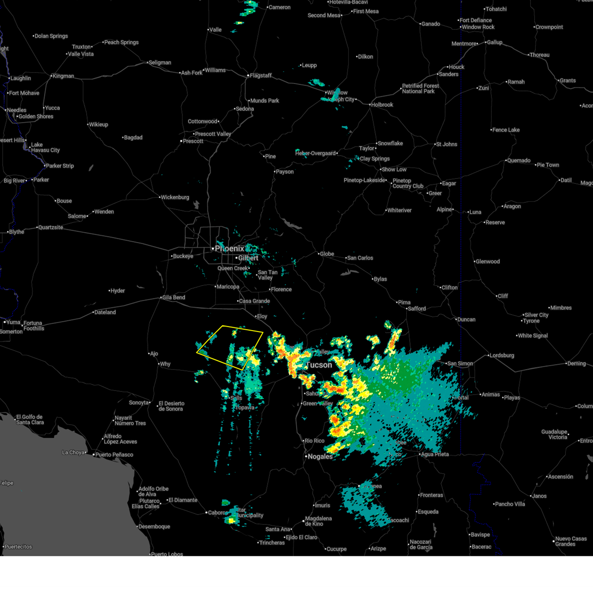
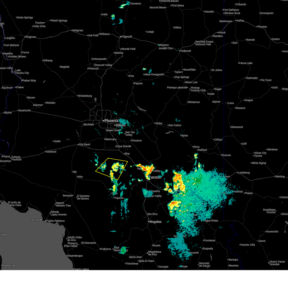
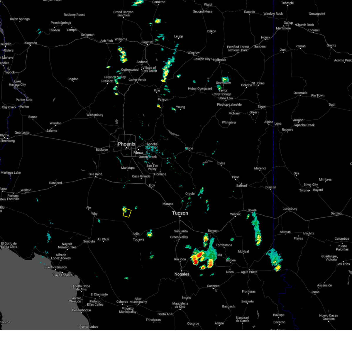
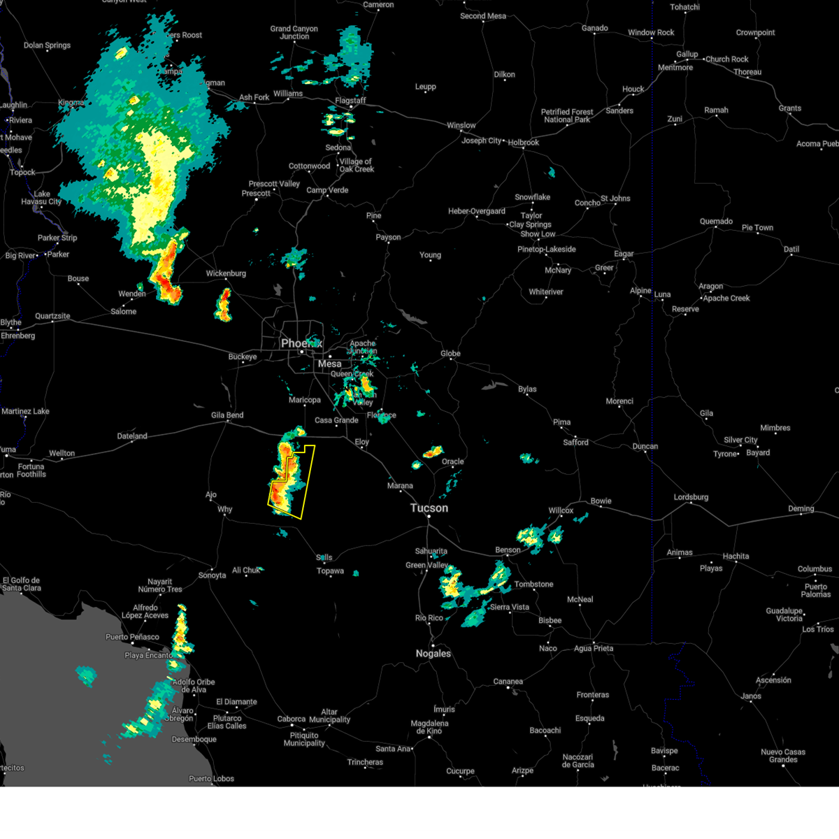
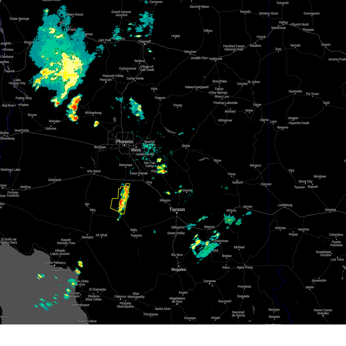
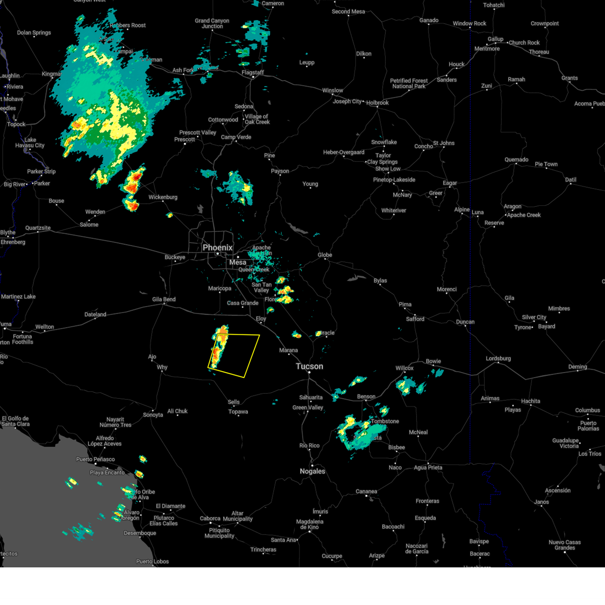
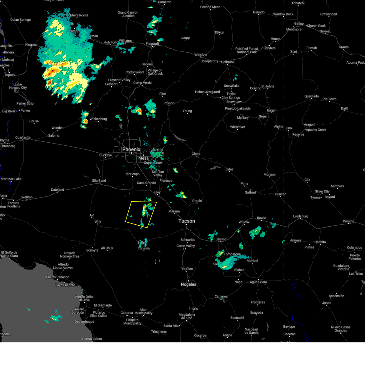
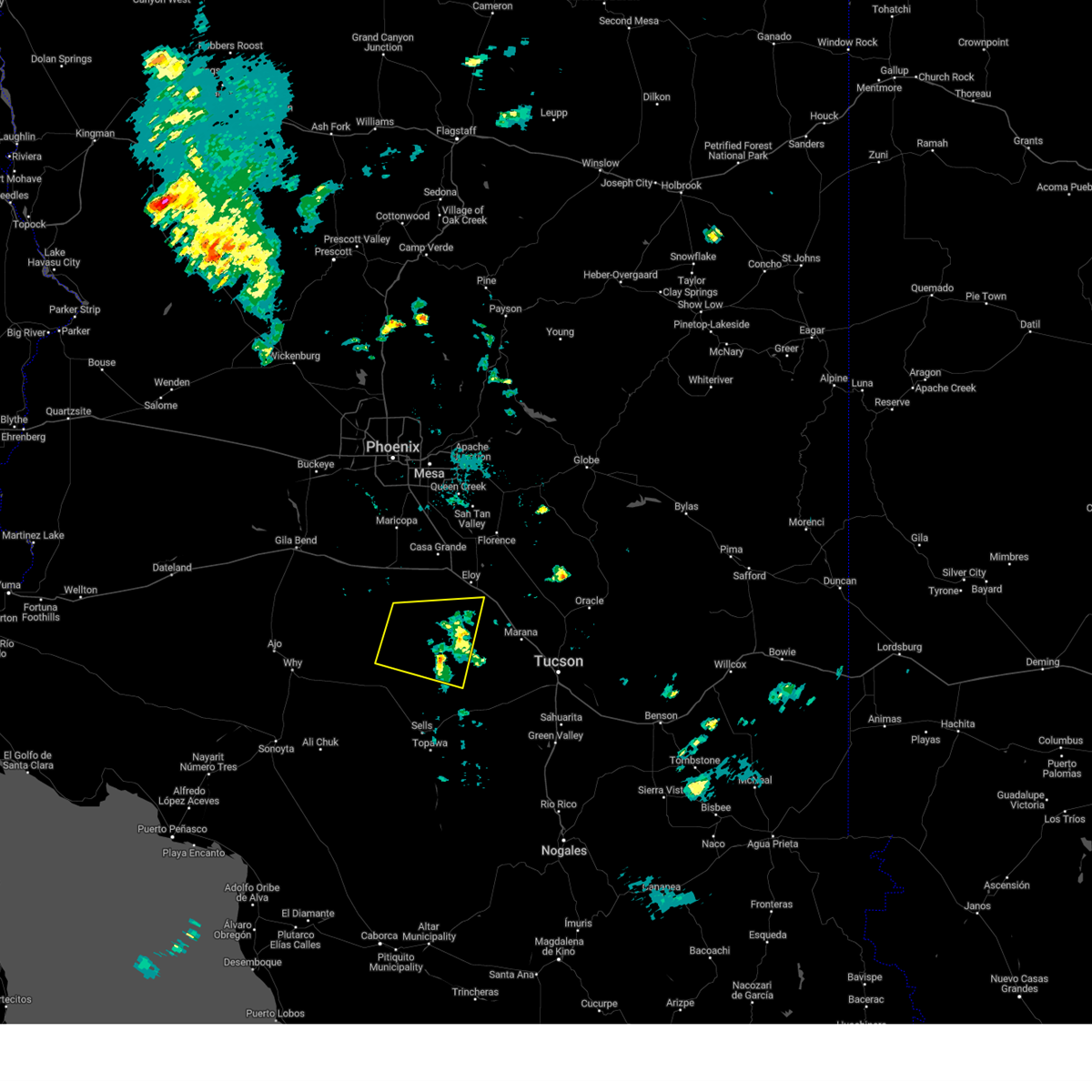
Hail Map for Anegam, AZ
The Anegam, AZ area has had 0 reports of on-the-ground hail by trained spotters, and has been under severe weather warnings 2 times during the past 12 months. Doppler radar has detected hail at or near Anegam, AZ on 20 occasions.
| Name: | Anegam, AZ |
| Where Located: | 63.3 miles W of Tucson, AZ |
| Map: | Google Map for Anegam, AZ |
| Population: | 151 |
| Housing Units: | 43 |
| More Info: | Search Google for Anegam, AZ |
0
The Top Recent Hail Date for Anegam, AZ is Tuesday, August 6, 2024 (10th out of 20)

Hail and Wind Damage Spotted near Anegam, AZ
| Date / Time | Report Details |
|---|---|
| 7/15/2025 8:15 PM MST |
 The storm which prompted the warning has weakened below severe limits, and no longer poses an immediate threat to life or property. therefore, the warning has been allowed to expire. The storm which prompted the warning has weakened below severe limits, and no longer poses an immediate threat to life or property. therefore, the warning has been allowed to expire.
|
| 7/15/2025 7:32 PM MST |
 Svrtwc the national weather service in tucson has issued a * severe thunderstorm warning for, north central pima county in southeastern arizona, southwestern pinal county in southeastern arizona, * until 815 pm mst. * at 732 pm mst, a severe thunderstorm was located 11 miles northeast of santa rosa, moving northwest at 15 mph (radar indicated). Hazards include 60 mph wind gusts and small hail. expect damage to roofs, siding, and trees Svrtwc the national weather service in tucson has issued a * severe thunderstorm warning for, north central pima county in southeastern arizona, southwestern pinal county in southeastern arizona, * until 815 pm mst. * at 732 pm mst, a severe thunderstorm was located 11 miles northeast of santa rosa, moving northwest at 15 mph (radar indicated). Hazards include 60 mph wind gusts and small hail. expect damage to roofs, siding, and trees
|
| 8/12/2024 2:28 PM MST | The storm which prompted the warning has weakened below severe limits, and no longer poses an immediate threat to life or property. therefore, the warning will be allowed to expire. |
| 8/12/2024 1:51 PM MST |
 Svrtwc the national weather service in tucson has issued a * severe thunderstorm warning for, north central pima county in southeastern arizona, * until 230 pm mst. * at 150 pm mst, a severe thunderstorm was located over santa rosa, or 29 miles north of sells, and is nearly stationary (radar indicated). Hazards include 60 mph wind gusts and penny size hail. expect damage to roofs, siding, and trees Svrtwc the national weather service in tucson has issued a * severe thunderstorm warning for, north central pima county in southeastern arizona, * until 230 pm mst. * at 150 pm mst, a severe thunderstorm was located over santa rosa, or 29 miles north of sells, and is nearly stationary (radar indicated). Hazards include 60 mph wind gusts and penny size hail. expect damage to roofs, siding, and trees
|
| 8/6/2024 7:44 PM MST |
 The storm which prompted the warning has moved out of the area. therefore, the warning will be allowed to expire. however, gusty winds and heavy rain are still possible with this thunderstorm. The storm which prompted the warning has moved out of the area. therefore, the warning will be allowed to expire. however, gusty winds and heavy rain are still possible with this thunderstorm.
|
| 8/6/2024 7:27 PM MST |
 At 726 pm mst, a severe thunderstorm was located near kaka, or 38 miles east of ajo, moving west at 20 mph (radar indicated). Hazards include 60 mph wind gusts and penny size hail. Expect damage to roofs, siding, and trees. Locations impacted include, santa rosa, kohatk, ventana, and vaya chin. At 726 pm mst, a severe thunderstorm was located near kaka, or 38 miles east of ajo, moving west at 20 mph (radar indicated). Hazards include 60 mph wind gusts and penny size hail. Expect damage to roofs, siding, and trees. Locations impacted include, santa rosa, kohatk, ventana, and vaya chin.
|
| 8/6/2024 7:16 PM MST |
 Svrtwc the national weather service in tucson has issued a * severe thunderstorm warning for, north central pima county in southeastern arizona, southwestern pinal county in southeastern arizona, * until 745 pm mst. * at 716 pm mst, a severe thunderstorm was located 9 miles southeast of kaka, or 40 miles northwest of sells, moving west at 20 mph (radar indicated). Hazards include 60 mph wind gusts and penny size hail. expect damage to roofs, siding, and trees Svrtwc the national weather service in tucson has issued a * severe thunderstorm warning for, north central pima county in southeastern arizona, southwestern pinal county in southeastern arizona, * until 745 pm mst. * at 716 pm mst, a severe thunderstorm was located 9 miles southeast of kaka, or 40 miles northwest of sells, moving west at 20 mph (radar indicated). Hazards include 60 mph wind gusts and penny size hail. expect damage to roofs, siding, and trees
|
| 8/6/2024 7:13 PM MST |
 The storm which prompted the warning has moved out of the area. therefore, the warning will be allowed to expire. The storm which prompted the warning has moved out of the area. therefore, the warning will be allowed to expire.
|
| 8/6/2024 6:43 PM MST |
 At 643 pm mst, a severe thunderstorm was located near santa rosa, or 31 miles north of sells, moving west at 20 mph (radar indicated). Hazards include 60 mph wind gusts and penny size hail. Expect damage to roofs, siding, and trees. Locations impacted include, santa rosa, anegam, north komelik, kohatk, palo verde stand, ak chin, sil nakya, jack rabbit, and san luis. At 643 pm mst, a severe thunderstorm was located near santa rosa, or 31 miles north of sells, moving west at 20 mph (radar indicated). Hazards include 60 mph wind gusts and penny size hail. Expect damage to roofs, siding, and trees. Locations impacted include, santa rosa, anegam, north komelik, kohatk, palo verde stand, ak chin, sil nakya, jack rabbit, and san luis.
|
| 8/6/2024 6:20 PM MST |
 Svrtwc the national weather service in tucson has issued a * severe thunderstorm warning for, north central pima county in southeastern arizona, southwestern pinal county in southeastern arizona, * until 715 pm mst. * at 619 pm mst, a severe thunderstorm was located 13 miles east of santa rosa, or 30 miles north of sells, moving west at 20 mph (radar indicated). Hazards include 60 mph wind gusts and quarter size hail. Hail damage to vehicles is expected. Expect wind damage to roofs, siding, and trees. Svrtwc the national weather service in tucson has issued a * severe thunderstorm warning for, north central pima county in southeastern arizona, southwestern pinal county in southeastern arizona, * until 715 pm mst. * at 619 pm mst, a severe thunderstorm was located 13 miles east of santa rosa, or 30 miles north of sells, moving west at 20 mph (radar indicated). Hazards include 60 mph wind gusts and quarter size hail. Hail damage to vehicles is expected. Expect wind damage to roofs, siding, and trees.
|
| 9/11/2022 7:25 PM MST |
 The severe thunderstorm warning for north central pima and southwestern pinal counties will expire at 730 pm mst, the storm which prompted the warning has weakened below severe limits, and no longer poses an immediate threat to life or property. therefore, the warning will be allowed to expire. however gusty winds are still possible with this thunderstorm. The severe thunderstorm warning for north central pima and southwestern pinal counties will expire at 730 pm mst, the storm which prompted the warning has weakened below severe limits, and no longer poses an immediate threat to life or property. therefore, the warning will be allowed to expire. however gusty winds are still possible with this thunderstorm.
|
| 9/11/2022 7:03 PM MST |
 At 703 pm mst, a severe thunderstorm was located 10 miles north of santa rosa, or 33 miles southwest of casa grande, moving northwest at 15 mph (radar indicated). Hazards include 60 mph wind gusts and quarter size hail. Hail damage to vehicles is expected. expect wind damage to roofs, siding, and trees. locations impacted include, santa rosa, chui-chu, anegam, north komelik, kohatk, palo verde stand, ventana, jack rabbit, shopishk, san luis, east chui-chu and santa rosa school. hail threat, radar indicated max hail size, 1. 00 in wind threat, radar indicated max wind gust, 60 mph. At 703 pm mst, a severe thunderstorm was located 10 miles north of santa rosa, or 33 miles southwest of casa grande, moving northwest at 15 mph (radar indicated). Hazards include 60 mph wind gusts and quarter size hail. Hail damage to vehicles is expected. expect wind damage to roofs, siding, and trees. locations impacted include, santa rosa, chui-chu, anegam, north komelik, kohatk, palo verde stand, ventana, jack rabbit, shopishk, san luis, east chui-chu and santa rosa school. hail threat, radar indicated max hail size, 1. 00 in wind threat, radar indicated max wind gust, 60 mph.
|
| 9/11/2022 6:44 PM MST |
 At 643 pm mst, a severe thunderstorm was located 7 miles northeast of santa rosa, or 33 miles north of sells, moving northwest at 15 mph (radar indicated). Hazards include 60 mph wind gusts and quarter size hail. Hail damage to vehicles is expected. Expect wind damage to roofs, siding, and trees. At 643 pm mst, a severe thunderstorm was located 7 miles northeast of santa rosa, or 33 miles north of sells, moving northwest at 15 mph (radar indicated). Hazards include 60 mph wind gusts and quarter size hail. Hail damage to vehicles is expected. Expect wind damage to roofs, siding, and trees.
|
| 9/11/2022 6:22 PM MST |
 At 622 pm mst, severe thunderstorms were located along a line extending from 23 miles north of san isidro to near santa rosa, moving northwest at 15 mph (radar indicated). Hazards include 60 mph wind gusts and quarter size hail. Hail damage to vehicles is expected. expect wind damage to roofs, siding, and trees. locations impacted include, santa rosa, anegam, palo verde stand, ak chin, queens well, sil nakya, san luis and silver bell. hail threat, radar indicated max hail size, 1. 00 in wind threat, radar indicated max wind gust, 60 mph. At 622 pm mst, severe thunderstorms were located along a line extending from 23 miles north of san isidro to near santa rosa, moving northwest at 15 mph (radar indicated). Hazards include 60 mph wind gusts and quarter size hail. Hail damage to vehicles is expected. expect wind damage to roofs, siding, and trees. locations impacted include, santa rosa, anegam, palo verde stand, ak chin, queens well, sil nakya, san luis and silver bell. hail threat, radar indicated max hail size, 1. 00 in wind threat, radar indicated max wind gust, 60 mph.
|
| 9/11/2022 6:02 PM MST |
 At 602 pm mst, severe thunderstorms were located along a line extending from 19 miles southwest of avra valley to near santa rosa, moving north at 10 mph (radar indicated). Hazards include 60 mph wind gusts and quarter size hail. Hail damage to vehicles is expected. Expect wind damage to roofs, siding, and trees. At 602 pm mst, severe thunderstorms were located along a line extending from 19 miles southwest of avra valley to near santa rosa, moving north at 10 mph (radar indicated). Hazards include 60 mph wind gusts and quarter size hail. Hail damage to vehicles is expected. Expect wind damage to roofs, siding, and trees.
|
| 8/21/2022 7:50 PM MST | At 749 pm mst, a severe thunderstorm was located near santa rosa, or 34 miles north of sells, moving south at 15 mph (radar indicated). Hazards include 60 mph wind gusts and penny size hail. expect damage to roofs, siding, and trees |
| 8/8/2022 3:35 PM MST |
 The severe thunderstorm warning for north central pima county will expire at 345 pm mst, the storm which prompted the warning has weakened below severe limits, and no longer poses an immediate threat to life or property. therefore, the warning will be allowed to expire. The severe thunderstorm warning for north central pima county will expire at 345 pm mst, the storm which prompted the warning has weakened below severe limits, and no longer poses an immediate threat to life or property. therefore, the warning will be allowed to expire.
|
| 8/8/2022 3:07 PM MST |
 At 307 pm mst, a severe thunderstorm was located near santa rosa, or 28 miles northwest of sells, moving northwest at 15 mph (radar indicated). Hazards include 60 mph wind gusts and quarter size hail. Hail damage to vehicles is expected. Expect wind damage to roofs, siding, and trees. At 307 pm mst, a severe thunderstorm was located near santa rosa, or 28 miles northwest of sells, moving northwest at 15 mph (radar indicated). Hazards include 60 mph wind gusts and quarter size hail. Hail damage to vehicles is expected. Expect wind damage to roofs, siding, and trees.
|
| 8/6/2021 6:42 PM MST |
 At 641 pm mst, a severe thunderstorm was located near picacho, or 20 miles southeast of casa grande, moving northeast at 55 mph (radar indicated). Hazards include 60 mph wind gusts and quarter size hail. Hail damage to vehicles is expected. expect wind damage to roofs, siding, and trees. Locations impacted include, santa rosa, covered wells, anegam, north komelik, palo verde stand, ak chin, mountain village, san luis and santa rosa school. At 641 pm mst, a severe thunderstorm was located near picacho, or 20 miles southeast of casa grande, moving northeast at 55 mph (radar indicated). Hazards include 60 mph wind gusts and quarter size hail. Hail damage to vehicles is expected. expect wind damage to roofs, siding, and trees. Locations impacted include, santa rosa, covered wells, anegam, north komelik, palo verde stand, ak chin, mountain village, san luis and santa rosa school.
|
| 8/6/2021 6:02 PM MST |
 At 601 pm mst, a severe thunderstorm was located over santa rosa, or 28 miles north of sells, moving northeast at 55 mph (radar indicated). Hazards include 60 mph wind gusts and quarter size hail. Hail damage to vehicles is expected. Expect wind damage to roofs, siding, and trees. At 601 pm mst, a severe thunderstorm was located over santa rosa, or 28 miles north of sells, moving northeast at 55 mph (radar indicated). Hazards include 60 mph wind gusts and quarter size hail. Hail damage to vehicles is expected. Expect wind damage to roofs, siding, and trees.
|
| 7/10/2021 9:26 PM MST |
 At 925 pm mst, severe thunderstorms were located along a line extending from 12 miles southwest of chui-chu to near san isidro, moving west at 20 mph (radar indicated). Hazards include 60 mph wind gusts and quarter size hail. Hail damage to vehicles is expected. expect wind damage to roofs, siding, and trees. locations impacted include, santa rosa, san isidro, anegam, north komelik, kohatk, palo verde stand, ventana, ak chin, no:ligk, comobabi, south comobabi, cababi, sil nakya, san luis - sells district, san luis, rincon and santa rosa school. This includes route 86 between mile markers 92 and 108, and between mile markers 122 and 128. At 925 pm mst, severe thunderstorms were located along a line extending from 12 miles southwest of chui-chu to near san isidro, moving west at 20 mph (radar indicated). Hazards include 60 mph wind gusts and quarter size hail. Hail damage to vehicles is expected. expect wind damage to roofs, siding, and trees. locations impacted include, santa rosa, san isidro, anegam, north komelik, kohatk, palo verde stand, ventana, ak chin, no:ligk, comobabi, south comobabi, cababi, sil nakya, san luis - sells district, san luis, rincon and santa rosa school. This includes route 86 between mile markers 92 and 108, and between mile markers 122 and 128.
|
| 7/10/2021 8:40 PM MST |
 At 839 pm mst, severe thunderstorms were located along a line extending from near chui-chu to 12 miles southeast of kitt peak, moving west southwest at 20 mph (radar indicated). Hazards include 60 mph wind gusts and quarter size hail. Hail damage to vehicles is expected. Expect wind damage to roofs, siding, and trees. At 839 pm mst, severe thunderstorms were located along a line extending from near chui-chu to 12 miles southeast of kitt peak, moving west southwest at 20 mph (radar indicated). Hazards include 60 mph wind gusts and quarter size hail. Hail damage to vehicles is expected. Expect wind damage to roofs, siding, and trees.
|
| 8/31/2020 5:34 PM MST |
 At 534 pm mst, a severe thunderstorm was located 9 miles south of hickiwan, or 26 miles southeast of ajo, moving east at 15 mph (radar indicated). Hazards include 60 mph wind gusts. expect damage to roofs, siding, and trees At 534 pm mst, a severe thunderstorm was located 9 miles south of hickiwan, or 26 miles southeast of ajo, moving east at 15 mph (radar indicated). Hazards include 60 mph wind gusts. expect damage to roofs, siding, and trees
|
| 8/20/2020 11:05 PM MST |
 At 1104 pm mst, severe thunderstorms were located along a line extending from near ajo to 8 miles south of santa rosa, moving southwest at 25 mph (radar indicated). Hazards include 60 mph wind gusts. Expect damage to roofs, siding, and trees. locations impacted include, ajo, santa rosa, pisinemo, hickiwan, covered wells, anegam, san simon, why, palo verde stand, ak chin, gunsight, vaya chin, mountain village, san luis, kuakatch, santa rosa school. this includes the following highways, route 85 between mile markers 33 and 61. Route 86 between mile markers 53 and 97. At 1104 pm mst, severe thunderstorms were located along a line extending from near ajo to 8 miles south of santa rosa, moving southwest at 25 mph (radar indicated). Hazards include 60 mph wind gusts. Expect damage to roofs, siding, and trees. locations impacted include, ajo, santa rosa, pisinemo, hickiwan, covered wells, anegam, san simon, why, palo verde stand, ak chin, gunsight, vaya chin, mountain village, san luis, kuakatch, santa rosa school. this includes the following highways, route 85 between mile markers 33 and 61. Route 86 between mile markers 53 and 97.
|
| 8/20/2020 10:30 PM MST |
 At 1028 pm mst, severe thunderstorms were located along a line extending from 10 miles north of ajo to 6 miles northeast of santa rosa, moving southwest at 20 mph (radar indicated). Hazards include 60 mph wind gusts. expect damage to roofs, siding, and trees At 1028 pm mst, severe thunderstorms were located along a line extending from 10 miles north of ajo to 6 miles northeast of santa rosa, moving southwest at 20 mph (radar indicated). Hazards include 60 mph wind gusts. expect damage to roofs, siding, and trees
|
| 8/20/2020 9:17 PM MST |
 At 916 pm mst, a severe thunderstorm was located 15 miles southeast of freeman, or 24 miles southwest of casa grande, moving southwest at 45 mph (radar indicated). Hazards include 60 mph wind gusts and penny size hail. expect damage to roofs, siding, and trees At 916 pm mst, a severe thunderstorm was located 15 miles southeast of freeman, or 24 miles southwest of casa grande, moving southwest at 45 mph (radar indicated). Hazards include 60 mph wind gusts and penny size hail. expect damage to roofs, siding, and trees
|
| 8/16/2020 6:52 PM MST |
 The severe thunderstorm warning for north central pima county will expire at 700 pm mst, the storm which prompted the warning has weakened below severe limits, and no longer poses an immediate threat to life or property. therefore, the warning will be allowed to expire. however gusty winds and blowing dust are still possible with this thunderstorm. The severe thunderstorm warning for north central pima county will expire at 700 pm mst, the storm which prompted the warning has weakened below severe limits, and no longer poses an immediate threat to life or property. therefore, the warning will be allowed to expire. however gusty winds and blowing dust are still possible with this thunderstorm.
|
| 8/16/2020 6:41 PM MST |
 At 641 pm mst, a severe thunderstorm was located 12 miles east of hickiwan, moving southwest at 20 mph (radar indicated). Hazards include 60 mph wind gusts and quarter size hail. Hail damage to vehicles is expected. expect wind damage to roofs, siding, and trees. Locations impacted include, santa rosa, anegam, palo verde stand, vaya chin, san luis and santa rosa school. At 641 pm mst, a severe thunderstorm was located 12 miles east of hickiwan, moving southwest at 20 mph (radar indicated). Hazards include 60 mph wind gusts and quarter size hail. Hail damage to vehicles is expected. expect wind damage to roofs, siding, and trees. Locations impacted include, santa rosa, anegam, palo verde stand, vaya chin, san luis and santa rosa school.
|
| 8/16/2020 6:15 PM MST |
 At 614 pm mst, a severe thunderstorm was located 10 miles southeast of kaka moving southwest at 30 mph (radar indicated). Hazards include 60 mph wind gusts and quarter size hail. Hail damage to vehicles is expected. Expect wind damage to roofs, siding, and trees. At 614 pm mst, a severe thunderstorm was located 10 miles southeast of kaka moving southwest at 30 mph (radar indicated). Hazards include 60 mph wind gusts and quarter size hail. Hail damage to vehicles is expected. Expect wind damage to roofs, siding, and trees.
|
| 8/16/2020 6:00 PM MST |
 At 600 pm mst, a severe thunderstorm was located 11 miles west of santa rosa moving southwest at 25 mph (radar indicated). Hazards include 60 mph wind gusts and quarter size hail. Hail damage to vehicles is expected. expect wind damage to roofs, siding, and trees. Locations impacted include, santa rosa, anegam, north komelik, kohatk, palo verde stand, ventana, vaya chin, jack rabbit, san luis and santa rosa school. At 600 pm mst, a severe thunderstorm was located 11 miles west of santa rosa moving southwest at 25 mph (radar indicated). Hazards include 60 mph wind gusts and quarter size hail. Hail damage to vehicles is expected. expect wind damage to roofs, siding, and trees. Locations impacted include, santa rosa, anegam, north komelik, kohatk, palo verde stand, ventana, vaya chin, jack rabbit, san luis and santa rosa school.
|
| 8/16/2020 5:38 PM MST |
 At 537 pm mst, a severe thunderstorm was located 9 miles east of kaka moving southwest at 25 mph (radar indicated). Hazards include 60 mph wind gusts. expect damage to roofs, siding, and trees At 537 pm mst, a severe thunderstorm was located 9 miles east of kaka moving southwest at 25 mph (radar indicated). Hazards include 60 mph wind gusts. expect damage to roofs, siding, and trees
|
| 9/24/2019 3:07 AM MST |
 The national weather service in tucson has issued a * severe thunderstorm warning for. north central pima county in southeastern arizona. until 400 am mst. At 306 am mst, a severe thunderstorm was located 11 miles northeast of pisinemo, or 25 miles northwest of sells, moving east at 35 mph. The national weather service in tucson has issued a * severe thunderstorm warning for. north central pima county in southeastern arizona. until 400 am mst. At 306 am mst, a severe thunderstorm was located 11 miles northeast of pisinemo, or 25 miles northwest of sells, moving east at 35 mph.
|
| 7/25/2019 7:38 PM MST |
 The severe thunderstorm warning for north central pima and southwestern pinal counties will expire at 745 pm mst, the storm which prompted the warning over northern portions of the tohono o`odham nation north of sells has weakened moved out of the area. therefore, the warning will be allowed to expire. however heavy rain is still possible with this thunderstorm. The severe thunderstorm warning for north central pima and southwestern pinal counties will expire at 745 pm mst, the storm which prompted the warning over northern portions of the tohono o`odham nation north of sells has weakened moved out of the area. therefore, the warning will be allowed to expire. however heavy rain is still possible with this thunderstorm.
|
| 7/25/2019 6:56 PM MST |
 At 655 pm mst, a severe thunderstorm was located 10 miles north of santa rosa, or 25 to 30 miles southwest of casa grande, moving northwest at 15 mph (radar indicated). Hazards include 60 mph wind gusts and penny size hail along with heavy rain. expect damage to roofs, siding, and trees At 655 pm mst, a severe thunderstorm was located 10 miles north of santa rosa, or 25 to 30 miles southwest of casa grande, moving northwest at 15 mph (radar indicated). Hazards include 60 mph wind gusts and penny size hail along with heavy rain. expect damage to roofs, siding, and trees
|
| 7/22/2019 7:17 PM MST |
 At 717 pm mst, a severe thunderstorm was located 11 miles southwest of santa rosa, or 27 miles northwest of sells, moving northwest at 10 mph. it has just passed covered wells. the storm is weakening and hail is no longer a threat but strong gusty winds may remain, therefore the warning will be allowed to run through 730 pm (radar indicated). Hazards include 60 mph wind gusts. Expect damage to roofs, siding, and trees. locations impacted include, santa rosa, pisinemo, gu vo, hickiwan, covered wells, san simon, palo verde stand, ventana, vaya chin, mountain village, san luis, santa rosa school and san simon west. This includes route 86 between mile markers 65 and 93. At 717 pm mst, a severe thunderstorm was located 11 miles southwest of santa rosa, or 27 miles northwest of sells, moving northwest at 10 mph. it has just passed covered wells. the storm is weakening and hail is no longer a threat but strong gusty winds may remain, therefore the warning will be allowed to run through 730 pm (radar indicated). Hazards include 60 mph wind gusts. Expect damage to roofs, siding, and trees. locations impacted include, santa rosa, pisinemo, gu vo, hickiwan, covered wells, san simon, palo verde stand, ventana, vaya chin, mountain village, san luis, santa rosa school and san simon west. This includes route 86 between mile markers 65 and 93.
|
| 7/22/2019 6:48 PM MST |
 At 647 pm mst, a severe thunderstorm was located 12 miles southwest of santa rosa, or 26 miles northwest of sells, moving northwest at 35 mph (radar indicated). Hazards include 70 mph wind gusts and penny size hail. Expect considerable tree damage. Damage is likely to mobile homes, roofs, and outbuildings. At 647 pm mst, a severe thunderstorm was located 12 miles southwest of santa rosa, or 26 miles northwest of sells, moving northwest at 35 mph (radar indicated). Hazards include 70 mph wind gusts and penny size hail. Expect considerable tree damage. Damage is likely to mobile homes, roofs, and outbuildings.
|
| 7/9/2017 6:35 PM MST |
 At 632 pm mst, a line of severe thunderstorms was located 17 miles southwest of santa rosa, or 31 miles northwest of sells, moving west at 15 mph. received a report that a significant haboob has formed with a large area of blowing dust in advance of this line of storms (trained weather spotters). Hazards include 60 mph wind gusts, blowing dust ahead of the storm and very heavy rain and penny size hail directly under the storms. Expect damage to roofs, siding, and trees and water flowing in local washes. Locations impacted include, organ pipe national monument, santa rosa, santa cruz, ali chuk, kuakatch, kupk, pisinimo, ventana, papago farms, hickiwan, pisinemo, charco 27, ak chin, mountain village, lukeville, covered wells, anegam, gu vo, gunsight and vaya chin. At 632 pm mst, a line of severe thunderstorms was located 17 miles southwest of santa rosa, or 31 miles northwest of sells, moving west at 15 mph. received a report that a significant haboob has formed with a large area of blowing dust in advance of this line of storms (trained weather spotters). Hazards include 60 mph wind gusts, blowing dust ahead of the storm and very heavy rain and penny size hail directly under the storms. Expect damage to roofs, siding, and trees and water flowing in local washes. Locations impacted include, organ pipe national monument, santa rosa, santa cruz, ali chuk, kuakatch, kupk, pisinimo, ventana, papago farms, hickiwan, pisinemo, charco 27, ak chin, mountain village, lukeville, covered wells, anegam, gu vo, gunsight and vaya chin.
|
| 7/9/2017 6:13 PM MST |
 At 611 pm mst, a line of severe thunderstorms was located 14 miles southwest of santa rosa, or 26 miles northwest of sells, moving northwest at 15 mph. this group of storms continue to maintain their severe characteristics (radar indicated). Hazards include 60 mph wind gusts with blowing dust and very heavy rain with up to penny size hail directly under the storm. expect damage to roofs, siding, and trees, and water flowing in area washes At 611 pm mst, a line of severe thunderstorms was located 14 miles southwest of santa rosa, or 26 miles northwest of sells, moving northwest at 15 mph. this group of storms continue to maintain their severe characteristics (radar indicated). Hazards include 60 mph wind gusts with blowing dust and very heavy rain with up to penny size hail directly under the storm. expect damage to roofs, siding, and trees, and water flowing in area washes
|
| 7/9/2017 5:56 PM MST |
 At 554 pm mst, radar indicates that a severe thunderstorm continues approximately 10 miles southwest of santa rosa, or 24 miles northwest of sells, moving northwest at 15 mph (radar indicated). Hazards include 70 mph wind gusts with blowing dust are still likely along with nickel size hail. locally heavy rain is expected directly under the storm. Expect considerable tree damage. damage is likely to mobile homes, roofs, and outbuildings. Locations impacted include, sells, santa rosa, san luis, santa rosa ranch, ventana, ak chin, mountain village, covered wells, anegam, comobabi, nolic, vaya chin, san simon village and sil naggia. At 554 pm mst, radar indicates that a severe thunderstorm continues approximately 10 miles southwest of santa rosa, or 24 miles northwest of sells, moving northwest at 15 mph (radar indicated). Hazards include 70 mph wind gusts with blowing dust are still likely along with nickel size hail. locally heavy rain is expected directly under the storm. Expect considerable tree damage. damage is likely to mobile homes, roofs, and outbuildings. Locations impacted include, sells, santa rosa, san luis, santa rosa ranch, ventana, ak chin, mountain village, covered wells, anegam, comobabi, nolic, vaya chin, san simon village and sil naggia.
|
| 7/9/2017 5:32 PM MST |
 At 531 pm mst, a severe thunderstorm was located 12 miles south of santa rosa, or 18 miles northwest of sells, moving northwest at 15 mph (trained weather spotters and radar). Hazards include up to 70 mph wind gusts, blowing dust and nickel size hail and locally heavy rain. Expect considerable tree damage. Damage is likely to mobile homes, roofs, and outbuildings. At 531 pm mst, a severe thunderstorm was located 12 miles south of santa rosa, or 18 miles northwest of sells, moving northwest at 15 mph (trained weather spotters and radar). Hazards include up to 70 mph wind gusts, blowing dust and nickel size hail and locally heavy rain. Expect considerable tree damage. Damage is likely to mobile homes, roofs, and outbuildings.
|
Hail Maps for Anegam, AZ


Connect with Interactive Hail Maps