

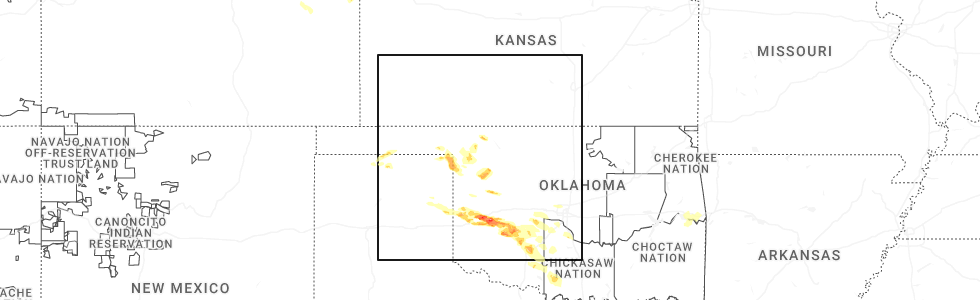
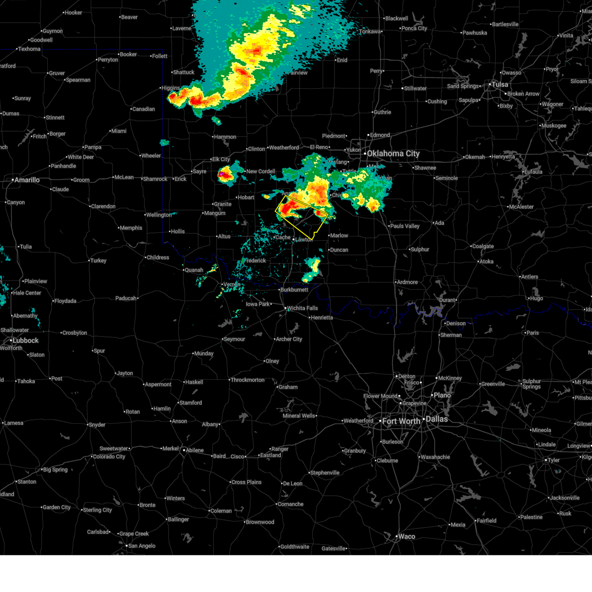
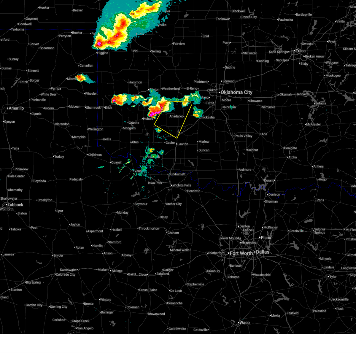
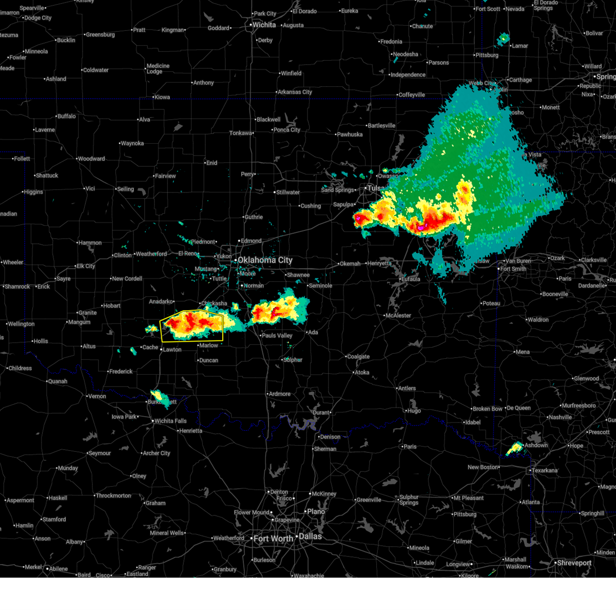
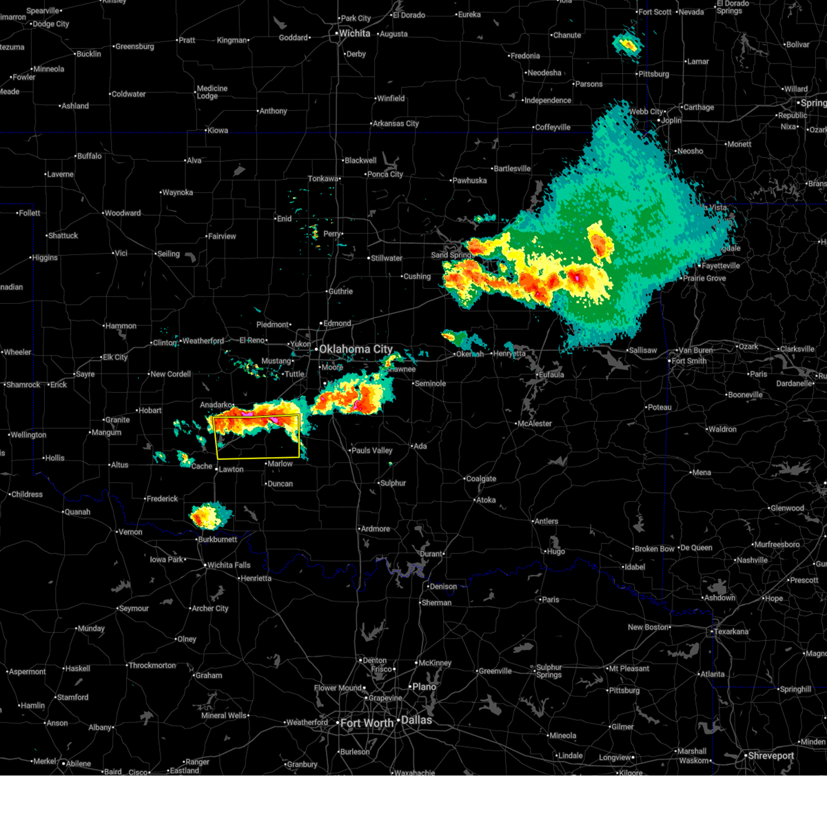
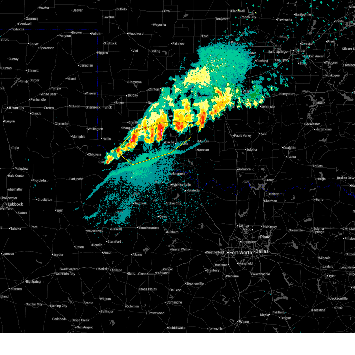
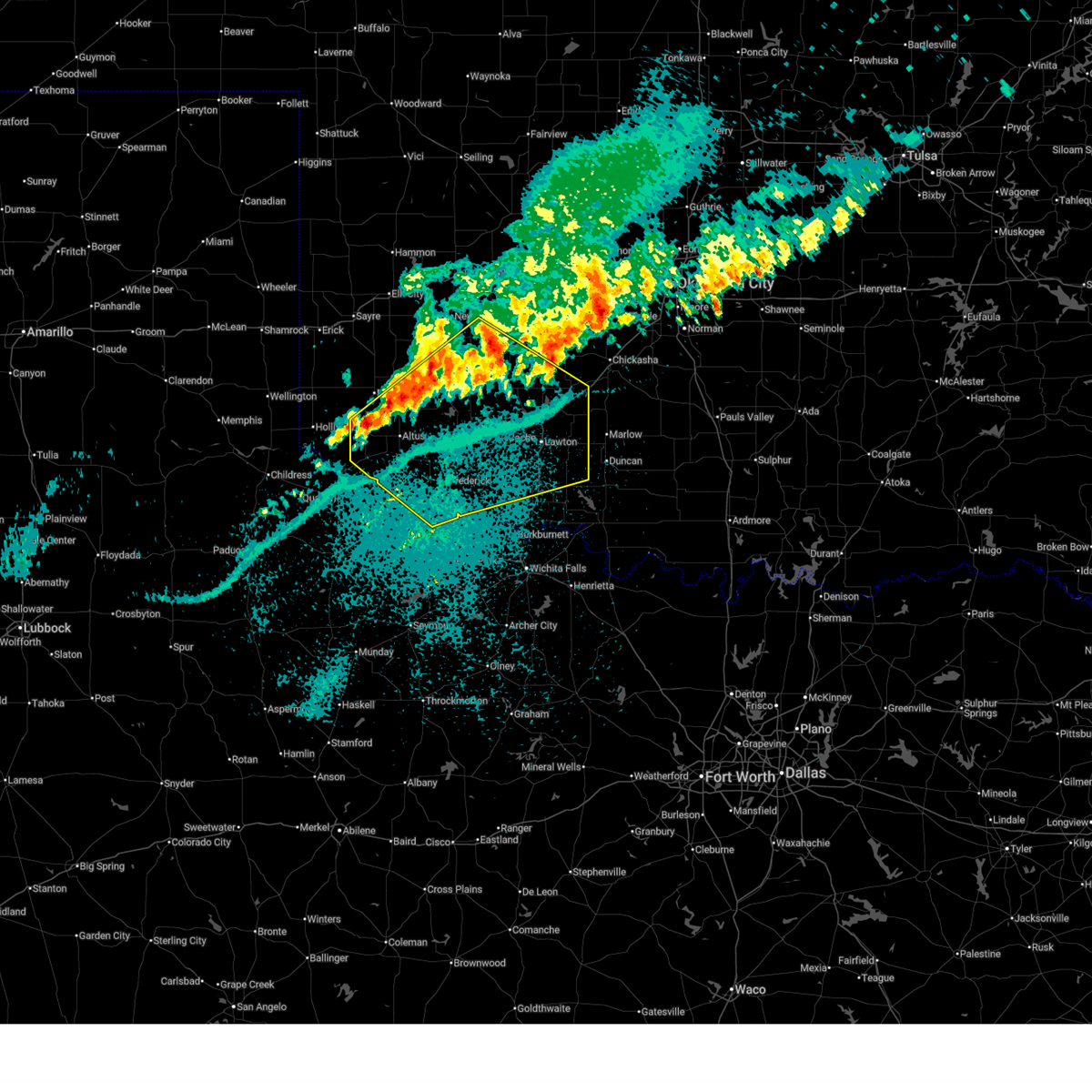
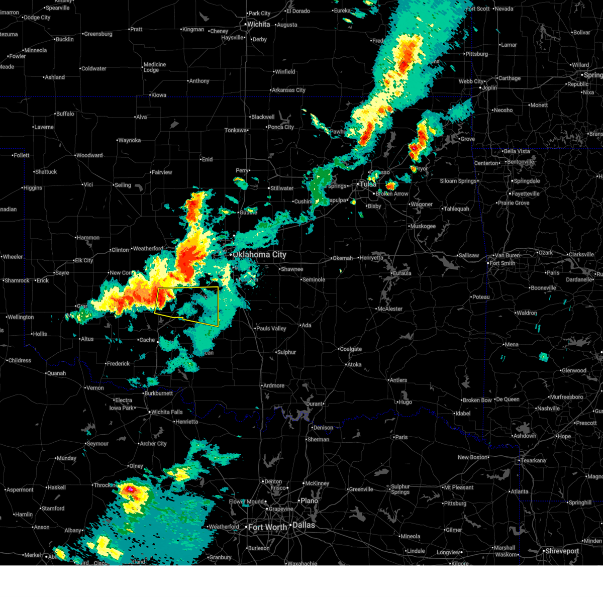
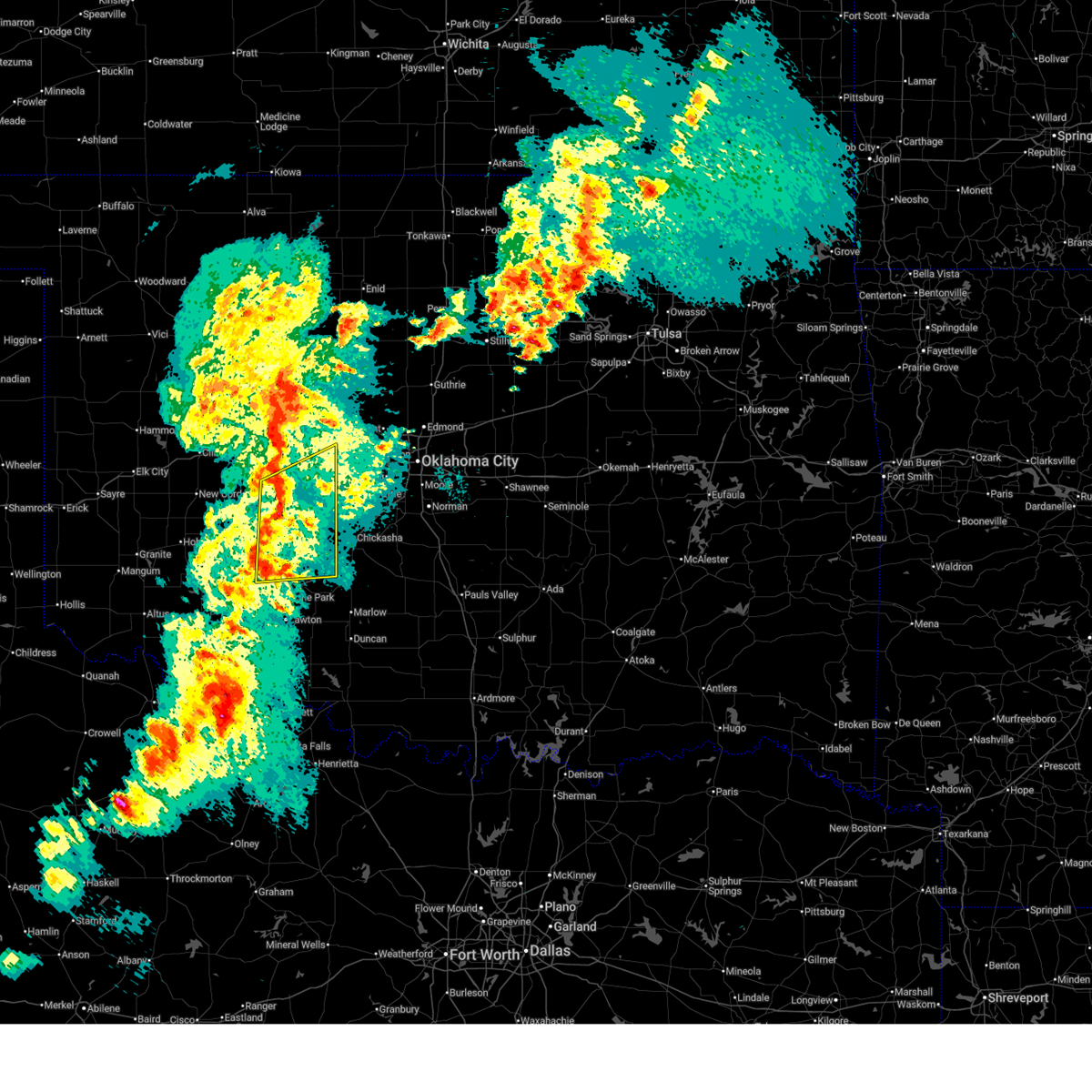
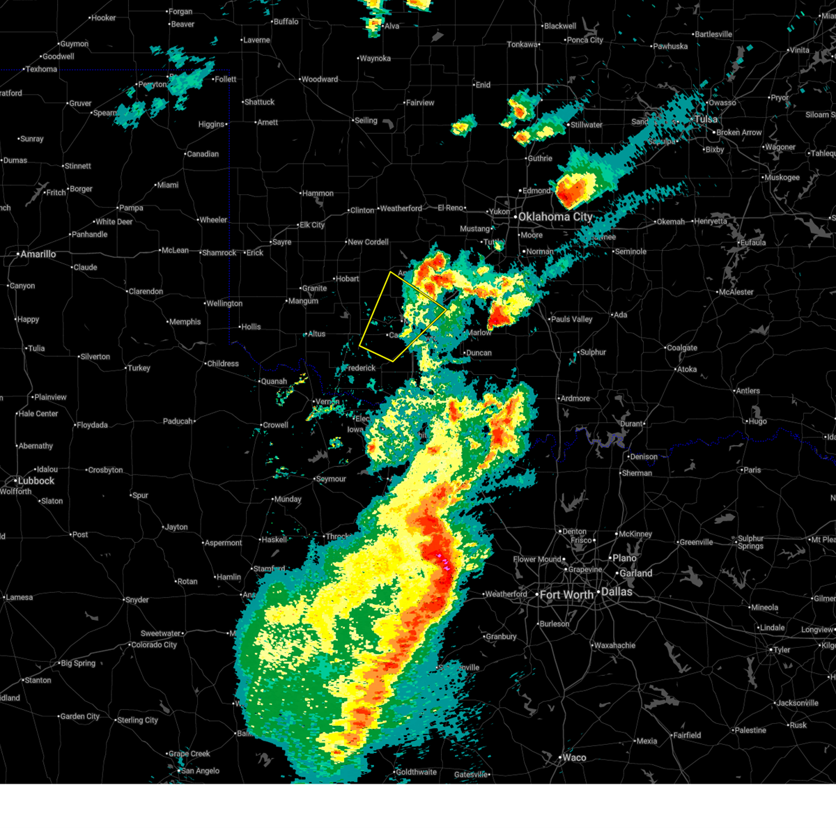
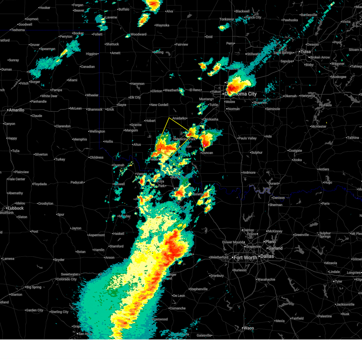
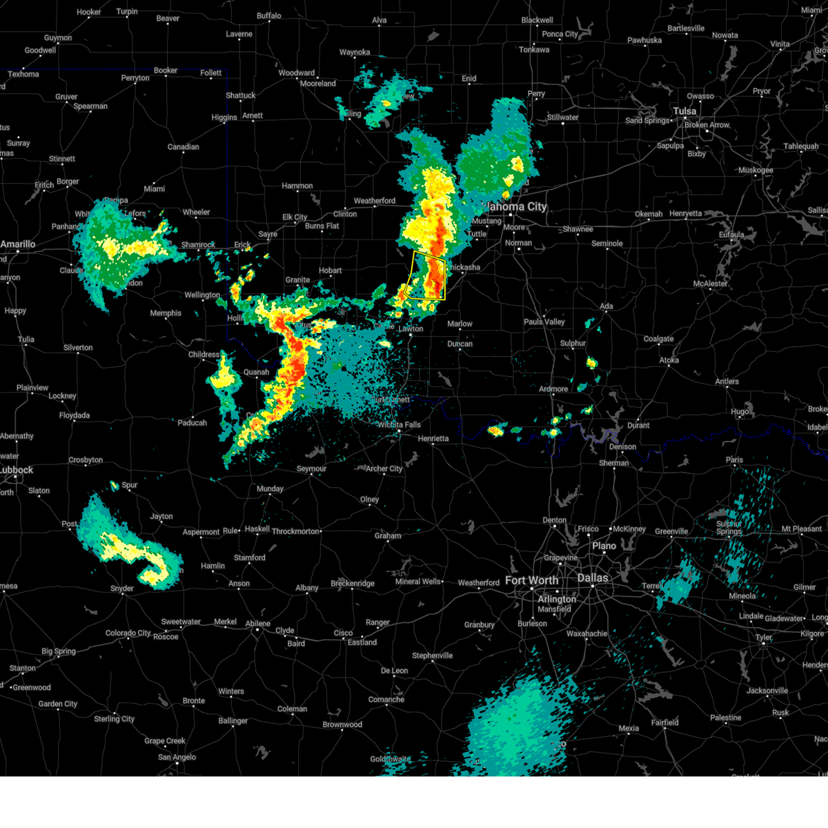
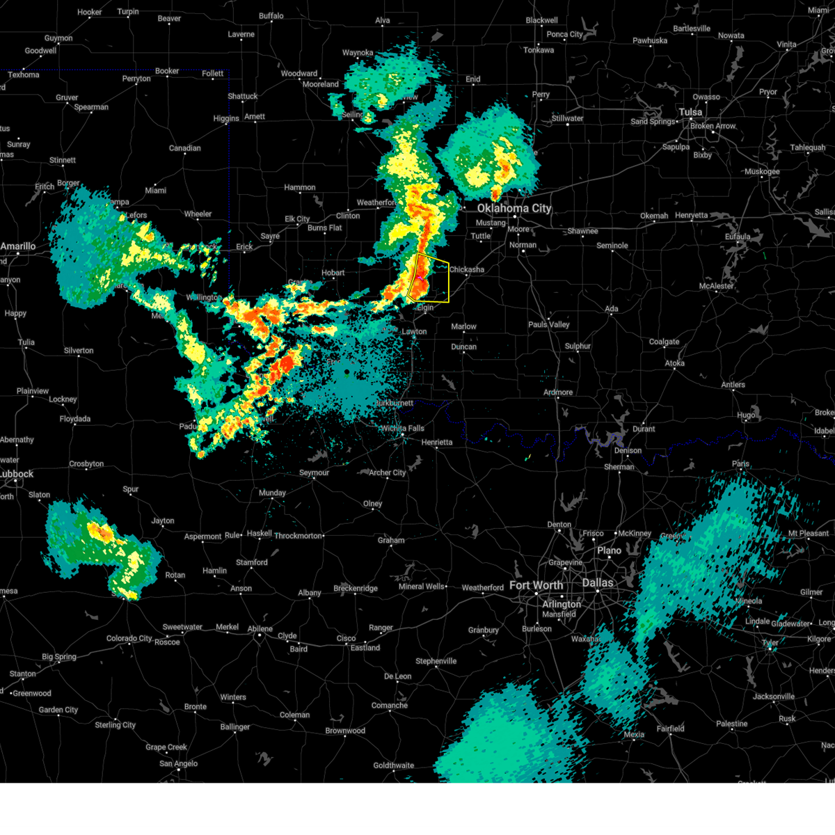
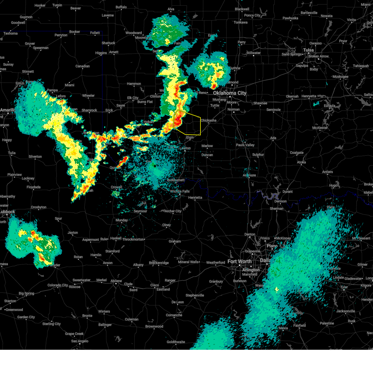
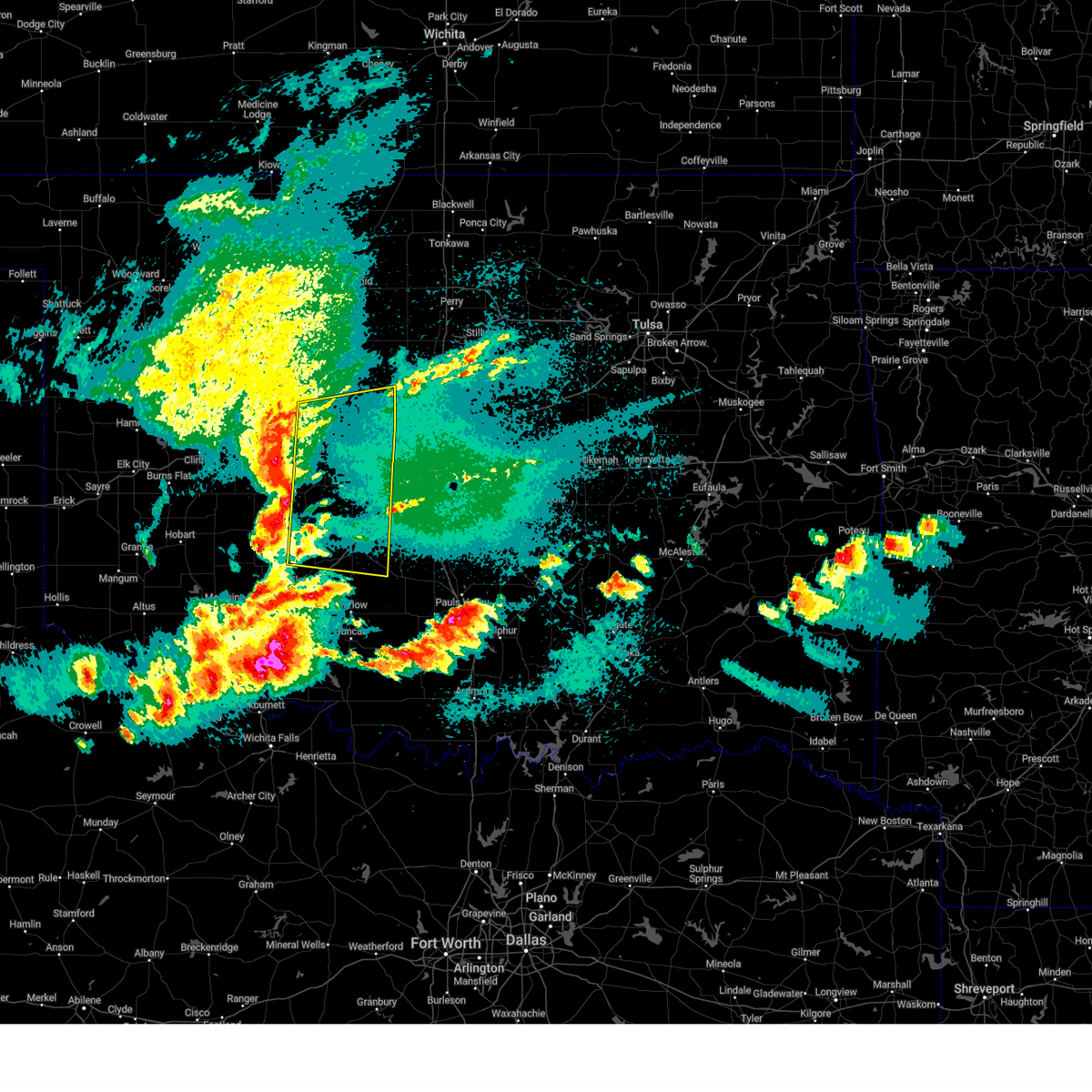
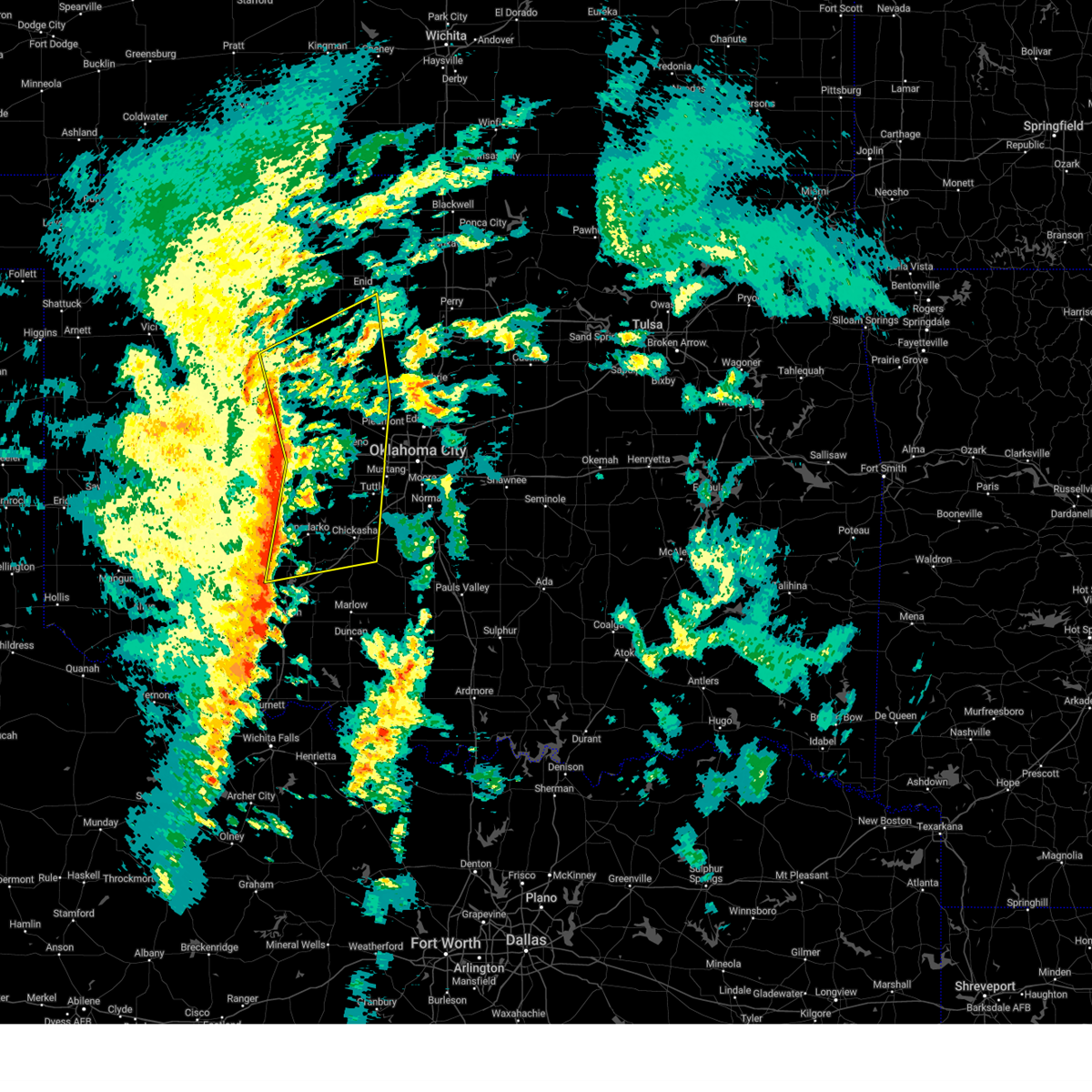
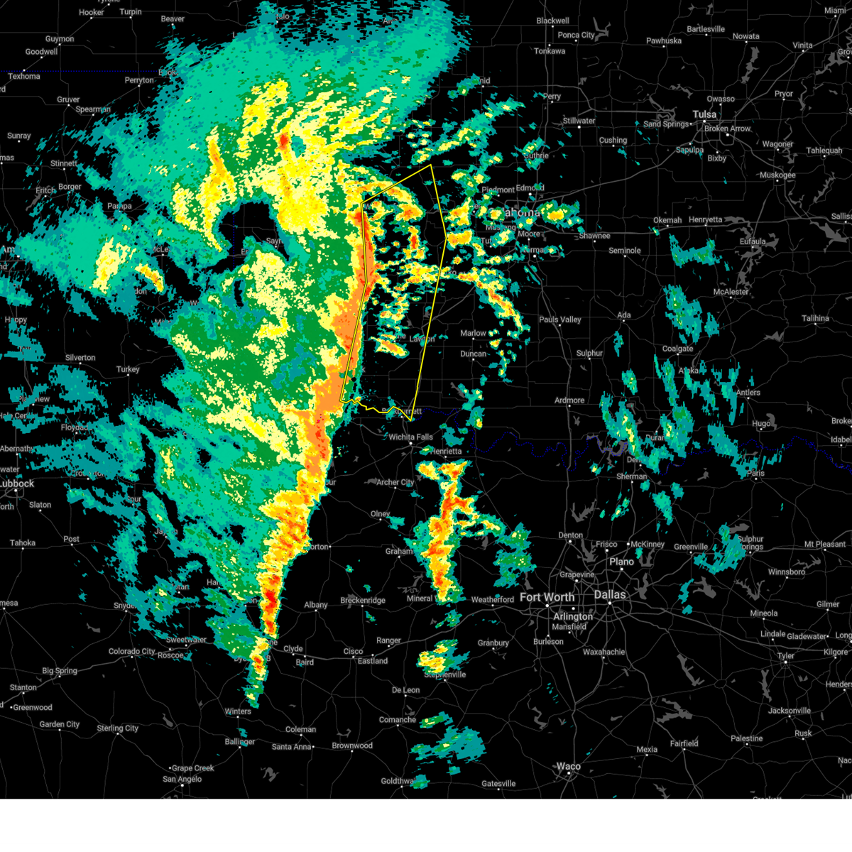
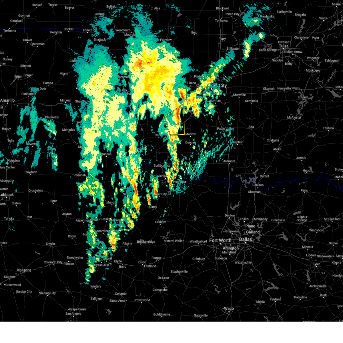
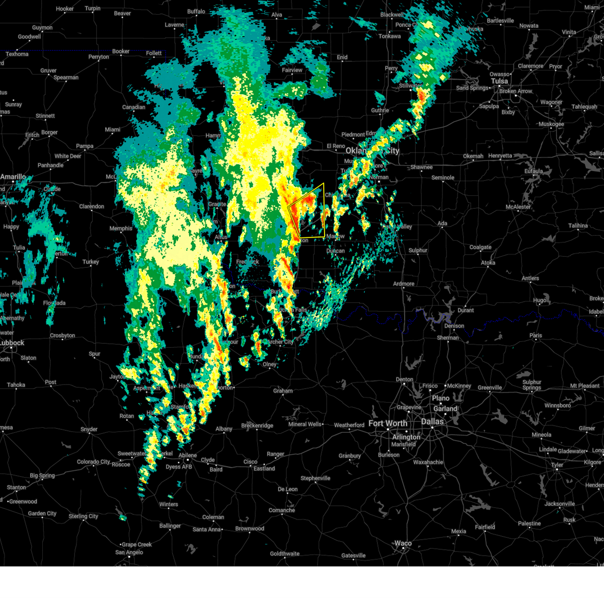
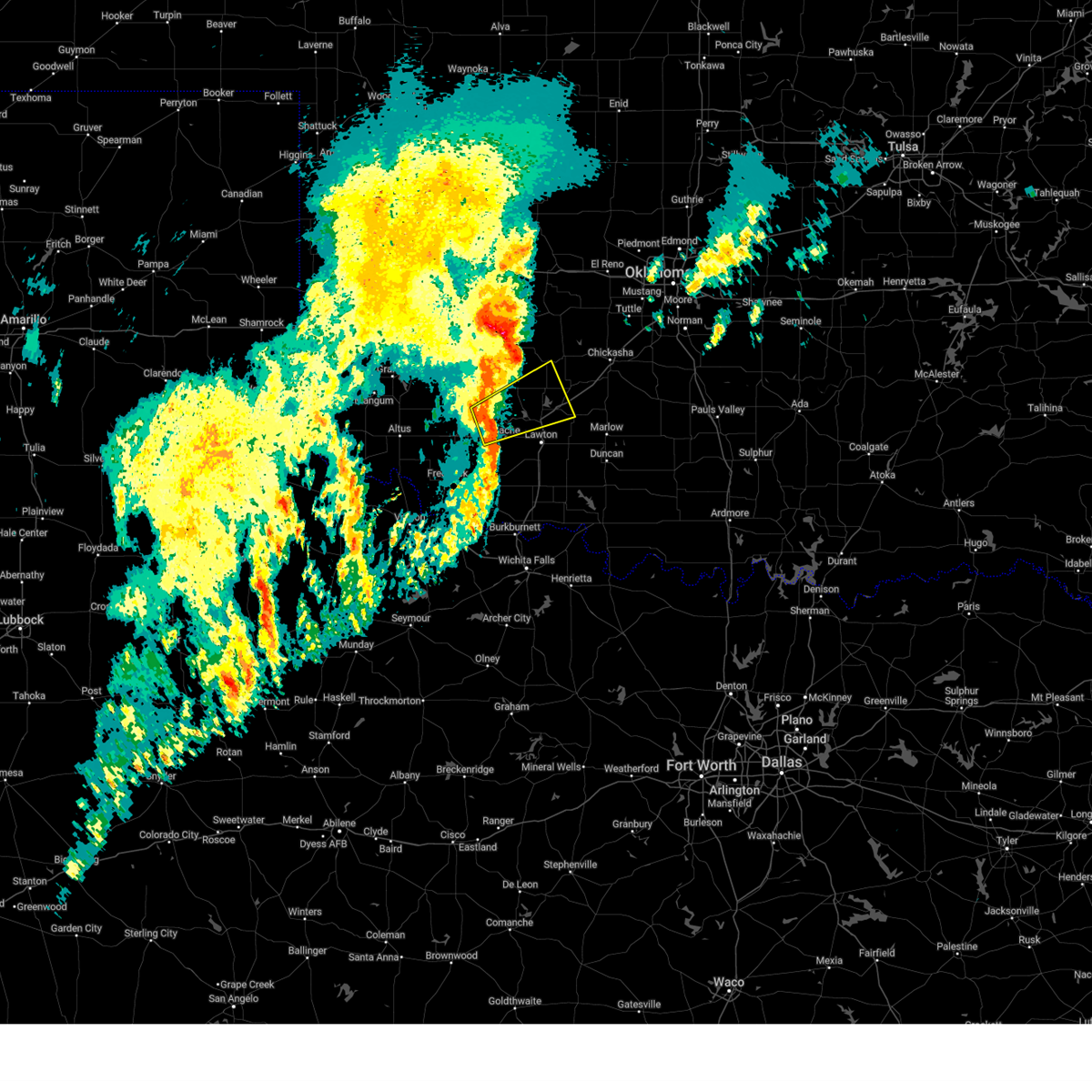
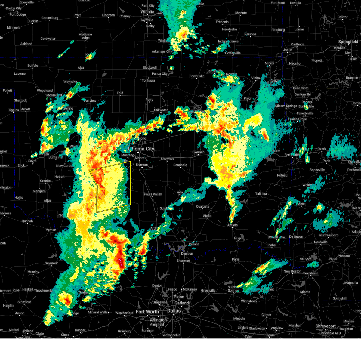
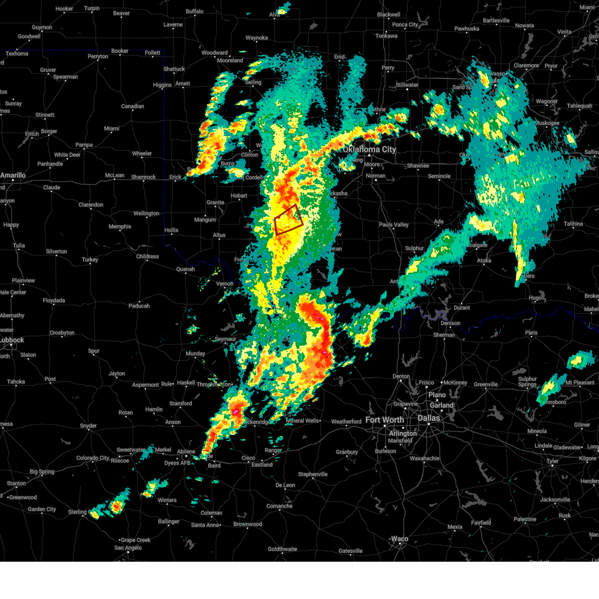
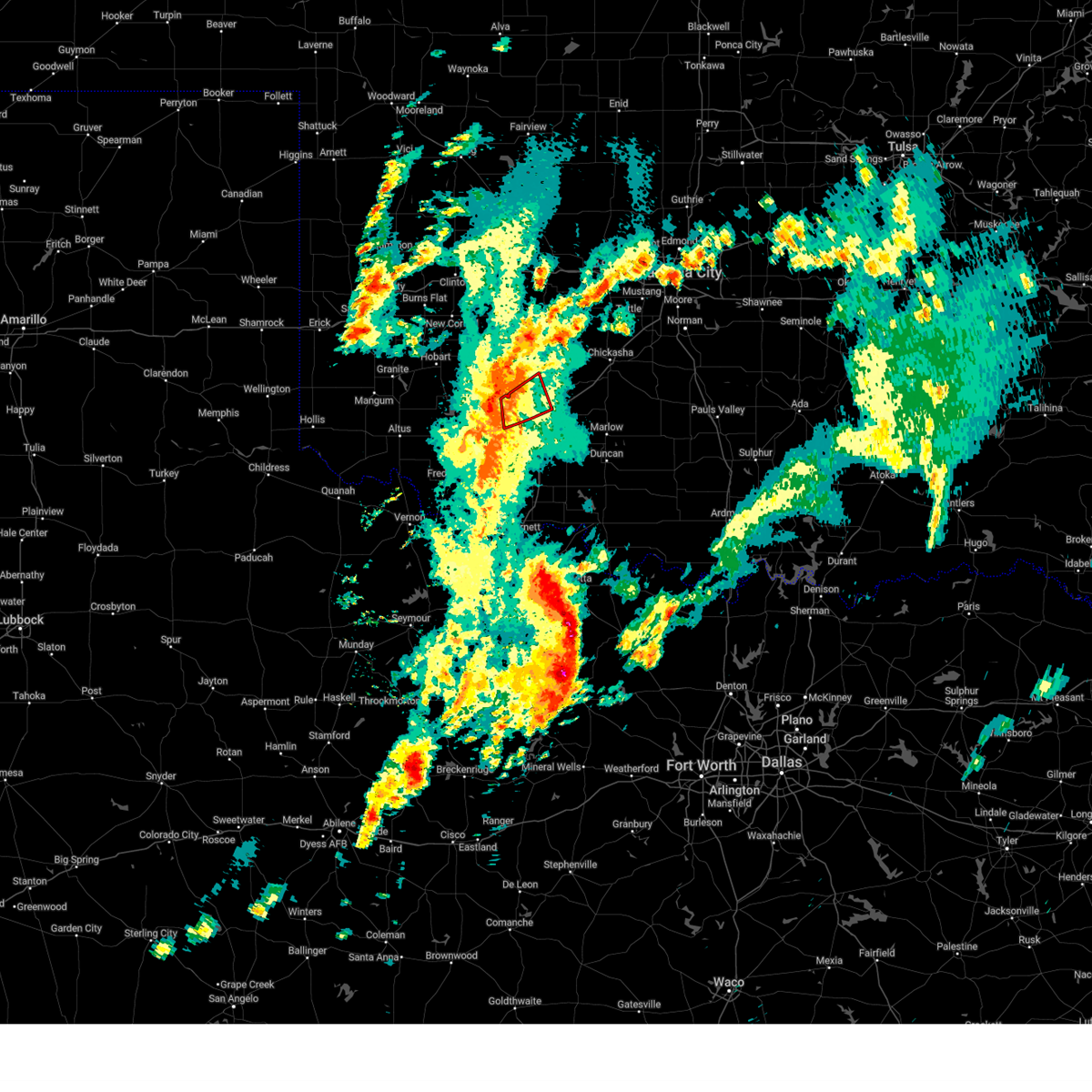
Hail Map for Apache, OK
The Apache, OK area has had 22 reports of on-the-ground hail by trained spotters, and has been under severe weather warnings 21 times during the past 12 months. Doppler radar has detected hail at or near Apache, OK on 90 occasions, including 4 occasions during the past year.
| Name: | Apache, OK |
| Where Located: | 61.9 miles SW of Oklahoma City, OK |
| Map: | Google Map for Apache, OK |
| Population: | 1444 |
| Housing Units: | 694 |
| More Info: | Search Google for Apache, OK |
2
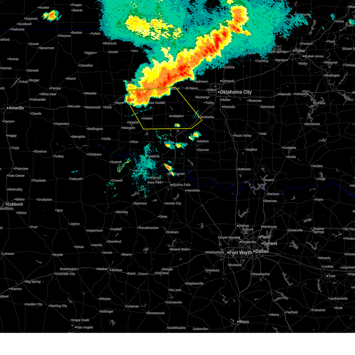
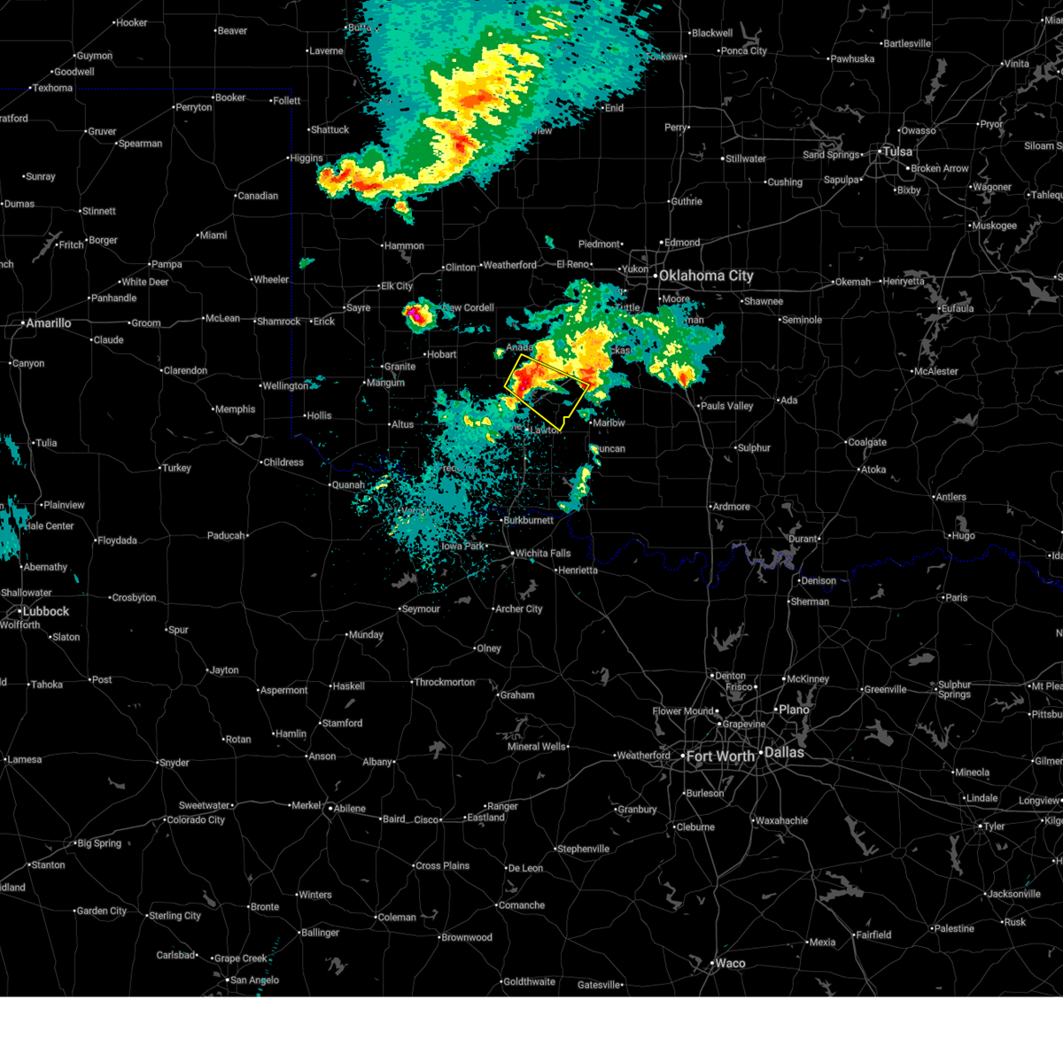
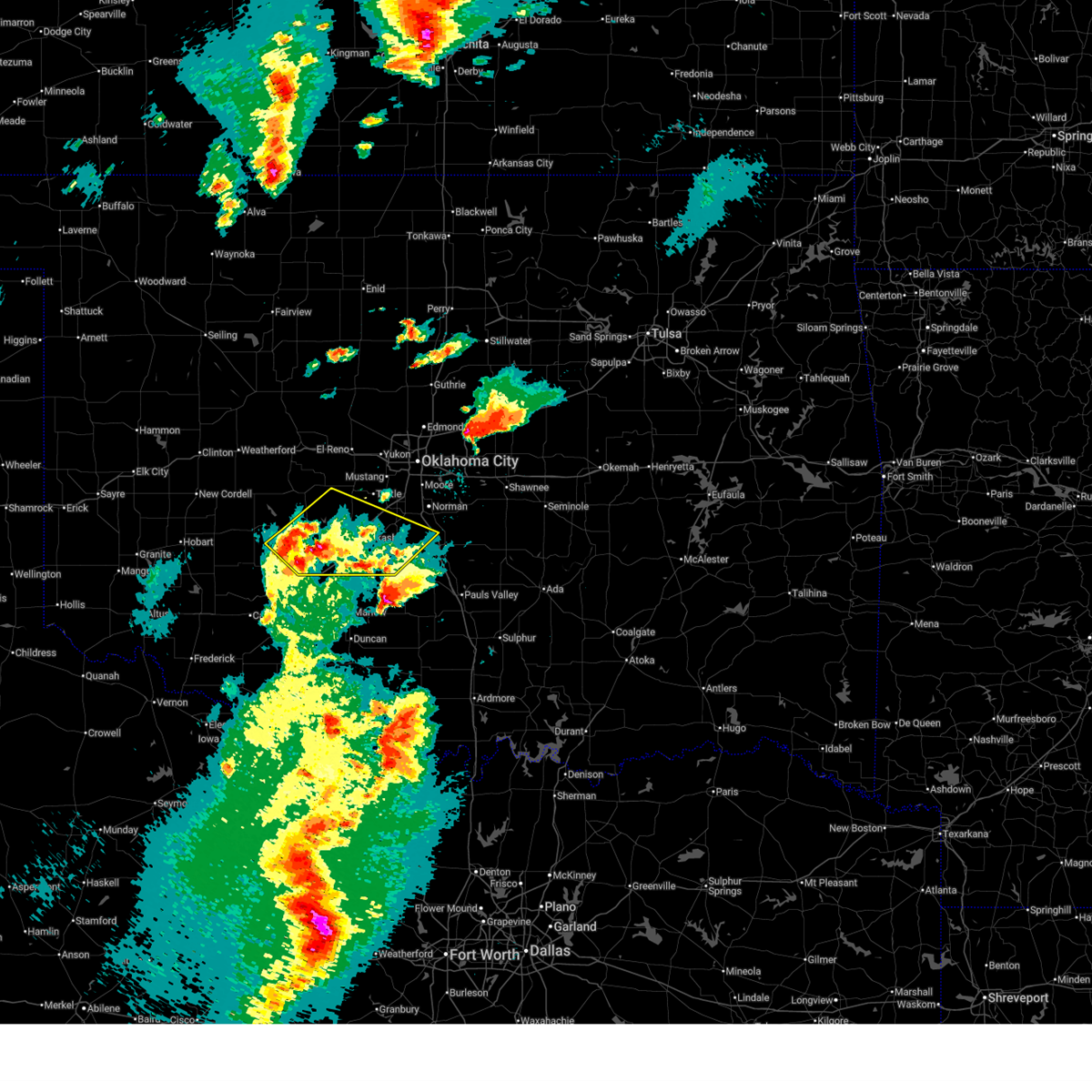
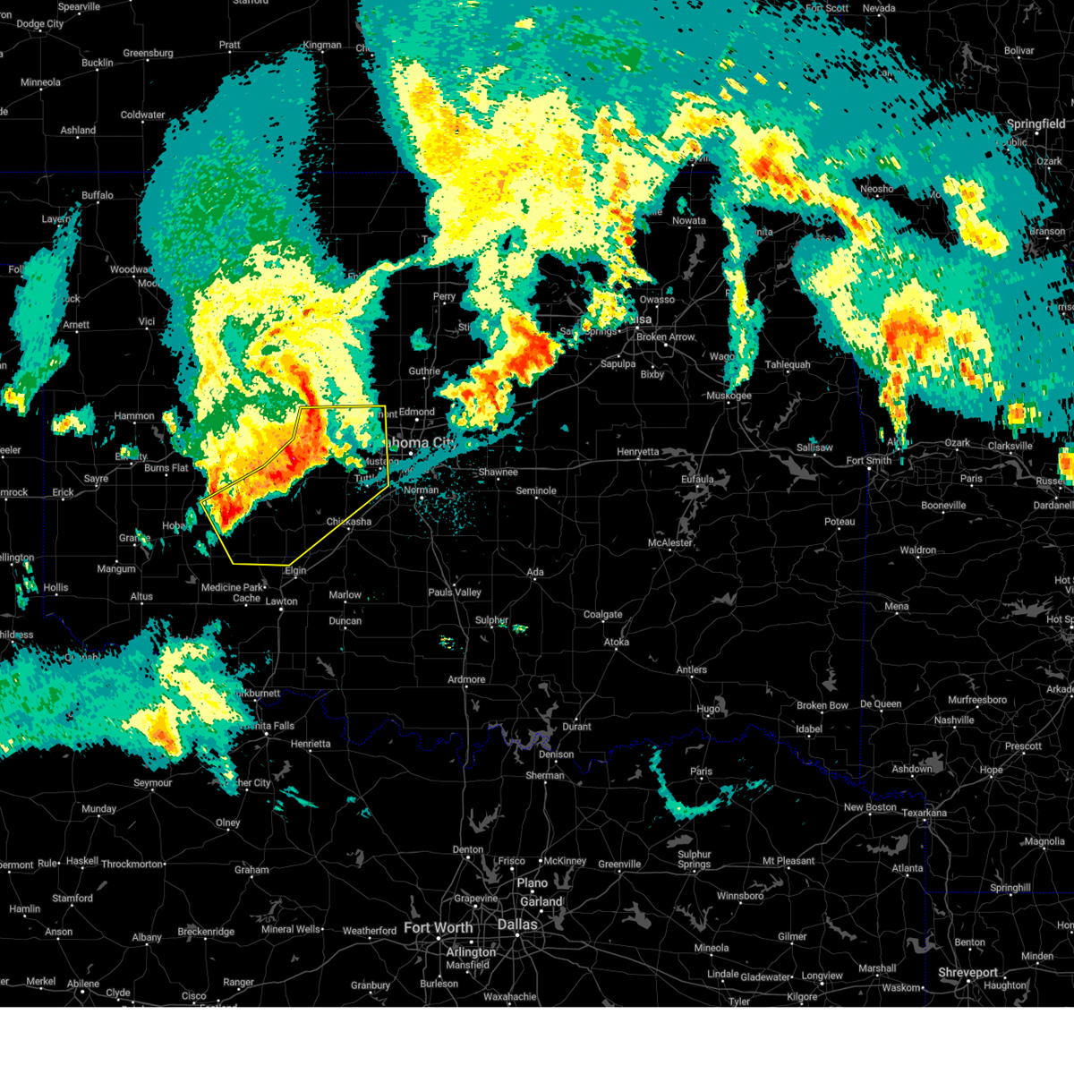
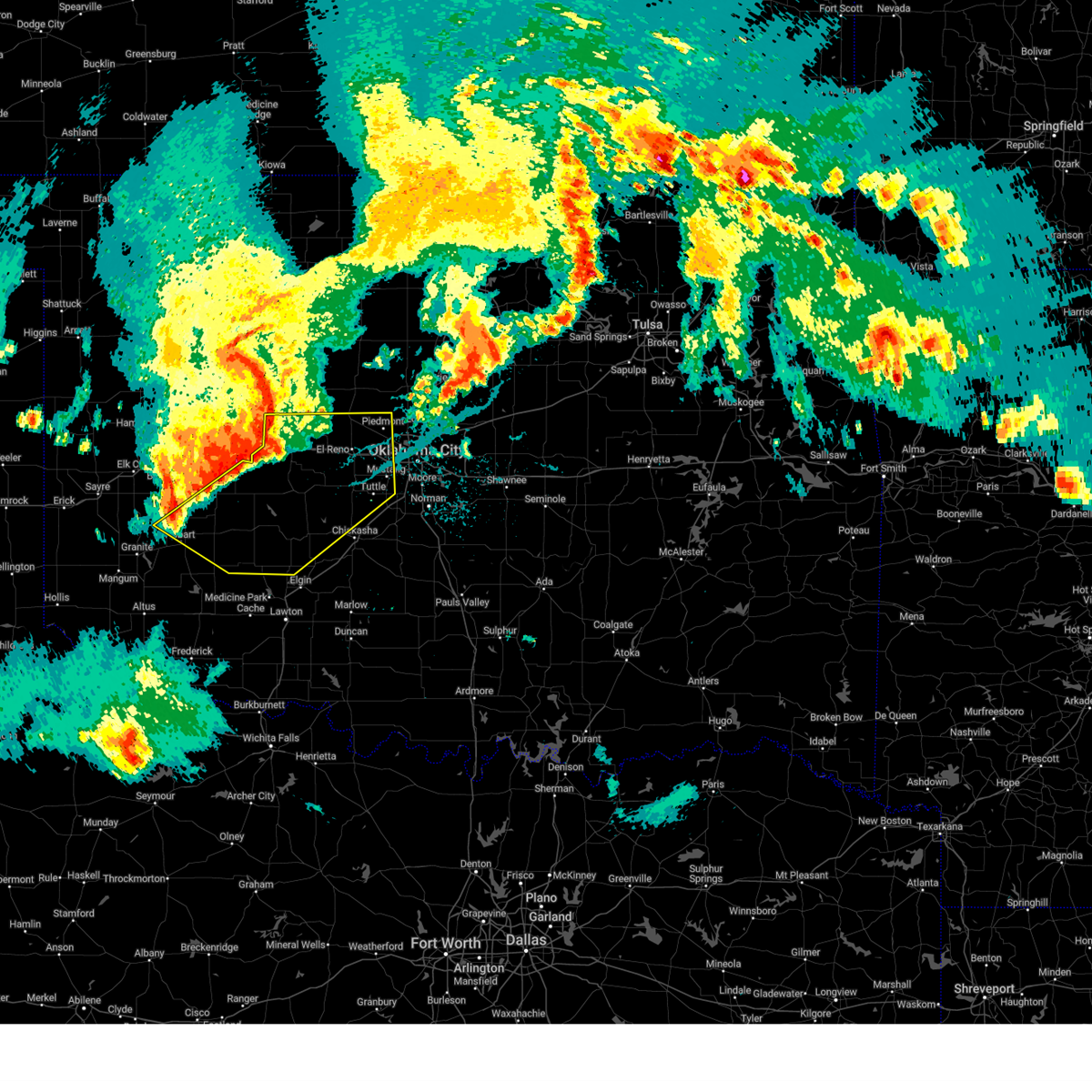
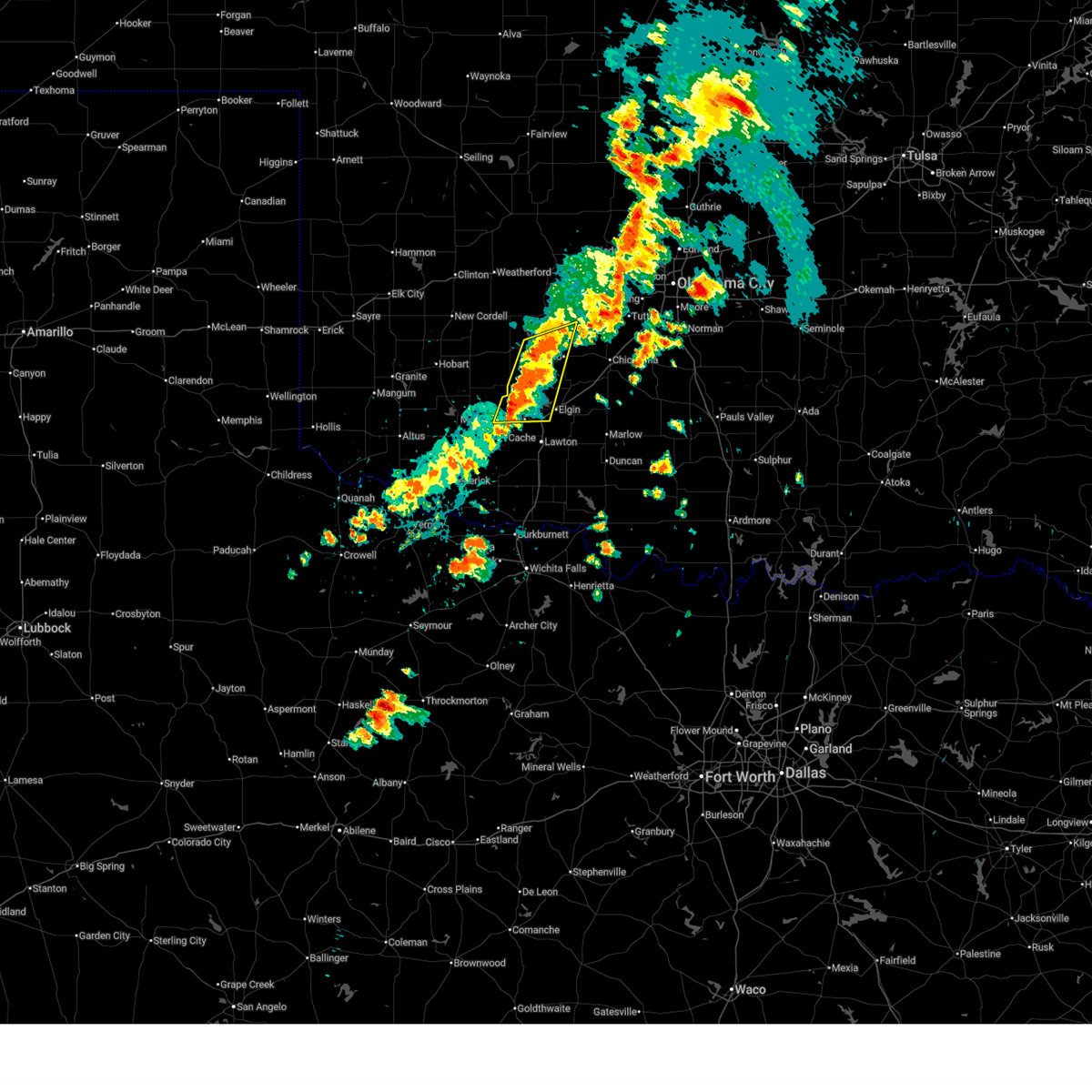
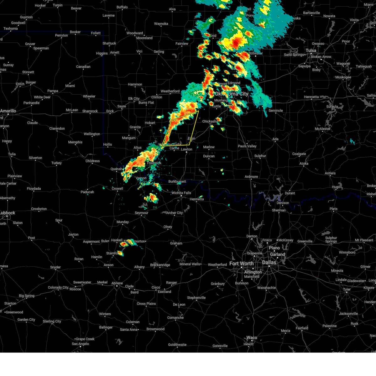
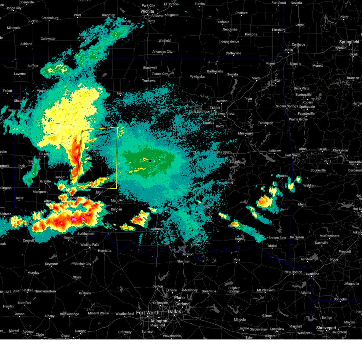
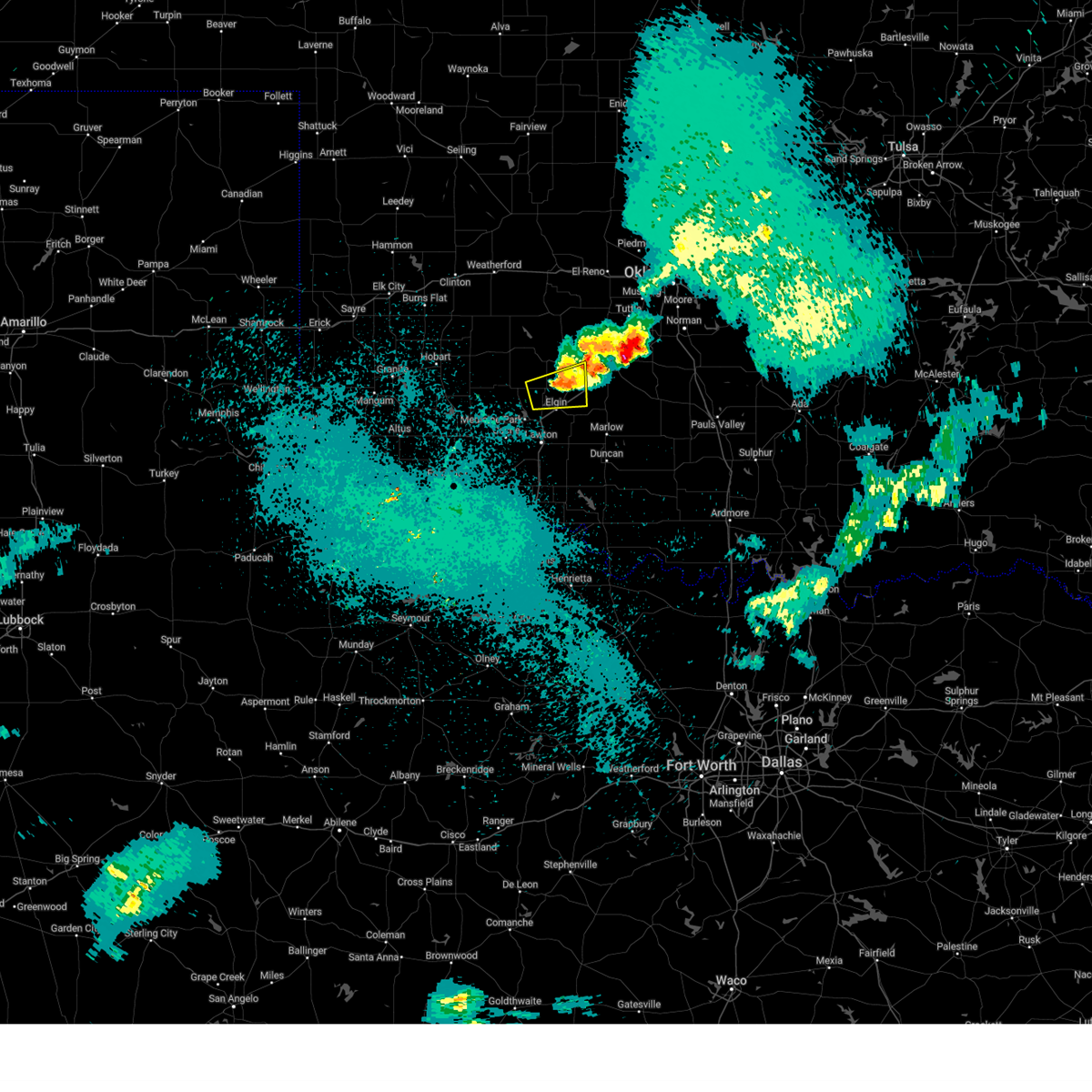
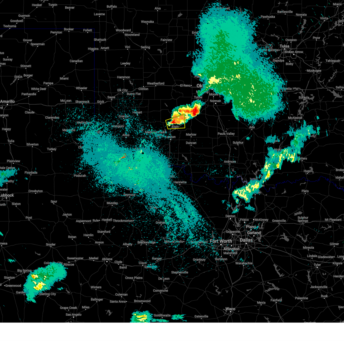
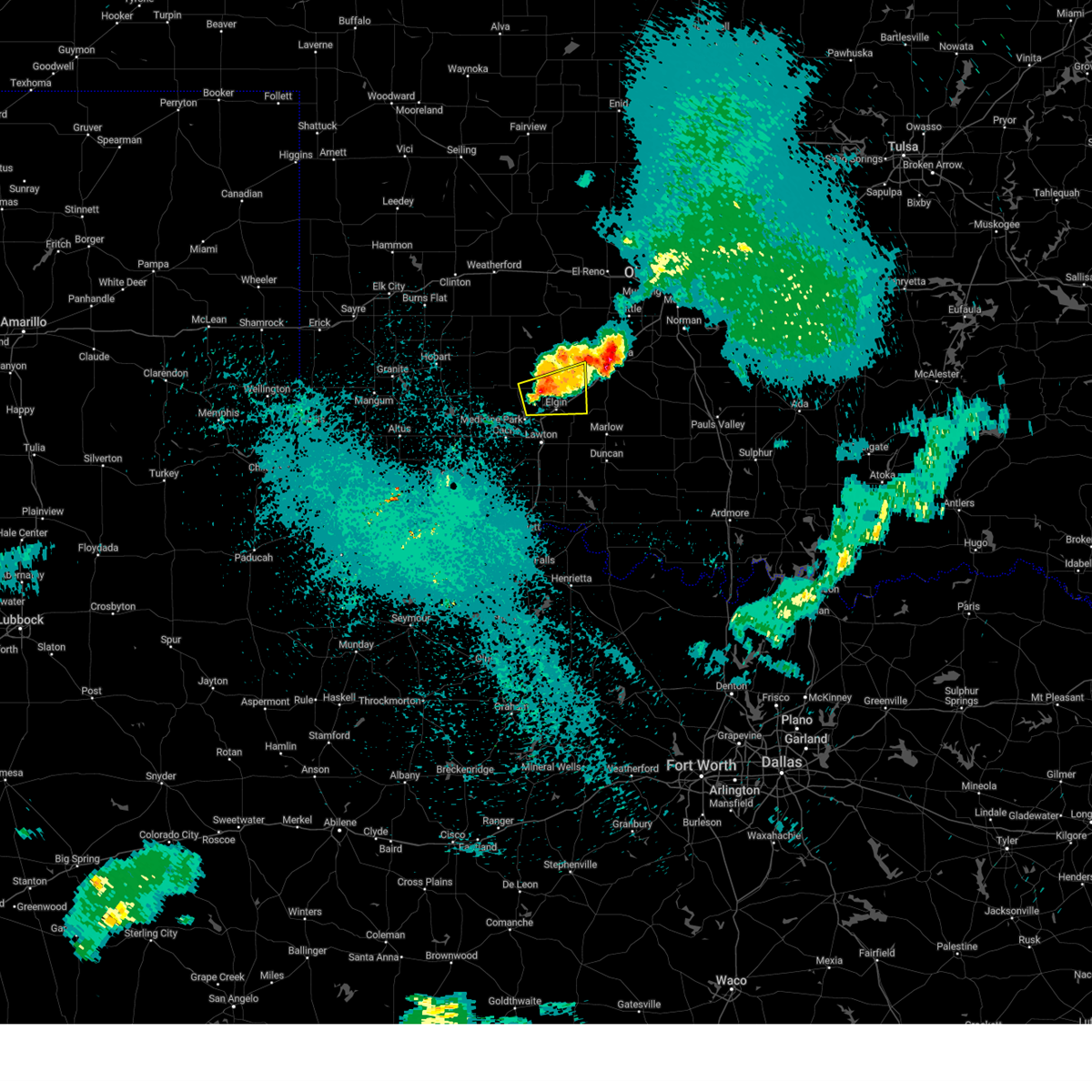
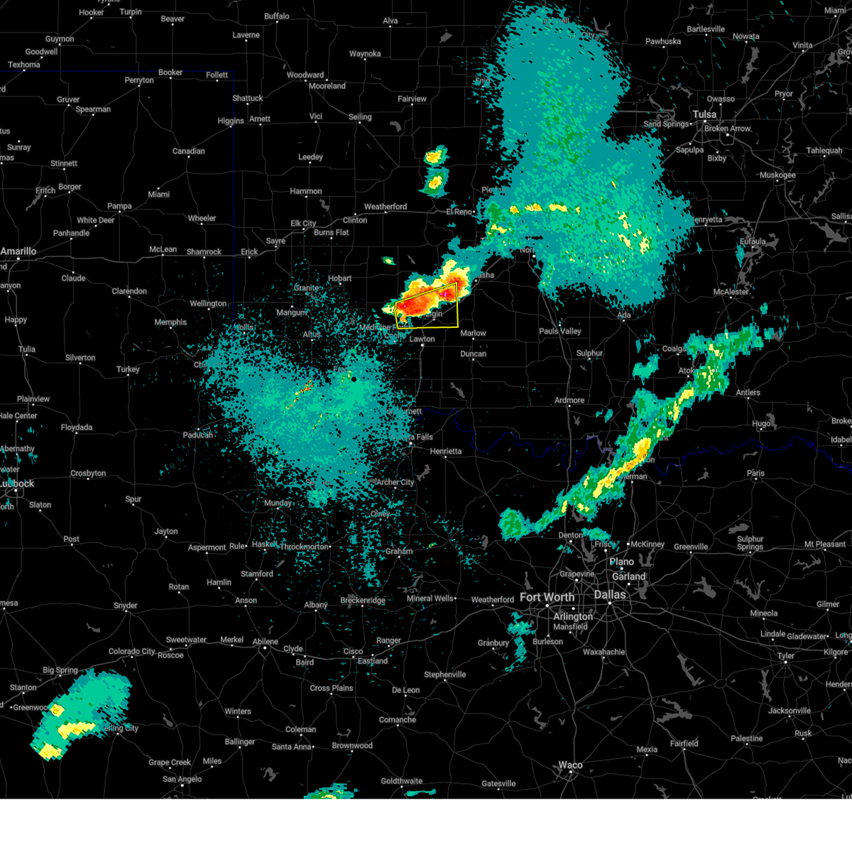
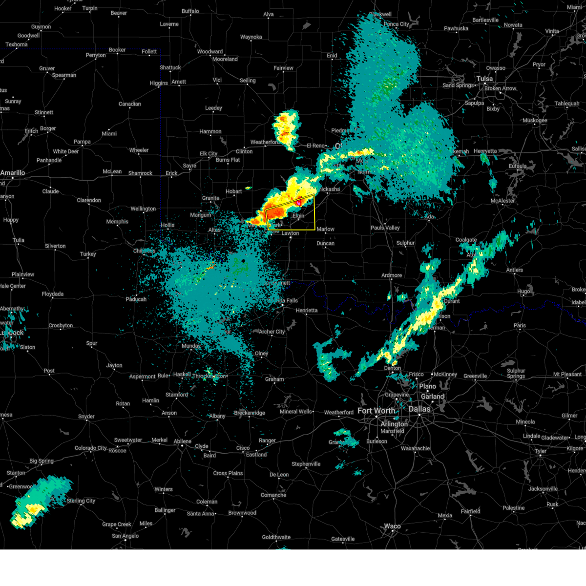
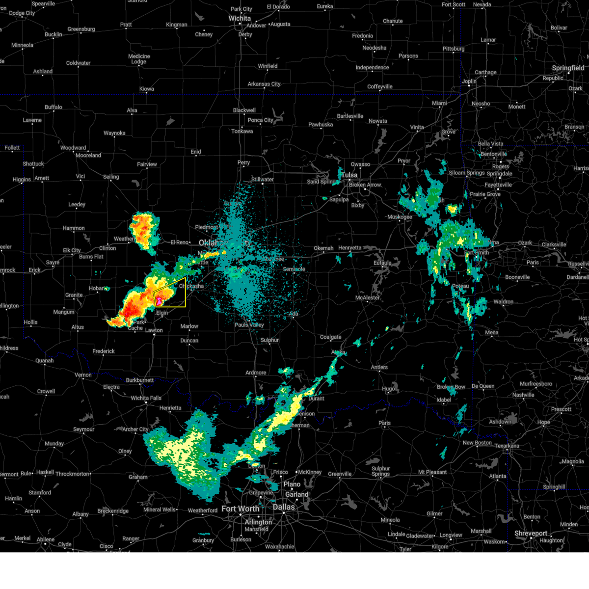
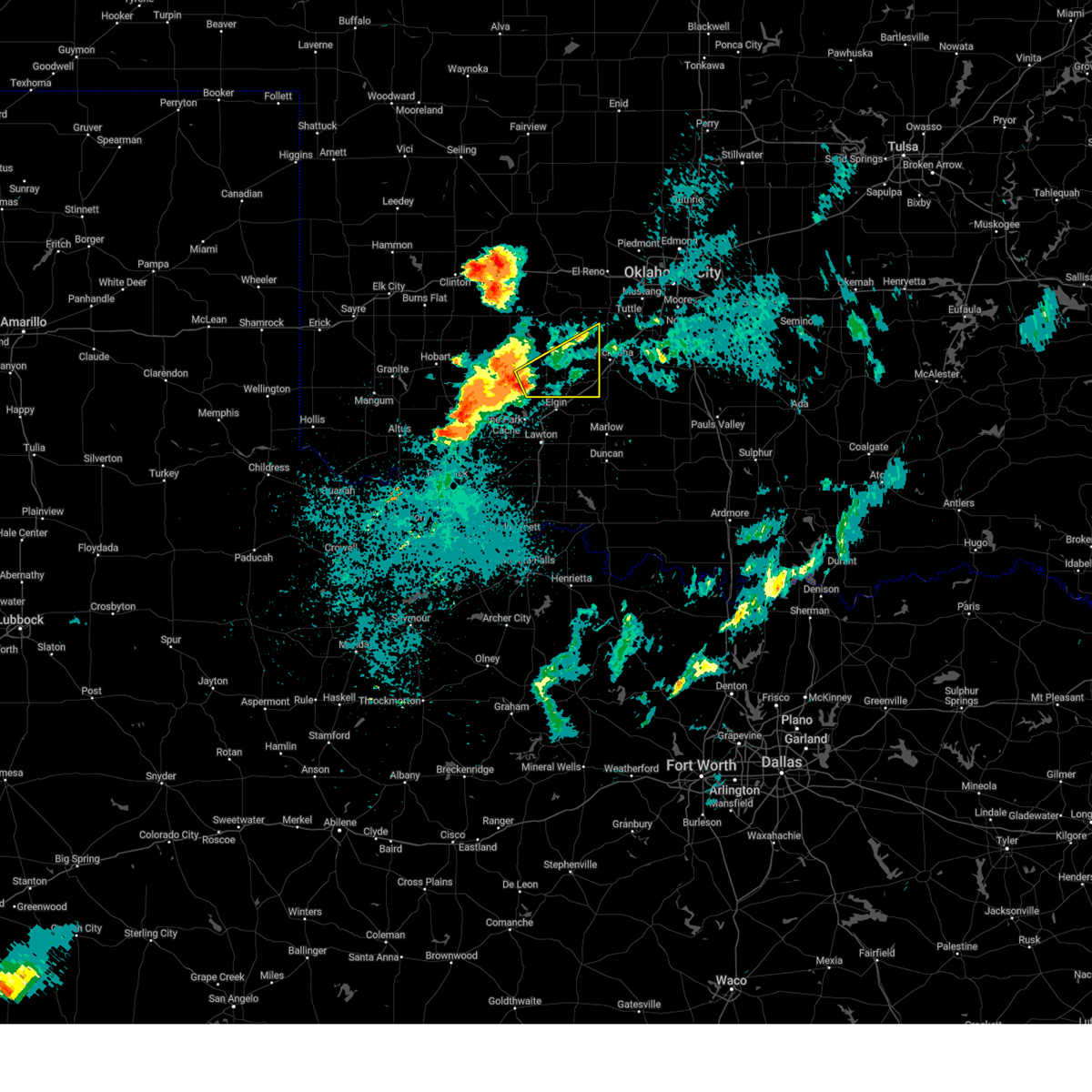
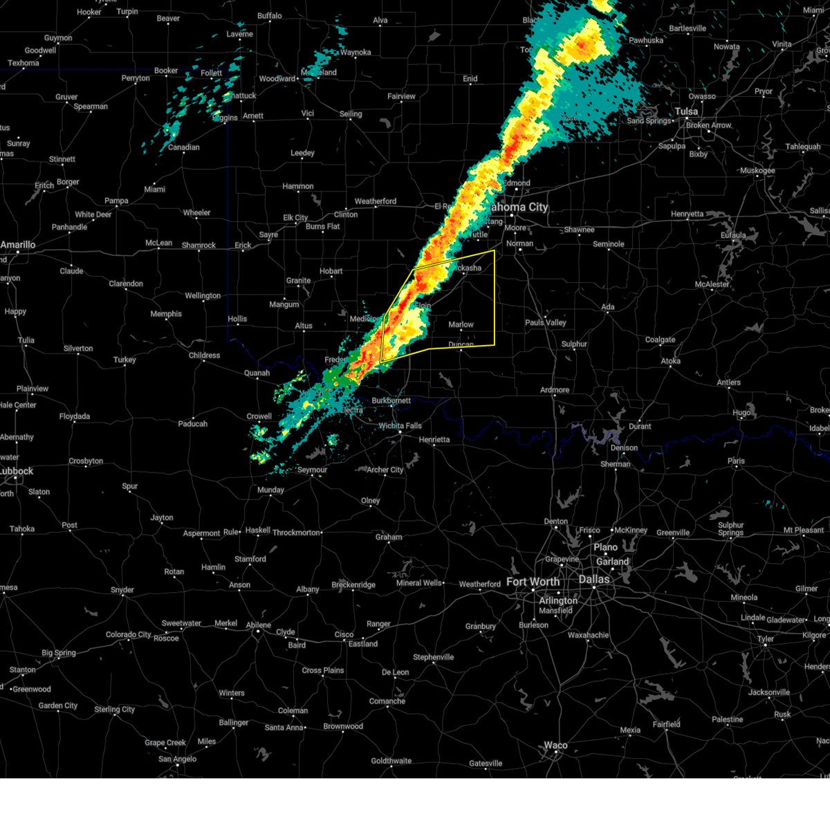
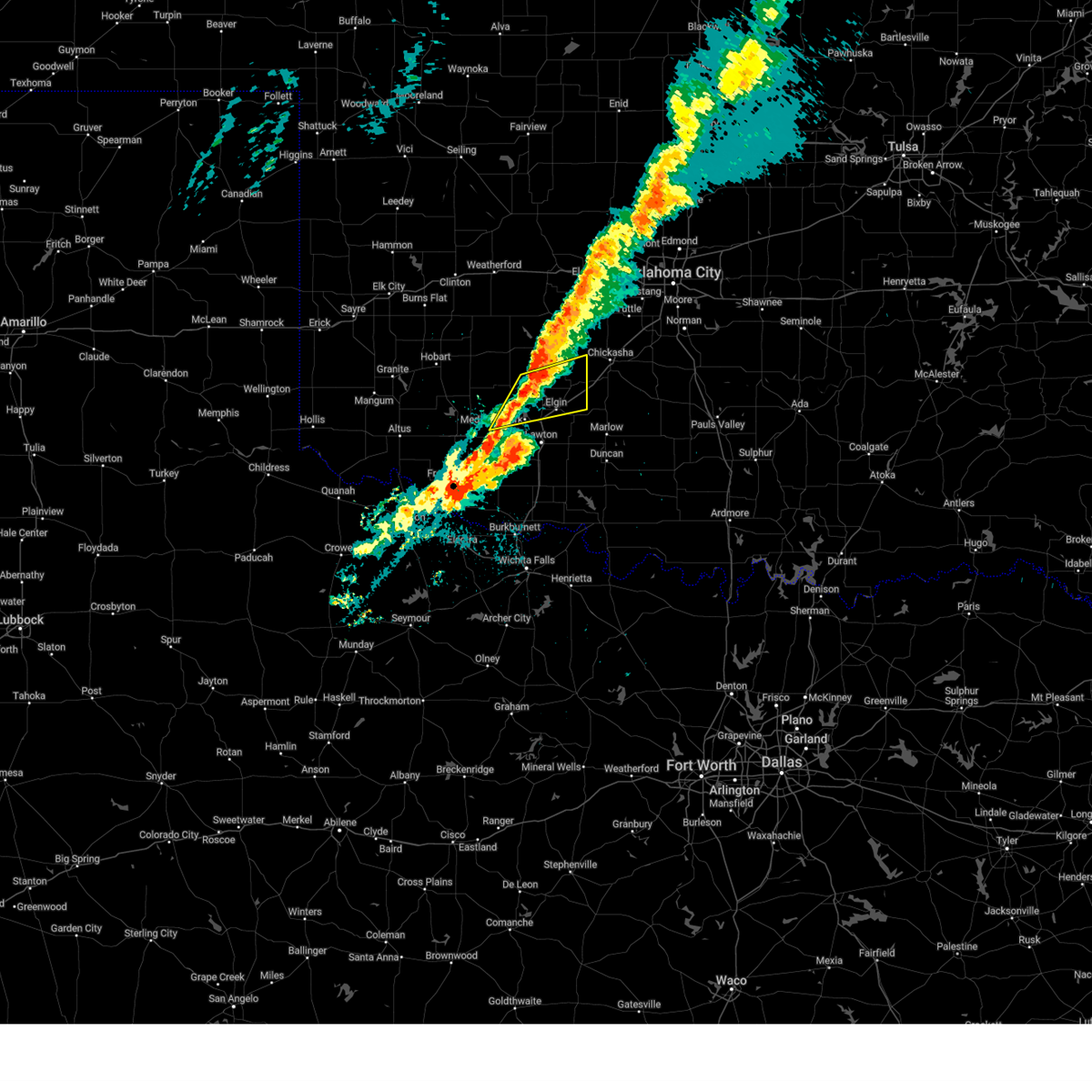
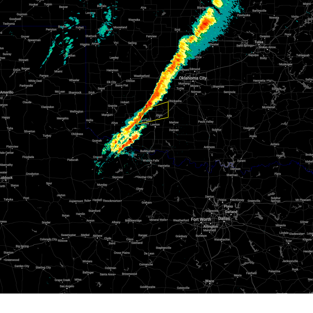
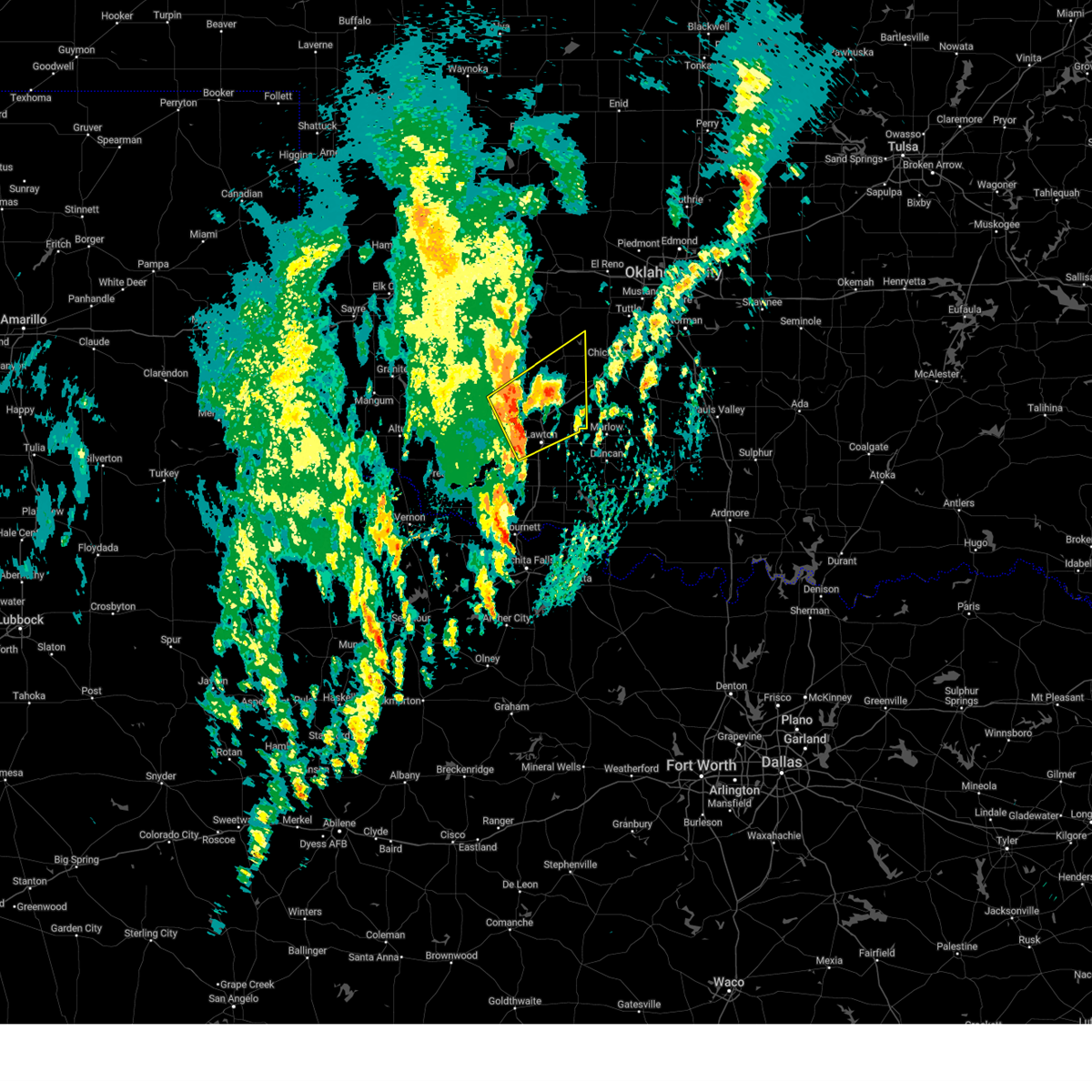
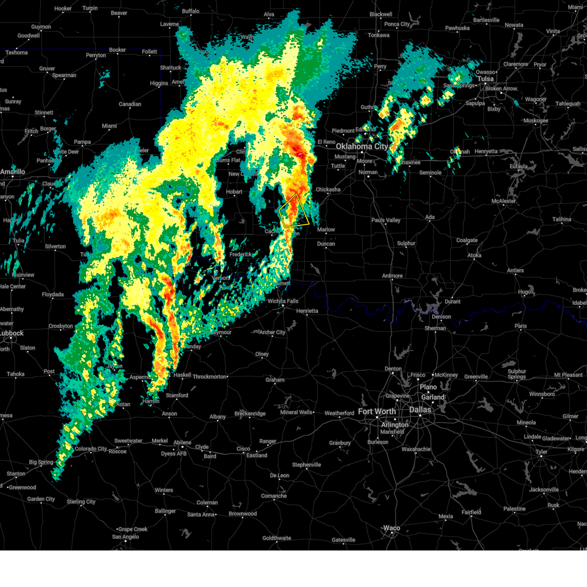
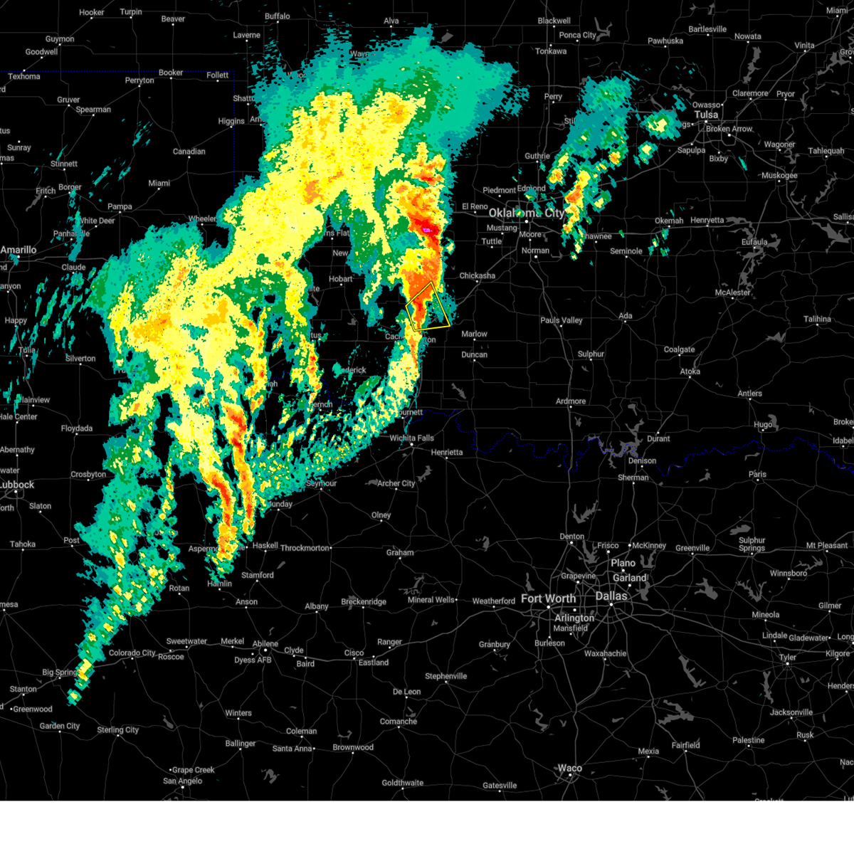
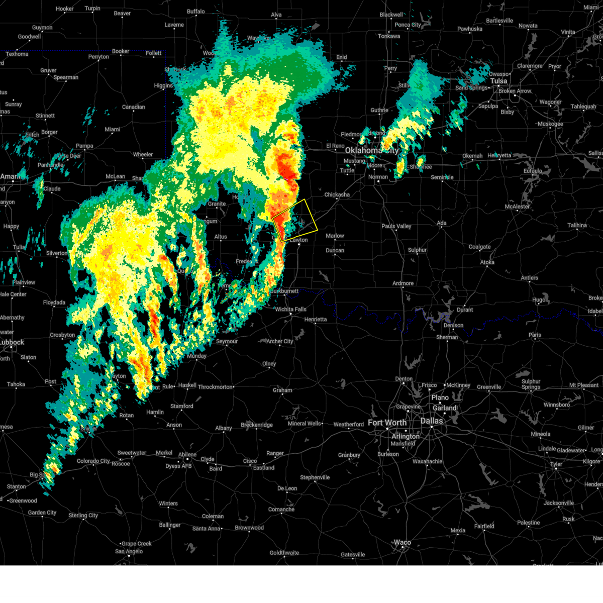
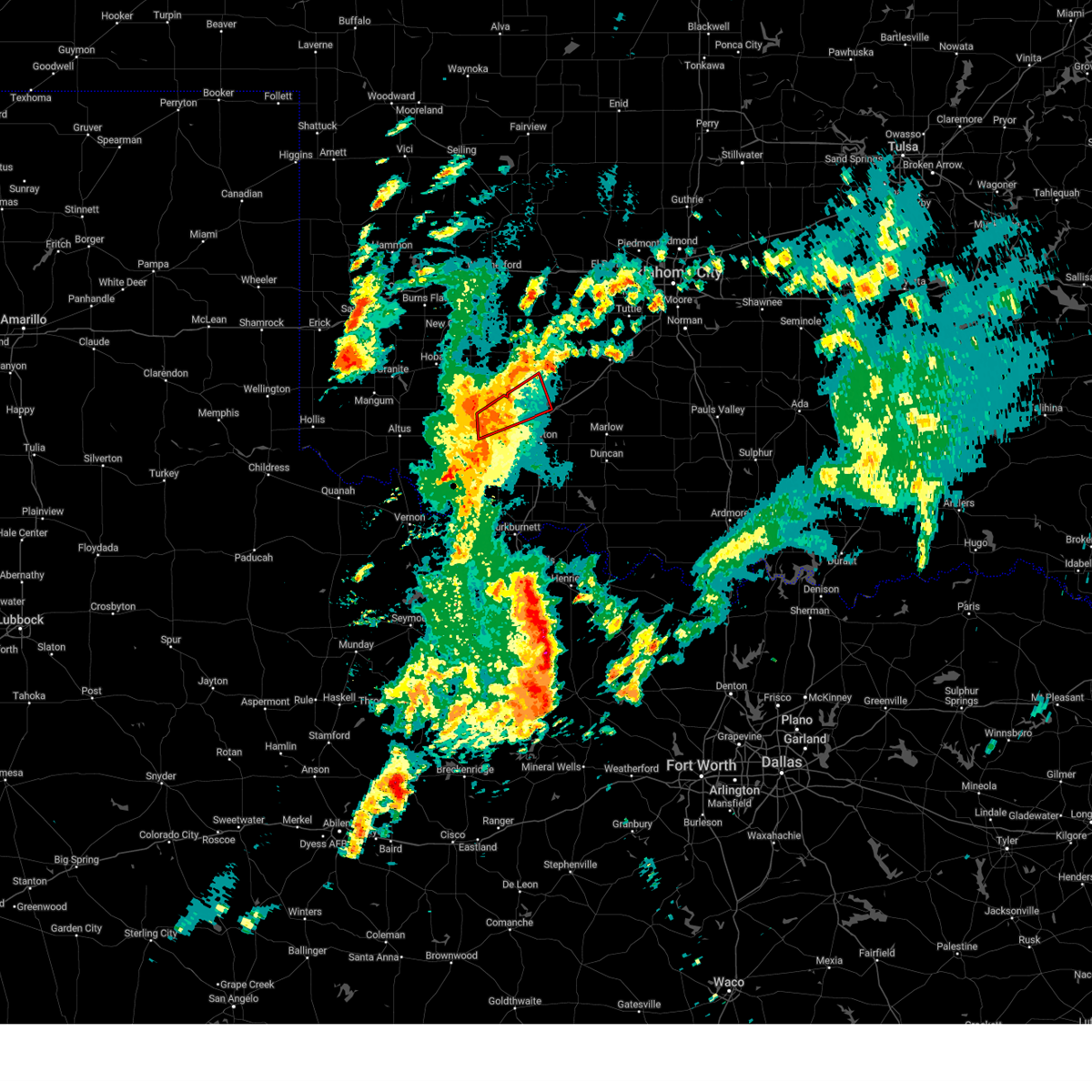
The Top Recent Hail Date for Apache, OK is Saturday, May 9, 2026 (23rd out of 90)
Hail and Wind Damage Spotted near Apache, OK
| Date / Time | Report Details |
|---|---|
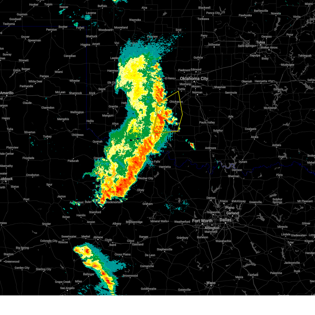
| 7/4/2026 9:51 PM CDT |
 Svroun the national weather service in norman has issued a * severe thunderstorm warning for, northeastern comanche county in southwestern oklahoma, grady county in central oklahoma, southeastern caddo county in southwestern oklahoma, northwestern cleveland county in central oklahoma, northwestern mcclain county in central oklahoma, * until 1015 pm cdt. * at 951 pm cdt, severe thunderstorms were located along a line extending from near tuttle to near chickasha to near lake ellsworth, moving east at 35 mph (radar indicated). Hazards include 60 mph wind gusts and penny size hail. expect damage to roofs, siding, and trees Svroun the national weather service in norman has issued a * severe thunderstorm warning for, northeastern comanche county in southwestern oklahoma, grady county in central oklahoma, southeastern caddo county in southwestern oklahoma, northwestern cleveland county in central oklahoma, northwestern mcclain county in central oklahoma, * until 1015 pm cdt. * at 951 pm cdt, severe thunderstorms were located along a line extending from near tuttle to near chickasha to near lake ellsworth, moving east at 35 mph (radar indicated). Hazards include 60 mph wind gusts and penny size hail. expect damage to roofs, siding, and trees
|
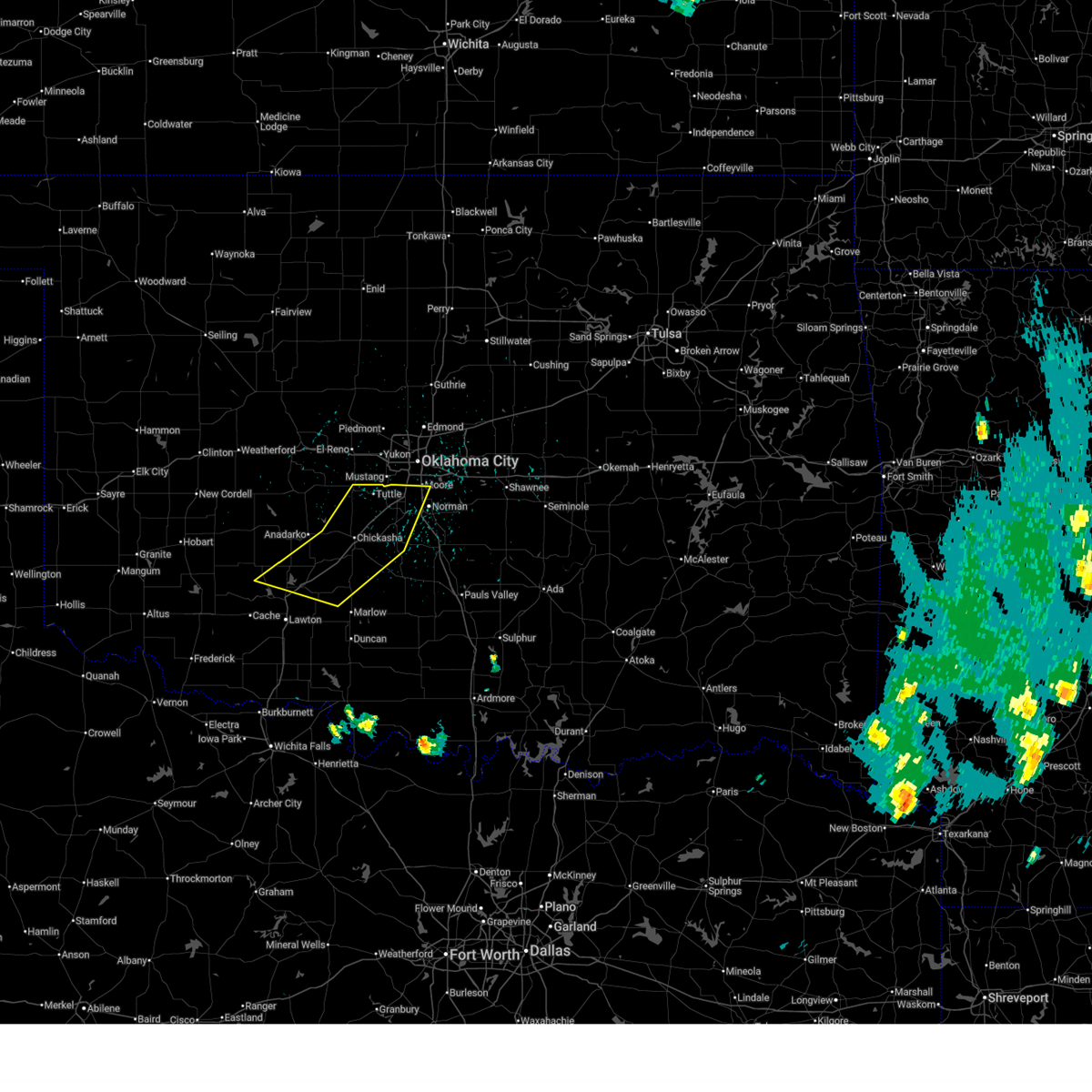
| 7/4/2026 9:44 PM CDT | Storm damage reported in comanche county OK, 4.6 miles NNE of Apache, OK |
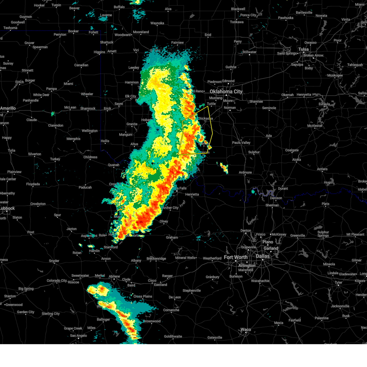
| 6/22/2026 2:36 AM CDT |
 Svroun the national weather service in norman has issued a * severe thunderstorm warning for, comanche county in southwestern oklahoma, southwestern garvin county in southern oklahoma, southern grady county in central oklahoma, southeastern caddo county in southwestern oklahoma, stephens county in southern oklahoma, northern cotton county in southwestern oklahoma, northwestern carter county in southern oklahoma, east central tillman county in southwestern oklahoma, * until 330 am cdt. * at 236 am cdt, severe thunderstorms were located along a line extending from near fort sill to 6 miles northwest of marlow to 4 miles southwest of bradley, moving southeast at 30 mph (radar indicated). Hazards include 60 mph wind gusts and quarter size hail. Hail damage to vehicles is expected. Expect wind damage to roofs, siding, and trees. Svroun the national weather service in norman has issued a * severe thunderstorm warning for, comanche county in southwestern oklahoma, southwestern garvin county in southern oklahoma, southern grady county in central oklahoma, southeastern caddo county in southwestern oklahoma, stephens county in southern oklahoma, northern cotton county in southwestern oklahoma, northwestern carter county in southern oklahoma, east central tillman county in southwestern oklahoma, * until 330 am cdt. * at 236 am cdt, severe thunderstorms were located along a line extending from near fort sill to 6 miles northwest of marlow to 4 miles southwest of bradley, moving southeast at 30 mph (radar indicated). Hazards include 60 mph wind gusts and quarter size hail. Hail damage to vehicles is expected. Expect wind damage to roofs, siding, and trees.
|
| 6/22/2026 2:15 AM CDT | Storm damage reported in caddo county OK, 3.7 miles WSW of Apache, OK |
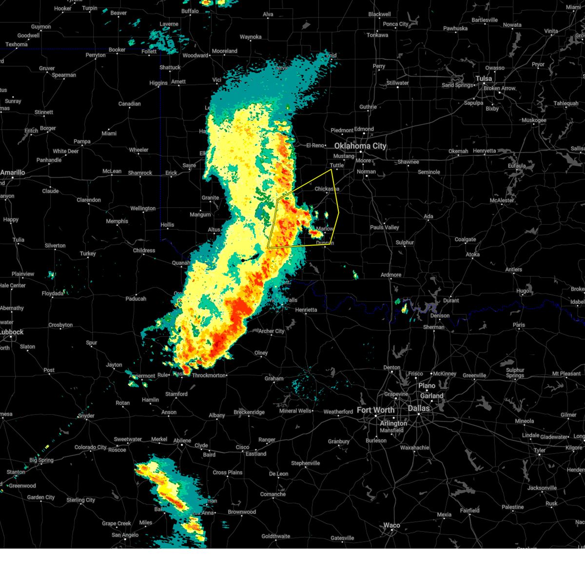
| 6/22/2026 1:46 AM CDT |
 Svroun the national weather service in norman has issued a * severe thunderstorm warning for, southern washita county in western oklahoma, comanche county in southwestern oklahoma, southern grady county in central oklahoma, caddo county in southwestern oklahoma, northwestern stephens county in southern oklahoma, northeastern jackson county in southwestern oklahoma, kiowa county in southwestern oklahoma, northwestern tillman county in southwestern oklahoma, western canadian county in central oklahoma, * until 245 am cdt. * at 146 am cdt, severe thunderstorms were located along a line extending from 3 miles southeast of hobart to 4 miles south of carnegie to 5 miles northeast of gracemont, moving southeast at 55 mph (radar indicated). Hazards include 70 mph wind gusts and quarter size hail. Hail damage to vehicles is expected. expect considerable tree damage. Wind damage is also likely to mobile homes, roofs, and outbuildings. Svroun the national weather service in norman has issued a * severe thunderstorm warning for, southern washita county in western oklahoma, comanche county in southwestern oklahoma, southern grady county in central oklahoma, caddo county in southwestern oklahoma, northwestern stephens county in southern oklahoma, northeastern jackson county in southwestern oklahoma, kiowa county in southwestern oklahoma, northwestern tillman county in southwestern oklahoma, western canadian county in central oklahoma, * until 245 am cdt. * at 146 am cdt, severe thunderstorms were located along a line extending from 3 miles southeast of hobart to 4 miles south of carnegie to 5 miles northeast of gracemont, moving southeast at 55 mph (radar indicated). Hazards include 70 mph wind gusts and quarter size hail. Hail damage to vehicles is expected. expect considerable tree damage. Wind damage is also likely to mobile homes, roofs, and outbuildings.
|
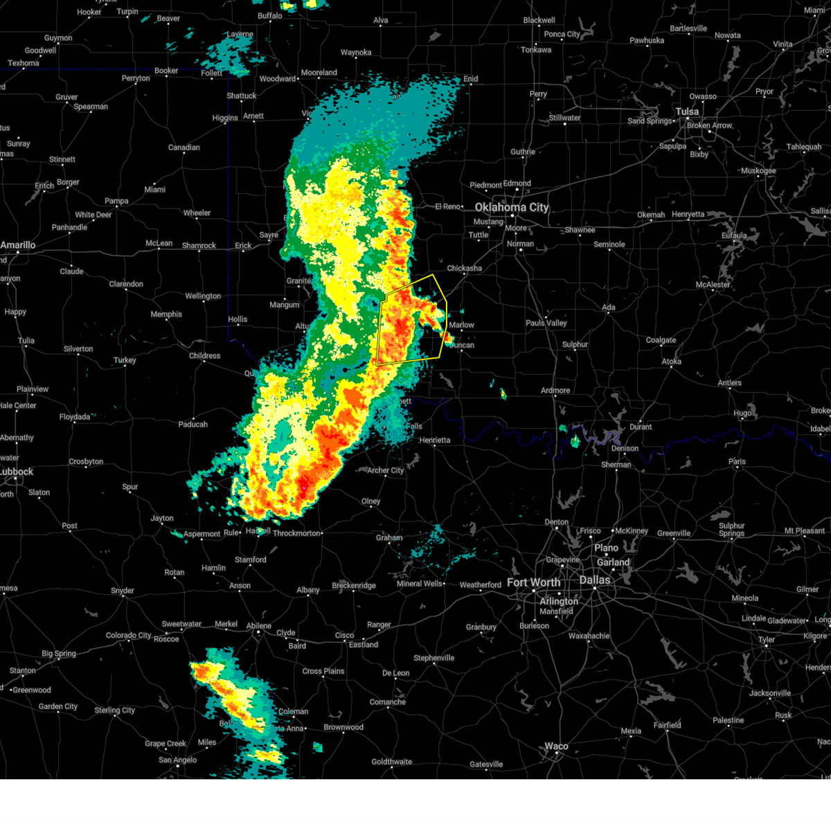
| 6/22/2026 1:19 AM CDT |
 Svroun the national weather service in norman has issued a * severe thunderstorm warning for, washita county in western oklahoma, west central grady county in central oklahoma, caddo county in southwestern oklahoma, southern custer county in western oklahoma, northeastern kiowa county in southwestern oklahoma, western canadian county in central oklahoma, * until 200 am cdt. * at 119 am cdt, severe thunderstorms were located along a line extending from 4 miles north of sentinel to near colony to near hinton, moving southeast at 40 mph (radar indicated). Hazards include 70 mph wind gusts and quarter size hail. Hail damage to vehicles is expected. expect considerable tree damage. Wind damage is also likely to mobile homes, roofs, and outbuildings. Svroun the national weather service in norman has issued a * severe thunderstorm warning for, washita county in western oklahoma, west central grady county in central oklahoma, caddo county in southwestern oklahoma, southern custer county in western oklahoma, northeastern kiowa county in southwestern oklahoma, western canadian county in central oklahoma, * until 200 am cdt. * at 119 am cdt, severe thunderstorms were located along a line extending from 4 miles north of sentinel to near colony to near hinton, moving southeast at 40 mph (radar indicated). Hazards include 70 mph wind gusts and quarter size hail. Hail damage to vehicles is expected. expect considerable tree damage. Wind damage is also likely to mobile homes, roofs, and outbuildings.
|
| 6/11/2026 8:26 PM CDT |
 At 826 pm cdt, a severe thunderstorm was located near cement, moving southeast at 15 mph (radar indicated). Hazards include 60 mph wind gusts and quarter size hail. Hail damage to vehicles is expected. expect wind damage to roofs, siding, and trees. Locations impacted include, anadarko, apache, cyril, verden, cement, agawam, lake chickasha, ninnekah, stecker, and laverty. At 826 pm cdt, a severe thunderstorm was located near cement, moving southeast at 15 mph (radar indicated). Hazards include 60 mph wind gusts and quarter size hail. Hail damage to vehicles is expected. expect wind damage to roofs, siding, and trees. Locations impacted include, anadarko, apache, cyril, verden, cement, agawam, lake chickasha, ninnekah, stecker, and laverty.
|
| 6/11/2026 7:57 PM CDT |
 Svroun the national weather service in norman has issued a * severe thunderstorm warning for, west central grady county in central oklahoma, southeastern caddo county in southwestern oklahoma, * until 845 pm cdt. * at 757 pm cdt, a severe thunderstorm was located near anadarko, moving southeast at 15 mph (radar indicated). Hazards include ping pong ball size hail and 60 mph wind gusts. People and animals outdoors will be injured. expect hail damage to roofs, siding, windows, and vehicles. Expect wind damage to roofs, siding, and trees. Svroun the national weather service in norman has issued a * severe thunderstorm warning for, west central grady county in central oklahoma, southeastern caddo county in southwestern oklahoma, * until 845 pm cdt. * at 757 pm cdt, a severe thunderstorm was located near anadarko, moving southeast at 15 mph (radar indicated). Hazards include ping pong ball size hail and 60 mph wind gusts. People and animals outdoors will be injured. expect hail damage to roofs, siding, windows, and vehicles. Expect wind damage to roofs, siding, and trees.
|
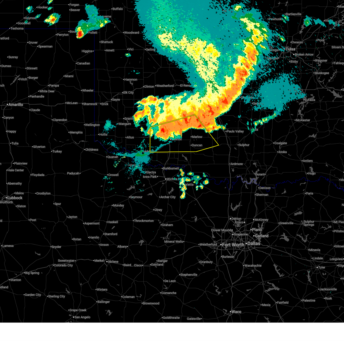
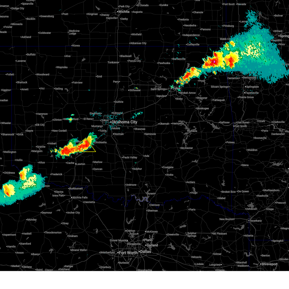
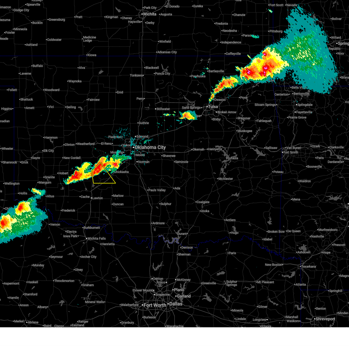
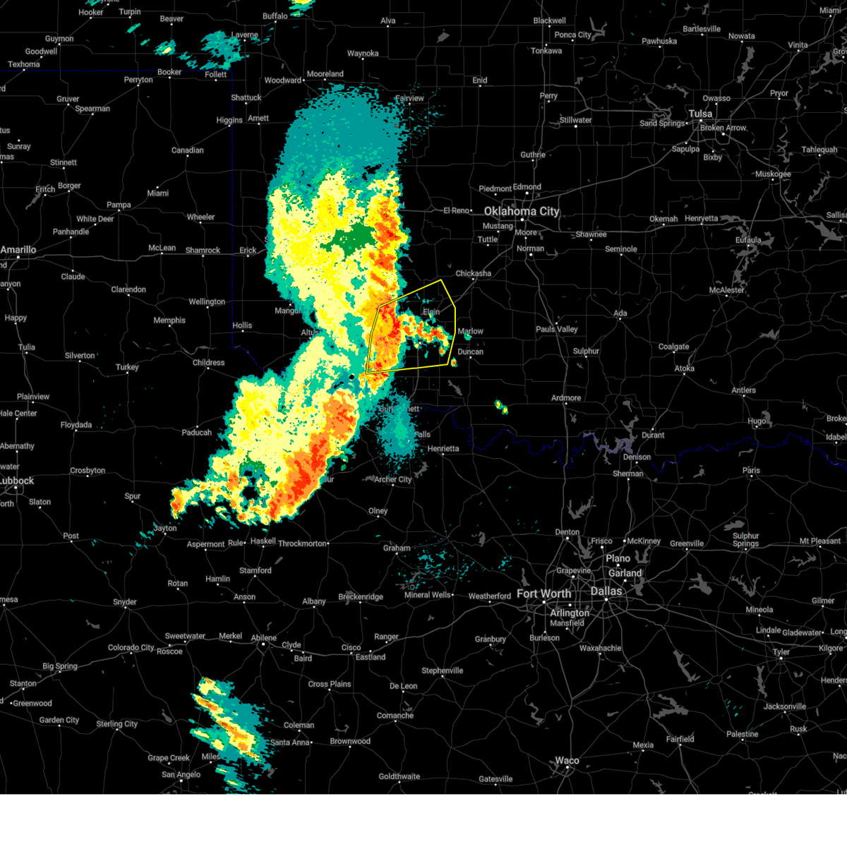
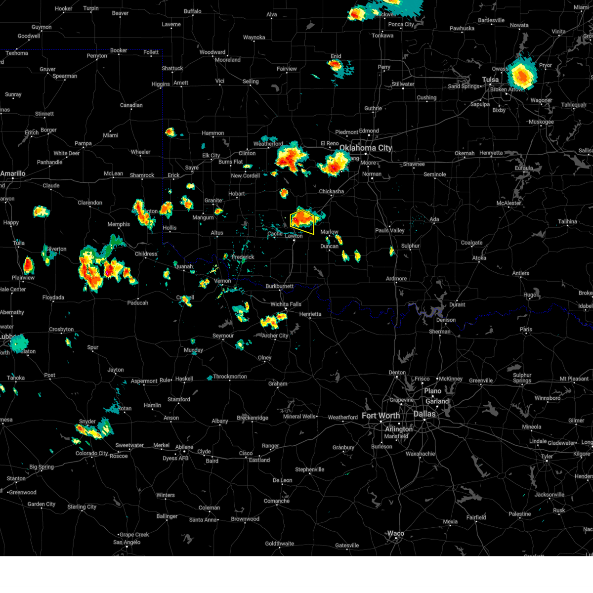
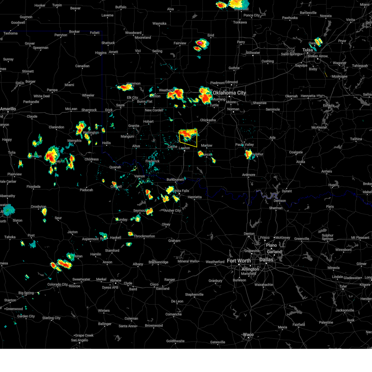
| 5/9/2026 9:08 PM CDT | Quarter sized hail reported 4.6 miles NNE of Apache, OK |
| 5/9/2026 9:06 PM CDT |
 At 906 pm cdt, a severe thunderstorm was located near lake ellsworth, moving southeast at 30 mph (radar indicated). Hazards include 60 mph wind gusts and half dollar size hail. Hail damage to vehicles is expected. expect wind damage to roofs, siding, and trees. Locations impacted include, elgin, apache, fletcher, cyril, sterling, lake ellsworth, boone, northeastern fort sill, acme, and stecker. At 906 pm cdt, a severe thunderstorm was located near lake ellsworth, moving southeast at 30 mph (radar indicated). Hazards include 60 mph wind gusts and half dollar size hail. Hail damage to vehicles is expected. expect wind damage to roofs, siding, and trees. Locations impacted include, elgin, apache, fletcher, cyril, sterling, lake ellsworth, boone, northeastern fort sill, acme, and stecker.
|
| 5/9/2026 8:57 PM CDT |
 At 857 pm cdt, a severe thunderstorm was located near boone, moving southeast at 30 mph (radar indicated). Hazards include 60 mph wind gusts and half dollar size hail. Hail damage to vehicles is expected. expect wind damage to roofs, siding, and trees. Locations impacted include, elgin, apache, fletcher, cyril, sterling, lake ellsworth, boone, northeastern fort sill, acme, and stecker. At 857 pm cdt, a severe thunderstorm was located near boone, moving southeast at 30 mph (radar indicated). Hazards include 60 mph wind gusts and half dollar size hail. Hail damage to vehicles is expected. expect wind damage to roofs, siding, and trees. Locations impacted include, elgin, apache, fletcher, cyril, sterling, lake ellsworth, boone, northeastern fort sill, acme, and stecker.
|
| 5/9/2026 8:45 PM CDT |
 Svroun the national weather service in norman has issued a * severe thunderstorm warning for, northeastern comanche county in southwestern oklahoma, southwestern grady county in central oklahoma, southern caddo county in southwestern oklahoma, * until 930 pm cdt. * at 845 pm cdt, a severe thunderstorm was located 4 miles northwest of boone, moving southeast at 30 mph (radar indicated). Hazards include golf ball size hail and 60 mph wind gusts. People and animals outdoors will be injured. expect hail damage to roofs, siding, windows, and vehicles. Expect wind damage to roofs, siding, and trees. Svroun the national weather service in norman has issued a * severe thunderstorm warning for, northeastern comanche county in southwestern oklahoma, southwestern grady county in central oklahoma, southern caddo county in southwestern oklahoma, * until 930 pm cdt. * at 845 pm cdt, a severe thunderstorm was located 4 miles northwest of boone, moving southeast at 30 mph (radar indicated). Hazards include golf ball size hail and 60 mph wind gusts. People and animals outdoors will be injured. expect hail damage to roofs, siding, windows, and vehicles. Expect wind damage to roofs, siding, and trees.
|
| 5/9/2026 8:37 PM CDT |
 Svroun the national weather service in norman has issued a * severe thunderstorm warning for, northeastern comanche county in southwestern oklahoma, grady county in central oklahoma, southeastern caddo county in southwestern oklahoma, northwestern stephens county in southern oklahoma, southwestern mcclain county in central oklahoma, * until 915 pm cdt. * at 837 pm cdt, a severe thunderstorm was located 4 miles southwest of anadarko, moving southeast at 30 mph (radar indicated). Hazards include 60 mph wind gusts and half dollar size hail. Hail damage to vehicles is expected. Expect wind damage to roofs, siding, and trees. Svroun the national weather service in norman has issued a * severe thunderstorm warning for, northeastern comanche county in southwestern oklahoma, grady county in central oklahoma, southeastern caddo county in southwestern oklahoma, northwestern stephens county in southern oklahoma, southwestern mcclain county in central oklahoma, * until 915 pm cdt. * at 837 pm cdt, a severe thunderstorm was located 4 miles southwest of anadarko, moving southeast at 30 mph (radar indicated). Hazards include 60 mph wind gusts and half dollar size hail. Hail damage to vehicles is expected. Expect wind damage to roofs, siding, and trees.
|
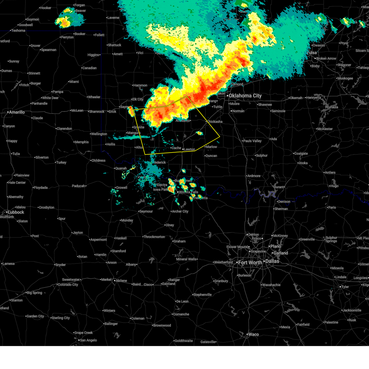
| 5/9/2026 8:24 PM CDT |
 At 824 pm cdt, a severe thunderstorm was located near fort cobb, moving east at 30 mph (radar indicated). Hazards include 70 mph wind gusts and ping pong ball size hail. People and animals outdoors will be injured. expect hail damage to roofs, siding, windows, and vehicles. expect considerable tree damage. wind damage is also likely to mobile homes, roofs, and outbuildings. Locations impacted include, anadarko, carnegie, apache, binger, fort cobb, eakly, gracemont, alfalfa, boone, fort cobb reservoir, lake ellsworth, albert, lake lawtonka, lake chickasha, and stecker. At 824 pm cdt, a severe thunderstorm was located near fort cobb, moving east at 30 mph (radar indicated). Hazards include 70 mph wind gusts and ping pong ball size hail. People and animals outdoors will be injured. expect hail damage to roofs, siding, windows, and vehicles. expect considerable tree damage. wind damage is also likely to mobile homes, roofs, and outbuildings. Locations impacted include, anadarko, carnegie, apache, binger, fort cobb, eakly, gracemont, alfalfa, boone, fort cobb reservoir, lake ellsworth, albert, lake lawtonka, lake chickasha, and stecker.
|
| 5/9/2026 8:07 PM CDT |
 Svroun the national weather service in norman has issued a * severe thunderstorm warning for, southeastern washita county in western oklahoma, north central comanche county in southwestern oklahoma, caddo county in southwestern oklahoma, northeastern kiowa county in southwestern oklahoma, * until 845 pm cdt. * at 806 pm cdt, a severe thunderstorm was located near carnegie, moving east at 25 mph (radar indicated). Hazards include tennis ball size hail and 70 mph wind gusts. People and animals outdoors will be injured. expect hail damage to roofs, siding, windows, and vehicles. expect considerable tree damage. Wind damage is also likely to mobile homes, roofs, and outbuildings. Svroun the national weather service in norman has issued a * severe thunderstorm warning for, southeastern washita county in western oklahoma, north central comanche county in southwestern oklahoma, caddo county in southwestern oklahoma, northeastern kiowa county in southwestern oklahoma, * until 845 pm cdt. * at 806 pm cdt, a severe thunderstorm was located near carnegie, moving east at 25 mph (radar indicated). Hazards include tennis ball size hail and 70 mph wind gusts. People and animals outdoors will be injured. expect hail damage to roofs, siding, windows, and vehicles. expect considerable tree damage. Wind damage is also likely to mobile homes, roofs, and outbuildings.
|
| 5/8/2026 7:37 PM CDT |
 At 737 pm cdt, severe thunderstorms were located along a line extending from near lake ellsworth to 5 miles west of rush springs to 3 miles southeast of bradley, moving south at 15 mph (radar indicated). Hazards include golf ball size hail and 60 mph wind gusts. People and animals outdoors will be injured. expect hail damage to roofs, siding, windows, and vehicles. expect wind damage to roofs, siding, and trees. Locations impacted include, elgin, apache, rush springs, fletcher, cyril, sterling, alex, cement, bradley, agawam, lake ellsworth, northeastern fort sill, ninnekah, acme, and cox city. At 737 pm cdt, severe thunderstorms were located along a line extending from near lake ellsworth to 5 miles west of rush springs to 3 miles southeast of bradley, moving south at 15 mph (radar indicated). Hazards include golf ball size hail and 60 mph wind gusts. People and animals outdoors will be injured. expect hail damage to roofs, siding, windows, and vehicles. expect wind damage to roofs, siding, and trees. Locations impacted include, elgin, apache, rush springs, fletcher, cyril, sterling, alex, cement, bradley, agawam, lake ellsworth, northeastern fort sill, ninnekah, acme, and cox city.
|
| 5/8/2026 7:19 PM CDT |
 Svroun the national weather service in norman has issued a * severe thunderstorm warning for, northeastern comanche county in southwestern oklahoma, southern grady county in central oklahoma, southeastern caddo county in southwestern oklahoma, * until 800 pm cdt. * at 718 pm cdt, severe thunderstorms were located along a line extending from near apache to 5 miles southeast of cement to 3 miles northeast of bradley, moving south at 15 mph (radar indicated). Hazards include tennis ball size hail and 60 mph wind gusts. People and animals outdoors will be injured. expect hail damage to roofs, siding, windows, and vehicles. Expect wind damage to roofs, siding, and trees. Svroun the national weather service in norman has issued a * severe thunderstorm warning for, northeastern comanche county in southwestern oklahoma, southern grady county in central oklahoma, southeastern caddo county in southwestern oklahoma, * until 800 pm cdt. * at 718 pm cdt, severe thunderstorms were located along a line extending from near apache to 5 miles southeast of cement to 3 miles northeast of bradley, moving south at 15 mph (radar indicated). Hazards include tennis ball size hail and 60 mph wind gusts. People and animals outdoors will be injured. expect hail damage to roofs, siding, windows, and vehicles. Expect wind damage to roofs, siding, and trees.
|
| 4/17/2026 11:26 PM CDT |
 Svroun the national weather service in norman has issued a * severe thunderstorm warning for, comanche county in southwestern oklahoma, southern caddo county in southwestern oklahoma, jackson county in southwestern oklahoma, southeastern kiowa county in southwestern oklahoma, central tillman county in southwestern oklahoma, northwestern wilbarger county in northern texas, * until 1215 am cdt. * at 1125 pm cdt, severe thunderstorms were located along a line extending from near meers to near elmer, moving southeast at 30 mph (the tipton mesonet measured a 59 mph wind gust). Hazards include 60 mph wind gusts. expect damage to roofs, siding, and trees Svroun the national weather service in norman has issued a * severe thunderstorm warning for, comanche county in southwestern oklahoma, southern caddo county in southwestern oklahoma, jackson county in southwestern oklahoma, southeastern kiowa county in southwestern oklahoma, central tillman county in southwestern oklahoma, northwestern wilbarger county in northern texas, * until 1215 am cdt. * at 1125 pm cdt, severe thunderstorms were located along a line extending from near meers to near elmer, moving southeast at 30 mph (the tipton mesonet measured a 59 mph wind gust). Hazards include 60 mph wind gusts. expect damage to roofs, siding, and trees
|
| 4/17/2026 10:45 PM CDT |
 Svroun the national weather service in norman has issued a * severe thunderstorm warning for, southeastern washita county in western oklahoma, comanche county in southwestern oklahoma, southwestern grady county in central oklahoma, southern caddo county in southwestern oklahoma, northwestern stephens county in southern oklahoma, northern cotton county in southwestern oklahoma, jackson county in southwestern oklahoma, kiowa county in southwestern oklahoma, tillman county in southwestern oklahoma, southeastern greer county in southwestern oklahoma, northern wilbarger county in northern texas, * until 1130 pm cdt. * at 1045 pm cdt, the leading edge of winds from a line of severe thunderstorms was located along a line extending from 4 miles south of humphreys to near fort sill, moving southeast at 45 mph (radar indicated). Hazards include 60 mph wind gusts and penny size hail. expect damage to roofs, siding, and trees Svroun the national weather service in norman has issued a * severe thunderstorm warning for, southeastern washita county in western oklahoma, comanche county in southwestern oklahoma, southwestern grady county in central oklahoma, southern caddo county in southwestern oklahoma, northwestern stephens county in southern oklahoma, northern cotton county in southwestern oklahoma, jackson county in southwestern oklahoma, kiowa county in southwestern oklahoma, tillman county in southwestern oklahoma, southeastern greer county in southwestern oklahoma, northern wilbarger county in northern texas, * until 1130 pm cdt. * at 1045 pm cdt, the leading edge of winds from a line of severe thunderstorms was located along a line extending from 4 miles south of humphreys to near fort sill, moving southeast at 45 mph (radar indicated). Hazards include 60 mph wind gusts and penny size hail. expect damage to roofs, siding, and trees
|
| 4/3/2026 8:17 PM CDT |
 Svroun the national weather service in norman has issued a * severe thunderstorm warning for, central grady county in central oklahoma, southeastern caddo county in southwestern oklahoma, * until 900 pm cdt. * at 817 pm cdt, a severe thunderstorm was located 5 miles southwest of anadarko, moving east at 30 mph (radar indicated). Hazards include 60 mph wind gusts and quarter size hail. Hail damage to vehicles is expected. Expect wind damage to roofs, siding, and trees. Svroun the national weather service in norman has issued a * severe thunderstorm warning for, central grady county in central oklahoma, southeastern caddo county in southwestern oklahoma, * until 900 pm cdt. * at 817 pm cdt, a severe thunderstorm was located 5 miles southwest of anadarko, moving east at 30 mph (radar indicated). Hazards include 60 mph wind gusts and quarter size hail. Hail damage to vehicles is expected. Expect wind damage to roofs, siding, and trees.
|
| 4/1/2026 8:11 PM CDT |
 Svroun the national weather service in norman has issued a * severe thunderstorm warning for, northeastern comanche county in southwestern oklahoma, northwestern grady county in central oklahoma, caddo county in southwestern oklahoma, southwestern canadian county in central oklahoma, * until 845 pm cdt. * at 811 pm cdt, severe thunderstorms were located along a line extending from 3 miles east of eakly to near boone, moving northeast at 35 mph (radar indicated). Hazards include 60 mph wind gusts and quarter size hail. Hail damage to vehicles is expected. Expect wind damage to roofs, siding, and trees. Svroun the national weather service in norman has issued a * severe thunderstorm warning for, northeastern comanche county in southwestern oklahoma, northwestern grady county in central oklahoma, caddo county in southwestern oklahoma, southwestern canadian county in central oklahoma, * until 845 pm cdt. * at 811 pm cdt, severe thunderstorms were located along a line extending from 3 miles east of eakly to near boone, moving northeast at 35 mph (radar indicated). Hazards include 60 mph wind gusts and quarter size hail. Hail damage to vehicles is expected. Expect wind damage to roofs, siding, and trees.
|
| 3/10/2026 8:19 PM CDT |
 the severe thunderstorm warning has been cancelled and is no longer in effect the severe thunderstorm warning has been cancelled and is no longer in effect
|
| 3/10/2026 8:14 PM CDT |
 Svroun the national weather service in norman has issued a * severe thunderstorm warning for, central grady county in central oklahoma, southern caddo county in southwestern oklahoma, southwestern mcclain county in central oklahoma, * until 900 pm cdt. * at 814 pm cdt, severe thunderstorms were located along a line extending from 5 miles southeast of fort cobb to 3 miles east of agawam, moving northeast at 30 mph (radar indicated). Hazards include 60 mph wind gusts and quarter size hail. Hail damage to vehicles is expected. Expect wind damage to roofs, siding, and trees. Svroun the national weather service in norman has issued a * severe thunderstorm warning for, central grady county in central oklahoma, southern caddo county in southwestern oklahoma, southwestern mcclain county in central oklahoma, * until 900 pm cdt. * at 814 pm cdt, severe thunderstorms were located along a line extending from 5 miles southeast of fort cobb to 3 miles east of agawam, moving northeast at 30 mph (radar indicated). Hazards include 60 mph wind gusts and quarter size hail. Hail damage to vehicles is expected. Expect wind damage to roofs, siding, and trees.
|
| 3/10/2026 7:42 PM CDT |
 Svroun the national weather service in norman has issued a * severe thunderstorm warning for, comanche county in southwestern oklahoma, southwestern caddo county in southwestern oklahoma, southeastern kiowa county in southwestern oklahoma, northeastern tillman county in southwestern oklahoma, * until 830 pm cdt. * at 742 pm cdt, a severe thunderstorm was located near cache, moving northeast at 30 mph (radar indicated). Hazards include 60 mph wind gusts and quarter size hail. Hail damage to vehicles is expected. Expect wind damage to roofs, siding, and trees. Svroun the national weather service in norman has issued a * severe thunderstorm warning for, comanche county in southwestern oklahoma, southwestern caddo county in southwestern oklahoma, southeastern kiowa county in southwestern oklahoma, northeastern tillman county in southwestern oklahoma, * until 830 pm cdt. * at 742 pm cdt, a severe thunderstorm was located near cache, moving northeast at 30 mph (radar indicated). Hazards include 60 mph wind gusts and quarter size hail. Hail damage to vehicles is expected. Expect wind damage to roofs, siding, and trees.
|
| 8/11/2025 5:40 PM CDT | Quarter sized hail reported 0.3 miles NNE of Apache, OK, report from x. |
| 6/26/2025 4:56 PM CDT |
 Svroun the national weather service in norman has issued a * severe thunderstorm warning for, northeastern comanche county in southwestern oklahoma, southwestern caddo county in southwestern oklahoma, * until 530 pm cdt. * at 456 pm cdt, severe thunderstorms were located along a line extending from near boone to near lawton, moving east at 10 mph (radar indicated). Hazards include 60 mph wind gusts and quarter size hail. Hail damage to vehicles is expected. Expect wind damage to roofs, siding, and trees. Svroun the national weather service in norman has issued a * severe thunderstorm warning for, northeastern comanche county in southwestern oklahoma, southwestern caddo county in southwestern oklahoma, * until 530 pm cdt. * at 456 pm cdt, severe thunderstorms were located along a line extending from near boone to near lawton, moving east at 10 mph (radar indicated). Hazards include 60 mph wind gusts and quarter size hail. Hail damage to vehicles is expected. Expect wind damage to roofs, siding, and trees.
|
| 6/7/2025 3:56 AM CDT |
 The storms which prompted the warning have weakened below severe limits, therefore the warning will be allowed to expire. however, gusty winds to 50 mph are still possible with these thunderstorms. The storms which prompted the warning have weakened below severe limits, therefore the warning will be allowed to expire. however, gusty winds to 50 mph are still possible with these thunderstorms.
|
| 6/7/2025 3:38 AM CDT |
 At 337 am cdt, severe thunderstorms were located along a line extending from 3 miles northeast of calumet to 7 miles southwest of el reno to near mountain view, moving east at 60 mph (radar indicated). Hazards include 60 mph wind gusts and nickel size hail. Expect damage to roofs, siding, and trees. Locations impacted include, western oklahoma city, el reno, anadarko, yukon, mustang, tuttle, piedmont, hinton, carnegie, union city, minco, apache, okarche, mountain view, binger, fort cobb, verden, calumet, amber, and eakly. At 337 am cdt, severe thunderstorms were located along a line extending from 3 miles northeast of calumet to 7 miles southwest of el reno to near mountain view, moving east at 60 mph (radar indicated). Hazards include 60 mph wind gusts and nickel size hail. Expect damage to roofs, siding, and trees. Locations impacted include, western oklahoma city, el reno, anadarko, yukon, mustang, tuttle, piedmont, hinton, carnegie, union city, minco, apache, okarche, mountain view, binger, fort cobb, verden, calumet, amber, and eakly.
|
| 6/7/2025 3:38 AM CDT |
 the severe thunderstorm warning has been cancelled and is no longer in effect the severe thunderstorm warning has been cancelled and is no longer in effect
|
| 6/7/2025 3:13 AM CDT |
 Svroun the national weather service in norman has issued a * severe thunderstorm warning for, eastern washita county in western oklahoma, northern grady county in central oklahoma, caddo county in southwestern oklahoma, northeastern kiowa county in southwestern oklahoma, south central blaine county in northwestern oklahoma, canadian county in central oklahoma, * until 400 am cdt. * at 312 am cdt, severe thunderstorms were located along a line extending from 5 miles west of greenfield to 4 miles west of bridgeport to near rocky, moving east-southeast at 60 mph (radar indicated). Hazards include 60 mph wind gusts and quarter size hail. Hail damage to vehicles is expected. Expect wind damage to roofs, siding, and trees. Svroun the national weather service in norman has issued a * severe thunderstorm warning for, eastern washita county in western oklahoma, northern grady county in central oklahoma, caddo county in southwestern oklahoma, northeastern kiowa county in southwestern oklahoma, south central blaine county in northwestern oklahoma, canadian county in central oklahoma, * until 400 am cdt. * at 312 am cdt, severe thunderstorms were located along a line extending from 5 miles west of greenfield to 4 miles west of bridgeport to near rocky, moving east-southeast at 60 mph (radar indicated). Hazards include 60 mph wind gusts and quarter size hail. Hail damage to vehicles is expected. Expect wind damage to roofs, siding, and trees.
|
| 6/3/2025 4:26 PM CDT |
 the severe thunderstorm warning has been cancelled and is no longer in effect the severe thunderstorm warning has been cancelled and is no longer in effect
|
| 6/3/2025 4:26 PM CDT |
 At 426 pm cdt, severe thunderstorms were located along a line extending from 4 miles east of fort cobb to near lake lawtonka, moving east at 40 mph (radar indicated). Hazards include 60 mph wind gusts and quarter size hail. Hail damage to vehicles is expected. expect wind damage to roofs, siding, and trees. Locations in or near the path include, mount scott, meers, medicine park, lake lawtonka, anadarko, wichita mountains wildlife refu, stecker, apache, gracemont, boone, doris campground, fort cobb, lake ellsworth, fort cobb reservoir, fort sill,. At 426 pm cdt, severe thunderstorms were located along a line extending from 4 miles east of fort cobb to near lake lawtonka, moving east at 40 mph (radar indicated). Hazards include 60 mph wind gusts and quarter size hail. Hail damage to vehicles is expected. expect wind damage to roofs, siding, and trees. Locations in or near the path include, mount scott, meers, medicine park, lake lawtonka, anadarko, wichita mountains wildlife refu, stecker, apache, gracemont, boone, doris campground, fort cobb, lake ellsworth, fort cobb reservoir, fort sill,.
|
| 6/3/2025 4:02 PM CDT |
 Svroun the national weather service in norman has issued a * severe thunderstorm warning for, northwestern comanche county in southwestern oklahoma, southern caddo county in southwestern oklahoma, eastern kiowa county in southwestern oklahoma, * until 445 pm cdt. * at 402 pm cdt, severe thunderstorms were located along a line extending from near carnegie to 9 miles southeast of cooperton, moving northeast at 30 mph (radar indicated). Hazards include 60 mph wind gusts and quarter size hail. Hail damage to vehicles is expected. expect wind damage to roofs, siding, and trees. Locations in or near the path include, mount scott, meers, medicine park, carnegie, lake lawtonka, anadarko, wichita mountains wildlife refu, stecker, apache, gracemont, boone, doris campground, fort cobb, lake ellsworth, the visitor center, fort cobb reservoir, fort sill,. Svroun the national weather service in norman has issued a * severe thunderstorm warning for, northwestern comanche county in southwestern oklahoma, southern caddo county in southwestern oklahoma, eastern kiowa county in southwestern oklahoma, * until 445 pm cdt. * at 402 pm cdt, severe thunderstorms were located along a line extending from near carnegie to 9 miles southeast of cooperton, moving northeast at 30 mph (radar indicated). Hazards include 60 mph wind gusts and quarter size hail. Hail damage to vehicles is expected. expect wind damage to roofs, siding, and trees. Locations in or near the path include, mount scott, meers, medicine park, carnegie, lake lawtonka, anadarko, wichita mountains wildlife refu, stecker, apache, gracemont, boone, doris campground, fort cobb, lake ellsworth, the visitor center, fort cobb reservoir, fort sill,.
|
| 5/27/2025 1:13 AM CDT |
 The storm which prompted the warning has weakened below severe limits, therefore the warning will be allowed to expire. however, small hail, gusty winds and heavy rain are still possible with this thunderstorm. The storm which prompted the warning has weakened below severe limits, therefore the warning will be allowed to expire. however, small hail, gusty winds and heavy rain are still possible with this thunderstorm.
|
| 5/27/2025 12:53 AM CDT |
 At 1253 am cdt, a severe thunderstorm was located 4 miles south of anadarko, moving southeast at 30 mph (radar indicated). Hazards include 60 mph wind gusts and quarter size hail. Hail damage to vehicles is expected. expect wind damage to roofs, siding, and trees. Locations impacted include, anadarko, apache, cyril, verden, cement, lake chickasha, and stecker. At 1253 am cdt, a severe thunderstorm was located 4 miles south of anadarko, moving southeast at 30 mph (radar indicated). Hazards include 60 mph wind gusts and quarter size hail. Hail damage to vehicles is expected. expect wind damage to roofs, siding, and trees. Locations impacted include, anadarko, apache, cyril, verden, cement, lake chickasha, and stecker.
|
| 5/27/2025 12:25 AM CDT |
 Svroun the national weather service in norman has issued a * severe thunderstorm warning for, southern caddo county in southwestern oklahoma, * until 115 am cdt. * at 1224 am cdt, a severe thunderstorm was located near fort cobb, moving southeast at 30 mph (radar indicated). Hazards include 60 mph wind gusts and half dollar size hail. Hail damage to vehicles is expected. Expect wind damage to roofs, siding, and trees. Svroun the national weather service in norman has issued a * severe thunderstorm warning for, southern caddo county in southwestern oklahoma, * until 115 am cdt. * at 1224 am cdt, a severe thunderstorm was located near fort cobb, moving southeast at 30 mph (radar indicated). Hazards include 60 mph wind gusts and half dollar size hail. Hail damage to vehicles is expected. Expect wind damage to roofs, siding, and trees.
|
| 5/2/2025 1:51 AM CDT |
 Svroun the national weather service in norman has issued a * severe thunderstorm warning for, southern kingfisher county in central oklahoma, grady county in central oklahoma, eastern caddo county in southwestern oklahoma, southeastern blaine county in northwestern oklahoma, canadian county in central oklahoma, * until 230 am cdt. * at 151 am cdt, severe thunderstorms were located along a line extending from near greenfield to 7 miles south of fort cobb, moving east at 35 mph (radar indicated). Hazards include 60 mph wind gusts and penny size hail. expect damage to roofs, siding, and trees Svroun the national weather service in norman has issued a * severe thunderstorm warning for, southern kingfisher county in central oklahoma, grady county in central oklahoma, eastern caddo county in southwestern oklahoma, southeastern blaine county in northwestern oklahoma, canadian county in central oklahoma, * until 230 am cdt. * at 151 am cdt, severe thunderstorms were located along a line extending from near greenfield to 7 miles south of fort cobb, moving east at 35 mph (radar indicated). Hazards include 60 mph wind gusts and penny size hail. expect damage to roofs, siding, and trees
|
| 5/2/2025 1:21 AM CDT |
 Svroun the national weather service in norman has issued a * severe thunderstorm warning for, eastern washita county in western oklahoma, southwestern kingfisher county in central oklahoma, northwestern grady county in central oklahoma, caddo county in southwestern oklahoma, southeastern custer county in western oklahoma, northeastern kiowa county in southwestern oklahoma, southern blaine county in northwestern oklahoma, western canadian county in central oklahoma, * until 200 am cdt. * at 121 am cdt, severe thunderstorms were located along a line extending from 3 miles south of fay to 4 miles southeast of mountain view, moving east at 35 mph (radar indicated). Hazards include 70 mph wind gusts and quarter size hail. Hail damage to vehicles is expected. expect considerable tree damage. Wind damage is also likely to mobile homes, roofs, and outbuildings. Svroun the national weather service in norman has issued a * severe thunderstorm warning for, eastern washita county in western oklahoma, southwestern kingfisher county in central oklahoma, northwestern grady county in central oklahoma, caddo county in southwestern oklahoma, southeastern custer county in western oklahoma, northeastern kiowa county in southwestern oklahoma, southern blaine county in northwestern oklahoma, western canadian county in central oklahoma, * until 200 am cdt. * at 121 am cdt, severe thunderstorms were located along a line extending from 3 miles south of fay to 4 miles southeast of mountain view, moving east at 35 mph (radar indicated). Hazards include 70 mph wind gusts and quarter size hail. Hail damage to vehicles is expected. expect considerable tree damage. Wind damage is also likely to mobile homes, roofs, and outbuildings.
|
| 4/28/2025 10:53 PM CDT |
 The storm which prompted the warning has weakened below severe limits, therefore the warning will be allowed to expire. however, small hail and gusty winds are still possible with this thunderstorm. The storm which prompted the warning has weakened below severe limits, therefore the warning will be allowed to expire. however, small hail and gusty winds are still possible with this thunderstorm.
|
| 4/28/2025 10:47 PM CDT |
 At 1046 pm cdt, a severe thunderstorm was located 4 miles northwest of fletcher, moving east at 40 mph (radar indicated). Hazards include 60 mph wind gusts and quarter size hail. Hail damage to vehicles is expected. expect wind damage to roofs, siding, and trees. Locations impacted include, elgin, apache, fletcher, cyril, cement, lake ellsworth, boone, and stecker. At 1046 pm cdt, a severe thunderstorm was located 4 miles northwest of fletcher, moving east at 40 mph (radar indicated). Hazards include 60 mph wind gusts and quarter size hail. Hail damage to vehicles is expected. expect wind damage to roofs, siding, and trees. Locations impacted include, elgin, apache, fletcher, cyril, cement, lake ellsworth, boone, and stecker.
|
| 4/28/2025 10:38 PM CDT |
 At 1038 pm cdt, a severe thunderstorm was located near lake ellsworth, moving east at 35 mph (radar indicated). Hazards include 70 mph wind gusts and ping pong ball size hail. People and animals outdoors will be injured. expect hail damage to roofs, siding, windows, and vehicles. expect considerable tree damage. wind damage is also likely to mobile homes, roofs, and outbuildings. Locations impacted include, elgin, apache, fletcher, cyril, cement, lake ellsworth, boone, lake lawtonka, northeastern fort sill, and stecker. At 1038 pm cdt, a severe thunderstorm was located near lake ellsworth, moving east at 35 mph (radar indicated). Hazards include 70 mph wind gusts and ping pong ball size hail. People and animals outdoors will be injured. expect hail damage to roofs, siding, windows, and vehicles. expect considerable tree damage. wind damage is also likely to mobile homes, roofs, and outbuildings. Locations impacted include, elgin, apache, fletcher, cyril, cement, lake ellsworth, boone, lake lawtonka, northeastern fort sill, and stecker.
|
| 4/28/2025 10:27 PM CDT |
 the severe thunderstorm warning has been cancelled and is no longer in effect the severe thunderstorm warning has been cancelled and is no longer in effect
|
| 4/28/2025 10:27 PM CDT |
 At 1027 pm cdt, a severe thunderstorm was located 4 miles north of lake lawtonka, moving northeast at 30 mph (radar indicated). Hazards include golf ball size hail and 70 mph wind gusts. People and animals outdoors will be injured. expect hail damage to roofs, siding, windows, and vehicles. expect considerable tree damage. wind damage is also likely to mobile homes, roofs, and outbuildings. Locations impacted include, elgin, apache, fletcher, cyril, sterling, cement, medicine park, meers, lake lawtonka, boone, lake ellsworth, northern fort sill, stecker, and eastern wichita mountains wildlife refuge. At 1027 pm cdt, a severe thunderstorm was located 4 miles north of lake lawtonka, moving northeast at 30 mph (radar indicated). Hazards include golf ball size hail and 70 mph wind gusts. People and animals outdoors will be injured. expect hail damage to roofs, siding, windows, and vehicles. expect considerable tree damage. wind damage is also likely to mobile homes, roofs, and outbuildings. Locations impacted include, elgin, apache, fletcher, cyril, sterling, cement, medicine park, meers, lake lawtonka, boone, lake ellsworth, northern fort sill, stecker, and eastern wichita mountains wildlife refuge.
|
| 4/28/2025 10:12 PM CDT |
 Svroun the national weather service in norman has issued a * severe thunderstorm warning for, northern comanche county in southwestern oklahoma, southern caddo county in southwestern oklahoma, eastern kiowa county in southwestern oklahoma, * until 1100 pm cdt. * at 1012 pm cdt, a severe thunderstorm was located near meers, moving east at 40 mph (radar indicated). Hazards include golf ball size hail and 70 mph wind gusts. People and animals outdoors will be injured. expect hail damage to roofs, siding, windows, and vehicles. expect considerable tree damage. Wind damage is also likely to mobile homes, roofs, and outbuildings. Svroun the national weather service in norman has issued a * severe thunderstorm warning for, northern comanche county in southwestern oklahoma, southern caddo county in southwestern oklahoma, eastern kiowa county in southwestern oklahoma, * until 1100 pm cdt. * at 1012 pm cdt, a severe thunderstorm was located near meers, moving east at 40 mph (radar indicated). Hazards include golf ball size hail and 70 mph wind gusts. People and animals outdoors will be injured. expect hail damage to roofs, siding, windows, and vehicles. expect considerable tree damage. Wind damage is also likely to mobile homes, roofs, and outbuildings.
|
| 4/28/2025 10:05 PM CDT |
 At 1005 pm cdt, a severe thunderstorm was located 5 miles northwest of cyril, moving northeast at 35 mph (radar indicated). Hazards include 60 mph wind gusts and quarter size hail. Hail damage to vehicles is expected. expect wind damage to roofs, siding, and trees. Locations impacted include, anadarko, apache, cyril, verden, cement, lake chickasha, stecker, and laverty. At 1005 pm cdt, a severe thunderstorm was located 5 miles northwest of cyril, moving northeast at 35 mph (radar indicated). Hazards include 60 mph wind gusts and quarter size hail. Hail damage to vehicles is expected. expect wind damage to roofs, siding, and trees. Locations impacted include, anadarko, apache, cyril, verden, cement, lake chickasha, stecker, and laverty.
|
| 4/28/2025 9:49 PM CDT |
 Svroun the national weather service in norman has issued a * severe thunderstorm warning for, northwestern grady county in central oklahoma, southern caddo county in southwestern oklahoma, * until 1015 pm cdt. * at 949 pm cdt, a severe thunderstorm was located near boone, moving northeast at 50 mph (radar indicated). Hazards include 60 mph wind gusts and quarter size hail. Hail damage to vehicles is expected. Expect wind damage to roofs, siding, and trees. Svroun the national weather service in norman has issued a * severe thunderstorm warning for, northwestern grady county in central oklahoma, southern caddo county in southwestern oklahoma, * until 1015 pm cdt. * at 949 pm cdt, a severe thunderstorm was located near boone, moving northeast at 50 mph (radar indicated). Hazards include 60 mph wind gusts and quarter size hail. Hail damage to vehicles is expected. Expect wind damage to roofs, siding, and trees.
|
| 4/24/2025 4:09 AM CDT |
 The storms which prompted the warning have weakened below severe limits, therefore the warning will be allowed to expire. however, gusty winds are still possible with these thunderstorms. The storms which prompted the warning have weakened below severe limits, therefore the warning will be allowed to expire. however, gusty winds are still possible with these thunderstorms.
|
| 4/24/2025 4:01 AM CDT |
 At 401 am cdt, severe thunderstorms were located along a line extending from near lake chickasha to 7 miles northeast of sterling to 12 miles west of duncan, moving east at 35 mph (radar indicated). Hazards include 60 mph wind gusts. Expect damage to roofs, siding, and trees. Locations impacted include, lawton, duncan, chickasha, anadarko, marlow, elgin, apache, rush springs, fletcher, cyril, sterling, verden, cement, amber, pocasset, norge, lake chickasha, agawam, lake ellsworth, and eastern fort sill. At 401 am cdt, severe thunderstorms were located along a line extending from near lake chickasha to 7 miles northeast of sterling to 12 miles west of duncan, moving east at 35 mph (radar indicated). Hazards include 60 mph wind gusts. Expect damage to roofs, siding, and trees. Locations impacted include, lawton, duncan, chickasha, anadarko, marlow, elgin, apache, rush springs, fletcher, cyril, sterling, verden, cement, amber, pocasset, norge, lake chickasha, agawam, lake ellsworth, and eastern fort sill.
|
| 4/24/2025 3:43 AM CDT |
 Svroun the national weather service in norman has issued a * severe thunderstorm warning for, comanche county in southwestern oklahoma, western grady county in central oklahoma, southern caddo county in southwestern oklahoma, northwestern stephens county in southern oklahoma, * until 415 am cdt. * at 343 am cdt, severe thunderstorms were located along a line extending from 4 miles west of anadarko to near elgin to 4 miles northeast of geronimo, moving east at 35 mph (radar indicated). Hazards include 60 mph wind gusts. expect damage to roofs, siding, and trees Svroun the national weather service in norman has issued a * severe thunderstorm warning for, comanche county in southwestern oklahoma, western grady county in central oklahoma, southern caddo county in southwestern oklahoma, northwestern stephens county in southern oklahoma, * until 415 am cdt. * at 343 am cdt, severe thunderstorms were located along a line extending from 4 miles west of anadarko to near elgin to 4 miles northeast of geronimo, moving east at 35 mph (radar indicated). Hazards include 60 mph wind gusts. expect damage to roofs, siding, and trees
|
| 4/24/2025 3:36 AM CDT |
 the severe thunderstorm warning has been cancelled and is no longer in effect the severe thunderstorm warning has been cancelled and is no longer in effect
|
| 4/24/2025 3:36 AM CDT |
 At 336 am cdt, severe thunderstorms were located along a line extending from 3 miles north of apache to near fort sill to 4 miles southwest of geronimo, moving east at 30 mph (radar indicated). Hazards include 60 mph wind gusts. Expect damage to roofs, siding, and trees. Locations impacted include, lawton, cache, elgin, apache, geronimo, fletcher, cyril, sterling, cement, chattanooga, medicine park, faxon, meers, lake lawtonka, boone, fort sill, lake ellsworth, central high, hulen, and stecker. At 336 am cdt, severe thunderstorms were located along a line extending from 3 miles north of apache to near fort sill to 4 miles southwest of geronimo, moving east at 30 mph (radar indicated). Hazards include 60 mph wind gusts. Expect damage to roofs, siding, and trees. Locations impacted include, lawton, cache, elgin, apache, geronimo, fletcher, cyril, sterling, cement, chattanooga, medicine park, faxon, meers, lake lawtonka, boone, fort sill, lake ellsworth, central high, hulen, and stecker.
|
| 4/24/2025 3:15 AM CDT |
 Svroun the national weather service in norman has issued a * severe thunderstorm warning for, comanche county in southwestern oklahoma, southern caddo county in southwestern oklahoma, northwestern stephens county in southern oklahoma, northern cotton county in southwestern oklahoma, eastern kiowa county in southwestern oklahoma, northeastern tillman county in southwestern oklahoma, * until 345 am cdt. * at 315 am cdt, severe thunderstorms were located along a line extending from 3 miles north of meers to near fort sill to near faxon, moving east at 35 mph (radar indicated). Hazards include 60 mph wind gusts and penny size hail. expect damage to roofs, siding, and trees Svroun the national weather service in norman has issued a * severe thunderstorm warning for, comanche county in southwestern oklahoma, southern caddo county in southwestern oklahoma, northwestern stephens county in southern oklahoma, northern cotton county in southwestern oklahoma, eastern kiowa county in southwestern oklahoma, northeastern tillman county in southwestern oklahoma, * until 345 am cdt. * at 315 am cdt, severe thunderstorms were located along a line extending from 3 miles north of meers to near fort sill to near faxon, moving east at 35 mph (radar indicated). Hazards include 60 mph wind gusts and penny size hail. expect damage to roofs, siding, and trees
|
| 4/2/2025 4:52 AM CDT | Quarter sized hail reported 5.2 miles N of Apache, OK |
| 4/2/2025 4:49 AM CDT | Half Dollar sized hail reported 5.2 miles N of Apache, OK, report from mping: half dollar (1.25 in.). |
| 4/2/2025 4:43 AM CDT |
 Svroun the national weather service in norman has issued a * severe thunderstorm warning for, comanche county in southwestern oklahoma, grady county in central oklahoma, southeastern caddo county in southwestern oklahoma, northern stephens county in southern oklahoma, * until 530 am cdt. * at 443 am cdt, severe thunderstorms were located along a line extending from near verden to near chattanooga, moving east at 50 mph (radar indicated). Hazards include 60 mph wind gusts and quarter size hail. Hail damage to vehicles is expected. Expect wind damage to roofs, siding, and trees. Svroun the national weather service in norman has issued a * severe thunderstorm warning for, comanche county in southwestern oklahoma, grady county in central oklahoma, southeastern caddo county in southwestern oklahoma, northern stephens county in southern oklahoma, * until 530 am cdt. * at 443 am cdt, severe thunderstorms were located along a line extending from near verden to near chattanooga, moving east at 50 mph (radar indicated). Hazards include 60 mph wind gusts and quarter size hail. Hail damage to vehicles is expected. Expect wind damage to roofs, siding, and trees.
|
| 4/2/2025 4:33 AM CDT |
 At 432 am cdt, severe thunderstorms were located along a line extending from 6 miles northwest of apache to 5 miles north of cache, moving east at 35 mph (radar indicated). Hazards include 60 mph wind gusts and half dollar size hail. Hail damage to vehicles is expected. expect wind damage to roofs, siding, and trees. Locations impacted include, meers, medicine park, lake lawtonka, stecker, apache, boone, cement, cyril, lake ellsworth, fletcher, elgin, wichita mountains wildlife refuge, verden, anadarko, and fort sill. At 432 am cdt, severe thunderstorms were located along a line extending from 6 miles northwest of apache to 5 miles north of cache, moving east at 35 mph (radar indicated). Hazards include 60 mph wind gusts and half dollar size hail. Hail damage to vehicles is expected. expect wind damage to roofs, siding, and trees. Locations impacted include, meers, medicine park, lake lawtonka, stecker, apache, boone, cement, cyril, lake ellsworth, fletcher, elgin, wichita mountains wildlife refuge, verden, anadarko, and fort sill.
|
| 4/2/2025 4:33 AM CDT |
 the severe thunderstorm warning has been cancelled and is no longer in effect the severe thunderstorm warning has been cancelled and is no longer in effect
|
| 4/2/2025 4:19 AM CDT |
 Svroun the national weather service in norman has issued a * severe thunderstorm warning for, northern comanche county in southwestern oklahoma, southern caddo county in southwestern oklahoma, southeastern kiowa county in southwestern oklahoma, * until 445 am cdt. * at 419 am cdt, severe thunderstorms were located along a line extending from 6 miles west of boone to 6 miles north of indiahoma, moving east-northeast at 50 mph (radar indicated). Hazards include 60 mph wind gusts and half dollar size hail. Hail damage to vehicles is expected. Expect wind damage to roofs, siding, and trees. Svroun the national weather service in norman has issued a * severe thunderstorm warning for, northern comanche county in southwestern oklahoma, southern caddo county in southwestern oklahoma, southeastern kiowa county in southwestern oklahoma, * until 445 am cdt. * at 419 am cdt, severe thunderstorms were located along a line extending from 6 miles west of boone to 6 miles north of indiahoma, moving east-northeast at 50 mph (radar indicated). Hazards include 60 mph wind gusts and half dollar size hail. Hail damage to vehicles is expected. Expect wind damage to roofs, siding, and trees.
|
| 11/18/2024 5:23 AM CST |
 Svroun the national weather service in norman has issued a * severe thunderstorm warning for, north central comanche county in southwestern oklahoma, kingfisher county in central oklahoma, northern grady county in central oklahoma, caddo county in southwestern oklahoma, blaine county in northwestern oklahoma, southwestern garfield county in northern oklahoma, southeastern major county in northwestern oklahoma, canadian county in central oklahoma, * until 615 am cst. * at 523 am cst, severe thunderstorms were located along a line extending from 3 miles north of watonga to near hinton to 4 miles south of boone, moving northeast at 40 mph (radar indicated). Hazards include 70 mph wind gusts and nickel size hail. Expect considerable tree damage. Damage is likely to mobile homes, roofs, and outbuildings. Svroun the national weather service in norman has issued a * severe thunderstorm warning for, north central comanche county in southwestern oklahoma, kingfisher county in central oklahoma, northern grady county in central oklahoma, caddo county in southwestern oklahoma, blaine county in northwestern oklahoma, southwestern garfield county in northern oklahoma, southeastern major county in northwestern oklahoma, canadian county in central oklahoma, * until 615 am cst. * at 523 am cst, severe thunderstorms were located along a line extending from 3 miles north of watonga to near hinton to 4 miles south of boone, moving northeast at 40 mph (radar indicated). Hazards include 70 mph wind gusts and nickel size hail. Expect considerable tree damage. Damage is likely to mobile homes, roofs, and outbuildings.
|
| 11/18/2024 4:39 AM CST |
 Svroun the national weather service in norman has issued a * severe thunderstorm warning for, eastern washita county in western oklahoma, comanche county in southwestern oklahoma, caddo county in southwestern oklahoma, western cotton county in southwestern oklahoma, southeastern custer county in western oklahoma, eastern kiowa county in southwestern oklahoma, southern blaine county in northwestern oklahoma, tillman county in southwestern oklahoma, western canadian county in central oklahoma, * until 530 am cst. * at 439 am cst, severe thunderstorms were located along a line extending from 6 miles southeast of clinton to 3 miles southwest of mountain view to 5 miles northeast of davidson, moving northeast at 35 mph (radar indicated). Hazards include 60 mph wind gusts and quarter size hail. Hail damage to vehicles is expected. Expect wind damage to roofs, siding, and trees. Svroun the national weather service in norman has issued a * severe thunderstorm warning for, eastern washita county in western oklahoma, comanche county in southwestern oklahoma, caddo county in southwestern oklahoma, western cotton county in southwestern oklahoma, southeastern custer county in western oklahoma, eastern kiowa county in southwestern oklahoma, southern blaine county in northwestern oklahoma, tillman county in southwestern oklahoma, western canadian county in central oklahoma, * until 530 am cst. * at 439 am cst, severe thunderstorms were located along a line extending from 6 miles southeast of clinton to 3 miles southwest of mountain view to 5 miles northeast of davidson, moving northeast at 35 mph (radar indicated). Hazards include 60 mph wind gusts and quarter size hail. Hail damage to vehicles is expected. Expect wind damage to roofs, siding, and trees.
|
| 11/4/2024 8:23 AM CST |
 The severe thunderstorm which prompted the warning has weakened. moved out of the warned area. therefore, the warning will be allowed to expire. The severe thunderstorm which prompted the warning has weakened. moved out of the warned area. therefore, the warning will be allowed to expire.
|
| 11/4/2024 8:02 AM CST |
 At 802 am cst, a severe thunderstorm was located near elgin, moving northeast at 45 mph (radar indicated). Hazards include 60 mph wind gusts and quarter size hail. Hail damage to vehicles is expected. expect wind damage to roofs, siding, and trees. Locations impacted include, anadarko, elgin, apache, fletcher, cyril, sterling, cement, lake ellsworth, boone, lake chickasha, northeastern fort sill, and stecker. At 802 am cst, a severe thunderstorm was located near elgin, moving northeast at 45 mph (radar indicated). Hazards include 60 mph wind gusts and quarter size hail. Hail damage to vehicles is expected. expect wind damage to roofs, siding, and trees. Locations impacted include, anadarko, elgin, apache, fletcher, cyril, sterling, cement, lake ellsworth, boone, lake chickasha, northeastern fort sill, and stecker.
|
| 11/4/2024 8:02 AM CST |
 the severe thunderstorm warning has been cancelled and is no longer in effect the severe thunderstorm warning has been cancelled and is no longer in effect
|
| 11/4/2024 7:43 AM CST |
 Svroun the national weather service in norman has issued a * severe thunderstorm warning for, comanche county in southwestern oklahoma, southern caddo county in southwestern oklahoma, eastern kiowa county in southwestern oklahoma, * until 830 am cst. * at 742 am cst, a severe thunderstorm was located over southwestern fort sill, moving northeast at 45 mph (radar indicated). Hazards include 60 mph wind gusts and quarter size hail. Hail damage to vehicles is expected. Expect wind damage to roofs, siding, and trees. Svroun the national weather service in norman has issued a * severe thunderstorm warning for, comanche county in southwestern oklahoma, southern caddo county in southwestern oklahoma, eastern kiowa county in southwestern oklahoma, * until 830 am cst. * at 742 am cst, a severe thunderstorm was located over southwestern fort sill, moving northeast at 45 mph (radar indicated). Hazards include 60 mph wind gusts and quarter size hail. Hail damage to vehicles is expected. Expect wind damage to roofs, siding, and trees.
|
| 11/4/2024 5:24 AM CST |
 The storm which prompted the warning has weakened below severe limits, therefore the warning will be allowed to expire. however, gusty winds are still possible with this thunderstorm. The storm which prompted the warning has weakened below severe limits, therefore the warning will be allowed to expire. however, gusty winds are still possible with this thunderstorm.
|
| 11/4/2024 5:15 AM CST |
 At 515 am cst, a severe thunderstorm was located 4 miles west of lake ellsworth, moving northeast at 35 mph (radar indicated). Hazards include 60 mph wind gusts and nickel size hail. Expect damage to roofs, siding, and trees. Locations impacted include, elgin, apache, fletcher, sterling, medicine park, lake ellsworth, boone, northeastern fort sill, and stecker. At 515 am cst, a severe thunderstorm was located 4 miles west of lake ellsworth, moving northeast at 35 mph (radar indicated). Hazards include 60 mph wind gusts and nickel size hail. Expect damage to roofs, siding, and trees. Locations impacted include, elgin, apache, fletcher, sterling, medicine park, lake ellsworth, boone, northeastern fort sill, and stecker.
|
| 11/4/2024 5:15 AM CST |
 the severe thunderstorm warning has been cancelled and is no longer in effect the severe thunderstorm warning has been cancelled and is no longer in effect
|
| 11/4/2024 5:02 AM CST |
 At 502 am cst, a severe thunderstorm was located near meers, moving northeast at 35 mph (radar indicated). Hazards include 60 mph wind gusts and nickel size hail. Expect damage to roofs, siding, and trees. Locations impacted include, elgin, apache, fletcher, sterling, medicine park, fort sill, meers, lake ellsworth, lake lawtonka, boone, stecker, and eastern wichita mountains wildlife refuge. At 502 am cst, a severe thunderstorm was located near meers, moving northeast at 35 mph (radar indicated). Hazards include 60 mph wind gusts and nickel size hail. Expect damage to roofs, siding, and trees. Locations impacted include, elgin, apache, fletcher, sterling, medicine park, fort sill, meers, lake ellsworth, lake lawtonka, boone, stecker, and eastern wichita mountains wildlife refuge.
|
| 11/4/2024 4:43 AM CST |
 Svroun the national weather service in norman has issued a * severe thunderstorm warning for, northern comanche county in southwestern oklahoma, southwestern caddo county in southwestern oklahoma, east central kiowa county in southwestern oklahoma, * until 530 am cst. * at 443 am cst, a severe thunderstorm was located 6 miles north of indiahoma, moving northeast at 35 mph (radar indicated). Hazards include 60 mph wind gusts and nickel size hail. expect damage to roofs, siding, and trees Svroun the national weather service in norman has issued a * severe thunderstorm warning for, northern comanche county in southwestern oklahoma, southwestern caddo county in southwestern oklahoma, east central kiowa county in southwestern oklahoma, * until 530 am cst. * at 443 am cst, a severe thunderstorm was located 6 miles north of indiahoma, moving northeast at 35 mph (radar indicated). Hazards include 60 mph wind gusts and nickel size hail. expect damage to roofs, siding, and trees
|
| 11/3/2024 2:57 PM CST |
 At 257 pm cst, severe thunderstorms were located along a line extending from 3 miles northeast of lake chickasha to 6 miles west of rush springs to 12 miles south of sterling, moving east at 45 mph (radar indicated). Hazards include 70 mph wind gusts. Expect considerable tree damage. damage is likely to mobile homes, roofs, and outbuildings. Locations impacted include, northeastern lawton, duncan, chickasha, blanchard, anadarko, marlow, tuttle, elgin, apache, rush springs, bray, fletcher, cyril, sterling, fort cobb, alex, verden, cement, amber, and bridge creek. At 257 pm cst, severe thunderstorms were located along a line extending from 3 miles northeast of lake chickasha to 6 miles west of rush springs to 12 miles south of sterling, moving east at 45 mph (radar indicated). Hazards include 70 mph wind gusts. Expect considerable tree damage. damage is likely to mobile homes, roofs, and outbuildings. Locations impacted include, northeastern lawton, duncan, chickasha, blanchard, anadarko, marlow, tuttle, elgin, apache, rush springs, bray, fletcher, cyril, sterling, fort cobb, alex, verden, cement, amber, and bridge creek.
|
| 11/3/2024 2:40 PM CST |
 The tornado threat has diminished and the tornado warning has been cancelled. however, large hail and damaging winds remain likely and a severe thunderstorm warning remains in effect for the area. The tornado threat has diminished and the tornado warning has been cancelled. however, large hail and damaging winds remain likely and a severe thunderstorm warning remains in effect for the area.
|
| 11/3/2024 2:30 PM CST |
 Svroun the national weather service in norman has issued a * severe thunderstorm warning for, comanche county in southwestern oklahoma, grady county in central oklahoma, southern caddo county in southwestern oklahoma, northern stephens county in southern oklahoma, * until 330 pm cst. * at 230 pm cst, severe thunderstorms were located along a line extending from near fort cobb to 4 miles east of medicine park to 5 miles northeast of faxon, moving east at 50 mph (radar indicated). Hazards include 70 mph wind gusts. Expect considerable tree damage. Damage is likely to mobile homes, roofs, and outbuildings. Svroun the national weather service in norman has issued a * severe thunderstorm warning for, comanche county in southwestern oklahoma, grady county in central oklahoma, southern caddo county in southwestern oklahoma, northern stephens county in southern oklahoma, * until 330 pm cst. * at 230 pm cst, severe thunderstorms were located along a line extending from near fort cobb to 4 miles east of medicine park to 5 miles northeast of faxon, moving east at 50 mph (radar indicated). Hazards include 70 mph wind gusts. Expect considerable tree damage. Damage is likely to mobile homes, roofs, and outbuildings.
|
| 11/3/2024 2:25 PM CST |
 At 225 pm cst, a severe thunderstorm capable of producing a tornado was located near meers, moving east at 45 mph (radar indicated rotation). Hazards include tornado. Flying debris will be dangerous to those caught without shelter. mobile homes will be damaged or destroyed. damage to roofs, windows, and vehicles will occur. tree damage is likely. Locations impacted include, apache, medicine park, meers, lake ellsworth, lake lawtonka, boone, northwestern fort sill, and eastern wichita mountains wildlife refuge. At 225 pm cst, a severe thunderstorm capable of producing a tornado was located near meers, moving east at 45 mph (radar indicated rotation). Hazards include tornado. Flying debris will be dangerous to those caught without shelter. mobile homes will be damaged or destroyed. damage to roofs, windows, and vehicles will occur. tree damage is likely. Locations impacted include, apache, medicine park, meers, lake ellsworth, lake lawtonka, boone, northwestern fort sill, and eastern wichita mountains wildlife refuge.
|
| 11/3/2024 2:13 PM CST |
 Toroun the national weather service in norman has issued a * tornado warning for, northwestern comanche county in southwestern oklahoma, southwestern caddo county in southwestern oklahoma, * until 245 pm cst. * at 213 pm cst, a severe thunderstorm capable of producing a tornado was located 5 miles north of indiahoma, moving east at 45 mph (radar indicated rotation). Hazards include tornado. Flying debris will be dangerous to those caught without shelter. mobile homes will be damaged or destroyed. damage to roofs, windows, and vehicles will occur. Tree damage is likely. Toroun the national weather service in norman has issued a * tornado warning for, northwestern comanche county in southwestern oklahoma, southwestern caddo county in southwestern oklahoma, * until 245 pm cst. * at 213 pm cst, a severe thunderstorm capable of producing a tornado was located 5 miles north of indiahoma, moving east at 45 mph (radar indicated rotation). Hazards include tornado. Flying debris will be dangerous to those caught without shelter. mobile homes will be damaged or destroyed. damage to roofs, windows, and vehicles will occur. Tree damage is likely.
|
| 8/15/2024 6:29 PM CDT |
 At 628 pm cdt, a severe thunderstorm was located near lake ellsworth, moving east at 5 mph (public). Hazards include 60 mph wind gusts and quarter size hail. Hail damage to vehicles is expected. expect wind damage to roofs, siding, and trees. Locations impacted include, elgin, apache, fletcher, sterling, lake ellsworth, and northeastern fort sill. At 628 pm cdt, a severe thunderstorm was located near lake ellsworth, moving east at 5 mph (public). Hazards include 60 mph wind gusts and quarter size hail. Hail damage to vehicles is expected. expect wind damage to roofs, siding, and trees. Locations impacted include, elgin, apache, fletcher, sterling, lake ellsworth, and northeastern fort sill.
|
| 8/15/2024 5:54 PM CDT |
 Svroun the national weather service in norman has issued a * severe thunderstorm warning for, northeastern comanche county in southwestern oklahoma, southeastern caddo county in southwestern oklahoma, * until 645 pm cdt. * at 554 pm cdt, a severe thunderstorm was located over southern lake ellsworth, moving east at 10 mph (radar indicated). Hazards include 60 mph wind gusts and quarter size hail. Hail damage to vehicles is expected. Expect wind damage to roofs, siding, and trees. Svroun the national weather service in norman has issued a * severe thunderstorm warning for, northeastern comanche county in southwestern oklahoma, southeastern caddo county in southwestern oklahoma, * until 645 pm cdt. * at 554 pm cdt, a severe thunderstorm was located over southern lake ellsworth, moving east at 10 mph (radar indicated). Hazards include 60 mph wind gusts and quarter size hail. Hail damage to vehicles is expected. Expect wind damage to roofs, siding, and trees.
|
| 8/15/2024 5:00 PM CDT | Downed trees and powerline in caddo county OK, 3.2 miles S of Apache, OK |
| 7/7/2024 5:53 PM CDT |
 Svroun the national weather service in norman has issued a * severe thunderstorm warning for, northeastern comanche county in southwestern oklahoma, northwestern garvin county in southern oklahoma, grady county in central oklahoma, southeastern caddo county in southwestern oklahoma, northwestern stephens county in southern oklahoma, southwestern mcclain county in central oklahoma, * until 645 pm cdt. * at 552 pm cdt, severe thunderstorms were located along a line extending from 3 miles southwest of bridge creek to 3 miles southwest of tabler to near apache, moving southeast at 20 mph (the chickasha awos station measured a 62 mph wind gust). Hazards include 60 mph wind gusts and quarter size hail. Hail damage to vehicles is expected. Expect wind damage to roofs, siding, and trees. Svroun the national weather service in norman has issued a * severe thunderstorm warning for, northeastern comanche county in southwestern oklahoma, northwestern garvin county in southern oklahoma, grady county in central oklahoma, southeastern caddo county in southwestern oklahoma, northwestern stephens county in southern oklahoma, southwestern mcclain county in central oklahoma, * until 645 pm cdt. * at 552 pm cdt, severe thunderstorms were located along a line extending from 3 miles southwest of bridge creek to 3 miles southwest of tabler to near apache, moving southeast at 20 mph (the chickasha awos station measured a 62 mph wind gust). Hazards include 60 mph wind gusts and quarter size hail. Hail damage to vehicles is expected. Expect wind damage to roofs, siding, and trees.
|
| 7/7/2024 5:40 PM CDT | Storm damage reported in caddo county OK, 3.7 miles WSW of Apache, OK |
| 6/4/2024 9:26 PM CDT |
 Svroun the national weather service in norman has issued a * severe thunderstorm warning for, northeastern comanche county in southwestern oklahoma, grady county in central oklahoma, southeastern caddo county in southwestern oklahoma, southwestern mcclain county in central oklahoma, * until 1000 pm cdt. * at 925 pm cdt, severe thunderstorms were located along a line extending from near middleberg to 3 miles northwest of lake ellsworth, moving east at 35 mph (radar indicated). Hazards include 60 mph wind gusts and quarter size hail. Hail damage to vehicles is expected. Expect wind damage to roofs, siding, and trees. Svroun the national weather service in norman has issued a * severe thunderstorm warning for, northeastern comanche county in southwestern oklahoma, grady county in central oklahoma, southeastern caddo county in southwestern oklahoma, southwestern mcclain county in central oklahoma, * until 1000 pm cdt. * at 925 pm cdt, severe thunderstorms were located along a line extending from near middleberg to 3 miles northwest of lake ellsworth, moving east at 35 mph (radar indicated). Hazards include 60 mph wind gusts and quarter size hail. Hail damage to vehicles is expected. Expect wind damage to roofs, siding, and trees.
|
| 6/2/2024 12:03 PM CDT |
 At 1203 pm cdt, severe thunderstorms were located along a line extending from near anadarko to near cement to near sterling, moving east at 35 mph (radar indicated). Hazards include 60 mph wind gusts and quarter size hail. Hail damage to vehicles is expected. expect wind damage to roofs, siding, and trees. Locations impacted include, northeastern lawton, anadarko, elgin, apache, rush springs, fletcher, cyril, sterling, cement, agawam, lake ellsworth, eastern fort sill, ninnekah, acme, stecker, and laverty. At 1203 pm cdt, severe thunderstorms were located along a line extending from near anadarko to near cement to near sterling, moving east at 35 mph (radar indicated). Hazards include 60 mph wind gusts and quarter size hail. Hail damage to vehicles is expected. expect wind damage to roofs, siding, and trees. Locations impacted include, northeastern lawton, anadarko, elgin, apache, rush springs, fletcher, cyril, sterling, cement, agawam, lake ellsworth, eastern fort sill, ninnekah, acme, stecker, and laverty.
|
| 6/2/2024 12:03 PM CDT |
 the severe thunderstorm warning has been cancelled and is no longer in effect the severe thunderstorm warning has been cancelled and is no longer in effect
|
| 6/2/2024 11:39 AM CDT |
 Svroun the national weather service in norman has issued a * severe thunderstorm warning for, northeastern comanche county in southwestern oklahoma, southwestern grady county in central oklahoma, southern caddo county in southwestern oklahoma, eastern kiowa county in southwestern oklahoma, * until 1230 pm cdt. * at 1139 am cdt, severe thunderstorms were located along a line extending from 6 miles west of boone to near elgin to 8 miles south of sterling, moving northeast at 35 mph (radar indicated). Hazards include 60 mph wind gusts and quarter size hail. Hail damage to vehicles is expected. Expect wind damage to roofs, siding, and trees. Svroun the national weather service in norman has issued a * severe thunderstorm warning for, northeastern comanche county in southwestern oklahoma, southwestern grady county in central oklahoma, southern caddo county in southwestern oklahoma, eastern kiowa county in southwestern oklahoma, * until 1230 pm cdt. * at 1139 am cdt, severe thunderstorms were located along a line extending from 6 miles west of boone to near elgin to 8 miles south of sterling, moving northeast at 35 mph (radar indicated). Hazards include 60 mph wind gusts and quarter size hail. Hail damage to vehicles is expected. Expect wind damage to roofs, siding, and trees.
|
| 5/25/2024 5:36 PM CDT |
 The storm which prompted the warning has weakened below severe limits, therefore the warning will be allowed to expire. The storm which prompted the warning has weakened below severe limits, therefore the warning will be allowed to expire.
|
| 5/25/2024 5:21 PM CDT | Quarter sized hail reported 4.2 miles SSE of Apache, OK, report from mping; time estimated based on radar. |
| 5/25/2024 5:17 PM CDT |
 the severe thunderstorm warning has been cancelled and is no longer in effect the severe thunderstorm warning has been cancelled and is no longer in effect
|
| 5/25/2024 5:17 PM CDT |
 At 517 pm cdt, a severe thunderstorm was located near boone, moving northeast at 45 mph (radar indicated). Hazards include 60 mph wind gusts and quarter size hail. Hail damage to vehicles is expected. expect wind damage to roofs, siding, and trees. Locations impacted include, anadarko, apache, cyril, cement, boone, northern lake ellsworth, stecker, and laverty. At 517 pm cdt, a severe thunderstorm was located near boone, moving northeast at 45 mph (radar indicated). Hazards include 60 mph wind gusts and quarter size hail. Hail damage to vehicles is expected. expect wind damage to roofs, siding, and trees. Locations impacted include, anadarko, apache, cyril, cement, boone, northern lake ellsworth, stecker, and laverty.
|
| 5/25/2024 5:11 PM CDT |
 the severe thunderstorm warning has been cancelled and is no longer in effect the severe thunderstorm warning has been cancelled and is no longer in effect
|
| 5/25/2024 5:11 PM CDT |
 At 511 pm cdt, severe thunderstorms were located along a line extending from near carnegie to near cyril to 4 miles northwest of marlow, moving northeast at 35 mph (radar indicated). Hazards include 60 mph wind gusts and quarter size hail. Hail damage to vehicles is expected. expect wind damage to roofs, siding, and trees. Locations impacted include, anadarko, elgin, carnegie, apache, rush springs, fletcher, cyril, sterling, fort cobb, cement, agawam, boone, lake ellsworth, fort cobb reservoir, northeastern fort sill, acme, stecker, and laverty. At 511 pm cdt, severe thunderstorms were located along a line extending from near carnegie to near cyril to 4 miles northwest of marlow, moving northeast at 35 mph (radar indicated). Hazards include 60 mph wind gusts and quarter size hail. Hail damage to vehicles is expected. expect wind damage to roofs, siding, and trees. Locations impacted include, anadarko, elgin, carnegie, apache, rush springs, fletcher, cyril, sterling, fort cobb, cement, agawam, boone, lake ellsworth, fort cobb reservoir, northeastern fort sill, acme, stecker, and laverty.
|
| 5/25/2024 4:54 PM CDT |
 Svroun the national weather service in norman has issued a * severe thunderstorm warning for, northeastern comanche county in southwestern oklahoma, southwestern grady county in central oklahoma, southern caddo county in southwestern oklahoma, northwestern stephens county in southern oklahoma, northeastern kiowa county in southwestern oklahoma, * until 545 pm cdt. * at 454 pm cdt, severe thunderstorms were located along a line extending from 5 miles northeast of cooperton to 4 miles south of lake ellsworth to 10 miles northeast of geronimo, moving northeast at 30 mph (radar indicated). Hazards include 60 mph wind gusts and quarter size hail. Hail damage to vehicles is expected. Expect wind damage to roofs, siding, and trees. Svroun the national weather service in norman has issued a * severe thunderstorm warning for, northeastern comanche county in southwestern oklahoma, southwestern grady county in central oklahoma, southern caddo county in southwestern oklahoma, northwestern stephens county in southern oklahoma, northeastern kiowa county in southwestern oklahoma, * until 545 pm cdt. * at 454 pm cdt, severe thunderstorms were located along a line extending from 5 miles northeast of cooperton to 4 miles south of lake ellsworth to 10 miles northeast of geronimo, moving northeast at 30 mph (radar indicated). Hazards include 60 mph wind gusts and quarter size hail. Hail damage to vehicles is expected. Expect wind damage to roofs, siding, and trees.
|
| 5/23/2024 10:28 PM CDT |
 At 1026 pm cdt, severe thunderstorms were located along a line extending from 5 miles south of fort cobb to 3 miles north of apache to near fort sill, moving northeast at 25 mph. a mesonet station near apache has measured a 59 mph wind gust (radar indicated). Hazards include 60 mph wind gusts and quarter size hail. Hail damage to vehicles is expected. expect wind damage to roofs, siding, and trees. Locations impacted include, anadarko, elgin, apache, fletcher, cyril, sterling, fort cobb, verden, cement, medicine park, gracemont, lake lawtonka, boone, fort sill, lake ellsworth, lake chickasha, stecker, and eastern wichita mountains wildlife refuge. At 1026 pm cdt, severe thunderstorms were located along a line extending from 5 miles south of fort cobb to 3 miles north of apache to near fort sill, moving northeast at 25 mph. a mesonet station near apache has measured a 59 mph wind gust (radar indicated). Hazards include 60 mph wind gusts and quarter size hail. Hail damage to vehicles is expected. expect wind damage to roofs, siding, and trees. Locations impacted include, anadarko, elgin, apache, fletcher, cyril, sterling, fort cobb, verden, cement, medicine park, gracemont, lake lawtonka, boone, fort sill, lake ellsworth, lake chickasha, stecker, and eastern wichita mountains wildlife refuge.
|
| 5/23/2024 10:28 PM CDT |
 the severe thunderstorm warning has been cancelled and is no longer in effect the severe thunderstorm warning has been cancelled and is no longer in effect
|
| 5/23/2024 10:19 PM CDT | Quarter sized hail reported 5.2 miles N of Apache, OK, report from mping: quarter (1.00 in.). |
| 5/23/2024 9:48 PM CDT |
 Svroun the national weather service in norman has issued a * severe thunderstorm warning for, northern comanche county in southwestern oklahoma, southern caddo county in southwestern oklahoma, east central kiowa county in southwestern oklahoma, * until 1045 pm cdt. * at 948 pm cdt, severe thunderstorms were located along a line extending from 9 miles south of mountain view to 6 miles north of meers to near fort sill, moving northeast at 35 mph (radar indicated). Hazards include 60 mph wind gusts and quarter size hail. Hail damage to vehicles is expected. Expect wind damage to roofs, siding, and trees. Svroun the national weather service in norman has issued a * severe thunderstorm warning for, northern comanche county in southwestern oklahoma, southern caddo county in southwestern oklahoma, east central kiowa county in southwestern oklahoma, * until 1045 pm cdt. * at 948 pm cdt, severe thunderstorms were located along a line extending from 9 miles south of mountain view to 6 miles north of meers to near fort sill, moving northeast at 35 mph (radar indicated). Hazards include 60 mph wind gusts and quarter size hail. Hail damage to vehicles is expected. Expect wind damage to roofs, siding, and trees.
|
| 5/3/2024 9:20 PM CDT |
 At 920 pm cdt, a severe thunderstorm was located near anadarko, moving northeast at 20 mph (radar indicated). Hazards include golf ball size hail. People and animals outdoors will be injured. expect damage to roofs, siding, windows, and vehicles. Locations impacted include, anadarko, apache, fort cobb, gracemont, fort cobb reservoir, albert, and stecker. At 920 pm cdt, a severe thunderstorm was located near anadarko, moving northeast at 20 mph (radar indicated). Hazards include golf ball size hail. People and animals outdoors will be injured. expect damage to roofs, siding, windows, and vehicles. Locations impacted include, anadarko, apache, fort cobb, gracemont, fort cobb reservoir, albert, and stecker.
|
| 5/3/2024 9:11 PM CDT |
 Svroun the national weather service in norman has issued a * severe thunderstorm warning for, southern caddo county in southwestern oklahoma, * until 945 pm cdt. * at 911 pm cdt, a severe thunderstorm was located 6 miles north of boone, moving north at 30 mph (radar indicated). Hazards include quarter size hail. damage to vehicles is expected Svroun the national weather service in norman has issued a * severe thunderstorm warning for, southern caddo county in southwestern oklahoma, * until 945 pm cdt. * at 911 pm cdt, a severe thunderstorm was located 6 miles north of boone, moving north at 30 mph (radar indicated). Hazards include quarter size hail. damage to vehicles is expected
|
| 4/30/2024 9:21 PM CDT |
 the tornado warning has been cancelled and is no longer in effect the tornado warning has been cancelled and is no longer in effect
|
| 4/30/2024 9:14 PM CDT |
 At 914 pm cdt, a severe thunderstorm capable of producing a tornado was located near apache, moving northeast at 5 mph (radar indicated rotation). Hazards include tornado and quarter size hail. Flying debris will be dangerous to those caught without shelter. mobile homes will be damaged or destroyed. damage to roofs, windows, and vehicles will occur. tree damage is likely. Locations impacted include, apache and stecker. At 914 pm cdt, a severe thunderstorm capable of producing a tornado was located near apache, moving northeast at 5 mph (radar indicated rotation). Hazards include tornado and quarter size hail. Flying debris will be dangerous to those caught without shelter. mobile homes will be damaged or destroyed. damage to roofs, windows, and vehicles will occur. tree damage is likely. Locations impacted include, apache and stecker.
|
| 4/30/2024 8:55 PM CDT |
 Toroun the national weather service in norman has issued a * tornado warning for, south central caddo county in southwestern oklahoma, * until 945 pm cdt. * at 855 pm cdt, a severe thunderstorm capable of producing a tornado was located near boone, moving north at 10 mph (radar indicated rotation). Hazards include tornado and half dollar size hail. Flying debris will be dangerous to those caught without shelter. mobile homes will be damaged or destroyed. damage to roofs, windows, and vehicles will occur. Tree damage is likely. Toroun the national weather service in norman has issued a * tornado warning for, south central caddo county in southwestern oklahoma, * until 945 pm cdt. * at 855 pm cdt, a severe thunderstorm capable of producing a tornado was located near boone, moving north at 10 mph (radar indicated rotation). Hazards include tornado and half dollar size hail. Flying debris will be dangerous to those caught without shelter. mobile homes will be damaged or destroyed. damage to roofs, windows, and vehicles will occur. Tree damage is likely.
|
| 4/30/2024 8:39 PM CDT |
 At 837 pm cdt, a confirmed tornado was located near boone, moving north at 10 mph (weather spotters reported a tornado south of boone, moving north). Hazards include damaging tornado and half dollar size hail. Flying debris will be dangerous to those caught without shelter. mobile homes will be damaged or destroyed. damage to roofs, windows, and vehicles will occur. tree damage is likely. Locations impacted include, apache, boone, northwestern lake ellsworth, and stecker. At 837 pm cdt, a confirmed tornado was located near boone, moving north at 10 mph (weather spotters reported a tornado south of boone, moving north). Hazards include damaging tornado and half dollar size hail. Flying debris will be dangerous to those caught without shelter. mobile homes will be damaged or destroyed. damage to roofs, windows, and vehicles will occur. tree damage is likely. Locations impacted include, apache, boone, northwestern lake ellsworth, and stecker.
|
| 4/30/2024 8:24 PM CDT |
 Toroun the national weather service in norman has issued a * tornado warning for, north central comanche county in southwestern oklahoma, southwestern caddo county in southwestern oklahoma, * until 900 pm cdt. * at 824 pm cdt, a severe thunderstorm capable of producing a tornado was located 4 miles south of boone, moving north at 15 mph (radar indicated rotation). Hazards include tornado and quarter size hail. Flying debris will be dangerous to those caught without shelter. mobile homes will be damaged or destroyed. damage to roofs, windows, and vehicles will occur. Tree damage is likely. Toroun the national weather service in norman has issued a * tornado warning for, north central comanche county in southwestern oklahoma, southwestern caddo county in southwestern oklahoma, * until 900 pm cdt. * at 824 pm cdt, a severe thunderstorm capable of producing a tornado was located 4 miles south of boone, moving north at 15 mph (radar indicated rotation). Hazards include tornado and quarter size hail. Flying debris will be dangerous to those caught without shelter. mobile homes will be damaged or destroyed. damage to roofs, windows, and vehicles will occur. Tree damage is likely.
|
| 4/27/2024 2:07 PM CDT |
 the severe thunderstorm warning has been cancelled and is no longer in effect the severe thunderstorm warning has been cancelled and is no longer in effect
|
| 4/27/2024 1:43 PM CDT |
 Svroun the national weather service in norman has issued a * severe thunderstorm warning for, northeastern comanche county in southwestern oklahoma, west central grady county in central oklahoma, southeastern caddo county in southwestern oklahoma, * until 230 pm cdt. * at 142 pm cdt, a severe thunderstorm was located over southeastern fort sill, moving north at 55 mph (radar indicated). Hazards include 60 mph wind gusts and quarter size hail. Hail damage to vehicles is expected. Expect wind damage to roofs, siding, and trees. Svroun the national weather service in norman has issued a * severe thunderstorm warning for, northeastern comanche county in southwestern oklahoma, west central grady county in central oklahoma, southeastern caddo county in southwestern oklahoma, * until 230 pm cdt. * at 142 pm cdt, a severe thunderstorm was located over southeastern fort sill, moving north at 55 mph (radar indicated). Hazards include 60 mph wind gusts and quarter size hail. Hail damage to vehicles is expected. Expect wind damage to roofs, siding, and trees.
|
| 4/9/2024 10:12 PM CDT |
 Svroun the national weather service in norman has issued a * severe thunderstorm warning for, comanche county in southwestern oklahoma, southwestern grady county in central oklahoma, southern caddo county in southwestern oklahoma, northeastern cotton county in southwestern oklahoma, northwestern stephens county in southern oklahoma, east central kiowa county in southwestern oklahoma, * until 1100 pm cdt. * at 1011 pm cdt, severe thunderstorms were located along a line extending from 11 miles northwest of meers to near lake lawtonka to 4 miles southeast of lawton to 4 miles north of walters, moving northeast at 40 mph (radar indicated). Hazards include 60 mph wind gusts and quarter size hail. Hail damage to vehicles is expected. Expect wind damage to roofs, siding, and trees. Svroun the national weather service in norman has issued a * severe thunderstorm warning for, comanche county in southwestern oklahoma, southwestern grady county in central oklahoma, southern caddo county in southwestern oklahoma, northeastern cotton county in southwestern oklahoma, northwestern stephens county in southern oklahoma, east central kiowa county in southwestern oklahoma, * until 1100 pm cdt. * at 1011 pm cdt, severe thunderstorms were located along a line extending from 11 miles northwest of meers to near lake lawtonka to 4 miles southeast of lawton to 4 miles north of walters, moving northeast at 40 mph (radar indicated). Hazards include 60 mph wind gusts and quarter size hail. Hail damage to vehicles is expected. Expect wind damage to roofs, siding, and trees.
|
| 3/7/2024 4:24 PM CST |
 the severe thunderstorm warning has been cancelled and is no longer in effect the severe thunderstorm warning has been cancelled and is no longer in effect
|
| 3/7/2024 4:09 PM CST |
 Svroun the national weather service in norman has issued a * severe thunderstorm warning for, northwestern comanche county in southwestern oklahoma, southwestern caddo county in southwestern oklahoma, eastern kiowa county in southwestern oklahoma, * until 500 pm cst. * at 409 pm cst, a severe thunderstorm was located near meers, moving northeast at 25 mph (radar indicated). Hazards include 60 mph wind gusts and half dollar size hail. Hail damage to vehicles is expected. Expect wind damage to roofs, siding, and trees. Svroun the national weather service in norman has issued a * severe thunderstorm warning for, northwestern comanche county in southwestern oklahoma, southwestern caddo county in southwestern oklahoma, eastern kiowa county in southwestern oklahoma, * until 500 pm cst. * at 409 pm cst, a severe thunderstorm was located near meers, moving northeast at 25 mph (radar indicated). Hazards include 60 mph wind gusts and half dollar size hail. Hail damage to vehicles is expected. Expect wind damage to roofs, siding, and trees.
|
| 10/4/2023 2:41 PM CDT |
 At 241 pm cdt, a severe thunderstorm was located 4 miles east of apache, moving northeast at 25 mph (radar indicated). Hazards include golf ball size hail and 70 mph wind gusts. People and animals outdoors will be injured. expect hail damage to roofs, siding, windows, and vehicles. expect considerable tree damage. wind damage is also likely to mobile homes, roofs, and outbuildings. locations impacted include, chickasha, apache, fletcher, cyril, verden, cement, norge, lake ellsworth, agawam, ninnekah, stecker, and laverty. thunderstorm damage threat, considerable hail threat, radar indicated max hail size, 1. 75 in wind threat, radar indicated max wind gust, 70 mph. At 241 pm cdt, a severe thunderstorm was located 4 miles east of apache, moving northeast at 25 mph (radar indicated). Hazards include golf ball size hail and 70 mph wind gusts. People and animals outdoors will be injured. expect hail damage to roofs, siding, windows, and vehicles. expect considerable tree damage. wind damage is also likely to mobile homes, roofs, and outbuildings. locations impacted include, chickasha, apache, fletcher, cyril, verden, cement, norge, lake ellsworth, agawam, ninnekah, stecker, and laverty. thunderstorm damage threat, considerable hail threat, radar indicated max hail size, 1. 75 in wind threat, radar indicated max wind gust, 70 mph.
|
| 10/4/2023 2:33 PM CDT |
 At 233 pm cdt, a severe thunderstorm was located near apache, moving east at 25 mph (radar indicated). Hazards include 60 mph wind gusts and quarter size hail. Hail damage to vehicles is expected. Expect wind damage to roofs, siding, and trees. At 233 pm cdt, a severe thunderstorm was located near apache, moving east at 25 mph (radar indicated). Hazards include 60 mph wind gusts and quarter size hail. Hail damage to vehicles is expected. Expect wind damage to roofs, siding, and trees.
|
| 9/19/2023 7:50 PM CDT | Quarter sized hail reported 4.2 miles SSE of Apache, OK, report from mping: quarter (1.00 in.). |
| 9/19/2023 7:48 PM CDT |
 At 748 pm cdt, a severe thunderstorm was located 7 miles north of apache, moving east at 50 mph (radar indicated). Hazards include 70 mph wind gusts and half dollar size hail. Hail damage to vehicles is expected. expect considerable tree damage. wind damage is also likely to mobile homes, roofs, and outbuildings. locations impacted include, anadarko, elgin, carnegie, apache, fletcher, cyril, binger, fort cobb, gracemont, boone, fort cobb reservoir, lake ellsworth, albert, and stecker. thunderstorm damage threat, considerable hail threat, radar indicated max hail size, 1. 25 in wind threat, radar indicated max wind gust, 70 mph. At 748 pm cdt, a severe thunderstorm was located 7 miles north of apache, moving east at 50 mph (radar indicated). Hazards include 70 mph wind gusts and half dollar size hail. Hail damage to vehicles is expected. expect considerable tree damage. wind damage is also likely to mobile homes, roofs, and outbuildings. locations impacted include, anadarko, elgin, carnegie, apache, fletcher, cyril, binger, fort cobb, gracemont, boone, fort cobb reservoir, lake ellsworth, albert, and stecker. thunderstorm damage threat, considerable hail threat, radar indicated max hail size, 1. 25 in wind threat, radar indicated max wind gust, 70 mph.
|
| 9/19/2023 7:45 PM CDT | Quarter sized hail reported 4.5 miles ESE of Apache, OK |
| 9/19/2023 7:24 PM CDT |
 At 723 pm cdt, a severe thunderstorm was located 9 miles northeast of cooperton, moving northeast at 50 mph (radar indicated). Hazards include 70 mph wind gusts and half dollar size hail. Hail damage to vehicles is expected. expect considerable tree damage. Wind damage is also likely to mobile homes, roofs, and outbuildings. At 723 pm cdt, a severe thunderstorm was located 9 miles northeast of cooperton, moving northeast at 50 mph (radar indicated). Hazards include 70 mph wind gusts and half dollar size hail. Hail damage to vehicles is expected. expect considerable tree damage. Wind damage is also likely to mobile homes, roofs, and outbuildings.
|
| 8/12/2023 9:26 PM CDT |
 The severe thunderstorm warning for northeastern comanche and southeastern caddo counties will expire at 930 pm cdt, the storm which prompted the warning has weakened below severe limits, therefore the warning will be allowed to expire. however, gusty winds are still possible with this thunderstorm. The severe thunderstorm warning for northeastern comanche and southeastern caddo counties will expire at 930 pm cdt, the storm which prompted the warning has weakened below severe limits, therefore the warning will be allowed to expire. however, gusty winds are still possible with this thunderstorm.
|
| 8/12/2023 9:12 PM CDT |
 At 912 pm cdt, a severe thunderstorm was located near fletcher, moving east at 20 mph (radar indicated). Hazards include 60 mph wind gusts and nickel size hail. Expect damage to roofs, siding, and trees. locations impacted include, elgin, apache, fletcher, cyril, sterling, medicine park, lake ellsworth, boone, lake lawtonka, and eastern fort sill. hail threat, radar indicated max hail size, 0. 88 in wind threat, radar indicated max wind gust, 60 mph. At 912 pm cdt, a severe thunderstorm was located near fletcher, moving east at 20 mph (radar indicated). Hazards include 60 mph wind gusts and nickel size hail. Expect damage to roofs, siding, and trees. locations impacted include, elgin, apache, fletcher, cyril, sterling, medicine park, lake ellsworth, boone, lake lawtonka, and eastern fort sill. hail threat, radar indicated max hail size, 0. 88 in wind threat, radar indicated max wind gust, 60 mph.
|
| 8/12/2023 8:42 PM CDT |
 At 842 pm cdt, a severe thunderstorm was located near lake lawtonka, moving east at 20 mph (radar indicated). Hazards include 60 mph wind gusts and nickel size hail. expect damage to roofs, siding, and trees At 842 pm cdt, a severe thunderstorm was located near lake lawtonka, moving east at 20 mph (radar indicated). Hazards include 60 mph wind gusts and nickel size hail. expect damage to roofs, siding, and trees
|
| 8/12/2023 7:28 PM CDT |
 The severe thunderstorm warning for comanche, northwestern garvin, grady, southern caddo, northwestern stephens and southwestern mcclain counties will expire at 730 pm cdt, the storms which prompted the warning have weakened below severe limits, therefore the warning will be allowed to expire. however, gusty winds are still possible with these thunderstorms. The severe thunderstorm warning for comanche, northwestern garvin, grady, southern caddo, northwestern stephens and southwestern mcclain counties will expire at 730 pm cdt, the storms which prompted the warning have weakened below severe limits, therefore the warning will be allowed to expire. however, gusty winds are still possible with these thunderstorms.
|
| 8/12/2023 6:58 PM CDT |
 At 658 pm cdt, severe thunderstorms were located along a line extending from 7 miles southwest of lindsay to near cyril to near medicine park, moving northeast at 25 mph (radar indicated). Hazards include 60 mph wind gusts. expect damage to roofs, siding, and trees At 658 pm cdt, severe thunderstorms were located along a line extending from 7 miles southwest of lindsay to near cyril to near medicine park, moving northeast at 25 mph (radar indicated). Hazards include 60 mph wind gusts. expect damage to roofs, siding, and trees
|
| 8/12/2023 6:13 PM CDT |
 At 612 pm cdt, severe thunderstorms were located along a line extending from 4 miles east of rush springs to 4 miles northeast of lake lawtonka, moving northeast at 20 mph (radar indicated). Hazards include 60 mph wind gusts. expect damage to roofs, siding, and trees At 612 pm cdt, severe thunderstorms were located along a line extending from 4 miles east of rush springs to 4 miles northeast of lake lawtonka, moving northeast at 20 mph (radar indicated). Hazards include 60 mph wind gusts. expect damage to roofs, siding, and trees
|
| 8/12/2023 5:24 PM CDT |
 At 524 pm cdt, severe thunderstorms were located along a line extending from 3 miles east of chickasha to 5 miles northeast of sterling to near fort sill, moving northeast at 25 mph (radar indicated). Hazards include 60 mph wind gusts and nickel size hail. expect damage to roofs, siding, and trees At 524 pm cdt, severe thunderstorms were located along a line extending from 3 miles east of chickasha to 5 miles northeast of sterling to near fort sill, moving northeast at 25 mph (radar indicated). Hazards include 60 mph wind gusts and nickel size hail. expect damage to roofs, siding, and trees
|
| 8/12/2023 4:42 PM CDT |
 At 442 pm cdt, severe thunderstorms were located along a line extending from 3 miles southwest of verden to near cyril to near fort sill to near lawton, moving east at 15 mph (radar indicated). Hazards include 70 mph wind gusts and quarter size hail. Hail damage to vehicles is expected. expect considerable tree damage. Wind damage is also likely to mobile homes, roofs, and outbuildings. At 442 pm cdt, severe thunderstorms were located along a line extending from 3 miles southwest of verden to near cyril to near fort sill to near lawton, moving east at 15 mph (radar indicated). Hazards include 70 mph wind gusts and quarter size hail. Hail damage to vehicles is expected. expect considerable tree damage. Wind damage is also likely to mobile homes, roofs, and outbuildings.
|
| 8/12/2023 3:56 PM CDT |
 At 355 pm cdt, a severe thunderstorm was located 7 miles southeast of fort cobb, moving northeast at 15 mph (radar indicated). Hazards include 60 mph wind gusts and half dollar size hail. Hail damage to vehicles is expected. expect wind damage to roofs, siding, and trees. locations impacted include, anadarko, apache, fort cobb, boone, northern lake ellsworth, and stecker. hail threat, radar indicated max hail size, 1. 25 in wind threat, radar indicated max wind gust, 60 mph. At 355 pm cdt, a severe thunderstorm was located 7 miles southeast of fort cobb, moving northeast at 15 mph (radar indicated). Hazards include 60 mph wind gusts and half dollar size hail. Hail damage to vehicles is expected. expect wind damage to roofs, siding, and trees. locations impacted include, anadarko, apache, fort cobb, boone, northern lake ellsworth, and stecker. hail threat, radar indicated max hail size, 1. 25 in wind threat, radar indicated max wind gust, 60 mph.
|
| 8/12/2023 3:34 PM CDT |
 At 334 pm cdt, a severe thunderstorm was located 4 miles north of boone, moving northeast at 15 mph (radar indicated). Hazards include 60 mph wind gusts and penny size hail. expect damage to roofs, siding, and trees At 334 pm cdt, a severe thunderstorm was located 4 miles north of boone, moving northeast at 15 mph (radar indicated). Hazards include 60 mph wind gusts and penny size hail. expect damage to roofs, siding, and trees
|
| 7/9/2023 3:58 AM CDT |
 At 358 am cdt, severe thunderstorms were located along a line extending from near cement to 4 miles west of lawton to near fargo, moving southeast at 35 mph (radar indicated). Hazards include 70 mph wind gusts and nickel size hail. Expect considerable tree damage. Damage is likely to mobile homes, roofs, and outbuildings. At 358 am cdt, severe thunderstorms were located along a line extending from near cement to 4 miles west of lawton to near fargo, moving southeast at 35 mph (radar indicated). Hazards include 70 mph wind gusts and nickel size hail. Expect considerable tree damage. Damage is likely to mobile homes, roofs, and outbuildings.
|
| 7/9/2023 3:40 AM CDT |
 At 338 am cdt, severe thunderstorms were located along a line extending from 9 miles south of carnegie to 3 miles northwest of tipton, moving east at 40 mph. these are destructive storms for tipton, snyder, indiahoma, and lawton (altus mesonet site reported 77 mph wind gust). Hazards include 80 mph wind gusts and quarter size hail. Flying debris will be dangerous to those caught without shelter. mobile homes will be heavily damaged. expect considerable damage to roofs, windows, and vehicles. extensive tree damage and power outages are likely. locations impacted include, lawton, altus, frederick, cache, elgin, apache, snyder, fletcher, cyril, tipton, blair, olustee, chattanooga, mountain park, medicine park, indiahoma, roosevelt, manitou, martha, and faxon. thunderstorm damage threat, destructive hail threat, radar indicated max hail size, 1. 00 in wind threat, observed max wind gust, 80 mph. At 338 am cdt, severe thunderstorms were located along a line extending from 9 miles south of carnegie to 3 miles northwest of tipton, moving east at 40 mph. these are destructive storms for tipton, snyder, indiahoma, and lawton (altus mesonet site reported 77 mph wind gust). Hazards include 80 mph wind gusts and quarter size hail. Flying debris will be dangerous to those caught without shelter. mobile homes will be heavily damaged. expect considerable damage to roofs, windows, and vehicles. extensive tree damage and power outages are likely. locations impacted include, lawton, altus, frederick, cache, elgin, apache, snyder, fletcher, cyril, tipton, blair, olustee, chattanooga, mountain park, medicine park, indiahoma, roosevelt, manitou, martha, and faxon. thunderstorm damage threat, destructive hail threat, radar indicated max hail size, 1. 00 in wind threat, observed max wind gust, 80 mph.
|
| 7/9/2023 3:28 AM CDT |
 At 327 am cdt, severe thunderstorms were located along a line extending from 7 miles south of mountain view to near humphreys, moving east at 40 mph. these are destructive storms for roosevelt, snyder, indiahoma, and lawton (radar indicated). Hazards include 80 mph wind gusts and quarter size hail. Flying debris will be dangerous to those caught without shelter. mobile homes will be heavily damaged. expect considerable damage to roofs, windows, and vehicles. Extensive tree damage and power outages are likely. At 327 am cdt, severe thunderstorms were located along a line extending from 7 miles south of mountain view to near humphreys, moving east at 40 mph. these are destructive storms for roosevelt, snyder, indiahoma, and lawton (radar indicated). Hazards include 80 mph wind gusts and quarter size hail. Flying debris will be dangerous to those caught without shelter. mobile homes will be heavily damaged. expect considerable damage to roofs, windows, and vehicles. Extensive tree damage and power outages are likely.
|
| 7/9/2023 3:16 AM CDT |
 At 315 am cdt, severe thunderstorms were located along a line extending from 6 miles northeast of cogar to near friendship, moving southeast at 50 mph (hinton mesonet site reported 70 mph wind gust). Hazards include 70 mph wind gusts and half dollar size hail. Hail damage to vehicles is expected. expect considerable tree damage. Wind damage is also likely to mobile homes, roofs, and outbuildings. At 315 am cdt, severe thunderstorms were located along a line extending from 6 miles northeast of cogar to near friendship, moving southeast at 50 mph (hinton mesonet site reported 70 mph wind gust). Hazards include 70 mph wind gusts and half dollar size hail. Hail damage to vehicles is expected. expect considerable tree damage. Wind damage is also likely to mobile homes, roofs, and outbuildings.
|
| 7/7/2023 10:18 PM CDT |
 At 1017 pm cdt, severe thunderstorms were located along a line extending from 3 miles east of alfalfa to 4 miles southwest of boone to near meers, moving east at 30 mph (radar indicated). Hazards include 60 mph wind gusts. expect damage to roofs, siding, and trees At 1017 pm cdt, severe thunderstorms were located along a line extending from 3 miles east of alfalfa to 4 miles southwest of boone to near meers, moving east at 30 mph (radar indicated). Hazards include 60 mph wind gusts. expect damage to roofs, siding, and trees
|
| 6/23/2023 12:33 PM CDT |
 At 1233 pm cdt, severe thunderstorms were located along a line extending from 6 miles northwest of cashion to near oklahoma city to near chickasha to near boone, moving east at 45 mph (radar indicated). Hazards include 70 mph wind gusts and quarter size hail. Hail damage to vehicles is expected. expect considerable tree damage. wind damage is also likely to mobile homes, roofs, and outbuildings. locations impacted include, oklahoma city, norman, edmond, moore, midwest city, del city, el reno, chickasha, guthrie, newcastle, blanchard, anadarko, purcell, marlow, kingfisher, yukon, bethany, mustang, choctaw, and warr acres. thunderstorm damage threat, considerable hail threat, radar indicated max hail size, 1. 00 in wind threat, radar indicated max wind gust, 70 mph. At 1233 pm cdt, severe thunderstorms were located along a line extending from 6 miles northwest of cashion to near oklahoma city to near chickasha to near boone, moving east at 45 mph (radar indicated). Hazards include 70 mph wind gusts and quarter size hail. Hail damage to vehicles is expected. expect considerable tree damage. wind damage is also likely to mobile homes, roofs, and outbuildings. locations impacted include, oklahoma city, norman, edmond, moore, midwest city, del city, el reno, chickasha, guthrie, newcastle, blanchard, anadarko, purcell, marlow, kingfisher, yukon, bethany, mustang, choctaw, and warr acres. thunderstorm damage threat, considerable hail threat, radar indicated max hail size, 1. 00 in wind threat, radar indicated max wind gust, 70 mph.
|
| 6/23/2023 12:26 PM CDT |
 At 1225 pm cdt, severe thunderstorms were located along a line extending from 4 miles east of kingfisher to 5 miles east of el reno to near norge to 4 miles west of boone, moving east at 45 mph. these are destructive storms for caddo and canadian counties (fort cobb mesonet site reported 76 mph wind gust). Hazards include 80 mph wind gusts and quarter size hail. Flying debris will be dangerous to those caught without shelter. mobile homes will be heavily damaged. expect considerable damage to roofs, windows, and vehicles. extensive tree damage and power outages are likely. locations impacted include, oklahoma city, norman, edmond, moore, midwest city, del city, el reno, chickasha, guthrie, newcastle, blanchard, anadarko, purcell, marlow, kingfisher, yukon, bethany, mustang, choctaw, and warr acres. thunderstorm damage threat, destructive hail threat, radar indicated max hail size, 1. 00 in wind threat, radar indicated max wind gust, 80 mph. At 1225 pm cdt, severe thunderstorms were located along a line extending from 4 miles east of kingfisher to 5 miles east of el reno to near norge to 4 miles west of boone, moving east at 45 mph. these are destructive storms for caddo and canadian counties (fort cobb mesonet site reported 76 mph wind gust). Hazards include 80 mph wind gusts and quarter size hail. Flying debris will be dangerous to those caught without shelter. mobile homes will be heavily damaged. expect considerable damage to roofs, windows, and vehicles. extensive tree damage and power outages are likely. locations impacted include, oklahoma city, norman, edmond, moore, midwest city, del city, el reno, chickasha, guthrie, newcastle, blanchard, anadarko, purcell, marlow, kingfisher, yukon, bethany, mustang, choctaw, and warr acres. thunderstorm damage threat, destructive hail threat, radar indicated max hail size, 1. 00 in wind threat, radar indicated max wind gust, 80 mph.
|
| 6/23/2023 12:11 PM CDT |
 At 1209 pm cdt, severe thunderstorms were located along a line extending from 7 miles west of kingfisher to 5 miles west of el reno to 4 miles south of anadarko to 8 miles east of cooperton, moving east at 45 mph. these are destructive storms for blaine, caddo, and canadian counties (fort cobb mesonet site reported 76 mph wind gust). Hazards include 80 mph wind gusts and quarter size hail. Flying debris will be dangerous to those caught without shelter. mobile homes will be heavily damaged. expect considerable damage to roofs, windows, and vehicles. Extensive tree damage and power outages are likely. At 1209 pm cdt, severe thunderstorms were located along a line extending from 7 miles west of kingfisher to 5 miles west of el reno to 4 miles south of anadarko to 8 miles east of cooperton, moving east at 45 mph. these are destructive storms for blaine, caddo, and canadian counties (fort cobb mesonet site reported 76 mph wind gust). Hazards include 80 mph wind gusts and quarter size hail. Flying debris will be dangerous to those caught without shelter. mobile homes will be heavily damaged. expect considerable damage to roofs, windows, and vehicles. Extensive tree damage and power outages are likely.
|
| 6/23/2023 11:57 AM CDT |
 At 1156 am cdt, severe thunderstorms were located along a line extending from 4 miles east of hitchcock to 8 miles east of hinton to 4 miles southeast of fort cobb to near cooperton, moving east at 40 mph (watonga mesonet station reported 69 mph wind gust). Hazards include 70 mph wind gusts and quarter size hail. Hail damage to vehicles is expected. expect considerable tree damage. wind damage is also likely to mobile homes, roofs, and outbuildings. locations impacted include, western oklahoma city, el reno, chickasha, blanchard, anadarko, watonga, kingfisher, yukon, mustang, tuttle, piedmont, hinton, elgin, carnegie, union city, minco, apache, geary, okarche, and fletcher. thunderstorm damage threat, considerable hail threat, radar indicated max hail size, 1. 00 in wind threat, radar indicated max wind gust, 70 mph. At 1156 am cdt, severe thunderstorms were located along a line extending from 4 miles east of hitchcock to 8 miles east of hinton to 4 miles southeast of fort cobb to near cooperton, moving east at 40 mph (watonga mesonet station reported 69 mph wind gust). Hazards include 70 mph wind gusts and quarter size hail. Hail damage to vehicles is expected. expect considerable tree damage. wind damage is also likely to mobile homes, roofs, and outbuildings. locations impacted include, western oklahoma city, el reno, chickasha, blanchard, anadarko, watonga, kingfisher, yukon, mustang, tuttle, piedmont, hinton, elgin, carnegie, union city, minco, apache, geary, okarche, and fletcher. thunderstorm damage threat, considerable hail threat, radar indicated max hail size, 1. 00 in wind threat, radar indicated max wind gust, 70 mph.
|
| 6/23/2023 11:50 AM CDT |
 At 1150 am cdt, severe thunderstorms were located along a line extending from near hitchcock to 6 miles east of hinton to 3 miles southeast of fort cobb to near cooperton, moving east at 40 mph (radar indicated). Hazards include 70 mph wind gusts and quarter size hail. Hail damage to vehicles is expected. expect considerable tree damage. Wind damage is also likely to mobile homes, roofs, and outbuildings. At 1150 am cdt, severe thunderstorms were located along a line extending from near hitchcock to 6 miles east of hinton to 3 miles southeast of fort cobb to near cooperton, moving east at 40 mph (radar indicated). Hazards include 70 mph wind gusts and quarter size hail. Hail damage to vehicles is expected. expect considerable tree damage. Wind damage is also likely to mobile homes, roofs, and outbuildings.
|
| 6/18/2023 12:17 AM CDT |
 At 1217 am cdt, severe thunderstorms were located along a line extending from near martha to 3 miles north of mountain park to near elgin to near verden, moving east at 55 mph (radar indicated). Hazards include 60 mph wind gusts and half dollar size hail. Hail damage to vehicles is expected. expect wind damage to roofs, siding, and trees. locations impacted include, altus, anadarko, mangum, elgin, apache, fletcher, cyril, blair, sterling, verden, cement, mountain park, medicine park, roosevelt, martha, friendship, cooperton, meers, tom steed reservoir, and boone. hail threat, radar indicated max hail size, 1. 25 in wind threat, radar indicated max wind gust, 60 mph. At 1217 am cdt, severe thunderstorms were located along a line extending from near martha to 3 miles north of mountain park to near elgin to near verden, moving east at 55 mph (radar indicated). Hazards include 60 mph wind gusts and half dollar size hail. Hail damage to vehicles is expected. expect wind damage to roofs, siding, and trees. locations impacted include, altus, anadarko, mangum, elgin, apache, fletcher, cyril, blair, sterling, verden, cement, mountain park, medicine park, roosevelt, martha, friendship, cooperton, meers, tom steed reservoir, and boone. hail threat, radar indicated max hail size, 1. 25 in wind threat, radar indicated max wind gust, 60 mph.
|
| 6/17/2023 11:52 PM CDT |
 At 1152 pm cdt, severe thunderstorms were located along a line extending from 7 miles south of vinson to 3 miles northeast of blair to 6 miles northwest of meers to near fort cobb, moving east at 55 mph (radar indicated). Hazards include 60 mph wind gusts and half dollar size hail. Hail damage to vehicles is expected. Expect wind damage to roofs, siding, and trees. At 1152 pm cdt, severe thunderstorms were located along a line extending from 7 miles south of vinson to 3 miles northeast of blair to 6 miles northwest of meers to near fort cobb, moving east at 55 mph (radar indicated). Hazards include 60 mph wind gusts and half dollar size hail. Hail damage to vehicles is expected. Expect wind damage to roofs, siding, and trees.
|
| 6/12/2023 6:49 AM CDT |
 At 648 am cdt, severe thunderstorms were located along a line extending from 3 miles northwest of cement to 4 miles southwest of sterling, moving east-southeast at 45 mph. the strongest storm was located just west of sterling, and this storm produced golf ball size hail in elgin (radar indicated). Hazards include golf ball size hail and 60 mph wind gusts. People and animals outdoors will be injured. expect hail damage to roofs, siding, windows, and vehicles. expect wind damage to roofs, siding, and trees. locations impacted include, duncan, anadarko, marlow, elgin, apache, rush springs, fletcher, cyril, sterling, cement, norge, agawam, lake ellsworth, eastern fort sill, central high, ninnekah, acme, stecker, and laverty. thunderstorm damage threat, considerable hail threat, observed max hail size, 1. 75 in wind threat, radar indicated max wind gust, 60 mph. At 648 am cdt, severe thunderstorms were located along a line extending from 3 miles northwest of cement to 4 miles southwest of sterling, moving east-southeast at 45 mph. the strongest storm was located just west of sterling, and this storm produced golf ball size hail in elgin (radar indicated). Hazards include golf ball size hail and 60 mph wind gusts. People and animals outdoors will be injured. expect hail damage to roofs, siding, windows, and vehicles. expect wind damage to roofs, siding, and trees. locations impacted include, duncan, anadarko, marlow, elgin, apache, rush springs, fletcher, cyril, sterling, cement, norge, agawam, lake ellsworth, eastern fort sill, central high, ninnekah, acme, stecker, and laverty. thunderstorm damage threat, considerable hail threat, observed max hail size, 1. 75 in wind threat, radar indicated max wind gust, 60 mph.
|
| 6/12/2023 6:41 AM CDT |
 At 640 am cdt, severe thunderstorms were located along a line extending from 3 miles south of anadarko to just north of fort sill, moving east-southeast at 45 mph. the area of the storm with the largest hail will approach elgin and sterling (radar indicated). Hazards include golf ball size hail and 60 mph wind gusts. People and animals outdoors will be injured. expect hail damage to roofs, siding, windows, and vehicles. expect wind damage to roofs, siding, and trees. locations impacted include, duncan, anadarko, marlow, elgin, apache, rush springs, fletcher, cyril, sterling, cement, norge, agawam, lake ellsworth, eastern fort sill, central high, ninnekah, acme, stecker, and laverty. thunderstorm damage threat, considerable hail threat, radar indicated max hail size, 1. 75 in wind threat, radar indicated max wind gust, 60 mph. At 640 am cdt, severe thunderstorms were located along a line extending from 3 miles south of anadarko to just north of fort sill, moving east-southeast at 45 mph. the area of the storm with the largest hail will approach elgin and sterling (radar indicated). Hazards include golf ball size hail and 60 mph wind gusts. People and animals outdoors will be injured. expect hail damage to roofs, siding, windows, and vehicles. expect wind damage to roofs, siding, and trees. locations impacted include, duncan, anadarko, marlow, elgin, apache, rush springs, fletcher, cyril, sterling, cement, norge, agawam, lake ellsworth, eastern fort sill, central high, ninnekah, acme, stecker, and laverty. thunderstorm damage threat, considerable hail threat, radar indicated max hail size, 1. 75 in wind threat, radar indicated max wind gust, 60 mph.
|
| 6/12/2023 6:24 AM CDT |
 At 624 am cdt, severe thunderstorms were located along a line extending from near fort cobb to near lake lawtonka, moving east- southeast at 45 mph (radar indicated). Hazards include ping pong ball size hail and 60 mph wind gusts. People and animals outdoors will be injured. expect hail damage to roofs, siding, windows, and vehicles. Expect wind damage to roofs, siding, and trees. At 624 am cdt, severe thunderstorms were located along a line extending from near fort cobb to near lake lawtonka, moving east- southeast at 45 mph (radar indicated). Hazards include ping pong ball size hail and 60 mph wind gusts. People and animals outdoors will be injured. expect hail damage to roofs, siding, windows, and vehicles. Expect wind damage to roofs, siding, and trees.
|
| 5/6/2023 8:35 PM CDT |
 At 835 pm cdt, a severe thunderstorm was located near lake ellsworth, moving northeast at 30 mph (radar indicated). Hazards include 60 mph wind gusts and quarter size hail. Hail damage to vehicles is expected. Expect wind damage to roofs, siding, and trees. At 835 pm cdt, a severe thunderstorm was located near lake ellsworth, moving northeast at 30 mph (radar indicated). Hazards include 60 mph wind gusts and quarter size hail. Hail damage to vehicles is expected. Expect wind damage to roofs, siding, and trees.
|
| 5/6/2023 8:33 PM CDT |
 At 833 pm cdt, a severe thunderstorm was located near lake lawtonka, moving northeast at 35 mph (radar indicated). Hazards include 60 mph wind gusts and half dollar size hail. Hail damage to vehicles is expected. expect wind damage to roofs, siding, and trees. locations impacted include, northeastern lawton, elgin, apache, fletcher, sterling, medicine park, meers, lake lawtonka, boone, lake ellsworth, eastern fort sill, central high, and eastern wichita mountains wildlife refuge. hail threat, radar indicated max hail size, 1. 25 in wind threat, radar indicated max wind gust, 60 mph. At 833 pm cdt, a severe thunderstorm was located near lake lawtonka, moving northeast at 35 mph (radar indicated). Hazards include 60 mph wind gusts and half dollar size hail. Hail damage to vehicles is expected. expect wind damage to roofs, siding, and trees. locations impacted include, northeastern lawton, elgin, apache, fletcher, sterling, medicine park, meers, lake lawtonka, boone, lake ellsworth, eastern fort sill, central high, and eastern wichita mountains wildlife refuge. hail threat, radar indicated max hail size, 1. 25 in wind threat, radar indicated max wind gust, 60 mph.
|
| 5/6/2023 8:23 PM CDT |
 At 823 pm cdt, a severe thunderstorm was located over northwestern fort sill, moving northeast at 35 mph (radar indicated). Hazards include 60 mph wind gusts and half dollar size hail. Hail damage to vehicles is expected. expect wind damage to roofs, siding, and trees. locations impacted include, lawton, cache, elgin, apache, fletcher, sterling, medicine park, meers, lake lawtonka, boone, fort sill, lake ellsworth, central high, and wichita mountains wildlife refuge. hail threat, radar indicated max hail size, 1. 25 in wind threat, radar indicated max wind gust, 60 mph. At 823 pm cdt, a severe thunderstorm was located over northwestern fort sill, moving northeast at 35 mph (radar indicated). Hazards include 60 mph wind gusts and half dollar size hail. Hail damage to vehicles is expected. expect wind damage to roofs, siding, and trees. locations impacted include, lawton, cache, elgin, apache, fletcher, sterling, medicine park, meers, lake lawtonka, boone, fort sill, lake ellsworth, central high, and wichita mountains wildlife refuge. hail threat, radar indicated max hail size, 1. 25 in wind threat, radar indicated max wind gust, 60 mph.
|
| 5/6/2023 8:12 PM CDT |
 At 812 pm cdt, a severe thunderstorm was located over southwestern fort sill, moving northeast at 35 mph (radar indicated). Hazards include 70 mph wind gusts and half dollar size hail. Hail damage to vehicles is expected. expect considerable tree damage. wind damage is also likely to mobile homes, roofs, and outbuildings. locations impacted include, lawton, cache, elgin, apache, geronimo, fletcher, sterling, medicine park, meers, lake lawtonka, boone, fort sill, lake ellsworth, central high, and wichita mountains wildlife refuge. thunderstorm damage threat, considerable hail threat, radar indicated max hail size, 1. 25 in wind threat, radar indicated max wind gust, 70 mph. At 812 pm cdt, a severe thunderstorm was located over southwestern fort sill, moving northeast at 35 mph (radar indicated). Hazards include 70 mph wind gusts and half dollar size hail. Hail damage to vehicles is expected. expect considerable tree damage. wind damage is also likely to mobile homes, roofs, and outbuildings. locations impacted include, lawton, cache, elgin, apache, geronimo, fletcher, sterling, medicine park, meers, lake lawtonka, boone, fort sill, lake ellsworth, central high, and wichita mountains wildlife refuge. thunderstorm damage threat, considerable hail threat, radar indicated max hail size, 1. 25 in wind threat, radar indicated max wind gust, 70 mph.
|
| 5/6/2023 8:02 PM CDT |
 At 801 pm cdt, a severe thunderstorm was located near indiahoma, moving northeast at 35 mph (radar indicated). Hazards include golf ball size hail and 70 mph wind gusts. People and animals outdoors will be injured. expect hail damage to roofs, siding, windows, and vehicles. expect considerable tree damage. wind damage is also likely to mobile homes, roofs, and outbuildings. locations impacted include, lawton, cache, elgin, apache, geronimo, fletcher, sterling, medicine park, indiahoma, faxon, meers, lake lawtonka, boone, fort sill, lake ellsworth, central high, and wichita mountains wildlife refuge. thunderstorm damage threat, considerable hail threat, radar indicated max hail size, 1. 75 in wind threat, radar indicated max wind gust, 70 mph. At 801 pm cdt, a severe thunderstorm was located near indiahoma, moving northeast at 35 mph (radar indicated). Hazards include golf ball size hail and 70 mph wind gusts. People and animals outdoors will be injured. expect hail damage to roofs, siding, windows, and vehicles. expect considerable tree damage. wind damage is also likely to mobile homes, roofs, and outbuildings. locations impacted include, lawton, cache, elgin, apache, geronimo, fletcher, sterling, medicine park, indiahoma, faxon, meers, lake lawtonka, boone, fort sill, lake ellsworth, central high, and wichita mountains wildlife refuge. thunderstorm damage threat, considerable hail threat, radar indicated max hail size, 1. 75 in wind threat, radar indicated max wind gust, 70 mph.
|
| 5/6/2023 7:56 PM CDT |
 At 756 pm cdt, a severe thunderstorm was located near indiahoma, moving northeast at 35 mph (radar indicated). Hazards include tennis ball size hail and 70 mph wind gusts. People and animals outdoors will be injured. expect hail damage to roofs, siding, windows, and vehicles. expect considerable tree damage. Wind damage is also likely to mobile homes, roofs, and outbuildings. At 756 pm cdt, a severe thunderstorm was located near indiahoma, moving northeast at 35 mph (radar indicated). Hazards include tennis ball size hail and 70 mph wind gusts. People and animals outdoors will be injured. expect hail damage to roofs, siding, windows, and vehicles. expect considerable tree damage. Wind damage is also likely to mobile homes, roofs, and outbuildings.
|
| 4/19/2023 5:20 PM CDT | Half Dollar sized hail reported 1.8 miles S of Apache, OK, report from mping: half dollar (1.25 in.). |
| 4/19/2023 5:06 PM CDT |
 At 506 pm cdt, a severe thunderstorm was located over apache, moving northeast at 35 mph (radar indicated). Hazards include golf ball size hail and 60 mph wind gusts. People and animals outdoors will be injured. expect hail damage to roofs, siding, windows, and vehicles. expect wind damage to roofs, siding, and trees. locations impacted include, chickasha, anadarko, apache, cyril, verden, cement, norge, boone, lake ellsworth, lake chickasha, ninnekah, stecker, and laverty. thunderstorm damage threat, considerable hail threat, radar indicated max hail size, 1. 75 in wind threat, radar indicated max wind gust, 60 mph. At 506 pm cdt, a severe thunderstorm was located over apache, moving northeast at 35 mph (radar indicated). Hazards include golf ball size hail and 60 mph wind gusts. People and animals outdoors will be injured. expect hail damage to roofs, siding, windows, and vehicles. expect wind damage to roofs, siding, and trees. locations impacted include, chickasha, anadarko, apache, cyril, verden, cement, norge, boone, lake ellsworth, lake chickasha, ninnekah, stecker, and laverty. thunderstorm damage threat, considerable hail threat, radar indicated max hail size, 1. 75 in wind threat, radar indicated max wind gust, 60 mph.
|
| 4/19/2023 5:00 PM CDT |
 At 500 pm cdt, a severe thunderstorm was located near apache, moving northeast at 35 mph (radar indicated). Hazards include 60 mph wind gusts and quarter size hail. Hail damage to vehicles is expected. Expect wind damage to roofs, siding, and trees. At 500 pm cdt, a severe thunderstorm was located near apache, moving northeast at 35 mph (radar indicated). Hazards include 60 mph wind gusts and quarter size hail. Hail damage to vehicles is expected. Expect wind damage to roofs, siding, and trees.
|
| 3/23/2023 8:39 PM CDT |
 At 839 pm cdt, a severe thunderstorm was located near lake ellsworth, moving northeast at 55 mph (radar indicated). Hazards include 60 mph wind gusts and half dollar size hail. Hail damage to vehicles is expected. Expect wind damage to roofs, siding, and trees. At 839 pm cdt, a severe thunderstorm was located near lake ellsworth, moving northeast at 55 mph (radar indicated). Hazards include 60 mph wind gusts and half dollar size hail. Hail damage to vehicles is expected. Expect wind damage to roofs, siding, and trees.
|
| 2/26/2023 8:43 PM CST |
 At 842 pm cst, severe thunderstorms were located along a line extending from 4 miles southeast of hitchcock to 5 miles east of geary to 4 miles east of cogar to 4 miles west of lake ellsworth, moving east at 70 mph (radar indicated). Hazards include 80 mph wind gusts and golf ball size hail. Flying debris will be dangerous to those caught without shelter. mobile homes will be heavily damaged. expect considerable damage to roofs, windows, and vehicles. extensive tree damage and power outages are likely. Locations impacted include, southwestern oklahoma city, northern lawton, el reno, anadarko, yukon, mustang, tuttle, cache, elgin, union city, minco, apache, fletcher, cyril, verden, calumet, cement, medicine park, gracemont and pocasset. At 842 pm cst, severe thunderstorms were located along a line extending from 4 miles southeast of hitchcock to 5 miles east of geary to 4 miles east of cogar to 4 miles west of lake ellsworth, moving east at 70 mph (radar indicated). Hazards include 80 mph wind gusts and golf ball size hail. Flying debris will be dangerous to those caught without shelter. mobile homes will be heavily damaged. expect considerable damage to roofs, windows, and vehicles. extensive tree damage and power outages are likely. Locations impacted include, southwestern oklahoma city, northern lawton, el reno, anadarko, yukon, mustang, tuttle, cache, elgin, union city, minco, apache, fletcher, cyril, verden, calumet, cement, medicine park, gracemont and pocasset.
|
| 2/26/2023 8:35 PM CST | Storm damage reported in caddo county OK, 3.7 miles WSW of Apache, OK |
| 2/26/2023 8:11 PM CST |
 At 809 pm cst, severe thunderstorms were located along a line extending from 5 miles north of custer city to 5 miles north of corn to 3 miles northwest of carnegie to 5 miles southwest of snyder, moving east at 65 mph. these are destructive storms for binger, geary, and el reno (golf ball size hail and wind gusts up to 75 mph have been observed with this line of thunderstorms). Hazards include 80 mph wind gusts and golf ball size hail. Flying debris will be dangerous to those caught without shelter. mobile homes will be heavily damaged. expect considerable damage to roofs, windows, and vehicles. Extensive tree damage and power outages are likely. At 809 pm cst, severe thunderstorms were located along a line extending from 5 miles north of custer city to 5 miles north of corn to 3 miles northwest of carnegie to 5 miles southwest of snyder, moving east at 65 mph. these are destructive storms for binger, geary, and el reno (golf ball size hail and wind gusts up to 75 mph have been observed with this line of thunderstorms). Hazards include 80 mph wind gusts and golf ball size hail. Flying debris will be dangerous to those caught without shelter. mobile homes will be heavily damaged. expect considerable damage to roofs, windows, and vehicles. Extensive tree damage and power outages are likely.
|
| 10/16/2022 12:53 AM CDT |
 The severe thunderstorm warning for northern comanche and southern caddo counties will expire at 100 am cdt, the storms which prompted the warning have weakened below severe limits, therefore the warning will be allowed to expire. however gusty winds and heavy rain are still possible with these thunderstorms. The severe thunderstorm warning for northern comanche and southern caddo counties will expire at 100 am cdt, the storms which prompted the warning have weakened below severe limits, therefore the warning will be allowed to expire. however gusty winds and heavy rain are still possible with these thunderstorms.
|
| 10/16/2022 12:36 AM CDT |
 At 1235 am cdt, severe thunderstorms were located along a line extending from 3 miles northeast of boone to 4 miles northeast of lake lawtonka to near fort sill, moving east at 35 mph (trained weather spotters reported quarter size hail south of meers). Hazards include 60 mph wind gusts and quarter size hail. Hail damage to vehicles is expected. Expect wind damage to roofs, siding, and trees. At 1235 am cdt, severe thunderstorms were located along a line extending from 3 miles northeast of boone to 4 miles northeast of lake lawtonka to near fort sill, moving east at 35 mph (trained weather spotters reported quarter size hail south of meers). Hazards include 60 mph wind gusts and quarter size hail. Hail damage to vehicles is expected. Expect wind damage to roofs, siding, and trees.
|
| 6/10/2022 12:34 AM CDT |
 At 1233 am cdt, severe thunderstorms were located along a line extending from near cooperton to 6 miles east of mountain park to 3 miles west of frederick to 4 miles southeast of odell, moving east at 50 mph (the altus mesonet measured a 71 mph wind gust with this line of thunderstorms). Hazards include 70 mph wind gusts and penny size hail. Expect considerable tree damage. Damage is likely to mobile homes, roofs, and outbuildings. At 1233 am cdt, severe thunderstorms were located along a line extending from near cooperton to 6 miles east of mountain park to 3 miles west of frederick to 4 miles southeast of odell, moving east at 50 mph (the altus mesonet measured a 71 mph wind gust with this line of thunderstorms). Hazards include 70 mph wind gusts and penny size hail. Expect considerable tree damage. Damage is likely to mobile homes, roofs, and outbuildings.
|
| 6/8/2022 8:39 AM CDT |
 At 838 am cdt, severe thunderstorms were located along a line extending from near lake ellsworth to 4 miles southeast of goodlett, moving southeast at 50 mph (there have been several wind gusts of 60 mph or higher). Hazards include 60 mph wind gusts. expect damage to roofs, siding, and trees At 838 am cdt, severe thunderstorms were located along a line extending from near lake ellsworth to 4 miles southeast of goodlett, moving southeast at 50 mph (there have been several wind gusts of 60 mph or higher). Hazards include 60 mph wind gusts. expect damage to roofs, siding, and trees
|
| 6/1/2022 12:37 AM CDT |
 At 1236 am cdt, severe thunderstorms were located along a line extending from 4 miles southwest of gracemont to 3 miles west of norge to 8 miles west of marlow, moving northeast at 55 mph (radar indicated). Hazards include 60 mph wind gusts and nickel size hail. Expect damage to roofs, siding, and trees. locations impacted include, chickasha, anadarko, marlow, elgin, apache, rush springs, bray, fletcher, cyril, sterling, fort cobb, alex, verden, cement, gracemont, norge, bradley, boone, lake chickasha and agawam. hail threat, radar indicated max hail size, 0. 88 in wind threat, radar indicated max wind gust, 60 mph. At 1236 am cdt, severe thunderstorms were located along a line extending from 4 miles southwest of gracemont to 3 miles west of norge to 8 miles west of marlow, moving northeast at 55 mph (radar indicated). Hazards include 60 mph wind gusts and nickel size hail. Expect damage to roofs, siding, and trees. locations impacted include, chickasha, anadarko, marlow, elgin, apache, rush springs, bray, fletcher, cyril, sterling, fort cobb, alex, verden, cement, gracemont, norge, bradley, boone, lake chickasha and agawam. hail threat, radar indicated max hail size, 0. 88 in wind threat, radar indicated max wind gust, 60 mph.
|
| 6/1/2022 12:15 AM CDT |
 At 1214 am cdt, severe thunderstorms were located along a line extending from 3 miles southwest of boone to 7 miles south of elgin to near geronimo, moving northeast at 50 mph (trained weather spotters measured a 70 mph wind gust east of medicine park). Hazards include 70 mph wind gusts and quarter size hail. Hail damage to vehicles is expected. expect considerable tree damage. Wind damage is also likely to mobile homes, roofs, and outbuildings. At 1214 am cdt, severe thunderstorms were located along a line extending from 3 miles southwest of boone to 7 miles south of elgin to near geronimo, moving northeast at 50 mph (trained weather spotters measured a 70 mph wind gust east of medicine park). Hazards include 70 mph wind gusts and quarter size hail. Hail damage to vehicles is expected. expect considerable tree damage. Wind damage is also likely to mobile homes, roofs, and outbuildings.
|
| 5/31/2022 11:14 PM CDT |
 At 1114 pm cdt, severe thunderstorms were located along a line extending from 5 miles south of gotebo to 9 miles west of boone to 4 miles east of medicine park, moving northeast at 25 mph (radar indicated). Hazards include 60 mph wind gusts and quarter size hail. Hail damage to vehicles is expected. expect wind damage to roofs, siding, and trees. locations impacted include, elgin, carnegie, apache, fletcher, cyril, mountain view, fort cobb, cement, medicine park, roosevelt, gotebo, cooperton, meers, lake lawtonka, cloud chief, boone, lake ellsworth, fort sill, wichita mountains wildlife refuge and stecker. hail threat, radar indicated max hail size, 1. 00 in wind threat, radar indicated max wind gust, 60 mph. At 1114 pm cdt, severe thunderstorms were located along a line extending from 5 miles south of gotebo to 9 miles west of boone to 4 miles east of medicine park, moving northeast at 25 mph (radar indicated). Hazards include 60 mph wind gusts and quarter size hail. Hail damage to vehicles is expected. expect wind damage to roofs, siding, and trees. locations impacted include, elgin, carnegie, apache, fletcher, cyril, mountain view, fort cobb, cement, medicine park, roosevelt, gotebo, cooperton, meers, lake lawtonka, cloud chief, boone, lake ellsworth, fort sill, wichita mountains wildlife refuge and stecker. hail threat, radar indicated max hail size, 1. 00 in wind threat, radar indicated max wind gust, 60 mph.
|
| 5/31/2022 10:57 PM CDT |
 At 1057 pm cdt, severe thunderstorms were located along a line extending from near roosevelt to near cache, moving northeast at 35 mph (radar indicated). Hazards include 60 mph wind gusts and quarter size hail. Hail damage to vehicles is expected. Expect wind damage to roofs, siding, and trees. At 1057 pm cdt, severe thunderstorms were located along a line extending from near roosevelt to near cache, moving northeast at 35 mph (radar indicated). Hazards include 60 mph wind gusts and quarter size hail. Hail damage to vehicles is expected. Expect wind damage to roofs, siding, and trees.
|
| 5/2/2022 7:15 PM CDT |
 At 714 pm cdt, severe thunderstorms were located along a line extending from 4 miles southeast of chickasha to 3 miles east of cement to 3 miles southeast of apache, moving southeast at 30 mph (radar indicated). Hazards include golf ball size hail and 70 mph wind gusts. People and animals outdoors will be injured. expect hail damage to roofs, siding, windows, and vehicles. expect considerable tree damage. Wind damage is also likely to mobile homes, roofs, and outbuildings. At 714 pm cdt, severe thunderstorms were located along a line extending from 4 miles southeast of chickasha to 3 miles east of cement to 3 miles southeast of apache, moving southeast at 30 mph (radar indicated). Hazards include golf ball size hail and 70 mph wind gusts. People and animals outdoors will be injured. expect hail damage to roofs, siding, windows, and vehicles. expect considerable tree damage. Wind damage is also likely to mobile homes, roofs, and outbuildings.
|
| 5/2/2022 7:15 PM CDT |
 At 715 pm cdt, severe thunderstorms were located along a line extending from 5 miles southeast of chickasha to 4 miles east of cement to 3 miles northwest of fletcher, moving southeast at 30 mph (radar indicated). Hazards include golf ball size hail and 70 mph wind gusts. People and animals outdoors will be injured. expect hail damage to roofs, siding, windows, and vehicles. expect considerable tree damage. Wind damage is also likely to mobile homes, roofs, and outbuildings. At 715 pm cdt, severe thunderstorms were located along a line extending from 5 miles southeast of chickasha to 4 miles east of cement to 3 miles northwest of fletcher, moving southeast at 30 mph (radar indicated). Hazards include golf ball size hail and 70 mph wind gusts. People and animals outdoors will be injured. expect hail damage to roofs, siding, windows, and vehicles. expect considerable tree damage. Wind damage is also likely to mobile homes, roofs, and outbuildings.
|
| 5/2/2022 4:56 PM CDT |
 At 456 pm cdt, a severe thunderstorm was located 4 miles northwest of cyril, moving northeast at 40 mph (radar indicated). Hazards include ping pong ball size hail and 60 mph wind gusts. People and animals outdoors will be injured. expect hail damage to roofs, siding, windows, and vehicles. expect wind damage to roofs, siding, and trees. locations impacted include, chickasha, anadarko, apache, cyril, verden, cement, norge, lake chickasha, stecker and laverty. hail threat, radar indicated max hail size, 1. 50 in wind threat, radar indicated max wind gust, 60 mph. At 456 pm cdt, a severe thunderstorm was located 4 miles northwest of cyril, moving northeast at 40 mph (radar indicated). Hazards include ping pong ball size hail and 60 mph wind gusts. People and animals outdoors will be injured. expect hail damage to roofs, siding, windows, and vehicles. expect wind damage to roofs, siding, and trees. locations impacted include, chickasha, anadarko, apache, cyril, verden, cement, norge, lake chickasha, stecker and laverty. hail threat, radar indicated max hail size, 1. 50 in wind threat, radar indicated max wind gust, 60 mph.
|
| 5/2/2022 4:55 PM CDT | Quarter sized hail reported 0.6 miles SW of Apache, OK, time estimated by radar. |
| 5/2/2022 4:43 PM CDT |
 At 443 pm cdt, a severe thunderstorm was located near boone, moving northeast at 30 mph (radar indicated). Hazards include ping pong ball size hail and 60 mph wind gusts. People and animals outdoors will be injured. expect hail damage to roofs, siding, windows, and vehicles. Expect wind damage to roofs, siding, and trees. At 443 pm cdt, a severe thunderstorm was located near boone, moving northeast at 30 mph (radar indicated). Hazards include ping pong ball size hail and 60 mph wind gusts. People and animals outdoors will be injured. expect hail damage to roofs, siding, windows, and vehicles. Expect wind damage to roofs, siding, and trees.
|
| 4/23/2022 11:23 PM CDT |
 At 1122 pm cdt, a severe thunderstorm was located near medicine park, moving east at 45 mph (radar indicated). Hazards include 60 mph wind gusts and quarter size hail. Hail damage to vehicles is expected. expect wind damage to roofs, siding, and trees. locations impacted include, northwestern lawton, cache, elgin, apache, fletcher, cyril, sterling, medicine park, meers, lake lawtonka, boone, fort sill, lake ellsworth, wichita mountains wildlife refuge and stecker. hail threat, radar indicated max hail size, 1. 00 in wind threat, radar indicated max wind gust, 60 mph. At 1122 pm cdt, a severe thunderstorm was located near medicine park, moving east at 45 mph (radar indicated). Hazards include 60 mph wind gusts and quarter size hail. Hail damage to vehicles is expected. expect wind damage to roofs, siding, and trees. locations impacted include, northwestern lawton, cache, elgin, apache, fletcher, cyril, sterling, medicine park, meers, lake lawtonka, boone, fort sill, lake ellsworth, wichita mountains wildlife refuge and stecker. hail threat, radar indicated max hail size, 1. 00 in wind threat, radar indicated max wind gust, 60 mph.
|
| 4/23/2022 11:02 PM CDT |
 At 1102 pm cdt, a severe thunderstorm was located over western fort sill, moving east at 45 mph (radar indicated). Hazards include ping pong ball size hail and 60 mph wind gusts. People and animals outdoors will be injured. expect hail damage to roofs, siding, windows, and vehicles. expect wind damage to roofs, siding, and trees. locations impacted include, northern lawton, cache, elgin, apache, fletcher, cyril, sterling, medicine park, indiahoma, meers, lake lawtonka, boone, fort sill, lake ellsworth, wichita mountains wildlife refuge and stecker. hail threat, radar indicated max hail size, 1. 50 in wind threat, radar indicated max wind gust, 60 mph. At 1102 pm cdt, a severe thunderstorm was located over western fort sill, moving east at 45 mph (radar indicated). Hazards include ping pong ball size hail and 60 mph wind gusts. People and animals outdoors will be injured. expect hail damage to roofs, siding, windows, and vehicles. expect wind damage to roofs, siding, and trees. locations impacted include, northern lawton, cache, elgin, apache, fletcher, cyril, sterling, medicine park, indiahoma, meers, lake lawtonka, boone, fort sill, lake ellsworth, wichita mountains wildlife refuge and stecker. hail threat, radar indicated max hail size, 1. 50 in wind threat, radar indicated max wind gust, 60 mph.
|
| 4/23/2022 10:58 PM CDT |
 At 1058 pm cdt, a severe thunderstorm was located near indiahoma, moving east at 45 mph (radar indicated). Hazards include 60 mph wind gusts and quarter size hail. Hail damage to vehicles is expected. Expect wind damage to roofs, siding, and trees. At 1058 pm cdt, a severe thunderstorm was located near indiahoma, moving east at 45 mph (radar indicated). Hazards include 60 mph wind gusts and quarter size hail. Hail damage to vehicles is expected. Expect wind damage to roofs, siding, and trees.
|
| 4/23/2022 7:18 PM CDT |
 At 718 pm cdt, a severe thunderstorm was located near meers, moving east at 30 mph (radar indicated). Hazards include 60 mph wind gusts and quarter size hail. Hail damage to vehicles is expected. Expect wind damage to roofs, siding, and trees. At 718 pm cdt, a severe thunderstorm was located near meers, moving east at 30 mph (radar indicated). Hazards include 60 mph wind gusts and quarter size hail. Hail damage to vehicles is expected. Expect wind damage to roofs, siding, and trees.
|
| 4/3/2022 10:13 PM CDT |
 At 1013 pm cdt, severe thunderstorms were located along a line extending from 8 miles northwest of apache to near boone to near lake lawtonka, moving east at 35 mph (trained weather spotters reported quarter size hail east of meers). Hazards include 60 mph wind gusts and quarter size hail. Hail damage to vehicles is expected. Expect wind damage to roofs, siding, and trees. At 1013 pm cdt, severe thunderstorms were located along a line extending from 8 miles northwest of apache to near boone to near lake lawtonka, moving east at 35 mph (trained weather spotters reported quarter size hail east of meers). Hazards include 60 mph wind gusts and quarter size hail. Hail damage to vehicles is expected. Expect wind damage to roofs, siding, and trees.
|
| 10/26/2021 11:12 PM CDT |
 At 1111 pm cdt, severe thunderstorms were located along a line extending from 6 miles northeast of colony to near apache to 5 miles west of walters, moving northeast at 40 mph. the most intense part of the line was located between carnegie and apache (radar indicated). Hazards include 70 mph wind gusts and nickel size hail. Expect considerable tree damage. damage is likely to mobile homes, roofs, and outbuildings. locations impacted include, lawton, anadarko, walters, hinton, elgin, carnegie, apache, geronimo, fletcher, cyril, sterling, binger, fort cobb, corn, cement, medicine park, eakly, gracemont, lookeba and faxon. thunderstorm damage threat, considerable hail threat, radar indicated max hail size, 0. 88 in wind threat, radar indicated max wind gust, 70 mph. At 1111 pm cdt, severe thunderstorms were located along a line extending from 6 miles northeast of colony to near apache to 5 miles west of walters, moving northeast at 40 mph. the most intense part of the line was located between carnegie and apache (radar indicated). Hazards include 70 mph wind gusts and nickel size hail. Expect considerable tree damage. damage is likely to mobile homes, roofs, and outbuildings. locations impacted include, lawton, anadarko, walters, hinton, elgin, carnegie, apache, geronimo, fletcher, cyril, sterling, binger, fort cobb, corn, cement, medicine park, eakly, gracemont, lookeba and faxon. thunderstorm damage threat, considerable hail threat, radar indicated max hail size, 0. 88 in wind threat, radar indicated max wind gust, 70 mph.
|
| 10/26/2021 11:05 PM CDT |
 At 1105 pm cdt, severe thunderstorms were located along a line extending from near colony to 4 miles south of boone to 5 miles northwest of cookietown, moving northeast at 45 mph (radar indicated). Hazards include 60 mph wind gusts and nickel size hail. Expect damage to roofs, siding, and trees. locations impacted include, lawton, anadarko, walters, hinton, cache, elgin, carnegie, apache, geronimo, fletcher, cyril, mountain view, sterling, binger, fort cobb, corn, cement, chattanooga, medicine park and eakly. hail threat, radar indicated max hail size, 0. 88 in wind threat, radar indicated max wind gust, 60 mph. At 1105 pm cdt, severe thunderstorms were located along a line extending from near colony to 4 miles south of boone to 5 miles northwest of cookietown, moving northeast at 45 mph (radar indicated). Hazards include 60 mph wind gusts and nickel size hail. Expect damage to roofs, siding, and trees. locations impacted include, lawton, anadarko, walters, hinton, cache, elgin, carnegie, apache, geronimo, fletcher, cyril, mountain view, sterling, binger, fort cobb, corn, cement, chattanooga, medicine park and eakly. hail threat, radar indicated max hail size, 0. 88 in wind threat, radar indicated max wind gust, 60 mph.
|
| 10/26/2021 10:42 PM CDT |
 At 1041 pm cdt, severe thunderstorms were located along a line extending from 5 miles north of mountain view to near fort sill to 4 miles southwest of loveland, moving northeast at 40 mph (radar indicated). Hazards include 60 mph wind gusts and nickel size hail. expect damage to roofs, siding, and trees At 1041 pm cdt, severe thunderstorms were located along a line extending from 5 miles north of mountain view to near fort sill to 4 miles southwest of loveland, moving northeast at 40 mph (radar indicated). Hazards include 60 mph wind gusts and nickel size hail. expect damage to roofs, siding, and trees
|
| 10/10/2021 7:19 PM CDT |
 At 718 pm cdt, severe thunderstorms were located along a line extending from 4 miles west of bridge creek to near chickasha to near fletcher, moving east at 45 mph. in addition, a tornado warning is also in effect for a portion of grady county where these severe thunderstorms may be able to produce a tornado (radar indicated). Hazards include tennis ball size hail and 60 mph wind gusts. People and animals outdoors will be injured. expect hail damage to roofs, siding, windows, and vehicles. expect wind damage to roofs, siding, and trees. locations impacted include, southwestern oklahoma city, chickasha, blanchard, anadarko, mustang, tuttle, elgin, minco, apache, fletcher, cyril, verden, cement, amber, bridge creek, pocasset, norge, tabler, lake chickasha and agawam. thunderstorm damage threat, considerable hail threat, radar indicated max hail size, 2. 50 in wind threat, radar indicated max wind gust, 60 mph. At 718 pm cdt, severe thunderstorms were located along a line extending from 4 miles west of bridge creek to near chickasha to near fletcher, moving east at 45 mph. in addition, a tornado warning is also in effect for a portion of grady county where these severe thunderstorms may be able to produce a tornado (radar indicated). Hazards include tennis ball size hail and 60 mph wind gusts. People and animals outdoors will be injured. expect hail damage to roofs, siding, windows, and vehicles. expect wind damage to roofs, siding, and trees. locations impacted include, southwestern oklahoma city, chickasha, blanchard, anadarko, mustang, tuttle, elgin, minco, apache, fletcher, cyril, verden, cement, amber, bridge creek, pocasset, norge, tabler, lake chickasha and agawam. thunderstorm damage threat, considerable hail threat, radar indicated max hail size, 2. 50 in wind threat, radar indicated max wind gust, 60 mph.
|
| 10/10/2021 7:00 PM CDT | Storm damage reported in caddo county OK, 4.2 miles WSW of Apache, OK |
| 10/10/2021 6:57 PM CDT |
 At 656 pm cdt, severe thunderstorms were located along a line extending from 4 miles northeast of lake chickasha to 5 miles north of cement to 4 miles west of lake ellsworth, moving east- northeast at 50 mph. a tornado warning is also in effect for areas near anadarko and into central grady county with a portion of these severe thunderstorms (radar indicated). Hazards include golf ball size hail and 60 mph wind gusts. People and animals outdoors will be injured. expect hail damage to roofs, siding, windows, and vehicles. Expect wind damage to roofs, siding, and trees. At 656 pm cdt, severe thunderstorms were located along a line extending from 4 miles northeast of lake chickasha to 5 miles north of cement to 4 miles west of lake ellsworth, moving east- northeast at 50 mph. a tornado warning is also in effect for areas near anadarko and into central grady county with a portion of these severe thunderstorms (radar indicated). Hazards include golf ball size hail and 60 mph wind gusts. People and animals outdoors will be injured. expect hail damage to roofs, siding, windows, and vehicles. Expect wind damage to roofs, siding, and trees.
|
| 10/10/2021 6:35 PM CDT |
 At 634 pm cdt, severe thunderstorms were located near fort cobb and 5 miles northwest of meers, moving east-northeast at 50 mph. a tornado warning is also in effect for a portion of caddo county where the severe thunderstorm may be capable of producing a tornado (radar indicated). Hazards include two inch hail and 70 mph wind gusts. People and animals outdoors will be injured. expect hail damage to roofs, siding, windows, and vehicles. expect considerable tree damage. wind damage is also likely to mobile homes, roofs, and outbuildings. locations impacted include, anadarko, carnegie, apache, fletcher, cyril, mountain view, binger, fort cobb, cement, gracemont, meers, cogar, alfalfa, boone, fort cobb reservoir, lake ellsworth, albert, lake chickasha, lake lawtonka and wichita mountains wildlife refuge. thunderstorm damage threat, considerable hail threat, radar indicated max hail size, 2. 00 in wind threat, radar indicated max wind gust, 70 mph. At 634 pm cdt, severe thunderstorms were located near fort cobb and 5 miles northwest of meers, moving east-northeast at 50 mph. a tornado warning is also in effect for a portion of caddo county where the severe thunderstorm may be capable of producing a tornado (radar indicated). Hazards include two inch hail and 70 mph wind gusts. People and animals outdoors will be injured. expect hail damage to roofs, siding, windows, and vehicles. expect considerable tree damage. wind damage is also likely to mobile homes, roofs, and outbuildings. locations impacted include, anadarko, carnegie, apache, fletcher, cyril, mountain view, binger, fort cobb, cement, gracemont, meers, cogar, alfalfa, boone, fort cobb reservoir, lake ellsworth, albert, lake chickasha, lake lawtonka and wichita mountains wildlife refuge. thunderstorm damage threat, considerable hail threat, radar indicated max hail size, 2. 00 in wind threat, radar indicated max wind gust, 70 mph.
|
| 10/10/2021 6:28 PM CDT |
 At 627 pm cdt, a confirmed tornado was located 5 miles northwest of boone, moving northeast at 55 mph (weather spotters confirmed tornado). Hazards include damaging tornado and baseball size hail. Flying debris will be dangerous to those caught without shelter. mobile homes will be damaged or destroyed. damage to roofs, windows, and vehicles will occur. tree damage is likely. Locations impacted include, anadarko, apache, cyril, fort cobb, gracemont, boone, lake chickasha and stecker. At 627 pm cdt, a confirmed tornado was located 5 miles northwest of boone, moving northeast at 55 mph (weather spotters confirmed tornado). Hazards include damaging tornado and baseball size hail. Flying debris will be dangerous to those caught without shelter. mobile homes will be damaged or destroyed. damage to roofs, windows, and vehicles will occur. tree damage is likely. Locations impacted include, anadarko, apache, cyril, fort cobb, gracemont, boone, lake chickasha and stecker.
|
| 10/10/2021 6:25 PM CDT |
 At 625 pm cdt, a severe thunderstorm capable of producing a tornado was located 7 miles west of boone, moving east at 30 mph (radar indicated rotation). Hazards include tornado and baseball size hail. Flying debris will be dangerous to those caught without shelter. mobile homes will be damaged or destroyed. damage to roofs, windows, and vehicles will occur. tree damage is likely. Locations impacted include, anadarko, apache, cyril, fort cobb, gracemont, boone, lake chickasha, northern lake ellsworth and stecker. At 625 pm cdt, a severe thunderstorm capable of producing a tornado was located 7 miles west of boone, moving east at 30 mph (radar indicated rotation). Hazards include tornado and baseball size hail. Flying debris will be dangerous to those caught without shelter. mobile homes will be damaged or destroyed. damage to roofs, windows, and vehicles will occur. tree damage is likely. Locations impacted include, anadarko, apache, cyril, fort cobb, gracemont, boone, lake chickasha, northern lake ellsworth and stecker.
|
| 10/10/2021 6:14 PM CDT |
 At 614 pm cdt, a severe thunderstorm capable of producing a tornado was located 9 miles east of cooperton, moving east-northeast at 45 mph (radar indicated rotation). Hazards include tornado and tennis ball size hail. Flying debris will be dangerous to those caught without shelter. mobile homes will be damaged or destroyed. damage to roofs, windows, and vehicles will occur. Tree damage is likely. At 614 pm cdt, a severe thunderstorm capable of producing a tornado was located 9 miles east of cooperton, moving east-northeast at 45 mph (radar indicated rotation). Hazards include tornado and tennis ball size hail. Flying debris will be dangerous to those caught without shelter. mobile homes will be damaged or destroyed. damage to roofs, windows, and vehicles will occur. Tree damage is likely.
|
| 10/10/2021 6:05 PM CDT |
 At 604 pm cdt, a severe thunderstorm was located 4 miles northeast of cooperton, moving northeast at 55 mph. this is a destructive storm for northeastern kiowa and southern caddo counties (radar indicated). Hazards include three inch hail and 60 mph wind gusts. People and animals outdoors will be severely injured. Expect shattered windows, extensive damage to roofs, siding, and vehicles. At 604 pm cdt, a severe thunderstorm was located 4 miles northeast of cooperton, moving northeast at 55 mph. this is a destructive storm for northeastern kiowa and southern caddo counties (radar indicated). Hazards include three inch hail and 60 mph wind gusts. People and animals outdoors will be severely injured. Expect shattered windows, extensive damage to roofs, siding, and vehicles.
|
| 7/17/2021 4:58 PM CDT |
 At 457 pm cdt, severe thunderstorms were located along a line extending from near norge to near cyril to near boone, moving southeast at 35 mph (radar indicated). Hazards include 60 mph wind gusts. Expect damage to roofs, siding, and trees. Locations impacted include, chickasha, elgin, apache, fletcher, cyril, verden, cement, norge, meers, agawam, boone, lake ellsworth, lake lawtonka, ninnekah, stecker and laverty. At 457 pm cdt, severe thunderstorms were located along a line extending from near norge to near cyril to near boone, moving southeast at 35 mph (radar indicated). Hazards include 60 mph wind gusts. Expect damage to roofs, siding, and trees. Locations impacted include, chickasha, elgin, apache, fletcher, cyril, verden, cement, norge, meers, agawam, boone, lake ellsworth, lake lawtonka, ninnekah, stecker and laverty.
|
| 7/17/2021 4:34 PM CDT |
 At 433 pm cdt, severe thunderstorms were located along a line extending from near verden to 6 miles southwest of anadarko to 6 miles south of carnegie, moving south at 20 mph (radar indicated). Hazards include 60 mph wind gusts. expect damage to roofs, siding, and trees At 433 pm cdt, severe thunderstorms were located along a line extending from near verden to 6 miles southwest of anadarko to 6 miles south of carnegie, moving south at 20 mph (radar indicated). Hazards include 60 mph wind gusts. expect damage to roofs, siding, and trees
|
| 7/10/2021 11:12 PM CDT |
 At 1112 pm cdt, the leading edge of winds from a line of severe thunderstorms was located along a line extending from 3 miles southeast of hobart to near boone to 5 miles north of sterling, moving south at 25 mph (trained weather spotters reported a 65 mph gust near meers). Hazards include 60 mph wind gusts and quarter size hail. Hail damage to vehicles is expected. Expect wind damage to roofs, siding, and trees. At 1112 pm cdt, the leading edge of winds from a line of severe thunderstorms was located along a line extending from 3 miles southeast of hobart to near boone to 5 miles north of sterling, moving south at 25 mph (trained weather spotters reported a 65 mph gust near meers). Hazards include 60 mph wind gusts and quarter size hail. Hail damage to vehicles is expected. Expect wind damage to roofs, siding, and trees.
|
| 7/10/2021 11:05 PM CDT |
 At 1104 pm cdt, severe thunderstorms were located along a line extending from 7 miles north of cooperton to near apache to 3 miles west of agawam, moving south at 30 mph (radar indicated). Hazards include 60 mph wind gusts and quarter size hail. Hail damage to vehicles is expected. expect wind damage to roofs, siding, and trees. Locations impacted include, anadarko, elgin, carnegie, apache, rush springs, fletcher, cyril, mountain view, sterling, fort cobb, verden, cement, medicine park, gotebo, norge, cooperton, meers, boone, lake lawtonka and agawam. At 1104 pm cdt, severe thunderstorms were located along a line extending from 7 miles north of cooperton to near apache to 3 miles west of agawam, moving south at 30 mph (radar indicated). Hazards include 60 mph wind gusts and quarter size hail. Hail damage to vehicles is expected. expect wind damage to roofs, siding, and trees. Locations impacted include, anadarko, elgin, carnegie, apache, rush springs, fletcher, cyril, mountain view, sterling, fort cobb, verden, cement, medicine park, gotebo, norge, cooperton, meers, boone, lake lawtonka and agawam.
|
| 7/10/2021 10:37 PM CDT |
 At 1037 pm cdt, severe thunderstorms were located along a line extending from near gotebo to 3 miles south of fort cobb to near verden, moving south at 30 mph (radar indicated). Hazards include 60 mph wind gusts and quarter size hail. Hail damage to vehicles is expected. Expect wind damage to roofs, siding, and trees. At 1037 pm cdt, severe thunderstorms were located along a line extending from near gotebo to 3 miles south of fort cobb to near verden, moving south at 30 mph (radar indicated). Hazards include 60 mph wind gusts and quarter size hail. Hail damage to vehicles is expected. Expect wind damage to roofs, siding, and trees.
|
| 7/10/2021 10:27 PM CDT |
 At 1026 pm cdt, severe thunderstorms were located along a line extending from 3 miles southwest of alfalfa to near tabler, moving southeast at 40 mph (radar indicated). Hazards include 60 mph wind gusts and quarter size hail. Hail damage to vehicles is expected. expect wind damage to roofs, siding, and trees. Locations impacted include, chickasha, anadarko, carnegie, apache, cyril, mountain view, fort cobb, alex, verden, cement, amber, eakly, gracemont, pocasset, norge, bradley, cloud chief, tabler, albert and lake chickasha. At 1026 pm cdt, severe thunderstorms were located along a line extending from 3 miles southwest of alfalfa to near tabler, moving southeast at 40 mph (radar indicated). Hazards include 60 mph wind gusts and quarter size hail. Hail damage to vehicles is expected. expect wind damage to roofs, siding, and trees. Locations impacted include, chickasha, anadarko, carnegie, apache, cyril, mountain view, fort cobb, alex, verden, cement, amber, eakly, gracemont, pocasset, norge, bradley, cloud chief, tabler, albert and lake chickasha.
|
| 7/10/2021 10:00 PM CDT |
 At 1000 pm cdt, severe thunderstorms were located along a line extending from near corn to 5 miles northwest of pocasset, moving southeast at 30 mph (radar indicated). Hazards include 60 mph wind gusts and quarter size hail. Hail damage to vehicles is expected. Expect wind damage to roofs, siding, and trees. At 1000 pm cdt, severe thunderstorms were located along a line extending from near corn to 5 miles northwest of pocasset, moving southeast at 30 mph (radar indicated). Hazards include 60 mph wind gusts and quarter size hail. Hail damage to vehicles is expected. Expect wind damage to roofs, siding, and trees.
|
| 6/12/2021 3:00 AM CDT |
 At 300 am cdt, severe thunderstorms were located along a line extending from 4 miles southwest of dibble to 5 miles north of bray to 4 miles west of marlow to near fort sill, moving southeast at 35 mph (radar indicated). Hazards include 70 mph wind gusts. Expect considerable tree damage. Damage is likely to mobile homes, roofs, and outbuildings. At 300 am cdt, severe thunderstorms were located along a line extending from 4 miles southwest of dibble to 5 miles north of bray to 4 miles west of marlow to near fort sill, moving southeast at 35 mph (radar indicated). Hazards include 70 mph wind gusts. Expect considerable tree damage. Damage is likely to mobile homes, roofs, and outbuildings.
|
| 6/12/2021 2:37 AM CDT |
 At 236 am cdt, severe thunderstorms were located along a line extending from near tabler to near cement to 4 miles east of carnegie, moving southeast at 35 mph (radar indicated). Hazards include 60 mph wind gusts and quarter size hail. Hail damage to vehicles is expected. Expect wind damage to roofs, siding, and trees. At 236 am cdt, severe thunderstorms were located along a line extending from near tabler to near cement to 4 miles east of carnegie, moving southeast at 35 mph (radar indicated). Hazards include 60 mph wind gusts and quarter size hail. Hail damage to vehicles is expected. Expect wind damage to roofs, siding, and trees.
|
| 8/10/2020 11:40 PM CDT |
 At 1140 pm cdt, the leading edge of winds from severe thunderstorms was located along a line extending from near chickasha to 3 miles southeast of fletcher to near faxon to near hollister, moving east at 45 mph (emergency management). Hazards include 60 mph wind gusts. Expect damage to roofs, siding, and trees. Locations impacted include, lawton, chickasha, anadarko, marlow, frederick, walters, cache, elgin, apache, geronimo, rush springs, fletcher, cyril, grandfield, sterling, alex, verden, cement, chattanooga and medicine park. At 1140 pm cdt, the leading edge of winds from severe thunderstorms was located along a line extending from near chickasha to 3 miles southeast of fletcher to near faxon to near hollister, moving east at 45 mph (emergency management). Hazards include 60 mph wind gusts. Expect damage to roofs, siding, and trees. Locations impacted include, lawton, chickasha, anadarko, marlow, frederick, walters, cache, elgin, apache, geronimo, rush springs, fletcher, cyril, grandfield, sterling, alex, verden, cement, chattanooga and medicine park.
|
| 8/10/2020 11:24 PM CDT |
 The national weather service in norman has issued a * severe thunderstorm warning for. comanche county in southwestern oklahoma. southern grady county in central oklahoma. southeastern caddo county in southwestern oklahoma. Northwestern stephens county in southern oklahoma. The national weather service in norman has issued a * severe thunderstorm warning for. comanche county in southwestern oklahoma. southern grady county in central oklahoma. southeastern caddo county in southwestern oklahoma. Northwestern stephens county in southern oklahoma.
|
| 8/10/2020 10:40 PM CDT |
 At 1039 pm cdt, the leading edge of winds from a line of severe thunderstorms was located along a line extending from near colony to near cooperton to near elmer, moving southeast at 40 mph (64 mph wind gusts were measured by both the hobart mesonet and asos). Hazards include 60 mph wind gusts. expect damage to roofs, siding, and trees At 1039 pm cdt, the leading edge of winds from a line of severe thunderstorms was located along a line extending from near colony to near cooperton to near elmer, moving southeast at 40 mph (64 mph wind gusts were measured by both the hobart mesonet and asos). Hazards include 60 mph wind gusts. expect damage to roofs, siding, and trees
|
| 7/30/2020 9:15 PM CDT |
 At 914 pm cdt, a severe thunderstorm was located 6 miles south of fort cobb, moving east at 30 mph (radar indicated). Hazards include 60 mph wind gusts and quarter size hail. Hail damage to vehicles is expected. Expect wind damage to roofs, siding, and trees. At 914 pm cdt, a severe thunderstorm was located 6 miles south of fort cobb, moving east at 30 mph (radar indicated). Hazards include 60 mph wind gusts and quarter size hail. Hail damage to vehicles is expected. Expect wind damage to roofs, siding, and trees.
|
| 7/30/2020 9:05 PM CDT |
 At 905 pm cdt, severe thunderstorms were located along a line extending from near sterling to 7 miles northwest of meers, moving southeast at 25 mph (radar indicated). Hazards include 60 mph wind gusts and quarter size hail. Hail damage to vehicles is expected. expect wind damage to roofs, siding, and trees. locations impacted include, elgin, apache, fletcher, sterling, medicine park, meers, lake lawtonka, lake ellsworth, boone, northeastern fort sill, wichita mountains wildlife refuge and stecker. this includes interstate 44 between mile markers 46 and 62. Weak funnel clouds may occur occasionally with these storms. At 905 pm cdt, severe thunderstorms were located along a line extending from near sterling to 7 miles northwest of meers, moving southeast at 25 mph (radar indicated). Hazards include 60 mph wind gusts and quarter size hail. Hail damage to vehicles is expected. expect wind damage to roofs, siding, and trees. locations impacted include, elgin, apache, fletcher, sterling, medicine park, meers, lake lawtonka, lake ellsworth, boone, northeastern fort sill, wichita mountains wildlife refuge and stecker. this includes interstate 44 between mile markers 46 and 62. Weak funnel clouds may occur occasionally with these storms.
|
| 7/30/2020 8:25 PM CDT |
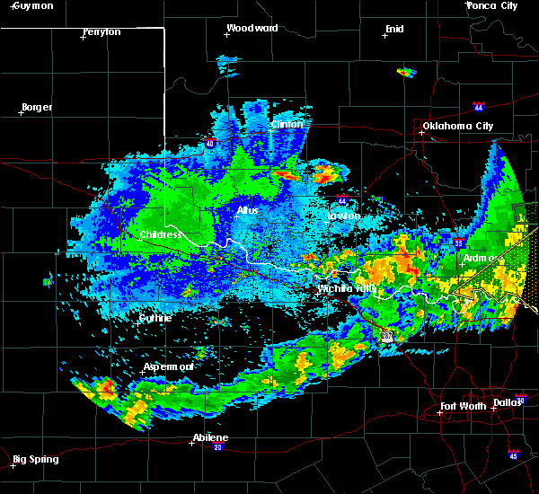 At 824 pm cdt, severe thunderstorms were located along a line extending from 3 miles north of apache to 3 miles south of gotebo, moving southeast at 25 mph (radar indicated). Hazards include 60 mph wind gusts and quarter size hail. Hail damage to vehicles is expected. Expect wind damage to roofs, siding, and trees. At 824 pm cdt, severe thunderstorms were located along a line extending from 3 miles north of apache to 3 miles south of gotebo, moving southeast at 25 mph (radar indicated). Hazards include 60 mph wind gusts and quarter size hail. Hail damage to vehicles is expected. Expect wind damage to roofs, siding, and trees.
|
| 7/12/2020 2:22 AM CDT |
 At 222 am cdt, a severe thunderstorm was located over meers, moving east at 30 mph (trained weather spotters reported a 61 mph wind gust at meers). Hazards include 60 mph wind gusts. expect damage to roofs, siding, and trees At 222 am cdt, a severe thunderstorm was located over meers, moving east at 30 mph (trained weather spotters reported a 61 mph wind gust at meers). Hazards include 60 mph wind gusts. expect damage to roofs, siding, and trees
|
| 7/12/2020 12:37 AM CDT |
 At 1237 am cdt, the leading edge of winds from a line of severe thunderstorms was located along a line extending from 9 miles southwest of lindsay to 4 miles southeast of sterling to 4 miles north of meers, moving southeast at 45 mph (radar indicated). Hazards include 60 mph wind gusts. expect damage to roofs, siding, and trees At 1237 am cdt, the leading edge of winds from a line of severe thunderstorms was located along a line extending from 9 miles southwest of lindsay to 4 miles southeast of sterling to 4 miles north of meers, moving southeast at 45 mph (radar indicated). Hazards include 60 mph wind gusts. expect damage to roofs, siding, and trees
|
| 7/12/2020 12:25 AM CDT | Storm damage reported in caddo county OK, 4.2 miles WSW of Apache, OK |
| 7/10/2020 10:51 AM CDT |
 At 1050 am cdt, severe thunderstorms were located along a line extending from near bethany to near pocasset to near gracemont, moving south at 40 mph (there was a measured 62 mph wind gust at el reno). Hazards include 60 mph wind gusts and nickel size hail. Expect damage to roofs, siding, and trees. Locations impacted include, western oklahoma city, el reno, chickasha, blanchard, anadarko, yukon, mustang, tuttle, piedmont, union city, minco, apache, cyril, binger, verden, cement, amber, bridge creek, gracemont and lookeba. At 1050 am cdt, severe thunderstorms were located along a line extending from near bethany to near pocasset to near gracemont, moving south at 40 mph (there was a measured 62 mph wind gust at el reno). Hazards include 60 mph wind gusts and nickel size hail. Expect damage to roofs, siding, and trees. Locations impacted include, western oklahoma city, el reno, chickasha, blanchard, anadarko, yukon, mustang, tuttle, piedmont, union city, minco, apache, cyril, binger, verden, cement, amber, bridge creek, gracemont and lookeba.
|
| 7/10/2020 10:21 AM CDT |
 At 1020 am cdt, severe thunderstorms were located along a line extending from 3 miles southwest of cashion to 5 miles southwest of el reno to 6 miles west of hinton, moving south at 40 mph (radar indicated). Hazards include 60 mph wind gusts. expect damage to roofs, siding, and trees At 1020 am cdt, severe thunderstorms were located along a line extending from 3 miles southwest of cashion to 5 miles southwest of el reno to 6 miles west of hinton, moving south at 40 mph (radar indicated). Hazards include 60 mph wind gusts. expect damage to roofs, siding, and trees
|
| 6/22/2020 12:13 AM CDT |
 At 1212 am cdt, severe thunderstorms were located along a line extending from near rush springs to near lawton to 5 miles northeast of headrick, moving southeast at 20 mph (radar indicated). Hazards include 60 mph wind gusts. expect damage to roofs, siding, and trees At 1212 am cdt, severe thunderstorms were located along a line extending from near rush springs to near lawton to 5 miles northeast of headrick, moving southeast at 20 mph (radar indicated). Hazards include 60 mph wind gusts. expect damage to roofs, siding, and trees
|
| 6/21/2020 11:33 PM CDT |
 At 1133 pm cdt, severe thunderstorms were located along a line extending from 4 miles northwest of lone wolf to 6 miles northeast of cooperton to near anadarko, moving southeast at 45 mph (radar indicated). Hazards include 70 mph wind gusts and nickel size hail. Expect considerable tree damage. Damage is likely to mobile homes, roofs, and outbuildings. At 1133 pm cdt, severe thunderstorms were located along a line extending from 4 miles northwest of lone wolf to 6 miles northeast of cooperton to near anadarko, moving southeast at 45 mph (radar indicated). Hazards include 70 mph wind gusts and nickel size hail. Expect considerable tree damage. Damage is likely to mobile homes, roofs, and outbuildings.
|
| 6/21/2020 10:25 AM CDT | Quarter sized hail reported 6.4 miles E of Apache, OK |
| 6/4/2020 8:31 PM CDT |
 At 830 pm cdt, severe thunderstorms were located along a line extending from near cyril to near snyder to near humphreys, moving southeast at 30 mph (radar indicated. a 63 mph wind gust was measured at altus afb). Hazards include 70 mph wind gusts. Expect considerable tree damage. damage is likely to mobile homes, roofs, and outbuildings. Locations impacted include, lawton, altus, frederick, cache, elgin, apache, snyder, geronimo, fletcher, cyril, tipton, blair, sterling, cement, chattanooga, mountain park, medicine park, indiahoma, roosevelt and manitou. At 830 pm cdt, severe thunderstorms were located along a line extending from near cyril to near snyder to near humphreys, moving southeast at 30 mph (radar indicated. a 63 mph wind gust was measured at altus afb). Hazards include 70 mph wind gusts. Expect considerable tree damage. damage is likely to mobile homes, roofs, and outbuildings. Locations impacted include, lawton, altus, frederick, cache, elgin, apache, snyder, geronimo, fletcher, cyril, tipton, blair, sterling, cement, chattanooga, mountain park, medicine park, indiahoma, roosevelt and manitou.
|
| 6/4/2020 8:24 PM CDT |
 At 823 pm cdt, severe thunderstorms were located along a line extending from near tabler to near medicine park to near friendship, moving east at 55 mph (radar indicated). Hazards include 60 mph wind gusts. Expect damage to roofs, siding, and trees. strong damaging winds may begin well before the rain starts. Locations impacted include, lawton, altus, anadarko, frederick, cache, elgin, apache, snyder, geronimo, fletcher, cyril, tipton, blair, sterling, fort cobb, cement, mountain park, medicine park, indiahoma and gracemont. At 823 pm cdt, severe thunderstorms were located along a line extending from near tabler to near medicine park to near friendship, moving east at 55 mph (radar indicated). Hazards include 60 mph wind gusts. Expect damage to roofs, siding, and trees. strong damaging winds may begin well before the rain starts. Locations impacted include, lawton, altus, anadarko, frederick, cache, elgin, apache, snyder, geronimo, fletcher, cyril, tipton, blair, sterling, fort cobb, cement, mountain park, medicine park, indiahoma and gracemont.
|
| 6/4/2020 8:00 PM CDT |
 At 800 pm cdt, severe thunderstorms were located along a line extending from 5 miles north of lake chickasha to near duke, moving east at 45 mph (radar indicated). Hazards include 60 mph wind gusts. expect damage to roofs, siding, and trees At 800 pm cdt, severe thunderstorms were located along a line extending from 5 miles north of lake chickasha to near duke, moving east at 45 mph (radar indicated). Hazards include 60 mph wind gusts. expect damage to roofs, siding, and trees
|
| 6/4/2020 7:47 PM CDT |
 At 747 pm cdt, severe thunderstorms were located along a line extending from near hinton to 3 miles northwest of albert to near hobart to 4 miles west of willow, moving southeast at 25 mph (radar indicated). Hazards include 60 mph wind gusts. Expect damage to roofs, siding, and trees. Locations impacted include, anadarko, hobart, hinton, carnegie, apache, geary, cyril, mountain view, binger, fort cobb, verden, calumet, cement, lone wolf, eakly, gracemont, roosevelt, gotebo, lookeba and bridgeport. At 747 pm cdt, severe thunderstorms were located along a line extending from near hinton to 3 miles northwest of albert to near hobart to 4 miles west of willow, moving southeast at 25 mph (radar indicated). Hazards include 60 mph wind gusts. Expect damage to roofs, siding, and trees. Locations impacted include, anadarko, hobart, hinton, carnegie, apache, geary, cyril, mountain view, binger, fort cobb, verden, calumet, cement, lone wolf, eakly, gracemont, roosevelt, gotebo, lookeba and bridgeport.
|
| 6/4/2020 7:14 PM CDT |
 At 714 pm cdt, severe thunderstorms were located along a line extending from near thomas to near weatherford to near cordell to near sentinel, moving southeast at 35 mph (radar indicated. this line of storms has a history of causing wind damage). Hazards include 70 mph wind gusts. Expect considerable tree damage. damage is likely to mobile homes, roofs, and outbuildings. Locations impacted include, weatherford, clinton, anadarko, hobart, cordell, hinton, burns flat, carnegie, apache, geary, thomas, cyril, hydro, sentinel, arapaho, mountain view, binger, fort cobb, dill city and canute. At 714 pm cdt, severe thunderstorms were located along a line extending from near thomas to near weatherford to near cordell to near sentinel, moving southeast at 35 mph (radar indicated. this line of storms has a history of causing wind damage). Hazards include 70 mph wind gusts. Expect considerable tree damage. damage is likely to mobile homes, roofs, and outbuildings. Locations impacted include, weatherford, clinton, anadarko, hobart, cordell, hinton, burns flat, carnegie, apache, geary, thomas, cyril, hydro, sentinel, arapaho, mountain view, binger, fort cobb, dill city and canute.
|
| 6/4/2020 6:49 PM CDT |
 At 649 pm cdt, severe thunderstorms were located along a line extending from 3 miles southeast of putnam to near elk city, moving southeast at 35 mph. these are very dangerous storms (radar indicated. 80 mph measured wind gusts occurred at both cheyenne and butler. this line of storms has a history of causing wind damage). Hazards include 80 mph wind gusts. Flying debris will be dangerous to those caught without shelter. mobile homes will be heavily damaged. expect considerable damage to roofs, windows, and vehicles. Extensive tree damage and power outages are likely. At 649 pm cdt, severe thunderstorms were located along a line extending from 3 miles southeast of putnam to near elk city, moving southeast at 35 mph. these are very dangerous storms (radar indicated. 80 mph measured wind gusts occurred at both cheyenne and butler. this line of storms has a history of causing wind damage). Hazards include 80 mph wind gusts. Flying debris will be dangerous to those caught without shelter. mobile homes will be heavily damaged. expect considerable damage to roofs, windows, and vehicles. Extensive tree damage and power outages are likely.
|
| 5/23/2020 11:22 PM CDT |
 At 1122 pm cdt, severe thunderstorms were located along a line extending from 7 miles north of eakly to 3 miles southeast of faxon, moving east at 30 mph (radar indicated). Hazards include 60 mph wind gusts and quarter size hail. Hail damage to vehicles is expected. Expect wind damage to roofs, siding, and trees. At 1122 pm cdt, severe thunderstorms were located along a line extending from 7 miles north of eakly to 3 miles southeast of faxon, moving east at 30 mph (radar indicated). Hazards include 60 mph wind gusts and quarter size hail. Hail damage to vehicles is expected. Expect wind damage to roofs, siding, and trees.
|
| 5/15/2020 5:38 PM CDT | Quarter sized hail reported 3.8 miles SE of Apache, OK |
| 5/15/2020 5:35 PM CDT |
 At 535 pm cdt, a severe thunderstorm was located 5 miles north of apache, moving east at 20 mph (radar indicated). Hazards include 60 mph wind gusts and quarter size hail. Hail damage to vehicles is expected. Expect wind damage to roofs, siding, and trees. At 535 pm cdt, a severe thunderstorm was located 5 miles north of apache, moving east at 20 mph (radar indicated). Hazards include 60 mph wind gusts and quarter size hail. Hail damage to vehicles is expected. Expect wind damage to roofs, siding, and trees.
|
| 5/8/2020 1:27 AM CDT |
 At 127 am cdt, severe thunderstorms were located along a line extending from 4 miles southeast of cement to near fort sill, moving southeast at 50 mph (radar indicated). Hazards include ping pong ball size hail and 60 mph wind gusts. People and animals outdoors will be injured. expect hail damage to roofs, siding, windows, and vehicles. Expect wind damage to roofs, siding, and trees. At 127 am cdt, severe thunderstorms were located along a line extending from 4 miles southeast of cement to near fort sill, moving southeast at 50 mph (radar indicated). Hazards include ping pong ball size hail and 60 mph wind gusts. People and animals outdoors will be injured. expect hail damage to roofs, siding, windows, and vehicles. Expect wind damage to roofs, siding, and trees.
|
| 5/8/2020 1:05 AM CDT |
 At 104 am cdt, severe thunderstorms were located along a line extending from near fort cobb to 5 miles southeast of cooperton, moving southeast at 55 mph (radar indicated). Hazards include ping pong ball size hail and 60 mph wind gusts. People and animals outdoors will be injured. expect hail damage to roofs, siding, windows, and vehicles. expect wind damage to roofs, siding, and trees. Locations impacted include, lawton, anadarko, cache, elgin, carnegie, apache, geronimo, fletcher, cyril, sterling, fort cobb, cement, medicine park, cooperton, meers, lake lawtonka, boone, fort sill, lake ellsworth and fort cobb reservoir. At 104 am cdt, severe thunderstorms were located along a line extending from near fort cobb to 5 miles southeast of cooperton, moving southeast at 55 mph (radar indicated). Hazards include ping pong ball size hail and 60 mph wind gusts. People and animals outdoors will be injured. expect hail damage to roofs, siding, windows, and vehicles. expect wind damage to roofs, siding, and trees. Locations impacted include, lawton, anadarko, cache, elgin, carnegie, apache, geronimo, fletcher, cyril, sterling, fort cobb, cement, medicine park, cooperton, meers, lake lawtonka, boone, fort sill, lake ellsworth and fort cobb reservoir.
|
| 5/8/2020 12:45 AM CDT |
 At 1244 am cdt, severe thunderstorms were located along a line extending from near cloud chief to 6 miles north of roosevelt, moving southeast at 55 mph (radar indicated). Hazards include ping pong ball size hail and 60 mph wind gusts. People and animals outdoors will be injured. expect hail damage to roofs, siding, windows, and vehicles. Expect wind damage to roofs, siding, and trees. At 1244 am cdt, severe thunderstorms were located along a line extending from near cloud chief to 6 miles north of roosevelt, moving southeast at 55 mph (radar indicated). Hazards include ping pong ball size hail and 60 mph wind gusts. People and animals outdoors will be injured. expect hail damage to roofs, siding, windows, and vehicles. Expect wind damage to roofs, siding, and trees.
|
| 4/21/2020 11:12 PM CDT |
 At 1112 pm cdt, a severe thunderstorm was located near fletcher, moving east at 30 mph. this is a very dangerous storm (radar indicated). Hazards include baseball size hail and 70 mph wind gusts. People and animals outdoors will be severely injured. expect shattered windows, extensive damage to roofs, siding, and vehicles. Locations impacted include, duncan, marlow, elgin, apache, rush springs, fletcher, cyril, sterling, cement, agawam, lake ellsworth, northeastern fort sill, central high, acme and stecker. At 1112 pm cdt, a severe thunderstorm was located near fletcher, moving east at 30 mph. this is a very dangerous storm (radar indicated). Hazards include baseball size hail and 70 mph wind gusts. People and animals outdoors will be severely injured. expect shattered windows, extensive damage to roofs, siding, and vehicles. Locations impacted include, duncan, marlow, elgin, apache, rush springs, fletcher, cyril, sterling, cement, agawam, lake ellsworth, northeastern fort sill, central high, acme and stecker.
|
| 4/21/2020 10:54 PM CDT |
 At 1053 pm cdt, a severe thunderstorm was located near boone, moving east at 35 mph (radar indicated). Hazards include tennis ball size hail and 60 mph wind gusts. People and animals outdoors will be injured. expect hail damage to roofs, siding, windows, and vehicles. Expect wind damage to roofs, siding, and trees. At 1053 pm cdt, a severe thunderstorm was located near boone, moving east at 35 mph (radar indicated). Hazards include tennis ball size hail and 60 mph wind gusts. People and animals outdoors will be injured. expect hail damage to roofs, siding, windows, and vehicles. Expect wind damage to roofs, siding, and trees.
|
| 4/21/2020 10:44 PM CDT |
 At 1043 pm cdt, a severe thunderstorm was located 5 miles west of boone, moving east at 30 mph (radar indicated). Hazards include tennis ball size hail and 60 mph wind gusts. People and animals outdoors will be injured. expect hail damage to roofs, siding, windows, and vehicles. expect wind damage to roofs, siding, and trees. Locations impacted include, apache, medicine park, meers, lake ellsworth, lake lawtonka, boone, fort sill, stecker and eastern wichita mountains wildlife refuge. At 1043 pm cdt, a severe thunderstorm was located 5 miles west of boone, moving east at 30 mph (radar indicated). Hazards include tennis ball size hail and 60 mph wind gusts. People and animals outdoors will be injured. expect hail damage to roofs, siding, windows, and vehicles. expect wind damage to roofs, siding, and trees. Locations impacted include, apache, medicine park, meers, lake ellsworth, lake lawtonka, boone, fort sill, stecker and eastern wichita mountains wildlife refuge.
|
| 4/21/2020 10:18 PM CDT |
 At 1018 pm cdt, a severe thunderstorm was located 8 miles southeast of gotebo, moving east at 25 mph (radar indicated). Hazards include golf ball size hail and 60 mph wind gusts. People and animals outdoors will be injured. expect hail damage to roofs, siding, windows, and vehicles. Expect wind damage to roofs, siding, and trees. At 1018 pm cdt, a severe thunderstorm was located 8 miles southeast of gotebo, moving east at 25 mph (radar indicated). Hazards include golf ball size hail and 60 mph wind gusts. People and animals outdoors will be injured. expect hail damage to roofs, siding, windows, and vehicles. Expect wind damage to roofs, siding, and trees.
|
| 4/11/2020 8:35 PM CDT |
 At 834 pm cdt, severe thunderstorms were located along a line extending from 8 miles east of cooperton to 8 miles south of indiahoma to 4 miles south of frederick to near vernon, moving east at 40 mph (trained weather spotters). Hazards include tennis ball size hail and 70 mph wind gusts. People and animals outdoors will be injured. expect hail damage to roofs, siding, windows, and vehicles. expect considerable tree damage. wind damage is also likely to mobile homes, roofs, and outbuildings. Locations impacted include, lawton, vernon, frederick, walters, cache, elgin, apache, snyder, geronimo, fletcher, cyril, grandfield, tipton, chattanooga, mountain park, medicine park, indiahoma, davidson, manitou and devol. At 834 pm cdt, severe thunderstorms were located along a line extending from 8 miles east of cooperton to 8 miles south of indiahoma to 4 miles south of frederick to near vernon, moving east at 40 mph (trained weather spotters). Hazards include tennis ball size hail and 70 mph wind gusts. People and animals outdoors will be injured. expect hail damage to roofs, siding, windows, and vehicles. expect considerable tree damage. wind damage is also likely to mobile homes, roofs, and outbuildings. Locations impacted include, lawton, vernon, frederick, walters, cache, elgin, apache, snyder, geronimo, fletcher, cyril, grandfield, tipton, chattanooga, mountain park, medicine park, indiahoma, davidson, manitou and devol.
|
| 4/11/2020 8:22 PM CDT |
 At 821 pm cdt, severe thunderstorms were located along a line extending from near cooperton to 5 miles east of manitou to 6 miles northwest of davidson to 7 miles southeast of chillicothe, moving east at 40 mph (trained weather spotters). Hazards include tennis ball size hail and 70 mph wind gusts. People and animals outdoors will be injured. expect hail damage to roofs, siding, windows, and vehicles. expect considerable tree damage. Wind damage is also likely to mobile homes, roofs, and outbuildings. At 821 pm cdt, severe thunderstorms were located along a line extending from near cooperton to 5 miles east of manitou to 6 miles northwest of davidson to 7 miles southeast of chillicothe, moving east at 40 mph (trained weather spotters). Hazards include tennis ball size hail and 70 mph wind gusts. People and animals outdoors will be injured. expect hail damage to roofs, siding, windows, and vehicles. expect considerable tree damage. Wind damage is also likely to mobile homes, roofs, and outbuildings.
|
| 3/28/2020 3:42 AM CDT |
 At 342 am cdt, a severe thunderstorm was located 6 miles northwest of boone, moving northeast at 85 mph (radar indicated). Hazards include ping pong ball size hail and 60 mph wind gusts. People and animals outdoors will be injured. expect hail damage to roofs, siding, windows, and vehicles. Expect wind damage to roofs, siding, and trees. At 342 am cdt, a severe thunderstorm was located 6 miles northwest of boone, moving northeast at 85 mph (radar indicated). Hazards include ping pong ball size hail and 60 mph wind gusts. People and animals outdoors will be injured. expect hail damage to roofs, siding, windows, and vehicles. Expect wind damage to roofs, siding, and trees.
|
| 3/19/2020 3:09 AM CDT |
 At 309 am cdt, severe thunderstorms were located along a line extending from near lake ellsworth to 5 miles south of sterling, moving northeast at 45 mph (radar indicated). Hazards include 70 mph wind gusts and penny size hail. Expect considerable tree damage. Damage is likely to mobile homes, roofs, and outbuildings. At 309 am cdt, severe thunderstorms were located along a line extending from near lake ellsworth to 5 miles south of sterling, moving northeast at 45 mph (radar indicated). Hazards include 70 mph wind gusts and penny size hail. Expect considerable tree damage. Damage is likely to mobile homes, roofs, and outbuildings.
|
| 8/27/2019 5:10 AM CDT |
 The severe thunderstorm warning for southern caddo county will expire at 515 am cdt, the storm which prompted the warning has weakened below severe limits, and no longer poses an immediate threat to life or property. therefore, the warning will be allowed to expire. however gusty winds and heavy rain are still possible with this thunderstorm. The severe thunderstorm warning for southern caddo county will expire at 515 am cdt, the storm which prompted the warning has weakened below severe limits, and no longer poses an immediate threat to life or property. therefore, the warning will be allowed to expire. however gusty winds and heavy rain are still possible with this thunderstorm.
|
| 8/27/2019 4:57 AM CDT |
 At 457 am cdt, a severe thunderstorm was located near fort cobb, moving southeast at 20 mph (trained weather spotters). Hazards include 60 mph wind gusts and quarter size hail. Hail damage to vehicles is expected. expect wind damage to roofs, siding, and trees. Locations impacted include, anadarko, apache, cyril, fort cobb, cement, fort cobb reservoir, boone, northern lake ellsworth and stecker. At 457 am cdt, a severe thunderstorm was located near fort cobb, moving southeast at 20 mph (trained weather spotters). Hazards include 60 mph wind gusts and quarter size hail. Hail damage to vehicles is expected. expect wind damage to roofs, siding, and trees. Locations impacted include, anadarko, apache, cyril, fort cobb, cement, fort cobb reservoir, boone, northern lake ellsworth and stecker.
|
| 8/27/2019 4:29 AM CDT |
 At 429 am cdt, a severe thunderstorm was located 4 miles southwest of anadarko, moving east at 25 mph (trained weather spotters). Hazards include 60 mph wind gusts and quarter size hail. Hail damage to vehicles is expected. Expect wind damage to roofs, siding, and trees. At 429 am cdt, a severe thunderstorm was located 4 miles southwest of anadarko, moving east at 25 mph (trained weather spotters). Hazards include 60 mph wind gusts and quarter size hail. Hail damage to vehicles is expected. Expect wind damage to roofs, siding, and trees.
|
| 8/27/2019 4:01 AM CDT |
 The national weather service in norman has issued a * severe thunderstorm warning for. comanche county in southwestern oklahoma. northern jefferson county in southern oklahoma. southwestern grady county in central oklahoma. South central caddo county in southwestern oklahoma. The national weather service in norman has issued a * severe thunderstorm warning for. comanche county in southwestern oklahoma. northern jefferson county in southern oklahoma. southwestern grady county in central oklahoma. South central caddo county in southwestern oklahoma.
|
| 8/27/2019 4:01 AM CDT |
 At 401 am cdt, severe thunderstorms were located along a line extending from near velma to 7 miles northeast of geronimo to near fort sill, moving southeast at 40 mph (radar indicated). Hazards include 60 mph wind gusts and quarter size hail. Hail damage to vehicles is expected. Expect wind damage to roofs, siding, and trees. At 401 am cdt, severe thunderstorms were located along a line extending from near velma to 7 miles northeast of geronimo to near fort sill, moving southeast at 40 mph (radar indicated). Hazards include 60 mph wind gusts and quarter size hail. Hail damage to vehicles is expected. Expect wind damage to roofs, siding, and trees.
|
| 8/22/2019 5:27 PM CDT |
 At 527 pm cdt, a severe thunderstorm was located 5 miles northwest of cyril, moving north at 10 mph (radar indicated). Hazards include ping pong ball size hail and 60 mph wind gusts. People and animals outdoors will be injured. expect hail damage to roofs, siding, windows, and vehicles. expect wind damage to roofs, siding, and trees. Locations impacted include, anadarko, apache, cyril, verden, cement, northern lake ellsworth and stecker. At 527 pm cdt, a severe thunderstorm was located 5 miles northwest of cyril, moving north at 10 mph (radar indicated). Hazards include ping pong ball size hail and 60 mph wind gusts. People and animals outdoors will be injured. expect hail damage to roofs, siding, windows, and vehicles. expect wind damage to roofs, siding, and trees. Locations impacted include, anadarko, apache, cyril, verden, cement, northern lake ellsworth and stecker.
|
| 8/22/2019 5:05 PM CDT |
 At 505 pm cdt, a severe thunderstorm was located 4 miles northwest of fletcher, moving northeast at 5 mph (radar indicated). Hazards include 60 mph wind gusts and quarter size hail. Hail damage to vehicles is expected. Expect wind damage to roofs, siding, and trees. At 505 pm cdt, a severe thunderstorm was located 4 miles northwest of fletcher, moving northeast at 5 mph (radar indicated). Hazards include 60 mph wind gusts and quarter size hail. Hail damage to vehicles is expected. Expect wind damage to roofs, siding, and trees.
|
| 7/7/2019 10:06 PM CDT |
 At 1005 pm cdt, a severe thunderstorm was located 4 miles southwest of fort cobb, moving north at 20 mph (trained weather spotters have reported wind damage with this storm 7 miles southeast of carnegie). Hazards include 60 mph wind gusts and penny size hail. expect damage to roofs, siding, and trees At 1005 pm cdt, a severe thunderstorm was located 4 miles southwest of fort cobb, moving north at 20 mph (trained weather spotters have reported wind damage with this storm 7 miles southeast of carnegie). Hazards include 60 mph wind gusts and penny size hail. expect damage to roofs, siding, and trees
|
| 6/19/2019 12:49 AM CDT |
 At 1248 am cdt, severe thunderstorms were located along a line extending from near apache to near lawton to 8 miles east of davidson, moving southeast at 50 mph (radar indicated. this line of storms produced measured wind gust of 62 mph at frederick and 65 mph at altus). Hazards include 60 mph wind gusts. Expect damage to roofs, siding, and trees. winds may begin before the rain starts. Locations impacted include, lawton, burkburnett, walters, cache, electra, elgin, apache, geronimo, fletcher, cyril, grandfield, temple, sterling, chattanooga, randlett, medicine park, indiahoma, davidson, devol and faxon. At 1248 am cdt, severe thunderstorms were located along a line extending from near apache to near lawton to 8 miles east of davidson, moving southeast at 50 mph (radar indicated. this line of storms produced measured wind gust of 62 mph at frederick and 65 mph at altus). Hazards include 60 mph wind gusts. Expect damage to roofs, siding, and trees. winds may begin before the rain starts. Locations impacted include, lawton, burkburnett, walters, cache, electra, elgin, apache, geronimo, fletcher, cyril, grandfield, temple, sterling, chattanooga, randlett, medicine park, indiahoma, davidson, devol and faxon.
|
| 6/19/2019 12:29 AM CDT |
 At 1229 am cdt, severe thunderstorms were located along a line extending from 4 miles east of cooperton to 4 miles southeast of snyder to 3 miles southeast of altus air force base, moving east at 55 mph (radar indicated). Hazards include 60 mph wind gusts and nickel size hail. expect damage to roofs, siding, and trees At 1229 am cdt, severe thunderstorms were located along a line extending from 4 miles east of cooperton to 4 miles southeast of snyder to 3 miles southeast of altus air force base, moving east at 55 mph (radar indicated). Hazards include 60 mph wind gusts and nickel size hail. expect damage to roofs, siding, and trees
|
| 6/15/2019 10:29 PM CDT |
 At 1029 pm cdt, severe thunderstorms were located along a line extending from 4 miles south of anadarko to 3 miles northeast of walters to 3 miles northwest of burkburnett, moving east at 40 mph (radar indicated). Hazards include 70 mph wind gusts and quarter size hail. Hail damage to vehicles is expected. expect considerable tree damage. wind damage is also likely to mobile homes, roofs, and outbuildings. Locations impacted include, northern wichita falls, lawton, duncan, chickasha, burkburnett, anadarko, marlow, walters, cache, electra, elgin, carnegie, comanche, apache, geronimo, rush springs, fletcher, cyril, grandfield and temple. At 1029 pm cdt, severe thunderstorms were located along a line extending from 4 miles south of anadarko to 3 miles northeast of walters to 3 miles northwest of burkburnett, moving east at 40 mph (radar indicated). Hazards include 70 mph wind gusts and quarter size hail. Hail damage to vehicles is expected. expect considerable tree damage. wind damage is also likely to mobile homes, roofs, and outbuildings. Locations impacted include, northern wichita falls, lawton, duncan, chickasha, burkburnett, anadarko, marlow, walters, cache, electra, elgin, carnegie, comanche, apache, geronimo, rush springs, fletcher, cyril, grandfield and temple.
|
| 6/15/2019 10:10 PM CDT |
 At 1010 pm cdt, severe thunderstorms were located along a line extending from 5 miles south of fort cobb to 7 miles southwest of geronimo to 7 miles northwest of iowa park, moving east at 40 mph (radar indicated). Hazards include 70 mph wind gusts and quarter size hail. Hail damage to vehicles is expected. expect considerable tree damage. Wind damage is also likely to mobile homes, roofs, and outbuildings. At 1010 pm cdt, severe thunderstorms were located along a line extending from 5 miles south of fort cobb to 7 miles southwest of geronimo to 7 miles northwest of iowa park, moving east at 40 mph (radar indicated). Hazards include 70 mph wind gusts and quarter size hail. Hail damage to vehicles is expected. expect considerable tree damage. Wind damage is also likely to mobile homes, roofs, and outbuildings.
|
| 5/28/2019 5:04 PM CDT |
 At 503 pm cdt, a severe thunderstorm was located over southern fort sill, moving northeast at 30 mph (radar indicated). Hazards include ping pong ball size hail and 60 mph wind gusts. People and animals outdoors will be injured. expect hail damage to roofs, siding, windows, and vehicles. expect wind damage to roofs, siding, and trees. Locations impacted include, lawton, cache, elgin, apache, fletcher, cyril, sterling, cement, medicine park, lake lawtonka, fort sill, lake ellsworth, stecker and southeastern wichita mountains wildlife refuge. At 503 pm cdt, a severe thunderstorm was located over southern fort sill, moving northeast at 30 mph (radar indicated). Hazards include ping pong ball size hail and 60 mph wind gusts. People and animals outdoors will be injured. expect hail damage to roofs, siding, windows, and vehicles. expect wind damage to roofs, siding, and trees. Locations impacted include, lawton, cache, elgin, apache, fletcher, cyril, sterling, cement, medicine park, lake lawtonka, fort sill, lake ellsworth, stecker and southeastern wichita mountains wildlife refuge.
|
| 5/28/2019 4:50 PM CDT |
 At 450 pm cdt, a severe thunderstorm was located near cache, moving northeast at 35 mph (radar indicated). Hazards include 60 mph wind gusts and quarter size hail. Hail damage to vehicles is expected. Expect wind damage to roofs, siding, and trees. At 450 pm cdt, a severe thunderstorm was located near cache, moving northeast at 35 mph (radar indicated). Hazards include 60 mph wind gusts and quarter size hail. Hail damage to vehicles is expected. Expect wind damage to roofs, siding, and trees.
|
| 5/25/2019 10:04 PM CDT |
 At 1004 pm cdt, severe thunderstorms were located along a line extending from near fort cobb reservoir to near mountain view to 6 miles northwest of roosevelt, moving east at 35 mph (radar indicated). Hazards include 60 mph wind gusts and quarter size hail. Expect wind damage to roofs, siding, and trees. Locations impacted include, anadarko, carnegie, apache, mountain view, mountain park, roosevelt, gotebo, cooperton, meers, tom steed reservoir, boone, warren, northwestern lake ellsworth, lake lawtonka, stecker and wichita mountains wildlife refuge. At 1004 pm cdt, severe thunderstorms were located along a line extending from near fort cobb reservoir to near mountain view to 6 miles northwest of roosevelt, moving east at 35 mph (radar indicated). Hazards include 60 mph wind gusts and quarter size hail. Expect wind damage to roofs, siding, and trees. Locations impacted include, anadarko, carnegie, apache, mountain view, mountain park, roosevelt, gotebo, cooperton, meers, tom steed reservoir, boone, warren, northwestern lake ellsworth, lake lawtonka, stecker and wichita mountains wildlife refuge.
|
| 5/25/2019 9:41 PM CDT |
 At 940 pm cdt, severe thunderstorms were located along a line extending from 3 miles east of cloud chief to 3 miles east of gotebo to 3 miles east of hobart to 3 miles east of warren, moving east at 30 mph (radar indicated). Hazards include 70 mph wind gusts and quarter size hail. Hail damage to vehicles is expected. expect considerable tree damage. Wind damage is also likely to mobile homes, roofs, and outbuildings. At 940 pm cdt, severe thunderstorms were located along a line extending from 3 miles east of cloud chief to 3 miles east of gotebo to 3 miles east of hobart to 3 miles east of warren, moving east at 30 mph (radar indicated). Hazards include 70 mph wind gusts and quarter size hail. Hail damage to vehicles is expected. expect considerable tree damage. Wind damage is also likely to mobile homes, roofs, and outbuildings.
|
| 5/24/2019 8:24 PM CDT |
 At 822 pm cdt, severe thunderstorms were located along a line extending from near calumet to near minco to 4 miles northeast of cement to near fletcher, moving east at 40 mph (radar indicated). Hazards include 60 mph wind gusts. wind gusts may occur well ahead of the storm before the rain starts. Expect damage to roofs, siding, and trees. Locations impacted include, northern lawton, el reno, chickasha, anadarko, tuttle, hinton, cache, elgin, union city, minco, apache, geary, rush springs, okarche, fletcher, cyril, sterling, binger, fort cobb and verden. At 822 pm cdt, severe thunderstorms were located along a line extending from near calumet to near minco to 4 miles northeast of cement to near fletcher, moving east at 40 mph (radar indicated). Hazards include 60 mph wind gusts. wind gusts may occur well ahead of the storm before the rain starts. Expect damage to roofs, siding, and trees. Locations impacted include, northern lawton, el reno, chickasha, anadarko, tuttle, hinton, cache, elgin, union city, minco, apache, geary, rush springs, okarche, fletcher, cyril, sterling, binger, fort cobb and verden.
|
| 5/24/2019 8:04 PM CDT |
 At 803 pm cdt, severe thunderstorms were located along a line extending from near colony to near albert to near fort cobb to near meers, moving northeast at 40 mph (radar indicated. this line of storms has a history of causing wind damage). Hazards include 70 mph wind gusts and nickel size hail. Expect considerable tree damage. damage is likely to mobile homes, roofs, and outbuildings. Locations impacted include, el reno, chickasha, anadarko, tuttle, hinton, cache, elgin, carnegie, union city, minco, apache, geary, rush springs, okarche, fletcher, cyril, sterling, binger, fort cobb and verden. At 803 pm cdt, severe thunderstorms were located along a line extending from near colony to near albert to near fort cobb to near meers, moving northeast at 40 mph (radar indicated. this line of storms has a history of causing wind damage). Hazards include 70 mph wind gusts and nickel size hail. Expect considerable tree damage. damage is likely to mobile homes, roofs, and outbuildings. Locations impacted include, el reno, chickasha, anadarko, tuttle, hinton, cache, elgin, carnegie, union city, minco, apache, geary, rush springs, okarche, fletcher, cyril, sterling, binger, fort cobb and verden.
|
| 5/24/2019 7:38 PM CDT |
 At 737 pm cdt, severe thunderstorms were located along a line extending from 4 miles northeast of cloud chief to 4 miles northwest of carnegie to 8 miles north of meers to near fort sill, moving northeast at 45 mph (radar indicated. this line of storms has a history of causing wind damage). Hazards include 70 mph wind gusts and nickel size hail. Expect considerable tree damage. Damage is likely to mobile homes, roofs, and outbuildings. At 737 pm cdt, severe thunderstorms were located along a line extending from 4 miles northeast of cloud chief to 4 miles northwest of carnegie to 8 miles north of meers to near fort sill, moving northeast at 45 mph (radar indicated. this line of storms has a history of causing wind damage). Hazards include 70 mph wind gusts and nickel size hail. Expect considerable tree damage. Damage is likely to mobile homes, roofs, and outbuildings.
|
| 5/18/2019 6:42 AM CDT |
 At 642 am cdt, a severe thunderstorm was located near fletcher, moving northeast at 35 mph (radar indicated). Hazards include ping pong ball size hail and 60 mph wind gusts. People and animals outdoors will be injured. expect hail damage to roofs, siding, windows, and vehicles. Expect wind damage to roofs, siding, and trees. At 642 am cdt, a severe thunderstorm was located near fletcher, moving northeast at 35 mph (radar indicated). Hazards include ping pong ball size hail and 60 mph wind gusts. People and animals outdoors will be injured. expect hail damage to roofs, siding, windows, and vehicles. Expect wind damage to roofs, siding, and trees.
|
| 12/26/2018 7:15 PM CST |
 At 714 pm cst, severe thunderstorms were located along a line extending from 3 miles northwest of cement to 4 miles west of marlow to near loco to 7 miles north of grady, moving northeast at 60 mph (radar indicated). Hazards include 70 mph wind gusts. Expect considerable tree damage. damage is likely to mobile homes, roofs, and outbuildings. Locations impacted include, duncan, anadarko, marlow, waurika, elgin, comanche, apache, rush springs, bray, fletcher, cyril, ryan, sterling, velma, cement, loco, addington, sugden, grady and oscar. At 714 pm cst, severe thunderstorms were located along a line extending from 3 miles northwest of cement to 4 miles west of marlow to near loco to 7 miles north of grady, moving northeast at 60 mph (radar indicated). Hazards include 70 mph wind gusts. Expect considerable tree damage. damage is likely to mobile homes, roofs, and outbuildings. Locations impacted include, duncan, anadarko, marlow, waurika, elgin, comanche, apache, rush springs, bray, fletcher, cyril, ryan, sterling, velma, cement, loco, addington, sugden, grady and oscar.
|
| 12/26/2018 6:56 PM CST |
 At 655 pm cst, severe thunderstorms were located along a line extending from 4 miles east of lake lawtonka to 7 miles east of geronimo to near waurika to near terral, moving northeast at 60 mph (radar indicated). Hazards include 70 mph wind gusts. Expect considerable tree damage. damage is likely to mobile homes, roofs, and outbuildings. Locations impacted include, lawton, duncan, anadarko, marlow, henrietta, walters, waurika, cache, elgin, comanche, apache, geronimo, rush springs, bray, fletcher, cyril, temple, ryan, sterling and petrolia. At 655 pm cst, severe thunderstorms were located along a line extending from 4 miles east of lake lawtonka to 7 miles east of geronimo to near waurika to near terral, moving northeast at 60 mph (radar indicated). Hazards include 70 mph wind gusts. Expect considerable tree damage. damage is likely to mobile homes, roofs, and outbuildings. Locations impacted include, lawton, duncan, anadarko, marlow, henrietta, walters, waurika, cache, elgin, comanche, apache, geronimo, rush springs, bray, fletcher, cyril, temple, ryan, sterling and petrolia.
|
| 12/26/2018 6:38 PM CST |
 At 637 pm cst, severe thunderstorms were located along a line extending from near cache to near cookietown to 4 miles southeast of petrolia to 7 miles northwest of newport, moving northeast at 60 mph (radar indicated). Hazards include 70 mph wind gusts. Expect considerable tree damage. Damage is likely to mobile homes, roofs, and outbuildings. At 637 pm cst, severe thunderstorms were located along a line extending from near cache to near cookietown to 4 miles southeast of petrolia to 7 miles northwest of newport, moving northeast at 60 mph (radar indicated). Hazards include 70 mph wind gusts. Expect considerable tree damage. Damage is likely to mobile homes, roofs, and outbuildings.
|
| 11/30/2018 7:59 PM CST |
 At 759 pm cst, a severe thunderstorm was located near cyril, moving northeast at 50 mph (radar indicated). Hazards include 60 mph wind gusts and quarter size hail. Hail damage to vehicles is expected. expect wind damage to roofs, siding, and trees. Locations impacted include, anadarko, apache, cyril, verden, cement, lake chickasha and stecker. At 759 pm cst, a severe thunderstorm was located near cyril, moving northeast at 50 mph (radar indicated). Hazards include 60 mph wind gusts and quarter size hail. Hail damage to vehicles is expected. expect wind damage to roofs, siding, and trees. Locations impacted include, anadarko, apache, cyril, verden, cement, lake chickasha and stecker.
|
| 11/30/2018 7:50 PM CST |
 At 750 pm cst, a severe thunderstorm was located near lake ellsworth, moving northeast at 50 mph (radar indicated). Hazards include ping pong ball size hail and 60 mph wind gusts. People and animals outdoors will be injured. expect hail damage to roofs, siding, windows, and vehicles. expect wind damage to roofs, siding, and trees. Locations impacted include, anadarko, elgin, apache, fletcher, cyril, verden, cement, lake ellsworth, lake chickasha, northeastern fort sill and stecker. At 750 pm cst, a severe thunderstorm was located near lake ellsworth, moving northeast at 50 mph (radar indicated). Hazards include ping pong ball size hail and 60 mph wind gusts. People and animals outdoors will be injured. expect hail damage to roofs, siding, windows, and vehicles. expect wind damage to roofs, siding, and trees. Locations impacted include, anadarko, elgin, apache, fletcher, cyril, verden, cement, lake ellsworth, lake chickasha, northeastern fort sill and stecker.
|
| 11/30/2018 7:38 PM CST |
 At 738 pm cst, a severe thunderstorm was located over eastern fort sill, moving northeast at 50 mph (radar indicated). Hazards include golf ball size hail and 60 mph wind gusts. People and animals outdoors will be injured. expect hail damage to roofs, siding, windows, and vehicles. Expect wind damage to roofs, siding, and trees. At 738 pm cst, a severe thunderstorm was located over eastern fort sill, moving northeast at 50 mph (radar indicated). Hazards include golf ball size hail and 60 mph wind gusts. People and animals outdoors will be injured. expect hail damage to roofs, siding, windows, and vehicles. Expect wind damage to roofs, siding, and trees.
|
| 10/7/2018 6:53 PM CDT |
 At 653 pm cdt, a severe thunderstorm was located 4 miles northeast of apache, moving northeast at 25 mph (radar indicated). Hazards include 60 mph wind gusts and quarter size hail. Hail damage to vehicles is expected. Expect wind damage to roofs, siding, and trees. At 653 pm cdt, a severe thunderstorm was located 4 miles northeast of apache, moving northeast at 25 mph (radar indicated). Hazards include 60 mph wind gusts and quarter size hail. Hail damage to vehicles is expected. Expect wind damage to roofs, siding, and trees.
|
| 6/30/2018 2:52 PM CDT |
 At 252 pm cdt, severe thunderstorms were located along a line extending from 5 miles southeast of fort cobb to near rush springs, moving northeast at 55 mph (radar indicated). Hazards include 70 mph wind gusts and quarter size hail. Hail damage to vehicles is expected. expect considerable tree damage. Wind damage is also likely to mobile homes, roofs, and outbuildings. At 252 pm cdt, severe thunderstorms were located along a line extending from 5 miles southeast of fort cobb to near rush springs, moving northeast at 55 mph (radar indicated). Hazards include 70 mph wind gusts and quarter size hail. Hail damage to vehicles is expected. expect considerable tree damage. Wind damage is also likely to mobile homes, roofs, and outbuildings.
|
| 6/30/2018 2:50 PM CDT | Storm damage reported in caddo county OK, 4.2 miles WSW of Apache, OK |
| 6/30/2018 2:30 PM CDT |
 At 230 pm cdt, severe thunderstorms were located along a line extending from near meers to near fort sill, moving northeast at 55 mph (radar indicated). Hazards include 70 mph wind gusts and quarter size hail. Hail damage to vehicles is expected. expect considerable tree damage. Wind damage is also likely to mobile homes, roofs, and outbuildings. At 230 pm cdt, severe thunderstorms were located along a line extending from near meers to near fort sill, moving northeast at 55 mph (radar indicated). Hazards include 70 mph wind gusts and quarter size hail. Hail damage to vehicles is expected. expect considerable tree damage. Wind damage is also likely to mobile homes, roofs, and outbuildings.
|
| 6/25/2018 3:24 AM CDT |
 At 323 am cdt, severe thunderstorms were located along a line extending from 5 miles northeast of corum to near temple to 7 miles southeast of grayback, moving southeast at 65 mph (radar indicated). Hazards include 70 mph wind gusts and penny size hail. Expect considerable tree damage. damage is likely to mobile homes, roofs, and outbuildings. locations impacted include, wichita falls, lawton, duncan, vernon, burkburnett, frederick, walters, waurika, iowa park, cache, electra, elgin, holliday, apache, geronimo, fletcher, cyril, grandfield, temple and tipton. This includes interstate 44 between mile markers 0 and 70. At 323 am cdt, severe thunderstorms were located along a line extending from 5 miles northeast of corum to near temple to 7 miles southeast of grayback, moving southeast at 65 mph (radar indicated). Hazards include 70 mph wind gusts and penny size hail. Expect considerable tree damage. damage is likely to mobile homes, roofs, and outbuildings. locations impacted include, wichita falls, lawton, duncan, vernon, burkburnett, frederick, walters, waurika, iowa park, cache, electra, elgin, holliday, apache, geronimo, fletcher, cyril, grandfield, temple and tipton. This includes interstate 44 between mile markers 0 and 70.
|
| 6/25/2018 3:06 AM CDT |
 At 306 am cdt, severe thunderstorms were located along a line extending from 5 miles southeast of sterling to near geronimo to near vernon, moving southeast at 35 mph (radar indicated). Hazards include 70 mph wind gusts and penny size hail. Expect considerable tree damage. damage is likely to mobile homes, roofs, and outbuildings. locations impacted include, wichita falls, lawton, duncan, altus, vernon, burkburnett, anadarko, frederick, hobart, walters, waurika, iowa park, cache, electra, elgin, holliday, carnegie, apache, snyder and geronimo. This includes interstate 44 between mile markers 0 and 70. At 306 am cdt, severe thunderstorms were located along a line extending from 5 miles southeast of sterling to near geronimo to near vernon, moving southeast at 35 mph (radar indicated). Hazards include 70 mph wind gusts and penny size hail. Expect considerable tree damage. damage is likely to mobile homes, roofs, and outbuildings. locations impacted include, wichita falls, lawton, duncan, altus, vernon, burkburnett, anadarko, frederick, hobart, walters, waurika, iowa park, cache, electra, elgin, holliday, carnegie, apache, snyder and geronimo. This includes interstate 44 between mile markers 0 and 70.
|
| 6/25/2018 2:47 AM CDT |
 At 246 am cdt, severe thunderstorms were located along a line extending from 4 miles northeast of cement to 6 miles north of faxon to 3 miles southeast of quanah, moving southeast at 65 mph (radar indicated). Hazards include 70 mph wind gusts and quarter size hail. Hail damage to vehicles is expected. expect considerable tree damage. Wind damage is also likely to mobile homes, roofs, and outbuildings. At 246 am cdt, severe thunderstorms were located along a line extending from 4 miles northeast of cement to 6 miles north of faxon to 3 miles southeast of quanah, moving southeast at 65 mph (radar indicated). Hazards include 70 mph wind gusts and quarter size hail. Hail damage to vehicles is expected. expect considerable tree damage. Wind damage is also likely to mobile homes, roofs, and outbuildings.
|
| 6/25/2018 2:45 AM CDT | Storm damage reported in caddo county OK, 4.2 miles WSW of Apache, OK |
| 6/25/2018 2:16 AM CDT |
 At 216 am cdt, severe thunderstorms were located along a line extending from 5 miles southwest of gracemont to 3 miles northwest of quanah, moving southeast at 60 mph. these are very dangerous storms (radar indicated). Hazards include 80 mph wind gusts and quarter size hail. Flying debris will be dangerous to those caught without shelter. mobile homes will be heavily damaged. expect considerable damage to roofs, windows, and vehicles. extensive tree damage and power outages are likely. locations impacted include, lawton, altus, vernon, anadarko, frederick, hobart, mangum, cordell, quanah, hollis, crowell, cache, elgin, granite, burns flat, carnegie, apache, snyder, geronimo and fletcher. this includes the following highways, interstate 40 between mile markers 8 and 15, and between mile markers 19 and 22, and near mile marker 91. Interstate 44 between mile markers 23 and 72. At 216 am cdt, severe thunderstorms were located along a line extending from 5 miles southwest of gracemont to 3 miles northwest of quanah, moving southeast at 60 mph. these are very dangerous storms (radar indicated). Hazards include 80 mph wind gusts and quarter size hail. Flying debris will be dangerous to those caught without shelter. mobile homes will be heavily damaged. expect considerable damage to roofs, windows, and vehicles. extensive tree damage and power outages are likely. locations impacted include, lawton, altus, vernon, anadarko, frederick, hobart, mangum, cordell, quanah, hollis, crowell, cache, elgin, granite, burns flat, carnegie, apache, snyder, geronimo and fletcher. this includes the following highways, interstate 40 between mile markers 8 and 15, and between mile markers 19 and 22, and near mile marker 91. Interstate 44 between mile markers 23 and 72.
|
| 6/25/2018 1:56 AM CDT |
 At 156 am cdt, severe thunderstorms were located along a line extending from 6 miles west of lookeba to 9 miles south of hollis, moving southeast at 60 mph. these are very dangerous storms (radar indicated). Hazards include 80 mph wind gusts and quarter size hail. Flying debris will be dangerous to those caught without shelter. mobile homes will be heavily damaged. expect considerable damage to roofs, windows, and vehicles. Extensive tree damage and power outages are likely. At 156 am cdt, severe thunderstorms were located along a line extending from 6 miles west of lookeba to 9 miles south of hollis, moving southeast at 60 mph. these are very dangerous storms (radar indicated). Hazards include 80 mph wind gusts and quarter size hail. Flying debris will be dangerous to those caught without shelter. mobile homes will be heavily damaged. expect considerable damage to roofs, windows, and vehicles. Extensive tree damage and power outages are likely.
|
| 6/24/2018 1:50 PM CDT |
 At 150 pm cdt, a severe thunderstorm was located near cement, moving east at 35 mph (radar indicated). Hazards include 60 mph wind gusts and penny size hail. Expect damage to roofs, siding, and trees. locations impacted include, chickasha, anadarko, apache, fletcher, cyril, sterling, verden, cement, amber, pocasset, norge, agawam, lake chickasha, tabler, northeastern lake ellsworth, ninnekah, acme, stecker and laverty. This includes interstate 44 between mile markers 56 and 94. At 150 pm cdt, a severe thunderstorm was located near cement, moving east at 35 mph (radar indicated). Hazards include 60 mph wind gusts and penny size hail. Expect damage to roofs, siding, and trees. locations impacted include, chickasha, anadarko, apache, fletcher, cyril, sterling, verden, cement, amber, pocasset, norge, agawam, lake chickasha, tabler, northeastern lake ellsworth, ninnekah, acme, stecker and laverty. This includes interstate 44 between mile markers 56 and 94.
|
| 6/24/2018 1:32 PM CDT |
 At 131 pm cdt, a severe thunderstorm was located 4 miles southwest of anadarko, moving east at 35 mph (radar indicated). Hazards include 60 mph wind gusts and quarter size hail. Hail damage to vehicles is expected. Expect wind damage to roofs, siding, and trees. At 131 pm cdt, a severe thunderstorm was located 4 miles southwest of anadarko, moving east at 35 mph (radar indicated). Hazards include 60 mph wind gusts and quarter size hail. Hail damage to vehicles is expected. Expect wind damage to roofs, siding, and trees.
|
| 6/23/2018 12:50 AM CDT |
 At 1250 am cdt, severe thunderstorms were located along a line extending from 3 miles northeast of lookeba to near gracemont to near lake lawtonka, moving east at 50 mph (radar indicated). Hazards include 70 mph wind gusts and quarter size hail. Hail damage to vehicles is expected. expect considerable tree damage. wind damage is also likely to mobile homes, roofs, and outbuildings. locations impacted include, anadarko, hinton, elgin, union city, minco, apache, fletcher, cyril, sterling, binger, fort cobb, verden, cement, medicine park, gracemont, lookeba, meers, boone, albert and lake chickasha. This includes interstate 44 between mile markers 44 and 73. At 1250 am cdt, severe thunderstorms were located along a line extending from 3 miles northeast of lookeba to near gracemont to near lake lawtonka, moving east at 50 mph (radar indicated). Hazards include 70 mph wind gusts and quarter size hail. Hail damage to vehicles is expected. expect considerable tree damage. wind damage is also likely to mobile homes, roofs, and outbuildings. locations impacted include, anadarko, hinton, elgin, union city, minco, apache, fletcher, cyril, sterling, binger, fort cobb, verden, cement, medicine park, gracemont, lookeba, meers, boone, albert and lake chickasha. This includes interstate 44 between mile markers 44 and 73.
|
| 6/23/2018 12:25 AM CDT |
 At 1225 am cdt, severe thunderstorms were located along a line extending from 5 miles north of colony to near carnegie to 5 miles southeast of cooperton, moving east at 45 mph (radar indicated). Hazards include 70 mph wind gusts and ping pong ball size hail. People and animals outdoors will be injured. expect hail damage to roofs, siding, windows, and vehicles. expect considerable tree damage. Wind damage is also likely to mobile homes, roofs, and outbuildings. At 1225 am cdt, severe thunderstorms were located along a line extending from 5 miles north of colony to near carnegie to 5 miles southeast of cooperton, moving east at 45 mph (radar indicated). Hazards include 70 mph wind gusts and ping pong ball size hail. People and animals outdoors will be injured. expect hail damage to roofs, siding, windows, and vehicles. expect considerable tree damage. Wind damage is also likely to mobile homes, roofs, and outbuildings.
|
| 6/22/2018 11:51 PM CDT |
 At 1151 pm cdt, severe thunderstorms were located along a line extending from near cement to 3 miles southwest of sentinel, moving east at 45 mph (radar indicated). Hazards include 70 mph wind gusts and quarter size hail. Hail damage to vehicles is expected. expect considerable tree damage. Wind damage is also likely to mobile homes, roofs, and outbuildings. At 1151 pm cdt, severe thunderstorms were located along a line extending from near cement to 3 miles southwest of sentinel, moving east at 45 mph (radar indicated). Hazards include 70 mph wind gusts and quarter size hail. Hail damage to vehicles is expected. expect considerable tree damage. Wind damage is also likely to mobile homes, roofs, and outbuildings.
|
| 6/22/2018 11:28 PM CDT |
 At 1128 pm cdt, severe thunderstorms were located along a line extending from near carter to 4 miles south of fort cobb, moving southeast at 40 mph (radar indicated). Hazards include 60 mph wind gusts and nickel size hail. expect damage to roofs, siding, and trees At 1128 pm cdt, severe thunderstorms were located along a line extending from near carter to 4 miles south of fort cobb, moving southeast at 40 mph (radar indicated). Hazards include 60 mph wind gusts and nickel size hail. expect damage to roofs, siding, and trees
|
| 5/17/2018 3:43 PM CDT |
 At 342 pm cdt, a severe thunderstorm was located 5 miles southeast of fort cobb, moving southeast at 25 mph. hail the size of quarters was reported in fort cobb (radar indicated). Hazards include 60 mph wind gusts and quarter size hail. Hail damage to vehicles is expected. expect wind damage to roofs, siding, and trees. Locations impacted include, apache, cyril and stecker. At 342 pm cdt, a severe thunderstorm was located 5 miles southeast of fort cobb, moving southeast at 25 mph. hail the size of quarters was reported in fort cobb (radar indicated). Hazards include 60 mph wind gusts and quarter size hail. Hail damage to vehicles is expected. expect wind damage to roofs, siding, and trees. Locations impacted include, apache, cyril and stecker.
|
| 5/17/2018 3:32 PM CDT |
 At 331 pm cdt, a severe thunderstorm was located over fort cobb, moving southeast at 25 mph (radar indicated). Hazards include 60 mph wind gusts and nickel size hail. Expect damage to roofs, siding, and trees. Locations impacted include, apache, cyril, fort cobb and stecker. At 331 pm cdt, a severe thunderstorm was located over fort cobb, moving southeast at 25 mph (radar indicated). Hazards include 60 mph wind gusts and nickel size hail. Expect damage to roofs, siding, and trees. Locations impacted include, apache, cyril, fort cobb and stecker.
|
| 5/17/2018 3:19 PM CDT |
 At 319 pm cdt, a severe thunderstorm was located near fort cobb reservoir, moving southeast at 25 mph (radar indicated). Hazards include ping pong ball size hail and 60 mph wind gusts. People and animals outdoors will be injured. expect hail damage to roofs, siding, windows, and vehicles. Expect wind damage to roofs, siding, and trees. At 319 pm cdt, a severe thunderstorm was located near fort cobb reservoir, moving southeast at 25 mph (radar indicated). Hazards include ping pong ball size hail and 60 mph wind gusts. People and animals outdoors will be injured. expect hail damage to roofs, siding, windows, and vehicles. Expect wind damage to roofs, siding, and trees.
|
| 5/15/2018 12:37 PM CDT |
 At 1236 pm cdt, severe thunderstorms were located along a line extending from near amber to 3 miles southeast of chickasha. another severe storm was located near boone, moving east-southeast at 20 mph (radar indicated). Hazards include 60 mph wind gusts and half dollar size hail. Hail damage to vehicles is expected. expect wind damage to roofs, siding, and trees. Locations impacted include, chickasha, blanchard, anadarko, minco, apache, cyril, verden, cement, amber, bridge creek, pocasset, norge, boone, middleberg, tabler, lake chickasha, northern lake ellsworth, ninnekah, stecker and laverty. At 1236 pm cdt, severe thunderstorms were located along a line extending from near amber to 3 miles southeast of chickasha. another severe storm was located near boone, moving east-southeast at 20 mph (radar indicated). Hazards include 60 mph wind gusts and half dollar size hail. Hail damage to vehicles is expected. expect wind damage to roofs, siding, and trees. Locations impacted include, chickasha, blanchard, anadarko, minco, apache, cyril, verden, cement, amber, bridge creek, pocasset, norge, boone, middleberg, tabler, lake chickasha, northern lake ellsworth, ninnekah, stecker and laverty.
|
| 5/15/2018 12:26 PM CDT |
 At 1224 pm cdt, severe thunderstorms were located along a line extending from near pocasset to near chickasha, with another severe storm near boone. the storms are moving east-southeast at 25 mph. winds of 57 mph were measured at the chickasha airport (radar indicated). Hazards include 60 mph wind gusts and quarter size hail. Hail damage to vehicles is expected. expect wind damage to roofs, siding, and trees. Locations impacted include, chickasha, blanchard, anadarko, minco, apache, cyril, fort cobb, verden, cement, amber, bridge creek, gracemont, pocasset, norge, cogar, boone, middleberg, tabler, lake chickasha and northern lake ellsworth. At 1224 pm cdt, severe thunderstorms were located along a line extending from near pocasset to near chickasha, with another severe storm near boone. the storms are moving east-southeast at 25 mph. winds of 57 mph were measured at the chickasha airport (radar indicated). Hazards include 60 mph wind gusts and quarter size hail. Hail damage to vehicles is expected. expect wind damage to roofs, siding, and trees. Locations impacted include, chickasha, blanchard, anadarko, minco, apache, cyril, fort cobb, verden, cement, amber, bridge creek, gracemont, pocasset, norge, cogar, boone, middleberg, tabler, lake chickasha and northern lake ellsworth.
|
| 5/15/2018 12:10 PM CDT |
 At 1210 pm cdt, severe thunderstorms were located along a line extending from near pocasset to 4 miles southeast of verden, and another potentially severe thunderstorm 5 miles west of boone. these storms were moving east-southeast at 20 mph (radar indicated). Hazards include 60 mph wind gusts and quarter size hail. Hail damage to vehicles is expected. Expect wind damage to roofs, siding, and trees. At 1210 pm cdt, severe thunderstorms were located along a line extending from near pocasset to 4 miles southeast of verden, and another potentially severe thunderstorm 5 miles west of boone. these storms were moving east-southeast at 20 mph (radar indicated). Hazards include 60 mph wind gusts and quarter size hail. Hail damage to vehicles is expected. Expect wind damage to roofs, siding, and trees.
|
| 5/3/2018 12:59 AM CDT |
 The national weather service in norman has issued a * severe thunderstorm warning for. comanche county in southwestern oklahoma. northwestern garvin county in southern oklahoma. grady county in central oklahoma. Southeastern caddo county in southwestern oklahoma. The national weather service in norman has issued a * severe thunderstorm warning for. comanche county in southwestern oklahoma. northwestern garvin county in southern oklahoma. grady county in central oklahoma. Southeastern caddo county in southwestern oklahoma.
|
| 5/3/2018 12:35 AM CDT |
 At 1235 am cdt, a severe thunderstorm was located 6 miles north of faxon, moving northeast at 65 mph. this is a very dangerous storm (radar indicated). Hazards include 80 mph wind gusts and nickel size hail. Flying debris will be dangerous to those caught without shelter. mobile homes will be heavily damaged. expect considerable damage to roofs, windows, and vehicles. extensive tree damage and power outages are likely. locations impacted include, lawton, duncan, burkburnett, marlow, frederick, walters, cache, elgin, comanche, apache, snyder, geronimo, fletcher, grandfield, temple, sterling, chattanooga, randlett, mountain park and medicine park. This includes interstate 44 between mile markers 0 and 62. At 1235 am cdt, a severe thunderstorm was located 6 miles north of faxon, moving northeast at 65 mph. this is a very dangerous storm (radar indicated). Hazards include 80 mph wind gusts and nickel size hail. Flying debris will be dangerous to those caught without shelter. mobile homes will be heavily damaged. expect considerable damage to roofs, windows, and vehicles. extensive tree damage and power outages are likely. locations impacted include, lawton, duncan, burkburnett, marlow, frederick, walters, cache, elgin, comanche, apache, snyder, geronimo, fletcher, grandfield, temple, sterling, chattanooga, randlett, mountain park and medicine park. This includes interstate 44 between mile markers 0 and 62.
|
| 5/3/2018 12:17 AM CDT |
 At 1216 am cdt, a severe thunderstorm was located near loveland, moving northeast at 65 mph (radar indicated). Hazards include 60 mph wind gusts and nickel size hail. expect damage to roofs, siding, and trees At 1216 am cdt, a severe thunderstorm was located near loveland, moving northeast at 65 mph (radar indicated). Hazards include 60 mph wind gusts and nickel size hail. expect damage to roofs, siding, and trees
|
| 5/2/2018 8:00 PM CDT |
 At 800 pm cdt, severe thunderstorms were located along a line extending from near cyril to 5 miles northwest of marlow, moving northeast at 40 mph (radar indicated). Hazards include 70 mph wind gusts and half dollar size hail. Hail damage to vehicles is expected. expect considerable tree damage. Wind damage is also likely to mobile homes, roofs, and outbuildings. At 800 pm cdt, severe thunderstorms were located along a line extending from near cyril to 5 miles northwest of marlow, moving northeast at 40 mph (radar indicated). Hazards include 70 mph wind gusts and half dollar size hail. Hail damage to vehicles is expected. expect considerable tree damage. Wind damage is also likely to mobile homes, roofs, and outbuildings.
|
| 5/2/2018 7:26 PM CDT |
 At 726 pm cdt, severe thunderstorms were located along a line extending from 6 miles south of anadarko to near lawton, moving northeast at 30 mph (radar indicated). Hazards include 70 mph wind gusts and nickel size hail. Expect considerable tree damage. damage is likely to mobile homes, roofs, and outbuildings. Locations impacted include, northern lawton, cache, elgin, apache, fletcher, cyril, sterling, verden, cement, medicine park, meers, lake lawtonka, boone, fort sill, lake ellsworth, stecker and eastern wichita mountains wildlife refuge. At 726 pm cdt, severe thunderstorms were located along a line extending from 6 miles south of anadarko to near lawton, moving northeast at 30 mph (radar indicated). Hazards include 70 mph wind gusts and nickel size hail. Expect considerable tree damage. damage is likely to mobile homes, roofs, and outbuildings. Locations impacted include, northern lawton, cache, elgin, apache, fletcher, cyril, sterling, verden, cement, medicine park, meers, lake lawtonka, boone, fort sill, lake ellsworth, stecker and eastern wichita mountains wildlife refuge.
|
| 5/2/2018 6:58 PM CDT |
 The national weather service in norman has issued a * severe thunderstorm warning for. northern comanche county in southwestern oklahoma. southeastern caddo county in southwestern oklahoma. Until 745 pm cdt * at 658 pm cdt, a severe thunderstorm was located over western fort. The national weather service in norman has issued a * severe thunderstorm warning for. northern comanche county in southwestern oklahoma. southeastern caddo county in southwestern oklahoma. Until 745 pm cdt * at 658 pm cdt, a severe thunderstorm was located over western fort.
|
| 5/2/2018 6:33 PM CDT |
 At 633 pm cdt, a severe thunderstorm was located over southwestern fort sill, moving east at 25 mph (radar indicated). Hazards include golf ball size hail and 70 mph wind gusts. People and animals outdoors will be injured. expect hail damage to roofs, siding, windows, and vehicles. expect considerable tree damage. wind damage is also likely to mobile homes, roofs, and outbuildings. locations impacted include, lawton, cache, elgin, apache, medicine park, indiahoma, fort sill, meers, lake ellsworth, lake lawtonka and wichita mountains wildlife refuge. This includes interstate 44 between mile markers 34 and 55. At 633 pm cdt, a severe thunderstorm was located over southwestern fort sill, moving east at 25 mph (radar indicated). Hazards include golf ball size hail and 70 mph wind gusts. People and animals outdoors will be injured. expect hail damage to roofs, siding, windows, and vehicles. expect considerable tree damage. wind damage is also likely to mobile homes, roofs, and outbuildings. locations impacted include, lawton, cache, elgin, apache, medicine park, indiahoma, fort sill, meers, lake ellsworth, lake lawtonka and wichita mountains wildlife refuge. This includes interstate 44 between mile markers 34 and 55.
|
| 5/2/2018 5:58 PM CDT |
 At 558 pm cdt, a severe thunderstorm was located 4 miles southeast of snyder, moving east at 25 mph (radar indicated). Hazards include two inch hail and 70 mph wind gusts. People and animals outdoors will be injured. expect hail damage to roofs, siding, windows, and vehicles. expect considerable tree damage. Wind damage is also likely to mobile homes, roofs, and outbuildings. At 558 pm cdt, a severe thunderstorm was located 4 miles southeast of snyder, moving east at 25 mph (radar indicated). Hazards include two inch hail and 70 mph wind gusts. People and animals outdoors will be injured. expect hail damage to roofs, siding, windows, and vehicles. expect considerable tree damage. Wind damage is also likely to mobile homes, roofs, and outbuildings.
|
| 10/21/2017 7:24 PM CDT |
 At 724 pm cdt, severe thunderstorms were located along a line extending from 3 miles east of anadarko to 6 miles northwest of cyril to near apache to 4 miles northeast of lake lawtonka, moving northeast at 20 mph (radar indicated). Hazards include tennis ball size hail and 70 mph wind gusts. People and animals outdoors will be injured. expect hail damage to roofs, siding, windows, and vehicles. expect considerable tree damage. Wind damage is also likely to mobile homes, roofs, and outbuildings. At 724 pm cdt, severe thunderstorms were located along a line extending from 3 miles east of anadarko to 6 miles northwest of cyril to near apache to 4 miles northeast of lake lawtonka, moving northeast at 20 mph (radar indicated). Hazards include tennis ball size hail and 70 mph wind gusts. People and animals outdoors will be injured. expect hail damage to roofs, siding, windows, and vehicles. expect considerable tree damage. Wind damage is also likely to mobile homes, roofs, and outbuildings.
|
| 10/21/2017 7:15 PM CDT | Storm damage reported in caddo county OK, 3.7 miles WSW of Apache, OK |
| 10/21/2017 6:51 PM CDT |
 At 651 pm cdt, a severe thunderstorm was located near apache, moving northeast at 30 mph. this is a very dangerous storm (radar indicated). Hazards include baseball size hail and 70 mph wind gusts. People and animals outdoors will be severely injured. expect shattered windows, extensive damage to roofs, siding, and vehicles. locations impacted include, anadarko, apache, fletcher, cyril, verden, cement, lake ellsworth, boone, lake lawtonka, ninnekah, stecker and laverty. This includes interstate 44 between mile markers 55 and 74. At 651 pm cdt, a severe thunderstorm was located near apache, moving northeast at 30 mph. this is a very dangerous storm (radar indicated). Hazards include baseball size hail and 70 mph wind gusts. People and animals outdoors will be severely injured. expect shattered windows, extensive damage to roofs, siding, and vehicles. locations impacted include, anadarko, apache, fletcher, cyril, verden, cement, lake ellsworth, boone, lake lawtonka, ninnekah, stecker and laverty. This includes interstate 44 between mile markers 55 and 74.
|
| 10/21/2017 6:41 PM CDT |
 At 641 pm cdt, a severe thunderstorm was located near boone, moving northeast at 35 mph. this is a very dangerous storm (radar indicated). Hazards include baseball size hail and 70 mph wind gusts. People and animals outdoors will be severely injured. Expect shattered windows, extensive damage to roofs, siding, and vehicles. At 641 pm cdt, a severe thunderstorm was located near boone, moving northeast at 35 mph. this is a very dangerous storm (radar indicated). Hazards include baseball size hail and 70 mph wind gusts. People and animals outdoors will be severely injured. Expect shattered windows, extensive damage to roofs, siding, and vehicles.
|
| 10/15/2017 1:07 AM CDT |
 The severe thunderstorm warning for comanche, southern caddo, cotton, eastern jackson, kiowa, tillman, northern wichita and central wilbarger counties will expire at 115 am cdt, the storms which prompted the warning have weakened below severe limits, therefore the warning will be allowed to expire. however gusty winds of 40 to 55 mph will still be possible across a wide area behind the cold front. The severe thunderstorm warning for comanche, southern caddo, cotton, eastern jackson, kiowa, tillman, northern wichita and central wilbarger counties will expire at 115 am cdt, the storms which prompted the warning have weakened below severe limits, therefore the warning will be allowed to expire. however gusty winds of 40 to 55 mph will still be possible across a wide area behind the cold front.
|
| 10/15/2017 12:32 AM CDT |
 At 1231 am cdt, the leading edge of winds from severe thunderstorms was located along a line extending from near sterling to near davidson, moving east-southeast at 40 mph. winds of 62 mph were measured at grandfield (radar indicated). Hazards include 70 mph wind gusts. Expect considerable tree damage. Damage is likely to mobile homes, roofs, and outbuildings. At 1231 am cdt, the leading edge of winds from severe thunderstorms was located along a line extending from near sterling to near davidson, moving east-southeast at 40 mph. winds of 62 mph were measured at grandfield (radar indicated). Hazards include 70 mph wind gusts. Expect considerable tree damage. Damage is likely to mobile homes, roofs, and outbuildings.
|
| 9/20/2017 9:28 PM CDT |
 At 927 pm cdt, severe thunderstorms were located along a line extending from 5 miles northwest of cyril to 3 miles north of sterling, moving northeast at 25 mph. a wind gust of 62 mph was measured near fletcher (radar indicated). Hazards include 60 mph wind gusts and half dollar size hail. Hail damage to vehicles is expected. Expect wind damage to roofs, siding, and trees. At 927 pm cdt, severe thunderstorms were located along a line extending from 5 miles northwest of cyril to 3 miles north of sterling, moving northeast at 25 mph. a wind gust of 62 mph was measured near fletcher (radar indicated). Hazards include 60 mph wind gusts and half dollar size hail. Hail damage to vehicles is expected. Expect wind damage to roofs, siding, and trees.
|
| 9/18/2017 12:50 AM CDT |
 At 1250 am cdt, severe thunderstorms were located along a line extending from near boone to near fort sill to 8 miles east of geronimo, moving northeast at 25 mph (radar indicated). Hazards include 60 mph wind gusts. Expect damage to roofs, siding, and trees. locations impacted include, lawton, elgin, apache, geronimo, fletcher, cyril, sterling, medicine park, lake lawtonka, boone, eastern fort sill, lake ellsworth and hulen. This includes interstate 44 between mile markers 33 and 64. At 1250 am cdt, severe thunderstorms were located along a line extending from near boone to near fort sill to 8 miles east of geronimo, moving northeast at 25 mph (radar indicated). Hazards include 60 mph wind gusts. Expect damage to roofs, siding, and trees. locations impacted include, lawton, elgin, apache, geronimo, fletcher, cyril, sterling, medicine park, lake lawtonka, boone, eastern fort sill, lake ellsworth and hulen. This includes interstate 44 between mile markers 33 and 64.
|
| 9/18/2017 12:20 AM CDT |
 At 1220 am cdt, severe thunderstorms were located along a line extending from 5 miles west of meers to near fort sill to 4 miles southwest of geronimo, moving northeast at 25 mph (radar indicated). Hazards include 60 mph wind gusts. expect damage to roofs, siding, and trees At 1220 am cdt, severe thunderstorms were located along a line extending from 5 miles west of meers to near fort sill to 4 miles southwest of geronimo, moving northeast at 25 mph (radar indicated). Hazards include 60 mph wind gusts. expect damage to roofs, siding, and trees
|
| 8/16/2017 11:07 PM CDT |
 At 1107 pm cdt, a severe thunderstorm was located near meers, moving east at 15 mph (radar indicated). Hazards include 60 mph wind gusts and quarter size hail. Hail damage to vehicles is expected. Expect wind damage to roofs, siding, and trees. At 1107 pm cdt, a severe thunderstorm was located near meers, moving east at 15 mph (radar indicated). Hazards include 60 mph wind gusts and quarter size hail. Hail damage to vehicles is expected. Expect wind damage to roofs, siding, and trees.
|
| 8/16/2017 11:04 PM CDT |
 At 1104 pm cdt, a severe thunderstorm was located 4 miles north of meers, moving east at 25 mph (radar indicated). Hazards include 60 mph wind gusts and quarter size hail. Hail damage to vehicles is expected. expect wind damage to roofs, siding, and trees. locations impacted include, elgin, apache, cyril, lake ellsworth and boone. This includes interstate 44 between mile markers 55 and 56. At 1104 pm cdt, a severe thunderstorm was located 4 miles north of meers, moving east at 25 mph (radar indicated). Hazards include 60 mph wind gusts and quarter size hail. Hail damage to vehicles is expected. expect wind damage to roofs, siding, and trees. locations impacted include, elgin, apache, cyril, lake ellsworth and boone. This includes interstate 44 between mile markers 55 and 56.
|
| 8/16/2017 10:43 PM CDT |
 At 1043 pm cdt, a severe thunderstorm was located 9 miles south of carnegie, moving east at 20 mph (radar indicated). Hazards include 60 mph wind gusts. expect damage to roofs, siding, and trees At 1043 pm cdt, a severe thunderstorm was located 9 miles south of carnegie, moving east at 20 mph (radar indicated). Hazards include 60 mph wind gusts. expect damage to roofs, siding, and trees
|
| 7/23/2017 7:31 PM CDT |
 At 730 pm cdt, a severe thunderstorm was located near boone and apache, and is drifting slowly south (radar indicated). Hazards include 60 mph wind gusts and quarter size hail. Hail damage to vehicles is expected. Expect wind damage to roofs, siding, and trees. At 730 pm cdt, a severe thunderstorm was located near boone and apache, and is drifting slowly south (radar indicated). Hazards include 60 mph wind gusts and quarter size hail. Hail damage to vehicles is expected. Expect wind damage to roofs, siding, and trees.
|
| 7/23/2017 4:05 PM CDT | Storm damage reported in caddo county OK, 4.2 miles WSW of Apache, OK |
| 7/3/2017 9:34 PM CDT |
 At 934 pm cdt, severe thunderstorms were located along a line extending from 4 miles southwest of grainola to 7 miles west of ralston to near carney to near oklahoma city to near apache, moving east at 30 mph (radar indicated. in addition, tinker air force base just recorded a 58 mph wind gust). Hazards include 70 mph wind gusts and nickel size hail. Expect considerable tree damage. damage is likely to mobile homes, roofs, and outbuildings. locations impacted include, oklahoma city, norman, edmond, moore, midwest city, stillwater, ponca city, del city, chickasha, guthrie, cushing, newcastle, blanchard, anadarko, perry, chandler, yukon, bethany, mustang and choctaw. this includes the following highways, interstate 35 between mile markers 102 and 178. interstate 40 between mile markers 130 and 174. interstate 44 between mile markers 44 and 178. Interstate 240 between mile markers 1 and 16. At 934 pm cdt, severe thunderstorms were located along a line extending from 4 miles southwest of grainola to 7 miles west of ralston to near carney to near oklahoma city to near apache, moving east at 30 mph (radar indicated. in addition, tinker air force base just recorded a 58 mph wind gust). Hazards include 70 mph wind gusts and nickel size hail. Expect considerable tree damage. damage is likely to mobile homes, roofs, and outbuildings. locations impacted include, oklahoma city, norman, edmond, moore, midwest city, stillwater, ponca city, del city, chickasha, guthrie, cushing, newcastle, blanchard, anadarko, perry, chandler, yukon, bethany, mustang and choctaw. this includes the following highways, interstate 35 between mile markers 102 and 178. interstate 40 between mile markers 130 and 174. interstate 44 between mile markers 44 and 178. Interstate 240 between mile markers 1 and 16.
|
| 7/3/2017 9:08 PM CDT |
 At 907 pm cdt, severe thunderstorms were located along a line extending from 7 miles northeast of newkirk to 4 miles southeast of marland to near meridian to near oklahoma city to 6 miles west of boone, moving east at 30 mph (at 905 pm, a personal weather station reported 68 mph wind gusts in edmond). Hazards include 70 mph wind gusts and quarter size hail. Hail damage to vehicles is expected. expect considerable tree damage. wind damage is also likely to mobile homes, roofs, and outbuildings. locations impacted include, oklahoma city, norman, edmond, moore, midwest city, stillwater, ponca city, del city, el reno, chickasha, guthrie, cushing, newcastle, blanchard, blackwell, anadarko, perry, tonkawa, chandler and yukon. this includes the following highways, interstate 35 between mile markers 102 and 236. interstate 40 between mile markers 115 and 174. interstate 44 between mile markers 44 and 178. Interstate 240 between mile markers 1 and 16. At 907 pm cdt, severe thunderstorms were located along a line extending from 7 miles northeast of newkirk to 4 miles southeast of marland to near meridian to near oklahoma city to 6 miles west of boone, moving east at 30 mph (at 905 pm, a personal weather station reported 68 mph wind gusts in edmond). Hazards include 70 mph wind gusts and quarter size hail. Hail damage to vehicles is expected. expect considerable tree damage. wind damage is also likely to mobile homes, roofs, and outbuildings. locations impacted include, oklahoma city, norman, edmond, moore, midwest city, stillwater, ponca city, del city, el reno, chickasha, guthrie, cushing, newcastle, blanchard, blackwell, anadarko, perry, tonkawa, chandler and yukon. this includes the following highways, interstate 35 between mile markers 102 and 236. interstate 40 between mile markers 115 and 174. interstate 44 between mile markers 44 and 178. Interstate 240 between mile markers 1 and 16.
|
| 7/3/2017 8:58 PM CDT |
 The national weather service in norman has issued a * severe thunderstorm warning for. southeastern washita county in western oklahoma. northern comanche county in southwestern oklahoma. southeastern kingfisher county in central oklahoma. Grady county in central oklahoma. The national weather service in norman has issued a * severe thunderstorm warning for. southeastern washita county in western oklahoma. northern comanche county in southwestern oklahoma. southeastern kingfisher county in central oklahoma. Grady county in central oklahoma.
|
| 6/30/2017 6:20 PM CDT |
 At 619 pm cdt, a severe thunderstorm was located 4 miles northeast of lake lawtonka, moving southeast at 15 mph (radar indicated). Hazards include hail up to golf ball size and 70 mph wind gusts. People and animals outdoors will be injured. expect hail damage to roofs, siding, windows, and vehicles. expect considerable tree damage. wind damage is also likely to mobile homes, roofs, and outbuildings. locations impacted include, northern lawton, elgin, apache, cyril, medicine park, eastern fort sill, meers, lake ellsworth, lake lawtonka, boone and eastern wichita mountains wildlife refuge. This includes interstate 44 between mile markers 43 and 56. At 619 pm cdt, a severe thunderstorm was located 4 miles northeast of lake lawtonka, moving southeast at 15 mph (radar indicated). Hazards include hail up to golf ball size and 70 mph wind gusts. People and animals outdoors will be injured. expect hail damage to roofs, siding, windows, and vehicles. expect considerable tree damage. wind damage is also likely to mobile homes, roofs, and outbuildings. locations impacted include, northern lawton, elgin, apache, cyril, medicine park, eastern fort sill, meers, lake ellsworth, lake lawtonka, boone and eastern wichita mountains wildlife refuge. This includes interstate 44 between mile markers 43 and 56.
|
| 6/30/2017 6:14 PM CDT | Quarter sized hail reported 0.4 miles SSE of Apache, OK |
| 6/30/2017 5:59 PM CDT |
 At 559 pm cdt, a severe thunderstorm was located 4 miles southwest of boone, moving southeast at 15 mph (radar indicated). Hazards include two inch hail and 70 mph wind gusts. People and animals outdoors will be injured. expect hail damage to roofs, siding, windows, and vehicles. expect considerable tree damage. Wind damage is also likely to mobile homes, roofs, and outbuildings. At 559 pm cdt, a severe thunderstorm was located 4 miles southwest of boone, moving southeast at 15 mph (radar indicated). Hazards include two inch hail and 70 mph wind gusts. People and animals outdoors will be injured. expect hail damage to roofs, siding, windows, and vehicles. expect considerable tree damage. Wind damage is also likely to mobile homes, roofs, and outbuildings.
|
| 6/30/2017 5:46 PM CDT |
 At 545 pm cdt, a severe thunderstorm was located 6 miles west of boone, moving southeast at 15 mph (trained weather spotters reported two inch diameter hail earlier west of boone and the storm has since strengthened based on radar). Hazards include tennis ball size hail and 70 mph wind gusts. People and animals outdoors will be injured. expect hail damage to roofs, siding, windows, and vehicles. expect considerable tree damage. wind damage is also likely to mobile homes, roofs, and outbuildings. Locations impacted include, apache, medicine park, meers, lake ellsworth, lake lawtonka, boone, fort sill and stecker. At 545 pm cdt, a severe thunderstorm was located 6 miles west of boone, moving southeast at 15 mph (trained weather spotters reported two inch diameter hail earlier west of boone and the storm has since strengthened based on radar). Hazards include tennis ball size hail and 70 mph wind gusts. People and animals outdoors will be injured. expect hail damage to roofs, siding, windows, and vehicles. expect considerable tree damage. wind damage is also likely to mobile homes, roofs, and outbuildings. Locations impacted include, apache, medicine park, meers, lake ellsworth, lake lawtonka, boone, fort sill and stecker.
|
| 6/30/2017 5:37 PM CDT |
 At 536 pm cdt, a severe thunderstorm was located 8 miles west of boone, moving southeast at 15 mph (trained weather spotters reported two inch diameter hail 5 west southwest of boone). Hazards include two inch hail and 70 mph wind gusts. People and animals outdoors will be injured. expect hail damage to roofs, siding, windows, and vehicles. expect considerable tree damage. wind damage is also likely to mobile homes, roofs, and outbuildings. Locations impacted include, apache, medicine park, meers, lake ellsworth, lake lawtonka, boone, fort sill and stecker. At 536 pm cdt, a severe thunderstorm was located 8 miles west of boone, moving southeast at 15 mph (trained weather spotters reported two inch diameter hail 5 west southwest of boone). Hazards include two inch hail and 70 mph wind gusts. People and animals outdoors will be injured. expect hail damage to roofs, siding, windows, and vehicles. expect considerable tree damage. wind damage is also likely to mobile homes, roofs, and outbuildings. Locations impacted include, apache, medicine park, meers, lake ellsworth, lake lawtonka, boone, fort sill and stecker.
|
| 6/30/2017 5:14 PM CDT |
 At 514 pm cdt, a severe thunderstorm was located 10 miles south of mountain view, moving southeast at 15 mph (radar indicated). Hazards include two inch hail and 70 mph wind gusts. People and animals outdoors will be injured. expect hail damage to roofs, siding, windows, and vehicles. expect considerable tree damage. Wind damage is also likely to mobile homes, roofs, and outbuildings. At 514 pm cdt, a severe thunderstorm was located 10 miles south of mountain view, moving southeast at 15 mph (radar indicated). Hazards include two inch hail and 70 mph wind gusts. People and animals outdoors will be injured. expect hail damage to roofs, siding, windows, and vehicles. expect considerable tree damage. Wind damage is also likely to mobile homes, roofs, and outbuildings.
|
| 5/16/2017 11:56 PM CDT |
 At 1155 pm cdt, severe thunderstorms were located along a line extending from near lake ellsworth to 9 miles south of sterling, moving northeast at 35 mph. winds of 68 mph were measured in east lawton with these storms (trained weather spotters). Hazards include 70 mph wind gusts and penny size hail. Expect considerable tree damage. Damage is likely to mobile homes, roofs, and outbuildings. At 1155 pm cdt, severe thunderstorms were located along a line extending from near lake ellsworth to 9 miles south of sterling, moving northeast at 35 mph. winds of 68 mph were measured in east lawton with these storms (trained weather spotters). Hazards include 70 mph wind gusts and penny size hail. Expect considerable tree damage. Damage is likely to mobile homes, roofs, and outbuildings.
|
| 5/10/2017 8:23 PM CDT |
 At 823 pm cdt, a severe thunderstorm was located near apache, moving east at 35 mph (radar indicated). Hazards include golf ball size hail and 60 mph wind gusts. People and animals outdoors will be injured. expect hail damage to roofs, siding, windows, and vehicles. expect wind damage to roofs, siding, and trees. locations impacted include, anadarko, apache, fletcher, cyril, verden, cement, lake ellsworth and stecker. This includes interstate 44 between mile markers 60 and 67. At 823 pm cdt, a severe thunderstorm was located near apache, moving east at 35 mph (radar indicated). Hazards include golf ball size hail and 60 mph wind gusts. People and animals outdoors will be injured. expect hail damage to roofs, siding, windows, and vehicles. expect wind damage to roofs, siding, and trees. locations impacted include, anadarko, apache, fletcher, cyril, verden, cement, lake ellsworth and stecker. This includes interstate 44 between mile markers 60 and 67.
|
| 5/10/2017 8:03 PM CDT |
 At 803 pm cdt, a severe thunderstorm was located near boone, moving east at 35 mph (radar indicated). Hazards include 60 mph wind gusts and quarter size hail. Hail damage to vehicles is expected. Expect wind damage to roofs, siding, and trees. At 803 pm cdt, a severe thunderstorm was located near boone, moving east at 35 mph (radar indicated). Hazards include 60 mph wind gusts and quarter size hail. Hail damage to vehicles is expected. Expect wind damage to roofs, siding, and trees.
|
| 5/10/2017 6:17 PM CDT |
 At 616 pm cdt, a severe thunderstorm was located 8 miles northeast of cooperton, moving northeast at 30 mph (radar indicated). Hazards include two inch hail and 60 mph wind gusts. People and animals outdoors will be injured. expect hail damage to roofs, siding, windows, and vehicles. Expect wind damage to roofs, siding, and trees. At 616 pm cdt, a severe thunderstorm was located 8 miles northeast of cooperton, moving northeast at 30 mph (radar indicated). Hazards include two inch hail and 60 mph wind gusts. People and animals outdoors will be injured. expect hail damage to roofs, siding, windows, and vehicles. Expect wind damage to roofs, siding, and trees.
|
| 4/29/2017 3:22 AM CDT |
 At 322 am cdt, severe thunderstorms were located along a line extending from 4 miles south of gotebo to near cooperton, moving northeast at 45 mph (radar indicated). Hazards include golf ball size hail and 60 mph wind gusts. People and animals outdoors will be injured. expect hail damage to roofs, siding, windows, and vehicles. Expect wind damage to roofs, siding, and trees. At 322 am cdt, severe thunderstorms were located along a line extending from 4 miles south of gotebo to near cooperton, moving northeast at 45 mph (radar indicated). Hazards include golf ball size hail and 60 mph wind gusts. People and animals outdoors will be injured. expect hail damage to roofs, siding, windows, and vehicles. Expect wind damage to roofs, siding, and trees.
|
| 4/21/2017 9:24 AM CDT |
 At 923 am cdt, severe thunderstorms were located along a line extending from 5 miles southwest of guthrie to near oklahoma city to near chickasha to near cyril, moving east at 40 mph (radar indicated. a 62 mph wind gust was measured in chickasha). Hazards include 60 mph wind gusts and penny size hail. Expect damage to roofs, siding, and trees. Locations impacted include, oklahoma city, norman, edmond, moore, midwest city, del city, chickasha, guthrie, newcastle, blanchard, anadarko, yukon, bethany, mustang, choctaw, warr acres, the village, noble, tuttle and piedmont. At 923 am cdt, severe thunderstorms were located along a line extending from 5 miles southwest of guthrie to near oklahoma city to near chickasha to near cyril, moving east at 40 mph (radar indicated. a 62 mph wind gust was measured in chickasha). Hazards include 60 mph wind gusts and penny size hail. Expect damage to roofs, siding, and trees. Locations impacted include, oklahoma city, norman, edmond, moore, midwest city, del city, chickasha, guthrie, newcastle, blanchard, anadarko, yukon, bethany, mustang, choctaw, warr acres, the village, noble, tuttle and piedmont.
|
| 4/21/2017 9:16 AM CDT |
 At 916 am cdt, severe thunderstorms were located along a line extending from 4 miles southeast of cedar valley to near chickasha, moving east at 35 mph (radar indicated). Hazards include 60 mph wind gusts. expect damage to roofs, siding, and trees At 916 am cdt, severe thunderstorms were located along a line extending from 4 miles southeast of cedar valley to near chickasha, moving east at 35 mph (radar indicated). Hazards include 60 mph wind gusts. expect damage to roofs, siding, and trees
|
| 4/21/2017 1:18 AM CDT |
 At 118 am cdt, a severe thunderstorm was located over fletcher, moving east at 25 mph (radar indicated). Hazards include half dollar size hail. Damage to vehicles is expected. locations impacted include, elgin, apache, rush springs, fletcher, cyril, agawam, southeastern lake ellsworth, northeastern fort sill and acme. This includes interstate 44 between mile markers 52 and 71. At 118 am cdt, a severe thunderstorm was located over fletcher, moving east at 25 mph (radar indicated). Hazards include half dollar size hail. Damage to vehicles is expected. locations impacted include, elgin, apache, rush springs, fletcher, cyril, agawam, southeastern lake ellsworth, northeastern fort sill and acme. This includes interstate 44 between mile markers 52 and 71.
|
| 4/21/2017 1:12 AM CDT |
 At 112 am cdt, a severe thunderstorm was located near fletcher, moving east at 25 mph (radar indicated). Hazards include golf ball size hail and 60 mph wind gusts. People and animals outdoors will be injured. expect hail damage to roofs, siding, windows, and vehicles. Expect wind damage to roofs, siding, and trees. At 112 am cdt, a severe thunderstorm was located near fletcher, moving east at 25 mph (radar indicated). Hazards include golf ball size hail and 60 mph wind gusts. People and animals outdoors will be injured. expect hail damage to roofs, siding, windows, and vehicles. Expect wind damage to roofs, siding, and trees.
|
| 4/21/2017 1:05 AM CDT |
 At 104 am cdt, a severe thunderstorm was located over southeastern lake ellsworth, moving east at 25 mph (the media reported golf ball size hail near lake ellsworth). Hazards include two inch hail. People and animals outdoors will be injured. expect damage to roofs, siding, windows, and vehicles. locations impacted include, elgin, apache, fletcher, cyril, sterling, lake ellsworth and northeastern fort sill. This includes interstate 44 between mile markers 50 and 67. At 104 am cdt, a severe thunderstorm was located over southeastern lake ellsworth, moving east at 25 mph (the media reported golf ball size hail near lake ellsworth). Hazards include two inch hail. People and animals outdoors will be injured. expect damage to roofs, siding, windows, and vehicles. locations impacted include, elgin, apache, fletcher, cyril, sterling, lake ellsworth and northeastern fort sill. This includes interstate 44 between mile markers 50 and 67.
|
| 4/21/2017 12:36 AM CDT |
 At 1236 am cdt, a severe thunderstorm was located near meers, moving east at 25 mph (radar indicated). Hazards include two inch hail. People and animals outdoors will be injured. Expect damage to roofs, siding, windows, and vehicles. At 1236 am cdt, a severe thunderstorm was located near meers, moving east at 25 mph (radar indicated). Hazards include two inch hail. People and animals outdoors will be injured. Expect damage to roofs, siding, windows, and vehicles.
|
| 4/21/2017 12:00 AM CDT |
 At 1200 am cdt, a severe thunderstorm was located 4 miles southeast of cooperton, moving east at 25 mph (radar indicated). Hazards include 60 mph wind gusts and quarter size hail. Hail damage to vehicles is expected. Expect wind damage to roofs, siding, and trees. At 1200 am cdt, a severe thunderstorm was located 4 miles southeast of cooperton, moving east at 25 mph (radar indicated). Hazards include 60 mph wind gusts and quarter size hail. Hail damage to vehicles is expected. Expect wind damage to roofs, siding, and trees.
|
| 3/28/2017 11:32 PM CDT |
 At 1132 pm cdt, severe thunderstorms were located along a line extending from near lake ellsworth to 3 miles southwest of sterling to 10 miles west of duncan, moving northeast at 30 mph (radar indicated). Hazards include 60 mph wind gusts and quarter size hail. Hail damage to vehicles is expected. expect wind damage to roofs, siding, and trees. locations impacted include, marlow, elgin, apache, fletcher, cyril, sterling, cement, lake ellsworth, northeastern fort sill, central high and acme. This includes interstate 44 between mile markers 50 and 69. At 1132 pm cdt, severe thunderstorms were located along a line extending from near lake ellsworth to 3 miles southwest of sterling to 10 miles west of duncan, moving northeast at 30 mph (radar indicated). Hazards include 60 mph wind gusts and quarter size hail. Hail damage to vehicles is expected. expect wind damage to roofs, siding, and trees. locations impacted include, marlow, elgin, apache, fletcher, cyril, sterling, cement, lake ellsworth, northeastern fort sill, central high and acme. This includes interstate 44 between mile markers 50 and 69.
|
| 3/28/2017 11:13 PM CDT |
 At 1113 pm cdt, severe thunderstorms were located along a line extending from 3 miles southwest of lake ellsworth to 6 miles northeast of walters, moving northeast at 30 mph (trained weather spotters). Hazards include 60 mph wind gusts and quarter size hail. Hail damage to vehicles is expected. Expect wind damage to roofs, siding, and trees. At 1113 pm cdt, severe thunderstorms were located along a line extending from 3 miles southwest of lake ellsworth to 6 miles northeast of walters, moving northeast at 30 mph (trained weather spotters). Hazards include 60 mph wind gusts and quarter size hail. Hail damage to vehicles is expected. Expect wind damage to roofs, siding, and trees.
|
| 3/28/2017 8:41 PM CDT |
 At 841 pm cdt, severe thunderstorms were located along a line extending from near weatherford to 5 miles west of cogar to near cyril, moving northeast at 55 mph (trained weather spotters a wind gust of 66 mph near fort cobb). Hazards include 70 mph wind gusts and nickel size hail. Expect considerable tree damage. damage is likely to mobile homes, roofs, and outbuildings. locations impacted include, el reno, chickasha, weatherford, anadarko, watonga, hinton, carnegie, union city, minco, apache, geary, okarche, fletcher, cyril, hydro, binger, fort cobb, verden, calumet and corn. this includes the following highways, interstate 40 between mile markers 71 and 131. Interstate 44 between mile markers 68 and 89. At 841 pm cdt, severe thunderstorms were located along a line extending from near weatherford to 5 miles west of cogar to near cyril, moving northeast at 55 mph (trained weather spotters a wind gust of 66 mph near fort cobb). Hazards include 70 mph wind gusts and nickel size hail. Expect considerable tree damage. damage is likely to mobile homes, roofs, and outbuildings. locations impacted include, el reno, chickasha, weatherford, anadarko, watonga, hinton, carnegie, union city, minco, apache, geary, okarche, fletcher, cyril, hydro, binger, fort cobb, verden, calumet and corn. this includes the following highways, interstate 40 between mile markers 71 and 131. Interstate 44 between mile markers 68 and 89.
|
| 3/28/2017 8:36 PM CDT |
 At 834 pm cdt, severe thunderstorms were located along a line extending from 5 miles southwest of weatherford to 4 miles north of gracemont to near fletcher, moving northeast at 45 mph (radar indicated). Hazards include 60 mph wind gusts and nickel size hail. Expect damage to roofs, siding, and trees. locations impacted include, el reno, chickasha, weatherford, anadarko, watonga, hinton, carnegie, union city, minco, apache, geary, okarche, fletcher, cyril, hydro, binger, fort cobb, verden, calumet and corn. this includes the following highways, interstate 40 between mile markers 72 and 131. Interstate 44 between mile markers 68 and 89. At 834 pm cdt, severe thunderstorms were located along a line extending from 5 miles southwest of weatherford to 4 miles north of gracemont to near fletcher, moving northeast at 45 mph (radar indicated). Hazards include 60 mph wind gusts and nickel size hail. Expect damage to roofs, siding, and trees. locations impacted include, el reno, chickasha, weatherford, anadarko, watonga, hinton, carnegie, union city, minco, apache, geary, okarche, fletcher, cyril, hydro, binger, fort cobb, verden, calumet and corn. this includes the following highways, interstate 40 between mile markers 72 and 131. Interstate 44 between mile markers 68 and 89.
|
| 3/28/2017 8:19 PM CDT |
 At 818 pm cdt, severe thunderstorms were located along a line extending from 5 miles east of bessie to 3 miles south of albert to 4 miles east of medicine park, moving northeast at 55 mph (radar indicated). Hazards include 60 mph wind gusts and quarter size hail. Hail damage to vehicles is expected. Expect wind damage to roofs, siding, and trees. At 818 pm cdt, severe thunderstorms were located along a line extending from 5 miles east of bessie to 3 miles south of albert to 4 miles east of medicine park, moving northeast at 55 mph (radar indicated). Hazards include 60 mph wind gusts and quarter size hail. Hail damage to vehicles is expected. Expect wind damage to roofs, siding, and trees.
|
| 2/19/2017 8:29 PM CST |
 At 829 pm cst, severe thunderstorms were located along a line extending from 4 miles north of meers to near elgin to 7 miles northeast of geronimo, moving northeast at 45 mph (radar indicated). Hazards include 60 mph wind gusts. expect damage to roofs, siding, and trees At 829 pm cst, severe thunderstorms were located along a line extending from 4 miles north of meers to near elgin to 7 miles northeast of geronimo, moving northeast at 45 mph (radar indicated). Hazards include 60 mph wind gusts. expect damage to roofs, siding, and trees
|
| 12/25/2016 12:23 PM CST |
 At 1223 pm cst, severe thunderstorms were located along a line extending from 3 miles northwest of hydro to near colony to 4 miles south of mountain view to 6 miles northeast of mountain park, moving northeast at 50 mph (radar indicated). Hazards include 65 mph wind gusts. expect damage to roofs, siding, and trees At 1223 pm cst, severe thunderstorms were located along a line extending from 3 miles northwest of hydro to near colony to 4 miles south of mountain view to 6 miles northeast of mountain park, moving northeast at 50 mph (radar indicated). Hazards include 65 mph wind gusts. expect damage to roofs, siding, and trees
|
| 9/17/2016 4:10 PM CDT |
 At 409 pm cdt, severe thunderstorms were located along a line extending from 6 miles northwest of corn to near carnegie to 8 miles northwest of meers, moving east at 45 mph (radar indicated). Hazards include 60 mph wind gusts and quarter size hail. Hail damage to vehicles is expected. expect wind damage to roofs, siding, and trees. Locations impacted include, weatherford, clinton, anadarko, cordell, hinton, carnegie, apache, hydro, mountain view, binger, fort cobb, corn, eakly, bessie, lookeba, colony, bridgeport, boone, albert and alfalfa. At 409 pm cdt, severe thunderstorms were located along a line extending from 6 miles northwest of corn to near carnegie to 8 miles northwest of meers, moving east at 45 mph (radar indicated). Hazards include 60 mph wind gusts and quarter size hail. Hail damage to vehicles is expected. expect wind damage to roofs, siding, and trees. Locations impacted include, weatherford, clinton, anadarko, cordell, hinton, carnegie, apache, hydro, mountain view, binger, fort cobb, corn, eakly, bessie, lookeba, colony, bridgeport, boone, albert and alfalfa.
|
| 9/17/2016 4:02 PM CDT |
 At 401 pm cdt, severe thunderstorms were located along a line extending from 4 miles west of arapaho to near mountain view to 5 miles east of cooperton, moving east at 45 mph (radar indicated). Hazards include 60 mph wind gusts and quarter size hail. Hail damage to vehicles is expected. expect wind damage to roofs, siding, and trees. Locations impacted include, weatherford, clinton, anadarko, cordell, hinton, carnegie, apache, geary, thomas, hydro, arapaho, mountain view, binger, fort cobb, corn, custer city, eakly, gotebo, bessie and lookeba. At 401 pm cdt, severe thunderstorms were located along a line extending from 4 miles west of arapaho to near mountain view to 5 miles east of cooperton, moving east at 45 mph (radar indicated). Hazards include 60 mph wind gusts and quarter size hail. Hail damage to vehicles is expected. expect wind damage to roofs, siding, and trees. Locations impacted include, weatherford, clinton, anadarko, cordell, hinton, carnegie, apache, geary, thomas, hydro, arapaho, mountain view, binger, fort cobb, corn, custer city, eakly, gotebo, bessie and lookeba.
|
| 9/17/2016 3:48 PM CDT |
 At 347 pm cdt, severe thunderstorms were located along a line extending from 5 miles west of arapaho to 7 miles northwest of cooperton, moving east at 40 mph (radar indicated). Hazards include 60 mph wind gusts and quarter size hail. Hail damage to vehicles is expected. Expect wind damage to roofs, siding, and trees. At 347 pm cdt, severe thunderstorms were located along a line extending from 5 miles west of arapaho to 7 miles northwest of cooperton, moving east at 40 mph (radar indicated). Hazards include 60 mph wind gusts and quarter size hail. Hail damage to vehicles is expected. Expect wind damage to roofs, siding, and trees.
|
| 9/10/2016 12:11 AM CDT |
 At 1211 am cdt, the leading edge of winds from a line of severe thunderstorms was located along a line extending from near humphreys to 9 miles east of fort sill, moving south at 30 mph (radar indicated). Hazards include 60 mph wind gusts. Expect damage to roofs. siding. And trees. At 1211 am cdt, the leading edge of winds from a line of severe thunderstorms was located along a line extending from near humphreys to 9 miles east of fort sill, moving south at 30 mph (radar indicated). Hazards include 60 mph wind gusts. Expect damage to roofs. siding. And trees.
|
| 7/16/2016 1:06 AM CDT |
 At 105 am cdt, severe thunderstorms were located along a line extending from near binger to 3 miles northeast of cement to 6 miles southeast of sterling to 4 miles west of temple to 3 miles northeast of burkburnett, moving southeast at 35 mph (radar indicated). Hazards include 60 mph wind gusts and penny size hail. Expect damage to roofs. siding. and trees. locations impacted include, lawton, anadarko, walters, cache, elgin, apache, geronimo, fletcher, cyril, grandfield, temple, sterling, binger, fort cobb, verden, cement, chattanooga, randlett, medicine park and eakly. This includes interstate 44 between mile markers 3 and 75. At 105 am cdt, severe thunderstorms were located along a line extending from near binger to 3 miles northeast of cement to 6 miles southeast of sterling to 4 miles west of temple to 3 miles northeast of burkburnett, moving southeast at 35 mph (radar indicated). Hazards include 60 mph wind gusts and penny size hail. Expect damage to roofs. siding. and trees. locations impacted include, lawton, anadarko, walters, cache, elgin, apache, geronimo, fletcher, cyril, grandfield, temple, sterling, binger, fort cobb, verden, cement, chattanooga, randlett, medicine park and eakly. This includes interstate 44 between mile markers 3 and 75.
|
| 7/16/2016 12:43 AM CDT |
 At 1242 am cdt, severe thunderstorms were located along a line extending from 5 miles northeast of eakly to near anadarko to near elgin to near cookietown to 7 miles southwest of grandfield, moving southeast at 40 mph (radar indicated). Hazards include 60 mph wind gusts and quarter size hail. Hail damage to vehicles is expected. Expect wind damage to roofs, siding, and trees. At 1242 am cdt, severe thunderstorms were located along a line extending from 5 miles northeast of eakly to near anadarko to near elgin to near cookietown to 7 miles southwest of grandfield, moving southeast at 40 mph (radar indicated). Hazards include 60 mph wind gusts and quarter size hail. Hail damage to vehicles is expected. Expect wind damage to roofs, siding, and trees.
|
| 7/16/2016 12:15 AM CDT |
 At 1215 am cdt, severe thunderstorms were located along a line extending from 4 miles east of carnegie to 7 miles west of chattanooga, moving east at 15 mph (radar indicated). Hazards include 60 mph wind gusts and quarter size hail. Hail damage to vehicles is expected. Expect wind damage to roofs, siding, and trees. At 1215 am cdt, severe thunderstorms were located along a line extending from 4 miles east of carnegie to 7 miles west of chattanooga, moving east at 15 mph (radar indicated). Hazards include 60 mph wind gusts and quarter size hail. Hail damage to vehicles is expected. Expect wind damage to roofs, siding, and trees.
|
| 7/6/2016 9:55 PM CDT |
 At 954 pm cdt, the leading edge of winds from severe thunderstorms was located along a line extending from cooperton to indiahoma to 7 miles southwest of grandfield, moving east at 55 mph (radar indicated). Hazards include 60 mph wind gusts. Expect damage to roofs. siding. and trees. Locations impacted include, lawton, anadarko, frederick, hobart, walters, cache, elgin, apache, snyder, geronimo, fletcher, cyril, grandfield, temple, tipton, sterling, verden, cement, chattanooga and randlett. At 954 pm cdt, the leading edge of winds from severe thunderstorms was located along a line extending from cooperton to indiahoma to 7 miles southwest of grandfield, moving east at 55 mph (radar indicated). Hazards include 60 mph wind gusts. Expect damage to roofs. siding. and trees. Locations impacted include, lawton, anadarko, frederick, hobart, walters, cache, elgin, apache, snyder, geronimo, fletcher, cyril, grandfield, temple, tipton, sterling, verden, cement, chattanooga and randlett.
|
| 7/6/2016 9:28 PM CDT |
 At 927 pm cdt, the leading edge of winds from a line of severe thunderstorms was located along a line extending from near lone wolf to 4 miles west of snyder to 5 miles northwest of davidson, moving east at 60 mph. winds of 70 mph have been measured with these storms (radar indicated). Hazards include 70 mph wind gusts. Expect considerable tree damage. Damage is likely to mobile homes, roofs, and outbuildings. At 927 pm cdt, the leading edge of winds from a line of severe thunderstorms was located along a line extending from near lone wolf to 4 miles west of snyder to 5 miles northwest of davidson, moving east at 60 mph. winds of 70 mph have been measured with these storms (radar indicated). Hazards include 70 mph wind gusts. Expect considerable tree damage. Damage is likely to mobile homes, roofs, and outbuildings.
|
| 6/28/2016 8:52 PM CDT |
 At 851 pm cdt, severe thunderstorms were located along a line extending from 10 miles southeast of mountain view to near duke, moving south at 45 mph. these are very dangerous storms (trained weather spotters and radar. at 845 pm...altus airforce base reported a wind gust of 64 mph). Hazards include 80 mph wind gusts and ping pong ball size hail. Flying debris will be dangerous to those caught without shelter. mobile homes will be heavily damaged. expect considerable damage to roofs, windows, and vehicles. extensive tree damage and power outages are likely. locations impacted include, lawton, altus, hobart, mangum, hollis, cache, granite, carnegie, apache, snyder, geronimo, tipton, blair, mountain view, fort cobb, olustee, eldorado, lone wolf, mountain park and medicine park. This includes interstate 44 between mile markers 29 and 52. At 851 pm cdt, severe thunderstorms were located along a line extending from 10 miles southeast of mountain view to near duke, moving south at 45 mph. these are very dangerous storms (trained weather spotters and radar. at 845 pm...altus airforce base reported a wind gust of 64 mph). Hazards include 80 mph wind gusts and ping pong ball size hail. Flying debris will be dangerous to those caught without shelter. mobile homes will be heavily damaged. expect considerable damage to roofs, windows, and vehicles. extensive tree damage and power outages are likely. locations impacted include, lawton, altus, hobart, mangum, hollis, cache, granite, carnegie, apache, snyder, geronimo, tipton, blair, mountain view, fort cobb, olustee, eldorado, lone wolf, mountain park and medicine park. This includes interstate 44 between mile markers 29 and 52.
|
| 6/28/2016 8:31 PM CDT |
 At 829 pm cdt, severe thunderstorms were located along a line extending from 3 miles southwest of alfalfa to near mangum, moving south at 40 mph. these are very dangerous storms (trained weather spotters and radar. at 815 pm...significant wind damage was reported in carnegie). Hazards include 80 mph wind gusts and golf ball size hail. Flying debris will be dangerous to those caught without shelter. mobile homes will be heavily damaged. expect considerable damage to roofs, windows, and vehicles. extensive tree damage and power outages are likely. locations impacted include, lawton, altus, hobart, mangum, hollis, cache, elgin, granite, carnegie, apache, snyder, geronimo, sentinel, tipton, blair, mountain view, binger, fort cobb, olustee and eldorado. This includes interstate 44 between mile markers 28 and 56. At 829 pm cdt, severe thunderstorms were located along a line extending from 3 miles southwest of alfalfa to near mangum, moving south at 40 mph. these are very dangerous storms (trained weather spotters and radar. at 815 pm...significant wind damage was reported in carnegie). Hazards include 80 mph wind gusts and golf ball size hail. Flying debris will be dangerous to those caught without shelter. mobile homes will be heavily damaged. expect considerable damage to roofs, windows, and vehicles. extensive tree damage and power outages are likely. locations impacted include, lawton, altus, hobart, mangum, hollis, cache, elgin, granite, carnegie, apache, snyder, geronimo, sentinel, tipton, blair, mountain view, binger, fort cobb, olustee and eldorado. This includes interstate 44 between mile markers 28 and 56.
|
| 6/28/2016 8:28 PM CDT |
 At 827 pm cdt, severe thunderstorms were located along a line extending from 3 miles southeast of mountain view to 6 miles northwest of mangum, moving south at 40 mph. these are very dangerous storms (trained weather spotters and radar). Hazards include 80 mph wind gusts and golf ball size hail. Flying debris will be dangerous to those caught without shelter. mobile homes will be heavily damaged. expect considerable damage to roofs, windows, and vehicles. extensive tree damage and power outages are likely. Locations impacted include, hobart, mangum, hollis, granite, carnegie, apache, sentinel, blair, mountain view, binger, fort cobb, lone wolf, eakly, roosevelt, gotebo, lookeba, rocky, willow, colony and cooperton. At 827 pm cdt, severe thunderstorms were located along a line extending from 3 miles southeast of mountain view to 6 miles northwest of mangum, moving south at 40 mph. these are very dangerous storms (trained weather spotters and radar). Hazards include 80 mph wind gusts and golf ball size hail. Flying debris will be dangerous to those caught without shelter. mobile homes will be heavily damaged. expect considerable damage to roofs, windows, and vehicles. extensive tree damage and power outages are likely. Locations impacted include, hobart, mangum, hollis, granite, carnegie, apache, sentinel, blair, mountain view, binger, fort cobb, lone wolf, eakly, roosevelt, gotebo, lookeba, rocky, willow, colony and cooperton.
|
| 6/28/2016 8:06 PM CDT |
 At 804 pm cdt, severe thunderstorms were located along a line extending from 3 miles east of fort cobb to near lone wolf, moving south at 50 mph. these are very dangerous storms (radar indicated). Hazards include 80 mph wind gusts and golf ball size hail. Flying debris will be dangerous to those caught without shelter. mobile homes will be heavily damaged. expect considerable damage to roofs, windows, and vehicles. extensive tree damage and power outages are likely. Locations impacted include, hobart, mangum, cordell, hollis, granite, carnegie, apache, sentinel, blair, mountain view, binger, fort cobb, dill city, corn, lone wolf, eakly, carter, roosevelt, gotebo and lookeba. At 804 pm cdt, severe thunderstorms were located along a line extending from 3 miles east of fort cobb to near lone wolf, moving south at 50 mph. these are very dangerous storms (radar indicated). Hazards include 80 mph wind gusts and golf ball size hail. Flying debris will be dangerous to those caught without shelter. mobile homes will be heavily damaged. expect considerable damage to roofs, windows, and vehicles. extensive tree damage and power outages are likely. Locations impacted include, hobart, mangum, cordell, hollis, granite, carnegie, apache, sentinel, blair, mountain view, binger, fort cobb, dill city, corn, lone wolf, eakly, carter, roosevelt, gotebo and lookeba.
|
| 6/28/2016 7:58 PM CDT |
 At 757 pm cdt, severe thunderstorms were located along a line extending from 3 miles west of lookeba to 5 miles northwest of lone wolf, moving south at 50 mph. these are very dangerous storms (radar indicated). Hazards include 80 mph wind gusts and golf ball size hail. Flying debris will be dangerous to those caught without shelter. mobile homes will be heavily damaged. expect considerable damage to roofs, windows, and vehicles. Extensive tree damage and power outages are likely. At 757 pm cdt, severe thunderstorms were located along a line extending from 3 miles west of lookeba to 5 miles northwest of lone wolf, moving south at 50 mph. these are very dangerous storms (radar indicated). Hazards include 80 mph wind gusts and golf ball size hail. Flying debris will be dangerous to those caught without shelter. mobile homes will be heavily damaged. expect considerable damage to roofs, windows, and vehicles. Extensive tree damage and power outages are likely.
|
| 6/28/2016 7:31 PM CDT |
 At 730 pm cdt, severe thunderstorms were located along a line extending from near hinton to 4 miles west of burns flat, moving south at 50 mph. these are very dangerous storms (radar indicated). Hazards include 80 mph wind gusts and golf ball size hail. Flying debris will be dangerous to those caught without shelter. mobile homes will be heavily damaged. expect considerable damage to roofs, windows, and vehicles. Extensive tree damage and power outages are likely. At 730 pm cdt, severe thunderstorms were located along a line extending from near hinton to 4 miles west of burns flat, moving south at 50 mph. these are very dangerous storms (radar indicated). Hazards include 80 mph wind gusts and golf ball size hail. Flying debris will be dangerous to those caught without shelter. mobile homes will be heavily damaged. expect considerable damage to roofs, windows, and vehicles. Extensive tree damage and power outages are likely.
|
| 5/27/2016 5:01 PM CDT |
 At 500 pm cdt, a severe thunderstorm was located near fletcher, moving northeast at 20 to 25mph. this storm produced hail to the size of quarters about 2 miles north of elgin (radar indicated). Hazards include 60 mph wind gusts and quarter size hail. Hail damage to vehicles is expected. expect wind damage to roofs, siding, and trees. locations impacted include, anadarko, elgin, apache, fletcher, cyril, sterling, cement, lake ellsworth, ninnekah and laverty. This includes interstate 44 between mile markers 53 and 74. At 500 pm cdt, a severe thunderstorm was located near fletcher, moving northeast at 20 to 25mph. this storm produced hail to the size of quarters about 2 miles north of elgin (radar indicated). Hazards include 60 mph wind gusts and quarter size hail. Hail damage to vehicles is expected. expect wind damage to roofs, siding, and trees. locations impacted include, anadarko, elgin, apache, fletcher, cyril, sterling, cement, lake ellsworth, ninnekah and laverty. This includes interstate 44 between mile markers 53 and 74.
|
| 5/27/2016 4:42 PM CDT |
 At 442 pm cdt, a severe thunderstorm was located over eastern fort sill, moving northeast at 20 to 25 mph (radar indicated). Hazards include 60 mph wind gusts and quarter size hail. Hail damage to vehicles is expected. Expect wind damage to roofs, siding, and trees. At 442 pm cdt, a severe thunderstorm was located over eastern fort sill, moving northeast at 20 to 25 mph (radar indicated). Hazards include 60 mph wind gusts and quarter size hail. Hail damage to vehicles is expected. Expect wind damage to roofs, siding, and trees.
|
| 5/17/2016 12:28 AM CDT | The severe thunderstorm warning for southeastern kiowa, southern caddo and western comanche counties will expire at 1230 am cdt, the storms which prompted the warning have weakened below severe limits, and no longer pose an immediate threat to life or property. therefore the warning will be allowed to expire. |
| 5/17/2016 12:18 AM CDT |
 At 1217 am cdt, severe thunderstorms were located along a line extending from 5 miles west of cogar to near boone to 4 miles east of tom steed reservoir, moving east at 50 mph (radar indicated). Hazards include 60 mph wind gusts and penny size hail. Expect damage to roofs. siding. and trees. locations impacted include, northwestern lawton, anadarko, cache, carnegie, apache, binger, fort cobb, medicine park, indiahoma, gracemont, roosevelt, lookeba, cooperton, boone, meers, albert, lake lawtonka, cogar, fort cobb reservoir and tom steed reservoir. This includes interstate 44 between mile markers 46 and 48. At 1217 am cdt, severe thunderstorms were located along a line extending from 5 miles west of cogar to near boone to 4 miles east of tom steed reservoir, moving east at 50 mph (radar indicated). Hazards include 60 mph wind gusts and penny size hail. Expect damage to roofs. siding. and trees. locations impacted include, northwestern lawton, anadarko, cache, carnegie, apache, binger, fort cobb, medicine park, indiahoma, gracemont, roosevelt, lookeba, cooperton, boone, meers, albert, lake lawtonka, cogar, fort cobb reservoir and tom steed reservoir. This includes interstate 44 between mile markers 46 and 48.
|
| 5/16/2016 11:43 PM CDT |
 At 1143 pm cdt, severe thunderstorms were located along a line extending from 3 miles south of colony to 3 miles southeast of gotebo to near roosevelt, moving southeast at 40 mph. winds of 67 mph were measured at hobart (radar indicated). Hazards include 70 mph wind gusts and quarter size hail. Hail damage to vehicles is expected. expect considerable tree damage. Wind damage is also likely to mobile homes, roofs, and outbuildings. At 1143 pm cdt, severe thunderstorms were located along a line extending from 3 miles south of colony to 3 miles southeast of gotebo to near roosevelt, moving southeast at 40 mph. winds of 67 mph were measured at hobart (radar indicated). Hazards include 70 mph wind gusts and quarter size hail. Hail damage to vehicles is expected. expect considerable tree damage. Wind damage is also likely to mobile homes, roofs, and outbuildings.
|
| 5/8/2016 6:14 PM CDT | Half Dollar sized hail reported 8.6 miles SSE of Apache, OK |
| 4/29/2016 3:29 PM CDT |
 At 328 pm cdt, a confirmed tornado was located near elgin, moving east at 30 mph (weather spotters have confirmed a tornado between highways 277 and 281, just northwest of elgin. take cover now). Hazards include damaging tornado and baseball size hail. Flying debris will be dangerous to those caught without shelter. mobile homes will be damaged or destroyed. damage to roofs, windows, and vehicles will occur. tree damage is likely. locations impacted include, elgin, apache, rush springs, fletcher, cyril, sterling, cement, lake ellsworth, northeastern fort sill, ninnekah and acme. This includes interstate 44 between mile markers 46 and 76. At 328 pm cdt, a confirmed tornado was located near elgin, moving east at 30 mph (weather spotters have confirmed a tornado between highways 277 and 281, just northwest of elgin. take cover now). Hazards include damaging tornado and baseball size hail. Flying debris will be dangerous to those caught without shelter. mobile homes will be damaged or destroyed. damage to roofs, windows, and vehicles will occur. tree damage is likely. locations impacted include, elgin, apache, rush springs, fletcher, cyril, sterling, cement, lake ellsworth, northeastern fort sill, ninnekah and acme. This includes interstate 44 between mile markers 46 and 76.
|
| 4/29/2016 3:20 PM CDT |
 At 320 pm cdt, a severe thunderstorm capable of producing a tornado was located near lake ellsworth, moving east at 35 mph (radar indicated rotation). Hazards include tornado and baseball size hail. Flying debris will be dangerous to those caught without shelter. mobile homes will be damaged or destroyed. damage to roofs, windows, and vehicles will occur. Tree damage is likely. At 320 pm cdt, a severe thunderstorm capable of producing a tornado was located near lake ellsworth, moving east at 35 mph (radar indicated rotation). Hazards include tornado and baseball size hail. Flying debris will be dangerous to those caught without shelter. mobile homes will be damaged or destroyed. damage to roofs, windows, and vehicles will occur. Tree damage is likely.
|
| 4/29/2016 3:04 PM CDT |
 At 303 pm cdt, a severe thunderstorm was located near meers, moving east at 35 mph. this is a very dangerous storm (radar indicated). Hazards include baseball size hail and 70 mph wind gusts. People and animals outdoors will be severely injured. Expect shattered windows, extensive damage to roofs, siding, and vehicles. At 303 pm cdt, a severe thunderstorm was located near meers, moving east at 35 mph. this is a very dangerous storm (radar indicated). Hazards include baseball size hail and 70 mph wind gusts. People and animals outdoors will be severely injured. Expect shattered windows, extensive damage to roofs, siding, and vehicles.
|
| 4/26/2016 7:25 PM CDT |
 At 725 pm cdt, a severe thunderstorm was located near medicine park, moving east at 40 mph. another strong to severe storm was located 2 miles east of manitou (radar indicated). Hazards include ping pong ball size hail and 60 mph wind gusts. People and animals outdoors will be injured. expect hail damage to roofs, siding, windows, and vehicles. Expect wind damage to roofs, siding, and trees. At 725 pm cdt, a severe thunderstorm was located near medicine park, moving east at 40 mph. another strong to severe storm was located 2 miles east of manitou (radar indicated). Hazards include ping pong ball size hail and 60 mph wind gusts. People and animals outdoors will be injured. expect hail damage to roofs, siding, windows, and vehicles. Expect wind damage to roofs, siding, and trees.
|
| 4/26/2016 7:16 PM CDT |
 At 714 pm cdt, a severe thunderstorm was located 5 miles west of gracemont, moving northeast at 40 mph. another severe thunderstorm was located between meers adn cooperton. hail to the size of golf balls was reported near fort cobb (radar indicated). Hazards include golf ball size hail and 60 mph wind gusts. People and animals outdoors will be injured. expect hail damage to roofs, siding, windows, and vehicles. expect wind damage to roofs, siding, and trees. Locations impacted include, anadarko, cache, carnegie, apache, snyder, binger, fort cobb, verden, mountain park, medicine park, indiahoma, gracemont, roosevelt, manitou, headrick, cooperton, meers, lake lawtonka, fort cobb reservoir and boone. At 714 pm cdt, a severe thunderstorm was located 5 miles west of gracemont, moving northeast at 40 mph. another severe thunderstorm was located between meers adn cooperton. hail to the size of golf balls was reported near fort cobb (radar indicated). Hazards include golf ball size hail and 60 mph wind gusts. People and animals outdoors will be injured. expect hail damage to roofs, siding, windows, and vehicles. expect wind damage to roofs, siding, and trees. Locations impacted include, anadarko, cache, carnegie, apache, snyder, binger, fort cobb, verden, mountain park, medicine park, indiahoma, gracemont, roosevelt, manitou, headrick, cooperton, meers, lake lawtonka, fort cobb reservoir and boone.
|
| 4/26/2016 6:41 PM CDT |
 At 639 pm cdt, severe thunderstorms were located from near boone to sotuh of cooperton to 3 miles southwest of synder. the storms were moving moving northeast at 40 mph. the strongest storm was the one located near boone (radar indicated). Hazards include two inch hail and 70 mph wind gusts. People and animals outdoors will be injured. expect hail damage to roofs, siding, windows, and vehicles. expect considerable tree damage. Wind damage is also likely to mobile homes, roofs, and outbuildings. At 639 pm cdt, severe thunderstorms were located from near boone to sotuh of cooperton to 3 miles southwest of synder. the storms were moving moving northeast at 40 mph. the strongest storm was the one located near boone (radar indicated). Hazards include two inch hail and 70 mph wind gusts. People and animals outdoors will be injured. expect hail damage to roofs, siding, windows, and vehicles. expect considerable tree damage. Wind damage is also likely to mobile homes, roofs, and outbuildings.
|
| 4/26/2016 6:17 PM CDT |
 At 613 pm cdt, three severe thunderstorms were located from tipton to tom steed reservoir to 5 miles southwest of carnegie. the storms were moving northeast at 35 mph. golf ball size hail was reported near tipton around 605 pm. the storms will also produce very heavy rainfall and some flooding is possible (radar indicated). Hazards include two inch hail and 60 mph wind gusts. People and animals outdoors will be injured. expect hail damage to roofs, siding, windows, and vehicles. expect wind damage to roofs, siding, and trees. Locations impacted include, altus, frederick, cache, carnegie, apache, snyder, tipton, olustee, mountain park, medicine park, indiahoma, roosevelt, manitou, elmer, headrick, friendship, cooperton, humphreys, meers and lake lawtonka. At 613 pm cdt, three severe thunderstorms were located from tipton to tom steed reservoir to 5 miles southwest of carnegie. the storms were moving northeast at 35 mph. golf ball size hail was reported near tipton around 605 pm. the storms will also produce very heavy rainfall and some flooding is possible (radar indicated). Hazards include two inch hail and 60 mph wind gusts. People and animals outdoors will be injured. expect hail damage to roofs, siding, windows, and vehicles. expect wind damage to roofs, siding, and trees. Locations impacted include, altus, frederick, cache, carnegie, apache, snyder, tipton, olustee, mountain park, medicine park, indiahoma, roosevelt, manitou, elmer, headrick, friendship, cooperton, humphreys, meers and lake lawtonka.
|
| 4/26/2016 5:56 PM CDT |
 At 555 pm cdt, severe thunderstorms were located along a line extending from 5 miles east of cooperton to 4 miles east of headrick to 6 miles north of fargo, moving northeast at 30 mph (radar indicated). Hazards include ping pong ball size hail and 60 mph wind gusts. People and animals outdoors will be injured. expect hail damage to roofs, siding, windows, and vehicles. Expect wind damage to roofs, siding, and trees. At 555 pm cdt, severe thunderstorms were located along a line extending from 5 miles east of cooperton to 4 miles east of headrick to 6 miles north of fargo, moving northeast at 30 mph (radar indicated). Hazards include ping pong ball size hail and 60 mph wind gusts. People and animals outdoors will be injured. expect hail damage to roofs, siding, windows, and vehicles. Expect wind damage to roofs, siding, and trees.
|
| 4/10/2016 11:14 PM CDT |
 At 1114 pm cdt, severe thunderstorms were located along a line extending from 5 miles west of anadarko to near elgin to 3 miles northwest of geronimo, moving east at 55 mph (radar indicated). Hazards include 70 mph wind gusts and ping pong ball size hail. People and animals outdoors will be injured. expect hail damage to roofs, siding, windows, and vehicles. expect considerable tree damage. wind damage is also likely to mobile homes, roofs, and outbuildings. locations impacted include, lawton, anadarko, elgin, carnegie, apache, fletcher, cyril, sterling, fort cobb, verden, cement, medicine park, gracemont, boone, fort sill, lake lawtonka, lake chickasha, lake ellsworth, fort cobb reservoir and central high. This includes interstate 44 between mile markers 30 and 71. At 1114 pm cdt, severe thunderstorms were located along a line extending from 5 miles west of anadarko to near elgin to 3 miles northwest of geronimo, moving east at 55 mph (radar indicated). Hazards include 70 mph wind gusts and ping pong ball size hail. People and animals outdoors will be injured. expect hail damage to roofs, siding, windows, and vehicles. expect considerable tree damage. wind damage is also likely to mobile homes, roofs, and outbuildings. locations impacted include, lawton, anadarko, elgin, carnegie, apache, fletcher, cyril, sterling, fort cobb, verden, cement, medicine park, gracemont, boone, fort sill, lake lawtonka, lake chickasha, lake ellsworth, fort cobb reservoir and central high. This includes interstate 44 between mile markers 30 and 71.
|
| 4/10/2016 10:52 PM CDT |
 At 1052 pm cdt, severe thunderstorms were located along a line extending from 6 miles southeast of mountain view to near meers to 4 miles northwest of chattanooga, moving east at 50 mph. these are very dangerous storms (radar indicated). Hazards include 80 mph wind gusts and ping pong ball size hail. Flying debris will be dangerous to those caught without shelter. mobile homes will be heavily damaged. expect considerable damage to roofs, windows, and vehicles. Extensive tree damage and power outages are likely. At 1052 pm cdt, severe thunderstorms were located along a line extending from 6 miles southeast of mountain view to near meers to 4 miles northwest of chattanooga, moving east at 50 mph. these are very dangerous storms (radar indicated). Hazards include 80 mph wind gusts and ping pong ball size hail. Flying debris will be dangerous to those caught without shelter. mobile homes will be heavily damaged. expect considerable damage to roofs, windows, and vehicles. Extensive tree damage and power outages are likely.
|
| 4/10/2016 10:05 PM CDT | Quarter sized hail reported 7.5 miles SE of Apache, OK, quarter sized hail falling at county rd 2550. |
| 4/10/2016 10:01 PM CDT |
 At 1001 pm cdt, a severe thunderstorm was located near boone, moving east at 30 mph (radar indicated). Hazards include ping pong ball size hail and 60 mph wind gusts. People and animals outdoors will be injured. expect hail damage to roofs, siding, windows, and vehicles. Expect wind damage to roofs, siding, and trees. At 1001 pm cdt, a severe thunderstorm was located near boone, moving east at 30 mph (radar indicated). Hazards include ping pong ball size hail and 60 mph wind gusts. People and animals outdoors will be injured. expect hail damage to roofs, siding, windows, and vehicles. Expect wind damage to roofs, siding, and trees.
|
| 2/29/2016 10:28 PM CST |
 At 1027 pm cst, severe thunderstorms were located along a line extending from near lake ellsworth to near sterling to 6 miles north of bray, moving east at 30 mph (trained weather spotters). Hazards include ping pong ball size hail and 60 mph wind gusts. People and animals outdoors will be injured. expect hail damage to roofs, siding, windows, and vehicles. Expect wind damage to roofs, siding, and trees. At 1027 pm cst, severe thunderstorms were located along a line extending from near lake ellsworth to near sterling to 6 miles north of bray, moving east at 30 mph (trained weather spotters). Hazards include ping pong ball size hail and 60 mph wind gusts. People and animals outdoors will be injured. expect hail damage to roofs, siding, windows, and vehicles. Expect wind damage to roofs, siding, and trees.
|
| 2/29/2016 10:12 PM CST |
 At 1011 pm cst, severe thunderstorms were located along a line extending from near boone to near elgin, moving east at 30 mph (radar indicated). Hazards include 60 mph wind gusts and half dollar size hail. Hail damage to vehicles is expected. expect wind damage to roofs, siding, and trees. locations impacted include, elgin, apache, fletcher, cyril, sterling, cement, boone, lake ellsworth, northeastern fort sill and stecker. This includes interstate 44 between mile markers 52 and 67. At 1011 pm cst, severe thunderstorms were located along a line extending from near boone to near elgin, moving east at 30 mph (radar indicated). Hazards include 60 mph wind gusts and half dollar size hail. Hail damage to vehicles is expected. expect wind damage to roofs, siding, and trees. locations impacted include, elgin, apache, fletcher, cyril, sterling, cement, boone, lake ellsworth, northeastern fort sill and stecker. This includes interstate 44 between mile markers 52 and 67.
|
| 2/29/2016 10:02 PM CST |
 At 1001 pm cst, a severe thunderstorm was located 5 miles west of boone, moving east at 35 mph (radar indicated). Hazards include 60 mph wind gusts and quarter size hail. Hail damage to vehicles is expected. expect wind damage to roofs, siding, and trees. locations impacted include, anadarko, elgin, carnegie, apache, fletcher, cyril, sterling, fort cobb, verden, cement, boone, lake chickasha, lake ellsworth, northeastern fort sill, laverty and stecker. This includes interstate 44 between mile markers 52 and 69. At 1001 pm cst, a severe thunderstorm was located 5 miles west of boone, moving east at 35 mph (radar indicated). Hazards include 60 mph wind gusts and quarter size hail. Hail damage to vehicles is expected. expect wind damage to roofs, siding, and trees. locations impacted include, anadarko, elgin, carnegie, apache, fletcher, cyril, sterling, fort cobb, verden, cement, boone, lake chickasha, lake ellsworth, northeastern fort sill, laverty and stecker. This includes interstate 44 between mile markers 52 and 69.
|
| 2/29/2016 9:49 PM CST |
 At 948 pm cst, a severe thunderstorm was located 11 miles west of boone, moving east at 45 mph (radar indicated). Hazards include 60 mph wind gusts and half dollar size hail. Hail damage to vehicles is expected. Expect wind damage to roofs, siding, and trees. At 948 pm cst, a severe thunderstorm was located 11 miles west of boone, moving east at 45 mph (radar indicated). Hazards include 60 mph wind gusts and half dollar size hail. Hail damage to vehicles is expected. Expect wind damage to roofs, siding, and trees.
|
| 12/26/2015 10:53 AM CST | Half Dollar sized hail reported 1.8 miles S of Apache, OK |
| 9/13/2015 10:40 AM CDT | This was an errant observation and will need to be removed from the database as a valid repor in caddo county OK, 3.7 miles WSW of Apache, OK |
| 5/19/2015 11:20 PM CDT | At 1120 pm cdt, severe thunderstorms were located along a line extending from near boone to near cache to near loveland to near vernon to 3 miles south of thalia, moving east at 40 mph (radar indicated). Hazards include 60 mph wind gusts and quarter size hail. Hail damage to vehicles is expected. expect wind damage to roofs, siding and trees. Locations impacted include, lawton, vernon, frederick, cache, electra, elgin, apache, geronimo, fletcher, grandfield, chattanooga, medicine park, davidson, faxon, hollister, loveland, fort sill, harrold, meers and lake lawtonka. |
| 5/19/2015 11:20 PM CDT | At 1120 pm cdt, severe thunderstorms were located along a line extending from near boone to near cache to near loveland to near vernon to 3 miles south of thalia, moving east at 40 mph (radar indicated). Hazards include 60 mph wind gusts and quarter size hail. Hail damage to vehicles is expected. expect wind damage to roofs, siding and trees. Locations impacted include, lawton, vernon, frederick, cache, electra, elgin, apache, geronimo, fletcher, grandfield, chattanooga, medicine park, davidson, faxon, hollister, loveland, fort sill, harrold, meers and lake lawtonka. |
| 5/19/2015 11:03 PM CDT | At 1103 pm cdt, severe thunderstorms were located along a line extending from 6 miles northwest of meers to near indiahoma to 5 miles west of hollister to 3 miles west of vernon to 5 miles southeast of medicine mound, moving east at 25 mph (radar indicated). Hazards include 60 mph wind gusts and quarter size hail. Hail damage to vehicles is expected. expect wind damage to roofs, siding and trees. Locations impacted include, lawton, vernon, frederick, cache, electra, elgin, apache, geronimo, fletcher, grandfield, chattanooga, medicine park, indiahoma, davidson, manitou, faxon, hollister, loveland, fort sill and harrold. |
| 5/19/2015 11:03 PM CDT | At 1103 pm cdt, severe thunderstorms were located along a line extending from 6 miles northwest of meers to near indiahoma to 5 miles west of hollister to 3 miles west of vernon to 5 miles southeast of medicine mound, moving east at 25 mph (radar indicated). Hazards include 60 mph wind gusts and quarter size hail. Hail damage to vehicles is expected. expect wind damage to roofs, siding and trees. Locations impacted include, lawton, vernon, frederick, cache, electra, elgin, apache, geronimo, fletcher, grandfield, chattanooga, medicine park, indiahoma, davidson, manitou, faxon, hollister, loveland, fort sill and harrold. |
| 5/19/2015 10:43 PM CDT | At 1043 pm cdt, severe thunderstorms were located along a line extending from 5 miles east of cooperton to 5 miles west of indiahoma to 4 miles northwest of davidson to 6 miles east of medicine mound to 4 miles northwest of margaret, moving east at 25 mph (radar indicated). Hazards include 60 mph wind gusts and quarter size hail. Hail damage to vehicles is expected. Expect wind damage to roofs, siding and trees. |
| 5/19/2015 10:43 PM CDT | At 1043 pm cdt, severe thunderstorms were located along a line extending from 5 miles east of cooperton to 5 miles west of indiahoma to 4 miles northwest of davidson to 6 miles east of medicine mound to 4 miles northwest of margaret, moving east at 25 mph (radar indicated). Hazards include 60 mph wind gusts and quarter size hail. Hail damage to vehicles is expected. Expect wind damage to roofs, siding and trees. |
| 5/19/2015 9:35 PM CDT | At 934 pm cdt, a severe thunderstorm was located 4 miles north of fort sill, moving northeast at 35 mph (radar indicated). Hazards include 60 mph wind gusts and quarter size hail. Hail damage to vehicles is expected. expect wind damage to roofs, siding and trees. Locations impacted include, northern lawton, elgin, apache, fletcher, cyril, sterling, medicine park, fort sill, lake lawtonka, lake ellsworth and eastern wichita mountains wildlife refuge. |
| 5/19/2015 9:12 PM CDT | At 912 pm cdt, a severe thunderstorm was located near cache, moving northeast at 30 mph (radar indicated). Hazards include golf ball size hail and 60 mph wind gusts. People and animals outdoors will be injured. expect hail damage to roofs, siding, windows and vehicles. Expect wind damage to roofs, siding and trees. |
| 5/16/2015 7:42 PM CDT | At 742 pm cdt, a severe thunderstorm capable of producing a tornado was located near boone, moving northeast at 40 mph (radar indicated rotation). Hazards include tornado and golf ball size hail. Flying debris will be dangerous to those caught without shelter. mobile homes will be damaged or destroyed. damage to roofs, windows and vehicles will occur. Tree damage is likely. |
| 5/16/2015 6:57 PM CDT | At 657 pm cdt, a severe thunderstorm was located 7 miles northwest of meers, moving northeast at 30 mph (radar indicated). Hazards include golf ball size hail and 60 mph wind gusts. People and animals outdoors will be injured. expect hail damage to roofs, siding, windows and vehicles. Expect wind damage to roofs, siding and trees. |
| 5/7/2015 4:19 PM CDT | At 418 pm cdt, severe thunderstorms were located along a line extending from near fort sill to 3 miles southeast of cookietown, moving north-northeast at 50 mph (radar indicated). Hazards include 60 mph wind gusts and quarter size hail. Hail damage to vehicles is expected. Expect wind damage to roofs, siding and trees. |
| 5/6/2015 7:24 PM CDT | At 724 pm cdt, a severe thunderstorm was located 6 miles northwest of meers, moving northeast at 20 mph (radar indicated). Hazards include golf ball size hail and 70 mph wind gusts. People and animals outdoors will be injured. expect hail damage to roofs, siding, windows and vehicles. expect considerable tree damage. Wind damage is also likely to mobile homes, roofs and outbuildings. |
| 5/6/2015 5:21 PM CDT | At 521 pm cdt, a severe thunderstorm was located 6 miles northeast of apache, moving northeast at 25 mph (radar indicated). Hazards include golf ball size hail and 70 mph wind gusts. People and animals outdoors will be injured. expect hail damage to roofs, siding, windows and vehicles. expect considerable tree damage. Wind damage is also likely to mobile homes, roofs and outbuildings. |
| 5/6/2015 2:54 PM CDT | At 253 pm cdt, a confirmed tornado was located 4 miles northwest of cyril, moving northeast at 25 mph (public confirmed tornado). Hazards include damaging tornado and golf ball size hail. Flying debris will be dangerous to those caught without shelter. mobile homes will be damaged or destroyed. damage to roofs, windows and vehicles will occur. tree damage is likely. locations impacted include, anadarko, apache, cyril, verden, cement and stecker. Observed. |
| 5/6/2015 2:45 PM CDT | Tree limbs larger than 2 inches in diameter downed by wind in caddo county OK, 2.4 miles WSW of Apache, OK |
| 5/6/2015 2:45 PM CDT | At 245 pm cdt, a severe thunderstorm capable of producing a tornado was located near apache, moving northeast at 20 mph (radar indicated rotation). Hazards include tornado and golf ball size hail. Flying debris will be dangerous to those caught without shelter. mobile homes will be damaged or destroyed. damage to roofs, windows and vehicles will occur. Tree damage is likely. |
| 5/6/2015 2:31 PM CDT | At 230 pm cdt, a severe thunderstorm was located near apache, moving northeast at 20 mph (radar indicated). Hazards include 60 mph wind gusts and half dollar size hail. Hail damage to vehicles is expected. expect wind damage to roofs, siding and trees. locations impacted include, anadarko, apache, cyril, fort cobb, boone, northern lake ellsworth and stecker. Possible. |
| 5/6/2015 2:18 PM CDT | Trees snapped in comanche county OK, 5.5 miles NE of Apache, OK |
| 5/6/2015 2:11 PM CDT | At 210 pm cdt, a severe thunderstorm was located 4 miles south of boone, moving northeast at 35 mph (radar indicated). Hazards include 60 mph wind gusts and half dollar size hail. Hail damage to vehicles is expected. Expect wind damage to roofs, siding and trees. |
| 4/22/2015 6:57 AM CDT | At 656 am cdt, severe thunderstorms were located along a line extending from near cyril to near fort sill to 3 miles northeast of indiahoma, moving southeast at 35 mph (radar indicated). Hazards include 60 mph wind gusts and half dollar size hail. Hail damage to vehicles is expected. expect wind damage to roofs, siding and trees. locations impacted include, lawton, anadarko, cache, elgin, apache, fletcher, cyril, sterling, cement, medicine park, indiahoma, cooperton, boone, fort sill, meers, lake lawtonka, lake ellsworth, stecker and wichita mountains wildlife refuge. 1. 25in. |
| 4/22/2015 6:45 AM CDT | At 644 am cdt, severe thunderstorms were located along a line extending from near verden to 4 miles southwest of lake ellsworth to 5 miles northwest of indiahoma, moving southeast at 35 mph (trained weather spotters reported quarter size hail west of broxton). Hazards include 60 mph wind gusts and half dollar size hail. Hail damage to vehicles is expected. expect wind damage to roofs, siding and trees. locations impacted include, lawton, chickasha, anadarko, cache, elgin, apache, fletcher, cyril, sterling, fort cobb, verden, cement, medicine park, indiahoma, norge, cooperton, fort sill, meers, lake lawtonka and lake chickasha. 1. 25in. |
| 4/22/2015 6:37 AM CDT | Quarter sized hail reported 7.4 miles SE of Apache, OK |
| 4/22/2015 6:28 AM CDT | At 628 am cdt, severe thunderstorms were located along a line extending from near gracemont to 3 miles west of boone to 4 miles south of cooperton, moving southeast at 35 mph (radar indicated). Hazards include ping pong ball size hail and 60 mph wind gusts. People and animals outdoors will be injured. expect hail damage to roofs, siding, windows and vehicles. Expect wind damage to roofs, siding and trees. |
| 3/25/2015 7:24 PM CDT | The national weather service in norman has issued a * severe thunderstorm warning for. southeastern caddo county in southwestern oklahoma. northeastern comanche county in southwestern oklahoma. until 815 pm cdt * at 724 pm cdt. Severe thunderstorms were located over. |
| 3/25/2015 6:54 PM CDT | The national weather service in norman has issued a * severe thunderstorm warning for. southeastern caddo county in southwestern oklahoma. southeastern canadian county in central oklahoma. grady county in central oklahoma. Until 745 pm cdt. |
| 6/6/2014 6:25 AM CDT | Storm damage reported in caddo county OK, 3.7 miles WSW of Apache, OK |
| 5/29/2013 5:25 PM CDT | Storm damage reported in caddo county OK, 4.2 miles WSW of Apache, OK |
| 1/1/0001 12:00 AM | Golf Ball sized hail reported 3.9 miles NNW of Apache, OK |
| 1/1/0001 12:00 AM | Tea Cup sized hail reported 5 miles ESE of Apache, OK |
| 1/1/0001 12:00 AM | Tea Cup sized hail reported 5 miles ESE of Apache, OK |
| 2/10/2009 4:45 PM CST | Quarter sized hail reported 8 miles S of Apache, OK |
| 2/10/2009 2:55 PM CST | Half Dollar sized hail reported 3.1 miles ESE of Apache, OK, damage to a car windshield |
Hail Maps for Apache, OK
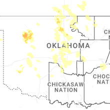
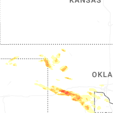
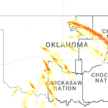
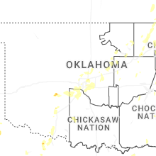
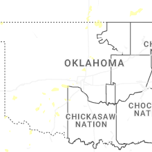
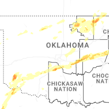


Connect with Interactive Hail Maps