

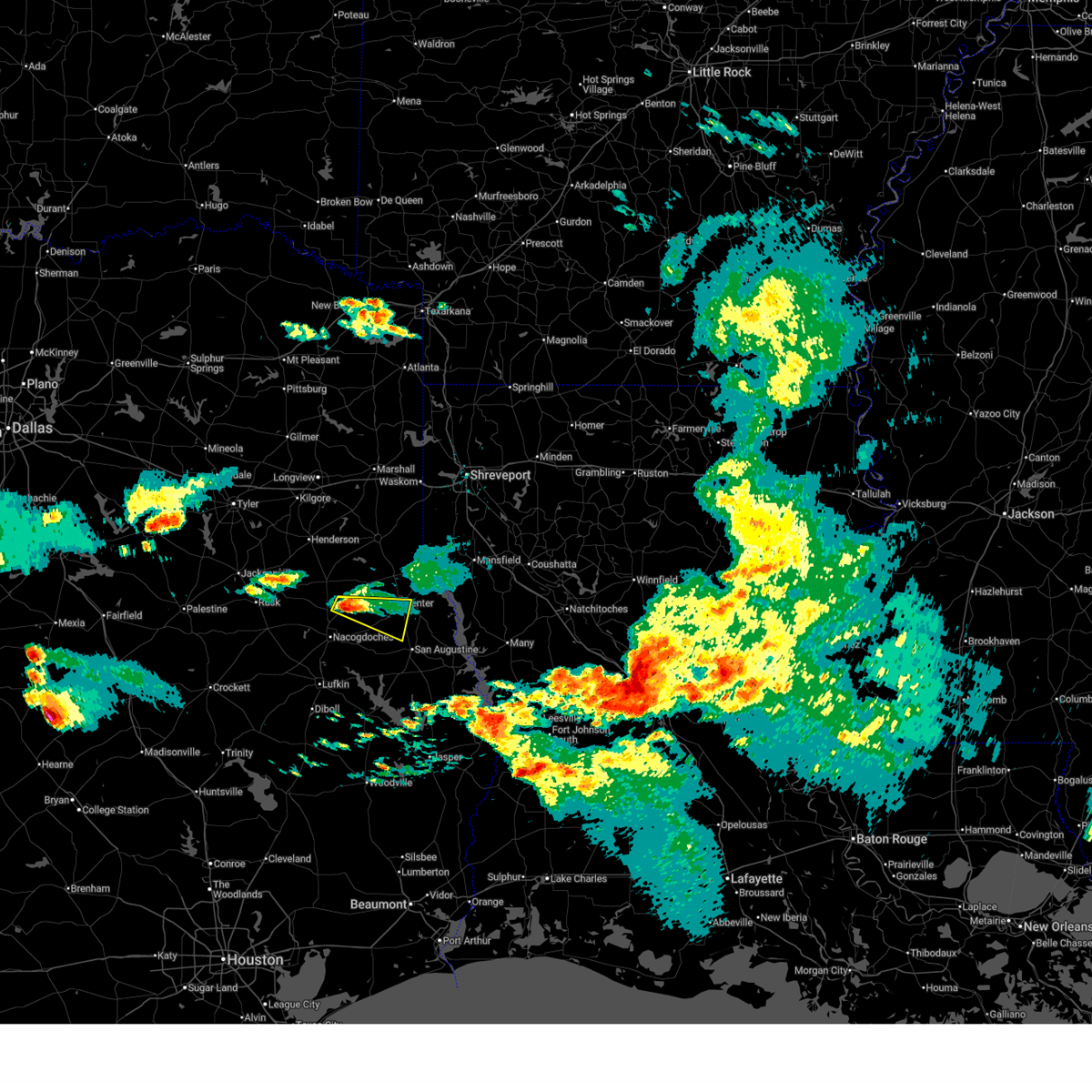
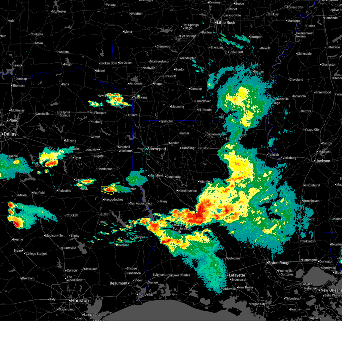
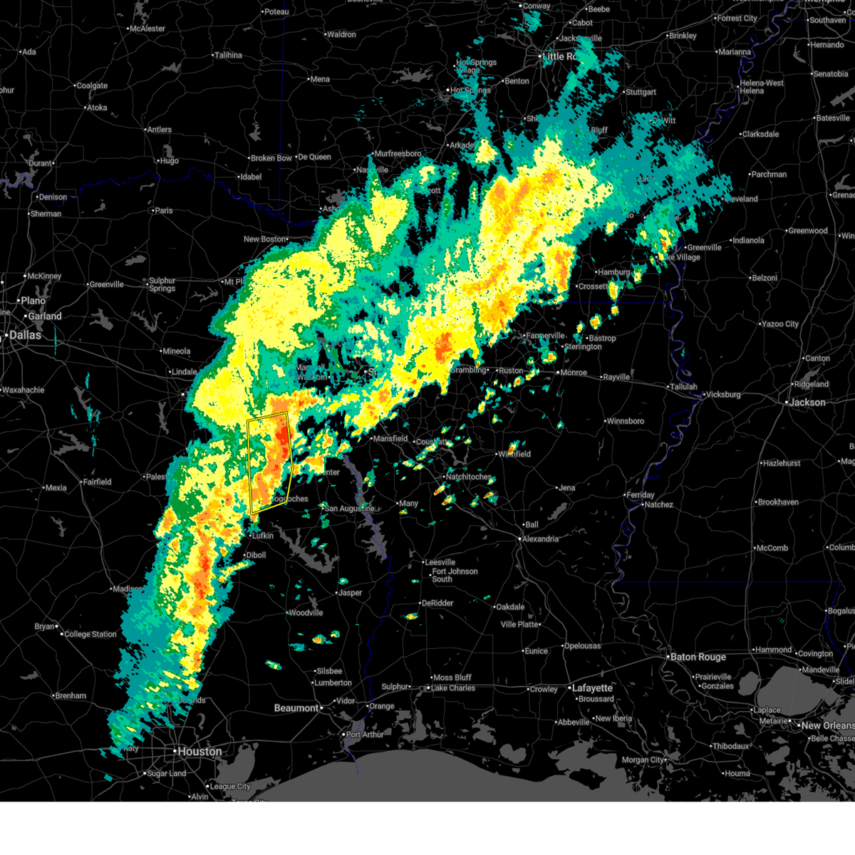
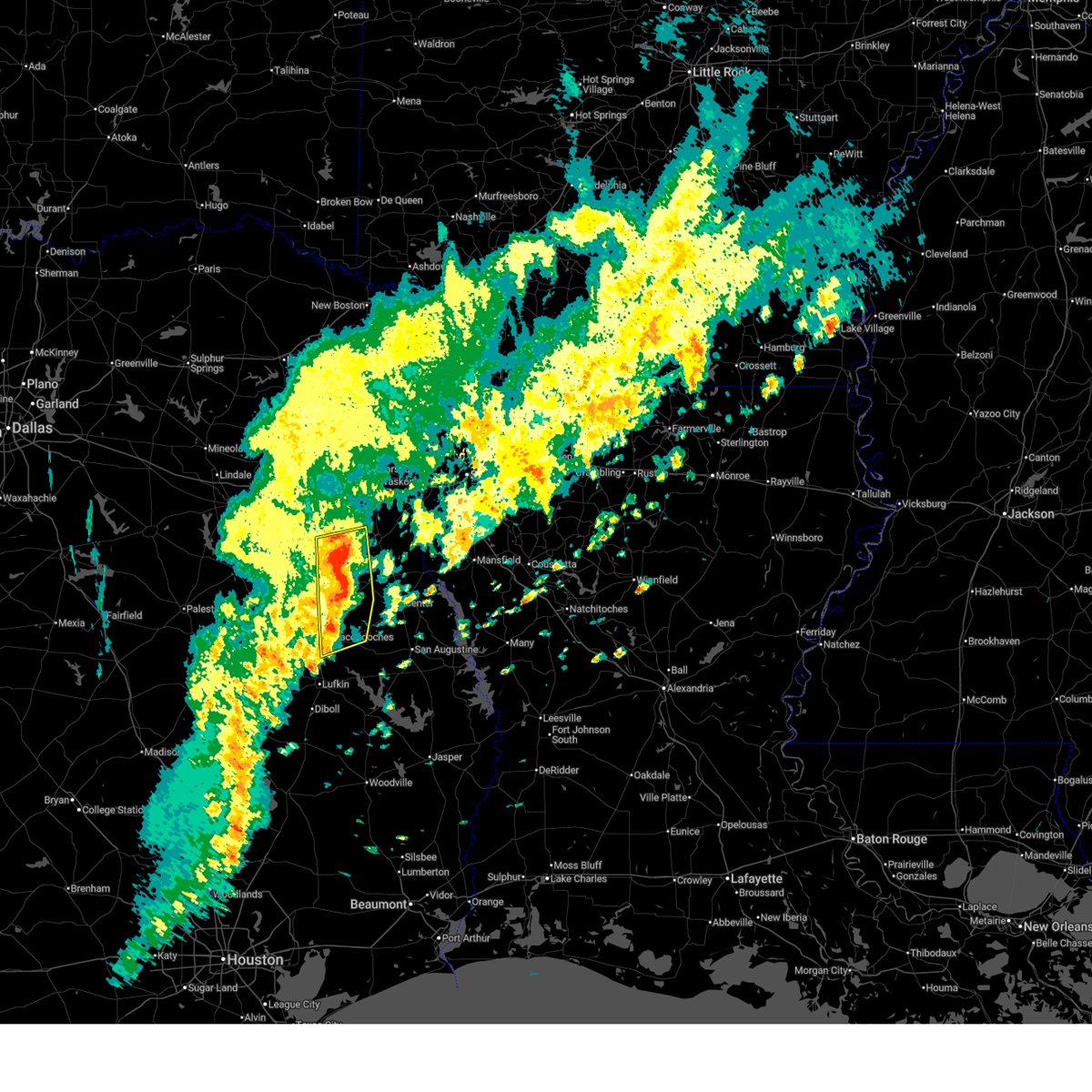
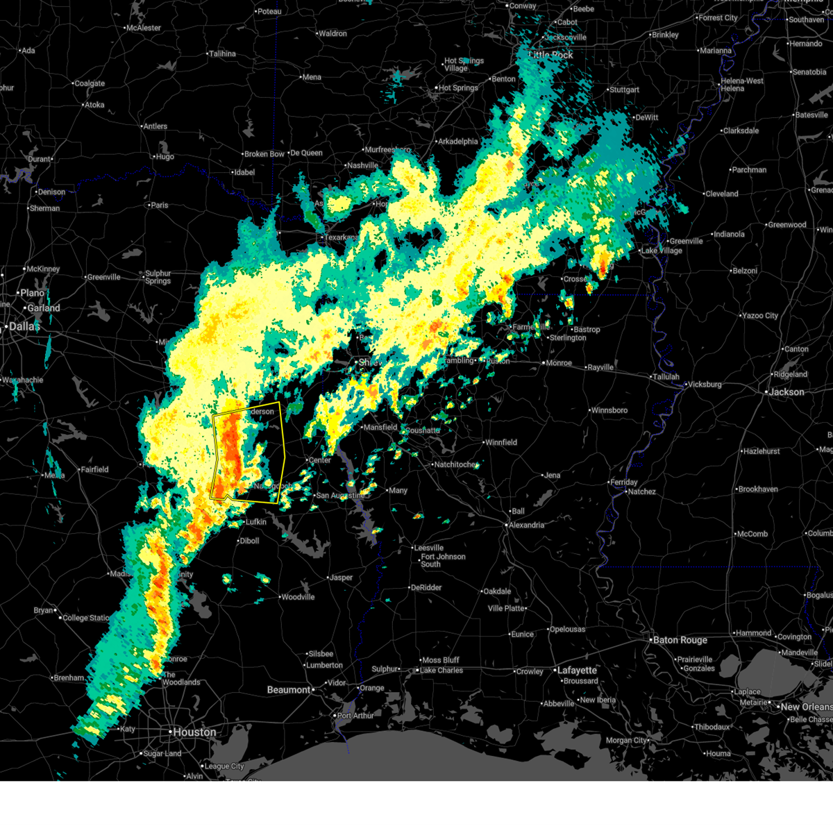
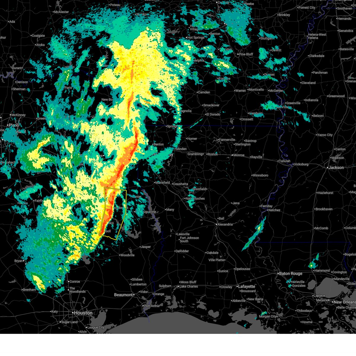
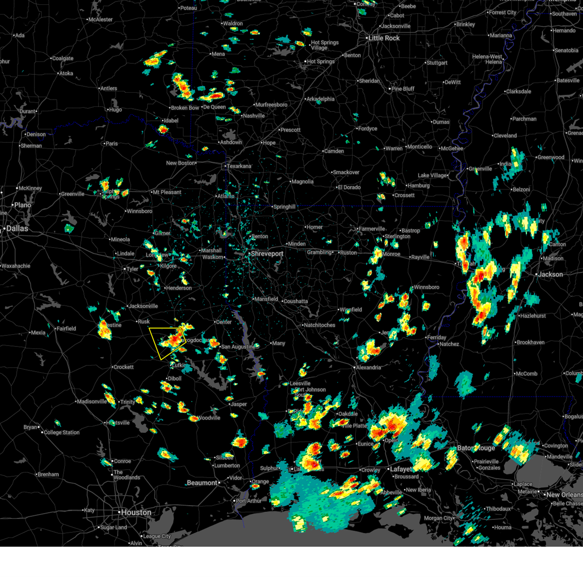
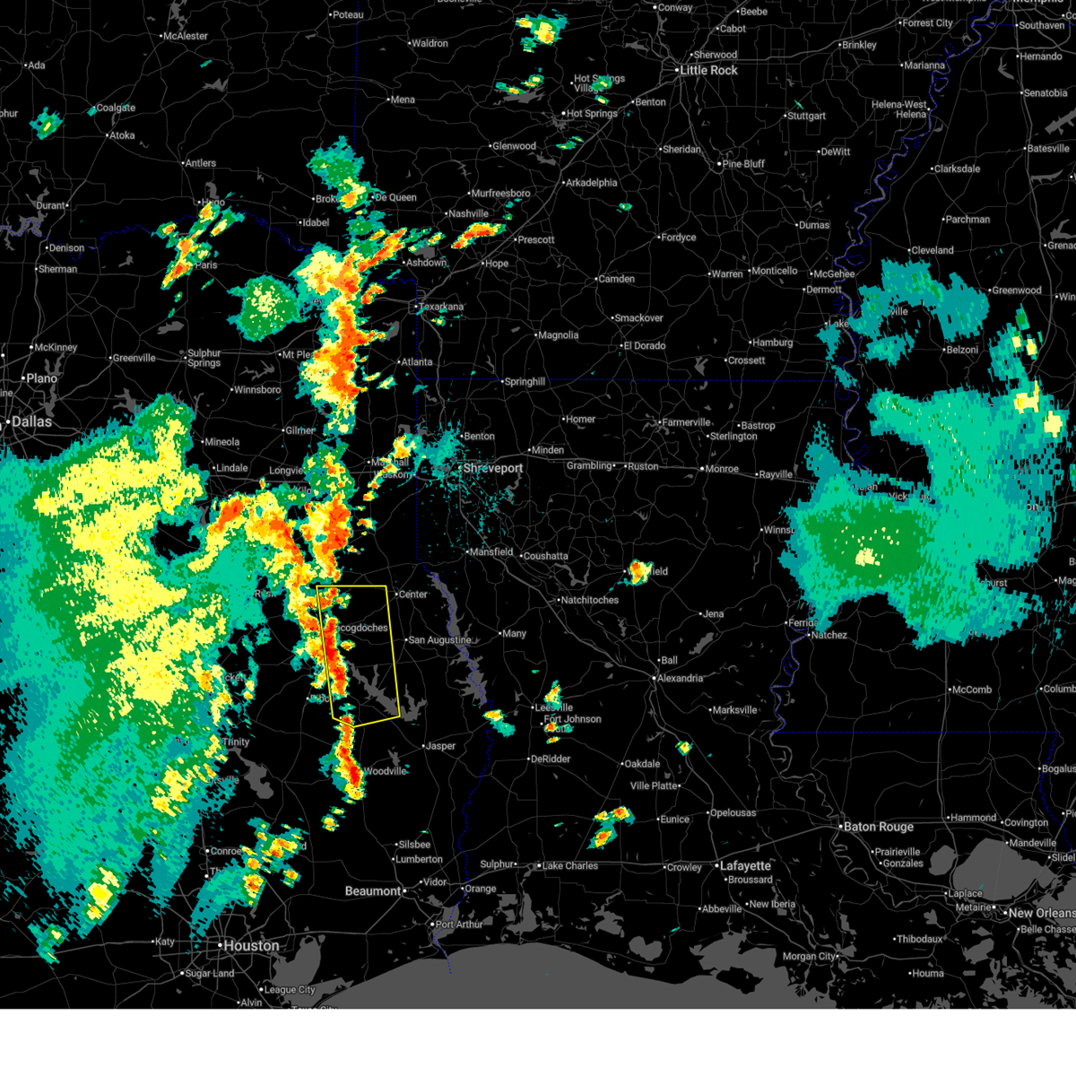
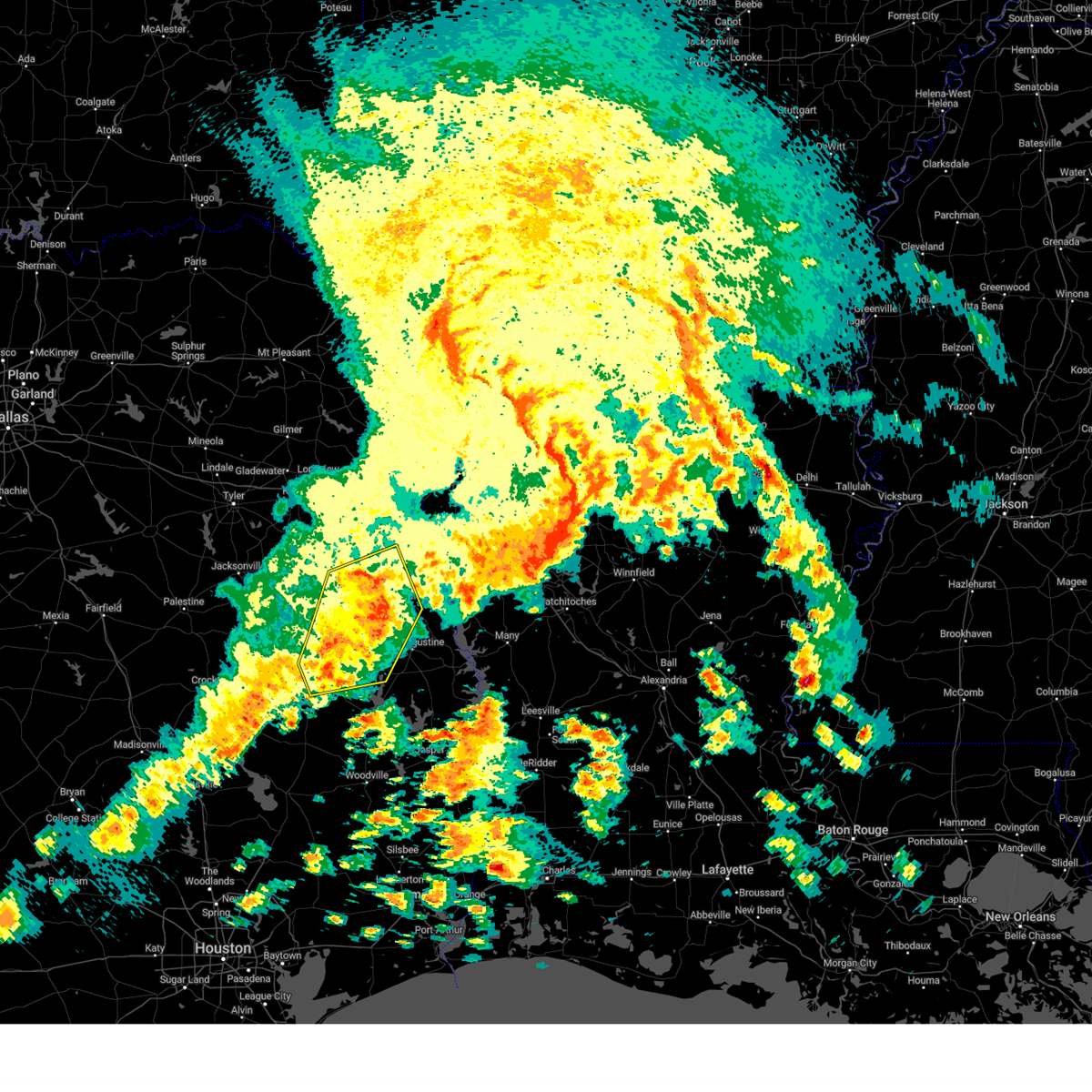
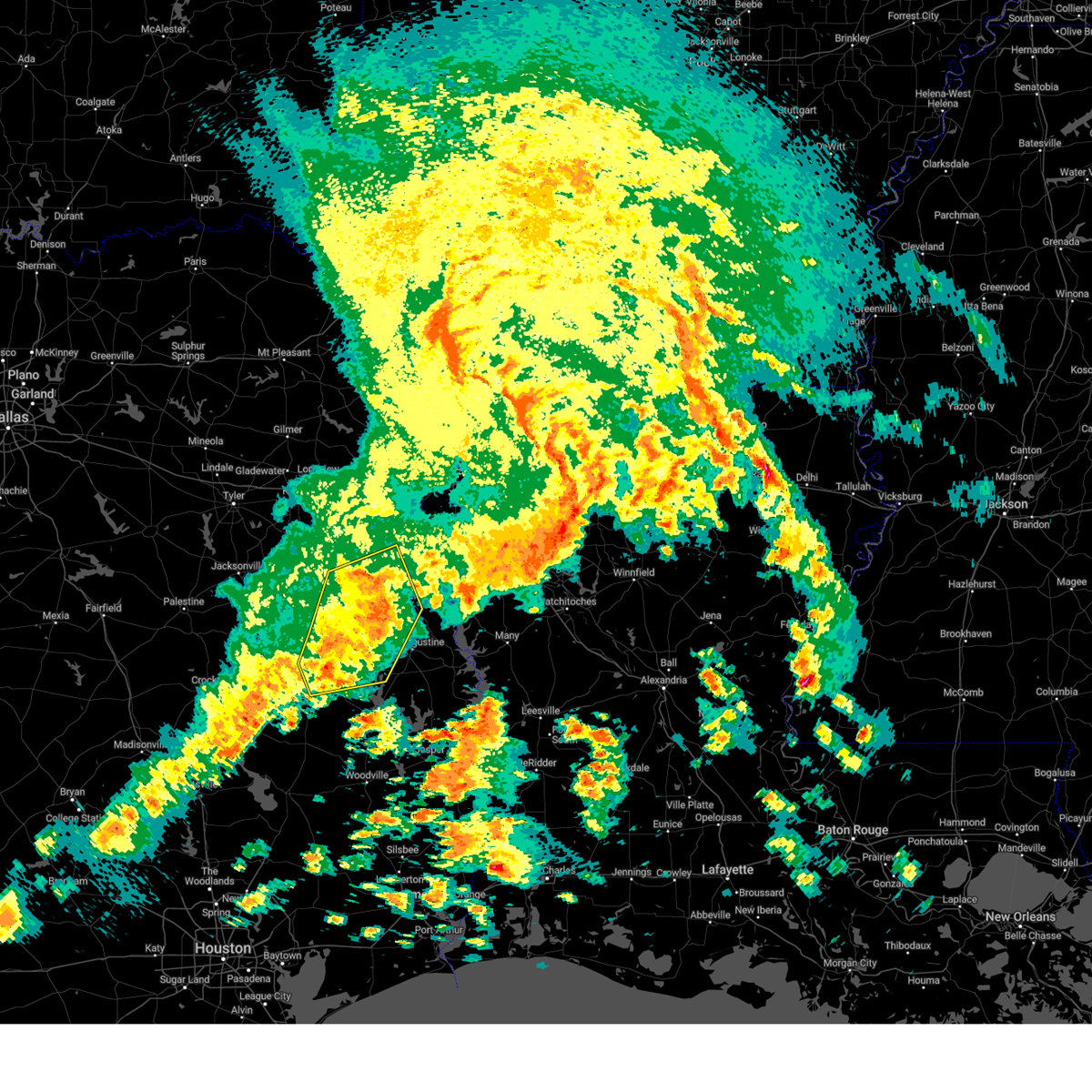
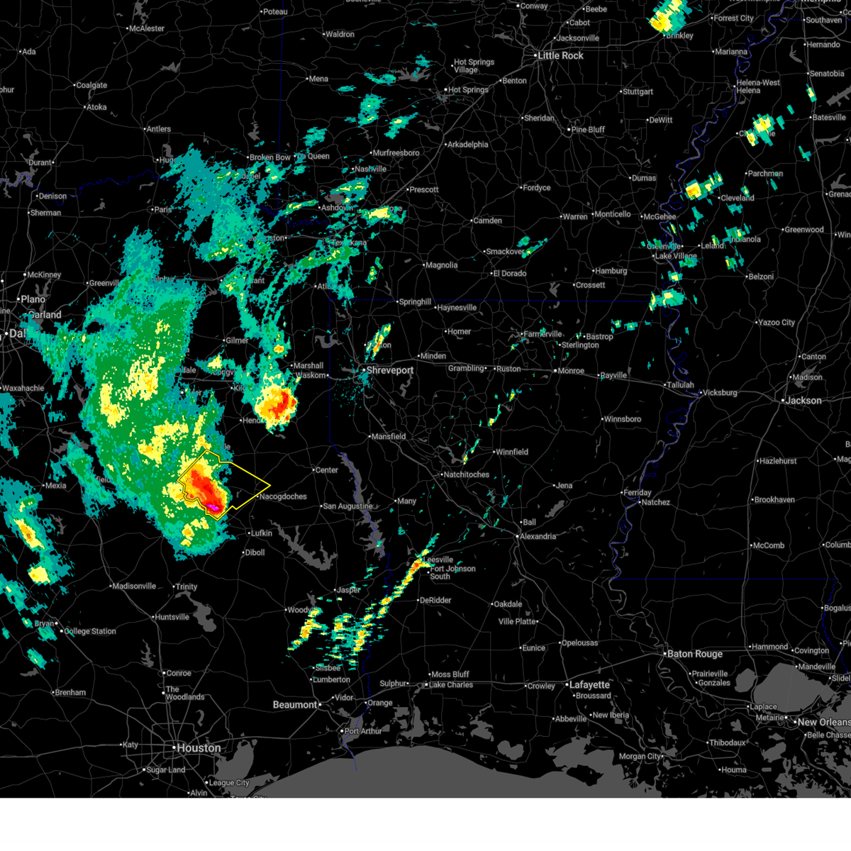
Hail Map for Appleby, TX
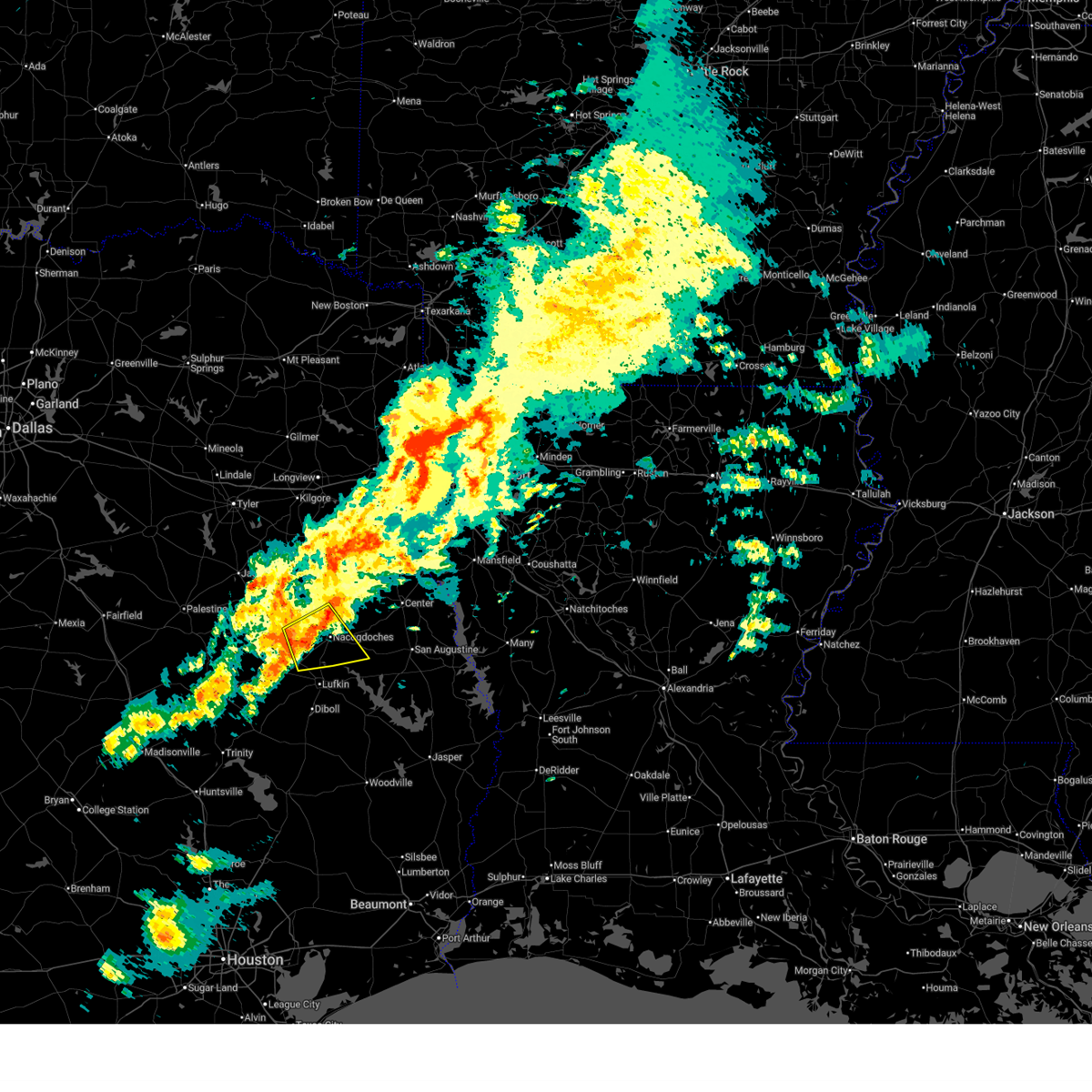
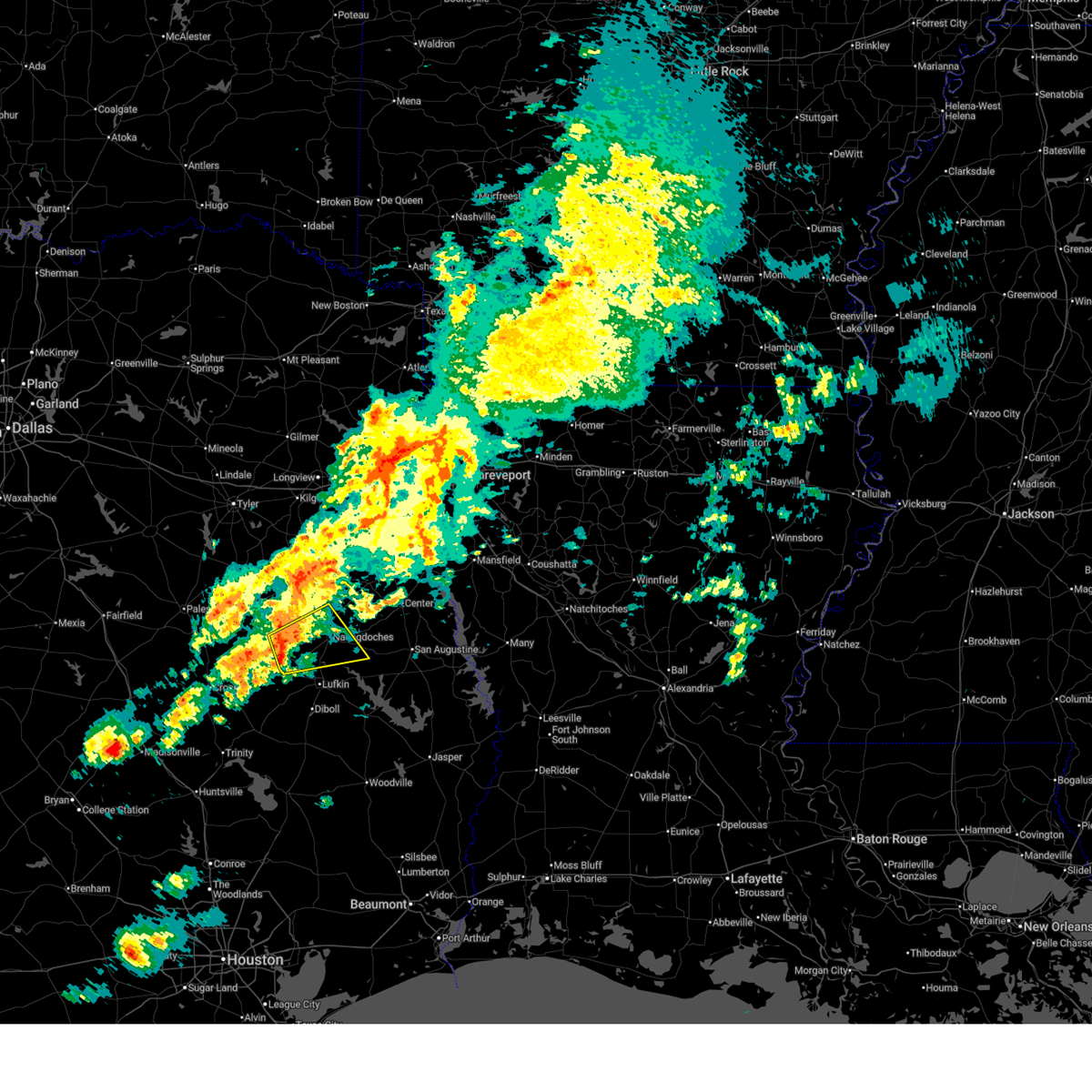
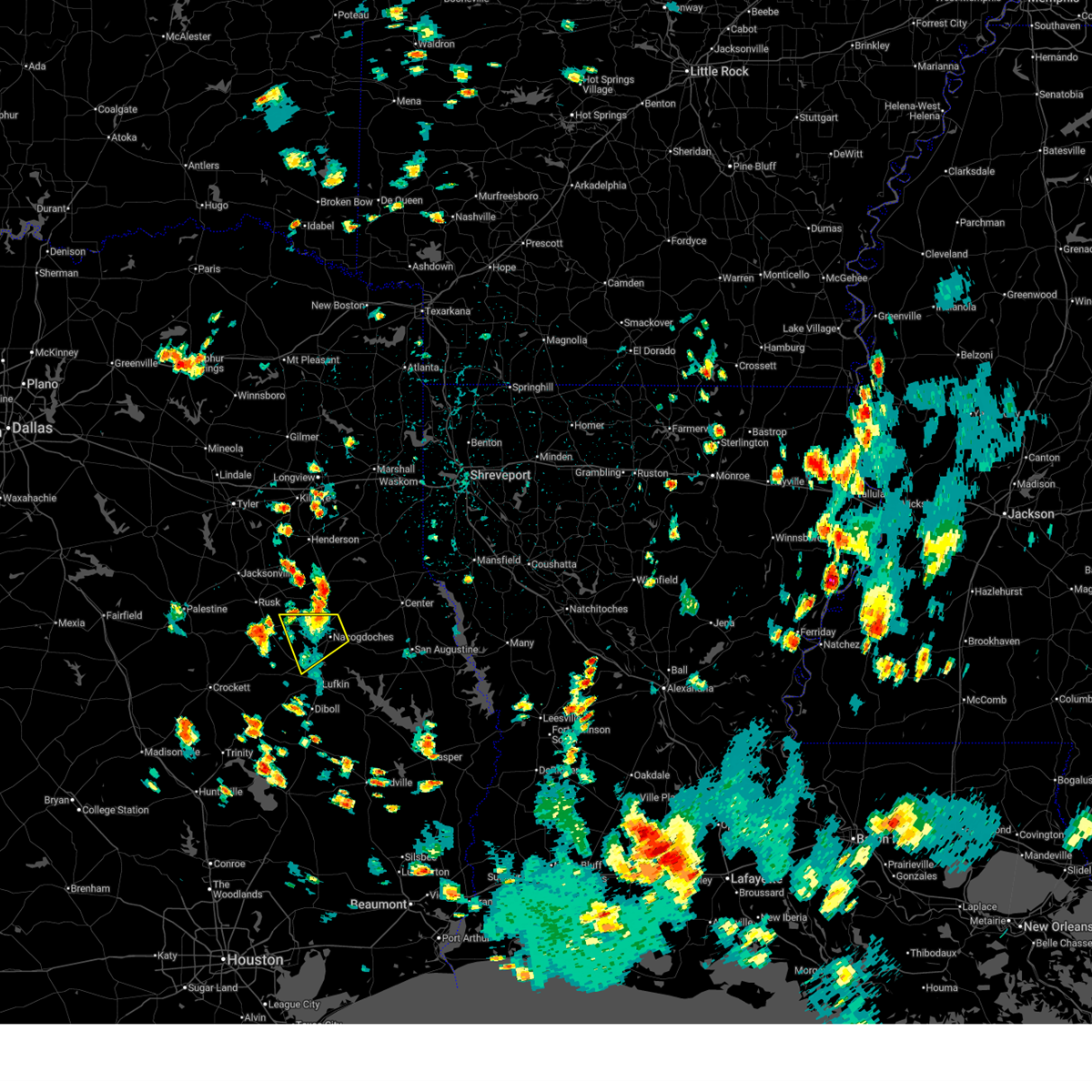
The Appleby, TX area has had 0 reports of on-the-ground hail by trained spotters, and has been under severe weather warnings 26 times during the past 12 months. Doppler radar has detected hail at or near Appleby, TX on 54 occasions, including 4 occasions during the past year.
| Name: | Appleby, TX |
| Where Located: | 26.6 miles NNE of Lufkin, TX |
| Map: | Google Map for Appleby, TX |
| Population: | 474 |
| Housing Units: | 215 |
| More Info: | Search Google for Appleby, TX |
5
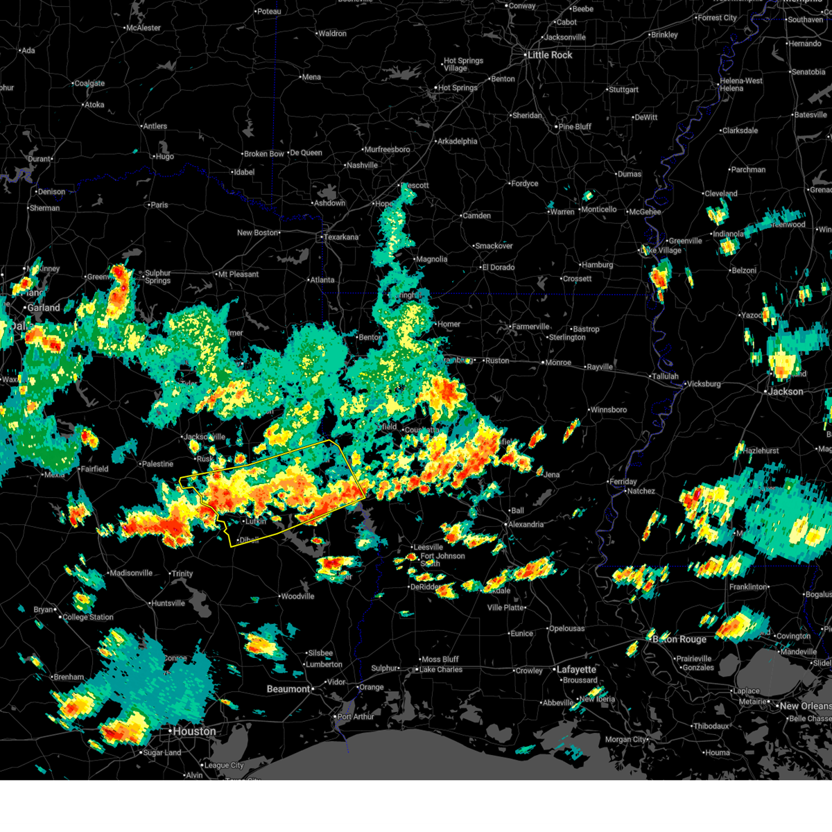
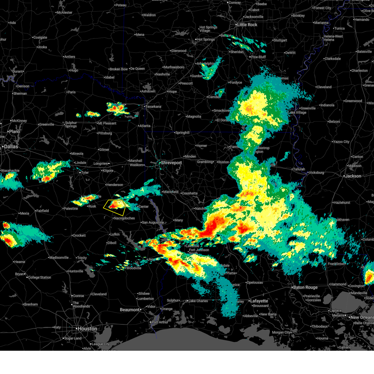
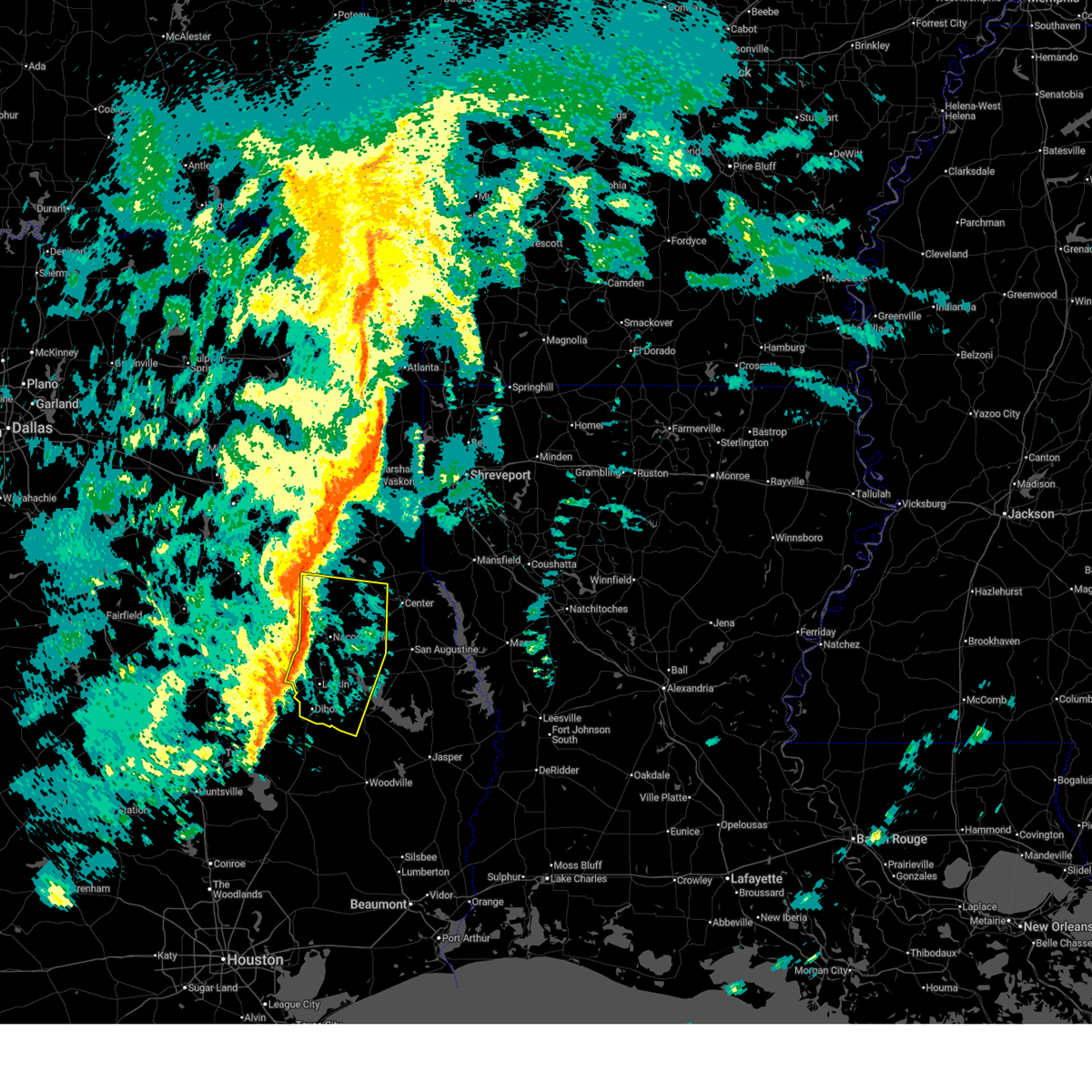
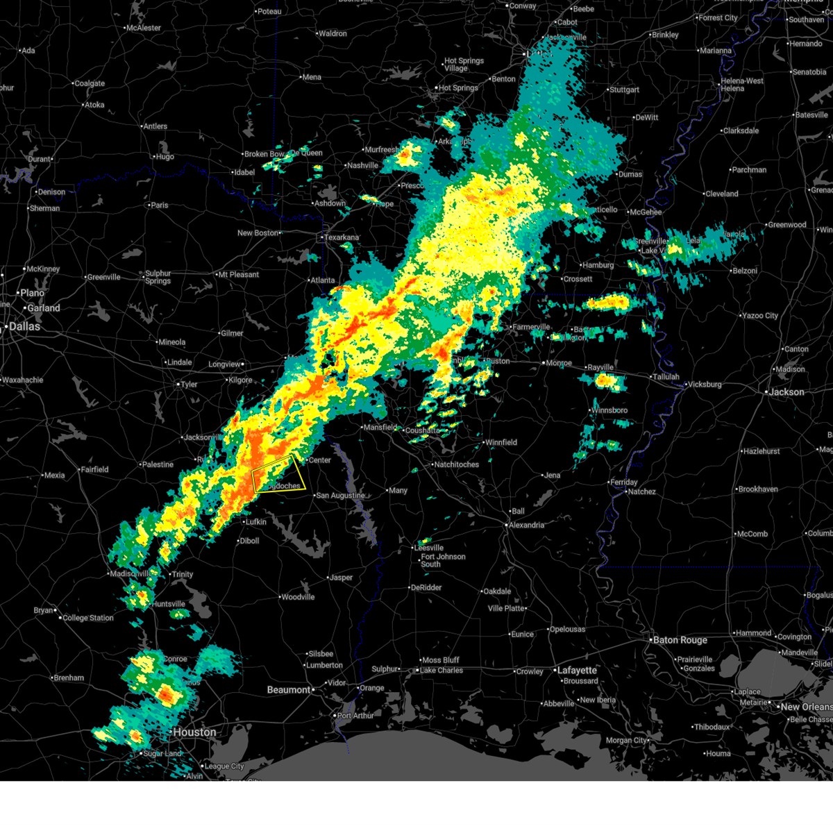
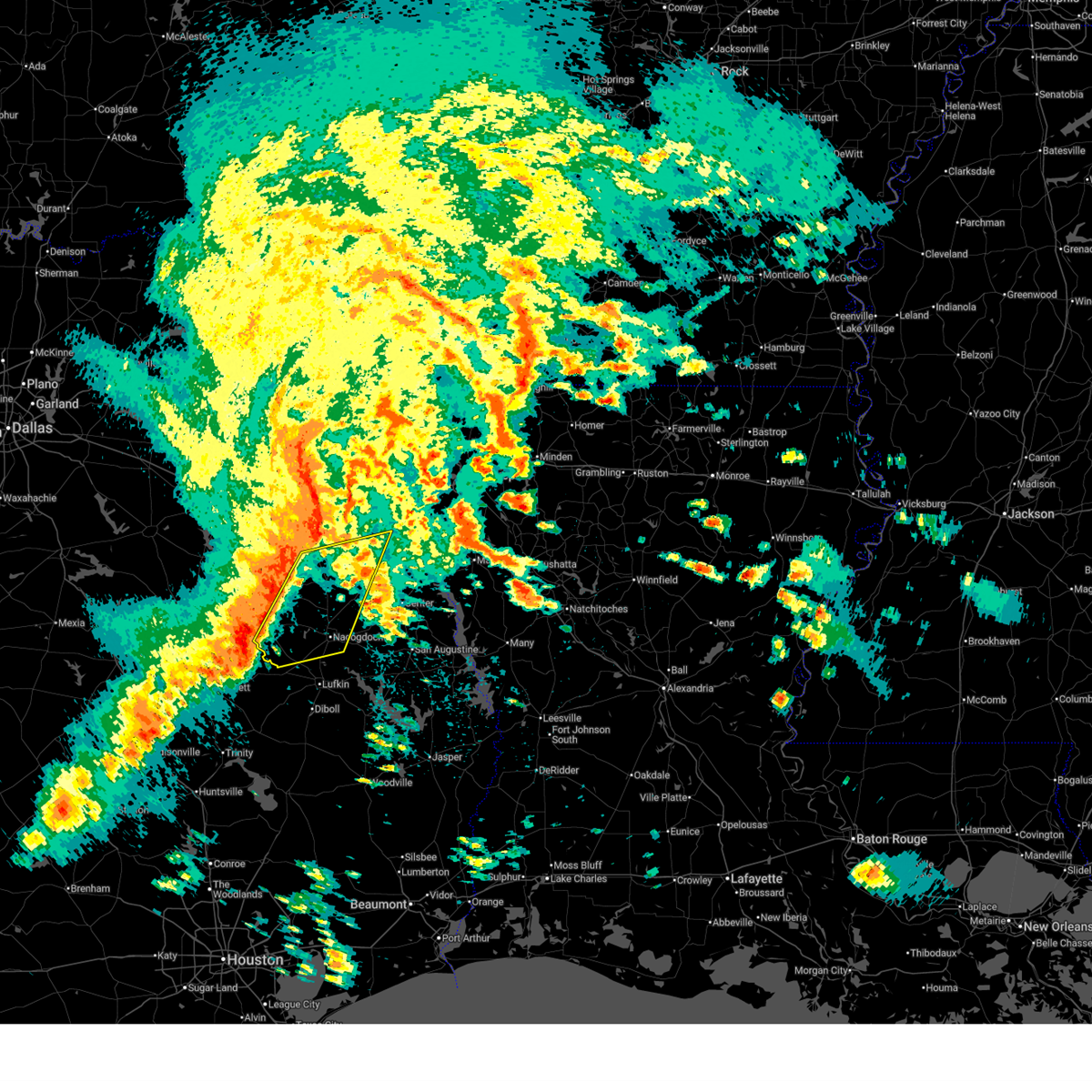
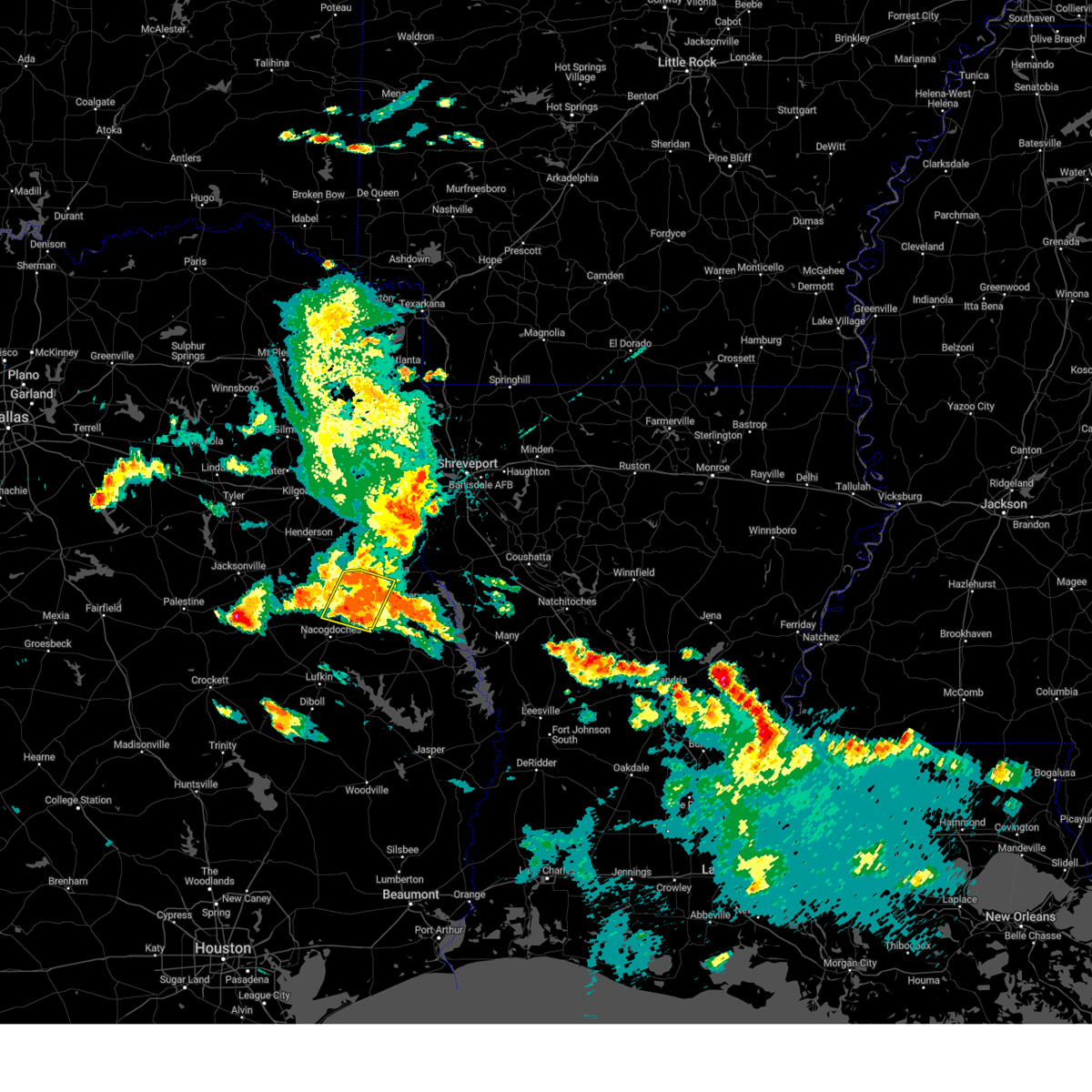
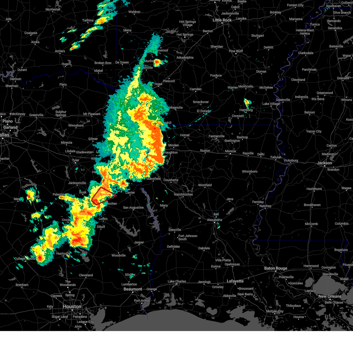
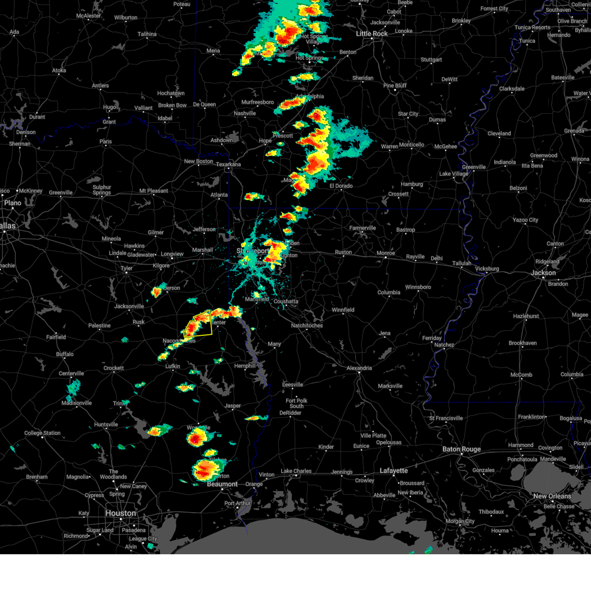
The Top Recent Hail Date for Appleby, TX is Sunday, March 15, 2026 (3rd out of 54)

Hail and Wind Damage Spotted near Appleby, TX
| Date / Time | Report Details |
|---|---|
| 6/2/2026 5:10 PM CDT |
 The storms which prompted the warning have weakened below severe limits, and no longer pose an immediate threat to life or property. therefore, the warning will be allowed to expire. however, small hail, gusty winds, and heavy rain are still possible with these thunderstorms. to report severe weather, contact your nearest law enforcement agency. they will send your report to the national weather service office. The storms which prompted the warning have weakened below severe limits, and no longer pose an immediate threat to life or property. therefore, the warning will be allowed to expire. however, small hail, gusty winds, and heavy rain are still possible with these thunderstorms. to report severe weather, contact your nearest law enforcement agency. they will send your report to the national weather service office.
|
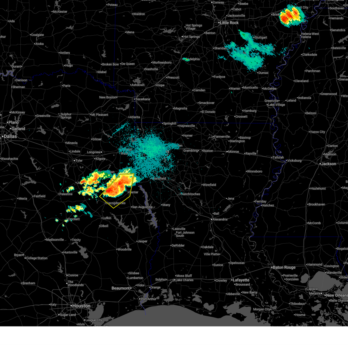
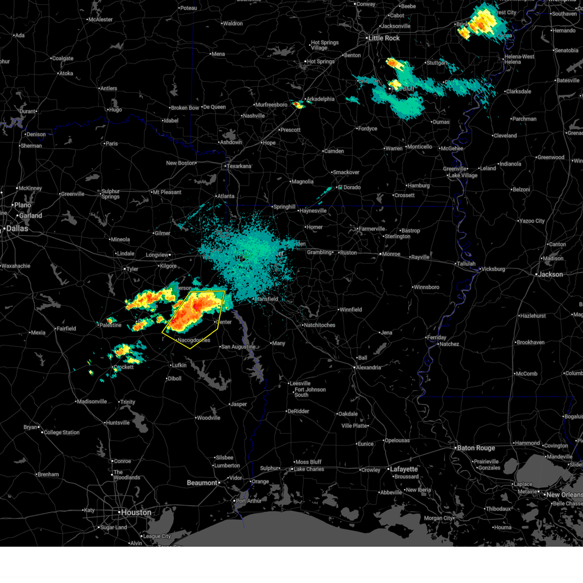
| 6/2/2026 4:13 PM CDT |
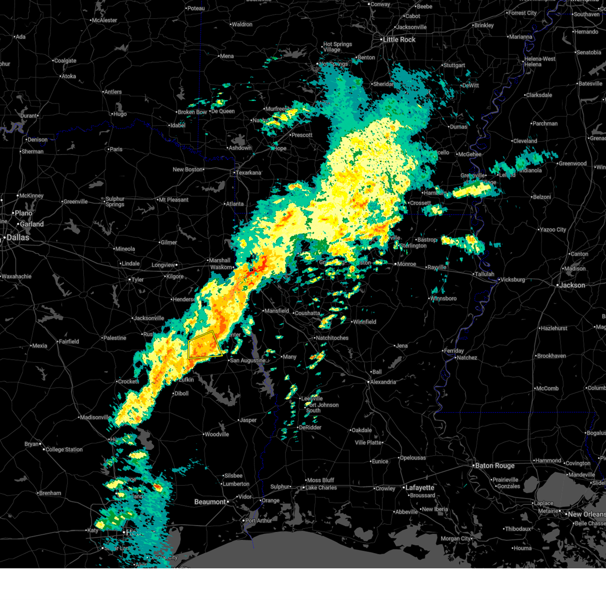
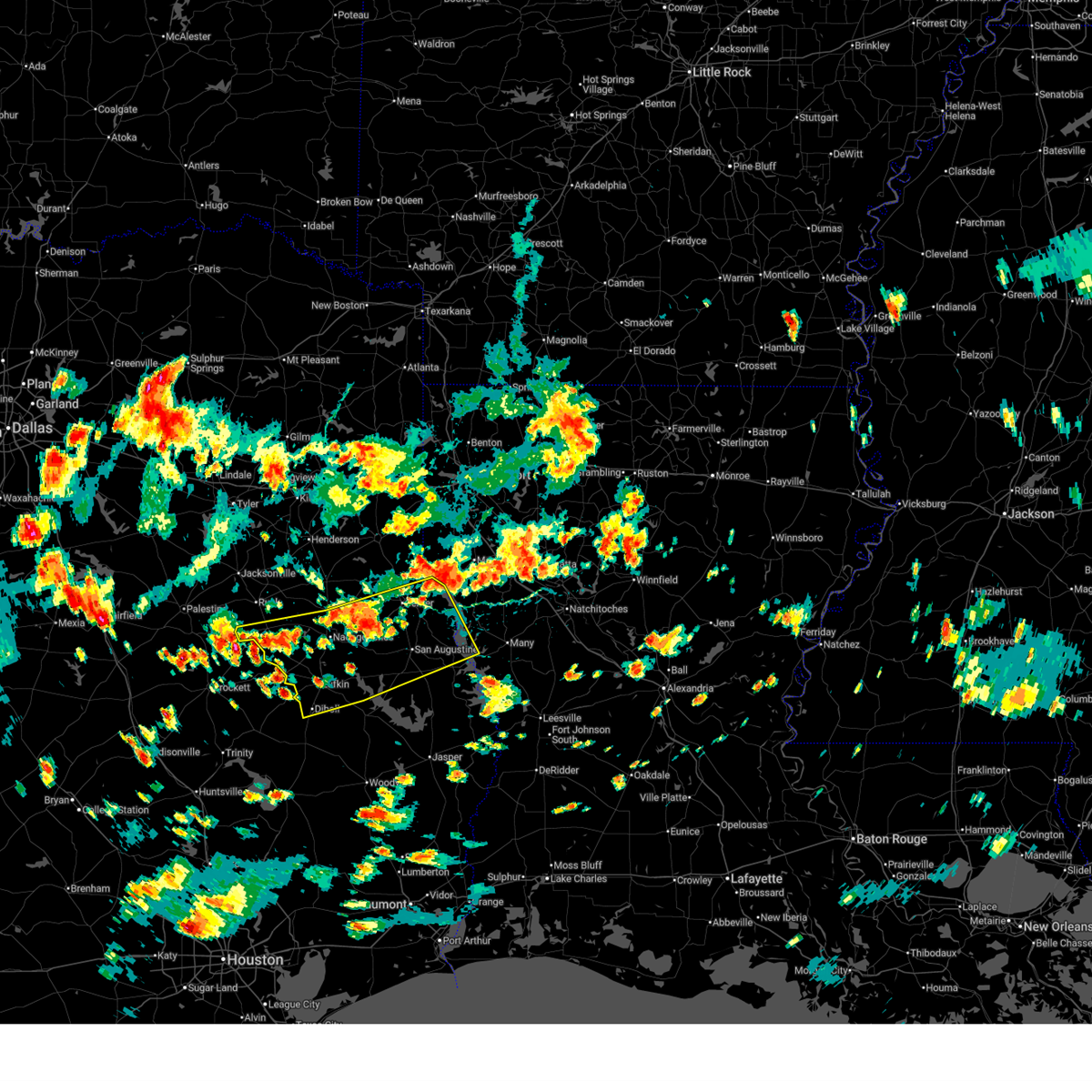 Svrshv the national weather service in shreveport has issued a * severe thunderstorm warning for, northwestern sabine parish in northwestern louisiana, angelina county in eastern texas, nacogdoches county in eastern texas, northwestern sabine county in eastern texas, san augustine county in eastern texas, shelby county in eastern texas, southeastern cherokee county in northeastern texas, * until 515 pm cdt. * at 413 pm cdt, severe thunderstorms were located along a line from over shelbyville to 12 miles southwest of forest, or along a line from 6 miles southeast of center to 25 miles south of rusk, moving southeast at 20 mph (radar indicated). Hazards include 60 mph wind gusts and quarter size hail. Hail damage to vehicles is expected. Expect wind damage to roofs, siding, and trees. Svrshv the national weather service in shreveport has issued a * severe thunderstorm warning for, northwestern sabine parish in northwestern louisiana, angelina county in eastern texas, nacogdoches county in eastern texas, northwestern sabine county in eastern texas, san augustine county in eastern texas, shelby county in eastern texas, southeastern cherokee county in northeastern texas, * until 515 pm cdt. * at 413 pm cdt, severe thunderstorms were located along a line from over shelbyville to 12 miles southwest of forest, or along a line from 6 miles southeast of center to 25 miles south of rusk, moving southeast at 20 mph (radar indicated). Hazards include 60 mph wind gusts and quarter size hail. Hail damage to vehicles is expected. Expect wind damage to roofs, siding, and trees.
|
| 4/29/2026 7:40 PM CDT |
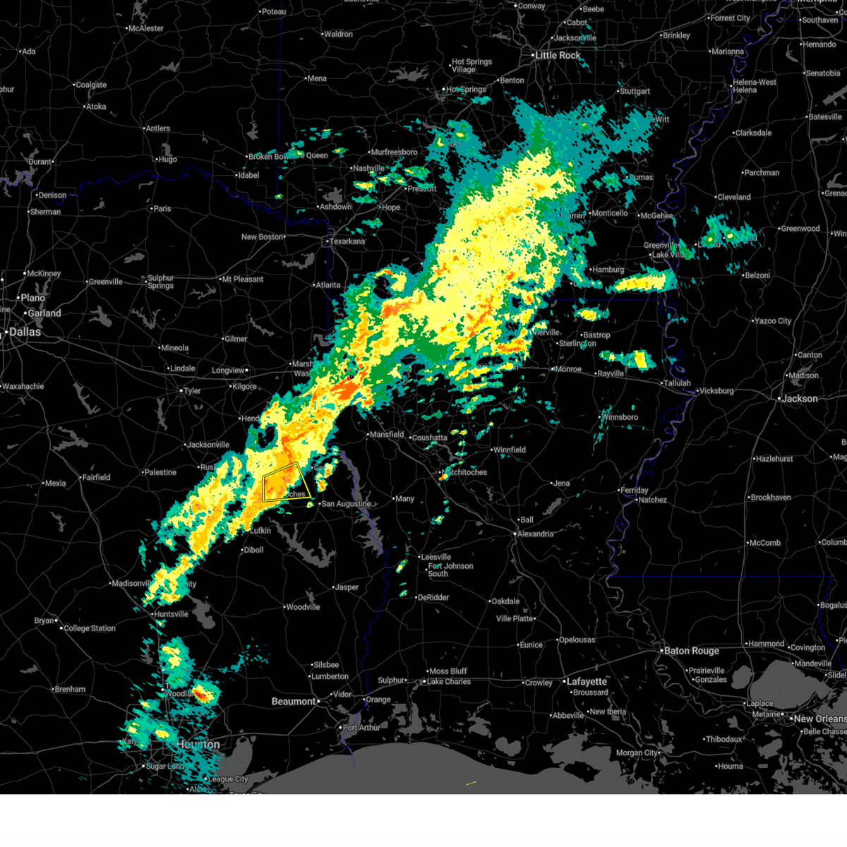
 Svrshv the national weather service in shreveport has issued a * severe thunderstorm warning for, northeastern nacogdoches county in eastern texas, north central san augustine county in eastern texas, southwestern shelby county in eastern texas, * until 830 pm cdt. * at 740 pm cdt, a severe thunderstorm was located 5 miles southwest of garrison, or 12 miles northeast of nacogdoches, moving east at 30 mph (radar indicated). Hazards include quarter size hail. damage to vehicles is expected Svrshv the national weather service in shreveport has issued a * severe thunderstorm warning for, northeastern nacogdoches county in eastern texas, north central san augustine county in eastern texas, southwestern shelby county in eastern texas, * until 830 pm cdt. * at 740 pm cdt, a severe thunderstorm was located 5 miles southwest of garrison, or 12 miles northeast of nacogdoches, moving east at 30 mph (radar indicated). Hazards include quarter size hail. damage to vehicles is expected
|
| 4/29/2026 7:37 PM CDT |
 At 737 pm cdt, a severe thunderstorm was located 6 miles southwest of garrison, or 11 miles northeast of nacogdoches, moving east at 30 mph (radar indicated). Hazards include 60 mph wind gusts and quarter size hail. Hail damage to vehicles is expected. expect wind damage to roofs, siding, and trees. Locations impacted include, garrison and appleby. At 737 pm cdt, a severe thunderstorm was located 6 miles southwest of garrison, or 11 miles northeast of nacogdoches, moving east at 30 mph (radar indicated). Hazards include 60 mph wind gusts and quarter size hail. Hail damage to vehicles is expected. expect wind damage to roofs, siding, and trees. Locations impacted include, garrison and appleby.
|
| 4/29/2026 7:23 PM CDT |
 At 723 pm cdt, a severe thunderstorm was located near trawick, or 13 miles north of nacogdoches, moving east at 30 mph (radar indicated). Hazards include 60 mph wind gusts and quarter size hail. Hail damage to vehicles is expected. expect wind damage to roofs, siding, and trees. Locations impacted include, garrison, trawick, appleby and mount enterprise. At 723 pm cdt, a severe thunderstorm was located near trawick, or 13 miles north of nacogdoches, moving east at 30 mph (radar indicated). Hazards include 60 mph wind gusts and quarter size hail. Hail damage to vehicles is expected. expect wind damage to roofs, siding, and trees. Locations impacted include, garrison, trawick, appleby and mount enterprise.
|
| 4/29/2026 6:57 PM CDT |
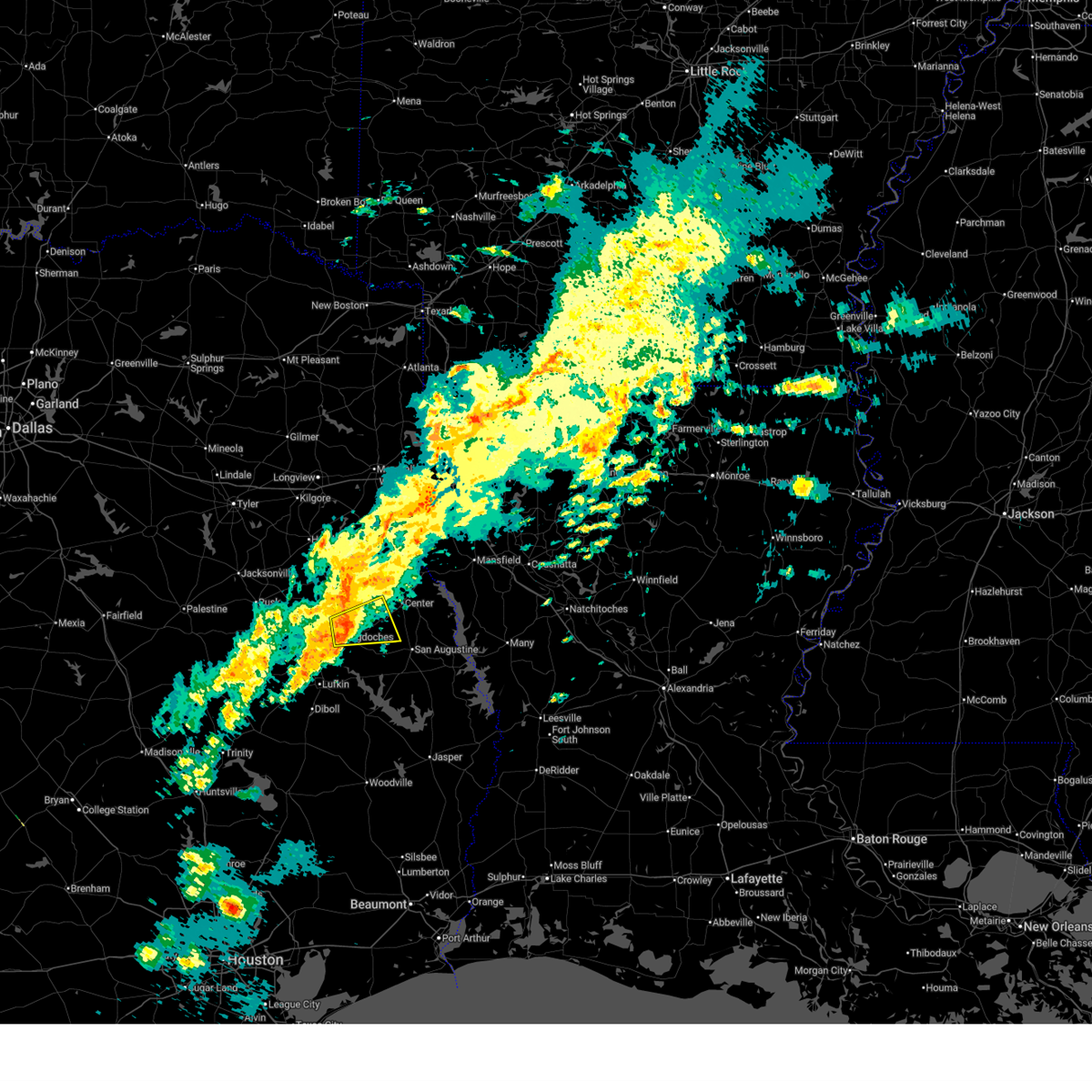
 Svrshv the national weather service in shreveport has issued a * severe thunderstorm warning for, northern nacogdoches county in eastern texas, southern rusk county in northeastern texas, * until 745 pm cdt. * at 657 pm cdt, a severe thunderstorm was located near sacul, or 16 miles east of rusk, moving east at 30 mph (radar indicated). Hazards include 60 mph wind gusts and quarter size hail. Hail damage to vehicles is expected. Expect wind damage to roofs, siding, and trees. Svrshv the national weather service in shreveport has issued a * severe thunderstorm warning for, northern nacogdoches county in eastern texas, southern rusk county in northeastern texas, * until 745 pm cdt. * at 657 pm cdt, a severe thunderstorm was located near sacul, or 16 miles east of rusk, moving east at 30 mph (radar indicated). Hazards include 60 mph wind gusts and quarter size hail. Hail damage to vehicles is expected. Expect wind damage to roofs, siding, and trees.
|
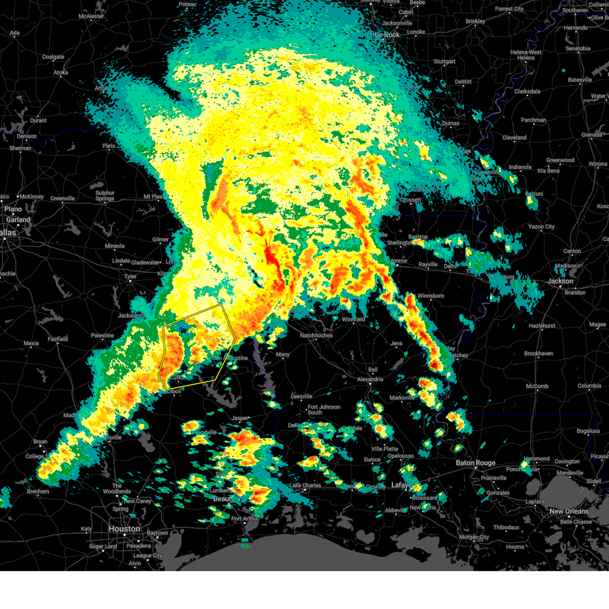
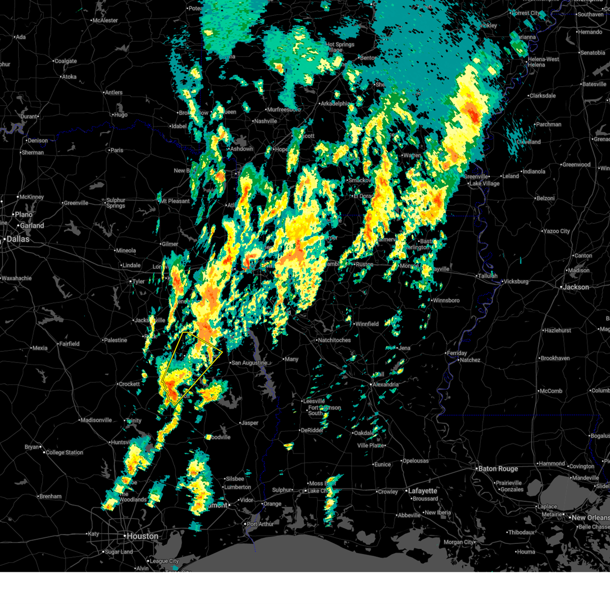
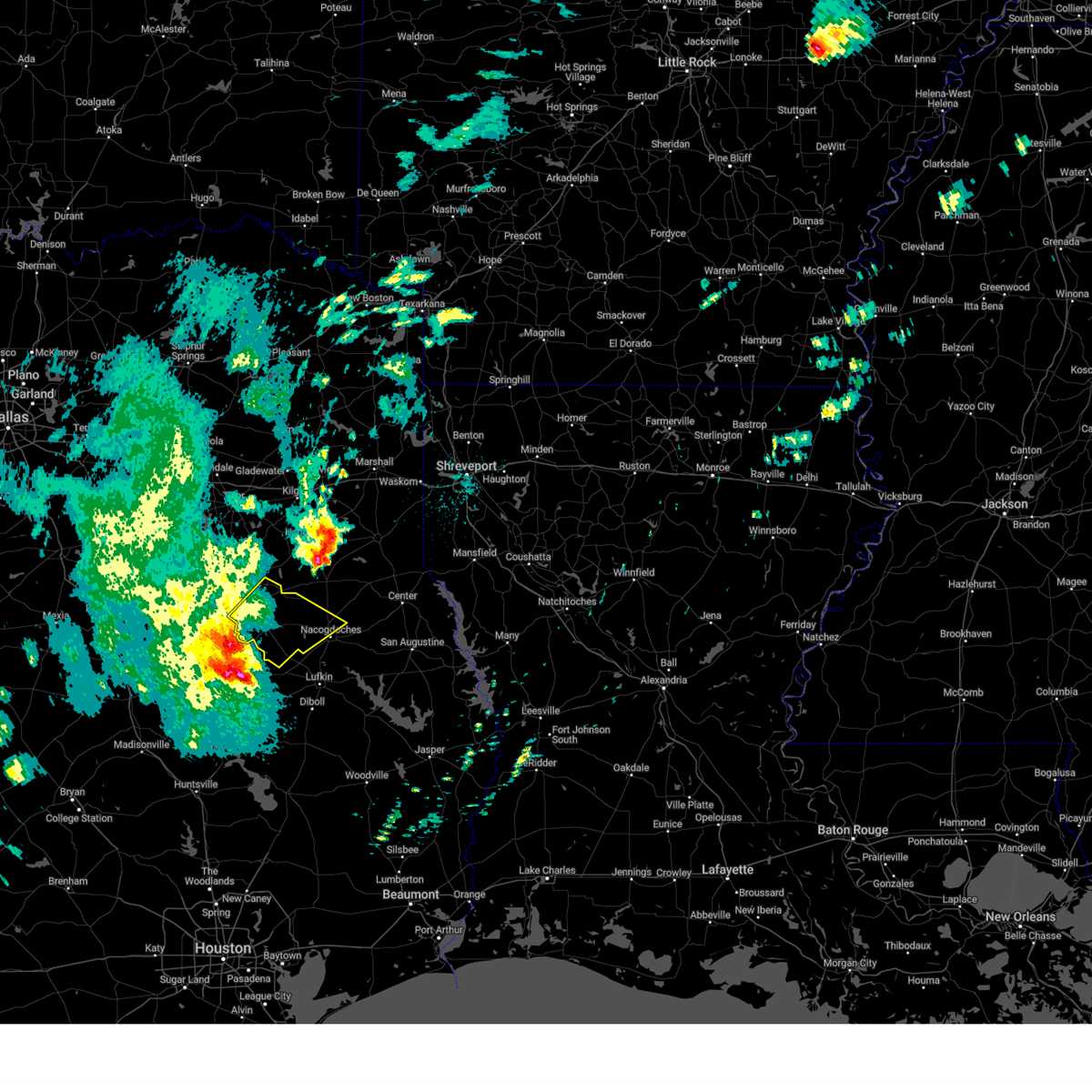
| 3/15/2026 6:19 PM CDT |
 At 619 pm cdt, severe thunderstorms were located along a line from near tenaha to near hudson, or along a line from 8 miles northwest of center to 9 miles west of lufkin, moving east at 40 mph (radar indicated). Hazards include ping pong ball size hail and 60 mph wind gusts. People and animals outdoors will be injured. expect hail damage to roofs, siding, windows, and vehicles. expect wind damage to roofs, siding, and trees. Locations impacted include, lufkin, nacogdoches, center, diboll, hudson, tenaha, timpson, garrison, wells, melrose, woden, martinsville, pollok, burke, appleby, redland, stockman, arcadia, clawson and central. At 619 pm cdt, severe thunderstorms were located along a line from near tenaha to near hudson, or along a line from 8 miles northwest of center to 9 miles west of lufkin, moving east at 40 mph (radar indicated). Hazards include ping pong ball size hail and 60 mph wind gusts. People and animals outdoors will be injured. expect hail damage to roofs, siding, windows, and vehicles. expect wind damage to roofs, siding, and trees. Locations impacted include, lufkin, nacogdoches, center, diboll, hudson, tenaha, timpson, garrison, wells, melrose, woden, martinsville, pollok, burke, appleby, redland, stockman, arcadia, clawson and central.
|
| 3/15/2026 5:53 PM CDT |
 Svrshv the national weather service in shreveport has issued a * severe thunderstorm warning for, northwestern angelina county in eastern texas, nacogdoches county in eastern texas, northwestern san augustine county in eastern texas, western shelby county in eastern texas, southeastern cherokee county in northeastern texas, southeastern rusk county in northeastern texas, * until 700 pm cdt. * at 553 pm cdt, severe thunderstorms were located along a line from 9 miles northwest of garrison to near forest, or along a line from 19 miles southwest of carthage to 21 miles northwest of lufkin, moving east at 40 mph (radar indicated). Hazards include ping pong ball size hail and 60 mph wind gusts. People and animals outdoors will be injured. expect hail damage to roofs, siding, windows, and vehicles. Expect wind damage to roofs, siding, and trees. Svrshv the national weather service in shreveport has issued a * severe thunderstorm warning for, northwestern angelina county in eastern texas, nacogdoches county in eastern texas, northwestern san augustine county in eastern texas, western shelby county in eastern texas, southeastern cherokee county in northeastern texas, southeastern rusk county in northeastern texas, * until 700 pm cdt. * at 553 pm cdt, severe thunderstorms were located along a line from 9 miles northwest of garrison to near forest, or along a line from 19 miles southwest of carthage to 21 miles northwest of lufkin, moving east at 40 mph (radar indicated). Hazards include ping pong ball size hail and 60 mph wind gusts. People and animals outdoors will be injured. expect hail damage to roofs, siding, windows, and vehicles. Expect wind damage to roofs, siding, and trees.
|
| 3/11/2026 1:30 PM CDT |
 The storms which prompted the warning have weakened below severe limits, and no longer pose an immediate threat to life or property. therefore, the warning has been allowed to expire. however, small hail, gusty winds, and heavy rain are still possible with these thunderstorms. a tornado watch remains in effect until 600 pm cdt wednesday for a portion of northeast texas. The storms which prompted the warning have weakened below severe limits, and no longer pose an immediate threat to life or property. therefore, the warning has been allowed to expire. however, small hail, gusty winds, and heavy rain are still possible with these thunderstorms. a tornado watch remains in effect until 600 pm cdt wednesday for a portion of northeast texas.
|
| 3/11/2026 1:16 PM CDT |
 At 116 pm cdt, severe thunderstorms were located along a line from over pinehill to near nacogdoches, or along a line from 14 miles southeast of henderson to near nacogdoches, moving east at 30 mph (radar indicated). Hazards include 60 mph wind gusts and quarter size hail. Hail damage to vehicles is expected. expect wind damage to roofs, siding, and trees. Locations impacted include, nacogdoches, timpson, garrison, minden, pinehill, martinsville, melrose, appleby, mount enterprise, lawsonville, dotson, stockman, fairplay and chapman. At 116 pm cdt, severe thunderstorms were located along a line from over pinehill to near nacogdoches, or along a line from 14 miles southeast of henderson to near nacogdoches, moving east at 30 mph (radar indicated). Hazards include 60 mph wind gusts and quarter size hail. Hail damage to vehicles is expected. expect wind damage to roofs, siding, and trees. Locations impacted include, nacogdoches, timpson, garrison, minden, pinehill, martinsville, melrose, appleby, mount enterprise, lawsonville, dotson, stockman, fairplay and chapman.
|
| 3/11/2026 1:16 PM CDT |
 the severe thunderstorm warning has been cancelled and is no longer in effect the severe thunderstorm warning has been cancelled and is no longer in effect
|
| 3/11/2026 12:44 PM CDT |
 Svrshv the national weather service in shreveport has issued a * severe thunderstorm warning for, nacogdoches county in eastern texas, northwestern shelby county in eastern texas, eastern cherokee county in northeastern texas, southwestern panola county in northeastern texas, southern rusk county in northeastern texas, * until 130 pm cdt. * at 1244 pm cdt, severe thunderstorms were located along a line from 7 miles southwest of henderson to 6 miles northeast of pollok, or along a line from 7 miles southwest of henderson to 12 miles southwest of nacogdoches, moving east at 30 mph (radar indicated). Hazards include 60 mph wind gusts and quarter size hail. Hail damage to vehicles is expected. Expect wind damage to roofs, siding, and trees. Svrshv the national weather service in shreveport has issued a * severe thunderstorm warning for, nacogdoches county in eastern texas, northwestern shelby county in eastern texas, eastern cherokee county in northeastern texas, southwestern panola county in northeastern texas, southern rusk county in northeastern texas, * until 130 pm cdt. * at 1244 pm cdt, severe thunderstorms were located along a line from 7 miles southwest of henderson to 6 miles northeast of pollok, or along a line from 7 miles southwest of henderson to 12 miles southwest of nacogdoches, moving east at 30 mph (radar indicated). Hazards include 60 mph wind gusts and quarter size hail. Hail damage to vehicles is expected. Expect wind damage to roofs, siding, and trees.
|
| 2/14/2026 5:14 PM CST |
 At 514 pm cst, severe thunderstorms were located along a line from near timpson to 6 miles southeast of diboll, or along a line from 18 miles northwest of center to 6 miles southeast of diboll, moving east at 30 mph (radar indicated). Hazards include 60 mph wind gusts. Expect damage to roofs, siding, and trees. Locations impacted include, lufkin, nacogdoches, diboll, hudson, huntington, timpson, garrison, woden, melrose, martinsville, etoile, burke, appleby, mount enterprise, chireno, redland, homer, shawnee, arcadia and stockman. At 514 pm cst, severe thunderstorms were located along a line from near timpson to 6 miles southeast of diboll, or along a line from 18 miles northwest of center to 6 miles southeast of diboll, moving east at 30 mph (radar indicated). Hazards include 60 mph wind gusts. Expect damage to roofs, siding, and trees. Locations impacted include, lufkin, nacogdoches, diboll, hudson, huntington, timpson, garrison, woden, melrose, martinsville, etoile, burke, appleby, mount enterprise, chireno, redland, homer, shawnee, arcadia and stockman.
|
| 2/14/2026 4:43 PM CST |
 Svrshv the national weather service in shreveport has issued a * severe thunderstorm warning for, angelina county in eastern texas, nacogdoches county in eastern texas, northwestern san augustine county in eastern texas, western shelby county in eastern texas, southeastern rusk county in northeastern texas, * until 530 pm cst. * at 443 pm cst, severe thunderstorms were located along a line from 7 miles south of minden to 7 miles southwest of hudson, or along a line from 16 miles south of henderson to 7 miles northwest of diboll, moving east at 35 mph (radar indicated). Hazards include 60 mph wind gusts. expect damage to roofs, siding, and trees Svrshv the national weather service in shreveport has issued a * severe thunderstorm warning for, angelina county in eastern texas, nacogdoches county in eastern texas, northwestern san augustine county in eastern texas, western shelby county in eastern texas, southeastern rusk county in northeastern texas, * until 530 pm cst. * at 443 pm cst, severe thunderstorms were located along a line from 7 miles south of minden to 7 miles southwest of hudson, or along a line from 16 miles south of henderson to 7 miles northwest of diboll, moving east at 35 mph (radar indicated). Hazards include 60 mph wind gusts. expect damage to roofs, siding, and trees
|
| 11/24/2025 7:30 PM CST |
 The storm which prompted the warning has moved out of the area. therefore, the warning has been allowed to expire. however, small hail, gusty winds, and heavy rain are still possible with this thunderstorm. to report severe weather, contact your nearest law enforcement agency. they will send your report to the national weather service office. a tornado watch remains in effect until 100 am cst tuesday for a portion of northeast texas. The storm which prompted the warning has moved out of the area. therefore, the warning has been allowed to expire. however, small hail, gusty winds, and heavy rain are still possible with this thunderstorm. to report severe weather, contact your nearest law enforcement agency. they will send your report to the national weather service office. a tornado watch remains in effect until 100 am cst tuesday for a portion of northeast texas.
|
| 11/24/2025 7:09 PM CST |
 At 709 pm cst, a severe thunderstorm was located 5 miles north of martinsville, or 14 miles southwest of center, moving east at 35 mph (radar indicated). Hazards include 60 mph wind gusts and small hail. Expect damage to roofs, siding, and trees. Locations impacted include, nacogdoches, martinsville, melrose, appleby, arcadia and stockman. At 709 pm cst, a severe thunderstorm was located 5 miles north of martinsville, or 14 miles southwest of center, moving east at 35 mph (radar indicated). Hazards include 60 mph wind gusts and small hail. Expect damage to roofs, siding, and trees. Locations impacted include, nacogdoches, martinsville, melrose, appleby, arcadia and stockman.
|
| 11/24/2025 6:55 PM CST |
 At 655 pm cst, a severe thunderstorm was located 8 miles northwest of melrose, or 8 miles northeast of nacogdoches, moving east at 30 mph (radar indicated). Hazards include 60 mph wind gusts and small hail. Expect damage to roofs, siding, and trees. Locations impacted include, nacogdoches, martinsville, melrose, appleby, arcadia and stockman. At 655 pm cst, a severe thunderstorm was located 8 miles northwest of melrose, or 8 miles northeast of nacogdoches, moving east at 30 mph (radar indicated). Hazards include 60 mph wind gusts and small hail. Expect damage to roofs, siding, and trees. Locations impacted include, nacogdoches, martinsville, melrose, appleby, arcadia and stockman.
|
| 11/24/2025 6:51 PM CST |
 Svrshv the national weather service in shreveport has issued a * severe thunderstorm warning for, northeastern nacogdoches county in eastern texas, northwestern san augustine county in eastern texas, southwestern shelby county in eastern texas, * until 730 pm cst. * at 651 pm cst, a severe thunderstorm was located 5 miles northeast of nacogdoches, moving east at 25 mph (radar indicated). Hazards include 60 mph wind gusts and small hail. expect damage to roofs, siding, and trees Svrshv the national weather service in shreveport has issued a * severe thunderstorm warning for, northeastern nacogdoches county in eastern texas, northwestern san augustine county in eastern texas, southwestern shelby county in eastern texas, * until 730 pm cst. * at 651 pm cst, a severe thunderstorm was located 5 miles northeast of nacogdoches, moving east at 25 mph (radar indicated). Hazards include 60 mph wind gusts and small hail. expect damage to roofs, siding, and trees
|
| 11/24/2025 6:45 PM CST |
 The storm which prompted the warning has weakened below severe limits, and no longer poses an immediate threat to life or property. therefore, the warning has been allowed to expire. however, small hail, gusty winds, and heavy rain are still possible with this thunderstorm. to report severe weather, contact your nearest law enforcement agency. they will send your report to the national weather service office. The storm which prompted the warning has weakened below severe limits, and no longer poses an immediate threat to life or property. therefore, the warning has been allowed to expire. however, small hail, gusty winds, and heavy rain are still possible with this thunderstorm. to report severe weather, contact your nearest law enforcement agency. they will send your report to the national weather service office.
|
| 11/24/2025 6:22 PM CST |
 At 622 pm cst, a severe thunderstorm was located 8 miles southwest of nacogdoches, moving east at 25 mph (radar indicated). Hazards include 60 mph wind gusts and quarter size hail. Hail damage to vehicles is expected. expect wind damage to roofs, siding, and trees. Locations impacted include, nacogdoches, douglass, woden, pollok, melrose, appleby and central. At 622 pm cst, a severe thunderstorm was located 8 miles southwest of nacogdoches, moving east at 25 mph (radar indicated). Hazards include 60 mph wind gusts and quarter size hail. Hail damage to vehicles is expected. expect wind damage to roofs, siding, and trees. Locations impacted include, nacogdoches, douglass, woden, pollok, melrose, appleby and central.
|
| 11/24/2025 5:59 PM CST |
 Svrshv the national weather service in shreveport has issued a * severe thunderstorm warning for, northwestern angelina county in eastern texas, central nacogdoches county in eastern texas, southeastern cherokee county in northeastern texas, * until 645 pm cst. * at 559 pm cst, a severe thunderstorm was located over wells, or 17 miles northwest of lufkin, moving northeast at 35 mph (radar indicated). Hazards include 60 mph wind gusts and quarter size hail. Hail damage to vehicles is expected. Expect wind damage to roofs, siding, and trees. Svrshv the national weather service in shreveport has issued a * severe thunderstorm warning for, northwestern angelina county in eastern texas, central nacogdoches county in eastern texas, southeastern cherokee county in northeastern texas, * until 645 pm cst. * at 559 pm cst, a severe thunderstorm was located over wells, or 17 miles northwest of lufkin, moving northeast at 35 mph (radar indicated). Hazards include 60 mph wind gusts and quarter size hail. Hail damage to vehicles is expected. Expect wind damage to roofs, siding, and trees.
|
| 10/28/2025 4:12 PM CDT | Svrshv the national weather service in shreveport has issued a * severe thunderstorm warning for, east central nacogdoches county in eastern texas, northwestern san augustine county in eastern texas, southwestern shelby county in eastern texas, * until 500 pm cdt. * at 412 pm cdt, a severe thunderstorm was located over nacogdoches, moving east at 45 mph (radar indicated). Hazards include 60 mph wind gusts and quarter size hail. Hail damage to vehicles is expected. Expect wind damage to roofs, siding, and trees. |
| 8/18/2025 4:14 PM CDT |
 The storm which prompted the warning has weakened below severe limits, and no longer poses an immediate threat to life or property. therefore, the warning will be allowed to expire. however, gusty winds are still possible with this thunderstorm. The storm which prompted the warning has weakened below severe limits, and no longer poses an immediate threat to life or property. therefore, the warning will be allowed to expire. however, gusty winds are still possible with this thunderstorm.
|
| 8/18/2025 3:37 PM CDT |
 Svrshv the national weather service in shreveport has issued a * severe thunderstorm warning for, northwestern angelina county in eastern texas, northwestern nacogdoches county in eastern texas, east central cherokee county in northeastern texas, * until 415 pm cdt. * at 337 pm cdt, a severe thunderstorm was located near nacogdoches, moving west at 15 mph (radar indicated). Hazards include 60 mph wind gusts and small hail. expect damage to roofs, siding, and trees Svrshv the national weather service in shreveport has issued a * severe thunderstorm warning for, northwestern angelina county in eastern texas, northwestern nacogdoches county in eastern texas, east central cherokee county in northeastern texas, * until 415 pm cdt. * at 337 pm cdt, a severe thunderstorm was located near nacogdoches, moving west at 15 mph (radar indicated). Hazards include 60 mph wind gusts and small hail. expect damage to roofs, siding, and trees
|
| 7/13/2025 5:35 PM CDT |
 At 534 pm cdt, severe thunderstorms were located along a line extending from garrison to near colmesneil, moving east at 20 mph (radar indicated). Hazards include 60 mph wind gusts and penny size hail. Expect damage to roofs, siding, and trees. Locations impacted include, nacogdoches, huntington, garrison, melrose, woden, etoile, martinsville, zavalla, appleby, chireno, broaddus, denning, stockman, shawnee, arcadia, and dolan. At 534 pm cdt, severe thunderstorms were located along a line extending from garrison to near colmesneil, moving east at 20 mph (radar indicated). Hazards include 60 mph wind gusts and penny size hail. Expect damage to roofs, siding, and trees. Locations impacted include, nacogdoches, huntington, garrison, melrose, woden, etoile, martinsville, zavalla, appleby, chireno, broaddus, denning, stockman, shawnee, arcadia, and dolan.
|
| 7/13/2025 5:17 PM CDT |
 Svrshv the national weather service in shreveport has issued a * severe thunderstorm warning for, nacogdoches county in eastern texas, southwestern shelby county in eastern texas, eastern angelina county in eastern texas, western san augustine county in eastern texas, * until 600 pm cdt. * at 516 pm cdt, severe thunderstorms were located along a line extending from near garrison to near colmesneil, moving east at 20 mph (radar indicated). Hazards include 60 mph wind gusts and penny size hail. expect damage to roofs, siding, and trees Svrshv the national weather service in shreveport has issued a * severe thunderstorm warning for, nacogdoches county in eastern texas, southwestern shelby county in eastern texas, eastern angelina county in eastern texas, western san augustine county in eastern texas, * until 600 pm cdt. * at 516 pm cdt, severe thunderstorms were located along a line extending from near garrison to near colmesneil, moving east at 20 mph (radar indicated). Hazards include 60 mph wind gusts and penny size hail. expect damage to roofs, siding, and trees
|
| 5/6/2025 4:20 PM CDT |
 the severe thunderstorm warning has been cancelled and is no longer in effect the severe thunderstorm warning has been cancelled and is no longer in effect
|
| 5/6/2025 4:20 PM CDT |
 At 420 pm cdt, severe thunderstorms were located along a line extending from 6 miles south of pinehill to near garrison to near woden, moving northeast at 65 mph (radar indicated). Hazards include 60 mph wind gusts and quarter size hail. Hail damage to vehicles is expected. expect wind damage to roofs, siding, and trees. Locations impacted include, lufkin, melrose, jericho, stockman, central, nacogdoches, chireno, redland, dotson, martinsville, neuville, appleby, center, denning, james, tenaha, hudson, woden, clawson, and lawsonville. At 420 pm cdt, severe thunderstorms were located along a line extending from 6 miles south of pinehill to near garrison to near woden, moving northeast at 65 mph (radar indicated). Hazards include 60 mph wind gusts and quarter size hail. Hail damage to vehicles is expected. expect wind damage to roofs, siding, and trees. Locations impacted include, lufkin, melrose, jericho, stockman, central, nacogdoches, chireno, redland, dotson, martinsville, neuville, appleby, center, denning, james, tenaha, hudson, woden, clawson, and lawsonville.
|
| 5/6/2025 4:02 PM CDT |
 Svrshv the national weather service in shreveport has issued a * severe thunderstorm warning for, southwestern panola county in northeastern texas, southeastern rusk county in northeastern texas, nacogdoches county in eastern texas, western shelby county in eastern texas, northwestern angelina county in eastern texas, northwestern san augustine county in eastern texas, southeastern cherokee county in northeastern texas, * until 445 pm cdt. * at 401 pm cdt, severe thunderstorms were located along a line extending from 8 miles northeast of sacul to near nacogdoches to hudson, moving northeast at 65 mph (radar indicated). Hazards include 60 mph wind gusts and quarter size hail. Hail damage to vehicles is expected. Expect wind damage to roofs, siding, and trees. Svrshv the national weather service in shreveport has issued a * severe thunderstorm warning for, southwestern panola county in northeastern texas, southeastern rusk county in northeastern texas, nacogdoches county in eastern texas, western shelby county in eastern texas, northwestern angelina county in eastern texas, northwestern san augustine county in eastern texas, southeastern cherokee county in northeastern texas, * until 445 pm cdt. * at 401 pm cdt, severe thunderstorms were located along a line extending from 8 miles northeast of sacul to near nacogdoches to hudson, moving northeast at 65 mph (radar indicated). Hazards include 60 mph wind gusts and quarter size hail. Hail damage to vehicles is expected. Expect wind damage to roofs, siding, and trees.
|
| 5/6/2025 2:37 PM CDT |
 Svrshv the national weather service in shreveport has issued a * severe thunderstorm warning for, southwestern panola county in northeastern texas, southern rusk county in northeastern texas, nacogdoches county in eastern texas, northwestern shelby county in eastern texas, northwestern angelina county in eastern texas, southeastern cherokee county in northeastern texas, * until 330 pm cdt. * at 236 pm cdt, severe thunderstorms were located along a line extending from 8 miles south of turnertown to 6 miles north of kennard, moving east at 45 mph (radar indicated). Hazards include 70 mph wind gusts and nickel size hail. Expect considerable tree damage. Damage is likely to mobile homes, roofs, and outbuildings. Svrshv the national weather service in shreveport has issued a * severe thunderstorm warning for, southwestern panola county in northeastern texas, southern rusk county in northeastern texas, nacogdoches county in eastern texas, northwestern shelby county in eastern texas, northwestern angelina county in eastern texas, southeastern cherokee county in northeastern texas, * until 330 pm cdt. * at 236 pm cdt, severe thunderstorms were located along a line extending from 8 miles south of turnertown to 6 miles north of kennard, moving east at 45 mph (radar indicated). Hazards include 70 mph wind gusts and nickel size hail. Expect considerable tree damage. Damage is likely to mobile homes, roofs, and outbuildings.
|
| 4/24/2025 6:35 PM CDT |
 At 635 pm cdt, severe thunderstorms were located along a line extending from 8 miles north of henderson to near pinehill to near nacogdoches, moving northeast at 25 mph (radar indicated). Hazards include 60 mph wind gusts. Expect damage to roofs, siding, and trees. Locations impacted include, appleby, chapman, melrose, stockman, woden, nacogdoches, lawsonville, beckville, fairplay, carthage, pinehill, tatum, garrison, mount enterprise, dotson, timpson, church hill, martinsville, gary city, and minden. At 635 pm cdt, severe thunderstorms were located along a line extending from 8 miles north of henderson to near pinehill to near nacogdoches, moving northeast at 25 mph (radar indicated). Hazards include 60 mph wind gusts. Expect damage to roofs, siding, and trees. Locations impacted include, appleby, chapman, melrose, stockman, woden, nacogdoches, lawsonville, beckville, fairplay, carthage, pinehill, tatum, garrison, mount enterprise, dotson, timpson, church hill, martinsville, gary city, and minden.
|
| 4/24/2025 6:35 PM CDT |
 the severe thunderstorm warning has been cancelled and is no longer in effect the severe thunderstorm warning has been cancelled and is no longer in effect
|
| 4/24/2025 5:57 PM CDT |
 Svrshv the national weather service in shreveport has issued a * severe thunderstorm warning for, western panola county in northeastern texas, rusk county in northeastern texas, nacogdoches county in eastern texas, northwestern shelby county in eastern texas, southeastern cherokee county in northeastern texas, * until 700 pm cdt. * at 557 pm cdt, severe thunderstorms were located along a line extending from turnertown to near minden to near wells, moving east at 25 mph (radar indicated. multiple trees and power lines have been downed across cherokee county from these storms). Hazards include 60 mph wind gusts and penny size hail. expect damage to roofs, siding, and trees Svrshv the national weather service in shreveport has issued a * severe thunderstorm warning for, western panola county in northeastern texas, rusk county in northeastern texas, nacogdoches county in eastern texas, northwestern shelby county in eastern texas, southeastern cherokee county in northeastern texas, * until 700 pm cdt. * at 557 pm cdt, severe thunderstorms were located along a line extending from turnertown to near minden to near wells, moving east at 25 mph (radar indicated. multiple trees and power lines have been downed across cherokee county from these storms). Hazards include 60 mph wind gusts and penny size hail. expect damage to roofs, siding, and trees
|
| 4/5/2025 2:56 PM CDT |
 At 256 pm cdt, a severe thunderstorm was located near woden, or 8 miles southeast of nacogdoches, moving northeast at 50 mph (radar indicated). Hazards include 60 mph wind gusts and quarter size hail. Hail damage to vehicles is expected. expect wind damage to roofs, siding, and trees. Locations impacted include, woden, appleby, martinsville, nacogdoches, melrose, and chireno. At 256 pm cdt, a severe thunderstorm was located near woden, or 8 miles southeast of nacogdoches, moving northeast at 50 mph (radar indicated). Hazards include 60 mph wind gusts and quarter size hail. Hail damage to vehicles is expected. expect wind damage to roofs, siding, and trees. Locations impacted include, woden, appleby, martinsville, nacogdoches, melrose, and chireno.
|
| 4/5/2025 2:56 PM CDT |
 the severe thunderstorm warning has been cancelled and is no longer in effect the severe thunderstorm warning has been cancelled and is no longer in effect
|
| 4/5/2025 2:35 PM CDT |
 Svrshv the national weather service in shreveport has issued a * severe thunderstorm warning for, nacogdoches county in eastern texas, southwestern shelby county in eastern texas, western angelina county in eastern texas, northwestern san augustine county in eastern texas, * until 315 pm cdt. * at 235 pm cdt, a severe thunderstorm was located over hudson, or near lufkin, moving northeast at 50 mph (radar indicated). Hazards include 60 mph wind gusts and quarter size hail. Hail damage to vehicles is expected. Expect wind damage to roofs, siding, and trees. Svrshv the national weather service in shreveport has issued a * severe thunderstorm warning for, nacogdoches county in eastern texas, southwestern shelby county in eastern texas, western angelina county in eastern texas, northwestern san augustine county in eastern texas, * until 315 pm cdt. * at 235 pm cdt, a severe thunderstorm was located over hudson, or near lufkin, moving northeast at 50 mph (radar indicated). Hazards include 60 mph wind gusts and quarter size hail. Hail damage to vehicles is expected. Expect wind damage to roofs, siding, and trees.
|
| 3/30/2025 10:08 PM CDT |
 At 1008 pm cdt, severe thunderstorms were located along a line from 6 miles southeast of carthage to 7 miles northeast of nacogdoches, moving southeast at 15 mph (radar indicated). Hazards include two inch hail and 70 mph wind gusts. People and animals outdoors will be injured. expect hail damage to roofs, siding, windows, and vehicles. expect considerable tree damage. wind damage is also likely to mobile homes, roofs, and outbuildings. Locations impacted include, nacogdoches, center, tenaha, timpson, garrison, martinsville, melrose, appleby, gary city, stockman, arcadia, jericho, woods, paxton and james. At 1008 pm cdt, severe thunderstorms were located along a line from 6 miles southeast of carthage to 7 miles northeast of nacogdoches, moving southeast at 15 mph (radar indicated). Hazards include two inch hail and 70 mph wind gusts. People and animals outdoors will be injured. expect hail damage to roofs, siding, windows, and vehicles. expect considerable tree damage. wind damage is also likely to mobile homes, roofs, and outbuildings. Locations impacted include, nacogdoches, center, tenaha, timpson, garrison, martinsville, melrose, appleby, gary city, stockman, arcadia, jericho, woods, paxton and james.
|
| 3/30/2025 10:03 PM CDT |
 At 1003 pm cdt, severe thunderstorms were located along a line from near carthage to near nacogdoches, moving southeast at 15 mph (radar indicated). Hazards include two inch hail and 70 mph wind gusts. People and animals outdoors will be injured. expect hail damage to roofs, siding, windows, and vehicles. expect considerable tree damage. wind damage is also likely to mobile homes, roofs, and outbuildings. Locations impacted include, nacogdoches, center, tenaha, timpson, garrison, martinsville, melrose, trawick, appleby, gary city, stockman, arcadia, lawsonville, jericho, woods, paxton and james. At 1003 pm cdt, severe thunderstorms were located along a line from near carthage to near nacogdoches, moving southeast at 15 mph (radar indicated). Hazards include two inch hail and 70 mph wind gusts. People and animals outdoors will be injured. expect hail damage to roofs, siding, windows, and vehicles. expect considerable tree damage. wind damage is also likely to mobile homes, roofs, and outbuildings. Locations impacted include, nacogdoches, center, tenaha, timpson, garrison, martinsville, melrose, trawick, appleby, gary city, stockman, arcadia, lawsonville, jericho, woods, paxton and james.
|
| 3/30/2025 9:59 PM CDT |
 At 959 pm cdt, severe thunderstorms were located along a line from near carthage to near nacogdoches, moving southeast at 15 mph (radar indicated). Hazards include two inch hail and 70 mph wind gusts. People and animals outdoors will be injured. expect hail damage to roofs, siding, windows, and vehicles. expect considerable tree damage. wind damage is also likely to mobile homes, roofs, and outbuildings. Locations impacted include, nacogdoches, center, tenaha, timpson, garrison, martinsville, melrose, trawick, appleby, gary city, stockman, arcadia, lawsonville, dotson, jericho, woods, paxton and james. At 959 pm cdt, severe thunderstorms were located along a line from near carthage to near nacogdoches, moving southeast at 15 mph (radar indicated). Hazards include two inch hail and 70 mph wind gusts. People and animals outdoors will be injured. expect hail damage to roofs, siding, windows, and vehicles. expect considerable tree damage. wind damage is also likely to mobile homes, roofs, and outbuildings. Locations impacted include, nacogdoches, center, tenaha, timpson, garrison, martinsville, melrose, trawick, appleby, gary city, stockman, arcadia, lawsonville, dotson, jericho, woods, paxton and james.
|
| 3/30/2025 9:56 PM CDT |
 Svrshv the national weather service in shreveport has issued a * severe thunderstorm warning for, northern nacogdoches county in eastern texas, northwestern san augustine county in eastern texas, western shelby county in eastern texas, southern panola county in northeastern texas, southeastern rusk county in northeastern texas, * until 1045 pm cdt. * at 956 pm cdt, severe thunderstorms were located along a line from over carthage to 6 miles north of nacogdoches, moving southeast at 15 mph (radar indicated). Hazards include two inch hail and 70 mph wind gusts. People and animals outdoors will be injured. expect hail damage to roofs, siding, windows, and vehicles. expect considerable tree damage. Wind damage is also likely to mobile homes, roofs, and outbuildings. Svrshv the national weather service in shreveport has issued a * severe thunderstorm warning for, northern nacogdoches county in eastern texas, northwestern san augustine county in eastern texas, western shelby county in eastern texas, southern panola county in northeastern texas, southeastern rusk county in northeastern texas, * until 1045 pm cdt. * at 956 pm cdt, severe thunderstorms were located along a line from over carthage to 6 miles north of nacogdoches, moving southeast at 15 mph (radar indicated). Hazards include two inch hail and 70 mph wind gusts. People and animals outdoors will be injured. expect hail damage to roofs, siding, windows, and vehicles. expect considerable tree damage. Wind damage is also likely to mobile homes, roofs, and outbuildings.
|
| 3/15/2025 5:24 AM CDT |
 Svrshv the national weather service in shreveport has issued a * severe thunderstorm warning for, north central nacogdoches county in eastern texas, northwestern shelby county in eastern texas, southwestern panola county in northeastern texas, rusk county in northeastern texas, * until 615 am cdt. * at 524 am cdt, a severe thunderstorm was located near sacul, or 16 miles east of rusk, moving northeast at 50 mph (radar indicated). Hazards include two inch hail and 60 mph wind gusts. People and animals outdoors will be injured. expect hail damage to roofs, siding, windows, and vehicles. Expect wind damage to roofs, siding, and trees. Svrshv the national weather service in shreveport has issued a * severe thunderstorm warning for, north central nacogdoches county in eastern texas, northwestern shelby county in eastern texas, southwestern panola county in northeastern texas, rusk county in northeastern texas, * until 615 am cdt. * at 524 am cdt, a severe thunderstorm was located near sacul, or 16 miles east of rusk, moving northeast at 50 mph (radar indicated). Hazards include two inch hail and 60 mph wind gusts. People and animals outdoors will be injured. expect hail damage to roofs, siding, windows, and vehicles. Expect wind damage to roofs, siding, and trees.
|
| 3/15/2025 5:11 AM CDT |
 At 511 am cdt, a severe thunderstorm was located over alto, or 10 miles south of rusk, moving northeast at 50 mph (radar indicated). Hazards include two inch hail and 60 mph wind gusts. People and animals outdoors will be injured. expect hail damage to roofs, siding, windows, and vehicles. expect wind damage to roofs, siding, and trees. Locations impacted include, nacogdoches, rusk, alto, wells, douglass, morrill, sacul, forest, ponta, trawick, cushing, appleby, gallatin, reklaw, linwood, lilbert and looneyville. At 511 am cdt, a severe thunderstorm was located over alto, or 10 miles south of rusk, moving northeast at 50 mph (radar indicated). Hazards include two inch hail and 60 mph wind gusts. People and animals outdoors will be injured. expect hail damage to roofs, siding, windows, and vehicles. expect wind damage to roofs, siding, and trees. Locations impacted include, nacogdoches, rusk, alto, wells, douglass, morrill, sacul, forest, ponta, trawick, cushing, appleby, gallatin, reklaw, linwood, lilbert and looneyville.
|
| 3/15/2025 4:54 AM CDT |
 Svrshv the national weather service in shreveport has issued a * severe thunderstorm warning for, northwestern nacogdoches county in eastern texas, southern cherokee county in northeastern texas, * until 530 am cdt. * at 454 am cdt, a severe thunderstorm was located 13 miles southwest of morrill, or 20 miles south of rusk, moving northeast at 50 mph (radar indicated). Hazards include 60 mph wind gusts and quarter size hail. Hail damage to vehicles is expected. Expect wind damage to roofs, siding, and trees. Svrshv the national weather service in shreveport has issued a * severe thunderstorm warning for, northwestern nacogdoches county in eastern texas, southern cherokee county in northeastern texas, * until 530 am cdt. * at 454 am cdt, a severe thunderstorm was located 13 miles southwest of morrill, or 20 miles south of rusk, moving northeast at 50 mph (radar indicated). Hazards include 60 mph wind gusts and quarter size hail. Hail damage to vehicles is expected. Expect wind damage to roofs, siding, and trees.
|
| 3/4/2025 8:45 AM CST |
 Svrshv the national weather service in shreveport has issued a * severe thunderstorm warning for, southwestern caddo parish in northwestern louisiana, western de soto parish in northwestern louisiana, angelina county in eastern texas, nacogdoches county in eastern texas, northwestern san augustine county in eastern texas, shelby county in eastern texas, southeastern cherokee county in northeastern texas, southern panola county in northeastern texas, southeastern rusk county in northeastern texas, * until 945 am cst. * at 845 am cst, severe thunderstorms were located along a line from 7 miles east of new salem to 5 miles southwest of wells, or along a line from 16 miles south of henderson to 18 miles northwest of lufkin, moving east at 40 mph (radar indicated). Hazards include 60 mph wind gusts and small hail. expect damage to roofs, siding, and trees Svrshv the national weather service in shreveport has issued a * severe thunderstorm warning for, southwestern caddo parish in northwestern louisiana, western de soto parish in northwestern louisiana, angelina county in eastern texas, nacogdoches county in eastern texas, northwestern san augustine county in eastern texas, shelby county in eastern texas, southeastern cherokee county in northeastern texas, southern panola county in northeastern texas, southeastern rusk county in northeastern texas, * until 945 am cst. * at 845 am cst, severe thunderstorms were located along a line from 7 miles east of new salem to 5 miles southwest of wells, or along a line from 16 miles south of henderson to 18 miles northwest of lufkin, moving east at 40 mph (radar indicated). Hazards include 60 mph wind gusts and small hail. expect damage to roofs, siding, and trees
|
| 12/28/2024 2:25 PM CST |
 The storm which prompted the warning has weakened below severe limits, and no longer poses an immediate threat to life or property. therefore, the warning will be allowed to expire. however, small hail is still possible with this thunderstorm. to report severe weather, contact your nearest law enforcement agency. they will send your report to the national weather service office. The storm which prompted the warning has weakened below severe limits, and no longer poses an immediate threat to life or property. therefore, the warning will be allowed to expire. however, small hail is still possible with this thunderstorm. to report severe weather, contact your nearest law enforcement agency. they will send your report to the national weather service office.
|
| 12/28/2024 1:40 PM CST |
 Svrshv the national weather service in shreveport has issued a * severe thunderstorm warning for, western angelina county in eastern texas, nacogdoches county in eastern texas, southeastern cherokee county in northeastern texas, southwestern rusk county in northeastern texas, * until 230 pm cst. * at 140 pm cst, a severe thunderstorm was located 6 miles southwest of wells, or 18 miles west of lufkin, moving northeast at 40 mph (radar indicated). Hazards include 60 mph wind gusts and quarter size hail. Hail damage to vehicles is expected. Expect wind damage to roofs, siding, and trees. Svrshv the national weather service in shreveport has issued a * severe thunderstorm warning for, western angelina county in eastern texas, nacogdoches county in eastern texas, southeastern cherokee county in northeastern texas, southwestern rusk county in northeastern texas, * until 230 pm cst. * at 140 pm cst, a severe thunderstorm was located 6 miles southwest of wells, or 18 miles west of lufkin, moving northeast at 40 mph (radar indicated). Hazards include 60 mph wind gusts and quarter size hail. Hail damage to vehicles is expected. Expect wind damage to roofs, siding, and trees.
|
| 6/26/2024 2:04 PM CDT |
 the severe thunderstorm warning has been cancelled and is no longer in effect the severe thunderstorm warning has been cancelled and is no longer in effect
|
| 6/26/2024 2:04 PM CDT |
 At 204 pm cdt, severe thunderstorms were located along a line extending from 11 miles northeast of coon creek lake to sacul to near garrison, moving south at 45 mph (radar indicated). Hazards include 60 mph wind gusts. Expect damage to roofs, siding, and trees. Locations impacted include, tyler, nacogdoches, jacksonville, whitehouse, rusk, bullard, troup, alto, timpson, berryville, garrison, ponta, new salem, martinsville, trawick, mount selman, sacul, mixon, reese, and douglass. At 204 pm cdt, severe thunderstorms were located along a line extending from 11 miles northeast of coon creek lake to sacul to near garrison, moving south at 45 mph (radar indicated). Hazards include 60 mph wind gusts. Expect damage to roofs, siding, and trees. Locations impacted include, tyler, nacogdoches, jacksonville, whitehouse, rusk, bullard, troup, alto, timpson, berryville, garrison, ponta, new salem, martinsville, trawick, mount selman, sacul, mixon, reese, and douglass.
|
| 6/26/2024 1:29 PM CDT |
 Svrshv the national weather service in shreveport has issued a * severe thunderstorm warning for, southern smith county in northeastern texas, southwestern panola county in northeastern texas, southern rusk county in northeastern texas, northern nacogdoches county in eastern texas, western shelby county in eastern texas, northwestern san augustine county in eastern texas, cherokee county in northeastern texas, * until 230 pm cdt. * at 129 pm cdt, severe thunderstorms were located along a line extending from near van to joinerville to near carthage, moving south at 45 mph (radar indicated). Hazards include 60 mph wind gusts. expect damage to roofs, siding, and trees Svrshv the national weather service in shreveport has issued a * severe thunderstorm warning for, southern smith county in northeastern texas, southwestern panola county in northeastern texas, southern rusk county in northeastern texas, northern nacogdoches county in eastern texas, western shelby county in eastern texas, northwestern san augustine county in eastern texas, cherokee county in northeastern texas, * until 230 pm cdt. * at 129 pm cdt, severe thunderstorms were located along a line extending from near van to joinerville to near carthage, moving south at 45 mph (radar indicated). Hazards include 60 mph wind gusts. expect damage to roofs, siding, and trees
|
| 6/3/2024 9:02 PM CDT |
 Svrshv the national weather service in shreveport has issued a * severe thunderstorm warning for, west central caddo parish in northwestern louisiana, harrison county in northeastern texas, panola county in northeastern texas, rusk county in northeastern texas, northern nacogdoches county in eastern texas, northwestern shelby county in eastern texas, southeastern gregg county in northeastern texas, northeastern cherokee county in northeastern texas, * until 1000 pm cdt. * at 902 pm cdt, severe thunderstorms were located along a line extending from 6 miles southeast of harleton to near pinehill to near new salem, moving east at 35 mph (radar indicated. winds speeds in excess of 70 mph have downed numerous trees across henderson in rusk county). Hazards include 70 mph wind gusts. Expect considerable tree damage. Damage is likely to mobile homes, roofs, and outbuildings. Svrshv the national weather service in shreveport has issued a * severe thunderstorm warning for, west central caddo parish in northwestern louisiana, harrison county in northeastern texas, panola county in northeastern texas, rusk county in northeastern texas, northern nacogdoches county in eastern texas, northwestern shelby county in eastern texas, southeastern gregg county in northeastern texas, northeastern cherokee county in northeastern texas, * until 1000 pm cdt. * at 902 pm cdt, severe thunderstorms were located along a line extending from 6 miles southeast of harleton to near pinehill to near new salem, moving east at 35 mph (radar indicated. winds speeds in excess of 70 mph have downed numerous trees across henderson in rusk county). Hazards include 70 mph wind gusts. Expect considerable tree damage. Damage is likely to mobile homes, roofs, and outbuildings.
|
| 6/1/2024 6:04 PM CDT |
 At 603 pm cdt, severe thunderstorms were located along a line extending from near timpson to 6 miles north of nacogdoches, moving east at 10 mph (radar indicated). Hazards include 60 mph wind gusts and quarter size hail. Hail damage to vehicles is expected. expect wind damage to roofs, siding, and trees. Locations impacted include, timpson, garrison, appleby, lawsonville, arcadia, and stockman. At 603 pm cdt, severe thunderstorms were located along a line extending from near timpson to 6 miles north of nacogdoches, moving east at 10 mph (radar indicated). Hazards include 60 mph wind gusts and quarter size hail. Hail damage to vehicles is expected. expect wind damage to roofs, siding, and trees. Locations impacted include, timpson, garrison, appleby, lawsonville, arcadia, and stockman.
|
| 6/1/2024 6:04 PM CDT |
 the severe thunderstorm warning has been cancelled and is no longer in effect the severe thunderstorm warning has been cancelled and is no longer in effect
|
| 6/1/2024 5:26 PM CDT |
 Svrshv the national weather service in shreveport has issued a * severe thunderstorm warning for, southwestern panola county in northeastern texas, southern rusk county in northeastern texas, northern nacogdoches county in eastern texas, northwestern shelby county in eastern texas, east central cherokee county in northeastern texas, * until 615 pm cdt. * at 526 pm cdt, a severe thunderstorm was located near sacul, or 10 miles northeast of rusk, moving southeast at 10 mph (radar indicated). Hazards include 60 mph wind gusts and half dollar size hail. Hail damage to vehicles is expected. Expect wind damage to roofs, siding, and trees. Svrshv the national weather service in shreveport has issued a * severe thunderstorm warning for, southwestern panola county in northeastern texas, southern rusk county in northeastern texas, northern nacogdoches county in eastern texas, northwestern shelby county in eastern texas, east central cherokee county in northeastern texas, * until 615 pm cdt. * at 526 pm cdt, a severe thunderstorm was located near sacul, or 10 miles northeast of rusk, moving southeast at 10 mph (radar indicated). Hazards include 60 mph wind gusts and half dollar size hail. Hail damage to vehicles is expected. Expect wind damage to roofs, siding, and trees.
|
| 5/30/2024 6:09 PM CDT |
 Svrshv the national weather service in shreveport has issued a * severe thunderstorm warning for, southwestern rusk county in northeastern texas, northwestern nacogdoches county in eastern texas, northwestern angelina county in eastern texas, central cherokee county in northeastern texas, * until 700 pm cdt. * at 608 pm cdt, severe thunderstorms were located along a line extending from near minden to near sacul to 12 miles northeast of grapeland, moving southeast at 30 mph (radar indicated). Hazards include 60 mph wind gusts and penny size hail. expect damage to roofs, siding, and trees Svrshv the national weather service in shreveport has issued a * severe thunderstorm warning for, southwestern rusk county in northeastern texas, northwestern nacogdoches county in eastern texas, northwestern angelina county in eastern texas, central cherokee county in northeastern texas, * until 700 pm cdt. * at 608 pm cdt, severe thunderstorms were located along a line extending from near minden to near sacul to 12 miles northeast of grapeland, moving southeast at 30 mph (radar indicated). Hazards include 60 mph wind gusts and penny size hail. expect damage to roofs, siding, and trees
|
| 5/28/2024 11:14 AM CDT |
 Svrshv the national weather service in shreveport has issued a * severe thunderstorm warning for, northwestern nacogdoches county in eastern texas, central cherokee county in northeastern texas, * until noon cdt. * at 1114 am cdt, a severe thunderstorm was located 8 miles northeast of elkhart, or 12 miles east of palestine, moving southeast at 45 mph (radar indicated). Hazards include 60 mph wind gusts and quarter size hail. Hail damage to vehicles is expected. Expect wind damage to roofs, siding, and trees. Svrshv the national weather service in shreveport has issued a * severe thunderstorm warning for, northwestern nacogdoches county in eastern texas, central cherokee county in northeastern texas, * until noon cdt. * at 1114 am cdt, a severe thunderstorm was located 8 miles northeast of elkhart, or 12 miles east of palestine, moving southeast at 45 mph (radar indicated). Hazards include 60 mph wind gusts and quarter size hail. Hail damage to vehicles is expected. Expect wind damage to roofs, siding, and trees.
|
| 5/28/2024 10:28 AM CDT |
 At 1027 am cdt, severe thunderstorms were located along a line extending from near timpson to melrose to woden to 7 miles northeast of lufkin, moving southeast at 30 mph (radar indicated). Hazards include 60 mph wind gusts and quarter size hail. Hail damage to vehicles is expected. expect wind damage to roofs, siding, and trees. Locations impacted include, lufkin, nacogdoches, center, hudson, huntington, tenaha, timpson, garrison, melrose, martinsville, neuville, woden, macune, etoile, zavalla, appleby, chireno, broaddus, jericho, and stockman. At 1027 am cdt, severe thunderstorms were located along a line extending from near timpson to melrose to woden to 7 miles northeast of lufkin, moving southeast at 30 mph (radar indicated). Hazards include 60 mph wind gusts and quarter size hail. Hail damage to vehicles is expected. expect wind damage to roofs, siding, and trees. Locations impacted include, lufkin, nacogdoches, center, hudson, huntington, tenaha, timpson, garrison, melrose, martinsville, neuville, woden, macune, etoile, zavalla, appleby, chireno, broaddus, jericho, and stockman.
|
| 5/28/2024 9:58 AM CDT |
 Svrshv the national weather service in shreveport has issued a * severe thunderstorm warning for, southwestern panola county in northeastern texas, southeastern rusk county in northeastern texas, nacogdoches county in eastern texas, western shelby county in eastern texas, central angelina county in eastern texas, western san augustine county in eastern texas, * until 1045 am cdt. * at 958 am cdt, severe thunderstorms were located along a line extending from 6 miles east of minden to near nacogdoches to near hudson, moving southeast at 35 mph (radar indicated). Hazards include 60 mph wind gusts and quarter size hail. Hail damage to vehicles is expected. Expect wind damage to roofs, siding, and trees. Svrshv the national weather service in shreveport has issued a * severe thunderstorm warning for, southwestern panola county in northeastern texas, southeastern rusk county in northeastern texas, nacogdoches county in eastern texas, western shelby county in eastern texas, central angelina county in eastern texas, western san augustine county in eastern texas, * until 1045 am cdt. * at 958 am cdt, severe thunderstorms were located along a line extending from 6 miles east of minden to near nacogdoches to near hudson, moving southeast at 35 mph (radar indicated). Hazards include 60 mph wind gusts and quarter size hail. Hail damage to vehicles is expected. Expect wind damage to roofs, siding, and trees.
|
| 5/28/2024 9:11 AM CDT |
 Svrshv the national weather service in shreveport has issued a * severe thunderstorm warning for, nacogdoches county in eastern texas, northwestern angelina county in eastern texas, southeastern cherokee county in northeastern texas, * until 1000 am cdt. * at 911 am cdt, severe thunderstorms were located along a line extending from near sacul to near alto to near morrill, moving east at 50 mph (radar indicated). Hazards include 70 mph wind gusts and half dollar size hail. Hail damage to vehicles is expected. expect considerable tree damage. Wind damage is also likely to mobile homes, roofs, and outbuildings. Svrshv the national weather service in shreveport has issued a * severe thunderstorm warning for, nacogdoches county in eastern texas, northwestern angelina county in eastern texas, southeastern cherokee county in northeastern texas, * until 1000 am cdt. * at 911 am cdt, severe thunderstorms were located along a line extending from near sacul to near alto to near morrill, moving east at 50 mph (radar indicated). Hazards include 70 mph wind gusts and half dollar size hail. Hail damage to vehicles is expected. expect considerable tree damage. Wind damage is also likely to mobile homes, roofs, and outbuildings.
|
| 5/22/2024 9:38 PM CDT |
 At 935 pm cdt, a severe thunderstorm was located near garrison, or 20 miles northeast of nacogdoches, moving northeast at 60 mph (radar indicated). Hazards include 60 mph wind gusts and quarter size hail. Hail damage to vehicles is expected. expect wind damage to roofs, siding, and trees. Locations impacted include, nacogdoches, carthage, center, tenaha, timpson, garrison, trawick, appleby, mount enterprise, gary city, james, front, stockman, lawsonville, midyett, arcadia, dotson, deadwood, woods, and paxton. At 935 pm cdt, a severe thunderstorm was located near garrison, or 20 miles northeast of nacogdoches, moving northeast at 60 mph (radar indicated). Hazards include 60 mph wind gusts and quarter size hail. Hail damage to vehicles is expected. expect wind damage to roofs, siding, and trees. Locations impacted include, nacogdoches, carthage, center, tenaha, timpson, garrison, trawick, appleby, mount enterprise, gary city, james, front, stockman, lawsonville, midyett, arcadia, dotson, deadwood, woods, and paxton.
|
| 5/22/2024 9:20 PM CDT |
 Svrshv the national weather service in shreveport has issued a * severe thunderstorm warning for, southern panola county in northeastern texas, southeastern rusk county in northeastern texas, northern nacogdoches county in eastern texas, northwestern shelby county in eastern texas, * until 1000 pm cdt. * at 918 pm cdt, a severe thunderstorm was located over trawick, or 15 miles northwest of nacogdoches, moving northeast at 60 mph. this is a destructive storm for parts of east texas. Hazards include 80 mph wind gusts and quarter size hail. Flying debris will be dangerous to those caught without shelter. mobile homes will be heavily damaged. expect considerable damage to roofs, windows, and vehicles. Extensive tree damage and power outages are likely. Svrshv the national weather service in shreveport has issued a * severe thunderstorm warning for, southern panola county in northeastern texas, southeastern rusk county in northeastern texas, northern nacogdoches county in eastern texas, northwestern shelby county in eastern texas, * until 1000 pm cdt. * at 918 pm cdt, a severe thunderstorm was located over trawick, or 15 miles northwest of nacogdoches, moving northeast at 60 mph. this is a destructive storm for parts of east texas. Hazards include 80 mph wind gusts and quarter size hail. Flying debris will be dangerous to those caught without shelter. mobile homes will be heavily damaged. expect considerable damage to roofs, windows, and vehicles. Extensive tree damage and power outages are likely.
|
| 4/28/2024 8:28 PM CDT |
 Svrshv the national weather service in shreveport has issued a * severe thunderstorm warning for, central nacogdoches county in eastern texas, northwestern san augustine county in eastern texas, * until 915 pm cdt. * at 828 pm cdt, a severe thunderstorm was located near nacogdoches, moving northeast at 20 mph (radar indicated). Hazards include 60 mph wind gusts and quarter size hail. Hail damage to vehicles is expected. Expect wind damage to roofs, siding, and trees. Svrshv the national weather service in shreveport has issued a * severe thunderstorm warning for, central nacogdoches county in eastern texas, northwestern san augustine county in eastern texas, * until 915 pm cdt. * at 828 pm cdt, a severe thunderstorm was located near nacogdoches, moving northeast at 20 mph (radar indicated). Hazards include 60 mph wind gusts and quarter size hail. Hail damage to vehicles is expected. Expect wind damage to roofs, siding, and trees.
|
| 4/28/2024 8:03 PM CDT |
 Svrshv the national weather service in shreveport has issued a * severe thunderstorm warning for, southwestern panola county in northeastern texas, southeastern rusk county in northeastern texas, north central nacogdoches county in eastern texas, northwestern shelby county in eastern texas, * until 845 pm cdt. * at 802 pm cdt, a severe thunderstorm was located near trawick, or 8 miles north of nacogdoches, moving northeast at 35 mph (radar indicated). Hazards include 60 mph wind gusts and quarter size hail. Hail damage to vehicles is expected. Expect wind damage to roofs, siding, and trees. Svrshv the national weather service in shreveport has issued a * severe thunderstorm warning for, southwestern panola county in northeastern texas, southeastern rusk county in northeastern texas, north central nacogdoches county in eastern texas, northwestern shelby county in eastern texas, * until 845 pm cdt. * at 802 pm cdt, a severe thunderstorm was located near trawick, or 8 miles north of nacogdoches, moving northeast at 35 mph (radar indicated). Hazards include 60 mph wind gusts and quarter size hail. Hail damage to vehicles is expected. Expect wind damage to roofs, siding, and trees.
|
| 4/28/2024 7:40 PM CDT |
 Torshv the national weather service in shreveport has issued a * tornado warning for, south central rusk county in northeastern texas, northwestern nacogdoches county in eastern texas, * until 815 pm cdt. * at 740 pm cdt, a severe thunderstorm capable of producing a tornado was located over douglass, or 14 miles west of nacogdoches, moving northeast at 40 mph (radar indicated rotation). Hazards include tornado and quarter size hail. Flying debris will be dangerous to those caught without shelter. mobile homes will be damaged or destroyed. damage to roofs, windows, and vehicles will occur. tree damage is likely. this dangerous storm will be near, trawick around 750 pm cdt. Other locations impacted by this tornadic thunderstorm include lilbert, looneyville, cushing, and appleby. Torshv the national weather service in shreveport has issued a * tornado warning for, south central rusk county in northeastern texas, northwestern nacogdoches county in eastern texas, * until 815 pm cdt. * at 740 pm cdt, a severe thunderstorm capable of producing a tornado was located over douglass, or 14 miles west of nacogdoches, moving northeast at 40 mph (radar indicated rotation). Hazards include tornado and quarter size hail. Flying debris will be dangerous to those caught without shelter. mobile homes will be damaged or destroyed. damage to roofs, windows, and vehicles will occur. tree damage is likely. this dangerous storm will be near, trawick around 750 pm cdt. Other locations impacted by this tornadic thunderstorm include lilbert, looneyville, cushing, and appleby.
|
| 4/9/2024 2:51 PM CDT |
 the severe thunderstorm warning has been cancelled and is no longer in effect the severe thunderstorm warning has been cancelled and is no longer in effect
|
| 4/9/2024 2:51 PM CDT |
 At 250 pm cdt, severe thunderstorms were located along a line extending from 8 miles northeast of new salem to 7 miles southwest of minden to near trawick to near douglass, moving east at 45 mph (radar indicated). Hazards include 60 mph wind gusts and penny size hail. Expect damage to roofs, siding, and trees. Locations impacted include, nacogdoches, timpson, garrison, martinsville, douglass, minden, trawick, appleby, mount enterprise, gary city, stockman, lawsonville, brachfield, arcadia, dotson, looneyville, and laneville. At 250 pm cdt, severe thunderstorms were located along a line extending from 8 miles northeast of new salem to 7 miles southwest of minden to near trawick to near douglass, moving east at 45 mph (radar indicated). Hazards include 60 mph wind gusts and penny size hail. Expect damage to roofs, siding, and trees. Locations impacted include, nacogdoches, timpson, garrison, martinsville, douglass, minden, trawick, appleby, mount enterprise, gary city, stockman, lawsonville, brachfield, arcadia, dotson, looneyville, and laneville.
|
| 4/9/2024 2:40 PM CDT |
 Svrshv the national weather service in shreveport has issued a * severe thunderstorm warning for, southwestern panola county in northeastern texas, southern rusk county in northeastern texas, nacogdoches county in eastern texas, western shelby county in eastern texas, eastern cherokee county in northeastern texas, * until 330 pm cdt. * at 239 pm cdt, severe thunderstorms were located along a line extending from 9 miles northeast of ponta to near new salem to near sacul to 6 miles southwest of douglass, moving east at 40 mph (radar indicated). Hazards include 60 mph wind gusts and penny size hail. expect damage to roofs, siding, and trees Svrshv the national weather service in shreveport has issued a * severe thunderstorm warning for, southwestern panola county in northeastern texas, southern rusk county in northeastern texas, nacogdoches county in eastern texas, western shelby county in eastern texas, eastern cherokee county in northeastern texas, * until 330 pm cdt. * at 239 pm cdt, severe thunderstorms were located along a line extending from 9 miles northeast of ponta to near new salem to near sacul to 6 miles southwest of douglass, moving east at 40 mph (radar indicated). Hazards include 60 mph wind gusts and penny size hail. expect damage to roofs, siding, and trees
|
| 2/11/2024 8:41 AM CST |
 At 840 am cst, a severe thunderstorm was located near trawick, or 14 miles northwest of nacogdoches, moving east at 35 mph (radar indicated). Hazards include 60 mph wind gusts and quarter size hail. Hail damage to vehicles is expected. Expect wind damage to roofs, siding, and trees. At 840 am cst, a severe thunderstorm was located near trawick, or 14 miles northwest of nacogdoches, moving east at 35 mph (radar indicated). Hazards include 60 mph wind gusts and quarter size hail. Hail damage to vehicles is expected. Expect wind damage to roofs, siding, and trees.
|
| 2/11/2024 8:26 AM CST |
 At 824 am cst, a severe thunderstorm was located near sacul, or 10 miles east of rusk, moving east at 50 mph (radar indicated. at 824 am cst, media reported quarter sized hail seven miles south of rusk). Hazards include 60 mph wind gusts and quarter size hail. Hail damage to vehicles is expected. expect wind damage to roofs, siding, and trees. locations impacted include, nacogdoches, rusk, alto, morrill, ponta, sacul, new salem, douglass, trawick, cushing, appleby, mount enterprise, gallatin, reklaw, glenfawn, lilbert, linwood, looneyville, and laneville. hail threat, observed max hail size, 1. 00 in wind threat, radar indicated max wind gust, 60 mph. At 824 am cst, a severe thunderstorm was located near sacul, or 10 miles east of rusk, moving east at 50 mph (radar indicated. at 824 am cst, media reported quarter sized hail seven miles south of rusk). Hazards include 60 mph wind gusts and quarter size hail. Hail damage to vehicles is expected. expect wind damage to roofs, siding, and trees. locations impacted include, nacogdoches, rusk, alto, morrill, ponta, sacul, new salem, douglass, trawick, cushing, appleby, mount enterprise, gallatin, reklaw, glenfawn, lilbert, linwood, looneyville, and laneville. hail threat, observed max hail size, 1. 00 in wind threat, radar indicated max wind gust, 60 mph.
|
| 2/11/2024 7:52 AM CST |
 At 751 am cst, a severe thunderstorm was located 8 miles east of elkhart, or 13 miles southeast of palestine, moving east at 50 mph (radar indicated). Hazards include 60 mph wind gusts and half dollar size hail. Hail damage to vehicles is expected. Expect wind damage to roofs, siding, and trees. At 751 am cst, a severe thunderstorm was located 8 miles east of elkhart, or 13 miles southeast of palestine, moving east at 50 mph (radar indicated). Hazards include 60 mph wind gusts and half dollar size hail. Hail damage to vehicles is expected. Expect wind damage to roofs, siding, and trees.
|
| 9/24/2023 11:58 PM CDT |
 At 1156 pm cdt, severe thunderstorms were located along a line extending from 6 miles northwest of pinehill to 7 miles north of nacogdoches to near kennard, moving east at 40 mph (radar indicated). Hazards include 60 mph wind gusts and quarter size hail. Hail damage to vehicles is expected. Expect wind damage to roofs, siding, and trees. At 1156 pm cdt, severe thunderstorms were located along a line extending from 6 miles northwest of pinehill to 7 miles north of nacogdoches to near kennard, moving east at 40 mph (radar indicated). Hazards include 60 mph wind gusts and quarter size hail. Hail damage to vehicles is expected. Expect wind damage to roofs, siding, and trees.
|
| 9/24/2023 11:45 PM CDT |
 At 1145 pm cdt, a severe thunderstorm was located 8 miles north of nacogdoches, moving southeast at 55 mph (radar indicated). Hazards include 60 mph wind gusts and quarter size hail. Hail damage to vehicles is expected. expect wind damage to roofs, siding, and trees. locations impacted include, nacogdoches, henderson, rusk, hudson, alto, timpson, garrison, wells, morrill, ponta, pinehill, new salem, trawick, pollok, sacul, forest, douglass, minden, maydelle, and new summerfield. hail threat, radar indicated max hail size, 1. 00 in wind threat, radar indicated max wind gust, 60 mph. At 1145 pm cdt, a severe thunderstorm was located 8 miles north of nacogdoches, moving southeast at 55 mph (radar indicated). Hazards include 60 mph wind gusts and quarter size hail. Hail damage to vehicles is expected. expect wind damage to roofs, siding, and trees. locations impacted include, nacogdoches, henderson, rusk, hudson, alto, timpson, garrison, wells, morrill, ponta, pinehill, new salem, trawick, pollok, sacul, forest, douglass, minden, maydelle, and new summerfield. hail threat, radar indicated max hail size, 1. 00 in wind threat, radar indicated max wind gust, 60 mph.
|
| 9/24/2023 11:14 PM CDT |
 At 1114 pm cdt, a severe thunderstorm was located near new salem, or 11 miles northeast of rusk, moving southeast at 55 mph (radar indicated). Hazards include 60 mph wind gusts and quarter size hail. Hail damage to vehicles is expected. Expect wind damage to roofs, siding, and trees. At 1114 pm cdt, a severe thunderstorm was located near new salem, or 11 miles northeast of rusk, moving southeast at 55 mph (radar indicated). Hazards include 60 mph wind gusts and quarter size hail. Hail damage to vehicles is expected. Expect wind damage to roofs, siding, and trees.
|
| 5/11/2023 3:15 AM CDT |
 At 315 am cdt, a severe thunderstorm was located near nacogdoches, moving northeast at 25 mph (radar indicated). Hazards include 60 mph wind gusts and quarter size hail. Hail damage to vehicles is expected. Expect wind damage to roofs, siding, and trees. At 315 am cdt, a severe thunderstorm was located near nacogdoches, moving northeast at 25 mph (radar indicated). Hazards include 60 mph wind gusts and quarter size hail. Hail damage to vehicles is expected. Expect wind damage to roofs, siding, and trees.
|
| 5/5/2023 1:18 AM CDT |
 At 118 am cdt, severe thunderstorms were located along a line extending from near carthage to tenaha to near martinsville to near woden, moving east at 50 mph (radar indicated). Hazards include 60 mph wind gusts. Expect damage to roofs, siding, and trees. locations impacted include, nacogdoches, center, tenaha, timpson, garrison, joaquin, melrose, woden, martinsville, appleby, gary city, james, jericho, stockman, central, redland, arcadia, deadwood, woods and paxton. hail threat, radar indicated max hail size, <. 75 in wind threat, radar indicated max wind gust, 60 mph. At 118 am cdt, severe thunderstorms were located along a line extending from near carthage to tenaha to near martinsville to near woden, moving east at 50 mph (radar indicated). Hazards include 60 mph wind gusts. Expect damage to roofs, siding, and trees. locations impacted include, nacogdoches, center, tenaha, timpson, garrison, joaquin, melrose, woden, martinsville, appleby, gary city, james, jericho, stockman, central, redland, arcadia, deadwood, woods and paxton. hail threat, radar indicated max hail size, <. 75 in wind threat, radar indicated max wind gust, 60 mph.
|
| 5/5/2023 12:42 AM CDT |
 At 1242 am cdt, severe thunderstorms were located along a line extending from near joinerville to minden to near trawick to near forest, moving east at 50 mph (radar indicated). Hazards include 60 mph wind gusts and penny size hail. expect damage to roofs, siding, and trees At 1242 am cdt, severe thunderstorms were located along a line extending from near joinerville to minden to near trawick to near forest, moving east at 50 mph (radar indicated). Hazards include 60 mph wind gusts and penny size hail. expect damage to roofs, siding, and trees
|
| 4/15/2023 5:36 PM CDT |
 At 535 pm cdt, a severe thunderstorm was located near garrison, or 12 miles northeast of nacogdoches, moving east at 15 mph (radar indicated). Hazards include 60 mph wind gusts and quarter size hail. Hail damage to vehicles is expected. expect wind damage to roofs, siding, and trees. locations impacted include, timpson, garrison, appleby, arcadia and stockman. hail threat, radar indicated max hail size, 1. 00 in wind threat, radar indicated max wind gust, 60 mph. At 535 pm cdt, a severe thunderstorm was located near garrison, or 12 miles northeast of nacogdoches, moving east at 15 mph (radar indicated). Hazards include 60 mph wind gusts and quarter size hail. Hail damage to vehicles is expected. expect wind damage to roofs, siding, and trees. locations impacted include, timpson, garrison, appleby, arcadia and stockman. hail threat, radar indicated max hail size, 1. 00 in wind threat, radar indicated max wind gust, 60 mph.
|
| 4/15/2023 5:26 PM CDT |
 At 525 pm cdt, a severe thunderstorm was located 7 miles southwest of garrison, or 11 miles north of nacogdoches, moving east at 15 mph (radar indicated). Hazards include 60 mph wind gusts and quarter size hail. Hail damage to vehicles is expected. Expect wind damage to roofs, siding, and trees. At 525 pm cdt, a severe thunderstorm was located 7 miles southwest of garrison, or 11 miles north of nacogdoches, moving east at 15 mph (radar indicated). Hazards include 60 mph wind gusts and quarter size hail. Hail damage to vehicles is expected. Expect wind damage to roofs, siding, and trees.
|
| 3/16/2023 11:07 PM CDT |
 At 1106 pm cdt, severe thunderstorms were located along a line extending from 7 miles north of logansport to near center to near nacogdoches, moving southeast at 35 mph (radar indicated). Hazards include 60 mph wind gusts and penny size hail. expect damage to roofs, siding, and trees At 1106 pm cdt, severe thunderstorms were located along a line extending from 7 miles north of logansport to near center to near nacogdoches, moving southeast at 35 mph (radar indicated). Hazards include 60 mph wind gusts and penny size hail. expect damage to roofs, siding, and trees
|
| 3/9/2023 9:27 PM CST |
 At 927 pm cst, a severe thunderstorm was located near minden, or 17 miles southeast of henderson, moving east at 20 mph (radar indicated). Hazards include 60 mph wind gusts and quarter size hail. Hail damage to vehicles is expected. expect wind damage to roofs, siding, and trees. locations impacted include, garrison, minden, trawick, appleby, mount enterprise, dotson and lawsonville. hail threat, radar indicated max hail size, 1. 00 in wind threat, radar indicated max wind gust, 60 mph. At 927 pm cst, a severe thunderstorm was located near minden, or 17 miles southeast of henderson, moving east at 20 mph (radar indicated). Hazards include 60 mph wind gusts and quarter size hail. Hail damage to vehicles is expected. expect wind damage to roofs, siding, and trees. locations impacted include, garrison, minden, trawick, appleby, mount enterprise, dotson and lawsonville. hail threat, radar indicated max hail size, 1. 00 in wind threat, radar indicated max wind gust, 60 mph.
|
| 3/9/2023 9:15 PM CST |
 At 914 pm cst, a severe thunderstorm was located 8 miles southwest of minden, or 16 miles south of henderson, moving east at 20 mph (radar indicated). Hazards include 60 mph wind gusts and quarter size hail. Hail damage to vehicles is expected. expect wind damage to roofs, siding, and trees. locations impacted include, garrison, minden, trawick, cushing, appleby, mount enterprise, dotson, lawsonville, glenfawn, laneville and brachfield. hail threat, radar indicated max hail size, 1. 00 in wind threat, radar indicated max wind gust, 60 mph. At 914 pm cst, a severe thunderstorm was located 8 miles southwest of minden, or 16 miles south of henderson, moving east at 20 mph (radar indicated). Hazards include 60 mph wind gusts and quarter size hail. Hail damage to vehicles is expected. expect wind damage to roofs, siding, and trees. locations impacted include, garrison, minden, trawick, cushing, appleby, mount enterprise, dotson, lawsonville, glenfawn, laneville and brachfield. hail threat, radar indicated max hail size, 1. 00 in wind threat, radar indicated max wind gust, 60 mph.
|
| 3/9/2023 8:53 PM CST |
 At 852 pm cst, a severe thunderstorm was located near new salem, or 16 miles southwest of henderson, moving east at 20 mph (radar indicated). Hazards include 60 mph wind gusts and quarter size hail. Hail damage to vehicles is expected. Expect wind damage to roofs, siding, and trees. At 852 pm cst, a severe thunderstorm was located near new salem, or 16 miles southwest of henderson, moving east at 20 mph (radar indicated). Hazards include 60 mph wind gusts and quarter size hail. Hail damage to vehicles is expected. Expect wind damage to roofs, siding, and trees.
|
| 3/2/2023 11:29 PM CST |
 At 1127 pm cst, severe thunderstorms were located along a line extending from near tenaha to 7 miles south of huntington, moving east at 45 mph (radar indicated). Hazards include 60 mph wind gusts and penny size hail. Expect damage to roofs, siding, and trees. locations impacted include, lufkin, nacogdoches, center, diboll, hudson, huntington, san augustine, tenaha, timpson, garrison, joaquin, melrose, patroon, martinsville, bland lake, neuville, woden, macune, etoile and shelbyville. hail threat, radar indicated max hail size, 0. 75 in wind threat, radar indicated max wind gust, 60 mph. At 1127 pm cst, severe thunderstorms were located along a line extending from near tenaha to 7 miles south of huntington, moving east at 45 mph (radar indicated). Hazards include 60 mph wind gusts and penny size hail. Expect damage to roofs, siding, and trees. locations impacted include, lufkin, nacogdoches, center, diboll, hudson, huntington, san augustine, tenaha, timpson, garrison, joaquin, melrose, patroon, martinsville, bland lake, neuville, woden, macune, etoile and shelbyville. hail threat, radar indicated max hail size, 0. 75 in wind threat, radar indicated max wind gust, 60 mph.
|
| 3/2/2023 11:17 PM CST |
 At 1116 pm cst, a confirmed tornado was located near timpson, or 12 miles west of center, moving east at 55 mph (public confirmed tornado). Hazards include damaging tornado and quarter size hail. Flying debris will be dangerous to those caught without shelter. mobile homes will be damaged or destroyed. damage to roofs, windows, and vehicles will occur. tree damage is likely. This tornadic thunderstorm will remain over mainly rural areas of southeastern rusk, northeastern nacogdoches and northwestern shelby counties, including the following locations, appleby, lawsonville, arcadia and stockman. At 1116 pm cst, a confirmed tornado was located near timpson, or 12 miles west of center, moving east at 55 mph (public confirmed tornado). Hazards include damaging tornado and quarter size hail. Flying debris will be dangerous to those caught without shelter. mobile homes will be damaged or destroyed. damage to roofs, windows, and vehicles will occur. tree damage is likely. This tornadic thunderstorm will remain over mainly rural areas of southeastern rusk, northeastern nacogdoches and northwestern shelby counties, including the following locations, appleby, lawsonville, arcadia and stockman.
|
| 3/2/2023 11:10 PM CST |
 At 1109 pm cst, a confirmed tornado was located over garrison, or 16 miles northeast of nacogdoches, moving east at 55 mph (public confirmed tornado). Hazards include damaging tornado and quarter size hail. Flying debris will be dangerous to those caught without shelter. mobile homes will be damaged or destroyed. damage to roofs, windows, and vehicles will occur. tree damage is likely. the tornado will be near, timpson around 1115 pm cst. Other locations impacted by this tornadic thunderstorm include appleby, lilbert, lawsonville, arcadia, looneyville and stockman. At 1109 pm cst, a confirmed tornado was located over garrison, or 16 miles northeast of nacogdoches, moving east at 55 mph (public confirmed tornado). Hazards include damaging tornado and quarter size hail. Flying debris will be dangerous to those caught without shelter. mobile homes will be damaged or destroyed. damage to roofs, windows, and vehicles will occur. tree damage is likely. the tornado will be near, timpson around 1115 pm cst. Other locations impacted by this tornadic thunderstorm include appleby, lilbert, lawsonville, arcadia, looneyville and stockman.
|
| 3/2/2023 10:52 PM CST |
 At 1051 pm cst, severe thunderstorms were located along a line extending from 7 miles south of minden to 6 miles southwest of apple springs, moving east at 45 mph (radar indicated). Hazards include 60 mph wind gusts and penny size hail. expect damage to roofs, siding, and trees At 1051 pm cst, severe thunderstorms were located along a line extending from 7 miles south of minden to 6 miles southwest of apple springs, moving east at 45 mph (radar indicated). Hazards include 60 mph wind gusts and penny size hail. expect damage to roofs, siding, and trees
|
| 3/2/2023 10:34 PM CST |
 At 1033 pm cst, a severe thunderstorm capable of producing a tornado was located near morrill, or 16 miles southeast of rusk, moving east at 45 mph (radar indicated rotation). Hazards include tornado and quarter size hail. Flying debris will be dangerous to those caught without shelter. mobile homes will be damaged or destroyed. damage to roofs, windows, and vehicles will occur. tree damage is likely. this dangerous storm will be near, douglass around 1045 pm cst. trawick around 1055 pm cst. nacogdoches around 1100 pm cst. Other locations impacted by this tornadic thunderstorm include appleby, looneyville and linwood. At 1033 pm cst, a severe thunderstorm capable of producing a tornado was located near morrill, or 16 miles southeast of rusk, moving east at 45 mph (radar indicated rotation). Hazards include tornado and quarter size hail. Flying debris will be dangerous to those caught without shelter. mobile homes will be damaged or destroyed. damage to roofs, windows, and vehicles will occur. tree damage is likely. this dangerous storm will be near, douglass around 1045 pm cst. trawick around 1055 pm cst. nacogdoches around 1100 pm cst. Other locations impacted by this tornadic thunderstorm include appleby, looneyville and linwood.
|
| 3/2/2023 9:54 PM CST |
 At 953 pm cst, a severe thunderstorm was located near grapeland, or 9 miles northwest of crockett, moving east at 55 mph (radar indicated). Hazards include 60 mph wind gusts and quarter size hail. Hail damage to vehicles is expected. Expect wind damage to roofs, siding, and trees. At 953 pm cst, a severe thunderstorm was located near grapeland, or 9 miles northwest of crockett, moving east at 55 mph (radar indicated). Hazards include 60 mph wind gusts and quarter size hail. Hail damage to vehicles is expected. Expect wind damage to roofs, siding, and trees.
|
| 1/18/2023 10:12 AM CST |
 At 1012 am cst, a severe thunderstorm capable of producing a tornado was located near trawick, or 11 miles northwest of nacogdoches, moving northeast at 30 mph (radar indicated rotation). Hazards include tornado. Flying debris will be dangerous to those caught without shelter. mobile homes will be damaged or destroyed. damage to roofs, windows, and vehicles will occur. tree damage is likely. this dangerous storm will be near, trawick around 1020 am cst. garrison around 1050 am cst. Other locations impacted by this tornadic thunderstorm include appleby, lawsonville, mount enterprise and looneyville. At 1012 am cst, a severe thunderstorm capable of producing a tornado was located near trawick, or 11 miles northwest of nacogdoches, moving northeast at 30 mph (radar indicated rotation). Hazards include tornado. Flying debris will be dangerous to those caught without shelter. mobile homes will be damaged or destroyed. damage to roofs, windows, and vehicles will occur. tree damage is likely. this dangerous storm will be near, trawick around 1020 am cst. garrison around 1050 am cst. Other locations impacted by this tornadic thunderstorm include appleby, lawsonville, mount enterprise and looneyville.
|
| 12/13/2022 3:27 PM CST |
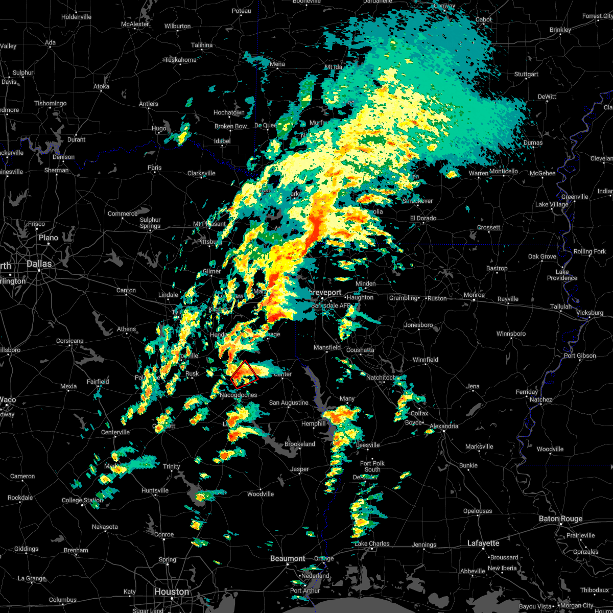 At 327 pm cst, a severe thunderstorm capable of producing a tornado was located near trawick, or 11 miles north of nacogdoches, moving northeast at 40 mph (radar indicated rotation). Hazards include tornado. Flying debris will be dangerous to those caught without shelter. mobile homes will be damaged or destroyed. damage to roofs, windows, and vehicles will occur. tree damage is likely. this dangerous storm will be near, garrison around 345 pm cst. Other locations impacted by this tornadic thunderstorm include lawsonville and appleby. At 327 pm cst, a severe thunderstorm capable of producing a tornado was located near trawick, or 11 miles north of nacogdoches, moving northeast at 40 mph (radar indicated rotation). Hazards include tornado. Flying debris will be dangerous to those caught without shelter. mobile homes will be damaged or destroyed. damage to roofs, windows, and vehicles will occur. tree damage is likely. this dangerous storm will be near, garrison around 345 pm cst. Other locations impacted by this tornadic thunderstorm include lawsonville and appleby.
|
| 12/13/2022 3:15 PM CST |
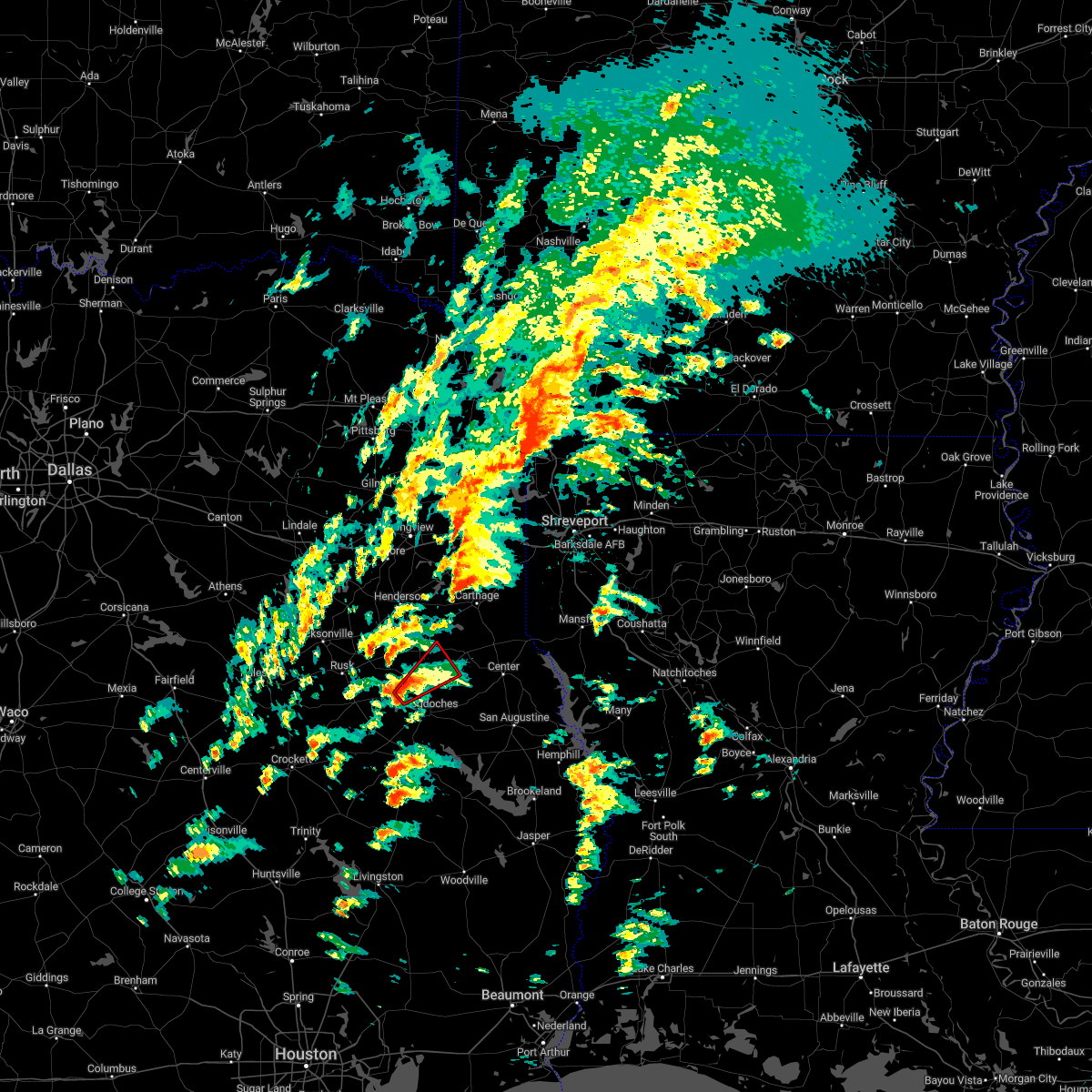 At 315 pm cst, a severe thunderstorm capable of producing a tornado was located near trawick, or 9 miles northwest of nacogdoches, moving northeast at 30 mph (radar indicated rotation). Hazards include tornado. Flying debris will be dangerous to those caught without shelter. mobile homes will be damaged or destroyed. damage to roofs, windows, and vehicles will occur. tree damage is likely. this dangerous storm will be near, trawick around 325 pm cst. garrison around 350 pm cst. Other locations impacted by this tornadic thunderstorm include appleby and lawsonville. At 315 pm cst, a severe thunderstorm capable of producing a tornado was located near trawick, or 9 miles northwest of nacogdoches, moving northeast at 30 mph (radar indicated rotation). Hazards include tornado. Flying debris will be dangerous to those caught without shelter. mobile homes will be damaged or destroyed. damage to roofs, windows, and vehicles will occur. tree damage is likely. this dangerous storm will be near, trawick around 325 pm cst. garrison around 350 pm cst. Other locations impacted by this tornadic thunderstorm include appleby and lawsonville.
|
| 10/25/2022 12:49 AM CDT |
 At 1248 am cdt, severe thunderstorms were located along a line extending from timpson to near lufkin, moving east at 50 mph (radar indicated). Hazards include 60 mph wind gusts and penny size hail. Expect damage to roofs, siding, and trees. locations impacted include, lufkin, nacogdoches, hudson, tenaha, timpson, garrison, melrose, woden, martinsville, appleby, stockman, clawson, central and redland. hail threat, radar indicated max hail size, 0. 75 in wind threat, radar indicated max wind gust, 60 mph. At 1248 am cdt, severe thunderstorms were located along a line extending from timpson to near lufkin, moving east at 50 mph (radar indicated). Hazards include 60 mph wind gusts and penny size hail. Expect damage to roofs, siding, and trees. locations impacted include, lufkin, nacogdoches, hudson, tenaha, timpson, garrison, melrose, woden, martinsville, appleby, stockman, clawson, central and redland. hail threat, radar indicated max hail size, 0. 75 in wind threat, radar indicated max wind gust, 60 mph.
|
| 10/25/2022 12:26 AM CDT |
 At 1225 am cdt, severe thunderstorms were located along a line extending from 7 miles northeast of trawick to 8 miles south of wells, moving east at 50 mph (radar indicated). Hazards include 60 mph wind gusts and penny size hail. expect damage to roofs, siding, and trees At 1225 am cdt, severe thunderstorms were located along a line extending from 7 miles northeast of trawick to 8 miles south of wells, moving east at 50 mph (radar indicated). Hazards include 60 mph wind gusts and penny size hail. expect damage to roofs, siding, and trees
|
| 8/17/2022 5:12 PM CDT |
 At 511 pm cdt, severe thunderstorms were located along a line extending from near trawick to 9 miles west of alto, moving southeast at 15 mph (radar indicated). Hazards include 60 mph wind gusts and quarter size hail. Hail damage to vehicles is expected. expect wind damage to roofs, siding, and trees. locations impacted include, nacogdoches, rusk, alto, morrill, forest, douglass, trawick, appleby, linwood, lilbert and looneyville. hail threat, radar indicated max hail size, 1. 00 in wind threat, radar indicated max wind gust, 60 mph. At 511 pm cdt, severe thunderstorms were located along a line extending from near trawick to 9 miles west of alto, moving southeast at 15 mph (radar indicated). Hazards include 60 mph wind gusts and quarter size hail. Hail damage to vehicles is expected. expect wind damage to roofs, siding, and trees. locations impacted include, nacogdoches, rusk, alto, morrill, forest, douglass, trawick, appleby, linwood, lilbert and looneyville. hail threat, radar indicated max hail size, 1. 00 in wind threat, radar indicated max wind gust, 60 mph.
|
| 8/17/2022 4:40 PM CDT |
 At 439 pm cdt, severe thunderstorms were located along a line extending from near trawick to near maydelle, moving southeast at 15 mph (radar indicated). Hazards include 60 mph wind gusts and quarter size hail. Hail damage to vehicles is expected. Expect wind damage to roofs, siding, and trees. At 439 pm cdt, severe thunderstorms were located along a line extending from near trawick to near maydelle, moving southeast at 15 mph (radar indicated). Hazards include 60 mph wind gusts and quarter size hail. Hail damage to vehicles is expected. Expect wind damage to roofs, siding, and trees.
|
| 5/21/2022 11:21 PM CDT |
 At 1121 pm cdt, severe thunderstorms were located along a line extending from near west mountain to 7 miles southwest of marshall to near tenaha to near martinsville, moving east at 45 mph (radar indicated. multiple trees and power lines have been downed across east texas with these storms). Hazards include 60 mph wind gusts. Expect damage to roofs, siding, and trees. locations impacted include, longview, nacogdoches, marshall, kilgore, carthage, white oak, gladewater, center, hallsville, tatum, big sandy, hawkins, tenaha, timpson, garrison, clarksville city, beckville, east mountain, deberry and elysian fields. hail threat, radar indicated max hail size, <. 75 in wind threat, radar indicated max wind gust, 60 mph. At 1121 pm cdt, severe thunderstorms were located along a line extending from near west mountain to 7 miles southwest of marshall to near tenaha to near martinsville, moving east at 45 mph (radar indicated. multiple trees and power lines have been downed across east texas with these storms). Hazards include 60 mph wind gusts. Expect damage to roofs, siding, and trees. locations impacted include, longview, nacogdoches, marshall, kilgore, carthage, white oak, gladewater, center, hallsville, tatum, big sandy, hawkins, tenaha, timpson, garrison, clarksville city, beckville, east mountain, deberry and elysian fields. hail threat, radar indicated max hail size, <. 75 in wind threat, radar indicated max wind gust, 60 mph.
|
| 5/21/2022 10:38 PM CDT |
 At 1037 pm cdt, severe thunderstorms were located along a line extending from 6 miles southeast of lindale to near kilgore to 9 miles southwest of minden to forest, moving east at 45 mph (radar indicated. trees have been downed across southern smith and cherokee counties from these storms). Hazards include 60 mph wind gusts. expect damage to roofs, siding, and trees At 1037 pm cdt, severe thunderstorms were located along a line extending from 6 miles southeast of lindale to near kilgore to 9 miles southwest of minden to forest, moving east at 45 mph (radar indicated. trees have been downed across southern smith and cherokee counties from these storms). Hazards include 60 mph wind gusts. expect damage to roofs, siding, and trees
|
| 4/13/2022 12:15 AM CDT |
 At 1215 am cdt, severe thunderstorms were located along a line extending from natchitoches to near nacogdoches, moving east at 25 mph (radar indicated). Hazards include 60 mph wind gusts and nickel size hail. Expect damage to roofs, siding, and trees. Locations impacted include, nacogdoches, natchitoches, center, milam, many, san augustine, zwolle, converse, melrose, patroon, martinsville, bland lake, neuville, woden, shelbyville, allen, oak grove, pleasant hill, provencal and natchez. At 1215 am cdt, severe thunderstorms were located along a line extending from natchitoches to near nacogdoches, moving east at 25 mph (radar indicated). Hazards include 60 mph wind gusts and nickel size hail. Expect damage to roofs, siding, and trees. Locations impacted include, nacogdoches, natchitoches, center, milam, many, san augustine, zwolle, converse, melrose, patroon, martinsville, bland lake, neuville, woden, shelbyville, allen, oak grove, pleasant hill, provencal and natchez.
|
| 4/12/2022 11:58 PM CDT |
 At 1157 pm cdt, severe thunderstorms were located along a line extending from near natchitoches to 8 miles west of nacogdoches, moving east at 25 mph (radar indicated). Hazards include 60 mph wind gusts and nickel size hail. expect damage to roofs, siding, and trees At 1157 pm cdt, severe thunderstorms were located along a line extending from near natchitoches to 8 miles west of nacogdoches, moving east at 25 mph (radar indicated). Hazards include 60 mph wind gusts and nickel size hail. expect damage to roofs, siding, and trees
|
| 4/12/2022 9:30 PM CDT |
 At 930 pm cdt, severe thunderstorms were located along a line extending from elysian fields to 7 miles southwest of nacogdoches, moving east at 50 mph (radar indicated). Hazards include 70 mph wind gusts and penny size hail. Expect considerable tree damage. damage is likely to mobile homes, roofs, and outbuildings. locations impacted include, nacogdoches, carthage, timpson, garrison, beckville, deberry, elysian fields, pinehill, trawick, appleby, mount enterprise, gary city, stockman, lawsonville, fairplay and dotson. thunderstorm damage threat, considerable hail threat, radar indicated max hail size, 0. 75 in wind threat, radar indicated max wind gust, 70 mph. At 930 pm cdt, severe thunderstorms were located along a line extending from elysian fields to 7 miles southwest of nacogdoches, moving east at 50 mph (radar indicated). Hazards include 70 mph wind gusts and penny size hail. Expect considerable tree damage. damage is likely to mobile homes, roofs, and outbuildings. locations impacted include, nacogdoches, carthage, timpson, garrison, beckville, deberry, elysian fields, pinehill, trawick, appleby, mount enterprise, gary city, stockman, lawsonville, fairplay and dotson. thunderstorm damage threat, considerable hail threat, radar indicated max hail size, 0. 75 in wind threat, radar indicated max wind gust, 70 mph.
|
| 4/12/2022 8:48 PM CDT |
 At 848 pm cdt, severe thunderstorms were located along a line extending from 8 miles east of kilgore to 11 miles northwest of kennard, moving east at 50 mph (radar indicated). Hazards include 70 mph wind gusts and penny size hail. Expect considerable tree damage. Damage is likely to mobile homes, roofs, and outbuildings. At 848 pm cdt, severe thunderstorms were located along a line extending from 8 miles east of kilgore to 11 miles northwest of kennard, moving east at 50 mph (radar indicated). Hazards include 70 mph wind gusts and penny size hail. Expect considerable tree damage. Damage is likely to mobile homes, roofs, and outbuildings.
|
| 3/30/2022 9:39 AM CDT |
 At 938 am cdt, severe thunderstorms were located along a line extending from 8 miles southeast of pinehill to garrison to 10 miles southwest of timpson to 7 miles northwest of melrose to near nacogdoches, moving east at 35 mph (radar indicated). Hazards include 60 mph wind gusts. expect damage to roofs, siding, and trees At 938 am cdt, severe thunderstorms were located along a line extending from 8 miles southeast of pinehill to garrison to 10 miles southwest of timpson to 7 miles northwest of melrose to near nacogdoches, moving east at 35 mph (radar indicated). Hazards include 60 mph wind gusts. expect damage to roofs, siding, and trees
|
| 1/19/2022 6:50 PM CST |
 At 649 pm cst, a severe thunderstorm was located near nacogdoches, moving northeast at 30 mph (radar indicated). Hazards include 60 mph wind gusts and quarter size hail. Hail damage to vehicles is expected. expect wind damage to roofs, siding, and trees. locations impacted include, nacogdoches and appleby. hail threat, radar indicated max hail size, 1. 00 in wind threat, radar indicated max wind gust, 60 mph. At 649 pm cst, a severe thunderstorm was located near nacogdoches, moving northeast at 30 mph (radar indicated). Hazards include 60 mph wind gusts and quarter size hail. Hail damage to vehicles is expected. expect wind damage to roofs, siding, and trees. locations impacted include, nacogdoches and appleby. hail threat, radar indicated max hail size, 1. 00 in wind threat, radar indicated max wind gust, 60 mph.
|
| 1/19/2022 6:31 PM CST |
 At 630 pm cst, a severe thunderstorm was located near nacogdoches, moving northeast at 30 mph (radar indicated). Hazards include 60 mph wind gusts and quarter size hail. Hail damage to vehicles is expected. Expect wind damage to roofs, siding, and trees. At 630 pm cst, a severe thunderstorm was located near nacogdoches, moving northeast at 30 mph (radar indicated). Hazards include 60 mph wind gusts and quarter size hail. Hail damage to vehicles is expected. Expect wind damage to roofs, siding, and trees.
|
| 6/8/2021 11:40 AM CDT |
 At 1139 am cdt, severe thunderstorms were located along a line extending from near carthage to near timpson to martinsville, moving east at 35 mph (radar indicated). Hazards include 60 mph wind gusts. Expect damage to roofs, siding, and trees. Locations impacted include, nacogdoches, carthage, center, tenaha, timpson, garrison, melrose, martinsville, appleby, gary city, jericho, stockman, arcadia, woods and paxton. At 1139 am cdt, severe thunderstorms were located along a line extending from near carthage to near timpson to martinsville, moving east at 35 mph (radar indicated). Hazards include 60 mph wind gusts. Expect damage to roofs, siding, and trees. Locations impacted include, nacogdoches, carthage, center, tenaha, timpson, garrison, melrose, martinsville, appleby, gary city, jericho, stockman, arcadia, woods and paxton.
|
| 6/8/2021 11:15 AM CDT |
 At 1114 am cdt, severe thunderstorms were located along a line extending from pinehill to near garrison to nacogdoches, moving east at 35 mph (radar indicated). Hazards include 60 mph wind gusts. expect damage to roofs, siding, and trees At 1114 am cdt, severe thunderstorms were located along a line extending from pinehill to near garrison to nacogdoches, moving east at 35 mph (radar indicated). Hazards include 60 mph wind gusts. expect damage to roofs, siding, and trees
|
| 6/8/2021 10:59 AM CDT |
 At 1058 am cdt, severe thunderstorms were located along a line extending from near henderson to near trawick to 6 miles north of pollok, moving east at 45 mph (radar indicated). Hazards include 60 mph wind gusts. Expect damage to roofs, siding, and trees. Locations impacted include, nacogdoches, pinehill, douglass, minden, trawick, appleby, mount enterprise, dotson, looneyville and lawsonville. At 1058 am cdt, severe thunderstorms were located along a line extending from near henderson to near trawick to 6 miles north of pollok, moving east at 45 mph (radar indicated). Hazards include 60 mph wind gusts. Expect damage to roofs, siding, and trees. Locations impacted include, nacogdoches, pinehill, douglass, minden, trawick, appleby, mount enterprise, dotson, looneyville and lawsonville.
|
| 6/8/2021 10:30 AM CDT |
 At 1029 am cdt, severe thunderstorms were located along a line extending from near troup to near rusk to 7 miles southwest of morrill, moving east at 45 mph (radar indicated). Hazards include 60 mph wind gusts and penny size hail. expect damage to roofs, siding, and trees At 1029 am cdt, severe thunderstorms were located along a line extending from near troup to near rusk to 7 miles southwest of morrill, moving east at 45 mph (radar indicated). Hazards include 60 mph wind gusts and penny size hail. expect damage to roofs, siding, and trees
|
| 5/9/2021 4:26 PM CDT |
 At 426 pm cdt, a severe thunderstorm was located over nacogdoches, moving east southeast at 20 mph (radar indicated). Hazards include 60 mph wind gusts and quarter size hail. Hail damage to vehicles is expected. Expect wind damage to roofs, siding, and trees. At 426 pm cdt, a severe thunderstorm was located over nacogdoches, moving east southeast at 20 mph (radar indicated). Hazards include 60 mph wind gusts and quarter size hail. Hail damage to vehicles is expected. Expect wind damage to roofs, siding, and trees.
|
| 5/9/2021 4:15 PM CDT |
 At 414 pm cdt, a severe thunderstorm was located over nacogdoches, moving east at 25 mph. another severe thunderstorm was indicated just southeast of douglass, also moving east at 25 mph (radar indicated). Hazards include 60 mph wind gusts and half dollar size hail. Hail damage to vehicles is expected. expect wind damage to roofs, siding, and trees. Locations impacted include, nacogdoches, martinsville, trawick, appleby and looneyville. At 414 pm cdt, a severe thunderstorm was located over nacogdoches, moving east at 25 mph. another severe thunderstorm was indicated just southeast of douglass, also moving east at 25 mph (radar indicated). Hazards include 60 mph wind gusts and half dollar size hail. Hail damage to vehicles is expected. expect wind damage to roofs, siding, and trees. Locations impacted include, nacogdoches, martinsville, trawick, appleby and looneyville.
|
| 5/9/2021 3:56 PM CDT |
 At 356 pm cdt, a severe thunderstorm was located over douglass, or 15 miles southeast of rusk, moving east at 25 mph (radar indicated). Hazards include 60 mph wind gusts and quarter size hail. Hail damage to vehicles is expected. Expect wind damage to roofs, siding, and trees. At 356 pm cdt, a severe thunderstorm was located over douglass, or 15 miles southeast of rusk, moving east at 25 mph (radar indicated). Hazards include 60 mph wind gusts and quarter size hail. Hail damage to vehicles is expected. Expect wind damage to roofs, siding, and trees.
|
| 4/13/2021 5:10 PM CDT |
 At 509 pm cdt, a severe thunderstorm was located 7 miles south of garrison, or 11 miles northeast of nacogdoches, moving east at 15 mph (radar indicated). Hazards include 60 mph wind gusts and half dollar size hail. Hail damage to vehicles is expected. expect wind damage to roofs, siding, and trees. Locations impacted include, nacogdoches, martinsville, appleby, arcadia and stockman. At 509 pm cdt, a severe thunderstorm was located 7 miles south of garrison, or 11 miles northeast of nacogdoches, moving east at 15 mph (radar indicated). Hazards include 60 mph wind gusts and half dollar size hail. Hail damage to vehicles is expected. expect wind damage to roofs, siding, and trees. Locations impacted include, nacogdoches, martinsville, appleby, arcadia and stockman.
|
| 4/13/2021 4:53 PM CDT |
 At 452 pm cdt, a severe thunderstorm was located 8 miles northeast of nacogdoches, moving east at 15 mph (radar indicated). Hazards include 60 mph wind gusts and quarter size hail. Hail damage to vehicles is expected. Expect wind damage to roofs, siding, and trees. At 452 pm cdt, a severe thunderstorm was located 8 miles northeast of nacogdoches, moving east at 15 mph (radar indicated). Hazards include 60 mph wind gusts and quarter size hail. Hail damage to vehicles is expected. Expect wind damage to roofs, siding, and trees.
|
| 4/9/2021 10:50 PM CDT |
 At 1049 pm cdt, a severe thunderstorm was located over trawick, or 12 miles northwest of nacogdoches, moving east at 35 mph (radar indicated). Hazards include 60 mph wind gusts and penny size hail. expect damage to roofs, siding, and trees At 1049 pm cdt, a severe thunderstorm was located over trawick, or 12 miles northwest of nacogdoches, moving east at 35 mph (radar indicated). Hazards include 60 mph wind gusts and penny size hail. expect damage to roofs, siding, and trees
|
| 4/9/2021 5:11 PM CDT |
 At 511 pm cdt, a severe thunderstorm was located near garrison, or 19 miles north of nacogdoches, moving east at 40 mph (radar indicated). Hazards include 60 mph wind gusts and quarter size hail. Hail damage to vehicles is expected. expect wind damage to roofs, siding, and trees. Locations impacted include, timpson, garrison, sacul, trawick, cushing, appleby, mount enterprise, reklaw, gary city, stockman, lawsonville, glenfawn, lilbert, dotson and looneyville. At 511 pm cdt, a severe thunderstorm was located near garrison, or 19 miles north of nacogdoches, moving east at 40 mph (radar indicated). Hazards include 60 mph wind gusts and quarter size hail. Hail damage to vehicles is expected. expect wind damage to roofs, siding, and trees. Locations impacted include, timpson, garrison, sacul, trawick, cushing, appleby, mount enterprise, reklaw, gary city, stockman, lawsonville, glenfawn, lilbert, dotson and looneyville.
|
| 4/9/2021 4:51 PM CDT |
 At 451 pm cdt, a severe thunderstorm was located near trawick, or 13 miles north of nacogdoches, moving east at 45 mph (radar indicated). Hazards include ping pong ball size hail and 60 mph wind gusts. People and animals outdoors will be injured. expect hail damage to roofs, siding, windows, and vehicles. expect wind damage to roofs, siding, and trees. Locations impacted include, nacogdoches, alto, timpson, garrison, sacul, douglass, trawick, cushing, appleby, mount enterprise, reklaw, gary city, stockman, lawsonville, glenfawn, linwood, lilbert, arcadia, dotson and looneyville. At 451 pm cdt, a severe thunderstorm was located near trawick, or 13 miles north of nacogdoches, moving east at 45 mph (radar indicated). Hazards include ping pong ball size hail and 60 mph wind gusts. People and animals outdoors will be injured. expect hail damage to roofs, siding, windows, and vehicles. expect wind damage to roofs, siding, and trees. Locations impacted include, nacogdoches, alto, timpson, garrison, sacul, douglass, trawick, cushing, appleby, mount enterprise, reklaw, gary city, stockman, lawsonville, glenfawn, linwood, lilbert, arcadia, dotson and looneyville.
|
| 4/9/2021 4:31 PM CDT |
 At 431 pm cdt, a severe thunderstorm was located near sacul, or 13 miles east of rusk, moving east at 45 mph (radar indicated). Hazards include 60 mph wind gusts and quarter size hail. Hail damage to vehicles is expected. Expect wind damage to roofs, siding, and trees. At 431 pm cdt, a severe thunderstorm was located near sacul, or 13 miles east of rusk, moving east at 45 mph (radar indicated). Hazards include 60 mph wind gusts and quarter size hail. Hail damage to vehicles is expected. Expect wind damage to roofs, siding, and trees.
|
| 3/17/2021 9:04 AM CDT |
 At 903 am cdt, severe thunderstorms were located along a line extending from near garrison to nacogdoches to near pollok, moving east at 30 mph (radar indicated). Hazards include 70 mph wind gusts and quarter size hail. Hail damage to vehicles is expected. expect considerable tree damage. wind damage is also likely to mobile homes, roofs, and outbuildings. Locations impacted include, nacogdoches, timpson, garrison, melrose, woden, pollok, trawick, appleby, stockman and central. At 903 am cdt, severe thunderstorms were located along a line extending from near garrison to nacogdoches to near pollok, moving east at 30 mph (radar indicated). Hazards include 70 mph wind gusts and quarter size hail. Hail damage to vehicles is expected. expect considerable tree damage. wind damage is also likely to mobile homes, roofs, and outbuildings. Locations impacted include, nacogdoches, timpson, garrison, melrose, woden, pollok, trawick, appleby, stockman and central.
|
| 3/17/2021 8:45 AM CDT |
 At 844 am cdt, severe thunderstorms were located along a line extending from near trawick to 7 miles southeast of douglass to near wells, moving northeast at 40 mph (radar indicated). Hazards include 70 mph wind gusts and quarter size hail. Hail damage to vehicles is expected. expect considerable tree damage. wind damage is also likely to mobile homes, roofs, and outbuildings. Locations impacted include, nacogdoches, timpson, garrison, wells, melrose, woden, pollok, sacul, forest, douglass, trawick, cushing, appleby, stockman, central, linwood, lilbert and looneyville. At 844 am cdt, severe thunderstorms were located along a line extending from near trawick to 7 miles southeast of douglass to near wells, moving northeast at 40 mph (radar indicated). Hazards include 70 mph wind gusts and quarter size hail. Hail damage to vehicles is expected. expect considerable tree damage. wind damage is also likely to mobile homes, roofs, and outbuildings. Locations impacted include, nacogdoches, timpson, garrison, wells, melrose, woden, pollok, sacul, forest, douglass, trawick, cushing, appleby, stockman, central, linwood, lilbert and looneyville.
|
| 3/17/2021 8:27 AM CDT |
 The national weather service in shreveport has issued a * severe thunderstorm warning for. southeastern rusk county in northeastern texas. nacogdoches county in eastern texas. northwestern shelby county in eastern texas. Northwestern angelina county in eastern texas. The national weather service in shreveport has issued a * severe thunderstorm warning for. southeastern rusk county in northeastern texas. nacogdoches county in eastern texas. northwestern shelby county in eastern texas. Northwestern angelina county in eastern texas.
|
| 4/29/2020 2:32 AM CDT |
 At 232 am cdt, severe thunderstorms were located along a line extending from near woden to near macune to 7 miles north of milam, moving south at 45 mph (radar indicated). Hazards include 60 mph wind gusts and quarter size hail. Hail damage to vehicles is expected. expect wind damage to roofs, siding, and trees. Locations impacted include, nacogdoches, center, milam, san augustine, hemphill, garrison, melrose, patroon, martinsville, bland lake, neuville, woden, rosevine, macune, etoile, shelbyville, appleby, chireno, huxley and broaddus. At 232 am cdt, severe thunderstorms were located along a line extending from near woden to near macune to 7 miles north of milam, moving south at 45 mph (radar indicated). Hazards include 60 mph wind gusts and quarter size hail. Hail damage to vehicles is expected. expect wind damage to roofs, siding, and trees. Locations impacted include, nacogdoches, center, milam, san augustine, hemphill, garrison, melrose, patroon, martinsville, bland lake, neuville, woden, rosevine, macune, etoile, shelbyville, appleby, chireno, huxley and broaddus.
|
| 4/29/2020 2:04 AM CDT |
 At 203 am cdt, severe thunderstorms were located along a line extending from near trawick to 6 miles northwest of neuville to 9 miles south of logansport, moving south at 45 mph (radar indicated. at 155 am, trees were downed in mount enterprise from these storms). Hazards include 60 mph wind gusts and quarter size hail. Hail damage to vehicles is expected. Expect wind damage to roofs, siding, and trees. At 203 am cdt, severe thunderstorms were located along a line extending from near trawick to 6 miles northwest of neuville to 9 miles south of logansport, moving south at 45 mph (radar indicated. at 155 am, trees were downed in mount enterprise from these storms). Hazards include 60 mph wind gusts and quarter size hail. Hail damage to vehicles is expected. Expect wind damage to roofs, siding, and trees.
|
| 4/29/2020 1:54 AM CDT |
 At 154 am cdt, severe thunderstorms were located along a line extending from 8 miles northwest of garrison to 7 miles southeast of timpson to near joaquin, moving south at 45 mph (radar indicated). Hazards include 60 mph wind gusts and quarter size hail. Hail damage to vehicles is expected. expect wind damage to roofs, siding, and trees. Locations impacted include, carthage, center, tenaha, timpson, garrison, joaquin, pinehill, shelbyville, appleby, mount enterprise, huxley, gary city, jericho, front, stockman, fairplay, deadwood, dotson, chapman and james. At 154 am cdt, severe thunderstorms were located along a line extending from 8 miles northwest of garrison to 7 miles southeast of timpson to near joaquin, moving south at 45 mph (radar indicated). Hazards include 60 mph wind gusts and quarter size hail. Hail damage to vehicles is expected. expect wind damage to roofs, siding, and trees. Locations impacted include, carthage, center, tenaha, timpson, garrison, joaquin, pinehill, shelbyville, appleby, mount enterprise, huxley, gary city, jericho, front, stockman, fairplay, deadwood, dotson, chapman and james.
|
| 4/29/2020 1:28 AM CDT |
 At 128 am cdt, severe thunderstorms were located along a line extending from near pinehill to near carthage to 8 miles southeast of deberry, moving south at 40 mph (radar indicated). Hazards include 60 mph wind gusts and quarter size hail. Hail damage to vehicles is expected. Expect wind damage to roofs, siding, and trees. At 128 am cdt, severe thunderstorms were located along a line extending from near pinehill to near carthage to 8 miles southeast of deberry, moving south at 40 mph (radar indicated). Hazards include 60 mph wind gusts and quarter size hail. Hail damage to vehicles is expected. Expect wind damage to roofs, siding, and trees.
|
| 4/28/2020 4:20 PM CDT |
 At 420 pm cdt, a severe thunderstorm was located near nacogdoches, moving northeast at 20 mph (radar indicated). Hazards include 60 mph wind gusts and quarter size hail. Hail damage to vehicles is expected. expect wind damage to roofs, siding, and trees. Locations impacted include, nacogdoches and appleby. At 420 pm cdt, a severe thunderstorm was located near nacogdoches, moving northeast at 20 mph (radar indicated). Hazards include 60 mph wind gusts and quarter size hail. Hail damage to vehicles is expected. expect wind damage to roofs, siding, and trees. Locations impacted include, nacogdoches and appleby.
|
| 4/28/2020 4:01 PM CDT |
 At 401 pm cdt, a severe thunderstorm was located over nacogdoches, moving northeast at 20 mph (radar indicated). Hazards include 60 mph wind gusts and half dollar size hail. Hail damage to vehicles is expected. Expect wind damage to roofs, siding, and trees. At 401 pm cdt, a severe thunderstorm was located over nacogdoches, moving northeast at 20 mph (radar indicated). Hazards include 60 mph wind gusts and half dollar size hail. Hail damage to vehicles is expected. Expect wind damage to roofs, siding, and trees.
|
| 4/22/2020 3:43 PM CDT |
 At 342 pm cdt, a severe thunderstorm capable of producing a tornado was located 8 miles east of pollok, or 9 miles southwest of nacogdoches, moving east at 45 mph (radar indicated rotation). Hazards include tornado and tennis ball size hail. Flying debris will be dangerous to those caught without shelter. mobile homes will be damaged or destroyed. damage to roofs, windows, and vehicles will occur. tree damage is likely. this dangerous storm will be near, woden around 400 pm cdt. melrose around 405 pm cdt. macune around 430 pm cdt. Other locations impacted by this tornadic thunderstorm include redland, denning, arcadia, jericho and chireno. At 342 pm cdt, a severe thunderstorm capable of producing a tornado was located 8 miles east of pollok, or 9 miles southwest of nacogdoches, moving east at 45 mph (radar indicated rotation). Hazards include tornado and tennis ball size hail. Flying debris will be dangerous to those caught without shelter. mobile homes will be damaged or destroyed. damage to roofs, windows, and vehicles will occur. tree damage is likely. this dangerous storm will be near, woden around 400 pm cdt. melrose around 405 pm cdt. macune around 430 pm cdt. Other locations impacted by this tornadic thunderstorm include redland, denning, arcadia, jericho and chireno.
|
| 4/22/2020 3:25 PM CDT |
 At 325 pm cdt, a severe thunderstorm capable of producing a tornado was located over wells, or 18 miles west of nacogdoches, moving east at 50 mph (radar indicated rotation). Hazards include tornado and tennis ball size hail. Flying debris will be dangerous to those caught without shelter. mobile homes will be damaged or destroyed. damage to roofs, windows, and vehicles will occur. tree damage is likely. this dangerous storm will be near, nacogdoches around 345 pm cdt. melrose and woden around 355 pm cdt. martinsville around 400 pm cdt. Other locations impacted by this tornadic thunderstorm include appleby and chireno. At 325 pm cdt, a severe thunderstorm capable of producing a tornado was located over wells, or 18 miles west of nacogdoches, moving east at 50 mph (radar indicated rotation). Hazards include tornado and tennis ball size hail. Flying debris will be dangerous to those caught without shelter. mobile homes will be damaged or destroyed. damage to roofs, windows, and vehicles will occur. tree damage is likely. this dangerous storm will be near, nacogdoches around 345 pm cdt. melrose and woden around 355 pm cdt. martinsville around 400 pm cdt. Other locations impacted by this tornadic thunderstorm include appleby and chireno.
|
| 4/22/2020 3:22 PM CDT |
 At 321 pm cdt, a severe thunderstorm was located near trawick, or 11 miles northwest of nacogdoches, moving east at 55 mph (radar indicated). Hazards include tennis ball size hail and 70 mph wind gusts. People and animals outdoors will be injured. expect hail damage to roofs, siding, windows, and vehicles. expect wind damage to roofs, siding, and trees. Locations impacted include, nacogdoches, alto, wells, morrill, melrose, sacul, forest, douglass, trawick, cushing, appleby, linwood, lilbert and looneyville. At 321 pm cdt, a severe thunderstorm was located near trawick, or 11 miles northwest of nacogdoches, moving east at 55 mph (radar indicated). Hazards include tennis ball size hail and 70 mph wind gusts. People and animals outdoors will be injured. expect hail damage to roofs, siding, windows, and vehicles. expect wind damage to roofs, siding, and trees. Locations impacted include, nacogdoches, alto, wells, morrill, melrose, sacul, forest, douglass, trawick, cushing, appleby, linwood, lilbert and looneyville.
|
| 4/22/2020 3:04 PM CDT |
 At 304 pm cdt, a severe thunderstorm capable of producing a tornado was located near morrill, or 16 miles south of rusk, moving east at 65 mph (radar indicated rotation). Hazards include tornado and half dollar size hail. Flying debris will be dangerous to those caught without shelter. mobile homes will be damaged or destroyed. damage to roofs, windows, and vehicles will occur. tree damage is likely. this dangerous storm will be near, forest around 310 pm cdt. wells around 315 pm cdt. douglass around 320 pm cdt. nacogdoches around 330 pm cdt. melrose around 340 pm cdt. martinsville around 345 pm cdt. Other locations impacted by this tornadic thunderstorm include appleby, linwood, lilbert and chireno. At 304 pm cdt, a severe thunderstorm capable of producing a tornado was located near morrill, or 16 miles south of rusk, moving east at 65 mph (radar indicated rotation). Hazards include tornado and half dollar size hail. Flying debris will be dangerous to those caught without shelter. mobile homes will be damaged or destroyed. damage to roofs, windows, and vehicles will occur. tree damage is likely. this dangerous storm will be near, forest around 310 pm cdt. wells around 315 pm cdt. douglass around 320 pm cdt. nacogdoches around 330 pm cdt. melrose around 340 pm cdt. martinsville around 345 pm cdt. Other locations impacted by this tornadic thunderstorm include appleby, linwood, lilbert and chireno.
|
| 4/22/2020 2:37 PM CDT |
 At 237 pm cdt, a severe thunderstorm was located near grapeland, or 15 miles north of crockett, moving east at 55 mph (radar indicated). Hazards include 60 mph wind gusts and quarter size hail. Hail damage to vehicles is expected. Expect wind damage to roofs, siding, and trees. At 237 pm cdt, a severe thunderstorm was located near grapeland, or 15 miles north of crockett, moving east at 55 mph (radar indicated). Hazards include 60 mph wind gusts and quarter size hail. Hail damage to vehicles is expected. Expect wind damage to roofs, siding, and trees.
|
| 4/19/2020 11:48 AM CDT |
 At 1148 am cdt, a severe thunderstorm was located just south of nacogdoches, moving east at 50 mph (radar indicated). Hazards include 60 mph wind gusts and quarter size hail. Hail damage to vehicles is expected. Expect wind damage to roofs, siding, and trees. At 1148 am cdt, a severe thunderstorm was located just south of nacogdoches, moving east at 50 mph (radar indicated). Hazards include 60 mph wind gusts and quarter size hail. Hail damage to vehicles is expected. Expect wind damage to roofs, siding, and trees.
|
| 4/19/2020 11:12 AM CDT |
 At 1112 am cdt, a severe thunderstorm was located near trawick, or 13 miles north of nacogdoches, moving east at 55 mph (radar indicated). Hazards include ping pong ball size hail and 60 mph wind gusts. People and animals outdoors will be injured. expect hail damage to roofs, siding, windows, and vehicles. Expect wind damage to roofs, siding, and trees. At 1112 am cdt, a severe thunderstorm was located near trawick, or 13 miles north of nacogdoches, moving east at 55 mph (radar indicated). Hazards include ping pong ball size hail and 60 mph wind gusts. People and animals outdoors will be injured. expect hail damage to roofs, siding, windows, and vehicles. Expect wind damage to roofs, siding, and trees.
|
| 4/19/2020 10:42 AM CDT |
 At 1042 am cdt, severe thunderstorms were located along a line extending from ponta to 6 miles northwest of douglass to near morrill, moving east at 60 mph (radar indicated). Hazards include 60 mph wind gusts and half dollar size hail. Hail damage to vehicles is expected. expect wind damage to roofs, siding, and trees. Locations impacted include, nacogdoches, rusk, alto, morrill, ponta, sacul, new salem, douglass, trawick, cushing, appleby, mount enterprise, gallatin, reklaw, lawsonville, glenfawn, linwood, lilbert, looneyville and laneville. At 1042 am cdt, severe thunderstorms were located along a line extending from ponta to 6 miles northwest of douglass to near morrill, moving east at 60 mph (radar indicated). Hazards include 60 mph wind gusts and half dollar size hail. Hail damage to vehicles is expected. expect wind damage to roofs, siding, and trees. Locations impacted include, nacogdoches, rusk, alto, morrill, ponta, sacul, new salem, douglass, trawick, cushing, appleby, mount enterprise, gallatin, reklaw, lawsonville, glenfawn, linwood, lilbert, looneyville and laneville.
|
| 4/19/2020 10:13 AM CDT |
 At 1013 am cdt, a severe thunderstorm was located 9 miles southwest of maydelle, or 11 miles east of palestine, moving east at 55 mph (radar indicated). Hazards include 60 mph wind gusts and half dollar size hail. Hail damage to vehicles is expected. Expect wind damage to roofs, siding, and trees. At 1013 am cdt, a severe thunderstorm was located 9 miles southwest of maydelle, or 11 miles east of palestine, moving east at 55 mph (radar indicated). Hazards include 60 mph wind gusts and half dollar size hail. Hail damage to vehicles is expected. Expect wind damage to roofs, siding, and trees.
|
| 4/12/2020 8:57 AM CDT |
 At 857 am cdt, severe thunderstorms were located along a line extending from 7 miles northwest of timpson to near garrison to near nacogdoches to 6 miles southeast of douglass to pollok, moving east at 60 mph. these are very dangerous storms (radar indicated). Hazards include 80 mph wind gusts and quarter size hail. Flying debris will be dangerous to those caught without shelter. mobile homes will be heavily damaged. expect considerable damage to roofs, windows, and vehicles. extensive tree damage and power outages are likely. Locations impacted include, nacogdoches, center, san augustine, tenaha, timpson, garrison, joaquin, wells, melrose, martinsville, bland lake, neuville, trawick, woden, pollok, shelbyville, douglass, cushing, appleby and mount enterprise. At 857 am cdt, severe thunderstorms were located along a line extending from 7 miles northwest of timpson to near garrison to near nacogdoches to 6 miles southeast of douglass to pollok, moving east at 60 mph. these are very dangerous storms (radar indicated). Hazards include 80 mph wind gusts and quarter size hail. Flying debris will be dangerous to those caught without shelter. mobile homes will be heavily damaged. expect considerable damage to roofs, windows, and vehicles. extensive tree damage and power outages are likely. Locations impacted include, nacogdoches, center, san augustine, tenaha, timpson, garrison, joaquin, wells, melrose, martinsville, bland lake, neuville, trawick, woden, pollok, shelbyville, douglass, cushing, appleby and mount enterprise.
|
| 4/12/2020 8:31 AM CDT |
 At 830 am cdt, severe thunderstorms were located along a line extending from near new salem to 6 miles southwest of sacul to near morrill to near forest, moving east at 60 mph. these are very dangerous storms (radar indicated). Hazards include 80 mph wind gusts and quarter size hail. Flying debris will be dangerous to those caught without shelter. mobile homes will be heavily damaged. expect considerable damage to roofs, windows, and vehicles. Extensive tree damage and power outages are likely. At 830 am cdt, severe thunderstorms were located along a line extending from near new salem to 6 miles southwest of sacul to near morrill to near forest, moving east at 60 mph. these are very dangerous storms (radar indicated). Hazards include 80 mph wind gusts and quarter size hail. Flying debris will be dangerous to those caught without shelter. mobile homes will be heavily damaged. expect considerable damage to roofs, windows, and vehicles. Extensive tree damage and power outages are likely.
|
| 1/10/2020 11:53 PM CST |
 At 1153 pm cst, a severe thunderstorm capable of producing a tornado was located near trawick, or 7 miles north of nacogdoches, moving northeast at 30 mph (radar indicated rotation). Hazards include tornado. Flying debris will be dangerous to those caught without shelter. mobile homes will be damaged or destroyed. damage to roofs, windows, and vehicles will occur. Tree damage is likely. At 1153 pm cst, a severe thunderstorm capable of producing a tornado was located near trawick, or 7 miles north of nacogdoches, moving northeast at 30 mph (radar indicated rotation). Hazards include tornado. Flying debris will be dangerous to those caught without shelter. mobile homes will be damaged or destroyed. damage to roofs, windows, and vehicles will occur. Tree damage is likely.
|
| 1/10/2020 11:28 PM CST |
 At 1126 pm cst, severe thunderstorms were located along a line extending from 6 miles west of hawkins to near grapeland, moving northeast at 45 mph (radar indicated). Hazards include 60 mph wind gusts. expect damage to roofs, siding, and trees At 1126 pm cst, severe thunderstorms were located along a line extending from 6 miles west of hawkins to near grapeland, moving northeast at 45 mph (radar indicated). Hazards include 60 mph wind gusts. expect damage to roofs, siding, and trees
|
| 10/3/2019 5:40 PM CDT |
 At 539 pm cdt, severe thunderstorms were located along a line extending from near sacul to near nacogdoches, moving southwest at 25 mph (radar indicated). Hazards include 60 mph wind gusts and penny size hail. expect damage to roofs, siding, and trees At 539 pm cdt, severe thunderstorms were located along a line extending from near sacul to near nacogdoches, moving southwest at 25 mph (radar indicated). Hazards include 60 mph wind gusts and penny size hail. expect damage to roofs, siding, and trees
|
| 10/3/2019 4:42 PM CDT |
 At 442 pm cdt, a severe thunderstorm was located 7 miles northeast of martinsville, or 10 miles southwest of center, moving west southwest at 20 mph (radar indicated). Hazards include 60 mph wind gusts and penny size hail. expect damage to roofs, siding, and trees At 442 pm cdt, a severe thunderstorm was located 7 miles northeast of martinsville, or 10 miles southwest of center, moving west southwest at 20 mph (radar indicated). Hazards include 60 mph wind gusts and penny size hail. expect damage to roofs, siding, and trees
|
| 5/18/2019 9:39 PM CDT |
 The national weather service in shreveport has issued a * severe thunderstorm warning for. southwestern de soto parish in northwestern louisiana. southern panola county in northeastern texas. southeastern rusk county in northeastern texas. Northeastern nacogdoches county in eastern texas. The national weather service in shreveport has issued a * severe thunderstorm warning for. southwestern de soto parish in northwestern louisiana. southern panola county in northeastern texas. southeastern rusk county in northeastern texas. Northeastern nacogdoches county in eastern texas.
|
| 5/18/2019 9:20 PM CDT |
 At 919 pm cdt, severe thunderstorms were located along a line extending from near pinehill to near timpson to near nacogdoches, moving east at 20 mph (radar indicated). Hazards include 60 mph wind gusts and quarter size hail. Hail damage to vehicles is expected. expect wind damage to roofs, siding, and trees. Locations impacted include, nacogdoches, timpson, garrison, trawick, cushing, appleby, mount enterprise, gary city, dotson, looneyville, stockman and lawsonville. At 919 pm cdt, severe thunderstorms were located along a line extending from near pinehill to near timpson to near nacogdoches, moving east at 20 mph (radar indicated). Hazards include 60 mph wind gusts and quarter size hail. Hail damage to vehicles is expected. expect wind damage to roofs, siding, and trees. Locations impacted include, nacogdoches, timpson, garrison, trawick, cushing, appleby, mount enterprise, gary city, dotson, looneyville, stockman and lawsonville.
|
| 5/18/2019 8:43 PM CDT |
 At 843 pm cdt, severe thunderstorms were located along a line extending from 7 miles west of minden to 8 miles northeast of trawick to douglass, moving east at 35 mph (radar indicated). Hazards include golf ball size hail and 70 mph wind gusts. People and animals outdoors will be injured. expect hail damage to roofs, siding, windows, and vehicles. expect considerable tree damage. Wind damage is also likely to mobile homes, roofs, and outbuildings. At 843 pm cdt, severe thunderstorms were located along a line extending from 7 miles west of minden to 8 miles northeast of trawick to douglass, moving east at 35 mph (radar indicated). Hazards include golf ball size hail and 70 mph wind gusts. People and animals outdoors will be injured. expect hail damage to roofs, siding, windows, and vehicles. expect considerable tree damage. Wind damage is also likely to mobile homes, roofs, and outbuildings.
|
| 5/2/2019 5:24 AM CDT |
 At 523 am cdt, severe thunderstorms were located along a line extending from 6 miles east of trawick to near melrose to near huntington to 9 miles southeast of diboll to near seven oaks, moving east at 35 mph (radar indicated). Hazards include 60 mph wind gusts and penny size hail. expect damage to roofs, siding, and trees At 523 am cdt, severe thunderstorms were located along a line extending from 6 miles east of trawick to near melrose to near huntington to 9 miles southeast of diboll to near seven oaks, moving east at 35 mph (radar indicated). Hazards include 60 mph wind gusts and penny size hail. expect damage to roofs, siding, and trees
|
| 5/2/2019 5:15 AM CDT |
 At 515 am cdt, severe thunderstorms were located along a line extending from near trawick to near nacogdoches to 7 miles northeast of lufkin to near diboll to near corrigan, moving east at 35 mph (radar indicated). Hazards include 60 mph wind gusts and penny size hail. Expect damage to roofs, siding, and trees. Locations impacted include, lufkin, nacogdoches, diboll, hudson, huntington, garrison, melrose, woden, etoile, martinsville, trawick, burke, zavalla, appleby, chireno, shawnee, clawson, central, redland and looneyville. At 515 am cdt, severe thunderstorms were located along a line extending from near trawick to near nacogdoches to 7 miles northeast of lufkin to near diboll to near corrigan, moving east at 35 mph (radar indicated). Hazards include 60 mph wind gusts and penny size hail. Expect damage to roofs, siding, and trees. Locations impacted include, lufkin, nacogdoches, diboll, hudson, huntington, garrison, melrose, woden, etoile, martinsville, trawick, burke, zavalla, appleby, chireno, shawnee, clawson, central, redland and looneyville.
|
| 5/2/2019 4:54 AM CDT |
 The national weather service in shreveport has issued a * severe thunderstorm warning for. nacogdoches county in eastern texas. angelina county in eastern texas. southeastern cherokee county in northeastern texas. Until 530 am cdt. The national weather service in shreveport has issued a * severe thunderstorm warning for. nacogdoches county in eastern texas. angelina county in eastern texas. southeastern cherokee county in northeastern texas. Until 530 am cdt.
|
| 5/2/2019 4:38 AM CDT |
 At 438 am cdt, severe thunderstorms were located along a line extending from near sacul to near wells to 7 miles northwest of apple springs, moving east at 30 mph (radar indicated). Hazards include 60 mph wind gusts and penny size hail. Expect damage to roofs, siding, and trees. Locations impacted include, lufkin, nacogdoches, rusk, hudson, alto, wells, morrill, melrose, woden, pollok, sacul, forest, douglass, trawick, cushing, appleby, clawson, central, redland and linwood. At 438 am cdt, severe thunderstorms were located along a line extending from near sacul to near wells to 7 miles northwest of apple springs, moving east at 30 mph (radar indicated). Hazards include 60 mph wind gusts and penny size hail. Expect damage to roofs, siding, and trees. Locations impacted include, lufkin, nacogdoches, rusk, hudson, alto, wells, morrill, melrose, woden, pollok, sacul, forest, douglass, trawick, cushing, appleby, clawson, central, redland and linwood.
|
| 5/2/2019 4:22 AM CDT |
 At 422 am cdt, severe thunderstorms were located along a line extending from 6 miles southeast of rusk to near forest to near kennard, moving east at 35 mph (radar indicated). Hazards include 60 mph wind gusts and penny size hail. expect damage to roofs, siding, and trees At 422 am cdt, severe thunderstorms were located along a line extending from 6 miles southeast of rusk to near forest to near kennard, moving east at 35 mph (radar indicated). Hazards include 60 mph wind gusts and penny size hail. expect damage to roofs, siding, and trees
|
| 4/18/2019 3:59 AM CDT |
 At 359 am cdt, severe thunderstorms were located along a line extending from 6 miles west of tatum to near pinehill to nacogdoches, moving east at 40 mph (radar indicated. trees have been downed near new london in northern rusk county from these storms). Hazards include 60 mph wind gusts. Expect damage to roofs, siding, and trees. Locations impacted include, nacogdoches, henderson, carthage, tatum, timpson, garrison, beckville, pinehill, minden, trawick, easton, appleby, mount enterprise, gary city, chapman, stockman, lawsonville, darco, fairplay and stewart. At 359 am cdt, severe thunderstorms were located along a line extending from 6 miles west of tatum to near pinehill to nacogdoches, moving east at 40 mph (radar indicated. trees have been downed near new london in northern rusk county from these storms). Hazards include 60 mph wind gusts. Expect damage to roofs, siding, and trees. Locations impacted include, nacogdoches, henderson, carthage, tatum, timpson, garrison, beckville, pinehill, minden, trawick, easton, appleby, mount enterprise, gary city, chapman, stockman, lawsonville, darco, fairplay and stewart.
|
| 4/18/2019 3:30 AM CDT |
 At 329 am cdt, severe thunderstorms were located along a line extending from turnertown to 7 miles east of new salem to near wells, moving northeast at 45 mph (radar indicated). Hazards include 70 mph wind gusts and penny size hail. Expect considerable tree damage. Damage is likely to mobile homes, roofs, and outbuildings. At 329 am cdt, severe thunderstorms were located along a line extending from turnertown to 7 miles east of new salem to near wells, moving northeast at 45 mph (radar indicated). Hazards include 70 mph wind gusts and penny size hail. Expect considerable tree damage. Damage is likely to mobile homes, roofs, and outbuildings.
|
| 4/13/2019 2:27 PM CDT |
 At 226 pm cdt, severe thunderstorms were located along a line extending from near trawick to 8 miles southeast of diboll, moving east at 55 mph (radar indicated). Hazards include 70 mph wind gusts and quarter size hail. Hail damage to vehicles is expected. expect considerable tree damage. wind damage is also likely to mobile homes, roofs, and outbuildings. Locations impacted include, lufkin, nacogdoches, diboll, hudson, huntington, garrison, melrose, woden, etoile, martinsville, trawick, burke, zavalla, appleby, chireno, broaddus, shawnee, clawson, redland and homer. At 226 pm cdt, severe thunderstorms were located along a line extending from near trawick to 8 miles southeast of diboll, moving east at 55 mph (radar indicated). Hazards include 70 mph wind gusts and quarter size hail. Hail damage to vehicles is expected. expect considerable tree damage. wind damage is also likely to mobile homes, roofs, and outbuildings. Locations impacted include, lufkin, nacogdoches, diboll, hudson, huntington, garrison, melrose, woden, etoile, martinsville, trawick, burke, zavalla, appleby, chireno, broaddus, shawnee, clawson, redland and homer.
|
| 4/13/2019 2:01 PM CDT |
 At 201 pm cdt, severe thunderstorms were located along a line extending from alto to diboll, moving northeast at 60 mph (radar indicated). Hazards include 60 mph wind gusts and quarter size hail. Hail damage to vehicles is expected. Expect wind damage to roofs, siding, and trees. At 201 pm cdt, severe thunderstorms were located along a line extending from alto to diboll, moving northeast at 60 mph (radar indicated). Hazards include 60 mph wind gusts and quarter size hail. Hail damage to vehicles is expected. Expect wind damage to roofs, siding, and trees.
|
| 4/7/2019 3:51 PM CDT |
 At 351 pm cdt, severe thunderstorms were located along a line extending from near trawick to near zwolle, moving north at 50 mph (radar indicated). Hazards include 60 mph wind gusts and quarter size hail. Hail damage to vehicles is expected. Expect wind damage to roofs, siding, and trees. At 351 pm cdt, severe thunderstorms were located along a line extending from near trawick to near zwolle, moving north at 50 mph (radar indicated). Hazards include 60 mph wind gusts and quarter size hail. Hail damage to vehicles is expected. Expect wind damage to roofs, siding, and trees.
|
| 4/4/2019 2:12 AM CDT |
 At 211 am cdt, a severe thunderstorm was located near trawick, or 13 miles north of nacogdoches, moving northeast at 35 mph (radar indicated). Hazards include quarter size hail. Damage to vehicles is expected. Locations impacted include, garrison, trawick, cushing, appleby, mount enterprise and lawsonville. At 211 am cdt, a severe thunderstorm was located near trawick, or 13 miles north of nacogdoches, moving northeast at 35 mph (radar indicated). Hazards include quarter size hail. Damage to vehicles is expected. Locations impacted include, garrison, trawick, cushing, appleby, mount enterprise and lawsonville.
|
| 4/4/2019 1:58 AM CDT |
 At 157 am cdt, a severe thunderstorm was located near trawick, or 10 miles northwest of nacogdoches, moving northeast at 35 mph (radar indicated). Hazards include quarter size hail. damage to vehicles is expected At 157 am cdt, a severe thunderstorm was located near trawick, or 10 miles northwest of nacogdoches, moving northeast at 35 mph (radar indicated). Hazards include quarter size hail. damage to vehicles is expected
|
| 3/14/2019 4:39 AM CDT |
 At 438 am cdt, a severe thunderstorm was located near nacogdoches, moving east at 55 mph (radar indicated). Hazards include 60 mph wind gusts and quarter size hail. Hail damage to vehicles is expected. expect wind damage to roofs, siding, and trees. Locations impacted include, nacogdoches, woden, martinsville, melrose, appleby and chireno. At 438 am cdt, a severe thunderstorm was located near nacogdoches, moving east at 55 mph (radar indicated). Hazards include 60 mph wind gusts and quarter size hail. Hail damage to vehicles is expected. expect wind damage to roofs, siding, and trees. Locations impacted include, nacogdoches, woden, martinsville, melrose, appleby and chireno.
|
| 3/14/2019 4:15 AM CDT |
 At 414 am cdt, a severe thunderstorm was located over wells, or 17 miles northwest of lufkin, moving east at 55 mph (radar indicated). Hazards include 60 mph wind gusts and quarter size hail. Hail damage to vehicles is expected. Expect wind damage to roofs, siding, and trees. At 414 am cdt, a severe thunderstorm was located over wells, or 17 miles northwest of lufkin, moving east at 55 mph (radar indicated). Hazards include 60 mph wind gusts and quarter size hail. Hail damage to vehicles is expected. Expect wind damage to roofs, siding, and trees.
|
| 3/9/2019 12:17 PM CST |
 At 1217 pm cst, a severe thunderstorm was located near rusk, moving east at 40 mph (radar indicated). Hazards include 60 mph wind gusts. Expect damage to roofs, siding, and trees. Locations impacted include, rusk, sacul, new salem, trawick, cushing, appleby, mount enterprise, reklaw, lilbert, looneyville, lawsonville and glenfawn. At 1217 pm cst, a severe thunderstorm was located near rusk, moving east at 40 mph (radar indicated). Hazards include 60 mph wind gusts. Expect damage to roofs, siding, and trees. Locations impacted include, rusk, sacul, new salem, trawick, cushing, appleby, mount enterprise, reklaw, lilbert, looneyville, lawsonville and glenfawn.
|
| 3/9/2019 11:56 AM CST |
 At 1155 am cst, a severe thunderstorm was located near rusk, moving east at 55 mph (radar indicated). Hazards include 60 mph wind gusts. expect damage to roofs, siding, and trees At 1155 am cst, a severe thunderstorm was located near rusk, moving east at 55 mph (radar indicated). Hazards include 60 mph wind gusts. expect damage to roofs, siding, and trees
|
| 12/26/2018 9:56 PM CST |
 At 955 pm cst, a severe thunderstorm was located near apple springs, moving north at 60 mph (radar indicated). Hazards include 60 mph wind gusts and quarter size hail. Hail damage to vehicles is expected. Expect wind damage to roofs, siding, and trees. At 955 pm cst, a severe thunderstorm was located near apple springs, moving north at 60 mph (radar indicated). Hazards include 60 mph wind gusts and quarter size hail. Hail damage to vehicles is expected. Expect wind damage to roofs, siding, and trees.
|
| 10/31/2018 7:25 PM CDT |
 At 725 pm cdt, severe thunderstorms were located along a line extending from near pinehill to near timpson to garrison to near nacogdoches, moving east at 40 mph (radar indicated. shortly after 7 pm, trees were blown down across southeast rusk county). Hazards include 60 mph wind gusts. Expect damage to roofs, siding, and trees. locations impacted include, nacogdoches, center, san augustine, tenaha, timpson, garrison, melrose, martinsville, bland lake, neuville, shelbyville, appleby, chireno, gary city, jericho, stockman, deadwood, dotson, james and calgary. A tornado watch remains in effect until 1000 pm cdt for eastern and northeastern texas. At 725 pm cdt, severe thunderstorms were located along a line extending from near pinehill to near timpson to garrison to near nacogdoches, moving east at 40 mph (radar indicated. shortly after 7 pm, trees were blown down across southeast rusk county). Hazards include 60 mph wind gusts. Expect damage to roofs, siding, and trees. locations impacted include, nacogdoches, center, san augustine, tenaha, timpson, garrison, melrose, martinsville, bland lake, neuville, shelbyville, appleby, chireno, gary city, jericho, stockman, deadwood, dotson, james and calgary. A tornado watch remains in effect until 1000 pm cdt for eastern and northeastern texas.
|
| 10/31/2018 6:56 PM CDT |
 At 656 pm cdt, severe thunderstorms were located along a line extending from 6 miles east of new salem to 6 miles northeast of pollok, moving east at 35 mph (radar indicated). Hazards include 60 mph wind gusts. Expect damage to roofs, siding, and trees. locations impacted include, nacogdoches, center, san augustine, tenaha, timpson, garrison, melrose, martinsville, bland lake, neuville, trawick, shelbyville, douglass, minden, cushing, appleby, mount enterprise, chireno, gary city and jericho. A tornado watch remains in effect until 1000 pm cdt for eastern and northeastern texas. At 656 pm cdt, severe thunderstorms were located along a line extending from 6 miles east of new salem to 6 miles northeast of pollok, moving east at 35 mph (radar indicated). Hazards include 60 mph wind gusts. Expect damage to roofs, siding, and trees. locations impacted include, nacogdoches, center, san augustine, tenaha, timpson, garrison, melrose, martinsville, bland lake, neuville, trawick, shelbyville, douglass, minden, cushing, appleby, mount enterprise, chireno, gary city and jericho. A tornado watch remains in effect until 1000 pm cdt for eastern and northeastern texas.
|
| 10/31/2018 6:45 PM CDT |
 At 645 pm cdt, severe thunderstorms were located along a line extending from near new salem to near wells, moving east at 50 mph (radar indicated). Hazards include 60 mph wind gusts. expect damage to roofs, siding, and trees At 645 pm cdt, severe thunderstorms were located along a line extending from near new salem to near wells, moving east at 50 mph (radar indicated). Hazards include 60 mph wind gusts. expect damage to roofs, siding, and trees
|
| 10/13/2018 7:33 PM CDT |
 At 733 pm cdt, a severe thunderstorm capable of producing a tornado was located over douglass, or 14 miles west of nacogdoches, moving northeast at 25 mph (radar indicated rotation). Hazards include tornado. Flying debris will be dangerous to those caught without shelter. mobile homes will be damaged or destroyed. damage to roofs, windows, and vehicles will occur. tree damage is likely. this dangerous storm will be near, nacogdoches and trawick around 800 pm cdt. Other locations impacted by this tornadic thunderstorm include appleby. At 733 pm cdt, a severe thunderstorm capable of producing a tornado was located over douglass, or 14 miles west of nacogdoches, moving northeast at 25 mph (radar indicated rotation). Hazards include tornado. Flying debris will be dangerous to those caught without shelter. mobile homes will be damaged or destroyed. damage to roofs, windows, and vehicles will occur. tree damage is likely. this dangerous storm will be near, nacogdoches and trawick around 800 pm cdt. Other locations impacted by this tornadic thunderstorm include appleby.
|
| 10/13/2018 7:28 PM CDT |
 At 728 pm cdt, a severe thunderstorm was located over douglass, or 15 miles west of nacogdoches, moving northeast at 30 mph (radar indicated). Hazards include 60 mph wind gusts. expect damage to roofs, siding, and trees At 728 pm cdt, a severe thunderstorm was located over douglass, or 15 miles west of nacogdoches, moving northeast at 30 mph (radar indicated). Hazards include 60 mph wind gusts. expect damage to roofs, siding, and trees
|
| 8/12/2018 3:16 PM CDT |
 At 316 pm cdt, a severe thunderstorm was located near douglass, or 12 miles west of nacogdoches, moving northeast at 50 mph (radar indicated). Hazards include 60 mph wind gusts. expect damage to roofs, siding, and trees At 316 pm cdt, a severe thunderstorm was located near douglass, or 12 miles west of nacogdoches, moving northeast at 50 mph (radar indicated). Hazards include 60 mph wind gusts. expect damage to roofs, siding, and trees
|
| 6/4/2018 6:48 PM CDT |
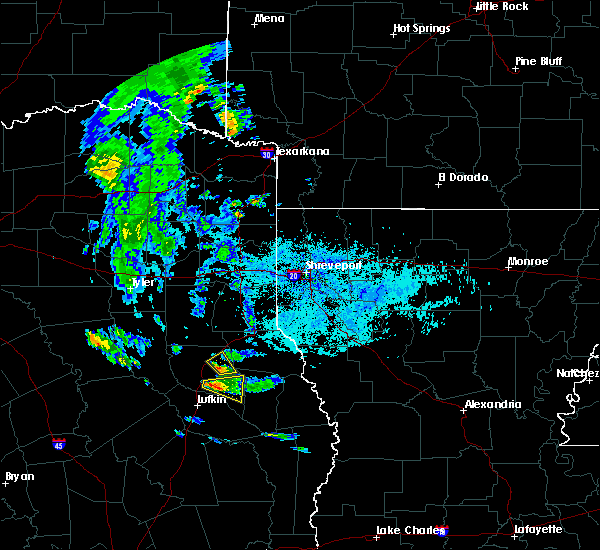 At 648 pm cdt, a severe thunderstorm was located near martinsville, or 8 miles northeast of nacogdoches, moving northeast at 20 mph (radar indicated). Hazards include 60 mph wind gusts and quarter size hail. Hail damage to vehicles is expected. expect wind damage to roofs, siding, and trees. Locations impacted include, martinsville and appleby. At 648 pm cdt, a severe thunderstorm was located near martinsville, or 8 miles northeast of nacogdoches, moving northeast at 20 mph (radar indicated). Hazards include 60 mph wind gusts and quarter size hail. Hail damage to vehicles is expected. expect wind damage to roofs, siding, and trees. Locations impacted include, martinsville and appleby.
|
| 6/4/2018 6:24 PM CDT |
 At 622 pm cdt, a severe thunderstorm was located over nacogdoches, moving northeast at 20 mph. at 615 pm, a wind gust of 60 mph was measured at nacogdoches regional airport (radar indicated). Hazards include 60 mph wind gusts and quarter size hail. Hail damage to vehicles is expected. Expect wind damage to roofs, siding, and trees. At 622 pm cdt, a severe thunderstorm was located over nacogdoches, moving northeast at 20 mph. at 615 pm, a wind gust of 60 mph was measured at nacogdoches regional airport (radar indicated). Hazards include 60 mph wind gusts and quarter size hail. Hail damage to vehicles is expected. Expect wind damage to roofs, siding, and trees.
|
| 4/6/2018 11:00 PM CDT |
 At 1059 pm cdt, severe thunderstorms were located along a line extending from near etoile to macune to 7 miles south of patroon, moving southeast at 15 mph. other strong to severe thunderstorms were indicated along a line from appleby to alto, moving south at 20 mph (radar indicated). Hazards include 60 mph wind gusts and quarter size hail. Hail damage to vehicles is expected. Expect wind damage to roofs, siding, and trees. At 1059 pm cdt, severe thunderstorms were located along a line extending from near etoile to macune to 7 miles south of patroon, moving southeast at 15 mph. other strong to severe thunderstorms were indicated along a line from appleby to alto, moving south at 20 mph (radar indicated). Hazards include 60 mph wind gusts and quarter size hail. Hail damage to vehicles is expected. Expect wind damage to roofs, siding, and trees.
|
| 4/6/2018 10:40 PM CDT |
 At 1040 pm cdt, a severe thunderstorm was located 8 miles southeast of martinsville, or 19 miles southwest of center, moving southeast at 20 mph. other strong to severe thunderstorms were indicated 5 miles north of appleby, also moving southeast at 20 mph (radar indicated). Hazards include 60 mph wind gusts and quarter size hail. Hail damage to vehicles is expected. expect wind damage to roofs, siding, and trees. locations impacted include, nacogdoches, center, milam, san augustine, hemphill, garrison, pineland, melrose, patroon, martinsville, bland lake, neuville, woden, rosevine, etoile, macune, shelbyville, appleby, chireno and huxley. A tornado watch remains in effect until 1100 pm cdt for northwestern louisiana, and eastern texas. At 1040 pm cdt, a severe thunderstorm was located 8 miles southeast of martinsville, or 19 miles southwest of center, moving southeast at 20 mph. other strong to severe thunderstorms were indicated 5 miles north of appleby, also moving southeast at 20 mph (radar indicated). Hazards include 60 mph wind gusts and quarter size hail. Hail damage to vehicles is expected. expect wind damage to roofs, siding, and trees. locations impacted include, nacogdoches, center, milam, san augustine, hemphill, garrison, pineland, melrose, patroon, martinsville, bland lake, neuville, woden, rosevine, etoile, macune, shelbyville, appleby, chireno and huxley. A tornado watch remains in effect until 1100 pm cdt for northwestern louisiana, and eastern texas.
|
| 4/6/2018 9:56 PM CDT |
 At 956 pm cdt, a severe thunderstorm was located near garrison, or 15 miles west of center, moving southeast at 20 mph (radar indicated). Hazards include 60 mph wind gusts and quarter size hail. Hail damage to vehicles is expected. Expect wind damage to roofs, siding, and trees. At 956 pm cdt, a severe thunderstorm was located near garrison, or 15 miles west of center, moving southeast at 20 mph (radar indicated). Hazards include 60 mph wind gusts and quarter size hail. Hail damage to vehicles is expected. Expect wind damage to roofs, siding, and trees.
|
| 4/6/2018 9:12 PM CDT |
 At 911 pm cdt, a severe thunderstorm was located near garrison, or 20 miles southwest of carthage, moving southeast at 35 mph (radar indicated). Hazards include 60 mph wind gusts and half dollar size hail. Hail damage to vehicles is expected. Expect wind damage to roofs, siding, and trees. At 911 pm cdt, a severe thunderstorm was located near garrison, or 20 miles southwest of carthage, moving southeast at 35 mph (radar indicated). Hazards include 60 mph wind gusts and half dollar size hail. Hail damage to vehicles is expected. Expect wind damage to roofs, siding, and trees.
|
| 4/3/2018 3:33 PM CDT |
 At 332 pm cdt, a severe thunderstorm was located 7 miles southwest of carthage, moving northeast at 65 mph (radar indicated). Hazards include 60 mph wind gusts and quarter size hail. Hail damage to vehicles is expected. expect wind damage to roofs, siding, and trees. Locations impacted include, henderson, sacul, new salem, minden, trawick, cushing, appleby, mount enterprise, reklaw, lawsonville, glenfawn, brachfield, lilbert, linwood, looneyville and laneville. At 332 pm cdt, a severe thunderstorm was located 7 miles southwest of carthage, moving northeast at 65 mph (radar indicated). Hazards include 60 mph wind gusts and quarter size hail. Hail damage to vehicles is expected. expect wind damage to roofs, siding, and trees. Locations impacted include, henderson, sacul, new salem, minden, trawick, cushing, appleby, mount enterprise, reklaw, lawsonville, glenfawn, brachfield, lilbert, linwood, looneyville and laneville.
|
| 4/3/2018 2:48 PM CDT |
 At 247 pm cdt, a severe thunderstorm was located near maydelle, or near rusk, moving northeast at 60 mph (radar indicated). Hazards include 60 mph wind gusts and quarter size hail. Hail damage to vehicles is expected. Expect wind damage to roofs, siding, and trees. At 247 pm cdt, a severe thunderstorm was located near maydelle, or near rusk, moving northeast at 60 mph (radar indicated). Hazards include 60 mph wind gusts and quarter size hail. Hail damage to vehicles is expected. Expect wind damage to roofs, siding, and trees.
|
| 12/19/2017 7:56 PM CST |
 At 755 pm cst, a severe thunderstorm was located over minden, or 9 miles southeast of henderson, and another thunderstorm near rusk moving northeast at 50 mph (radar indicated). Hazards include 60 mph wind gusts. expect damage to roofs, siding, and trees At 755 pm cst, a severe thunderstorm was located over minden, or 9 miles southeast of henderson, and another thunderstorm near rusk moving northeast at 50 mph (radar indicated). Hazards include 60 mph wind gusts. expect damage to roofs, siding, and trees
|
| 12/19/2017 7:50 PM CST |
 At 749 pm cst, a severe thunderstorm capable of producing a tornado was located near rusk, moving east at 40 mph (radar indicated rotation). Hazards include tornado. Flying debris will be dangerous to those caught without shelter. mobile homes will be damaged or destroyed. damage to roofs, windows, and vehicles will occur. tree damage is likely. this dangerous storm will be near, sacul and new salem around 805 pm cst. trawick around 815 pm cst. Other locations impacted by this tornadic thunderstorm include lilbert, mount enterprise, reklaw, looneyville, cushing, glenfawn and laneville. At 749 pm cst, a severe thunderstorm capable of producing a tornado was located near rusk, moving east at 40 mph (radar indicated rotation). Hazards include tornado. Flying debris will be dangerous to those caught without shelter. mobile homes will be damaged or destroyed. damage to roofs, windows, and vehicles will occur. tree damage is likely. this dangerous storm will be near, sacul and new salem around 805 pm cst. trawick around 815 pm cst. Other locations impacted by this tornadic thunderstorm include lilbert, mount enterprise, reklaw, looneyville, cushing, glenfawn and laneville.
|
| 12/19/2017 6:57 PM CST |
 At 656 pm cst, a severe thunderstorm was located over rusk, moving northeast at 55 mph (radar indicated). Hazards include 60 mph wind gusts. expect damage to roofs, siding, and trees At 656 pm cst, a severe thunderstorm was located over rusk, moving northeast at 55 mph (radar indicated). Hazards include 60 mph wind gusts. expect damage to roofs, siding, and trees
|
| 7/8/2017 5:32 PM CDT |
 At 532 pm cdt, a severe thunderstorm was located near nacogdoches, moving southeast at 15 mph (radar indicated). Hazards include 60 mph wind gusts and quarter size hail. Hail damage to vehicles is expected. Expect wind damage to roofs, siding, and trees. At 532 pm cdt, a severe thunderstorm was located near nacogdoches, moving southeast at 15 mph (radar indicated). Hazards include 60 mph wind gusts and quarter size hail. Hail damage to vehicles is expected. Expect wind damage to roofs, siding, and trees.
|
| 5/11/2017 8:35 PM CDT |
 At 835 pm cdt, severe thunderstorms were located along a line extending from garrison to 6 miles northwest of martinsville to 7 miles northeast of pollok to 8 miles northwest of apple springs, moving northeast at 60 mph (radar indicated). Hazards include 60 mph wind gusts and penny size hail. Expect damage to roofs, siding, and trees. Locations impacted include, lufkin, nacogdoches, hudson, garrison, melrose, woden, pollok, trawick, appleby, oak ridge, clawson, central, redland, looneyville and homer. At 835 pm cdt, severe thunderstorms were located along a line extending from garrison to 6 miles northwest of martinsville to 7 miles northeast of pollok to 8 miles northwest of apple springs, moving northeast at 60 mph (radar indicated). Hazards include 60 mph wind gusts and penny size hail. Expect damage to roofs, siding, and trees. Locations impacted include, lufkin, nacogdoches, hudson, garrison, melrose, woden, pollok, trawick, appleby, oak ridge, clawson, central, redland, looneyville and homer.
|
| 5/11/2017 7:40 PM CDT |
 At 740 pm cdt, severe thunderstorms were located along a line extending from near rusk to 9 miles north of kennard to near crockett, moving east at 45 mph (radar indicated). Hazards include 60 mph wind gusts and penny size hail. expect damage to roofs, siding, and trees At 740 pm cdt, severe thunderstorms were located along a line extending from near rusk to 9 miles north of kennard to near crockett, moving east at 45 mph (radar indicated). Hazards include 60 mph wind gusts and penny size hail. expect damage to roofs, siding, and trees
|
| 5/3/2017 5:21 PM CDT |
 At 520 pm cdt, a severe thunderstorm was located near center, moving east at 40 mph (radar indicated). Hazards include 60 mph wind gusts and quarter size hail. Hail damage to vehicles is expected. expect wind damage to roofs, siding, and trees. Locations impacted include, nacogdoches, center, garrison, patroon, shelbyville, martinsville, douglass, neuville, trawick, cushing, appleby, huxley, hurstown, james, jericho, stockman, arcadia, looneyville and jordans store. At 520 pm cdt, a severe thunderstorm was located near center, moving east at 40 mph (radar indicated). Hazards include 60 mph wind gusts and quarter size hail. Hail damage to vehicles is expected. expect wind damage to roofs, siding, and trees. Locations impacted include, nacogdoches, center, garrison, patroon, shelbyville, martinsville, douglass, neuville, trawick, cushing, appleby, huxley, hurstown, james, jericho, stockman, arcadia, looneyville and jordans store.
|
| 5/3/2017 4:35 PM CDT |
 At 435 pm cdt, a severe thunderstorm was located over trawick, or 10 miles north of nacogdoches, moving east at 40 mph (radar indicated). Hazards include 70 mph wind gusts and half dollar size hail. Hail damage to vehicles is expected. expect considerable tree damage. Wind damage is also likely to mobile homes, roofs, and outbuildings. At 435 pm cdt, a severe thunderstorm was located over trawick, or 10 miles north of nacogdoches, moving east at 40 mph (radar indicated). Hazards include 70 mph wind gusts and half dollar size hail. Hail damage to vehicles is expected. expect considerable tree damage. Wind damage is also likely to mobile homes, roofs, and outbuildings.
|
| 4/2/2017 1:47 PM CDT |
 At 147 pm cdt, a severe thunderstorm was located near garrison, or 13 miles north of nacogdoches, moving northeast at 50 mph (radar indicated). Hazards include 60 mph wind gusts and quarter size hail. Hail damage to vehicles is expected. expect wind damage to roofs, siding, and trees. locations impacted include, nacogdoches, martinsville, melrose, appleby and oak ridge. a tornado watch remains in effect until 600 pm cdt for eastern texas. A tornado watch also remains in effect until 900 pm cdt for eastern texas. At 147 pm cdt, a severe thunderstorm was located near garrison, or 13 miles north of nacogdoches, moving northeast at 50 mph (radar indicated). Hazards include 60 mph wind gusts and quarter size hail. Hail damage to vehicles is expected. expect wind damage to roofs, siding, and trees. locations impacted include, nacogdoches, martinsville, melrose, appleby and oak ridge. a tornado watch remains in effect until 600 pm cdt for eastern texas. A tornado watch also remains in effect until 900 pm cdt for eastern texas.
|
| 4/2/2017 1:30 PM CDT |
 At 130 pm cdt, a severe thunderstorm was located near douglass, or 11 miles northwest of nacogdoches, moving northeast at 50 mph (radar indicated). Hazards include 60 mph wind gusts and quarter size hail. Hail damage to vehicles is expected. expect wind damage to roofs, siding, and trees. locations impacted include, nacogdoches, melrose, martinsville, douglass, trawick, cushing, appleby, mount enterprise, oak ridge, lilbert, looneyville and lawsonville. A tornado watch remains in effect until 600 pm cdt for eastern and northeastern texas. At 130 pm cdt, a severe thunderstorm was located near douglass, or 11 miles northwest of nacogdoches, moving northeast at 50 mph (radar indicated). Hazards include 60 mph wind gusts and quarter size hail. Hail damage to vehicles is expected. expect wind damage to roofs, siding, and trees. locations impacted include, nacogdoches, melrose, martinsville, douglass, trawick, cushing, appleby, mount enterprise, oak ridge, lilbert, looneyville and lawsonville. A tornado watch remains in effect until 600 pm cdt for eastern and northeastern texas.
|
| 4/2/2017 1:09 PM CDT |
 At 108 pm cdt, a severe thunderstorm was located over forest, or 19 miles north of apple springs, moving northeast at 50 mph (radar indicated). Hazards include 60 mph wind gusts and quarter size hail. Hail damage to vehicles is expected. Expect wind damage to roofs, siding, and trees. At 108 pm cdt, a severe thunderstorm was located over forest, or 19 miles north of apple springs, moving northeast at 50 mph (radar indicated). Hazards include 60 mph wind gusts and quarter size hail. Hail damage to vehicles is expected. Expect wind damage to roofs, siding, and trees.
|
| 4/2/2017 12:42 PM CDT |
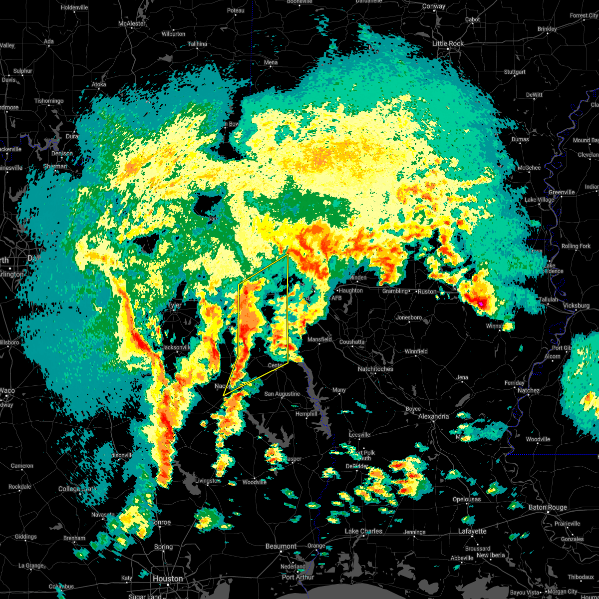 At 1242 pm cdt, severe thunderstorms were located along a line extending from 6 miles northeast of hallsville to 8 miles southeast of pinehill to near nacogdoches, moving northeast at 35 mph (radar indicated). Hazards include 60 mph wind gusts and quarter size hail. Hail damage to vehicles is expected. Expect wind damage to roofs, siding, and trees. At 1242 pm cdt, severe thunderstorms were located along a line extending from 6 miles northeast of hallsville to 8 miles southeast of pinehill to near nacogdoches, moving northeast at 35 mph (radar indicated). Hazards include 60 mph wind gusts and quarter size hail. Hail damage to vehicles is expected. Expect wind damage to roofs, siding, and trees.
|
| 4/2/2017 10:38 AM CDT | At 1038 am cdt, a severe thunderstorm was located near nacogdoches, moving northeast at 35 mph (radar indicated). Hazards include 60 mph wind gusts and quarter size hail. Hail damage to vehicles is expected. expect wind damage to roofs, siding, and trees. locations impacted include, nacogdoches, melrose, woden, martinsville, trawick, appleby and oak ridge. A tornado watch remains in effect until 600 pm cdt for eastern texas. |
| 4/2/2017 10:13 AM CDT | At 1012 am cdt, a severe thunderstorm was located 9 miles north of lufkin, moving north at 35 mph (radar indicated). Hazards include 60 mph wind gusts and quarter size hail. Hail damage to vehicles is expected. Expect wind damage to roofs, siding, and trees. |
| 3/24/2017 8:55 PM CDT |
 At 854 pm cdt, a severe thunderstorm was located near diboll, moving northeast at 65 mph (radar indicated). Hazards include 60 mph wind gusts and nickel size hail. expect damage to roofs, siding, and trees At 854 pm cdt, a severe thunderstorm was located near diboll, moving northeast at 65 mph (radar indicated). Hazards include 60 mph wind gusts and nickel size hail. expect damage to roofs, siding, and trees
|
| 1/2/2017 6:08 AM CST |
 At 607 am cst, severe thunderstorms were located along a line extending from 7 miles east of kennard to near corrigan, moving northeast at 60 mph (radar indicated). Hazards include 60 mph wind gusts and quarter size hail. Hail damage to vehicles is expected. Expect wind damage to roofs, siding, and trees. At 607 am cst, severe thunderstorms were located along a line extending from 7 miles east of kennard to near corrigan, moving northeast at 60 mph (radar indicated). Hazards include 60 mph wind gusts and quarter size hail. Hail damage to vehicles is expected. Expect wind damage to roofs, siding, and trees.
|
| 6/18/2016 4:03 PM CDT |
 At 402 pm cdt, severe thunderstorms were located along a line extending from near nacogdoches to 8 miles north of lufkin to 7 miles south of huntington to rockland, moving southwest at 35 mph (radar indicated). Hazards include 60 mph wind gusts. Expect damage to roofs. siding. and trees. Locations impacted include, lufkin, nacogdoches, diboll, hudson, huntington, wells, pollok, woden, etoile, melrose, burke, zavalla, appleby, oak ridge, central, dolan, homer, clawson, shawnee and redland. At 402 pm cdt, severe thunderstorms were located along a line extending from near nacogdoches to 8 miles north of lufkin to 7 miles south of huntington to rockland, moving southwest at 35 mph (radar indicated). Hazards include 60 mph wind gusts. Expect damage to roofs. siding. and trees. Locations impacted include, lufkin, nacogdoches, diboll, hudson, huntington, wells, pollok, woden, etoile, melrose, burke, zavalla, appleby, oak ridge, central, dolan, homer, clawson, shawnee and redland.
|
| 6/18/2016 3:47 PM CDT |
 At 346 pm cdt, severe thunderstorms were located along a line extending from near nacogdoches to 6 miles south of woden to 7 miles southeast of huntington to near ebenezer, moving southwest at 25 mph (radar indicated). Hazards include 60 mph wind gusts. Expect damage to roofs. siding. and trees. Locations impacted include, lufkin, nacogdoches, diboll, hudson, huntington, wells, pollok, woden, martinsville, etoile, melrose, burke, zavalla, appleby, chireno, broaddus, oak ridge, central, dolan and homer. At 346 pm cdt, severe thunderstorms were located along a line extending from near nacogdoches to 6 miles south of woden to 7 miles southeast of huntington to near ebenezer, moving southwest at 25 mph (radar indicated). Hazards include 60 mph wind gusts. Expect damage to roofs. siding. and trees. Locations impacted include, lufkin, nacogdoches, diboll, hudson, huntington, wells, pollok, woden, martinsville, etoile, melrose, burke, zavalla, appleby, chireno, broaddus, oak ridge, central, dolan and homer.
|
| 6/18/2016 3:13 PM CDT |
 At 312 pm cdt, severe thunderstorms were located along a line extending from 7 miles southeast of garrison to 9 miles southeast of melrose to 8 miles south of macune, moving southwest at 35 mph (radar indicated). Hazards include 60 mph wind gusts. Expect damage to roofs. siding. And trees. At 312 pm cdt, severe thunderstorms were located along a line extending from 7 miles southeast of garrison to 9 miles southeast of melrose to 8 miles south of macune, moving southwest at 35 mph (radar indicated). Hazards include 60 mph wind gusts. Expect damage to roofs. siding. And trees.
|
| 4/29/2016 8:46 PM CDT |
 At 846 pm cdt, a severe thunderstorm was located over nacogdoches, moving northeast at 55 mph (radar indicated). Hazards include 60 mph wind gusts and quarter size hail. Hail damage to vehicles is expected. Expect wind damage to roofs, siding, and trees. At 846 pm cdt, a severe thunderstorm was located over nacogdoches, moving northeast at 55 mph (radar indicated). Hazards include 60 mph wind gusts and quarter size hail. Hail damage to vehicles is expected. Expect wind damage to roofs, siding, and trees.
|
| 4/29/2016 7:59 PM CDT |
 At 759 pm cdt, a severe thunderstorm was located near forest, or 17 miles north of apple springs, moving northeast at 55 mph (radar indicated). Hazards include 60 mph wind gusts and quarter size hail. Hail damage to vehicles is expected. Expect wind damage to roofs, siding, and trees. At 759 pm cdt, a severe thunderstorm was located near forest, or 17 miles north of apple springs, moving northeast at 55 mph (radar indicated). Hazards include 60 mph wind gusts and quarter size hail. Hail damage to vehicles is expected. Expect wind damage to roofs, siding, and trees.
|
| 4/27/2016 4:32 AM CDT |
 At 431 am cdt, a severe thunderstorm was located near martinsville, or 13 miles northeast of nacogdoches, moving east at 60 mph (radar indicated). Hazards include 60 mph wind gusts and quarter size hail. Hail damage to vehicles is expected. Expect wind damage to roofs, siding, and trees. At 431 am cdt, a severe thunderstorm was located near martinsville, or 13 miles northeast of nacogdoches, moving east at 60 mph (radar indicated). Hazards include 60 mph wind gusts and quarter size hail. Hail damage to vehicles is expected. Expect wind damage to roofs, siding, and trees.
|
| 4/27/2016 3:53 AM CDT |
 At 351 am cdt, a line of severe thunderstorms was located near forest, or 18 miles south of rusk, moving east at 60 mph (radar indicated). Hazards include 60 mph wind gusts and quarter size hail. Hail damage to vehicles is expected. Expect wind damage to roofs, siding, and trees. At 351 am cdt, a line of severe thunderstorms was located near forest, or 18 miles south of rusk, moving east at 60 mph (radar indicated). Hazards include 60 mph wind gusts and quarter size hail. Hail damage to vehicles is expected. Expect wind damage to roofs, siding, and trees.
|
| 1/21/2016 11:29 AM CST |
 At 1128 am cst, a severe thunderstorm was located near nacogdoches, moving northeast at 40 mph (radar indicated). Hazards include quarter size hail. damage to vehicles is expected At 1128 am cst, a severe thunderstorm was located near nacogdoches, moving northeast at 40 mph (radar indicated). Hazards include quarter size hail. damage to vehicles is expected
|
| 1/8/2016 6:16 PM CST |
 At 616 pm cst, a severe thunderstorm was located near woden, or 6 miles southeast of nacogdoches, moving northeast at 35 mph (radar indicated). Hazards include quarter size hail. Damage to vehicles is expected. Locations impacted include, nacogdoches, garrison, martinsville, woden, melrose, appleby, oak ridge, arcadia and stockman. At 616 pm cst, a severe thunderstorm was located near woden, or 6 miles southeast of nacogdoches, moving northeast at 35 mph (radar indicated). Hazards include quarter size hail. Damage to vehicles is expected. Locations impacted include, nacogdoches, garrison, martinsville, woden, melrose, appleby, oak ridge, arcadia and stockman.
|
| 1/8/2016 5:53 PM CST |
 At 553 pm cst, a severe thunderstorm was located 7 miles north of lufkin, moving northeast at 50 mph (radar indicated). Hazards include quarter size hail. damage to vehicles is expected At 553 pm cst, a severe thunderstorm was located 7 miles north of lufkin, moving northeast at 50 mph (radar indicated). Hazards include quarter size hail. damage to vehicles is expected
|
| 12/27/2015 10:45 AM CST |
 At 1044 am cst, a severe thunderstorm capable of producing a tornado was located 8 miles south of garrison, or 9 miles northeast of nacogdoches, moving north at 45 mph (radar indicated rotation). Hazards include tornado and quarter size hail. Flying debris will be dangerous to those caught without shelter. mobile homes will be damaged or destroyed. damage to roofs, windows, and vehicles will occur. tree damage is likely. this dangerous storm will be near, garrison around 1055 am cst. timpson around 1100 am cst. Other locations impacted by this tornadic thunderstorm include appleby, stockman and mount enterprise. At 1044 am cst, a severe thunderstorm capable of producing a tornado was located 8 miles south of garrison, or 9 miles northeast of nacogdoches, moving north at 45 mph (radar indicated rotation). Hazards include tornado and quarter size hail. Flying debris will be dangerous to those caught without shelter. mobile homes will be damaged or destroyed. damage to roofs, windows, and vehicles will occur. tree damage is likely. this dangerous storm will be near, garrison around 1055 am cst. timpson around 1100 am cst. Other locations impacted by this tornadic thunderstorm include appleby, stockman and mount enterprise.
|
| 12/27/2015 10:34 AM CST |
 The national weather service in shreveport has issued a * tornado warning for. southeastern rusk county in northeastern texas. northeastern nacogdoches county in eastern texas. northwestern shelby county in eastern texas. Until 1100 am cst. The national weather service in shreveport has issued a * tornado warning for. southeastern rusk county in northeastern texas. northeastern nacogdoches county in eastern texas. northwestern shelby county in eastern texas. Until 1100 am cst.
|
| 8/24/2015 6:22 PM CDT |
 The severe thunderstorm warning for north central nacogdoches county will expire at 630 pm cdt, the storm which prompted the warning has weakened below severe limits, and no longer pose an immediate threat to life or property. therefore the warning will be allowed to expire. however gusty winds along decayed outflow boundaries near 30 mph are still possible with the remnants of this thunderstorm. The severe thunderstorm warning for north central nacogdoches county will expire at 630 pm cdt, the storm which prompted the warning has weakened below severe limits, and no longer pose an immediate threat to life or property. therefore the warning will be allowed to expire. however gusty winds along decayed outflow boundaries near 30 mph are still possible with the remnants of this thunderstorm.
|
| 8/24/2015 5:44 PM CDT |
 At 543 pm cdt, a severe thunderstorm was located near trawick, or 8 miles north of nacogdoches, moving south at 15 mph (radar indicated). Hazards include 60 mph wind gusts and penny size hail. Expect damage to roofs. Siding and trees. At 543 pm cdt, a severe thunderstorm was located near trawick, or 8 miles north of nacogdoches, moving south at 15 mph (radar indicated). Hazards include 60 mph wind gusts and penny size hail. Expect damage to roofs. Siding and trees.
|
| 5/30/2015 6:13 PM CDT | At 613 pm cdt, a severe thunderstorm capable of producing a tornado was located near trawick, or 11 miles north of nacogdoches, moving east southeast near 15 mph (radar indicated rotation). Hazards include tornado. Flying debris will be dangerous to those caught without shelter. mobile homes will be damaged or destroyed. damage to roofs, windows and vehicles will occur. tree damage is likely. This tornadic thunderstorm will remain over mainly rural areas of north central nacogdoches county, including the following locations, appleby. |
| 5/30/2015 5:57 PM CDT | At 556 pm cdt, a severe thunderstorm capable of producing a tornado was located near trawick, or 12 miles north of nacogdoches, moving east at 15 mph (radar indicated rotation). Hazards include tornado. Flying debris will be dangerous to those caught without shelter. mobile homes will be damaged or destroyed. damage to roofs, windows and vehicles will occur. tree damage is likely. this dangerous storm will be near, garrison around 630 pm cdt. Other locations impacted by this tornadic thunderstorm include appleby and garrison. |
| 5/30/2015 5:41 PM CDT | At 540 pm cdt, a severe thunderstorm capable of producing a tornado was located near trawick, or 13 miles north of nacogdoches, moving east southeast at 25 mph (radar indicated rotation). Hazards include tornado. Flying debris will be dangerous to those caught without shelter. mobile homes will be damaged or destroyed. damage to roofs, windows and vehicles will occur. tree damage is likely. this dangerous storm will be near, garrison around 610 pm cdt. Other locations impacted by this tornadic thunderstorm include appleby and garrison. |
| 5/25/2015 7:27 PM CDT | At 726 pm cdt, severe thunderstorms were located along a line extending from berea to near woodlawn to 8 miles northeast of beckville to near garrison to diboll, moving east at 65 mph (radar indicated). Hazards include 70 mph wind gusts and quarter size hail. Hail damage to vehicles is expected. expect considerable tree damage. Wind damage is also likely to mobile homes, roofs and outbuildings. |
| 5/25/2015 7:27 PM CDT | At 726 pm cdt, severe thunderstorms were located along a line extending from berea to near woodlawn to 8 miles northeast of beckville to near garrison to diboll, moving east at 65 mph (radar indicated). Hazards include 70 mph wind gusts and quarter size hail. Hail damage to vehicles is expected. expect considerable tree damage. Wind damage is also likely to mobile homes, roofs and outbuildings. |
| 5/25/2015 7:11 PM CDT | At 711 pm cdt, severe thunderstorms were located along a line extending from near harleton to 6 miles northeast of pinehill to 8 miles east of trawick to near hudson, moving east at 45 mph (radar indicated). Hazards include 70 mph wind gusts and quarter size hail. Hail damage to vehicles is expected. expect considerable tree damage. wind damage is also likely to mobile homes, roofs and outbuildings. locations impacted include, longview, nacogdoches, marshall, henderson, kilgore, carthage, white oak, gladewater, center, hudson, hallsville, tatum, tenaha, timpson, garrison, clarksville city, beckville, joaquin, east mountain and wells. a tornado watch remains in effect until 1000 pm cdt for northeastern texas. A tornado watch also remains in effect until 200 am cdt for northwestern louisiana. |
| 5/25/2015 6:36 PM CDT | At 636 pm cdt, severe thunderstorms were located along a line extending from near lindale to near troup to near sacul to near kennard, moving east at 60 mph (radar indicated). Hazards include 70 mph wind gusts and quarter size hail. Hail damage to vehicles is expected. expect considerable tree damage. Wind damage is also likely to mobile homes, roofs and outbuildings. |
| 5/19/2015 7:13 PM CDT | The severe thunderstorm warning for north central nacogdoches county will expire at 715 pm cdt. the storm which prompted the warning has weakened below severe limits. and no longer pose an immediate threat to life or property. therefore the warning will be allowed to expire. The thunderstorms was 6 miles northeast of appleby. |
| 5/19/2015 6:58 PM CDT | At 658 pm cdt, the original severe thunderstorm has weakened and was no longer severe. however, a developing strong thunderstorm was located 7 miles west of garrison, or 12 miles north of nacogdoches, moving north at 20 mph. this storm has shown signs of further intensification, and may become severe shortly (radar indicated). Hazards include 60 mph wind gusts. Expect damage to roofs. siding and trees. Locations impacted include, appleby. |
| 5/19/2015 6:20 PM CDT | At 619 pm cdt, a severe thunderstorm was located near nacogdoches, moving north at 20 mph (radar indicated). Hazards include 60 mph wind gusts and quarter size hail. Hail damage to vehicles is expected. Expect wind damage to roofs, siding and trees. |
| 4/27/2015 5:18 AM CDT | At 517 am cdt, severe thunderstorms were located along a line extending from near sacul to 6 miles east of douglass to near nacogdoches to 7 miles southwest of woden to 6 miles northeast of lufkin, moving east at 50 mph (radar indicated). Hazards include 60 mph wind gusts and quarter size hail. Hail damage to vehicles is expected. Expect wind damage to roofs, siding and trees. |
| 4/27/2015 4:53 AM CDT | At 452 am cdt, severe thunderstorms were located along a line extending from near alto to near wells to near hudson, moving east at 40 mph (radar indicated). Hazards include 60 mph wind gusts and quarter size hail. Hail damage to vehicles is expected. expect wind damage to roofs, siding and trees. locations impacted include, lufkin, nacogdoches, hudson, huntington, alto, wells, pollok, woden, forest, douglass, morrill, appleby, oak ridge, central, linwood, clawson and redland. a tornado watch remains in effect until 900 am cdt for northeastern texas. 1. 00in. |
| 4/27/2015 4:50 AM CDT | At 449 am cdt, severe thunderstorms were located along a line extending from near rusk to near ponta to near sacul to near douglass, moving east at 35 mph (radar indicated). Hazards include 60 mph wind gusts and quarter size hail. Hail damage to vehicles is expected. Expect wind damage to roofs, siding and trees. |
| 4/27/2015 4:32 AM CDT | At 432 am cdt, severe thunderstorms were located along a line extending from near alto to near forest to 7 miles northeast of kennard, moving east at 40 mph (radar indicated). Hazards include 60 mph wind gusts and quarter size hail. Hail damage to vehicles is expected. Expect wind damage to roofs, siding and trees. |
| 4/24/2015 11:02 PM CDT | At 1101 pm cdt, severe thunderstorms were located along a line extending from 6 miles west of marshall to 6 miles east of tatum to near beckville to near pinehill to 6 miles northwest of trawick, moving east at 55 mph (radar indicated). Hazards include 70 mph wind gusts and quarter size hail. Hail damage to vehicles is expected. expect considerable tree damage. wind damage is also likely to mobile homes, roofs and outbuildings. severe thunderstorms will be near, beckville around 1105 pm cdt. marshall and carthage around 1110 pm cdt. garrison, deberry and elysian fields around 1120 pm cdt. waskom and tenaha around 1125 pm cdt. greenwood, logansport and joaquin around 1135 pm cdt. stonewall around 1145 pm cdt. mansfield around 1155 pm cdt. other locations impacted by these severe thunderstorms include front, jericho, woods, keat chie, paxton, gary city, dotson, stanley, mount enterprise and oak ridge. a tornado watch remains in effect until 400 am cdt for northwestern louisiana and northeastern texas. Possible. |
| 4/24/2015 11:02 PM CDT | At 1101 pm cdt, severe thunderstorms were located along a line extending from 6 miles west of marshall to 6 miles east of tatum to near beckville to near pinehill to 6 miles northwest of trawick, moving east at 55 mph (radar indicated). Hazards include 70 mph wind gusts and quarter size hail. Hail damage to vehicles is expected. expect considerable tree damage. wind damage is also likely to mobile homes, roofs and outbuildings. severe thunderstorms will be near, beckville around 1105 pm cdt. marshall and carthage around 1110 pm cdt. garrison, deberry and elysian fields around 1120 pm cdt. waskom and tenaha around 1125 pm cdt. greenwood, logansport and joaquin around 1135 pm cdt. stonewall around 1145 pm cdt. mansfield around 1155 pm cdt. other locations impacted by these severe thunderstorms include front, jericho, woods, keat chie, paxton, gary city, dotson, stanley, mount enterprise and oak ridge. a tornado watch remains in effect until 400 am cdt for northwestern louisiana and northeastern texas. Possible. |
| 4/19/2015 5:42 PM CDT | At 541 pm cdt, a severe thunderstorm was located near nacogdoches, moving east at 30 mph (radar indicated). Hazards include 70 mph wind gusts and quarter size hail. Hail damage to vehicles is expected. expect considerable tree damage. wind damage is also likely to mobile homes, roofs and outbuildings. this severe thunderstorm will be near, nacogdoches around 550 pm cdt. melrose around 610 pm cdt. martinsville around 615 pm cdt. other locations impacted by this severe thunderstorm include oak ridge and appleby. 1. 00in. |
Hail Maps for Appleby, TX

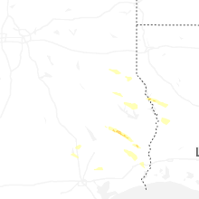
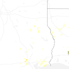
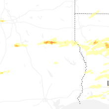
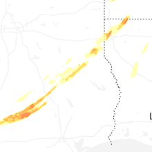


Connect with Interactive Hail Maps