

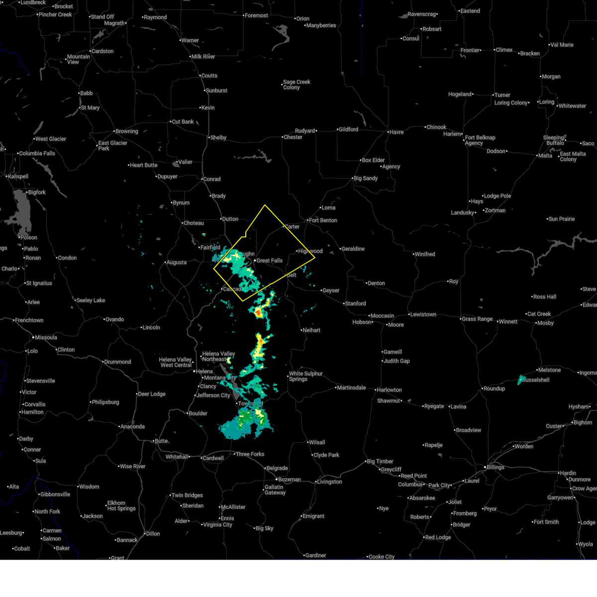
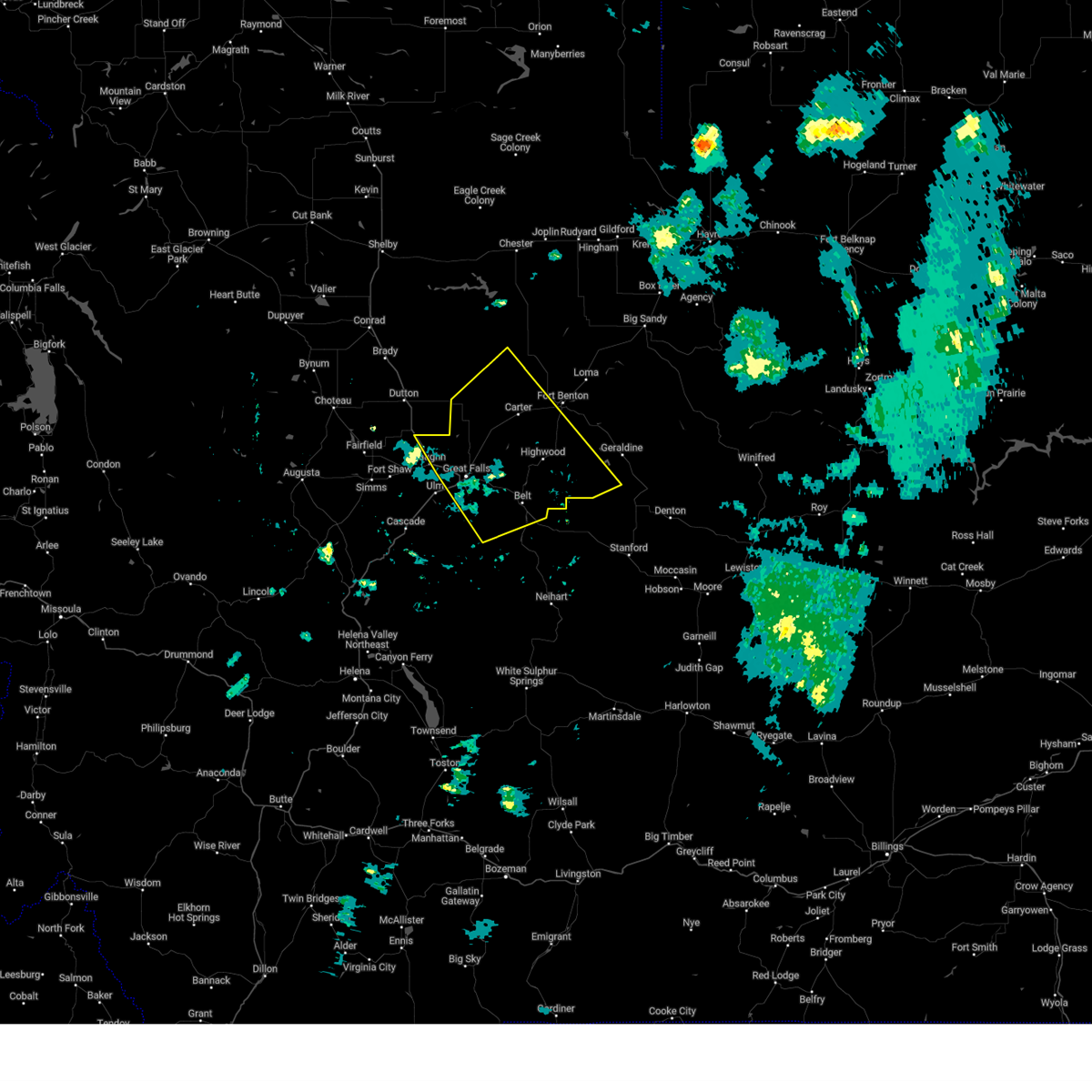
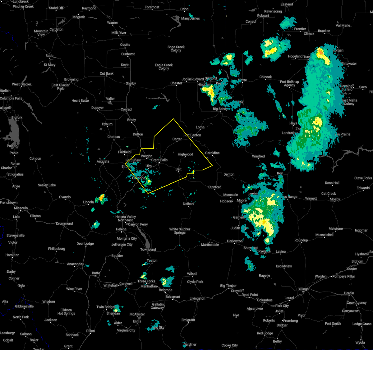
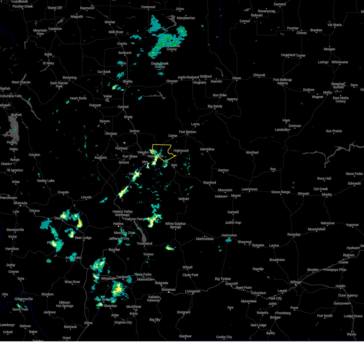
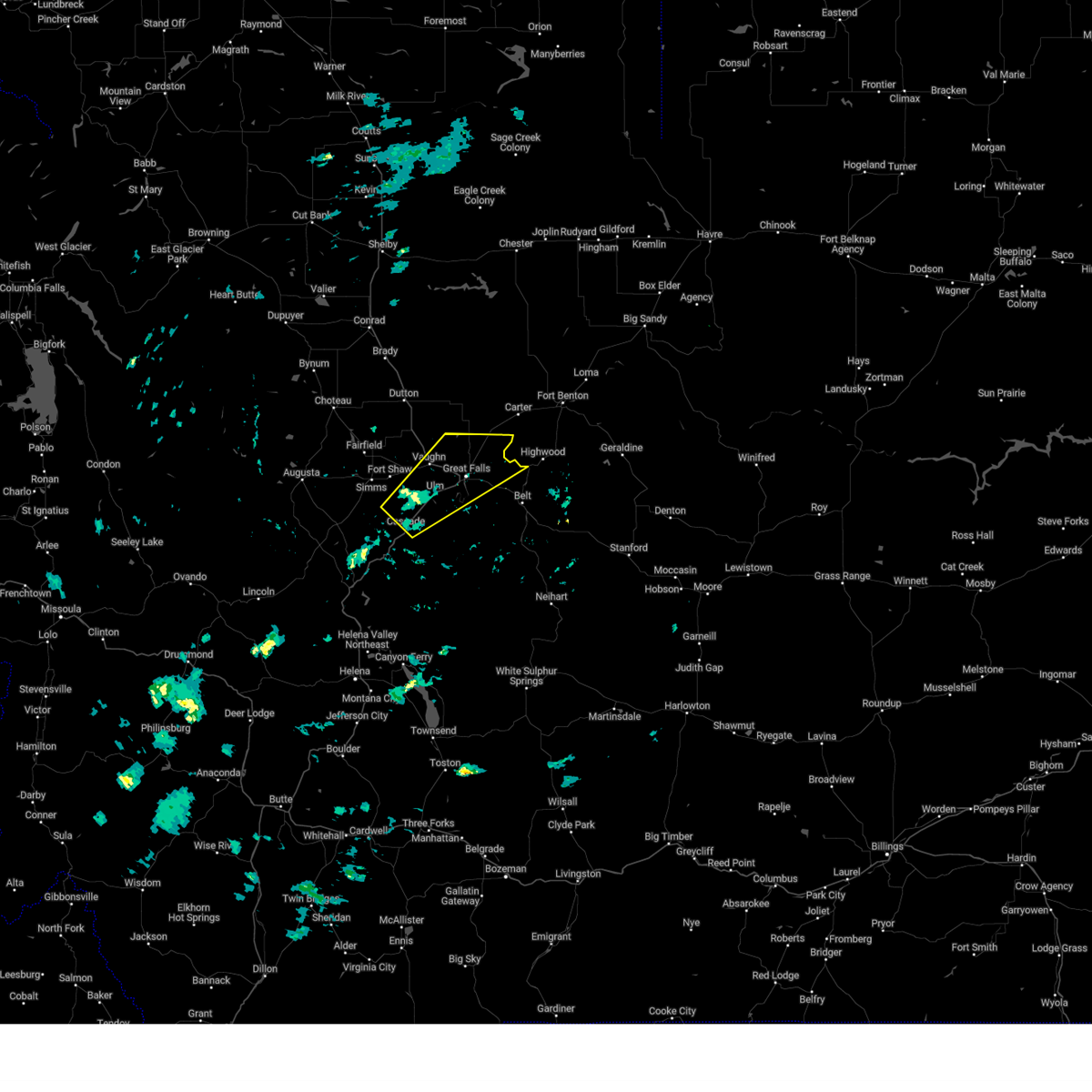
Hail Map for Black Eagle, MT
The Black Eagle, MT area has had 2 reports of on-the-ground hail by trained spotters, and has been under severe weather warnings 26 times during the past 12 months. Doppler radar has detected hail at or near Black Eagle, MT on 26 occasions, including 1 occasion during the past year.
| Name: | Black Eagle, MT |
| Where Located: | 2.1 miles NE of Great Falls, MT |
| Map: | Google Map for Black Eagle, MT |
| Population: | 904 |
| Housing Units: | 474 |
| More Info: | Search Google for Black Eagle, MT |
1
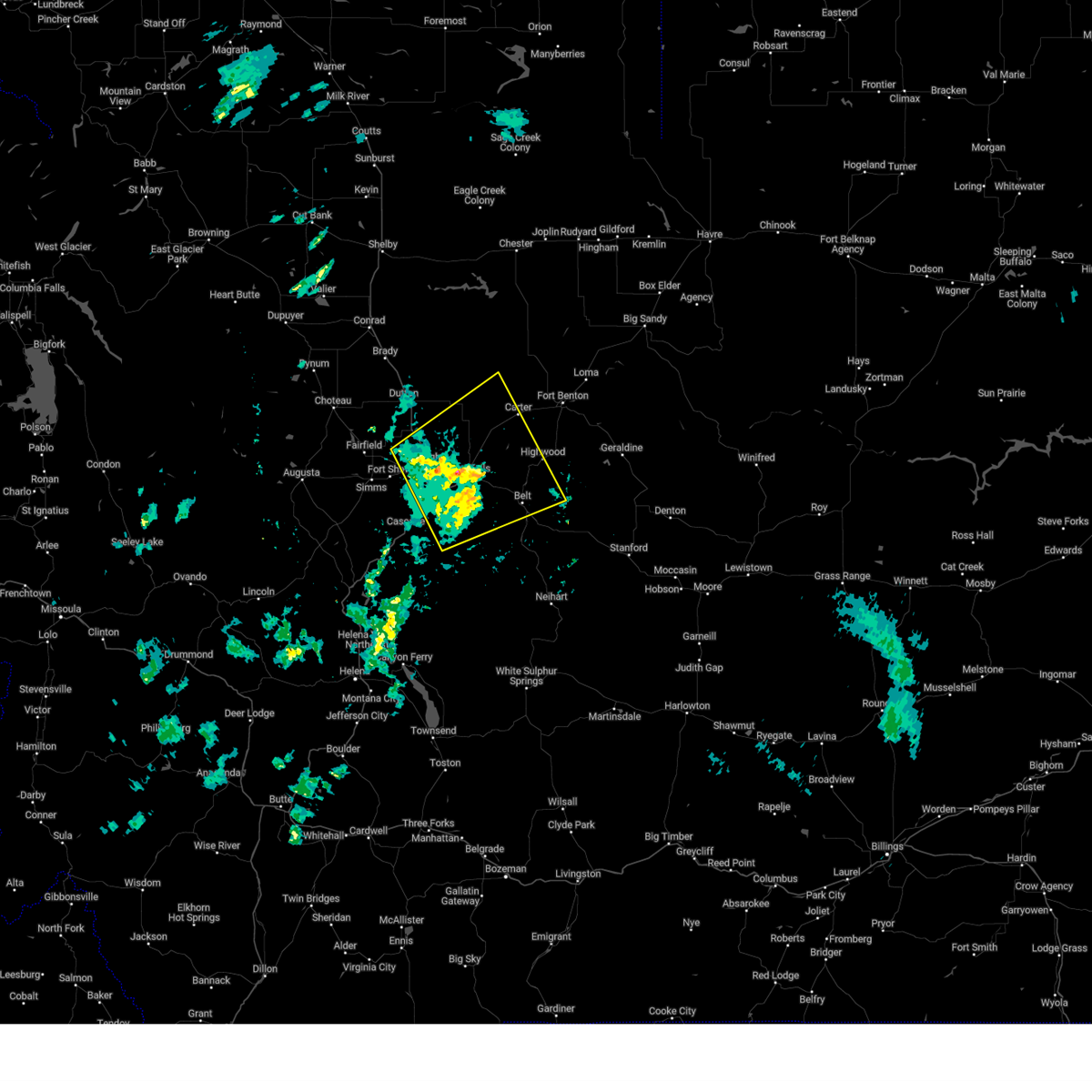
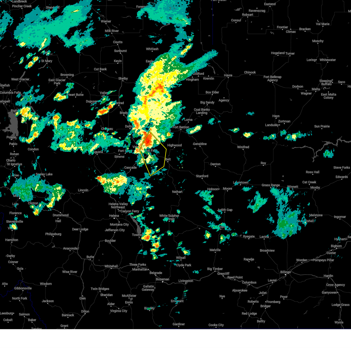
The Top Recent Hail Date for Black Eagle, MT is Thursday, July 31, 2025 (3rd out of 26)
Hail and Wind Damage Spotted near Black Eagle, MT
| Date / Time | Report Details |
|---|---|
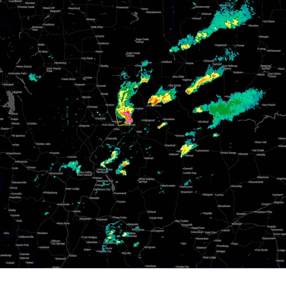
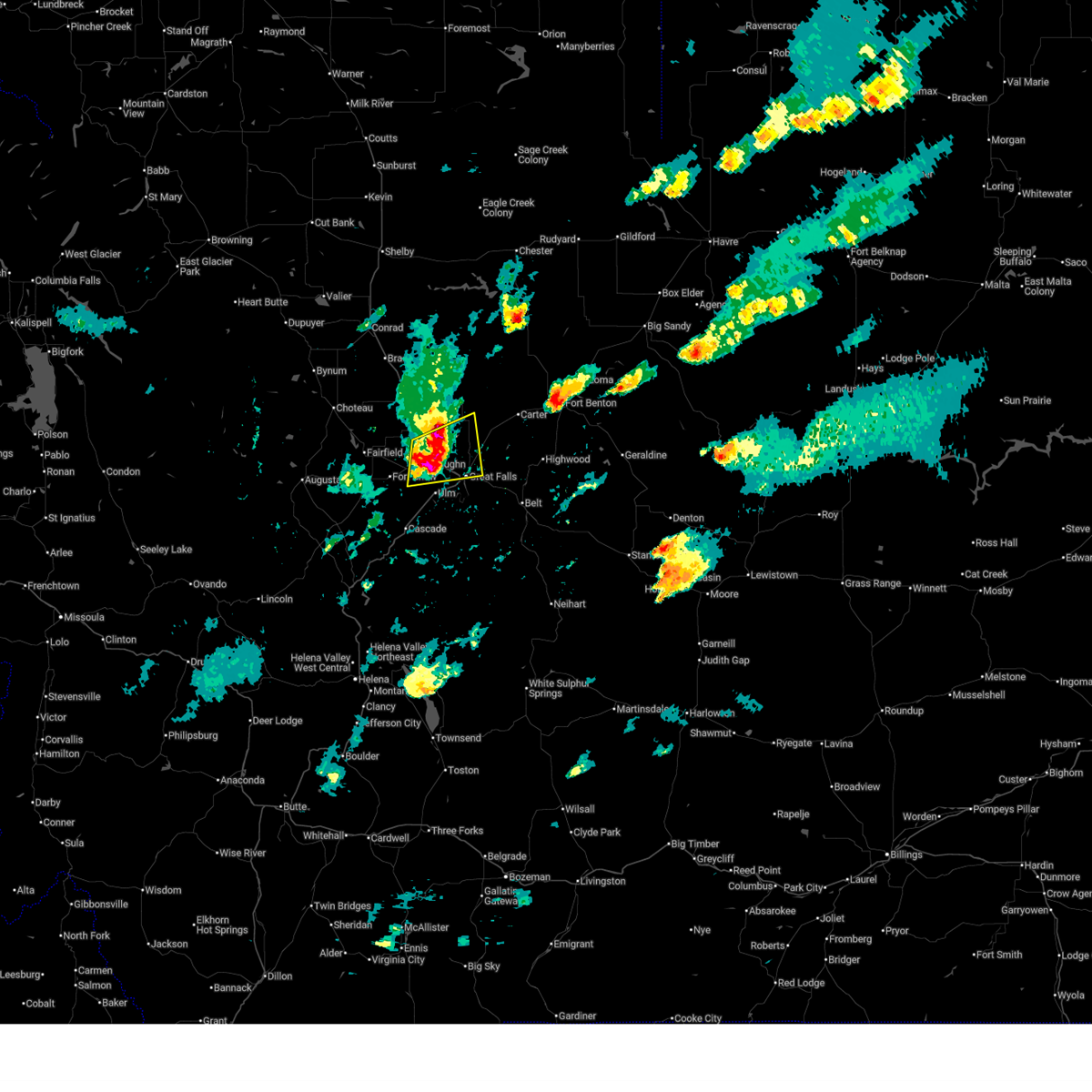
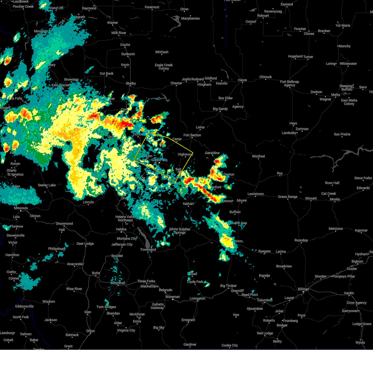
| 5/13/2026 3:30 PM MDT |
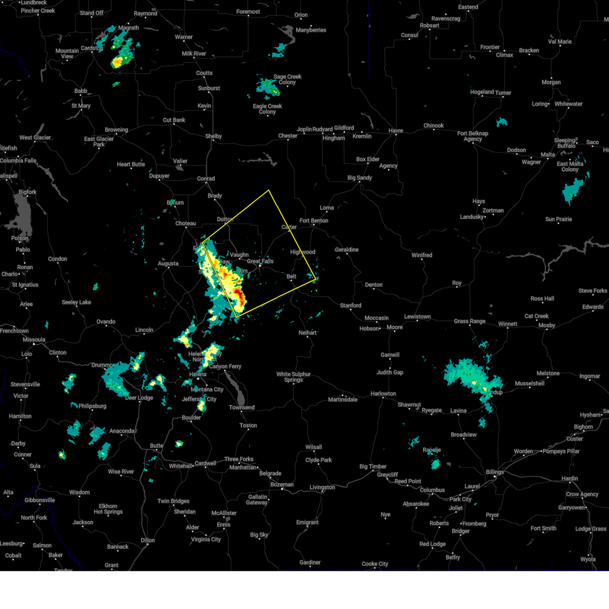
 The storm which prompted the warning has moved out of the area. therefore, the warning has been allowed to expire. a severe thunderstorm watch remains in effect until 900 pm mdt for central and north central montana. remember, a severe thunderstorm warning still remains in effect for northern cascade and chouteau counties until 415 pm. The storm which prompted the warning has moved out of the area. therefore, the warning has been allowed to expire. a severe thunderstorm watch remains in effect until 900 pm mdt for central and north central montana. remember, a severe thunderstorm warning still remains in effect for northern cascade and chouteau counties until 415 pm.
|
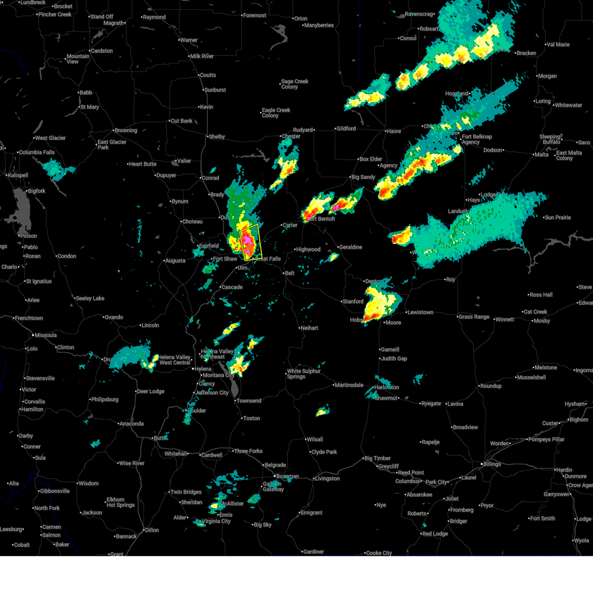
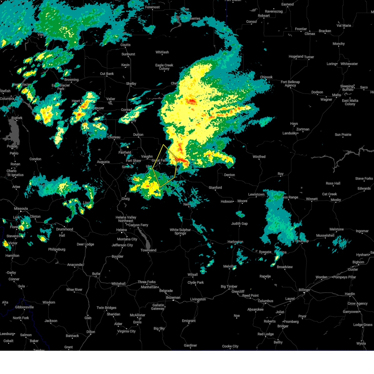
| 5/13/2026 3:00 PM MDT |
 At 259 pm mdt, a severe thunderstorm was located 7 miles west of great falls, moving northeast at 55 mph (radar indicated). Hazards include 70 mph wind gusts. Expect considerable tree damage. damage is likely to mobile homes, roofs, and outbuildings. blowing dust will reduce visibility to less than one mile. Locations impacted include, great falls, cascade, black eagle, carter, floweree, portage, malmstrom afb, eden, stockett, tracy, vaughn, first peoples buffalo jump state park, sun river, centerville, ulm, and sand coulee. At 259 pm mdt, a severe thunderstorm was located 7 miles west of great falls, moving northeast at 55 mph (radar indicated). Hazards include 70 mph wind gusts. Expect considerable tree damage. damage is likely to mobile homes, roofs, and outbuildings. blowing dust will reduce visibility to less than one mile. Locations impacted include, great falls, cascade, black eagle, carter, floweree, portage, malmstrom afb, eden, stockett, tracy, vaughn, first peoples buffalo jump state park, sun river, centerville, ulm, and sand coulee.
|
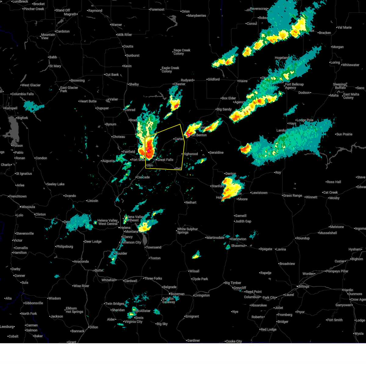
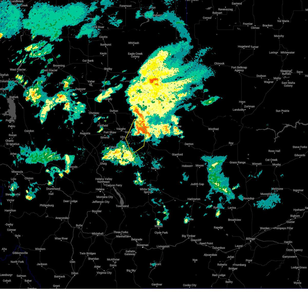
| 5/13/2026 2:50 PM MDT |
 Svrtfx the national weather service in great falls has issued a * severe thunderstorm warning for, southeastern teton county in north central montana, southwestern chouteau county in north central montana, northwestern cascade county in central montana, * until 330 pm mdt. * at 249 pm mdt, a severe thunderstorm was located 8 miles northeast of cascade, moving northeast at 55 mph (radar indicated). Hazards include 70 mph wind gusts. Expect considerable tree damage. Damage is likely to mobile homes, roofs, and outbuildings. Svrtfx the national weather service in great falls has issued a * severe thunderstorm warning for, southeastern teton county in north central montana, southwestern chouteau county in north central montana, northwestern cascade county in central montana, * until 330 pm mdt. * at 249 pm mdt, a severe thunderstorm was located 8 miles northeast of cascade, moving northeast at 55 mph (radar indicated). Hazards include 70 mph wind gusts. Expect considerable tree damage. Damage is likely to mobile homes, roofs, and outbuildings.
|
| 12/26/2025 12:27 PM MST |
 At 1227 pm mst, a gusty shower was located along a line extending from 9 miles southeast of power to 7 miles west of great falls to 12 miles southwest of black eagle to 14 miles east of cascade, moving northeast at 45 mph (radar indicated). Hazards include 60 mph wind gusts. Expect damage to roofs, siding, and trees. Locations impacted include, great falls, belt, black eagle, highwood, power, carter, floweree, portage, malmstrom afb, sluice boxes state park, eden, stockett, tracy, vaughn, first peoples buffalo jump state park, centerville, armington, ulm, and sand coulee. At 1227 pm mst, a gusty shower was located along a line extending from 9 miles southeast of power to 7 miles west of great falls to 12 miles southwest of black eagle to 14 miles east of cascade, moving northeast at 45 mph (radar indicated). Hazards include 60 mph wind gusts. Expect damage to roofs, siding, and trees. Locations impacted include, great falls, belt, black eagle, highwood, power, carter, floweree, portage, malmstrom afb, sluice boxes state park, eden, stockett, tracy, vaughn, first peoples buffalo jump state park, centerville, armington, ulm, and sand coulee.
|
| 12/26/2025 12:23 PM MST |
 Svrtfx the national weather service in great falls has issued a * severe thunderstorm warning for, southeastern teton county in north central montana, southwestern chouteau county in north central montana, northeastern cascade county in central montana, * until 115 pm mst. * at 1222 pm mst, a gusty shower was located along a line extending from 8 miles southeast of power to 8 miles west of great falls to 14 miles southwest of black eagle to 13 miles southeast of cascade, moving northeast at 45 mph (radar indicated). Hazards include 60 mph wind gusts. expect damage to roofs, siding, and trees Svrtfx the national weather service in great falls has issued a * severe thunderstorm warning for, southeastern teton county in north central montana, southwestern chouteau county in north central montana, northeastern cascade county in central montana, * until 115 pm mst. * at 1222 pm mst, a gusty shower was located along a line extending from 8 miles southeast of power to 8 miles west of great falls to 14 miles southwest of black eagle to 13 miles southeast of cascade, moving northeast at 45 mph (radar indicated). Hazards include 60 mph wind gusts. expect damage to roofs, siding, and trees
|
| 9/14/2025 9:11 PM MDT | The storms which prompted the warning have weakened below severe limits, and no longer pose an immediate threat to life or property. therefore, the warning will be allowed to expire. however, gusty winds are still possible with these thunderstorms. |
| 9/14/2025 8:27 PM MDT | the severe thunderstorm warning has been cancelled and is no longer in effect |
| 9/14/2025 8:27 PM MDT | At 827 pm mdt, severe thunderstorms were located along a line extending from fort shaw to 8 miles north of cascade to 23 miles east of wolf creek, moving northeast at 40 mph (radar indicated). Hazards include 60 mph wind gusts. Expect damage to roofs, siding, and trees. Locations impacted include, great falls, cascade, belt, black eagle, fort shaw, fort shaw, portage, malmstrom afb, eden, stockett, tracy, vaughn, first peoples buffalo jump state park, centerville, sun river, armington, ulm, sand coulee, and simms. |
| 9/14/2025 8:12 PM MDT | Svrtfx the national weather service in great falls has issued a * severe thunderstorm warning for, northwestern meagher county in central montana, cascade county in central montana, * until 915 pm mdt. * at 812 pm mdt, severe thunderstorms were located along a line extending from 11 miles southwest of fort shaw to near cascade to 14 miles east of wolf creek, moving east at 45 mph (radar indicated). Hazards include 60 mph wind gusts. expect damage to roofs, siding, and trees |
| 8/19/2025 11:33 PM MDT |
 the severe thunderstorm warning has been cancelled and is no longer in effect the severe thunderstorm warning has been cancelled and is no longer in effect
|
| 8/19/2025 11:03 PM MDT |
 At 1103 pm mdt, severe thunderstorms were located along a line extending from 13 miles east of power to near great falls to 12 miles southwest of black eagle, moving east at 10 mph (radar indicated). Hazards include 60 mph wind gusts. Expect damage to roofs, siding, and trees. Locations impacted include, great falls, black eagle, floweree, ulm, portage, malmstrom afb, sand coulee, tracy, vaughn, first peoples buffalo jump state park, and centerville. At 1103 pm mdt, severe thunderstorms were located along a line extending from 13 miles east of power to near great falls to 12 miles southwest of black eagle, moving east at 10 mph (radar indicated). Hazards include 60 mph wind gusts. Expect damage to roofs, siding, and trees. Locations impacted include, great falls, black eagle, floweree, ulm, portage, malmstrom afb, sand coulee, tracy, vaughn, first peoples buffalo jump state park, and centerville.
|
| 8/19/2025 10:45 PM MDT |
 The storms which prompted the warning have moved out of the area. therefore, the warning will be allowed to expire. remember, a severe thunderstorm warning still remains in effect for for northwestern cascade, southeastern teton, and central choteau counties until 1215 am mdt. The storms which prompted the warning have moved out of the area. therefore, the warning will be allowed to expire. remember, a severe thunderstorm warning still remains in effect for for northwestern cascade, southeastern teton, and central choteau counties until 1215 am mdt.
|
| 8/19/2025 10:43 PM MDT |
 Svrtfx the national weather service in great falls has issued a * severe thunderstorm warning for, east central teton county in north central montana, southwestern chouteau county in north central montana, north central cascade county in central montana, * until 1215 am mdt. * at 1042 pm mdt, severe thunderstorms were located along a line extending from 10 miles northeast of power to near great falls to 12 miles northeast of cascade, moving east at 10 mph (trained weather spotters. at 1041 pm mdt the great falls asos measured a 64 mph wind gust). Hazards include 60 mph wind gusts. expect damage to roofs, siding, and trees Svrtfx the national weather service in great falls has issued a * severe thunderstorm warning for, east central teton county in north central montana, southwestern chouteau county in north central montana, north central cascade county in central montana, * until 1215 am mdt. * at 1042 pm mdt, severe thunderstorms were located along a line extending from 10 miles northeast of power to near great falls to 12 miles northeast of cascade, moving east at 10 mph (trained weather spotters. at 1041 pm mdt the great falls asos measured a 64 mph wind gust). Hazards include 60 mph wind gusts. expect damage to roofs, siding, and trees
|
| 8/19/2025 10:30 PM MDT |
 At 1029 pm mdt, severe thunderstorms were located along a line extending from near dutton to near great falls to 12 miles east of cascade, moving east at 40 mph (trained weather spotters. at 1027 pm mdt the great falls asos measured a 64 mph wind gust). Hazards include 70 mph wind gusts. Expect considerable tree damage. damage is likely to mobile homes, roofs, and outbuildings. Locations impacted include, great falls, black eagle, fort shaw, fort shaw, power, malmstrom afb, stockett, tracy, vaughn, first peoples buffalo jump state park, centerville, sun river, ulm, and sand coulee. At 1029 pm mdt, severe thunderstorms were located along a line extending from near dutton to near great falls to 12 miles east of cascade, moving east at 40 mph (trained weather spotters. at 1027 pm mdt the great falls asos measured a 64 mph wind gust). Hazards include 70 mph wind gusts. Expect considerable tree damage. damage is likely to mobile homes, roofs, and outbuildings. Locations impacted include, great falls, black eagle, fort shaw, fort shaw, power, malmstrom afb, stockett, tracy, vaughn, first peoples buffalo jump state park, centerville, sun river, ulm, and sand coulee.
|
| 8/19/2025 10:17 PM MDT |
 the severe thunderstorm warning has been cancelled and is no longer in effect the severe thunderstorm warning has been cancelled and is no longer in effect
|
| 8/19/2025 10:17 PM MDT |
 At 1017 pm mdt, severe thunderstorms were located along a line extending from near dutton to 10 miles west of great falls to 6 miles east of cascade, moving east at 40 mph (radar indicated). Hazards include 70 mph wind gusts. Expect considerable tree damage. damage is likely to mobile homes, roofs, and outbuildings. Locations impacted include, great falls, fairfield, black eagle, fort shaw, fort shaw, power, malmstrom afb, stockett, tracy, vaughn, first peoples buffalo jump state park, centerville, sun river, ulm, sand coulee, and simms. At 1017 pm mdt, severe thunderstorms were located along a line extending from near dutton to 10 miles west of great falls to 6 miles east of cascade, moving east at 40 mph (radar indicated). Hazards include 70 mph wind gusts. Expect considerable tree damage. damage is likely to mobile homes, roofs, and outbuildings. Locations impacted include, great falls, fairfield, black eagle, fort shaw, fort shaw, power, malmstrom afb, stockett, tracy, vaughn, first peoples buffalo jump state park, centerville, sun river, ulm, sand coulee, and simms.
|
| 8/19/2025 10:06 PM MDT |
 At 1006 pm mdt, severe thunderstorms were located along a line extending from 9 miles north of fairfield to 9 miles southeast of fort shaw to cascade, moving northeast at 45 mph (radar indicated). Hazards include 70 mph wind gusts. Expect considerable tree damage. damage is likely to mobile homes, roofs, and outbuildings. Locations impacted include, great falls, cascade, fairfield, black eagle, fort shaw, fort shaw, power, malmstrom afb, eden, stockett, tracy, vaughn, first peoples buffalo jump state park, centerville, sun river, ulm, sand coulee, and simms. At 1006 pm mdt, severe thunderstorms were located along a line extending from 9 miles north of fairfield to 9 miles southeast of fort shaw to cascade, moving northeast at 45 mph (radar indicated). Hazards include 70 mph wind gusts. Expect considerable tree damage. damage is likely to mobile homes, roofs, and outbuildings. Locations impacted include, great falls, cascade, fairfield, black eagle, fort shaw, fort shaw, power, malmstrom afb, eden, stockett, tracy, vaughn, first peoples buffalo jump state park, centerville, sun river, ulm, sand coulee, and simms.
|
| 8/19/2025 9:50 PM MDT |
 Svrtfx the national weather service in great falls has issued a * severe thunderstorm warning for, northeastern lewis and clark county in west central montana, southeastern teton county in north central montana, west central chouteau county in north central montana, northwestern cascade county in central montana, * until 1045 pm mdt. * at 949 pm mdt, severe thunderstorms were located along a line extending from 12 miles southwest of fort shaw to 7 miles west of cascade to 14 miles northeast of wolf creek, moving northeast at 40 mph (radar indicated). Hazards include 60 mph wind gusts. expect damage to roofs, siding, and trees Svrtfx the national weather service in great falls has issued a * severe thunderstorm warning for, northeastern lewis and clark county in west central montana, southeastern teton county in north central montana, west central chouteau county in north central montana, northwestern cascade county in central montana, * until 1045 pm mdt. * at 949 pm mdt, severe thunderstorms were located along a line extending from 12 miles southwest of fort shaw to 7 miles west of cascade to 14 miles northeast of wolf creek, moving northeast at 40 mph (radar indicated). Hazards include 60 mph wind gusts. expect damage to roofs, siding, and trees
|
| 8/18/2025 8:43 PM MDT |
 The storm which prompted the warning has weakened below severe limits, and no longer poses an immediate threat to life or property. therefore, the warning will be allowed to expire. however, gusty winds and heavy rain are still possible with this thunderstorm. The storm which prompted the warning has weakened below severe limits, and no longer poses an immediate threat to life or property. therefore, the warning will be allowed to expire. however, gusty winds and heavy rain are still possible with this thunderstorm.
|
| 8/18/2025 8:23 PM MDT |
 At 823 pm mdt, a severe thunderstorm was located 9 miles southwest of great falls, moving northeast at 40 mph (radar indicated). Hazards include 60 mph wind gusts. Expect damage to roofs, siding, and trees. Locations impacted include, great falls, belt, black eagle, highwood, carter, floweree, portage, malmstrom afb, eden, stockett, tracy, vaughn, first peoples buffalo jump state park, centerville, ulm, and sand coulee. At 823 pm mdt, a severe thunderstorm was located 9 miles southwest of great falls, moving northeast at 40 mph (radar indicated). Hazards include 60 mph wind gusts. Expect damage to roofs, siding, and trees. Locations impacted include, great falls, belt, black eagle, highwood, carter, floweree, portage, malmstrom afb, eden, stockett, tracy, vaughn, first peoples buffalo jump state park, centerville, ulm, and sand coulee.
|
| 8/18/2025 8:07 PM MDT |
 Svrtfx the national weather service in great falls has issued a * severe thunderstorm warning for, eastern teton county in north central montana, southwestern chouteau county in north central montana, northern cascade county in central montana, * until 845 pm mdt. * at 807 pm mdt, a severe thunderstorm was located near cascade, moving northeast at 40 mph (radar indicated). Hazards include 60 mph wind gusts. expect damage to roofs, siding, and trees Svrtfx the national weather service in great falls has issued a * severe thunderstorm warning for, eastern teton county in north central montana, southwestern chouteau county in north central montana, northern cascade county in central montana, * until 845 pm mdt. * at 807 pm mdt, a severe thunderstorm was located near cascade, moving northeast at 40 mph (radar indicated). Hazards include 60 mph wind gusts. expect damage to roofs, siding, and trees
|
| 8/4/2025 7:31 PM MDT |
 The most intense winds with the storm that prompted the warning have moved out of the area. therefore, the warning will be allowed to expire. however, small hail and heavy rain are still possible with this thunderstorm as is continues across northern cascade county including great falls. localized heavier rainfall may produce minor street flooding in urban areas. a severe thunderstorm watch remains in effect until 1100 pm mdt for central montana. to report severe weather, contact your nearest law enforcement agency. they will relay your report to the national weather service great falls. The most intense winds with the storm that prompted the warning have moved out of the area. therefore, the warning will be allowed to expire. however, small hail and heavy rain are still possible with this thunderstorm as is continues across northern cascade county including great falls. localized heavier rainfall may produce minor street flooding in urban areas. a severe thunderstorm watch remains in effect until 1100 pm mdt for central montana. to report severe weather, contact your nearest law enforcement agency. they will relay your report to the national weather service great falls.
|
| 8/4/2025 6:56 PM MDT |
 Svrtfx the national weather service in great falls has issued a * severe thunderstorm warning for, northeastern cascade county in central montana, * until 730 pm mdt. * at 655 pm mdt, a severe thunderstorm was located near great falls, moving north at 25 mph (radar indicated). Hazards include 60 mph wind gusts. expect damage to roofs, siding, and trees Svrtfx the national weather service in great falls has issued a * severe thunderstorm warning for, northeastern cascade county in central montana, * until 730 pm mdt. * at 655 pm mdt, a severe thunderstorm was located near great falls, moving north at 25 mph (radar indicated). Hazards include 60 mph wind gusts. expect damage to roofs, siding, and trees
|
| 7/31/2025 9:40 PM MDT |
 The storm which prompted the warning has weakened below severe limits, and no longer poses an immediate threat to life or property. therefore, the warning will be allowed to expire. however, heavy rain is still possible with this thunderstorm. The storm which prompted the warning has weakened below severe limits, and no longer poses an immediate threat to life or property. therefore, the warning will be allowed to expire. however, heavy rain is still possible with this thunderstorm.
|
| 7/31/2025 9:28 PM MDT |
 At 927 pm mdt, a severe thunderstorm was located over black eagle, or over great falls, and is nearly stationary (radar indicated). Hazards include quarter size hail. Damage to vehicles is expected. Locations impacted include, great falls, black eagle, malmstrom afb, sand coulee, and tracy. At 927 pm mdt, a severe thunderstorm was located over black eagle, or over great falls, and is nearly stationary (radar indicated). Hazards include quarter size hail. Damage to vehicles is expected. Locations impacted include, great falls, black eagle, malmstrom afb, sand coulee, and tracy.
|
| 7/31/2025 9:03 PM MDT |
 Svrtfx the national weather service in great falls has issued a * severe thunderstorm warning for, north central cascade county in central montana, * until 945 pm mdt. * at 903 pm mdt, a severe thunderstorm was located over great falls, and is nearly stationary (radar indicated). Hazards include quarter size hail. damage to vehicles is expected Svrtfx the national weather service in great falls has issued a * severe thunderstorm warning for, north central cascade county in central montana, * until 945 pm mdt. * at 903 pm mdt, a severe thunderstorm was located over great falls, and is nearly stationary (radar indicated). Hazards include quarter size hail. damage to vehicles is expected
|
| 6/15/2025 4:09 PM MDT |
 At 409 pm mdt, severe thunderstorms were located along a line extending from 17 miles south of the knees to 12 miles northeast of great falls to near black eagle, moving east at 30 mph (trained weather spotters). Hazards include 60 mph wind gusts and quarter size hail. Hail damage to vehicles is expected. expect wind damage to roofs, siding, and trees. Locations impacted include, great falls, belt, black eagle, highwood, carter, floweree, portage, malmstrom afb, sand coulee, tracy, and centerville. At 409 pm mdt, severe thunderstorms were located along a line extending from 17 miles south of the knees to 12 miles northeast of great falls to near black eagle, moving east at 30 mph (trained weather spotters). Hazards include 60 mph wind gusts and quarter size hail. Hail damage to vehicles is expected. expect wind damage to roofs, siding, and trees. Locations impacted include, great falls, belt, black eagle, highwood, carter, floweree, portage, malmstrom afb, sand coulee, tracy, and centerville.
|
| 6/15/2025 4:09 PM MDT |
 the severe thunderstorm warning has been cancelled and is no longer in effect the severe thunderstorm warning has been cancelled and is no longer in effect
|
| 6/15/2025 4:08 PM MDT |
 The storm which prompted the warning has moved out of the area. therefore, the warning will be allowed to expire. a severe thunderstorm watch remains in effect until 1100 pm mdt for central and north central montana. remember, a severe thunderstorm warning still remains in effect for cascade county through 430 pm mdt. The storm which prompted the warning has moved out of the area. therefore, the warning will be allowed to expire. a severe thunderstorm watch remains in effect until 1100 pm mdt for central and north central montana. remember, a severe thunderstorm warning still remains in effect for cascade county through 430 pm mdt.
|
| 6/15/2025 4:01 PM MDT |
 At 401 pm mdt, a severe thunderstorm was located 9 miles north of black eagle, or 10 miles north of great falls, moving east at 30 mph (radar indicated). Hazards include 60 mph wind gusts and quarter size hail. Hail damage to vehicles is expected. expect wind damage to roofs, siding, and trees. Locations impacted include, great falls, black eagle, and malmstrom afb. At 401 pm mdt, a severe thunderstorm was located 9 miles north of black eagle, or 10 miles north of great falls, moving east at 30 mph (radar indicated). Hazards include 60 mph wind gusts and quarter size hail. Hail damage to vehicles is expected. expect wind damage to roofs, siding, and trees. Locations impacted include, great falls, black eagle, and malmstrom afb.
|
| 6/15/2025 3:49 PM MDT |
 Svrtfx the national weather service in great falls has issued a * severe thunderstorm warning for, eastern teton county in north central montana, southwestern chouteau county in north central montana, northeastern cascade county in central montana, * until 430 pm mdt. * at 349 pm mdt, severe thunderstorms were located along a line extending from 12 miles east of power to 9 miles northwest of black eagle to 7 miles northwest of great falls, moving east at 30 mph (radar indicated). Hazards include 60 mph wind gusts and quarter size hail. Hail damage to vehicles is expected. Expect wind damage to roofs, siding, and trees. Svrtfx the national weather service in great falls has issued a * severe thunderstorm warning for, eastern teton county in north central montana, southwestern chouteau county in north central montana, northeastern cascade county in central montana, * until 430 pm mdt. * at 349 pm mdt, severe thunderstorms were located along a line extending from 12 miles east of power to 9 miles northwest of black eagle to 7 miles northwest of great falls, moving east at 30 mph (radar indicated). Hazards include 60 mph wind gusts and quarter size hail. Hail damage to vehicles is expected. Expect wind damage to roofs, siding, and trees.
|
| 6/15/2025 3:44 PM MDT |
 At 344 pm mdt, a severe thunderstorm was located 11 miles northwest of great falls, moving east at 35 mph (radar indicated). Hazards include 60 mph wind gusts and quarter size hail. Hail damage to vehicles is expected. expect wind damage to roofs, siding, and trees. Locations impacted include, great falls, black eagle, vaughn, first peoples buffalo jump state park, and malmstrom afb. At 344 pm mdt, a severe thunderstorm was located 11 miles northwest of great falls, moving east at 35 mph (radar indicated). Hazards include 60 mph wind gusts and quarter size hail. Hail damage to vehicles is expected. expect wind damage to roofs, siding, and trees. Locations impacted include, great falls, black eagle, vaughn, first peoples buffalo jump state park, and malmstrom afb.
|
| 6/15/2025 3:33 PM MDT |
 At 333 pm mdt, a severe thunderstorm was located 8 miles northeast of fort shaw, or 17 miles west of great falls, moving east at 30 mph (radar indicated). Hazards include 60 mph wind gusts and quarter size hail. Hail damage to vehicles is expected. expect wind damage to roofs, siding, and trees. Locations impacted include, great falls, black eagle, vaughn, first peoples buffalo jump state park, sun river, and malmstrom afb. At 333 pm mdt, a severe thunderstorm was located 8 miles northeast of fort shaw, or 17 miles west of great falls, moving east at 30 mph (radar indicated). Hazards include 60 mph wind gusts and quarter size hail. Hail damage to vehicles is expected. expect wind damage to roofs, siding, and trees. Locations impacted include, great falls, black eagle, vaughn, first peoples buffalo jump state park, sun river, and malmstrom afb.
|
| 6/15/2025 3:23 PM MDT |
 Svrtfx the national weather service in great falls has issued a * severe thunderstorm warning for, southeastern teton county in north central montana, west central chouteau county in north central montana, northwestern cascade county in central montana, * until 415 pm mdt. * at 322 pm mdt, a severe thunderstorm was located near fort shaw, or 19 miles north of cascade, moving east at 30 mph (trained weather spotters). Hazards include 60 mph wind gusts and half dollar size hail. Hail damage to vehicles is expected. Expect wind damage to roofs, siding, and trees. Svrtfx the national weather service in great falls has issued a * severe thunderstorm warning for, southeastern teton county in north central montana, west central chouteau county in north central montana, northwestern cascade county in central montana, * until 415 pm mdt. * at 322 pm mdt, a severe thunderstorm was located near fort shaw, or 19 miles north of cascade, moving east at 30 mph (trained weather spotters). Hazards include 60 mph wind gusts and half dollar size hail. Hail damage to vehicles is expected. Expect wind damage to roofs, siding, and trees.
|
| 5/11/2025 3:29 PM MDT |
 The storms which prompted the warning have moved out of the area. therefore, the warning will be allowed to expire. remember, a severe thunderstorm warning still remains in effect for eastern portions of cascade and southwestern chouteau counties. The storms which prompted the warning have moved out of the area. therefore, the warning will be allowed to expire. remember, a severe thunderstorm warning still remains in effect for eastern portions of cascade and southwestern chouteau counties.
|
| 5/11/2025 3:27 PM MDT |
 Svrtfx the national weather service in great falls has issued a * severe thunderstorm warning for, northwestern judith basin county in central montana, northwestern fergus county in central montana, eastern teton county in north central montana, south central hill county in north central montana, chouteau county in north central montana, northeastern cascade county in central montana, * until 430 pm mdt. * at 327 pm mdt, severe thunderstorms were located along a line extending from 12 miles southeast of the knees to 8 miles east of belt, moving northeast at 45 mph (radar indicated). Hazards include 60 mph wind gusts. expect damage to roofs, siding, and trees Svrtfx the national weather service in great falls has issued a * severe thunderstorm warning for, northwestern judith basin county in central montana, northwestern fergus county in central montana, eastern teton county in north central montana, south central hill county in north central montana, chouteau county in north central montana, northeastern cascade county in central montana, * until 430 pm mdt. * at 327 pm mdt, severe thunderstorms were located along a line extending from 12 miles southeast of the knees to 8 miles east of belt, moving northeast at 45 mph (radar indicated). Hazards include 60 mph wind gusts. expect damage to roofs, siding, and trees
|
| 5/11/2025 3:09 PM MDT |
 At 305 pm mdt, severe thunderstorms were located along a line extending from 9 miles east of power to 10 miles southeast of great falls, moving east at 40 mph (multiple stations reported wind gusts greater than 58 mph). Hazards include 60 mph wind gusts. Expect damage to roofs, siding, and trees. Locations impacted include, floweree, portage, black eagle, eden, malmstrom afb, stockett, tracy, great falls, carter, vaughn, first peoples buffalo jump state park, centerville, sun river, belt, armington, ulm, sand coulee, and highwood. At 305 pm mdt, severe thunderstorms were located along a line extending from 9 miles east of power to 10 miles southeast of great falls, moving east at 40 mph (multiple stations reported wind gusts greater than 58 mph). Hazards include 60 mph wind gusts. Expect damage to roofs, siding, and trees. Locations impacted include, floweree, portage, black eagle, eden, malmstrom afb, stockett, tracy, great falls, carter, vaughn, first peoples buffalo jump state park, centerville, sun river, belt, armington, ulm, sand coulee, and highwood.
|
| 5/11/2025 3:09 PM MDT |
 the severe thunderstorm warning has been cancelled and is no longer in effect the severe thunderstorm warning has been cancelled and is no longer in effect
|
| 5/11/2025 2:44 PM MDT |
 Svrtfx the national weather service in great falls has issued a * severe thunderstorm warning for, southeastern pondera county in north central montana, southeastern teton county in north central montana, southwestern chouteau county in north central montana, northern cascade county in central montana, * until 330 pm mdt. * at 242 pm mdt, severe thunderstorms were located along a line extending from near power to 11 miles east of cascade, moving northeast at 40 mph (radar indicated). Hazards include 60 mph wind gusts. expect damage to roofs, siding, and trees Svrtfx the national weather service in great falls has issued a * severe thunderstorm warning for, southeastern pondera county in north central montana, southeastern teton county in north central montana, southwestern chouteau county in north central montana, northern cascade county in central montana, * until 330 pm mdt. * at 242 pm mdt, severe thunderstorms were located along a line extending from near power to 11 miles east of cascade, moving northeast at 40 mph (radar indicated). Hazards include 60 mph wind gusts. expect damage to roofs, siding, and trees
|
| 5/10/2025 7:25 PM MDT |
 At 725 pm mdt, severe thunderstorms were located along a line extending from 16 miles north of black eagle to 7 miles northwest of belt, moving northeast at 45 mph (radar indicated). Hazards include 60 mph wind gusts. Expect damage to roofs, siding, and trees. Locations impacted include, floweree, portage, black eagle, malmstrom afb, stockett, tracy, great falls, carter, centerville, shonkin, belt, armington, highwood, and sand coulee. At 725 pm mdt, severe thunderstorms were located along a line extending from 16 miles north of black eagle to 7 miles northwest of belt, moving northeast at 45 mph (radar indicated). Hazards include 60 mph wind gusts. Expect damage to roofs, siding, and trees. Locations impacted include, floweree, portage, black eagle, malmstrom afb, stockett, tracy, great falls, carter, centerville, shonkin, belt, armington, highwood, and sand coulee.
|
| 5/10/2025 7:05 PM MDT |
 Svrtfx the national weather service in great falls has issued a * severe thunderstorm warning for, southwestern chouteau county in north central montana, northern cascade county in central montana, * until 800 pm mdt. * at 704 pm mdt, severe thunderstorms were located along a line extending from fort shaw to 10 miles east of cascade, moving northeast at 45 mph (radar indicated). Hazards include 60 mph wind gusts. expect damage to roofs, siding, and trees Svrtfx the national weather service in great falls has issued a * severe thunderstorm warning for, southwestern chouteau county in north central montana, northern cascade county in central montana, * until 800 pm mdt. * at 704 pm mdt, severe thunderstorms were located along a line extending from fort shaw to 10 miles east of cascade, moving northeast at 45 mph (radar indicated). Hazards include 60 mph wind gusts. expect damage to roofs, siding, and trees
|
| 5/10/2025 3:36 PM MDT |
 At 336 pm mdt, a severe thunderstorm was located 8 miles north of black eagle, or 10 miles north of great falls, moving northeast at 40 mph (radar indicated). Hazards include 60 mph wind gusts. Expect damage to roofs, siding, and trees. Locations impacted include, malmstrom afb, portage, black eagle, and great falls. At 336 pm mdt, a severe thunderstorm was located 8 miles north of black eagle, or 10 miles north of great falls, moving northeast at 40 mph (radar indicated). Hazards include 60 mph wind gusts. Expect damage to roofs, siding, and trees. Locations impacted include, malmstrom afb, portage, black eagle, and great falls.
|
| 5/10/2025 3:28 PM MDT |
 At 328 pm mdt, a severe thunderstorm was located near black eagle, or near great falls, moving northeast at 45 mph (radar indicated). Hazards include 60 mph wind gusts. Expect damage to roofs, siding, and trees. Locations impacted include, malmstrom afb, great falls, vaughn, portage, and black eagle. At 328 pm mdt, a severe thunderstorm was located near black eagle, or near great falls, moving northeast at 45 mph (radar indicated). Hazards include 60 mph wind gusts. Expect damage to roofs, siding, and trees. Locations impacted include, malmstrom afb, great falls, vaughn, portage, and black eagle.
|
| 5/10/2025 3:24 PM MDT |
 At 323 pm mdt, a severe thunderstorm was located near great falls, moving northeast at 45 mph (radar indicated). Hazards include 60 mph wind gusts. Expect damage to roofs, siding, and trees. Locations impacted include, ulm, portage, black eagle, malmstrom afb, great falls, vaughn, and first peoples buffalo jump state park. At 323 pm mdt, a severe thunderstorm was located near great falls, moving northeast at 45 mph (radar indicated). Hazards include 60 mph wind gusts. Expect damage to roofs, siding, and trees. Locations impacted include, ulm, portage, black eagle, malmstrom afb, great falls, vaughn, and first peoples buffalo jump state park.
|
| 5/10/2025 3:17 PM MDT |
 At 316 pm mdt, a severe thunderstorm was located near great falls, moving northeast at 40 mph (radar indicated). Hazards include 60 mph wind gusts. Expect damage to roofs, siding, and trees. Locations impacted include, ulm, portage, black eagle, malmstrom afb, great falls, vaughn, and first peoples buffalo jump state park. At 316 pm mdt, a severe thunderstorm was located near great falls, moving northeast at 40 mph (radar indicated). Hazards include 60 mph wind gusts. Expect damage to roofs, siding, and trees. Locations impacted include, ulm, portage, black eagle, malmstrom afb, great falls, vaughn, and first peoples buffalo jump state park.
|
| 5/10/2025 3:05 PM MDT |
 Svrtfx the national weather service in great falls has issued a * severe thunderstorm warning for, northwestern cascade county in central montana, * until 400 pm mdt. * at 305 pm mdt, a severe thunderstorm was located 10 miles northeast of cascade, moving northeast at 40 mph (radar indicated). Hazards include 60 mph wind gusts. expect damage to roofs, siding, and trees Svrtfx the national weather service in great falls has issued a * severe thunderstorm warning for, northwestern cascade county in central montana, * until 400 pm mdt. * at 305 pm mdt, a severe thunderstorm was located 10 miles northeast of cascade, moving northeast at 40 mph (radar indicated). Hazards include 60 mph wind gusts. expect damage to roofs, siding, and trees
|
| 8/23/2024 5:31 PM MDT |
 The storm which prompted the warning has moved out of the area. therefore, the warning will be allowed to expire. however, gusty winds are still possible with this thunderstorm. a severe thunderstorm watch remains in effect until 900 pm mdt for central and north central montana. remember, a severe thunderstorm warning still remains in effect for northern cascade, northern teton, and western choteau counties until 600 pm. The storm which prompted the warning has moved out of the area. therefore, the warning will be allowed to expire. however, gusty winds are still possible with this thunderstorm. a severe thunderstorm watch remains in effect until 900 pm mdt for central and north central montana. remember, a severe thunderstorm warning still remains in effect for northern cascade, northern teton, and western choteau counties until 600 pm.
|
| 8/23/2024 5:14 PM MDT |
 At 512 pm mdt, a severe thunderstorm was located 15 miles northeast of black eagle, or 18 miles northeast of great falls, moving north at 80 mph. this is a destructive storm for great falls, malmstrom air force base, and black eagle (automated weather sensor near ulm reported a wind gust of 77 mph). Hazards include 80 mph wind gusts. Flying debris will be dangerous to those caught without shelter. mobile homes will be heavily damaged. expect considerable damage to roofs, windows, and vehicles. extensive tree damage and power outages are likely. Locations impacted include, great falls, belt, black eagle, highwood, carter, floweree, portage, malmstrom afb, eden, stockett, tracy, vaughn, first peoples buffalo jump state park, centerville, armington, ulm, and sand coulee. At 512 pm mdt, a severe thunderstorm was located 15 miles northeast of black eagle, or 18 miles northeast of great falls, moving north at 80 mph. this is a destructive storm for great falls, malmstrom air force base, and black eagle (automated weather sensor near ulm reported a wind gust of 77 mph). Hazards include 80 mph wind gusts. Flying debris will be dangerous to those caught without shelter. mobile homes will be heavily damaged. expect considerable damage to roofs, windows, and vehicles. extensive tree damage and power outages are likely. Locations impacted include, great falls, belt, black eagle, highwood, carter, floweree, portage, malmstrom afb, eden, stockett, tracy, vaughn, first peoples buffalo jump state park, centerville, armington, ulm, and sand coulee.
|
| 8/23/2024 5:04 PM MDT |
 Svrtfx the national weather service in great falls has issued a * severe thunderstorm warning for, northwestern judith basin county in central montana, eastern teton county in north central montana, southwestern chouteau county in north central montana, northeastern cascade county in central montana, * until 530 pm mdt. * at 503 pm mdt, a severe thunderstorm was located 7 miles east of black eagle, or 9 miles east of great falls, moving north at 80 mph (radar indicated). Hazards include 70 mph wind gusts. Expect considerable tree damage. Damage is likely to mobile homes, roofs, and outbuildings. Svrtfx the national weather service in great falls has issued a * severe thunderstorm warning for, northwestern judith basin county in central montana, eastern teton county in north central montana, southwestern chouteau county in north central montana, northeastern cascade county in central montana, * until 530 pm mdt. * at 503 pm mdt, a severe thunderstorm was located 7 miles east of black eagle, or 9 miles east of great falls, moving north at 80 mph (radar indicated). Hazards include 70 mph wind gusts. Expect considerable tree damage. Damage is likely to mobile homes, roofs, and outbuildings.
|
| 8/19/2024 7:13 PM MDT |
 Svrtfx the national weather service in great falls has issued a * severe thunderstorm warning for, southeastern teton county in north central montana, southwestern chouteau county in north central montana, northern cascade county in central montana, * until 800 pm mdt. * at 713 pm mdt, severe thunderstorms were located along a line extending from 8 miles northeast of fort shaw to near great falls to 6 miles west of belt, moving northeast at 30 mph (radar indicated). Hazards include 60 mph wind gusts. expect damage to roofs, siding, and trees Svrtfx the national weather service in great falls has issued a * severe thunderstorm warning for, southeastern teton county in north central montana, southwestern chouteau county in north central montana, northern cascade county in central montana, * until 800 pm mdt. * at 713 pm mdt, severe thunderstorms were located along a line extending from 8 miles northeast of fort shaw to near great falls to 6 miles west of belt, moving northeast at 30 mph (radar indicated). Hazards include 60 mph wind gusts. expect damage to roofs, siding, and trees
|
| 8/6/2024 9:43 PM MDT |
 The storms which prompted the warning have weakened below severe limits, and have exited the warned area. therefore, the warning will be allowed to expire. a severe thunderstorm watch remains in effect until midnight mdt for central and north central montana. The storms which prompted the warning have weakened below severe limits, and have exited the warned area. therefore, the warning will be allowed to expire. a severe thunderstorm watch remains in effect until midnight mdt for central and north central montana.
|
| 8/6/2024 9:30 PM MDT |
 At 929 pm mdt, severe thunderstorms were located along a line extending from 7 miles east of black eagle to 9 miles west of belt to 10 miles south of great falls, moving southeast at 30 mph (radar indicated). Hazards include 60 mph wind gusts. Expect damage to roofs, siding, and trees. Locations impacted include, great falls, black eagle, portage, malmstrom afb, eden, sand coulee, stockett, tracy, and centerville. At 929 pm mdt, severe thunderstorms were located along a line extending from 7 miles east of black eagle to 9 miles west of belt to 10 miles south of great falls, moving southeast at 30 mph (radar indicated). Hazards include 60 mph wind gusts. Expect damage to roofs, siding, and trees. Locations impacted include, great falls, black eagle, portage, malmstrom afb, eden, sand coulee, stockett, tracy, and centerville.
|
| 8/6/2024 9:02 PM MDT |
 Svrtfx the national weather service in great falls has issued a * severe thunderstorm warning for, southwestern chouteau county in north central montana, north central cascade county in central montana, * until 945 pm mdt. * at 902 pm mdt, severe thunderstorms were located along a line extending from 19 miles east of power to near black eagle to near great falls, moving southeast at 30 mph (radar indicated). Hazards include 60 mph wind gusts. expect damage to roofs, siding, and trees Svrtfx the national weather service in great falls has issued a * severe thunderstorm warning for, southwestern chouteau county in north central montana, north central cascade county in central montana, * until 945 pm mdt. * at 902 pm mdt, severe thunderstorms were located along a line extending from 19 miles east of power to near black eagle to near great falls, moving southeast at 30 mph (radar indicated). Hazards include 60 mph wind gusts. expect damage to roofs, siding, and trees
|
| 6/21/2024 6:09 PM MDT |
 At 608 pm mdt, severe thunderstorms were located along a line extending from 12 miles west of highwood to 9 miles northeast of great falls to black eagle, moving east southeast at 40 mph (radar indicated). Hazards include 60 mph wind gusts and quarter size hail. Hail damage to vehicles is expected. expect wind damage to roofs, siding, and trees. Locations impacted include, great falls, black eagle, malmstrom afb, and portage. At 608 pm mdt, severe thunderstorms were located along a line extending from 12 miles west of highwood to 9 miles northeast of great falls to black eagle, moving east southeast at 40 mph (radar indicated). Hazards include 60 mph wind gusts and quarter size hail. Hail damage to vehicles is expected. expect wind damage to roofs, siding, and trees. Locations impacted include, great falls, black eagle, malmstrom afb, and portage.
|
| 6/21/2024 6:00 PM MDT |
 At 559 pm mdt, severe thunderstorms were located along a line extending from 19 miles west of highwood to near black eagle to 6 miles northwest of great falls, moving east southeast at 35 mph (radar indicated). Hazards include 70 mph wind gusts and quarter size hail. Hail damage to vehicles is expected. expect considerable tree damage. wind damage is also likely to mobile homes, roofs, and outbuildings. Locations impacted include, great falls, black eagle, malmstrom afb, and portage. At 559 pm mdt, severe thunderstorms were located along a line extending from 19 miles west of highwood to near black eagle to 6 miles northwest of great falls, moving east southeast at 35 mph (radar indicated). Hazards include 70 mph wind gusts and quarter size hail. Hail damage to vehicles is expected. expect considerable tree damage. wind damage is also likely to mobile homes, roofs, and outbuildings. Locations impacted include, great falls, black eagle, malmstrom afb, and portage.
|
| 6/21/2024 5:48 PM MDT |
 At 547 pm mdt, severe thunderstorms were located along a line extending from 15 miles north of black eagle to 8 miles southeast of power, moving east southeast at 30 mph (radar indicated). Hazards include 70 mph wind gusts and quarter size hail. Hail damage to vehicles is expected. expect considerable tree damage. wind damage is also likely to mobile homes, roofs, and outbuildings. Locations impacted include, great falls, black eagle, malmstrom afb, vaughn, and portage. At 547 pm mdt, severe thunderstorms were located along a line extending from 15 miles north of black eagle to 8 miles southeast of power, moving east southeast at 30 mph (radar indicated). Hazards include 70 mph wind gusts and quarter size hail. Hail damage to vehicles is expected. expect considerable tree damage. wind damage is also likely to mobile homes, roofs, and outbuildings. Locations impacted include, great falls, black eagle, malmstrom afb, vaughn, and portage.
|
| 6/21/2024 5:48 PM MDT |
 the severe thunderstorm warning has been cancelled and is no longer in effect the severe thunderstorm warning has been cancelled and is no longer in effect
|
| 6/21/2024 5:36 PM MDT |
 Svrtfx the national weather service in great falls has issued a * severe thunderstorm warning for, southeastern teton county in north central montana, north central cascade county in central montana, * until 630 pm mdt. * at 535 pm mdt, severe thunderstorms were located along a line extending from 12 miles southeast of dutton to 6 miles southeast of power to 8 miles northeast of fort shaw, moving east southeast at 30 mph (radar indicated). Hazards include 60 mph wind gusts and quarter size hail. Hail damage to vehicles is expected. Expect wind damage to roofs, siding, and trees. Svrtfx the national weather service in great falls has issued a * severe thunderstorm warning for, southeastern teton county in north central montana, north central cascade county in central montana, * until 630 pm mdt. * at 535 pm mdt, severe thunderstorms were located along a line extending from 12 miles southeast of dutton to 6 miles southeast of power to 8 miles northeast of fort shaw, moving east southeast at 30 mph (radar indicated). Hazards include 60 mph wind gusts and quarter size hail. Hail damage to vehicles is expected. Expect wind damage to roofs, siding, and trees.
|
| 6/15/2024 1:23 PM MDT |
 The storm which prompted the warning for the great falls area has weakened below severe limits, and has exited the warned area. therefore, the warning will be allowed to expire. remember, a severe thunderstorm warning still remains in effect for eastern cascade, southern chouteau, and judith basin counties until 145 pm. The storm which prompted the warning for the great falls area has weakened below severe limits, and has exited the warned area. therefore, the warning will be allowed to expire. remember, a severe thunderstorm warning still remains in effect for eastern cascade, southern chouteau, and judith basin counties until 145 pm.
|
| 6/15/2024 12:56 PM MDT |
 At 1256 pm mdt, a severe thunderstorm was located near great falls, moving northeast at 40 mph (radar indicated). Hazards include 60 mph wind gusts. Expect damage to roofs, siding, and trees. Locations impacted include, great falls, black eagle, malmstrom afb, first peoples buffalo jump state park, and portage. At 1256 pm mdt, a severe thunderstorm was located near great falls, moving northeast at 40 mph (radar indicated). Hazards include 60 mph wind gusts. Expect damage to roofs, siding, and trees. Locations impacted include, great falls, black eagle, malmstrom afb, first peoples buffalo jump state park, and portage.
|
| 6/15/2024 12:44 PM MDT |
 Svrtfx the national weather service in great falls has issued a * severe thunderstorm warning for, northwestern cascade county in central montana, * until 130 pm mdt. * at 1243 pm mdt, a severe thunderstorm was located 10 miles northeast of cascade, moving northeast at 40 mph (radar indicated). Hazards include 60 mph wind gusts. expect damage to roofs, siding, and trees Svrtfx the national weather service in great falls has issued a * severe thunderstorm warning for, northwestern cascade county in central montana, * until 130 pm mdt. * at 1243 pm mdt, a severe thunderstorm was located 10 miles northeast of cascade, moving northeast at 40 mph (radar indicated). Hazards include 60 mph wind gusts. expect damage to roofs, siding, and trees
|
| 6/15/2024 12:21 PM MDT |
 Svrtfx the national weather service in great falls has issued a * severe thunderstorm warning for, southwestern chouteau county in north central montana, northern cascade county in central montana, * until 1245 pm mdt. * at 1220 pm mdt, a severe thunderstorm was located near cascade, moving northeast at 35 mph (radar indicated). Hazards include 60 mph wind gusts. expect damage to roofs, siding, and trees Svrtfx the national weather service in great falls has issued a * severe thunderstorm warning for, southwestern chouteau county in north central montana, northern cascade county in central montana, * until 1245 pm mdt. * at 1220 pm mdt, a severe thunderstorm was located near cascade, moving northeast at 35 mph (radar indicated). Hazards include 60 mph wind gusts. expect damage to roofs, siding, and trees
|
| 8/29/2023 8:09 PM MDT |
 The severe thunderstorm warning for southeastern pondera, southwestern liberty, east central teton, southwestern chouteau and central cascade counties will expire at 815 pm mdt, the storms which prompted the warning have weakened below severe limits, and no longer pose an immediate threat to life or property. therefore, the warning will be allowed to expire. however gusty winds are still possible with these thunderstorms. The severe thunderstorm warning for southeastern pondera, southwestern liberty, east central teton, southwestern chouteau and central cascade counties will expire at 815 pm mdt, the storms which prompted the warning have weakened below severe limits, and no longer pose an immediate threat to life or property. therefore, the warning will be allowed to expire. however gusty winds are still possible with these thunderstorms.
|
| 8/29/2023 7:49 PM MDT |
 At 748 pm mdt, strong wind gust were located along a line extending from 10 miles west of the knees to 12 miles north of black eagle to 11 miles south of great falls to 13 miles southeast of cascade, moving east at 25 mph (radar indicated). Hazards include 60 mph wind gusts. Expect damage to roofs, siding, and trees. locations impacted include, great falls, belt, black eagle, the knees, highwood, carter, floweree, portage, malmstrom afb, eden, stockett, tracy, centerville, armington, and sand coulee. hail threat, radar indicated max hail size, <. 75 in wind threat, radar indicated max wind gust, 60 mph. At 748 pm mdt, strong wind gust were located along a line extending from 10 miles west of the knees to 12 miles north of black eagle to 11 miles south of great falls to 13 miles southeast of cascade, moving east at 25 mph (radar indicated). Hazards include 60 mph wind gusts. Expect damage to roofs, siding, and trees. locations impacted include, great falls, belt, black eagle, the knees, highwood, carter, floweree, portage, malmstrom afb, eden, stockett, tracy, centerville, armington, and sand coulee. hail threat, radar indicated max hail size, <. 75 in wind threat, radar indicated max wind gust, 60 mph.
|
| 8/29/2023 7:32 PM MDT |
 At 731 pm mdt, an outflow boundary of strong wind gusts from collapsing severe thunderstorms was located along a line extending from 9 miles east of brady to 12 miles north of black eagle to 12 miles south of great falls to 9 miles southeast of cascade, moving east at 25 mph (radar indicated). Hazards include 60 mph wind gusts. expect damage to roofs, siding, and trees At 731 pm mdt, an outflow boundary of strong wind gusts from collapsing severe thunderstorms was located along a line extending from 9 miles east of brady to 12 miles north of black eagle to 12 miles south of great falls to 9 miles southeast of cascade, moving east at 25 mph (radar indicated). Hazards include 60 mph wind gusts. expect damage to roofs, siding, and trees
|
| 8/29/2023 7:24 PM MDT |
 At 724 pm mdt, severe thunderstorms were located along a line extending from 8 miles east of dutton to 6 miles northwest of great falls to 11 miles east of cascade, moving east at 35 mph (radar indicated). Hazards include 70 mph wind gusts. Expect considerable tree damage. damage is likely to mobile homes, roofs, and outbuildings. locations impacted include, great falls, black eagle, power, malmstrom afb, eden, stockett, tracy, vaughn, first peoples buffalo jump state park, centerville, sun river, ulm, and sand coulee. thunderstorm damage threat, considerable hail threat, radar indicated max hail size, <. 75 in wind threat, radar indicated max wind gust, 70 mph. At 724 pm mdt, severe thunderstorms were located along a line extending from 8 miles east of dutton to 6 miles northwest of great falls to 11 miles east of cascade, moving east at 35 mph (radar indicated). Hazards include 70 mph wind gusts. Expect considerable tree damage. damage is likely to mobile homes, roofs, and outbuildings. locations impacted include, great falls, black eagle, power, malmstrom afb, eden, stockett, tracy, vaughn, first peoples buffalo jump state park, centerville, sun river, ulm, and sand coulee. thunderstorm damage threat, considerable hail threat, radar indicated max hail size, <. 75 in wind threat, radar indicated max wind gust, 70 mph.
|
| 8/29/2023 6:52 PM MDT |
 At 651 pm mdt, an outflow boundary with strong wind gusts from severe thunderstorms were located along a line extending from 9 miles north of fairfield to near fort shaw to 6 miles north of cascade, moving east at 35 mph (radar indicated). Hazards include 70 mph wind gusts. Expect considerable tree damage. Damage is likely to mobile homes, roofs, and outbuildings. At 651 pm mdt, an outflow boundary with strong wind gusts from severe thunderstorms were located along a line extending from 9 miles north of fairfield to near fort shaw to 6 miles north of cascade, moving east at 35 mph (radar indicated). Hazards include 70 mph wind gusts. Expect considerable tree damage. Damage is likely to mobile homes, roofs, and outbuildings.
|
| 7/30/2023 7:59 PM MDT |
 At 758 pm mdt, a severe thunderstorm was located 9 miles southeast of black eagle, or 9 miles east of great falls, moving northeast at 40 mph (radar indicated). Hazards include 60 mph wind gusts and half dollar size hail. Hail damage to vehicles is expected. Expect wind damage to roofs, siding, and trees. At 758 pm mdt, a severe thunderstorm was located 9 miles southeast of black eagle, or 9 miles east of great falls, moving northeast at 40 mph (radar indicated). Hazards include 60 mph wind gusts and half dollar size hail. Hail damage to vehicles is expected. Expect wind damage to roofs, siding, and trees.
|
| 7/10/2023 6:23 PM MDT |
 The severe thunderstorm warning for eastern teton, western chouteau and north central cascade counties will expire at 630 pm mdt, the storm which prompted the warning has moved out of the area. therefore, the warning will be allowed to expire. however gusty winds are still possible with this thunderstorm. The severe thunderstorm warning for eastern teton, western chouteau and north central cascade counties will expire at 630 pm mdt, the storm which prompted the warning has moved out of the area. therefore, the warning will be allowed to expire. however gusty winds are still possible with this thunderstorm.
|
| 7/10/2023 6:08 PM MDT |
 At 607 pm mdt, a severe thunderstorm was located near great falls, moving northeast at 35 mph (radar indicated). Hazards include 60 mph wind gusts and penny size hail. Expect damage to roofs, siding, and trees. locations impacted include, great falls, black eagle, malmstrom afb, vaughn, first peoples buffalo jump state park and ulm. hail threat, radar indicated max hail size, 0. 75 in wind threat, radar indicated max wind gust, 60 mph. At 607 pm mdt, a severe thunderstorm was located near great falls, moving northeast at 35 mph (radar indicated). Hazards include 60 mph wind gusts and penny size hail. Expect damage to roofs, siding, and trees. locations impacted include, great falls, black eagle, malmstrom afb, vaughn, first peoples buffalo jump state park and ulm. hail threat, radar indicated max hail size, 0. 75 in wind threat, radar indicated max wind gust, 60 mph.
|
| 7/10/2023 5:50 PM MDT |
 At 550 pm mdt, a severe thunderstorm was located 10 miles northeast of cascade, moving northeast at 35 mph (radar indicated). Hazards include 60 mph wind gusts and penny size hail. expect damage to roofs, siding, and trees At 550 pm mdt, a severe thunderstorm was located 10 miles northeast of cascade, moving northeast at 35 mph (radar indicated). Hazards include 60 mph wind gusts and penny size hail. expect damage to roofs, siding, and trees
|
| 9/7/2022 6:32 PM MDT |
 At 630 pm mdt, severe thunderstorms were located along a line extending from 16 miles north of black eagle to 19 miles southwest of geyser to near white sulphur springs, moving east at 40 mph (radar indicated). Hazards include 70 mph wind gusts, and widespread blowing dust. Expect considerable tree damage. damage is likely to mobile homes, roofs, and outbuildings. Visibility will be reduced to less than 2 miles at times in blowing dust. At 630 pm mdt, severe thunderstorms were located along a line extending from 16 miles north of black eagle to 19 miles southwest of geyser to near white sulphur springs, moving east at 40 mph (radar indicated). Hazards include 70 mph wind gusts, and widespread blowing dust. Expect considerable tree damage. damage is likely to mobile homes, roofs, and outbuildings. Visibility will be reduced to less than 2 miles at times in blowing dust.
|
| 9/7/2022 6:13 PM MDT |
 At 611 pm mdt, severe thunderstorms were located along a line extending from 9 miles east of dutton to 19 miles south of belt to near townsend, moving east at 50 mph (radar indicated). Hazards include 70 mph wind gusts, and blowing dust. Expect considerable tree damage. damage is likely to mobile homes, roofs, and outbuildings. visibility will be reduced to less than 2 miles at times in blowing dust. locations impacted include, great falls, townsend, fort benton, white sulphur springs, stanford, belt, dutton, highwood, black eagle, geyser, power, carter, neihart, fort logan on the smith river, floweree, eden, sapphire village, fort logan, stockett and first peoples buffalo jump state park. thunderstorm damage threat, considerable hail threat, radar indicated max hail size, <. 75 in wind threat, radar indicated max wind gust, 70 mph. At 611 pm mdt, severe thunderstorms were located along a line extending from 9 miles east of dutton to 19 miles south of belt to near townsend, moving east at 50 mph (radar indicated). Hazards include 70 mph wind gusts, and blowing dust. Expect considerable tree damage. damage is likely to mobile homes, roofs, and outbuildings. visibility will be reduced to less than 2 miles at times in blowing dust. locations impacted include, great falls, townsend, fort benton, white sulphur springs, stanford, belt, dutton, highwood, black eagle, geyser, power, carter, neihart, fort logan on the smith river, floweree, eden, sapphire village, fort logan, stockett and first peoples buffalo jump state park. thunderstorm damage threat, considerable hail threat, radar indicated max hail size, <. 75 in wind threat, radar indicated max wind gust, 70 mph.
|
| 9/7/2022 5:57 PM MDT |
 At 556 pm mdt, severe thunderstorms were located along a line extending from near dutton to 23 miles southeast of cascade to 10 miles southwest of townsend, moving east at 50 mph (radar indicated). Hazards include 70 mph wind gusts. Expect considerable tree damage. Damage is likely to mobile homes, roofs, and outbuildings. At 556 pm mdt, severe thunderstorms were located along a line extending from near dutton to 23 miles southeast of cascade to 10 miles southwest of townsend, moving east at 50 mph (radar indicated). Hazards include 70 mph wind gusts. Expect considerable tree damage. Damage is likely to mobile homes, roofs, and outbuildings.
|
| 8/12/2022 7:36 PM MDT |
 The severe thunderstorm warning for southeastern pondera, southeastern teton and northwestern cascade counties will expire at 745 pm mdt, the storms which prompted the warning have weakened below severe limits, and have exited the warned area. therefore, the warning will be allowed to expire. however small hail, gusty winds and heavy rain are still possible with these thunderstorms. The severe thunderstorm warning for southeastern pondera, southeastern teton and northwestern cascade counties will expire at 745 pm mdt, the storms which prompted the warning have weakened below severe limits, and have exited the warned area. therefore, the warning will be allowed to expire. however small hail, gusty winds and heavy rain are still possible with these thunderstorms.
|
| 8/12/2022 7:13 PM MDT |
 At 713 pm mdt, severe thunderstorms were located along a line extending from 8 miles northeast of fairfield to cascade, moving northeast at 35 mph (radar indicated). Hazards include 60 mph wind gusts. expect damage to roofs, siding, and trees At 713 pm mdt, severe thunderstorms were located along a line extending from 8 miles northeast of fairfield to cascade, moving northeast at 35 mph (radar indicated). Hazards include 60 mph wind gusts. expect damage to roofs, siding, and trees
|
| 7/15/2022 1:12 PM MDT |
 The severe thunderstorm warning for north central meagher, northwestern judith basin, chouteau and cascade counties will expire at 115 pm mdt, the storms which prompted the warning have moved out of the area. therefore, the warning will be allowed to expire. however gusty winds are still possible with these thunderstorms. a severe thunderstorm watch remains in effect until 700 pm mdt for central and north central montana. The severe thunderstorm warning for north central meagher, northwestern judith basin, chouteau and cascade counties will expire at 115 pm mdt, the storms which prompted the warning have moved out of the area. therefore, the warning will be allowed to expire. however gusty winds are still possible with these thunderstorms. a severe thunderstorm watch remains in effect until 700 pm mdt for central and north central montana.
|
| 7/15/2022 12:48 PM MDT |
 At 1247 pm mdt, severe thunderstorms were located along a line extending from 6 miles west of brady to 22 miles south of geyser, moving northeast at 35 mph (radar indicated. at 1229 pm 66 mph wind gust was reported near ulm). Hazards include 60 mph wind gusts. Expect damage to roofs, siding, and trees. locations impacted include, great falls, fort benton, stanford, belt, geraldine, fort shaw, the knees, highwood, black eagle, geyser, fort shaw, carter, neihart, floweree, eden, stockett, first peoples buffalo jump state park, shonkin, loma and ulm. hail threat, radar indicated max hail size, <. 75 in wind threat, observed max wind gust, 60 mph. At 1247 pm mdt, severe thunderstorms were located along a line extending from 6 miles west of brady to 22 miles south of geyser, moving northeast at 35 mph (radar indicated. at 1229 pm 66 mph wind gust was reported near ulm). Hazards include 60 mph wind gusts. Expect damage to roofs, siding, and trees. locations impacted include, great falls, fort benton, stanford, belt, geraldine, fort shaw, the knees, highwood, black eagle, geyser, fort shaw, carter, neihart, floweree, eden, stockett, first peoples buffalo jump state park, shonkin, loma and ulm. hail threat, radar indicated max hail size, <. 75 in wind threat, observed max wind gust, 60 mph.
|
| 7/15/2022 12:13 PM MDT |
 At 1213 pm mdt, severe thunderstorms were located along a line extending from near choteau to 14 miles north of white sulphur springs, moving northeast at 35 mph (radar indicated). Hazards include 60 mph wind gusts. expect damage to roofs, siding, and trees At 1213 pm mdt, severe thunderstorms were located along a line extending from near choteau to 14 miles north of white sulphur springs, moving northeast at 35 mph (radar indicated). Hazards include 60 mph wind gusts. expect damage to roofs, siding, and trees
|
| 7/9/2022 6:07 PM MDT |
 At 606 pm mdt, a severe thunderstorm was located near black eagle, or near great falls, moving east at 35 mph (radar indicated). Hazards include 60 mph wind gusts. Expect damage to roofs, siding, and trees. locations impacted include, great falls, cascade, belt, black eagle, highwood, floweree, portage, eden, sluice boxes state park, malmstrom afb, stockett, tracy, vaughn, first peoples buffalo jump state park, centerville, sun river, armington, ulm and sand coulee. hail threat, radar indicated max hail size, <. 75 in wind threat, radar indicated max wind gust, 60 mph. At 606 pm mdt, a severe thunderstorm was located near black eagle, or near great falls, moving east at 35 mph (radar indicated). Hazards include 60 mph wind gusts. Expect damage to roofs, siding, and trees. locations impacted include, great falls, cascade, belt, black eagle, highwood, floweree, portage, eden, sluice boxes state park, malmstrom afb, stockett, tracy, vaughn, first peoples buffalo jump state park, centerville, sun river, armington, ulm and sand coulee. hail threat, radar indicated max hail size, <. 75 in wind threat, radar indicated max wind gust, 60 mph.
|
| 7/9/2022 5:43 PM MDT |
 At 542 pm mdt, a severe thunderstorm was located 12 miles west of great falls, moving east at 35 mph (radar indicated). Hazards include 60 mph wind gusts and penny size hail. expect damage to roofs, siding, and trees At 542 pm mdt, a severe thunderstorm was located 12 miles west of great falls, moving east at 35 mph (radar indicated). Hazards include 60 mph wind gusts and penny size hail. expect damage to roofs, siding, and trees
|
| 7/8/2022 6:13 PM MDT |
 At 613 pm mdt, severe thunderstorms were located along a line extending from near cascade to 13 miles south of belt, moving north at 45 mph (radar indicated). Hazards include 60 mph wind gusts. expect damage to roofs, siding, and trees At 613 pm mdt, severe thunderstorms were located along a line extending from near cascade to 13 miles south of belt, moving north at 45 mph (radar indicated). Hazards include 60 mph wind gusts. expect damage to roofs, siding, and trees
|
| 7/7/2022 6:12 PM MDT |
 At 611 pm mdt, severe thunderstorms were located along a line extending from near black eagle to 10 miles west of highwood to 11 miles east of belt, moving east at 25 mph (radar indicated). Hazards include two inch hail and 60 mph wind gusts. People and animals outdoors will be injured. expect hail damage to roofs, siding, windows, and vehicles. expect wind damage to roofs, siding, and trees. these storms have a history of producing 2 inch diameter hail and funnel clouds. Locations impacted include, great falls, fort benton, belt, geraldine, black eagle, highwood, carter, floweree, portage, malmstrom afb, tracy, centerville, shonkin and sand coulee. At 611 pm mdt, severe thunderstorms were located along a line extending from near black eagle to 10 miles west of highwood to 11 miles east of belt, moving east at 25 mph (radar indicated). Hazards include two inch hail and 60 mph wind gusts. People and animals outdoors will be injured. expect hail damage to roofs, siding, windows, and vehicles. expect wind damage to roofs, siding, and trees. these storms have a history of producing 2 inch diameter hail and funnel clouds. Locations impacted include, great falls, fort benton, belt, geraldine, black eagle, highwood, carter, floweree, portage, malmstrom afb, tracy, centerville, shonkin and sand coulee.
|
| 7/7/2022 6:10 PM MDT |
 At 610 pm mdt, severe thunderstorms were located along a line extending from near black eagle to 8 miles west of highwood to 12 miles east of belt, moving east at 25 mph (radar indicated). Hazards include two inch hail and 60 mph wind gusts. People and animals outdoors will be injured. expect hail damage to roofs, siding, windows, and vehicles. expect wind damage to roofs, siding, and trees. Locations impacted include, great falls, fort benton, belt, geraldine, black eagle, highwood, carter, floweree, portage, malmstrom afb, tracy, centerville, shonkin and sand coulee. At 610 pm mdt, severe thunderstorms were located along a line extending from near black eagle to 8 miles west of highwood to 12 miles east of belt, moving east at 25 mph (radar indicated). Hazards include two inch hail and 60 mph wind gusts. People and animals outdoors will be injured. expect hail damage to roofs, siding, windows, and vehicles. expect wind damage to roofs, siding, and trees. Locations impacted include, great falls, fort benton, belt, geraldine, black eagle, highwood, carter, floweree, portage, malmstrom afb, tracy, centerville, shonkin and sand coulee.
|
| 7/7/2022 6:08 PM MDT |
 At 607 pm mdt, severe thunderstorms were located along a line extending from 6 miles northeast of black eagle to 7 miles west of highwood to 12 miles northwest of geyser, moving east at 25 mph (radar indicated). Hazards include two inch hail and 60 mph wind gusts. People and animals outdoors will be injured. expect hail damage to roofs, siding, windows, and vehicles. expect wind damage to roofs, siding, and trees. locations impacted include, great falls, fort benton, belt, geraldine, black eagle, highwood, carter, floweree, portage, malmstrom afb, tracy, centerville, shonkin and sand coulee. These storms have a history of producing 2 inch diameter hail and funnel clouds. At 607 pm mdt, severe thunderstorms were located along a line extending from 6 miles northeast of black eagle to 7 miles west of highwood to 12 miles northwest of geyser, moving east at 25 mph (radar indicated). Hazards include two inch hail and 60 mph wind gusts. People and animals outdoors will be injured. expect hail damage to roofs, siding, windows, and vehicles. expect wind damage to roofs, siding, and trees. locations impacted include, great falls, fort benton, belt, geraldine, black eagle, highwood, carter, floweree, portage, malmstrom afb, tracy, centerville, shonkin and sand coulee. These storms have a history of producing 2 inch diameter hail and funnel clouds.
|
| 7/7/2022 5:54 PM MDT |
 At 554 pm mdt, severe thunderstorms were located along a line extending from 10 miles north of great falls to 8 miles northeast of black eagle to near belt, moving east at 25 mph (radar indicated). Hazards include two inch hail and 60 mph wind gusts. People and animals outdoors will be injured. expect hail damage to roofs, siding, windows, and vehicles. expect wind damage to roofs, siding, and trees. locations impacted include, great falls, fort benton, belt, geraldine, black eagle, highwood, carter, floweree, portage, malmstrom afb, tracy, centerville, shonkin and sand coulee. These storms have a history of producing 2 inch diameter hail and funnel clouds. At 554 pm mdt, severe thunderstorms were located along a line extending from 10 miles north of great falls to 8 miles northeast of black eagle to near belt, moving east at 25 mph (radar indicated). Hazards include two inch hail and 60 mph wind gusts. People and animals outdoors will be injured. expect hail damage to roofs, siding, windows, and vehicles. expect wind damage to roofs, siding, and trees. locations impacted include, great falls, fort benton, belt, geraldine, black eagle, highwood, carter, floweree, portage, malmstrom afb, tracy, centerville, shonkin and sand coulee. These storms have a history of producing 2 inch diameter hail and funnel clouds.
|
| 7/7/2022 5:50 PM MDT | Quarter sized hail reported 0.4 miles ESE of Black Eagle, MT, pictures submitted of large hail in black eagle. |
| 7/7/2022 5:45 PM MDT |
 At 544 pm mdt, severe thunderstorms were located along a line extending from 9 miles east of power to near black eagle to belt, moving east at 20 mph (radar indicated). Hazards include two inch hail and 60 mph wind gusts. People and animals outdoors will be injured. expect hail damage to roofs, siding, windows, and vehicles. expect wind damage to roofs, siding, and trees. Locations impacted include, great falls, fort benton, belt, geraldine, black eagle, highwood, carter, floweree, portage, malmstrom afb, tracy, centerville, shonkin and sand coulee. At 544 pm mdt, severe thunderstorms were located along a line extending from 9 miles east of power to near black eagle to belt, moving east at 20 mph (radar indicated). Hazards include two inch hail and 60 mph wind gusts. People and animals outdoors will be injured. expect hail damage to roofs, siding, windows, and vehicles. expect wind damage to roofs, siding, and trees. Locations impacted include, great falls, fort benton, belt, geraldine, black eagle, highwood, carter, floweree, portage, malmstrom afb, tracy, centerville, shonkin and sand coulee.
|
| 7/7/2022 5:36 PM MDT |
 The severe thunderstorm warning for southeastern pondera, east central teton, southwestern chouteau and north central cascade counties will expire at 545 pm mdt, this will be replaced by another severe thunderstorm warning. The severe thunderstorm warning for southeastern pondera, east central teton, southwestern chouteau and north central cascade counties will expire at 545 pm mdt, this will be replaced by another severe thunderstorm warning.
|
| 7/7/2022 5:35 PM MDT |
 At 534 pm mdt, severe thunderstorms were located along a line extending from 6 miles northeast of power to near black eagle to near belt, moving east at 25 mph (radar indicated). Hazards include 60 mph wind gusts and half dollar size hail. Hail damage to vehicles is expected. Expect wind damage to roofs, siding, and trees. At 534 pm mdt, severe thunderstorms were located along a line extending from 6 miles northeast of power to near black eagle to near belt, moving east at 25 mph (radar indicated). Hazards include 60 mph wind gusts and half dollar size hail. Hail damage to vehicles is expected. Expect wind damage to roofs, siding, and trees.
|
| 7/7/2022 5:30 PM MDT |
 At 529 pm mdt, severe thunderstorms were located along a line extending from 6 miles northeast of power to 13 miles southeast of dutton to 9 miles northwest of black eagle, moving east at 15 mph (trained weather spotters). Hazards include ping pong ball size hail and 60 mph wind gusts. People and animals outdoors will be injured. expect hail damage to roofs, siding, windows, and vehicles. expect wind damage to roofs, siding, and trees. these storms have a history of producing funnel clouds. Locations impacted include, great falls, dutton, the knees, black eagle, carter, floweree, portage, vaughn and malmstrom afb. At 529 pm mdt, severe thunderstorms were located along a line extending from 6 miles northeast of power to 13 miles southeast of dutton to 9 miles northwest of black eagle, moving east at 15 mph (trained weather spotters). Hazards include ping pong ball size hail and 60 mph wind gusts. People and animals outdoors will be injured. expect hail damage to roofs, siding, windows, and vehicles. expect wind damage to roofs, siding, and trees. these storms have a history of producing funnel clouds. Locations impacted include, great falls, dutton, the knees, black eagle, carter, floweree, portage, vaughn and malmstrom afb.
|
| 7/7/2022 5:23 PM MDT |
 At 522 pm mdt, severe thunderstorms were located along a line extending from near power to 11 miles southeast of dutton to 12 miles northwest of black eagle, moving east at 15 mph (radar indicated). Hazards include 60 mph wind gusts and quarter size hail. Hail damage to vehicles is expected. expect wind damage to roofs, siding, and trees. these storms have a history of producing funnel clouds. Locations impacted include, great falls, dutton, the knees, black eagle, power, carter, floweree, portage, vaughn, first peoples buffalo jump state park and malmstrom afb. At 522 pm mdt, severe thunderstorms were located along a line extending from near power to 11 miles southeast of dutton to 12 miles northwest of black eagle, moving east at 15 mph (radar indicated). Hazards include 60 mph wind gusts and quarter size hail. Hail damage to vehicles is expected. expect wind damage to roofs, siding, and trees. these storms have a history of producing funnel clouds. Locations impacted include, great falls, dutton, the knees, black eagle, power, carter, floweree, portage, vaughn, first peoples buffalo jump state park and malmstrom afb.
|
| 7/7/2022 5:11 PM MDT |
 At 510 pm mdt, severe thunderstorms were located along a line extending from near dutton to 6 miles east of power to 13 miles northwest of great falls, moving northeast at 20 mph (radar indicated). Hazards include 60 mph wind gusts and quarter size hail. Hail damage to vehicles is expected. expect wind damage to roofs, siding, and trees. funnel clouds have been reported between vaughn and sun prairie. Locations impacted include, great falls, dutton, the knees, black eagle, power, carter, floweree, portage, vaughn, first peoples buffalo jump state park and malmstrom afb. At 510 pm mdt, severe thunderstorms were located along a line extending from near dutton to 6 miles east of power to 13 miles northwest of great falls, moving northeast at 20 mph (radar indicated). Hazards include 60 mph wind gusts and quarter size hail. Hail damage to vehicles is expected. expect wind damage to roofs, siding, and trees. funnel clouds have been reported between vaughn and sun prairie. Locations impacted include, great falls, dutton, the knees, black eagle, power, carter, floweree, portage, vaughn, first peoples buffalo jump state park and malmstrom afb.
|
| 7/7/2022 5:05 PM MDT |
 At 504 pm mdt, severe thunderstorms were located along a line extending from near dutton to near power to 13 miles northeast of fort shaw, moving east at 20 mph (radar indicated). Hazards include 60 mph wind gusts and quarter size hail. Hail damage to vehicles is expected. expect wind damage to roofs, siding, and trees. Locations impacted include, great falls, dutton, the knees, black eagle, power, carter, floweree, portage, vaughn, first peoples buffalo jump state park and malmstrom afb. At 504 pm mdt, severe thunderstorms were located along a line extending from near dutton to near power to 13 miles northeast of fort shaw, moving east at 20 mph (radar indicated). Hazards include 60 mph wind gusts and quarter size hail. Hail damage to vehicles is expected. expect wind damage to roofs, siding, and trees. Locations impacted include, great falls, dutton, the knees, black eagle, power, carter, floweree, portage, vaughn, first peoples buffalo jump state park and malmstrom afb.
|
| 7/7/2022 4:51 PM MDT |
 At 451 pm mdt, severe thunderstorms were located along a line extending from dutton to near power to 11 miles northeast of fort shaw, moving east northeast at 25 mph (radar indicated). Hazards include 60 mph wind gusts and quarter size hail. Hail damage to vehicles is expected. Expect wind damage to roofs, siding, and trees. At 451 pm mdt, severe thunderstorms were located along a line extending from dutton to near power to 11 miles northeast of fort shaw, moving east northeast at 25 mph (radar indicated). Hazards include 60 mph wind gusts and quarter size hail. Hail damage to vehicles is expected. Expect wind damage to roofs, siding, and trees.
|
| 7/2/2022 8:25 PM MDT |
 At 825 pm mdt, severe thunderstorms were located along a line extending from 7 miles west of power to 14 miles southwest of belt, moving northeast at 50 mph (radar indicated). Hazards include 60 mph wind gusts. expect damage to roofs, siding, and trees At 825 pm mdt, severe thunderstorms were located along a line extending from 7 miles west of power to 14 miles southwest of belt, moving northeast at 50 mph (radar indicated). Hazards include 60 mph wind gusts. expect damage to roofs, siding, and trees
|
| 6/18/2022 2:59 PM MDT |
 At 258 pm mdt, a severe thunderstorm was located over fort shaw, or 17 miles north of cascade, moving northeast at 45 mph (radar indicated). Hazards include 70 mph wind gusts and half dollar size hail. Hail damage to vehicles is expected. expect considerable tree damage. Wind damage is also likely to mobile homes, roofs, and outbuildings. At 258 pm mdt, a severe thunderstorm was located over fort shaw, or 17 miles north of cascade, moving northeast at 45 mph (radar indicated). Hazards include 70 mph wind gusts and half dollar size hail. Hail damage to vehicles is expected. expect considerable tree damage. Wind damage is also likely to mobile homes, roofs, and outbuildings.
|
| 5/5/2022 8:25 PM MDT |
 At 823 pm mdt, a thunderstorm with severe wind gusts was located 8 miles southwest of great falls, moving northeast at 40 mph. expect wind gusts to 60 mph, brief rain and isolated lightning as this storm passes (radar indicated). Hazards include 60 mph wind gusts. expect damage to roofs, siding, and trees At 823 pm mdt, a thunderstorm with severe wind gusts was located 8 miles southwest of great falls, moving northeast at 40 mph. expect wind gusts to 60 mph, brief rain and isolated lightning as this storm passes (radar indicated). Hazards include 60 mph wind gusts. expect damage to roofs, siding, and trees
|
| 12/23/2021 6:11 PM MST |
 At 609 pm mst, severe thunderstorms were located along a line extending from near great falls to near cascade, moving east at 60 mph (radar indicated. at 5:56 pm, a trained spotter reported a 63 mph wind gust just south of ulm). Hazards include 60 mph wind gusts. expect damage to roofs, siding, and trees At 609 pm mst, severe thunderstorms were located along a line extending from near great falls to near cascade, moving east at 60 mph (radar indicated. at 5:56 pm, a trained spotter reported a 63 mph wind gust just south of ulm). Hazards include 60 mph wind gusts. expect damage to roofs, siding, and trees
|
| 8/20/2020 4:37 PM MDT |
 The severe thunderstorm warning for north central cascade county will expire at 445 pm mdt, the storm which prompted the warning has weakened below severe limits, and no longer poses an immediate threat to life or property. therefore, the warning will be allowed to expire. however gusty winds and heavy rain are still possible with this thunderstorm. The severe thunderstorm warning for north central cascade county will expire at 445 pm mdt, the storm which prompted the warning has weakened below severe limits, and no longer poses an immediate threat to life or property. therefore, the warning will be allowed to expire. however gusty winds and heavy rain are still possible with this thunderstorm.
|
| 8/20/2020 4:17 PM MDT |
 At 417 pm mdt, a severe thunderstorm was located 7 miles northwest of black eagle, or 7 miles northwest of great falls, moving east at 30 mph (radar indicated). Hazards include 60 mph wind gusts. expect damage to roofs, siding, and trees At 417 pm mdt, a severe thunderstorm was located 7 miles northwest of black eagle, or 7 miles northwest of great falls, moving east at 30 mph (radar indicated). Hazards include 60 mph wind gusts. expect damage to roofs, siding, and trees
|
| 8/6/2020 7:40 PM MDT |
 At 739 pm mdt, severe thunderstorms were located along a line extending from 12 miles southeast of power to 6 miles south of great falls, moving north northeast at 40 mph (radar indicated). Hazards include 60 mph wind gusts. Expect damage to roofs, siding, and trees. Locations impacted include, great falls, black eagle, malmstrom afb, sand coulee, tracy and centerville. At 739 pm mdt, severe thunderstorms were located along a line extending from 12 miles southeast of power to 6 miles south of great falls, moving north northeast at 40 mph (radar indicated). Hazards include 60 mph wind gusts. Expect damage to roofs, siding, and trees. Locations impacted include, great falls, black eagle, malmstrom afb, sand coulee, tracy and centerville.
|
| 8/6/2020 7:28 PM MDT |
 At 728 pm mdt, severe thunderstorms were located along a line extending from 11 miles east of fort shaw to 12 miles south of great falls, moving north at 45 mph (radar indicated). Hazards include 60 mph wind gusts. expect damage to roofs, siding, and trees At 728 pm mdt, severe thunderstorms were located along a line extending from 11 miles east of fort shaw to 12 miles south of great falls, moving north at 45 mph (radar indicated). Hazards include 60 mph wind gusts. expect damage to roofs, siding, and trees
|
| 7/3/2020 7:55 PM MDT |
 The severe thunderstorm warning for southwestern chouteau and northern cascade counties will expire at 800 pm mdt, the storms which prompted the warning have weakened below severe limits, and no longer pose an immediate threat to life or property. therefore, the warning will be allowed to expire. The severe thunderstorm warning for southwestern chouteau and northern cascade counties will expire at 800 pm mdt, the storms which prompted the warning have weakened below severe limits, and no longer pose an immediate threat to life or property. therefore, the warning will be allowed to expire.
|
| 7/3/2020 7:38 PM MDT |
 At 737 pm mdt, severe thunderstorms were located along a line extending from 9 miles northwest of belt to 6 miles east of fort shaw, moving northeast at 30 mph (radar indicated). Hazards include 60 mph wind gusts and quarter size hail. Hail damage to vehicles is expected. expect wind damage to roofs, siding, and trees. locations impacted include, the east side of great falls will likely be impacted the most. Expect brief heavy rainfall. At 737 pm mdt, severe thunderstorms were located along a line extending from 9 miles northwest of belt to 6 miles east of fort shaw, moving northeast at 30 mph (radar indicated). Hazards include 60 mph wind gusts and quarter size hail. Hail damage to vehicles is expected. expect wind damage to roofs, siding, and trees. locations impacted include, the east side of great falls will likely be impacted the most. Expect brief heavy rainfall.
|
| 7/3/2020 7:23 PM MDT |
 At 722 pm mdt, severe thunderstorms were located along a line extending from 10 miles southwest of belt to 7 miles northwest of cascade, moving northeast at 25 mph (radar indicated). Hazards include 60 mph wind gusts and quarter size hail. Hail damage to vehicles is expected. expect wind damage to roofs, siding, and trees. Locations impacted include, great falls, cascade, belt, black eagle, fort shaw, highwood, portage, malmstrom afb, eden, stockett, tracy, vaughn, centerville, sun river, ulm and sand coulee. At 722 pm mdt, severe thunderstorms were located along a line extending from 10 miles southwest of belt to 7 miles northwest of cascade, moving northeast at 25 mph (radar indicated). Hazards include 60 mph wind gusts and quarter size hail. Hail damage to vehicles is expected. expect wind damage to roofs, siding, and trees. Locations impacted include, great falls, cascade, belt, black eagle, fort shaw, highwood, portage, malmstrom afb, eden, stockett, tracy, vaughn, centerville, sun river, ulm and sand coulee.
|
| 7/3/2020 7:07 PM MDT |
 At 706 pm mdt, severe thunderstorms were located along a line extending from 16 miles southwest of belt to 11 miles west of cascade, moving north at 25 mph (radar indicated). Hazards include 60 mph wind gusts and quarter size hail. Hail damage to vehicles is expected. Expect wind damage to roofs, siding, and trees. At 706 pm mdt, severe thunderstorms were located along a line extending from 16 miles southwest of belt to 11 miles west of cascade, moving north at 25 mph (radar indicated). Hazards include 60 mph wind gusts and quarter size hail. Hail damage to vehicles is expected. Expect wind damage to roofs, siding, and trees.
|
| 8/21/2019 8:18 PM MDT |
 At 818 pm mdt, a severe thunderstorm was located near black eagle, or near great falls, moving northeast at 15 mph (radar indicated). Hazards include 60 mph wind gusts and penny size hail. Expect damage to roofs, siding, and trees. Locations impacted include, great falls, black eagle and malmstrom afb. At 818 pm mdt, a severe thunderstorm was located near black eagle, or near great falls, moving northeast at 15 mph (radar indicated). Hazards include 60 mph wind gusts and penny size hail. Expect damage to roofs, siding, and trees. Locations impacted include, great falls, black eagle and malmstrom afb.
|
| 8/21/2019 8:08 PM MDT |
 At 808 pm mdt, a severe thunderstorm was located over black eagle, or over great falls, moving northeast at 20 mph (radar indicated). Hazards include 60 mph wind gusts and nickel size hail. Expect damage to roofs, siding, and trees. Locations impacted include, great falls, black eagle and malmstrom afb. At 808 pm mdt, a severe thunderstorm was located over black eagle, or over great falls, moving northeast at 20 mph (radar indicated). Hazards include 60 mph wind gusts and nickel size hail. Expect damage to roofs, siding, and trees. Locations impacted include, great falls, black eagle and malmstrom afb.
|
| 8/21/2019 7:54 PM MDT |
 At 753 pm mdt, a severe thunderstorm was located near great falls, moving northeast at 15 mph (radar indicated). Hazards include 60 mph wind gusts and quarter size hail. Hail damage to vehicles is expected. Expect wind damage to roofs, siding, and trees. At 753 pm mdt, a severe thunderstorm was located near great falls, moving northeast at 15 mph (radar indicated). Hazards include 60 mph wind gusts and quarter size hail. Hail damage to vehicles is expected. Expect wind damage to roofs, siding, and trees.
|
| 8/21/2019 7:44 PM MDT |
 At 743 pm mdt, a severe thunderstorm was located near great falls, moving northeast at 25 mph (radar indicated). Hazards include 60 mph wind gusts and half dollar size hail. Hail damage to vehicles is expected. expect wind damage to roofs, siding, and trees. Locations impacted include, great falls, black eagle, malmstrom afb and tracy. At 743 pm mdt, a severe thunderstorm was located near great falls, moving northeast at 25 mph (radar indicated). Hazards include 60 mph wind gusts and half dollar size hail. Hail damage to vehicles is expected. expect wind damage to roofs, siding, and trees. Locations impacted include, great falls, black eagle, malmstrom afb and tracy.
|
| 8/21/2019 7:31 PM MDT |
 At 730 pm mdt, a severe thunderstorm was located 8 miles southwest of great falls, moving northeast at 25 mph (radar indicated). Hazards include 60 mph wind gusts and half dollar size hail. Hail damage to vehicles is expected. expect wind damage to roofs, siding, and trees. Locations impacted include, great falls, black eagle, malmstrom afb, sand coulee and tracy. At 730 pm mdt, a severe thunderstorm was located 8 miles southwest of great falls, moving northeast at 25 mph (radar indicated). Hazards include 60 mph wind gusts and half dollar size hail. Hail damage to vehicles is expected. expect wind damage to roofs, siding, and trees. Locations impacted include, great falls, black eagle, malmstrom afb, sand coulee and tracy.
|
| 8/21/2019 7:24 PM MDT |
 At 723 pm mdt, a severe thunderstorm was located 11 miles southwest of great falls, moving northeast at 25 mph (trained weather spotters). Hazards include 60 mph wind gusts and quarter size hail. Hail damage to vehicles is expected. expect wind damage to roofs, siding, and trees. Locations impacted include, great falls, black eagle, ulm, malmstrom afb, sand coulee, tracy and centerville. At 723 pm mdt, a severe thunderstorm was located 11 miles southwest of great falls, moving northeast at 25 mph (trained weather spotters). Hazards include 60 mph wind gusts and quarter size hail. Hail damage to vehicles is expected. expect wind damage to roofs, siding, and trees. Locations impacted include, great falls, black eagle, ulm, malmstrom afb, sand coulee, tracy and centerville.
|
| 8/21/2019 7:17 PM MDT |
 At 716 pm mdt, a severe thunderstorm was located 10 miles northeast of cascade, moving northeast at 25 mph (trained weather spotters). Hazards include 60 mph wind gusts and quarter size hail. Hail damage to vehicles is expected. Expect wind damage to roofs, siding, and trees. At 716 pm mdt, a severe thunderstorm was located 10 miles northeast of cascade, moving northeast at 25 mph (trained weather spotters). Hazards include 60 mph wind gusts and quarter size hail. Hail damage to vehicles is expected. Expect wind damage to roofs, siding, and trees.
|
| 7/14/2019 4:52 PM MDT |
 The severe thunderstorm warning for eastern teton, southwestern chouteau and north central cascade counties will expire at 500 pm mdt, the storms which prompted the warning have moved out of the originally warned area, however, a new warning has been issued for northeastern cascade county. The severe thunderstorm warning for eastern teton, southwestern chouteau and north central cascade counties will expire at 500 pm mdt, the storms which prompted the warning have moved out of the originally warned area, however, a new warning has been issued for northeastern cascade county.
|
| 7/14/2019 4:39 PM MDT | Quarter sized hail reported 0.4 miles ESE of Black Eagle, MT, lt. mackey called in to pass on that malmstrom weather received a report of 1 inch hail in black eagle... mt. |
| 7/14/2019 4:37 PM MDT |
 At 437 pm mdt, severe thunderstorms were located along a line extending from 16 miles east of power to near black eagle to 13 miles northwest of belt to near great falls, moving east at 50 mph (radar indicated). Hazards include 70 mph wind gusts and quarter size hail. Hail damage to vehicles is expected. expect considerable tree damage. wind damage is also likely to mobile homes, roofs, and outbuildings. locations impacted include, great falls, black eagle, malmstrom afb, floweree and portage. those attending the mission over malmstrom are in the path of these storms and should prepare for imminent dangerous weather conditions. Seek shelter now!. At 437 pm mdt, severe thunderstorms were located along a line extending from 16 miles east of power to near black eagle to 13 miles northwest of belt to near great falls, moving east at 50 mph (radar indicated). Hazards include 70 mph wind gusts and quarter size hail. Hail damage to vehicles is expected. expect considerable tree damage. wind damage is also likely to mobile homes, roofs, and outbuildings. locations impacted include, great falls, black eagle, malmstrom afb, floweree and portage. those attending the mission over malmstrom are in the path of these storms and should prepare for imminent dangerous weather conditions. Seek shelter now!.
|
| 7/14/2019 4:33 PM MDT |
 At 432 pm mdt, severe thunderstorms were located along a line extending from 19 miles southeast of power to black eagle to near great falls, moving east at 45 mph (radar indicated). Hazards include 70 mph wind gusts and quarter size hail. Hail damage to vehicles is expected. expect considerable tree damage. wind damage is also likely to mobile homes, roofs, and outbuildings. locations impacted include, great falls, black eagle, floweree, portage, ulm, malmstrom afb, vaughn and first peoples buffalo jump state park. those attending the mission over malmstrom are in the path of these storms and should prepare for imminent dangerous weather conditions. Seek shelter now!. At 432 pm mdt, severe thunderstorms were located along a line extending from 19 miles southeast of power to black eagle to near great falls, moving east at 45 mph (radar indicated). Hazards include 70 mph wind gusts and quarter size hail. Hail damage to vehicles is expected. expect considerable tree damage. wind damage is also likely to mobile homes, roofs, and outbuildings. locations impacted include, great falls, black eagle, floweree, portage, ulm, malmstrom afb, vaughn and first peoples buffalo jump state park. those attending the mission over malmstrom are in the path of these storms and should prepare for imminent dangerous weather conditions. Seek shelter now!.
|
| 7/14/2019 4:22 PM MDT |
 At 421 pm mdt, severe thunderstorms were located along a line extending from 8 miles west of black eagle to 7 miles west of great falls, moving east at 80 mph (radar indicated). Hazards include 70 mph wind gusts and quarter size hail. Hail damage to vehicles is expected. expect considerable tree damage. wind damage is also likely to mobile homes, roofs, and outbuildings. locations impacted include, great falls, black eagle, floweree, portage, ulm, malmstrom afb, vaughn and first peoples buffalo jump state park. those attending the mission over malmstrom are in the path of these storms and should prepare for imminent dangerous weather conditions. Seek shelter now!. At 421 pm mdt, severe thunderstorms were located along a line extending from 8 miles west of black eagle to 7 miles west of great falls, moving east at 80 mph (radar indicated). Hazards include 70 mph wind gusts and quarter size hail. Hail damage to vehicles is expected. expect considerable tree damage. wind damage is also likely to mobile homes, roofs, and outbuildings. locations impacted include, great falls, black eagle, floweree, portage, ulm, malmstrom afb, vaughn and first peoples buffalo jump state park. those attending the mission over malmstrom are in the path of these storms and should prepare for imminent dangerous weather conditions. Seek shelter now!.
|
| 7/14/2019 4:13 PM MDT |
 At 412 pm mdt, severe thunderstorms were located along a line extending from 7 miles south of power to 8 miles east of fort shaw to near fort shaw, moving east at 45 mph (radar indicated). Hazards include 60 mph wind gusts and quarter size hail. Hail damage to vehicles is expected. Expect wind damage to roofs, siding, and trees. At 412 pm mdt, severe thunderstorms were located along a line extending from 7 miles south of power to 8 miles east of fort shaw to near fort shaw, moving east at 45 mph (radar indicated). Hazards include 60 mph wind gusts and quarter size hail. Hail damage to vehicles is expected. Expect wind damage to roofs, siding, and trees.
|
| 7/13/2019 3:50 PM MDT |
 The severe thunderstorm warning for northeastern cascade county will expire at 400 pm mdt, the storms which prompted the warning have weakened below severe limits, and no longer pose an immediate threat to life or property. therefore, the warning will be allowed to expire. however small hail and gusty winds are still possible with these thunderstorms. The severe thunderstorm warning for northeastern cascade county will expire at 400 pm mdt, the storms which prompted the warning have weakened below severe limits, and no longer pose an immediate threat to life or property. therefore, the warning will be allowed to expire. however small hail and gusty winds are still possible with these thunderstorms.
|
| 7/13/2019 3:46 PM MDT |
 At 345 pm mdt, severe thunderstorms were located along a line extending from 12 miles southwest of great falls to 12 miles southwest of belt, moving east at 30 mph (radar indicated). Hazards include 60 mph wind gusts. Expect damage to roofs, siding, and trees. locations impacted include, great falls, belt, black eagle, ulm, sand coulee, stockett, tracy, first peoples buffalo jump state park, centerville and malmstrom afb. those attending the mission over malmstrom are in the path of these storms and should prepare for imminent dangerous weather conditions. Seek shelter now!. At 345 pm mdt, severe thunderstorms were located along a line extending from 12 miles southwest of great falls to 12 miles southwest of belt, moving east at 30 mph (radar indicated). Hazards include 60 mph wind gusts. Expect damage to roofs, siding, and trees. locations impacted include, great falls, belt, black eagle, ulm, sand coulee, stockett, tracy, first peoples buffalo jump state park, centerville and malmstrom afb. those attending the mission over malmstrom are in the path of these storms and should prepare for imminent dangerous weather conditions. Seek shelter now!.
|
| 7/13/2019 3:33 PM MDT |
 At 331 pm mdt, severe thunderstorms were located along a line extending from near cascade to 19 miles southwest of belt, moving northeast at 30 mph (radar indicated). Hazards include 60 mph wind gusts and penny size hail. Expect damage to roofs, siding, and trees. locations impacted include, great falls, black eagle, armington, ulm, eden, sand coulee, stockett, tracy, vaughn, first peoples buffalo jump state park, centerville and malmstrom afb. those attending the mission over malmstrom are in the path of these storms and should prepare for imminent dangerous weather conditions. Seek shelter now!. At 331 pm mdt, severe thunderstorms were located along a line extending from near cascade to 19 miles southwest of belt, moving northeast at 30 mph (radar indicated). Hazards include 60 mph wind gusts and penny size hail. Expect damage to roofs, siding, and trees. locations impacted include, great falls, black eagle, armington, ulm, eden, sand coulee, stockett, tracy, vaughn, first peoples buffalo jump state park, centerville and malmstrom afb. those attending the mission over malmstrom are in the path of these storms and should prepare for imminent dangerous weather conditions. Seek shelter now!.
|
| 7/13/2019 3:18 PM MDT |
 At 317 pm mdt, severe thunderstorms were located along a line extending from cascade to 24 miles south of great falls, moving northeast at 30 mph (radar indicated). Hazards include 60 mph wind gusts and quarter size hail. Hail damage to vehicles is expected. expect wind damage to roofs, siding, and trees. Locations impacted include, great falls, cascade, belt, black eagle, eden, stockett, tracy, vaughn, first peoples buffalo jump state park, centerville, armington, ulm, sand coulee and malmstrom afb. At 317 pm mdt, severe thunderstorms were located along a line extending from cascade to 24 miles south of great falls, moving northeast at 30 mph (radar indicated). Hazards include 60 mph wind gusts and quarter size hail. Hail damage to vehicles is expected. expect wind damage to roofs, siding, and trees. Locations impacted include, great falls, cascade, belt, black eagle, eden, stockett, tracy, vaughn, first peoples buffalo jump state park, centerville, armington, ulm, sand coulee and malmstrom afb.
|
| 7/13/2019 3:15 PM MDT |
 At 315 pm mdt, severe thunderstorms were located along a line extending from cascade to 24 miles south of great falls, moving northeast at 30 mph (radar indicated). Hazards include 60 mph wind gusts and quarter size hail. Hail damage to vehicles is expected. Expect wind damage to roofs, siding, and trees. At 315 pm mdt, severe thunderstorms were located along a line extending from cascade to 24 miles south of great falls, moving northeast at 30 mph (radar indicated). Hazards include 60 mph wind gusts and quarter size hail. Hail damage to vehicles is expected. Expect wind damage to roofs, siding, and trees.
|
| 7/6/2019 6:41 PM MDT |
 The severe thunderstorm warning for southwestern chouteau and northeastern cascade counties will expire at 645 pm mdt, the storm which prompted the warning has weakened below severe limits, and no longer poses an immediate threat to life or property. therefore, the warning will be allowed to expire. however small hail, gusty winds and heavy rain are still possible with this thunderstorm. The severe thunderstorm warning for southwestern chouteau and northeastern cascade counties will expire at 645 pm mdt, the storm which prompted the warning has weakened below severe limits, and no longer poses an immediate threat to life or property. therefore, the warning will be allowed to expire. however small hail, gusty winds and heavy rain are still possible with this thunderstorm.
|
| 7/6/2019 6:22 PM MDT |
 The severe thunderstorm warning for southwestern chouteau and northeastern cascade counties will expire at 630 pm mdt, the storm which prompted the warning has moved out of the area and a new warning has been issued for far-northeastern cascade and southwestern chouteau counties. therefore, the warning will be allowed to expire. however small hail, gusty winds and heavy rain are still possible with separate thunderstorms over the great falls area. The severe thunderstorm warning for southwestern chouteau and northeastern cascade counties will expire at 630 pm mdt, the storm which prompted the warning has moved out of the area and a new warning has been issued for far-northeastern cascade and southwestern chouteau counties. therefore, the warning will be allowed to expire. however small hail, gusty winds and heavy rain are still possible with separate thunderstorms over the great falls area.
|
| 7/6/2019 6:18 PM MDT |
 At 618 pm mdt, a severe thunderstorm was located 10 miles east of black eagle, or 12 miles northeast of great falls, moving east at 50 mph (radar indicated). Hazards include 60 mph wind gusts and quarter size hail. Hail damage to vehicles is expected. Expect wind damage to roofs, siding, and trees. At 618 pm mdt, a severe thunderstorm was located 10 miles east of black eagle, or 12 miles northeast of great falls, moving east at 50 mph (radar indicated). Hazards include 60 mph wind gusts and quarter size hail. Hail damage to vehicles is expected. Expect wind damage to roofs, siding, and trees.
|
| 7/6/2019 5:57 PM MDT |
 At 557 pm mdt, a severe thunderstorm was located over great falls, moving east at 45 mph (radar indicated). Hazards include 60 mph wind gusts and nickel size hail. expect damage to roofs, siding, and trees At 557 pm mdt, a severe thunderstorm was located over great falls, moving east at 45 mph (radar indicated). Hazards include 60 mph wind gusts and nickel size hail. expect damage to roofs, siding, and trees
|
| 7/6/2019 5:51 PM MDT |
 At 551 pm mdt, severe thunderstorms were located along a line extending from 10 miles east of power to near great falls to near cascade, moving east at 40 mph (radar indicated). Hazards include 60 mph wind gusts and quarter size hail. Hail damage to vehicles is expected. expect wind damage to roofs, siding, and trees. Locations impacted include, great falls, cascade, black eagle, carter, floweree, portage, eden, malmstrom afb, stockett, tracy, vaughn, first peoples buffalo jump state park, centerville, sun river, ulm and sand coulee. At 551 pm mdt, severe thunderstorms were located along a line extending from 10 miles east of power to near great falls to near cascade, moving east at 40 mph (radar indicated). Hazards include 60 mph wind gusts and quarter size hail. Hail damage to vehicles is expected. expect wind damage to roofs, siding, and trees. Locations impacted include, great falls, cascade, black eagle, carter, floweree, portage, eden, malmstrom afb, stockett, tracy, vaughn, first peoples buffalo jump state park, centerville, sun river, ulm and sand coulee.
|
| 7/6/2019 5:28 PM MDT |
 The severe thunderstorm warning for southeastern teton, southwestern chouteau and northwestern cascade counties will expire at 530 pm mdt, the storms which prompted the warning have moved out of the warned area. a new warning was issued downwind. The severe thunderstorm warning for southeastern teton, southwestern chouteau and northwestern cascade counties will expire at 530 pm mdt, the storms which prompted the warning have moved out of the warned area. a new warning was issued downwind.
|
| 7/6/2019 5:27 PM MDT |
 At 526 pm mdt, severe thunderstorms were located along a line extending from 8 miles east of dutton to near cascade, moving east at 20 mph (radar indicated). Hazards include 60 mph wind gusts and quarter size hail. Hail damage to vehicles is expected. Expect wind damage to roofs, siding, and trees. At 526 pm mdt, severe thunderstorms were located along a line extending from 8 miles east of dutton to near cascade, moving east at 20 mph (radar indicated). Hazards include 60 mph wind gusts and quarter size hail. Hail damage to vehicles is expected. Expect wind damage to roofs, siding, and trees.
|
| 7/6/2019 5:20 PM MDT |
 At 519 pm mdt, severe thunderstorms were located along a line extending from 7 miles east of dutton to 6 miles north of cascade, moving east at 30 mph (radar indicated). Hazards include 60 mph wind gusts and quarter size hail. Hail damage to vehicles is expected. expect wind damage to roofs, siding, and trees. Locations impacted include, great falls, black eagle, fort shaw, fort shaw, power, carter, floweree, portage, eden, malmstrom afb, stockett, tracy, vaughn, first peoples buffalo jump state park, centerville, sun river, ulm and sand coulee. At 519 pm mdt, severe thunderstorms were located along a line extending from 7 miles east of dutton to 6 miles north of cascade, moving east at 30 mph (radar indicated). Hazards include 60 mph wind gusts and quarter size hail. Hail damage to vehicles is expected. expect wind damage to roofs, siding, and trees. Locations impacted include, great falls, black eagle, fort shaw, fort shaw, power, carter, floweree, portage, eden, malmstrom afb, stockett, tracy, vaughn, first peoples buffalo jump state park, centerville, sun river, ulm and sand coulee.
|
| 7/6/2019 5:05 PM MDT |
 At 504 pm mdt, severe thunderstorms were located along a line extending from near dutton to 8 miles south of fort shaw, moving east at 50 mph (radar indicated). Hazards include 60 mph wind gusts and quarter size hail. Hail damage to vehicles is expected. Expect wind damage to roofs, siding, and trees. At 504 pm mdt, severe thunderstorms were located along a line extending from near dutton to 8 miles south of fort shaw, moving east at 50 mph (radar indicated). Hazards include 60 mph wind gusts and quarter size hail. Hail damage to vehicles is expected. Expect wind damage to roofs, siding, and trees.
|
| 6/27/2019 4:17 PM MDT |
 At 416 pm mdt, a severe thunderstorm was located 8 miles north of black eagle, or 10 miles north of great falls, moving northeast at 45 mph (radar indicated. at 405 pm quarter sized hail was reported in great falls. flash flooding has also been reported in great falls). Hazards include 60 mph wind gusts and quarter size hail. Hail damage to vehicles is expected. expect wind damage to roofs, siding, and trees. Locations impacted include, great falls, black eagle and malmstrom afb. At 416 pm mdt, a severe thunderstorm was located 8 miles north of black eagle, or 10 miles north of great falls, moving northeast at 45 mph (radar indicated. at 405 pm quarter sized hail was reported in great falls. flash flooding has also been reported in great falls). Hazards include 60 mph wind gusts and quarter size hail. Hail damage to vehicles is expected. expect wind damage to roofs, siding, and trees. Locations impacted include, great falls, black eagle and malmstrom afb.
|
| 6/27/2019 4:06 PM MDT |
 At 405 pm mdt, a severe thunderstorm was located over black eagle, or over great falls, moving northeast at 45 mph (radar indicated. at 405 pm quarter sized hail was reported in great falls). Hazards include 60 mph wind gusts and quarter size hail. Hail damage to vehicles is expected. Expect wind damage to roofs, siding, and trees. At 405 pm mdt, a severe thunderstorm was located over black eagle, or over great falls, moving northeast at 45 mph (radar indicated. at 405 pm quarter sized hail was reported in great falls). Hazards include 60 mph wind gusts and quarter size hail. Hail damage to vehicles is expected. Expect wind damage to roofs, siding, and trees.
|
| 6/18/2019 4:00 PM MDT |
 At 359 pm mdt, a severe thunderstorm was located just north of black eagle, or near great falls, moving southeast at 25 mph (radar indicated). Hazards include 60 mph wind gusts and half dollar size hail. Hail damage to vehicles is expected. expect wind damage to roofs, siding, and trees. this severe thunderstorm will be near, malmstrom air force base around 415 pm mdt and belt around 440 pm mdt. Other locations impacted by this severe thunderstorm include armington, portage, malmstrom afb, sand coulee, stockett, tracy and centerville. At 359 pm mdt, a severe thunderstorm was located just north of black eagle, or near great falls, moving southeast at 25 mph (radar indicated). Hazards include 60 mph wind gusts and half dollar size hail. Hail damage to vehicles is expected. expect wind damage to roofs, siding, and trees. this severe thunderstorm will be near, malmstrom air force base around 415 pm mdt and belt around 440 pm mdt. Other locations impacted by this severe thunderstorm include armington, portage, malmstrom afb, sand coulee, stockett, tracy and centerville.
|
| 8/3/2018 1:59 PM MDT |
 At 157 pm mdt, a severe thunderstorm was located over black eagle, or over great falls, moving east at 30 mph (trained weather spotters reported strong winds near great falls). Hazards include 60 mph wind gusts. Expect damage to roofs, siding, loose or unanchored items, and trees. Locations impacted include, great falls, black eagle, portage, ulm, malmstrom afb, sand coulee, tracy, first peoples buffalo jump state park and centerville. At 157 pm mdt, a severe thunderstorm was located over black eagle, or over great falls, moving east at 30 mph (trained weather spotters reported strong winds near great falls). Hazards include 60 mph wind gusts. Expect damage to roofs, siding, loose or unanchored items, and trees. Locations impacted include, great falls, black eagle, portage, ulm, malmstrom afb, sand coulee, tracy, first peoples buffalo jump state park and centerville.
|
| 8/3/2018 1:40 PM MDT |
 At 140 pm mdt, a severe thunderstorm was located 7 miles west of great falls, moving east at 30 mph (trained weather spotters in vaughn reported strong winds near 60 mph). Hazards include 60 mph wind gusts. expect damage to roofs, siding, and trees At 140 pm mdt, a severe thunderstorm was located 7 miles west of great falls, moving east at 30 mph (trained weather spotters in vaughn reported strong winds near 60 mph). Hazards include 60 mph wind gusts. expect damage to roofs, siding, and trees
|
| 6/25/2018 7:17 PM MDT |
 At 717 pm mdt, severe thunderstorms were located along a line extending from 11 miles north of black eagle to 9 miles west of belt, moving east at 45 mph (radar indicated). Hazards include 60 mph wind gusts and penny size hail. expect damage to roofs, siding, and trees At 717 pm mdt, severe thunderstorms were located along a line extending from 11 miles north of black eagle to 9 miles west of belt, moving east at 45 mph (radar indicated). Hazards include 60 mph wind gusts and penny size hail. expect damage to roofs, siding, and trees
|
| 6/4/2017 4:18 PM MDT |
 At 417 pm mdt, a severe thunderstorm was located 10 miles southwest of belt, or 18 miles southeast of great falls, moving north at 30 mph. an additional thunderstorm just south of great falls is rapidly strengthening and may also become severe (radar indicated). Hazards include 60 mph wind gusts and half dollar size hail. Hail damage to vehicles is expected. Expect wind damage to roofs, siding, and trees. At 417 pm mdt, a severe thunderstorm was located 10 miles southwest of belt, or 18 miles southeast of great falls, moving north at 30 mph. an additional thunderstorm just south of great falls is rapidly strengthening and may also become severe (radar indicated). Hazards include 60 mph wind gusts and half dollar size hail. Hail damage to vehicles is expected. Expect wind damage to roofs, siding, and trees.
|
| 6/1/2017 5:29 PM MDT |
 At 527 pm mdt, a severe thunderstorm was located near black eagle, or near great falls, moving northeast at 40 mph (60 to 70 mph winds have been observed along with very heavy rainfall and small hail). Hazards include 60 mph wind gusts and quarter size hail. Expect wind damage to roofs, siding, and trees. This severe thunderstorm will affect southwestern chouteau and northeastern cascade counties, including the following locations: shonkin, floweree, portage, ulm, malmstrom afb, sand coulee, stockett, tracy, carter and first peoples buffalo jump state park. At 527 pm mdt, a severe thunderstorm was located near black eagle, or near great falls, moving northeast at 40 mph (60 to 70 mph winds have been observed along with very heavy rainfall and small hail). Hazards include 60 mph wind gusts and quarter size hail. Expect wind damage to roofs, siding, and trees. This severe thunderstorm will affect southwestern chouteau and northeastern cascade counties, including the following locations: shonkin, floweree, portage, ulm, malmstrom afb, sand coulee, stockett, tracy, carter and first peoples buffalo jump state park.
|
| 6/1/2017 5:17 PM MDT |
 At 516 pm mdt, a severe thunderstorm was located near great falls, moving northeast at 35 mph (trained weather spotters have observed winds of 60 to 70 mph). Hazards include 60 mph wind gusts and quarter size hail. Hail damage to vehicles is expected. expect wind damage to roofs, siding, and trees. this severe storm will be near, great falls and black eagle around 525 pm mdt. Other locations impacted by this severe thunderstorm include portage, ulm, malmstrom afb, eden, sand coulee, stockett, tracy, vaughn, first peoples buffalo jump state park and centerville. At 516 pm mdt, a severe thunderstorm was located near great falls, moving northeast at 35 mph (trained weather spotters have observed winds of 60 to 70 mph). Hazards include 60 mph wind gusts and quarter size hail. Hail damage to vehicles is expected. expect wind damage to roofs, siding, and trees. this severe storm will be near, great falls and black eagle around 525 pm mdt. Other locations impacted by this severe thunderstorm include portage, ulm, malmstrom afb, eden, sand coulee, stockett, tracy, vaughn, first peoples buffalo jump state park and centerville.
|
| 6/1/2017 4:57 PM MDT |
 At 457 pm mdt, a severe thunderstorm was located 8 miles northeast of cascade, moving northeast at 35 mph (trained weather spotters have reported winds in excess of 60 mph near cascade). Hazards include 60 mph wind gusts and quarter size hail. Hail damage to vehicles is expected. expect wind damage to roofs, siding, and trees. this severe thunderstorm will be near, great falls and black eagle around 525 pm mdt. Other locations impacted by this severe thunderstorm include portage, ulm, malmstrom afb, eden, sand coulee, stockett, tracy, vaughn, first peoples buffalo jump state park and centerville. At 457 pm mdt, a severe thunderstorm was located 8 miles northeast of cascade, moving northeast at 35 mph (trained weather spotters have reported winds in excess of 60 mph near cascade). Hazards include 60 mph wind gusts and quarter size hail. Hail damage to vehicles is expected. expect wind damage to roofs, siding, and trees. this severe thunderstorm will be near, great falls and black eagle around 525 pm mdt. Other locations impacted by this severe thunderstorm include portage, ulm, malmstrom afb, eden, sand coulee, stockett, tracy, vaughn, first peoples buffalo jump state park and centerville.
|
| 5/6/2017 6:14 PM MDT |
 At 613 pm mdt, severe thunderstorms were located along a line extending from 8 miles northeast of belt to near fort shaw, moving northeast at 30 mph (radar and trained spotter indicated). Hazards include 60 mph wind gusts and quarter size hail. Hail damage to vehicles is expected. Expect wind damage to roofs, siding, and trees. At 613 pm mdt, severe thunderstorms were located along a line extending from 8 miles northeast of belt to near fort shaw, moving northeast at 30 mph (radar and trained spotter indicated). Hazards include 60 mph wind gusts and quarter size hail. Hail damage to vehicles is expected. Expect wind damage to roofs, siding, and trees.
|
| 5/6/2017 6:05 PM MDT |
 At 604 pm mdt, severe thunderstorms were located along a line extending from 6 miles south of power to 6 miles southeast of highwood, moving northeast at 55 mph (trained weather spotters reported estimated wind gusts of 60 mph on the southwest end of great falls). Hazards include 60 mph wind gusts and half dollar size hail. Hail damage to vehicles is expected. expect wind damage to roofs, siding, and trees. Locations impacted include, great falls, belt, black eagle, fort shaw, highwood, fort shaw, power, carter, floweree, portage, malmstrom afb, tracy, vaughn, first peoples buffalo jump state park, sun river, shonkin, armington, ulm and sand coulee. At 604 pm mdt, severe thunderstorms were located along a line extending from 6 miles south of power to 6 miles southeast of highwood, moving northeast at 55 mph (trained weather spotters reported estimated wind gusts of 60 mph on the southwest end of great falls). Hazards include 60 mph wind gusts and half dollar size hail. Hail damage to vehicles is expected. expect wind damage to roofs, siding, and trees. Locations impacted include, great falls, belt, black eagle, fort shaw, highwood, fort shaw, power, carter, floweree, portage, malmstrom afb, tracy, vaughn, first peoples buffalo jump state park, sun river, shonkin, armington, ulm and sand coulee.
|
| 5/6/2017 5:44 PM MDT |
 At 544 pm mdt, severe thunderstorms were located along a line extending from 6 miles south of fort shaw to 7 miles south of belt, moving northeast at 55 mph (radar indicated). Hazards include 70 mph wind gusts and half dollar size hail. Hail damage to vehicles is expected. expect considerable tree damage. Wind damage is also likely to mobile homes, roofs, and outbuildings. At 544 pm mdt, severe thunderstorms were located along a line extending from 6 miles south of fort shaw to 7 miles south of belt, moving northeast at 55 mph (radar indicated). Hazards include 70 mph wind gusts and half dollar size hail. Hail damage to vehicles is expected. expect considerable tree damage. Wind damage is also likely to mobile homes, roofs, and outbuildings.
|
| 5/6/2017 5:24 PM MDT |
 At 524 pm mdt, a severe thunderstorm was located 11 miles southwest of great falls, moving northeast at 40 mph (radar indicated). Hazards include 60 mph wind gusts and half dollar size hail. Hail damage to vehicles is expected. expect wind damage to roofs, siding, and trees. Locations impacted include, great falls, cascade, black eagle, fort shaw, fort shaw, portage, malmstrom afb, eden, stockett, tracy, vaughn, first peoples buffalo jump state park, centerville, sun river, tower rock state park, craig, ulm and sand coulee. At 524 pm mdt, a severe thunderstorm was located 11 miles southwest of great falls, moving northeast at 40 mph (radar indicated). Hazards include 60 mph wind gusts and half dollar size hail. Hail damage to vehicles is expected. expect wind damage to roofs, siding, and trees. Locations impacted include, great falls, cascade, black eagle, fort shaw, fort shaw, portage, malmstrom afb, eden, stockett, tracy, vaughn, first peoples buffalo jump state park, centerville, sun river, tower rock state park, craig, ulm and sand coulee.
|
| 5/6/2017 5:14 PM MDT |
 At 513 pm mdt, a severe thunderstorm was located near cascade, moving northeast at 60 mph (radar indicated). Hazards include 60 mph wind gusts and half dollar size hail. Hail damage to vehicles is expected. expect wind damage to roofs, siding, and trees. Locations impacted include, great falls, cascade, black eagle, fort shaw, fort shaw, portage, malmstrom afb, eden, stockett, tracy, vaughn, first peoples buffalo jump state park, centerville, sun river, tower rock state park, craig, ulm and sand coulee. At 513 pm mdt, a severe thunderstorm was located near cascade, moving northeast at 60 mph (radar indicated). Hazards include 60 mph wind gusts and half dollar size hail. Hail damage to vehicles is expected. expect wind damage to roofs, siding, and trees. Locations impacted include, great falls, cascade, black eagle, fort shaw, fort shaw, portage, malmstrom afb, eden, stockett, tracy, vaughn, first peoples buffalo jump state park, centerville, sun river, tower rock state park, craig, ulm and sand coulee.
|
| 5/6/2017 4:59 PM MDT |
 At 458 pm mdt, a severe thunderstorm was located 13 miles east of wolf creek, or 14 miles south of cascade, moving northeast at 60 mph (radar indicated along). Hazards include 60 mph wind gusts and penny size hail. expect damage to roofs, siding, and trees At 458 pm mdt, a severe thunderstorm was located 13 miles east of wolf creek, or 14 miles south of cascade, moving northeast at 60 mph (radar indicated along). Hazards include 60 mph wind gusts and penny size hail. expect damage to roofs, siding, and trees
|
| 8/18/2016 1:23 AM MDT |
 The severe thunderstorm warning for northeastern cascade county will expire at 130 am mdt, the storm which prompted the warning has weakened below severe limits, and no longer poses an immediate threat to life or property. therefore, the warning will be allowed to expire. however small hail is still possible with this thunderstorm. The severe thunderstorm warning for northeastern cascade county will expire at 130 am mdt, the storm which prompted the warning has weakened below severe limits, and no longer poses an immediate threat to life or property. therefore, the warning will be allowed to expire. however small hail is still possible with this thunderstorm.
|
| 8/18/2016 1:12 AM MDT |
 At 110 am mdt, a severe thunderstorm was located 7 miles southeast of great falls, moving east at 10 mph (radar indicated. at 12:45 am, half dollar size hail was reported by an nws employee in great falls. radar indicates this storm is capable of hail up to ping pong ball-size). Hazards include ping pong ball size hail. People and animals outdoors will be injured. expect damage to roofs, siding, windows, and vehicles. Locations impacted include, great falls, black eagle and malmstrom afb. At 110 am mdt, a severe thunderstorm was located 7 miles southeast of great falls, moving east at 10 mph (radar indicated. at 12:45 am, half dollar size hail was reported by an nws employee in great falls. radar indicates this storm is capable of hail up to ping pong ball-size). Hazards include ping pong ball size hail. People and animals outdoors will be injured. expect damage to roofs, siding, windows, and vehicles. Locations impacted include, great falls, black eagle and malmstrom afb.
|
| 8/18/2016 12:45 AM MDT |
 At 1243 am mdt, a severe thunderstorm was located near great falls, moving southeast at 20 mph (trained weather spotters). Hazards include ping pong ball size hail. People and animals outdoors will be injured. expect damage to roofs, siding, windows, and vehicles. locations impacted include, great falls, black eagle, stockett, malmstrom afb, tracy, centerville and sand coulee. Numerous reports of hail up to ping pong size hail falling across much of the city of great falls. At 1243 am mdt, a severe thunderstorm was located near great falls, moving southeast at 20 mph (trained weather spotters). Hazards include ping pong ball size hail. People and animals outdoors will be injured. expect damage to roofs, siding, windows, and vehicles. locations impacted include, great falls, black eagle, stockett, malmstrom afb, tracy, centerville and sand coulee. Numerous reports of hail up to ping pong size hail falling across much of the city of great falls.
|
| 8/18/2016 12:33 AM MDT |
 At 1233 am mdt, a severe thunderstorm was located over black eagle, or over great falls, moving southeast at 20 mph (trained weather spotters). Hazards include ping pong ball size hail. People and animals outdoors will be injured. Expect damage to roofs, siding, windows, and vehicles. At 1233 am mdt, a severe thunderstorm was located over black eagle, or over great falls, moving southeast at 20 mph (trained weather spotters). Hazards include ping pong ball size hail. People and animals outdoors will be injured. Expect damage to roofs, siding, windows, and vehicles.
|
| 8/10/2016 12:08 AM MDT |
 At 1208 am mdt, severe thunderstorms were located along a line extending from 8 miles southeast of power to 9 miles east of black eagle, moving northeast at 35 mph (trained weather spotters). Hazards include 60 mph wind gusts and quarter size hail. Hail damage to vehicles is expected. Expect wind damage to roofs, siding, and trees. At 1208 am mdt, severe thunderstorms were located along a line extending from 8 miles southeast of power to 9 miles east of black eagle, moving northeast at 35 mph (trained weather spotters). Hazards include 60 mph wind gusts and quarter size hail. Hail damage to vehicles is expected. Expect wind damage to roofs, siding, and trees.
|
| 8/9/2016 6:54 PM MDT |
 The severe thunderstorm warning for southwestern chouteau and northeastern cascade counties will expire at 700 pm mdt, the storm which prompted the warning has weakened below severe limits, and no longer pose an immediate threat to life or property. therefore, the warning will be allowed to expire. however gusty winds are still possible with this thunderstorm. a severe thunderstorm watch remains in effect until midnight mdt for north central and central montana. The severe thunderstorm warning for southwestern chouteau and northeastern cascade counties will expire at 700 pm mdt, the storm which prompted the warning has weakened below severe limits, and no longer pose an immediate threat to life or property. therefore, the warning will be allowed to expire. however gusty winds are still possible with this thunderstorm. a severe thunderstorm watch remains in effect until midnight mdt for north central and central montana.
|
| 8/9/2016 6:22 PM MDT |
 At 621 pm mdt, a severe thunderstorm was located near black eagle, or near great falls, moving east at 20 mph (malmstrom air force base reported a 58 mph wind gust at 619 pm mdt). Hazards include 60 mph wind gusts and quarter size hail. Hail damage to vehicles is expected. Expect wind damage to roofs, siding, and trees. At 621 pm mdt, a severe thunderstorm was located near black eagle, or near great falls, moving east at 20 mph (malmstrom air force base reported a 58 mph wind gust at 619 pm mdt). Hazards include 60 mph wind gusts and quarter size hail. Hail damage to vehicles is expected. Expect wind damage to roofs, siding, and trees.
|
| 6/11/2016 5:11 AM MDT |
 The severe thunderstorm warning for southwestern chouteau and north central cascade counties will expire at 515 am mdt, the storm which prompted the warning has moved out of the area. therefore the warning will be allowed to expire. hail is still possible with this thunderstorm. The severe thunderstorm warning for southwestern chouteau and north central cascade counties will expire at 515 am mdt, the storm which prompted the warning has moved out of the area. therefore the warning will be allowed to expire. hail is still possible with this thunderstorm.
|
| 6/11/2016 5:06 AM MDT |
 At 505 am mdt, a severe thunderstorm was located 12 miles northeast of black eagle, or 13 miles northeast of great falls, moving northeast at 55 mph (radar indicated). Hazards include ping pong ball size hail was reported in great falls. People and animals outdoors will be injured. expect damage to roofs, siding, windows, and vehicles. Locations impacted include, great falls, black eagle, carter, portage, floweree and malmstrom afb. At 505 am mdt, a severe thunderstorm was located 12 miles northeast of black eagle, or 13 miles northeast of great falls, moving northeast at 55 mph (radar indicated). Hazards include ping pong ball size hail was reported in great falls. People and animals outdoors will be injured. expect damage to roofs, siding, windows, and vehicles. Locations impacted include, great falls, black eagle, carter, portage, floweree and malmstrom afb.
|
| 6/11/2016 4:50 AM MDT |
 At 449 am mdt, a severe thunderstorm was located over great falls, moving northeast at 55 mph (radar indicated). Hazards include quarter size hail observed at nws office. damage to vehicles is expected At 449 am mdt, a severe thunderstorm was located over great falls, moving northeast at 55 mph (radar indicated). Hazards include quarter size hail observed at nws office. damage to vehicles is expected
|
| 6/8/2016 7:21 PM MDT |
 The severe thunderstorm warning for central cascade county will expire at 730 pm mdt, the storm which prompted the warning has weakened below severe limits, and no longer pose an immediate threat to life or property. therefore the warning will be allowed to expire. however gusty winds around 40 mph are still possible with this thunderstorm. The severe thunderstorm warning for central cascade county will expire at 730 pm mdt, the storm which prompted the warning has weakened below severe limits, and no longer pose an immediate threat to life or property. therefore the warning will be allowed to expire. however gusty winds around 40 mph are still possible with this thunderstorm.
|
| 6/8/2016 6:53 PM MDT |
 At 653 pm mdt, a severe thunderstorm was located 10 miles southwest of great falls, moving east at 35 mph (radar indicated). Hazards include 70 mph wind gusts. Expect considerable tree damage. damage is likely to mobile homes, roofs, and outbuildings. Locations impacted include, great falls, cascade, fort shaw, fort shaw, black eagle, sand coulee, first peoples buffalo jump state park, tracy, sluice boxes state park, vaughn, stockett, centerville, sun river, ulm, eden and malmstrom afb. At 653 pm mdt, a severe thunderstorm was located 10 miles southwest of great falls, moving east at 35 mph (radar indicated). Hazards include 70 mph wind gusts. Expect considerable tree damage. damage is likely to mobile homes, roofs, and outbuildings. Locations impacted include, great falls, cascade, fort shaw, fort shaw, black eagle, sand coulee, first peoples buffalo jump state park, tracy, sluice boxes state park, vaughn, stockett, centerville, sun river, ulm, eden and malmstrom afb.
|
| 6/8/2016 6:43 PM MDT |
 At 642 pm mdt, a severe thunderstorm was located 8 miles southeast of fort shaw, or 8 miles north of cascade, moving northeast at 15 mph (radar indicated). Hazards include 60 mph wind gusts. Expect damage to roofs. siding. And trees. At 642 pm mdt, a severe thunderstorm was located 8 miles southeast of fort shaw, or 8 miles north of cascade, moving northeast at 15 mph (radar indicated). Hazards include 60 mph wind gusts. Expect damage to roofs. siding. And trees.
|
| 8/8/2012 5:20 PM MDT | Estimated wind gusts around 65 mph. plywood sheeting...packaged shingles...and other debris blowing around at a construction sit in cascade county MT, 1 miles NE of Black Eagle, MT |
| 6/4/2012 7:15 PM MDT | Damage to small buildings and fences at local race track...loose equipment displaced 200 feet in cascade county MT, 0.4 miles ESE of Black Eagle, MT |
| 1/1/0001 12:00 AM | Trampoline blown 300 yards from original location due to strong wind in cascade county MT, 1 miles NE of Black Eagle, MT |
Hail Maps for Black Eagle, MT
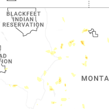
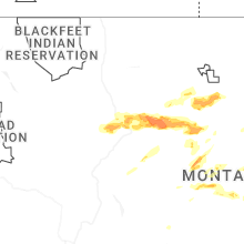


Connect with Interactive Hail Maps