

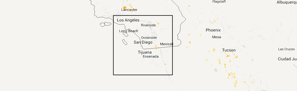
Hail Map for Boulevard, CA
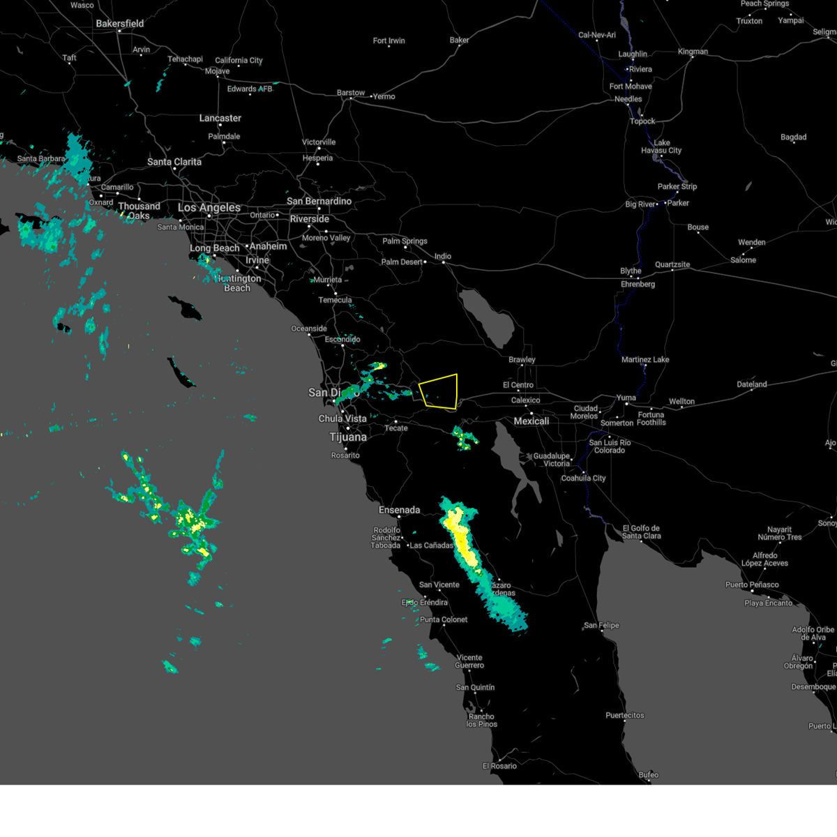
The Boulevard, CA area has had 0 reports of on-the-ground hail by trained spotters, and has been under severe weather warnings 0 times during the past 12 months. Doppler radar has detected hail at or near Boulevard, CA on 8 occasions.
| Name: | Boulevard, CA |
| Where Located: | 50.9 miles E of San Diego, CA |
| Map: | Google Map for Boulevard, CA |
| Population: | 315 |
| Housing Units: | 218 |
| More Info: | Search Google for Boulevard, CA |
5
The Top Recent Hail Date for Boulevard, CA is Tuesday, July 5, 2011 (1st out of 8)
Hail and Wind Damage Spotted near Boulevard, CA
| Date / Time | Report Details |
|---|---|
| 8/1/2024 5:29 PM PDT |
 Svrsgx the national weather service in san diego has issued a * severe thunderstorm warning for, southeastern san diego county in southwestern california, * until 630 pm pdt. * at 529 pm pdt, a severe thunderstorm was located near hwy s2 between canebrake and imperial county line, or 7 miles northwest of i-8 between boulevard and imperial county line, moving east at 20 mph (radar indicated). Hazards include up to 60 mph wind gusts, frequent lightning, and small hail. expect damage to roofs, siding, and trees Svrsgx the national weather service in san diego has issued a * severe thunderstorm warning for, southeastern san diego county in southwestern california, * until 630 pm pdt. * at 529 pm pdt, a severe thunderstorm was located near hwy s2 between canebrake and imperial county line, or 7 miles northwest of i-8 between boulevard and imperial county line, moving east at 20 mph (radar indicated). Hazards include up to 60 mph wind gusts, frequent lightning, and small hail. expect damage to roofs, siding, and trees
|
| 8/24/2022 4:09 PM PDT | At 408 pm pdt, a severe thunderstorm was located over i-8 between boulevard and imperial county line, and is nearly stationary. an additional severe thunderstorm over southwest imperial county could bring severe winds into the lower deserts of san diego county (radar indicated). Hazards include 70 mph wind gusts and quarter size hail. Hail damage to vehicles is expected. expect considerable tree damage. Wind damage is also likely to mobile homes, roofs, and outbuildings. |
| 8/24/2022 2:20 PM PDT | The severe thunderstorm warning for southeastern san diego county will expire at 230 pm pdt, the storm which prompted the warning has weakened below severe limits, and no longer poses an immediate threat to life or property. therefore, the warning will be allowed to expire. |
| 8/24/2022 1:27 PM PDT | At 127 pm pdt, a severe thunderstorm was located near i-8 between pine valley and boulevard, and is nearly stationary (radar indicated). Hazards include 60 mph wind gusts and quarter size hail. Hail damage to vehicles is expected. Expect wind damage to roofs, siding, and trees. |
| 9/26/2019 4:53 PM PDT |
 The severe thunderstorm warning for southeastern san diego county will expire at 500 pm pdt, the severe thunderstorm which prompted the warning has weakened, therefore, the warning will be allowed to expire. The severe thunderstorm warning for southeastern san diego county will expire at 500 pm pdt, the severe thunderstorm which prompted the warning has weakened, therefore, the warning will be allowed to expire.
|
| 9/26/2019 4:28 PM PDT |
 At 419 pm pdt, a severe thunderstorm was located east of mount laguna near canebrake, moving south at about 20 mph (radar indicated). Hazards include 70 mph wind gusts and penny size hail. Expect considerable tree damage. damage is likely to mobile homes, roofs, and outbuildings. Locations impacted include, i-8 between pine valley and boulevard, i-8 between boulevard and imperial county line, hwy 78 between s2 and borrego springs rd, mount laguna, hwy 78 between banner and s2, hwy s2 between shelter valley and agua caliente, hwy s2 vallecito creek rd, ocotillo wells, hwy s2 between canebrake and imperial county line and hwy s2 between agua caliente and canebrake. At 419 pm pdt, a severe thunderstorm was located east of mount laguna near canebrake, moving south at about 20 mph (radar indicated). Hazards include 70 mph wind gusts and penny size hail. Expect considerable tree damage. damage is likely to mobile homes, roofs, and outbuildings. Locations impacted include, i-8 between pine valley and boulevard, i-8 between boulevard and imperial county line, hwy 78 between s2 and borrego springs rd, mount laguna, hwy 78 between banner and s2, hwy s2 between shelter valley and agua caliente, hwy s2 vallecito creek rd, ocotillo wells, hwy s2 between canebrake and imperial county line and hwy s2 between agua caliente and canebrake.
|
| 9/26/2019 3:58 PM PDT |
 At 355 pm pdt, a severe thunderstorm was located over ocotillo wells, or near hwy 78 between borrego springs rd and ocotillo wells, moving south at about 20 mph (radar indicated). Hazards include 70 mph wind gusts and penny size hail. Expect considerable tree damage. Damage is likely to mobile homes, roofs, and outbuildings. At 355 pm pdt, a severe thunderstorm was located over ocotillo wells, or near hwy 78 between borrego springs rd and ocotillo wells, moving south at about 20 mph (radar indicated). Hazards include 70 mph wind gusts and penny size hail. Expect considerable tree damage. Damage is likely to mobile homes, roofs, and outbuildings.
|
| 9/3/2019 3:35 PM PDT |
 At 334 pm pdt, a severe thunderstorm was located near hwy s2 between canebrake and imperial county line, or 7 miles east of i-8 between pine valley and boulevard, and is drifting slowly southward (radar indicated). Hazards include 60 mph wind gusts and penny size hail. Expect damage to roofs, siding, and trees. Locations impacted include, mount laguna, i-8 between pine valley and boulevard, i-8 between boulevard and imperial county line, boulevard, pine valley, campo, tierra del sol, campo indian reservation, la posta indian reservation and live oak springs. At 334 pm pdt, a severe thunderstorm was located near hwy s2 between canebrake and imperial county line, or 7 miles east of i-8 between pine valley and boulevard, and is drifting slowly southward (radar indicated). Hazards include 60 mph wind gusts and penny size hail. Expect damage to roofs, siding, and trees. Locations impacted include, mount laguna, i-8 between pine valley and boulevard, i-8 between boulevard and imperial county line, boulevard, pine valley, campo, tierra del sol, campo indian reservation, la posta indian reservation and live oak springs.
|
| 9/3/2019 3:30 PM PDT | Above ground communication cable was dislodged and is draped across the road. a wind gust of 40 mph was reported about 5 miles to the northwest of this locatio in san diego county CA, 0.8 miles SE of Boulevard, CA |
| 9/3/2019 3:11 PM PDT |
 At 311 pm pdt, a severe thunderstorm was located near i-8 between pine valley and boulevard, moving south at 5 mph (radar indicated). Hazards include 60 mph wind gusts and penny size hail. expect damage to roofs, siding, and trees At 311 pm pdt, a severe thunderstorm was located near i-8 between pine valley and boulevard, moving south at 5 mph (radar indicated). Hazards include 60 mph wind gusts and penny size hail. expect damage to roofs, siding, and trees
|
| 8/15/2018 3:54 PM PDT |
 At 347 pm pdt, a severe thunderstorm was located just south of pine valley extending to near campo, and was moving east at about 5 mph (radar indicated). Hazards include 60 mph wind gusts. Expect damage to roofs, siding, and trees. Locations impacted include, i-8 between pine valley and boulevard, i-8 between boulevard and imperial county line, campo, hwy s2 between canebrake and imperial county line, boulevard, lake morena, tierra del sol, campo indian reservation, la posta indian reservation, live oak springs, jacumba and manzanita indian reservation. At 347 pm pdt, a severe thunderstorm was located just south of pine valley extending to near campo, and was moving east at about 5 mph (radar indicated). Hazards include 60 mph wind gusts. Expect damage to roofs, siding, and trees. Locations impacted include, i-8 between pine valley and boulevard, i-8 between boulevard and imperial county line, campo, hwy s2 between canebrake and imperial county line, boulevard, lake morena, tierra del sol, campo indian reservation, la posta indian reservation, live oak springs, jacumba and manzanita indian reservation.
|
| 8/15/2018 3:30 PM PDT |
 At 324 pm pdt, a severe thunderstorm was located near boulevard, or 7 miles northwest of i-8 between boulevard and imperial county line moving southeast at about 5 mph (radar indicated). Hazards include 60 mph wind gusts. expect damage to roofs, siding, and trees At 324 pm pdt, a severe thunderstorm was located near boulevard, or 7 miles northwest of i-8 between boulevard and imperial county line moving southeast at about 5 mph (radar indicated). Hazards include 60 mph wind gusts. expect damage to roofs, siding, and trees
|
| 8/2/2017 4:39 PM PDT |
 The severe thunderstorm warning for southeastern san diego county will expire at 445 pm pdt, the storm which prompted the warning has weakened below severe limits, and no longer poses an immediate threat to life or property. therefore the warning will be allowed to expire. The severe thunderstorm warning for southeastern san diego county will expire at 445 pm pdt, the storm which prompted the warning has weakened below severe limits, and no longer poses an immediate threat to life or property. therefore the warning will be allowed to expire.
|
| 8/2/2017 4:26 PM PDT |
 At 424 pm pdt, a severe thunderstorm was located near i-8 between pine valley and boulevard, and was nearly stationary (radar indicated). Hazards include 60 mph wind gusts and penny size hail. Damage possible to cars, power lines and trees. Locations impacted include, i-8 between pine valley and boulevard, boulevard, lake morena, pine valley, campo, campo indian reservation, la posta indian reservation, live oak springs and manzanita indian reservation. At 424 pm pdt, a severe thunderstorm was located near i-8 between pine valley and boulevard, and was nearly stationary (radar indicated). Hazards include 60 mph wind gusts and penny size hail. Damage possible to cars, power lines and trees. Locations impacted include, i-8 between pine valley and boulevard, boulevard, lake morena, pine valley, campo, campo indian reservation, la posta indian reservation, live oak springs and manzanita indian reservation.
|
| 8/2/2017 3:59 PM PDT |
 At 358 pm pdt, a severe thunderstorm was located over i-8 between pine valley and boulevard, moving south at 5 mph (radar indicated). Hazards include 60 mph wind gusts and nickel size hail. expect damage to power lines, cars and trees At 358 pm pdt, a severe thunderstorm was located over i-8 between pine valley and boulevard, moving south at 5 mph (radar indicated). Hazards include 60 mph wind gusts and nickel size hail. expect damage to power lines, cars and trees
|
| 1/31/2016 4:40 PM PST |
 The severe thunderstorm warning for eastern san diego county will expire at 445 pm pst, the line of storms which prompted the warning have weakened below severe limits, and exited the warned area. therefore the warning will be allowed to expire. however gusty winds are still possible with these thunderstorms. The severe thunderstorm warning for eastern san diego county will expire at 445 pm pst, the line of storms which prompted the warning have weakened below severe limits, and exited the warned area. therefore the warning will be allowed to expire. however gusty winds are still possible with these thunderstorms.
|
| 1/31/2016 4:14 PM PST |
 At 411 pm pst, doppler radar indicated a line of severe thunderstorms capable of producing damaging winds in excess of 60 mph. these storms have moved east of the mountain ridge. in addition, several cases of wind damage have been reported. locations impacted include, ramona, alpine, san diego country, jamul, harbison canyon, borrego springs, julian and pine valley. At 411 pm pst, doppler radar indicated a line of severe thunderstorms capable of producing damaging winds in excess of 60 mph. these storms have moved east of the mountain ridge. in addition, several cases of wind damage have been reported. locations impacted include, ramona, alpine, san diego country, jamul, harbison canyon, borrego springs, julian and pine valley.
|
| 1/31/2016 3:22 PM PST |
 At 321 pm pst, doppler radar indicated a line of severe thunderstorms capable of producing damaging winds in excess of 60 mph. these storms were located along a line extending from 18 miles northeast of ramona to 12 miles southeast of bonita, and moving east at 40 mph. At 321 pm pst, doppler radar indicated a line of severe thunderstorms capable of producing damaging winds in excess of 60 mph. these storms were located along a line extending from 18 miles northeast of ramona to 12 miles southeast of bonita, and moving east at 40 mph.
|
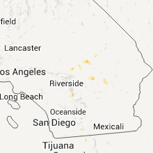
Hail Maps for Boulevard, CA


Connect with Interactive Hail Maps