

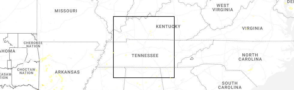
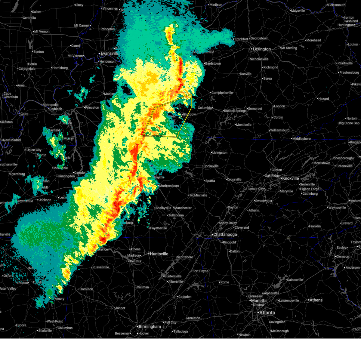
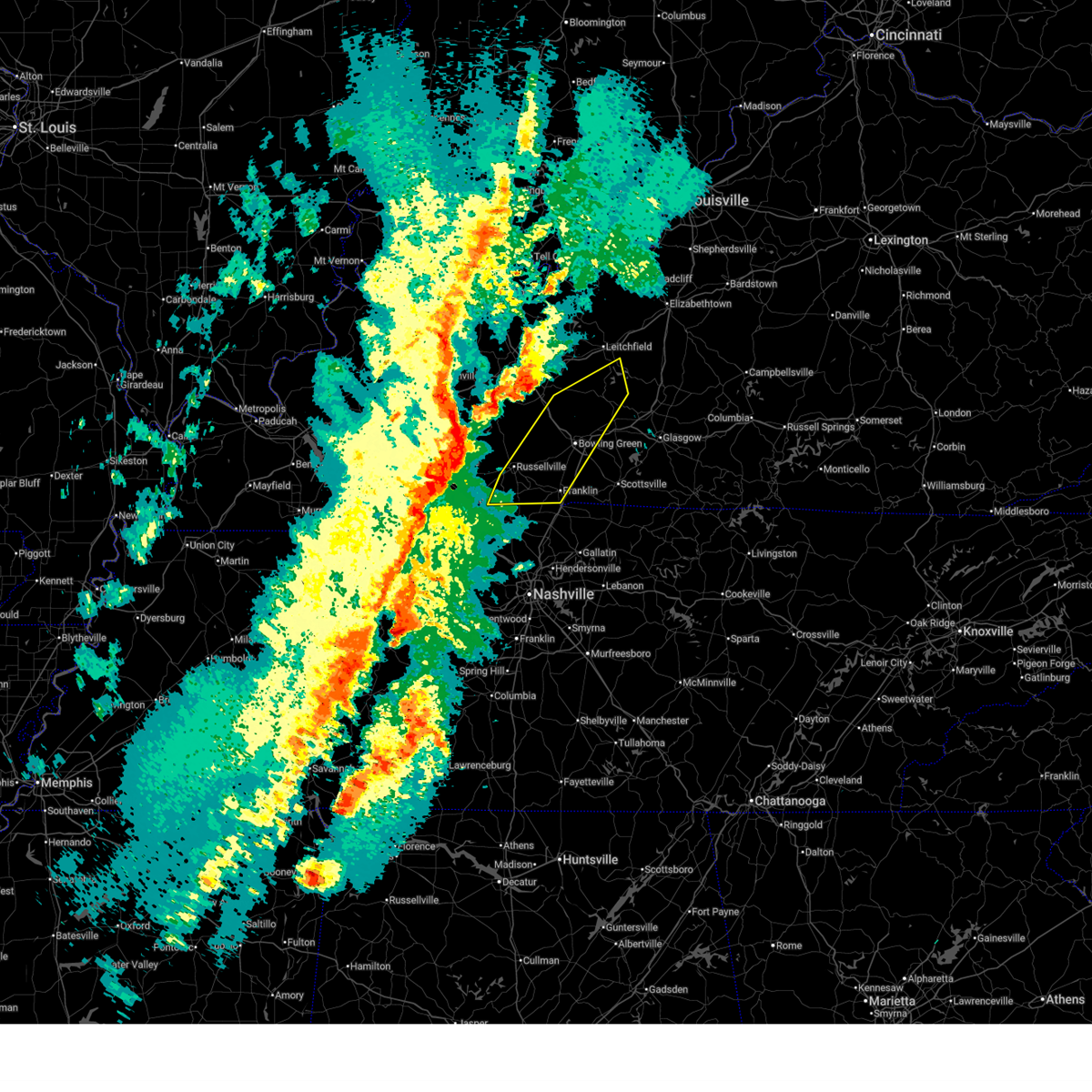
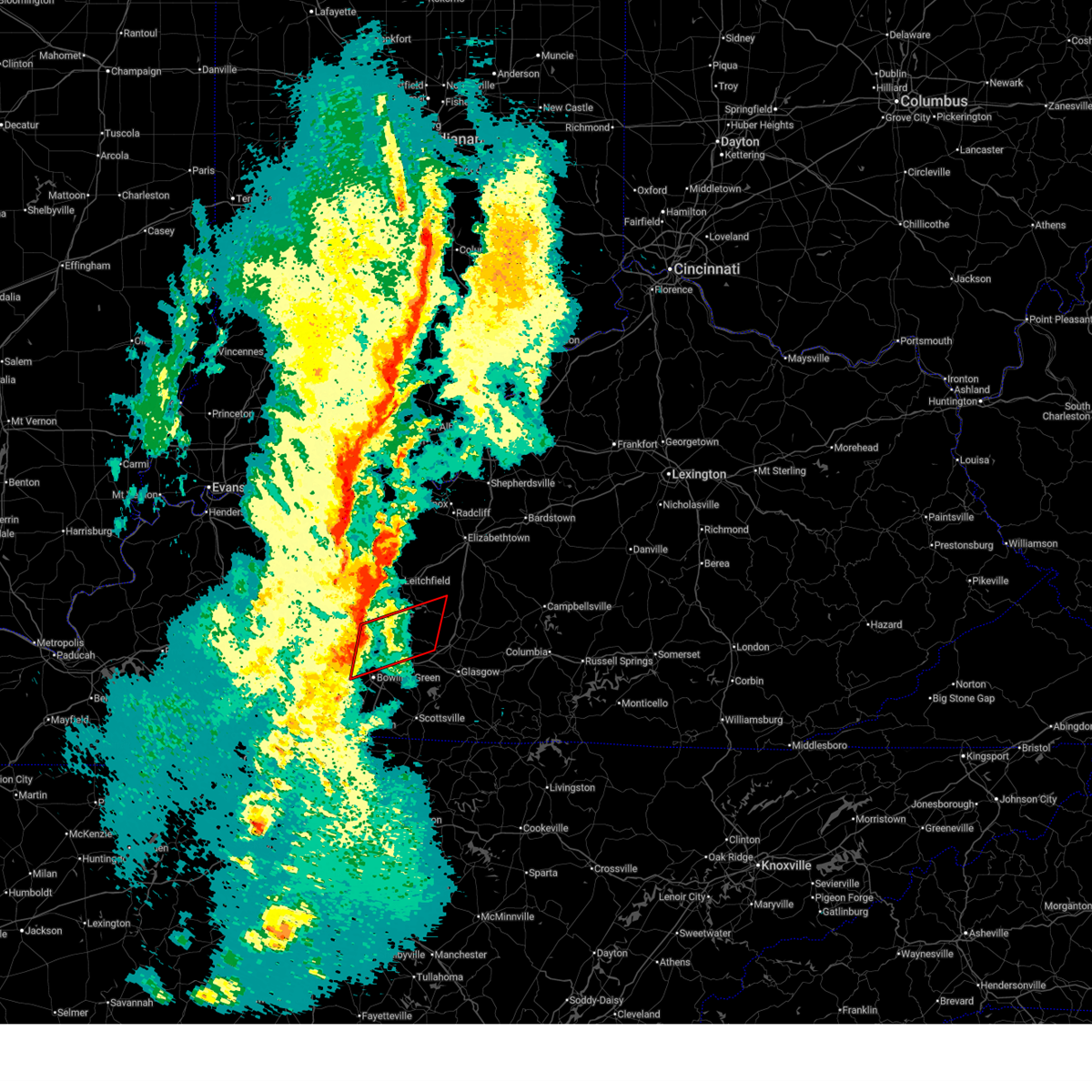
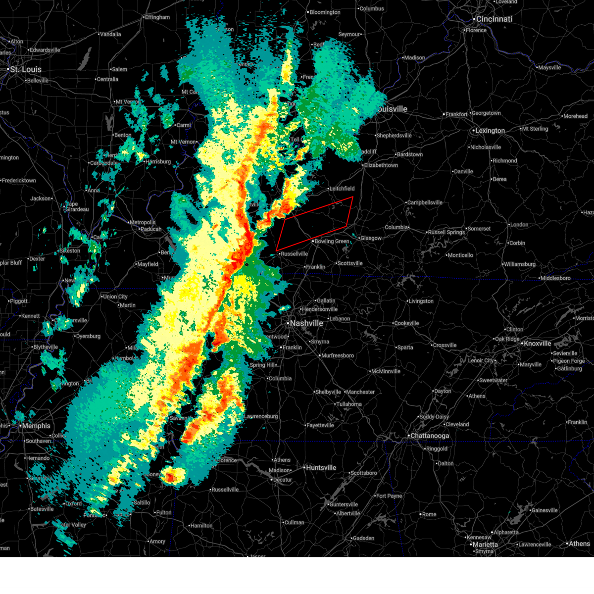
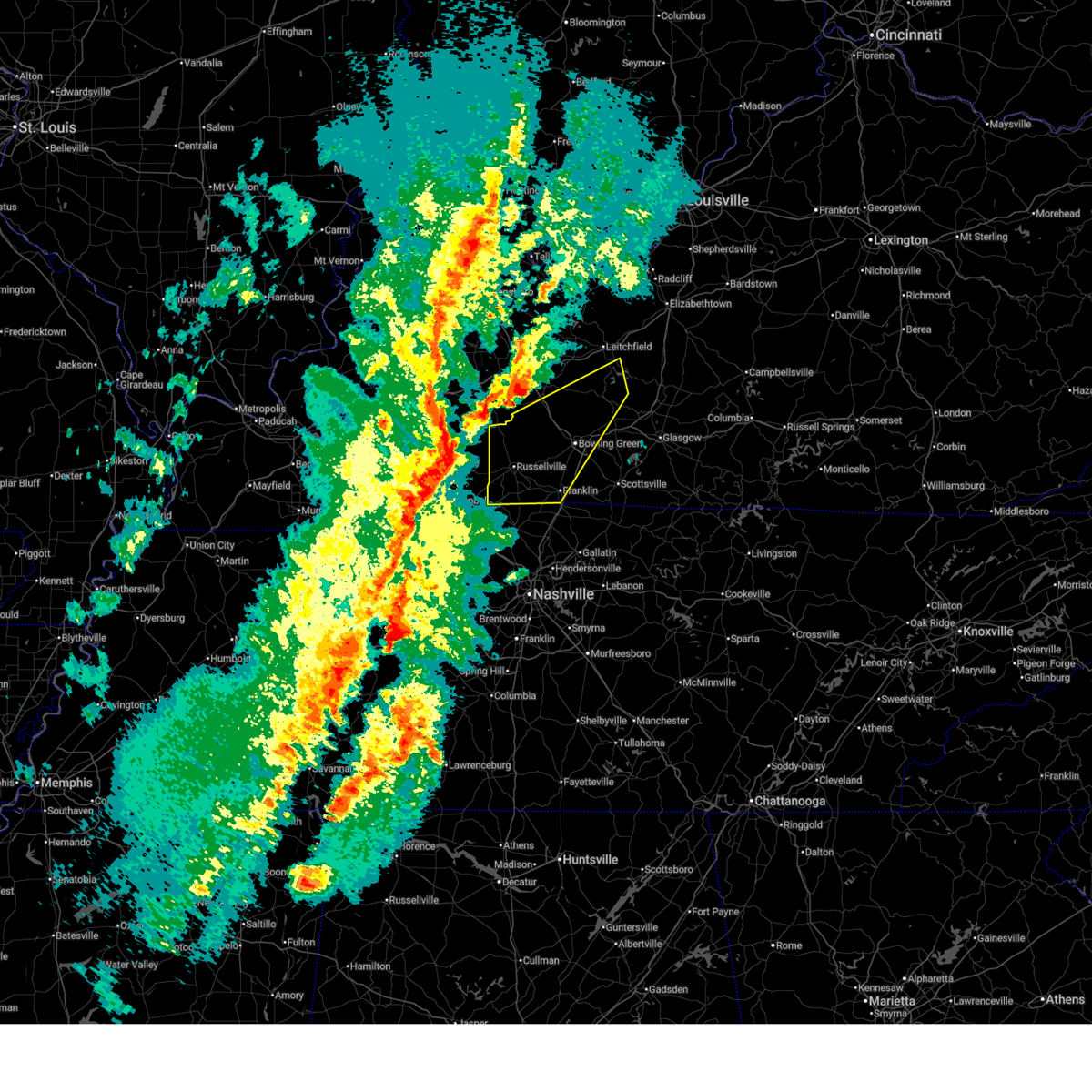
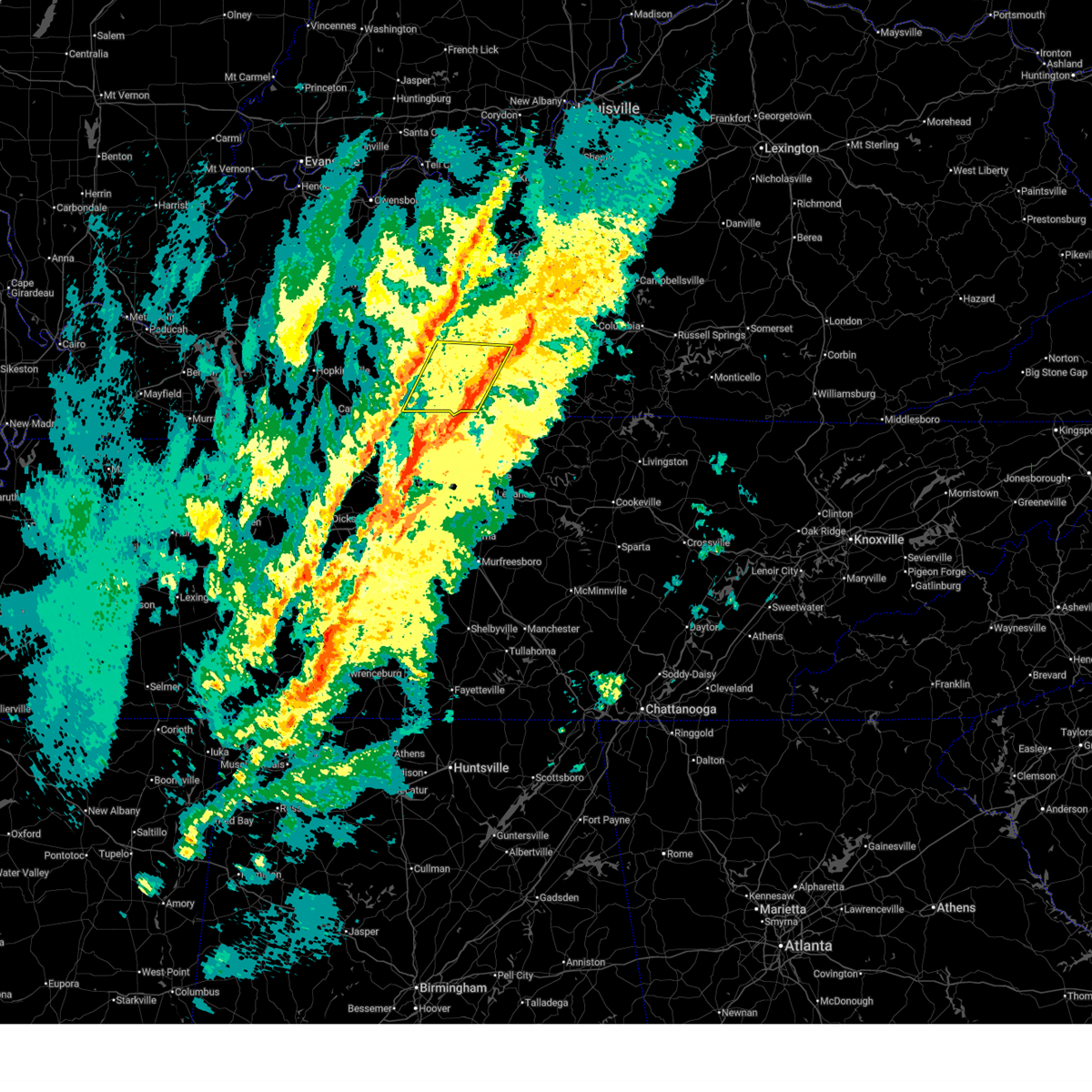
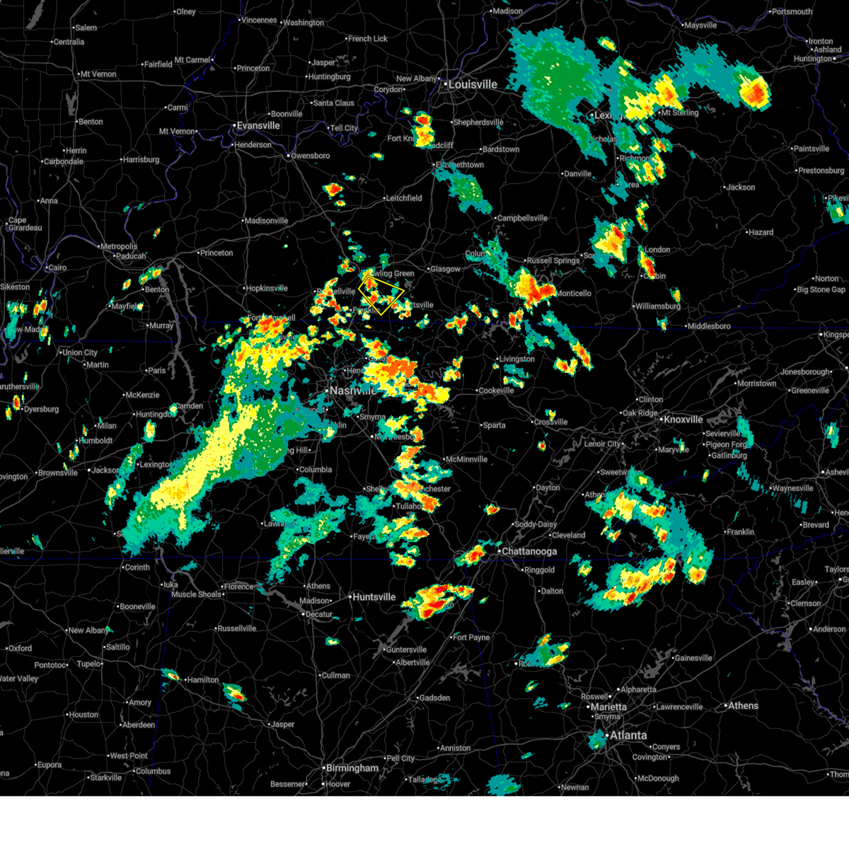
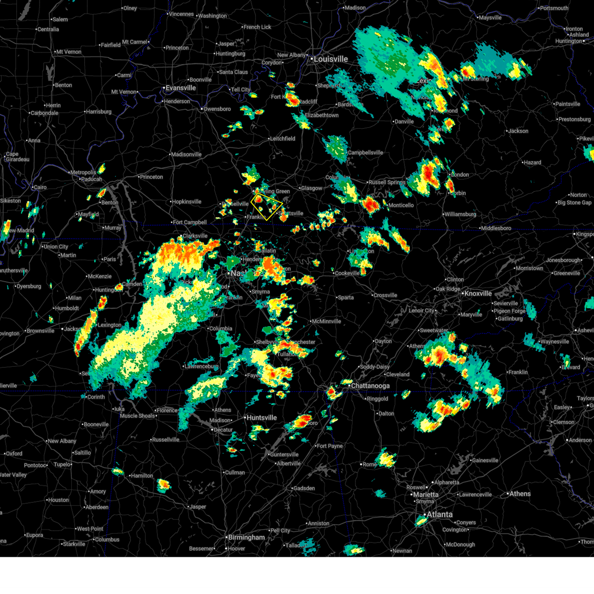
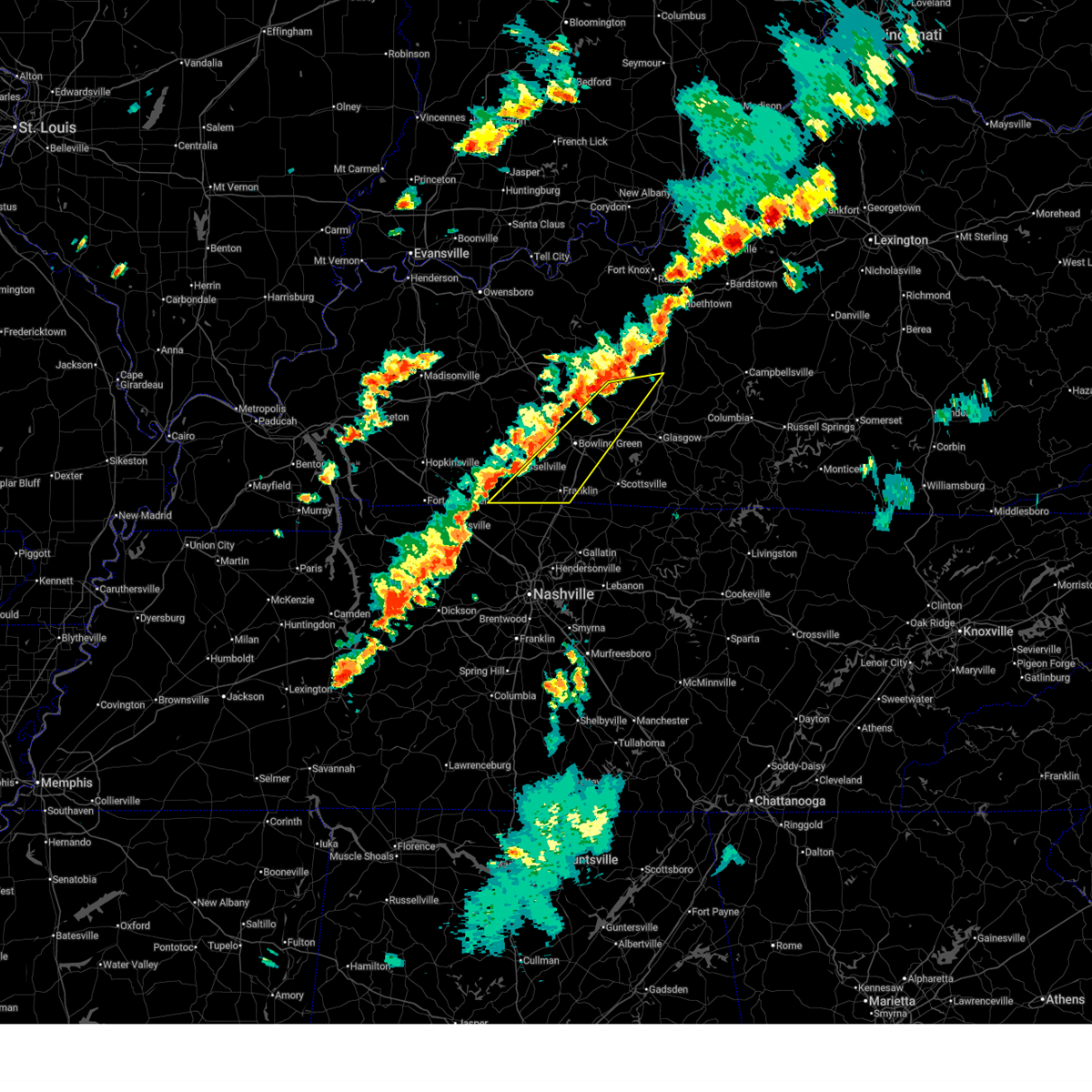
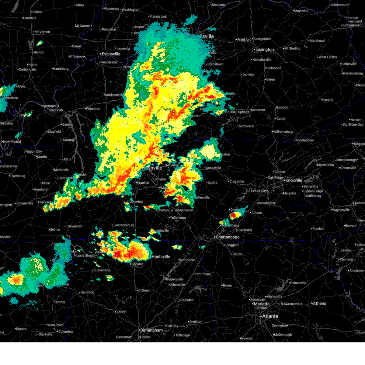
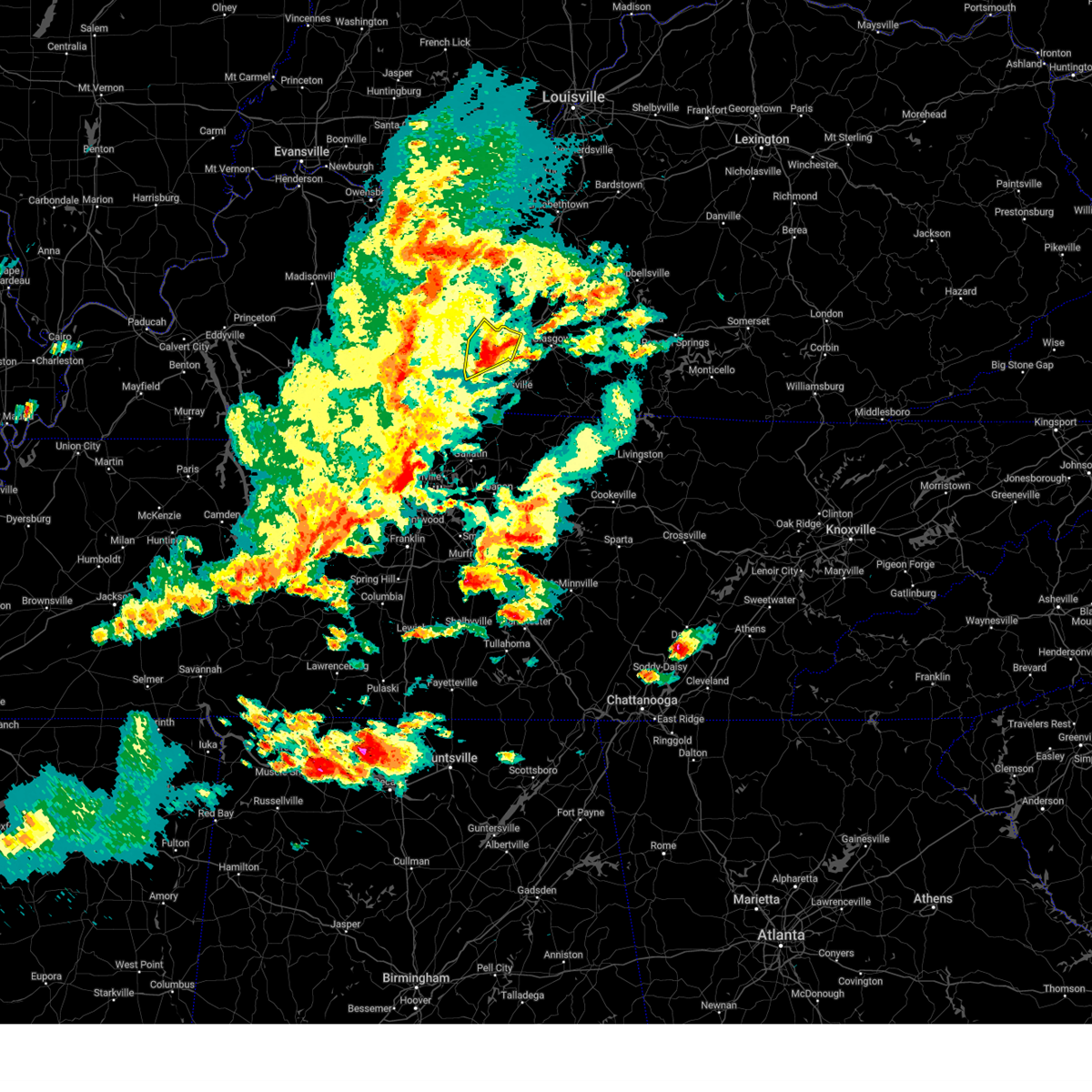
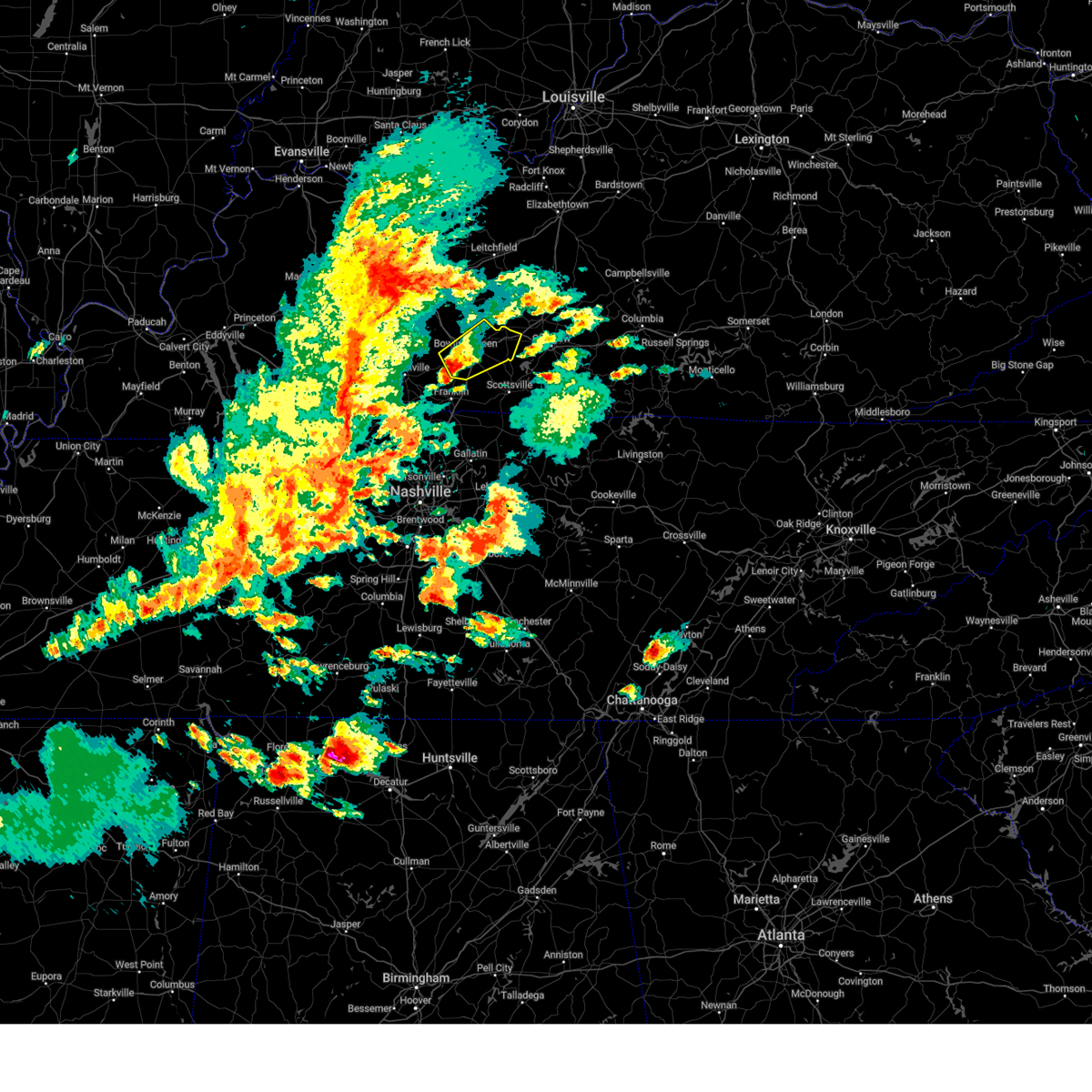
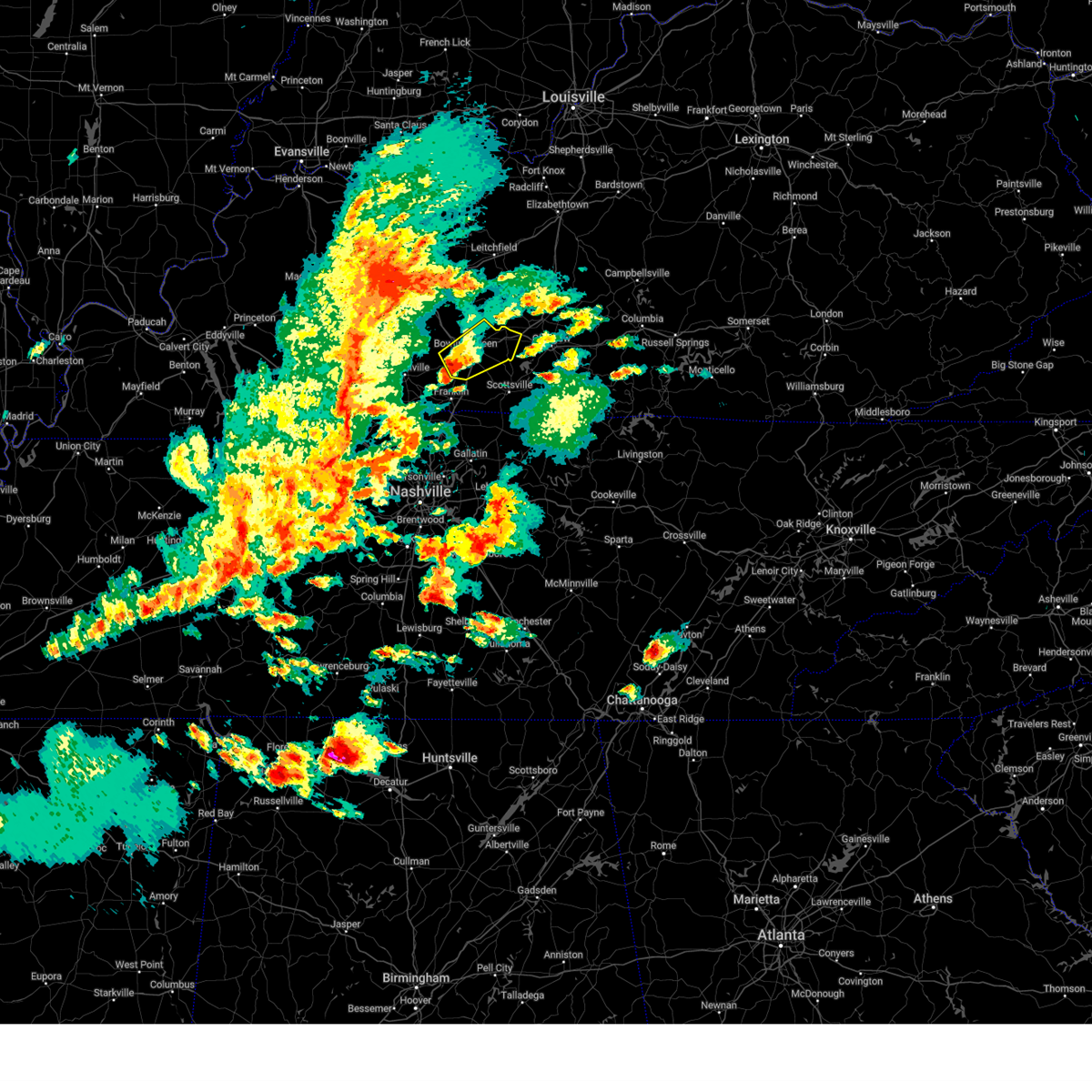
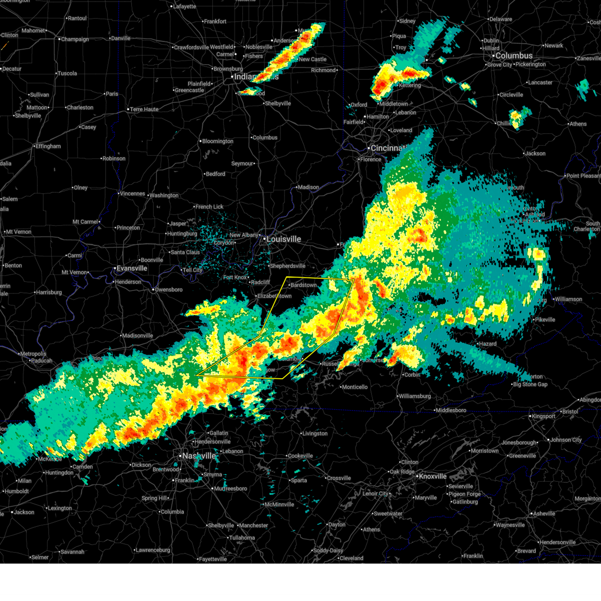
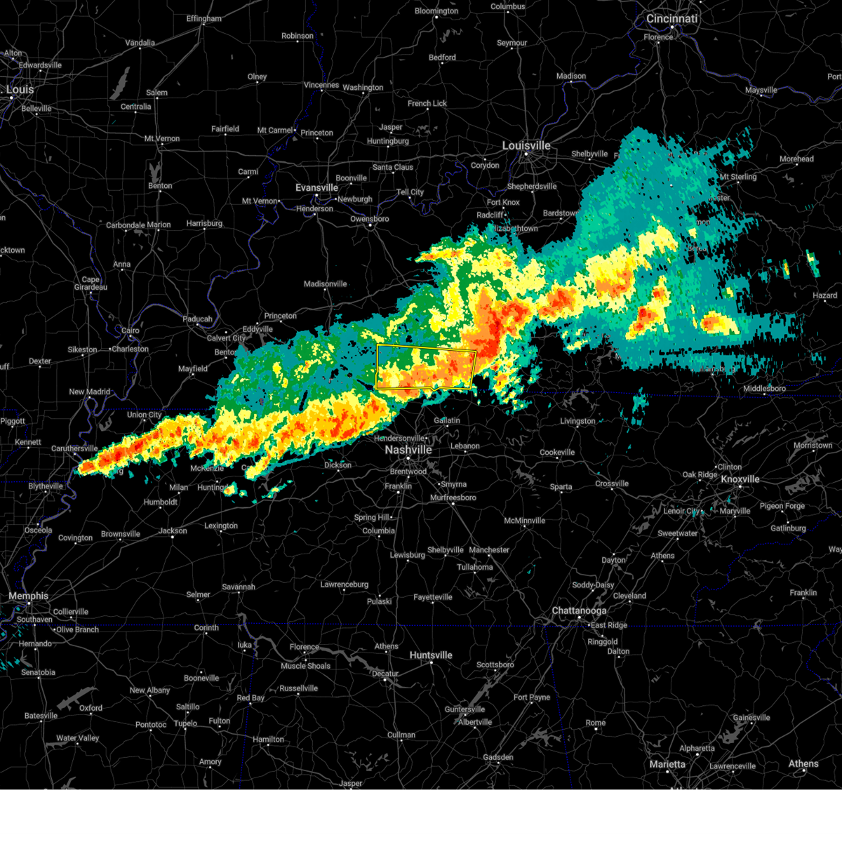
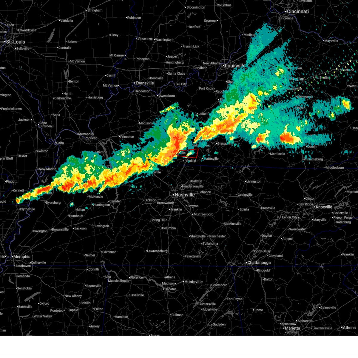
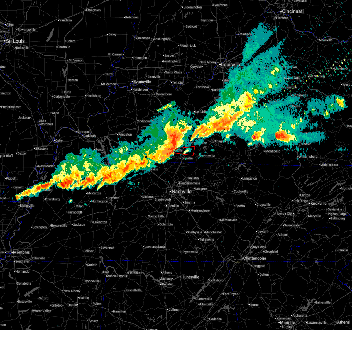
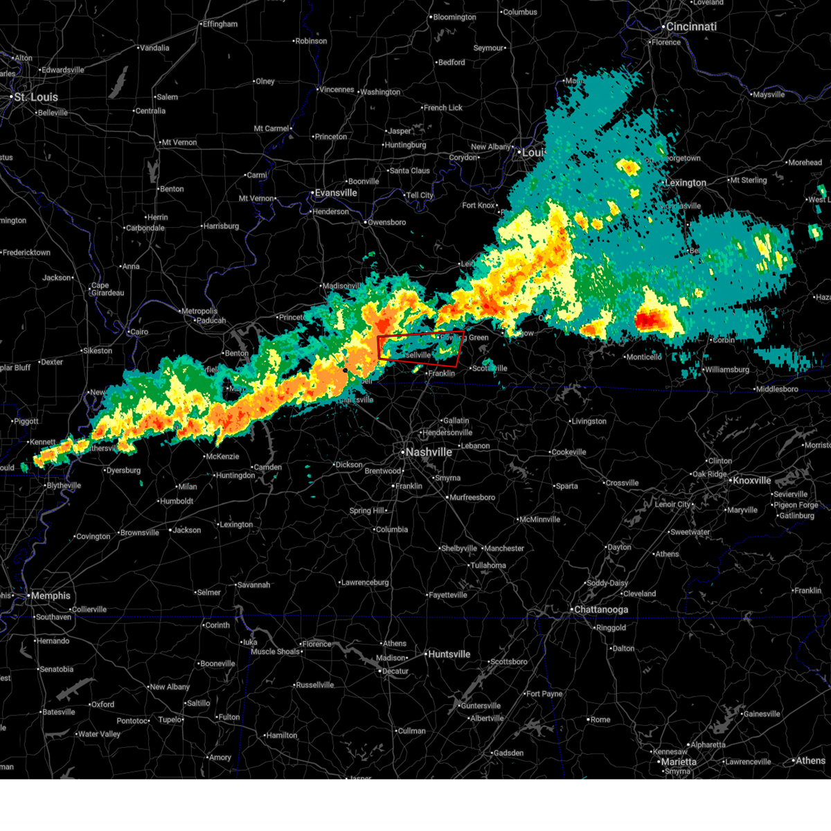
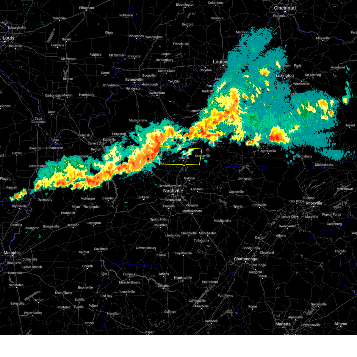
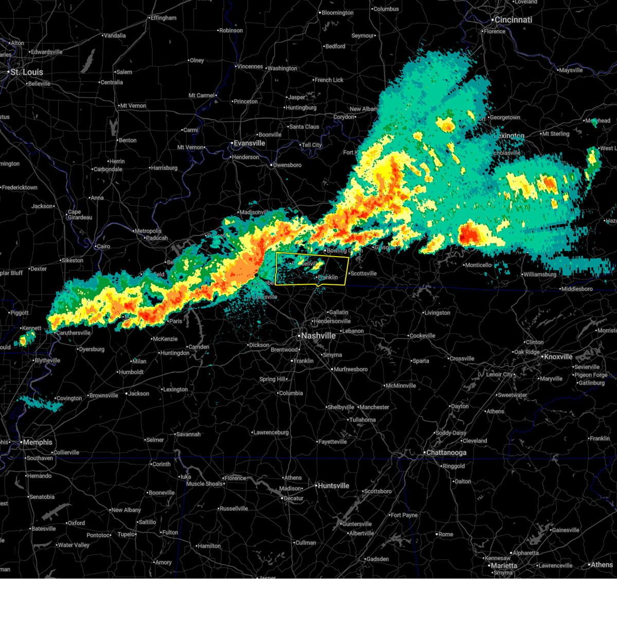
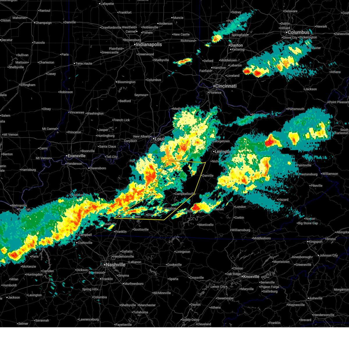
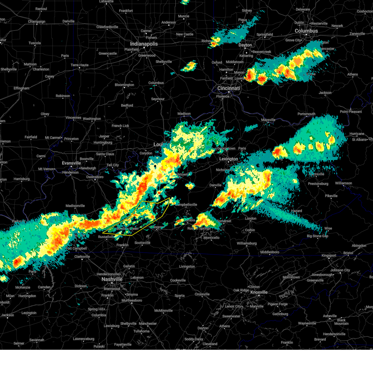
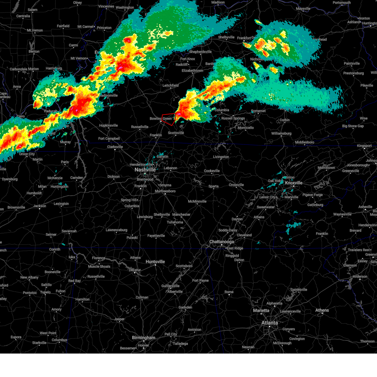
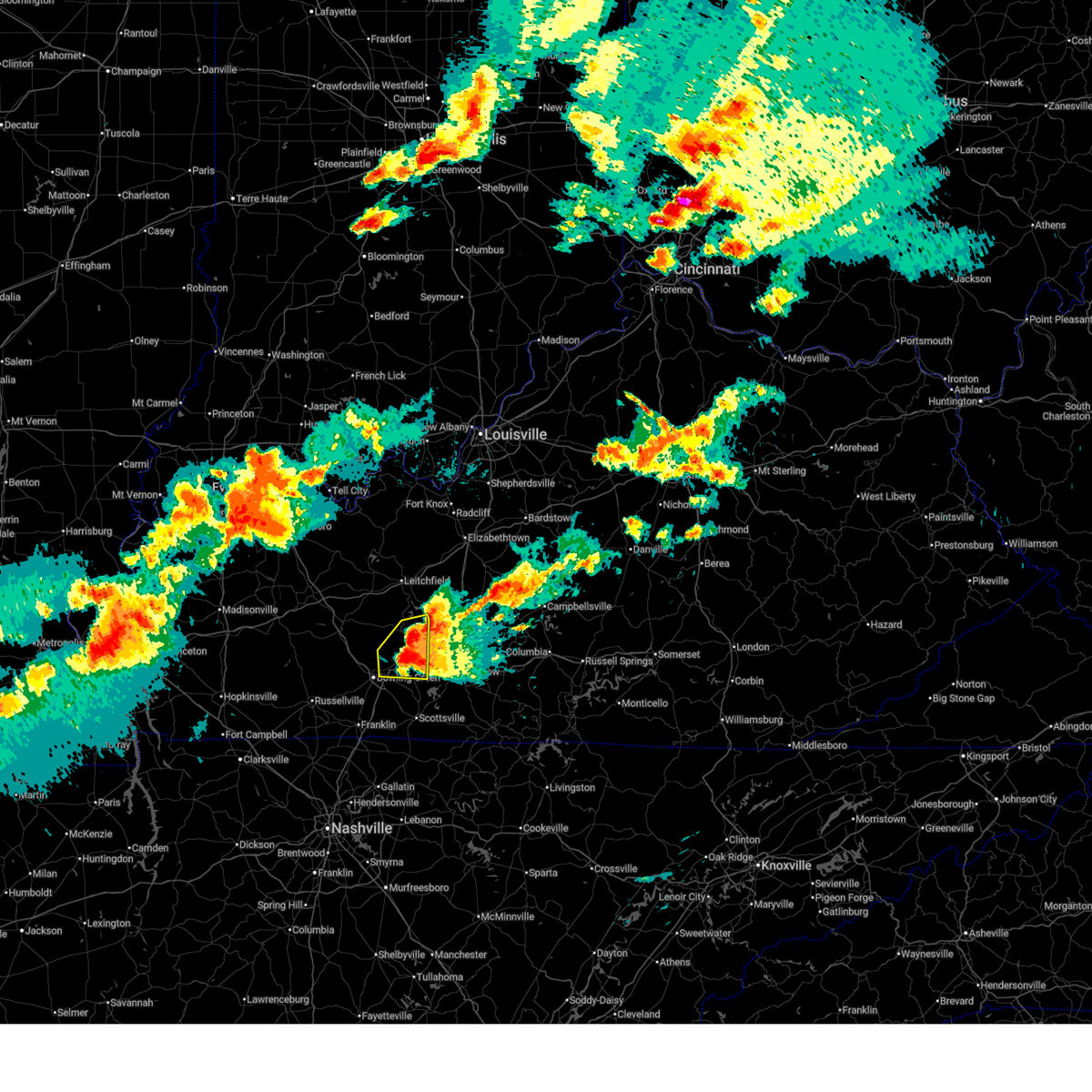
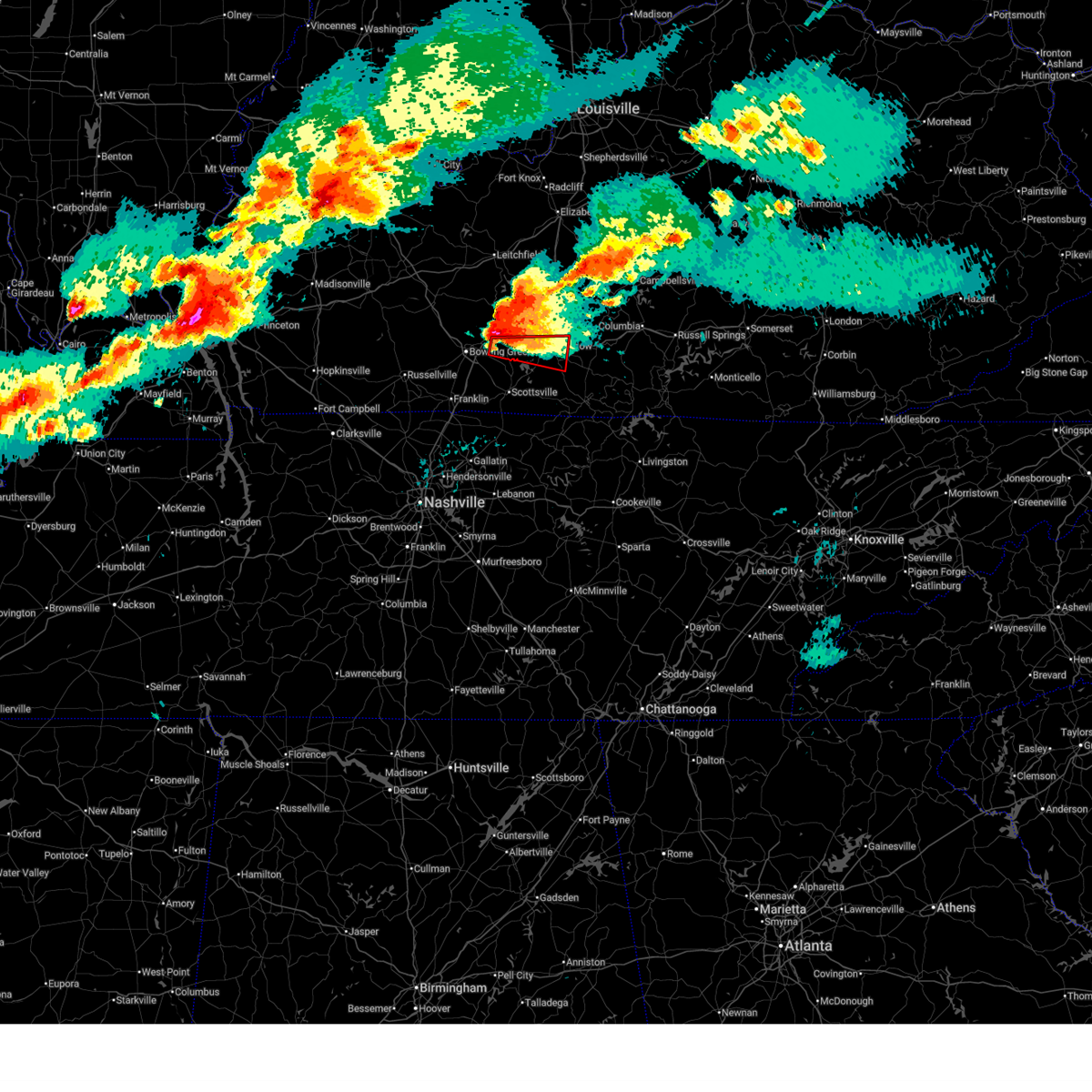
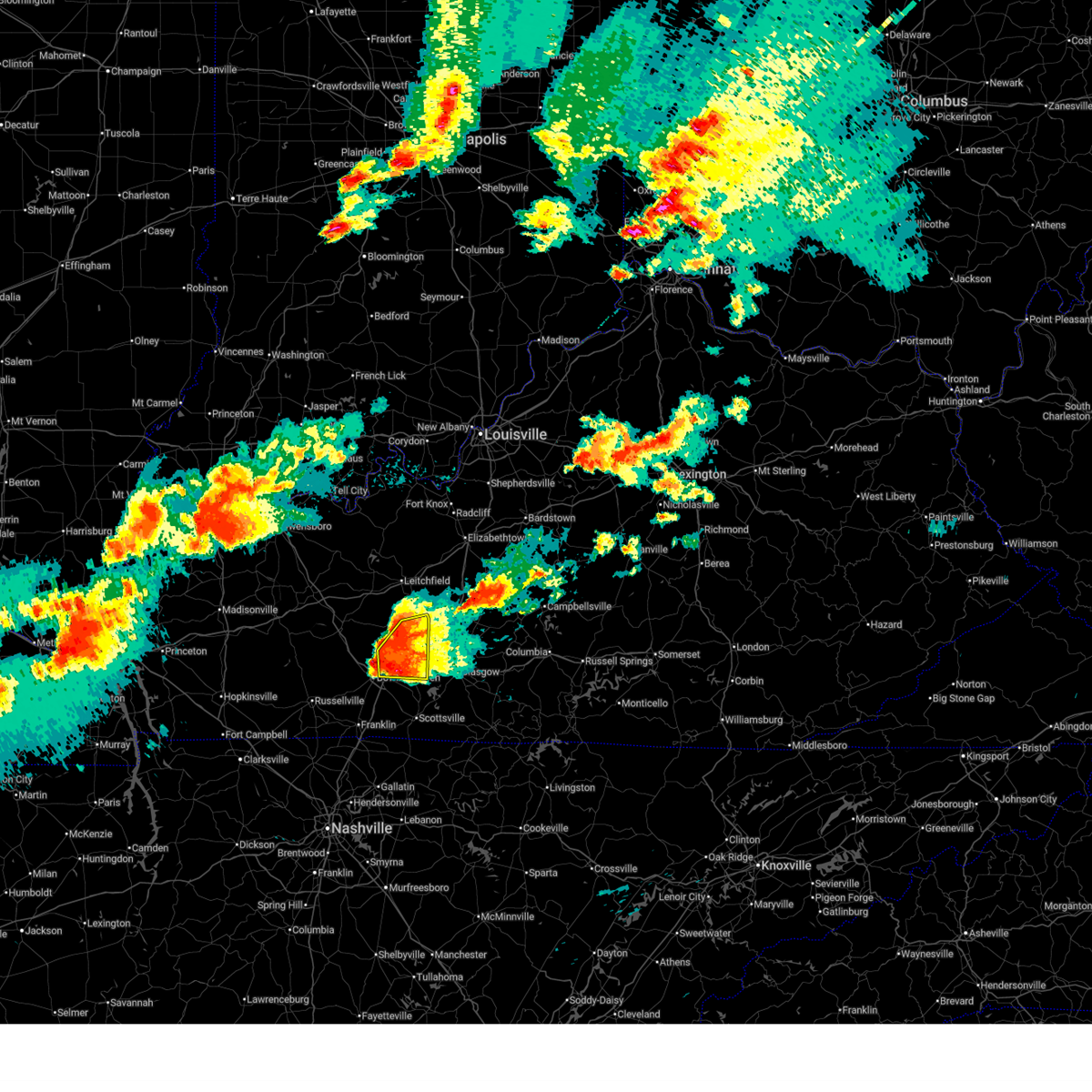
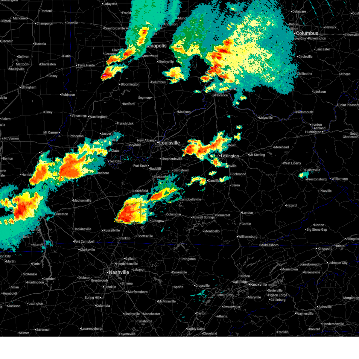
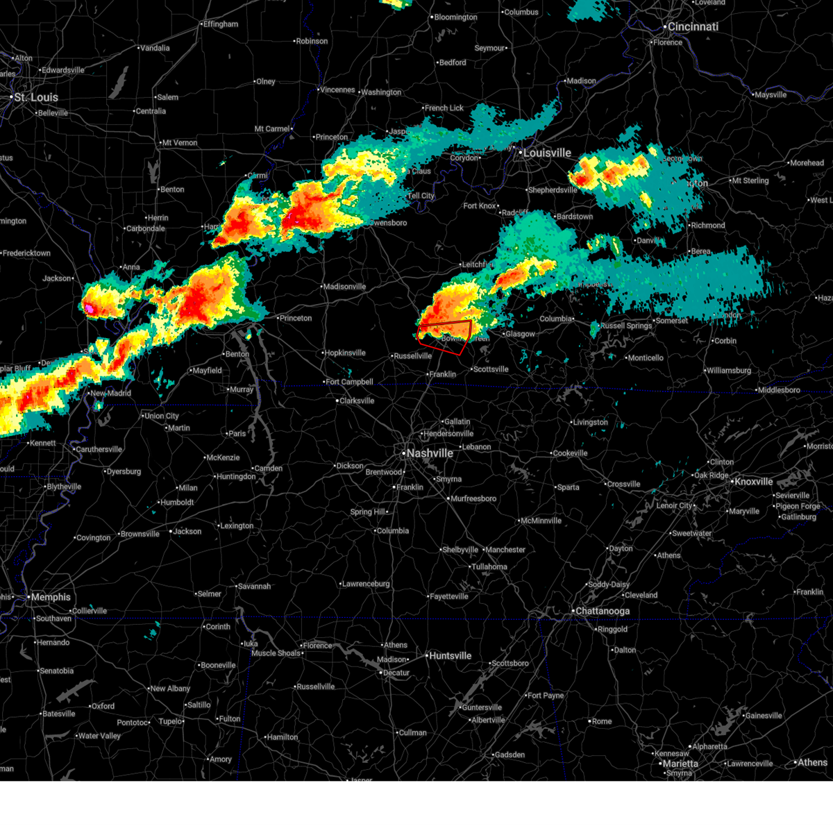
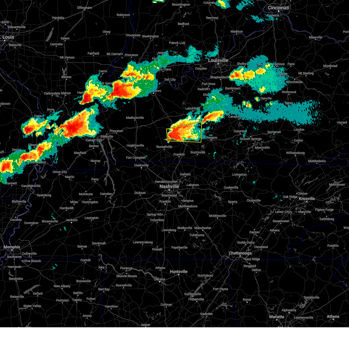
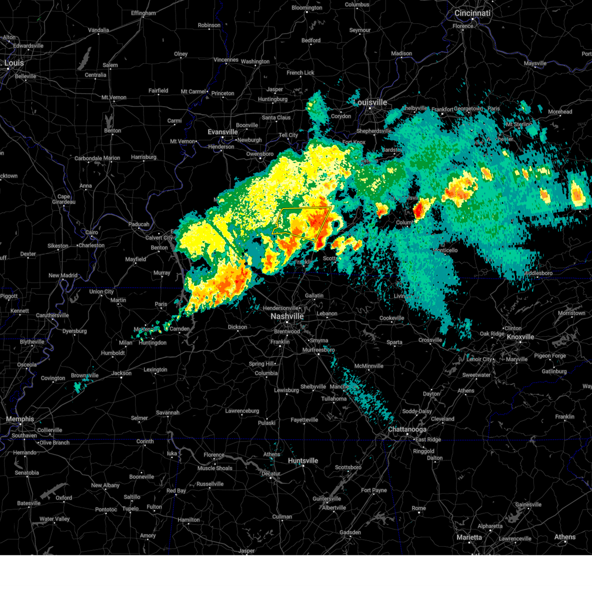
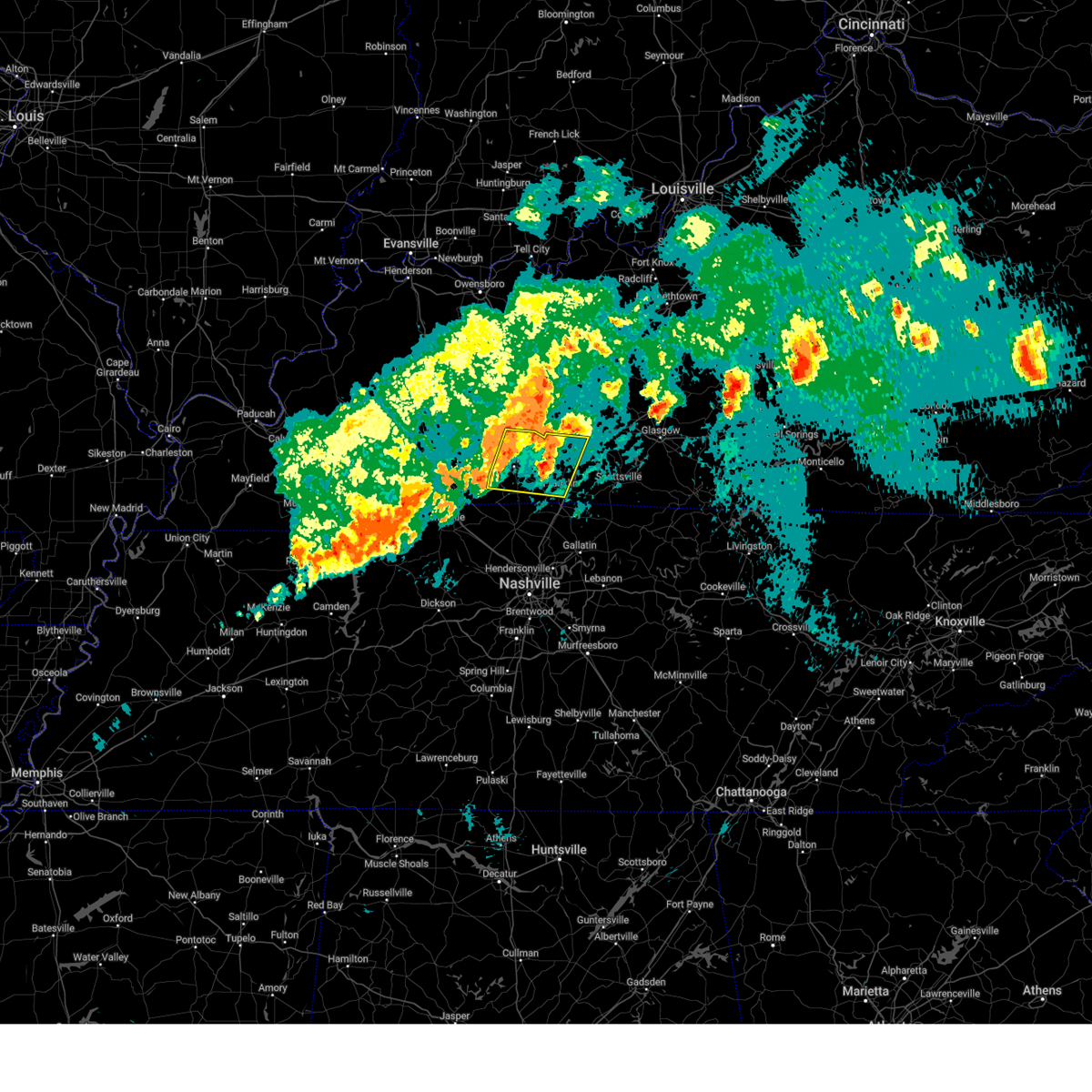
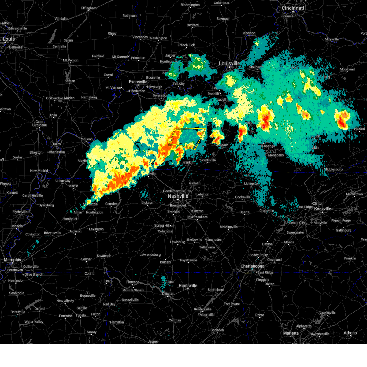
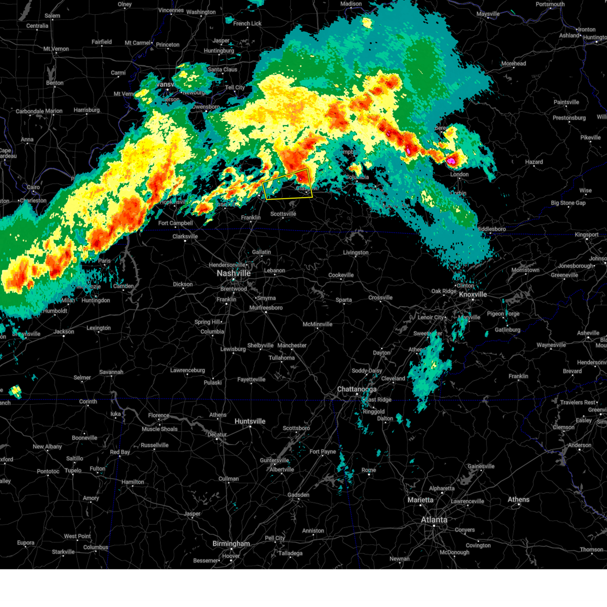
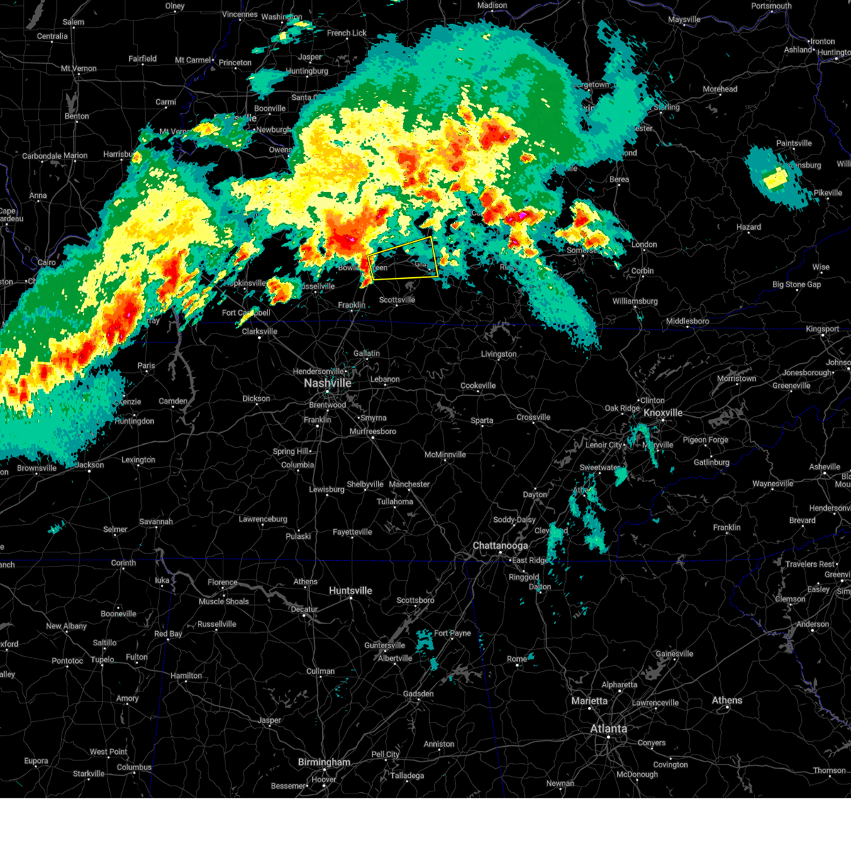
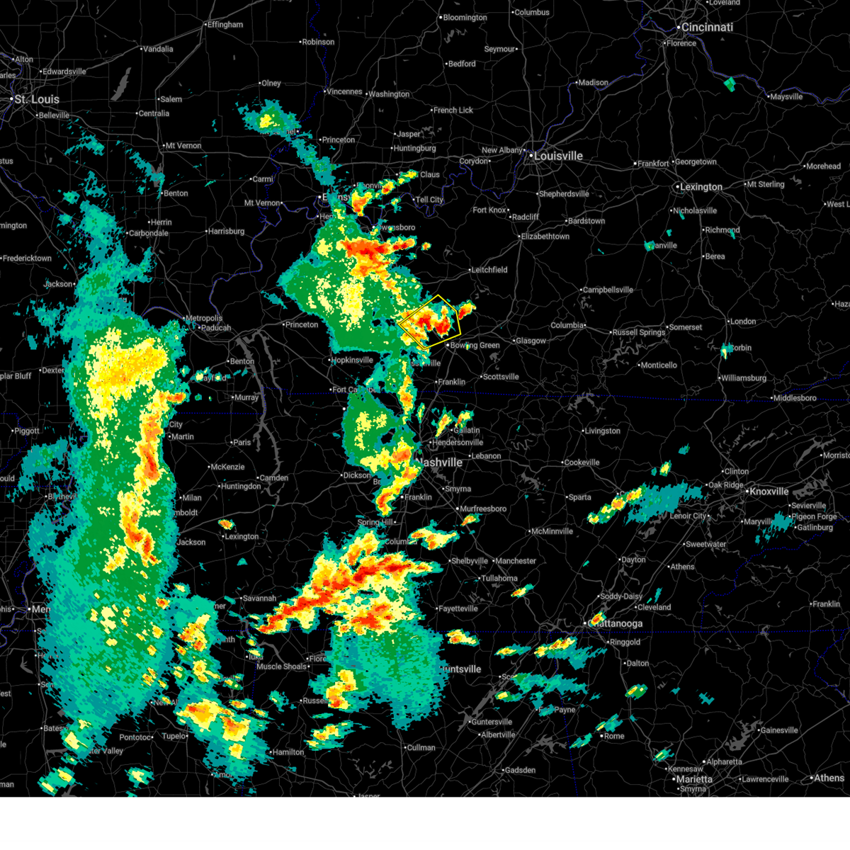
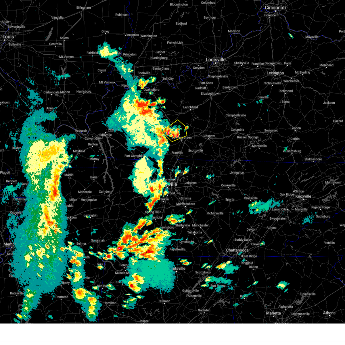
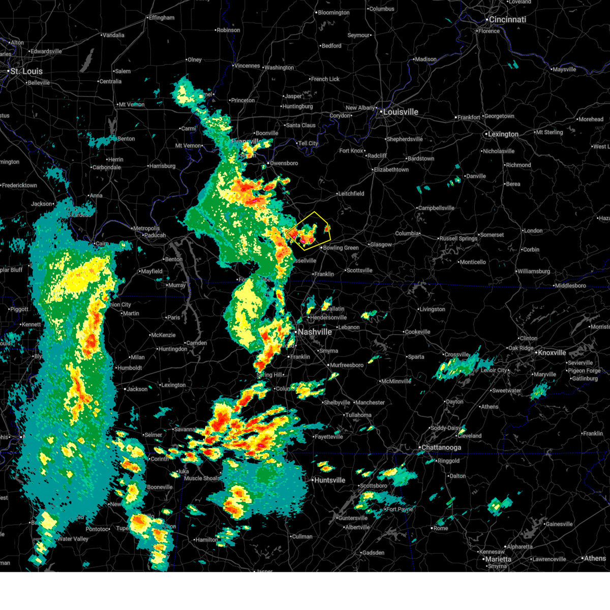
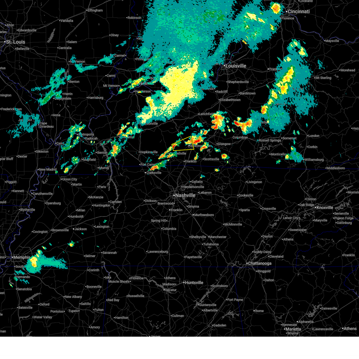
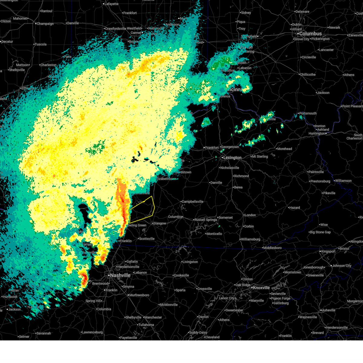
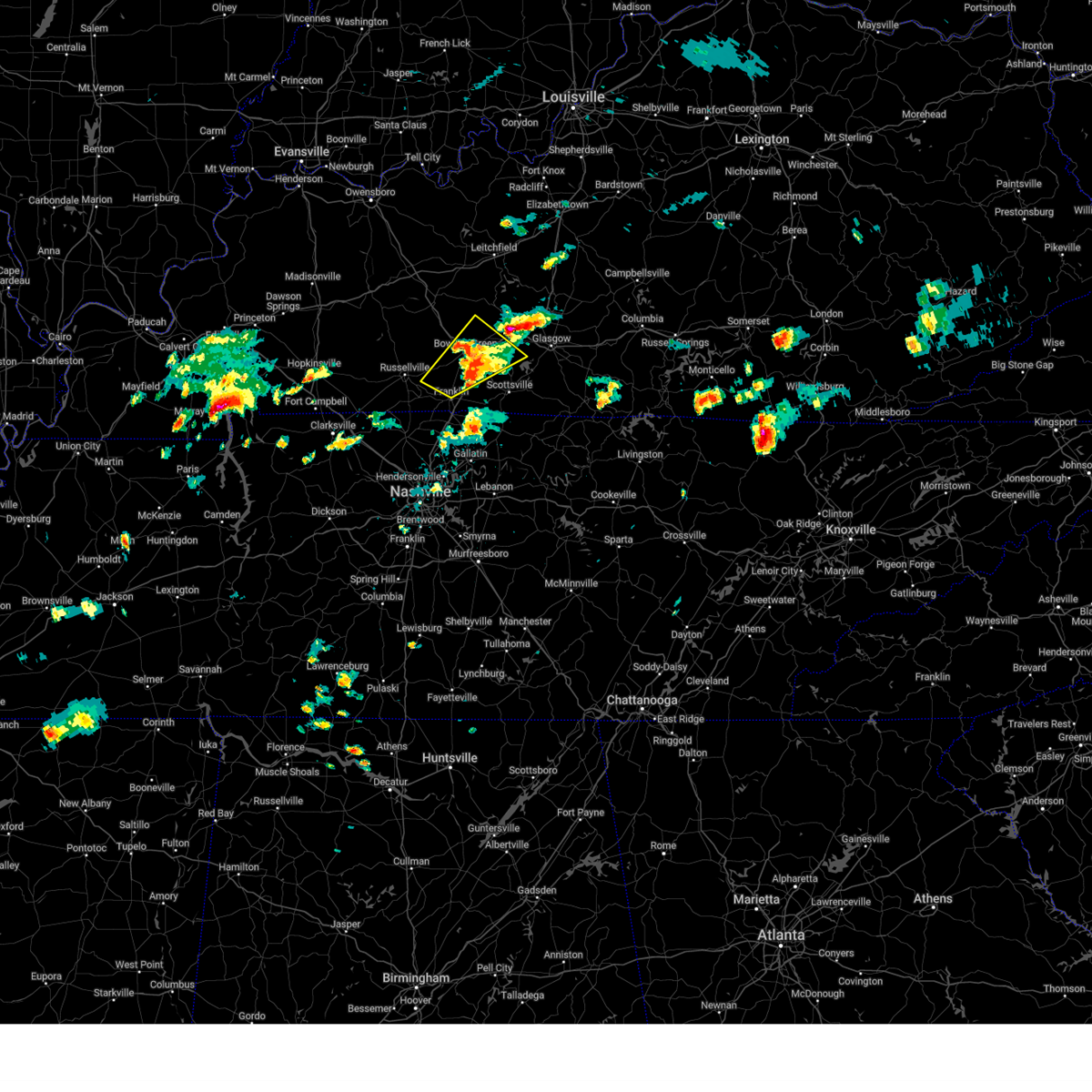
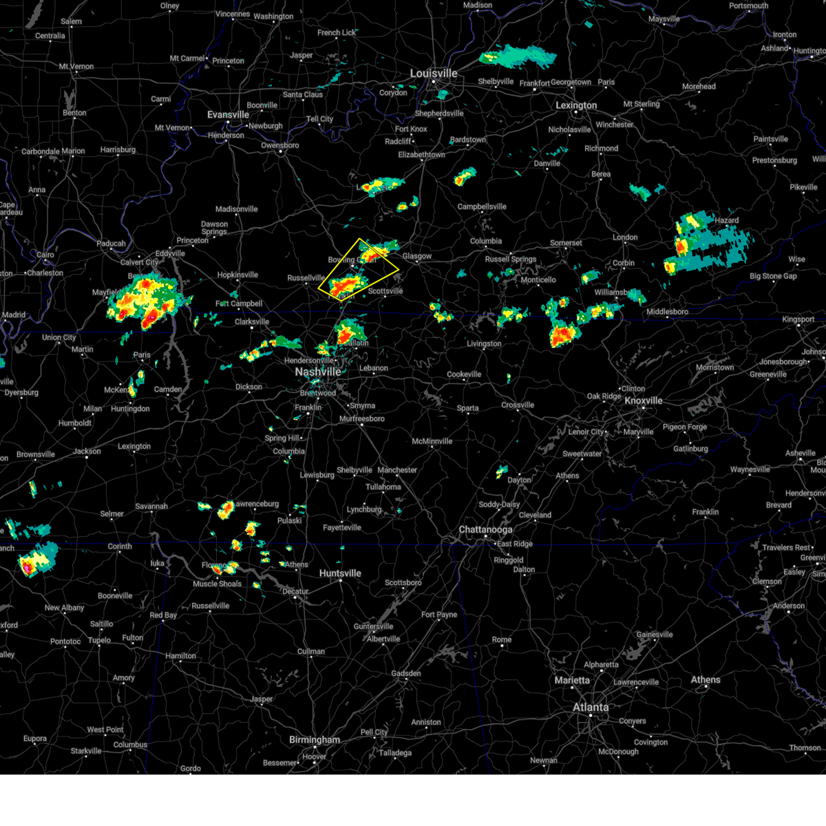
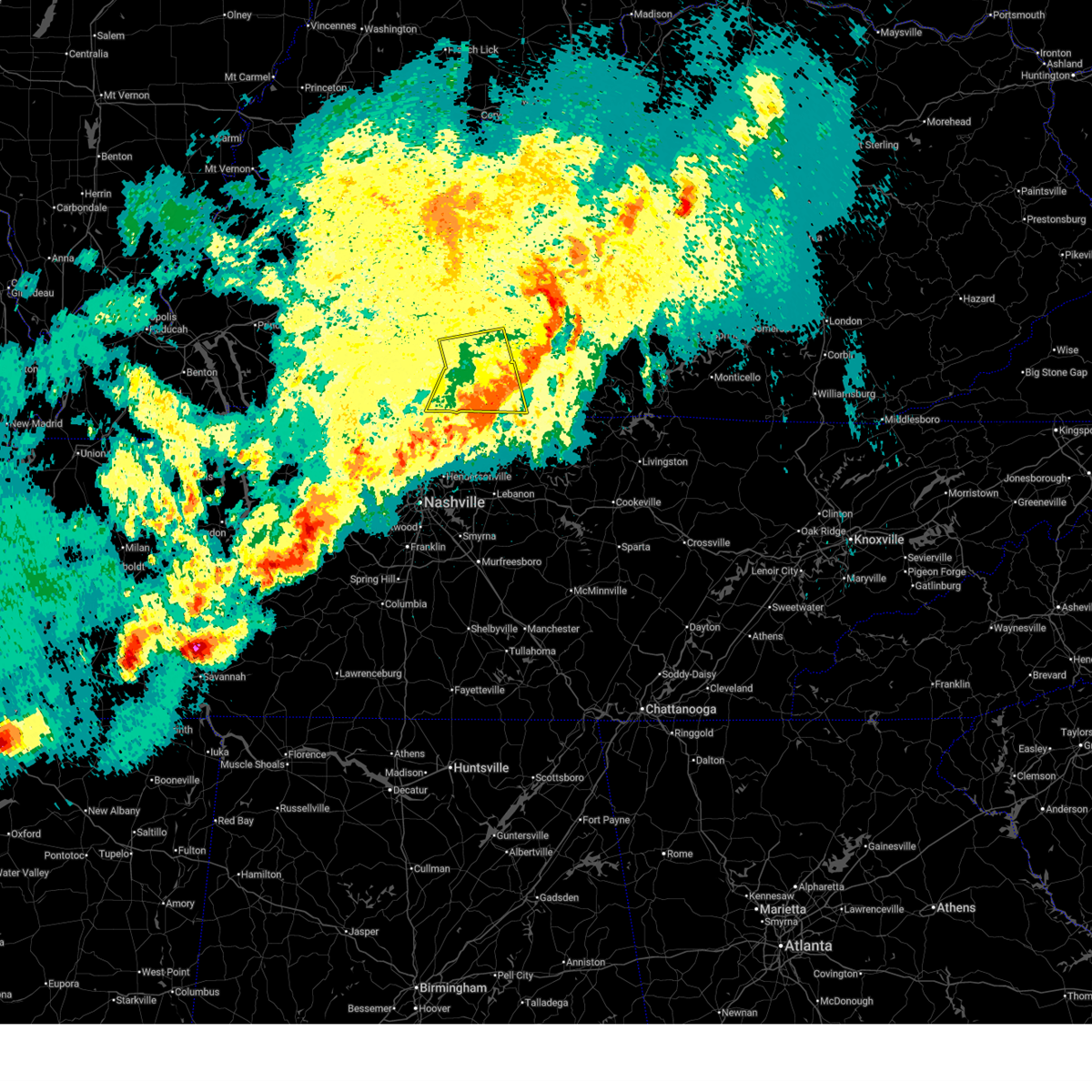
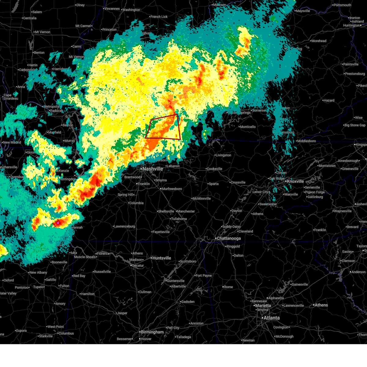
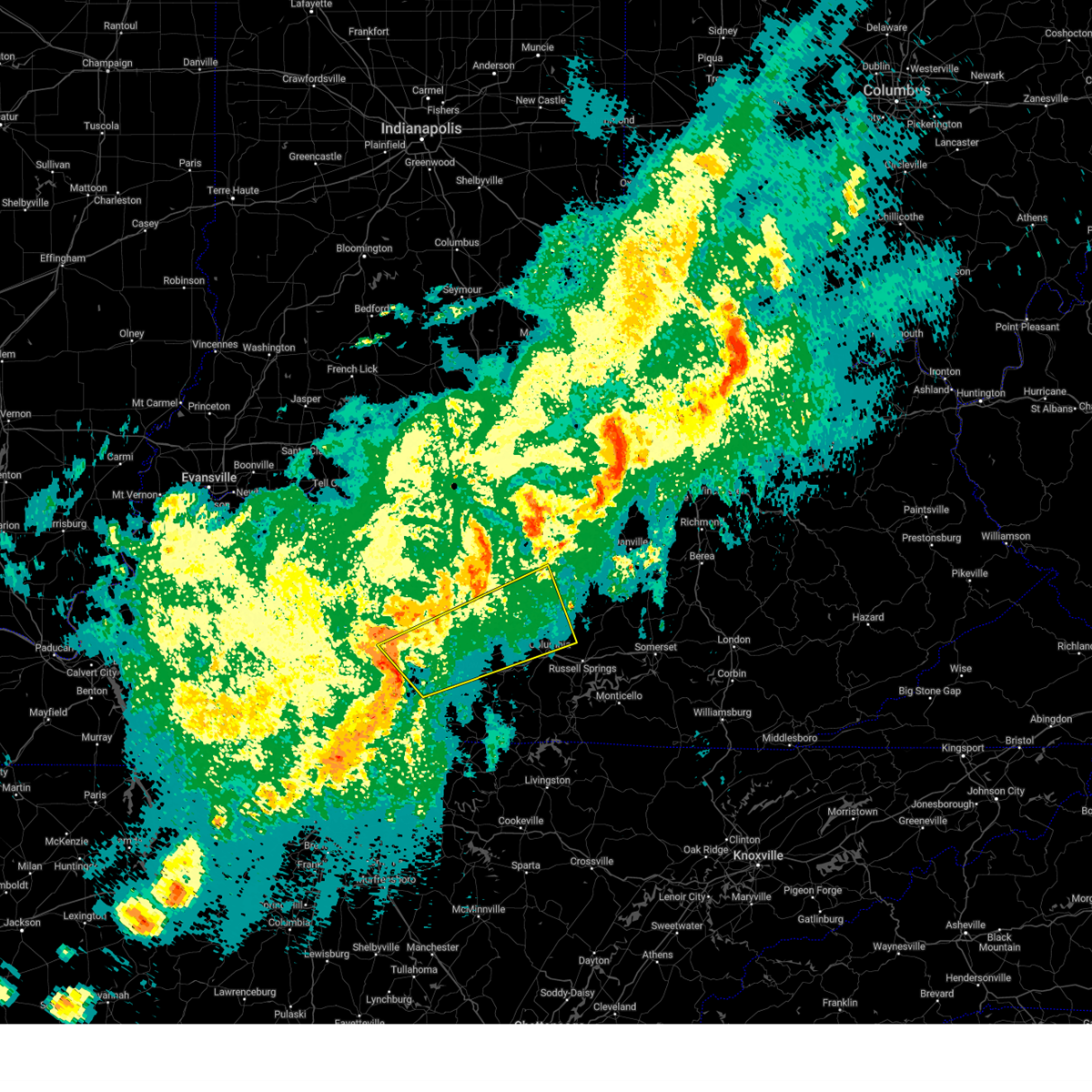
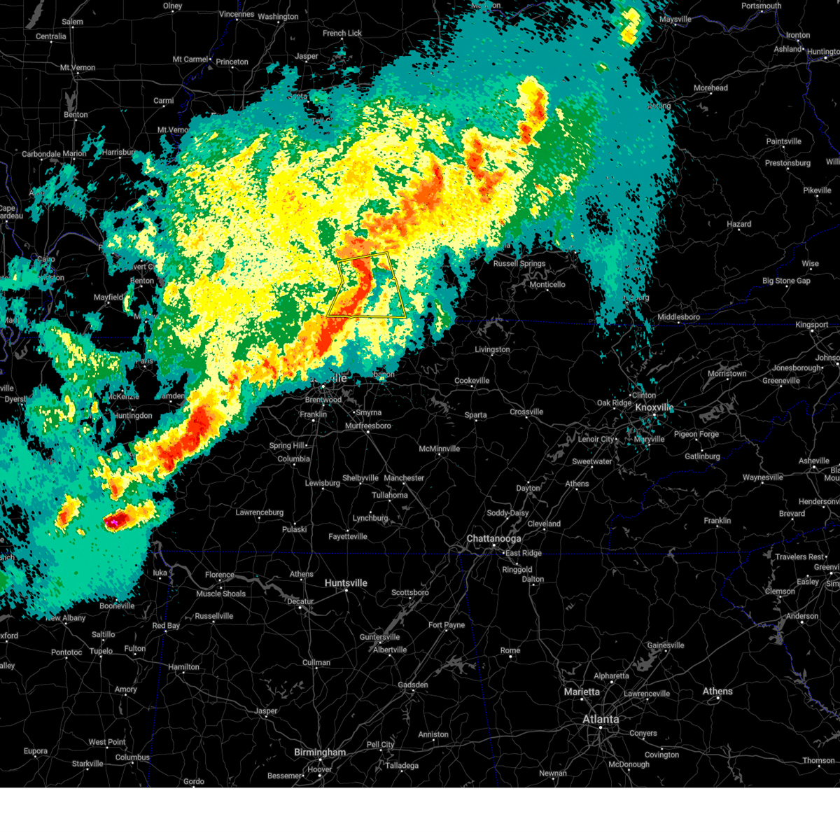
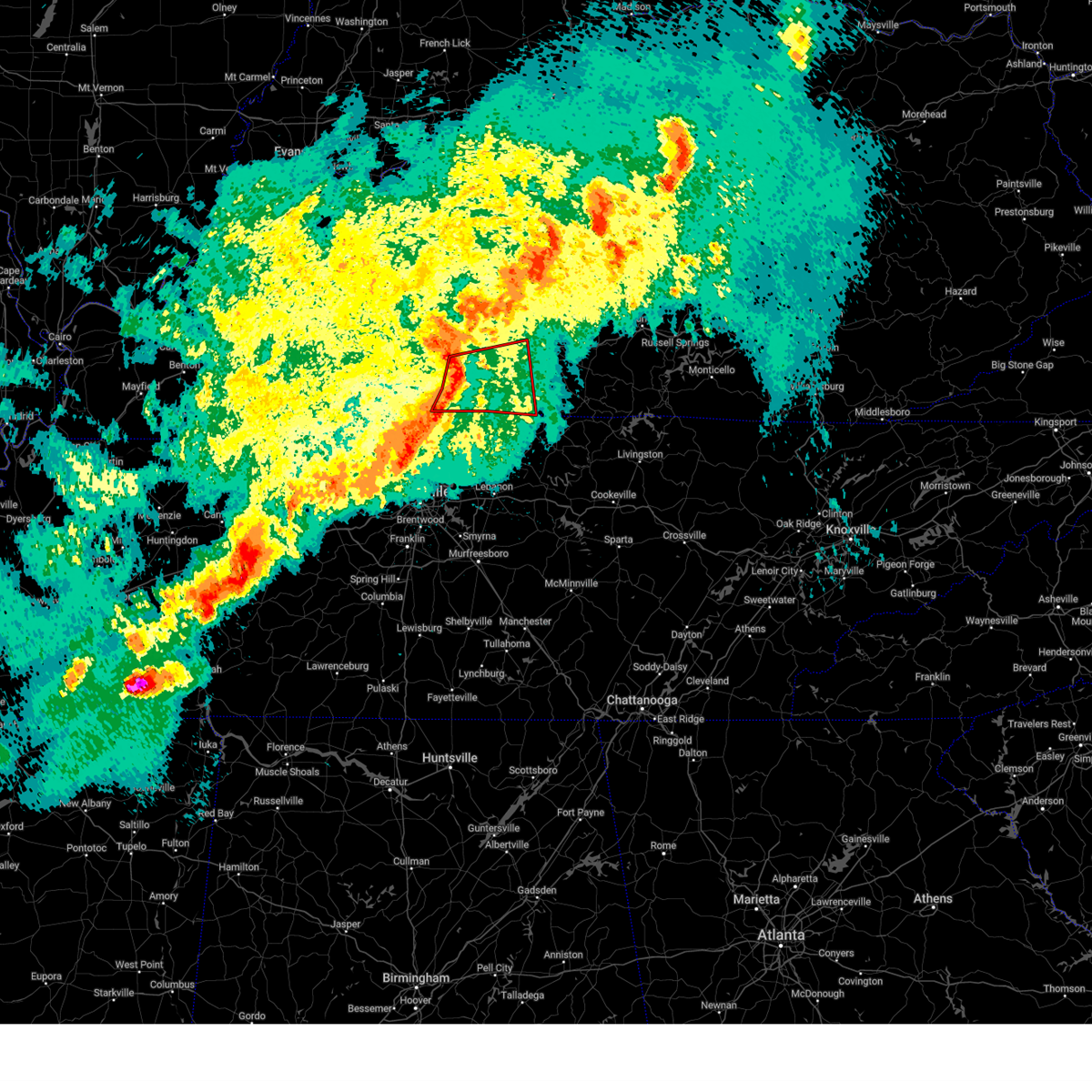
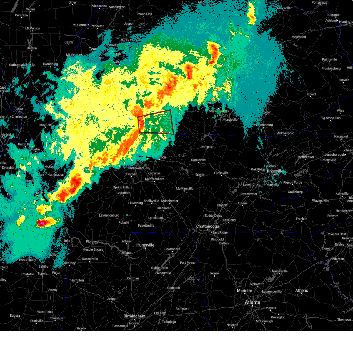
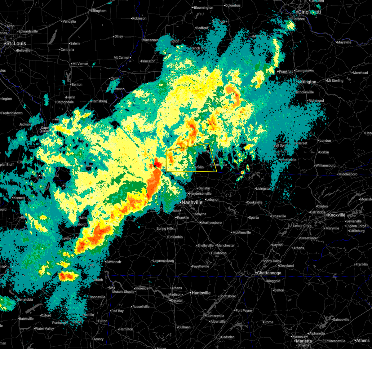
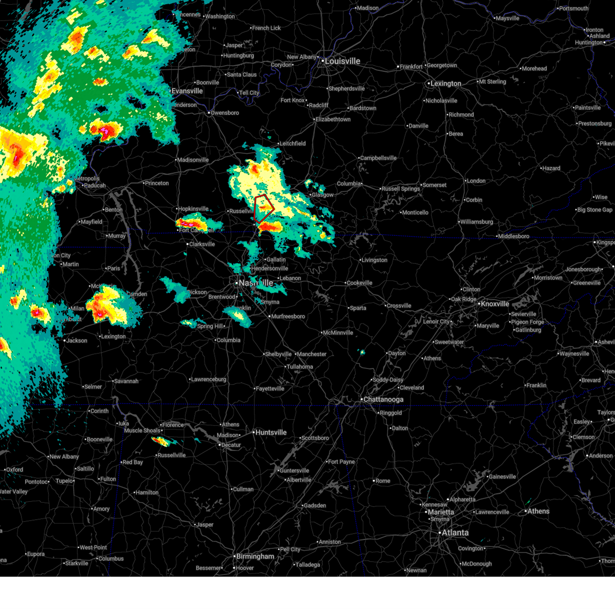
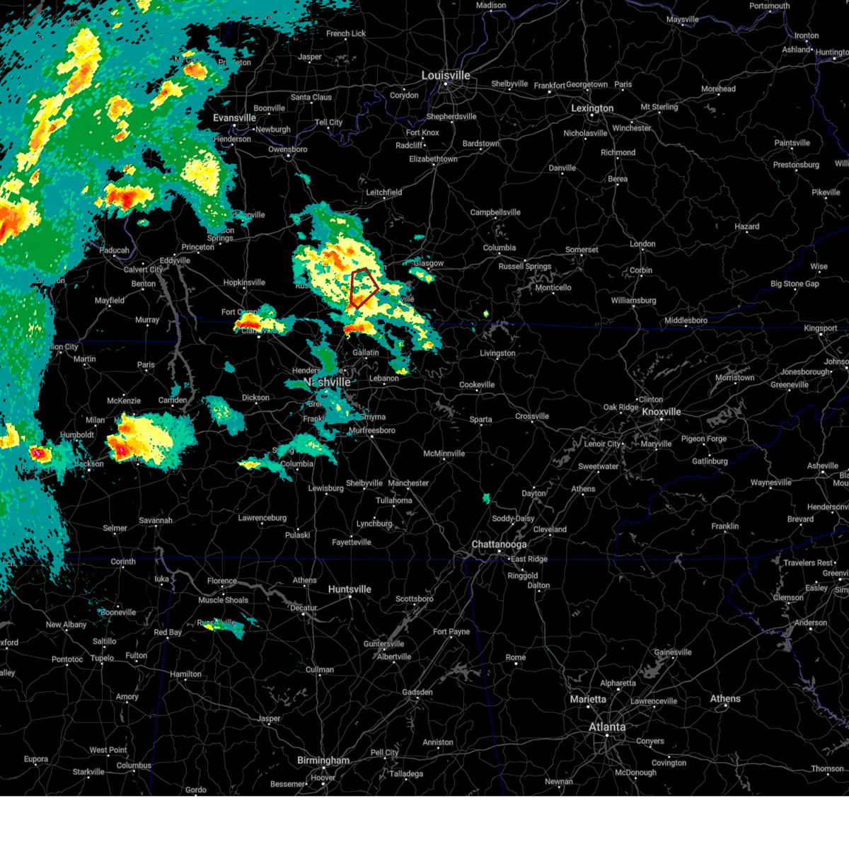
Hail Map for Bowling Green, KY
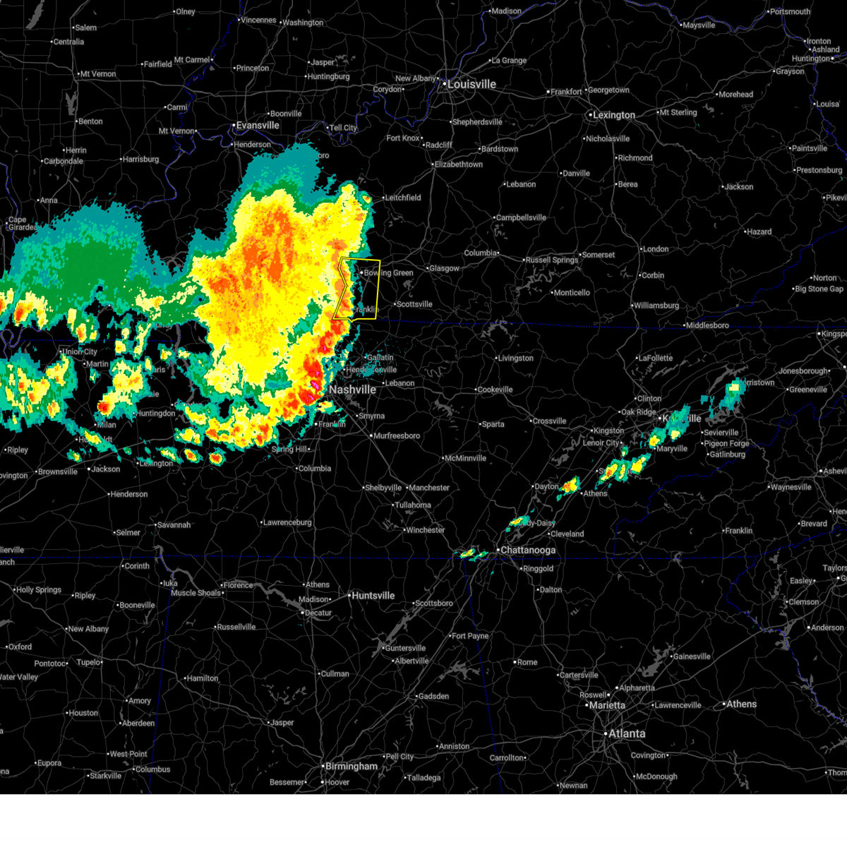
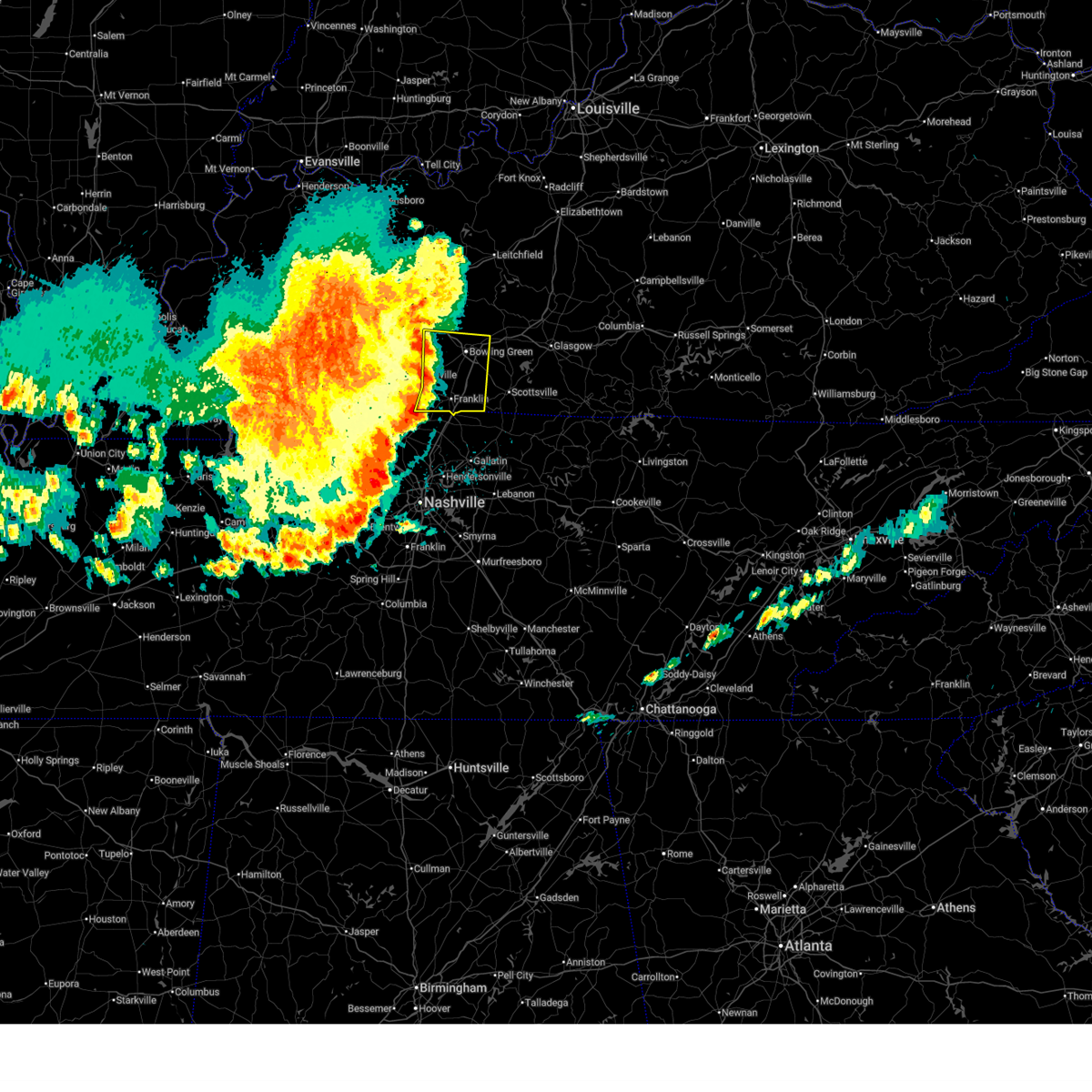
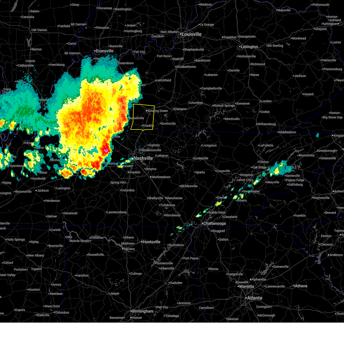
The Bowling Green, KY area has had 48 reports of on-the-ground hail by trained spotters, and has been under severe weather warnings 17 times during the past 12 months. Doppler radar has detected hail at or near Bowling Green, KY on 115 occasions, including 2 occasions during the past year.
| Name: | Bowling Green, KY |
| Where Located: | 59.1 miles NNE of Nashville, TN |
| Map: | Google Map for Bowling Green, KY |
| Population: | 58067 |
| Housing Units: | 24712 |
| More Info: | Search Google for Bowling Green, KY |
0
The Top Recent Hail Date for Bowling Green, KY is Thursday, July 31, 2025 (109th out of 115)
Hail and Wind Damage Spotted near Bowling Green, KY
| Date / Time | Report Details |
|---|---|
| 4/16/2026 7:30 PM CDT | Tree down on power line on gayle wa in warren county KY, 2.4 miles ESE of Bowling Green, KY |
| 4/16/2026 7:25 PM CDT |
 At 724 pm cdt, severe thunderstorms were located along a line extending from 7 miles west of memphis junction to 14 miles southwest of crestmoor to near cross plains, moving east at 40 mph (law enforcement). Hazards include 60 mph wind gusts. Expect damage to roofs, siding, and trees. Locations impacted include, bowling green, plum springs, crestmoor, memphis junction, mount victor, franklin, woodburn, black jack, clare, and rich pond. At 724 pm cdt, severe thunderstorms were located along a line extending from 7 miles west of memphis junction to 14 miles southwest of crestmoor to near cross plains, moving east at 40 mph (law enforcement). Hazards include 60 mph wind gusts. Expect damage to roofs, siding, and trees. Locations impacted include, bowling green, plum springs, crestmoor, memphis junction, mount victor, franklin, woodburn, black jack, clare, and rich pond.
|
| 4/16/2026 7:11 PM CDT |
 At 711 pm cdt, severe thunderstorms were located along a line extending from 13 miles west of memphis junction to 11 miles east of russellville to 8 miles northwest of cross plains, moving east at 40 mph (law enforcement reported trees and power lines down throughout the county). Hazards include 60 mph wind gusts. Expect damage to roofs, siding, and trees. Locations impacted include, bowling green, plum springs, crestmoor, memphis junction, mount victor, franklin, auburn, woodburn, black jack, and hilltop. At 711 pm cdt, severe thunderstorms were located along a line extending from 13 miles west of memphis junction to 11 miles east of russellville to 8 miles northwest of cross plains, moving east at 40 mph (law enforcement reported trees and power lines down throughout the county). Hazards include 60 mph wind gusts. Expect damage to roofs, siding, and trees. Locations impacted include, bowling green, plum springs, crestmoor, memphis junction, mount victor, franklin, auburn, woodburn, black jack, and hilltop.
|
| 4/16/2026 7:03 PM CDT |
 Svrlmk the national weather service in louisville has issued a * severe thunderstorm warning for, eastern logan county in south central kentucky, simpson county in south central kentucky, southwestern allen county in south central kentucky, south central butler county in south central kentucky, southwestern warren county in south central kentucky, * until 745 pm cdt. * at 703 pm cdt, severe thunderstorms were located along a line extending from 15 miles southeast of dunmor to 8 miles southeast of russellville to 8 miles north of springfield, moving east at 40 mph (radar indicated). Hazards include 60 mph wind gusts. expect damage to roofs, siding, and trees Svrlmk the national weather service in louisville has issued a * severe thunderstorm warning for, eastern logan county in south central kentucky, simpson county in south central kentucky, southwestern allen county in south central kentucky, south central butler county in south central kentucky, southwestern warren county in south central kentucky, * until 745 pm cdt. * at 703 pm cdt, severe thunderstorms were located along a line extending from 15 miles southeast of dunmor to 8 miles southeast of russellville to 8 miles north of springfield, moving east at 40 mph (radar indicated). Hazards include 60 mph wind gusts. expect damage to roofs, siding, and trees
|
| 3/15/2026 10:50 PM CDT | Tree down blocking holly drive near dennis wa in warren county KY, 2.9 miles ESE of Bowling Green, KY |
| 3/15/2026 10:46 PM CDT |
 Svrlmk the national weather service in louisville has issued a * severe thunderstorm warning for, simpson county in south central kentucky, southern hart county in central kentucky, allen county in south central kentucky, warren county in south central kentucky, barren county in south central kentucky, northwestern metcalfe county in south central kentucky, southeastern edmonson county in south central kentucky, * until 1130 pm cdt. * at 1046 pm cdt, severe thunderstorms were located along a line extending from 6 miles northeast of plum springs to 7 miles north of cross plains, moving east at 45 mph (radar indicated). Hazards include 60 mph wind gusts. expect damage to roofs, siding, and trees Svrlmk the national weather service in louisville has issued a * severe thunderstorm warning for, simpson county in south central kentucky, southern hart county in central kentucky, allen county in south central kentucky, warren county in south central kentucky, barren county in south central kentucky, northwestern metcalfe county in south central kentucky, southeastern edmonson county in south central kentucky, * until 1130 pm cdt. * at 1046 pm cdt, severe thunderstorms were located along a line extending from 6 miles northeast of plum springs to 7 miles north of cross plains, moving east at 45 mph (radar indicated). Hazards include 60 mph wind gusts. expect damage to roofs, siding, and trees
|
| 3/15/2026 10:30 PM CDT |
 The storms which prompted the warning have weakened below severe limits, and have exited the warned area. therefore, the warning has been allowed to expire. a tornado watch remains in effect until 200 am cdt for south central and central kentucky. to report severe weather, contact your nearest law enforcement agency. they will relay your report to the national weather service louisville. The storms which prompted the warning have weakened below severe limits, and have exited the warned area. therefore, the warning has been allowed to expire. a tornado watch remains in effect until 200 am cdt for south central and central kentucky. to report severe weather, contact your nearest law enforcement agency. they will relay your report to the national weather service louisville.
|
| 3/15/2026 10:19 PM CDT |
 At 1019 pm cdt, severe thunderstorms were located along a line extending from 10 miles southwest of leitchfield to 7 miles west of brownsville to near memphis junction, moving east at 60 mph (radar indicated). Hazards include 70 mph wind gusts. Expect considerable tree damage. damage is likely to mobile homes, roofs, and outbuildings. Locations impacted include, bowling green, russellville, brownsville, plum springs, crestmoor, memphis junction, mount victor, franklin, auburn, and adairville. At 1019 pm cdt, severe thunderstorms were located along a line extending from 10 miles southwest of leitchfield to 7 miles west of brownsville to near memphis junction, moving east at 60 mph (radar indicated). Hazards include 70 mph wind gusts. Expect considerable tree damage. damage is likely to mobile homes, roofs, and outbuildings. Locations impacted include, bowling green, russellville, brownsville, plum springs, crestmoor, memphis junction, mount victor, franklin, auburn, and adairville.
|
| 3/15/2026 10:14 PM CDT |
 At 1013 pm cdt, a severe squall line capable of producing both tornadoes and extensive straight line wind damage was located 11 miles east of morgantown, moving northeast at 65 mph (radar indicated rotation). Hazards include tornado. Flying debris will be dangerous to those caught without shelter. mobile homes will be damaged or destroyed. damage to roofs, windows, and vehicles will occur. tree damage is likely. these dangerous storms will be near, brownsville around 1025 pm cdt. Other locations impacted by this tornadic thunderstorm include windyville, chalybeate, roundhill, black gold, girkin, cub run, lines mill, broadway, rockland, and tuckertown. At 1013 pm cdt, a severe squall line capable of producing both tornadoes and extensive straight line wind damage was located 11 miles east of morgantown, moving northeast at 65 mph (radar indicated rotation). Hazards include tornado. Flying debris will be dangerous to those caught without shelter. mobile homes will be damaged or destroyed. damage to roofs, windows, and vehicles will occur. tree damage is likely. these dangerous storms will be near, brownsville around 1025 pm cdt. Other locations impacted by this tornadic thunderstorm include windyville, chalybeate, roundhill, black gold, girkin, cub run, lines mill, broadway, rockland, and tuckertown.
|
| 3/15/2026 10:14 PM CDT |
 the tornado warning has been cancelled and is no longer in effect the tornado warning has been cancelled and is no longer in effect
|
| 3/15/2026 9:59 PM CDT |
 Torlmk the national weather service in louisville has issued a * tornado warning for, northeastern logan county in south central kentucky, western hart county in central kentucky, southern butler county in south central kentucky, southeastern grayson county in central kentucky, northern warren county in south central kentucky, edmonson county in south central kentucky, * until 1045 pm cdt. * at 958 pm cdt, severe thunderstorms capable of producing both tornadoes and extensive straight line wind damage were located 13 miles east of dunmor, moving northeast at 75 mph (radar indicated rotation). Hazards include tornado. Flying debris will be dangerous to those caught without shelter. mobile homes will be damaged or destroyed. damage to roofs, windows, and vehicles will occur. tree damage is likely. these dangerous storms will be near, brownsville around 1020 pm cdt. Other locations impacted by this tornadic thunderstorm include roundhill, chalybeate, insco, dimple, girkin, black gold, leetown, cub run, rockland, and sunfish. Torlmk the national weather service in louisville has issued a * tornado warning for, northeastern logan county in south central kentucky, western hart county in central kentucky, southern butler county in south central kentucky, southeastern grayson county in central kentucky, northern warren county in south central kentucky, edmonson county in south central kentucky, * until 1045 pm cdt. * at 958 pm cdt, severe thunderstorms capable of producing both tornadoes and extensive straight line wind damage were located 13 miles east of dunmor, moving northeast at 75 mph (radar indicated rotation). Hazards include tornado. Flying debris will be dangerous to those caught without shelter. mobile homes will be damaged or destroyed. damage to roofs, windows, and vehicles will occur. tree damage is likely. these dangerous storms will be near, brownsville around 1020 pm cdt. Other locations impacted by this tornadic thunderstorm include roundhill, chalybeate, insco, dimple, girkin, black gold, leetown, cub run, rockland, and sunfish.
|
| 3/15/2026 9:39 PM CDT |
 Svrlmk the national weather service in louisville has issued a * severe thunderstorm warning for, logan county in south central kentucky, simpson county in south central kentucky, southern butler county in south central kentucky, south central grayson county in central kentucky, warren county in south central kentucky, edmonson county in south central kentucky, * until 1030 pm cdt. * at 939 pm cdt, severe thunderstorms were located along a line extending from near weir to 6 miles southwest of dunmor to 7 miles northeast of elkton to 6 miles southeast of pembroke, moving east at 80 mph (radar indicated). Hazards include 70 mph wind gusts. Expect considerable tree damage. Damage is likely to mobile homes, roofs, and outbuildings. Svrlmk the national weather service in louisville has issued a * severe thunderstorm warning for, logan county in south central kentucky, simpson county in south central kentucky, southern butler county in south central kentucky, south central grayson county in central kentucky, warren county in south central kentucky, edmonson county in south central kentucky, * until 1030 pm cdt. * at 939 pm cdt, severe thunderstorms were located along a line extending from near weir to 6 miles southwest of dunmor to 7 miles northeast of elkton to 6 miles southeast of pembroke, moving east at 80 mph (radar indicated). Hazards include 70 mph wind gusts. Expect considerable tree damage. Damage is likely to mobile homes, roofs, and outbuildings.
|
| 12/18/2025 6:53 PM CST |
 The storms which prompted the warning have moved out of the area. therefore, the warning will be allowed to expire. to report severe weather, contact your nearest law enforcement agency. they will relay your report to the national weather service louisville. The storms which prompted the warning have moved out of the area. therefore, the warning will be allowed to expire. to report severe weather, contact your nearest law enforcement agency. they will relay your report to the national weather service louisville.
|
| 12/18/2025 6:40 PM CST | Report of a mini trailer tumbled from a gas station onto red rock r in warren county KY, 5.2 miles N of Bowling Green, KY |
| 12/18/2025 6:37 PM CST |
 At 636 pm cst, severe thunderstorms were located along a line extending from mount victor to 6 miles north of cross plains, moving east at 50 mph (radar indicated). Hazards include 60 mph wind gusts. Expect damage to roofs, siding, and trees. Locations impacted include, bowling green, crestmoor, memphis junction, mount victor, franklin, woodburn, three forks, hardcastle, allen springs, and black jack. At 636 pm cst, severe thunderstorms were located along a line extending from mount victor to 6 miles north of cross plains, moving east at 50 mph (radar indicated). Hazards include 60 mph wind gusts. Expect damage to roofs, siding, and trees. Locations impacted include, bowling green, crestmoor, memphis junction, mount victor, franklin, woodburn, three forks, hardcastle, allen springs, and black jack.
|
| 12/18/2025 6:37 PM CST |
 the severe thunderstorm warning has been cancelled and is no longer in effect the severe thunderstorm warning has been cancelled and is no longer in effect
|
| 12/18/2025 6:17 PM CST |
 Svrlmk the national weather service in louisville has issued a * severe thunderstorm warning for, southeastern logan county in south central kentucky, simpson county in south central kentucky, northwestern allen county in south central kentucky, southern warren county in south central kentucky, * until 700 pm cst. * at 616 pm cst, severe thunderstorms were located along a line extending from 14 miles northeast of russellville to 9 miles east of guthrie, moving east at 40 mph (radar indicated). Hazards include 60 mph wind gusts. expect damage to roofs, siding, and trees Svrlmk the national weather service in louisville has issued a * severe thunderstorm warning for, southeastern logan county in south central kentucky, simpson county in south central kentucky, northwestern allen county in south central kentucky, southern warren county in south central kentucky, * until 700 pm cst. * at 616 pm cst, severe thunderstorms were located along a line extending from 14 miles northeast of russellville to 9 miles east of guthrie, moving east at 40 mph (radar indicated). Hazards include 60 mph wind gusts. expect damage to roofs, siding, and trees
|
| 6/27/2025 3:30 PM CDT |
 The storm which prompted the warning has weakened below severe limits, and no longer poses an immediate threat to life or property. therefore, the warning has been allowed to expire. however, gusty winds and heavy rain are still possible with this thunderstorm. to report severe weather, contact your nearest law enforcement agency. they will relay your report to the national weather service louisville. The storm which prompted the warning has weakened below severe limits, and no longer poses an immediate threat to life or property. therefore, the warning has been allowed to expire. however, gusty winds and heavy rain are still possible with this thunderstorm. to report severe weather, contact your nearest law enforcement agency. they will relay your report to the national weather service louisville.
|
| 6/27/2025 3:22 PM CDT | Trees down and blocking roadways in plan in warren county KY, 7.3 miles N of Bowling Green, KY |
| 6/27/2025 3:16 PM CDT |
 At 316 pm cdt, a severe thunderstorm was located near scottsville, moving southeast at 10 mph (radar indicated). Hazards include 60 mph wind gusts and penny size hail. Expect damage to roofs, siding, and trees. Locations impacted include, bowling green, allen springs, west fork, greenhill, settle, yesse, raley ford, halifax, chapel hill, and red hill. At 316 pm cdt, a severe thunderstorm was located near scottsville, moving southeast at 10 mph (radar indicated). Hazards include 60 mph wind gusts and penny size hail. Expect damage to roofs, siding, and trees. Locations impacted include, bowling green, allen springs, west fork, greenhill, settle, yesse, raley ford, halifax, chapel hill, and red hill.
|
| 6/27/2025 2:55 PM CDT |
 Svrlmk the national weather service in louisville has issued a * severe thunderstorm warning for, northeastern simpson county in south central kentucky, western allen county in south central kentucky, south central warren county in south central kentucky, * until 330 pm cdt. * at 255 pm cdt, a severe thunderstorm was located 7 miles southeast of memphis junction, moving southeast at 20 mph (radar indicated). Hazards include 60 mph wind gusts and penny size hail. expect damage to roofs, siding, and trees Svrlmk the national weather service in louisville has issued a * severe thunderstorm warning for, northeastern simpson county in south central kentucky, western allen county in south central kentucky, south central warren county in south central kentucky, * until 330 pm cdt. * at 255 pm cdt, a severe thunderstorm was located 7 miles southeast of memphis junction, moving southeast at 20 mph (radar indicated). Hazards include 60 mph wind gusts and penny size hail. expect damage to roofs, siding, and trees
|
| 6/18/2025 7:14 PM CDT |
 Svrlmk the national weather service in louisville has issued a * severe thunderstorm warning for, southern logan county in south central kentucky, simpson county in south central kentucky, southwestern hart county in central kentucky, warren county in south central kentucky, edmonson county in south central kentucky, * until 800 pm cdt. * at 714 pm cdt, severe thunderstorms were located along a line extending from near brownsville to near russellville, moving east at 30 mph (radar indicated). Hazards include 60 mph wind gusts. expect damage to roofs, siding, and trees Svrlmk the national weather service in louisville has issued a * severe thunderstorm warning for, southern logan county in south central kentucky, simpson county in south central kentucky, southwestern hart county in central kentucky, warren county in south central kentucky, edmonson county in south central kentucky, * until 800 pm cdt. * at 714 pm cdt, severe thunderstorms were located along a line extending from near brownsville to near russellville, moving east at 30 mph (radar indicated). Hazards include 60 mph wind gusts. expect damage to roofs, siding, and trees
|
| 5/20/2025 6:02 PM CDT |
 the severe thunderstorm warning has been cancelled and is no longer in effect the severe thunderstorm warning has been cancelled and is no longer in effect
|
| 5/20/2025 5:48 PM CDT |
 At 547 pm cdt, a severe thunderstorm was located over mount victor, or just southeast of bowling green, moving northeast at 30 mph (radar indicated). Hazards include 60 mph wind gusts and quarter size hail. Hail damage to vehicles is expected. expect wind damage to roofs, siding, and trees. Locations impacted include, bowling green, plum springs, crestmoor, mount victor, smiths grove, oakland, three forks, bristow, hardcastle, girkin, pondsville, greenhill, loving, tuckertown, matlock, alvaton, hays, sunnyside, gotts, and polkville. At 547 pm cdt, a severe thunderstorm was located over mount victor, or just southeast of bowling green, moving northeast at 30 mph (radar indicated). Hazards include 60 mph wind gusts and quarter size hail. Hail damage to vehicles is expected. expect wind damage to roofs, siding, and trees. Locations impacted include, bowling green, plum springs, crestmoor, mount victor, smiths grove, oakland, three forks, bristow, hardcastle, girkin, pondsville, greenhill, loving, tuckertown, matlock, alvaton, hays, sunnyside, gotts, and polkville.
|
| 5/20/2025 5:35 PM CDT |
 At 535 pm cdt, a severe thunderstorm was located near memphis junction, or near bowling green, moving northeast at 40 mph (radar indicated). Hazards include 70 mph wind gusts and quarter size hail. Hail damage to vehicles is expected. expect considerable tree damage. wind damage is also likely to mobile homes, roofs, and outbuildings. Locations impacted include, bowling green, plum springs, crestmoor, memphis junction, mount victor, smiths grove, woodburn, oakland, three forks, hardcastle, girkin, rich pond, greenhill, loving, tuckertown, hays, sunnyside, polkville, martinsville, and motley. At 535 pm cdt, a severe thunderstorm was located near memphis junction, or near bowling green, moving northeast at 40 mph (radar indicated). Hazards include 70 mph wind gusts and quarter size hail. Hail damage to vehicles is expected. expect considerable tree damage. wind damage is also likely to mobile homes, roofs, and outbuildings. Locations impacted include, bowling green, plum springs, crestmoor, memphis junction, mount victor, smiths grove, woodburn, oakland, three forks, hardcastle, girkin, rich pond, greenhill, loving, tuckertown, hays, sunnyside, polkville, martinsville, and motley.
|
| 5/20/2025 5:33 PM CDT | Tree down blocking matlock rd near rich pond r in warren county KY, 7.6 miles NNE of Bowling Green, KY |
| 5/20/2025 5:31 PM CDT |
 the severe thunderstorm warning has been cancelled and is no longer in effect the severe thunderstorm warning has been cancelled and is no longer in effect
|
| 5/20/2025 5:31 PM CDT |
 At 530 pm cdt, a severe thunderstorm was located near memphis junction, or near bowling green, moving northeast at 40 mph (radar indicated). Hazards include 60 mph wind gusts and quarter size hail. Hail damage to vehicles is expected. expect wind damage to roofs, siding, and trees. Locations impacted include, bowling green, plum springs, crestmoor, memphis junction, mount victor, smiths grove, woodburn, oakland, three forks, hardcastle, girkin, rich pond, greenhill, loving, tuckertown, hays, sunnyside, polkville, martinsville, and motley. At 530 pm cdt, a severe thunderstorm was located near memphis junction, or near bowling green, moving northeast at 40 mph (radar indicated). Hazards include 60 mph wind gusts and quarter size hail. Hail damage to vehicles is expected. expect wind damage to roofs, siding, and trees. Locations impacted include, bowling green, plum springs, crestmoor, memphis junction, mount victor, smiths grove, woodburn, oakland, three forks, hardcastle, girkin, rich pond, greenhill, loving, tuckertown, hays, sunnyside, polkville, martinsville, and motley.
|
| 5/20/2025 5:23 PM CDT |
 Svrlmk the national weather service in louisville has issued a * severe thunderstorm warning for, east central logan county in south central kentucky, northern simpson county in south central kentucky, warren county in south central kentucky, * until 615 pm cdt. * at 523 pm cdt, a severe thunderstorm was located 9 miles southwest of memphis junction, or 12 miles southwest of bowling green, moving northeast at 35 mph (radar indicated). Hazards include 60 mph wind gusts and quarter size hail. Hail damage to vehicles is expected. Expect wind damage to roofs, siding, and trees. Svrlmk the national weather service in louisville has issued a * severe thunderstorm warning for, east central logan county in south central kentucky, northern simpson county in south central kentucky, warren county in south central kentucky, * until 615 pm cdt. * at 523 pm cdt, a severe thunderstorm was located 9 miles southwest of memphis junction, or 12 miles southwest of bowling green, moving northeast at 35 mph (radar indicated). Hazards include 60 mph wind gusts and quarter size hail. Hail damage to vehicles is expected. Expect wind damage to roofs, siding, and trees.
|
| 5/16/2025 11:33 PM EDT |
 The storms which prompted the warning have moved out of the area. therefore, the warning has been allowed to expire. however, gusty winds and heavy rain are still possible with these thunderstorms. a tornado watch remains in effect until 100 am edt/midnight cdt/ for south central kentucky. a tornado watch also remains in effect until 300 am edt/200 am cdt/ for south central and central kentucky. The storms which prompted the warning have moved out of the area. therefore, the warning has been allowed to expire. however, gusty winds and heavy rain are still possible with these thunderstorms. a tornado watch remains in effect until 100 am edt/midnight cdt/ for south central kentucky. a tornado watch also remains in effect until 300 am edt/200 am cdt/ for south central and central kentucky.
|
| 5/16/2025 10:32 PM CDT |
 The storms which prompted the warning have moved out of the area. therefore, the warning has been allowed to expire. a tornado watch remains in effect until midnight cdt for south central kentucky. a tornado watch also remains in effect until 200 am cdt for south central kentucky. to report severe weather, contact your nearest law enforcement agency. they will relay your report to the national weather service louisville. The storms which prompted the warning have moved out of the area. therefore, the warning has been allowed to expire. a tornado watch remains in effect until midnight cdt for south central kentucky. a tornado watch also remains in effect until 200 am cdt for south central kentucky. to report severe weather, contact your nearest law enforcement agency. they will relay your report to the national weather service louisville.
|
| 5/16/2025 10:17 PM CDT | Corrects previous tstm wnd gst report from 1 ese bowling gree in warren county KY, 1.1 miles N of Bowling Green, KY |
| 5/16/2025 10:17 PM CDT | Storm damage reported in warren county KY, 1.1 miles N of Bowling Green, KY |
| 5/16/2025 10:15 PM CDT | Storm damage reported in warren county KY, 5.3 miles N of Bowling Green, KY |
| 5/16/2025 10:09 PM CDT |
 At 1008 pm cdt, a severe thunderstorm capable of producing a tornado was located 8 miles southwest of memphis junction, moving east at 70 mph (radar indicated rotation). Hazards include tornado. Flying debris will be dangerous to those caught without shelter. mobile homes will be damaged or destroyed. damage to roofs, windows, and vehicles will occur. tree damage is likely. This tornadic thunderstorm will remain over mainly rural areas of northern simpson, west central allen and southwestern warren counties, including the following locations, matlock, alvaton, hillsdale, pope, trammel, allen springs, boyce, motley, south union, and drake. At 1008 pm cdt, a severe thunderstorm capable of producing a tornado was located 8 miles southwest of memphis junction, moving east at 70 mph (radar indicated rotation). Hazards include tornado. Flying debris will be dangerous to those caught without shelter. mobile homes will be damaged or destroyed. damage to roofs, windows, and vehicles will occur. tree damage is likely. This tornadic thunderstorm will remain over mainly rural areas of northern simpson, west central allen and southwestern warren counties, including the following locations, matlock, alvaton, hillsdale, pope, trammel, allen springs, boyce, motley, south union, and drake.
|
| 5/16/2025 10:09 PM CDT |
 the tornado warning has been cancelled and is no longer in effect the tornado warning has been cancelled and is no longer in effect
|
| 5/16/2025 10:07 PM CDT | 4 trees blown over and uprooted on london driv in warren county KY, 7.7 miles NE of Bowling Green, KY |
| 5/16/2025 10:02 PM CDT |
 At 1002 pm cdt, a confirmed tornado was located 8 miles east of russellville, moving east at 75 mph (radar confirmed tornado). Hazards include damaging tornado. Flying debris will be dangerous to those caught without shelter. mobile homes will be damaged or destroyed. damage to roofs, windows, and vehicles will occur. tree damage is likely. this tornado will be near, bowling green around 1010 pm cdt. Other locations impacted by this tornadic thunderstorm include hillsdale, hardcastle, allen springs, dennis, rockfield, rich pond, auburn, greenhill, south union, and woodburn. At 1002 pm cdt, a confirmed tornado was located 8 miles east of russellville, moving east at 75 mph (radar confirmed tornado). Hazards include damaging tornado. Flying debris will be dangerous to those caught without shelter. mobile homes will be damaged or destroyed. damage to roofs, windows, and vehicles will occur. tree damage is likely. this tornado will be near, bowling green around 1010 pm cdt. Other locations impacted by this tornadic thunderstorm include hillsdale, hardcastle, allen springs, dennis, rockfield, rich pond, auburn, greenhill, south union, and woodburn.
|
| 5/16/2025 9:58 PM CDT |
 At 957 pm cdt, a confirmed tornado was located near russellville, moving east at 70 mph (radar confirmed tornado). Hazards include damaging tornado. Flying debris will be dangerous to those caught without shelter. mobile homes will be damaged or destroyed. damage to roofs, windows, and vehicles will occur. tree damage is likely. this tornado will be near, bowling green and memphis junction around 1010 pm cdt. Other locations impacted by this tornadic thunderstorm include hardcastle, allen springs, epleys, dennis, rich pond, greenhill, trammel, polkville, boyce, and motley. At 957 pm cdt, a confirmed tornado was located near russellville, moving east at 70 mph (radar confirmed tornado). Hazards include damaging tornado. Flying debris will be dangerous to those caught without shelter. mobile homes will be damaged or destroyed. damage to roofs, windows, and vehicles will occur. tree damage is likely. this tornado will be near, bowling green and memphis junction around 1010 pm cdt. Other locations impacted by this tornadic thunderstorm include hardcastle, allen springs, epleys, dennis, rich pond, greenhill, trammel, polkville, boyce, and motley.
|
| 5/16/2025 9:54 PM CDT |
 Torlmk the national weather service in louisville has issued a * tornado warning for, central logan county in south central kentucky, northern simpson county in south central kentucky, west central allen county in south central kentucky, southwestern warren county in south central kentucky, * until 1030 pm cdt. * at 954 pm cdt, a severe thunderstorm capable of producing a tornado was located near russellville, moving east at 70 mph (radar indicated rotation). Hazards include tornado. Flying debris will be dangerous to those caught without shelter. mobile homes will be damaged or destroyed. damage to roofs, windows, and vehicles will occur. tree damage is likely. this dangerous storm will be near, bowling green and memphis junction around 1010 pm cdt. Other locations impacted by this tornadic thunderstorm include hardcastle, allen springs, epleys, dennis, rich pond, greenhill, trammel, polkville, boyce, and motley. Torlmk the national weather service in louisville has issued a * tornado warning for, central logan county in south central kentucky, northern simpson county in south central kentucky, west central allen county in south central kentucky, southwestern warren county in south central kentucky, * until 1030 pm cdt. * at 954 pm cdt, a severe thunderstorm capable of producing a tornado was located near russellville, moving east at 70 mph (radar indicated rotation). Hazards include tornado. Flying debris will be dangerous to those caught without shelter. mobile homes will be damaged or destroyed. damage to roofs, windows, and vehicles will occur. tree damage is likely. this dangerous storm will be near, bowling green and memphis junction around 1010 pm cdt. Other locations impacted by this tornadic thunderstorm include hardcastle, allen springs, epleys, dennis, rich pond, greenhill, trammel, polkville, boyce, and motley.
|
| 5/16/2025 9:52 PM CDT |
 At 952 pm cdt, severe thunderstorms were located along a line extending from 8 miles south of dunmor to guthrie, moving east at 70 mph (radar indicated). Hazards include 70 mph wind gusts and quarter size hail. Hail damage to vehicles is expected. expect considerable tree damage. wind damage is also likely to mobile homes, roofs, and outbuildings. Locations impacted include, russellville, franklin, auburn, adairville, woodburn, epleys, black jack, rich pond, crossroad, and settle. At 952 pm cdt, severe thunderstorms were located along a line extending from 8 miles south of dunmor to guthrie, moving east at 70 mph (radar indicated). Hazards include 70 mph wind gusts and quarter size hail. Hail damage to vehicles is expected. expect considerable tree damage. wind damage is also likely to mobile homes, roofs, and outbuildings. Locations impacted include, russellville, franklin, auburn, adairville, woodburn, epleys, black jack, rich pond, crossroad, and settle.
|
| 5/16/2025 9:45 PM CDT |
 Svrlmk the national weather service in louisville has issued a * severe thunderstorm warning for, logan county in south central kentucky, simpson county in south central kentucky, western allen county in south central kentucky, southern warren county in south central kentucky, * until 1030 pm cdt. * at 945 pm cdt, severe thunderstorms were located along a line extending from 9 miles southwest of dunmor to 6 miles west of guthrie, moving east at 70 mph (radar indicated). Hazards include 70 mph wind gusts and quarter size hail. Hail damage to vehicles is expected. expect considerable tree damage. Wind damage is also likely to mobile homes, roofs, and outbuildings. Svrlmk the national weather service in louisville has issued a * severe thunderstorm warning for, logan county in south central kentucky, simpson county in south central kentucky, western allen county in south central kentucky, southern warren county in south central kentucky, * until 1030 pm cdt. * at 945 pm cdt, severe thunderstorms were located along a line extending from 9 miles southwest of dunmor to 6 miles west of guthrie, moving east at 70 mph (radar indicated). Hazards include 70 mph wind gusts and quarter size hail. Hail damage to vehicles is expected. expect considerable tree damage. Wind damage is also likely to mobile homes, roofs, and outbuildings.
|
| 5/16/2025 10:40 PM EDT |
 Svrlmk the national weather service in louisville has issued a * severe thunderstorm warning for, central nelson county in central kentucky, eastern larue county in central kentucky, marion county in central kentucky, eastern hart county in central kentucky, taylor county in central kentucky, west central jessamine county in central kentucky, northwestern casey county in central kentucky, central adair county in south central kentucky, southeastern edmonson county in south central kentucky, mercer county in central kentucky, green county in central kentucky, central warren county in south central kentucky, washington county in central kentucky, boyle county in central kentucky, barren county in south central kentucky, metcalfe county in south central kentucky, * until 1130 pm edt/1030 pm cdt/. * at 1040 pm edt/940 pm cdt/, severe thunderstorms were located along a line extending from 9 miles west of bardstown to 9 miles west of munfordville to near memphis junction, moving east at 65 mph (radar indicated). Hazards include 70 mph wind gusts and penny size hail. Expect considerable tree damage. Damage is likely to mobile homes, roofs, and outbuildings. Svrlmk the national weather service in louisville has issued a * severe thunderstorm warning for, central nelson county in central kentucky, eastern larue county in central kentucky, marion county in central kentucky, eastern hart county in central kentucky, taylor county in central kentucky, west central jessamine county in central kentucky, northwestern casey county in central kentucky, central adair county in south central kentucky, southeastern edmonson county in south central kentucky, mercer county in central kentucky, green county in central kentucky, central warren county in south central kentucky, washington county in central kentucky, boyle county in central kentucky, barren county in south central kentucky, metcalfe county in south central kentucky, * until 1130 pm edt/1030 pm cdt/. * at 1040 pm edt/940 pm cdt/, severe thunderstorms were located along a line extending from 9 miles west of bardstown to 9 miles west of munfordville to near memphis junction, moving east at 65 mph (radar indicated). Hazards include 70 mph wind gusts and penny size hail. Expect considerable tree damage. Damage is likely to mobile homes, roofs, and outbuildings.
|
| 5/16/2025 9:22 PM CDT |
 Svrlmk the national weather service in louisville has issued a * severe thunderstorm warning for, northern logan county in south central kentucky, south central larue county in central kentucky, hart county in central kentucky, southeastern butler county in south central kentucky, southeastern grayson county in central kentucky, warren county in south central kentucky, northwestern barren county in south central kentucky, edmonson county in south central kentucky, * until 1100 pm edt/1000 pm cdt/. * at 1021 pm edt/921 pm cdt/, severe thunderstorms were located along a line extending from 7 miles south of leitchfield to 9 miles west of brownsville to 9 miles southeast of morgantown to 8 miles south of dunmor, moving east at 40 mph (radar indicated). Hazards include 70 mph wind gusts. Expect considerable tree damage. Damage is likely to mobile homes, roofs, and outbuildings. Svrlmk the national weather service in louisville has issued a * severe thunderstorm warning for, northern logan county in south central kentucky, south central larue county in central kentucky, hart county in central kentucky, southeastern butler county in south central kentucky, southeastern grayson county in central kentucky, warren county in south central kentucky, northwestern barren county in south central kentucky, edmonson county in south central kentucky, * until 1100 pm edt/1000 pm cdt/. * at 1021 pm edt/921 pm cdt/, severe thunderstorms were located along a line extending from 7 miles south of leitchfield to 9 miles west of brownsville to 9 miles southeast of morgantown to 8 miles south of dunmor, moving east at 40 mph (radar indicated). Hazards include 70 mph wind gusts. Expect considerable tree damage. Damage is likely to mobile homes, roofs, and outbuildings.
|
| 5/16/2025 8:05 PM CDT |
 The storm which prompted the warning has moved out of the area. therefore, the warning will be allowed to expire. a tornado watch remains in effect until 1000 pm cdt for south central kentucky. to report severe weather, contact your nearest law enforcement agency. they will relay your report to the national weather service louisville. The storm which prompted the warning has moved out of the area. therefore, the warning will be allowed to expire. a tornado watch remains in effect until 1000 pm cdt for south central kentucky. to report severe weather, contact your nearest law enforcement agency. they will relay your report to the national weather service louisville.
|
| 5/16/2025 8:02 PM CDT |
 The storm which prompted the warning has moved out of the area. therefore, the warning has been allowed to expire. a tornado watch remains in effect until 1000 pm cdt for south central kentucky. a tornado watch also remains in effect until 200 am cdt for south central and central kentucky. to report severe weather, contact your nearest law enforcement agency. they will relay your report to the national weather service louisville. The storm which prompted the warning has moved out of the area. therefore, the warning has been allowed to expire. a tornado watch remains in effect until 1000 pm cdt for south central kentucky. a tornado watch also remains in effect until 200 am cdt for south central and central kentucky. to report severe weather, contact your nearest law enforcement agency. they will relay your report to the national weather service louisville.
|
| 5/16/2025 7:59 PM CDT |
 Svrlmk the national weather service in louisville has issued a * severe thunderstorm warning for, southwestern green county in central kentucky, hart county in central kentucky, northeastern warren county in south central kentucky, barren county in south central kentucky, western metcalfe county in south central kentucky, eastern edmonson county in south central kentucky, * until 845 pm cdt. * at 759 pm cdt, a severe thunderstorm was located 9 miles east of plum springs, moving east at 45 mph (radar indicated). Hazards include two inch hail and 70 mph wind gusts. People and animals outdoors will be injured. expect hail damage to roofs, siding, windows, and vehicles. expect considerable tree damage. Wind damage is also likely to mobile homes, roofs, and outbuildings. Svrlmk the national weather service in louisville has issued a * severe thunderstorm warning for, southwestern green county in central kentucky, hart county in central kentucky, northeastern warren county in south central kentucky, barren county in south central kentucky, western metcalfe county in south central kentucky, eastern edmonson county in south central kentucky, * until 845 pm cdt. * at 759 pm cdt, a severe thunderstorm was located 9 miles east of plum springs, moving east at 45 mph (radar indicated). Hazards include two inch hail and 70 mph wind gusts. People and animals outdoors will be injured. expect hail damage to roofs, siding, windows, and vehicles. expect considerable tree damage. Wind damage is also likely to mobile homes, roofs, and outbuildings.
|
| 5/16/2025 7:55 PM CDT |
 Torlmk the national weather service in louisville has issued a * tornado warning for, east central warren county in south central kentucky, central barren county in south central kentucky, * until 845 pm cdt. * at 755 pm cdt, a severe thunderstorm capable of producing a tornado was located near plum springs, moving east at 35 mph (radar indicated rotation). Hazards include tornado and golf ball size hail. Flying debris will be dangerous to those caught without shelter. mobile homes will be damaged or destroyed. damage to roofs, windows, and vehicles will occur. tree damage is likely. this dangerous storm will be near, glasgow around 820 pm cdt. Other locations impacted by this tornadic thunderstorm include three forks, red cross, roseville, pritchardsville, lecta, haywood, loving, hays, sunnyside, and polkville. Torlmk the national weather service in louisville has issued a * tornado warning for, east central warren county in south central kentucky, central barren county in south central kentucky, * until 845 pm cdt. * at 755 pm cdt, a severe thunderstorm capable of producing a tornado was located near plum springs, moving east at 35 mph (radar indicated rotation). Hazards include tornado and golf ball size hail. Flying debris will be dangerous to those caught without shelter. mobile homes will be damaged or destroyed. damage to roofs, windows, and vehicles will occur. tree damage is likely. this dangerous storm will be near, glasgow around 820 pm cdt. Other locations impacted by this tornadic thunderstorm include three forks, red cross, roseville, pritchardsville, lecta, haywood, loving, hays, sunnyside, and polkville.
|
| 5/16/2025 7:51 PM CDT |
 At 750 pm cdt, a severe thunderstorm capable of producing a tornado was located over bowling green, moving east at 45 mph (radar indicated rotation). Hazards include tornado and golf ball size hail. Flying debris will be dangerous to those caught without shelter. mobile homes will be damaged or destroyed. damage to roofs, windows, and vehicles will occur. tree damage is likely. this dangerous storm will be near, bowling green, plum springs, and mount victor around 755 pm cdt. Other locations impacted by this tornadic thunderstorm include bristow, hardcastle, sunnyside, girkin, gotts, polkville, smiths grove, loving, oakland, and tuckertown. At 750 pm cdt, a severe thunderstorm capable of producing a tornado was located over bowling green, moving east at 45 mph (radar indicated rotation). Hazards include tornado and golf ball size hail. Flying debris will be dangerous to those caught without shelter. mobile homes will be damaged or destroyed. damage to roofs, windows, and vehicles will occur. tree damage is likely. this dangerous storm will be near, bowling green, plum springs, and mount victor around 755 pm cdt. Other locations impacted by this tornadic thunderstorm include bristow, hardcastle, sunnyside, girkin, gotts, polkville, smiths grove, loving, oakland, and tuckertown.
|
| 5/16/2025 7:49 PM CDT | Quarter sized hail reported 3.8 miles SW of Bowling Green, KY |
| 5/16/2025 7:49 PM CDT |
 the severe thunderstorm warning has been cancelled and is no longer in effect the severe thunderstorm warning has been cancelled and is no longer in effect
|
| 5/16/2025 7:49 PM CDT |
 At 749 pm cdt, a severe thunderstorm was located near plum springs, moving east at 45 mph (radar indicated). Hazards include two inch hail and 70 mph wind gusts. People and animals outdoors will be injured. expect hail damage to roofs, siding, windows, and vehicles. expect considerable tree damage. wind damage is also likely to mobile homes, roofs, and outbuildings. Locations impacted include, bowling green, brownsville, plum springs, mount victor, smiths grove, oakland, windyville, chalybeate, girkin, and rocky hill. At 749 pm cdt, a severe thunderstorm was located near plum springs, moving east at 45 mph (radar indicated). Hazards include two inch hail and 70 mph wind gusts. People and animals outdoors will be injured. expect hail damage to roofs, siding, windows, and vehicles. expect considerable tree damage. wind damage is also likely to mobile homes, roofs, and outbuildings. Locations impacted include, bowling green, brownsville, plum springs, mount victor, smiths grove, oakland, windyville, chalybeate, girkin, and rocky hill.
|
| 5/16/2025 7:48 PM CDT | Golf Ball sized hail reported 4.6 miles SW of Bowling Green, KY, picture on x. |
| 5/16/2025 7:48 PM CDT | Golf Ball sized hail reported 6.2 miles W of Bowling Green, KY, picture on x. |
| 5/16/2025 7:47 PM CDT | Golf Ball sized hail reported 5.5 miles SW of Bowling Green, KY, report from mping: golf ball (1.75 in.). |
| 5/16/2025 7:46 PM CDT | Golf Ball sized hail reported 5.9 miles SSW of Bowling Green, KY, report from mping: golf ball (1.75 in.). |
| 5/16/2025 7:46 PM CDT | Hen Egg sized hail reported 5.9 miles SSW of Bowling Green, KY, report from mping: hen egg (2.00 in.). |
| 5/16/2025 7:46 PM CDT | Tennis Ball sized hail reported 3.8 miles SW of Bowling Green, KY, report from mping: tennis ball (2.50 in.). |
| 5/16/2025 7:46 PM CDT | Quarter sized hail reported 1.9 miles ESE of Bowling Green, KY |
| 5/16/2025 7:42 PM CDT | Quarter sized hail reported 1.1 miles ENE of Bowling Green, KY, report from mping: quarter (1.00 in.). |
| 5/16/2025 7:42 PM CDT | Quarter sized hail reported 2 miles SSE of Bowling Green, KY, report from mping: quarter (1.00 in.). |
| 5/16/2025 7:42 PM CDT | Golf Ball sized hail reported 2 miles SSE of Bowling Green, KY, picture on twitter. |
| 5/16/2025 7:41 PM CDT | Ping Pong Ball sized hail reported 2 miles SSE of Bowling Green, KY |
| 5/16/2025 7:40 PM CDT | Half Dollar sized hail reported 2.4 miles ESE of Bowling Green, KY |
| 5/16/2025 7:40 PM CDT |
 the severe thunderstorm warning has been cancelled and is no longer in effect the severe thunderstorm warning has been cancelled and is no longer in effect
|
| 5/16/2025 7:40 PM CDT |
 At 740 pm cdt, a severe thunderstorm was located 7 miles northwest of plum springs, moving east at 45 mph (radar indicated). Hazards include two inch hail and 70 mph wind gusts. People and animals outdoors will be injured. expect hail damage to roofs, siding, windows, and vehicles. expect considerable tree damage. wind damage is also likely to mobile homes, roofs, and outbuildings. Locations impacted include, bowling green, brownsville, plum springs, mount victor, smiths grove, oakland, windyville, chalybeate, girkin, and black gold. At 740 pm cdt, a severe thunderstorm was located 7 miles northwest of plum springs, moving east at 45 mph (radar indicated). Hazards include two inch hail and 70 mph wind gusts. People and animals outdoors will be injured. expect hail damage to roofs, siding, windows, and vehicles. expect considerable tree damage. wind damage is also likely to mobile homes, roofs, and outbuildings. Locations impacted include, bowling green, brownsville, plum springs, mount victor, smiths grove, oakland, windyville, chalybeate, girkin, and black gold.
|
| 5/16/2025 7:39 PM CDT | Baseball sized hail reported 3.2 miles ENE of Bowling Green, KY, picture on x. |
| 5/16/2025 7:37 PM CDT |
 At 736 pm cdt, a severe thunderstorm capable of producing a tornado was located 8 miles west of memphis junction, moving east at 45 mph (radar indicated rotation). Hazards include tornado and golf ball size hail. Flying debris will be dangerous to those caught without shelter. mobile homes will be damaged or destroyed. damage to roofs, windows, and vehicles will occur. tree damage is likely. this dangerous storm will be near, bowling green around 740 pm cdt. memphis junction and crestmoor around 745 pm cdt. plum springs and mount victor around 750 pm cdt. Other locations impacted by this tornadic thunderstorm include barren river, bristow, hardcastle, girkin, greenhill, loving, oakland, tuckertown, alvaton, and browning. At 736 pm cdt, a severe thunderstorm capable of producing a tornado was located 8 miles west of memphis junction, moving east at 45 mph (radar indicated rotation). Hazards include tornado and golf ball size hail. Flying debris will be dangerous to those caught without shelter. mobile homes will be damaged or destroyed. damage to roofs, windows, and vehicles will occur. tree damage is likely. this dangerous storm will be near, bowling green around 740 pm cdt. memphis junction and crestmoor around 745 pm cdt. plum springs and mount victor around 750 pm cdt. Other locations impacted by this tornadic thunderstorm include barren river, bristow, hardcastle, girkin, greenhill, loving, oakland, tuckertown, alvaton, and browning.
|
| 5/16/2025 7:37 PM CDT |
 the tornado warning has been cancelled and is no longer in effect the tornado warning has been cancelled and is no longer in effect
|
| 5/16/2025 7:28 PM CDT | Quarter sized hail reported 12 miles ESE of Bowling Green, KY |
| 5/16/2025 7:23 PM CDT |
 Torlmk the national weather service in louisville has issued a * tornado warning for, northeastern logan county in south central kentucky, south central butler county in south central kentucky, central warren county in south central kentucky, * until 815 pm cdt. * at 723 pm cdt, a severe thunderstorm capable of producing a tornado was located 10 miles northeast of russellville, moving east at 45 mph (radar indicated rotation). Hazards include tornado and golf ball size hail. Flying debris will be dangerous to those caught without shelter. mobile homes will be damaged or destroyed. damage to roofs, windows, and vehicles will occur. tree damage is likely. this dangerous storm will be near, bowling green around 740 pm cdt. memphis junction and crestmoor around 745 pm cdt. plum springs and mount victor around 750 pm cdt. Other locations impacted by this tornadic thunderstorm include hardcastle, girkin, rich pond, greenhill, buffalo fork, loving, oakland, tuckertown, sunnyside, and polkville. Torlmk the national weather service in louisville has issued a * tornado warning for, northeastern logan county in south central kentucky, south central butler county in south central kentucky, central warren county in south central kentucky, * until 815 pm cdt. * at 723 pm cdt, a severe thunderstorm capable of producing a tornado was located 10 miles northeast of russellville, moving east at 45 mph (radar indicated rotation). Hazards include tornado and golf ball size hail. Flying debris will be dangerous to those caught without shelter. mobile homes will be damaged or destroyed. damage to roofs, windows, and vehicles will occur. tree damage is likely. this dangerous storm will be near, bowling green around 740 pm cdt. memphis junction and crestmoor around 745 pm cdt. plum springs and mount victor around 750 pm cdt. Other locations impacted by this tornadic thunderstorm include hardcastle, girkin, rich pond, greenhill, buffalo fork, loving, oakland, tuckertown, sunnyside, and polkville.
|
| 5/16/2025 7:22 PM CDT |
 Svrlmk the national weather service in louisville has issued a * severe thunderstorm warning for, northeastern logan county in south central kentucky, southern butler county in south central kentucky, northern warren county in south central kentucky, western barren county in south central kentucky, edmonson county in south central kentucky, * until 800 pm cdt. * at 721 pm cdt, a severe thunderstorm was located 11 miles south of morgantown, moving east at 40 mph (radar indicated). Hazards include two inch hail and 70 mph wind gusts. People and animals outdoors will be injured. expect hail damage to roofs, siding, windows, and vehicles. expect considerable tree damage. Wind damage is also likely to mobile homes, roofs, and outbuildings. Svrlmk the national weather service in louisville has issued a * severe thunderstorm warning for, northeastern logan county in south central kentucky, southern butler county in south central kentucky, northern warren county in south central kentucky, western barren county in south central kentucky, edmonson county in south central kentucky, * until 800 pm cdt. * at 721 pm cdt, a severe thunderstorm was located 11 miles south of morgantown, moving east at 40 mph (radar indicated). Hazards include two inch hail and 70 mph wind gusts. People and animals outdoors will be injured. expect hail damage to roofs, siding, windows, and vehicles. expect considerable tree damage. Wind damage is also likely to mobile homes, roofs, and outbuildings.
|
| 5/16/2025 10:04 AM CDT |
 the severe thunderstorm warning has been cancelled and is no longer in effect the severe thunderstorm warning has been cancelled and is no longer in effect
|
| 5/16/2025 9:59 AM CDT |
 The storms which prompted the warning have weakened below severe limits, and no longer pose an immediate threat to life or property. therefore, the warning will be allowed to expire. however, gusty winds are still possible with these thunderstorms. a severe thunderstorm watch remains in effect until 1100 am cdt for south central kentucky, and south central and central kentucky. The storms which prompted the warning have weakened below severe limits, and no longer pose an immediate threat to life or property. therefore, the warning will be allowed to expire. however, gusty winds are still possible with these thunderstorms. a severe thunderstorm watch remains in effect until 1100 am cdt for south central kentucky, and south central and central kentucky.
|
| 5/16/2025 9:44 AM CDT |
 Svrlmk the national weather service in louisville has issued a * severe thunderstorm warning for, logan county in south central kentucky, central simpson county in south central kentucky, southwestern warren county in south central kentucky, * until 1015 am cdt. * at 944 am cdt, severe thunderstorms were located along a line extending from near dunmor to near elkton, moving east at 45 mph (radar indicated). Hazards include 60 mph wind gusts and penny size hail. expect damage to roofs, siding, and trees Svrlmk the national weather service in louisville has issued a * severe thunderstorm warning for, logan county in south central kentucky, central simpson county in south central kentucky, southwestern warren county in south central kentucky, * until 1015 am cdt. * at 944 am cdt, severe thunderstorms were located along a line extending from near dunmor to near elkton, moving east at 45 mph (radar indicated). Hazards include 60 mph wind gusts and penny size hail. expect damage to roofs, siding, and trees
|
| 5/16/2025 9:35 AM CDT |
 Svrlmk the national weather service in louisville has issued a * severe thunderstorm warning for, north central logan county in south central kentucky, butler county in south central kentucky, northwestern warren county in south central kentucky, northwestern edmonson county in south central kentucky, * until 1000 am cdt. * at 935 am cdt, severe thunderstorms were located along a line extending from 6 miles northwest of morgantown to 6 miles southeast of dunmor, moving east at 65 mph (radar indicated). Hazards include 60 mph wind gusts and nickel size hail. expect damage to roofs, siding, and trees Svrlmk the national weather service in louisville has issued a * severe thunderstorm warning for, north central logan county in south central kentucky, butler county in south central kentucky, northwestern warren county in south central kentucky, northwestern edmonson county in south central kentucky, * until 1000 am cdt. * at 935 am cdt, severe thunderstorms were located along a line extending from 6 miles northwest of morgantown to 6 miles southeast of dunmor, moving east at 65 mph (radar indicated). Hazards include 60 mph wind gusts and nickel size hail. expect damage to roofs, siding, and trees
|
| 5/16/2025 8:48 AM CDT |
 the severe thunderstorm warning has been cancelled and is no longer in effect the severe thunderstorm warning has been cancelled and is no longer in effect
|
| 5/16/2025 8:27 AM CDT |
 Svrlmk the national weather service in louisville has issued a * severe thunderstorm warning for, south central hart county in central kentucky, northeastern warren county in south central kentucky, northern barren county in south central kentucky, southeastern edmonson county in south central kentucky, * until 900 am cdt. * at 827 am cdt, a severe thunderstorm was located near plum springs, moving east at 50 mph (radar indicated). Hazards include quarter size hail. damage to vehicles is expected Svrlmk the national weather service in louisville has issued a * severe thunderstorm warning for, south central hart county in central kentucky, northeastern warren county in south central kentucky, northern barren county in south central kentucky, southeastern edmonson county in south central kentucky, * until 900 am cdt. * at 827 am cdt, a severe thunderstorm was located near plum springs, moving east at 50 mph (radar indicated). Hazards include quarter size hail. damage to vehicles is expected
|
| 5/16/2025 8:20 AM CDT | Tree down on mercer rd near riversid in warren county KY, 13.5 miles SE of Bowling Green, KY |
| 5/2/2025 1:22 PM CDT | Quarter sized hail reported 10.2 miles SSW of Bowling Green, KY, report from mping: quarter (1.00 in.). |
| 5/2/2025 1:12 PM CDT |
 At 112 pm cdt, a severe thunderstorm was located 7 miles southeast of morgantown, moving northeast at 30 mph (radar indicated). Hazards include 60 mph wind gusts and quarter size hail. Hail damage to vehicles is expected. expect wind damage to roofs, siding, and trees. Locations impacted include, bowling green, morgantown, woodbury, dimple, leetown, rockland, brooklyn, buffalo fork, huldeville, and quality. At 112 pm cdt, a severe thunderstorm was located 7 miles southeast of morgantown, moving northeast at 30 mph (radar indicated). Hazards include 60 mph wind gusts and quarter size hail. Hail damage to vehicles is expected. expect wind damage to roofs, siding, and trees. Locations impacted include, bowling green, morgantown, woodbury, dimple, leetown, rockland, brooklyn, buffalo fork, huldeville, and quality.
|
| 5/2/2025 12:59 PM CDT |
 At 1259 pm cdt, a severe thunderstorm was located 8 miles south of morgantown, moving northeast at 30 mph (radar indicated). Hazards include golf ball size hail and 60 mph wind gusts. People and animals outdoors will be injured. expect hail damage to roofs, siding, windows, and vehicles. expect wind damage to roofs, siding, and trees. Locations impacted include, bowling green, morgantown, woodbury, dimple, leetown, rockland, brooklyn, buffalo fork, huldeville, and quality. At 1259 pm cdt, a severe thunderstorm was located 8 miles south of morgantown, moving northeast at 30 mph (radar indicated). Hazards include golf ball size hail and 60 mph wind gusts. People and animals outdoors will be injured. expect hail damage to roofs, siding, windows, and vehicles. expect wind damage to roofs, siding, and trees. Locations impacted include, bowling green, morgantown, woodbury, dimple, leetown, rockland, brooklyn, buffalo fork, huldeville, and quality.
|
| 5/2/2025 12:55 PM CDT |
 Svrlmk the national weather service in louisville has issued a * severe thunderstorm warning for, northeastern logan county in south central kentucky, central butler county in south central kentucky, northwestern warren county in south central kentucky, * until 130 pm cdt. * at 1255 pm cdt, a severe thunderstorm was located 10 miles south of morgantown, moving northeast at 30 mph (radar indicated). Hazards include 60 mph wind gusts and half dollar size hail. Hail damage to vehicles is expected. Expect wind damage to roofs, siding, and trees. Svrlmk the national weather service in louisville has issued a * severe thunderstorm warning for, northeastern logan county in south central kentucky, central butler county in south central kentucky, northwestern warren county in south central kentucky, * until 130 pm cdt. * at 1255 pm cdt, a severe thunderstorm was located 10 miles south of morgantown, moving northeast at 30 mph (radar indicated). Hazards include 60 mph wind gusts and half dollar size hail. Hail damage to vehicles is expected. Expect wind damage to roofs, siding, and trees.
|
| 4/29/2025 6:00 PM CDT |
 Svrlmk the national weather service in louisville has issued a * severe thunderstorm warning for, northeastern logan county in south central kentucky, south central butler county in south central kentucky, northwestern warren county in south central kentucky, * until 630 pm cdt. * at 559 pm cdt, a severe thunderstorm was located 12 miles northeast of russellville, moving east at 35 mph (radar indicated). Hazards include 60 mph wind gusts and quarter size hail. Hail damage to vehicles is expected. Expect wind damage to roofs, siding, and trees. Svrlmk the national weather service in louisville has issued a * severe thunderstorm warning for, northeastern logan county in south central kentucky, south central butler county in south central kentucky, northwestern warren county in south central kentucky, * until 630 pm cdt. * at 559 pm cdt, a severe thunderstorm was located 12 miles northeast of russellville, moving east at 35 mph (radar indicated). Hazards include 60 mph wind gusts and quarter size hail. Hail damage to vehicles is expected. Expect wind damage to roofs, siding, and trees.
|
| 4/5/2025 4:38 PM CDT |
 Svrlmk the national weather service in louisville has issued a * severe thunderstorm warning for, western hart county in central kentucky, northeastern warren county in south central kentucky, north central barren county in south central kentucky, edmonson county in south central kentucky, * until 515 pm cdt. * at 438 pm cdt, severe thunderstorms were located along a line extending from near brownsville to 10 miles northeast of mount victor to near plum springs, moving northeast at 45 mph (radar indicated). Hazards include 60 mph wind gusts. expect damage to roofs, siding, and trees Svrlmk the national weather service in louisville has issued a * severe thunderstorm warning for, western hart county in central kentucky, northeastern warren county in south central kentucky, north central barren county in south central kentucky, edmonson county in south central kentucky, * until 515 pm cdt. * at 438 pm cdt, severe thunderstorms were located along a line extending from near brownsville to 10 miles northeast of mount victor to near plum springs, moving northeast at 45 mph (radar indicated). Hazards include 60 mph wind gusts. expect damage to roofs, siding, and trees
|
| 4/4/2025 3:37 PM CDT |
 The storm which prompted the warning has weakened below severe limits, and no longer poses an immediate threat to life or property. therefore, the warning will be allowed to expire. however, gusty winds and heavy rain are still possible with this thunderstorm. The storm which prompted the warning has weakened below severe limits, and no longer poses an immediate threat to life or property. therefore, the warning will be allowed to expire. however, gusty winds and heavy rain are still possible with this thunderstorm.
|
| 4/4/2025 3:17 PM CDT |
 Svrlmk the national weather service in louisville has issued a * severe thunderstorm warning for, east central logan county in south central kentucky, northern simpson county in south central kentucky, northwestern allen county in south central kentucky, warren county in south central kentucky, west central barren county in south central kentucky, * until 345 pm cdt. * at 317 pm cdt, a severe thunderstorm was located 7 miles south of memphis junction, moving northeast at 40 mph (radar indicated). Hazards include 60 mph wind gusts and quarter size hail. Hail damage to vehicles is expected. Expect wind damage to roofs, siding, and trees. Svrlmk the national weather service in louisville has issued a * severe thunderstorm warning for, east central logan county in south central kentucky, northern simpson county in south central kentucky, northwestern allen county in south central kentucky, warren county in south central kentucky, west central barren county in south central kentucky, * until 345 pm cdt. * at 317 pm cdt, a severe thunderstorm was located 7 miles south of memphis junction, moving northeast at 40 mph (radar indicated). Hazards include 60 mph wind gusts and quarter size hail. Hail damage to vehicles is expected. Expect wind damage to roofs, siding, and trees.
|
| 4/3/2025 1:07 AM CDT |
 The storm which prompted the warning has weakened below severe limits, and has exited the warned area. therefore, the warning has been allowed to expire. however, gusty winds and heavy rain are still possible with this thunderstorm. a tornado watch remains in effect until 600 am cdt for south central kentucky. to report severe weather, contact your nearest law enforcement agency. they will relay your report to the national weather service louisville. The storm which prompted the warning has weakened below severe limits, and has exited the warned area. therefore, the warning has been allowed to expire. however, gusty winds and heavy rain are still possible with this thunderstorm. a tornado watch remains in effect until 600 am cdt for south central kentucky. to report severe weather, contact your nearest law enforcement agency. they will relay your report to the national weather service louisville.
|
| 4/3/2025 1:03 AM CDT |
 The storm which prompted the warning has weakened below severe limits, and has exited the warned area. therefore, the warning has been allowed to expire. however, gusty winds and heavy rain are still possible with this thunderstorm. a tornado watch remains in effect until 600 am cdt for south central kentucky. to report severe weather, contact your nearest law enforcement agency. they will relay your report to the national weather service louisville. The storm which prompted the warning has weakened below severe limits, and has exited the warned area. therefore, the warning has been allowed to expire. however, gusty winds and heavy rain are still possible with this thunderstorm. a tornado watch remains in effect until 600 am cdt for south central kentucky. to report severe weather, contact your nearest law enforcement agency. they will relay your report to the national weather service louisville.
|
| 4/3/2025 12:51 AM CDT |
 Svrlmk the national weather service in louisville has issued a * severe thunderstorm warning for, green county in central kentucky, southeastern larue county in central kentucky, southwestern marion county in central kentucky, hart county in central kentucky, taylor county in central kentucky, north central allen county in south central kentucky, northeastern warren county in south central kentucky, barren county in south central kentucky, central adair county in south central kentucky, northern metcalfe county in south central kentucky, southern edmonson county in south central kentucky, * until 230 am edt/130 am cdt/. * at 150 am edt/1250 am cdt/, a severe thunderstorm was located 10 miles east of plum springs, moving northeast at 80 mph (radar indicated). Hazards include 60 mph wind gusts. expect damage to roofs, siding, and trees Svrlmk the national weather service in louisville has issued a * severe thunderstorm warning for, green county in central kentucky, southeastern larue county in central kentucky, southwestern marion county in central kentucky, hart county in central kentucky, taylor county in central kentucky, north central allen county in south central kentucky, northeastern warren county in south central kentucky, barren county in south central kentucky, central adair county in south central kentucky, northern metcalfe county in south central kentucky, southern edmonson county in south central kentucky, * until 230 am edt/130 am cdt/. * at 150 am edt/1250 am cdt/, a severe thunderstorm was located 10 miles east of plum springs, moving northeast at 80 mph (radar indicated). Hazards include 60 mph wind gusts. expect damage to roofs, siding, and trees
|
| 4/3/2025 12:41 AM CDT |
 the severe thunderstorm warning has been cancelled and is no longer in effect the severe thunderstorm warning has been cancelled and is no longer in effect
|
| 4/3/2025 12:41 AM CDT |
 At 1241 am cdt, a severe thunderstorm was located 12 miles west of scottsville, moving east at 65 mph (radar indicated). Hazards include 70 mph wind gusts. Expect considerable tree damage. damage is likely to mobile homes, roofs, and outbuildings. Locations impacted include, bowling green, scottsville, plum springs, crestmoor, memphis junction, mount victor, franklin, smiths grove, woodburn, and oakland. At 1241 am cdt, a severe thunderstorm was located 12 miles west of scottsville, moving east at 65 mph (radar indicated). Hazards include 70 mph wind gusts. Expect considerable tree damage. damage is likely to mobile homes, roofs, and outbuildings. Locations impacted include, bowling green, scottsville, plum springs, crestmoor, memphis junction, mount victor, franklin, smiths grove, woodburn, and oakland.
|
| 4/3/2025 12:39 AM CDT |
 At 1239 am cdt, a severe thunderstorm capable of producing a tornado was located 10 miles southeast of memphis junction, moving east at 70 mph (radar indicated rotation). Hazards include tornado. Flying debris will be dangerous to those caught without shelter. mobile homes will be damaged or destroyed. damage to roofs, windows, and vehicles will occur. tree damage is likely. Locations impacted include, bowling green, scottsville, memphis junction, franklin, woodburn, three forks, red cross, hardcastle, rich pond, and greenhill. At 1239 am cdt, a severe thunderstorm capable of producing a tornado was located 10 miles southeast of memphis junction, moving east at 70 mph (radar indicated rotation). Hazards include tornado. Flying debris will be dangerous to those caught without shelter. mobile homes will be damaged or destroyed. damage to roofs, windows, and vehicles will occur. tree damage is likely. Locations impacted include, bowling green, scottsville, memphis junction, franklin, woodburn, three forks, red cross, hardcastle, rich pond, and greenhill.
|
| 4/3/2025 12:39 AM CDT |
 the tornado warning has been cancelled and is no longer in effect the tornado warning has been cancelled and is no longer in effect
|
| 4/3/2025 12:30 AM CDT |
 Torlmk the national weather service in louisville has issued a * tornado warning for, east central logan county in south central kentucky, simpson county in south central kentucky, allen county in south central kentucky, southern warren county in south central kentucky, southwestern barren county in south central kentucky, * until 100 am cdt. * at 1230 am cdt, a severe thunderstorm capable of producing a tornado was located 13 miles southwest of memphis junction, moving east at 65 mph (radar indicated rotation). Hazards include tornado. Flying debris will be dangerous to those caught without shelter. mobile homes will be damaged or destroyed. damage to roofs, windows, and vehicles will occur. tree damage is likely. This tornadic thunderstorm will remain over mainly rural areas of east central logan, simpson, allen, southern warren and southwestern barren counties, including the following locations, franklin, three forks, red cross, hardcastle, rich pond, greenhill, settle, raley ford, alonzo, and butlersville. Torlmk the national weather service in louisville has issued a * tornado warning for, east central logan county in south central kentucky, simpson county in south central kentucky, allen county in south central kentucky, southern warren county in south central kentucky, southwestern barren county in south central kentucky, * until 100 am cdt. * at 1230 am cdt, a severe thunderstorm capable of producing a tornado was located 13 miles southwest of memphis junction, moving east at 65 mph (radar indicated rotation). Hazards include tornado. Flying debris will be dangerous to those caught without shelter. mobile homes will be damaged or destroyed. damage to roofs, windows, and vehicles will occur. tree damage is likely. This tornadic thunderstorm will remain over mainly rural areas of east central logan, simpson, allen, southern warren and southwestern barren counties, including the following locations, franklin, three forks, red cross, hardcastle, rich pond, greenhill, settle, raley ford, alonzo, and butlersville.
|
| 4/3/2025 12:14 AM CDT |
 Svrlmk the national weather service in louisville has issued a * severe thunderstorm warning for, logan county in south central kentucky, simpson county in south central kentucky, allen county in south central kentucky, warren county in south central kentucky, * until 100 am cdt. * at 1213 am cdt, a severe thunderstorm was located 7 miles southwest of russellville, moving east at 60 mph (radar indicated). Hazards include 60 mph wind gusts. expect damage to roofs, siding, and trees Svrlmk the national weather service in louisville has issued a * severe thunderstorm warning for, logan county in south central kentucky, simpson county in south central kentucky, allen county in south central kentucky, warren county in south central kentucky, * until 100 am cdt. * at 1213 am cdt, a severe thunderstorm was located 7 miles southwest of russellville, moving east at 60 mph (radar indicated). Hazards include 60 mph wind gusts. expect damage to roofs, siding, and trees
|
| 4/2/2025 7:17 PM CDT |
 the tornado warning has been cancelled and is no longer in effect the tornado warning has been cancelled and is no longer in effect
|
| 4/2/2025 7:06 PM CDT |
 At 706 pm cdt, a severe thunderstorm capable of producing a tornado was located 9 miles south of memphis junction, moving northeast at 50 mph (radar indicated rotation). Hazards include tornado and ping pong ball size hail. Flying debris will be dangerous to those caught without shelter. mobile homes will be damaged or destroyed. damage to roofs, windows, and vehicles will occur. tree damage is likely. this dangerous storm will be near, bowling green around 710 pm cdt. memphis junction and crestmoor around 715 pm cdt. Other locations impacted by this tornadic thunderstorm include matlock, alvaton, hillsdale, salmons, boyce, rockfield, rich pond, drake, woodburn, and franklin. At 706 pm cdt, a severe thunderstorm capable of producing a tornado was located 9 miles south of memphis junction, moving northeast at 50 mph (radar indicated rotation). Hazards include tornado and ping pong ball size hail. Flying debris will be dangerous to those caught without shelter. mobile homes will be damaged or destroyed. damage to roofs, windows, and vehicles will occur. tree damage is likely. this dangerous storm will be near, bowling green around 710 pm cdt. memphis junction and crestmoor around 715 pm cdt. Other locations impacted by this tornadic thunderstorm include matlock, alvaton, hillsdale, salmons, boyce, rockfield, rich pond, drake, woodburn, and franklin.
|
| 4/2/2025 6:55 PM CDT |
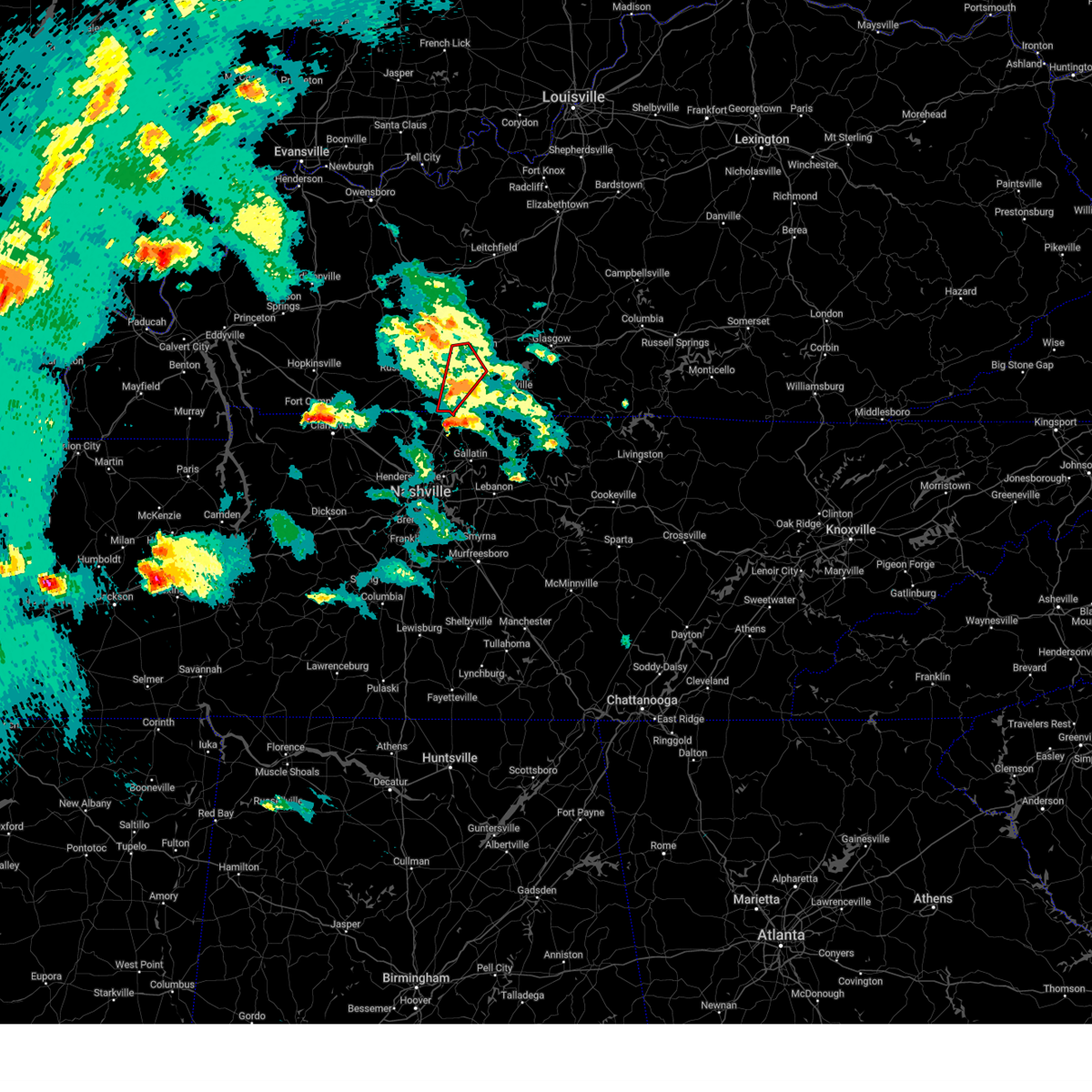 Torlmk the national weather service in louisville has issued a * tornado warning for, central simpson county in south central kentucky, southwestern warren county in south central kentucky, * until 730 pm cdt. * at 655 pm cdt, a severe thunderstorm capable of producing a tornado was located 9 miles northwest of portland, moving north at 50 mph (radar indicated rotation). Hazards include tornado and ping pong ball size hail. Flying debris will be dangerous to those caught without shelter. mobile homes will be damaged or destroyed. damage to roofs, windows, and vehicles will occur. tree damage is likely. this dangerous storm will be near, bowling green around 710 pm cdt. memphis junction and crestmoor around 715 pm cdt. Other locations impacted by this tornadic thunderstorm include franklin, hillsdale, black jack, rockfield, rich pond, geddes, woodburn, matlock, alvaton, and salmons. Torlmk the national weather service in louisville has issued a * tornado warning for, central simpson county in south central kentucky, southwestern warren county in south central kentucky, * until 730 pm cdt. * at 655 pm cdt, a severe thunderstorm capable of producing a tornado was located 9 miles northwest of portland, moving north at 50 mph (radar indicated rotation). Hazards include tornado and ping pong ball size hail. Flying debris will be dangerous to those caught without shelter. mobile homes will be damaged or destroyed. damage to roofs, windows, and vehicles will occur. tree damage is likely. this dangerous storm will be near, bowling green around 710 pm cdt. memphis junction and crestmoor around 715 pm cdt. Other locations impacted by this tornadic thunderstorm include franklin, hillsdale, black jack, rockfield, rich pond, geddes, woodburn, matlock, alvaton, and salmons.
|
| 4/2/2025 6:54 PM CDT |
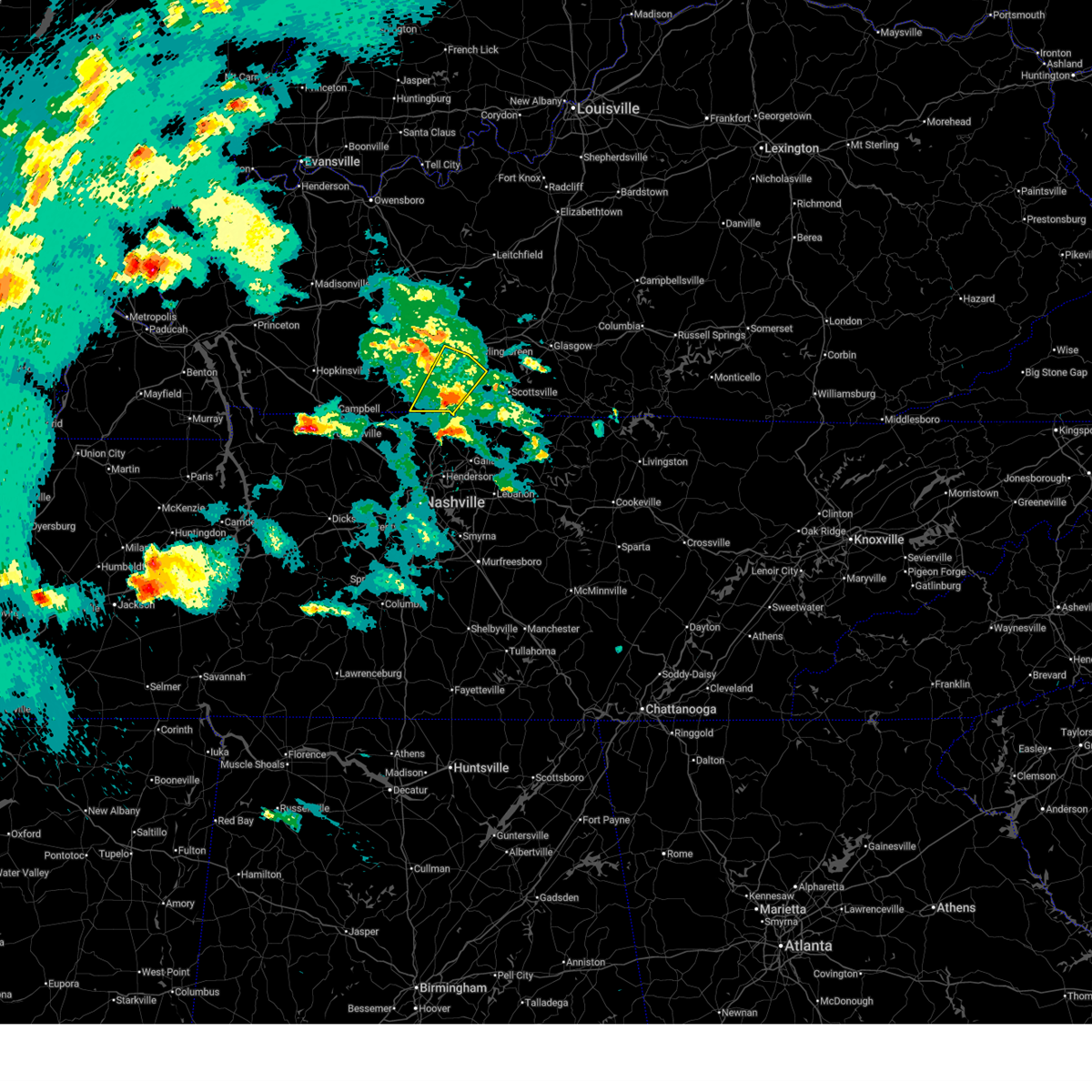 At 653 pm cdt, a severe thunderstorm was located 8 miles northwest of portland, moving north at 50 mph (radar indicated). Hazards include ping pong ball size hail and 60 mph wind gusts. People and animals outdoors will be injured. expect hail damage to roofs, siding, windows, and vehicles. expect wind damage to roofs, siding, and trees. Locations impacted include, bowling green, memphis junction, franklin, auburn, woodburn, black jack, hilltop, rich pond, geddes, and middleton. At 653 pm cdt, a severe thunderstorm was located 8 miles northwest of portland, moving north at 50 mph (radar indicated). Hazards include ping pong ball size hail and 60 mph wind gusts. People and animals outdoors will be injured. expect hail damage to roofs, siding, windows, and vehicles. expect wind damage to roofs, siding, and trees. Locations impacted include, bowling green, memphis junction, franklin, auburn, woodburn, black jack, hilltop, rich pond, geddes, and middleton.
|
| 4/2/2025 6:35 PM CDT |
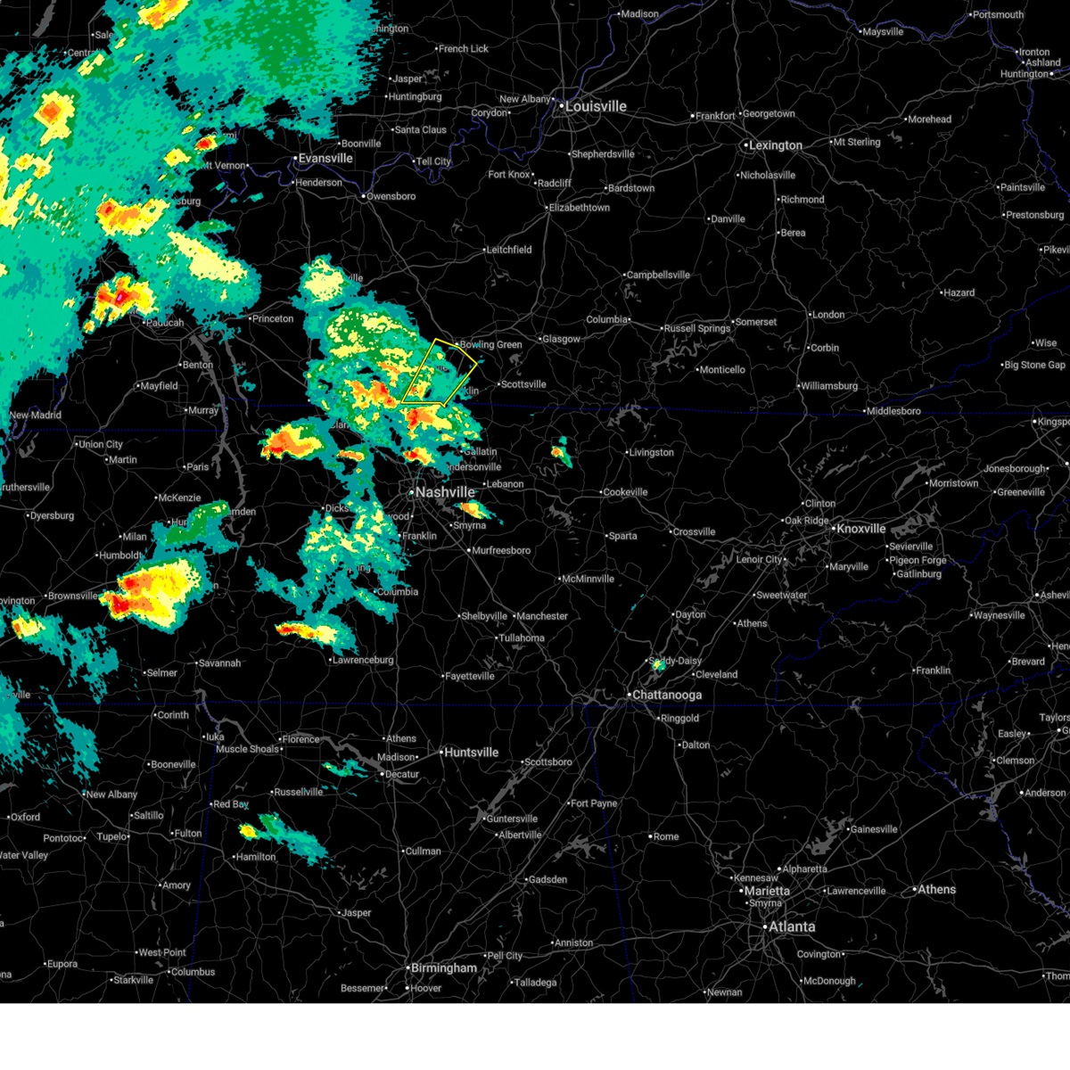 Svrlmk the national weather service in louisville has issued a * severe thunderstorm warning for, southeastern logan county in south central kentucky, simpson county in south central kentucky, southwestern warren county in south central kentucky, * until 715 pm cdt. * at 634 pm cdt, a severe thunderstorm was located near cross plains, moving northeast at 45 mph (radar indicated). Hazards include ping pong ball size hail and 60 mph wind gusts. People and animals outdoors will be injured. expect hail damage to roofs, siding, windows, and vehicles. Expect wind damage to roofs, siding, and trees. Svrlmk the national weather service in louisville has issued a * severe thunderstorm warning for, southeastern logan county in south central kentucky, simpson county in south central kentucky, southwestern warren county in south central kentucky, * until 715 pm cdt. * at 634 pm cdt, a severe thunderstorm was located near cross plains, moving northeast at 45 mph (radar indicated). Hazards include ping pong ball size hail and 60 mph wind gusts. People and animals outdoors will be injured. expect hail damage to roofs, siding, windows, and vehicles. Expect wind damage to roofs, siding, and trees.
|
| 3/30/2025 10:13 PM CDT |
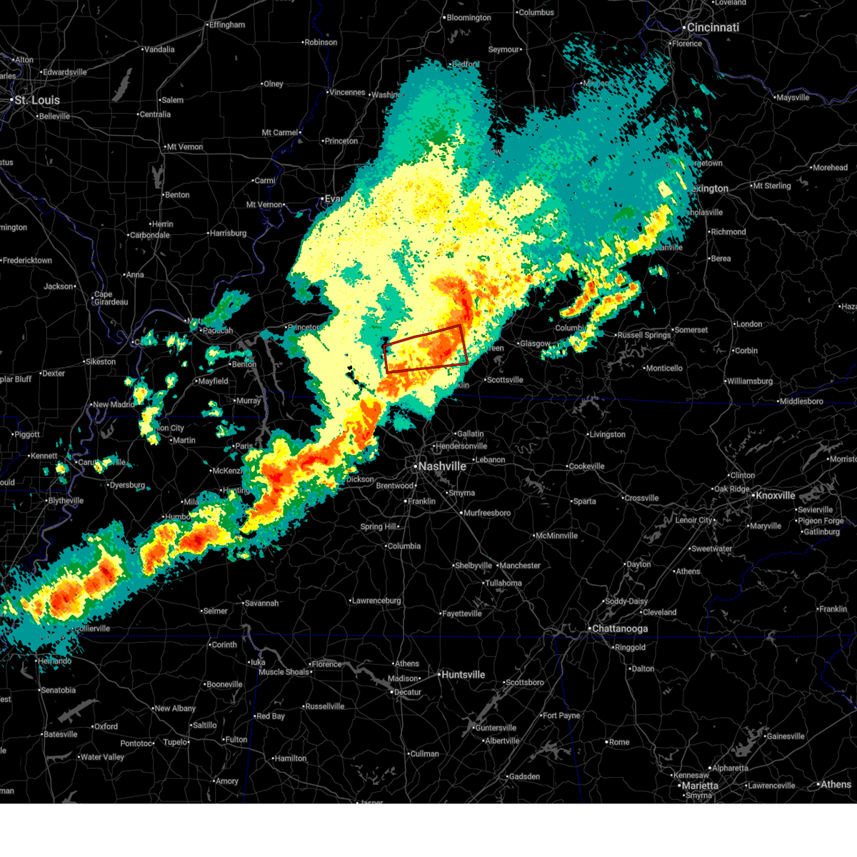 The storm which prompted the warning has moved out of the area. therefore, the warning will be allowed to expire. however, gusty winds and heavy rain are still possible with this thunderstorm. a tornado watch remains in effect until 300 am cdt for south central kentucky. The storm which prompted the warning has moved out of the area. therefore, the warning will be allowed to expire. however, gusty winds and heavy rain are still possible with this thunderstorm. a tornado watch remains in effect until 300 am cdt for south central kentucky.
|
| 3/30/2025 10:06 PM CDT |
 Svrlmk the national weather service in louisville has issued a * severe thunderstorm warning for, southeastern logan county in south central kentucky, simpson county in south central kentucky, hart county in central kentucky, western allen county in south central kentucky, northeastern butler county in south central kentucky, southeastern grayson county in central kentucky, warren county in south central kentucky, northern barren county in south central kentucky, edmonson county in south central kentucky, * until 1045 pm cdt. * at 1005 pm cdt, severe thunderstorms were located along a line extending from 12 miles northwest of brownsville to 8 miles north of plum springs to 11 miles south of russellville, moving east at 60 mph (radar indicated). Hazards include 60 mph wind gusts and penny size hail. expect damage to roofs, siding, and trees Svrlmk the national weather service in louisville has issued a * severe thunderstorm warning for, southeastern logan county in south central kentucky, simpson county in south central kentucky, hart county in central kentucky, western allen county in south central kentucky, northeastern butler county in south central kentucky, southeastern grayson county in central kentucky, warren county in south central kentucky, northern barren county in south central kentucky, edmonson county in south central kentucky, * until 1045 pm cdt. * at 1005 pm cdt, severe thunderstorms were located along a line extending from 12 miles northwest of brownsville to 8 miles north of plum springs to 11 miles south of russellville, moving east at 60 mph (radar indicated). Hazards include 60 mph wind gusts and penny size hail. expect damage to roofs, siding, and trees
|
| 3/30/2025 9:45 PM CDT |
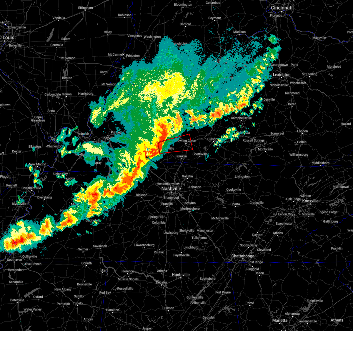 Torlmk the national weather service in louisville has issued a * tornado warning for, central logan county in south central kentucky, northwestern simpson county in south central kentucky, south central butler county in south central kentucky, western warren county in south central kentucky, * until 1015 pm cdt. * at 944 pm cdt, a severe thunderstorm capable of producing a tornado was located near russellville, moving east at 65 mph (radar indicated rotation). Hazards include tornado. Flying debris will be dangerous to those caught without shelter. mobile homes will be damaged or destroyed. damage to roofs, windows, and vehicles will occur. tree damage is likely. this dangerous storm will be near, bowling green around 1000 pm cdt. memphis junction and crestmoor around 1005 pm cdt. plum springs and mount victor around 1010 pm cdt. Other locations impacted by this tornadic thunderstorm include insco, gordonsville, spa, epleys, dennis, rich pond, crossroad, buffalo fork, lost city, and sharer. Torlmk the national weather service in louisville has issued a * tornado warning for, central logan county in south central kentucky, northwestern simpson county in south central kentucky, south central butler county in south central kentucky, western warren county in south central kentucky, * until 1015 pm cdt. * at 944 pm cdt, a severe thunderstorm capable of producing a tornado was located near russellville, moving east at 65 mph (radar indicated rotation). Hazards include tornado. Flying debris will be dangerous to those caught without shelter. mobile homes will be damaged or destroyed. damage to roofs, windows, and vehicles will occur. tree damage is likely. this dangerous storm will be near, bowling green around 1000 pm cdt. memphis junction and crestmoor around 1005 pm cdt. plum springs and mount victor around 1010 pm cdt. Other locations impacted by this tornadic thunderstorm include insco, gordonsville, spa, epleys, dennis, rich pond, crossroad, buffalo fork, lost city, and sharer.
|
| 3/30/2025 9:28 PM CDT |
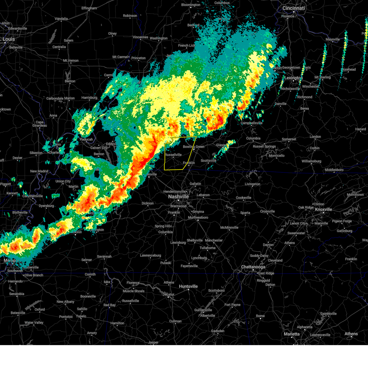 Svrlmk the national weather service in louisville has issued a * severe thunderstorm warning for, logan county in south central kentucky, western simpson county in south central kentucky, southern butler county in south central kentucky, western warren county in south central kentucky, * until 1015 pm cdt. * at 928 pm cdt, severe thunderstorms were located along a line extending from 7 miles south of weir to near pembroke to near fort campbell, moving east at 50 mph (radar indicated). Hazards include 60 mph wind gusts and penny size hail. expect damage to roofs, siding, and trees Svrlmk the national weather service in louisville has issued a * severe thunderstorm warning for, logan county in south central kentucky, western simpson county in south central kentucky, southern butler county in south central kentucky, western warren county in south central kentucky, * until 1015 pm cdt. * at 928 pm cdt, severe thunderstorms were located along a line extending from 7 miles south of weir to near pembroke to near fort campbell, moving east at 50 mph (radar indicated). Hazards include 60 mph wind gusts and penny size hail. expect damage to roofs, siding, and trees
|
| 3/19/2025 10:00 PM CDT |
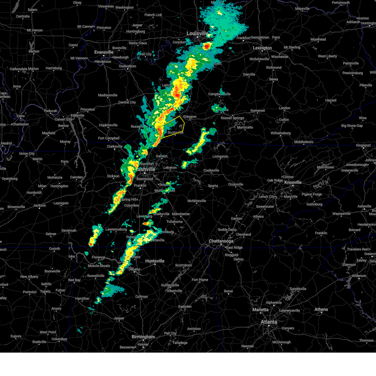 Svrlmk the national weather service in louisville has issued a * severe thunderstorm warning for, east central simpson county in south central kentucky, central allen county in south central kentucky, southeastern warren county in south central kentucky, southwestern barren county in south central kentucky, * until 1030 pm cdt. * at 1000 pm cdt, a severe thunderstorm was located 10 miles south of memphis junction, moving northeast at 45 mph (radar indicated). Hazards include 60 mph wind gusts and penny size hail. expect damage to roofs, siding, and trees Svrlmk the national weather service in louisville has issued a * severe thunderstorm warning for, east central simpson county in south central kentucky, central allen county in south central kentucky, southeastern warren county in south central kentucky, southwestern barren county in south central kentucky, * until 1030 pm cdt. * at 1000 pm cdt, a severe thunderstorm was located 10 miles south of memphis junction, moving northeast at 45 mph (radar indicated). Hazards include 60 mph wind gusts and penny size hail. expect damage to roofs, siding, and trees
|
| 2/15/2025 10:16 PM CST |
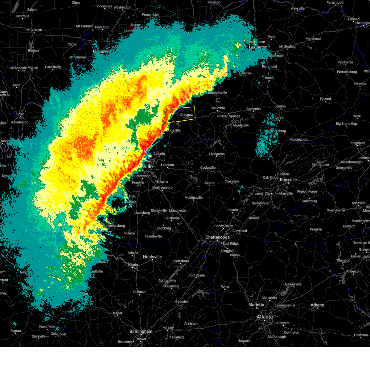 At 1016 pm cst, a severe thunderstorm was located 10 miles southeast of brownsville, moving east at 65 mph (radar indicated). Hazards include 60 mph wind gusts and nickel size hail. Expect damage to roofs, siding, and trees. Locations impacted include, bowling green, glasgow, cave city, smiths grove, park city, oakland, three forks, red cross, hardcastle, and coral hill. At 1016 pm cst, a severe thunderstorm was located 10 miles southeast of brownsville, moving east at 65 mph (radar indicated). Hazards include 60 mph wind gusts and nickel size hail. Expect damage to roofs, siding, and trees. Locations impacted include, bowling green, glasgow, cave city, smiths grove, park city, oakland, three forks, red cross, hardcastle, and coral hill.
|
| 2/15/2025 10:08 PM CST |
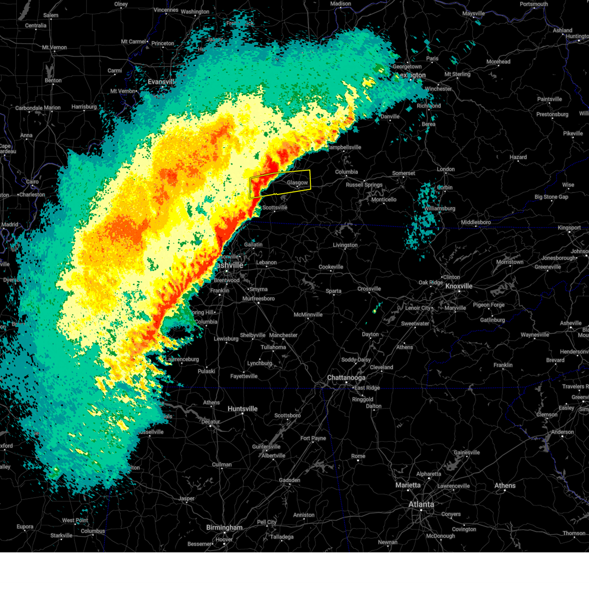 At 1008 pm cst, a severe thunderstorm was located near plum springs, moving east at 55 mph (radar indicated). Hazards include 60 mph wind gusts and nickel size hail. Expect damage to roofs, siding, and trees. Locations impacted include, bowling green, glasgow, plum springs, crestmoor, memphis junction, mount victor, cave city, smiths grove, park city, and oakland. At 1008 pm cst, a severe thunderstorm was located near plum springs, moving east at 55 mph (radar indicated). Hazards include 60 mph wind gusts and nickel size hail. Expect damage to roofs, siding, and trees. Locations impacted include, bowling green, glasgow, plum springs, crestmoor, memphis junction, mount victor, cave city, smiths grove, park city, and oakland.
|
| 2/15/2025 9:46 PM CST |
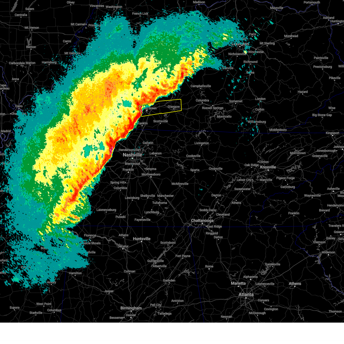 Svrlmk the national weather service in louisville has issued a * severe thunderstorm warning for, warren county in south central kentucky, northern barren county in south central kentucky, western metcalfe county in south central kentucky, southeastern edmonson county in south central kentucky, * until 1030 pm cst. * at 945 pm cst, a severe thunderstorm was located over memphis junction, moving east at 65 mph (radar indicated). Hazards include 60 mph wind gusts and nickel size hail. expect damage to roofs, siding, and trees Svrlmk the national weather service in louisville has issued a * severe thunderstorm warning for, warren county in south central kentucky, northern barren county in south central kentucky, western metcalfe county in south central kentucky, southeastern edmonson county in south central kentucky, * until 1030 pm cst. * at 945 pm cst, a severe thunderstorm was located over memphis junction, moving east at 65 mph (radar indicated). Hazards include 60 mph wind gusts and nickel size hail. expect damage to roofs, siding, and trees
|
| 9/6/2024 4:40 PM CDT | Small microburst with 55mph winds peeled some of a barn roof off and snapped a large tree limb on iron bridge roa in warren county KY, 9.7 miles WNW of Bowling Green, KY |
| 7/30/2024 1:55 PM CDT |
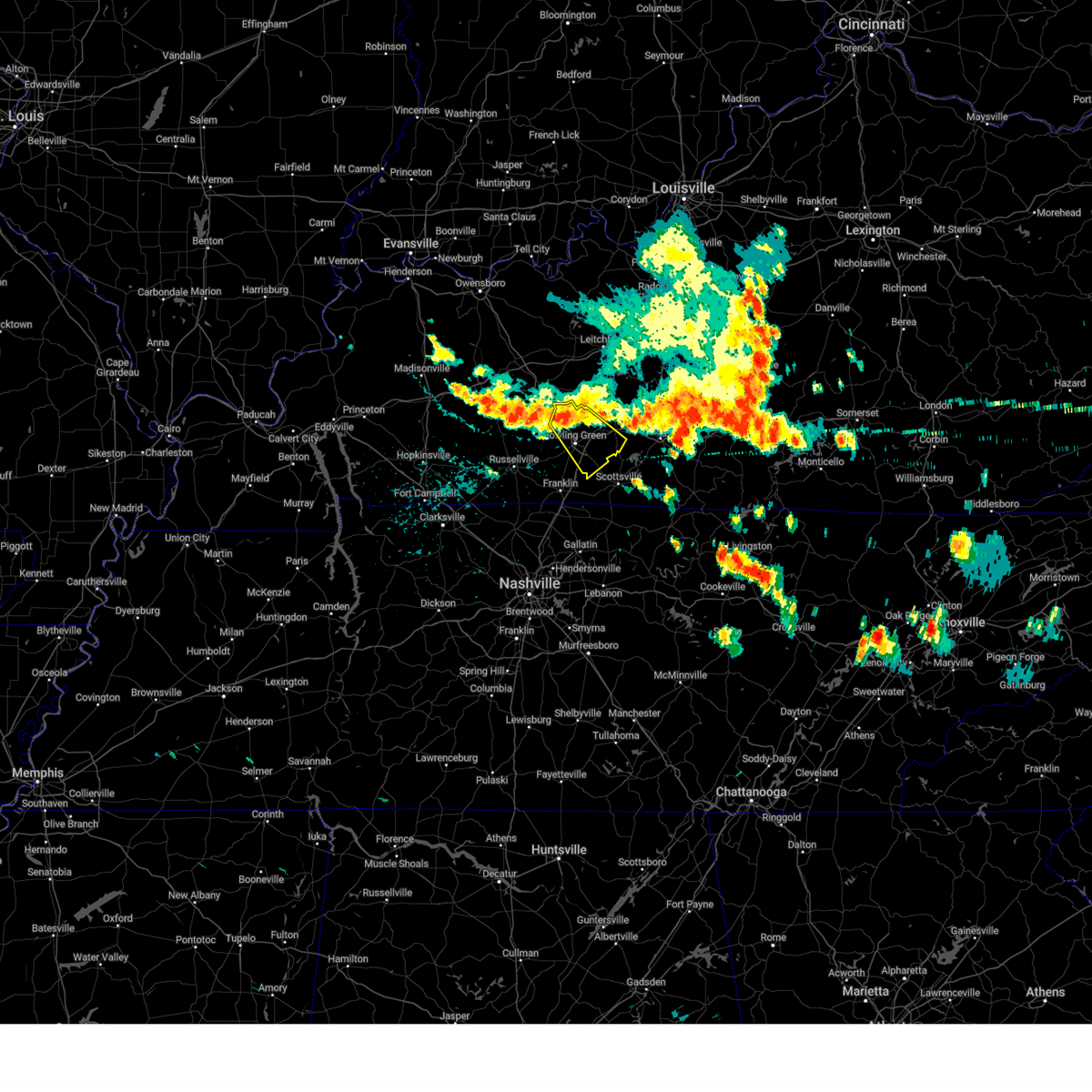 At 155 pm cdt, a severe thunderstorm was located over plum springs, moving southeast at 45 mph (radar indicated). Hazards include 60 mph wind gusts. Expect damage to roofs, siding, and trees. Locations impacted include, bowling green, plum springs, crestmoor, memphis junction, mount victor, oakland, three forks, hardcastle, girkin, and rockland. At 155 pm cdt, a severe thunderstorm was located over plum springs, moving southeast at 45 mph (radar indicated). Hazards include 60 mph wind gusts. Expect damage to roofs, siding, and trees. Locations impacted include, bowling green, plum springs, crestmoor, memphis junction, mount victor, oakland, three forks, hardcastle, girkin, and rockland.
|
| 7/30/2024 1:55 PM CDT |
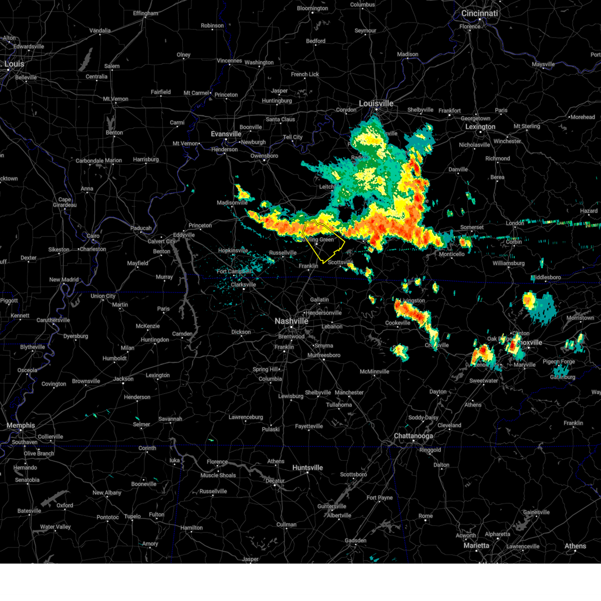 the severe thunderstorm warning has been cancelled and is no longer in effect the severe thunderstorm warning has been cancelled and is no longer in effect
|
| 7/30/2024 1:38 PM CDT |
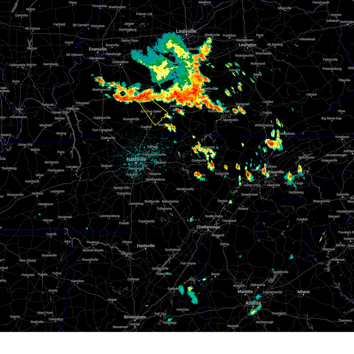 Svrlmk the national weather service in louisville has issued a * severe thunderstorm warning for, central butler county in south central kentucky, warren county in south central kentucky, * until 215 pm cdt. * at 138 pm cdt, a severe thunderstorm was located 7 miles southeast of morgantown, moving southeast at 45 mph (radar indicated). Hazards include 60 mph wind gusts. expect damage to roofs, siding, and trees Svrlmk the national weather service in louisville has issued a * severe thunderstorm warning for, central butler county in south central kentucky, warren county in south central kentucky, * until 215 pm cdt. * at 138 pm cdt, a severe thunderstorm was located 7 miles southeast of morgantown, moving southeast at 45 mph (radar indicated). Hazards include 60 mph wind gusts. expect damage to roofs, siding, and trees
|
| 7/22/2024 3:52 PM CDT | Tree damage across multiple areas within plano from a storm earlier in the afternoon. at least one powerline impacted by the falling tree limbs. time estimated by radar in warren county KY, 6.6 miles N of Bowling Green, KY |
| 7/5/2024 7:14 AM CDT |
 The storm which prompted the warning has weakened below severe limits, and no longer poses an immediate threat to life or property. therefore, the warning will be allowed to expire. however, heavy rain is still possible with this thunderstorm. to report severe weather, contact your nearest law enforcement agency. they will relay your report to the national weather service louisville. The storm which prompted the warning has weakened below severe limits, and no longer poses an immediate threat to life or property. therefore, the warning will be allowed to expire. however, heavy rain is still possible with this thunderstorm. to report severe weather, contact your nearest law enforcement agency. they will relay your report to the national weather service louisville.
|
| 7/5/2024 7:03 AM CDT |
 At 703 am cdt, a severe thunderstorm was located near brownsville, moving northeast at 40 mph (radar indicated). Hazards include 60 mph wind gusts. Expect damage to roofs, siding, and trees. Locations impacted include, bowling green, brownsville, plum springs, crestmoor, mount victor, smiths grove, oakland, windyville, chalybeate, and girkin. At 703 am cdt, a severe thunderstorm was located near brownsville, moving northeast at 40 mph (radar indicated). Hazards include 60 mph wind gusts. Expect damage to roofs, siding, and trees. Locations impacted include, bowling green, brownsville, plum springs, crestmoor, mount victor, smiths grove, oakland, windyville, chalybeate, and girkin.
|
| 7/5/2024 6:50 AM CDT |
 At 649 am cdt, a severe thunderstorm was located near plum springs, moving northeast at 40 mph (radar indicated). Hazards include 60 mph wind gusts and penny size hail. Expect damage to roofs, siding, and trees. Locations impacted include, bowling green, brownsville, plum springs, crestmoor, memphis junction, mount victor, smiths grove, oakland, windyville, and chalybeate. At 649 am cdt, a severe thunderstorm was located near plum springs, moving northeast at 40 mph (radar indicated). Hazards include 60 mph wind gusts and penny size hail. Expect damage to roofs, siding, and trees. Locations impacted include, bowling green, brownsville, plum springs, crestmoor, memphis junction, mount victor, smiths grove, oakland, windyville, and chalybeate.
|
| 7/5/2024 6:38 AM CDT |
 Svrlmk the national weather service in louisville has issued a * severe thunderstorm warning for, southeastern butler county in south central kentucky, central warren county in south central kentucky, central edmonson county in south central kentucky, * until 715 am cdt. * at 638 am cdt, a severe thunderstorm was located near crestmoor, moving northeast at 40 mph (radar indicated). Hazards include 60 mph wind gusts and quarter size hail. Hail damage to vehicles is expected. Expect wind damage to roofs, siding, and trees. Svrlmk the national weather service in louisville has issued a * severe thunderstorm warning for, southeastern butler county in south central kentucky, central warren county in south central kentucky, central edmonson county in south central kentucky, * until 715 am cdt. * at 638 am cdt, a severe thunderstorm was located near crestmoor, moving northeast at 40 mph (radar indicated). Hazards include 60 mph wind gusts and quarter size hail. Hail damage to vehicles is expected. Expect wind damage to roofs, siding, and trees.
|
| 6/26/2024 6:09 PM CDT |
 At 609 pm cdt, severe thunderstorms were located along a line extending from 11 miles southwest of memphis junction to near westmoreland to 6 miles south of red boiling springs, moving northeast at 35 mph (radar indicated). Hazards include 60 mph wind gusts. Expect damage to roofs, siding, and trees. Locations impacted include, bowling green, scottsville, franklin, woodburn, black jack, west fork, rich pond, clare, geddes, and mcelroy ford. At 609 pm cdt, severe thunderstorms were located along a line extending from 11 miles southwest of memphis junction to near westmoreland to 6 miles south of red boiling springs, moving northeast at 35 mph (radar indicated). Hazards include 60 mph wind gusts. Expect damage to roofs, siding, and trees. Locations impacted include, bowling green, scottsville, franklin, woodburn, black jack, west fork, rich pond, clare, geddes, and mcelroy ford.
|
| 6/26/2024 5:42 PM CDT |
 Svrlmk the national weather service in louisville has issued a * severe thunderstorm warning for, simpson county in south central kentucky, southwestern allen county in south central kentucky, southwestern warren county in south central kentucky, * until 630 pm cdt. * at 542 pm cdt, severe thunderstorms were located along a line extending from near cross plains to near gallatin to carthage, moving northeast at 30 mph (radar indicated). Hazards include 60 mph wind gusts. expect damage to roofs, siding, and trees Svrlmk the national weather service in louisville has issued a * severe thunderstorm warning for, simpson county in south central kentucky, southwestern allen county in south central kentucky, southwestern warren county in south central kentucky, * until 630 pm cdt. * at 542 pm cdt, severe thunderstorms were located along a line extending from near cross plains to near gallatin to carthage, moving northeast at 30 mph (radar indicated). Hazards include 60 mph wind gusts. expect damage to roofs, siding, and trees
|
| 5/26/2024 10:42 PM CDT |
 At 1042 pm cdt, severe thunderstorms were located along a line extending from 9 miles south of brownsville to 8 miles south of mount victor to 12 miles north of springfield, moving east at 80 mph (radar indicated). Hazards include 60 mph wind gusts. Expect damage to roofs, siding, and trees. Locations impacted include, bowling green, russellville, plum springs, crestmoor, memphis junction, mount victor, anderson, franklin, auburn, and adairville. At 1042 pm cdt, severe thunderstorms were located along a line extending from 9 miles south of brownsville to 8 miles south of mount victor to 12 miles north of springfield, moving east at 80 mph (radar indicated). Hazards include 60 mph wind gusts. Expect damage to roofs, siding, and trees. Locations impacted include, bowling green, russellville, plum springs, crestmoor, memphis junction, mount victor, anderson, franklin, auburn, and adairville.
|
| 5/26/2024 10:42 PM CDT |
 the severe thunderstorm warning has been cancelled and is no longer in effect the severe thunderstorm warning has been cancelled and is no longer in effect
|
| 5/26/2024 10:40 PM CDT |
 Svrlmk the national weather service in louisville has issued a * severe thunderstorm warning for, west central monroe county in south central kentucky, southeastern simpson county in south central kentucky, hart county in central kentucky, allen county in south central kentucky, southeastern warren county in south central kentucky, barren county in south central kentucky, eastern edmonson county in south central kentucky, * until 1115 pm cdt. * at 1040 pm cdt, severe thunderstorms were located along a line extending from 12 miles northwest of munfordville to 6 miles northwest of portland, moving east at 50 mph (radar indicated). Hazards include 60 mph wind gusts and quarter size hail. Hail damage to vehicles is expected. Expect wind damage to roofs, siding, and trees. Svrlmk the national weather service in louisville has issued a * severe thunderstorm warning for, west central monroe county in south central kentucky, southeastern simpson county in south central kentucky, hart county in central kentucky, allen county in south central kentucky, southeastern warren county in south central kentucky, barren county in south central kentucky, eastern edmonson county in south central kentucky, * until 1115 pm cdt. * at 1040 pm cdt, severe thunderstorms were located along a line extending from 12 miles northwest of munfordville to 6 miles northwest of portland, moving east at 50 mph (radar indicated). Hazards include 60 mph wind gusts and quarter size hail. Hail damage to vehicles is expected. Expect wind damage to roofs, siding, and trees.
|
| 5/26/2024 10:39 PM CDT | Kentucky mesonet station ewp in warren county KY, 6 miles SW of Bowling Green, KY |
| 5/26/2024 10:38 PM CDT |
 The storm which prompted the warning has weakened below severe limits, and no longer appears capable of producing a tornado. therefore, the warning will be allowed to expire. a tornado watch remains in effect until 100 am cdt for south central kentucky. The storm which prompted the warning has weakened below severe limits, and no longer appears capable of producing a tornado. therefore, the warning will be allowed to expire. a tornado watch remains in effect until 100 am cdt for south central kentucky.
|
| 5/26/2024 10:33 PM CDT | Significant second story damage to a hom in warren county KY, 6.5 miles S of Bowling Green, KY |
| 5/26/2024 10:23 PM CDT |
 the tornado warning has been cancelled and is no longer in effect the tornado warning has been cancelled and is no longer in effect
|
| 5/26/2024 10:23 PM CDT |
 At 1023 pm cdt, a severe thunderstorm capable of producing a tornado was located 9 miles northwest of crestmoor, moving east at 45 mph (radar indicated rotation). Hazards include tornado. Flying debris will be dangerous to those caught without shelter. mobile homes will be damaged or destroyed. damage to roofs, windows, and vehicles will occur. tree damage is likely. this dangerous storm will be near, bowling green around 1030 pm cdt. Other locations impacted by this tornadic thunderstorm include barren river, hadley, blue level, greencastle, benleo, richardsville, rockland, guy, riverside, and anna. At 1023 pm cdt, a severe thunderstorm capable of producing a tornado was located 9 miles northwest of crestmoor, moving east at 45 mph (radar indicated rotation). Hazards include tornado. Flying debris will be dangerous to those caught without shelter. mobile homes will be damaged or destroyed. damage to roofs, windows, and vehicles will occur. tree damage is likely. this dangerous storm will be near, bowling green around 1030 pm cdt. Other locations impacted by this tornadic thunderstorm include barren river, hadley, blue level, greencastle, benleo, richardsville, rockland, guy, riverside, and anna.
|
| 5/26/2024 10:14 PM CDT |
 Torlmk the national weather service in louisville has issued a * tornado warning for, southeastern butler county in south central kentucky, northwestern warren county in south central kentucky, * until 1045 pm cdt. * at 1014 pm cdt, a severe thunderstorm capable of producing a tornado was located near morgantown, moving southeast at 40 mph (radar indicated rotation). Hazards include tornado. Flying debris will be dangerous to those caught without shelter. mobile homes will be damaged or destroyed. damage to roofs, windows, and vehicles will occur. tree damage is likely. this dangerous storm will be near, bowling green around 1030 pm cdt. crestmoor around 1035 pm cdt. Other locations impacted by this tornadic thunderstorm include barren river, dimple, leetown, davis crossroads, benleo, rockland, guy, woodbury, hadley, and youngtown. Torlmk the national weather service in louisville has issued a * tornado warning for, southeastern butler county in south central kentucky, northwestern warren county in south central kentucky, * until 1045 pm cdt. * at 1014 pm cdt, a severe thunderstorm capable of producing a tornado was located near morgantown, moving southeast at 40 mph (radar indicated rotation). Hazards include tornado. Flying debris will be dangerous to those caught without shelter. mobile homes will be damaged or destroyed. damage to roofs, windows, and vehicles will occur. tree damage is likely. this dangerous storm will be near, bowling green around 1030 pm cdt. crestmoor around 1035 pm cdt. Other locations impacted by this tornadic thunderstorm include barren river, dimple, leetown, davis crossroads, benleo, rockland, guy, woodbury, hadley, and youngtown.
|
| 5/26/2024 10:11 PM CDT |
 Svrlmk the national weather service in louisville has issued a * severe thunderstorm warning for, logan county in south central kentucky, simpson county in south central kentucky, northwestern allen county in south central kentucky, central butler county in south central kentucky, warren county in south central kentucky, southwestern edmonson county in south central kentucky, * until 1100 pm cdt. * at 1010 pm cdt, severe thunderstorms were located along a line extending from 10 miles northeast of morgantown to 8 miles southwest of russellville, moving southeast at 50 mph (radar indicated). Hazards include 60 mph wind gusts. expect damage to roofs, siding, and trees Svrlmk the national weather service in louisville has issued a * severe thunderstorm warning for, logan county in south central kentucky, simpson county in south central kentucky, northwestern allen county in south central kentucky, central butler county in south central kentucky, warren county in south central kentucky, southwestern edmonson county in south central kentucky, * until 1100 pm cdt. * at 1010 pm cdt, severe thunderstorms were located along a line extending from 10 miles northeast of morgantown to 8 miles southwest of russellville, moving southeast at 50 mph (radar indicated). Hazards include 60 mph wind gusts. expect damage to roofs, siding, and trees
|
| 5/26/2024 10:24 AM CDT |
 The storms which prompted the warning have moved out of the area. therefore, the warning will be allowed to expire. however, gusty winds are still possible with these thunderstorms. a tornado watch remains in effect until 300 pm cdt for south central kentucky. The storms which prompted the warning have moved out of the area. therefore, the warning will be allowed to expire. however, gusty winds are still possible with these thunderstorms. a tornado watch remains in effect until 300 pm cdt for south central kentucky.
|
| 5/26/2024 10:13 AM CDT |
 At 1013 am cdt, severe thunderstorms were located along a line extending from 9 miles northwest of plum springs to 8 miles north of portland, moving east at 50 mph (radar indicated). Hazards include 60 mph wind gusts. Expect damage to roofs, siding, and trees. Locations impacted include, bowling green, crestmoor, memphis junction, mount victor, franklin, woodburn, hardcastle, allen springs, black jack, and rich pond. At 1013 am cdt, severe thunderstorms were located along a line extending from 9 miles northwest of plum springs to 8 miles north of portland, moving east at 50 mph (radar indicated). Hazards include 60 mph wind gusts. Expect damage to roofs, siding, and trees. Locations impacted include, bowling green, crestmoor, memphis junction, mount victor, franklin, woodburn, hardcastle, allen springs, black jack, and rich pond.
|
| 5/26/2024 10:13 AM CDT |
 the severe thunderstorm warning has been cancelled and is no longer in effect the severe thunderstorm warning has been cancelled and is no longer in effect
|
| 5/26/2024 10:07 AM CDT |
 At 1006 am cdt, severe thunderstorms were located along a line extending from 10 miles northwest of crestmoor to 8 miles northwest of portland, moving east at 50 mph (radar indicated). Hazards include 60 mph wind gusts. Expect damage to roofs, siding, and trees. Locations impacted include, bowling green, crestmoor, memphis junction, mount victor, franklin, auburn, woodburn, hardcastle, allen springs, and black jack. At 1006 am cdt, severe thunderstorms were located along a line extending from 10 miles northwest of crestmoor to 8 miles northwest of portland, moving east at 50 mph (radar indicated). Hazards include 60 mph wind gusts. Expect damage to roofs, siding, and trees. Locations impacted include, bowling green, crestmoor, memphis junction, mount victor, franklin, auburn, woodburn, hardcastle, allen springs, and black jack.
|
| 5/26/2024 9:56 AM CDT |
 The tornado threat has diminished and the tornado warning has been cancelled. however, large hail and damaging winds remain likely and a severe thunderstorm warning remains in effect for the area. however, gusty winds are still possible with this thunderstorm. a tornado watch remains in effect until 300 pm cdt for south central kentucky. remember, a severe thunderstorm warning still remains in effect for logan, warren, and allen counties. The tornado threat has diminished and the tornado warning has been cancelled. however, large hail and damaging winds remain likely and a severe thunderstorm warning remains in effect for the area. however, gusty winds are still possible with this thunderstorm. a tornado watch remains in effect until 300 pm cdt for south central kentucky. remember, a severe thunderstorm warning still remains in effect for logan, warren, and allen counties.
|
| 5/26/2024 9:54 AM CDT |
 Svrlmk the national weather service in louisville has issued a * severe thunderstorm warning for, eastern logan county in south central kentucky, simpson county in south central kentucky, southwestern allen county in south central kentucky, southwestern warren county in south central kentucky, * until 1030 am cdt. * at 954 am cdt, severe thunderstorms were located along a line extending from 11 miles south of morgantown to 8 miles northwest of cross plains, moving east at 50 mph (radar indicated). Hazards include 60 mph wind gusts. expect damage to roofs, siding, and trees Svrlmk the national weather service in louisville has issued a * severe thunderstorm warning for, eastern logan county in south central kentucky, simpson county in south central kentucky, southwestern allen county in south central kentucky, southwestern warren county in south central kentucky, * until 1030 am cdt. * at 954 am cdt, severe thunderstorms were located along a line extending from 11 miles south of morgantown to 8 miles northwest of cross plains, moving east at 50 mph (radar indicated). Hazards include 60 mph wind gusts. expect damage to roofs, siding, and trees
|
| 5/26/2024 9:51 AM CDT |
 At 950 am cdt, a severe thunderstorm was located 9 miles southeast of hartford, moving east at 45 mph (radar indicated). Hazards include 60 mph wind gusts. Expect damage to roofs, siding, and trees. Locations impacted include, bowling green, hartford, morgantown, plum springs, casey, lee, beaver dam, caneyville, mchenry, and rochester. At 950 am cdt, a severe thunderstorm was located 9 miles southeast of hartford, moving east at 45 mph (radar indicated). Hazards include 60 mph wind gusts. Expect damage to roofs, siding, and trees. Locations impacted include, bowling green, hartford, morgantown, plum springs, casey, lee, beaver dam, caneyville, mchenry, and rochester.
|
| 5/26/2024 9:42 AM CDT |
 At 942 am cdt, a severe squall line capable of producing both tornadoes and extensive straight line wind damage was located 7 miles northeast of russellville, moving east at 70 mph (radar indicated rotation). Hazards include tornado. Flying debris will be dangerous to those caught without shelter. mobile homes will be damaged or destroyed. damage to roofs, windows, and vehicles will occur. tree damage is likely. these dangerous storms will be near, bowling green around 955 am cdt. memphis junction and crestmoor around 1000 am cdt. Other locations impacted by this tornadic thunderstorm include insco, epleys, dennis, rich pond, rockland, buffalo fork, lost city, sharer, richelieu, and cooperstown. At 942 am cdt, a severe squall line capable of producing both tornadoes and extensive straight line wind damage was located 7 miles northeast of russellville, moving east at 70 mph (radar indicated rotation). Hazards include tornado. Flying debris will be dangerous to those caught without shelter. mobile homes will be damaged or destroyed. damage to roofs, windows, and vehicles will occur. tree damage is likely. these dangerous storms will be near, bowling green around 955 am cdt. memphis junction and crestmoor around 1000 am cdt. Other locations impacted by this tornadic thunderstorm include insco, epleys, dennis, rich pond, rockland, buffalo fork, lost city, sharer, richelieu, and cooperstown.
|
| 5/26/2024 9:32 AM CDT |
 At 931 am cdt, a severe thunderstorm was located near central city, moving east at 45 mph (radar indicated). Hazards include 70 mph wind gusts. Expect considerable tree damage. damage is likely to mobile homes, roofs, and outbuildings. Locations impacted include, bowling green, hartford, morgantown, plum springs, casey, lee, beaver dam, caneyville, centertown, and mchenry. At 931 am cdt, a severe thunderstorm was located near central city, moving east at 45 mph (radar indicated). Hazards include 70 mph wind gusts. Expect considerable tree damage. damage is likely to mobile homes, roofs, and outbuildings. Locations impacted include, bowling green, hartford, morgantown, plum springs, casey, lee, beaver dam, caneyville, centertown, and mchenry.
|
| 5/26/2024 9:25 AM CDT |
 Torlmk the national weather service in louisville has issued a * tornado warning for, central logan county in south central kentucky, north central simpson county in south central kentucky, south central butler county in south central kentucky, western warren county in south central kentucky, * until 1000 am cdt. * at 924 am cdt, severe thunderstorms capable of producing both tornadoes and extensive straight line wind damage were located near elkton, moving east at 70 mph (radar indicated rotation). Hazards include tornado. Flying debris will be dangerous to those caught without shelter. mobile homes will be damaged or destroyed. damage to roofs, windows, and vehicles will occur. tree damage is likely. these dangerous storms will be near, russellville around 935 am cdt. bowling green around 955 am cdt. memphis junction around 1000 am cdt. Other locations impacted by this tornadic thunderstorm include justice, insco, gordonsville, spa, epleys, dennis, rich pond, everett, rockland, and crossroad. Torlmk the national weather service in louisville has issued a * tornado warning for, central logan county in south central kentucky, north central simpson county in south central kentucky, south central butler county in south central kentucky, western warren county in south central kentucky, * until 1000 am cdt. * at 924 am cdt, severe thunderstorms capable of producing both tornadoes and extensive straight line wind damage were located near elkton, moving east at 70 mph (radar indicated rotation). Hazards include tornado. Flying debris will be dangerous to those caught without shelter. mobile homes will be damaged or destroyed. damage to roofs, windows, and vehicles will occur. tree damage is likely. these dangerous storms will be near, russellville around 935 am cdt. bowling green around 955 am cdt. memphis junction around 1000 am cdt. Other locations impacted by this tornadic thunderstorm include justice, insco, gordonsville, spa, epleys, dennis, rich pond, everett, rockland, and crossroad.
|
| 5/26/2024 9:18 AM CDT |
 Svrlmk the national weather service in louisville has issued a * severe thunderstorm warning for, northeastern logan county in south central kentucky, butler county in south central kentucky, western grayson county in central kentucky, northwestern warren county in south central kentucky, south central breckinridge county in central kentucky, ohio county in central kentucky, northwestern edmonson county in south central kentucky, * until 1015 am cdt. * at 917 am cdt, a severe thunderstorm was located near weir, moving east at 45 mph (radar indicated). Hazards include 70 mph wind gusts. Expect considerable tree damage. Damage is likely to mobile homes, roofs, and outbuildings. Svrlmk the national weather service in louisville has issued a * severe thunderstorm warning for, northeastern logan county in south central kentucky, butler county in south central kentucky, western grayson county in central kentucky, northwestern warren county in south central kentucky, south central breckinridge county in central kentucky, ohio county in central kentucky, northwestern edmonson county in south central kentucky, * until 1015 am cdt. * at 917 am cdt, a severe thunderstorm was located near weir, moving east at 45 mph (radar indicated). Hazards include 70 mph wind gusts. Expect considerable tree damage. Damage is likely to mobile homes, roofs, and outbuildings.
|
| 5/8/2024 2:09 PM CDT |
 The storm which prompted the warning has moved out of the area. therefore, the warning will be allowed to expire. however, small hail and heavy rain are still possible with this thunderstorm. a tornado watch remains in effect until 900 pm cdt for south central kentucky. The storm which prompted the warning has moved out of the area. therefore, the warning will be allowed to expire. however, small hail and heavy rain are still possible with this thunderstorm. a tornado watch remains in effect until 900 pm cdt for south central kentucky.
|
| 5/8/2024 2:08 PM CDT |
 Svrlmk the national weather service in louisville has issued a * severe thunderstorm warning for, northeastern warren county in south central kentucky, west central barren county in south central kentucky, southeastern edmonson county in south central kentucky, * until 245 pm cdt. * at 208 pm cdt, a severe thunderstorm was located near plum springs, moving east at 30 mph (radar indicated). Hazards include 60 mph wind gusts and half dollar size hail. Hail damage to vehicles is expected. Expect wind damage to roofs, siding, and trees. Svrlmk the national weather service in louisville has issued a * severe thunderstorm warning for, northeastern warren county in south central kentucky, west central barren county in south central kentucky, southeastern edmonson county in south central kentucky, * until 245 pm cdt. * at 208 pm cdt, a severe thunderstorm was located near plum springs, moving east at 30 mph (radar indicated). Hazards include 60 mph wind gusts and half dollar size hail. Hail damage to vehicles is expected. Expect wind damage to roofs, siding, and trees.
|
| 5/8/2024 1:47 PM CDT |
 the severe thunderstorm warning has been cancelled and is no longer in effect the severe thunderstorm warning has been cancelled and is no longer in effect
|
| 5/8/2024 1:47 PM CDT |
 At 147 pm cdt, a severe thunderstorm was located near crestmoor, moving east at 35 mph (radar indicated). Hazards include golf ball size hail. People and animals outdoors will be injured. expect damage to roofs, siding, windows, and vehicles. Locations impacted include, bowling green, plum springs, crestmoor, memphis junction, mount victor, barren river, bristow, hardcastle, girkin, and rockland. At 147 pm cdt, a severe thunderstorm was located near crestmoor, moving east at 35 mph (radar indicated). Hazards include golf ball size hail. People and animals outdoors will be injured. expect damage to roofs, siding, windows, and vehicles. Locations impacted include, bowling green, plum springs, crestmoor, memphis junction, mount victor, barren river, bristow, hardcastle, girkin, and rockland.
|
| 5/8/2024 1:38 PM CDT |
 Svrlmk the national weather service in louisville has issued a * severe thunderstorm warning for, northeastern logan county in south central kentucky, south central butler county in south central kentucky, northwestern warren county in south central kentucky, * until 215 pm cdt. * at 138 pm cdt, a severe thunderstorm was located 10 miles west of memphis junction, moving east at 35 mph (radar indicated). Hazards include golf ball size hail. People and animals outdoors will be injured. Expect damage to roofs, siding, windows, and vehicles. Svrlmk the national weather service in louisville has issued a * severe thunderstorm warning for, northeastern logan county in south central kentucky, south central butler county in south central kentucky, northwestern warren county in south central kentucky, * until 215 pm cdt. * at 138 pm cdt, a severe thunderstorm was located 10 miles west of memphis junction, moving east at 35 mph (radar indicated). Hazards include golf ball size hail. People and animals outdoors will be injured. Expect damage to roofs, siding, windows, and vehicles.
|
| 5/8/2024 1:36 PM CDT |
 the severe thunderstorm warning has been cancelled and is no longer in effect the severe thunderstorm warning has been cancelled and is no longer in effect
|
| 5/8/2024 1:35 PM CDT |
 Svrlmk the national weather service in louisville has issued a * severe thunderstorm warning for, northeastern logan county in south central kentucky, southeastern butler county in south central kentucky, northwestern warren county in south central kentucky, * until 200 pm cdt. * at 135 pm cdt, a severe thunderstorm was located 11 miles west of memphis junction, moving east at 35 mph (radar indicated). Hazards include golf ball size hail and 60 mph wind gusts. People and animals outdoors will be injured. expect hail damage to roofs, siding, windows, and vehicles. Expect wind damage to roofs, siding, and trees. Svrlmk the national weather service in louisville has issued a * severe thunderstorm warning for, northeastern logan county in south central kentucky, southeastern butler county in south central kentucky, northwestern warren county in south central kentucky, * until 200 pm cdt. * at 135 pm cdt, a severe thunderstorm was located 11 miles west of memphis junction, moving east at 35 mph (radar indicated). Hazards include golf ball size hail and 60 mph wind gusts. People and animals outdoors will be injured. expect hail damage to roofs, siding, windows, and vehicles. Expect wind damage to roofs, siding, and trees.
|
| 4/2/2024 6:42 PM CDT |
 The storm which prompted the warning has weakened below severe limits, and no longer appears capable of producing a tornado. therefore, the warning will be allowed to expire. a tornado watch remains in effect until 900 pm cdt for south central kentucky. The storm which prompted the warning has weakened below severe limits, and no longer appears capable of producing a tornado. therefore, the warning will be allowed to expire. a tornado watch remains in effect until 900 pm cdt for south central kentucky.
|
| 4/2/2024 6:29 PM CDT |
 the tornado warning has been cancelled and is no longer in effect the tornado warning has been cancelled and is no longer in effect
|
| 4/2/2024 6:29 PM CDT |
 At 629 pm cdt, a severe thunderstorm capable of producing a tornado was located near memphis junction, moving east at 45 mph (radar indicated rotation). Hazards include tornado. Flying debris will be dangerous to those caught without shelter. mobile homes will be damaged or destroyed. damage to roofs, windows, and vehicles will occur. tree damage is likely. this dangerous storm will be near, bowling green and memphis junction around 635 pm cdt. Other locations impacted by this tornadic thunderstorm include matlock, alvaton, hardcastle, boyce, rich pond, greenhill, drake, and woodburn. At 629 pm cdt, a severe thunderstorm capable of producing a tornado was located near memphis junction, moving east at 45 mph (radar indicated rotation). Hazards include tornado. Flying debris will be dangerous to those caught without shelter. mobile homes will be damaged or destroyed. damage to roofs, windows, and vehicles will occur. tree damage is likely. this dangerous storm will be near, bowling green and memphis junction around 635 pm cdt. Other locations impacted by this tornadic thunderstorm include matlock, alvaton, hardcastle, boyce, rich pond, greenhill, drake, and woodburn.
|
| 4/2/2024 6:20 PM CDT |
 Torlmk the national weather service in louisville has issued a * tornado warning for, east central logan county in south central kentucky, northern simpson county in south central kentucky, west central allen county in south central kentucky, southwestern warren county in south central kentucky, * until 645 pm cdt. * at 620 pm cdt, a severe thunderstorm capable of producing a tornado was located 10 miles southwest of memphis junction, moving east at 45 mph (radar indicated rotation). Hazards include tornado. Flying debris will be dangerous to those caught without shelter. mobile homes will be damaged or destroyed. damage to roofs, windows, and vehicles will occur. tree damage is likely. this dangerous storm will be near, bowling green around 630 pm cdt. memphis junction around 635 pm cdt. Other locations impacted by this tornadic thunderstorm include hardcastle, allen springs, rockfield, rich pond, auburn, greenhill, south union, woodburn, matlock, and alvaton. Torlmk the national weather service in louisville has issued a * tornado warning for, east central logan county in south central kentucky, northern simpson county in south central kentucky, west central allen county in south central kentucky, southwestern warren county in south central kentucky, * until 645 pm cdt. * at 620 pm cdt, a severe thunderstorm capable of producing a tornado was located 10 miles southwest of memphis junction, moving east at 45 mph (radar indicated rotation). Hazards include tornado. Flying debris will be dangerous to those caught without shelter. mobile homes will be damaged or destroyed. damage to roofs, windows, and vehicles will occur. tree damage is likely. this dangerous storm will be near, bowling green around 630 pm cdt. memphis junction around 635 pm cdt. Other locations impacted by this tornadic thunderstorm include hardcastle, allen springs, rockfield, rich pond, auburn, greenhill, south union, woodburn, matlock, and alvaton.
|
| 4/2/2024 5:47 PM CDT |
 At 547 pm cdt, a severe thunderstorm capable of producing a tornado was located near mount victor, moving northeast at 45 mph (radar indicated rotation). Hazards include tornado. Flying debris will be dangerous to those caught without shelter. mobile homes will be damaged or destroyed. damage to roofs, windows, and vehicles will occur. tree damage is likely. This tornadic thunderstorm will remain over mainly rural areas of north central allen, southeastern warren, west central barren and southeastern edmonson counties, including the following locations, three forks, red cross, hardcastle, greenhill, rocky hill, loving, oakland, hays, sunnyside, and polkville. At 547 pm cdt, a severe thunderstorm capable of producing a tornado was located near mount victor, moving northeast at 45 mph (radar indicated rotation). Hazards include tornado. Flying debris will be dangerous to those caught without shelter. mobile homes will be damaged or destroyed. damage to roofs, windows, and vehicles will occur. tree damage is likely. This tornadic thunderstorm will remain over mainly rural areas of north central allen, southeastern warren, west central barren and southeastern edmonson counties, including the following locations, three forks, red cross, hardcastle, greenhill, rocky hill, loving, oakland, hays, sunnyside, and polkville.
|
| 4/2/2024 5:34 PM CDT |
 Torlmk the national weather service in louisville has issued a * tornado warning for, north central allen county in south central kentucky, central warren county in south central kentucky, west central barren county in south central kentucky, southeastern edmonson county in south central kentucky, * until 600 pm cdt. * at 534 pm cdt, a severe thunderstorm capable of producing a tornado was located near memphis junction, moving northeast at 45 mph (radar indicated rotation). Hazards include tornado. Flying debris will be dangerous to those caught without shelter. mobile homes will be damaged or destroyed. damage to roofs, windows, and vehicles will occur. tree damage is likely. this dangerous storm will be near, bowling green around 540 pm cdt. mount victor around 545 pm cdt. Other locations impacted by this tornadic thunderstorm include three forks, red cross, hardcastle, rich pond, greenhill, rocky hill, loving, oakland, tuckertown, and hays. Torlmk the national weather service in louisville has issued a * tornado warning for, north central allen county in south central kentucky, central warren county in south central kentucky, west central barren county in south central kentucky, southeastern edmonson county in south central kentucky, * until 600 pm cdt. * at 534 pm cdt, a severe thunderstorm capable of producing a tornado was located near memphis junction, moving northeast at 45 mph (radar indicated rotation). Hazards include tornado. Flying debris will be dangerous to those caught without shelter. mobile homes will be damaged or destroyed. damage to roofs, windows, and vehicles will occur. tree damage is likely. this dangerous storm will be near, bowling green around 540 pm cdt. mount victor around 545 pm cdt. Other locations impacted by this tornadic thunderstorm include three forks, red cross, hardcastle, rich pond, greenhill, rocky hill, loving, oakland, tuckertown, and hays.
|
| 4/2/2024 11:29 AM CDT |
 The storm which prompted the warning has weakened below severe limits, and no longer poses an immediate threat to life or property. therefore, the warning will be allowed to expire. however, small hail, gusty winds and heavy rain are still possible with this thunderstorm. a tornado watch remains in effect until 300 pm cdt for south central kentucky. to report severe weather, contact your nearest law enforcement agency. they will relay your report to the national weather service louisville. The storm which prompted the warning has weakened below severe limits, and no longer poses an immediate threat to life or property. therefore, the warning will be allowed to expire. however, small hail, gusty winds and heavy rain are still possible with this thunderstorm. a tornado watch remains in effect until 300 pm cdt for south central kentucky. to report severe weather, contact your nearest law enforcement agency. they will relay your report to the national weather service louisville.
|
| 4/2/2024 11:12 AM CDT |
 At 1112 am cdt, a severe thunderstorm was located 7 miles north of scottsville, moving northeast at 60 mph (radar indicated). Hazards include 60 mph wind gusts and quarter size hail. Hail damage to vehicles is expected. expect wind damage to roofs, siding, and trees. Locations impacted include, glasgow, scottsville, cave city, smiths grove, park city, oakland, three forks, red cross, hardcastle, and lecta. At 1112 am cdt, a severe thunderstorm was located 7 miles north of scottsville, moving northeast at 60 mph (radar indicated). Hazards include 60 mph wind gusts and quarter size hail. Hail damage to vehicles is expected. expect wind damage to roofs, siding, and trees. Locations impacted include, glasgow, scottsville, cave city, smiths grove, park city, oakland, three forks, red cross, hardcastle, and lecta.
|
| 4/2/2024 11:12 AM CDT |
 the severe thunderstorm warning has been cancelled and is no longer in effect the severe thunderstorm warning has been cancelled and is no longer in effect
|
| 4/2/2024 11:02 AM CDT |
 Svrlmk the national weather service in louisville has issued a * severe thunderstorm warning for, southeastern simpson county in south central kentucky, northwestern allen county in south central kentucky, southeastern warren county in south central kentucky, central barren county in south central kentucky, southeastern edmonson county in south central kentucky, * until 1130 am cdt. * at 1102 am cdt, a severe thunderstorm was located 10 miles west of scottsville, moving northeast at 60 mph (radar indicated). Hazards include 60 mph wind gusts and quarter size hail. Hail damage to vehicles is expected. Expect wind damage to roofs, siding, and trees. Svrlmk the national weather service in louisville has issued a * severe thunderstorm warning for, southeastern simpson county in south central kentucky, northwestern allen county in south central kentucky, southeastern warren county in south central kentucky, central barren county in south central kentucky, southeastern edmonson county in south central kentucky, * until 1130 am cdt. * at 1102 am cdt, a severe thunderstorm was located 10 miles west of scottsville, moving northeast at 60 mph (radar indicated). Hazards include 60 mph wind gusts and quarter size hail. Hail damage to vehicles is expected. Expect wind damage to roofs, siding, and trees.
|
| 3/6/2024 10:06 AM EST |
 Torlmk the national weather service in louisville has issued a * this is a test message. tornado warning for, meade county in central kentucky, larue county in central kentucky, jessamine county in central kentucky, nicholas county in central kentucky, adair county in south central kentucky, bourbon county in central kentucky, warren county in south central kentucky, cumberland county in south central kentucky, henry county in central kentucky, russell county in south central kentucky, taylor county in central kentucky, jefferson county in central kentucky, hardin county in central kentucky, spencer county in central kentucky, scott county in central kentucky, hancock county in central kentucky, trimble county in central kentucky, monroe county in south central kentucky, metcalfe county in south central kentucky, shelby county in central kentucky, logan county in south central kentucky, nelson county in central kentucky, anderson county in central kentucky, clark county in central kentucky, marion county in central kentucky, simpson county in south central kentucky, grayson county in central kentucky, casey county in central kentucky, franklin county in central kentucky, edmonson county in south central kentucky, lincoln county in central kentucky, woodford county in central kentucky, butler county in south central kentucky, madison county in central kentucky, barren county in south central kentucky, ohio county in central kentucky, oldham county in central kentucky, garrard county in central kentucky, hart county in central kentucky, bullitt county in central kentucky, harrison county in central kentucky, mercer county in central kentucky, clinton county in south central kentucky, green county in central kentucky, allen county in south central kentucky, washington county in central kentucky, boyle county in central kentucky, breckinridge county in central kentucky, fayette county in central kentucky, * this is a test message. until 1030 am est/930 am cst/. * this is a test message. Torlmk the national weather service in louisville has issued a * this is a test message. tornado warning for, meade county in central kentucky, larue county in central kentucky, jessamine county in central kentucky, nicholas county in central kentucky, adair county in south central kentucky, bourbon county in central kentucky, warren county in south central kentucky, cumberland county in south central kentucky, henry county in central kentucky, russell county in south central kentucky, taylor county in central kentucky, jefferson county in central kentucky, hardin county in central kentucky, spencer county in central kentucky, scott county in central kentucky, hancock county in central kentucky, trimble county in central kentucky, monroe county in south central kentucky, metcalfe county in south central kentucky, shelby county in central kentucky, logan county in south central kentucky, nelson county in central kentucky, anderson county in central kentucky, clark county in central kentucky, marion county in central kentucky, simpson county in south central kentucky, grayson county in central kentucky, casey county in central kentucky, franklin county in central kentucky, edmonson county in south central kentucky, lincoln county in central kentucky, woodford county in central kentucky, butler county in south central kentucky, madison county in central kentucky, barren county in south central kentucky, ohio county in central kentucky, oldham county in central kentucky, garrard county in central kentucky, hart county in central kentucky, bullitt county in central kentucky, harrison county in central kentucky, mercer county in central kentucky, clinton county in south central kentucky, green county in central kentucky, allen county in south central kentucky, washington county in central kentucky, boyle county in central kentucky, breckinridge county in central kentucky, fayette county in central kentucky, * this is a test message. until 1030 am est/930 am cst/. * this is a test message.
|
| 12/9/2023 3:21 PM CST |
 At 319 pm cst, a severe thunderstorm capable of producing a tornado was located 2 miles east of mount victor, moving northeast at 40 mph (radar indicated rotation). Hazards include tornado. Flying debris will be dangerous to those caught without shelter. mobile homes will be damaged or destroyed. damage to roofs, windows, and vehicles will occur. tree damage is likely. Locations impacted include, bowling green, glasgow, cave city, smiths grove, park city, oakland, three forks, red cross, hardcastle and rocky hill. At 319 pm cst, a severe thunderstorm capable of producing a tornado was located 2 miles east of mount victor, moving northeast at 40 mph (radar indicated rotation). Hazards include tornado. Flying debris will be dangerous to those caught without shelter. mobile homes will be damaged or destroyed. damage to roofs, windows, and vehicles will occur. tree damage is likely. Locations impacted include, bowling green, glasgow, cave city, smiths grove, park city, oakland, three forks, red cross, hardcastle and rocky hill.
|
| 12/9/2023 3:13 PM CST | Roof damage to hote in warren county KY, 2.5 miles NNW of Bowling Green, KY |
| 12/9/2023 3:00 PM CST |
 At 259 pm cst, a severe thunderstorm capable of producing a tornado was located 3 miles west of rich pond, moving northeast at 40 mph (radar indicated rotation). Hazards include tornado. Flying debris will be dangerous to those caught without shelter. mobile homes will be damaged or destroyed. damage to roofs, windows, and vehicles will occur. tree damage is likely. Locations impacted include, bowling green, memphis junction, crestmoor, woodburn, alvaton, blue level, rockfield, rich pond, petros and browning. At 259 pm cst, a severe thunderstorm capable of producing a tornado was located 3 miles west of rich pond, moving northeast at 40 mph (radar indicated rotation). Hazards include tornado. Flying debris will be dangerous to those caught without shelter. mobile homes will be damaged or destroyed. damage to roofs, windows, and vehicles will occur. tree damage is likely. Locations impacted include, bowling green, memphis junction, crestmoor, woodburn, alvaton, blue level, rockfield, rich pond, petros and browning.
|
| 12/9/2023 2:55 PM CST |
 At 254 pm cst, a severe thunderstorm capable of producing a tornado was located 8 miles southwest of memphis junction, moving northeast at 40 mph (radar indicated rotation). Hazards include tornado. Flying debris will be dangerous to those caught without shelter. mobile homes will be damaged or destroyed. damage to roofs, windows, and vehicles will occur. Tree damage is likely. At 254 pm cst, a severe thunderstorm capable of producing a tornado was located 8 miles southwest of memphis junction, moving northeast at 40 mph (radar indicated rotation). Hazards include tornado. Flying debris will be dangerous to those caught without shelter. mobile homes will be damaged or destroyed. damage to roofs, windows, and vehicles will occur. Tree damage is likely.
|
| 12/9/2023 2:42 PM CST |
 At 242 pm cst, a severe thunderstorm capable of producing a tornado was located 8 miles east of russellville, moving northeast at 40 mph (radar indicated rotation). Hazards include tornado. Flying debris will be dangerous to those caught without shelter. mobile homes will be damaged or destroyed. damage to roofs, windows, and vehicles will occur. tree damage is likely. Locations impacted include, bowling green, crestmoor, memphis junction, auburn, woodburn, dennis, rockfield, rich pond, south union and matlock. At 242 pm cst, a severe thunderstorm capable of producing a tornado was located 8 miles east of russellville, moving northeast at 40 mph (radar indicated rotation). Hazards include tornado. Flying debris will be dangerous to those caught without shelter. mobile homes will be damaged or destroyed. damage to roofs, windows, and vehicles will occur. tree damage is likely. Locations impacted include, bowling green, crestmoor, memphis junction, auburn, woodburn, dennis, rockfield, rich pond, south union and matlock.
|
| 12/9/2023 2:34 PM CST |
 At 234 pm cst, a confirmed large and extremely dangerous tornado was located 3 mile southeast of russellville, moving northeast at 45 mph. this is a particularly dangerous situation. take cover now! (radar confirmed tornado). Hazards include damaging tornado. You are in a life-threatening situation. flying debris may be deadly to those caught without shelter. mobile homes will be destroyed. considerable damage to homes, businesses, and vehicles is likely and complete destruction is possible. Locations impacted include, bowling green, russellville, crestmoor, memphis junction, auburn, woodburn, dennis, rockfield, rich pond and south union. At 234 pm cst, a confirmed large and extremely dangerous tornado was located 3 mile southeast of russellville, moving northeast at 45 mph. this is a particularly dangerous situation. take cover now! (radar confirmed tornado). Hazards include damaging tornado. You are in a life-threatening situation. flying debris may be deadly to those caught without shelter. mobile homes will be destroyed. considerable damage to homes, businesses, and vehicles is likely and complete destruction is possible. Locations impacted include, bowling green, russellville, crestmoor, memphis junction, auburn, woodburn, dennis, rockfield, rich pond and south union.
|
| 12/9/2023 2:17 PM CST |
 At 216 pm cst, a tornado producing storm was located 7 miles northeast of guthrie, moving east at 40 mph (radar confirmed tornado). Hazards include damaging tornado. Flying debris will be dangerous to those caught without shelter. mobile homes will be damaged or destroyed. damage to roofs, windows, and vehicles will occur. tree damage is likely. this tornadic storm will be near, russellville around 230 pm cst. bowling green around 300 pm cst. memphis junction around 305 pm cst. Other locations impacted by this tornadic thunderstorm include hillsdale, dennis, rockfield, rich pond, auburn, south union, woodburn, matlock, alvaton and browning. At 216 pm cst, a tornado producing storm was located 7 miles northeast of guthrie, moving east at 40 mph (radar confirmed tornado). Hazards include damaging tornado. Flying debris will be dangerous to those caught without shelter. mobile homes will be damaged or destroyed. damage to roofs, windows, and vehicles will occur. tree damage is likely. this tornadic storm will be near, russellville around 230 pm cst. bowling green around 300 pm cst. memphis junction around 305 pm cst. Other locations impacted by this tornadic thunderstorm include hillsdale, dennis, rockfield, rich pond, auburn, south union, woodburn, matlock, alvaton and browning.
|
| 9/28/2023 12:43 AM CDT |
 The severe thunderstorm warning for northern logan, northwestern simpson, southwestern butler and west central warren counties will expire at 1245 am cdt, the storm which prompted the warning has weakened below severe limits, and no longer poses an immediate threat to life or property. therefore, the warning will be allowed to expire. however, small hail, gusty winds and heavy rain are still possible with this thunderstorm. to report severe weather, contact your nearest law enforcement agency. they will relay your report to the national weather service louisville. The severe thunderstorm warning for northern logan, northwestern simpson, southwestern butler and west central warren counties will expire at 1245 am cdt, the storm which prompted the warning has weakened below severe limits, and no longer poses an immediate threat to life or property. therefore, the warning will be allowed to expire. however, small hail, gusty winds and heavy rain are still possible with this thunderstorm. to report severe weather, contact your nearest law enforcement agency. they will relay your report to the national weather service louisville.
|
| 9/27/2023 11:58 PM CDT |
 At 1158 pm cdt, a severe thunderstorm was located 7 miles southeast of dunmor, moving southeast at 35 mph (radar indicated). Hazards include 60 mph wind gusts and quarter size hail. Hail damage to vehicles is expected. Expect wind damage to roofs, siding, and trees. At 1158 pm cdt, a severe thunderstorm was located 7 miles southeast of dunmor, moving southeast at 35 mph (radar indicated). Hazards include 60 mph wind gusts and quarter size hail. Hail damage to vehicles is expected. Expect wind damage to roofs, siding, and trees.
|
| 7/18/2023 4:05 PM CDT |
 At 404 pm cdt, severe thunderstorms were located along a line extending from 6 miles northwest of brownsville to near westmoreland to near nashville, moving east at 45 mph (radar indicated). Hazards include 60 mph wind gusts. Expect damage to roofs, siding, and trees. locations impacted include, bowling green, scottsville, brownsville, plum springs, mount victor, smiths grove, oakland, chalybeate, hardcastle and girkin. hail threat, radar indicated max hail size, <. 75 in wind threat, radar indicated max wind gust, 60 mph. At 404 pm cdt, severe thunderstorms were located along a line extending from 6 miles northwest of brownsville to near westmoreland to near nashville, moving east at 45 mph (radar indicated). Hazards include 60 mph wind gusts. Expect damage to roofs, siding, and trees. locations impacted include, bowling green, scottsville, brownsville, plum springs, mount victor, smiths grove, oakland, chalybeate, hardcastle and girkin. hail threat, radar indicated max hail size, <. 75 in wind threat, radar indicated max wind gust, 60 mph.
|
| 7/18/2023 3:51 PM CDT |
 At 350 pm cdt, severe thunderstorms were located along a line extending from 9 miles east of morgantown to near portland to near ashland city, moving east at 55 mph (radar indicated). Hazards include 60 mph wind gusts. Expect damage to roofs, siding, and trees. locations impacted include, bowling green, scottsville, morgantown, brownsville, plum springs, crestmoor, memphis junction, mount victor, smiths grove and woodburn. hail threat, radar indicated max hail size, <. 75 in wind threat, radar indicated max wind gust, 60 mph. At 350 pm cdt, severe thunderstorms were located along a line extending from 9 miles east of morgantown to near portland to near ashland city, moving east at 55 mph (radar indicated). Hazards include 60 mph wind gusts. Expect damage to roofs, siding, and trees. locations impacted include, bowling green, scottsville, morgantown, brownsville, plum springs, crestmoor, memphis junction, mount victor, smiths grove and woodburn. hail threat, radar indicated max hail size, <. 75 in wind threat, radar indicated max wind gust, 60 mph.
|
| 7/18/2023 3:15 PM CDT |
 At 314 pm cdt, severe thunderstorms were located along a line extending from 6 miles east of powderly to 8 miles northwest of springfield to 7 miles northeast of mcewen, moving east at 45 mph (radar indicated). Hazards include 60 mph wind gusts. expect damage to roofs, siding, and trees At 314 pm cdt, severe thunderstorms were located along a line extending from 6 miles east of powderly to 8 miles northwest of springfield to 7 miles northeast of mcewen, moving east at 45 mph (radar indicated). Hazards include 60 mph wind gusts. expect damage to roofs, siding, and trees
|
| 6/29/2023 11:44 AM CDT |
 At 1143 am cdt, severe thunderstorms were located along a line extending from near elkton to 10 miles south of memphis junction to plum springs, moving southeast at 35mph (radar indicated). Hazards include 70 mph wind gusts. Expect considerable tree damage. damage is likely to mobile homes, roofs, and outbuildings. moved out of the warned area. At 1143 am cdt, severe thunderstorms were located along a line extending from near elkton to 10 miles south of memphis junction to plum springs, moving southeast at 35mph (radar indicated). Hazards include 70 mph wind gusts. Expect considerable tree damage. damage is likely to mobile homes, roofs, and outbuildings. moved out of the warned area.
|
| 6/29/2023 11:39 AM CDT |
 At 1139 am cdt, a severe thunderstorm capable of producing a tornado was located 9 miles south of three springs, moving southeast at 35 mph (radar indicated rotation). Hazards include tornado and half dollar size hail. Flying debris will be dangerous to those caught without shelter. mobile homes will be damaged or destroyed. damage to roofs, windows, and vehicles will occur. tree damage is likely. Locations impacted include, scottsville, woodburn, allen springs, west fork, clare, mcelroy ford, alonzo, butlersville, trammel and new roe. At 1139 am cdt, a severe thunderstorm capable of producing a tornado was located 9 miles south of three springs, moving southeast at 35 mph (radar indicated rotation). Hazards include tornado and half dollar size hail. Flying debris will be dangerous to those caught without shelter. mobile homes will be damaged or destroyed. damage to roofs, windows, and vehicles will occur. tree damage is likely. Locations impacted include, scottsville, woodburn, allen springs, west fork, clare, mcelroy ford, alonzo, butlersville, trammel and new roe.
|
| 6/29/2023 11:30 AM CDT | Multiple trees dow in warren county KY, 3.6 miles NE of Bowling Green, KY |
| 6/29/2023 11:27 AM CDT | Trees and power lines dow in warren county KY, 6.8 miles ESE of Bowling Green, KY |
| 6/29/2023 11:26 AM CDT |
 At 1126 am cdt, a severe thunderstorm capable of producing a tornado was located near memphis junction, moving southeast at 35 mph (radar indicated rotation). Hazards include tornado and half dollar size hail. Flying debris will be dangerous to those caught without shelter. mobile homes will be damaged or destroyed. damage to roofs, windows, and vehicles will occur. Tree damage is likely. At 1126 am cdt, a severe thunderstorm capable of producing a tornado was located near memphis junction, moving southeast at 35 mph (radar indicated rotation). Hazards include tornado and half dollar size hail. Flying debris will be dangerous to those caught without shelter. mobile homes will be damaged or destroyed. damage to roofs, windows, and vehicles will occur. Tree damage is likely.
|
| 6/29/2023 11:16 AM CDT |
 At 1115 am cdt, a severe thunderstorm was located 11 miles northeast of russellville, moving southeast at 45 mph. there are three areas of rotation we are vigilantly watching around these damaging winds (radar indicated). Hazards include 70 mph wind gusts. Expect considerable tree damage. damage is likely to mobile homes, roofs, and outbuildings. Locations impacted include, bowling green, russellville, scottsville, plum springs, memphis junction, mount victor, crestmoor, anderson, casey and auburn. At 1115 am cdt, a severe thunderstorm was located 11 miles northeast of russellville, moving southeast at 45 mph. there are three areas of rotation we are vigilantly watching around these damaging winds (radar indicated). Hazards include 70 mph wind gusts. Expect considerable tree damage. damage is likely to mobile homes, roofs, and outbuildings. Locations impacted include, bowling green, russellville, scottsville, plum springs, memphis junction, mount victor, crestmoor, anderson, casey and auburn.
|
| 6/29/2023 11:11 AM CDT |
 At 1110 am cdt, a severe thunderstorm was located 11 miles southeast of dunmor, moving southeast at 45 mph (radar indicated). Hazards include 70 mph wind gusts. Expect considerable tree damage. Damage is likely to mobile homes, roofs, and outbuildings. At 1110 am cdt, a severe thunderstorm was located 11 miles southeast of dunmor, moving southeast at 45 mph (radar indicated). Hazards include 70 mph wind gusts. Expect considerable tree damage. Damage is likely to mobile homes, roofs, and outbuildings.
|
| 6/25/2023 11:43 PM CDT |
 At 1142 pm cdt, severe thunderstorms were located along a line extending from near russellville to near bowling green to 10 miles northeast of scottsville, moving southeast at 25 mph (kentucky mesonet). Hazards include 60 mph wind gusts and penny size hail. Expect damage to roofs, siding, and trees. the kentucky mesonet station near plum springs just reported a 63 mph wind gust. locations impacted include, bowling green, russellville, scottsville, plum springs, crestmoor, memphis junction, mount victor, auburn, adairville and woodburn. hail threat, radar indicated max hail size, 0. 75 in wind threat, observed max wind gust, 60 mph. At 1142 pm cdt, severe thunderstorms were located along a line extending from near russellville to near bowling green to 10 miles northeast of scottsville, moving southeast at 25 mph (kentucky mesonet). Hazards include 60 mph wind gusts and penny size hail. Expect damage to roofs, siding, and trees. the kentucky mesonet station near plum springs just reported a 63 mph wind gust. locations impacted include, bowling green, russellville, scottsville, plum springs, crestmoor, memphis junction, mount victor, auburn, adairville and woodburn. hail threat, radar indicated max hail size, 0. 75 in wind threat, observed max wind gust, 60 mph.
|
| 6/25/2023 11:40 PM CDT |
 The severe thunderstorm warning for butler, northern warren, south central ohio and edmonson counties will expire at 1145 pm cdt, the storms which prompted the warning have moved out of the area. therefore, the warning will be allowed to expire. however gusty winds are still possible with these thunderstorms. a severe thunderstorm watch remains in effect until 300 am cdt for south central and central kentucky. to report severe weather, contact your nearest law enforcement agency. they will relay your report to the national weather service louisville. remember, a severe thunderstorm warning still remains in effect for warren county. The severe thunderstorm warning for butler, northern warren, south central ohio and edmonson counties will expire at 1145 pm cdt, the storms which prompted the warning have moved out of the area. therefore, the warning will be allowed to expire. however gusty winds are still possible with these thunderstorms. a severe thunderstorm watch remains in effect until 300 am cdt for south central and central kentucky. to report severe weather, contact your nearest law enforcement agency. they will relay your report to the national weather service louisville. remember, a severe thunderstorm warning still remains in effect for warren county.
|
| 6/25/2023 11:35 PM CDT | Kentucky mesonet site ewpk measured a 63 mph wind gus in warren county KY, 6 miles SW of Bowling Green, KY |
| 6/25/2023 11:28 PM CDT |
 At 1128 pm cdt, severe thunderstorms were located along a line extending from 9 miles northwest of russellville to 7 miles northwest of bowling green to 12 miles east of plum springs, moving southeast at 25 mph (kentucky mesonet). Hazards include 60 mph wind gusts and penny size hail. Expect damage to roofs, siding, and trees. The kentucky mesonet station in butler county reported a 60 mph wind gust at 1120 pm cdt. At 1128 pm cdt, severe thunderstorms were located along a line extending from 9 miles northwest of russellville to 7 miles northwest of bowling green to 12 miles east of plum springs, moving southeast at 25 mph (kentucky mesonet). Hazards include 60 mph wind gusts and penny size hail. Expect damage to roofs, siding, and trees. The kentucky mesonet station in butler county reported a 60 mph wind gust at 1120 pm cdt.
|
| 6/25/2023 10:58 PM CDT |
 At 1057 pm cdt, severe thunderstorms were located along a line extending from near central city to near morgantown to brownsville, moving southeast at 45 mph (radar indicated). Hazards include 60 mph wind gusts and quarter size hail. Hail damage to vehicles is expected. Expect wind damage to roofs, siding, and trees. At 1057 pm cdt, severe thunderstorms were located along a line extending from near central city to near morgantown to brownsville, moving southeast at 45 mph (radar indicated). Hazards include 60 mph wind gusts and quarter size hail. Hail damage to vehicles is expected. Expect wind damage to roofs, siding, and trees.
|
| 5/16/2023 1:55 PM CDT |
 At 155 pm cdt, a severe thunderstorm was located near memphis junction, moving east at 35 mph (radar indicated). Hazards include 60 mph wind gusts and quarter size hail. Hail damage to vehicles is expected. Expect wind damage to roofs, siding, and trees. At 155 pm cdt, a severe thunderstorm was located near memphis junction, moving east at 35 mph (radar indicated). Hazards include 60 mph wind gusts and quarter size hail. Hail damage to vehicles is expected. Expect wind damage to roofs, siding, and trees.
|
| 5/8/2023 5:42 AM CDT |
 The severe thunderstorm warning for southwestern warren county will expire at 545 am cdt, the storm which prompted the warning has weakened below severe limits, and no longer poses an immediate threat to life or property. however, heavy rain and lightning are still occurring. The severe thunderstorm warning for southwestern warren county will expire at 545 am cdt, the storm which prompted the warning has weakened below severe limits, and no longer poses an immediate threat to life or property. however, heavy rain and lightning are still occurring.
|
| 5/8/2023 5:17 AM CDT |
 At 516 am cdt, a severe thunderstorm was located near memphis junction, moving east at 25 mph (radar indicated). Hazards include quarter size hail. damage to vehicles is expected At 516 am cdt, a severe thunderstorm was located near memphis junction, moving east at 25 mph (radar indicated). Hazards include quarter size hail. damage to vehicles is expected
|
| 5/7/2023 5:34 PM CDT |
 At 533 pm cdt, a severe thunderstorm was located near three springs, moving east at 35 mph (radar indicated). Hazards include 60 mph wind gusts and quarter size hail. Hail damage to vehicles is expected. expect wind damage to roofs, siding, and trees. locations impacted include, woodburn, rich pond, clare, geddes, mcelroy ford, alonzo, butlersville, trammel and new roe. hail threat, radar indicated max hail size, 1. 00 in wind threat, radar indicated max wind gust, 60 mph. At 533 pm cdt, a severe thunderstorm was located near three springs, moving east at 35 mph (radar indicated). Hazards include 60 mph wind gusts and quarter size hail. Hail damage to vehicles is expected. expect wind damage to roofs, siding, and trees. locations impacted include, woodburn, rich pond, clare, geddes, mcelroy ford, alonzo, butlersville, trammel and new roe. hail threat, radar indicated max hail size, 1. 00 in wind threat, radar indicated max wind gust, 60 mph.
|
| 5/7/2023 5:12 PM CDT |
 At 511 pm cdt, a severe thunderstorm was located 9 miles east of russellville, moving east at 35 mph (radar indicated). Hazards include 70 mph wind gusts and ping pong ball size hail. People and animals outdoors will be injured. expect hail damage to roofs, siding, windows, and vehicles. expect considerable tree damage. Wind damage is also likely to mobile homes, roofs, and outbuildings. At 511 pm cdt, a severe thunderstorm was located 9 miles east of russellville, moving east at 35 mph (radar indicated). Hazards include 70 mph wind gusts and ping pong ball size hail. People and animals outdoors will be injured. expect hail damage to roofs, siding, windows, and vehicles. expect considerable tree damage. Wind damage is also likely to mobile homes, roofs, and outbuildings.
|
| 4/5/2023 3:57 PM CDT |
 At 457 pm edt/357 pm cdt/, severe thunderstorms were located along a line extending from 13 miles east of leitchfield to near portland, moving east at 45 mph (radar indicated). Hazards include 60 mph wind gusts. expect damage to roofs, siding, and trees At 457 pm edt/357 pm cdt/, severe thunderstorms were located along a line extending from 13 miles east of leitchfield to near portland, moving east at 45 mph (radar indicated). Hazards include 60 mph wind gusts. expect damage to roofs, siding, and trees
|
| 4/5/2023 3:29 PM CDT |
 At 429 pm edt/329 pm cdt/, severe thunderstorms were located along a line extending from 8 miles northwest of leitchfield to 9 miles northwest of cross plains, moving east at 65 mph (radar indicated). Hazards include 60 mph wind gusts. Expect damage to roofs, siding, and trees. severe thunderstorms will be near, leitchfield around 335 pm cdt. hail threat, radar indicated max hail size, <. 75 in wind threat, radar indicated max wind gust, 60 mph. At 429 pm edt/329 pm cdt/, severe thunderstorms were located along a line extending from 8 miles northwest of leitchfield to 9 miles northwest of cross plains, moving east at 65 mph (radar indicated). Hazards include 60 mph wind gusts. Expect damage to roofs, siding, and trees. severe thunderstorms will be near, leitchfield around 335 pm cdt. hail threat, radar indicated max hail size, <. 75 in wind threat, radar indicated max wind gust, 60 mph.
|
| 3/24/2023 11:27 PM CDT |
 At 1126 pm cdt, severe thunderstorms were located along a line extending from plum springs to 8 miles northwest of scottsville to 7 miles west of westmoreland, moving northeast at 55 mph (radar indicated). Hazards include 60 mph wind gusts. Expect damage to roofs, siding, and trees. locations impacted include, scottsville. hail threat, radar indicated max hail size, <. 75 in wind threat, radar indicated max wind gust, 60 mph. At 1126 pm cdt, severe thunderstorms were located along a line extending from plum springs to 8 miles northwest of scottsville to 7 miles west of westmoreland, moving northeast at 55 mph (radar indicated). Hazards include 60 mph wind gusts. Expect damage to roofs, siding, and trees. locations impacted include, scottsville. hail threat, radar indicated max hail size, <. 75 in wind threat, radar indicated max wind gust, 60 mph.
|
| 3/24/2023 11:09 PM CDT |
 At 1108 pm cdt, severe thunderstorms were located along a line extending from 8 miles west of memphis junction to 6 miles north of portland to near white house, moving east at 55 mph (radar indicated). Hazards include 70 mph wind gusts. Expect considerable tree damage. damage is likely to mobile homes, roofs, and outbuildings. severe thunderstorms will be near, memphis junction around 1115 pm cdt. Other locations in the path of these severe thunderstorms include bowling green and scottsville. At 1108 pm cdt, severe thunderstorms were located along a line extending from 8 miles west of memphis junction to 6 miles north of portland to near white house, moving east at 55 mph (radar indicated). Hazards include 70 mph wind gusts. Expect considerable tree damage. damage is likely to mobile homes, roofs, and outbuildings. severe thunderstorms will be near, memphis junction around 1115 pm cdt. Other locations in the path of these severe thunderstorms include bowling green and scottsville.
|
| 3/3/2023 12:07 PM CST |
 At 1207 pm cst, severe thunderstorms were located along a line extending from 8 miles southeast of brownsville to near scottsville to westmoreland, moving northeast at 70 mph (radar indicated). Hazards include 70 mph wind gusts. Expect considerable tree damage. damage is likely to mobile homes, roofs, and outbuildings. These severe thunderstorms will remain over mainly rural areas of western allen, southeastern warren and southeastern edmonson counties, including the following locations, hardcastle, allen springs, west fork, greenhill, settle, yesse, loving, oakland, tuckertown and raley ford. At 1207 pm cst, severe thunderstorms were located along a line extending from 8 miles southeast of brownsville to near scottsville to westmoreland, moving northeast at 70 mph (radar indicated). Hazards include 70 mph wind gusts. Expect considerable tree damage. damage is likely to mobile homes, roofs, and outbuildings. These severe thunderstorms will remain over mainly rural areas of western allen, southeastern warren and southeastern edmonson counties, including the following locations, hardcastle, allen springs, west fork, greenhill, settle, yesse, loving, oakland, tuckertown and raley ford.
|
| 3/3/2023 11:39 AM CST |
 At 1138 am cst, severe thunderstorms were located along a line extending from 10 miles north of portland to white house to lakewood, moving northeast at 70 mph (radar indicated). Hazards include 70 mph wind gusts. Expect considerable tree damage. damage is likely to mobile homes, roofs, and outbuildings. severe thunderstorms will be near, mount victor around 1150 am cst. bowling green around 1155 am cst. Other locations in the path of these severe thunderstorms include scottsville. At 1138 am cst, severe thunderstorms were located along a line extending from 10 miles north of portland to white house to lakewood, moving northeast at 70 mph (radar indicated). Hazards include 70 mph wind gusts. Expect considerable tree damage. damage is likely to mobile homes, roofs, and outbuildings. severe thunderstorms will be near, mount victor around 1150 am cst. bowling green around 1155 am cst. Other locations in the path of these severe thunderstorms include scottsville.
|
| 1/12/2023 6:52 AM CST | Tree down on ky-185 near the warren/butler county lin in warren county KY, 12.1 miles S of Bowling Green, KY |
| 1/3/2023 6:02 AM CST |
 At 701 am est/601 am cst/, severe thunderstorms were located along a line extending from 14 miles south of leitchfield to near brownsville to 6 miles northeast of plum springs, moving northeast at 50 mph (radar indicated). Hazards include 60 mph wind gusts and penny size hail. Expect damage to roofs, siding, and trees. these severe storms will be near, brownsville around 605 am cst. Other locations in the path of these severe thunderstorms include munfordville. At 701 am est/601 am cst/, severe thunderstorms were located along a line extending from 14 miles south of leitchfield to near brownsville to 6 miles northeast of plum springs, moving northeast at 50 mph (radar indicated). Hazards include 60 mph wind gusts and penny size hail. Expect damage to roofs, siding, and trees. these severe storms will be near, brownsville around 605 am cst. Other locations in the path of these severe thunderstorms include munfordville.
|
| 1/3/2023 5:52 AM CST |
 At 651 am est/551 am cst/, severe thunderstorms were located along a line extending from 9 miles west of brownsville to 7 miles north of plum springs to near bowling green, moving northeast at 50 mph (radar indicated). Hazards include 60 mph wind gusts and penny size hail. Expect damage to roofs, siding, and trees. severe thunderstorms will be near, brownsville around 605 am cst. Other locations in the path of these severe thunderstorms include munfordville. At 651 am est/551 am cst/, severe thunderstorms were located along a line extending from 9 miles west of brownsville to 7 miles north of plum springs to near bowling green, moving northeast at 50 mph (radar indicated). Hazards include 60 mph wind gusts and penny size hail. Expect damage to roofs, siding, and trees. severe thunderstorms will be near, brownsville around 605 am cst. Other locations in the path of these severe thunderstorms include munfordville.
|
| 9/3/2022 4:07 PM CDT |
 At 407 pm cdt, a severe thunderstorm was located 8 miles southeast of morgantown, moving north at 30 mph (radar indicated). Hazards include 60 mph wind gusts. Expect damage to roofs, siding, and trees. locations impacted include, bowling green, crestmoor, memphis junction, barren river, rockfield, rich pond, benleo, rockland, guy and browning. hail threat, radar indicated max hail size, <. 75 in wind threat, radar indicated max wind gust, 60 mph. At 407 pm cdt, a severe thunderstorm was located 8 miles southeast of morgantown, moving north at 30 mph (radar indicated). Hazards include 60 mph wind gusts. Expect damage to roofs, siding, and trees. locations impacted include, bowling green, crestmoor, memphis junction, barren river, rockfield, rich pond, benleo, rockland, guy and browning. hail threat, radar indicated max hail size, <. 75 in wind threat, radar indicated max wind gust, 60 mph.
|
| 9/3/2022 3:47 PM CDT | Trees down along galloway mills r in warren county KY, 9.9 miles E of Bowling Green, KY |
| 9/3/2022 3:45 PM CDT | Trees down around the 2500 block of blue level providence r in warren county KY, 7.7 miles E of Bowling Green, KY |
| 9/3/2022 3:43 PM CDT |
 At 342 pm cdt, a severe thunderstorm was located near memphis junction, moving north at 30 mph (radar indicated). Hazards include 60 mph wind gusts. Expect damage to roofs, siding, and trees. this severe thunderstorm will remain over mainly rural areas of southeastern butler and western warren counties, including the following locations, barren river, rockfield, rich pond, benleo, rockland, guy, browning, hadley, blue level and greencastle. hail threat, radar indicated max hail size, <. 75 in wind threat, radar indicated max wind gust, 60 mph. At 342 pm cdt, a severe thunderstorm was located near memphis junction, moving north at 30 mph (radar indicated). Hazards include 60 mph wind gusts. Expect damage to roofs, siding, and trees. this severe thunderstorm will remain over mainly rural areas of southeastern butler and western warren counties, including the following locations, barren river, rockfield, rich pond, benleo, rockland, guy, browning, hadley, blue level and greencastle. hail threat, radar indicated max hail size, <. 75 in wind threat, radar indicated max wind gust, 60 mph.
|
| 9/3/2022 3:42 PM CDT | Corrects previous tstm wnd dmg report from 3 nnw rockfield. trees took down power lines around the 1700 block of browning rd near rockfield browning r in warren county KY, 8.8 miles ENE of Bowling Green, KY |
| 9/3/2022 3:42 PM CDT | Corrects previous tstm wnd dmg report from 3 nnw rockfield. trees took down power lines around the 1700 block of browning rd near rockfield browning r in warren county KY, 8.8 miles ENE of Bowling Green, KY |
| 9/3/2022 3:40 PM CDT | In the weather stone subdivision trees down knocking down power line in warren county KY, 7.3 miles ENE of Bowling Green, KY |
| 9/3/2022 3:40 PM CDT | 300 block of windsor cir. trees took down power lines with a report of one pole on fir in warren county KY, 7 miles ENE of Bowling Green, KY |
| 8/6/2022 2:30 PM CDT |
 At 229 pm cdt, severe thunderstorms were from near brownsville to 11 miles northwest of glasgow, moving east at 20 mph (radar indicated). Hazards include 60 mph wind gusts and nickel size hail. Expect damage to roofs, siding, and trees. locations impacted include, mammoth cave national park, brownsville, smiths grove, oakland, chalybeate, rhoda, lindseyville, girkin, black gold, nick, and tuckertown. hail threat, radar indicated max hail size, 0. 88 in wind threat, radar indicated max wind gust, 60 mph. At 229 pm cdt, severe thunderstorms were from near brownsville to 11 miles northwest of glasgow, moving east at 20 mph (radar indicated). Hazards include 60 mph wind gusts and nickel size hail. Expect damage to roofs, siding, and trees. locations impacted include, mammoth cave national park, brownsville, smiths grove, oakland, chalybeate, rhoda, lindseyville, girkin, black gold, nick, and tuckertown. hail threat, radar indicated max hail size, 0. 88 in wind threat, radar indicated max wind gust, 60 mph.
|
| 8/6/2022 2:09 PM CDT |
 At 209 pm cdt, severe thunderstorms were from 8 miles west of brownsville to 9 miles east of plum springs, moving east at 20 mph (radar indicated). Hazards include 60 mph wind gusts and quarter size hail. Hail damage to vehicles is expected. Expect wind damage to roofs, siding, and trees. At 209 pm cdt, severe thunderstorms were from 8 miles west of brownsville to 9 miles east of plum springs, moving east at 20 mph (radar indicated). Hazards include 60 mph wind gusts and quarter size hail. Hail damage to vehicles is expected. Expect wind damage to roofs, siding, and trees.
|
| 7/27/2022 6:47 PM CDT |
 At 646 pm cdt, a severe thunderstorm was located 10 miles west of memphis junction, moving southeast at 25 mph (radar indicated). Hazards include 60 mph wind gusts and penny size hail. expect damage to roofs, siding, and trees At 646 pm cdt, a severe thunderstorm was located 10 miles west of memphis junction, moving southeast at 25 mph (radar indicated). Hazards include 60 mph wind gusts and penny size hail. expect damage to roofs, siding, and trees
|
| 7/27/2022 6:43 PM CDT |
 At 642 pm cdt, a severe thunderstorm was located near brownsville, moving southeast at 25 mph (radar indicated). Hazards include 60 mph wind gusts and penny size hail. Expect damage to roofs, siding, and trees. this severe thunderstorm will remain over mainly rural areas of northeastern warren and southeastern edmonson counties, including the following locations, chalybeate, nick, smiths grove, loving, oakland, cedar spring, tuckertown, pig, girkin and sunnyside. hail threat, radar indicated max hail size, 0. 75 in wind threat, radar indicated max wind gust, 60 mph. At 642 pm cdt, a severe thunderstorm was located near brownsville, moving southeast at 25 mph (radar indicated). Hazards include 60 mph wind gusts and penny size hail. Expect damage to roofs, siding, and trees. this severe thunderstorm will remain over mainly rural areas of northeastern warren and southeastern edmonson counties, including the following locations, chalybeate, nick, smiths grove, loving, oakland, cedar spring, tuckertown, pig, girkin and sunnyside. hail threat, radar indicated max hail size, 0. 75 in wind threat, radar indicated max wind gust, 60 mph.
|
| 7/27/2022 6:40 PM CDT | Report of a tree down in the windfield communit in edmonson county KY, 12.4 miles SSW of Bowling Green, KY |
| 7/27/2022 6:28 PM CDT |
 At 628 pm cdt, a severe thunderstorm was located 7 miles southwest of brownsville, moving southeast at 25 mph (radar indicated). Hazards include 60 mph wind gusts and penny size hail. Expect damage to roofs, siding, and trees. this severe thunderstorm will be near, brownsville around 640 pm cdt. hail threat, radar indicated max hail size, 0. 75 in wind threat, radar indicated max wind gust, 60 mph. At 628 pm cdt, a severe thunderstorm was located 7 miles southwest of brownsville, moving southeast at 25 mph (radar indicated). Hazards include 60 mph wind gusts and penny size hail. Expect damage to roofs, siding, and trees. this severe thunderstorm will be near, brownsville around 640 pm cdt. hail threat, radar indicated max hail size, 0. 75 in wind threat, radar indicated max wind gust, 60 mph.
|
| 7/8/2022 4:11 PM CDT |
 The severe thunderstorm warning for central warren county will expire at 415 pm cdt, the storm which prompted the warning has moved out of the area. therefore, the warning will be allowed to expire. remember, a severe thunderstorm warning still remains in effect for southeastern warren, northern allen, and western barren counties until 445 pm cdt. The severe thunderstorm warning for central warren county will expire at 415 pm cdt, the storm which prompted the warning has moved out of the area. therefore, the warning will be allowed to expire. remember, a severe thunderstorm warning still remains in effect for southeastern warren, northern allen, and western barren counties until 445 pm cdt.
|
| 7/8/2022 4:08 PM CDT |
 At 407 pm cdt, a severe thunderstorm was located near mount victor, moving southeast at 25 mph (radar indicated). Hazards include 60 mph wind gusts and penny size hail. expect damage to roofs, siding, and trees At 407 pm cdt, a severe thunderstorm was located near mount victor, moving southeast at 25 mph (radar indicated). Hazards include 60 mph wind gusts and penny size hail. expect damage to roofs, siding, and trees
|
| 7/8/2022 3:57 PM CDT |
 At 356 pm cdt, a severe thunderstorm was located near bowling green, moving southeast at 30 mph (radar indicated). Hazards include 60 mph wind gusts and penny size hail. Expect damage to roofs, siding, and trees. locations impacted include, bowling green, plum springs, crestmoor, mount victor, oakland, bristow, hardcastle, girkin, greenhill and loving. hail threat, radar indicated max hail size, 0. 75 in wind threat, radar indicated max wind gust, 60 mph. At 356 pm cdt, a severe thunderstorm was located near bowling green, moving southeast at 30 mph (radar indicated). Hazards include 60 mph wind gusts and penny size hail. Expect damage to roofs, siding, and trees. locations impacted include, bowling green, plum springs, crestmoor, mount victor, oakland, bristow, hardcastle, girkin, greenhill and loving. hail threat, radar indicated max hail size, 0. 75 in wind threat, radar indicated max wind gust, 60 mph.
|
| 7/8/2022 3:42 PM CDT | Report from ky mesonet official of tree down on house on boatlanding rd. time estimated from radar dat in warren county KY, 2.6 miles SSE of Bowling Green, KY |
| 7/8/2022 3:39 PM CDT |
 At 339 pm cdt, a severe thunderstorm was located 9 miles southeast of morgantown, moving southeast at 30 mph (radar indicated). Hazards include 60 mph wind gusts and penny size hail. expect damage to roofs, siding, and trees At 339 pm cdt, a severe thunderstorm was located 9 miles southeast of morgantown, moving southeast at 30 mph (radar indicated). Hazards include 60 mph wind gusts and penny size hail. expect damage to roofs, siding, and trees
|
| 6/17/2022 9:59 AM CDT |
 At 957 am cdt, a severe thunderstorm was located near russellville, moving southeast at 35 mph. numerous trees have been reported down in logan county, especially in and around russellville area (radar indicated). Hazards include 60 mph wind gusts and penny size hail. Expect damage to roofs, siding, and trees. locations impacted include, bowling green, russellville, anderson, auburn, adairville, lewisburg, woodburn, insco, epleys and black jack. hail threat, radar indicated max hail size, 0. 75 in wind threat, radar indicated max wind gust, 60 mph. At 957 am cdt, a severe thunderstorm was located near russellville, moving southeast at 35 mph. numerous trees have been reported down in logan county, especially in and around russellville area (radar indicated). Hazards include 60 mph wind gusts and penny size hail. Expect damage to roofs, siding, and trees. locations impacted include, bowling green, russellville, anderson, auburn, adairville, lewisburg, woodburn, insco, epleys and black jack. hail threat, radar indicated max hail size, 0. 75 in wind threat, radar indicated max wind gust, 60 mph.
|
| 6/17/2022 9:42 AM CDT |
 At 942 am cdt, a severe thunderstorm was located 9 miles north of russellville, moving east at 40 mph (radar indicated). Hazards include 60 mph wind gusts and quarter size hail. Hail damage to vehicles is expected. expect wind damage to roofs, siding, and trees. this severe thunderstorm will remain over mainly rural areas of logan, simpson and southwestern warren counties, including the following locations, insco, spa, epleys, black jack, rich pond, crossroad, cave springs, old volney, olmstead and cooperstown. hail threat, radar indicated max hail size, 1. 00 in wind threat, radar indicated max wind gust, 60 mph. At 942 am cdt, a severe thunderstorm was located 9 miles north of russellville, moving east at 40 mph (radar indicated). Hazards include 60 mph wind gusts and quarter size hail. Hail damage to vehicles is expected. expect wind damage to roofs, siding, and trees. this severe thunderstorm will remain over mainly rural areas of logan, simpson and southwestern warren counties, including the following locations, insco, spa, epleys, black jack, rich pond, crossroad, cave springs, old volney, olmstead and cooperstown. hail threat, radar indicated max hail size, 1. 00 in wind threat, radar indicated max wind gust, 60 mph.
|
| 5/5/2022 4:12 PM CDT | Emergency manager reports tree down on cemetery road... about 3 miles from the allen county line. time estimated from rada in warren county KY, 8.4 miles WNW of Bowling Green, KY |
| 5/5/2022 4:10 PM CDT |
 At 409 pm cdt, a severe thunderstorm was located near mount victor, moving east at 35 mph (radar indicated). Hazards include 60 mph wind gusts and half dollar size hail. Hail damage to vehicles is expected. expect wind damage to roofs, siding, and trees. this severe thunderstorm will remain over mainly rural areas of north central allen and southeastern warren counties, including the following locations, hardcastle, pondsville, greenhill, settle, raley ford, claypool, alvaton, gotts, polkville and port oliver ford. hail threat, radar indicated max hail size, 1. 25 in wind threat, radar indicated max wind gust, 60 mph. At 409 pm cdt, a severe thunderstorm was located near mount victor, moving east at 35 mph (radar indicated). Hazards include 60 mph wind gusts and half dollar size hail. Hail damage to vehicles is expected. expect wind damage to roofs, siding, and trees. this severe thunderstorm will remain over mainly rural areas of north central allen and southeastern warren counties, including the following locations, hardcastle, pondsville, greenhill, settle, raley ford, claypool, alvaton, gotts, polkville and port oliver ford. hail threat, radar indicated max hail size, 1. 25 in wind threat, radar indicated max wind gust, 60 mph.
|
| 5/5/2022 4:00 PM CDT | Report of several trees down and collapse of the overhang of a building on old scottsville road. time estimated from radar. report received via broadcast media social m in warren county KY, 6.8 miles NNW of Bowling Green, KY |
| 5/5/2022 3:54 PM CDT |
 At 354 pm cdt, a severe thunderstorm was located over three springs, moving east at 35 mph (radar indicated). Hazards include 60 mph wind gusts and quarter size hail. Hail damage to vehicles is expected. expect wind damage to roofs, siding, and trees. this severe thunderstorm will be near, bowling green around 405 pm cdt. hail threat, radar indicated max hail size, 1. 00 in wind threat, radar indicated max wind gust, 60 mph. At 354 pm cdt, a severe thunderstorm was located over three springs, moving east at 35 mph (radar indicated). Hazards include 60 mph wind gusts and quarter size hail. Hail damage to vehicles is expected. expect wind damage to roofs, siding, and trees. this severe thunderstorm will be near, bowling green around 405 pm cdt. hail threat, radar indicated max hail size, 1. 00 in wind threat, radar indicated max wind gust, 60 mph.
|
| 4/13/2022 7:11 PM CDT |
 The severe thunderstorm warning for east central butler, grayson, northeastern warren, southwestern hardin, southeastern breckinridge and edmonson counties will expire at 815 pm edt/715 pm cdt/, the storms which prompted the warning have moved out of the area. therefore, the warning will be allowed to expire. a tornado watch remains in effect until 1100 pm edt/1000 pm cdt/ for south central and central kentucky. The severe thunderstorm warning for east central butler, grayson, northeastern warren, southwestern hardin, southeastern breckinridge and edmonson counties will expire at 815 pm edt/715 pm cdt/, the storms which prompted the warning have moved out of the area. therefore, the warning will be allowed to expire. a tornado watch remains in effect until 1100 pm edt/1000 pm cdt/ for south central and central kentucky.
|
| 4/13/2022 6:56 PM CDT |
 At 755 pm edt/655 pm cdt/, severe thunderstorms were located along a line extending from 13 miles south of carefree town to 10 miles northwest of brownsville, moving northeast at 60 mph (radar indicated). Hazards include 70 mph wind gusts and quarter size hail. Hail damage to vehicles is expected. expect considerable tree damage. wind damage is also likely to mobile homes, roofs, and outbuildings. Locations impacted include, bowling green, leitchfield, hardinsburg, brownsville, plum springs, mount victor, irvington, clarkson, smiths grove and park city. At 755 pm edt/655 pm cdt/, severe thunderstorms were located along a line extending from 13 miles south of carefree town to 10 miles northwest of brownsville, moving northeast at 60 mph (radar indicated). Hazards include 70 mph wind gusts and quarter size hail. Hail damage to vehicles is expected. expect considerable tree damage. wind damage is also likely to mobile homes, roofs, and outbuildings. Locations impacted include, bowling green, leitchfield, hardinsburg, brownsville, plum springs, mount victor, irvington, clarkson, smiths grove and park city.
|
| 4/13/2022 6:43 PM CDT |
 At 643 pm cdt, severe thunderstorms were located along a line extending from plum springs to near portland, moving east at 60 mph (radar indicated). Hazards include 70 mph wind gusts and penny size hail. Expect considerable tree damage. damage is likely to mobile homes, roofs, and outbuildings. severe thunderstorms will be near, bowling green and mount victor around 650 pm cdt. Other locations in the path of these severe thunderstorms include scottsville. At 643 pm cdt, severe thunderstorms were located along a line extending from plum springs to near portland, moving east at 60 mph (radar indicated). Hazards include 70 mph wind gusts and penny size hail. Expect considerable tree damage. damage is likely to mobile homes, roofs, and outbuildings. severe thunderstorms will be near, bowling green and mount victor around 650 pm cdt. Other locations in the path of these severe thunderstorms include scottsville.
|
| 4/13/2022 6:37 PM CDT |
 At 737 pm edt/637 pm cdt/, severe thunderstorms were located along a line extending from 8 miles southeast of hawesville to 10 miles southeast of morgantown, moving northeast at 60 mph (radar indicated). Hazards include 70 mph wind gusts and quarter size hail. Hail damage to vehicles is expected. expect considerable tree damage. wind damage is also likely to mobile homes, roofs, and outbuildings. Locations impacted include, bowling green, leitchfield, morgantown, hardinsburg, brownsville, plum springs, mount victor, crestmoor, casey and webster. At 737 pm edt/637 pm cdt/, severe thunderstorms were located along a line extending from 8 miles southeast of hawesville to 10 miles southeast of morgantown, moving northeast at 60 mph (radar indicated). Hazards include 70 mph wind gusts and quarter size hail. Hail damage to vehicles is expected. expect considerable tree damage. wind damage is also likely to mobile homes, roofs, and outbuildings. Locations impacted include, bowling green, leitchfield, morgantown, hardinsburg, brownsville, plum springs, mount victor, crestmoor, casey and webster.
|
| 4/13/2022 6:31 PM CDT |
 At 730 pm edt/630 pm cdt/, severe thunderstorms were located along a line extending from 8 miles southeast of hawesville to 10 miles northwest of crestmoor, moving northeast at 60 mph (radar indicated). Hazards include 70 mph wind gusts and penny size hail. Expect considerable tree damage. Damage is likely to mobile homes, roofs, and outbuildings. At 730 pm edt/630 pm cdt/, severe thunderstorms were located along a line extending from 8 miles southeast of hawesville to 10 miles northwest of crestmoor, moving northeast at 60 mph (radar indicated). Hazards include 70 mph wind gusts and penny size hail. Expect considerable tree damage. Damage is likely to mobile homes, roofs, and outbuildings.
|
| 4/13/2022 6:08 PM CDT |
 At 607 pm cdt, severe thunderstorms were located along a line extending from 8 miles southeast of dunmor to near guthrie, moving northeast at 65 mph (radar indicated). Hazards include 70 mph wind gusts and penny size hail. Expect considerable tree damage. damage is likely to mobile homes, roofs, and outbuildings. severe thunderstorms will be near, russellville around 625 pm cdt. Other locations in the path of these severe thunderstorms include memphis junction, bowling green and crestmoor. At 607 pm cdt, severe thunderstorms were located along a line extending from 8 miles southeast of dunmor to near guthrie, moving northeast at 65 mph (radar indicated). Hazards include 70 mph wind gusts and penny size hail. Expect considerable tree damage. damage is likely to mobile homes, roofs, and outbuildings. severe thunderstorms will be near, russellville around 625 pm cdt. Other locations in the path of these severe thunderstorms include memphis junction, bowling green and crestmoor.
|
| 1/1/2022 12:10 PM CST |
 The tornado warning for northeastern simpson and southwestern warren counties will expire at 1215 pm cst, the storm which prompted the warning has weakened below severe limits, and no longer appears capable of producing a tornado. therefore, the warning will be allowed to expire. however gusty winds and heavy rain are still possible with this thunderstorm. a tornado watch remains in effect until 600 pm cst for south central kentucky. The tornado warning for northeastern simpson and southwestern warren counties will expire at 1215 pm cst, the storm which prompted the warning has weakened below severe limits, and no longer appears capable of producing a tornado. therefore, the warning will be allowed to expire. however gusty winds and heavy rain are still possible with this thunderstorm. a tornado watch remains in effect until 600 pm cst for south central kentucky.
|
| 1/1/2022 12:03 PM CST |
 At 1202 pm cst, a severe thunderstorm capable of producing a tornado was located 9 miles southwest of memphis junction, moving northeast at 70 mph (radar indicated rotation). Hazards include tornado. Flying debris will be dangerous to those caught without shelter. mobile homes will be damaged or destroyed. damage to roofs, windows, and vehicles will occur. tree damage is likely. Locations impacted include, woodburn, matlock, alvaton, hillsdale, salmons, boyce and drake. At 1202 pm cst, a severe thunderstorm capable of producing a tornado was located 9 miles southwest of memphis junction, moving northeast at 70 mph (radar indicated rotation). Hazards include tornado. Flying debris will be dangerous to those caught without shelter. mobile homes will be damaged or destroyed. damage to roofs, windows, and vehicles will occur. tree damage is likely. Locations impacted include, woodburn, matlock, alvaton, hillsdale, salmons, boyce and drake.
|
| 1/1/2022 12:02 PM CST |
 At 1201 pm cst, a severe thunderstorm capable of producing a tornado was located 7 miles east of plum springs, moving northeast at 70 mph (radar indicated rotation). Hazards include tornado. Flying debris will be dangerous to those caught without shelter. mobile homes will be damaged or destroyed. damage to roofs, windows, and vehicles will occur. tree damage is likely. This tornadic thunderstorm will remain over mainly rural areas of east central warren county, including the following locations, hays, sunnyside, gotts, polkville, pondsville, smiths grove, kepler, loving and oakland. At 1201 pm cst, a severe thunderstorm capable of producing a tornado was located 7 miles east of plum springs, moving northeast at 70 mph (radar indicated rotation). Hazards include tornado. Flying debris will be dangerous to those caught without shelter. mobile homes will be damaged or destroyed. damage to roofs, windows, and vehicles will occur. tree damage is likely. This tornadic thunderstorm will remain over mainly rural areas of east central warren county, including the following locations, hays, sunnyside, gotts, polkville, pondsville, smiths grove, kepler, loving and oakland.
|
| 1/1/2022 11:58 AM CST |
 At 1158 am cst, a severe thunderstorm capable of producing a tornado was located 12 miles northwest of portland, moving northeast at 70 mph (radar indicated rotation). Hazards include tornado. Flying debris will be dangerous to those caught without shelter. mobile homes will be damaged or destroyed. damage to roofs, windows, and vehicles will occur. tree damage is likely. Locations impacted include, bowling green, woodburn, matlock, alvaton, hillsdale, salmons, boyce, rich pond, drake and neosheo. At 1158 am cst, a severe thunderstorm capable of producing a tornado was located 12 miles northwest of portland, moving northeast at 70 mph (radar indicated rotation). Hazards include tornado. Flying debris will be dangerous to those caught without shelter. mobile homes will be damaged or destroyed. damage to roofs, windows, and vehicles will occur. tree damage is likely. Locations impacted include, bowling green, woodburn, matlock, alvaton, hillsdale, salmons, boyce, rich pond, drake and neosheo.
|
| 1/1/2022 11:52 AM CST | Video on social media showed a kroger with roof damage and a damaged fence at the back of the parking lo in warren county KY, 2.5 miles N of Bowling Green, KY |
| 1/1/2022 11:52 AM CST | Social media shows video of multiple snapped mature pine trees and damage to one of the buildings at aston parc apartment in warren county KY, 2.4 miles N of Bowling Green, KY |
| 1/1/2022 11:52 AM CST |
 At 1152 am cst, a severe thunderstorm capable of producing a tornado was located over mount victor, moving northeast at 70 mph (radar indicated rotation). Hazards include tornado. Flying debris will be dangerous to those caught without shelter. mobile homes will be damaged or destroyed. damage to roofs, windows, and vehicles will occur. tree damage is likely. this dangerous storm will be near, plum springs around 1155 am cst. Other locations impacted by this tornadic thunderstorm include bristow, hardcastle, rich pond, pondsville, greenhill, loving, oakland, hays, sunnyside and gotts. At 1152 am cst, a severe thunderstorm capable of producing a tornado was located over mount victor, moving northeast at 70 mph (radar indicated rotation). Hazards include tornado. Flying debris will be dangerous to those caught without shelter. mobile homes will be damaged or destroyed. damage to roofs, windows, and vehicles will occur. tree damage is likely. this dangerous storm will be near, plum springs around 1155 am cst. Other locations impacted by this tornadic thunderstorm include bristow, hardcastle, rich pond, pondsville, greenhill, loving, oakland, hays, sunnyside and gotts.
|
| 1/1/2022 11:43 AM CST |
 At 1143 am cst, a severe thunderstorm capable of producing a tornado was located 11 miles south of russellville, moving northeast at 65 mph (radar indicated rotation). Hazards include tornado. Flying debris will be dangerous to those caught without shelter. mobile homes will be damaged or destroyed. damage to roofs, windows, and vehicles will occur. tree damage is likely. This tornadic thunderstorm will remain over mainly rural areas of southern logan, simpson and southwestern warren counties, including the following locations, hillsdale, neosheo, dot, rich pond, mcelroy ford, schley, woodburn, matlock, alvaton and adairville. At 1143 am cst, a severe thunderstorm capable of producing a tornado was located 11 miles south of russellville, moving northeast at 65 mph (radar indicated rotation). Hazards include tornado. Flying debris will be dangerous to those caught without shelter. mobile homes will be damaged or destroyed. damage to roofs, windows, and vehicles will occur. tree damage is likely. This tornadic thunderstorm will remain over mainly rural areas of southern logan, simpson and southwestern warren counties, including the following locations, hillsdale, neosheo, dot, rich pond, mcelroy ford, schley, woodburn, matlock, alvaton and adairville.
|
| 1/1/2022 11:39 AM CST |
 At 1138 am cst, a severe thunderstorm capable of producing a tornado was located 10 miles east of russellville, moving northeast at 60 mph (radar indicated rotation). Hazards include tornado. Flying debris will be dangerous to those caught without shelter. mobile homes will be damaged or destroyed. damage to roofs, windows, and vehicles will occur. tree damage is likely. this dangerous storm will be near, memphis junction and crestmoor around 1150 am cst. plum springs and mount victor around 1155 am cst. Other locations in the path of this tornadic thunderstorm include bowling green. At 1138 am cst, a severe thunderstorm capable of producing a tornado was located 10 miles east of russellville, moving northeast at 60 mph (radar indicated rotation). Hazards include tornado. Flying debris will be dangerous to those caught without shelter. mobile homes will be damaged or destroyed. damage to roofs, windows, and vehicles will occur. tree damage is likely. this dangerous storm will be near, memphis junction and crestmoor around 1150 am cst. plum springs and mount victor around 1155 am cst. Other locations in the path of this tornadic thunderstorm include bowling green.
|
| 1/1/2022 4:41 AM CST |
 The severe thunderstorm warning for north central allen, central warren, barren and southeastern edmonson counties will expire at 445 am cst, the storm which prompted the warning has moved out of the area. therefore, the warning will be allowed to expire. a new severe thunderstorm warning has been issued for barren county. a tornado watch remains in effect until 700 am cst for south central and central kentucky. to report severe weather, contact your nearest law enforcement agency. they will relay your report to the national weather service louisville. remember, a severe thunderstorm warning still remains in effect for barren county until 515 am cst. The severe thunderstorm warning for north central allen, central warren, barren and southeastern edmonson counties will expire at 445 am cst, the storm which prompted the warning has moved out of the area. therefore, the warning will be allowed to expire. a new severe thunderstorm warning has been issued for barren county. a tornado watch remains in effect until 700 am cst for south central and central kentucky. to report severe weather, contact your nearest law enforcement agency. they will relay your report to the national weather service louisville. remember, a severe thunderstorm warning still remains in effect for barren county until 515 am cst.
|
| 1/1/2022 4:20 AM CST |
 At 420 am cst, a severe thunderstorm was located over mount victor, moving east at 60 mph (radar indicated). Hazards include quarter size hail. damage to vehicles is expected At 420 am cst, a severe thunderstorm was located over mount victor, moving east at 60 mph (radar indicated). Hazards include quarter size hail. damage to vehicles is expected
|
| 12/11/2021 5:12 AM CST | The bowling green kentucky mesonet measured a wind gust of 75mp in warren county KY, 5.3 miles N of Bowling Green, KY |
| 12/11/2021 1:20 AM CST | Corrects previous tstm wnd gst report from 2 nw plano. the bowling green kentucky mesonet measured a wind gust of 75mp in warren county KY, 5.3 miles N of Bowling Green, KY |
| 6/29/2021 5:49 PM CDT | Reports of a tree down as well as power lines down in bowling gree in warren county KY, 1.6 miles ESE of Bowling Green, KY |
| 6/11/2021 9:13 PM CDT |
 At 913 pm cdt, a severe thunderstorm was located near brownsville, moving south at 25 mph (radar indicated). Hazards include 60 mph wind gusts. Expect damage to roofs, siding, and trees. Locations impacted include, bowling green and plum springs. At 913 pm cdt, a severe thunderstorm was located near brownsville, moving south at 25 mph (radar indicated). Hazards include 60 mph wind gusts. Expect damage to roofs, siding, and trees. Locations impacted include, bowling green and plum springs.
|
| 6/11/2021 8:55 PM CDT |
 At 855 pm cdt, a severe thunderstorm was located over brownsville, moving south at 25 mph (radar indicated). Hazards include 60 mph wind gusts. Expect damage to roofs, siding, and trees. this severe thunderstorm will be near, brownsville around 900 pm cdt. Other locations in the path of this severe thunderstorm include bowling green and plum springs. At 855 pm cdt, a severe thunderstorm was located over brownsville, moving south at 25 mph (radar indicated). Hazards include 60 mph wind gusts. Expect damage to roofs, siding, and trees. this severe thunderstorm will be near, brownsville around 900 pm cdt. Other locations in the path of this severe thunderstorm include bowling green and plum springs.
|
| 5/4/2021 12:29 AM CDT |
 At 1228 am cdt, a severe thunderstorm was located near plum springs, moving northeast at 30 mph. quarter size and larger hail has been reported with this storm (radar indicated). Hazards include 60 mph wind gusts and half dollar size hail. Hail damage to vehicles is expected. expect wind damage to roofs, siding, and trees. Locations impacted include, bowling green, plum springs, mount victor, smiths grove, oakland, bristow, girkin, nick, loving and tuckertown. At 1228 am cdt, a severe thunderstorm was located near plum springs, moving northeast at 30 mph. quarter size and larger hail has been reported with this storm (radar indicated). Hazards include 60 mph wind gusts and half dollar size hail. Hail damage to vehicles is expected. expect wind damage to roofs, siding, and trees. Locations impacted include, bowling green, plum springs, mount victor, smiths grove, oakland, bristow, girkin, nick, loving and tuckertown.
|
| 5/4/2021 12:26 AM CDT | Half Dollar sized hail reported 3.8 miles SW of Bowling Green, KY, trained spotter reported quarter size and some larger hail stones ongoing. |
| 5/4/2021 12:17 AM CDT | Quarter sized hail reported 2.9 miles ESE of Bowling Green, KY, trained spotter reported quarter size hail in bowling green ongoing. |
| 5/4/2021 12:12 AM CDT |
 At 1211 am cdt, a severe thunderstorm was located over bowling green, moving northeast at 30 mph (radar indicated). Hazards include 60 mph wind gusts and quarter size hail. Hail damage to vehicles is expected. Expect wind damage to roofs, siding, and trees. At 1211 am cdt, a severe thunderstorm was located over bowling green, moving northeast at 30 mph (radar indicated). Hazards include 60 mph wind gusts and quarter size hail. Hail damage to vehicles is expected. Expect wind damage to roofs, siding, and trees.
|
| 3/25/2021 7:11 PM CDT |
 The severe thunderstorm warning for southwestern warren county will expire at 715 pm cdt, the storm which prompted the warning has weakened below severe limits, and has exited the warned area. therefore, the warning will be allowed to expire. however gusty winds are still possible later tonight. a tornado watch remains in effect until 1100 pm cdt for south central kentucky. The severe thunderstorm warning for southwestern warren county will expire at 715 pm cdt, the storm which prompted the warning has weakened below severe limits, and has exited the warned area. therefore, the warning will be allowed to expire. however gusty winds are still possible later tonight. a tornado watch remains in effect until 1100 pm cdt for south central kentucky.
|
| 3/25/2021 7:02 PM CDT |
 At 701 pm cdt, a severe thunderstorm was located 9 miles west of memphis junction, moving northeast at 65 mph (radar indicated). Hazards include 60 mph wind gusts and penny size hail. Expect damage to roofs, siding, and trees. Locations impacted include, bowling green, memphis junction, crestmoor, woodburn, browning, blue level, rich pond, rockfield and petros. At 701 pm cdt, a severe thunderstorm was located 9 miles west of memphis junction, moving northeast at 65 mph (radar indicated). Hazards include 60 mph wind gusts and penny size hail. Expect damage to roofs, siding, and trees. Locations impacted include, bowling green, memphis junction, crestmoor, woodburn, browning, blue level, rich pond, rockfield and petros.
|
| 3/25/2021 6:40 PM CDT |
 At 640 pm cdt, a severe thunderstorm was located 9 miles north of springfield, moving northeast at 65 mph (radar indicated). Hazards include 60 mph wind gusts and penny size hail. expect damage to roofs, siding, and trees At 640 pm cdt, a severe thunderstorm was located 9 miles north of springfield, moving northeast at 65 mph (radar indicated). Hazards include 60 mph wind gusts and penny size hail. expect damage to roofs, siding, and trees
|
| 3/25/2021 4:59 PM CDT |
 At 458 pm cdt, a severe thunderstorm was located near portland, moving northeast at 75 mph (radar indicated). Hazards include 60 mph wind gusts and quarter size hail. Hail damage to vehicles is expected. Expect wind damage to roofs, siding, and trees. At 458 pm cdt, a severe thunderstorm was located near portland, moving northeast at 75 mph (radar indicated). Hazards include 60 mph wind gusts and quarter size hail. Hail damage to vehicles is expected. Expect wind damage to roofs, siding, and trees.
|
| 2/28/2021 9:45 AM CST |
 At 944 am cst, a severe thunderstorm was located over three springs, moving east at 60 mph (radar indicated). Hazards include 60 mph wind gusts. Expect damage to roofs, siding, and trees. Locations impacted include, bowling green, scottsville, crestmoor, memphis junction, woodburn, hardcastle, allen springs, west fork, rich pond and greenhill. At 944 am cst, a severe thunderstorm was located over three springs, moving east at 60 mph (radar indicated). Hazards include 60 mph wind gusts. Expect damage to roofs, siding, and trees. Locations impacted include, bowling green, scottsville, crestmoor, memphis junction, woodburn, hardcastle, allen springs, west fork, rich pond and greenhill.
|
| 2/28/2021 9:38 AM CST |
 At 937 am cst, a severe thunderstorm was located near memphis junction, moving east at 60 mph (radar indicated). Hazards include 60 mph wind gusts. expect damage to roofs, siding, and trees At 937 am cst, a severe thunderstorm was located near memphis junction, moving east at 60 mph (radar indicated). Hazards include 60 mph wind gusts. expect damage to roofs, siding, and trees
|
| 9/2/2020 4:27 AM CDT |
 At 427 am cdt, a severe thunderstorm was located near plum springs, moving east at 40 mph (radar indicated). Hazards include 60 mph wind gusts. expect damage to roofs, siding, and trees At 427 am cdt, a severe thunderstorm was located near plum springs, moving east at 40 mph (radar indicated). Hazards include 60 mph wind gusts. expect damage to roofs, siding, and trees
|
| 8/12/2020 1:15 PM CDT | Tree down...reported at 4000 sunnyside gotts warren county ky. time estimated using rada in warren county KY, 6.2 miles W of Bowling Green, KY |
| 8/12/2020 1:02 PM CDT |
 At 101 pm cdt, a severe thunderstorm was located near mount victor, and is moving east at 5 mph (radar indicated). Hazards include 60 mph wind gusts and quarter size hail. Hail damage to vehicles is expected. Expect wind damage to roofs, siding, and trees. At 101 pm cdt, a severe thunderstorm was located near mount victor, and is moving east at 5 mph (radar indicated). Hazards include 60 mph wind gusts and quarter size hail. Hail damage to vehicles is expected. Expect wind damage to roofs, siding, and trees.
|
| 7/22/2020 3:50 PM CDT | Delayed report. social media report of large tree down across glen lily rd at the 5500 block. time estimated from rada in warren county KY, 6.6 miles SE of Bowling Green, KY |
| 7/21/2020 6:30 PM CDT | Social media report of one tree down across newman way near nashville roa in warren county KY, 2.2 miles E of Bowling Green, KY |
| 4/8/2020 10:00 PM CDT | Mesonet station 0683w 1.0 nw bowling green (weatherstem in warren county KY, 1.9 miles ESE of Bowling Green, KY |
| 4/8/2020 9:28 PM CDT |
 At 928 pm cdt, a severe thunderstorm was located 10 miles southeast of russellville, moving east at 50 mph (radar indicated). Hazards include 60 mph wind gusts and quarter size hail. Hail damage to vehicles is expected. Expect wind damage to roofs, siding, and trees. At 928 pm cdt, a severe thunderstorm was located 10 miles southeast of russellville, moving east at 50 mph (radar indicated). Hazards include 60 mph wind gusts and quarter size hail. Hail damage to vehicles is expected. Expect wind damage to roofs, siding, and trees.
|
| 3/28/2020 11:35 PM CDT | Two trees down and damage to a garage on goshen church north roa in warren county KY, 8.9 miles WSW of Bowling Green, KY |
| 3/28/2020 11:28 PM CDT | Storm damage reported in warren county KY, 1.1 miles N of Bowling Green, KY |
| 3/28/2020 11:14 PM CDT |
 At 1114 pm cdt, severe thunderstorms were located along a line extending from 9 miles west of memphis junction to 12 miles east of russellville, moving east at 55 mph (radar indicated). Hazards include 60 mph wind gusts and penny size hail. expect damage to roofs, siding, and trees At 1114 pm cdt, severe thunderstorms were located along a line extending from 9 miles west of memphis junction to 12 miles east of russellville, moving east at 55 mph (radar indicated). Hazards include 60 mph wind gusts and penny size hail. expect damage to roofs, siding, and trees
|
| 3/28/2020 10:39 PM CDT |
 At 1038 pm cdt, a severe thunderstorm was located over crestmoor, moving northeast at 50 mph (radar indicated). Hazards include 60 mph wind gusts and quarter size hail. Hail damage to vehicles is expected. expect wind damage to roofs, siding, and trees. Locations impacted include, bowling green, brownsville, plum springs, crestmoor, memphis junction, mount victor, smiths grove, oakland, chalybeate and rhoda. At 1038 pm cdt, a severe thunderstorm was located over crestmoor, moving northeast at 50 mph (radar indicated). Hazards include 60 mph wind gusts and quarter size hail. Hail damage to vehicles is expected. expect wind damage to roofs, siding, and trees. Locations impacted include, bowling green, brownsville, plum springs, crestmoor, memphis junction, mount victor, smiths grove, oakland, chalybeate and rhoda.
|
| 3/28/2020 10:22 PM CDT |
 At 1022 pm cdt, a severe thunderstorm was located 10 miles east of russellville, moving northeast at 50 mph (radar indicated). Hazards include 60 mph wind gusts and quarter size hail. Hail damage to vehicles is expected. Expect wind damage to roofs, siding, and trees. At 1022 pm cdt, a severe thunderstorm was located 10 miles east of russellville, moving northeast at 50 mph (radar indicated). Hazards include 60 mph wind gusts and quarter size hail. Hail damage to vehicles is expected. Expect wind damage to roofs, siding, and trees.
|
| 3/20/2020 5:57 AM CDT |
 The severe thunderstorm warning for northern allen and southeastern warren counties will expire at 600 am cdt, the storm which prompted the warning has weakened below severe limits, and no longer poses an immediate threat to life or property. therefore, the warning will be allowed to expire. however heavy rain is still possible with this thunderstorm. report severe weather to local law enforcement, post your report to the national weather service louisville facebook page, or tweet your report using hashtag l, m, k, spotter. The severe thunderstorm warning for northern allen and southeastern warren counties will expire at 600 am cdt, the storm which prompted the warning has weakened below severe limits, and no longer poses an immediate threat to life or property. therefore, the warning will be allowed to expire. however heavy rain is still possible with this thunderstorm. report severe weather to local law enforcement, post your report to the national weather service louisville facebook page, or tweet your report using hashtag l, m, k, spotter.
|
| 3/20/2020 5:46 AM CDT |
 At 546 am cdt, a severe thunderstorm was located 7 miles southeast of three springs, moving east at 50 mph (radar indicated). Hazards include 60 mph wind gusts and half dollar size hail. Hail damage to vehicles is expected. expect wind damage to roofs, siding, and trees. Locations impacted include, allen springs, settle, yesse, raley ford, halifax, claypool, alvaton, gainesville, butlersville and trammel. At 546 am cdt, a severe thunderstorm was located 7 miles southeast of three springs, moving east at 50 mph (radar indicated). Hazards include 60 mph wind gusts and half dollar size hail. Hail damage to vehicles is expected. expect wind damage to roofs, siding, and trees. Locations impacted include, allen springs, settle, yesse, raley ford, halifax, claypool, alvaton, gainesville, butlersville and trammel.
|
| 3/20/2020 5:31 AM CDT |
 At 531 am cdt, a severe thunderstorm was located 11 miles north of portland, moving east at 50 mph (radar indicated). Hazards include 60 mph wind gusts and half dollar size hail. Hail damage to vehicles is expected. Expect wind damage to roofs, siding, and trees. At 531 am cdt, a severe thunderstorm was located 11 miles north of portland, moving east at 50 mph (radar indicated). Hazards include 60 mph wind gusts and half dollar size hail. Hail damage to vehicles is expected. Expect wind damage to roofs, siding, and trees.
|
| 3/12/2020 6:37 PM CDT |
 At 636 pm cdt, a severe thunderstorm was located near plum springs, moving east at 55 mph (radar indicated). Hazards include tennis ball size hail and 70 mph wind gusts. People and animals outdoors will be injured. expect hail damage to roofs, siding, windows, and vehicles. expect considerable tree damage. wind damage is also likely to mobile homes, roofs, and outbuildings. Locations impacted include, bowling green, plum springs, smiths grove, oakland, chalybeate, bristow, sunnyside, girkin, nick and loving. At 636 pm cdt, a severe thunderstorm was located near plum springs, moving east at 55 mph (radar indicated). Hazards include tennis ball size hail and 70 mph wind gusts. People and animals outdoors will be injured. expect hail damage to roofs, siding, windows, and vehicles. expect considerable tree damage. wind damage is also likely to mobile homes, roofs, and outbuildings. Locations impacted include, bowling green, plum springs, smiths grove, oakland, chalybeate, bristow, sunnyside, girkin, nick and loving.
|
| 3/12/2020 6:34 PM CDT | Quarter sized hail reported 10.9 miles SSW of Bowling Green, KY |
| 3/12/2020 6:24 PM CDT |
 At 623 pm cdt, a severe thunderstorm was located near plum springs, moving east at 55 mph (radar indicated). Hazards include 70 mph wind gusts and ping pong ball size hail. People and animals outdoors will be injured. expect hail damage to roofs, siding, windows, and vehicles. expect considerable tree damage. Wind damage is also likely to mobile homes, roofs, and outbuildings. At 623 pm cdt, a severe thunderstorm was located near plum springs, moving east at 55 mph (radar indicated). Hazards include 70 mph wind gusts and ping pong ball size hail. People and animals outdoors will be injured. expect hail damage to roofs, siding, windows, and vehicles. expect considerable tree damage. Wind damage is also likely to mobile homes, roofs, and outbuildings.
|
| 3/12/2020 6:06 PM CDT |
 At 605 pm cdt, a severe thunderstorm was located near plum springs, moving east at 35 mph (radar indicated). Hazards include 70 mph wind gusts and half dollar size hail. Hail damage to vehicles is expected. expect considerable tree damage. wind damage is also likely to mobile homes, roofs, and outbuildings. Locations impacted include, bowling green, smiths grove, park city, oakland, bristow, girkin, pondsville, loving, tuckertown and hays. At 605 pm cdt, a severe thunderstorm was located near plum springs, moving east at 35 mph (radar indicated). Hazards include 70 mph wind gusts and half dollar size hail. Hail damage to vehicles is expected. expect considerable tree damage. wind damage is also likely to mobile homes, roofs, and outbuildings. Locations impacted include, bowling green, smiths grove, park city, oakland, bristow, girkin, pondsville, loving, tuckertown and hays.
|
| 3/12/2020 5:54 PM CDT |
 At 554 pm cdt, a severe thunderstorm was located near bowling green, moving east at 35 mph (radar indicated). Hazards include 70 mph wind gusts and half dollar size hail. Hail damage to vehicles is expected. expect considerable tree damage. wind damage is also likely to mobile homes, roofs, and outbuildings. Locations impacted include, bowling green, plum springs, mount victor, smiths grove, park city, oakland, chalybeate, girkin, loving and tuckertown. At 554 pm cdt, a severe thunderstorm was located near bowling green, moving east at 35 mph (radar indicated). Hazards include 70 mph wind gusts and half dollar size hail. Hail damage to vehicles is expected. expect considerable tree damage. wind damage is also likely to mobile homes, roofs, and outbuildings. Locations impacted include, bowling green, plum springs, mount victor, smiths grove, park city, oakland, chalybeate, girkin, loving and tuckertown.
|
| 3/12/2020 5:43 PM CDT |
 At 543 pm cdt, a severe thunderstorm was located 9 miles northwest of bowling green, moving east at 35 mph. this is a very dangerous storm (radar indicated). Hazards include 80 mph wind gusts and golf ball size hail. Flying debris will be dangerous to those caught without shelter. mobile homes will be heavily damaged. expect considerable damage to roofs, windows, and vehicles. extensive tree damage and power outages are likely. Locations impacted include, bowling green, plum springs, crestmoor, mount victor, smiths grove, park city, oakland, chalybeate, hardcastle and girkin. At 543 pm cdt, a severe thunderstorm was located 9 miles northwest of bowling green, moving east at 35 mph. this is a very dangerous storm (radar indicated). Hazards include 80 mph wind gusts and golf ball size hail. Flying debris will be dangerous to those caught without shelter. mobile homes will be heavily damaged. expect considerable damage to roofs, windows, and vehicles. extensive tree damage and power outages are likely. Locations impacted include, bowling green, plum springs, crestmoor, mount victor, smiths grove, park city, oakland, chalybeate, hardcastle and girkin.
|
| 3/12/2020 5:42 PM CDT | Golf Ball sized hail reported 12.1 miles ESE of Bowling Green, KY |
| 3/12/2020 5:27 PM CDT |
 At 527 pm cdt, a severe thunderstorm was located 7 miles southwest of morgantown, moving east at 35 mph. this is a very dangerous storm (radar indicated). Hazards include 80 mph wind gusts and golf ball size hail. Flying debris will be dangerous to those caught without shelter. mobile homes will be heavily damaged. expect considerable damage to roofs, windows, and vehicles. Extensive tree damage and power outages are likely. At 527 pm cdt, a severe thunderstorm was located 7 miles southwest of morgantown, moving east at 35 mph. this is a very dangerous storm (radar indicated). Hazards include 80 mph wind gusts and golf ball size hail. Flying debris will be dangerous to those caught without shelter. mobile homes will be heavily damaged. expect considerable damage to roofs, windows, and vehicles. Extensive tree damage and power outages are likely.
|
| 3/3/2020 12:17 AM CST | Multiple trees down... significant roof damage to two home in warren county KY, 10.9 miles NNW of Bowling Green, KY |
| 3/2/2020 10:05 PM CST | Quarter sized hail reported 4.6 miles WSW of Bowling Green, KY |
| 3/2/2020 9:58 PM CST |
 At 958 pm cst, a severe thunderstorm was located over plum springs, moving east at 35 mph (radar indicated). Hazards include 60 mph wind gusts and quarter size hail. Hail damage to vehicles is expected. Expect wind damage to roofs, siding, and trees. At 958 pm cst, a severe thunderstorm was located over plum springs, moving east at 35 mph (radar indicated). Hazards include 60 mph wind gusts and quarter size hail. Hail damage to vehicles is expected. Expect wind damage to roofs, siding, and trees.
|
| 3/2/2020 9:57 PM CST | Quarter sized hail reported 3.8 miles SW of Bowling Green, KY |
| 3/2/2020 9:51 PM CST |
 At 951 pm cst, a severe thunderstorm was located over brownsville, moving east at 45 mph (radar indicated). Hazards include 60 mph wind gusts and quarter size hail. Hail damage to vehicles is expected. expect wind damage to roofs, siding, and trees. Locations impacted include, bowling green, brownsville, plum springs, smiths grove, oakland, ollie, segal, chalybeate, rhoda and lindseyville. At 951 pm cst, a severe thunderstorm was located over brownsville, moving east at 45 mph (radar indicated). Hazards include 60 mph wind gusts and quarter size hail. Hail damage to vehicles is expected. expect wind damage to roofs, siding, and trees. Locations impacted include, bowling green, brownsville, plum springs, smiths grove, oakland, ollie, segal, chalybeate, rhoda and lindseyville.
|
| 3/2/2020 9:50 PM CST | Quarter sized hail reported 2.9 miles ESE of Bowling Green, KY, report from mping: quarter (1.00 in.). |
| 3/2/2020 9:30 PM CST |
 At 930 pm cst, a severe thunderstorm was located 8 miles north of bowling green, moving east at 45 mph (radar indicated). Hazards include 60 mph wind gusts and quarter size hail. Hail damage to vehicles is expected. Expect wind damage to roofs, siding, and trees. At 930 pm cst, a severe thunderstorm was located 8 miles north of bowling green, moving east at 45 mph (radar indicated). Hazards include 60 mph wind gusts and quarter size hail. Hail damage to vehicles is expected. Expect wind damage to roofs, siding, and trees.
|
| 3/2/2020 9:11 PM CST |
 At 910 pm cst, a severe thunderstorm was located 11 miles northwest of crestmoor, moving east at 50 mph (radar indicated). Hazards include 70 mph wind gusts and ping pong ball size hail. People and animals outdoors will be injured. expect hail damage to roofs, siding, windows, and vehicles. expect considerable tree damage. wind damage is also likely to mobile homes, roofs, and outbuildings. Locations impacted include, bowling green, plum springs, crestmoor, memphis junction, mount victor, dimple, leetown, rockland, buffalo fork and sharer. At 910 pm cst, a severe thunderstorm was located 11 miles northwest of crestmoor, moving east at 50 mph (radar indicated). Hazards include 70 mph wind gusts and ping pong ball size hail. People and animals outdoors will be injured. expect hail damage to roofs, siding, windows, and vehicles. expect considerable tree damage. wind damage is also likely to mobile homes, roofs, and outbuildings. Locations impacted include, bowling green, plum springs, crestmoor, memphis junction, mount victor, dimple, leetown, rockland, buffalo fork and sharer.
|
| 3/2/2020 9:02 PM CST |
 At 902 pm cst, a severe thunderstorm was located 12 miles south of morgantown, moving east at 45 mph (radar indicated). Hazards include 60 mph wind gusts and half dollar size hail. Hail damage to vehicles is expected. Expect wind damage to roofs, siding, and trees. At 902 pm cst, a severe thunderstorm was located 12 miles south of morgantown, moving east at 45 mph (radar indicated). Hazards include 60 mph wind gusts and half dollar size hail. Hail damage to vehicles is expected. Expect wind damage to roofs, siding, and trees.
|
| 1/11/2020 9:27 AM CST |
 The severe thunderstorm warning for simpson, western allen and southern warren counties will expire at 930 am cst, the storms which prompted the warning have weakened below severe limits. however gusty winds and heavy rain are still possible. a tornado watch remains in effect until 100 pm cst for south central kentucky. The severe thunderstorm warning for simpson, western allen and southern warren counties will expire at 930 am cst, the storms which prompted the warning have weakened below severe limits. however gusty winds and heavy rain are still possible. a tornado watch remains in effect until 100 pm cst for south central kentucky.
|
| 1/11/2020 9:19 AM CST |
 At 918 am cst, a severe thunderstorm was located near plum springs, moving east at 45 mph (radar indicated). Hazards include 60 mph wind gusts. Expect damage to roofs, siding, and trees. Locations impacted include, bowling green, plum springs, crestmoor, memphis junction, mount victor, oakland, bristow, hardcastle, girkin, and rich pond. At 918 am cst, a severe thunderstorm was located near plum springs, moving east at 45 mph (radar indicated). Hazards include 60 mph wind gusts. Expect damage to roofs, siding, and trees. Locations impacted include, bowling green, plum springs, crestmoor, memphis junction, mount victor, oakland, bristow, hardcastle, girkin, and rich pond.
|
| 1/11/2020 9:07 AM CST |
 At 906 am cst, severe thunderstorms were located along a line extending from near three springs to portland, moving northeast at 40 mph (radar indicated). Hazards include 60 mph wind gusts. expect damage to roofs, siding, and trees At 906 am cst, severe thunderstorms were located along a line extending from near three springs to portland, moving northeast at 40 mph (radar indicated). Hazards include 60 mph wind gusts. expect damage to roofs, siding, and trees
|
| 1/11/2020 8:59 AM CST |
 At 858 am cst, a severe thunderstorm was located 9 miles west of memphis junction, moving northeast at 45 mph (radar indicated). Hazards include 60 mph wind gusts. expect damage to roofs, siding, and trees At 858 am cst, a severe thunderstorm was located 9 miles west of memphis junction, moving northeast at 45 mph (radar indicated). Hazards include 60 mph wind gusts. expect damage to roofs, siding, and trees
|
| 1/11/2020 8:34 AM CST |
 At 833 am cst, a severe thunderstorm was located over russellville, moving northeast at 60 mph (radar indicated). Hazards include 60 mph wind gusts. expect damage to roofs, siding, and trees At 833 am cst, a severe thunderstorm was located over russellville, moving northeast at 60 mph (radar indicated). Hazards include 60 mph wind gusts. expect damage to roofs, siding, and trees
|
| 8/20/2019 5:00 PM CDT | Photos of large downed tree on a garage. time estimated from rada in warren county KY, 1.6 miles ENE of Bowling Green, KY |
| 8/20/2019 4:54 PM CDT | Asos reports gust of 52.0 knots from north at kbw in warren county KY, 0.4 miles NNW of Bowling Green, KY |
| 8/20/2019 4:50 PM CDT |
 The national weather service in louisville has issued a * severe thunderstorm warning for. east central simpson county in south central kentucky. central warren county in south central kentucky. until 515 pm cdt. At 450 pm cdt, a severe thunderstorm was located near crestmoor,. The national weather service in louisville has issued a * severe thunderstorm warning for. east central simpson county in south central kentucky. central warren county in south central kentucky. until 515 pm cdt. At 450 pm cdt, a severe thunderstorm was located near crestmoor,.
|
| 8/20/2019 4:45 PM CDT | Trees reported down on briggs hill rd and old scottsville r in warren county KY, 6 miles ESE of Bowling Green, KY |
| 7/16/2019 5:26 PM CDT |
 The severe thunderstorm warning for southwestern warren county will expire at 530 pm cdt, the storm which prompted the warning has weakened below severe limits, and no longer poses an immediate threat to life or property. therefore, the warning will be allowed to expire. however gusty winds to 50 mph and heavy rain are still possible with this thunderstorm. report severe weather to local law enforcement, post your report to the national weather service louisville facebook page, or tweet your report using hashtag l, m, k, spotter. The severe thunderstorm warning for southwestern warren county will expire at 530 pm cdt, the storm which prompted the warning has weakened below severe limits, and no longer poses an immediate threat to life or property. therefore, the warning will be allowed to expire. however gusty winds to 50 mph and heavy rain are still possible with this thunderstorm. report severe weather to local law enforcement, post your report to the national weather service louisville facebook page, or tweet your report using hashtag l, m, k, spotter.
|
| 7/16/2019 5:20 PM CDT |
 At 520 pm cdt, a severe thunderstorm was located over memphis junction, moving northeast at 50 mph (radar indicated). Hazards include 60 mph wind gusts. Expect damage to roofs, siding, and trees. Locations impacted include, bowling green, memphis junction, crestmoor, woodburn, browning, blue level, rich pond, rockfield and petros. At 520 pm cdt, a severe thunderstorm was located over memphis junction, moving northeast at 50 mph (radar indicated). Hazards include 60 mph wind gusts. Expect damage to roofs, siding, and trees. Locations impacted include, bowling green, memphis junction, crestmoor, woodburn, browning, blue level, rich pond, rockfield and petros.
|
| 7/16/2019 5:05 PM CDT |
 At 505 pm cdt, a severe thunderstorm was located 10 miles east of russellville, moving northeast at 50 mph (radar indicated). Hazards include 60 mph wind gusts. expect damage to roofs, siding, and trees At 505 pm cdt, a severe thunderstorm was located 10 miles east of russellville, moving northeast at 50 mph (radar indicated). Hazards include 60 mph wind gusts. expect damage to roofs, siding, and trees
|
| 7/3/2019 2:34 PM CDT |
 At 233 pm cdt, a severe thunderstorm was located over three springs, moving northeast at 10 mph (radar indicated). Hazards include 60 mph wind gusts and nickel size hail. Expect damage to roofs, siding, and trees. Locations impacted include, bowling green, memphis junction, mount victor, crestmoor, matlock, alvaton, boyce, rich pond and drake. At 233 pm cdt, a severe thunderstorm was located over three springs, moving northeast at 10 mph (radar indicated). Hazards include 60 mph wind gusts and nickel size hail. Expect damage to roofs, siding, and trees. Locations impacted include, bowling green, memphis junction, mount victor, crestmoor, matlock, alvaton, boyce, rich pond and drake.
|
| 7/3/2019 2:16 PM CDT |
 At 215 pm cdt, a severe thunderstorm was located over memphis junction, moving northeast at 10 mph (radar indicated). Hazards include 60 mph wind gusts and nickel size hail. expect damage to roofs, siding, and trees At 215 pm cdt, a severe thunderstorm was located over memphis junction, moving northeast at 10 mph (radar indicated). Hazards include 60 mph wind gusts and nickel size hail. expect damage to roofs, siding, and trees
|
| 6/27/2019 7:27 PM CDT | Powerlines down along the 300 block of glen lily roa in warren county KY, 2.3 miles SE of Bowling Green, KY |
| 6/27/2019 7:27 PM CDT | Tree and power lines down along the 400 block of w 12th avenu in warren county KY, 2.3 miles SE of Bowling Green, KY |
| 6/27/2019 7:06 PM CDT |
 At 705 pm cdt, severe thunderstorms were located along a line extending from 7 miles southeast of russellville to 6 miles south of memphis junction to scottsville, moving north at 40 mph (radar indicated). Hazards include 60 mph wind gusts. expect damage to roofs, siding, and trees At 705 pm cdt, severe thunderstorms were located along a line extending from 7 miles southeast of russellville to 6 miles south of memphis junction to scottsville, moving north at 40 mph (radar indicated). Hazards include 60 mph wind gusts. expect damage to roofs, siding, and trees
|
| 6/26/2019 8:02 PM CDT |
 At 801 pm cdt, a severe thunderstorm was located 10 miles west of memphis junction, moving northeast at 15 mph (radar indicated). Hazards include 60 mph wind gusts and nickel size hail. Expect damage to roofs, siding, and trees. Locations impacted include, auburn, gasper, browning, dennis, sharer, buffalo fork, south union, petros, richelieu and blue level. At 801 pm cdt, a severe thunderstorm was located 10 miles west of memphis junction, moving northeast at 15 mph (radar indicated). Hazards include 60 mph wind gusts and nickel size hail. Expect damage to roofs, siding, and trees. Locations impacted include, auburn, gasper, browning, dennis, sharer, buffalo fork, south union, petros, richelieu and blue level.
|
| 6/26/2019 7:52 PM CDT |
 At 752 pm cdt, a severe thunderstorm was located 11 miles east of russellville, moving northeast at 15 mph (radar indicated). Hazards include 60 mph wind gusts and penny size hail. expect damage to roofs, siding, and trees At 752 pm cdt, a severe thunderstorm was located 11 miles east of russellville, moving northeast at 15 mph (radar indicated). Hazards include 60 mph wind gusts and penny size hail. expect damage to roofs, siding, and trees
|
| 6/21/2019 7:34 PM CDT |
 At 734 pm cdt, a severe thunderstorm was located near plum springs, moving east at 35 mph (radar indicated). Hazards include 60 mph wind gusts and penny size hail. Expect damage to roofs, siding, and trees. Locations impacted include, brownsville, smiths grove, oakland, segal, chalybeate, rhoda, girkin, nick, glenmore and tuckertown. At 734 pm cdt, a severe thunderstorm was located near plum springs, moving east at 35 mph (radar indicated). Hazards include 60 mph wind gusts and penny size hail. Expect damage to roofs, siding, and trees. Locations impacted include, brownsville, smiths grove, oakland, segal, chalybeate, rhoda, girkin, nick, glenmore and tuckertown.
|
| 6/21/2019 7:32 PM CDT | Tree down. social media report. reported at old union church road kentucky 4210 in warren county KY, 8.8 miles N of Bowling Green, KY |
| 6/21/2019 7:19 PM CDT |
 At 719 pm cdt, a severe thunderstorm was located 9 miles northwest of bowling green, moving east at 40 mph (radar indicated). Hazards include 60 mph wind gusts and quarter size hail. Hail damage to vehicles is expected. Expect wind damage to roofs, siding, and trees. At 719 pm cdt, a severe thunderstorm was located 9 miles northwest of bowling green, moving east at 40 mph (radar indicated). Hazards include 60 mph wind gusts and quarter size hail. Hail damage to vehicles is expected. Expect wind damage to roofs, siding, and trees.
|
| 6/21/2019 7:18 PM CDT |
 At 717 pm cdt, a severe thunderstorm was located 7 miles northeast of russellville, moving east at 45 mph. this storm has a long history of producing wind damage (radar indicated). Hazards include 70 mph wind gusts. Expect considerable tree damage. Damage is likely to mobile homes, roofs, and outbuildings. At 717 pm cdt, a severe thunderstorm was located 7 miles northeast of russellville, moving east at 45 mph. this storm has a long history of producing wind damage (radar indicated). Hazards include 70 mph wind gusts. Expect considerable tree damage. Damage is likely to mobile homes, roofs, and outbuildings.
|
| 5/29/2019 4:27 PM CDT |
 At 427 pm cdt, a severe thunderstorm was located over memphis junction, moving east at 30 mph. this storm is increasing in strength (radar indicated). Hazards include ping pong ball size hail and 60 mph wind gusts. People and animals outdoors will be injured. expect hail damage to roofs, siding, windows, and vehicles. expect wind damage to roofs, siding, and trees. Locations impacted include, bowling green, memphis junction, rich pond, drake and boyce. At 427 pm cdt, a severe thunderstorm was located over memphis junction, moving east at 30 mph. this storm is increasing in strength (radar indicated). Hazards include ping pong ball size hail and 60 mph wind gusts. People and animals outdoors will be injured. expect hail damage to roofs, siding, windows, and vehicles. expect wind damage to roofs, siding, and trees. Locations impacted include, bowling green, memphis junction, rich pond, drake and boyce.
|
| 5/29/2019 4:25 PM CDT | Half Dollar sized hail reported 7.7 miles NE of Bowling Green, KY |
| 5/29/2019 4:17 PM CDT |
 At 417 pm cdt, a severe thunderstorm was located near memphis junction, moving east at 25 mph (radar indicated). Hazards include 60 mph wind gusts and quarter size hail. Hail damage to vehicles is expected. Expect wind damage to roofs, siding, and trees. At 417 pm cdt, a severe thunderstorm was located near memphis junction, moving east at 25 mph (radar indicated). Hazards include 60 mph wind gusts and quarter size hail. Hail damage to vehicles is expected. Expect wind damage to roofs, siding, and trees.
|
| 5/29/2019 3:41 PM CDT |
 The severe thunderstorm warning for northwestern warren county will expire at 345 pm cdt, the storm which prompted the warning has weakened below severe limits, and no longer poses an immediate threat to life or property. therefore, the warning will be allowed to expire. however gusty winds and heavy rain are still possible with this thunderstorm. report severe weather to local law enforcement, post your report to the national weather service louisville facebook page, or tweet your report using hashtag l, m, k, spotter. The severe thunderstorm warning for northwestern warren county will expire at 345 pm cdt, the storm which prompted the warning has weakened below severe limits, and no longer poses an immediate threat to life or property. therefore, the warning will be allowed to expire. however gusty winds and heavy rain are still possible with this thunderstorm. report severe weather to local law enforcement, post your report to the national weather service louisville facebook page, or tweet your report using hashtag l, m, k, spotter.
|
| 5/29/2019 3:19 PM CDT |
 At 319 pm cdt, a severe thunderstorm was located near crestmoor, moving east at 35 mph (radar indicated). Hazards include 60 mph wind gusts and half dollar size hail. Hail damage to vehicles is expected. expect wind damage to roofs, siding, and trees. Locations impacted include, bowling green, plum springs, crestmoor, memphis junction, mount victor, barren river, bristow, girkin, rockland and hadley. At 319 pm cdt, a severe thunderstorm was located near crestmoor, moving east at 35 mph (radar indicated). Hazards include 60 mph wind gusts and half dollar size hail. Hail damage to vehicles is expected. expect wind damage to roofs, siding, and trees. Locations impacted include, bowling green, plum springs, crestmoor, memphis junction, mount victor, barren river, bristow, girkin, rockland and hadley.
|
| 5/29/2019 3:02 PM CDT |
 At 302 pm cdt, a severe thunderstorm was located 13 miles south of morgantown, moving east at 35 mph (radar indicated). Hazards include 60 mph wind gusts and half dollar size hail. Hail damage to vehicles is expected. Expect wind damage to roofs, siding, and trees. At 302 pm cdt, a severe thunderstorm was located 13 miles south of morgantown, moving east at 35 mph (radar indicated). Hazards include 60 mph wind gusts and half dollar size hail. Hail damage to vehicles is expected. Expect wind damage to roofs, siding, and trees.
|
| 3/30/2019 6:12 PM CDT |
 The severe thunderstorm warning for northeastern logan, southeastern butler and northwestern warren counties will expire at 615 pm cdt, the storms which prompted the warning have weakened below severe limits. however, gusty winds to 50 mph are still possible with these thunderstorms. report severe weather to local law enforcement, post your report to the national weather service louisville facebook page, or tweet your report using hashtag l, m, k, spotter. The severe thunderstorm warning for northeastern logan, southeastern butler and northwestern warren counties will expire at 615 pm cdt, the storms which prompted the warning have weakened below severe limits. however, gusty winds to 50 mph are still possible with these thunderstorms. report severe weather to local law enforcement, post your report to the national weather service louisville facebook page, or tweet your report using hashtag l, m, k, spotter.
|
| 3/30/2019 6:04 PM CDT |
 At 604 pm cdt, severe thunderstorms were from 8 miles southeast of morgantown to 9 miles west of memphis junction, moving east at 45 mph (radar indicated). Hazards include 60 mph wind gusts. Expect damage to roofs, siding, and trees. Locations impacted include, bowling green, barren river, benleo, rockland, guy, buffalo fork, costelow, hadley, greencastle and richardsville. At 604 pm cdt, severe thunderstorms were from 8 miles southeast of morgantown to 9 miles west of memphis junction, moving east at 45 mph (radar indicated). Hazards include 60 mph wind gusts. Expect damage to roofs, siding, and trees. Locations impacted include, bowling green, barren river, benleo, rockland, guy, buffalo fork, costelow, hadley, greencastle and richardsville.
|
| 3/30/2019 5:44 PM CDT |
 At 543 pm cdt, a severe thunderstorm was located 9 miles east of dunmor, moving east at 55 mph (radar indicated). Hazards include 60 mph wind gusts. expect damage to roofs, siding, and trees At 543 pm cdt, a severe thunderstorm was located 9 miles east of dunmor, moving east at 55 mph (radar indicated). Hazards include 60 mph wind gusts. expect damage to roofs, siding, and trees
|
| 3/14/2019 3:26 PM CDT | Viewer reported a large pine tree blown down along cumberland trac in warren county KY, 1.6 miles NW of Bowling Green, KY |
| 2/6/2019 7:35 AM CST |
 At 735 am cst, a severe thunderstorm was located 9 miles west of memphis junction, moving east at 35 mph (radar indicated). Hazards include 60 mph wind gusts. Expect damage to roofs, siding, and trees. Locations impacted include, bowling green, memphis junction, auburn, woodburn, browning, blue level, rockfield, rich pond, south union and petros. At 735 am cst, a severe thunderstorm was located 9 miles west of memphis junction, moving east at 35 mph (radar indicated). Hazards include 60 mph wind gusts. Expect damage to roofs, siding, and trees. Locations impacted include, bowling green, memphis junction, auburn, woodburn, browning, blue level, rockfield, rich pond, south union and petros.
|
| 2/6/2019 7:24 AM CST |
 At 724 am cst, a severe thunderstorm was located near russellville, moving east at 35 mph (radar indicated). Hazards include 60 mph wind gusts. expect damage to roofs, siding, and trees At 724 am cst, a severe thunderstorm was located near russellville, moving east at 35 mph (radar indicated). Hazards include 60 mph wind gusts. expect damage to roofs, siding, and trees
|
| 12/31/2018 2:46 PM CST | More than 4000 customers reported without power in warren count in warren county KY, 1.1 miles SSE of Bowling Green, KY |
| 11/5/2018 9:55 PM CST | Tree down on woodburn allen springs r in warren county KY, 9.3 miles N of Bowling Green, KY |
| 11/5/2018 9:33 PM CST | Multiple large limbs down along hwy 185 just south of ann in warren county KY, 9.3 miles S of Bowling Green, KY |
| 7/5/2018 2:45 PM CDT | Trees down on clarence o dell rd off of ky 263 in warren county KY, 7.9 miles ESE of Bowling Green, KY |
| 7/5/2018 2:42 PM CDT |
 The severe thunderstorm warning for southwestern warren county will expire at 245 pm cdt, the storm which prompted the warning has weakened below severe limits, and no longer poses an immediate threat to life or property. therefore the warning will be allowed to expire. however gusty winds and heavy rain are still possible with this thunderstorm. a new severe thunderstorm warning has been issued for western warren county. report severe weather to local law enforcement, post your report to the national weather service louisville facebook page, or tweet your report using hashtag l, m, k, spotter. The severe thunderstorm warning for southwestern warren county will expire at 245 pm cdt, the storm which prompted the warning has weakened below severe limits, and no longer poses an immediate threat to life or property. therefore the warning will be allowed to expire. however gusty winds and heavy rain are still possible with this thunderstorm. a new severe thunderstorm warning has been issued for western warren county. report severe weather to local law enforcement, post your report to the national weather service louisville facebook page, or tweet your report using hashtag l, m, k, spotter.
|
| 7/5/2018 2:40 PM CDT | Spotter at intersection of russellville road and jack smith road reported a wall of heavy rain came across the road... lifting up the front end of his car and spinning in warren county KY, 9.9 miles ENE of Bowling Green, KY |
| 7/5/2018 2:37 PM CDT |
 At 237 pm cdt, a severe thunderstorm was located near memphis junction, moving southwest at 10 mph (radar indicated). Hazards include 60 mph wind gusts and penny size hail. expect damage to roofs, siding, and trees At 237 pm cdt, a severe thunderstorm was located near memphis junction, moving southwest at 10 mph (radar indicated). Hazards include 60 mph wind gusts and penny size hail. expect damage to roofs, siding, and trees
|
| 7/5/2018 2:23 PM CDT |
 At 223 pm cdt, a severe thunderstorm was located over three springs, moving south at 5 mph (radar indicated). Hazards include 60 mph wind gusts. Expect damage to roofs, siding, and trees. Locations impacted include, bowling green, memphis junction, crestmoor, rich pond, drake and boyce. At 223 pm cdt, a severe thunderstorm was located over three springs, moving south at 5 mph (radar indicated). Hazards include 60 mph wind gusts. Expect damage to roofs, siding, and trees. Locations impacted include, bowling green, memphis junction, crestmoor, rich pond, drake and boyce.
|
| 7/5/2018 2:09 PM CDT |
 The national weather service in louisville has issued a * severe thunderstorm warning for. southwestern warren county in south central kentucky. Until 245 pm cdt * at 208 pm cdt, a severe thunderstorm was located over three springs, moving south at 5 mph. The national weather service in louisville has issued a * severe thunderstorm warning for. southwestern warren county in south central kentucky. Until 245 pm cdt * at 208 pm cdt, a severe thunderstorm was located over three springs, moving south at 5 mph.
|
| 7/5/2018 2:05 PM CDT | Tree downed on power line reported at shawnee estates bowling green... k in warren county KY, 2.8 miles NE of Bowling Green, KY |
| 6/26/2018 12:48 PM CDT |
 At 1248 pm cdt, severe thunderstorms were located along a line extending from 12 miles east of plum springs to near portland, moving east at 30 mph (radar indicated). Hazards include 60 mph wind gusts. expect damage to roofs, siding, and trees At 1248 pm cdt, severe thunderstorms were located along a line extending from 12 miles east of plum springs to near portland, moving east at 30 mph (radar indicated). Hazards include 60 mph wind gusts. expect damage to roofs, siding, and trees
|
| 6/26/2018 12:17 PM CDT |
 At 1217 pm cdt, severe thunderstorms were located along a line extending from 11 miles southeast of leitchfield to plum springs, moving east at 35 mph (radar indicated). Hazards include 60 mph wind gusts. expect damage to roofs, siding, and trees At 1217 pm cdt, severe thunderstorms were located along a line extending from 11 miles southeast of leitchfield to plum springs, moving east at 35 mph (radar indicated). Hazards include 60 mph wind gusts. expect damage to roofs, siding, and trees
|
| 6/24/2018 3:08 PM CDT |
 The severe thunderstorm warning for northwestern allen and southeastern warren counties will expire at 315 pm cdt, the storm which prompted the warning has weakened below severe limits, and has exited the warned area. therefore, the warning will be allowed to expire. report severe weather to local law enforcement, post your report to the national weather service louisville facebook page, or tweet your report using hashtag l, m, k, spotter. The severe thunderstorm warning for northwestern allen and southeastern warren counties will expire at 315 pm cdt, the storm which prompted the warning has weakened below severe limits, and has exited the warned area. therefore, the warning will be allowed to expire. report severe weather to local law enforcement, post your report to the national weather service louisville facebook page, or tweet your report using hashtag l, m, k, spotter.
|
| 6/24/2018 2:52 PM CDT |
 At 252 pm cdt, a severe thunderstorm was located 7 miles east of three springs, moving east at 30 mph (radar indicated). Hazards include 60 mph wind gusts and penny size hail. Expect damage to roofs, siding, and trees. Locations impacted include, allen springs, west fork, greenhill, settle, yesse, raley ford, halifax, claypool, alvaton, and butlersville. At 252 pm cdt, a severe thunderstorm was located 7 miles east of three springs, moving east at 30 mph (radar indicated). Hazards include 60 mph wind gusts and penny size hail. Expect damage to roofs, siding, and trees. Locations impacted include, allen springs, west fork, greenhill, settle, yesse, raley ford, halifax, claypool, alvaton, and butlersville.
|
| 6/24/2018 2:40 PM CDT |
 At 239 pm cdt, a severe thunderstorm was located near three springs, moving east at 30 mph (radar indicated). Hazards include 60 mph wind gusts and nickel size hail. expect damage to roofs, siding, and trees At 239 pm cdt, a severe thunderstorm was located near three springs, moving east at 30 mph (radar indicated). Hazards include 60 mph wind gusts and nickel size hail. expect damage to roofs, siding, and trees
|
| 5/31/2018 6:06 PM CDT |
 At 606 pm cdt, severe thunderstorms were located along a line extending from near three springs to near russellville, moving east at 35 mph (radar indicated). Hazards include 60 mph wind gusts. Expect damage to roofs, siding, and trees. Locations impacted include, woodburn, hillsdale, rockfield, rich pond, south union, matlock, alvaton, salmons, middleton and boyce. At 606 pm cdt, severe thunderstorms were located along a line extending from near three springs to near russellville, moving east at 35 mph (radar indicated). Hazards include 60 mph wind gusts. Expect damage to roofs, siding, and trees. Locations impacted include, woodburn, hillsdale, rockfield, rich pond, south union, matlock, alvaton, salmons, middleton and boyce.
|
| 5/31/2018 5:50 PM CDT |
 At 549 pm cdt, a severe thunderstorm was located near three springs, moving east at 50 mph (radar indicated). Hazards include 60 mph wind gusts. expect damage to roofs, siding, and trees At 549 pm cdt, a severe thunderstorm was located near three springs, moving east at 50 mph (radar indicated). Hazards include 60 mph wind gusts. expect damage to roofs, siding, and trees
|
| 5/31/2018 5:43 PM CDT | Tree down across nashville road south of chaney's dairy bar in warren county KY, 8.9 miles NE of Bowling Green, KY |
| 5/31/2018 5:42 PM CDT |
 At 542 pm cdt, severe thunderstorms were located along a line extending from 9 miles east of russellville to elkton, moving east at 35 mph (radar indicated). Hazards include 60 mph wind gusts and penny size hail. expect damage to roofs, siding, and trees At 542 pm cdt, severe thunderstorms were located along a line extending from 9 miles east of russellville to elkton, moving east at 35 mph (radar indicated). Hazards include 60 mph wind gusts and penny size hail. expect damage to roofs, siding, and trees
|
| 4/3/2018 9:01 PM CDT |
 At 900 pm cdt, a severe thunderstorm was located near plum springs, moving east at 65 mph (radar indicated). Hazards include 60 mph wind gusts. Expect damage to roofs, siding, and trees. locations impacted include, bowling green, brownsville, plum springs, crestmoor, memphis junction, mount victor, smiths grove, oakland, chalybeate and girkin. A tornado watch remains in effect until midnight cdt for south central kentucky. At 900 pm cdt, a severe thunderstorm was located near plum springs, moving east at 65 mph (radar indicated). Hazards include 60 mph wind gusts. Expect damage to roofs, siding, and trees. locations impacted include, bowling green, brownsville, plum springs, crestmoor, memphis junction, mount victor, smiths grove, oakland, chalybeate and girkin. A tornado watch remains in effect until midnight cdt for south central kentucky.
|
| 4/3/2018 8:46 PM CDT |
 At 846 pm cdt, a severe thunderstorm was located 14 miles northeast of russellville, moving east at 70 mph (radar indicated). Hazards include 60 mph wind gusts. expect damage to roofs, siding, and trees At 846 pm cdt, a severe thunderstorm was located 14 miles northeast of russellville, moving east at 70 mph (radar indicated). Hazards include 60 mph wind gusts. expect damage to roofs, siding, and trees
|
| 2/24/2018 9:53 PM CST |
 The tornado warning for east central butler and central warren counties will expire at 1000 pm cst, the storm which prompted the warning has moved out of the area. therefore the warning will be allowed to expire. however heavy rain is still possible with this thunderstorm. a tornado watch remains in effect until 200 am cst for south central kentucky. report severe weather to local law enforcement, post your report to the national weather service louisville facebook page, or tweet your report using hashtag l, m, k, spotter. remember, a severe thunderstorm warning still remains in effect for warren county. The tornado warning for east central butler and central warren counties will expire at 1000 pm cst, the storm which prompted the warning has moved out of the area. therefore the warning will be allowed to expire. however heavy rain is still possible with this thunderstorm. a tornado watch remains in effect until 200 am cst for south central kentucky. report severe weather to local law enforcement, post your report to the national weather service louisville facebook page, or tweet your report using hashtag l, m, k, spotter. remember, a severe thunderstorm warning still remains in effect for warren county.
|
| 2/24/2018 9:51 PM CST |
 At 950 pm cst, a severe thunderstorm was located near plum springs, moving east at 45 mph (radar indicated). Hazards include 60 mph wind gusts. expect damage to roofs, siding, and trees At 950 pm cst, a severe thunderstorm was located near plum springs, moving east at 45 mph (radar indicated). Hazards include 60 mph wind gusts. expect damage to roofs, siding, and trees
|
| 2/24/2018 9:45 PM CST | Report of tree blocking 2100 block of mount victor lan in warren county KY, 1.2 miles WSW of Bowling Green, KY |
| 2/24/2018 9:44 PM CST | Peak wind gust at bowling green regional airpor in warren county KY, 1.2 miles NNE of Bowling Green, KY |
| 2/24/2018 9:42 PM CST |
 At 941 pm cst, a severe squall line capable of producing both tornadoes and extensive straight line wind damage was located near bowling green, moving northeast at 55 mph (radar indicated rotation). Hazards include tornado. Flying debris will be dangerous to those caught without shelter. mobile homes will be damaged or destroyed. damage to roofs, windows, and vehicles will occur. tree damage is likely. Locations impacted include, bowling green, plum springs, crestmoor, memphis junction, mount victor, barren river, bristow, girkin, rockfield and benleo. At 941 pm cst, a severe squall line capable of producing both tornadoes and extensive straight line wind damage was located near bowling green, moving northeast at 55 mph (radar indicated rotation). Hazards include tornado. Flying debris will be dangerous to those caught without shelter. mobile homes will be damaged or destroyed. damage to roofs, windows, and vehicles will occur. tree damage is likely. Locations impacted include, bowling green, plum springs, crestmoor, memphis junction, mount victor, barren river, bristow, girkin, rockfield and benleo.
|
| 2/24/2018 9:38 PM CST | Tree down on power line... corner of cabell dr and chestnut s in warren county KY, 1.9 miles ESE of Bowling Green, KY |
| 2/24/2018 9:38 PM CST | Tree dow in warren county KY, 9.1 miles ENE of Bowling Green, KY |
| 2/24/2018 9:34 PM CST |
 At 934 pm cst, a severe squall line capable of producing both tornadoes and extensive straight line wind damage was located 8 miles northwest of memphis junction, moving northeast at 55 mph (radar indicated rotation). Hazards include tornado. Flying debris will be dangerous to those caught without shelter. mobile homes will be damaged or destroyed. damage to roofs, windows, and vehicles will occur. tree damage is likely. Locations impacted include, bowling green, plum springs, crestmoor, memphis junction, mount victor, auburn, girkin, rockland, buffalo fork and sunnyside. At 934 pm cst, a severe squall line capable of producing both tornadoes and extensive straight line wind damage was located 8 miles northwest of memphis junction, moving northeast at 55 mph (radar indicated rotation). Hazards include tornado. Flying debris will be dangerous to those caught without shelter. mobile homes will be damaged or destroyed. damage to roofs, windows, and vehicles will occur. tree damage is likely. Locations impacted include, bowling green, plum springs, crestmoor, memphis junction, mount victor, auburn, girkin, rockland, buffalo fork and sunnyside.
|
| 2/24/2018 9:28 PM CST |
 At 928 pm cst, severe thunderstorms capable of producing both tornadoes and extensive straight line wind damage were located 12 miles west of memphis junction, moving northeast at 55 mph (radar indicated rotation). Hazards include tornado. Flying debris will be dangerous to those caught without shelter. mobile homes will be damaged or destroyed. damage to roofs, windows, and vehicles will occur. Tree damage is likely. At 928 pm cst, severe thunderstorms capable of producing both tornadoes and extensive straight line wind damage were located 12 miles west of memphis junction, moving northeast at 55 mph (radar indicated rotation). Hazards include tornado. Flying debris will be dangerous to those caught without shelter. mobile homes will be damaged or destroyed. damage to roofs, windows, and vehicles will occur. Tree damage is likely.
|
| 2/24/2018 9:20 PM CST |
 At 919 pm cst, severe thunderstorms were located along a line extending from 7 miles southeast of dunmor to 10 miles northwest of springfield, moving east at 55 mph (radar indicated). Hazards include 70 mph wind gusts. Expect considerable tree damage. damage is likely to mobile homes, roofs, and outbuildings. locations impacted include, bowling green, russellville, crestmoor, memphis junction, anderson, auburn, adairville, lewisburg, woodburn and insco. A tornado watch remains in effect until 200 am cst for south central kentucky. At 919 pm cst, severe thunderstorms were located along a line extending from 7 miles southeast of dunmor to 10 miles northwest of springfield, moving east at 55 mph (radar indicated). Hazards include 70 mph wind gusts. Expect considerable tree damage. damage is likely to mobile homes, roofs, and outbuildings. locations impacted include, bowling green, russellville, crestmoor, memphis junction, anderson, auburn, adairville, lewisburg, woodburn and insco. A tornado watch remains in effect until 200 am cst for south central kentucky.
|
| 2/24/2018 9:05 PM CST |
 At 905 pm cst, severe thunderstorms were located along a line extending from 6 miles southwest of dunmor to near guthrie, moving east at 55 mph (radar indicated). Hazards include 60 mph wind gusts. expect damage to roofs, siding, and trees At 905 pm cst, severe thunderstorms were located along a line extending from 6 miles southwest of dunmor to near guthrie, moving east at 55 mph (radar indicated). Hazards include 60 mph wind gusts. expect damage to roofs, siding, and trees
|
| 2/24/2018 4:32 PM CST |
 A tornado warning remains in effect until 445 pm cst for northeastern simpson and southwestern warren counties. at 431 pm cst, a severe thunderstorm capable of producing a tornado was located 8 miles southwest of memphis junction, moving northeast at 50 mph. hazard. Tornado and quarter size hail. A tornado warning remains in effect until 445 pm cst for northeastern simpson and southwestern warren counties. at 431 pm cst, a severe thunderstorm capable of producing a tornado was located 8 miles southwest of memphis junction, moving northeast at 50 mph. hazard. Tornado and quarter size hail.
|
| 2/24/2018 4:20 PM CST |
 At 420 pm cst, a severe thunderstorm capable of producing a tornado was located 9 miles southeast of russellville, moving northeast at 50 mph (weather spotters reported funnel cloud). Hazards include tornado and quarter size hail. Flying debris will be dangerous to those caught without shelter. mobile homes will be damaged or destroyed. damage to roofs, windows, and vehicles will occur. Tree damage is likely. At 420 pm cst, a severe thunderstorm capable of producing a tornado was located 9 miles southeast of russellville, moving northeast at 50 mph (weather spotters reported funnel cloud). Hazards include tornado and quarter size hail. Flying debris will be dangerous to those caught without shelter. mobile homes will be damaged or destroyed. damage to roofs, windows, and vehicles will occur. Tree damage is likely.
|
| 7/1/2017 2:22 PM CDT |
 The severe thunderstorm warning for northwestern allen and southeastern warren counties will expire at 230 pm cdt, the storm which prompted the warning has weakened below severe limits, and no longer poses an immediate threat to life or property. therefore the warning will be allowed to expire. however heavy rain is still possible with this thunderstorm. report severe weather to local law enforcement, post your report to the national weather service louisville facebook page, or tweet your report using hashtag l, m, k, spotter. The severe thunderstorm warning for northwestern allen and southeastern warren counties will expire at 230 pm cdt, the storm which prompted the warning has weakened below severe limits, and no longer poses an immediate threat to life or property. therefore the warning will be allowed to expire. however heavy rain is still possible with this thunderstorm. report severe weather to local law enforcement, post your report to the national weather service louisville facebook page, or tweet your report using hashtag l, m, k, spotter.
|
| 7/1/2017 2:08 PM CDT | Multiple trees down... some blocking the roa in warren county KY, 6.6 miles N of Bowling Green, KY |
| 7/1/2017 2:07 PM CDT |
 At 206 pm cdt, a severe thunderstorm was located over three springs, moving east at 30 mph (radar indicated). Hazards include 60 mph wind gusts and quarter size hail. Hail damage to vehicles is expected. Expect wind damage to roofs, siding, and trees. At 206 pm cdt, a severe thunderstorm was located over three springs, moving east at 30 mph (radar indicated). Hazards include 60 mph wind gusts and quarter size hail. Hail damage to vehicles is expected. Expect wind damage to roofs, siding, and trees.
|
| 7/1/2017 2:03 PM CDT | Several trees and large limbs dow in warren county KY, 6.8 miles NNE of Bowling Green, KY |
| 7/1/2017 1:38 PM CDT | Quarter sized hail reported 10.6 miles E of Bowling Green, KY |
| 7/1/2017 1:38 PM CDT | Roof damage to a bar in warren county KY, 10.6 miles E of Bowling Green, KY |
| 6/18/2017 12:41 PM CDT |
 The severe thunderstorm warning for simpson and southwestern warren counties will expire at 1245 pm cdt, the storms which prompted the warning have weakened below severe limits, and have exited the warned area. therefore the warning will be allowed to expire. report severe weather to local law enforcement, post your report to the national weather service louisville facebook page, or tweet your report using hashtag l, m, k, spotter. The severe thunderstorm warning for simpson and southwestern warren counties will expire at 1245 pm cdt, the storms which prompted the warning have weakened below severe limits, and have exited the warned area. therefore the warning will be allowed to expire. report severe weather to local law enforcement, post your report to the national weather service louisville facebook page, or tweet your report using hashtag l, m, k, spotter.
|
| 6/18/2017 12:24 PM CDT |
 At 1224 pm cdt, severe thunderstorms were located along a line extending from memphis junction to near portland, moving east at 40 mph (radar indicated). Hazards include 60 mph wind gusts and penny size hail. Expect damage to roofs, siding, and trees. Locations impacted include, bowling green, woodburn, matlock, hillsdale, salmons, schweizer, rockfield, rich pond, geddes and peden mill. At 1224 pm cdt, severe thunderstorms were located along a line extending from memphis junction to near portland, moving east at 40 mph (radar indicated). Hazards include 60 mph wind gusts and penny size hail. Expect damage to roofs, siding, and trees. Locations impacted include, bowling green, woodburn, matlock, hillsdale, salmons, schweizer, rockfield, rich pond, geddes and peden mill.
|
| 6/18/2017 12:11 PM CDT |
 At 1211 pm cdt, severe thunderstorms were located along a line extending from 7 miles west of memphis junction to near portland, moving east at 40 mph (radar indicated). Hazards include 60 mph wind gusts and penny size hail. expect damage to roofs, siding, and trees At 1211 pm cdt, severe thunderstorms were located along a line extending from 7 miles west of memphis junction to near portland, moving east at 40 mph (radar indicated). Hazards include 60 mph wind gusts and penny size hail. expect damage to roofs, siding, and trees
|
| 6/15/2017 10:25 AM CDT | Tree limb down at meng road northeast of woodbur in warren county KY, 1.1 miles ESE of Bowling Green, KY |
| 5/20/2017 5:26 PM CDT |
 The severe thunderstorm warning for eastern simpson, northwestern allen, central warren and west central barren counties will expire at 530 pm cdt, the storm which prompted the warning has moved out of the area. therefore the warning will be allowed to expire. a severe thunderstorm watch remains in effect until 1000 pm cdt for south central kentucky. report severe weather to local law enforcement, post your report to the national weather service louisville facebook page, or tweet your report using hashtag l, m, k, spotter. The severe thunderstorm warning for eastern simpson, northwestern allen, central warren and west central barren counties will expire at 530 pm cdt, the storm which prompted the warning has moved out of the area. therefore the warning will be allowed to expire. a severe thunderstorm watch remains in effect until 1000 pm cdt for south central kentucky. report severe weather to local law enforcement, post your report to the national weather service louisville facebook page, or tweet your report using hashtag l, m, k, spotter.
|
| 5/20/2017 4:52 PM CDT |
 At 451 pm cdt, a severe thunderstorm was located 7 miles south of three springs, moving northeast at 40 mph (radar indicated). Hazards include 60 mph wind gusts and penny size hail. expect damage to roofs, siding, and trees At 451 pm cdt, a severe thunderstorm was located 7 miles south of three springs, moving northeast at 40 mph (radar indicated). Hazards include 60 mph wind gusts and penny size hail. expect damage to roofs, siding, and trees
|
| 5/19/2017 1:54 PM CDT |
 At 154 pm cdt, a severe thunderstorm was located near plum springs, moving east at 30 mph (radar indicated). Hazards include 60 mph wind gusts. Expect damage to roofs, siding, and trees. Locations impacted include, brownsville, smiths grove, oakland, chalybeate, girkin, nick, tuckertown and anna. At 154 pm cdt, a severe thunderstorm was located near plum springs, moving east at 30 mph (radar indicated). Hazards include 60 mph wind gusts. Expect damage to roofs, siding, and trees. Locations impacted include, brownsville, smiths grove, oakland, chalybeate, girkin, nick, tuckertown and anna.
|
| 5/19/2017 1:37 PM CDT |
 At 136 pm cdt, a severe thunderstorm was located near bowling green, moving east at 30 mph (radar indicated). Hazards include 60 mph wind gusts and penny size hail. expect damage to roofs, siding, and trees At 136 pm cdt, a severe thunderstorm was located near bowling green, moving east at 30 mph (radar indicated). Hazards include 60 mph wind gusts and penny size hail. expect damage to roofs, siding, and trees
|
| 5/11/2017 3:48 PM CDT |
 At 348 pm cdt, a severe thunderstorm was located near brownsville, moving east at 35 mph (radar indicated). Hazards include 60 mph wind gusts and quarter size hail. Hail damage to vehicles is expected. Expect wind damage to roofs, siding, and trees. At 348 pm cdt, a severe thunderstorm was located near brownsville, moving east at 35 mph (radar indicated). Hazards include 60 mph wind gusts and quarter size hail. Hail damage to vehicles is expected. Expect wind damage to roofs, siding, and trees.
|
| 4/5/2017 4:46 PM CDT | Golf Ball sized hail reported 8.3 miles NNW of Bowling Green, KY |
| 4/5/2017 4:34 PM CDT | Power lines dow in warren county KY, 9.3 miles S of Bowling Green, KY |
| 4/5/2017 4:34 PM CDT | Golf Ball sized hail reported 9.3 miles S of Bowling Green, KY |
| 4/5/2017 4:27 PM CDT |
 The severe thunderstorm warning for southwestern warren county will expire at 430 pm cdt, the storm which prompted the warning has moved out of the area. therefore the warning will be allowed to expire. a tornado watch remains in effect until 900 pm cdt for south central kentucky. report severe weather to local law enforcement, post your report to the national weather service louisville facebook page, or tweet your report using hashtag l, m, k, spotter. The severe thunderstorm warning for southwestern warren county will expire at 430 pm cdt, the storm which prompted the warning has moved out of the area. therefore the warning will be allowed to expire. a tornado watch remains in effect until 900 pm cdt for south central kentucky. report severe weather to local law enforcement, post your report to the national weather service louisville facebook page, or tweet your report using hashtag l, m, k, spotter.
|
| 4/5/2017 4:26 PM CDT |
 At 426 pm cdt, a severe thunderstorm was located over plum springs, moving north at 60 mph (radar indicated). Hazards include 60 mph wind gusts and half dollar size hail. Hail damage to vehicles is expected. Expect wind damage to roofs, siding, and trees. At 426 pm cdt, a severe thunderstorm was located over plum springs, moving north at 60 mph (radar indicated). Hazards include 60 mph wind gusts and half dollar size hail. Hail damage to vehicles is expected. Expect wind damage to roofs, siding, and trees.
|
| 4/5/2017 4:25 PM CDT |
 The severe thunderstorm warning for south central grayson, northeastern warren and central edmonson counties will expire at 430 pm cdt, the storm which prompted the warning has weakened below severe limits, and have exited the warned area. therefore the warning will be allowed to expire. a tornado watch remains in effect until 900 pm cdt for south central and central kentucky. report severe weather to local law enforcement, post your report to the national weather service louisville facebook page, or tweet your report using hashtag l, m, k, spotter. The severe thunderstorm warning for south central grayson, northeastern warren and central edmonson counties will expire at 430 pm cdt, the storm which prompted the warning has weakened below severe limits, and have exited the warned area. therefore the warning will be allowed to expire. a tornado watch remains in effect until 900 pm cdt for south central and central kentucky. report severe weather to local law enforcement, post your report to the national weather service louisville facebook page, or tweet your report using hashtag l, m, k, spotter.
|
| 4/5/2017 4:23 PM CDT | Golf Ball sized hail reported 3.9 miles ESE of Bowling Green, KY, veterans memorial parkway and morgantown road. |
| 4/5/2017 4:23 PM CDT | Golf Ball sized hail reported 1.9 miles ESE of Bowling Green, KY |
| 4/5/2017 4:22 PM CDT | Quarter sized hail reported 3.3 miles E of Bowling Green, KY |
| 4/5/2017 4:16 PM CDT |
 At 415 pm cdt, a severe thunderstorm was located over memphis junction, moving northeast at 55 mph (radar indicated). Hazards include ping pong ball size hail and 60 mph wind gusts. People and animals outdoors will be injured. expect hail damage to roofs, siding, windows, and vehicles. expect wind damage to roofs, siding, and trees. locations impacted include, bowling green, plum springs, crestmoor, memphis junction, mount victor, woodburn, barren river, hardcastle, rockfield and rich pond. A tornado watch remains in effect until 900 pm cdt for south central kentucky. At 415 pm cdt, a severe thunderstorm was located over memphis junction, moving northeast at 55 mph (radar indicated). Hazards include ping pong ball size hail and 60 mph wind gusts. People and animals outdoors will be injured. expect hail damage to roofs, siding, windows, and vehicles. expect wind damage to roofs, siding, and trees. locations impacted include, bowling green, plum springs, crestmoor, memphis junction, mount victor, woodburn, barren river, hardcastle, rockfield and rich pond. A tornado watch remains in effect until 900 pm cdt for south central kentucky.
|
| 4/5/2017 4:12 PM CDT |
 At 412 pm cdt, a severe thunderstorm was located near brownsville, moving northeast at 60 mph (radar indicated). Hazards include 60 mph wind gusts and quarter size hail. Hail damage to vehicles is expected. expect wind damage to roofs, siding, and trees. locations impacted include, bowling green, brownsville, oakland, chalybeate, girkin, black gold, broadway, sadler, loving and tuckertown. A tornado watch remains in effect until 900 pm cdt for south central and central kentucky. At 412 pm cdt, a severe thunderstorm was located near brownsville, moving northeast at 60 mph (radar indicated). Hazards include 60 mph wind gusts and quarter size hail. Hail damage to vehicles is expected. expect wind damage to roofs, siding, and trees. locations impacted include, bowling green, brownsville, oakland, chalybeate, girkin, black gold, broadway, sadler, loving and tuckertown. A tornado watch remains in effect until 900 pm cdt for south central and central kentucky.
|
| 4/5/2017 4:10 PM CDT | Shingles off a home near warren east high schoo in warren county KY, 5.1 miles SW of Bowling Green, KY |
| 4/5/2017 4:10 PM CDT | Storm damage reported in warren county KY, 3.7 miles SW of Bowling Green, KY |
| 4/5/2017 4:10 PM CDT |
 At 410 pm cdt, a severe thunderstorm was located 7 miles southwest of memphis junction, moving northeast at 60 mph (radar indicated). Hazards include ping pong ball size hail and 60 mph wind gusts. People and animals outdoors will be injured. expect hail damage to roofs, siding, windows, and vehicles. expect wind damage to roofs, siding, and trees. locations impacted include, bowling green, plum springs, crestmoor, memphis junction, mount victor, woodburn, hillsdale, barren river, hardcastle and rockfield. A tornado watch remains in effect until 900 pm cdt for south central kentucky. At 410 pm cdt, a severe thunderstorm was located 7 miles southwest of memphis junction, moving northeast at 60 mph (radar indicated). Hazards include ping pong ball size hail and 60 mph wind gusts. People and animals outdoors will be injured. expect hail damage to roofs, siding, windows, and vehicles. expect wind damage to roofs, siding, and trees. locations impacted include, bowling green, plum springs, crestmoor, memphis junction, mount victor, woodburn, hillsdale, barren river, hardcastle and rockfield. A tornado watch remains in effect until 900 pm cdt for south central kentucky.
|
| 4/5/2017 4:06 PM CDT |
 At 405 pm cdt, a severe thunderstorm was located 11 miles northwest of portland, moving northeast at 55 mph. a second severe thunderstorm was located near the bowling green regional airport. dime sized hail was reported by the civil air patrol at bowling green regional airport (radar indicated). Hazards include 60 mph wind gusts and quarter size hail. Hail damage to vehicles is expected. expect wind damage to roofs, siding, and trees. locations impacted include, bowling green, plum springs, crestmoor, memphis junction, mount victor, auburn, woodburn, hardcastle, rich pond and rockland. A tornado watch remains in effect until 900 pm cdt for central and south central kentucky. At 405 pm cdt, a severe thunderstorm was located 11 miles northwest of portland, moving northeast at 55 mph. a second severe thunderstorm was located near the bowling green regional airport. dime sized hail was reported by the civil air patrol at bowling green regional airport (radar indicated). Hazards include 60 mph wind gusts and quarter size hail. Hail damage to vehicles is expected. expect wind damage to roofs, siding, and trees. locations impacted include, bowling green, plum springs, crestmoor, memphis junction, mount victor, auburn, woodburn, hardcastle, rich pond and rockland. A tornado watch remains in effect until 900 pm cdt for central and south central kentucky.
|
| 4/5/2017 4:04 PM CDT |
 At 404 pm cdt, a severe thunderstorm was located 7 miles north of plum springs, moving northeast at 55 mph. a second severe thunderstorm was located near sunfish moving northeast at 55 mph (radar indicated). Hazards include 60 mph wind gusts and quarter size hail. Hail damage to vehicles is expected. Expect wind damage to roofs, siding, and trees. At 404 pm cdt, a severe thunderstorm was located 7 miles north of plum springs, moving northeast at 55 mph. a second severe thunderstorm was located near sunfish moving northeast at 55 mph (radar indicated). Hazards include 60 mph wind gusts and quarter size hail. Hail damage to vehicles is expected. Expect wind damage to roofs, siding, and trees.
|
| 4/5/2017 3:55 PM CDT |
 At 354 pm cdt, a severe thunderstorm was located 7 miles north of cross plains, moving northeast at 55 mph (radar indicated). Hazards include 60 mph wind gusts and quarter size hail. Hail damage to vehicles is expected. Expect wind damage to roofs, siding, and trees. At 354 pm cdt, a severe thunderstorm was located 7 miles north of cross plains, moving northeast at 55 mph (radar indicated). Hazards include 60 mph wind gusts and quarter size hail. Hail damage to vehicles is expected. Expect wind damage to roofs, siding, and trees.
|
| 4/5/2017 3:45 PM CDT |
 At 345 pm cdt, a severe thunderstorm was located 8 miles southwest of memphis junction, moving northeast at 50 mph (radar indicated). Hazards include 60 mph wind gusts and quarter size hail. Hail damage to vehicles is expected. expect wind damage to roofs, siding, and trees. locations impacted include, bowling green, memphis junction, auburn, browning, blue level, rockfield, rich pond, south union, petros and turnertown. A tornado watch remains in effect until 900 pm cdt for central and south central kentucky. At 345 pm cdt, a severe thunderstorm was located 8 miles southwest of memphis junction, moving northeast at 50 mph (radar indicated). Hazards include 60 mph wind gusts and quarter size hail. Hail damage to vehicles is expected. expect wind damage to roofs, siding, and trees. locations impacted include, bowling green, memphis junction, auburn, browning, blue level, rockfield, rich pond, south union, petros and turnertown. A tornado watch remains in effect until 900 pm cdt for central and south central kentucky.
|
| 4/5/2017 3:37 PM CDT |
 At 337 pm cdt, a severe thunderstorm was located 10 miles east of russellville, moving northeast at 50 mph (radar indicated). Hazards include 60 mph wind gusts and quarter size hail. Hail damage to vehicles is expected. expect wind damage to roofs, siding, and trees. locations impacted include, bowling green, memphis junction, auburn, dennis, rockfield, rich pond, buffalo fork, south union, gasper and browning. A tornado watch remains in effect until 900 pm cdt for south central and central kentucky. At 337 pm cdt, a severe thunderstorm was located 10 miles east of russellville, moving northeast at 50 mph (radar indicated). Hazards include 60 mph wind gusts and quarter size hail. Hail damage to vehicles is expected. expect wind damage to roofs, siding, and trees. locations impacted include, bowling green, memphis junction, auburn, dennis, rockfield, rich pond, buffalo fork, south union, gasper and browning. A tornado watch remains in effect until 900 pm cdt for south central and central kentucky.
|
| 4/5/2017 3:28 PM CDT |
 At 328 pm cdt, a severe thunderstorm was located 9 miles southeast of russellville, moving northeast at 55 mph (radar indicated). Hazards include 60 mph wind gusts and quarter size hail. Hail damage to vehicles is expected. Expect wind damage to roofs, siding, and trees. At 328 pm cdt, a severe thunderstorm was located 9 miles southeast of russellville, moving northeast at 55 mph (radar indicated). Hazards include 60 mph wind gusts and quarter size hail. Hail damage to vehicles is expected. Expect wind damage to roofs, siding, and trees.
|
| 3/27/2017 4:15 PM CDT | Tree down blocking the intersection at smallhouse road and walnu in warren county KY, 2.4 miles NE of Bowling Green, KY |
| 3/27/2017 4:14 PM CDT |
 At 409 pm cdt, severe thunderstorms were located along a line extending from near crestmoor to near three springs to near portland, moving northeast at 50 mph (radar indicated). Hazards include 70 mph wind gusts and quarter size hail. Hail damage to vehicles is expected. expect considerable tree damage. wind damage is also likely to mobile homes, roofs, and outbuildings. locations impacted include, bowling green, plum springs, crestmoor, memphis junction, mount victor, smiths grove, woodburn, oakland, hardcastle and black jack. the greatest damaging wind threat at this timne is over the southern part of warren county where gusts around 70 mph are possible. these storms will move into northwest allen county. elsewhere in the warning, 60 mph wind gusts are possible. precautionary/preparedness actions, for your protection move to an interior room on the lowest floor of a building. At 409 pm cdt, severe thunderstorms were located along a line extending from near crestmoor to near three springs to near portland, moving northeast at 50 mph (radar indicated). Hazards include 70 mph wind gusts and quarter size hail. Hail damage to vehicles is expected. expect considerable tree damage. wind damage is also likely to mobile homes, roofs, and outbuildings. locations impacted include, bowling green, plum springs, crestmoor, memphis junction, mount victor, smiths grove, woodburn, oakland, hardcastle and black jack. the greatest damaging wind threat at this timne is over the southern part of warren county where gusts around 70 mph are possible. these storms will move into northwest allen county. elsewhere in the warning, 60 mph wind gusts are possible. precautionary/preparedness actions, for your protection move to an interior room on the lowest floor of a building.
|
| 3/27/2017 4:13 PM CDT | Tree down by the intersection of memphis junction road and nashville road just southwest of bowling green... ky. time estimated by rada in warren county KY, 5 miles ENE of Bowling Green, KY |
| 3/27/2017 3:54 PM CDT |
 At 354 pm cdt, severe thunderstorms were located along a line extending from 13 miles northeast of russellville to 12 miles southwest of memphis junction to 8 miles northwest of cross plains, moving northeast at 50 mph (radar indicated). Hazards include 60 mph wind gusts and quarter size hail. Hail damage to vehicles is expected. Expect wind damage to roofs, siding, and trees. At 354 pm cdt, severe thunderstorms were located along a line extending from 13 miles northeast of russellville to 12 miles southwest of memphis junction to 8 miles northwest of cross plains, moving northeast at 50 mph (radar indicated). Hazards include 60 mph wind gusts and quarter size hail. Hail damage to vehicles is expected. Expect wind damage to roofs, siding, and trees.
|
| 3/1/2017 7:20 AM CST | Trees down... houses damaged on jack johnson roa in warren county KY, 10.5 miles WNW of Bowling Green, KY |
| 3/1/2017 7:20 AM CST | Barn destroyed... time estimate in warren county KY, 8.8 miles NE of Bowling Green, KY |
| 3/1/2017 7:16 AM CST | Multiple structures damaged on cemetery roa in warren county KY, 1 miles S of Bowling Green, KY |
| 3/1/2017 7:11 AM CST | Barn flattene in warren county KY, 8.9 miles ENE of Bowling Green, KY |
| 3/1/2017 6:52 AM CST |
 At 651 am cst, severe thunderstorms were located along a line extending from 10 miles east of dunmor to 10 miles north of springfield, moving east at 50 mph (radar indicated). Hazards include 60 mph wind gusts. Expect damage to roofs, siding, and trees. locations impacted include, bowling green, glasgow, russellville, scottsville, plum springs, memphis junction, mount victor, delafield, crestmoor and anderson. a tornado watch remains in effect until 800 am cst for south central and central kentucky. A tornado watch also remains in effect until 1000 am cst for south central and central kentucky. At 651 am cst, severe thunderstorms were located along a line extending from 10 miles east of dunmor to 10 miles north of springfield, moving east at 50 mph (radar indicated). Hazards include 60 mph wind gusts. Expect damage to roofs, siding, and trees. locations impacted include, bowling green, glasgow, russellville, scottsville, plum springs, memphis junction, mount victor, delafield, crestmoor and anderson. a tornado watch remains in effect until 800 am cst for south central and central kentucky. A tornado watch also remains in effect until 1000 am cst for south central and central kentucky.
|
| 3/1/2017 6:29 AM CST |
 At 629 am cst, severe thunderstorms were located along a line extending from near weir to near guthrie, moving east at 65 mph (radar indicated). Hazards include 70 mph wind gusts and nickel size hail. Expect considerable tree damage. Damage is likely to mobile homes, roofs, and outbuildings. At 629 am cst, severe thunderstorms were located along a line extending from near weir to near guthrie, moving east at 65 mph (radar indicated). Hazards include 70 mph wind gusts and nickel size hail. Expect considerable tree damage. Damage is likely to mobile homes, roofs, and outbuildings.
|
| 11/28/2016 6:33 PM CST |
 At 633 pm cst, a severe thunderstorm was located 8 miles east of plum springs, moving east at 45 mph (automated wind gauges. at 626 pm cst...the gauge at bowling green airport reported 58 mph winds). Hazards include 60 mph wind gusts. Expect damage to roofs. siding. And trees. At 633 pm cst, a severe thunderstorm was located 8 miles east of plum springs, moving east at 45 mph (automated wind gauges. at 626 pm cst...the gauge at bowling green airport reported 58 mph winds). Hazards include 60 mph wind gusts. Expect damage to roofs. siding. And trees.
|
| 8/5/2016 4:12 PM CDT | The severe thunderstorm warning for warren, northern simpson and east central logan counties will expire at 415 pm cdt, the storm which prompted the warning has weakened below severe limits, and no longer pose an immediate threat to life or property. therefore the warning will be allowed to expire. however gusty winds are still possible with this thunderstorm. report severe weather to local law enforcement, post your report to the national weather service louisville facebook page, or tweet your report using hashtag l, m, k, spotter. |
| 8/5/2016 4:01 PM CDT |
 At 401 pm cdt, a severe thunderstorm was located near three springs, moving southeast at 30 mph (radar indicated). Hazards include 60 mph wind gusts. Expect damage to roofs. siding. and trees. Locations impacted include, bowling green, plum springs, memphis junction, crestmoor, mount victor, delafield, auburn, woodburn, blue level and petros. At 401 pm cdt, a severe thunderstorm was located near three springs, moving southeast at 30 mph (radar indicated). Hazards include 60 mph wind gusts. Expect damage to roofs. siding. and trees. Locations impacted include, bowling green, plum springs, memphis junction, crestmoor, mount victor, delafield, auburn, woodburn, blue level and petros.
|
| 8/5/2016 3:30 PM CDT |
 At 328 pm cdt, a severe thunderstorm was located 11 miles south of morgantown, moving southeast at 30 mph (radar indicated). Hazards include 60 mph wind gusts. Expect damage to roofs. siding. And trees. At 328 pm cdt, a severe thunderstorm was located 11 miles south of morgantown, moving southeast at 30 mph (radar indicated). Hazards include 60 mph wind gusts. Expect damage to roofs. siding. And trees.
|
| 7/14/2016 12:24 PM CDT |
 At 1224 pm cdt, severe thunderstorms were located along a line extending from near three springs to near portland, moving east at 40 mph (radar indicated). Hazards include 60 mph wind gusts and quarter size hail. Hail damage to vehicles is expected. Expect wind damage to roofs, siding, and trees. At 1224 pm cdt, severe thunderstorms were located along a line extending from near three springs to near portland, moving east at 40 mph (radar indicated). Hazards include 60 mph wind gusts and quarter size hail. Hail damage to vehicles is expected. Expect wind damage to roofs, siding, and trees.
|
| 7/8/2016 9:22 PM CDT |
 At 922 pm cdt, a severe thunderstorm was located 13 miles east of scottsville, moving east at 30 mph (radar indicated). Hazards include 60 mph wind gusts. Expect damage to roofs. siding. and trees. Locations impacted include, glasgow, scottsville, smiths grove, oakland, fountain run, cedar springs, railton, kepler, settle and dry fork. At 922 pm cdt, a severe thunderstorm was located 13 miles east of scottsville, moving east at 30 mph (radar indicated). Hazards include 60 mph wind gusts. Expect damage to roofs. siding. and trees. Locations impacted include, glasgow, scottsville, smiths grove, oakland, fountain run, cedar springs, railton, kepler, settle and dry fork.
|
| 7/8/2016 8:56 PM CDT |
 At 856 pm cdt, a severe thunderstorm was located near scottsville, moving east at 30 mph (radar indicated). Hazards include 60 mph wind gusts. Expect damage to roofs. siding. And trees. At 856 pm cdt, a severe thunderstorm was located near scottsville, moving east at 30 mph (radar indicated). Hazards include 60 mph wind gusts. Expect damage to roofs. siding. And trees.
|
| 7/8/2016 8:50 PM CDT |
 At 850 pm cdt, severe thunderstorms were located along a line extending from near plum springs to 8 miles northwest of scottsville to 10 miles northeast of portland, moving east at 60 mph (radar indicated). Hazards include 60 mph wind gusts. Expect damage to roofs. siding. and trees. Locations impacted include, bowling green, crestmoor, memphis junction, mount victor, woodburn, settle, petros, halifax, browning and rich pond. At 850 pm cdt, severe thunderstorms were located along a line extending from near plum springs to 8 miles northwest of scottsville to 10 miles northeast of portland, moving east at 60 mph (radar indicated). Hazards include 60 mph wind gusts. Expect damage to roofs. siding. and trees. Locations impacted include, bowling green, crestmoor, memphis junction, mount victor, woodburn, settle, petros, halifax, browning and rich pond.
|
| 7/8/2016 8:48 PM CDT |
 At 848 pm cdt, a severe thunderstorm was located near morgantown, moving east at 50 mph (radar indicated). Hazards include 60 mph wind gusts. Expect damage to roofs. siding. and trees. Locations impacted include, bowling green, morgantown, brownsville, plum springs, delafield, mount victor, casey, lee, beaver dam and smiths grove. At 848 pm cdt, a severe thunderstorm was located near morgantown, moving east at 50 mph (radar indicated). Hazards include 60 mph wind gusts. Expect damage to roofs. siding. and trees. Locations impacted include, bowling green, morgantown, brownsville, plum springs, delafield, mount victor, casey, lee, beaver dam and smiths grove.
|
| 7/8/2016 8:35 PM CDT |
 At 835 pm cdt, a severe thunderstorm was located 9 miles west of morgantown, moving east at 50 mph (radar indicated). Hazards include 60 mph wind gusts. Expect damage to roofs. siding. And trees. At 835 pm cdt, a severe thunderstorm was located 9 miles west of morgantown, moving east at 50 mph (radar indicated). Hazards include 60 mph wind gusts. Expect damage to roofs. siding. And trees.
|
| 7/8/2016 8:28 PM CDT |
 At 827 pm cdt, severe thunderstorms were located along a line extending from 12 miles west of memphis junction to 11 miles southeast of russellville to 7 miles northwest of cross plains, moving east at 60 mph (radar indicated). Hazards include 60 mph wind gusts. Expect damage to roofs. siding. And trees. At 827 pm cdt, severe thunderstorms were located along a line extending from 12 miles west of memphis junction to 11 miles southeast of russellville to 7 miles northwest of cross plains, moving east at 60 mph (radar indicated). Hazards include 60 mph wind gusts. Expect damage to roofs. siding. And trees.
|
| 7/7/2016 3:21 PM CDT |
 At 321 pm cdt, severe thunderstorms were located along and behind a line extending from near glasgow to 12 miles northwest of red boiling springs to near lafayette, moving east at 50 mph (radar indicated). Hazards include 70 mph wind gusts. Expect considerable tree damage. Damage is likely to mobile homes, roofs, and outbuildings. At 321 pm cdt, severe thunderstorms were located along and behind a line extending from near glasgow to 12 miles northwest of red boiling springs to near lafayette, moving east at 50 mph (radar indicated). Hazards include 70 mph wind gusts. Expect considerable tree damage. Damage is likely to mobile homes, roofs, and outbuildings.
|
| 7/7/2016 3:09 PM CDT | Trees downe in warren county KY, 8.3 miles E of Bowling Green, KY |
| 7/7/2016 3:02 PM CDT |
 At 302 pm cdt, severe thunderstorms were located along a line extending from leitchfield to glasgow, moving east at 45 mph (radar indicated). Hazards include 70 mph wind gusts. Expect considerable tree damage. Damage is likely to mobile homes, roofs, and outbuildings. At 302 pm cdt, severe thunderstorms were located along a line extending from leitchfield to glasgow, moving east at 45 mph (radar indicated). Hazards include 70 mph wind gusts. Expect considerable tree damage. Damage is likely to mobile homes, roofs, and outbuildings.
|
| 7/7/2016 2:53 PM CDT |
 At 251 pm cdt, severe thunderstorms were located along a line extending from plum springs to near portland, moving east at 55 mph. a spotter in simpson county reported several trees down with winds around 60 mph in and around franklin. radar showed the stronges winds heading toward hicory flat and gold city (radar indicated). Hazards include 70 mph wind gusts. Expect considerable tree damage. damage is likely to mobile homes, roofs, and outbuildings. Locations impacted include, bowling green, glasgow, scottsville, plum springs, crestmoor, mount victor, delafield, memphis junction, woodburn and cedar springs. At 251 pm cdt, severe thunderstorms were located along a line extending from plum springs to near portland, moving east at 55 mph. a spotter in simpson county reported several trees down with winds around 60 mph in and around franklin. radar showed the stronges winds heading toward hicory flat and gold city (radar indicated). Hazards include 70 mph wind gusts. Expect considerable tree damage. damage is likely to mobile homes, roofs, and outbuildings. Locations impacted include, bowling green, glasgow, scottsville, plum springs, crestmoor, mount victor, delafield, memphis junction, woodburn and cedar springs.
|
| 7/7/2016 2:46 PM CDT |
 At 246 pm cdt, a severe thunderstorm was located 8 miles north of russellville, moving east at 50 mph. this storm was trailing behind a line of strong storms that has already exited to the east (radar indicated). Hazards include 60 mph wind gusts. Expect damage to roofs. siding. And trees. At 246 pm cdt, a severe thunderstorm was located 8 miles north of russellville, moving east at 50 mph. this storm was trailing behind a line of strong storms that has already exited to the east (radar indicated). Hazards include 60 mph wind gusts. Expect damage to roofs. siding. And trees.
|
| 7/7/2016 2:43 PM CDT |
 At 243 pm cdt, severe thunderstorms were located along a line extending from delafield to 6 miles north of cross plains, moving east at 55 mph. numerous trees and power lines were reported down in logan county from these storms (radar indicated). Hazards include 70 mph wind gusts. Expect considerable tree damage. Damage is likely to mobile homes, roofs, and outbuildings. At 243 pm cdt, severe thunderstorms were located along a line extending from delafield to 6 miles north of cross plains, moving east at 55 mph. numerous trees and power lines were reported down in logan county from these storms (radar indicated). Hazards include 70 mph wind gusts. Expect considerable tree damage. Damage is likely to mobile homes, roofs, and outbuildings.
|
| 7/7/2016 2:31 PM CDT |
 At 230 pm cdt, severe thunderstorms were located along a line extending from 9 miles west of memphis junction to 10 miles northwest of cross plains, moving east at 60 mph (radar indicated). Hazards include 70 mph wind gusts. Expect considerable tree damage. damage is likely to mobile homes, roofs, and outbuildings. Locations impacted include, bowling green, russellville, plum springs, crestmoor, mount victor, delafield, memphis junction, anderson, auburn and adairville. At 230 pm cdt, severe thunderstorms were located along a line extending from 9 miles west of memphis junction to 10 miles northwest of cross plains, moving east at 60 mph (radar indicated). Hazards include 70 mph wind gusts. Expect considerable tree damage. damage is likely to mobile homes, roofs, and outbuildings. Locations impacted include, bowling green, russellville, plum springs, crestmoor, mount victor, delafield, memphis junction, anderson, auburn and adairville.
|
| 7/7/2016 2:25 PM CDT |
 At 225 pm cdt, severe thunderstorms were located along a line extending from near hartford to near weir, moving east at 60 mph (radar indicated). Hazards include 70 mph wind gusts. Expect considerable tree damage. Damage is likely to mobile homes, roofs, and outbuildings. At 225 pm cdt, severe thunderstorms were located along a line extending from near hartford to near weir, moving east at 60 mph (radar indicated). Hazards include 70 mph wind gusts. Expect considerable tree damage. Damage is likely to mobile homes, roofs, and outbuildings.
|
| 7/7/2016 2:16 PM CDT |
 At 216 pm cdt, severe thunderstorms were located along a line extending from 8 miles southeast of dunmor to guthrie, moving east at 45 mph (radar indicated). Hazards include 60 mph wind gusts and penny size hail. Expect damage to roofs. siding. And trees. At 216 pm cdt, severe thunderstorms were located along a line extending from 8 miles southeast of dunmor to guthrie, moving east at 45 mph (radar indicated). Hazards include 60 mph wind gusts and penny size hail. Expect damage to roofs. siding. And trees.
|
| 7/6/2016 4:22 PM CDT | Barn fully engulfed in flames at 7753 morgantown r in warren county KY, 8.5 miles ESE of Bowling Green, KY |
| 7/6/2016 4:11 PM CDT |
 The severe thunderstorm warning for central warren, southeastern simpson, west central barren and allen counties will expire at 415 pm cdt, the storms which prompted the warning have moved out of the area. therefore the warning will be allowed to expire. a severe thunderstorm watch remains in effect until 900 pm cdt for south central kentucky. report severe weather to local law enforcement, post your report to the national weather service louisville facebook page, or tweet your report using hashtag l, m, k, spotter. The severe thunderstorm warning for central warren, southeastern simpson, west central barren and allen counties will expire at 415 pm cdt, the storms which prompted the warning have moved out of the area. therefore the warning will be allowed to expire. a severe thunderstorm watch remains in effect until 900 pm cdt for south central kentucky. report severe weather to local law enforcement, post your report to the national weather service louisville facebook page, or tweet your report using hashtag l, m, k, spotter.
|
| 7/6/2016 4:05 PM CDT |
 At 405 pm cdt, severe thunderstorms were located along a line extending from 9 miles southeast of brownsville to 9 miles north of scottsville to near westmoreland, moving east at 60 mph (radar indicated). Hazards include 60 mph wind gusts. Expect damage to roofs. siding. and trees. Locations impacted include, bowling green, scottsville, plum springs, mount victor, cedar springs, railton, kepler, settle, halifax and mcelroy ford. At 405 pm cdt, severe thunderstorms were located along a line extending from 9 miles southeast of brownsville to 9 miles north of scottsville to near westmoreland, moving east at 60 mph (radar indicated). Hazards include 60 mph wind gusts. Expect damage to roofs. siding. and trees. Locations impacted include, bowling green, scottsville, plum springs, mount victor, cedar springs, railton, kepler, settle, halifax and mcelroy ford.
|
| 7/6/2016 3:53 PM CDT |
 At 352 pm cdt, severe thunderstorms were located along a line extending from 6 miles north of plum springs to near three springs to near portland, moving east at 60 mph (radar indicated). Hazards include 60 mph wind gusts. Expect damage to roofs. siding. and trees. Locations impacted include, bowling green, scottsville, plum springs, crestmoor, mount victor, delafield, memphis junction, woodburn, cedar springs and railton. At 352 pm cdt, severe thunderstorms were located along a line extending from 6 miles north of plum springs to near three springs to near portland, moving east at 60 mph (radar indicated). Hazards include 60 mph wind gusts. Expect damage to roofs. siding. and trees. Locations impacted include, bowling green, scottsville, plum springs, crestmoor, mount victor, delafield, memphis junction, woodburn, cedar springs and railton.
|
| 7/6/2016 3:29 PM CDT |
 At 328 pm cdt, severe thunderstorms were located along a line extending from 7 miles southwest of morgantown to 9 miles northeast of russellville to 9 miles north of springfield, moving east at 55 mph (radar indicated). Hazards include 60 mph wind gusts. Expect damage to roofs. siding. And trees. At 328 pm cdt, severe thunderstorms were located along a line extending from 7 miles southwest of morgantown to 9 miles northeast of russellville to 9 miles north of springfield, moving east at 55 mph (radar indicated). Hazards include 60 mph wind gusts. Expect damage to roofs. siding. And trees.
|
| 7/6/2016 3:09 PM CDT | Metal siding and a roof blown off a building near ann in warren county KY, 10 miles S of Bowling Green, KY |
| 7/6/2016 2:05 PM CDT | Numerous trees and power lines down in bowling green and across the count in warren county KY, 1.1 miles ENE of Bowling Green, KY |
| 7/4/2016 1:20 PM CDT |
 At 120 pm cdt, a severe thunderstorm was located 8 miles southwest of memphis junction, moving east at 50 mph (radar indicated). Hazards include 60 mph wind gusts. Expect damage to roofs. siding. And trees. At 120 pm cdt, a severe thunderstorm was located 8 miles southwest of memphis junction, moving east at 50 mph (radar indicated). Hazards include 60 mph wind gusts. Expect damage to roofs. siding. And trees.
|
| 7/4/2016 12:58 PM CDT |
 At 1258 pm cdt, a severe thunderstorm was located 9 miles west of brownsville, moving northeast at 45 mph (radar indicated). Hazards include 60 mph wind gusts. Expect damage to roofs. siding. and trees. Locations impacted include, reedyville, riverside, benleo, anna, black gold, big reedy, girkin, glenmore, asphalt and barren river. At 1258 pm cdt, a severe thunderstorm was located 9 miles west of brownsville, moving northeast at 45 mph (radar indicated). Hazards include 60 mph wind gusts. Expect damage to roofs. siding. and trees. Locations impacted include, reedyville, riverside, benleo, anna, black gold, big reedy, girkin, glenmore, asphalt and barren river.
|
| 7/4/2016 12:44 PM CDT |
 At 1244 pm cdt, a severe thunderstorm was located 10 miles south of morgantown, moving northeast at 40 mph (radar indicated). Hazards include 60 mph wind gusts. Expect damage to roofs. siding. And trees. At 1244 pm cdt, a severe thunderstorm was located 10 miles south of morgantown, moving northeast at 40 mph (radar indicated). Hazards include 60 mph wind gusts. Expect damage to roofs. siding. And trees.
|
| 6/23/2016 8:57 PM CDT |
 The severe thunderstorm warning for northeastern warren, northwestern barren and southeastern edmonson counties will expire at 900 pm cdt, the storm which prompted the warning has weakened below severe limits and exited the warned area. therefore the warning will be allowed to expire. however gusty winds and heavy rain are still possible with this thunderstorm. a severe thunderstorm watch remains in effect until 1000 pm cdt for south central kentucky. The severe thunderstorm warning for northeastern warren, northwestern barren and southeastern edmonson counties will expire at 900 pm cdt, the storm which prompted the warning has weakened below severe limits and exited the warned area. therefore the warning will be allowed to expire. however gusty winds and heavy rain are still possible with this thunderstorm. a severe thunderstorm watch remains in effect until 1000 pm cdt for south central kentucky.
|
| 6/23/2016 8:41 PM CDT |
 At 840 pm cdt, a severe thunderstorm was located 7 miles east of plum springs, moving southeast at 25 mph. a tornado warning is also in effect for this storm (radar indicated). Hazards include 60 mph wind gusts and half dollar size hail. Hail damage to vehicles is expected. expect wind damage to roofs, siding, and trees. Locations impacted include, bowling green, smiths grove, park city, oakland, hays, railton, chalybeate, kepler, loving and hydro. At 840 pm cdt, a severe thunderstorm was located 7 miles east of plum springs, moving southeast at 25 mph. a tornado warning is also in effect for this storm (radar indicated). Hazards include 60 mph wind gusts and half dollar size hail. Hail damage to vehicles is expected. expect wind damage to roofs, siding, and trees. Locations impacted include, bowling green, smiths grove, park city, oakland, hays, railton, chalybeate, kepler, loving and hydro.
|
| 6/23/2016 8:38 PM CDT |
 At 838 pm cdt, a severe thunderstorm capable of producing a tornado was located 8 miles east of plum springs, moving southeast at 30 mph (radar indicated rotation). Hazards include tornado and half dollar size hail. Flying debris will be dangerous to those caught without shelter. mobile homes will be damaged or destroyed. damage to roofs, windows, and vehicles will occur. tree damage is likely. Locations impacted include, smiths grove, oakland, hays, kepler, loving, hydro, merry oaks, apple grove, sunnyside and pondsville. At 838 pm cdt, a severe thunderstorm capable of producing a tornado was located 8 miles east of plum springs, moving southeast at 30 mph (radar indicated rotation). Hazards include tornado and half dollar size hail. Flying debris will be dangerous to those caught without shelter. mobile homes will be damaged or destroyed. damage to roofs, windows, and vehicles will occur. tree damage is likely. Locations impacted include, smiths grove, oakland, hays, kepler, loving, hydro, merry oaks, apple grove, sunnyside and pondsville.
|
| 6/23/2016 8:28 PM CDT |
 At 828 pm cdt, a severe thunderstorm capable of producing a tornado was located near brownsville, moving southeast at 35 mph (radar indicated rotation). Hazards include tornado and quarter size hail. Flying debris will be dangerous to those caught without shelter. mobile homes will be damaged or destroyed. damage to roofs, windows, and vehicles will occur. Tree damage is likely. At 828 pm cdt, a severe thunderstorm capable of producing a tornado was located near brownsville, moving southeast at 35 mph (radar indicated rotation). Hazards include tornado and quarter size hail. Flying debris will be dangerous to those caught without shelter. mobile homes will be damaged or destroyed. damage to roofs, windows, and vehicles will occur. Tree damage is likely.
|
| 6/23/2016 8:26 PM CDT |
 At 825 pm cdt, a severe thunderstorm was located near plum springs, moving southeast at 25 mph (radar indicated). Hazards include 60 mph wind gusts and penny size hail. Expect damage to roofs. siding. And trees. At 825 pm cdt, a severe thunderstorm was located near plum springs, moving southeast at 25 mph (radar indicated). Hazards include 60 mph wind gusts and penny size hail. Expect damage to roofs. siding. And trees.
|
| 6/16/2016 5:58 PM CDT | Downed tree blocking three springs road near woodbur in warren county KY, 10.5 miles NE of Bowling Green, KY |
| 6/16/2016 5:41 PM CDT |
 At 541 pm cdt, a severe thunderstorm was located 13 miles northeast of russellville, moving southeast at 45 mph (radar indicated). Hazards include 60 mph wind gusts and quarter size hail. Hail damage to vehicles is expected. Expect wind damage to roofs, siding, and trees. At 541 pm cdt, a severe thunderstorm was located 13 miles northeast of russellville, moving southeast at 45 mph (radar indicated). Hazards include 60 mph wind gusts and quarter size hail. Hail damage to vehicles is expected. Expect wind damage to roofs, siding, and trees.
|
| 6/16/2016 5:36 PM CDT |
 At 536 pm cdt, a severe thunderstorm was located 13 miles east of dunmor, moving southeast at 45 mph (radar indicated). Hazards include 60 mph wind gusts and penny size hail. Expect damage to roofs. siding. and trees. Locations impacted include, bowling green, russellville, anderson, auburn, lewisburg, rochester, blue level, epleys, cooperstown and buffalo fork. At 536 pm cdt, a severe thunderstorm was located 13 miles east of dunmor, moving southeast at 45 mph (radar indicated). Hazards include 60 mph wind gusts and penny size hail. Expect damage to roofs. siding. and trees. Locations impacted include, bowling green, russellville, anderson, auburn, lewisburg, rochester, blue level, epleys, cooperstown and buffalo fork.
|
| 6/16/2016 5:16 PM CDT |
 At 516 pm cdt, a severe thunderstorm was located 9 miles northeast of dunmor, moving southeast at 75 mph (radar indicated). Hazards include 60 mph wind gusts. Expect damage to roofs. siding. And trees. At 516 pm cdt, a severe thunderstorm was located 9 miles northeast of dunmor, moving southeast at 75 mph (radar indicated). Hazards include 60 mph wind gusts. Expect damage to roofs. siding. And trees.
|
| 6/15/2016 3:51 PM CDT |
 At 351 pm cdt, a severe thunderstorm was located 7 miles northwest of scottsville, moving southeast at 35 mph (radar indicated). Hazards include 60 mph wind gusts. Expect damage to roofs. siding. and trees. Locations impacted include, bowling green, scottsville, cedar springs, hays, railton, kepler, settle, gainesville, hardcastle and halifax. At 351 pm cdt, a severe thunderstorm was located 7 miles northwest of scottsville, moving southeast at 35 mph (radar indicated). Hazards include 60 mph wind gusts. Expect damage to roofs. siding. and trees. Locations impacted include, bowling green, scottsville, cedar springs, hays, railton, kepler, settle, gainesville, hardcastle and halifax.
|
| 6/15/2016 3:38 PM CDT | Downed power lines blocking audubon driv in warren county KY, 4.5 miles ESE of Bowling Green, KY |
| 6/15/2016 3:13 PM CDT |
 At 312 pm cdt, a severe thunderstorm was located 8 miles east of morgantown, moving southeast at 35 mph (radar indicated). Hazards include 60 mph wind gusts. Expect damage to roofs. siding. And trees. At 312 pm cdt, a severe thunderstorm was located 8 miles east of morgantown, moving southeast at 35 mph (radar indicated). Hazards include 60 mph wind gusts. Expect damage to roofs. siding. And trees.
|
| 6/15/2016 2:51 PM CDT |
 At 251 pm cdt, a severe thunderstorm was located over dunmor, moving southeast at 35 mph (radar indicated). Hazards include 60 mph wind gusts. Expect damage to roofs. siding. And trees. At 251 pm cdt, a severe thunderstorm was located over dunmor, moving southeast at 35 mph (radar indicated). Hazards include 60 mph wind gusts. Expect damage to roofs. siding. And trees.
|
| 4/27/2016 7:12 PM CDT |
 At 711 pm cdt, severe thunderstorms were located along a line extending from 8 miles north of morgantown to 6 miles north of delafield to 6 miles west of westmoreland, moving northeast at 25 mph (radar indicated). Hazards include 60 mph wind gusts and penny size hail. Expect damage to roofs. siding. and trees. locations impacted include, bowling green, leitchfield, scottsville, brownsville, plum springs, crestmoor, mount victor, delafield, memphis junction and casey. A tornado watch remains in effect until 1100 pm cdt for south central kentucky. At 711 pm cdt, severe thunderstorms were located along a line extending from 8 miles north of morgantown to 6 miles north of delafield to 6 miles west of westmoreland, moving northeast at 25 mph (radar indicated). Hazards include 60 mph wind gusts and penny size hail. Expect damage to roofs. siding. and trees. locations impacted include, bowling green, leitchfield, scottsville, brownsville, plum springs, crestmoor, mount victor, delafield, memphis junction and casey. A tornado watch remains in effect until 1100 pm cdt for south central kentucky.
|
| 4/27/2016 6:51 PM CDT |
 At 650 pm cdt, severe thunderstorms were located along a line extending from 6 miles northwest of morgantown to 7 miles west of delafield to near portland, moving northeast at 25 mph (radar indicated). Hazards include 60 mph wind gusts and penny size hail. Expect damage to roofs. siding. And trees. At 650 pm cdt, severe thunderstorms were located along a line extending from 6 miles northwest of morgantown to 7 miles west of delafield to near portland, moving northeast at 25 mph (radar indicated). Hazards include 60 mph wind gusts and penny size hail. Expect damage to roofs. siding. And trees.
|
| 3/31/2016 4:09 PM CDT | Tree down on a vehicle on smallhouse roa in warren county KY, 1.6 miles ENE of Bowling Green, KY |
| 3/31/2016 3:55 PM CDT |
 At 354 pm cdt, a severe thunderstorm was located 9 miles northeast of russellville, moving northeast at 55 mph (radar indicated). Hazards include 60 mph wind gusts. Expect damage to roofs. siding. And trees. At 354 pm cdt, a severe thunderstorm was located 9 miles northeast of russellville, moving northeast at 55 mph (radar indicated). Hazards include 60 mph wind gusts. Expect damage to roofs. siding. And trees.
|
| 3/31/2016 3:36 PM CDT |
 At 335 pm cdt, a severe thunderstorm was located near russellville, moving northeast at 55 mph (radar indicated). Hazards include 60 mph wind gusts. Expect damage to roofs. siding. And trees. At 335 pm cdt, a severe thunderstorm was located near russellville, moving northeast at 55 mph (radar indicated). Hazards include 60 mph wind gusts. Expect damage to roofs. siding. And trees.
|
| 12/23/2015 7:39 PM CST | At 739 pm cst, a severe thunderstorm was located near portland, moving northeast at 55 mph (radar indicated). Hazards include 60 mph wind gusts. Expect damage to roofs. Siding and trees. |
| 12/23/2015 7:12 PM CST | The tornado warning for northern warren and southwestern edmonson counties will expire at 715 pm cst, the storm which prompted the warning has moved out of the area. therefore the warning will be allowed to expire. however heavy rain is still possible with this thunderstorm. a tornado watch remains in effect until 800 pm cst for south central kentucky. |
| 12/23/2015 7:00 PM CST | At 700 pm cst, a severe thunderstorm capable of producing a tornado was located 7 miles north of delafield, moving northeast at 55 mph (radar indicated rotation). Hazards include tornado. Flying debris will be dangerous to those caught without shelter. mobile homes will be damaged or destroyed. damage to roofs, windows and vehicles will occur. tree damage is likely. this dangerous storm will be near, brownsville around 715 pm cst. Other locations impacted by this tornadic thunderstorm include chalybeate, riverside, benleo, anna, girkin, glenmore, asphalt, barren river, tuckertown and segal. |
| 12/23/2015 6:50 PM CST | At 650 pm cst, a severe thunderstorm capable of producing a tornado was located 8 miles northwest of memphis junction, moving northeast at 50 mph (radar indicated rotation). Hazards include tornado. Flying debris will be dangerous to those caught without shelter. mobile homes will be damaged or destroyed. damage to roofs, windows and vehicles will occur. tree damage is likely. this dangerous storm will be near, delafield and crestmoor around 700 pm cst. bowling green and plum springs around 705 pm cst. brownsville around 715 pm cst. Other locations impacted by this tornadic thunderstorm include blue level, chalybeate, riverside, benleo, browning, smiths grove, bristow, guy, rockland and nick. |
| 7/20/2015 11:43 PM CDT |
 At 1141 pm cdt, severe thunderstorms were located along a line extending from 7 miles north of brownsville to 6 miles southwest of brownsville to delafield, and moving east at 40 mph (radar indicated). Hazards include 60 mph wind gusts. Expect damage to roofs. Siding and trees. At 1141 pm cdt, severe thunderstorms were located along a line extending from 7 miles north of brownsville to 6 miles southwest of brownsville to delafield, and moving east at 40 mph (radar indicated). Hazards include 60 mph wind gusts. Expect damage to roofs. Siding and trees.
|
| 7/10/2015 2:30 PM CDT | A large piece of a tree was split and branches were down near the wnky studio in warren county KY, 3.3 miles E of Bowling Green, KY |
| 6/29/2015 5:47 PM CDT | The severe thunderstorm warning for allen, southern warren, simpson and southern logan counties will expire at 650 pm edt/550 pm cdt/, the line of storms which prompted the warning has weakened below severe limits, and no longer poses an immediate threat to life or property. however, heavy rain is still possible with these thunderstorms. |
| 6/29/2015 5:08 PM CDT |
 At 503 pm cdt, developing severe thunderstorms were located along a line extending from greenwood to 8 miles north of franklin to 5 miles south of russellville to 11 miles northwest of elkton, and moving southeast at 25 mph (radar indicated). Hazards include 60 mph wind gusts and penny size hail. Expect damage to roofs. Siding and trees. At 503 pm cdt, developing severe thunderstorms were located along a line extending from greenwood to 8 miles north of franklin to 5 miles south of russellville to 11 miles northwest of elkton, and moving southeast at 25 mph (radar indicated). Hazards include 60 mph wind gusts and penny size hail. Expect damage to roofs. Siding and trees.
|
| 6/26/2015 3:23 PM CDT | Quarter sized hail reported 1.1 miles N of Bowling Green, KY, high winds also reported |
| 6/26/2015 3:23 PM CDT | At 320 pm cdt, a severe thunderstorm was located near greenwood, and moving east at 20 mph (radar indicated. quarter size hail has been reported near bowling green). Hazards include 70 mph wind gusts and quarter size hail. Hail damage to vehicles is expected. expect considerable tree damage. wind damage is also likely to mobile homes, roofs and outbuildings. Locations impacted include, mount victor, plum springs, greenhill, hardcastle, bristow, girkin, gotts, sunnyside, loving, polkville, oakland, kepler, tuckertown, three forks, smiths grove, martinsville, pondsville, hydro and chalybeate. |
| 6/26/2015 3:18 PM CDT | Quarter sized hail reported 1.8 miles NNE of Bowling Green, KY |
| 6/26/2015 3:16 PM CDT | At 314 pm cdt, a severe thunderstorm was located near crestmoor, and moving east at 20 mph (radar indicated). Hazards include 60 mph wind gusts and quarter size hail. Hail damage to vehicles is expected. expect wind damage to roofs, siding and trees. Locations impacted include, bowling green, greenwood, delafield, mount victor, plum springs, warren county regional airport, greenhill, hardcastle, bristow, girkin, gotts, sunnyside, loving, polkville, oakland, kepler, three forks, tuckertown, smiths grove and martinsville. |
| 6/26/2015 3:15 PM CDT | Several trees down in the vicinity of the kfarm mesonet sit in warren county KY, 5.3 miles N of Bowling Green, KY |
| 6/26/2015 3:12 PM CDT | At 311 pm cdt, a severe thunderstorm was located near memphis junction, and moving east at 20 mph (radar indicated). Hazards include 60 mph wind gusts and quarter size hail. Hail damage to vehicles is expected. Expect wind damage to roofs, siding and trees. |
| 6/26/2015 2:55 PM CDT | At 254 pm cdt, severe thunderstorms were located along a line extending from 11 miles northwest of glasgow to delafield, and moving northeast at 15 mph (radar indicated). Hazards include 60 mph wind gusts. Expect damage to roofs. siding and trees. Locations impacted include, munfordville, girkin, cave city, union city, cedar spring, sand hill, pig, sloans crossing, chalybeate, horse cave, elko, nick, rhoda, mammoth cave, northtown, arthur, bear wallow, griderville, goodnight and uno. |
| 6/26/2015 2:46 PM CDT | At 244 pm cdt, severe thunderstorms were located along a line extending from 12 miles northwest of glasgow to delafield, and moving northeast at 15 mph (radar indicated). Hazards include 60 mph wind gusts and quarter size hail. Hail damage to vehicles is expected. Expect wind damage to roofs, siding and trees. |
| 6/26/2015 2:01 PM CDT |
 At 159 pm cdt, a severe thunderstorm was located 5 miles northwest of delafield, and moving northeast at 20 mph (radar indicated). Hazards include 60 mph wind gusts and quarter size hail. Hail damage to vehicles is expected. Expect wind damage to roofs, siding and trees. At 159 pm cdt, a severe thunderstorm was located 5 miles northwest of delafield, and moving northeast at 20 mph (radar indicated). Hazards include 60 mph wind gusts and quarter size hail. Hail damage to vehicles is expected. Expect wind damage to roofs, siding and trees.
|
| 6/18/2015 2:11 PM CDT | Twitter report passed along of several trees down along the 10000 block of barren river r in warren county KY, 10.5 miles SE of Bowling Green, KY |
| 6/8/2015 2:18 PM CDT |
 At 216 pm cdt, a severe thunderstorm was located 7 miles southwest of memphis junction, and moving east at 50 mph (radar indicated). Hazards include 60 mph wind gusts. Expect damage to roofs. siding and trees. Locations impacted include, bowling green, memphis junction, crestmoor, three springs, greenwood, mount victor, rich pond, hillsdale, matlock, hickory flat, gold city, highland, temperance, warren county regional airport, plano, drake, boyce and bristow. At 216 pm cdt, a severe thunderstorm was located 7 miles southwest of memphis junction, and moving east at 50 mph (radar indicated). Hazards include 60 mph wind gusts. Expect damage to roofs. siding and trees. Locations impacted include, bowling green, memphis junction, crestmoor, three springs, greenwood, mount victor, rich pond, hillsdale, matlock, hickory flat, gold city, highland, temperance, warren county regional airport, plano, drake, boyce and bristow.
|
| 6/8/2015 2:06 PM CDT |
 At 203 pm cdt, a severe thunderstorm was located 8 miles east of russellville, and moving east at 50 mph (radar indicated). Hazards include 60 mph wind gusts. Expect damage to roofs. Siding and trees. At 203 pm cdt, a severe thunderstorm was located 8 miles east of russellville, and moving east at 50 mph (radar indicated). Hazards include 60 mph wind gusts. Expect damage to roofs. Siding and trees.
|
| 5/30/2015 6:39 PM CDT | At 637 pm cdt, a severe thunderstorm was located near crestmoor, and moving northeast at 30 mph (radar indicated). Hazards include 60 mph wind gusts. Expect damage to roofs. siding and trees. Locations impacted include, mount victor, delafield, plum springs, hardcastle, barren river, gotts, polkville, bristow, greencastle, richardsville, anna, sand hill, girkin, sunnyside, loving, tuckertown, oakland and smiths grove. |
| 5/30/2015 6:32 PM CDT | At 629 pm cdt, a severe thunderstorm was located near memphis junction, and moving northeast at 35 mph (radar indicated). Hazards include 60 mph wind gusts. Expect damage to roofs. siding and trees. Locations impacted include, bowling green, greenwood, crestmoor, mount victor, delafield, plum springs, warren county regional airport, hardcastle, barren river, gotts, bristow, polkville, greencastle, richardsville, anna, sand hill, girkin, sunnyside, loving and tuckertown. |
| 5/30/2015 6:29 PM CDT | A tree is down against a pole in brentmoor / ashmoor area. 112 customers without powe in warren county KY, 2.7 miles E of Bowling Green, KY |
| 5/30/2015 6:18 PM CDT | At 617 pm cdt, a severe thunderstorm was located 5 miles north of franklin, and was nearly stationary (radar indicated). Hazards include 60 mph wind gusts. Expect damage to roofs. Siding and trees. |
| 5/27/2015 2:20 PM CDT | Trees dow in warren county KY, 12 miles ESE of Bowling Green, KY |
| 4/10/2015 2:45 AM CDT | A severe thunderstorm warning remains in effect for west central warren and east central logan counties until 300 am cdt. at 243 am cdt. a severe thunderstorm was located 6 miles west of memphis junction. and moving northeast at 55 mph. hazard. 60 mph wind gusts. source. Radar indicated. |
| 4/10/2015 2:29 AM CDT | The national weather service in louisville has issued a * severe thunderstorm warning for. south central butler county in south central kentucky. eastern logan county in south central kentucky. west central warren county in south central kentucky. Until 300 am cdt. |
| 4/10/2015 2:19 AM CDT | The national weather service in louisville has issued a * severe thunderstorm warning for. allen county in south central kentucky. western barren county in south central kentucky. eastern simpson county in south central kentucky. Southeastern warren county in south central kentucky. |
| 4/10/2015 2:04 AM CDT | The national weather service in louisville has issued a * severe thunderstorm warning for. northern barren county in south central kentucky. edmonson county in south central kentucky. southwestern hart county in south central kentucky. Northern warren county in south central kentucky. |
| 4/10/2015 1:54 AM CDT | A severe thunderstorm warning remains in effect for warren and east central logan counties until 210 am cdt. at 152 am cdt. a severe thunderstorm was located 9 miles west of memphis junction. and moving northeast at 55 mph. hazard. 60 mph wind gusts. source. Radar indicated. |
| 4/10/2015 1:39 AM CDT | The national weather service in louisville has issued a * severe thunderstorm warning for. logan county in south central kentucky. warren county in south central kentucky. until 210 am cdt * at 138 am cdt. A severe thunderstorm was located near. |
| 4/2/2015 4:14 PM CDT | A severe thunderstorm warning remains in effect for south central grayson. northwestern edmonson. butler. northwestern warren and northeastern logan counties until 430 pm cdt. at 414 pm cdt. severe thunderstorms were located along a line extending from 10 miles northeast of morgantown to 6 miles northwest of delafield. And moving northeast at 70 mph. |
| 4/2/2015 3:58 PM CDT | The national weather service in louisville has issued a * severe thunderstorm warning for. butler county in south central kentucky. northwestern edmonson county in south central kentucky. south central grayson county in south central kentucky. Northeastern logan county in south central kentucky. |
| 10/6/2014 4:15 PM CDT | Golf Ball sized hail reported 10 miles S of Bowling Green, KY, broadcast media relayed report of golf ball size hail in the anna community of northern warren county |
| 10/6/2014 3:32 PM CDT | Quarter sized hail reported 1.1 miles ENE of Bowling Green, KY, pea to quarter size hail reported on the west side of bowling green |
| 10/3/2014 2:42 AM CDT | Asos at bowling green regional airport measured a 59 mph gus in warren county KY, 1.1 miles ENE of Bowling Green, KY |
| 6/20/2014 3:42 PM CDT | Large tree down at the corner of briarwood and fairview avenue in warren county KY, 1 miles S of Bowling Green, KY |
| 6/4/2014 7:37 PM CDT | Dispatch reports trees down across barren river road and power lines also down in warren county KY, 5.9 miles SE of Bowling Green, KY |
| 4/27/2014 4:07 PM CDT | Report via twitter of a roof blown off of an out building near the intersection of ky-185 and day road in warren county KY, 4.6 miles SSE of Bowling Green, KY |
| 4/27/2014 4:07 PM CDT | Power lines and tree branches down on detour road near witt road in warren county KY, 5.2 miles S of Bowling Green, KY |
| 4/27/2014 4:03 PM CDT | Report via twitter of large tree down on massey road near detour road just outside of bowling green in warren county KY, 5.2 miles S of Bowling Green, KY |
| 4/27/2014 4:03 PM CDT | Snapped trees on beech bend road just outside of bowling green. report via twitte in warren county KY, 3.3 miles SSW of Bowling Green, KY |
| 4/27/2014 4:03 PM CDT | Dispatch reported power lines down on east 14th avenu in warren county KY, 1.1 miles ESE of Bowling Green, KY |
| 4/27/2014 4:00 PM CDT | Report via twitter of tree down on power lines on nutwood street near t.c. cherry school in warren county KY, 1.6 miles ESE of Bowling Green, KY |
| 2/20/2014 7:37 PM CST | Golf Ball sized hail reported 1.6 miles NW of Bowling Green, KY, between mile marker 20 and 22 on i-65. |
| 2/20/2014 7:37 PM CST | Golf Ball sized hail reported 1.9 miles NNW of Bowling Green, KY, between mile markers 20 and 22 on i-65. |
| 12/21/2013 9:38 PM CST | Multiple reports of trees... limbs... power lines... and other debris down on roadways throughout the city. several power outages reporte in warren county KY, 1.1 miles ENE of Bowling Green, KY |
| 12/21/2013 9:25 PM CST | Spotter reported peak gust of 59 mph on scottsville road. also reported lots of trees and power lines dow in warren county KY, 1.1 miles ENE of Bowling Green, KY |
| 12/21/2013 9:20 PM CST | One of the warren county mesonets reported 60.2 mph wind gust in warren county KY, 2.9 miles W of Bowling Green, KY |
| 12/21/2013 9:16 PM CST | Bwg asos reported 54 knot wind gust. power outages reported in the are in warren county KY, 1.1 miles ENE of Bowling Green, KY |
| 8/23/2013 3:35 PM CDT | Damage to trees and outbuilding in warren county KY, 8.8 miles NE of Bowling Green, KY |
| 8/23/2013 3:27 PM CDT | Quarter sized hail reported 1.1 miles ENE of Bowling Green, KY, at warren county airport. |
| 3/24/2013 1:25 PM CDT | Quarter sized hail reported 1.1 miles ENE of Bowling Green, KY, near highway 622 and the natcher parkway. |
| 3/24/2013 1:22 PM CDT | Quarter sized hail reported 1.1 miles ENE of Bowling Green, KY, up to quarter size hail at the state police post. |
| 1/30/2013 2:37 AM CST | 50-70 mph winds downed trees and damaged barns. part of 16 mile long 1.5 mile wide path of straight line wind damag in allen county KY, 12.1 miles NW of Bowling Green, KY |
| 8/16/2012 9:17 PM CDT | Storm damage reported in warren county KY, 1.1 miles ENE of Bowling Green, KY |
| 8/16/2012 9:17 PM CDT | Report of several trees down in bowling gree in warren county KY, 1.1 miles ENE of Bowling Green, KY |
| 8/16/2012 9:17 PM CDT | Secondhand report of several trees down in bowling gree in warren county KY, 1.1 miles ENE of Bowling Green, KY |
| 7/19/2012 8:17 PM CDT | Light weight plane flipped and badly damaged. also trees down on property. used time of asos measured gust of 46 mph for repor in warren county KY, 1.2 miles NNE of Bowling Green, KY |
| 7/2/2012 4:42 PM CDT | Trees reported downed in warren county KY, 2.4 miles NE of Bowling Green, KY |
| 7/2/2012 4:25 PM CDT | Trees down on bill dedmon roa in warren county KY, 1.1 miles ENE of Bowling Green, KY |
| 7/2/2012 4:24 PM CDT | Tree blocking part of cave mill roa in warren county KY, 1.1 miles ENE of Bowling Green, KY |
| 7/2/2012 4:22 PM CDT | Partial roof collapse on k-mart on scottsville road in warren county KY, 1.5 miles NE of Bowling Green, KY |
| 7/2/2012 4:22 PM CDT | Trees reported downed in warren county KY, 2.4 miles NE of Bowling Green, KY |
| 7/2/2012 4:15 PM CDT | Tree down across blue level roa in warren county KY, 1.1 miles ENE of Bowling Green, KY |
| 7/2/2012 4:12 PM CDT | Quarter sized hail reported 8.3 miles NNW of Bowling Green, KY, quarter sized hail reported near alvaton |
| 7/2/2012 4:08 PM CDT | Tree down at intersection of campbell lane and smallhouse road in warren county KY, 1.5 miles NE of Bowling Green, KY |
| 7/2/2012 4:00 PM CDT | Tree down on 31w near the i-65 exchang in warren county KY, 1.1 miles ENE of Bowling Green, KY |
| 7/2/2012 3:40 PM CDT | Quarter sized hail reported 1.1 miles ENE of Bowling Green, KY, highway 31w and the barren river. |
| 1/1/0001 12:00 AM | Some trees down near the airpor in warren county KY, 1.1 miles ENE of Bowling Green, KY |
| 1/1/0001 12:00 AM | Storm damage reported in warren county KY, 1.1 miles ENE of Bowling Green, KY |
| 1/1/0001 12:00 AM | Storm damage reported in warren county KY, 4.9 miles E of Bowling Green, KY |
| 1/1/0001 12:00 AM | Roof damage in warren county KY, 1.1 miles ENE of Bowling Green, KY |
| 1/1/0001 12:00 AM | At wku campus in warren county KY, 1.1 miles ENE of Bowling Green, KY |
| 1/1/0001 12:00 AM | Quarter sized hail reported 13.5 miles SE of Bowling Green, KY |
| 1/1/0001 12:00 AM | Trees reported down in browin in warren county KY, 5.6 miles NW of Bowling Green, KY |
| 1/1/0001 12:00 AM | Trees reported down in brownin in warren county KY, 7.1 miles NE of Bowling Green, KY |
| 1/1/0001 12:00 AM | Two small planes turned over at warren county airpor in warren county KY, 1.1 miles ENE of Bowling Green, KY |
| 1/1/0001 12:00 AM | Powerlines down in warren county KY, 1.1 miles ENE of Bowling Green, KY |
| 1/1/0001 12:00 AM | Scattered trees down across the city in warren county KY, 1.1 miles ENE of Bowling Green, KY |
| 1/1/0001 12:00 AM | Reported at warren county airport in warren county KY, 1.1 miles ENE of Bowling Green, KY |
| 1/1/0001 12:00 AM | Reported at warren county airport in warren county KY, 1.1 miles ENE of Bowling Green, KY |
| 1/1/0001 12:00 AM | Trees down on scottsville roa in warren county KY, 3.1 miles N of Bowling Green, KY |
| 1/1/0001 12:00 AM | Trees down in plum springs and trees down on glasgow road and moreman lan in warren county KY, 6.9 miles WSW of Bowling Green, KY |
| 1/1/0001 12:00 AM | Quarter sized hail reported 12.5 miles SSE of Bowling Green, KY, report of dime to quarter size hail |
| 1/1/0001 12:00 AM | Storm damage reported in warren county KY, 5.5 miles NE of Bowling Green, KY |
| 1/1/0001 12:00 AM | Quarter sized hail reported 5.5 miles NE of Bowling Green, KY |
| 1/1/0001 12:00 AM | Numerous power outages across the city in warren county KY, 1.1 miles ENE of Bowling Green, KY |
| 1/1/0001 12:00 AM | Quarter sized hail reported 1.1 miles ENE of Bowling Green, KY |
| 1/1/0001 12:00 AM | Numerous trees down in bowling green and a wendys sign blown down in warren county KY, 1.1 miles ENE of Bowling Green, KY |
| 1/1/0001 12:00 AM | Trained spotter reported winds in excess of 60 mph near bowling green junior high in warren county KY, 1.9 miles ENE of Bowling Green, KY |
| 1/1/0001 12:00 AM | Storm damage reported in warren county KY, 1.1 miles ENE of Bowling Green, KY |
| 1/1/0001 12:00 AM | An apartment building was damaged in bowling green with part of the roof torn off...shingles in the courtyard...and shutters ripped off of brick sidin in warren county KY, 3.9 miles NNE of Bowling Green, KY |
| 1/1/0001 12:00 AM | Many hardwood trees down along and near bogle road in warren county KY, 9.7 miles NE of Bowling Green, KY |
| 1/1/0001 12:00 AM | Trees down in sprinfield neighborhoo in warren county KY, 1.1 miles ENE of Bowling Green, KY |
| 1/1/0001 12:00 AM | Trees down all over town in warren county KY, 1.1 miles ENE of Bowling Green, KY |
| 1/1/0001 12:00 AM | Quarter sized hail reported 1.1 miles ENE of Bowling Green, KY |
| 1/1/0001 12:00 AM | Quarter sized hail reported 6.6 miles N of Bowling Green, KY |
| 1/1/0001 12:00 AM | Quarter sized hail reported 4.9 miles NE of Bowling Green, KY, up to quarter size hail in the memphis junction area. |
| 1/1/0001 12:00 AM | Trees were down...some on power lines. power lines down. trees blocking road in warren county KY, 1.1 miles ENE of Bowling Green, KY |
| 1/1/0001 12:00 AM | Damage to roof and windows at lumber company. time estimated based on rada in warren county KY, 3.7 miles SW of Bowling Green, KY |
| 1/1/0001 12:00 AM | The county road foreman reported several trees blocking roads countywide in warren county KY, 1.1 miles ENE of Bowling Green, KY |
| 1/1/0001 12:00 AM | Cinder block wall of a car wash was blown i in warren county KY, 1.1 miles ENE of Bowling Green, KY |
| 1/1/0001 12:00 AM | 60 mph gust measured at wky met lab. sustained 45 mp in warren county KY, 3.1 miles S of Bowling Green, KY |
Hail Maps for Bowling Green, KY


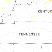
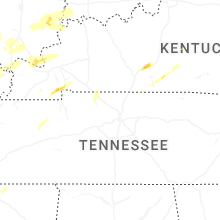


Connect with Interactive Hail Maps