

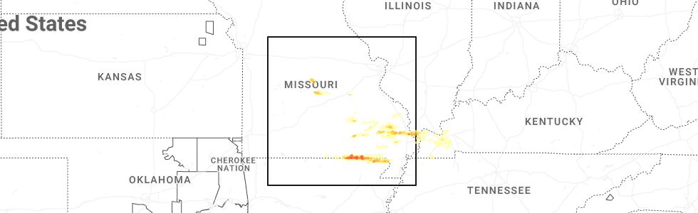
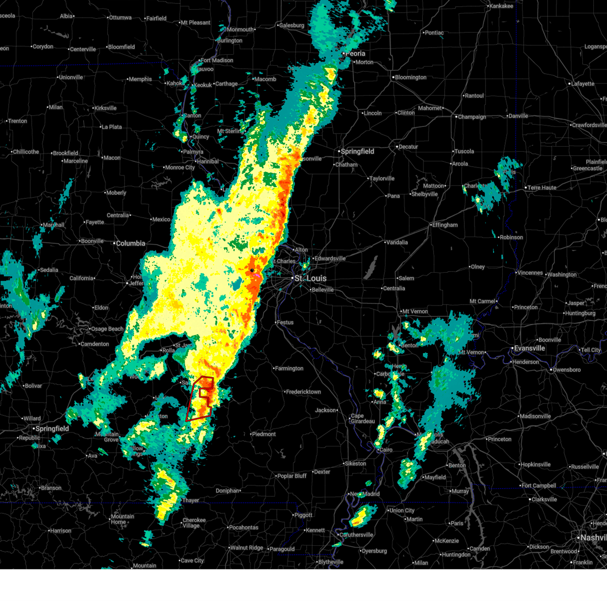
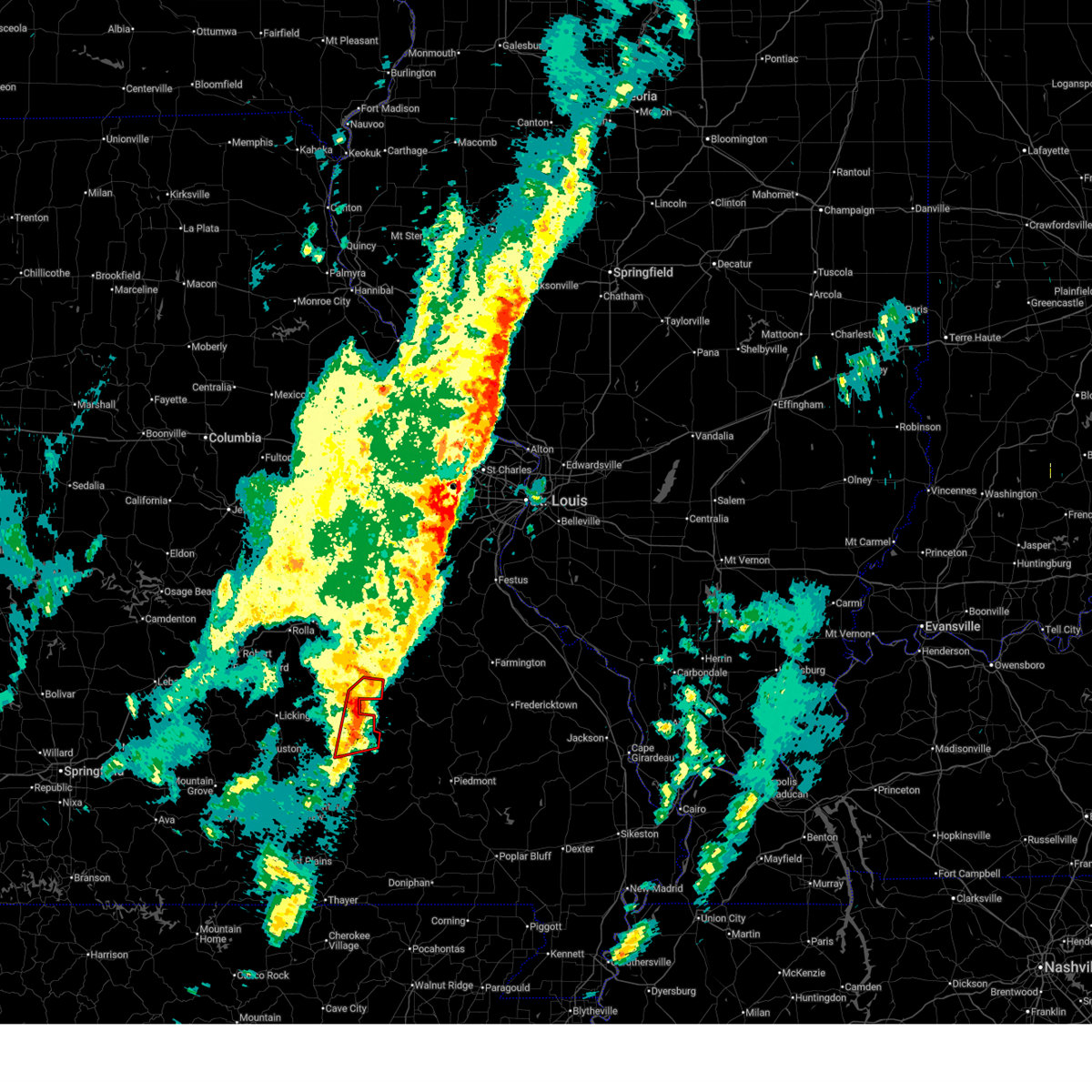
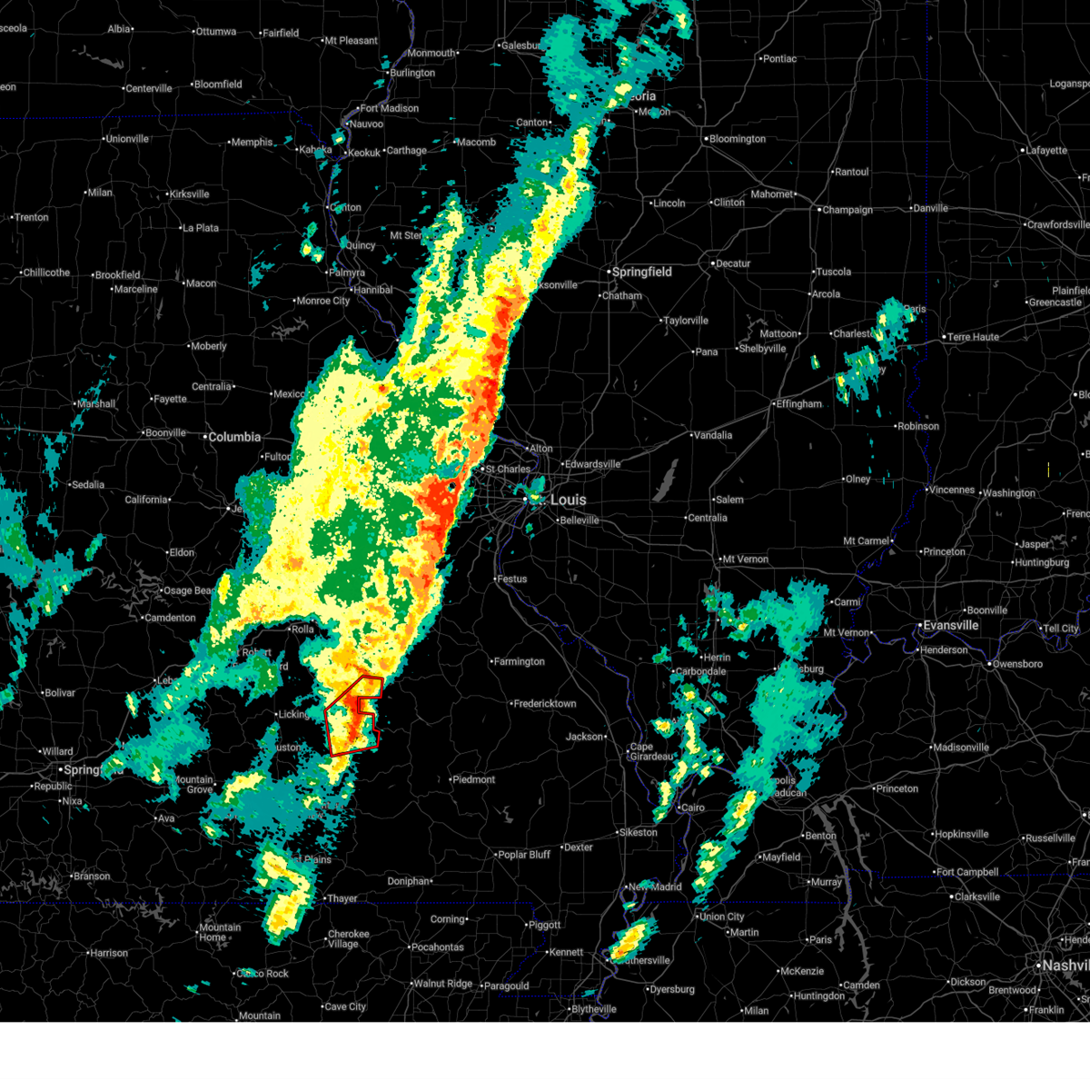
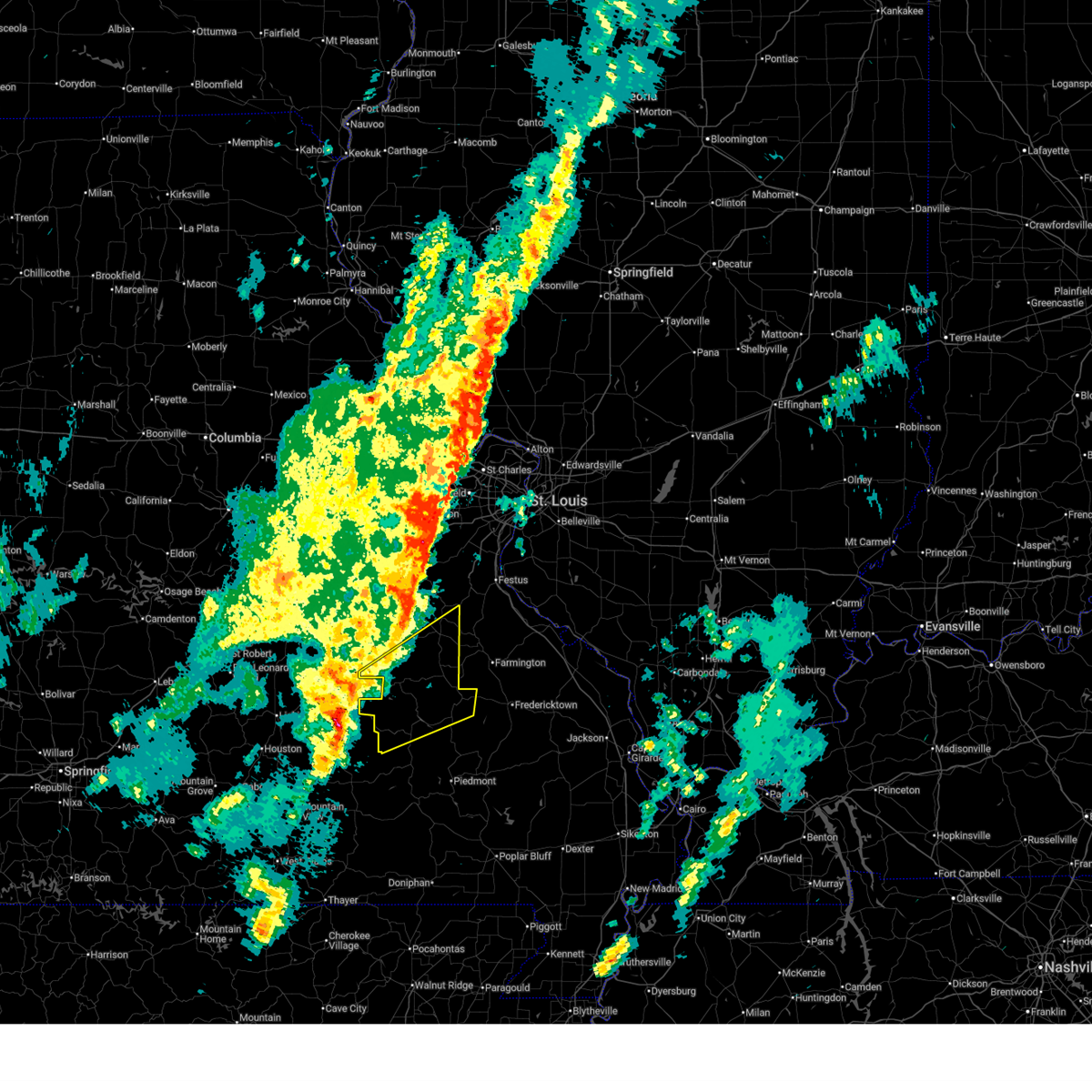
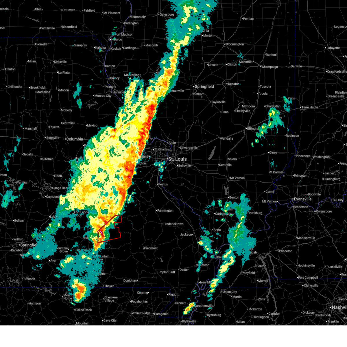
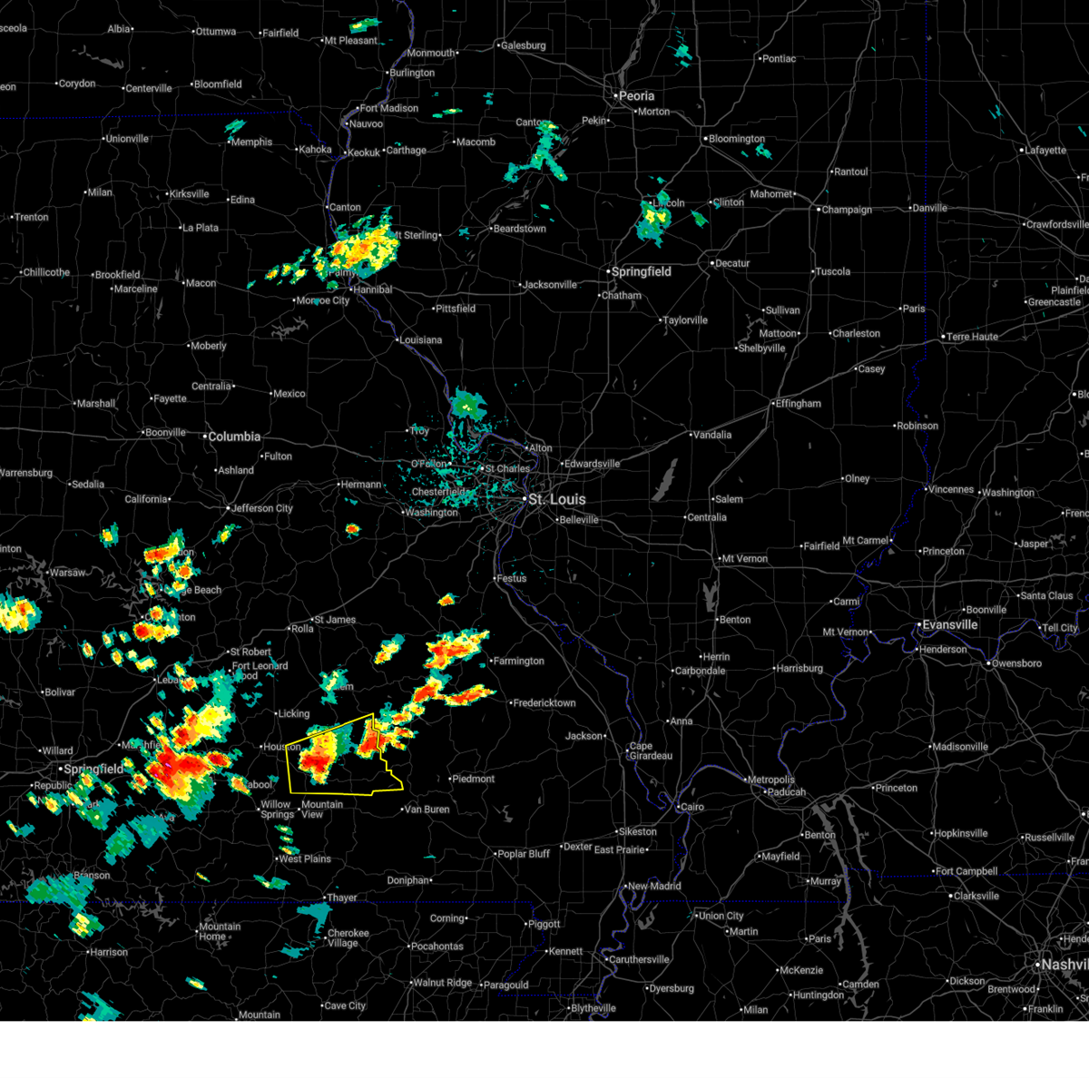
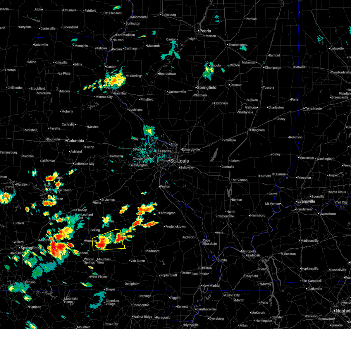
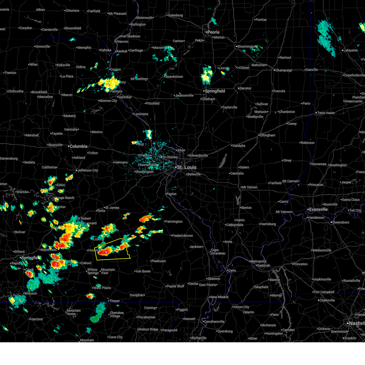
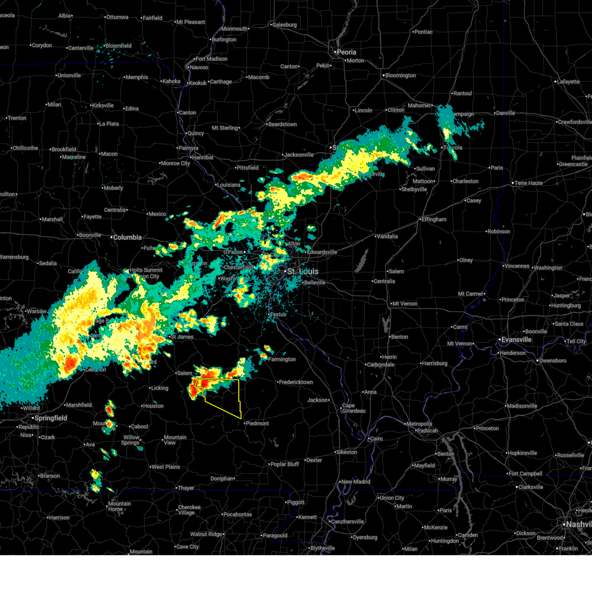
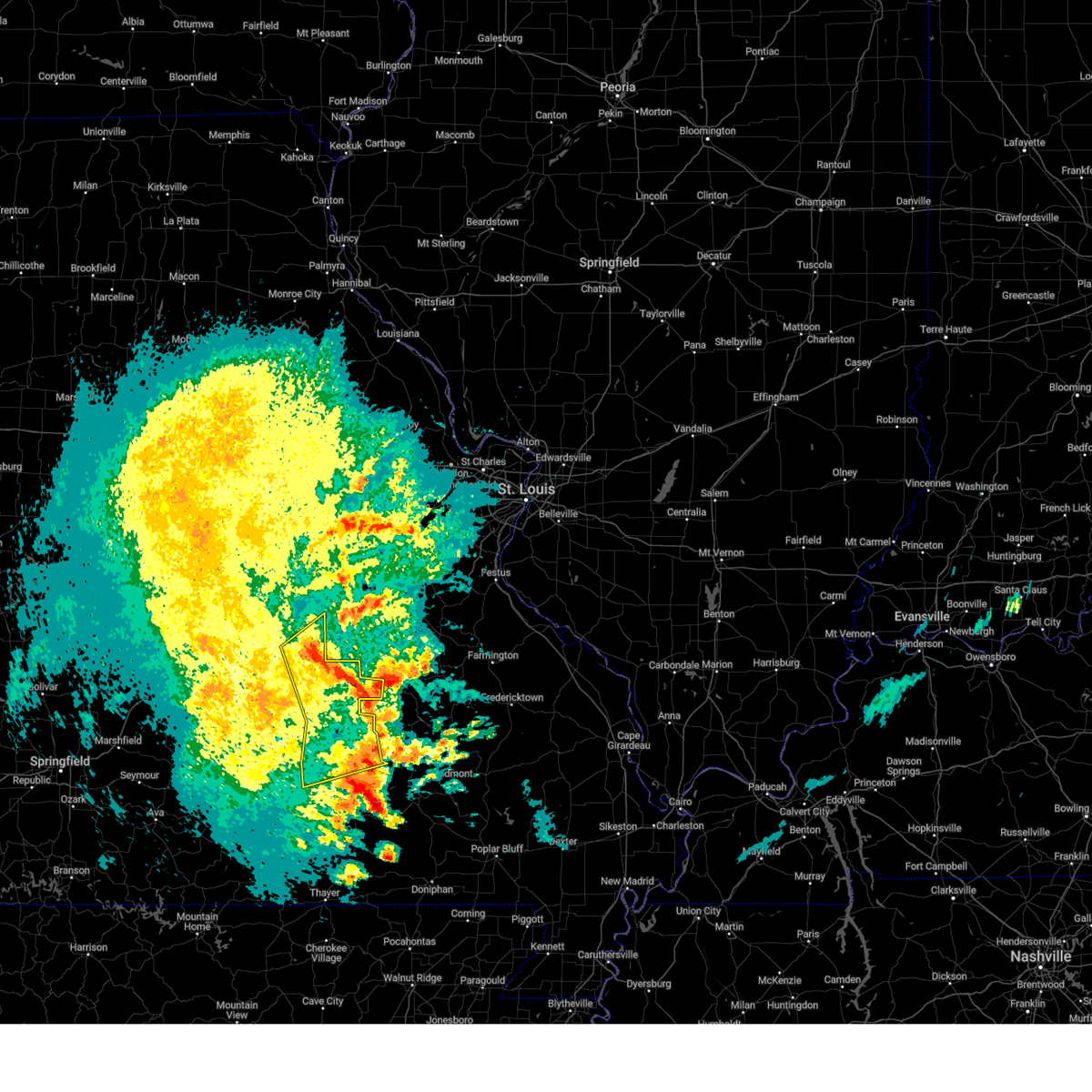
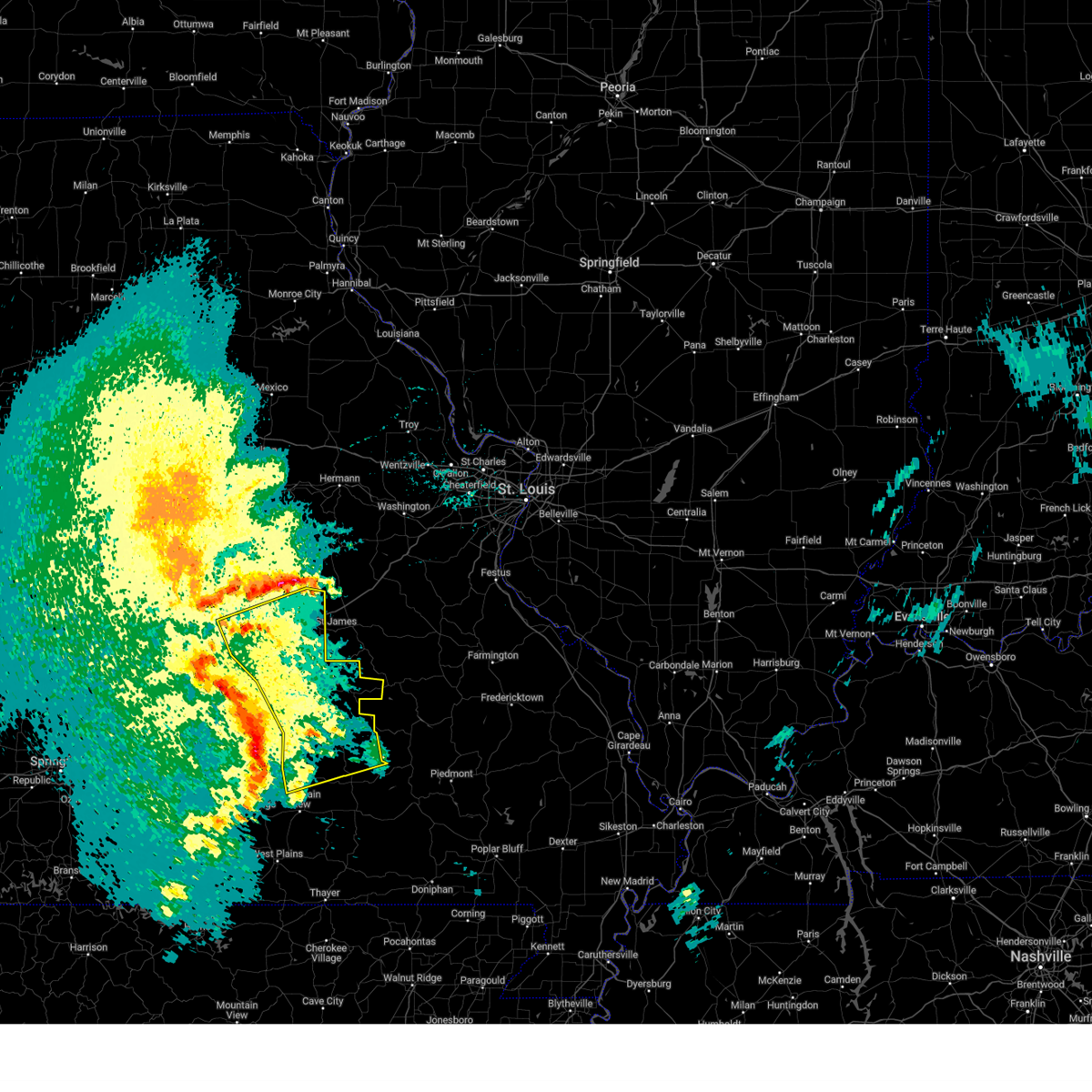
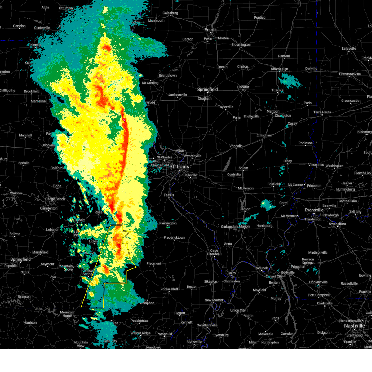
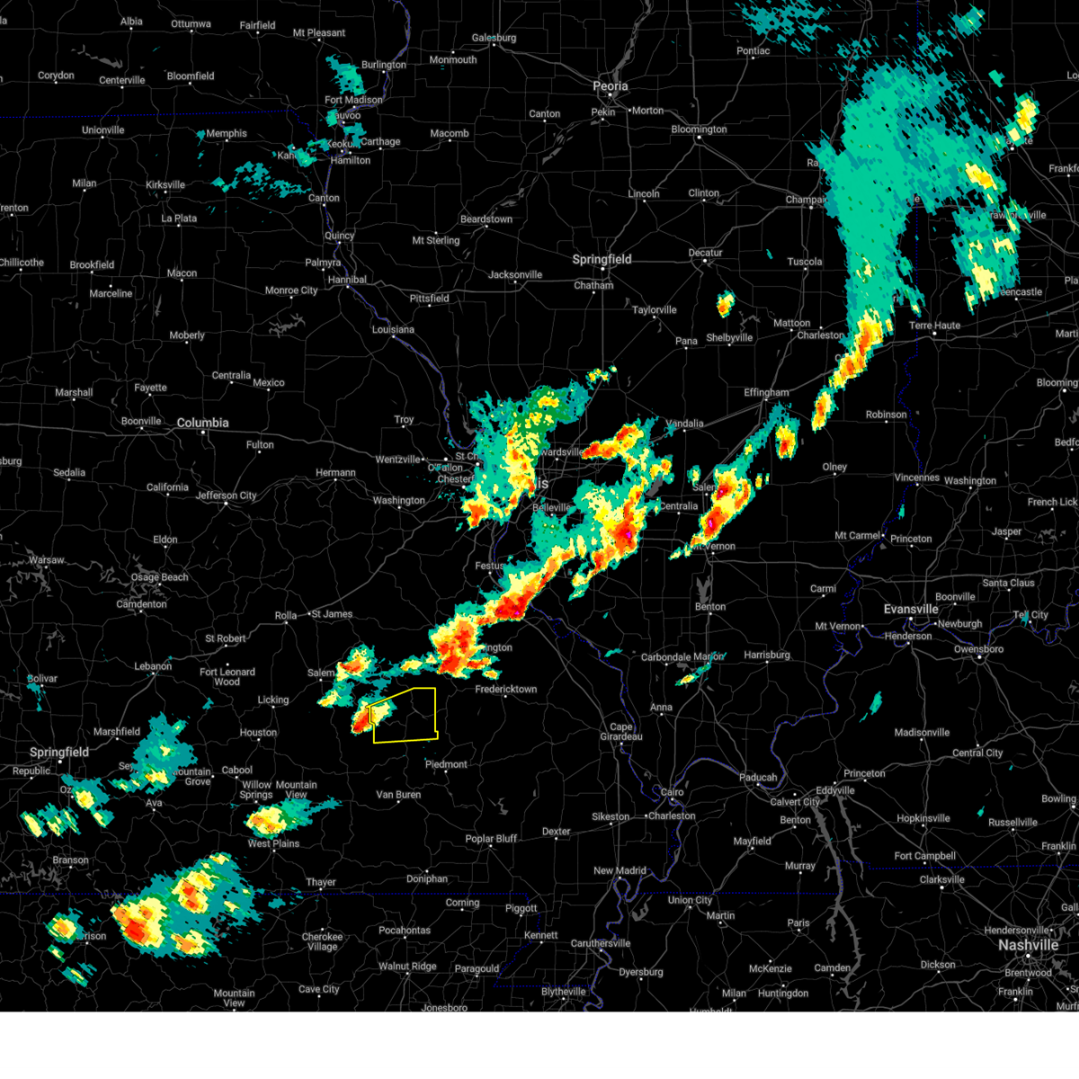
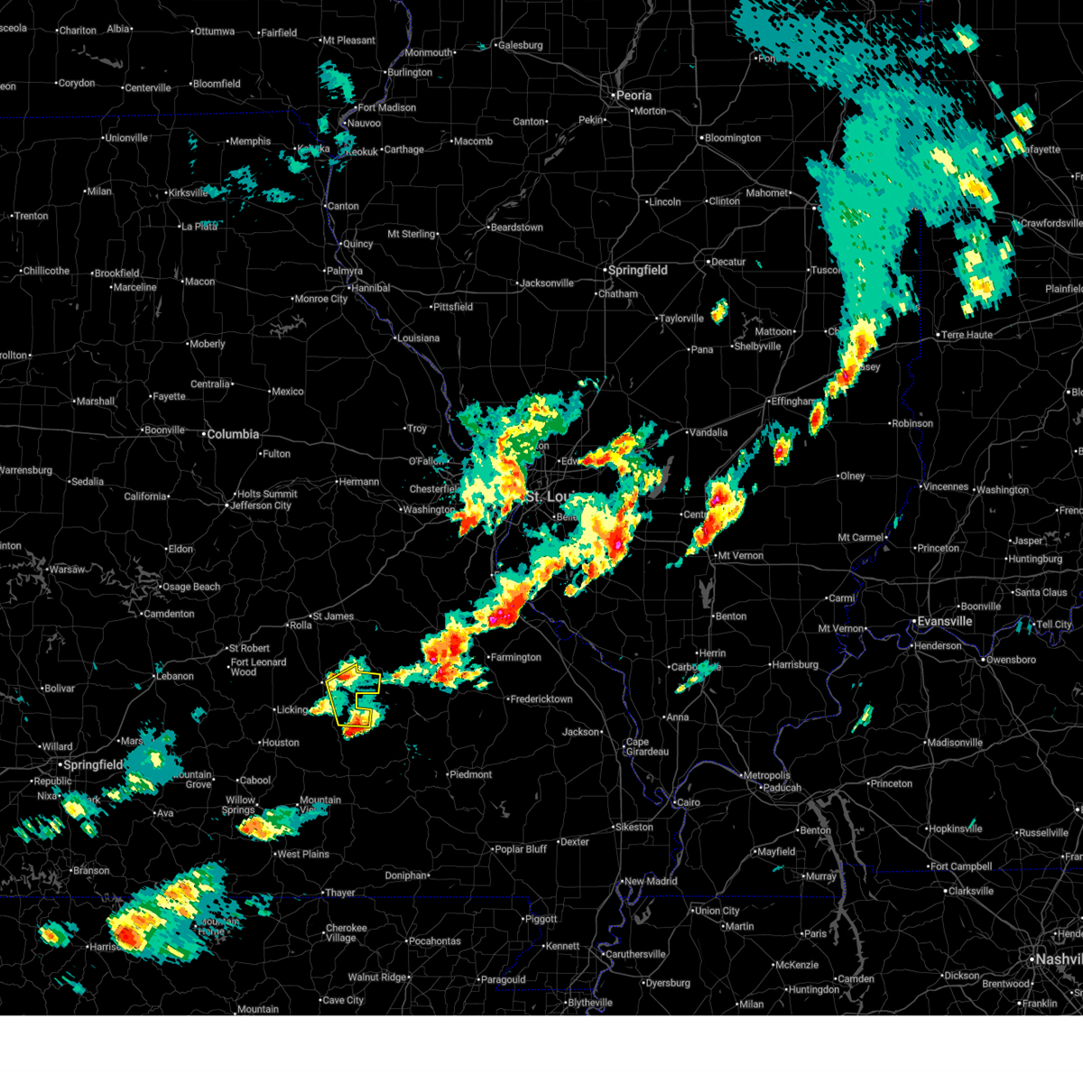
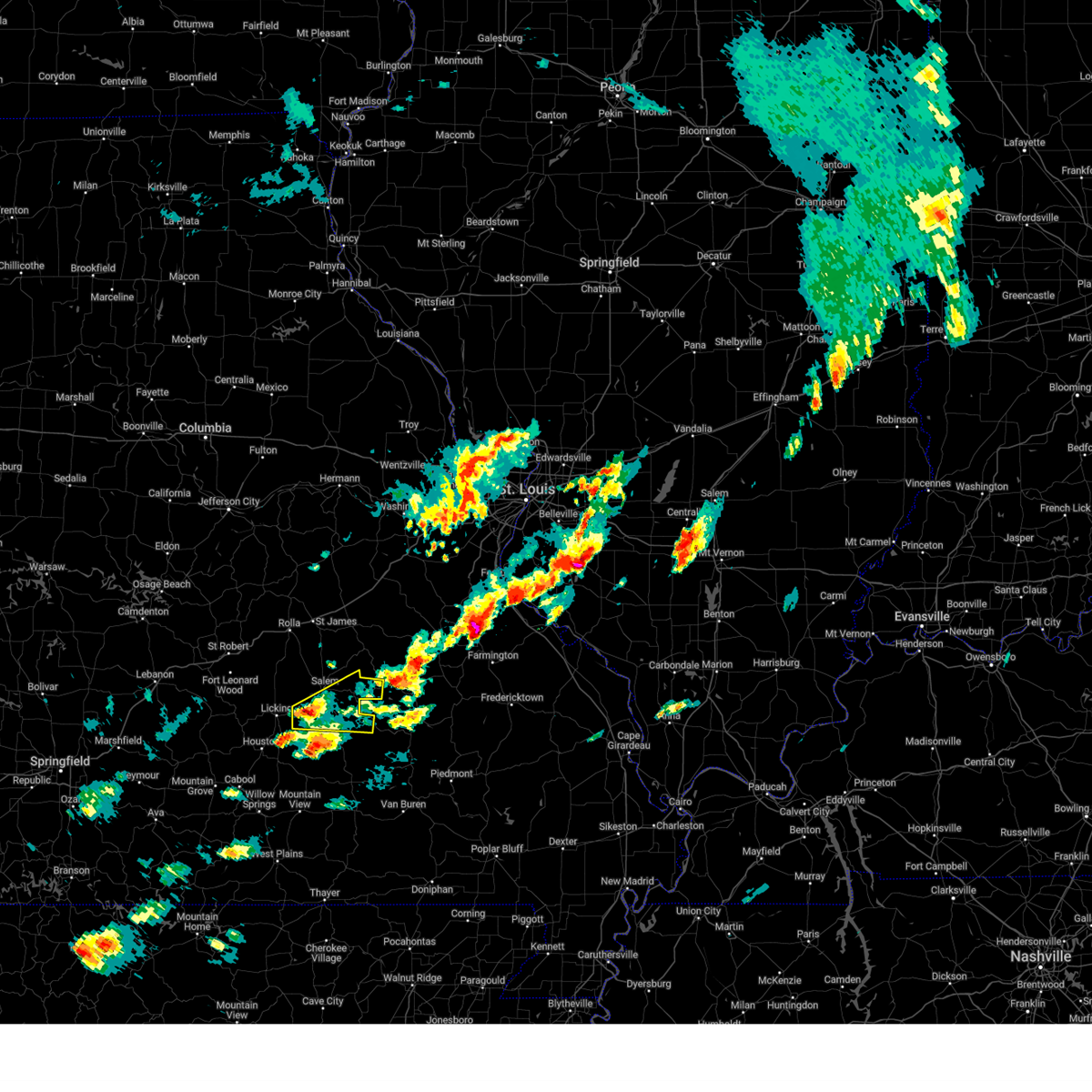
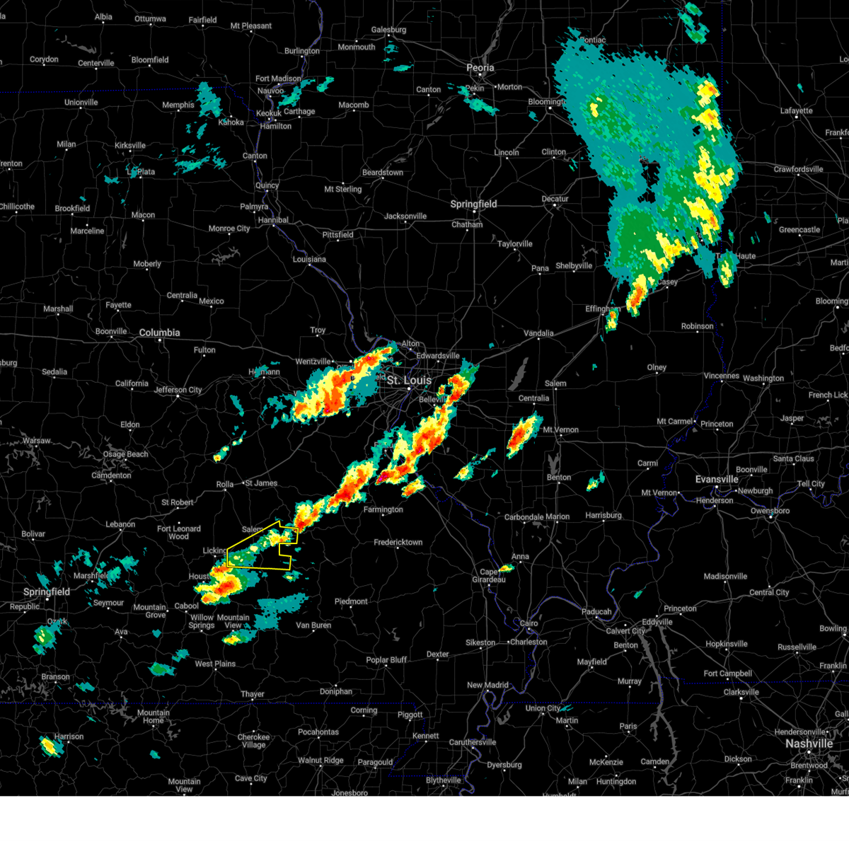
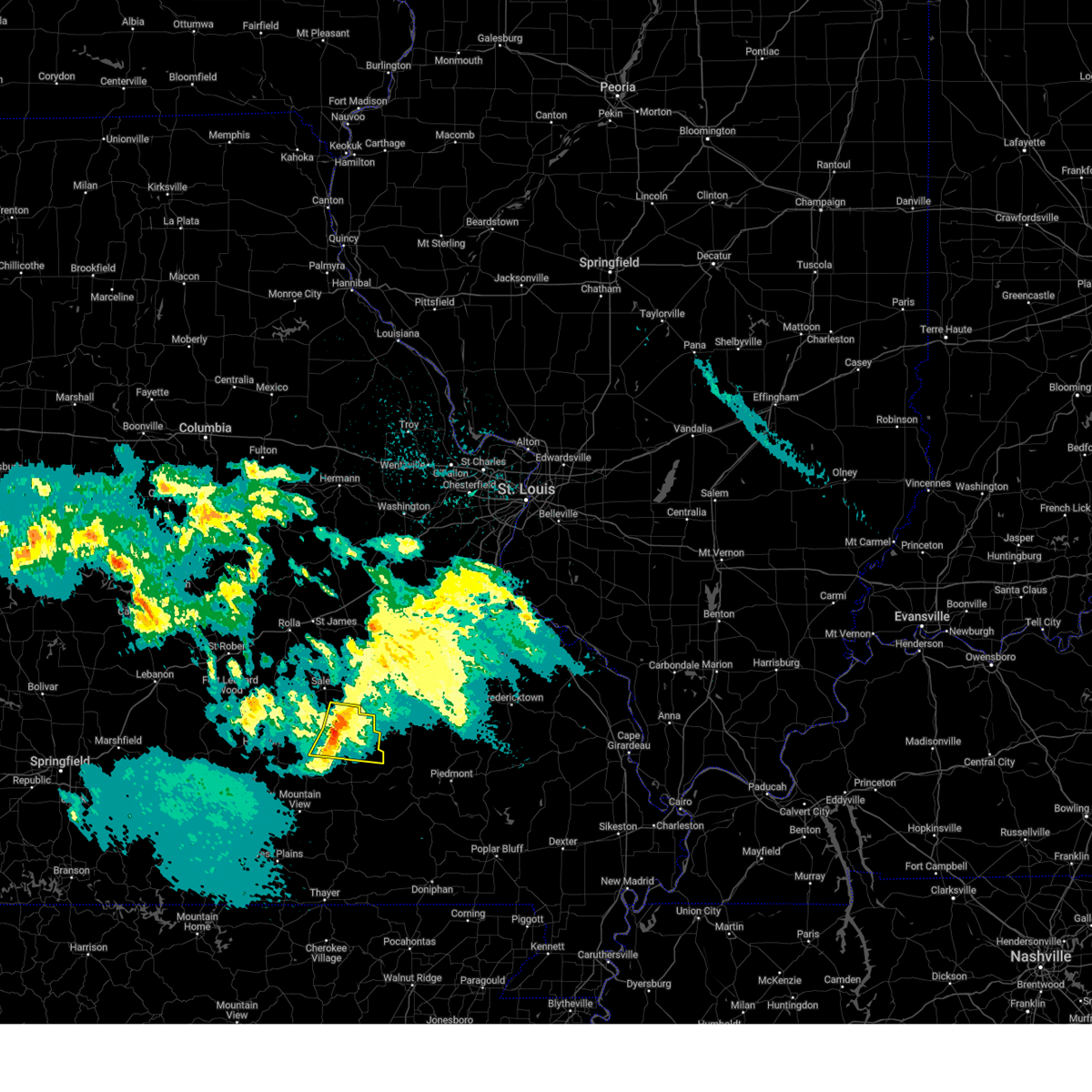
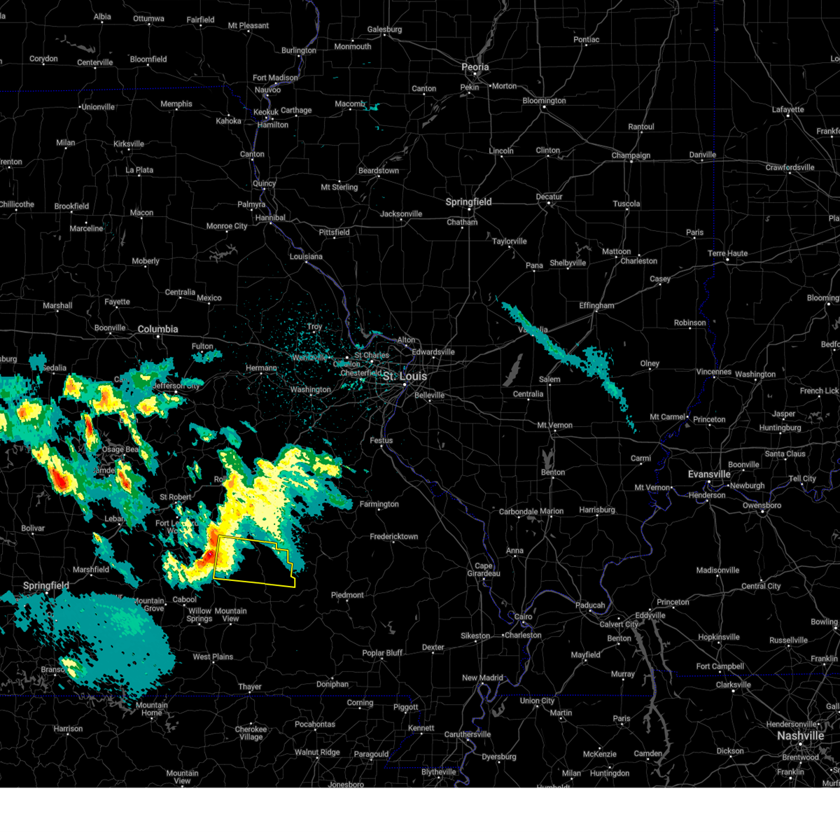
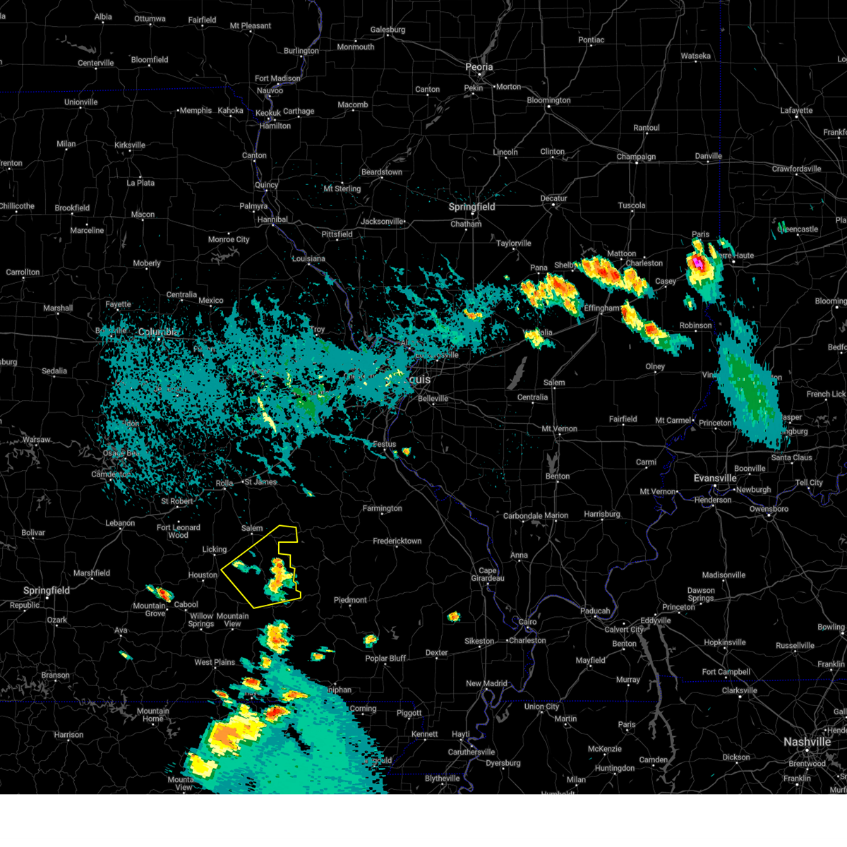
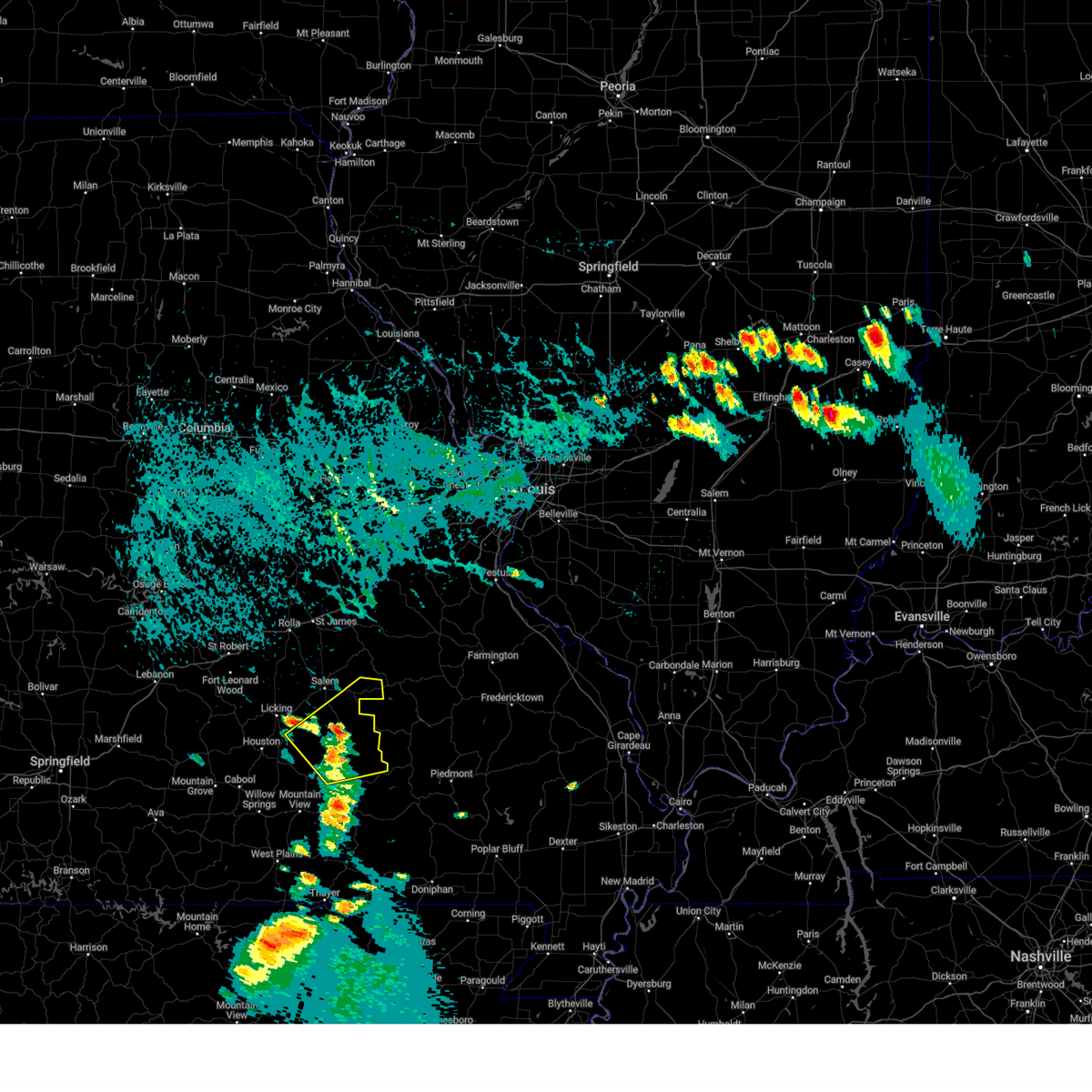
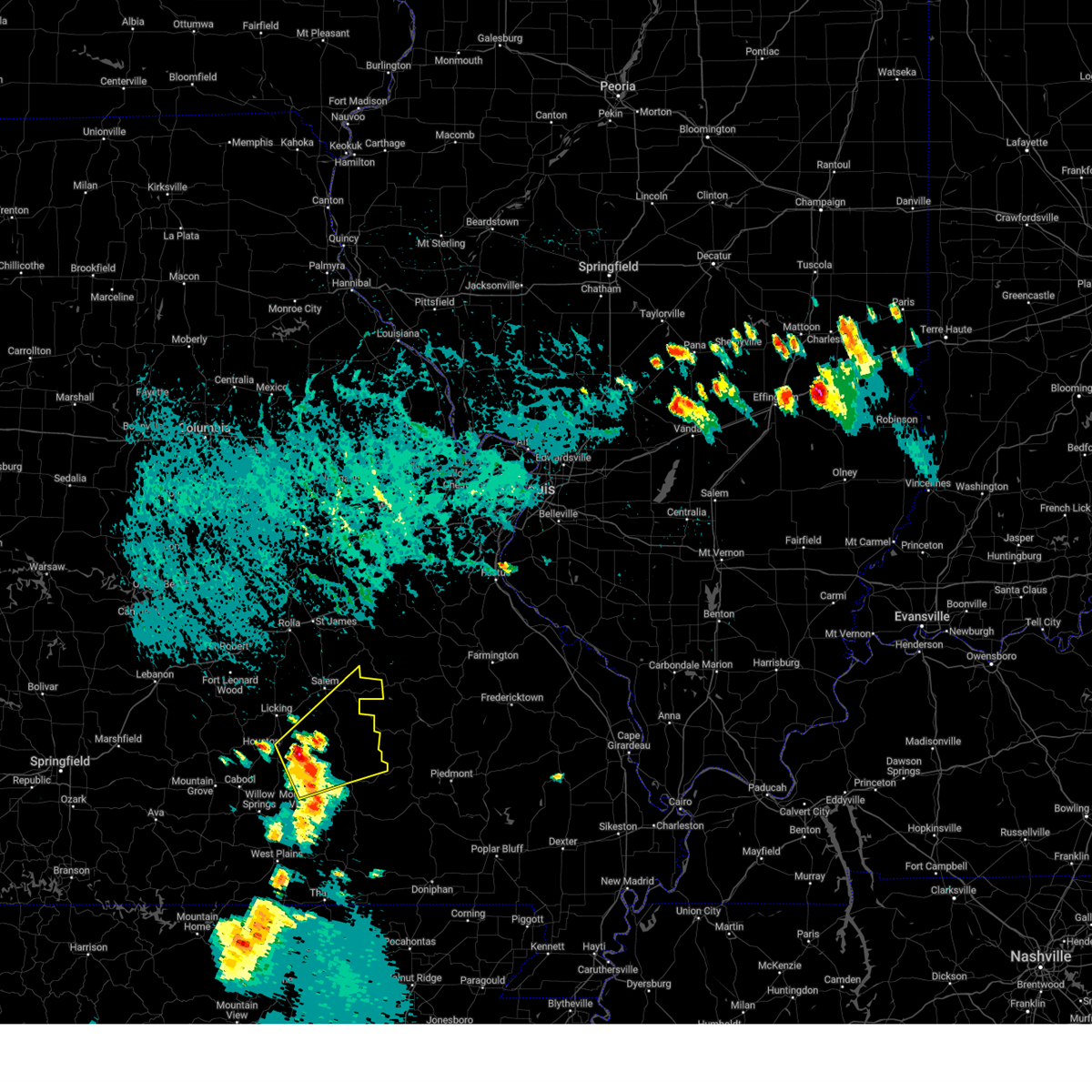
Hail Map for Bunker, MO
The Bunker, MO area has had 9 reports of on-the-ground hail by trained spotters, and has been under severe weather warnings 14 times during the past 12 months. Doppler radar has detected hail at or near Bunker, MO on 52 occasions, including 2 occasions during the past year.
| Name: | Bunker, MO |
| Where Located: | 21.7 miles SE of Salem, MO |
| Map: | Google Map for Bunker, MO |
| Population: | 407 |
| Housing Units: | 196 |
| More Info: | Search Google for Bunker, MO |
1
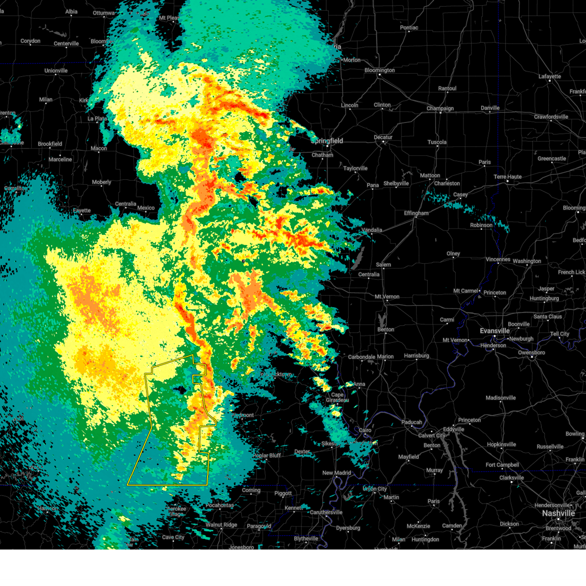
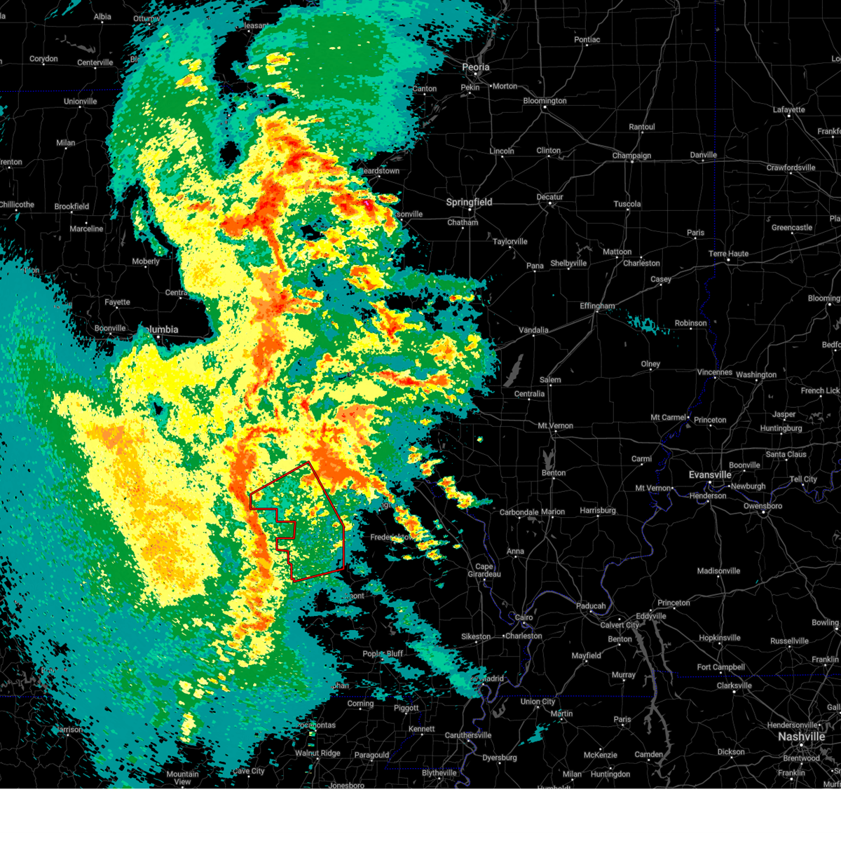
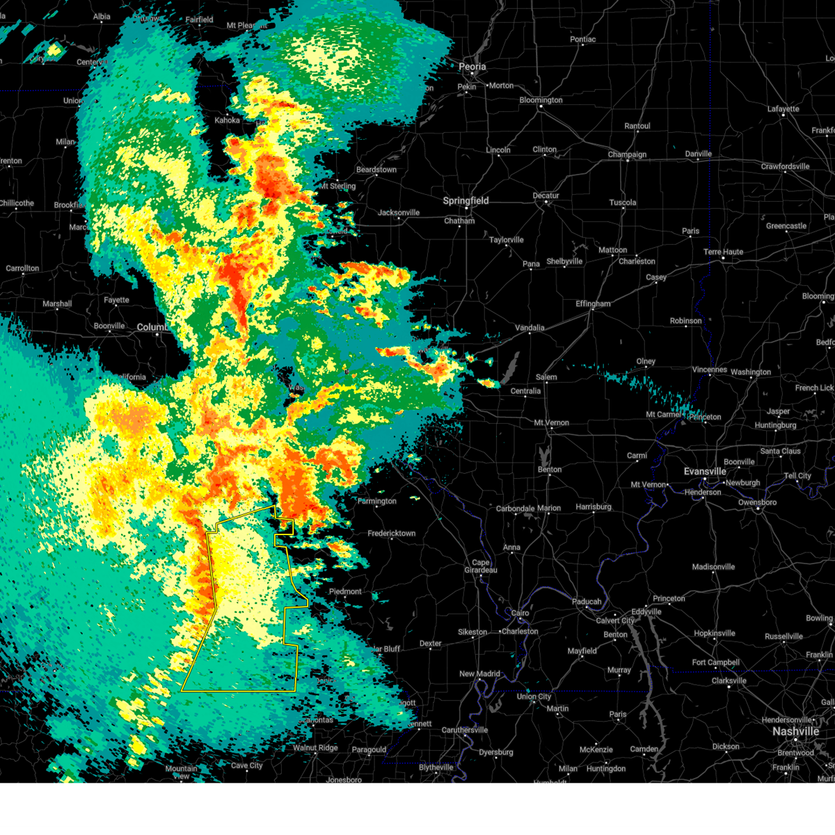
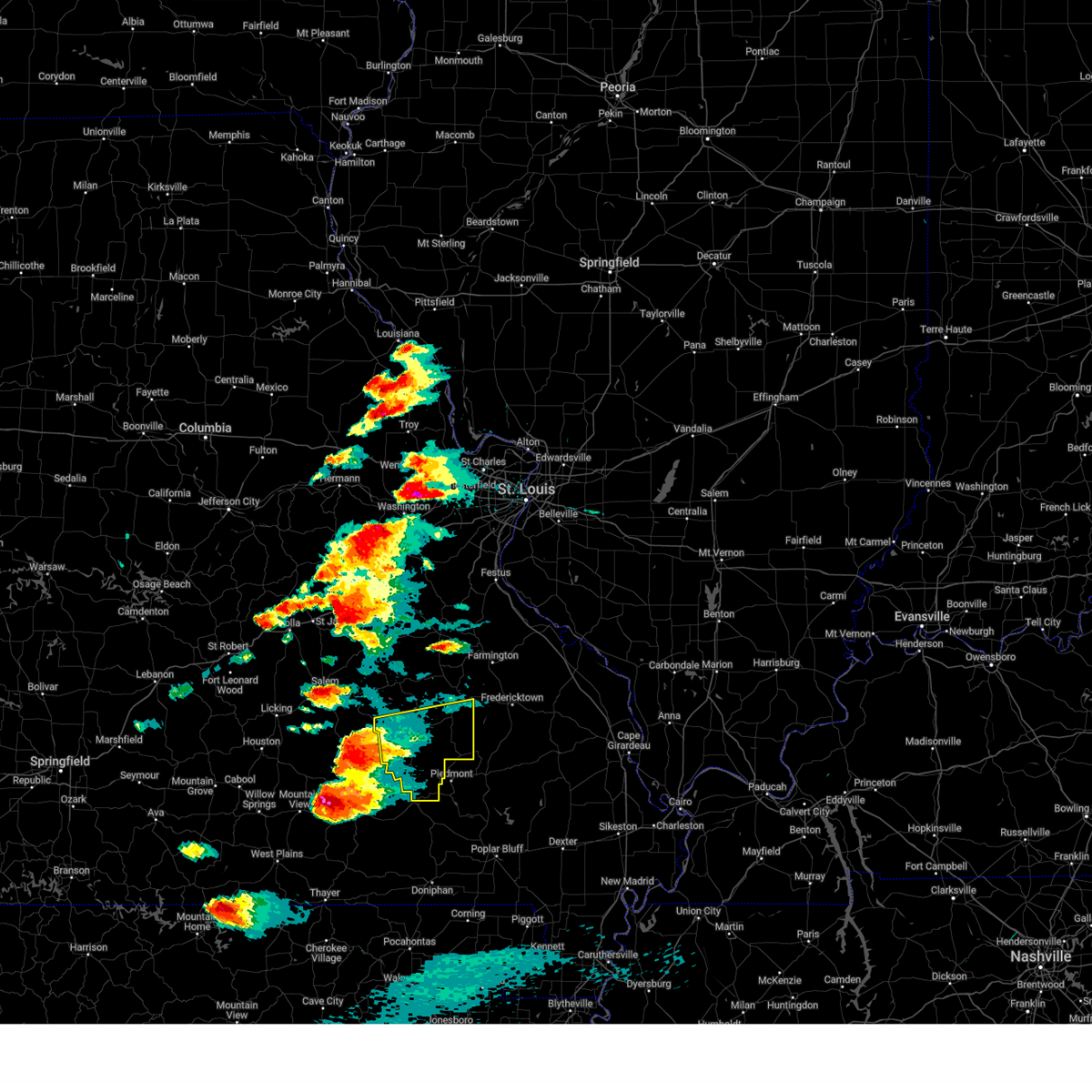
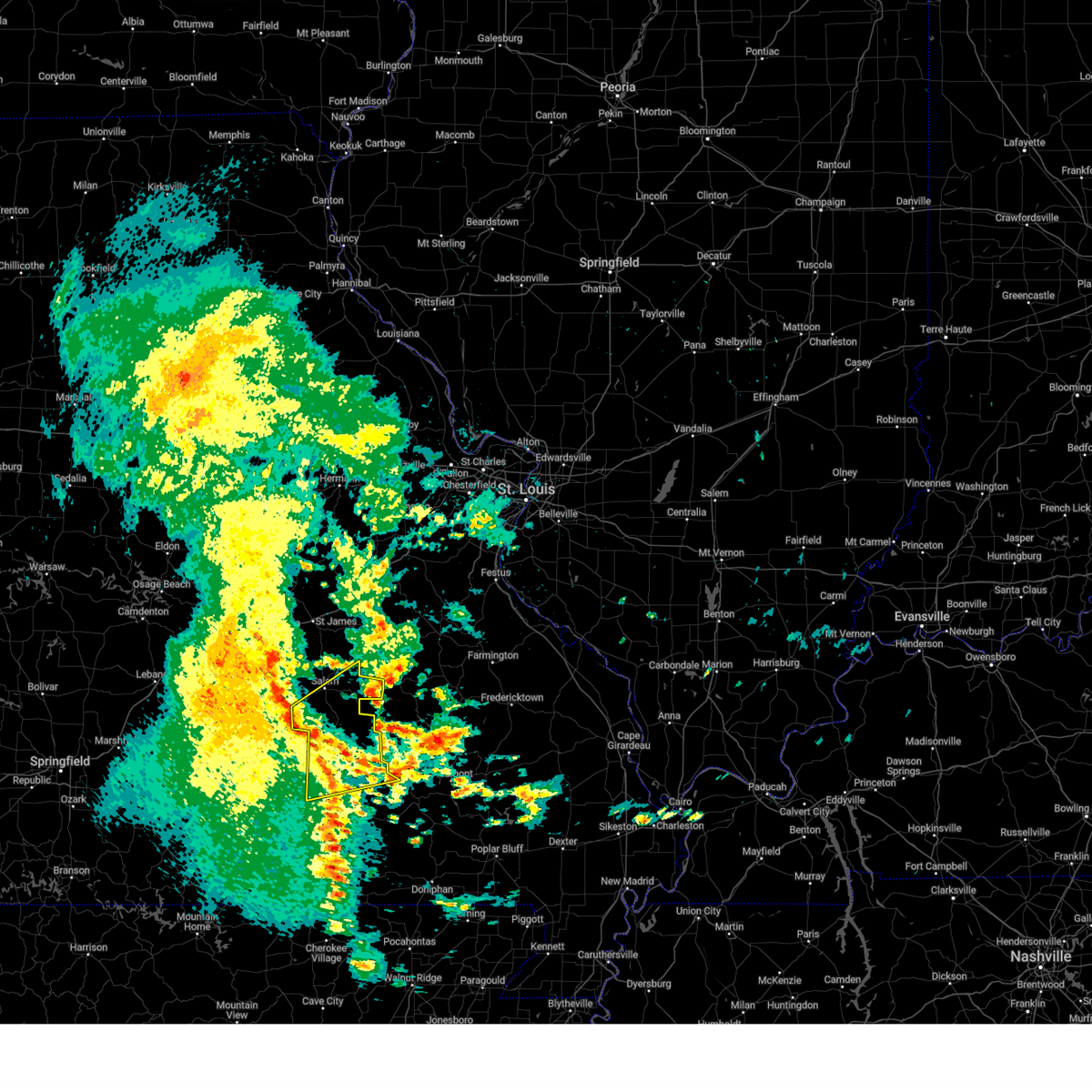
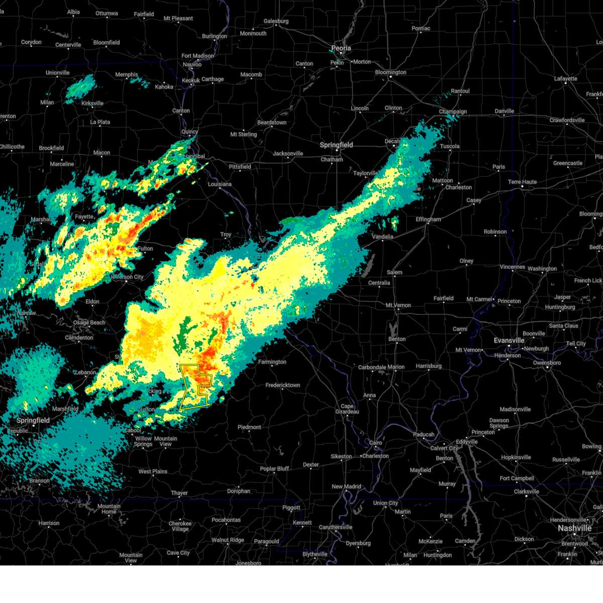
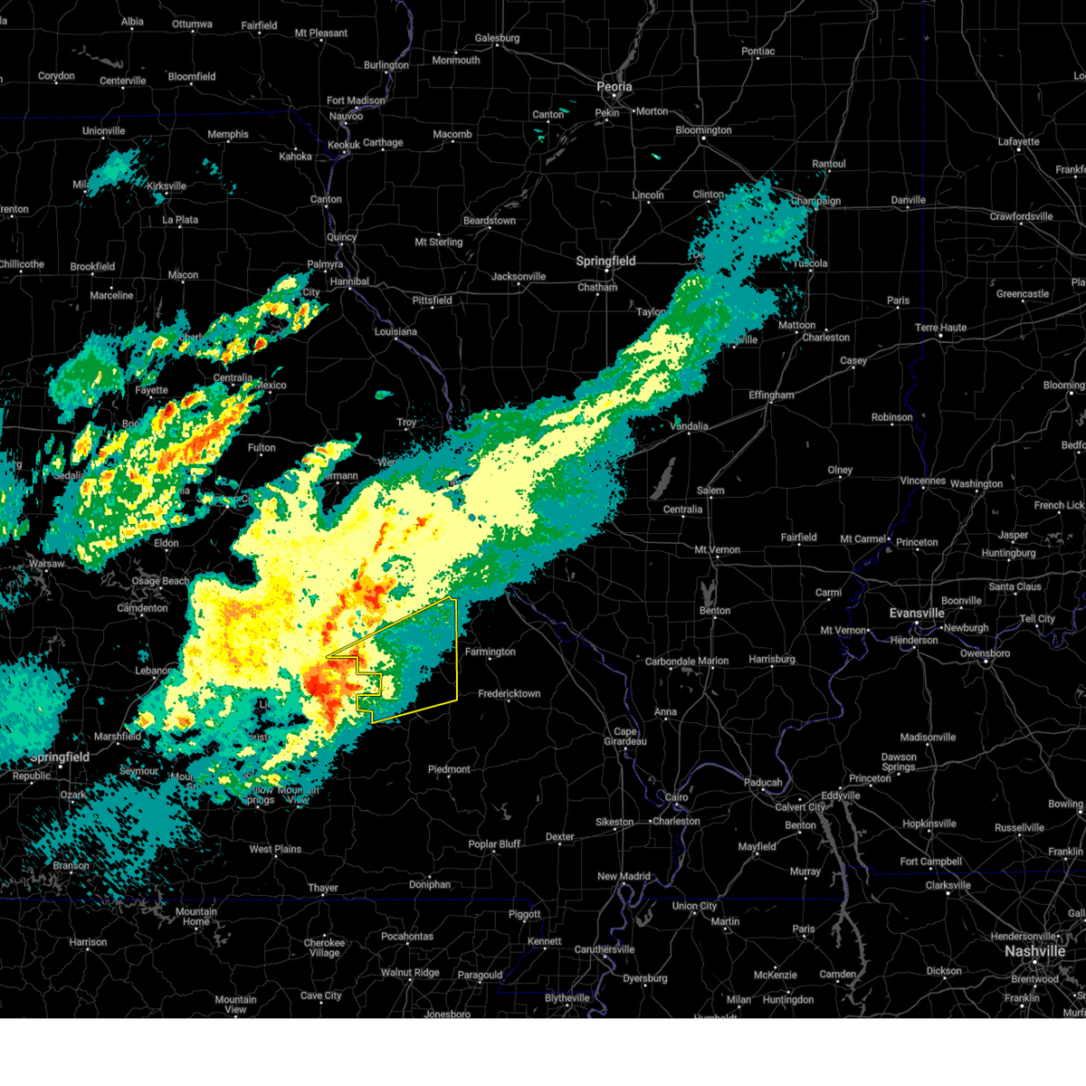
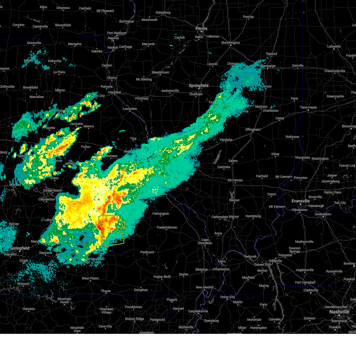
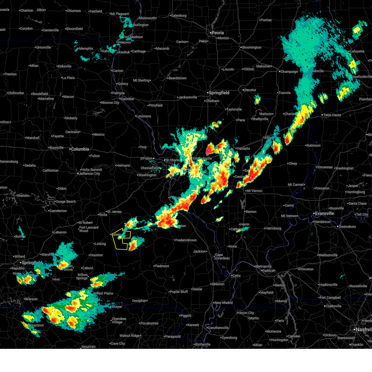
The Top Recent Hail Date for Bunker, MO is Thursday, April 16, 2026 (18th out of 52)
Hail and Wind Damage Spotted near Bunker, MO
| Date / Time | Report Details |
|---|---|
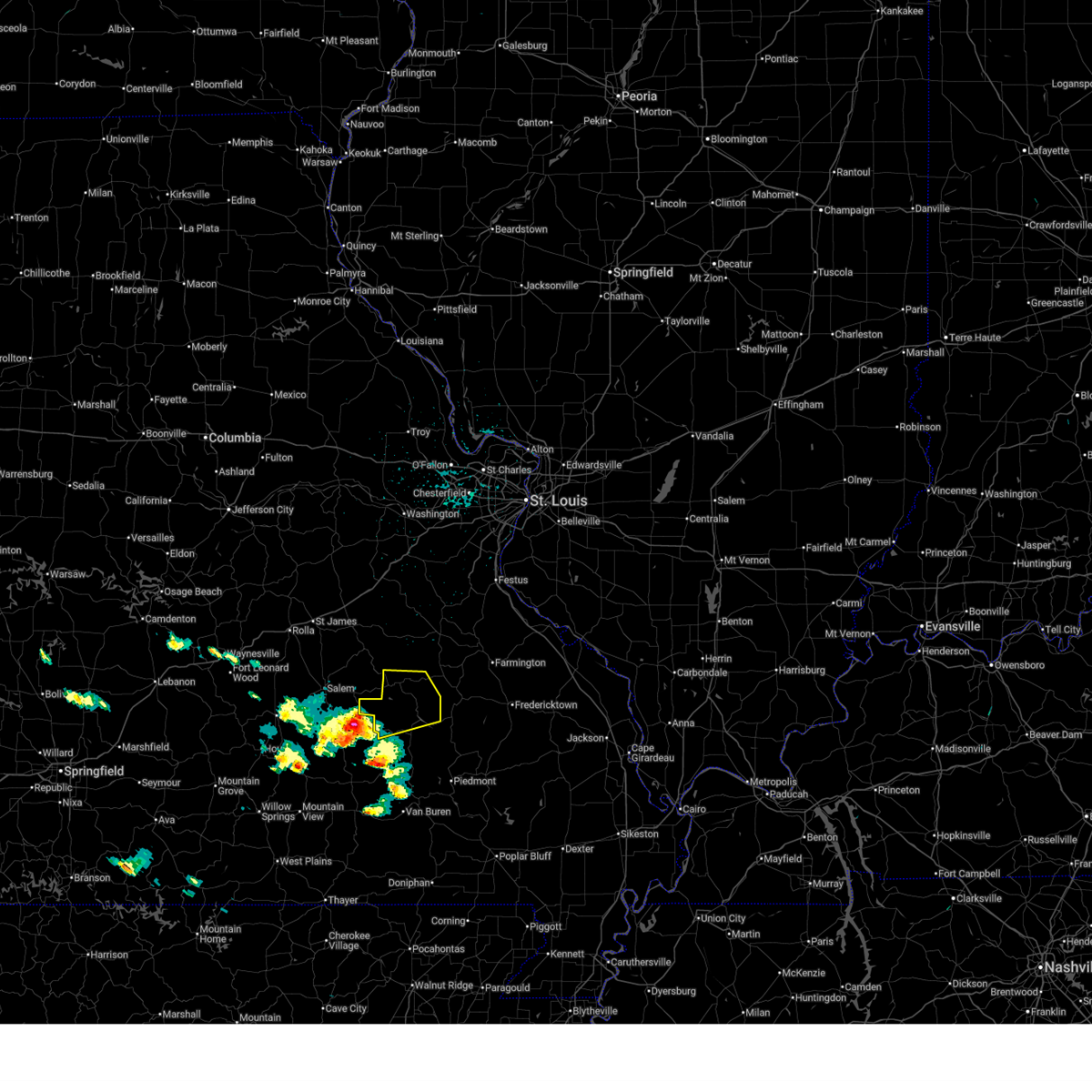
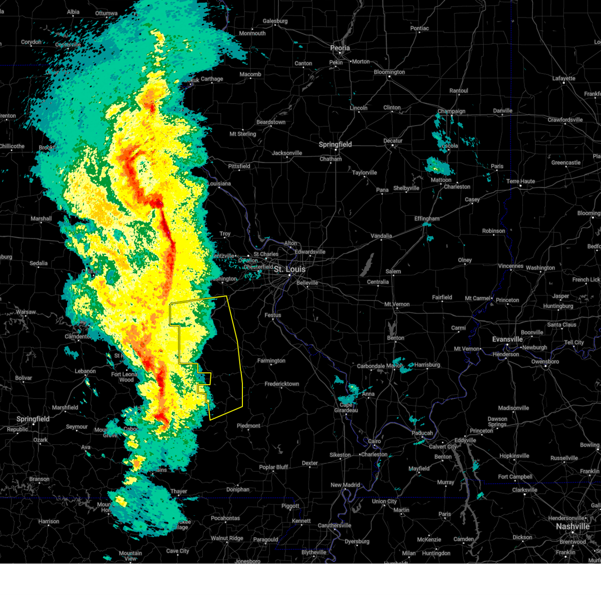
| 4/16/2026 1:01 PM CDT |
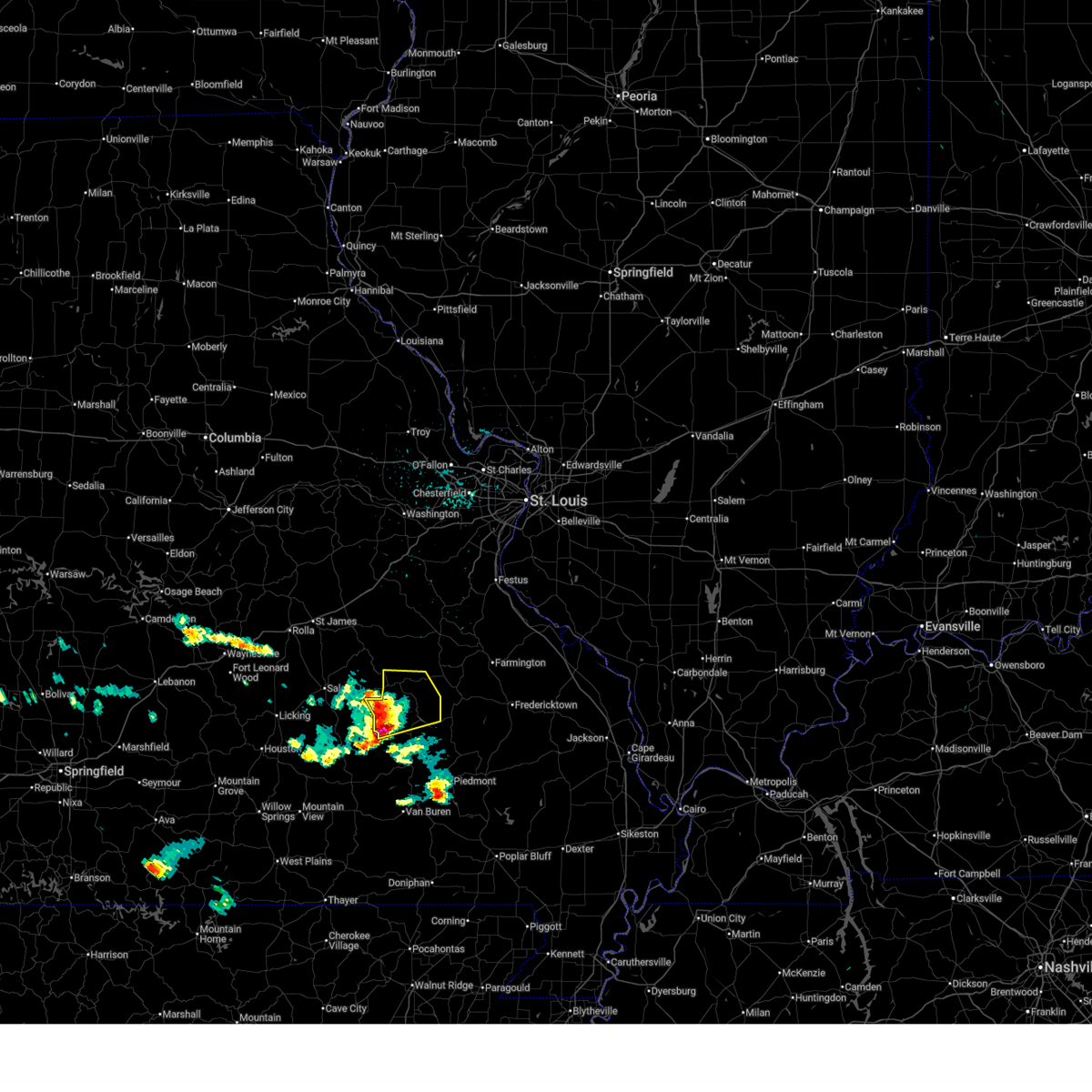 At 101 pm cdt, a severe thunderstorm was located over reynolds, or 27 miles southwest of ironton, moving east at 35 mph (radar indicated). Hazards include 60 mph wind gusts and quarter size hail. Hail damage to vehicles is expected. expect wind damage to roofs, siding, and trees. locations impacted include, viburnum, oates, bixby, centerville and black. This includes the following state parks, johnsons shut-ins state park and taum sauk mountain state park. At 101 pm cdt, a severe thunderstorm was located over reynolds, or 27 miles southwest of ironton, moving east at 35 mph (radar indicated). Hazards include 60 mph wind gusts and quarter size hail. Hail damage to vehicles is expected. expect wind damage to roofs, siding, and trees. locations impacted include, viburnum, oates, bixby, centerville and black. This includes the following state parks, johnsons shut-ins state park and taum sauk mountain state park.
|
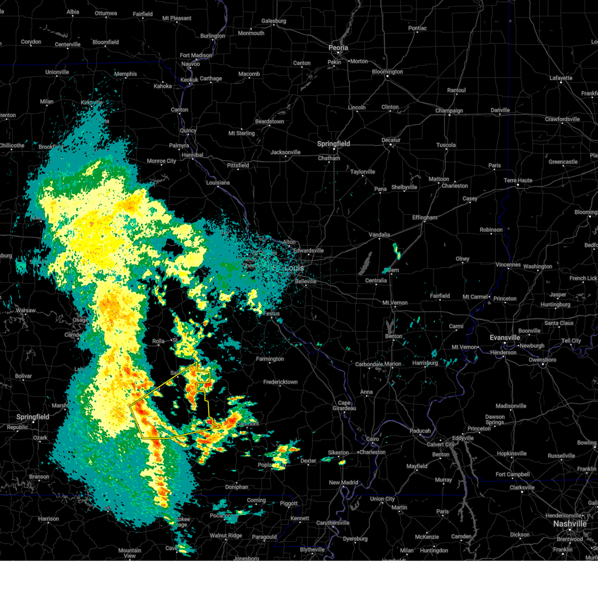
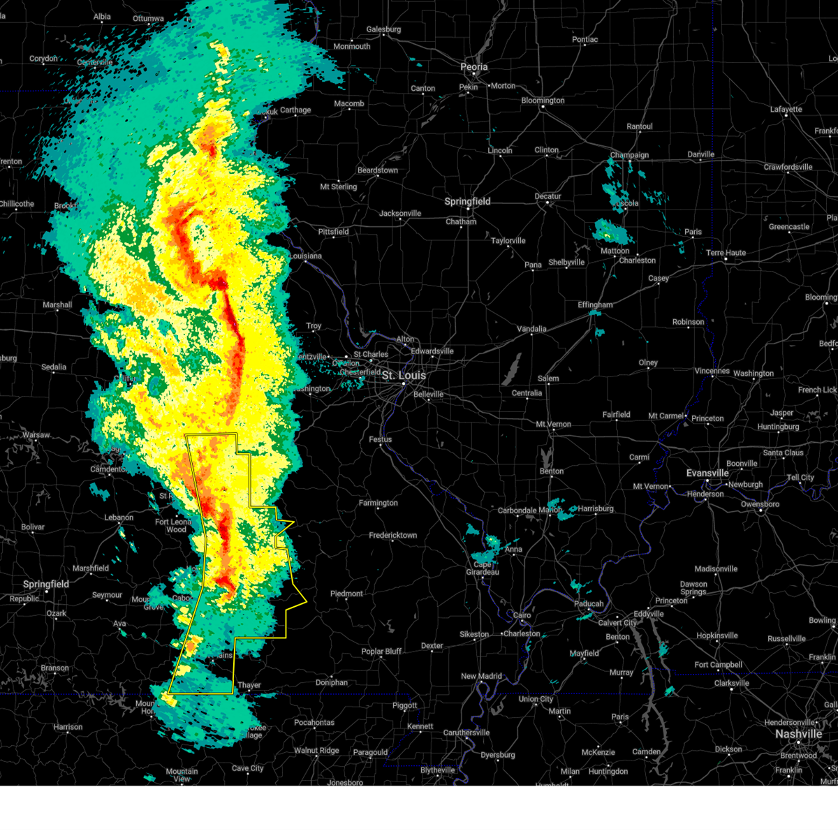
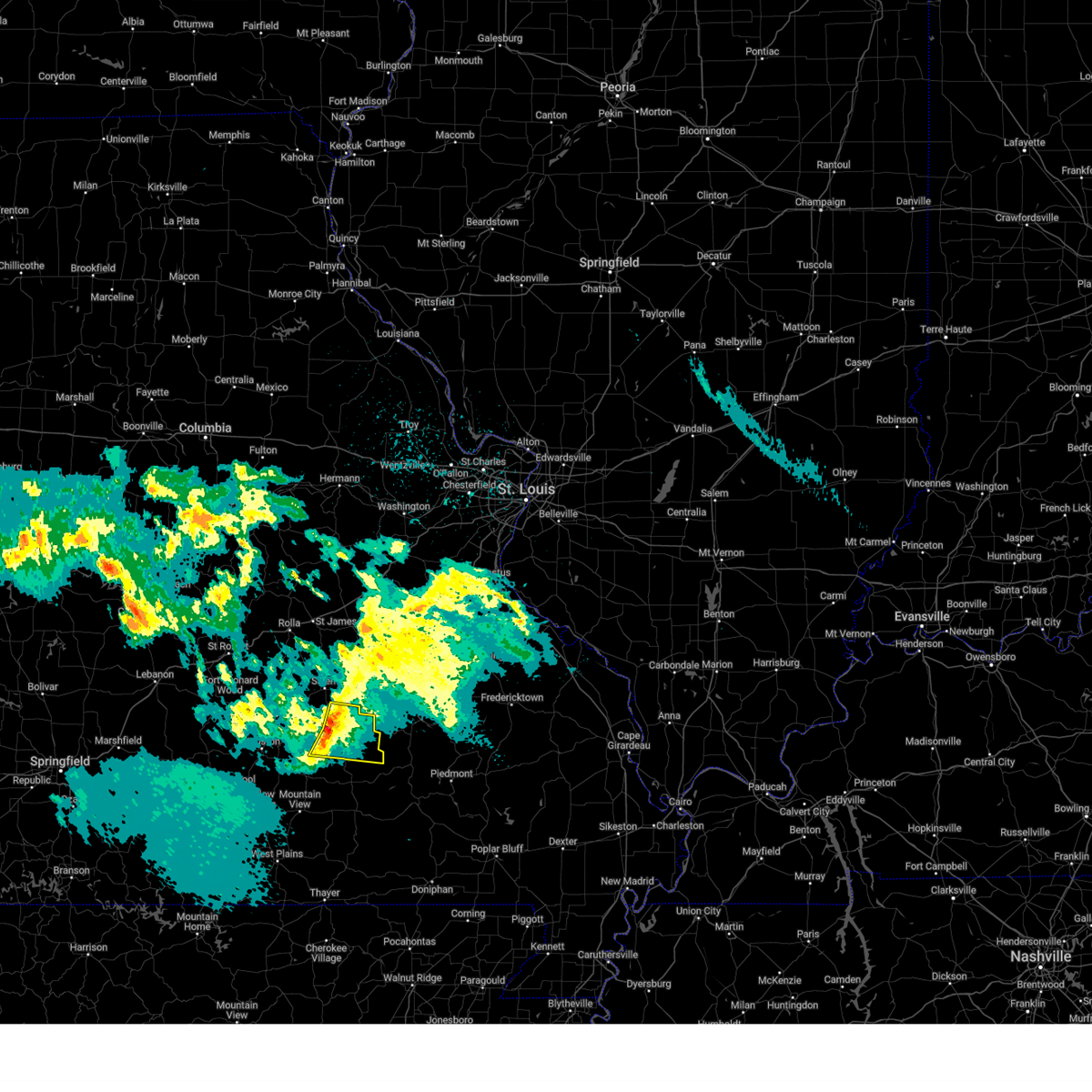
| 4/16/2026 12:37 PM CDT |
 Svrlsx the national weather service in st louis has issued a * severe thunderstorm warning for, northwestern iron county in southeastern missouri, northern reynolds county in southeastern missouri, * until 130 pm cdt. * at 1237 pm cdt, a severe thunderstorm was located 12 miles west of reynolds, or 36 miles south of steelville, moving east at 35 mph (radar indicated). Hazards include 60 mph wind gusts and quarter size hail. Hail damage to vehicles is expected. Expect wind damage to roofs, siding, and trees. Svrlsx the national weather service in st louis has issued a * severe thunderstorm warning for, northwestern iron county in southeastern missouri, northern reynolds county in southeastern missouri, * until 130 pm cdt. * at 1237 pm cdt, a severe thunderstorm was located 12 miles west of reynolds, or 36 miles south of steelville, moving east at 35 mph (radar indicated). Hazards include 60 mph wind gusts and quarter size hail. Hail damage to vehicles is expected. Expect wind damage to roofs, siding, and trees.
|
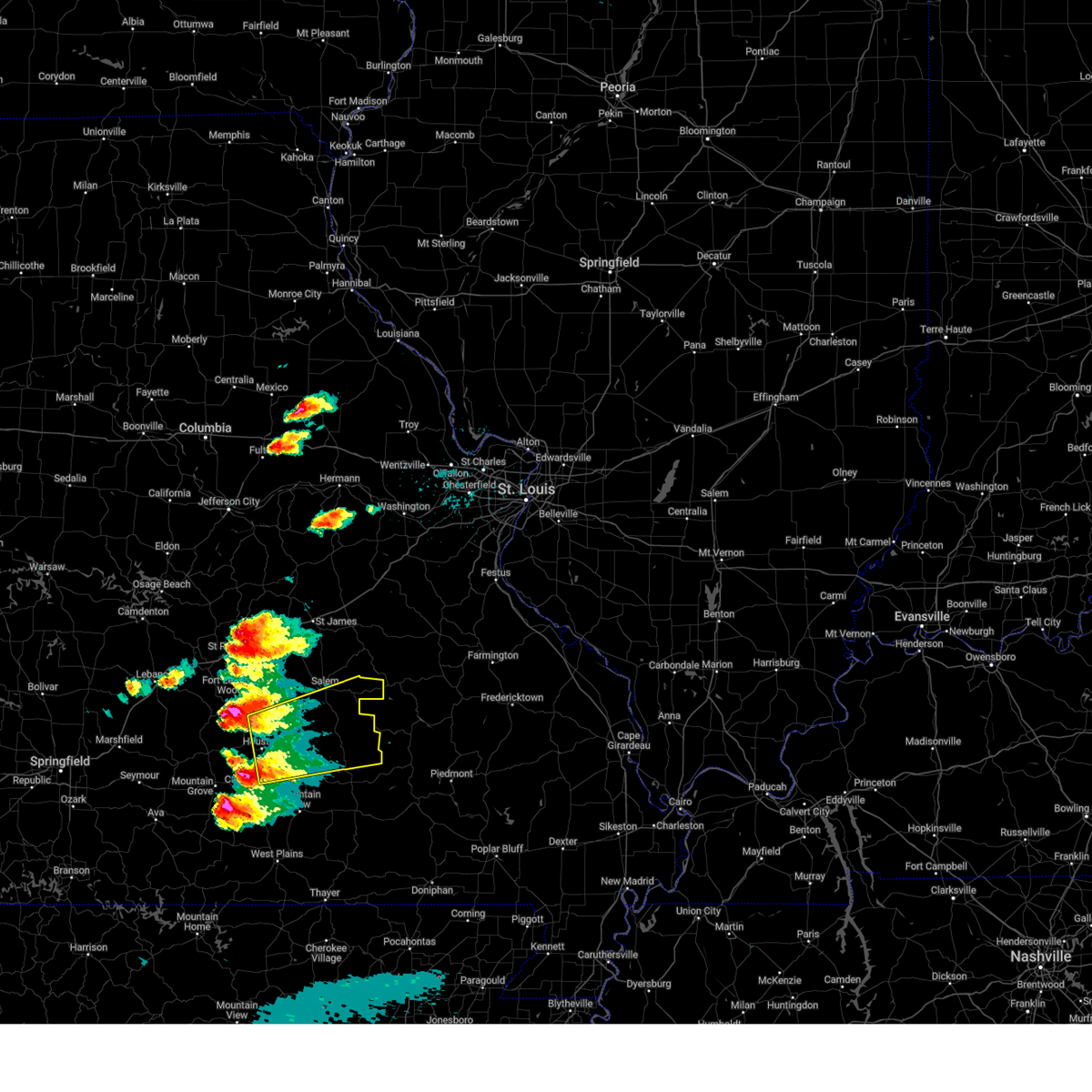
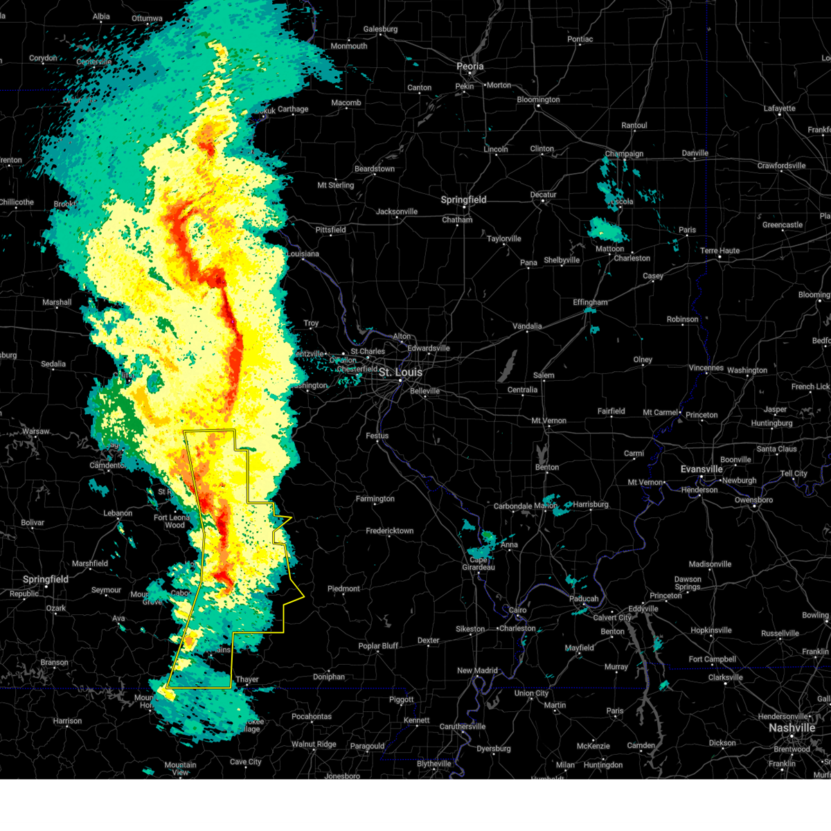
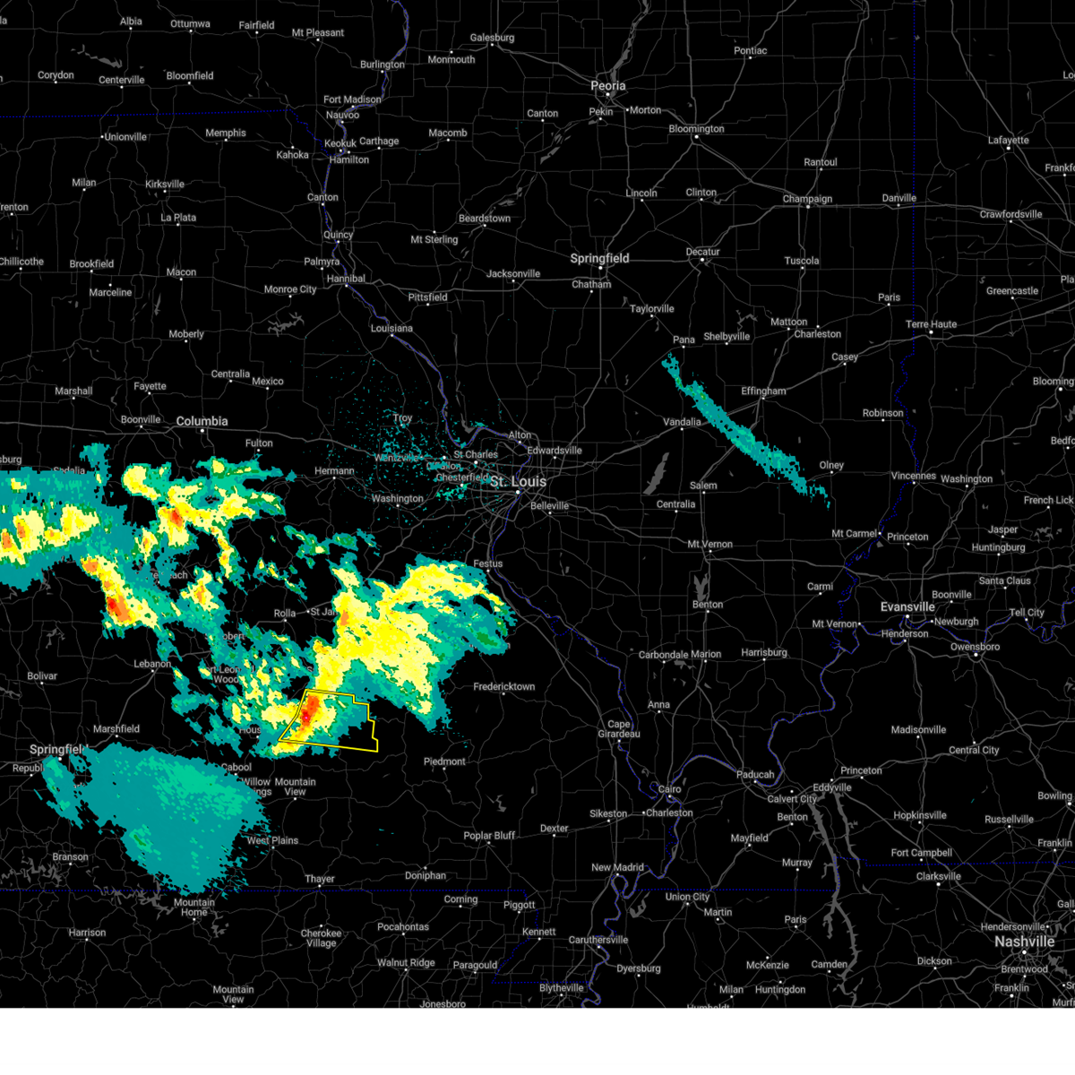
| 4/16/2026 12:30 PM CDT |
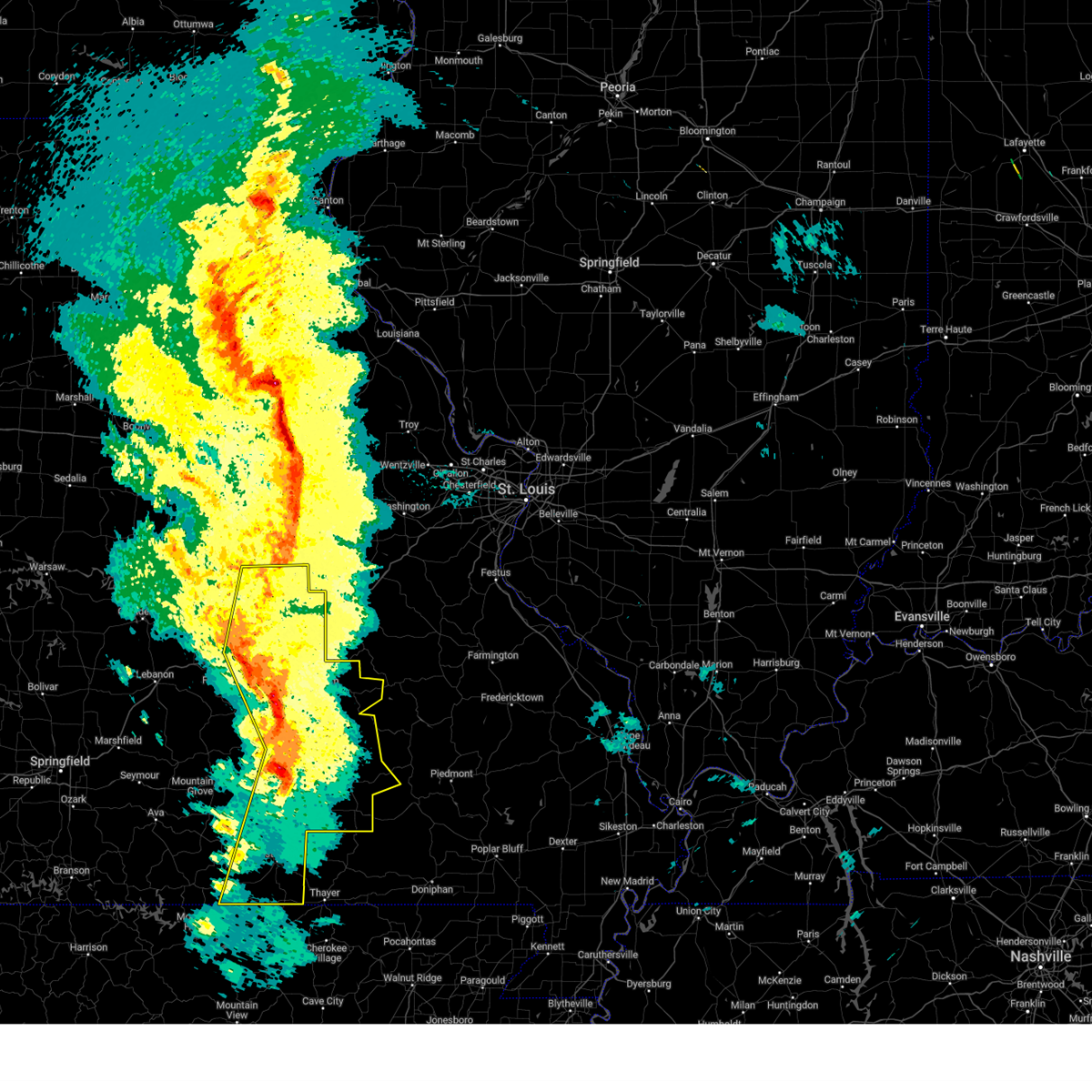
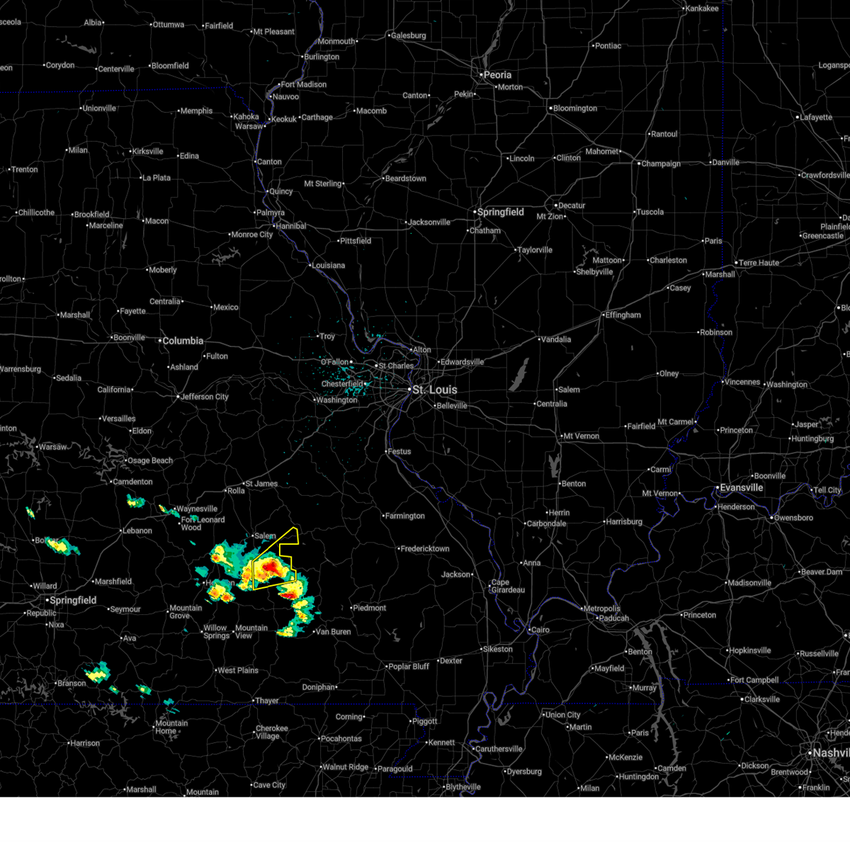 Svrsgf the national weather service in springfield has issued a * severe thunderstorm warning for, northwestern shannon county in south central missouri, southeastern dent county in south central missouri, * until 100 pm cdt. * at 1230 pm cdt, a severe thunderstorm was located 11 miles west of bunker, or 15 miles southeast of salem, moving northeast at 25 mph (radar indicated). Hazards include 60 mph wind gusts and quarter size hail. Hail damage to vehicles is expected. Expect wind damage to roofs, siding, and trees. Svrsgf the national weather service in springfield has issued a * severe thunderstorm warning for, northwestern shannon county in south central missouri, southeastern dent county in south central missouri, * until 100 pm cdt. * at 1230 pm cdt, a severe thunderstorm was located 11 miles west of bunker, or 15 miles southeast of salem, moving northeast at 25 mph (radar indicated). Hazards include 60 mph wind gusts and quarter size hail. Hail damage to vehicles is expected. Expect wind damage to roofs, siding, and trees.
|
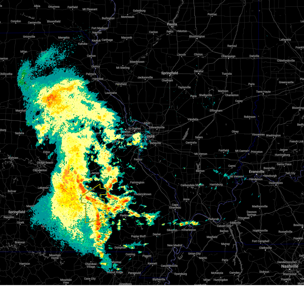
| 3/15/2026 4:42 PM CDT |
 the tornado warning has been cancelled and is no longer in effect the tornado warning has been cancelled and is no longer in effect
|
| 3/15/2026 4:32 PM CDT |
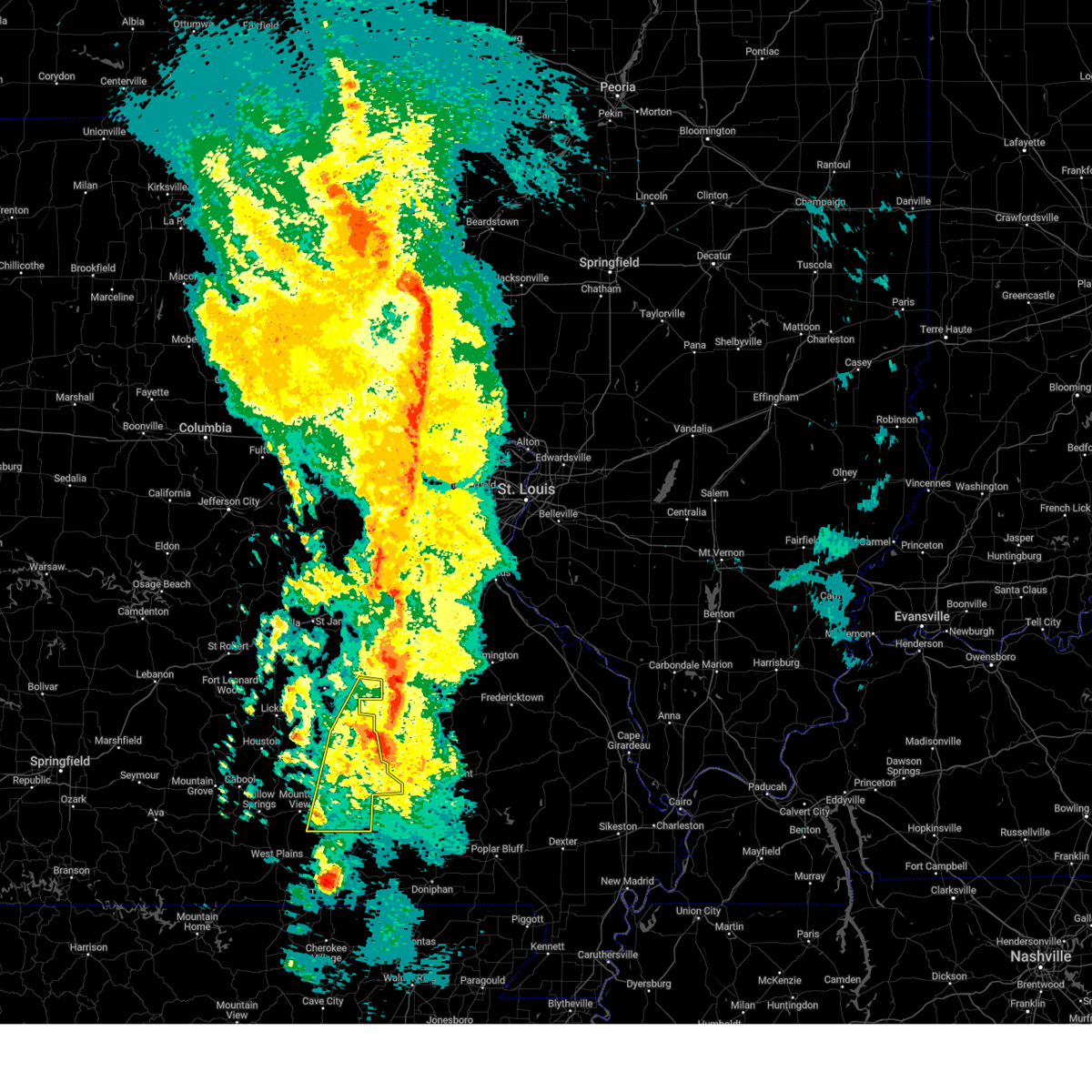
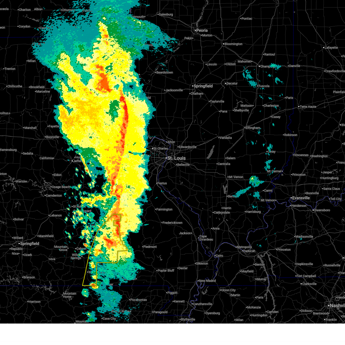
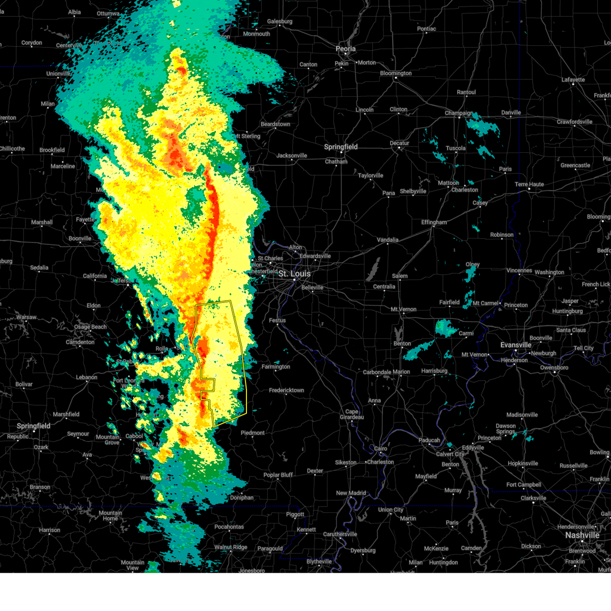
 At 432 pm cdt, a severe squall line capable of producing both tornadoes and extensive straight line wind damage was located near bunker, or 20 miles southeast of salem, moving east at 40 mph (radar indicated rotation). Hazards include tornado and quarter size hail. Flying debris will be dangerous to those caught without shelter. mobile homes will be damaged or destroyed. damage to roofs, windows, and vehicles will occur. tree damage is likely. Locations impacted include, echo bluff state park, current river state park, ozark national scenic riverways, bunker, boss, howes mill, midridge, and stone hill. At 432 pm cdt, a severe squall line capable of producing both tornadoes and extensive straight line wind damage was located near bunker, or 20 miles southeast of salem, moving east at 40 mph (radar indicated rotation). Hazards include tornado and quarter size hail. Flying debris will be dangerous to those caught without shelter. mobile homes will be damaged or destroyed. damage to roofs, windows, and vehicles will occur. tree damage is likely. Locations impacted include, echo bluff state park, current river state park, ozark national scenic riverways, bunker, boss, howes mill, midridge, and stone hill.
|
| 3/15/2026 4:28 PM CDT |
 At 427 pm cdt, a severe squall line capable of producing both tornadoes and extensive straight line wind damage was located 7 miles southwest of bunker, or 19 miles southeast of salem, moving east at 40 mph (radar indicated rotation). Hazards include tornado and quarter size hail. Flying debris will be dangerous to those caught without shelter. mobile homes will be damaged or destroyed. damage to roofs, windows, and vehicles will occur. tree damage is likely. Locations impacted include, echo bluff state park, current river state park, ozark national scenic riverways, bunker, turtle, boss, howes mill, midridge, stone hill, and gladden. At 427 pm cdt, a severe squall line capable of producing both tornadoes and extensive straight line wind damage was located 7 miles southwest of bunker, or 19 miles southeast of salem, moving east at 40 mph (radar indicated rotation). Hazards include tornado and quarter size hail. Flying debris will be dangerous to those caught without shelter. mobile homes will be damaged or destroyed. damage to roofs, windows, and vehicles will occur. tree damage is likely. Locations impacted include, echo bluff state park, current river state park, ozark national scenic riverways, bunker, turtle, boss, howes mill, midridge, stone hill, and gladden.
|
| 3/15/2026 4:24 PM CDT |
 Svrlsx the national weather service in st louis has issued a * severe thunderstorm warning for, southeastern crawford county in east central missouri, southern washington county in east central missouri, iron county in southeastern missouri, northern reynolds county in southeastern missouri, * until 530 pm cdt. * at 424 pm cdt, severe thunderstorms were located along a line from 19 miles south of cherryville to 18 miles southwest of reynolds, or along a line from 26 miles south of steelville to 46 miles southwest of ironton, moving northeast at 55 mph (radar indicated). Hazards include 60 mph wind gusts and quarter size hail. Hail damage to vehicles is expected. Expect wind damage to roofs, siding, and trees. Svrlsx the national weather service in st louis has issued a * severe thunderstorm warning for, southeastern crawford county in east central missouri, southern washington county in east central missouri, iron county in southeastern missouri, northern reynolds county in southeastern missouri, * until 530 pm cdt. * at 424 pm cdt, severe thunderstorms were located along a line from 19 miles south of cherryville to 18 miles southwest of reynolds, or along a line from 26 miles south of steelville to 46 miles southwest of ironton, moving northeast at 55 mph (radar indicated). Hazards include 60 mph wind gusts and quarter size hail. Hail damage to vehicles is expected. Expect wind damage to roofs, siding, and trees.
|
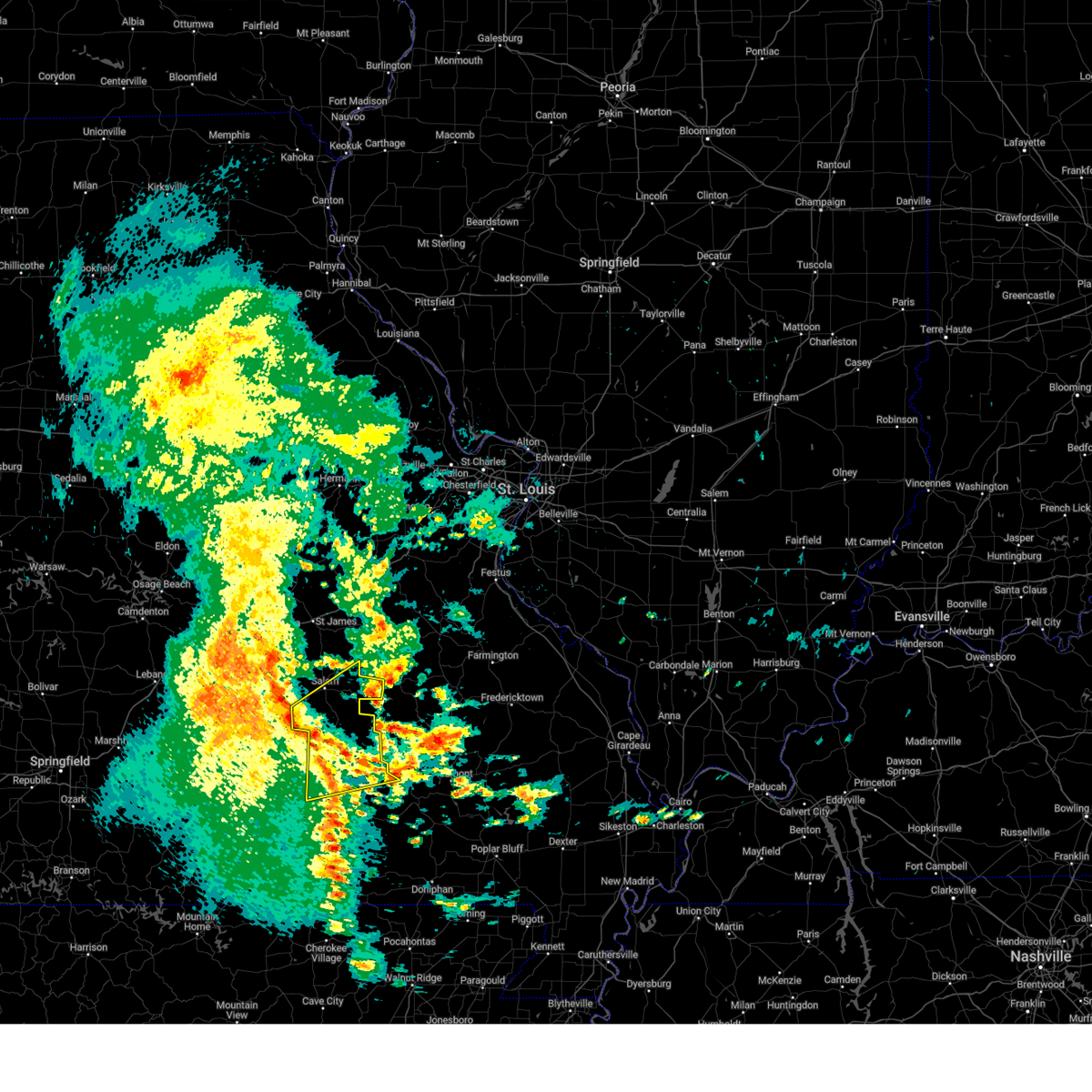
| 3/15/2026 4:12 PM CDT |
 At 411 pm cdt, a severe squall line capable of producing both tornadoes and extensive straight line wind damage was located 13 miles northeast of summersville, or 19 miles south of salem, moving east at 40 mph (radar indicated rotation). Hazards include tornado and quarter size hail. Flying debris will be dangerous to those caught without shelter. mobile homes will be damaged or destroyed. damage to roofs, windows, and vehicles will occur. tree damage is likely. Locations impacted include, echo bluff state park, current river state park, ozark national scenic riverways, bunker, turtle, boss, jadwin, howes mill, midridge, akers, stone hill, and gladden. At 411 pm cdt, a severe squall line capable of producing both tornadoes and extensive straight line wind damage was located 13 miles northeast of summersville, or 19 miles south of salem, moving east at 40 mph (radar indicated rotation). Hazards include tornado and quarter size hail. Flying debris will be dangerous to those caught without shelter. mobile homes will be damaged or destroyed. damage to roofs, windows, and vehicles will occur. tree damage is likely. Locations impacted include, echo bluff state park, current river state park, ozark national scenic riverways, bunker, turtle, boss, jadwin, howes mill, midridge, akers, stone hill, and gladden.
|
| 3/15/2026 4:10 PM CDT |
 Torsgf the national weather service in springfield has issued a * tornado warning for, northwestern shannon county in south central missouri, southeastern dent county in south central missouri, * until 500 pm cdt. * at 410 pm cdt, severe thunderstorms capable of producing both tornadoes and extensive straight line wind damage were located 12 miles northeast of summersville, or 19 miles south of salem, moving east at 40 mph (radar indicated rotation). Hazards include tornado. Flying debris will be dangerous to those caught without shelter. mobile homes will be damaged or destroyed. damage to roofs, windows, and vehicles will occur. Tree damage is likely. Torsgf the national weather service in springfield has issued a * tornado warning for, northwestern shannon county in south central missouri, southeastern dent county in south central missouri, * until 500 pm cdt. * at 410 pm cdt, severe thunderstorms capable of producing both tornadoes and extensive straight line wind damage were located 12 miles northeast of summersville, or 19 miles south of salem, moving east at 40 mph (radar indicated rotation). Hazards include tornado. Flying debris will be dangerous to those caught without shelter. mobile homes will be damaged or destroyed. damage to roofs, windows, and vehicles will occur. Tree damage is likely.
|
| 3/15/2026 2:57 PM CDT |
 Svrsgf the national weather service in springfield has issued a * severe thunderstorm warning for, shannon county in south central missouri, wright county in southwestern missouri, douglas county in southwestern missouri, dent county in south central missouri, northern howell county in south central missouri, southeastern pulaski county in central missouri, texas county in south central missouri, southwestern phelps county in east central missouri, northwestern oregon county in south central missouri, * until 345 pm cdt. * at 256 pm cdt, severe thunderstorms were located along a line extending from 12 miles west of licking to 7 miles north of cabool to 12 miles southeast of ava, moving east at 45 mph (radar indicated). Hazards include 60 mph wind gusts and penny size hail. expect damage to roofs, siding, and trees Svrsgf the national weather service in springfield has issued a * severe thunderstorm warning for, shannon county in south central missouri, wright county in southwestern missouri, douglas county in southwestern missouri, dent county in south central missouri, northern howell county in south central missouri, southeastern pulaski county in central missouri, texas county in south central missouri, southwestern phelps county in east central missouri, northwestern oregon county in south central missouri, * until 345 pm cdt. * at 256 pm cdt, severe thunderstorms were located along a line extending from 12 miles west of licking to 7 miles north of cabool to 12 miles southeast of ava, moving east at 45 mph (radar indicated). Hazards include 60 mph wind gusts and penny size hail. expect damage to roofs, siding, and trees
|
| 8/19/2025 5:06 PM CDT |
 Svrsgf the national weather service in springfield has issued a * severe thunderstorm warning for, dent county in south central missouri, northeastern texas county in south central missouri, * until 545 pm cdt. * at 505 pm cdt, severe thunderstorms were located along a line extending from 6 miles southwest of cherryville to 11 miles north of licking, moving southeast at 25 mph (radar indicated). Hazards include 60 mph wind gusts and quarter size hail. Hail damage to vehicles is expected. Expect wind damage to roofs, siding, and trees. Svrsgf the national weather service in springfield has issued a * severe thunderstorm warning for, dent county in south central missouri, northeastern texas county in south central missouri, * until 545 pm cdt. * at 505 pm cdt, severe thunderstorms were located along a line extending from 6 miles southwest of cherryville to 11 miles north of licking, moving southeast at 25 mph (radar indicated). Hazards include 60 mph wind gusts and quarter size hail. Hail damage to vehicles is expected. Expect wind damage to roofs, siding, and trees.
|
| 7/30/2025 3:56 PM CDT |
 Svrsgf the national weather service in springfield has issued a * severe thunderstorm warning for, shannon county in south central missouri, southeastern dent county in south central missouri, southeastern texas county in south central missouri, * until 430 pm cdt. * at 355 pm cdt, a severe thunderstorm was located near summersville, or 18 miles north of mountain view, moving east at 10 mph (radar indicated). Hazards include 60 mph wind gusts and quarter size hail. Hail damage to vehicles is expected. Expect wind damage to roofs, siding, and trees. Svrsgf the national weather service in springfield has issued a * severe thunderstorm warning for, shannon county in south central missouri, southeastern dent county in south central missouri, southeastern texas county in south central missouri, * until 430 pm cdt. * at 355 pm cdt, a severe thunderstorm was located near summersville, or 18 miles north of mountain view, moving east at 10 mph (radar indicated). Hazards include 60 mph wind gusts and quarter size hail. Hail damage to vehicles is expected. Expect wind damage to roofs, siding, and trees.
|
| 7/30/2025 3:48 PM CDT |
 At 348 pm cdt, a severe thunderstorm was located 9 miles northeast of summersville, or 21 miles east of houston, moving east at 10 mph (radar indicated). Hazards include 60 mph wind gusts and quarter size hail. Hail damage to vehicles is expected. expect wind damage to roofs, siding, and trees. Locations impacted include, echo bluff state park, current river state park, ozark national scenic riverways, summersville, bunker, hartshorn, midridge, round spring, and akers. At 348 pm cdt, a severe thunderstorm was located 9 miles northeast of summersville, or 21 miles east of houston, moving east at 10 mph (radar indicated). Hazards include 60 mph wind gusts and quarter size hail. Hail damage to vehicles is expected. expect wind damage to roofs, siding, and trees. Locations impacted include, echo bluff state park, current river state park, ozark national scenic riverways, summersville, bunker, hartshorn, midridge, round spring, and akers.
|
| 7/30/2025 3:33 PM CDT |
 Svrsgf the national weather service in springfield has issued a * severe thunderstorm warning for, northern shannon county in south central missouri, southeastern dent county in south central missouri, east central texas county in south central missouri, * until 400 pm cdt. * at 333 pm cdt, a severe thunderstorm was located 8 miles north of summersville, or 19 miles east of houston, moving east at 10 mph (radar indicated). Hazards include 60 mph wind gusts and quarter size hail. Hail damage to vehicles is expected. Expect wind damage to roofs, siding, and trees. Svrsgf the national weather service in springfield has issued a * severe thunderstorm warning for, northern shannon county in south central missouri, southeastern dent county in south central missouri, east central texas county in south central missouri, * until 400 pm cdt. * at 333 pm cdt, a severe thunderstorm was located 8 miles north of summersville, or 19 miles east of houston, moving east at 10 mph (radar indicated). Hazards include 60 mph wind gusts and quarter size hail. Hail damage to vehicles is expected. Expect wind damage to roofs, siding, and trees.
|
| 6/8/2025 9:36 PM CDT |
 Svrlsx the national weather service in st louis has issued a * severe thunderstorm warning for, reynolds county in southeastern missouri, * until 1030 pm cdt. * at 936 pm cdt, a severe thunderstorm was located 7 miles west of oates, or 29 miles west of ironton, moving east at 25 mph (radar indicated). Hazards include 60 mph wind gusts and quarter size hail. Hail damage to vehicles is expected. Expect wind damage to roofs, siding, and trees. Svrlsx the national weather service in st louis has issued a * severe thunderstorm warning for, reynolds county in southeastern missouri, * until 1030 pm cdt. * at 936 pm cdt, a severe thunderstorm was located 7 miles west of oates, or 29 miles west of ironton, moving east at 25 mph (radar indicated). Hazards include 60 mph wind gusts and quarter size hail. Hail damage to vehicles is expected. Expect wind damage to roofs, siding, and trees.
|
| 5/19/2025 10:59 PM CDT |
 The storms which prompted the warning have moved out of the area. therefore, the warning will be allowed to expire. The storms which prompted the warning have moved out of the area. therefore, the warning will be allowed to expire.
|
| 5/19/2025 10:30 PM CDT |
 Torlsx the national weather service in st louis has issued a * tornado warning for, southern crawford county in east central missouri, southwestern washington county in east central missouri, western iron county in southeastern missouri, northern reynolds county in southeastern missouri, * until 1115 pm cdt. * at 1030 pm cdt, severe thunderstorms capable of producing a tornado were located along a line from 12 miles west of cherryville to 15 miles west of reynolds, or along a line from 14 miles southwest of steelville to 42 miles southwest of ironton, moving east at 55 mph (radar indicated rotation). Hazards include tornado. Flying debris will be dangerous to those caught without shelter. mobile homes will be damaged or destroyed. damage to roofs, windows and vehicles will occur. Tree damage is likely. Torlsx the national weather service in st louis has issued a * tornado warning for, southern crawford county in east central missouri, southwestern washington county in east central missouri, western iron county in southeastern missouri, northern reynolds county in southeastern missouri, * until 1115 pm cdt. * at 1030 pm cdt, severe thunderstorms capable of producing a tornado were located along a line from 12 miles west of cherryville to 15 miles west of reynolds, or along a line from 14 miles southwest of steelville to 42 miles southwest of ironton, moving east at 55 mph (radar indicated rotation). Hazards include tornado. Flying debris will be dangerous to those caught without shelter. mobile homes will be damaged or destroyed. damage to roofs, windows and vehicles will occur. Tree damage is likely.
|
| 5/19/2025 10:02 PM CDT |
 Svrsgf the national weather service in springfield has issued a * severe thunderstorm warning for, shannon county in south central missouri, dent county in south central missouri, howell county in south central missouri, eastern texas county in south central missouri, oregon county in south central missouri, * until 1100 pm cdt. * at 1001 pm cdt, severe thunderstorms were located along a line extending from 6 miles northeast of licking to 6 miles north of mountain view to near ott, moving east at 45 mph (radar indicated). Hazards include 60 mph wind gusts. expect damage to roofs, siding, and trees Svrsgf the national weather service in springfield has issued a * severe thunderstorm warning for, shannon county in south central missouri, dent county in south central missouri, howell county in south central missouri, eastern texas county in south central missouri, oregon county in south central missouri, * until 1100 pm cdt. * at 1001 pm cdt, severe thunderstorms were located along a line extending from 6 miles northeast of licking to 6 miles north of mountain view to near ott, moving east at 45 mph (radar indicated). Hazards include 60 mph wind gusts. expect damage to roofs, siding, and trees
|
| 5/16/2025 2:58 PM CDT |
 Svrlsx the national weather service in st louis has issued a * severe thunderstorm warning for, iron county in southeastern missouri, northwestern madison county in southeastern missouri, reynolds county in southeastern missouri, * until 345 pm cdt. * at 258 pm cdt, a severe thunderstorm was located 13 miles southwest of ellington, or 44 miles southwest of ironton, moving northeast at 65 mph (radar indicated). Hazards include ping pong ball size hail and 60 mph wind gusts. People and animals outdoors will be injured. expect hail damage to roofs, siding, windows, and vehicles. Expect wind damage to roofs, siding, and trees. Svrlsx the national weather service in st louis has issued a * severe thunderstorm warning for, iron county in southeastern missouri, northwestern madison county in southeastern missouri, reynolds county in southeastern missouri, * until 345 pm cdt. * at 258 pm cdt, a severe thunderstorm was located 13 miles southwest of ellington, or 44 miles southwest of ironton, moving northeast at 65 mph (radar indicated). Hazards include ping pong ball size hail and 60 mph wind gusts. People and animals outdoors will be injured. expect hail damage to roofs, siding, windows, and vehicles. Expect wind damage to roofs, siding, and trees.
|
| 5/16/2025 2:02 PM CDT |
 Svrlsx the national weather service in st louis has issued a * severe thunderstorm warning for, southeastern iron county in southeastern missouri, reynolds county in southeastern missouri, * until 245 pm cdt. * at 202 pm cdt, a severe thunderstorm was located 16 miles southwest of reynolds, or 43 miles southwest of ironton, moving east at 60 mph (radar indicated). Hazards include ping pong ball size hail and 60 mph wind gusts. People and animals outdoors will be injured. expect hail damage to roofs, siding, windows, and vehicles. Expect wind damage to roofs, siding, and trees. Svrlsx the national weather service in st louis has issued a * severe thunderstorm warning for, southeastern iron county in southeastern missouri, reynolds county in southeastern missouri, * until 245 pm cdt. * at 202 pm cdt, a severe thunderstorm was located 16 miles southwest of reynolds, or 43 miles southwest of ironton, moving east at 60 mph (radar indicated). Hazards include ping pong ball size hail and 60 mph wind gusts. People and animals outdoors will be injured. expect hail damage to roofs, siding, windows, and vehicles. Expect wind damage to roofs, siding, and trees.
|
| 5/16/2025 1:19 PM CDT |
 Svrsgf the national weather service in springfield has issued a * severe thunderstorm warning for, northern shannon county in south central missouri, dent county in south central missouri, eastern texas county in south central missouri, * until 200 pm cdt. * at 118 pm cdt, a severe thunderstorm was located 7 miles southeast of houston, moving east at 60 mph (radar indicated). Hazards include golf ball size hail and 60 mph wind gusts. People and animals outdoors will be injured. expect hail damage to roofs, siding, windows, and vehicles. Expect wind damage to roofs, siding, and trees. Svrsgf the national weather service in springfield has issued a * severe thunderstorm warning for, northern shannon county in south central missouri, dent county in south central missouri, eastern texas county in south central missouri, * until 200 pm cdt. * at 118 pm cdt, a severe thunderstorm was located 7 miles southeast of houston, moving east at 60 mph (radar indicated). Hazards include golf ball size hail and 60 mph wind gusts. People and animals outdoors will be injured. expect hail damage to roofs, siding, windows, and vehicles. Expect wind damage to roofs, siding, and trees.
|
| 4/30/2025 6:10 AM CDT |
 The storms which prompted the warning have weakened below severe limits, and no longer pose an immediate threat to life or property. therefore, the warning will be allowed to expire. however, gusty winds are still possible with these thunderstorms. The storms which prompted the warning have weakened below severe limits, and no longer pose an immediate threat to life or property. therefore, the warning will be allowed to expire. however, gusty winds are still possible with these thunderstorms.
|
| 4/30/2025 6:01 AM CDT |
 the severe thunderstorm warning has been cancelled and is no longer in effect the severe thunderstorm warning has been cancelled and is no longer in effect
|
| 4/30/2025 6:01 AM CDT |
 At 601 am cdt, severe thunderstorms were located along a line extending from 8 miles east of licking to 10 miles northeast of summersville to 7 miles west of eminence, moving northeast at 30 mph (radar indicated). Hazards include 60 mph wind gusts. Expect damage to roofs, siding, and trees. Locations impacted include, montauk, turtle, jadwin, howes mill, midridge, current river state park, ozark national scenic riverways, darien, gladden, echo bluff state park, alley spring, boss, montauk state park, round spring, west eminence, bunker, salem, eminence, akers, and stone hill. At 601 am cdt, severe thunderstorms were located along a line extending from 8 miles east of licking to 10 miles northeast of summersville to 7 miles west of eminence, moving northeast at 30 mph (radar indicated). Hazards include 60 mph wind gusts. Expect damage to roofs, siding, and trees. Locations impacted include, montauk, turtle, jadwin, howes mill, midridge, current river state park, ozark national scenic riverways, darien, gladden, echo bluff state park, alley spring, boss, montauk state park, round spring, west eminence, bunker, salem, eminence, akers, and stone hill.
|
| 4/30/2025 5:29 AM CDT |
 Svrsgf the national weather service in springfield has issued a * severe thunderstorm warning for, shannon county in south central missouri, dent county in south central missouri, eastern texas county in south central missouri, * until 615 am cdt. * at 528 am cdt, severe thunderstorms were located along a line extending from near houston to 10 miles southwest of summersville to near mountain view, moving northeast at 55 mph (radar indicated). Hazards include 60 mph wind gusts. expect damage to roofs, siding, and trees Svrsgf the national weather service in springfield has issued a * severe thunderstorm warning for, shannon county in south central missouri, dent county in south central missouri, eastern texas county in south central missouri, * until 615 am cdt. * at 528 am cdt, severe thunderstorms were located along a line extending from near houston to 10 miles southwest of summersville to near mountain view, moving northeast at 55 mph (radar indicated). Hazards include 60 mph wind gusts. expect damage to roofs, siding, and trees
|
| 4/29/2025 11:55 AM CDT |
 The storms which prompted the warning have weakened below severe limits, and have exited the warned area. therefore, the warning will be allowed to expire. a severe thunderstorm watch remains in effect until 300 pm cdt for south central and east central missouri. to report severe weather, contact your nearest law enforcement agency. they will relay your report to the national weather service springfield. The storms which prompted the warning have weakened below severe limits, and have exited the warned area. therefore, the warning will be allowed to expire. a severe thunderstorm watch remains in effect until 300 pm cdt for south central and east central missouri. to report severe weather, contact your nearest law enforcement agency. they will relay your report to the national weather service springfield.
|
| 4/29/2025 11:41 AM CDT |
 the severe thunderstorm warning has been cancelled and is no longer in effect the severe thunderstorm warning has been cancelled and is no longer in effect
|
| 4/29/2025 11:41 AM CDT |
 At 1140 am cdt, severe thunderstorms were located along a line extending from 7 miles southeast of newburg to 6 miles north of salem to 7 miles northwest of bunker to 13 miles north of eminence to near birch tree, moving east at 45 mph (radar indicated). Hazards include 60 mph wind gusts and penny size hail. Expect damage to roofs, siding, and trees. locations impacted include, jadwin, howes mill, midridge, current river state park, lake spring, gladden, anutt, bangert, echo bluff state park, boss, round spring, bunker, salem, akers, summersville, turtle, darien, howes, hartshorn, and lecoma. This includes interstate 44 near mile marker 183, and between mile markers 198 and 199. At 1140 am cdt, severe thunderstorms were located along a line extending from 7 miles southeast of newburg to 6 miles north of salem to 7 miles northwest of bunker to 13 miles north of eminence to near birch tree, moving east at 45 mph (radar indicated). Hazards include 60 mph wind gusts and penny size hail. Expect damage to roofs, siding, and trees. locations impacted include, jadwin, howes mill, midridge, current river state park, lake spring, gladden, anutt, bangert, echo bluff state park, boss, round spring, bunker, salem, akers, summersville, turtle, darien, howes, hartshorn, and lecoma. This includes interstate 44 near mile marker 183, and between mile markers 198 and 199.
|
| 4/29/2025 10:59 AM CDT |
 Svrsgf the national weather service in springfield has issued a * severe thunderstorm warning for, southeastern maries county in central missouri, northern shannon county in south central missouri, dent county in south central missouri, northeastern pulaski county in central missouri, eastern texas county in south central missouri, phelps county in east central missouri, * until noon cdt. * at 1058 am cdt, severe thunderstorms were located along a line extending from 7 miles southwest of waynesville to 8 miles southeast of fort leonard wood to near raymondville to 7 miles southeast of houston to willow springs, moving east at 55 mph (radar indicated). Hazards include 60 mph wind gusts and quarter size hail. Hail damage to vehicles is expected. Expect wind damage to roofs, siding, and trees. Svrsgf the national weather service in springfield has issued a * severe thunderstorm warning for, southeastern maries county in central missouri, northern shannon county in south central missouri, dent county in south central missouri, northeastern pulaski county in central missouri, eastern texas county in south central missouri, phelps county in east central missouri, * until noon cdt. * at 1058 am cdt, severe thunderstorms were located along a line extending from 7 miles southwest of waynesville to 8 miles southeast of fort leonard wood to near raymondville to 7 miles southeast of houston to willow springs, moving east at 55 mph (radar indicated). Hazards include 60 mph wind gusts and quarter size hail. Hail damage to vehicles is expected. Expect wind damage to roofs, siding, and trees.
|
| 4/20/2025 6:59 PM CDT |
 the severe thunderstorm warning has been cancelled and is no longer in effect the severe thunderstorm warning has been cancelled and is no longer in effect
|
| 4/20/2025 6:59 PM CDT |
 At 659 pm cdt, severe thunderstorms were located along a line extending from near oates to near ellington to mammoth spring state park, moving east at 35 mph (radar indicated). Hazards include 60 mph wind gusts and nickel size hail. Expect damage to roofs, siding, and trees. Locations impacted include, montier, turtle, teresita, howes mill, midridge, current river state park, ozark national scenic riverways, echo bluff state park, alley spring, boss, winona, round spring, west eminence, bunker, eminence, birch tree, and stone hill. At 659 pm cdt, severe thunderstorms were located along a line extending from near oates to near ellington to mammoth spring state park, moving east at 35 mph (radar indicated). Hazards include 60 mph wind gusts and nickel size hail. Expect damage to roofs, siding, and trees. Locations impacted include, montier, turtle, teresita, howes mill, midridge, current river state park, ozark national scenic riverways, echo bluff state park, alley spring, boss, winona, round spring, west eminence, bunker, eminence, birch tree, and stone hill.
|
| 4/20/2025 6:50 PM CDT |
 At 650 pm cdt, severe thunderstorms were located along a line from 6 miles northwest of miramiguoa park to 5 miles south of reynolds, or along a line from 7 miles north of sullivan to 30 miles southwest of ironton, moving northeast at 50 mph (radar indicated). Hazards include 60 mph wind gusts and small hail. Expect damage to roofs, siding, and trees. locations impacted include, union, sullivan, st. clair, bourbon, anthonies mill, reynolds, viburnum, parkway, miramiguoa park, courtois, bixby, oates, centerville, st. cloud, shirley, latty, belgrade, black, stanton and lesterville. this includes the following state parks, onondaga cave state park, johnsons shut-ins state park, taum sauk mountain state park and meramec state park. This includes interstate 44 in missouri between exits 218 and 242. At 650 pm cdt, severe thunderstorms were located along a line from 6 miles northwest of miramiguoa park to 5 miles south of reynolds, or along a line from 7 miles north of sullivan to 30 miles southwest of ironton, moving northeast at 50 mph (radar indicated). Hazards include 60 mph wind gusts and small hail. Expect damage to roofs, siding, and trees. locations impacted include, union, sullivan, st. clair, bourbon, anthonies mill, reynolds, viburnum, parkway, miramiguoa park, courtois, bixby, oates, centerville, st. cloud, shirley, latty, belgrade, black, stanton and lesterville. this includes the following state parks, onondaga cave state park, johnsons shut-ins state park, taum sauk mountain state park and meramec state park. This includes interstate 44 in missouri between exits 218 and 242.
|
| 4/20/2025 6:40 PM CDT |
 Svrsgf the national weather service in springfield has issued a * severe thunderstorm warning for, shannon county in south central missouri, southeastern dent county in south central missouri, eastern howell county in south central missouri, southeastern texas county in south central missouri, * until 745 pm cdt. * at 639 pm cdt, severe thunderstorms were located along a line extending from bunker to 9 miles northeast of eminence to 8 miles northeast of salem in fulton county, moving east at 35 mph (radar indicated). Hazards include 70 mph wind gusts and nickel size hail. Expect considerable tree damage. Damage is likely to mobile homes, roofs, and outbuildings. Svrsgf the national weather service in springfield has issued a * severe thunderstorm warning for, shannon county in south central missouri, southeastern dent county in south central missouri, eastern howell county in south central missouri, southeastern texas county in south central missouri, * until 745 pm cdt. * at 639 pm cdt, severe thunderstorms were located along a line extending from bunker to 9 miles northeast of eminence to 8 miles northeast of salem in fulton county, moving east at 35 mph (radar indicated). Hazards include 70 mph wind gusts and nickel size hail. Expect considerable tree damage. Damage is likely to mobile homes, roofs, and outbuildings.
|
| 4/20/2025 6:39 PM CDT |
 the severe thunderstorm warning has been cancelled and is no longer in effect the severe thunderstorm warning has been cancelled and is no longer in effect
|
| 4/20/2025 6:39 PM CDT |
 At 639 pm cdt, severe thunderstorms were located along a line from 6 miles north of bourbon to 5 miles southwest of oates, or along a line from 6 miles north of bourbon to 27 miles west of ironton, moving northeast at 50 mph (radar indicated). Hazards include 60 mph wind gusts and small hail. Expect damage to roofs, siding, and trees. locations impacted include, union, sullivan, st. clair, cuba, steelville, bourbon, anthonies mill, reynolds, gerald, viburnum, parkway, leasburg, miramiguoa park, courtois, bixby, cherryville, oates, centerville, st. cloud and davisville. this includes the following state parks, onondaga cave state park, johnsons shut-ins state park, dillard mill historic site, taum sauk mountain state park and meramec state park. This includes interstate 44 in missouri between exits 208 and 242. At 639 pm cdt, severe thunderstorms were located along a line from 6 miles north of bourbon to 5 miles southwest of oates, or along a line from 6 miles north of bourbon to 27 miles west of ironton, moving northeast at 50 mph (radar indicated). Hazards include 60 mph wind gusts and small hail. Expect damage to roofs, siding, and trees. locations impacted include, union, sullivan, st. clair, cuba, steelville, bourbon, anthonies mill, reynolds, gerald, viburnum, parkway, leasburg, miramiguoa park, courtois, bixby, cherryville, oates, centerville, st. cloud and davisville. this includes the following state parks, onondaga cave state park, johnsons shut-ins state park, dillard mill historic site, taum sauk mountain state park and meramec state park. This includes interstate 44 in missouri between exits 208 and 242.
|
| 4/20/2025 6:29 PM CDT |
 At 628 pm cdt, severe thunderstorms were located along a line extending from near bland to near cherryville to 9 miles northwest of mountain view, moving northeast at 60 mph (public). Hazards include 70 mph wind gusts and nickel size hail. Expect considerable tree damage. damage is likely to mobile homes, roofs, and outbuildings. Locations impacted include, lanton, teresita, jadwin, howes mill, midridge, current river state park, ozark national scenic riverways, pottersville, gladden, eunice, brandsville, bangert, echo bluff state park, clear springs, winona, round spring, bunker, salem, west plains, and eminence. At 628 pm cdt, severe thunderstorms were located along a line extending from near bland to near cherryville to 9 miles northwest of mountain view, moving northeast at 60 mph (public). Hazards include 70 mph wind gusts and nickel size hail. Expect considerable tree damage. damage is likely to mobile homes, roofs, and outbuildings. Locations impacted include, lanton, teresita, jadwin, howes mill, midridge, current river state park, ozark national scenic riverways, pottersville, gladden, eunice, brandsville, bangert, echo bluff state park, clear springs, winona, round spring, bunker, salem, west plains, and eminence.
|
| 4/20/2025 6:29 PM CDT |
 the severe thunderstorm warning has been cancelled and is no longer in effect the severe thunderstorm warning has been cancelled and is no longer in effect
|
| 4/20/2025 6:07 PM CDT |
 Svrlsx the national weather service in st louis has issued a * severe thunderstorm warning for, crawford county in east central missouri, southwestern franklin county in east central missouri, southern gasconade county in east central missouri, washington county in east central missouri, northwestern iron county in southeastern missouri, northern reynolds county in southeastern missouri, * until 700 pm cdt. * at 607 pm cdt, severe thunderstorms were located along a line from 17 miles west of cuba to 24 miles west of reynolds, or along a line from 17 miles west of cuba to 48 miles south of steelville, moving northeast at 50 mph (radar indicated). Hazards include 70 mph wind gusts and small hail. Expect considerable tree damage. Damage is likely to mobile homes, roofs, and outbuildings. Svrlsx the national weather service in st louis has issued a * severe thunderstorm warning for, crawford county in east central missouri, southwestern franklin county in east central missouri, southern gasconade county in east central missouri, washington county in east central missouri, northwestern iron county in southeastern missouri, northern reynolds county in southeastern missouri, * until 700 pm cdt. * at 607 pm cdt, severe thunderstorms were located along a line from 17 miles west of cuba to 24 miles west of reynolds, or along a line from 17 miles west of cuba to 48 miles south of steelville, moving northeast at 50 mph (radar indicated). Hazards include 70 mph wind gusts and small hail. Expect considerable tree damage. Damage is likely to mobile homes, roofs, and outbuildings.
|
| 4/20/2025 6:01 PM CDT |
 At 600 pm cdt, severe thunderstorms were located along a line extending from near doolittle to 9 miles southwest of salem to 12 miles west of west plains, moving east at 60 mph (public). Hazards include 70 mph wind gusts and nickel size hail. Expect considerable tree damage. damage is likely to mobile homes, roofs, and outbuildings. locations impacted include, lanton, jadwin, beulah, ozark national scenic riverways, caulfield, bakersfield, gladden, anutt, bangert, echo bluff state park, edgar springs, west plains, eminence, akers, pine crest, summersville, rosati, montier, turtle, and pomona. This includes interstate 44 between mile markers 171 and 200. At 600 pm cdt, severe thunderstorms were located along a line extending from near doolittle to 9 miles southwest of salem to 12 miles west of west plains, moving east at 60 mph (public). Hazards include 70 mph wind gusts and nickel size hail. Expect considerable tree damage. damage is likely to mobile homes, roofs, and outbuildings. locations impacted include, lanton, jadwin, beulah, ozark national scenic riverways, caulfield, bakersfield, gladden, anutt, bangert, echo bluff state park, edgar springs, west plains, eminence, akers, pine crest, summersville, rosati, montier, turtle, and pomona. This includes interstate 44 between mile markers 171 and 200.
|
| 4/20/2025 6:01 PM CDT |
 the severe thunderstorm warning has been cancelled and is no longer in effect the severe thunderstorm warning has been cancelled and is no longer in effect
|
| 4/20/2025 5:48 PM CDT |
 Svrsgf the national weather service in springfield has issued a * severe thunderstorm warning for, maries county in central missouri, southeastern ozark county in southwestern missouri, shannon county in south central missouri, dent county in south central missouri, howell county in south central missouri, eastern pulaski county in central missouri, eastern texas county in south central missouri, phelps county in east central missouri, * until 645 pm cdt. * at 546 pm cdt, severe thunderstorms were located along a line extending from near st. robert to near raymondville to near bakersfield, moving northeast at 65 mph (radar indicated). Hazards include 70 mph wind gusts and nickel size hail. Expect considerable tree damage. Damage is likely to mobile homes, roofs, and outbuildings. Svrsgf the national weather service in springfield has issued a * severe thunderstorm warning for, maries county in central missouri, southeastern ozark county in southwestern missouri, shannon county in south central missouri, dent county in south central missouri, howell county in south central missouri, eastern pulaski county in central missouri, eastern texas county in south central missouri, phelps county in east central missouri, * until 645 pm cdt. * at 546 pm cdt, severe thunderstorms were located along a line extending from near st. robert to near raymondville to near bakersfield, moving northeast at 65 mph (radar indicated). Hazards include 70 mph wind gusts and nickel size hail. Expect considerable tree damage. Damage is likely to mobile homes, roofs, and outbuildings.
|
| 4/19/2025 5:02 AM CDT |
 Svrlsx the national weather service in st louis has issued a * severe thunderstorm warning for, iron county in southeastern missouri, reynolds county in southeastern missouri, * until 545 am cdt. * at 502 am cdt, severe thunderstorms were located along a line from over oates to 9 miles southwest of ellington, or along a line from 25 miles west of ironton to 39 miles southwest of ironton, moving east at 70 mph (radar indicated). Hazards include 60 mph wind gusts. expect damage to roofs, siding, and trees Svrlsx the national weather service in st louis has issued a * severe thunderstorm warning for, iron county in southeastern missouri, reynolds county in southeastern missouri, * until 545 am cdt. * at 502 am cdt, severe thunderstorms were located along a line from over oates to 9 miles southwest of ellington, or along a line from 25 miles west of ironton to 39 miles southwest of ironton, moving east at 70 mph (radar indicated). Hazards include 60 mph wind gusts. expect damage to roofs, siding, and trees
|
| 4/19/2025 12:49 AM CDT |
 At 1249 am cdt, a severe thunderstorm was located over courtois, or 22 miles southwest of potosi, moving northeast at 55 mph (radar indicated). Hazards include 60 mph wind gusts. Expect damage to roofs, siding, and trees. locations impacted include, potosi, ironton, pilot knob, viburnum, irondale, mineral point, courtois, bixby, belleview, oates, old mines, caledonia, belgrade, shirley, latty, black, davisville, granite, dillard and cadet. This includes the following state parks, washington state park, johnsons shut-ins state park, elephant rocks state park, dillard mill historic site and taum sauk mountain state park. At 1249 am cdt, a severe thunderstorm was located over courtois, or 22 miles southwest of potosi, moving northeast at 55 mph (radar indicated). Hazards include 60 mph wind gusts. Expect damage to roofs, siding, and trees. locations impacted include, potosi, ironton, pilot knob, viburnum, irondale, mineral point, courtois, bixby, belleview, oates, old mines, caledonia, belgrade, shirley, latty, black, davisville, granite, dillard and cadet. This includes the following state parks, washington state park, johnsons shut-ins state park, elephant rocks state park, dillard mill historic site and taum sauk mountain state park.
|
| 4/19/2025 12:40 AM CDT |
 At 1240 am cdt, a severe thunderstorm was located 6 miles southwest of viburnum, or 22 miles south of steelville, moving northeast at 50 mph (radar indicated). Hazards include 60 mph wind gusts. Expect damage to roofs, siding, and trees. locations impacted include, potosi, ironton, pilot knob, viburnum, irondale, mineral point, courtois, bixby, belleview, oates, old mines, cherryville, caledonia, belgrade, shirley, black, latty, davisville, dillard and granite. This includes the following state parks, washington state park, johnsons shut-ins state park, elephant rocks state park, dillard mill historic site and taum sauk mountain state park. At 1240 am cdt, a severe thunderstorm was located 6 miles southwest of viburnum, or 22 miles south of steelville, moving northeast at 50 mph (radar indicated). Hazards include 60 mph wind gusts. Expect damage to roofs, siding, and trees. locations impacted include, potosi, ironton, pilot knob, viburnum, irondale, mineral point, courtois, bixby, belleview, oates, old mines, cherryville, caledonia, belgrade, shirley, black, latty, davisville, dillard and granite. This includes the following state parks, washington state park, johnsons shut-ins state park, elephant rocks state park, dillard mill historic site and taum sauk mountain state park.
|
| 4/19/2025 12:39 AM CDT |
 At 1238 am cdt, severe thunderstorms were located along a line extending from near cherryville to 12 miles east of salem to 9 miles southwest of bunker, moving east at 45 mph (radar indicated). Hazards include 60 mph wind gusts and quarter size hail. Hail damage to vehicles is expected. expect wind damage to roofs, siding, and trees. Locations impacted include, bangert, turtle, boss, howes mill, bunker, stone hill, sligo, and gladden. At 1238 am cdt, severe thunderstorms were located along a line extending from near cherryville to 12 miles east of salem to 9 miles southwest of bunker, moving east at 45 mph (radar indicated). Hazards include 60 mph wind gusts and quarter size hail. Hail damage to vehicles is expected. expect wind damage to roofs, siding, and trees. Locations impacted include, bangert, turtle, boss, howes mill, bunker, stone hill, sligo, and gladden.
|
| 4/19/2025 12:24 AM CDT |
 Svrlsx the national weather service in st louis has issued a * severe thunderstorm warning for, southern crawford county in east central missouri, washington county in east central missouri, northern iron county in southeastern missouri, northern reynolds county in southeastern missouri, * until 130 am cdt. * at 1224 am cdt, a severe thunderstorm was located 20 miles southwest of cherryville, or 26 miles south of steelville, moving northeast at 55 mph (radar indicated). Hazards include 60 mph wind gusts. expect damage to roofs, siding, and trees Svrlsx the national weather service in st louis has issued a * severe thunderstorm warning for, southern crawford county in east central missouri, washington county in east central missouri, northern iron county in southeastern missouri, northern reynolds county in southeastern missouri, * until 130 am cdt. * at 1224 am cdt, a severe thunderstorm was located 20 miles southwest of cherryville, or 26 miles south of steelville, moving northeast at 55 mph (radar indicated). Hazards include 60 mph wind gusts. expect damage to roofs, siding, and trees
|
| 4/19/2025 12:18 AM CDT |
 Svrsgf the national weather service in springfield has issued a * severe thunderstorm warning for, northwestern shannon county in south central missouri, dent county in south central missouri, * until 100 am cdt. * at 1218 am cdt, severe thunderstorms were located along a line extending from 14 miles southeast of rolla to 8 miles south of salem to 9 miles north of summersville, moving east at 45 mph (radar indicated). Hazards include 60 mph wind gusts and quarter size hail. Hail damage to vehicles is expected. Expect wind damage to roofs, siding, and trees. Svrsgf the national weather service in springfield has issued a * severe thunderstorm warning for, northwestern shannon county in south central missouri, dent county in south central missouri, * until 100 am cdt. * at 1218 am cdt, severe thunderstorms were located along a line extending from 14 miles southeast of rolla to 8 miles south of salem to 9 miles north of summersville, moving east at 45 mph (radar indicated). Hazards include 60 mph wind gusts and quarter size hail. Hail damage to vehicles is expected. Expect wind damage to roofs, siding, and trees.
|
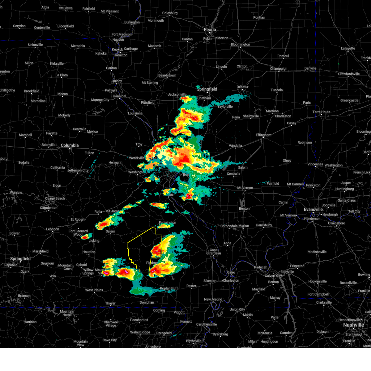
| 3/30/2025 3:09 PM CDT |
 The storm which prompted the warning has moved out of the area. therefore, the warning will be allowed to expire. a tornado watch remains in effect until 1100 pm cdt for south central missouri. The storm which prompted the warning has moved out of the area. therefore, the warning will be allowed to expire. a tornado watch remains in effect until 1100 pm cdt for south central missouri.
|
| 3/30/2025 2:56 PM CDT | Tennis Ball sized hail reported 0.4 miles N of Bunker, MO |
| 3/30/2025 2:54 PM CDT |
 Svrlsx the national weather service in st louis has issued a * severe thunderstorm warning for, northern reynolds county in southeastern missouri, * until 345 pm cdt. * at 254 pm cdt, a severe thunderstorm was located 13 miles west of reynolds, or 39 miles southwest of ironton, moving east at 45 mph (radar indicated). Hazards include 60 mph wind gusts and half dollar size hail. Hail damage to vehicles is expected. Expect wind damage to roofs, siding, and trees. Svrlsx the national weather service in st louis has issued a * severe thunderstorm warning for, northern reynolds county in southeastern missouri, * until 345 pm cdt. * at 254 pm cdt, a severe thunderstorm was located 13 miles west of reynolds, or 39 miles southwest of ironton, moving east at 45 mph (radar indicated). Hazards include 60 mph wind gusts and half dollar size hail. Hail damage to vehicles is expected. Expect wind damage to roofs, siding, and trees.
|
| 3/30/2025 2:51 PM CDT |
 At 250 pm cdt, a severe thunderstorm was located 7 miles east of salem, moving northeast at 50 mph (radar indicated). Hazards include ping pong ball size hail and 60 mph wind gusts. People and animals outdoors will be injured. expect hail damage to roofs, siding, windows, and vehicles. expect wind damage to roofs, siding, and trees. Locations impacted include, turtle, boss, stone hill, howes mill, gladden, and bunker. At 250 pm cdt, a severe thunderstorm was located 7 miles east of salem, moving northeast at 50 mph (radar indicated). Hazards include ping pong ball size hail and 60 mph wind gusts. People and animals outdoors will be injured. expect hail damage to roofs, siding, windows, and vehicles. expect wind damage to roofs, siding, and trees. Locations impacted include, turtle, boss, stone hill, howes mill, gladden, and bunker.
|
| 3/30/2025 2:29 PM CDT |
 At 228 pm cdt, a severe thunderstorm was located 10 miles southwest of salem, moving northeast at 55 mph (law enforcement. this storm produced quarter size hail in houston missouri). Hazards include ping pong ball size hail and 60 mph wind gusts. People and animals outdoors will be injured. expect hail damage to roofs, siding, windows, and vehicles. expect wind damage to roofs, siding, and trees. Locations impacted include, montauk, turtle, boss, jadwin, howes mill, montauk state park, darien, salem, stone hill, gladden, and bunker. At 228 pm cdt, a severe thunderstorm was located 10 miles southwest of salem, moving northeast at 55 mph (law enforcement. this storm produced quarter size hail in houston missouri). Hazards include ping pong ball size hail and 60 mph wind gusts. People and animals outdoors will be injured. expect hail damage to roofs, siding, windows, and vehicles. expect wind damage to roofs, siding, and trees. Locations impacted include, montauk, turtle, boss, jadwin, howes mill, montauk state park, darien, salem, stone hill, gladden, and bunker.
|
| 3/30/2025 2:15 PM CDT |
 Svrsgf the national weather service in springfield has issued a * severe thunderstorm warning for, dent county in south central missouri, * until 315 pm cdt. * at 214 pm cdt, a severe thunderstorm was located 7 miles northeast of raymondville, or 12 miles northeast of houston, moving northeast at 50 mph (law enforcement. this storm produced quarter size hail in houston missouri). Hazards include 60 mph wind gusts and half dollar size hail. Hail damage to vehicles is expected. Expect wind damage to roofs, siding, and trees. Svrsgf the national weather service in springfield has issued a * severe thunderstorm warning for, dent county in south central missouri, * until 315 pm cdt. * at 214 pm cdt, a severe thunderstorm was located 7 miles northeast of raymondville, or 12 miles northeast of houston, moving northeast at 50 mph (law enforcement. this storm produced quarter size hail in houston missouri). Hazards include 60 mph wind gusts and half dollar size hail. Hail damage to vehicles is expected. Expect wind damage to roofs, siding, and trees.
|
| 3/23/2025 12:59 AM CDT |
 The storm which prompted the warning has weakened below severe limits, and no longer poses an immediate threat to life or property. therefore, the warning will be allowed to expire. The storm which prompted the warning has weakened below severe limits, and no longer poses an immediate threat to life or property. therefore, the warning will be allowed to expire.
|
| 3/23/2025 12:53 AM CDT |
 At 1252 am cdt, a severe thunderstorm was located 10 miles west of bunker, or 15 miles southeast of salem, moving east at 40 mph (radar indicated). Hazards include 60 mph wind gusts and half dollar size hail. Hail damage to vehicles is expected. expect wind damage to roofs, siding, and trees. Locations impacted include, echo bluff state park, turtle, midridge, current river state park, round spring, bunker, akers, gladden, and ozark national scenic riverways. At 1252 am cdt, a severe thunderstorm was located 10 miles west of bunker, or 15 miles southeast of salem, moving east at 40 mph (radar indicated). Hazards include 60 mph wind gusts and half dollar size hail. Hail damage to vehicles is expected. expect wind damage to roofs, siding, and trees. Locations impacted include, echo bluff state park, turtle, midridge, current river state park, round spring, bunker, akers, gladden, and ozark national scenic riverways.
|
| 3/23/2025 12:53 AM CDT |
 the severe thunderstorm warning has been cancelled and is no longer in effect the severe thunderstorm warning has been cancelled and is no longer in effect
|
| 3/23/2025 12:42 AM CDT |
 At 1242 am cdt, a severe thunderstorm was located 12 miles south of salem, moving east at 40 mph (radar indicated). Hazards include 60 mph wind gusts and half dollar size hail. Hail damage to vehicles is expected. expect wind damage to roofs, siding, and trees. Locations impacted include, echo bluff state park, turtle, jadwin, midridge, current river state park, montauk state park, darien, round spring, bunker, akers, gladden, and ozark national scenic riverways. At 1242 am cdt, a severe thunderstorm was located 12 miles south of salem, moving east at 40 mph (radar indicated). Hazards include 60 mph wind gusts and half dollar size hail. Hail damage to vehicles is expected. expect wind damage to roofs, siding, and trees. Locations impacted include, echo bluff state park, turtle, jadwin, midridge, current river state park, montauk state park, darien, round spring, bunker, akers, gladden, and ozark national scenic riverways.
|
| 3/23/2025 12:20 AM CDT |
 Svrsgf the national weather service in springfield has issued a * severe thunderstorm warning for, northern shannon county in south central missouri, southern dent county in south central missouri, northeastern texas county in south central missouri, * until 100 am cdt. * at 1220 am cdt, a severe thunderstorm was located near licking, or 14 miles northeast of houston, moving east at 40 mph (radar indicated). Hazards include 60 mph wind gusts and half dollar size hail. Hail damage to vehicles is expected. Expect wind damage to roofs, siding, and trees. Svrsgf the national weather service in springfield has issued a * severe thunderstorm warning for, northern shannon county in south central missouri, southern dent county in south central missouri, northeastern texas county in south central missouri, * until 100 am cdt. * at 1220 am cdt, a severe thunderstorm was located near licking, or 14 miles northeast of houston, moving east at 40 mph (radar indicated). Hazards include 60 mph wind gusts and half dollar size hail. Hail damage to vehicles is expected. Expect wind damage to roofs, siding, and trees.
|
| 9/20/2024 6:05 PM CDT |
 The storm which prompted the warning has weakened below severe limits, and no longer poses an immediate threat to life or property. therefore, the warning will be allowed to expire. The storm which prompted the warning has weakened below severe limits, and no longer poses an immediate threat to life or property. therefore, the warning will be allowed to expire.
|
| 9/20/2024 5:50 PM CDT |
 At 550 pm cdt, a severe thunderstorm was located 13 miles east of raymondville, or 17 miles south of salem, moving northeast at 20 mph (radar indicated). Hazards include 60 mph wind gusts and quarter size hail. Hail damage to vehicles is expected. expect wind damage to roofs, siding, and trees. Locations impacted include, current river state park, ozark national scenic riverways, echo bluff state park, montauk state park, bunker, montauk, turtle, jadwin, howes mill, midridge, darien, gladden, boss, round spring, akers, and stone hill. At 550 pm cdt, a severe thunderstorm was located 13 miles east of raymondville, or 17 miles south of salem, moving northeast at 20 mph (radar indicated). Hazards include 60 mph wind gusts and quarter size hail. Hail damage to vehicles is expected. expect wind damage to roofs, siding, and trees. Locations impacted include, current river state park, ozark national scenic riverways, echo bluff state park, montauk state park, bunker, montauk, turtle, jadwin, howes mill, midridge, darien, gladden, boss, round spring, akers, and stone hill.
|
| 9/20/2024 5:26 PM CDT |
 Svrsgf the national weather service in springfield has issued a * severe thunderstorm warning for, northern shannon county in south central missouri, eastern dent county in south central missouri, southeastern texas county in south central missouri, * until 615 pm cdt. * at 525 pm cdt, a severe thunderstorm was located near raymondville, or 13 miles east of houston, moving northeast at 20 mph (radar indicated). Hazards include 60 mph wind gusts and quarter size hail. Hail damage to vehicles is expected. Expect wind damage to roofs, siding, and trees. Svrsgf the national weather service in springfield has issued a * severe thunderstorm warning for, northern shannon county in south central missouri, eastern dent county in south central missouri, southeastern texas county in south central missouri, * until 615 pm cdt. * at 525 pm cdt, a severe thunderstorm was located near raymondville, or 13 miles east of houston, moving northeast at 20 mph (radar indicated). Hazards include 60 mph wind gusts and quarter size hail. Hail damage to vehicles is expected. Expect wind damage to roofs, siding, and trees.
|
| 5/26/2024 6:51 PM CDT |
 Svrsgf the national weather service in springfield has issued a * severe thunderstorm warning for, northern shannon county in south central missouri, southeastern dent county in south central missouri, * until 715 pm cdt. * at 651 pm cdt, a severe thunderstorm was located 15 miles west of bunker, or 17 miles south of salem, moving east at 60 mph (radar indicated). Hazards include 60 mph wind gusts and quarter size hail. Hail damage to vehicles is expected. Expect wind damage to roofs, siding, and trees. Svrsgf the national weather service in springfield has issued a * severe thunderstorm warning for, northern shannon county in south central missouri, southeastern dent county in south central missouri, * until 715 pm cdt. * at 651 pm cdt, a severe thunderstorm was located 15 miles west of bunker, or 17 miles south of salem, moving east at 60 mph (radar indicated). Hazards include 60 mph wind gusts and quarter size hail. Hail damage to vehicles is expected. Expect wind damage to roofs, siding, and trees.
|
| 5/26/2024 6:43 PM CDT |
 the severe thunderstorm warning has been cancelled and is no longer in effect the severe thunderstorm warning has been cancelled and is no longer in effect
|
| 5/26/2024 6:43 PM CDT |
 At 643 pm cdt, a severe thunderstorm was located 12 miles south of salem, moving east at 65 mph (radar indicated). Hazards include 60 mph wind gusts and quarter size hail. Hail damage to vehicles is expected. expect wind damage to roofs, siding, and trees. Locations impacted include, montauk state park, salem, bunker, montauk, turtle, boss, jadwin, howes mill, darien, stone hill, and gladden. At 643 pm cdt, a severe thunderstorm was located 12 miles south of salem, moving east at 65 mph (radar indicated). Hazards include 60 mph wind gusts and quarter size hail. Hail damage to vehicles is expected. expect wind damage to roofs, siding, and trees. Locations impacted include, montauk state park, salem, bunker, montauk, turtle, boss, jadwin, howes mill, darien, stone hill, and gladden.
|
| 5/26/2024 6:16 PM CDT |
 Svrsgf the national weather service in springfield has issued a * severe thunderstorm warning for, dent county in south central missouri, northern texas county in south central missouri, southeastern pulaski county in central missouri, southwestern phelps county in east central missouri, * until 715 pm cdt. * at 616 pm cdt, a severe thunderstorm was located 8 miles northwest of licking, or 13 miles southeast of fort leonard wood, moving east at 40 mph (radar indicated). Hazards include 60 mph wind gusts and half dollar size hail. Hail damage to vehicles is expected. Expect wind damage to roofs, siding, and trees. Svrsgf the national weather service in springfield has issued a * severe thunderstorm warning for, dent county in south central missouri, northern texas county in south central missouri, southeastern pulaski county in central missouri, southwestern phelps county in east central missouri, * until 715 pm cdt. * at 616 pm cdt, a severe thunderstorm was located 8 miles northwest of licking, or 13 miles southeast of fort leonard wood, moving east at 40 mph (radar indicated). Hazards include 60 mph wind gusts and half dollar size hail. Hail damage to vehicles is expected. Expect wind damage to roofs, siding, and trees.
|
| 5/26/2024 5:48 PM CDT |
 Torsgf the national weather service in springfield has issued a * tornado warning for, northeastern shannon county in south central missouri, southeastern dent county in south central missouri, * until 615 pm cdt. * at 548 pm cdt, a severe thunderstorm capable of producing a tornado was located 11 miles southwest of bunker, or 21 miles southeast of salem, moving east at 35 mph (radar indicated rotation). Hazards include tornado. Flying debris will be dangerous to those caught without shelter. mobile homes will be damaged or destroyed. damage to roofs, windows, and vehicles will occur. Tree damage is likely. Torsgf the national weather service in springfield has issued a * tornado warning for, northeastern shannon county in south central missouri, southeastern dent county in south central missouri, * until 615 pm cdt. * at 548 pm cdt, a severe thunderstorm capable of producing a tornado was located 11 miles southwest of bunker, or 21 miles southeast of salem, moving east at 35 mph (radar indicated rotation). Hazards include tornado. Flying debris will be dangerous to those caught without shelter. mobile homes will be damaged or destroyed. damage to roofs, windows, and vehicles will occur. Tree damage is likely.
|
| 5/24/2024 11:08 PM CDT |
 At 1108 pm cdt, severe thunderstorms were located along a line extending from near belleview to 11 miles west of pilot knob to near bunker, moving east at 25 mph (radar indicated). Hazards include 60 mph wind gusts and quarter size hail. Hail damage to vehicles is expected. expect wind damage to roofs, siding, and trees. these severe storms will be near, belleview and oates around 1115 pm cdt. other locations in the path of these severe thunderstorms include ironton, pilot knob and arcadia. This also includes johnsons shut-ins state park, fort davidson historic site, elephant rocks state park, and taum sauk mountain state park. At 1108 pm cdt, severe thunderstorms were located along a line extending from near belleview to 11 miles west of pilot knob to near bunker, moving east at 25 mph (radar indicated). Hazards include 60 mph wind gusts and quarter size hail. Hail damage to vehicles is expected. expect wind damage to roofs, siding, and trees. these severe storms will be near, belleview and oates around 1115 pm cdt. other locations in the path of these severe thunderstorms include ironton, pilot knob and arcadia. This also includes johnsons shut-ins state park, fort davidson historic site, elephant rocks state park, and taum sauk mountain state park.
|
| 5/24/2024 10:59 PM CDT |
 Svrlsx the national weather service in st louis has issued a * severe thunderstorm warning for, northern iron county in southeastern missouri, northern reynolds county in southeastern missouri, * until 1130 pm cdt. * at 1059 pm cdt, severe thunderstorms were located along a line extending from near belleview to near oates to 7 miles northwest of bunker, moving southeast at 25 mph (radar indicated). Hazards include 60 mph wind gusts and quarter size hail. Hail damage to vehicles is expected. expect wind damage to roofs, siding, and trees. severe thunderstorms will be near, belleview and oates around 1105 pm cdt. bunker around 1110 pm cdt. ironton and pilot knob around 1115 pm cdt. This also includes johnsons shut-ins state park, fort davidson historic site, elephant rocks state park, and taum sauk mountain state park. Svrlsx the national weather service in st louis has issued a * severe thunderstorm warning for, northern iron county in southeastern missouri, northern reynolds county in southeastern missouri, * until 1130 pm cdt. * at 1059 pm cdt, severe thunderstorms were located along a line extending from near belleview to near oates to 7 miles northwest of bunker, moving southeast at 25 mph (radar indicated). Hazards include 60 mph wind gusts and quarter size hail. Hail damage to vehicles is expected. expect wind damage to roofs, siding, and trees. severe thunderstorms will be near, belleview and oates around 1105 pm cdt. bunker around 1110 pm cdt. ironton and pilot knob around 1115 pm cdt. This also includes johnsons shut-ins state park, fort davidson historic site, elephant rocks state park, and taum sauk mountain state park.
|
| 5/8/2024 8:21 PM CDT |
 Svrlsx the national weather service in st louis has issued a * severe thunderstorm warning for, southeastern iron county in southeastern missouri, reynolds county in southeastern missouri, * until 900 pm cdt. * at 821 pm cdt, severe thunderstorms were located along a line extending from near bunker to near winona, moving east at 45 mph (radar indicated). Hazards include 60 mph wind gusts. expect damage to roofs, siding, and trees Svrlsx the national weather service in st louis has issued a * severe thunderstorm warning for, southeastern iron county in southeastern missouri, reynolds county in southeastern missouri, * until 900 pm cdt. * at 821 pm cdt, severe thunderstorms were located along a line extending from near bunker to near winona, moving east at 45 mph (radar indicated). Hazards include 60 mph wind gusts. expect damage to roofs, siding, and trees
|
| 5/7/2024 3:43 AM CDT |
 The storms which prompted the warning have moved out of the area. therefore, the warning will be allowed to expire. however, gusty winds are still possible with these thunderstorms. a tornado watch remains in effect until 400 am cdt for southwestern missouri. a tornado watch also remains in effect until 800 am cdt for south central and east central missouri. The storms which prompted the warning have moved out of the area. therefore, the warning will be allowed to expire. however, gusty winds are still possible with these thunderstorms. a tornado watch remains in effect until 400 am cdt for southwestern missouri. a tornado watch also remains in effect until 800 am cdt for south central and east central missouri.
|
| 5/7/2024 3:05 AM CDT |
 Svrsgf the national weather service in springfield has issued a * severe thunderstorm warning for, shannon county in south central missouri, east central douglas county in southwestern missouri, dent county in south central missouri, northern howell county in south central missouri, eastern texas county in south central missouri, northeastern phelps county in east central missouri, * until 345 am cdt. * at 304 am cdt, severe thunderstorms were located along a line extending from near st. james to licking to near cabool, moving northeast at 55 mph (radar indicated). Hazards include 60 mph wind gusts. expect damage to roofs, siding, and trees Svrsgf the national weather service in springfield has issued a * severe thunderstorm warning for, shannon county in south central missouri, east central douglas county in southwestern missouri, dent county in south central missouri, northern howell county in south central missouri, eastern texas county in south central missouri, northeastern phelps county in east central missouri, * until 345 am cdt. * at 304 am cdt, severe thunderstorms were located along a line extending from near st. james to licking to near cabool, moving northeast at 55 mph (radar indicated). Hazards include 60 mph wind gusts. expect damage to roofs, siding, and trees
|
| 5/4/2024 1:42 PM CDT |
 The storm which prompted the warning has weakened below severe limits, and no longer poses an immediate threat to life or property. therefore, the warning will be allowed to expire. however, small hail, gusty winds and heavy rain are still possible with this thunderstorm. The storm which prompted the warning has weakened below severe limits, and no longer poses an immediate threat to life or property. therefore, the warning will be allowed to expire. however, small hail, gusty winds and heavy rain are still possible with this thunderstorm.
|
| 5/4/2024 1:36 PM CDT |
 The storm which prompted the warning has moved out of the area. therefore, the warning will be allowed to expire. to report severe weather, contact your nearest law enforcement agency. they will relay your report to the national weather service springfield. The storm which prompted the warning has moved out of the area. therefore, the warning will be allowed to expire. to report severe weather, contact your nearest law enforcement agency. they will relay your report to the national weather service springfield.
|
| 5/4/2024 1:31 PM CDT |
 At 131 pm cdt, a severe thunderstorm was located over bunker, moving northeast at 20 mph (radar indicated). Hazards include 60 mph wind gusts and quarter size hail. Hail damage to vehicles is expected. expect wind damage to roofs, siding, and trees. Locations impacted include, reynolds, bunker, and corridon. At 131 pm cdt, a severe thunderstorm was located over bunker, moving northeast at 20 mph (radar indicated). Hazards include 60 mph wind gusts and quarter size hail. Hail damage to vehicles is expected. expect wind damage to roofs, siding, and trees. Locations impacted include, reynolds, bunker, and corridon.
|
| 5/4/2024 1:21 PM CDT |
 Svrlsx the national weather service in st louis has issued a * severe thunderstorm warning for, northwestern reynolds county in southeastern missouri, * until 145 pm cdt. * at 120 pm cdt, a severe thunderstorm was located over bunker, moving northeast at 20 mph (radar indicated). Hazards include 60 mph wind gusts and quarter size hail. Hail damage to vehicles is expected. Expect wind damage to roofs, siding, and trees. Svrlsx the national weather service in st louis has issued a * severe thunderstorm warning for, northwestern reynolds county in southeastern missouri, * until 145 pm cdt. * at 120 pm cdt, a severe thunderstorm was located over bunker, moving northeast at 20 mph (radar indicated). Hazards include 60 mph wind gusts and quarter size hail. Hail damage to vehicles is expected. Expect wind damage to roofs, siding, and trees.
|
| 5/4/2024 1:17 PM CDT |
 Svrsgf the national weather service in springfield has issued a * severe thunderstorm warning for, north central shannon county in south central missouri, southeastern dent county in south central missouri, * until 145 pm cdt. * at 117 pm cdt, a severe thunderstorm was located over bunker, or 22 miles southeast of salem, moving northeast at 15 mph (radar indicated). Hazards include 60 mph wind gusts and quarter size hail. Hail damage to vehicles is expected. Expect wind damage to roofs, siding, and trees. Svrsgf the national weather service in springfield has issued a * severe thunderstorm warning for, north central shannon county in south central missouri, southeastern dent county in south central missouri, * until 145 pm cdt. * at 117 pm cdt, a severe thunderstorm was located over bunker, or 22 miles southeast of salem, moving northeast at 15 mph (radar indicated). Hazards include 60 mph wind gusts and quarter size hail. Hail damage to vehicles is expected. Expect wind damage to roofs, siding, and trees.
|
| 3/14/2024 6:20 PM CDT |
 The storms which prompted the warning have moved out of the area. therefore, the warning will be allowed to expire. a tornado watch remains in effect until 900 pm cdt for south central and east central missouri. The storms which prompted the warning have moved out of the area. therefore, the warning will be allowed to expire. a tornado watch remains in effect until 900 pm cdt for south central and east central missouri.
|
| 3/14/2024 5:54 PM CDT |
 Svrsgf the national weather service in springfield has issued a * severe thunderstorm warning for, shannon county in south central missouri, eastern dent county in south central missouri, * until 630 pm cdt. * at 553 pm cdt, severe thunderstorms were located along a line extending from near cherryville to reynolds to 8 miles north of fremont, moving east at 55 mph (law enforcement. this storm has a history of producing widespread wind damage including downing trees and removing roofs). Hazards include 70 mph wind gusts and half dollar size hail. Hail damage to vehicles is expected. expect considerable tree damage. Wind damage is also likely to mobile homes, roofs, and outbuildings. Svrsgf the national weather service in springfield has issued a * severe thunderstorm warning for, shannon county in south central missouri, eastern dent county in south central missouri, * until 630 pm cdt. * at 553 pm cdt, severe thunderstorms were located along a line extending from near cherryville to reynolds to 8 miles north of fremont, moving east at 55 mph (law enforcement. this storm has a history of producing widespread wind damage including downing trees and removing roofs). Hazards include 70 mph wind gusts and half dollar size hail. Hail damage to vehicles is expected. expect considerable tree damage. Wind damage is also likely to mobile homes, roofs, and outbuildings.
|
| 3/14/2024 5:52 PM CDT |
 the severe thunderstorm warning has been cancelled and is no longer in effect the severe thunderstorm warning has been cancelled and is no longer in effect
|
| 3/14/2024 5:52 PM CDT |
 At 552 pm cdt, severe thunderstorms were located along a line extending from near cherryville to reynolds to 8 miles north of fremont, moving east at 55 mph (law enforcement. this storm has a history of producing widespread wind damage including downing trees and removing roofs). Hazards include 70 mph wind gusts and half dollar size hail. Hail damage to vehicles is expected. expect considerable tree damage. wind damage is also likely to mobile homes, roofs, and outbuildings. Locations impacted include, current river state park, ozark national scenic riverways, echo bluff state park, salem, winona, birch tree, eminence, bunker, montier, turtle, howes mill, midridge, gladden, bangert, alley spring, boss, howes, round spring, west eminence, and stone hill. At 552 pm cdt, severe thunderstorms were located along a line extending from near cherryville to reynolds to 8 miles north of fremont, moving east at 55 mph (law enforcement. this storm has a history of producing widespread wind damage including downing trees and removing roofs). Hazards include 70 mph wind gusts and half dollar size hail. Hail damage to vehicles is expected. expect considerable tree damage. wind damage is also likely to mobile homes, roofs, and outbuildings. Locations impacted include, current river state park, ozark national scenic riverways, echo bluff state park, salem, winona, birch tree, eminence, bunker, montier, turtle, howes mill, midridge, gladden, bangert, alley spring, boss, howes, round spring, west eminence, and stone hill.
|
| 3/14/2024 5:47 PM CDT |
 At 547 pm cdt, severe thunderstorms were located along a line extending from 7 miles west of cherryville to near reynolds to near winona, moving east at 55 mph (law enforcement. this storm has a history of producing widespread wind damage including downing trees and removing roofs). Hazards include 70 mph wind gusts and half dollar size hail. Hail damage to vehicles is expected. expect considerable tree damage. wind damage is also likely to mobile homes, roofs, and outbuildings. Locations impacted include, current river state park, ozark national scenic riverways, echo bluff state park, salem, winona, birch tree, eminence, bunker, montier, teresita, jadwin, howes mill, midridge, lake spring, gladden, bangert, boss, round spring, akers, and turtle. At 547 pm cdt, severe thunderstorms were located along a line extending from 7 miles west of cherryville to near reynolds to near winona, moving east at 55 mph (law enforcement. this storm has a history of producing widespread wind damage including downing trees and removing roofs). Hazards include 70 mph wind gusts and half dollar size hail. Hail damage to vehicles is expected. expect considerable tree damage. wind damage is also likely to mobile homes, roofs, and outbuildings. Locations impacted include, current river state park, ozark national scenic riverways, echo bluff state park, salem, winona, birch tree, eminence, bunker, montier, teresita, jadwin, howes mill, midridge, lake spring, gladden, bangert, boss, round spring, akers, and turtle.
|
| 3/14/2024 5:47 PM CDT |
 the severe thunderstorm warning has been cancelled and is no longer in effect the severe thunderstorm warning has been cancelled and is no longer in effect
|
| 3/14/2024 5:32 PM CDT |
 At 530 pm cdt, severe thunderstorms were located along a line extending from 11 miles southeast of rolla to 10 miles north of eminence to birch tree, moving east at 55 mph (law enforcement. this storm has a history of producing widespread wind damage including downing trees and removing roofs). Hazards include 70 mph wind gusts and half dollar size hail. Hail damage to vehicles is expected. expect considerable tree damage. wind damage is also likely to mobile homes, roofs, and outbuildings. Locations impacted include, west plains, current river state park, ozark national scenic riverways, echo bluff state park, montauk state park, salem, licking, mountain view, willow springs, winona, birch tree, eminence, pomona, summersville, bunker, raymondville, edgar springs, montier, lenox, and montauk. At 530 pm cdt, severe thunderstorms were located along a line extending from 11 miles southeast of rolla to 10 miles north of eminence to birch tree, moving east at 55 mph (law enforcement. this storm has a history of producing widespread wind damage including downing trees and removing roofs). Hazards include 70 mph wind gusts and half dollar size hail. Hail damage to vehicles is expected. expect considerable tree damage. wind damage is also likely to mobile homes, roofs, and outbuildings. Locations impacted include, west plains, current river state park, ozark national scenic riverways, echo bluff state park, montauk state park, salem, licking, mountain view, willow springs, winona, birch tree, eminence, pomona, summersville, bunker, raymondville, edgar springs, montier, lenox, and montauk.
|
| 3/14/2024 5:32 PM CDT |
 the severe thunderstorm warning has been cancelled and is no longer in effect the severe thunderstorm warning has been cancelled and is no longer in effect
|
| 3/14/2024 5:29 PM CDT |
 At 528 pm cdt, severe thunderstorms were located along a line extending from 12 miles south of salem to 12 miles northeast of summersville to 7 miles southwest of eminence, moving east at 55 mph. these are destructive storms for summersville and eminence (law enforcement. this storm has a history of producing widespread wind damage including downing trees and removing roofs). Hazards include 80 mph wind gusts and half dollar size hail. Flying debris will be dangerous to those caught without shelter. mobile homes will be heavily damaged. expect considerable damage to roofs, windows, and vehicles. extensive tree damage and power outages are likely. Locations impacted include, current river state park, ozark national scenic riverways, echo bluff state park, montauk state park, eminence, summersville, bunker, raymondville, montauk, turtle, jadwin, midridge, arroll, gladden, alley spring, hartshorn, round spring, west eminence, akers, and pine crest. At 528 pm cdt, severe thunderstorms were located along a line extending from 12 miles south of salem to 12 miles northeast of summersville to 7 miles southwest of eminence, moving east at 55 mph. these are destructive storms for summersville and eminence (law enforcement. this storm has a history of producing widespread wind damage including downing trees and removing roofs). Hazards include 80 mph wind gusts and half dollar size hail. Flying debris will be dangerous to those caught without shelter. mobile homes will be heavily damaged. expect considerable damage to roofs, windows, and vehicles. extensive tree damage and power outages are likely. Locations impacted include, current river state park, ozark national scenic riverways, echo bluff state park, montauk state park, eminence, summersville, bunker, raymondville, montauk, turtle, jadwin, midridge, arroll, gladden, alley spring, hartshorn, round spring, west eminence, akers, and pine crest.
|
| 3/14/2024 5:08 PM CDT |
 Svrsgf the national weather service in springfield has issued a * severe thunderstorm warning for, shannon county in south central missouri, southern dent county in south central missouri, southeastern texas county in south central missouri, * until 545 pm cdt. * at 507 pm cdt, severe thunderstorms were located along a line extending from near raymondville to near summersville to 6 miles northwest of mountain view, moving east at 55 mph. these are destructive storms for summersville and eminence (law enforcement. this storm has a history of producing widespread wind damage including downing trees and removing roofs). Hazards include 80 mph wind gusts and half dollar size hail. Flying debris will be dangerous to those caught without shelter. mobile homes will be heavily damaged. expect considerable damage to roofs, windows, and vehicles. Extensive tree damage and power outages are likely. Svrsgf the national weather service in springfield has issued a * severe thunderstorm warning for, shannon county in south central missouri, southern dent county in south central missouri, southeastern texas county in south central missouri, * until 545 pm cdt. * at 507 pm cdt, severe thunderstorms were located along a line extending from near raymondville to near summersville to 6 miles northwest of mountain view, moving east at 55 mph. these are destructive storms for summersville and eminence (law enforcement. this storm has a history of producing widespread wind damage including downing trees and removing roofs). Hazards include 80 mph wind gusts and half dollar size hail. Flying debris will be dangerous to those caught without shelter. mobile homes will be heavily damaged. expect considerable damage to roofs, windows, and vehicles. Extensive tree damage and power outages are likely.
|
| 3/14/2024 5:02 PM CDT |
 Svrsgf the national weather service in springfield has issued a * severe thunderstorm warning for, shannon county in south central missouri, dent county in south central missouri, northern howell county in south central missouri, texas county in south central missouri, southeastern pulaski county in central missouri, southern phelps county in east central missouri, * until 600 pm cdt. * at 501 pm cdt, severe thunderstorms were located along a line extending from fort leonard wood to 10 miles south of raymondville to 8 miles south of willow springs, moving east at 55 mph (law enforcement. this storm has a history of producing widespread wind damage including downing trees and removing roofs). Hazards include 70 mph wind gusts and half dollar size hail. Hail damage to vehicles is expected. expect considerable tree damage. Wind damage is also likely to mobile homes, roofs, and outbuildings. Svrsgf the national weather service in springfield has issued a * severe thunderstorm warning for, shannon county in south central missouri, dent county in south central missouri, northern howell county in south central missouri, texas county in south central missouri, southeastern pulaski county in central missouri, southern phelps county in east central missouri, * until 600 pm cdt. * at 501 pm cdt, severe thunderstorms were located along a line extending from fort leonard wood to 10 miles south of raymondville to 8 miles south of willow springs, moving east at 55 mph (law enforcement. this storm has a history of producing widespread wind damage including downing trees and removing roofs). Hazards include 70 mph wind gusts and half dollar size hail. Hail damage to vehicles is expected. expect considerable tree damage. Wind damage is also likely to mobile homes, roofs, and outbuildings.
|
| 8/3/2023 12:23 AM CDT |
 At 1223 am cdt, a severe thunderstorm was located near reynolds, moving southeast at 40 mph (radar indicated). Hazards include 60 mph wind gusts and nickel size hail. Expect damage to roofs, siding, and trees. locations impacted include, reynolds, bunker, oates, centerville, corridon, lesterville, and black. hail threat, radar indicated max hail size, 0. 88 in wind threat, radar indicated max wind gust, 60 mph. At 1223 am cdt, a severe thunderstorm was located near reynolds, moving southeast at 40 mph (radar indicated). Hazards include 60 mph wind gusts and nickel size hail. Expect damage to roofs, siding, and trees. locations impacted include, reynolds, bunker, oates, centerville, corridon, lesterville, and black. hail threat, radar indicated max hail size, 0. 88 in wind threat, radar indicated max wind gust, 60 mph.
|
| 8/3/2023 12:11 AM CDT |
 At 1211 am cdt, a severe thunderstorm was located 8 miles west of bunker, or 13 miles southeast of salem, moving southeast at 40 mph (radar indicated). Hazards include 60 mph wind gusts and quarter size hail. Hail damage to vehicles is expected. expect wind damage to roofs, siding, and trees. locations impacted include, montauk state park, salem, bunker, montauk, turtle, boss, jadwin, howes mill, darien, stone hill and gladden. hail threat, radar indicated max hail size, 1. 00 in wind threat, radar indicated max wind gust, 60 mph. At 1211 am cdt, a severe thunderstorm was located 8 miles west of bunker, or 13 miles southeast of salem, moving southeast at 40 mph (radar indicated). Hazards include 60 mph wind gusts and quarter size hail. Hail damage to vehicles is expected. expect wind damage to roofs, siding, and trees. locations impacted include, montauk state park, salem, bunker, montauk, turtle, boss, jadwin, howes mill, darien, stone hill and gladden. hail threat, radar indicated max hail size, 1. 00 in wind threat, radar indicated max wind gust, 60 mph.
|
| 8/3/2023 12:03 AM CDT |
 At 1203 am cdt, a severe thunderstorm was located near bunker, moving southeast at 25 mph (radar indicated). Hazards include 60 mph wind gusts and nickel size hail. expect damage to roofs, siding, and trees At 1203 am cdt, a severe thunderstorm was located near bunker, moving southeast at 25 mph (radar indicated). Hazards include 60 mph wind gusts and nickel size hail. expect damage to roofs, siding, and trees
|
| 8/2/2023 11:42 PM CDT |
 At 1142 pm cdt, a severe thunderstorm was located near salem, moving southeast at 30 mph (radar indicated). Hazards include 60 mph wind gusts and quarter size hail. Hail damage to vehicles is expected. Expect wind damage to roofs, siding, and trees. At 1142 pm cdt, a severe thunderstorm was located near salem, moving southeast at 30 mph (radar indicated). Hazards include 60 mph wind gusts and quarter size hail. Hail damage to vehicles is expected. Expect wind damage to roofs, siding, and trees.
|
| 8/2/2023 11:00 PM CDT |
 At 1059 pm cdt, severe thunderstorms were located along a line extending from 6 miles west of rocky ridge to 6 miles west of coffman to near knob lick to iron mountain to 6 miles northeast of oates to near bixby, moving southeast at 45 mph (radar indicated). Hazards include 70 mph wind gusts and penny size hail. Expect considerable tree damage. damage is likely to mobile homes, roofs, and outbuildings. locations impacted include, farmington, bonne terre, desloge, fredericktown, bismarck, ironton, leadwood, park hills, pilot knob, iron mountain lake, viburnum, arcadia, bunker, junction city, cobalt, knob lick, iron mountain, weingarten, glover, and bixby. this also includes st. joe state park, st. francois state park, johnsons shut-ins state park, hawn state park, fort davidson historic site, elephant rocks state park, taum sauk mountain state park, and missouri mines historic site. thunderstorm damage threat, considerable hail threat, radar indicated max hail size, 0. 75 in wind threat, observed max wind gust, 70 mph. At 1059 pm cdt, severe thunderstorms were located along a line extending from 6 miles west of rocky ridge to 6 miles west of coffman to near knob lick to iron mountain to 6 miles northeast of oates to near bixby, moving southeast at 45 mph (radar indicated). Hazards include 70 mph wind gusts and penny size hail. Expect considerable tree damage. damage is likely to mobile homes, roofs, and outbuildings. locations impacted include, farmington, bonne terre, desloge, fredericktown, bismarck, ironton, leadwood, park hills, pilot knob, iron mountain lake, viburnum, arcadia, bunker, junction city, cobalt, knob lick, iron mountain, weingarten, glover, and bixby. this also includes st. joe state park, st. francois state park, johnsons shut-ins state park, hawn state park, fort davidson historic site, elephant rocks state park, taum sauk mountain state park, and missouri mines historic site. thunderstorm damage threat, considerable hail threat, radar indicated max hail size, 0. 75 in wind threat, observed max wind gust, 70 mph.
|
| 8/2/2023 10:48 PM CDT |
 At 1047 pm cdt, severe thunderstorms were located along a line extending from near bonne terre to near desloge to near park hills to 7 miles northwest of belleview to viburnum, moving southeast at 45 mph (trained weather spotters. at 1048 pm a 69 mph wind gust was reported in desloge). Hazards include 70 mph wind gusts and penny size hail. Expect considerable tree damage. damage is likely to mobile homes, roofs, and outbuildings. locations impacted include, farmington, bonne terre, desloge, fredericktown, bismarck, ironton, leadwood, park hills, pilot knob, iron mountain lake, viburnum, arcadia, bunker, junction city, cobalt, knob lick, iron mountain, weingarten, glover, and bixby. this also includes st. joe state park, st. francois state park, johnsons shut-ins state park, hawn state park, fort davidson historic site, elephant rocks state park, taum sauk mountain state park, and missouri mines historic site. thunderstorm damage threat, considerable hail threat, radar indicated max hail size, 0. 75 in wind threat, observed max wind gust, 70 mph. At 1047 pm cdt, severe thunderstorms were located along a line extending from near bonne terre to near desloge to near park hills to 7 miles northwest of belleview to viburnum, moving southeast at 45 mph (trained weather spotters. at 1048 pm a 69 mph wind gust was reported in desloge). Hazards include 70 mph wind gusts and penny size hail. Expect considerable tree damage. damage is likely to mobile homes, roofs, and outbuildings. locations impacted include, farmington, bonne terre, desloge, fredericktown, bismarck, ironton, leadwood, park hills, pilot knob, iron mountain lake, viburnum, arcadia, bunker, junction city, cobalt, knob lick, iron mountain, weingarten, glover, and bixby. this also includes st. joe state park, st. francois state park, johnsons shut-ins state park, hawn state park, fort davidson historic site, elephant rocks state park, taum sauk mountain state park, and missouri mines historic site. thunderstorm damage threat, considerable hail threat, radar indicated max hail size, 0. 75 in wind threat, observed max wind gust, 70 mph.
|
| 8/2/2023 10:39 PM CDT |
 At 1038 pm cdt, severe thunderstorms were located along a line extending from 6 miles north of bonne terre to near irondale to 10 miles east of courtois to near viburnum to 9 miles northeast of salem, moving southeast at 45 mph (radar indicated). Hazards include 70 mph wind gusts and penny size hail. Expect considerable tree damage. damage is likely to mobile homes, roofs, and outbuildings. locations impacted include, farmington, bonne terre, desloge, fredericktown, bismarck, ironton, leadwood, park hills, pilot knob, iron mountain lake, viburnum, arcadia, bunker, junction city, cobalt, knob lick, iron mountain, weingarten, glover, and bixby. this also includes st. joe state park, st. francois state park, johnsons shut-ins state park, hawn state park, fort davidson historic site, elephant rocks state park, taum sauk mountain state park, and missouri mines historic site. thunderstorm damage threat, considerable hail threat, radar indicated max hail size, 0. 75 in wind threat, observed max wind gust, 70 mph. At 1038 pm cdt, severe thunderstorms were located along a line extending from 6 miles north of bonne terre to near irondale to 10 miles east of courtois to near viburnum to 9 miles northeast of salem, moving southeast at 45 mph (radar indicated). Hazards include 70 mph wind gusts and penny size hail. Expect considerable tree damage. damage is likely to mobile homes, roofs, and outbuildings. locations impacted include, farmington, bonne terre, desloge, fredericktown, bismarck, ironton, leadwood, park hills, pilot knob, iron mountain lake, viburnum, arcadia, bunker, junction city, cobalt, knob lick, iron mountain, weingarten, glover, and bixby. this also includes st. joe state park, st. francois state park, johnsons shut-ins state park, hawn state park, fort davidson historic site, elephant rocks state park, taum sauk mountain state park, and missouri mines historic site. thunderstorm damage threat, considerable hail threat, radar indicated max hail size, 0. 75 in wind threat, observed max wind gust, 70 mph.
|
| 8/2/2023 10:29 PM CDT |
 At 1029 pm cdt, severe thunderstorms were located along a line extending from 6 miles southwest of de soto to near potosi to 9 miles northeast of courtois to near cherryville to 9 miles north of salem, moving southeast at 45 mph (radar indicated). Hazards include 60 mph wind gusts and penny size hail. expect damage to roofs, siding, and trees At 1029 pm cdt, severe thunderstorms were located along a line extending from 6 miles southwest of de soto to near potosi to 9 miles northeast of courtois to near cherryville to 9 miles north of salem, moving southeast at 45 mph (radar indicated). Hazards include 60 mph wind gusts and penny size hail. expect damage to roofs, siding, and trees
|
| 7/7/2023 7:43 PM CDT |
 The severe thunderstorm warning for eastern dent county will expire at 745 pm cdt, the storm which prompted the warning has weakened below severe limits, and no longer poses an immediate threat to life or property. therefore, the warning will be allowed to expire. however heavy rain is still possible with this thunderstorm. The severe thunderstorm warning for eastern dent county will expire at 745 pm cdt, the storm which prompted the warning has weakened below severe limits, and no longer poses an immediate threat to life or property. therefore, the warning will be allowed to expire. however heavy rain is still possible with this thunderstorm.
|
| 7/7/2023 7:24 PM CDT |
 At 724 pm cdt, a severe thunderstorm was located 8 miles east of salem, moving southeast at 15 mph (radar indicated). Hazards include 60 mph wind gusts and quarter size hail. Hail damage to vehicles is expected. expect wind damage to roofs, siding, and trees. locations impacted include, bunker, boss, stone hill and howes mill. hail threat, radar indicated max hail size, 1. 00 in wind threat, radar indicated max wind gust, 60 mph. At 724 pm cdt, a severe thunderstorm was located 8 miles east of salem, moving southeast at 15 mph (radar indicated). Hazards include 60 mph wind gusts and quarter size hail. Hail damage to vehicles is expected. expect wind damage to roofs, siding, and trees. locations impacted include, bunker, boss, stone hill and howes mill. hail threat, radar indicated max hail size, 1. 00 in wind threat, radar indicated max wind gust, 60 mph.
|
| 7/7/2023 7:09 PM CDT |
 At 709 pm cdt, a severe thunderstorm was located near salem, moving southeast at 15 mph (radar indicated). Hazards include 60 mph wind gusts and quarter size hail. Hail damage to vehicles is expected. Expect wind damage to roofs, siding, and trees. At 709 pm cdt, a severe thunderstorm was located near salem, moving southeast at 15 mph (radar indicated). Hazards include 60 mph wind gusts and quarter size hail. Hail damage to vehicles is expected. Expect wind damage to roofs, siding, and trees.
|
| 5/15/2023 8:34 PM CDT |
 At 834 pm cdt, severe thunderstorms were located along a line extending from 6 miles west of bunker to 15 miles west of reynolds to near eminence, moving east at 25 mph (radar indicated). Hazards include 60 mph wind gusts. Expect damage to roofs, siding, and trees. locations impacted include, ozark national scenic riverways, bunker and midridge. hail threat, radar indicated max hail size, <. 75 in wind threat, radar indicated max wind gust, 60 mph. At 834 pm cdt, severe thunderstorms were located along a line extending from 6 miles west of bunker to 15 miles west of reynolds to near eminence, moving east at 25 mph (radar indicated). Hazards include 60 mph wind gusts. Expect damage to roofs, siding, and trees. locations impacted include, ozark national scenic riverways, bunker and midridge. hail threat, radar indicated max hail size, <. 75 in wind threat, radar indicated max wind gust, 60 mph.
|
| 5/15/2023 7:44 PM CDT |
 At 744 pm cdt, severe thunderstorms were located along a line extending from near licking to 6 miles southeast of raymondville to 7 miles west of summersville, moving east at 35 mph (radar indicated). Hazards include 60 mph wind gusts. expect damage to roofs, siding, and trees At 744 pm cdt, severe thunderstorms were located along a line extending from near licking to 6 miles southeast of raymondville to 7 miles west of summersville, moving east at 35 mph (radar indicated). Hazards include 60 mph wind gusts. expect damage to roofs, siding, and trees
|
| 5/8/2023 8:24 PM CDT |
 The severe thunderstorm warning for northwestern shannon, southern dent and northern texas counties will expire at 830 pm cdt, the storms which prompted the warning have moved out of the area. therefore, the warning will be allowed to expire. a severe thunderstorm watch remains in effect until 1100 pm cdt for south central and southwestern missouri. The severe thunderstorm warning for northwestern shannon, southern dent and northern texas counties will expire at 830 pm cdt, the storms which prompted the warning have moved out of the area. therefore, the warning will be allowed to expire. a severe thunderstorm watch remains in effect until 1100 pm cdt for south central and southwestern missouri.
|
| 5/8/2023 8:00 PM CDT | Tennis Ball sized hail reported 9.3 miles S of Bunker, MO, via broadcast media with a picture. |
| 5/8/2023 7:44 PM CDT |
 At 744 pm cdt, severe thunderstorms were located along a line extending from fort leonard wood to 10 miles east of salem, moving southeast at 35 mph (radar indicated). Hazards include 60 mph wind gusts and half dollar size hail. Hail damage to vehicles is expected. Expect wind damage to roofs, siding, and trees. At 744 pm cdt, severe thunderstorms were located along a line extending from fort leonard wood to 10 miles east of salem, moving southeast at 35 mph (radar indicated). Hazards include 60 mph wind gusts and half dollar size hail. Hail damage to vehicles is expected. Expect wind damage to roofs, siding, and trees.
|
| 5/8/2023 7:00 PM CDT | Quarter sized hail reported 9.2 miles SW of Bunker, MO, radar estimated time. video of falling hail provided via twitter. |
| 5/8/2023 6:55 PM CDT | Quarter sized hail reported 9.2 miles SW of Bunker, MO, corrects previous hail report from 3 sw oates. radar estimated time. video of falling hail provided via twitter. |
| 5/8/2023 5:58 PM CDT | Tennis Ball sized hail reported 7.5 miles SSE of Bunker, MO, lime to tennis ball sized hail in marcoot missouri. |
| 4/15/2023 5:19 PM CDT |
 At 518 pm cdt, severe thunderstorms were located along a line extending from 9 miles south of fort leonard wood to 13 miles northwest of houston to 8 miles north of mountain grove, moving northeast at 45 mph (radar indicated). Hazards include 60 mph wind gusts and quarter size hail. Hail damage to vehicles is expected. Expect wind damage to roofs, siding, and trees. At 518 pm cdt, severe thunderstorms were located along a line extending from 9 miles south of fort leonard wood to 13 miles northwest of houston to 8 miles north of mountain grove, moving northeast at 45 mph (radar indicated). Hazards include 60 mph wind gusts and quarter size hail. Hail damage to vehicles is expected. Expect wind damage to roofs, siding, and trees.
|
| 4/5/2023 9:41 AM CDT |
 At 941 am cdt, a severe thunderstorm was located over bunker, or 22 miles southeast of salem, moving northeast at 75 mph (radar indicated). Hazards include 60 mph wind gusts and quarter size hail. Hail damage to vehicles is expected. expect wind damage to roofs, siding, and trees. Locations impacted include, current river state park, ozark national scenic riverways, echo bluff state park, eminence, summersville, bunker, teresita, howes mill, midridge, alley spring, boss, round spring, west eminence and akers. At 941 am cdt, a severe thunderstorm was located over bunker, or 22 miles southeast of salem, moving northeast at 75 mph (radar indicated). Hazards include 60 mph wind gusts and quarter size hail. Hail damage to vehicles is expected. expect wind damage to roofs, siding, and trees. Locations impacted include, current river state park, ozark national scenic riverways, echo bluff state park, eminence, summersville, bunker, teresita, howes mill, midridge, alley spring, boss, round spring, west eminence and akers.
|
| 4/5/2023 9:10 AM CDT |
 At 910 am cdt, a severe thunderstorm was located near mountain view, moving northeast at 75 mph (radar indicated). Hazards include 60 mph wind gusts and quarter size hail. Hail damage to vehicles is expected. Expect wind damage to roofs, siding, and trees. At 910 am cdt, a severe thunderstorm was located near mountain view, moving northeast at 75 mph (radar indicated). Hazards include 60 mph wind gusts and quarter size hail. Hail damage to vehicles is expected. Expect wind damage to roofs, siding, and trees.
|
| 4/5/2023 8:51 AM CDT |
 At 851 am cdt, a severe thunderstorm was located 7 miles west of bunker, moving east at 60 mph (radar indicated). Hazards include 60 mph wind gusts. Expect damage to roofs, siding, and trees. this severe thunderstorm will be near, bunker around 900 am cdt. reynolds around 905 am cdt. oates around 910 am cdt. other locations in the path of this severe thunderstorm include glover, ironton and arcadia. this also includes johnsons shut-ins state park, fort davidson historic site, elephant rocks state park, and taum sauk mountain state park. hail threat, radar indicated max hail size, <. 75 in wind threat, radar indicated max wind gust, 60 mph. At 851 am cdt, a severe thunderstorm was located 7 miles west of bunker, moving east at 60 mph (radar indicated). Hazards include 60 mph wind gusts. Expect damage to roofs, siding, and trees. this severe thunderstorm will be near, bunker around 900 am cdt. reynolds around 905 am cdt. oates around 910 am cdt. other locations in the path of this severe thunderstorm include glover, ironton and arcadia. this also includes johnsons shut-ins state park, fort davidson historic site, elephant rocks state park, and taum sauk mountain state park. hail threat, radar indicated max hail size, <. 75 in wind threat, radar indicated max wind gust, 60 mph.
|
| 4/5/2023 8:25 AM CDT |
 At 824 am cdt, a severe thunderstorm was located 8 miles south of houston, moving northeast at 55 mph (radar indicated). Hazards include 60 mph wind gusts and quarter size hail. Hail damage to vehicles is expected. Expect wind damage to roofs, siding, and trees. At 824 am cdt, a severe thunderstorm was located 8 miles south of houston, moving northeast at 55 mph (radar indicated). Hazards include 60 mph wind gusts and quarter size hail. Hail damage to vehicles is expected. Expect wind damage to roofs, siding, and trees.
|
| 4/5/2023 8:08 AM CDT |
 At 808 am cdt, a severe thunderstorm was located near salem, moving northeast at 75 mph (radar indicated). Hazards include 60 mph wind gusts and quarter size hail. Hail damage to vehicles is expected. Expect wind damage to roofs, siding, and trees. At 808 am cdt, a severe thunderstorm was located near salem, moving northeast at 75 mph (radar indicated). Hazards include 60 mph wind gusts and quarter size hail. Hail damage to vehicles is expected. Expect wind damage to roofs, siding, and trees.
|
| 3/23/2023 7:53 PM CDT |
 At 752 pm cdt, a severe thunderstorm was located 8 miles south of bunker, moving east at 45 mph (radar indicated). Hazards include ping pong ball size hail and 60 mph wind gusts. People and animals outdoors will be injured. expect hail damage to roofs, siding, windows, and vehicles. expect wind damage to roofs, siding, and trees. this severe thunderstorm will be near, bunker around 800 pm cdt. reynolds around 805 pm cdt. other locations in the path of this severe thunderstorm include glover. this also includes johnsons shut-ins state park, fort davidson historic site, elephant rocks state park, and taum sauk mountain state park. hail threat, radar indicated max hail size, 1. 50 in wind threat, radar indicated max wind gust, 60 mph. At 752 pm cdt, a severe thunderstorm was located 8 miles south of bunker, moving east at 45 mph (radar indicated). Hazards include ping pong ball size hail and 60 mph wind gusts. People and animals outdoors will be injured. expect hail damage to roofs, siding, windows, and vehicles. expect wind damage to roofs, siding, and trees. this severe thunderstorm will be near, bunker around 800 pm cdt. reynolds around 805 pm cdt. other locations in the path of this severe thunderstorm include glover. this also includes johnsons shut-ins state park, fort davidson historic site, elephant rocks state park, and taum sauk mountain state park. hail threat, radar indicated max hail size, 1. 50 in wind threat, radar indicated max wind gust, 60 mph.
|
| 3/23/2023 7:46 PM CDT |
 At 745 pm cdt, a severe thunderstorm was located 11 miles southwest of bunker, or 22 miles southeast of salem, moving east at 55 mph (radar indicated). Hazards include golf ball size hail. People and animals outdoors will be injured. expect damage to roofs, siding, windows, and vehicles. locations impacted include, echo bluff state park, current river state park, ozark national scenic riverways, bunker, round spring and midridge. thunderstorm damage threat, considerable hail threat, radar indicated max hail size, 1. 75 in wind threat, radar indicated max wind gust, <50 mph. At 745 pm cdt, a severe thunderstorm was located 11 miles southwest of bunker, or 22 miles southeast of salem, moving east at 55 mph (radar indicated). Hazards include golf ball size hail. People and animals outdoors will be injured. expect damage to roofs, siding, windows, and vehicles. locations impacted include, echo bluff state park, current river state park, ozark national scenic riverways, bunker, round spring and midridge. thunderstorm damage threat, considerable hail threat, radar indicated max hail size, 1. 75 in wind threat, radar indicated max wind gust, <50 mph.
|
| 3/23/2023 7:21 PM CDT |
 At 721 pm cdt, a severe thunderstorm was located near summersville, or 13 miles southeast of houston, moving east at 55 mph (radar indicated). Hazards include ping pong ball size hail. People and animals outdoors will be injured. Expect damage to roofs, siding, windows, and vehicles. At 721 pm cdt, a severe thunderstorm was located near summersville, or 13 miles southeast of houston, moving east at 55 mph (radar indicated). Hazards include ping pong ball size hail. People and animals outdoors will be injured. Expect damage to roofs, siding, windows, and vehicles.
|
| 2/16/2023 2:39 AM CST |
 The severe thunderstorm warning for eastern dent county will expire at 245 am cst, the storms which prompted the warning have moved out of the area. therefore, the warning will be allowed to expire. a severe thunderstorm watch remains in effect until 500 am cst for south central missouri. to report severe weather, contact your nearest law enforcement agency. they will relay your report to the national weather service springfield. The severe thunderstorm warning for eastern dent county will expire at 245 am cst, the storms which prompted the warning have moved out of the area. therefore, the warning will be allowed to expire. a severe thunderstorm watch remains in effect until 500 am cst for south central missouri. to report severe weather, contact your nearest law enforcement agency. they will relay your report to the national weather service springfield.
|
| 2/16/2023 2:33 AM CST |
 At 233 am cst, severe thunderstorms were located along a line extending from near cuba to 8 miles southwest of viburnum to 8 miles northwest of eminence, moving east at 45 mph (radar indicated). Hazards include 60 mph wind gusts and nickel size hail. Expect damage to roofs, siding, and trees. locations impacted include, salem, bunker, bangert, turtle, boss, howes, howes mill, stone hill, sligo and gladden. hail threat, radar indicated max hail size, 0. 88 in wind threat, radar indicated max wind gust, 60 mph. At 233 am cst, severe thunderstorms were located along a line extending from near cuba to 8 miles southwest of viburnum to 8 miles northwest of eminence, moving east at 45 mph (radar indicated). Hazards include 60 mph wind gusts and nickel size hail. Expect damage to roofs, siding, and trees. locations impacted include, salem, bunker, bangert, turtle, boss, howes, howes mill, stone hill, sligo and gladden. hail threat, radar indicated max hail size, 0. 88 in wind threat, radar indicated max wind gust, 60 mph.
|
| 2/16/2023 2:30 AM CST |
 At 230 am cst, severe thunderstorms were located along a line extending from 7 miles southwest of steelville to 7 miles west of viburnum to 6 miles southwest of bunker, moving east at 55 mph (trained weather spotters). Hazards include 60 mph wind gusts and quarter size hail. Hail damage to vehicles is expected. expect wind damage to roofs, siding, and trees. these severe storms will be near, viburnum, courtois, bixby and cherryville around 240 am cst. other locations in the path of these severe thunderstorms include anthonies mill. this also includes onondaga cave state park, johnsons shut-ins state park, and dillard mill historic site. hail threat, radar indicated max hail size, 1. 00 in wind threat, observed max wind gust, 60 mph. At 230 am cst, severe thunderstorms were located along a line extending from 7 miles southwest of steelville to 7 miles west of viburnum to 6 miles southwest of bunker, moving east at 55 mph (trained weather spotters). Hazards include 60 mph wind gusts and quarter size hail. Hail damage to vehicles is expected. expect wind damage to roofs, siding, and trees. these severe storms will be near, viburnum, courtois, bixby and cherryville around 240 am cst. other locations in the path of these severe thunderstorms include anthonies mill. this also includes onondaga cave state park, johnsons shut-ins state park, and dillard mill historic site. hail threat, radar indicated max hail size, 1. 00 in wind threat, observed max wind gust, 60 mph.
|
| 2/16/2023 2:20 AM CST |
 At 219 am cst, severe thunderstorms were located along a line extending from 9 miles south of st. james to 6 miles east of salem to 12 miles north of eminence, moving east at 55 mph (radar indicated). Hazards include 60 mph wind gusts and quarter size hail. Hail damage to vehicles is expected. expect wind damage to roofs, siding, and trees. severe thunderstorms will be near, steelville, viburnum, bunker and cherryville around 235 am cst. other locations in the path of these severe thunderstorms include courtois, bixby and anthonies mill. this also includes onondaga cave state park, johnsons shut-ins state park, and dillard mill historic site. hail threat, radar indicated max hail size, 1. 00 in wind threat, radar indicated max wind gust, 60 mph. At 219 am cst, severe thunderstorms were located along a line extending from 9 miles south of st. james to 6 miles east of salem to 12 miles north of eminence, moving east at 55 mph (radar indicated). Hazards include 60 mph wind gusts and quarter size hail. Hail damage to vehicles is expected. expect wind damage to roofs, siding, and trees. severe thunderstorms will be near, steelville, viburnum, bunker and cherryville around 235 am cst. other locations in the path of these severe thunderstorms include courtois, bixby and anthonies mill. this also includes onondaga cave state park, johnsons shut-ins state park, and dillard mill historic site. hail threat, radar indicated max hail size, 1. 00 in wind threat, radar indicated max wind gust, 60 mph.
|
| 2/16/2023 2:01 AM CST |
 At 201 am cst, severe thunderstorms were located along a line extending from near doolittle to 9 miles southwest of salem to 9 miles west of summersville, moving east at 45 mph (radar indicated). Hazards include 60 mph wind gusts and nickel size hail. expect damage to roofs, siding, and trees At 201 am cst, severe thunderstorms were located along a line extending from near doolittle to 9 miles southwest of salem to 9 miles west of summersville, moving east at 45 mph (radar indicated). Hazards include 60 mph wind gusts and nickel size hail. expect damage to roofs, siding, and trees
|
| 5/19/2022 4:03 PM CDT |
 At 403 pm cdt, severe thunderstorms were located along a line extending from near bunker to 8 miles north of eminence to 6 miles northwest of birch tree, moving east at 35 mph (radar indicated). Hazards include 60 mph wind gusts and quarter size hail. Hail damage to vehicles is expected. expect wind damage to roofs, siding, and trees. Locations impacted include, current river state park, ozark national scenic riverways, echo bluff state park, winona, birch tree, eminence, bunker, howes mill, midridge, alley spring, boss, round spring, west eminence, stone hill,. At 403 pm cdt, severe thunderstorms were located along a line extending from near bunker to 8 miles north of eminence to 6 miles northwest of birch tree, moving east at 35 mph (radar indicated). Hazards include 60 mph wind gusts and quarter size hail. Hail damage to vehicles is expected. expect wind damage to roofs, siding, and trees. Locations impacted include, current river state park, ozark national scenic riverways, echo bluff state park, winona, birch tree, eminence, bunker, howes mill, midridge, alley spring, boss, round spring, west eminence, stone hill,.
|
| 5/19/2022 3:40 PM CDT |
 At 340 pm cdt, severe thunderstorms were located along a line extending from 10 miles west of bunker to 9 miles northeast of summersville to 7 miles northwest of mountain view, moving east at 35 mph (radar indicated). Hazards include 60 mph wind gusts and quarter size hail. Hail damage to vehicles is expected. Expect wind damage to roofs, siding, and trees. At 340 pm cdt, severe thunderstorms were located along a line extending from 10 miles west of bunker to 9 miles northeast of summersville to 7 miles northwest of mountain view, moving east at 35 mph (radar indicated). Hazards include 60 mph wind gusts and quarter size hail. Hail damage to vehicles is expected. Expect wind damage to roofs, siding, and trees.
|
| 5/19/2022 3:33 PM CDT |
 At 333 pm cdt, severe thunderstorms were located along a line extending from 6 miles southeast of st. james to 9 miles east of salem to 17 miles west of bunker to near summersville, moving northeast at 35 mph (radar indicated). Hazards include 70 mph wind gusts and nickel size hail. Expect considerable tree damage. damage is likely to mobile homes, roofs, and outbuildings. locations impacted include, rolla, current river state park, echo bluff state park, montauk state park, ozark national scenic riverways, salem, st. James, licking, doolittle, newburg, bunker, raymondville, edgar springs, lenox, montauk, jadwin, howes mill, lake spring, gladden, eunice, this includes interstate 44 between mile markers 171 and 200. At 333 pm cdt, severe thunderstorms were located along a line extending from 6 miles southeast of st. james to 9 miles east of salem to 17 miles west of bunker to near summersville, moving northeast at 35 mph (radar indicated). Hazards include 70 mph wind gusts and nickel size hail. Expect considerable tree damage. damage is likely to mobile homes, roofs, and outbuildings. locations impacted include, rolla, current river state park, echo bluff state park, montauk state park, ozark national scenic riverways, salem, st. James, licking, doolittle, newburg, bunker, raymondville, edgar springs, lenox, montauk, jadwin, howes mill, lake spring, gladden, eunice, this includes interstate 44 between mile markers 171 and 200.
|
| 5/19/2022 3:03 PM CDT |
 At 303 pm cdt, severe thunderstorms were located along a line extending from near newburg to near licking to raymondville to near mountain grove, moving east at 60 mph (radar indicated). Hazards include 70 mph wind gusts and penny size hail. Expect considerable tree damage. Damage is likely to mobile homes, roofs, and outbuildings. At 303 pm cdt, severe thunderstorms were located along a line extending from near newburg to near licking to raymondville to near mountain grove, moving east at 60 mph (radar indicated). Hazards include 70 mph wind gusts and penny size hail. Expect considerable tree damage. Damage is likely to mobile homes, roofs, and outbuildings.
|
| 10/24/2021 9:37 PM CDT |
 At 937 pm cdt, a severe thunderstorm was located near oates, moving northeast at 60 mph (radar indicated). Hazards include 60 mph wind gusts. Expect damage to roofs, siding, and trees. this severe thunderstorm will be near, belleview and glover around 955 pm cdt. other locations in the path of this severe thunderstorm include ironton, pilot knob and arcadia. This also includes johnsons shut-ins state park, fort davidson historic site, elephant rocks state park, and taum sauk mountain state park. At 937 pm cdt, a severe thunderstorm was located near oates, moving northeast at 60 mph (radar indicated). Hazards include 60 mph wind gusts. Expect damage to roofs, siding, and trees. this severe thunderstorm will be near, belleview and glover around 955 pm cdt. other locations in the path of this severe thunderstorm include ironton, pilot knob and arcadia. This also includes johnsons shut-ins state park, fort davidson historic site, elephant rocks state park, and taum sauk mountain state park.
|
| 10/24/2021 7:15 PM CDT |
 At 714 pm cdt, a severe thunderstorm capable of producing a tornado was located over bunker, moving northeast at 40 mph (radar indicated rotation). Hazards include tornado and quarter size hail. Flying debris will be dangerous to those caught without shelter. mobile homes will be damaged or destroyed. damage to roofs, windows, and vehicles will occur. tree damage is likely. locations impacted include, oates. This also includes johnsons shut-ins state park. At 714 pm cdt, a severe thunderstorm capable of producing a tornado was located over bunker, moving northeast at 40 mph (radar indicated rotation). Hazards include tornado and quarter size hail. Flying debris will be dangerous to those caught without shelter. mobile homes will be damaged or destroyed. damage to roofs, windows, and vehicles will occur. tree damage is likely. locations impacted include, oates. This also includes johnsons shut-ins state park.
|
| 10/24/2021 7:06 PM CDT |
 At 706 pm cdt, a severe thunderstorm capable of producing a tornado was located near bunker, moving northeast at 40 mph (radar indicated rotation). Hazards include tornado. Flying debris will be dangerous to those caught without shelter. mobile homes will be damaged or destroyed. damage to roofs, windows, and vehicles will occur. tree damage is likely. this dangerous storm will be near, bunker around 715 pm cdt. reynolds around 720 pm cdt. other locations in the path of this tornadic thunderstorm include oates. This also includes johnsons shut-ins state park. At 706 pm cdt, a severe thunderstorm capable of producing a tornado was located near bunker, moving northeast at 40 mph (radar indicated rotation). Hazards include tornado. Flying debris will be dangerous to those caught without shelter. mobile homes will be damaged or destroyed. damage to roofs, windows, and vehicles will occur. tree damage is likely. this dangerous storm will be near, bunker around 715 pm cdt. reynolds around 720 pm cdt. other locations in the path of this tornadic thunderstorm include oates. This also includes johnsons shut-ins state park.
|
| 10/24/2021 7:06 PM CDT |
 At 705 pm cdt, a severe thunderstorm capable of producing a tornado was located near bunker, or 21 miles southeast of salem, moving northeast at 50 mph (radar indicated rotation). Hazards include tornado and quarter size hail. Flying debris will be dangerous to those caught without shelter. mobile homes will be damaged or destroyed. damage to roofs, windows, and vehicles will occur. Tree damage is likely. At 705 pm cdt, a severe thunderstorm capable of producing a tornado was located near bunker, or 21 miles southeast of salem, moving northeast at 50 mph (radar indicated rotation). Hazards include tornado and quarter size hail. Flying debris will be dangerous to those caught without shelter. mobile homes will be damaged or destroyed. damage to roofs, windows, and vehicles will occur. Tree damage is likely.
|
| 10/24/2021 6:57 PM CDT |
 The severe thunderstorm warning for northern shannon and southeastern dent counties will expire at 700 pm cdt, the storm which prompted the warning has weakened below severe limits, and no longer poses an immediate threat to life or property. therefore, the warning will be allowed to expire. however small hail and gusty winds are still possible with this thunderstorm. a tornado watch remains in effect until 1000 pm cdt for south central missouri. The severe thunderstorm warning for northern shannon and southeastern dent counties will expire at 700 pm cdt, the storm which prompted the warning has weakened below severe limits, and no longer poses an immediate threat to life or property. therefore, the warning will be allowed to expire. however small hail and gusty winds are still possible with this thunderstorm. a tornado watch remains in effect until 1000 pm cdt for south central missouri.
|
| 10/24/2021 6:44 PM CDT |
 At 643 pm cdt, a severe thunderstorm was located 13 miles north of eminence, or 21 miles south of salem, moving northeast at 45 mph (radar indicated). Hazards include 60 mph wind gusts and quarter size hail. Hail damage to vehicles is expected. expect wind damage to roofs, siding, and trees. locations impacted include, echo bluff state park, current river state park, ozark national scenic riverways, bunker, round spring, midridge, hail threat, radar indicated max hail size, 1. 00 in wind threat, radar indicated max wind gust, 60 mph. At 643 pm cdt, a severe thunderstorm was located 13 miles north of eminence, or 21 miles south of salem, moving northeast at 45 mph (radar indicated). Hazards include 60 mph wind gusts and quarter size hail. Hail damage to vehicles is expected. expect wind damage to roofs, siding, and trees. locations impacted include, echo bluff state park, current river state park, ozark national scenic riverways, bunker, round spring, midridge, hail threat, radar indicated max hail size, 1. 00 in wind threat, radar indicated max wind gust, 60 mph.
|
| 10/24/2021 6:34 PM CDT |
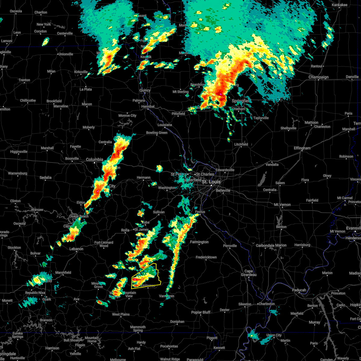 At 633 pm cdt, a severe thunderstorm was located 10 miles northeast of summersville, or 22 miles northeast of mountain view, moving northeast at 55 mph (radar indicated). Hazards include 60 mph wind gusts and half dollar size hail. Hail damage to vehicles is expected. expect wind damage to roofs, siding, and trees. locations impacted include, echo bluff state park, current river state park, ozark national scenic riverways, summersville, bunker, midridge, round spring, hail threat, radar indicated max hail size, 1. 25 in wind threat, radar indicated max wind gust, 60 mph. At 633 pm cdt, a severe thunderstorm was located 10 miles northeast of summersville, or 22 miles northeast of mountain view, moving northeast at 55 mph (radar indicated). Hazards include 60 mph wind gusts and half dollar size hail. Hail damage to vehicles is expected. expect wind damage to roofs, siding, and trees. locations impacted include, echo bluff state park, current river state park, ozark national scenic riverways, summersville, bunker, midridge, round spring, hail threat, radar indicated max hail size, 1. 25 in wind threat, radar indicated max wind gust, 60 mph.
|
| 10/24/2021 6:18 PM CDT |
 At 617 pm cdt, a severe thunderstorm was located near summersville, or 12 miles north of mountain view, moving northeast at 50 mph (radar indicated). Hazards include 60 mph wind gusts and half dollar size hail. Hail damage to vehicles is expected. Expect wind damage to roofs, siding, and trees. At 617 pm cdt, a severe thunderstorm was located near summersville, or 12 miles north of mountain view, moving northeast at 50 mph (radar indicated). Hazards include 60 mph wind gusts and half dollar size hail. Hail damage to vehicles is expected. Expect wind damage to roofs, siding, and trees.
|
| 11/14/2020 10:01 PM CST |
 At 1000 pm cst, a severe thunderstorm was located near belleview, moving east at 55 mph (radar indicated). Hazards include 60 mph wind gusts. Expect damage to roofs, siding, and trees. locations impacted include, ironton, pilot knob, arcadia, bunker, oates, belleview, roselle, hogan, black and granite. This also includes johnsons shut-ins state park, fort davidson historic site, elephant rocks state park, and taum sauk mountain state park. At 1000 pm cst, a severe thunderstorm was located near belleview, moving east at 55 mph (radar indicated). Hazards include 60 mph wind gusts. Expect damage to roofs, siding, and trees. locations impacted include, ironton, pilot knob, arcadia, bunker, oates, belleview, roselle, hogan, black and granite. This also includes johnsons shut-ins state park, fort davidson historic site, elephant rocks state park, and taum sauk mountain state park.
|
| 11/14/2020 9:40 PM CST |
 The severe thunderstorm warning for northwestern shannon, southern dent and northern texas counties will expire at 945 pm cst, the storms which prompted the warning have weakened below severe limits, and no longer pose an immediate threat to life or property. therefore, the warning will be allowed to expire. a tornado watch remains in effect until midnight cst for south central and east central missouri. time, mot, loc 0340z 270deg 105kt 3760 9041 3748 9050 3739 9056. The severe thunderstorm warning for northwestern shannon, southern dent and northern texas counties will expire at 945 pm cst, the storms which prompted the warning have weakened below severe limits, and no longer pose an immediate threat to life or property. therefore, the warning will be allowed to expire. a tornado watch remains in effect until midnight cst for south central and east central missouri. time, mot, loc 0340z 270deg 105kt 3760 9041 3748 9050 3739 9056.
|
| 11/14/2020 9:38 PM CST |
 At 938 pm cst, a severe thunderstorm was located 8 miles north of bunker, moving east at 55 mph (radar indicated). Hazards include 60 mph wind gusts and quarter size hail. Hail damage to vehicles is expected. Expect wind damage to roofs, siding, and trees. At 938 pm cst, a severe thunderstorm was located 8 miles north of bunker, moving east at 55 mph (radar indicated). Hazards include 60 mph wind gusts and quarter size hail. Hail damage to vehicles is expected. Expect wind damage to roofs, siding, and trees.
|
| 11/14/2020 9:01 PM CST |
 At 901 pm cst, severe thunderstorms were located along a line extending from 14 miles southwest of salem to near licking to houston, moving northeast at 85 mph (radar indicated). Hazards include 60 mph wind gusts and quarter size hail. Hail damage to vehicles is expected. expect wind damage to roofs, siding, and trees. Locations impacted include, montauk state park, ozark national scenic riverways, licking, houston, bunker, raymondville, huggins, montauk, turtle, jadwin, darien, bucyrus, gladden, akers, prescott,. At 901 pm cst, severe thunderstorms were located along a line extending from 14 miles southwest of salem to near licking to houston, moving northeast at 85 mph (radar indicated). Hazards include 60 mph wind gusts and quarter size hail. Hail damage to vehicles is expected. expect wind damage to roofs, siding, and trees. Locations impacted include, montauk state park, ozark national scenic riverways, licking, houston, bunker, raymondville, huggins, montauk, turtle, jadwin, darien, bucyrus, gladden, akers, prescott,.
|
| 11/14/2020 8:52 PM CST |
 At 852 pm cst, severe thunderstorms were located along a line extending from 7 miles west of licking to 10 miles northwest of raymondville to near houston, moving east at 40 mph (radar indicated). Hazards include 60 mph wind gusts and quarter size hail. Hail damage to vehicles is expected. expect wind damage to roofs, siding, and trees. Locations impacted include, southern fort leonard wood, montauk state park, ozark national scenic riverways, licking, houston, bunker, raymondville, huggins, plato, montauk, turtle, jadwin, beulah, darien, bucyrus, hazelton, gladden, success, roby, akers,. At 852 pm cst, severe thunderstorms were located along a line extending from 7 miles west of licking to 10 miles northwest of raymondville to near houston, moving east at 40 mph (radar indicated). Hazards include 60 mph wind gusts and quarter size hail. Hail damage to vehicles is expected. expect wind damage to roofs, siding, and trees. Locations impacted include, southern fort leonard wood, montauk state park, ozark national scenic riverways, licking, houston, bunker, raymondville, huggins, plato, montauk, turtle, jadwin, beulah, darien, bucyrus, hazelton, gladden, success, roby, akers,.
|
| 11/14/2020 8:38 PM CST |
 At 838 pm cst, severe thunderstorms were located along a line extending from 8 miles south of fort leonard wood to 18 miles west of licking to 15 miles west of houston, moving east at 120 mph (radar indicated). Hazards include 70 mph wind gusts and quarter size hail. Hail damage to vehicles is expected. expect considerable tree damage. Wind damage is also likely to mobile homes, roofs, and outbuildings. At 838 pm cst, severe thunderstorms were located along a line extending from 8 miles south of fort leonard wood to 18 miles west of licking to 15 miles west of houston, moving east at 120 mph (radar indicated). Hazards include 70 mph wind gusts and quarter size hail. Hail damage to vehicles is expected. expect considerable tree damage. Wind damage is also likely to mobile homes, roofs, and outbuildings.
|
| 8/31/2020 1:05 PM CDT |
 The severe thunderstorm warning for dent and northern texas counties will expire at 115 pm cdt, the storms which prompted the warning have weakened below severe limits, and have exited the warned area. therefore, the warning will be allowed to expire. a severe thunderstorm watch remains in effect until 200 pm cdt for south central and east central missouri. The severe thunderstorm warning for dent and northern texas counties will expire at 115 pm cdt, the storms which prompted the warning have weakened below severe limits, and have exited the warned area. therefore, the warning will be allowed to expire. a severe thunderstorm watch remains in effect until 200 pm cdt for south central and east central missouri.
|
| 8/31/2020 12:48 PM CDT |
 At 1247 pm cdt, severe thunderstorms were located along a line extending from 12 miles south of st. james to near salem to 8 miles east of licking to near houston, moving southeast at 35 mph (radar indicated). Hazards include 60 mph wind gusts. Expect damage to roofs, siding, and trees. Locations impacted include, ozark national scenic riverways, montauk state park, salem, licking, bunker, montauk, turtle, jadwin, howes mill, darien, hazelton, gladden, success, bangert, boss, howes, stone hill, sligo, prescott,. At 1247 pm cdt, severe thunderstorms were located along a line extending from 12 miles south of st. james to near salem to 8 miles east of licking to near houston, moving southeast at 35 mph (radar indicated). Hazards include 60 mph wind gusts. Expect damage to roofs, siding, and trees. Locations impacted include, ozark national scenic riverways, montauk state park, salem, licking, bunker, montauk, turtle, jadwin, howes mill, darien, hazelton, gladden, success, bangert, boss, howes, stone hill, sligo, prescott,.
|
| 8/31/2020 12:12 PM CDT |
 At 1212 pm cdt, severe thunderstorms were located along a line extending from near dixon to 9 miles east of st. robert to fort leonard wood to 14 miles southeast of lebanon, moving southeast at 40 mph (radar indicated). Hazards include 60 mph wind gusts. expect damage to roofs, siding, and trees At 1212 pm cdt, severe thunderstorms were located along a line extending from near dixon to 9 miles east of st. robert to fort leonard wood to 14 miles southeast of lebanon, moving southeast at 40 mph (radar indicated). Hazards include 60 mph wind gusts. expect damage to roofs, siding, and trees
|
| 5/4/2020 3:18 PM CDT |
 At 318 pm cdt, severe thunderstorms were located along a line extending from near salem to 6 miles north of summersville to near willow springs to 10 miles southwest of cabool, moving east at 55 mph (radar indicated). Hazards include 70 mph wind gusts and nickel size hail. Expect considerable tree damage. Damage is likely to mobile homes, roofs, and outbuildings. At 318 pm cdt, severe thunderstorms were located along a line extending from near salem to 6 miles north of summersville to near willow springs to 10 miles southwest of cabool, moving east at 55 mph (radar indicated). Hazards include 70 mph wind gusts and nickel size hail. Expect considerable tree damage. Damage is likely to mobile homes, roofs, and outbuildings.
|
| 3/27/2020 6:47 PM CDT |
 At 647 pm cdt, a severe thunderstorm was located near reynolds, moving east at 50 mph (radar indicated). Hazards include 60 mph wind gusts and quarter size hail. Hail damage to vehicles is expected. expect wind damage to roofs, siding, and trees. locations impacted include, reynolds, bunker, oates, centerville, corridon, lesterville and black. This also includes johnsons shut-ins state park and taum sauk mountain state park. At 647 pm cdt, a severe thunderstorm was located near reynolds, moving east at 50 mph (radar indicated). Hazards include 60 mph wind gusts and quarter size hail. Hail damage to vehicles is expected. expect wind damage to roofs, siding, and trees. locations impacted include, reynolds, bunker, oates, centerville, corridon, lesterville and black. This also includes johnsons shut-ins state park and taum sauk mountain state park.
|
| 3/27/2020 6:36 PM CDT |
 At 635 pm cdt, a severe thunderstorm was located over bunker, moving east at 45 mph (radar indicated). Hazards include 60 mph wind gusts and quarter size hail. Hail damage to vehicles is expected. expect wind damage to roofs, siding, and trees. locations impacted include, reynolds, bunker, oates, centerville, corridon, lesterville and black. This also includes johnsons shut-ins state park and taum sauk mountain state park. At 635 pm cdt, a severe thunderstorm was located over bunker, moving east at 45 mph (radar indicated). Hazards include 60 mph wind gusts and quarter size hail. Hail damage to vehicles is expected. expect wind damage to roofs, siding, and trees. locations impacted include, reynolds, bunker, oates, centerville, corridon, lesterville and black. This also includes johnsons shut-ins state park and taum sauk mountain state park.
|
| 3/27/2020 6:31 PM CDT |
 At 630 pm cdt, a severe thunderstorm was located near bunker, or 21 miles southeast of salem, moving east at 45 mph (trained weather spotters. this storm has a long history of producing large hail). Hazards include 60 mph wind gusts and half dollar size hail. Hail damage to vehicles is expected. expect wind damage to roofs, siding, and trees. This severe storm will be near, bunker around 640 pm cdt. At 630 pm cdt, a severe thunderstorm was located near bunker, or 21 miles southeast of salem, moving east at 45 mph (trained weather spotters. this storm has a long history of producing large hail). Hazards include 60 mph wind gusts and half dollar size hail. Hail damage to vehicles is expected. expect wind damage to roofs, siding, and trees. This severe storm will be near, bunker around 640 pm cdt.
|
| 3/27/2020 6:20 PM CDT |
 At 620 pm cdt, a severe thunderstorm was located 14 miles west of bunker, or 18 miles south of salem, moving east at 50 mph (trained weather spotters. this storm has a long history of producing large hail). Hazards include ping pong ball size hail and 60 mph wind gusts. People and animals outdoors will be injured. expect hail damage to roofs, siding, windows, and vehicles. expect wind damage to roofs, siding, and trees. this severe storm will be near, bunker around 635 pm cdt. Other locations impacted by this severe thunderstorm include echo bluff state park, current river state park, ozark national scenic riverways, turtle, midridge, akers and gladden. At 620 pm cdt, a severe thunderstorm was located 14 miles west of bunker, or 18 miles south of salem, moving east at 50 mph (trained weather spotters. this storm has a long history of producing large hail). Hazards include ping pong ball size hail and 60 mph wind gusts. People and animals outdoors will be injured. expect hail damage to roofs, siding, windows, and vehicles. expect wind damage to roofs, siding, and trees. this severe storm will be near, bunker around 635 pm cdt. Other locations impacted by this severe thunderstorm include echo bluff state park, current river state park, ozark national scenic riverways, turtle, midridge, akers and gladden.
|
| 3/27/2020 6:19 PM CDT |
 At 619 pm cdt, a severe thunderstorm was located 12 miles west of bunker, moving east at 50 mph (trained weather spotters). Hazards include 60 mph wind gusts and half dollar size hail. Hail damage to vehicles is expected. Expect wind damage to roofs, siding, and trees. At 619 pm cdt, a severe thunderstorm was located 12 miles west of bunker, moving east at 50 mph (trained weather spotters). Hazards include 60 mph wind gusts and half dollar size hail. Hail damage to vehicles is expected. Expect wind damage to roofs, siding, and trees.
|
| 3/27/2020 6:02 PM CDT |
 At 601 pm cdt, a severe thunderstorm was located over raymondville, or 8 miles east of houston, moving east at 45 mph (trained weather spotters. this storm has a long history of producing golf ball to tennis ball size hail). Hazards include tennis ball size hail and 60 mph wind gusts. People and animals outdoors will be injured. expect hail damage to roofs, siding, windows, and vehicles. expect wind damage to roofs, siding, and trees. this severe thunderstorm will be near, bunker around 645 pm cdt. Other locations impacted by this severe thunderstorm include current river state park, echo bluff state park, montauk state park, ozark national scenic riverways, montauk, turtle, jadwin, midridge, darien and gladden. At 601 pm cdt, a severe thunderstorm was located over raymondville, or 8 miles east of houston, moving east at 45 mph (trained weather spotters. this storm has a long history of producing golf ball to tennis ball size hail). Hazards include tennis ball size hail and 60 mph wind gusts. People and animals outdoors will be injured. expect hail damage to roofs, siding, windows, and vehicles. expect wind damage to roofs, siding, and trees. this severe thunderstorm will be near, bunker around 645 pm cdt. Other locations impacted by this severe thunderstorm include current river state park, echo bluff state park, montauk state park, ozark national scenic riverways, montauk, turtle, jadwin, midridge, darien and gladden.
|
| 3/2/2020 6:21 PM CST |
 At 621 pm cst, a severe thunderstorm was located 8 miles north of eminence, or 25 miles northwest of van buren, moving east at 35 mph (radar indicated). Hazards include golf ball size hail and 60 mph wind gusts. People and animals outdoors will be injured. expect hail damage to roofs, siding, windows, and vehicles. expect wind damage to roofs, siding, and trees. Locations impacted include, echo bluff state park, current river state park, bunker, round spring, midridge,. At 621 pm cst, a severe thunderstorm was located 8 miles north of eminence, or 25 miles northwest of van buren, moving east at 35 mph (radar indicated). Hazards include golf ball size hail and 60 mph wind gusts. People and animals outdoors will be injured. expect hail damage to roofs, siding, windows, and vehicles. expect wind damage to roofs, siding, and trees. Locations impacted include, echo bluff state park, current river state park, bunker, round spring, midridge,.
|
| 3/2/2020 6:12 PM CST |
 At 612 pm cst, a severe thunderstorm was located 12 miles northwest of eminence, or 23 miles south of salem, moving east at 40 mph (radar indicated). Hazards include golf ball size hail and 60 mph wind gusts. People and animals outdoors will be injured. expect hail damage to roofs, siding, windows, and vehicles. expect wind damage to roofs, siding, and trees. Locations impacted include, echo bluff state park, current river state park, ozark national scenic riverways, bunker, midridge, round spring, akers,. At 612 pm cst, a severe thunderstorm was located 12 miles northwest of eminence, or 23 miles south of salem, moving east at 40 mph (radar indicated). Hazards include golf ball size hail and 60 mph wind gusts. People and animals outdoors will be injured. expect hail damage to roofs, siding, windows, and vehicles. expect wind damage to roofs, siding, and trees. Locations impacted include, echo bluff state park, current river state park, ozark national scenic riverways, bunker, midridge, round spring, akers,.
|
| 3/2/2020 6:06 PM CST |
 At 606 pm cst, a severe thunderstorm was located 11 miles northeast of summersville, or 21 miles south of salem, moving east at 30 mph (radar indicated). Hazards include ping pong ball size hail and 60 mph wind gusts. People and animals outdoors will be injured. expect hail damage to roofs, siding, windows, and vehicles. expect wind damage to roofs, siding, and trees. Locations impacted include, echo bluff state park, current river state park, ozark national scenic riverways, bunker, midridge, round spring, akers,. At 606 pm cst, a severe thunderstorm was located 11 miles northeast of summersville, or 21 miles south of salem, moving east at 30 mph (radar indicated). Hazards include ping pong ball size hail and 60 mph wind gusts. People and animals outdoors will be injured. expect hail damage to roofs, siding, windows, and vehicles. expect wind damage to roofs, siding, and trees. Locations impacted include, echo bluff state park, current river state park, ozark national scenic riverways, bunker, midridge, round spring, akers,.
|
| 3/2/2020 5:56 PM CST |
 The national weather service in springfield has issued a * severe thunderstorm warning for. northwestern shannon county in south central missouri. southeastern dent county in south central missouri. east central texas county in south central missouri. Until 700 pm cst. The national weather service in springfield has issued a * severe thunderstorm warning for. northwestern shannon county in south central missouri. southeastern dent county in south central missouri. east central texas county in south central missouri. Until 700 pm cst.
|
| 12/28/2019 11:28 PM CST |
 The severe thunderstorm warning for northwestern shannon and southeastern dent counties will expire at 1130 pm cst, the storm which prompted the warning has weakened below severe limits, and no longer poses an immediate threat to life or property. therefore, the warning will be allowed to expire. however gusty winds of 50 to 55 mph are still possible with this thunderstorm. The severe thunderstorm warning for northwestern shannon and southeastern dent counties will expire at 1130 pm cst, the storm which prompted the warning has weakened below severe limits, and no longer poses an immediate threat to life or property. therefore, the warning will be allowed to expire. however gusty winds of 50 to 55 mph are still possible with this thunderstorm.
|
| 12/28/2019 11:16 PM CST |
 At 1116 pm cst, a severe thunderstorm was located 15 miles northeast of summersville, or 18 miles south of salem, moving northeast at 55 mph (radar indicated). Hazards include 60 mph wind gusts. Expect damage to roofs, siding, and trees. Locations impacted include, current river state park, echo bluff state park, ozark national scenic riverways, summersville, bunker, turtle, jadwin, howes mill, midridge, gladden, round spring, akers, stone hill,. At 1116 pm cst, a severe thunderstorm was located 15 miles northeast of summersville, or 18 miles south of salem, moving northeast at 55 mph (radar indicated). Hazards include 60 mph wind gusts. Expect damage to roofs, siding, and trees. Locations impacted include, current river state park, echo bluff state park, ozark national scenic riverways, summersville, bunker, turtle, jadwin, howes mill, midridge, gladden, round spring, akers, stone hill,.
|
| 12/28/2019 10:55 PM CST |
 At 1055 pm cst, a severe thunderstorm was located 8 miles south of raymondville, or 9 miles southeast of houston, moving northeast at 30 mph (radar indicated). Hazards include 60 mph wind gusts. Expect damage to roofs, siding, and trees. Locations impacted include, current river state park, echo bluff state park, ozark national scenic riverways, summersville, bunker, raymondville, turtle, jadwin, howes mill, midridge, arroll, gladden, eunice, yukon, hartshorn, clear springs, round spring, akers, stone hill,. At 1055 pm cst, a severe thunderstorm was located 8 miles south of raymondville, or 9 miles southeast of houston, moving northeast at 30 mph (radar indicated). Hazards include 60 mph wind gusts. Expect damage to roofs, siding, and trees. Locations impacted include, current river state park, echo bluff state park, ozark national scenic riverways, summersville, bunker, raymondville, turtle, jadwin, howes mill, midridge, arroll, gladden, eunice, yukon, hartshorn, clear springs, round spring, akers, stone hill,.
|
| 12/28/2019 10:48 PM CST |
 At 1047 pm cst, a severe thunderstorm was located 10 miles east of cabool, or 10 miles north of willow springs, moving northeast at 55 mph (radar indicated). Hazards include 60 mph wind gusts. expect damage to roofs, siding, and trees At 1047 pm cst, a severe thunderstorm was located 10 miles east of cabool, or 10 miles north of willow springs, moving northeast at 55 mph (radar indicated). Hazards include 60 mph wind gusts. expect damage to roofs, siding, and trees
|
| 10/21/2019 3:13 AM CDT |
 At 313 am cdt, severe thunderstorms were located along a line extending from 6 miles southeast of rolla to near salem to 10 miles west of bunker to near eminence, moving northeast at 65 mph (radar indicated). Hazards include 60 mph wind gusts. Expect damage to roofs, siding, and trees. Locations impacted include, current river state park, ozark national scenic riverways, echo bluff state park, salem, eminence, bunker, turtle, howes mill, midridge, lake spring, gladden, anutt, bangert, boss, howes, lecoma, round spring, west eminence, stone hill, sligo,. At 313 am cdt, severe thunderstorms were located along a line extending from 6 miles southeast of rolla to near salem to 10 miles west of bunker to near eminence, moving northeast at 65 mph (radar indicated). Hazards include 60 mph wind gusts. Expect damage to roofs, siding, and trees. Locations impacted include, current river state park, ozark national scenic riverways, echo bluff state park, salem, eminence, bunker, turtle, howes mill, midridge, lake spring, gladden, anutt, bangert, boss, howes, lecoma, round spring, west eminence, stone hill, sligo,.
|
| 10/21/2019 3:02 AM CDT |
 At 302 am cdt, severe thunderstorms were located along a line extending from 12 miles south of rolla to 14 miles north of summersville to 6 miles southwest of eminence, moving east at 60 mph (radar indicated). Hazards include 60 mph wind gusts. Expect damage to roofs, siding, and trees. Locations impacted include, current river state park, ozark national scenic riverways, echo bluff state park, montauk state park, salem, eminence, bunker, edgar springs, lenox, montauk, jadwin, howes mill, midridge, lake spring, gladden, anutt, bangert, boss, round spring, akers,. At 302 am cdt, severe thunderstorms were located along a line extending from 12 miles south of rolla to 14 miles north of summersville to 6 miles southwest of eminence, moving east at 60 mph (radar indicated). Hazards include 60 mph wind gusts. Expect damage to roofs, siding, and trees. Locations impacted include, current river state park, ozark national scenic riverways, echo bluff state park, montauk state park, salem, eminence, bunker, edgar springs, lenox, montauk, jadwin, howes mill, midridge, lake spring, gladden, anutt, bangert, boss, round spring, akers,.
|
| 10/21/2019 2:38 AM CDT |
 At 238 am cdt, severe thunderstorms were located along a line extending from 8 miles south of fort leonard wood to near houston to near willow springs, moving east at 55 mph (radar indicated). Hazards include 60 mph wind gusts. expect damage to roofs, siding, and trees At 238 am cdt, severe thunderstorms were located along a line extending from 8 miles south of fort leonard wood to near houston to near willow springs, moving east at 55 mph (radar indicated). Hazards include 60 mph wind gusts. expect damage to roofs, siding, and trees
|
| 8/26/2019 3:35 PM CDT |
 At 333 pm cdt, severe thunderstorms were located along a line extending from bixby to near bunker to 13 miles northeast of summersville, moving east at 45 mph (public. these storms have a history of downing trees and powerlines). Hazards include 60 mph wind gusts and quarter size hail. Hail damage to vehicles is expected. expect wind damage to roofs, siding, and trees. Locations impacted include, echo bluff state park, current river state park, eminence, bunker, midridge, round spring, akers,. At 333 pm cdt, severe thunderstorms were located along a line extending from bixby to near bunker to 13 miles northeast of summersville, moving east at 45 mph (public. these storms have a history of downing trees and powerlines). Hazards include 60 mph wind gusts and quarter size hail. Hail damage to vehicles is expected. expect wind damage to roofs, siding, and trees. Locations impacted include, echo bluff state park, current river state park, eminence, bunker, midridge, round spring, akers,.
|
| 8/26/2019 3:18 PM CDT |
 At 317 pm cdt, severe thunderstorms were located along a line extending from 7 miles west of viburnum to 7 miles southeast of salem to 7 miles northeast of raymondville, moving east at 45 mph (public. these storms have a history of downing trees and powerlines). Hazards include 60 mph wind gusts and quarter size hail. Hail damage to vehicles is expected. expect wind damage to roofs, siding, and trees. Locations impacted include, current river state park, ozark national scenic riverways, echo bluff state park, montauk state park, salem, eminence, bunker, montauk, turtle, jadwin, howes mill, midridge, darien, gladden, boss, round spring, akers, stone hill,. At 317 pm cdt, severe thunderstorms were located along a line extending from 7 miles west of viburnum to 7 miles southeast of salem to 7 miles northeast of raymondville, moving east at 45 mph (public. these storms have a history of downing trees and powerlines). Hazards include 60 mph wind gusts and quarter size hail. Hail damage to vehicles is expected. expect wind damage to roofs, siding, and trees. Locations impacted include, current river state park, ozark national scenic riverways, echo bluff state park, montauk state park, salem, eminence, bunker, montauk, turtle, jadwin, howes mill, midridge, darien, gladden, boss, round spring, akers, stone hill,.
|
| 8/26/2019 3:10 PM CDT |
 At 310 pm cdt, severe thunderstorms were located along a line extending from 7 miles south of cherryville to near salem to near licking, moving east at 45 mph (radar indicated). Hazards include 60 mph wind gusts and quarter size hail. Hail damage to vehicles is expected. Expect wind damage to roofs, siding, and trees. At 310 pm cdt, severe thunderstorms were located along a line extending from 7 miles south of cherryville to near salem to near licking, moving east at 45 mph (radar indicated). Hazards include 60 mph wind gusts and quarter size hail. Hail damage to vehicles is expected. Expect wind damage to roofs, siding, and trees.
|
| 8/26/2019 3:02 PM CDT |
 At 301 pm cdt, severe thunderstorms were located along a line extending from 8 miles southwest of cherryville to near salem to near licking, moving east at 55 mph (public. this storm has produced damage to tree limbs and shingles). Hazards include 60 mph wind gusts and quarter size hail. Hail damage to vehicles is expected. expect wind damage to roofs, siding, and trees. Locations impacted include, current river state park, ozark national scenic riverways, echo bluff state park, montauk state park, salem, licking, eminence, bunker, lenox, montauk, jadwin, howes mill, midridge, lake spring, gladden, anutt, bangert, boss, round spring, akers,. At 301 pm cdt, severe thunderstorms were located along a line extending from 8 miles southwest of cherryville to near salem to near licking, moving east at 55 mph (public. this storm has produced damage to tree limbs and shingles). Hazards include 60 mph wind gusts and quarter size hail. Hail damage to vehicles is expected. expect wind damage to roofs, siding, and trees. Locations impacted include, current river state park, ozark national scenic riverways, echo bluff state park, montauk state park, salem, licking, eminence, bunker, lenox, montauk, jadwin, howes mill, midridge, lake spring, gladden, anutt, bangert, boss, round spring, akers,.
|
| 8/26/2019 2:46 PM CDT |
 At 244 pm cdt, severe thunderstorms were located along a line extending from 11 miles south of newburg to 7 miles northwest of licking, moving east at 45 mph (public). Hazards include 60 mph wind gusts and quarter size hail. these storms have downed tree limbs and removed shingles from a home. Hail damage to vehicles is expected. expect wind damage to roofs, siding, and trees. Locations impacted include, current river state park, ozark national scenic riverways, echo bluff state park, montauk state park, salem, licking, eminence, bunker, edgar springs, lenox, montauk, jadwin, beulah, howes mill, midridge, lake spring, gladden, anutt, bangert, boss,. At 244 pm cdt, severe thunderstorms were located along a line extending from 11 miles south of newburg to 7 miles northwest of licking, moving east at 45 mph (public). Hazards include 60 mph wind gusts and quarter size hail. these storms have downed tree limbs and removed shingles from a home. Hail damage to vehicles is expected. expect wind damage to roofs, siding, and trees. Locations impacted include, current river state park, ozark national scenic riverways, echo bluff state park, montauk state park, salem, licking, eminence, bunker, edgar springs, lenox, montauk, jadwin, beulah, howes mill, midridge, lake spring, gladden, anutt, bangert, boss,.
|
| 8/26/2019 2:40 PM CDT |
 At 238 pm cdt, severe thunderstorms were located along a line extending from 10 miles south of newburg to 10 miles northwest of licking, moving east at 45 mph (public. these storms have downed tree limbs and removed shingles from a home). Hazards include 60 mph wind gusts and quarter size hail. Hail damage to vehicles is expected. expect wind damage to roofs, siding, and trees. Locations impacted include, eastern fort leonard wood, current river state park, ozark national scenic riverways, echo bluff state park, montauk state park, salem, licking, eminence, bunker, edgar springs, lenox, montauk, jadwin, beulah, howes mill, midridge, lake spring, gladden, anutt, bangert, this includes interstate 44 near mile marker 164. At 238 pm cdt, severe thunderstorms were located along a line extending from 10 miles south of newburg to 10 miles northwest of licking, moving east at 45 mph (public. these storms have downed tree limbs and removed shingles from a home). Hazards include 60 mph wind gusts and quarter size hail. Hail damage to vehicles is expected. expect wind damage to roofs, siding, and trees. Locations impacted include, eastern fort leonard wood, current river state park, ozark national scenic riverways, echo bluff state park, montauk state park, salem, licking, eminence, bunker, edgar springs, lenox, montauk, jadwin, beulah, howes mill, midridge, lake spring, gladden, anutt, bangert, this includes interstate 44 near mile marker 164.
|
| 8/26/2019 2:20 PM CDT |
 At 220 pm cdt, severe thunderstorms were located along a line extending from st. robert to fort leonard wood, moving east at 45 mph (radar indicated). Hazards include 60 mph wind gusts and quarter size hail. Hail damage to vehicles is expected. Expect wind damage to roofs, siding, and trees. At 220 pm cdt, severe thunderstorms were located along a line extending from st. robert to fort leonard wood, moving east at 45 mph (radar indicated). Hazards include 60 mph wind gusts and quarter size hail. Hail damage to vehicles is expected. Expect wind damage to roofs, siding, and trees.
|
| 8/20/2019 3:55 PM CDT |
 The severe thunderstorm warning for dent and southern phelps counties will expire at 400 pm cdt, the storms which prompted the warning have weakened below severe limits, and no longer pose an immediate threat to life or property. therefore, the warning will be allowed to expire. The severe thunderstorm warning for dent and southern phelps counties will expire at 400 pm cdt, the storms which prompted the warning have weakened below severe limits, and no longer pose an immediate threat to life or property. therefore, the warning will be allowed to expire.
|
| 8/20/2019 3:19 PM CDT |
 At 318 pm cdt, severe thunderstorms were located along a line extending from 11 miles northeast of licking to 8 miles west of viburnum, moving southeast at 20 mph (radar indicated). Hazards include 60 mph wind gusts and quarter size hail. Hail damage to vehicles is expected. Expect wind damage to roofs, siding, and trees. At 318 pm cdt, severe thunderstorms were located along a line extending from 11 miles northeast of licking to 8 miles west of viburnum, moving southeast at 20 mph (radar indicated). Hazards include 60 mph wind gusts and quarter size hail. Hail damage to vehicles is expected. Expect wind damage to roofs, siding, and trees.
|
| 6/21/2019 2:21 PM CDT |
 At 221 pm cdt, a severe thunderstorm was located near licking, or 17 miles west of salem, moving east at 30 mph (radar indicated). Hazards include 60 mph wind gusts and penny size hail. expect damage to roofs, siding, and trees At 221 pm cdt, a severe thunderstorm was located near licking, or 17 miles west of salem, moving east at 30 mph (radar indicated). Hazards include 60 mph wind gusts and penny size hail. expect damage to roofs, siding, and trees
|
| 6/4/2019 5:44 PM CDT |
 At 544 pm cdt, a severe thunderstorm was located 12 miles north of summersville, or 20 miles east of houston, moving northeast at 30 mph (radar indicated). Hazards include 60 mph wind gusts and quarter size hail. Hail damage to vehicles is expected. expect wind damage to roofs, siding, and trees. Locations impacted include, echo bluff state park, current river state park, montauk state park, ozark national scenic riverways, bunker, montauk, turtle, jadwin, darien, akers, gladden,. At 544 pm cdt, a severe thunderstorm was located 12 miles north of summersville, or 20 miles east of houston, moving northeast at 30 mph (radar indicated). Hazards include 60 mph wind gusts and quarter size hail. Hail damage to vehicles is expected. expect wind damage to roofs, siding, and trees. Locations impacted include, echo bluff state park, current river state park, montauk state park, ozark national scenic riverways, bunker, montauk, turtle, jadwin, darien, akers, gladden,.
|
| 6/4/2019 5:22 PM CDT |
 At 521 pm cdt, a severe thunderstorm was located near summersville, or 13 miles southeast of houston, moving northeast at 30 mph (radar indicated). Hazards include 60 mph wind gusts and quarter size hail. Hail damage to vehicles is expected. Expect wind damage to roofs, siding, and trees. At 521 pm cdt, a severe thunderstorm was located near summersville, or 13 miles southeast of houston, moving northeast at 30 mph (radar indicated). Hazards include 60 mph wind gusts and quarter size hail. Hail damage to vehicles is expected. Expect wind damage to roofs, siding, and trees.
|
| 5/21/2019 5:04 PM CDT |
 At 441 pm cdt, severe thunderstorms were located along a line extending from 9 miles west of salem to 11 miles south of mountain view, moving east at 40 mph (radar indicated). Hazards include 60 mph wind gusts and quarter size hail. Hail damage to vehicles is expected. Expect wind damage to roofs, siding, and trees. At 441 pm cdt, severe thunderstorms were located along a line extending from 9 miles west of salem to 11 miles south of mountain view, moving east at 40 mph (radar indicated). Hazards include 60 mph wind gusts and quarter size hail. Hail damage to vehicles is expected. Expect wind damage to roofs, siding, and trees.
|
| 5/21/2019 4:41 PM CDT |
 The national weather service in springfield has issued a * severe thunderstorm warning for. shannon county in south central missouri. dent county in south central missouri. northern oregon county in south central missouri. Until 530 pm cdt. The national weather service in springfield has issued a * severe thunderstorm warning for. shannon county in south central missouri. dent county in south central missouri. northern oregon county in south central missouri. Until 530 pm cdt.
|
| 5/21/2019 1:26 AM CDT |
 The severe thunderstorm warning for northwestern shannon, southeastern wright, dent and texas counties will expire at 130 am cdt, the storms which prompted the warning have weakened below severe limits, and no longer pose an immediate threat to life or property. therefore, the warning will be allowed to expire. however heavy rain is still possible with these thunderstorms. a tornado watch remains in effect until 800 am cdt for south central and southwestern missouri. a severe thunderstorm watch remains in effect until 400 am cdt for south central and east central missouri. The severe thunderstorm warning for northwestern shannon, southeastern wright, dent and texas counties will expire at 130 am cdt, the storms which prompted the warning have weakened below severe limits, and no longer pose an immediate threat to life or property. therefore, the warning will be allowed to expire. however heavy rain is still possible with these thunderstorms. a tornado watch remains in effect until 800 am cdt for south central and southwestern missouri. a severe thunderstorm watch remains in effect until 400 am cdt for south central and east central missouri.
|
| 5/21/2019 12:28 AM CDT |
 At 1228 am cdt, severe thunderstorms were located along a line extending from near st. james to 7 miles northeast of raymondville to norwood, moving east at 40 mph (radar indicated). Hazards include 60 mph wind gusts and quarter size hail. Hail damage to vehicles is expected. Expect wind damage to roofs, siding, and trees. At 1228 am cdt, severe thunderstorms were located along a line extending from near st. james to 7 miles northeast of raymondville to norwood, moving east at 40 mph (radar indicated). Hazards include 60 mph wind gusts and quarter size hail. Hail damage to vehicles is expected. Expect wind damage to roofs, siding, and trees.
|
| 5/18/2019 6:09 PM CDT |
 At 609 pm cdt, severe thunderstorms were located along a line extending from rolla to 11 miles southwest of bunker to near alton, moving east at 35 mph (trained weather spotters). Hazards include 60 mph wind gusts. Expect damage to roofs, siding, and trees. locations impacted include, rolla, current river state park, ozark national scenic riverways, echo bluff state park, salem, st. James, winona, alton, birch tree, eminence, bunker, howes mill, midridge, gladden, bangert, boss, round spring, turtle, wilderness, couch, this includes interstate 44 between mile markers 186 and 199. At 609 pm cdt, severe thunderstorms were located along a line extending from rolla to 11 miles southwest of bunker to near alton, moving east at 35 mph (trained weather spotters). Hazards include 60 mph wind gusts. Expect damage to roofs, siding, and trees. locations impacted include, rolla, current river state park, ozark national scenic riverways, echo bluff state park, salem, st. James, winona, alton, birch tree, eminence, bunker, howes mill, midridge, gladden, bangert, boss, round spring, turtle, wilderness, couch, this includes interstate 44 between mile markers 186 and 199.
|
| 5/18/2019 5:51 PM CDT |
 At 550 pm cdt, severe thunderstorms were located along a line extending from near newburg to 10 miles northeast of summersville to near thayer, moving east at 35 mph (trained weather spotters). Hazards include 60 mph wind gusts. Expect damage to roofs, siding, and trees. locations impacted include, rolla, current river state park, ozark national scenic riverways, echo bluff state park, grand gulf state park, montauk state park, salem, st. James, thayer, winona, alton, birch tree, doolittle, eminence, summersville, newburg, bunker, koshkonong, edgar springs, montier, this includes interstate 44 between mile markers 179 and 199. At 550 pm cdt, severe thunderstorms were located along a line extending from near newburg to 10 miles northeast of summersville to near thayer, moving east at 35 mph (trained weather spotters). Hazards include 60 mph wind gusts. Expect damage to roofs, siding, and trees. locations impacted include, rolla, current river state park, ozark national scenic riverways, echo bluff state park, grand gulf state park, montauk state park, salem, st. James, thayer, winona, alton, birch tree, doolittle, eminence, summersville, newburg, bunker, koshkonong, edgar springs, montier, this includes interstate 44 between mile markers 179 and 199.
|
| 5/18/2019 5:36 PM CDT |
 At 536 pm cdt, severe thunderstorms were located along a line extending from 6 miles east of st. robert to 7 miles northwest of summersville to 6 miles west of thayer, moving east at 35 mph (trained weather spotters). Hazards include 60 mph wind gusts. Expect damage to roofs, siding, and trees. locations impacted include, rolla, northeastern fort leonard wood, west plains, ozark national scenic riverways, echo bluff state park, current river state park, grand gulf state park, montauk state park, salem, st. robert, st. James, licking, mountain view, thayer, winona, alton, birch tree, doolittle, eminence, summersville, this includes interstate 44 between mile markers 161 and 169, and between mile markers 179 and 199. At 536 pm cdt, severe thunderstorms were located along a line extending from 6 miles east of st. robert to 7 miles northwest of summersville to 6 miles west of thayer, moving east at 35 mph (trained weather spotters). Hazards include 60 mph wind gusts. Expect damage to roofs, siding, and trees. locations impacted include, rolla, northeastern fort leonard wood, west plains, ozark national scenic riverways, echo bluff state park, current river state park, grand gulf state park, montauk state park, salem, st. robert, st. James, licking, mountain view, thayer, winona, alton, birch tree, doolittle, eminence, summersville, this includes interstate 44 between mile markers 161 and 169, and between mile markers 179 and 199.
|
| 5/18/2019 5:15 PM CDT |
 At 515 pm cdt, severe thunderstorms were located along a line extending from near waynesville to 7 miles south of houston to near sturkie, moving east at 35 mph (trained weather spotters). Hazards include 60 mph wind gusts. expect damage to roofs, siding, and trees At 515 pm cdt, severe thunderstorms were located along a line extending from near waynesville to 7 miles south of houston to near sturkie, moving east at 35 mph (trained weather spotters). Hazards include 60 mph wind gusts. expect damage to roofs, siding, and trees
|
| 12/1/2018 2:37 AM CST |
 At 236 am cst, severe thunderstorms were located along a line extending from near bunker to near van buren, moving northeast at 65 mph (radar indicated). Hazards include 60 mph wind gusts. expect damage to roofs, siding, and trees At 236 am cst, severe thunderstorms were located along a line extending from near bunker to near van buren, moving northeast at 65 mph (radar indicated). Hazards include 60 mph wind gusts. expect damage to roofs, siding, and trees
|
| 12/1/2018 2:12 AM CST |
 At 212 am cst, severe thunderstorms were located along a line extending from near richland to near summersville, moving northeast at 50 mph (radar indicated). Hazards include 60 mph wind gusts. expect damage to roofs, siding, and trees At 212 am cst, severe thunderstorms were located along a line extending from near richland to near summersville, moving northeast at 50 mph (radar indicated). Hazards include 60 mph wind gusts. expect damage to roofs, siding, and trees
|
| 8/7/2018 2:21 PM CDT |
 The severe thunderstorm warning for northeastern shannon and southeastern dent counties will expire at 230 pm cdt, the storm which prompted the warning has weakened below severe limits, and has exited the warned area. therefore, the warning will be allowed to expire. to report severe weather, contact your nearest law enforcement agency. they will relay your report to the national weather service springfield. The severe thunderstorm warning for northeastern shannon and southeastern dent counties will expire at 230 pm cdt, the storm which prompted the warning has weakened below severe limits, and has exited the warned area. therefore, the warning will be allowed to expire. to report severe weather, contact your nearest law enforcement agency. they will relay your report to the national weather service springfield.
|
| 8/7/2018 2:10 PM CDT |
 At 208 pm cdt, a severe thunderstorm was located 16 miles southeast of salem, moving east at 15 mph. other storms capable of damaging winds were located 12 miles east of eminence moving slowly east at 10 mph (radar indicated). Hazards include 60 mph wind gusts and penny size hail. Expect damage to roofs, siding, and trees. Locations impacted include, bunker, stone hill, midridge,. At 208 pm cdt, a severe thunderstorm was located 16 miles southeast of salem, moving east at 15 mph. other storms capable of damaging winds were located 12 miles east of eminence moving slowly east at 10 mph (radar indicated). Hazards include 60 mph wind gusts and penny size hail. Expect damage to roofs, siding, and trees. Locations impacted include, bunker, stone hill, midridge,.
|
| 8/7/2018 1:55 PM CDT |
 At 154 pm cdt, a severe thunderstorm was located 7 miles west of bunker, or 17 miles southeast of salem, moving east at 20 mph (radar indicated). Hazards include 60 mph wind gusts and quarter size hail. Hail damage to vehicles is expected. Expect wind damage to roofs, siding, and trees. At 154 pm cdt, a severe thunderstorm was located 7 miles west of bunker, or 17 miles southeast of salem, moving east at 20 mph (radar indicated). Hazards include 60 mph wind gusts and quarter size hail. Hail damage to vehicles is expected. Expect wind damage to roofs, siding, and trees.
|
| 8/7/2018 1:51 PM CDT |
 At 150 pm cdt, a severe thunderstorm was located 10 miles west of bunker, or 16 miles southeast of salem, moving east at 20 mph (radar indicated). Hazards include 60 mph wind gusts and quarter size hail. Hail damage to vehicles is expected. expect wind damage to roofs, siding, and trees. Locations impacted include, current river state park, winona, birch tree, eminence, bunker, montier, turtle, teresita, jadwin, midridge, gladden, alley spring, round spring, west eminence, akers,. At 150 pm cdt, a severe thunderstorm was located 10 miles west of bunker, or 16 miles southeast of salem, moving east at 20 mph (radar indicated). Hazards include 60 mph wind gusts and quarter size hail. Hail damage to vehicles is expected. expect wind damage to roofs, siding, and trees. Locations impacted include, current river state park, winona, birch tree, eminence, bunker, montier, turtle, teresita, jadwin, midridge, gladden, alley spring, round spring, west eminence, akers,.
|
| 8/7/2018 1:42 PM CDT |
 At 142 pm cdt, severe thunderstorms were located along a line extending from near bunker to near winona, moving east at 40 mph (radar indicated). Hazards include 60 mph wind gusts and quarter size hail. Hail damage to vehicles is expected. expect wind damage to roofs, siding, and trees. Locations impacted include, current river state park, winona, birch tree, eminence, bunker, montier, turtle, teresita, jadwin, midridge, gladden, alley spring, round spring, west eminence, akers,. At 142 pm cdt, severe thunderstorms were located along a line extending from near bunker to near winona, moving east at 40 mph (radar indicated). Hazards include 60 mph wind gusts and quarter size hail. Hail damage to vehicles is expected. expect wind damage to roofs, siding, and trees. Locations impacted include, current river state park, winona, birch tree, eminence, bunker, montier, turtle, teresita, jadwin, midridge, gladden, alley spring, round spring, west eminence, akers,.
|
| 8/7/2018 1:15 PM CDT |
 At 114 pm cdt, severe thunderstorms were located along a line extending from 12 miles south of salem to near mountain view, moving east at 35 mph (radar indicated). Hazards include 60 mph wind gusts and quarter size hail. Hail damage to vehicles is expected. Expect wind damage to roofs, siding, and trees. At 114 pm cdt, severe thunderstorms were located along a line extending from 12 miles south of salem to near mountain view, moving east at 35 mph (radar indicated). Hazards include 60 mph wind gusts and quarter size hail. Hail damage to vehicles is expected. Expect wind damage to roofs, siding, and trees.
|
| 6/26/2018 7:06 PM CDT |
 At 706 pm cdt, severe thunderstorms were located along a line extending from 11 miles northwest of bunker to near birch tree to 7 miles north of ott, moving east at 40 mph (radar indicated). Hazards include 60 mph wind gusts and nickel size hail. Expect damage to roofs, siding, and trees. Locations impacted include, west plains, current river state park, grand gulf state park, mountain view, thayer, willow springs, winona, alton, birch tree, eminence, pomona, bunker, south fork, koshkonong, brandsville, montier, thomasville, lanton, teresita, myrtle,. At 706 pm cdt, severe thunderstorms were located along a line extending from 11 miles northwest of bunker to near birch tree to 7 miles north of ott, moving east at 40 mph (radar indicated). Hazards include 60 mph wind gusts and nickel size hail. Expect damage to roofs, siding, and trees. Locations impacted include, west plains, current river state park, grand gulf state park, mountain view, thayer, willow springs, winona, alton, birch tree, eminence, pomona, bunker, south fork, koshkonong, brandsville, montier, thomasville, lanton, teresita, myrtle,.
|
| 6/26/2018 6:58 PM CDT |
 At 658 pm cdt, severe thunderstorms were located along a line extending from 9 miles southeast of salem to birch tree to near bakersfield, moving east at 55 mph (radar indicated). Hazards include 60 mph wind gusts and nickel size hail. Expect damage to roofs, siding, and trees. Locations impacted include, west plains, current river state park, grand gulf state park, montauk state park, mountain view, thayer, willow springs, winona, alton, birch tree, eminence, pomona, summersville, bunker, bakersfield, south fork, koshkonong, brandsville, montier, thomasville,. At 658 pm cdt, severe thunderstorms were located along a line extending from 9 miles southeast of salem to birch tree to near bakersfield, moving east at 55 mph (radar indicated). Hazards include 60 mph wind gusts and nickel size hail. Expect damage to roofs, siding, and trees. Locations impacted include, west plains, current river state park, grand gulf state park, montauk state park, mountain view, thayer, willow springs, winona, alton, birch tree, eminence, pomona, summersville, bunker, bakersfield, south fork, koshkonong, brandsville, montier, thomasville,.
|
| 6/26/2018 6:45 PM CDT |
 At 645 pm cdt, severe thunderstorms were located along a line extending from near licking to near mountain view to 7 miles north of fawn park, moving east at 40 mph (radar indicated). Hazards include 60 mph wind gusts and nickel size hail. Expect damage to roofs, siding, and trees. Locations impacted include, west plains, norfork lake, current river state park, grand gulf state park, montauk state park, mountain view, thayer, willow springs, winona, alton, birch tree, eminence, pomona, summersville, bunker, raymondville, bakersfield, south fork, koshkonong, brandsville,. At 645 pm cdt, severe thunderstorms were located along a line extending from near licking to near mountain view to 7 miles north of fawn park, moving east at 40 mph (radar indicated). Hazards include 60 mph wind gusts and nickel size hail. Expect damage to roofs, siding, and trees. Locations impacted include, west plains, norfork lake, current river state park, grand gulf state park, montauk state park, mountain view, thayer, willow springs, winona, alton, birch tree, eminence, pomona, summersville, bunker, raymondville, bakersfield, south fork, koshkonong, brandsville,.
|
| 6/26/2018 6:29 PM CDT |
 At 629 pm cdt, severe thunderstorms were located along a line extending from 9 miles northwest of licking to near willow springs to near price place, moving east at 40 mph (radar indicated). Hazards include 60 mph wind gusts and nickel size hail. expect damage to roofs, siding, and trees At 629 pm cdt, severe thunderstorms were located along a line extending from 9 miles northwest of licking to near willow springs to near price place, moving east at 40 mph (radar indicated). Hazards include 60 mph wind gusts and nickel size hail. expect damage to roofs, siding, and trees
|
| 6/26/2018 5:38 PM CDT |
 At 538 pm cdt, a severe thunderstorm was located 9 miles southeast of salem, moving east at 30 mph (radar indicated). Hazards include 60 mph wind gusts and quarter size hail. Hail damage to vehicles is expected. Expect wind damage to roofs, siding, and trees. At 538 pm cdt, a severe thunderstorm was located 9 miles southeast of salem, moving east at 30 mph (radar indicated). Hazards include 60 mph wind gusts and quarter size hail. Hail damage to vehicles is expected. Expect wind damage to roofs, siding, and trees.
|
| 6/26/2018 3:30 PM CDT |
 At 329 pm cdt, a severe thunderstorm was located near glover, moving east at 65 mph (radar indicated). Hazards include 60 mph wind gusts and quarter size hail. Hail damage to vehicles is expected. expect wind damage to roofs, siding, and trees. locations impacted include, reynolds, bunker, oates, centerville, lesterville and black. This also includes johnsons shut-ins state park and taum sauk mountain state park. At 329 pm cdt, a severe thunderstorm was located near glover, moving east at 65 mph (radar indicated). Hazards include 60 mph wind gusts and quarter size hail. Hail damage to vehicles is expected. expect wind damage to roofs, siding, and trees. locations impacted include, reynolds, bunker, oates, centerville, lesterville and black. This also includes johnsons shut-ins state park and taum sauk mountain state park.
|
| 6/26/2018 3:05 PM CDT |
 At 305 pm cdt, a severe thunderstorm was located near oates, moving east at 65 mph (radar indicated). Hazards include 60 mph wind gusts and quarter size hail. Hail damage to vehicles is expected. Expect wind damage to roofs, siding, and trees. At 305 pm cdt, a severe thunderstorm was located near oates, moving east at 65 mph (radar indicated). Hazards include 60 mph wind gusts and quarter size hail. Hail damage to vehicles is expected. Expect wind damage to roofs, siding, and trees.
|
| 6/26/2018 2:42 PM CDT |
 At 242 pm cdt, a severe thunderstorm was located near salem, moving east at 35 mph (radar indicated). Hazards include 60 mph wind gusts and quarter size hail. Hail damage to vehicles is expected. Expect wind damage to roofs, siding, and trees. At 242 pm cdt, a severe thunderstorm was located near salem, moving east at 35 mph (radar indicated). Hazards include 60 mph wind gusts and quarter size hail. Hail damage to vehicles is expected. Expect wind damage to roofs, siding, and trees.
|
| 6/9/2018 6:04 AM CDT |
 At 604 am cdt, a severe thunderstorm was located 10 miles southeast of salem, moving east at 15 mph (radar indicated). Hazards include 60 mph wind gusts and quarter size hail. Hail damage to vehicles is expected. Expect wind damage to roofs, siding, and trees. At 604 am cdt, a severe thunderstorm was located 10 miles southeast of salem, moving east at 15 mph (radar indicated). Hazards include 60 mph wind gusts and quarter size hail. Hail damage to vehicles is expected. Expect wind damage to roofs, siding, and trees.
|
| 6/8/2018 6:28 PM CDT |
 At 628 pm cdt, a severe thunderstorm was located 13 miles west of bunker, or 18 miles south of salem, moving northeast at 10 mph. other severe storms were located near mountain view and summersville (radar indicated). Hazards include 60 mph wind gusts and quarter size hail. Hail damage to vehicles is expected. expect wind damage to roofs, siding, and trees. Locations impacted include, current river state park, mountain view, birch tree, eminence, summersville, bunker, montier, peace valley, turtle, teresita, midridge, arroll, gladden, alley spring, white church, round spring, west eminence, akers, pine crest,. At 628 pm cdt, a severe thunderstorm was located 13 miles west of bunker, or 18 miles south of salem, moving northeast at 10 mph. other severe storms were located near mountain view and summersville (radar indicated). Hazards include 60 mph wind gusts and quarter size hail. Hail damage to vehicles is expected. expect wind damage to roofs, siding, and trees. Locations impacted include, current river state park, mountain view, birch tree, eminence, summersville, bunker, montier, peace valley, turtle, teresita, midridge, arroll, gladden, alley spring, white church, round spring, west eminence, akers, pine crest,.
|
| 6/8/2018 6:04 PM CDT |
 At 603 pm cdt, a severe thunderstorm was located 15 miles northeast of summersville, or 19 miles south of salem, moving northeast at 10 mph. other severe thunderstorms were located in northeast howell and western shannon counties. these storms will move through the warning area (radar indicated). Hazards include 60 mph wind gusts and quarter size hail. Hail damage to vehicles is expected. Expect wind damage to roofs, siding, and trees. At 603 pm cdt, a severe thunderstorm was located 15 miles northeast of summersville, or 19 miles south of salem, moving northeast at 10 mph. other severe thunderstorms were located in northeast howell and western shannon counties. these storms will move through the warning area (radar indicated). Hazards include 60 mph wind gusts and quarter size hail. Hail damage to vehicles is expected. Expect wind damage to roofs, siding, and trees.
|
| 6/2/2018 6:10 PM CDT |
 At 610 pm cdt, a severe thunderstorm was located 8 miles west of bunker, or 17 miles southeast of salem, moving southeast at 25 mph (radar indicated). Hazards include ping pong ball size hail and 60 mph wind gusts. People and animals outdoors will be injured. expect hail damage to roofs, siding, windows, and vehicles. expect wind damage to roofs, siding, and trees. Locations impacted include, montauk state park, bunker, turtle, jadwin, midridge, darien, gladden,. At 610 pm cdt, a severe thunderstorm was located 8 miles west of bunker, or 17 miles southeast of salem, moving southeast at 25 mph (radar indicated). Hazards include ping pong ball size hail and 60 mph wind gusts. People and animals outdoors will be injured. expect hail damage to roofs, siding, windows, and vehicles. expect wind damage to roofs, siding, and trees. Locations impacted include, montauk state park, bunker, turtle, jadwin, midridge, darien, gladden,.
|
| 6/2/2018 5:45 PM CDT |
 At 545 pm cdt, a severe thunderstorm was located 11 miles south of salem, moving southeast at 25 mph (radar indicated). Hazards include 60 mph wind gusts and quarter size hail. Hail damage to vehicles is expected. Expect wind damage to roofs, siding, and trees. At 545 pm cdt, a severe thunderstorm was located 11 miles south of salem, moving southeast at 25 mph (radar indicated). Hazards include 60 mph wind gusts and quarter size hail. Hail damage to vehicles is expected. Expect wind damage to roofs, siding, and trees.
|
| 5/31/2018 9:06 PM CDT |
 At 854 pm cdt, a severe thunderstorm was located 8 miles south of salem, moving east at 35 mph (radar indicated). Hazards include ping pong ball size hail and 60 mph wind gusts. People and animals outdoors will be injured. expect hail damage to roofs, siding, windows, and vehicles. expect wind damage to roofs, siding, and trees. Locations impacted include, montauk state park, salem, bunker, montauk, turtle, boss, jadwin, howes mill, darien, stone hill, gladden,. At 854 pm cdt, a severe thunderstorm was located 8 miles south of salem, moving east at 35 mph (radar indicated). Hazards include ping pong ball size hail and 60 mph wind gusts. People and animals outdoors will be injured. expect hail damage to roofs, siding, windows, and vehicles. expect wind damage to roofs, siding, and trees. Locations impacted include, montauk state park, salem, bunker, montauk, turtle, boss, jadwin, howes mill, darien, stone hill, gladden,.
|
| 5/31/2018 8:54 PM CDT |
 At 854 pm cdt, a severe thunderstorm was located 8 miles south of salem, moving east at 35 mph (radar indicated). Hazards include ping pong ball size hail and 60 mph wind gusts. People and animals outdoors will be injured. expect hail damage to roofs, siding, windows, and vehicles. expect wind damage to roofs, siding, and trees. Locations impacted include, montauk state park, salem, bunker, montauk, turtle, boss, jadwin, howes mill, darien, stone hill, gladden,. At 854 pm cdt, a severe thunderstorm was located 8 miles south of salem, moving east at 35 mph (radar indicated). Hazards include ping pong ball size hail and 60 mph wind gusts. People and animals outdoors will be injured. expect hail damage to roofs, siding, windows, and vehicles. expect wind damage to roofs, siding, and trees. Locations impacted include, montauk state park, salem, bunker, montauk, turtle, boss, jadwin, howes mill, darien, stone hill, gladden,.
|
| 5/31/2018 8:38 PM CDT |
 At 838 pm cdt, a severe thunderstorm was located 8 miles east of licking, or 12 miles southwest of salem, moving east at 20 mph (radar indicated). Hazards include ping pong ball size hail and 60 mph wind gusts. People and animals outdoors will be injured. expect hail damage to roofs, siding, windows, and vehicles. Expect wind damage to roofs, siding, and trees. At 838 pm cdt, a severe thunderstorm was located 8 miles east of licking, or 12 miles southwest of salem, moving east at 20 mph (radar indicated). Hazards include ping pong ball size hail and 60 mph wind gusts. People and animals outdoors will be injured. expect hail damage to roofs, siding, windows, and vehicles. Expect wind damage to roofs, siding, and trees.
|
| 5/31/2018 8:23 PM CDT |
 At 823 pm cdt, a severe thunderstorm was located 14 miles south of salem, moving east at 25 mph (radar indicated). Hazards include 60 mph wind gusts and quarter size hail. Hail damage to vehicles is expected. expect wind damage to roofs, siding, and trees. Locations impacted include, montauk state park, bunker, montauk, turtle, jadwin, darien, akers, gladden,. At 823 pm cdt, a severe thunderstorm was located 14 miles south of salem, moving east at 25 mph (radar indicated). Hazards include 60 mph wind gusts and quarter size hail. Hail damage to vehicles is expected. expect wind damage to roofs, siding, and trees. Locations impacted include, montauk state park, bunker, montauk, turtle, jadwin, darien, akers, gladden,.
|
| 5/31/2018 7:55 PM CDT |
 At 754 pm cdt, a severe thunderstorm was located 8 miles east of licking, or 14 miles southwest of salem, moving east at 20 mph (radar indicated). Hazards include 60 mph wind gusts and nickel size hail. expect damage to roofs, siding, and trees At 754 pm cdt, a severe thunderstorm was located 8 miles east of licking, or 14 miles southwest of salem, moving east at 20 mph (radar indicated). Hazards include 60 mph wind gusts and nickel size hail. expect damage to roofs, siding, and trees
|
| 5/31/2018 7:36 PM CDT |
 At 736 pm cdt, a severe thunderstorm was located 12 miles north of eminence, or 23 miles south of salem, moving southeast at 25 mph (radar indicated). Hazards include 60 mph wind gusts and half dollar size hail. Hail damage to vehicles is expected. expect wind damage to roofs, siding, and trees. Locations impacted include, current river state park, bunker, round spring, midridge, a tornado watch remains in effect until 800 pm cdt for south central missouri. At 736 pm cdt, a severe thunderstorm was located 12 miles north of eminence, or 23 miles south of salem, moving southeast at 25 mph (radar indicated). Hazards include 60 mph wind gusts and half dollar size hail. Hail damage to vehicles is expected. expect wind damage to roofs, siding, and trees. Locations impacted include, current river state park, bunker, round spring, midridge, a tornado watch remains in effect until 800 pm cdt for south central missouri.
|
| 5/31/2018 7:28 PM CDT |
 The national weather service in st louis has issued a * severe thunderstorm warning for. central iron county in southeastern missouri. northern reynolds county in southeastern missouri. until 815 pm cdt. At 727 pm cdt, a severe thunderstorm was located near bunker,. The national weather service in st louis has issued a * severe thunderstorm warning for. central iron county in southeastern missouri. northern reynolds county in southeastern missouri. until 815 pm cdt. At 727 pm cdt, a severe thunderstorm was located near bunker,.
|
| 5/31/2018 7:24 PM CDT |
 The national weather service in springfield has issued a * severe thunderstorm warning for. northern shannon county in south central missouri. southeastern dent county in south central missouri. Until 815 pm cdt * at 724 pm cdt, a severe thunderstorm was located 14 miles northeast. The national weather service in springfield has issued a * severe thunderstorm warning for. northern shannon county in south central missouri. southeastern dent county in south central missouri. Until 815 pm cdt * at 724 pm cdt, a severe thunderstorm was located 14 miles northeast.
|
| 5/31/2018 6:49 PM CDT |
 At 648 pm cdt, a severe thunderstorm was located 8 miles northwest of bunker, moving east at 25 mph (radar indicated). Hazards include 60 mph wind gusts and quarter size hail. Hail damage to vehicles is expected. Expect wind damage to roofs, siding, and trees. At 648 pm cdt, a severe thunderstorm was located 8 miles northwest of bunker, moving east at 25 mph (radar indicated). Hazards include 60 mph wind gusts and quarter size hail. Hail damage to vehicles is expected. Expect wind damage to roofs, siding, and trees.
|
| 5/31/2018 6:36 PM CDT |
 At 636 pm cdt, a severe thunderstorm capable of producing a tornado was located 9 miles southeast of salem, moving east at 15 mph (radar indicated rotation). Hazards include tornado and ping pong ball size hail. Flying debris will be dangerous to those caught without shelter. mobile homes will be damaged or destroyed. damage to roofs, windows, and vehicles will occur. Tree damage is likely. At 636 pm cdt, a severe thunderstorm capable of producing a tornado was located 9 miles southeast of salem, moving east at 15 mph (radar indicated rotation). Hazards include tornado and ping pong ball size hail. Flying debris will be dangerous to those caught without shelter. mobile homes will be damaged or destroyed. damage to roofs, windows, and vehicles will occur. Tree damage is likely.
|
| 5/31/2018 6:32 PM CDT |
 At 632 pm cdt, a severe thunderstorm was located near licking, or 13 miles northeast of houston, moving east at 20 mph (radar indicated). Hazards include 60 mph wind gusts and quarter size hail. Hail damage to vehicles is expected. Expect wind damage to roofs, siding, and trees. At 632 pm cdt, a severe thunderstorm was located near licking, or 13 miles northeast of houston, moving east at 20 mph (radar indicated). Hazards include 60 mph wind gusts and quarter size hail. Hail damage to vehicles is expected. Expect wind damage to roofs, siding, and trees.
|
| 5/19/2018 2:43 PM CDT |
 At 243 pm cdt, a severe thunderstorm was located near bunker, or 15 miles southeast of salem, moving east at 40 mph (radar indicated). Hazards include 60 mph wind gusts and quarter size hail. Hail damage to vehicles is expected. expect wind damage to roofs, siding, and trees. Locations impacted include, bunker, turtle, boss, stone hill, howes mill, gladden,. At 243 pm cdt, a severe thunderstorm was located near bunker, or 15 miles southeast of salem, moving east at 40 mph (radar indicated). Hazards include 60 mph wind gusts and quarter size hail. Hail damage to vehicles is expected. expect wind damage to roofs, siding, and trees. Locations impacted include, bunker, turtle, boss, stone hill, howes mill, gladden,.
|
| 5/19/2018 2:21 PM CDT |
 At 220 pm cdt, a severe thunderstorm was located near salem, moving east at 40 mph (radar indicated). Hazards include 60 mph wind gusts and quarter size hail. Hail damage to vehicles is expected. expect wind damage to roofs, siding, and trees. Locations impacted include, montauk state park, salem, bunker, turtle, boss, jadwin, howes mill, darien, stone hill, gladden,. At 220 pm cdt, a severe thunderstorm was located near salem, moving east at 40 mph (radar indicated). Hazards include 60 mph wind gusts and quarter size hail. Hail damage to vehicles is expected. expect wind damage to roofs, siding, and trees. Locations impacted include, montauk state park, salem, bunker, turtle, boss, jadwin, howes mill, darien, stone hill, gladden,.
|
| 5/19/2018 2:07 PM CDT |
 At 206 pm cdt, a severe thunderstorm was located 7 miles northeast of licking, or 12 miles southwest of salem, moving east at 40 mph (radar indicated). Hazards include 60 mph wind gusts and quarter size hail. Hail damage to vehicles is expected. Expect wind damage to roofs, siding, and trees. At 206 pm cdt, a severe thunderstorm was located 7 miles northeast of licking, or 12 miles southwest of salem, moving east at 40 mph (radar indicated). Hazards include 60 mph wind gusts and quarter size hail. Hail damage to vehicles is expected. Expect wind damage to roofs, siding, and trees.
|
| 5/3/2018 4:12 AM CDT |
 At 412 am cdt, severe thunderstorms were located along a line extending from near viburnum to near thayer, moving east at 50 mph (radar indicated). Hazards include 60 mph wind gusts and penny size hail. Expect damage to roofs, siding, and trees. Locations impacted include, current river state park, grand gulf state park, thayer, winona, alton, birch tree, eminence, summersville, bunker, koshkonong, montier, thomasville, teresita, myrtle, howes mill, midridge, rover, boss, round spring, turtle,. At 412 am cdt, severe thunderstorms were located along a line extending from near viburnum to near thayer, moving east at 50 mph (radar indicated). Hazards include 60 mph wind gusts and penny size hail. Expect damage to roofs, siding, and trees. Locations impacted include, current river state park, grand gulf state park, thayer, winona, alton, birch tree, eminence, summersville, bunker, koshkonong, montier, thomasville, teresita, myrtle, howes mill, midridge, rover, boss, round spring, turtle,.
|
| 5/3/2018 3:46 AM CDT |
 At 346 am cdt, severe thunderstorms were located along a line extending from near salem to near ott, moving east at 50 mph (radar indicated). Hazards include 60 mph wind gusts and penny size hail. expect damage to roofs, siding, and trees At 346 am cdt, severe thunderstorms were located along a line extending from near salem to near ott, moving east at 50 mph (radar indicated). Hazards include 60 mph wind gusts and penny size hail. expect damage to roofs, siding, and trees
|
| 4/13/2018 9:08 PM CDT |
 At 908 pm cdt, severe thunderstorms were located along a line extending from near bunker to 8 miles northeast of eminence to 6 miles southeast of summersville, moving east at 40 mph (radar indicated). Hazards include 60 mph wind gusts. Expect damage to roofs, siding, and trees. Locations impacted include, current river state park, eminence, summersville, bunker, alley spring, boss, midridge, round spring, west eminence, arroll, pine crest, a tornado watch remains in effect until 100 am cdt for south central missouri. At 908 pm cdt, severe thunderstorms were located along a line extending from near bunker to 8 miles northeast of eminence to 6 miles southeast of summersville, moving east at 40 mph (radar indicated). Hazards include 60 mph wind gusts. Expect damage to roofs, siding, and trees. Locations impacted include, current river state park, eminence, summersville, bunker, alley spring, boss, midridge, round spring, west eminence, arroll, pine crest, a tornado watch remains in effect until 100 am cdt for south central missouri.
|
| 4/13/2018 8:37 PM CDT |
 At 836 pm cdt, severe thunderstorms were located along a line extending from 11 miles south of salem to near summersville to near willow springs, moving east at 40 mph (radar indicated). Hazards include 60 mph wind gusts. expect damage to roofs, siding, and trees At 836 pm cdt, severe thunderstorms were located along a line extending from 11 miles south of salem to near summersville to near willow springs, moving east at 40 mph (radar indicated). Hazards include 60 mph wind gusts. expect damage to roofs, siding, and trees
|
| 4/3/2018 3:13 PM CDT |
 At 312 pm cdt, a severe thunderstorm was located over reynolds, moving east at 45 mph (radar indicated). Hazards include 60 mph wind gusts and quarter size hail. Hail damage to vehicles is expected. Expect wind damage to roofs, siding, and trees. At 312 pm cdt, a severe thunderstorm was located over reynolds, moving east at 45 mph (radar indicated). Hazards include 60 mph wind gusts and quarter size hail. Hail damage to vehicles is expected. Expect wind damage to roofs, siding, and trees.
|
| 5/27/2017 7:09 PM CDT |
 At 709 pm cdt, a severe thunderstorm was located near bunker, moving east at 45 mph (radar indicated). Hazards include half dollar size hail. damage to vehicles is expected At 709 pm cdt, a severe thunderstorm was located near bunker, moving east at 45 mph (radar indicated). Hazards include half dollar size hail. damage to vehicles is expected
|
| 5/27/2017 6:58 PM CDT |
 At 657 pm cdt, a severe thunderstorm was located 8 miles west of bunker, or 15 miles southeast of salem, moving east at 65 mph (radar indicated). Hazards include quarter size hail. damage to vehicles is expected At 657 pm cdt, a severe thunderstorm was located 8 miles west of bunker, or 15 miles southeast of salem, moving east at 65 mph (radar indicated). Hazards include quarter size hail. damage to vehicles is expected
|
| 5/27/2017 4:40 PM CDT |
 The severe thunderstorm warning for shannon, dent and east central texas counties will expire at 445 pm cdt, the storms which prompted the warning have moved out of the area. therefore the warning will be allowed to expire. a tornado watch remains in effect until 700 pm cdt for south central and east central missouri. remember, a severe thunderstorm warning still remains in effect for southern shannon county until 500 pm cdt. The severe thunderstorm warning for shannon, dent and east central texas counties will expire at 445 pm cdt, the storms which prompted the warning have moved out of the area. therefore the warning will be allowed to expire. a tornado watch remains in effect until 700 pm cdt for south central and east central missouri. remember, a severe thunderstorm warning still remains in effect for southern shannon county until 500 pm cdt.
|
| 5/27/2017 4:30 PM CDT |
 At 430 pm cdt, severe thunderstorms were located along a line extending from near bourbon to 6 miles north of courtois to near reynolds to 6 miles northwest of eminence, moving east at 65 mph (emergency management. widespread wind damage has been reported with these thunderstorms in the salem area). Hazards include 70 mph wind gusts and half dollar size hail. Hail damage to vehicles is expected. expect considerable tree damage. wind damage is also likely to mobile homes, roofs, and outbuildings. Locations impacted include, current river state park, salem, eminence, summersville, bunker, turtle, jadwin, howes mill, midridge, darien, gladden, bangert, alley spring, boss, hartshorn, howes, round spring, west eminence, akers, pine crest, a tornado watch remains in effect until 700 pm cdt for south central and east central missouri. At 430 pm cdt, severe thunderstorms were located along a line extending from near bourbon to 6 miles north of courtois to near reynolds to 6 miles northwest of eminence, moving east at 65 mph (emergency management. widespread wind damage has been reported with these thunderstorms in the salem area). Hazards include 70 mph wind gusts and half dollar size hail. Hail damage to vehicles is expected. expect considerable tree damage. wind damage is also likely to mobile homes, roofs, and outbuildings. Locations impacted include, current river state park, salem, eminence, summersville, bunker, turtle, jadwin, howes mill, midridge, darien, gladden, bangert, alley spring, boss, hartshorn, howes, round spring, west eminence, akers, pine crest, a tornado watch remains in effect until 700 pm cdt for south central and east central missouri.
|
| 5/27/2017 4:19 PM CDT |
 At 419 pm cdt, severe thunderstorms were located along a line extending from near bunker to 8 miles west of eminence, moving east at 60 mph (radar indicated). Hazards include 70 mph wind gusts. Expect considerable tree damage. Damage is likely to mobile homes, roofs, and outbuildings. At 419 pm cdt, severe thunderstorms were located along a line extending from near bunker to 8 miles west of eminence, moving east at 60 mph (radar indicated). Hazards include 70 mph wind gusts. Expect considerable tree damage. Damage is likely to mobile homes, roofs, and outbuildings.
|
| 5/27/2017 4:13 PM CDT |
 At 412 pm cdt, severe thunderstorms were located along a line extending from 9 miles south of bland to near cherryville to 7 miles west of bunker to near summersville, moving east at 65 mph (emergency management. this line of storms has a history of producing large hail and damaging wind gusts over the last several hours). Hazards include 70 mph wind gusts and half dollar size hail. Hail damage to vehicles is expected. expect considerable tree damage. wind damage is also likely to mobile homes, roofs, and outbuildings. locations impacted include, rolla, current river state park, montauk state park, salem, st. james, licking, houston, doolittle, eminence, summersville, newburg, bunker, raymondville, edgar springs, lenox, montauk, jadwin, beulah, howes mill, midridge, this includes interstate 44 between mile markers 177 and 200. A tornado watch remains in effect until 700 pm cdt for south central, central and east central missouri. At 412 pm cdt, severe thunderstorms were located along a line extending from 9 miles south of bland to near cherryville to 7 miles west of bunker to near summersville, moving east at 65 mph (emergency management. this line of storms has a history of producing large hail and damaging wind gusts over the last several hours). Hazards include 70 mph wind gusts and half dollar size hail. Hail damage to vehicles is expected. expect considerable tree damage. wind damage is also likely to mobile homes, roofs, and outbuildings. locations impacted include, rolla, current river state park, montauk state park, salem, st. james, licking, houston, doolittle, eminence, summersville, newburg, bunker, raymondville, edgar springs, lenox, montauk, jadwin, beulah, howes mill, midridge, this includes interstate 44 between mile markers 177 and 200. A tornado watch remains in effect until 700 pm cdt for south central, central and east central missouri.
|
| 5/27/2017 3:45 PM CDT |
 The national weather service in springfield has issued a * severe thunderstorm warning for. southern maries county in central missouri. shannon county in south central missouri. southeastern wright county in southwestern missouri. Dent county in south central missouri. The national weather service in springfield has issued a * severe thunderstorm warning for. southern maries county in central missouri. shannon county in south central missouri. southeastern wright county in southwestern missouri. Dent county in south central missouri.
|
| 5/27/2017 2:27 PM CDT |
 At 227 pm cdt, a severe thunderstorm capable of producing a tornado was located near bunker, moving southeast at 20 mph (radar indicated rotation). Hazards include tornado and ping pong ball size hail. Flying debris will be dangerous to those caught without shelter. mobile homes will be damaged or destroyed. damage to roofs, windows, and vehicles will occur. tree damage is likely. this dangerous storm will be near, reynolds around 240 pm cdt. Other locations impacted by this tornadic thunderstorm include corridon, redford and centerville. At 227 pm cdt, a severe thunderstorm capable of producing a tornado was located near bunker, moving southeast at 20 mph (radar indicated rotation). Hazards include tornado and ping pong ball size hail. Flying debris will be dangerous to those caught without shelter. mobile homes will be damaged or destroyed. damage to roofs, windows, and vehicles will occur. tree damage is likely. this dangerous storm will be near, reynolds around 240 pm cdt. Other locations impacted by this tornadic thunderstorm include corridon, redford and centerville.
|
| 5/27/2017 2:19 PM CDT | Tea Cup sized hail reported 2 miles SW of Bunker, MO, time estimated from radar.. |
| 5/27/2017 2:15 PM CDT | Hen Egg sized hail reported 0.4 miles N of Bunker, MO, facebook picture of 2-inch hail in bunker... mo. |
| 5/27/2017 1:52 PM CDT |
 At 152 pm cdt, a severe thunderstorm capable of producing a tornado was located 8 miles northwest of bunker, moving east at 35 mph (radar indicated rotation). Hazards include tornado and ping pong ball size hail. Flying debris will be dangerous to those caught without shelter. mobile homes will be damaged or destroyed. damage to roofs, windows, and vehicles will occur. tree damage is likely. this dangerous storm will be near, bunker around 205 pm cdt. Oates around 220 pm cdt. At 152 pm cdt, a severe thunderstorm capable of producing a tornado was located 8 miles northwest of bunker, moving east at 35 mph (radar indicated rotation). Hazards include tornado and ping pong ball size hail. Flying debris will be dangerous to those caught without shelter. mobile homes will be damaged or destroyed. damage to roofs, windows, and vehicles will occur. tree damage is likely. this dangerous storm will be near, bunker around 205 pm cdt. Oates around 220 pm cdt.
|
| 5/27/2017 1:44 PM CDT |
 At 144 pm cdt, a severe thunderstorm was located 11 miles northwest of bunker, moving east at 35 mph (trained weather spotters). Hazards include ping pong ball size hail. People and animals outdoors will be injured. Expect damage to roofs, siding, windows, and vehicles. At 144 pm cdt, a severe thunderstorm was located 11 miles northwest of bunker, moving east at 35 mph (trained weather spotters). Hazards include ping pong ball size hail. People and animals outdoors will be injured. Expect damage to roofs, siding, windows, and vehicles.
|
| 4/29/2017 12:36 AM CDT |
 The severe thunderstorm warning for southeastern dent county will expire at 1245 am cdt, the storm which prompted the warning has moved out of the area. therefore the warning will be allowed to expire. a severe thunderstorm watch remains in effect until 500 am cdt for south central missouri. The severe thunderstorm warning for southeastern dent county will expire at 1245 am cdt, the storm which prompted the warning has moved out of the area. therefore the warning will be allowed to expire. a severe thunderstorm watch remains in effect until 500 am cdt for south central missouri.
|
| 4/29/2017 12:21 AM CDT |
 The severe thunderstorm warning for iron, northern reynolds and southern washington counties will expire at 1230 am cdt, the storm which prompted the warning has weakened below severe limits, and no longer poses an immediate threat to life or property. therefore, the warning will be allowed to expire. a severe thunderstorm watch remains in effect until 500 am cdt for southeastern missouri. The severe thunderstorm warning for iron, northern reynolds and southern washington counties will expire at 1230 am cdt, the storm which prompted the warning has weakened below severe limits, and no longer poses an immediate threat to life or property. therefore, the warning will be allowed to expire. a severe thunderstorm watch remains in effect until 500 am cdt for southeastern missouri.
|
| 4/29/2017 12:04 AM CDT |
 At 1203 am cdt, a severe thunderstorm was located over bixby, moving northeast at 50 mph (radar indicated). Hazards include ping pong ball size hail and 60 mph wind gusts. People and animals outdoors will be injured. expect hail damage to roofs, siding, windows, and vehicles. expect wind damage to roofs, siding, and trees. locations impacted include, ironton, pilot knob, viburnum, irondale, bunker, belleview, glover, oates, bixby, centerville, caledonia, belgrade, hogan, black, granite, chloride and lesterville. This also includes johnsons shut-ins state park, elephant rocks state park, and taum sauk mountain state park. At 1203 am cdt, a severe thunderstorm was located over bixby, moving northeast at 50 mph (radar indicated). Hazards include ping pong ball size hail and 60 mph wind gusts. People and animals outdoors will be injured. expect hail damage to roofs, siding, windows, and vehicles. expect wind damage to roofs, siding, and trees. locations impacted include, ironton, pilot knob, viburnum, irondale, bunker, belleview, glover, oates, bixby, centerville, caledonia, belgrade, hogan, black, granite, chloride and lesterville. This also includes johnsons shut-ins state park, elephant rocks state park, and taum sauk mountain state park.
|
| 4/28/2017 11:57 PM CDT |
 At 1157 pm cdt, a severe thunderstorm was located 10 miles southwest of salem, moving northeast at 40 mph (radar indicated). Hazards include quarter size hail. Damage to vehicles is expected. Locations impacted include, montauk state park, salem, bunker, montauk, turtle, boss, jadwin, howes mill, darien, stone hill, gladden,. At 1157 pm cdt, a severe thunderstorm was located 10 miles southwest of salem, moving northeast at 40 mph (radar indicated). Hazards include quarter size hail. Damage to vehicles is expected. Locations impacted include, montauk state park, salem, bunker, montauk, turtle, boss, jadwin, howes mill, darien, stone hill, gladden,.
|
| 4/28/2017 11:42 PM CDT |
 At 1142 pm cdt, a severe thunderstorm was located near bunker, moving northeast at 40 mph (radar indicated). Hazards include ping pong ball size hail and 60 mph wind gusts. People and animals outdoors will be injured. expect hail damage to roofs, siding, windows, and vehicles. Expect wind damage to roofs, siding, and trees. At 1142 pm cdt, a severe thunderstorm was located near bunker, moving northeast at 40 mph (radar indicated). Hazards include ping pong ball size hail and 60 mph wind gusts. People and animals outdoors will be injured. expect hail damage to roofs, siding, windows, and vehicles. Expect wind damage to roofs, siding, and trees.
|
| 4/28/2017 11:39 PM CDT |
 At 1139 pm cdt, a severe thunderstorm was located near licking, or 9 miles northeast of houston, moving east at 40 mph (radar indicated). Hazards include quarter size hail. damage to vehicles is expected At 1139 pm cdt, a severe thunderstorm was located near licking, or 9 miles northeast of houston, moving east at 40 mph (radar indicated). Hazards include quarter size hail. damage to vehicles is expected
|
| 4/28/2017 11:16 PM CDT |
 At 1116 pm cdt, a severe thunderstorm was located 13 miles south of salem, moving east at 50 mph (radar indicated). Hazards include half dollar size hail. Damage to vehicles is expected. Locations impacted include, current river state park, montauk state park, salem, bunker, turtle, jadwin, howes mill, midridge, darien, gladden, boss, round spring, akers, stone hill,. At 1116 pm cdt, a severe thunderstorm was located 13 miles south of salem, moving east at 50 mph (radar indicated). Hazards include half dollar size hail. Damage to vehicles is expected. Locations impacted include, current river state park, montauk state park, salem, bunker, turtle, jadwin, howes mill, midridge, darien, gladden, boss, round spring, akers, stone hill,.
|
| 4/28/2017 10:56 PM CDT |
 At 1055 pm cdt, a severe thunderstorm was located over raymondville, or 7 miles east of houston, moving east at 40 mph (radar indicated). Hazards include 60 mph wind gusts and half dollar size hail. Hail damage to vehicles is expected. expect wind damage to roofs, siding, and trees. Locations impacted include, current river state park, montauk state park, salem, licking, houston, summersville, bunker, raymondville, montauk, jadwin, howes mill, midridge, gladden, eunice, yukon, boss, round spring, solo, akers, turtle,. At 1055 pm cdt, a severe thunderstorm was located over raymondville, or 7 miles east of houston, moving east at 40 mph (radar indicated). Hazards include 60 mph wind gusts and half dollar size hail. Hail damage to vehicles is expected. expect wind damage to roofs, siding, and trees. Locations impacted include, current river state park, montauk state park, salem, licking, houston, summersville, bunker, raymondville, montauk, jadwin, howes mill, midridge, gladden, eunice, yukon, boss, round spring, solo, akers, turtle,.
|
| 4/28/2017 10:43 PM CDT |
 At 1042 pm cdt, a severe thunderstorm was located over houston, moving northeast at 50 mph (radar indicated). Hazards include quarter size hail. damage to vehicles is expected At 1042 pm cdt, a severe thunderstorm was located over houston, moving northeast at 50 mph (radar indicated). Hazards include quarter size hail. damage to vehicles is expected
|
| 4/28/2017 1:25 PM CDT |
 The severe thunderstorm warning for north central shannon and southeastern dent counties will expire at 130 pm cdt, the storm which prompted the warning has moved out northeast out of dent county into reynolds county. therefore the warning will be allowed to expire. The severe thunderstorm warning for north central shannon and southeastern dent counties will expire at 130 pm cdt, the storm which prompted the warning has moved out northeast out of dent county into reynolds county. therefore the warning will be allowed to expire.
|
| 4/28/2017 1:11 PM CDT |
 At 110 pm cdt, a severe thunderstorm was located near bunker, moving northeast at 65 mph (radar indicated). Hazards include quarter size hail. damage to vehicles is expected At 110 pm cdt, a severe thunderstorm was located near bunker, moving northeast at 65 mph (radar indicated). Hazards include quarter size hail. damage to vehicles is expected
|
| 4/28/2017 1:07 PM CDT |
 At 107 pm cdt, a severe thunderstorm was located 10 miles west of bunker, or 17 miles southeast of salem, moving northeast at 55 mph (radar indicated). Hazards include quarter size hail. damage to vehicles is expected At 107 pm cdt, a severe thunderstorm was located 10 miles west of bunker, or 17 miles southeast of salem, moving northeast at 55 mph (radar indicated). Hazards include quarter size hail. damage to vehicles is expected
|
| 3/9/2017 4:42 PM CST |
 At 441 pm cst, a severe thunderstorm was located near raymondville, or 10 miles northeast of houston, moving east at 55 mph (radar indicated). Hazards include quarter size hail. Damage to vehicles is expected. Locations impacted include, current river state park, montauk state park, licking, houston, eminence, bunker, raymondville, montauk, turtle, jadwin, howes mill, midridge, darien, gladden, eunice, alley spring, yukon, boss, hartshorn, round spring,. At 441 pm cst, a severe thunderstorm was located near raymondville, or 10 miles northeast of houston, moving east at 55 mph (radar indicated). Hazards include quarter size hail. Damage to vehicles is expected. Locations impacted include, current river state park, montauk state park, licking, houston, eminence, bunker, raymondville, montauk, turtle, jadwin, howes mill, midridge, darien, gladden, eunice, alley spring, yukon, boss, hartshorn, round spring,.
|
| 3/9/2017 4:21 PM CST |
 At 421 pm cst, a severe thunderstorm was located 12 miles south of fort leonard wood, moving east at 50 mph (radar indicated). Hazards include quarter size hail. damage to vehicles is expected At 421 pm cst, a severe thunderstorm was located 12 miles south of fort leonard wood, moving east at 50 mph (radar indicated). Hazards include quarter size hail. damage to vehicles is expected
|
| 3/7/2017 1:06 AM CST |
 The severe thunderstorm warning for southern dent county will expire at 115 am cst, the storm which prompted the warning has weakened below severe limits, and have exited the warned area. therefore, the warning will be allowed to expire. a tornado watch remains in effect until 300 am cst for south central missouri. The severe thunderstorm warning for southern dent county will expire at 115 am cst, the storm which prompted the warning has weakened below severe limits, and have exited the warned area. therefore, the warning will be allowed to expire. a tornado watch remains in effect until 300 am cst for south central missouri.
|
| 3/7/2017 12:45 AM CST |
 At 1245 am cst, a severe thunderstorm was located 10 miles southeast of salem, moving east at 40 mph (radar indicated). Hazards include 60 mph wind gusts and nickel size hail. Expect damage to roofs, siding, and trees. Locations impacted include, montauk state park, salem, bunker, montauk, turtle, boss, jadwin, howes mill, darien, stone hill, gladden, a tornado watch remains in effect until 300 am cst for south central missouri. At 1245 am cst, a severe thunderstorm was located 10 miles southeast of salem, moving east at 40 mph (radar indicated). Hazards include 60 mph wind gusts and nickel size hail. Expect damage to roofs, siding, and trees. Locations impacted include, montauk state park, salem, bunker, montauk, turtle, boss, jadwin, howes mill, darien, stone hill, gladden, a tornado watch remains in effect until 300 am cst for south central missouri.
|
| 3/7/2017 12:12 AM CST |
 At 1212 am cst, a severe thunderstorm was located 7 miles northeast of licking, or 14 miles west of salem, moving east at 55 mph (radar indicated). Hazards include 60 mph wind gusts and nickel size hail. expect damage to roofs, siding, and trees At 1212 am cst, a severe thunderstorm was located 7 miles northeast of licking, or 14 miles west of salem, moving east at 55 mph (radar indicated). Hazards include 60 mph wind gusts and nickel size hail. expect damage to roofs, siding, and trees
|
| 3/1/2017 3:11 AM CST |
 At 311 am cst, a severe thunderstorm was located 9 miles south of bunker, moving east at 80 mph (radar indicated). Hazards include 60 mph wind gusts and quarter size hail. Hail damage to vehicles is expected. Expect wind damage to roofs, siding, and trees. At 311 am cst, a severe thunderstorm was located 9 miles south of bunker, moving east at 80 mph (radar indicated). Hazards include 60 mph wind gusts and quarter size hail. Hail damage to vehicles is expected. Expect wind damage to roofs, siding, and trees.
|
| 3/1/2017 3:06 AM CST |
 The severe thunderstorm warning for northwestern shannon, douglas, southeastern wright, southern dent, northwestern howell and southern texas counties will expire at 315 am cst, the storms which prompted the warning have moved out of the area. therefore the warning will be allowed to expire. however heavy rain is still possible with these thunderstorms. a tornado watch remains in effect until 400 am cst for south central and southwestern missouri. The severe thunderstorm warning for northwestern shannon, douglas, southeastern wright, southern dent, northwestern howell and southern texas counties will expire at 315 am cst, the storms which prompted the warning have moved out of the area. therefore the warning will be allowed to expire. however heavy rain is still possible with these thunderstorms. a tornado watch remains in effect until 400 am cst for south central and southwestern missouri.
|
| 3/1/2017 2:16 AM CST |
 At 216 am cst, severe thunderstorms were located along a line extending from near licking to 6 miles north of urbanette, moving east at 80 mph (radar indicated). Hazards include 60 mph wind gusts and quarter size hail. Hail damage to vehicles is expected. expect wind damage to roofs, siding, and trees. these severe thunderstorms will remain over mainly rural areas of northwestern shannon, douglas, southeastern wright, southern dent, northwestern howell and southern texas counties, including the following locations: current river state park, montauk state park, montauk, jadwin, brushyknob, bucyrus, elk creek, eunice, gentryville and yukon. A tornado watch remains in effect until 400 am cst for south central and southwestern missouri. At 216 am cst, severe thunderstorms were located along a line extending from near licking to 6 miles north of urbanette, moving east at 80 mph (radar indicated). Hazards include 60 mph wind gusts and quarter size hail. Hail damage to vehicles is expected. expect wind damage to roofs, siding, and trees. these severe thunderstorms will remain over mainly rural areas of northwestern shannon, douglas, southeastern wright, southern dent, northwestern howell and southern texas counties, including the following locations: current river state park, montauk state park, montauk, jadwin, brushyknob, bucyrus, elk creek, eunice, gentryville and yukon. A tornado watch remains in effect until 400 am cst for south central and southwestern missouri.
|
| 2/28/2017 6:16 PM CST |
 At 616 pm cst, a severe thunderstorm was located near bunker, moving northeast at 60 mph (radar indicated). Hazards include 60 mph wind gusts and quarter size hail. Hail damage to vehicles is expected. Expect wind damage to roofs, siding, and trees. At 616 pm cst, a severe thunderstorm was located near bunker, moving northeast at 60 mph (radar indicated). Hazards include 60 mph wind gusts and quarter size hail. Hail damage to vehicles is expected. Expect wind damage to roofs, siding, and trees.
|
| 2/28/2017 5:56 PM CST |
 At 555 pm cst, a severe thunderstorm was located 12 miles northeast of summersville, or 21 miles south of salem, moving east at 70 mph (radar indicated). Hazards include ping pong ball size hail and 60 mph wind gusts. People and animals outdoors will be injured. expect hail damage to roofs, siding, windows, and vehicles. expect wind damage to roofs, siding, and trees. Locations impacted include, current river state park, bunker, jadwin, midridge, round spring, akers, gladden, a tornado watch remains in effect until 900 pm cst for south central missouri. At 555 pm cst, a severe thunderstorm was located 12 miles northeast of summersville, or 21 miles south of salem, moving east at 70 mph (radar indicated). Hazards include ping pong ball size hail and 60 mph wind gusts. People and animals outdoors will be injured. expect hail damage to roofs, siding, windows, and vehicles. expect wind damage to roofs, siding, and trees. Locations impacted include, current river state park, bunker, jadwin, midridge, round spring, akers, gladden, a tornado watch remains in effect until 900 pm cst for south central missouri.
|
| 2/28/2017 5:49 PM CST |
 At 549 pm cst, a severe thunderstorm was located 10 miles north of summersville, or 20 miles east of houston, moving east at 60 mph (radar indicated. this storm has a history of producing half dollar to ping pong size hail). Hazards include ping pong ball size hail and 60 mph wind gusts. People and animals outdoors will be injured. expect hail damage to roofs, siding, windows, and vehicles. expect wind damage to roofs, siding, and trees. Locations impacted include, current river state park, summersville, bunker, turtle, jadwin, howes mill, midridge, darien, gladden, boss, round spring, akers, stone hill, a tornado watch remains in effect until 900 pm cst for south central missouri. At 549 pm cst, a severe thunderstorm was located 10 miles north of summersville, or 20 miles east of houston, moving east at 60 mph (radar indicated. this storm has a history of producing half dollar to ping pong size hail). Hazards include ping pong ball size hail and 60 mph wind gusts. People and animals outdoors will be injured. expect hail damage to roofs, siding, windows, and vehicles. expect wind damage to roofs, siding, and trees. Locations impacted include, current river state park, summersville, bunker, turtle, jadwin, howes mill, midridge, darien, gladden, boss, round spring, akers, stone hill, a tornado watch remains in effect until 900 pm cst for south central missouri.
|
| 2/28/2017 5:37 PM CST |
 At 536 pm cst, severe thunderstorms were located along a line extending from near raymondville to 7 miles northwest of summersville, moving east at 65 mph (radar indicated. this storm has a history of producing half dollar to ping pong size hail). Hazards include 60 mph wind gusts and half dollar size hail. Hail damage to vehicles is expected. Expect wind damage to roofs, siding, and trees. At 536 pm cst, severe thunderstorms were located along a line extending from near raymondville to 7 miles northwest of summersville, moving east at 65 mph (radar indicated. this storm has a history of producing half dollar to ping pong size hail). Hazards include 60 mph wind gusts and half dollar size hail. Hail damage to vehicles is expected. Expect wind damage to roofs, siding, and trees.
|
| 2/28/2017 4:08 PM CST |
 The severe thunderstorm warning for dent county will expire at 415 pm cst, the storm which prompted the warning has moved out of the area. therefore the warning will be allowed to expire. a tornado watch remains in effect until 900 pm cst for south central missouri. The severe thunderstorm warning for dent county will expire at 415 pm cst, the storm which prompted the warning has moved out of the area. therefore the warning will be allowed to expire. a tornado watch remains in effect until 900 pm cst for south central missouri.
|
| 2/28/2017 3:34 PM CST |
 At 334 pm cst, a severe thunderstorm was located 8 miles east of licking, or 14 miles southwest of salem, moving northeast at 65 mph (radar indicated). Hazards include ping pong ball size hail and 60 mph wind gusts. People and animals outdoors will be injured. expect hail damage to roofs, siding, windows, and vehicles. expect wind damage to roofs, siding, and trees. Locations impacted include, montauk state park, salem, bunker, montauk, turtle, jadwin, howes mill, darien, gladden, bangert, boss, howes, stone hill, sligo, a tornado watch remains in effect until 900 pm cst for south central missouri. At 334 pm cst, a severe thunderstorm was located 8 miles east of licking, or 14 miles southwest of salem, moving northeast at 65 mph (radar indicated). Hazards include ping pong ball size hail and 60 mph wind gusts. People and animals outdoors will be injured. expect hail damage to roofs, siding, windows, and vehicles. expect wind damage to roofs, siding, and trees. Locations impacted include, montauk state park, salem, bunker, montauk, turtle, jadwin, howes mill, darien, gladden, bangert, boss, howes, stone hill, sligo, a tornado watch remains in effect until 900 pm cst for south central missouri.
|
| 2/28/2017 3:30 PM CST |
 At 330 pm cst, a severe thunderstorm was located near licking, or 12 miles northeast of houston, moving northeast at 60 mph (radar indicated). Hazards include 60 mph wind gusts and quarter size hail. Hail damage to vehicles is expected. Expect wind damage to roofs, siding, and trees. At 330 pm cst, a severe thunderstorm was located near licking, or 12 miles northeast of houston, moving northeast at 60 mph (radar indicated). Hazards include 60 mph wind gusts and quarter size hail. Hail damage to vehicles is expected. Expect wind damage to roofs, siding, and trees.
|
| 10/19/2016 5:02 PM CDT |
 At 502 pm cdt, a severe thunderstorm was located over oates, moving east at 30 mph (radar indicated). Hazards include 60 mph wind gusts and quarter size hail. Hail damage to vehicles is expected. Expect wind damage to roofs, siding, and trees. At 502 pm cdt, a severe thunderstorm was located over oates, moving east at 30 mph (radar indicated). Hazards include 60 mph wind gusts and quarter size hail. Hail damage to vehicles is expected. Expect wind damage to roofs, siding, and trees.
|
| 10/19/2016 4:43 PM CDT |
 At 443 pm cdt, a severe thunderstorm was located 7 miles west of bunker, or 16 miles southeast of salem, moving east at 40 mph (radar indicated). Hazards include 60 mph wind gusts and quarter size hail. Hail damage to vehicles is expected. expect wind damage to roofs, siding, and trees. Locations impacted include, bunker, stone hill, howes mill, midridge, turtle,. At 443 pm cdt, a severe thunderstorm was located 7 miles west of bunker, or 16 miles southeast of salem, moving east at 40 mph (radar indicated). Hazards include 60 mph wind gusts and quarter size hail. Hail damage to vehicles is expected. expect wind damage to roofs, siding, and trees. Locations impacted include, bunker, stone hill, howes mill, midridge, turtle,.
|
| 10/19/2016 4:27 PM CDT |
 At 427 pm cdt, a severe thunderstorm was located 13 miles south of salem, moving east at 40 mph (radar indicated). Hazards include 60 mph wind gusts and quarter size hail. Hail damage to vehicles is expected. expect wind damage to roofs, siding, and trees. Locations impacted include, bunker, midridge, stone hill, jadwin, howes mill, gladden, akers, darien, turtle,. At 427 pm cdt, a severe thunderstorm was located 13 miles south of salem, moving east at 40 mph (radar indicated). Hazards include 60 mph wind gusts and quarter size hail. Hail damage to vehicles is expected. expect wind damage to roofs, siding, and trees. Locations impacted include, bunker, midridge, stone hill, jadwin, howes mill, gladden, akers, darien, turtle,.
|
| 10/19/2016 4:13 PM CDT |
 At 413 pm cdt, severe thunderstorms were located along a line extending from 10 miles east of licking to near raymondville, moving east at 40 mph (radar indicated). Hazards include 70 mph wind gusts and quarter size hail. Hail damage to vehicles is expected. expect considerable tree damage. Wind damage is also likely to mobile homes, roofs, and outbuildings. At 413 pm cdt, severe thunderstorms were located along a line extending from 10 miles east of licking to near raymondville, moving east at 40 mph (radar indicated). Hazards include 70 mph wind gusts and quarter size hail. Hail damage to vehicles is expected. expect considerable tree damage. Wind damage is also likely to mobile homes, roofs, and outbuildings.
|
| 7/29/2016 3:46 PM CDT |
 At 345 pm cdt, severe thunderstorms were located along a line extending from 6 miles southwest of bunker to 6 miles north of eminence, moving east at 35 mph (radar indicated). Hazards include 60 mph wind gusts. Expect damage to roofs. siding. And trees. At 345 pm cdt, severe thunderstorms were located along a line extending from 6 miles southwest of bunker to 6 miles north of eminence, moving east at 35 mph (radar indicated). Hazards include 60 mph wind gusts. Expect damage to roofs. siding. And trees.
|
| 7/6/2016 11:08 AM CDT |
 The severe thunderstorm warning for eastern shannon and eastern dent counties will expire at 1115 am cdt, the storms which prompted the warning have moved out of the area. therefore the warning will be allowed to expire. however gusty winds are still possible with these thunderstorms. a severe thunderstorm watch remains in effect until 500 pm cdt for south central missouri. The severe thunderstorm warning for eastern shannon and eastern dent counties will expire at 1115 am cdt, the storms which prompted the warning have moved out of the area. therefore the warning will be allowed to expire. however gusty winds are still possible with these thunderstorms. a severe thunderstorm watch remains in effect until 500 pm cdt for south central missouri.
|
| 7/6/2016 11:02 AM CDT |
 At 1102 am cdt, severe thunderstorms were located along a line extending from near salem to 6 miles southwest of reynolds to fremont, moving east at 55 mph (radar indicated). Hazards include 60 mph wind gusts and nickel size hail. Expect damage to roofs. siding. and trees. Locations impacted include, salem, winona, bunker, midridge, stone hill, howes mill, boss, howes, turtle,. At 1102 am cdt, severe thunderstorms were located along a line extending from near salem to 6 miles southwest of reynolds to fremont, moving east at 55 mph (radar indicated). Hazards include 60 mph wind gusts and nickel size hail. Expect damage to roofs. siding. and trees. Locations impacted include, salem, winona, bunker, midridge, stone hill, howes mill, boss, howes, turtle,.
|
| 7/6/2016 10:56 AM CDT |
 At 1055 am cdt, severe thunderstorms were located along a line extending from salem to 10 miles southwest of reynolds to near winona, moving east at 40 mph (radar indicated). Hazards include 60 mph wind gusts and nickel size hail. Expect damage to roofs. siding. and trees. Locations impacted include, salem, winona, birch tree, eminence, bunker, midridge, stone hill, howes mill, gladden, boss, howes, turtle,. At 1055 am cdt, severe thunderstorms were located along a line extending from salem to 10 miles southwest of reynolds to near winona, moving east at 40 mph (radar indicated). Hazards include 60 mph wind gusts and nickel size hail. Expect damage to roofs. siding. and trees. Locations impacted include, salem, winona, birch tree, eminence, bunker, midridge, stone hill, howes mill, gladden, boss, howes, turtle,.
|
| 7/6/2016 10:46 AM CDT |
 A severe thunderstorm warning remains in effect until 1115 am cdt for shannon. dent and northeastern texas counties. at 1045 am cdt. severe thunderstorms were located along a line extending from salem to 10 miles northeast of eminence to 7 miles south of winona. moving east at 55 mph. hazard. 60 mph wind gusts and penny size hail. A severe thunderstorm warning remains in effect until 1115 am cdt for shannon. dent and northeastern texas counties. at 1045 am cdt. severe thunderstorms were located along a line extending from salem to 10 miles northeast of eminence to 7 miles south of winona. moving east at 55 mph. hazard. 60 mph wind gusts and penny size hail.
|
| 7/6/2016 10:23 AM CDT |
 At 1023 am cdt, severe thunderstorms were located along a line extending from near licking to near summersville to 10 miles south of mountain view, moving east at 55 mph (radar indicated). Hazards include 60 mph wind gusts and penny size hail. Expect damage to roofs. siding. And trees. At 1023 am cdt, severe thunderstorms were located along a line extending from near licking to near summersville to 10 miles south of mountain view, moving east at 55 mph (radar indicated). Hazards include 60 mph wind gusts and penny size hail. Expect damage to roofs. siding. And trees.
|
| 5/26/2016 8:59 AM CDT |
 At 858 am cdt, a severe thunderstorm was located near bunker, or 17 miles southeast of salem, moving northeast at 25 mph (radar indicated). Hazards include 60 mph wind gusts and quarter size hail. Hail damage to vehicles is expected. Expect wind damage to roofs, siding, and trees. At 858 am cdt, a severe thunderstorm was located near bunker, or 17 miles southeast of salem, moving northeast at 25 mph (radar indicated). Hazards include 60 mph wind gusts and quarter size hail. Hail damage to vehicles is expected. Expect wind damage to roofs, siding, and trees.
|
| 7/1/2015 11:57 PM CDT | The severe thunderstorm warning for northern texas, pulaski, phelps, maries, and dent counties will expire at midnight cdt, the line of storms which prompted the warning has weakened below severe limits, and no longer poses an immediate threat to life or property. however, heavy rain is still possible with these thunderstorms. a tornado watch remains in effect until midnight cdt thursday morning for southeast kansas and southern missouri. |
| 7/1/2015 10:55 PM CDT |
 At 1052 pm cdt, severe thunderstorms were located along a line extending from 6 miles east of vienna to dixon to richland, and moving southeast at 35 mph (radar indicated). Hazards include 70 mph wind gusts and quarter size hail. Hail damage to vehicles is expected. expect considerable tree damage. Wind damage is also likely to mobile homes, roofs and outbuildings. At 1052 pm cdt, severe thunderstorms were located along a line extending from 6 miles east of vienna to dixon to richland, and moving southeast at 35 mph (radar indicated). Hazards include 70 mph wind gusts and quarter size hail. Hail damage to vehicles is expected. expect considerable tree damage. Wind damage is also likely to mobile homes, roofs and outbuildings.
|
| 4/9/2015 7:24 PM CDT | Quarter sized hail reported 1.3 miles NNW of Bunker, MO |
| 4/9/2015 7:24 PM CDT | Quarter sized hail reported 0.3 miles SSW of Bunker, MO, correction to location of previous report. |
| 4/9/2015 7:17 PM CDT | The national weather service in st louis has issued a * severe thunderstorm warning for. iron county in southeast missouri. northern reynolds county in southeast missouri. until 800 pm cdt * at 714 pm cdt. a severe thunderstorm was located near bunker. And. |
| 4/9/2015 7:13 PM CDT | The national weather service in springfield has issued a * severe thunderstorm warning for. southeastern dent county in south central missouri. northern shannon county in south central missouri. until 745 pm cdt * at 711 pm cdt. A severe thunderstorm was located 5 miles west of. |
| 4/9/2015 7:08 PM CDT | A severe thunderstorm warning remains in effect for northern shannon and southeastern dent counties until 715 pm cdt. at 707 pm cdt. severe thunderstorms were located along a line extending from 12 miles north of bunker to 6 miles southwest of bunker. and moving east at 55 mph. hazard. 60 mph wind gusts and quarter size hail. This storm. |
| 4/9/2015 6:54 PM CDT | A severe thunderstorm warning remains in effect for northern shannon and southeastern dent counties until 715 pm cdt. at 652 pm cdt. severe thunderstorms were located along a line extending from 13 miles northwest of bunker to 20 miles southwest of bunker. and moving east at 55 mph. hazard. 60 mph wind gusts and quarter size hail. |
| 4/9/2015 6:37 PM CDT | The national weather service in springfield has issued a * severe thunderstorm warning for. southern dent county in south central missouri. northern shannon county in south central missouri. east central texas county in south central missouri. Until 715 pm cdt. |
| 3/25/2015 7:45 PM CDT | A severe thunderstorm warning remains in effect for reynolds county until 815 pm cdt. at 743 pm cdt. a severe thunderstorm was located near ellington. and moving east at 40 mph. hazard. 60 mph wind gusts and quarter size hail. source. Radar indicated. |
| 3/25/2015 7:25 PM CDT | The national weather service in st louis has issued a * severe thunderstorm warning for. reynolds county in southeast missouri. until 815 pm cdt * at 723 pm cdt. a severe thunderstorm was located 10 miles northeast of eminence. And moving northeast at 30 mph. |
Hail Maps for Bunker, MO
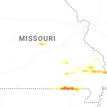


Connect with Interactive Hail Maps