

Hail Map for Caliente, NV
The Caliente, NV area has had 0 reports of on-the-ground hail by trained spotters, and has been under severe weather warnings 0 times during the past 12 months. Doppler radar has detected hail at or near Caliente, NV on 10 occasions.
| Name: | Caliente, NV |
| Where Located: | 62.2 miles WNW of Saint George, UT |
| Map: | Google Map for Caliente, NV |
| Population: | 1130 |
| Housing Units: | 530 |
| More Info: | Search Google for Caliente, NV |
0
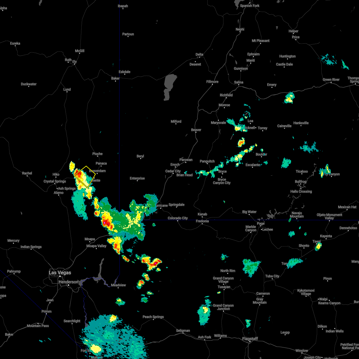
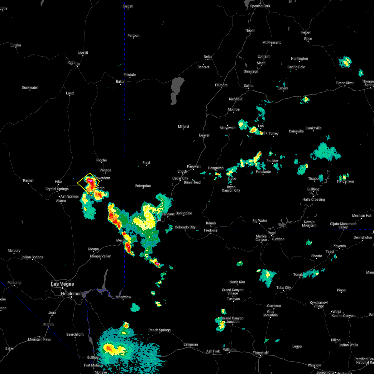
The Top Recent Hail Date for Caliente, NV is Thursday, August 8, 2024 (10th out of 10)

Hail and Wind Damage Spotted near Caliente, NV
| Date / Time | Report Details |
|---|---|
| 8/22/2022 4:41 PM PDT | The kane springs raws site gusted to 76 mph at approximately 441p in lincoln county NV, 26.9 miles NNE of Caliente, NV |
| 8/10/2022 3:15 PM PDT | Kane springs raws site measured a gust of 58 mph. time estimated using rada in lincoln county NV, 26.9 miles NNE of Caliente, NV |
| 7/28/2022 4:42 PM PDT |
 The severe thunderstorm warning for east central lincoln county will expire at 445 pm pdt, the storm which prompted the warning has weakened below severe limits, and has exited the warned area. therefore, the warning will be allowed to expire. however heavy rain is still possible with this thunderstorm. The severe thunderstorm warning for east central lincoln county will expire at 445 pm pdt, the storm which prompted the warning has weakened below severe limits, and has exited the warned area. therefore, the warning will be allowed to expire. however heavy rain is still possible with this thunderstorm.
|
| 7/28/2022 4:32 PM PDT |
 At 432 pm pdt, a severe thunderstorm was located near cabin pines campground, or 7 miles south of caliente, moving southwest at 30 mph (radar indicated). Hazards include 60 mph wind gusts and quarter size hail. Hail damage to vehicles is expected. expect wind damage to roofs and trees. locations impacted include, caliente, panaca and kershaw-ryan campground. hail threat, radar indicated max hail size, 1. 00 in wind threat, radar indicated max wind gust, 60 mph. At 432 pm pdt, a severe thunderstorm was located near cabin pines campground, or 7 miles south of caliente, moving southwest at 30 mph (radar indicated). Hazards include 60 mph wind gusts and quarter size hail. Hail damage to vehicles is expected. expect wind damage to roofs and trees. locations impacted include, caliente, panaca and kershaw-ryan campground. hail threat, radar indicated max hail size, 1. 00 in wind threat, radar indicated max wind gust, 60 mph.
|
| 7/28/2022 4:00 PM PDT |
 At 400 pm pdt, a severe thunderstorm was located near panaca, or 10 miles northeast of caliente, moving southwest at 30 mph (radar indicated). Hazards include 60 mph wind gusts and quarter size hail. Hail damage to vehicles is expected. Expect wind damage to roofs and trees. At 400 pm pdt, a severe thunderstorm was located near panaca, or 10 miles northeast of caliente, moving southwest at 30 mph (radar indicated). Hazards include 60 mph wind gusts and quarter size hail. Hail damage to vehicles is expected. Expect wind damage to roofs and trees.
|
| 7/25/2021 6:42 PM PDT |
 The severe thunderstorm warning for central lincoln county will expire at 645 pm pdt, the storm which prompted the warning has weakened below severe limits, and no longer poses an immediate threat to life or property. therefore, the warning will be allowed to expire. The severe thunderstorm warning for central lincoln county will expire at 645 pm pdt, the storm which prompted the warning has weakened below severe limits, and no longer poses an immediate threat to life or property. therefore, the warning will be allowed to expire.
|
| 7/25/2021 6:33 PM PDT |
 At 632 pm pdt, a severe thunderstorm was located 8 miles west of caliente, and is moving slowly southwest (radar indicated). Hazards include 60 mph wind gusts and quarter size hail. Hail damage to vehicles is expected. expect wind damage to roofs and trees. Locations impacted include, caliente. At 632 pm pdt, a severe thunderstorm was located 8 miles west of caliente, and is moving slowly southwest (radar indicated). Hazards include 60 mph wind gusts and quarter size hail. Hail damage to vehicles is expected. expect wind damage to roofs and trees. Locations impacted include, caliente.
|
| 7/25/2021 6:06 PM PDT |
 At 605 pm pdt, a severe thunderstorm was located 7 miles northwest of caliente, and is moving slowly southwest (radar indicated). Hazards include 60 mph wind gusts and quarter size hail. Hail damage to vehicles is expected. Expect wind damage to roofs and trees. At 605 pm pdt, a severe thunderstorm was located 7 miles northwest of caliente, and is moving slowly southwest (radar indicated). Hazards include 60 mph wind gusts and quarter size hail. Hail damage to vehicles is expected. Expect wind damage to roofs and trees.
|
| 7/23/2021 6:41 PM PDT | 75mph gust reported at the kane springs raws sit in lincoln county NV, 26.9 miles NNE of Caliente, NV |
| 7/12/2021 9:41 PM PDT | Corrects previous tstm wnd gst report from 12 sw elgin to include a higher peak wind gust. thunderstorm related wind gust measured in southern lincoln county at kane sp in lincoln county NV, 26.9 miles NNE of Caliente, NV |
| 7/11/2021 7:50 PM PDT | Storm damage reported in lincoln county NV, 26.9 miles NNE of Caliente, NV |
| 6/29/2021 6:41 PM PDT | 64 mph wind gust at knsn2 (raws) sit in lincoln county NV, 26.9 miles NNE of Caliente, NV |
| 8/8/2019 9:51 PM PDT |
 The severe thunderstorm warning for southeastern lincoln county will expire at 1000 pm pdt, the storm which prompted the warning has weakened below severe limits, and no longer poses an immediate threat to life or property. therefore, the warning will be allowed to expire. however gusty winds are still possible with this thunderstorm as it continues to move off to the northeast toward panaca. The severe thunderstorm warning for southeastern lincoln county will expire at 1000 pm pdt, the storm which prompted the warning has weakened below severe limits, and no longer poses an immediate threat to life or property. therefore, the warning will be allowed to expire. however gusty winds are still possible with this thunderstorm as it continues to move off to the northeast toward panaca.
|
| 8/8/2019 9:09 PM PDT |
 At 908 pm pdt, a severe thunderstorm was located 11 miles southwest of cabin pines campground, or 18 miles south of caliente, moving northeast at 20 mph (raws station). Hazards include 60 mph wind gusts. expect damage to roofs and trees At 908 pm pdt, a severe thunderstorm was located 11 miles southwest of cabin pines campground, or 18 miles south of caliente, moving northeast at 20 mph (raws station). Hazards include 60 mph wind gusts. expect damage to roofs and trees
|
| 8/8/2019 8:41 PM PDT | Storm damage reported in lincoln county NV, 26.9 miles NNE of Caliente, NV |
| 7/19/2018 7:16 PM PDT | Kane springs raws recorded a wind gust of 67 mph. time is estimated by rada in lincoln county NV, 26.9 miles NNE of Caliente, NV |
| 8/6/2017 10:41 PM PDT | Storm damage reported in lincoln county NV, 26.9 miles NNE of Caliente, NV |
| 8/1/2016 5:10 PM PDT |
 At 510 pm pdt, doppler radar indicated a severe thunderstorm capable of producing quarter size hail and damaging winds in excess of 60 mph. this storm was located near cabin pines campground, or 8 miles southeast of caliente, moving southwest at 20 mph. locations impacted include, caliente, beaver dam, kershaw-ryan campground, cabin pines campground, panaca, beaver dam state park and cathedral gorge state park. At 510 pm pdt, doppler radar indicated a severe thunderstorm capable of producing quarter size hail and damaging winds in excess of 60 mph. this storm was located near cabin pines campground, or 8 miles southeast of caliente, moving southwest at 20 mph. locations impacted include, caliente, beaver dam, kershaw-ryan campground, cabin pines campground, panaca, beaver dam state park and cathedral gorge state park.
|
| 8/1/2016 4:43 PM PDT |
 At 442 pm pdt, doppler radar indicated a severe thunderstorm capable of producing quarter size hail and damaging winds in excess of 60 mph. this storm was located 10 miles southeast of panaca, or 13 miles east of caliente, and moving southwest at 20 mph. At 442 pm pdt, doppler radar indicated a severe thunderstorm capable of producing quarter size hail and damaging winds in excess of 60 mph. this storm was located 10 miles southeast of panaca, or 13 miles east of caliente, and moving southwest at 20 mph.
|
| 10/18/2015 1:01 PM PDT |
 At 100 pm pdt, doppler radar continued to indicate a severe thunderstorm capable of producing quarter size hail and destructive winds in excess of 70 mph. this storm was located near cabin pines campground, or 7 miles south of caliente, moving northeast at 35 mph. locations impacted include, caliente, panaca, kershaw-ryan campground, cathedral gorge state park and cabin pines campground. At 100 pm pdt, doppler radar continued to indicate a severe thunderstorm capable of producing quarter size hail and destructive winds in excess of 70 mph. this storm was located near cabin pines campground, or 7 miles south of caliente, moving northeast at 35 mph. locations impacted include, caliente, panaca, kershaw-ryan campground, cathedral gorge state park and cabin pines campground.
|
| 10/18/2015 12:39 PM PDT |
 At 1239 pm pdt, doppler radar indicated a severe thunderstorm capable of producing quarter size hail and destructive winds in excess of 70 mph. this storm was located 14 miles southwest of cabin pines campground, or 18 miles southwest of caliente, and moving northeast at 30 mph. At 1239 pm pdt, doppler radar indicated a severe thunderstorm capable of producing quarter size hail and destructive winds in excess of 70 mph. this storm was located 14 miles southwest of cabin pines campground, or 18 miles southwest of caliente, and moving northeast at 30 mph.
|
| 10/18/2015 11:24 AM PDT |
 The severe thunderstorm warning for east central lincoln county will expire at 1130 am pdt, the storm which prompted the warning has weakened below severe limits, and no longer poses an immediate threat to life or property. therefore the warning will be allowed to expire. however gusty winds and heavy rain are still possible with this thunderstorm as it continues to move northeastward along us-93 toward panaca. The severe thunderstorm warning for east central lincoln county will expire at 1130 am pdt, the storm which prompted the warning has weakened below severe limits, and no longer poses an immediate threat to life or property. therefore the warning will be allowed to expire. however gusty winds and heavy rain are still possible with this thunderstorm as it continues to move northeastward along us-93 toward panaca.
|
| 10/18/2015 11:05 AM PDT |
 At 1105 am pdt, doppler radar continued to indicate a severe thunderstorm capable of producing quarter size hail and destructive winds in excess of 70 mph. this storm was located near caliente, moving northeast at 35 mph. locations impacted include, caliente, panaca, kershaw-ryan campground, cathedral gorge state park and cabin pines campground. At 1105 am pdt, doppler radar continued to indicate a severe thunderstorm capable of producing quarter size hail and destructive winds in excess of 70 mph. this storm was located near caliente, moving northeast at 35 mph. locations impacted include, caliente, panaca, kershaw-ryan campground, cathedral gorge state park and cabin pines campground.
|
| 10/18/2015 10:42 AM PDT |
 At 1042 am pdt, doppler radar indicated a severe thunderstorm capable of producing quarter size hail and destructive winds in excess of 70 mph. this storm was located 9 miles west of cabin pines campground, or 11 miles southwest of caliente, and moving northeast at 35 mph. At 1042 am pdt, doppler radar indicated a severe thunderstorm capable of producing quarter size hail and destructive winds in excess of 70 mph. this storm was located 9 miles west of cabin pines campground, or 11 miles southwest of caliente, and moving northeast at 35 mph.
|
| 7/1/2015 5:25 PM PDT |
 The severe thunderstorm warning for east central lincoln county will expire at 530 pm pdt, the storms which prompted the warning have weakened below severe limits, and no longer poses an immediate threat to life or property. therefore the warning will be allowed to expire. The severe thunderstorm warning for east central lincoln county will expire at 530 pm pdt, the storms which prompted the warning have weakened below severe limits, and no longer poses an immediate threat to life or property. therefore the warning will be allowed to expire.
|
| 7/1/2015 5:18 PM PDT |
 At 516 pm pdt, storms located near caliente have weakened but remain capable of producing damaging outflow winds to 60 mph. locations impacted include, caliente, panaca, kershaw-ryan campground, cathedral gorge state park and cabin pines campground. At 516 pm pdt, storms located near caliente have weakened but remain capable of producing damaging outflow winds to 60 mph. locations impacted include, caliente, panaca, kershaw-ryan campground, cathedral gorge state park and cabin pines campground.
|
| 7/1/2015 4:59 PM PDT |
 At 459 pm pdt, doppler radar indicated a line of severe thunderstorms capable of producing quarter size hail and damaging winds in excess of 60 mph. these storms were located along a line extending from 6 miles west of kershaw-ryan campground to 10 miles east of caliente, and moving north at 10 mph. At 459 pm pdt, doppler radar indicated a line of severe thunderstorms capable of producing quarter size hail and damaging winds in excess of 60 mph. these storms were located along a line extending from 6 miles west of kershaw-ryan campground to 10 miles east of caliente, and moving north at 10 mph.
|
| 7/1/2015 4:47 PM PDT |
 At 446 pm pdt, doppler radar continued to indicate a severe thunderstorm capable of producing quarter size hail and damaging winds in excess of 60 mph. this storm was located 10 miles northwest of beaver dam state park, or 12 miles northwest of beaver dam, moving southwest at 15 mph. locations impacted include, caliente, beaver dam, beaver dam state park, kershaw-ryan campground and cabin pines campground. At 446 pm pdt, doppler radar continued to indicate a severe thunderstorm capable of producing quarter size hail and damaging winds in excess of 60 mph. this storm was located 10 miles northwest of beaver dam state park, or 12 miles northwest of beaver dam, moving southwest at 15 mph. locations impacted include, caliente, beaver dam, beaver dam state park, kershaw-ryan campground and cabin pines campground.
|
| 7/1/2015 4:25 PM PDT |
 At 424 pm pdt, doppler radar indicated a severe thunderstorm capable of producing quarter size hail and damaging winds in excess of 60 mph. this storm was located 9 miles northwest of beaver dam state park, or 10 miles northwest of beaver dam, and moving southwest at 15 mph. At 424 pm pdt, doppler radar indicated a severe thunderstorm capable of producing quarter size hail and damaging winds in excess of 60 mph. this storm was located 9 miles northwest of beaver dam state park, or 10 miles northwest of beaver dam, and moving southwest at 15 mph.
|
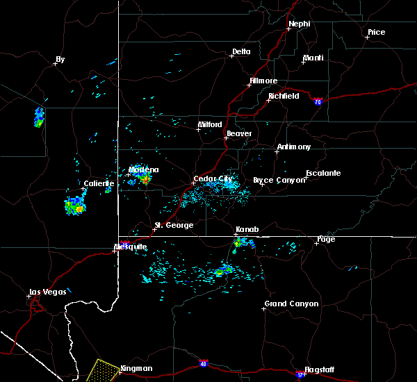
Hail Maps for Caliente, NV


Connect with Interactive Hail Maps