

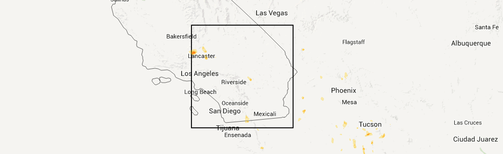
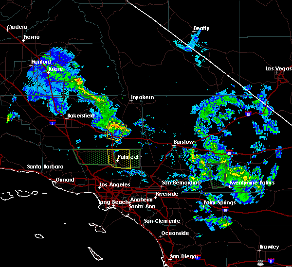
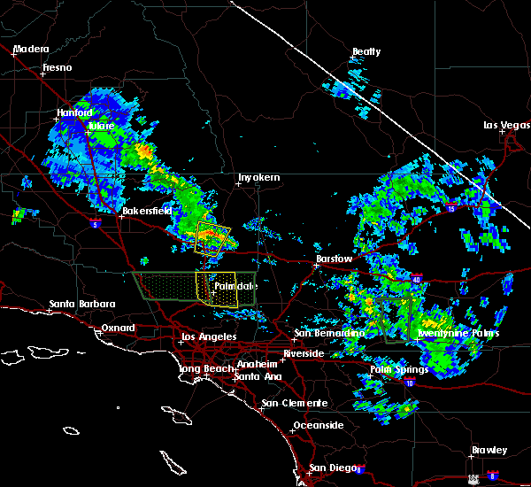
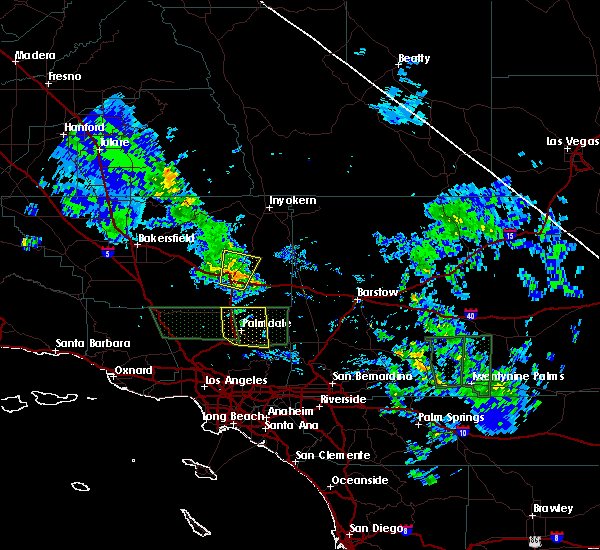
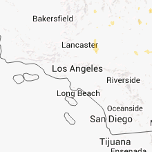
Hail Map for California City, CA
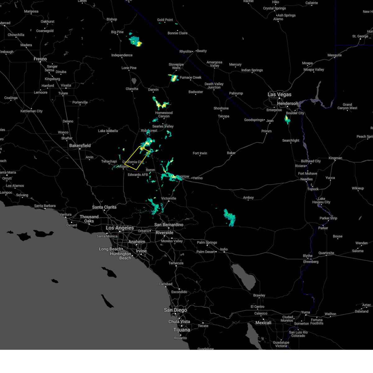
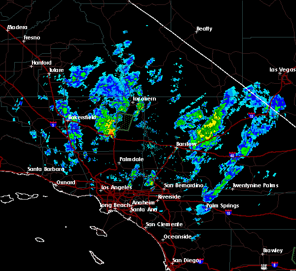
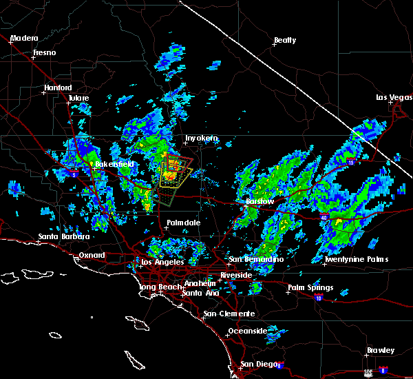
The California City, CA area has had 0 reports of on-the-ground hail by trained spotters, and has been under severe weather warnings 1 time during the past 12 months. Doppler radar has detected hail at or near California City, CA on 4 occasions.
| Name: | California City, CA |
| Where Located: | 66.8 miles ESE of Bakersfield, CA |
| Map: | Google Map for California City, CA |
| Population: | 14120 |
| Housing Units: | 5210 |
| More Info: | Search Google for California City, CA |
5
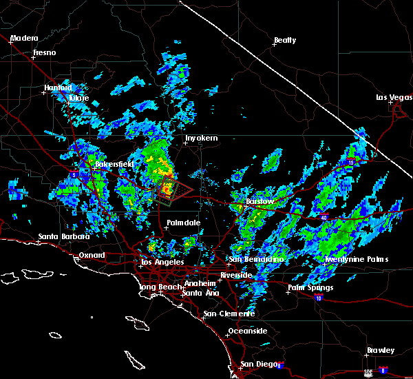
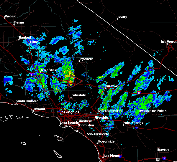
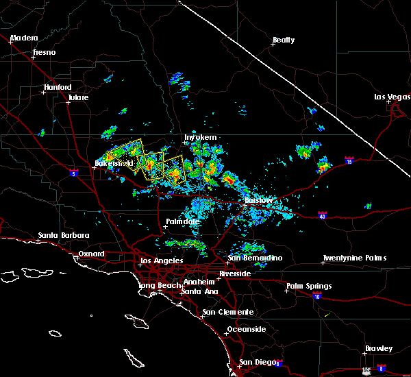
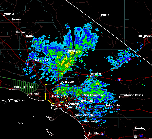
The Top Recent Hail Date for California City, CA is Tuesday, July 5, 2011 (1st out of 4)
Hail and Wind Damage Spotted near California City, CA
| Date / Time | Report Details |
|---|---|
| 5/21/2023 7:53 PM PDT |
 At 752 pm pdt, a severe thunderstorm was located about 9 miles north of california city, moving to the southwest at around 30 mph (radar indicated). Hazards include 60 mph wind gusts and quarter size hail. expect wind damage to roofs, siding, and trees At 752 pm pdt, a severe thunderstorm was located about 9 miles north of california city, moving to the southwest at around 30 mph (radar indicated). Hazards include 60 mph wind gusts and quarter size hail. expect wind damage to roofs, siding, and trees
|
| 3/10/2020 8:17 PM PDT |
 At 816 pm pdt, a severe thunderstorm was located 14 miles east of tehachapi, or 34 miles north of lancaster, moving north at 15 mph (radar indicated). Hazards include 60 mph wind gusts. Expect damage to roofs, siding, and trees. Locations impacted include, jawbone canyon. At 816 pm pdt, a severe thunderstorm was located 14 miles east of tehachapi, or 34 miles north of lancaster, moving north at 15 mph (radar indicated). Hazards include 60 mph wind gusts. Expect damage to roofs, siding, and trees. Locations impacted include, jawbone canyon.
|
| 3/10/2020 7:58 PM PDT |
 At 757 pm pdt, a severe thunderstorm was located 13 miles east of tehachapi, or 29 miles north of lancaster, moving north at 15 mph (radar indicated). Hazards include 60 mph wind gusts. expect damage to roofs, siding, and trees At 757 pm pdt, a severe thunderstorm was located 13 miles east of tehachapi, or 29 miles north of lancaster, moving north at 15 mph (radar indicated). Hazards include 60 mph wind gusts. expect damage to roofs, siding, and trees
|
| 3/10/2020 6:49 PM PDT |
 At 649 pm pdt, a severe thunderstorm capable of producing a tornado was located 10 miles west of california city, or 34 miles southwest of ridgecrest, moving northeast at 15 mph (radar indicated rotation). Hazards include tornado. Flying debris will be dangerous to those caught without shelter. mobile homes will be damaged or destroyed. damage to roofs, windows, and vehicles will occur. tree damage is likely. This tornadic thunderstorm will remain over mainly rural areas of east central kern county. At 649 pm pdt, a severe thunderstorm capable of producing a tornado was located 10 miles west of california city, or 34 miles southwest of ridgecrest, moving northeast at 15 mph (radar indicated rotation). Hazards include tornado. Flying debris will be dangerous to those caught without shelter. mobile homes will be damaged or destroyed. damage to roofs, windows, and vehicles will occur. tree damage is likely. This tornadic thunderstorm will remain over mainly rural areas of east central kern county.
|
| 3/10/2020 6:38 PM PDT |
 At 637 pm pdt, a severe thunderstorm was located 12 miles west of california city, or 35 miles southwest of ridgecrest, moving north at 25 mph (radar indicated). Hazards include 60 mph wind gusts. Expect damage to roofs, siding, and trees. This severe thunderstorm will remain over mainly rural areas of east central kern county. At 637 pm pdt, a severe thunderstorm was located 12 miles west of california city, or 35 miles southwest of ridgecrest, moving north at 25 mph (radar indicated). Hazards include 60 mph wind gusts. Expect damage to roofs, siding, and trees. This severe thunderstorm will remain over mainly rural areas of east central kern county.
|
| 3/10/2020 6:12 PM PDT |
 At 612 pm pdt, a severe thunderstorm was located 15 miles northwest of edwards afb, or 28 miles north of lancaster, moving north at 20 mph (radar indicated). Hazards include 60 mph wind gusts. expect damage to roofs, siding, and trees At 612 pm pdt, a severe thunderstorm was located 15 miles northwest of edwards afb, or 28 miles north of lancaster, moving north at 20 mph (radar indicated). Hazards include 60 mph wind gusts. expect damage to roofs, siding, and trees
|
| 3/10/2020 5:59 PM PDT |
 At 559 pm pdt, a severe thunderstorm capable of producing a tornado was located 10 miles northwest of edwards afb, or 24 miles north of lancaster, moving northeast at 20 mph (radar indicated rotation). Hazards include tornado. Flying debris will be dangerous to those caught without shelter. mobile homes will be damaged or destroyed. damage to roofs, windows, and vehicles will occur. tree damage is likely. Locations impacted include, mojave and north edwards. At 559 pm pdt, a severe thunderstorm capable of producing a tornado was located 10 miles northwest of edwards afb, or 24 miles north of lancaster, moving northeast at 20 mph (radar indicated rotation). Hazards include tornado. Flying debris will be dangerous to those caught without shelter. mobile homes will be damaged or destroyed. damage to roofs, windows, and vehicles will occur. tree damage is likely. Locations impacted include, mojave and north edwards.
|
| 3/10/2020 5:47 PM PDT |
 At 546 pm pdt, a severe thunderstorm capable of producing a tornado was located 10 miles northwest of edwards afb, or 20 miles north of lancaster, moving northeast at 25 mph (radar indicated rotation). Hazards include tornado. Flying debris will be dangerous to those caught without shelter. mobile homes will be damaged or destroyed. damage to roofs, windows, and vehicles will occur. tree damage is likely. This tornadic thunderstorm will remain over mainly rural areas of southeastern kern county, including the following locations, mojave and north edwards. At 546 pm pdt, a severe thunderstorm capable of producing a tornado was located 10 miles northwest of edwards afb, or 20 miles north of lancaster, moving northeast at 25 mph (radar indicated rotation). Hazards include tornado. Flying debris will be dangerous to those caught without shelter. mobile homes will be damaged or destroyed. damage to roofs, windows, and vehicles will occur. tree damage is likely. This tornadic thunderstorm will remain over mainly rural areas of southeastern kern county, including the following locations, mojave and north edwards.
|
| 8/9/2018 5:44 PM PDT |
 At 544 pm pdt, a severe thunderstorm was located 11 miles northeast of edwards afb, or 29 miles north of lake los angeles, moving northwest at 15 mph (radar indicated). Hazards include 60 mph wind gusts and nickel size hail. expect damage to roofs, siding, and trees At 544 pm pdt, a severe thunderstorm was located 11 miles northeast of edwards afb, or 29 miles north of lake los angeles, moving northwest at 15 mph (radar indicated). Hazards include 60 mph wind gusts and nickel size hail. expect damage to roofs, siding, and trees
|
| 9/11/2017 3:58 PM PDT |
 At 357 pm pdt, a severe thunderstorm was located near california city, or 16 miles southwest of government peak, moving northwest at 25 mph (radar indicated). Hazards include 60 mph wind gusts and quarter size hail. Hail damage to vehicles is expected. expect wind damage to roofs, siding, and trees. This severe thunderstorm will remain over mainly rural areas of east central kern county. At 357 pm pdt, a severe thunderstorm was located near california city, or 16 miles southwest of government peak, moving northwest at 25 mph (radar indicated). Hazards include 60 mph wind gusts and quarter size hail. Hail damage to vehicles is expected. expect wind damage to roofs, siding, and trees. This severe thunderstorm will remain over mainly rural areas of east central kern county.
|
| 1/31/2016 1:53 PM PST |
 At 152 pm pst, doppler radar indicated a line of severe thunderstorms capable of producing damaging winds in excess of 60 mph. these storms were located along a line extending from near california city to 8 miles east of edwards afb, and moving east at 60 mph. At 152 pm pst, doppler radar indicated a line of severe thunderstorms capable of producing damaging winds in excess of 60 mph. these storms were located along a line extending from near california city to 8 miles east of edwards afb, and moving east at 60 mph.
|
| 1/31/2016 1:33 PM PST |
 At 132 pm pst, doppler radar indicated a severe thunderstorm capable of producing damaging winds in excess of 60 mph. this storm was located near randsburg, or 14 miles south of ridgecrest, and moving northeast at 45 mph. At 132 pm pst, doppler radar indicated a severe thunderstorm capable of producing damaging winds in excess of 60 mph. this storm was located near randsburg, or 14 miles south of ridgecrest, and moving northeast at 45 mph.
|
| 10/15/2015 6:40 PM PDT |
 The severe thunderstorm warning for southeastern kern county will expire at 645 pm pdt, the storm which prompted the warning has weakened below severe limits, and no longer poses an immediate threat to life or property. therefore the warning will be allowed to expire. however gusty winds are still possible with this thunderstorm. The severe thunderstorm warning for southeastern kern county will expire at 645 pm pdt, the storm which prompted the warning has weakened below severe limits, and no longer poses an immediate threat to life or property. therefore the warning will be allowed to expire. however gusty winds are still possible with this thunderstorm.
|
| 10/15/2015 6:29 PM PDT |
 At 624 pm pdt, doppler radar indicated a severe thunderstorm capable of producing damaging winds in excess of 60 mph. this storm was located 17 miles east of tehachapi, or 29 miles north of lancaster, moving north at 15 mph. this severe thunderstorm will continue to track northward along the highway 14 corridor. At 624 pm pdt, doppler radar indicated a severe thunderstorm capable of producing damaging winds in excess of 60 mph. this storm was located 17 miles east of tehachapi, or 29 miles north of lancaster, moving north at 15 mph. this severe thunderstorm will continue to track northward along the highway 14 corridor.
|
| 10/15/2015 6:11 PM PDT |
 At 611 pm pdt, doppler radar indicated a severe thunderstorm capable of producing damaging winds in excess of 60 mph. this storm was located 14 miles north of rosamond, or 26 miles north of lancaster, and moving north at 20 mph. At 611 pm pdt, doppler radar indicated a severe thunderstorm capable of producing damaging winds in excess of 60 mph. this storm was located 14 miles north of rosamond, or 26 miles north of lancaster, and moving north at 20 mph.
|
Hail Maps for California City, CA


Connect with Interactive Hail Maps