

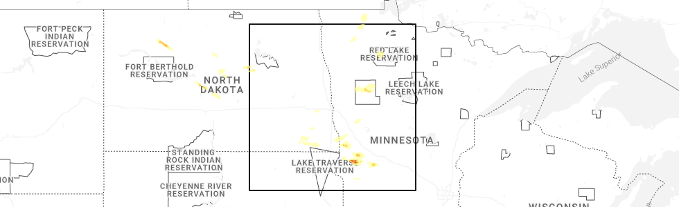
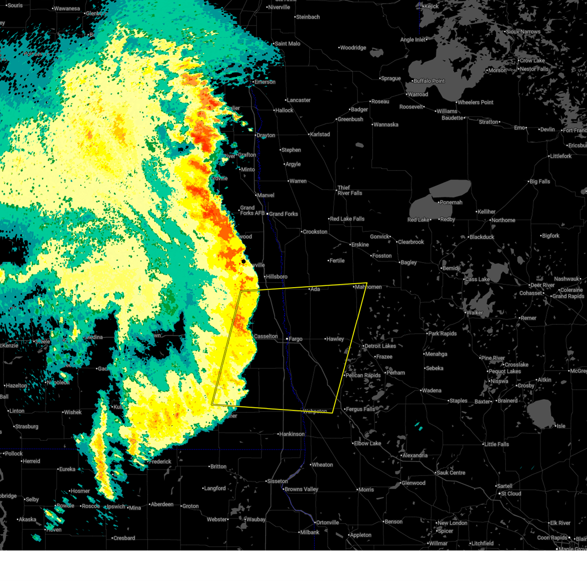
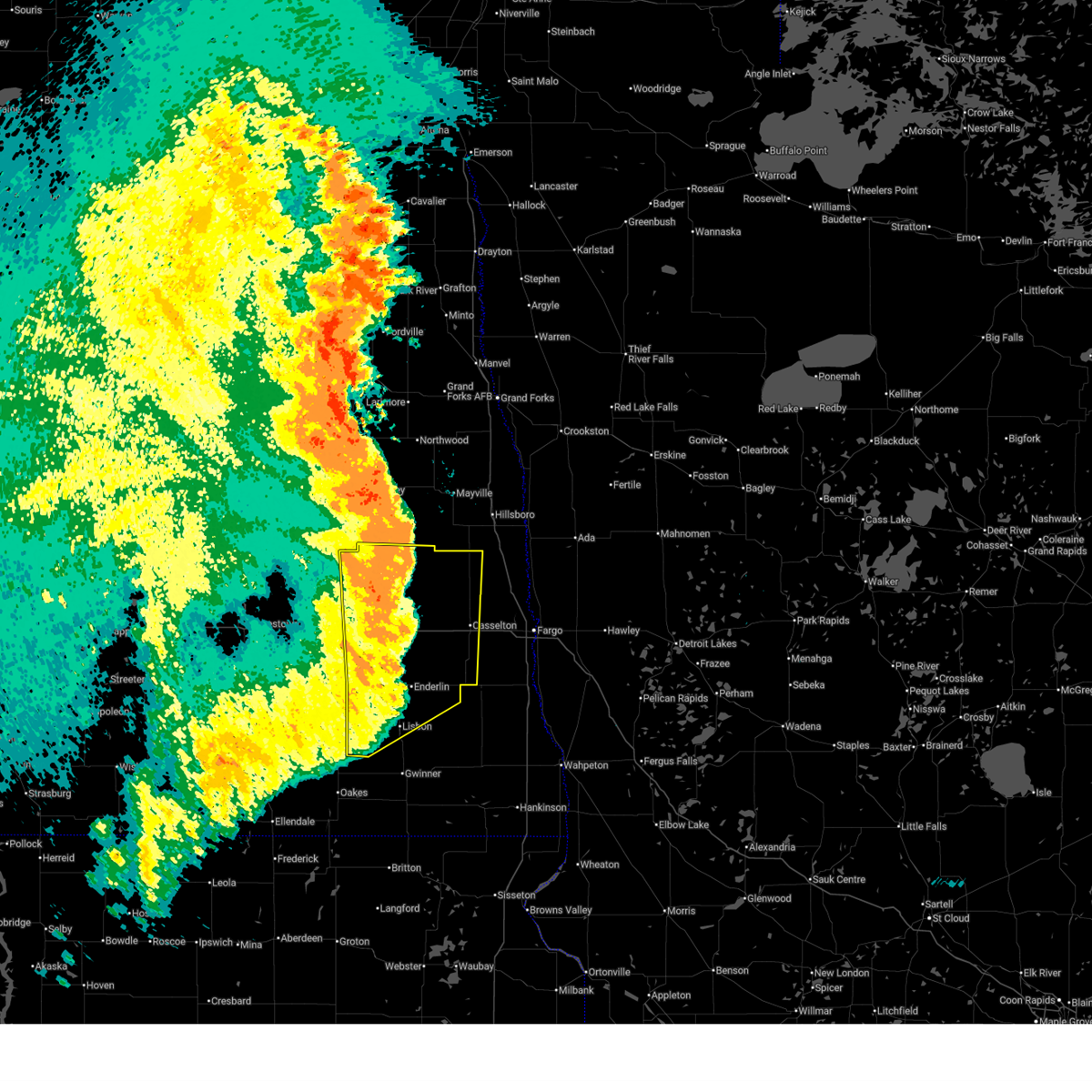
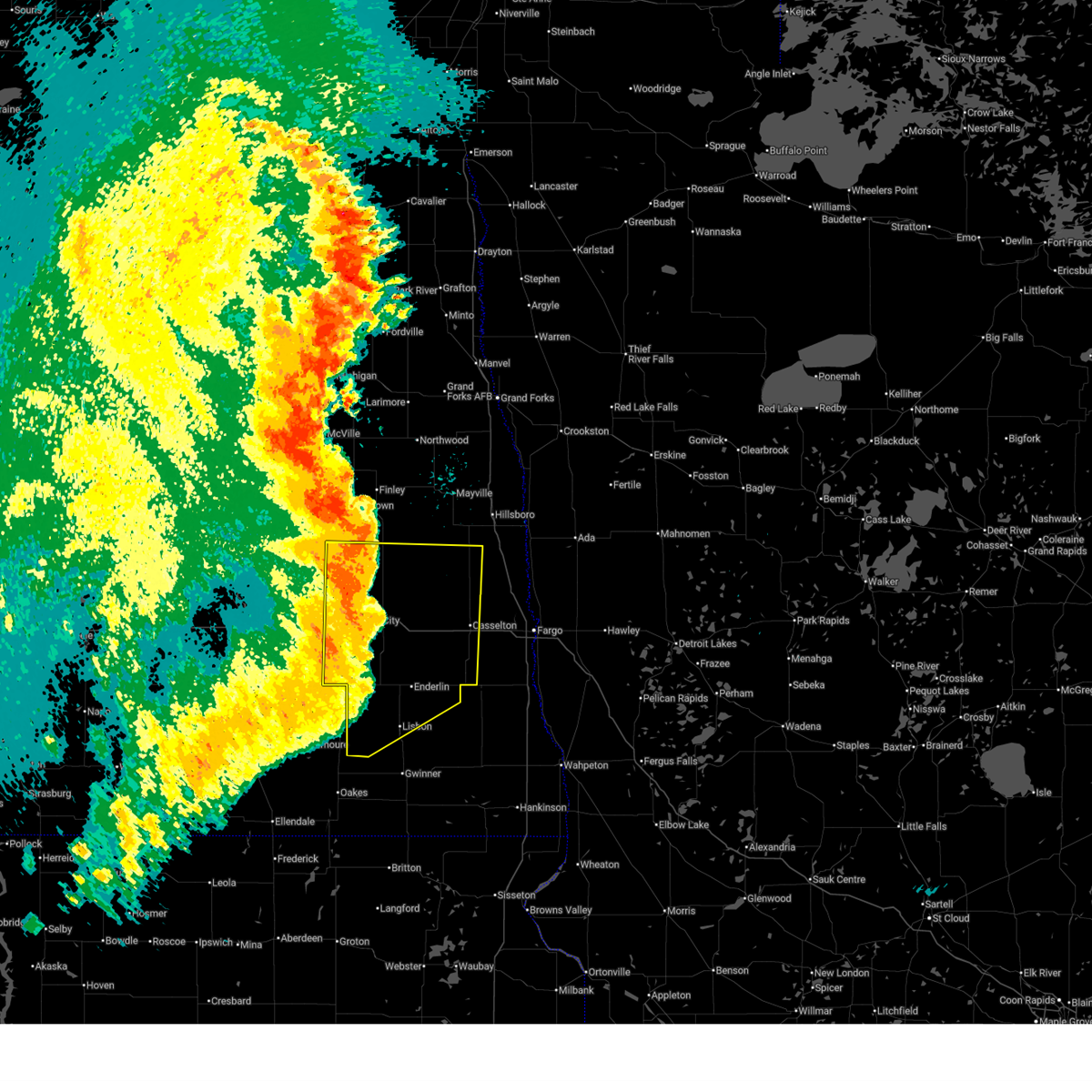
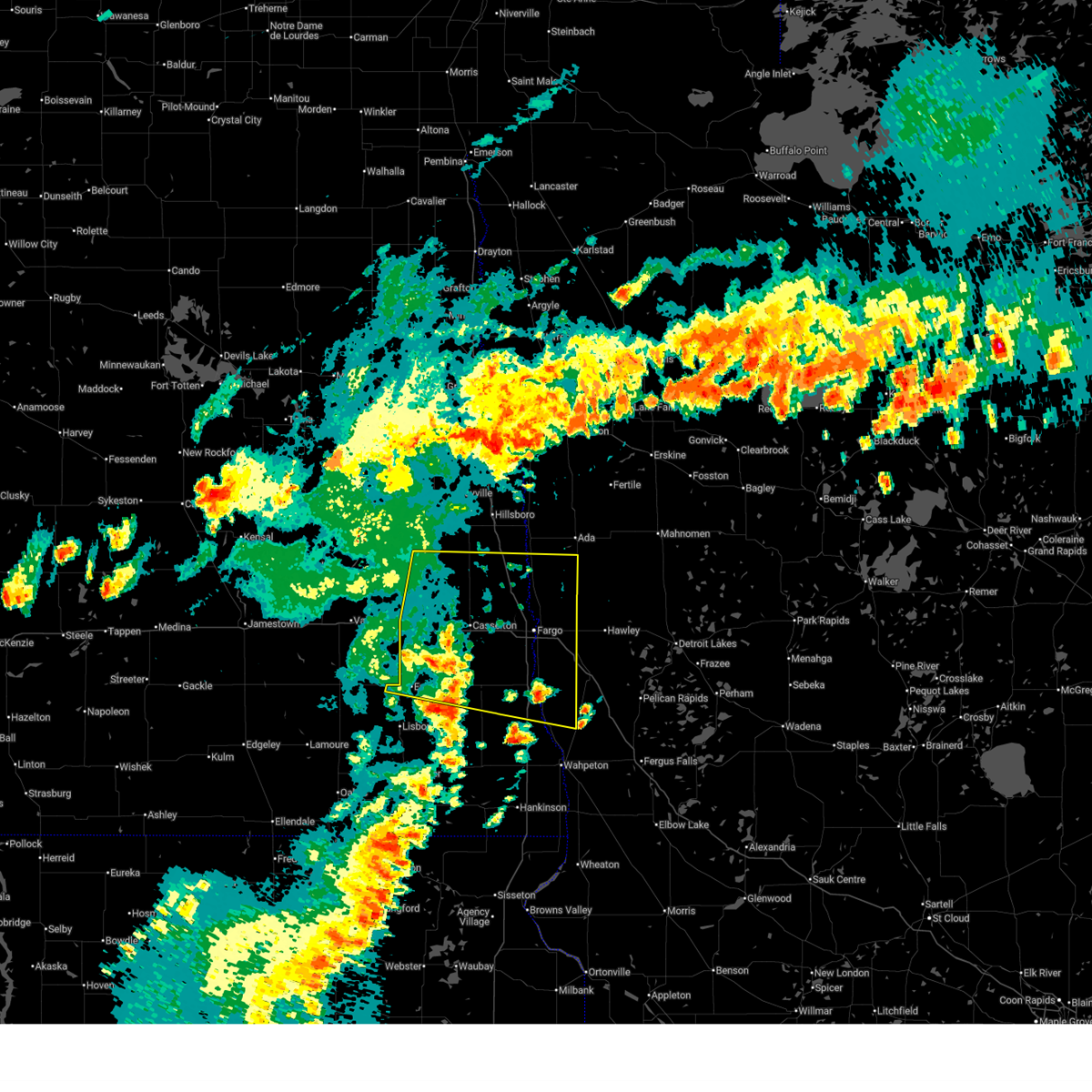
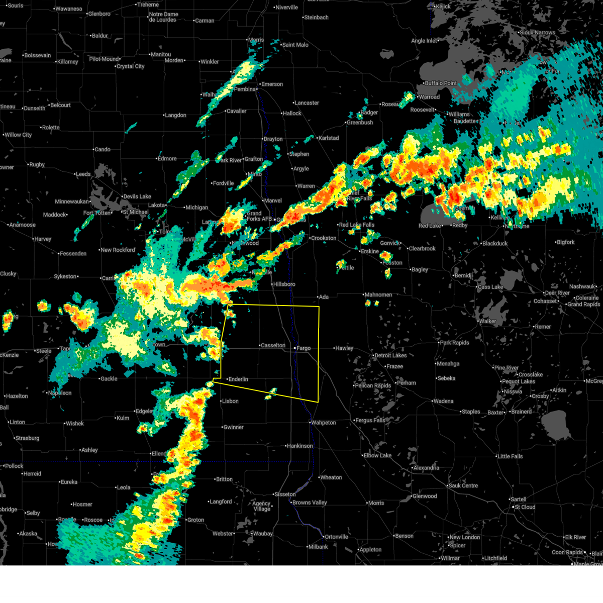
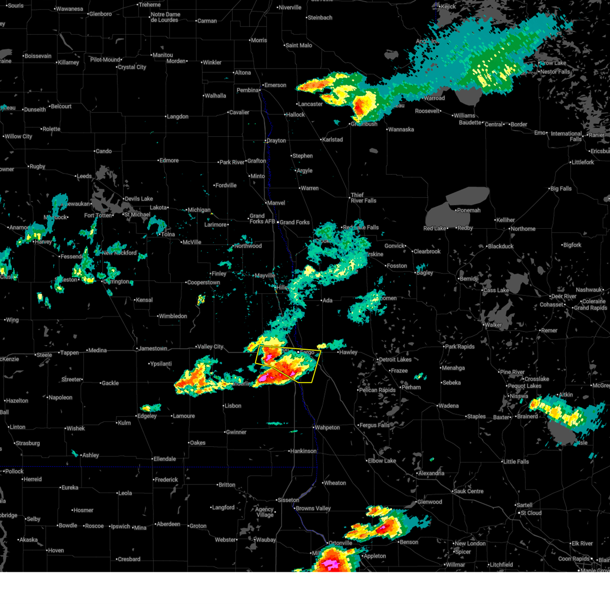
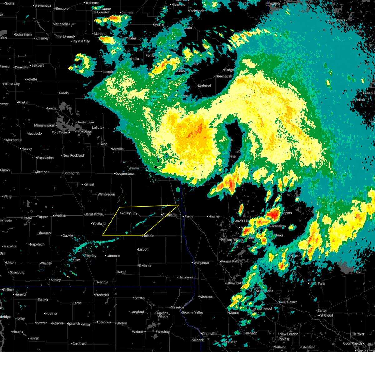
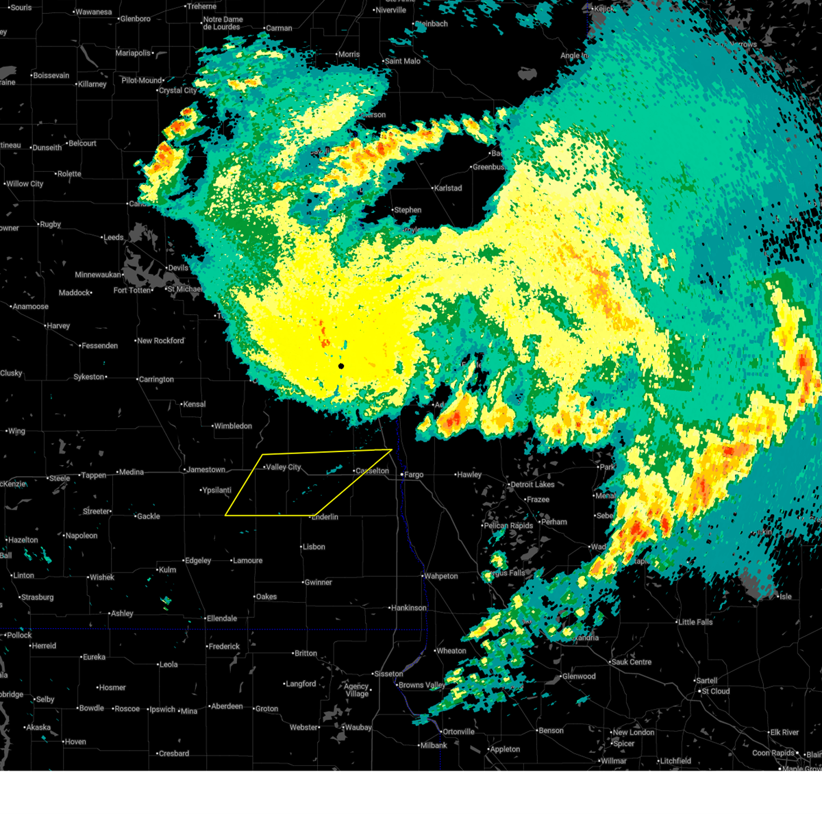
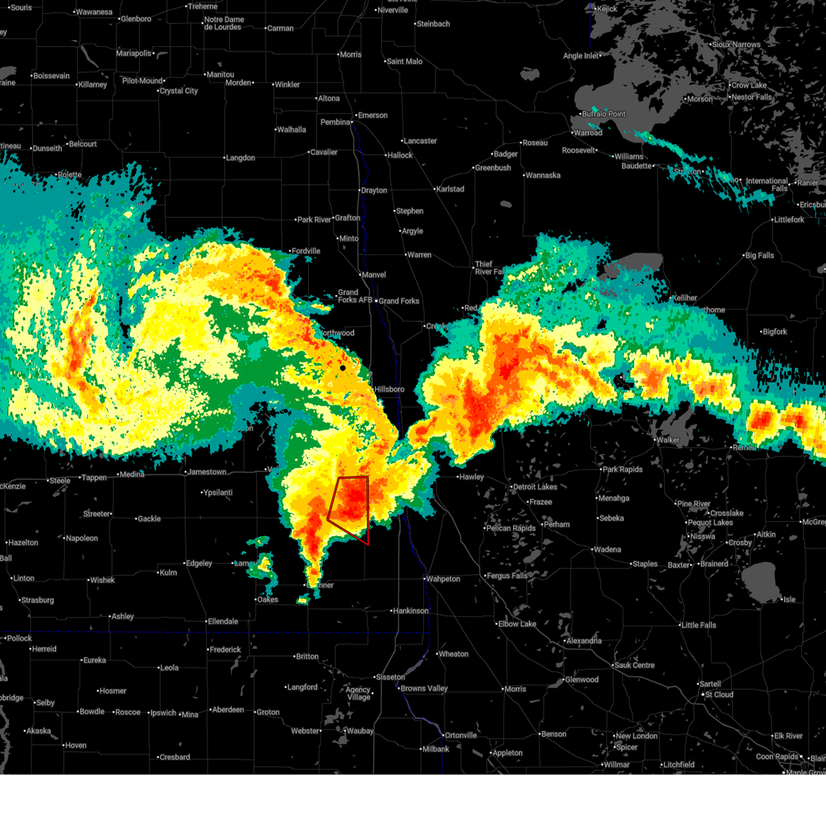
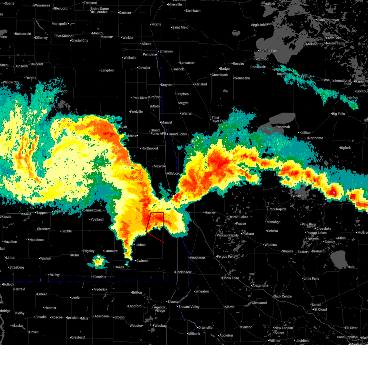
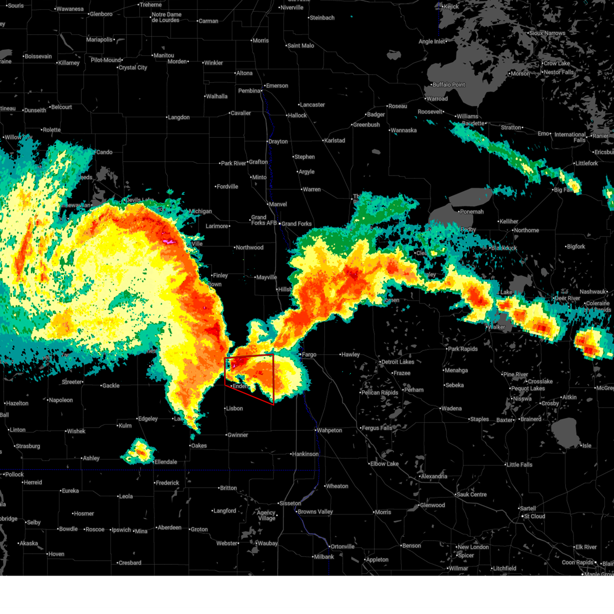
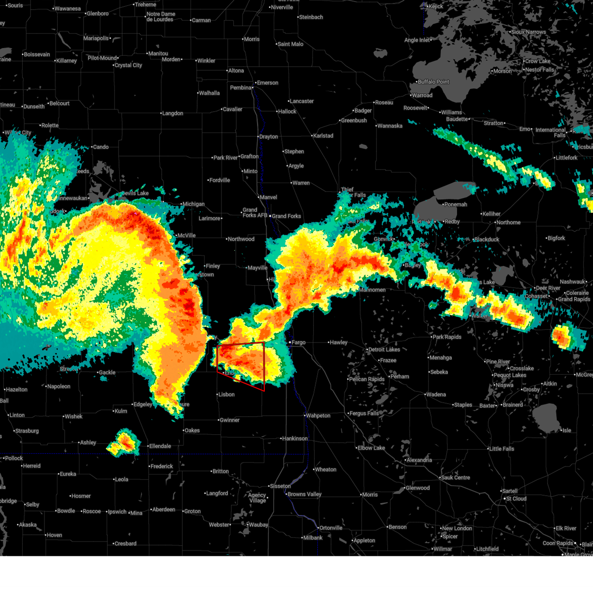
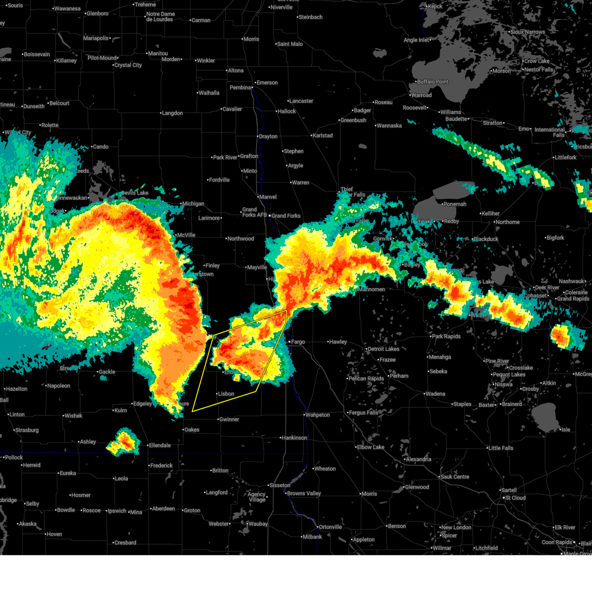
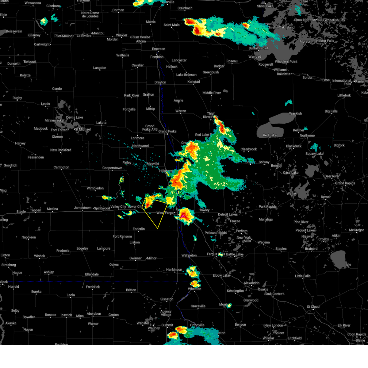
Hail Map for Casselton, ND
The Casselton, ND area has had 2 reports of on-the-ground hail by trained spotters, and has been under severe weather warnings 7 times during the past 12 months. Doppler radar has detected hail at or near Casselton, ND on 53 occasions, including 1 occasion during the past year.
| Name: | Casselton, ND |
| Where Located: | 20.4 miles W of Fargo, ND |
| Map: | Google Map for Casselton, ND |
| Population: | 2329 |
| Housing Units: | 926 |
| More Info: | Search Google for Casselton, ND |
0
The Top Recent Hail Date for Casselton, ND is Monday, August 11, 2025 (46th out of 53)
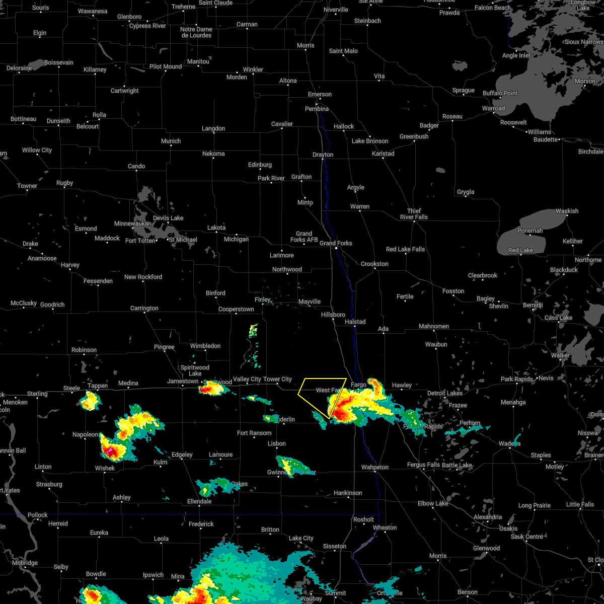
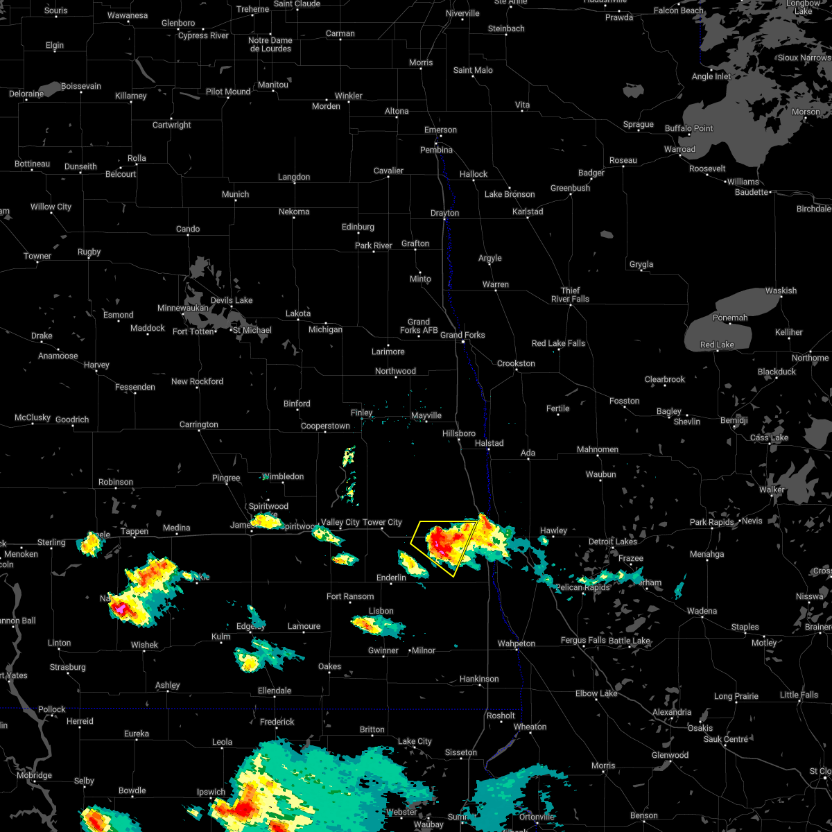
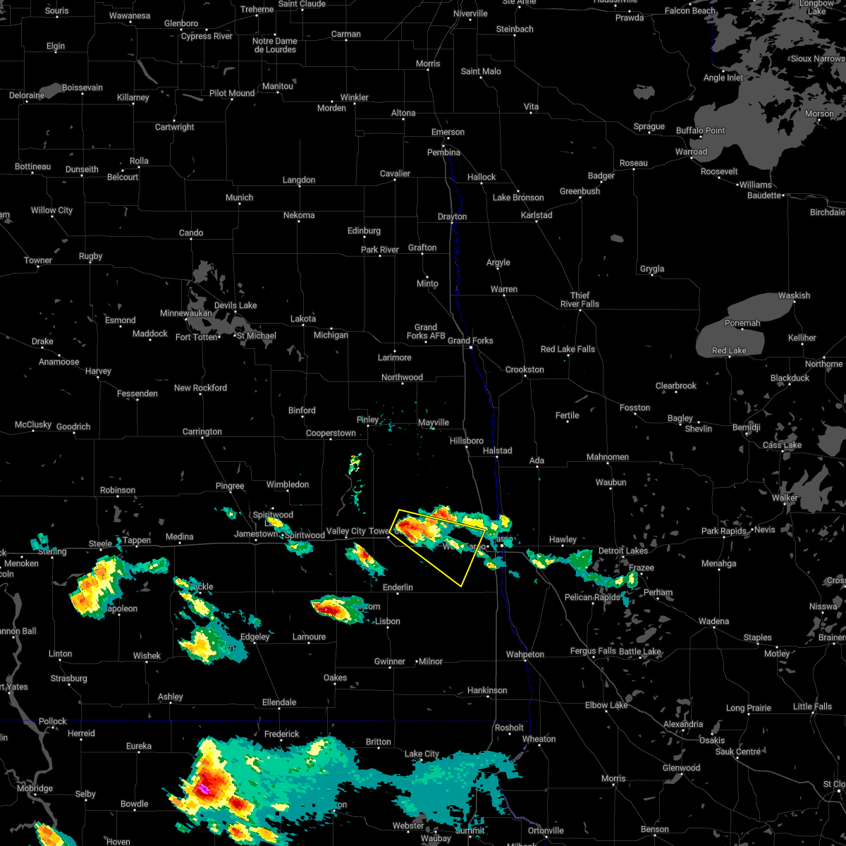
Hail and Wind Damage Spotted near Casselton, ND
| Date / Time | Report Details |
|---|---|
| 6/10/2026 1:56 AM CDT |
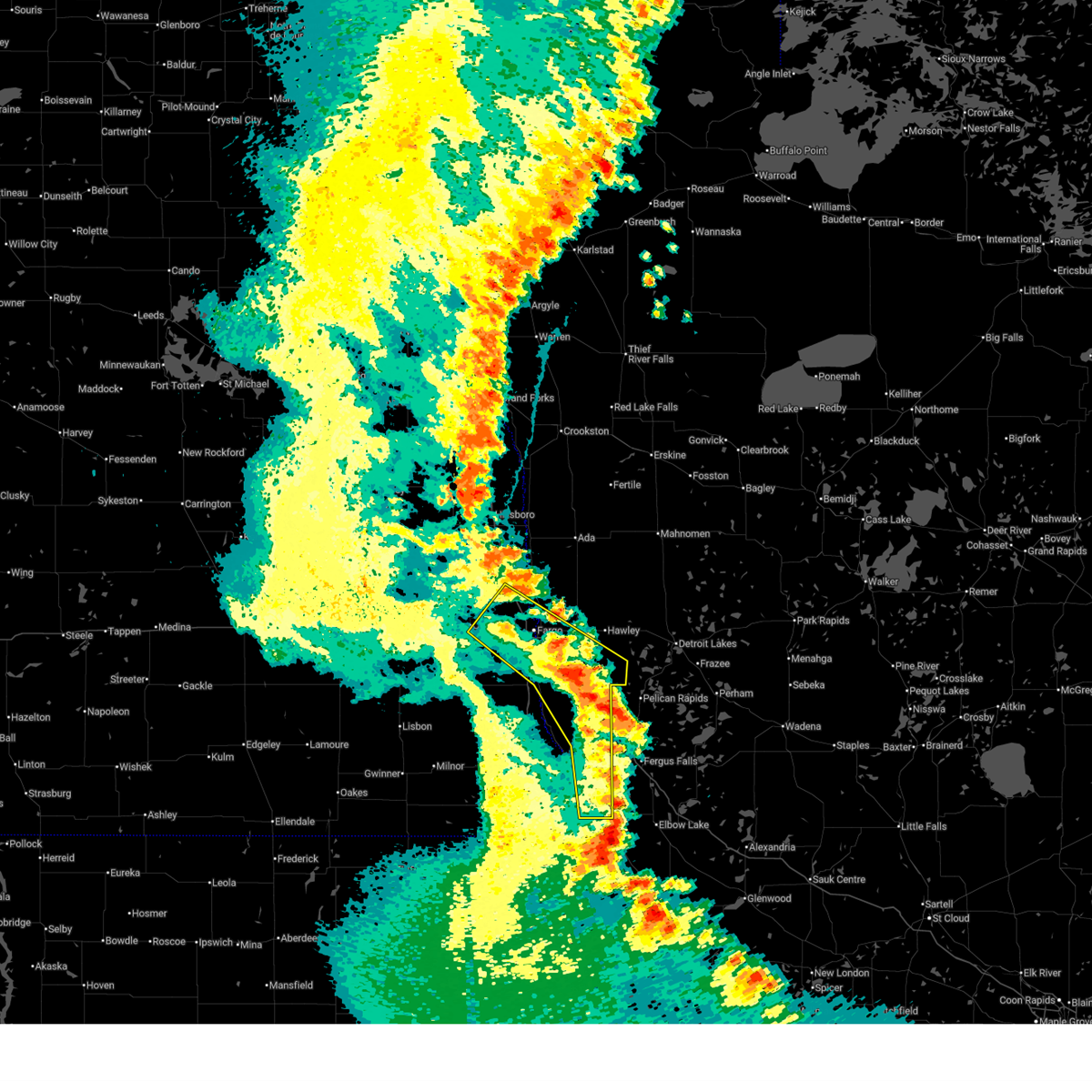 At 155 am cdt, severe thunderstorms were located along a line extending from near moorhead to near lawndale to near dalton, moving east at 45 mph (radar indicated). Hazards include 60 mph wind gusts and penny size hail. Expect damage to roofs, siding, and trees. Locations impacted include, fargo, moorhead, west fargo, dilworth, barnesville, horace, and casselton. At 155 am cdt, severe thunderstorms were located along a line extending from near moorhead to near lawndale to near dalton, moving east at 45 mph (radar indicated). Hazards include 60 mph wind gusts and penny size hail. Expect damage to roofs, siding, and trees. Locations impacted include, fargo, moorhead, west fargo, dilworth, barnesville, horace, and casselton.
|
| 6/10/2026 1:16 AM CDT |
 Svrfgf the national weather service in grand forks has issued a * severe thunderstorm warning for, southern clay county in northwestern minnesota, wilkin county in west central minnesota, southeastern cass county in southeastern north dakota, eastern richland county in southeastern north dakota, * until 215 am cdt. * at 114 am cdt, severe thunderstorms were located along a line extending from near leonard to colfax to fairmount, moving east at 45 mph (radar indicated. at 1:10 am, a 58 mph wind gust was reported at ekre north dakota). Hazards include 60 mph wind gusts and penny size hail. expect damage to roofs, siding, and trees Svrfgf the national weather service in grand forks has issued a * severe thunderstorm warning for, southern clay county in northwestern minnesota, wilkin county in west central minnesota, southeastern cass county in southeastern north dakota, eastern richland county in southeastern north dakota, * until 215 am cdt. * at 114 am cdt, severe thunderstorms were located along a line extending from near leonard to colfax to fairmount, moving east at 45 mph (radar indicated. at 1:10 am, a 58 mph wind gust was reported at ekre north dakota). Hazards include 60 mph wind gusts and penny size hail. expect damage to roofs, siding, and trees
|
| 8/8/2025 4:34 AM CDT |
 At 434 am cdt, severe thunderstorms were located along a line extending from near twin valley to near kent, moving east at 60 mph (radar indicated). Hazards include 70 mph wind gusts. Expect considerable tree damage. damage is likely to mobile homes, roofs, and outbuildings. Locations impacted include, fargo, wahpeton, moorhead, west fargo, dilworth, breckenridge, and barnesville. At 434 am cdt, severe thunderstorms were located along a line extending from near twin valley to near kent, moving east at 60 mph (radar indicated). Hazards include 70 mph wind gusts. Expect considerable tree damage. damage is likely to mobile homes, roofs, and outbuildings. Locations impacted include, fargo, wahpeton, moorhead, west fargo, dilworth, breckenridge, and barnesville.
|
| 8/8/2025 3:55 AM CDT | 10 meter wind sensor at the casselton ndaw in cass county ND, 5.5 miles SW of Casselton, ND |
| 8/8/2025 3:55 AM CDT |
 Svrfgf the national weather service in grand forks has issued a * severe thunderstorm warning for, clay county in northwestern minnesota, southern norman county in northwestern minnesota, northwestern otter tail county in west central minnesota, wilkin county in west central minnesota, southwestern mahnomen county in northwestern minnesota, western becker county in northwestern minnesota, eastern ransom county in southeastern north dakota, cass county in southeastern north dakota, southeastern traill county in southeastern north dakota, northern richland county in southeastern north dakota, * until 500 am cdt. * at 355 am cdt, severe thunderstorms were located along a line extending from near grandin to near venlo, moving east at 60 mph (mesonets). Hazards include 70 mph wind gusts. Expect considerable tree damage. Damage is likely to mobile homes, roofs, and outbuildings. Svrfgf the national weather service in grand forks has issued a * severe thunderstorm warning for, clay county in northwestern minnesota, southern norman county in northwestern minnesota, northwestern otter tail county in west central minnesota, wilkin county in west central minnesota, southwestern mahnomen county in northwestern minnesota, western becker county in northwestern minnesota, eastern ransom county in southeastern north dakota, cass county in southeastern north dakota, southeastern traill county in southeastern north dakota, northern richland county in southeastern north dakota, * until 500 am cdt. * at 355 am cdt, severe thunderstorms were located along a line extending from near grandin to near venlo, moving east at 60 mph (mesonets). Hazards include 70 mph wind gusts. Expect considerable tree damage. Damage is likely to mobile homes, roofs, and outbuildings.
|
| 8/8/2025 3:35 AM CDT |
 At 335 am cdt, severe thunderstorms were located along a line extending from near colgate to 6 miles southeast of nome to near la moure, moving east at 55 mph (radar indicated). Hazards include 70 mph wind gusts. Expect considerable tree damage. damage is likely to mobile homes, roofs, and outbuildings. Locations impacted include, valley city, casselton, lisbon, enderlin, arthur, hunter, and tower city. At 335 am cdt, severe thunderstorms were located along a line extending from near colgate to 6 miles southeast of nome to near la moure, moving east at 55 mph (radar indicated). Hazards include 70 mph wind gusts. Expect considerable tree damage. damage is likely to mobile homes, roofs, and outbuildings. Locations impacted include, valley city, casselton, lisbon, enderlin, arthur, hunter, and tower city.
|
| 8/8/2025 3:35 AM CDT |
 the severe thunderstorm warning has been cancelled and is no longer in effect the severe thunderstorm warning has been cancelled and is no longer in effect
|
| 8/8/2025 3:23 AM CDT |
 Svrfgf the national weather service in grand forks has issued a * severe thunderstorm warning for, ransom county in southeastern north dakota, cass county in southeastern north dakota, southwestern traill county in southeastern north dakota, southeastern griggs county in southeastern north dakota, barnes county in southeastern north dakota, southern steele county in southeastern north dakota, * until 400 am cdt. * at 323 am cdt, severe thunderstorms were located along a line extending from near luverne to near little yellowstone to near grand rapids, moving east at 55 mph (radar indicated). Hazards include 70 mph wind gusts. Expect considerable tree damage. Damage is likely to mobile homes, roofs, and outbuildings. Svrfgf the national weather service in grand forks has issued a * severe thunderstorm warning for, ransom county in southeastern north dakota, cass county in southeastern north dakota, southwestern traill county in southeastern north dakota, southeastern griggs county in southeastern north dakota, barnes county in southeastern north dakota, southern steele county in southeastern north dakota, * until 400 am cdt. * at 323 am cdt, severe thunderstorms were located along a line extending from near luverne to near little yellowstone to near grand rapids, moving east at 55 mph (radar indicated). Hazards include 70 mph wind gusts. Expect considerable tree damage. Damage is likely to mobile homes, roofs, and outbuildings.
|
| 7/4/2025 5:19 PM CDT |
 the severe thunderstorm warning has been cancelled and is no longer in effect the severe thunderstorm warning has been cancelled and is no longer in effect
|
| 7/4/2025 4:29 PM CDT |
 Svrfgf the national weather service in grand forks has issued a * severe thunderstorm warning for, western clay county in northwestern minnesota, southwestern norman county in northwestern minnesota, northwestern wilkin county in west central minnesota, northeastern ransom county in southeastern north dakota, cass county in southeastern north dakota, northern richland county in southeastern north dakota, * until 530 pm cdt. * at 428 pm cdt, severe thunderstorms were located along a line extending from near hunter to near leonard, moving east at 40 mph (radar indicated). Hazards include 60 mph wind gusts. expect damage to roofs, siding, and trees Svrfgf the national weather service in grand forks has issued a * severe thunderstorm warning for, western clay county in northwestern minnesota, southwestern norman county in northwestern minnesota, northwestern wilkin county in west central minnesota, northeastern ransom county in southeastern north dakota, cass county in southeastern north dakota, northern richland county in southeastern north dakota, * until 530 pm cdt. * at 428 pm cdt, severe thunderstorms were located along a line extending from near hunter to near leonard, moving east at 40 mph (radar indicated). Hazards include 60 mph wind gusts. expect damage to roofs, siding, and trees
|
| 6/28/2025 6:51 PM CDT |
 Svrfgf the national weather service in grand forks has issued a * severe thunderstorm warning for, southwestern clay county in northwestern minnesota, southeastern cass county in southeastern north dakota, * until 730 pm cdt. * at 651 pm cdt, a severe thunderstorm was located over durbin, or 14 miles west of fargo, moving east at 30 mph (radar indicated). Hazards include 60 mph wind gusts and quarter size hail. Hail damage to vehicles is expected. Expect wind damage to roofs, siding, and trees. Svrfgf the national weather service in grand forks has issued a * severe thunderstorm warning for, southwestern clay county in northwestern minnesota, southeastern cass county in southeastern north dakota, * until 730 pm cdt. * at 651 pm cdt, a severe thunderstorm was located over durbin, or 14 miles west of fargo, moving east at 30 mph (radar indicated). Hazards include 60 mph wind gusts and quarter size hail. Hail damage to vehicles is expected. Expect wind damage to roofs, siding, and trees.
|
| 6/21/2025 2:20 AM CDT |
 The storms which prompted the warning have weakened below severe limits, and have exited the warned area. therefore, the warning will be allowed to expire. however, gusty winds are still possible with these thunderstorms. a tornado watch remains in effect until 300 am cdt for southeastern north dakota. The storms which prompted the warning have weakened below severe limits, and have exited the warned area. therefore, the warning will be allowed to expire. however, gusty winds are still possible with these thunderstorms. a tornado watch remains in effect until 300 am cdt for southeastern north dakota.
|
| 6/21/2025 1:56 AM CDT |
 Svrfgf the national weather service in grand forks has issued a * severe thunderstorm warning for, southern cass county in southeastern north dakota, southeastern barnes county in southeastern north dakota, * until 230 am cdt. * at 155 am cdt, severe thunderstorms were located along a line extending from near amenia to near nome, moving east at 25 mph (public. at 1:50 am ndawn mesonets in cass county reported gusts over 70 mph). Hazards include 70 mph wind gusts. Expect considerable tree damage. damage is likely to mobile homes, roofs, and outbuildings. severe thunderstorms will be near, casselton, amenia, and wheatland around 200 am cdt. chaffee and prosper around 210 am cdt. other locations impacted by these severe thunderstorms include casselton airport. this includes the following highways, interstate 29 near mile marker 76. interstate 94 in north dakota between mile markers 288 and 334. Interstate 94 in minnesota between mile markers 288 and 334. Svrfgf the national weather service in grand forks has issued a * severe thunderstorm warning for, southern cass county in southeastern north dakota, southeastern barnes county in southeastern north dakota, * until 230 am cdt. * at 155 am cdt, severe thunderstorms were located along a line extending from near amenia to near nome, moving east at 25 mph (public. at 1:50 am ndawn mesonets in cass county reported gusts over 70 mph). Hazards include 70 mph wind gusts. Expect considerable tree damage. damage is likely to mobile homes, roofs, and outbuildings. severe thunderstorms will be near, casselton, amenia, and wheatland around 200 am cdt. chaffee and prosper around 210 am cdt. other locations impacted by these severe thunderstorms include casselton airport. this includes the following highways, interstate 29 near mile marker 76. interstate 94 in north dakota between mile markers 288 and 334. Interstate 94 in minnesota between mile markers 288 and 334.
|
| 6/20/2025 11:59 PM CDT |
 The tornado threat has diminished and the tornado warning has been cancelled. however, very damaging winds remain likely and a severe thunderstorm warning remains in effect for the area. a tornado watch remains in effect until 300 am cdt for southeastern north dakota. The tornado threat has diminished and the tornado warning has been cancelled. however, very damaging winds remain likely and a severe thunderstorm warning remains in effect for the area. a tornado watch remains in effect until 300 am cdt for southeastern north dakota.
|
| 6/20/2025 11:58 PM CDT |
 The storms which prompted the warning have moved out of the area. therefore, the warning will be allowed to expire. however, gusty winds and heavy rain are still possible with these thunderstorms. a tornado watch remains in effect until 300 am cdt for northwestern minnesota, and southeastern north dakota. to report severe weather, contact your nearest law enforcement agency. they will relay your report to the national weather service grand forks. The storms which prompted the warning have moved out of the area. therefore, the warning will be allowed to expire. however, gusty winds and heavy rain are still possible with these thunderstorms. a tornado watch remains in effect until 300 am cdt for northwestern minnesota, and southeastern north dakota. to report severe weather, contact your nearest law enforcement agency. they will relay your report to the national weather service grand forks.
|
| 6/20/2025 11:41 PM CDT |
 At 1140 pm cdt, a confirmed large and extremely dangerous tornado was located near chaffee and leonard, or 29 miles southwest of fargo, moving east at 25 mph. this is a particularly dangerous situation. take cover now! (weather spotters confirmed tornado). Hazards include damaging tornado and golf ball size hail. You are in a life-threatening situation. flying debris may be deadly to those caught without shelter. mobile homes will be destroyed. considerable damage to homes, businesses, and vehicles is likely and complete destruction is possible. locations impacted include, leonard, chaffee, durbin, and barrie. this includes the following highways, interstate 94 in north dakota between mile markers 331 and 336. Interstate 94 in minnesota between mile markers 331 and 336. At 1140 pm cdt, a confirmed large and extremely dangerous tornado was located near chaffee and leonard, or 29 miles southwest of fargo, moving east at 25 mph. this is a particularly dangerous situation. take cover now! (weather spotters confirmed tornado). Hazards include damaging tornado and golf ball size hail. You are in a life-threatening situation. flying debris may be deadly to those caught without shelter. mobile homes will be destroyed. considerable damage to homes, businesses, and vehicles is likely and complete destruction is possible. locations impacted include, leonard, chaffee, durbin, and barrie. this includes the following highways, interstate 94 in north dakota between mile markers 331 and 336. Interstate 94 in minnesota between mile markers 331 and 336.
|
| 6/20/2025 11:28 PM CDT |
 At 1128 pm cdt, a confirmed tornado was located between alice and enderlin, or 29 miles southeast of valley city, moving east at 25 mph (radar confirmed tornado). Hazards include damaging tornado and golf ball size hail. Flying debris will be dangerous to those caught without shelter. mobile homes will be damaged or destroyed. damage to roofs, windows, and vehicles will occur. tree damage is likely. locations impacted include, enderlin, leonard, sheldon, chaffee, embden, alice, and durbin. this includes the following highways, interstate 94 in north dakota near mile marker 331, and between mile markers 334 and 336. Interstate 94 in minnesota near mile marker 331, and between mile markers 334 and 336. At 1128 pm cdt, a confirmed tornado was located between alice and enderlin, or 29 miles southeast of valley city, moving east at 25 mph (radar confirmed tornado). Hazards include damaging tornado and golf ball size hail. Flying debris will be dangerous to those caught without shelter. mobile homes will be damaged or destroyed. damage to roofs, windows, and vehicles will occur. tree damage is likely. locations impacted include, enderlin, leonard, sheldon, chaffee, embden, alice, and durbin. this includes the following highways, interstate 94 in north dakota near mile marker 331, and between mile markers 334 and 336. Interstate 94 in minnesota near mile marker 331, and between mile markers 334 and 336.
|
| 6/20/2025 11:25 PM CDT |
 Torfgf the national weather service in grand forks has issued a * tornado warning for, northeastern ransom county in southeastern north dakota, southwestern cass county in southeastern north dakota, northwestern richland county in southeastern north dakota, * until midnight cdt. * at 1124 pm cdt, a severe thunderstorm capable of producing a tornado was located near enderlin, or 28 miles southeast of valley city, moving east at 25 mph (radar indicated rotation). Hazards include tornado and golf ball size hail. Flying debris will be dangerous to those caught without shelter. mobile homes will be damaged or destroyed. damage to roofs, windows, and vehicles will occur. Tree damage is likely. Torfgf the national weather service in grand forks has issued a * tornado warning for, northeastern ransom county in southeastern north dakota, southwestern cass county in southeastern north dakota, northwestern richland county in southeastern north dakota, * until midnight cdt. * at 1124 pm cdt, a severe thunderstorm capable of producing a tornado was located near enderlin, or 28 miles southeast of valley city, moving east at 25 mph (radar indicated rotation). Hazards include tornado and golf ball size hail. Flying debris will be dangerous to those caught without shelter. mobile homes will be damaged or destroyed. damage to roofs, windows, and vehicles will occur. Tree damage is likely.
|
| 6/20/2025 11:24 PM CDT |
 Svrfgf the national weather service in grand forks has issued a * severe thunderstorm warning for, ransom county in southeastern north dakota, cass county in southeastern north dakota, southeastern barnes county in southeastern north dakota, northwestern richland county in southeastern north dakota, * until midnight cdt. * at 1123 pm cdt, severe thunderstorms were located along a line extending from near oriska to near verona, moving east at 80 mph. these are destructive storms for ransom, cass, barnes, richland (public). Hazards include 80 mph wind gusts and quarter size hail. Flying debris will be dangerous to those caught without shelter. mobile homes will be heavily damaged. expect considerable damage to roofs, windows, and vehicles. extensive tree damage and power outages are likely. severe thunderstorms will be near, tower city, fingal, and nome around 1125 pm cdt. buffalo and lucca around 1130 pm cdt. enderlin, alice, and absaraka around 1135 pm cdt. amenia, wheatland, and embden around 1140 pm cdt. casselton, sheldon, and chaffee around 1145 pm cdt. other locations impacted by these severe thunderstorms include casselton airport and west argusville. this includes the following highways, interstate 29 between mile markers 72 and 82. interstate 94 in north dakota between mile markers 306 and 344. Interstate 94 in minnesota between mile markers 306 and 344. Svrfgf the national weather service in grand forks has issued a * severe thunderstorm warning for, ransom county in southeastern north dakota, cass county in southeastern north dakota, southeastern barnes county in southeastern north dakota, northwestern richland county in southeastern north dakota, * until midnight cdt. * at 1123 pm cdt, severe thunderstorms were located along a line extending from near oriska to near verona, moving east at 80 mph. these are destructive storms for ransom, cass, barnes, richland (public). Hazards include 80 mph wind gusts and quarter size hail. Flying debris will be dangerous to those caught without shelter. mobile homes will be heavily damaged. expect considerable damage to roofs, windows, and vehicles. extensive tree damage and power outages are likely. severe thunderstorms will be near, tower city, fingal, and nome around 1125 pm cdt. buffalo and lucca around 1130 pm cdt. enderlin, alice, and absaraka around 1135 pm cdt. amenia, wheatland, and embden around 1140 pm cdt. casselton, sheldon, and chaffee around 1145 pm cdt. other locations impacted by these severe thunderstorms include casselton airport and west argusville. this includes the following highways, interstate 29 between mile markers 72 and 82. interstate 94 in north dakota between mile markers 306 and 344. Interstate 94 in minnesota between mile markers 306 and 344.
|
| 8/29/2024 12:51 AM CDT |
 The storms which prompted the warning have weakened below severe limits, and no longer pose an immediate threat to life or property. therefore, the warning will be allowed to expire. The storms which prompted the warning have weakened below severe limits, and no longer pose an immediate threat to life or property. therefore, the warning will be allowed to expire.
|
| 8/29/2024 12:22 AM CDT |
 At 1221 am cdt, severe thunderstorms were located along a line extending from near galesburg to near amenia to 6 miles southeast of alice, moving east at 30 mph (radar indicated). Hazards include 60 mph wind gusts and quarter size hail. Hail damage to vehicles is expected. expect wind damage to roofs, siding, and trees. locations impacted include, northwestern fargo, west fargo, casselton, mapleton, harwood, reile's acres, and arthur. this includes the following highways, interstate 29 between mile markers 68 and 100. Interstate 94 in north dakota between mile markers 303 and 348. At 1221 am cdt, severe thunderstorms were located along a line extending from near galesburg to near amenia to 6 miles southeast of alice, moving east at 30 mph (radar indicated). Hazards include 60 mph wind gusts and quarter size hail. Hail damage to vehicles is expected. expect wind damage to roofs, siding, and trees. locations impacted include, northwestern fargo, west fargo, casselton, mapleton, harwood, reile's acres, and arthur. this includes the following highways, interstate 29 between mile markers 68 and 100. Interstate 94 in north dakota between mile markers 303 and 348.
|
| 8/28/2024 11:54 PM CDT |
 Svrfgf the national weather service in grand forks has issued a * severe thunderstorm warning for, cass county in southeastern north dakota, southern traill county in southeastern north dakota, eastern barnes county in southeastern north dakota, southeastern steele county in southeastern north dakota, * until 100 am cdt. * at 1154 pm cdt, severe thunderstorms were located along a line extending from near colgate to near ayr to near lucca, moving east at 30 mph (radar indicated). Hazards include 60 mph wind gusts and quarter size hail. Hail damage to vehicles is expected. Expect wind damage to roofs, siding, and trees. Svrfgf the national weather service in grand forks has issued a * severe thunderstorm warning for, cass county in southeastern north dakota, southern traill county in southeastern north dakota, eastern barnes county in southeastern north dakota, southeastern steele county in southeastern north dakota, * until 100 am cdt. * at 1154 pm cdt, severe thunderstorms were located along a line extending from near colgate to near ayr to near lucca, moving east at 30 mph (radar indicated). Hazards include 60 mph wind gusts and quarter size hail. Hail damage to vehicles is expected. Expect wind damage to roofs, siding, and trees.
|
| 6/18/2024 3:08 AM CDT |
 At 308 am cdt, severe thunderstorms were located along a line extending from near maple bay to dilworth to near forman, moving east at 40 mph (radar indicated). Hazards include 70 mph wind gusts. Expect considerable tree damage. damage is likely to mobile homes, roofs, and outbuildings. locations impacted include, fargo, moorhead, west fargo, dilworth, barnesville, horace, and casselton. this includes the following highways, interstate 29 between mile markers 13 and 114. interstate 94 in north dakota between mile markers 305 and 352. Interstate 94 in minnesota between mile markers 1 and 26. At 308 am cdt, severe thunderstorms were located along a line extending from near maple bay to dilworth to near forman, moving east at 40 mph (radar indicated). Hazards include 70 mph wind gusts. Expect considerable tree damage. damage is likely to mobile homes, roofs, and outbuildings. locations impacted include, fargo, moorhead, west fargo, dilworth, barnesville, horace, and casselton. this includes the following highways, interstate 29 between mile markers 13 and 114. interstate 94 in north dakota between mile markers 305 and 352. Interstate 94 in minnesota between mile markers 1 and 26.
|
| 6/18/2024 2:50 AM CDT |
 Svrfgf the national weather service in grand forks has issued a * severe thunderstorm warning for, clay county in northwestern minnesota, norman county in northwestern minnesota, southern polk county in northwestern minnesota, northwestern wilkin county in west central minnesota, western mahnomen county in northwestern minnesota, northwestern becker county in northwestern minnesota, ransom county in southeastern north dakota, cass county in southeastern north dakota, southeastern traill county in southeastern north dakota, southeastern barnes county in southeastern north dakota, richland county in southeastern north dakota, sargent county in southeastern north dakota, * until 330 am cdt. * at 250 am cdt, severe thunderstorms were located along a line extending from melvin to west fargo to straubville, moving east at 40 mph (radar indicated). Hazards include 60 mph wind gusts. expect damage to roofs, siding, and trees Svrfgf the national weather service in grand forks has issued a * severe thunderstorm warning for, clay county in northwestern minnesota, norman county in northwestern minnesota, southern polk county in northwestern minnesota, northwestern wilkin county in west central minnesota, western mahnomen county in northwestern minnesota, northwestern becker county in northwestern minnesota, ransom county in southeastern north dakota, cass county in southeastern north dakota, southeastern traill county in southeastern north dakota, southeastern barnes county in southeastern north dakota, richland county in southeastern north dakota, sargent county in southeastern north dakota, * until 330 am cdt. * at 250 am cdt, severe thunderstorms were located along a line extending from melvin to west fargo to straubville, moving east at 40 mph (radar indicated). Hazards include 60 mph wind gusts. expect damage to roofs, siding, and trees
|
| 6/18/2024 2:31 AM CDT |
 At 231 am cdt, severe thunderstorms were located along a line extending from near amenia to lisbon to frederick, moving southeast at 40 mph (radar indicated). Hazards include 60 mph wind gusts. Expect damage to roofs, siding, and trees. locations impacted include, valley city, west fargo, casselton, lisbon, enderlin, mapleton, and gwinner. this includes the following highways, interstate 29 between mile markers 71 and 74. Interstate 94 in north dakota between mile markers 280 and 345. At 231 am cdt, severe thunderstorms were located along a line extending from near amenia to lisbon to frederick, moving southeast at 40 mph (radar indicated). Hazards include 60 mph wind gusts. Expect damage to roofs, siding, and trees. locations impacted include, valley city, west fargo, casselton, lisbon, enderlin, mapleton, and gwinner. this includes the following highways, interstate 29 between mile markers 71 and 74. Interstate 94 in north dakota between mile markers 280 and 345.
|
| 6/18/2024 2:11 AM CDT |
 Svrfgf the national weather service in grand forks has issued a * severe thunderstorm warning for, ransom county in southeastern north dakota, cass county in southeastern north dakota, barnes county in southeastern north dakota, northwestern richland county in southeastern north dakota, sargent county in southeastern north dakota, * until 300 am cdt. * at 210 am cdt, severe thunderstorms were located along a line extending from erie to near fort ransom to near elm lake, moving southeast at 40 mph (radar indicated). Hazards include 70 mph wind gusts. Expect considerable tree damage. Damage is likely to mobile homes, roofs, and outbuildings. Svrfgf the national weather service in grand forks has issued a * severe thunderstorm warning for, ransom county in southeastern north dakota, cass county in southeastern north dakota, barnes county in southeastern north dakota, northwestern richland county in southeastern north dakota, sargent county in southeastern north dakota, * until 300 am cdt. * at 210 am cdt, severe thunderstorms were located along a line extending from erie to near fort ransom to near elm lake, moving southeast at 40 mph (radar indicated). Hazards include 70 mph wind gusts. Expect considerable tree damage. Damage is likely to mobile homes, roofs, and outbuildings.
|
| 7/13/2023 4:41 PM CDT |
 At 441 pm cdt, a severe thunderstorm was located over absaraka, or 27 miles west of fargo, moving southeast at 40 mph (radar indicated). Hazards include 60 mph wind gusts and quarter size hail. Hail damage to vehicles is expected. expect wind damage to roofs, siding, and trees. locations impacted include, casselton, amenia, wheatland, absaraka, durbin and chaffee. this includes interstate 94 in north dakota between mile markers 320 and 336. hail threat, radar indicated max hail size, 1. 00 in wind threat, radar indicated max wind gust, 60 mph. At 441 pm cdt, a severe thunderstorm was located over absaraka, or 27 miles west of fargo, moving southeast at 40 mph (radar indicated). Hazards include 60 mph wind gusts and quarter size hail. Hail damage to vehicles is expected. expect wind damage to roofs, siding, and trees. locations impacted include, casselton, amenia, wheatland, absaraka, durbin and chaffee. this includes interstate 94 in north dakota between mile markers 320 and 336. hail threat, radar indicated max hail size, 1. 00 in wind threat, radar indicated max wind gust, 60 mph.
|
| 7/13/2023 4:25 PM CDT |
 At 425 pm cdt, a severe thunderstorm was located near ayr, or 20 miles east of valley city, moving southeast at 40 mph (radar indicated). Hazards include 60 mph wind gusts and quarter size hail. Hail damage to vehicles is expected. Expect wind damage to roofs, siding, and trees. At 425 pm cdt, a severe thunderstorm was located near ayr, or 20 miles east of valley city, moving southeast at 40 mph (radar indicated). Hazards include 60 mph wind gusts and quarter size hail. Hail damage to vehicles is expected. Expect wind damage to roofs, siding, and trees.
|
| 7/13/2023 3:56 PM CDT | Quarter sized hail reported 0.5 miles SSW of Casselton, ND |
| 7/13/2023 3:46 PM CDT |
 At 344 pm cdt, a severe thunderstorm was located over casselton, or 19 miles west of fargo, moving east at 20 mph (radar indicated). Hazards include ping pong ball size hail and 60 mph wind gusts. People and animals outdoors will be injured. expect hail damage to roofs, siding, windows, and vehicles. Expect wind damage to roofs, siding, and trees. At 344 pm cdt, a severe thunderstorm was located over casselton, or 19 miles west of fargo, moving east at 20 mph (radar indicated). Hazards include ping pong ball size hail and 60 mph wind gusts. People and animals outdoors will be injured. expect hail damage to roofs, siding, windows, and vehicles. Expect wind damage to roofs, siding, and trees.
|
| 7/13/2023 3:36 PM CDT |
 At 336 pm cdt, a severe thunderstorm was located near wheatland, or 25 miles west of fargo, moving east at 25 mph (radar indicated). Hazards include ping pong ball size hail and 60 mph wind gusts. People and animals outdoors will be injured. expect hail damage to roofs, siding, windows, and vehicles. expect wind damage to roofs, siding, and trees. locations impacted include, casselton, mapleton, amenia, wheatland, absaraka and durbin. This includes interstate 94 in north dakota between mile markers 321 and 338. At 336 pm cdt, a severe thunderstorm was located near wheatland, or 25 miles west of fargo, moving east at 25 mph (radar indicated). Hazards include ping pong ball size hail and 60 mph wind gusts. People and animals outdoors will be injured. expect hail damage to roofs, siding, windows, and vehicles. expect wind damage to roofs, siding, and trees. locations impacted include, casselton, mapleton, amenia, wheatland, absaraka and durbin. This includes interstate 94 in north dakota between mile markers 321 and 338.
|
| 7/13/2023 3:30 PM CDT |
 At 330 pm cdt, a severe thunderstorm was located over wheatland, or 25 miles west of fargo, moving east at 25 mph (radar indicated). Hazards include ping pong ball size hail and 60 mph wind gusts. People and animals outdoors will be injured. expect hail damage to roofs, siding, windows, and vehicles. expect wind damage to roofs, siding, and trees. locations impacted include, casselton, mapleton, amenia, wheatland, absaraka and durbin. this includes interstate 94 in north dakota between mile markers 321 and 338. hail threat, radar indicated max hail size, 1. 50 in wind threat, radar indicated max wind gust, 60 mph. At 330 pm cdt, a severe thunderstorm was located over wheatland, or 25 miles west of fargo, moving east at 25 mph (radar indicated). Hazards include ping pong ball size hail and 60 mph wind gusts. People and animals outdoors will be injured. expect hail damage to roofs, siding, windows, and vehicles. expect wind damage to roofs, siding, and trees. locations impacted include, casselton, mapleton, amenia, wheatland, absaraka and durbin. this includes interstate 94 in north dakota between mile markers 321 and 338. hail threat, radar indicated max hail size, 1. 50 in wind threat, radar indicated max wind gust, 60 mph.
|
| 7/13/2023 3:16 PM CDT |
 At 316 pm cdt, a severe thunderstorm was located near absaraka, or 26 miles east of valley city, moving east at 25 mph (radar indicated). Hazards include 60 mph wind gusts and quarter size hail. Hail damage to vehicles is expected. Expect wind damage to roofs, siding, and trees. At 316 pm cdt, a severe thunderstorm was located near absaraka, or 26 miles east of valley city, moving east at 25 mph (radar indicated). Hazards include 60 mph wind gusts and quarter size hail. Hail damage to vehicles is expected. Expect wind damage to roofs, siding, and trees.
|
| 7/21/2022 9:06 PM CDT |
 The severe thunderstorm warning for southeastern cass county will expire at 915 pm cdt, the storm which prompted the warning has weakened below severe limits, and no longer poses an immediate threat to life or property. therefore, the warning will be allowed to expire. however small hail is still possible with this thunderstorm. The severe thunderstorm warning for southeastern cass county will expire at 915 pm cdt, the storm which prompted the warning has weakened below severe limits, and no longer poses an immediate threat to life or property. therefore, the warning will be allowed to expire. however small hail is still possible with this thunderstorm.
|
| 7/21/2022 8:50 PM CDT |
 At 849 pm cdt, a severe thunderstorm was located over casselton, or 17 miles west of fargo, moving southeast at 45 mph. at 836 pm cdt, the public reported quarter size hail 3 miles west of wheatland (radar indicated). Hazards include 60 mph wind gusts and quarter size hail. Hail damage to vehicles is expected. expect wind damage to roofs, siding, and trees. locations impacted include, mapleton. this includes interstate 94 in north dakota between mile markers 321 and 342. hail threat, observed max hail size, 1. 00 in wind threat, radar indicated max wind gust, 60 mph. At 849 pm cdt, a severe thunderstorm was located over casselton, or 17 miles west of fargo, moving southeast at 45 mph. at 836 pm cdt, the public reported quarter size hail 3 miles west of wheatland (radar indicated). Hazards include 60 mph wind gusts and quarter size hail. Hail damage to vehicles is expected. expect wind damage to roofs, siding, and trees. locations impacted include, mapleton. this includes interstate 94 in north dakota between mile markers 321 and 342. hail threat, observed max hail size, 1. 00 in wind threat, radar indicated max wind gust, 60 mph.
|
| 7/21/2022 8:28 PM CDT |
 At 827 pm cdt, a severe thunderstorm was located near buffalo, or 23 miles east of valley city, moving southeast at 45 mph (radar indicated). Hazards include 60 mph wind gusts and quarter size hail. Hail damage to vehicles is expected. expect wind damage to roofs, siding, and trees. this severe thunderstorm will be near, absaraka around 835 pm cdt. wheatland around 840 pm cdt. amenia around 845 pm cdt. other locations in the path of this severe thunderstorm include casselton and durbin. this includes interstate 94 in north dakota between mile markers 317 and 342. hail threat, radar indicated max hail size, 1. 00 in wind threat, radar indicated max wind gust, 60 mph. At 827 pm cdt, a severe thunderstorm was located near buffalo, or 23 miles east of valley city, moving southeast at 45 mph (radar indicated). Hazards include 60 mph wind gusts and quarter size hail. Hail damage to vehicles is expected. expect wind damage to roofs, siding, and trees. this severe thunderstorm will be near, absaraka around 835 pm cdt. wheatland around 840 pm cdt. amenia around 845 pm cdt. other locations in the path of this severe thunderstorm include casselton and durbin. this includes interstate 94 in north dakota between mile markers 317 and 342. hail threat, radar indicated max hail size, 1. 00 in wind threat, radar indicated max wind gust, 60 mph.
|
| 7/10/2022 12:46 PM CDT |
 At 1245 pm cdt, a severe thunderstorm was located near casselton, or 20 miles west of fargo, moving southeast at 35 mph (radar indicated). Hazards include 60 mph wind gusts and quarter size hail. Hail damage to vehicles is expected. expect wind damage to roofs, siding, and trees. locations impacted include, casselton, buffalo, amenia, wheatland, absaraka and durbin. this includes interstate 94 in north dakota between mile markers 317 and 337. hail threat, radar indicated max hail size, 1. 00 in wind threat, radar indicated max wind gust, 60 mph. At 1245 pm cdt, a severe thunderstorm was located near casselton, or 20 miles west of fargo, moving southeast at 35 mph (radar indicated). Hazards include 60 mph wind gusts and quarter size hail. Hail damage to vehicles is expected. expect wind damage to roofs, siding, and trees. locations impacted include, casselton, buffalo, amenia, wheatland, absaraka and durbin. this includes interstate 94 in north dakota between mile markers 317 and 337. hail threat, radar indicated max hail size, 1. 00 in wind threat, radar indicated max wind gust, 60 mph.
|
| 7/10/2022 12:32 PM CDT |
 At 1232 pm cdt, a severe thunderstorm was located over wheatland, or 27 miles west of fargo, moving east at 40 mph (radar indicated). Hazards include 60 mph wind gusts and quarter size hail. Hail damage to vehicles is expected. expect wind damage to roofs, siding, and trees. locations impacted include, wheatland, casselton, amenia and durbin. this includes interstate 94 in north dakota between mile markers 309 and 337. hail threat, radar indicated max hail size, 1. 00 in wind threat, radar indicated max wind gust, 60 mph. At 1232 pm cdt, a severe thunderstorm was located over wheatland, or 27 miles west of fargo, moving east at 40 mph (radar indicated). Hazards include 60 mph wind gusts and quarter size hail. Hail damage to vehicles is expected. expect wind damage to roofs, siding, and trees. locations impacted include, wheatland, casselton, amenia and durbin. this includes interstate 94 in north dakota between mile markers 309 and 337. hail threat, radar indicated max hail size, 1. 00 in wind threat, radar indicated max wind gust, 60 mph.
|
| 7/10/2022 12:10 PM CDT |
 At 1210 pm cdt, a severe thunderstorm was located over tower city, or 15 miles east of valley city, moving east at 35 mph (radar indicated). Hazards include 60 mph wind gusts and quarter size hail. Hail damage to vehicles is expected. expect wind damage to roofs, siding, and trees. this severe thunderstorm will be near, buffalo around 1220 pm cdt. ayr around 1225 pm cdt. other locations in the path of this severe thunderstorm include absaraka, wheatland, casselton and amenia. this includes interstate 94 in north dakota between mile markers 301 and 337. hail threat, radar indicated max hail size, 1. 00 in wind threat, radar indicated max wind gust, 60 mph. At 1210 pm cdt, a severe thunderstorm was located over tower city, or 15 miles east of valley city, moving east at 35 mph (radar indicated). Hazards include 60 mph wind gusts and quarter size hail. Hail damage to vehicles is expected. expect wind damage to roofs, siding, and trees. this severe thunderstorm will be near, buffalo around 1220 pm cdt. ayr around 1225 pm cdt. other locations in the path of this severe thunderstorm include absaraka, wheatland, casselton and amenia. this includes interstate 94 in north dakota between mile markers 301 and 337. hail threat, radar indicated max hail size, 1. 00 in wind threat, radar indicated max wind gust, 60 mph.
|
| 6/30/2022 12:34 AM CDT |
 At 1233 am cdt, severe thunderstorms were located along a line extending from near alice to near wolverton, moving northeast at 50 mph. a 59 mph wind gust was measured near leonard at 12:28 am cdt (radar indicated). Hazards include 60 mph wind gusts and penny size hail. expect damage to roofs, siding, and trees At 1233 am cdt, severe thunderstorms were located along a line extending from near alice to near wolverton, moving northeast at 50 mph. a 59 mph wind gust was measured near leonard at 12:28 am cdt (radar indicated). Hazards include 60 mph wind gusts and penny size hail. expect damage to roofs, siding, and trees
|
| 6/24/2022 9:13 PM CDT |
 At 912 pm cdt, severe thunderstorms were located along a line extending from near hadler to near muskoda to near barrie, moving southeast at 50 mph (broadcast media reported 60 to 70 mph winds with this storm). Hazards include 70 mph wind gusts and quarter size hail. Hail damage to vehicles is expected. expect considerable tree damage. wind damage is also likely to mobile homes, roofs, and outbuildings. locations impacted include, fargo, wahpeton, moorhead, west fargo, dilworth, breckenridge and barnesville. this includes the following highways, interstate 29 between mile markers 28 and 83. interstate 94 in north dakota between mile markers 322 and 352. interstate 94 in minnesota between mile markers 1 and 38. thunderstorm damage threat, considerable hail threat, radar indicated max hail size, 1. 00 in wind threat, radar indicated max wind gust, 70 mph. At 912 pm cdt, severe thunderstorms were located along a line extending from near hadler to near muskoda to near barrie, moving southeast at 50 mph (broadcast media reported 60 to 70 mph winds with this storm). Hazards include 70 mph wind gusts and quarter size hail. Hail damage to vehicles is expected. expect considerable tree damage. wind damage is also likely to mobile homes, roofs, and outbuildings. locations impacted include, fargo, wahpeton, moorhead, west fargo, dilworth, breckenridge and barnesville. this includes the following highways, interstate 29 between mile markers 28 and 83. interstate 94 in north dakota between mile markers 322 and 352. interstate 94 in minnesota between mile markers 1 and 38. thunderstorm damage threat, considerable hail threat, radar indicated max hail size, 1. 00 in wind threat, radar indicated max wind gust, 70 mph.
|
| 6/24/2022 8:52 PM CDT |
 At 852 pm cdt, severe thunderstorms were located along a line extending from near hendrum to near leonard, moving southeast at 60 mph (radar indicated). Hazards include 70 mph wind gusts and quarter size hail. Hail damage to vehicles is expected. expect considerable tree damage. wind damage is also likely to mobile homes, roofs, and outbuildings. locations impacted include, barrie, ada, borup, kindred, felton, walcott, ulen, christine, wolverton, abercrombie, hitterdal and flom. this includes the following highways, interstate 29 between mile markers 28 and 108. interstate 94 in north dakota between mile markers 311 and 352. interstate 94 in minnesota between mile markers 1 and 38. thunderstorm damage threat, considerable hail threat, radar indicated max hail size, 1. 00 in wind threat, radar indicated max wind gust, 70 mph. At 852 pm cdt, severe thunderstorms were located along a line extending from near hendrum to near leonard, moving southeast at 60 mph (radar indicated). Hazards include 70 mph wind gusts and quarter size hail. Hail damage to vehicles is expected. expect considerable tree damage. wind damage is also likely to mobile homes, roofs, and outbuildings. locations impacted include, barrie, ada, borup, kindred, felton, walcott, ulen, christine, wolverton, abercrombie, hitterdal and flom. this includes the following highways, interstate 29 between mile markers 28 and 108. interstate 94 in north dakota between mile markers 311 and 352. interstate 94 in minnesota between mile markers 1 and 38. thunderstorm damage threat, considerable hail threat, radar indicated max hail size, 1. 00 in wind threat, radar indicated max wind gust, 70 mph.
|
| 6/24/2022 8:36 PM CDT |
 At 836 pm cdt, severe thunderstorms were located along a line extending from near kelso to near embden, moving southeast at 60 mph (radar indicated). Hazards include 60 mph wind gusts and quarter size hail. Hail damage to vehicles is expected. expect wind damage to roofs, siding, and trees. severe thunderstorms will be near, halstad around 840 pm cdt. hendrum around 845 pm cdt. leonard and perley around 850 pm cdt. davenport and ada around 855 pm cdt. other locations in the path of these severe thunderstorms include borup, kindred and barrie. this includes the following highways, interstate 29 between mile markers 28 and 109. interstate 94 in north dakota between mile markers 308 and 352. interstate 94 in minnesota between mile markers 1 and 38. hail threat, radar indicated max hail size, 1. 00 in wind threat, radar indicated max wind gust, 60 mph. At 836 pm cdt, severe thunderstorms were located along a line extending from near kelso to near embden, moving southeast at 60 mph (radar indicated). Hazards include 60 mph wind gusts and quarter size hail. Hail damage to vehicles is expected. expect wind damage to roofs, siding, and trees. severe thunderstorms will be near, halstad around 840 pm cdt. hendrum around 845 pm cdt. leonard and perley around 850 pm cdt. davenport and ada around 855 pm cdt. other locations in the path of these severe thunderstorms include borup, kindred and barrie. this includes the following highways, interstate 29 between mile markers 28 and 109. interstate 94 in north dakota between mile markers 308 and 352. interstate 94 in minnesota between mile markers 1 and 38. hail threat, radar indicated max hail size, 1. 00 in wind threat, radar indicated max wind gust, 60 mph.
|
| 6/24/2022 7:11 PM CDT |
 At 710 pm cdt, severe thunderstorms were located along a line extending from near harold to near caledonia to colgate, moving east at 30 mph. high wind gusts will occur prior to the arrival of thunderstorms (radar indicated). Hazards include 70 mph wind gusts and nickel size hail. Expect considerable tree damage. damage is likely to mobile homes, roofs, and outbuildings. severe thunderstorms will be near, caledonia and harold around 715 pm cdt. halstad, shelly and marcoux around 720 pm cdt. dugdale around 725 pm cdt. maple bay and galesburg around 730 pm cdt. other locations in the path of these severe thunderstorms include mentor. this includes interstate 29 between mile markers 79 and 131. thunderstorm damage threat, considerable hail threat, radar indicated max hail size, 0. 88 in wind threat, radar indicated max wind gust, 70 mph. At 710 pm cdt, severe thunderstorms were located along a line extending from near harold to near caledonia to colgate, moving east at 30 mph. high wind gusts will occur prior to the arrival of thunderstorms (radar indicated). Hazards include 70 mph wind gusts and nickel size hail. Expect considerable tree damage. damage is likely to mobile homes, roofs, and outbuildings. severe thunderstorms will be near, caledonia and harold around 715 pm cdt. halstad, shelly and marcoux around 720 pm cdt. dugdale around 725 pm cdt. maple bay and galesburg around 730 pm cdt. other locations in the path of these severe thunderstorms include mentor. this includes interstate 29 between mile markers 79 and 131. thunderstorm damage threat, considerable hail threat, radar indicated max hail size, 0. 88 in wind threat, radar indicated max wind gust, 70 mph.
|
| 6/20/2022 6:32 PM CDT |
 At 632 pm cdt, a severe thunderstorm was located over casselton, or 18 miles west of fargo, moving east at 50 mph (public report of semi blown over on i94 south of buffalo north dakota). Hazards include 70 mph wind gusts and quarter size hail. Hail damage to vehicles is expected. expect considerable tree damage. wind damage is also likely to mobile homes, roofs, and outbuildings. this severe storm will be near, mapleton around 640 pm cdt. prosper and west fargo around 645 pm cdt. other locations in the path of this severe thunderstorm include harwood, brooktree park, reile`s acres, north river, northern fargo, oakport, kragnes and georgetown. this includes the following highways, interstate 29 between mile markers 52 and 93. interstate 94 in north dakota between mile markers 332 and 352. interstate 94 in minnesota between mile markers 1 and 20. thunderstorm damage threat, considerable hail threat, radar indicated max hail size, 1. 00 in wind threat, radar indicated max wind gust, 70 mph. At 632 pm cdt, a severe thunderstorm was located over casselton, or 18 miles west of fargo, moving east at 50 mph (public report of semi blown over on i94 south of buffalo north dakota). Hazards include 70 mph wind gusts and quarter size hail. Hail damage to vehicles is expected. expect considerable tree damage. wind damage is also likely to mobile homes, roofs, and outbuildings. this severe storm will be near, mapleton around 640 pm cdt. prosper and west fargo around 645 pm cdt. other locations in the path of this severe thunderstorm include harwood, brooktree park, reile`s acres, north river, northern fargo, oakport, kragnes and georgetown. this includes the following highways, interstate 29 between mile markers 52 and 93. interstate 94 in north dakota between mile markers 332 and 352. interstate 94 in minnesota between mile markers 1 and 20. thunderstorm damage threat, considerable hail threat, radar indicated max hail size, 1. 00 in wind threat, radar indicated max wind gust, 70 mph.
|
| 6/20/2022 6:26 PM CDT |
 At 625 pm cdt, a severe thunderstorm was located over wheatland, or 23 miles west of fargo, moving east at 50 mph (public report estimated 70 mph wind gusts 5 miles west southwest of fargo). Hazards include 70 mph wind gusts and quarter size hail. Hail damage to vehicles is expected. expect considerable tree damage. wind damage is also likely to mobile homes, roofs, and outbuildings. this severe thunderstorm will be near, casselton around 630 pm cdt. durbin around 635 pm cdt. mapleton around 640 pm cdt. prosper and west fargo around 645 pm cdt. other locations in the path of this severe thunderstorm include harwood, brooktree park and reile`s acres. this includes the following highways, interstate 29 between mile markers 52 and 93. interstate 94 in north dakota between mile markers 332 and 352. interstate 94 in minnesota between mile markers 1 and 20. thunderstorm damage threat, considerable hail threat, radar indicated max hail size, 1. 00 in wind threat, radar indicated max wind gust, 70 mph. At 625 pm cdt, a severe thunderstorm was located over wheatland, or 23 miles west of fargo, moving east at 50 mph (public report estimated 70 mph wind gusts 5 miles west southwest of fargo). Hazards include 70 mph wind gusts and quarter size hail. Hail damage to vehicles is expected. expect considerable tree damage. wind damage is also likely to mobile homes, roofs, and outbuildings. this severe thunderstorm will be near, casselton around 630 pm cdt. durbin around 635 pm cdt. mapleton around 640 pm cdt. prosper and west fargo around 645 pm cdt. other locations in the path of this severe thunderstorm include harwood, brooktree park and reile`s acres. this includes the following highways, interstate 29 between mile markers 52 and 93. interstate 94 in north dakota between mile markers 332 and 352. interstate 94 in minnesota between mile markers 1 and 20. thunderstorm damage threat, considerable hail threat, radar indicated max hail size, 1. 00 in wind threat, radar indicated max wind gust, 70 mph.
|
| 6/20/2022 6:11 PM CDT |
 At 609 pm cdt, a severe thunderstorm was located near wheatland, or 26 miles west of fargo, moving east at 45 mph (ndawn reported 59 mph wind gust at leonard north dakota). Hazards include 70 mph wind gusts and half dollar size hail. Hail damage to vehicles is expected. expect considerable tree damage. wind damage is also likely to mobile homes, roofs, and outbuildings. locations impacted include, casselton, durbin, amenia, mapleton, prosper, west fargo, harwood, reile`s acres and argusville. this includes the following highways, interstate 29 between mile markers 53 and 84. Interstate 94 in north dakota between mile markers 305 and 351. At 609 pm cdt, a severe thunderstorm was located near wheatland, or 26 miles west of fargo, moving east at 45 mph (ndawn reported 59 mph wind gust at leonard north dakota). Hazards include 70 mph wind gusts and half dollar size hail. Hail damage to vehicles is expected. expect considerable tree damage. wind damage is also likely to mobile homes, roofs, and outbuildings. locations impacted include, casselton, durbin, amenia, mapleton, prosper, west fargo, harwood, reile`s acres and argusville. this includes the following highways, interstate 29 between mile markers 53 and 84. Interstate 94 in north dakota between mile markers 305 and 351.
|
| 6/20/2022 5:51 PM CDT |
 At 550 pm cdt, a severe thunderstorm was located near alice, or 19 miles southeast of valley city, moving east at 45 mph (radar indicated). Hazards include ping pong ball size hail and 60 mph wind gusts. People and animals outdoors will be injured. expect hail damage to roofs, siding, windows, and vehicles. expect wind damage to roofs, siding, and trees. this severe thunderstorm will be near, embden and buffalo around 600 pm cdt. chaffee around 605 pm cdt. wheatland and absaraka around 610 pm cdt. other locations in the path of this severe thunderstorm include casselton, amenia, durbin, prosper and mapleton. this includes the following highways, interstate 29 between mile markers 53 and 84. Interstate 94 in north dakota between mile markers 299 and 351. At 550 pm cdt, a severe thunderstorm was located near alice, or 19 miles southeast of valley city, moving east at 45 mph (radar indicated). Hazards include ping pong ball size hail and 60 mph wind gusts. People and animals outdoors will be injured. expect hail damage to roofs, siding, windows, and vehicles. expect wind damage to roofs, siding, and trees. this severe thunderstorm will be near, embden and buffalo around 600 pm cdt. chaffee around 605 pm cdt. wheatland and absaraka around 610 pm cdt. other locations in the path of this severe thunderstorm include casselton, amenia, durbin, prosper and mapleton. this includes the following highways, interstate 29 between mile markers 53 and 84. Interstate 94 in north dakota between mile markers 299 and 351.
|
| 4/23/2022 3:11 PM CDT |
 At 311 pm cdt, severe thunderstorms were located along a line extending from 6 miles west of ayr to near prosper to near horace, moving north at 50 mph (radar indicated). Hazards include 60 mph wind gusts and quarter size hail. Hail damage to vehicles is expected. expect wind damage to roofs, siding, and trees. severe thunderstorms will be near, amenia and ayr around 315 pm cdt. page around 320 pm cdt. west fargo and arthur around 325 pm cdt. colgate, reile`s acres and hunter around 330 pm cdt. other locations in the path of these severe thunderstorms include hope, brooktree park and harwood. this includes the following highways, interstate 29 between mile markers 50 and 107. Interstate 94 in north dakota between mile markers 334 and 351. At 311 pm cdt, severe thunderstorms were located along a line extending from 6 miles west of ayr to near prosper to near horace, moving north at 50 mph (radar indicated). Hazards include 60 mph wind gusts and quarter size hail. Hail damage to vehicles is expected. expect wind damage to roofs, siding, and trees. severe thunderstorms will be near, amenia and ayr around 315 pm cdt. page around 320 pm cdt. west fargo and arthur around 325 pm cdt. colgate, reile`s acres and hunter around 330 pm cdt. other locations in the path of these severe thunderstorms include hope, brooktree park and harwood. this includes the following highways, interstate 29 between mile markers 50 and 107. Interstate 94 in north dakota between mile markers 334 and 351.
|
| 4/23/2022 2:56 PM CDT |
 At 256 pm cdt, severe thunderstorms capable of producing tornadoes were located along a line extending from near embden to near horace, moving north at 50 mph (radar indicated rotation). Hazards include tornado and quarter size hail. Flying debris will be dangerous to those caught without shelter. mobile homes will be damaged or destroyed. damage to roofs, windows, and vehicles will occur. tree damage is likely. these dangerous storms will be near, wheatland and casselton around 300 pm cdt. other locations in the path of these tornadic storms include west fargo, mapleton and prosper. This includes interstate 94 in north dakota between mile markers 321 and 345. At 256 pm cdt, severe thunderstorms capable of producing tornadoes were located along a line extending from near embden to near horace, moving north at 50 mph (radar indicated rotation). Hazards include tornado and quarter size hail. Flying debris will be dangerous to those caught without shelter. mobile homes will be damaged or destroyed. damage to roofs, windows, and vehicles will occur. tree damage is likely. these dangerous storms will be near, wheatland and casselton around 300 pm cdt. other locations in the path of these tornadic storms include west fargo, mapleton and prosper. This includes interstate 94 in north dakota between mile markers 321 and 345.
|
| 4/23/2022 2:41 PM CDT |
 At 240 pm cdt, severe thunderstorms capable of producing tornadoes were located along a line extending from near sheldon to near walcott, moving north at 50 mph (radar indicated rotation). Hazards include tornado and quarter size hail. Flying debris will be dangerous to those caught without shelter. mobile homes will be damaged or destroyed. damage to roofs, windows, and vehicles will occur. tree damage is likely. these dangerous storms will be near, leonard around 245 pm cdt. other locations in the path of these tornadic storms include chaffee, kindred, embden, wheatland, casselton, west fargo and mapleton. This includes interstate 94 in north dakota between mile markers 321 and 345. At 240 pm cdt, severe thunderstorms capable of producing tornadoes were located along a line extending from near sheldon to near walcott, moving north at 50 mph (radar indicated rotation). Hazards include tornado and quarter size hail. Flying debris will be dangerous to those caught without shelter. mobile homes will be damaged or destroyed. damage to roofs, windows, and vehicles will occur. tree damage is likely. these dangerous storms will be near, leonard around 245 pm cdt. other locations in the path of these tornadic storms include chaffee, kindred, embden, wheatland, casselton, west fargo and mapleton. This includes interstate 94 in north dakota between mile markers 321 and 345.
|
| 4/23/2022 2:28 PM CDT |
 At 227 pm cdt, a severe thunderstorm capable of producing a tornado was located 8 miles southwest of colfax, or 22 miles northwest of wahpeton, moving north at 55 mph (radar indicated rotation). Hazards include tornado and quarter size hail. Flying debris will be dangerous to those caught without shelter. mobile homes will be damaged or destroyed. damage to roofs, windows, and vehicles will occur. tree damage is likely. this dangerous storm will be near, walcott around 235 pm cdt. barrie around 240 pm cdt. kindred around 245 pm cdt. other locations in the path of this tornadic thunderstorm include davenport and durbin. This includes interstate 94 in north dakota between mile markers 321 and 345. At 227 pm cdt, a severe thunderstorm capable of producing a tornado was located 8 miles southwest of colfax, or 22 miles northwest of wahpeton, moving north at 55 mph (radar indicated rotation). Hazards include tornado and quarter size hail. Flying debris will be dangerous to those caught without shelter. mobile homes will be damaged or destroyed. damage to roofs, windows, and vehicles will occur. tree damage is likely. this dangerous storm will be near, walcott around 235 pm cdt. barrie around 240 pm cdt. kindred around 245 pm cdt. other locations in the path of this tornadic thunderstorm include davenport and durbin. This includes interstate 94 in north dakota between mile markers 321 and 345.
|
| 7/19/2021 2:27 PM CDT |
 At 226 pm cdt, severe thunderstorms were located along a line extending from near halstad to near gardner to wheatland, moving southeast at 35 mph (radar indicated). Hazards include 60 mph wind gusts and penny size hail. Expect damage to roofs, siding, and trees. severe thunderstorms will be near, argusville and casselton around 230 pm cdt. georgetown and brooktree park around 235 pm cdt. harwood and chaffee around 240 pm cdt. north river, kragnes and fargo around 245 pm cdt. other locations in the path of these severe thunderstorms include oakport. this includes the following highways, interstate 29 between mile markers 40 and 91. interstate 94 in north dakota between mile markers 323 and 352. Interstate 94 in minnesota between mile markers 1 and 21. At 226 pm cdt, severe thunderstorms were located along a line extending from near halstad to near gardner to wheatland, moving southeast at 35 mph (radar indicated). Hazards include 60 mph wind gusts and penny size hail. Expect damage to roofs, siding, and trees. severe thunderstorms will be near, argusville and casselton around 230 pm cdt. georgetown and brooktree park around 235 pm cdt. harwood and chaffee around 240 pm cdt. north river, kragnes and fargo around 245 pm cdt. other locations in the path of these severe thunderstorms include oakport. this includes the following highways, interstate 29 between mile markers 40 and 91. interstate 94 in north dakota between mile markers 323 and 352. Interstate 94 in minnesota between mile markers 1 and 21.
|
| 7/19/2021 1:58 PM CDT |
 At 131 pm cdt, severe thunderstorms were located along a line extending from 6 miles west of eldred to 6 miles west of climax to near hatton to near clifford, moving south at 35 mph (radar indicated). Hazards include 70 mph wind gusts and penny size hail. Expect considerable tree damage. damage is likely to mobile homes, roofs, and outbuildings. severe thunderstorms will be near, roseville around 135 pm cdt. clifford, climax and cummings around 140 pm cdt. galesburg and mayville around 145 pm cdt. caledonia and nielsville around 150 pm cdt. other locations in the path of these severe thunderstorms include shelly. this includes the following highways, interstate 29 between mile markers 74 and 127. Interstate 94 in north dakota between mile markers 319 and 326. At 131 pm cdt, severe thunderstorms were located along a line extending from 6 miles west of eldred to 6 miles west of climax to near hatton to near clifford, moving south at 35 mph (radar indicated). Hazards include 70 mph wind gusts and penny size hail. Expect considerable tree damage. damage is likely to mobile homes, roofs, and outbuildings. severe thunderstorms will be near, roseville around 135 pm cdt. clifford, climax and cummings around 140 pm cdt. galesburg and mayville around 145 pm cdt. caledonia and nielsville around 150 pm cdt. other locations in the path of these severe thunderstorms include shelly. this includes the following highways, interstate 29 between mile markers 74 and 127. Interstate 94 in north dakota between mile markers 319 and 326.
|
| 7/19/2021 1:58 PM CDT |
 A severe thunderstorm warning remains in effect until 230 pm cdt for northwestern clay. western norman. southwestern polk. northern cass. traill and southeastern steele counties. At 158 pm cdt, severe thunderstorms were located along a line extending from near nielsville to near caledonia to near blanchard to near erie, moving south at 35 mph. A severe thunderstorm warning remains in effect until 230 pm cdt for northwestern clay. western norman. southwestern polk. northern cass. traill and southeastern steele counties. At 158 pm cdt, severe thunderstorms were located along a line extending from near nielsville to near caledonia to near blanchard to near erie, moving south at 35 mph.
|
| 7/19/2021 1:32 PM CDT |
 At 131 pm cdt, severe thunderstorms were located along a line extending from 6 miles west of eldred to 6 miles west of climax to near hatton to near clifford, moving south at 35 mph (radar indicated). Hazards include 70 mph wind gusts and penny size hail. Expect considerable tree damage. damage is likely to mobile homes, roofs, and outbuildings. severe thunderstorms will be near, roseville around 135 pm cdt. clifford, climax and cummings around 140 pm cdt. galesburg and mayville around 145 pm cdt. caledonia and nielsville around 150 pm cdt. other locations in the path of these severe thunderstorms include shelly. this includes the following highways, interstate 29 between mile markers 74 and 127. Interstate 94 in north dakota between mile markers 319 and 326. At 131 pm cdt, severe thunderstorms were located along a line extending from 6 miles west of eldred to 6 miles west of climax to near hatton to near clifford, moving south at 35 mph (radar indicated). Hazards include 70 mph wind gusts and penny size hail. Expect considerable tree damage. damage is likely to mobile homes, roofs, and outbuildings. severe thunderstorms will be near, roseville around 135 pm cdt. clifford, climax and cummings around 140 pm cdt. galesburg and mayville around 145 pm cdt. caledonia and nielsville around 150 pm cdt. other locations in the path of these severe thunderstorms include shelly. this includes the following highways, interstate 29 between mile markers 74 and 127. Interstate 94 in north dakota between mile markers 319 and 326.
|
| 6/11/2021 5:18 AM CDT |
 At 517 am cdt, severe thunderstorms were located along a line extending from north river to near hankinson, moving east at 135 mph (radar indicated). Hazards include 70 mph wind gusts and quarter size hail. Hail damage to vehicles is expected. expect considerable tree damage. wind damage is also likely to mobile homes, roofs, and outbuildings. locations impacted include, fargo, wahpeton, moorhead, west fargo, dilworth, breckenridge and barnesville. Time, mot, loc 1017z 259deg 115kt 4695 9681 4604 9683. At 517 am cdt, severe thunderstorms were located along a line extending from north river to near hankinson, moving east at 135 mph (radar indicated). Hazards include 70 mph wind gusts and quarter size hail. Hail damage to vehicles is expected. expect considerable tree damage. wind damage is also likely to mobile homes, roofs, and outbuildings. locations impacted include, fargo, wahpeton, moorhead, west fargo, dilworth, breckenridge and barnesville. Time, mot, loc 1017z 259deg 115kt 4695 9681 4604 9683.
|
| 6/11/2021 4:42 AM CDT |
 At 442 am cdt, severe thunderstorms were located along a line extending from near wheatland to near geneseo, moving east at 60 mph (radar indicated). Hazards include 70 mph wind gusts. Expect considerable tree damage. Damage is likely to mobile homes, roofs, and outbuildings. At 442 am cdt, severe thunderstorms were located along a line extending from near wheatland to near geneseo, moving east at 60 mph (radar indicated). Hazards include 70 mph wind gusts. Expect considerable tree damage. Damage is likely to mobile homes, roofs, and outbuildings.
|
| 6/11/2021 4:33 AM CDT |
 At 433 am cdt, severe thunderstorms were located along a line extending from near wheatland to lake traverse reservation, moving east at 60 mph (radar indicated). Hazards include 70 mph wind gusts and penny size hail. Expect considerable tree damage. damage is likely to mobile homes, roofs, and outbuildings. Locations impacted include, casselton, lisbon, enderlin, gwinner, milnor, lidgerwood and forman. At 433 am cdt, severe thunderstorms were located along a line extending from near wheatland to lake traverse reservation, moving east at 60 mph (radar indicated). Hazards include 70 mph wind gusts and penny size hail. Expect considerable tree damage. damage is likely to mobile homes, roofs, and outbuildings. Locations impacted include, casselton, lisbon, enderlin, gwinner, milnor, lidgerwood and forman.
|
| 6/11/2021 4:07 AM CDT |
 At 407 am cdt, severe thunderstorms were located along a line extending from near valley city to near straubville, moving east at 60 mph (radar indicated). Hazards include 60 mph wind gusts and penny size hail. expect damage to roofs, siding, and trees At 407 am cdt, severe thunderstorms were located along a line extending from near valley city to near straubville, moving east at 60 mph (radar indicated). Hazards include 60 mph wind gusts and penny size hail. expect damage to roofs, siding, and trees
|
| 6/7/2021 10:53 PM CDT |
 The severe thunderstorm warning for western clay, northern wilkin, southeastern cass and northwestern richland counties will expire at 1100 pm cdt, the storm which prompted the warning has weakened below severe limits, and has exited the warned area. therefore, the warning will be allowed to expire. however small hail and gusty winds are still possible with this thunderstorm. a severe thunderstorm watch remains in effect until midnight cdt for northwestern minnesota, and southeastern north dakota. The severe thunderstorm warning for western clay, northern wilkin, southeastern cass and northwestern richland counties will expire at 1100 pm cdt, the storm which prompted the warning has weakened below severe limits, and has exited the warned area. therefore, the warning will be allowed to expire. however small hail and gusty winds are still possible with this thunderstorm. a severe thunderstorm watch remains in effect until midnight cdt for northwestern minnesota, and southeastern north dakota.
|
| 6/7/2021 10:29 PM CDT |
 At 1029 pm cdt, a severe thunderstorm was located over wild rice, or 8 miles south of fargo, moving east at 20 mph (radar indicated). Hazards include 60 mph wind gusts and penny size hail. Expect damage to roofs, siding, and trees. this severe storm will be near, frontier around 1030 pm cdt. wild rice, briarwood and oxbow around 1035 pm cdt. rustad and comstock around 1040 pm cdt. sabin around 1055 pm cdt. baker around 1110 pm cdt. Other locations impacted by this severe thunderstorm include moorhead airport and casselton airport. At 1029 pm cdt, a severe thunderstorm was located over wild rice, or 8 miles south of fargo, moving east at 20 mph (radar indicated). Hazards include 60 mph wind gusts and penny size hail. Expect damage to roofs, siding, and trees. this severe storm will be near, frontier around 1030 pm cdt. wild rice, briarwood and oxbow around 1035 pm cdt. rustad and comstock around 1040 pm cdt. sabin around 1055 pm cdt. baker around 1110 pm cdt. Other locations impacted by this severe thunderstorm include moorhead airport and casselton airport.
|
| 6/7/2021 10:03 PM CDT |
 At 1002 pm cdt, a severe thunderstorm was located near durbin, or 16 miles southwest of fargo, moving east at 35 mph (radar indicated). Hazards include 70 mph wind gusts and quarter size hail. Hail damage to vehicles is expected. expect considerable tree damage. wind damage is also likely to mobile homes, roofs, and outbuildings. this severe thunderstorm will be near, davenport around 1005 pm cdt. west fargo around 1015 pm cdt. horace around 1020 pm cdt. frontier, wild rice and prairie rose around 1025 pm cdt. briarwood, rustad and oxbow around 1030 pm cdt. other locations impacted by this severe thunderstorm include moorhead airport and casselton airport. this severe thunderstorm will be near, davenport around 1005 pm cdt. west fargo around 1015 pm cdt. horace around 1020 pm cdt. frontier, wild rice and prairie rose around 1025 pm cdt. briarwood, rustad and oxbow around 1030 pm cdt. Other locations impacted by this severe thunderstorm include moorhead airport and casselton airport. At 1002 pm cdt, a severe thunderstorm was located near durbin, or 16 miles southwest of fargo, moving east at 35 mph (radar indicated). Hazards include 70 mph wind gusts and quarter size hail. Hail damage to vehicles is expected. expect considerable tree damage. wind damage is also likely to mobile homes, roofs, and outbuildings. this severe thunderstorm will be near, davenport around 1005 pm cdt. west fargo around 1015 pm cdt. horace around 1020 pm cdt. frontier, wild rice and prairie rose around 1025 pm cdt. briarwood, rustad and oxbow around 1030 pm cdt. other locations impacted by this severe thunderstorm include moorhead airport and casselton airport. this severe thunderstorm will be near, davenport around 1005 pm cdt. west fargo around 1015 pm cdt. horace around 1020 pm cdt. frontier, wild rice and prairie rose around 1025 pm cdt. briarwood, rustad and oxbow around 1030 pm cdt. Other locations impacted by this severe thunderstorm include moorhead airport and casselton airport.
|
| 8/14/2020 10:04 AM CDT |
 At 1001 am cdt, severe thunderstorms were located along a line extending from near ada to sabin to near colfax, moving east at 40 mph (observed. at 954 am, a wind gust to 61 mph was reported at the ndawn mesonet site on the ndsu campus). Hazards include 60 mph wind gusts and quarter size hail. Hail damage to vehicles is expected. expect wind damage to roofs, siding, and trees. these severe storms will be near, sabin and ada around 1005 am cdt. baker, glyndon and borup around 1010 am cdt. downer and buffalo river state park around 1015 am cdt. mccauleyville, kent and abercrombie around 1020 am cdt. twin valley, brushvale and syre around 1025 am cdt. other locations impacted by these severe thunderstorms include moorhead airport, casselton airport and west argusville. this includes the following highways, interstate 29 between mile markers 23 and 97. interstate 94 in north dakota between mile markers 331 and 352. Interstate 94 in minnesota between mile markers 1 and 33. At 1001 am cdt, severe thunderstorms were located along a line extending from near ada to sabin to near colfax, moving east at 40 mph (observed. at 954 am, a wind gust to 61 mph was reported at the ndawn mesonet site on the ndsu campus). Hazards include 60 mph wind gusts and quarter size hail. Hail damage to vehicles is expected. expect wind damage to roofs, siding, and trees. these severe storms will be near, sabin and ada around 1005 am cdt. baker, glyndon and borup around 1010 am cdt. downer and buffalo river state park around 1015 am cdt. mccauleyville, kent and abercrombie around 1020 am cdt. twin valley, brushvale and syre around 1025 am cdt. other locations impacted by these severe thunderstorms include moorhead airport, casselton airport and west argusville. this includes the following highways, interstate 29 between mile markers 23 and 97. interstate 94 in north dakota between mile markers 331 and 352. Interstate 94 in minnesota between mile markers 1 and 33.
|
| 8/14/2020 9:56 AM CDT |
 At 955 am cdt, severe thunderstorms were located along a line extending from 6 miles east of hendrum to near fargo to 8 miles west of colfax, moving east at 40 mph (radar indicated). Hazards include 60 mph wind gusts and quarter size hail. Hail damage to vehicles is expected. expect wind damage to roofs, siding, and trees. these severe storms will be near, dilworth and rustad around 1000 am cdt. sabin and walcott around 1005 am cdt. ada, glyndon and baker around 1010 am cdt. downer, galchutt and buffalo river state park around 1015 am cdt. mccauleyville, abercrombie and muskoda around 1020 am cdt. other locations impacted by these severe thunderstorms include moorhead airport, casselton airport and west argusville. this includes the following highways, interstate 29 between mile markers 23 and 97. interstate 94 in north dakota between mile markers 331 and 352. Interstate 94 in minnesota between mile markers 1 and 33. At 955 am cdt, severe thunderstorms were located along a line extending from 6 miles east of hendrum to near fargo to 8 miles west of colfax, moving east at 40 mph (radar indicated). Hazards include 60 mph wind gusts and quarter size hail. Hail damage to vehicles is expected. expect wind damage to roofs, siding, and trees. these severe storms will be near, dilworth and rustad around 1000 am cdt. sabin and walcott around 1005 am cdt. ada, glyndon and baker around 1010 am cdt. downer, galchutt and buffalo river state park around 1015 am cdt. mccauleyville, abercrombie and muskoda around 1020 am cdt. other locations impacted by these severe thunderstorms include moorhead airport, casselton airport and west argusville. this includes the following highways, interstate 29 between mile markers 23 and 97. interstate 94 in north dakota between mile markers 331 and 352. Interstate 94 in minnesota between mile markers 1 and 33.
|
| 8/14/2020 9:38 AM CDT |
 At 938 am cdt, severe thunderstorms were located along a line extending from near hunter to near durbin to near mcleod, moving east at 55 mph (radar indicated). Hazards include 60 mph wind gusts and half dollar size hail. Hail damage to vehicles is expected. expect wind damage to roofs, siding, and trees. severe thunderstorms will be near, mapleton around 940 am cdt. grandin, west fargo and horace around 945 am cdt. prairie rose, frontier and briarwood around 950 am cdt. dilworth, moorhead and hendrum around 955 am cdt. glyndon, colfax and galchutt around 1000 am cdt. other locations impacted by these severe thunderstorms include moorhead airport, casselton airport and west argusville. this includes the following highways, interstate 29 between mile markers 23 and 98. interstate 94 in north dakota between mile markers 319 and 352. Interstate 94 in minnesota between mile markers 1 and 33. At 938 am cdt, severe thunderstorms were located along a line extending from near hunter to near durbin to near mcleod, moving east at 55 mph (radar indicated). Hazards include 60 mph wind gusts and half dollar size hail. Hail damage to vehicles is expected. expect wind damage to roofs, siding, and trees. severe thunderstorms will be near, mapleton around 940 am cdt. grandin, west fargo and horace around 945 am cdt. prairie rose, frontier and briarwood around 950 am cdt. dilworth, moorhead and hendrum around 955 am cdt. glyndon, colfax and galchutt around 1000 am cdt. other locations impacted by these severe thunderstorms include moorhead airport, casselton airport and west argusville. this includes the following highways, interstate 29 between mile markers 23 and 98. interstate 94 in north dakota between mile markers 319 and 352. Interstate 94 in minnesota between mile markers 1 and 33.
|
| 8/14/2020 9:31 AM CDT |
 At 930 am cdt, severe thunderstorms were located along a line extending from near durbin to near venlo to near gwinner, moving east at 55 mph (radar indicated). Hazards include 60 mph wind gusts and half dollar size hail. Hail damage to vehicles is expected. expect wind damage to roofs, siding, and trees. these severe storms will be near, durbin around 935 am cdt. davenport and mapleton around 940 am cdt. de lamere, barrie and mcleod around 945 am cdt. kindred around 950 am cdt. wyndmere around 955 am cdt. other locations impacted by these severe thunderstorms include casselton airport. This includes interstate 94 in north dakota between mile markers 311 and 339. At 930 am cdt, severe thunderstorms were located along a line extending from near durbin to near venlo to near gwinner, moving east at 55 mph (radar indicated). Hazards include 60 mph wind gusts and half dollar size hail. Hail damage to vehicles is expected. expect wind damage to roofs, siding, and trees. these severe storms will be near, durbin around 935 am cdt. davenport and mapleton around 940 am cdt. de lamere, barrie and mcleod around 945 am cdt. kindred around 950 am cdt. wyndmere around 955 am cdt. other locations impacted by these severe thunderstorms include casselton airport. This includes interstate 94 in north dakota between mile markers 311 and 339.
|
| 8/14/2020 9:09 AM CDT |
 At 909 am cdt, a severe thunderstorm was located near enderlin, or 26 miles southeast of valley city, moving east at 50 mph (radar indicated). Hazards include ping pong ball size hail and 60 mph wind gusts. People and animals outdoors will be injured. expect hail damage to roofs, siding, windows, and vehicles. expect wind damage to roofs, siding, and trees. this severe storm will be near, enderlin around 915 am cdt. sheldon and anselm around 920 am cdt. venlo around 925 am cdt. leonard around 935 am cdt. barrie and davenport around 945 am cdt. other locations impacted by this severe thunderstorm include casselton airport. This includes interstate 94 in north dakota between mile markers 310 and 339. At 909 am cdt, a severe thunderstorm was located near enderlin, or 26 miles southeast of valley city, moving east at 50 mph (radar indicated). Hazards include ping pong ball size hail and 60 mph wind gusts. People and animals outdoors will be injured. expect hail damage to roofs, siding, windows, and vehicles. expect wind damage to roofs, siding, and trees. this severe storm will be near, enderlin around 915 am cdt. sheldon and anselm around 920 am cdt. venlo around 925 am cdt. leonard around 935 am cdt. barrie and davenport around 945 am cdt. other locations impacted by this severe thunderstorm include casselton airport. This includes interstate 94 in north dakota between mile markers 310 and 339.
|
| 8/14/2020 8:56 AM CDT |
 At 856 am cdt, a severe thunderstorm was located over fort ransom, or 28 miles south of valley city, moving east at 40 mph (radar indicated). Hazards include 60 mph wind gusts and half dollar size hail. Hail damage to vehicles is expected. expect wind damage to roofs, siding, and trees. this severe storm will be near, lisbon around 910 am cdt. enderlin around 920 am cdt. sheldon and anselm around 925 am cdt. venlo around 930 am cdt. leonard around 945 am cdt. other locations impacted by this severe thunderstorm include casselton airport. This includes interstate 94 in north dakota between mile markers 310 and 339. At 856 am cdt, a severe thunderstorm was located over fort ransom, or 28 miles south of valley city, moving east at 40 mph (radar indicated). Hazards include 60 mph wind gusts and half dollar size hail. Hail damage to vehicles is expected. expect wind damage to roofs, siding, and trees. this severe storm will be near, lisbon around 910 am cdt. enderlin around 920 am cdt. sheldon and anselm around 925 am cdt. venlo around 930 am cdt. leonard around 945 am cdt. other locations impacted by this severe thunderstorm include casselton airport. This includes interstate 94 in north dakota between mile markers 310 and 339.
|
| 8/14/2020 8:44 AM CDT |
 At 844 am cdt, a severe thunderstorm was located 8 miles west of fort ransom, or 29 miles south of valley city, moving east at 40 mph (radar indicated). Hazards include 60 mph wind gusts and penny size hail. Expect damage to roofs, siding, and trees. this severe thunderstorm will be near, fort ransom and fort ransom state park around 855 am cdt. little yellowstone around 900 am cdt. lisbon around 910 am cdt. enderlin around 920 am cdt. sheldon and anselm around 925 am cdt. other locations impacted by this severe thunderstorm include casselton airport. This includes interstate 94 in north dakota between mile markers 310 and 339. At 844 am cdt, a severe thunderstorm was located 8 miles west of fort ransom, or 29 miles south of valley city, moving east at 40 mph (radar indicated). Hazards include 60 mph wind gusts and penny size hail. Expect damage to roofs, siding, and trees. this severe thunderstorm will be near, fort ransom and fort ransom state park around 855 am cdt. little yellowstone around 900 am cdt. lisbon around 910 am cdt. enderlin around 920 am cdt. sheldon and anselm around 925 am cdt. other locations impacted by this severe thunderstorm include casselton airport. This includes interstate 94 in north dakota between mile markers 310 and 339.
|
| 8/9/2020 3:20 PM CDT |
 At 320 pm cdt, severe thunderstorms were located along a line extending from near amenia to 6 miles southeast of alice, moving east at 25 mph (radar indicated). Hazards include 60 mph wind gusts and nickel size hail. Expect damage to roofs, siding, and trees. severe thunderstorms will be near, prosper and mapleton around 330 pm cdt. leonard and west fargo around 340 pm cdt. harwood and reile`s acres around 345 pm cdt. fargo and durbin around 350 pm cdt. north river around 355 pm cdt. other locations impacted by these severe thunderstorms include moorhead airport and casselton airport. this includes the following highways, interstate 29 between mile markers 49 and 72. interstate 94 in north dakota between mile markers 316 and 352. Interstate 94 in minnesota between mile markers 1 and 19. At 320 pm cdt, severe thunderstorms were located along a line extending from near amenia to 6 miles southeast of alice, moving east at 25 mph (radar indicated). Hazards include 60 mph wind gusts and nickel size hail. Expect damage to roofs, siding, and trees. severe thunderstorms will be near, prosper and mapleton around 330 pm cdt. leonard and west fargo around 340 pm cdt. harwood and reile`s acres around 345 pm cdt. fargo and durbin around 350 pm cdt. north river around 355 pm cdt. other locations impacted by these severe thunderstorms include moorhead airport and casselton airport. this includes the following highways, interstate 29 between mile markers 49 and 72. interstate 94 in north dakota between mile markers 316 and 352. Interstate 94 in minnesota between mile markers 1 and 19.
|
| 7/25/2020 12:42 AM CDT |
 At 1242 am cdt, a severe thunderstorm was located near davenport, or 14 miles southwest of fargo, moving northeast at 30 mph (radar indicated). Hazards include 60 mph wind gusts. expect damage to roofs, siding, and trees At 1242 am cdt, a severe thunderstorm was located near davenport, or 14 miles southwest of fargo, moving northeast at 30 mph (radar indicated). Hazards include 60 mph wind gusts. expect damage to roofs, siding, and trees
|
| 7/25/2020 12:31 AM CDT |
 At 1231 am cdt, severe thunderstorms were located along a line extending from near georgetown to near dilworth, moving east at 40 mph (radar indicated). Hazards include 60 mph wind gusts. Expect damage to roofs, siding, and trees. locations impacted include, fargo, moorhead, west fargo, dilworth, horace, casselton and glyndon. this includes the following highways, interstate 29 between mile markers 49 and 85. interstate 94 in north dakota between mile markers 327 and 352. Interstate 94 in minnesota between mile markers 1 and 16. At 1231 am cdt, severe thunderstorms were located along a line extending from near georgetown to near dilworth, moving east at 40 mph (radar indicated). Hazards include 60 mph wind gusts. Expect damage to roofs, siding, and trees. locations impacted include, fargo, moorhead, west fargo, dilworth, horace, casselton and glyndon. this includes the following highways, interstate 29 between mile markers 49 and 85. interstate 94 in north dakota between mile markers 327 and 352. Interstate 94 in minnesota between mile markers 1 and 16.
|
| 7/24/2020 11:41 PM CDT |
 At 1141 pm cdt, severe thunderstorms were located along a line extending from near argusville to near chaffee, moving east at 25 mph (radar indicated). Hazards include 60 mph wind gusts and nickel size hail. expect damage to roofs, siding, and trees At 1141 pm cdt, severe thunderstorms were located along a line extending from near argusville to near chaffee, moving east at 25 mph (radar indicated). Hazards include 60 mph wind gusts and nickel size hail. expect damage to roofs, siding, and trees
|
| 7/17/2020 8:13 PM CDT |
 The severe thunderstorm warning for northern cass, southwestern traill and southeastern steele counties will expire at 815 pm cdt, the storm which prompted the warning has weakened below severe limits, and no longer pose an immediate threat to life or property. therefore, the warning will be allowed to expire. a severe thunderstorm watch remains in effect until 100 am cdt for northwestern minnesota, and southeastern north dakota. The severe thunderstorm warning for northern cass, southwestern traill and southeastern steele counties will expire at 815 pm cdt, the storm which prompted the warning has weakened below severe limits, and no longer pose an immediate threat to life or property. therefore, the warning will be allowed to expire. a severe thunderstorm watch remains in effect until 100 am cdt for northwestern minnesota, and southeastern north dakota.
|
| 7/17/2020 7:50 PM CDT |
 At 749 pm cdt, a severe thunderstorm was located over arthur, or 24 miles northwest of fargo, moving southeast at 30 mph (radar indicated). Hazards include 60 mph wind gusts and quarter size hail. Hail damage to vehicles is expected. expect wind damage to roofs, siding, and trees. this severe storm will be near, prosper around 815 pm cdt. argusville and mapleton around 820 pm cdt. other locations impacted by this severe thunderstorm include casselton airport and west argusville. this includes the following highways, interstate 29 between mile markers 76 and 91. Interstate 94 in north dakota between mile markers 320 and 338. At 749 pm cdt, a severe thunderstorm was located over arthur, or 24 miles northwest of fargo, moving southeast at 30 mph (radar indicated). Hazards include 60 mph wind gusts and quarter size hail. Hail damage to vehicles is expected. expect wind damage to roofs, siding, and trees. this severe storm will be near, prosper around 815 pm cdt. argusville and mapleton around 820 pm cdt. other locations impacted by this severe thunderstorm include casselton airport and west argusville. this includes the following highways, interstate 29 between mile markers 76 and 91. Interstate 94 in north dakota between mile markers 320 and 338.
|
| 7/17/2020 7:29 PM CDT |
 At 729 pm cdt, a severe thunderstorm was located near erie, or 31 miles northeast of valley city, moving southeast at 30 mph (radar indicated). Hazards include 60 mph wind gusts and quarter size hail. Hail damage to vehicles is expected. expect wind damage to roofs, siding, and trees. this severe thunderstorm will be near, hunter around 745 pm cdt. arthur around 750 pm cdt. amenia around 755 pm cdt. prosper, argusville and mapleton around 815 pm cdt. other locations impacted by this severe thunderstorm include casselton airport and west argusville. this includes the following highways, interstate 29 between mile markers 76 and 91. Interstate 94 in north dakota between mile markers 320 and 338. At 729 pm cdt, a severe thunderstorm was located near erie, or 31 miles northeast of valley city, moving southeast at 30 mph (radar indicated). Hazards include 60 mph wind gusts and quarter size hail. Hail damage to vehicles is expected. expect wind damage to roofs, siding, and trees. this severe thunderstorm will be near, hunter around 745 pm cdt. arthur around 750 pm cdt. amenia around 755 pm cdt. prosper, argusville and mapleton around 815 pm cdt. other locations impacted by this severe thunderstorm include casselton airport and west argusville. this includes the following highways, interstate 29 between mile markers 76 and 91. Interstate 94 in north dakota between mile markers 320 and 338.
|
| 7/17/2020 5:54 PM CDT |
 At 553 pm cdt, severe thunderstorms were located along a line extending from rindal to near hadler to near hunter, moving southeast at 45 mph (radar indicated). Hazards include 70 mph wind gusts and quarter size hail. Hail damage to vehicles is expected. expect considerable tree damage. wind damage is also likely to mobile homes, roofs, and outbuildings. severe thunderstorms will be near, rindal and lockhart around 555 pm cdt. ranum, hadler and winger around 600 pm cdt. bejou, ada and waukon around 605 pm cdt. arthur around 610 pm cdt. mahnomen, borup and gardner around 615 pm cdt. other locations impacted by these severe thunderstorms include casselton airport, moorhead airport, west argusville and many point scout camp. this includes the following highways, interstate 29 between mile markers 54 and 101. interstate 94 in north dakota between mile markers 325 and 352. Interstate 94 in minnesota between mile markers 1 and 16. At 553 pm cdt, severe thunderstorms were located along a line extending from rindal to near hadler to near hunter, moving southeast at 45 mph (radar indicated). Hazards include 70 mph wind gusts and quarter size hail. Hail damage to vehicles is expected. expect considerable tree damage. wind damage is also likely to mobile homes, roofs, and outbuildings. severe thunderstorms will be near, rindal and lockhart around 555 pm cdt. ranum, hadler and winger around 600 pm cdt. bejou, ada and waukon around 605 pm cdt. arthur around 610 pm cdt. mahnomen, borup and gardner around 615 pm cdt. other locations impacted by these severe thunderstorms include casselton airport, moorhead airport, west argusville and many point scout camp. this includes the following highways, interstate 29 between mile markers 54 and 101. interstate 94 in north dakota between mile markers 325 and 352. Interstate 94 in minnesota between mile markers 1 and 16.
|
| 7/8/2020 2:49 AM CDT |
 At 247 am cdt, a cluster of severe thunderstorms were located from near casselton to fargo to near buffalo river state park, moving east at 40 mph (radar indicated). Hazards include 60 mph wind gusts and quarter size hail. Hail damage to vehicles is expected. expect wind damage to roofs, siding, and trees. locations impacted include, fargo, moorhead, west fargo, dilworth, barnesville, horace and casselton. this includes the following highways, interstate 29 between mile markers 34 and 74. interstate 94 in north dakota between mile markers 313 and 352. Interstate 94 in minnesota between mile markers 1 and 26. At 247 am cdt, a cluster of severe thunderstorms were located from near casselton to fargo to near buffalo river state park, moving east at 40 mph (radar indicated). Hazards include 60 mph wind gusts and quarter size hail. Hail damage to vehicles is expected. expect wind damage to roofs, siding, and trees. locations impacted include, fargo, moorhead, west fargo, dilworth, barnesville, horace and casselton. this includes the following highways, interstate 29 between mile markers 34 and 74. interstate 94 in north dakota between mile markers 313 and 352. Interstate 94 in minnesota between mile markers 1 and 26.
|
| 7/8/2020 2:12 AM CDT |
 The national weather service in grand forks has issued a * severe thunderstorm warning for. southern clay county in northwestern minnesota. northwestern wilkin county in west central minnesota. southern cass county in southeastern north dakota. Northwestern richland county in southeastern north dakota. The national weather service in grand forks has issued a * severe thunderstorm warning for. southern clay county in northwestern minnesota. northwestern wilkin county in west central minnesota. southern cass county in southeastern north dakota. Northwestern richland county in southeastern north dakota.
|
| 7/8/2020 2:12 AM CDT |
 At 211 am cdt, severe thunderstorms were located along a line extending from 6 miles south of tower city to near leonard to colfax, moving northeast at 40 mph (radar indicated). Hazards include 60 mph wind gusts and half dollar size hail. Hail damage to vehicles is expected. Expect wind damage to roofs, siding, and trees. At 211 am cdt, severe thunderstorms were located along a line extending from 6 miles south of tower city to near leonard to colfax, moving northeast at 40 mph (radar indicated). Hazards include 60 mph wind gusts and half dollar size hail. Hail damage to vehicles is expected. Expect wind damage to roofs, siding, and trees.
|
| 6/17/2020 9:36 PM CDT |
 At 936 pm cdt, a severe thunderstorm was located near embden, or 26 miles east of valley city, moving northeast at 45 mph (radar indicated). Hazards include 70 mph wind gusts and quarter size hail. Hail damage to vehicles is expected. expect considerable tree damage. wind damage is also likely to mobile homes, roofs, and outbuildings. this severe storm will be near, wheatland around 945 pm cdt. absaraka around 950 pm cdt. amenia around 955 pm cdt. arthur around 1005 pm cdt. hunter around 1010 pm cdt. this includes the following highways, interstate 29 between mile markers 80 and 86. Interstate 94 in north dakota between mile markers 314 and 327. At 936 pm cdt, a severe thunderstorm was located near embden, or 26 miles east of valley city, moving northeast at 45 mph (radar indicated). Hazards include 70 mph wind gusts and quarter size hail. Hail damage to vehicles is expected. expect considerable tree damage. wind damage is also likely to mobile homes, roofs, and outbuildings. this severe storm will be near, wheatland around 945 pm cdt. absaraka around 950 pm cdt. amenia around 955 pm cdt. arthur around 1005 pm cdt. hunter around 1010 pm cdt. this includes the following highways, interstate 29 between mile markers 80 and 86. Interstate 94 in north dakota between mile markers 314 and 327.
|
| 6/17/2020 9:32 PM CDT |
 At 932 pm cdt, severe thunderstorms were located along a line extending from near mayville to near kelso, moving northeast at 50 mph (radar indicated). Hazards include 70 mph wind gusts and penny size hail. Expect considerable tree damage. damage is likely to mobile homes, roofs, and outbuildings. these severe storms will be near, kelso around 935 pm cdt. hillsboro and cummings around 940 pm cdt. halstad around 945 pm cdt. caledonia, reynolds and buxton around 950 pm cdt. shelly around 955 pm cdt. other locations impacted by these severe thunderstorms include american crystal sugar. this includes the following highways, interstate 29 between mile markers 80 and 142. Interstate 94 in north dakota between mile markers 326 and 327. At 932 pm cdt, severe thunderstorms were located along a line extending from near mayville to near kelso, moving northeast at 50 mph (radar indicated). Hazards include 70 mph wind gusts and penny size hail. Expect considerable tree damage. damage is likely to mobile homes, roofs, and outbuildings. these severe storms will be near, kelso around 935 pm cdt. hillsboro and cummings around 940 pm cdt. halstad around 945 pm cdt. caledonia, reynolds and buxton around 950 pm cdt. shelly around 955 pm cdt. other locations impacted by these severe thunderstorms include american crystal sugar. this includes the following highways, interstate 29 between mile markers 80 and 142. Interstate 94 in north dakota between mile markers 326 and 327.
|
| 6/17/2020 9:13 PM CDT |
 At 913 pm cdt, severe thunderstorms were located along a line extending from near clifford to near amenia, moving northeast at 40 mph (radar indicated). Hazards include 70 mph wind gusts and quarter size hail. Hail damage to vehicles is expected. expect considerable tree damage. wind damage is also likely to mobile homes, roofs, and outbuildings. severe thunderstorms will be near, galesburg around 915 pm cdt. clifford and arthur around 920 pm cdt. roseville around 925 pm cdt. portland around 930 pm cdt. gardner and mayville around 935 pm cdt. other locations impacted by these severe thunderstorms include american crystal sugar. this includes the following highways, interstate 29 between mile markers 80 and 142. Interstate 94 in north dakota between mile markers 326 and 327. At 913 pm cdt, severe thunderstorms were located along a line extending from near clifford to near amenia, moving northeast at 40 mph (radar indicated). Hazards include 70 mph wind gusts and quarter size hail. Hail damage to vehicles is expected. expect considerable tree damage. wind damage is also likely to mobile homes, roofs, and outbuildings. severe thunderstorms will be near, galesburg around 915 pm cdt. clifford and arthur around 920 pm cdt. roseville around 925 pm cdt. portland around 930 pm cdt. gardner and mayville around 935 pm cdt. other locations impacted by these severe thunderstorms include american crystal sugar. this includes the following highways, interstate 29 between mile markers 80 and 142. Interstate 94 in north dakota between mile markers 326 and 327.
|
| 6/17/2020 8:58 PM CDT |
 At 857 pm cdt, a severe thunderstorm was located near buffalo, or 25 miles east of valley city, moving northeast at 40 mph (radar indicated). Hazards include 70 mph wind gusts and quarter size hail. Hail damage to vehicles is expected. expect considerable tree damage. wind damage is also likely to mobile homes, roofs, and outbuildings. this severe thunderstorm will be near, wheatland around 905 pm cdt. absaraka around 910 pm cdt. amenia around 915 pm cdt. arthur around 925 pm cdt. hunter around 935 pm cdt. this includes the following highways, interstate 29 between mile markers 80 and 86. Interstate 94 in north dakota between mile markers 314 and 327. At 857 pm cdt, a severe thunderstorm was located near buffalo, or 25 miles east of valley city, moving northeast at 40 mph (radar indicated). Hazards include 70 mph wind gusts and quarter size hail. Hail damage to vehicles is expected. expect considerable tree damage. wind damage is also likely to mobile homes, roofs, and outbuildings. this severe thunderstorm will be near, wheatland around 905 pm cdt. absaraka around 910 pm cdt. amenia around 915 pm cdt. arthur around 925 pm cdt. hunter around 935 pm cdt. this includes the following highways, interstate 29 between mile markers 80 and 86. Interstate 94 in north dakota between mile markers 314 and 327.
|
| 6/7/2020 11:55 PM CDT |
 At 1154 pm cdt, a severe thunderstorm was located near durbin, or 18 miles southwest of fargo, moving northeast at 70 mph (radar indicated). Hazards include 60 mph wind gusts and penny size hail. expect damage to roofs, siding, and trees At 1154 pm cdt, a severe thunderstorm was located near durbin, or 18 miles southwest of fargo, moving northeast at 70 mph (radar indicated). Hazards include 60 mph wind gusts and penny size hail. expect damage to roofs, siding, and trees
|
| 6/7/2020 10:22 PM CDT |
 At 1019 pm cdt, severe thunderstorms were located along a line extending from oklee to near callaway, moving east at 60 mph (airport observation. a wind gust of 71 mph was reported at the fargo airport at 1015 pm). Hazards include 70 mph wind gusts. Expect considerable tree damage. damage is likely to mobile homes, roofs, and outbuildings. these severe thunderstorms will remain over mainly rural areas of red lake, clay, norman, western polk, western pennington, southeastern grand forks, eastern cass and eastern traill counties, including the following locations, thief river falls airport, casselton airport, american crystal sugar, moorhead airport and west argusville. this includes the following highways, interstate 29 between mile markers 49 and 124. interstate 94 in north dakota between mile markers 331 and 352. Interstate 94 in minnesota between mile markers 1 and 27. At 1019 pm cdt, severe thunderstorms were located along a line extending from oklee to near callaway, moving east at 60 mph (airport observation. a wind gust of 71 mph was reported at the fargo airport at 1015 pm). Hazards include 70 mph wind gusts. Expect considerable tree damage. damage is likely to mobile homes, roofs, and outbuildings. these severe thunderstorms will remain over mainly rural areas of red lake, clay, norman, western polk, western pennington, southeastern grand forks, eastern cass and eastern traill counties, including the following locations, thief river falls airport, casselton airport, american crystal sugar, moorhead airport and west argusville. this includes the following highways, interstate 29 between mile markers 49 and 124. interstate 94 in north dakota between mile markers 331 and 352. Interstate 94 in minnesota between mile markers 1 and 27.
|
| 6/7/2020 9:23 PM CDT |
 At 923 pm cdt, severe thunderstorms were located along a line extending from near reynolds to mapleton, moving east at 60 mph (radar indicated). Hazards include 70 mph wind gusts. Expect considerable tree damage. damage is likely to mobile homes, roofs, and outbuildings. severe thunderstorms will be near, west fargo around 925 pm cdt. reile`s acres, harwood and prairie rose around 930 pm cdt. moorhead, fargo and oakport around 935 pm cdt. dilworth and kragnes around 940 pm cdt. averill, glyndon and harold around 945 pm cdt. other locations impacted by these severe thunderstorms include thief river falls airport, casselton airport, american crystal sugar, moorhead airport and west argusville. this includes the following highways, interstate 29 between mile markers 49 and 124. interstate 94 in north dakota between mile markers 331 and 352. Interstate 94 in minnesota between mile markers 1 and 27. At 923 pm cdt, severe thunderstorms were located along a line extending from near reynolds to mapleton, moving east at 60 mph (radar indicated). Hazards include 70 mph wind gusts. Expect considerable tree damage. damage is likely to mobile homes, roofs, and outbuildings. severe thunderstorms will be near, west fargo around 925 pm cdt. reile`s acres, harwood and prairie rose around 930 pm cdt. moorhead, fargo and oakport around 935 pm cdt. dilworth and kragnes around 940 pm cdt. averill, glyndon and harold around 945 pm cdt. other locations impacted by these severe thunderstorms include thief river falls airport, casselton airport, american crystal sugar, moorhead airport and west argusville. this includes the following highways, interstate 29 between mile markers 49 and 124. interstate 94 in north dakota between mile markers 331 and 352. Interstate 94 in minnesota between mile markers 1 and 27.
|
| 6/7/2020 8:57 PM CDT |
 At 857 pm cdt, a severe thunderstorm was located over lucca, or 20 miles southeast of valley city, moving northeast at 60 mph (radar indicated). Hazards include 60 mph wind gusts and quarter size hail. Hail damage to vehicles is expected. expect wind damage to roofs, siding, and trees. this severe thunderstorm will be near, alice around 905 pm cdt. embden around 910 pm cdt. buffalo around 915 pm cdt. wheatland and absaraka around 920 pm cdt. casselton around 925 pm cdt. other locations impacted by this severe thunderstorm include casselton airport and west argusville. this includes the following highways, interstate 29 between mile markers 73 and 102. Interstate 94 in north dakota between mile markers 308 and 338. At 857 pm cdt, a severe thunderstorm was located over lucca, or 20 miles southeast of valley city, moving northeast at 60 mph (radar indicated). Hazards include 60 mph wind gusts and quarter size hail. Hail damage to vehicles is expected. expect wind damage to roofs, siding, and trees. this severe thunderstorm will be near, alice around 905 pm cdt. embden around 910 pm cdt. buffalo around 915 pm cdt. wheatland and absaraka around 920 pm cdt. casselton around 925 pm cdt. other locations impacted by this severe thunderstorm include casselton airport and west argusville. this includes the following highways, interstate 29 between mile markers 73 and 102. Interstate 94 in north dakota between mile markers 308 and 338.
|
| 9/20/2019 7:29 PM CDT |
 At 729 pm cdt, a severe thunderstorm was located over gardner, or 20 miles northwest of fargo, moving north at 45 mph (radar indicated). Hazards include 60 mph wind gusts and quarter size hail. Hail damage to vehicles is expected. expect wind damage to roofs, siding, and trees. this severe storm will be near, grandin around 740 pm cdt. kelso around 745 pm cdt. hillsboro around 755 pm cdt. other locations impacted by this severe thunderstorm include casselton airport, west argusville and american crystal sugar. this includes the following highways, interstate 29 between mile markers 74 and 107. Interstate 94 in north dakota between mile markers 329 and 344. At 729 pm cdt, a severe thunderstorm was located over gardner, or 20 miles northwest of fargo, moving north at 45 mph (radar indicated). Hazards include 60 mph wind gusts and quarter size hail. Hail damage to vehicles is expected. expect wind damage to roofs, siding, and trees. this severe storm will be near, grandin around 740 pm cdt. kelso around 745 pm cdt. hillsboro around 755 pm cdt. other locations impacted by this severe thunderstorm include casselton airport, west argusville and american crystal sugar. this includes the following highways, interstate 29 between mile markers 74 and 107. Interstate 94 in north dakota between mile markers 329 and 344.
|
| 9/20/2019 7:03 PM CDT |
 The national weather service in grand forks has issued a * severe thunderstorm warning for. eastern cass county in southeastern north dakota. southeastern traill county in southeastern north dakota. until 800 pm cdt. At 703 pm cdt, a severe thunderstorm was located near mapleton, or. The national weather service in grand forks has issued a * severe thunderstorm warning for. eastern cass county in southeastern north dakota. southeastern traill county in southeastern north dakota. until 800 pm cdt. At 703 pm cdt, a severe thunderstorm was located near mapleton, or.
|
| 9/20/2019 6:40 PM CDT |
 At 640 pm cdt, a severe thunderstorm was located over davenport, or 16 miles southwest of fargo, moving north at 50 mph (radar indicated). Hazards include 60 mph wind gusts and half dollar size hail. Hail damage to vehicles is expected. expect wind damage to roofs, siding, and trees. this severe storm will be near, durbin around 645 pm cdt. mapleton, west fargo and casselton around 655 pm cdt. prosper and harwood around 700 pm cdt. other locations impacted by this severe thunderstorm include casselton airport and west argusville. this includes the following highways, interstate 29 between mile markers 72 and 85. Interstate 94 in north dakota between mile markers 328 and 346. At 640 pm cdt, a severe thunderstorm was located over davenport, or 16 miles southwest of fargo, moving north at 50 mph (radar indicated). Hazards include 60 mph wind gusts and half dollar size hail. Hail damage to vehicles is expected. expect wind damage to roofs, siding, and trees. this severe storm will be near, durbin around 645 pm cdt. mapleton, west fargo and casselton around 655 pm cdt. prosper and harwood around 700 pm cdt. other locations impacted by this severe thunderstorm include casselton airport and west argusville. this includes the following highways, interstate 29 between mile markers 72 and 85. Interstate 94 in north dakota between mile markers 328 and 346.
|
| 9/20/2019 6:22 PM CDT |
 At 621 pm cdt, a severe thunderstorm was located near barrie, or 29 miles southwest of fargo, moving north at 50 mph (radar indicated). Hazards include ping pong ball size hail and 60 mph wind gusts. People and animals outdoors will be injured. expect hail damage to roofs, siding, windows, and vehicles. expect wind damage to roofs, siding, and trees. this severe thunderstorm will be near, barrie around 625 pm cdt. kindred and leonard around 635 pm cdt. davenport around 640 pm cdt. durbin around 645 pm cdt. mapleton and west fargo around 655 pm cdt. other locations impacted by this severe thunderstorm include casselton airport and west argusville. this includes the following highways, interstate 29 between mile markers 72 and 85. Interstate 94 in north dakota between mile markers 328 and 346. At 621 pm cdt, a severe thunderstorm was located near barrie, or 29 miles southwest of fargo, moving north at 50 mph (radar indicated). Hazards include ping pong ball size hail and 60 mph wind gusts. People and animals outdoors will be injured. expect hail damage to roofs, siding, windows, and vehicles. expect wind damage to roofs, siding, and trees. this severe thunderstorm will be near, barrie around 625 pm cdt. kindred and leonard around 635 pm cdt. davenport around 640 pm cdt. durbin around 645 pm cdt. mapleton and west fargo around 655 pm cdt. other locations impacted by this severe thunderstorm include casselton airport and west argusville. this includes the following highways, interstate 29 between mile markers 72 and 85. Interstate 94 in north dakota between mile markers 328 and 346.
|
| 9/2/2019 6:17 PM CDT |
 At 616 pm cdt, severe thunderstorms were located along a line extending from near arthur to near leonard to near lisbon, moving southeast at 40 mph. a 71 mph wind gust was reported at fargo hector international airport. this is a very dangerous storm! (trained weather spotters). Hazards include 70 mph wind gusts and quarter size hail. Hail damage to vehicles is expected. expect considerable tree damage. wind damage is also likely to mobile homes, roofs, and outbuildings. locations impacted include, fargo, moorhead, west fargo, dilworth, barnesville, horace and casselton. this includes the following highways, interstate 29 between mile markers 49 and 81. interstate 94 in north dakota between mile markers 314 and 352. Interstate 94 in minnesota between mile markers 1 and 27. At 616 pm cdt, severe thunderstorms were located along a line extending from near arthur to near leonard to near lisbon, moving southeast at 40 mph. a 71 mph wind gust was reported at fargo hector international airport. this is a very dangerous storm! (trained weather spotters). Hazards include 70 mph wind gusts and quarter size hail. Hail damage to vehicles is expected. expect considerable tree damage. wind damage is also likely to mobile homes, roofs, and outbuildings. locations impacted include, fargo, moorhead, west fargo, dilworth, barnesville, horace and casselton. this includes the following highways, interstate 29 between mile markers 49 and 81. interstate 94 in north dakota between mile markers 314 and 352. Interstate 94 in minnesota between mile markers 1 and 27.
|
| 9/2/2019 6:10 PM CDT |
 At 610 pm cdt, severe thunderstorms were located along a line extending from near arthur to near sheldon to near lisbon, moving southeast at 40 mph (radar indicated). Hazards include 60 mph wind gusts and quarter size hail. Hail damage to vehicles is expected. expect wind damage to roofs, siding, and trees. locations impacted include, fargo, moorhead, west fargo, dilworth, barnesville, horace and casselton. this includes the following highways, interstate 29 between mile markers 49 and 81. interstate 94 in north dakota between mile markers 314 and 352. Interstate 94 in minnesota between mile markers 1 and 27. At 610 pm cdt, severe thunderstorms were located along a line extending from near arthur to near sheldon to near lisbon, moving southeast at 40 mph (radar indicated). Hazards include 60 mph wind gusts and quarter size hail. Hail damage to vehicles is expected. expect wind damage to roofs, siding, and trees. locations impacted include, fargo, moorhead, west fargo, dilworth, barnesville, horace and casselton. this includes the following highways, interstate 29 between mile markers 49 and 81. interstate 94 in north dakota between mile markers 314 and 352. Interstate 94 in minnesota between mile markers 1 and 27.
|
| 9/2/2019 5:54 PM CDT |
 At 554 pm cdt, severe thunderstorms were located along a line extending from near erie to near enderlin to near fort ransom, moving southeast at 40 mph (radar indicated). Hazards include 60 mph wind gusts and quarter size hail. Hail damage to vehicles is expected. expect wind damage to roofs, siding, and trees. locations impacted include, fargo, moorhead, west fargo, dilworth, barnesville, horace and casselton. this includes the following highways, interstate 29 between mile markers 49 and 81. interstate 94 in north dakota between mile markers 300 and 352. Interstate 94 in minnesota between mile markers 1 and 27. At 554 pm cdt, severe thunderstorms were located along a line extending from near erie to near enderlin to near fort ransom, moving southeast at 40 mph (radar indicated). Hazards include 60 mph wind gusts and quarter size hail. Hail damage to vehicles is expected. expect wind damage to roofs, siding, and trees. locations impacted include, fargo, moorhead, west fargo, dilworth, barnesville, horace and casselton. this includes the following highways, interstate 29 between mile markers 49 and 81. interstate 94 in north dakota between mile markers 300 and 352. Interstate 94 in minnesota between mile markers 1 and 27.
|
| 9/2/2019 5:42 PM CDT |
 At 541 pm cdt, severe thunderstorms were located along a line extending from near galesburg to lucca to near fort ransom, moving southeast at 40 mph (radar indicated). Hazards include 60 mph wind gusts and quarter size hail. Hail damage to vehicles is expected. Expect wind damage to roofs, siding, and trees. At 541 pm cdt, severe thunderstorms were located along a line extending from near galesburg to lucca to near fort ransom, moving southeast at 40 mph (radar indicated). Hazards include 60 mph wind gusts and quarter size hail. Hail damage to vehicles is expected. Expect wind damage to roofs, siding, and trees.
|
| 7/8/2019 9:14 PM CDT |
 At 913 pm cdt, severe thunderstorms were located along a line extending from near mcintosh to faith to near averill, moving east at 35 mph (radar indicated). Hazards include 60 mph wind gusts. Expect damage to roofs, siding, and trees. locations impacted include, fargo, moorhead, west fargo, dilworth, barnesville, casselton and hawley. this includes the following highways, interstate 29 between mile markers 57 and 83. interstate 94 in north dakota between mile markers 327 and 352. Interstate 94 in minnesota between mile markers 1 and 26. At 913 pm cdt, severe thunderstorms were located along a line extending from near mcintosh to faith to near averill, moving east at 35 mph (radar indicated). Hazards include 60 mph wind gusts. Expect damage to roofs, siding, and trees. locations impacted include, fargo, moorhead, west fargo, dilworth, barnesville, casselton and hawley. this includes the following highways, interstate 29 between mile markers 57 and 83. interstate 94 in north dakota between mile markers 327 and 352. Interstate 94 in minnesota between mile markers 1 and 26.
|
| 7/8/2019 8:43 PM CDT |
 At 843 pm cdt, severe thunderstorms were located along a line extending from near dugdale to 6 miles northeast of ada to near harwood, moving east at 35 mph (radar indicated). Hazards include 60 mph wind gusts. expect damage to roofs, siding, and trees At 843 pm cdt, severe thunderstorms were located along a line extending from near dugdale to 6 miles northeast of ada to near harwood, moving east at 35 mph (radar indicated). Hazards include 60 mph wind gusts. expect damage to roofs, siding, and trees
|
| 7/8/2019 8:43 PM CDT |
 The national weather service in grand forks has issued a * severe thunderstorm warning for. clay county in northwestern minnesota. norman county in northwestern minnesota. southeastern polk county in northwestern minnesota. Mahnomen county in northwestern minnesota. The national weather service in grand forks has issued a * severe thunderstorm warning for. clay county in northwestern minnesota. norman county in northwestern minnesota. southeastern polk county in northwestern minnesota. Mahnomen county in northwestern minnesota.
|
| 7/3/2019 8:21 PM CDT |
 At 820 pm cdt, a severe thunderstorm was located near casselton, or 21 miles west of fargo, moving northeast at 15 mph (radar indicated). Hazards include 60 mph wind gusts and quarter size hail. Hail damage to vehicles is expected. Expect wind damage to roofs, siding, and trees. At 820 pm cdt, a severe thunderstorm was located near casselton, or 21 miles west of fargo, moving northeast at 15 mph (radar indicated). Hazards include 60 mph wind gusts and quarter size hail. Hail damage to vehicles is expected. Expect wind damage to roofs, siding, and trees.
|
| 6/29/2019 12:11 PM CDT |
 At 1210 pm cdt, severe thunderstorms were located along a line extending from near cummings to near gardner to near chaffee, moving east at 35 mph (public). Hazards include 60 mph wind gusts. Expect damage to roofs, siding, and trees. severe thunderstorms will be near, gardner and argusville around 1215 pm cdt. caledonia and brooktree park around 1220 pm cdt. georgetown, shelly and perley around 1225 pm cdt. mapleton around 1230 pm cdt. west fargo around 1235 pm cdt. other locations impacted by these severe thunderstorms include casselton airport, american crystal sugar, moorhead airport and west argusville. this includes the following highways, interstate 29 between mile markers 58 and 110. interstate 94 in north dakota between mile markers 326 and 352. Interstate 94 in minnesota between mile markers 1 and 14. At 1210 pm cdt, severe thunderstorms were located along a line extending from near cummings to near gardner to near chaffee, moving east at 35 mph (public). Hazards include 60 mph wind gusts. Expect damage to roofs, siding, and trees. severe thunderstorms will be near, gardner and argusville around 1215 pm cdt. caledonia and brooktree park around 1220 pm cdt. georgetown, shelly and perley around 1225 pm cdt. mapleton around 1230 pm cdt. west fargo around 1235 pm cdt. other locations impacted by these severe thunderstorms include casselton airport, american crystal sugar, moorhead airport and west argusville. this includes the following highways, interstate 29 between mile markers 58 and 110. interstate 94 in north dakota between mile markers 326 and 352. Interstate 94 in minnesota between mile markers 1 and 14.
|
| 6/8/2019 1:39 PM CDT |
 At 139 pm cdt, a severe thunderstorm was located over durbin, or 16 miles west of fargo, moving northeast at 25 mph (radar indicated). Hazards include 60 mph wind gusts and quarter size hail. Hail damage to vehicles is expected. expect wind damage to roofs, siding, and trees. this severe storm will be near, casselton around 150 pm cdt. mapleton and west fargo around 155 pm cdt. prosper and amenia around 205 pm cdt. argusville, brooktree park and harwood around 215 pm cdt. other locations impacted by this severe thunderstorm include casselton airport and west argusville. this includes the following highways, interstate 29 between mile markers 72 and 83. Interstate 94 in north dakota between mile markers 327 and 344. At 139 pm cdt, a severe thunderstorm was located over durbin, or 16 miles west of fargo, moving northeast at 25 mph (radar indicated). Hazards include 60 mph wind gusts and quarter size hail. Hail damage to vehicles is expected. expect wind damage to roofs, siding, and trees. this severe storm will be near, casselton around 150 pm cdt. mapleton and west fargo around 155 pm cdt. prosper and amenia around 205 pm cdt. argusville, brooktree park and harwood around 215 pm cdt. other locations impacted by this severe thunderstorm include casselton airport and west argusville. this includes the following highways, interstate 29 between mile markers 72 and 83. Interstate 94 in north dakota between mile markers 327 and 344.
|
| 6/8/2019 1:18 PM CDT |
 At 118 pm cdt, a severe thunderstorm was located over leonard, or 23 miles southwest of fargo, moving northeast at 25 mph (radar indicated). Hazards include 60 mph wind gusts and quarter size hail. Hail damage to vehicles is expected. expect wind damage to roofs, siding, and trees. this severe thunderstorm will be near, davenport around 130 pm cdt. durbin around 140 pm cdt. casselton around 150 pm cdt. mapleton around 155 pm cdt. west fargo around 200 pm cdt. other locations impacted by this severe thunderstorm include casselton airport and west argusville. this includes the following highways, interstate 29 between mile markers 72 and 83. Interstate 94 in north dakota between mile markers 327 and 344. At 118 pm cdt, a severe thunderstorm was located over leonard, or 23 miles southwest of fargo, moving northeast at 25 mph (radar indicated). Hazards include 60 mph wind gusts and quarter size hail. Hail damage to vehicles is expected. expect wind damage to roofs, siding, and trees. this severe thunderstorm will be near, davenport around 130 pm cdt. durbin around 140 pm cdt. casselton around 150 pm cdt. mapleton around 155 pm cdt. west fargo around 200 pm cdt. other locations impacted by this severe thunderstorm include casselton airport and west argusville. this includes the following highways, interstate 29 between mile markers 72 and 83. Interstate 94 in north dakota between mile markers 327 and 344.
|
| 9/14/2018 9:35 PM CDT |
 At 935 pm cdt, a severe thunderstorm was located near ayr, or 24 miles east of valley city, moving east at 30 mph (radar indicated). Hazards include quarter size hail. Damage to vehicles is expected. this severe storm will be near, absaraka and wheatland around 945 pm cdt. erie around 950 pm cdt. amenia and arthur around 1000 pm cdt. This includes interstate 94 in north dakota between mile markers 317 and 319. At 935 pm cdt, a severe thunderstorm was located near ayr, or 24 miles east of valley city, moving east at 30 mph (radar indicated). Hazards include quarter size hail. Damage to vehicles is expected. this severe storm will be near, absaraka and wheatland around 945 pm cdt. erie around 950 pm cdt. amenia and arthur around 1000 pm cdt. This includes interstate 94 in north dakota between mile markers 317 and 319.
|
| 9/14/2018 9:14 PM CDT |
 At 914 pm cdt, a severe thunderstorm was located over tower city, or 14 miles east of valley city, moving east at 30 mph (radar indicated). Hazards include quarter size hail. Damage to vehicles is expected. this severe thunderstorm will be near, tower city around 915 pm cdt. buffalo around 925 pm cdt. ayr around 940 pm cdt. absaraka and wheatland around 945 pm cdt. erie around 950 pm cdt. This includes interstate 94 in north dakota between mile markers 303 and 319. At 914 pm cdt, a severe thunderstorm was located over tower city, or 14 miles east of valley city, moving east at 30 mph (radar indicated). Hazards include quarter size hail. Damage to vehicles is expected. this severe thunderstorm will be near, tower city around 915 pm cdt. buffalo around 925 pm cdt. ayr around 940 pm cdt. absaraka and wheatland around 945 pm cdt. erie around 950 pm cdt. This includes interstate 94 in north dakota between mile markers 303 and 319.
|
| 8/27/2018 8:56 PM CDT |
 At 855 pm cdt, a severe thunderstorm was located near west fargo, or 7 miles west of fargo, moving east at 50 mph (radar indicated). Hazards include 60 mph wind gusts and quarter size hail. Hail damage to vehicles is expected. expect wind damage to roofs, siding, and trees. this severe thunderstorm will be near, west fargo, prairie rose and frontier around 900 pm cdt. reile`s acres, fargo and harwood around 905 pm cdt. moorhead, oakport and north river around 910 pm cdt. glyndon around 920 pm cdt. averill and buffalo river state park around 925 pm cdt. other locations impacted by this severe thunderstorm include moorhead airport, casselton airport and west argusville. this includes the following highways, interstate 29 between mile markers 57 and 79. interstate 94 in north dakota between mile markers 331 and 352. Interstate 94 in minnesota between mile markers 1 and 13. At 855 pm cdt, a severe thunderstorm was located near west fargo, or 7 miles west of fargo, moving east at 50 mph (radar indicated). Hazards include 60 mph wind gusts and quarter size hail. Hail damage to vehicles is expected. expect wind damage to roofs, siding, and trees. this severe thunderstorm will be near, west fargo, prairie rose and frontier around 900 pm cdt. reile`s acres, fargo and harwood around 905 pm cdt. moorhead, oakport and north river around 910 pm cdt. glyndon around 920 pm cdt. averill and buffalo river state park around 925 pm cdt. other locations impacted by this severe thunderstorm include moorhead airport, casselton airport and west argusville. this includes the following highways, interstate 29 between mile markers 57 and 79. interstate 94 in north dakota between mile markers 331 and 352. Interstate 94 in minnesota between mile markers 1 and 13.
|
| 8/27/2018 8:53 PM CDT |
 At 852 pm cdt, a severe thunderstorm was located near mapleton, or 11 miles west of fargo, moving east at 45 mph (radar indicated). Hazards include 60 mph wind gusts and quarter size hail. Hail damage to vehicles is expected. expect wind damage to roofs, siding, and trees. this severe thunderstorm will remain over mainly rural areas of southeastern cass county, including the following locations, casselton airport. This includes interstate 94 in north dakota between mile markers 330 and 343. At 852 pm cdt, a severe thunderstorm was located near mapleton, or 11 miles west of fargo, moving east at 45 mph (radar indicated). Hazards include 60 mph wind gusts and quarter size hail. Hail damage to vehicles is expected. expect wind damage to roofs, siding, and trees. this severe thunderstorm will remain over mainly rural areas of southeastern cass county, including the following locations, casselton airport. This includes interstate 94 in north dakota between mile markers 330 and 343.
|
| 8/27/2018 8:44 PM CDT |
 At 844 pm cdt, a severe thunderstorm was located over durbin, or 18 miles west of fargo, moving east at 40 mph (radar indicated). Hazards include ping pong ball size hail and 60 mph wind gusts. People and animals outdoors will be injured. expect hail damage to roofs, siding, windows, and vehicles. expect wind damage to roofs, siding, and trees. this severe storm will be near, mapleton around 855 pm cdt. horace around 900 pm cdt. other locations impacted by this severe thunderstorm include casselton airport. This includes interstate 94 in north dakota between mile markers 327 and 343. At 844 pm cdt, a severe thunderstorm was located over durbin, or 18 miles west of fargo, moving east at 40 mph (radar indicated). Hazards include ping pong ball size hail and 60 mph wind gusts. People and animals outdoors will be injured. expect hail damage to roofs, siding, windows, and vehicles. expect wind damage to roofs, siding, and trees. this severe storm will be near, mapleton around 855 pm cdt. horace around 900 pm cdt. other locations impacted by this severe thunderstorm include casselton airport. This includes interstate 94 in north dakota between mile markers 327 and 343.
|
| 8/27/2018 8:30 PM CDT |
 At 830 pm cdt, a severe thunderstorm was located over chaffee, or 27 miles west of fargo, moving east at 45 mph (radar indicated). Hazards include ping pong ball size hail and 60 mph wind gusts. People and animals outdoors will be injured. expect hail damage to roofs, siding, windows, and vehicles. expect wind damage to roofs, siding, and trees. this severe thunderstorm will be near, leonard around 835 pm cdt. durbin and davenport around 845 pm cdt. mapleton around 855 pm cdt. horace around 900 pm cdt. other locations impacted by this severe thunderstorm include casselton airport. This includes interstate 94 in north dakota between mile markers 326 and 343. At 830 pm cdt, a severe thunderstorm was located over chaffee, or 27 miles west of fargo, moving east at 45 mph (radar indicated). Hazards include ping pong ball size hail and 60 mph wind gusts. People and animals outdoors will be injured. expect hail damage to roofs, siding, windows, and vehicles. expect wind damage to roofs, siding, and trees. this severe thunderstorm will be near, leonard around 835 pm cdt. durbin and davenport around 845 pm cdt. mapleton around 855 pm cdt. horace around 900 pm cdt. other locations impacted by this severe thunderstorm include casselton airport. This includes interstate 94 in north dakota between mile markers 326 and 343.
|
| 7/4/2018 4:25 AM CDT |
 The severe thunderstorm warning for western red lake, clay, norman, southwestern polk, northeastern wilkin, southeastern grand forks, cass, traill and eastern steele counties will expire at 430 am cdt, the storms which prompted the warning have weakened. therefore, the warning will be allowed to expire. however gusty winds are still possible with these thunderstorms. a severe thunderstorm watch remains in effect until 900 am cdt for northwestern and west central minnesota, and southeastern and northeastern north dakota. The severe thunderstorm warning for western red lake, clay, norman, southwestern polk, northeastern wilkin, southeastern grand forks, cass, traill and eastern steele counties will expire at 430 am cdt, the storms which prompted the warning have weakened. therefore, the warning will be allowed to expire. however gusty winds are still possible with these thunderstorms. a severe thunderstorm watch remains in effect until 900 am cdt for northwestern and west central minnesota, and southeastern and northeastern north dakota.
|
| 7/4/2018 3:51 AM CDT |
 At 350 am cdt, severe thunderstorms were located along a line extending from near grand forks to near leonard, moving east at 50 mph (radar indicated). Hazards include 60 mph wind gusts and quarter size hail. Hail damage to vehicles is expected. expect wind damage to roofs, siding, and trees. these severe storms will be near, east grand forks and mallory around 355 am cdt. davidson around 400 am cdt. key west, west fargo, and horace around 405 am cdt. fargo, hickson, and wild rice around 410 am cdt. comstock and rustad around 415 am cdt. other locations impacted by these severe thunderstorms include casselton airport, american crystal sugar, moorhead airport, grand forks airport and west argusville. this includes the following highways, interstate 29 between mile markers 49 and 143. interstate 94 in north dakota between mile markers 318 and 352. Interstate 94 in minnesota between mile markers 1 and 27. At 350 am cdt, severe thunderstorms were located along a line extending from near grand forks to near leonard, moving east at 50 mph (radar indicated). Hazards include 60 mph wind gusts and quarter size hail. Hail damage to vehicles is expected. expect wind damage to roofs, siding, and trees. these severe storms will be near, east grand forks and mallory around 355 am cdt. davidson around 400 am cdt. key west, west fargo, and horace around 405 am cdt. fargo, hickson, and wild rice around 410 am cdt. comstock and rustad around 415 am cdt. other locations impacted by these severe thunderstorms include casselton airport, american crystal sugar, moorhead airport, grand forks airport and west argusville. this includes the following highways, interstate 29 between mile markers 49 and 143. interstate 94 in north dakota between mile markers 318 and 352. Interstate 94 in minnesota between mile markers 1 and 27.
|
| 7/4/2018 3:24 AM CDT |
 The national weather service in grand forks has issued a * severe thunderstorm warning for. western red lake county in northwestern minnesota. clay county in northwestern minnesota. norman county in northwestern minnesota. Southwestern polk county in northwestern minnesota. The national weather service in grand forks has issued a * severe thunderstorm warning for. western red lake county in northwestern minnesota. clay county in northwestern minnesota. norman county in northwestern minnesota. Southwestern polk county in northwestern minnesota.
|
| 7/4/2018 3:24 AM CDT |
 At 324 am cdt, severe thunderstorms were located along a line extending from near turtle river state park to near sheldon, moving east at 60 mph (radar indicated). Hazards include 60 mph wind gusts and quarter size hail. Hail damage to vehicles is expected. expect wind damage to roofs, siding, and trees. severe thunderstorms will be near, grand forks afb, leonard and emerado around 330 am cdt. davenport, grand forks and merrifield around 340 am cdt. east grand forks and kindred around 345 am cdt. hickson, mallory and davidson around 350 am cdt. comstock, key west and oxbow around 355 am cdt. other locations impacted by these severe thunderstorms include casselton airport, american crystal sugar, moorhead airport, grand forks airport and west argusville. this includes the following highways, interstate 29 between mile markers 49 and 143. interstate 94 in north dakota between mile markers 318 and 352. Interstate 94 in minnesota between mile markers 1 and 27. At 324 am cdt, severe thunderstorms were located along a line extending from near turtle river state park to near sheldon, moving east at 60 mph (radar indicated). Hazards include 60 mph wind gusts and quarter size hail. Hail damage to vehicles is expected. expect wind damage to roofs, siding, and trees. severe thunderstorms will be near, grand forks afb, leonard and emerado around 330 am cdt. davenport, grand forks and merrifield around 340 am cdt. east grand forks and kindred around 345 am cdt. hickson, mallory and davidson around 350 am cdt. comstock, key west and oxbow around 355 am cdt. other locations impacted by these severe thunderstorms include casselton airport, american crystal sugar, moorhead airport, grand forks airport and west argusville. this includes the following highways, interstate 29 between mile markers 49 and 143. interstate 94 in north dakota between mile markers 318 and 352. Interstate 94 in minnesota between mile markers 1 and 27.
|
| 7/2/2018 10:30 PM CDT |
 At 1030 pm cdt, a severe thunderstorm was located over mapleton, or 10 miles west of fargo, moving northeast at 30 mph (radar indicated). Hazards include 60 mph wind gusts and half dollar size hail. Hail damage to vehicles is expected. expect wind damage to roofs, siding, and trees. this severe storm will be near, prosper and west fargo around 1035 pm cdt. reile`s acres around 1040 pm cdt. brooktree park, harwood and argusville around 1045 pm cdt. other locations impacted by this severe thunderstorm include west argusville. this includes the following highways, interstate 29 between mile markers 61 and 87. interstate 94 in north dakota between mile markers 330 and 352. Interstate 94 in minnesota between mile markers 1 and 2. At 1030 pm cdt, a severe thunderstorm was located over mapleton, or 10 miles west of fargo, moving northeast at 30 mph (radar indicated). Hazards include 60 mph wind gusts and half dollar size hail. Hail damage to vehicles is expected. expect wind damage to roofs, siding, and trees. this severe storm will be near, prosper and west fargo around 1035 pm cdt. reile`s acres around 1040 pm cdt. brooktree park, harwood and argusville around 1045 pm cdt. other locations impacted by this severe thunderstorm include west argusville. this includes the following highways, interstate 29 between mile markers 61 and 87. interstate 94 in north dakota between mile markers 330 and 352. Interstate 94 in minnesota between mile markers 1 and 2.
|
| 7/2/2018 10:11 PM CDT |
 At 1010 pm cdt, a severe thunderstorm was located over durbin, or 15 miles west of fargo, moving northeast at 40 mph (radar indicated). Hazards include ping pong ball size hail and 60 mph wind gusts. People and animals outdoors will be injured. expect hail damage to roofs, siding, windows, and vehicles. expect wind damage to roofs, siding, and trees. this severe storm will be near, mapleton and west fargo around 1020 pm cdt. prosper around 1025 pm cdt. reile`s acres around 1030 pm cdt. brooktree park, argusville and harwood around 1035 pm cdt. georgetown and gardner around 1045 pm cdt. other locations impacted by this severe thunderstorm include casselton airport and west argusville. this includes the following highways, interstate 29 between mile markers 59 and 87. interstate 94 in north dakota between mile markers 329 and 352. Interstate 94 in minnesota between mile markers 1 and 2. At 1010 pm cdt, a severe thunderstorm was located over durbin, or 15 miles west of fargo, moving northeast at 40 mph (radar indicated). Hazards include ping pong ball size hail and 60 mph wind gusts. People and animals outdoors will be injured. expect hail damage to roofs, siding, windows, and vehicles. expect wind damage to roofs, siding, and trees. this severe storm will be near, mapleton and west fargo around 1020 pm cdt. prosper around 1025 pm cdt. reile`s acres around 1030 pm cdt. brooktree park, argusville and harwood around 1035 pm cdt. georgetown and gardner around 1045 pm cdt. other locations impacted by this severe thunderstorm include casselton airport and west argusville. this includes the following highways, interstate 29 between mile markers 59 and 87. interstate 94 in north dakota between mile markers 329 and 352. Interstate 94 in minnesota between mile markers 1 and 2.
|
| 7/2/2018 9:59 PM CDT |
 At 959 pm cdt, a severe thunderstorm was located near durbin, or 21 miles southwest of fargo, moving northeast at 40 mph (radar indicated). Hazards include 60 mph wind gusts and quarter size hail. Hail damage to vehicles is expected. expect wind damage to roofs, siding, and trees. this severe thunderstorm will be near, davenport around 1005 pm cdt. durbin around 1010 pm cdt. casselton around 1015 pm cdt. mapleton around 1020 pm cdt. prosper and west fargo around 1025 pm cdt. other locations impacted by this severe thunderstorm include casselton airport and west argusville. this includes the following highways, interstate 29 between mile markers 58 and 87. interstate 94 in north dakota between mile markers 329 and 352. Interstate 94 in minnesota between mile markers 1 and 3. At 959 pm cdt, a severe thunderstorm was located near durbin, or 21 miles southwest of fargo, moving northeast at 40 mph (radar indicated). Hazards include 60 mph wind gusts and quarter size hail. Hail damage to vehicles is expected. expect wind damage to roofs, siding, and trees. this severe thunderstorm will be near, davenport around 1005 pm cdt. durbin around 1010 pm cdt. casselton around 1015 pm cdt. mapleton around 1020 pm cdt. prosper and west fargo around 1025 pm cdt. other locations impacted by this severe thunderstorm include casselton airport and west argusville. this includes the following highways, interstate 29 between mile markers 58 and 87. interstate 94 in north dakota between mile markers 329 and 352. Interstate 94 in minnesota between mile markers 1 and 3.
|
| 6/29/2018 4:36 AM CDT |
 At 435 am cdt, severe thunderstorms were located along a line extending from harwood to near walcott to 6 miles north of claire city, moving east at 50 mph (radar indicated). Hazards include 60 mph wind gusts and penny size hail. Expect damage to roofs, siding, and trees. these severe storms will be near, north river, fargo and christine around 440 am cdt. wolverton, oakport and moorhead around 445 am cdt. lamars, glyndon and sonora around 455 am cdt. blackmer, lawndale and fairmount around 500 am cdt. other locations impacted by these severe thunderstorms include moorhead airport and casselton airport. this includes the following highways, interstate 29 between mile markers 0 and 71. interstate 94 in north dakota between mile markers 331 and 352. Interstate 94 in minnesota between mile markers 1 and 44. At 435 am cdt, severe thunderstorms were located along a line extending from harwood to near walcott to 6 miles north of claire city, moving east at 50 mph (radar indicated). Hazards include 60 mph wind gusts and penny size hail. Expect damage to roofs, siding, and trees. these severe storms will be near, north river, fargo and christine around 440 am cdt. wolverton, oakport and moorhead around 445 am cdt. lamars, glyndon and sonora around 455 am cdt. blackmer, lawndale and fairmount around 500 am cdt. other locations impacted by these severe thunderstorms include moorhead airport and casselton airport. this includes the following highways, interstate 29 between mile markers 0 and 71. interstate 94 in north dakota between mile markers 331 and 352. Interstate 94 in minnesota between mile markers 1 and 44.
|
| 6/29/2018 4:06 AM CDT |
 At 405 am cdt, severe thunderstorms were located along a line extending from absaraka to near venlo to near havana, moving east at 50 mph (radar indicated). Hazards include 60 mph wind gusts and penny size hail. Expect damage to roofs, siding, and trees. severe thunderstorms will be near, wheatland around 410 am cdt. casselton around 415 am cdt. barrie around 420 am cdt. mapleton around 425 am cdt. prosper, walcott and west fargo around 430 am cdt. other locations impacted by these severe thunderstorms include moorhead airport and casselton airport. this includes the following highways, interstate 29 between mile markers 0 and 71. interstate 94 in north dakota between mile markers 309 and 352. Interstate 94 in minnesota between mile markers 1 and 44. At 405 am cdt, severe thunderstorms were located along a line extending from absaraka to near venlo to near havana, moving east at 50 mph (radar indicated). Hazards include 60 mph wind gusts and penny size hail. Expect damage to roofs, siding, and trees. severe thunderstorms will be near, wheatland around 410 am cdt. casselton around 415 am cdt. barrie around 420 am cdt. mapleton around 425 am cdt. prosper, walcott and west fargo around 430 am cdt. other locations impacted by these severe thunderstorms include moorhead airport and casselton airport. this includes the following highways, interstate 29 between mile markers 0 and 71. interstate 94 in north dakota between mile markers 309 and 352. Interstate 94 in minnesota between mile markers 1 and 44.
|
| 6/16/2018 8:56 AM CDT |
 At 854 am cdt, severe thunderstorms were located along a line extending from amenia to near harwood to dunvilla, moving north at 45 mph (radar indicated). Hazards include 60 mph wind gusts and quarter size hail. Hail damage to vehicles is expected. expect wind damage to roofs, siding, and trees. these severe storms will be near, averill around 900 am cdt. shoreham around 905 am cdt. hunter and felton around 910 am cdt. detroit lakes and westbury around 915 am cdt. other locations impacted by these severe thunderstorms include moorhead, casselton, and argusville. this includes the following highways, interstate 29 between mile markers 52 and 89. interstate 94 in north dakota between mile markers 324 and 352. Interstate 94 in minnesota between mile markers 1 and 48. At 854 am cdt, severe thunderstorms were located along a line extending from amenia to near harwood to dunvilla, moving north at 45 mph (radar indicated). Hazards include 60 mph wind gusts and quarter size hail. Hail damage to vehicles is expected. expect wind damage to roofs, siding, and trees. these severe storms will be near, averill around 900 am cdt. shoreham around 905 am cdt. hunter and felton around 910 am cdt. detroit lakes and westbury around 915 am cdt. other locations impacted by these severe thunderstorms include moorhead, casselton, and argusville. this includes the following highways, interstate 29 between mile markers 52 and 89. interstate 94 in north dakota between mile markers 324 and 352. Interstate 94 in minnesota between mile markers 1 and 48.
|
| 6/16/2018 8:37 AM CDT |
 At 836 am cdt, severe thunderstorms were located along a line extending from near chaffee to sabin to near erhard, moving northeast at 45 mph (radar indicated). Hazards include 60 mph wind gusts and quarter size hail. Hail damage to vehicles is expected. expect wind damage to roofs, siding, and trees. these severe storms will be near, sabin, erhard and baker around 840 am cdt. moorhead, dilworth and pelican rapids around 845 am cdt. glyndon, absaraka and buffalo river state park around 850 am cdt. amenia, dunvilla and averill around 855 am cdt. cormorant around 900 am cdt. other locations impacted by these severe thunderstorms include fargo, moorhead, casselton, and argusville. this includes the following highways, interstate 29 between mile markers 41 and 89. interstate 94 in north dakota between mile markers 316 and 352. Interstate 94 in minnesota between mile markers 1 and 50. At 836 am cdt, severe thunderstorms were located along a line extending from near chaffee to sabin to near erhard, moving northeast at 45 mph (radar indicated). Hazards include 60 mph wind gusts and quarter size hail. Hail damage to vehicles is expected. expect wind damage to roofs, siding, and trees. these severe storms will be near, sabin, erhard and baker around 840 am cdt. moorhead, dilworth and pelican rapids around 845 am cdt. glyndon, absaraka and buffalo river state park around 850 am cdt. amenia, dunvilla and averill around 855 am cdt. cormorant around 900 am cdt. other locations impacted by these severe thunderstorms include fargo, moorhead, casselton, and argusville. this includes the following highways, interstate 29 between mile markers 41 and 89. interstate 94 in north dakota between mile markers 316 and 352. Interstate 94 in minnesota between mile markers 1 and 50.
|
| 6/16/2018 8:23 AM CDT |
 At 822 am cdt, severe thunderstorms were located along a line extending from 6 miles north of sheldon to near comstock to near carlisle, moving northeast at 40 mph (radar indicated). Hazards include 60 mph wind gusts and quarter size hail. Hail damage to vehicles is expected. expect wind damage to roofs, siding, and trees. severe thunderstorms will be near, oxbow, wolverton and comstock around 825 am cdt. elizabeth around 830 am cdt. rothsay, baker and rustad around 835 am cdt. sabin, erhard and briarwood around 840 am cdt. wheatland around 845 am cdt. other locations impacted by these severe thunderstorms include fargo, moorhead, casselton, and argusville. this includes the following highways, interstate 29 between mile markers 34 and 89. interstate 94 in north dakota between mile markers 316 and 352. Interstate 94 in minnesota between mile markers 1 and 50. At 822 am cdt, severe thunderstorms were located along a line extending from 6 miles north of sheldon to near comstock to near carlisle, moving northeast at 40 mph (radar indicated). Hazards include 60 mph wind gusts and quarter size hail. Hail damage to vehicles is expected. expect wind damage to roofs, siding, and trees. severe thunderstorms will be near, oxbow, wolverton and comstock around 825 am cdt. elizabeth around 830 am cdt. rothsay, baker and rustad around 835 am cdt. sabin, erhard and briarwood around 840 am cdt. wheatland around 845 am cdt. other locations impacted by these severe thunderstorms include fargo, moorhead, casselton, and argusville. this includes the following highways, interstate 29 between mile markers 34 and 89. interstate 94 in north dakota between mile markers 316 and 352. Interstate 94 in minnesota between mile markers 1 and 50.
|
| 6/8/2018 4:56 PM CDT |
 The tornado warning for southwestern cass county will expire at 500 pm cdt, the storm which prompted the warning has moved out of the area. therefore, the warning will be allowed to expire. to report severe weather, contact your nearest law enforcement agency. they will relay your report to the national weather service grand forks. remember, a tornado warning still remains in effect for southeast cass and northwest richland counties until 545 pm cdt. The tornado warning for southwestern cass county will expire at 500 pm cdt, the storm which prompted the warning has moved out of the area. therefore, the warning will be allowed to expire. to report severe weather, contact your nearest law enforcement agency. they will relay your report to the national weather service grand forks. remember, a tornado warning still remains in effect for southeast cass and northwest richland counties until 545 pm cdt.
|
| 6/8/2018 4:38 PM CDT |
 At 438 pm cdt, a severe thunderstorm capable of producing a tornado was located over chaffee, or 27 miles west of fargo, moving east at 20 mph (radar indicated rotation). Hazards include tornado and golf ball size hail. Expect damage to mobile homes, roofs, and vehicles. this dangerous storm will be near, chaffee around 440 pm cdt. leonard and durbin around 500 pm cdt. other locations impacted by this tornadic thunderstorm include casselton airport. This includes interstate 94 in north dakota between mile markers 321 and 339. At 438 pm cdt, a severe thunderstorm capable of producing a tornado was located over chaffee, or 27 miles west of fargo, moving east at 20 mph (radar indicated rotation). Hazards include tornado and golf ball size hail. Expect damage to mobile homes, roofs, and vehicles. this dangerous storm will be near, chaffee around 440 pm cdt. leonard and durbin around 500 pm cdt. other locations impacted by this tornadic thunderstorm include casselton airport. This includes interstate 94 in north dakota between mile markers 321 and 339.
|
| 6/8/2018 4:14 PM CDT |
 At 413 pm cdt, a confirmed tornado was located near alice, or 22 miles east of valley city, moving southeast at 20 mph (weather spotters confirmed tornado). Hazards include damaging tornado and golf ball size hail. Flying debris will be dangerous to those caught without shelter. mobile homes will be damaged or destroyed. damage to roofs, windows, and vehicles will occur. tree damage is likely. the tornado will be near, alice around 420 pm cdt. embden around 430 pm cdt. chaffee around 445 pm cdt. leonard and durbin around 500 pm cdt. other locations impacted by this tornadic thunderstorm include casselton airport. This includes interstate 94 in north dakota between mile markers 310 and 339. At 413 pm cdt, a confirmed tornado was located near alice, or 22 miles east of valley city, moving southeast at 20 mph (weather spotters confirmed tornado). Hazards include damaging tornado and golf ball size hail. Flying debris will be dangerous to those caught without shelter. mobile homes will be damaged or destroyed. damage to roofs, windows, and vehicles will occur. tree damage is likely. the tornado will be near, alice around 420 pm cdt. embden around 430 pm cdt. chaffee around 445 pm cdt. leonard and durbin around 500 pm cdt. other locations impacted by this tornadic thunderstorm include casselton airport. This includes interstate 94 in north dakota between mile markers 310 and 339.
|
| 6/8/2018 4:07 PM CDT |
 At 407 pm cdt, a confirmed tornado was located near embden, or 27 miles east of valley city, moving east at 30 mph (weather spotters confirmed tornado). Hazards include damaging tornado and golf ball size hail. Flying debris will be dangerous to those caught without shelter. mobile homes will be damaged or destroyed. damage to roofs, windows, and vehicles will occur. tree damage is likely. this tornado will be near, chaffee and wheatland around 415 pm cdt. This includes interstate 94 in north dakota between mile markers 308 and 329. At 407 pm cdt, a confirmed tornado was located near embden, or 27 miles east of valley city, moving east at 30 mph (weather spotters confirmed tornado). Hazards include damaging tornado and golf ball size hail. Flying debris will be dangerous to those caught without shelter. mobile homes will be damaged or destroyed. damage to roofs, windows, and vehicles will occur. tree damage is likely. this tornado will be near, chaffee and wheatland around 415 pm cdt. This includes interstate 94 in north dakota between mile markers 308 and 329.
|
| 6/8/2018 3:53 PM CDT |
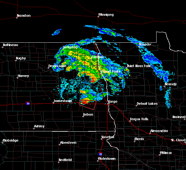 At 353 pm cdt, a severe thunderstorm capable of producing a tornado was located near buffalo, or 20 miles east of valley city, moving east at 30 mph (weather spotters reported a funnel cloud). Hazards include tornado and golf ball size hail. Expect damage to mobile homes, roofs, and vehicles. this dangerous storm will be near, buffalo around 355 pm cdt. alice around 400 pm cdt. embden around 410 pm cdt. chaffee and wheatland around 415 pm cdt. This includes interstate 94 in north dakota between mile markers 302 and 329. At 353 pm cdt, a severe thunderstorm capable of producing a tornado was located near buffalo, or 20 miles east of valley city, moving east at 30 mph (weather spotters reported a funnel cloud). Hazards include tornado and golf ball size hail. Expect damage to mobile homes, roofs, and vehicles. this dangerous storm will be near, buffalo around 355 pm cdt. alice around 400 pm cdt. embden around 410 pm cdt. chaffee and wheatland around 415 pm cdt. This includes interstate 94 in north dakota between mile markers 302 and 329.
|
| 6/8/2018 3:36 PM CDT |
 At 335 pm cdt, a severe thunderstorm capable of producing a tornado was located over oriska, or 11 miles east of valley city, moving east at 30 mph (weather spotters reported funnel cloud). Hazards include tornado and quarter size hail. Expect damage to mobile homes, roofs, and vehicles. this dangerous storm will be near, tower city around 345 pm cdt. buffalo around 355 pm cdt. alice around 400 pm cdt. embden around 410 pm cdt. chaffee and wheatland around 415 pm cdt. This includes interstate 94 in north dakota between mile markers 299 and 329. At 335 pm cdt, a severe thunderstorm capable of producing a tornado was located over oriska, or 11 miles east of valley city, moving east at 30 mph (weather spotters reported funnel cloud). Hazards include tornado and quarter size hail. Expect damage to mobile homes, roofs, and vehicles. this dangerous storm will be near, tower city around 345 pm cdt. buffalo around 355 pm cdt. alice around 400 pm cdt. embden around 410 pm cdt. chaffee and wheatland around 415 pm cdt. This includes interstate 94 in north dakota between mile markers 299 and 329.
|
| 6/6/2018 12:40 AM CDT |
 The severe thunderstorm warning for northeastern ransom, western cass, southeastern barnes and northwestern richland counties will expire at 1245 am cdt, the storms which prompted the warning have weakened below severe limits, and no longer poses an immediate threat to life or property. therefore, the warning will be allowed to expire. a severe thunderstorm watch remains in effect until 300 am cdt for southeastern north dakota. to report severe weather, contact your nearest law enforcement agency. they will relay your report to the national weather service grand forks. remember, a severe thunderstorm warning still remains in effect for eastern cass county and northeast richland county until 100 am. The severe thunderstorm warning for northeastern ransom, western cass, southeastern barnes and northwestern richland counties will expire at 1245 am cdt, the storms which prompted the warning have weakened below severe limits, and no longer poses an immediate threat to life or property. therefore, the warning will be allowed to expire. a severe thunderstorm watch remains in effect until 300 am cdt for southeastern north dakota. to report severe weather, contact your nearest law enforcement agency. they will relay your report to the national weather service grand forks. remember, a severe thunderstorm warning still remains in effect for eastern cass county and northeast richland county until 100 am.
|
| 6/6/2018 12:21 AM CDT |
 At 1221 am cdt, severe thunderstorms were located along a line extending from near argusville to near leonard, moving east at 50 mph (radar indicated). Hazards include 70 mph wind gusts and quarter size hail. Hail damage to vehicles is expected. expect considerable tree damage. Wind damage is also likely to mobile homes, roofs, and outbuildings. At 1221 am cdt, severe thunderstorms were located along a line extending from near argusville to near leonard, moving east at 50 mph (radar indicated). Hazards include 70 mph wind gusts and quarter size hail. Hail damage to vehicles is expected. expect considerable tree damage. Wind damage is also likely to mobile homes, roofs, and outbuildings.
|
| 6/6/2018 12:14 AM CDT |
 At 1214 am cdt, severe thunderstorms were located along a line extending from near page to near alice, moving east at 35 mph (radar indicated). Hazards include 60 mph wind gusts and quarter size hail. Hail damage to vehicles is expected. expect wind damage to roofs, siding, and trees. locations impacted include, casselton, enderlin, arthur, tower city, page, leonard and buffalo. This includes interstate 94 in north dakota between mile markers 305 and 337. At 1214 am cdt, severe thunderstorms were located along a line extending from near page to near alice, moving east at 35 mph (radar indicated). Hazards include 60 mph wind gusts and quarter size hail. Hail damage to vehicles is expected. expect wind damage to roofs, siding, and trees. locations impacted include, casselton, enderlin, arthur, tower city, page, leonard and buffalo. This includes interstate 94 in north dakota between mile markers 305 and 337.
|
| 6/5/2018 11:40 PM CDT |
 At 1140 pm cdt, severe thunderstorms were located along a line extending from near sibley to near kathryn, moving east at 35 mph (radar indicated). Hazards include 60 mph wind gusts and half dollar size hail. Hail damage to vehicles is expected. Expect wind damage to roofs, siding, and trees. At 1140 pm cdt, severe thunderstorms were located along a line extending from near sibley to near kathryn, moving east at 35 mph (radar indicated). Hazards include 60 mph wind gusts and half dollar size hail. Hail damage to vehicles is expected. Expect wind damage to roofs, siding, and trees.
|
| 9/19/2017 6:08 PM CDT |
 The severe thunderstorm warning for northwestern cass and east central barnes counties will expire at 615 pm cdt, the storm which prompted the warning has moved out of the area. therefore the warning will be allowed to expire. a tornado watch remains in effect until midnight cdt for southeastern north dakota. to report severe weather, contact your nearest law enforcement agency. they will relay your report to the national weather service grand forks. The severe thunderstorm warning for northwestern cass and east central barnes counties will expire at 615 pm cdt, the storm which prompted the warning has moved out of the area. therefore the warning will be allowed to expire. a tornado watch remains in effect until midnight cdt for southeastern north dakota. to report severe weather, contact your nearest law enforcement agency. they will relay your report to the national weather service grand forks.
|
| 9/19/2017 5:56 PM CDT |
 At 555 pm cdt, a severe thunderstorm was located near absaraka, or 25 miles west of fargo, moving east at 30 mph (radar indicated). Hazards include 60 mph wind gusts and quarter size hail. Hail damage to vehicles is expected. expect wind damage to roofs, siding, and trees. this severe thunderstorm will be near, casselton around 600 pm cdt. amenia around 605 pm cdt. arthur around 610 pm cdt. prosper around 620 pm cdt. argusville around 630 pm cdt. other locations impacted by this severe thunderstorm include moorhead airport, west argusville and casselton airport. this includes the following highways, interstate 29 between mile markers 62 and 96. interstate 94 in north dakota between mile markers 320 and 352. interstate 94 in minnesota between mile markers 1 and 7. A tornado watch remains in effect until midnight cdt for northwestern minnesota, and southeastern north dakota. At 555 pm cdt, a severe thunderstorm was located near absaraka, or 25 miles west of fargo, moving east at 30 mph (radar indicated). Hazards include 60 mph wind gusts and quarter size hail. Hail damage to vehicles is expected. expect wind damage to roofs, siding, and trees. this severe thunderstorm will be near, casselton around 600 pm cdt. amenia around 605 pm cdt. arthur around 610 pm cdt. prosper around 620 pm cdt. argusville around 630 pm cdt. other locations impacted by this severe thunderstorm include moorhead airport, west argusville and casselton airport. this includes the following highways, interstate 29 between mile markers 62 and 96. interstate 94 in north dakota between mile markers 320 and 352. interstate 94 in minnesota between mile markers 1 and 7. A tornado watch remains in effect until midnight cdt for northwestern minnesota, and southeastern north dakota.
|
| 9/19/2017 5:47 PM CDT |
 At 547 pm cdt, a severe thunderstorm was located near buffalo, or 23 miles east of valley city, moving northeast at 25 mph (radar indicated). Hazards include ping pong ball size hail and 60 mph wind gusts. People and animals outdoors will be injured. expect hail damage to roofs, siding, windows, and vehicles. expect wind damage to roofs, siding, and trees. this severe storm will be near, ayr and wheatland around 555 pm cdt. absaraka around 600 pm cdt. this includes interstate 94 in north dakota between mile markers 307 and 326. A tornado watch remains in effect until midnight cdt for southeastern north dakota. At 547 pm cdt, a severe thunderstorm was located near buffalo, or 23 miles east of valley city, moving northeast at 25 mph (radar indicated). Hazards include ping pong ball size hail and 60 mph wind gusts. People and animals outdoors will be injured. expect hail damage to roofs, siding, windows, and vehicles. expect wind damage to roofs, siding, and trees. this severe storm will be near, ayr and wheatland around 555 pm cdt. absaraka around 600 pm cdt. this includes interstate 94 in north dakota between mile markers 307 and 326. A tornado watch remains in effect until midnight cdt for southeastern north dakota.
|
| 9/19/2017 5:30 PM CDT |
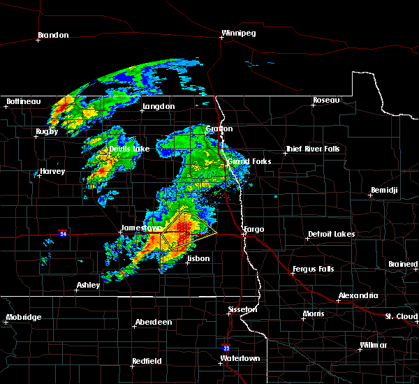 At 530 pm cdt, a severe thunderstorm was located over tower city, or 17 miles east of valley city, moving northeast at 25 mph (radar indicated). Hazards include ping pong ball size hail and 60 mph wind gusts. People and animals outdoors will be injured. expect hail damage to roofs, siding, windows, and vehicles. expect wind damage to roofs, siding, and trees. this severe storm will be near, buffalo around 540 pm cdt. ayr and wheatland around 555 pm cdt. absaraka around 600 pm cdt. this includes interstate 94 in north dakota between mile markers 300 and 326. A tornado watch remains in effect until midnight cdt for southeastern north dakota. At 530 pm cdt, a severe thunderstorm was located over tower city, or 17 miles east of valley city, moving northeast at 25 mph (radar indicated). Hazards include ping pong ball size hail and 60 mph wind gusts. People and animals outdoors will be injured. expect hail damage to roofs, siding, windows, and vehicles. expect wind damage to roofs, siding, and trees. this severe storm will be near, buffalo around 540 pm cdt. ayr and wheatland around 555 pm cdt. absaraka around 600 pm cdt. this includes interstate 94 in north dakota between mile markers 300 and 326. A tornado watch remains in effect until midnight cdt for southeastern north dakota.
|
| 9/19/2017 5:14 PM CDT |
 At 513 pm cdt, a severe thunderstorm was located near oriska, or 11 miles southeast of valley city, moving northeast at 25 mph (radar indicated). Hazards include ping pong ball size hail and 60 mph wind gusts. People and animals outdoors will be injured. expect hail damage to roofs, siding, windows, and vehicles. expect wind damage to roofs, siding, and trees. this severe thunderstorm will be near, oriska around 520 pm cdt. tower city around 530 pm cdt. buffalo around 540 pm cdt. ayr around 555 pm cdt. absaraka around 600 pm cdt. this includes interstate 94 in north dakota between mile markers 291 and 326. A tornado watch remains in effect until midnight cdt for southeastern north dakota. At 513 pm cdt, a severe thunderstorm was located near oriska, or 11 miles southeast of valley city, moving northeast at 25 mph (radar indicated). Hazards include ping pong ball size hail and 60 mph wind gusts. People and animals outdoors will be injured. expect hail damage to roofs, siding, windows, and vehicles. expect wind damage to roofs, siding, and trees. this severe thunderstorm will be near, oriska around 520 pm cdt. tower city around 530 pm cdt. buffalo around 540 pm cdt. ayr around 555 pm cdt. absaraka around 600 pm cdt. this includes interstate 94 in north dakota between mile markers 291 and 326. A tornado watch remains in effect until midnight cdt for southeastern north dakota.
|
| 7/31/2017 9:44 PM CDT |
 At 941 pm cdt, severe thunderstorms were located along a line extending from dilworth to fargo to near casselton, moving south at 30 mph (radar indicated). Hazards include 60 mph wind gusts. Expect damage to roofs, siding, and trees. locations impacted include, fargo, moorhead, west fargo, dilworth, horace, casselton and mapleton. this includes the following highways, interstate 29 between mile markers 27 and 80. interstate 94 in north dakota between mile markers 318 and 352. Interstate 94 in minnesota between mile markers 1 and 5. At 941 pm cdt, severe thunderstorms were located along a line extending from dilworth to fargo to near casselton, moving south at 30 mph (radar indicated). Hazards include 60 mph wind gusts. Expect damage to roofs, siding, and trees. locations impacted include, fargo, moorhead, west fargo, dilworth, horace, casselton and mapleton. this includes the following highways, interstate 29 between mile markers 27 and 80. interstate 94 in north dakota between mile markers 318 and 352. Interstate 94 in minnesota between mile markers 1 and 5.
|
| 7/31/2017 9:13 PM CDT |
 At 912 pm cdt, severe thunderstorms were located along a line extending from near kragnes to absaraka, moving south at 50 mph (radar indicated). Hazards include 60 mph wind gusts. Expect damage to roofs, siding, and trees. severe thunderstorms will be near, oakport, kragnes and north river around 915 pm cdt. fargo, moorhead and casselton around 950 pm cdt. dilworth and embden around 930 pm cdt. sabin and chaffee around 940 pm cdt. other locations impacted by these severe thunderstorms include casselton airport and moorhead airport. this includes the following highways, interstate 29 between mile markers 27 and 80. interstate 94 in north dakota between mile markers 318 and 352. Interstate 94 in minnesota between mile markers 1 and 5. At 912 pm cdt, severe thunderstorms were located along a line extending from near kragnes to absaraka, moving south at 50 mph (radar indicated). Hazards include 60 mph wind gusts. Expect damage to roofs, siding, and trees. severe thunderstorms will be near, oakport, kragnes and north river around 915 pm cdt. fargo, moorhead and casselton around 950 pm cdt. dilworth and embden around 930 pm cdt. sabin and chaffee around 940 pm cdt. other locations impacted by these severe thunderstorms include casselton airport and moorhead airport. this includes the following highways, interstate 29 between mile markers 27 and 80. interstate 94 in north dakota between mile markers 318 and 352. Interstate 94 in minnesota between mile markers 1 and 5.
|
| 7/22/2017 3:07 AM CDT |
 At 307 am cdt, severe thunderstorms were located along a line extending from near casselton to near leonard to near lisbon, moving southeast at 40 mph (radar indicated). Hazards include 60 mph wind gusts. Expect damage to roofs, siding, and trees. severe thunderstorms will be near, casselton around 310 am cdt. mapleton, leonard and durbin around 315 am cdt. venlo around 320 am cdt. west fargo and barrie around 325 am cdt. fargo, horace and kindred around 330 am cdt. other locations impacted by these severe thunderstorms include casselton airport. this includes the following highways, interstate 29 between mile markers 6 and 66. interstate 94 in north dakota between mile markers 323 and 352. Interstate 94 in minnesota between mile markers 1 and 3, and between mile markers 11 and 34. At 307 am cdt, severe thunderstorms were located along a line extending from near casselton to near leonard to near lisbon, moving southeast at 40 mph (radar indicated). Hazards include 60 mph wind gusts. Expect damage to roofs, siding, and trees. severe thunderstorms will be near, casselton around 310 am cdt. mapleton, leonard and durbin around 315 am cdt. venlo around 320 am cdt. west fargo and barrie around 325 am cdt. fargo, horace and kindred around 330 am cdt. other locations impacted by these severe thunderstorms include casselton airport. this includes the following highways, interstate 29 between mile markers 6 and 66. interstate 94 in north dakota between mile markers 323 and 352. Interstate 94 in minnesota between mile markers 1 and 3, and between mile markers 11 and 34.
|
| 7/21/2017 4:51 PM CDT |
 At 451 pm cdt, a severe thunderstorm was located over casselton, or 19 miles west of fargo, moving east at 50 mph (radar indicated). Hazards include 60 mph wind gusts and penny size hail. Expect damage to roofs, siding, and trees. this severe thunderstorm will be near, durbin around 455 pm cdt. mapleton and prosper around 500 pm cdt. west fargo around 505 pm cdt. fargo, horace and reile`s acres around 510 pm cdt. frontier, moorhead and prairie rose around 515 pm cdt. other locations impacted by this severe thunderstorm include moorhead airport, west argusville and casselton airport. this includes the following highways, interstate 29 between mile markers 49 and 84. interstate 94 in north dakota between mile markers 315 and 352. Interstate 94 in minnesota between mile markers 1 and 26. At 451 pm cdt, a severe thunderstorm was located over casselton, or 19 miles west of fargo, moving east at 50 mph (radar indicated). Hazards include 60 mph wind gusts and penny size hail. Expect damage to roofs, siding, and trees. this severe thunderstorm will be near, durbin around 455 pm cdt. mapleton and prosper around 500 pm cdt. west fargo around 505 pm cdt. fargo, horace and reile`s acres around 510 pm cdt. frontier, moorhead and prairie rose around 515 pm cdt. other locations impacted by this severe thunderstorm include moorhead airport, west argusville and casselton airport. this includes the following highways, interstate 29 between mile markers 49 and 84. interstate 94 in north dakota between mile markers 315 and 352. Interstate 94 in minnesota between mile markers 1 and 26.
|
| 6/13/2017 9:08 PM CDT |
 At 907 pm cdt, severe thunderstorms were located along a line extending from near galesburg to averill, moving northeast at 55 mph (trained weather spotters. at 907 pm, spotters reported 70 mph winds in south fargo). Hazards include 70 mph wind gusts and penny size hail. Expect considerable tree damage. damage is likely to mobile homes, roofs, and outbuildings. these severe storms will be near, glyndon and averill around 910 pm cdt. felton and blanchard around 915 pm cdt. kelso around 920 pm cdt. this includes the following highways, interstate 29 between mile markers 49 and 99. interstate 94 in north dakota between mile markers 331 and 352. Interstate 94 in minnesota between mile markers 1 and 16. At 907 pm cdt, severe thunderstorms were located along a line extending from near galesburg to averill, moving northeast at 55 mph (trained weather spotters. at 907 pm, spotters reported 70 mph winds in south fargo). Hazards include 70 mph wind gusts and penny size hail. Expect considerable tree damage. damage is likely to mobile homes, roofs, and outbuildings. these severe storms will be near, glyndon and averill around 910 pm cdt. felton and blanchard around 915 pm cdt. kelso around 920 pm cdt. this includes the following highways, interstate 29 between mile markers 49 and 99. interstate 94 in north dakota between mile markers 331 and 352. Interstate 94 in minnesota between mile markers 1 and 16.
|
| 6/13/2017 8:44 PM CDT |
 At 843 pm cdt, severe thunderstorms were located along a line extending from near valley city to davenport, moving northeast at 55 mph (radar indicated). Hazards include 60 mph wind gusts and quarter size hail. Hail damage to vehicles is expected. expect wind damage to roofs, siding, and trees. severe thunderstorms will be near, davenport, kindred and durbin around 845 pm cdt. horace around 850 pm cdt. frontier, west fargo and prairie rose around 855 pm cdt. fargo, page and moorhead around 900 pm cdt. glyndon, erie and kragnes around 905 pm cdt. this includes the following highways, interstate 29 between mile markers 48 and 99. interstate 94 in north dakota between mile markers 298 and 352. Interstate 94 in minnesota between mile markers 1 and 16. At 843 pm cdt, severe thunderstorms were located along a line extending from near valley city to davenport, moving northeast at 55 mph (radar indicated). Hazards include 60 mph wind gusts and quarter size hail. Hail damage to vehicles is expected. expect wind damage to roofs, siding, and trees. severe thunderstorms will be near, davenport, kindred and durbin around 845 pm cdt. horace around 850 pm cdt. frontier, west fargo and prairie rose around 855 pm cdt. fargo, page and moorhead around 900 pm cdt. glyndon, erie and kragnes around 905 pm cdt. this includes the following highways, interstate 29 between mile markers 48 and 99. interstate 94 in north dakota between mile markers 298 and 352. Interstate 94 in minnesota between mile markers 1 and 16.
|
| 6/9/2017 11:15 PM CDT |
 At 1115 pm cdt, severe thunderstorms were located along a line extending from amenia to near leonard, moving east at 40 mph (radar indicated). Hazards include 60 mph wind gusts and quarter size hail. Hail damage to vehicles is expected. expect wind damage to roofs, siding, and trees. severe thunderstorms will be near, davenport and mapleton around 1125 pm cdt. prosper around 1130 pm cdt. west fargo around 1135 pm cdt. fargo, harwood and reile`s acres around 1140 pm cdt. oxbow, oakport and frontier around 1145 pm cdt. this includes the following highways, interstate 29 between mile markers 51 and 77. interstate 94 in north dakota between mile markers 331 and 352. Interstate 94 in minnesota between mile markers 1 and 18. At 1115 pm cdt, severe thunderstorms were located along a line extending from amenia to near leonard, moving east at 40 mph (radar indicated). Hazards include 60 mph wind gusts and quarter size hail. Hail damage to vehicles is expected. expect wind damage to roofs, siding, and trees. severe thunderstorms will be near, davenport and mapleton around 1125 pm cdt. prosper around 1130 pm cdt. west fargo around 1135 pm cdt. fargo, harwood and reile`s acres around 1140 pm cdt. oxbow, oakport and frontier around 1145 pm cdt. this includes the following highways, interstate 29 between mile markers 51 and 77. interstate 94 in north dakota between mile markers 331 and 352. Interstate 94 in minnesota between mile markers 1 and 18.
|
| 6/9/2017 11:10 PM CDT |
 At 1109 pm cdt, a severe thunderstorm was located near durbin, or 21 miles west of fargo, moving east at 50 mph (radar indicated). Hazards include 60 mph wind gusts and quarter size hail. Hail damage to vehicles is expected. expect wind damage to roofs, siding, and trees. this severe thunderstorm will remain over mainly rural areas of south central cass county. This includes interstate 94 in north dakota between mile markers 321 and 331. At 1109 pm cdt, a severe thunderstorm was located near durbin, or 21 miles west of fargo, moving east at 50 mph (radar indicated). Hazards include 60 mph wind gusts and quarter size hail. Hail damage to vehicles is expected. expect wind damage to roofs, siding, and trees. this severe thunderstorm will remain over mainly rural areas of south central cass county. This includes interstate 94 in north dakota between mile markers 321 and 331.
|
| 6/9/2017 10:45 PM CDT |
 At 1045 pm cdt, a severe thunderstorm was located near lucca, or 17 miles southeast of valley city, moving east at 35 mph (radar indicated). Hazards include golf ball size hail and 70 mph wind gusts. People and animals outdoors will be injured. expect hail damage to roofs, siding, windows, and vehicles. expect considerable tree damage. wind damage is also likely to mobile homes, roofs, and outbuildings. this severe thunderstorm will be near, alice around 1055 pm cdt. embden around 1105 pm cdt. chaffee around 1110 pm cdt. leonard around 1125 pm cdt. This includes interstate 94 in north dakota between mile markers 311 and 331. At 1045 pm cdt, a severe thunderstorm was located near lucca, or 17 miles southeast of valley city, moving east at 35 mph (radar indicated). Hazards include golf ball size hail and 70 mph wind gusts. People and animals outdoors will be injured. expect hail damage to roofs, siding, windows, and vehicles. expect considerable tree damage. wind damage is also likely to mobile homes, roofs, and outbuildings. this severe thunderstorm will be near, alice around 1055 pm cdt. embden around 1105 pm cdt. chaffee around 1110 pm cdt. leonard around 1125 pm cdt. This includes interstate 94 in north dakota between mile markers 311 and 331.
|
| 8/18/2016 8:18 AM CDT |
 At 817 am cdt, severe thunderstorms were located along a line extending from near absaraka to near venlo to stirum, moving southeast at 45 mph (radar indicated). Hazards include 70 mph wind gusts and quarter size hail. Hail damage to vehicles is expected. expect considerable tree damage. wind damage is also likely to mobile homes, roofs, and outbuildings. these severe storms will be near, venlo around 820 am cdt. mcleod around 825 am cdt. forman and casselton around 830 am cdt. prosper around 835 am cdt. west fargo, mapleton and harwood around 840 am cdt. also includes the following highways, interstate 29 between mile markers 71 and 88. Interstate 94 in north dakota between mile markers 302 and 348. At 817 am cdt, severe thunderstorms were located along a line extending from near absaraka to near venlo to stirum, moving southeast at 45 mph (radar indicated). Hazards include 70 mph wind gusts and quarter size hail. Hail damage to vehicles is expected. expect considerable tree damage. wind damage is also likely to mobile homes, roofs, and outbuildings. these severe storms will be near, venlo around 820 am cdt. mcleod around 825 am cdt. forman and casselton around 830 am cdt. prosper around 835 am cdt. west fargo, mapleton and harwood around 840 am cdt. also includes the following highways, interstate 29 between mile markers 71 and 88. Interstate 94 in north dakota between mile markers 302 and 348.
|
| 8/18/2016 7:52 AM CDT |
 At 751 am cdt, severe thunderstorms were located along a line extending from near pillsbury to near nome to near la moure city, moving east at 40 mph (public. at 720 am...thunderstorm winds overturned a semi truck on i-94 at mile marker 278). Hazards include 70 mph wind gusts and quarter size hail. Hail damage to vehicles is expected. expect considerable tree damage. wind damage is also likely to mobile homes, roofs, and outbuildings. severe thunderstorms will be near, nome, pillsbury and fingal around 755 am cdt. lucca around 800 am cdt. page around 805 am cdt. enderlin and ayr around 810 am cdt. erie around 815 am cdt. also includes the following highways, interstate 29 between mile markers 71 and 88. Interstate 94 in north dakota between mile markers 291 and 348. At 751 am cdt, severe thunderstorms were located along a line extending from near pillsbury to near nome to near la moure city, moving east at 40 mph (public. at 720 am...thunderstorm winds overturned a semi truck on i-94 at mile marker 278). Hazards include 70 mph wind gusts and quarter size hail. Hail damage to vehicles is expected. expect considerable tree damage. wind damage is also likely to mobile homes, roofs, and outbuildings. severe thunderstorms will be near, nome, pillsbury and fingal around 755 am cdt. lucca around 800 am cdt. page around 805 am cdt. enderlin and ayr around 810 am cdt. erie around 815 am cdt. also includes the following highways, interstate 29 between mile markers 71 and 88. Interstate 94 in north dakota between mile markers 291 and 348.
|
| 7/21/2016 12:37 AM CDT |
 At 1237 am cdt, a severe thunderstorm was located over sabin, or 12 miles southeast of fargo, moving east at 80 mph (radar indicated). Hazards include 60 mph wind gusts and quarter size hail. Hail damage to vehicles is expected. expect wind damage to roofs, siding, and trees. this severe thunderstorm will be near, downer around 1240 am cdt. barnesville around 1245 am cdt. rollag around 1250 am cdt. cormorant around 1255 am cdt. shoreham and dunvilla around 100 am cdt. also includes the following highways, interstate 29 between mile markers 29 and 67. interstate 94 in north dakota between mile markers 320 and 352. Interstate 94 in minnesota between mile markers 1 and 65. At 1237 am cdt, a severe thunderstorm was located over sabin, or 12 miles southeast of fargo, moving east at 80 mph (radar indicated). Hazards include 60 mph wind gusts and quarter size hail. Hail damage to vehicles is expected. expect wind damage to roofs, siding, and trees. this severe thunderstorm will be near, downer around 1240 am cdt. barnesville around 1245 am cdt. rollag around 1250 am cdt. cormorant around 1255 am cdt. shoreham and dunvilla around 100 am cdt. also includes the following highways, interstate 29 between mile markers 29 and 67. interstate 94 in north dakota between mile markers 320 and 352. Interstate 94 in minnesota between mile markers 1 and 65.
|
| 7/20/2016 11:36 PM CDT |
 At 1135 pm cdt, a severe thunderstorm was located near grandin, or 29 miles north of fargo, moving southeast at 55 mph (radar indicated). Hazards include 60 mph wind gusts and penny size hail. Expect damage to roofs. siding. and trees. this severe thunderstorm will be near, gardner around 1145 pm cdt. argusville and perley around 1150 pm cdt. georgetown, harwood and brooktree park around 1155 pm cdt. northeastern fargo, kragnes and north river around 1200 am cdt. oakport and moorhead around 1205 am cdt. Also includes interstate 29 between mile markers 67 and 103. At 1135 pm cdt, a severe thunderstorm was located near grandin, or 29 miles north of fargo, moving southeast at 55 mph (radar indicated). Hazards include 60 mph wind gusts and penny size hail. Expect damage to roofs. siding. and trees. this severe thunderstorm will be near, gardner around 1145 pm cdt. argusville and perley around 1150 pm cdt. georgetown, harwood and brooktree park around 1155 pm cdt. northeastern fargo, kragnes and north river around 1200 am cdt. oakport and moorhead around 1205 am cdt. Also includes interstate 29 between mile markers 67 and 103.
|
| 7/11/2016 12:53 AM CDT |
 At 1252 am cdt, severe thunderstorms were located along a line extending from near hunter to near west fargo to 6 miles west of colfax, moving east at 50 mph (radar indicated). Hazards include 70 mph wind gusts. Expect considerable tree damage. damage is likely to mobile homes, roofs, and outbuildings. storm spotter 64 mph wind gust 2 miles ese of mapleton at 1246 am. these severe storms will be near, fargo, west fargo and reile`s acres around 1255 am cdt. colfax, frontier and moorhead around 100 am cdt. also includes the following highways, interstate 29 between mile markers 35 and 92. interstate 94 in north dakota between mile markers 308 and 352. Interstate 94 in minnesota between mile markers 1 and 4. At 1252 am cdt, severe thunderstorms were located along a line extending from near hunter to near west fargo to 6 miles west of colfax, moving east at 50 mph (radar indicated). Hazards include 70 mph wind gusts. Expect considerable tree damage. damage is likely to mobile homes, roofs, and outbuildings. storm spotter 64 mph wind gust 2 miles ese of mapleton at 1246 am. these severe storms will be near, fargo, west fargo and reile`s acres around 1255 am cdt. colfax, frontier and moorhead around 100 am cdt. also includes the following highways, interstate 29 between mile markers 35 and 92. interstate 94 in north dakota between mile markers 308 and 352. Interstate 94 in minnesota between mile markers 1 and 4.
|
| 7/11/2016 12:40 AM CDT |
 At 1239 am cdt, severe thunderstorms were located along a line extending from near galesburg to near casselton to 7 miles southwest of barrie, moving east at 65 mph (radar indicated). Hazards include 70 mph wind gusts and half dollar size hail. Hail damage to vehicles is expected. expect considerable tree damage. wind damage is also likely to mobile homes, roofs, and outbuildings. storm spotters reported a peak wind of 60 mph 3 west of casselton along i-94 at 1235 am. these severe storms will be near, mapleton, barrie and prosper around 1245 am cdt. west fargo, walcott and reile`s acres around 1250 am cdt. fargo, colfax and grandin around 1255 am cdt. dilworth, abercrombie and moorhead around 100 am cdt. also includes the following highways, interstate 29 between mile markers 35 and 92. interstate 94 in north dakota between mile markers 308 and 352. Interstate 94 in minnesota between mile markers 1 and 4. At 1239 am cdt, severe thunderstorms were located along a line extending from near galesburg to near casselton to 7 miles southwest of barrie, moving east at 65 mph (radar indicated). Hazards include 70 mph wind gusts and half dollar size hail. Hail damage to vehicles is expected. expect considerable tree damage. wind damage is also likely to mobile homes, roofs, and outbuildings. storm spotters reported a peak wind of 60 mph 3 west of casselton along i-94 at 1235 am. these severe storms will be near, mapleton, barrie and prosper around 1245 am cdt. west fargo, walcott and reile`s acres around 1250 am cdt. fargo, colfax and grandin around 1255 am cdt. dilworth, abercrombie and moorhead around 100 am cdt. also includes the following highways, interstate 29 between mile markers 35 and 92. interstate 94 in north dakota between mile markers 308 and 352. Interstate 94 in minnesota between mile markers 1 and 4.
|
| 7/11/2016 12:13 AM CDT |
 At 1212 am cdt, severe thunderstorms were located along a line extending from luverne to near tower city to 6 miles northwest of lisbon, moving east at 50 mph (radar indicated). Hazards include 70 mph wind gusts and half dollar size hail. Hail damage to vehicles is expected. expect considerable tree damage. wind damage is also likely to mobile homes, roofs, and outbuildings. severe thunderstorms will be near, tower city around 1215 am cdt. buffalo around 1220 am cdt. sheldon around 1225 am cdt. venlo, anselm and wheatland around 1230 am cdt. page and chaffee around 1235 am cdt. fargo around 1255 am cdt. also includes the following highways, interstate 29 between mile markers 35 and 92. interstate 94 in north dakota between mile markers 308 and 352. Interstate 94 in minnesota between mile markers 1 and 4. At 1212 am cdt, severe thunderstorms were located along a line extending from luverne to near tower city to 6 miles northwest of lisbon, moving east at 50 mph (radar indicated). Hazards include 70 mph wind gusts and half dollar size hail. Hail damage to vehicles is expected. expect considerable tree damage. wind damage is also likely to mobile homes, roofs, and outbuildings. severe thunderstorms will be near, tower city around 1215 am cdt. buffalo around 1220 am cdt. sheldon around 1225 am cdt. venlo, anselm and wheatland around 1230 am cdt. page and chaffee around 1235 am cdt. fargo around 1255 am cdt. also includes the following highways, interstate 29 between mile markers 35 and 92. interstate 94 in north dakota between mile markers 308 and 352. Interstate 94 in minnesota between mile markers 1 and 4.
|
| 7/9/2016 10:41 PM CDT |
 At 1040 pm cdt, severe thunderstorms were located along a line extending from 6 miles northeast of perley to near west fargo to near wheatland, moving south at 55 mph (radar indicated). Hazards include 60 mph wind gusts and penny size hail. Expect damage to roofs. siding. and trees. these severe storms will be near, frontier, west fargo and prairie rose around 1045 pm cdt. horace, wild rice and rustad around 1050 pm cdt. oxbow, felton and kindred around 1055 pm cdt. averill around 1100 pm cdt. glyndon and dilworth around 1105 pm cdt. also includes the following highways, interstate 29 between mile markers 49 and 81. interstate 94 in north dakota between mile markers 325 and 352. Interstate 94 in minnesota between mile markers 1 and 18. At 1040 pm cdt, severe thunderstorms were located along a line extending from 6 miles northeast of perley to near west fargo to near wheatland, moving south at 55 mph (radar indicated). Hazards include 60 mph wind gusts and penny size hail. Expect damage to roofs. siding. and trees. these severe storms will be near, frontier, west fargo and prairie rose around 1045 pm cdt. horace, wild rice and rustad around 1050 pm cdt. oxbow, felton and kindred around 1055 pm cdt. averill around 1100 pm cdt. glyndon and dilworth around 1105 pm cdt. also includes the following highways, interstate 29 between mile markers 49 and 81. interstate 94 in north dakota between mile markers 325 and 352. Interstate 94 in minnesota between mile markers 1 and 18.
|
| 7/9/2016 10:13 PM CDT |
 At 1012 pm cdt, severe thunderstorms were located along a line extending from near caledonia to near gardner to near erie, moving southeast at 35 mph (radar indicated). Hazards include 60 mph wind gusts and quarter size hail. Hail damage to vehicles is expected. expect wind damage to roofs, siding, and trees. severe thunderstorms will be near, gardner around 1015 pm cdt. argusville and amenia around 1025 pm cdt. hendrum, prosper and wheatland around 1030 pm cdt. casselton, harwood and brooktree park around 1035 pm cdt. reile`s acres, perley and kragnes around 1040 pm cdt. also includes the following highways, interstate 29 between mile markers 49 and 98. interstate 94 in north dakota between mile markers 325 and 352. Interstate 94 in minnesota between mile markers 1 and 18. At 1012 pm cdt, severe thunderstorms were located along a line extending from near caledonia to near gardner to near erie, moving southeast at 35 mph (radar indicated). Hazards include 60 mph wind gusts and quarter size hail. Hail damage to vehicles is expected. expect wind damage to roofs, siding, and trees. severe thunderstorms will be near, gardner around 1015 pm cdt. argusville and amenia around 1025 pm cdt. hendrum, prosper and wheatland around 1030 pm cdt. casselton, harwood and brooktree park around 1035 pm cdt. reile`s acres, perley and kragnes around 1040 pm cdt. also includes the following highways, interstate 29 between mile markers 49 and 98. interstate 94 in north dakota between mile markers 325 and 352. Interstate 94 in minnesota between mile markers 1 and 18.
|
| 7/9/2016 9:48 PM CDT |
 At 947 pm cdt, a severe thunderstorm was located near blanchard, or 34 miles northwest of fargo, moving southeast at 35 mph (radar indicated). Hazards include 70 mph wind gusts and quarter size hail. Hail damage to vehicles is expected. expect considerable tree damage. wind damage is also likely to mobile homes, roofs, and outbuildings. this severe storm will be near, hunter and kelso around 955 pm cdt. grandin around 1005 pm cdt. gardner around 1015 pm cdt. Also includes interstate 29 between mile markers 84 and 114. At 947 pm cdt, a severe thunderstorm was located near blanchard, or 34 miles northwest of fargo, moving southeast at 35 mph (radar indicated). Hazards include 70 mph wind gusts and quarter size hail. Hail damage to vehicles is expected. expect considerable tree damage. wind damage is also likely to mobile homes, roofs, and outbuildings. this severe storm will be near, hunter and kelso around 955 pm cdt. grandin around 1005 pm cdt. gardner around 1015 pm cdt. Also includes interstate 29 between mile markers 84 and 114.
|
| 7/9/2016 9:30 PM CDT |
 At 929 pm cdt, a severe thunderstorm was located over roseville, or 37 miles south of grand forks, moving southeast at 35 mph (radar indicated). Hazards include 60 mph wind gusts and quarter size hail. Hail damage to vehicles is expected. expect wind damage to roofs, siding, and trees. this severe thunderstorm will be near, blanchard around 945 pm cdt. hunter around 955 pm cdt. kelso around 1000 pm cdt. grandin around 1005 pm cdt. hendrum and gardner around 1015 pm cdt. Also includes interstate 29 between mile markers 84 and 115. At 929 pm cdt, a severe thunderstorm was located over roseville, or 37 miles south of grand forks, moving southeast at 35 mph (radar indicated). Hazards include 60 mph wind gusts and quarter size hail. Hail damage to vehicles is expected. expect wind damage to roofs, siding, and trees. this severe thunderstorm will be near, blanchard around 945 pm cdt. hunter around 955 pm cdt. kelso around 1000 pm cdt. grandin around 1005 pm cdt. hendrum and gardner around 1015 pm cdt. Also includes interstate 29 between mile markers 84 and 115.
|
| 7/4/2016 8:13 PM CDT |
 At 813 pm cdt, a severe thunderstorm was located over casselton, or 17 miles west of fargo, moving east at 35 mph (radar indicated). Hazards include 60 mph wind gusts and quarter size hail. Hail damage to vehicles is expected. expect wind damage to roofs, siding, and trees. this severe thunderstorm will be near, durbin around 815 pm cdt. mapleton and prosper around 825 pm cdt. west fargo around 830 pm cdt. harwood and brooktree park around 835 pm cdt. fargo, reile`s acres and frontier around 840 pm cdt. also includes the following highways, interstate 29 between mile markers 58 and 74. interstate 94 in north dakota between mile markers 328 and 352. Interstate 94 in minnesota between mile markers 1 and 5. At 813 pm cdt, a severe thunderstorm was located over casselton, or 17 miles west of fargo, moving east at 35 mph (radar indicated). Hazards include 60 mph wind gusts and quarter size hail. Hail damage to vehicles is expected. expect wind damage to roofs, siding, and trees. this severe thunderstorm will be near, durbin around 815 pm cdt. mapleton and prosper around 825 pm cdt. west fargo around 830 pm cdt. harwood and brooktree park around 835 pm cdt. fargo, reile`s acres and frontier around 840 pm cdt. also includes the following highways, interstate 29 between mile markers 58 and 74. interstate 94 in north dakota between mile markers 328 and 352. Interstate 94 in minnesota between mile markers 1 and 5.
|
| 7/4/2016 8:01 PM CDT |
 At 800 pm cdt, a severe thunderstorm was located near wheatland, or 23 miles west of fargo, moving east at 45 mph (radar indicated). Hazards include 60 mph wind gusts and quarter size hail. Hail damage to vehicles is expected. expect wind damage to roofs, siding, and trees. this severe storm will be near, casselton around 805 pm cdt. davenport and durbin around 815 pm cdt. also includes the following highways, interstate 29 between mile markers 34 and 51. Interstate 94 in north dakota between mile markers 318 and 337. At 800 pm cdt, a severe thunderstorm was located near wheatland, or 23 miles west of fargo, moving east at 45 mph (radar indicated). Hazards include 60 mph wind gusts and quarter size hail. Hail damage to vehicles is expected. expect wind damage to roofs, siding, and trees. this severe storm will be near, casselton around 805 pm cdt. davenport and durbin around 815 pm cdt. also includes the following highways, interstate 29 between mile markers 34 and 51. Interstate 94 in north dakota between mile markers 318 and 337.
|
| 7/4/2016 7:48 PM CDT |
 At 747 pm cdt, severe thunderstorms were located along a line extending from near mapleton to near embden to near nome, moving southeast at 45 mph (radar indicated). Hazards include 60 mph wind gusts and quarter size hail. Hail damage to vehicles is expected. expect wind damage to roofs, siding, and trees. these severe storms will be near, casselton, chaffee and durbin around 750 pm cdt. leonard and enderlin around 805 pm cdt. sheldon, kindred and walcott around 815 pm cdt. also includes the following highways, interstate 29 between mile markers 34 and 51. Interstate 94 in north dakota between mile markers 286 and 337. At 747 pm cdt, severe thunderstorms were located along a line extending from near mapleton to near embden to near nome, moving southeast at 45 mph (radar indicated). Hazards include 60 mph wind gusts and quarter size hail. Hail damage to vehicles is expected. expect wind damage to roofs, siding, and trees. these severe storms will be near, casselton, chaffee and durbin around 750 pm cdt. leonard and enderlin around 805 pm cdt. sheldon, kindred and walcott around 815 pm cdt. also includes the following highways, interstate 29 between mile markers 34 and 51. Interstate 94 in north dakota between mile markers 286 and 337.
|
| 7/4/2016 7:28 PM CDT |
 At 727 pm cdt, severe thunderstorms were located along a line extending from near amenia to near buffalo to 7 miles north of kathryn, moving southeast at 55 mph (radar indicated). Hazards include 60 mph wind gusts and quarter size hail. Hail damage to vehicles is expected. expect wind damage to roofs, siding, and trees. severe thunderstorms will be near, alice around 730 pm cdt. embden and wheatland around 735 pm cdt. chaffee and nome around 740 pm cdt. lucca around 745 pm cdt. leonard and durbin around 750 pm cdt. also includes the following highways, interstate 29 between mile markers 34 and 51. Interstate 94 in north dakota between mile markers 286 and 337. At 727 pm cdt, severe thunderstorms were located along a line extending from near amenia to near buffalo to 7 miles north of kathryn, moving southeast at 55 mph (radar indicated). Hazards include 60 mph wind gusts and quarter size hail. Hail damage to vehicles is expected. expect wind damage to roofs, siding, and trees. severe thunderstorms will be near, alice around 730 pm cdt. embden and wheatland around 735 pm cdt. chaffee and nome around 740 pm cdt. lucca around 745 pm cdt. leonard and durbin around 750 pm cdt. also includes the following highways, interstate 29 between mile markers 34 and 51. Interstate 94 in north dakota between mile markers 286 and 337.
|
| 5/30/2016 9:11 PM CDT |
 At 910 pm cdt, a severe thunderstorm was located over amenia, or 20 miles west of fargo, moving north at 25 mph (radar indicated). Hazards include 60 mph wind gusts and quarter size hail. Hail damage to vehicles is expected. expect wind damage to roofs, siding, and trees. this severe thunderstorm will remain over mainly rural areas of northeastern cass county. also includes the following highways, interstate 29 between mile markers 82 and 83. Interstate 94 in north dakota between mile markers 334 and 335. At 910 pm cdt, a severe thunderstorm was located over amenia, or 20 miles west of fargo, moving north at 25 mph (radar indicated). Hazards include 60 mph wind gusts and quarter size hail. Hail damage to vehicles is expected. expect wind damage to roofs, siding, and trees. this severe thunderstorm will remain over mainly rural areas of northeastern cass county. also includes the following highways, interstate 29 between mile markers 82 and 83. Interstate 94 in north dakota between mile markers 334 and 335.
|
| 5/30/2016 8:52 PM CDT |
 At 851 pm cdt, a severe thunderstorm was located near wheatland, or 22 miles west of fargo, moving north at 20 mph (radar indicated). Hazards include 60 mph wind gusts and quarter size hail. Hail damage to vehicles is expected. expect wind damage to roofs, siding, and trees. this severe storm will be near, casselton around 900 pm cdt. absaraka around 905 pm cdt. amenia around 915 pm cdt. arthur around 930 pm cdt. also includes the following highways, interstate 29 between mile markers 82 and 83. Interstate 94 in north dakota between mile markers 320 and 336. At 851 pm cdt, a severe thunderstorm was located near wheatland, or 22 miles west of fargo, moving north at 20 mph (radar indicated). Hazards include 60 mph wind gusts and quarter size hail. Hail damage to vehicles is expected. expect wind damage to roofs, siding, and trees. this severe storm will be near, casselton around 900 pm cdt. absaraka around 905 pm cdt. amenia around 915 pm cdt. arthur around 930 pm cdt. also includes the following highways, interstate 29 between mile markers 82 and 83. Interstate 94 in north dakota between mile markers 320 and 336.
|
| 5/30/2016 8:38 PM CDT |
 At 837 pm cdt, a severe thunderstorm was located over chaffee, or 24 miles west of fargo, moving north at 20 mph (radar indicated). Hazards include 60 mph wind gusts and quarter size hail. Hail damage to vehicles is expected. expect wind damage to roofs, siding, and trees. this severe thunderstorm will be near, durbin around 845 pm cdt. wheatland around 855 pm cdt. casselton around 900 pm cdt. absaraka around 905 pm cdt. amenia around 915 pm cdt. also includes the following highways, interstate 29 between mile markers 82 and 83. Interstate 94 in north dakota between mile markers 320 and 336. At 837 pm cdt, a severe thunderstorm was located over chaffee, or 24 miles west of fargo, moving north at 20 mph (radar indicated). Hazards include 60 mph wind gusts and quarter size hail. Hail damage to vehicles is expected. expect wind damage to roofs, siding, and trees. this severe thunderstorm will be near, durbin around 845 pm cdt. wheatland around 855 pm cdt. casselton around 900 pm cdt. absaraka around 905 pm cdt. amenia around 915 pm cdt. also includes the following highways, interstate 29 between mile markers 82 and 83. Interstate 94 in north dakota between mile markers 320 and 336.
|
| 8/15/2015 10:21 PM CDT |
 At 1019 pm cdt, severe thunderstorms were located along a line extending from near oakport to anselm, moving east at 45 mph (radar indicated). Hazards include 60 mph wind gusts and quarter size hail. Hail damage to vehicles is expected. expect wind damage to roofs, siding and trees. these severe thunderstorms will remain over mainly rural areas of southern cass, northeastern ransom, southeastern barnes and northwestern richland counties. also includes the following highways, interstate 29 between mile markers 72 and 76. Interstate 94 in north dakota between mile markers 317 and 344. At 1019 pm cdt, severe thunderstorms were located along a line extending from near oakport to anselm, moving east at 45 mph (radar indicated). Hazards include 60 mph wind gusts and quarter size hail. Hail damage to vehicles is expected. expect wind damage to roofs, siding and trees. these severe thunderstorms will remain over mainly rural areas of southern cass, northeastern ransom, southeastern barnes and northwestern richland counties. also includes the following highways, interstate 29 between mile markers 72 and 76. Interstate 94 in north dakota between mile markers 317 and 344.
|
| 8/15/2015 9:48 PM CDT |
 At 947 pm cdt, severe thunderstorms were located along a line extending from amenia to near little yellowstone, moving east at 45 mph (radar indicated). Hazards include 60 mph wind gusts and quarter size hail. Hail damage to vehicles is expected. expect wind damage to roofs, siding and trees. severe thunderstorms will be near, casselton and amenia around 950 pm cdt. mapleton and prosper around 1000 pm cdt. harwood, west fargo and brooktree park around 1005 pm cdt. enderlin around 1010 pm cdt. sheldon and anselm around 1015 pm cdt. also includes the following highways, interstate 29 between mile markers 72 and 76. Interstate 94 in north dakota between mile markers 304 and 344. At 947 pm cdt, severe thunderstorms were located along a line extending from amenia to near little yellowstone, moving east at 45 mph (radar indicated). Hazards include 60 mph wind gusts and quarter size hail. Hail damage to vehicles is expected. expect wind damage to roofs, siding and trees. severe thunderstorms will be near, casselton and amenia around 950 pm cdt. mapleton and prosper around 1000 pm cdt. harwood, west fargo and brooktree park around 1005 pm cdt. enderlin around 1010 pm cdt. sheldon and anselm around 1015 pm cdt. also includes the following highways, interstate 29 between mile markers 72 and 76. Interstate 94 in north dakota between mile markers 304 and 344.
|
| 8/7/2015 6:53 PM CDT |
 The severe thunderstorm warning for southwestern cass, ransom, southeastern barnes and northwestern richland counties will expire at 700 pm cdt, the storm which prompted the warning has weakened below severe limits, and no longer pose an immediate threat to life or property. therefore the warning will be allowed to expire. The severe thunderstorm warning for southwestern cass, ransom, southeastern barnes and northwestern richland counties will expire at 700 pm cdt, the storm which prompted the warning has weakened below severe limits, and no longer pose an immediate threat to life or property. therefore the warning will be allowed to expire.
|
| 8/7/2015 6:42 PM CDT |
 At 641 pm cdt, a severe thunderstorm was located near arthur, or 21 miles northwest of fargo, moving east at 20 mph (radar indicated). Hazards include half dollar size hail. Damage to vehicles is expected. this severe thunderstorm will be near, gardner around 700 pm cdt. prosper around 705 pm cdt. argusville around 710 pm cdt. harwood and brooktree park around 715 pm cdt. reile`s acres around 720 pm cdt. also includes the following highways, interstate 29 between mile markers 59 and 88. Interstate 94 in north dakota between mile markers 322 and 352. At 641 pm cdt, a severe thunderstorm was located near arthur, or 21 miles northwest of fargo, moving east at 20 mph (radar indicated). Hazards include half dollar size hail. Damage to vehicles is expected. this severe thunderstorm will be near, gardner around 700 pm cdt. prosper around 705 pm cdt. argusville around 710 pm cdt. harwood and brooktree park around 715 pm cdt. reile`s acres around 720 pm cdt. also includes the following highways, interstate 29 between mile markers 59 and 88. Interstate 94 in north dakota between mile markers 322 and 352.
|
| 8/7/2015 6:31 PM CDT |
 At 629 pm cdt, a severe thunderstorm was located near lisbon, or 32 miles southeast of valley city, moving east at 20 mph. a second severe storm between buffalo and wheatland is moving to the east northeast at 25 mph (trained weather spotters one inch hail south of valley city on the northern storm). Hazards include half dollar size hail. Damage to vehicles is expected. this severe storm will be near, enderlin around 635 pm cdt. sheldon and anselm around 640 pm cdt. venlo around 645 pm cdt. Also includes interstate 94 in north dakota between mile markers 301 and 338. At 629 pm cdt, a severe thunderstorm was located near lisbon, or 32 miles southeast of valley city, moving east at 20 mph. a second severe storm between buffalo and wheatland is moving to the east northeast at 25 mph (trained weather spotters one inch hail south of valley city on the northern storm). Hazards include half dollar size hail. Damage to vehicles is expected. this severe storm will be near, enderlin around 635 pm cdt. sheldon and anselm around 640 pm cdt. venlo around 645 pm cdt. Also includes interstate 94 in north dakota between mile markers 301 and 338.
|
| 8/7/2015 5:55 PM CDT |
 At 554 pm cdt, a severe thunderstorm was located near fingal, or 12 miles southeast of valley city, moving east at 40 mph (radar indicated). Hazards include half dollar size hail. Damage to vehicles is expected. this severe thunderstorm will be near, nome around 555 pm cdt. fingal around 600 pm cdt. lucca around 605 pm cdt. tower city around 610 pm cdt. alice around 615 pm cdt. Also includes interstate 94 in north dakota between mile markers 301 and 338. At 554 pm cdt, a severe thunderstorm was located near fingal, or 12 miles southeast of valley city, moving east at 40 mph (radar indicated). Hazards include half dollar size hail. Damage to vehicles is expected. this severe thunderstorm will be near, nome around 555 pm cdt. fingal around 600 pm cdt. lucca around 605 pm cdt. tower city around 610 pm cdt. alice around 615 pm cdt. Also includes interstate 94 in north dakota between mile markers 301 and 338.
|
| 7/24/2015 12:10 AM CDT |
 At 1209 am cdt, severe thunderstorms were located along a line extending from near climax to near hillsboro to near lucca, moving east at 60 mph. these are very dangerous storms. winds of 80 mph or higher are possible in traill county moving into normal county. seek shelter if you are in the path of this storm (radar indicated). Hazards include 80 mph wind gusts and penny size hail. Flying debris will be dangerous to those caught without shelter. mobile homes will be heavily damaged. expect considerable damage to roofs, windows and vehicles. extensive tree damage and power outages are likely. these severe storms will be near, climax, hillsboro, kelso and nielsville around 1210 am cdt. halstad, shelly, caledonia and alice around 1215 am cdt. greenview and embden around 1220 am cdt. beltrami and chaffee around 1225 am cdt. leonard, ada, lockhart, melvin and hadler around 1230 am cdt. Also includes interstate 29 between mile markers 49 and 120. At 1209 am cdt, severe thunderstorms were located along a line extending from near climax to near hillsboro to near lucca, moving east at 60 mph. these are very dangerous storms. winds of 80 mph or higher are possible in traill county moving into normal county. seek shelter if you are in the path of this storm (radar indicated). Hazards include 80 mph wind gusts and penny size hail. Flying debris will be dangerous to those caught without shelter. mobile homes will be heavily damaged. expect considerable damage to roofs, windows and vehicles. extensive tree damage and power outages are likely. these severe storms will be near, climax, hillsboro, kelso and nielsville around 1210 am cdt. halstad, shelly, caledonia and alice around 1215 am cdt. greenview and embden around 1220 am cdt. beltrami and chaffee around 1225 am cdt. leonard, ada, lockhart, melvin and hadler around 1230 am cdt. Also includes interstate 29 between mile markers 49 and 120.
|
| 7/23/2015 11:48 PM CDT |
 At 1147 pm cdt, severe thunderstorms were located along a line extending from near mekinock to near clifford to kathryn, moving east at 50 mph. the radar indicates 80 mph winds or greater will pass near mayville by midnight (radar indicated). Hazards include 70 mph wind gusts and penny size hail. Expect considerable tree damage. damage is likely to mobile homes, roofs and outbuildings. these severe storms will be near, grand forks afb, mekinock, galesburg, emerado, clifford and roseville around 1150 pm cdt. grand forks, blanchard and fingal around 1200 am cdt. east grand forks and lucca around 1205 am cdt. hillsboro, kelso and mallory around 1210 am cdt. sherack, key west and alice around 1215 am cdt. Also includes interstate 29 between mile markers 49 and 150. At 1147 pm cdt, severe thunderstorms were located along a line extending from near mekinock to near clifford to kathryn, moving east at 50 mph. the radar indicates 80 mph winds or greater will pass near mayville by midnight (radar indicated). Hazards include 70 mph wind gusts and penny size hail. Expect considerable tree damage. damage is likely to mobile homes, roofs and outbuildings. these severe storms will be near, grand forks afb, mekinock, galesburg, emerado, clifford and roseville around 1150 pm cdt. grand forks, blanchard and fingal around 1200 am cdt. east grand forks and lucca around 1205 am cdt. hillsboro, kelso and mallory around 1210 am cdt. sherack, key west and alice around 1215 am cdt. Also includes interstate 29 between mile markers 49 and 150.
|
| 7/23/2015 11:40 PM CDT |
 At 1140 pm cdt, severe thunderstorms were located along a line extending from mekinock to 6 miles west of clifford to hastings, moving east at 50 mph (radar indicated). Hazards include 70 mph wind gusts and penny size hail. Expect considerable tree damage. damage is likely to mobile homes, roofs and outbuildings. severe thunderstorms will be near, mekinock, grand forks afb and emerado around 1145 pm cdt. galesburg, clifford and roseville around 1150 pm cdt. grand forks, nome and fingal around 1155 pm cdt. east grand forks, blanchard and lucca around 1200 am cdt. mallory around 1205 am cdt. Also includes interstate 29 between mile markers 49 and 150. At 1140 pm cdt, severe thunderstorms were located along a line extending from mekinock to 6 miles west of clifford to hastings, moving east at 50 mph (radar indicated). Hazards include 70 mph wind gusts and penny size hail. Expect considerable tree damage. damage is likely to mobile homes, roofs and outbuildings. severe thunderstorms will be near, mekinock, grand forks afb and emerado around 1145 pm cdt. galesburg, clifford and roseville around 1150 pm cdt. grand forks, nome and fingal around 1155 pm cdt. east grand forks, blanchard and lucca around 1200 am cdt. mallory around 1205 am cdt. Also includes interstate 29 between mile markers 49 and 150.
|
| 6/27/2015 7:00 PM CDT | Quarter sized hail reported 0.5 miles SSW of Casselton, ND |
| 6/27/2015 6:55 PM CDT |
 At 655 pm cdt, a severe thunderstorm capable of producing a tornado was located near wheatland, or 22 miles west of fargo, moving south at 35 mph (radar indicated rotation). Hazards include tornado and golf ball size hail. Expect damage to mobile homes. roofs and vehicles. this dangerous storm will be near, chaffee and durbin around 700 pm cdt. leonard around 710 pm cdt. Barrie around 720 pm cdt. At 655 pm cdt, a severe thunderstorm capable of producing a tornado was located near wheatland, or 22 miles west of fargo, moving south at 35 mph (radar indicated rotation). Hazards include tornado and golf ball size hail. Expect damage to mobile homes. roofs and vehicles. this dangerous storm will be near, chaffee and durbin around 700 pm cdt. leonard around 710 pm cdt. Barrie around 720 pm cdt.
|
| 6/27/2015 6:33 PM CDT |
 At 633 pm cdt, a severe thunderstorm capable of producing a tornado was located over erie, or 30 miles northeast of valley city, moving south at 20 mph (radar indicated rotation). Hazards include tornado and quarter size hail. Flying debris will be dangerous to those caught without shelter. mobile homes will be damaged or destroyed. damage to roofs, windows and vehicles will occur. tree damage is likely. this dangerous storm will be near, erie around 635 pm cdt. ayr around 645 pm cdt. Absaraka, wheatland and amenia around 700 pm cdt. At 633 pm cdt, a severe thunderstorm capable of producing a tornado was located over erie, or 30 miles northeast of valley city, moving south at 20 mph (radar indicated rotation). Hazards include tornado and quarter size hail. Flying debris will be dangerous to those caught without shelter. mobile homes will be damaged or destroyed. damage to roofs, windows and vehicles will occur. tree damage is likely. this dangerous storm will be near, erie around 635 pm cdt. ayr around 645 pm cdt. Absaraka, wheatland and amenia around 700 pm cdt.
|
| 6/27/2015 6:14 PM CDT |
 At 613 pm cdt, a severe thunderstorm capable of producing a tornado was located near page, or 28 miles northeast of valley city, moving south at 45 mph (radar indicated rotation). Hazards include tornado and ping pong ball size hail. Expect damage to mobile homes. roofs and vehicles. this dangerous storm will be near, page around 615 pm cdt. erie around 620 pm cdt. ayr around 630 pm cdt. absaraka around 635 pm cdt. Buffalo and tower city around 640 pm cdt. At 613 pm cdt, a severe thunderstorm capable of producing a tornado was located near page, or 28 miles northeast of valley city, moving south at 45 mph (radar indicated rotation). Hazards include tornado and ping pong ball size hail. Expect damage to mobile homes. roofs and vehicles. this dangerous storm will be near, page around 615 pm cdt. erie around 620 pm cdt. ayr around 630 pm cdt. absaraka around 635 pm cdt. Buffalo and tower city around 640 pm cdt.
|
| 1/1/0001 12:00 AM | Storm damage reported in cass county ND, 0.2 miles NW of Casselton, ND |
| 1/1/0001 12:00 AM | Storm damage reported in cass county ND, 0.5 miles SSW of Casselton, ND |
Hail Maps for Casselton, ND
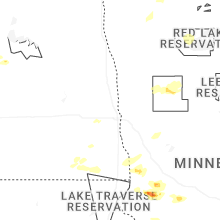
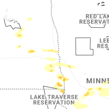


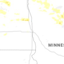


Connect with Interactive Hail Maps