

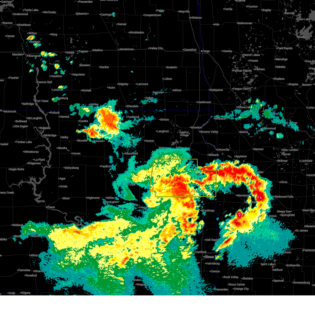
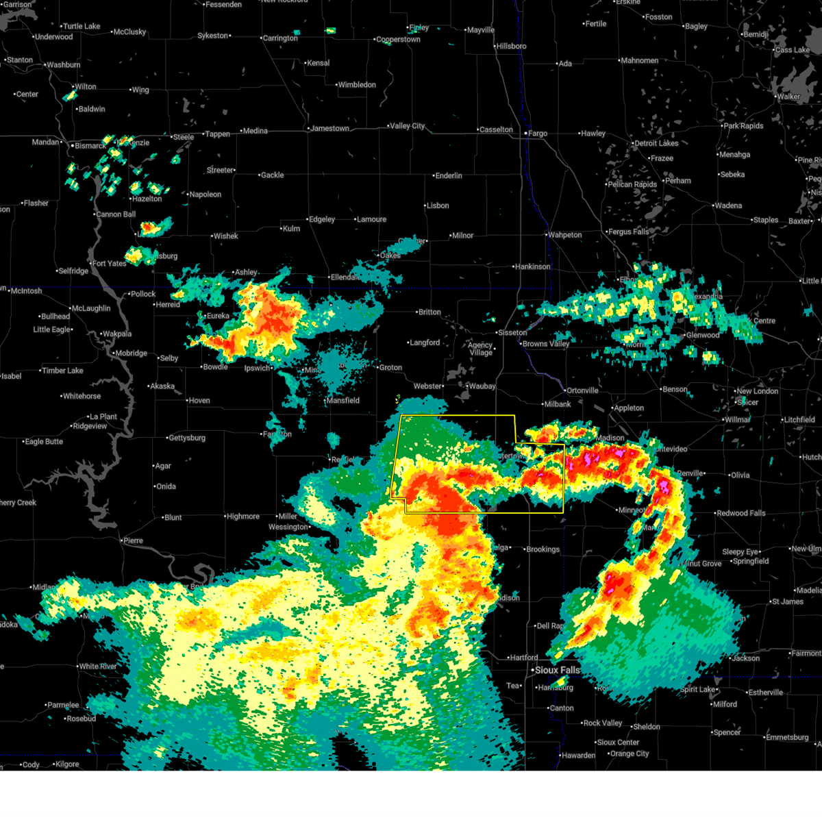
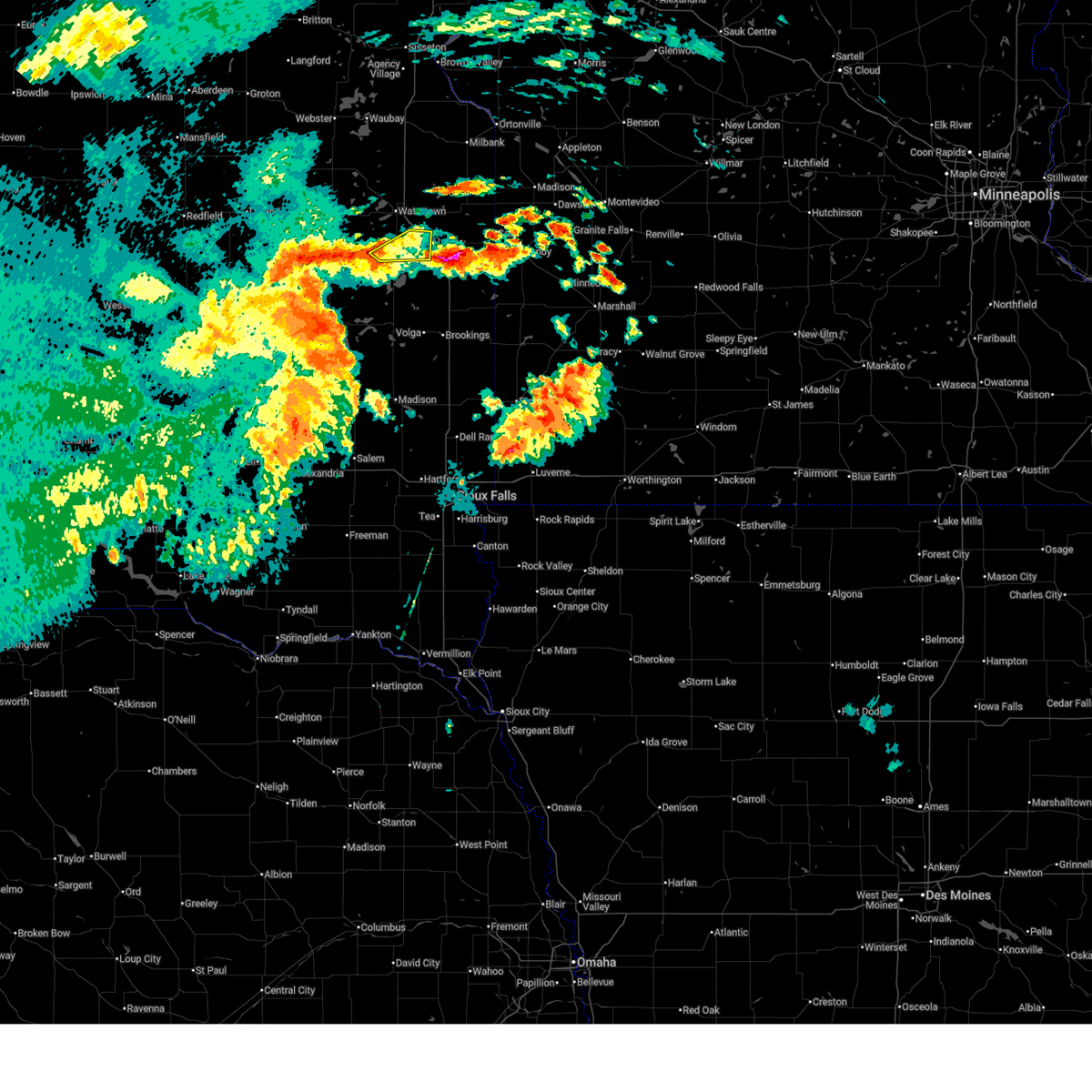
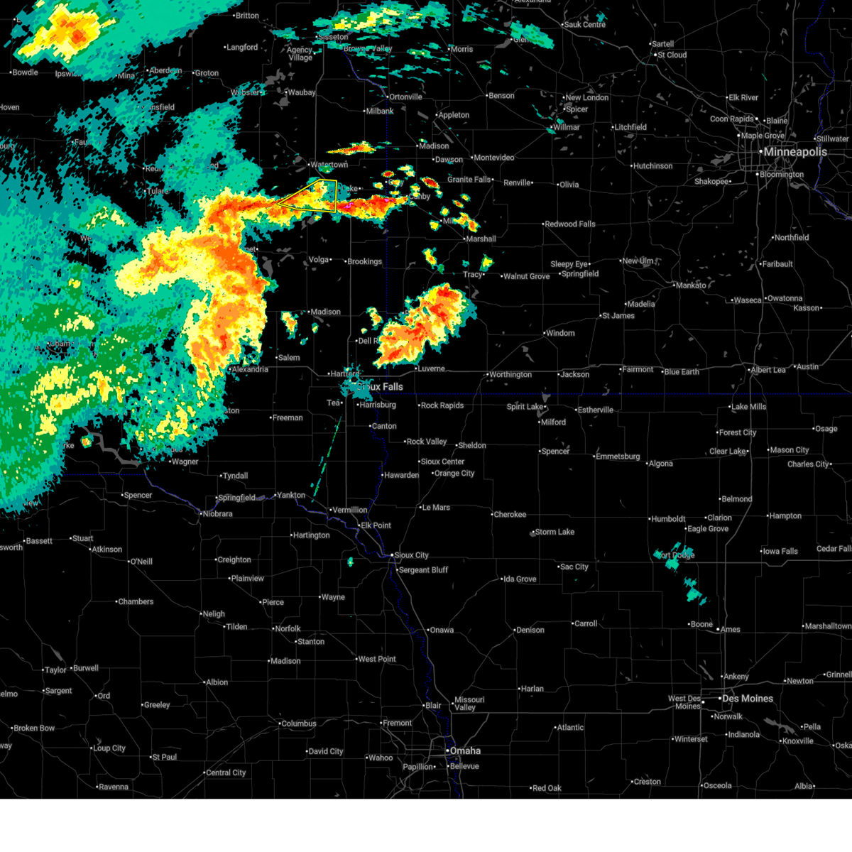
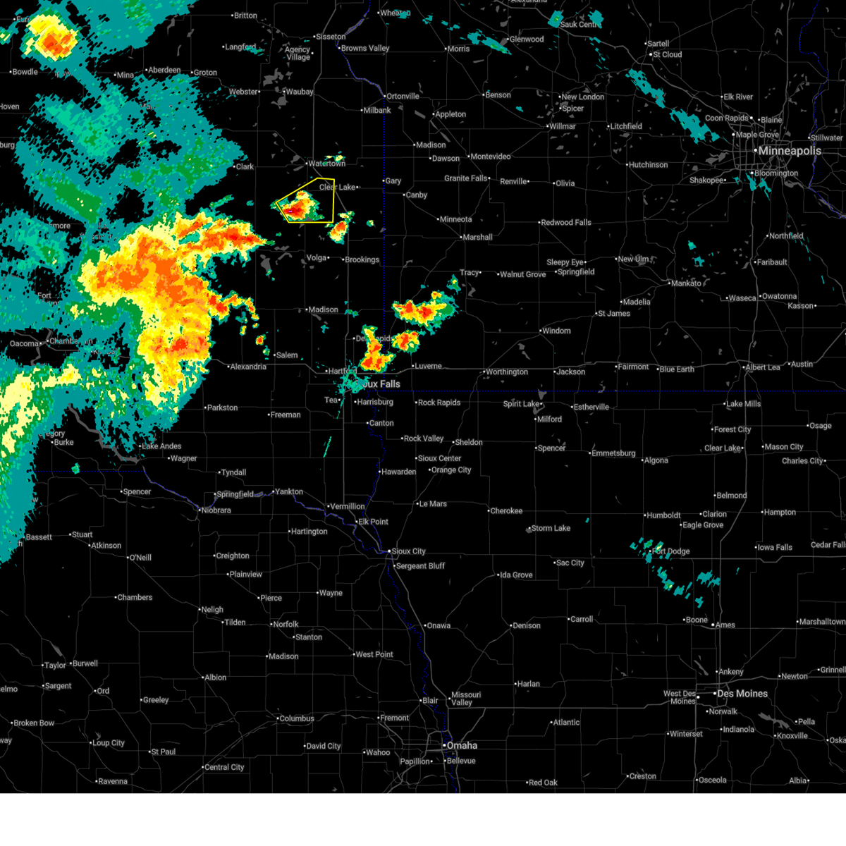
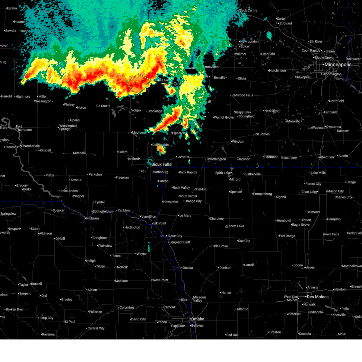
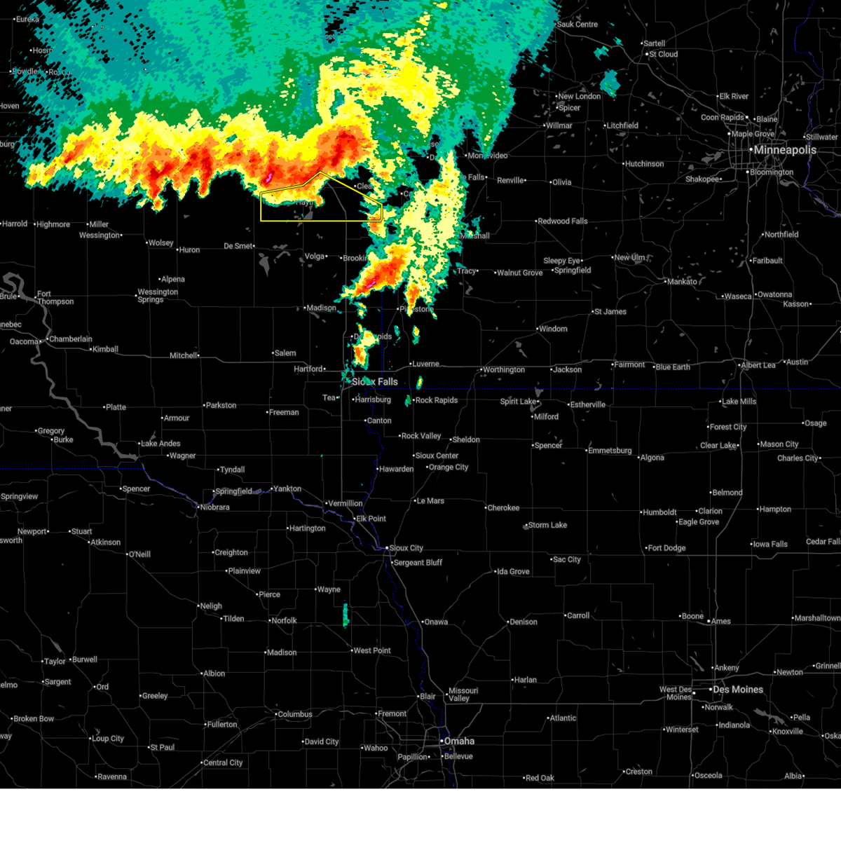
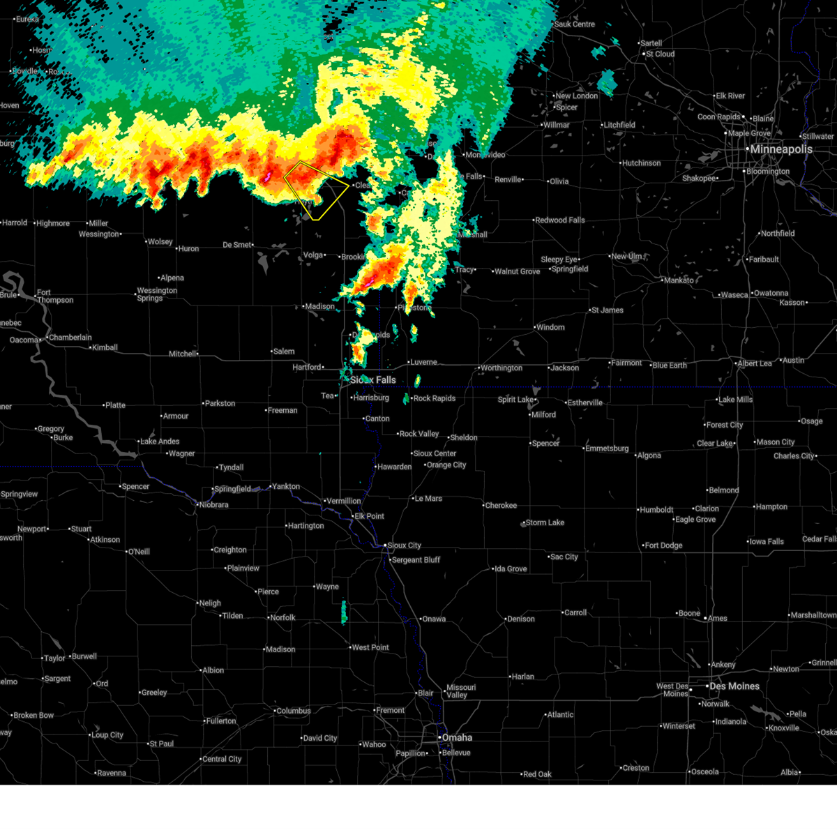
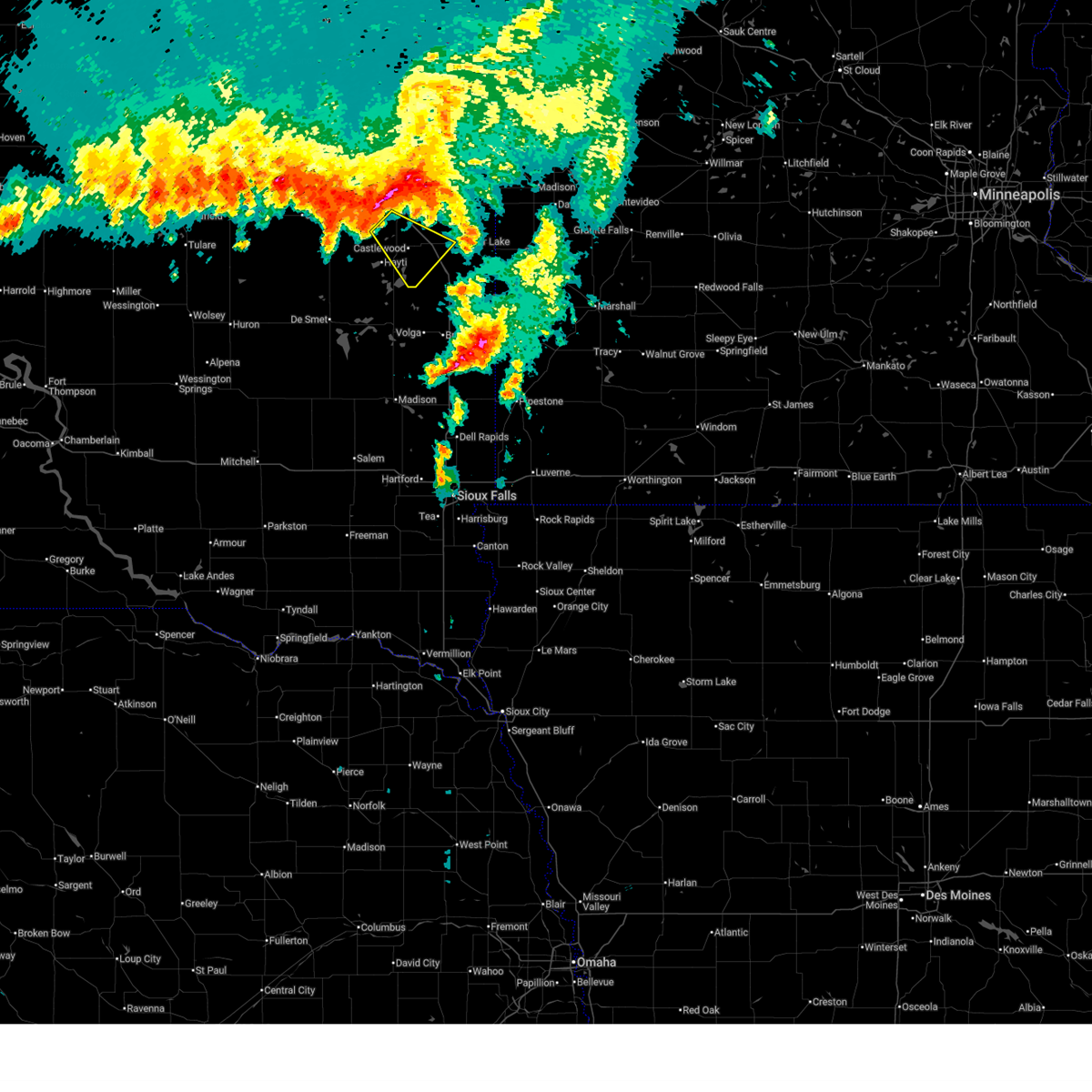
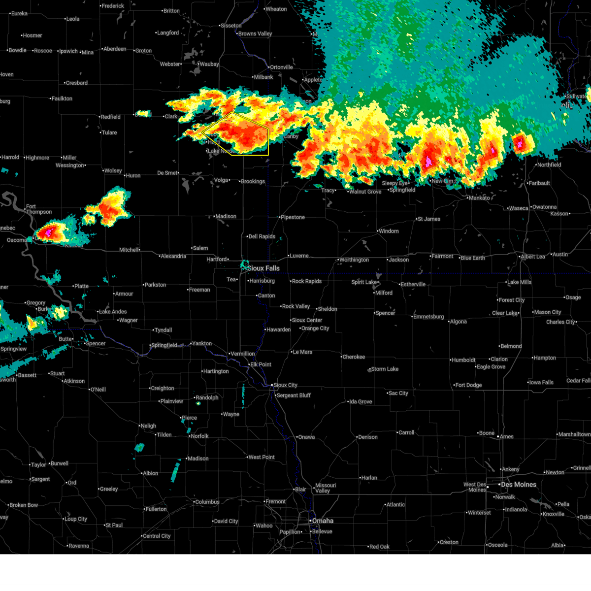
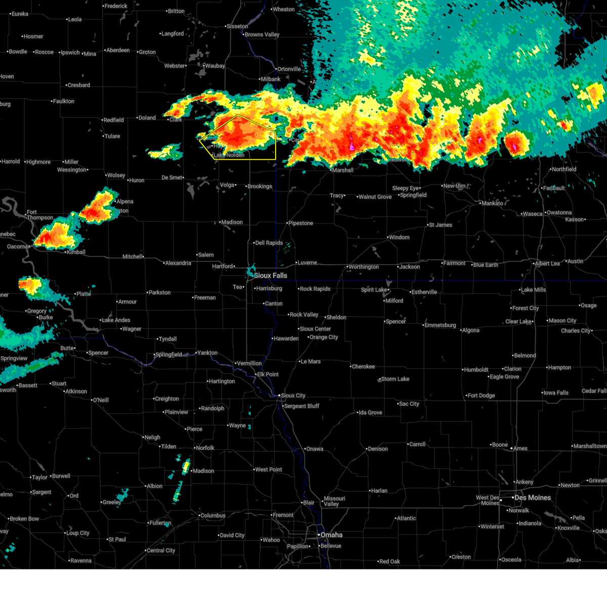
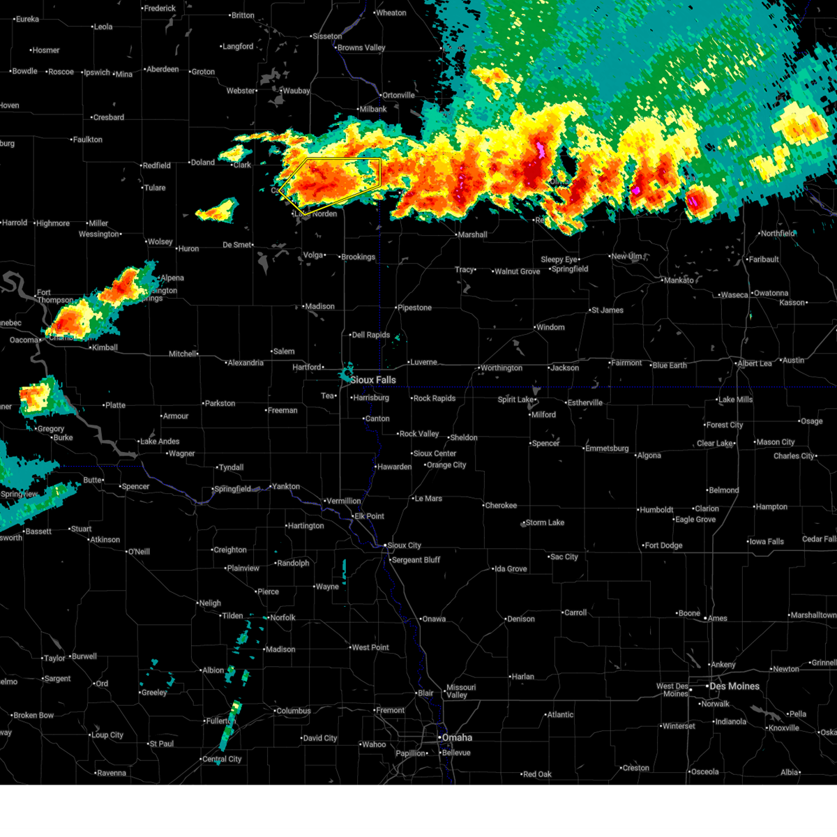
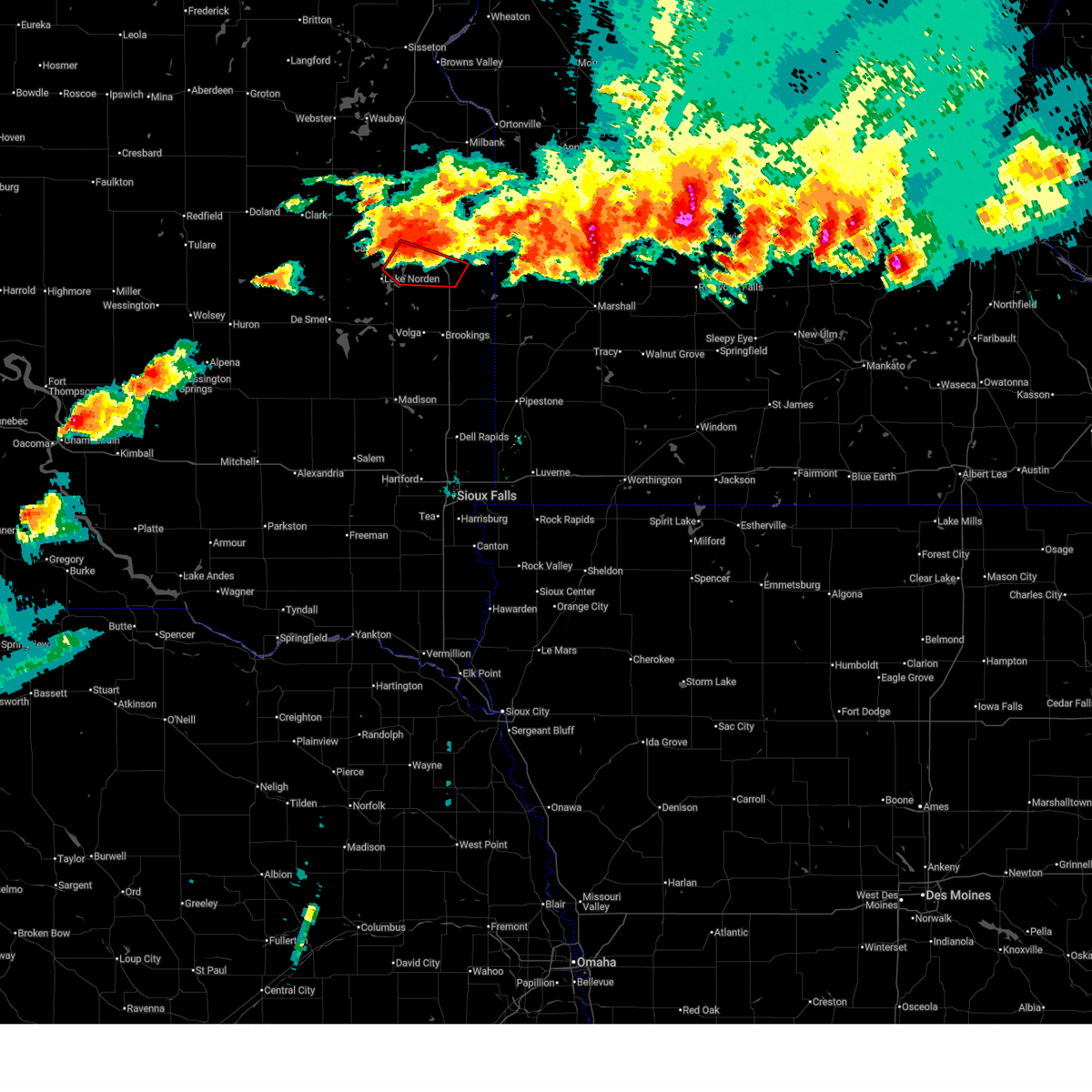
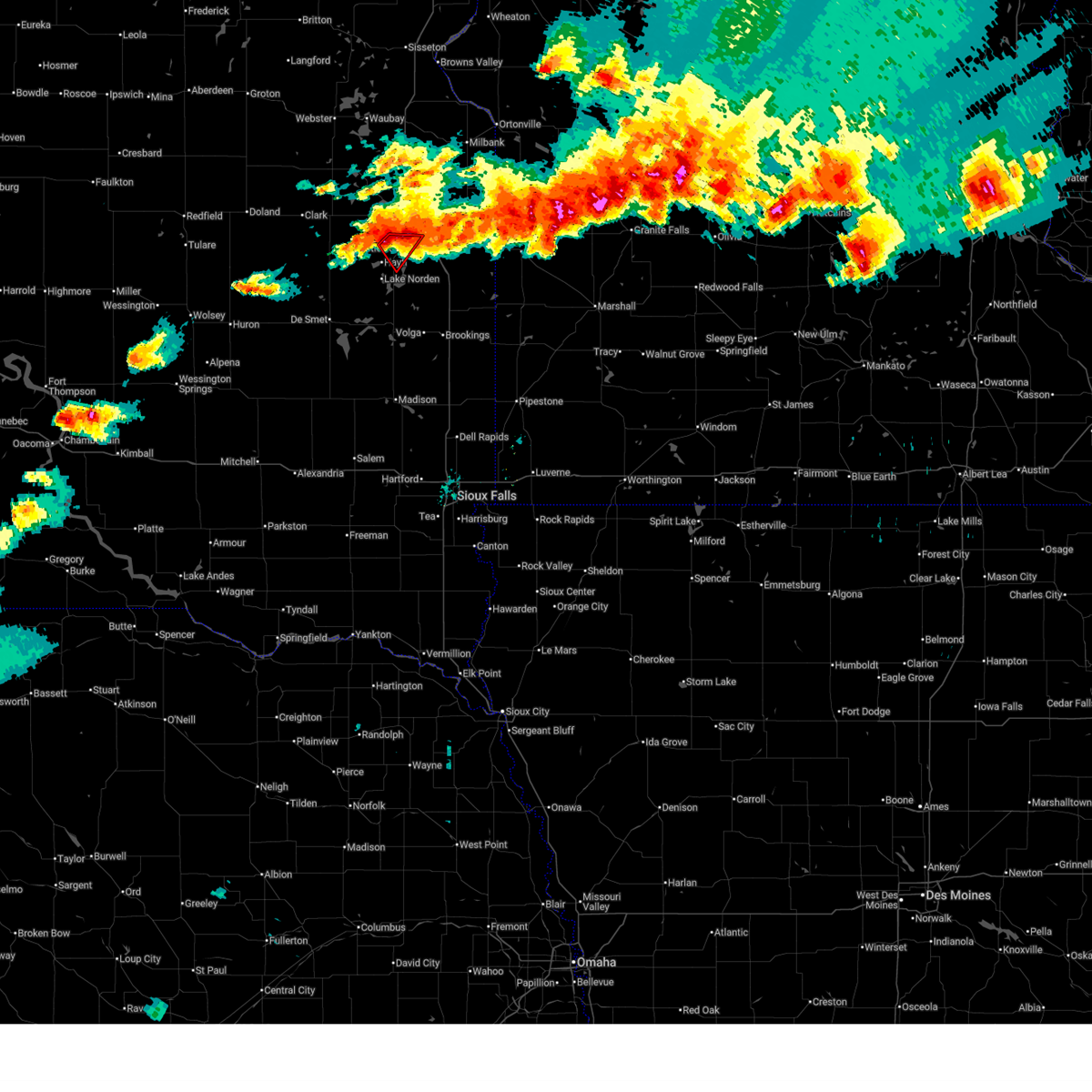
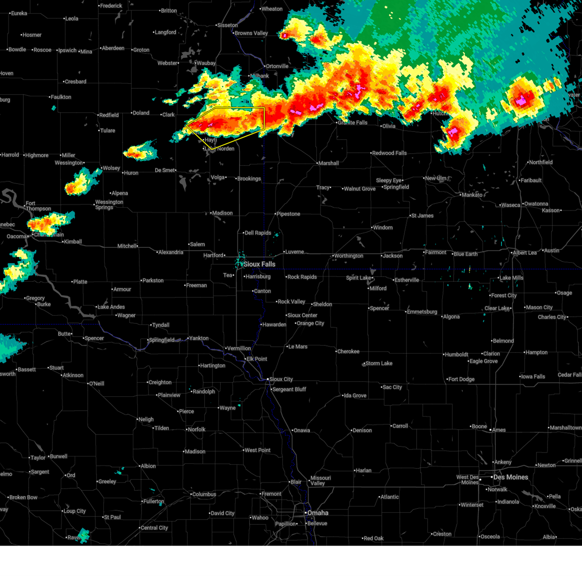
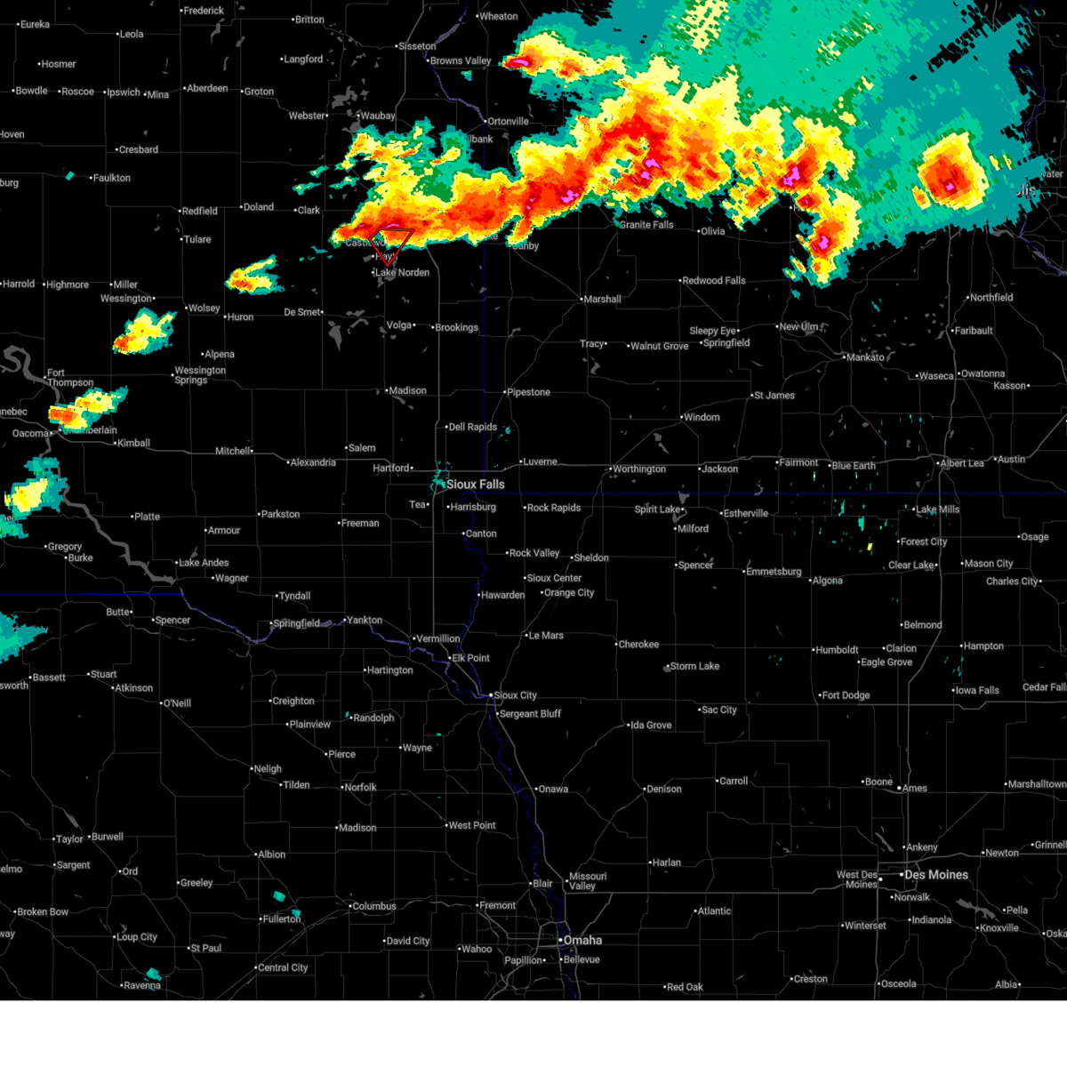
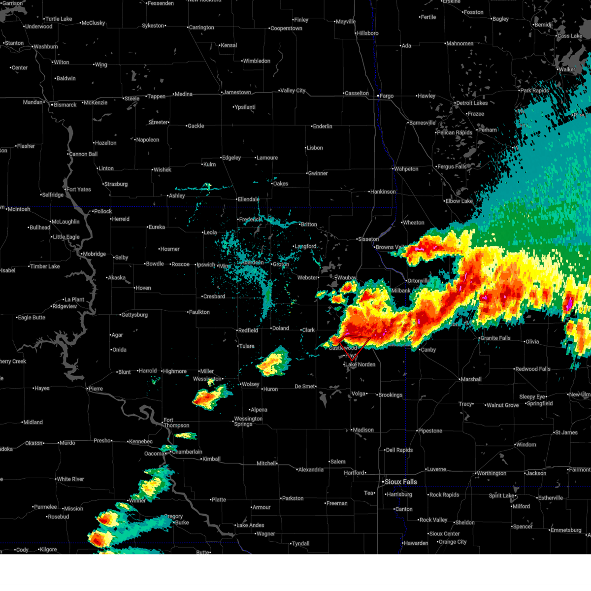
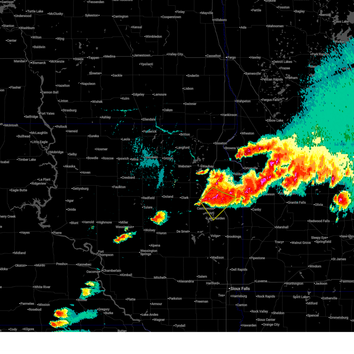
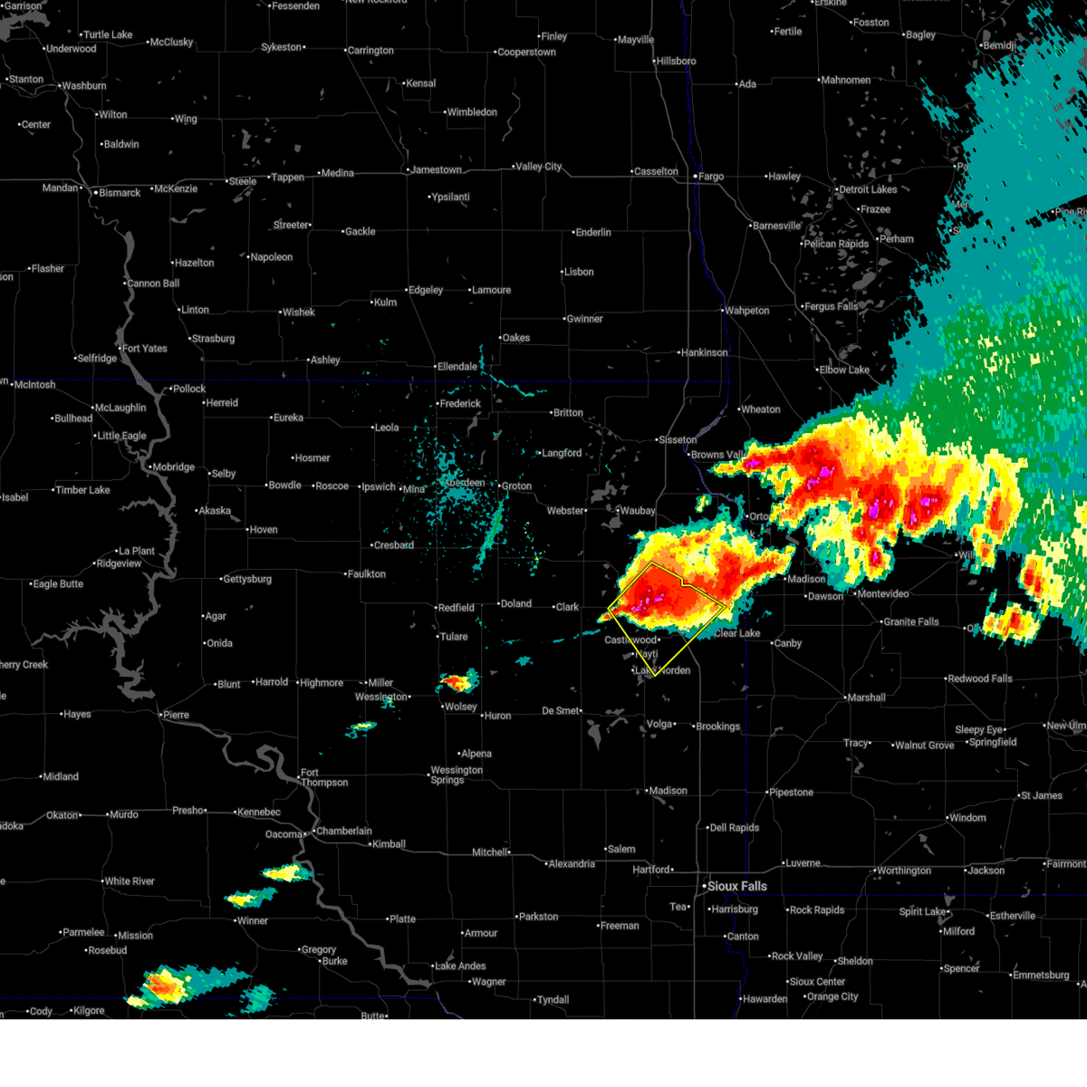
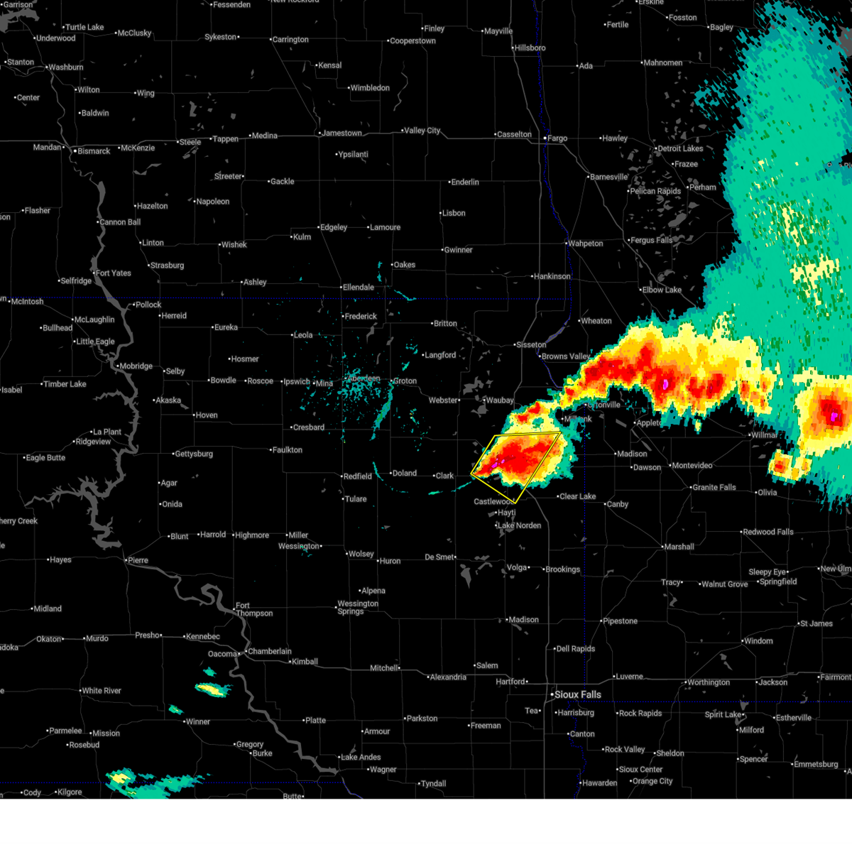
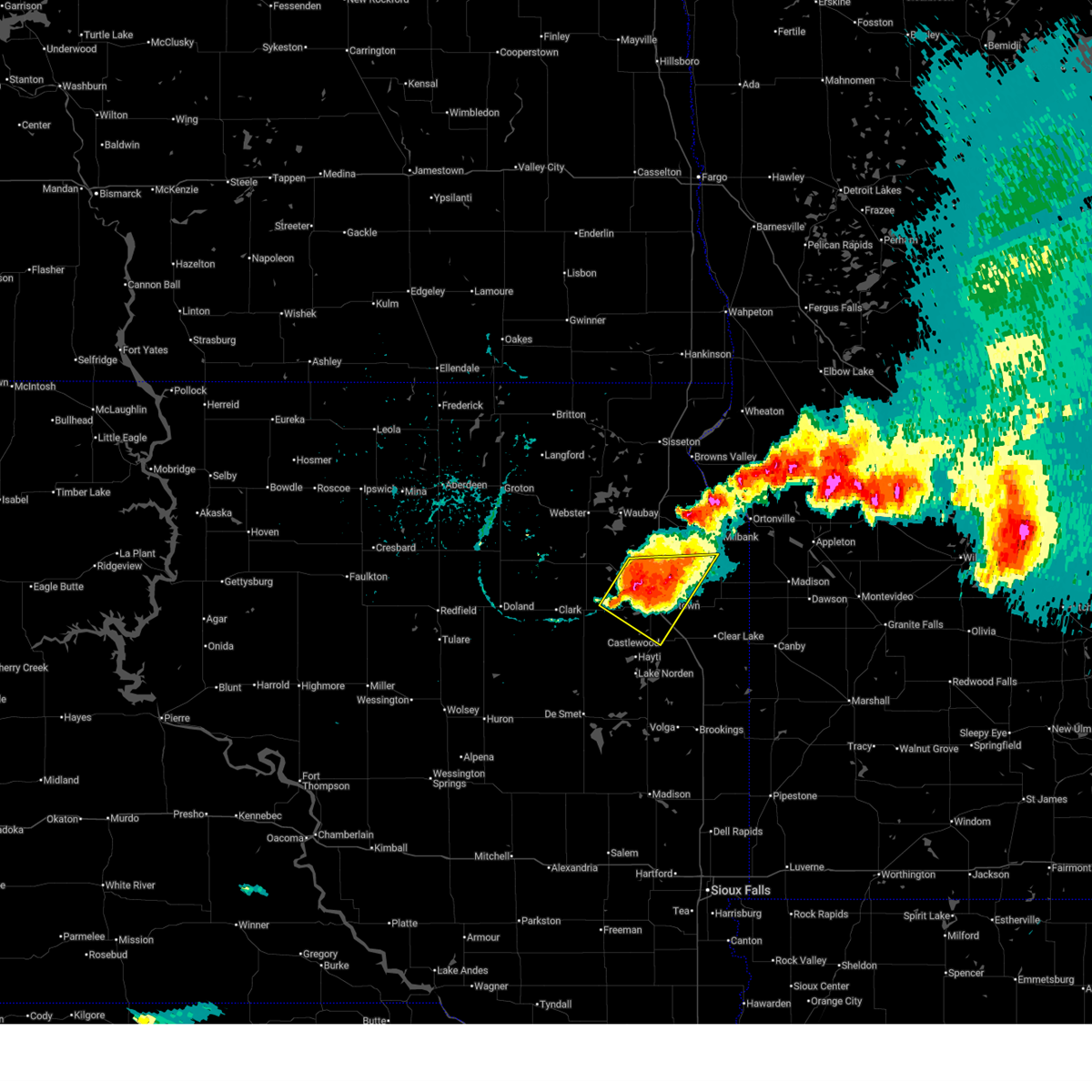
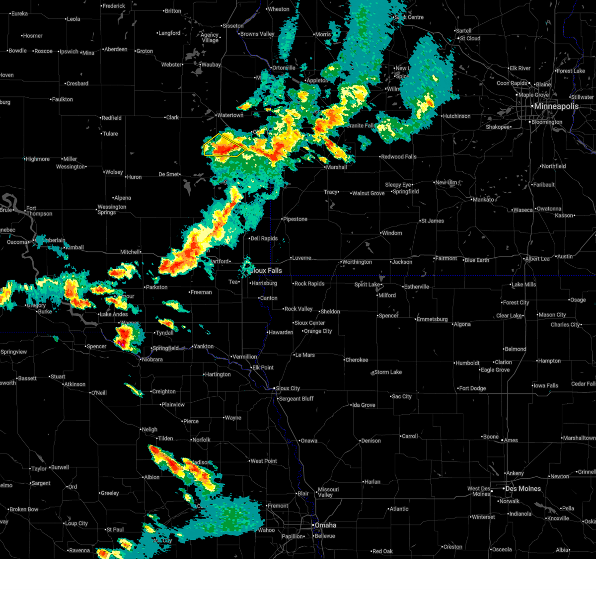
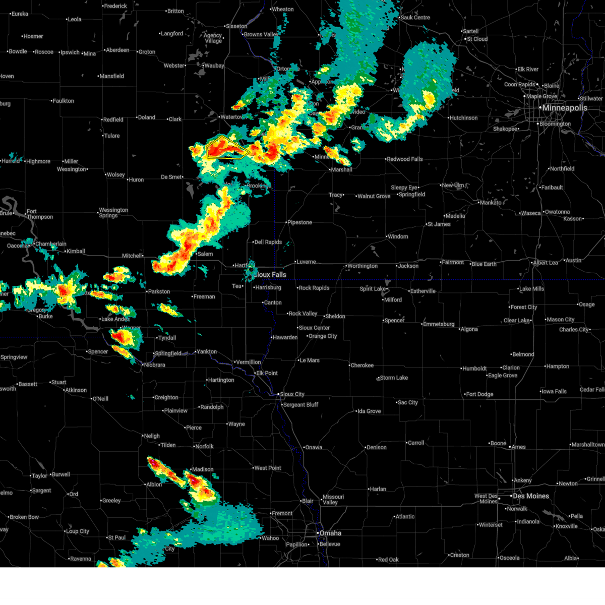
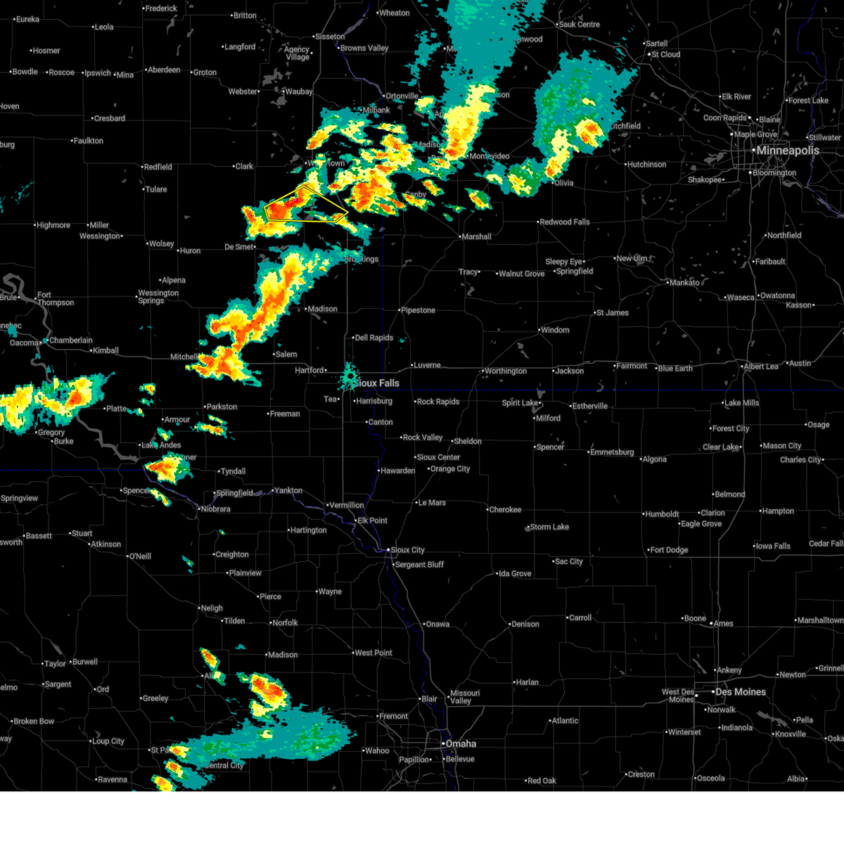
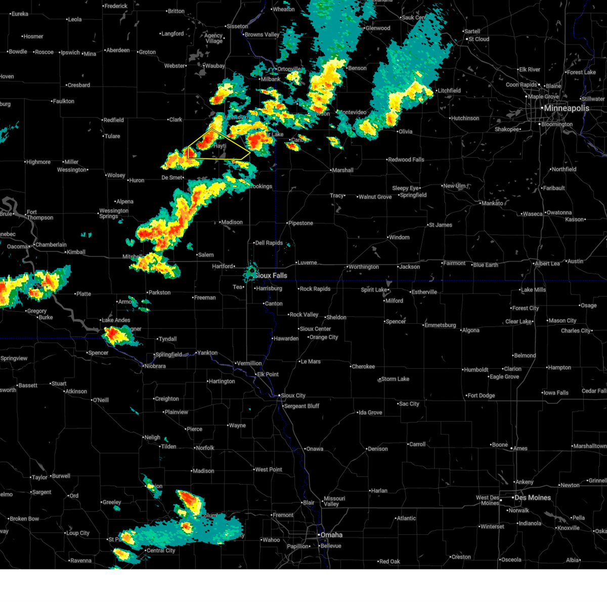
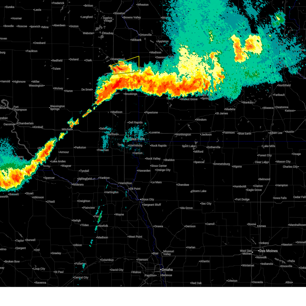
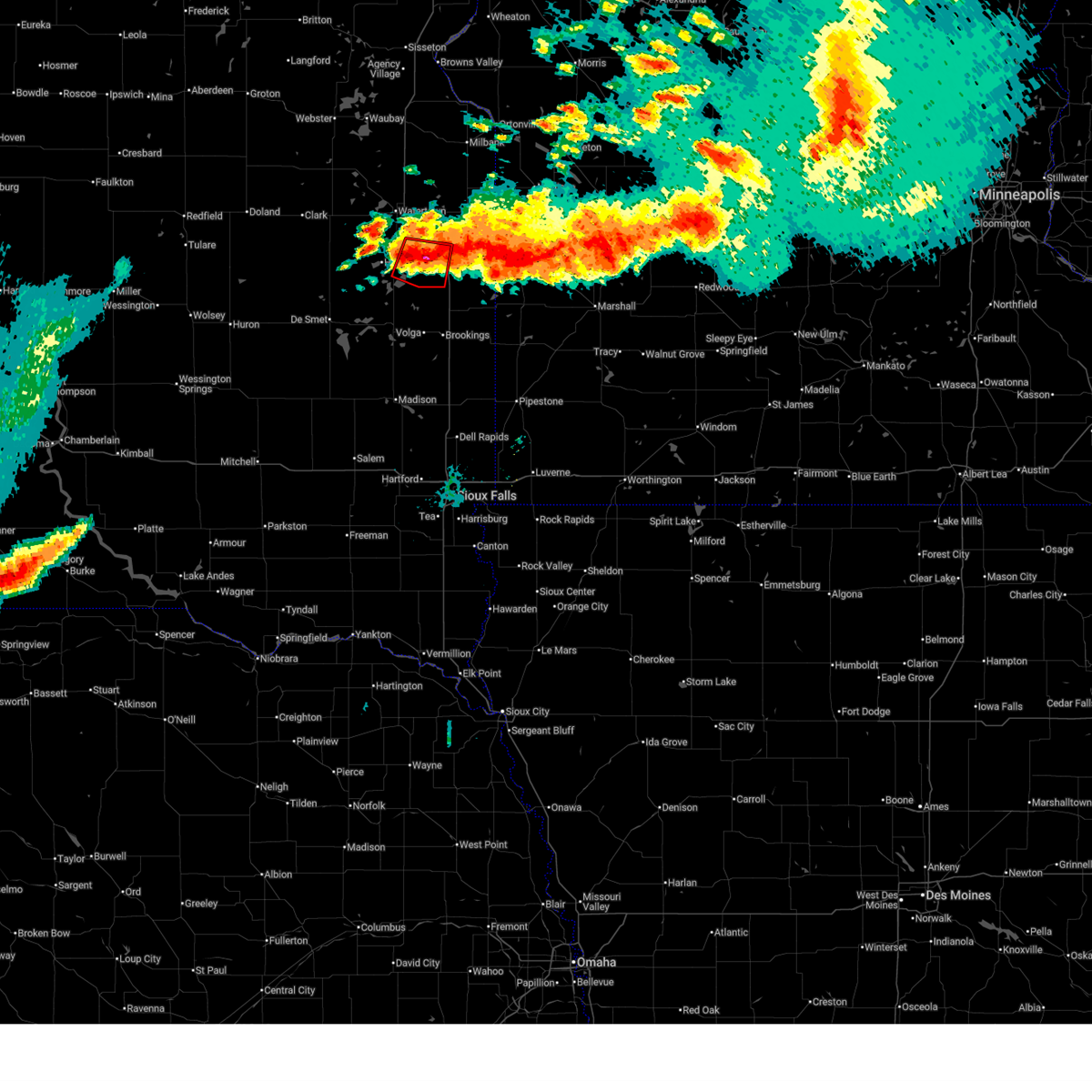
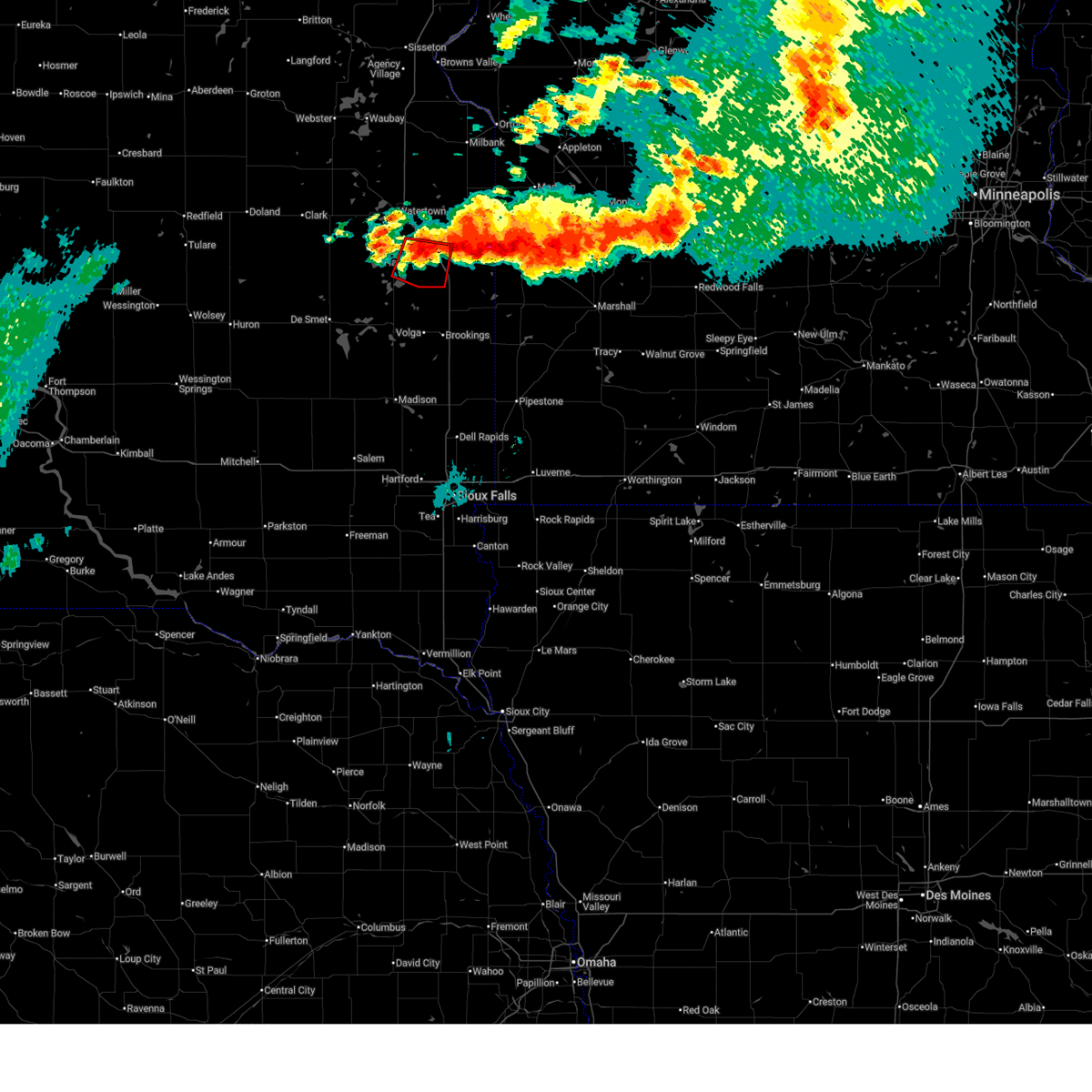
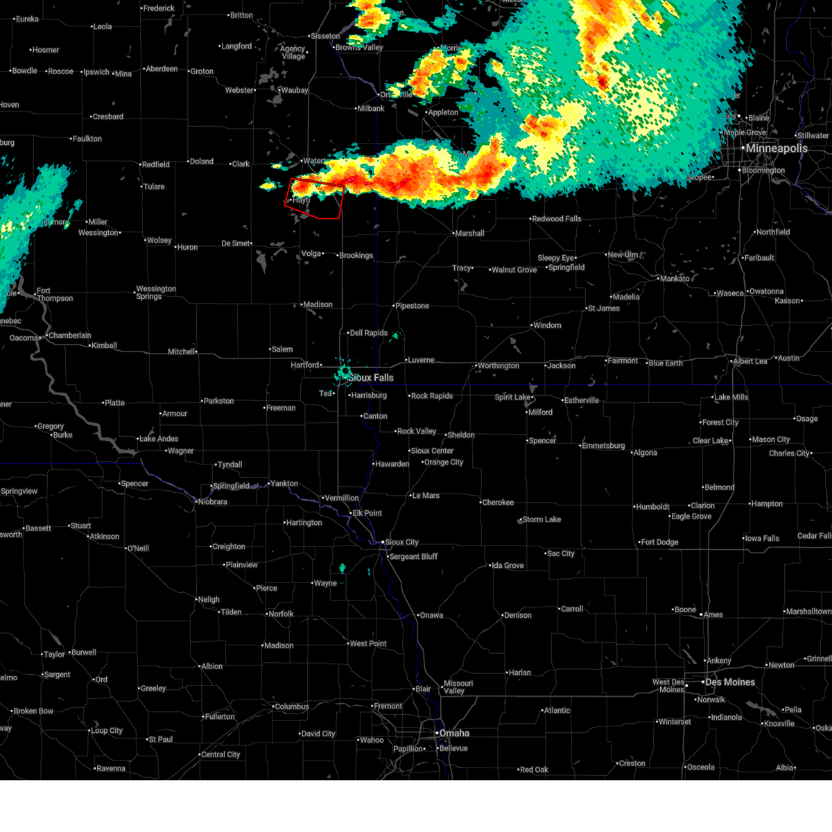
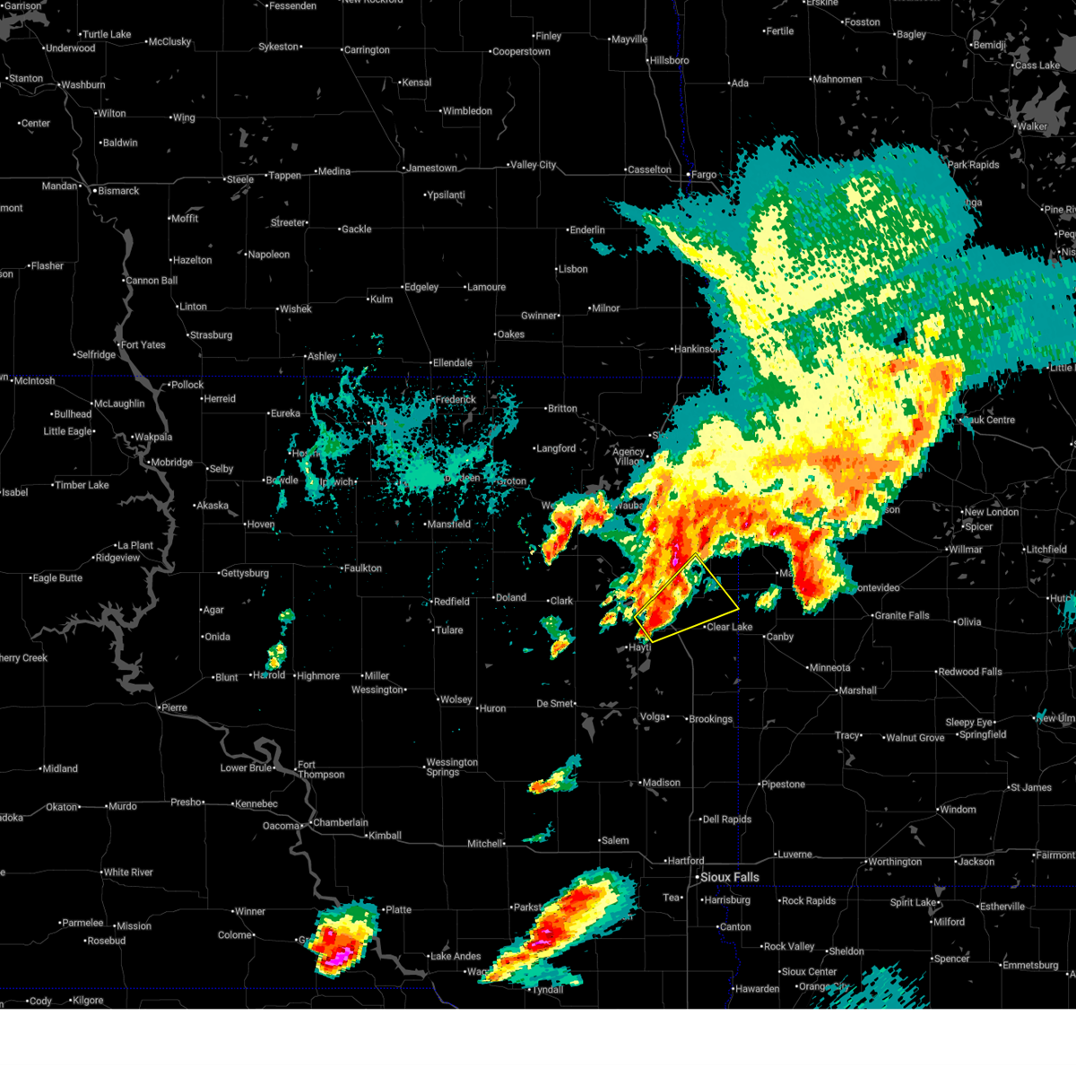
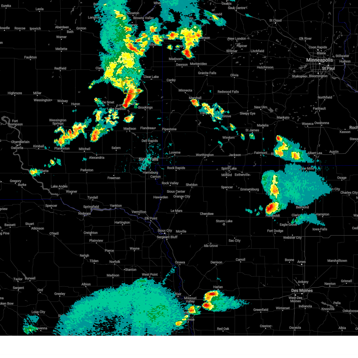
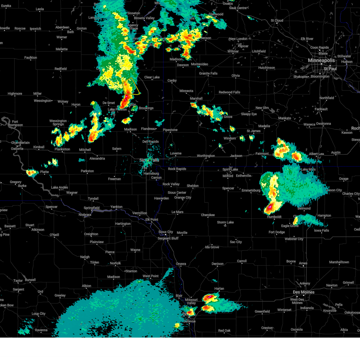
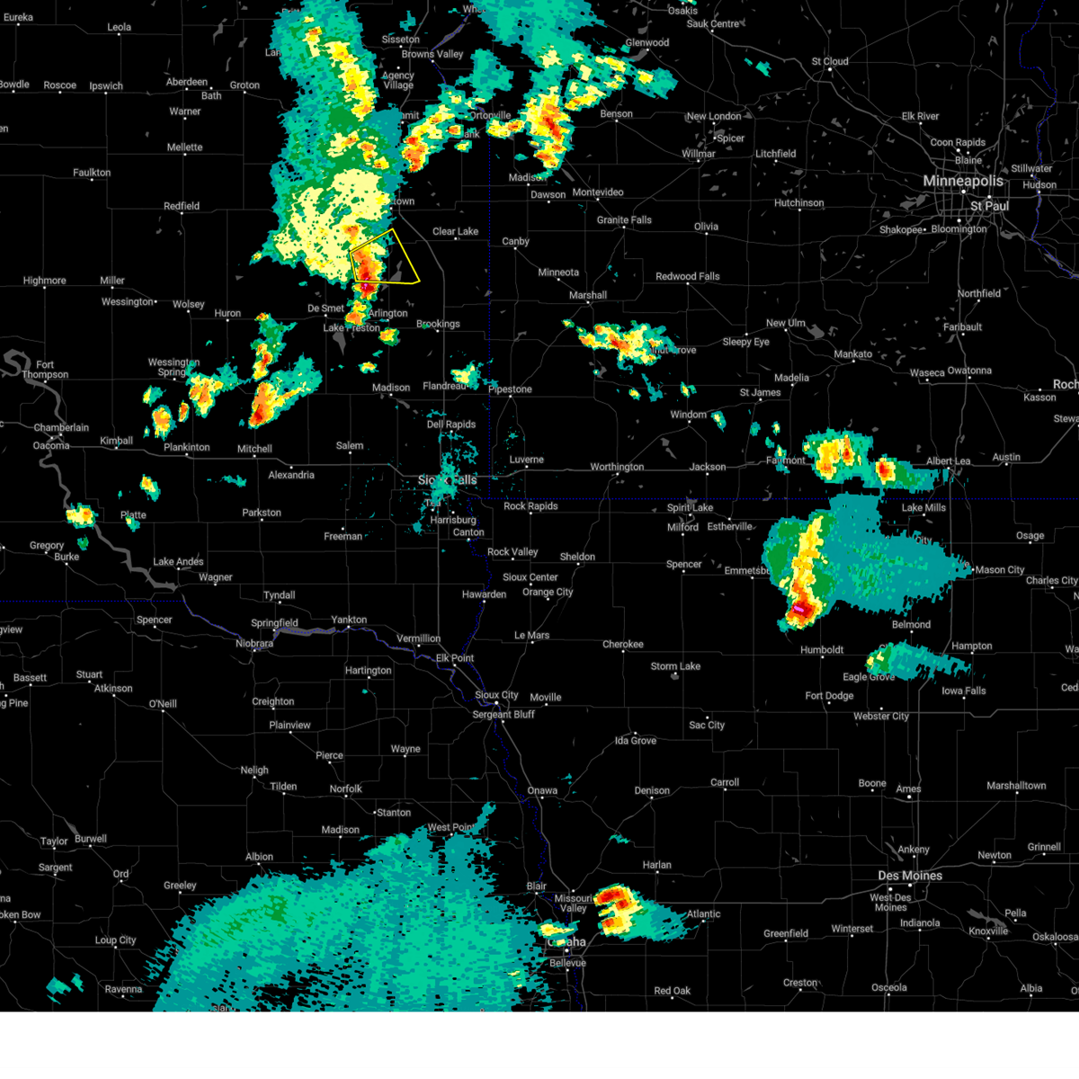
Hail Map for Castlewood, SD
The Castlewood, SD area has had 4 reports of on-the-ground hail by trained spotters, and has been under severe weather warnings 42 times during the past 12 months. Doppler radar has detected hail at or near Castlewood, SD on 53 occasions, including 8 occasions during the past year.
| Name: | Castlewood, SD |
| Where Located: | 66.4 miles WSW of Montevideo, MN |
| Map: | Google Map for Castlewood, SD |
| Population: | 627 |
| Housing Units: | 292 |
| More Info: | Search Google for Castlewood, SD |
1
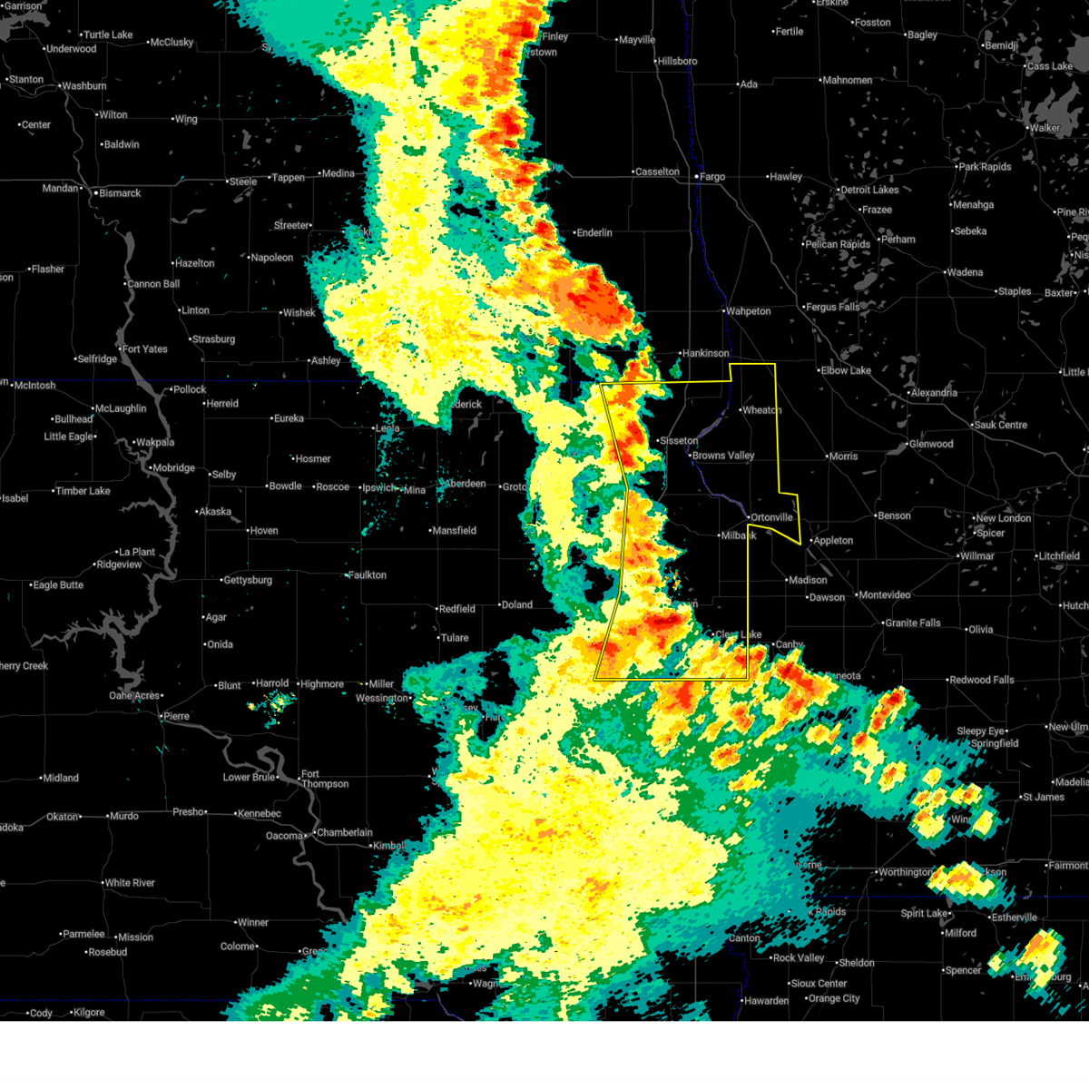
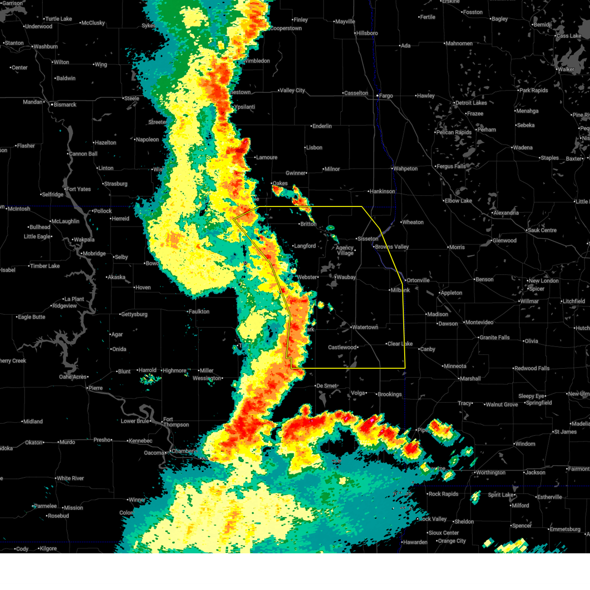
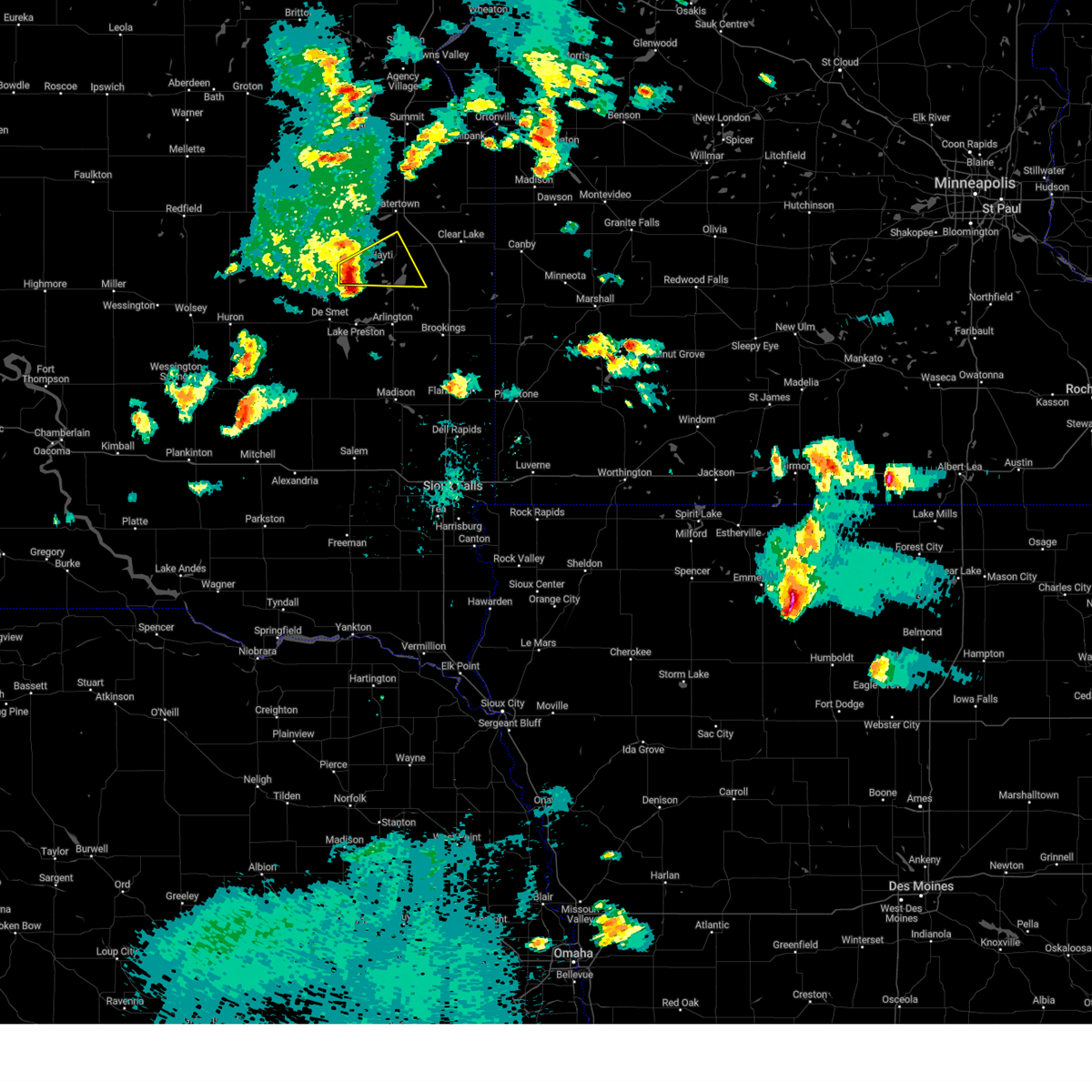
The Top Recent Hail Date for Castlewood, SD is Sunday, July 27, 2025 (5th out of 53)
Hail and Wind Damage Spotted near Castlewood, SD
| Date / Time | Report Details |
|---|---|
| 6/10/2026 1:35 AM CDT | Significant tree damage along 465th avenu in hamlin county SD, 7.1 miles WNW of Castlewood, SD |
| 6/10/2026 12:53 AM CDT |
 Svrabr the national weather service in aberdeen has issued a * severe thunderstorm warning for, traverse county in west central minnesota, big stone county in west central minnesota, deuel county in northeastern south dakota, roberts county in northeastern south dakota, eastern day county in northeastern south dakota, eastern marshall county in northeastern south dakota, hamlin county in northeastern south dakota, grant county in northeastern south dakota, codington county in northeastern south dakota, * until 145 am cdt. * at 1252 am cdt, severe thunderstorms were located along a line extending from 6 miles southwest of wyndmere to near victor to bonanza grove to near bullhead lake, moving northeast at 55 mph (radar indicated). Hazards include 60 mph wind gusts. Expect damage to roofs, siding, and trees. severe thunderstorms will be near, milbank, ortonville, wheaton, graceville, big stone city, clinton, rosholt, revillo, la bolt, and albee around 100 am cdt. dumont and collis around 105 am cdt. odessa, johnson, immanuel church, and trinity lutheran country church around 110 am cdt. Other locations in the path of these severe thunderstorms include tintah, charlesville, artichoke, correll and artichoke lake. Svrabr the national weather service in aberdeen has issued a * severe thunderstorm warning for, traverse county in west central minnesota, big stone county in west central minnesota, deuel county in northeastern south dakota, roberts county in northeastern south dakota, eastern day county in northeastern south dakota, eastern marshall county in northeastern south dakota, hamlin county in northeastern south dakota, grant county in northeastern south dakota, codington county in northeastern south dakota, * until 145 am cdt. * at 1252 am cdt, severe thunderstorms were located along a line extending from 6 miles southwest of wyndmere to near victor to bonanza grove to near bullhead lake, moving northeast at 55 mph (radar indicated). Hazards include 60 mph wind gusts. Expect damage to roofs, siding, and trees. severe thunderstorms will be near, milbank, ortonville, wheaton, graceville, big stone city, clinton, rosholt, revillo, la bolt, and albee around 100 am cdt. dumont and collis around 105 am cdt. odessa, johnson, immanuel church, and trinity lutheran country church around 110 am cdt. Other locations in the path of these severe thunderstorms include tintah, charlesville, artichoke, correll and artichoke lake.
|
| 6/10/2026 12:39 AM CDT |
 At 1237 am cdt, severe thunderstorms were located along a line extending from near rutland to near claire city to near marvin to near kranzburg, moving northeast at 55 mph (trained weather spotters. at 1233 am cdt, a trained spotter observed 70 mph thunderstorm wind gusts at lake poinsett). Hazards include 70 mph wind gusts. Expect considerable tree damage. damage is likely to mobile homes, roofs, and outbuildings. Locations impacted include, sisseton, browns valley, wilmot, new effington, south shore, waverly, kranzburg, peever, goodwin, corona, milbank, beardsley, strandburg, bonanza grove, yankeetown, traverse country park, la bolt, rainbow island, lismore colony, revillo and albee. At 1237 am cdt, severe thunderstorms were located along a line extending from near rutland to near claire city to near marvin to near kranzburg, moving northeast at 55 mph (trained weather spotters. at 1233 am cdt, a trained spotter observed 70 mph thunderstorm wind gusts at lake poinsett). Hazards include 70 mph wind gusts. Expect considerable tree damage. damage is likely to mobile homes, roofs, and outbuildings. Locations impacted include, sisseton, browns valley, wilmot, new effington, south shore, waverly, kranzburg, peever, goodwin, corona, milbank, beardsley, strandburg, bonanza grove, yankeetown, traverse country park, la bolt, rainbow island, lismore colony, revillo and albee.
|
| 6/10/2026 12:15 AM CDT |
 At 1213 am cdt, severe thunderstorms were located along a line extending from near westwood colony to eden to 7 miles southeast of bitter lake to near kellerton church, moving northeast at 60 mph (radar indicated). Hazards include 70 mph wind gusts. Expect considerable tree damage. damage is likely to mobile homes, roofs, and outbuildings. Locations impacted include, watertown, agency village, veblen, summit, rauville, ortley, lake city, enemy swim lake, clear lake rec area, buffalo lakes, sisseton, castlewood, south shore, waverly, kranzburg, marvin, veblen flats housing, wilmot, peever, goodwin, stockholm, claire city, troy, bemis, dakota connection & casino, peever flats housing, browns valley, new effington, corona, strandburg, twin brooks, bullhead lake, lake traverse, big stone lake, school lake, yankeetown, milbank, beardsley, la bolt, bonanza grove, tunerville, traverse country park, rainbow island, revillo, lake alice, lismore colony and albee. At 1213 am cdt, severe thunderstorms were located along a line extending from near westwood colony to eden to 7 miles southeast of bitter lake to near kellerton church, moving northeast at 60 mph (radar indicated). Hazards include 70 mph wind gusts. Expect considerable tree damage. damage is likely to mobile homes, roofs, and outbuildings. Locations impacted include, watertown, agency village, veblen, summit, rauville, ortley, lake city, enemy swim lake, clear lake rec area, buffalo lakes, sisseton, castlewood, south shore, waverly, kranzburg, marvin, veblen flats housing, wilmot, peever, goodwin, stockholm, claire city, troy, bemis, dakota connection & casino, peever flats housing, browns valley, new effington, corona, strandburg, twin brooks, bullhead lake, lake traverse, big stone lake, school lake, yankeetown, milbank, beardsley, la bolt, bonanza grove, tunerville, traverse country park, rainbow island, revillo, lake alice, lismore colony and albee.
|
| 6/9/2026 11:57 PM CDT |
 Svrabr the national weather service in aberdeen has issued a * severe thunderstorm warning for, southwestern traverse county in west central minnesota, northwestern big stone county in west central minnesota, deuel county in northeastern south dakota, roberts county in northeastern south dakota, day county in northeastern south dakota, marshall county in northeastern south dakota, northeastern brown county in northeastern south dakota, hamlin county in northeastern south dakota, grant county in northeastern south dakota, clark county in northeastern south dakota, codington county in northeastern south dakota, * until 100 am cdt. * at 1156 pm cdt, severe thunderstorms were located along a line extending from near hecla to near pierpont to near wallace to near willow lake, moving east at 55 mph (radar indicated). Hazards include 70 mph wind gusts and nickel size hail. Expect considerable tree damage. damage is likely to mobile homes, roofs, and outbuildings. severe thunderstorms will be near, webster, bryant, florence, langford, henry, hecla, mayfield colony, sunset colony, newport colony, and hazel around 1200 am cdt. watertown, britton, goose lake, roslyn, rush lake, minnewasta lake, opitz lake, cattail lake, bitter lake, and lake kampeska around 1205 am cdt. waubay, hayti, enemy swim housing, eden, kidder, grenville, westwood colony, enemy swim lake, campbell slough, and piyas lake around 1210 am cdt. rauville, ortley, lake city, clear lake rec area, buffalo lakes, roy lake rec area, and pickerel lake rec area around 1215 am cdt. Other locations in the path of these severe thunderstorms include castlewood, summit, rudebusch corner, red iron housing, agency village, south shore, waverly, kranzburg, claremont colony, marvin, hillhead, finley heights housing, long hollow housing, sica hollow state park, sisseton, veblen, peever, goodwin, stockholm, twin brooks, troy, bemis, school lake, veblen flats housing, wilmot, corona, strandburg, bullhead lake, dakota connection & casino and peever flats housing. Svrabr the national weather service in aberdeen has issued a * severe thunderstorm warning for, southwestern traverse county in west central minnesota, northwestern big stone county in west central minnesota, deuel county in northeastern south dakota, roberts county in northeastern south dakota, day county in northeastern south dakota, marshall county in northeastern south dakota, northeastern brown county in northeastern south dakota, hamlin county in northeastern south dakota, grant county in northeastern south dakota, clark county in northeastern south dakota, codington county in northeastern south dakota, * until 100 am cdt. * at 1156 pm cdt, severe thunderstorms were located along a line extending from near hecla to near pierpont to near wallace to near willow lake, moving east at 55 mph (radar indicated). Hazards include 70 mph wind gusts and nickel size hail. Expect considerable tree damage. damage is likely to mobile homes, roofs, and outbuildings. severe thunderstorms will be near, webster, bryant, florence, langford, henry, hecla, mayfield colony, sunset colony, newport colony, and hazel around 1200 am cdt. watertown, britton, goose lake, roslyn, rush lake, minnewasta lake, opitz lake, cattail lake, bitter lake, and lake kampeska around 1205 am cdt. waubay, hayti, enemy swim housing, eden, kidder, grenville, westwood colony, enemy swim lake, campbell slough, and piyas lake around 1210 am cdt. rauville, ortley, lake city, clear lake rec area, buffalo lakes, roy lake rec area, and pickerel lake rec area around 1215 am cdt. Other locations in the path of these severe thunderstorms include castlewood, summit, rudebusch corner, red iron housing, agency village, south shore, waverly, kranzburg, claremont colony, marvin, hillhead, finley heights housing, long hollow housing, sica hollow state park, sisseton, veblen, peever, goodwin, stockholm, twin brooks, troy, bemis, school lake, veblen flats housing, wilmot, corona, strandburg, bullhead lake, dakota connection & casino and peever flats housing.
|
| 6/3/2026 7:55 PM CDT |
 Svrabr the national weather service in aberdeen has issued a * severe thunderstorm warning for, west central deuel county in northeastern south dakota, northeastern hamlin county in northeastern south dakota, southeastern codington county in northeastern south dakota, * until 845 pm cdt. * at 755 pm cdt, a severe thunderstorm was located over claremont colony, or near castlewood, moving northeast at 20 mph (radar indicated). Hazards include 60 mph wind gusts and quarter size hail. Hail damage to vehicles is expected. expect wind damage to roofs, siding, and trees. this severe thunderstorm will be near, claremont colony around 800 pm cdt. bemis around 815 pm cdt. Other locations in the path of this severe thunderstorm include goodwin. Svrabr the national weather service in aberdeen has issued a * severe thunderstorm warning for, west central deuel county in northeastern south dakota, northeastern hamlin county in northeastern south dakota, southeastern codington county in northeastern south dakota, * until 845 pm cdt. * at 755 pm cdt, a severe thunderstorm was located over claremont colony, or near castlewood, moving northeast at 20 mph (radar indicated). Hazards include 60 mph wind gusts and quarter size hail. Hail damage to vehicles is expected. expect wind damage to roofs, siding, and trees. this severe thunderstorm will be near, claremont colony around 800 pm cdt. bemis around 815 pm cdt. Other locations in the path of this severe thunderstorm include goodwin.
|
| 9/2/2025 5:04 PM CDT |
 Svrabr the national weather service in aberdeen has issued a * severe thunderstorm warning for, southwestern deuel county in northeastern south dakota, northeastern hamlin county in northeastern south dakota, southeastern codington county in northeastern south dakota, * until 545 pm cdt. * at 504 pm cdt, a severe thunderstorm was located near rauville, or near watertown, moving southeast at 20 mph (radar indicated). Hazards include quarter size hail. Damage to vehicles is expected. this severe thunderstorm will be near, watertown, kranzburg, and pelican lake around 510 pm cdt. Other locations in the path of this severe thunderstorm include bemis and castlewood. Svrabr the national weather service in aberdeen has issued a * severe thunderstorm warning for, southwestern deuel county in northeastern south dakota, northeastern hamlin county in northeastern south dakota, southeastern codington county in northeastern south dakota, * until 545 pm cdt. * at 504 pm cdt, a severe thunderstorm was located near rauville, or near watertown, moving southeast at 20 mph (radar indicated). Hazards include quarter size hail. Damage to vehicles is expected. this severe thunderstorm will be near, watertown, kranzburg, and pelican lake around 510 pm cdt. Other locations in the path of this severe thunderstorm include bemis and castlewood.
|
| 8/16/2025 4:17 AM CDT |
 At 417 am cdt, severe thunderstorms were located along a line extending from dakota sioux casino to near claremont colony to near white, moving northeast at 65 mph (radar indicated. at 353 am 59 mph wind gust was reported 4 miles west of bryant). Hazards include 70 mph wind gusts and nickel size hail. Expect considerable tree damage. damage is likely to mobile homes, roofs, and outbuildings. these severe storms will be near, watertown, clear lake, rauville, toronto, waverly, kranzburg, goodwin, astoria, brandt, and bemis around 420 am cdt. Other locations in the path of these severe thunderstorms include south shore, altamont, bullhead lake, lake alice, tunerville, gary, lake cochrane rec area and moritz. At 417 am cdt, severe thunderstorms were located along a line extending from dakota sioux casino to near claremont colony to near white, moving northeast at 65 mph (radar indicated. at 353 am 59 mph wind gust was reported 4 miles west of bryant). Hazards include 70 mph wind gusts and nickel size hail. Expect considerable tree damage. damage is likely to mobile homes, roofs, and outbuildings. these severe storms will be near, watertown, clear lake, rauville, toronto, waverly, kranzburg, goodwin, astoria, brandt, and bemis around 420 am cdt. Other locations in the path of these severe thunderstorms include south shore, altamont, bullhead lake, lake alice, tunerville, gary, lake cochrane rec area and moritz.
|
| 8/16/2025 4:02 AM CDT |
 At 402 am cdt, severe thunderstorms were located along a line extending from near henry to near hayti to near volga, moving northeast at 55 mph (radar indicated). Hazards include 60 mph wind gusts and nickel size hail. Expect damage to roofs, siding, and trees. these severe storms will be near, estelline, castlewood, goose lake, lake poinsett, hayti, henry, thomas, long lake, pelican lake, and stone bridge around 405 am cdt. watertown, claremont colony, poinsett colony, lake kampeska, sandy shore rec area, and memorial park camping site around 410 am cdt. watertown city park around 415 am cdt. Other locations in the path of these severe thunderstorms include clear lake, rauville, toronto, kranzburg, goodwin, bemis, dakota sioux casino, waverly, astoria, brandt, altamont, school lake, bullhead lake, lake alice, lake cochrane rec area, tunerville, moritz and gary. At 402 am cdt, severe thunderstorms were located along a line extending from near henry to near hayti to near volga, moving northeast at 55 mph (radar indicated). Hazards include 60 mph wind gusts and nickel size hail. Expect damage to roofs, siding, and trees. these severe storms will be near, estelline, castlewood, goose lake, lake poinsett, hayti, henry, thomas, long lake, pelican lake, and stone bridge around 405 am cdt. watertown, claremont colony, poinsett colony, lake kampeska, sandy shore rec area, and memorial park camping site around 410 am cdt. watertown city park around 415 am cdt. Other locations in the path of these severe thunderstorms include clear lake, rauville, toronto, kranzburg, goodwin, bemis, dakota sioux casino, waverly, astoria, brandt, altamont, school lake, bullhead lake, lake alice, lake cochrane rec area, tunerville, moritz and gary.
|
| 8/16/2025 3:57 AM CDT |
 Svrabr the national weather service in aberdeen has issued a * severe thunderstorm warning for, deuel county in northeastern south dakota, hamlin county in northeastern south dakota, clark county in northeastern south dakota, codington county in northeastern south dakota, * until 445 am cdt. * at 357 am cdt, severe thunderstorms were located along a line extending from 8 miles west of mayfield colony to near lake norden to near arlington, moving northeast at 70 mph (radar indicated). Hazards include 60 mph wind gusts and nickel size hail. Expect damage to roofs, siding, and trees. severe thunderstorms will be near, estelline, castlewood, lake poinsett, hayti, henry, hazel, claremont colony, naples, poinsett colony, and thomas around 405 am cdt. watertown, goose lake, long lake, lake kampeska, pelican lake, and tinkertown around 410 am cdt. toronto, astoria, brandt, bemis, sandy shore rec area, medicine lake, memorial park camping site, and watertown city park around 415 am cdt. Other locations in the path of these severe thunderstorms include clear lake, rauville, kranzburg, goodwin, altamont, dakota sioux casino, waverly, bullhead lake, lake alice, school lake, lake cochrane rec area, tunerville, moritz, gary and south shore. Svrabr the national weather service in aberdeen has issued a * severe thunderstorm warning for, deuel county in northeastern south dakota, hamlin county in northeastern south dakota, clark county in northeastern south dakota, codington county in northeastern south dakota, * until 445 am cdt. * at 357 am cdt, severe thunderstorms were located along a line extending from 8 miles west of mayfield colony to near lake norden to near arlington, moving northeast at 70 mph (radar indicated). Hazards include 60 mph wind gusts and nickel size hail. Expect damage to roofs, siding, and trees. severe thunderstorms will be near, estelline, castlewood, lake poinsett, hayti, henry, hazel, claremont colony, naples, poinsett colony, and thomas around 405 am cdt. watertown, goose lake, long lake, lake kampeska, pelican lake, and tinkertown around 410 am cdt. toronto, astoria, brandt, bemis, sandy shore rec area, medicine lake, memorial park camping site, and watertown city park around 415 am cdt. Other locations in the path of these severe thunderstorms include clear lake, rauville, kranzburg, goodwin, altamont, dakota sioux casino, waverly, bullhead lake, lake alice, school lake, lake cochrane rec area, tunerville, moritz, gary and south shore.
|
| 8/16/2025 3:43 AM CDT |
 At 343 am cdt, severe thunderstorms were located along a line extending from kellerton church to near poinsett colony, moving northeast at 35 mph (radar indicated). Hazards include 60 mph wind gusts and quarter size hail. Hail damage to vehicles is expected. expect wind damage to roofs, siding, and trees. Locations impacted include, castlewood, hayti, and claremont colony. At 343 am cdt, severe thunderstorms were located along a line extending from kellerton church to near poinsett colony, moving northeast at 35 mph (radar indicated). Hazards include 60 mph wind gusts and quarter size hail. Hail damage to vehicles is expected. expect wind damage to roofs, siding, and trees. Locations impacted include, castlewood, hayti, and claremont colony.
|
| 8/16/2025 3:32 AM CDT |
 At 332 am cdt, severe thunderstorms were located along a line extending from hamlin education center to poinsett colony, moving northeast at 20 mph (radar indicated). Hazards include 60 mph wind gusts and quarter size hail. Hail damage to vehicles is expected. expect wind damage to roofs, siding, and trees. Locations impacted include, castlewood, claremont colony and poinsett colony. At 332 am cdt, severe thunderstorms were located along a line extending from hamlin education center to poinsett colony, moving northeast at 20 mph (radar indicated). Hazards include 60 mph wind gusts and quarter size hail. Hail damage to vehicles is expected. expect wind damage to roofs, siding, and trees. Locations impacted include, castlewood, claremont colony and poinsett colony.
|
| 8/16/2025 3:08 AM CDT |
 Svrabr the national weather service in aberdeen has issued a * severe thunderstorm warning for, hamlin county in northeastern south dakota, * until 415 am cdt. * at 308 am cdt, a severe thunderstorm was located over lake norden, or over hayti, moving northeast at 20 mph (radar indicated). Hazards include 60 mph wind gusts and quarter size hail. Hail damage to vehicles is expected. expect wind damage to roofs, siding, and trees. this severe thunderstorm will be near, lake poinsett and stone bridge around 315 am cdt. castlewood around 325 am cdt. Other locations in the path of this severe thunderstorm include claremont colony, dempster and poinsett colony. Svrabr the national weather service in aberdeen has issued a * severe thunderstorm warning for, hamlin county in northeastern south dakota, * until 415 am cdt. * at 308 am cdt, a severe thunderstorm was located over lake norden, or over hayti, moving northeast at 20 mph (radar indicated). Hazards include 60 mph wind gusts and quarter size hail. Hail damage to vehicles is expected. expect wind damage to roofs, siding, and trees. this severe thunderstorm will be near, lake poinsett and stone bridge around 315 am cdt. castlewood around 325 am cdt. Other locations in the path of this severe thunderstorm include claremont colony, dempster and poinsett colony.
|
| 8/5/2025 11:28 PM CDT |
 At 1128 pm cdt, a severe thunderstorm was located over estelline, moving southeast at 45 mph (radar indicated). Hazards include 70 mph wind gusts and penny size hail. Expect considerable tree damage. damage is likely to mobile homes, roofs, and outbuildings. Locations impacted include, castlewood, lake poinsett, claremont colony, poinsett colony, stone bridge, and dempster. At 1128 pm cdt, a severe thunderstorm was located over estelline, moving southeast at 45 mph (radar indicated). Hazards include 70 mph wind gusts and penny size hail. Expect considerable tree damage. damage is likely to mobile homes, roofs, and outbuildings. Locations impacted include, castlewood, lake poinsett, claremont colony, poinsett colony, stone bridge, and dempster.
|
| 8/5/2025 11:20 PM CDT |
 Svrabr the national weather service in aberdeen has issued a * severe thunderstorm warning for, southern deuel county in northeastern south dakota, hamlin county in northeastern south dakota, southeastern codington county in northeastern south dakota, * until midnight cdt. * at 1119 pm cdt, severe thunderstorms were located along a line extending from near clear lake to dempster to near bryant, moving southeast at 35 mph (radar indicated). Hazards include 70 mph wind gusts and penny size hail. Expect considerable tree damage. damage is likely to mobile homes, roofs, and outbuildings. severe thunderstorms will be near, estelline, lake poinsett, lake norden, brandt, and lake albert around 1125 pm cdt. toronto around 1130 pm cdt. Other locations in the path of these severe thunderstorms include astoria. Svrabr the national weather service in aberdeen has issued a * severe thunderstorm warning for, southern deuel county in northeastern south dakota, hamlin county in northeastern south dakota, southeastern codington county in northeastern south dakota, * until midnight cdt. * at 1119 pm cdt, severe thunderstorms were located along a line extending from near clear lake to dempster to near bryant, moving southeast at 35 mph (radar indicated). Hazards include 70 mph wind gusts and penny size hail. Expect considerable tree damage. damage is likely to mobile homes, roofs, and outbuildings. severe thunderstorms will be near, estelline, lake poinsett, lake norden, brandt, and lake albert around 1125 pm cdt. toronto around 1130 pm cdt. Other locations in the path of these severe thunderstorms include astoria.
|
| 8/5/2025 11:16 PM CDT |
 At 1115 pm cdt, a severe thunderstorm was located over claremont colony, or near castlewood, moving southeast at 35 mph. this is a destructive storm for eastern hamlin and western deuel counties (trained weather spotters. at 1051 pm cdt, a 90 mph wind gust was reported on a weather station near lake kampeska. trees were also reported uprooted on lake kampeska). Hazards include 80 mph wind gusts and penny size hail. Flying debris will be dangerous to those caught without shelter. mobile homes will be heavily damaged. expect considerable damage to roofs, windows, and vehicles. extensive tree damage and power outages are likely. Locations impacted include, poinsett colony and dempster. At 1115 pm cdt, a severe thunderstorm was located over claremont colony, or near castlewood, moving southeast at 35 mph. this is a destructive storm for eastern hamlin and western deuel counties (trained weather spotters. at 1051 pm cdt, a 90 mph wind gust was reported on a weather station near lake kampeska. trees were also reported uprooted on lake kampeska). Hazards include 80 mph wind gusts and penny size hail. Flying debris will be dangerous to those caught without shelter. mobile homes will be heavily damaged. expect considerable damage to roofs, windows, and vehicles. extensive tree damage and power outages are likely. Locations impacted include, poinsett colony and dempster.
|
| 8/5/2025 10:54 PM CDT |
 Svrabr the national weather service in aberdeen has issued a * severe thunderstorm warning for, west central deuel county in northeastern south dakota, eastern hamlin county in northeastern south dakota, southeastern codington county in northeastern south dakota, * until 1145 pm cdt. * at 1052 pm cdt, a severe thunderstorm was located near pelican lake, or near watertown, moving southeast at 25 mph. this is a destructive storm for southeast codington and northeast hamlin counties (trained weather spotters. at 1051 pm cdt, a 90 mph wind gust was reported on a weather station near lake kampeska). Hazards include 80 mph wind gusts and penny size hail. Flying debris will be dangerous to those caught without shelter. mobile homes will be heavily damaged. expect considerable damage to roofs, windows, and vehicles. extensive tree damage and power outages are likely. this severe thunderstorm will be near, castlewood around 1100 pm cdt. claremont colony around 1105 pm cdt. Other locations in the path of this severe thunderstorm include poinsett colony and dempster. Svrabr the national weather service in aberdeen has issued a * severe thunderstorm warning for, west central deuel county in northeastern south dakota, eastern hamlin county in northeastern south dakota, southeastern codington county in northeastern south dakota, * until 1145 pm cdt. * at 1052 pm cdt, a severe thunderstorm was located near pelican lake, or near watertown, moving southeast at 25 mph. this is a destructive storm for southeast codington and northeast hamlin counties (trained weather spotters. at 1051 pm cdt, a 90 mph wind gust was reported on a weather station near lake kampeska). Hazards include 80 mph wind gusts and penny size hail. Flying debris will be dangerous to those caught without shelter. mobile homes will be heavily damaged. expect considerable damage to roofs, windows, and vehicles. extensive tree damage and power outages are likely. this severe thunderstorm will be near, castlewood around 1100 pm cdt. claremont colony around 1105 pm cdt. Other locations in the path of this severe thunderstorm include poinsett colony and dempster.
|
| 7/27/2025 10:11 PM CDT |
 The storms which prompted the warning have weakened below severe limits, and no longer pose an immediate threat to life or property. therefore, the warning will be allowed to expire. however, gusty winds and heavy rain are still possible with these thunderstorms. a severe thunderstorm watch remains in effect until midnight cdt for northeastern south dakota. The storms which prompted the warning have weakened below severe limits, and no longer pose an immediate threat to life or property. therefore, the warning will be allowed to expire. however, gusty winds and heavy rain are still possible with these thunderstorms. a severe thunderstorm watch remains in effect until midnight cdt for northeastern south dakota.
|
| 7/27/2025 9:51 PM CDT |
 At 950 pm cdt, severe thunderstorms were located along a line extending from 6 miles southwest of canby to 6 miles east of claremont colony, moving east at 25 mph (radar indicated). Hazards include 60 mph wind gusts and half dollar size hail. Hail damage to vehicles is expected. expect wind damage to roofs, siding, and trees. Locations impacted include, clear lake, brandt and lake cochrane rec area. At 950 pm cdt, severe thunderstorms were located along a line extending from 6 miles southwest of canby to 6 miles east of claremont colony, moving east at 25 mph (radar indicated). Hazards include 60 mph wind gusts and half dollar size hail. Hail damage to vehicles is expected. expect wind damage to roofs, siding, and trees. Locations impacted include, clear lake, brandt and lake cochrane rec area.
|
| 7/27/2025 9:28 PM CDT |
 Svrabr the national weather service in aberdeen has issued a * severe thunderstorm warning for, deuel county in northeastern south dakota, northeastern hamlin county in northeastern south dakota, southeastern codington county in northeastern south dakota, * until 1015 pm cdt. * at 928 pm cdt, severe thunderstorms were located along a line extending from near lake cochrane rec area to near castlewood, moving east at 25 mph (radar indicated). Hazards include ping pong ball size hail and 60 mph wind gusts. People and animals outdoors will be injured. expect hail damage to roofs, siding, windows, and vehicles. expect wind damage to roofs, siding, and trees. Severe thunderstorms will be near, clear lake, brandt, claremont colony, and lake cochrane rec area around 935 pm cdt. Svrabr the national weather service in aberdeen has issued a * severe thunderstorm warning for, deuel county in northeastern south dakota, northeastern hamlin county in northeastern south dakota, southeastern codington county in northeastern south dakota, * until 1015 pm cdt. * at 928 pm cdt, severe thunderstorms were located along a line extending from near lake cochrane rec area to near castlewood, moving east at 25 mph (radar indicated). Hazards include ping pong ball size hail and 60 mph wind gusts. People and animals outdoors will be injured. expect hail damage to roofs, siding, windows, and vehicles. expect wind damage to roofs, siding, and trees. Severe thunderstorms will be near, clear lake, brandt, claremont colony, and lake cochrane rec area around 935 pm cdt.
|
| 7/27/2025 9:08 PM CDT |
 At 907 pm cdt, severe thunderstorms were located along a line extending from lake cochrane rec area to near lake poinsett, moving southeast at 10 mph (radar indicated). Hazards include 60 mph wind gusts and half dollar size hail. Hail damage to vehicles is expected. expect wind damage to roofs, siding, and trees. Locations impacted include, clear lake, estelline, toronto, brandt, poinsett colony, lake cochrane rec area, dempster and astoria. At 907 pm cdt, severe thunderstorms were located along a line extending from lake cochrane rec area to near lake poinsett, moving southeast at 10 mph (radar indicated). Hazards include 60 mph wind gusts and half dollar size hail. Hail damage to vehicles is expected. expect wind damage to roofs, siding, and trees. Locations impacted include, clear lake, estelline, toronto, brandt, poinsett colony, lake cochrane rec area, dempster and astoria.
|
| 7/27/2025 8:40 PM CDT |
 Svrabr the national weather service in aberdeen has issued a * severe thunderstorm warning for, deuel county in northeastern south dakota, hamlin county in northeastern south dakota, southeastern codington county in northeastern south dakota, * until 930 pm cdt. * at 840 pm cdt, severe thunderstorms were located along a line extending from near lake cochrane rec area to lake poinsett, moving southeast at 10 mph (radar indicated). Hazards include 60 mph wind gusts and quarter size hail. Hail damage to vehicles is expected. expect wind damage to roofs, siding, and trees. severe thunderstorms will be near, clear lake, estelline, lake poinsett, lake norden, brandt, claremont colony, poinsett colony, lake albert, stone bridge, and lake cochrane rec area around 845 pm cdt. Other locations in the path of these severe thunderstorms include toronto. Svrabr the national weather service in aberdeen has issued a * severe thunderstorm warning for, deuel county in northeastern south dakota, hamlin county in northeastern south dakota, southeastern codington county in northeastern south dakota, * until 930 pm cdt. * at 840 pm cdt, severe thunderstorms were located along a line extending from near lake cochrane rec area to lake poinsett, moving southeast at 10 mph (radar indicated). Hazards include 60 mph wind gusts and quarter size hail. Hail damage to vehicles is expected. expect wind damage to roofs, siding, and trees. severe thunderstorms will be near, clear lake, estelline, lake poinsett, lake norden, brandt, claremont colony, poinsett colony, lake albert, stone bridge, and lake cochrane rec area around 845 pm cdt. Other locations in the path of these severe thunderstorms include toronto.
|
| 7/27/2025 8:33 PM CDT |
 At 833 pm cdt, a severe thunderstorm was located over claremont colony, or over castlewood, moving southeast at 10 mph (trained weather spotters). Hazards include golf ball size hail and 60 mph wind gusts. People and animals outdoors will be injured. expect hail damage to roofs, siding, windows, and vehicles. expect wind damage to roofs, siding, and trees. Locations impacted include, claremont colony, poinsett colony and dempster. At 833 pm cdt, a severe thunderstorm was located over claremont colony, or over castlewood, moving southeast at 10 mph (trained weather spotters). Hazards include golf ball size hail and 60 mph wind gusts. People and animals outdoors will be injured. expect hail damage to roofs, siding, windows, and vehicles. expect wind damage to roofs, siding, and trees. Locations impacted include, claremont colony, poinsett colony and dempster.
|
| 7/27/2025 8:29 PM CDT |
 Torabr the national weather service in aberdeen has issued a * tornado warning for, southwestern deuel county in northeastern south dakota, eastern hamlin county in northeastern south dakota, * until 915 pm cdt. * at 829 pm cdt, a severe thunderstorm capable of producing a tornado was located near stone bridge, or near castlewood, moving southeast at 20 mph (radar indicated rotation). Hazards include tornado and half dollar size hail. Flying debris will be dangerous to those caught without shelter. mobile homes will be damaged or destroyed. damage to roofs, windows, and vehicles will occur. tree damage is likely. this dangerous storm will be near, lake poinsett, claremont colony, poinsett colony, stone bridge, and dempster around 835 pm cdt. Estelline around 840 pm cdt. Torabr the national weather service in aberdeen has issued a * tornado warning for, southwestern deuel county in northeastern south dakota, eastern hamlin county in northeastern south dakota, * until 915 pm cdt. * at 829 pm cdt, a severe thunderstorm capable of producing a tornado was located near stone bridge, or near castlewood, moving southeast at 20 mph (radar indicated rotation). Hazards include tornado and half dollar size hail. Flying debris will be dangerous to those caught without shelter. mobile homes will be damaged or destroyed. damage to roofs, windows, and vehicles will occur. tree damage is likely. this dangerous storm will be near, lake poinsett, claremont colony, poinsett colony, stone bridge, and dempster around 835 pm cdt. Estelline around 840 pm cdt.
|
| 7/27/2025 8:25 PM CDT | Quarter sized hail reported 0.2 miles N of Castlewood, SD |
| 7/27/2025 8:06 PM CDT |
 The storm which prompted the warning has weakened below severe limits, and no longer appears capable of producing a tornado. therefore, the warning will be allowed to expire. a severe thunderstorm watch remains in effect until midnight cdt for northeastern south dakota. remember, a severe thunderstorm warning still remains in effect for codington, hamiln, and deuel counties until 900 pm cdt. The storm which prompted the warning has weakened below severe limits, and no longer appears capable of producing a tornado. therefore, the warning will be allowed to expire. a severe thunderstorm watch remains in effect until midnight cdt for northeastern south dakota. remember, a severe thunderstorm warning still remains in effect for codington, hamiln, and deuel counties until 900 pm cdt.
|
| 7/27/2025 8:05 PM CDT |
 At 804 pm cdt, a severe thunderstorm was located over castlewood, moving southeast at 10 mph (trained weather spotters. at 8 pm cdt, golfball sized hail was reported 3 miles northwest of castlewood). Hazards include golf ball size hail and 60 mph wind gusts. People and animals outdoors will be injured. expect hail damage to roofs, siding, windows, and vehicles. expect wind damage to roofs, siding, and trees. this severe storm will be near, castlewood and claremont colony around 810 pm cdt. Other locations in the path of this severe thunderstorm include dempster. At 804 pm cdt, a severe thunderstorm was located over castlewood, moving southeast at 10 mph (trained weather spotters. at 8 pm cdt, golfball sized hail was reported 3 miles northwest of castlewood). Hazards include golf ball size hail and 60 mph wind gusts. People and animals outdoors will be injured. expect hail damage to roofs, siding, windows, and vehicles. expect wind damage to roofs, siding, and trees. this severe storm will be near, castlewood and claremont colony around 810 pm cdt. Other locations in the path of this severe thunderstorm include dempster.
|
| 7/27/2025 8:00 PM CDT | Golf Ball sized hail reported 2.7 miles SE of Castlewood, SD |
| 7/27/2025 7:56 PM CDT |
 At 756 pm cdt, a severe thunderstorm was located near castlewood, moving southeast at 10 mph (radar indicated). Hazards include ping pong ball size hail and 60 mph wind gusts. People and animals outdoors will be injured. expect hail damage to roofs, siding, windows, and vehicles. expect wind damage to roofs, siding, and trees. this severe storm will be near, castlewood and claremont colony around 800 pm cdt. Other locations in the path of this severe thunderstorm include poinsett colony and dempster. At 756 pm cdt, a severe thunderstorm was located near castlewood, moving southeast at 10 mph (radar indicated). Hazards include ping pong ball size hail and 60 mph wind gusts. People and animals outdoors will be injured. expect hail damage to roofs, siding, windows, and vehicles. expect wind damage to roofs, siding, and trees. this severe storm will be near, castlewood and claremont colony around 800 pm cdt. Other locations in the path of this severe thunderstorm include poinsett colony and dempster.
|
| 7/27/2025 7:53 PM CDT |
 the tornado warning has been cancelled and is no longer in effect the tornado warning has been cancelled and is no longer in effect
|
| 7/27/2025 7:53 PM CDT |
 At 753 pm cdt, a severe thunderstorm capable of producing a tornado was located over thomas, or near hayti, moving southeast at 10 mph (radar indicated rotation). Hazards include tornado and half dollar size hail. Flying debris will be dangerous to those caught without shelter. mobile homes will be damaged or destroyed. damage to roofs, windows, and vehicles will occur. tree damage is likely. Locations impacted include, castlewood. At 753 pm cdt, a severe thunderstorm capable of producing a tornado was located over thomas, or near hayti, moving southeast at 10 mph (radar indicated rotation). Hazards include tornado and half dollar size hail. Flying debris will be dangerous to those caught without shelter. mobile homes will be damaged or destroyed. damage to roofs, windows, and vehicles will occur. tree damage is likely. Locations impacted include, castlewood.
|
| 7/27/2025 7:44 PM CDT |
 Svrabr the national weather service in aberdeen has issued a * severe thunderstorm warning for, deuel county in northeastern south dakota, central hamlin county in northeastern south dakota, southeastern codington county in northeastern south dakota, * until 900 pm cdt. * at 743 pm cdt, a severe thunderstorm was located near castlewood, moving southeast at 10 mph (radar indicated). Hazards include 60 mph wind gusts and half dollar size hail. Hail damage to vehicles is expected. expect wind damage to roofs, siding, and trees. this severe thunderstorm will be near, castlewood around 750 pm cdt. Other locations in the path of this severe thunderstorm include claremont colony. Svrabr the national weather service in aberdeen has issued a * severe thunderstorm warning for, deuel county in northeastern south dakota, central hamlin county in northeastern south dakota, southeastern codington county in northeastern south dakota, * until 900 pm cdt. * at 743 pm cdt, a severe thunderstorm was located near castlewood, moving southeast at 10 mph (radar indicated). Hazards include 60 mph wind gusts and half dollar size hail. Hail damage to vehicles is expected. expect wind damage to roofs, siding, and trees. this severe thunderstorm will be near, castlewood around 750 pm cdt. Other locations in the path of this severe thunderstorm include claremont colony.
|
| 7/27/2025 7:37 PM CDT |
 Torabr the national weather service in aberdeen has issued a * tornado warning for, northeastern hamlin county in northeastern south dakota, southeastern codington county in northeastern south dakota, * until 815 pm cdt. * at 737 pm cdt, a severe thunderstorm capable of producing a tornado was located over thomas, or near goose lake, moving southeast at 15 mph (radar indicated rotation). Hazards include tornado and half dollar size hail. Flying debris will be dangerous to those caught without shelter. mobile homes will be damaged or destroyed. damage to roofs, windows, and vehicles will occur. tree damage is likely. This dangerous storm will be near, castlewood around 745 pm cdt. Torabr the national weather service in aberdeen has issued a * tornado warning for, northeastern hamlin county in northeastern south dakota, southeastern codington county in northeastern south dakota, * until 815 pm cdt. * at 737 pm cdt, a severe thunderstorm capable of producing a tornado was located over thomas, or near goose lake, moving southeast at 15 mph (radar indicated rotation). Hazards include tornado and half dollar size hail. Flying debris will be dangerous to those caught without shelter. mobile homes will be damaged or destroyed. damage to roofs, windows, and vehicles will occur. tree damage is likely. This dangerous storm will be near, castlewood around 745 pm cdt.
|
| 7/27/2025 7:26 PM CDT |
 At 726 pm cdt, a severe thunderstorm was located near castlewood, moving southeast at 10 mph (radar indicated). Hazards include 60 mph wind gusts and quarter size hail. Hail damage to vehicles is expected. expect wind damage to roofs, siding, and trees. Locations impacted include, castlewood. At 726 pm cdt, a severe thunderstorm was located near castlewood, moving southeast at 10 mph (radar indicated). Hazards include 60 mph wind gusts and quarter size hail. Hail damage to vehicles is expected. expect wind damage to roofs, siding, and trees. Locations impacted include, castlewood.
|
| 7/27/2025 7:06 PM CDT |
 Svrabr the national weather service in aberdeen has issued a * severe thunderstorm warning for, northwestern deuel county in northeastern south dakota, eastern hamlin county in northeastern south dakota, eastern codington county in northeastern south dakota, * until 745 pm cdt. * at 705 pm cdt, a severe thunderstorm was located near pelican lake, or near watertown, moving southeast at 15 mph (radar indicated). Hazards include two inch hail and 70 mph wind gusts. People and animals outdoors will be injured. expect hail damage to roofs, siding, windows, and vehicles. expect considerable tree damage. wind damage is also likely to mobile homes, roofs, and outbuildings. this severe thunderstorm will be near, castlewood around 710 pm cdt. Claremont colony around 720 pm cdt. Svrabr the national weather service in aberdeen has issued a * severe thunderstorm warning for, northwestern deuel county in northeastern south dakota, eastern hamlin county in northeastern south dakota, eastern codington county in northeastern south dakota, * until 745 pm cdt. * at 705 pm cdt, a severe thunderstorm was located near pelican lake, or near watertown, moving southeast at 15 mph (radar indicated). Hazards include two inch hail and 70 mph wind gusts. People and animals outdoors will be injured. expect hail damage to roofs, siding, windows, and vehicles. expect considerable tree damage. wind damage is also likely to mobile homes, roofs, and outbuildings. this severe thunderstorm will be near, castlewood around 710 pm cdt. Claremont colony around 720 pm cdt.
|
| 7/27/2025 6:41 PM CDT |
 At 640 pm cdt, a severe thunderstorm was located over waverly, or 11 miles northeast of watertown, moving east at 25 mph (radar indicated. at 626 pm cdt, golfball sized hail was reported 4 miles northwest of rauville). Hazards include two inch hail and 60 mph wind gusts. People and animals outdoors will be injured. expect hail damage to roofs, siding, windows, and vehicles. expect wind damage to roofs, siding, and trees. Locations impacted include, troy, strandburg and stockholm. At 640 pm cdt, a severe thunderstorm was located over waverly, or 11 miles northeast of watertown, moving east at 25 mph (radar indicated. at 626 pm cdt, golfball sized hail was reported 4 miles northwest of rauville). Hazards include two inch hail and 60 mph wind gusts. People and animals outdoors will be injured. expect hail damage to roofs, siding, windows, and vehicles. expect wind damage to roofs, siding, and trees. Locations impacted include, troy, strandburg and stockholm.
|
| 7/27/2025 6:19 PM CDT |
 Svrabr the national weather service in aberdeen has issued a * severe thunderstorm warning for, northwestern deuel county in northeastern south dakota, northeastern hamlin county in northeastern south dakota, south central grant county in northeastern south dakota, codington county in northeastern south dakota, * until 700 pm cdt. * at 619 pm cdt, a severe thunderstorm was located over dakota sioux casino, or near watertown, moving east at 25 mph (radar indicated). Hazards include two inch hail and 60 mph wind gusts. People and animals outdoors will be injured. expect hail damage to roofs, siding, windows, and vehicles. expect wind damage to roofs, siding, and trees. this severe thunderstorm will be near, watertown, rauville, and waverly around 625 pm cdt. Other locations in the path of this severe thunderstorm include troy. Svrabr the national weather service in aberdeen has issued a * severe thunderstorm warning for, northwestern deuel county in northeastern south dakota, northeastern hamlin county in northeastern south dakota, south central grant county in northeastern south dakota, codington county in northeastern south dakota, * until 700 pm cdt. * at 619 pm cdt, a severe thunderstorm was located over dakota sioux casino, or near watertown, moving east at 25 mph (radar indicated). Hazards include two inch hail and 60 mph wind gusts. People and animals outdoors will be injured. expect hail damage to roofs, siding, windows, and vehicles. expect wind damage to roofs, siding, and trees. this severe thunderstorm will be near, watertown, rauville, and waverly around 625 pm cdt. Other locations in the path of this severe thunderstorm include troy.
|
| 7/7/2025 5:10 PM CDT |
 The storm which prompted the warning has weakened below severe limits, and no longer poses an immediate threat to life or property. therefore, the warning will be allowed to expire. however, heavy rain is still possible with this thunderstorm. a severe thunderstorm watch remains in effect until 1000 pm cdt for northeastern south dakota. The storm which prompted the warning has weakened below severe limits, and no longer poses an immediate threat to life or property. therefore, the warning will be allowed to expire. however, heavy rain is still possible with this thunderstorm. a severe thunderstorm watch remains in effect until 1000 pm cdt for northeastern south dakota.
|
| 7/7/2025 4:59 PM CDT |
 At 459 pm cdt, a severe thunderstorm was located over lake poinsett, moving southeast at 20 mph (radar indicated). Hazards include 60 mph wind gusts and quarter size hail. Hail damage to vehicles is expected. expect wind damage to roofs, siding, and trees. Locations impacted include, estelline and dempster. At 459 pm cdt, a severe thunderstorm was located over lake poinsett, moving southeast at 20 mph (radar indicated). Hazards include 60 mph wind gusts and quarter size hail. Hail damage to vehicles is expected. expect wind damage to roofs, siding, and trees. Locations impacted include, estelline and dempster.
|
| 7/7/2025 4:38 PM CDT |
 At 437 pm cdt, a severe thunderstorm was located over hayti, moving southeast at 20 mph (trained weather spotters. at 435 pm, quarter size hail was reported in hayti). Hazards include 60 mph wind gusts and quarter size hail. Hail damage to vehicles is expected. expect wind damage to roofs, siding, and trees. this severe storm will be near, lake poinsett, lake albert, and stone bridge around 445 pm cdt. Other locations in the path of this severe thunderstorm include dempster and estelline. At 437 pm cdt, a severe thunderstorm was located over hayti, moving southeast at 20 mph (trained weather spotters. at 435 pm, quarter size hail was reported in hayti). Hazards include 60 mph wind gusts and quarter size hail. Hail damage to vehicles is expected. expect wind damage to roofs, siding, and trees. this severe storm will be near, lake poinsett, lake albert, and stone bridge around 445 pm cdt. Other locations in the path of this severe thunderstorm include dempster and estelline.
|
| 7/7/2025 4:26 PM CDT |
 Svrabr the national weather service in aberdeen has issued a * severe thunderstorm warning for, southwestern deuel county in northeastern south dakota, hamlin county in northeastern south dakota, * until 515 pm cdt. * at 426 pm cdt, a severe thunderstorm was located over hayti, moving southeast at 20 mph (radar indicated). Hazards include 60 mph wind gusts and quarter size hail. Hail damage to vehicles is expected. expect wind damage to roofs, siding, and trees. this severe thunderstorm will be near, hayti and lake norden around 430 pm cdt. lake poinsett, lake albert, and stone bridge around 440 pm cdt. Other locations in the path of this severe thunderstorm include dempster and estelline. Svrabr the national weather service in aberdeen has issued a * severe thunderstorm warning for, southwestern deuel county in northeastern south dakota, hamlin county in northeastern south dakota, * until 515 pm cdt. * at 426 pm cdt, a severe thunderstorm was located over hayti, moving southeast at 20 mph (radar indicated). Hazards include 60 mph wind gusts and quarter size hail. Hail damage to vehicles is expected. expect wind damage to roofs, siding, and trees. this severe thunderstorm will be near, hayti and lake norden around 430 pm cdt. lake poinsett, lake albert, and stone bridge around 440 pm cdt. Other locations in the path of this severe thunderstorm include dempster and estelline.
|
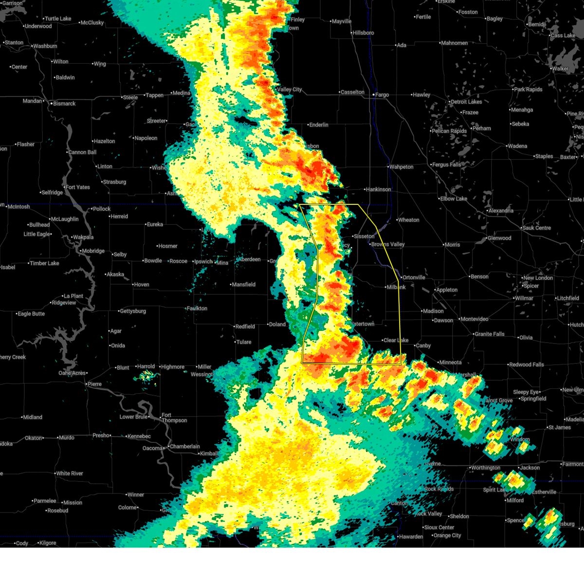
| 6/28/2025 11:38 PM CDT |
 Svrabr the national weather service in aberdeen has issued a * severe thunderstorm warning for, central deuel county in northeastern south dakota, northeastern hamlin county in northeastern south dakota, southeastern codington county in northeastern south dakota, * until 1230 am cdt. * at 1137 pm cdt, a severe thunderstorm was located near claremont colony, or 7 miles east of castlewood, moving east at 25 mph (radar indicated). Hazards include 60 mph wind gusts and quarter size hail. Hail damage to vehicles is expected. expect wind damage to roofs, siding, and trees. this severe thunderstorm will be near, bemis around 1140 pm cdt. clear lake around 1145 pm cdt. altamont around 1150 pm cdt. Other locations in the path of this severe thunderstorm include lake alice, moritz and gary. Svrabr the national weather service in aberdeen has issued a * severe thunderstorm warning for, central deuel county in northeastern south dakota, northeastern hamlin county in northeastern south dakota, southeastern codington county in northeastern south dakota, * until 1230 am cdt. * at 1137 pm cdt, a severe thunderstorm was located near claremont colony, or 7 miles east of castlewood, moving east at 25 mph (radar indicated). Hazards include 60 mph wind gusts and quarter size hail. Hail damage to vehicles is expected. expect wind damage to roofs, siding, and trees. this severe thunderstorm will be near, bemis around 1140 pm cdt. clear lake around 1145 pm cdt. altamont around 1150 pm cdt. Other locations in the path of this severe thunderstorm include lake alice, moritz and gary.
|
| 6/28/2025 10:20 PM CDT |
 At 1020 pm cdt, a severe thunderstorm capable of producing a tornado was located over dempster, or near estelline, moving east at 35 mph (radar indicated rotation). Hazards include tornado and two inch hail. Flying debris will be dangerous to those caught without shelter. mobile homes will be damaged or destroyed. damage to roofs, windows, and vehicles will occur. tree damage is likely. Locations impacted include, estelline, castlewood, lake poinsett, claremont colony, poinsett colony, dempster, and stone bridge. At 1020 pm cdt, a severe thunderstorm capable of producing a tornado was located over dempster, or near estelline, moving east at 35 mph (radar indicated rotation). Hazards include tornado and two inch hail. Flying debris will be dangerous to those caught without shelter. mobile homes will be damaged or destroyed. damage to roofs, windows, and vehicles will occur. tree damage is likely. Locations impacted include, estelline, castlewood, lake poinsett, claremont colony, poinsett colony, dempster, and stone bridge.
|
| 6/28/2025 9:59 PM CDT |
 At 958 pm cdt, a severe thunderstorm capable of producing a tornado was located over claremont colony, or near castlewood, moving east at 30 mph (radar indicated rotation). Hazards include tornado and quarter size hail. Flying debris will be dangerous to those caught without shelter. mobile homes will be damaged or destroyed. damage to roofs, windows, and vehicles will occur. tree damage is likely. Locations impacted include, poinsett colony and dempster. At 958 pm cdt, a severe thunderstorm capable of producing a tornado was located over claremont colony, or near castlewood, moving east at 30 mph (radar indicated rotation). Hazards include tornado and quarter size hail. Flying debris will be dangerous to those caught without shelter. mobile homes will be damaged or destroyed. damage to roofs, windows, and vehicles will occur. tree damage is likely. Locations impacted include, poinsett colony and dempster.
|
| 6/28/2025 9:43 PM CDT |
 Torabr the national weather service in aberdeen has issued a * tornado warning for, southwestern deuel county in northeastern south dakota, eastern hamlin county in northeastern south dakota, * until 1030 pm cdt. * at 943 pm cdt, a severe thunderstorm capable of producing a tornado was located near castlewood, moving east at 25 mph (radar indicated rotation). Hazards include tornado and quarter size hail. Flying debris will be dangerous to those caught without shelter. mobile homes will be damaged or destroyed. damage to roofs, windows, and vehicles will occur. tree damage is likely. this dangerous storm will be near, castlewood, claremont colony, and dempster around 950 pm cdt. Poinsett colony around 955 pm cdt. Torabr the national weather service in aberdeen has issued a * tornado warning for, southwestern deuel county in northeastern south dakota, eastern hamlin county in northeastern south dakota, * until 1030 pm cdt. * at 943 pm cdt, a severe thunderstorm capable of producing a tornado was located near castlewood, moving east at 25 mph (radar indicated rotation). Hazards include tornado and quarter size hail. Flying debris will be dangerous to those caught without shelter. mobile homes will be damaged or destroyed. damage to roofs, windows, and vehicles will occur. tree damage is likely. this dangerous storm will be near, castlewood, claremont colony, and dempster around 950 pm cdt. Poinsett colony around 955 pm cdt.
|
| 6/28/2025 9:40 PM CDT | Quarter sized hail reported 4 miles E of Castlewood, SD |
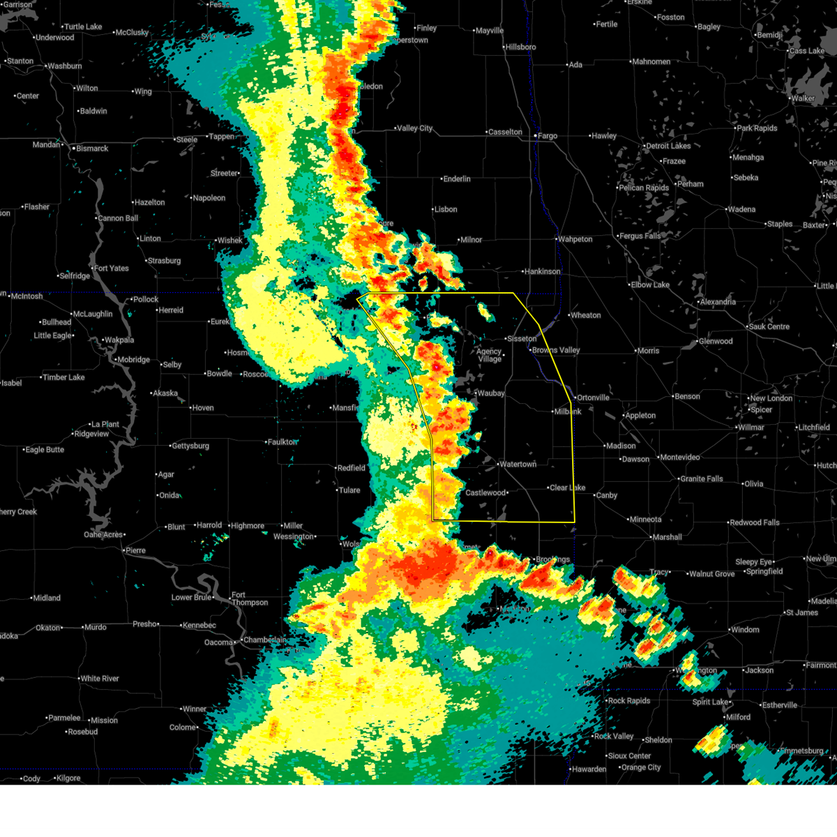
| 7/31/2024 7:00 PM CDT | 10 inch branch down and blocking main street... as well as 3/4 inch hai in hamlin county SD, 0.5 miles S of Castlewood, SD |
| 7/31/2024 7:00 PM CDT |
 Svrabr the national weather service in aberdeen has issued a * severe thunderstorm warning for, northern deuel county in northeastern south dakota, northeastern hamlin county in northeastern south dakota, south central grant county in northeastern south dakota, southeastern codington county in northeastern south dakota, * until 800 pm cdt. * at 700 pm cdt, a severe thunderstorm was located near castlewood, moving northeast at 25 mph (radar indicated). Hazards include golf ball size hail and 60 mph wind gusts. People and animals outdoors will be injured. expect hail damage to roofs, siding, windows, and vehicles. expect wind damage to roofs, siding, and trees. this severe thunderstorm will be near, kranzburg, goodwin, and bemis around 705 pm cdt. school lake and bullhead lake around 720 pm cdt. Other locations in the path of this severe thunderstorm include tunerville, lake alice and strandburg. Svrabr the national weather service in aberdeen has issued a * severe thunderstorm warning for, northern deuel county in northeastern south dakota, northeastern hamlin county in northeastern south dakota, south central grant county in northeastern south dakota, southeastern codington county in northeastern south dakota, * until 800 pm cdt. * at 700 pm cdt, a severe thunderstorm was located near castlewood, moving northeast at 25 mph (radar indicated). Hazards include golf ball size hail and 60 mph wind gusts. People and animals outdoors will be injured. expect hail damage to roofs, siding, windows, and vehicles. expect wind damage to roofs, siding, and trees. this severe thunderstorm will be near, kranzburg, goodwin, and bemis around 705 pm cdt. school lake and bullhead lake around 720 pm cdt. Other locations in the path of this severe thunderstorm include tunerville, lake alice and strandburg.
|
| 7/6/2024 6:01 PM CDT |
 the severe thunderstorm warning has been cancelled and is no longer in effect the severe thunderstorm warning has been cancelled and is no longer in effect
|
| 7/6/2024 5:48 PM CDT |
 At 548 pm cdt, a severe thunderstorm was located near hayti, moving east at 30 mph (radar indicated). Hazards include 60 mph wind gusts and quarter size hail. Hail damage to vehicles is expected. expect wind damage to roofs, siding, and trees. This severe storm will be near, lake poinsett and stone bridge around 555 pm cdt. At 548 pm cdt, a severe thunderstorm was located near hayti, moving east at 30 mph (radar indicated). Hazards include 60 mph wind gusts and quarter size hail. Hail damage to vehicles is expected. expect wind damage to roofs, siding, and trees. This severe storm will be near, lake poinsett and stone bridge around 555 pm cdt.
|
| 7/6/2024 5:37 PM CDT |
 At 536 pm cdt, a severe thunderstorm was located near lake norden, or near hayti, moving east at 30 mph (radar indicated). Hazards include 60 mph wind gusts and quarter size hail. Hail damage to vehicles is expected. expect wind damage to roofs, siding, and trees. this severe storm will be near, lake poinsett, hayti, lake norden, lake albert, and hamlin education center around 540 pm cdt. Other locations in the path of this severe thunderstorm include stone bridge and castlewood. At 536 pm cdt, a severe thunderstorm was located near lake norden, or near hayti, moving east at 30 mph (radar indicated). Hazards include 60 mph wind gusts and quarter size hail. Hail damage to vehicles is expected. expect wind damage to roofs, siding, and trees. this severe storm will be near, lake poinsett, hayti, lake norden, lake albert, and hamlin education center around 540 pm cdt. Other locations in the path of this severe thunderstorm include stone bridge and castlewood.
|
| 7/6/2024 5:24 PM CDT |
 Svrabr the national weather service in aberdeen has issued a * severe thunderstorm warning for, hamlin county in northeastern south dakota, * until 615 pm cdt. * at 524 pm cdt, a severe thunderstorm was located near bryant, moving east at 30 mph (law enforcement). Hazards include 60 mph wind gusts and quarter size hail. Hail damage to vehicles is expected. expect wind damage to roofs, siding, and trees. this severe thunderstorm will be near, lake norden and hamlin education center around 530 pm cdt. hayti and lake albert around 535 pm cdt. lake poinsett around 540 pm cdt. Other locations in the path of this severe thunderstorm include stone bridge and castlewood. Svrabr the national weather service in aberdeen has issued a * severe thunderstorm warning for, hamlin county in northeastern south dakota, * until 615 pm cdt. * at 524 pm cdt, a severe thunderstorm was located near bryant, moving east at 30 mph (law enforcement). Hazards include 60 mph wind gusts and quarter size hail. Hail damage to vehicles is expected. expect wind damage to roofs, siding, and trees. this severe thunderstorm will be near, lake norden and hamlin education center around 530 pm cdt. hayti and lake albert around 535 pm cdt. lake poinsett around 540 pm cdt. Other locations in the path of this severe thunderstorm include stone bridge and castlewood.
|
| 6/2/2024 8:23 PM CDT |
 At 822 pm cdt, a severe thunderstorm was located near stone bridge, or near hayti, moving east at 20 mph (radar indicated. at 800 pm, a brief funnel cloud was reported between lake norden and badger). Hazards include 60 mph wind gusts and quarter size hail. Hail damage to vehicles is expected. expect wind damage to roofs, siding, and trees. Locations impacted include, castlewood, lake poinsett, stone bridge, dempster, claremont colony and estelline. At 822 pm cdt, a severe thunderstorm was located near stone bridge, or near hayti, moving east at 20 mph (radar indicated. at 800 pm, a brief funnel cloud was reported between lake norden and badger). Hazards include 60 mph wind gusts and quarter size hail. Hail damage to vehicles is expected. expect wind damage to roofs, siding, and trees. Locations impacted include, castlewood, lake poinsett, stone bridge, dempster, claremont colony and estelline.
|
| 6/2/2024 8:01 PM CDT |
 Svrabr the national weather service in aberdeen has issued a * severe thunderstorm warning for, central hamlin county in northeastern south dakota, * until 845 pm cdt. * at 801 pm cdt, a severe thunderstorm was located near lake norden, or near hayti, moving east at 20 mph (radar indicated). Hazards include 60 mph wind gusts and quarter size hail. Hail damage to vehicles is expected. expect wind damage to roofs, siding, and trees. this severe thunderstorm will be near, lake poinsett, hayti, lake norden, and lake albert around 805 pm cdt. stone bridge around 815 pm cdt. Other locations in the path of this severe thunderstorm include dempster, castlewood and claremont colony. Svrabr the national weather service in aberdeen has issued a * severe thunderstorm warning for, central hamlin county in northeastern south dakota, * until 845 pm cdt. * at 801 pm cdt, a severe thunderstorm was located near lake norden, or near hayti, moving east at 20 mph (radar indicated). Hazards include 60 mph wind gusts and quarter size hail. Hail damage to vehicles is expected. expect wind damage to roofs, siding, and trees. this severe thunderstorm will be near, lake poinsett, hayti, lake norden, and lake albert around 805 pm cdt. stone bridge around 815 pm cdt. Other locations in the path of this severe thunderstorm include dempster, castlewood and claremont colony.
|
| 8/10/2023 8:25 PM CDT |
 The tornado warning for eastern hamlin county will expire at 830 pm cdt, the storm which prompted the warning has weakened below severe limits, and no longer appears capable of producing a tornado. therefore, the warning will be allowed to expire. a severe thunderstorm watch remains in effect until 1100 pm cdt for northeastern south dakota. The tornado warning for eastern hamlin county will expire at 830 pm cdt, the storm which prompted the warning has weakened below severe limits, and no longer appears capable of producing a tornado. therefore, the warning will be allowed to expire. a severe thunderstorm watch remains in effect until 1100 pm cdt for northeastern south dakota.
|
| 8/10/2023 8:13 PM CDT |
 At 812 pm cdt, a confirmed tornado was located over hayti, moving east at 30 mph (weather spotters confirmed tornado. at 754 pm cdt a tornado was reported northeast of bryant). Hazards include damaging tornado. Flying debris will be dangerous to those caught without shelter. mobile homes will be damaged or destroyed. damage to roofs, windows, and vehicles will occur. tree damage is likely. Locations impacted include, stone bridge, castlewood, dempster and claremont colony. At 812 pm cdt, a confirmed tornado was located over hayti, moving east at 30 mph (weather spotters confirmed tornado. at 754 pm cdt a tornado was reported northeast of bryant). Hazards include damaging tornado. Flying debris will be dangerous to those caught without shelter. mobile homes will be damaged or destroyed. damage to roofs, windows, and vehicles will occur. tree damage is likely. Locations impacted include, stone bridge, castlewood, dempster and claremont colony.
|
| 8/10/2023 7:59 PM CDT |
 At 759 pm cdt, a confirmed tornado was located over hamlin education center, or near hayti, moving east at 35 mph (weather spotters confirmed tornado. at 754 pm cdt a tornado was reported northeast of bryant). Hazards include damaging tornado. Flying debris will be dangerous to those caught without shelter. mobile homes will be damaged or destroyed. damage to roofs, windows, and vehicles will occur. tree damage is likely. the tornado will be near, hayti and lake norden around 805 pm cdt. thomas around 810 pm cdt. Other locations in the path of this tornadic thunderstorm include stone bridge, castlewood, claremont colony and dempster. At 759 pm cdt, a confirmed tornado was located over hamlin education center, or near hayti, moving east at 35 mph (weather spotters confirmed tornado. at 754 pm cdt a tornado was reported northeast of bryant). Hazards include damaging tornado. Flying debris will be dangerous to those caught without shelter. mobile homes will be damaged or destroyed. damage to roofs, windows, and vehicles will occur. tree damage is likely. the tornado will be near, hayti and lake norden around 805 pm cdt. thomas around 810 pm cdt. Other locations in the path of this tornadic thunderstorm include stone bridge, castlewood, claremont colony and dempster.
|
| 8/10/2023 7:47 PM CDT |
 At 746 pm cdt, severe thunderstorms were located along a line extending from near kranzburg to near claremont colony to hamlin education center, moving east at 50 mph (radar indicated). Hazards include 60 mph wind gusts and quarter size hail. Hail damage to vehicles is expected. expect wind damage to roofs, siding, and trees. locations impacted include, kranzburg, goodwin, bemis, bullhead lake, school lake, lake poinsett, stone bridge, claremont colony and dempster. hail threat, radar indicated max hail size, 1. 00 in wind threat, radar indicated max wind gust, 60 mph. At 746 pm cdt, severe thunderstorms were located along a line extending from near kranzburg to near claremont colony to hamlin education center, moving east at 50 mph (radar indicated). Hazards include 60 mph wind gusts and quarter size hail. Hail damage to vehicles is expected. expect wind damage to roofs, siding, and trees. locations impacted include, kranzburg, goodwin, bemis, bullhead lake, school lake, lake poinsett, stone bridge, claremont colony and dempster. hail threat, radar indicated max hail size, 1. 00 in wind threat, radar indicated max wind gust, 60 mph.
|
| 8/10/2023 7:28 PM CDT |
 At 727 pm cdt, severe thunderstorms were located along a line extending from lake kampeska to near thomas to near willow lake, moving east at 50 mph (trained weather spotters. at 711 pm cdt 74 mph wind gust was reported 6 w henry). Hazards include 70 mph wind gusts and quarter size hail. Hail damage to vehicles is expected. expect considerable tree damage. wind damage is also likely to mobile homes, roofs, and outbuildings. these severe storms will be near, watertown, goose lake, thomas, watertown city park, pelican lake, lake kampeska, sandy shore rec area and memorial park camping site around 730 pm cdt. other locations in the path of these severe thunderstorms include castlewood, kellerton church, kranzburg, goodwin, claremont colony, hamlin education center, hayti, lake norden, bemis, school lake, bullhead lake, lake albert, lake poinsett, stone bridge and dempster. thunderstorm damage threat, considerable hail threat, radar indicated max hail size, 1. 00 in wind threat, observed max wind gust, 70 mph. At 727 pm cdt, severe thunderstorms were located along a line extending from lake kampeska to near thomas to near willow lake, moving east at 50 mph (trained weather spotters. at 711 pm cdt 74 mph wind gust was reported 6 w henry). Hazards include 70 mph wind gusts and quarter size hail. Hail damage to vehicles is expected. expect considerable tree damage. wind damage is also likely to mobile homes, roofs, and outbuildings. these severe storms will be near, watertown, goose lake, thomas, watertown city park, pelican lake, lake kampeska, sandy shore rec area and memorial park camping site around 730 pm cdt. other locations in the path of these severe thunderstorms include castlewood, kellerton church, kranzburg, goodwin, claremont colony, hamlin education center, hayti, lake norden, bemis, school lake, bullhead lake, lake albert, lake poinsett, stone bridge and dempster. thunderstorm damage threat, considerable hail threat, radar indicated max hail size, 1. 00 in wind threat, observed max wind gust, 70 mph.
|
| 8/10/2023 7:10 PM CDT |
 At 710 pm cdt, severe thunderstorms were located along a line extending from near henry to near mayfield colony to near collins colony, moving east at 50 mph (radar indicated). Hazards include 60 mph wind gusts and quarter size hail. Hail damage to vehicles is expected. expect wind damage to roofs, siding, and trees. severe thunderstorms will be near, henry, vienna and long lake around 715 pm cdt. hazel and tinkertown around 720 pm cdt. goose lake, bryant, memorial park camping site, sandy shore rec area, lake kampeska and kellerton church around 725 pm cdt. watertown, thomas, watertown city park and pelican lake around 730 pm cdt. other locations in the path of these severe thunderstorms include hamlin education center, castlewood, hayti, lake norden, kranzburg, claremont colony, lake albert, lake poinsett, goodwin and stone bridge. hail threat, radar indicated max hail size, 1. 00 in wind threat, radar indicated max wind gust, 60 mph. At 710 pm cdt, severe thunderstorms were located along a line extending from near henry to near mayfield colony to near collins colony, moving east at 50 mph (radar indicated). Hazards include 60 mph wind gusts and quarter size hail. Hail damage to vehicles is expected. expect wind damage to roofs, siding, and trees. severe thunderstorms will be near, henry, vienna and long lake around 715 pm cdt. hazel and tinkertown around 720 pm cdt. goose lake, bryant, memorial park camping site, sandy shore rec area, lake kampeska and kellerton church around 725 pm cdt. watertown, thomas, watertown city park and pelican lake around 730 pm cdt. other locations in the path of these severe thunderstorms include hamlin education center, castlewood, hayti, lake norden, kranzburg, claremont colony, lake albert, lake poinsett, goodwin and stone bridge. hail threat, radar indicated max hail size, 1. 00 in wind threat, radar indicated max wind gust, 60 mph.
|
| 7/13/2023 4:36 PM CDT |
 At 436 pm cdt, a severe thunderstorm was located near castlewood, moving southeast at 30 mph (radar indicated). Hazards include quarter size hail. Damage to vehicles is expected. this severe storm will be near, castlewood around 440 pm cdt. other locations in the path of this severe thunderstorm include claremont colony, poinsett colony and clear lake. hail threat, radar indicated max hail size, 1. 00 in wind threat, radar indicated max wind gust, <50 mph. At 436 pm cdt, a severe thunderstorm was located near castlewood, moving southeast at 30 mph (radar indicated). Hazards include quarter size hail. Damage to vehicles is expected. this severe storm will be near, castlewood around 440 pm cdt. other locations in the path of this severe thunderstorm include claremont colony, poinsett colony and clear lake. hail threat, radar indicated max hail size, 1. 00 in wind threat, radar indicated max wind gust, <50 mph.
|
| 7/13/2023 4:27 PM CDT |
 At 427 pm cdt, a severe thunderstorm was located near pelican lake, or near watertown, moving southeast at 30 mph (radar indicated). Hazards include quarter size hail. Damage to vehicles is expected. this severe thunderstorm will be near, castlewood around 440 pm cdt. other locations in the path of this severe thunderstorm include claremont colony, bemis, poinsett colony and clear lake. hail threat, radar indicated max hail size, 1. 00 in wind threat, radar indicated max wind gust, <50 mph. At 427 pm cdt, a severe thunderstorm was located near pelican lake, or near watertown, moving southeast at 30 mph (radar indicated). Hazards include quarter size hail. Damage to vehicles is expected. this severe thunderstorm will be near, castlewood around 440 pm cdt. other locations in the path of this severe thunderstorm include claremont colony, bemis, poinsett colony and clear lake. hail threat, radar indicated max hail size, 1. 00 in wind threat, radar indicated max wind gust, <50 mph.
|
| 9/8/2022 10:48 PM CDT |
 At 1048 pm cdt, a severe thunderstorm was located over goodwin, or 13 miles northwest of clear lake, moving northeast at 40 mph (radar indicated). Hazards include 60 mph wind gusts and half dollar size hail. Hail damage to vehicles is expected. expect wind damage to roofs, siding, and trees. locations impacted include, bullhead lake, altamont, tunerville, lake alice, la bolt, revillo and albee. hail threat, radar indicated max hail size, 1. 25 in wind threat, radar indicated max wind gust, 60 mph. At 1048 pm cdt, a severe thunderstorm was located over goodwin, or 13 miles northwest of clear lake, moving northeast at 40 mph (radar indicated). Hazards include 60 mph wind gusts and half dollar size hail. Hail damage to vehicles is expected. expect wind damage to roofs, siding, and trees. locations impacted include, bullhead lake, altamont, tunerville, lake alice, la bolt, revillo and albee. hail threat, radar indicated max hail size, 1. 25 in wind threat, radar indicated max wind gust, 60 mph.
|
| 9/8/2022 10:34 PM CDT |
 At 1034 pm cdt, a severe thunderstorm was located near pelican lake, or near castlewood, moving northeast at 40 mph (radar indicated). Hazards include ping pong ball size hail and 60 mph wind gusts. People and animals outdoors will be injured. expect hail damage to roofs, siding, windows, and vehicles. expect wind damage to roofs, siding, and trees. this severe thunderstorm will be near, kranzburg around 1045 pm cdt. goodwin and bemis around 1050 pm cdt. other locations in the path of this severe thunderstorm include school lake, bullhead lake, altamont, tunerville, lake alice, la bolt, revillo and albee. hail threat, radar indicated max hail size, 1. 50 in wind threat, radar indicated max wind gust, 60 mph. At 1034 pm cdt, a severe thunderstorm was located near pelican lake, or near castlewood, moving northeast at 40 mph (radar indicated). Hazards include ping pong ball size hail and 60 mph wind gusts. People and animals outdoors will be injured. expect hail damage to roofs, siding, windows, and vehicles. expect wind damage to roofs, siding, and trees. this severe thunderstorm will be near, kranzburg around 1045 pm cdt. goodwin and bemis around 1050 pm cdt. other locations in the path of this severe thunderstorm include school lake, bullhead lake, altamont, tunerville, lake alice, la bolt, revillo and albee. hail threat, radar indicated max hail size, 1. 50 in wind threat, radar indicated max wind gust, 60 mph.
|
| 7/23/2022 8:33 AM CDT |
 At 829 am cdt, severe thunderstorms were located along a line extending from near lismore colony to near stockholm to near kranzburg to near thomas, moving southeast at 60 mph (radar indicated). Hazards include 70 mph wind gusts and penny size hail. Expect considerable tree damage. damage is likely to mobile homes, roofs, and outbuildings. locations impacted include, goodwin, la bolt, lagoona beach, bullhead lake, ortonville, big stone city, revillo, altamont, albee, tunerville, lake alice, clear lake, stone bridge, moritz, lake poinsett, claremont colony, lake albert, gary, odessa, brandt, dempster, poinsett colony, artichoke lake, estelline, correll and lake cochrane rec area. thunderstorm damage threat, considerable hail threat, radar indicated max hail size, 0. 75 in wind threat, observed max wind gust, 70 mph. At 829 am cdt, severe thunderstorms were located along a line extending from near lismore colony to near stockholm to near kranzburg to near thomas, moving southeast at 60 mph (radar indicated). Hazards include 70 mph wind gusts and penny size hail. Expect considerable tree damage. damage is likely to mobile homes, roofs, and outbuildings. locations impacted include, goodwin, la bolt, lagoona beach, bullhead lake, ortonville, big stone city, revillo, altamont, albee, tunerville, lake alice, clear lake, stone bridge, moritz, lake poinsett, claremont colony, lake albert, gary, odessa, brandt, dempster, poinsett colony, artichoke lake, estelline, correll and lake cochrane rec area. thunderstorm damage threat, considerable hail threat, radar indicated max hail size, 0. 75 in wind threat, observed max wind gust, 70 mph.
|
| 7/23/2022 7:59 AM CDT |
 At 759 am cdt, severe thunderstorms were located along a line extending from near browns valley to garden city, moving southeast at 40 mph (radar indicated). Hazards include 60 mph wind gusts and penny size hail. Expect damage to roofs, siding, and trees. severe thunderstorms will be near, browns valley, lake traverse housing units and peever flats housing around 805 am cdt. long lake around 810 am cdt. beardsley, yankeetown and tinkertown around 815 am cdt. other locations in the path of these severe thunderstorms include hazel, bonanza grove, barry, goose lake, big stone lake, lismore colony, thomas, kellerton church, big stone colony, clinton, hamlin education center, hayti and lagoona beach. hail threat, radar indicated max hail size, 0. 75 in wind threat, radar indicated max wind gust, 60 mph. At 759 am cdt, severe thunderstorms were located along a line extending from near browns valley to garden city, moving southeast at 40 mph (radar indicated). Hazards include 60 mph wind gusts and penny size hail. Expect damage to roofs, siding, and trees. severe thunderstorms will be near, browns valley, lake traverse housing units and peever flats housing around 805 am cdt. long lake around 810 am cdt. beardsley, yankeetown and tinkertown around 815 am cdt. other locations in the path of these severe thunderstorms include hazel, bonanza grove, barry, goose lake, big stone lake, lismore colony, thomas, kellerton church, big stone colony, clinton, hamlin education center, hayti and lagoona beach. hail threat, radar indicated max hail size, 0. 75 in wind threat, radar indicated max wind gust, 60 mph.
|
| 6/25/2022 12:39 AM CDT |
 The severe thunderstorm warning for deuel, eastern hamlin and southeastern codington counties will expire at 1245 am cdt, the storms which prompted the warning have weakened below severe limits, and no longer pose an immediate threat to life or property. therefore, the warning will be allowed to expire. however small hail and gusty winds are still possible with these thunderstorms. a severe thunderstorm watch remains in effect until 300 am cdt for northeastern south dakota. The severe thunderstorm warning for deuel, eastern hamlin and southeastern codington counties will expire at 1245 am cdt, the storms which prompted the warning have weakened below severe limits, and no longer pose an immediate threat to life or property. therefore, the warning will be allowed to expire. however small hail and gusty winds are still possible with these thunderstorms. a severe thunderstorm watch remains in effect until 300 am cdt for northeastern south dakota.
|
| 6/25/2022 12:20 AM CDT |
 At 1219 am cdt, severe thunderstorms were located along a line extending from near albee to moritz to 6 miles southeast of estelline, moving east at 45 mph (radar indicated). Hazards include 60 mph wind gusts. Expect damage to roofs, siding, and trees. these severe storms will be near, gary and lake cochrane rec area around 1225 am cdt. other locations in the path of these severe thunderstorms include astoria. hail threat, radar indicated max hail size, <. 75 in wind threat, observed max wind gust, 60 mph. At 1219 am cdt, severe thunderstorms were located along a line extending from near albee to moritz to 6 miles southeast of estelline, moving east at 45 mph (radar indicated). Hazards include 60 mph wind gusts. Expect damage to roofs, siding, and trees. these severe storms will be near, gary and lake cochrane rec area around 1225 am cdt. other locations in the path of these severe thunderstorms include astoria. hail threat, radar indicated max hail size, <. 75 in wind threat, observed max wind gust, 60 mph.
|
| 6/25/2022 12:07 AM CDT |
 At 1207 am cdt, severe thunderstorms were located along a line extending from near stockholm to near altamont to near estelline, moving east at 45 mph (radar indicated). Hazards include 60 mph wind gusts. Expect damage to roofs, siding, and trees. these severe storms will be near, clear lake, la bolt, altamont and tunerville around 1210 am cdt. other locations in the path of these severe thunderstorms include lake alice, revillo, albee, moritz, gary, lake cochrane rec area, toronto and astoria. hail threat, radar indicated max hail size, <. 75 in wind threat, observed max wind gust, 60 mph. At 1207 am cdt, severe thunderstorms were located along a line extending from near stockholm to near altamont to near estelline, moving east at 45 mph (radar indicated). Hazards include 60 mph wind gusts. Expect damage to roofs, siding, and trees. these severe storms will be near, clear lake, la bolt, altamont and tunerville around 1210 am cdt. other locations in the path of these severe thunderstorms include lake alice, revillo, albee, moritz, gary, lake cochrane rec area, toronto and astoria. hail threat, radar indicated max hail size, <. 75 in wind threat, observed max wind gust, 60 mph.
|
| 6/24/2022 11:51 PM CDT |
 At 1150 pm cdt, severe thunderstorms were located along a line extending from south shore to near kranzburg to lake albert, moving east at 45 mph (radar indicated). Hazards include 60 mph wind gusts. Expect damage to roofs, siding, and trees. these severe storms will be near, south shore, kranzburg, goodwin and troy around 1155 pm cdt. other locations in the path of these severe thunderstorms include stockholm, twin brooks, school lake, bullhead lake, strandburg, dempster, clear lake, estelline, la bolt, altamont, lake alice, tunerville, poinsett colony, revillo, albee, moritz, gary, toronto and astoria. hail threat, radar indicated max hail size, <. 75 in wind threat, observed max wind gust, 60 mph. At 1150 pm cdt, severe thunderstorms were located along a line extending from south shore to near kranzburg to lake albert, moving east at 45 mph (radar indicated). Hazards include 60 mph wind gusts. Expect damage to roofs, siding, and trees. these severe storms will be near, south shore, kranzburg, goodwin and troy around 1155 pm cdt. other locations in the path of these severe thunderstorms include stockholm, twin brooks, school lake, bullhead lake, strandburg, dempster, clear lake, estelline, la bolt, altamont, lake alice, tunerville, poinsett colony, revillo, albee, moritz, gary, toronto and astoria. hail threat, radar indicated max hail size, <. 75 in wind threat, observed max wind gust, 60 mph.
|
| 6/24/2022 11:38 PM CDT |
 At 1138 pm cdt, severe thunderstorms were located along a line extending from 7 miles west of south shore to near pelican lake to near lake norden, moving east at 45 mph (radar indicated). Hazards include 60 mph wind gusts. Expect damage to roofs, siding, and trees. severe thunderstorms will be near, castlewood and waverly around 1145 pm cdt. south shore, kranzburg and claremont colony around 1150 pm cdt. goodwin, troy, lake poinsett and stone bridge around 1155 pm cdt. other locations in the path of these severe thunderstorms include stockholm, strandburg, dempster, clear lake, estelline, la bolt, altamont, tunerville, lake alice, revillo, albee, moritz, gary and lake cochrane rec area. hail threat, radar indicated max hail size, <. 75 in wind threat, observed max wind gust, 60 mph. At 1138 pm cdt, severe thunderstorms were located along a line extending from 7 miles west of south shore to near pelican lake to near lake norden, moving east at 45 mph (radar indicated). Hazards include 60 mph wind gusts. Expect damage to roofs, siding, and trees. severe thunderstorms will be near, castlewood and waverly around 1145 pm cdt. south shore, kranzburg and claremont colony around 1150 pm cdt. goodwin, troy, lake poinsett and stone bridge around 1155 pm cdt. other locations in the path of these severe thunderstorms include stockholm, strandburg, dempster, clear lake, estelline, la bolt, altamont, tunerville, lake alice, revillo, albee, moritz, gary and lake cochrane rec area. hail threat, radar indicated max hail size, <. 75 in wind threat, observed max wind gust, 60 mph.
|
| 6/20/2022 10:28 PM CDT |
 At 1028 pm cdt, severe thunderstorms were located along a line extending from near finley heights housing to near rauville to stone bridge, moving east at 50 mph (trained weather spotters). Hazards include 60 mph wind gusts. Expect damage to roofs, siding, and trees. Locations impacted include, watertown, sisseton, estelline, castlewood, lake norden, hayti, summit, south shore, waverly, kranzburg, goodwin, stockholm, strandburg, ortley, troy, marvin, finley heights housing, bullhead lake, stone bridge and rudebusch corner. At 1028 pm cdt, severe thunderstorms were located along a line extending from near finley heights housing to near rauville to stone bridge, moving east at 50 mph (trained weather spotters). Hazards include 60 mph wind gusts. Expect damage to roofs, siding, and trees. Locations impacted include, watertown, sisseton, estelline, castlewood, lake norden, hayti, summit, south shore, waverly, kranzburg, goodwin, stockholm, strandburg, ortley, troy, marvin, finley heights housing, bullhead lake, stone bridge and rudebusch corner.
|
| 6/20/2022 10:15 PM CDT |
 At 1015 pm cdt, severe thunderstorms were located along a line extending from near rudebusch corner to near dakota sioux casino to lake norden, moving east at 50 mph (radar indicated). Hazards include 60 mph wind gusts. Expect damage to roofs, siding, and trees. Locations impacted include, rauville, rudebusch corner, stone bridge, finley heights housing, lake poinsett, waverly, dempster, claremont colony, estelline, south shore, troy, poinsett colony, stockholm, bullhead lake, school lake and strandburg. At 1015 pm cdt, severe thunderstorms were located along a line extending from near rudebusch corner to near dakota sioux casino to lake norden, moving east at 50 mph (radar indicated). Hazards include 60 mph wind gusts. Expect damage to roofs, siding, and trees. Locations impacted include, rauville, rudebusch corner, stone bridge, finley heights housing, lake poinsett, waverly, dempster, claremont colony, estelline, south shore, troy, poinsett colony, stockholm, bullhead lake, school lake and strandburg.
|
| 6/20/2022 10:06 PM CDT |
 At 1005 pm cdt, a confirmed tornado was located over kellerton church, or 14 miles southwest of watertown, moving northeast at 35 mph (weather spotters confirmed tornado). Hazards include damaging tornado and quarter size hail. Flying debris will be dangerous to those caught without shelter. mobile homes will be damaged or destroyed. damage to roofs, windows, and vehicles will occur. tree damage is likely. The tornado will be near, thomas and goose lake around 1015 pm cdt. At 1005 pm cdt, a confirmed tornado was located over kellerton church, or 14 miles southwest of watertown, moving northeast at 35 mph (weather spotters confirmed tornado). Hazards include damaging tornado and quarter size hail. Flying debris will be dangerous to those caught without shelter. mobile homes will be damaged or destroyed. damage to roofs, windows, and vehicles will occur. tree damage is likely. The tornado will be near, thomas and goose lake around 1015 pm cdt.
|
| 6/20/2022 9:56 PM CDT |
 At 956 pm cdt, severe thunderstorms were located along a line extending from near webster to garden city to near bryant, moving east at 50 mph (radar indicated). Hazards include 60 mph wind gusts. Expect damage to roofs, siding, and trees. severe thunderstorms will be near, webster, henry and roslyn around 1000 pm cdt. wallace, grenville, waubay lake, minnewasta lake, long lake, rush lake and tinkertown around 1005 pm cdt. waubay, florence, enemy swim housing, campbell slough, medicine lake, waubay wildlife rec area, enemy swim lake, pickerel lake rec area, blue dog lake and hamlin education center around 1010 pm cdt. lake norden, hayti, ortley, memorial park camping site, sandy shore rec area and lake kampeska around 1015 pm cdt. other locations in the path of these severe thunderstorms include watertown, rauville, dakota sioux casino, rudebusch corner, lake albert, watertown city park, stone bridge, finley heights housing, lake poinsett, waverly, dempster, claremont colony, estelline, south shore, troy and poinsett colony. hail threat, radar indicated max hail size, <. 75 in wind threat, radar indicated max wind gust, 60 mph. At 956 pm cdt, severe thunderstorms were located along a line extending from near webster to garden city to near bryant, moving east at 50 mph (radar indicated). Hazards include 60 mph wind gusts. Expect damage to roofs, siding, and trees. severe thunderstorms will be near, webster, henry and roslyn around 1000 pm cdt. wallace, grenville, waubay lake, minnewasta lake, long lake, rush lake and tinkertown around 1005 pm cdt. waubay, florence, enemy swim housing, campbell slough, medicine lake, waubay wildlife rec area, enemy swim lake, pickerel lake rec area, blue dog lake and hamlin education center around 1010 pm cdt. lake norden, hayti, ortley, memorial park camping site, sandy shore rec area and lake kampeska around 1015 pm cdt. other locations in the path of these severe thunderstorms include watertown, rauville, dakota sioux casino, rudebusch corner, lake albert, watertown city park, stone bridge, finley heights housing, lake poinsett, waverly, dempster, claremont colony, estelline, south shore, troy and poinsett colony. hail threat, radar indicated max hail size, <. 75 in wind threat, radar indicated max wind gust, 60 mph.
|
| 5/30/2022 2:49 PM CDT |
 At 248 pm cdt, a severe thunderstorm capable of producing a tornado was located near altamont, or near clear lake, moving northeast at 50 mph (weather spotters reported a funnel cloud. at 140 pm cdt a funnel cloud was reported near 184th street and 466th avenue near the hamlin and deuel county border). Hazards include tornado and quarter size hail. Flying debris will be dangerous to those caught without shelter. mobile homes will be damaged or destroyed. damage to roofs, windows, and vehicles will occur. tree damage is likely. Locations impacted include, tunerville, lake alice, bullhead lake, school lake, strandburg, revillo, la bolt and albee. At 248 pm cdt, a severe thunderstorm capable of producing a tornado was located near altamont, or near clear lake, moving northeast at 50 mph (weather spotters reported a funnel cloud. at 140 pm cdt a funnel cloud was reported near 184th street and 466th avenue near the hamlin and deuel county border). Hazards include tornado and quarter size hail. Flying debris will be dangerous to those caught without shelter. mobile homes will be damaged or destroyed. damage to roofs, windows, and vehicles will occur. tree damage is likely. Locations impacted include, tunerville, lake alice, bullhead lake, school lake, strandburg, revillo, la bolt and albee.
|
| 5/30/2022 2:36 PM CDT |
 At 236 pm cdt, a severe thunderstorm capable of producing a tornado was located near poinsett colony, or 8 miles north of estelline, moving northeast at 65 mph (radar indicated rotation). Hazards include tornado and quarter size hail. Flying debris will be dangerous to those caught without shelter. mobile homes will be damaged or destroyed. damage to roofs, windows, and vehicles will occur. tree damage is likely. this dangerous storm will be near, clear lake and goodwin around 245 pm cdt. altamont, tunerville, bullhead lake, school lake and lake alice around 250 pm cdt. Other locations in the path of this tornadic thunderstorm include revillo, strandburg, la bolt and albee. At 236 pm cdt, a severe thunderstorm capable of producing a tornado was located near poinsett colony, or 8 miles north of estelline, moving northeast at 65 mph (radar indicated rotation). Hazards include tornado and quarter size hail. Flying debris will be dangerous to those caught without shelter. mobile homes will be damaged or destroyed. damage to roofs, windows, and vehicles will occur. tree damage is likely. this dangerous storm will be near, clear lake and goodwin around 245 pm cdt. altamont, tunerville, bullhead lake, school lake and lake alice around 250 pm cdt. Other locations in the path of this tornadic thunderstorm include revillo, strandburg, la bolt and albee.
|
| 5/30/2022 2:17 AM CDT | At 216 am cdt, a severe thunderstorm was located near lake albert, or 11 miles southwest of estelline, moving north at 40 mph (radar indicated). Hazards include 70 mph wind gusts and quarter size hail. Hail damage to vehicles is expected. expect considerable tree damage. wind damage is also likely to mobile homes, roofs, and outbuildings. this severe thunderstorm will be near, lake poinsett and lake albert around 220 am cdt. lake norden and stone bridge around 225 am cdt. hayti and dempster around 230 am cdt. other locations in the path of this severe thunderstorm include castlewood, claremont colony, thomas, pelican lake, kranzburg and watertown city park. thunderstorm damage threat, considerable hail threat, radar indicated max hail size, 1. 00 in wind threat, radar indicated max wind gust, 70 mph. |
| 5/29/2022 1:43 AM CDT |
 At 142 am cdt, severe thunderstorms were located along a line extending from near crandall to near hillcrest colony to 6 miles west of badger, moving northeast at 45 mph (trained weather spotters). Hazards include 60 mph wind gusts. Expect damage to roofs, siding, and trees. severe thunderstorms will be near, henry, garden city and hamlin education center around 150 am cdt. lake norden, hayti, lily, long lake, lake albert and tinkertown around 155 am cdt. bristol, butler, stone bridge, medicine lake and lake poinsett around 200 am cdt. other locations in the path of these severe thunderstorms include florence, memorial park camping site, sandy shore rec area, lake kampeska, watertown, castlewood, watertown city park, webster, rauville, dakota sioux casino, claremont colony, antelope lake, rush lake, waubay, waverly and waubay lake. hail threat, radar indicated max hail size, <. 75 in wind threat, radar indicated max wind gust, 60 mph. At 142 am cdt, severe thunderstorms were located along a line extending from near crandall to near hillcrest colony to 6 miles west of badger, moving northeast at 45 mph (trained weather spotters). Hazards include 60 mph wind gusts. Expect damage to roofs, siding, and trees. severe thunderstorms will be near, henry, garden city and hamlin education center around 150 am cdt. lake norden, hayti, lily, long lake, lake albert and tinkertown around 155 am cdt. bristol, butler, stone bridge, medicine lake and lake poinsett around 200 am cdt. other locations in the path of these severe thunderstorms include florence, memorial park camping site, sandy shore rec area, lake kampeska, watertown, castlewood, watertown city park, webster, rauville, dakota sioux casino, claremont colony, antelope lake, rush lake, waubay, waverly and waubay lake. hail threat, radar indicated max hail size, <. 75 in wind threat, radar indicated max wind gust, 60 mph.
|
| 5/12/2022 6:37 PM CDT |
 The severe thunderstorm warning for northwestern deuel, southwestern roberts, day, southeastern brown, northern hamlin, grant, northern clark, northeastern spink and codington counties will expire at 645 pm cdt, the storms which prompted the warning have moved out of the area. therefore, the warning will be allowed to expire. a tornado watch remains in effect until 1000 pm cdt for northeastern south dakota. remember, severe thunderstorm and tornado warnings remains in effect for portions of brown, day, grant, and roberts counties. The severe thunderstorm warning for northwestern deuel, southwestern roberts, day, southeastern brown, northern hamlin, grant, northern clark, northeastern spink and codington counties will expire at 645 pm cdt, the storms which prompted the warning have moved out of the area. therefore, the warning will be allowed to expire. a tornado watch remains in effect until 1000 pm cdt for northeastern south dakota. remember, severe thunderstorm and tornado warnings remains in effect for portions of brown, day, grant, and roberts counties.
|
| 5/12/2022 5:57 PM CDT |
 At 556 pm cdt, tornado producing storms were located along a line extending from memorial park camping site to near watertown, moving north at 80 mph (weather spotters confirmed tornado. at 552 pm cdt, damage was reported in castlewood). Hazards include damaging tornado. Flying debris will be dangerous to those caught without shelter. mobile homes will be damaged or destroyed. damage to roofs, windows, and vehicles will occur. tree damage is likely. these tornadic storms will be near, rauville and medicine lake around 600 pm cdt. florence, dakota sioux casino and grass lake around 605 pm cdt. Other locations in the path of these tornadic storms include bitter lake. At 556 pm cdt, tornado producing storms were located along a line extending from memorial park camping site to near watertown, moving north at 80 mph (weather spotters confirmed tornado. at 552 pm cdt, damage was reported in castlewood). Hazards include damaging tornado. Flying debris will be dangerous to those caught without shelter. mobile homes will be damaged or destroyed. damage to roofs, windows, and vehicles will occur. tree damage is likely. these tornadic storms will be near, rauville and medicine lake around 600 pm cdt. florence, dakota sioux casino and grass lake around 605 pm cdt. Other locations in the path of these tornadic storms include bitter lake.
|
| 5/12/2022 5:52 PM CDT |
 At 551 pm cdt, severe thunderstorms capable of producing both tornadoes and extensive straight line wind damage were located along a line extending from near goose lake to near castlewood, moving north at 70 mph (radar indicated rotation. in addition, trained spotters reported a funnel cloud north northeast of castlewood). Hazards include tornado. Flying debris will be dangerous to those caught without shelter. mobile homes will be damaged or destroyed. damage to roofs, windows, and vehicles will occur. tree damage is likely. these dangerous storms will be near, goose lake around 555 pm cdt. memorial park camping site, sandy shore rec area, lake kampeska and pelican lake around 600 pm cdt. watertown, rauville, watertown city park and medicine lake around 605 pm cdt. florence, dakota sioux casino and grass lake around 610 pm cdt. Other locations in the path of these tornadic storms include bitter lake. At 551 pm cdt, severe thunderstorms capable of producing both tornadoes and extensive straight line wind damage were located along a line extending from near goose lake to near castlewood, moving north at 70 mph (radar indicated rotation. in addition, trained spotters reported a funnel cloud north northeast of castlewood). Hazards include tornado. Flying debris will be dangerous to those caught without shelter. mobile homes will be damaged or destroyed. damage to roofs, windows, and vehicles will occur. tree damage is likely. these dangerous storms will be near, goose lake around 555 pm cdt. memorial park camping site, sandy shore rec area, lake kampeska and pelican lake around 600 pm cdt. watertown, rauville, watertown city park and medicine lake around 605 pm cdt. florence, dakota sioux casino and grass lake around 610 pm cdt. Other locations in the path of these tornadic storms include bitter lake.
|
| 5/12/2022 5:51 PM CDT |
 At 548 pm cdt, severe thunderstorms were located along a line extending from near camrose colony to clark to near hayti, moving north at 50 mph. these are destructive storms for codington, clark, day, grant counties (trained weather spotters. 70 to 80 mph winds were reported near lake poinsett). Hazards include 80 mph wind gusts and quarter size hail. Flying debris will be dangerous to those caught without shelter. mobile homes will be heavily damaged. expect considerable damage to roofs, windows, and vehicles. extensive tree damage and power outages are likely. severe thunderstorms will be near, garden city and hillcrest colony around 555 pm cdt. brentford and goose lake around 600 pm cdt. conde, bradley, pelican lake, lake kampeska, sandy shore rec area, memorial park camping site and crocker around 605 pm cdt. Other locations in the path of these severe thunderstorms include watertown, wallace, verdon, lily, swan lake, watertown city park, rauville, butler, dakota sioux casino, waverly, ferney, antelope lake, webster, groton, south shore, andover and rush lake. At 548 pm cdt, severe thunderstorms were located along a line extending from near camrose colony to clark to near hayti, moving north at 50 mph. these are destructive storms for codington, clark, day, grant counties (trained weather spotters. 70 to 80 mph winds were reported near lake poinsett). Hazards include 80 mph wind gusts and quarter size hail. Flying debris will be dangerous to those caught without shelter. mobile homes will be heavily damaged. expect considerable damage to roofs, windows, and vehicles. extensive tree damage and power outages are likely. severe thunderstorms will be near, garden city and hillcrest colony around 555 pm cdt. brentford and goose lake around 600 pm cdt. conde, bradley, pelican lake, lake kampeska, sandy shore rec area, memorial park camping site and crocker around 605 pm cdt. Other locations in the path of these severe thunderstorms include watertown, wallace, verdon, lily, swan lake, watertown city park, rauville, butler, dakota sioux casino, waverly, ferney, antelope lake, webster, groton, south shore, andover and rush lake.
|
| 5/12/2022 5:46 PM CDT |
 At 545 pm cdt, severe thunderstorms were located along a line extending from near kellerton church to near bruce to ward, moving northeast at 75 mph. these are destructive storms for deuel, hamlin, grant, codington counties (trained weather spotters. a 79 mph wind gust was reported in brookings). Hazards include 80 mph wind gusts and penny size hail. Flying debris will be dangerous to those caught without shelter. mobile homes will be heavily damaged. expect considerable damage to roofs, windows, and vehicles. extensive tree damage and power outages are likely. these severe storms will be near, toronto around 555 pm cdt. Other locations in the path of these severe thunderstorms include clear lake, brandt, lake cochrane rec area, gary and moritz. At 545 pm cdt, severe thunderstorms were located along a line extending from near kellerton church to near bruce to ward, moving northeast at 75 mph. these are destructive storms for deuel, hamlin, grant, codington counties (trained weather spotters. a 79 mph wind gust was reported in brookings). Hazards include 80 mph wind gusts and penny size hail. Flying debris will be dangerous to those caught without shelter. mobile homes will be heavily damaged. expect considerable damage to roofs, windows, and vehicles. extensive tree damage and power outages are likely. these severe storms will be near, toronto around 555 pm cdt. Other locations in the path of these severe thunderstorms include clear lake, brandt, lake cochrane rec area, gary and moritz.
|
| 5/12/2022 5:42 PM CDT |
 At 541 pm cdt, severe thunderstorms were located along a line extending from near camrose colony to near clark to near bryant, moving northeast at 55 mph. these are destructive storms for hamlin, clark, spink, and codington counties (radar indicated). Hazards include 80 mph wind gusts and quarter size hail. Flying debris will be dangerous to those caught without shelter. mobile homes will be heavily damaged. expect considerable damage to roofs, windows, and vehicles. extensive tree damage and power outages are likely. Locations impacted include, clark, lake norden, hamlin education center, kellerton church, hillcrest colony, hayti, henry, hazel, garden city, turton, thomas, long lake, conde, wallace, pelican lake, goose lake, lake kampeska, sandy shore rec area, medicine lake and swan lake. At 541 pm cdt, severe thunderstorms were located along a line extending from near camrose colony to near clark to near bryant, moving northeast at 55 mph. these are destructive storms for hamlin, clark, spink, and codington counties (radar indicated). Hazards include 80 mph wind gusts and quarter size hail. Flying debris will be dangerous to those caught without shelter. mobile homes will be heavily damaged. expect considerable damage to roofs, windows, and vehicles. extensive tree damage and power outages are likely. Locations impacted include, clark, lake norden, hamlin education center, kellerton church, hillcrest colony, hayti, henry, hazel, garden city, turton, thomas, long lake, conde, wallace, pelican lake, goose lake, lake kampeska, sandy shore rec area, medicine lake and swan lake.
|
| 5/12/2022 5:36 PM CDT |
 At 535 pm cdt, severe thunderstorms were located along a line extending from near bryant to near volga to near flandreau, moving northeast at 75 mph. these are destructive storms for castlewood and clear lake (radar indicated). Hazards include 80 mph wind gusts and penny size hail. Flying debris will be dangerous to those caught without shelter. mobile homes will be heavily damaged. expect considerable damage to roofs, windows, and vehicles. extensive tree damage and power outages are likely. severe thunderstorms will be near, estelline around 545 pm cdt. toronto and poinsett colony around 550 pm cdt. brandt around 555 pm cdt. Other locations in the path of these severe thunderstorms include clear lake, altamont, lake alice, moritz, tunerville, revillo and albee. At 535 pm cdt, severe thunderstorms were located along a line extending from near bryant to near volga to near flandreau, moving northeast at 75 mph. these are destructive storms for castlewood and clear lake (radar indicated). Hazards include 80 mph wind gusts and penny size hail. Flying debris will be dangerous to those caught without shelter. mobile homes will be heavily damaged. expect considerable damage to roofs, windows, and vehicles. extensive tree damage and power outages are likely. severe thunderstorms will be near, estelline around 545 pm cdt. toronto and poinsett colony around 550 pm cdt. brandt around 555 pm cdt. Other locations in the path of these severe thunderstorms include clear lake, altamont, lake alice, moritz, tunerville, revillo and albee.
|
| 5/12/2022 5:01 PM CDT |
 At 459 pm cdt, severe thunderstorms were located along a line extending from near hitchcock to near cavour to near carthage, moving northeast at 60 mph. these are destructive storms for tulare, carpenter, willow lake, bryant (radar indicated). Hazards include 80 mph wind gusts and ping pong ball size hail. Flying debris will be dangerous to those caught without shelter. mobile homes will be heavily damaged. expect considerable damage to roofs, windows, and vehicles. extensive tree damage and power outages are likely. severe thunderstorms will be near, tulare around 505 pm cdt. spink colony around 510 pm cdt. glendale colony around 515 pm cdt. Other locations in the path of these severe thunderstorms include frankfort, carpenter, doland, camrose colony, fordham colony, clark colony, willow lake, bryant, turton, mayfield colony, clark, vienna, kellerton church and hamlin education center. At 459 pm cdt, severe thunderstorms were located along a line extending from near hitchcock to near cavour to near carthage, moving northeast at 60 mph. these are destructive storms for tulare, carpenter, willow lake, bryant (radar indicated). Hazards include 80 mph wind gusts and ping pong ball size hail. Flying debris will be dangerous to those caught without shelter. mobile homes will be heavily damaged. expect considerable damage to roofs, windows, and vehicles. extensive tree damage and power outages are likely. severe thunderstorms will be near, tulare around 505 pm cdt. spink colony around 510 pm cdt. glendale colony around 515 pm cdt. Other locations in the path of these severe thunderstorms include frankfort, carpenter, doland, camrose colony, fordham colony, clark colony, willow lake, bryant, turton, mayfield colony, clark, vienna, kellerton church and hamlin education center.
|
| 5/12/2022 4:28 AM CDT |
 The severe thunderstorm warning for deuel, eastern hamlin and southeastern codington counties will expire at 430 am cdt, the storm which prompted the warning has weakened below severe limits, and no longer poses an immediate threat to life or property. therefore, the warning will be allowed to expire. however small hail is still possible with this thunderstorm. The severe thunderstorm warning for deuel, eastern hamlin and southeastern codington counties will expire at 430 am cdt, the storm which prompted the warning has weakened below severe limits, and no longer poses an immediate threat to life or property. therefore, the warning will be allowed to expire. however small hail is still possible with this thunderstorm.
|
| 5/12/2022 3:35 AM CDT |
 At 335 am cdt, a severe thunderstorm was located near hayti, or 12 miles northwest of estelline, moving northeast at 45 mph (radar indicated). Hazards include 60 mph wind gusts and half dollar size hail. Hail damage to vehicles is expected. expect wind damage to roofs, siding, and trees. this severe thunderstorm will be near, castlewood, claremont colony, dempster and poinsett colony around 345 am cdt. other locations in the path of this severe thunderstorm include kranzburg, goodwin, clear lake, school lake, bullhead lake, altamont, tunerville, lake alice and moritz. hail threat, radar indicated max hail size, 1. 25 in wind threat, radar indicated max wind gust, 60 mph. At 335 am cdt, a severe thunderstorm was located near hayti, or 12 miles northwest of estelline, moving northeast at 45 mph (radar indicated). Hazards include 60 mph wind gusts and half dollar size hail. Hail damage to vehicles is expected. expect wind damage to roofs, siding, and trees. this severe thunderstorm will be near, castlewood, claremont colony, dempster and poinsett colony around 345 am cdt. other locations in the path of this severe thunderstorm include kranzburg, goodwin, clear lake, school lake, bullhead lake, altamont, tunerville, lake alice and moritz. hail threat, radar indicated max hail size, 1. 25 in wind threat, radar indicated max wind gust, 60 mph.
|
| 10/9/2021 7:00 PM CDT |
 At 659 pm cdt, severe thunderstorms were located along a line extending from 6 miles south of hankinson to near lismore colony to near dempster, moving south at 45 mph (radar indicated). Hazards include 60 mph wind gusts and quarter size hail. Hail damage to vehicles is expected. expect wind damage to roofs, siding, and trees. Locations impacted include, estelline, lake poinsett, dempster, stone bridge, poinsett colony, milbank, odessa, lake traverse housing units, rainbow island, halls landing, lake traverse, traverse country park, browns valley, albee, beardsley and yankeetown. At 659 pm cdt, severe thunderstorms were located along a line extending from 6 miles south of hankinson to near lismore colony to near dempster, moving south at 45 mph (radar indicated). Hazards include 60 mph wind gusts and quarter size hail. Hail damage to vehicles is expected. expect wind damage to roofs, siding, and trees. Locations impacted include, estelline, lake poinsett, dempster, stone bridge, poinsett colony, milbank, odessa, lake traverse housing units, rainbow island, halls landing, lake traverse, traverse country park, browns valley, albee, beardsley and yankeetown.
|
| 10/9/2021 6:15 PM CDT |
 At 615 pm cdt, severe thunderstorms were located along a line extending from 6 miles southwest of rutland to near dakota connection & casino to near badger, moving east at 50 mph (radar indicated). Hazards include 60 mph wind gusts and penny size hail. Expect damage to roofs, siding, and trees. severe thunderstorms will be near, peever, dakota connection & casino and peever flats housing around 620 pm cdt. browns valley, lake poinsett, lake traverse housing units and stone bridge around 625 pm cdt. veblen, beardsley, traverse country park, rainbow island and veblen flats housing around 630 pm cdt. estelline around 635 pm cdt. Other locations in the path of these severe thunderstorms include barry, siloah country church, claire city, big stone colony, graceville, toronto, dumont, collis, new effington, johnson and trinity lutheran country church. At 615 pm cdt, severe thunderstorms were located along a line extending from 6 miles southwest of rutland to near dakota connection & casino to near badger, moving east at 50 mph (radar indicated). Hazards include 60 mph wind gusts and penny size hail. Expect damage to roofs, siding, and trees. severe thunderstorms will be near, peever, dakota connection & casino and peever flats housing around 620 pm cdt. browns valley, lake poinsett, lake traverse housing units and stone bridge around 625 pm cdt. veblen, beardsley, traverse country park, rainbow island and veblen flats housing around 630 pm cdt. estelline around 635 pm cdt. Other locations in the path of these severe thunderstorms include barry, siloah country church, claire city, big stone colony, graceville, toronto, dumont, collis, new effington, johnson and trinity lutheran country church.
|
| 8/26/2021 10:33 AM CDT |
 At 1033 am cdt, a severe thunderstorm was located near toronto, or 9 miles south of clear lake, moving east at 45 mph (radar indicated). Hazards include 60 mph wind gusts and penny size hail. Expect damage to roofs, siding, and trees. Locations impacted include, estelline, castlewood, toronto, astoria, brandt, lake poinsett, lake cochrane rec area, dempster, stone bridge, lake albert, poinsett colony and claremont colony. At 1033 am cdt, a severe thunderstorm was located near toronto, or 9 miles south of clear lake, moving east at 45 mph (radar indicated). Hazards include 60 mph wind gusts and penny size hail. Expect damage to roofs, siding, and trees. Locations impacted include, estelline, castlewood, toronto, astoria, brandt, lake poinsett, lake cochrane rec area, dempster, stone bridge, lake albert, poinsett colony and claremont colony.
|
| 8/26/2021 10:30 AM CDT |
 At 1029 am cdt, a severe thunderstorm was located over tunerville, or 8 miles north of clear lake, moving east at 40 mph (radar indicated). Hazards include 60 mph wind gusts. Expect damage to roofs, siding, and trees. Locations impacted include, moritz and gary. At 1029 am cdt, a severe thunderstorm was located over tunerville, or 8 miles north of clear lake, moving east at 40 mph (radar indicated). Hazards include 60 mph wind gusts. Expect damage to roofs, siding, and trees. Locations impacted include, moritz and gary.
|
| 8/26/2021 10:23 AM CDT |
 At 1022 am cdt, a severe thunderstorm was located over poinsett colony, or near estelline, moving east at 45 mph (law enforcement. at 1004 am cdt, 62 mph winds were reported at castlewood). Hazards include 60 mph wind gusts and penny size hail. Expect damage to roofs, siding, and trees. Locations impacted include, toronto, brandt, astoria and lake cochrane rec area. At 1022 am cdt, a severe thunderstorm was located over poinsett colony, or near estelline, moving east at 45 mph (law enforcement. at 1004 am cdt, 62 mph winds were reported at castlewood). Hazards include 60 mph wind gusts and penny size hail. Expect damage to roofs, siding, and trees. Locations impacted include, toronto, brandt, astoria and lake cochrane rec area.
|
| 8/26/2021 10:10 AM CDT |
 At 1008 am cdt, a severe thunderstorm was located over kranzburg, or 9 miles east of watertown, moving east at 40 mph (trained weather spotters. at 1001 am cdt, 75 mph winds were reported at the watertown airport). Hazards include 70 mph wind gusts. Expect considerable tree damage. damage is likely to mobile homes, roofs, and outbuildings. this severe storm will be near, goodwin, school lake and bullhead lake around 1020 am cdt. Other locations in the path of this severe thunderstorm include clear lake, altamont, tunerville, lake alice, moritz and gary. At 1008 am cdt, a severe thunderstorm was located over kranzburg, or 9 miles east of watertown, moving east at 40 mph (trained weather spotters. at 1001 am cdt, 75 mph winds were reported at the watertown airport). Hazards include 70 mph wind gusts. Expect considerable tree damage. damage is likely to mobile homes, roofs, and outbuildings. this severe storm will be near, goodwin, school lake and bullhead lake around 1020 am cdt. Other locations in the path of this severe thunderstorm include clear lake, altamont, tunerville, lake alice, moritz and gary.
|
| 8/26/2021 10:04 AM CDT | Storm damage reported in hamlin county SD, 0.5 miles S of Castlewood, SD |
| 8/26/2021 10:00 AM CDT |
 At 1000 am cdt, a severe thunderstorm was located near watertown, moving east at 40 mph (radar indicated). Hazards include 60 mph wind gusts. Expect damage to roofs, siding, and trees. this severe thunderstorm will be near, kranzburg around 1010 am cdt. goodwin, school lake and bullhead lake around 1020 am cdt. Other locations in the path of this severe thunderstorm include clear lake, altamont, tunerville, lake alice, moritz and gary. At 1000 am cdt, a severe thunderstorm was located near watertown, moving east at 40 mph (radar indicated). Hazards include 60 mph wind gusts. Expect damage to roofs, siding, and trees. this severe thunderstorm will be near, kranzburg around 1010 am cdt. goodwin, school lake and bullhead lake around 1020 am cdt. Other locations in the path of this severe thunderstorm include clear lake, altamont, tunerville, lake alice, moritz and gary.
|
| 8/26/2021 9:58 AM CDT |
 At 956 am cdt, a severe thunderstorm was located near hamlin education center, or 17 miles west of estelline, moving east at 45 mph (public. at 940 am cdt, 60 mph winds was reported at mayfield colony in clark county). Hazards include 60 mph wind gusts and nickel size hail. Expect damage to roofs, siding, and trees. this severe thunderstorm will be near, lake norden and hayti around 1000 am cdt. lake albert around 1005 am cdt. stone bridge and lake poinsett around 1010 am cdt. Other locations in the path of this severe thunderstorm include estelline, dempster, poinsett colony, claremont colony, toronto, brandt, astoria and lake cochrane rec area. At 956 am cdt, a severe thunderstorm was located near hamlin education center, or 17 miles west of estelline, moving east at 45 mph (public. at 940 am cdt, 60 mph winds was reported at mayfield colony in clark county). Hazards include 60 mph wind gusts and nickel size hail. Expect damage to roofs, siding, and trees. this severe thunderstorm will be near, lake norden and hayti around 1000 am cdt. lake albert around 1005 am cdt. stone bridge and lake poinsett around 1010 am cdt. Other locations in the path of this severe thunderstorm include estelline, dempster, poinsett colony, claremont colony, toronto, brandt, astoria and lake cochrane rec area.
|
| 8/26/2021 9:47 AM CDT |
 At 946 am cdt, a severe thunderstorm was located over tinkertown, or 8 miles west of watertown, moving east at 35 mph (radar indicated). Hazards include 60 mph wind gusts and penny size hail. Expect damage to roofs, siding, and trees. Locations impacted include, lake kampeska, sandy shore rec area, memorial park camping site, goose lake, watertown, pelican lake, watertown city park and rauville. At 946 am cdt, a severe thunderstorm was located over tinkertown, or 8 miles west of watertown, moving east at 35 mph (radar indicated). Hazards include 60 mph wind gusts and penny size hail. Expect damage to roofs, siding, and trees. Locations impacted include, lake kampeska, sandy shore rec area, memorial park camping site, goose lake, watertown, pelican lake, watertown city park and rauville.
|
| 8/26/2021 9:26 AM CDT |
 At 926 am cdt, a severe thunderstorm was located near garden city, or near clark, moving east at 40 mph (radar indicated). Hazards include 60 mph wind gusts and nickel size hail. Expect damage to roofs, siding, and trees. this severe thunderstorm will be near, henry around 935 am cdt. long lake around 940 am cdt. tinkertown and medicine lake around 945 am cdt. Other locations in the path of this severe thunderstorm include memorial park camping site, goose lake, watertown, lake kampeska, sandy shore rec area, watertown city park, rauville and pelican lake. At 926 am cdt, a severe thunderstorm was located near garden city, or near clark, moving east at 40 mph (radar indicated). Hazards include 60 mph wind gusts and nickel size hail. Expect damage to roofs, siding, and trees. this severe thunderstorm will be near, henry around 935 am cdt. long lake around 940 am cdt. tinkertown and medicine lake around 945 am cdt. Other locations in the path of this severe thunderstorm include memorial park camping site, goose lake, watertown, lake kampeska, sandy shore rec area, watertown city park, rauville and pelican lake.
|
| 6/11/2021 5:35 AM CDT |
 At 535 am cdt, a severe thunderstorm was located near claremont colony, or 12 miles west of clear lake, moving east at 65 mph (radar indicated). Hazards include 60 mph wind gusts. Expect damage to roofs, siding, and trees. this severe thunderstorm will be near, clear lake and altamont around 545 am cdt. brandt, moritz and lake alice around 550 am cdt. Gary and lake cochrane rec area around 555 am cdt. At 535 am cdt, a severe thunderstorm was located near claremont colony, or 12 miles west of clear lake, moving east at 65 mph (radar indicated). Hazards include 60 mph wind gusts. Expect damage to roofs, siding, and trees. this severe thunderstorm will be near, clear lake and altamont around 545 am cdt. brandt, moritz and lake alice around 550 am cdt. Gary and lake cochrane rec area around 555 am cdt.
|
| 8/28/2020 1:49 AM CDT |
 At 148 am cdt, a severe thunderstorm was located over hayti, or 16 miles west of estelline, moving east at 40 mph (radar indicated). Hazards include 60 mph wind gusts. expect damage to roofs, siding, and trees At 148 am cdt, a severe thunderstorm was located over hayti, or 16 miles west of estelline, moving east at 40 mph (radar indicated). Hazards include 60 mph wind gusts. expect damage to roofs, siding, and trees
|
| 8/9/2020 2:00 AM CDT |
 At 200 am cdt, a severe thunderstorm was located over bryant, or 18 miles north of lake thompson state recreation area, moving northeast at 40 mph (radar indicated). Hazards include 60 mph wind gusts. expect damage to roofs, siding, and trees At 200 am cdt, a severe thunderstorm was located over bryant, or 18 miles north of lake thompson state recreation area, moving northeast at 40 mph (radar indicated). Hazards include 60 mph wind gusts. expect damage to roofs, siding, and trees
|
| 7/26/2020 3:09 AM CDT |
 At 308 am cdt, severe thunderstorms were located along a line extending from near marietta to near lake cochrane rec area to near toronto, moving southeast at 40 mph (radar indicated). Hazards include 60 mph wind gusts. Expect damage to roofs, siding, and trees. Locations impacted include, clear lake, castlewood, gary, toronto, astoria, brandt, altamont, moritz, claremont colony, lake cochrane rec area, poinsett colony, lake alice and dempster. At 308 am cdt, severe thunderstorms were located along a line extending from near marietta to near lake cochrane rec area to near toronto, moving southeast at 40 mph (radar indicated). Hazards include 60 mph wind gusts. Expect damage to roofs, siding, and trees. Locations impacted include, clear lake, castlewood, gary, toronto, astoria, brandt, altamont, moritz, claremont colony, lake cochrane rec area, poinsett colony, lake alice and dempster.
|
| 7/26/2020 2:59 AM CDT |
 A severe thunderstorm warning remains in effect until 330 am cdt for deuel. northeastern hamlin and southeastern grant counties. at 258 am cdt, severe thunderstorms were located along a line extending from near bellingham to near moritz to near brandt, moving southeast at 40 mph. hazard. 60 mph wind gusts and penny size hail. A severe thunderstorm warning remains in effect until 330 am cdt for deuel. northeastern hamlin and southeastern grant counties. at 258 am cdt, severe thunderstorms were located along a line extending from near bellingham to near moritz to near brandt, moving southeast at 40 mph. hazard. 60 mph wind gusts and penny size hail.
|
| 7/26/2020 2:31 AM CDT |
 At 230 am cdt, severe thunderstorms were located along a line extending from near twin brooks to near school lake to near castlewood, moving southeast at 40 mph (trained weather spotters. at 211 am cdt a 61 mph wind gust was reported in watertown). Hazards include 60 mph wind gusts and quarter size hail. Hail damage to vehicles is expected. Expect wind damage to roofs, siding, and trees. At 230 am cdt, severe thunderstorms were located along a line extending from near twin brooks to near school lake to near castlewood, moving southeast at 40 mph (trained weather spotters. at 211 am cdt a 61 mph wind gust was reported in watertown). Hazards include 60 mph wind gusts and quarter size hail. Hail damage to vehicles is expected. Expect wind damage to roofs, siding, and trees.
|
| 6/4/2020 9:11 PM CDT |
 The severe thunderstorm warning for northeastern hamlin and southern codington counties will expire at 915 pm cdt, the storm which prompted the warning has moved out of the area. therefore, the warning will be allowed to expire. The severe thunderstorm warning for northeastern hamlin and southern codington counties will expire at 915 pm cdt, the storm which prompted the warning has moved out of the area. therefore, the warning will be allowed to expire.
|
| 6/4/2020 8:59 PM CDT |
 At 858 pm cdt, severe thunderstorms were located along a line extending from school lake to near stone bridge, moving southeast at 40 mph (radar indicated). Hazards include 70 mph wind gusts. Expect considerable tree damage. Damage is likely to mobile homes, roofs, and outbuildings. At 858 pm cdt, severe thunderstorms were located along a line extending from school lake to near stone bridge, moving southeast at 40 mph (radar indicated). Hazards include 70 mph wind gusts. Expect considerable tree damage. Damage is likely to mobile homes, roofs, and outbuildings.
|
| 6/4/2020 8:35 PM CDT |
 At 835 pm cdt, a severe thunderstorm was located over goose lake, or 9 miles southwest of watertown, moving southeast at 35 mph (radar indicated). Hazards include 70 mph wind gusts. Expect considerable tree damage. Damage is likely to mobile homes, roofs, and outbuildings. At 835 pm cdt, a severe thunderstorm was located over goose lake, or 9 miles southwest of watertown, moving southeast at 35 mph (radar indicated). Hazards include 70 mph wind gusts. Expect considerable tree damage. Damage is likely to mobile homes, roofs, and outbuildings.
|
| 8/15/2019 6:28 PM CDT |
 The national weather service in aberdeen has issued a * severe thunderstorm warning for. deuel county in northeastern south dakota. eastern hamlin county in northeastern south dakota. southeastern grant county in northeastern south dakota. Southeastern codington county in northeastern south dakota. The national weather service in aberdeen has issued a * severe thunderstorm warning for. deuel county in northeastern south dakota. eastern hamlin county in northeastern south dakota. southeastern grant county in northeastern south dakota. Southeastern codington county in northeastern south dakota.
|
| 8/15/2019 6:19 PM CDT |
 At 618 pm cdt, severe thunderstorms were located along a line extending from troy to near lake norden, moving east at 40 mph (trained weather spotters. at 611 pm cdt, tree damage was reported 3 miles east southeast of watertown). Hazards include 60 mph wind gusts and nickel size hail. Expect damage to roofs, siding, and trees. Locations impacted include, watertown, castlewood, lake norden, hayti, rauville, waverly, kranzburg, goodwin, strandburg, troy, bullhead lake, kellerton church, stone bridge, lake kampeska, claremont colony, hamlin education center, watertown city park, lake poinsett, dakota sioux casino and lake albert. At 618 pm cdt, severe thunderstorms were located along a line extending from troy to near lake norden, moving east at 40 mph (trained weather spotters. at 611 pm cdt, tree damage was reported 3 miles east southeast of watertown). Hazards include 60 mph wind gusts and nickel size hail. Expect damage to roofs, siding, and trees. Locations impacted include, watertown, castlewood, lake norden, hayti, rauville, waverly, kranzburg, goodwin, strandburg, troy, bullhead lake, kellerton church, stone bridge, lake kampeska, claremont colony, hamlin education center, watertown city park, lake poinsett, dakota sioux casino and lake albert.
|
| 8/15/2019 5:56 PM CDT |
 At 556 pm cdt, severe thunderstorms were located along a line extending from near florence to near bryant, moving east at 35 mph (trained weather spotters. at 535 pm cdt, 58 mph wind was reported 7 miles east of clark). Hazards include 60 mph wind gusts and nickel size hail. expect damage to roofs, siding, and trees At 556 pm cdt, severe thunderstorms were located along a line extending from near florence to near bryant, moving east at 35 mph (trained weather spotters. at 535 pm cdt, 58 mph wind was reported 7 miles east of clark). Hazards include 60 mph wind gusts and nickel size hail. expect damage to roofs, siding, and trees
|
| 7/20/2019 7:12 AM CDT |
 At 711 am cdt, severe thunderstorms were located along a line extending from near castlewood to near lake albert, moving east at 35 mph (radar indicated). Hazards include 60 mph wind gusts and nickel size hail. Expect damage to roofs, siding, and trees. Locations impacted include, clear lake, estelline, castlewood, lake norden, hayti, lake poinsett, dempster, stone bridge, poinsett colony, lake albert, claremont colony and hamlin education center. At 711 am cdt, severe thunderstorms were located along a line extending from near castlewood to near lake albert, moving east at 35 mph (radar indicated). Hazards include 60 mph wind gusts and nickel size hail. Expect damage to roofs, siding, and trees. Locations impacted include, clear lake, estelline, castlewood, lake norden, hayti, lake poinsett, dempster, stone bridge, poinsett colony, lake albert, claremont colony and hamlin education center.
|
| 7/20/2019 7:01 AM CDT |
 At 701 am cdt, severe thunderstorms were located along a line extending from 10 miles southeast of bitter lake to near badger, moving east at 40 mph (radar indicated). Hazards include 60 mph wind gusts and nickel size hail. Expect damage to roofs, siding, and trees. Locations impacted include, watertown, clear lake, estelline, castlewood, lake norden, bryant, hayti, florence, rauville, henry, south shore, waverly, kranzburg, goodwin, stockholm, hazel, strandburg, la bolt, vienna and troy. At 701 am cdt, severe thunderstorms were located along a line extending from 10 miles southeast of bitter lake to near badger, moving east at 40 mph (radar indicated). Hazards include 60 mph wind gusts and nickel size hail. Expect damage to roofs, siding, and trees. Locations impacted include, watertown, clear lake, estelline, castlewood, lake norden, bryant, hayti, florence, rauville, henry, south shore, waverly, kranzburg, goodwin, stockholm, hazel, strandburg, la bolt, vienna and troy.
|
| 7/20/2019 6:44 AM CDT |
 At 643 am cdt, severe thunderstorms were located along a line extending from near grass lake to near de smet, moving east at 40 mph (trained weather spotters). Hazards include 60 mph wind gusts and nickel size hail. expect damage to roofs, siding, and trees At 643 am cdt, severe thunderstorms were located along a line extending from near grass lake to near de smet, moving east at 40 mph (trained weather spotters). Hazards include 60 mph wind gusts and nickel size hail. expect damage to roofs, siding, and trees
|
| 6/15/2019 5:35 PM CDT |
 The severe thunderstorm warning for southwestern deuel and eastern hamlin counties will expire at 545 pm cdt, the storm which prompted the warning has weakened below severe limits, and has exited the warned area. therefore, the warning will be allowed to expire. The severe thunderstorm warning for southwestern deuel and eastern hamlin counties will expire at 545 pm cdt, the storm which prompted the warning has weakened below severe limits, and has exited the warned area. therefore, the warning will be allowed to expire.
|
| 6/15/2019 5:00 PM CDT | Heavy gusty winds... did not see hai in hamlin county SD, 5.4 miles E of Castlewood, SD |
| 6/15/2019 4:57 PM CDT |
 At 456 pm cdt, a severe thunderstorm was located near castlewood, or 13 miles south of watertown, moving southeast at 25 mph (radar indicated). Hazards include 60 mph wind gusts and quarter size hail. Hail damage to vehicles is expected. Expect wind damage to roofs, siding, and trees. At 456 pm cdt, a severe thunderstorm was located near castlewood, or 13 miles south of watertown, moving southeast at 25 mph (radar indicated). Hazards include 60 mph wind gusts and quarter size hail. Hail damage to vehicles is expected. Expect wind damage to roofs, siding, and trees.
|
| 8/27/2018 12:17 AM CDT |
 At 1217 am cdt, a severe thunderstorm was located over dempster, or over estelline, moving east at 45 mph (radar indicated). Hazards include 60 mph wind gusts and quarter size hail. Hail damage to vehicles is expected. Expect wind damage to roofs, siding, and trees. At 1217 am cdt, a severe thunderstorm was located over dempster, or over estelline, moving east at 45 mph (radar indicated). Hazards include 60 mph wind gusts and quarter size hail. Hail damage to vehicles is expected. Expect wind damage to roofs, siding, and trees.
|
| 6/16/2018 6:31 PM CDT |
 At 630 pm cdt, a severe thunderstorm was located over lake poinsett, or 10 miles west of estelline, moving northeast at 25 mph (radar indicated). Hazards include ping pong ball size hail and 60 mph wind gusts. People and animals outdoors will be injured. expect hail damage to roofs, siding, windows, and vehicles. Expect wind damage to roofs, siding, and trees. At 630 pm cdt, a severe thunderstorm was located over lake poinsett, or 10 miles west of estelline, moving northeast at 25 mph (radar indicated). Hazards include ping pong ball size hail and 60 mph wind gusts. People and animals outdoors will be injured. expect hail damage to roofs, siding, windows, and vehicles. Expect wind damage to roofs, siding, and trees.
|
| 6/6/2018 1:53 AM CDT |
 At 153 am cdt, severe thunderstorms were located along a line extending from near ortley to watertown city park to badger, moving east at 50 mph (radar indicated). Hazards include 60 mph wind gusts. expect damage to roofs, siding, and trees At 153 am cdt, severe thunderstorms were located along a line extending from near ortley to watertown city park to badger, moving east at 50 mph (radar indicated). Hazards include 60 mph wind gusts. expect damage to roofs, siding, and trees
|
| 8/13/2017 11:35 AM CDT |
 At 1134 am cdt, a severe thunderstorm was located over hazel, or 15 miles southwest of watertown, moving east at 45 mph. golfball size hail was reported in naples (trained weather spotters). Hazards include golf ball size hail. People and animals outdoors will be injured. expect damage to roofs, siding, windows, and vehicles. Locations impacted include, castlewood, hazel, vienna, naples, thomas, kellerton church, goose lake, claremont colony and pelican lake. At 1134 am cdt, a severe thunderstorm was located over hazel, or 15 miles southwest of watertown, moving east at 45 mph. golfball size hail was reported in naples (trained weather spotters). Hazards include golf ball size hail. People and animals outdoors will be injured. expect damage to roofs, siding, windows, and vehicles. Locations impacted include, castlewood, hazel, vienna, naples, thomas, kellerton church, goose lake, claremont colony and pelican lake.
|
| 8/13/2017 11:29 AM CDT |
 At 1129 am cdt, a severe thunderstorm was located over naples, or 14 miles southeast of clark, moving east at 40 mph (radar indicated). Hazards include quarter size hail. damage to vehicles is expected At 1129 am cdt, a severe thunderstorm was located over naples, or 14 miles southeast of clark, moving east at 40 mph (radar indicated). Hazards include quarter size hail. damage to vehicles is expected
|
| 7/22/2017 12:28 AM CDT |
 At 1227 am cdt, severe thunderstorms were located along a line extending from near medicine lake to near bryant, moving northeast at 40 mph (radar indicated). Hazards include 60 mph wind gusts. expect damage to roofs, siding, and trees At 1227 am cdt, severe thunderstorms were located along a line extending from near medicine lake to near bryant, moving northeast at 40 mph (radar indicated). Hazards include 60 mph wind gusts. expect damage to roofs, siding, and trees
|
| 7/11/2017 11:05 PM CDT |
 At 1104 pm cdt, a severe thunderstorm was located over castlewood, or 12 miles northwest of estelline, moving southeast at 20 mph (radar indicated). Hazards include 60 mph wind gusts and quarter size hail. Hail damage to vehicles is expected. expect wind damage to roofs, siding, and trees. Locations impacted include, castlewood. At 1104 pm cdt, a severe thunderstorm was located over castlewood, or 12 miles northwest of estelline, moving southeast at 20 mph (radar indicated). Hazards include 60 mph wind gusts and quarter size hail. Hail damage to vehicles is expected. expect wind damage to roofs, siding, and trees. Locations impacted include, castlewood.
|
| 7/11/2017 11:00 PM CDT |
 At 1059 pm cdt, a severe thunderstorm was located over castlewood, or 12 miles south of watertown, moving east at 30 mph (radar indicated). Hazards include golf ball size hail and 60 mph wind gusts. People and animals outdoors will be injured. expect hail damage to roofs, siding, windows, and vehicles. expect wind damage to roofs, siding, and trees. Locations impacted include, castlewood and thomas. At 1059 pm cdt, a severe thunderstorm was located over castlewood, or 12 miles south of watertown, moving east at 30 mph (radar indicated). Hazards include golf ball size hail and 60 mph wind gusts. People and animals outdoors will be injured. expect hail damage to roofs, siding, windows, and vehicles. expect wind damage to roofs, siding, and trees. Locations impacted include, castlewood and thomas.
|
| 7/11/2017 10:47 PM CDT |
 At 1047 pm cdt, a severe thunderstorm was located over thomas, or 11 miles south of watertown, moving southeast at 20 mph (radar indicated). Hazards include golf ball size hail and 60 mph wind gusts. People and animals outdoors will be injured. expect hail damage to roofs, siding, windows, and vehicles. expect wind damage to roofs, siding, and trees. Locations impacted include, castlewood, hayti, thomas and pelican lake. At 1047 pm cdt, a severe thunderstorm was located over thomas, or 11 miles south of watertown, moving southeast at 20 mph (radar indicated). Hazards include golf ball size hail and 60 mph wind gusts. People and animals outdoors will be injured. expect hail damage to roofs, siding, windows, and vehicles. expect wind damage to roofs, siding, and trees. Locations impacted include, castlewood, hayti, thomas and pelican lake.
|
| 7/11/2017 10:38 PM CDT |
 At 1038 pm cdt, a severe thunderstorm was located near thomas, or 11 miles southwest of watertown, moving southeast at 20 mph (radar indicated). Hazards include 60 mph wind gusts and half dollar size hail. Hail damage to vehicles is expected. expect wind damage to roofs, siding, and trees. Locations impacted include, watertown, castlewood, hayti, hazel, thomas, pelican lake, sandy shore rec area, goose lake, memorial park camping site and lake kampeska. At 1038 pm cdt, a severe thunderstorm was located near thomas, or 11 miles southwest of watertown, moving southeast at 20 mph (radar indicated). Hazards include 60 mph wind gusts and half dollar size hail. Hail damage to vehicles is expected. expect wind damage to roofs, siding, and trees. Locations impacted include, watertown, castlewood, hayti, hazel, thomas, pelican lake, sandy shore rec area, goose lake, memorial park camping site and lake kampeska.
|
| 7/11/2017 10:28 PM CDT |
 At 1027 pm cdt, a severe thunderstorm was located near hazel, or 12 miles southwest of watertown, moving southeast at 20 mph (radar indicated). Hazards include 60 mph wind gusts and quarter size hail. Hail damage to vehicles is expected. Expect wind damage to roofs, siding, and trees. At 1027 pm cdt, a severe thunderstorm was located near hazel, or 12 miles southwest of watertown, moving southeast at 20 mph (radar indicated). Hazards include 60 mph wind gusts and quarter size hail. Hail damage to vehicles is expected. Expect wind damage to roofs, siding, and trees.
|
| 7/11/2017 10:18 PM CDT |
 At 1018 pm cdt, a severe thunderstorm was located over goose lake, or 7 miles southwest of watertown, moving southeast at 20 mph (radar indicated). Hazards include ping pong ball size hail and 60 mph wind gusts. People and animals outdoors will be injured. expect hail damage to roofs, siding, windows, and vehicles. expect wind damage to roofs, siding, and trees. Locations impacted include, watertown, castlewood, thomas, pelican lake, sandy shore rec area, goose lake, tinkertown, claremont colony, memorial park camping site, lake kampeska and long lake. At 1018 pm cdt, a severe thunderstorm was located over goose lake, or 7 miles southwest of watertown, moving southeast at 20 mph (radar indicated). Hazards include ping pong ball size hail and 60 mph wind gusts. People and animals outdoors will be injured. expect hail damage to roofs, siding, windows, and vehicles. expect wind damage to roofs, siding, and trees. Locations impacted include, watertown, castlewood, thomas, pelican lake, sandy shore rec area, goose lake, tinkertown, claremont colony, memorial park camping site, lake kampeska and long lake.
|
| 7/11/2017 10:02 PM CDT |
 At 1002 pm cdt, a severe thunderstorm was located near memorial park camping site, or 7 miles west of watertown, moving east at 30 mph (radar indicated). Hazards include two inch hail and 60 mph wind gusts. People and animals outdoors will be injured. expect hail damage to roofs, siding, windows, and vehicles. expect wind damage to roofs, siding, and trees. Locations impacted include, watertown, castlewood, kranzburg, goodwin, thomas, pelican lake, lake kampeska, goose lake, tinkertown, claremont colony, long lake, sandy shore rec area, memorial park camping site and watertown city park. At 1002 pm cdt, a severe thunderstorm was located near memorial park camping site, or 7 miles west of watertown, moving east at 30 mph (radar indicated). Hazards include two inch hail and 60 mph wind gusts. People and animals outdoors will be injured. expect hail damage to roofs, siding, windows, and vehicles. expect wind damage to roofs, siding, and trees. Locations impacted include, watertown, castlewood, kranzburg, goodwin, thomas, pelican lake, lake kampeska, goose lake, tinkertown, claremont colony, long lake, sandy shore rec area, memorial park camping site and watertown city park.
|
| 7/11/2017 9:49 PM CDT |
 At 948 pm cdt, a severe thunderstorm was located over henry, or 13 miles west of watertown, moving southeast at 40 mph (radar indicated). Hazards include two inch hail and 60 mph wind gusts. People and animals outdoors will be injured. expect hail damage to roofs, siding, windows, and vehicles. Expect wind damage to roofs, siding, and trees. At 948 pm cdt, a severe thunderstorm was located over henry, or 13 miles west of watertown, moving southeast at 40 mph (radar indicated). Hazards include two inch hail and 60 mph wind gusts. People and animals outdoors will be injured. expect hail damage to roofs, siding, windows, and vehicles. Expect wind damage to roofs, siding, and trees.
|
| 7/11/2017 7:25 PM CDT |
 At 725 pm cdt, a severe thunderstorm was located over hayti, or 14 miles west of estelline, moving east at 35 mph (emergency management). Hazards include 60 mph wind gusts and quarter size hail. Hail damage to vehicles is expected. Expect wind damage to roofs, siding, and trees. At 725 pm cdt, a severe thunderstorm was located over hayti, or 14 miles west of estelline, moving east at 35 mph (emergency management). Hazards include 60 mph wind gusts and quarter size hail. Hail damage to vehicles is expected. Expect wind damage to roofs, siding, and trees.
|
| 7/11/2017 7:12 PM CDT |
 At 712 pm cdt, a severe thunderstorm was located near pelican lake, or 7 miles southeast of watertown, moving east at 35 mph (radar indicated). Hazards include 60 mph wind gusts and half dollar size hail. Hail damage to vehicles is expected. expect wind damage to roofs, siding, and trees. Locations impacted include, watertown, castlewood, kranzburg, goodwin and pelican lake. At 712 pm cdt, a severe thunderstorm was located near pelican lake, or 7 miles southeast of watertown, moving east at 35 mph (radar indicated). Hazards include 60 mph wind gusts and half dollar size hail. Hail damage to vehicles is expected. expect wind damage to roofs, siding, and trees. Locations impacted include, watertown, castlewood, kranzburg, goodwin and pelican lake.
|
| 7/11/2017 7:05 PM CDT |
 At 704 pm cdt, a severe thunderstorm was located over hamlin education center, or 18 miles south of watertown, moving east at 35 mph (emergency management). Hazards include pea to dime sized hail was reported over the hamline education center. 60 mph wind gusts and quarter size hail will be possible with this storm. Hail damage to vehicles is expected. expect wind damage to roofs, siding, and trees. Locations impacted include, estelline, castlewood, lake norden, hayti, thomas, lake poinsett, dempster, kellerton church, stone bridge, poinsett colony, hamlin education center and claremont colony. At 704 pm cdt, a severe thunderstorm was located over hamlin education center, or 18 miles south of watertown, moving east at 35 mph (emergency management). Hazards include pea to dime sized hail was reported over the hamline education center. 60 mph wind gusts and quarter size hail will be possible with this storm. Hail damage to vehicles is expected. expect wind damage to roofs, siding, and trees. Locations impacted include, estelline, castlewood, lake norden, hayti, thomas, lake poinsett, dempster, kellerton church, stone bridge, poinsett colony, hamlin education center and claremont colony.
|
| 7/11/2017 7:00 PM CDT |
 At 700 pm cdt, a severe thunderstorm was located over thomas, or 8 miles south of watertown, moving east at 25 mph (radar indicated). Hazards include 60 mph wind gusts and half dollar size hail. Hail damage to vehicles is expected. Expect wind damage to roofs, siding, and trees. At 700 pm cdt, a severe thunderstorm was located over thomas, or 8 miles south of watertown, moving east at 25 mph (radar indicated). Hazards include 60 mph wind gusts and half dollar size hail. Hail damage to vehicles is expected. Expect wind damage to roofs, siding, and trees.
|
| 7/11/2017 6:50 PM CDT |
 At 649 pm cdt, a severe thunderstorm was located over kellerton church, or 15 miles southwest of watertown, moving east at 30 mph (emergency management). Hazards include quarter size hail has been reported as the storm passed over hazel. strong winds of 60 mph will also be possible. Hail damage to vehicles is expected. expect wind damage to roofs, siding, and trees. Locations impacted include, estelline, castlewood, lake norden, hayti, hazel, thomas, kellerton church, stone bridge, hamlin education center, claremont colony, lake poinsett, dempster and poinsett colony. At 649 pm cdt, a severe thunderstorm was located over kellerton church, or 15 miles southwest of watertown, moving east at 30 mph (emergency management). Hazards include quarter size hail has been reported as the storm passed over hazel. strong winds of 60 mph will also be possible. Hail damage to vehicles is expected. expect wind damage to roofs, siding, and trees. Locations impacted include, estelline, castlewood, lake norden, hayti, hazel, thomas, kellerton church, stone bridge, hamlin education center, claremont colony, lake poinsett, dempster and poinsett colony.
|
| 7/11/2017 6:31 PM CDT |
 At 631 pm cdt, a severe thunderstorm was located over vienna, or 18 miles southeast of clark, moving east at 30 mph (radar indicated). Hazards include 60 mph wind gusts and half dollar size hail. Hail damage to vehicles is expected. Expect wind damage to roofs, siding, and trees. At 631 pm cdt, a severe thunderstorm was located over vienna, or 18 miles southeast of clark, moving east at 30 mph (radar indicated). Hazards include 60 mph wind gusts and half dollar size hail. Hail damage to vehicles is expected. Expect wind damage to roofs, siding, and trees.
|
| 6/22/2017 3:20 AM CDT | Quarter sized hail reported 0.5 miles S of Castlewood, SD |
| 6/22/2017 3:18 AM CDT |
 At 318 am cdt, a severe thunderstorm was located over claremont colony, or 9 miles northwest of estelline, moving east at 50 mph (radar indicated). Hazards include golf ball size hail and 60 mph wind gusts. People and animals outdoors will be injured. expect hail damage to roofs, siding, windows, and vehicles. expect wind damage to roofs, siding, and trees. Locations impacted include, clear lake, estelline, castlewood, toronto, astoria, brandt, lake cochrane rec area, dempster, poinsett colony and claremont colony. At 318 am cdt, a severe thunderstorm was located over claremont colony, or 9 miles northwest of estelline, moving east at 50 mph (radar indicated). Hazards include golf ball size hail and 60 mph wind gusts. People and animals outdoors will be injured. expect hail damage to roofs, siding, windows, and vehicles. expect wind damage to roofs, siding, and trees. Locations impacted include, clear lake, estelline, castlewood, toronto, astoria, brandt, lake cochrane rec area, dempster, poinsett colony and claremont colony.
|
| 6/22/2017 3:10 AM CDT | Multiple trees downed blocking intersection of highways 81 and 22 at kones corner. correction to previous report for locatio in hamlin county SD, 4 miles E of Castlewood, SD |
| 6/22/2017 3:09 AM CDT | 16 to 20 power poles down. power outages as wel in hamlin county SD, 4.9 miles E of Castlewood, SD |
| 6/22/2017 3:08 AM CDT |
 At 307 am cdt, a severe thunderstorm was located over thomas, or 11 miles south of watertown, moving east at 50 mph (radar indicated). Hazards include 60 mph wind gusts and half dollar size hail. Hail damage to vehicles is expected. Expect wind damage to roofs, siding, and trees. At 307 am cdt, a severe thunderstorm was located over thomas, or 11 miles south of watertown, moving east at 50 mph (radar indicated). Hazards include 60 mph wind gusts and half dollar size hail. Hail damage to vehicles is expected. Expect wind damage to roofs, siding, and trees.
|
| 6/13/2017 7:35 PM CDT |
 At 735 pm cdt, a severe thunderstorm was located over castlewood, or 12 miles southeast of watertown, moving northeast at 60 mph (radar indicated). Hazards include 60 mph wind gusts and penny size hail. Expect damage to roofs, siding, and trees. locations impacted include, watertown, milbank, clear lake, estelline, castlewood, lake norden, hayti, toronto, waverly, kranzburg, goodwin, astoria, revillo, stockholm, brandt, strandburg, la bolt, troy, altamont and bullhead lake. A tornado watch remains in effect until 1000 pm cdt for northeastern south dakota. At 735 pm cdt, a severe thunderstorm was located over castlewood, or 12 miles southeast of watertown, moving northeast at 60 mph (radar indicated). Hazards include 60 mph wind gusts and penny size hail. Expect damage to roofs, siding, and trees. locations impacted include, watertown, milbank, clear lake, estelline, castlewood, lake norden, hayti, toronto, waverly, kranzburg, goodwin, astoria, revillo, stockholm, brandt, strandburg, la bolt, troy, altamont and bullhead lake. A tornado watch remains in effect until 1000 pm cdt for northeastern south dakota.
|
| 6/13/2017 7:16 PM CDT |
 At 716 pm cdt, a severe thunderstorm was located near bryant, or 20 miles north of lake thompson state recreation area, moving northeast at 50 mph (radar indicated). Hazards include 60 mph wind gusts and penny size hail. expect damage to roofs, siding, and trees At 716 pm cdt, a severe thunderstorm was located near bryant, or 20 miles north of lake thompson state recreation area, moving northeast at 50 mph (radar indicated). Hazards include 60 mph wind gusts and penny size hail. expect damage to roofs, siding, and trees
|
| 6/13/2017 7:07 AM CDT |
 At 707 am cdt, a severe thunderstorm was located near hamlin education center, or 18 miles west of estelline, moving northeast at 30 mph (radar indicated). Hazards include 60 mph wind gusts and quarter size hail. Hail damage to vehicles is expected. Expect wind damage to roofs, siding, and trees. At 707 am cdt, a severe thunderstorm was located near hamlin education center, or 18 miles west of estelline, moving northeast at 30 mph (radar indicated). Hazards include 60 mph wind gusts and quarter size hail. Hail damage to vehicles is expected. Expect wind damage to roofs, siding, and trees.
|
| 6/11/2017 5:23 AM CDT |
 At 522 am cdt, severe thunderstorms were located along a line extending from 7 miles northeast of florence to near castlewood to near lake poinsett, moving northeast at 55 mph (radar indicated). Hazards include 70 mph wind gusts and quarter size hail. Hail damage to vehicles is expected. expect considerable tree damage. Wind damage is also likely to mobile homes, roofs, and outbuildings. At 522 am cdt, severe thunderstorms were located along a line extending from 7 miles northeast of florence to near castlewood to near lake poinsett, moving northeast at 55 mph (radar indicated). Hazards include 70 mph wind gusts and quarter size hail. Hail damage to vehicles is expected. expect considerable tree damage. Wind damage is also likely to mobile homes, roofs, and outbuildings.
|
| 6/11/2017 4:52 AM CDT |
 At 451 am cdt, a severe thunderstorm was located near willow lake, or 19 miles south of clark, moving east at 60 mph (radar indicated). Hazards include 70 mph wind gusts and quarter size hail. Hail damage to vehicles is expected. expect considerable tree damage. Wind damage is also likely to mobile homes, roofs, and outbuildings. At 451 am cdt, a severe thunderstorm was located near willow lake, or 19 miles south of clark, moving east at 60 mph (radar indicated). Hazards include 70 mph wind gusts and quarter size hail. Hail damage to vehicles is expected. expect considerable tree damage. Wind damage is also likely to mobile homes, roofs, and outbuildings.
|
| 7/5/2016 6:07 PM CDT |
 The severe thunderstorm warning for southwestern deuel and southeastern hamlin counties will expire at 615 pm cdt, the storm which prompted the warning has weakened below severe limits, and have exited the warned area. therefore the warning will be allowed to expire. a tornado watch remains in effect until 900 pm cdt for northeastern south dakota. to report severe weather, contact your nearest law enforcement agency. they will relay your report to the national weather service aberdeen. The severe thunderstorm warning for southwestern deuel and southeastern hamlin counties will expire at 615 pm cdt, the storm which prompted the warning has weakened below severe limits, and have exited the warned area. therefore the warning will be allowed to expire. a tornado watch remains in effect until 900 pm cdt for northeastern south dakota. to report severe weather, contact your nearest law enforcement agency. they will relay your report to the national weather service aberdeen.
|
| 7/5/2016 5:55 PM CDT |
 At 554 pm cdt, a severe thunderstorm was located over dempster, or over estelline, moving east at 40 mph (trained weather spotters. at 535 pm cdt quarter size hail was reported 2 miles west of lake norden). Hazards include quarter size hail. Damage to vehicles is expected. this severe thunderstorm will remain over mainly rural areas of southwestern deuel and southeastern hamlin counties. A tornado watch remains in effect until 900 pm cdt for northeastern south dakota. At 554 pm cdt, a severe thunderstorm was located over dempster, or over estelline, moving east at 40 mph (trained weather spotters. at 535 pm cdt quarter size hail was reported 2 miles west of lake norden). Hazards include quarter size hail. Damage to vehicles is expected. this severe thunderstorm will remain over mainly rural areas of southwestern deuel and southeastern hamlin counties. A tornado watch remains in effect until 900 pm cdt for northeastern south dakota.
|
| 7/5/2016 5:37 PM CDT |
 At 536 pm cdt, a severe thunderstorm was located over lake norden, or 15 miles west of estelline, moving east at 30 mph (trained weather spotters. at 535 pm cdt quarter size hail was reported 2 miles west of lake norden). Hazards include quarter size hail. Damage to vehicles is expected. this severe thunderstorm will be near, lake albert around 545 pm cdt. stone bridge and lake poinsett around 550 pm cdt. dempster around 600 pm cdt. estelline and poinsett colony around 605 pm cdt. A tornado watch remains in effect until 900 pm cdt for northeastern south dakota. At 536 pm cdt, a severe thunderstorm was located over lake norden, or 15 miles west of estelline, moving east at 30 mph (trained weather spotters. at 535 pm cdt quarter size hail was reported 2 miles west of lake norden). Hazards include quarter size hail. Damage to vehicles is expected. this severe thunderstorm will be near, lake albert around 545 pm cdt. stone bridge and lake poinsett around 550 pm cdt. dempster around 600 pm cdt. estelline and poinsett colony around 605 pm cdt. A tornado watch remains in effect until 900 pm cdt for northeastern south dakota.
|
| 5/25/2016 9:25 PM CDT |
 At 924 pm cdt, a severe thunderstorm was located over claremont colony, or 8 miles north of estelline, moving east at 30 mph (radar indicated). Hazards include half dollar size hail. Damage to vehicles is expected. This severe thunderstorm will remain over mainly rural areas of west central deuel and northeastern hamlin counties. At 924 pm cdt, a severe thunderstorm was located over claremont colony, or 8 miles north of estelline, moving east at 30 mph (radar indicated). Hazards include half dollar size hail. Damage to vehicles is expected. This severe thunderstorm will remain over mainly rural areas of west central deuel and northeastern hamlin counties.
|
| 5/25/2016 9:04 PM CDT |
 At 903 pm cdt, a severe thunderstorm was located over hayti, or 14 miles west of estelline, moving east at 30 mph (radar indicated). Hazards include golf ball size hail. People and animals outdoors will be injured. expect damage to roofs, siding, windows, and vehicles. this severe thunderstorm will be near, stone bridge around 915 pm cdt. castlewood around 920 pm cdt. claremont colony and dempster around 925 pm cdt. Poinsett colony around 930 pm cdt. At 903 pm cdt, a severe thunderstorm was located over hayti, or 14 miles west of estelline, moving east at 30 mph (radar indicated). Hazards include golf ball size hail. People and animals outdoors will be injured. expect damage to roofs, siding, windows, and vehicles. this severe thunderstorm will be near, stone bridge around 915 pm cdt. castlewood around 920 pm cdt. claremont colony and dempster around 925 pm cdt. Poinsett colony around 930 pm cdt.
|
| 8/6/2015 3:46 PM CDT |
 At 346 pm cdt, a severe thunderstorm was located near goodwin, or 11 miles west of clear lake, moving east at 30 mph (radar indicated). Hazards include 60 mph wind gusts and quarter size hail. Hail damage to vehicles is expected. expect wind damage to roofs, siding and trees. this severe storm will be near, goodwin around 355 pm cdt. clear lake around 405 pm cdt. altamont and tunerville around 410 pm cdt. Lake alice around 415 pm cdt. At 346 pm cdt, a severe thunderstorm was located near goodwin, or 11 miles west of clear lake, moving east at 30 mph (radar indicated). Hazards include 60 mph wind gusts and quarter size hail. Hail damage to vehicles is expected. expect wind damage to roofs, siding and trees. this severe storm will be near, goodwin around 355 pm cdt. clear lake around 405 pm cdt. altamont and tunerville around 410 pm cdt. Lake alice around 415 pm cdt.
|
| 8/6/2015 3:16 PM CDT |
 At 316 pm cdt, a severe thunderstorm was located over thomas, or 10 miles south of watertown, moving east at 30 mph (radar indicated). Hazards include 60 mph wind gusts and quarter size hail. Hail damage to vehicles is expected. expect wind damage to roofs, siding and trees. this severe thunderstorm will be near, castlewood around 330 pm cdt. claremont colony around 340 pm cdt. kranzburg around 345 pm cdt. goodwin around 350 pm cdt. clear lake and altamont around 405 pm cdt. tunerville around 410 pm cdt. Lake alice around 415 pm cdt. At 316 pm cdt, a severe thunderstorm was located over thomas, or 10 miles south of watertown, moving east at 30 mph (radar indicated). Hazards include 60 mph wind gusts and quarter size hail. Hail damage to vehicles is expected. expect wind damage to roofs, siding and trees. this severe thunderstorm will be near, castlewood around 330 pm cdt. claremont colony around 340 pm cdt. kranzburg around 345 pm cdt. goodwin around 350 pm cdt. clear lake and altamont around 405 pm cdt. tunerville around 410 pm cdt. Lake alice around 415 pm cdt.
|
| 7/17/2015 10:20 PM CDT |
 At 1018 pm cdt, severe thunderstorms were located along a line extending from near canby to near lake cochrane rec area to near lake poinsett, moving southeast at 25 mph. the strongest storm in the line appeared to be just north of dempster (radar indicated). Hazards include 70 mph wind gusts and quarter size hail. Hail damage to vehicles is expected. expect considerable tree damage. wind damage is also likely to mobile homes, roofs and outbuildings. These severe storms will be near, gary and lake cochrane rec area around 1025 pm cdt. At 1018 pm cdt, severe thunderstorms were located along a line extending from near canby to near lake cochrane rec area to near lake poinsett, moving southeast at 25 mph. the strongest storm in the line appeared to be just north of dempster (radar indicated). Hazards include 70 mph wind gusts and quarter size hail. Hail damage to vehicles is expected. expect considerable tree damage. wind damage is also likely to mobile homes, roofs and outbuildings. These severe storms will be near, gary and lake cochrane rec area around 1025 pm cdt.
|
| 7/17/2015 9:57 PM CDT |
 At 956 pm cdt, severe thunderstorms were located along a line extending from 7 miles south of marietta to near clear lake to near lake norden, moving southeast at 30 mph. these are very dangerous storms (radar indicated). Hazards include 90 mph wind gusts and quarter size hail. You are in a life-threatening situation. flying debris may be deadly to those caught without shelter. mobile homes will be heavily damaged or destroyed. homes and businesses will have substantial roof and window damage. expect extensive tree damage and power outages. severe thunderstorms will be near, clear lake around 1000 pm cdt. gary and brandt around 1005 pm cdt. toronto and lake cochrane rec area around 1010 pm cdt. lake poinsett around 1015 pm cdt. Astoria around 1020 pm cdt. At 956 pm cdt, severe thunderstorms were located along a line extending from 7 miles south of marietta to near clear lake to near lake norden, moving southeast at 30 mph. these are very dangerous storms (radar indicated). Hazards include 90 mph wind gusts and quarter size hail. You are in a life-threatening situation. flying debris may be deadly to those caught without shelter. mobile homes will be heavily damaged or destroyed. homes and businesses will have substantial roof and window damage. expect extensive tree damage and power outages. severe thunderstorms will be near, clear lake around 1000 pm cdt. gary and brandt around 1005 pm cdt. toronto and lake cochrane rec area around 1010 pm cdt. lake poinsett around 1015 pm cdt. Astoria around 1020 pm cdt.
|
| 7/17/2015 9:25 PM CDT |
 At 923 pm cdt, a severe thunderstorm capable of producing a tornado was located near castlewood, or 10 miles southeast of watertown, moving east at 35 mph (radar indicated rotation...a wall cloud was reported north of hayti). Hazards include tornado and ping pong ball size hail. Flying debris will be dangerous to those caught without shelter. mobile homes will be damaged or destroyed. damage to roofs, windows and vehicles will occur. tree damage is likely. this dangerous storm will be near, claremont colony around 935 pm cdt. poinsett colony around 940 pm cdt. clear lake around 955 pm cdt. Brandt around 1000 pm cdt. At 923 pm cdt, a severe thunderstorm capable of producing a tornado was located near castlewood, or 10 miles southeast of watertown, moving east at 35 mph (radar indicated rotation...a wall cloud was reported north of hayti). Hazards include tornado and ping pong ball size hail. Flying debris will be dangerous to those caught without shelter. mobile homes will be damaged or destroyed. damage to roofs, windows and vehicles will occur. tree damage is likely. this dangerous storm will be near, claremont colony around 935 pm cdt. poinsett colony around 940 pm cdt. clear lake around 955 pm cdt. Brandt around 1000 pm cdt.
|
| 7/17/2015 8:58 PM CDT |
 At 857 pm cdt, a severe thunderstorm capable of producing a tornado was located over tinkertown, or 11 miles southwest of watertown, moving southeast at 45 mph (radar indicated rotation). Hazards include tornado and half dollar size hail. Flying debris will be dangerous to those caught without shelter. mobile homes will be damaged or destroyed. damage to roofs, windows and vehicles will occur. tree damage is likely. this dangerous storm will be near, lake kampeska around 905 pm cdt. thomas and pelican lake around 910 pm cdt. castlewood around 925 pm cdt. claremont colony and dempster around 930 pm cdt. poinsett colony around 935 pm cdt. brandt around 950 pm cdt. toronto around 955 pm cdt. Astoria around 1000 pm cdt. At 857 pm cdt, a severe thunderstorm capable of producing a tornado was located over tinkertown, or 11 miles southwest of watertown, moving southeast at 45 mph (radar indicated rotation). Hazards include tornado and half dollar size hail. Flying debris will be dangerous to those caught without shelter. mobile homes will be damaged or destroyed. damage to roofs, windows and vehicles will occur. tree damage is likely. this dangerous storm will be near, lake kampeska around 905 pm cdt. thomas and pelican lake around 910 pm cdt. castlewood around 925 pm cdt. claremont colony and dempster around 930 pm cdt. poinsett colony around 935 pm cdt. brandt around 950 pm cdt. toronto around 955 pm cdt. Astoria around 1000 pm cdt.
|
| 8/3/2012 7:20 PM CDT | 30 to 40 trees uprooted and power outages in castlewood and hayt in hamlin county SD, 0.2 miles N of Castlewood, SD |
| 8/3/2012 7:20 PM CDT | Some trees uprooted and power outagesin castlewood and hayt in hamlin county SD, 0.2 miles N of Castlewood, SD |
| 1/1/0001 12:00 AM | Tree damage in town...including a 36 inch diameter tree down in hamlin county SD, 0.2 miles N of Castlewood, SD |
Hail Maps for Castlewood, SD
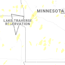
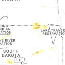
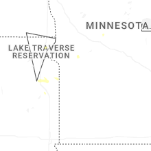
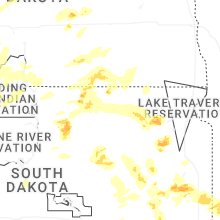
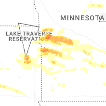
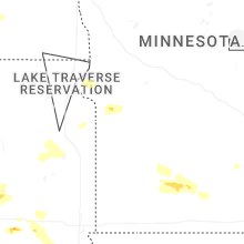

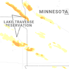


Connect with Interactive Hail Maps