

Hail Map for Centre, AL
The Centre, AL area has had 12 reports of on-the-ground hail by trained spotters, and has been under severe weather warnings 4 times during the past 12 months. Doppler radar has detected hail at or near Centre, AL on 54 occasions, including 2 occasions during the past year.
| Name: | Centre, AL |
| Where Located: | 64.1 miles SSW of Chattanooga, TN |
| Map: | Google Map for Centre, AL |
| Population: | 3489 |
| Housing Units: | 1690 |
| More Info: | Search Google for Centre, AL |
0
The Top Recent Hail Date for Centre, AL is Wednesday, July 1, 2026 (54th out of 54)
Hail and Wind Damage Spotted near Centre, AL
| Date / Time | Report Details |
|---|---|
| 3/9/2026 7:49 PM CDT |
 At 749 pm cdt, severe thunderstorms were located along a line extending from near little river falls to tennala to near glencoe, moving east at 40 mph (radar indicated). Hazards include 60 mph wind gusts. Expect damage to roofs, siding, and trees. Locations impacted include, gadsden, jacksonville, piedmont, hokes bluff, centre, cedar bluff, little river canyon national preserve, forney, centre municipal airport, glencoe, weaver, leesburg, fruithurst, edwardsville, gaylesville, pleasant gap, cornwall furnace park, blanche, eastern weiss lake, and muscadine. At 749 pm cdt, severe thunderstorms were located along a line extending from near little river falls to tennala to near glencoe, moving east at 40 mph (radar indicated). Hazards include 60 mph wind gusts. Expect damage to roofs, siding, and trees. Locations impacted include, gadsden, jacksonville, piedmont, hokes bluff, centre, cedar bluff, little river canyon national preserve, forney, centre municipal airport, glencoe, weaver, leesburg, fruithurst, edwardsville, gaylesville, pleasant gap, cornwall furnace park, blanche, eastern weiss lake, and muscadine.
|
| 3/9/2026 7:39 PM CDT |
 Svrbmx the national weather service in birmingham has issued a * severe thunderstorm warning for, northern calhoun county in east central alabama, eastern etowah county in northeastern alabama, northeastern cleburne county in east central alabama, cherokee county in northeastern alabama, * until 845 pm cdt. * at 739 pm cdt, severe thunderstorms were located along a line extending from near little river falls to near neely henry lake, moving east at 45 mph (radar indicated). Hazards include 60 mph wind gusts. expect damage to roofs, siding, and trees Svrbmx the national weather service in birmingham has issued a * severe thunderstorm warning for, northern calhoun county in east central alabama, eastern etowah county in northeastern alabama, northeastern cleburne county in east central alabama, cherokee county in northeastern alabama, * until 845 pm cdt. * at 739 pm cdt, severe thunderstorms were located along a line extending from near little river falls to near neely henry lake, moving east at 45 mph (radar indicated). Hazards include 60 mph wind gusts. expect damage to roofs, siding, and trees
|
| 11/25/2025 6:02 AM CST | At 602 am cst, severe thunderstorms were located along a line extending from sand rock to near pleasant gap to near heflin, moving east at 50 mph (radar indicated). Hazards include 60 mph wind gusts. Expect damage to roofs, siding, and trees. Locations impacted include, piedmont, centre, heflin, cedar bluff, little river canyon national preserve, forney, centre municipal airport, leesburg, sand rock, fruithurst, edwardsville, gaylesville, tennala, cherokee rock village, pleasant gap, cornwall furnace park, blanche, eastern weiss lake, muscadine, and abernathy. |
| 11/25/2025 6:00 AM CST | Tree down on a powerline in centr in cherokee county AL, 2.3 miles NNW of Centre, AL |
| 11/25/2025 5:45 AM CST |
 Svrbmx the national weather service in birmingham has issued a * severe thunderstorm warning for, cleburne county in east central alabama, cherokee county in northeastern alabama, * until 645 am cst. * at 545 am cst, severe thunderstorms were located along a line extending from near crossville to 6 miles southeast of hokes bluff to anniston regional airport, moving east at 50 mph (radar indicated). Hazards include 60 mph wind gusts. expect damage to roofs, siding, and trees Svrbmx the national weather service in birmingham has issued a * severe thunderstorm warning for, cleburne county in east central alabama, cherokee county in northeastern alabama, * until 645 am cst. * at 545 am cst, severe thunderstorms were located along a line extending from near crossville to 6 miles southeast of hokes bluff to anniston regional airport, moving east at 50 mph (radar indicated). Hazards include 60 mph wind gusts. expect damage to roofs, siding, and trees
|
| 8/20/2025 5:25 PM CDT | Power line down along county rd 382 south of centr in cherokee county AL, 4.4 miles NNW of Centre, AL |
| 6/14/2025 3:31 PM CDT |
 the severe thunderstorm warning has been cancelled and is no longer in effect the severe thunderstorm warning has been cancelled and is no longer in effect
|
| 6/14/2025 3:16 PM CDT |
 At 316 pm cdt, a severe thunderstorm was located near eastern weiss lake, or near cedar bluff, moving east at 30 mph (radar indicated). Hazards include 60 mph wind gusts and quarter size hail. Hail damage to vehicles is expected. expect wind damage to roofs, siding, and trees. Locations impacted include, centre, cedar bluff, centre municipal airport, little river canyon national preserve, forney, gaylesville, tennala, cornwall furnace park, western weiss lake, blanche, eastern weiss lake, moshat, little river falls, coloma, fullerton, new moon, chesnut bay resort, broomtown, howells crossroads, and waterhouse. At 316 pm cdt, a severe thunderstorm was located near eastern weiss lake, or near cedar bluff, moving east at 30 mph (radar indicated). Hazards include 60 mph wind gusts and quarter size hail. Hail damage to vehicles is expected. expect wind damage to roofs, siding, and trees. Locations impacted include, centre, cedar bluff, centre municipal airport, little river canyon national preserve, forney, gaylesville, tennala, cornwall furnace park, western weiss lake, blanche, eastern weiss lake, moshat, little river falls, coloma, fullerton, new moon, chesnut bay resort, broomtown, howells crossroads, and waterhouse.
|
| 6/14/2025 2:57 PM CDT | Tree and power line down in centr in cherokee county AL, 2 miles N of Centre, AL |
| 6/14/2025 2:56 PM CDT |
 Svrbmx the national weather service in birmingham has issued a * severe thunderstorm warning for, cherokee county in northeastern alabama, * until 345 pm cdt. * at 255 pm cdt, a severe thunderstorm was located over western weiss lake, or near centre, moving east at 30 mph (radar indicated). Hazards include 60 mph wind gusts and quarter size hail. Hail damage to vehicles is expected. Expect wind damage to roofs, siding, and trees. Svrbmx the national weather service in birmingham has issued a * severe thunderstorm warning for, cherokee county in northeastern alabama, * until 345 pm cdt. * at 255 pm cdt, a severe thunderstorm was located over western weiss lake, or near centre, moving east at 30 mph (radar indicated). Hazards include 60 mph wind gusts and quarter size hail. Hail damage to vehicles is expected. Expect wind damage to roofs, siding, and trees.
|
| 6/7/2025 3:15 PM CDT | Trees down in the centre are in cherokee county AL, 1.4 miles NNW of Centre, AL |
| 6/7/2025 3:15 PM CDT |
 At 315 pm cdt, severe thunderstorms were located along a line extending from near blanche to near alexandria to bon air to near lawley, moving east at 45 mph (radar indicated). Hazards include 60 mph wind gusts and penny size hail. Expect damage to roofs, siding, and trees. Locations impacted include, anniston, oxford, talladega, sylacauga, jacksonville, clanton, childersburg, piedmont, centre, jemison, cedar bluff, talladega springs, weogufka, cobb town, fort mcclellan, saks, little river canyon national preserve, forney, west end-cobb town, and centre municipal airport. At 315 pm cdt, severe thunderstorms were located along a line extending from near blanche to near alexandria to bon air to near lawley, moving east at 45 mph (radar indicated). Hazards include 60 mph wind gusts and penny size hail. Expect damage to roofs, siding, and trees. Locations impacted include, anniston, oxford, talladega, sylacauga, jacksonville, clanton, childersburg, piedmont, centre, jemison, cedar bluff, talladega springs, weogufka, cobb town, fort mcclellan, saks, little river canyon national preserve, forney, west end-cobb town, and centre municipal airport.
|
| 6/7/2025 3:03 PM CDT |
 At 303 pm cdt, severe thunderstorms were located along a line extending from near fort payne to near ohatchee to near harpersville to talladega national forest, moving east at 45 mph (radar indicated). Hazards include 60 mph wind gusts and penny size hail. Expect damage to roofs, siding, and trees. Locations impacted include, anniston, oxford, talladega, sylacauga, jacksonville, clanton, childersburg, piedmont, centre, jemison, cedar bluff, talladega springs, weogufka, cobb town, fort mcclellan, saks, little river canyon national preserve, forney, west end-cobb town, and centre municipal airport. At 303 pm cdt, severe thunderstorms were located along a line extending from near fort payne to near ohatchee to near harpersville to talladega national forest, moving east at 45 mph (radar indicated). Hazards include 60 mph wind gusts and penny size hail. Expect damage to roofs, siding, and trees. Locations impacted include, anniston, oxford, talladega, sylacauga, jacksonville, clanton, childersburg, piedmont, centre, jemison, cedar bluff, talladega springs, weogufka, cobb town, fort mcclellan, saks, little river canyon national preserve, forney, west end-cobb town, and centre municipal airport.
|
| 6/7/2025 2:46 PM CDT |
 Svrbmx the national weather service in birmingham has issued a * severe thunderstorm warning for, chilton county in central alabama, talladega county in east central alabama, calhoun county in east central alabama, western coosa county in east central alabama, cherokee county in northeastern alabama, * until 400 pm cdt. * at 245 pm cdt, severe thunderstorms were located along a line extending from 6 miles south of section to near ashville to brook highland to near brent, moving east at 45 mph (radar indicated). Hazards include 60 mph wind gusts and penny size hail. expect damage to roofs, siding, and trees Svrbmx the national weather service in birmingham has issued a * severe thunderstorm warning for, chilton county in central alabama, talladega county in east central alabama, calhoun county in east central alabama, western coosa county in east central alabama, cherokee county in northeastern alabama, * until 400 pm cdt. * at 245 pm cdt, severe thunderstorms were located along a line extending from 6 miles south of section to near ashville to brook highland to near brent, moving east at 45 mph (radar indicated). Hazards include 60 mph wind gusts and penny size hail. expect damage to roofs, siding, and trees
|
| 5/20/2025 10:14 PM CDT |
 At 1014 pm cdt, severe thunderstorms were located along a line extending from near trion to near summerville to near gaylesville, moving east at 45 mph (radar indicated). Hazards include 60 mph wind gusts and quarter size hail. Hail damage to vehicles is expected. expect wind damage to roofs, siding, and trees. Locations impacted include, centre, cedar bluff, centre municipal airport, gaylesville, cornwall furnace park, western weiss lake, eastern weiss lake, weiss dam, fullerton, new moon, chesnut bay resort, broomtown, howells crossroads, waterhouse, and chesterfield. At 1014 pm cdt, severe thunderstorms were located along a line extending from near trion to near summerville to near gaylesville, moving east at 45 mph (radar indicated). Hazards include 60 mph wind gusts and quarter size hail. Hail damage to vehicles is expected. expect wind damage to roofs, siding, and trees. Locations impacted include, centre, cedar bluff, centre municipal airport, gaylesville, cornwall furnace park, western weiss lake, eastern weiss lake, weiss dam, fullerton, new moon, chesnut bay resort, broomtown, howells crossroads, waterhouse, and chesterfield.
|
| 5/20/2025 10:09 PM CDT |
 At 1009 pm cdt, a severe thunderstorm capable of producing a tornado was located over cedar bluff, moving east at 30 mph (radar indicated rotation). Hazards include tornado and golf ball size hail. Flying debris will be dangerous to those caught without shelter. mobile homes will be damaged or destroyed. damage to roofs, windows, and vehicles will occur. tree damage is likely. Locations impacted include, centre, cedar bluff, centre municipal airport, gaylesville, cornwall furnace park, eastern weiss lake, western weiss lake, fullerton, howells crossroads, and waterhouse. At 1009 pm cdt, a severe thunderstorm capable of producing a tornado was located over cedar bluff, moving east at 30 mph (radar indicated rotation). Hazards include tornado and golf ball size hail. Flying debris will be dangerous to those caught without shelter. mobile homes will be damaged or destroyed. damage to roofs, windows, and vehicles will occur. tree damage is likely. Locations impacted include, centre, cedar bluff, centre municipal airport, gaylesville, cornwall furnace park, eastern weiss lake, western weiss lake, fullerton, howells crossroads, and waterhouse.
|
| 5/20/2025 10:00 PM CDT |
 At 959 pm cdt, a severe thunderstorm capable of producing a tornado was located over western weiss lake, or near centre, moving east at 45 mph (radar indicated rotation). Hazards include tornado and golf ball size hail. Flying debris will be dangerous to those caught without shelter. mobile homes will be damaged or destroyed. damage to roofs, windows, and vehicles will occur. tree damage is likely. Locations impacted include, centre, cedar bluff, centre municipal airport, leesburg, sand rock, gaylesville, cornwall furnace park, western weiss lake, eastern weiss lake, weiss dam, fullerton, yellow creek falls, chesnut bay resort, broomtown, howells crossroads, and waterhouse. At 959 pm cdt, a severe thunderstorm capable of producing a tornado was located over western weiss lake, or near centre, moving east at 45 mph (radar indicated rotation). Hazards include tornado and golf ball size hail. Flying debris will be dangerous to those caught without shelter. mobile homes will be damaged or destroyed. damage to roofs, windows, and vehicles will occur. tree damage is likely. Locations impacted include, centre, cedar bluff, centre municipal airport, leesburg, sand rock, gaylesville, cornwall furnace park, western weiss lake, eastern weiss lake, weiss dam, fullerton, yellow creek falls, chesnut bay resort, broomtown, howells crossroads, and waterhouse.
|
| 5/20/2025 10:00 PM CDT |
 the tornado warning has been cancelled and is no longer in effect the tornado warning has been cancelled and is no longer in effect
|
| 5/20/2025 9:54 PM CDT |
 At 954 pm cdt, severe thunderstorms were located along a line extending from 7 miles east of henagar to little river canyon national preserve to near sand rock, moving east at 45 mph (radar indicated). Hazards include golf ball size hail and 70 mph wind gusts. People and animals outdoors will be injured. expect hail damage to roofs, siding, windows, and vehicles. expect considerable tree damage. wind damage is also likely to mobile homes, roofs, and outbuildings. Locations impacted include, centre, cedar bluff, centre municipal airport, little river canyon national preserve, leesburg, sand rock, gaylesville, cherokee rock village, cornwall furnace park, western weiss lake, blanche, eastern weiss lake, little river falls, weiss dam, fullerton, new moon, yellow creek falls, chesnut bay resort, broomtown, and howells crossroads. At 954 pm cdt, severe thunderstorms were located along a line extending from 7 miles east of henagar to little river canyon national preserve to near sand rock, moving east at 45 mph (radar indicated). Hazards include golf ball size hail and 70 mph wind gusts. People and animals outdoors will be injured. expect hail damage to roofs, siding, windows, and vehicles. expect considerable tree damage. wind damage is also likely to mobile homes, roofs, and outbuildings. Locations impacted include, centre, cedar bluff, centre municipal airport, little river canyon national preserve, leesburg, sand rock, gaylesville, cherokee rock village, cornwall furnace park, western weiss lake, blanche, eastern weiss lake, little river falls, weiss dam, fullerton, new moon, yellow creek falls, chesnut bay resort, broomtown, and howells crossroads.
|
| 5/20/2025 9:43 PM CDT |
 Torbmx the national weather service in birmingham has issued a * tornado warning for, north central etowah county in northeastern alabama, central cherokee county in northeastern alabama, * until 1045 pm cdt. * at 943 pm cdt, a severe thunderstorm capable of producing a tornado was located near tabor road, or 13 miles east of boaz, moving east at 30 mph (radar indicated rotation). Hazards include tornado and half dollar size hail. Flying debris will be dangerous to those caught without shelter. mobile homes will be damaged or destroyed. damage to roofs, windows, and vehicles will occur. Tree damage is likely. Torbmx the national weather service in birmingham has issued a * tornado warning for, north central etowah county in northeastern alabama, central cherokee county in northeastern alabama, * until 1045 pm cdt. * at 943 pm cdt, a severe thunderstorm capable of producing a tornado was located near tabor road, or 13 miles east of boaz, moving east at 30 mph (radar indicated rotation). Hazards include tornado and half dollar size hail. Flying debris will be dangerous to those caught without shelter. mobile homes will be damaged or destroyed. damage to roofs, windows, and vehicles will occur. Tree damage is likely.
|
| 5/20/2025 9:39 PM CDT |
 Svrbmx the national weather service in birmingham has issued a * severe thunderstorm warning for, central cherokee county in northeastern alabama, * until 1045 pm cdt. * at 938 pm cdt, severe thunderstorms were located along a line extending from sylvania to 6 miles southeast of fyffe to near crossville, moving east at 45 mph (radar indicated). Hazards include 70 mph wind gusts and half dollar size hail. Hail damage to vehicles is expected. expect considerable tree damage. Wind damage is also likely to mobile homes, roofs, and outbuildings. Svrbmx the national weather service in birmingham has issued a * severe thunderstorm warning for, central cherokee county in northeastern alabama, * until 1045 pm cdt. * at 938 pm cdt, severe thunderstorms were located along a line extending from sylvania to 6 miles southeast of fyffe to near crossville, moving east at 45 mph (radar indicated). Hazards include 70 mph wind gusts and half dollar size hail. Hail damage to vehicles is expected. expect considerable tree damage. Wind damage is also likely to mobile homes, roofs, and outbuildings.
|
| 5/2/2025 6:19 PM CDT |
 the severe thunderstorm warning has been cancelled and is no longer in effect the severe thunderstorm warning has been cancelled and is no longer in effect
|
| 5/2/2025 6:19 PM CDT |
 At 618 pm cdt, severe thunderstorms were located along a line extending from 11 miles east of resaca to near ball flat, moving east at 55 mph (radar indicated). Hazards include 60 mph wind gusts and quarter size hail. Hail damage to vehicles is expected. expect wind damage to roofs, siding, and trees. Locations impacted include, whitney junction, weiss dam, gadsden steam plant, hokes bluff, yellow creek falls, rockledge, cherokee rock village, spring garden, little river canyon national preserve, pleasant gap, cornwall furnace park, cobb city, attalla, gadsden water works, blanche, eastern weiss lake, forney, glencoe, crudup, and new moon. At 618 pm cdt, severe thunderstorms were located along a line extending from 11 miles east of resaca to near ball flat, moving east at 55 mph (radar indicated). Hazards include 60 mph wind gusts and quarter size hail. Hail damage to vehicles is expected. expect wind damage to roofs, siding, and trees. Locations impacted include, whitney junction, weiss dam, gadsden steam plant, hokes bluff, yellow creek falls, rockledge, cherokee rock village, spring garden, little river canyon national preserve, pleasant gap, cornwall furnace park, cobb city, attalla, gadsden water works, blanche, eastern weiss lake, forney, glencoe, crudup, and new moon.
|
| 5/2/2025 5:48 PM CDT |
 At 548 pm cdt, severe thunderstorms were located along a line extending from near trion to near steele, moving east at 55 mph (radar indicated). Hazards include 60 mph wind gusts and quarter size hail. Hail damage to vehicles is expected. expect wind damage to roofs, siding, and trees. Locations impacted include, whitney junction, weiss dam, gadsden steam plant, hokes bluff, yellow creek falls, rockledge, cherokee rock village, spring garden, fairview, aurora, little river canyon national preserve, pleasant gap, cornwall furnace park, cobb city, attalla, gadsden water works, blanche, eastern weiss lake, forney, and glencoe. At 548 pm cdt, severe thunderstorms were located along a line extending from near trion to near steele, moving east at 55 mph (radar indicated). Hazards include 60 mph wind gusts and quarter size hail. Hail damage to vehicles is expected. expect wind damage to roofs, siding, and trees. Locations impacted include, whitney junction, weiss dam, gadsden steam plant, hokes bluff, yellow creek falls, rockledge, cherokee rock village, spring garden, fairview, aurora, little river canyon national preserve, pleasant gap, cornwall furnace park, cobb city, attalla, gadsden water works, blanche, eastern weiss lake, forney, and glencoe.
|
| 5/2/2025 5:21 PM CDT |
 Svrbmx the national weather service in birmingham has issued a * severe thunderstorm warning for, eastern blount county in central alabama, etowah county in northeastern alabama, northern st. clair county in central alabama, cherokee county in northeastern alabama, * until 630 pm cdt. * at 520 pm cdt, severe thunderstorms were located along a line extending from near henagar to near nectar, moving east at 55 mph (radar indicated). Hazards include 60 mph wind gusts and half dollar size hail. Hail damage to vehicles is expected. Expect wind damage to roofs, siding, and trees. Svrbmx the national weather service in birmingham has issued a * severe thunderstorm warning for, eastern blount county in central alabama, etowah county in northeastern alabama, northern st. clair county in central alabama, cherokee county in northeastern alabama, * until 630 pm cdt. * at 520 pm cdt, severe thunderstorms were located along a line extending from near henagar to near nectar, moving east at 55 mph (radar indicated). Hazards include 60 mph wind gusts and half dollar size hail. Hail damage to vehicles is expected. Expect wind damage to roofs, siding, and trees.
|
| 4/10/2025 7:19 PM CDT |
 the severe thunderstorm warning has been cancelled and is no longer in effect the severe thunderstorm warning has been cancelled and is no longer in effect
|
| 4/10/2025 7:12 PM CDT |
 At 712 pm cdt, severe thunderstorms were located along a line extending from near slackland to near forney, moving southeast at 30 mph (radar indicated). Hazards include 60 mph wind gusts. Expect damage to roofs, siding, and trees. Locations impacted include, coloma, weiss dam, tennala, keener, centre municipal airport, slackland, centre, black creek, howells crossroads, wilsonia, forney, moshat, cherokee rock village, leesburg, eastern weiss lake, western weiss lake, and reece city. At 712 pm cdt, severe thunderstorms were located along a line extending from near slackland to near forney, moving southeast at 30 mph (radar indicated). Hazards include 60 mph wind gusts. Expect damage to roofs, siding, and trees. Locations impacted include, coloma, weiss dam, tennala, keener, centre municipal airport, slackland, centre, black creek, howells crossroads, wilsonia, forney, moshat, cherokee rock village, leesburg, eastern weiss lake, western weiss lake, and reece city.
|
| 4/10/2025 6:51 PM CDT |
 At 651 pm cdt, severe thunderstorms were located along a line extending from near tabor road to near forney, moving east at 40 mph (public). Hazards include 60 mph wind gusts and quarter size hail. Hail damage to vehicles is expected. expect wind damage to roofs, siding, and trees. Locations impacted include, coloma, weiss dam, tennala, leesburg, cedar bluff, tabor road, yellow creek falls, keener, centre municipal airport, slackland, cherokee rock village, chesnut bay resort, centre, western weiss lake, black creek, howells crossroads, wilsonia, eastern weiss lake, forney, and moshat. At 651 pm cdt, severe thunderstorms were located along a line extending from near tabor road to near forney, moving east at 40 mph (public). Hazards include 60 mph wind gusts and quarter size hail. Hail damage to vehicles is expected. expect wind damage to roofs, siding, and trees. Locations impacted include, coloma, weiss dam, tennala, leesburg, cedar bluff, tabor road, yellow creek falls, keener, centre municipal airport, slackland, cherokee rock village, chesnut bay resort, centre, western weiss lake, black creek, howells crossroads, wilsonia, eastern weiss lake, forney, and moshat.
|
| 4/10/2025 6:33 PM CDT |
 At 633 pm cdt, severe thunderstorms were located along a line extending from near albertville to near leesburg, moving southeast at 45 mph (public). Hazards include golf ball size hail and 60 mph wind gusts. People and animals outdoors will be injured. expect hail damage to roofs, siding, windows, and vehicles. expect wind damage to roofs, siding, and trees. Locations impacted include, coloma, weiss dam, tennala, leesburg, tabor road, yellow creek falls, cherokee rock village, cornwall furnace park, eastern weiss lake, forney, cedar bluff, fullerton, keener, centre municipal airport, slackland, chesnut bay resort, gaylesville, centre, western weiss lake, and black creek. At 633 pm cdt, severe thunderstorms were located along a line extending from near albertville to near leesburg, moving southeast at 45 mph (public). Hazards include golf ball size hail and 60 mph wind gusts. People and animals outdoors will be injured. expect hail damage to roofs, siding, windows, and vehicles. expect wind damage to roofs, siding, and trees. Locations impacted include, coloma, weiss dam, tennala, leesburg, tabor road, yellow creek falls, cherokee rock village, cornwall furnace park, eastern weiss lake, forney, cedar bluff, fullerton, keener, centre municipal airport, slackland, chesnut bay resort, gaylesville, centre, western weiss lake, and black creek.
|
| 4/10/2025 6:30 PM CDT | Half Dollar sized hail reported 1.8 miles ENE of Centre, AL, reports of hail from 1-1.25 inches near centre. |
| 4/10/2025 6:22 PM CDT |
 Svrbmx the national weather service in birmingham has issued a * severe thunderstorm warning for, northeastern etowah county in northeastern alabama, cherokee county in northeastern alabama, * until 730 pm cdt. * at 621 pm cdt, a severe thunderstorm was located over tabor road, or 12 miles west of centre, moving east at 35 mph (public). Hazards include golf ball size hail and 60 mph wind gusts. People and animals outdoors will be injured. expect hail damage to roofs, siding, windows, and vehicles. Expect wind damage to roofs, siding, and trees. Svrbmx the national weather service in birmingham has issued a * severe thunderstorm warning for, northeastern etowah county in northeastern alabama, cherokee county in northeastern alabama, * until 730 pm cdt. * at 621 pm cdt, a severe thunderstorm was located over tabor road, or 12 miles west of centre, moving east at 35 mph (public). Hazards include golf ball size hail and 60 mph wind gusts. People and animals outdoors will be injured. expect hail damage to roofs, siding, windows, and vehicles. Expect wind damage to roofs, siding, and trees.
|
| 3/4/2025 11:20 PM CST |
 The storms which prompted the warning have weakened below severe limits, and have exited the warned area. therefore, the warning will be allowed to expire. however, gusty winds are still possible with these thunderstorms. a severe thunderstorm watch remains in effect until 300 am cst for northeastern and east central alabama. The storms which prompted the warning have weakened below severe limits, and have exited the warned area. therefore, the warning will be allowed to expire. however, gusty winds are still possible with these thunderstorms. a severe thunderstorm watch remains in effect until 300 am cst for northeastern and east central alabama.
|
| 3/4/2025 10:19 PM CST |
 Svrbmx the national weather service in birmingham has issued a * severe thunderstorm warning for, cleburne county in east central alabama, cherokee county in northeastern alabama, * until 1130 pm cst. * at 1019 pm cst, severe thunderstorms were located along a line extending from near sand rock to near talladega, moving east at 35 mph (radar indicated). Hazards include 60 mph wind gusts. expect damage to roofs, siding, and trees Svrbmx the national weather service in birmingham has issued a * severe thunderstorm warning for, cleburne county in east central alabama, cherokee county in northeastern alabama, * until 1130 pm cst. * at 1019 pm cst, severe thunderstorms were located along a line extending from near sand rock to near talladega, moving east at 35 mph (radar indicated). Hazards include 60 mph wind gusts. expect damage to roofs, siding, and trees
|
| 2/16/2025 2:01 AM CST |
 At 201 am cst, severe thunderstorms were located along a line extending from near summerville to blue mountain to near fayetteville, moving east at 60 mph (radar indicated). Hazards include 70 mph wind gusts. Expect considerable tree damage. damage is likely to mobile homes, roofs, and outbuildings. Locations impacted include, anniston, oxford, talladega, sylacauga, jacksonville, childersburg, piedmont, centre, cedar bluff, talladega springs, forney, west end-cobb town, centre municipal airport, cobb town, fort mcclellan, saks, lincoln, weaver, munford, and hobson city. At 201 am cst, severe thunderstorms were located along a line extending from near summerville to blue mountain to near fayetteville, moving east at 60 mph (radar indicated). Hazards include 70 mph wind gusts. Expect considerable tree damage. damage is likely to mobile homes, roofs, and outbuildings. Locations impacted include, anniston, oxford, talladega, sylacauga, jacksonville, childersburg, piedmont, centre, cedar bluff, talladega springs, forney, west end-cobb town, centre municipal airport, cobb town, fort mcclellan, saks, lincoln, weaver, munford, and hobson city.
|
| 2/16/2025 1:44 AM CST |
 At 144 am cst, severe thunderstorms were located along a line extending from near little river falls to near honda manufacturing of alabama to near lay lake, moving east at 45 mph (radar indicated). Hazards include 70 mph wind gusts. Expect considerable tree damage. damage is likely to mobile homes, roofs, and outbuildings. Locations impacted include, anniston, oxford, talladega, sylacauga, jacksonville, childersburg, piedmont, centre, wilsonville, cedar bluff, talladega springs, cobb town, fort mcclellan, saks, little river canyon national preserve, forney, west end-cobb town, centre municipal airport, lincoln, and glencoe. At 144 am cst, severe thunderstorms were located along a line extending from near little river falls to near honda manufacturing of alabama to near lay lake, moving east at 45 mph (radar indicated). Hazards include 70 mph wind gusts. Expect considerable tree damage. damage is likely to mobile homes, roofs, and outbuildings. Locations impacted include, anniston, oxford, talladega, sylacauga, jacksonville, childersburg, piedmont, centre, wilsonville, cedar bluff, talladega springs, cobb town, fort mcclellan, saks, little river canyon national preserve, forney, west end-cobb town, centre municipal airport, lincoln, and glencoe.
|
| 2/16/2025 1:23 AM CST |
 Svrbmx the national weather service in birmingham has issued a * severe thunderstorm warning for, talladega county in east central alabama, calhoun county in east central alabama, cherokee county in northeastern alabama, * until 230 am cst. * at 123 am cst, severe thunderstorms were located along a line extending from fyffe to near odenville to wilton, moving east at 65 mph (radar indicated). Hazards include 70 mph wind gusts. Expect considerable tree damage. Damage is likely to mobile homes, roofs, and outbuildings. Svrbmx the national weather service in birmingham has issued a * severe thunderstorm warning for, talladega county in east central alabama, calhoun county in east central alabama, cherokee county in northeastern alabama, * until 230 am cst. * at 123 am cst, severe thunderstorms were located along a line extending from fyffe to near odenville to wilton, moving east at 65 mph (radar indicated). Hazards include 70 mph wind gusts. Expect considerable tree damage. Damage is likely to mobile homes, roofs, and outbuildings.
|
| 8/31/2024 2:42 PM CDT | Part of the roof was blown off a barn at the intersection of county road 31 and county road 4 in cherokee county AL, 6.9 miles WNW of Centre, AL |
| 8/30/2024 3:20 PM CDT | Several trees were blown down around centr in cherokee county AL, 1.4 miles NNW of Centre, AL |
| 8/30/2024 3:10 PM CDT | Roof damage and trees down reported near cr 2 in cherokee county AL, 7.9 miles WNW of Centre, AL |
| 8/30/2024 3:10 PM CDT | Some roof damage reporte in cherokee county AL, 12.6 miles W of Centre, AL |
| 8/30/2024 3:06 PM CDT | A tree was blown down on cr 12 in cherokee county AL, 7.7 miles WNW of Centre, AL |
| 8/30/2024 2:55 PM CDT | A tree was blown down near us 411 and bus us 41 in cherokee county AL, 1.8 miles ENE of Centre, AL |
| 8/16/2024 7:10 PM CDT |
 the severe thunderstorm warning has been cancelled and is no longer in effect the severe thunderstorm warning has been cancelled and is no longer in effect
|
| 8/16/2024 6:54 PM CDT |
 At 654 pm cdt, severe thunderstorms were located along a line extending from near gaylesville to leesburg to near sardis city, moving southeast at 30 mph (radar indicated). Hazards include 60 mph wind gusts. Expect damage to roofs, siding, and trees. Locations impacted include, centre, cedar bluff, little river canyon national preserve, forney, centre municipal airport, leesburg, reece city, sand rock, gaylesville, tennala, tabor road, cherokee rock village, cornwall furnace park, eastern weiss lake, ballplay, slackland, western weiss lake, moshat, weiss dam, and yellow creek falls. At 654 pm cdt, severe thunderstorms were located along a line extending from near gaylesville to leesburg to near sardis city, moving southeast at 30 mph (radar indicated). Hazards include 60 mph wind gusts. Expect damage to roofs, siding, and trees. Locations impacted include, centre, cedar bluff, little river canyon national preserve, forney, centre municipal airport, leesburg, reece city, sand rock, gaylesville, tennala, tabor road, cherokee rock village, cornwall furnace park, eastern weiss lake, ballplay, slackland, western weiss lake, moshat, weiss dam, and yellow creek falls.
|
| 8/16/2024 6:28 PM CDT |
 Svrbmx the national weather service in birmingham has issued a * severe thunderstorm warning for, northeastern etowah county in northeastern alabama, cherokee county in northeastern alabama, * until 730 pm cdt. * at 627 pm cdt, severe thunderstorms were located along a line extending from near little river canyon national preserve to near crossville to albertville, moving southeast at 30 mph (radar indicated). Hazards include 60 mph wind gusts. expect damage to roofs, siding, and trees Svrbmx the national weather service in birmingham has issued a * severe thunderstorm warning for, northeastern etowah county in northeastern alabama, cherokee county in northeastern alabama, * until 730 pm cdt. * at 627 pm cdt, severe thunderstorms were located along a line extending from near little river canyon national preserve to near crossville to albertville, moving southeast at 30 mph (radar indicated). Hazards include 60 mph wind gusts. expect damage to roofs, siding, and trees
|
| 8/16/2024 5:54 PM CDT |
 At 554 pm cdt, severe thunderstorms were located along a line extending from summerville to 9 miles northeast of gaylesville to near blanche, moving southeast at 30 mph (radar indicated). Hazards include 60 mph wind gusts. Expect damage to roofs, siding, and trees. Locations impacted include, centre, cedar bluff, centre municipal airport, little river canyon national preserve, leesburg, sand rock, gaylesville, cornwall furnace park, western weiss lake, blanche, eastern weiss lake, fullerton, new moon, yellow creek falls, chesnut bay resort, broomtown, howells crossroads, waterhouse, chesterfield, and little river canyon np. At 554 pm cdt, severe thunderstorms were located along a line extending from summerville to 9 miles northeast of gaylesville to near blanche, moving southeast at 30 mph (radar indicated). Hazards include 60 mph wind gusts. Expect damage to roofs, siding, and trees. Locations impacted include, centre, cedar bluff, centre municipal airport, little river canyon national preserve, leesburg, sand rock, gaylesville, cornwall furnace park, western weiss lake, blanche, eastern weiss lake, fullerton, new moon, yellow creek falls, chesnut bay resort, broomtown, howells crossroads, waterhouse, chesterfield, and little river canyon np.
|
| 8/16/2024 5:33 PM CDT |
 Svrbmx the national weather service in birmingham has issued a * severe thunderstorm warning for, central cherokee county in northeastern alabama, * until 630 pm cdt. * at 532 pm cdt, severe thunderstorms were located along a line extending from 10 miles southeast of ider to near fort payne to near fyffe, moving southeast at 20 mph (radar indicated). Hazards include 60 mph wind gusts. expect damage to roofs, siding, and trees Svrbmx the national weather service in birmingham has issued a * severe thunderstorm warning for, central cherokee county in northeastern alabama, * until 630 pm cdt. * at 532 pm cdt, severe thunderstorms were located along a line extending from 10 miles southeast of ider to near fort payne to near fyffe, moving southeast at 20 mph (radar indicated). Hazards include 60 mph wind gusts. expect damage to roofs, siding, and trees
|
| 7/29/2024 5:39 PM CDT |
 At 539 pm cdt, severe thunderstorms were located along a line extending from 6 miles east of gaylesville to near tabor road, moving southeast at 40 mph (radar indicated). Hazards include 60 mph wind gusts. Expect damage to roofs, siding, and trees. Locations impacted include, centre, cedar bluff, little river canyon national preserve, forney, centre municipal airport, leesburg, sand rock, gaylesville, tennala, cherokee rock village, pleasant gap, cornwall furnace park, blanche, eastern weiss lake, slackland, western weiss lake, moshat, ball flat, coloma, and weiss dam. At 539 pm cdt, severe thunderstorms were located along a line extending from 6 miles east of gaylesville to near tabor road, moving southeast at 40 mph (radar indicated). Hazards include 60 mph wind gusts. Expect damage to roofs, siding, and trees. Locations impacted include, centre, cedar bluff, little river canyon national preserve, forney, centre municipal airport, leesburg, sand rock, gaylesville, tennala, cherokee rock village, pleasant gap, cornwall furnace park, blanche, eastern weiss lake, slackland, western weiss lake, moshat, ball flat, coloma, and weiss dam.
|
| 7/29/2024 5:18 PM CDT |
 Svrbmx the national weather service in birmingham has issued a * severe thunderstorm warning for, cherokee county in northeastern alabama, * until 615 pm cdt. * at 518 pm cdt, severe thunderstorms were located along a line extending from 8 miles west of summerville to crossville, moving southeast at 30 mph (radar indicated). Hazards include 60 mph wind gusts. expect damage to roofs, siding, and trees Svrbmx the national weather service in birmingham has issued a * severe thunderstorm warning for, cherokee county in northeastern alabama, * until 615 pm cdt. * at 518 pm cdt, severe thunderstorms were located along a line extending from 8 miles west of summerville to crossville, moving southeast at 30 mph (radar indicated). Hazards include 60 mph wind gusts. expect damage to roofs, siding, and trees
|
| 5/27/2024 5:02 AM CDT |
 the severe thunderstorm warning has been cancelled and is no longer in effect the severe thunderstorm warning has been cancelled and is no longer in effect
|
| 5/27/2024 4:48 AM CDT |
 At 448 am cdt, severe thunderstorms were located along a line extending from 9 miles north of cave spring to 6 miles northwest of ashville, moving southeast at 40 mph (radar indicated). Hazards include 60 mph wind gusts and penny size hail. Expect damage to roofs, siding, and trees. Locations impacted include, gadsden, rainbow city, oneonta, attalla, hokes bluff, centre, cedar bluff, blountsville, cleveland, little river canyon national preserve, forney, centre municipal airport, glencoe, sardis city, steele, leesburg, altoona, snead, susan moore, and walnut grove. At 448 am cdt, severe thunderstorms were located along a line extending from 9 miles north of cave spring to 6 miles northwest of ashville, moving southeast at 40 mph (radar indicated). Hazards include 60 mph wind gusts and penny size hail. Expect damage to roofs, siding, and trees. Locations impacted include, gadsden, rainbow city, oneonta, attalla, hokes bluff, centre, cedar bluff, blountsville, cleveland, little river canyon national preserve, forney, centre municipal airport, glencoe, sardis city, steele, leesburg, altoona, snead, susan moore, and walnut grove.
|
| 5/27/2024 4:27 AM CDT |
 At 426 am cdt, severe thunderstorms were located along a line extending from 7 miles east of blanche to near susan moore, moving southeast at 40 mph (radar indicated). Hazards include 60 mph wind gusts and quarter size hail. Hail damage to vehicles is expected. expect wind damage to roofs, siding, and trees. Locations impacted include, gadsden, rainbow city, oneonta, attalla, hokes bluff, centre, cedar bluff, blountsville, cleveland, little river canyon national preserve, forney, centre municipal airport, glencoe, sardis city, steele, leesburg, altoona, snead, susan moore, and walnut grove. At 426 am cdt, severe thunderstorms were located along a line extending from 7 miles east of blanche to near susan moore, moving southeast at 40 mph (radar indicated). Hazards include 60 mph wind gusts and quarter size hail. Hail damage to vehicles is expected. expect wind damage to roofs, siding, and trees. Locations impacted include, gadsden, rainbow city, oneonta, attalla, hokes bluff, centre, cedar bluff, blountsville, cleveland, little river canyon national preserve, forney, centre municipal airport, glencoe, sardis city, steele, leesburg, altoona, snead, susan moore, and walnut grove.
|
| 5/27/2024 4:12 AM CDT |
 Svrbmx the national weather service in birmingham has issued a * severe thunderstorm warning for, eastern blount county in central alabama, etowah county in northeastern alabama, cherokee county in northeastern alabama, * until 515 am cdt. * at 412 am cdt, severe thunderstorms were located along a line extending from 8 miles northeast of little river falls to near holly pond, moving southeast at 40 mph (radar indicated). Hazards include 60 mph wind gusts and quarter size hail. Hail damage to vehicles is expected. Expect wind damage to roofs, siding, and trees. Svrbmx the national weather service in birmingham has issued a * severe thunderstorm warning for, eastern blount county in central alabama, etowah county in northeastern alabama, cherokee county in northeastern alabama, * until 515 am cdt. * at 412 am cdt, severe thunderstorms were located along a line extending from 8 miles northeast of little river falls to near holly pond, moving southeast at 40 mph (radar indicated). Hazards include 60 mph wind gusts and quarter size hail. Hail damage to vehicles is expected. Expect wind damage to roofs, siding, and trees.
|
| 5/9/2024 9:22 AM CDT |
 The storms which prompted the warning have moved out of the area. therefore, the warning will be allowed to expire. a tornado watch remains in effect until 1000 am cdt for northeastern alabama. a tornado watch also remains in effect until 400 pm cdt for east central alabama. The storms which prompted the warning have moved out of the area. therefore, the warning will be allowed to expire. a tornado watch remains in effect until 1000 am cdt for northeastern alabama. a tornado watch also remains in effect until 400 pm cdt for east central alabama.
|
| 5/9/2024 8:48 AM CDT |
 Svrbmx the national weather service in birmingham has issued a * severe thunderstorm warning for, cherokee county in northeastern alabama, * until 930 am cdt. * at 848 am cdt, severe thunderstorms were located along a line extending from near little river falls to near rainbow city, moving east at 55 mph (radar indicated). Hazards include 60 mph wind gusts and quarter size hail. Hail damage to vehicles is expected. Expect wind damage to roofs, siding, and trees. Svrbmx the national weather service in birmingham has issued a * severe thunderstorm warning for, cherokee county in northeastern alabama, * until 930 am cdt. * at 848 am cdt, severe thunderstorms were located along a line extending from near little river falls to near rainbow city, moving east at 55 mph (radar indicated). Hazards include 60 mph wind gusts and quarter size hail. Hail damage to vehicles is expected. Expect wind damage to roofs, siding, and trees.
|
| 5/9/2024 6:19 AM CDT |
 At 618 am cdt, severe thunderstorms were located along a line extending from 6 miles south of summerville to near cornwall furnace park to near tabor road, moving southeast at 30 mph (radar indicated). Hazards include 60 mph wind gusts and quarter size hail. Hail damage to vehicles is expected. expect wind damage to roofs, siding, and trees. Locations impacted include, centre, cedar bluff, little river canyon national preserve, centre municipal airport, leesburg, sand rock, gaylesville, tennala, cherokee rock village, cornwall furnace park, blanche, eastern weiss lake, little river falls, slackland, western weiss lake, moshat, weiss dam, yellow creek falls, fullerton, and new moon. At 618 am cdt, severe thunderstorms were located along a line extending from 6 miles south of summerville to near cornwall furnace park to near tabor road, moving southeast at 30 mph (radar indicated). Hazards include 60 mph wind gusts and quarter size hail. Hail damage to vehicles is expected. expect wind damage to roofs, siding, and trees. Locations impacted include, centre, cedar bluff, little river canyon national preserve, centre municipal airport, leesburg, sand rock, gaylesville, tennala, cherokee rock village, cornwall furnace park, blanche, eastern weiss lake, little river falls, slackland, western weiss lake, moshat, weiss dam, yellow creek falls, fullerton, and new moon.
|
| 5/9/2024 5:30 AM CDT |
 Svrbmx the national weather service in birmingham has issued a * severe thunderstorm warning for, cherokee county in northeastern alabama, * until 630 am cdt. * at 530 am cdt, severe thunderstorms were located along a line extending from 8 miles southeast of ider to near fort payne to 7 miles northwest of geraldine, moving southeast at 35 mph (radar indicated). Hazards include 60 mph wind gusts and quarter size hail. Hail damage to vehicles is expected. Expect wind damage to roofs, siding, and trees. Svrbmx the national weather service in birmingham has issued a * severe thunderstorm warning for, cherokee county in northeastern alabama, * until 630 am cdt. * at 530 am cdt, severe thunderstorms were located along a line extending from 8 miles southeast of ider to near fort payne to 7 miles northwest of geraldine, moving southeast at 35 mph (radar indicated). Hazards include 60 mph wind gusts and quarter size hail. Hail damage to vehicles is expected. Expect wind damage to roofs, siding, and trees.
|
| 3/15/2024 8:15 AM CDT |
 The storms which prompted the warning have moved out of the area. therefore, the warning will be allowed to expire. a severe thunderstorm watch remains in effect until 1000 am cdt for portions of central, northeastern and east central alabama. The storms which prompted the warning have moved out of the area. therefore, the warning will be allowed to expire. a severe thunderstorm watch remains in effect until 1000 am cdt for portions of central, northeastern and east central alabama.
|
| 3/15/2024 7:56 AM CDT | Roof off of a building... part of it blocking a roa in cherokee county AL, 8.5 miles WNW of Centre, AL |
| 3/15/2024 7:08 AM CDT |
 Svrbmx the national weather service in birmingham has issued a * severe thunderstorm warning for, northern calhoun county in east central alabama, eastern etowah county in northeastern alabama, cherokee county in northeastern alabama, * until 815 am cdt. * at 707 am cdt, severe thunderstorms were located along a line extending from 9 miles northeast of fort payne to steele, moving east at 40 mph (radar indicated). Hazards include 60 mph wind gusts. expect damage to roofs, siding, and trees Svrbmx the national weather service in birmingham has issued a * severe thunderstorm warning for, northern calhoun county in east central alabama, eastern etowah county in northeastern alabama, cherokee county in northeastern alabama, * until 815 am cdt. * at 707 am cdt, severe thunderstorms were located along a line extending from 9 miles northeast of fort payne to steele, moving east at 40 mph (radar indicated). Hazards include 60 mph wind gusts. expect damage to roofs, siding, and trees
|
| 12/10/2023 1:40 AM CST |
 At 139 am cst, severe thunderstorms were located along a line extending from ballplay to 6 miles west of piedmont to blue mountain, moving northeast at 40 mph (radar indicated). Hazards include 60 mph wind gusts and nickel size hail. Expect damage to roofs, siding, and trees. locations impacted include, anniston, jacksonville, piedmont, hokes bluff, centre, fort mcclellan, saks, cobb town, west end-cobb town, weaver, tennala, ballplay, blue mountain, jacksonville state university, ball flat, western weiss lake, bynum, alexandria, coloma, and sweetwater lake. hail threat, radar indicated max hail size, 0. 88 in wind threat, radar indicated max wind gust, 60 mph. At 139 am cst, severe thunderstorms were located along a line extending from ballplay to 6 miles west of piedmont to blue mountain, moving northeast at 40 mph (radar indicated). Hazards include 60 mph wind gusts and nickel size hail. Expect damage to roofs, siding, and trees. locations impacted include, anniston, jacksonville, piedmont, hokes bluff, centre, fort mcclellan, saks, cobb town, west end-cobb town, weaver, tennala, ballplay, blue mountain, jacksonville state university, ball flat, western weiss lake, bynum, alexandria, coloma, and sweetwater lake. hail threat, radar indicated max hail size, 0. 88 in wind threat, radar indicated max wind gust, 60 mph.
|
| 12/10/2023 1:16 AM CST |
 At 116 am cst, severe thunderstorms were located along a line extending from near neely henry lake to near talladega municipal airport, moving northeast at 45 mph (radar indicated). Hazards include 60 mph wind gusts and nickel size hail. expect damage to roofs, siding, and trees At 116 am cst, severe thunderstorms were located along a line extending from near neely henry lake to near talladega municipal airport, moving northeast at 45 mph (radar indicated). Hazards include 60 mph wind gusts and nickel size hail. expect damage to roofs, siding, and trees
|
| 8/12/2023 3:52 PM CDT |
 At 352 pm cdt, severe thunderstorms were located along a line extending from near leesburg to near piedmont, moving east at 30 mph (radar indicated). Hazards include 60 mph wind gusts. Expect damage to roofs, siding, and trees. locations impacted include, jacksonville, piedmont, centre, centre municipal airport, forney, leesburg, tennala, pleasant gap, mars hills, moshat, ball flat, eastern weiss lake, western weiss lake, coloma, weiss dam, spring garden, knightens crossroads, liberty hill, howells crossroads and oak level. hail threat, radar indicated max hail size, <. 75 in wind threat, radar indicated max wind gust, 60 mph. At 352 pm cdt, severe thunderstorms were located along a line extending from near leesburg to near piedmont, moving east at 30 mph (radar indicated). Hazards include 60 mph wind gusts. Expect damage to roofs, siding, and trees. locations impacted include, jacksonville, piedmont, centre, centre municipal airport, forney, leesburg, tennala, pleasant gap, mars hills, moshat, ball flat, eastern weiss lake, western weiss lake, coloma, weiss dam, spring garden, knightens crossroads, liberty hill, howells crossroads and oak level. hail threat, radar indicated max hail size, <. 75 in wind threat, radar indicated max wind gust, 60 mph.
|
| 8/12/2023 3:44 PM CDT |
 At 344 pm cdt, severe thunderstorms were located along a line extending from cherokee rock village to near piedmont, moving east at 35 mph (radar indicated). Hazards include 60 mph wind gusts. Expect damage to roofs, siding, and trees. locations impacted include, jacksonville, piedmont, hokes bluff, centre, forney, centre municipal airport, leesburg, tennala, tabor road, cherokee rock village, pleasant gap, eastern weiss lake, ballplay, slackland, mars hills, moshat, ball flat, western weiss lake, coloma and weiss dam. hail threat, radar indicated max hail size, <. 75 in wind threat, radar indicated max wind gust, 60 mph. At 344 pm cdt, severe thunderstorms were located along a line extending from cherokee rock village to near piedmont, moving east at 35 mph (radar indicated). Hazards include 60 mph wind gusts. Expect damage to roofs, siding, and trees. locations impacted include, jacksonville, piedmont, hokes bluff, centre, forney, centre municipal airport, leesburg, tennala, tabor road, cherokee rock village, pleasant gap, eastern weiss lake, ballplay, slackland, mars hills, moshat, ball flat, western weiss lake, coloma and weiss dam. hail threat, radar indicated max hail size, <. 75 in wind threat, radar indicated max wind gust, 60 mph.
|
| 8/12/2023 3:29 PM CDT |
 At 329 pm cdt, severe thunderstorms were located along a line extending from near tabor road to near neely henry lake, moving east at 30 mph (radar indicated). Hazards include 60 mph wind gusts. expect damage to roofs, siding, and trees At 329 pm cdt, severe thunderstorms were located along a line extending from near tabor road to near neely henry lake, moving east at 30 mph (radar indicated). Hazards include 60 mph wind gusts. expect damage to roofs, siding, and trees
|
| 8/7/2023 3:51 PM CDT |
 At 350 pm cdt, severe thunderstorms were located along a line extending from near rome to 6 miles west of ashville, moving southeast at 25 mph (radar indicated). Hazards include 60 mph wind gusts. Expect damage to roofs, siding, and trees. locations impacted include, centre, cedar bluff, little river canyon national preserve, forney, centre municipal airport, leesburg, sand rock, gaylesville, tennala, cherokee rock village, pleasant gap, cornwall furnace park, blanche, eastern weiss lake, slackland, western weiss lake, moshat, ball flat, coloma and weiss dam. hail threat, radar indicated max hail size, <. 75 in wind threat, radar indicated max wind gust, 60 mph. At 350 pm cdt, severe thunderstorms were located along a line extending from near rome to 6 miles west of ashville, moving southeast at 25 mph (radar indicated). Hazards include 60 mph wind gusts. Expect damage to roofs, siding, and trees. locations impacted include, centre, cedar bluff, little river canyon national preserve, forney, centre municipal airport, leesburg, sand rock, gaylesville, tennala, cherokee rock village, pleasant gap, cornwall furnace park, blanche, eastern weiss lake, slackland, western weiss lake, moshat, ball flat, coloma and weiss dam. hail threat, radar indicated max hail size, <. 75 in wind threat, radar indicated max wind gust, 60 mph.
|
| 8/7/2023 3:39 PM CDT |
 At 338 pm cdt, severe thunderstorms were located along a line extending from 8 miles west of rome to near allgood, moving southeast at 25 mph (radar indicated). Hazards include 60 mph wind gusts. Expect damage to roofs, siding, and trees. locations impacted include, gadsden, rainbow city, attalla, hokes bluff, centre, cedar bluff, little river canyon national preserve, forney, centre municipal airport, glencoe, sardis city, leesburg, reece city, sand rock, gaylesville, cherokee rock village, pleasant gap, cornwall furnace park, blanche and eastern weiss lake. hail threat, radar indicated max hail size, <. 75 in wind threat, radar indicated max wind gust, 60 mph. At 338 pm cdt, severe thunderstorms were located along a line extending from 8 miles west of rome to near allgood, moving southeast at 25 mph (radar indicated). Hazards include 60 mph wind gusts. Expect damage to roofs, siding, and trees. locations impacted include, gadsden, rainbow city, attalla, hokes bluff, centre, cedar bluff, little river canyon national preserve, forney, centre municipal airport, glencoe, sardis city, leesburg, reece city, sand rock, gaylesville, cherokee rock village, pleasant gap, cornwall furnace park, blanche and eastern weiss lake. hail threat, radar indicated max hail size, <. 75 in wind threat, radar indicated max wind gust, 60 mph.
|
| 8/7/2023 3:38 PM CDT | Tree in roadway on highway 411 at county road 1 in cherokee county AL, 13.2 miles WNW of Centre, AL |
| 8/7/2023 2:50 PM CDT |
 At 250 pm cdt, severe thunderstorms were located along a line extending from little river canyon national preserve to near bangor, moving southeast at 25 mph (radar indicated). Hazards include 60 mph wind gusts. expect damage to roofs, siding, and trees At 250 pm cdt, severe thunderstorms were located along a line extending from little river canyon national preserve to near bangor, moving southeast at 25 mph (radar indicated). Hazards include 60 mph wind gusts. expect damage to roofs, siding, and trees
|
| 8/6/2023 7:49 PM CDT | Trees down across road. time estimated by rada in cherokee county AL, 2.8 miles E of Centre, AL |
| 8/6/2023 4:27 PM CDT |
 At 426 pm cdt, severe thunderstorms were located along a line extending from near summerville to near forney to ohatchee, moving east at 35 mph (radar indicated). Hazards include 60 mph wind gusts. Expect damage to roofs, siding, and trees. locations impacted include, anniston, jacksonville, piedmont, hokes bluff, centre, cedar bluff, forney, centre municipal airport, gaylesville, tennala, pleasant gap, cornwall furnace park, eastern weiss lake, jacksonville state university, ballplay, moshat, ball flat, western weiss lake, coloma and spring garden. hail threat, radar indicated max hail size, <. 75 in wind threat, radar indicated max wind gust, 60 mph. At 426 pm cdt, severe thunderstorms were located along a line extending from near summerville to near forney to ohatchee, moving east at 35 mph (radar indicated). Hazards include 60 mph wind gusts. Expect damage to roofs, siding, and trees. locations impacted include, anniston, jacksonville, piedmont, hokes bluff, centre, cedar bluff, forney, centre municipal airport, gaylesville, tennala, pleasant gap, cornwall furnace park, eastern weiss lake, jacksonville state university, ballplay, moshat, ball flat, western weiss lake, coloma and spring garden. hail threat, radar indicated max hail size, <. 75 in wind threat, radar indicated max wind gust, 60 mph.
|
| 8/6/2023 4:15 PM CDT | Roof blown off manufactured home with damage to nearby powerlines. time estimated by rada in cherokee county AL, 5.4 miles N of Centre, AL |
| 8/6/2023 4:11 PM CDT |
 At 411 pm cdt, severe thunderstorms were located along a line extending from 8 miles northeast of little river falls to near centre municipal airport to near ragland, moving east at 45 mph (radar indicated). Hazards include 60 mph wind gusts. Expect damage to roofs, siding, and trees. locations impacted include, gadsden, anniston, jacksonville, rainbow city, attalla, piedmont, hokes bluff, centre, cedar bluff, little river canyon national preserve, forney, centre municipal airport, saks, glencoe, weaver, ashville, ohatchee, steele, leesburg and reece city. hail threat, radar indicated max hail size, <. 75 in wind threat, radar indicated max wind gust, 60 mph. At 411 pm cdt, severe thunderstorms were located along a line extending from 8 miles northeast of little river falls to near centre municipal airport to near ragland, moving east at 45 mph (radar indicated). Hazards include 60 mph wind gusts. Expect damage to roofs, siding, and trees. locations impacted include, gadsden, anniston, jacksonville, rainbow city, attalla, piedmont, hokes bluff, centre, cedar bluff, little river canyon national preserve, forney, centre municipal airport, saks, glencoe, weaver, ashville, ohatchee, steele, leesburg and reece city. hail threat, radar indicated max hail size, <. 75 in wind threat, radar indicated max wind gust, 60 mph.
|
| 8/6/2023 4:10 PM CDT | Trees across road. time estimated by rada in cherokee county AL, 2.7 miles NNW of Centre, AL |
| 8/6/2023 4:02 PM CDT |
 At 402 pm cdt, severe thunderstorms were located along a line extending from 6 miles north of little river falls to western weiss lake to ashville, moving east at 40 mph (radar indicated). Hazards include 60 mph wind gusts. Expect damage to roofs, siding, and trees. locations impacted include, gadsden, anniston, jacksonville, rainbow city, attalla, piedmont, hokes bluff, centre, cedar bluff, little river canyon national preserve, forney, centre municipal airport, saks, glencoe, weaver, ashville, sardis city, ohatchee, steele and leesburg. hail threat, radar indicated max hail size, <. 75 in wind threat, radar indicated max wind gust, 60 mph. At 402 pm cdt, severe thunderstorms were located along a line extending from 6 miles north of little river falls to western weiss lake to ashville, moving east at 40 mph (radar indicated). Hazards include 60 mph wind gusts. Expect damage to roofs, siding, and trees. locations impacted include, gadsden, anniston, jacksonville, rainbow city, attalla, piedmont, hokes bluff, centre, cedar bluff, little river canyon national preserve, forney, centre municipal airport, saks, glencoe, weaver, ashville, sardis city, ohatchee, steele and leesburg. hail threat, radar indicated max hail size, <. 75 in wind threat, radar indicated max wind gust, 60 mph.
|
| 8/6/2023 3:53 PM CDT |
 At 353 pm cdt, severe thunderstorms were located along a line extending from near fort payne to near ashville, moving east at 35 mph (radar indicated). Hazards include 60 mph wind gusts. Expect damage to roofs, siding, and trees. locations impacted include, gadsden, anniston, jacksonville, rainbow city, attalla, piedmont, hokes bluff, centre, cedar bluff, little river canyon national preserve, forney, centre municipal airport, saks, glencoe, weaver, ashville, sardis city, ohatchee, steele and leesburg. hail threat, radar indicated max hail size, <. 75 in wind threat, radar indicated max wind gust, 60 mph. At 353 pm cdt, severe thunderstorms were located along a line extending from near fort payne to near ashville, moving east at 35 mph (radar indicated). Hazards include 60 mph wind gusts. Expect damage to roofs, siding, and trees. locations impacted include, gadsden, anniston, jacksonville, rainbow city, attalla, piedmont, hokes bluff, centre, cedar bluff, little river canyon national preserve, forney, centre municipal airport, saks, glencoe, weaver, ashville, sardis city, ohatchee, steele and leesburg. hail threat, radar indicated max hail size, <. 75 in wind threat, radar indicated max wind gust, 60 mph.
|
| 8/6/2023 3:38 PM CDT |
 At 338 pm cdt, severe thunderstorms were located along a line extending from near mclarty to near inland lake, moving east at 50 mph (radar indicated). Hazards include 60 mph wind gusts. expect damage to roofs, siding, and trees At 338 pm cdt, severe thunderstorms were located along a line extending from near mclarty to near inland lake, moving east at 50 mph (radar indicated). Hazards include 60 mph wind gusts. expect damage to roofs, siding, and trees
|
| 7/21/2023 6:32 PM CDT | A few trees were blown down around centr in cherokee county AL, 0.6 miles N of Centre, AL |
| 7/3/2023 4:35 PM CDT |
 At 435 pm cdt, severe thunderstorms were located along a line extending from 7 miles north of forney to 6 miles southeast of hokes bluff, moving east at 25 mph (radar indicated). Hazards include 60 mph wind gusts. Expect damage to roofs, siding, and trees. locations impacted include, centre, cedar bluff, tennala, eastern weiss lake, moshat, ball flat, coloma, howells crossroads, reaves and waterhouse. hail threat, radar indicated max hail size, <. 75 in wind threat, radar indicated max wind gust, 60 mph. At 435 pm cdt, severe thunderstorms were located along a line extending from 7 miles north of forney to 6 miles southeast of hokes bluff, moving east at 25 mph (radar indicated). Hazards include 60 mph wind gusts. Expect damage to roofs, siding, and trees. locations impacted include, centre, cedar bluff, tennala, eastern weiss lake, moshat, ball flat, coloma, howells crossroads, reaves and waterhouse. hail threat, radar indicated max hail size, <. 75 in wind threat, radar indicated max wind gust, 60 mph.
|
| 7/3/2023 4:22 PM CDT |
 At 422 pm cdt, severe thunderstorms were located along a line extending from near eastern weiss lake to near glencoe, moving southeast at 30 mph (radar indicated). Hazards include 60 mph wind gusts. Expect damage to roofs, siding, and trees. locations impacted include, hokes bluff, centre, cedar bluff, centre municipal airport, glencoe, gaylesville, tennala, ballplay, cornwall furnace park, western weiss lake, eastern weiss lake, moshat, ball flat, coloma, fullerton, howells crossroads, reaves and waterhouse. hail threat, radar indicated max hail size, <. 75 in wind threat, radar indicated max wind gust, 60 mph. At 422 pm cdt, severe thunderstorms were located along a line extending from near eastern weiss lake to near glencoe, moving southeast at 30 mph (radar indicated). Hazards include 60 mph wind gusts. Expect damage to roofs, siding, and trees. locations impacted include, hokes bluff, centre, cedar bluff, centre municipal airport, glencoe, gaylesville, tennala, ballplay, cornwall furnace park, western weiss lake, eastern weiss lake, moshat, ball flat, coloma, fullerton, howells crossroads, reaves and waterhouse. hail threat, radar indicated max hail size, <. 75 in wind threat, radar indicated max wind gust, 60 mph.
|
| 7/3/2023 4:13 PM CDT |
 At 413 pm cdt, severe thunderstorms were located along a line extending from gaylesville to near gadsden mall, moving east at 20 mph (radar indicated). Hazards include 60 mph wind gusts. Expect damage to roofs, siding, and trees. locations impacted include, gadsden, rainbow city, hokes bluff, centre, cedar bluff, centre municipal airport, glencoe, leesburg, gaylesville, tennala, cherokee rock village, cornwall furnace park, eastern weiss lake, ballplay, slackland, gadsden mall, western weiss lake, moshat, ball flat and coloma. hail threat, radar indicated max hail size, <. 75 in wind threat, radar indicated max wind gust, 60 mph. At 413 pm cdt, severe thunderstorms were located along a line extending from gaylesville to near gadsden mall, moving east at 20 mph (radar indicated). Hazards include 60 mph wind gusts. Expect damage to roofs, siding, and trees. locations impacted include, gadsden, rainbow city, hokes bluff, centre, cedar bluff, centre municipal airport, glencoe, leesburg, gaylesville, tennala, cherokee rock village, cornwall furnace park, eastern weiss lake, ballplay, slackland, gadsden mall, western weiss lake, moshat, ball flat and coloma. hail threat, radar indicated max hail size, <. 75 in wind threat, radar indicated max wind gust, 60 mph.
|
| 7/3/2023 3:59 PM CDT |
 At 359 pm cdt, severe thunderstorms were located along a line extending from near sand rock to near noccalula falls, moving east at 25 mph (radar indicated). Hazards include 60 mph wind gusts. Expect damage to roofs, siding, and trees. locations impacted include, gadsden, rainbow city, attalla, hokes bluff, centre, cedar bluff, centre municipal airport, glencoe, leesburg, reece city, sand rock, gaylesville, tennala, tabor road, cherokee rock village, cornwall furnace park, eastern weiss lake, ballplay, slackland and gadsden mall. hail threat, radar indicated max hail size, <. 75 in wind threat, radar indicated max wind gust, 60 mph. At 359 pm cdt, severe thunderstorms were located along a line extending from near sand rock to near noccalula falls, moving east at 25 mph (radar indicated). Hazards include 60 mph wind gusts. Expect damage to roofs, siding, and trees. locations impacted include, gadsden, rainbow city, attalla, hokes bluff, centre, cedar bluff, centre municipal airport, glencoe, leesburg, reece city, sand rock, gaylesville, tennala, tabor road, cherokee rock village, cornwall furnace park, eastern weiss lake, ballplay, slackland and gadsden mall. hail threat, radar indicated max hail size, <. 75 in wind threat, radar indicated max wind gust, 60 mph.
|
| 7/3/2023 3:50 PM CDT |
 At 350 pm cdt, severe thunderstorms were located along a line extending from near sand rock to attalla, moving east at 25 mph (radar indicated). Hazards include 60 mph wind gusts. expect damage to roofs, siding, and trees At 350 pm cdt, severe thunderstorms were located along a line extending from near sand rock to attalla, moving east at 25 mph (radar indicated). Hazards include 60 mph wind gusts. expect damage to roofs, siding, and trees
|
| 7/2/2023 3:00 PM CDT | A couple trees down in the centre are in cherokee county AL, 0.6 miles W of Centre, AL |
| 6/30/2023 12:46 PM CDT | A few trees blown down in the centre area... mainly on the east side of tow in cherokee county AL, 3.2 miles WNW of Centre, AL |
| 6/25/2023 4:42 PM CDT |
 At 442 pm cdt, severe thunderstorms were located along a line extending from forney to near ball flat to attalla, moving southeast at 35 mph (radar indicated). Hazards include 60 mph wind gusts and quarter size hail. Hail damage to vehicles is expected. expect wind damage to roofs, siding, and trees. locations impacted include, gadsden, rainbow city, attalla, hokes bluff, centre, forney, glencoe, reece city, tennala, ballplay, gadsden mall, noccalula falls, moshat, ball flat, eastern weiss lake, neely henry lake, southside, coloma, gadsden steam plant and gadsden water works. hail threat, radar indicated max hail size, 1. 00 in wind threat, radar indicated max wind gust, 60 mph. At 442 pm cdt, severe thunderstorms were located along a line extending from forney to near ball flat to attalla, moving southeast at 35 mph (radar indicated). Hazards include 60 mph wind gusts and quarter size hail. Hail damage to vehicles is expected. expect wind damage to roofs, siding, and trees. locations impacted include, gadsden, rainbow city, attalla, hokes bluff, centre, forney, glencoe, reece city, tennala, ballplay, gadsden mall, noccalula falls, moshat, ball flat, eastern weiss lake, neely henry lake, southside, coloma, gadsden steam plant and gadsden water works. hail threat, radar indicated max hail size, 1. 00 in wind threat, radar indicated max wind gust, 60 mph.
|
| 6/25/2023 4:34 PM CDT |
 At 434 pm cdt, severe thunderstorms were located along a line extending from tennala to gadsden mall to cleveland, moving southeast at 30 mph (radar indicated). Hazards include 60 mph wind gusts and quarter size hail. Hail damage to vehicles is expected. expect wind damage to roofs, siding, and trees. locations impacted include, gadsden, rainbow city, oneonta, attalla, hokes bluff, centre, cedar bluff, blountsville, cleveland, forney, centre municipal airport, glencoe, leesburg, altoona, snead, susan moore, walnut grove, reece city, allgood and fairview. hail threat, radar indicated max hail size, 1. 00 in wind threat, radar indicated max wind gust, 60 mph. At 434 pm cdt, severe thunderstorms were located along a line extending from tennala to gadsden mall to cleveland, moving southeast at 30 mph (radar indicated). Hazards include 60 mph wind gusts and quarter size hail. Hail damage to vehicles is expected. expect wind damage to roofs, siding, and trees. locations impacted include, gadsden, rainbow city, oneonta, attalla, hokes bluff, centre, cedar bluff, blountsville, cleveland, forney, centre municipal airport, glencoe, leesburg, altoona, snead, susan moore, walnut grove, reece city, allgood and fairview. hail threat, radar indicated max hail size, 1. 00 in wind threat, radar indicated max wind gust, 60 mph.
|
| 6/25/2023 4:19 PM CDT |
 At 419 pm cdt, severe thunderstorms were located along a line extending from sand rock to near reece city to near blountsville, moving southeast at 30 mph (radar indicated). Hazards include 60 mph wind gusts and quarter size hail. Hail damage to vehicles is expected. expect wind damage to roofs, siding, and trees. locations impacted include, gadsden, rainbow city, oneonta, attalla, hokes bluff, centre, cedar bluff, blountsville, cleveland, forney, centre municipal airport, glencoe, sardis city, leesburg, altoona, snead, susan moore, walnut grove, reece city and allgood. hail threat, radar indicated max hail size, 1. 00 in wind threat, radar indicated max wind gust, 60 mph. At 419 pm cdt, severe thunderstorms were located along a line extending from sand rock to near reece city to near blountsville, moving southeast at 30 mph (radar indicated). Hazards include 60 mph wind gusts and quarter size hail. Hail damage to vehicles is expected. expect wind damage to roofs, siding, and trees. locations impacted include, gadsden, rainbow city, oneonta, attalla, hokes bluff, centre, cedar bluff, blountsville, cleveland, forney, centre municipal airport, glencoe, sardis city, leesburg, altoona, snead, susan moore, walnut grove, reece city and allgood. hail threat, radar indicated max hail size, 1. 00 in wind threat, radar indicated max wind gust, 60 mph.
|
| 6/25/2023 4:03 PM CDT |
 At 403 pm cdt, severe thunderstorms were located along a line extending from near crossville to near aurora to near hanceville, moving southeast at 25 mph (radar indicated). Hazards include 60 mph wind gusts and quarter size hail. Hail damage to vehicles is expected. expect wind damage to roofs, siding, and trees. locations impacted include, gadsden, rainbow city, oneonta, attalla, hokes bluff, centre, cedar bluff, blountsville, cleveland, forney, centre municipal airport, glencoe, sardis city, leesburg, altoona, snead, susan moore, walnut grove, reece city and allgood. hail threat, radar indicated max hail size, 1. 00 in wind threat, radar indicated max wind gust, 60 mph. At 403 pm cdt, severe thunderstorms were located along a line extending from near crossville to near aurora to near hanceville, moving southeast at 25 mph (radar indicated). Hazards include 60 mph wind gusts and quarter size hail. Hail damage to vehicles is expected. expect wind damage to roofs, siding, and trees. locations impacted include, gadsden, rainbow city, oneonta, attalla, hokes bluff, centre, cedar bluff, blountsville, cleveland, forney, centre municipal airport, glencoe, sardis city, leesburg, altoona, snead, susan moore, walnut grove, reece city and allgood. hail threat, radar indicated max hail size, 1. 00 in wind threat, radar indicated max wind gust, 60 mph.
|
| 6/25/2023 3:48 PM CDT |
 At 348 pm cdt, severe thunderstorms were located along a line extending from near geraldine to 6 miles northeast of strawberry to 8 miles northeast of cullman, moving southeast at 25 mph (radar indicated). Hazards include 60 mph wind gusts and quarter size hail. Hail damage to vehicles is expected. Expect wind damage to roofs, siding, and trees. At 348 pm cdt, severe thunderstorms were located along a line extending from near geraldine to 6 miles northeast of strawberry to 8 miles northeast of cullman, moving southeast at 25 mph (radar indicated). Hazards include 60 mph wind gusts and quarter size hail. Hail damage to vehicles is expected. Expect wind damage to roofs, siding, and trees.
|
| 6/14/2023 12:53 PM CDT |
 At 1253 pm cdt, a severe thunderstorm was located over rainbow city, moving east at 45 mph (emergency management). Hazards include 60 mph wind gusts and quarter size hail. Hail damage to vehicles is expected. Expect wind damage to roofs, siding, and trees. At 1253 pm cdt, a severe thunderstorm was located over rainbow city, moving east at 45 mph (emergency management). Hazards include 60 mph wind gusts and quarter size hail. Hail damage to vehicles is expected. Expect wind damage to roofs, siding, and trees.
|
| 3/3/2023 1:40 PM CST | Roof reported blown off house on cherokee county road 778. time estimated from rada in cherokee county AL, 12.1 miles W of Centre, AL |
| 3/3/2023 1:26 PM CST |
 At 126 pm cst, severe thunderstorms were located along a line extending from 6 miles northeast of gaylesville to near moshat to near ball flat, moving east at 65 mph (radar indicated). Hazards include 60 mph wind gusts. Expect damage to roofs, siding, and trees. locations impacted include, centre, cedar bluff, centre municipal airport, forney, gaylesville, tennala, pleasant gap, cornwall furnace park, eastern weiss lake, moshat, ball flat, western weiss lake, coloma, fullerton, spring garden, broomtown, howells crossroads and waterhouse. hail threat, radar indicated max hail size, <. 75 in wind threat, radar indicated max wind gust, 60 mph. At 126 pm cst, severe thunderstorms were located along a line extending from 6 miles northeast of gaylesville to near moshat to near ball flat, moving east at 65 mph (radar indicated). Hazards include 60 mph wind gusts. Expect damage to roofs, siding, and trees. locations impacted include, centre, cedar bluff, centre municipal airport, forney, gaylesville, tennala, pleasant gap, cornwall furnace park, eastern weiss lake, moshat, ball flat, western weiss lake, coloma, fullerton, spring garden, broomtown, howells crossroads and waterhouse. hail threat, radar indicated max hail size, <. 75 in wind threat, radar indicated max wind gust, 60 mph.
|
| 3/3/2023 12:57 PM CST |
 At 1257 pm cst, severe thunderstorms were located along a line extending from near crossville to near gadsden mall to near ragland, moving northeast at 60 mph (radar indicated). Hazards include 60 mph wind gusts. expect damage to roofs, siding, and trees At 1257 pm cst, severe thunderstorms were located along a line extending from near crossville to near gadsden mall to near ragland, moving northeast at 60 mph (radar indicated). Hazards include 60 mph wind gusts. expect damage to roofs, siding, and trees
|
| 7/21/2022 4:38 PM CDT |
 At 437 pm cdt, severe thunderstorms were located along a line extending from moshat to near hokes bluff to 6 miles northeast of odenville, moving southeast at 25 mph (radar indicated). Hazards include 60 mph wind gusts. Expect damage to roofs, siding, and trees. locations impacted include, gadsden, anniston, oxford, pell city, jacksonville, rainbow city, piedmont, hokes bluff, centre, cedar bluff, forney, west end-cobb town, centre municipal airport, cobb town, fort mcclellan, saks, lincoln, glencoe, weaver and ashville. hail threat, radar indicated max hail size, <. 75 in wind threat, radar indicated max wind gust, 60 mph. At 437 pm cdt, severe thunderstorms were located along a line extending from moshat to near hokes bluff to 6 miles northeast of odenville, moving southeast at 25 mph (radar indicated). Hazards include 60 mph wind gusts. Expect damage to roofs, siding, and trees. locations impacted include, gadsden, anniston, oxford, pell city, jacksonville, rainbow city, piedmont, hokes bluff, centre, cedar bluff, forney, west end-cobb town, centre municipal airport, cobb town, fort mcclellan, saks, lincoln, glencoe, weaver and ashville. hail threat, radar indicated max hail size, <. 75 in wind threat, radar indicated max wind gust, 60 mph.
|
| 7/21/2022 4:23 PM CDT |
 At 423 pm cdt, severe thunderstorms were located along a line extending from western weiss lake to near hokes bluff to near ashville, moving southeast at 25 mph (radar indicated). Hazards include 60 mph wind gusts. expect damage to roofs, siding, and trees At 423 pm cdt, severe thunderstorms were located along a line extending from western weiss lake to near hokes bluff to near ashville, moving southeast at 25 mph (radar indicated). Hazards include 60 mph wind gusts. expect damage to roofs, siding, and trees
|
| 6/15/2022 9:08 PM CDT |
 At 908 pm cdt, severe thunderstorms were located along a line extending from near forney to near piedmont, moving northwest at 25 mph (radar indicated). Hazards include 60 mph wind gusts. Expect damage to roofs, siding, and trees. locations impacted include, centre, cedar bluff, centre municipal airport, forney, leesburg, sand rock, tennala, slackland, cherokee rock village, pleasant gap, western weiss lake, eastern weiss lake, moshat, ball flat, coloma, weiss dam, yellow creek falls, chesnut bay resort, spring garden and howells crossroads. hail threat, radar indicated max hail size, <. 75 in wind threat, radar indicated max wind gust, 60 mph. At 908 pm cdt, severe thunderstorms were located along a line extending from near forney to near piedmont, moving northwest at 25 mph (radar indicated). Hazards include 60 mph wind gusts. Expect damage to roofs, siding, and trees. locations impacted include, centre, cedar bluff, centre municipal airport, forney, leesburg, sand rock, tennala, slackland, cherokee rock village, pleasant gap, western weiss lake, eastern weiss lake, moshat, ball flat, coloma, weiss dam, yellow creek falls, chesnut bay resort, spring garden and howells crossroads. hail threat, radar indicated max hail size, <. 75 in wind threat, radar indicated max wind gust, 60 mph.
|
| 6/15/2022 8:42 PM CDT |
 At 842 pm cdt, severe thunderstorms were located along a line extending from 7 miles south of rome to 6 miles southeast of piedmont, moving northwest at 30 mph (radar indicated). Hazards include 60 mph wind gusts. expect damage to roofs, siding, and trees At 842 pm cdt, severe thunderstorms were located along a line extending from 7 miles south of rome to 6 miles southeast of piedmont, moving northwest at 30 mph (radar indicated). Hazards include 60 mph wind gusts. expect damage to roofs, siding, and trees
|
| 12/29/2021 9:19 PM CST |
 At 919 pm cst, severe thunderstorms were located along a line extending from near moshat to near ball flat, moving east at 45 mph (radar indicated). Hazards include 60 mph wind gusts. expect damage to roofs, siding, and trees At 919 pm cst, severe thunderstorms were located along a line extending from near moshat to near ball flat, moving east at 45 mph (radar indicated). Hazards include 60 mph wind gusts. expect damage to roofs, siding, and trees
|
| 12/11/2021 10:17 AM CST | Tree in road. wind estimated 35 mp in cherokee county AL, 4.7 miles N of Centre, AL |
| 7/30/2021 8:06 PM CDT |
 At 806 pm cdt, severe thunderstorms were located along a line extending from cherokee rock village to near walnut grove, moving southeast at 20 mph (radar indicated). Hazards include 60 mph wind gusts. Expect damage to roofs, siding, and trees. Locations impacted include, gadsden, attalla, centre, centre municipal airport, sardis city, leesburg, walnut grove, reece city, sand rock, tennala, tabor road, cherokee rock village, aurora, ballplay, slackland, western weiss lake, noccalula falls, moshat, weiss dam and yellow creek falls. At 806 pm cdt, severe thunderstorms were located along a line extending from cherokee rock village to near walnut grove, moving southeast at 20 mph (radar indicated). Hazards include 60 mph wind gusts. Expect damage to roofs, siding, and trees. Locations impacted include, gadsden, attalla, centre, centre municipal airport, sardis city, leesburg, walnut grove, reece city, sand rock, tennala, tabor road, cherokee rock village, aurora, ballplay, slackland, western weiss lake, noccalula falls, moshat, weiss dam and yellow creek falls.
|
| 7/30/2021 7:45 PM CDT |
 At 744 pm cdt, severe thunderstorms were located along a line extending from cherokee rock village to 6 miles east of mclarty, moving southeast at 30 mph (radar indicated). Hazards include 60 mph wind gusts. expect damage to roofs, siding, and trees At 744 pm cdt, severe thunderstorms were located along a line extending from cherokee rock village to 6 miles east of mclarty, moving southeast at 30 mph (radar indicated). Hazards include 60 mph wind gusts. expect damage to roofs, siding, and trees
|
| 3/17/2021 11:18 PM CDT |
 At 1118 pm cdt, severe thunderstorms were located along a line extending from near blanche to near piedmont, moving northeast at 60 mph (radar indicated). Hazards include 60 mph wind gusts. Expect damage to roofs, siding, and trees. Locations impacted include, piedmont, cedar bluff, little river canyon national preserve, forney, gaylesville, pleasant gap, cornwall furnace park, blanche, eastern weiss lake, moshat, western weiss lake, coloma, fullerton, new moon, spring garden, broomtown, howells crossroads, waterhouse and chesterfield. At 1118 pm cdt, severe thunderstorms were located along a line extending from near blanche to near piedmont, moving northeast at 60 mph (radar indicated). Hazards include 60 mph wind gusts. Expect damage to roofs, siding, and trees. Locations impacted include, piedmont, cedar bluff, little river canyon national preserve, forney, gaylesville, pleasant gap, cornwall furnace park, blanche, eastern weiss lake, moshat, western weiss lake, coloma, fullerton, new moon, spring garden, broomtown, howells crossroads, waterhouse and chesterfield.
|
| 3/17/2021 11:06 PM CDT |
 At 1106 pm cdt, severe thunderstorms were located along a line extending from near sand rock to 6 miles west of heflin, moving east at 55 mph (radar indicated). Hazards include 60 mph wind gusts. Expect damage to roofs, siding, and trees. Locations impacted include, anniston, oxford, jacksonville, piedmont, centre, cedar bluff, little river canyon national preserve, forney, fort mcclellan, centre municipal airport, saks, weaver, leesburg, hobson city, sand rock, gaylesville, tennala, pleasant gap, cornwall furnace park and blanche. At 1106 pm cdt, severe thunderstorms were located along a line extending from near sand rock to 6 miles west of heflin, moving east at 55 mph (radar indicated). Hazards include 60 mph wind gusts. Expect damage to roofs, siding, and trees. Locations impacted include, anniston, oxford, jacksonville, piedmont, centre, cedar bluff, little river canyon national preserve, forney, fort mcclellan, centre municipal airport, saks, weaver, leesburg, hobson city, sand rock, gaylesville, tennala, pleasant gap, cornwall furnace park and blanche.
|
| 3/17/2021 10:52 PM CDT |
 At 1052 pm cdt, severe thunderstorms were located along a line extending from near crossville to near hobson city, moving northeast at 60 mph (radar indicated). Hazards include 60 mph wind gusts. Expect damage to roofs, siding, and trees. Locations impacted include, gadsden, anniston, oxford, jacksonville, rainbow city, piedmont, hokes bluff, centre, cedar bluff, little river canyon national preserve, forney, west end-cobb town, centre municipal airport, cobb town, fort mcclellan, saks, glencoe, weaver, ohatchee and leesburg. At 1052 pm cdt, severe thunderstorms were located along a line extending from near crossville to near hobson city, moving northeast at 60 mph (radar indicated). Hazards include 60 mph wind gusts. Expect damage to roofs, siding, and trees. Locations impacted include, gadsden, anniston, oxford, jacksonville, rainbow city, piedmont, hokes bluff, centre, cedar bluff, little river canyon national preserve, forney, west end-cobb town, centre municipal airport, cobb town, fort mcclellan, saks, glencoe, weaver, ohatchee and leesburg.
|
| 3/17/2021 10:43 PM CDT |
 At 1042 pm cdt, severe thunderstorms were located along a line extending from near crossville to near talladega municipal airport, moving east at 50 mph (radar indicated). Hazards include 60 mph wind gusts. Expect damage to roofs, siding, and trees. Locations impacted include, gadsden, anniston, oxford, jacksonville, rainbow city, attalla, piedmont, hokes bluff, centre, cedar bluff, little river canyon national preserve, forney, west end-cobb town, centre municipal airport, cobb town, fort mcclellan, saks, glencoe, weaver and sardis city. At 1042 pm cdt, severe thunderstorms were located along a line extending from near crossville to near talladega municipal airport, moving east at 50 mph (radar indicated). Hazards include 60 mph wind gusts. Expect damage to roofs, siding, and trees. Locations impacted include, gadsden, anniston, oxford, jacksonville, rainbow city, attalla, piedmont, hokes bluff, centre, cedar bluff, little river canyon national preserve, forney, west end-cobb town, centre municipal airport, cobb town, fort mcclellan, saks, glencoe, weaver and sardis city.
|
| 3/17/2021 10:22 PM CDT |
 At 1022 pm cdt, severe thunderstorms were located along a line extending from near albertville to near pell city, moving east at 50 mph (radar indicated). Hazards include 60 mph wind gusts. expect damage to roofs, siding, and trees At 1022 pm cdt, severe thunderstorms were located along a line extending from near albertville to near pell city, moving east at 50 mph (radar indicated). Hazards include 60 mph wind gusts. expect damage to roofs, siding, and trees
|
| 7/21/2020 5:47 PM CDT |
 At 546 pm cdt, a severe thunderstorm was located over sand rock, or 7 miles northwest of centre, moving north at 15 mph (emergency management). Hazards include 60 mph wind gusts. Expect damage to roofs, siding, and trees. Locations impacted include, centre, cedar bluff, centre municipal airport, little river canyon national preserve, leesburg, sand rock, gaylesville, cherokee rock village, cornwall furnace park, western weiss lake, blanche, little river falls, eastern weiss lake, weiss dam, new moon, yellow creek falls, chesnut bay resort, broomtown, chesterfield and little river canyon np. At 546 pm cdt, a severe thunderstorm was located over sand rock, or 7 miles northwest of centre, moving north at 15 mph (emergency management). Hazards include 60 mph wind gusts. Expect damage to roofs, siding, and trees. Locations impacted include, centre, cedar bluff, centre municipal airport, little river canyon national preserve, leesburg, sand rock, gaylesville, cherokee rock village, cornwall furnace park, western weiss lake, blanche, little river falls, eastern weiss lake, weiss dam, new moon, yellow creek falls, chesnut bay resort, broomtown, chesterfield and little river canyon np.
|
| 7/21/2020 5:29 PM CDT |
 At 528 pm cdt, severe thunderstorms were located along a line extending from near cherokee rock village to near centre, moving east at 15 mph (radar indicated). Hazards include 60 mph wind gusts. expect damage to roofs, siding, and trees At 528 pm cdt, severe thunderstorms were located along a line extending from near cherokee rock village to near centre, moving east at 15 mph (radar indicated). Hazards include 60 mph wind gusts. expect damage to roofs, siding, and trees
|
| 7/21/2020 5:16 PM CDT |
 At 516 pm cdt, a severe thunderstorm was located over tennala, or near centre, and is nearly stationary (emergency management). Hazards include 60 mph wind gusts. Expect damage to roofs, siding, and trees. Locations impacted include, centre, forney, pleasant gap, tennala, moshat, ball flat, western weiss lake, eastern weiss lake and coloma. At 516 pm cdt, a severe thunderstorm was located over tennala, or near centre, and is nearly stationary (emergency management). Hazards include 60 mph wind gusts. Expect damage to roofs, siding, and trees. Locations impacted include, centre, forney, pleasant gap, tennala, moshat, ball flat, western weiss lake, eastern weiss lake and coloma.
|
| 7/21/2020 5:15 PM CDT | Several locations with one or more trees downed across southern cherokee county... some affecting roadways. time estimated for this area of the count in cherokee county AL, 4.4 miles NNE of Centre, AL |
| 7/21/2020 4:53 PM CDT |
 At 453 pm cdt, a severe thunderstorm was located near moshat, or 7 miles west of forney, and is nearly stationary (radar indicated). Hazards include 60 mph wind gusts and nickel size hail. expect damage to roofs, siding, and trees At 453 pm cdt, a severe thunderstorm was located near moshat, or 7 miles west of forney, and is nearly stationary (radar indicated). Hazards include 60 mph wind gusts and nickel size hail. expect damage to roofs, siding, and trees
|
| 4/12/2020 11:11 PM CDT |
 At 1111 pm cdt, severe thunderstorms were located along a line extending from near summerville to near pleasant gap to 6 miles southeast of jacksonville, moving east at 65 mph (radar indicated). Hazards include 60 mph wind gusts. Expect damage to roofs, siding, and trees. Locations impacted include, anniston, jacksonville, piedmont, centre, cedar bluff, forney, fort mcclellan, centre municipal airport, saks, west end-cobb town, weaver, gaylesville, pleasant gap, cornwall furnace park, blue mountain, eastern weiss lake, jacksonville state university, mars hills, moshat and western weiss lake. At 1111 pm cdt, severe thunderstorms were located along a line extending from near summerville to near pleasant gap to 6 miles southeast of jacksonville, moving east at 65 mph (radar indicated). Hazards include 60 mph wind gusts. Expect damage to roofs, siding, and trees. Locations impacted include, anniston, jacksonville, piedmont, centre, cedar bluff, forney, fort mcclellan, centre municipal airport, saks, west end-cobb town, weaver, gaylesville, pleasant gap, cornwall furnace park, blue mountain, eastern weiss lake, jacksonville state university, mars hills, moshat and western weiss lake.
|
| 4/12/2020 10:59 PM CDT |
 At 1059 pm cdt, severe thunderstorms were located along a line extending from near blanche to near piedmont to near saks, moving east at 60 mph (radar indicated). Hazards include 60 mph wind gusts. Expect damage to roofs, siding, and trees. Locations impacted include, anniston, jacksonville, piedmont, hokes bluff, centre, cedar bluff, little river canyon national preserve, forney, centre municipal airport, fort mcclellan, saks, west end-cobb town, weaver, leesburg, gaylesville, pleasant gap, cornwall furnace park, blanche, eastern weiss lake and little river falls. At 1059 pm cdt, severe thunderstorms were located along a line extending from near blanche to near piedmont to near saks, moving east at 60 mph (radar indicated). Hazards include 60 mph wind gusts. Expect damage to roofs, siding, and trees. Locations impacted include, anniston, jacksonville, piedmont, hokes bluff, centre, cedar bluff, little river canyon national preserve, forney, centre municipal airport, fort mcclellan, saks, west end-cobb town, weaver, leesburg, gaylesville, pleasant gap, cornwall furnace park, blanche, eastern weiss lake and little river falls.
|
| 4/12/2020 10:47 PM CDT |
 At 1047 pm cdt, severe thunderstorms were located along a line extending from near sand rock to near weaver, moving northeast at 85 mph (radar indicated). Hazards include 60 mph wind gusts. expect damage to roofs, siding, and trees At 1047 pm cdt, severe thunderstorms were located along a line extending from near sand rock to near weaver, moving northeast at 85 mph (radar indicated). Hazards include 60 mph wind gusts. expect damage to roofs, siding, and trees
|
| 4/12/2020 6:33 PM CDT |
 At 633 pm cdt, a severe thunderstorm capable of producing a tornado was located over sand rock, or 8 miles northwest of centre, moving northeast at 60 mph (radar indicated rotation). Hazards include tornado. Flying debris will be dangerous to those caught without shelter. mobile homes will be damaged or destroyed. damage to roofs, windows, and vehicles will occur. tree damage is likely. Locations impacted include, cedar bluff, little river canyon national preserve, leesburg, sand rock, gaylesville, slackland, cherokee rock village, western weiss lake, blanche, little river falls, eastern weiss lake, weiss dam, new moon, yellow creek falls, chesnut bay resort, broomtown, chesterfield and little river canyon np. At 633 pm cdt, a severe thunderstorm capable of producing a tornado was located over sand rock, or 8 miles northwest of centre, moving northeast at 60 mph (radar indicated rotation). Hazards include tornado. Flying debris will be dangerous to those caught without shelter. mobile homes will be damaged or destroyed. damage to roofs, windows, and vehicles will occur. tree damage is likely. Locations impacted include, cedar bluff, little river canyon national preserve, leesburg, sand rock, gaylesville, slackland, cherokee rock village, western weiss lake, blanche, little river falls, eastern weiss lake, weiss dam, new moon, yellow creek falls, chesnut bay resort, broomtown, chesterfield and little river canyon np.
|
| 4/12/2020 6:30 PM CDT |
 At 630 pm cdt, a severe thunderstorm capable of producing a tornado was located over cherokee rock village, or 8 miles west of centre, moving northeast at 60 mph (radar indicated rotation). Hazards include tornado. Flying debris will be dangerous to those caught without shelter. mobile homes will be damaged or destroyed. damage to roofs, windows, and vehicles will occur. tree damage is likely. Locations impacted include, centre, cedar bluff, centre municipal airport, little river canyon national preserve, leesburg, sand rock, gaylesville, slackland, cherokee rock village, cornwall furnace park, western weiss lake, blanche, eastern weiss lake, little river falls, weiss dam, fullerton, new moon, yellow creek falls, chesnut bay resort and broomtown. At 630 pm cdt, a severe thunderstorm capable of producing a tornado was located over cherokee rock village, or 8 miles west of centre, moving northeast at 60 mph (radar indicated rotation). Hazards include tornado. Flying debris will be dangerous to those caught without shelter. mobile homes will be damaged or destroyed. damage to roofs, windows, and vehicles will occur. tree damage is likely. Locations impacted include, centre, cedar bluff, centre municipal airport, little river canyon national preserve, leesburg, sand rock, gaylesville, slackland, cherokee rock village, cornwall furnace park, western weiss lake, blanche, eastern weiss lake, little river falls, weiss dam, fullerton, new moon, yellow creek falls, chesnut bay resort and broomtown.
|
| 4/12/2020 6:19 PM CDT |
 At 619 pm cdt, a severe thunderstorm capable of producing a tornado was located near reece city, or near gadsden, moving northeast at 55 mph (radar indicated rotation). Hazards include tornado. Flying debris will be dangerous to those caught without shelter. mobile homes will be damaged or destroyed. damage to roofs, windows, and vehicles will occur. Tree damage is likely. At 619 pm cdt, a severe thunderstorm capable of producing a tornado was located near reece city, or near gadsden, moving northeast at 55 mph (radar indicated rotation). Hazards include tornado. Flying debris will be dangerous to those caught without shelter. mobile homes will be damaged or destroyed. damage to roofs, windows, and vehicles will occur. Tree damage is likely.
|
| 2/6/2020 3:22 AM CST |
 At 322 am cst, a severe thunderstorm capable of producing a tornado was located near glencoe, or near hokes bluff, moving northeast at 55 mph (radar indicated rotation). Hazards include tornado. Flying debris will be dangerous to those caught without shelter. mobile homes will be damaged or destroyed. damage to roofs, windows, and vehicles will occur. Tree damage is likely. At 322 am cst, a severe thunderstorm capable of producing a tornado was located near glencoe, or near hokes bluff, moving northeast at 55 mph (radar indicated rotation). Hazards include tornado. Flying debris will be dangerous to those caught without shelter. mobile homes will be damaged or destroyed. damage to roofs, windows, and vehicles will occur. Tree damage is likely.
|
| 1/11/2020 2:36 PM CST |
 At 236 pm cst, severe thunderstorms were located along a line extending from near la fayette to 10 miles east of trion to near forney, moving northeast at 65 mph (radar indicated). Hazards include 70 mph wind gusts. Expect considerable tree damage. damage is likely to mobile homes, roofs, and outbuildings. Locations impacted include, centre, cedar bluff, centre municipal airport, little river canyon national preserve, forney, gaylesville, tennala, pleasant gap, cornwall furnace park, western weiss lake, blanche, eastern weiss lake, moshat, ball flat, coloma, fullerton, new moon, chesnut bay resort, spring garden and broomtown. At 236 pm cst, severe thunderstorms were located along a line extending from near la fayette to 10 miles east of trion to near forney, moving northeast at 65 mph (radar indicated). Hazards include 70 mph wind gusts. Expect considerable tree damage. damage is likely to mobile homes, roofs, and outbuildings. Locations impacted include, centre, cedar bluff, centre municipal airport, little river canyon national preserve, forney, gaylesville, tennala, pleasant gap, cornwall furnace park, western weiss lake, blanche, eastern weiss lake, moshat, ball flat, coloma, fullerton, new moon, chesnut bay resort, spring garden and broomtown.
|
| 1/11/2020 2:31 PM CST | Trees and power lines reported down in several locations across the count in cherokee county AL, 1.4 miles NNW of Centre, AL |
| 1/11/2020 2:17 PM CST |
 At 216 pm cst, severe thunderstorms were located along a line extending from 9 miles southeast of ider to 6 miles southwest of summerville to near ball flat, moving northeast at 65 mph (radar indicated). Hazards include 70 mph wind gusts. Expect considerable tree damage. damage is likely to mobile homes, roofs, and outbuildings. Locations impacted include, centre, cedar bluff, little river canyon national preserve, forney, centre municipal airport, leesburg, sand rock, gaylesville, tennala, cherokee rock village, pleasant gap, cornwall furnace park, blanche, eastern weiss lake, slackland, western weiss lake, moshat, ball flat, coloma and weiss dam. At 216 pm cst, severe thunderstorms were located along a line extending from 9 miles southeast of ider to 6 miles southwest of summerville to near ball flat, moving northeast at 65 mph (radar indicated). Hazards include 70 mph wind gusts. Expect considerable tree damage. damage is likely to mobile homes, roofs, and outbuildings. Locations impacted include, centre, cedar bluff, little river canyon national preserve, forney, centre municipal airport, leesburg, sand rock, gaylesville, tennala, cherokee rock village, pleasant gap, cornwall furnace park, blanche, eastern weiss lake, slackland, western weiss lake, moshat, ball flat, coloma and weiss dam.
|
| 1/11/2020 2:07 PM CST | Structural damage to a home. shed destoryed. along cr 15 in cherokee county AL, 1.4 miles NNW of Centre, AL |
| 1/11/2020 1:56 PM CST |
 At 156 pm cst, severe thunderstorms were located along a line extending from near fyffe to near sand rock to ballplay, moving northeast at 65 mph (radar indicated). Hazards include 70 mph wind gusts. Expect considerable tree damage. damage is likely to mobile homes, roofs, and outbuildings. Locations impacted include, centre, cedar bluff, little river canyon national preserve, forney, centre municipal airport, leesburg, sand rock, gaylesville, tennala, cherokee rock village, pleasant gap, cornwall furnace park, blanche, eastern weiss lake, slackland, western weiss lake, moshat, ball flat, coloma and weiss dam. At 156 pm cst, severe thunderstorms were located along a line extending from near fyffe to near sand rock to ballplay, moving northeast at 65 mph (radar indicated). Hazards include 70 mph wind gusts. Expect considerable tree damage. damage is likely to mobile homes, roofs, and outbuildings. Locations impacted include, centre, cedar bluff, little river canyon national preserve, forney, centre municipal airport, leesburg, sand rock, gaylesville, tennala, cherokee rock village, pleasant gap, cornwall furnace park, blanche, eastern weiss lake, slackland, western weiss lake, moshat, ball flat, coloma and weiss dam.
|
| 1/11/2020 1:41 PM CST |
 At 140 pm cst, severe thunderstorms were located along a line extending from near crossville to near reece city to near rainbow city, moving northeast at 65 mph (radar indicated). Hazards include 70 mph wind gusts. Expect considerable tree damage. Damage is likely to mobile homes, roofs, and outbuildings. At 140 pm cst, severe thunderstorms were located along a line extending from near crossville to near reece city to near rainbow city, moving northeast at 65 mph (radar indicated). Hazards include 70 mph wind gusts. Expect considerable tree damage. Damage is likely to mobile homes, roofs, and outbuildings.
|
| 7/9/2019 8:43 PM CDT |
 The national weather service in birmingham has issued a * severe thunderstorm warning for. northeastern etowah county in northeastern alabama. southern cherokee county in northeastern alabama. until 930 pm cdt. At 843 pm cdt, a severe thunderstorm was located over centre,. The national weather service in birmingham has issued a * severe thunderstorm warning for. northeastern etowah county in northeastern alabama. southern cherokee county in northeastern alabama. until 930 pm cdt. At 843 pm cdt, a severe thunderstorm was located over centre,.
|
| 6/27/2019 5:46 PM CDT |
 At 546 pm cdt, severe thunderstorms were located along a line extending from western weiss lake to near forney, moving west at 10 mph (radar indicated). Hazards include 60 mph wind gusts and quarter size hail. Hail damage to vehicles is expected. expect wind damage to roofs, siding, and trees. Locations impacted include, centre, cedar bluff, centre municipal airport, forney, gaylesville, cornwall furnace park, western weiss lake, eastern weiss lake, moshat, howells crossroads and waterhouse. At 546 pm cdt, severe thunderstorms were located along a line extending from western weiss lake to near forney, moving west at 10 mph (radar indicated). Hazards include 60 mph wind gusts and quarter size hail. Hail damage to vehicles is expected. expect wind damage to roofs, siding, and trees. Locations impacted include, centre, cedar bluff, centre municipal airport, forney, gaylesville, cornwall furnace park, western weiss lake, eastern weiss lake, moshat, howells crossroads and waterhouse.
|
| 6/27/2019 5:34 PM CDT |
 At 534 pm cdt, a severe thunderstorm was located near forney, moving west at 5 mph (radar indicated). Hazards include 60 mph wind gusts and half dollar size hail. Hail damage to vehicles is expected. Expect wind damage to roofs, siding, and trees. At 534 pm cdt, a severe thunderstorm was located near forney, moving west at 5 mph (radar indicated). Hazards include 60 mph wind gusts and half dollar size hail. Hail damage to vehicles is expected. Expect wind damage to roofs, siding, and trees.
|
| 6/27/2019 5:29 PM CDT |
 At 515 pm cdt, severe thunderstorms were located along a line extending from 7 miles west of summerville to near moshat, moving west at 5 mph (emergency management). Hazards include golf ball size hail and 60 mph wind gusts. People and animals outdoors will be injured. expect hail damage to roofs, siding, windows, and vehicles. expect wind damage to roofs, siding, and trees. Locations impacted include, centre, cedar bluff, centre municipal airport, little river canyon national preserve, gaylesville, tennala, cornwall furnace park, western weiss lake, blanche, eastern weiss lake, moshat, little river falls, fullerton, new moon, broomtown, howells crossroads, waterhouse, chesterfield and little river canyon np. At 515 pm cdt, severe thunderstorms were located along a line extending from 7 miles west of summerville to near moshat, moving west at 5 mph (emergency management). Hazards include golf ball size hail and 60 mph wind gusts. People and animals outdoors will be injured. expect hail damage to roofs, siding, windows, and vehicles. expect wind damage to roofs, siding, and trees. Locations impacted include, centre, cedar bluff, centre municipal airport, little river canyon national preserve, gaylesville, tennala, cornwall furnace park, western weiss lake, blanche, eastern weiss lake, moshat, little river falls, fullerton, new moon, broomtown, howells crossroads, waterhouse, chesterfield and little river canyon np.
|
| 6/27/2019 5:24 PM CDT | Trees and power lines were blown down along cr 25 in cherokee county AL, 11.5 miles W of Centre, AL |
| 6/27/2019 5:16 PM CDT |
 At 515 pm cdt, severe thunderstorms were located along a line extending from 7 miles west of summerville to near moshat, moving west at 5 mph (emergency management). Hazards include golf ball size hail and 60 mph wind gusts. People and animals outdoors will be injured. expect hail damage to roofs, siding, windows, and vehicles. expect wind damage to roofs, siding, and trees. Locations impacted include, centre, cedar bluff, centre municipal airport, little river canyon national preserve, gaylesville, tennala, cornwall furnace park, western weiss lake, blanche, eastern weiss lake, moshat, little river falls, fullerton, new moon, broomtown, howells crossroads, waterhouse, chesterfield and little river canyon np. At 515 pm cdt, severe thunderstorms were located along a line extending from 7 miles west of summerville to near moshat, moving west at 5 mph (emergency management). Hazards include golf ball size hail and 60 mph wind gusts. People and animals outdoors will be injured. expect hail damage to roofs, siding, windows, and vehicles. expect wind damage to roofs, siding, and trees. Locations impacted include, centre, cedar bluff, centre municipal airport, little river canyon national preserve, gaylesville, tennala, cornwall furnace park, western weiss lake, blanche, eastern weiss lake, moshat, little river falls, fullerton, new moon, broomtown, howells crossroads, waterhouse, chesterfield and little river canyon np.
|
| 6/27/2019 5:12 PM CDT | Golf Ball sized hail reported 7.4 miles WNW of Centre, AL |
| 6/27/2019 5:09 PM CDT | Half Dollar sized hail reported 6.9 miles WNW of Centre, AL, near cr 31 ans cr 40. |
| 6/27/2019 5:08 PM CDT |
 At 508 pm cdt, severe thunderstorms were located along a line extending from 7 miles west of summerville to moshat, moving southwest at 10 mph (radar indicated). Hazards include 60 mph wind gusts and half dollar size hail. Hail damage to vehicles is expected. expect wind damage to roofs, siding, and trees. Locations impacted include, centre, cedar bluff, centre municipal airport, little river canyon national preserve, gaylesville, tennala, cornwall furnace park, western weiss lake, blanche, eastern weiss lake, moshat, little river falls, fullerton, new moon, broomtown, howells crossroads, waterhouse, chesterfield and little river canyon np. At 508 pm cdt, severe thunderstorms were located along a line extending from 7 miles west of summerville to moshat, moving southwest at 10 mph (radar indicated). Hazards include 60 mph wind gusts and half dollar size hail. Hail damage to vehicles is expected. expect wind damage to roofs, siding, and trees. Locations impacted include, centre, cedar bluff, centre municipal airport, little river canyon national preserve, gaylesville, tennala, cornwall furnace park, western weiss lake, blanche, eastern weiss lake, moshat, little river falls, fullerton, new moon, broomtown, howells crossroads, waterhouse, chesterfield and little river canyon np.
|
| 6/27/2019 5:00 PM CDT |
 At 500 pm cdt, severe thunderstorms were located along a line extending from 6 miles northwest of summerville to moshat, moving southwest at 10 mph (radar indicated). Hazards include 60 mph wind gusts and quarter size hail. Hail damage to vehicles is expected. Expect wind damage to roofs, siding, and trees. At 500 pm cdt, severe thunderstorms were located along a line extending from 6 miles northwest of summerville to moshat, moving southwest at 10 mph (radar indicated). Hazards include 60 mph wind gusts and quarter size hail. Hail damage to vehicles is expected. Expect wind damage to roofs, siding, and trees.
|
| 6/20/2019 4:35 AM CDT |
 At 409 am cdt, severe thunderstorms were located along a line extending from near crossville to near ballplay to near glencoe, moving northeast at 55 mph (radar indicated). Hazards include 60 mph wind gusts and penny size hail. expect damage to roofs, siding, and trees At 409 am cdt, severe thunderstorms were located along a line extending from near crossville to near ballplay to near glencoe, moving northeast at 55 mph (radar indicated). Hazards include 60 mph wind gusts and penny size hail. expect damage to roofs, siding, and trees
|
| 6/20/2019 4:09 AM CDT |
 The national weather service in birmingham has issued a * severe thunderstorm warning for. cherokee county in northeastern alabama. until 515 am cdt. At 409 am cdt, severe thunderstorms were located along a line extending from near crossville to near ballplay to near glencoe,. The national weather service in birmingham has issued a * severe thunderstorm warning for. cherokee county in northeastern alabama. until 515 am cdt. At 409 am cdt, severe thunderstorms were located along a line extending from near crossville to near ballplay to near glencoe,.
|
| 5/9/2019 2:07 PM CDT | Tree across cr 45 north of hwy 41 in cherokee county AL, 11.4 miles WNW of Centre, AL |
| 5/9/2019 1:56 PM CDT |
 A severe thunderstorm warning remains in effect until 230 pm cdt for cherokee county. at 156 pm cdt, severe thunderstorms were located along a line extending from 6 miles north of sand rock to near ball flat, moving northeast at 40 mph. hazard. 60 mph wind gusts. A severe thunderstorm warning remains in effect until 230 pm cdt for cherokee county. at 156 pm cdt, severe thunderstorms were located along a line extending from 6 miles north of sand rock to near ball flat, moving northeast at 40 mph. hazard. 60 mph wind gusts.
|
| 5/9/2019 1:35 PM CDT |
 The national weather service in birmingham has issued a * severe thunderstorm warning for. cherokee county in northeastern alabama. until 230 pm cdt. At 135 pm cdt, severe thunderstorms were located along a line extending from near crossville to near glencoe, moving northeast at. The national weather service in birmingham has issued a * severe thunderstorm warning for. cherokee county in northeastern alabama. until 230 pm cdt. At 135 pm cdt, severe thunderstorms were located along a line extending from near crossville to near glencoe, moving northeast at.
|
| 4/18/2019 8:54 PM CDT | Trees blown dow in cherokee county AL, 4.7 miles N of Centre, AL |
| 4/14/2019 6:48 AM CDT |
 At 647 am cdt, severe thunderstorms were located along a line extending from near sand rock to near tennala, moving northeast at 55 mph (radar indicated). Hazards include 60 mph wind gusts. a wind gust to 55 mph was recorded at the gadsden airport. Expect damage to roofs, siding, and trees. locations impacted include, piedmont, hokes bluff, centre, cedar bluff, little river canyon national preserve, forney, centre municipal airport, leesburg, sand rock, gaylesville, tennala, cherokee rock village, pleasant gap, cornwall furnace park, blanche, eastern weiss lake, little river falls, ballplay, slackland and western weiss lake. A tornado watch remains in effect until 900 am cdt for northeastern and east central alabama. At 647 am cdt, severe thunderstorms were located along a line extending from near sand rock to near tennala, moving northeast at 55 mph (radar indicated). Hazards include 60 mph wind gusts. a wind gust to 55 mph was recorded at the gadsden airport. Expect damage to roofs, siding, and trees. locations impacted include, piedmont, hokes bluff, centre, cedar bluff, little river canyon national preserve, forney, centre municipal airport, leesburg, sand rock, gaylesville, tennala, cherokee rock village, pleasant gap, cornwall furnace park, blanche, eastern weiss lake, little river falls, ballplay, slackland and western weiss lake. A tornado watch remains in effect until 900 am cdt for northeastern and east central alabama.
|
| 4/14/2019 6:34 AM CDT |
 At 633 am cdt, severe thunderstorms were located along a line extending from near tabor road to near hokes bluff, moving northeast at 60 mph (radar indicated). Hazards include 60 mph wind gusts. expect damage to roofs, siding, and trees At 633 am cdt, severe thunderstorms were located along a line extending from near tabor road to near hokes bluff, moving northeast at 60 mph (radar indicated). Hazards include 60 mph wind gusts. expect damage to roofs, siding, and trees
|
| 3/14/2019 6:57 PM CDT |
 At 657 pm cdt, a severe thunderstorm was located near cave spring, or 7 miles northeast of forney, moving east at 35 mph (radar indicated). Hazards include 60 mph wind gusts and quarter size hail. Hail damage to vehicles is expected. expect wind damage to roofs, siding, and trees. locations impacted include, piedmont, centre, cedar bluff, centre municipal airport, forney, pleasant gap, eastern weiss lake, moshat, western weiss lake, coloma, spring garden, howells crossroads and waterhouse. A tornado watch remains in effect until midnight cdt for northeastern and east central alabama. At 657 pm cdt, a severe thunderstorm was located near cave spring, or 7 miles northeast of forney, moving east at 35 mph (radar indicated). Hazards include 60 mph wind gusts and quarter size hail. Hail damage to vehicles is expected. expect wind damage to roofs, siding, and trees. locations impacted include, piedmont, centre, cedar bluff, centre municipal airport, forney, pleasant gap, eastern weiss lake, moshat, western weiss lake, coloma, spring garden, howells crossroads and waterhouse. A tornado watch remains in effect until midnight cdt for northeastern and east central alabama.
|
| 3/14/2019 6:37 PM CDT |
 At 637 pm cdt, a severe thunderstorm was located near moshat, or near centre municipal airport, moving east at 35 mph (radar indicated). Hazards include 60 mph wind gusts and quarter size hail. Hail damage to vehicles is expected. expect wind damage to roofs, siding, and trees. locations impacted include, gadsden, piedmont, hokes bluff, centre, cedar bluff, forney, centre municipal airport, glencoe, leesburg, tennala, pleasant gap, eastern weiss lake, ballplay, slackland, western weiss lake, moshat, ball flat, coloma, weiss dam and spring garden. A tornado watch remains in effect until 700 pm cdt for northeastern and east central alabama. At 637 pm cdt, a severe thunderstorm was located near moshat, or near centre municipal airport, moving east at 35 mph (radar indicated). Hazards include 60 mph wind gusts and quarter size hail. Hail damage to vehicles is expected. expect wind damage to roofs, siding, and trees. locations impacted include, gadsden, piedmont, hokes bluff, centre, cedar bluff, forney, centre municipal airport, glencoe, leesburg, tennala, pleasant gap, eastern weiss lake, ballplay, slackland, western weiss lake, moshat, ball flat, coloma, weiss dam and spring garden. A tornado watch remains in effect until 700 pm cdt for northeastern and east central alabama.
|
| 3/14/2019 6:07 PM CDT |
 At 607 pm cdt, a severe thunderstorm was located near hokes bluff, moving east at 35 mph (radar indicated). Hazards include 60 mph wind gusts and quarter size hail. Hail damage to vehicles is expected. Expect wind damage to roofs, siding, and trees. At 607 pm cdt, a severe thunderstorm was located near hokes bluff, moving east at 35 mph (radar indicated). Hazards include 60 mph wind gusts and quarter size hail. Hail damage to vehicles is expected. Expect wind damage to roofs, siding, and trees.
|
| 8/9/2018 1:21 PM CDT | Tree on power lines and power lines down. sub-severe winds probable. time estimated from rada in cherokee county AL, 1.3 miles N of Centre, AL |
| 8/9/2018 1:15 PM CDT | Tree on power lines and power lines down. sub-severe winds probable. time estimated from rada in cherokee county AL, 2.8 miles E of Centre, AL |
| 7/31/2018 4:10 PM CDT | Tree down with one lane blocked. time estimated from radar. sub-severe winds probabl in cherokee county AL, 0.8 miles NE of Centre, AL |
| 6/28/2018 1:47 PM CDT |
 At 146 pm cdt, severe thunderstorms were located along a line extending from near ball flat to pleasant gap to mars hills, moving south at 40 mph (emergency management). Hazards include 60 mph wind gusts and nickel size hail. Expect damage to roofs, siding, and trees. Locations impacted include, centre, cedar bluff, centre municipal airport, forney, leesburg, tennala, slackland, cherokee rock village, pleasant gap, western weiss lake, eastern weiss lake, moshat, ball flat, cornwall furnace park, coloma, weiss dam, yellow creek falls, chesnut bay resort, spring garden and howells crossroads. At 146 pm cdt, severe thunderstorms were located along a line extending from near ball flat to pleasant gap to mars hills, moving south at 40 mph (emergency management). Hazards include 60 mph wind gusts and nickel size hail. Expect damage to roofs, siding, and trees. Locations impacted include, centre, cedar bluff, centre municipal airport, forney, leesburg, tennala, slackland, cherokee rock village, pleasant gap, western weiss lake, eastern weiss lake, moshat, ball flat, cornwall furnace park, coloma, weiss dam, yellow creek falls, chesnut bay resort, spring garden and howells crossroads.
|
| 6/28/2018 1:25 PM CDT | Multiple trees down in cedar bluff per e in cherokee county AL, 0.9 miles NW of Centre, AL |
| 6/28/2018 1:22 PM CDT |
 At 122 pm cdt, severe thunderstorms were located along a line extending from cherokee rock village to near cedar bluff to near forney, moving south at 40 mph (radar indicated). Hazards include 60 mph wind gusts and quarter size hail. Hail damage to vehicles is expected. expect wind damage to roofs, siding, and trees. Locations impacted include, centre, cedar bluff, little river canyon national preserve, forney, centre municipal airport, leesburg, sand rock, gaylesville, tennala, cherokee rock village, pleasant gap, cornwall furnace park, blanche, eastern weiss lake, little river falls, slackland, western weiss lake, moshat, ball flat and coloma. At 122 pm cdt, severe thunderstorms were located along a line extending from cherokee rock village to near cedar bluff to near forney, moving south at 40 mph (radar indicated). Hazards include 60 mph wind gusts and quarter size hail. Hail damage to vehicles is expected. expect wind damage to roofs, siding, and trees. Locations impacted include, centre, cedar bluff, little river canyon national preserve, forney, centre municipal airport, leesburg, sand rock, gaylesville, tennala, cherokee rock village, pleasant gap, cornwall furnace park, blanche, eastern weiss lake, little river falls, slackland, western weiss lake, moshat, ball flat and coloma.
|
| 6/28/2018 12:57 PM CDT |
 At 1257 pm cdt, severe thunderstorms were located along a line extending from 9 miles northwest of geraldine to near sylvania to near forney, moving south at 40 mph (radar indicated). Hazards include 60 mph wind gusts and nickel size hail. expect damage to roofs, siding, and trees At 1257 pm cdt, severe thunderstorms were located along a line extending from 9 miles northwest of geraldine to near sylvania to near forney, moving south at 40 mph (radar indicated). Hazards include 60 mph wind gusts and nickel size hail. expect damage to roofs, siding, and trees
|
| 6/27/2018 2:19 PM CDT |
 At 218 pm cdt, a severe thunderstorm was located near moshat, or near centre municipal airport, moving east at 15 mph (radar indicated). Hazards include 60 mph wind gusts and nickel size hail. expect damage to roofs, siding, and trees At 218 pm cdt, a severe thunderstorm was located near moshat, or near centre municipal airport, moving east at 15 mph (radar indicated). Hazards include 60 mph wind gusts and nickel size hail. expect damage to roofs, siding, and trees
|
| 6/27/2018 2:15 PM CDT | Tree in the road on us hwy 411 at cr 158. time estimated from rada in cherokee county AL, 4.8 miles NW of Centre, AL |
| 6/22/2018 2:48 PM CDT | Multiple trees down on residential driveways. winds estimated 40-50 mph per radar. 26 mph gust measured at eo in cherokee county AL, 5.5 miles NNE of Centre, AL |
| 4/4/2018 12:31 AM CDT |
 At 1230 am cdt, severe thunderstorms were located along a line extending from near dalton to near rome to near pleasant gap, moving east at 60 mph (law enforcement). Hazards include 60 mph wind gusts. Expect damage to roofs, siding, and trees. Locations impacted include, forney, pleasant gap, tennala, moshat, ball flat, eastern weiss lake, coloma, howells crossroads, waterhouse and spring garden. At 1230 am cdt, severe thunderstorms were located along a line extending from near dalton to near rome to near pleasant gap, moving east at 60 mph (law enforcement). Hazards include 60 mph wind gusts. Expect damage to roofs, siding, and trees. Locations impacted include, forney, pleasant gap, tennala, moshat, ball flat, eastern weiss lake, coloma, howells crossroads, waterhouse and spring garden.
|
| 4/4/2018 12:24 AM CDT |
 At 1224 am cdt, severe thunderstorms were located along a line extending from 6 miles southwest of dalton to 6 miles southwest of rome to near piedmont, moving east at 60 mph (law enforcement). Hazards include 60 mph wind gusts. Expect damage to roofs, siding, and trees. Locations impacted include, hokes bluff, centre, forney, tennala, pleasant gap, moshat, ball flat, eastern weiss lake, coloma, spring garden, howells crossroads, reaves and waterhouse. At 1224 am cdt, severe thunderstorms were located along a line extending from 6 miles southwest of dalton to 6 miles southwest of rome to near piedmont, moving east at 60 mph (law enforcement). Hazards include 60 mph wind gusts. Expect damage to roofs, siding, and trees. Locations impacted include, hokes bluff, centre, forney, tennala, pleasant gap, moshat, ball flat, eastern weiss lake, coloma, spring garden, howells crossroads, reaves and waterhouse.
|
| 4/4/2018 12:06 AM CDT |
 At 1206 am cdt, severe thunderstorms were located along a line extending from near lafayette to eastern weiss lake to near glencoe, moving east at 60 mph (law enforcement). Hazards include 60 mph wind gusts. Expect damage to roofs, siding, and trees. Locations impacted include, gadsden, rainbow city, hokes bluff, centre, cedar bluff, little river canyon national preserve, forney, centre municipal airport, glencoe, leesburg, sand rock, gaylesville, tennala, cherokee rock village, pleasant gap, cornwall furnace park, blanche, eastern weiss lake, ballplay and slackland. At 1206 am cdt, severe thunderstorms were located along a line extending from near lafayette to eastern weiss lake to near glencoe, moving east at 60 mph (law enforcement). Hazards include 60 mph wind gusts. Expect damage to roofs, siding, and trees. Locations impacted include, gadsden, rainbow city, hokes bluff, centre, cedar bluff, little river canyon national preserve, forney, centre municipal airport, glencoe, leesburg, sand rock, gaylesville, tennala, cherokee rock village, pleasant gap, cornwall furnace park, blanche, eastern weiss lake, ballplay and slackland.
|
| 4/4/2018 12:00 AM CDT | *** 1 inj *** em reports tree on house with 1 injury. time estimated by rada in cherokee county AL, 1.8 miles ENE of Centre, AL |
| 4/3/2018 11:49 PM CDT |
 At 1149 pm cdt, severe thunderstorms were located along a line extending from near ider to cherokee rock village to near steele, moving east at 60 mph (radar indicated). Hazards include 60 mph wind gusts. expect damage to roofs, siding, and trees At 1149 pm cdt, severe thunderstorms were located along a line extending from near ider to cherokee rock village to near steele, moving east at 60 mph (radar indicated). Hazards include 60 mph wind gusts. expect damage to roofs, siding, and trees
|
| 3/19/2018 8:39 PM CDT |
 At 839 pm cdt, a severe thunderstorm capable of producing a tornado was located over forney, moving east at 40 mph (radar indicated rotation). Hazards include tornado and quarter size hail. Flying debris will be dangerous to those caught without shelter. mobile homes will be damaged or destroyed. damage to roofs, windows, and vehicles will occur. tree damage is likely. Locations impacted include, centre, cedar bluff, centre municipal airport, forney, tennala, eastern weiss lake, moshat, western weiss lake, howells crossroads and waterhouse. At 839 pm cdt, a severe thunderstorm capable of producing a tornado was located over forney, moving east at 40 mph (radar indicated rotation). Hazards include tornado and quarter size hail. Flying debris will be dangerous to those caught without shelter. mobile homes will be damaged or destroyed. damage to roofs, windows, and vehicles will occur. tree damage is likely. Locations impacted include, centre, cedar bluff, centre municipal airport, forney, tennala, eastern weiss lake, moshat, western weiss lake, howells crossroads and waterhouse.
|
| 3/19/2018 8:27 PM CDT | Trees and powerlines down in and around centre... including near centre middle school... country road 59... country road 163... and park street. awning damaged at grub in cherokee county AL, 1.4 miles NNW of Centre, AL |
| 3/19/2018 8:22 PM CDT |
 At 822 pm cdt, a severe thunderstorm capable of producing a tornado was located over centre, moving east at 40 mph (radar indicated rotation). Hazards include tornado and quarter size hail. Flying debris will be dangerous to those caught without shelter. mobile homes will be damaged or destroyed. damage to roofs, windows, and vehicles will occur. tree damage is likely. Locations impacted include, centre, cedar bluff, centre municipal airport, forney, leesburg, sand rock, tennala, slackland, cherokee rock village, western weiss lake, eastern weiss lake, moshat, weiss dam, yellow creek falls, chesnut bay resort, howells crossroads and waterhouse. At 822 pm cdt, a severe thunderstorm capable of producing a tornado was located over centre, moving east at 40 mph (radar indicated rotation). Hazards include tornado and quarter size hail. Flying debris will be dangerous to those caught without shelter. mobile homes will be damaged or destroyed. damage to roofs, windows, and vehicles will occur. tree damage is likely. Locations impacted include, centre, cedar bluff, centre municipal airport, forney, leesburg, sand rock, tennala, slackland, cherokee rock village, western weiss lake, eastern weiss lake, moshat, weiss dam, yellow creek falls, chesnut bay resort, howells crossroads and waterhouse.
|
| 3/19/2018 8:02 PM CDT |
 At 802 pm cdt, a severe thunderstorm capable of producing a tornado was located over tabor road, or 11 miles west of centre, moving east at 45 mph (radar indicated rotation). Hazards include tornado and quarter size hail. Flying debris will be dangerous to those caught without shelter. mobile homes will be damaged or destroyed. damage to roofs, windows, and vehicles will occur. Tree damage is likely. At 802 pm cdt, a severe thunderstorm capable of producing a tornado was located over tabor road, or 11 miles west of centre, moving east at 45 mph (radar indicated rotation). Hazards include tornado and quarter size hail. Flying debris will be dangerous to those caught without shelter. mobile homes will be damaged or destroyed. damage to roofs, windows, and vehicles will occur. Tree damage is likely.
|
| 7/15/2017 1:20 PM CDT |
 The national weather service in birmingham has issued a * severe thunderstorm warning for. cherokee county in northeastern alabama. Until 200 pm cdt * at 120 pm cdt, a severe thunderstorm was located near weiss lake, or near centre, moving south at 5 mph. The national weather service in birmingham has issued a * severe thunderstorm warning for. cherokee county in northeastern alabama. Until 200 pm cdt * at 120 pm cdt, a severe thunderstorm was located near weiss lake, or near centre, moving south at 5 mph.
|
| 7/14/2017 4:55 PM CDT | Single tree down events in a few spots in the county. winds estimated around 40-50mph. time estimated by rada in cherokee county AL, 1.3 miles N of Centre, AL |
| 7/6/2017 3:58 PM CDT |
 At 358 pm cdt, severe thunderstorms were located along a line extending from near moshat to hokes bluff to near ohatchee, moving east at 35 mph (radar indicated). Hazards include 60 mph wind gusts and penny size hail. Expect damage to roofs, siding, and trees. Locations impacted include, anniston, jacksonville, piedmont, hokes bluff, centre, forney, saks, glencoe, weaver, ohatchee, tennala, pleasant gap, alexandria, jacksonville state university, ballplay, moshat, ball flat, southside, coloma and spring garden. At 358 pm cdt, severe thunderstorms were located along a line extending from near moshat to hokes bluff to near ohatchee, moving east at 35 mph (radar indicated). Hazards include 60 mph wind gusts and penny size hail. Expect damage to roofs, siding, and trees. Locations impacted include, anniston, jacksonville, piedmont, hokes bluff, centre, forney, saks, glencoe, weaver, ohatchee, tennala, pleasant gap, alexandria, jacksonville state university, ballplay, moshat, ball flat, southside, coloma and spring garden.
|
| 7/6/2017 3:43 PM CDT |
 At 342 pm cdt, severe thunderstorms were located along a line extending from tennala to near glencoe to near ragland, moving east at 35 mph (radar indicated). Hazards include 60 mph wind gusts and penny size hail. expect damage to roofs, siding, and trees At 342 pm cdt, severe thunderstorms were located along a line extending from tennala to near glencoe to near ragland, moving east at 35 mph (radar indicated). Hazards include 60 mph wind gusts and penny size hail. expect damage to roofs, siding, and trees
|
| 6/23/2017 3:36 PM CDT | Trees and power lines down county road 22 at cr 53 in cherokee county AL, 4.2 miles WNW of Centre, AL |
| 6/23/2017 3:36 PM CDT | Trees down across cr 124. time estimated by rada in cherokee county AL, 7.7 miles WNW of Centre, AL |
| 6/23/2017 3:35 PM CDT | Tree down on residence on cr 531. time estimate in cherokee county AL, 4.2 miles WNW of Centre, AL |
| 6/23/2017 3:35 PM CDT | Tree down on residence. cr 71 and cr 55. time estimate in cherokee county AL, 4.2 miles NNE of Centre, AL |
| 6/23/2017 3:35 PM CDT | Trees across road and power lines down at cr 31 and cr 2 in cherokee county AL, 6.4 miles W of Centre, AL |
| 6/23/2017 3:35 PM CDT | Multiple trees down and houses with roof damage in area of cr 71 and cr38. time estimated by rada in cherokee county AL, 4.9 miles NE of Centre, AL |
| 6/23/2017 3:32 PM CDT | Trees down neat cr 71 at cr 19. time estimated by rada in cherokee county AL, 4.1 miles N of Centre, AL |
| 6/15/2017 3:22 PM CDT |
 At 322 pm cdt, a severe thunderstorm was located over blanche, or near little river canyon national preserve, moving east at 50 mph (radar indicated). Hazards include 60 mph wind gusts. there have been several reports of trees downed with this storm. Expect damage to roofs, siding, and trees. Locations impacted include, centre, cedar bluff, little river canyon national preserve, forney, centre municipal airport, leesburg, sand rock, gaylesville, tennala, cherokee rock village, pleasant gap, cornwall furnace park, blanche, little river falls, slackland, weiss lake, moshat, ball flat, coloma and weiss dam. At 322 pm cdt, a severe thunderstorm was located over blanche, or near little river canyon national preserve, moving east at 50 mph (radar indicated). Hazards include 60 mph wind gusts. there have been several reports of trees downed with this storm. Expect damage to roofs, siding, and trees. Locations impacted include, centre, cedar bluff, little river canyon national preserve, forney, centre municipal airport, leesburg, sand rock, gaylesville, tennala, cherokee rock village, pleasant gap, cornwall furnace park, blanche, little river falls, slackland, weiss lake, moshat, ball flat, coloma and weiss dam.
|
| 6/15/2017 3:08 PM CDT |
 At 307 pm cdt, a severe thunderstorm was located near fyffe, or 8 miles southwest of fort payne, moving east at 45 mph (radar indicated). Hazards include 60 mph wind gusts. expect damage to roofs, siding, and trees At 307 pm cdt, a severe thunderstorm was located near fyffe, or 8 miles southwest of fort payne, moving east at 45 mph (radar indicated). Hazards include 60 mph wind gusts. expect damage to roofs, siding, and trees
|
| 5/28/2017 3:43 AM CDT |
 At 343 am cdt, severe thunderstorms were located along a line extending from near bynum to moshat, moving east at 45 mph (radar indicated). Hazards include 60 mph wind gusts. Expect damage to roofs, siding, and trees. Locations impacted include, anniston, oxford, jacksonville, piedmont, centre, cobb town, forney, west end-cobb town, fort mcclellan, centre municipal airport, saks, weaver, hobson city, tennala, anniston regional airport, pleasant gap, blue mountain, alexandria, jacksonville state university and oxford lake. At 343 am cdt, severe thunderstorms were located along a line extending from near bynum to moshat, moving east at 45 mph (radar indicated). Hazards include 60 mph wind gusts. Expect damage to roofs, siding, and trees. Locations impacted include, anniston, oxford, jacksonville, piedmont, centre, cobb town, forney, west end-cobb town, fort mcclellan, centre municipal airport, saks, weaver, hobson city, tennala, anniston regional airport, pleasant gap, blue mountain, alexandria, jacksonville state university and oxford lake.
|
| 5/28/2017 3:19 AM CDT |
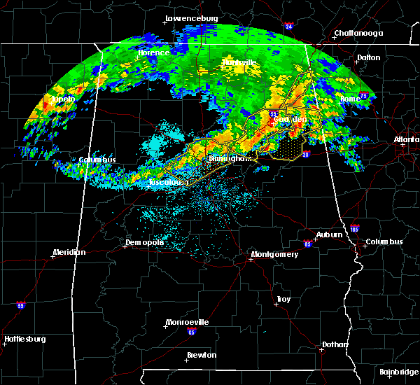 At 319 am cdt, severe thunderstorms were located along a line extending from 6 miles east of odenville to tabor road, moving east at 45 mph (radar indicated). Hazards include 60 mph wind gusts. expect damage to roofs, siding, and trees At 319 am cdt, severe thunderstorms were located along a line extending from 6 miles east of odenville to tabor road, moving east at 45 mph (radar indicated). Hazards include 60 mph wind gusts. expect damage to roofs, siding, and trees
|
| 4/5/2017 4:28 PM CDT |
 At 428 pm cdt, a severe thunderstorm was located near ball flat, or near piedmont, moving northeast at 45 mph (radar indicated). Hazards include 60 mph wind gusts and quarter size hail. Hail damage to vehicles is expected. expect wind damage to roofs, siding, and trees. locations impacted include, forney, tennala, moshat, ball flat, coloma, howells crossroads and waterhouse. A tornado watch remains in effect until 900 pm cdt for northeastern alabama. At 428 pm cdt, a severe thunderstorm was located near ball flat, or near piedmont, moving northeast at 45 mph (radar indicated). Hazards include 60 mph wind gusts and quarter size hail. Hail damage to vehicles is expected. expect wind damage to roofs, siding, and trees. locations impacted include, forney, tennala, moshat, ball flat, coloma, howells crossroads and waterhouse. A tornado watch remains in effect until 900 pm cdt for northeastern alabama.
|
| 4/5/2017 4:21 PM CDT |
 At 409 pm cdt, a severe thunderstorm was located near jacksonville state university, or 7 miles northwest of jacksonville, moving northeast at 45 mph (radar indicated). Hazards include ping pong ball size hail and 60 mph wind gusts. People and animals outdoors will be injured. expect hail damage to roofs, siding, windows, and vehicles. Expect wind damage to roofs, siding, and trees. At 409 pm cdt, a severe thunderstorm was located near jacksonville state university, or 7 miles northwest of jacksonville, moving northeast at 45 mph (radar indicated). Hazards include ping pong ball size hail and 60 mph wind gusts. People and animals outdoors will be injured. expect hail damage to roofs, siding, windows, and vehicles. Expect wind damage to roofs, siding, and trees.
|
| 4/5/2017 4:10 PM CDT |
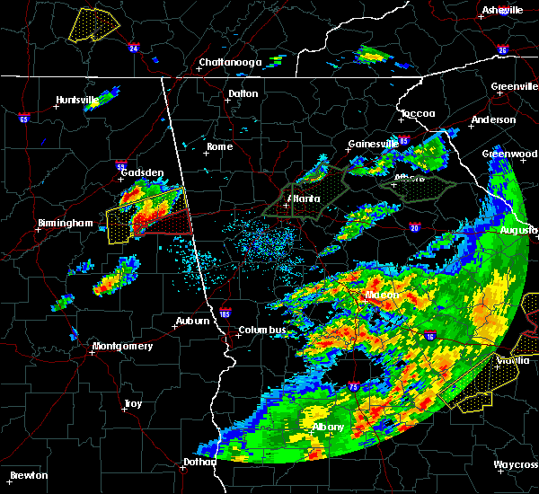 At 409 pm cdt, a severe thunderstorm was located near jacksonville state university, or 7 miles northwest of jacksonville, moving northeast at 45 mph (radar indicated). Hazards include ping pong ball size hail and 60 mph wind gusts. People and animals outdoors will be injured. expect hail damage to roofs, siding, windows, and vehicles. Expect wind damage to roofs, siding, and trees. At 409 pm cdt, a severe thunderstorm was located near jacksonville state university, or 7 miles northwest of jacksonville, moving northeast at 45 mph (radar indicated). Hazards include ping pong ball size hail and 60 mph wind gusts. People and animals outdoors will be injured. expect hail damage to roofs, siding, windows, and vehicles. Expect wind damage to roofs, siding, and trees.
|
| 4/5/2017 6:25 AM CDT | Quarter sized hail reported 13.8 miles WNW of Centre, AL |
| 3/27/2017 7:52 PM CDT |
 At 750 pm cdt, severe thunderstorms were located along a line extending from near crossville to ball flat, moving east at 30 mph (radar indicated). Hazards include golf ball size hail. People and animals outdoors will be injured. expect damage to roofs, siding, windows, and vehicles. Locations impacted include, gadsden, hokes bluff, centre, cedar bluff, little river canyon national preserve, forney, centre municipal airport, glencoe, leesburg, reece city, sand rock, gaylesville, tennala, tabor road, cherokee rock village, cornwall furnace park, blanche, eastern weiss lake, ballplay and slackland. At 750 pm cdt, severe thunderstorms were located along a line extending from near crossville to ball flat, moving east at 30 mph (radar indicated). Hazards include golf ball size hail. People and animals outdoors will be injured. expect damage to roofs, siding, windows, and vehicles. Locations impacted include, gadsden, hokes bluff, centre, cedar bluff, little river canyon national preserve, forney, centre municipal airport, glencoe, leesburg, reece city, sand rock, gaylesville, tennala, tabor road, cherokee rock village, cornwall furnace park, blanche, eastern weiss lake, ballplay and slackland.
|
| 3/27/2017 7:36 PM CDT |
 At 735 pm cdt, severe thunderstorms were located along a line extending from near sardis city to near hokes bluff, moving east at 30 mph (radar indicated). Hazards include golf ball size hail. People and animals outdoors will be injured. expect damage to roofs, siding, windows, and vehicles. Locations impacted include, gadsden, hokes bluff, centre, cedar bluff, little river canyon national preserve, forney, centre municipal airport, attalla, glencoe, leesburg, reece city, sand rock, gaylesville, tennala, tabor road, cherokee rock village, cornwall furnace park, blanche, eastern weiss lake and ballplay. At 735 pm cdt, severe thunderstorms were located along a line extending from near sardis city to near hokes bluff, moving east at 30 mph (radar indicated). Hazards include golf ball size hail. People and animals outdoors will be injured. expect damage to roofs, siding, windows, and vehicles. Locations impacted include, gadsden, hokes bluff, centre, cedar bluff, little river canyon national preserve, forney, centre municipal airport, attalla, glencoe, leesburg, reece city, sand rock, gaylesville, tennala, tabor road, cherokee rock village, cornwall furnace park, blanche, eastern weiss lake and ballplay.
|
| 3/27/2017 7:12 PM CDT |
 At 712 pm cdt, severe thunderstorms were located along a line extending from near boaz to gadsden mall, moving east at 30 mph (radar indicated). Hazards include golf ball size hail. People and animals outdoors will be injured. Expect damage to roofs, siding, windows, and vehicles. At 712 pm cdt, severe thunderstorms were located along a line extending from near boaz to gadsden mall, moving east at 30 mph (radar indicated). Hazards include golf ball size hail. People and animals outdoors will be injured. Expect damage to roofs, siding, windows, and vehicles.
|
| 3/27/2017 3:26 PM CDT |
 At 325 pm cdt, a severe thunderstorm was located over western weiss lake, or over centre, moving northeast at 35 mph (radar indicated). Hazards include 60 mph wind gusts and quarter size hail. Hail damage to vehicles is expected. Expect wind damage to roofs, siding, and trees. At 325 pm cdt, a severe thunderstorm was located over western weiss lake, or over centre, moving northeast at 35 mph (radar indicated). Hazards include 60 mph wind gusts and quarter size hail. Hail damage to vehicles is expected. Expect wind damage to roofs, siding, and trees.
|
| 3/27/2017 3:24 PM CDT | Half Dollar sized hail reported 0.6 miles N of Centre, AL, . |
| 3/27/2017 3:23 PM CDT | Em reports numerous trees downed and minor structure damage along cr 61 and cr 26 in the bay springs communit in cherokee county AL, 2.4 miles ESE of Centre, AL |
| 3/27/2017 3:20 PM CDT | Quarter sized hail reported 2.3 miles ENE of Centre, AL, reported between leesburg and centre. . |
| 6/17/2016 2:40 PM CDT |
 At 240 pm cdt, severe thunderstorms were located along a line extending from near tennala to near mars hills, moving south at 20 mph (radar indicated). Hazards include 60 mph wind gusts and quarter size hail. Hail damage to vehicles is expected. expect wind damage to roofs, siding, and trees. Locations impacted include, piedmont, centre, heflin, ranburne, fruithurst, edwardsville, tennala, mars hills, muscadine, pleasant gap, abernathy, moshat, eastern weiss lake, i 20 welcome center, coloma, hollis crossroads, sweetwater lake, chalafinnee, oak level and coleman lake and campground. At 240 pm cdt, severe thunderstorms were located along a line extending from near tennala to near mars hills, moving south at 20 mph (radar indicated). Hazards include 60 mph wind gusts and quarter size hail. Hail damage to vehicles is expected. expect wind damage to roofs, siding, and trees. Locations impacted include, piedmont, centre, heflin, ranburne, fruithurst, edwardsville, tennala, mars hills, muscadine, pleasant gap, abernathy, moshat, eastern weiss lake, i 20 welcome center, coloma, hollis crossroads, sweetwater lake, chalafinnee, oak level and coleman lake and campground.
|
| 6/17/2016 2:26 PM CDT |
 At 226 pm cdt, severe thunderstorms were located along a line extending from tennala to near mars hills, moving south at 25 mph (radar indicated). Hazards include 60 mph wind gusts and quarter size hail. Hail damage to vehicles is expected. Expect wind damage to roofs, siding, and trees. At 226 pm cdt, severe thunderstorms were located along a line extending from tennala to near mars hills, moving south at 25 mph (radar indicated). Hazards include 60 mph wind gusts and quarter size hail. Hail damage to vehicles is expected. Expect wind damage to roofs, siding, and trees.
|
| 6/17/2016 2:01 PM CDT | Trees down. possible damage to a camper near the intersection of alabama highway 31 and cherokee county 22. time estimated by rada in cherokee county AL, 6.6 miles WNW of Centre, AL |
| 6/15/2016 7:56 PM CDT |
 At 756 pm cdt, severe thunderstorms were located along a line extending from 8 miles north of cave spring to near walnut grove to near arkadelphia, moving south at 45 mph (radar indicated). Hazards include 60 mph wind gusts. Expect damage to roofs. siding. and trees. Locations impacted include, gadsden, rainbow city, oneonta, hokes bluff, centre, cedar bluff, blountsville, cleveland, forney, centre municipal airport, dallas, attalla, glencoe, warrior, locust fork, leesburg, altoona, susan moore, walnut grove and reece city. At 756 pm cdt, severe thunderstorms were located along a line extending from 8 miles north of cave spring to near walnut grove to near arkadelphia, moving south at 45 mph (radar indicated). Hazards include 60 mph wind gusts. Expect damage to roofs. siding. and trees. Locations impacted include, gadsden, rainbow city, oneonta, hokes bluff, centre, cedar bluff, blountsville, cleveland, forney, centre municipal airport, dallas, attalla, glencoe, warrior, locust fork, leesburg, altoona, susan moore, walnut grove and reece city.
|
| 6/15/2016 7:48 PM CDT | Tree down on county road 22 and 797 in kirks grove communit in cherokee county AL, 13.3 miles W of Centre, AL |
| 6/15/2016 7:45 PM CDT |
 At 745 pm cdt, severe thunderstorms were located along a line extending from 8 miles east of gaylesville to aurora to near smith dam, moving southeast at 40 mph (radar indicated). Hazards include 60 mph wind gusts. Expect damage to roofs. siding. and trees. Locations impacted include, gadsden, rainbow city, oneonta, hokes bluff, centre, cedar bluff, blountsville, cleveland, forney, little river canyon national preserve, centre municipal airport, dallas, attalla, glencoe, warrior, sardis city, locust fork, leesburg, altoona and snead. At 745 pm cdt, severe thunderstorms were located along a line extending from 8 miles east of gaylesville to aurora to near smith dam, moving southeast at 40 mph (radar indicated). Hazards include 60 mph wind gusts. Expect damage to roofs. siding. and trees. Locations impacted include, gadsden, rainbow city, oneonta, hokes bluff, centre, cedar bluff, blountsville, cleveland, forney, little river canyon national preserve, centre municipal airport, dallas, attalla, glencoe, warrior, sardis city, locust fork, leesburg, altoona and snead.
|
| 6/15/2016 7:44 PM CDT | Tree down on county road 22 and 797 in kirks grove communit in cherokee county AL, 13.3 miles W of Centre, AL |
| 6/15/2016 7:27 PM CDT |
 At 727 pm cdt, severe thunderstorms were located along a line extending from 7 miles southwest of summerville to near albertville to 7 miles northwest of dodge city, moving south at 35 mph (radar indicated). Hazards include 60 mph wind gusts. Expect damage to roofs. siding. and trees. Locations impacted include, gadsden, rainbow city, oneonta, hokes bluff, centre, cedar bluff, blountsville, cleveland, forney, little river canyon national preserve, centre municipal airport, dallas, attalla, glencoe, warrior, sardis city, locust fork, leesburg, altoona and snead. At 727 pm cdt, severe thunderstorms were located along a line extending from 7 miles southwest of summerville to near albertville to 7 miles northwest of dodge city, moving south at 35 mph (radar indicated). Hazards include 60 mph wind gusts. Expect damage to roofs. siding. and trees. Locations impacted include, gadsden, rainbow city, oneonta, hokes bluff, centre, cedar bluff, blountsville, cleveland, forney, little river canyon national preserve, centre municipal airport, dallas, attalla, glencoe, warrior, sardis city, locust fork, leesburg, altoona and snead.
|
| 6/15/2016 7:13 PM CDT |
 At 713 pm cdt, severe thunderstorms were located along a line extending from 11 miles northwest of summerville to near guntersville to 6 miles east of nesmith, moving south at 45 mph (radar indicated). Hazards include 60 mph wind gusts. Expect damage to roofs. siding. And trees. At 713 pm cdt, severe thunderstorms were located along a line extending from 11 miles northwest of summerville to near guntersville to 6 miles east of nesmith, moving south at 45 mph (radar indicated). Hazards include 60 mph wind gusts. Expect damage to roofs. siding. And trees.
|
| 4/19/2015 9:08 AM CDT | At 908 am cdt, severe thunderstorms were located along a line extending from 9 miles west of summerville to near pleasant gap to near delta, moving east at 35 mph (trained weather spotters). Hazards include 60 mph wind gusts. Expect damage to roofs. siding and trees. locations impacted include, anniston, oxford, jacksonville, piedmont, centre, heflin, cedar bluff, forney, little river canyon national preserve, centre municipal airport, ranburne, fruithurst, edwardsville, gaylesville, tennala, blanche, mars hills, muscadine, pleasant gap and eastern weiss lake. a tornado watch remains in effect until 200 pm cdt for east central alabama. 75in. |
| 4/19/2015 8:52 AM CDT | At 852 am cdt, severe thunderstorms were located along a line extending from 9 miles east of ider to near anniston regional airport, moving east at 55 mph (trained weather spotters). Hazards include 60 mph wind gusts. Expect damage to roofs. Siding and trees. |
| 4/17/2013 3:42 PM CDT | Quarter sized hail reported 14.7 miles WNW of Centre, AL, quarter size hail south of fourney. |
| 7/5/2012 8:32 PM CDT | Numerous tree limbs were blown down across cherokee county. winds estimated at 40 to 45 mp in cherokee county AL, 1.4 miles NNW of Centre, AL |
| 7/5/2012 8:32 PM CDT | Numerous tree limbs were blown down across cherokee county. winds estimated at 50 mph or greate in cherokee county AL, 1.4 miles NNW of Centre, AL |
| 7/5/2012 8:30 PM CDT | Tree down blocking county road 4 in cherokee county AL, 6.4 miles WNW of Centre, AL |
| 7/5/2012 8:30 PM CDT | Tin blown off 2 barns near county road 113 and county road 3 in cherokee county AL, 9.3 miles WNW of Centre, AL |
| 7/5/2012 8:27 PM CDT | Tree down on roa in cherokee county AL, 4.8 miles WNW of Centre, AL |
| 7/5/2012 8:03 PM CDT | Tree down on power line on county road 450 just north of intersection of county road 22 and county road 1 in cherokee county AL, 6.6 miles WNW of Centre, AL |
| 3/2/2012 11:05 PM CST | Quarter sized hail reported 5.5 miles NNE of Centre, AL, quarter size hail fell along cr 19. |
| 3/2/2012 11:05 PM CST | Quarter sized hail reported 5.5 miles NNE of Centre, AL, reported along cr 19. |
| 1/1/0001 12:00 AM | Quarter sized hail reported 12.7 miles WNW of Centre, AL, quarter size hail in the community of forney. |
| 1/1/0001 12:00 AM | Tops snapped off of some trees. winds estimated to be about 60 mp in cherokee county AL, 1.4 miles NNW of Centre, AL |
| 1/1/0001 12:00 AM | Golf Ball sized hail reported 1.4 miles NNW of Centre, AL, golfball size hail reported in centre. |
| 1/1/0001 12:00 AM | Quarter sized hail reported 1.4 miles NNW of Centre, AL |
| 1/1/0001 12:00 AM | Significant structural damage to new bethel church on hwy 411 in cherokee county AL, 6.6 miles NW of Centre, AL |
| 1/1/0001 12:00 AM | A large tree fell on a home along highway 411 north. one person was trapped. numerous trees down around the are in cherokee county AL, 1.4 miles NNW of Centre, AL |
| 1/1/0001 12:00 AM | A large tree fell on a home along highway 411 north. on person was trappe in cherokee county AL, 1.4 miles NNW of Centre, AL |
| 4/27/2011 7:05 AM CDT | Trees down blocking hwy in cherokee county AL, 8.5 miles NNW of Centre, AL |
| 1/1/0001 12:00 AM | Trees down in teh tates chapel communit in cherokee county AL, 1.6 miles SSE of Centre, AL |
| 1/1/0001 12:00 AM | Significant structural damage to new bethel church on hwy 411 in cherokee county AL, 6.6 miles NW of Centre, AL |
| 1/1/0001 12:00 AM | Trees were blown down in centre.a few trees landed on homes. one auto accident occurred as a vehicle was blown around in the high wind. no injurie in cherokee county AL, 1.4 miles NNW of Centre, AL |
| 1/1/0001 12:00 AM | Trees were blown down in centr in cherokee county AL, 1.4 miles NNW of Centre, AL |
| 1/1/0001 12:00 AM | Trees were blown down in centre. one auto accident occurred as a vehicle was blown around in the high wind. no injurie in cherokee county AL, 1.4 miles NNW of Centre, AL |
Hail Maps for Centre, AL


Connect with Interactive Hail Maps