

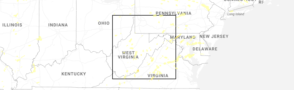
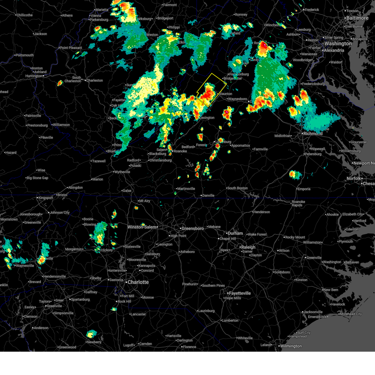
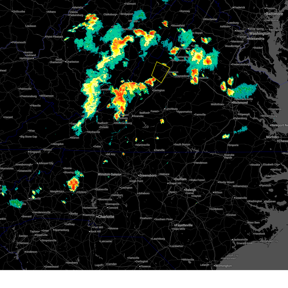
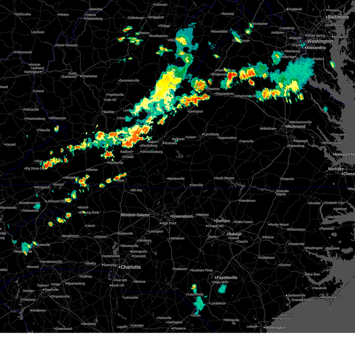
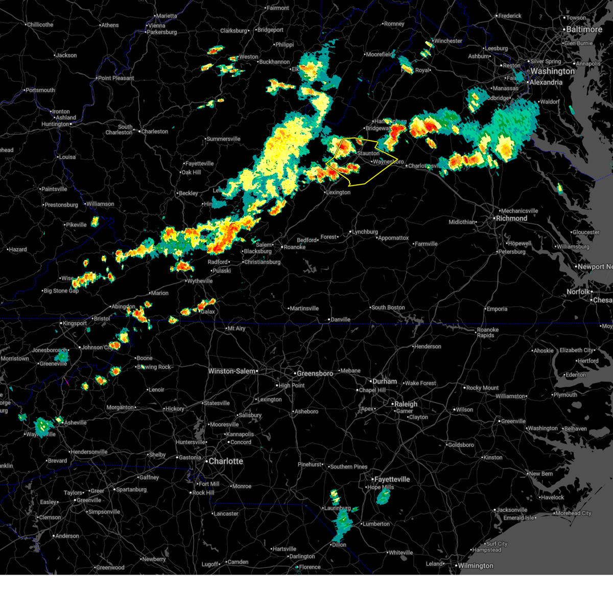
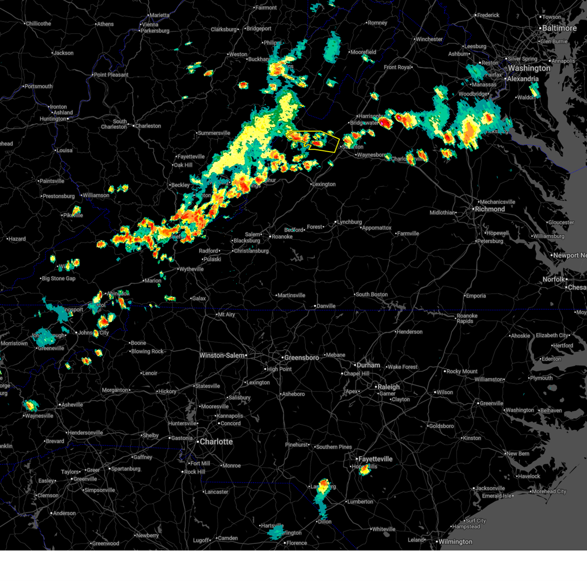
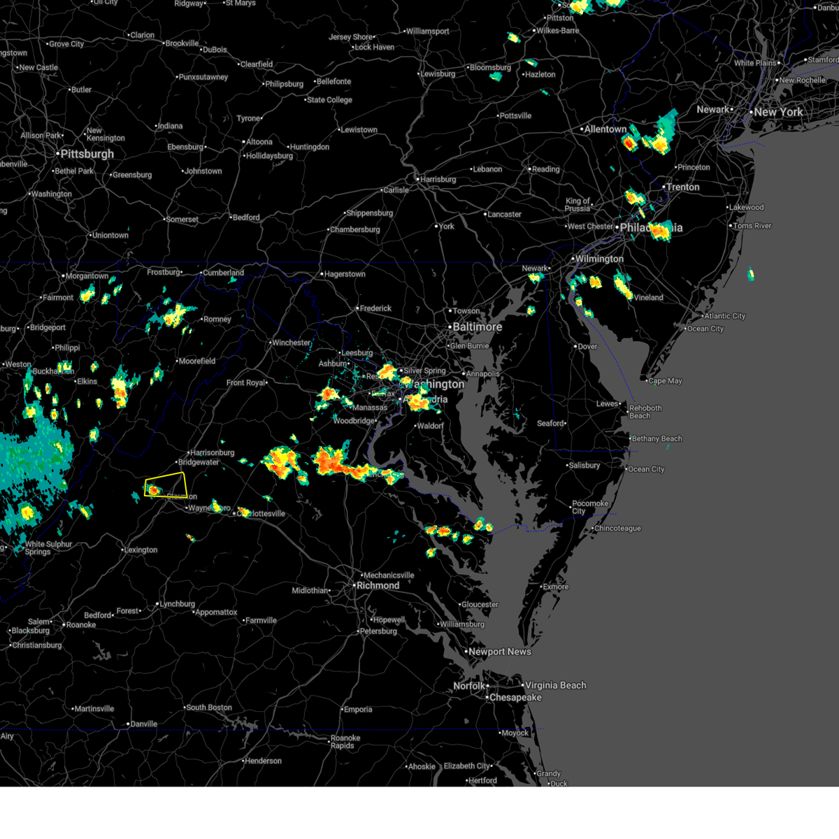
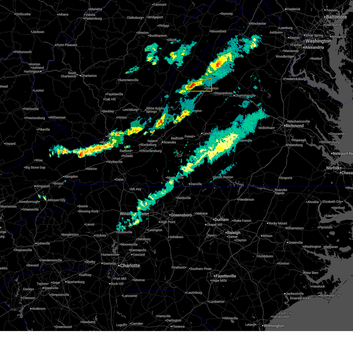
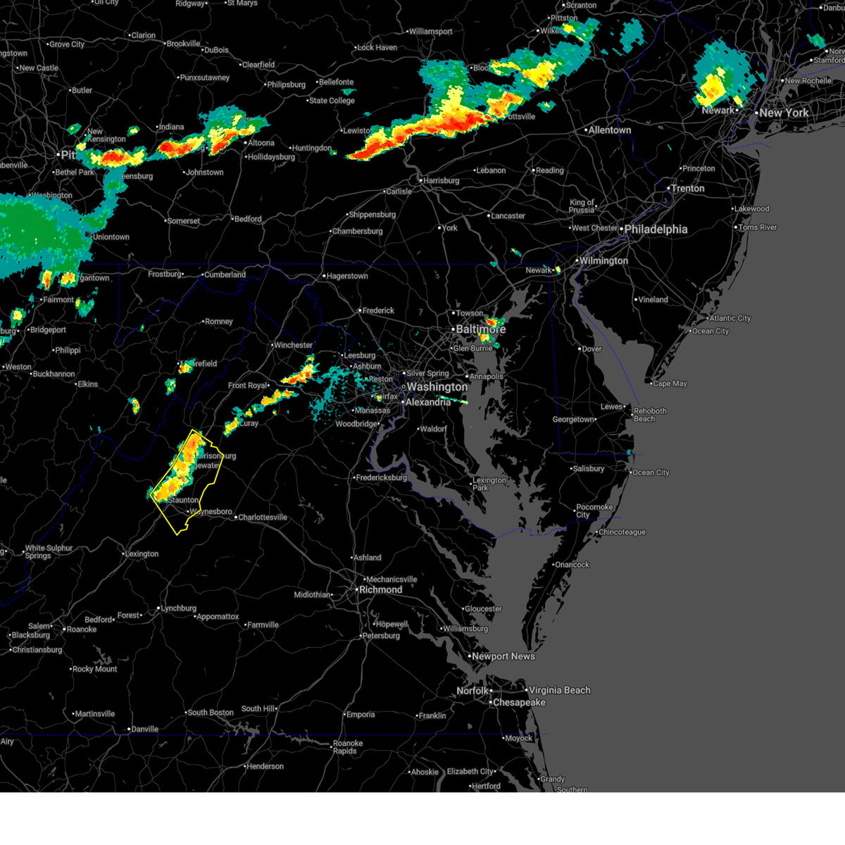
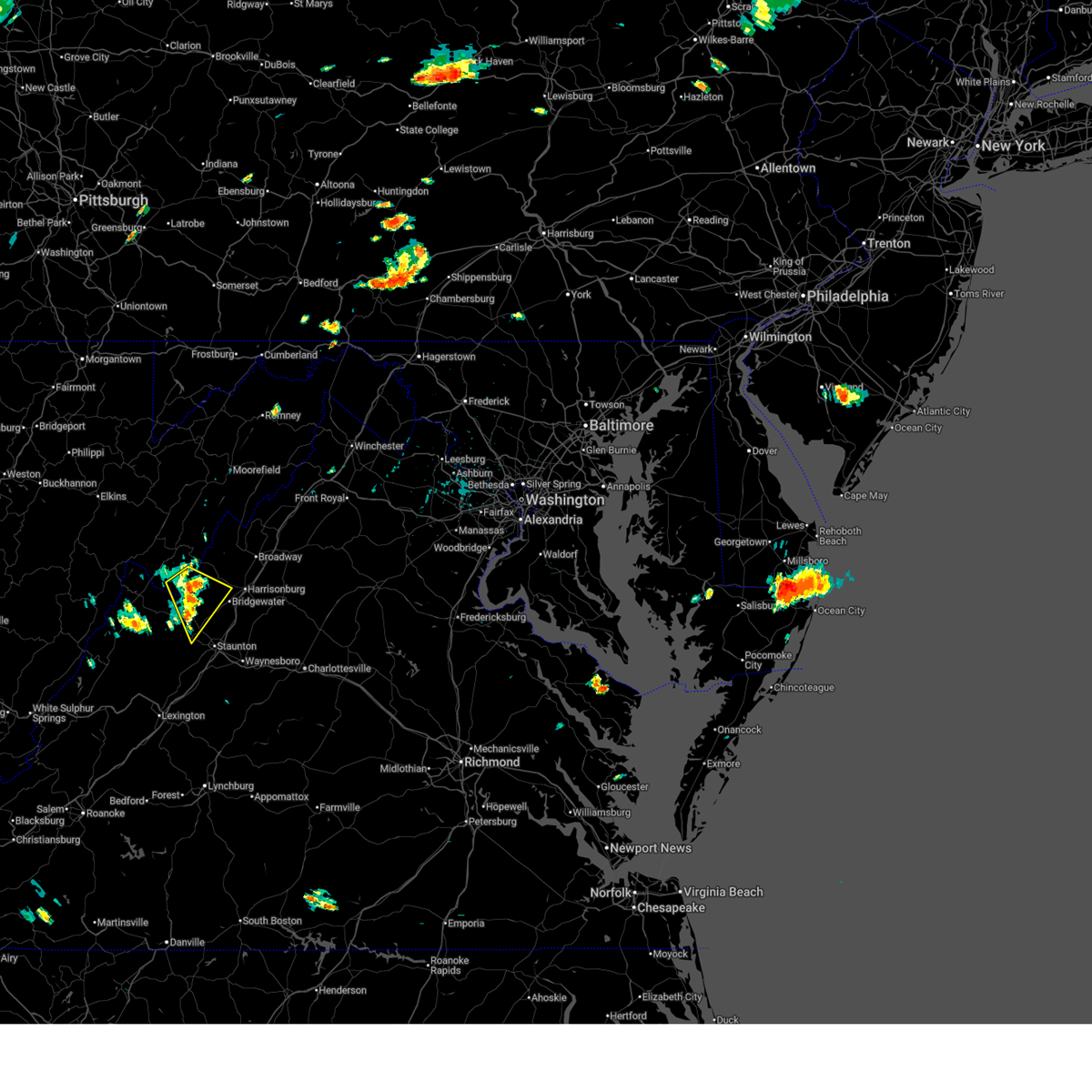
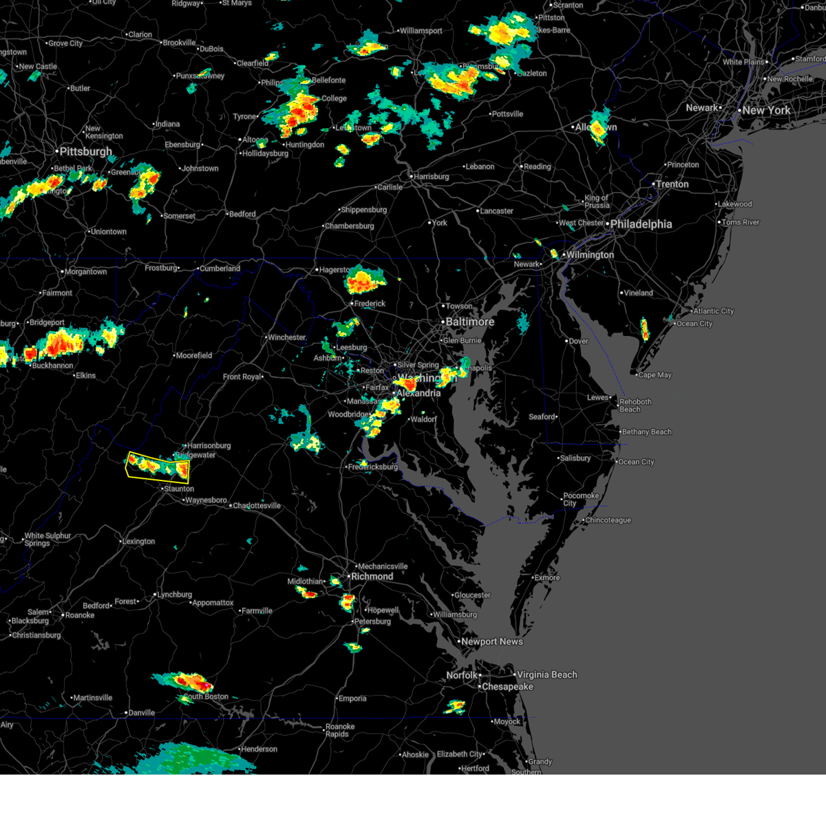
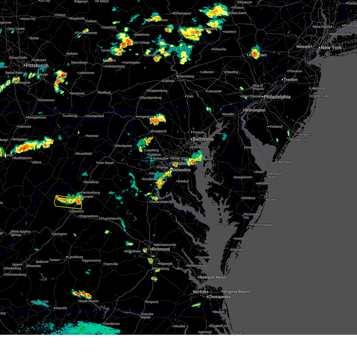
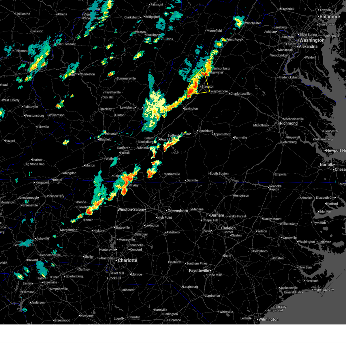
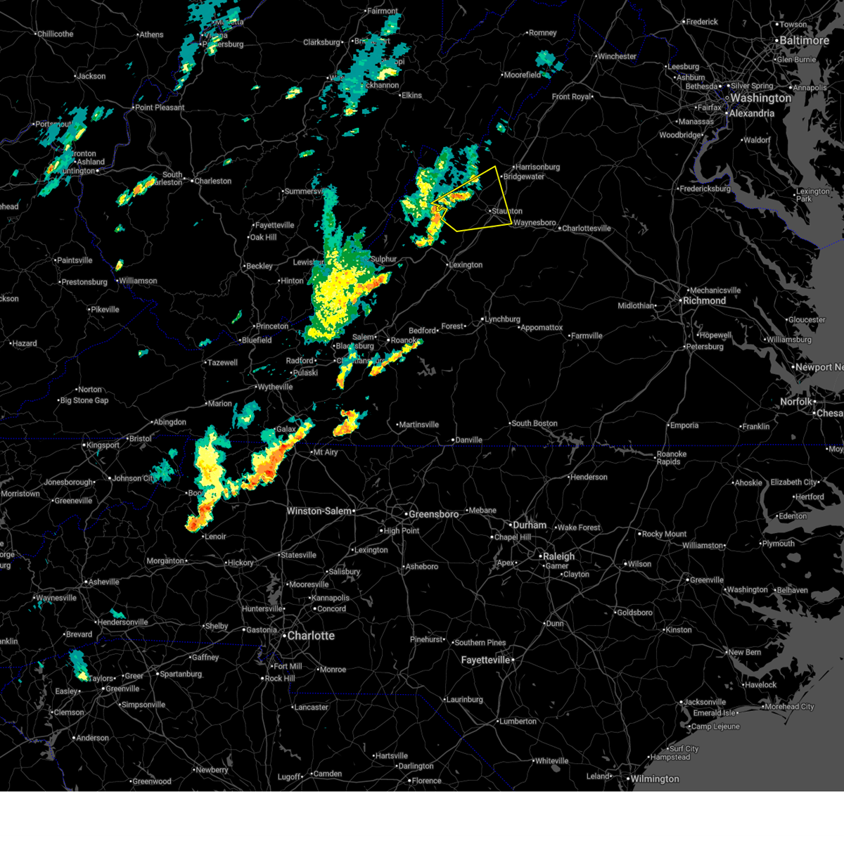
Hail Map for Churchville, VA
The Churchville, VA area has had 1 report of on-the-ground hail by trained spotters, and has been under severe weather warnings 12 times during the past 12 months. Doppler radar has detected hail at or near Churchville, VA on 20 occasions, including 1 occasion during the past year.
| Name: | Churchville, VA |
| Where Located: | 60.8 miles SE of Elkins, WV |
| Map: | Google Map for Churchville, VA |
| Population: | 194 |
| Housing Units: | 90 |
| More Info: | Search Google for Churchville, VA |
5
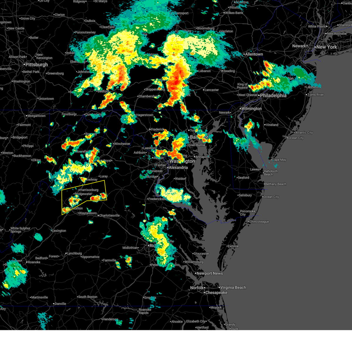
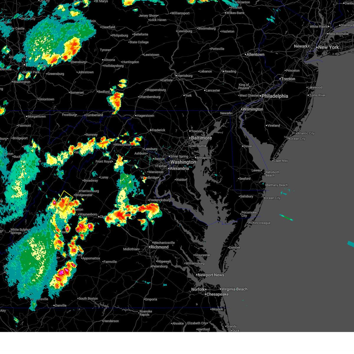
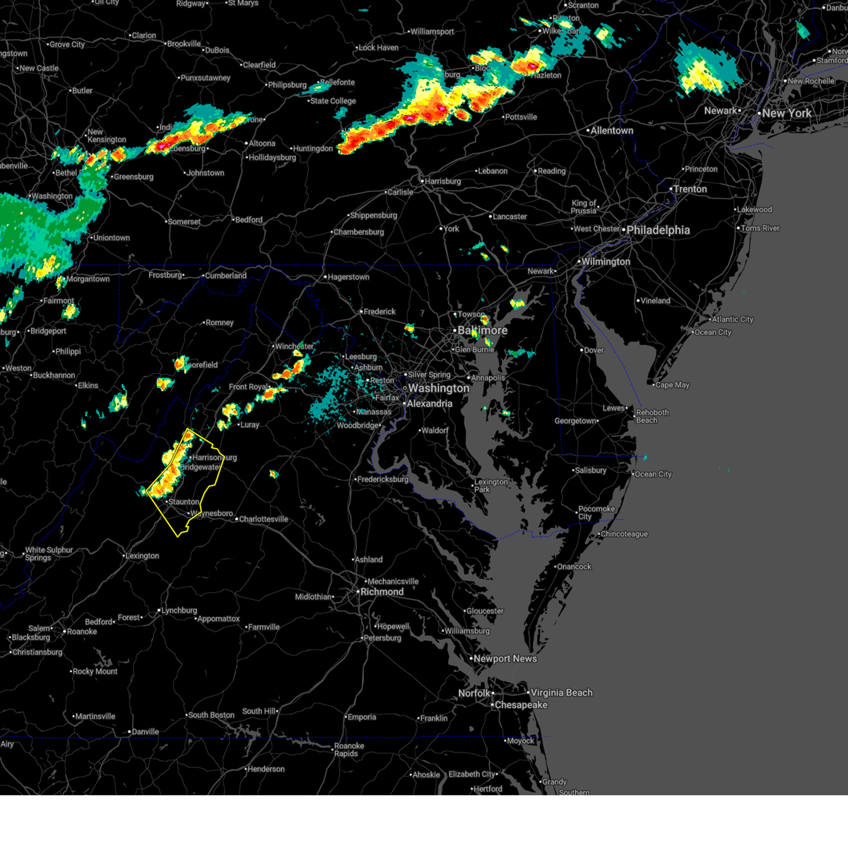
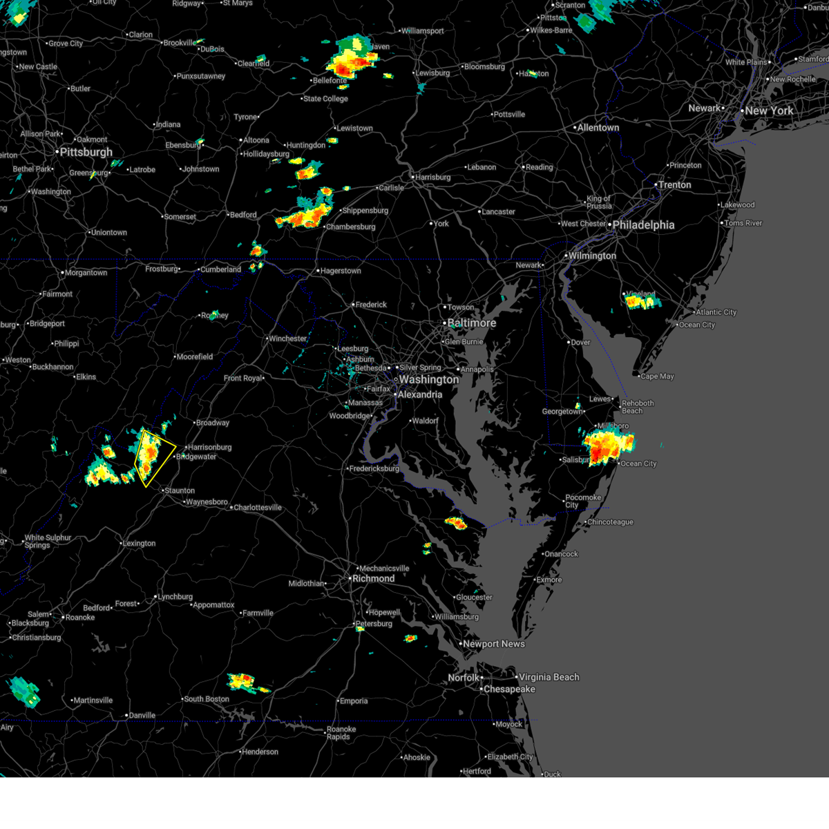
The Top Recent Hail Date for Churchville, VA is Saturday, July 4, 2026 (2nd out of 20)
Hail and Wind Damage Spotted near Churchville, VA
| Date / Time | Report Details |
|---|---|
| 7/5/2026 8:02 PM EDT |
 Svrlwx the national weather service in sterling virginia has issued a * severe thunderstorm warning for, western madison county in northwestern virginia, southern rockingham county in western virginia, southwestern page county in northwestern virginia, northwestern albemarle county in central virginia, central greene county in central virginia, the city of staunton in western virginia, central augusta county in western virginia, the city of harrisonburg in western virginia, * until 845 pm edt. * at 802 pm edt, severe thunderstorms were located along a line extending from near staunton to near stanardsville, moving north at 10 mph (radar indicated). Hazards include 60 mph wind gusts. Damaging winds will cause some trees and large branches to fall. this could injure those outdoors, as well as damage homes and vehicles. roadways may become blocked by downed trees. localized power outages are possible. Unsecured light objects may become projectiles. Svrlwx the national weather service in sterling virginia has issued a * severe thunderstorm warning for, western madison county in northwestern virginia, southern rockingham county in western virginia, southwestern page county in northwestern virginia, northwestern albemarle county in central virginia, central greene county in central virginia, the city of staunton in western virginia, central augusta county in western virginia, the city of harrisonburg in western virginia, * until 845 pm edt. * at 802 pm edt, severe thunderstorms were located along a line extending from near staunton to near stanardsville, moving north at 10 mph (radar indicated). Hazards include 60 mph wind gusts. Damaging winds will cause some trees and large branches to fall. this could injure those outdoors, as well as damage homes and vehicles. roadways may become blocked by downed trees. localized power outages are possible. Unsecured light objects may become projectiles.
|
| 7/4/2026 5:23 PM EDT | Multiple reports of trees down in western augusta county. several roads close in augusta county VA, 2.3 miles SE of Churchville, VA |
| 7/4/2026 5:15 PM EDT | Dozens of trees down across several locations in the count in augusta county VA, 0.8 miles WSW of Churchville, VA |
| 7/4/2026 5:14 PM EDT |
 Svrlwx the national weather service in sterling virginia has issued a * severe thunderstorm warning for, northwestern augusta county in western virginia, * until 545 pm edt. * at 513 pm edt, a severe thunderstorm was located 10 miles northwest of staunton, moving northeast at 25 mph. this is a destructive storm for western augusta county (radar indicated). Hazards include 80 mph wind gusts and quarter size hail. Expect considerable damage to trees and power lines. your life is at significant risk if outdoors. In addition to some trees falling into homes, wind damage is possible to roofs, sheds, open garages, and mobile homes. Svrlwx the national weather service in sterling virginia has issued a * severe thunderstorm warning for, northwestern augusta county in western virginia, * until 545 pm edt. * at 513 pm edt, a severe thunderstorm was located 10 miles northwest of staunton, moving northeast at 25 mph. this is a destructive storm for western augusta county (radar indicated). Hazards include 80 mph wind gusts and quarter size hail. Expect considerable damage to trees and power lines. your life is at significant risk if outdoors. In addition to some trees falling into homes, wind damage is possible to roofs, sheds, open garages, and mobile homes.
|
| 7/4/2026 4:56 PM EDT |
 At 456 pm edt, a severe thunderstorm was located 9 miles west of staunton, moving northeast at 40 mph (radar indicated). Hazards include 70 mph wind gusts and quarter size hail. Damaging winds will cause some trees and large branches to fall. this could injure those outdoors, as well as damage homes and vehicles. roadways may become blocked by downed trees. localized power outages are possible. unsecured light objects may become projectiles. Locations impacted include, staunton, verona, weyers cave, craigsville, mount sidney, augusta springs, middlebrook, churchville, deerfield, moscow, west augusta, buffalo gap, summerdean, trimbles mill, mount solon, sangerville, christian, fort defiance, and swoope. At 456 pm edt, a severe thunderstorm was located 9 miles west of staunton, moving northeast at 40 mph (radar indicated). Hazards include 70 mph wind gusts and quarter size hail. Damaging winds will cause some trees and large branches to fall. this could injure those outdoors, as well as damage homes and vehicles. roadways may become blocked by downed trees. localized power outages are possible. unsecured light objects may become projectiles. Locations impacted include, staunton, verona, weyers cave, craigsville, mount sidney, augusta springs, middlebrook, churchville, deerfield, moscow, west augusta, buffalo gap, summerdean, trimbles mill, mount solon, sangerville, christian, fort defiance, and swoope.
|
| 7/4/2026 4:46 PM EDT |
 Svrlwx the national weather service in sterling virginia has issued a * severe thunderstorm warning for, the city of staunton in western virginia, central augusta county in western virginia, * until 545 pm edt. * at 446 pm edt, a severe thunderstorm was located 9 miles northeast of bells valley, or 13 miles west of staunton, moving northeast at 40 mph (radar indicated). Hazards include 60 mph wind gusts and quarter size hail. Damaging winds will cause some trees and large branches to fall. this could injure those outdoors, as well as damage homes and vehicles. roadways may become blocked by downed trees. localized power outages are possible. Unsecured light objects may become projectiles. Svrlwx the national weather service in sterling virginia has issued a * severe thunderstorm warning for, the city of staunton in western virginia, central augusta county in western virginia, * until 545 pm edt. * at 446 pm edt, a severe thunderstorm was located 9 miles northeast of bells valley, or 13 miles west of staunton, moving northeast at 40 mph (radar indicated). Hazards include 60 mph wind gusts and quarter size hail. Damaging winds will cause some trees and large branches to fall. this could injure those outdoors, as well as damage homes and vehicles. roadways may become blocked by downed trees. localized power outages are possible. Unsecured light objects may become projectiles.
|
| 7/4/2026 4:45 PM EDT | Several trees blew down in buffalo ga in augusta county VA, 4.4 miles ENE of Churchville, VA |
| 7/4/2026 4:16 PM EDT |
 Svrlwx the national weather service in sterling virginia has issued a * severe thunderstorm warning for, the western city of staunton in western virginia, western augusta county in western virginia, * until 445 pm edt. * at 415 pm edt, a severe thunderstorm was located near bells valley, or near goshen, moving northeast at 20 mph (radar indicated). Hazards include 60 mph wind gusts. Damaging winds will cause some trees and large branches to fall. this could injure those outdoors, as well as damage homes and vehicles. roadways may become blocked by downed trees. localized power outages are possible. Unsecured light objects may become projectiles. Svrlwx the national weather service in sterling virginia has issued a * severe thunderstorm warning for, the western city of staunton in western virginia, western augusta county in western virginia, * until 445 pm edt. * at 415 pm edt, a severe thunderstorm was located near bells valley, or near goshen, moving northeast at 20 mph (radar indicated). Hazards include 60 mph wind gusts. Damaging winds will cause some trees and large branches to fall. this could injure those outdoors, as well as damage homes and vehicles. roadways may become blocked by downed trees. localized power outages are possible. Unsecured light objects may become projectiles.
|
| 6/12/2026 5:45 PM EDT |
 At 545 pm edt, a severe thunderstorm was located near staunton, moving east at 25 mph (radar indicated). Hazards include 60 mph wind gusts. Damaging winds will cause some trees and large branches to fall. this could injure those outdoors, as well as damage homes and vehicles. roadways may become blocked by downed trees. localized power outages are possible. unsecured light objects may become projectiles. Locations impacted include, churchville, christian, buffalo gap, and swoope. At 545 pm edt, a severe thunderstorm was located near staunton, moving east at 25 mph (radar indicated). Hazards include 60 mph wind gusts. Damaging winds will cause some trees and large branches to fall. this could injure those outdoors, as well as damage homes and vehicles. roadways may become blocked by downed trees. localized power outages are possible. unsecured light objects may become projectiles. Locations impacted include, churchville, christian, buffalo gap, and swoope.
|
| 6/12/2026 5:37 PM EDT |
 Svrlwx the national weather service in sterling virginia has issued a * severe thunderstorm warning for, northwestern nelson county in central virginia, southern rockingham county in western virginia, west central albemarle county in central virginia, the city of staunton in western virginia, augusta county in western virginia, the city of waynesboro in western virginia, * until 615 pm edt. * at 537 pm edt, severe thunderstorms were located along a line extending from near brownsburg to stuarts draft, moving east at 20 mph (radar indicated). Hazards include 60 mph wind gusts and quarter size hail. Damaging winds will cause some trees and large branches to fall. this could injure those outdoors, as well as damage homes and vehicles. roadways may become blocked by downed trees. localized power outages are possible. Unsecured light objects may become projectiles. Svrlwx the national weather service in sterling virginia has issued a * severe thunderstorm warning for, northwestern nelson county in central virginia, southern rockingham county in western virginia, west central albemarle county in central virginia, the city of staunton in western virginia, augusta county in western virginia, the city of waynesboro in western virginia, * until 615 pm edt. * at 537 pm edt, severe thunderstorms were located along a line extending from near brownsburg to stuarts draft, moving east at 20 mph (radar indicated). Hazards include 60 mph wind gusts and quarter size hail. Damaging winds will cause some trees and large branches to fall. this could injure those outdoors, as well as damage homes and vehicles. roadways may become blocked by downed trees. localized power outages are possible. Unsecured light objects may become projectiles.
|
| 6/12/2026 5:10 PM EDT |
 Svrlwx the national weather service in sterling virginia has issued a * severe thunderstorm warning for, west central augusta county in western virginia, southern highland county in western virginia, * until 600 pm edt. * at 510 pm edt, severe thunderstorms were located along a line extending from near burnsville to 11 miles northeast of bells valley, moving east at 25 mph (radar indicated). Hazards include 60 mph wind gusts and quarter size hail. Damaging winds will cause some trees and large branches to fall. this could injure those outdoors, as well as damage homes and vehicles. roadways may become blocked by downed trees. localized power outages are possible. Unsecured light objects may become projectiles. Svrlwx the national weather service in sterling virginia has issued a * severe thunderstorm warning for, west central augusta county in western virginia, southern highland county in western virginia, * until 600 pm edt. * at 510 pm edt, severe thunderstorms were located along a line extending from near burnsville to 11 miles northeast of bells valley, moving east at 25 mph (radar indicated). Hazards include 60 mph wind gusts and quarter size hail. Damaging winds will cause some trees and large branches to fall. this could injure those outdoors, as well as damage homes and vehicles. roadways may become blocked by downed trees. localized power outages are possible. Unsecured light objects may become projectiles.
|
| 6/12/2026 4:35 PM EDT |
 Svrlwx the national weather service in sterling virginia has issued a * severe thunderstorm warning for, the city of staunton in western virginia, central augusta county in western virginia, * until 500 pm edt. * at 435 pm edt, a severe thunderstorm was located near staunton, moving east at 25 mph (radar indicated). Hazards include 60 mph wind gusts. Damaging winds will cause some trees and large branches to fall. this could injure those outdoors, as well as damage homes and vehicles. roadways may become blocked by downed trees. localized power outages are possible. Unsecured light objects may become projectiles. Svrlwx the national weather service in sterling virginia has issued a * severe thunderstorm warning for, the city of staunton in western virginia, central augusta county in western virginia, * until 500 pm edt. * at 435 pm edt, a severe thunderstorm was located near staunton, moving east at 25 mph (radar indicated). Hazards include 60 mph wind gusts. Damaging winds will cause some trees and large branches to fall. this could injure those outdoors, as well as damage homes and vehicles. roadways may become blocked by downed trees. localized power outages are possible. Unsecured light objects may become projectiles.
|
| 5/13/2026 7:57 PM EDT |
 Svrlwx the national weather service in sterling virginia has issued a * severe thunderstorm warning for, the city of staunton in western virginia, central augusta county in western virginia, * until 830 pm edt. * at 757 pm edt, a severe thunderstorm was located 12 miles northeast of bells valley, or 13 miles west of staunton, moving east at 35 mph (radar indicated). Hazards include 60 mph wind gusts and quarter size hail. Damaging winds will cause some trees and large branches to fall. this could injure those outdoors, as well as damage homes and vehicles. roadways may become blocked by downed trees. localized power outages are possible. Unsecured light objects may become projectiles. Svrlwx the national weather service in sterling virginia has issued a * severe thunderstorm warning for, the city of staunton in western virginia, central augusta county in western virginia, * until 830 pm edt. * at 757 pm edt, a severe thunderstorm was located 12 miles northeast of bells valley, or 13 miles west of staunton, moving east at 35 mph (radar indicated). Hazards include 60 mph wind gusts and quarter size hail. Damaging winds will cause some trees and large branches to fall. this could injure those outdoors, as well as damage homes and vehicles. roadways may become blocked by downed trees. localized power outages are possible. Unsecured light objects may become projectiles.
|
| 7/25/2025 3:27 PM EDT |
 At 327 pm edt, severe thunderstorms were located along a line extending from near broadway to near bridgewater to staunton, moving southeast at 15 mph (radar indicated). Hazards include 60 mph wind gusts. Damaging winds will cause some trees and large branches to fall. this could injure those outdoors, as well as damage homes and vehicles. roadways may become blocked by downed trees. localized power outages are possible. unsecured light objects may become projectiles. Locations impacted include, harrisonburg, staunton, waynesboro, stuarts draft, bridgewater, broadway, grottoes, shenandoah, massanutten, crimora, sherando, dale enterprise, fishersville, verona, elkton, weyers cave, dayton, lyndhurst, new hope, and mount sidney. At 327 pm edt, severe thunderstorms were located along a line extending from near broadway to near bridgewater to staunton, moving southeast at 15 mph (radar indicated). Hazards include 60 mph wind gusts. Damaging winds will cause some trees and large branches to fall. this could injure those outdoors, as well as damage homes and vehicles. roadways may become blocked by downed trees. localized power outages are possible. unsecured light objects may become projectiles. Locations impacted include, harrisonburg, staunton, waynesboro, stuarts draft, bridgewater, broadway, grottoes, shenandoah, massanutten, crimora, sherando, dale enterprise, fishersville, verona, elkton, weyers cave, dayton, lyndhurst, new hope, and mount sidney.
|
| 7/25/2025 3:10 PM EDT |
 Svrlwx the national weather service in sterling virginia has issued a * severe thunderstorm warning for, southern rockingham county in western virginia, eastern augusta county in western virginia, the city of staunton in western virginia, the city of waynesboro in western virginia, the city of harrisonburg in western virginia, * until 400 pm edt. * at 310 pm edt, severe thunderstorms were located along a line extending from near broadway to near bridgewater to near staunton, moving southeast at 15 mph (radar indicated). Hazards include localized 60 mph wind gusts. Damaging winds will cause some trees and large branches to fall. this could injure those outdoors, as well as damage homes and vehicles. roadways may become blocked by downed trees. localized power outages are possible. Unsecured light objects may become projectiles. Svrlwx the national weather service in sterling virginia has issued a * severe thunderstorm warning for, southern rockingham county in western virginia, eastern augusta county in western virginia, the city of staunton in western virginia, the city of waynesboro in western virginia, the city of harrisonburg in western virginia, * until 400 pm edt. * at 310 pm edt, severe thunderstorms were located along a line extending from near broadway to near bridgewater to near staunton, moving southeast at 15 mph (radar indicated). Hazards include localized 60 mph wind gusts. Damaging winds will cause some trees and large branches to fall. this could injure those outdoors, as well as damage homes and vehicles. roadways may become blocked by downed trees. localized power outages are possible. Unsecured light objects may become projectiles.
|
| 7/9/2025 3:11 PM EDT |
 the severe thunderstorm warning has been cancelled and is no longer in effect the severe thunderstorm warning has been cancelled and is no longer in effect
|
| 7/9/2025 2:53 PM EDT |
 Svrlwx the national weather service in sterling virginia has issued a * severe thunderstorm warning for, central augusta county in western virginia, * until 330 pm edt. * at 253 pm edt, a severe thunderstorm was located 8 miles northeast of bells valley, or 12 miles northeast of goshen, moving east at 15 mph (radar indicated). Hazards include 60 mph wind gusts and quarter size hail. Damaging winds will cause some trees and large branches to fall. this could injure those outdoors, as well as damage homes and vehicles. roadways may become blocked by downed trees. localized power outages are possible. Unsecured light objects may become projectiles. Svrlwx the national weather service in sterling virginia has issued a * severe thunderstorm warning for, central augusta county in western virginia, * until 330 pm edt. * at 253 pm edt, a severe thunderstorm was located 8 miles northeast of bells valley, or 12 miles northeast of goshen, moving east at 15 mph (radar indicated). Hazards include 60 mph wind gusts and quarter size hail. Damaging winds will cause some trees and large branches to fall. this could injure those outdoors, as well as damage homes and vehicles. roadways may become blocked by downed trees. localized power outages are possible. Unsecured light objects may become projectiles.
|
| 6/26/2025 2:40 PM EDT |
 the severe thunderstorm warning has been cancelled and is no longer in effect the severe thunderstorm warning has been cancelled and is no longer in effect
|
| 6/26/2025 2:40 PM EDT |
 At 240 pm edt, a severe thunderstorm was located 13 miles west of bridgewater, or 14 miles northwest of staunton, moving southeast at 15 mph (radar indicated). Hazards include 60 mph wind gusts and quarter size hail. Damaging winds will cause some trees and large branches to fall. this could injure those outdoors, as well as damage homes and vehicles. roadways may become blocked by downed trees. localized power outages are possible. unsecured light objects may become projectiles. Locations impacted include, churchville, christian, clover hill, moscow, mount solon, and sangerville. At 240 pm edt, a severe thunderstorm was located 13 miles west of bridgewater, or 14 miles northwest of staunton, moving southeast at 15 mph (radar indicated). Hazards include 60 mph wind gusts and quarter size hail. Damaging winds will cause some trees and large branches to fall. this could injure those outdoors, as well as damage homes and vehicles. roadways may become blocked by downed trees. localized power outages are possible. unsecured light objects may become projectiles. Locations impacted include, churchville, christian, clover hill, moscow, mount solon, and sangerville.
|
| 6/26/2025 2:21 PM EDT |
 Svrlwx the national weather service in sterling virginia has issued a * severe thunderstorm warning for, west central rockingham county in western virginia, north central augusta county in western virginia, east central highland county in western virginia, south central pendleton county in eastern west virginia, * until 300 pm edt. * at 221 pm edt, a severe thunderstorm was located 14 miles west of bridgewater, or 16 miles northwest of staunton, moving southeast at 20 mph (radar indicated). Hazards include 60 mph wind gusts and quarter size hail. Damaging winds will cause some trees and large branches to fall. this could injure those outdoors, as well as damage homes and vehicles. roadways may become blocked by downed trees. localized power outages are possible. Unsecured light objects may become projectiles. Svrlwx the national weather service in sterling virginia has issued a * severe thunderstorm warning for, west central rockingham county in western virginia, north central augusta county in western virginia, east central highland county in western virginia, south central pendleton county in eastern west virginia, * until 300 pm edt. * at 221 pm edt, a severe thunderstorm was located 14 miles west of bridgewater, or 16 miles northwest of staunton, moving southeast at 20 mph (radar indicated). Hazards include 60 mph wind gusts and quarter size hail. Damaging winds will cause some trees and large branches to fall. this could injure those outdoors, as well as damage homes and vehicles. roadways may become blocked by downed trees. localized power outages are possible. Unsecured light objects may become projectiles.
|
| 6/25/2025 4:44 PM EDT |
 At 444 pm edt, severe thunderstorms were located along a line extending from 13 miles east of monterey to near grottoes, moving south at 10 mph (radar indicated). Hazards include 60 mph wind gusts. Damaging winds will cause some trees and large branches to fall. this could injure those outdoors, as well as damage homes and vehicles. roadways may become blocked by downed trees. localized power outages are possible. unsecured light objects may become projectiles. Locations impacted include, verona, weyers cave, new hope, mount sidney, churchville, west augusta, fort defiance, moscow, staunton airport, and mount solon. At 444 pm edt, severe thunderstorms were located along a line extending from 13 miles east of monterey to near grottoes, moving south at 10 mph (radar indicated). Hazards include 60 mph wind gusts. Damaging winds will cause some trees and large branches to fall. this could injure those outdoors, as well as damage homes and vehicles. roadways may become blocked by downed trees. localized power outages are possible. unsecured light objects may become projectiles. Locations impacted include, verona, weyers cave, new hope, mount sidney, churchville, west augusta, fort defiance, moscow, staunton airport, and mount solon.
|
| 6/25/2025 4:28 PM EDT |
 Svrlwx the national weather service in sterling virginia has issued a * severe thunderstorm warning for, south central rockingham county in western virginia, northern augusta county in western virginia, east central highland county in western virginia, * until 500 pm edt. * at 427 pm edt, severe thunderstorms were located along a line extending from 13 miles east of monterey to near grottoes, moving south at 15 mph (radar indicated). Hazards include 60 mph wind gusts. Damaging winds will cause some trees and large branches to fall. this could injure those outdoors, as well as damage homes and vehicles. roadways may become blocked by downed trees. localized power outages are possible. Unsecured light objects may become projectiles. Svrlwx the national weather service in sterling virginia has issued a * severe thunderstorm warning for, south central rockingham county in western virginia, northern augusta county in western virginia, east central highland county in western virginia, * until 500 pm edt. * at 427 pm edt, severe thunderstorms were located along a line extending from 13 miles east of monterey to near grottoes, moving south at 15 mph (radar indicated). Hazards include 60 mph wind gusts. Damaging winds will cause some trees and large branches to fall. this could injure those outdoors, as well as damage homes and vehicles. roadways may become blocked by downed trees. localized power outages are possible. Unsecured light objects may become projectiles.
|
| 6/25/2025 4:04 PM EDT | Roof off of a home near the intersection of stribling springs rd and free mason run r in augusta county VA, 8.1 miles S of Churchville, VA |
| 6/19/2025 2:10 PM EDT |
 At 209 pm edt, a severe thunderstorm was located 7 miles west of staunton, moving east at 45 mph (radar indicated). Hazards include 60 mph wind gusts and quarter size hail. Damaging winds will cause some trees and large branches to fall. this could injure those outdoors, as well as damage homes and vehicles. roadways may become blocked by downed trees. localized power outages are possible. unsecured light objects may become projectiles. Locations impacted include, staunton, waynesboro, stuarts draft, fishersville, verona, mount sidney, augusta springs, middlebrook, churchville, mint spring, moscow, buffalo gap, summerdean, trimbles mill, mount solon, sangerville, christian, fort defiance, and swoope. At 209 pm edt, a severe thunderstorm was located 7 miles west of staunton, moving east at 45 mph (radar indicated). Hazards include 60 mph wind gusts and quarter size hail. Damaging winds will cause some trees and large branches to fall. this could injure those outdoors, as well as damage homes and vehicles. roadways may become blocked by downed trees. localized power outages are possible. unsecured light objects may become projectiles. Locations impacted include, staunton, waynesboro, stuarts draft, fishersville, verona, mount sidney, augusta springs, middlebrook, churchville, mint spring, moscow, buffalo gap, summerdean, trimbles mill, mount solon, sangerville, christian, fort defiance, and swoope.
|
| 6/19/2025 2:10 PM EDT |
 the severe thunderstorm warning has been cancelled and is no longer in effect the severe thunderstorm warning has been cancelled and is no longer in effect
|
| 6/19/2025 2:05 PM EDT | Several trees blew down around churchville... including in the 200 block of us-250 hankey mountain highway... and near the intersection of jennings gap road and dryden in augusta county VA, 1.5 miles SE of Churchville, VA |
| 6/19/2025 1:45 PM EDT |
 Svrlwx the national weather service in sterling virginia has issued a * severe thunderstorm warning for, southwestern rockingham county in western virginia, augusta county in western virginia, the city of staunton in western virginia, the northwestern city of waynesboro in western virginia, southeastern highland county in western virginia, * until 230 pm edt. * at 145 pm edt, a severe thunderstorm was located near yost, or 8 miles north of goshen, moving east at 45 mph (radar indicated). Hazards include 60 mph wind gusts and quarter size hail. Damaging winds will cause some trees and large branches to fall. this could injure those outdoors, as well as damage homes and vehicles. roadways may become blocked by downed trees. localized power outages are possible. Unsecured light objects may become projectiles. Svrlwx the national weather service in sterling virginia has issued a * severe thunderstorm warning for, southwestern rockingham county in western virginia, augusta county in western virginia, the city of staunton in western virginia, the northwestern city of waynesboro in western virginia, southeastern highland county in western virginia, * until 230 pm edt. * at 145 pm edt, a severe thunderstorm was located near yost, or 8 miles north of goshen, moving east at 45 mph (radar indicated). Hazards include 60 mph wind gusts and quarter size hail. Damaging winds will cause some trees and large branches to fall. this could injure those outdoors, as well as damage homes and vehicles. roadways may become blocked by downed trees. localized power outages are possible. Unsecured light objects may become projectiles.
|
| 11/20/2024 8:22 PM EST | One tree down along the 100 block of little calf pasture highwa in augusta county VA, 5.3 miles ENE of Churchville, VA |
| 6/26/2024 7:20 PM EDT | Augusta county 911 center relayed at least 30 reports of downed trees and power lines across the county... especially in the southwestern portion... including christian in augusta county VA, 4.8 miles NE of Churchville, VA |
| 5/26/2024 8:12 PM EDT |
 At 811 pm edt, severe thunderstorms were located along a line extending from 9 miles southwest of petersburg to 6 miles south of brandywine to near afton to near tower hill, moving east at 45 mph (radar indicated). Hazards include 60 mph wind gusts and quarter size hail. Damaging winds will cause some trees and large branches to fall. this could injure those outdoors, as well as damage homes and vehicles. roadways may become blocked by downed trees. localized power outages are possible. unsecured light objects may become projectiles. Locations impacted include, harrisonburg, staunton, waynesboro, franklin, stuarts draft, bridgewater, crozet, broadway, grottoes, timberville, massanutten, crimora, sherando, shipman, schuyler, wintergreen, afton, dale enterprise, fishersville, and verona. At 811 pm edt, severe thunderstorms were located along a line extending from 9 miles southwest of petersburg to 6 miles south of brandywine to near afton to near tower hill, moving east at 45 mph (radar indicated). Hazards include 60 mph wind gusts and quarter size hail. Damaging winds will cause some trees and large branches to fall. this could injure those outdoors, as well as damage homes and vehicles. roadways may become blocked by downed trees. localized power outages are possible. unsecured light objects may become projectiles. Locations impacted include, harrisonburg, staunton, waynesboro, franklin, stuarts draft, bridgewater, crozet, broadway, grottoes, timberville, massanutten, crimora, sherando, shipman, schuyler, wintergreen, afton, dale enterprise, fishersville, and verona.
|
| 5/26/2024 8:12 PM EDT |
 the severe thunderstorm warning has been cancelled and is no longer in effect the severe thunderstorm warning has been cancelled and is no longer in effect
|
| 5/26/2024 7:42 PM EDT |
 Svrlwx the national weather service in sterling virginia has issued a * severe thunderstorm warning for, nelson county in central virginia, rockingham county in western virginia, western albemarle county in central virginia, western greene county in central virginia, augusta county in western virginia, the city of staunton in western virginia, the city of harrisonburg in western virginia, the city of waynesboro in western virginia, eastern highland county in western virginia, pendleton county in eastern west virginia, southwestern hardy county in eastern west virginia, * until 845 pm edt. * at 742 pm edt, severe thunderstorms were located along a line extending from 13 miles southeast of elkins to monterey to near fairfield to near evington, moving east at 40 mph (radar indicated). Hazards include 60 mph wind gusts. Damaging winds will cause some trees and large branches to fall. this could injure those outdoors, as well as damage homes and vehicles. roadways may become blocked by downed trees. localized power outages are possible. Unsecured light objects may become projectiles. Svrlwx the national weather service in sterling virginia has issued a * severe thunderstorm warning for, nelson county in central virginia, rockingham county in western virginia, western albemarle county in central virginia, western greene county in central virginia, augusta county in western virginia, the city of staunton in western virginia, the city of harrisonburg in western virginia, the city of waynesboro in western virginia, eastern highland county in western virginia, pendleton county in eastern west virginia, southwestern hardy county in eastern west virginia, * until 845 pm edt. * at 742 pm edt, severe thunderstorms were located along a line extending from 13 miles southeast of elkins to monterey to near fairfield to near evington, moving east at 40 mph (radar indicated). Hazards include 60 mph wind gusts. Damaging winds will cause some trees and large branches to fall. this could injure those outdoors, as well as damage homes and vehicles. roadways may become blocked by downed trees. localized power outages are possible. Unsecured light objects may become projectiles.
|
| 5/26/2024 7:10 PM EDT |
 At 710 pm edt, severe thunderstorms were located along a line extending from near dailey to 6 miles northwest of greenbank to 7 miles north of mountain grove to near collierstown, moving east at 45 mph (radar indicated). Hazards include 60 mph wind gusts. Damaging winds will cause some trees and large branches to fall. this could injure those outdoors, as well as damage homes and vehicles. roadways may become blocked by downed trees. localized power outages are possible. unsecured light objects may become projectiles. Locations impacted include, staunton, franklin, monterey, stuarts draft, sherando, shipman, wintergreen, montebello, fishersville, verona, lyndhurst, nellysford, craigsville, greenville, arrington, lovingston, augusta springs, middlebrook, churchville, and deerfield. At 710 pm edt, severe thunderstorms were located along a line extending from near dailey to 6 miles northwest of greenbank to 7 miles north of mountain grove to near collierstown, moving east at 45 mph (radar indicated). Hazards include 60 mph wind gusts. Damaging winds will cause some trees and large branches to fall. this could injure those outdoors, as well as damage homes and vehicles. roadways may become blocked by downed trees. localized power outages are possible. unsecured light objects may become projectiles. Locations impacted include, staunton, franklin, monterey, stuarts draft, sherando, shipman, wintergreen, montebello, fishersville, verona, lyndhurst, nellysford, craigsville, greenville, arrington, lovingston, augusta springs, middlebrook, churchville, and deerfield.
|
| 5/26/2024 6:44 PM EDT |
 Svrlwx the national weather service in sterling virginia has issued a * severe thunderstorm warning for, central nelson county in central virginia, augusta county in western virginia, the city of staunton in western virginia, highland county in western virginia, pendleton county in eastern west virginia, * until 745 pm edt. * at 644 pm edt, severe thunderstorms were located along a line extending from 6 miles southeast of rock cave to 10 miles west of snowshoe to near marlinton to near low moor, moving east at 45 mph (radar indicated). Hazards include 60 mph wind gusts and quarter size hail. Damaging winds will cause some trees and large branches to fall. this could injure those outdoors, as well as damage homes and vehicles. roadways may become blocked by downed trees. localized power outages are possible. Unsecured light objects may become projectiles. Svrlwx the national weather service in sterling virginia has issued a * severe thunderstorm warning for, central nelson county in central virginia, augusta county in western virginia, the city of staunton in western virginia, highland county in western virginia, pendleton county in eastern west virginia, * until 745 pm edt. * at 644 pm edt, severe thunderstorms were located along a line extending from 6 miles southeast of rock cave to 10 miles west of snowshoe to near marlinton to near low moor, moving east at 45 mph (radar indicated). Hazards include 60 mph wind gusts and quarter size hail. Damaging winds will cause some trees and large branches to fall. this could injure those outdoors, as well as damage homes and vehicles. roadways may become blocked by downed trees. localized power outages are possible. Unsecured light objects may become projectiles.
|
| 7/28/2023 6:58 PM EDT |
 The severe thunderstorm warning for west central rockingham and western augusta counties will expire at 700 pm edt, the storms which prompted the warning have moved out of the area. therefore, the warning will be allowed to expire. a severe thunderstorm watch remains in effect until 1100 pm edt for western virginia. to report severe weather, contact your nearest law enforcement agency. they will relay your report to the national weather service sterling virginia. The severe thunderstorm warning for west central rockingham and western augusta counties will expire at 700 pm edt, the storms which prompted the warning have moved out of the area. therefore, the warning will be allowed to expire. a severe thunderstorm watch remains in effect until 1100 pm edt for western virginia. to report severe weather, contact your nearest law enforcement agency. they will relay your report to the national weather service sterling virginia.
|
| 7/28/2023 6:37 PM EDT |
 At 637 pm edt, severe thunderstorms were located along a line extending from 8 miles southeast of brandywine to near bells valley, moving east at 15 mph (radar indicated). Hazards include 60 mph wind gusts. Damaging winds will cause some trees and large branches to fall. this could injure those outdoors, as well as damage homes and vehicles. roadways may become blocked by downed trees. localized power outages are possible. unsecured light objects may become projectiles. locations impacted include, bridgewater, broadway, timberville, dale enterprise, dayton, craigsville, augusta springs, middlebrook, churchville, deerfield, moscow, buffalo gap, clover hill, hinton, cherry grove, singers glen, rawley springs, west augusta, summerdean and montezuma. hail threat, radar indicated max hail size, <. 75 in wind threat, radar indicated max wind gust, 60 mph. At 637 pm edt, severe thunderstorms were located along a line extending from 8 miles southeast of brandywine to near bells valley, moving east at 15 mph (radar indicated). Hazards include 60 mph wind gusts. Damaging winds will cause some trees and large branches to fall. this could injure those outdoors, as well as damage homes and vehicles. roadways may become blocked by downed trees. localized power outages are possible. unsecured light objects may become projectiles. locations impacted include, bridgewater, broadway, timberville, dale enterprise, dayton, craigsville, augusta springs, middlebrook, churchville, deerfield, moscow, buffalo gap, clover hill, hinton, cherry grove, singers glen, rawley springs, west augusta, summerdean and montezuma. hail threat, radar indicated max hail size, <. 75 in wind threat, radar indicated max wind gust, 60 mph.
|
| 7/28/2023 6:30 PM EDT | Multiple calls of trees down in the churchville are in augusta county VA, 0.4 miles SSW of Churchville, VA |
| 7/28/2023 6:29 PM EDT |
 At 628 pm edt, severe thunderstorms were located along a line extending from 10 miles east of brandywine to near glasgow, moving east at 30 mph (radar indicated). Hazards include 60 mph wind gusts. Damaging winds will cause some trees and large branches to fall. this could injure those outdoors, as well as damage homes and vehicles. roadways may become blocked by downed trees. localized power outages are possible. Unsecured light objects may become projectiles. At 628 pm edt, severe thunderstorms were located along a line extending from 10 miles east of brandywine to near glasgow, moving east at 30 mph (radar indicated). Hazards include 60 mph wind gusts. Damaging winds will cause some trees and large branches to fall. this could injure those outdoors, as well as damage homes and vehicles. roadways may become blocked by downed trees. localized power outages are possible. Unsecured light objects may become projectiles.
|
| 7/28/2023 6:04 PM EDT |
 At 604 pm edt, severe thunderstorms were located along a line extending from near brandywine to near burnsville, moving east at 15 mph (radar indicated). Hazards include 60 mph wind gusts. Damaging winds will cause some trees and large branches to fall. this could injure those outdoors, as well as damage homes and vehicles. roadways may become blocked by downed trees. localized power outages are possible. Unsecured light objects may become projectiles. At 604 pm edt, severe thunderstorms were located along a line extending from near brandywine to near burnsville, moving east at 15 mph (radar indicated). Hazards include 60 mph wind gusts. Damaging winds will cause some trees and large branches to fall. this could injure those outdoors, as well as damage homes and vehicles. roadways may become blocked by downed trees. localized power outages are possible. Unsecured light objects may become projectiles.
|
| 7/6/2022 3:49 PM EDT | Siding torn off the side of a home in churchvill in augusta county VA, 0.4 miles SSW of Churchville, VA |
| 7/6/2022 3:46 PM EDT |
 At 346 pm edt, a severe thunderstorm was located 7 miles northwest of staunton, moving southeast at 15 mph (radar indicated). Hazards include 60 mph wind gusts and quarter size hail. Damaging winds will cause some trees and large branches to fall. this could injure those outdoors, as well as damage homes and vehicles. roadways may become blocked by downed trees. localized power outages are possible. Unsecured light objects may become projectiles. At 346 pm edt, a severe thunderstorm was located 7 miles northwest of staunton, moving southeast at 15 mph (radar indicated). Hazards include 60 mph wind gusts and quarter size hail. Damaging winds will cause some trees and large branches to fall. this could injure those outdoors, as well as damage homes and vehicles. roadways may become blocked by downed trees. localized power outages are possible. Unsecured light objects may become projectiles.
|
| 6/26/2022 1:55 PM EDT | Tree damage was reported in western augusta county... including along va-42 scenic highway/little calf pasture highway... and va-254 parkersburg turnpik in augusta county VA, 0.6 miles SE of Churchville, VA |
| 6/17/2022 4:14 PM EDT |
 At 414 pm edt, a severe thunderstorm was located near monterey, moving southeast at 30 mph (radar indicated). Hazards include 60 mph wind gusts. Damaging winds will cause some trees and large branches to fall. this could injure those outdoors, as well as damage homes and vehicles. roadways may become blocked by downed trees. localized power outages are possible. Unsecured light objects may become projectiles. At 414 pm edt, a severe thunderstorm was located near monterey, moving southeast at 30 mph (radar indicated). Hazards include 60 mph wind gusts. Damaging winds will cause some trees and large branches to fall. this could injure those outdoors, as well as damage homes and vehicles. roadways may become blocked by downed trees. localized power outages are possible. Unsecured light objects may become projectiles.
|
| 6/2/2022 2:37 PM EDT | A tree was also snapped nearby in augusta county VA, 4.1 miles WNW of Churchville, VA |
| 8/29/2021 2:26 PM EDT |
 The severe thunderstorm warning for west central augusta and southeastern highland counties will expire at 230 pm edt, the storms which prompted the warning have weakened below severe limits, and no longer pose an immediate threat to life or property. therefore, the warning will be allowed to expire. The severe thunderstorm warning for west central augusta and southeastern highland counties will expire at 230 pm edt, the storms which prompted the warning have weakened below severe limits, and no longer pose an immediate threat to life or property. therefore, the warning will be allowed to expire.
|
| 8/29/2021 2:03 PM EDT |
 At 203 pm edt, severe thunderstorms were located along a line extending from 13 miles west of staunton to 11 miles east of burnsville, moving southeast at 10 mph (radar indicated). Hazards include 60 mph wind gusts. Damaging winds will cause some trees and large branches to fall. this could injure those outdoors, as well as damage homes and vehicles. roadways may become blocked by downed trees. localized power outages are possible. unsecured light objects may become projectiles. locations impacted include, augusta springs, churchville, deerfield, west augusta, williamsville, buffalo gap, head waters and liberty. hail threat, radar indicated max hail size, <. 75 in wind threat, radar indicated max wind gust, 60 mph. At 203 pm edt, severe thunderstorms were located along a line extending from 13 miles west of staunton to 11 miles east of burnsville, moving southeast at 10 mph (radar indicated). Hazards include 60 mph wind gusts. Damaging winds will cause some trees and large branches to fall. this could injure those outdoors, as well as damage homes and vehicles. roadways may become blocked by downed trees. localized power outages are possible. unsecured light objects may become projectiles. locations impacted include, augusta springs, churchville, deerfield, west augusta, williamsville, buffalo gap, head waters and liberty. hail threat, radar indicated max hail size, <. 75 in wind threat, radar indicated max wind gust, 60 mph.
|
| 8/29/2021 1:43 PM EDT |
 At 143 pm edt, a severe thunderstorm was located 12 miles northeast of burnsville, or 13 miles southeast of monterey, moving southeast at 10 mph (radar indicated). Hazards include 60 mph wind gusts. Damaging winds will cause some trees and large branches to fall. this could injure those outdoors, as well as damage homes and vehicles. roadways may become blocked by downed trees. localized power outages are possible. Unsecured light objects may become projectiles. At 143 pm edt, a severe thunderstorm was located 12 miles northeast of burnsville, or 13 miles southeast of monterey, moving southeast at 10 mph (radar indicated). Hazards include 60 mph wind gusts. Damaging winds will cause some trees and large branches to fall. this could injure those outdoors, as well as damage homes and vehicles. roadways may become blocked by downed trees. localized power outages are possible. Unsecured light objects may become projectiles.
|
| 8/28/2021 6:58 PM EDT |
 At 658 pm edt, a severe thunderstorm was located 8 miles northwest of staunton, and is nearly stationary (radar indicated). Hazards include 60 mph wind gusts and quarter size hail. Damaging winds will cause some trees and large branches to fall. this could injure those outdoors, as well as damage homes and vehicles. roadways may become blocked by downed trees. localized power outages are possible. unsecured light objects may become projectiles. locations impacted include, churchville. hail threat, radar indicated max hail size, 1. 00 in wind threat, radar indicated max wind gust, 60 mph. At 658 pm edt, a severe thunderstorm was located 8 miles northwest of staunton, and is nearly stationary (radar indicated). Hazards include 60 mph wind gusts and quarter size hail. Damaging winds will cause some trees and large branches to fall. this could injure those outdoors, as well as damage homes and vehicles. roadways may become blocked by downed trees. localized power outages are possible. unsecured light objects may become projectiles. locations impacted include, churchville. hail threat, radar indicated max hail size, 1. 00 in wind threat, radar indicated max wind gust, 60 mph.
|
| 8/28/2021 6:39 PM EDT |
 At 639 pm edt, a severe thunderstorm was located 12 miles northwest of staunton, and is nearly stationary (radar indicated). Hazards include 60 mph wind gusts and quarter size hail. Damaging winds will cause some trees and large branches to fall. this could injure those outdoors, as well as damage homes and vehicles. roadways may become blocked by downed trees. localized power outages are possible. Unsecured light objects may become projectiles. At 639 pm edt, a severe thunderstorm was located 12 miles northwest of staunton, and is nearly stationary (radar indicated). Hazards include 60 mph wind gusts and quarter size hail. Damaging winds will cause some trees and large branches to fall. this could injure those outdoors, as well as damage homes and vehicles. roadways may become blocked by downed trees. localized power outages are possible. Unsecured light objects may become projectiles.
|
| 8/25/2021 5:44 PM EDT |
 At 544 pm edt, a severe thunderstorm was located 9 miles southwest of bridgewater, or 10 miles north of staunton, moving east at 10 mph (radar indicated). Hazards include 60 mph wind gusts and quarter size hail. Damaging winds will cause some trees and large branches to fall. this could injure those outdoors, as well as damage homes and vehicles. roadways may become blocked by downed trees. localized power outages are possible. unsecured light objects may become projectiles. locations impacted include, bridgewater, verona, mount sidney, churchville, montezuma, clover hill, mount solon, sangerville, fort defiance and moscow. hail threat, radar indicated max hail size, 1. 00 in wind threat, radar indicated max wind gust, 60 mph. At 544 pm edt, a severe thunderstorm was located 9 miles southwest of bridgewater, or 10 miles north of staunton, moving east at 10 mph (radar indicated). Hazards include 60 mph wind gusts and quarter size hail. Damaging winds will cause some trees and large branches to fall. this could injure those outdoors, as well as damage homes and vehicles. roadways may become blocked by downed trees. localized power outages are possible. unsecured light objects may become projectiles. locations impacted include, bridgewater, verona, mount sidney, churchville, montezuma, clover hill, mount solon, sangerville, fort defiance and moscow. hail threat, radar indicated max hail size, 1. 00 in wind threat, radar indicated max wind gust, 60 mph.
|
| 8/25/2021 5:34 PM EDT |
 At 534 pm edt, a severe thunderstorm was located 10 miles southwest of bridgewater, or 11 miles northwest of staunton, moving east at 10 mph (radar indicated). Hazards include 60 mph wind gusts and quarter size hail. Damaging winds will cause some trees and large branches to fall. this could injure those outdoors, as well as damage homes and vehicles. roadways may become blocked by downed trees. localized power outages are possible. unsecured light objects may become projectiles. locations impacted include, bridgewater, verona, mount sidney, churchville, montezuma, clover hill, mount solon, sangerville, fort defiance and moscow. hail threat, radar indicated max hail size, 1. 00 in wind threat, radar indicated max wind gust, 60 mph. At 534 pm edt, a severe thunderstorm was located 10 miles southwest of bridgewater, or 11 miles northwest of staunton, moving east at 10 mph (radar indicated). Hazards include 60 mph wind gusts and quarter size hail. Damaging winds will cause some trees and large branches to fall. this could injure those outdoors, as well as damage homes and vehicles. roadways may become blocked by downed trees. localized power outages are possible. unsecured light objects may become projectiles. locations impacted include, bridgewater, verona, mount sidney, churchville, montezuma, clover hill, mount solon, sangerville, fort defiance and moscow. hail threat, radar indicated max hail size, 1. 00 in wind threat, radar indicated max wind gust, 60 mph.
|
| 8/25/2021 5:28 PM EDT |
 At 528 pm edt, a severe thunderstorm was located 11 miles southwest of bridgewater, or 11 miles northwest of staunton, moving east at 10 mph (radar indicated). Hazards include 60 mph wind gusts. Damaging winds will cause some trees and large branches to fall. this could injure those outdoors, as well as damage homes and vehicles. roadways may become blocked by downed trees. localized power outages are possible. unsecured light objects may become projectiles. locations impacted include, bridgewater, verona, mount sidney, churchville, montezuma, clover hill, mount solon, sangerville, fort defiance and moscow. hail threat, radar indicated max hail size, <. 75 in wind threat, radar indicated max wind gust, 60 mph. At 528 pm edt, a severe thunderstorm was located 11 miles southwest of bridgewater, or 11 miles northwest of staunton, moving east at 10 mph (radar indicated). Hazards include 60 mph wind gusts. Damaging winds will cause some trees and large branches to fall. this could injure those outdoors, as well as damage homes and vehicles. roadways may become blocked by downed trees. localized power outages are possible. unsecured light objects may become projectiles. locations impacted include, bridgewater, verona, mount sidney, churchville, montezuma, clover hill, mount solon, sangerville, fort defiance and moscow. hail threat, radar indicated max hail size, <. 75 in wind threat, radar indicated max wind gust, 60 mph.
|
| 8/25/2021 5:17 PM EDT |
 At 516 pm edt, a severe thunderstorm was located 12 miles northwest of staunton, moving east at 10 mph (radar indicated). Hazards include 60 mph wind gusts. Damaging winds will cause some trees and large branches to fall. this could injure those outdoors, as well as damage homes and vehicles. roadways may become blocked by downed trees. localized power outages are possible. Unsecured light objects may become projectiles. At 516 pm edt, a severe thunderstorm was located 12 miles northwest of staunton, moving east at 10 mph (radar indicated). Hazards include 60 mph wind gusts. Damaging winds will cause some trees and large branches to fall. this could injure those outdoors, as well as damage homes and vehicles. roadways may become blocked by downed trees. localized power outages are possible. Unsecured light objects may become projectiles.
|
| 8/13/2021 2:15 PM EDT |
 At 214 pm edt, a severe thunderstorm was located 7 miles southwest of bridgewater, or 12 miles north of staunton, moving east at 15 mph (radar indicated). Hazards include 60 mph wind gusts and half dollar size hail. Damaging winds will cause some trees and large branches to fall. this could injure those outdoors, as well as damage homes and vehicles. roadways may become blocked by downed trees. localized power outages are possible. unsecured light objects may become projectiles. locations impacted include, staunton, bridgewater, fishersville, verona, weyers cave, mount sidney, mount crawford, churchville, mount solon, sangerville, fort defiance and moscow. hail threat, radar indicated max hail size, 1. 25 in wind threat, radar indicated max wind gust, 60 mph. At 214 pm edt, a severe thunderstorm was located 7 miles southwest of bridgewater, or 12 miles north of staunton, moving east at 15 mph (radar indicated). Hazards include 60 mph wind gusts and half dollar size hail. Damaging winds will cause some trees and large branches to fall. this could injure those outdoors, as well as damage homes and vehicles. roadways may become blocked by downed trees. localized power outages are possible. unsecured light objects may become projectiles. locations impacted include, staunton, bridgewater, fishersville, verona, weyers cave, mount sidney, mount crawford, churchville, mount solon, sangerville, fort defiance and moscow. hail threat, radar indicated max hail size, 1. 25 in wind threat, radar indicated max wind gust, 60 mph.
|
| 8/13/2021 1:59 PM EDT |
 At 159 pm edt, a severe thunderstorm was located 11 miles west of bridgewater, or 14 miles northwest of staunton, moving east at 15 mph (radar indicated). Hazards include 60 mph wind gusts and half dollar size hail. Damaging winds will cause some trees and large branches to fall. this could injure those outdoors, as well as damage homes and vehicles. roadways may become blocked by downed trees. localized power outages are possible. Unsecured light objects may become projectiles. At 159 pm edt, a severe thunderstorm was located 11 miles west of bridgewater, or 14 miles northwest of staunton, moving east at 15 mph (radar indicated). Hazards include 60 mph wind gusts and half dollar size hail. Damaging winds will cause some trees and large branches to fall. this could injure those outdoors, as well as damage homes and vehicles. roadways may become blocked by downed trees. localized power outages are possible. Unsecured light objects may become projectiles.
|
| 7/27/2021 10:08 PM EDT |
 At 1008 pm edt, a severe thunderstorm was located 7 miles northeast of staunton, moving northeast at 5 mph (radar indicated). Hazards include 60 mph wind gusts and quarter size hail. Damaging winds will cause some trees and large branches to fall. this could injure those outdoors, as well as damage homes and vehicles. roadways may become blocked by downed trees. localized power outages are possible. Unsecured light objects may become projectiles. At 1008 pm edt, a severe thunderstorm was located 7 miles northeast of staunton, moving northeast at 5 mph (radar indicated). Hazards include 60 mph wind gusts and quarter size hail. Damaging winds will cause some trees and large branches to fall. this could injure those outdoors, as well as damage homes and vehicles. roadways may become blocked by downed trees. localized power outages are possible. Unsecured light objects may become projectiles.
|
| 7/26/2021 1:34 PM EDT |
 At 134 pm edt, a severe thunderstorm was located near staunton, moving southeast at 30 mph (radar indicated). Hazards include 60 mph wind gusts and quarter size hail. Damaging winds will cause some trees and large branches to fall. this could injure those outdoors, as well as damage homes and vehicles. roadways may become blocked by downed trees. localized power outages are possible. Unsecured light objects may become projectiles. At 134 pm edt, a severe thunderstorm was located near staunton, moving southeast at 30 mph (radar indicated). Hazards include 60 mph wind gusts and quarter size hail. Damaging winds will cause some trees and large branches to fall. this could injure those outdoors, as well as damage homes and vehicles. roadways may become blocked by downed trees. localized power outages are possible. Unsecured light objects may become projectiles.
|
| 7/7/2021 4:40 PM EDT |
 At 439 pm edt, a severe thunderstorm was located over staunton, moving north at 15 mph (radar indicated). Hazards include 60 mph wind gusts and quarter size hail. Damaging winds will cause some trees and large branches to fall. this could injure those outdoors, as well as damage homes and vehicles. roadways may become blocked by downed trees. localized power outages are possible. Unsecured light objects may become projectiles. At 439 pm edt, a severe thunderstorm was located over staunton, moving north at 15 mph (radar indicated). Hazards include 60 mph wind gusts and quarter size hail. Damaging winds will cause some trees and large branches to fall. this could injure those outdoors, as well as damage homes and vehicles. roadways may become blocked by downed trees. localized power outages are possible. Unsecured light objects may become projectiles.
|
| 6/13/2021 3:40 PM EDT |
 The severe thunderstorm warning for central augusta county will expire at 345 pm edt, the storm which prompted the warning has weakened below severe limits, and no longer poses an immediate threat to life or property. therefore, the warning will be allowed to expire. however small hail and gusty winds are still possible with this thunderstorm. The severe thunderstorm warning for central augusta county will expire at 345 pm edt, the storm which prompted the warning has weakened below severe limits, and no longer poses an immediate threat to life or property. therefore, the warning will be allowed to expire. however small hail and gusty winds are still possible with this thunderstorm.
|
| 6/13/2021 3:29 PM EDT |
 At 329 pm edt, a severe thunderstorm was located 12 miles northwest of staunton, moving southeast at 10 mph (radar indicated). Hazards include 60 mph wind gusts and half dollar size hail. Damaging winds will cause some trees and large branches to fall. this could injure those outdoors, as well as damage homes and vehicles. roadways may become blocked by downed trees. localized power outages are possible. unsecured light objects may become projectiles. Locations impacted include, churchville. At 329 pm edt, a severe thunderstorm was located 12 miles northwest of staunton, moving southeast at 10 mph (radar indicated). Hazards include 60 mph wind gusts and half dollar size hail. Damaging winds will cause some trees and large branches to fall. this could injure those outdoors, as well as damage homes and vehicles. roadways may become blocked by downed trees. localized power outages are possible. unsecured light objects may become projectiles. Locations impacted include, churchville.
|
| 6/13/2021 3:22 PM EDT | A few trees and wires blew down near mount solo in augusta county VA, 6 miles S of Churchville, VA |
| 6/13/2021 3:20 PM EDT |
 At 320 pm edt, a severe thunderstorm was located 13 miles west of bridgewater, or 13 miles northwest of staunton, moving southeast at 10 mph (radar indicated). Hazards include 60 mph wind gusts and half dollar size hail. Damaging winds will cause some trees and large branches to fall. this could injure those outdoors, as well as damage homes and vehicles. roadways may become blocked by downed trees. localized power outages are possible. unsecured light objects may become projectiles. Locations impacted include, churchville and moscow. At 320 pm edt, a severe thunderstorm was located 13 miles west of bridgewater, or 13 miles northwest of staunton, moving southeast at 10 mph (radar indicated). Hazards include 60 mph wind gusts and half dollar size hail. Damaging winds will cause some trees and large branches to fall. this could injure those outdoors, as well as damage homes and vehicles. roadways may become blocked by downed trees. localized power outages are possible. unsecured light objects may become projectiles. Locations impacted include, churchville and moscow.
|
| 6/13/2021 3:06 PM EDT |
 At 306 pm edt, a severe thunderstorm was located 14 miles west of bridgewater, or 16 miles northwest of staunton, moving southeast at 10 mph (radar indicated). Hazards include 60 mph wind gusts and quarter size hail. Damaging winds will cause some trees and large branches to fall. this could injure those outdoors, as well as damage homes and vehicles. roadways may become blocked by downed trees. localized power outages are possible. Unsecured light objects may become projectiles. At 306 pm edt, a severe thunderstorm was located 14 miles west of bridgewater, or 16 miles northwest of staunton, moving southeast at 10 mph (radar indicated). Hazards include 60 mph wind gusts and quarter size hail. Damaging winds will cause some trees and large branches to fall. this could injure those outdoors, as well as damage homes and vehicles. roadways may become blocked by downed trees. localized power outages are possible. Unsecured light objects may become projectiles.
|
| 5/4/2021 2:15 PM EDT |
 At 215 pm edt, a severe thunderstorm was located 10 miles north of brownsburg, or 12 miles southwest of staunton, moving northeast at 35 mph (radar indicated). Hazards include 60 mph wind gusts and quarter size hail. Damaging winds will cause some trees and large branches to fall. this could injure those outdoors, as well as damage homes and vehicles. roadways may become blocked by downed trees. localized power outages are possible. Unsecured light objects may become projectiles. At 215 pm edt, a severe thunderstorm was located 10 miles north of brownsburg, or 12 miles southwest of staunton, moving northeast at 35 mph (radar indicated). Hazards include 60 mph wind gusts and quarter size hail. Damaging winds will cause some trees and large branches to fall. this could injure those outdoors, as well as damage homes and vehicles. roadways may become blocked by downed trees. localized power outages are possible. Unsecured light objects may become projectiles.
|
| 8/7/2020 4:39 PM EDT |
 The national weather service in sterling virginia has issued a * severe thunderstorm warning for. south central rockingham county in western virginia. northeastern augusta county in western virginia. the northern city of staunton in western virginia. Until 530 pm edt. The national weather service in sterling virginia has issued a * severe thunderstorm warning for. south central rockingham county in western virginia. northeastern augusta county in western virginia. the northern city of staunton in western virginia. Until 530 pm edt.
|
| 7/21/2020 5:01 PM EDT |
 At 501 pm edt, a severe thunderstorm was located near staunton, moving northeast at 30 mph (radar indicated). Hazards include 60 mph wind gusts and quarter size hail. Damaging winds will cause some trees and large branches to fall. this could injure those outdoors, as well as damage homes and vehicles. roadways may become blocked by downed trees. localized power outages are possible. Unsecured light objects may become projectiles. At 501 pm edt, a severe thunderstorm was located near staunton, moving northeast at 30 mph (radar indicated). Hazards include 60 mph wind gusts and quarter size hail. Damaging winds will cause some trees and large branches to fall. this could injure those outdoors, as well as damage homes and vehicles. roadways may become blocked by downed trees. localized power outages are possible. Unsecured light objects may become projectiles.
|
| 7/10/2020 4:53 PM EDT |
 At 453 pm edt, a severe thunderstorm was located 11 miles east of monterey, moving east at 15 mph (radar indicated). Hazards include 60 mph wind gusts and quarter size hail. Damaging winds will cause some trees and large branches to fall. this could injure those outdoors, as well as damage homes and vehicles. roadways may become blocked by downed trees. localized power outages are possible. unsecured light objects may become projectiles. Locations impacted include, churchville, west augusta and head waters. At 453 pm edt, a severe thunderstorm was located 11 miles east of monterey, moving east at 15 mph (radar indicated). Hazards include 60 mph wind gusts and quarter size hail. Damaging winds will cause some trees and large branches to fall. this could injure those outdoors, as well as damage homes and vehicles. roadways may become blocked by downed trees. localized power outages are possible. unsecured light objects may become projectiles. Locations impacted include, churchville, west augusta and head waters.
|
| 7/10/2020 4:23 PM EDT |
 At 423 pm edt, a severe thunderstorm was located near monterey, moving east at 15 mph (radar indicated). Hazards include 60 mph wind gusts and quarter size hail. Damaging winds will cause some trees and large branches to fall. this could injure those outdoors, as well as damage homes and vehicles. roadways may become blocked by downed trees. localized power outages are possible. Unsecured light objects may become projectiles. At 423 pm edt, a severe thunderstorm was located near monterey, moving east at 15 mph (radar indicated). Hazards include 60 mph wind gusts and quarter size hail. Damaging winds will cause some trees and large branches to fall. this could injure those outdoors, as well as damage homes and vehicles. roadways may become blocked by downed trees. localized power outages are possible. Unsecured light objects may become projectiles.
|
| 7/5/2020 6:08 PM EDT |
 The severe thunderstorm warning for west central augusta county will expire at 615 pm edt, the storm which prompted the warning has weakened below severe limits, and no longer poses an immediate threat to life or property. therefore, the warning will be allowed to expire. The severe thunderstorm warning for west central augusta county will expire at 615 pm edt, the storm which prompted the warning has weakened below severe limits, and no longer poses an immediate threat to life or property. therefore, the warning will be allowed to expire.
|
| 7/5/2020 5:37 PM EDT |
 The severe thunderstorm warning for southeastern augusta , the city of staunton and the city of waynesboro will expire at 545 pm edt, the storm which prompted the warning has moved out of the area. therefore, the warning will be allowed to expire. The severe thunderstorm warning for southeastern augusta , the city of staunton and the city of waynesboro will expire at 545 pm edt, the storm which prompted the warning has moved out of the area. therefore, the warning will be allowed to expire.
|
| 7/5/2020 5:23 PM EDT |
 At 523 pm edt, a severe thunderstorm was located 16 miles southeast of monterey, moving southeast at 5 mph (radar indicated). Hazards include 60 mph wind gusts and quarter size hail. Damaging winds will cause some trees and large branches to fall. this could injure those outdoors, as well as damage homes and vehicles. roadways may become blocked by downed trees. localized power outages are possible. Unsecured light objects may become projectiles. At 523 pm edt, a severe thunderstorm was located 16 miles southeast of monterey, moving southeast at 5 mph (radar indicated). Hazards include 60 mph wind gusts and quarter size hail. Damaging winds will cause some trees and large branches to fall. this could injure those outdoors, as well as damage homes and vehicles. roadways may become blocked by downed trees. localized power outages are possible. Unsecured light objects may become projectiles.
|
| 7/5/2020 4:55 PM EDT |
 At 455 pm edt, a severe thunderstorm was located near staunton, moving southeast at 15 mph (radar indicated). Hazards include 60 mph wind gusts and quarter size hail. Damaging winds will cause some trees and large branches to fall. this could injure those outdoors, as well as damage homes and vehicles. roadways may become blocked by downed trees. localized power outages are possible. Unsecured light objects may become projectiles. At 455 pm edt, a severe thunderstorm was located near staunton, moving southeast at 15 mph (radar indicated). Hazards include 60 mph wind gusts and quarter size hail. Damaging winds will cause some trees and large branches to fall. this could injure those outdoors, as well as damage homes and vehicles. roadways may become blocked by downed trees. localized power outages are possible. Unsecured light objects may become projectiles.
|
| 4/9/2020 4:05 AM EDT |
 The severe thunderstorm warning for augusta , the city of staunton and the city of waynesboro will expire at 415 am edt, the storms which prompted the warning have moved out of the area. therefore, the warning will be allowed to expire. a severe thunderstorm watch remains in effect until 600 am edt for central and western virginia. to report severe weather, contact your nearest law enforcement agency. they will relay your report to the national weather service sterling virginia. The severe thunderstorm warning for augusta , the city of staunton and the city of waynesboro will expire at 415 am edt, the storms which prompted the warning have moved out of the area. therefore, the warning will be allowed to expire. a severe thunderstorm watch remains in effect until 600 am edt for central and western virginia. to report severe weather, contact your nearest law enforcement agency. they will relay your report to the national weather service sterling virginia.
|
| 4/9/2020 3:55 AM EDT |
 At 355 am edt, severe thunderstorms were located along a line extending from 6 miles southwest of bridgewater to 6 miles northwest of stuarts draft, moving east at 60 mph (radar indicated). Hazards include 60 mph wind gusts. Damaging winds will cause some trees and large branches to fall. this could injure those outdoors, as well as damage homes and vehicles. roadways may become blocked by downed trees. localized power outages are possible. unsecured light objects may become projectiles. Locations impacted include, staunton, waynesboro, stuarts draft, grottoes, crimora, sherando, fishersville, verona, weyers cave, lyndhurst, greenville, new hope, mount sidney, augusta springs, middlebrook, churchville, hermitage, moscow, buffalo gap and afton mountain. At 355 am edt, severe thunderstorms were located along a line extending from 6 miles southwest of bridgewater to 6 miles northwest of stuarts draft, moving east at 60 mph (radar indicated). Hazards include 60 mph wind gusts. Damaging winds will cause some trees and large branches to fall. this could injure those outdoors, as well as damage homes and vehicles. roadways may become blocked by downed trees. localized power outages are possible. unsecured light objects may become projectiles. Locations impacted include, staunton, waynesboro, stuarts draft, grottoes, crimora, sherando, fishersville, verona, weyers cave, lyndhurst, greenville, new hope, mount sidney, augusta springs, middlebrook, churchville, hermitage, moscow, buffalo gap and afton mountain.
|
| 4/9/2020 3:44 AM EDT |
 At 344 am edt, severe thunderstorms were located along a line extending from 14 miles northwest of staunton to near brownsburg, moving east at 65 mph (radar indicated). Hazards include 60 mph wind gusts. Damaging winds will cause some trees and large branches to fall. this could injure those outdoors, as well as damage homes and vehicles. roadways may become blocked by downed trees. localized power outages are possible. unsecured light objects may become projectiles. Locations impacted include, staunton, waynesboro, stuarts draft, grottoes, crimora, sherando, fishersville, verona, weyers cave, lyndhurst, craigsville, greenville, new hope, mount sidney, augusta springs, middlebrook, churchville, deerfield, hermitage and moscow. At 344 am edt, severe thunderstorms were located along a line extending from 14 miles northwest of staunton to near brownsburg, moving east at 65 mph (radar indicated). Hazards include 60 mph wind gusts. Damaging winds will cause some trees and large branches to fall. this could injure those outdoors, as well as damage homes and vehicles. roadways may become blocked by downed trees. localized power outages are possible. unsecured light objects may become projectiles. Locations impacted include, staunton, waynesboro, stuarts draft, grottoes, crimora, sherando, fishersville, verona, weyers cave, lyndhurst, craigsville, greenville, new hope, mount sidney, augusta springs, middlebrook, churchville, deerfield, hermitage and moscow.
|
| 4/9/2020 3:14 AM EDT |
 At 314 am edt, severe thunderstorms were located along a line extending from near burnsville to near nimrod hall, moving east at 65 mph (radar indicated). Hazards include 60 mph wind gusts and quarter size hail. Damaging winds will cause some trees and large branches to fall. this could injure those outdoors, as well as damage homes and vehicles. roadways may become blocked by downed trees. localized power outages are possible. Unsecured light objects may become projectiles. At 314 am edt, severe thunderstorms were located along a line extending from near burnsville to near nimrod hall, moving east at 65 mph (radar indicated). Hazards include 60 mph wind gusts and quarter size hail. Damaging winds will cause some trees and large branches to fall. this could injure those outdoors, as well as damage homes and vehicles. roadways may become blocked by downed trees. localized power outages are possible. Unsecured light objects may become projectiles.
|
| 4/8/2020 5:54 AM EDT |
 At 554 am edt, severe thunderstorms were located along a line extending from 9 miles southwest of bridgewater to 6 miles southwest of staunton to near bells valley, moving southeast at 55 mph (radar indicated). Hazards include 60 mph wind gusts and quarter size hail. Damaging winds will cause some trees and large branches to fall. this could injure those outdoors, as well as damage homes and vehicles. roadways may become blocked by downed trees. localized power outages are possible. unsecured light objects may become projectiles. Locations impacted include, staunton, waynesboro, stuarts draft, crimora, sherando, fishersville, verona, lyndhurst, greenville, new hope, mount sidney, middlebrook, churchville, hermitage, mint spring, summerdean, trimbles mill, christian, fort defiance and swoope. At 554 am edt, severe thunderstorms were located along a line extending from 9 miles southwest of bridgewater to 6 miles southwest of staunton to near bells valley, moving southeast at 55 mph (radar indicated). Hazards include 60 mph wind gusts and quarter size hail. Damaging winds will cause some trees and large branches to fall. this could injure those outdoors, as well as damage homes and vehicles. roadways may become blocked by downed trees. localized power outages are possible. unsecured light objects may become projectiles. Locations impacted include, staunton, waynesboro, stuarts draft, crimora, sherando, fishersville, verona, lyndhurst, greenville, new hope, mount sidney, middlebrook, churchville, hermitage, mint spring, summerdean, trimbles mill, christian, fort defiance and swoope.
|
| 4/8/2020 5:32 AM EDT |
 At 532 am edt, a severe thunderstorm was located 15 miles northwest of staunton, moving southeast at 70 mph (radar indicated). Hazards include 60 mph wind gusts and quarter size hail. Damaging winds will cause some trees and large branches to fall. this could injure those outdoors, as well as damage homes and vehicles. roadways may become blocked by downed trees. localized power outages are possible. Unsecured light objects may become projectiles. At 532 am edt, a severe thunderstorm was located 15 miles northwest of staunton, moving southeast at 70 mph (radar indicated). Hazards include 60 mph wind gusts and quarter size hail. Damaging winds will cause some trees and large branches to fall. this could injure those outdoors, as well as damage homes and vehicles. roadways may become blocked by downed trees. localized power outages are possible. Unsecured light objects may become projectiles.
|
| 8/31/2019 7:00 PM EDT | Tree down blocking roadway near staunton da in augusta county VA, 7.6 miles SSE of Churchville, VA |
| 7/31/2019 3:10 PM EDT | Quarter sized hail reported 2.6 miles E of Churchville, VA, quarter size hail and several trees down in the 300 block of dry branch road. |
| 7/31/2019 3:10 PM EDT | Quarter size hail and several trees down in the 300 block of dry branch roa in augusta county VA, 2.6 miles E of Churchville, VA |
| 7/31/2019 3:03 PM EDT |
 At 303 pm edt, a severe thunderstorm was located 10 miles northwest of staunton, moving east at 5 mph (radar indicated). Hazards include 60 mph wind gusts. Damaging winds will cause some trees and large branches to fall. this could injure those outdoors, as well as damage homes and vehicles. roadways may become blocked by downed trees. localized power outages are possible. Unsecured light objects may become projectiles. At 303 pm edt, a severe thunderstorm was located 10 miles northwest of staunton, moving east at 5 mph (radar indicated). Hazards include 60 mph wind gusts. Damaging winds will cause some trees and large branches to fall. this could injure those outdoors, as well as damage homes and vehicles. roadways may become blocked by downed trees. localized power outages are possible. Unsecured light objects may become projectiles.
|
| 7/21/2019 5:06 PM EDT |
 The severe thunderstorm warning for northwestern albemarle, and east central augusta counties, the city of staunton and the northeastern city of waynesboro will expire at 515 pm edt, the storm which prompted the warning has weakened below severe limits, and no longer poses an immediate threat to life or property. therefore, the warning will be allowed to expire. however heavy rain is still possible with this thunderstorm. The severe thunderstorm warning for northwestern albemarle, and east central augusta counties, the city of staunton and the northeastern city of waynesboro will expire at 515 pm edt, the storm which prompted the warning has weakened below severe limits, and no longer poses an immediate threat to life or property. therefore, the warning will be allowed to expire. however heavy rain is still possible with this thunderstorm.
|
| 7/21/2019 4:50 PM EDT |
 At 450 pm edt, a severe thunderstorm was located near crimora, or 9 miles east of staunton, moving northeast at 25 mph (radar indicated). Hazards include 60 mph wind gusts and quarter size hail. Damaging winds will cause some trees and large branches to fall. this could injure those outdoors, as well as damage homes and vehicles. roadways may become blocked by downed trees. localized power outages are possible. unsecured light objects may become projectiles. Locations impacted include, staunton, waynesboro, crimora, fishersville, verona, new hope, churchville and hermitage. At 450 pm edt, a severe thunderstorm was located near crimora, or 9 miles east of staunton, moving northeast at 25 mph (radar indicated). Hazards include 60 mph wind gusts and quarter size hail. Damaging winds will cause some trees and large branches to fall. this could injure those outdoors, as well as damage homes and vehicles. roadways may become blocked by downed trees. localized power outages are possible. unsecured light objects may become projectiles. Locations impacted include, staunton, waynesboro, crimora, fishersville, verona, new hope, churchville and hermitage.
|
| 7/21/2019 4:35 PM EDT |
 At 435 pm edt, a severe thunderstorm was located near staunton, moving northeast at 20 mph (radar indicated). Hazards include 60 mph wind gusts and quarter size hail. Damaging winds will cause some trees and large branches to fall. this could injure those outdoors, as well as damage homes and vehicles. roadways may become blocked by downed trees. localized power outages are possible. Unsecured light objects may become projectiles. At 435 pm edt, a severe thunderstorm was located near staunton, moving northeast at 20 mph (radar indicated). Hazards include 60 mph wind gusts and quarter size hail. Damaging winds will cause some trees and large branches to fall. this could injure those outdoors, as well as damage homes and vehicles. roadways may become blocked by downed trees. localized power outages are possible. Unsecured light objects may become projectiles.
|
| 7/21/2019 4:11 PM EDT |
 At 411 pm edt, severe thunderstorms were located along a line extending from near grottoes to 15 miles north of bells valley, moving east at 5 mph (radar indicated). Hazards include 60 mph wind gusts and quarter size hail. Damaging winds will cause some trees and large branches to fall. this could injure those outdoors, as well as damage homes and vehicles. roadways may become blocked by downed trees. localized power outages are possible. unsecured light objects may become projectiles. Locations impacted include, weyers cave, mount sidney, augusta springs, churchville, deerfield, moscow, west augusta, williamsville, buffalo gap, mount solon, sangerville, christian and staunton airport. At 411 pm edt, severe thunderstorms were located along a line extending from near grottoes to 15 miles north of bells valley, moving east at 5 mph (radar indicated). Hazards include 60 mph wind gusts and quarter size hail. Damaging winds will cause some trees and large branches to fall. this could injure those outdoors, as well as damage homes and vehicles. roadways may become blocked by downed trees. localized power outages are possible. unsecured light objects may become projectiles. Locations impacted include, weyers cave, mount sidney, augusta springs, churchville, deerfield, moscow, west augusta, williamsville, buffalo gap, mount solon, sangerville, christian and staunton airport.
|
| 7/21/2019 4:02 PM EDT | Tree down near hanky mtn hwy and scenic hwy in augusta county VA, 0.6 miles SE of Churchville, VA |
| 7/21/2019 3:53 PM EDT |
 At 352 pm edt, severe thunderstorms were located along a line extending from 9 miles north of staunton to 14 miles northeast of bells valley, moving slowly eastward (radar indicated). Hazards include 60 mph wind gusts and quarter size hail. Damaging winds will cause some trees and large branches to fall. this could injure those outdoors, as well as damage homes and vehicles. roadways may become blocked by downed trees. localized power outages are possible. Unsecured light objects may become projectiles. At 352 pm edt, severe thunderstorms were located along a line extending from 9 miles north of staunton to 14 miles northeast of bells valley, moving slowly eastward (radar indicated). Hazards include 60 mph wind gusts and quarter size hail. Damaging winds will cause some trees and large branches to fall. this could injure those outdoors, as well as damage homes and vehicles. roadways may become blocked by downed trees. localized power outages are possible. Unsecured light objects may become projectiles.
|
| 6/28/2019 3:19 PM EDT |
 At 319 pm edt, a severe thunderstorm was located near staunton, and is nearly stationary (radar indicated). Hazards include 60 mph wind gusts. Damaging winds will cause some trees and large branches to fall. this could injure those outdoors, as well as damage homes and vehicles. roadways may become blocked by downed trees. localized power outages are possible. unsecured light objects may become projectiles. Locations impacted include, staunton, stuarts draft, verona, greenville, augusta springs, middlebrook, churchville, mint spring, buffalo gap, summerdean, trimbles mill, christian and swoope. At 319 pm edt, a severe thunderstorm was located near staunton, and is nearly stationary (radar indicated). Hazards include 60 mph wind gusts. Damaging winds will cause some trees and large branches to fall. this could injure those outdoors, as well as damage homes and vehicles. roadways may become blocked by downed trees. localized power outages are possible. unsecured light objects may become projectiles. Locations impacted include, staunton, stuarts draft, verona, greenville, augusta springs, middlebrook, churchville, mint spring, buffalo gap, summerdean, trimbles mill, christian and swoope.
|
| 6/28/2019 3:06 PM EDT |
 At 306 pm edt, a severe thunderstorm was located 7 miles southwest of staunton, and is nearly stationary (radar indicated). Hazards include 60 mph wind gusts. Damaging winds will cause some trees and large branches to fall. this could injure those outdoors, as well as damage homes and vehicles. roadways may become blocked by downed trees. localized power outages are possible. Unsecured light objects may become projectiles. At 306 pm edt, a severe thunderstorm was located 7 miles southwest of staunton, and is nearly stationary (radar indicated). Hazards include 60 mph wind gusts. Damaging winds will cause some trees and large branches to fall. this could injure those outdoors, as well as damage homes and vehicles. roadways may become blocked by downed trees. localized power outages are possible. Unsecured light objects may become projectiles.
|
| 8/12/2018 12:55 PM EDT |
 At 1255 pm edt, severe thunderstorms were located along a line extending from near timberville to 12 miles west of bridgewater, moving east at 25 mph (radar indicated). Hazards include 60 mph wind gusts. Damaging winds will cause some trees and large branches to fall. this could injure those outdoors, as well as damage homes and vehicles. roadways may become blocked by downed trees. localized power outages are possible. Unsecured light objects may become projectiles. At 1255 pm edt, severe thunderstorms were located along a line extending from near timberville to 12 miles west of bridgewater, moving east at 25 mph (radar indicated). Hazards include 60 mph wind gusts. Damaging winds will cause some trees and large branches to fall. this could injure those outdoors, as well as damage homes and vehicles. roadways may become blocked by downed trees. localized power outages are possible. Unsecured light objects may become projectiles.
|
| 6/24/2018 1:56 PM EDT | Tree down on the 4500 block of morris mill roa in augusta county VA, 2.5 miles NNE of Churchville, VA |
| 6/24/2018 1:46 PM EDT |
 At 146 pm edt, a severe thunderstorm was located 12 miles west of staunton, moving east at 40 mph (radar indicated). Hazards include 60 mph wind gusts and quarter size hail. Damaging winds will cause some trees and large branches to fall. this could injure those outdoors, as well as damage homes and vehicles. roadways may become blocked by downed trees. localized power outages are possible. Unsecured light objects may become projectiles. At 146 pm edt, a severe thunderstorm was located 12 miles west of staunton, moving east at 40 mph (radar indicated). Hazards include 60 mph wind gusts and quarter size hail. Damaging winds will cause some trees and large branches to fall. this could injure those outdoors, as well as damage homes and vehicles. roadways may become blocked by downed trees. localized power outages are possible. Unsecured light objects may become projectiles.
|
| 5/14/2018 5:42 PM EDT |
 At 542 pm edt, severe thunderstorms were located along a line extending from bridgewater to 7 miles northeast of bells valley, moving southeast at 30 mph (radar indicated). Hazards include 60 mph wind gusts and quarter size hail. Damaging winds will cause some trees and large branches to fall. this could injure those outdoors, as well as damage homes and vehicles. roadways may become blocked by downed trees. localized power outages are possible. Unsecured light objects may become projectiles. At 542 pm edt, severe thunderstorms were located along a line extending from bridgewater to 7 miles northeast of bells valley, moving southeast at 30 mph (radar indicated). Hazards include 60 mph wind gusts and quarter size hail. Damaging winds will cause some trees and large branches to fall. this could injure those outdoors, as well as damage homes and vehicles. roadways may become blocked by downed trees. localized power outages are possible. Unsecured light objects may become projectiles.
|
| 4/15/2018 7:50 PM EDT |
 At 749 pm edt, a line of severe thunderstorms were located along a line extending from 14 miles southeast of monterey to 7 miles southwest of staunton to near lowesville, moving north at 40 mph (radar indicated). Hazards include 60 mph wind gusts and quarter size hail. Damaging winds will cause some trees and large branches to fall. this could injure those outdoors, as well as damage homes and vehicles. roadways may become blocked by downed trees. localized power outages are possible. unsecured light objects may become projectiles. Locations impacted include, staunton, waynesboro, stuarts draft, sherando, shipman, schuyler, wintergreen, montebello, fishersville, verona, lyndhurst, nellysford, craigsville, greenville, arrington, lovingston, augusta springs, middlebrook, churchville and deerfield. At 749 pm edt, a line of severe thunderstorms were located along a line extending from 14 miles southeast of monterey to 7 miles southwest of staunton to near lowesville, moving north at 40 mph (radar indicated). Hazards include 60 mph wind gusts and quarter size hail. Damaging winds will cause some trees and large branches to fall. this could injure those outdoors, as well as damage homes and vehicles. roadways may become blocked by downed trees. localized power outages are possible. unsecured light objects may become projectiles. Locations impacted include, staunton, waynesboro, stuarts draft, sherando, shipman, schuyler, wintergreen, montebello, fishersville, verona, lyndhurst, nellysford, craigsville, greenville, arrington, lovingston, augusta springs, middlebrook, churchville and deerfield.
|
| 4/15/2018 7:10 PM EDT |
 At 708 pm edt, a line of severe thunderstorms were located along a line extending from near goshen to cornwall to near madison heights, moving north at 50 mph (radar indicated). Hazards include 60 mph wind gusts and quarter size hail. Damaging winds will cause some trees and large branches to fall. this could injure those outdoors, as well as damage homes and vehicles. roadways may become blocked by downed trees. localized power outages are possible. Unsecured light objects may become projectiles. At 708 pm edt, a line of severe thunderstorms were located along a line extending from near goshen to cornwall to near madison heights, moving north at 50 mph (radar indicated). Hazards include 60 mph wind gusts and quarter size hail. Damaging winds will cause some trees and large branches to fall. this could injure those outdoors, as well as damage homes and vehicles. roadways may become blocked by downed trees. localized power outages are possible. Unsecured light objects may become projectiles.
|
| 3/1/2017 12:16 PM EST |
 At 1215 pm est, severe thunderstorms were located along a line extending from woodstock to near stuarts draft, moving east at 50 mph (radar indicated). Hazards include 60 mph wind gusts. Damaging winds will cause some trees and large branches to fall. this could injure those outdoors, as well as damage homes and vehicles. roadways may become blocked by downed trees. localized power outages are possible. unsecured light objects may become projectiles. Locations impacted include, harrisonburg, staunton, waynesboro, front royal, strasburg, woodstock, stuarts draft, bridgewater, crozet, luray, broadway, grottoes, timberville, shenandoah, massanutten, crimora, mount jackson, stanley, sherando and wintergreen. At 1215 pm est, severe thunderstorms were located along a line extending from woodstock to near stuarts draft, moving east at 50 mph (radar indicated). Hazards include 60 mph wind gusts. Damaging winds will cause some trees and large branches to fall. this could injure those outdoors, as well as damage homes and vehicles. roadways may become blocked by downed trees. localized power outages are possible. unsecured light objects may become projectiles. Locations impacted include, harrisonburg, staunton, waynesboro, front royal, strasburg, woodstock, stuarts draft, bridgewater, crozet, luray, broadway, grottoes, timberville, shenandoah, massanutten, crimora, mount jackson, stanley, sherando and wintergreen.
|
| 3/1/2017 12:08 PM EST |
 At 1208 pm est, severe thunderstorms were located along a line extending from near mathias to near bells valley, moving east at 50 mph (radar indicated). Hazards include 60 mph wind gusts. Damaging winds will cause some trees and large branches to fall. this could injure those outdoors, as well as damage homes and vehicles. roadways may become blocked by downed trees. localized power outages are possible. unsecured light objects may become projectiles. Locations impacted include, harrisonburg, staunton, waynesboro, front royal, strasburg, woodstock, stuarts draft, bridgewater, crozet, luray, broadway, grottoes, timberville, shenandoah, massanutten, crimora, mount jackson, stanley, sherando and wintergreen. At 1208 pm est, severe thunderstorms were located along a line extending from near mathias to near bells valley, moving east at 50 mph (radar indicated). Hazards include 60 mph wind gusts. Damaging winds will cause some trees and large branches to fall. this could injure those outdoors, as well as damage homes and vehicles. roadways may become blocked by downed trees. localized power outages are possible. unsecured light objects may become projectiles. Locations impacted include, harrisonburg, staunton, waynesboro, front royal, strasburg, woodstock, stuarts draft, bridgewater, crozet, luray, broadway, grottoes, timberville, shenandoah, massanutten, crimora, mount jackson, stanley, sherando and wintergreen.
|
| 3/1/2017 12:03 PM EST | Numerous trees down throughout central augusta county in augusta county VA, 0.4 miles SSW of Churchville, VA |
| 3/1/2017 11:56 AM EST |
 At 1156 am est, severe thunderstorms were located along a line extending from near rough run to near yost, moving east at 50 mph (radar indicated). Hazards include 60 mph wind gusts. Damaging winds will cause some trees and large branches to fall. this could injure those outdoors, as well as damage homes and vehicles. roadways may become blocked by downed trees. localized power outages are possible. Unsecured light objects may become projectiles. At 1156 am est, severe thunderstorms were located along a line extending from near rough run to near yost, moving east at 50 mph (radar indicated). Hazards include 60 mph wind gusts. Damaging winds will cause some trees and large branches to fall. this could injure those outdoors, as well as damage homes and vehicles. roadways may become blocked by downed trees. localized power outages are possible. Unsecured light objects may become projectiles.
|
| 6/16/2016 7:22 PM EDT |
 At 722 pm edt, severe thunderstorms were located along a line extending from 7 miles southeast of wardensville to near broadway to 12 miles west of staunton, moving east at 45 mph (radar indicated). Hazards include 60 mph wind gusts and quarter size hail. Damaging winds will cause some trees and large branches to fall. this could injure those outdoors, as well as damage homes and vehicles. roadways may become blocked by downed trees. localized power outages are possible. unsecured light objects may become projectiles. Locations impacted include, harrisonburg, staunton, waynesboro, stuarts draft, bridgewater, luray, broadway, grottoes, timberville, shenandoah, massanutten, crimora, mount jackson, stanley, dale enterprise, big meadows, basye-bryce mountain, fishersville, woodstock and verona. At 722 pm edt, severe thunderstorms were located along a line extending from 7 miles southeast of wardensville to near broadway to 12 miles west of staunton, moving east at 45 mph (radar indicated). Hazards include 60 mph wind gusts and quarter size hail. Damaging winds will cause some trees and large branches to fall. this could injure those outdoors, as well as damage homes and vehicles. roadways may become blocked by downed trees. localized power outages are possible. unsecured light objects may become projectiles. Locations impacted include, harrisonburg, staunton, waynesboro, stuarts draft, bridgewater, luray, broadway, grottoes, timberville, shenandoah, massanutten, crimora, mount jackson, stanley, dale enterprise, big meadows, basye-bryce mountain, fishersville, woodstock and verona.
|
| 6/16/2016 6:55 PM EDT |
 At 654 pm edt, severe thunderstorms were located along a line extending from 6 miles east of moorefield to near brandywine to 6 miles northeast of burnsville, moving east at 45 mph (radar indicated). Hazards include 60 mph wind gusts and quarter size hail. Damaging winds will cause some trees and large branches to fall. this could injure those outdoors, as well as damage homes and vehicles. roadways may become blocked by downed trees. localized power outages are possible. Unsecured light objects may become projectiles. At 654 pm edt, severe thunderstorms were located along a line extending from 6 miles east of moorefield to near brandywine to 6 miles northeast of burnsville, moving east at 45 mph (radar indicated). Hazards include 60 mph wind gusts and quarter size hail. Damaging winds will cause some trees and large branches to fall. this could injure those outdoors, as well as damage homes and vehicles. roadways may become blocked by downed trees. localized power outages are possible. Unsecured light objects may become projectiles.
|
| 7/18/2012 12:30 PM EDT | Branches down blocking half of route 25 in augusta county VA, 2.3 miles SE of Churchville, VA |
| 6/29/2012 9:05 PM EDT | Trees down in augusta county VA, 0.4 miles SSW of Churchville, VA |
| 6/29/2012 9:00 PM EDT | Storm damage reported in augusta county VA, 5.5 miles SSW of Churchville, VA |
| 1/1/0001 12:00 AM | Buffalo gap high school press box damaged by thunderstorm wind in augusta county VA, 3.9 miles NE of Churchville, VA |
| 1/1/0001 12:00 AM | Tree down along swoope road in augusta county VA, 3.9 miles NNE of Churchville, VA |
| 1/1/0001 12:00 AM | Numerous large trees uprooted and snapped on hidden spring ln. damage to home across the stree in augusta county VA, 3.9 miles NE of Churchville, VA |
| 1/1/0001 12:00 AM | 4-5 large trees down on moffett branch rd in augusta county VA, 3.4 miles WSW of Churchville, VA |
Hail Maps for Churchville, VA


Connect with Interactive Hail Maps