

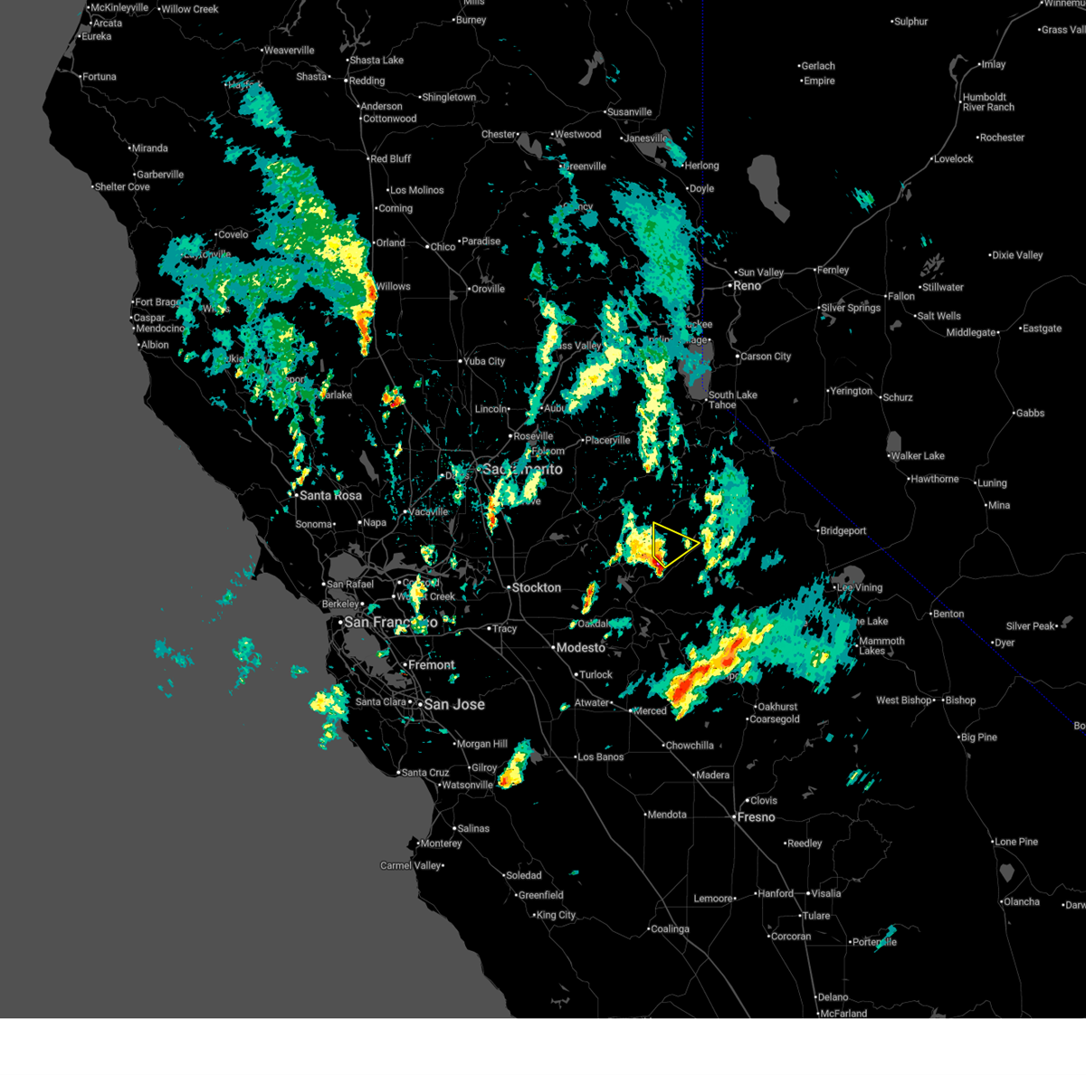
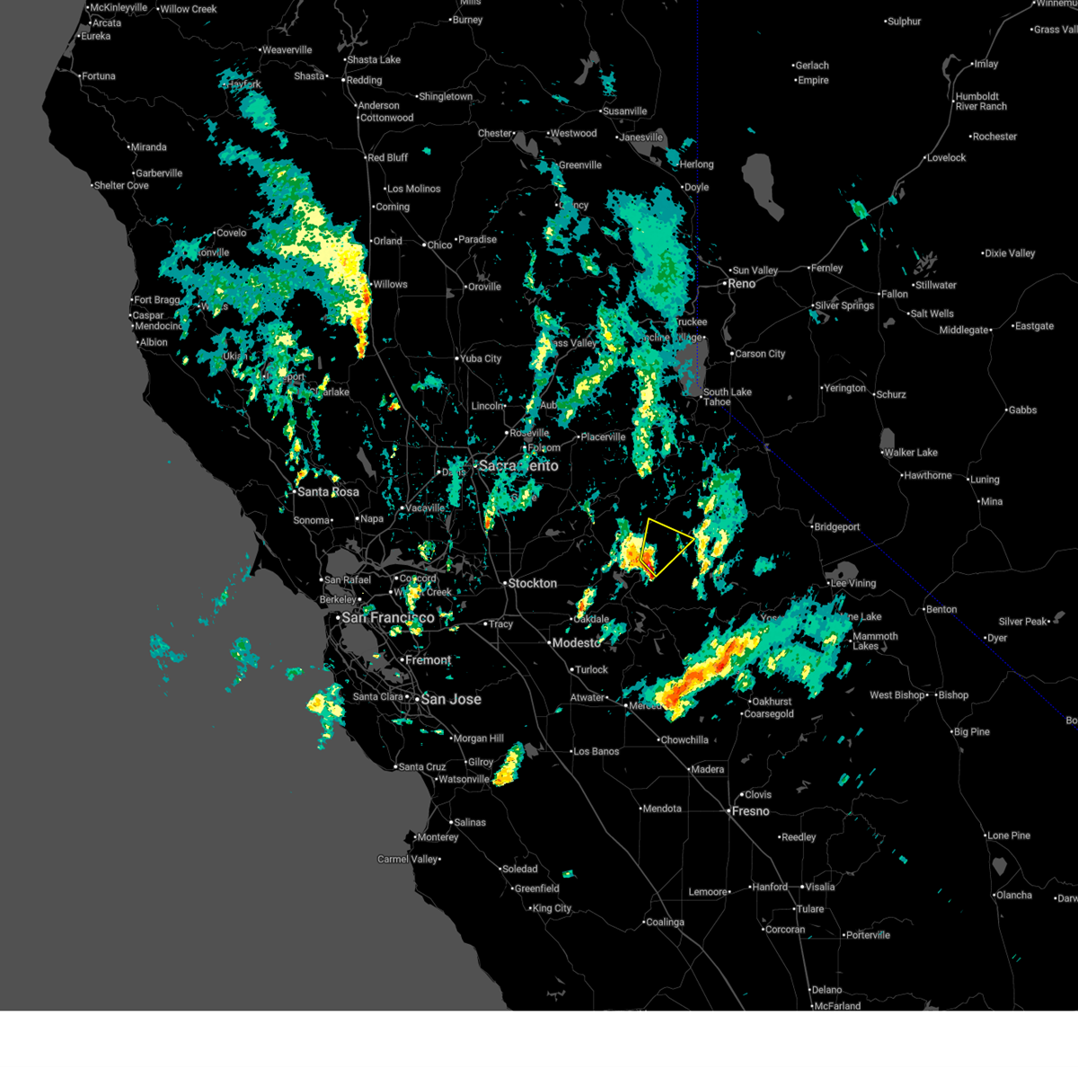
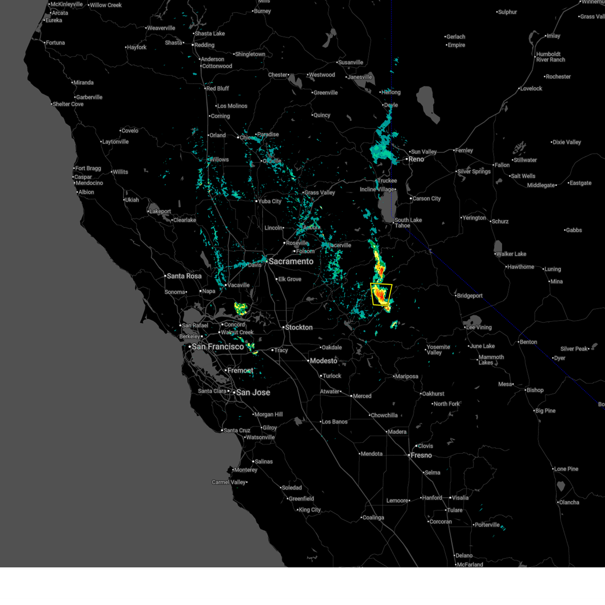
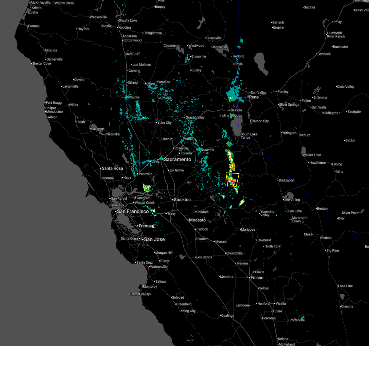
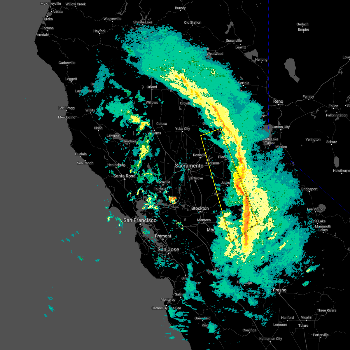
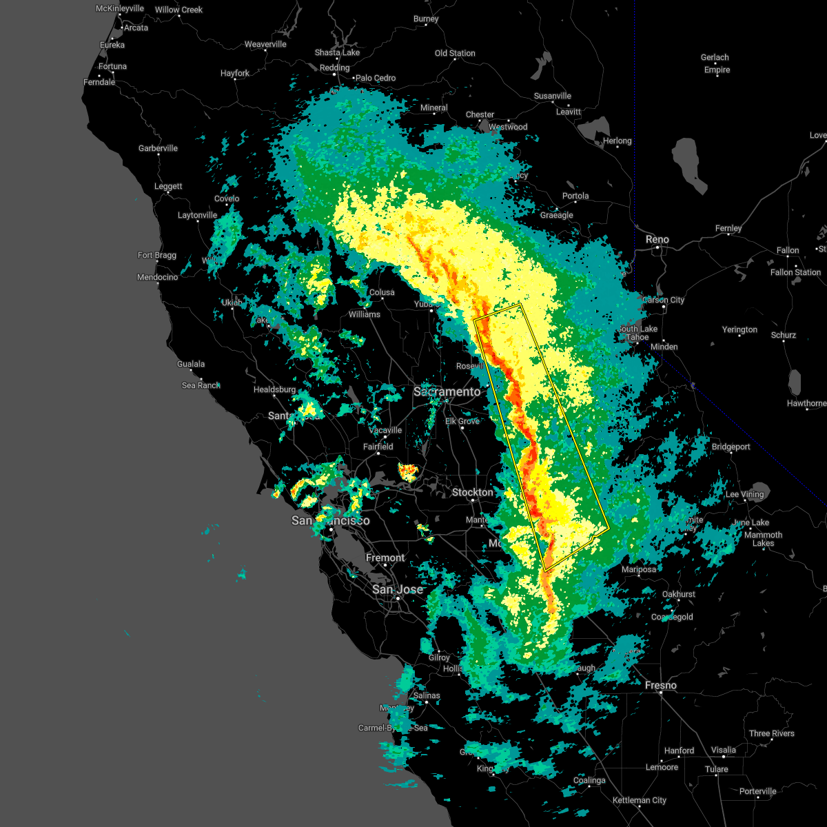
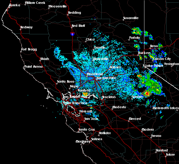
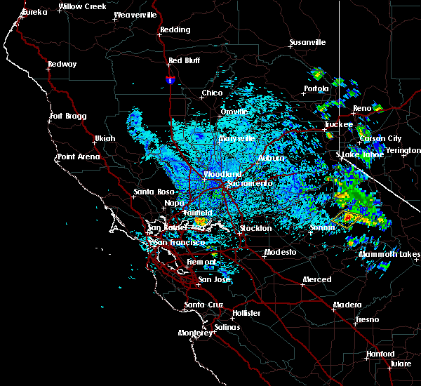
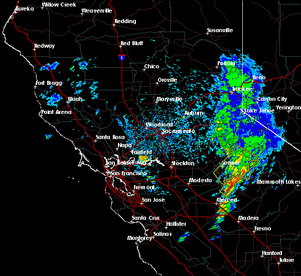
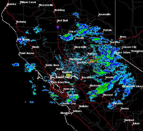
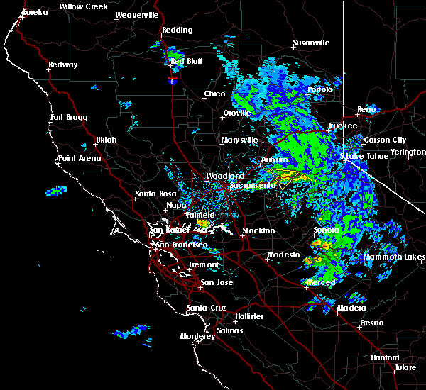
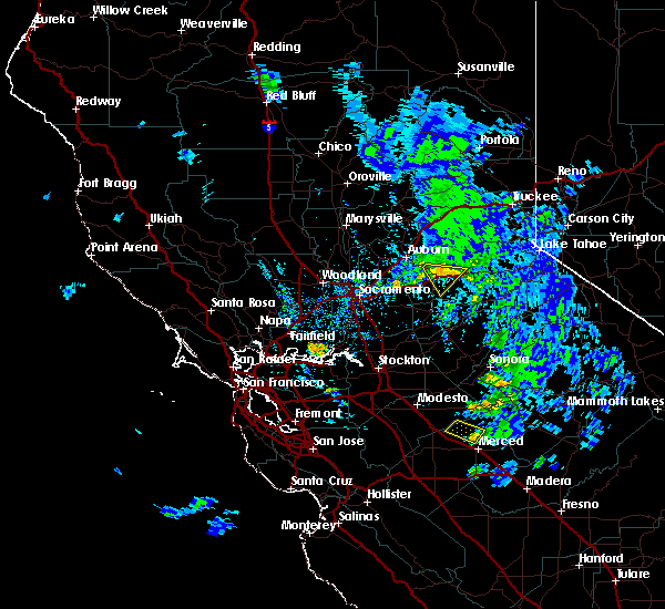
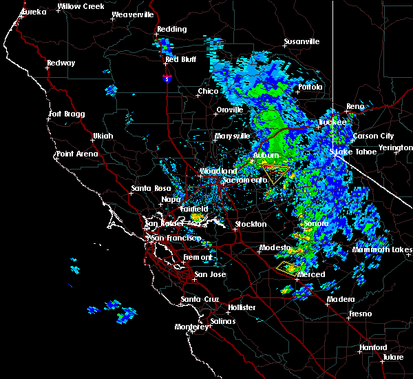
Hail Map for Cold Springs, CA
The Cold Springs, CA area has had 0 reports of on-the-ground hail by trained spotters, and has been under severe weather warnings 5 times during the past 12 months. Doppler radar has detected hail at or near Cold Springs, CA on 2 occasions.
| Name: | Cold Springs, CA |
| Where Located: | 21.8 miles E of Citrus Heights, CA |
| Map: | Google Map for Cold Springs, CA |
| Population: | 446 |
| Housing Units: | 207 |
| More Info: | Search Google for Cold Springs, CA |
0
The Top Recent Hail Date for Cold Springs, CA is Tuesday, May 1, 2018 (2nd out of 2)
Hail and Wind Damage Spotted near Cold Springs, CA
| Date / Time | Report Details |
|---|---|
| 4/10/2026 4:16 PM PDT |
 At 415 pm pdt, a severe thunderstorm was located over jupiter, or 10 miles south of calaveras big trees sp, moving northeast at 30 mph (radar indicated). Hazards include quarter size hail. Damage to vehicles is expected. Locations impacted include, calaveras big trees sp, jupiter, dorrington, arnold, and phoenix lake-cedar ridge. At 415 pm pdt, a severe thunderstorm was located over jupiter, or 10 miles south of calaveras big trees sp, moving northeast at 30 mph (radar indicated). Hazards include quarter size hail. Damage to vehicles is expected. Locations impacted include, calaveras big trees sp, jupiter, dorrington, arnold, and phoenix lake-cedar ridge.
|
| 4/10/2026 4:08 PM PDT |
 Svrsto the national weather service in sacramento has issued a * severe thunderstorm warning for, central tuolumne county in northern california, eastern calaveras county in northern california, * until 445 pm pdt. * at 408 pm pdt, a severe thunderstorm was located near jupiter, or 8 miles northeast of sonora, moving northeast at 30 mph (radar indicated). Hazards include quarter size hail. damage to vehicles is expected Svrsto the national weather service in sacramento has issued a * severe thunderstorm warning for, central tuolumne county in northern california, eastern calaveras county in northern california, * until 445 pm pdt. * at 408 pm pdt, a severe thunderstorm was located near jupiter, or 8 miles northeast of sonora, moving northeast at 30 mph (radar indicated). Hazards include quarter size hail. damage to vehicles is expected
|
| 7/30/2025 2:59 AM PDT |
 The storm which prompted the warning has weakened below severe limits, and no longer poses an immediate threat to life or property. therefore, the warning will be allowed to expire. however small hail is still possible with this thunderstorm. to report severe weather, contact your nearest law enforcement agency. they will relay your report to the national weather service sacramento. The storm which prompted the warning has weakened below severe limits, and no longer poses an immediate threat to life or property. therefore, the warning will be allowed to expire. however small hail is still possible with this thunderstorm. to report severe weather, contact your nearest law enforcement agency. they will relay your report to the national weather service sacramento.
|
| 7/30/2025 2:44 AM PDT |
 At 244 am pdt, a severe thunderstorm was located 8 miles northwest of pinecrest, or 9 miles east of calaveras big trees sp, moving north at 15 mph (radar indicated). Hazards include 60 mph wind gusts and penny size hail. Expect damage to roofs, siding, and trees. This severe thunderstorm will remain over mainly rural areas of north central tuolumne and northeastern calaveras counties. At 244 am pdt, a severe thunderstorm was located 8 miles northwest of pinecrest, or 9 miles east of calaveras big trees sp, moving north at 15 mph (radar indicated). Hazards include 60 mph wind gusts and penny size hail. Expect damage to roofs, siding, and trees. This severe thunderstorm will remain over mainly rural areas of north central tuolumne and northeastern calaveras counties.
|
| 7/30/2025 2:32 AM PDT |
 Svrsto the national weather service in sacramento has issued a * severe thunderstorm warning for, north central tuolumne county in northern california, northeastern calaveras county in northern california, * until 300 am pdt. * at 232 am pdt, a severe thunderstorm was located 7 miles west of pinecrest, or 9 miles east of calaveras big trees sp, moving north at 15 mph (radar indicated). Hazards include 60 mph wind gusts and penny size hail. Expect damage to roofs, siding, and trees. This severe thunderstorm will remain over mainly rural areas of north central tuolumne and northeastern calaveras counties. Svrsto the national weather service in sacramento has issued a * severe thunderstorm warning for, north central tuolumne county in northern california, northeastern calaveras county in northern california, * until 300 am pdt. * at 232 am pdt, a severe thunderstorm was located 7 miles west of pinecrest, or 9 miles east of calaveras big trees sp, moving north at 15 mph (radar indicated). Hazards include 60 mph wind gusts and penny size hail. Expect damage to roofs, siding, and trees. This severe thunderstorm will remain over mainly rural areas of north central tuolumne and northeastern calaveras counties.
|
| 1/10/2023 4:40 AM PST |
 The severe thunderstorm warning for southwestern tuolumne, northeastern sacramento, northeastern stanislaus, western el dorado, southwestern placer, calaveras, southeastern yuba, southwestern nevada and amador counties will expire at 445 am pst, the storms which prompted the warning have weakened, and have exited the warned area. therefore, the warning will be allowed to expire. however gusty winds and heavy rain are still possible with these thunderstorms. The severe thunderstorm warning for southwestern tuolumne, northeastern sacramento, northeastern stanislaus, western el dorado, southwestern placer, calaveras, southeastern yuba, southwestern nevada and amador counties will expire at 445 am pst, the storms which prompted the warning have weakened, and have exited the warned area. therefore, the warning will be allowed to expire. however gusty winds and heavy rain are still possible with these thunderstorms.
|
| 1/10/2023 4:09 AM PST |
 At 407 am pst, severe thunderstorms were located along a line extending from 5 miles east of lincoln to turlock, moving east at 45 mph (radar indicated). Hazards include 60 mph wind gusts. expect damage to roofs, siding, and trees At 407 am pst, severe thunderstorms were located along a line extending from 5 miles east of lincoln to turlock, moving east at 45 mph (radar indicated). Hazards include 60 mph wind gusts. expect damage to roofs, siding, and trees
|
| 8/19/2017 4:11 PM PDT |
 At 411 pm pdt, a severe thunderstorm was located near pinecrest, or 20 miles southwest of sonora pass, moving southwest at 10 mph (radar indicated). Hazards include 60 mph wind gusts and quarter size hail. Hail damage to vehicles is expected. expect wind damage to roofs, siding, and trees. Locations impacted include, pinecrest. At 411 pm pdt, a severe thunderstorm was located near pinecrest, or 20 miles southwest of sonora pass, moving southwest at 10 mph (radar indicated). Hazards include 60 mph wind gusts and quarter size hail. Hail damage to vehicles is expected. expect wind damage to roofs, siding, and trees. Locations impacted include, pinecrest.
|
| 8/19/2017 3:39 PM PDT |
 At 338 pm pdt, a severe thunderstorm was located near pinecrest, or 19 miles southwest of sonora pass, moving south at 15 mph (radar indicated). Hazards include 60 mph wind gusts and quarter size hail. Hail damage to vehicles is expected. Expect wind damage to roofs, siding, and trees. At 338 pm pdt, a severe thunderstorm was located near pinecrest, or 19 miles southwest of sonora pass, moving south at 15 mph (radar indicated). Hazards include 60 mph wind gusts and quarter size hail. Hail damage to vehicles is expected. Expect wind damage to roofs, siding, and trees.
|
| 3/21/2017 3:27 PM PDT |
 The severe thunderstorm warning for central tuolumne county will expire at 330 pm pdt, the storm which prompted the warning has weakened below severe limits, and no longer poses an immediate threat to life or property. therefore the warning will be allowed to expire. The severe thunderstorm warning for central tuolumne county will expire at 330 pm pdt, the storm which prompted the warning has weakened below severe limits, and no longer poses an immediate threat to life or property. therefore the warning will be allowed to expire.
|
| 3/21/2017 3:00 PM PDT |
 At 3 pm pdt, doppler radar continued to indicate a severe thunderstorm capable of producing quarter size hail and damaging winds in excess of 60 mph. trained spotters have reported abundant small hail in mono vista, groveland, and twain harte with this storm. this storm was located over pinecrest, or 18 miles southwest of sonora pass, moving northeast at 25 mph. locations impacted include, sonora, pinecrest, jupiter, long barn, smith station, phoenix lake- cedar, mi-wuk village, twain harte, groveland- big oak flat, mono vista, buck meadows fs, groveland- big oak, phoenix lake- cedar ridge, east sonora, tuolumne city, soulsbyville and columbia. At 3 pm pdt, doppler radar continued to indicate a severe thunderstorm capable of producing quarter size hail and damaging winds in excess of 60 mph. trained spotters have reported abundant small hail in mono vista, groveland, and twain harte with this storm. this storm was located over pinecrest, or 18 miles southwest of sonora pass, moving northeast at 25 mph. locations impacted include, sonora, pinecrest, jupiter, long barn, smith station, phoenix lake- cedar, mi-wuk village, twain harte, groveland- big oak flat, mono vista, buck meadows fs, groveland- big oak, phoenix lake- cedar ridge, east sonora, tuolumne city, soulsbyville and columbia.
|
| 3/21/2017 2:29 PM PDT |
 At 228 pm pdt, doppler radar indicated a severe thunderstorm capable of producing quarter size hail and damaging winds in excess of 60 mph. this storm was located 7 miles southeast of cedar ridge, or 10 miles east of sonora, and moving northeast at 25 mph. At 228 pm pdt, doppler radar indicated a severe thunderstorm capable of producing quarter size hail and damaging winds in excess of 60 mph. this storm was located 7 miles southeast of cedar ridge, or 10 miles east of sonora, and moving northeast at 25 mph.
|
| 12/24/2015 3:30 PM PST |
 At 325 pm pst, dopper radar still indicated rotation and a possible tornado just west of rescue and near cameron park moving to the east at 20 mph. the public reported a tornado with this storm. locations impacted include, placerville, cameron park, shingle springs, rescue, smithflat, lotus, coloma, clarksville and diamond springs. seek shelter immediately if you are in the path of this tornado. flying debris is possible from the tornado`s winds. At 325 pm pst, dopper radar still indicated rotation and a possible tornado just west of rescue and near cameron park moving to the east at 20 mph. the public reported a tornado with this storm. locations impacted include, placerville, cameron park, shingle springs, rescue, smithflat, lotus, coloma, clarksville and diamond springs. seek shelter immediately if you are in the path of this tornado. flying debris is possible from the tornado`s winds.
|
| 12/24/2015 3:15 PM PST |
 At 314 pm pst, the public reported a tornado near folsom or eldorado hills doppler radar showed this tornado moving east at 20 mph. At 314 pm pst, the public reported a tornado near folsom or eldorado hills doppler radar showed this tornado moving east at 20 mph.
|
| 11/15/2015 3:06 PM PST |
 The severe thunderstorm warning for southwestern el dorado county will expire at 315 pm pst, the storm which prompted the warning has weakened below severe limits and exited the warned area. therefore the warning will be allowed to expire. however small hail is still possible with this thunderstorm. The severe thunderstorm warning for southwestern el dorado county will expire at 315 pm pst, the storm which prompted the warning has weakened below severe limits and exited the warned area. therefore the warning will be allowed to expire. however small hail is still possible with this thunderstorm.
|
| 11/15/2015 2:48 PM PST |
 At 243 pm pst, marshall gold discovery state park officials reported a severe thunderstorm producing quarter size hail and damaging winds in excess of 60 mph. this storm was located over placerville, moving southeast at 15 mph. in addition, hail was reported to cover the ground in coloma with nickel to quarter size hail. locations impacted include, placerville, smithflat, camino, lotus, coloma, pollock pines and diamond springs. At 243 pm pst, marshall gold discovery state park officials reported a severe thunderstorm producing quarter size hail and damaging winds in excess of 60 mph. this storm was located over placerville, moving southeast at 15 mph. in addition, hail was reported to cover the ground in coloma with nickel to quarter size hail. locations impacted include, placerville, smithflat, camino, lotus, coloma, pollock pines and diamond springs.
|
| 11/15/2015 2:32 PM PST |
 At 232 pm pst, doppler radar indicated a severe thunderstorm capable of producing quarter size hail and damaging winds in excess of 60 mph. this storm was located over coloma, or near placerville, and moving southeast at 15 mph. At 232 pm pst, doppler radar indicated a severe thunderstorm capable of producing quarter size hail and damaging winds in excess of 60 mph. this storm was located over coloma, or near placerville, and moving southeast at 15 mph.
|
| 6/5/2015 5:31 PM PDT | At 525 pm pdt, doppler radar indicated a severe thunderstorm capable of producing quarter size hail. this storm was located over camino, moving west at 15 mph towards placerville. in addition, a weather spotter in pollack pines reported copious amounts of pea size hail, and a weather spotter in pacific house reported half inch size hail. this severe storm will be near, somerset around 535 pm pdt. smithflat around 540 pm pdt. placerville around 545 pm pdt. other locations impacted by this severe thunderstorm include diamond springs. |
| 6/5/2015 4:59 PM PDT | At 458 pm pdt, doppler radar indicated a severe thunderstorm capable of producing quarter size hail. this storm was located near pollock pines, or 9 miles south of big bend summit, and moving west at 15 mph. * this severe thunderstorm will be near, camino around 530 pm pdt. somerset around 535 pm pdt. placerville and smithflat around 545 pm pdt. other locations impacted by this severe thunderstorm include diamond springs. |
Hail Maps for Cold Springs, CA
Connect with Interactive Hail Maps