

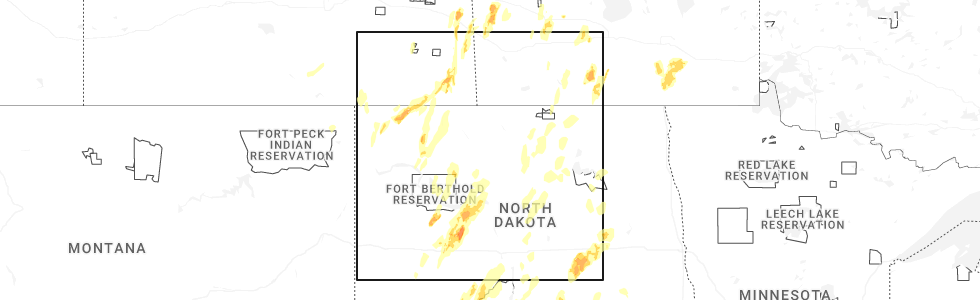
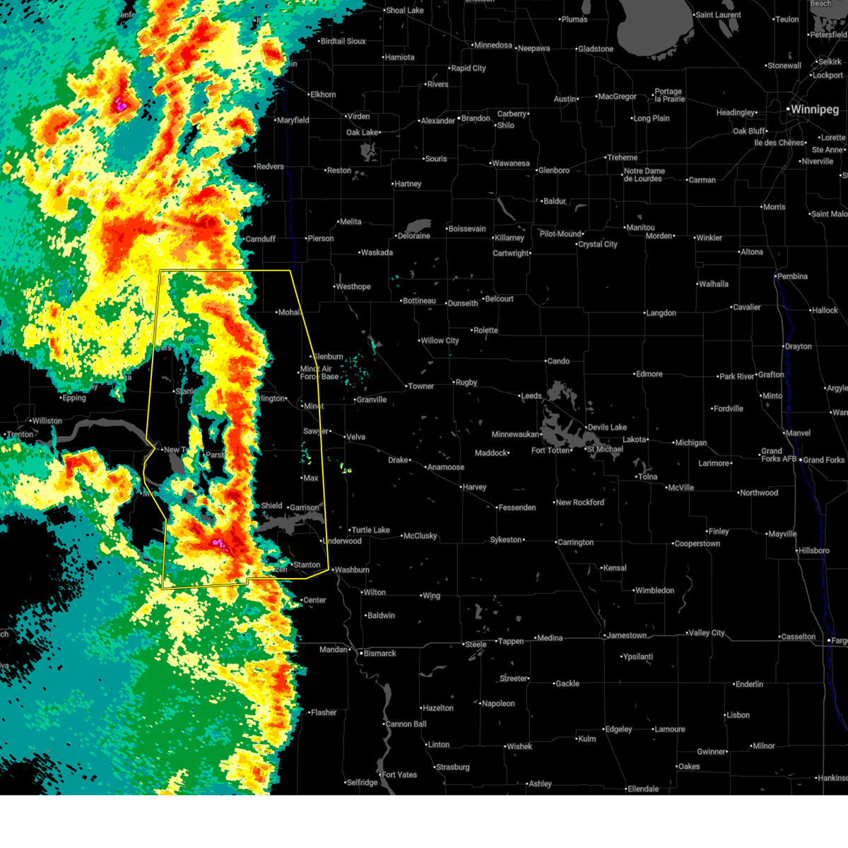
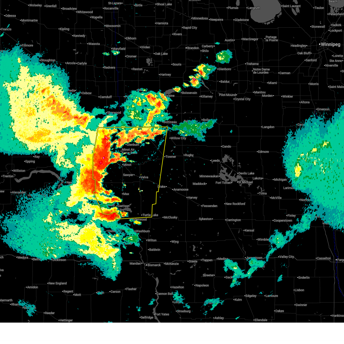
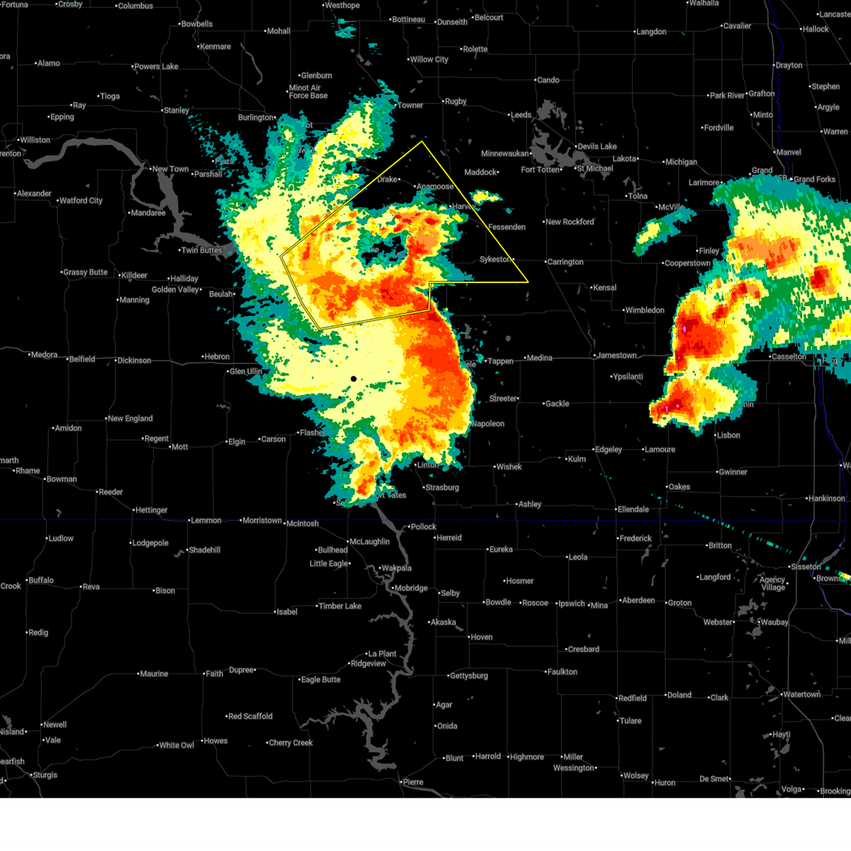
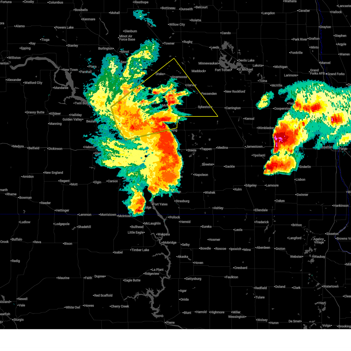
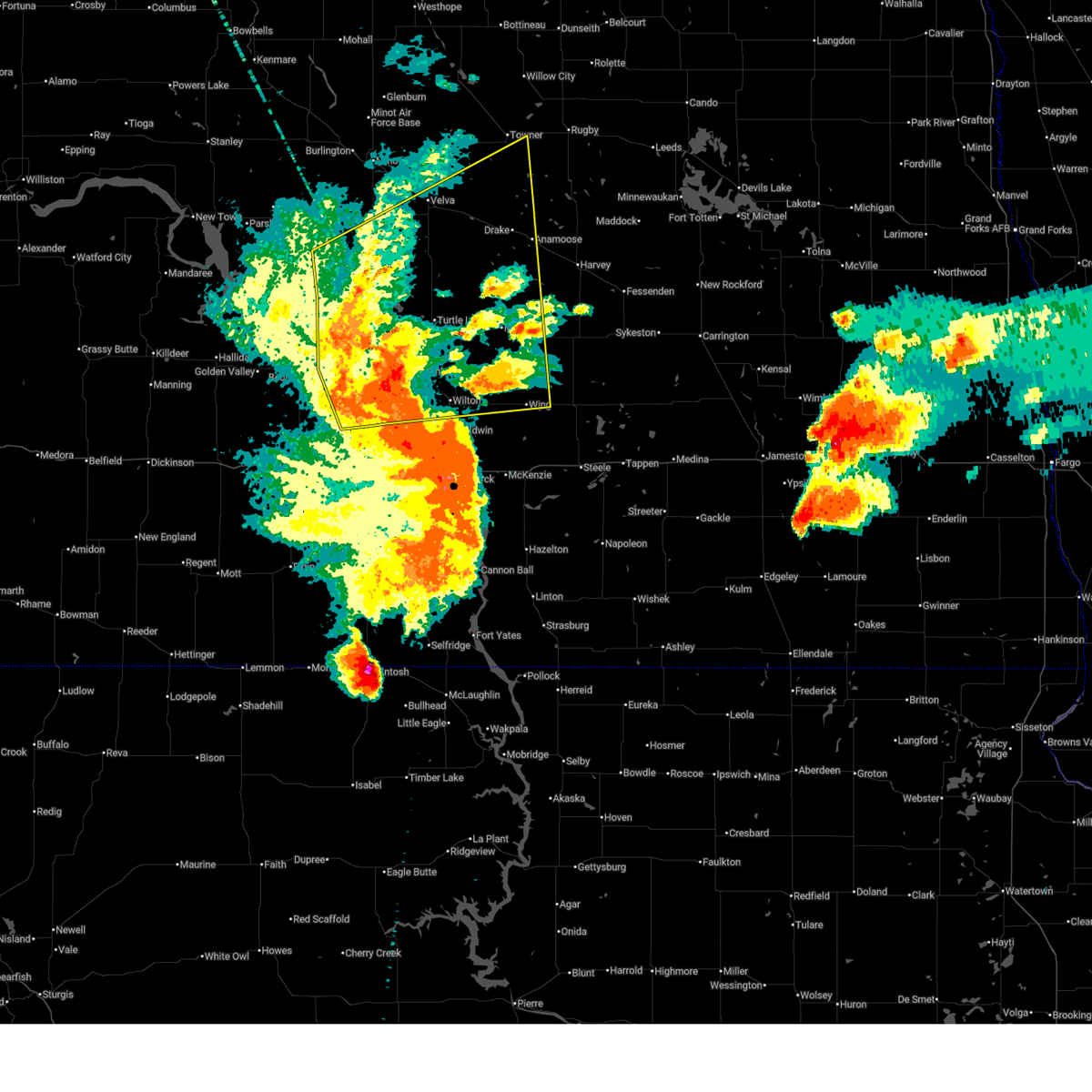
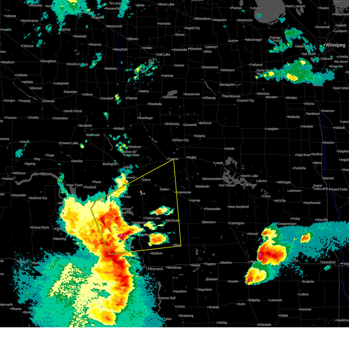
Hail Map for Coleharbor, ND
The Coleharbor, ND area has had 4 reports of on-the-ground hail by trained spotters, and has been under severe weather warnings 23 times during the past 12 months. Doppler radar has detected hail at or near Coleharbor, ND on 42 occasions, including 5 occasions during the past year.
| Name: | Coleharbor, ND |
| Where Located: | 48 miles S of Minot, ND |
| Map: | Google Map for Coleharbor, ND |
| Population: | 79 |
| Housing Units: | 51 |
| More Info: | Search Google for Coleharbor, ND |
2
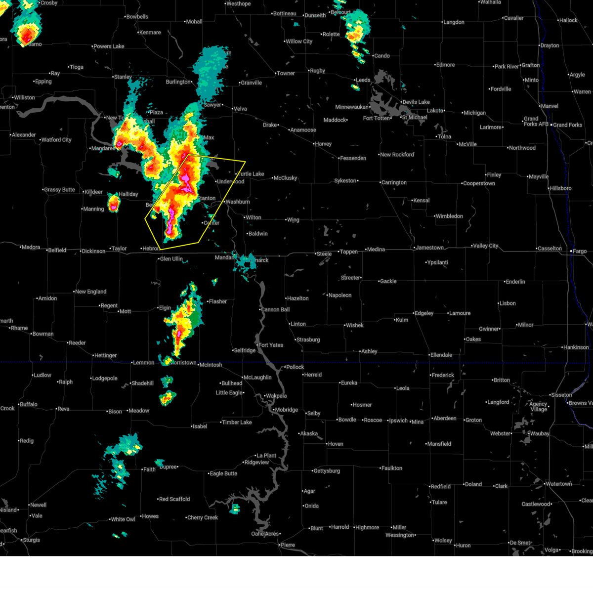
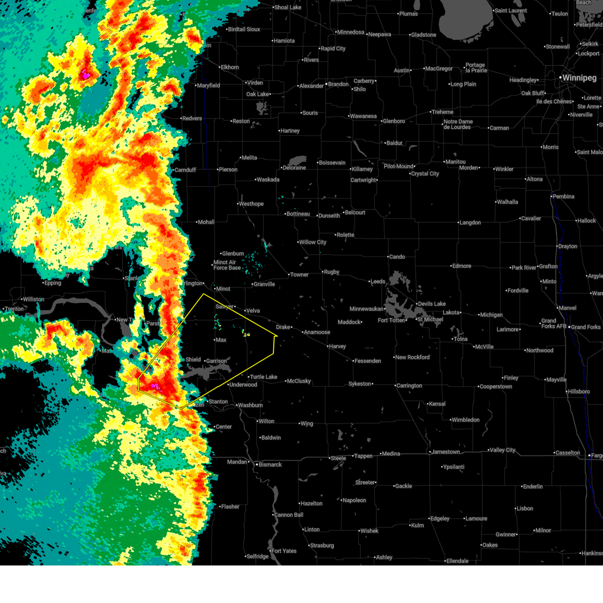
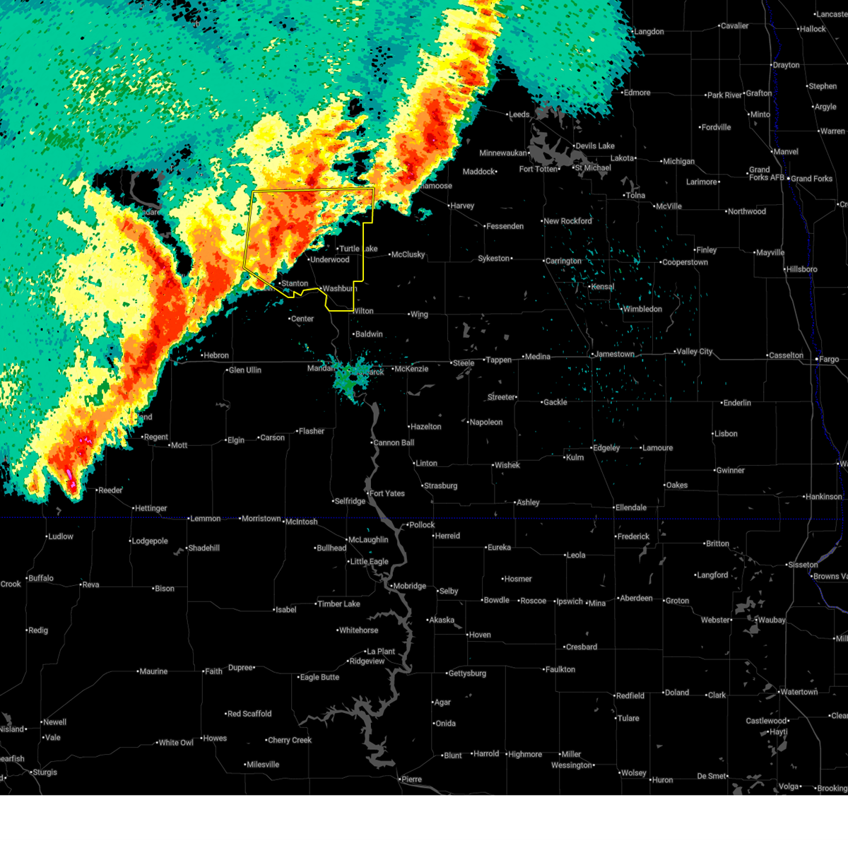
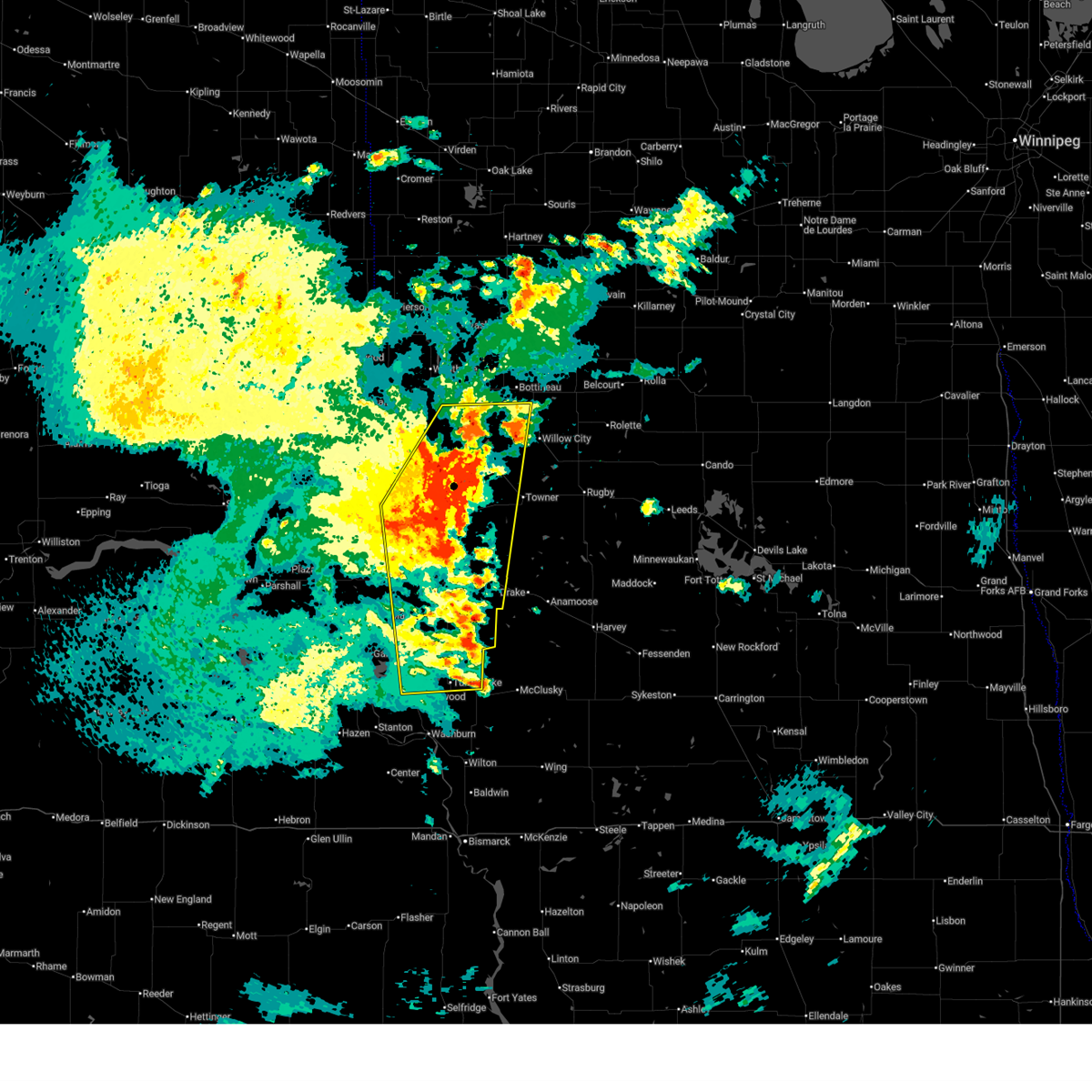
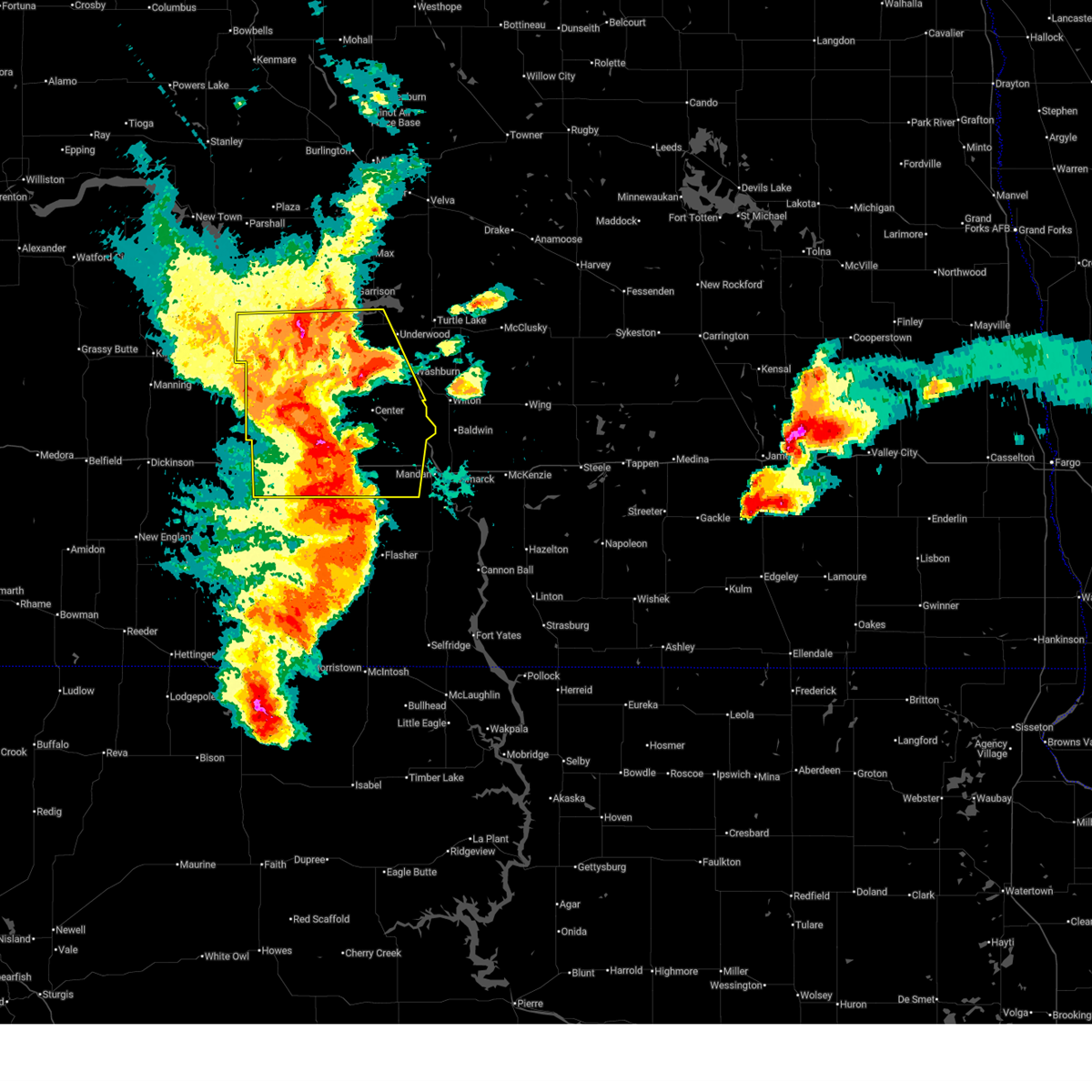
The Top Recent Hail Date for Coleharbor, ND is Tuesday, June 9, 2026 (14th out of 42)
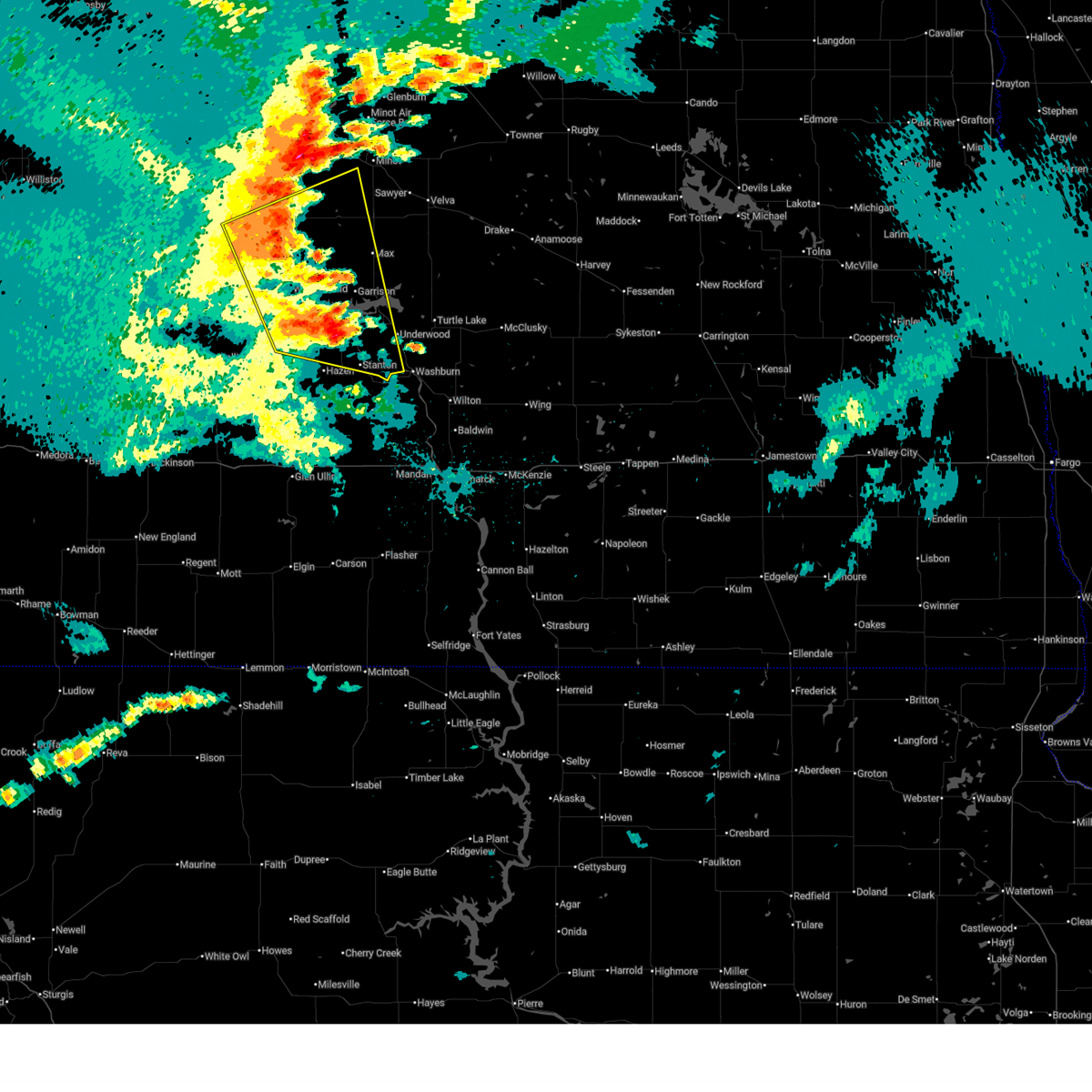
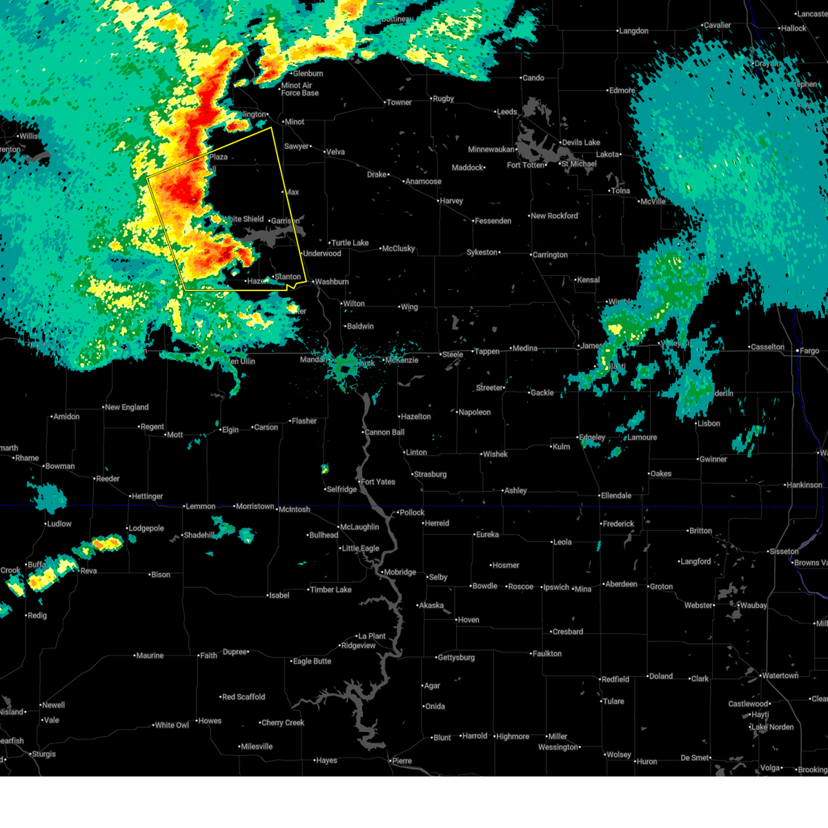
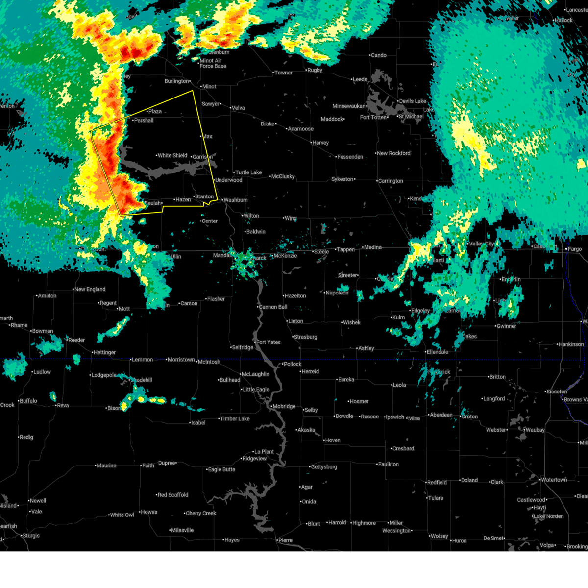
Hail and Wind Damage Spotted near Coleharbor, ND
| Date / Time | Report Details |
|---|---|
| 6/9/2026 6:52 PM CDT |
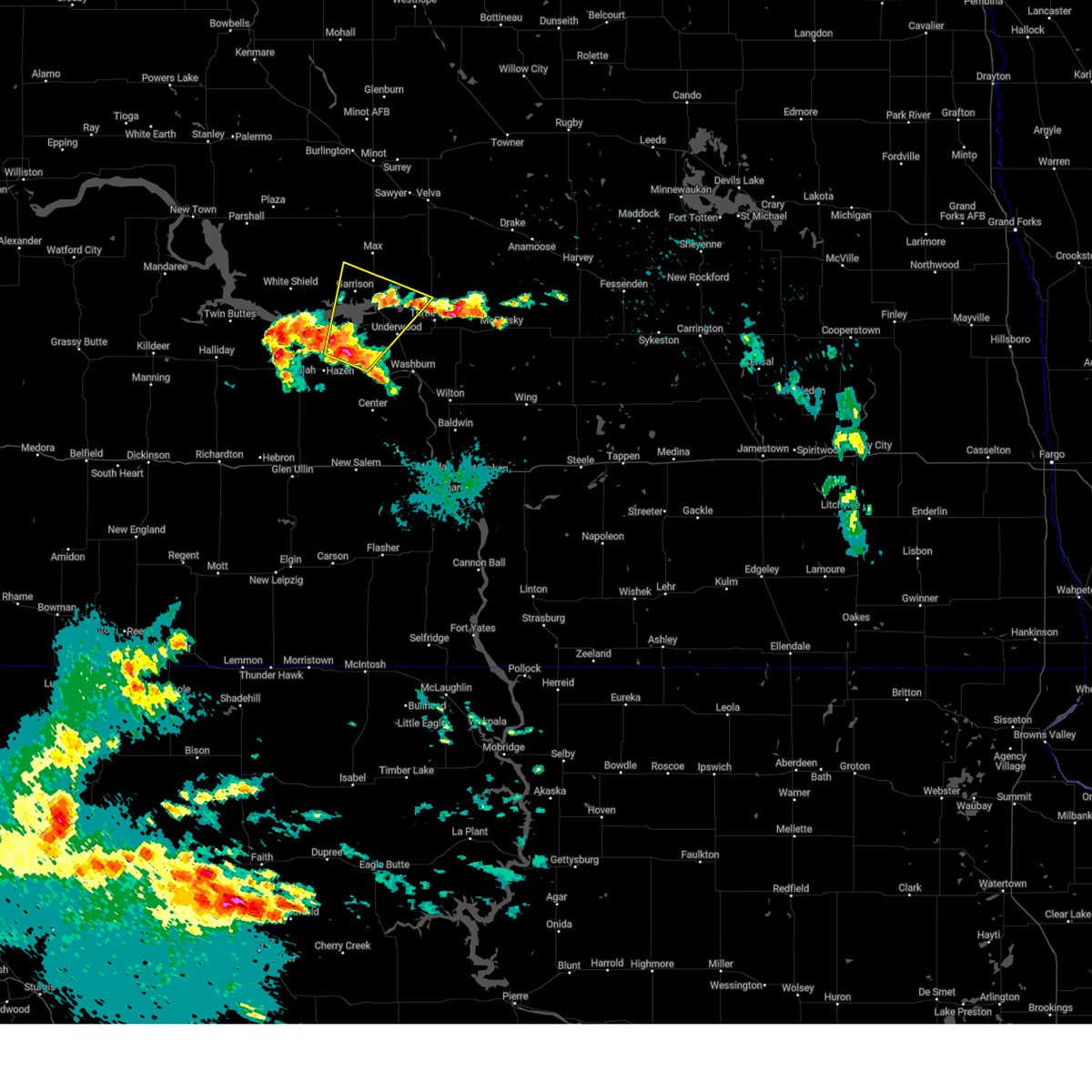
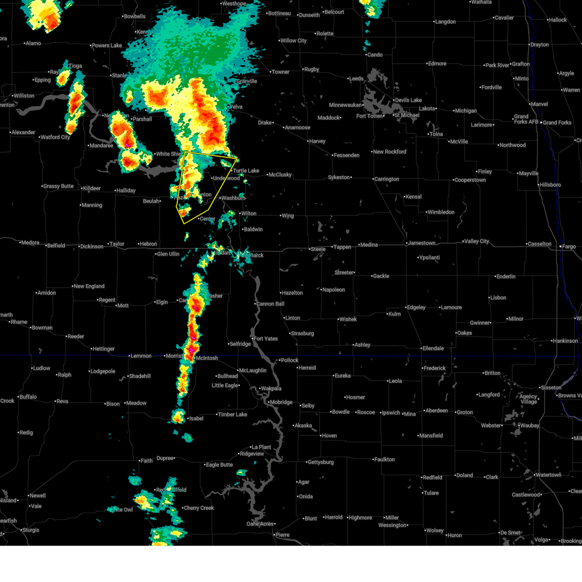 At 652 pm cdt, severe thunderstorms were located along a line from over riverdale to near hannover, or along a line from 10 miles south of garrison to 16 miles southeast of beulah, moving southeast at 10 mph (radar indicated). Hazards include 60 mph wind gusts and small hail. Expect damage to roofs, siding, and trees. Locations impacted include, garrison, underwood, stanton, riverdale, pick city, coleharbor, hannover, fort clark, falkirk, lake sakakawea state park and fort stevenson state park. At 652 pm cdt, severe thunderstorms were located along a line from over riverdale to near hannover, or along a line from 10 miles south of garrison to 16 miles southeast of beulah, moving southeast at 10 mph (radar indicated). Hazards include 60 mph wind gusts and small hail. Expect damage to roofs, siding, and trees. Locations impacted include, garrison, underwood, stanton, riverdale, pick city, coleharbor, hannover, fort clark, falkirk, lake sakakawea state park and fort stevenson state park.
|
| 6/9/2026 6:40 PM CDT |
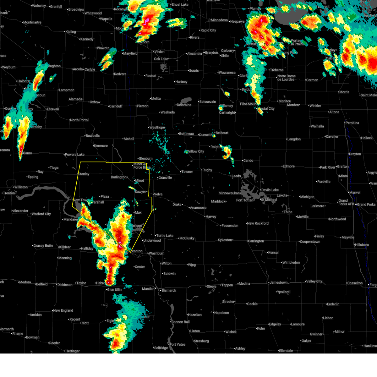
 At 640 pm cdt, severe thunderstorms were located along a line from 9 miles south of palermo to over ruso city, or along a line from 12 miles southeast of stanley to 23 miles northeast of garrison, moving northeast at 45 mph (trained spotters reported. at 616 pm cdt, 75 mph wind gusts were reported 3 miles south-southeast of garrison). Hazards include 70 mph wind gusts and ping pong ball size hail. People and animals outdoors will be injured. expect hail damage to roofs, siding, windows, and vehicles. expect considerable tree damage. wind damage is also likely to mobile homes, roofs, and outbuildings. Locations impacted include, minot, garrison, minot air force base, burlington, surrey, parshall, berthold, stanton, sawyer, max, riverdale, des lacs, plaza, carpio, makoti, pick city, foxholm, ryder and coleharbor. At 640 pm cdt, severe thunderstorms were located along a line from 9 miles south of palermo to over ruso city, or along a line from 12 miles southeast of stanley to 23 miles northeast of garrison, moving northeast at 45 mph (trained spotters reported. at 616 pm cdt, 75 mph wind gusts were reported 3 miles south-southeast of garrison). Hazards include 70 mph wind gusts and ping pong ball size hail. People and animals outdoors will be injured. expect hail damage to roofs, siding, windows, and vehicles. expect considerable tree damage. wind damage is also likely to mobile homes, roofs, and outbuildings. Locations impacted include, minot, garrison, minot air force base, burlington, surrey, parshall, berthold, stanton, sawyer, max, riverdale, des lacs, plaza, carpio, makoti, pick city, foxholm, ryder and coleharbor.
|
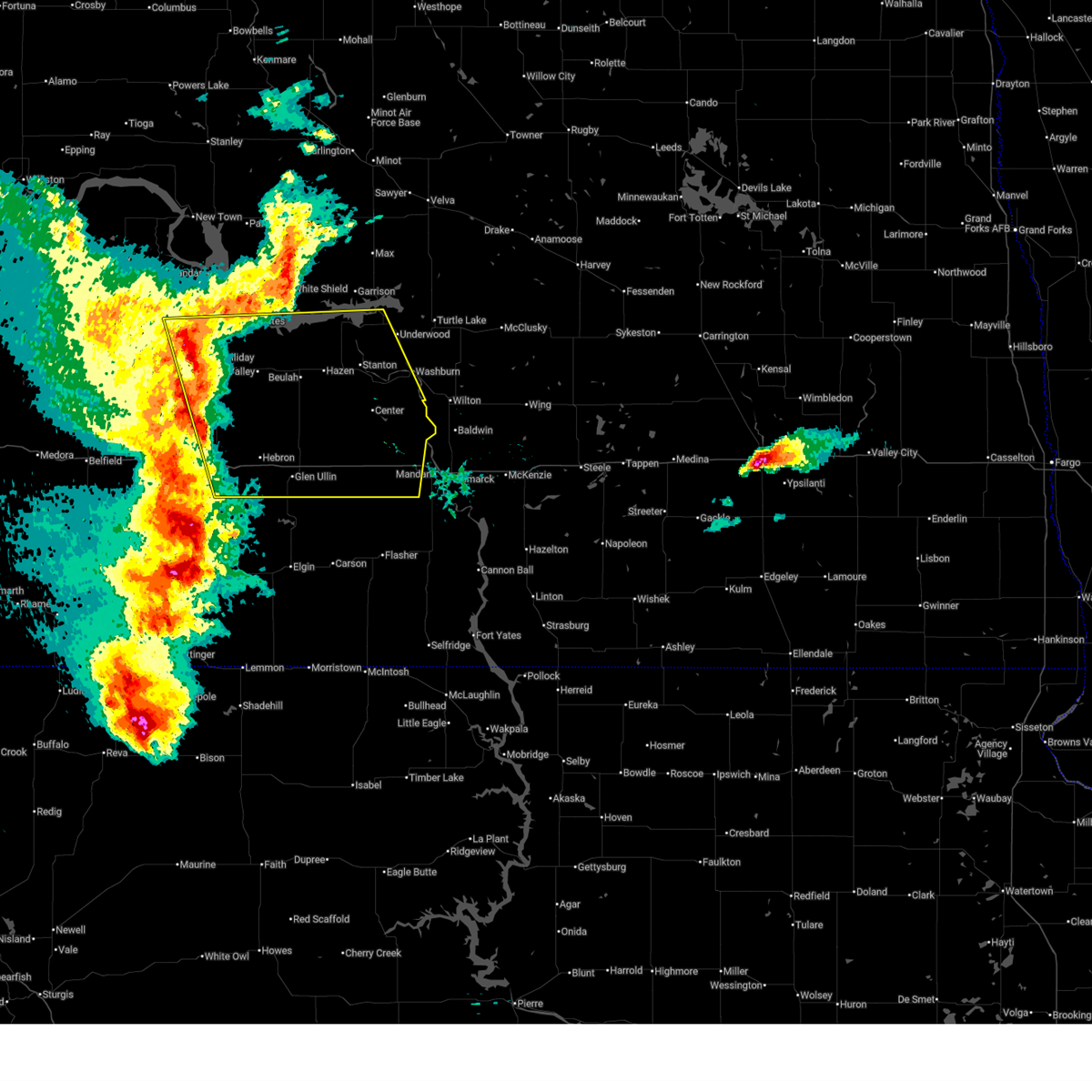
| 6/9/2026 5:30 PM MDT |
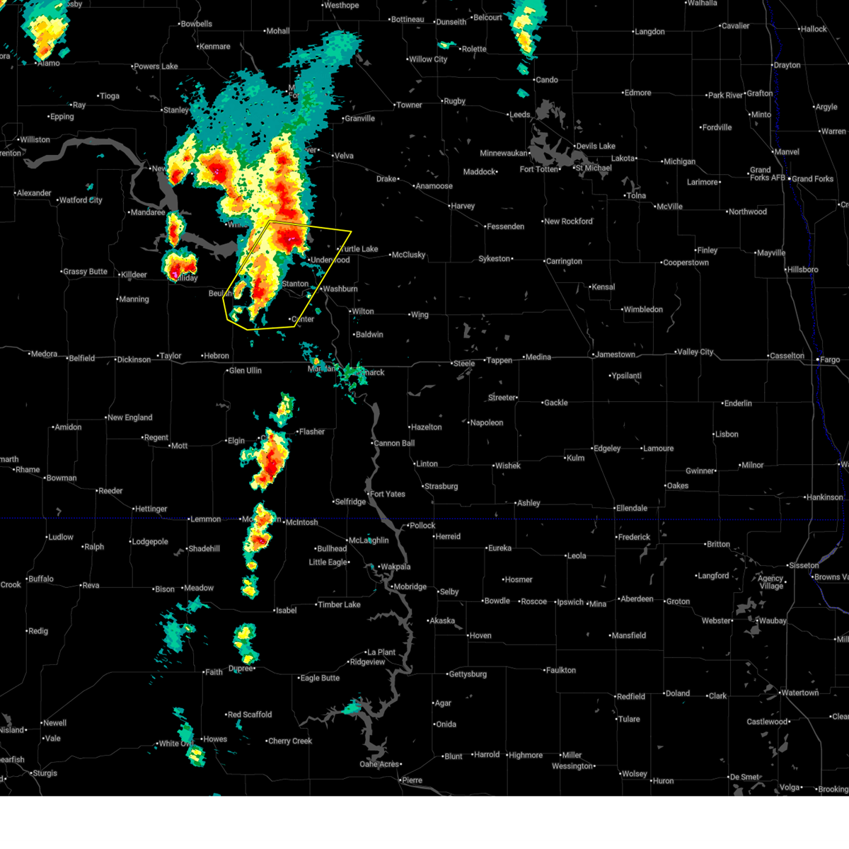 At 630 pm cdt, severe thunderstorms were located along a line from over pick city to 8 miles south of hazen, or along a line from 8 miles south of garrison to 11 miles southeast of beulah, moving northeast at 45 mph (radar indicated). Hazards include ping pong ball size hail and 60 mph wind gusts. People and animals outdoors will be injured. expect hail damage to roofs, siding, windows, and vehicles. expect wind damage to roofs, siding, and trees. Locations impacted include, beulah, garrison, hazen, underwood, turtle lake, center, stanton, riverdale, pick city, coleharbor, hannover, fort clark, lake sakakawea state park, fort stevenson state park and falkirk. At 630 pm cdt, severe thunderstorms were located along a line from over pick city to 8 miles south of hazen, or along a line from 8 miles south of garrison to 11 miles southeast of beulah, moving northeast at 45 mph (radar indicated). Hazards include ping pong ball size hail and 60 mph wind gusts. People and animals outdoors will be injured. expect hail damage to roofs, siding, windows, and vehicles. expect wind damage to roofs, siding, and trees. Locations impacted include, beulah, garrison, hazen, underwood, turtle lake, center, stanton, riverdale, pick city, coleharbor, hannover, fort clark, lake sakakawea state park, fort stevenson state park and falkirk.
|
| 6/9/2026 6:23 PM CDT |
 At 623 pm cdt, severe thunderstorms were located along a line from 8 miles southeast of belden to 9 miles north of coleharbor, or along a line from 19 miles south of stanley to 11 miles east of garrison, moving northeast at 45 mph (trained spotters reported. at 616 pm cdt, 75 mph wind gusts were reported 3 miles south-southeast of garrison). Hazards include 70 mph wind gusts and ping pong ball size hail. People and animals outdoors will be injured. expect hail damage to roofs, siding, windows, and vehicles. expect considerable tree damage. wind damage is also likely to mobile homes, roofs, and outbuildings. Locations impacted include, minot, garrison, minot air force base, burlington, surrey, parshall, berthold, stanton, sawyer, max, riverdale, des lacs, plaza, carpio, makoti, pick city, foxholm, ryder and coleharbor. At 623 pm cdt, severe thunderstorms were located along a line from 8 miles southeast of belden to 9 miles north of coleharbor, or along a line from 19 miles south of stanley to 11 miles east of garrison, moving northeast at 45 mph (trained spotters reported. at 616 pm cdt, 75 mph wind gusts were reported 3 miles south-southeast of garrison). Hazards include 70 mph wind gusts and ping pong ball size hail. People and animals outdoors will be injured. expect hail damage to roofs, siding, windows, and vehicles. expect considerable tree damage. wind damage is also likely to mobile homes, roofs, and outbuildings. Locations impacted include, minot, garrison, minot air force base, burlington, surrey, parshall, berthold, stanton, sawyer, max, riverdale, des lacs, plaza, carpio, makoti, pick city, foxholm, ryder and coleharbor.
|
| 6/9/2026 6:14 PM CDT |
 Svrbis the national weather service in bismarck has issued a * severe thunderstorm warning for, southeastern mclean county in south central north dakota, central mercer county in south central north dakota, north central morton county in south central north dakota, oliver county in south central north dakota, * until 700 pm cdt. * at 614 pm cdt, severe thunderstorms were located along a line from 5 miles north of hazen to 16 miles northeast of glen ullin, or along a line from 11 miles northeast of beulah to 17 miles south of beulah, moving northeast at 60 mph (radar indicated). Hazards include ping pong ball size hail and 60 mph wind gusts. People and animals outdoors will be injured. expect hail damage to roofs, siding, windows, and vehicles. Expect wind damage to roofs, siding, and trees. Svrbis the national weather service in bismarck has issued a * severe thunderstorm warning for, southeastern mclean county in south central north dakota, central mercer county in south central north dakota, north central morton county in south central north dakota, oliver county in south central north dakota, * until 700 pm cdt. * at 614 pm cdt, severe thunderstorms were located along a line from 5 miles north of hazen to 16 miles northeast of glen ullin, or along a line from 11 miles northeast of beulah to 17 miles south of beulah, moving northeast at 60 mph (radar indicated). Hazards include ping pong ball size hail and 60 mph wind gusts. People and animals outdoors will be injured. expect hail damage to roofs, siding, windows, and vehicles. Expect wind damage to roofs, siding, and trees.
|
| 6/9/2026 6:12 PM CDT |
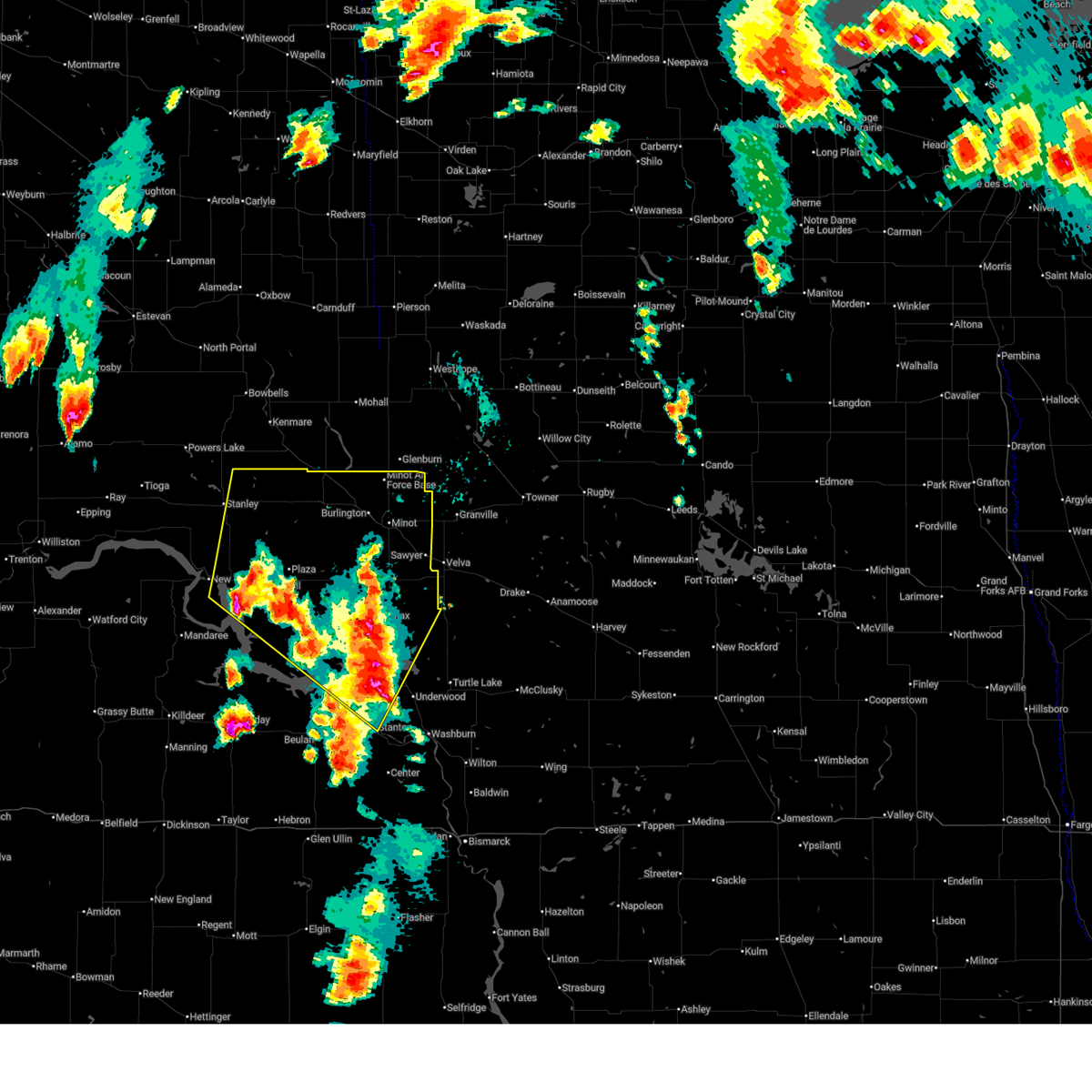
 Svrbis the national weather service in bismarck has issued a * severe thunderstorm warning for, ward county in north central north dakota, eastern mountrail county in northwestern north dakota, northwestern mclean county in south central north dakota, northeastern mercer county in south central north dakota, * until 715 pm cdt. * at 612 pm cdt, severe thunderstorms were located along a line from near van hook park to over riverdale, or along a line from 29 miles south of stanley to 10 miles south of garrison, moving northeast at 50 mph (radar indicated). Hazards include 70 mph wind gusts and ping pong ball size hail. People and animals outdoors will be injured. expect hail damage to roofs, siding, windows, and vehicles. expect considerable tree damage. Wind damage is also likely to mobile homes, roofs, and outbuildings. Svrbis the national weather service in bismarck has issued a * severe thunderstorm warning for, ward county in north central north dakota, eastern mountrail county in northwestern north dakota, northwestern mclean county in south central north dakota, northeastern mercer county in south central north dakota, * until 715 pm cdt. * at 612 pm cdt, severe thunderstorms were located along a line from near van hook park to over riverdale, or along a line from 29 miles south of stanley to 10 miles south of garrison, moving northeast at 50 mph (radar indicated). Hazards include 70 mph wind gusts and ping pong ball size hail. People and animals outdoors will be injured. expect hail damage to roofs, siding, windows, and vehicles. expect considerable tree damage. Wind damage is also likely to mobile homes, roofs, and outbuildings.
|
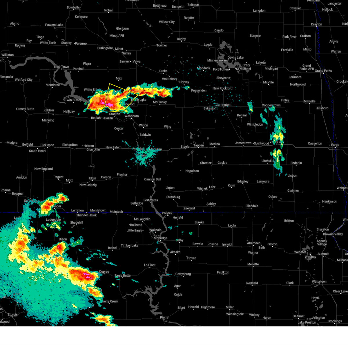
| 6/7/2026 10:02 PM CDT |
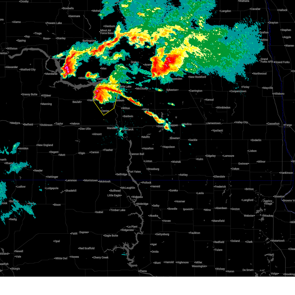
 Svrbis the national weather service in bismarck has issued a * severe thunderstorm warning for, southeastern mchenry county in north central north dakota, northeastern burleigh county in south central north dakota, northwestern kidder county in south central north dakota, eastern mclean county in south central north dakota, east central mercer county in south central north dakota, northeastern oliver county in south central north dakota, sheridan county in south central north dakota, * until 1045 pm cdt. * at 1002 pm cdt, severe thunderstorms were located along a line from 9 miles south of ruso city to 6 miles east of washburn, or along a line from 21 miles east of garrison to 32 miles north of mandan, moving east at 70 mph (radar indicated). Hazards include 70 mph wind gusts and small hail. Expect considerable tree damage. Damage is likely to mobile homes, roofs, and outbuildings. Svrbis the national weather service in bismarck has issued a * severe thunderstorm warning for, southeastern mchenry county in north central north dakota, northeastern burleigh county in south central north dakota, northwestern kidder county in south central north dakota, eastern mclean county in south central north dakota, east central mercer county in south central north dakota, northeastern oliver county in south central north dakota, sheridan county in south central north dakota, * until 1045 pm cdt. * at 1002 pm cdt, severe thunderstorms were located along a line from 9 miles south of ruso city to 6 miles east of washburn, or along a line from 21 miles east of garrison to 32 miles north of mandan, moving east at 70 mph (radar indicated). Hazards include 70 mph wind gusts and small hail. Expect considerable tree damage. Damage is likely to mobile homes, roofs, and outbuildings.
|
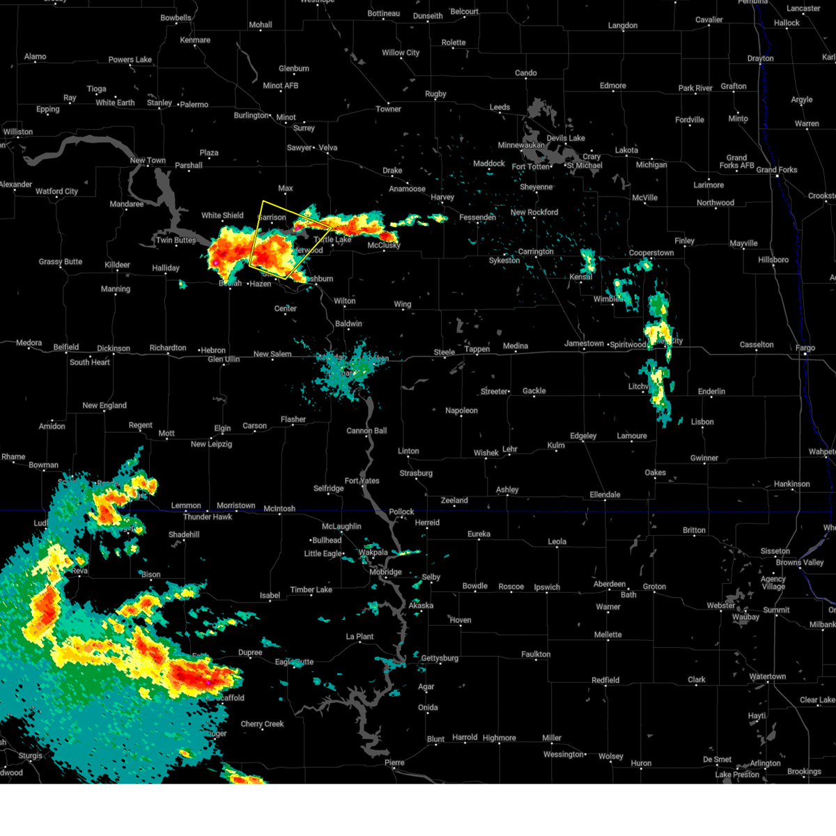
| 6/7/2026 9:53 PM CDT |
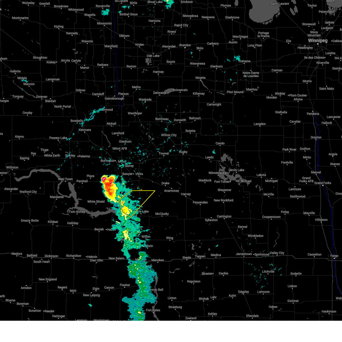
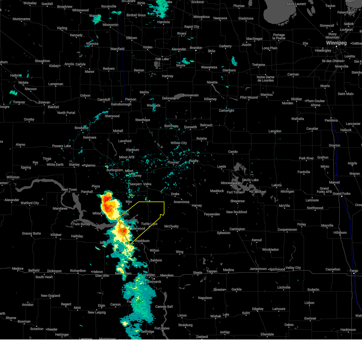
 At 953 pm cdt, a severe thunderstorm was located 8 miles south of max, or 10 miles northeast of garrison, moving northeast at 60 mph. this is a destructive storm for garrison, coleharbor, and white shield (ndawn mesonet 13nw of garrison reported a 93 mph wind gust). Hazards include 90 mph wind gusts and quarter size hail. You are in a life-threatening situation. flying debris may be deadly to those caught without shelter. mobile homes will be heavily damaged or destroyed. homes and businesses will have substantial roof and window damage. expect extensive tree damage and power outages. Locations impacted include, garrison, hazen, max, riverdale, pick city, ryder, coleharbor, butte, benedict, rice lake, douglas, roseglen, hazen bay recreation area, beulah bay recreation area, ruso city, ruso, fort stevenson state park, lake sakakawea state park, emmet and white shield. At 953 pm cdt, a severe thunderstorm was located 8 miles south of max, or 10 miles northeast of garrison, moving northeast at 60 mph. this is a destructive storm for garrison, coleharbor, and white shield (ndawn mesonet 13nw of garrison reported a 93 mph wind gust). Hazards include 90 mph wind gusts and quarter size hail. You are in a life-threatening situation. flying debris may be deadly to those caught without shelter. mobile homes will be heavily damaged or destroyed. homes and businesses will have substantial roof and window damage. expect extensive tree damage and power outages. Locations impacted include, garrison, hazen, max, riverdale, pick city, ryder, coleharbor, butte, benedict, rice lake, douglas, roseglen, hazen bay recreation area, beulah bay recreation area, ruso city, ruso, fort stevenson state park, lake sakakawea state park, emmet and white shield.
|
| 6/7/2026 9:50 PM CDT | Measured wind gust at private weather statio in mclean county ND, 10.5 miles SW of Coleharbor, ND |
| 6/7/2026 9:47 PM CDT |
 At 947 pm cdt, a severe thunderstorm was located 5 miles east of garrison, moving northeast at 60 mph. this is a destructive storm for garrison, coleharbor, and white shield (radar indicated). Hazards include 80 mph wind gusts and quarter size hail. Flying debris will be dangerous to those caught without shelter. mobile homes will be heavily damaged. expect considerable damage to roofs, windows, and vehicles. extensive tree damage and power outages are likely. Locations impacted include, garrison, hazen, max, riverdale, pick city, ryder, coleharbor, butte, benedict, rice lake, douglas, roseglen, hazen bay recreation area, beulah bay recreation area, ruso city, ruso, fort stevenson state park, lake sakakawea state park, emmet and white shield. At 947 pm cdt, a severe thunderstorm was located 5 miles east of garrison, moving northeast at 60 mph. this is a destructive storm for garrison, coleharbor, and white shield (radar indicated). Hazards include 80 mph wind gusts and quarter size hail. Flying debris will be dangerous to those caught without shelter. mobile homes will be heavily damaged. expect considerable damage to roofs, windows, and vehicles. extensive tree damage and power outages are likely. Locations impacted include, garrison, hazen, max, riverdale, pick city, ryder, coleharbor, butte, benedict, rice lake, douglas, roseglen, hazen bay recreation area, beulah bay recreation area, ruso city, ruso, fort stevenson state park, lake sakakawea state park, emmet and white shield.
|
| 6/7/2026 9:30 PM CDT |
 At 930 pm cdt /830 pm mdt/, severe thunderstorms were located along a line from 8 miles northwest of sherwood to 7 miles south of hazen bay recreation area, or along a line from 60 miles northeast of stanley to 12 miles northeast of beulah, moving northeast at 35 mph (radar indicated). Hazards include 60 mph wind gusts and quarter size hail. Hail damage to vehicles is expected. expect wind damage to roofs, siding, and trees. Locations impacted include, minot, beulah, stanley, garrison, minot air force base, hazen, new town, kenmare, burlington, parshall, mohall, underwood, berthold, glenburn, stanton, bowbells, max, lansford, sherwood and zap. At 930 pm cdt /830 pm mdt/, severe thunderstorms were located along a line from 8 miles northwest of sherwood to 7 miles south of hazen bay recreation area, or along a line from 60 miles northeast of stanley to 12 miles northeast of beulah, moving northeast at 35 mph (radar indicated). Hazards include 60 mph wind gusts and quarter size hail. Hail damage to vehicles is expected. expect wind damage to roofs, siding, and trees. Locations impacted include, minot, beulah, stanley, garrison, minot air force base, hazen, new town, kenmare, burlington, parshall, mohall, underwood, berthold, glenburn, stanton, bowbells, max, lansford, sherwood and zap.
|
| 6/7/2026 9:28 PM CDT |
 Svrbis the national weather service in bismarck has issued a * severe thunderstorm warning for, southwestern mchenry county in north central north dakota, southeastern ward county in north central north dakota, northern mclean county in south central north dakota, northern mercer county in south central north dakota, * until 1015 pm cdt. * at 928 pm cdt, a severe thunderstorm was located near hazen bay recreation area, or 15 miles southwest of garrison, moving northeast at 60 mph. this is a destructive storm for garrison, coleharbor, and white shield (radar indicated). Hazards include 80 mph wind gusts and quarter size hail. Flying debris will be dangerous to those caught without shelter. mobile homes will be heavily damaged. expect considerable damage to roofs, windows, and vehicles. Extensive tree damage and power outages are likely. Svrbis the national weather service in bismarck has issued a * severe thunderstorm warning for, southwestern mchenry county in north central north dakota, southeastern ward county in north central north dakota, northern mclean county in south central north dakota, northern mercer county in south central north dakota, * until 1015 pm cdt. * at 928 pm cdt, a severe thunderstorm was located near hazen bay recreation area, or 15 miles southwest of garrison, moving northeast at 60 mph. this is a destructive storm for garrison, coleharbor, and white shield (radar indicated). Hazards include 80 mph wind gusts and quarter size hail. Flying debris will be dangerous to those caught without shelter. mobile homes will be heavily damaged. expect considerable damage to roofs, windows, and vehicles. Extensive tree damage and power outages are likely.
|
| 6/7/2026 9:00 PM CDT |
 Svrbis the national weather service in bismarck has issued a * severe thunderstorm warning for, western bottineau county in north central north dakota, renville county in north central north dakota, ward county in north central north dakota, eastern burke county in northwestern north dakota, mountrail county in northwestern north dakota, mclean county in south central north dakota, mercer county in south central north dakota, northeastern dunn county in southwestern north dakota, * until 1000 pm cdt /900 pm mdt/. * at 900 pm cdt /800 pm mdt/, severe thunderstorms were located along a line from 7 miles south of donnybrook to near beulah, or along a line from 22 miles east of stanley to near beulah, moving east at 35 mph (radar indicated). Hazards include 70 mph wind gusts and quarter size hail. Hail damage to vehicles is expected. expect considerable tree damage. Wind damage is also likely to mobile homes, roofs, and outbuildings. Svrbis the national weather service in bismarck has issued a * severe thunderstorm warning for, western bottineau county in north central north dakota, renville county in north central north dakota, ward county in north central north dakota, eastern burke county in northwestern north dakota, mountrail county in northwestern north dakota, mclean county in south central north dakota, mercer county in south central north dakota, northeastern dunn county in southwestern north dakota, * until 1000 pm cdt /900 pm mdt/. * at 900 pm cdt /800 pm mdt/, severe thunderstorms were located along a line from 7 miles south of donnybrook to near beulah, or along a line from 22 miles east of stanley to near beulah, moving east at 35 mph (radar indicated). Hazards include 70 mph wind gusts and quarter size hail. Hail damage to vehicles is expected. expect considerable tree damage. Wind damage is also likely to mobile homes, roofs, and outbuildings.
|
| 8/8/2025 12:34 AM CDT |
 the severe thunderstorm warning has been cancelled and is no longer in effect the severe thunderstorm warning has been cancelled and is no longer in effect
|
| 8/8/2025 12:34 AM CDT |
 At 1233 am cdt, severe thunderstorms were located along a line extending from near ruso city to 6 miles northwest of turtle lake to 7 miles east of stanton, moving east at 20 mph (radar indicated). Hazards include 60 mph wind gusts and penny size hail. Expect damage to roofs, siding, and trees. Locations impacted include, washburn, underwood, wilton, turtle lake, stanton, max, riverdale, mercer, coleharbor, butte, benedict, ruso city, ruso, strawberry lake, falkirk, and cross ranch state park. At 1233 am cdt, severe thunderstorms were located along a line extending from near ruso city to 6 miles northwest of turtle lake to 7 miles east of stanton, moving east at 20 mph (radar indicated). Hazards include 60 mph wind gusts and penny size hail. Expect damage to roofs, siding, and trees. Locations impacted include, washburn, underwood, wilton, turtle lake, stanton, max, riverdale, mercer, coleharbor, butte, benedict, ruso city, ruso, strawberry lake, falkirk, and cross ranch state park.
|
| 8/8/2025 12:09 AM CDT |
 Svrbis the national weather service in bismarck has issued a * severe thunderstorm warning for, southeastern ward county in north central north dakota, mclean county in south central north dakota, south central mchenry county in north central north dakota, northeastern mercer county in south central north dakota, * until 115 am cdt. * at 1209 am cdt, severe thunderstorms were located along a line extending from near benedict to near coleharbor to stanton, moving east at 20 mph (radar indicated). Hazards include 60 mph wind gusts and penny size hail. expect damage to roofs, siding, and trees Svrbis the national weather service in bismarck has issued a * severe thunderstorm warning for, southeastern ward county in north central north dakota, mclean county in south central north dakota, south central mchenry county in north central north dakota, northeastern mercer county in south central north dakota, * until 115 am cdt. * at 1209 am cdt, severe thunderstorms were located along a line extending from near benedict to near coleharbor to stanton, moving east at 20 mph (radar indicated). Hazards include 60 mph wind gusts and penny size hail. expect damage to roofs, siding, and trees
|
| 7/27/2025 5:17 AM CDT |
 At 516 am cdt, severe thunderstorms were located along a line extending from 7 miles south of newburg to 9 miles south of ruso city, moving east at 55 mph (mesonet sites have observed multiple wind gusts of 60 to 70 mph within the warned area). Hazards include 70 mph wind gusts. Expect considerable tree damage. damage is likely to mobile homes, roofs, and outbuildings. Locations impacted include, minot, velva, surrey, turtle lake, sawyer, granville, upham, newburg, deering, mercer, denbigh, karlsruhe, coleharbor, butte, benedict, ruso city, norwich, voltaire, logan, and russell. At 516 am cdt, severe thunderstorms were located along a line extending from 7 miles south of newburg to 9 miles south of ruso city, moving east at 55 mph (mesonet sites have observed multiple wind gusts of 60 to 70 mph within the warned area). Hazards include 70 mph wind gusts. Expect considerable tree damage. damage is likely to mobile homes, roofs, and outbuildings. Locations impacted include, minot, velva, surrey, turtle lake, sawyer, granville, upham, newburg, deering, mercer, denbigh, karlsruhe, coleharbor, butte, benedict, ruso city, norwich, voltaire, logan, and russell.
|
| 7/27/2025 5:05 AM CDT |
 At 505 am cdt, severe thunderstorms were located along a line extending from 10 miles northeast of glenburn to 10 miles south of benedict, moving east at 55 mph (mesonet sites have observed multiple wind gusts of 60 to 70 mph within the warned area). Hazards include 70 mph wind gusts. Expect considerable tree damage. damage is likely to mobile homes, roofs, and outbuildings. Locations impacted include, minot, garrison, velva, burlington, surrey, turtle lake, glenburn, sawyer, max, granville, riverdale, upham, newburg, deering, mercer, maxbass, denbigh, karlsruhe, coleharbor, and butte. At 505 am cdt, severe thunderstorms were located along a line extending from 10 miles northeast of glenburn to 10 miles south of benedict, moving east at 55 mph (mesonet sites have observed multiple wind gusts of 60 to 70 mph within the warned area). Hazards include 70 mph wind gusts. Expect considerable tree damage. damage is likely to mobile homes, roofs, and outbuildings. Locations impacted include, minot, garrison, velva, burlington, surrey, turtle lake, glenburn, sawyer, max, granville, riverdale, upham, newburg, deering, mercer, maxbass, denbigh, karlsruhe, coleharbor, and butte.
|
| 7/27/2025 4:51 AM CDT |
 At 450 am cdt, severe thunderstorms were located along a line extending from glenburn to 6 miles north of coleharbor, moving east at 55 mph (mesonet sites have observed multiple wind gusts of 60 to 70 mph within the warned area). Hazards include 70 mph wind gusts. Expect considerable tree damage. damage is likely to mobile homes, roofs, and outbuildings. Locations impacted include, minot, garrison, velva, burlington, surrey, turtle lake, berthold, glenburn, sawyer, max, lansford, granville, riverdale, des lacs, carpio, upham, foxholm, newburg, deering, and mercer. At 450 am cdt, severe thunderstorms were located along a line extending from glenburn to 6 miles north of coleharbor, moving east at 55 mph (mesonet sites have observed multiple wind gusts of 60 to 70 mph within the warned area). Hazards include 70 mph wind gusts. Expect considerable tree damage. damage is likely to mobile homes, roofs, and outbuildings. Locations impacted include, minot, garrison, velva, burlington, surrey, turtle lake, berthold, glenburn, sawyer, max, lansford, granville, riverdale, des lacs, carpio, upham, foxholm, newburg, deering, and mercer.
|
| 7/27/2025 4:34 AM CDT |
 Svrbis the national weather service in bismarck has issued a * severe thunderstorm warning for, ward county in north central north dakota, southern bottineau county in north central north dakota, southern renville county in north central north dakota, northeastern mclean county in south central north dakota, mchenry county in north central north dakota, * until 530 am cdt. * at 434 am cdt, severe thunderstorms were located along a line extending from 8 miles north of foxholm to 5 miles north of pick city, moving east at 55 mph (radar indicated). Hazards include 70 mph wind gusts. Expect considerable tree damage. Damage is likely to mobile homes, roofs, and outbuildings. Svrbis the national weather service in bismarck has issued a * severe thunderstorm warning for, ward county in north central north dakota, southern bottineau county in north central north dakota, southern renville county in north central north dakota, northeastern mclean county in south central north dakota, mchenry county in north central north dakota, * until 530 am cdt. * at 434 am cdt, severe thunderstorms were located along a line extending from 8 miles north of foxholm to 5 miles north of pick city, moving east at 55 mph (radar indicated). Hazards include 70 mph wind gusts. Expect considerable tree damage. Damage is likely to mobile homes, roofs, and outbuildings.
|
| 7/27/2025 3:29 AM MDT |
 the severe thunderstorm warning has been cancelled and is no longer in effect the severe thunderstorm warning has been cancelled and is no longer in effect
|
| 7/27/2025 3:29 AM MDT |
 At 428 am cdt, severe thunderstorms were located along a line extending from 7 miles southeast of parshall to 4 miles south of beulah bay recreation area, moving northeast at 45 mph (a 69 mph wind gust was observed at the garrison airport at 427 am cdt). Hazards include 70 mph wind gusts and penny size hail. Expect considerable tree damage. damage is likely to mobile homes, roofs, and outbuildings. Locations impacted include, garrison, parshall, underwood, stanton, max, riverdale, plaza, makoti, pick city, ryder, coleharbor, rice lake, douglas, roseglen, beulah bay recreation area, hazen bay recreation area, emmet, white shield, fort stevenson state park, and dakota waters recreation area. At 428 am cdt, severe thunderstorms were located along a line extending from 7 miles southeast of parshall to 4 miles south of beulah bay recreation area, moving northeast at 45 mph (a 69 mph wind gust was observed at the garrison airport at 427 am cdt). Hazards include 70 mph wind gusts and penny size hail. Expect considerable tree damage. damage is likely to mobile homes, roofs, and outbuildings. Locations impacted include, garrison, parshall, underwood, stanton, max, riverdale, plaza, makoti, pick city, ryder, coleharbor, rice lake, douglas, roseglen, beulah bay recreation area, hazen bay recreation area, emmet, white shield, fort stevenson state park, and dakota waters recreation area.
|
| 7/27/2025 3:14 AM MDT |
 At 413 am cdt, severe thunderstorms were located along a line extending from 11 miles south of parshall to 6 miles northwest of zap, moving northeast at 45 mph (nddot mesonet site 1 east northwest of golden valley reported a 79 mph wind gust at 353 am cdt). Hazards include 70 mph wind gusts and penny size hail. Expect considerable tree damage. damage is likely to mobile homes, roofs, and outbuildings. Locations impacted include, beulah, garrison, hazen, parshall, underwood, stanton, max, zap, riverdale, golden valley, plaza, makoti, pick city, ryder, coleharbor, rice lake, douglas, roseglen, beulah bay recreation area, and hazen bay recreation area. At 413 am cdt, severe thunderstorms were located along a line extending from 11 miles south of parshall to 6 miles northwest of zap, moving northeast at 45 mph (nddot mesonet site 1 east northwest of golden valley reported a 79 mph wind gust at 353 am cdt). Hazards include 70 mph wind gusts and penny size hail. Expect considerable tree damage. damage is likely to mobile homes, roofs, and outbuildings. Locations impacted include, beulah, garrison, hazen, parshall, underwood, stanton, max, zap, riverdale, golden valley, plaza, makoti, pick city, ryder, coleharbor, rice lake, douglas, roseglen, beulah bay recreation area, and hazen bay recreation area.
|
| 7/27/2025 2:55 AM MDT |
 Svrbis the national weather service in bismarck has issued a * severe thunderstorm warning for, south central ward county in north central north dakota, northeastern dunn county in southwestern north dakota, western mclean county in south central north dakota, southeastern mountrail county in northwestern north dakota, mercer county in south central north dakota, * until 445 am cdt. * at 354 am cdt, severe thunderstorms were located along a line extending from 8 miles northwest of mckenzie bay recreation area to near dodge, moving northeast at 45 mph (radar indicated). Hazards include 60 mph wind gusts and penny size hail. expect damage to roofs, siding, and trees Svrbis the national weather service in bismarck has issued a * severe thunderstorm warning for, south central ward county in north central north dakota, northeastern dunn county in southwestern north dakota, western mclean county in south central north dakota, southeastern mountrail county in northwestern north dakota, mercer county in south central north dakota, * until 445 am cdt. * at 354 am cdt, severe thunderstorms were located along a line extending from 8 miles northwest of mckenzie bay recreation area to near dodge, moving northeast at 45 mph (radar indicated). Hazards include 60 mph wind gusts and penny size hail. expect damage to roofs, siding, and trees
|
| 6/20/2025 9:56 PM CDT |
 the severe thunderstorm warning has been cancelled and is no longer in effect the severe thunderstorm warning has been cancelled and is no longer in effect
|
| 6/20/2025 9:56 PM CDT |
 At 955 pm cdt, severe thunderstorms were located along a line extending from 6 miles east of coleharbor to 7 miles south of turtle lake to near wilton, moving northeast at 55 mph (radar indicated). Hazards include 70 mph wind gusts and quarter size hail. Hail damage to vehicles is expected. expect considerable tree damage. wind damage is also likely to mobile homes, roofs, and outbuildings. Locations impacted include, harvey, washburn, underwood, wilton, turtle lake, fessenden, mcclusky, drake, anamoose, riverdale, goodrich, mercer, hurdsfield, coleharbor, martin, butte, regan, bowdon, manfred, and chaseley. At 955 pm cdt, severe thunderstorms were located along a line extending from 6 miles east of coleharbor to 7 miles south of turtle lake to near wilton, moving northeast at 55 mph (radar indicated). Hazards include 70 mph wind gusts and quarter size hail. Hail damage to vehicles is expected. expect considerable tree damage. wind damage is also likely to mobile homes, roofs, and outbuildings. Locations impacted include, harvey, washburn, underwood, wilton, turtle lake, fessenden, mcclusky, drake, anamoose, riverdale, goodrich, mercer, hurdsfield, coleharbor, martin, butte, regan, bowdon, manfred, and chaseley.
|
| 6/20/2025 9:44 PM CDT |
 Svrbis the national weather service in bismarck has issued a * severe thunderstorm warning for, wells county in south central north dakota, sheridan county in south central north dakota, southwestern pierce county in north central north dakota, eastern mclean county in south central north dakota, northern burleigh county in south central north dakota, southeastern mchenry county in north central north dakota, eastern oliver county in south central north dakota, northeastern mercer county in south central north dakota, * until 1045 pm cdt. * at 944 pm cdt, severe thunderstorms were located along a line extending from near coleharbor to 4 miles north of washburn to 4 miles west of wilton, moving northeast at 55 mph (radar indicated). Hazards include 70 mph wind gusts and quarter size hail. Hail damage to vehicles is expected. expect considerable tree damage. Wind damage is also likely to mobile homes, roofs, and outbuildings. Svrbis the national weather service in bismarck has issued a * severe thunderstorm warning for, wells county in south central north dakota, sheridan county in south central north dakota, southwestern pierce county in north central north dakota, eastern mclean county in south central north dakota, northern burleigh county in south central north dakota, southeastern mchenry county in north central north dakota, eastern oliver county in south central north dakota, northeastern mercer county in south central north dakota, * until 1045 pm cdt. * at 944 pm cdt, severe thunderstorms were located along a line extending from near coleharbor to 4 miles north of washburn to 4 miles west of wilton, moving northeast at 55 mph (radar indicated). Hazards include 70 mph wind gusts and quarter size hail. Hail damage to vehicles is expected. expect considerable tree damage. Wind damage is also likely to mobile homes, roofs, and outbuildings.
|
| 6/20/2025 9:21 PM CDT |
 At 921 pm cdt, severe thunderstorms were located along a line extending from 4 miles northeast of benedict to 8 miles north of wilton, moving northeast at 75 mph (radar indicated). Hazards include 70 mph wind gusts and half dollar size hail. Hail damage to vehicles is expected. expect considerable tree damage. wind damage is also likely to mobile homes, roofs, and outbuildings. Locations impacted include, garrison, hazen, washburn, velva, underwood, wilton, turtle lake, center, mcclusky, stanton, max, drake, anamoose, riverdale, wing, pick city, mercer, karlsruhe, coleharbor, and butte. At 921 pm cdt, severe thunderstorms were located along a line extending from 4 miles northeast of benedict to 8 miles north of wilton, moving northeast at 75 mph (radar indicated). Hazards include 70 mph wind gusts and half dollar size hail. Hail damage to vehicles is expected. expect considerable tree damage. wind damage is also likely to mobile homes, roofs, and outbuildings. Locations impacted include, garrison, hazen, washburn, velva, underwood, wilton, turtle lake, center, mcclusky, stanton, max, drake, anamoose, riverdale, wing, pick city, mercer, karlsruhe, coleharbor, and butte.
|
| 6/20/2025 9:01 PM CDT |
 Svrbis the national weather service in bismarck has issued a * severe thunderstorm warning for, southeastern ward county in north central north dakota, sheridan county in south central north dakota, mclean county in south central north dakota, northern burleigh county in south central north dakota, southern mchenry county in north central north dakota, oliver county in south central north dakota, northeastern mercer county in south central north dakota, * until 945 pm cdt. * at 900 pm cdt, severe thunderstorms were located along a line extending from 5 miles north of garrison to 5 miles east of center, moving northeast at 75 mph (radar indicated). Hazards include 70 mph wind gusts and half dollar size hail. Hail damage to vehicles is expected. expect considerable tree damage. Wind damage is also likely to mobile homes, roofs, and outbuildings. Svrbis the national weather service in bismarck has issued a * severe thunderstorm warning for, southeastern ward county in north central north dakota, sheridan county in south central north dakota, mclean county in south central north dakota, northern burleigh county in south central north dakota, southern mchenry county in north central north dakota, oliver county in south central north dakota, northeastern mercer county in south central north dakota, * until 945 pm cdt. * at 900 pm cdt, severe thunderstorms were located along a line extending from 5 miles north of garrison to 5 miles east of center, moving northeast at 75 mph (radar indicated). Hazards include 70 mph wind gusts and half dollar size hail. Hail damage to vehicles is expected. expect considerable tree damage. Wind damage is also likely to mobile homes, roofs, and outbuildings.
|
| 6/20/2025 8:42 PM CDT |
 At 842 pm cdt, severe thunderstorms were located along a line extending from 4 miles northwest of hazen to 10 miles northwest of new salem to 8 miles southwest of almont, moving east at 50 mph (radar indicated). Hazards include 70 mph wind gusts and nickel size hail. Expect considerable tree damage. damage is likely to mobile homes, roofs, and outbuildings. Locations impacted include, mandan, beulah, hazen, washburn, new salem, glen ullin, underwood, hebron, center, stanton, zap, riverdale, golden valley, pick city, almont, coleharbor, beulah bay recreation area, hazen bay recreation area, hannover, and judson. At 842 pm cdt, severe thunderstorms were located along a line extending from 4 miles northwest of hazen to 10 miles northwest of new salem to 8 miles southwest of almont, moving east at 50 mph (radar indicated). Hazards include 70 mph wind gusts and nickel size hail. Expect considerable tree damage. damage is likely to mobile homes, roofs, and outbuildings. Locations impacted include, mandan, beulah, hazen, washburn, new salem, glen ullin, underwood, hebron, center, stanton, zap, riverdale, golden valley, pick city, almont, coleharbor, beulah bay recreation area, hazen bay recreation area, hannover, and judson.
|
| 6/20/2025 8:42 PM CDT |
 the severe thunderstorm warning has been cancelled and is no longer in effect the severe thunderstorm warning has been cancelled and is no longer in effect
|
| 6/20/2025 8:04 PM CDT |
 Svrbis the national weather service in bismarck has issued a * severe thunderstorm warning for, southeastern dunn county in southwestern north dakota, central mclean county in south central north dakota, northwestern morton county in south central north dakota, northeastern stark county in southwestern north dakota, oliver county in south central north dakota, mercer county in south central north dakota, * until 900 pm cdt/800 pm mdt/. * at 804 pm cdt/704 pm mdt/, severe thunderstorms were located along a line extending from 7 miles north of halliday to 9 miles southeast of marshall to 7 miles south of richardton, moving east at 50 mph (radar indicated). Hazards include 70 mph wind gusts and quarter size hail. Hail damage to vehicles is expected. expect considerable tree damage. Wind damage is also likely to mobile homes, roofs, and outbuildings. Svrbis the national weather service in bismarck has issued a * severe thunderstorm warning for, southeastern dunn county in southwestern north dakota, central mclean county in south central north dakota, northwestern morton county in south central north dakota, northeastern stark county in southwestern north dakota, oliver county in south central north dakota, mercer county in south central north dakota, * until 900 pm cdt/800 pm mdt/. * at 804 pm cdt/704 pm mdt/, severe thunderstorms were located along a line extending from 7 miles north of halliday to 9 miles southeast of marshall to 7 miles south of richardton, moving east at 50 mph (radar indicated). Hazards include 70 mph wind gusts and quarter size hail. Hail damage to vehicles is expected. expect considerable tree damage. Wind damage is also likely to mobile homes, roofs, and outbuildings.
|
| 9/16/2024 1:33 AM CDT |
 At 133 am cdt, a severe thunderstorm was located over riverdale, or 10 miles south of garrison, moving north at 25 mph (radar indicated). Hazards include two inch hail and 60 mph wind gusts. People and animals outdoors will be injured. expect hail damage to roofs, siding, windows, and vehicles. expect wind damage to roofs, siding, and trees. Locations impacted include, garrison, underwood, riverdale, pick city, coleharbor, fort stevenson state park, and lake sakakawea state park. At 133 am cdt, a severe thunderstorm was located over riverdale, or 10 miles south of garrison, moving north at 25 mph (radar indicated). Hazards include two inch hail and 60 mph wind gusts. People and animals outdoors will be injured. expect hail damage to roofs, siding, windows, and vehicles. expect wind damage to roofs, siding, and trees. Locations impacted include, garrison, underwood, riverdale, pick city, coleharbor, fort stevenson state park, and lake sakakawea state park.
|
| 9/16/2024 1:22 AM CDT |
 At 122 am cdt, a severe thunderstorm was located near riverdale, or 13 miles south of garrison, moving north at 25 mph (radar indicated). Hazards include golf ball size hail and 60 mph wind gusts. People and animals outdoors will be injured. expect hail damage to roofs, siding, windows, and vehicles. expect wind damage to roofs, siding, and trees. Locations impacted include, garrison, underwood, riverdale, pick city, coleharbor, fort stevenson state park, and lake sakakawea state park. At 122 am cdt, a severe thunderstorm was located near riverdale, or 13 miles south of garrison, moving north at 25 mph (radar indicated). Hazards include golf ball size hail and 60 mph wind gusts. People and animals outdoors will be injured. expect hail damage to roofs, siding, windows, and vehicles. expect wind damage to roofs, siding, and trees. Locations impacted include, garrison, underwood, riverdale, pick city, coleharbor, fort stevenson state park, and lake sakakawea state park.
|
| 9/16/2024 1:10 AM CDT |
 Svrbis the national weather service in bismarck has issued a * severe thunderstorm warning for, central mclean county in south central north dakota, northeastern mercer county in south central north dakota, * until 200 am cdt. * at 109 am cdt, a severe thunderstorm was located 5 miles northwest of stanton, or 17 miles northeast of beulah, moving north at 25 mph (radar indicated). Hazards include ping pong ball size hail and 60 mph wind gusts. People and animals outdoors will be injured. expect hail damage to roofs, siding, windows, and vehicles. Expect wind damage to roofs, siding, and trees. Svrbis the national weather service in bismarck has issued a * severe thunderstorm warning for, central mclean county in south central north dakota, northeastern mercer county in south central north dakota, * until 200 am cdt. * at 109 am cdt, a severe thunderstorm was located 5 miles northwest of stanton, or 17 miles northeast of beulah, moving north at 25 mph (radar indicated). Hazards include ping pong ball size hail and 60 mph wind gusts. People and animals outdoors will be injured. expect hail damage to roofs, siding, windows, and vehicles. Expect wind damage to roofs, siding, and trees.
|
| 7/30/2024 7:08 PM CDT |
 At 708 pm cdt, a severe thunderstorm was located 6 miles south of benedict, or 17 miles east of garrison, moving northeast at 45 mph (radar indicated). Hazards include 60 mph wind gusts and penny size hail. Expect damage to roofs, siding, and trees. Locations impacted include, coleharbor, butte, benedict, ruso city, ruso, and strawberry lake. At 708 pm cdt, a severe thunderstorm was located 6 miles south of benedict, or 17 miles east of garrison, moving northeast at 45 mph (radar indicated). Hazards include 60 mph wind gusts and penny size hail. Expect damage to roofs, siding, and trees. Locations impacted include, coleharbor, butte, benedict, ruso city, ruso, and strawberry lake.
|
| 7/30/2024 6:50 PM CDT |
 Svrbis the national weather service in bismarck has issued a * severe thunderstorm warning for, eastern mclean county in south central north dakota, * until 730 pm cdt. * at 649 pm cdt, a severe thunderstorm was located over coleharbor, or 11 miles southeast of garrison, moving northeast at 45 mph (radar indicated). Hazards include 60 mph wind gusts and penny size hail. expect damage to roofs, siding, and trees Svrbis the national weather service in bismarck has issued a * severe thunderstorm warning for, eastern mclean county in south central north dakota, * until 730 pm cdt. * at 649 pm cdt, a severe thunderstorm was located over coleharbor, or 11 miles southeast of garrison, moving northeast at 45 mph (radar indicated). Hazards include 60 mph wind gusts and penny size hail. expect damage to roofs, siding, and trees
|
| 7/15/2024 12:38 AM CDT |
 the severe thunderstorm warning has been cancelled and is no longer in effect the severe thunderstorm warning has been cancelled and is no longer in effect
|
| 7/15/2024 12:24 AM CDT |
 At 1224 am cdt, severe thunderstorms were located along a line extending from 4 miles southwest of max to near coleharbor to near stanton, moving southeast at 35 mph (radar indicated). Hazards include 60 mph wind gusts and quarter size hail. Hail damage to vehicles is expected. expect wind damage to roofs, siding, and trees. Locations impacted include, garrison, washburn, underwood, wilton, turtle lake, stanton, riverdale, mercer, coleharbor, hensler, fort clark, cross ranch state park, falkirk, fort stevenson state park, sanger, and lake sakakawea state park. At 1224 am cdt, severe thunderstorms were located along a line extending from 4 miles southwest of max to near coleharbor to near stanton, moving southeast at 35 mph (radar indicated). Hazards include 60 mph wind gusts and quarter size hail. Hail damage to vehicles is expected. expect wind damage to roofs, siding, and trees. Locations impacted include, garrison, washburn, underwood, wilton, turtle lake, stanton, riverdale, mercer, coleharbor, hensler, fort clark, cross ranch state park, falkirk, fort stevenson state park, sanger, and lake sakakawea state park.
|
| 7/15/2024 12:10 AM CDT |
 Svrbis the national weather service in bismarck has issued a * severe thunderstorm warning for, mclean county in south central north dakota, northeastern oliver county in south central north dakota, northeastern mercer county in south central north dakota, * until 100 am cdt. * at 1210 am cdt, severe thunderstorms were located along a line extending from 7 miles north of garrison to 4 miles northeast of pick city to 6 miles northwest of stanton, moving southeast at 50 mph (radar indicated). Hazards include 60 mph wind gusts and quarter size hail. Hail damage to vehicles is expected. Expect wind damage to roofs, siding, and trees. Svrbis the national weather service in bismarck has issued a * severe thunderstorm warning for, mclean county in south central north dakota, northeastern oliver county in south central north dakota, northeastern mercer county in south central north dakota, * until 100 am cdt. * at 1210 am cdt, severe thunderstorms were located along a line extending from 7 miles north of garrison to 4 miles northeast of pick city to 6 miles northwest of stanton, moving southeast at 50 mph (radar indicated). Hazards include 60 mph wind gusts and quarter size hail. Hail damage to vehicles is expected. Expect wind damage to roofs, siding, and trees.
|
| 7/15/2024 12:01 AM CDT |
 the severe thunderstorm warning has been cancelled and is no longer in effect the severe thunderstorm warning has been cancelled and is no longer in effect
|
| 7/14/2024 11:44 PM CDT |
 At 1142 pm cdt, severe thunderstorms were located along a line extending from near coleharbor to near underwood to 8 miles southeast of stanton, moving east at 35 mph (radar indicated). Hazards include 60 mph wind gusts and quarter size hail. Hail damage to vehicles is expected. expect wind damage to roofs, siding, and trees. Locations impacted include, washburn, underwood, turtle lake, coleharbor, cross ranch state park, falkirk, sanger, hensler, and fort clark. At 1142 pm cdt, severe thunderstorms were located along a line extending from near coleharbor to near underwood to 8 miles southeast of stanton, moving east at 35 mph (radar indicated). Hazards include 60 mph wind gusts and quarter size hail. Hail damage to vehicles is expected. expect wind damage to roofs, siding, and trees. Locations impacted include, washburn, underwood, turtle lake, coleharbor, cross ranch state park, falkirk, sanger, hensler, and fort clark.
|
| 7/14/2024 11:44 PM CDT |
 the severe thunderstorm warning has been cancelled and is no longer in effect the severe thunderstorm warning has been cancelled and is no longer in effect
|
| 7/14/2024 11:27 PM CDT |
 At 1126 pm cdt, a severe thunderstorm was located over stanton, or 19 miles east of beulah, moving southeast at 30 mph (radar indicated). Hazards include two inch hail and 60 mph wind gusts. People and animals outdoors will be injured. expect hail damage to roofs, siding, windows, and vehicles. expect wind damage to roofs, siding, and trees. Locations impacted include, washburn, underwood, turtle lake, center, stanton, riverdale, coleharbor, hensler, fort clark, nelson lake, cross ranch state park, falkirk, and sanger. At 1126 pm cdt, a severe thunderstorm was located over stanton, or 19 miles east of beulah, moving southeast at 30 mph (radar indicated). Hazards include two inch hail and 60 mph wind gusts. People and animals outdoors will be injured. expect hail damage to roofs, siding, windows, and vehicles. expect wind damage to roofs, siding, and trees. Locations impacted include, washburn, underwood, turtle lake, center, stanton, riverdale, coleharbor, hensler, fort clark, nelson lake, cross ranch state park, falkirk, and sanger.
|
| 7/14/2024 11:11 PM CDT |
 Svrbis the national weather service in bismarck has issued a * severe thunderstorm warning for, southern mclean county in south central north dakota, northeastern oliver county in south central north dakota, northeastern mercer county in south central north dakota, * until 1215 am cdt. * at 1110 pm cdt, a severe thunderstorm was located 7 miles south of pick city, or 16 miles northeast of beulah, moving southeast at 30 mph (radar indicated). Hazards include golf ball size hail and 60 mph wind gusts. People and animals outdoors will be injured. expect hail damage to roofs, siding, windows, and vehicles. Expect wind damage to roofs, siding, and trees. Svrbis the national weather service in bismarck has issued a * severe thunderstorm warning for, southern mclean county in south central north dakota, northeastern oliver county in south central north dakota, northeastern mercer county in south central north dakota, * until 1215 am cdt. * at 1110 pm cdt, a severe thunderstorm was located 7 miles south of pick city, or 16 miles northeast of beulah, moving southeast at 30 mph (radar indicated). Hazards include golf ball size hail and 60 mph wind gusts. People and animals outdoors will be injured. expect hail damage to roofs, siding, windows, and vehicles. Expect wind damage to roofs, siding, and trees.
|
| 7/14/2024 9:56 PM MDT |
 At 1055 pm cdt, a severe thunderstorm was located near hazen bay recreation area, or 12 miles southwest of garrison, moving east at 40 mph (radar indicated). Hazards include 60 mph wind gusts and half dollar size hail. Hail damage to vehicles is expected. expect wind damage to roofs, siding, and trees. Locations impacted include, stanton, riverdale, pick city, coleharbor, beulah bay recreation area, hazen bay recreation area, fort stevenson state park, dakota waters recreation area, emmet, and lake sakakawea state park. At 1055 pm cdt, a severe thunderstorm was located near hazen bay recreation area, or 12 miles southwest of garrison, moving east at 40 mph (radar indicated). Hazards include 60 mph wind gusts and half dollar size hail. Hail damage to vehicles is expected. expect wind damage to roofs, siding, and trees. Locations impacted include, stanton, riverdale, pick city, coleharbor, beulah bay recreation area, hazen bay recreation area, fort stevenson state park, dakota waters recreation area, emmet, and lake sakakawea state park.
|
| 7/14/2024 10:42 PM CDT |
 the severe thunderstorm warning has been cancelled and is no longer in effect the severe thunderstorm warning has been cancelled and is no longer in effect
|
| 7/14/2024 10:42 PM CDT |
 At 1041 pm cdt, a severe thunderstorm was located over beulah bay recreation area, or 17 miles southwest of garrison, moving east at 25 mph (radar indicated). Hazards include ping pong ball size hail and 60 mph wind gusts. People and animals outdoors will be injured. expect hail damage to roofs, siding, windows, and vehicles. expect wind damage to roofs, siding, and trees. Locations impacted include, garrison, stanton, riverdale, pick city, coleharbor, white shield, fort stevenson state park, emmet, and lake sakakawea state park. At 1041 pm cdt, a severe thunderstorm was located over beulah bay recreation area, or 17 miles southwest of garrison, moving east at 25 mph (radar indicated). Hazards include ping pong ball size hail and 60 mph wind gusts. People and animals outdoors will be injured. expect hail damage to roofs, siding, windows, and vehicles. expect wind damage to roofs, siding, and trees. Locations impacted include, garrison, stanton, riverdale, pick city, coleharbor, white shield, fort stevenson state park, emmet, and lake sakakawea state park.
|
| 7/14/2024 10:20 PM CDT |
 Svrbis the national weather service in bismarck has issued a * severe thunderstorm warning for, south central ward county in north central north dakota, western mclean county in south central north dakota, southeastern mountrail county in northwestern north dakota, northern mercer county in south central north dakota, * until 1115 pm cdt. * at 1019 pm cdt, severe thunderstorms were located along a line extending from 5 miles north of parshall to 6 miles south of makoti to 5 miles northwest of beulah bay recreation area, moving east at 40 mph (radar indicated). Hazards include 70 mph wind gusts and ping pong ball size hail. People and animals outdoors will be injured. expect hail damage to roofs, siding, windows, and vehicles. expect considerable tree damage. Wind damage is also likely to mobile homes, roofs, and outbuildings. Svrbis the national weather service in bismarck has issued a * severe thunderstorm warning for, south central ward county in north central north dakota, western mclean county in south central north dakota, southeastern mountrail county in northwestern north dakota, northern mercer county in south central north dakota, * until 1115 pm cdt. * at 1019 pm cdt, severe thunderstorms were located along a line extending from 5 miles north of parshall to 6 miles south of makoti to 5 miles northwest of beulah bay recreation area, moving east at 40 mph (radar indicated). Hazards include 70 mph wind gusts and ping pong ball size hail. People and animals outdoors will be injured. expect hail damage to roofs, siding, windows, and vehicles. expect considerable tree damage. Wind damage is also likely to mobile homes, roofs, and outbuildings.
|
| 6/17/2024 9:29 PM CDT |
 Svrbis the national weather service in bismarck has issued a * severe thunderstorm warning for, sheridan county in south central north dakota, southeastern mclean county in south central north dakota, northwestern burleigh county in south central north dakota, oliver county in south central north dakota, northeastern mercer county in south central north dakota, * until 1030 pm cdt. * at 928 pm cdt, severe thunderstorms were located along a line extending from 6 miles west of turtle lake to 5 miles southwest of washburn to 5 miles south of center, moving east at 45 mph (radar indicated). Hazards include 60 mph wind gusts and nickel size hail. expect damage to roofs, siding, and trees Svrbis the national weather service in bismarck has issued a * severe thunderstorm warning for, sheridan county in south central north dakota, southeastern mclean county in south central north dakota, northwestern burleigh county in south central north dakota, oliver county in south central north dakota, northeastern mercer county in south central north dakota, * until 1030 pm cdt. * at 928 pm cdt, severe thunderstorms were located along a line extending from 6 miles west of turtle lake to 5 miles southwest of washburn to 5 miles south of center, moving east at 45 mph (radar indicated). Hazards include 60 mph wind gusts and nickel size hail. expect damage to roofs, siding, and trees
|
| 8/1/2023 6:16 PM MDT |
 At 716 pm cdt, a severe thunderstorm was located 7 miles south of roseglen, or 17 miles west of garrison, moving southeast at 40 mph (radar indicated). Hazards include golf ball size hail and 60 mph wind gusts. People and animals outdoors will be injured. expect hail damage to roofs, siding, windows, and vehicles. expect wind damage to roofs, siding, and trees. this severe thunderstorm will be near, beulah bay recreation area around 730 pm cdt. hazen bay recreation area around 735 pm cdt. pick city around 745 pm cdt. riverdale around 750 pm cdt. stanton around 800 pm cdt. other locations impacted by this severe thunderstorm include white shield, fort stevenson state park, indian hills state recreation area, dakota waters recreation area, emmet, lake sakakawea state park and fort berthold. thunderstorm damage threat, considerable hail threat, observed max hail size, 1. 75 in wind threat, radar indicated max wind gust, 60 mph. At 716 pm cdt, a severe thunderstorm was located 7 miles south of roseglen, or 17 miles west of garrison, moving southeast at 40 mph (radar indicated). Hazards include golf ball size hail and 60 mph wind gusts. People and animals outdoors will be injured. expect hail damage to roofs, siding, windows, and vehicles. expect wind damage to roofs, siding, and trees. this severe thunderstorm will be near, beulah bay recreation area around 730 pm cdt. hazen bay recreation area around 735 pm cdt. pick city around 745 pm cdt. riverdale around 750 pm cdt. stanton around 800 pm cdt. other locations impacted by this severe thunderstorm include white shield, fort stevenson state park, indian hills state recreation area, dakota waters recreation area, emmet, lake sakakawea state park and fort berthold. thunderstorm damage threat, considerable hail threat, observed max hail size, 1. 75 in wind threat, radar indicated max wind gust, 60 mph.
|
| 6/20/2023 8:21 PM CDT |
 At 821 pm cdt, a severe thunderstorm was located over coleharbor, or 12 miles southeast of garrison, moving north at 40 mph (radar indicated). Hazards include 60 mph wind gusts and quarter size hail. Hail damage to vehicles is expected. expect wind damage to roofs, siding, and trees. this severe thunderstorm will remain over mainly rural areas of southeastern mclean county, including the following locations, falkirk and fort stevenson state park. hail threat, radar indicated max hail size, 1. 00 in wind threat, radar indicated max wind gust, 60 mph. At 821 pm cdt, a severe thunderstorm was located over coleharbor, or 12 miles southeast of garrison, moving north at 40 mph (radar indicated). Hazards include 60 mph wind gusts and quarter size hail. Hail damage to vehicles is expected. expect wind damage to roofs, siding, and trees. this severe thunderstorm will remain over mainly rural areas of southeastern mclean county, including the following locations, falkirk and fort stevenson state park. hail threat, radar indicated max hail size, 1. 00 in wind threat, radar indicated max wind gust, 60 mph.
|
| 6/20/2023 8:11 PM CDT |
 At 811 pm cdt, a severe thunderstorm was located over underwood, or 18 miles southeast of garrison, moving north at 40 mph (radar indicated). Hazards include 70 mph wind gusts and quarter size hail. Hail damage to vehicles is expected. expect considerable tree damage. wind damage is also likely to mobile homes, roofs, and outbuildings. this severe storm will be near, coleharbor around 820 pm cdt. other locations impacted by this severe thunderstorm include falkirk and fort stevenson state park. thunderstorm damage threat, considerable hail threat, radar indicated max hail size, 1. 00 in wind threat, radar indicated max wind gust, 70 mph. At 811 pm cdt, a severe thunderstorm was located over underwood, or 18 miles southeast of garrison, moving north at 40 mph (radar indicated). Hazards include 70 mph wind gusts and quarter size hail. Hail damage to vehicles is expected. expect considerable tree damage. wind damage is also likely to mobile homes, roofs, and outbuildings. this severe storm will be near, coleharbor around 820 pm cdt. other locations impacted by this severe thunderstorm include falkirk and fort stevenson state park. thunderstorm damage threat, considerable hail threat, radar indicated max hail size, 1. 00 in wind threat, radar indicated max wind gust, 70 mph.
|
| 6/20/2023 7:54 PM CDT |
 At 754 pm cdt, a severe thunderstorm was located near washburn, or 29 miles southeast of garrison, moving north at 40 mph (radar indicated). Hazards include 70 mph wind gusts and quarter size hail. Hail damage to vehicles is expected. expect considerable tree damage. wind damage is also likely to mobile homes, roofs, and outbuildings. this severe storm will be near, underwood around 810 pm cdt. coleharbor around 820 pm cdt. other locations impacted by this severe thunderstorm include sanger, hensler, cross ranch state park, falkirk and fort stevenson state park. thunderstorm damage threat, considerable hail threat, radar indicated max hail size, 1. 00 in wind threat, radar indicated max wind gust, 70 mph. At 754 pm cdt, a severe thunderstorm was located near washburn, or 29 miles southeast of garrison, moving north at 40 mph (radar indicated). Hazards include 70 mph wind gusts and quarter size hail. Hail damage to vehicles is expected. expect considerable tree damage. wind damage is also likely to mobile homes, roofs, and outbuildings. this severe storm will be near, underwood around 810 pm cdt. coleharbor around 820 pm cdt. other locations impacted by this severe thunderstorm include sanger, hensler, cross ranch state park, falkirk and fort stevenson state park. thunderstorm damage threat, considerable hail threat, radar indicated max hail size, 1. 00 in wind threat, radar indicated max wind gust, 70 mph.
|
| 6/20/2023 7:43 PM CDT |
 At 741 pm cdt, a severe thunderstorm was located 7 miles northwest of wilton, or 25 miles north of mandan, moving north at 40 mph (radar indicated). Hazards include 70 mph wind gusts and quarter size hail. Hail damage to vehicles is expected. expect considerable tree damage. wind damage is also likely to mobile homes, roofs, and outbuildings. this severe thunderstorm will be near, washburn around 755 pm cdt. underwood around 810 pm cdt. turtle lake around 815 pm cdt. other locations impacted by this severe thunderstorm include sanger, hensler, cross ranch state park, falkirk and fort stevenson state park. thunderstorm damage threat, considerable hail threat, radar indicated max hail size, 1. 00 in wind threat, radar indicated max wind gust, 70 mph. At 741 pm cdt, a severe thunderstorm was located 7 miles northwest of wilton, or 25 miles north of mandan, moving north at 40 mph (radar indicated). Hazards include 70 mph wind gusts and quarter size hail. Hail damage to vehicles is expected. expect considerable tree damage. wind damage is also likely to mobile homes, roofs, and outbuildings. this severe thunderstorm will be near, washburn around 755 pm cdt. underwood around 810 pm cdt. turtle lake around 815 pm cdt. other locations impacted by this severe thunderstorm include sanger, hensler, cross ranch state park, falkirk and fort stevenson state park. thunderstorm damage threat, considerable hail threat, radar indicated max hail size, 1. 00 in wind threat, radar indicated max wind gust, 70 mph.
|
| 7/2/2022 9:54 PM CDT |
 At 954 pm cdt, severe thunderstorms were located along a line extending from 9 miles south of benedict to 7 miles northeast of stanton to 8 miles west of hannover, moving southeast at 35 mph (radar indicated). Hazards include 60 mph wind gusts and quarter size hail. Hail damage to vehicles is expected. expect wind damage to roofs, siding, and trees. these severe storms will be near, hannover around 1010 pm cdt. washburn around 1015 pm cdt. other locations impacted by these severe thunderstorms include hensler, falkirk and fort clark. hail threat, radar indicated max hail size, 1. 00 in wind threat, radar indicated max wind gust, 60 mph. At 954 pm cdt, severe thunderstorms were located along a line extending from 9 miles south of benedict to 7 miles northeast of stanton to 8 miles west of hannover, moving southeast at 35 mph (radar indicated). Hazards include 60 mph wind gusts and quarter size hail. Hail damage to vehicles is expected. expect wind damage to roofs, siding, and trees. these severe storms will be near, hannover around 1010 pm cdt. washburn around 1015 pm cdt. other locations impacted by these severe thunderstorms include hensler, falkirk and fort clark. hail threat, radar indicated max hail size, 1. 00 in wind threat, radar indicated max wind gust, 60 mph.
|
| 7/2/2022 8:37 PM MDT |
 At 937 pm cdt, severe thunderstorms were located along a line extending from 6 miles south of max to pick city to 5 miles southeast of beulah, moving southeast at 35 mph (radar indicated). Hazards include 60 mph wind gusts and quarter size hail. Hail damage to vehicles is expected. expect wind damage to roofs, siding, and trees. these severe storms will be near, riverdale around 940 pm cdt. underwood around 1000 pm cdt. hannover around 1005 pm cdt. washburn around 1015 pm cdt. other locations impacted by these severe thunderstorms include hensler, falkirk and fort clark. hail threat, radar indicated max hail size, 1. 00 in wind threat, radar indicated max wind gust, 60 mph. At 937 pm cdt, severe thunderstorms were located along a line extending from 6 miles south of max to pick city to 5 miles southeast of beulah, moving southeast at 35 mph (radar indicated). Hazards include 60 mph wind gusts and quarter size hail. Hail damage to vehicles is expected. expect wind damage to roofs, siding, and trees. these severe storms will be near, riverdale around 940 pm cdt. underwood around 1000 pm cdt. hannover around 1005 pm cdt. washburn around 1015 pm cdt. other locations impacted by these severe thunderstorms include hensler, falkirk and fort clark. hail threat, radar indicated max hail size, 1. 00 in wind threat, radar indicated max wind gust, 60 mph.
|
| 7/2/2022 8:22 PM MDT |
 At 921 pm cdt, severe thunderstorms were located along a line extending from 5 miles southeast of douglas to 4 miles north of hazen bay recreation area to near zap, moving southeast at 30 mph (radar indicated). Hazards include 60 mph wind gusts and nickel size hail. Expect damage to roofs, siding, and trees. these severe storms will be near, hazen bay recreation area around 925 pm cdt. beulah and max around 930 pm cdt. garrison, pick city, lake sakakawea state park and fort stevenson state park around 935 pm cdt. hazen around 940 pm cdt. riverdale around 945 pm cdt. coleharbor around 955 pm cdt. underwood around 1000 pm cdt. hannover around 1010 pm cdt. other locations impacted by these severe thunderstorms include hensler, dakota waters recreation area, emmet, fort clark and falkirk. hail threat, radar indicated max hail size, 0. 88 in wind threat, radar indicated max wind gust, 60 mph. At 921 pm cdt, severe thunderstorms were located along a line extending from 5 miles southeast of douglas to 4 miles north of hazen bay recreation area to near zap, moving southeast at 30 mph (radar indicated). Hazards include 60 mph wind gusts and nickel size hail. Expect damage to roofs, siding, and trees. these severe storms will be near, hazen bay recreation area around 925 pm cdt. beulah and max around 930 pm cdt. garrison, pick city, lake sakakawea state park and fort stevenson state park around 935 pm cdt. hazen around 940 pm cdt. riverdale around 945 pm cdt. coleharbor around 955 pm cdt. underwood around 1000 pm cdt. hannover around 1010 pm cdt. other locations impacted by these severe thunderstorms include hensler, dakota waters recreation area, emmet, fort clark and falkirk. hail threat, radar indicated max hail size, 0. 88 in wind threat, radar indicated max wind gust, 60 mph.
|
| 7/2/2022 9:08 PM CDT |
 At 907 pm cdt, severe thunderstorms were located along a line extending from near douglas to 8 miles northwest of hazen bay recreation area to near golden valley, moving southeast at 30 mph (radar indicated). Hazards include 60 mph wind gusts and nickel size hail. Expect damage to roofs, siding, and trees. severe thunderstorms will be near, hazen bay recreation area around 920 pm cdt. max around 925 pm cdt. beulah, garrison, lake sakakawea state park and fort stevenson state park around 930 pm cdt. pick city around 935 pm cdt. riverdale around 940 pm cdt. stanton and coleharbor around 950 pm cdt. underwood around 1000 pm cdt. hannover around 1005 pm cdt. other locations impacted by these severe thunderstorms include hensler, dakota waters recreation area, emmet, fort clark, white shield and falkirk. hail threat, radar indicated max hail size, 0. 88 in wind threat, radar indicated max wind gust, 60 mph. At 907 pm cdt, severe thunderstorms were located along a line extending from near douglas to 8 miles northwest of hazen bay recreation area to near golden valley, moving southeast at 30 mph (radar indicated). Hazards include 60 mph wind gusts and nickel size hail. Expect damage to roofs, siding, and trees. severe thunderstorms will be near, hazen bay recreation area around 920 pm cdt. max around 925 pm cdt. beulah, garrison, lake sakakawea state park and fort stevenson state park around 930 pm cdt. pick city around 935 pm cdt. riverdale around 940 pm cdt. stanton and coleharbor around 950 pm cdt. underwood around 1000 pm cdt. hannover around 1005 pm cdt. other locations impacted by these severe thunderstorms include hensler, dakota waters recreation area, emmet, fort clark, white shield and falkirk. hail threat, radar indicated max hail size, 0. 88 in wind threat, radar indicated max wind gust, 60 mph.
|
| 6/13/2022 8:02 PM CDT |
 At 801 pm cdt, severe thunderstorms were located along a line extending from 4 miles southeast of minot to 4 miles west of benedict to near coleharbor, moving east at 35 mph (radar indicated). Hazards include 70 mph wind gusts and nickel size hail. Expect considerable tree damage. damage is likely to mobile homes, roofs, and outbuildings. severe thunderstorms will be near, surrey, sawyer and benedict around 810 pm cdt. other locations in the path of these severe thunderstorms include turtle lake, granville, butte, mercer, denbigh, towner and drake. thunderstorm damage threat, considerable hail threat, radar indicated max hail size, 0. 88 in wind threat, radar indicated max wind gust, 70 mph. At 801 pm cdt, severe thunderstorms were located along a line extending from 4 miles southeast of minot to 4 miles west of benedict to near coleharbor, moving east at 35 mph (radar indicated). Hazards include 70 mph wind gusts and nickel size hail. Expect considerable tree damage. damage is likely to mobile homes, roofs, and outbuildings. severe thunderstorms will be near, surrey, sawyer and benedict around 810 pm cdt. other locations in the path of these severe thunderstorms include turtle lake, granville, butte, mercer, denbigh, towner and drake. thunderstorm damage threat, considerable hail threat, radar indicated max hail size, 0. 88 in wind threat, radar indicated max wind gust, 70 mph.
|
| 6/11/2021 2:10 AM CDT |
 At 209 am cdt, severe thunderstorms were located along a line extending from 21 miles north of westhope to near velva to 8 miles southwest of goodrich, moving east at 55 mph (radar indicated). Hazards include 60 mph wind gusts and quarter size hail. Hail damage to vehicles is expected. expect wind damage to roofs, siding, and trees. Locations impacted include, minot, bottineau, garrison, mohall, mcclusky, minot air force base, velva, burlington, surrey, underwood, dunseith, turtle lake, towner, berthold, westhope, glenburn, sawyer, max, drake and lansford. At 209 am cdt, severe thunderstorms were located along a line extending from 21 miles north of westhope to near velva to 8 miles southwest of goodrich, moving east at 55 mph (radar indicated). Hazards include 60 mph wind gusts and quarter size hail. Hail damage to vehicles is expected. expect wind damage to roofs, siding, and trees. Locations impacted include, minot, bottineau, garrison, mohall, mcclusky, minot air force base, velva, burlington, surrey, underwood, dunseith, turtle lake, towner, berthold, westhope, glenburn, sawyer, max, drake and lansford.
|
| 6/11/2021 1:48 AM CDT |
 At 148 am cdt, severe thunderstorms were located along a line extending from 17 miles north of antler to 10 miles southwest of sawyer to 9 miles southwest of mcclusky, moving east at 50 mph (radar indicated). Hazards include 70 mph wind gusts and quarter size hail. Hail damage to vehicles is expected. expect considerable tree damage. wind damage is also likely to mobile homes, roofs, and outbuildings. Locations impacted include, minot, bottineau, garrison, washburn, mohall, mcclusky, minot air force base, kenmare, velva, burlington, surrey, underwood, dunseith, wilton, turtle lake, towner, berthold, westhope, glenburn and sawyer. At 148 am cdt, severe thunderstorms were located along a line extending from 17 miles north of antler to 10 miles southwest of sawyer to 9 miles southwest of mcclusky, moving east at 50 mph (radar indicated). Hazards include 70 mph wind gusts and quarter size hail. Hail damage to vehicles is expected. expect considerable tree damage. wind damage is also likely to mobile homes, roofs, and outbuildings. Locations impacted include, minot, bottineau, garrison, washburn, mohall, mcclusky, minot air force base, kenmare, velva, burlington, surrey, underwood, dunseith, wilton, turtle lake, towner, berthold, westhope, glenburn and sawyer.
|
| 6/11/2021 1:26 AM CDT |
 At 126 am cdt, severe thunderstorms were located along a line extending from 4 miles north of sherwood to near douglas to near wilton, moving east at 55 mph (radar indicated). Hazards include 70 mph wind gusts and quarter size hail. Hail damage to vehicles is expected. expect considerable tree damage. wind damage is also likely to mobile homes, roofs, and outbuildings. severe thunderstorms will be near, wilton around 130 am cdt. max and antler around 140 am cdt. benedict around 150 am cdt. westhope around 155 am cdt. butte and souris around 210 am cdt. anamoose and lake metigoshe state park around 230 am cdt. Other locations impacted by these severe thunderstorms include krueger lake, bantry, niobe, george lake, kramer, balfour, hoffer lake, tagus, falkirk and ruso. At 126 am cdt, severe thunderstorms were located along a line extending from 4 miles north of sherwood to near douglas to near wilton, moving east at 55 mph (radar indicated). Hazards include 70 mph wind gusts and quarter size hail. Hail damage to vehicles is expected. expect considerable tree damage. wind damage is also likely to mobile homes, roofs, and outbuildings. severe thunderstorms will be near, wilton around 130 am cdt. max and antler around 140 am cdt. benedict around 150 am cdt. westhope around 155 am cdt. butte and souris around 210 am cdt. anamoose and lake metigoshe state park around 230 am cdt. Other locations impacted by these severe thunderstorms include krueger lake, bantry, niobe, george lake, kramer, balfour, hoffer lake, tagus, falkirk and ruso.
|
| 6/11/2021 12:51 AM CDT |
 At 1250 am cdt, severe thunderstorms were located along a line extending from 15 miles northeast of bowbells to 11 miles south of parshall, moving east at 45 mph (radar indicated). Hazards include 70 mph wind gusts and half dollar size hail. Hail damage to vehicles is expected. expect considerable tree damage. wind damage is also likely to mobile homes, roofs, and outbuildings. these severe storms will be near, roseglen around 110 am cdt. sherwood around 115 am cdt. ryder around 120 am cdt. douglas around 130 am cdt. antler around 140 am cdt. max around 145 am cdt. Other locations impacted by these severe thunderstorms include white earth, coulee, white earth bay recreation area, pouch point recreation area, hartland, deep water creek recreation area, larson, tolley, grano and emmet. At 1250 am cdt, severe thunderstorms were located along a line extending from 15 miles northeast of bowbells to 11 miles south of parshall, moving east at 45 mph (radar indicated). Hazards include 70 mph wind gusts and half dollar size hail. Hail damage to vehicles is expected. expect considerable tree damage. wind damage is also likely to mobile homes, roofs, and outbuildings. these severe storms will be near, roseglen around 110 am cdt. sherwood around 115 am cdt. ryder around 120 am cdt. douglas around 130 am cdt. antler around 140 am cdt. max around 145 am cdt. Other locations impacted by these severe thunderstorms include white earth, coulee, white earth bay recreation area, pouch point recreation area, hartland, deep water creek recreation area, larson, tolley, grano and emmet.
|
| 6/11/2021 12:30 AM CDT |
 At 1229 am cdt, severe thunderstorms were located along a line extending from 16 miles west of sherwood to 11 miles north of mckenzie bay recreation area, moving east at 50 mph. these are very dangerous storms (radar indicated). Hazards include 80 mph wind gusts and ping pong ball size hail. Flying debris will be dangerous to those caught without shelter. mobile homes will be heavily damaged. expect considerable damage to roofs, windows, and vehicles. extensive tree damage and power outages are likely. severe thunderstorms will be near, sherwood around 1250 am cdt. roseglen around 100 am cdt. ryder and antler around 110 am cdt. douglas around 120 am cdt. max around 130 am cdt. Other locations impacted by these severe thunderstorms include white earth, white earth bay recreation area, deep water creek recreation area, larson, niobe, white shield, tagus, coteau, falkirk and mcgregor. At 1229 am cdt, severe thunderstorms were located along a line extending from 16 miles west of sherwood to 11 miles north of mckenzie bay recreation area, moving east at 50 mph. these are very dangerous storms (radar indicated). Hazards include 80 mph wind gusts and ping pong ball size hail. Flying debris will be dangerous to those caught without shelter. mobile homes will be heavily damaged. expect considerable damage to roofs, windows, and vehicles. extensive tree damage and power outages are likely. severe thunderstorms will be near, sherwood around 1250 am cdt. roseglen around 100 am cdt. ryder and antler around 110 am cdt. douglas around 120 am cdt. max around 130 am cdt. Other locations impacted by these severe thunderstorms include white earth, white earth bay recreation area, deep water creek recreation area, larson, niobe, white shield, tagus, coteau, falkirk and mcgregor.
|
| 6/6/2021 12:53 AM CDT |
 At 1252 am cdt, severe thunderstorms were located along a line extending from near butte to 7 miles southwest of mercer to near lake harmon, moving east at 45 mph (public). Hazards include 70 mph wind gusts. Expect considerable tree damage. damage is likely to mobile homes, roofs, and outbuildings. Locations impacted include, washburn, stanton, center, underwood, wilton, turtle lake, mercer, and butte. At 1252 am cdt, severe thunderstorms were located along a line extending from near butte to 7 miles southwest of mercer to near lake harmon, moving east at 45 mph (public). Hazards include 70 mph wind gusts. Expect considerable tree damage. damage is likely to mobile homes, roofs, and outbuildings. Locations impacted include, washburn, stanton, center, underwood, wilton, turtle lake, mercer, and butte.
|
| 6/6/2021 12:33 AM CDT |
 At 1232 am cdt, severe thunderstorms were located along a line extending from benedict to near underwood to 9 miles south of center, moving east at 45 mph (public). Hazards include 70 mph wind gusts. Expect considerable tree damage. damage is likely to mobile homes, roofs, and outbuildings. Locations impacted include, beulah, garrison, benedict, washburn, mercer, turtle lake, wilton, and butte. At 1232 am cdt, severe thunderstorms were located along a line extending from benedict to near underwood to 9 miles south of center, moving east at 45 mph (public). Hazards include 70 mph wind gusts. Expect considerable tree damage. damage is likely to mobile homes, roofs, and outbuildings. Locations impacted include, beulah, garrison, benedict, washburn, mercer, turtle lake, wilton, and butte.
|
| 6/6/2021 12:13 AM CDT |
 At 1212 am cdt, severe thunderstorms were located along a line extending from near max to 10 miles southwest of hannover, moving east at 45 mph (surface observations). Hazards include 70 mph wind gusts. Expect considerable tree damage. Damage is likely to mobile homes, roofs, and outbuildings. At 1212 am cdt, severe thunderstorms were located along a line extending from near max to 10 miles southwest of hannover, moving east at 45 mph (surface observations). Hazards include 70 mph wind gusts. Expect considerable tree damage. Damage is likely to mobile homes, roofs, and outbuildings.
|
| 7/13/2020 1:57 AM CDT |
 At 157 am cdt, a severe thunderstorm was located over garrison, moving northeast at 35 mph (radar indicated). Hazards include 60 mph wind gusts and half dollar size hail. Hail damage to vehicles is expected. expect wind damage to roofs, siding, and trees. Locations impacted include, garrison, velva, underwood, turtle lake, sawyer, max, riverdale, pick city, mercer, coleharbor, benedict, douglas, fort stevenson state park, lake sakakawea state park, ruso, strawberry lake and emmet. At 157 am cdt, a severe thunderstorm was located over garrison, moving northeast at 35 mph (radar indicated). Hazards include 60 mph wind gusts and half dollar size hail. Hail damage to vehicles is expected. expect wind damage to roofs, siding, and trees. Locations impacted include, garrison, velva, underwood, turtle lake, sawyer, max, riverdale, pick city, mercer, coleharbor, benedict, douglas, fort stevenson state park, lake sakakawea state park, ruso, strawberry lake and emmet.
|
| 7/13/2020 1:40 AM CDT |
 At 140 am cdt, a severe thunderstorm was located 8 miles west of fort stevenson state park, or 8 miles west of garrison, moving east at 45 mph (radar indicated). Hazards include golf ball size hail and 60 mph wind gusts. People and animals outdoors will be injured. expect hail damage to roofs, siding, windows, and vehicles. Expect wind damage to roofs, siding, and trees. At 140 am cdt, a severe thunderstorm was located 8 miles west of fort stevenson state park, or 8 miles west of garrison, moving east at 45 mph (radar indicated). Hazards include golf ball size hail and 60 mph wind gusts. People and animals outdoors will be injured. expect hail damage to roofs, siding, windows, and vehicles. Expect wind damage to roofs, siding, and trees.
|
| 7/7/2020 11:28 PM CDT |
 At 1128 pm cdt/1028 pm mdt/, severe thunderstorms were located along a line extending from 6 miles north of hazen bay recreation area to 6 miles west of washburn to 4 miles west of lake harmon to 4 miles southwest of flasher, moving northeast at 60 mph. these are very dangerous storms (radar indicated). Hazards include 80 mph wind gusts and quarter size hail. Flying debris will be dangerous to those caught without shelter. mobile homes will be heavily damaged. expect considerable damage to roofs, windows, and vehicles. extensive tree damage and power outages are likely. these severe storms will be near, mandan, washburn and lake harmon around 1135 pm cdt. bismarck around 1140 pm cdt. st. anthony around 1150 pm cdt. benedict and regan around 1200 am cdt. Other locations impacted by these severe thunderstorms include double ditch indian village, heil, new johns lake, baldwin, breien, hensler, lark, emmet, fort clark and university of mary. At 1128 pm cdt/1028 pm mdt/, severe thunderstorms were located along a line extending from 6 miles north of hazen bay recreation area to 6 miles west of washburn to 4 miles west of lake harmon to 4 miles southwest of flasher, moving northeast at 60 mph. these are very dangerous storms (radar indicated). Hazards include 80 mph wind gusts and quarter size hail. Flying debris will be dangerous to those caught without shelter. mobile homes will be heavily damaged. expect considerable damage to roofs, windows, and vehicles. extensive tree damage and power outages are likely. these severe storms will be near, mandan, washburn and lake harmon around 1135 pm cdt. bismarck around 1140 pm cdt. st. anthony around 1150 pm cdt. benedict and regan around 1200 am cdt. Other locations impacted by these severe thunderstorms include double ditch indian village, heil, new johns lake, baldwin, breien, hensler, lark, emmet, fort clark and university of mary.
|
| 7/7/2020 11:06 PM CDT |
 At 1105 pm cdt/1005 pm mdt/, severe thunderstorms were located along a line extending from 8 miles south of indian hills recreation area to 8 miles south of hazen to near new salem to elgin, moving northeast at 55 mph. these are very dangerous storms (radar indicated). Hazards include 80 mph wind gusts and quarter size hail. Flying debris will be dangerous to those caught without shelter. mobile homes will be heavily damaged. expect considerable damage to roofs, windows, and vehicles. extensive tree damage and power outages are likely. severe thunderstorms will be near, new salem and hannover around 1110 pm cdt. stanton, carson and beulah bay recreation area around 1120 pm cdt. mandan around 1130 pm cdt. washburn and lake harmon around 1135 pm cdt. fort stevenson state park around 1140 pm cdt. garrison around 1145 pm cdt. wilton and turtle lake around 1150 pm cdt. benedict, regan and st. anthony around 1200 am cdt. Other locations impacted by these severe thunderstorms include double ditch indian village, heil, raleigh, new johns lake, baldwin, breien, hensler, lark, emmet and fort clark. At 1105 pm cdt/1005 pm mdt/, severe thunderstorms were located along a line extending from 8 miles south of indian hills recreation area to 8 miles south of hazen to near new salem to elgin, moving northeast at 55 mph. these are very dangerous storms (radar indicated). Hazards include 80 mph wind gusts and quarter size hail. Flying debris will be dangerous to those caught without shelter. mobile homes will be heavily damaged. expect considerable damage to roofs, windows, and vehicles. extensive tree damage and power outages are likely. severe thunderstorms will be near, new salem and hannover around 1110 pm cdt. stanton, carson and beulah bay recreation area around 1120 pm cdt. mandan around 1130 pm cdt. washburn and lake harmon around 1135 pm cdt. fort stevenson state park around 1140 pm cdt. garrison around 1145 pm cdt. wilton and turtle lake around 1150 pm cdt. benedict, regan and st. anthony around 1200 am cdt. Other locations impacted by these severe thunderstorms include double ditch indian village, heil, raleigh, new johns lake, baldwin, breien, hensler, lark, emmet and fort clark.
|
| 7/2/2020 7:28 PM CDT |
 At 727 pm cdt, a severe thunderstorm was located 7 miles north of coleharbor, or 9 miles east of garrison, moving northeast at 45 mph (radar indicated). Hazards include 70 mph wind gusts and penny size hail. Expect considerable tree damage. damage is likely to mobile homes, roofs, and outbuildings. this severe thunderstorm will be near, benedict around 745 pm cdt. velva around 810 pm cdt. Other locations impacted by this severe thunderstorm include ruso and strawberry lake. At 727 pm cdt, a severe thunderstorm was located 7 miles north of coleharbor, or 9 miles east of garrison, moving northeast at 45 mph (radar indicated). Hazards include 70 mph wind gusts and penny size hail. Expect considerable tree damage. damage is likely to mobile homes, roofs, and outbuildings. this severe thunderstorm will be near, benedict around 745 pm cdt. velva around 810 pm cdt. Other locations impacted by this severe thunderstorm include ruso and strawberry lake.
|
| 6/28/2020 6:18 PM CDT |
 At 618 pm cdt, severe thunderstorms were located along a line extending from near coleharbor to 6 miles west of washburn to near center to 7 miles north of fish creek dam, moving northeast at 15 mph (radar indicated). Hazards include 60 mph wind gusts and half dollar size hail. Hail damage to vehicles is expected. expect wind damage to roofs, siding, and trees. these severe storms will be near, underwood and coleharbor around 625 pm cdt. washburn around 650 pm cdt. Other locations impacted by these severe thunderstorms include hensler, fort clark, falkirk and nelson lake. At 618 pm cdt, severe thunderstorms were located along a line extending from near coleharbor to 6 miles west of washburn to near center to 7 miles north of fish creek dam, moving northeast at 15 mph (radar indicated). Hazards include 60 mph wind gusts and half dollar size hail. Hail damage to vehicles is expected. expect wind damage to roofs, siding, and trees. these severe storms will be near, underwood and coleharbor around 625 pm cdt. washburn around 650 pm cdt. Other locations impacted by these severe thunderstorms include hensler, fort clark, falkirk and nelson lake.
|
| 6/28/2020 6:00 PM CDT |
 At 600 pm cdt, severe thunderstorms were located along a line extending from near coleharbor to 8 miles southeast of stanton to center to 5 miles southeast of new salem, moving northeast at 15 mph (radar indicated). Hazards include 60 mph wind gusts and quarter size hail. Hail damage to vehicles is expected. expect wind damage to roofs, siding, and trees. severe thunderstorms will be near, riverdale around 605 pm cdt. coleharbor around 610 pm cdt. underwood around 615 pm cdt. washburn around 645 pm cdt. Other locations impacted by these severe thunderstorms include sweet briar lake, falkirk, crown butte lake, hensler, fort clark, judson and nelson lake. At 600 pm cdt, severe thunderstorms were located along a line extending from near coleharbor to 8 miles southeast of stanton to center to 5 miles southeast of new salem, moving northeast at 15 mph (radar indicated). Hazards include 60 mph wind gusts and quarter size hail. Hail damage to vehicles is expected. expect wind damage to roofs, siding, and trees. severe thunderstorms will be near, riverdale around 605 pm cdt. coleharbor around 610 pm cdt. underwood around 615 pm cdt. washburn around 645 pm cdt. Other locations impacted by these severe thunderstorms include sweet briar lake, falkirk, crown butte lake, hensler, fort clark, judson and nelson lake.
|
| 6/28/2020 5:01 PM CDT |
 At 501 pm cdt, a severe thunderstorm was located near fort stevenson state park, or 6 miles southeast of garrison, moving north at 35 mph (radar indicated). Hazards include 60 mph wind gusts and quarter size hail. Hail damage to vehicles is expected. expect wind damage to roofs, siding, and trees. This severe storm will be near, garrison around 510 pm cdt. At 501 pm cdt, a severe thunderstorm was located near fort stevenson state park, or 6 miles southeast of garrison, moving north at 35 mph (radar indicated). Hazards include 60 mph wind gusts and quarter size hail. Hail damage to vehicles is expected. expect wind damage to roofs, siding, and trees. This severe storm will be near, garrison around 510 pm cdt.
|
| 6/28/2020 4:51 PM CDT |
 At 450 pm cdt, a severe thunderstorm was located over riverdale, or 11 miles south of garrison, moving north at 30 mph (radar indicated). Hazards include 60 mph wind gusts and half dollar size hail. Hail damage to vehicles is expected. expect wind damage to roofs, siding, and trees. this severe thunderstorm will be near, coleharbor around 500 pm cdt. fort stevenson state park around 505 pm cdt. Garrison around 515 pm cdt. At 450 pm cdt, a severe thunderstorm was located over riverdale, or 11 miles south of garrison, moving north at 30 mph (radar indicated). Hazards include 60 mph wind gusts and half dollar size hail. Hail damage to vehicles is expected. expect wind damage to roofs, siding, and trees. this severe thunderstorm will be near, coleharbor around 500 pm cdt. fort stevenson state park around 505 pm cdt. Garrison around 515 pm cdt.
|
| 8/25/2019 6:53 PM CDT |
 The severe thunderstorm warning for northeastern mclean county will expire at 700 pm cdt, the storm which prompted the warning has weakened below severe limits. therefore, the warning will be allowed to expire. however small hail and heavy rain are still possible with this thunderstorm. a severe thunderstorm watch remains in effect until 1000 pm cdt for south central north dakota. The severe thunderstorm warning for northeastern mclean county will expire at 700 pm cdt, the storm which prompted the warning has weakened below severe limits. therefore, the warning will be allowed to expire. however small hail and heavy rain are still possible with this thunderstorm. a severe thunderstorm watch remains in effect until 1000 pm cdt for south central north dakota.
|
| 8/25/2019 6:32 PM CDT |
 At 632 pm cdt, a severe thunderstorm was located over coleharbor, or 10 miles southeast of garrison, moving southeast at 20 mph (radar indicated). Hazards include 60 mph wind gusts and half dollar size hail. Hail damage to vehicles is expected. expect wind damage to roofs, siding, and trees. This severe storm will be near, underwood around 655 pm cdt. At 632 pm cdt, a severe thunderstorm was located over coleharbor, or 10 miles southeast of garrison, moving southeast at 20 mph (radar indicated). Hazards include 60 mph wind gusts and half dollar size hail. Hail damage to vehicles is expected. expect wind damage to roofs, siding, and trees. This severe storm will be near, underwood around 655 pm cdt.
|
| 8/25/2019 6:25 PM CDT | Quarter sized hail reported 5.6 miles SSE of Coleharbor, ND |
| 8/25/2019 6:16 PM CDT |
 At 616 pm cdt, a severe thunderstorm was located 5 miles east of fort stevenson state park, or 5 miles southeast of garrison, moving east at 20 mph (radar indicated). Hazards include 60 mph wind gusts and half dollar size hail. Hail damage to vehicles is expected. expect wind damage to roofs, siding, and trees. this severe thunderstorm will be near, coleharbor around 635 pm cdt. Underwood around 655 pm cdt. At 616 pm cdt, a severe thunderstorm was located 5 miles east of fort stevenson state park, or 5 miles southeast of garrison, moving east at 20 mph (radar indicated). Hazards include 60 mph wind gusts and half dollar size hail. Hail damage to vehicles is expected. expect wind damage to roofs, siding, and trees. this severe thunderstorm will be near, coleharbor around 635 pm cdt. Underwood around 655 pm cdt.
|
| 8/5/2019 2:34 AM CDT |
 At 234 am cdt, a severe thunderstorm was located 9 miles northwest of turtle lake, or 18 miles east of garrison, moving east at 45 mph (radar indicated). Hazards include 60 mph wind gusts and quarter size hail. Hail damage to vehicles is expected. expect wind damage to roofs, siding, and trees. Locations impacted include, coleharbor. At 234 am cdt, a severe thunderstorm was located 9 miles northwest of turtle lake, or 18 miles east of garrison, moving east at 45 mph (radar indicated). Hazards include 60 mph wind gusts and quarter size hail. Hail damage to vehicles is expected. expect wind damage to roofs, siding, and trees. Locations impacted include, coleharbor.
|
| 8/5/2019 2:22 AM CDT |
 At 222 am cdt, a severe thunderstorm was located 8 miles north of coleharbor, or 8 miles east of garrison, moving east at 45 mph (radar indicated). Hazards include 60 mph wind gusts and quarter size hail. Hail damage to vehicles is expected. expect wind damage to roofs, siding, and trees. This severe thunderstorm will remain over mainly rural areas of northeastern mclean county. At 222 am cdt, a severe thunderstorm was located 8 miles north of coleharbor, or 8 miles east of garrison, moving east at 45 mph (radar indicated). Hazards include 60 mph wind gusts and quarter size hail. Hail damage to vehicles is expected. expect wind damage to roofs, siding, and trees. This severe thunderstorm will remain over mainly rural areas of northeastern mclean county.
|
| 8/5/2019 2:07 AM CDT |
 At 207 am cdt, a severe thunderstorm was located near garrison, moving southeast at 45 mph (radar indicated). Hazards include 60 mph wind gusts and quarter size hail. Hail damage to vehicles is expected. expect wind damage to roofs, siding, and trees. this severe thunderstorm will be near, garrison around 210 am cdt. fort stevenson state park around 215 am cdt. coleharbor around 225 am cdt. Underwood around 235 am cdt. At 207 am cdt, a severe thunderstorm was located near garrison, moving southeast at 45 mph (radar indicated). Hazards include 60 mph wind gusts and quarter size hail. Hail damage to vehicles is expected. expect wind damage to roofs, siding, and trees. this severe thunderstorm will be near, garrison around 210 am cdt. fort stevenson state park around 215 am cdt. coleharbor around 225 am cdt. Underwood around 235 am cdt.
|
| 8/5/2019 1:22 AM CDT |
 At 122 am cdt, a severe thunderstorm was located 7 miles northwest of turtle lake, or 19 miles east of garrison, moving southeast at 35 mph (radar indicated). Hazards include two inch hail and 60 mph wind gusts. People and animals outdoors will be injured. expect hail damage to roofs, siding, windows, and vehicles. expect wind damage to roofs, siding, and trees. This severe thunderstorm will remain over mainly rural areas of northeastern mclean county. At 122 am cdt, a severe thunderstorm was located 7 miles northwest of turtle lake, or 19 miles east of garrison, moving southeast at 35 mph (radar indicated). Hazards include two inch hail and 60 mph wind gusts. People and animals outdoors will be injured. expect hail damage to roofs, siding, windows, and vehicles. expect wind damage to roofs, siding, and trees. This severe thunderstorm will remain over mainly rural areas of northeastern mclean county.
|
| 8/5/2019 1:16 AM CDT |
 At 115 am cdt, a severe thunderstorm was located 9 miles northeast of coleharbor, or 15 miles east of garrison, moving southeast at 35 mph (radar indicated). Hazards include golf ball size hail and 60 mph wind gusts. People and animals outdoors will be injured. expect hail damage to roofs, siding, windows, and vehicles. expect wind damage to roofs, siding, and trees. Locations impacted include, garrison, underwood, max, coleharbor, benedict and fort stevenson state park. At 115 am cdt, a severe thunderstorm was located 9 miles northeast of coleharbor, or 15 miles east of garrison, moving southeast at 35 mph (radar indicated). Hazards include golf ball size hail and 60 mph wind gusts. People and animals outdoors will be injured. expect hail damage to roofs, siding, windows, and vehicles. expect wind damage to roofs, siding, and trees. Locations impacted include, garrison, underwood, max, coleharbor, benedict and fort stevenson state park.
|
| 8/5/2019 1:08 AM CDT |
 At 108 am cdt, a severe thunderstorm was located 9 miles north of coleharbor, or 11 miles east of garrison, moving southeast at 40 mph (radar indicated). Hazards include 60 mph wind gusts and half dollar size hail. Hail damage to vehicles is expected. expect wind damage to roofs, siding, and trees. This severe thunderstorm will remain over mainly rural areas of south central ward and northeastern mclean counties. At 108 am cdt, a severe thunderstorm was located 9 miles north of coleharbor, or 11 miles east of garrison, moving southeast at 40 mph (radar indicated). Hazards include 60 mph wind gusts and half dollar size hail. Hail damage to vehicles is expected. expect wind damage to roofs, siding, and trees. This severe thunderstorm will remain over mainly rural areas of south central ward and northeastern mclean counties.
|
| 8/5/2019 12:51 AM CDT |
 At 1250 am cdt, a severe thunderstorm was located 5 miles west of max, or 9 miles north of garrison, moving southeast at 35 mph (radar indicated). Hazards include 60 mph wind gusts and half dollar size hail. Hail damage to vehicles is expected. expect wind damage to roofs, siding, and trees. this severe storm will be near, max around 1255 am cdt. Garrison around 100 am cdt. At 1250 am cdt, a severe thunderstorm was located 5 miles west of max, or 9 miles north of garrison, moving southeast at 35 mph (radar indicated). Hazards include 60 mph wind gusts and half dollar size hail. Hail damage to vehicles is expected. expect wind damage to roofs, siding, and trees. this severe storm will be near, max around 1255 am cdt. Garrison around 100 am cdt.
|
| 8/5/2019 12:35 AM CDT |
 At 1234 am cdt, a severe thunderstorm was located near douglas, or 17 miles northwest of garrison, moving southeast at 35 mph (radar indicated). Hazards include 60 mph wind gusts and half dollar size hail. Hail damage to vehicles is expected. expect wind damage to roofs, siding, and trees. this severe thunderstorm will be near, douglas around 1240 am cdt. max around 1255 am cdt. garrison around 100 am cdt. Coleharbor around 120 am cdt. At 1234 am cdt, a severe thunderstorm was located near douglas, or 17 miles northwest of garrison, moving southeast at 35 mph (radar indicated). Hazards include 60 mph wind gusts and half dollar size hail. Hail damage to vehicles is expected. expect wind damage to roofs, siding, and trees. this severe thunderstorm will be near, douglas around 1240 am cdt. max around 1255 am cdt. garrison around 100 am cdt. Coleharbor around 120 am cdt.
|
| 7/8/2019 1:48 PM MDT |
 At 247 pm cdt, severe thunderstorms were located along a line extending from 4 miles east of coleharbor to 8 miles north of hebron, moving east at 10 mph (radar indicated). Hazards include 60 mph wind gusts and half dollar size hail. Hail damage to vehicles is expected. expect wind damage to roofs, siding, and trees. Locations impacted include, beulah, hazen, underwood, stanton, riverdale, pick city, coleharbor, hannover, lake sakakawea state park, falkirk and fort clark. At 247 pm cdt, severe thunderstorms were located along a line extending from 4 miles east of coleharbor to 8 miles north of hebron, moving east at 10 mph (radar indicated). Hazards include 60 mph wind gusts and half dollar size hail. Hail damage to vehicles is expected. expect wind damage to roofs, siding, and trees. Locations impacted include, beulah, hazen, underwood, stanton, riverdale, pick city, coleharbor, hannover, lake sakakawea state park, falkirk and fort clark.
|
| 7/8/2019 1:20 PM MDT |
 At 220 pm cdt, severe thunderstorms capable of producing tornadoes were located along a line extending from coleharbor to 8 miles north of hebron, moving northeast at 10 mph (radar indicated rotation). Hazards include tornado and half dollar size hail. Flying debris will be dangerous to those caught without shelter. mobile homes will be damaged or destroyed. damage to roofs, windows, and vehicles will occur. tree damage is likely. Locations impacted include, beulah, hazen, underwood, stanton, riverdale, pick city, coleharbor and lake sakakawea state park. At 220 pm cdt, severe thunderstorms capable of producing tornadoes were located along a line extending from coleharbor to 8 miles north of hebron, moving northeast at 10 mph (radar indicated rotation). Hazards include tornado and half dollar size hail. Flying debris will be dangerous to those caught without shelter. mobile homes will be damaged or destroyed. damage to roofs, windows, and vehicles will occur. tree damage is likely. Locations impacted include, beulah, hazen, underwood, stanton, riverdale, pick city, coleharbor and lake sakakawea state park.
|
| 7/8/2019 1:10 PM MDT |
 At 210 pm cdt, severe thunderstorms capable of producing a tornado were located along a line extending from 4 miles southeast of riverdale to 12 miles north of hebron, moving northeast at 15 mph (radar indicated rotation). Hazards include tornado and half dollar size hail. Flying debris will be dangerous to those caught without shelter. mobile homes will be damaged or destroyed. damage to roofs, windows, and vehicles will occur. Tree damage is likely. At 210 pm cdt, severe thunderstorms capable of producing a tornado were located along a line extending from 4 miles southeast of riverdale to 12 miles north of hebron, moving northeast at 15 mph (radar indicated rotation). Hazards include tornado and half dollar size hail. Flying debris will be dangerous to those caught without shelter. mobile homes will be damaged or destroyed. damage to roofs, windows, and vehicles will occur. Tree damage is likely.
|
| 7/8/2019 1:05 PM MDT |
 At 205 pm cdt, severe thunderstorms were located along a line extending from coleharbor to 9 miles north of hebron, moving northeast at 20 mph (radar indicated). Hazards include 60 mph wind gusts and half dollar size hail. Hail damage to vehicles is expected. expect wind damage to roofs, siding, and trees. Locations impacted include, beulah, hazen, underwood, stanton, riverdale, pick city, coleharbor, hannover, lake sakakawea state park, falkirk and fort clark. At 205 pm cdt, severe thunderstorms were located along a line extending from coleharbor to 9 miles north of hebron, moving northeast at 20 mph (radar indicated). Hazards include 60 mph wind gusts and half dollar size hail. Hail damage to vehicles is expected. expect wind damage to roofs, siding, and trees. Locations impacted include, beulah, hazen, underwood, stanton, riverdale, pick city, coleharbor, hannover, lake sakakawea state park, falkirk and fort clark.
|
| 7/8/2019 12:55 PM MDT |
 At 155 pm cdt, severe thunderstorms were located along a line extending from near coleharbor to 13 miles south of beulah, moving northeast at 20 mph (radar indicated). Hazards include 60 mph wind gusts and half dollar size hail. Hail damage to vehicles is expected. Expect wind damage to roofs, siding, and trees. At 155 pm cdt, severe thunderstorms were located along a line extending from near coleharbor to 13 miles south of beulah, moving northeast at 20 mph (radar indicated). Hazards include 60 mph wind gusts and half dollar size hail. Hail damage to vehicles is expected. Expect wind damage to roofs, siding, and trees.
|
| 7/14/2018 4:43 PM CDT |
 At 442 pm cdt, a severe thunderstorm was located 6 miles north of beulah bay recreation area, or 15 miles west of garrison, moving southeast at 20 mph (radar indicated). Hazards include half dollar size hail. Damage to vehicles is expected. this severe thunderstorm will be near, hazen bay recreation area around 505 pm cdt. fort stevenson state park around 515 pm cdt. pick city and lake sakakawea state park around 520 pm cdt. riverdale around 530 pm cdt. Other locations impacted by this severe thunderstorm include emmet and white shield. At 442 pm cdt, a severe thunderstorm was located 6 miles north of beulah bay recreation area, or 15 miles west of garrison, moving southeast at 20 mph (radar indicated). Hazards include half dollar size hail. Damage to vehicles is expected. this severe thunderstorm will be near, hazen bay recreation area around 505 pm cdt. fort stevenson state park around 515 pm cdt. pick city and lake sakakawea state park around 520 pm cdt. riverdale around 530 pm cdt. Other locations impacted by this severe thunderstorm include emmet and white shield.
|
| 7/10/2018 3:01 AM CDT |
 At 300 am cdt, severe thunderstorms were located along a line extending from 8 miles south of benedict to 7 miles southeast of stanton, moving east at 45 mph (trained weather spotters. a 60 mph wind gust was recorded at garrison at 243 am cdt). Hazards include 60 mph wind gusts. Expect damage to roofs, siding, and trees. these severe storms will be near, turtle lake and cross ranch state park around 320 am cdt. wilton and mercer around 335 am cdt. Other locations impacted by these severe thunderstorms include hensler, fort clark, strawberry lake and falkirk. At 300 am cdt, severe thunderstorms were located along a line extending from 8 miles south of benedict to 7 miles southeast of stanton, moving east at 45 mph (trained weather spotters. a 60 mph wind gust was recorded at garrison at 243 am cdt). Hazards include 60 mph wind gusts. Expect damage to roofs, siding, and trees. these severe storms will be near, turtle lake and cross ranch state park around 320 am cdt. wilton and mercer around 335 am cdt. Other locations impacted by these severe thunderstorms include hensler, fort clark, strawberry lake and falkirk.
|
| 7/10/2018 2:46 AM CDT |
 At 246 am cdt, severe thunderstorms were located along a line extending from 6 miles northeast of garrison to 6 miles northeast of hazen, moving east at 50 mph (radar indicated). Hazards include 60 mph wind gusts and penny size hail. Expect damage to roofs, siding, and trees. severe thunderstorms will be near, stanton around 255 am cdt. washburn, turtle lake and cross ranch state park around 315 am cdt. mercer around 325 am cdt. wilton around 330 am cdt. Other locations impacted by these severe thunderstorms include hensler, fort clark, strawberry lake and falkirk. At 246 am cdt, severe thunderstorms were located along a line extending from 6 miles northeast of garrison to 6 miles northeast of hazen, moving east at 50 mph (radar indicated). Hazards include 60 mph wind gusts and penny size hail. Expect damage to roofs, siding, and trees. severe thunderstorms will be near, stanton around 255 am cdt. washburn, turtle lake and cross ranch state park around 315 am cdt. mercer around 325 am cdt. wilton around 330 am cdt. Other locations impacted by these severe thunderstorms include hensler, fort clark, strawberry lake and falkirk.
|
| 6/29/2018 12:39 AM CDT |
 At 1238 am cdt, severe thunderstorms were located along a line extending from 8 miles west of butte to 4 miles southeast of underwood to 10 miles southeast of center, moving east at 40 mph. these are very dangerous storms (radar indicated). Hazards include 80 mph wind gusts and half dollar size hail. Flying debris will be dangerous to those caught without shelter. mobile homes will be heavily damaged. expect considerable damage to roofs, windows, and vehicles. extensive tree damage and power outages are likely. severe thunderstorms will be near, turtle lake and butte around 1250 am cdt. mercer around 100 am cdt. mcclusky around 120 am cdt. martin around 125 am cdt. goodrich around 140 am cdt. Other locations impacted by these severe thunderstorms include sheyenne lake, krueger lake, strawberry lake, new johns lake, baldwin, hensler, fort clark, arena, nelson lake and hoffer lake. At 1238 am cdt, severe thunderstorms were located along a line extending from 8 miles west of butte to 4 miles southeast of underwood to 10 miles southeast of center, moving east at 40 mph. these are very dangerous storms (radar indicated). Hazards include 80 mph wind gusts and half dollar size hail. Flying debris will be dangerous to those caught without shelter. mobile homes will be heavily damaged. expect considerable damage to roofs, windows, and vehicles. extensive tree damage and power outages are likely. severe thunderstorms will be near, turtle lake and butte around 1250 am cdt. mercer around 100 am cdt. mcclusky around 120 am cdt. martin around 125 am cdt. goodrich around 140 am cdt. Other locations impacted by these severe thunderstorms include sheyenne lake, krueger lake, strawberry lake, new johns lake, baldwin, hensler, fort clark, arena, nelson lake and hoffer lake.
|
| 6/29/2018 12:31 AM CDT |
 At 1231 am cdt, severe thunderstorms were located along a line extending from 10 miles southeast of benedict to underwood to 10 miles south of center, moving east at 55 mph. these are very dangerous storms (radar indicated). Hazards include 80 mph wind gusts and quarter size hail. Flying debris will be dangerous to those caught without shelter. mobile homes will be heavily damaged. expect considerable damage to roofs, windows, and vehicles. extensive tree damage and power outages are likely. these severe storms will be near, butte around 1240 am cdt. turtle lake and mercer around 1245 am cdt. Other locations impacted by these severe thunderstorms include white shield, strawberry lake, price, falkirk, sanger, ruso, hensler, dakota waters recreation area, emmet and fort clark. At 1231 am cdt, severe thunderstorms were located along a line extending from 10 miles southeast of benedict to underwood to 10 miles south of center, moving east at 55 mph. these are very dangerous storms (radar indicated). Hazards include 80 mph wind gusts and quarter size hail. Flying debris will be dangerous to those caught without shelter. mobile homes will be heavily damaged. expect considerable damage to roofs, windows, and vehicles. extensive tree damage and power outages are likely. these severe storms will be near, butte around 1240 am cdt. turtle lake and mercer around 1245 am cdt. Other locations impacted by these severe thunderstorms include white shield, strawberry lake, price, falkirk, sanger, ruso, hensler, dakota waters recreation area, emmet and fort clark.
|
| 6/29/2018 12:06 AM CDT |
 A severe thunderstorm warning remains in effect until 1245 am cdt for mclean. oliver and mercer counties. At 1206 am cdt, severe thunderstorms were located along a line extending from 4 miles south of max to 4 miles southeast of hazen bay recreation area to 12 miles northeast of glen ullin, moving east at 45 mph. A severe thunderstorm warning remains in effect until 1245 am cdt for mclean. oliver and mercer counties. At 1206 am cdt, severe thunderstorms were located along a line extending from 4 miles south of max to 4 miles southeast of hazen bay recreation area to 12 miles northeast of glen ullin, moving east at 45 mph.
|
| 6/28/2018 11:38 PM CDT |
 At 1138 pm cdt/1038 pm mdt/, severe thunderstorms were located along a line extending from 4 miles east of garrison to 8 miles southeast of indian hills recreation area to 8 miles north of richardton, moving east at 40 mph. these are very dangerous storms (radar indicated). Hazards include 80 mph wind gusts and half dollar size hail. Flying debris will be dangerous to those caught without shelter. mobile homes will be heavily damaged. expect considerable damage to roofs, windows, and vehicles. extensive tree damage and power outages are likely. severe thunderstorms will be near, beulah bay recreation area around 1155 pm cdt. hazen bay recreation area around 1200 am cdt. pick city, lake sakakawea state park and fort stevenson state park around 1215 am cdt. riverdale around 1220 am cdt. coleharbor around 1230 am cdt. underwood around 1235 am cdt. turtle lake around 1245 am cdt. Other locations impacted by these severe thunderstorms include white shield, strawberry lake, price, twin buttes, falkirk, sanger, ruso, hensler, dakota waters recreation area and emmet. At 1138 pm cdt/1038 pm mdt/, severe thunderstorms were located along a line extending from 4 miles east of garrison to 8 miles southeast of indian hills recreation area to 8 miles north of richardton, moving east at 40 mph. these are very dangerous storms (radar indicated). Hazards include 80 mph wind gusts and half dollar size hail. Flying debris will be dangerous to those caught without shelter. mobile homes will be heavily damaged. expect considerable damage to roofs, windows, and vehicles. extensive tree damage and power outages are likely. severe thunderstorms will be near, beulah bay recreation area around 1155 pm cdt. hazen bay recreation area around 1200 am cdt. pick city, lake sakakawea state park and fort stevenson state park around 1215 am cdt. riverdale around 1220 am cdt. coleharbor around 1230 am cdt. underwood around 1235 am cdt. turtle lake around 1245 am cdt. Other locations impacted by these severe thunderstorms include white shield, strawberry lake, price, twin buttes, falkirk, sanger, ruso, hensler, dakota waters recreation area and emmet.
|
| 6/14/2018 8:34 PM MDT |
 At 932 pm cdt, a severe thunderstorm was located 5 miles southwest of hazen bay recreation area, or 12 miles north of beulah, moving northeast at 40 mph. this storm has a history of producing quarter size hail, reported by trained spotters. if you are on lake sakakawea or lake audubon in this area, get off the lake and find shelter (radar indicated). Hazards include 60 mph wind gusts and quarter size hail. Hail damage to vehicles is expected. expect wind damage to roofs, siding, and trees. this severe thunderstorm will be near, pick city and lake sakakawea state park around 950 pm cdt. riverdale around 955 pm cdt. fort stevenson state park around 1000 pm cdt. garrison and coleharbor around 1005 pm cdt. other locations impacted by this severe thunderstorm include dakota waters recreation area. A tornado watch remains in effect until 1100 pm cdt for south central north dakota. At 932 pm cdt, a severe thunderstorm was located 5 miles southwest of hazen bay recreation area, or 12 miles north of beulah, moving northeast at 40 mph. this storm has a history of producing quarter size hail, reported by trained spotters. if you are on lake sakakawea or lake audubon in this area, get off the lake and find shelter (radar indicated). Hazards include 60 mph wind gusts and quarter size hail. Hail damage to vehicles is expected. expect wind damage to roofs, siding, and trees. this severe thunderstorm will be near, pick city and lake sakakawea state park around 950 pm cdt. riverdale around 955 pm cdt. fort stevenson state park around 1000 pm cdt. garrison and coleharbor around 1005 pm cdt. other locations impacted by this severe thunderstorm include dakota waters recreation area. A tornado watch remains in effect until 1100 pm cdt for south central north dakota.
|
| 6/1/2018 7:55 AM CDT |
 The severe thunderstorm warning for central mclean and northeastern mercer counties will expire at 800 am cdt, the storm which prompted the warning has weakened below severe limits, and has exited the warned area. therefore, the warning will be allowed to expire. to report severe weather, contact your nearest law enforcement agency. they will relay your report to the national weather service bismarck. The severe thunderstorm warning for central mclean and northeastern mercer counties will expire at 800 am cdt, the storm which prompted the warning has weakened below severe limits, and has exited the warned area. therefore, the warning will be allowed to expire. to report severe weather, contact your nearest law enforcement agency. they will relay your report to the national weather service bismarck.
|
| 6/1/2018 7:19 AM CDT |
 At 719 am cdt, a severe thunderstorm was located over lake sakakawea state park, or 6 miles south of garrison, moving northeast at 35 mph (radar indicated). Hazards include 60 mph wind gusts and quarter size hail. Hail damage to vehicles is expected. expect wind damage to roofs, siding, and trees. this severe storm will be near, garrison around 730 am cdt. coleharbor around 735 am cdt. Other locations impacted by this severe thunderstorm include dakota waters recreation area and emmet. At 719 am cdt, a severe thunderstorm was located over lake sakakawea state park, or 6 miles south of garrison, moving northeast at 35 mph (radar indicated). Hazards include 60 mph wind gusts and quarter size hail. Hail damage to vehicles is expected. expect wind damage to roofs, siding, and trees. this severe storm will be near, garrison around 730 am cdt. coleharbor around 735 am cdt. Other locations impacted by this severe thunderstorm include dakota waters recreation area and emmet.
|
| 6/1/2018 6:56 AM CDT |
 At 656 am cdt, a severe thunderstorm was located near beulah bay recreation area, or 15 miles north of beulah, moving northeast at 30 mph (radar indicated). Hazards include 60 mph wind gusts and quarter size hail. Hail damage to vehicles is expected. expect wind damage to roofs, siding, and trees. this severe thunderstorm will be near, hazen bay recreation area around 705 am cdt. pick city and lake sakakawea state park around 720 am cdt. riverdale around 725 am cdt. fort stevenson state park around 730 am cdt. garrison around 735 am cdt. Other locations impacted by this severe thunderstorm include dakota waters recreation area and emmet. At 656 am cdt, a severe thunderstorm was located near beulah bay recreation area, or 15 miles north of beulah, moving northeast at 30 mph (radar indicated). Hazards include 60 mph wind gusts and quarter size hail. Hail damage to vehicles is expected. expect wind damage to roofs, siding, and trees. this severe thunderstorm will be near, hazen bay recreation area around 705 am cdt. pick city and lake sakakawea state park around 720 am cdt. riverdale around 725 am cdt. fort stevenson state park around 730 am cdt. garrison around 735 am cdt. Other locations impacted by this severe thunderstorm include dakota waters recreation area and emmet.
|
| 5/27/2018 4:26 AM CDT |
 The severe thunderstorm warning for eastern mclean, southwestern mchenry and east central mercer counties will expire at 430 am cdt, the storms which prompted the warning have weakened below severe limits, and no longer pose an immediate threat to life or property. therefore, the warning will be allowed to expire. however small hail and gusty winds are still possible with these thunderstorms. The severe thunderstorm warning for eastern mclean, southwestern mchenry and east central mercer counties will expire at 430 am cdt, the storms which prompted the warning have weakened below severe limits, and no longer pose an immediate threat to life or property. therefore, the warning will be allowed to expire. however small hail and gusty winds are still possible with these thunderstorms.
|
| 5/27/2018 4:15 AM CDT |
 At 414 am cdt, severe thunderstorms were located along a line extending from 4 miles west of karlsruhe to 9 miles south of butte to 5 miles west of washburn, moving southeast at 35 mph (radar indicated). Hazards include 60 mph wind gusts. Expect damage to roofs, siding, and trees. These severe thunderstorms will remain over mainly rural areas of eastern mclean, southwestern mchenry and east central mercer counties, including the following locations, voltaire, ruso, bergen, strawberry lake and falkirk. At 414 am cdt, severe thunderstorms were located along a line extending from 4 miles west of karlsruhe to 9 miles south of butte to 5 miles west of washburn, moving southeast at 35 mph (radar indicated). Hazards include 60 mph wind gusts. Expect damage to roofs, siding, and trees. These severe thunderstorms will remain over mainly rural areas of eastern mclean, southwestern mchenry and east central mercer counties, including the following locations, voltaire, ruso, bergen, strawberry lake and falkirk.
|
| 5/27/2018 4:01 AM CDT |
 At 342 am cdt, severe thunderstorms were located along a line extending from 5 miles northeast of burlington to near benedict to 8 miles southeast of stanton, moving east at 45 mph (radar indicated). Hazards include 70 mph wind gusts and nickel size hail. Expect considerable tree damage. damage is likely to mobile homes, roofs, and outbuildings. these severe storms will be near, deering around 400 am cdt. butte around 405 am cdt. Other locations impacted by these severe thunderstorms include logan, wolseth, bergen, strawberry lake, falkirk, norwich, voltaire, ruso and simcoe. At 342 am cdt, severe thunderstorms were located along a line extending from 5 miles northeast of burlington to near benedict to 8 miles southeast of stanton, moving east at 45 mph (radar indicated). Hazards include 70 mph wind gusts and nickel size hail. Expect considerable tree damage. damage is likely to mobile homes, roofs, and outbuildings. these severe storms will be near, deering around 400 am cdt. butte around 405 am cdt. Other locations impacted by these severe thunderstorms include logan, wolseth, bergen, strawberry lake, falkirk, norwich, voltaire, ruso and simcoe.
|
| 5/27/2018 3:43 AM CDT |
 At 327 am cdt, severe thunderstorms were located along a line extending from foxholm to near max to 6 miles southwest of stanton, moving east at 30 mph (radar indicated). Hazards include 70 mph wind gusts and nickel size hail. Expect considerable tree damage. damage is likely to mobile homes, roofs, and outbuildings. severe thunderstorms will be near, max around 335 am cdt. burlington around 340 am cdt. minot air force base and benedict around 355 am cdt. washburn around 410 am cdt. deering around 420 am cdt. butte around 430 am cdt. Other locations impacted by these severe thunderstorms include logan, wolseth, bergen, strawberry lake, falkirk, norwich, voltaire, ruso and simcoe. At 327 am cdt, severe thunderstorms were located along a line extending from foxholm to near max to 6 miles southwest of stanton, moving east at 30 mph (radar indicated). Hazards include 70 mph wind gusts and nickel size hail. Expect considerable tree damage. damage is likely to mobile homes, roofs, and outbuildings. severe thunderstorms will be near, max around 335 am cdt. burlington around 340 am cdt. minot air force base and benedict around 355 am cdt. washburn around 410 am cdt. deering around 420 am cdt. butte around 430 am cdt. Other locations impacted by these severe thunderstorms include logan, wolseth, bergen, strawberry lake, falkirk, norwich, voltaire, ruso and simcoe.
|
| 5/27/2018 3:28 AM CDT |
 At 327 am cdt, severe thunderstorms were located along a line extending from foxholm to near max to 6 miles southwest of stanton, moving east at 30 mph (radar indicated). Hazards include 70 mph wind gusts and nickel size hail. Expect considerable tree damage. damage is likely to mobile homes, roofs, and outbuildings. severe thunderstorms will be near, max around 335 am cdt. burlington around 340 am cdt. minot air force base and benedict around 355 am cdt. washburn around 410 am cdt. deering around 420 am cdt. butte around 430 am cdt. Other locations impacted by these severe thunderstorms include logan, wolseth, bergen, strawberry lake, falkirk, norwich, voltaire, ruso and simcoe. At 327 am cdt, severe thunderstorms were located along a line extending from foxholm to near max to 6 miles southwest of stanton, moving east at 30 mph (radar indicated). Hazards include 70 mph wind gusts and nickel size hail. Expect considerable tree damage. damage is likely to mobile homes, roofs, and outbuildings. severe thunderstorms will be near, max around 335 am cdt. burlington around 340 am cdt. minot air force base and benedict around 355 am cdt. washburn around 410 am cdt. deering around 420 am cdt. butte around 430 am cdt. Other locations impacted by these severe thunderstorms include logan, wolseth, bergen, strawberry lake, falkirk, norwich, voltaire, ruso and simcoe.
|
| 7/14/2017 5:33 PM CDT |
 At 533 pm cdt, severe thunderstorms were located along a line extending from 9 miles north of mercer to washburn to 7 miles southwest of stanton, moving east at 45 mph (radar indicated). Hazards include 60 mph wind gusts and quarter size hail. Hail damage to vehicles is expected. expect wind damage to roofs, siding, and trees. these severe storms will be near, cross ranch state park around 540 pm cdt. mcclusky around 555 pm cdt. Other locations impacted by these severe thunderstorms include sanger, hoffer lake, hensler, fort clark, denhoff and falkirk. At 533 pm cdt, severe thunderstorms were located along a line extending from 9 miles north of mercer to washburn to 7 miles southwest of stanton, moving east at 45 mph (radar indicated). Hazards include 60 mph wind gusts and quarter size hail. Hail damage to vehicles is expected. expect wind damage to roofs, siding, and trees. these severe storms will be near, cross ranch state park around 540 pm cdt. mcclusky around 555 pm cdt. Other locations impacted by these severe thunderstorms include sanger, hoffer lake, hensler, fort clark, denhoff and falkirk.
|
| 7/14/2017 5:15 PM CDT |
 At 515 pm cdt, severe thunderstorms were located along a line extending from 11 miles north of turtle lake to 5 miles northeast of stanton to near beulah, moving east at 40 mph (radar indicated). Hazards include 60 mph wind gusts and quarter size hail. Hail damage to vehicles is expected. expect wind damage to roofs, siding, and trees. severe thunderstorms will be near, washburn around 535 pm cdt. cross ranch state park around 540 pm cdt. mcclusky around 550 pm cdt. Other locations impacted by these severe thunderstorms include hoffer lake, denhoff, falkirk, sanger, hensler, dakota waters recreation area and fort clark. At 515 pm cdt, severe thunderstorms were located along a line extending from 11 miles north of turtle lake to 5 miles northeast of stanton to near beulah, moving east at 40 mph (radar indicated). Hazards include 60 mph wind gusts and quarter size hail. Hail damage to vehicles is expected. expect wind damage to roofs, siding, and trees. severe thunderstorms will be near, washburn around 535 pm cdt. cross ranch state park around 540 pm cdt. mcclusky around 550 pm cdt. Other locations impacted by these severe thunderstorms include hoffer lake, denhoff, falkirk, sanger, hensler, dakota waters recreation area and fort clark.
|
| 7/14/2017 4:50 PM CDT |
 At 450 pm cdt, severe thunderstorms were located along a line extending from benedict to near hazen bay recreation area to 4 miles north of zap, moving east at 30 mph (radar indicated). Hazards include 60 mph wind gusts and half dollar size hail. Hail damage to vehicles is expected. expect wind damage to roofs, siding, and trees. these severe storms will be near, benedict around 455 pm cdt. pick city, lake sakakawea state park and fort stevenson state park around 500 pm cdt. riverdale around 505 pm cdt. hazen and coleharbor around 515 pm cdt. Other locations impacted by these severe thunderstorms include dakota waters recreation area and emmet. At 450 pm cdt, severe thunderstorms were located along a line extending from benedict to near hazen bay recreation area to 4 miles north of zap, moving east at 30 mph (radar indicated). Hazards include 60 mph wind gusts and half dollar size hail. Hail damage to vehicles is expected. expect wind damage to roofs, siding, and trees. these severe storms will be near, benedict around 455 pm cdt. pick city, lake sakakawea state park and fort stevenson state park around 500 pm cdt. riverdale around 505 pm cdt. hazen and coleharbor around 515 pm cdt. Other locations impacted by these severe thunderstorms include dakota waters recreation area and emmet.
|
| 7/14/2017 4:36 PM CDT |
 At 436 pm cdt, severe thunderstorms were located along a line extending from 4 miles west of max to near beulah bay recreation area to near golden valley, moving east at 25 mph (radar indicated). Hazards include 60 mph wind gusts and half dollar size hail. Hail damage to vehicles is expected. expect wind damage to roofs, siding, and trees. these severe storms will be near, max and hazen bay recreation area around 445 pm cdt. pick city and lake sakakawea state park around 500 pm cdt. fort stevenson state park around 505 pm cdt. garrison, riverdale and benedict around 510 pm cdt. hazen and coleharbor around 515 pm cdt. Other locations impacted by these severe thunderstorms include white shield, dakota waters recreation area and emmet. At 436 pm cdt, severe thunderstorms were located along a line extending from 4 miles west of max to near beulah bay recreation area to near golden valley, moving east at 25 mph (radar indicated). Hazards include 60 mph wind gusts and half dollar size hail. Hail damage to vehicles is expected. expect wind damage to roofs, siding, and trees. these severe storms will be near, max and hazen bay recreation area around 445 pm cdt. pick city and lake sakakawea state park around 500 pm cdt. fort stevenson state park around 505 pm cdt. garrison, riverdale and benedict around 510 pm cdt. hazen and coleharbor around 515 pm cdt. Other locations impacted by these severe thunderstorms include white shield, dakota waters recreation area and emmet.
|
| 7/14/2017 4:14 PM CDT |
 At 413 pm cdt, severe thunderstorms were located along a line extending from 5 miles southwest of douglas to 4 miles west of beulah bay recreation area to 5 miles northeast of dodge, moving east at 30 mph (radar indicated). Hazards include 60 mph wind gusts and quarter size hail. Hail damage to vehicles is expected. expect wind damage to roofs, siding, and trees. severe thunderstorms will be near, beulah bay recreation area around 425 pm cdt. hazen bay recreation area around 435 pm cdt. max around 440 pm cdt. pick city and lake sakakawea state park around 450 pm cdt. fort stevenson state park around 455 pm cdt. hazen, riverdale and benedict around 500 pm cdt. stanton and coleharbor around 515 pm cdt. Other locations impacted by these severe thunderstorms include white shield, dakota waters recreation area and emmet. At 413 pm cdt, severe thunderstorms were located along a line extending from 5 miles southwest of douglas to 4 miles west of beulah bay recreation area to 5 miles northeast of dodge, moving east at 30 mph (radar indicated). Hazards include 60 mph wind gusts and quarter size hail. Hail damage to vehicles is expected. expect wind damage to roofs, siding, and trees. severe thunderstorms will be near, beulah bay recreation area around 425 pm cdt. hazen bay recreation area around 435 pm cdt. max around 440 pm cdt. pick city and lake sakakawea state park around 450 pm cdt. fort stevenson state park around 455 pm cdt. hazen, riverdale and benedict around 500 pm cdt. stanton and coleharbor around 515 pm cdt. Other locations impacted by these severe thunderstorms include white shield, dakota waters recreation area and emmet.
|
| 6/10/2017 4:11 AM CDT |
 At 410 am cdt, severe thunderstorms were located along a line extending from 4 miles west of turtle lake to 9 miles northwest of regan, moving northeast at 70 mph (radar indicated). Hazards include 60 mph wind gusts and penny size hail. Expect damage to roofs, siding, and trees. Locations impacted include, mcclusky, turtle lake, mercer, coleharbor, hoffer lake, strawberry lake and new johns lake. At 410 am cdt, severe thunderstorms were located along a line extending from 4 miles west of turtle lake to 9 miles northwest of regan, moving northeast at 70 mph (radar indicated). Hazards include 60 mph wind gusts and penny size hail. Expect damage to roofs, siding, and trees. Locations impacted include, mcclusky, turtle lake, mercer, coleharbor, hoffer lake, strawberry lake and new johns lake.
|
| 6/10/2017 4:01 AM CDT |
 At 401 am cdt, severe thunderstorms were located along a line extending from near coleharbor to 5 miles northwest of wilton, moving northeast at 60 mph (radar indicated). Hazards include 60 mph wind gusts and penny size hail. Expect damage to roofs, siding, and trees. Locations impacted include, washburn, mcclusky, underwood, wilton, turtle lake, mercer, coleharbor, cross ranch state park, strawberry lake, new johns lake, hensler, hoffer lake, falkirk and sanger. At 401 am cdt, severe thunderstorms were located along a line extending from near coleharbor to 5 miles northwest of wilton, moving northeast at 60 mph (radar indicated). Hazards include 60 mph wind gusts and penny size hail. Expect damage to roofs, siding, and trees. Locations impacted include, washburn, mcclusky, underwood, wilton, turtle lake, mercer, coleharbor, cross ranch state park, strawberry lake, new johns lake, hensler, hoffer lake, falkirk and sanger.
|
| 6/10/2017 3:39 AM CDT |
 At 339 am cdt, severe thunderstorms were located along a line extending from 5 miles north of hazen to near center, moving northeast at 70 mph (public). Hazards include 70 mph wind gusts and penny size hail. Expect considerable tree damage. Damage is likely to mobile homes, roofs, and outbuildings. At 339 am cdt, severe thunderstorms were located along a line extending from 5 miles north of hazen to near center, moving northeast at 70 mph (public). Hazards include 70 mph wind gusts and penny size hail. Expect considerable tree damage. Damage is likely to mobile homes, roofs, and outbuildings.
|
| 7/10/2016 8:30 PM CDT |
 At 828 pm cdt, severe thunderstorms were located along a line extending from 7 miles west of garrison to 4 miles east of fort stevenson state park to near underwood to 6 miles southwest of washburn, moving northeast at 55 mph (trained weather spotters). Hazards include 70 mph wind gusts and quarter size hail. Hail damage to vehicles is expected. expect considerable tree damage. wind damage is also likely to mobile homes, roofs, and outbuildings. Locations impacted include, beulah, garrison, washburn, hazen, underwood, wilton, turtle lake, center, stanton, max, riverdale, pick city, mercer, coleharbor, lake sakakawea state park and hannover. At 828 pm cdt, severe thunderstorms were located along a line extending from 7 miles west of garrison to 4 miles east of fort stevenson state park to near underwood to 6 miles southwest of washburn, moving northeast at 55 mph (trained weather spotters). Hazards include 70 mph wind gusts and quarter size hail. Hail damage to vehicles is expected. expect considerable tree damage. wind damage is also likely to mobile homes, roofs, and outbuildings. Locations impacted include, beulah, garrison, washburn, hazen, underwood, wilton, turtle lake, center, stanton, max, riverdale, pick city, mercer, coleharbor, lake sakakawea state park and hannover.
|
| 7/10/2016 8:13 PM CDT |
 At 810 pm cdt, severe thunderstorms were located along a line extending from near beulah bay recreation area to 5 miles southeast of hazen bay recreation area to 5 miles south of stanton to near hannover, moving northeast at 55 mph (trained weather spotters). Hazards include 70 mph wind gusts and nickel size hail. Expect considerable tree damage. damage is likely to mobile homes, roofs, and outbuildings. Locations impacted include, beulah, garrison, washburn, hazen, underwood, wilton, turtle lake, center, stanton, max, zap, riverdale, golden valley, coleharbor and lake sakakawea state park. At 810 pm cdt, severe thunderstorms were located along a line extending from near beulah bay recreation area to 5 miles southeast of hazen bay recreation area to 5 miles south of stanton to near hannover, moving northeast at 55 mph (trained weather spotters). Hazards include 70 mph wind gusts and nickel size hail. Expect considerable tree damage. damage is likely to mobile homes, roofs, and outbuildings. Locations impacted include, beulah, garrison, washburn, hazen, underwood, wilton, turtle lake, center, stanton, max, zap, riverdale, golden valley, coleharbor and lake sakakawea state park.
|
| 7/10/2016 7:55 PM CDT |
 At 753 pm cdt, severe thunderstorms were located along a line extending from near golden valley to near beulah to 9 miles west of hannover to 10 miles northwest of new salem, moving northeast at 55 mph (radar indicated). Hazards include 60 mph wind gusts and quarter size hail. Hail damage to vehicles is expected. expect wind damage to roofs, siding, and trees. severe thunderstorms will be near, hazen around 800 pm cdt. hannover and hazen bay recreation area around 810 pm cdt. center, stanton and beulah bay recreation area around 815 pm cdt. riverdale, pick city and lake sakakawea state park around 820 pm cdt. fort stevenson state park around 825 pm cdt. underwood, coleharbor and cross ranch state park around 830 pm cdt. Garrison and washburn around 835 pm cdt. At 753 pm cdt, severe thunderstorms were located along a line extending from near golden valley to near beulah to 9 miles west of hannover to 10 miles northwest of new salem, moving northeast at 55 mph (radar indicated). Hazards include 60 mph wind gusts and quarter size hail. Hail damage to vehicles is expected. expect wind damage to roofs, siding, and trees. severe thunderstorms will be near, hazen around 800 pm cdt. hannover and hazen bay recreation area around 810 pm cdt. center, stanton and beulah bay recreation area around 815 pm cdt. riverdale, pick city and lake sakakawea state park around 820 pm cdt. fort stevenson state park around 825 pm cdt. underwood, coleharbor and cross ranch state park around 830 pm cdt. Garrison and washburn around 835 pm cdt.
|
| 7/10/2016 3:06 AM CDT |
 At 306 am cdt, severe thunderstorms were located along a line extending from 5 miles southeast of riverdale to 9 miles northwest of lake harmon, moving northeast at 40 mph (radar indicated). Hazards include 70 mph wind gusts and quarter size hail. Hail damage to vehicles is expected. expect considerable tree damage. wind damage is also likely to mobile homes, roofs, and outbuildings. these severe storms will be near, underwood and coleharbor around 320 am cdt. wilton around 330 am cdt. turtle lake around 340 am cdt. regan around 345 am cdt. Other locations impacted by these severe thunderstorms include hensler, baldwin, fort clark, nelson lake, price, falkirk, new johns lake, sanger and strawberry lake. At 306 am cdt, severe thunderstorms were located along a line extending from 5 miles southeast of riverdale to 9 miles northwest of lake harmon, moving northeast at 40 mph (radar indicated). Hazards include 70 mph wind gusts and quarter size hail. Hail damage to vehicles is expected. expect considerable tree damage. wind damage is also likely to mobile homes, roofs, and outbuildings. these severe storms will be near, underwood and coleharbor around 320 am cdt. wilton around 330 am cdt. turtle lake around 340 am cdt. regan around 345 am cdt. Other locations impacted by these severe thunderstorms include hensler, baldwin, fort clark, nelson lake, price, falkirk, new johns lake, sanger and strawberry lake.
|
| 7/10/2016 2:45 AM CDT |
 At 245 am cdt, a severe thunderstorm was located near stanton, or 15 miles east of beulah, moving northeast at 50 mph (radar indicated). Hazards include 70 mph wind gusts and penny size hail. Expect considerable tree damage. damage is likely to mobile homes, roofs, and outbuildings. this severe thunderstorm will be near, underwood around 305 am cdt. turtle lake around 325 am cdt. mercer around 330 am cdt. Other locations impacted by this severe thunderstorm include hensler, baldwin, fort clark, nelson lake, price, falkirk, new johns lake, sanger and strawberry lake. At 245 am cdt, a severe thunderstorm was located near stanton, or 15 miles east of beulah, moving northeast at 50 mph (radar indicated). Hazards include 70 mph wind gusts and penny size hail. Expect considerable tree damage. damage is likely to mobile homes, roofs, and outbuildings. this severe thunderstorm will be near, underwood around 305 am cdt. turtle lake around 325 am cdt. mercer around 330 am cdt. Other locations impacted by this severe thunderstorm include hensler, baldwin, fort clark, nelson lake, price, falkirk, new johns lake, sanger and strawberry lake.
|
| 7/3/2016 7:07 PM CDT |
 At 707 pm cdt, severe thunderstorms were located along a line extending from 6 miles northeast of stanton to 9 miles southwest of hannover to 4 miles southeast of hebron, moving southeast at 20 mph (public. between 635 pm cdt and 650 pm cdt...hail up to golf ball size was reported in beulah, and wind gusts up to 72 mph were measured near hazen. numerous tree branches were reported down in hazen). Hazards include golf ball size hail and 70 mph wind gusts. People and animals outdoors will be injured. expect hail damage to roofs, siding, windows, and vehicles. expect considerable tree damage. wind damage is also likely to mobile homes, roofs, and outbuildings. these severe storms will be near, glen ullin around 725 pm cdt. washburn around 735 pm cdt. new salem around 740 pm cdt. cross ranch state park around 745 pm cdt. Other locations impacted by these severe thunderstorms include double ditch indian village, hensler, sweet briar lake, baldwin, fort clark, judson, nelson lake, crown butte lake, price and falkirk. At 707 pm cdt, severe thunderstorms were located along a line extending from 6 miles northeast of stanton to 9 miles southwest of hannover to 4 miles southeast of hebron, moving southeast at 20 mph (public. between 635 pm cdt and 650 pm cdt...hail up to golf ball size was reported in beulah, and wind gusts up to 72 mph were measured near hazen. numerous tree branches were reported down in hazen). Hazards include golf ball size hail and 70 mph wind gusts. People and animals outdoors will be injured. expect hail damage to roofs, siding, windows, and vehicles. expect considerable tree damage. wind damage is also likely to mobile homes, roofs, and outbuildings. these severe storms will be near, glen ullin around 725 pm cdt. washburn around 735 pm cdt. new salem around 740 pm cdt. cross ranch state park around 745 pm cdt. Other locations impacted by these severe thunderstorms include double ditch indian village, hensler, sweet briar lake, baldwin, fort clark, judson, nelson lake, crown butte lake, price and falkirk.
|
| 7/3/2016 6:44 PM CDT |
 At 643 pm cdt, severe thunderstorms were located along a line extending from near riverdale to 8 miles south of hazen to 7 miles north of hebron, moving southeast at 25 mph (radar indicated). Hazards include golf ball size hail and 70 mph wind gusts. People and animals outdoors will be injured. expect hail damage to roofs, siding, windows, and vehicles. expect considerable tree damage. wind damage is also likely to mobile homes, roofs, and outbuildings. severe thunderstorms will be near, coleharbor around 700 pm cdt. hannover around 705 pm cdt. underwood around 715 pm cdt. glen ullin and center around 720 pm cdt. washburn around 740 pm cdt. new salem around 745 pm cdt. Other locations impacted by these severe thunderstorms include double ditch indian village, hensler, sweet briar lake, baldwin, fort clark, judson, nelson lake, crown butte lake, price and falkirk. At 643 pm cdt, severe thunderstorms were located along a line extending from near riverdale to 8 miles south of hazen to 7 miles north of hebron, moving southeast at 25 mph (radar indicated). Hazards include golf ball size hail and 70 mph wind gusts. People and animals outdoors will be injured. expect hail damage to roofs, siding, windows, and vehicles. expect considerable tree damage. wind damage is also likely to mobile homes, roofs, and outbuildings. severe thunderstorms will be near, coleharbor around 700 pm cdt. hannover around 705 pm cdt. underwood around 715 pm cdt. glen ullin and center around 720 pm cdt. washburn around 740 pm cdt. new salem around 745 pm cdt. Other locations impacted by these severe thunderstorms include double ditch indian village, hensler, sweet briar lake, baldwin, fort clark, judson, nelson lake, crown butte lake, price and falkirk.
|
| 7/3/2016 5:36 PM MDT |
 At 635 pm cdt, severe thunderstorms were located along a line extending from near hazen bay recreation area to near beulah to 13 miles south of zap, moving southeast at 20 mph (radar indicated. at 615 pm cdt...65 mph wind gusts were measured by a weather station near golden valley). Hazards include golf ball size hail and 60 mph wind gusts. People and animals outdoors will be injured. expect hail damage to roofs, siding, windows, and vehicles. expect wind damage to roofs, siding, and trees. these severe storms will be near, hazen, pick city and lake sakakawea state park around 645 pm cdt. Other locations impacted by these severe thunderstorms include fort clark and dakota waters recreation area. At 635 pm cdt, severe thunderstorms were located along a line extending from near hazen bay recreation area to near beulah to 13 miles south of zap, moving southeast at 20 mph (radar indicated. at 615 pm cdt...65 mph wind gusts were measured by a weather station near golden valley). Hazards include golf ball size hail and 60 mph wind gusts. People and animals outdoors will be injured. expect hail damage to roofs, siding, windows, and vehicles. expect wind damage to roofs, siding, and trees. these severe storms will be near, hazen, pick city and lake sakakawea state park around 645 pm cdt. Other locations impacted by these severe thunderstorms include fort clark and dakota waters recreation area.
|
| 7/3/2016 5:20 PM MDT |
 At 619 pm cdt/519 pm mdt/, severe thunderstorms were located along a line extending from near roseglen to beulah bay recreation area to 8 miles south of golden valley, moving east at 15 mph (trained weather spotters. between 545 pm cdt and 555 pm cdt... golf ball size hail was reported 5 miles northeast of dodge). Hazards include golf ball size hail and 60 mph wind gusts. People and animals outdoors will be injured. expect hail damage to roofs, siding, windows, and vehicles. expect wind damage to roofs, siding, and trees. these severe storms will be near, beulah bay recreation area around 625 pm cdt. zap around 635 pm cdt. hazen bay recreation area around 640 pm cdt. pick city and lake sakakawea state park around 645 pm cdt. Other locations impacted by these severe thunderstorms include emmet, white shield, fort clark and dakota waters recreation area. At 619 pm cdt/519 pm mdt/, severe thunderstorms were located along a line extending from near roseglen to beulah bay recreation area to 8 miles south of golden valley, moving east at 15 mph (trained weather spotters. between 545 pm cdt and 555 pm cdt... golf ball size hail was reported 5 miles northeast of dodge). Hazards include golf ball size hail and 60 mph wind gusts. People and animals outdoors will be injured. expect hail damage to roofs, siding, windows, and vehicles. expect wind damage to roofs, siding, and trees. these severe storms will be near, beulah bay recreation area around 625 pm cdt. zap around 635 pm cdt. hazen bay recreation area around 640 pm cdt. pick city and lake sakakawea state park around 645 pm cdt. Other locations impacted by these severe thunderstorms include emmet, white shield, fort clark and dakota waters recreation area.
|
| 7/3/2016 5:01 PM MDT |
 At 600 pm cdt/500 pm mdt/, severe thunderstorms were located along a line extending from 4 miles northwest of roseglen to near beulah bay recreation area to 5 miles southwest of golden valley, moving east at 15 mph (trained weather spotters. between 545 pm cdt and 555 pm cdt... golf ball size hail was reported 5 miles northeast of dodge). Hazards include golf ball size hail and 60 mph wind gusts. People and animals outdoors will be injured. expect hail damage to roofs, siding, windows, and vehicles. expect wind damage to roofs, siding, and trees. these severe storms will be near, roseglen around 605 pm cdt. beulah bay recreation area around 610 pm cdt. zap and hazen bay recreation area around 635 pm cdt. beulah, pick city and lake sakakawea state park around 645 pm cdt. Other locations impacted by these severe thunderstorms include emmet, white shield, raub, fort clark, dakota waters recreation area and twin buttes. At 600 pm cdt/500 pm mdt/, severe thunderstorms were located along a line extending from 4 miles northwest of roseglen to near beulah bay recreation area to 5 miles southwest of golden valley, moving east at 15 mph (trained weather spotters. between 545 pm cdt and 555 pm cdt... golf ball size hail was reported 5 miles northeast of dodge). Hazards include golf ball size hail and 60 mph wind gusts. People and animals outdoors will be injured. expect hail damage to roofs, siding, windows, and vehicles. expect wind damage to roofs, siding, and trees. these severe storms will be near, roseglen around 605 pm cdt. beulah bay recreation area around 610 pm cdt. zap and hazen bay recreation area around 635 pm cdt. beulah, pick city and lake sakakawea state park around 645 pm cdt. Other locations impacted by these severe thunderstorms include emmet, white shield, raub, fort clark, dakota waters recreation area and twin buttes.
|
| 7/3/2016 4:45 PM MDT |
 At 545 pm cdt/445 pm mdt/, severe thunderstorms were located along a line extending from 6 miles northwest of roseglen to 6 miles west of beulah bay recreation area to 5 miles south of dodge, moving east at 15 mph (radar indicated). Hazards include 60 mph wind gusts and quarter size hail. Hail damage to vehicles is expected. expect wind damage to roofs, siding, and trees. severe thunderstorms will be near, roseglen around 605 pm cdt. beulah bay recreation area around 610 pm cdt. zap around 630 pm cdt. hazen bay recreation area around 635 pm cdt. beulah, pick city and lake sakakawea state park around 645 pm cdt. Other locations impacted by these severe thunderstorms include emmet, white shield, raub, fort clark, dakota waters recreation area and twin buttes. At 545 pm cdt/445 pm mdt/, severe thunderstorms were located along a line extending from 6 miles northwest of roseglen to 6 miles west of beulah bay recreation area to 5 miles south of dodge, moving east at 15 mph (radar indicated). Hazards include 60 mph wind gusts and quarter size hail. Hail damage to vehicles is expected. expect wind damage to roofs, siding, and trees. severe thunderstorms will be near, roseglen around 605 pm cdt. beulah bay recreation area around 610 pm cdt. zap around 630 pm cdt. hazen bay recreation area around 635 pm cdt. beulah, pick city and lake sakakawea state park around 645 pm cdt. Other locations impacted by these severe thunderstorms include emmet, white shield, raub, fort clark, dakota waters recreation area and twin buttes.
|
| 6/21/2016 10:58 PM CDT |
 At 1058 pm cdt, severe thunderstorms were located along a line extending from 7 miles southwest of benedict to 6 miles south of pick city, moving southeast at 40 mph (radar indicated). Hazards include golf ball size hail and 70 mph wind gusts. People and animals outdoors will be injured. expect hail damage to roofs, siding, windows, and vehicles. expect considerable tree damage. wind damage is also likely to mobile homes, roofs, and outbuildings. These severe thunderstorms will remain over mainly rural areas of eastern mclean and northeastern mercer counties, including the following locations: dakota waters recreation area and emmet. At 1058 pm cdt, severe thunderstorms were located along a line extending from 7 miles southwest of benedict to 6 miles south of pick city, moving southeast at 40 mph (radar indicated). Hazards include golf ball size hail and 70 mph wind gusts. People and animals outdoors will be injured. expect hail damage to roofs, siding, windows, and vehicles. expect considerable tree damage. wind damage is also likely to mobile homes, roofs, and outbuildings. These severe thunderstorms will remain over mainly rural areas of eastern mclean and northeastern mercer counties, including the following locations: dakota waters recreation area and emmet.
|
| 6/21/2016 10:50 PM CDT |
 At 1050 pm cdt, severe thunderstorms were located along a line extending from near max to near hazen bay recreation area, moving east at 40 mph (radar indicated). Hazards include golf ball size hail and 70 mph wind gusts. People and animals outdoors will be injured. expect hail damage to roofs, siding, windows, and vehicles. expect considerable tree damage. wind damage is also likely to mobile homes, roofs, and outbuildings. these severe storms will be near, benedict around 1100 pm cdt. riverdale around 1105 pm cdt. coleharbor around 1110 pm cdt. underwood around 1115 pm cdt. Other locations impacted by these severe thunderstorms include dakota waters recreation area, emmet and white shield. At 1050 pm cdt, severe thunderstorms were located along a line extending from near max to near hazen bay recreation area, moving east at 40 mph (radar indicated). Hazards include golf ball size hail and 70 mph wind gusts. People and animals outdoors will be injured. expect hail damage to roofs, siding, windows, and vehicles. expect considerable tree damage. wind damage is also likely to mobile homes, roofs, and outbuildings. these severe storms will be near, benedict around 1100 pm cdt. riverdale around 1105 pm cdt. coleharbor around 1110 pm cdt. underwood around 1115 pm cdt. Other locations impacted by these severe thunderstorms include dakota waters recreation area, emmet and white shield.
|
| 6/21/2016 10:15 PM CDT |
 At 1014 pm cdt, severe thunderstorms were located along a line extending from near ryder to indian hills recreation area, moving east at 40 mph (radar indicated). Hazards include golf ball size hail and 70 mph wind gusts. People and animals outdoors will be injured. expect hail damage to roofs, siding, windows, and vehicles. expect considerable tree damage. wind damage is also likely to mobile homes, roofs, and outbuildings. severe thunderstorms will be near, ryder around 1020 pm cdt. douglas around 1030 pm cdt. beulah bay recreation area around 1035 pm cdt. max and hazen bay recreation area around 1045 pm cdt. pick city and lake sakakawea state park around 1055 pm cdt. benedict around 1100 pm cdt. riverdale around 1105 pm cdt. coleharbor around 1110 pm cdt. Other locations impacted by these severe thunderstorms include dakota waters recreation area, emmet and white shield. At 1014 pm cdt, severe thunderstorms were located along a line extending from near ryder to indian hills recreation area, moving east at 40 mph (radar indicated). Hazards include golf ball size hail and 70 mph wind gusts. People and animals outdoors will be injured. expect hail damage to roofs, siding, windows, and vehicles. expect considerable tree damage. wind damage is also likely to mobile homes, roofs, and outbuildings. severe thunderstorms will be near, ryder around 1020 pm cdt. douglas around 1030 pm cdt. beulah bay recreation area around 1035 pm cdt. max and hazen bay recreation area around 1045 pm cdt. pick city and lake sakakawea state park around 1055 pm cdt. benedict around 1100 pm cdt. riverdale around 1105 pm cdt. coleharbor around 1110 pm cdt. Other locations impacted by these severe thunderstorms include dakota waters recreation area, emmet and white shield.
|
| 6/21/2016 9:56 PM CDT |
 The severe thunderstorm warning for northeastern mclean county will expire at 1000 pm cdt, the storm which prompted the warning has weakened. a severe thunderstorm watch remains in effect until 200 am cdt for south central north dakota. remember, a tornado warning still remains in effect for western mclean county until 1015 pm cdt. The severe thunderstorm warning for northeastern mclean county will expire at 1000 pm cdt, the storm which prompted the warning has weakened. a severe thunderstorm watch remains in effect until 200 am cdt for south central north dakota. remember, a tornado warning still remains in effect for western mclean county until 1015 pm cdt.
|
| 6/21/2016 9:30 PM CDT |
 At 929 pm cdt, a severe thunderstorm was located near coleharbor, or 9 miles southeast of garrison, moving northeast at 55 mph (radar indicated). Hazards include 60 mph wind gusts and quarter size hail. Hail damage to vehicles is expected. expect wind damage to roofs, siding, and trees. this severe storm will be near, butte around 1000 pm cdt. Other locations impacted by this severe thunderstorm include ruso and strawberry lake. At 929 pm cdt, a severe thunderstorm was located near coleharbor, or 9 miles southeast of garrison, moving northeast at 55 mph (radar indicated). Hazards include 60 mph wind gusts and quarter size hail. Hail damage to vehicles is expected. expect wind damage to roofs, siding, and trees. this severe storm will be near, butte around 1000 pm cdt. Other locations impacted by this severe thunderstorm include ruso and strawberry lake.
|
| 6/21/2016 9:05 PM CDT |
 At 904 pm cdt, a severe thunderstorm was located near beulah bay recreation area, or 14 miles north of beulah, moving northeast at 60 mph (radar indicated). Hazards include 60 mph wind gusts and quarter size hail. Hail damage to vehicles is expected. expect wind damage to roofs, siding, and trees. this severe thunderstorm will be near, pick city and lake sakakawea state park around 915 pm cdt. riverdale and fort stevenson state park around 920 pm cdt. garrison around 925 pm cdt. benedict around 945 pm cdt. butte around 1000 pm cdt. Other locations impacted by this severe thunderstorm include dakota waters recreation area, ruso and strawberry lake. At 904 pm cdt, a severe thunderstorm was located near beulah bay recreation area, or 14 miles north of beulah, moving northeast at 60 mph (radar indicated). Hazards include 60 mph wind gusts and quarter size hail. Hail damage to vehicles is expected. expect wind damage to roofs, siding, and trees. this severe thunderstorm will be near, pick city and lake sakakawea state park around 915 pm cdt. riverdale and fort stevenson state park around 920 pm cdt. garrison around 925 pm cdt. benedict around 945 pm cdt. butte around 1000 pm cdt. Other locations impacted by this severe thunderstorm include dakota waters recreation area, ruso and strawberry lake.
|
| 6/11/2016 8:04 AM CDT |
 At 802 am cdt, severe thunderstorms were located along a line extending from 5 miles northwest of benedict to 7 miles southwest of underwood, moving east at 55 mph (radar indicated. also...at 749 am cdt, a wind gust of 61 mph was reported at the garrison airport). Hazards include 70 mph wind gusts and nickel size hail. Expect considerable tree damage. damage is likely to mobile homes, roofs, and outbuildings. these severe storms will be near, washburn around 815 am cdt. butte around 830 am cdt. Other locations impacted by these severe thunderstorms include hensler, kief, krueger lake, ruso, hoffer lake, falkirk, new johns lake and strawberry lake. At 802 am cdt, severe thunderstorms were located along a line extending from 5 miles northwest of benedict to 7 miles southwest of underwood, moving east at 55 mph (radar indicated. also...at 749 am cdt, a wind gust of 61 mph was reported at the garrison airport). Hazards include 70 mph wind gusts and nickel size hail. Expect considerable tree damage. damage is likely to mobile homes, roofs, and outbuildings. these severe storms will be near, washburn around 815 am cdt. butte around 830 am cdt. Other locations impacted by these severe thunderstorms include hensler, kief, krueger lake, ruso, hoffer lake, falkirk, new johns lake and strawberry lake.
|
| 6/11/2016 7:41 AM CDT |
 At 740 am cdt, severe thunderstorms were located along a line extending from near douglas to 4 miles south of hazen bay recreation area, moving east at 55 mph (radar indicated). Hazards include 70 mph wind gusts and penny size hail. Expect considerable tree damage. damage is likely to mobile homes, roofs, and outbuildings. severe thunderstorms will be near, pick city and lake sakakawea state park around 745 am cdt. riverdale around 750 am cdt. stanton and max around 755 am cdt. underwood and benedict around 805 am cdt. washburn around 810 am cdt. butte around 825 am cdt. Other locations impacted by these severe thunderstorms include emmet, hensler, kief, krueger lake, ruso, hoffer lake, falkirk, new johns lake and strawberry lake. At 740 am cdt, severe thunderstorms were located along a line extending from near douglas to 4 miles south of hazen bay recreation area, moving east at 55 mph (radar indicated). Hazards include 70 mph wind gusts and penny size hail. Expect considerable tree damage. damage is likely to mobile homes, roofs, and outbuildings. severe thunderstorms will be near, pick city and lake sakakawea state park around 745 am cdt. riverdale around 750 am cdt. stanton and max around 755 am cdt. underwood and benedict around 805 am cdt. washburn around 810 am cdt. butte around 825 am cdt. Other locations impacted by these severe thunderstorms include emmet, hensler, kief, krueger lake, ruso, hoffer lake, falkirk, new johns lake and strawberry lake.
|
| 6/10/2016 12:15 AM CDT |
 At 1214 am cdt, severe thunderstorms were located along a line extending from 6 miles northwest of karlsruhe to turtle lake, moving east at 45 mph (radar indicated). Hazards include 60 mph wind gusts and quarter size hail. Hail damage to vehicles is expected. expect wind damage to roofs, siding, and trees. Locations impacted include, velva, turtle lake, sawyer, max, drake, mercer, karlsruhe, coleharbor, butte, benedict, voltaire, logan, balfour, kief, bergen, ruso, george lake, krueger lake, simcoe and strawberry lake. At 1214 am cdt, severe thunderstorms were located along a line extending from 6 miles northwest of karlsruhe to turtle lake, moving east at 45 mph (radar indicated). Hazards include 60 mph wind gusts and quarter size hail. Hail damage to vehicles is expected. expect wind damage to roofs, siding, and trees. Locations impacted include, velva, turtle lake, sawyer, max, drake, mercer, karlsruhe, coleharbor, butte, benedict, voltaire, logan, balfour, kief, bergen, ruso, george lake, krueger lake, simcoe and strawberry lake.
|
| 6/9/2016 11:48 PM CDT |
 At 1147 pm cdt, severe thunderstorms were located along a line extending from 5 miles northeast of sawyer to lake sakakawea state park, moving east at 40 mph (radar indicated). Hazards include 60 mph wind gusts and quarter size hail. Hail damage to vehicles is expected. Expect wind damage to roofs, siding, and trees. At 1147 pm cdt, severe thunderstorms were located along a line extending from 5 miles northeast of sawyer to lake sakakawea state park, moving east at 40 mph (radar indicated). Hazards include 60 mph wind gusts and quarter size hail. Hail damage to vehicles is expected. Expect wind damage to roofs, siding, and trees.
|
| 4/6/2016 5:43 PM CDT |
 At 543 pm cdt, a severe thunderstorm was located 5 miles southwest of underwood, or 12 miles northwest of washburn, moving southeast at 50 mph (radar indicated). Hazards include 60 mph wind gusts. Expect damage to roofs. siding. and trees. this severe storm will be near, washburn around 555 pm cdt. cross ranch state park around 605 pm cdt. Other locations impacted by this severe thunderstorm include falkirk, hensler, sanger and fort clark. At 543 pm cdt, a severe thunderstorm was located 5 miles southwest of underwood, or 12 miles northwest of washburn, moving southeast at 50 mph (radar indicated). Hazards include 60 mph wind gusts. Expect damage to roofs. siding. and trees. this severe storm will be near, washburn around 555 pm cdt. cross ranch state park around 605 pm cdt. Other locations impacted by this severe thunderstorm include falkirk, hensler, sanger and fort clark.
|
| 4/6/2016 5:37 PM CDT | Storm damage reported in mclean county ND, 0.3 miles NW of Coleharbor, ND |
| 4/6/2016 5:28 PM CDT |
 At 528 pm cdt, a severe thunderstorm was located over fort stevenson state park, or 6 miles south of garrison, moving southeast at 50 mph (radar indicated). Hazards include 60 mph wind gusts. Expect damage to roofs. siding. and trees. this severe thunderstorm will be near, coleharbor around 535 pm cdt. underwood around 545 pm cdt. washburn around 555 pm cdt. cross ranch state park around 605 pm cdt. Other locations impacted by this severe thunderstorm include hensler, falkirk, sanger and fort clark. At 528 pm cdt, a severe thunderstorm was located over fort stevenson state park, or 6 miles south of garrison, moving southeast at 50 mph (radar indicated). Hazards include 60 mph wind gusts. Expect damage to roofs. siding. and trees. this severe thunderstorm will be near, coleharbor around 535 pm cdt. underwood around 545 pm cdt. washburn around 555 pm cdt. cross ranch state park around 605 pm cdt. Other locations impacted by this severe thunderstorm include hensler, falkirk, sanger and fort clark.
|
| 9/6/2015 2:05 AM CDT |
 At 204 am cdt, severe thunderstorms were located along a line extending from riverdale to 7 miles southeast of stanton to 8 miles northeast of new salem, moving northeast at 45 mph (radar indicated). Hazards include 60 mph wind gusts. Expect damage to roofs. siding and trees. Locations impacted include, washburn, underwood, center, stanton, riverdale, pick city, coleharbor, lake sakakawea state park, hannover, cross ranch state park, hensler, fort clark, nelson lake, price, falkirk and sanger. At 204 am cdt, severe thunderstorms were located along a line extending from riverdale to 7 miles southeast of stanton to 8 miles northeast of new salem, moving northeast at 45 mph (radar indicated). Hazards include 60 mph wind gusts. Expect damage to roofs. siding and trees. Locations impacted include, washburn, underwood, center, stanton, riverdale, pick city, coleharbor, lake sakakawea state park, hannover, cross ranch state park, hensler, fort clark, nelson lake, price, falkirk and sanger.
|
| 9/6/2015 1:57 AM CDT |
 At 155 am cdt, severe thunderstorms were located along a line extending from near stanley to 9 miles southeast of blaisdell to 5 miles northwest of rice lake to fort stevenson state park, moving northeast at 50 mph (public). Hazards include 70 mph wind gusts. Expect considerable tree damage. Damage is likely to mobile homes, roofs and outbuildings. At 155 am cdt, severe thunderstorms were located along a line extending from near stanley to 9 miles southeast of blaisdell to 5 miles northwest of rice lake to fort stevenson state park, moving northeast at 50 mph (public). Hazards include 70 mph wind gusts. Expect considerable tree damage. Damage is likely to mobile homes, roofs and outbuildings.
|
| 9/6/2015 1:42 AM CDT |
 At 141 am cdt, severe thunderstorms were located along a line extending from 7 miles south of hazen bay recreation area to 7 miles west of hannover to 8 miles west of new salem, moving northeast at 45 mph (radar indicated). Hazards include 60 mph wind gusts and quarter size hail. Hail damage to vehicles is expected. Expect wind damage to roofs, siding and trees. At 141 am cdt, severe thunderstorms were located along a line extending from 7 miles south of hazen bay recreation area to 7 miles west of hannover to 8 miles west of new salem, moving northeast at 45 mph (radar indicated). Hazards include 60 mph wind gusts and quarter size hail. Hail damage to vehicles is expected. Expect wind damage to roofs, siding and trees.
|
| 7/23/2015 7:17 PM CDT |
 At 716 pm cdt, a severe thunderstorm was located over turtle lake, or 19 miles northeast of washburn, moving east at 30 mph (radar indicated). Hazards include 60 mph wind gusts and quarter size hail. Hail damage to vehicles is expected. expect wind damage to roofs, siding and trees. this severe storm will be near, mercer around 730 pm cdt. Other locations impacted by this severe thunderstorm include falkirk, krueger lake, hoffer lake and kief. At 716 pm cdt, a severe thunderstorm was located over turtle lake, or 19 miles northeast of washburn, moving east at 30 mph (radar indicated). Hazards include 60 mph wind gusts and quarter size hail. Hail damage to vehicles is expected. expect wind damage to roofs, siding and trees. this severe storm will be near, mercer around 730 pm cdt. Other locations impacted by this severe thunderstorm include falkirk, krueger lake, hoffer lake and kief.
|
| 7/23/2015 7:01 PM CDT |
 At 700 pm cdt, a severe thunderstorm was located 5 miles northeast of underwood, or 14 miles north of washburn, moving east at 30 mph. another severe thunderstorm was between riverdale and stanton, also moving east at 30 mph (radar indicated). Hazards include 60 mph wind gusts and quarter size hail. Hail damage to vehicles is expected. expect wind damage to roofs, siding and trees. these severe thunderstorms will be near, turtle lake around 715 pm cdt. mercer around 730 pm cdt. falkirk around 715 pm cdt. Other locations impacted by this severe thunderstorm include falkirk, krueger lake, hoffer lake and kief. At 700 pm cdt, a severe thunderstorm was located 5 miles northeast of underwood, or 14 miles north of washburn, moving east at 30 mph. another severe thunderstorm was between riverdale and stanton, also moving east at 30 mph (radar indicated). Hazards include 60 mph wind gusts and quarter size hail. Hail damage to vehicles is expected. expect wind damage to roofs, siding and trees. these severe thunderstorms will be near, turtle lake around 715 pm cdt. mercer around 730 pm cdt. falkirk around 715 pm cdt. Other locations impacted by this severe thunderstorm include falkirk, krueger lake, hoffer lake and kief.
|
| 7/23/2015 6:32 PM CDT |
 At 632 pm cdt, a severe thunderstorm was located near riverdale, or 15 miles south of garrison, moving east at 25 mph. this is a very dangerous storm (radar indicated). Hazards include baseball size hail and 70 mph wind gusts. People and animals outdoors will be severely injured. expect shattered windows, extensive damage to roofs, siding and vehicles. this severe storm will be near, coleharbor around 650 pm cdt. underwood around 655 pm cdt. Other locations impacted by this severe thunderstorm include falkirk. At 632 pm cdt, a severe thunderstorm was located near riverdale, or 15 miles south of garrison, moving east at 25 mph. this is a very dangerous storm (radar indicated). Hazards include baseball size hail and 70 mph wind gusts. People and animals outdoors will be severely injured. expect shattered windows, extensive damage to roofs, siding and vehicles. this severe storm will be near, coleharbor around 650 pm cdt. underwood around 655 pm cdt. Other locations impacted by this severe thunderstorm include falkirk.
|
| 7/23/2015 6:27 PM CDT |
 At 626 pm cdt, a severe thunderstorm was located near riverdale, or 14 miles south of garrison, moving east at 10 mph. another severe storm was just north of stanton, also moving east at 10 mph (radar indicated). Hazards include golf ball size hail and 60 mph wind gusts. People and animals outdoors will be injured. expect hail damage to roofs, siding, windows and vehicles. expect wind damage to roofs, siding and trees. this severe storm will be near, riverdale around 650 pm cdt. coleharbor around 700 pm cdt. Other locations impacted by this severe thunderstorm include falkirk. At 626 pm cdt, a severe thunderstorm was located near riverdale, or 14 miles south of garrison, moving east at 10 mph. another severe storm was just north of stanton, also moving east at 10 mph (radar indicated). Hazards include golf ball size hail and 60 mph wind gusts. People and animals outdoors will be injured. expect hail damage to roofs, siding, windows and vehicles. expect wind damage to roofs, siding and trees. this severe storm will be near, riverdale around 650 pm cdt. coleharbor around 700 pm cdt. Other locations impacted by this severe thunderstorm include falkirk.
|
| 7/23/2015 6:07 PM CDT |
 At 607 pm cdt, a severe thunderstorm was located near riverdale and garrison dam, or 14 miles south of garrison, moving northeast at 20 mph (radar indicated). Hazards include 60 mph wind gusts and half dollar size hail. Hail damage to vehicles is expected. expect wind damage to roofs, siding and trees. this severe thunderstorm will be near, riverdale around 620 pm cdt. underwood and coleharbor around 645 pm cdt. Other locations impacted by this severe thunderstorm include falkirk. At 607 pm cdt, a severe thunderstorm was located near riverdale and garrison dam, or 14 miles south of garrison, moving northeast at 20 mph (radar indicated). Hazards include 60 mph wind gusts and half dollar size hail. Hail damage to vehicles is expected. expect wind damage to roofs, siding and trees. this severe thunderstorm will be near, riverdale around 620 pm cdt. underwood and coleharbor around 645 pm cdt. Other locations impacted by this severe thunderstorm include falkirk.
|
| 7/23/2015 6:03 PM CDT |
 At 603 pm cdt, a severe thunderstorm was located 5 miles southwest of max, or 8 miles north of garrison, moving northeast at 30 mph. golfball sized hail was reported east of garrison with this storm (trained weather spotters). Hazards include golf ball size hail and 60 mph wind gusts. People and animals outdoors will be injured. expect hail damage to roofs, siding, windows and vehicles. expect wind damage to roofs, siding and trees. This severe storm will be near, max around 615 pm cdt. At 603 pm cdt, a severe thunderstorm was located 5 miles southwest of max, or 8 miles north of garrison, moving northeast at 30 mph. golfball sized hail was reported east of garrison with this storm (trained weather spotters). Hazards include golf ball size hail and 60 mph wind gusts. People and animals outdoors will be injured. expect hail damage to roofs, siding, windows and vehicles. expect wind damage to roofs, siding and trees. This severe storm will be near, max around 615 pm cdt.
|
| 7/23/2015 5:44 PM CDT |
 At 544 pm cdt, a severe thunderstorm was located 6 miles west of garrison, moving northeast at 30 mph (radar indicated). Hazards include 60 mph wind gusts and quarter size hail. Hail damage to vehicles is expected. expect wind damage to roofs, siding and trees. this severe storm will be near, garrison around 550 pm cdt. max around 615 pm cdt. Other locations impacted by this severe thunderstorm include emmet. At 544 pm cdt, a severe thunderstorm was located 6 miles west of garrison, moving northeast at 30 mph (radar indicated). Hazards include 60 mph wind gusts and quarter size hail. Hail damage to vehicles is expected. expect wind damage to roofs, siding and trees. this severe storm will be near, garrison around 550 pm cdt. max around 615 pm cdt. Other locations impacted by this severe thunderstorm include emmet.
|
| 7/23/2015 5:32 PM CDT |
 At 532 pm cdt, a severe thunderstorm was located 7 miles north of hazen bay recreation area, or 10 miles west of garrison, moving northeast at 30 mph (radar indicated). Hazards include 60 mph wind gusts and half dollar size hail. Hail damage to vehicles is expected. expect wind damage to roofs, siding and trees. this severe storm will be near, fort stevenson state park around 545 pm cdt. garrison around 555 pm cdt. max around 615 pm cdt. Other locations impacted by this severe thunderstorm include emmet. At 532 pm cdt, a severe thunderstorm was located 7 miles north of hazen bay recreation area, or 10 miles west of garrison, moving northeast at 30 mph (radar indicated). Hazards include 60 mph wind gusts and half dollar size hail. Hail damage to vehicles is expected. expect wind damage to roofs, siding and trees. this severe storm will be near, fort stevenson state park around 545 pm cdt. garrison around 555 pm cdt. max around 615 pm cdt. Other locations impacted by this severe thunderstorm include emmet.
|
| 7/23/2015 5:15 PM CDT |
 At 514 pm cdt, a severe thunderstorm was located over beulah bay recreation area, or 18 miles north of beulah, moving northeast at 30 mph (radar indicated). Hazards include 60 mph wind gusts and half dollar size hail. Hail damage to vehicles is expected. expect wind damage to roofs, siding and trees. this severe thunderstorm will be near, hazen bay recreation area around 525 pm cdt. fort stevenson state park around 545 pm cdt. garrison around 555 pm cdt. max around 615 pm cdt. Other locations impacted by this severe thunderstorm include dakota waters recreation area and emmet. At 514 pm cdt, a severe thunderstorm was located over beulah bay recreation area, or 18 miles north of beulah, moving northeast at 30 mph (radar indicated). Hazards include 60 mph wind gusts and half dollar size hail. Hail damage to vehicles is expected. expect wind damage to roofs, siding and trees. this severe thunderstorm will be near, hazen bay recreation area around 525 pm cdt. fort stevenson state park around 545 pm cdt. garrison around 555 pm cdt. max around 615 pm cdt. Other locations impacted by this severe thunderstorm include dakota waters recreation area and emmet.
|
| 7/15/2015 7:10 PM CDT |
 At 706 pm cdt, a severe thunderstorm was located 10 miles southeast of max, or 10 miles east of garrison, moving northeast at 20 mph (radar indicated. at 630 pm cdt quarter sized hail was reported northwest of coleharbor). Hazards include golf ball size hail and 60 mph wind gusts. People and animals outdoors will be injured. expect hail damage to roofs, siding, windows and vehicles. expect wind damage to roofs, siding and trees. this severe storm will be near, benedict around 745 pm cdt. Other locations impacted by this severe thunderstorm include falkirk. At 706 pm cdt, a severe thunderstorm was located 10 miles southeast of max, or 10 miles east of garrison, moving northeast at 20 mph (radar indicated. at 630 pm cdt quarter sized hail was reported northwest of coleharbor). Hazards include golf ball size hail and 60 mph wind gusts. People and animals outdoors will be injured. expect hail damage to roofs, siding, windows and vehicles. expect wind damage to roofs, siding and trees. this severe storm will be near, benedict around 745 pm cdt. Other locations impacted by this severe thunderstorm include falkirk.
|
| 7/15/2015 6:45 PM CDT |
 At 644 pm cdt, a severe thunderstorm was located over stanton, or 13 miles west of washburn, moving northeast at 30 mph (radar indicated). Hazards include golf ball size hail and 60 mph wind gusts. People and animals outdoors will be injured. expect hail damage to roofs, siding, windows and vehicles. expect wind damage to roofs, siding and trees. this severe thunderstorm will be near, riverdale around 705 pm cdt. underwood around 710 pm cdt. coleharbor around 715 pm cdt. Other locations impacted by this severe thunderstorm include falkirk. At 644 pm cdt, a severe thunderstorm was located over stanton, or 13 miles west of washburn, moving northeast at 30 mph (radar indicated). Hazards include golf ball size hail and 60 mph wind gusts. People and animals outdoors will be injured. expect hail damage to roofs, siding, windows and vehicles. expect wind damage to roofs, siding and trees. this severe thunderstorm will be near, riverdale around 705 pm cdt. underwood around 710 pm cdt. coleharbor around 715 pm cdt. Other locations impacted by this severe thunderstorm include falkirk.
|
| 3/28/2015 7:29 PM CDT | A severe thunderstorm warning remains in effect for northeastern mercer and central mclean counties until 800 pm cdt. at 726 pm cdt. a severe thunderstorm was located near garrison. moving east at 55 mph. hazard. 60 mph wind gusts. source. Radar indicated. |
| 3/28/2015 7:10 PM CDT | The national weather service in bismarck has issued a * severe thunderstorm warning for. central mclean county in south central north dakota. northeastern mercer county in south central north dakota. until 800 pm cdt * at 707 pm cdt. A severe thunderstorm was located 16 miles south of. |
| 9/3/2014 11:44 PM CDT | Quarter sized hail reported 1.1 miles W of Coleharbor, ND, lasted a few minutes |
| 9/3/2014 11:34 PM CDT | Quarter sized hail reported 1.1 miles W of Coleharbor, ND, lasted a few minutes |
| 8/24/2012 5:53 PM CDT | Half Dollar sized hail reported 0.3 miles NW of Coleharbor, ND, report relayed by media. |
| 1/1/0001 12:00 AM | 64 mph gust from a weather statio in mclean county ND, 1.1 miles W of Coleharbor, ND |
Hail Maps for Coleharbor, ND
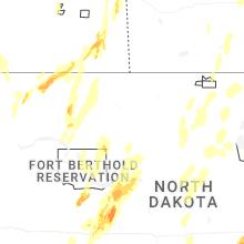
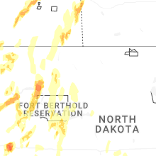
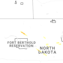
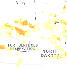
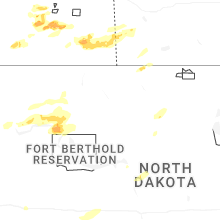


Connect with Interactive Hail Maps