

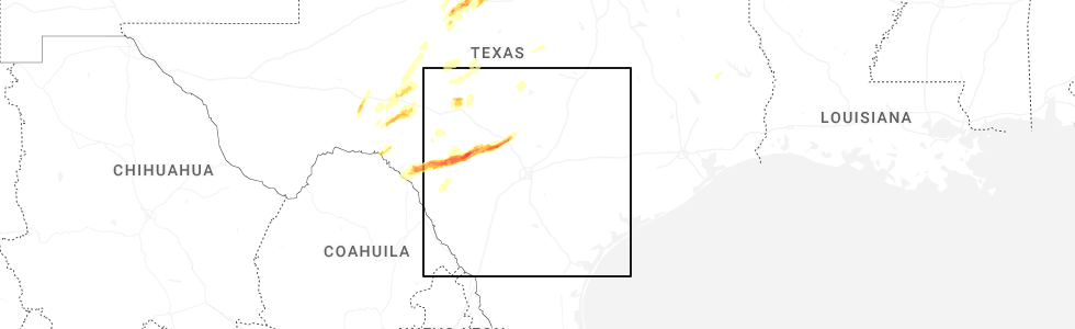
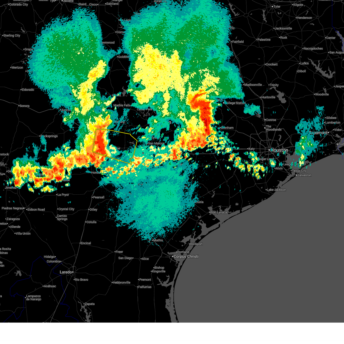
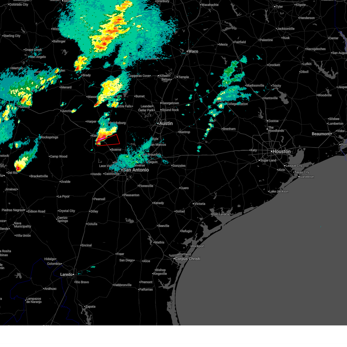
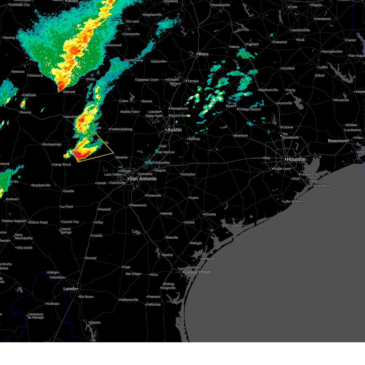
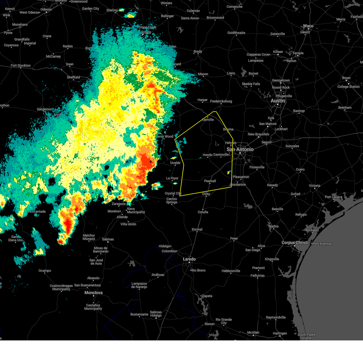
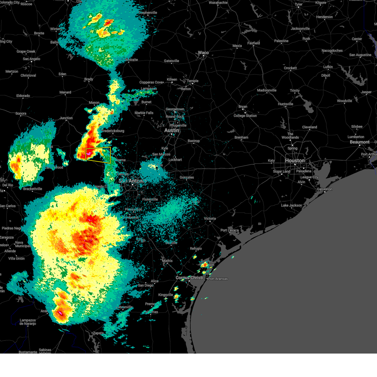
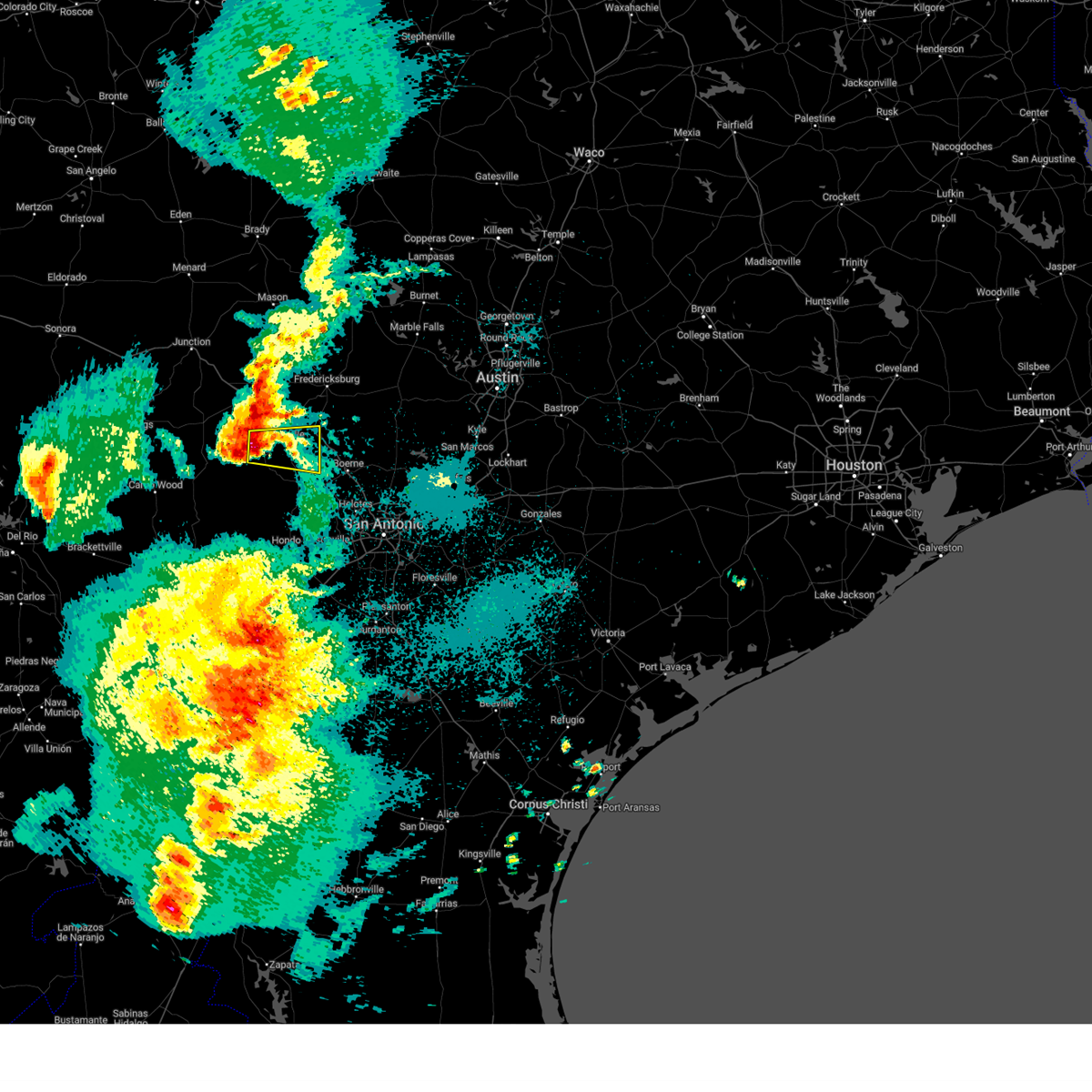
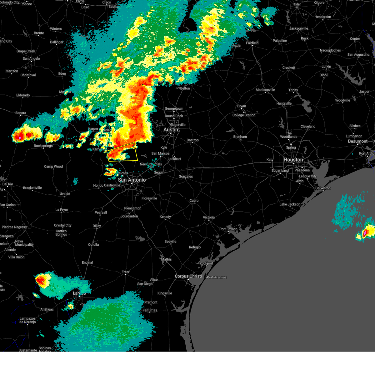
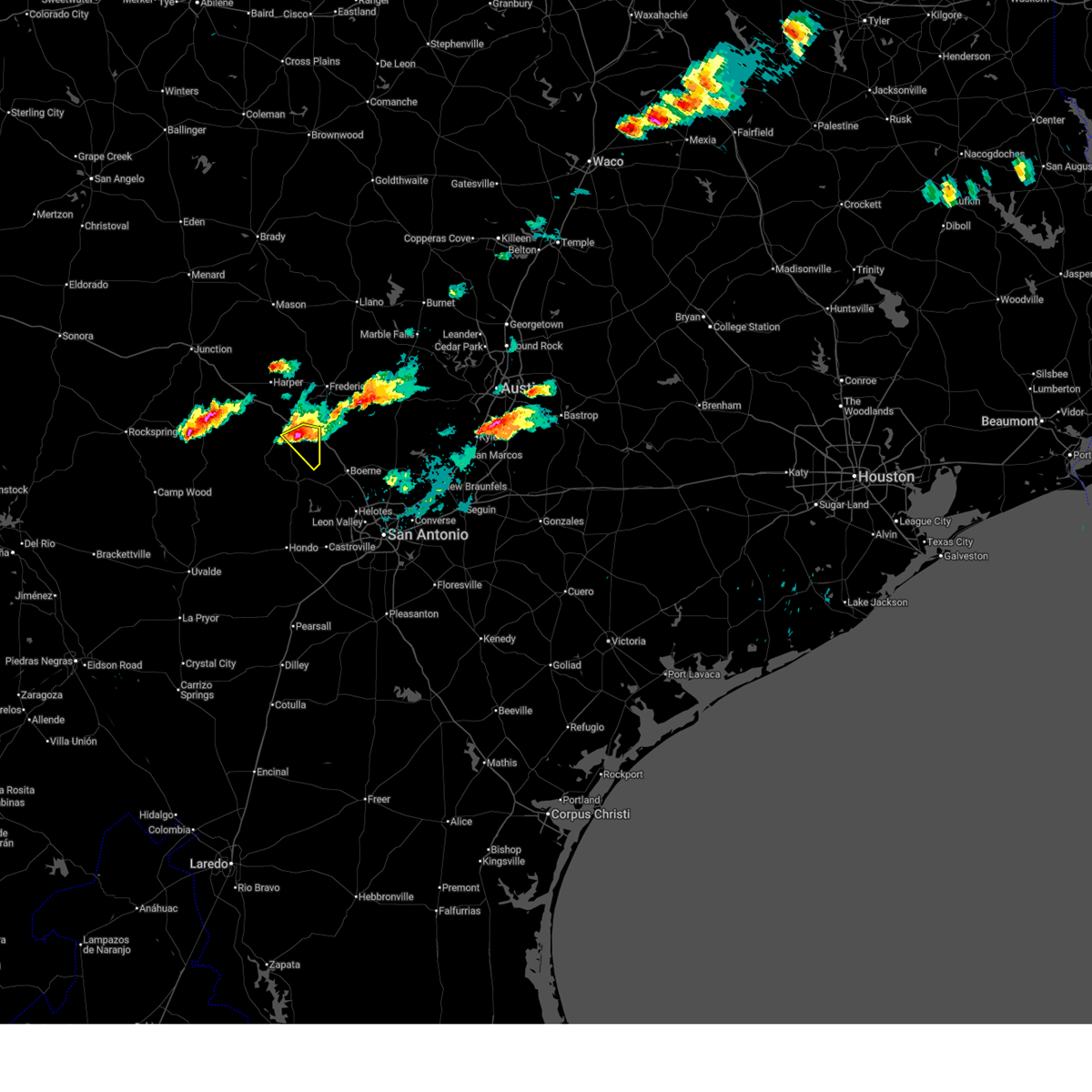
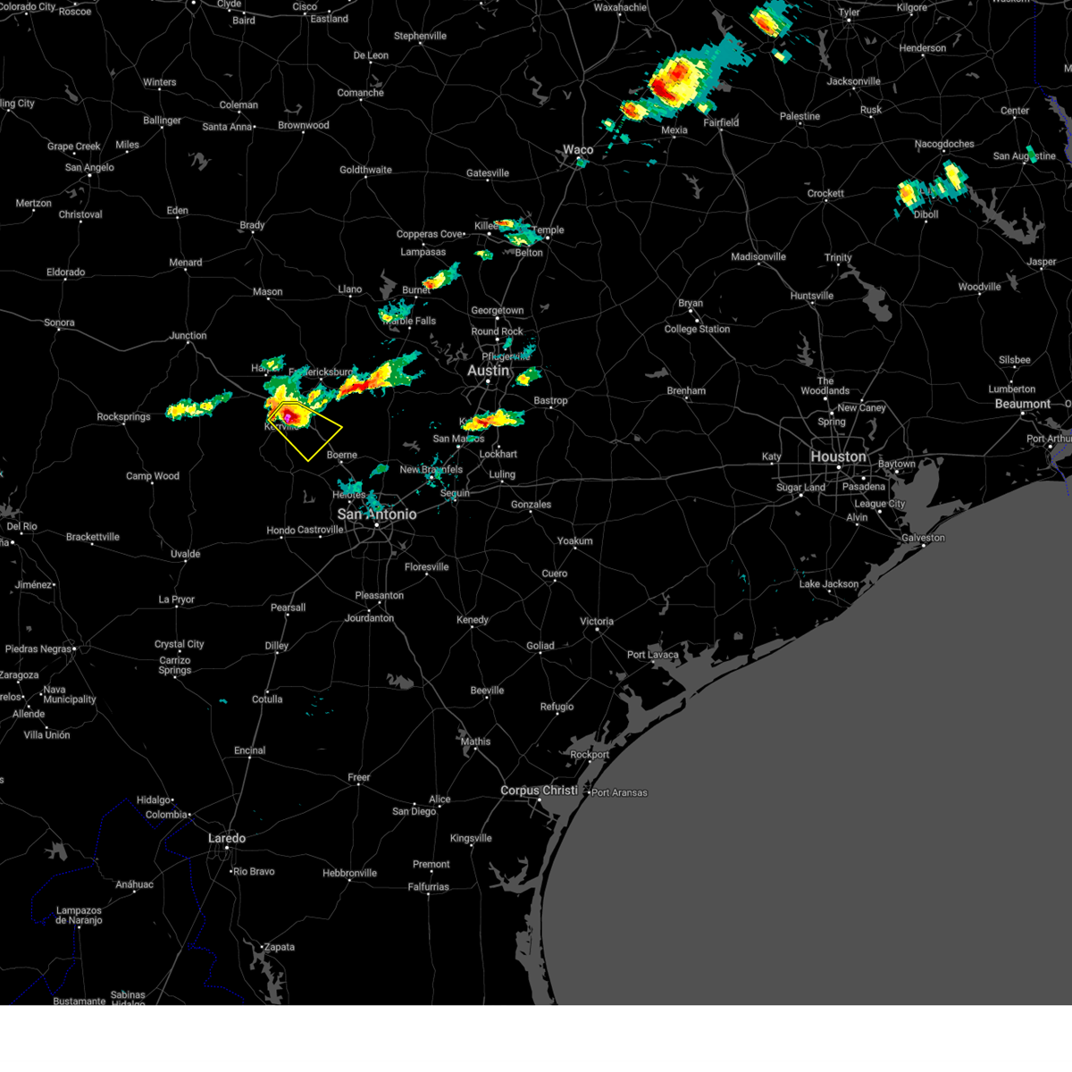
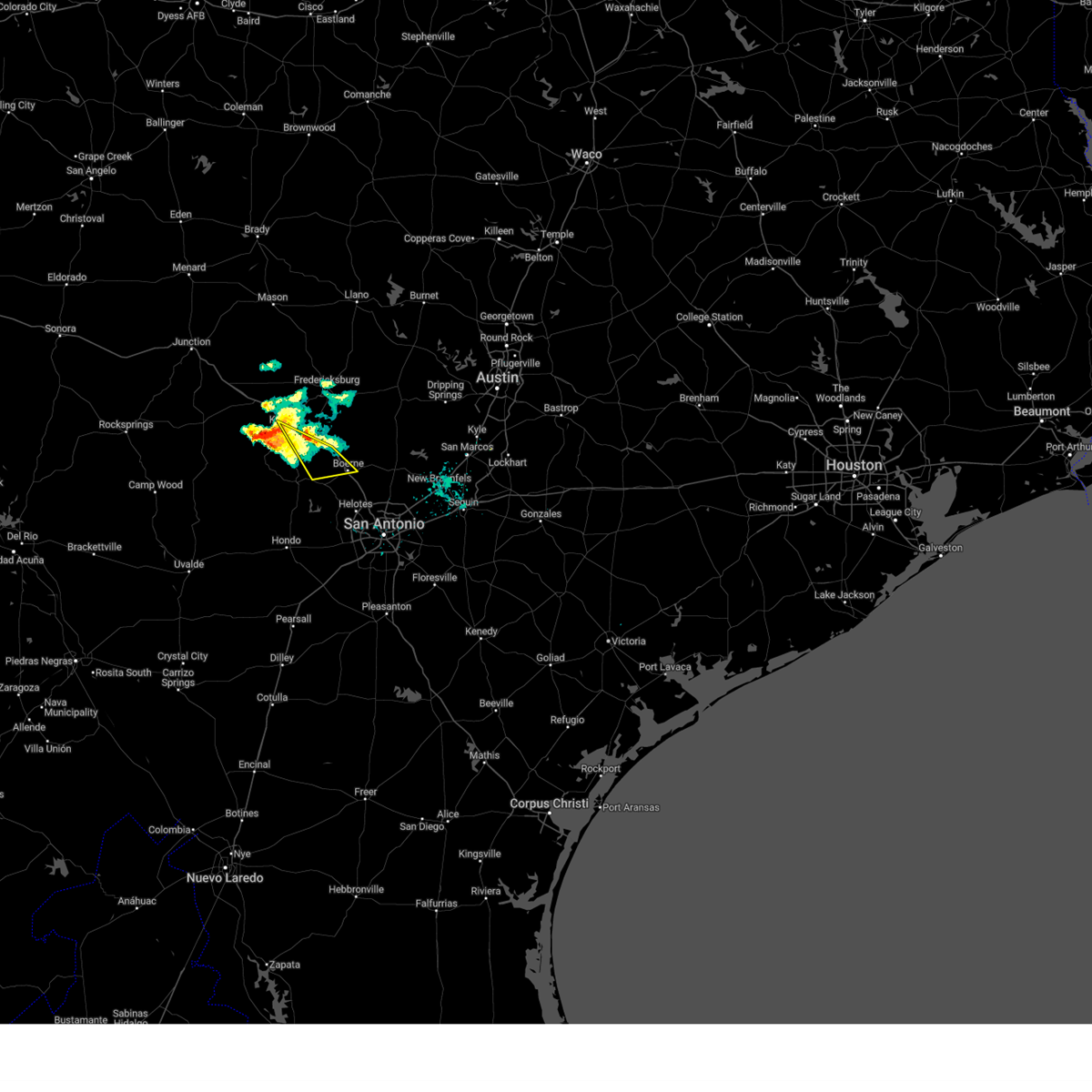
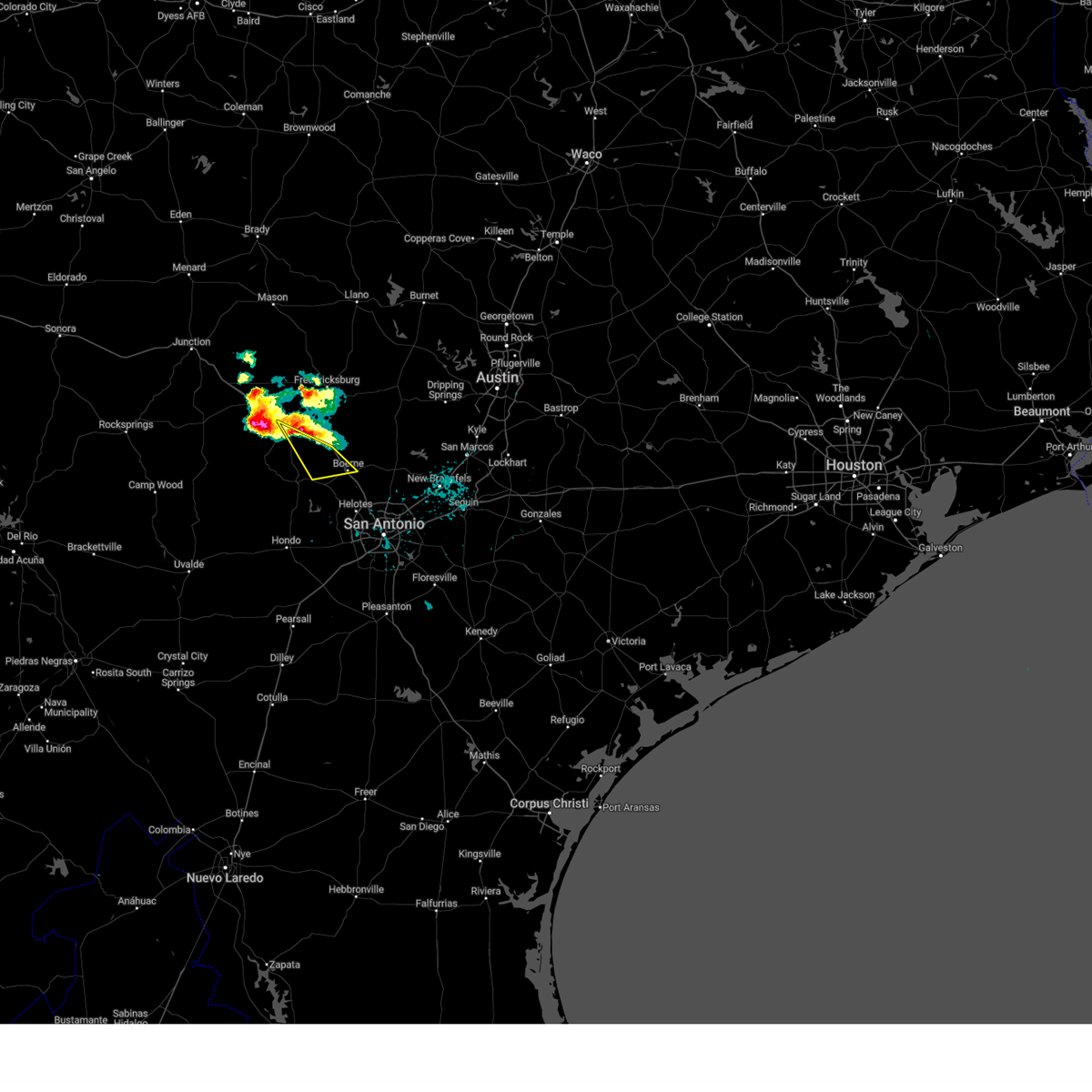
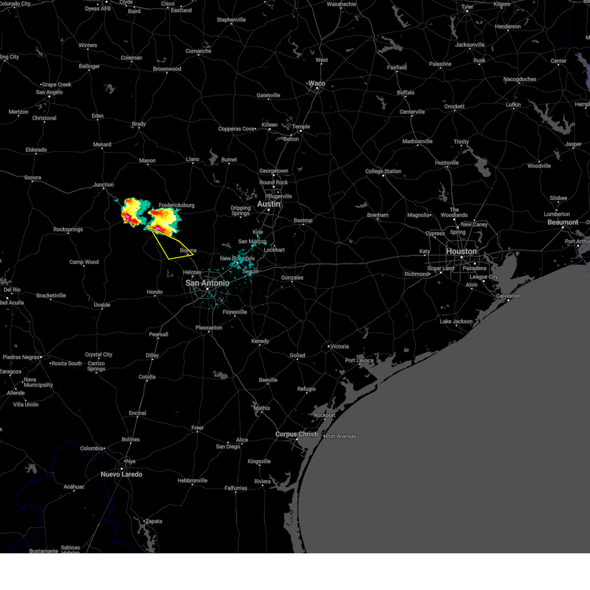
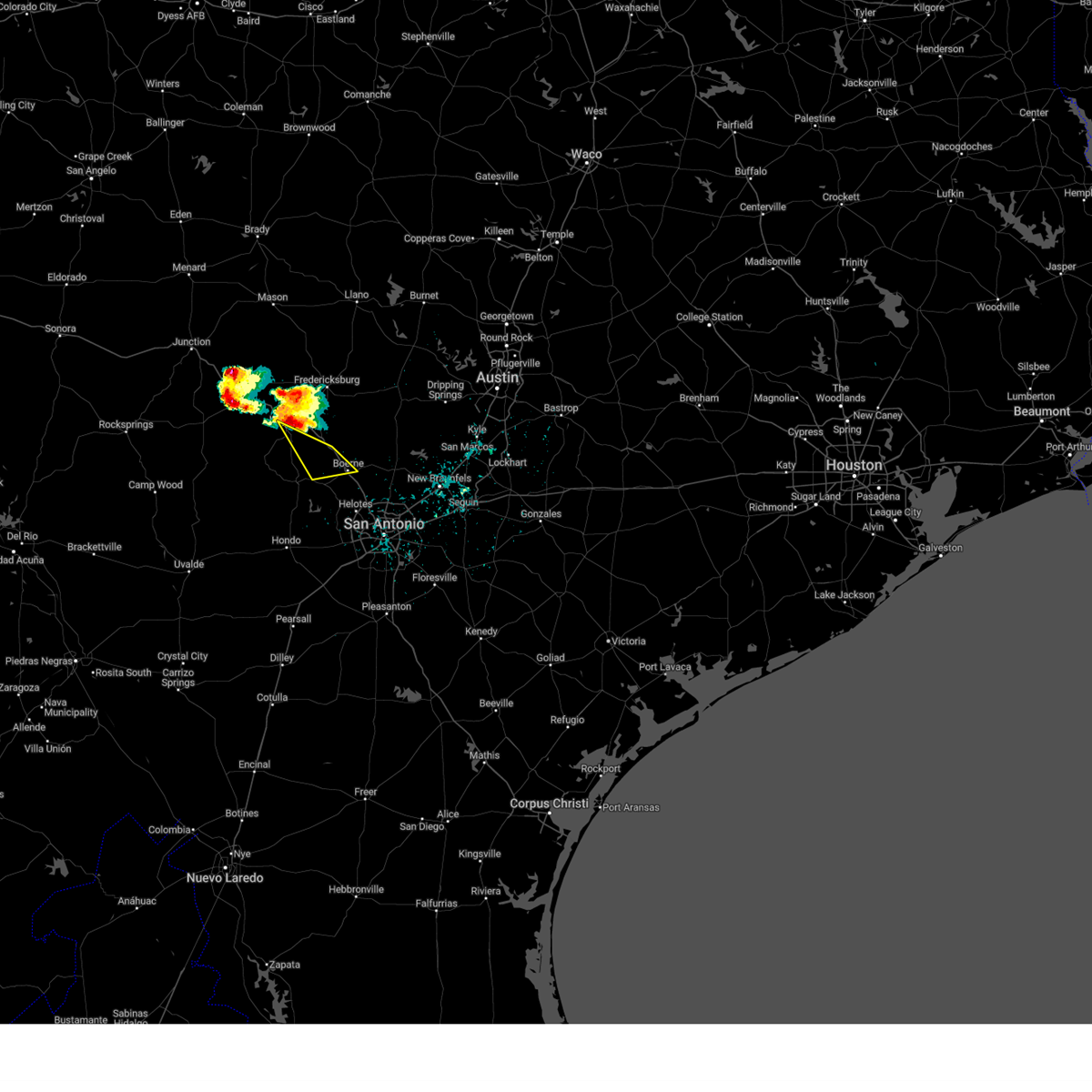
Hail Map for Comfort, TX
The Comfort, TX area has had 15 reports of on-the-ground hail by trained spotters, and has been under severe weather warnings 27 times during the past 12 months. Doppler radar has detected hail at or near Comfort, TX on 70 occasions, including 4 occasions during the past year.
| Name: | Comfort, TX |
| Where Located: | 44.8 miles NNW of San Antonio, TX |
| Map: | Google Map for Comfort, TX |
| Population: | 2363 |
| Housing Units: | 929 |
| More Info: | Search Google for Comfort, TX |
4
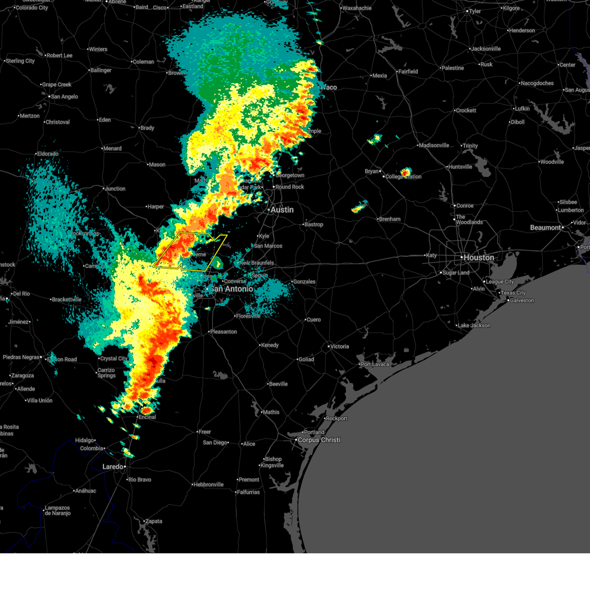
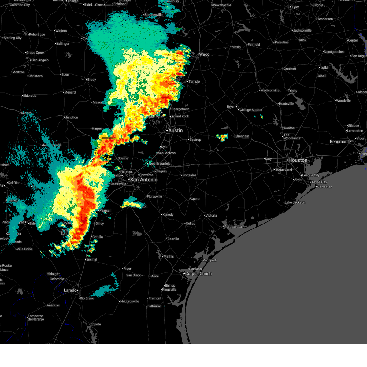
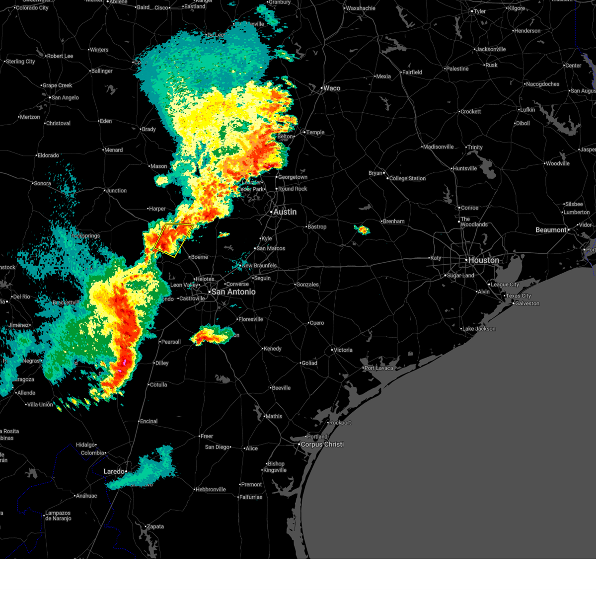
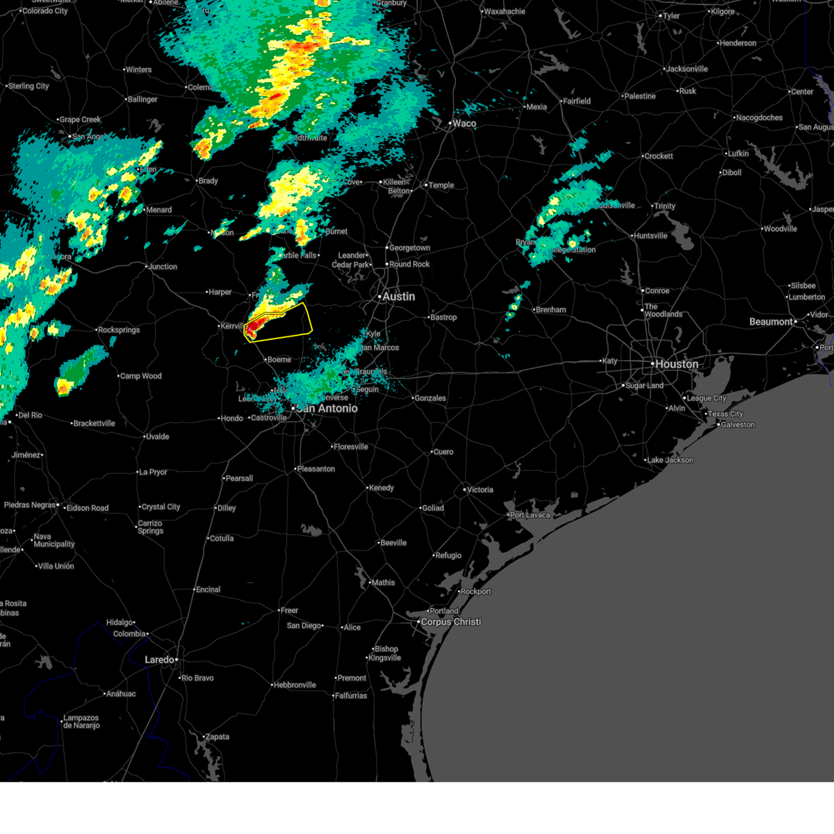
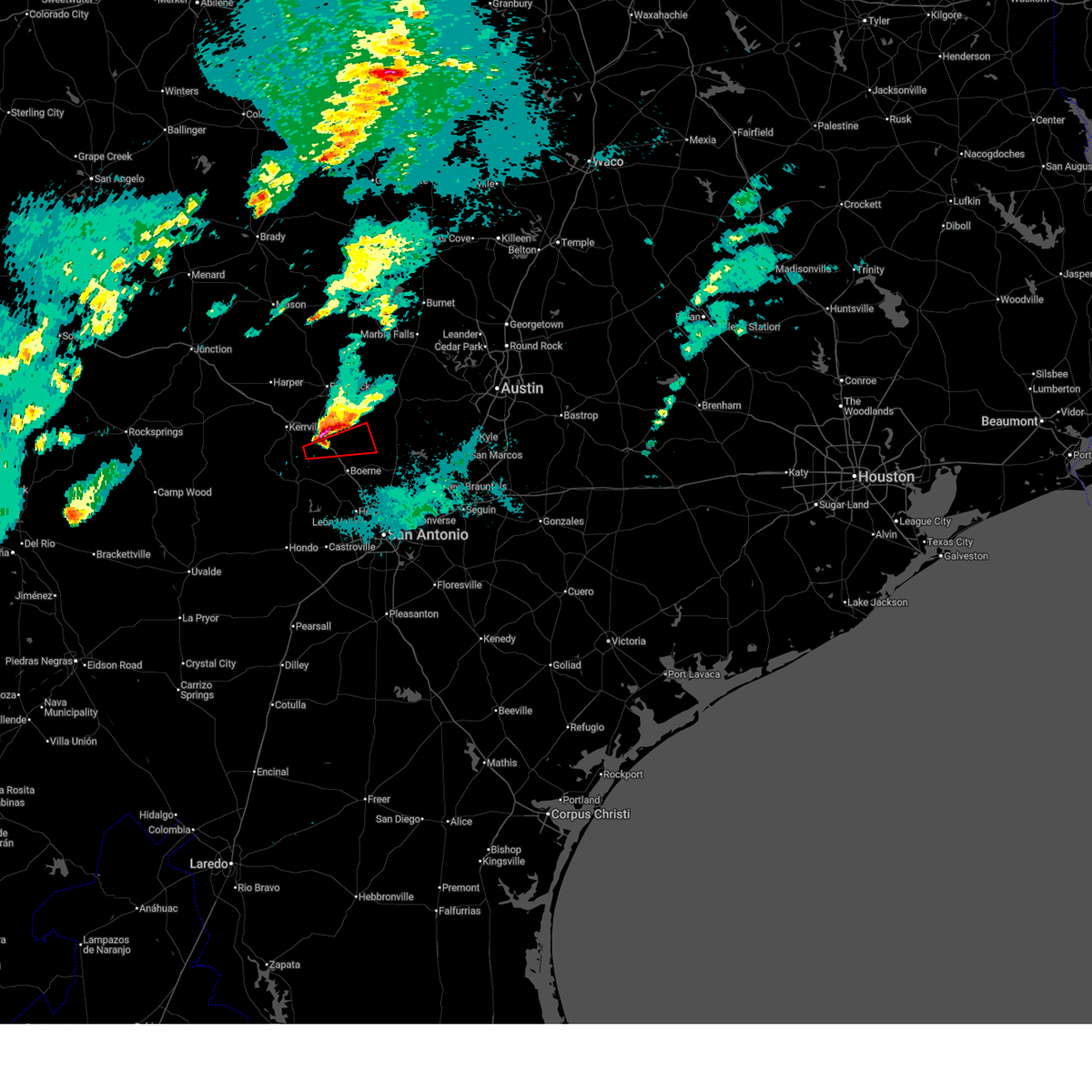
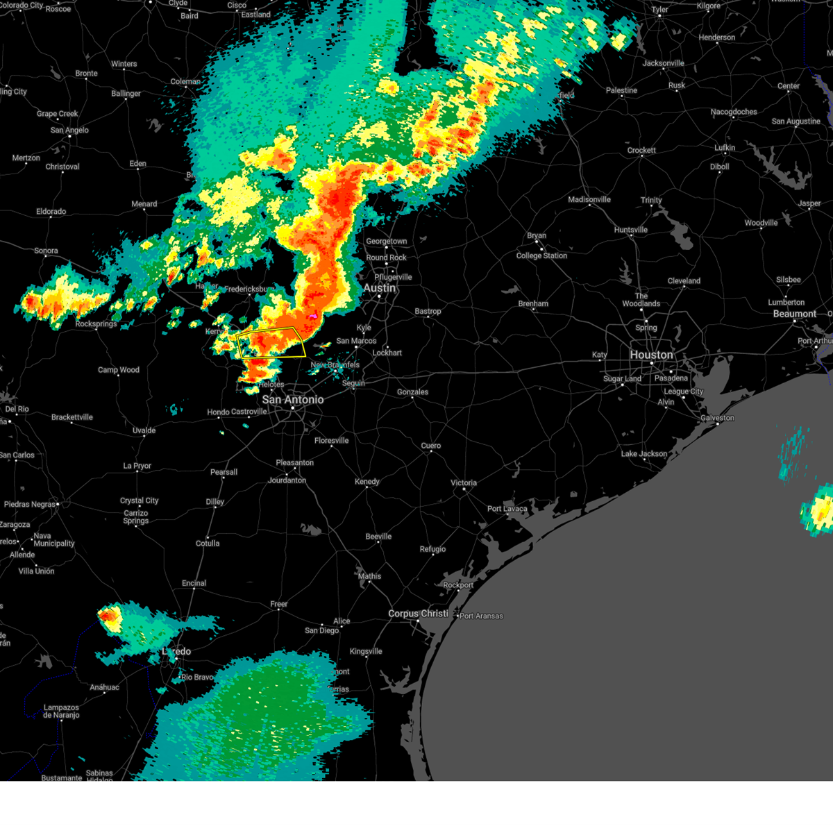
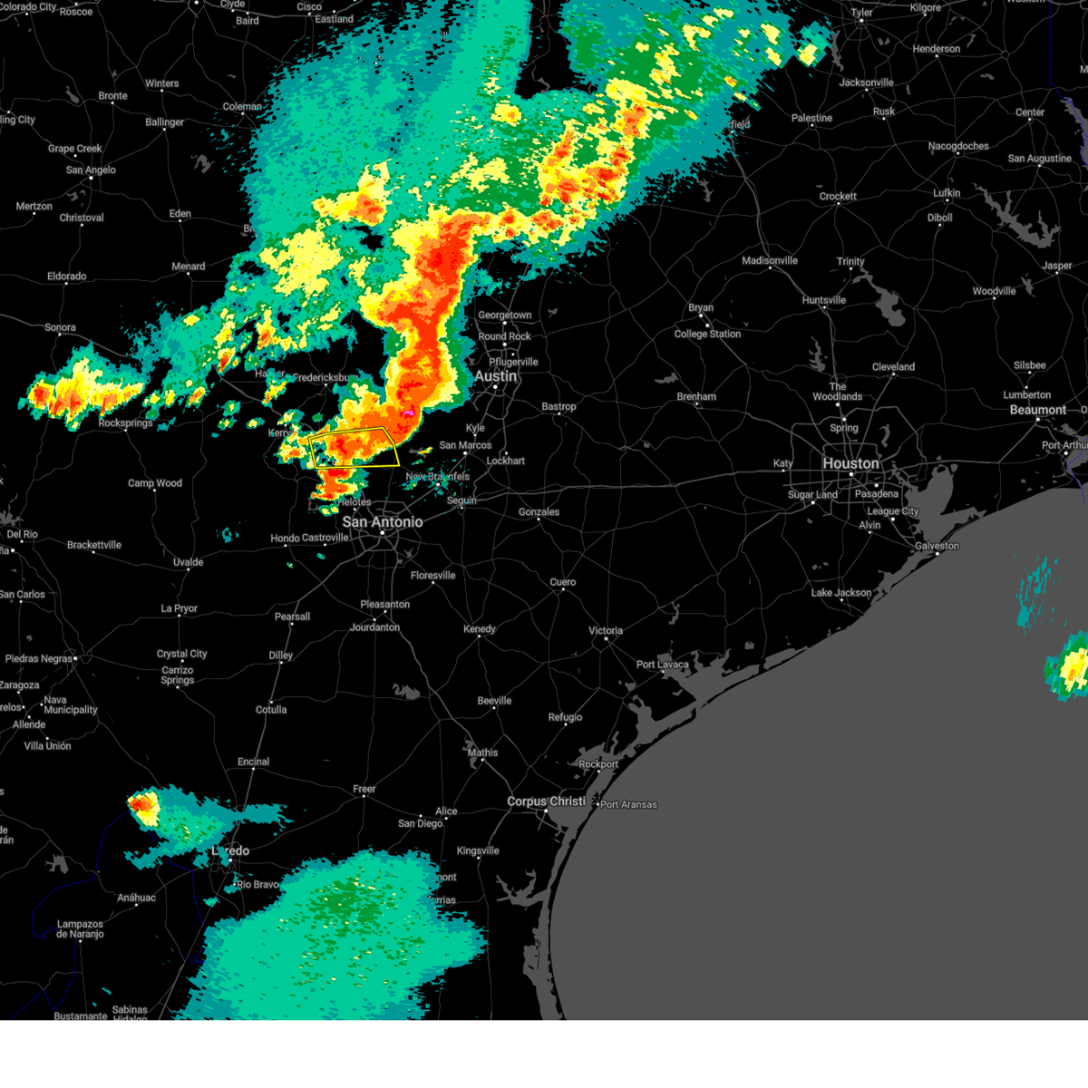
The Top Recent Hail Date for Comfort, TX is Tuesday, March 10, 2026 (3rd out of 70)
Hail and Wind Damage Spotted near Comfort, TX
| Date / Time | Report Details |
|---|---|
| 5/26/2026 8:47 PM CDT |
 Svrewx the national weather service in austin san antonio has issued a * severe thunderstorm warning for, east central bandera county in south central texas, southeastern kerr county in south central texas, kendall county in south central texas, northwestern bexar county in south central texas, northwestern comal county in south central texas, * until 945 pm cdt. * at 846 pm cdt, severe thunderstorms were located along a line extending from near kendalia to near bandera falls, moving east at 25 mph (radar indicated). Hazards include 60 mph wind gusts and quarter size hail. Hail damage to vehicles is expected. Expect wind damage to roofs, siding, and trees. Svrewx the national weather service in austin san antonio has issued a * severe thunderstorm warning for, east central bandera county in south central texas, southeastern kerr county in south central texas, kendall county in south central texas, northwestern bexar county in south central texas, northwestern comal county in south central texas, * until 945 pm cdt. * at 846 pm cdt, severe thunderstorms were located along a line extending from near kendalia to near bandera falls, moving east at 25 mph (radar indicated). Hazards include 60 mph wind gusts and quarter size hail. Hail damage to vehicles is expected. Expect wind damage to roofs, siding, and trees.
|
| 5/26/2026 8:19 PM CDT |
 the severe thunderstorm warning has been cancelled and is no longer in effect the severe thunderstorm warning has been cancelled and is no longer in effect
|
| 5/26/2026 8:03 PM CDT |
 Svrewx the national weather service in austin san antonio has issued a * severe thunderstorm warning for, southeastern kerr county in south central texas, northwestern kendall county in south central texas, * until 900 pm cdt. * at 803 pm cdt, a severe thunderstorm was located near center point, or 9 miles southwest of comfort, moving northeast at 10 mph (radar indicated). Hazards include 60 mph wind gusts and quarter size hail. Hail damage to vehicles is expected. Expect wind damage to roofs, siding, and trees. Svrewx the national weather service in austin san antonio has issued a * severe thunderstorm warning for, southeastern kerr county in south central texas, northwestern kendall county in south central texas, * until 900 pm cdt. * at 803 pm cdt, a severe thunderstorm was located near center point, or 9 miles southwest of comfort, moving northeast at 10 mph (radar indicated). Hazards include 60 mph wind gusts and quarter size hail. Hail damage to vehicles is expected. Expect wind damage to roofs, siding, and trees.
|
| 5/19/2026 11:22 PM CDT |
 Svrewx the national weather service in austin san antonio has issued a * severe thunderstorm warning for, northeastern bandera county in south central texas, southeastern kerr county in south central texas, southwestern blanco county in south central texas, kendall county in south central texas, northern bexar county in south central texas, comal county in south central texas, * until 1215 am cdt. * at 1122 pm cdt, severe thunderstorms were located along a line extending from near old tunnel state park to near kronkosky state natural area, moving east at 35 mph (radar indicated). Hazards include 60 mph wind gusts. expect damage to roofs, siding, and trees Svrewx the national weather service in austin san antonio has issued a * severe thunderstorm warning for, northeastern bandera county in south central texas, southeastern kerr county in south central texas, southwestern blanco county in south central texas, kendall county in south central texas, northern bexar county in south central texas, comal county in south central texas, * until 1215 am cdt. * at 1122 pm cdt, severe thunderstorms were located along a line extending from near old tunnel state park to near kronkosky state natural area, moving east at 35 mph (radar indicated). Hazards include 60 mph wind gusts. expect damage to roofs, siding, and trees
|
| 5/19/2026 11:16 PM CDT | Texas tech mesonet observed a 62 mph wind gusts 9 ssw of comfor in kerr county TX, 9.5 miles NNE of Comfort, TX |
| 5/19/2026 9:13 PM CDT |
 Svrewx the national weather service in austin san antonio has issued a * severe thunderstorm warning for, kendall county in south central texas, west central comal county in south central texas, * until 1015 pm cdt. * at 913 pm cdt, severe thunderstorms were located along a line extending from near twin sisters to near cypress creek, moving south at 15 mph (radar indicated). Hazards include 60 mph wind gusts and half dollar size hail. Hail damage to vehicles is expected. Expect wind damage to roofs, siding, and trees. Svrewx the national weather service in austin san antonio has issued a * severe thunderstorm warning for, kendall county in south central texas, west central comal county in south central texas, * until 1015 pm cdt. * at 913 pm cdt, severe thunderstorms were located along a line extending from near twin sisters to near cypress creek, moving south at 15 mph (radar indicated). Hazards include 60 mph wind gusts and half dollar size hail. Hail damage to vehicles is expected. Expect wind damage to roofs, siding, and trees.
|
| 3/10/2026 8:40 PM CDT |
 the severe thunderstorm warning has been cancelled and is no longer in effect the severe thunderstorm warning has been cancelled and is no longer in effect
|
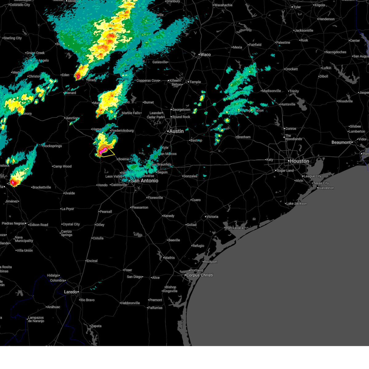
| 3/10/2026 8:40 PM CDT |
 At 840 pm cdt, a severe thunderstorm was located near waring, or near comfort, moving northeast at 40 mph (radar indicated). Hazards include tennis ball size hail and 60 mph wind gusts. People and animals outdoors will be injured. expect hail damage to roofs, siding, windows, and vehicles. expect wind damage to roofs, siding, and trees. Locations impacted include, comfort, blanco, sisterdale, flugrath, kendalia, twin sisters, waring, old tunnel state park, and crown. At 840 pm cdt, a severe thunderstorm was located near waring, or near comfort, moving northeast at 40 mph (radar indicated). Hazards include tennis ball size hail and 60 mph wind gusts. People and animals outdoors will be injured. expect hail damage to roofs, siding, windows, and vehicles. expect wind damage to roofs, siding, and trees. Locations impacted include, comfort, blanco, sisterdale, flugrath, kendalia, twin sisters, waring, old tunnel state park, and crown.
|
| 3/10/2026 8:38 PM CDT |
 the tornado warning has been cancelled and is no longer in effect the tornado warning has been cancelled and is no longer in effect
|
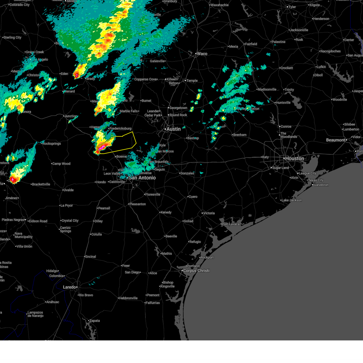
| 3/10/2026 8:30 PM CDT | Hen Egg sized hail reported 0.1 miles ENE of Comfort, TX, social media picture of lime size hail with a lime next to it for reference. time estimated via radar. |
| 3/10/2026 8:25 PM CDT | Ping Pong Ball sized hail reported 0.7 miles S of Comfort, TX |
| 3/10/2026 8:25 PM CDT |
 Torewx the national weather service in austin san antonio has issued a * tornado warning for, southeastern kerr county in south central texas, central kendall county in south central texas, * until 915 pm cdt. * at 825 pm cdt, a severe thunderstorm capable of producing a tornado was located near center point, or near comfort, moving east at 30 mph (radar indicated rotation). Hazards include tornado and tennis ball size hail. Flying debris will be dangerous to those caught without shelter. mobile homes will be damaged or destroyed. damage to roofs, windows, and vehicles will occur. tree damage is likely. this dangerous storm will be near, comfort around 830 pm cdt. welfare and waring around 840 pm cdt. sisterdale around 850 pm cdt. Other locations impacted by this tornadic thunderstorm include crown. Torewx the national weather service in austin san antonio has issued a * tornado warning for, southeastern kerr county in south central texas, central kendall county in south central texas, * until 915 pm cdt. * at 825 pm cdt, a severe thunderstorm capable of producing a tornado was located near center point, or near comfort, moving east at 30 mph (radar indicated rotation). Hazards include tornado and tennis ball size hail. Flying debris will be dangerous to those caught without shelter. mobile homes will be damaged or destroyed. damage to roofs, windows, and vehicles will occur. tree damage is likely. this dangerous storm will be near, comfort around 830 pm cdt. welfare and waring around 840 pm cdt. sisterdale around 850 pm cdt. Other locations impacted by this tornadic thunderstorm include crown.
|
| 3/10/2026 8:19 PM CDT |
 At 819 pm cdt, a severe thunderstorm was located near center point, or near comfort, moving northeast at 35 mph (radar indicated). Hazards include tennis ball size hail and 60 mph wind gusts. People and animals outdoors will be injured. expect hail damage to roofs, siding, windows, and vehicles. expect wind damage to roofs, siding, and trees. Locations impacted include, comfort, center point, and cypress creek. At 819 pm cdt, a severe thunderstorm was located near center point, or near comfort, moving northeast at 35 mph (radar indicated). Hazards include tennis ball size hail and 60 mph wind gusts. People and animals outdoors will be injured. expect hail damage to roofs, siding, windows, and vehicles. expect wind damage to roofs, siding, and trees. Locations impacted include, comfort, center point, and cypress creek.
|
| 3/10/2026 8:18 PM CDT |
 Svrewx the national weather service in austin san antonio has issued a * severe thunderstorm warning for, southeastern kerr county in south central texas, southwestern blanco county in south central texas, kendall county in south central texas, * until 915 pm cdt. * at 818 pm cdt, a severe thunderstorm was located near center point, or near comfort, moving east at 35 mph (radar indicated). Hazards include tennis ball size hail and 60 mph wind gusts. People and animals outdoors will be injured. expect hail damage to roofs, siding, windows, and vehicles. Expect wind damage to roofs, siding, and trees. Svrewx the national weather service in austin san antonio has issued a * severe thunderstorm warning for, southeastern kerr county in south central texas, southwestern blanco county in south central texas, kendall county in south central texas, * until 915 pm cdt. * at 818 pm cdt, a severe thunderstorm was located near center point, or near comfort, moving east at 35 mph (radar indicated). Hazards include tennis ball size hail and 60 mph wind gusts. People and animals outdoors will be injured. expect hail damage to roofs, siding, windows, and vehicles. Expect wind damage to roofs, siding, and trees.
|
| 3/10/2026 8:15 PM CDT |
 At 815 pm cdt, a severe thunderstorm was located near center point, or 8 miles southwest of comfort, moving northeast at 40 mph. this is a destructive storm from camp verde to comfort (radar indicated). Hazards include baseball size hail and 60 mph wind gusts. People and animals outdoors will be severely injured. expect shattered windows, extensive damage to roofs, siding, and vehicles. Locations impacted include, kerrville, comfort, center point, cypress creek, and camp verde. At 815 pm cdt, a severe thunderstorm was located near center point, or 8 miles southwest of comfort, moving northeast at 40 mph. this is a destructive storm from camp verde to comfort (radar indicated). Hazards include baseball size hail and 60 mph wind gusts. People and animals outdoors will be severely injured. expect shattered windows, extensive damage to roofs, siding, and vehicles. Locations impacted include, kerrville, comfort, center point, cypress creek, and camp verde.
|
| 3/10/2026 8:15 PM CDT |
 the severe thunderstorm warning has been cancelled and is no longer in effect the severe thunderstorm warning has been cancelled and is no longer in effect
|
| 3/10/2026 8:02 PM CDT |
 At 802 pm cdt, a severe thunderstorm was located near camp verde, or near medina, moving northeast at 35 mph. this is a destructive storm for camp verde and center point (radar indicated). Hazards include baseball size hail and 60 mph wind gusts. People and animals outdoors will be severely injured. expect shattered windows, extensive damage to roofs, siding, and vehicles. Locations impacted include, kerrville, comfort, center point, cypress creek, and camp verde. At 802 pm cdt, a severe thunderstorm was located near camp verde, or near medina, moving northeast at 35 mph. this is a destructive storm for camp verde and center point (radar indicated). Hazards include baseball size hail and 60 mph wind gusts. People and animals outdoors will be severely injured. expect shattered windows, extensive damage to roofs, siding, and vehicles. Locations impacted include, kerrville, comfort, center point, cypress creek, and camp verde.
|
| 3/10/2026 7:58 PM CDT |
 At 758 pm cdt, a severe thunderstorm was located near medina, moving northeast at 50 mph. this is a destructive storm for medina (radar indicated). Hazards include baseball size hail and 60 mph wind gusts. People and animals outdoors will be severely injured. expect shattered windows, extensive damage to roofs, siding, and vehicles. Locations impacted include, medina, kerrville, comfort, center point, cypress creek, and camp verde. At 758 pm cdt, a severe thunderstorm was located near medina, moving northeast at 50 mph. this is a destructive storm for medina (radar indicated). Hazards include baseball size hail and 60 mph wind gusts. People and animals outdoors will be severely injured. expect shattered windows, extensive damage to roofs, siding, and vehicles. Locations impacted include, medina, kerrville, comfort, center point, cypress creek, and camp verde.
|
| 3/10/2026 7:55 PM CDT |
 At 755 pm cdt, a severe thunderstorm was located near medina, moving east at 35 mph (radar indicated). Hazards include tennis ball size hail and 60 mph wind gusts. People and animals outdoors will be injured. expect hail damage to roofs, siding, windows, and vehicles. expect wind damage to roofs, siding, and trees. Locations impacted include, medina, kerrville, comfort, cypress creek, camp verde, center point, and kerrville-schreiner park. At 755 pm cdt, a severe thunderstorm was located near medina, moving east at 35 mph (radar indicated). Hazards include tennis ball size hail and 60 mph wind gusts. People and animals outdoors will be injured. expect hail damage to roofs, siding, windows, and vehicles. expect wind damage to roofs, siding, and trees. Locations impacted include, medina, kerrville, comfort, cypress creek, camp verde, center point, and kerrville-schreiner park.
|
| 3/10/2026 7:50 PM CDT |
 the severe thunderstorm warning has been cancelled and is no longer in effect the severe thunderstorm warning has been cancelled and is no longer in effect
|
| 3/10/2026 7:50 PM CDT |
 At 750 pm cdt, a severe thunderstorm was located near medina, moving east at 40 mph (radar indicated). Hazards include two inch hail and 60 mph wind gusts. People and animals outdoors will be injured. expect hail damage to roofs, siding, windows, and vehicles. expect wind damage to roofs, siding, and trees. Locations impacted include, medina, kerrville, comfort, cypress creek, camp verde, center point, and kerrville-schreiner park. At 750 pm cdt, a severe thunderstorm was located near medina, moving east at 40 mph (radar indicated). Hazards include two inch hail and 60 mph wind gusts. People and animals outdoors will be injured. expect hail damage to roofs, siding, windows, and vehicles. expect wind damage to roofs, siding, and trees. Locations impacted include, medina, kerrville, comfort, cypress creek, camp verde, center point, and kerrville-schreiner park.
|
| 3/10/2026 7:36 PM CDT |
 Svrewx the national weather service in austin san antonio has issued a * severe thunderstorm warning for, northwestern bandera county in south central texas, southeastern kerr county in south central texas, southwestern gillespie county in south central texas, west central kendall county in south central texas, * until 830 pm cdt. * at 736 pm cdt, a severe thunderstorm was located near lost maples state natural area, or 8 miles northeast of vanderpool, moving northeast at 35 mph (radar indicated). Hazards include two inch hail and 60 mph wind gusts. People and animals outdoors will be injured. expect hail damage to roofs, siding, windows, and vehicles. Expect wind damage to roofs, siding, and trees. Svrewx the national weather service in austin san antonio has issued a * severe thunderstorm warning for, northwestern bandera county in south central texas, southeastern kerr county in south central texas, southwestern gillespie county in south central texas, west central kendall county in south central texas, * until 830 pm cdt. * at 736 pm cdt, a severe thunderstorm was located near lost maples state natural area, or 8 miles northeast of vanderpool, moving northeast at 35 mph (radar indicated). Hazards include two inch hail and 60 mph wind gusts. People and animals outdoors will be injured. expect hail damage to roofs, siding, windows, and vehicles. Expect wind damage to roofs, siding, and trees.
|
| 10/25/2025 10:38 AM CDT | the severe thunderstorm warning has been cancelled and is no longer in effect |
| 10/25/2025 10:20 AM CDT | Svrewx the national weather service in austin san antonio has issued a * severe thunderstorm warning for, eastern bandera county in south central texas, southeastern kerr county in south central texas, western kendall county in south central texas, * until 1100 am cdt. * at 1020 am cdt, a severe thunderstorm was located near bandera, moving northeast at 40 mph (radar indicated). Hazards include half dollar size hail. damage to vehicles is expected |
| 10/24/2025 11:24 PM CDT | Svrewx the national weather service in austin san antonio has issued a * severe thunderstorm warning for, northern medina county in south central texas, southeastern bandera county in south central texas, hays county in south central texas, northwestern guadalupe county in south central texas, southwestern blanco county in south central texas, southeastern gillespie county in south central texas, kendall county in south central texas, northern bexar county in south central texas, comal county in south central texas, * until 1215 am cdt. * at 1123 pm cdt, severe thunderstorms were located along a line extending from 6 miles southeast of luckenbach to near kronkosky state natural area to near hill country state natural area, moving east at 60 mph (radar indicated). Hazards include 70 mph wind gusts and penny size hail. Expect considerable tree damage. Damage is likely to mobile homes, roofs, and outbuildings. |
| 10/24/2025 11:17 PM CDT | At 1116 pm cdt, a severe thunderstorm was located near cypress creek, or 7 miles east of kerrville, moving east at 35 mph (radar indicated). Hazards include 60 mph wind gusts and nickel size hail. Expect damage to roofs, siding, and trees. Locations impacted include, kerrville, comfort, center point, and cypress creek. |
| 10/24/2025 11:03 PM CDT | At 1103 pm cdt, a severe thunderstorm was located over kerrville, moving east at 35 mph (radar indicated). Hazards include 60 mph wind gusts and nickel size hail. Expect damage to roofs, siding, and trees. Locations impacted include, kerrville, comfort, ingram, cypress creek, center point, kerrville-schreiner park, and waltonia. |
| 10/24/2025 11:03 PM CDT | the severe thunderstorm warning has been cancelled and is no longer in effect |
| 10/24/2025 10:47 PM CDT | At 1046 pm cdt, a severe thunderstorm was located over hunt, or 11 miles west of kerrville, moving east at 35 mph (radar indicated). Hazards include 60 mph wind gusts and quarter size hail. Hail damage to vehicles is expected. expect wind damage to roofs, siding, and trees. Locations impacted include, kerrville, fredericksburg, comfort, ingram, hunt, cypress creek, center point, kerrville-schreiner park, and waltonia. |
| 10/24/2025 10:31 PM CDT | Svrewx the national weather service in austin san antonio has issued a * severe thunderstorm warning for, central kerr county in south central texas, southwestern gillespie county in south central texas, northwestern kendall county in south central texas, * until 1130 pm cdt. * at 1031 pm cdt, a severe thunderstorm was located near kerr wildlife management area, or 20 miles west of kerrville, moving east at 35 mph (radar indicated). Hazards include 60 mph wind gusts and quarter size hail. Hail damage to vehicles is expected. Expect wind damage to roofs, siding, and trees. |
| 6/11/2025 12:53 AM CDT |
 The storms which prompted the warning have weakened below severe limits, and no longer pose an immediate threat to life or property. therefore, the warning will be allowed to expire. a severe thunderstorm watch remains in effect until 200 am cdt for south central texas. The storms which prompted the warning have weakened below severe limits, and no longer pose an immediate threat to life or property. therefore, the warning will be allowed to expire. a severe thunderstorm watch remains in effect until 200 am cdt for south central texas.
|
| 6/11/2025 12:19 AM CDT |
 At 1218 am cdt, severe thunderstorms were located along a line extending from near lakehills to near sea world to near somerset, moving east at 60 mph (radar indicated). Hazards include 60 mph wind gusts and quarter size hail. Hail damage to vehicles is expected. expect wind damage to roofs, siding, and trees. Locations impacted include, san antonio, new braunfels, san marcos, medina, schertz, seguin, cibolo, kerrville, converse, universal city, live oak, boerne, pleasanton, selma, pearsall, hondo, floresville, devine, jourdanton, and poteet. At 1218 am cdt, severe thunderstorms were located along a line extending from near lakehills to near sea world to near somerset, moving east at 60 mph (radar indicated). Hazards include 60 mph wind gusts and quarter size hail. Hail damage to vehicles is expected. expect wind damage to roofs, siding, and trees. Locations impacted include, san antonio, new braunfels, san marcos, medina, schertz, seguin, cibolo, kerrville, converse, universal city, live oak, boerne, pleasanton, selma, pearsall, hondo, floresville, devine, jourdanton, and poteet.
|
| 6/11/2025 12:13 AM CDT |
 The storms which prompted the warning have moved out of the area. therefore, the warning will be allowed to expire. however small hail, gusty winds and heavy rain are still possible with these thunderstorms. a severe thunderstorm watch remains in effect until 200 am cdt for south central texas. remember, a severe thunderstorm warning still remains in effect for portions of medina, bandera, frio, bexar, kendall, kerr, and atascosa. The storms which prompted the warning have moved out of the area. therefore, the warning will be allowed to expire. however small hail, gusty winds and heavy rain are still possible with these thunderstorms. a severe thunderstorm watch remains in effect until 200 am cdt for south central texas. remember, a severe thunderstorm warning still remains in effect for portions of medina, bandera, frio, bexar, kendall, kerr, and atascosa.
|
| 6/11/2025 12:10 AM CDT |
 Svrewx the national weather service in austin san antonio has issued a * severe thunderstorm warning for, medina county in south central texas, bandera county in south central texas, southeastern kerr county in south central texas, southwestern hays county in south central texas, guadalupe county in south central texas, southwestern blanco county in south central texas, northeastern frio county in south central texas, northwestern atascosa county in south central texas, kendall county in south central texas, northwestern wilson county in south central texas, bexar county in south central texas, comal county in south central texas, * until 100 am cdt. * at 1207 am cdt, severe thunderstorms were located along a line extending from near mico to near rio medina to near lytle, moving northeast at 55 mph (radar indicated). Hazards include 60 mph wind gusts and quarter size hail. Hail damage to vehicles is expected. Expect wind damage to roofs, siding, and trees. Svrewx the national weather service in austin san antonio has issued a * severe thunderstorm warning for, medina county in south central texas, bandera county in south central texas, southeastern kerr county in south central texas, southwestern hays county in south central texas, guadalupe county in south central texas, southwestern blanco county in south central texas, northeastern frio county in south central texas, northwestern atascosa county in south central texas, kendall county in south central texas, northwestern wilson county in south central texas, bexar county in south central texas, comal county in south central texas, * until 100 am cdt. * at 1207 am cdt, severe thunderstorms were located along a line extending from near mico to near rio medina to near lytle, moving northeast at 55 mph (radar indicated). Hazards include 60 mph wind gusts and quarter size hail. Hail damage to vehicles is expected. Expect wind damage to roofs, siding, and trees.
|
| 6/10/2025 11:31 PM CDT |
 Svrewx the national weather service in austin san antonio has issued a * severe thunderstorm warning for, medina county in south central texas, bandera county in south central texas, southeastern kerr county in south central texas, eastern uvalde county in south central texas, eastern zavala county in south central texas, frio county in south central texas, northwestern atascosa county in south central texas, southwestern kendall county in south central texas, western bexar county in south central texas, southeastern real county in south central texas, * until 1215 am cdt. * at 1130 pm cdt, severe thunderstorms were located along a line extending from 8 miles east of vanderpool to near hondo to bluff, moving northeast at 35 mph (radar indicated). Hazards include 60 mph wind gusts and quarter size hail. Hail damage to vehicles is expected. Expect wind damage to roofs, siding, and trees. Svrewx the national weather service in austin san antonio has issued a * severe thunderstorm warning for, medina county in south central texas, bandera county in south central texas, southeastern kerr county in south central texas, eastern uvalde county in south central texas, eastern zavala county in south central texas, frio county in south central texas, northwestern atascosa county in south central texas, southwestern kendall county in south central texas, western bexar county in south central texas, southeastern real county in south central texas, * until 1215 am cdt. * at 1130 pm cdt, severe thunderstorms were located along a line extending from 8 miles east of vanderpool to near hondo to bluff, moving northeast at 35 mph (radar indicated). Hazards include 60 mph wind gusts and quarter size hail. Hail damage to vehicles is expected. Expect wind damage to roofs, siding, and trees.
|
| 5/28/2025 3:53 AM CDT |
 At 353 am cdt, severe thunderstorms were located along a line extending from waring to near boerne to mico, moving east at 25 mph (radar indicated). Hazards include 60 mph wind gusts and penny size hail. Expect damage to roofs, siding, and trees. Locations impacted include, boerne, comfort, walnut grove, lakehills, cliff, bandera falls, mico, sisterdale, kreutzberg, government canyon state natural area, pipe creek, welfare, nelson city, kronkosky state natural area, waring, rio medina, san geronimo, cascade caverns, crown, and lake medina shores. At 353 am cdt, severe thunderstorms were located along a line extending from waring to near boerne to mico, moving east at 25 mph (radar indicated). Hazards include 60 mph wind gusts and penny size hail. Expect damage to roofs, siding, and trees. Locations impacted include, boerne, comfort, walnut grove, lakehills, cliff, bandera falls, mico, sisterdale, kreutzberg, government canyon state natural area, pipe creek, welfare, nelson city, kronkosky state natural area, waring, rio medina, san geronimo, cascade caverns, crown, and lake medina shores.
|
| 5/28/2025 3:25 AM CDT |
 Svrewx the national weather service in austin san antonio has issued a * severe thunderstorm warning for, northern medina county in south central texas, eastern bandera county in south central texas, southeastern kerr county in south central texas, kendall county in south central texas, northwestern bexar county in south central texas, * until 430 am cdt. * at 325 am cdt, severe thunderstorms were located along a line extending from near kerrville to 6 miles southeast of center point to 8 miles south of hill country state natural area, moving east at 20 mph (radar indicated). Hazards include 60 mph wind gusts and half dollar size hail. Hail damage to vehicles is expected. Expect wind damage to roofs, siding, and trees. Svrewx the national weather service in austin san antonio has issued a * severe thunderstorm warning for, northern medina county in south central texas, eastern bandera county in south central texas, southeastern kerr county in south central texas, kendall county in south central texas, northwestern bexar county in south central texas, * until 430 am cdt. * at 325 am cdt, severe thunderstorms were located along a line extending from near kerrville to 6 miles southeast of center point to 8 miles south of hill country state natural area, moving east at 20 mph (radar indicated). Hazards include 60 mph wind gusts and half dollar size hail. Hail damage to vehicles is expected. Expect wind damage to roofs, siding, and trees.
|
| 5/28/2025 2:57 AM CDT |
 At 257 am cdt, a severe thunderstorm was located near kerrville-schreiner park, or 8 miles southwest of kerrville, moving east at 25 mph (radar indicated). Hazards include golf ball size hail and 60 mph wind gusts. People and animals outdoors will be injured. expect hail damage to roofs, siding, windows, and vehicles. expect wind damage to roofs, siding, and trees. this severe storm will be near, kerrville and kerrville-schreiner park around 300 am cdt. camp verde around 305 am cdt. center point around 310 am cdt. Comfort around 330 am cdt. At 257 am cdt, a severe thunderstorm was located near kerrville-schreiner park, or 8 miles southwest of kerrville, moving east at 25 mph (radar indicated). Hazards include golf ball size hail and 60 mph wind gusts. People and animals outdoors will be injured. expect hail damage to roofs, siding, windows, and vehicles. expect wind damage to roofs, siding, and trees. this severe storm will be near, kerrville and kerrville-schreiner park around 300 am cdt. camp verde around 305 am cdt. center point around 310 am cdt. Comfort around 330 am cdt.
|
| 5/28/2025 2:48 AM CDT |
 At 247 am cdt, a severe thunderstorm was located 8 miles south of waltonia, or 9 miles north of medina, moving east at 20 mph (radar indicated). Hazards include ping pong ball size hail and 60 mph wind gusts. People and animals outdoors will be injured. expect hail damage to roofs, siding, windows, and vehicles. expect wind damage to roofs, siding, and trees. this severe storm will be near, kerrville around 300 am cdt. kerrville-schreiner park around 305 am cdt. camp verde around 310 am cdt. Center point around 315 am cdt. At 247 am cdt, a severe thunderstorm was located 8 miles south of waltonia, or 9 miles north of medina, moving east at 20 mph (radar indicated). Hazards include ping pong ball size hail and 60 mph wind gusts. People and animals outdoors will be injured. expect hail damage to roofs, siding, windows, and vehicles. expect wind damage to roofs, siding, and trees. this severe storm will be near, kerrville around 300 am cdt. kerrville-schreiner park around 305 am cdt. camp verde around 310 am cdt. Center point around 315 am cdt.
|
| 5/28/2025 2:39 AM CDT |
 Svrewx the national weather service in austin san antonio has issued a * severe thunderstorm warning for, northeastern bandera county in south central texas, southeastern kerr county in south central texas, * until 330 am cdt. * at 239 am cdt, a severe thunderstorm was located 9 miles south of waltonia, or 10 miles north of medina, moving east at 25 mph (radar indicated). Hazards include 60 mph wind gusts and quarter size hail. Hail damage to vehicles is expected. Expect wind damage to roofs, siding, and trees. Svrewx the national weather service in austin san antonio has issued a * severe thunderstorm warning for, northeastern bandera county in south central texas, southeastern kerr county in south central texas, * until 330 am cdt. * at 239 am cdt, a severe thunderstorm was located 9 miles south of waltonia, or 10 miles north of medina, moving east at 25 mph (radar indicated). Hazards include 60 mph wind gusts and quarter size hail. Hail damage to vehicles is expected. Expect wind damage to roofs, siding, and trees.
|
| 5/26/2025 8:08 PM CDT |
 At 808 pm cdt, a severe thunderstorm was located over welfare, or 9 miles east of comfort, moving east at 25 mph (radar indicated). Hazards include ping pong ball size hail and 60 mph wind gusts. People and animals outdoors will be injured. expect hail damage to roofs, siding, windows, and vehicles. expect wind damage to roofs, siding, and trees. Locations impacted include, boerne, comfort, walnut grove, guadalupe river state park, kendalia, sisterdale, kreutzberg, spring branch, welfare, nelson city, waring, bergheim, crown, and honey creek state natural area. At 808 pm cdt, a severe thunderstorm was located over welfare, or 9 miles east of comfort, moving east at 25 mph (radar indicated). Hazards include ping pong ball size hail and 60 mph wind gusts. People and animals outdoors will be injured. expect hail damage to roofs, siding, windows, and vehicles. expect wind damage to roofs, siding, and trees. Locations impacted include, boerne, comfort, walnut grove, guadalupe river state park, kendalia, sisterdale, kreutzberg, spring branch, welfare, nelson city, waring, bergheim, crown, and honey creek state natural area.
|
| 5/26/2025 8:08 PM CDT |
 the severe thunderstorm warning has been cancelled and is no longer in effect the severe thunderstorm warning has been cancelled and is no longer in effect
|
| 5/26/2025 7:54 PM CDT | Quarter sized hail reported 5.8 miles NW of Comfort, TX, quarter size hail reported at i10 at big joshua creek. |
| 5/26/2025 7:49 PM CDT |
 Svrewx the national weather service in austin san antonio has issued a * severe thunderstorm warning for, east central kerr county in south central texas, southwestern blanco county in south central texas, kendall county in south central texas, west central comal county in south central texas, * until 845 pm cdt. * at 749 pm cdt, a severe thunderstorm was located near comfort, moving east at 25 mph (radar indicated). Hazards include ping pong ball size hail and 60 mph wind gusts. People and animals outdoors will be injured. expect hail damage to roofs, siding, windows, and vehicles. Expect wind damage to roofs, siding, and trees. Svrewx the national weather service in austin san antonio has issued a * severe thunderstorm warning for, east central kerr county in south central texas, southwestern blanco county in south central texas, kendall county in south central texas, west central comal county in south central texas, * until 845 pm cdt. * at 749 pm cdt, a severe thunderstorm was located near comfort, moving east at 25 mph (radar indicated). Hazards include ping pong ball size hail and 60 mph wind gusts. People and animals outdoors will be injured. expect hail damage to roofs, siding, windows, and vehicles. Expect wind damage to roofs, siding, and trees.
|
| 5/26/2025 7:31 PM CDT | Hen Egg sized hail reported 10.3 miles SSE of Comfort, TX, report from mping. |
| 5/26/2025 7:29 PM CDT | Ping Pong Ball sized hail reported 9.7 miles SSE of Comfort, TX, report from mping. |
| 5/26/2025 7:25 PM CDT | Quarter sized hail reported 9.7 miles SSE of Comfort, TX, report from mping. |
| 5/26/2025 7:25 PM CDT | Tennis Ball sized hail reported 8.4 miles SSE of Comfort, TX |
| 3/23/2025 8:26 PM CDT |
 At 826 pm cdt, a severe thunderstorm was located near center point, or 8 miles southwest of comfort, moving southeast at 20 mph (radar indicated). Hazards include half dollar size hail. Damage to vehicles is expected. Locations impacted include, comfort, bandera, center point, and camp verde. At 826 pm cdt, a severe thunderstorm was located near center point, or 8 miles southwest of comfort, moving southeast at 20 mph (radar indicated). Hazards include half dollar size hail. Damage to vehicles is expected. Locations impacted include, comfort, bandera, center point, and camp verde.
|
| 3/23/2025 8:08 PM CDT |
 Svrewx the national weather service in austin san antonio has issued a * severe thunderstorm warning for, northeastern bandera county in south central texas, southeastern kerr county in south central texas, southwestern kendall county in south central texas, * until 900 pm cdt. * at 808 pm cdt, a severe thunderstorm was located over center point, or 7 miles southeast of kerrville, moving southeast at 20 mph (radar indicated). Hazards include golf ball size hail. People and animals outdoors will be injured. Expect damage to roofs, siding, windows, and vehicles. Svrewx the national weather service in austin san antonio has issued a * severe thunderstorm warning for, northeastern bandera county in south central texas, southeastern kerr county in south central texas, southwestern kendall county in south central texas, * until 900 pm cdt. * at 808 pm cdt, a severe thunderstorm was located over center point, or 7 miles southeast of kerrville, moving southeast at 20 mph (radar indicated). Hazards include golf ball size hail. People and animals outdoors will be injured. Expect damage to roofs, siding, windows, and vehicles.
|
| 3/23/2025 8:04 PM CDT |
 the severe thunderstorm warning has been cancelled and is no longer in effect the severe thunderstorm warning has been cancelled and is no longer in effect
|
| 3/23/2025 8:04 PM CDT |
 At 802 pm cdt, a severe thunderstorm was located near comfort, moving southeast at 25 mph (radar indicated). Hazards include golf ball size hail. People and animals outdoors will be injured. expect damage to roofs, siding, windows, and vehicles. Locations impacted include, kerrville, comfort, center point, cypress creek, and kerrville-schreiner park. At 802 pm cdt, a severe thunderstorm was located near comfort, moving southeast at 25 mph (radar indicated). Hazards include golf ball size hail. People and animals outdoors will be injured. expect damage to roofs, siding, windows, and vehicles. Locations impacted include, kerrville, comfort, center point, cypress creek, and kerrville-schreiner park.
|
| 3/23/2025 7:35 PM CDT |
 Svrewx the national weather service in austin san antonio has issued a * severe thunderstorm warning for, southeastern kerr county in south central texas, west central kendall county in south central texas, * until 815 pm cdt. * at 735 pm cdt, a severe thunderstorm was located over kerrville, moving southeast at 25 mph. this is a destructive storm for kerrville (radar indicated). Hazards include baseball size hail. People and animals outdoors will be severely injured. Expect shattered windows, extensive damage to roofs, siding, and vehicles. Svrewx the national weather service in austin san antonio has issued a * severe thunderstorm warning for, southeastern kerr county in south central texas, west central kendall county in south central texas, * until 815 pm cdt. * at 735 pm cdt, a severe thunderstorm was located over kerrville, moving southeast at 25 mph. this is a destructive storm for kerrville (radar indicated). Hazards include baseball size hail. People and animals outdoors will be severely injured. Expect shattered windows, extensive damage to roofs, siding, and vehicles.
|
| 5/28/2024 10:22 PM CDT |
 The storm which prompted the warning has moved out of the area. therefore, the warning will be allowed to expire. however gusty winds and heavy rain are still possible with this thunderstorm. The storm which prompted the warning has moved out of the area. therefore, the warning will be allowed to expire. however gusty winds and heavy rain are still possible with this thunderstorm.
|
| 5/28/2024 9:53 PM CDT |
 At 953 pm cdt, a severe thunderstorm was located near cypress creek, or 9 miles north of comfort, moving northeast at 25 mph (radar indicated). Hazards include 60 mph wind gusts and quarter size hail. Hail damage to vehicles is expected. expect wind damage to roofs, siding, and trees. Locations impacted include, kerrville, fredericksburg, comfort, cypress creek, tivydale, old tunnel state park, grapetown, bankersmith, and center point. At 953 pm cdt, a severe thunderstorm was located near cypress creek, or 9 miles north of comfort, moving northeast at 25 mph (radar indicated). Hazards include 60 mph wind gusts and quarter size hail. Hail damage to vehicles is expected. expect wind damage to roofs, siding, and trees. Locations impacted include, kerrville, fredericksburg, comfort, cypress creek, tivydale, old tunnel state park, grapetown, bankersmith, and center point.
|
| 5/28/2024 9:44 PM CDT |
 Svrewx the national weather service in austin san antonio has issued a * severe thunderstorm warning for, east central kerr county in south central texas, west central blanco county in south central texas, eastern gillespie county in south central texas, northwestern kendall county in south central texas, * until 1030 pm cdt. * at 944 pm cdt, a severe thunderstorm was located near grapetown, or near fredericksburg, moving east at 30 mph (radar indicated). Hazards include 60 mph wind gusts and quarter size hail. Hail damage to vehicles is expected. Expect wind damage to roofs, siding, and trees. Svrewx the national weather service in austin san antonio has issued a * severe thunderstorm warning for, east central kerr county in south central texas, west central blanco county in south central texas, eastern gillespie county in south central texas, northwestern kendall county in south central texas, * until 1030 pm cdt. * at 944 pm cdt, a severe thunderstorm was located near grapetown, or near fredericksburg, moving east at 30 mph (radar indicated). Hazards include 60 mph wind gusts and quarter size hail. Hail damage to vehicles is expected. Expect wind damage to roofs, siding, and trees.
|
| 5/28/2024 9:29 PM CDT |
 Svrewx the national weather service in austin san antonio has issued a * severe thunderstorm warning for, east central kerr county in south central texas, southwestern gillespie county in south central texas, northwestern kendall county in south central texas, * until 1015 pm cdt. * at 929 pm cdt, a severe thunderstorm was located over kerrville, moving northeast at 25 mph (radar indicated). Hazards include 60 mph wind gusts and half dollar size hail. Hail damage to vehicles is expected. Expect wind damage to roofs, siding, and trees. Svrewx the national weather service in austin san antonio has issued a * severe thunderstorm warning for, east central kerr county in south central texas, southwestern gillespie county in south central texas, northwestern kendall county in south central texas, * until 1015 pm cdt. * at 929 pm cdt, a severe thunderstorm was located over kerrville, moving northeast at 25 mph (radar indicated). Hazards include 60 mph wind gusts and half dollar size hail. Hail damage to vehicles is expected. Expect wind damage to roofs, siding, and trees.
|
| 2/2/2024 8:12 PM CST |
 At 812 pm cst, a severe thunderstorm was located over sisterdale, or 10 miles east of comfort, moving east at 40 mph (radar indicated). Hazards include 60 mph wind gusts. Expect damage to roofs, siding, and trees. locations impacted include, boerne, comfort, fair oaks ranch, bulverde, stonewall, walnut grove, guadalupe river state park, kendalia, sisterdale, kreutzberg, welfare, blumenthal, nelson city, waring, grapetown, luckenbach, old tunnel state park, bankersmith, bergheim, and kronkosky state natural area. hail threat, radar indicated max hail size, <. 75 in wind threat, radar indicated max wind gust, 60 mph. At 812 pm cst, a severe thunderstorm was located over sisterdale, or 10 miles east of comfort, moving east at 40 mph (radar indicated). Hazards include 60 mph wind gusts. Expect damage to roofs, siding, and trees. locations impacted include, boerne, comfort, fair oaks ranch, bulverde, stonewall, walnut grove, guadalupe river state park, kendalia, sisterdale, kreutzberg, welfare, blumenthal, nelson city, waring, grapetown, luckenbach, old tunnel state park, bankersmith, bergheim, and kronkosky state natural area. hail threat, radar indicated max hail size, <. 75 in wind threat, radar indicated max wind gust, 60 mph.
|
| 2/2/2024 7:48 PM CST |
 At 748 pm cst, a severe thunderstorm was located near center point, or 7 miles southwest of comfort, moving east at 40 mph (radar indicated). Hazards include 60 mph wind gusts and nickel size hail. expect damage to roofs, siding, and trees At 748 pm cst, a severe thunderstorm was located near center point, or 7 miles southwest of comfort, moving east at 40 mph (radar indicated). Hazards include 60 mph wind gusts and nickel size hail. expect damage to roofs, siding, and trees
|
| 9/24/2023 9:03 PM CDT |
 At 903 pm cdt, a severe thunderstorm was located 7 miles southeast of tivydale, or 10 miles southwest of fredericksburg, moving south at 15 mph (radar indicated). Hazards include 60 mph wind gusts and penny size hail. expect damage to roofs, siding, and trees At 903 pm cdt, a severe thunderstorm was located 7 miles southeast of tivydale, or 10 miles southwest of fredericksburg, moving south at 15 mph (radar indicated). Hazards include 60 mph wind gusts and penny size hail. expect damage to roofs, siding, and trees
|
| 6/21/2023 6:11 PM CDT |
 At 611 pm cdt, severe thunderstorms were located along a line extending from near baby head to near sandy to near old tunnel state park, moving east at 35 mph (radar indicated). Hazards include golf ball size hail and 60 mph wind gusts. People and animals outdoors will be injured. expect hail damage to roofs, siding, windows, and vehicles. expect wind damage to roofs, siding, and trees. Locations impacted include, kerrville, fredericksburg, marble falls, kingsland, llano, comfort, round mountain, buchanan dam, gainesville, granite shoals, horseshoe bay, johnson city, meadowlakes, buchanan lake village, stonewall, highland haven, castell, field creek, inks lake state park and kerrville-schreiner park. At 611 pm cdt, severe thunderstorms were located along a line extending from near baby head to near sandy to near old tunnel state park, moving east at 35 mph (radar indicated). Hazards include golf ball size hail and 60 mph wind gusts. People and animals outdoors will be injured. expect hail damage to roofs, siding, windows, and vehicles. expect wind damage to roofs, siding, and trees. Locations impacted include, kerrville, fredericksburg, marble falls, kingsland, llano, comfort, round mountain, buchanan dam, gainesville, granite shoals, horseshoe bay, johnson city, meadowlakes, buchanan lake village, stonewall, highland haven, castell, field creek, inks lake state park and kerrville-schreiner park.
|
| 6/21/2023 6:06 PM CDT |
 At 605 pm cdt, severe thunderstorms were located along a line extending from near baby head to 6 miles northeast of stonewall to near old tunnel state park, moving east at 35 mph (trained weather spotters. a 59 mph wind gust was reported in fredericksburg at 555 pm cdt). Hazards include 60 mph wind gusts and quarter size hail. Hail damage to vehicles is expected. expect wind damage to roofs, siding, and trees. Locations impacted include, kerrville, fredericksburg, marble falls, kingsland, llano, comfort, round mountain, buchanan dam, gainesville, granite shoals, horseshoe bay, johnson city, meadowlakes, buchanan lake village, stonewall, highland haven, castell, field creek, inks lake state park and kerrville-schreiner park. At 605 pm cdt, severe thunderstorms were located along a line extending from near baby head to 6 miles northeast of stonewall to near old tunnel state park, moving east at 35 mph (trained weather spotters. a 59 mph wind gust was reported in fredericksburg at 555 pm cdt). Hazards include 60 mph wind gusts and quarter size hail. Hail damage to vehicles is expected. expect wind damage to roofs, siding, and trees. Locations impacted include, kerrville, fredericksburg, marble falls, kingsland, llano, comfort, round mountain, buchanan dam, gainesville, granite shoals, horseshoe bay, johnson city, meadowlakes, buchanan lake village, stonewall, highland haven, castell, field creek, inks lake state park and kerrville-schreiner park.
|
| 6/21/2023 5:45 PM CDT |
 At 545 pm cdt, severe thunderstorms were located along a line extending from near valley spring to near fredericksburg to near cypress creek, moving east at 35 mph (radar indicated). Hazards include 60 mph wind gusts and quarter size hail. Hail damage to vehicles is expected. Expect wind damage to roofs, siding, and trees. At 545 pm cdt, severe thunderstorms were located along a line extending from near valley spring to near fredericksburg to near cypress creek, moving east at 35 mph (radar indicated). Hazards include 60 mph wind gusts and quarter size hail. Hail damage to vehicles is expected. Expect wind damage to roofs, siding, and trees.
|
| 6/18/2023 7:09 PM CDT |
 The severe thunderstorm warning for northeastern bandera, southeastern kerr and southwestern kendall counties will expire at 715 pm cdt, the storm which prompted the warning has weakened below severe limits, and no longer poses an immediate threat to life or property. therefore, the warning will be allowed to expire. however small hail is still possible with this thunderstorm. remember, a severe thunderstorm warning still remains in effect for portions of kerr, bandera, and kendall counties until 745 pm. The severe thunderstorm warning for northeastern bandera, southeastern kerr and southwestern kendall counties will expire at 715 pm cdt, the storm which prompted the warning has weakened below severe limits, and no longer poses an immediate threat to life or property. therefore, the warning will be allowed to expire. however small hail is still possible with this thunderstorm. remember, a severe thunderstorm warning still remains in effect for portions of kerr, bandera, and kendall counties until 745 pm.
|
| 6/18/2023 6:48 PM CDT |
 At 648 pm cdt, a severe thunderstorm was located over cypress creek, or near comfort, moving east at 15 mph (radar indicated). Hazards include ping pong ball size hail and 60 mph wind gusts. People and animals outdoors will be injured. expect hail damage to roofs, siding, windows, and vehicles. expect wind damage to roofs, siding, and trees. locations impacted include, kerrville, fredericksburg, comfort, cypress creek, cain city, tivydale, old tunnel state park, grapetown, rocky hill and bankersmith. hail threat, radar indicated max hail size, 1. 50 in wind threat, radar indicated max wind gust, 60 mph. At 648 pm cdt, a severe thunderstorm was located over cypress creek, or near comfort, moving east at 15 mph (radar indicated). Hazards include ping pong ball size hail and 60 mph wind gusts. People and animals outdoors will be injured. expect hail damage to roofs, siding, windows, and vehicles. expect wind damage to roofs, siding, and trees. locations impacted include, kerrville, fredericksburg, comfort, cypress creek, cain city, tivydale, old tunnel state park, grapetown, rocky hill and bankersmith. hail threat, radar indicated max hail size, 1. 50 in wind threat, radar indicated max wind gust, 60 mph.
|
| 6/18/2023 6:47 PM CDT |
 At 647 pm cdt, a severe thunderstorm was located over cypress creek, or near kerrville, moving southeast at 10 mph (radar indicated). Hazards include ping pong ball size hail and 60 mph wind gusts. People and animals outdoors will be injured. expect hail damage to roofs, siding, windows, and vehicles. expect wind damage to roofs, siding, and trees. locations impacted include, kerrville, boerne, comfort, nelson city, center point, kerrville-schreiner park and kronkosky state natural area. hail threat, radar indicated max hail size, 1. 50 in wind threat, radar indicated max wind gust, 60 mph. At 647 pm cdt, a severe thunderstorm was located over cypress creek, or near kerrville, moving southeast at 10 mph (radar indicated). Hazards include ping pong ball size hail and 60 mph wind gusts. People and animals outdoors will be injured. expect hail damage to roofs, siding, windows, and vehicles. expect wind damage to roofs, siding, and trees. locations impacted include, kerrville, boerne, comfort, nelson city, center point, kerrville-schreiner park and kronkosky state natural area. hail threat, radar indicated max hail size, 1. 50 in wind threat, radar indicated max wind gust, 60 mph.
|
| 6/18/2023 6:31 PM CDT |
 At 631 pm cdt, a severe thunderstorm was located near cypress creek, or near kerrville, moving southeast at 10 mph (trained weather spotters). Hazards include two inch hail and 60 mph wind gusts. People and animals outdoors will be injured. expect hail damage to roofs, siding, windows, and vehicles. expect wind damage to roofs, siding, and trees. locations impacted include, kerrville, fredericksburg, comfort, cypress creek, cain city, tivydale, old tunnel state park, grapetown, rocky hill and bankersmith. thunderstorm damage threat, considerable hail threat, observed max hail size, 2. 00 in wind threat, radar indicated max wind gust, 60 mph. At 631 pm cdt, a severe thunderstorm was located near cypress creek, or near kerrville, moving southeast at 10 mph (trained weather spotters). Hazards include two inch hail and 60 mph wind gusts. People and animals outdoors will be injured. expect hail damage to roofs, siding, windows, and vehicles. expect wind damage to roofs, siding, and trees. locations impacted include, kerrville, fredericksburg, comfort, cypress creek, cain city, tivydale, old tunnel state park, grapetown, rocky hill and bankersmith. thunderstorm damage threat, considerable hail threat, observed max hail size, 2. 00 in wind threat, radar indicated max wind gust, 60 mph.
|
| 6/18/2023 6:30 PM CDT |
 At 629 pm cdt, a severe thunderstorm was located near kerrville, moving southeast at 25 mph (trained weather spotters). Hazards include two inch hail and 60 mph wind gusts. People and animals outdoors will be injured. expect hail damage to roofs, siding, windows, and vehicles. expect wind damage to roofs, siding, and trees. locations impacted include, kerrville, boerne, comfort, nelson city, center point, kerrville-schreiner park and kronkosky state natural area. thunderstorm damage threat, considerable hail threat, observed max hail size, 2. 00 in wind threat, radar indicated max wind gust, 60 mph. At 629 pm cdt, a severe thunderstorm was located near kerrville, moving southeast at 25 mph (trained weather spotters). Hazards include two inch hail and 60 mph wind gusts. People and animals outdoors will be injured. expect hail damage to roofs, siding, windows, and vehicles. expect wind damage to roofs, siding, and trees. locations impacted include, kerrville, boerne, comfort, nelson city, center point, kerrville-schreiner park and kronkosky state natural area. thunderstorm damage threat, considerable hail threat, observed max hail size, 2. 00 in wind threat, radar indicated max wind gust, 60 mph.
|
| 6/18/2023 6:26 PM CDT |
 At 626 pm cdt, a severe thunderstorm was located near cypress creek, or near kerrville, moving southeast at 30 mph (trained weather spotters). Hazards include golf ball size hail and 60 mph wind gusts. People and animals outdoors will be injured. expect hail damage to roofs, siding, windows, and vehicles. expect wind damage to roofs, siding, and trees. locations impacted include, kerrville, boerne, comfort, nelson city, center point, kerrville-schreiner park and kronkosky state natural area. thunderstorm damage threat, considerable hail threat, observed max hail size, 1. 75 in wind threat, radar indicated max wind gust, 60 mph. At 626 pm cdt, a severe thunderstorm was located near cypress creek, or near kerrville, moving southeast at 30 mph (trained weather spotters). Hazards include golf ball size hail and 60 mph wind gusts. People and animals outdoors will be injured. expect hail damage to roofs, siding, windows, and vehicles. expect wind damage to roofs, siding, and trees. locations impacted include, kerrville, boerne, comfort, nelson city, center point, kerrville-schreiner park and kronkosky state natural area. thunderstorm damage threat, considerable hail threat, observed max hail size, 1. 75 in wind threat, radar indicated max wind gust, 60 mph.
|
| 6/18/2023 6:23 PM CDT |
 At 623 pm cdt, a severe thunderstorm was located near cypress creek, or near kerrville, moving southeast at 30 mph (radar indicated). Hazards include ping pong ball size hail and 60 mph wind gusts. People and animals outdoors will be injured. expect hail damage to roofs, siding, windows, and vehicles. Expect wind damage to roofs, siding, and trees. At 623 pm cdt, a severe thunderstorm was located near cypress creek, or near kerrville, moving southeast at 30 mph (radar indicated). Hazards include ping pong ball size hail and 60 mph wind gusts. People and animals outdoors will be injured. expect hail damage to roofs, siding, windows, and vehicles. Expect wind damage to roofs, siding, and trees.
|
| 6/18/2023 6:06 PM CDT |
 At 605 pm cdt, a severe thunderstorm was located near tivydale, or 11 miles north of kerrville, moving east at 20 mph (radar indicated). Hazards include ping pong ball size hail and 60 mph wind gusts. People and animals outdoors will be injured. expect hail damage to roofs, siding, windows, and vehicles. Expect wind damage to roofs, siding, and trees. At 605 pm cdt, a severe thunderstorm was located near tivydale, or 11 miles north of kerrville, moving east at 20 mph (radar indicated). Hazards include ping pong ball size hail and 60 mph wind gusts. People and animals outdoors will be injured. expect hail damage to roofs, siding, windows, and vehicles. Expect wind damage to roofs, siding, and trees.
|
| 6/2/2023 11:29 PM CDT |
 At 1128 pm cdt, severe thunderstorms were located along a line extending from near old tunnel state park to near kronkosky state natural area to near d`hanis, moving east at 65 mph (radar indicated). Hazards include 70 mph wind gusts and penny size hail. Expect considerable tree damage. damage is likely to mobile homes, roofs, and outbuildings. locations impacted include, san antonio, kerrville, boerne, hondo, castroville, comfort, bandera, tarpley, canyon lake, leon valley, helotes, fair oaks ranch, bulverde, shavano park, cross mountain, lytle, lacoste, guadalupe river state park, kendalia and d`hanis. thunderstorm damage threat, considerable hail threat, radar indicated max hail size, 0. 75 in wind threat, radar indicated max wind gust, 70 mph. At 1128 pm cdt, severe thunderstorms were located along a line extending from near old tunnel state park to near kronkosky state natural area to near d`hanis, moving east at 65 mph (radar indicated). Hazards include 70 mph wind gusts and penny size hail. Expect considerable tree damage. damage is likely to mobile homes, roofs, and outbuildings. locations impacted include, san antonio, kerrville, boerne, hondo, castroville, comfort, bandera, tarpley, canyon lake, leon valley, helotes, fair oaks ranch, bulverde, shavano park, cross mountain, lytle, lacoste, guadalupe river state park, kendalia and d`hanis. thunderstorm damage threat, considerable hail threat, radar indicated max hail size, 0. 75 in wind threat, radar indicated max wind gust, 70 mph.
|
| 6/2/2023 11:12 PM CDT |
 At 1112 pm cdt, severe thunderstorms were located along a line extending from near kerrville to 7 miles southeast of camp verde to near sabinal, moving east at 45 mph (radar indicated). Hazards include 60 mph wind gusts and quarter size hail. Hail damage to vehicles is expected. Expect wind damage to roofs, siding, and trees. At 1112 pm cdt, severe thunderstorms were located along a line extending from near kerrville to 7 miles southeast of camp verde to near sabinal, moving east at 45 mph (radar indicated). Hazards include 60 mph wind gusts and quarter size hail. Hail damage to vehicles is expected. Expect wind damage to roofs, siding, and trees.
|
| 5/13/2023 12:13 AM CDT |
 At 1213 am cdt, severe thunderstorms were located along a line extending from near camp verde to near rio medina to near bigfoot, moving east at 30 mph (radar indicated). Hazards include 60 mph wind gusts. expect damage to roofs, siding, and trees At 1213 am cdt, severe thunderstorms were located along a line extending from near camp verde to near rio medina to near bigfoot, moving east at 30 mph (radar indicated). Hazards include 60 mph wind gusts. expect damage to roofs, siding, and trees
|
| 4/28/2023 5:41 PM CDT | Quarter sized hail reported 0.7 miles E of Comfort, TX |
| 4/28/2023 5:40 PM CDT |
 At 540 pm cdt, severe thunderstorms were located along a line extending from near shady hollow to 6 miles west of lakehills, moving southeast at 35 mph (radar indicated). Hazards include golf ball size hail and 60 mph wind gusts. People and animals outdoors will be injured. expect hail damage to roofs, siding, windows, and vehicles. Expect wind damage to roofs, siding, and trees. At 540 pm cdt, severe thunderstorms were located along a line extending from near shady hollow to 6 miles west of lakehills, moving southeast at 35 mph (radar indicated). Hazards include golf ball size hail and 60 mph wind gusts. People and animals outdoors will be injured. expect hail damage to roofs, siding, windows, and vehicles. Expect wind damage to roofs, siding, and trees.
|
| 4/28/2023 5:25 PM CDT |
 At 525 pm cdt, severe thunderstorms were located along a line extending from near tanglewood forest to near kronkosky state natural area, moving east at 50 mph (radar indicated). Hazards include golf ball size hail and 60 mph wind gusts. People and animals outdoors will be injured. expect hail damage to roofs, siding, windows, and vehicles. expect wind damage to roofs, siding, and trees. locations impacted include, san antonio, new braunfels, san marcos, schertz, kyle, buda, boerne, selma, dripping springs, wimberley, comfort, blanco, bandera, canyon lake dam, canyon lake, helotes, fair oaks ranch, bulverde, garden ridge and shavano park. thunderstorm damage threat, considerable hail threat, radar indicated max hail size, 1. 75 in wind threat, radar indicated max wind gust, 60 mph. At 525 pm cdt, severe thunderstorms were located along a line extending from near tanglewood forest to near kronkosky state natural area, moving east at 50 mph (radar indicated). Hazards include golf ball size hail and 60 mph wind gusts. People and animals outdoors will be injured. expect hail damage to roofs, siding, windows, and vehicles. expect wind damage to roofs, siding, and trees. locations impacted include, san antonio, new braunfels, san marcos, schertz, kyle, buda, boerne, selma, dripping springs, wimberley, comfort, blanco, bandera, canyon lake dam, canyon lake, helotes, fair oaks ranch, bulverde, garden ridge and shavano park. thunderstorm damage threat, considerable hail threat, radar indicated max hail size, 1. 75 in wind threat, radar indicated max wind gust, 60 mph.
|
| 4/28/2023 5:14 PM CDT |
 At 514 pm cdt, severe thunderstorms were located along a line extending from near bee cave to pipe creek, moving east at 50 mph (radar indicated). Hazards include 60 mph wind gusts and quarter size hail. Hail damage to vehicles is expected. Expect wind damage to roofs, siding, and trees. At 514 pm cdt, severe thunderstorms were located along a line extending from near bee cave to pipe creek, moving east at 50 mph (radar indicated). Hazards include 60 mph wind gusts and quarter size hail. Hail damage to vehicles is expected. Expect wind damage to roofs, siding, and trees.
|
| 4/28/2023 4:49 PM CDT |
 At 449 pm cdt, severe thunderstorms were located along a line extending from near spicewood to near medina, moving southeast at 30 mph (radar indicated). Hazards include 60 mph wind gusts and quarter size hail. Hail damage to vehicles is expected. expect wind damage to roofs, siding, and trees. locations impacted include, medina, kerrville, boerne, dripping springs, comfort, blanco, bandera, round mountain, vanderpool, fair oaks ranch, johnson city, stonewall, bear creek, kendalia, kerrville-schreiner park, kreutzberg, cypress mill, blumenthal, henly and albert. hail threat, radar indicated max hail size, 1. 00 in wind threat, radar indicated max wind gust, 60 mph. At 449 pm cdt, severe thunderstorms were located along a line extending from near spicewood to near medina, moving southeast at 30 mph (radar indicated). Hazards include 60 mph wind gusts and quarter size hail. Hail damage to vehicles is expected. expect wind damage to roofs, siding, and trees. locations impacted include, medina, kerrville, boerne, dripping springs, comfort, blanco, bandera, round mountain, vanderpool, fair oaks ranch, johnson city, stonewall, bear creek, kendalia, kerrville-schreiner park, kreutzberg, cypress mill, blumenthal, henly and albert. hail threat, radar indicated max hail size, 1. 00 in wind threat, radar indicated max wind gust, 60 mph.
|
| 4/28/2023 4:31 PM CDT |
 At 430 pm cdt, severe thunderstorms were located along a line extending from near meadowlakes to 11 miles northwest of medina, moving east at 30 mph (radar indicated). Hazards include 60 mph wind gusts and quarter size hail. Hail damage to vehicles is expected. Expect wind damage to roofs, siding, and trees. At 430 pm cdt, severe thunderstorms were located along a line extending from near meadowlakes to 11 miles northwest of medina, moving east at 30 mph (radar indicated). Hazards include 60 mph wind gusts and quarter size hail. Hail damage to vehicles is expected. Expect wind damage to roofs, siding, and trees.
|
| 4/28/2023 4:20 PM CDT |
 At 420 pm cdt, severe thunderstorms were located along a line extending from near marble falls to near luckenbach, moving east at 40 mph (radar indicated). Hazards include 60 mph wind gusts and quarter size hail. Hail damage to vehicles is expected. expect wind damage to roofs, siding, and trees. locations impacted include, kerrville, fredericksburg, marble falls, comfort, blanco, round mountain, granite shoals, horseshoe bay, johnson city, meadowlakes, ingram, stonewall, spicewood, blowout, kerrville-schreiner park, rocky hill, rocky creek, hye, cypress mill and blumenthal. hail threat, radar indicated max hail size, 1. 00 in wind threat, radar indicated max wind gust, 60 mph. At 420 pm cdt, severe thunderstorms were located along a line extending from near marble falls to near luckenbach, moving east at 40 mph (radar indicated). Hazards include 60 mph wind gusts and quarter size hail. Hail damage to vehicles is expected. expect wind damage to roofs, siding, and trees. locations impacted include, kerrville, fredericksburg, marble falls, comfort, blanco, round mountain, granite shoals, horseshoe bay, johnson city, meadowlakes, ingram, stonewall, spicewood, blowout, kerrville-schreiner park, rocky hill, rocky creek, hye, cypress mill and blumenthal. hail threat, radar indicated max hail size, 1. 00 in wind threat, radar indicated max wind gust, 60 mph.
|
| 4/28/2023 4:04 PM CDT |
 At 404 pm cdt, severe thunderstorms were located along a line extending from highland haven to near bankersmith, moving east at 40 mph (radar indicated). Hazards include 60 mph wind gusts and quarter size hail. Hail damage to vehicles is expected. Expect wind damage to roofs, siding, and trees. At 404 pm cdt, severe thunderstorms were located along a line extending from highland haven to near bankersmith, moving east at 40 mph (radar indicated). Hazards include 60 mph wind gusts and quarter size hail. Hail damage to vehicles is expected. Expect wind damage to roofs, siding, and trees.
|
| 4/20/2023 4:44 PM CDT |
 At 443 pm cdt, a severe thunderstorm was located near camp verde, or near bandera, moving east at 30 mph (radar indicated). Hazards include quarter size hail. Damage to vehicles is expected. locations impacted include, medina, boerne, comfort, bandera, walnut grove, camp verde, pipe creek, welfare, nelson city, center point, kronkosky state natural area and waring. hail threat, radar indicated max hail size, 1. 00 in wind threat, radar indicated max wind gust, <50 mph. At 443 pm cdt, a severe thunderstorm was located near camp verde, or near bandera, moving east at 30 mph (radar indicated). Hazards include quarter size hail. Damage to vehicles is expected. locations impacted include, medina, boerne, comfort, bandera, walnut grove, camp verde, pipe creek, welfare, nelson city, center point, kronkosky state natural area and waring. hail threat, radar indicated max hail size, 1. 00 in wind threat, radar indicated max wind gust, <50 mph.
|
| 4/20/2023 4:31 PM CDT |
 At 431 pm cdt, a severe thunderstorm was located near bandera, moving east at 25 mph (radar indicated). Hazards include ping pong ball size hail and 60 mph wind gusts. People and animals outdoors will be injured. expect hail damage to roofs, siding, windows, and vehicles. Expect wind damage to roofs, siding, and trees. At 431 pm cdt, a severe thunderstorm was located near bandera, moving east at 25 mph (radar indicated). Hazards include ping pong ball size hail and 60 mph wind gusts. People and animals outdoors will be injured. expect hail damage to roofs, siding, windows, and vehicles. Expect wind damage to roofs, siding, and trees.
|
| 3/2/2023 7:07 PM CST |
 At 707 pm cst, severe thunderstorms were located along a line extending from 6 miles southwest of albert to near pipe creek to near hill country state natural area, moving east at 40 mph (radar indicated). Hazards include 60 mph wind gusts and penny size hail. expect damage to roofs, siding, and trees At 707 pm cst, severe thunderstorms were located along a line extending from 6 miles southwest of albert to near pipe creek to near hill country state natural area, moving east at 40 mph (radar indicated). Hazards include 60 mph wind gusts and penny size hail. expect damage to roofs, siding, and trees
|
| 3/2/2023 6:46 PM CST |
 At 646 pm cst, severe thunderstorms were located along a line extending from stonewall to near flugrath to near medina, moving east at 70 mph (radar indicated). Hazards include 60 mph wind gusts and penny size hail. Expect damage to roofs, siding, and trees. these severe storms will be near, flugrath and albert around 650 pm cst. blanco and twin sisters around 655 pm cst. payton around 700 pm cst. kronkosky state natural area around 705 pm cst. nelson city around 710 pm cst. boerne, kreutzberg and walnut grove around 715 pm cst. fair oaks ranch and bergheim around 720 pm cst. guadalupe river state park around 725 pm cst. other locations impacted by these severe thunderstorms include crown, cascade caverns and scenic oaks. hail threat, radar indicated max hail size, 0. 75 in wind threat, radar indicated max wind gust, 60 mph. At 646 pm cst, severe thunderstorms were located along a line extending from stonewall to near flugrath to near medina, moving east at 70 mph (radar indicated). Hazards include 60 mph wind gusts and penny size hail. Expect damage to roofs, siding, and trees. these severe storms will be near, flugrath and albert around 650 pm cst. blanco and twin sisters around 655 pm cst. payton around 700 pm cst. kronkosky state natural area around 705 pm cst. nelson city around 710 pm cst. boerne, kreutzberg and walnut grove around 715 pm cst. fair oaks ranch and bergheim around 720 pm cst. guadalupe river state park around 725 pm cst. other locations impacted by these severe thunderstorms include crown, cascade caverns and scenic oaks. hail threat, radar indicated max hail size, 0. 75 in wind threat, radar indicated max wind gust, 60 mph.
|
| 3/2/2023 6:32 PM CST |
 At 632 pm cst, severe thunderstorms were located along a line extending from near fredericksburg to near cypress creek to 8 miles east of vanderpool, moving east at 65 mph (radar indicated). Hazards include 60 mph wind gusts and penny size hail. Expect damage to roofs, siding, and trees. these severe storms will be near, cain city, luckenbach, old tunnel state park, bankersmith, grapetown and waring around 640 pm cst. stonewall and sisterdale around 645 pm cst. bandera, albert and camp verde around 650 pm cst. flugrath and kendalia around 655 pm cst. blanco and twin sisters around 700 pm cst. kronkosky state natural area around 705 pm cst. walnut grove, payton, nelson city and welfare around 710 pm cst. boerne, fair oaks ranch and kreutzberg around 715 pm cst. other locations impacted by these severe thunderstorms include crown, cascade caverns and scenic oaks. hail threat, radar indicated max hail size, 0. 75 in wind threat, radar indicated max wind gust, 60 mph. At 632 pm cst, severe thunderstorms were located along a line extending from near fredericksburg to near cypress creek to 8 miles east of vanderpool, moving east at 65 mph (radar indicated). Hazards include 60 mph wind gusts and penny size hail. Expect damage to roofs, siding, and trees. these severe storms will be near, cain city, luckenbach, old tunnel state park, bankersmith, grapetown and waring around 640 pm cst. stonewall and sisterdale around 645 pm cst. bandera, albert and camp verde around 650 pm cst. flugrath and kendalia around 655 pm cst. blanco and twin sisters around 700 pm cst. kronkosky state natural area around 705 pm cst. walnut grove, payton, nelson city and welfare around 710 pm cst. boerne, fair oaks ranch and kreutzberg around 715 pm cst. other locations impacted by these severe thunderstorms include crown, cascade caverns and scenic oaks. hail threat, radar indicated max hail size, 0. 75 in wind threat, radar indicated max wind gust, 60 mph.
|
| 3/2/2023 6:14 PM CST |
 At 614 pm cst, severe thunderstorms were located along a line extending from near harper to near ingram to 6 miles northeast of vanderpool, moving east at 60 mph (radar indicated). Hazards include 60 mph wind gusts and penny size hail. Expect damage to roofs, siding, and trees. severe thunderstorms will be near, kerrville and kerrville-schreiner park around 620 pm cst. center point around 625 pm cst. comfort and cypress creek around 630 pm cst. camp verde around 635 pm cst. bandera, cain city, grapetown, waring, old tunnel state park and bankersmith around 640 pm cst. stonewall, sisterdale and luckenbach around 645 pm cst. albert and kronkosky state natural area around 650 pm cst. nelson city, kendalia, flugrath and welfare around 655 pm cst. other locations impacted by these severe thunderstorms include crown, cascade caverns and scenic oaks. hail threat, radar indicated max hail size, 0. 75 in wind threat, radar indicated max wind gust, 60 mph. At 614 pm cst, severe thunderstorms were located along a line extending from near harper to near ingram to 6 miles northeast of vanderpool, moving east at 60 mph (radar indicated). Hazards include 60 mph wind gusts and penny size hail. Expect damage to roofs, siding, and trees. severe thunderstorms will be near, kerrville and kerrville-schreiner park around 620 pm cst. center point around 625 pm cst. comfort and cypress creek around 630 pm cst. camp verde around 635 pm cst. bandera, cain city, grapetown, waring, old tunnel state park and bankersmith around 640 pm cst. stonewall, sisterdale and luckenbach around 645 pm cst. albert and kronkosky state natural area around 650 pm cst. nelson city, kendalia, flugrath and welfare around 655 pm cst. other locations impacted by these severe thunderstorms include crown, cascade caverns and scenic oaks. hail threat, radar indicated max hail size, 0. 75 in wind threat, radar indicated max wind gust, 60 mph.
|
| 7/14/2022 5:36 PM CDT |
 At 533 pm cdt, a severe thunderstorm was located over east fredericksburg, moving southwest at 35 mph. ewx doppler radar still indicates strong to damaging winds occuring west of johnson city and stonewall. therefore, severe thunderstorm warning continues (radar indicated). Hazards include 60 mph wind gusts and penny size hail. Expect damage to roofs, siding, and trees. locations impacted include, kerrville, fredericksburg, comfort, ingram, stonewall, camp verde, tivydale, kerrville-schreiner park, rocky hill, rocky creek, hye, blumenthal, center point, albert, grapetown, luckenbach, cain city, old tunnel state park, willow city and lbj state park. hail threat, radar indicated max hail size, 0. 75 in wind threat, radar indicated max wind gust, 60 mph. At 533 pm cdt, a severe thunderstorm was located over east fredericksburg, moving southwest at 35 mph. ewx doppler radar still indicates strong to damaging winds occuring west of johnson city and stonewall. therefore, severe thunderstorm warning continues (radar indicated). Hazards include 60 mph wind gusts and penny size hail. Expect damage to roofs, siding, and trees. locations impacted include, kerrville, fredericksburg, comfort, ingram, stonewall, camp verde, tivydale, kerrville-schreiner park, rocky hill, rocky creek, hye, blumenthal, center point, albert, grapetown, luckenbach, cain city, old tunnel state park, willow city and lbj state park. hail threat, radar indicated max hail size, 0. 75 in wind threat, radar indicated max wind gust, 60 mph.
|
| 7/14/2022 5:10 PM CDT |
 At 510 pm cdt, a severe thunderstorm was located near willow city, or 11 miles northeast of fredericksburg, moving southwest at 35 mph (radar indicated). Hazards include 60 mph wind gusts and quarter size hail. Hail damage to vehicles is expected. Expect wind damage to roofs, siding, and trees. At 510 pm cdt, a severe thunderstorm was located near willow city, or 11 miles northeast of fredericksburg, moving southwest at 35 mph (radar indicated). Hazards include 60 mph wind gusts and quarter size hail. Hail damage to vehicles is expected. Expect wind damage to roofs, siding, and trees.
|
| 5/24/2022 10:14 PM CDT |
 At 1014 pm cdt, severe thunderstorms were located along a line extending from near enchanted rock state natural area to near lbj state park to near cypress creek, moving east at 55 mph (radar indicated). Hazards include 70 mph wind gusts and quarter size hail. Hail damage to vehicles is expected. expect considerable tree damage. wind damage is also likely to mobile homes, roofs, and outbuildings. locations impacted include, kerrville, fredericksburg, comfort, blanco, round mountain, johnson city, stonewall, kendalia, blowout, tivydale, kerrville-schreiner park, rocky hill, sisterdale, rocky creek, hye, cypress mill, blumenthal, center point, pedernales falls state park and waring. thunderstorm damage threat, considerable hail threat, radar indicated max hail size, 1. 00 in wind threat, radar indicated max wind gust, 70 mph. At 1014 pm cdt, severe thunderstorms were located along a line extending from near enchanted rock state natural area to near lbj state park to near cypress creek, moving east at 55 mph (radar indicated). Hazards include 70 mph wind gusts and quarter size hail. Hail damage to vehicles is expected. expect considerable tree damage. wind damage is also likely to mobile homes, roofs, and outbuildings. locations impacted include, kerrville, fredericksburg, comfort, blanco, round mountain, johnson city, stonewall, kendalia, blowout, tivydale, kerrville-schreiner park, rocky hill, sisterdale, rocky creek, hye, cypress mill, blumenthal, center point, pedernales falls state park and waring. thunderstorm damage threat, considerable hail threat, radar indicated max hail size, 1. 00 in wind threat, radar indicated max wind gust, 70 mph.
|
| 5/24/2022 9:47 PM CDT |
 At 946 pm cdt, severe thunderstorms were located along a line extending from near doss to 6 miles east of tivydale to 8 miles southwest of kerr wildlife management area, moving east at 55 mph. these are destructive storms for fredericksburg, stonewall, luckenbach, and johnson city (radar indicated). Hazards include 80 mph wind gusts and quarter size hail. Flying debris will be dangerous to those caught without shelter. mobile homes will be heavily damaged. expect considerable damage to roofs, windows, and vehicles. Extensive tree damage and power outages are likely. At 946 pm cdt, severe thunderstorms were located along a line extending from near doss to 6 miles east of tivydale to 8 miles southwest of kerr wildlife management area, moving east at 55 mph. these are destructive storms for fredericksburg, stonewall, luckenbach, and johnson city (radar indicated). Hazards include 80 mph wind gusts and quarter size hail. Flying debris will be dangerous to those caught without shelter. mobile homes will be heavily damaged. expect considerable damage to roofs, windows, and vehicles. Extensive tree damage and power outages are likely.
|
| 5/21/2022 6:17 PM CDT |
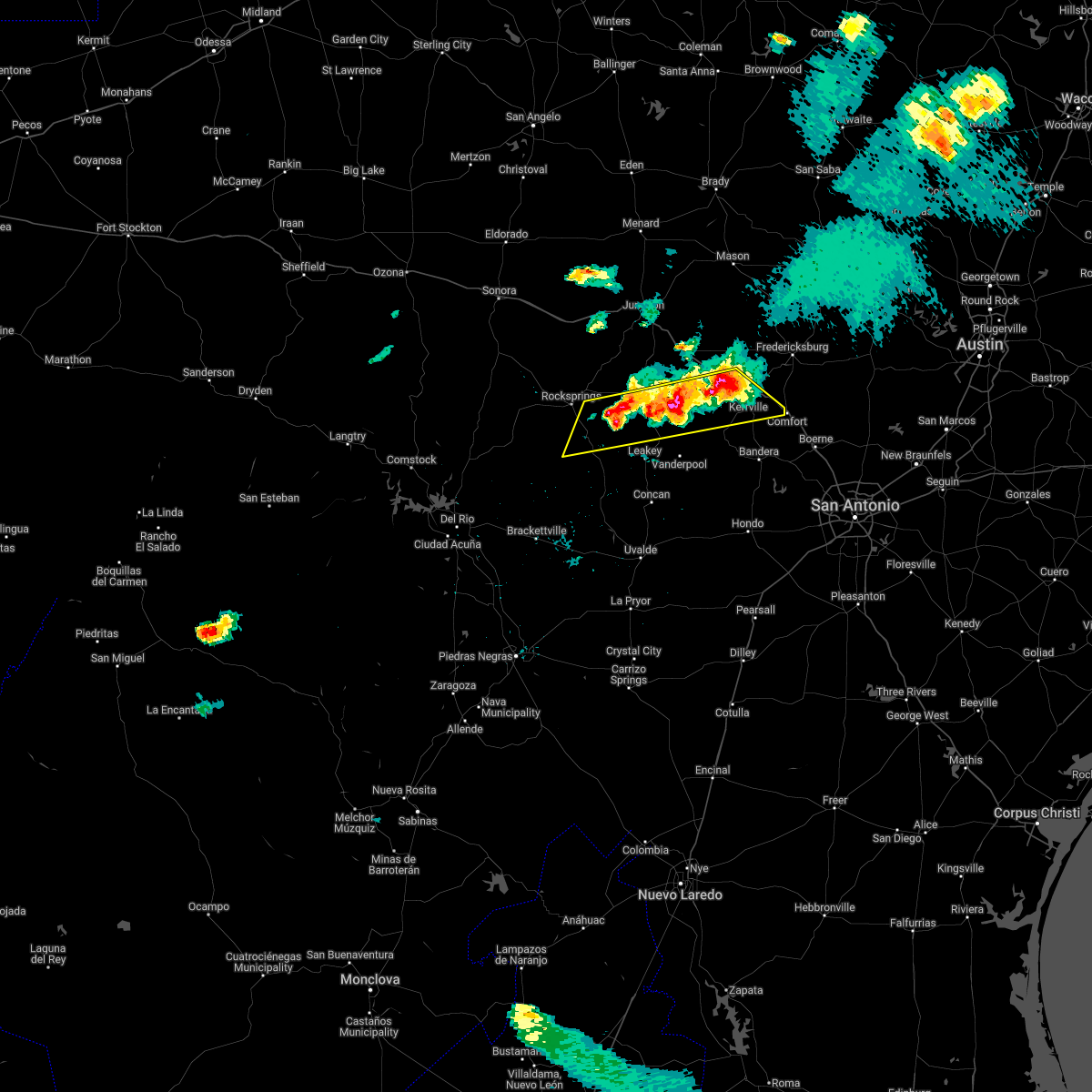 At 616 pm cdt, severe thunderstorms were located along a line extending from near waltonia to 7 miles north of vance, moving east at 10 mph (radar indicated). Hazards include 60 mph wind gusts and half dollar size hail. Hail damage to vehicles is expected. Expect wind damage to roofs, siding, and trees. At 616 pm cdt, severe thunderstorms were located along a line extending from near waltonia to 7 miles north of vance, moving east at 10 mph (radar indicated). Hazards include 60 mph wind gusts and half dollar size hail. Hail damage to vehicles is expected. Expect wind damage to roofs, siding, and trees.
|
| 4/17/2022 3:39 PM CDT | Quarter sized hail reported 0.1 miles ENE of Comfort, TX, picture of quarter sized hail relayed via social media. |
| 4/17/2022 3:34 PM CDT |
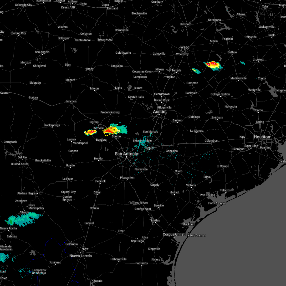 At 333 pm cdt, a severe thunderstorm was located near comfort, moving southeast at 30 mph (radar indicated). Hazards include ping pong ball size hail and 60 mph wind gusts. People and animals outdoors will be injured. expect hail damage to roofs, siding, windows, and vehicles. expect wind damage to roofs, siding, and trees. locations impacted include, comfort, center point, waring, welfare and crown. hail threat, radar indicated max hail size, 1. 50 in wind threat, radar indicated max wind gust, 60 mph. At 333 pm cdt, a severe thunderstorm was located near comfort, moving southeast at 30 mph (radar indicated). Hazards include ping pong ball size hail and 60 mph wind gusts. People and animals outdoors will be injured. expect hail damage to roofs, siding, windows, and vehicles. expect wind damage to roofs, siding, and trees. locations impacted include, comfort, center point, waring, welfare and crown. hail threat, radar indicated max hail size, 1. 50 in wind threat, radar indicated max wind gust, 60 mph.
|
| 4/17/2022 3:29 PM CDT |
 At 329 pm cdt, a severe thunderstorm was located over comfort, moving southeast at 30 mph (radar indicated). Hazards include 60 mph wind gusts and quarter size hail. Hail damage to vehicles is expected. expect wind damage to roofs, siding, and trees. locations impacted include, comfort, center point, waring, welfare and crown. hail threat, radar indicated max hail size, 1. 00 in wind threat, radar indicated max wind gust, 60 mph. At 329 pm cdt, a severe thunderstorm was located over comfort, moving southeast at 30 mph (radar indicated). Hazards include 60 mph wind gusts and quarter size hail. Hail damage to vehicles is expected. expect wind damage to roofs, siding, and trees. locations impacted include, comfort, center point, waring, welfare and crown. hail threat, radar indicated max hail size, 1. 00 in wind threat, radar indicated max wind gust, 60 mph.
|
| 4/17/2022 3:25 PM CDT | Quarter sized hail reported 0.1 miles ENE of Comfort, TX, report of quarter size hail relayed via social media. time estimated from radar. |
| 4/17/2022 3:25 PM CDT | Golf Ball sized hail reported 5.3 miles ENE of Comfort, TX, report of approximately golf ball sized hail between comfort and center point. time estimated from radar. |
| 4/17/2022 3:16 PM CDT |
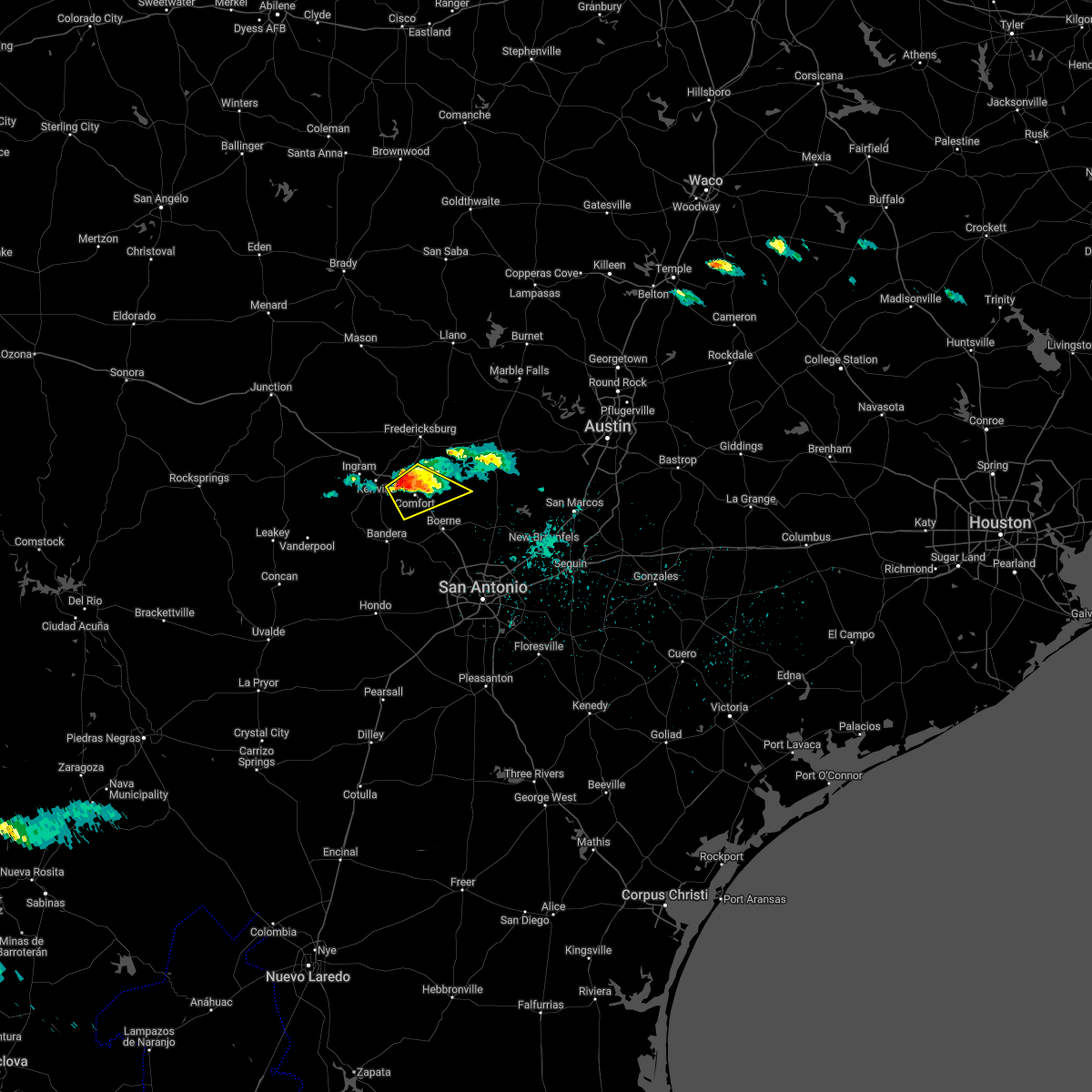 At 316 pm cdt, a severe thunderstorm was located over cypress creek, or near comfort, moving southeast at 30 mph (radar indicated). Hazards include 60 mph wind gusts and quarter size hail. Hail damage to vehicles is expected. expect wind damage to roofs, siding, and trees. locations impacted include, comfort, sisterdale, cypress creek, welfare, center point, waring, old tunnel state park and crown. hail threat, radar indicated max hail size, 1. 00 in wind threat, radar indicated max wind gust, 60 mph. At 316 pm cdt, a severe thunderstorm was located over cypress creek, or near comfort, moving southeast at 30 mph (radar indicated). Hazards include 60 mph wind gusts and quarter size hail. Hail damage to vehicles is expected. expect wind damage to roofs, siding, and trees. locations impacted include, comfort, sisterdale, cypress creek, welfare, center point, waring, old tunnel state park and crown. hail threat, radar indicated max hail size, 1. 00 in wind threat, radar indicated max wind gust, 60 mph.
|
| 4/17/2022 2:56 PM CDT |
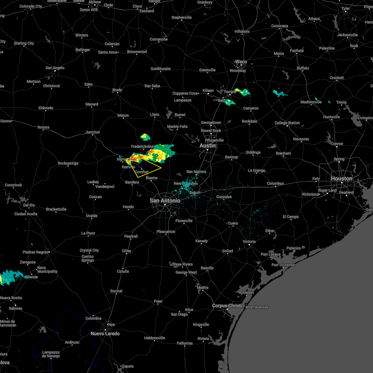 At 256 pm cdt, a severe thunderstorm was located near kerrville, moving southeast at 30 mph (radar indicated). Hazards include 60 mph wind gusts and quarter size hail. Hail damage to vehicles is expected. Expect wind damage to roofs, siding, and trees. At 256 pm cdt, a severe thunderstorm was located near kerrville, moving southeast at 30 mph (radar indicated). Hazards include 60 mph wind gusts and quarter size hail. Hail damage to vehicles is expected. Expect wind damage to roofs, siding, and trees.
|
| 6/22/2021 12:09 AM CDT |
 At 1208 am cdt, severe thunderstorms were located along a line extending from near fredericksburg to albert, moving southwest at 25 mph (radar indicated). Hazards include 60 mph wind gusts and quarter size hail. Hail damage to vehicles is expected. Expect wind damage to roofs, siding, and trees. At 1208 am cdt, severe thunderstorms were located along a line extending from near fredericksburg to albert, moving southwest at 25 mph (radar indicated). Hazards include 60 mph wind gusts and quarter size hail. Hail damage to vehicles is expected. Expect wind damage to roofs, siding, and trees.
|
| 5/28/2021 8:44 PM CDT |
 At 844 pm cdt, severe thunderstorms were located along a line extending from near center point to near pipe creek to near hill country state natural area to near tuff, moving southeast at 40 mph (radar indicated). Hazards include 60 mph wind gusts and quarter size hail. Hail damage to vehicles is expected. Expect wind damage to roofs, siding, and trees. At 844 pm cdt, severe thunderstorms were located along a line extending from near center point to near pipe creek to near hill country state natural area to near tuff, moving southeast at 40 mph (radar indicated). Hazards include 60 mph wind gusts and quarter size hail. Hail damage to vehicles is expected. Expect wind damage to roofs, siding, and trees.
|
| 5/3/2021 7:14 PM CDT |
 At 714 pm cdt, a severe thunderstorm was located near government canyon state natural area, or 12 miles southwest of boerne, moving northeast at 40 mph (radar indicated). Hazards include ping pong ball size hail and 60 mph wind gusts. People and animals outdoors will be injured. expect hail damage to roofs, siding, windows, and vehicles. Expect wind damage to roofs, siding, and trees. At 714 pm cdt, a severe thunderstorm was located near government canyon state natural area, or 12 miles southwest of boerne, moving northeast at 40 mph (radar indicated). Hazards include ping pong ball size hail and 60 mph wind gusts. People and animals outdoors will be injured. expect hail damage to roofs, siding, windows, and vehicles. Expect wind damage to roofs, siding, and trees.
|
| 4/28/2021 11:53 PM CDT |
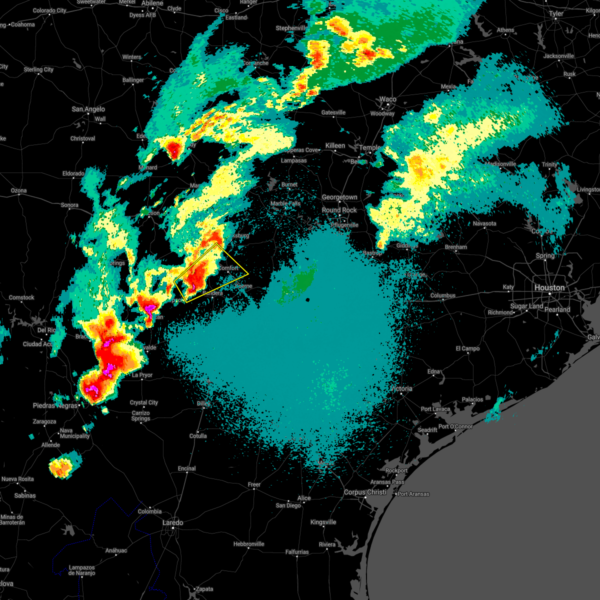 At 1152 pm cdt, a severe thunderstorm was located near medina, moving northeast at 30 mph (radar indicated). Hazards include 60 mph wind gusts and half dollar size hail. Hail damage to vehicles is expected. expect wind damage to roofs, siding, and trees. Locations impacted include, medina, kerrville, comfort, ingram, sisterdale, cypress creek, camp verde, welfare, center point, kerrville-schreiner park, waring and crown. At 1152 pm cdt, a severe thunderstorm was located near medina, moving northeast at 30 mph (radar indicated). Hazards include 60 mph wind gusts and half dollar size hail. Hail damage to vehicles is expected. expect wind damage to roofs, siding, and trees. Locations impacted include, medina, kerrville, comfort, ingram, sisterdale, cypress creek, camp verde, welfare, center point, kerrville-schreiner park, waring and crown.
|
| 4/28/2021 11:41 PM CDT |
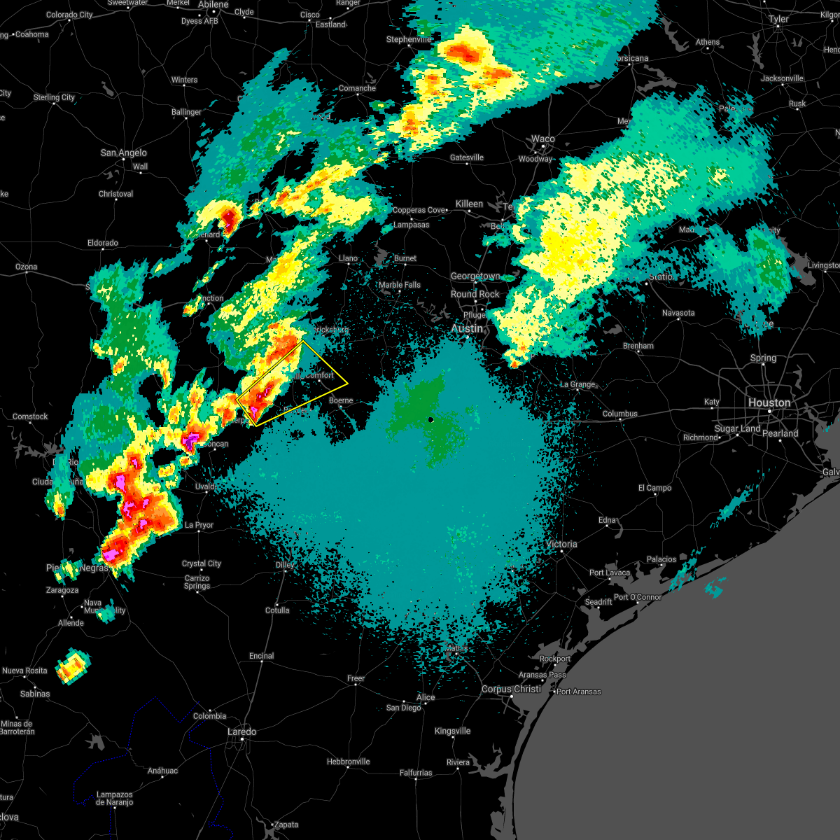 At 1141 pm cdt, a severe thunderstorm was located 7 miles west of medina, moving northeast at 50 mph (radar indicated). Hazards include half dollar size hail. damage to vehicles is expected At 1141 pm cdt, a severe thunderstorm was located 7 miles west of medina, moving northeast at 50 mph (radar indicated). Hazards include half dollar size hail. damage to vehicles is expected
|
| 4/28/2021 11:08 PM CDT |
 At 1107 pm cdt, a severe thunderstorm was located near hunt, or 15 miles west of kerrville, moving east at 50 mph (radar indicated). Hazards include quarter size hail. damage to vehicles is expected At 1107 pm cdt, a severe thunderstorm was located near hunt, or 15 miles west of kerrville, moving east at 50 mph (radar indicated). Hazards include quarter size hail. damage to vehicles is expected
|
| 3/23/2021 12:19 AM CDT |
 At 1219 am cdt, a severe thunderstorm was located near pipe creek, or near bandera, moving southeast at 35 mph (radar indicated). Hazards include 60 mph wind gusts and quarter size hail. Hail damage to vehicles is expected. expect wind damage to roofs, siding, and trees. Locations impacted include, boerne, comfort, bandera, fair oaks ranch, walnut grove, lakehills, camp verde, bandera falls, sisterdale, kreutzberg, pipe creek, welfare, nelson city, center point, kronkosky state natural area, waring, bergheim, cascade caverns, crown and lake medina shores. At 1219 am cdt, a severe thunderstorm was located near pipe creek, or near bandera, moving southeast at 35 mph (radar indicated). Hazards include 60 mph wind gusts and quarter size hail. Hail damage to vehicles is expected. expect wind damage to roofs, siding, and trees. Locations impacted include, boerne, comfort, bandera, fair oaks ranch, walnut grove, lakehills, camp verde, bandera falls, sisterdale, kreutzberg, pipe creek, welfare, nelson city, center point, kronkosky state natural area, waring, bergheim, cascade caverns, crown and lake medina shores.
|
| 3/23/2021 12:04 AM CDT |
 At 1203 am cdt, a severe thunderstorm was located over camp verde, or 8 miles north of bandera, moving southeast at 35 mph (radar indicated). Hazards include 60 mph wind gusts and quarter size hail. Hail damage to vehicles is expected. expect wind damage to roofs, siding, and trees. Locations impacted include, medina, kerrville, boerne, comfort, bandera, fair oaks ranch, walnut grove, camp verde, bandera falls, kerrville-schreiner park, mico, sisterdale, kreutzberg, pipe creek, welfare, nelson city, center point, waring, lakehills and cypress creek. At 1203 am cdt, a severe thunderstorm was located over camp verde, or 8 miles north of bandera, moving southeast at 35 mph (radar indicated). Hazards include 60 mph wind gusts and quarter size hail. Hail damage to vehicles is expected. expect wind damage to roofs, siding, and trees. Locations impacted include, medina, kerrville, boerne, comfort, bandera, fair oaks ranch, walnut grove, camp verde, bandera falls, kerrville-schreiner park, mico, sisterdale, kreutzberg, pipe creek, welfare, nelson city, center point, waring, lakehills and cypress creek.
|
| 3/22/2021 11:44 PM CDT |
 At 1144 pm cdt, a severe thunderstorm was located 7 miles south of waltonia, or 10 miles southwest of kerrville, moving southeast at 35 mph (radar indicated). Hazards include ping pong ball size hail and 60 mph wind gusts. People and animals outdoors will be injured. expect hail damage to roofs, siding, windows, and vehicles. Expect wind damage to roofs, siding, and trees. At 1144 pm cdt, a severe thunderstorm was located 7 miles south of waltonia, or 10 miles southwest of kerrville, moving southeast at 35 mph (radar indicated). Hazards include ping pong ball size hail and 60 mph wind gusts. People and animals outdoors will be injured. expect hail damage to roofs, siding, windows, and vehicles. Expect wind damage to roofs, siding, and trees.
|
| 3/22/2021 10:45 PM CDT |
 At 1044 pm cdt, a severe thunderstorm was located near kreutzberg, or 8 miles northeast of boerne, moving east at 55 mph (radar indicated). Hazards include 60 mph wind gusts and quarter size hail. Hail damage to vehicles is expected. expect wind damage to roofs, siding, and trees. Locations impacted include, boerne, comfort, blanco, canyon lake, fair oaks ranch, bulverde, walnut grove, guadalupe river state park, kendalia, smithson valley, sisterdale, kreutzberg, spring branch, welfare, nelson city, waring, flugrath, twin sisters, bergheim and kronkosky state natural area. At 1044 pm cdt, a severe thunderstorm was located near kreutzberg, or 8 miles northeast of boerne, moving east at 55 mph (radar indicated). Hazards include 60 mph wind gusts and quarter size hail. Hail damage to vehicles is expected. expect wind damage to roofs, siding, and trees. Locations impacted include, boerne, comfort, blanco, canyon lake, fair oaks ranch, bulverde, walnut grove, guadalupe river state park, kendalia, smithson valley, sisterdale, kreutzberg, spring branch, welfare, nelson city, waring, flugrath, twin sisters, bergheim and kronkosky state natural area.
|
| 3/22/2021 10:28 PM CDT |
 At 1028 pm cdt, a severe thunderstorm was located near comfort, moving east at 55 mph (radar indicated). Hazards include 60 mph wind gusts and quarter size hail. Hail damage to vehicles is expected. expect wind damage to roofs, siding, and trees. Locations impacted include, kerrville, boerne, comfort, blanco, canyon lake, fair oaks ranch, bulverde, walnut grove, guadalupe river state park, camp verde, kendalia, smithson valley, sisterdale, kreutzberg, spring branch, welfare, nelson city, center point, waring and flugrath. At 1028 pm cdt, a severe thunderstorm was located near comfort, moving east at 55 mph (radar indicated). Hazards include 60 mph wind gusts and quarter size hail. Hail damage to vehicles is expected. expect wind damage to roofs, siding, and trees. Locations impacted include, kerrville, boerne, comfort, blanco, canyon lake, fair oaks ranch, bulverde, walnut grove, guadalupe river state park, camp verde, kendalia, smithson valley, sisterdale, kreutzberg, spring branch, welfare, nelson city, center point, waring and flugrath.
|
| 3/22/2021 10:05 PM CDT |
 At 1005 pm cdt, a severe thunderstorm was located near medina, moving east at 55 mph (radar indicated). Hazards include 60 mph wind gusts and half dollar size hail. Hail damage to vehicles is expected. Expect wind damage to roofs, siding, and trees. At 1005 pm cdt, a severe thunderstorm was located near medina, moving east at 55 mph (radar indicated). Hazards include 60 mph wind gusts and half dollar size hail. Hail damage to vehicles is expected. Expect wind damage to roofs, siding, and trees.
|
| 5/28/2020 2:37 PM CDT |
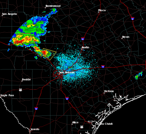 At 236 pm cdt, a severe thunderstorm was located near cypress creek, or 9 miles northeast of kerrville, moving south at 25 mph (radar indicated). Hazards include ping pong ball size hail. People and animals outdoors will be injured. Expect damage to roofs, siding, windows, and vehicles. At 236 pm cdt, a severe thunderstorm was located near cypress creek, or 9 miles northeast of kerrville, moving south at 25 mph (radar indicated). Hazards include ping pong ball size hail. People and animals outdoors will be injured. Expect damage to roofs, siding, windows, and vehicles.
|
| 5/27/2020 8:49 PM CDT |
 At 849 pm cdt, a severe thunderstorm was located over pipe creek, or 9 miles east of bandera, moving southeast at 35 mph (radar indicated). Hazards include golf ball size hail and 60 mph wind gusts. People and animals outdoors will be injured. expect hail damage to roofs, siding, windows, and vehicles. expect wind damage to roofs, siding, and trees. Locations impacted include, san antonio, medina, kerrville, boerne, castroville, comfort, bandera, leon valley, helotes, cross mountain, ingram, hunt, camp verde, bandera falls, kerrville-schreiner park, quihi, dunlay, mico, waltonia and government canyon state natural area. At 849 pm cdt, a severe thunderstorm was located over pipe creek, or 9 miles east of bandera, moving southeast at 35 mph (radar indicated). Hazards include golf ball size hail and 60 mph wind gusts. People and animals outdoors will be injured. expect hail damage to roofs, siding, windows, and vehicles. expect wind damage to roofs, siding, and trees. Locations impacted include, san antonio, medina, kerrville, boerne, castroville, comfort, bandera, leon valley, helotes, cross mountain, ingram, hunt, camp verde, bandera falls, kerrville-schreiner park, quihi, dunlay, mico, waltonia and government canyon state natural area.
|
| 5/27/2020 8:29 PM CDT |
 At 828 pm cdt, a severe thunderstorm was located near camp verde, or 7 miles north of bandera, moving southeast at 35 mph (radar indicated). Hazards include two inch hail and 60 mph wind gusts. People and animals outdoors will be injured. expect hail damage to roofs, siding, windows, and vehicles. Expect wind damage to roofs, siding, and trees. At 828 pm cdt, a severe thunderstorm was located near camp verde, or 7 miles north of bandera, moving southeast at 35 mph (radar indicated). Hazards include two inch hail and 60 mph wind gusts. People and animals outdoors will be injured. expect hail damage to roofs, siding, windows, and vehicles. Expect wind damage to roofs, siding, and trees.
|
| 5/27/2020 8:16 PM CDT |
 At 816 pm cdt, a severe thunderstorm capable of producing a tornado was located over center point, or 7 miles southeast of kerrville, moving southeast at 35 mph (radar indicated rotation). Hazards include tornado and baseball size hail. Flying debris will be dangerous to those caught without shelter. mobile homes will be damaged or destroyed. damage to roofs, windows, and vehicles will occur. tree damage is likely. Locations impacted include, kerrville, comfort, center point, cypress creek, camp verde and kerrville-schreiner park. At 816 pm cdt, a severe thunderstorm capable of producing a tornado was located over center point, or 7 miles southeast of kerrville, moving southeast at 35 mph (radar indicated rotation). Hazards include tornado and baseball size hail. Flying debris will be dangerous to those caught without shelter. mobile homes will be damaged or destroyed. damage to roofs, windows, and vehicles will occur. tree damage is likely. Locations impacted include, kerrville, comfort, center point, cypress creek, camp verde and kerrville-schreiner park.
|
| 5/27/2020 8:04 PM CDT |
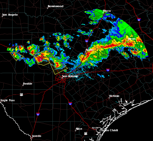 At 804 pm cdt, a severe thunderstorm capable of producing a tornado was located over kerrville, moving southeast at 45 mph (radar indicated rotation). Hazards include tornado and tennis ball size hail. Flying debris will be dangerous to those caught without shelter. mobile homes will be damaged or destroyed. damage to roofs, windows, and vehicles will occur. Tree damage is likely. At 804 pm cdt, a severe thunderstorm capable of producing a tornado was located over kerrville, moving southeast at 45 mph (radar indicated rotation). Hazards include tornado and tennis ball size hail. Flying debris will be dangerous to those caught without shelter. mobile homes will be damaged or destroyed. damage to roofs, windows, and vehicles will occur. Tree damage is likely.
|
| 5/27/2020 7:59 PM CDT |
 At 759 pm cdt, a severe thunderstorm was located over kreutzberg, or near boerne, moving southeast at 25 mph (radar indicated). Hazards include 60 mph wind gusts and half dollar size hail. Hail damage to vehicles is expected. expect wind damage to roofs, siding, and trees. Locations impacted include, boerne, comfort, helotes, fair oaks ranch, bulverde, cross mountain, walnut grove, guadalupe river state park, the dominion, sisterdale, kreutzberg, welfare, nelson city, waring, leon springs, old tunnel state park, bankersmith, bergheim, timberwood park and smithson valley. At 759 pm cdt, a severe thunderstorm was located over kreutzberg, or near boerne, moving southeast at 25 mph (radar indicated). Hazards include 60 mph wind gusts and half dollar size hail. Hail damage to vehicles is expected. expect wind damage to roofs, siding, and trees. Locations impacted include, boerne, comfort, helotes, fair oaks ranch, bulverde, cross mountain, walnut grove, guadalupe river state park, the dominion, sisterdale, kreutzberg, welfare, nelson city, waring, leon springs, old tunnel state park, bankersmith, bergheim, timberwood park and smithson valley.
|
| 5/27/2020 7:56 PM CDT |
 At 756 pm cdt, severe thunderstorms were located along a line extending from 6 miles northeast of kerrville to waltonia, moving south at 30 mph (radar indicated). Hazards include tennis ball size hail and 60 mph wind gusts. People and animals outdoors will be injured. expect hail damage to roofs, siding, windows, and vehicles. expect wind damage to roofs, siding, and trees. Locations impacted include, kerrville, fredericksburg, comfort, ingram, hunt, camp verde, tivydale, kerrville-schreiner park, waltonia, cypress creek, mountain home, center point, grapetown and harper. At 756 pm cdt, severe thunderstorms were located along a line extending from 6 miles northeast of kerrville to waltonia, moving south at 30 mph (radar indicated). Hazards include tennis ball size hail and 60 mph wind gusts. People and animals outdoors will be injured. expect hail damage to roofs, siding, windows, and vehicles. expect wind damage to roofs, siding, and trees. Locations impacted include, kerrville, fredericksburg, comfort, ingram, hunt, camp verde, tivydale, kerrville-schreiner park, waltonia, cypress creek, mountain home, center point, grapetown and harper.
|
| 5/27/2020 7:47 PM CDT |
 At 747 pm cdt, severe thunderstorms were located along a line extending from near tivydale to near mountain home, moving southeast at 30 mph (radar indicated). Hazards include two inch hail and 60 mph wind gusts. People and animals outdoors will be injured. expect hail damage to roofs, siding, windows, and vehicles. expect wind damage to roofs, siding, and trees. Locations impacted include, kerrville, fredericksburg, comfort, ingram, hunt, camp verde, tivydale, kerrville-schreiner park, waltonia, cypress creek, mountain home, center point, grapetown and harper. At 747 pm cdt, severe thunderstorms were located along a line extending from near tivydale to near mountain home, moving southeast at 30 mph (radar indicated). Hazards include two inch hail and 60 mph wind gusts. People and animals outdoors will be injured. expect hail damage to roofs, siding, windows, and vehicles. expect wind damage to roofs, siding, and trees. Locations impacted include, kerrville, fredericksburg, comfort, ingram, hunt, camp verde, tivydale, kerrville-schreiner park, waltonia, cypress creek, mountain home, center point, grapetown and harper.
|
| 5/27/2020 7:37 PM CDT |
 At 737 pm cdt, a severe thunderstorm was located over sisterdale, or 8 miles east of comfort, moving southeast at 30 mph (radar indicated). Hazards include ping pong ball size hail and 60 mph wind gusts. People and animals outdoors will be injured. expect hail damage to roofs, siding, windows, and vehicles. expect wind damage to roofs, siding, and trees. Locations impacted include, boerne, comfort, helotes, fair oaks ranch, bulverde, cross mountain, walnut grove, guadalupe river state park, the dominion, sisterdale, kreutzberg, welfare, nelson city, waring, leon springs, old tunnel state park, bankersmith, bergheim, timberwood park and smithson valley. At 737 pm cdt, a severe thunderstorm was located over sisterdale, or 8 miles east of comfort, moving southeast at 30 mph (radar indicated). Hazards include ping pong ball size hail and 60 mph wind gusts. People and animals outdoors will be injured. expect hail damage to roofs, siding, windows, and vehicles. expect wind damage to roofs, siding, and trees. Locations impacted include, boerne, comfort, helotes, fair oaks ranch, bulverde, cross mountain, walnut grove, guadalupe river state park, the dominion, sisterdale, kreutzberg, welfare, nelson city, waring, leon springs, old tunnel state park, bankersmith, bergheim, timberwood park and smithson valley.
|
| 5/27/2020 7:34 PM CDT | Quarter sized hail reported 7.8 miles W of Comfort, TX, report from mping: quarter (1.00 in.). |
| 5/27/2020 7:30 PM CDT |
 At 730 pm cdt, a severe thunderstorm was located near harper, or 17 miles north of kerrville, moving south at 25 mph (radar indicated). Hazards include ping pong ball size hail and 60 mph wind gusts. People and animals outdoors will be injured. expect hail damage to roofs, siding, windows, and vehicles. Expect wind damage to roofs, siding, and trees. At 730 pm cdt, a severe thunderstorm was located near harper, or 17 miles north of kerrville, moving south at 25 mph (radar indicated). Hazards include ping pong ball size hail and 60 mph wind gusts. People and animals outdoors will be injured. expect hail damage to roofs, siding, windows, and vehicles. Expect wind damage to roofs, siding, and trees.
|
| 5/27/2020 7:26 PM CDT |
 At 726 pm cdt, a severe thunderstorm was located near waring, or 7 miles northeast of comfort, moving southeast at 40 mph (radar indicated). Hazards include ping pong ball size hail and 60 mph wind gusts. People and animals outdoors will be injured. expect hail damage to roofs, siding, windows, and vehicles. Expect wind damage to roofs, siding, and trees. At 726 pm cdt, a severe thunderstorm was located near waring, or 7 miles northeast of comfort, moving southeast at 40 mph (radar indicated). Hazards include ping pong ball size hail and 60 mph wind gusts. People and animals outdoors will be injured. expect hail damage to roofs, siding, windows, and vehicles. Expect wind damage to roofs, siding, and trees.
|
| 5/27/2020 7:16 PM CDT |
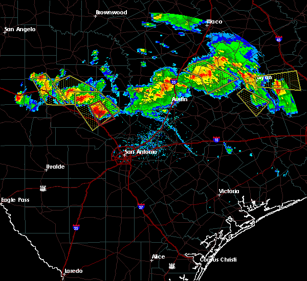 At 715 pm cdt, a severe thunderstorm capable of producing a tornado was located over old tunnel state park, or 9 miles north of comfort, moving southeast at 35 mph (radar indicated rotation). Hazards include tornado and golf ball size hail. Flying debris will be dangerous to those caught without shelter. mobile homes will be damaged or destroyed. damage to roofs, windows, and vehicles will occur. tree damage is likely. Locations impacted include, comfort, old tunnel state park, grapetown and bankersmith. At 715 pm cdt, a severe thunderstorm capable of producing a tornado was located over old tunnel state park, or 9 miles north of comfort, moving southeast at 35 mph (radar indicated rotation). Hazards include tornado and golf ball size hail. Flying debris will be dangerous to those caught without shelter. mobile homes will be damaged or destroyed. damage to roofs, windows, and vehicles will occur. tree damage is likely. Locations impacted include, comfort, old tunnel state park, grapetown and bankersmith.
|
| 5/27/2020 7:01 PM CDT |
 At 701 pm cdt, a severe thunderstorm capable of producing a tornado was located near fredericksburg, moving southeast at 30 mph (radar indicated rotation). Hazards include tornado and baseball size hail. Flying debris will be dangerous to those caught without shelter. mobile homes will be damaged or destroyed. damage to roofs, windows, and vehicles will occur. Tree damage is likely. At 701 pm cdt, a severe thunderstorm capable of producing a tornado was located near fredericksburg, moving southeast at 30 mph (radar indicated rotation). Hazards include tornado and baseball size hail. Flying debris will be dangerous to those caught without shelter. mobile homes will be damaged or destroyed. damage to roofs, windows, and vehicles will occur. Tree damage is likely.
|
| 5/27/2020 6:47 PM CDT |
 At 647 pm cdt, a severe thunderstorm was located near tivydale, or 9 miles west of fredericksburg, moving southeast at 40 mph. this is a very dangerous storm (radar indicated). Hazards include baseball size hail and 70 mph wind gusts. People and animals outdoors will be severely injured. expect shattered windows, extensive damage to roofs, siding, and vehicles. Locations impacted include, kerrville, fredericksburg, comfort, stonewall, cherry spring, luckenbach, cain city, tivydale, old tunnel state park, doss, rocky hill, lbj state park, harper, bankersmith, cypress creek, blumenthal, center point, albert, grapetown and lbj national historical park. At 647 pm cdt, a severe thunderstorm was located near tivydale, or 9 miles west of fredericksburg, moving southeast at 40 mph. this is a very dangerous storm (radar indicated). Hazards include baseball size hail and 70 mph wind gusts. People and animals outdoors will be severely injured. expect shattered windows, extensive damage to roofs, siding, and vehicles. Locations impacted include, kerrville, fredericksburg, comfort, stonewall, cherry spring, luckenbach, cain city, tivydale, old tunnel state park, doss, rocky hill, lbj state park, harper, bankersmith, cypress creek, blumenthal, center point, albert, grapetown and lbj national historical park.
|
| 5/27/2020 6:39 PM CDT |
 At 638 pm cdt, a severe thunderstorm was located near tivydale, or 15 miles west of fredericksburg, moving southeast at 35 mph (radar indicated). Hazards include two inch hail and 60 mph wind gusts. People and animals outdoors will be injured. expect hail damage to roofs, siding, windows, and vehicles. expect wind damage to roofs, siding, and trees. Locations impacted include, kerrville, fredericksburg, comfort, stonewall, cherry spring, luckenbach, cain city, tivydale, old tunnel state park, doss, rocky hill, lbj state park, harper, bankersmith, cypress creek, blumenthal, center point, albert, grapetown and lbj national historical park. At 638 pm cdt, a severe thunderstorm was located near tivydale, or 15 miles west of fredericksburg, moving southeast at 35 mph (radar indicated). Hazards include two inch hail and 60 mph wind gusts. People and animals outdoors will be injured. expect hail damage to roofs, siding, windows, and vehicles. expect wind damage to roofs, siding, and trees. Locations impacted include, kerrville, fredericksburg, comfort, stonewall, cherry spring, luckenbach, cain city, tivydale, old tunnel state park, doss, rocky hill, lbj state park, harper, bankersmith, cypress creek, blumenthal, center point, albert, grapetown and lbj national historical park.
|
| 5/27/2020 6:24 PM CDT |
 At 624 pm cdt, a severe thunderstorm was located near doss, or 21 miles northwest of fredericksburg, moving southeast at 35 mph (radar indicated). Hazards include golf ball size hail and 60 mph wind gusts. People and animals outdoors will be injured. expect hail damage to roofs, siding, windows, and vehicles. Expect wind damage to roofs, siding, and trees. At 624 pm cdt, a severe thunderstorm was located near doss, or 21 miles northwest of fredericksburg, moving southeast at 35 mph (radar indicated). Hazards include golf ball size hail and 60 mph wind gusts. People and animals outdoors will be injured. expect hail damage to roofs, siding, windows, and vehicles. Expect wind damage to roofs, siding, and trees.
|
| 5/24/2020 8:43 PM CDT |
 At 843 pm cdt, severe thunderstorms were located along a line extending from near horseshoe bay to near live oak to 9 miles southeast of derby, moving east at 60 mph (radar indicated). Hazards include 60 mph wind gusts and quarter size hail. Hail damage to vehicles is expected. expect wind damage to roofs, siding, and trees. Locations impacted include, san antonio, schertz, universal city, live oak, boerne, fredericksburg, pleasanton, selma, pearsall, marble falls, devine, jourdanton, dilley, poteet, castroville, comfort, blanco, charlotte, christine and round mountain. At 843 pm cdt, severe thunderstorms were located along a line extending from near horseshoe bay to near live oak to 9 miles southeast of derby, moving east at 60 mph (radar indicated). Hazards include 60 mph wind gusts and quarter size hail. Hail damage to vehicles is expected. expect wind damage to roofs, siding, and trees. Locations impacted include, san antonio, schertz, universal city, live oak, boerne, fredericksburg, pleasanton, selma, pearsall, marble falls, devine, jourdanton, dilley, poteet, castroville, comfort, blanco, charlotte, christine and round mountain.
|
| 5/24/2020 8:00 PM CDT |
 At 759 pm cdt, severe thunderstorms were located along a line extending from near crabapple to 6 miles east of derby, moving east at 40 mph (radar indicated). Hazards include 60 mph wind gusts and quarter size hail. Hail damage to vehicles is expected. Expect wind damage to roofs, siding, and trees. At 759 pm cdt, severe thunderstorms were located along a line extending from near crabapple to 6 miles east of derby, moving east at 40 mph (radar indicated). Hazards include 60 mph wind gusts and quarter size hail. Hail damage to vehicles is expected. Expect wind damage to roofs, siding, and trees.
|
| 3/4/2020 5:11 AM CST |
 At 511 am cst, severe thunderstorms were located along a line extending from near fredericksburg to 7 miles southeast of luckenbach to near kronkosky state natural area to near quihi, moving east at 45 mph (radar indicated). Hazards include 60 mph wind gusts and penny size hail. Expect damage to roofs, siding, and trees. Locations impacted include, boerne, fredericksburg, hondo, castroville, comfort, helotes, fair oaks ranch, cross mountain, stonewall, walnut grove, bandera falls, dunlay, quihi, mico, rocky hill, sisterdale, rocky creek, kreutzberg, government canyon state natural area and pipe creek. At 511 am cst, severe thunderstorms were located along a line extending from near fredericksburg to 7 miles southeast of luckenbach to near kronkosky state natural area to near quihi, moving east at 45 mph (radar indicated). Hazards include 60 mph wind gusts and penny size hail. Expect damage to roofs, siding, and trees. Locations impacted include, boerne, fredericksburg, hondo, castroville, comfort, helotes, fair oaks ranch, cross mountain, stonewall, walnut grove, bandera falls, dunlay, quihi, mico, rocky hill, sisterdale, rocky creek, kreutzberg, government canyon state natural area and pipe creek.
|
| 3/4/2020 4:43 AM CST |
 At 442 am cst, severe thunderstorms were located along a line extending from near tivydale to near cypress creek to near hill country state natural area to near d`hanis, moving east at 35 mph (radar indicated). Hazards include 60 mph wind gusts and quarter size hail. Hail damage to vehicles is expected. Expect wind damage to roofs, siding, and trees. At 442 am cst, severe thunderstorms were located along a line extending from near tivydale to near cypress creek to near hill country state natural area to near d`hanis, moving east at 35 mph (radar indicated). Hazards include 60 mph wind gusts and quarter size hail. Hail damage to vehicles is expected. Expect wind damage to roofs, siding, and trees.
|
| 1/10/2020 5:54 PM CST |
 At 554 pm cst, a severe thunderstorm was located over center point, or 7 miles southwest of comfort, moving northeast at 40 mph (radar indicated). Hazards include 60 mph wind gusts and quarter size hail. Hail damage to vehicles is expected. Expect wind damage to roofs, siding, and trees. At 554 pm cst, a severe thunderstorm was located over center point, or 7 miles southwest of comfort, moving northeast at 40 mph (radar indicated). Hazards include 60 mph wind gusts and quarter size hail. Hail damage to vehicles is expected. Expect wind damage to roofs, siding, and trees.
|
| 1/10/2020 5:26 PM CST |
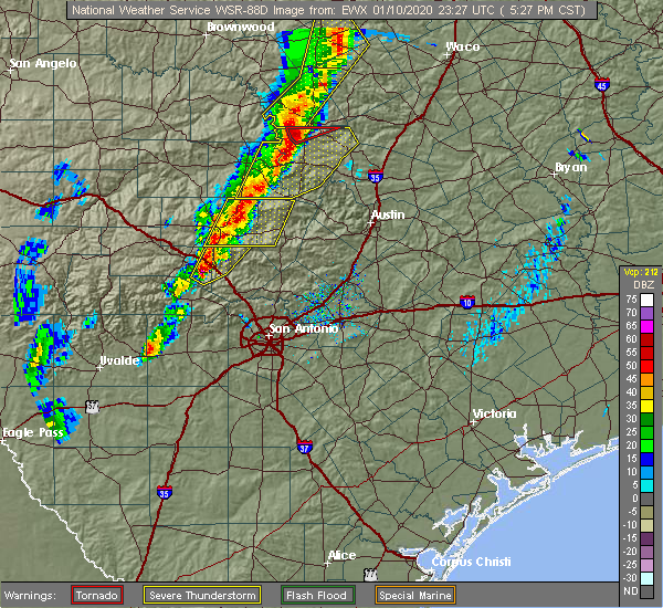 At 526 pm cst, a severe thunderstorm was located over center point, or 7 miles west of comfort, moving northeast at 35 mph (radar indicated). Hazards include 60 mph wind gusts and quarter size hail. Hail damage to vehicles is expected. Expect wind damage to roofs, siding, and trees. At 526 pm cst, a severe thunderstorm was located over center point, or 7 miles west of comfort, moving northeast at 35 mph (radar indicated). Hazards include 60 mph wind gusts and quarter size hail. Hail damage to vehicles is expected. Expect wind damage to roofs, siding, and trees.
|
| 6/16/2019 11:28 PM CDT |
 The national weather service in austin san antonio has issued a * severe thunderstorm warning for. medina county in south central texas. bandera county in south central texas. southeastern kerr county in south central texas. Northeastern uvalde county in south central texas. The national weather service in austin san antonio has issued a * severe thunderstorm warning for. medina county in south central texas. bandera county in south central texas. southeastern kerr county in south central texas. Northeastern uvalde county in south central texas.
|
| 6/9/2019 8:06 PM CDT |
 At 806 pm cdt, severe thunderstorms were located along a line extending from 10 miles southeast of telegraph to 6 miles south of harper to near stonewall, moving south at 20 mph (trained weather spotters). Hazards include 70 mph wind gusts and quarter size hail. Hail damage to vehicles is expected. expect considerable tree damage. wind damage is also likely to mobile homes, roofs, and outbuildings. Locations impacted include, kerrville, fredericksburg, comfort, ingram, hunt, stonewall, tivydale, kerrville-schreiner park, rocky hill, kerr wildlife management area, waltonia, sisterdale, welfare, blumenthal, center point, albert, waring, grapetown, luckenbach and cain city. At 806 pm cdt, severe thunderstorms were located along a line extending from 10 miles southeast of telegraph to 6 miles south of harper to near stonewall, moving south at 20 mph (trained weather spotters). Hazards include 70 mph wind gusts and quarter size hail. Hail damage to vehicles is expected. expect considerable tree damage. wind damage is also likely to mobile homes, roofs, and outbuildings. Locations impacted include, kerrville, fredericksburg, comfort, ingram, hunt, stonewall, tivydale, kerrville-schreiner park, rocky hill, kerr wildlife management area, waltonia, sisterdale, welfare, blumenthal, center point, albert, waring, grapetown, luckenbach and cain city.
|
| 6/9/2019 7:57 PM CDT |
 The national weather service in austin san antonio has issued a * severe thunderstorm warning for. kerr county in south central texas. gillespie county in south central texas. northeastern edwards county in south central texas. Northwestern kendall county in south central texas. The national weather service in austin san antonio has issued a * severe thunderstorm warning for. kerr county in south central texas. gillespie county in south central texas. northeastern edwards county in south central texas. Northwestern kendall county in south central texas.
|
| 5/9/2019 2:16 PM CDT |
 A severe thunderstorm warning remains in effect until 300 pm cdt for east central kerr and western kendall counties. at 216 pm cdt, a severe thunderstorm was located over comfort, moving east at 20 mph. hazard. 60 mph wind gusts and penny size hail. source. Radar indicated. A severe thunderstorm warning remains in effect until 300 pm cdt for east central kerr and western kendall counties. at 216 pm cdt, a severe thunderstorm was located over comfort, moving east at 20 mph. hazard. 60 mph wind gusts and penny size hail. source. Radar indicated.
|
| 5/9/2019 2:02 PM CDT |
 A severe thunderstorm warning remains in effect until 215 pm cdt for east central kerr and northwestern kendall counties. at 201 pm cdt, a severe thunderstorm was located near cypress creek, or 7 miles southeast of kerrville, moving north at 10 mph. hazard. 60 mph wind gusts and half dollar size hail. source. Public. A severe thunderstorm warning remains in effect until 215 pm cdt for east central kerr and northwestern kendall counties. at 201 pm cdt, a severe thunderstorm was located near cypress creek, or 7 miles southeast of kerrville, moving north at 10 mph. hazard. 60 mph wind gusts and half dollar size hail. source. Public.
|
| 5/9/2019 1:59 PM CDT |
 The national weather service in austin san antonio has issued a * severe thunderstorm warning for. southeastern kerr county in south central texas. southeastern gillespie county in south central texas. kendall county in south central texas. Until 300 pm cdt. The national weather service in austin san antonio has issued a * severe thunderstorm warning for. southeastern kerr county in south central texas. southeastern gillespie county in south central texas. kendall county in south central texas. Until 300 pm cdt.
|
| 5/9/2019 1:59 PM CDT |
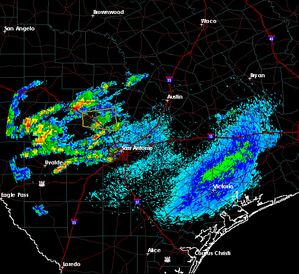 The national weather service in austin san antonio has issued a * severe thunderstorm warning for. southeastern kerr county in south central texas. southeastern gillespie county in south central texas. kendall county in south central texas. Until 300 pm cdt. The national weather service in austin san antonio has issued a * severe thunderstorm warning for. southeastern kerr county in south central texas. southeastern gillespie county in south central texas. kendall county in south central texas. Until 300 pm cdt.
|
| 5/9/2019 1:52 PM CDT |
 A severe thunderstorm warning remains in effect until 215 pm cdt for east central kerr. southwestern gillespie and northwestern kendall counties. at 152 pm cdt, a severe thunderstorm was located over center point, or 7 miles southeast of kerrville, moving northeast at 15 mph. hazard. 60 mph wind gusts and quarter size hail. A severe thunderstorm warning remains in effect until 215 pm cdt for east central kerr. southwestern gillespie and northwestern kendall counties. at 152 pm cdt, a severe thunderstorm was located over center point, or 7 miles southeast of kerrville, moving northeast at 15 mph. hazard. 60 mph wind gusts and quarter size hail.
|
| 5/9/2019 1:22 PM CDT |
 The national weather service in austin san antonio has issued a * severe thunderstorm warning for. northwestern bandera county in south central texas. kerr county in south central texas. southwestern gillespie county in south central texas. Northeastern edwards county in south central texas. The national weather service in austin san antonio has issued a * severe thunderstorm warning for. northwestern bandera county in south central texas. kerr county in south central texas. southwestern gillespie county in south central texas. Northeastern edwards county in south central texas.
|
| 5/8/2019 10:48 AM CDT |
 At 1047 am cdt, severe thunderstorms were located along a line extending from near eckert to lbj state park to comfort, moving east at 35 mph (radar indicated). Hazards include 60 mph wind gusts. Expect damage to roofs, siding, and trees. Locations impacted include, kerrville, fredericksburg, comfort, blanco, johnson city, stonewall, blowout, rocky hill, sisterdale, rocky creek, welfare, hye, blumenthal, nelson city, center point, crabapple, albert, waring, grapetown and flugrath. At 1047 am cdt, severe thunderstorms were located along a line extending from near eckert to lbj state park to comfort, moving east at 35 mph (radar indicated). Hazards include 60 mph wind gusts. Expect damage to roofs, siding, and trees. Locations impacted include, kerrville, fredericksburg, comfort, blanco, johnson city, stonewall, blowout, rocky hill, sisterdale, rocky creek, welfare, hye, blumenthal, nelson city, center point, crabapple, albert, waring, grapetown and flugrath.
|
| 5/8/2019 10:28 AM CDT |
 At 1027 am cdt, severe thunderstorms were located along a line extending from near cherry spring to fredericksburg to near kerrville-schreiner park, moving east at 30 mph (radar indicated). Hazards include 60 mph wind gusts. Expect damage to roofs, siding, and trees. Locations impacted include, kerrville, fredericksburg, comfort, blanco, johnson city, stonewall, blowout, tivydale, kerrville-schreiner park, rocky hill, sisterdale, rocky creek, welfare, hye, blumenthal, nelson city, center point, crabapple, albert and waring. At 1027 am cdt, severe thunderstorms were located along a line extending from near cherry spring to fredericksburg to near kerrville-schreiner park, moving east at 30 mph (radar indicated). Hazards include 60 mph wind gusts. Expect damage to roofs, siding, and trees. Locations impacted include, kerrville, fredericksburg, comfort, blanco, johnson city, stonewall, blowout, tivydale, kerrville-schreiner park, rocky hill, sisterdale, rocky creek, welfare, hye, blumenthal, nelson city, center point, crabapple, albert and waring.
|
| 5/8/2019 10:01 AM CDT |
 The national weather service in austin san antonio has issued a * severe thunderstorm warning for. northeastern kerr county in south central texas. western blanco county in south central texas. gillespie county in south central texas. Northern kendall county in south central texas. The national weather service in austin san antonio has issued a * severe thunderstorm warning for. northeastern kerr county in south central texas. western blanco county in south central texas. gillespie county in south central texas. Northern kendall county in south central texas.
|
| 5/8/2019 7:14 AM CDT |
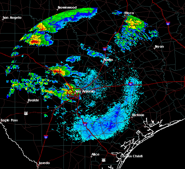 At 714 am cdt, a severe thunderstorm was located near cypress creek, or 8 miles northwest of comfort, moving northeast at 25 mph (public). Hazards include golf ball size hail and 60 mph wind gusts. People and animals outdoors will be injured. expect hail damage to roofs, siding, windows, and vehicles. expect wind damage to roofs, siding, and trees. Locations impacted include, kerrville, comfort, cypress creek, waring and center point. At 714 am cdt, a severe thunderstorm was located near cypress creek, or 8 miles northwest of comfort, moving northeast at 25 mph (public). Hazards include golf ball size hail and 60 mph wind gusts. People and animals outdoors will be injured. expect hail damage to roofs, siding, windows, and vehicles. expect wind damage to roofs, siding, and trees. Locations impacted include, kerrville, comfort, cypress creek, waring and center point.
|
| 5/8/2019 7:02 AM CDT |
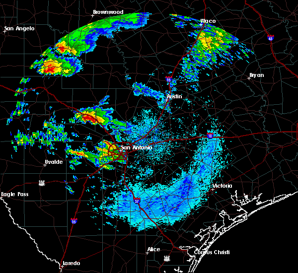 At 702 am cdt, a severe thunderstorm was located over cypress creek, or 7 miles west of comfort, moving northeast at 25 mph (radar indicated). Hazards include golf ball size hail and 60 mph wind gusts. People and animals outdoors will be injured. expect hail damage to roofs, siding, windows, and vehicles. expect wind damage to roofs, siding, and trees. Locations impacted include, kerrville, comfort, cypress creek, nelson city, center point, kerrville-schreiner park and waring. At 702 am cdt, a severe thunderstorm was located over cypress creek, or 7 miles west of comfort, moving northeast at 25 mph (radar indicated). Hazards include golf ball size hail and 60 mph wind gusts. People and animals outdoors will be injured. expect hail damage to roofs, siding, windows, and vehicles. expect wind damage to roofs, siding, and trees. Locations impacted include, kerrville, comfort, cypress creek, nelson city, center point, kerrville-schreiner park and waring.
|
| 5/8/2019 6:52 AM CDT |
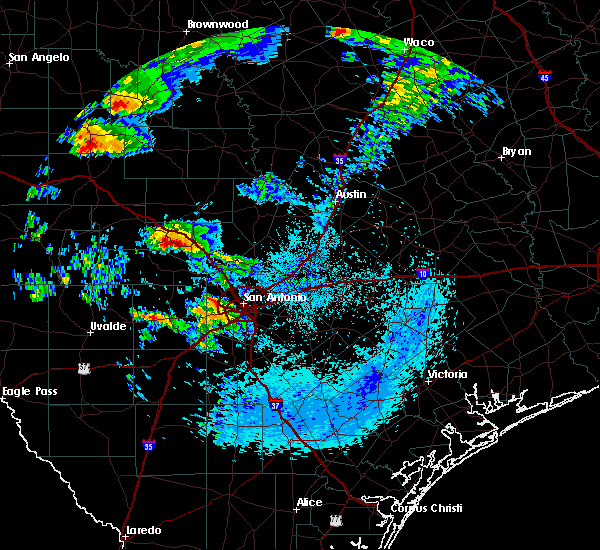 At 652 am cdt, a severe thunderstorm was located over center point, or 7 miles southeast of kerrville, moving east at 30 mph (radar indicated). Hazards include 60 mph wind gusts and half dollar size hail. Hail damage to vehicles is expected. expect wind damage to roofs, siding, and trees. Locations impacted include, kerrville, boerne, comfort, cypress creek, camp verde, nelson city, center point and kerrville-schreiner park. At 652 am cdt, a severe thunderstorm was located over center point, or 7 miles southeast of kerrville, moving east at 30 mph (radar indicated). Hazards include 60 mph wind gusts and half dollar size hail. Hail damage to vehicles is expected. expect wind damage to roofs, siding, and trees. Locations impacted include, kerrville, boerne, comfort, cypress creek, camp verde, nelson city, center point and kerrville-schreiner park.
|
| 5/8/2019 6:45 AM CDT |
 At 645 am cdt, a severe thunderstorm was located over kerrville-schreiner park, or near kerrville, moving northeast at 30 mph (radar indicated). Hazards include 60 mph wind gusts and quarter size hail. Hail damage to vehicles is expected. expect wind damage to roofs, siding, and trees. Locations impacted include, kerrville, boerne, fredericksburg, comfort, cypress creek, camp verde, nelson city, center point and kerrville-schreiner park. At 645 am cdt, a severe thunderstorm was located over kerrville-schreiner park, or near kerrville, moving northeast at 30 mph (radar indicated). Hazards include 60 mph wind gusts and quarter size hail. Hail damage to vehicles is expected. expect wind damage to roofs, siding, and trees. Locations impacted include, kerrville, boerne, fredericksburg, comfort, cypress creek, camp verde, nelson city, center point and kerrville-schreiner park.
|
| 5/8/2019 6:33 AM CDT |
 At 633 am cdt, a severe thunderstorm was located 7 miles west of camp verde, or 8 miles north of medina, moving northeast at 30 mph (radar indicated). Hazards include 60 mph wind gusts and quarter size hail. Hail damage to vehicles is expected. Expect wind damage to roofs, siding, and trees. At 633 am cdt, a severe thunderstorm was located 7 miles west of camp verde, or 8 miles north of medina, moving northeast at 30 mph (radar indicated). Hazards include 60 mph wind gusts and quarter size hail. Hail damage to vehicles is expected. Expect wind damage to roofs, siding, and trees.
|
| 4/17/2019 11:18 PM CDT |
 At 1118 pm cdt, severe thunderstorms were located along a line extending from near round mountain to near sisterdale, moving east at 45 mph (radar indicated). Hazards include 60 mph wind gusts and penny size hail. Expect damage to roofs, siding, and trees. Locations impacted include, kerrville, fredericksburg, comfort, round mountain, johnson city, stonewall, blowout, rocky hill, sisterdale, rocky creek, welfare, hye, blumenthal, center point, albert, waring, grapetown, flugrath, luckenbach and cain city. At 1118 pm cdt, severe thunderstorms were located along a line extending from near round mountain to near sisterdale, moving east at 45 mph (radar indicated). Hazards include 60 mph wind gusts and penny size hail. Expect damage to roofs, siding, and trees. Locations impacted include, kerrville, fredericksburg, comfort, round mountain, johnson city, stonewall, blowout, rocky hill, sisterdale, rocky creek, welfare, hye, blumenthal, center point, albert, waring, grapetown, flugrath, luckenbach and cain city.
|
| 4/17/2019 10:41 PM CDT |
 At 1041 pm cdt, severe thunderstorms were located along a line extending from near crabapple to near kerrville-schreiner park, moving east at 45 mph (radar indicated). Hazards include 60 mph wind gusts and penny size hail. expect damage to roofs, siding, and trees At 1041 pm cdt, severe thunderstorms were located along a line extending from near crabapple to near kerrville-schreiner park, moving east at 45 mph (radar indicated). Hazards include 60 mph wind gusts and penny size hail. expect damage to roofs, siding, and trees
|
| 5/28/2017 7:06 PM CDT |
 At 705 pm cdt, a severe thunderstorm was located over sisterdale, or 9 miles east of comfort, moving east at 30 mph (radar indicated). Hazards include 70 mph wind gusts and quarter size hail. Hail damage to vehicles is expected. expect considerable tree damage. wind damage is also likely to mobile homes, roofs, and outbuildings. Locations impacted include, boerne, comfort, sisterdale, kreutzberg, walnut grove, welfare, nelson city, waring, bergheim, bankersmith and crown. At 705 pm cdt, a severe thunderstorm was located over sisterdale, or 9 miles east of comfort, moving east at 30 mph (radar indicated). Hazards include 70 mph wind gusts and quarter size hail. Hail damage to vehicles is expected. expect considerable tree damage. wind damage is also likely to mobile homes, roofs, and outbuildings. Locations impacted include, boerne, comfort, sisterdale, kreutzberg, walnut grove, welfare, nelson city, waring, bergheim, bankersmith and crown.
|
| 5/28/2017 6:54 PM CDT |
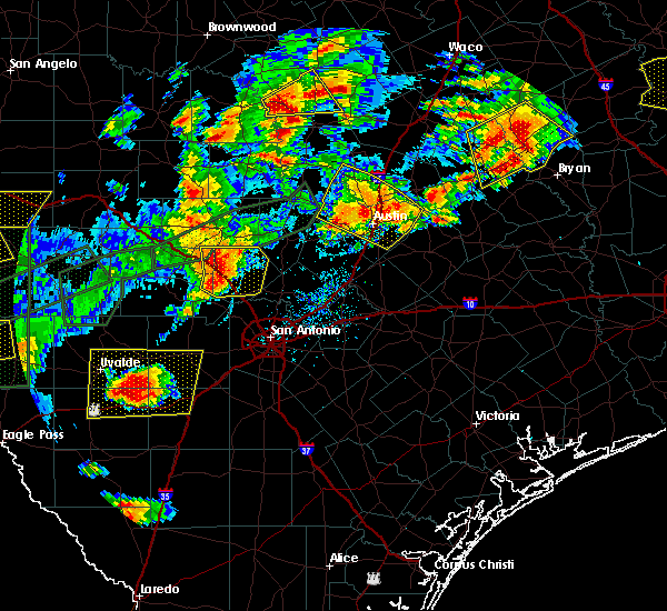 At 653 pm cdt, a severe thunderstorm was located over waring, or near comfort, moving east at 30 mph (radar indicated). Hazards include 70 mph wind gusts and quarter size hail. Hail damage to vehicles is expected. expect considerable tree damage. wind damage is also likely to mobile homes, roofs, and outbuildings. Locations impacted include, boerne, comfort, sisterdale, kreutzberg, walnut grove, cypress creek, welfare, nelson city, waring, bergheim, bankersmith and crown. At 653 pm cdt, a severe thunderstorm was located over waring, or near comfort, moving east at 30 mph (radar indicated). Hazards include 70 mph wind gusts and quarter size hail. Hail damage to vehicles is expected. expect considerable tree damage. wind damage is also likely to mobile homes, roofs, and outbuildings. Locations impacted include, boerne, comfort, sisterdale, kreutzberg, walnut grove, cypress creek, welfare, nelson city, waring, bergheim, bankersmith and crown.
|
| 5/28/2017 6:28 PM CDT |
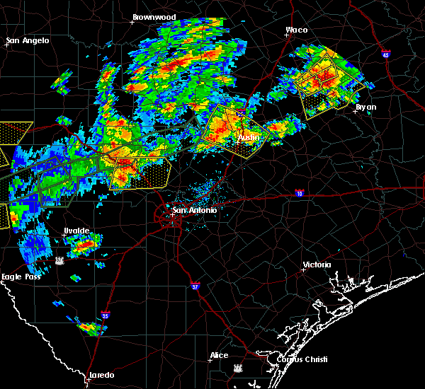 At 627 pm cdt, a severe thunderstorm was located over center point, or 8 miles west of comfort, moving east at 30 mph (radar indicated). Hazards include 60 mph wind gusts and quarter size hail. Hail damage to vehicles is expected. Expect wind damage to roofs, siding, and trees. At 627 pm cdt, a severe thunderstorm was located over center point, or 8 miles west of comfort, moving east at 30 mph (radar indicated). Hazards include 60 mph wind gusts and quarter size hail. Hail damage to vehicles is expected. Expect wind damage to roofs, siding, and trees.
|
| 4/2/2017 8:00 AM CDT |
 At 800 am cdt, severe thunderstorms were located along a line extending from near hilltop to near pipe creek, moving east at 35 mph (radar indicated). Hazards include 60 mph wind gusts and quarter size hail. Hail damage to vehicles is expected. expect wind damage to roofs, siding, and trees. locations impacted include, fredericksburg, boerne, comfort, walnut grove, bandera falls, cain city, rocky hill, bankersmith, sisterdale, cypress creek, pipe creek, welfare, nelson city, waring, crabapple, grapetown, lakehills and crown. A tornado watch remains in effect until 100 pm cdt for south central texas. At 800 am cdt, severe thunderstorms were located along a line extending from near hilltop to near pipe creek, moving east at 35 mph (radar indicated). Hazards include 60 mph wind gusts and quarter size hail. Hail damage to vehicles is expected. expect wind damage to roofs, siding, and trees. locations impacted include, fredericksburg, boerne, comfort, walnut grove, bandera falls, cain city, rocky hill, bankersmith, sisterdale, cypress creek, pipe creek, welfare, nelson city, waring, crabapple, grapetown, lakehills and crown. A tornado watch remains in effect until 100 pm cdt for south central texas.
|
| 4/2/2017 7:53 AM CDT |
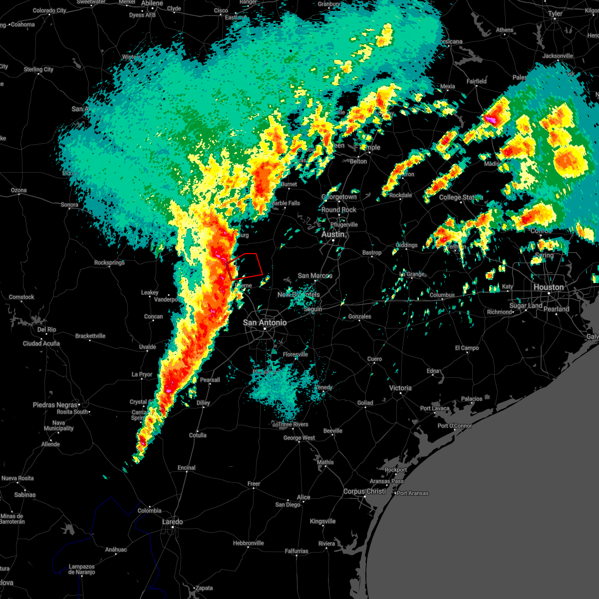 At 752 am cdt, a severe thunderstorm capable of producing a tornado was located over comfort, moving east at 35 mph (radar indicated rotation). Hazards include tornado. Flying debris will be dangerous to those caught without shelter. mobile homes will be damaged or destroyed. damage to roofs, windows, and vehicles will occur. Tree damage is likely. At 752 am cdt, a severe thunderstorm capable of producing a tornado was located over comfort, moving east at 35 mph (radar indicated rotation). Hazards include tornado. Flying debris will be dangerous to those caught without shelter. mobile homes will be damaged or destroyed. damage to roofs, windows, and vehicles will occur. Tree damage is likely.
|
| 4/2/2017 7:46 AM CDT |
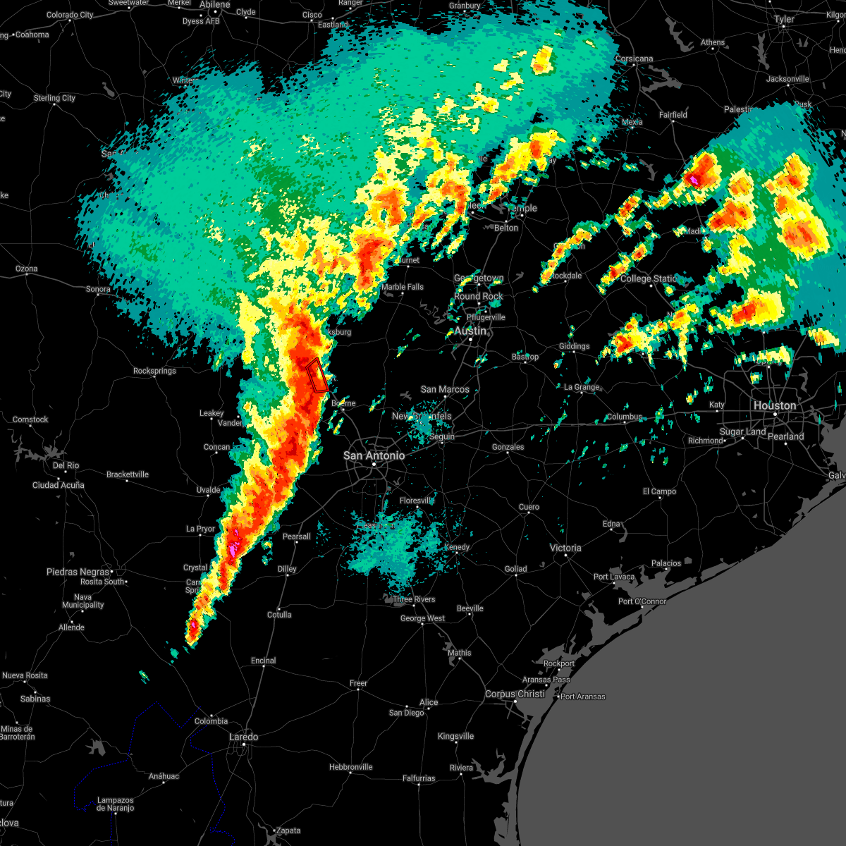 At 745 am cdt, a severe squall line capable of producing both tornadoes and extensive straight line wind damage was located over cypress creek, or near comfort, moving east at 35 mph (radar indicated rotation). Hazards include tornado. Flying debris will be dangerous to those caught without shelter. mobile homes will be damaged or destroyed. damage to roofs, windows, and vehicles will occur. tree damage is likely. Locations impacted include, comfort and cypress creek. At 745 am cdt, a severe squall line capable of producing both tornadoes and extensive straight line wind damage was located over cypress creek, or near comfort, moving east at 35 mph (radar indicated rotation). Hazards include tornado. Flying debris will be dangerous to those caught without shelter. mobile homes will be damaged or destroyed. damage to roofs, windows, and vehicles will occur. tree damage is likely. Locations impacted include, comfort and cypress creek.
|
| 4/2/2017 7:35 AM CDT |
 At 735 am cdt, severe thunderstorms were located along a line extending from tivydale to bandera, moving northeast at 35 mph (radar indicated). Hazards include 60 mph wind gusts and quarter size hail. Hail damage to vehicles is expected. expect wind damage to roofs, siding, and trees. locations impacted include, kerrville, fredericksburg, boerne, comfort, bandera, ingram, walnut grove, camp verde, bandera falls, tivydale, rocky hill, sisterdale, pipe creek, welfare, nelson city, kerrville state park, center point, waring, crabapple and grapetown. A tornado watch remains in effect until 100 pm cdt for south central texas. At 735 am cdt, severe thunderstorms were located along a line extending from tivydale to bandera, moving northeast at 35 mph (radar indicated). Hazards include 60 mph wind gusts and quarter size hail. Hail damage to vehicles is expected. expect wind damage to roofs, siding, and trees. locations impacted include, kerrville, fredericksburg, boerne, comfort, bandera, ingram, walnut grove, camp verde, bandera falls, tivydale, rocky hill, sisterdale, pipe creek, welfare, nelson city, kerrville state park, center point, waring, crabapple and grapetown. A tornado watch remains in effect until 100 pm cdt for south central texas.
|
| 4/2/2017 7:33 AM CDT |
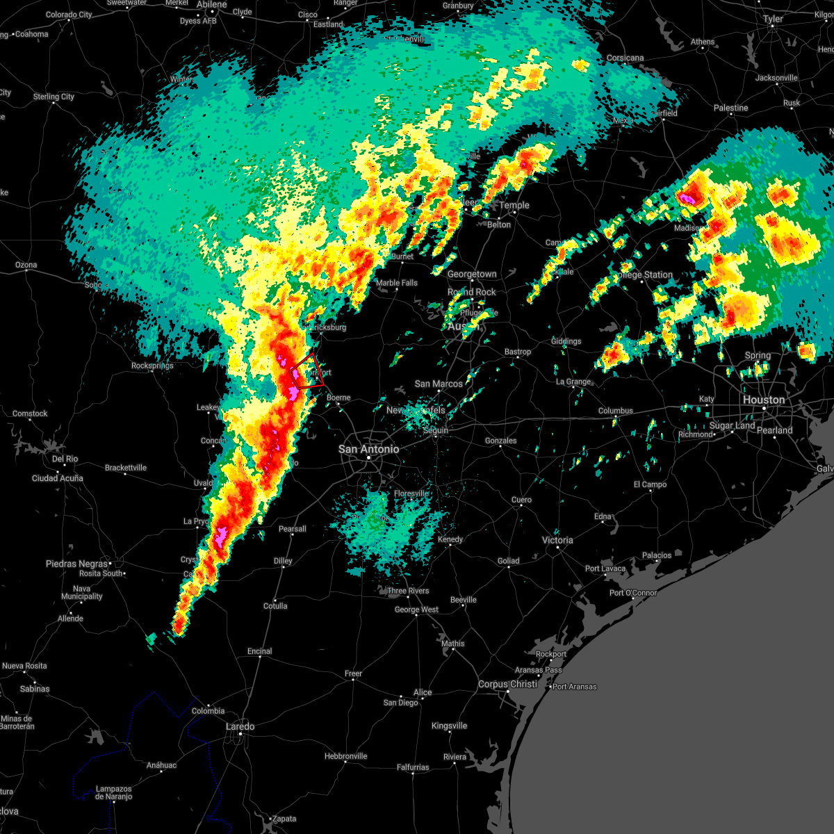 At 733 am cdt, a severe thunderstorm capable of producing a tornado was located near center point, or near kerrville, moving northeast at 30 mph (radar indicated rotation). Hazards include tornado. Flying debris will be dangerous to those caught without shelter. mobile homes will be damaged or destroyed. damage to roofs, windows, and vehicles will occur. tree damage is likely. Locations impacted include, kerrville, comfort, center point and cypress creek. At 733 am cdt, a severe thunderstorm capable of producing a tornado was located near center point, or near kerrville, moving northeast at 30 mph (radar indicated rotation). Hazards include tornado. Flying debris will be dangerous to those caught without shelter. mobile homes will be damaged or destroyed. damage to roofs, windows, and vehicles will occur. tree damage is likely. Locations impacted include, kerrville, comfort, center point and cypress creek.
|
| 4/2/2017 7:26 AM CDT |
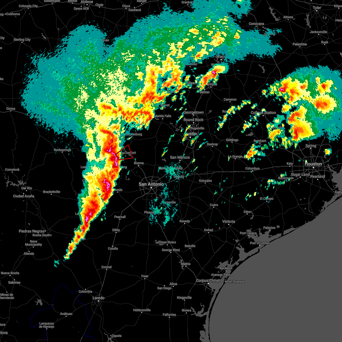 At 726 am cdt, a severe thunderstorm capable of producing a tornado was located near camp verde, or near kerrville, moving east at 30 mph (radar indicated rotation). Hazards include tornado. Flying debris will be dangerous to those caught without shelter. mobile homes will be damaged or destroyed. damage to roofs, windows, and vehicles will occur. Tree damage is likely. At 726 am cdt, a severe thunderstorm capable of producing a tornado was located near camp verde, or near kerrville, moving east at 30 mph (radar indicated rotation). Hazards include tornado. Flying debris will be dangerous to those caught without shelter. mobile homes will be damaged or destroyed. damage to roofs, windows, and vehicles will occur. Tree damage is likely.
|
| 4/2/2017 7:17 AM CDT |
 At 717 am cdt, severe thunderstorms were located along a line extending from near ingram to near tarpley, moving northeast at 35 mph (radar indicated). Hazards include 60 mph wind gusts and quarter size hail. Hail damage to vehicles is expected. Expect wind damage to roofs, siding, and trees. At 717 am cdt, severe thunderstorms were located along a line extending from near ingram to near tarpley, moving northeast at 35 mph (radar indicated). Hazards include 60 mph wind gusts and quarter size hail. Hail damage to vehicles is expected. Expect wind damage to roofs, siding, and trees.
|
| 3/29/2017 12:25 AM CDT |
 At 1225 am cdt, severe thunderstorms were located along a line extending from 6 miles northwest of cherokee to near enchanted rock station to kerrville to near tarpley, moving east at 35 mph (radar indicated). Hazards include 60 mph wind gusts. expect damage to roofs, siding, and trees At 1225 am cdt, severe thunderstorms were located along a line extending from 6 miles northwest of cherokee to near enchanted rock station to kerrville to near tarpley, moving east at 35 mph (radar indicated). Hazards include 60 mph wind gusts. expect damage to roofs, siding, and trees
|
| 6/1/2016 5:46 PM CDT |
 At 545 pm cdt, a severe thunderstorm was located over center point, or near comfort, moving east at 25 mph (trained weather spotters. at 5:38 pm 1.5 inch hail was reported in kerrville). Hazards include golf ball size hail and 60 mph wind gusts. People and animals outdoors will be injured. expect hail damage to roofs, siding, windows, and vehicles. expect wind damage to roofs, siding, and trees. Locations impacted include, kerrville, boerne, comfort, kerrville state park, waring, walnut grove, welfare, cypress creek, nelson city, sisterdale, center point, camp verde and crown. At 545 pm cdt, a severe thunderstorm was located over center point, or near comfort, moving east at 25 mph (trained weather spotters. at 5:38 pm 1.5 inch hail was reported in kerrville). Hazards include golf ball size hail and 60 mph wind gusts. People and animals outdoors will be injured. expect hail damage to roofs, siding, windows, and vehicles. expect wind damage to roofs, siding, and trees. Locations impacted include, kerrville, boerne, comfort, kerrville state park, waring, walnut grove, welfare, cypress creek, nelson city, sisterdale, center point, camp verde and crown.
|
| 6/1/2016 5:26 PM CDT |
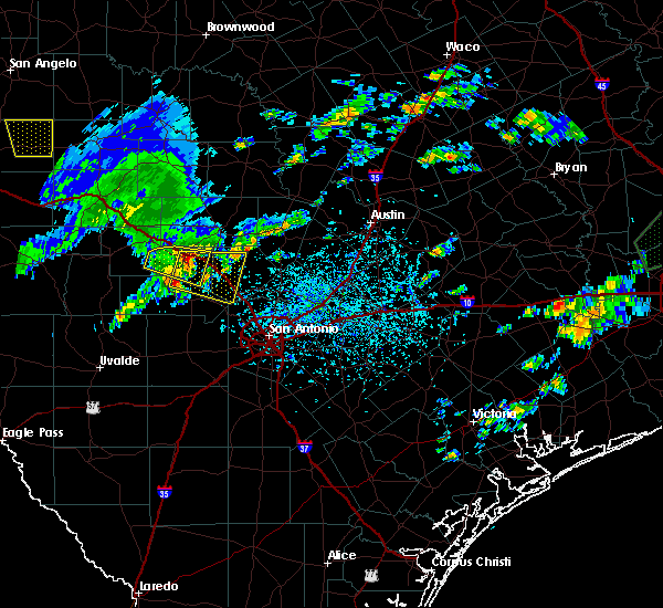 At 525 pm cdt, a severe thunderstorm was located near kerrville state park, or near kerrville, moving east at 25 mph (trained weather spotters. at 5:20 pm two inch hail was reported in kerrville). Hazards include golf ball size hail and 60 mph wind gusts. People and animals outdoors will be injured. expect hail damage to roofs, siding, windows, and vehicles. Expect wind damage to roofs, siding, and trees. At 525 pm cdt, a severe thunderstorm was located near kerrville state park, or near kerrville, moving east at 25 mph (trained weather spotters. at 5:20 pm two inch hail was reported in kerrville). Hazards include golf ball size hail and 60 mph wind gusts. People and animals outdoors will be injured. expect hail damage to roofs, siding, windows, and vehicles. Expect wind damage to roofs, siding, and trees.
|
| 5/29/2016 12:11 AM CDT |
 At 1210 am cdt, severe thunderstorms were located along a line extending from welfare to bandera falls to near utopia to 7 miles west of montell, moving south at 15 mph. this incluses garner state park where ongoing camping is high for the holiday weekend (radar indicated). Hazards include 60 mph wind gusts and quarter size hail. Hail damage to vehicles is expected. expect wind damage to roofs, siding, and trees. Locations impacted include, medina, kerrville, boerne, comfort, bandera, leakey, vanderpool, tarpley, camp wood, montell, lost maples state park, waring, concan, pipe creek, walnut grove, utopia, welfare, sisterdale, bandera falls and mico. At 1210 am cdt, severe thunderstorms were located along a line extending from welfare to bandera falls to near utopia to 7 miles west of montell, moving south at 15 mph. this incluses garner state park where ongoing camping is high for the holiday weekend (radar indicated). Hazards include 60 mph wind gusts and quarter size hail. Hail damage to vehicles is expected. expect wind damage to roofs, siding, and trees. Locations impacted include, medina, kerrville, boerne, comfort, bandera, leakey, vanderpool, tarpley, camp wood, montell, lost maples state park, waring, concan, pipe creek, walnut grove, utopia, welfare, sisterdale, bandera falls and mico.
|
| 5/28/2016 11:59 PM CDT |
 At 1158 pm cdt, severe thunderstorms were located along a line extending from comfort to pipe creek to near utopia to 7 miles west of montell, moving south to south-southeast at 15 mph (radar indicated). Hazards include 60 mph wind gusts and quarter size hail. Hail damage to vehicles is expected. Expect wind damage to roofs, siding, and trees. At 1158 pm cdt, severe thunderstorms were located along a line extending from comfort to pipe creek to near utopia to 7 miles west of montell, moving south to south-southeast at 15 mph (radar indicated). Hazards include 60 mph wind gusts and quarter size hail. Hail damage to vehicles is expected. Expect wind damage to roofs, siding, and trees.
|
| 5/28/2016 11:05 PM CDT |
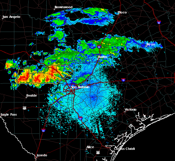 At 1105 pm cdt, severe thunderstorms were located along a line extending from near bankersmith to near bandera to near utopia, moving southeast at 20 mph (radar indicated). Hazards include 60 mph wind gusts and quarter size hail. Hail damage to vehicles is expected. Expect wind damage to roofs, siding, and trees. At 1105 pm cdt, severe thunderstorms were located along a line extending from near bankersmith to near bandera to near utopia, moving southeast at 20 mph (radar indicated). Hazards include 60 mph wind gusts and quarter size hail. Hail damage to vehicles is expected. Expect wind damage to roofs, siding, and trees.
|
| 5/28/2016 10:21 PM CDT |
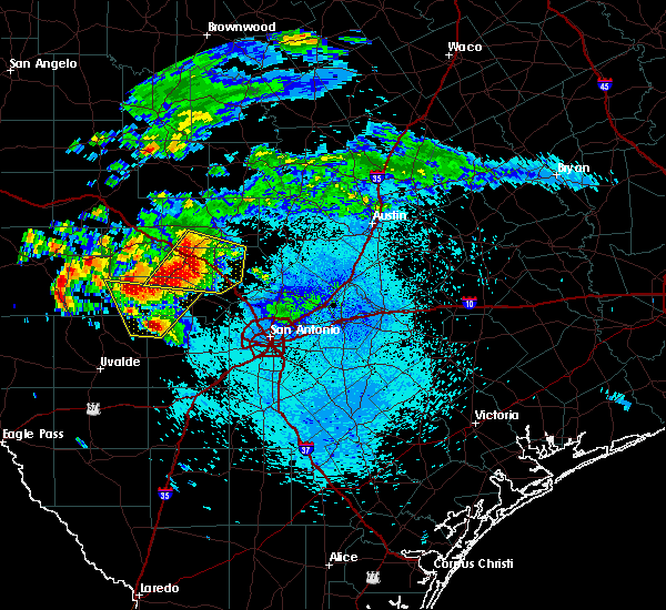 At 1021 pm cdt, a severe thunderstorm was located over center point, or 7 miles west of comfort, moving southeast at 30 mph (radar indicated). Hazards include 60 mph wind gusts and quarter size hail. Hail damage to vehicles is expected. Expect wind damage to roofs, siding, and trees. At 1021 pm cdt, a severe thunderstorm was located over center point, or 7 miles west of comfort, moving southeast at 30 mph (radar indicated). Hazards include 60 mph wind gusts and quarter size hail. Hail damage to vehicles is expected. Expect wind damage to roofs, siding, and trees.
|
| 5/26/2016 10:48 PM CDT |
 At 1048 pm cdt, severe thunderstorms were located along a line extending from near eckert to near blumenthal to kerrville state park, moving east at 45 mph (radar indicated). Hazards include 60 mph wind gusts and quarter size hail. Hail damage to vehicles is expected. expect wind damage to roofs, siding, and trees. Locations impacted include, kerrville, fredericksburg, comfort, stonewall, bankersmith, kerrville state park, eckert, tivydale, crabapple, blumenthal, grapetown, luckenbach, cain city, cypress creek, rocky hill, willow city and sisterdale. At 1048 pm cdt, severe thunderstorms were located along a line extending from near eckert to near blumenthal to kerrville state park, moving east at 45 mph (radar indicated). Hazards include 60 mph wind gusts and quarter size hail. Hail damage to vehicles is expected. expect wind damage to roofs, siding, and trees. Locations impacted include, kerrville, fredericksburg, comfort, stonewall, bankersmith, kerrville state park, eckert, tivydale, crabapple, blumenthal, grapetown, luckenbach, cain city, cypress creek, rocky hill, willow city and sisterdale.
|
| 5/26/2016 10:36 PM CDT |
 At 1034 pm cdt, severe thunderstorms were located along a line extending from near hilltop to 8 miles southeast of tivydale to near ingram, moving east at 55 mph. destructive winds will likely impact the city of fredericksburg (radar indicated). Hazards include 70 mph wind gusts and quarter size hail. Hail damage to vehicles is expected. expect considerable tree damage. wind damage is also likely to mobile homes, roofs, and outbuildings. Locations impacted include, kerrville, fredericksburg, comfort, ingram, stonewall, waltonia, bankersmith, kerrville state park, eckert, tivydale, crabapple, blumenthal, harper, grapetown, luckenbach, cain city, cypress creek, rocky hill, willow city and sisterdale. At 1034 pm cdt, severe thunderstorms were located along a line extending from near hilltop to 8 miles southeast of tivydale to near ingram, moving east at 55 mph. destructive winds will likely impact the city of fredericksburg (radar indicated). Hazards include 70 mph wind gusts and quarter size hail. Hail damage to vehicles is expected. expect considerable tree damage. wind damage is also likely to mobile homes, roofs, and outbuildings. Locations impacted include, kerrville, fredericksburg, comfort, ingram, stonewall, waltonia, bankersmith, kerrville state park, eckert, tivydale, crabapple, blumenthal, harper, grapetown, luckenbach, cain city, cypress creek, rocky hill, willow city and sisterdale.
|
| 5/26/2016 10:10 PM CDT |
 At 1009 pm cdt, severe thunderstorms were located along a line extending from near harper to near hunt, moving east at 45 mph (radar indicated). Hazards include 70 mph wind gusts and ping pong ball size hail. People and animals outdoors will be injured. expect hail damage to roofs, siding, windows, and vehicles. expect considerable tree damage. Wind damage is also likely to mobile homes, roofs, and outbuildings. At 1009 pm cdt, severe thunderstorms were located along a line extending from near harper to near hunt, moving east at 45 mph (radar indicated). Hazards include 70 mph wind gusts and ping pong ball size hail. People and animals outdoors will be injured. expect hail damage to roofs, siding, windows, and vehicles. expect considerable tree damage. Wind damage is also likely to mobile homes, roofs, and outbuildings.
|
| 5/17/2016 11:25 PM CDT |
 The severe thunderstorm warning for southeastern kerr and kendall counties will expire at 1130 pm cdt, the storm which prompted the warning has moved out of the area. therefore the warning will be allowed to expire. a severe thunderstorm watch remains in effect until 100 am cdt for south central texas. The severe thunderstorm warning for southeastern kerr and kendall counties will expire at 1130 pm cdt, the storm which prompted the warning has moved out of the area. therefore the warning will be allowed to expire. a severe thunderstorm watch remains in effect until 100 am cdt for south central texas.
|
| 5/17/2016 10:45 PM CDT |
 At 1045 pm cdt, a severe thunderstorm was located over comfort, moving southeast at 20 mph (radar indicated). Hazards include 70 mph wind gusts and quarter size hail. Hail damage to vehicles is expected. expect considerable tree damage. wind damage is also likely to mobile homes, roofs, and outbuildings. Locations impacted include, boerne, comfort, fair oaks ranch, walnut grove, welfare, nelson city, waring, kreutzberg, sisterdale, cascade caverns and crown. At 1045 pm cdt, a severe thunderstorm was located over comfort, moving southeast at 20 mph (radar indicated). Hazards include 70 mph wind gusts and quarter size hail. Hail damage to vehicles is expected. expect considerable tree damage. wind damage is also likely to mobile homes, roofs, and outbuildings. Locations impacted include, boerne, comfort, fair oaks ranch, walnut grove, welfare, nelson city, waring, kreutzberg, sisterdale, cascade caverns and crown.
|
| 5/17/2016 10:37 PM CDT |
 At 1036 pm cdt, a severe thunderstorm was located over comfort, moving southeast at 20 mph (radar indicated). Hazards include 60 mph wind gusts and quarter size hail. Hail damage to vehicles is expected. Expect wind damage to roofs, siding, and trees. At 1036 pm cdt, a severe thunderstorm was located over comfort, moving southeast at 20 mph (radar indicated). Hazards include 60 mph wind gusts and quarter size hail. Hail damage to vehicles is expected. Expect wind damage to roofs, siding, and trees.
|
| 5/11/2016 1:57 AM CDT |
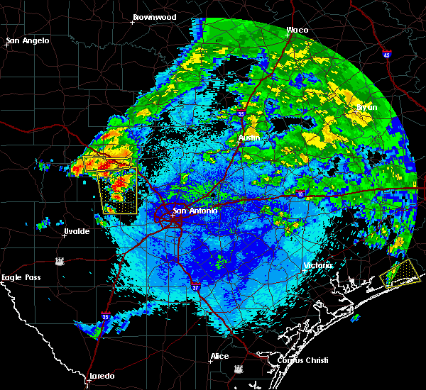 At 157 am cdt, a severe thunderstorm was located near camp verde, or 7 miles north of bandera, moving northeast at 25 mph (radar indicated). Hazards include 60 mph wind gusts and quarter size hail. Hail damage to vehicles is expected. Expect wind damage to roofs, siding, and trees. At 157 am cdt, a severe thunderstorm was located near camp verde, or 7 miles north of bandera, moving northeast at 25 mph (radar indicated). Hazards include 60 mph wind gusts and quarter size hail. Hail damage to vehicles is expected. Expect wind damage to roofs, siding, and trees.
|
| 4/30/2016 2:40 AM CDT |
 At 240 am cdt, severe thunderstorms were located along a line extending from 6 miles west of nelson city to near tarpley to 9 miles southeast of utopia to 7 miles northwest of knippa to 8 miles northwest of uvalde to near brackettville, moving east at 40 mph. these are very dangerous storms (radar indicated). Hazards include baseball size hail and 60 mph wind gusts. People and animals outdoors will be severely injured. expect shattered windows, extensive damage to roofs, siding, and vehicles. Locations impacted include, medina, kerrville, uvalde, boerne, hondo, comfort, brackettville, bandera, spofford, tarpley, sabinal, laguna, d`hanis, waring, blewett, alamo village, concan, pipe creek, standart and walnut grove. At 240 am cdt, severe thunderstorms were located along a line extending from 6 miles west of nelson city to near tarpley to 9 miles southeast of utopia to 7 miles northwest of knippa to 8 miles northwest of uvalde to near brackettville, moving east at 40 mph. these are very dangerous storms (radar indicated). Hazards include baseball size hail and 60 mph wind gusts. People and animals outdoors will be severely injured. expect shattered windows, extensive damage to roofs, siding, and vehicles. Locations impacted include, medina, kerrville, uvalde, boerne, hondo, comfort, brackettville, bandera, spofford, tarpley, sabinal, laguna, d`hanis, waring, blewett, alamo village, concan, pipe creek, standart and walnut grove.
|
| 4/30/2016 2:27 AM CDT |
 At 226 am cdt, severe thunderstorms were located along a line extending from near camp verde to near tarpley to 8 miles south of utopia to 10 miles southwest of concan to near cline to 7 miles south of standart, moving east at 35 mph (radar indicated). Hazards include quarter size hail. damage to vehicles is expected At 226 am cdt, severe thunderstorms were located along a line extending from near camp verde to near tarpley to 8 miles south of utopia to 10 miles southwest of concan to near cline to 7 miles south of standart, moving east at 35 mph (radar indicated). Hazards include quarter size hail. damage to vehicles is expected
|
| 4/27/2016 2:39 AM CDT |
 The severe thunderstorm warning for kendall county will expire at 245 am cdt, the storms which prompted the warning have weakened below severe limits, and exited the warned area. therefore the warning will be allowed to expire. a severe thunderstorm watch remains in effect until 500 am cdt for south central texas. The severe thunderstorm warning for kendall county will expire at 245 am cdt, the storms which prompted the warning have weakened below severe limits, and exited the warned area. therefore the warning will be allowed to expire. a severe thunderstorm watch remains in effect until 500 am cdt for south central texas.
|
| 4/27/2016 2:05 AM CDT |
 At 205 am cdt, severe thunderstorms were located along a line extending from kendalia to boerne to 6 miles west of bandera, moving southeast at 50 mph (radar indicated). Hazards include 60 mph wind gusts and nickel size hail. Expect damage to roofs. siding. and trees. Locations impacted include, boerne, comfort, fair oaks ranch, bankersmith, bergheim, waring, walnut grove, kendalia, guadalupe river state park, welfare, nelson city, kreutzberg, sisterdale, cascade caverns, crown and scenic oaks. At 205 am cdt, severe thunderstorms were located along a line extending from kendalia to boerne to 6 miles west of bandera, moving southeast at 50 mph (radar indicated). Hazards include 60 mph wind gusts and nickel size hail. Expect damage to roofs. siding. and trees. Locations impacted include, boerne, comfort, fair oaks ranch, bankersmith, bergheim, waring, walnut grove, kendalia, guadalupe river state park, welfare, nelson city, kreutzberg, sisterdale, cascade caverns, crown and scenic oaks.
|
| 4/27/2016 1:41 AM CDT |
 At 141 am cdt, severe thunderstorms were located along a line extending from near bankersmith to near center point to 8 miles west of medina, moving southeast at 50 mph (radar indicated). Hazards include 60 mph wind gusts and nickel size hail. Expect damage to roofs. siding. And trees. At 141 am cdt, severe thunderstorms were located along a line extending from near bankersmith to near center point to 8 miles west of medina, moving southeast at 50 mph (radar indicated). Hazards include 60 mph wind gusts and nickel size hail. Expect damage to roofs. siding. And trees.
|
| 3/18/2016 5:35 PM CDT |
 At 534 pm cdt, a severe thunderstorm was located 8 miles north of medina, moving southeast at 10 mph. this storm has a history of producing up to golf ball size hail as it slowly moves to the south and southeast (public). Hazards include golf ball size hail and 60 mph wind gusts. People and animals outdoors will be injured. expect hail damage to roofs, siding, windows, and vehicles. expect wind damage to roofs, siding, and trees. Locations impacted include, kerrville, comfort, hunt, ingram, waltonia, bankersmith, grapetown, cypress creek, kerrville state park, center point and camp verde. At 534 pm cdt, a severe thunderstorm was located 8 miles north of medina, moving southeast at 10 mph. this storm has a history of producing up to golf ball size hail as it slowly moves to the south and southeast (public). Hazards include golf ball size hail and 60 mph wind gusts. People and animals outdoors will be injured. expect hail damage to roofs, siding, windows, and vehicles. expect wind damage to roofs, siding, and trees. Locations impacted include, kerrville, comfort, hunt, ingram, waltonia, bankersmith, grapetown, cypress creek, kerrville state park, center point and camp verde.
|
| 3/18/2016 5:11 PM CDT |
 At 509 pm cdt, a severe thunderstorm was located over waltonia, or 8 miles west of kerrville, moving southeast at 10 mph. this storm has a history of producing ping pong to golf ball sized hail as it slowly moves to the south and southeast (public). Hazards include golf ball size hail and 60 mph wind gusts. People and animals outdoors will be injured. expect hail damage to roofs, siding, windows, and vehicles. Expect wind damage to roofs, siding, and trees. At 509 pm cdt, a severe thunderstorm was located over waltonia, or 8 miles west of kerrville, moving southeast at 10 mph. this storm has a history of producing ping pong to golf ball sized hail as it slowly moves to the south and southeast (public). Hazards include golf ball size hail and 60 mph wind gusts. People and animals outdoors will be injured. expect hail damage to roofs, siding, windows, and vehicles. Expect wind damage to roofs, siding, and trees.
|
| 3/18/2016 5:00 PM CDT |
 At 459 pm cdt, a severe thunderstorm was located 8 miles north of cypress creek, or 9 miles northeast of kerrville, moving southeast at 30 mph. ping pong size hail has been observed with this storm near tivydale in gillespie county (trained weather spotters). Hazards include ping pong ball size hail and 60 mph wind gusts. People and animals outdoors will be injured. expect hail damage to roofs, siding, windows, and vehicles. expect wind damage to roofs, siding, and trees. Locations impacted include, kerrville, fredericksburg, comfort, hunt, ingram, stonewall, waltonia, bankersmith, kerrville state park, tivydale, blumenthal, grapetown, luckenbach, cain city, cypress creek, rocky hill, center point, camp verde and harper. At 459 pm cdt, a severe thunderstorm was located 8 miles north of cypress creek, or 9 miles northeast of kerrville, moving southeast at 30 mph. ping pong size hail has been observed with this storm near tivydale in gillespie county (trained weather spotters). Hazards include ping pong ball size hail and 60 mph wind gusts. People and animals outdoors will be injured. expect hail damage to roofs, siding, windows, and vehicles. expect wind damage to roofs, siding, and trees. Locations impacted include, kerrville, fredericksburg, comfort, hunt, ingram, stonewall, waltonia, bankersmith, kerrville state park, tivydale, blumenthal, grapetown, luckenbach, cain city, cypress creek, rocky hill, center point, camp verde and harper.
|
| 3/18/2016 4:38 PM CDT |
 At 437 pm cdt, a severe thunderstorm was located near tivydale, or 12 miles west of fredericksburg, moving east at 25 mph. another severe thunderstorm was located south of hunt, moving east at 15 mph (radar indicated). Hazards include ping pong ball size hail and 60 mph wind gusts. People and animals outdoors will be injured. expect hail damage to roofs, siding, windows, and vehicles. Expect wind damage to roofs, siding, and trees. At 437 pm cdt, a severe thunderstorm was located near tivydale, or 12 miles west of fredericksburg, moving east at 25 mph. another severe thunderstorm was located south of hunt, moving east at 15 mph (radar indicated). Hazards include ping pong ball size hail and 60 mph wind gusts. People and animals outdoors will be injured. expect hail damage to roofs, siding, windows, and vehicles. Expect wind damage to roofs, siding, and trees.
|
| 5/29/2015 12:12 AM CDT | At 1211 am cdt, severe thunderstorms were located along a line extending from near copperas cove to near pedernales falls state park to boerne, moving east at 35 mph (radar indicated). Hazards include 60 mph wind gusts. Expect damage to roofs. siding and trees. Locations impacted include, boerne, kingsland, marble falls, burnet, comfort, blanco, bertram, round mountain, buchanan dam, fair oaks ranch, granite shoals, horseshoe bay, meadowlakes, johnson city, highland haven, sandy, flugrath, spicewood, blowout and waring. |
| 5/28/2015 11:42 PM CDT | At 1140 pm cdt, severe thunderstorms were located along a line extending from 7 miles west of lampasas to near sandy to near bandera, moving east at 45 mph. the strongest winds near 70 mph will be located in far northern kendall and southern blanco counties over the next 30 minutes (radar indicated). Hazards include 60 mph to isolated 70 mph wind gusts and penny size hail. Expect damage to roofs. siding and trees. Locations impacted include, boerne, kingsland, marble falls, burnet, comfort, blanco, bertram, round mountain, buchanan dam, fair oaks ranch, granite shoals, horseshoe bay, meadowlakes, johnson city, highland haven, sandy, flugrath, spicewood, blowout and waring. |
| 5/28/2015 11:30 PM CDT | At 1129 pm cdt, severe thunderstorms were located along a line extending from near tow to near blumenthal to near medina, moving east at 55 mph (radar indicated). Hazards include 60 to isolated 70 mph wind gusts. Expect damage to roofs. siding and trees. Locations impacted include, kerrville, fredericksburg, kingsland, llano, comfort, buchanan dam, hunt, gainesville, granite shoals, horseshoe bay, ingram, stonewall, highland haven, bluffton, valley spring, oxford, lone grove, kerrville state park, eckert and crabapple. |
| 5/28/2015 11:16 PM CDT | At 1114 pm cdt, severe thunderstorms were located along a line extending from near tow to near eckert to near camp verde, moving east at 40 mph. * an observed wind gust of 61 mph occurred in llano in association with this severe line of thunderstorms. these strong winds and heavy rainfall will continue east (radar indicated). Hazards include 60 mph wind gusts and penny size hail. Expect damage to roofs. Siding and trees. |
| 5/28/2015 11:03 PM CDT | At 1103 pm cdt, severe thunderstorms were located along a line extending from near chappel to near hilltop to near lost maples state park, moving east at 30 mph (radar indicated). Hazards include 60 mph wind gusts and penny size hail. Expect damage to roofs. siding and trees. Locations impacted include, kerrville, fredericksburg, kingsland, llano, comfort, buchanan dam, hunt, gainesville, granite shoals, horseshoe bay, ingram, stonewall, highland haven, bluffton, valley spring, oxford, lone grove, kerrville state park, eckert and crabapple. |
| 5/28/2015 10:24 PM CDT | At 1024 pm cdt, severe thunderstorms were located along a line extending from near san saba to near loyal valley to near mountain home, moving east at 55 mph (radar indicated). Hazards include 60 mph wind gusts and penny size hail. Expect damage to roofs. Siding and trees. |
| 4/27/2015 1:05 AM CDT | At 103 am cdt, severe thunderstorms were located along a line extending from near watson to near canyon lake to near fair oaks ranch to near lacoste to near yancey, and are nearly stationary. these are very dangerous storms (radar indicated). Hazards include 80 mph wind gusts and penny size hail. the strongest winds will impact medina, bexar and comal counties. Flying debris will be dangerous to those caught without shelter. mobile homes will be heavily damaged. expect considerable damage to roofs, windows and vehicles. extensive tree damage and power outages are likely. locations impacted include, san antonio, austin, round rock, new braunfels, cedar park, georgetown, pflugerville, san marcos, seguin, universal city, taylor, boerne, hondo, kingsland, marble falls, burnet, castroville, comfort, wimberley and dripping springs. 0. 75in. |
| 4/27/2015 12:44 AM CDT | At 1243 am cdt, severe thunderstorms were located along a line extending from near lake victor to near guadalupe river state park to near pipe creek to quihi to 9 miles southeast of sabinal, moving east at 45 mph (radar indicated). Hazards include 70 mph wind gusts and penny size hail. Expect considerable tree damage. Damage is likely to mobile homes, roofs and outbuildings. |
| 4/27/2015 12:09 AM CDT | At 1208 am cdt, severe thunderstorms were located along a line extending from near baby head to eckert to near cypress creek to 6 miles west of camp verde, moving east at 45 mph (radar indicated). Hazards include 70 mph wind gusts and quarter size hail. Hail damage to vehicles is expected. expect considerable tree damage. wind damage is also likely to mobile homes, roofs and outbuildings. locations impacted include, medina, kerrville, fredericksburg, boerne, kingsland, marble falls, burnet, llano, comfort, blanco, bertram, round mountain, buchanan dam, gainesville, granite shoals, horseshoe bay, ingram, meadowlakes, johnson city and stonewall. 1. 00in. |
| 4/26/2015 11:49 PM CDT | At 1148 pm cdt, severe thunderstorms were located along a line extending from near valley spring to near hilltop to near kerrville to 9 miles northwest of medina, moving east at 50 mph (radar indicated). Hazards include 70 mph wind gusts and quarter size hail. Hail damage to vehicles is expected. expect considerable tree damage. Wind damage is also likely to mobile homes, roofs and outbuildings. |
| 4/18/2015 5:37 PM CDT | At 536 pm cdt, a severe thunderstorm was located 8 miles northeast of sisterdale, or 14 miles west of blanco, moving northeast at 25 mph. other storms near fredericksburg were moving east at about 20 mph (radar indicated). Hazards include quarter size hail. damage to vehicles is expected |
| 4/18/2015 5:09 PM CDT | At 509 pm cdt, a severe thunderstorm was located over waring, or 8 miles east of comfort, moving northeast at 20 mph (radar indicated). Hazards include golf ball size hail. People and animals outdoors will be injured. expect damage to roofs, siding, windows and vehicles. locations impacted include, comfort, walnut grove, kendalia, welfare, nelson city, waring, kreutzberg, sisterdale and crown. 1. 75in. |
| 4/18/2015 4:59 PM CDT | Half Dollar sized hail reported 6.9 miles WNW of Comfort, TX |
| 4/18/2015 4:58 PM CDT | At 458 pm cdt, a severe thunderstorm was located over welfare, or near comfort, moving northeast at 20 mph (radar indicated). Hazards include golf ball size hail. People and animals outdoors will be injured. Expect damage to roofs, siding, windows and vehicles. |
| 1/1/0001 12:00 AM | Large oak tree snapped in half and tin roof was pulled up in sisterdal in kendall county TX, 10.1 miles W of Comfort, TX |
| 1/1/0001 12:00 AM | Wind gusts 50 to 60 mp in kendall county TX, 10.1 miles W of Comfort, TX |
| 1/1/0001 12:00 AM | Quarter sized hail reported 10.5 miles SW of Comfort, TX |
| 1/1/0001 12:00 AM | Quarter sized hail reported 10.5 miles SW of Comfort, TX |
Hail Maps for Comfort, TX
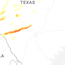
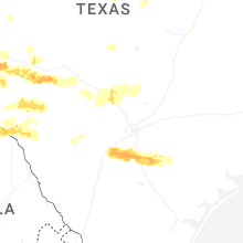
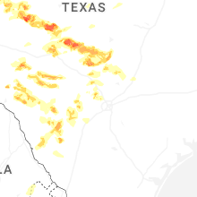
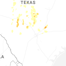
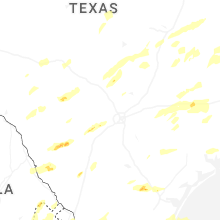


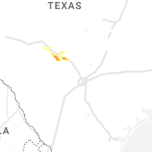


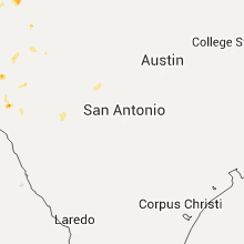


Connect with Interactive Hail Maps