

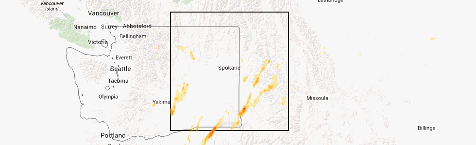
Hail Map for Conkling Park, ID
The Conkling Park, ID area has had 0 reports of on-the-ground hail by trained spotters, and has been under severe weather warnings 7 times during the past 12 months. Doppler radar has detected hail at or near Conkling Park, ID on 4 occasions.
| Name: | Conkling Park, ID |
| Where Located: | 35.1 miles ESE of Spokane, WA |
| Map: | Google Map for Conkling Park, ID |
| Population: | 43 |
| Housing Units: | 171 |
| More Info: | Search Google for Conkling Park, ID |
5
The Top Recent Hail Date for Conkling Park, ID is Friday, July 20, 2012 (1st out of 4)
Hail and Wind Damage Spotted near Conkling Park, ID
| Date / Time | Report Details |
|---|---|
| 6/9/2023 5:15 PM PDT |
 At 515 pm pdt, a severe thunderstorm was located over st. maries, moving north at 25 mph (radar indicated). Hazards include 60 mph wind gusts and penny size hail. Expect damage to roofs, siding, and trees. locations impacted include, st. maries, harrison, parkline, st. joe, and chatcolet. hail threat, radar indicated max hail size, 0. 75 in wind threat, radar indicated max wind gust, 60 mph. At 515 pm pdt, a severe thunderstorm was located over st. maries, moving north at 25 mph (radar indicated). Hazards include 60 mph wind gusts and penny size hail. Expect damage to roofs, siding, and trees. locations impacted include, st. maries, harrison, parkline, st. joe, and chatcolet. hail threat, radar indicated max hail size, 0. 75 in wind threat, radar indicated max wind gust, 60 mph.
|
| 6/9/2023 4:51 PM PDT |
 At 451 pm pdt, a severe thunderstorm was located 8 miles south of st. maries, moving north at 25 mph (radar indicated). Hazards include 60 mph wind gusts and quarter size hail. Hail damage to vehicles is expected. Expect wind damage to roofs, siding, and trees. At 451 pm pdt, a severe thunderstorm was located 8 miles south of st. maries, moving north at 25 mph (radar indicated). Hazards include 60 mph wind gusts and quarter size hail. Hail damage to vehicles is expected. Expect wind damage to roofs, siding, and trees.
|
| 6/8/2023 4:25 PM PDT |
 At 423 pm pdt, severe thunderstorms were located along a line extending from 6 miles east of chattaroy to 7 miles west of plummer, moving west at 20 mph (trained weather spotters reported downed tree limbs and highway signs near lake coeur d`alene earlier with these storms). Hazards include 60 mph wind gusts and nickel size hail. Expect damage to roofs, siding, and trees. locations impacted include, spokane, spokane valley, post falls, rathdrum, liberty lake, nine mile falls, millwood, plummer, hauser, harrison, otis orchards-east farms, fairwood, otis orchards, green acres, trentwood, country homes, town and country, chattaroy, dishman, and mead. this includes the following highways, interstate 90 in washington between mile markers 277 and 299. interstate 90 in idaho between mile markers 0 and 8. u. s. highway 95 in idaho between mile markers 390 and 425. u. s. highway 2 in washington between mile markers 282 and 305. u. s. highway 195 in washington between mile markers 75 and 95. u. s. highway 395 in washington between mile markers 165 and 177. hail threat, radar indicated max hail size, 0. 88 in wind threat, radar indicated max wind gust, 60 mph. At 423 pm pdt, severe thunderstorms were located along a line extending from 6 miles east of chattaroy to 7 miles west of plummer, moving west at 20 mph (trained weather spotters reported downed tree limbs and highway signs near lake coeur d`alene earlier with these storms). Hazards include 60 mph wind gusts and nickel size hail. Expect damage to roofs, siding, and trees. locations impacted include, spokane, spokane valley, post falls, rathdrum, liberty lake, nine mile falls, millwood, plummer, hauser, harrison, otis orchards-east farms, fairwood, otis orchards, green acres, trentwood, country homes, town and country, chattaroy, dishman, and mead. this includes the following highways, interstate 90 in washington between mile markers 277 and 299. interstate 90 in idaho between mile markers 0 and 8. u. s. highway 95 in idaho between mile markers 390 and 425. u. s. highway 2 in washington between mile markers 282 and 305. u. s. highway 195 in washington between mile markers 75 and 95. u. s. highway 395 in washington between mile markers 165 and 177. hail threat, radar indicated max hail size, 0. 88 in wind threat, radar indicated max wind gust, 60 mph.
|
| 6/8/2023 4:10 PM PDT |
 At 409 pm pdt, severe thunderstorms were located along a line extending from near hauser to 6 miles west of harrison, moving west at 15 mph (radar indicated). Hazards include 60 mph wind gusts and nickel size hail. expect damage to roofs, siding, and trees At 409 pm pdt, severe thunderstorms were located along a line extending from near hauser to 6 miles west of harrison, moving west at 15 mph (radar indicated). Hazards include 60 mph wind gusts and nickel size hail. expect damage to roofs, siding, and trees
|
| 6/8/2023 3:28 PM PDT |
 At 328 pm pdt, a severe thunderstorm was located near fourth of july pass, or 9 miles southeast of coeur d`alene, moving west at 25 mph (radar indicated). Hazards include 60 mph wind gusts and quarter size hail. Hail damage to vehicles is expected. Expect wind damage to roofs, siding, and trees. At 328 pm pdt, a severe thunderstorm was located near fourth of july pass, or 9 miles southeast of coeur d`alene, moving west at 25 mph (radar indicated). Hazards include 60 mph wind gusts and quarter size hail. Hail damage to vehicles is expected. Expect wind damage to roofs, siding, and trees.
|
| 8/10/2019 4:20 PM PDT |
 At 420 pm pdt, a severe thunderstorm was located over plummer, or 14 miles west of st. maries, and is nearly stationary (radar indicated). Hazards include quarter size hail. damage to vehicles is expected At 420 pm pdt, a severe thunderstorm was located over plummer, or 14 miles west of st. maries, and is nearly stationary (radar indicated). Hazards include quarter size hail. damage to vehicles is expected
|
| 7/20/2012 2:03 PM PDT | Trees and power lines down at ogara and south benewah road in kootenai county ID, 1.1 miles WNW of Conkling Park, ID |
Hail Maps for Conkling Park, ID


Connect with Interactive Hail Maps