

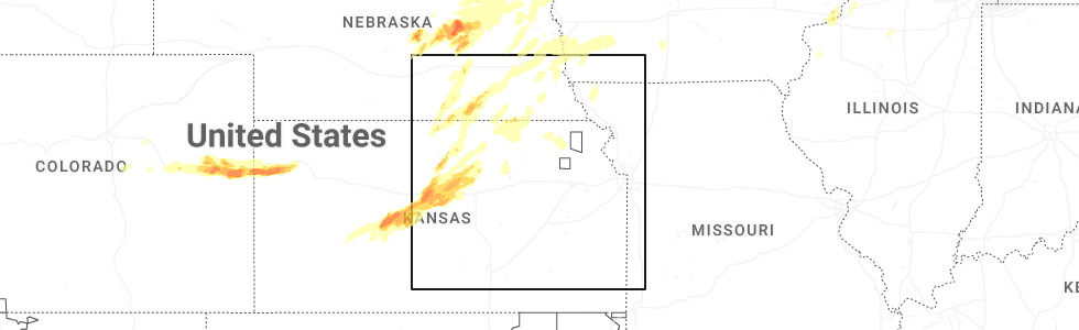
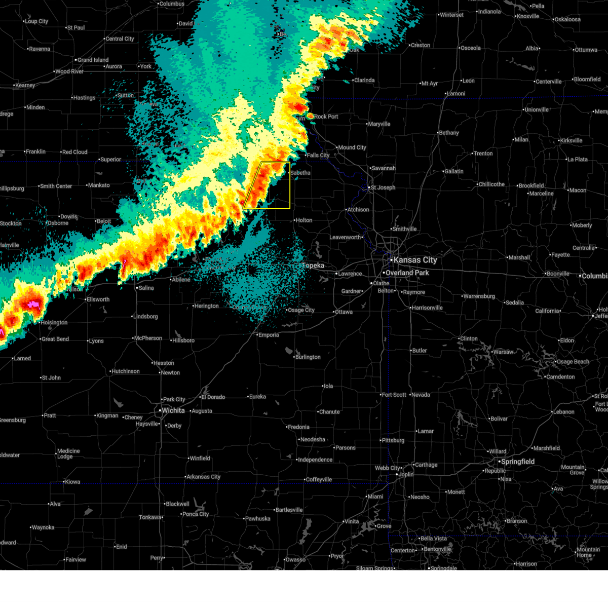
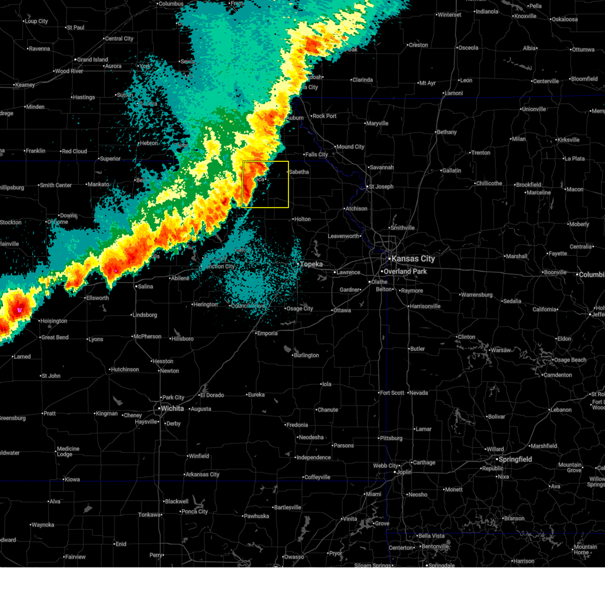
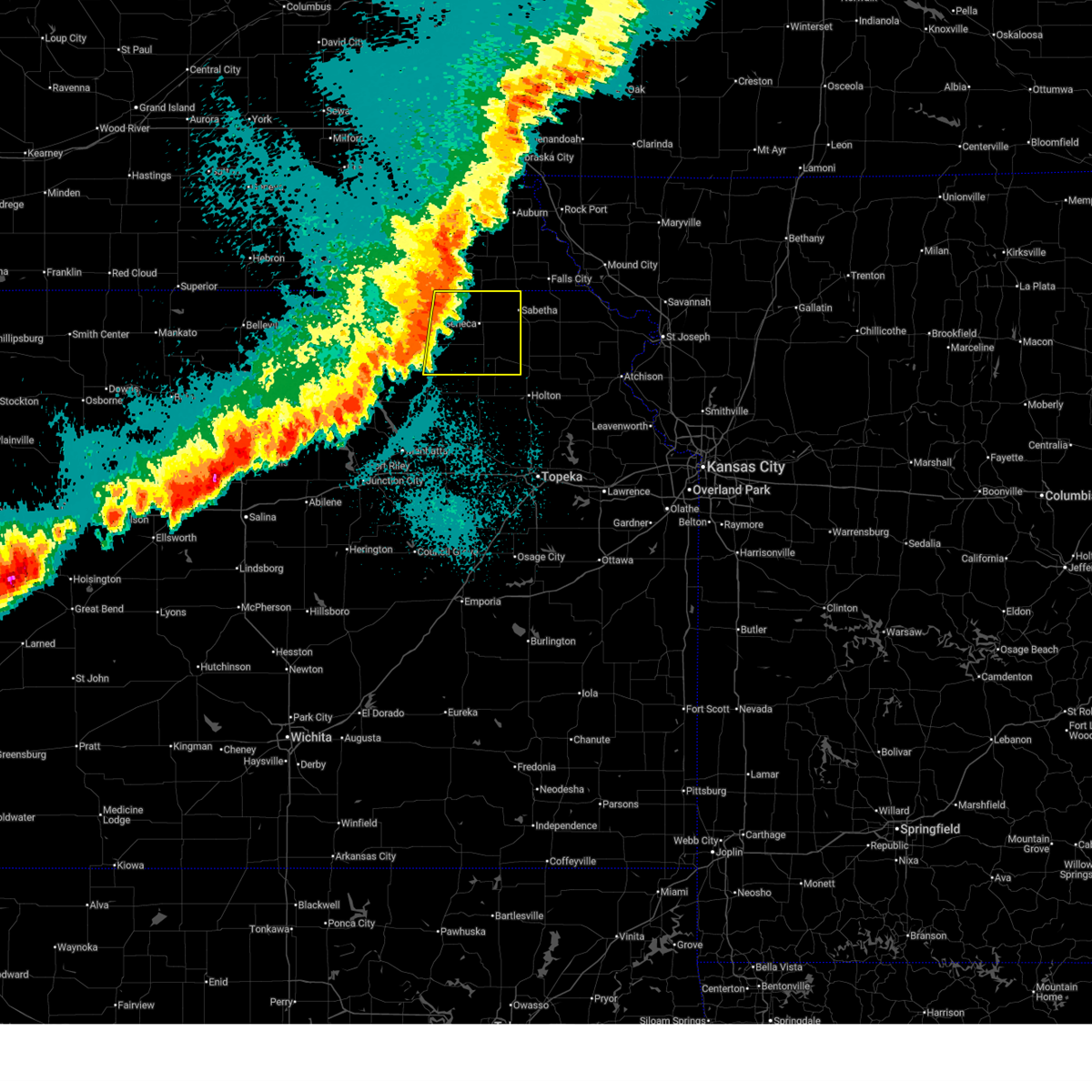
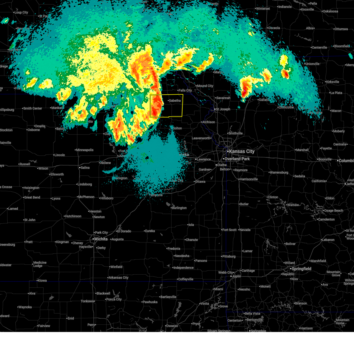
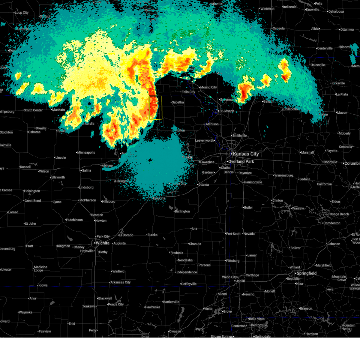
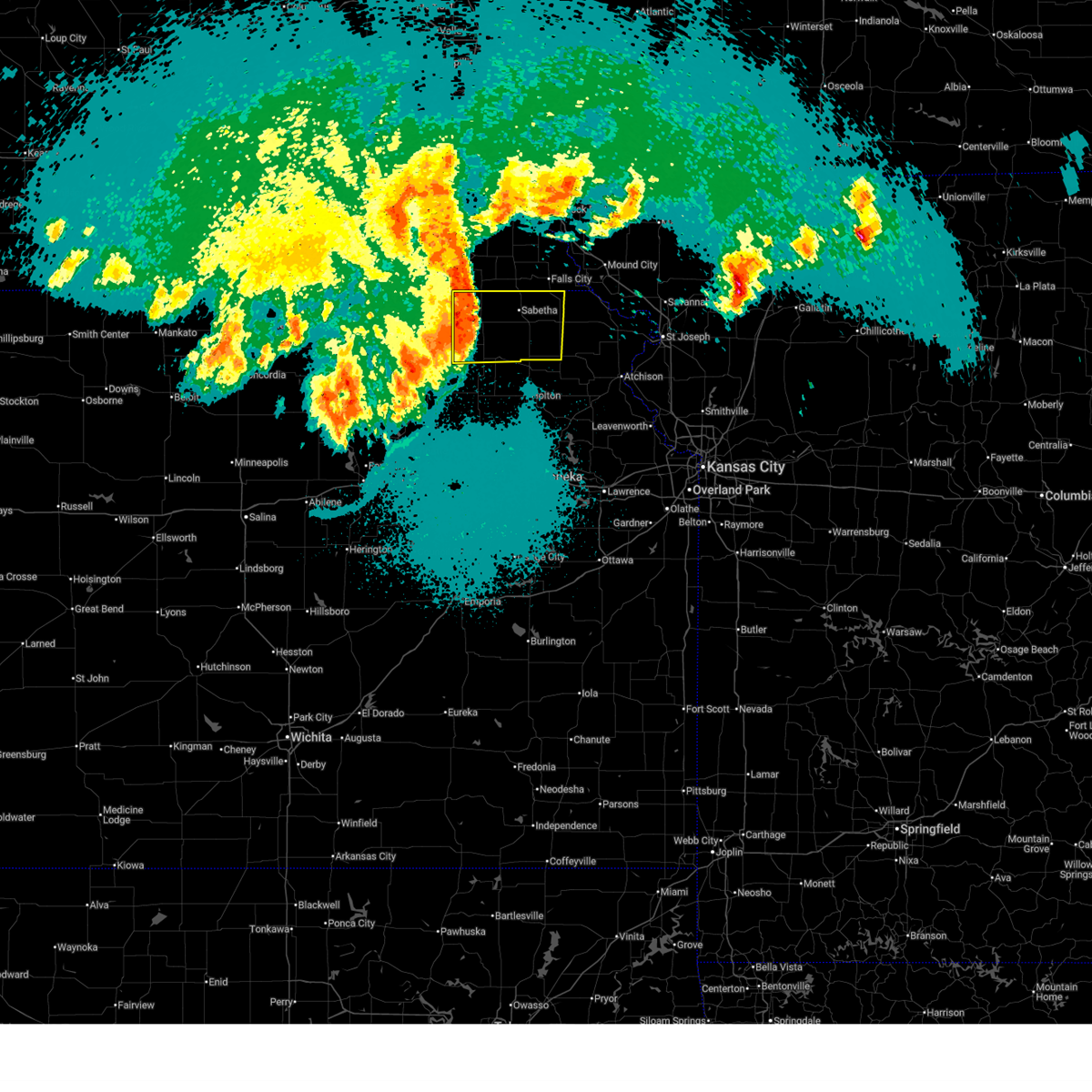
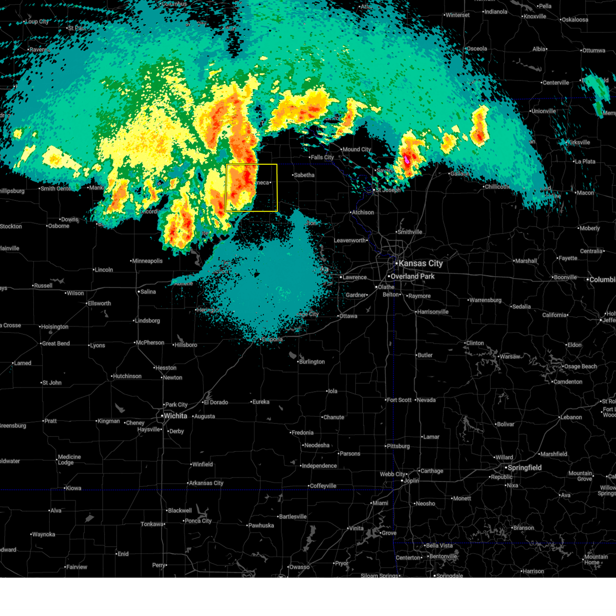
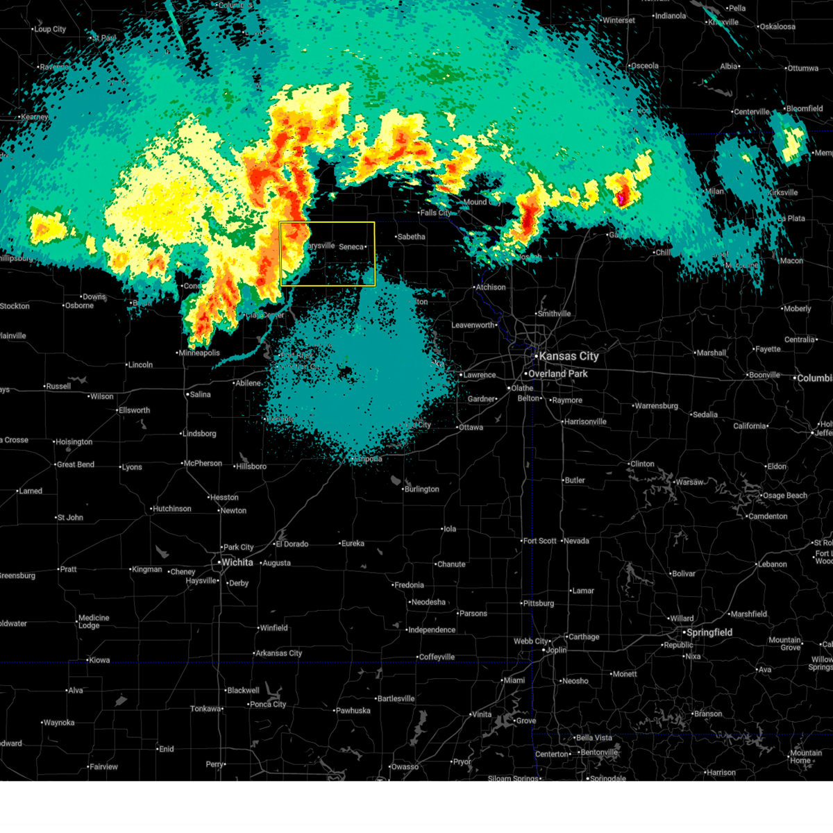
Hail Map for Corning, KS
The Corning, KS area has had 5 reports of on-the-ground hail by trained spotters, and has been under severe weather warnings 17 times during the past 12 months. Doppler radar has detected hail at or near Corning, KS on 86 occasions, including 4 occasions during the past year.
| Name: | Corning, KS |
| Where Located: | 43.6 miles NE of Manhattan, KS |
| Map: | Google Map for Corning, KS |
| Population: | 157 |
| Housing Units: | 67 |
| More Info: | Search Google for Corning, KS |
1
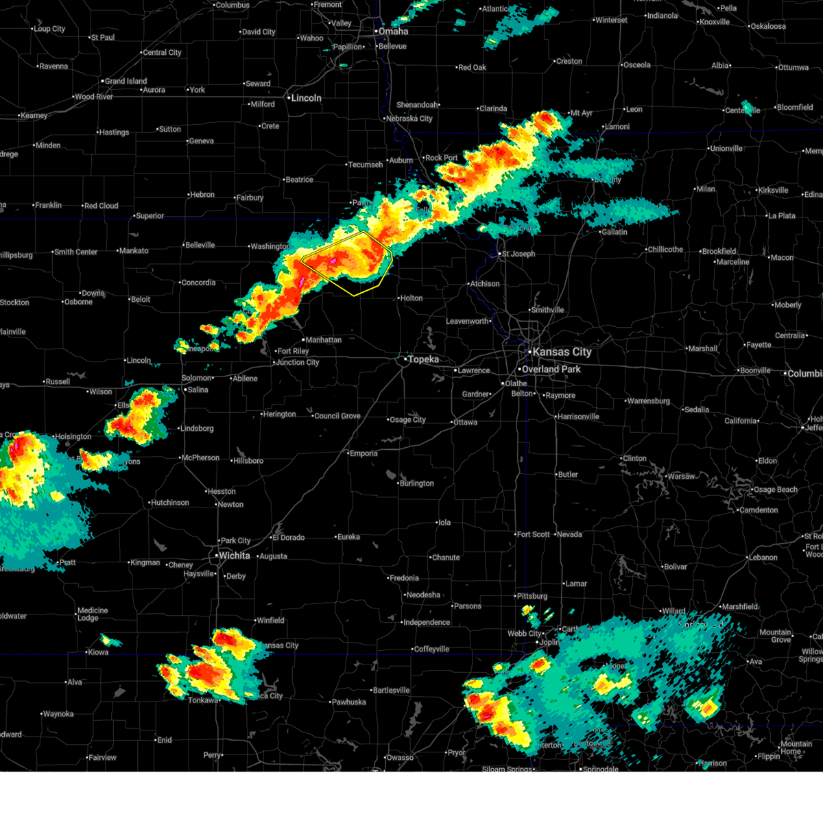
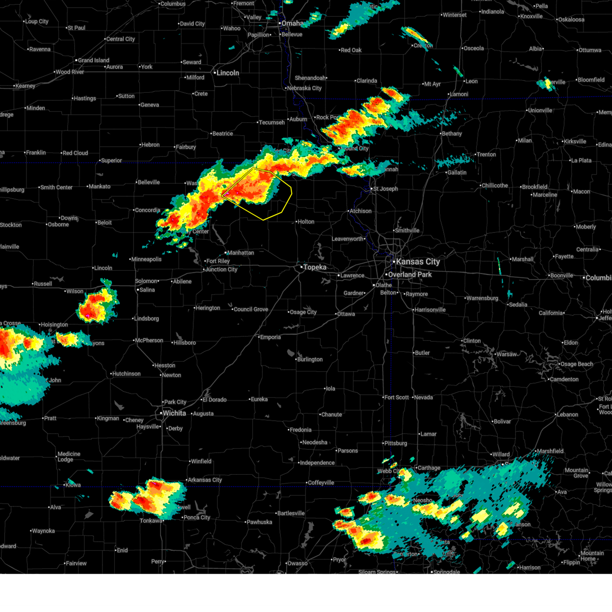
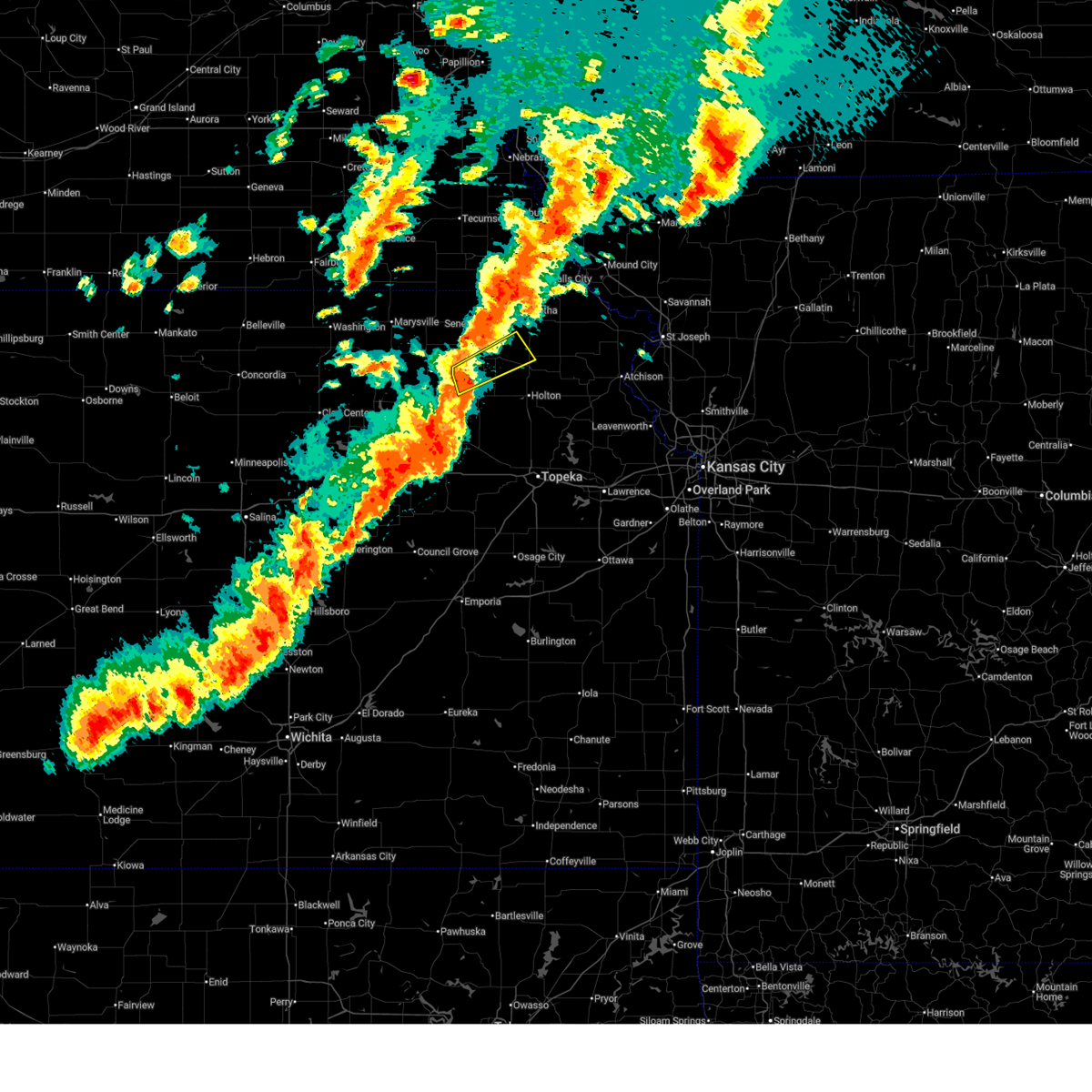
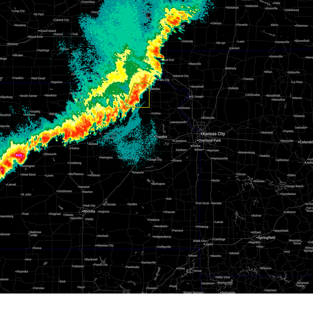
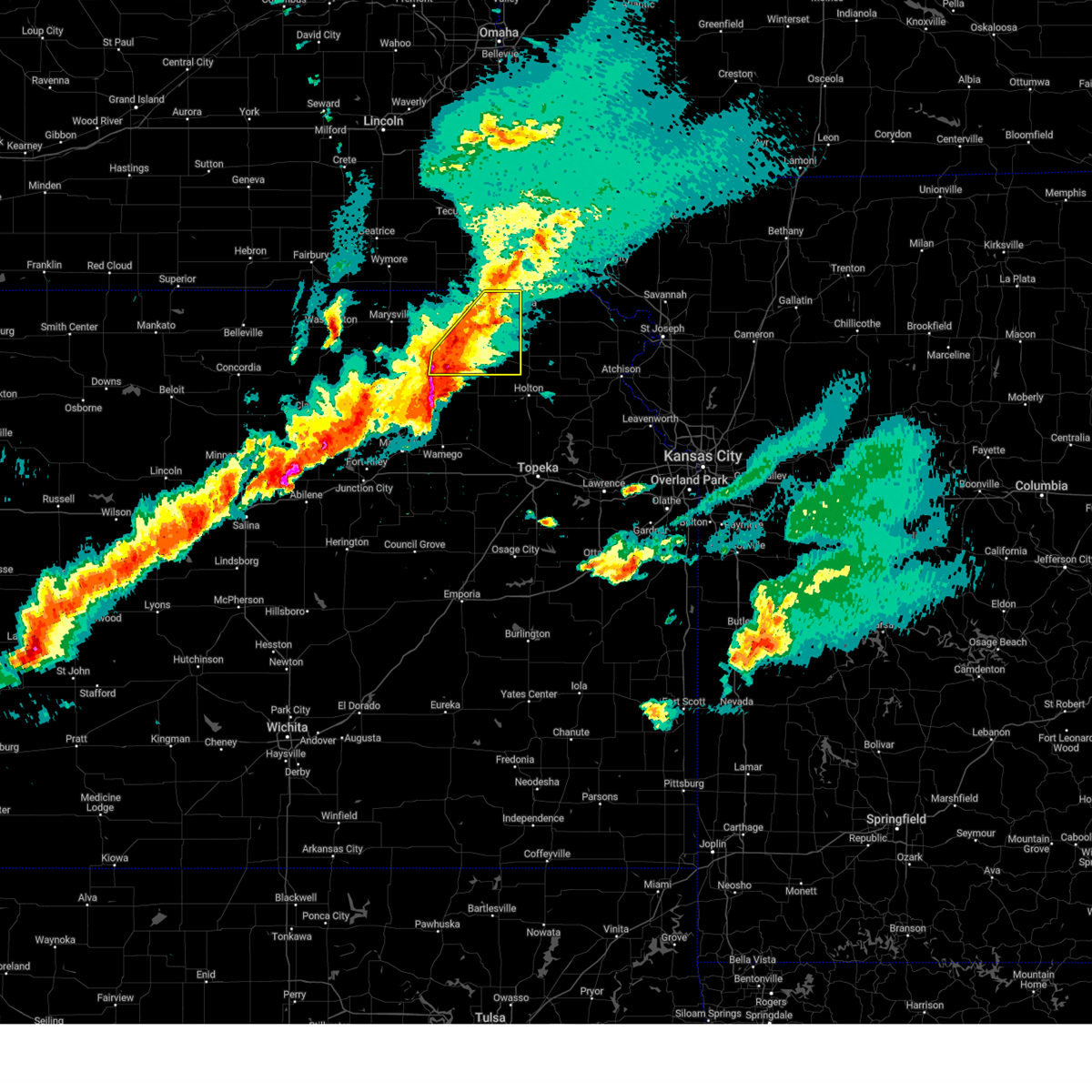
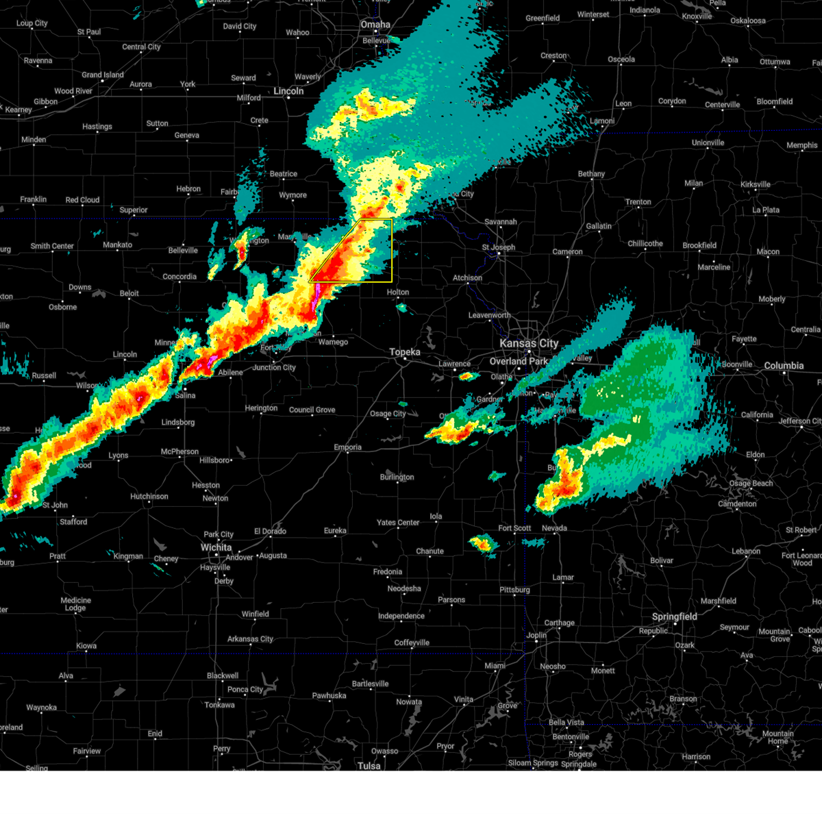
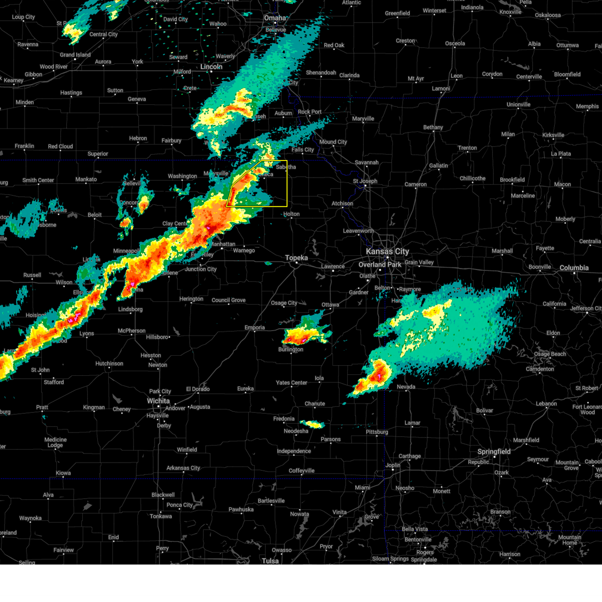
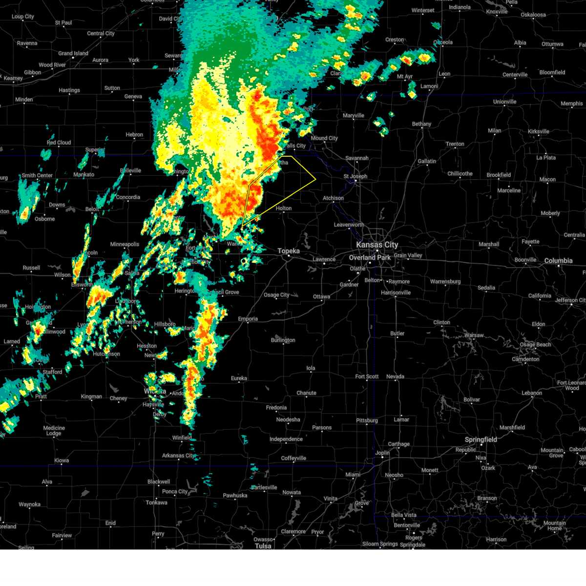
The Top Recent Hail Date for Corning, KS is Sunday, May 17, 2026 (25th out of 86)
Hail and Wind Damage Spotted near Corning, KS
| Date / Time | Report Details |
|---|---|
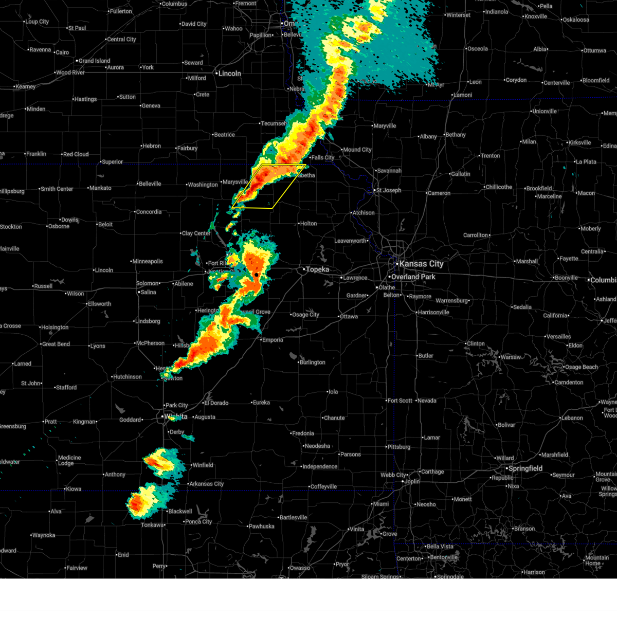
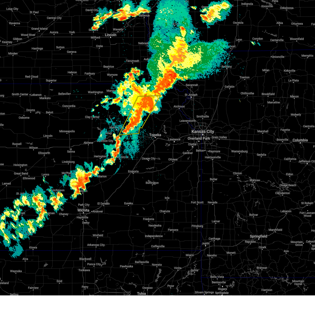
| 6/13/2026 7:09 PM CDT |
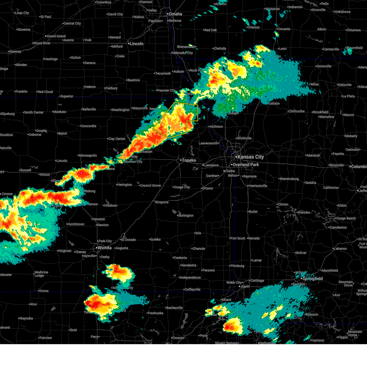 At 709 pm cdt, severe thunderstorms were located along a line extending from 4 miles north of everest to near muscotah to 3 miles east of holton, moving east at 40 mph (trained weather spotters. at 659 pm cdt...personal weather station reported 67 mph wind gust in holton). Hazards include 70 mph wind gusts and quarter size hail. Hail damage to vehicles is expected. expect considerable tree damage. wind damage is also likely to mobile homes, roofs, and outbuildings. Locations impacted include, holton, hiawatha, sabetha, horton, wetmore, everest, fairview, robinson, whiting, circleville, corning, netawaka, soldier, havensville, goff, powhattan, hamlin, willis, kickapoo reservation, and woodlawn. At 709 pm cdt, severe thunderstorms were located along a line extending from 4 miles north of everest to near muscotah to 3 miles east of holton, moving east at 40 mph (trained weather spotters. at 659 pm cdt...personal weather station reported 67 mph wind gust in holton). Hazards include 70 mph wind gusts and quarter size hail. Hail damage to vehicles is expected. expect considerable tree damage. wind damage is also likely to mobile homes, roofs, and outbuildings. Locations impacted include, holton, hiawatha, sabetha, horton, wetmore, everest, fairview, robinson, whiting, circleville, corning, netawaka, soldier, havensville, goff, powhattan, hamlin, willis, kickapoo reservation, and woodlawn.
|
| 6/13/2026 6:56 PM CDT |
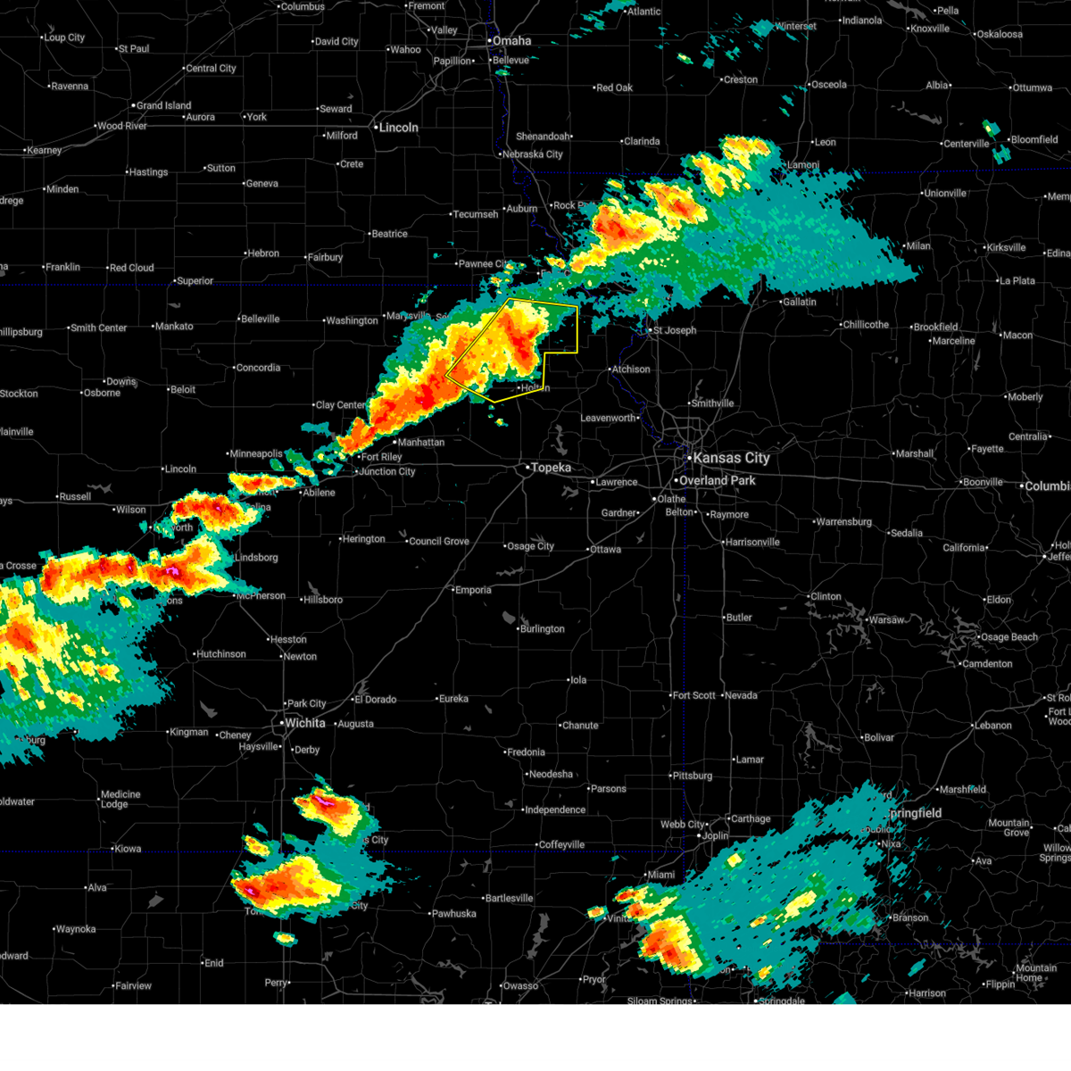 At 656 pm cdt, severe thunderstorms were located along a line extending from 3 miles east of powhattan to near whiting to near circleville, moving east at 40 mph (radar indicated). Hazards include 60 mph wind gusts and quarter size hail. Hail damage to vehicles is expected. expect wind damage to roofs, siding, and trees. Locations impacted include, holton, hiawatha, sabetha, horton, wetmore, everest, fairview, robinson, whiting, circleville, corning, netawaka, soldier, havensville, goff, powhattan, hamlin, willis, kickapoo reservation, and woodlawn. At 656 pm cdt, severe thunderstorms were located along a line extending from 3 miles east of powhattan to near whiting to near circleville, moving east at 40 mph (radar indicated). Hazards include 60 mph wind gusts and quarter size hail. Hail damage to vehicles is expected. expect wind damage to roofs, siding, and trees. Locations impacted include, holton, hiawatha, sabetha, horton, wetmore, everest, fairview, robinson, whiting, circleville, corning, netawaka, soldier, havensville, goff, powhattan, hamlin, willis, kickapoo reservation, and woodlawn.
|
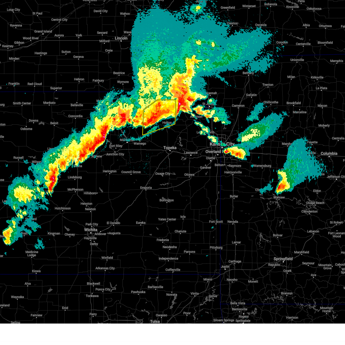
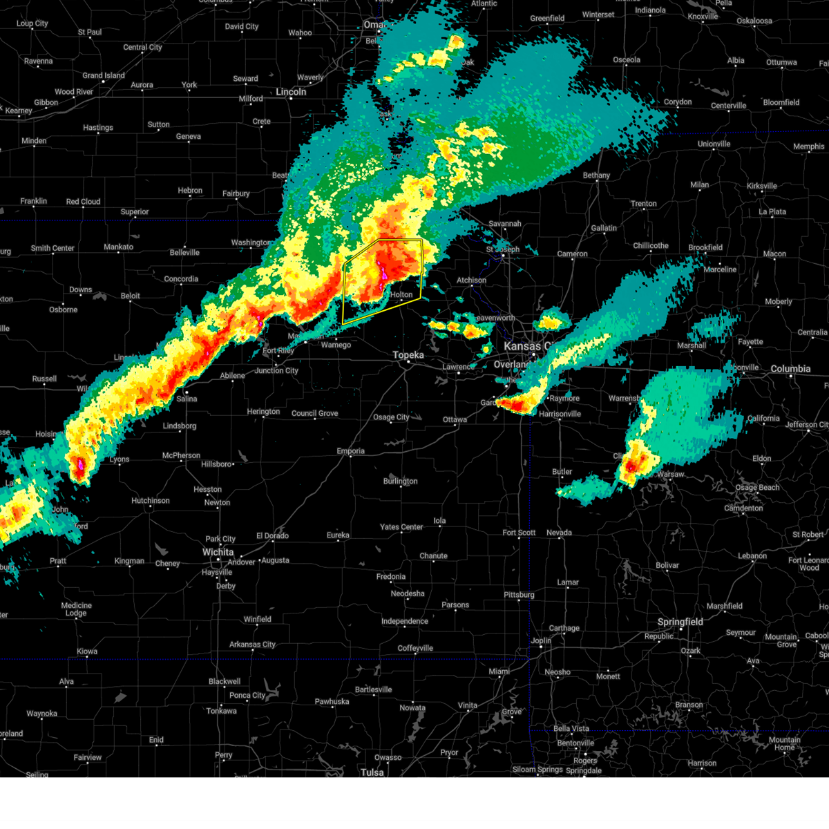
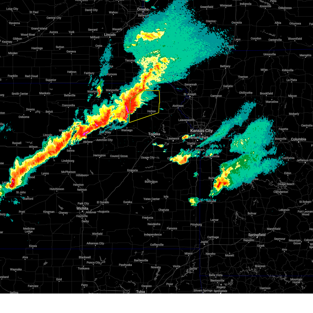
| 6/13/2026 6:36 PM CDT |
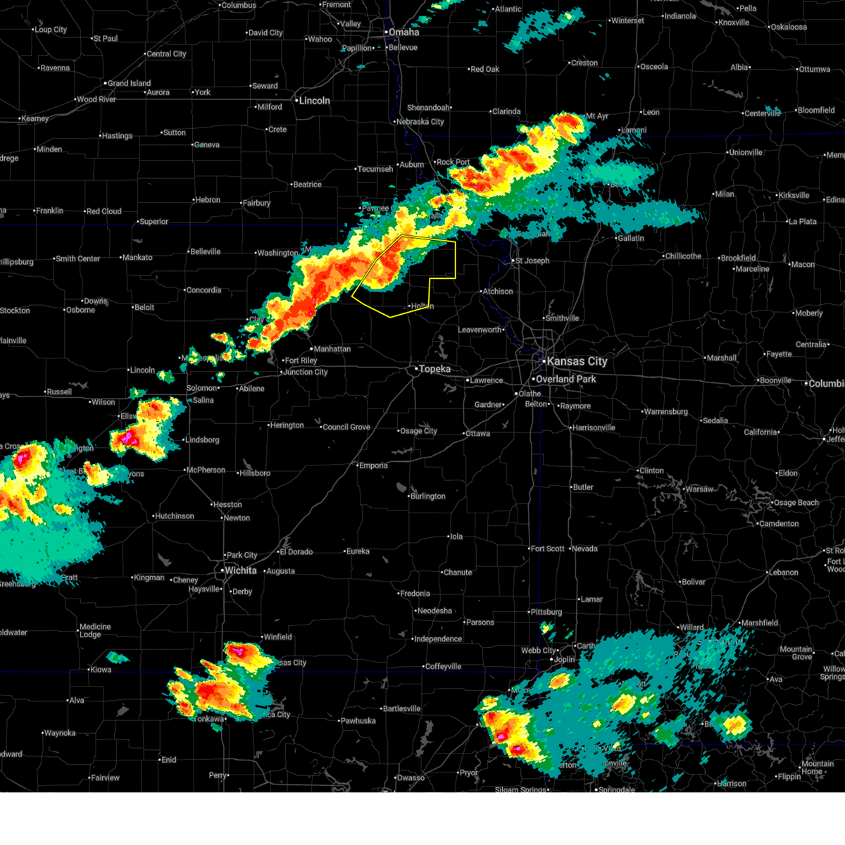 Svrtop the national weather service in topeka has issued a * severe thunderstorm warning for, southeastern nemaha county in northeastern kansas, northeastern pottawatomie county in northeastern kansas, northern jackson county in northeastern kansas, brown county in northeastern kansas, * until 715 pm cdt. * at 635 pm cdt, severe thunderstorms were located along a line extending from near fairview to near wetmore to 3 miles west of soldier, moving east at 40 mph (radar indicated). Hazards include 60 mph wind gusts and quarter size hail. Hail damage to vehicles is expected. Expect wind damage to roofs, siding, and trees. Svrtop the national weather service in topeka has issued a * severe thunderstorm warning for, southeastern nemaha county in northeastern kansas, northeastern pottawatomie county in northeastern kansas, northern jackson county in northeastern kansas, brown county in northeastern kansas, * until 715 pm cdt. * at 635 pm cdt, severe thunderstorms were located along a line extending from near fairview to near wetmore to 3 miles west of soldier, moving east at 40 mph (radar indicated). Hazards include 60 mph wind gusts and quarter size hail. Hail damage to vehicles is expected. Expect wind damage to roofs, siding, and trees.
|
| 6/13/2026 6:31 PM CDT |
 At 631 pm cdt, a severe thunderstorm was located near centralia, moving east at 35 mph (radar indicated). Hazards include 70 mph wind gusts and half dollar size hail. Hail damage to vehicles is expected. expect considerable tree damage. wind damage is also likely to mobile homes, roofs, and outbuildings. Locations impacted include, seneca, frankfort, centralia, corning, soldier, havensville, goff, vermillion, baileyville, lillis, and woodlawn. At 631 pm cdt, a severe thunderstorm was located near centralia, moving east at 35 mph (radar indicated). Hazards include 70 mph wind gusts and half dollar size hail. Hail damage to vehicles is expected. expect considerable tree damage. wind damage is also likely to mobile homes, roofs, and outbuildings. Locations impacted include, seneca, frankfort, centralia, corning, soldier, havensville, goff, vermillion, baileyville, lillis, and woodlawn.
|
| 6/13/2026 6:11 PM CDT |
 Svrtop the national weather service in topeka has issued a * severe thunderstorm warning for, nemaha county in northeastern kansas, northeastern pottawatomie county in northeastern kansas, northwestern jackson county in northeastern kansas, southeastern marshall county in northeastern kansas, * until 700 pm cdt. * at 611 pm cdt, a severe thunderstorm was located near frankfort, moving east at 35 mph (radar indicated). Hazards include 70 mph wind gusts and half dollar size hail. Hail damage to vehicles is expected. expect considerable tree damage. Wind damage is also likely to mobile homes, roofs, and outbuildings. Svrtop the national weather service in topeka has issued a * severe thunderstorm warning for, nemaha county in northeastern kansas, northeastern pottawatomie county in northeastern kansas, northwestern jackson county in northeastern kansas, southeastern marshall county in northeastern kansas, * until 700 pm cdt. * at 611 pm cdt, a severe thunderstorm was located near frankfort, moving east at 35 mph (radar indicated). Hazards include 70 mph wind gusts and half dollar size hail. Hail damage to vehicles is expected. expect considerable tree damage. Wind damage is also likely to mobile homes, roofs, and outbuildings.
|
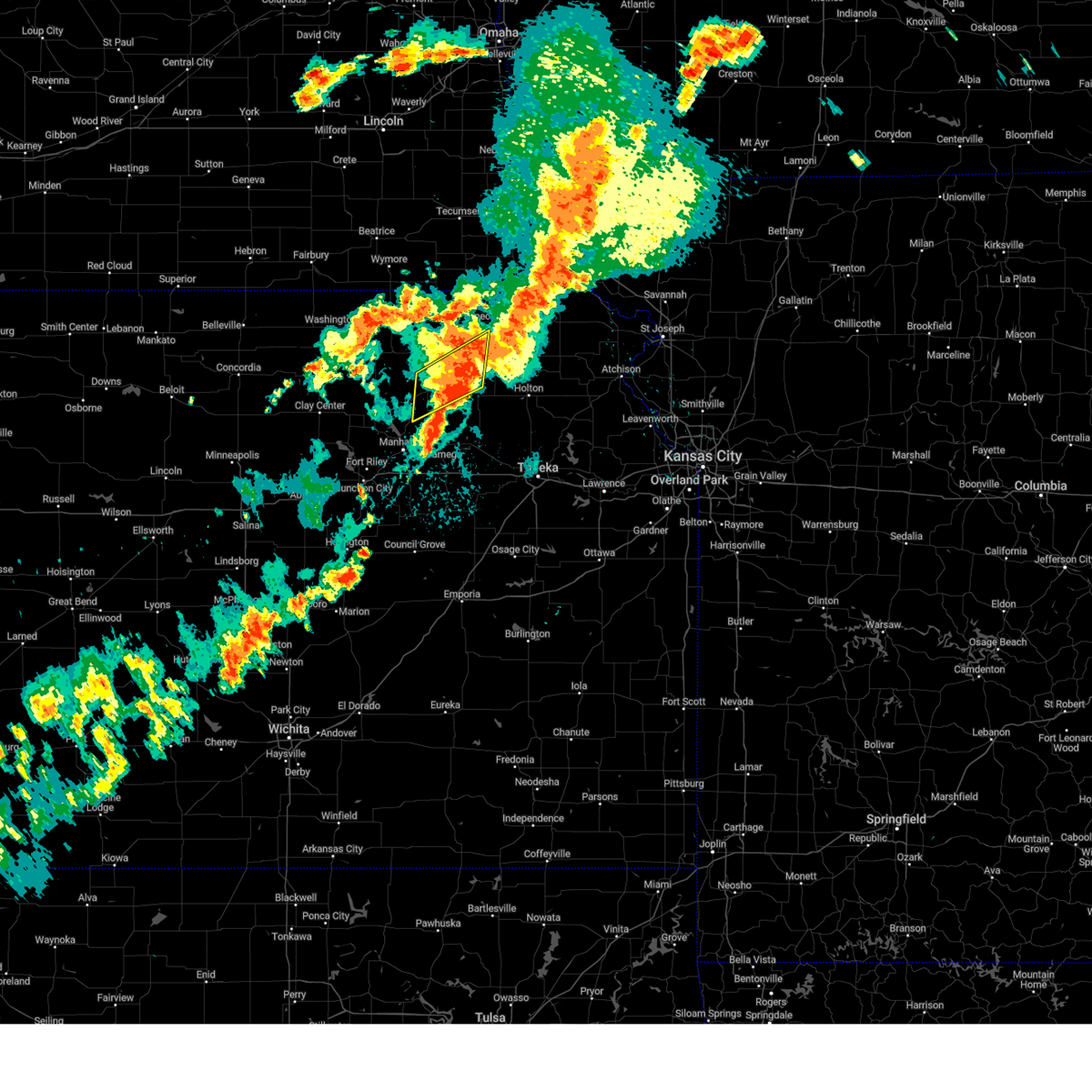
| 5/18/2026 7:01 PM CDT | Damage to hay barn. time estimated from rada in nemaha county KS, 3.2 miles N of Corning, KS |
| 5/18/2026 6:54 PM CDT |
 Svrtop the national weather service in topeka has issued a * severe thunderstorm warning for, southern nemaha county in northeastern kansas, northeastern pottawatomie county in northeastern kansas, northwestern jackson county in northeastern kansas, southwestern brown county in northeastern kansas, * until 730 pm cdt. * at 654 pm cdt, a severe thunderstorm was located near havensville, moving northeast at 50 mph (radar indicated). Hazards include 70 mph wind gusts and quarter size hail. Hail damage to vehicles is expected. expect considerable tree damage. Wind damage is also likely to mobile homes, roofs, and outbuildings. Svrtop the national weather service in topeka has issued a * severe thunderstorm warning for, southern nemaha county in northeastern kansas, northeastern pottawatomie county in northeastern kansas, northwestern jackson county in northeastern kansas, southwestern brown county in northeastern kansas, * until 730 pm cdt. * at 654 pm cdt, a severe thunderstorm was located near havensville, moving northeast at 50 mph (radar indicated). Hazards include 70 mph wind gusts and quarter size hail. Hail damage to vehicles is expected. expect considerable tree damage. Wind damage is also likely to mobile homes, roofs, and outbuildings.
|
| 5/17/2026 10:24 PM CDT |
 The storms which prompted the warning have weakened below severe limits, and no longer pose an immediate threat to life or property. therefore, the warning will be allowed to expire. however, small hail and gusty winds are still possible with these thunderstorms. a tornado watch remains in effect until 1100 pm cdt for northeastern kansas. The storms which prompted the warning have weakened below severe limits, and no longer pose an immediate threat to life or property. therefore, the warning will be allowed to expire. however, small hail and gusty winds are still possible with these thunderstorms. a tornado watch remains in effect until 1100 pm cdt for northeastern kansas.
|
| 5/17/2026 10:15 PM CDT |
 At 1015 pm cdt, severe thunderstorms were located along a line extending from 4 miles east of du bois to near corning, moving east at 35 mph (radar indicated). Hazards include 60 mph wind gusts and quarter size hail. Hail damage to vehicles is expected. expect wind damage to roofs, siding, and trees. Locations impacted include, sabetha, seneca, centralia, wetmore, bern, corning, goff, vermillion, oneida, baileyville, lillis, and woodlawn. At 1015 pm cdt, severe thunderstorms were located along a line extending from 4 miles east of du bois to near corning, moving east at 35 mph (radar indicated). Hazards include 60 mph wind gusts and quarter size hail. Hail damage to vehicles is expected. expect wind damage to roofs, siding, and trees. Locations impacted include, sabetha, seneca, centralia, wetmore, bern, corning, goff, vermillion, oneida, baileyville, lillis, and woodlawn.
|
| 5/17/2026 10:02 PM CDT |
 At 1002 pm cdt, severe thunderstorms were located along a line extending from near du bois to 5 miles east of lillis, moving east at 35 mph (radar indicated). Hazards include 60 mph wind gusts and quarter size hail. Hail damage to vehicles is expected. expect wind damage to roofs, siding, and trees. Locations impacted include, sabetha, seneca, centralia, axtell, wetmore, bern, corning, goff, vermillion, oneida, baileyville, lillis, and woodlawn. At 1002 pm cdt, severe thunderstorms were located along a line extending from near du bois to 5 miles east of lillis, moving east at 35 mph (radar indicated). Hazards include 60 mph wind gusts and quarter size hail. Hail damage to vehicles is expected. expect wind damage to roofs, siding, and trees. Locations impacted include, sabetha, seneca, centralia, axtell, wetmore, bern, corning, goff, vermillion, oneida, baileyville, lillis, and woodlawn.
|
| 5/17/2026 9:46 PM CDT |
 Svrtop the national weather service in topeka has issued a * severe thunderstorm warning for, nemaha county in northeastern kansas, eastern marshall county in northeastern kansas, * until 1030 pm cdt. * at 946 pm cdt, severe thunderstorms were located along a line extending from 5 miles east of summerfield to near lillis, moving east at 35 mph (radar indicated). Hazards include 60 mph wind gusts and quarter size hail. Hail damage to vehicles is expected. Expect wind damage to roofs, siding, and trees. Svrtop the national weather service in topeka has issued a * severe thunderstorm warning for, nemaha county in northeastern kansas, eastern marshall county in northeastern kansas, * until 1030 pm cdt. * at 946 pm cdt, severe thunderstorms were located along a line extending from 5 miles east of summerfield to near lillis, moving east at 35 mph (radar indicated). Hazards include 60 mph wind gusts and quarter size hail. Hail damage to vehicles is expected. Expect wind damage to roofs, siding, and trees.
|
| 5/17/2026 1:01 AM CDT |
 At 101 am cdt, severe thunderstorms were located along a line extending from 6 miles northeast of bern to near woodlawn to near soldier, moving east at 50 mph (radar indicated). Hazards include 70 mph wind gusts and nickel size hail. Expect considerable tree damage. damage is likely to mobile homes, roofs, and outbuildings. Locations impacted include, hiawatha, sabetha, seneca, horton, centralia, wetmore, fairview, morrill, bern, corning, goff, reserve, powhattan, oneida, hamlin, kickapoo reservation, and woodlawn. At 101 am cdt, severe thunderstorms were located along a line extending from 6 miles northeast of bern to near woodlawn to near soldier, moving east at 50 mph (radar indicated). Hazards include 70 mph wind gusts and nickel size hail. Expect considerable tree damage. damage is likely to mobile homes, roofs, and outbuildings. Locations impacted include, hiawatha, sabetha, seneca, horton, centralia, wetmore, fairview, morrill, bern, corning, goff, reserve, powhattan, oneida, hamlin, kickapoo reservation, and woodlawn.
|
| 5/17/2026 12:49 AM CDT |
 At 1248 am cdt, severe thunderstorms were located along a line extending from 3 miles south of pawnee city to near centralia to 5 miles north of onaga, moving east at 40 mph. these are destructive storms for western nemaha county (radar indicated). Hazards include 80 mph wind gusts and nickel size hail. Flying debris will be dangerous to those caught without shelter. mobile homes will be heavily damaged. expect considerable damage to roofs, windows, and vehicles. extensive tree damage and power outages are likely. Locations impacted include, seneca, centralia, corning, and baileyville. At 1248 am cdt, severe thunderstorms were located along a line extending from 3 miles south of pawnee city to near centralia to 5 miles north of onaga, moving east at 40 mph. these are destructive storms for western nemaha county (radar indicated). Hazards include 80 mph wind gusts and nickel size hail. Flying debris will be dangerous to those caught without shelter. mobile homes will be heavily damaged. expect considerable damage to roofs, windows, and vehicles. extensive tree damage and power outages are likely. Locations impacted include, seneca, centralia, corning, and baileyville.
|
| 5/17/2026 12:47 AM CDT |
 Svrtop the national weather service in topeka has issued a * severe thunderstorm warning for, nemaha county in northeastern kansas, brown county in northeastern kansas, * until 130 am cdt. * at 1246 am cdt, severe thunderstorms were located along a line extending from 4 miles southwest of du bois to 3 miles northeast of centralia to 3 miles north of onaga, moving east at 45 mph (radar indicated). Hazards include 70 mph wind gusts and nickel size hail. Expect considerable tree damage. Damage is likely to mobile homes, roofs, and outbuildings. Svrtop the national weather service in topeka has issued a * severe thunderstorm warning for, nemaha county in northeastern kansas, brown county in northeastern kansas, * until 130 am cdt. * at 1246 am cdt, severe thunderstorms were located along a line extending from 4 miles southwest of du bois to 3 miles northeast of centralia to 3 miles north of onaga, moving east at 45 mph (radar indicated). Hazards include 70 mph wind gusts and nickel size hail. Expect considerable tree damage. Damage is likely to mobile homes, roofs, and outbuildings.
|
| 5/17/2026 12:37 AM CDT |
 At 1236 am cdt, severe thunderstorms were located along a line extending from 4 miles northeast of summerfield to near vermillion to near lillis, moving east at 50 mph. these are destructive storms for central and eastern marshall county and western nemaha county. (radar indicated). Hazards include 80 mph wind gusts and nickel size hail. Flying debris will be dangerous to those caught without shelter. mobile homes will be heavily damaged. expect considerable damage to roofs, windows, and vehicles. extensive tree damage and power outages are likely. Locations impacted include, seneca, frankfort, centralia, axtell, beattie, corning, summerfield, vermillion, baileyville, and lillis. At 1236 am cdt, severe thunderstorms were located along a line extending from 4 miles northeast of summerfield to near vermillion to near lillis, moving east at 50 mph. these are destructive storms for central and eastern marshall county and western nemaha county. (radar indicated). Hazards include 80 mph wind gusts and nickel size hail. Flying debris will be dangerous to those caught without shelter. mobile homes will be heavily damaged. expect considerable damage to roofs, windows, and vehicles. extensive tree damage and power outages are likely. Locations impacted include, seneca, frankfort, centralia, axtell, beattie, corning, summerfield, vermillion, baileyville, and lillis.
|
| 5/17/2026 12:16 AM CDT |
 Svrtop the national weather service in topeka has issued a * severe thunderstorm warning for, western nemaha county in northeastern kansas, marshall county in northeastern kansas, * until 100 am cdt. * at 1215 am cdt, severe thunderstorms were located along a line extending from near barneston to 7 miles west of frankfort to 8 miles south of blue rapids, moving east at 40 mph. these are destructive storms for marshall and western nemaha county (radar indicated). Hazards include 80 mph wind gusts and nickel size hail. Flying debris will be dangerous to those caught without shelter. mobile homes will be heavily damaged. expect considerable damage to roofs, windows, and vehicles. Extensive tree damage and power outages are likely. Svrtop the national weather service in topeka has issued a * severe thunderstorm warning for, western nemaha county in northeastern kansas, marshall county in northeastern kansas, * until 100 am cdt. * at 1215 am cdt, severe thunderstorms were located along a line extending from near barneston to 7 miles west of frankfort to 8 miles south of blue rapids, moving east at 40 mph. these are destructive storms for marshall and western nemaha county (radar indicated). Hazards include 80 mph wind gusts and nickel size hail. Flying debris will be dangerous to those caught without shelter. mobile homes will be heavily damaged. expect considerable damage to roofs, windows, and vehicles. Extensive tree damage and power outages are likely.
|
| 4/23/2026 6:46 PM CDT | At 646 pm cdt, severe thunderstorms were located along a line extending from near bern to 3 miles south of frankfort, moving northeast at 15 mph (radar indicated). Hazards include 60 mph wind gusts and half dollar size hail. Hail damage to vehicles is expected. expect wind damage to roofs, siding, and trees. Locations impacted include, sabetha, seneca, frankfort, centralia, axtell, bern, corning, vermillion, oneida, baileyville, and lillis. |
| 4/23/2026 6:21 PM CDT |
 Svrtop the national weather service in topeka has issued a * severe thunderstorm warning for, nemaha county in northeastern kansas, northwestern brown county in northeastern kansas, southeastern marshall county in northeastern kansas, * until 700 pm cdt. * at 621 pm cdt, severe thunderstorms were located along a line extending from 3 miles north of baileyville to near frankfort, moving northeast at 30 mph (radar indicated). Hazards include 60 mph wind gusts and half dollar size hail. Hail damage to vehicles is expected. Expect wind damage to roofs, siding, and trees. Svrtop the national weather service in topeka has issued a * severe thunderstorm warning for, nemaha county in northeastern kansas, northwestern brown county in northeastern kansas, southeastern marshall county in northeastern kansas, * until 700 pm cdt. * at 621 pm cdt, severe thunderstorms were located along a line extending from 3 miles north of baileyville to near frankfort, moving northeast at 30 mph (radar indicated). Hazards include 60 mph wind gusts and half dollar size hail. Hail damage to vehicles is expected. Expect wind damage to roofs, siding, and trees.
|
| 3/5/2026 8:55 PM CST | Quarter sized hail reported 0.5 miles N of Corning, KS, relayed from emergency management. |
| 4/1/2025 11:59 PM CDT |
 The storm which prompted the warning has moved out of the area. therefore, the warning will be allowed to expire. however, small hail and gusty winds are still possible with other thunderstorms in this area. a severe thunderstorm watch remains in effect until 300 am cdt for northeastern kansas. remember, a severe thunderstorm warning still remains in effect for eastern brown county until 1230 am cdt. The storm which prompted the warning has moved out of the area. therefore, the warning will be allowed to expire. however, small hail and gusty winds are still possible with other thunderstorms in this area. a severe thunderstorm watch remains in effect until 300 am cdt for northeastern kansas. remember, a severe thunderstorm warning still remains in effect for eastern brown county until 1230 am cdt.
|
| 4/1/2025 11:31 PM CDT |
 At 1131 pm cdt, a severe thunderstorm was located 4 miles south of wetmore, moving east at 45 mph (radar indicated). Hazards include 70 mph wind gusts and quarter size hail. Hail damage to vehicles is expected. expect considerable tree damage. wind damage is also likely to mobile homes, roofs, and outbuildings. Locations impacted include, holton, kickapoo reservation, havensville, goff, oneida, woodlawn, powhattan, onaga, circleville, fairview, soldier, whiting, netawaka, wetmore, centralia, corning, horton, and hiawatha. At 1131 pm cdt, a severe thunderstorm was located 4 miles south of wetmore, moving east at 45 mph (radar indicated). Hazards include 70 mph wind gusts and quarter size hail. Hail damage to vehicles is expected. expect considerable tree damage. wind damage is also likely to mobile homes, roofs, and outbuildings. Locations impacted include, holton, kickapoo reservation, havensville, goff, oneida, woodlawn, powhattan, onaga, circleville, fairview, soldier, whiting, netawaka, wetmore, centralia, corning, horton, and hiawatha.
|
| 4/1/2025 11:10 PM CDT |
 Svrtop the national weather service in topeka has issued a * severe thunderstorm warning for, northeastern pottawatomie county in northeastern kansas, southern nemaha county in northeastern kansas, northern jackson county in northeastern kansas, southwestern brown county in northeastern kansas, * until midnight cdt. * at 1109 pm cdt, a severe thunderstorm was located over onaga, moving east at 40 mph (radar indicated). Hazards include 70 mph wind gusts and ping pong ball size hail. People and animals outdoors will be injured. expect hail damage to roofs, siding, windows, and vehicles. expect considerable tree damage. Wind damage is also likely to mobile homes, roofs, and outbuildings. Svrtop the national weather service in topeka has issued a * severe thunderstorm warning for, northeastern pottawatomie county in northeastern kansas, southern nemaha county in northeastern kansas, northern jackson county in northeastern kansas, southwestern brown county in northeastern kansas, * until midnight cdt. * at 1109 pm cdt, a severe thunderstorm was located over onaga, moving east at 40 mph (radar indicated). Hazards include 70 mph wind gusts and ping pong ball size hail. People and animals outdoors will be injured. expect hail damage to roofs, siding, windows, and vehicles. expect considerable tree damage. Wind damage is also likely to mobile homes, roofs, and outbuildings.
|
| 4/1/2025 10:57 PM CDT |
 At 1056 pm cdt, severe thunderstorms were located along a line extending from near bern to 4 miles southeast of vermillion, moving northeast at 45 mph (radar indicated). Hazards include 60 mph wind gusts and half dollar size hail. Hail damage to vehicles is expected. expect wind damage to roofs, siding, and trees. Locations impacted include, bern, seneca, sabetha, vermillion, wetmore, baileyville, goff, oneida, lillis, woodlawn, centralia, and corning. At 1056 pm cdt, severe thunderstorms were located along a line extending from near bern to 4 miles southeast of vermillion, moving northeast at 45 mph (radar indicated). Hazards include 60 mph wind gusts and half dollar size hail. Hail damage to vehicles is expected. expect wind damage to roofs, siding, and trees. Locations impacted include, bern, seneca, sabetha, vermillion, wetmore, baileyville, goff, oneida, lillis, woodlawn, centralia, and corning.
|
| 4/1/2025 10:47 PM CDT |
 At 1047 pm cdt, severe thunderstorms were located along a line extending from 5 miles west of bern to near lillis, moving northeast at 45 mph (radar indicated). Hazards include 60 mph wind gusts and quarter size hail. Hail damage to vehicles is expected. expect wind damage to roofs, siding, and trees. Locations impacted include, bern, seneca, sabetha, vermillion, wetmore, baileyville, goff, oneida, lillis, woodlawn, centralia, and corning. At 1047 pm cdt, severe thunderstorms were located along a line extending from 5 miles west of bern to near lillis, moving northeast at 45 mph (radar indicated). Hazards include 60 mph wind gusts and quarter size hail. Hail damage to vehicles is expected. expect wind damage to roofs, siding, and trees. Locations impacted include, bern, seneca, sabetha, vermillion, wetmore, baileyville, goff, oneida, lillis, woodlawn, centralia, and corning.
|
| 4/1/2025 10:17 PM CDT |
 Svrtop the national weather service in topeka has issued a * severe thunderstorm warning for, nemaha county in northeastern kansas, southeastern marshall county in northeastern kansas, * until 1115 pm cdt. * at 1017 pm cdt, severe thunderstorms were located along a line extending from 3 miles north of frankfort to 5 miles east of olsburg, moving northeast at 45 mph (radar indicated). Hazards include 60 mph wind gusts and quarter size hail. Hail damage to vehicles is expected. Expect wind damage to roofs, siding, and trees. Svrtop the national weather service in topeka has issued a * severe thunderstorm warning for, nemaha county in northeastern kansas, southeastern marshall county in northeastern kansas, * until 1115 pm cdt. * at 1017 pm cdt, severe thunderstorms were located along a line extending from 3 miles north of frankfort to 5 miles east of olsburg, moving northeast at 45 mph (radar indicated). Hazards include 60 mph wind gusts and quarter size hail. Hail damage to vehicles is expected. Expect wind damage to roofs, siding, and trees.
|
| 10/30/2024 12:49 PM CDT |
 Svrtop the national weather service in topeka has issued a * severe thunderstorm warning for, northeastern pottawatomie county in northeastern kansas, southeastern nemaha county in northeastern kansas, northwestern jackson county in northeastern kansas, brown county in northeastern kansas, * until 115 pm cdt. * at 1248 pm cdt, a severe thunderstorm was located over goff, moving northeast at 70 mph (radar indicated). Hazards include 60 mph wind gusts and penny size hail. expect damage to roofs, siding, and trees Svrtop the national weather service in topeka has issued a * severe thunderstorm warning for, northeastern pottawatomie county in northeastern kansas, southeastern nemaha county in northeastern kansas, northwestern jackson county in northeastern kansas, brown county in northeastern kansas, * until 115 pm cdt. * at 1248 pm cdt, a severe thunderstorm was located over goff, moving northeast at 70 mph (radar indicated). Hazards include 60 mph wind gusts and penny size hail. expect damage to roofs, siding, and trees
|
| 8/14/2024 9:25 PM CDT |
 The storms which prompted the warning have moved out of the area. therefore, the warning will be allowed to expire. a severe thunderstorm watch remains in effect until 100 am cdt for northeastern and east central kansas. remember, a severe thunderstorm warning still remains in effect for portions of jackson, northern shawnee and brown county. The storms which prompted the warning have moved out of the area. therefore, the warning will be allowed to expire. a severe thunderstorm watch remains in effect until 100 am cdt for northeastern and east central kansas. remember, a severe thunderstorm warning still remains in effect for portions of jackson, northern shawnee and brown county.
|
| 8/14/2024 8:56 PM CDT |
 The storms which prompted the warning have moved out of the area. therefore, the warning will be allowed to expire. however, gusty winds are still possible with these thunderstorms. a severe thunderstorm watch remains in effect until 100 am cdt for northeastern kansas. remember, a severe thunderstorm warning still remains in effect for eastern pottawatomie county and southern nemaha county. The storms which prompted the warning have moved out of the area. therefore, the warning will be allowed to expire. however, gusty winds are still possible with these thunderstorms. a severe thunderstorm watch remains in effect until 100 am cdt for northeastern kansas. remember, a severe thunderstorm warning still remains in effect for eastern pottawatomie county and southern nemaha county.
|
| 8/14/2024 8:54 PM CDT |
 Svrtop the national weather service in topeka has issued a * severe thunderstorm warning for, southeastern riley county in northeastern kansas, northern wabaunsee county in east central kansas, eastern pottawatomie county in northeastern kansas, southern nemaha county in northeastern kansas, western jackson county in northeastern kansas, southwestern brown county in northeastern kansas, * until 930 pm cdt. * at 854 pm cdt, severe thunderstorms were located along a line extending from 3 miles north of goff to 4 miles south of st. george, moving east at 30 mph (radar indicated). Hazards include 60 mph wind gusts and penny size hail. expect damage to roofs, siding, and trees Svrtop the national weather service in topeka has issued a * severe thunderstorm warning for, southeastern riley county in northeastern kansas, northern wabaunsee county in east central kansas, eastern pottawatomie county in northeastern kansas, southern nemaha county in northeastern kansas, western jackson county in northeastern kansas, southwestern brown county in northeastern kansas, * until 930 pm cdt. * at 854 pm cdt, severe thunderstorms were located along a line extending from 3 miles north of goff to 4 miles south of st. george, moving east at 30 mph (radar indicated). Hazards include 60 mph wind gusts and penny size hail. expect damage to roofs, siding, and trees
|
| 8/14/2024 8:38 PM CDT |
 Svrtop the national weather service in topeka has issued a * severe thunderstorm warning for, northeastern pottawatomie county in northeastern kansas, southwestern nemaha county in northeastern kansas, southeastern marshall county in northeastern kansas, * until 900 pm cdt. * at 838 pm cdt, severe thunderstorms were located along a line extending from 4 miles southwest of woodlawn to near westmoreland, moving northeast at 40 mph (radar indicated). Hazards include 60 mph wind gusts. expect damage to roofs, siding, and trees Svrtop the national weather service in topeka has issued a * severe thunderstorm warning for, northeastern pottawatomie county in northeastern kansas, southwestern nemaha county in northeastern kansas, southeastern marshall county in northeastern kansas, * until 900 pm cdt. * at 838 pm cdt, severe thunderstorms were located along a line extending from 4 miles southwest of woodlawn to near westmoreland, moving northeast at 40 mph (radar indicated). Hazards include 60 mph wind gusts. expect damage to roofs, siding, and trees
|
| 6/28/2024 7:27 PM CDT |
 the severe thunderstorm warning has been cancelled and is no longer in effect the severe thunderstorm warning has been cancelled and is no longer in effect
|
| 6/28/2024 7:27 PM CDT |
 At 725 pm cdt, a severe thunderstorm was located near seneca, moving east at 30 mph (radar indicated). Hazards include 60 mph wind gusts and quarter size hail. Hail damage to vehicles is expected. expect wind damage to roofs, siding, and trees. Locations impacted include, seneca, centralia, and corning. At 725 pm cdt, a severe thunderstorm was located near seneca, moving east at 30 mph (radar indicated). Hazards include 60 mph wind gusts and quarter size hail. Hail damage to vehicles is expected. expect wind damage to roofs, siding, and trees. Locations impacted include, seneca, centralia, and corning.
|
| 6/28/2024 7:23 PM CDT |
 At 722 pm cdt, a severe thunderstorm was located 4 miles north of centralia, moving northeast at 45 mph (radar indicated). Hazards include 60 mph wind gusts and quarter size hail. Hail damage to vehicles is expected. expect wind damage to roofs, siding, and trees. Locations impacted include, seneca, centralia, corning, vermillion, and lillis. At 722 pm cdt, a severe thunderstorm was located 4 miles north of centralia, moving northeast at 45 mph (radar indicated). Hazards include 60 mph wind gusts and quarter size hail. Hail damage to vehicles is expected. expect wind damage to roofs, siding, and trees. Locations impacted include, seneca, centralia, corning, vermillion, and lillis.
|
| 6/28/2024 7:23 PM CDT |
 the severe thunderstorm warning has been cancelled and is no longer in effect the severe thunderstorm warning has been cancelled and is no longer in effect
|
| 6/28/2024 7:17 PM CDT |
 At 716 pm cdt, a severe thunderstorm was located near vermillion, moving northeast at 35 mph (radar indicated). Hazards include 60 mph wind gusts and half dollar size hail. Hail damage to vehicles is expected. expect wind damage to roofs, siding, and trees. Locations impacted include, seneca, blaine, centralia, corning, soldier, havensville, vermillion, wheaton, and lillis. At 716 pm cdt, a severe thunderstorm was located near vermillion, moving northeast at 35 mph (radar indicated). Hazards include 60 mph wind gusts and half dollar size hail. Hail damage to vehicles is expected. expect wind damage to roofs, siding, and trees. Locations impacted include, seneca, blaine, centralia, corning, soldier, havensville, vermillion, wheaton, and lillis.
|
| 6/28/2024 7:11 PM CDT |
 Svrtop the national weather service in topeka has issued a * severe thunderstorm warning for, northeastern pottawatomie county in northeastern kansas, southwestern nemaha county in northeastern kansas, northwestern jackson county in northeastern kansas, southeastern marshall county in northeastern kansas, * until 745 pm cdt. * at 710 pm cdt, a severe thunderstorm was located 5 miles west of lillis, moving east at 30 mph. a second severe thunderstorm was located near vermillion, moving east at 30 mph (radar indicated). Hazards include 60 mph wind gusts and quarter size hail. Hail damage to vehicles is expected. Expect wind damage to roofs, siding, and trees. Svrtop the national weather service in topeka has issued a * severe thunderstorm warning for, northeastern pottawatomie county in northeastern kansas, southwestern nemaha county in northeastern kansas, northwestern jackson county in northeastern kansas, southeastern marshall county in northeastern kansas, * until 745 pm cdt. * at 710 pm cdt, a severe thunderstorm was located 5 miles west of lillis, moving east at 30 mph. a second severe thunderstorm was located near vermillion, moving east at 30 mph (radar indicated). Hazards include 60 mph wind gusts and quarter size hail. Hail damage to vehicles is expected. Expect wind damage to roofs, siding, and trees.
|
| 6/26/2024 2:50 AM CDT |
 the severe thunderstorm warning has been cancelled and is no longer in effect the severe thunderstorm warning has been cancelled and is no longer in effect
|
| 6/26/2024 2:50 AM CDT |
 At 250 am cdt, severe thunderstorms were located along a line extending from 5 miles west of kickapoo reservation to near westmoreland to near manchester, moving southeast at 60 mph (radar indicated). Hazards include 60 mph wind gusts. Expect damage to roofs, siding, and trees. Locations impacted include, clay center, sabetha, seneca, blaine, frankfort, miltonvale, centralia, wetmore, morganville, bern, corning, green, goff, vermillion, wheaton, oneida, lillis, and woodlawn. At 250 am cdt, severe thunderstorms were located along a line extending from 5 miles west of kickapoo reservation to near westmoreland to near manchester, moving southeast at 60 mph (radar indicated). Hazards include 60 mph wind gusts. Expect damage to roofs, siding, and trees. Locations impacted include, clay center, sabetha, seneca, blaine, frankfort, miltonvale, centralia, wetmore, morganville, bern, corning, green, goff, vermillion, wheaton, oneida, lillis, and woodlawn.
|
| 6/26/2024 2:45 AM CDT |
 At 244 am cdt, severe thunderstorms were located along a line extending from near woodlawn to 3 miles northwest of westmoreland to 3 miles west of longford, moving southeast at 45 mph (radar indicated). Hazards include 60 mph wind gusts. Expect damage to roofs, siding, and trees. Locations impacted include, clay center, sabetha, seneca, blue rapids, blaine, frankfort, waterville, miltonvale, centralia, axtell, wetmore, morganville, bern, corning, green, goff, vermillion, wheaton, oneida, and aurora. At 244 am cdt, severe thunderstorms were located along a line extending from near woodlawn to 3 miles northwest of westmoreland to 3 miles west of longford, moving southeast at 45 mph (radar indicated). Hazards include 60 mph wind gusts. Expect damage to roofs, siding, and trees. Locations impacted include, clay center, sabetha, seneca, blue rapids, blaine, frankfort, waterville, miltonvale, centralia, axtell, wetmore, morganville, bern, corning, green, goff, vermillion, wheaton, oneida, and aurora.
|
| 6/26/2024 2:41 AM CDT |
 Svrtop the national weather service in topeka has issued a * severe thunderstorm warning for, northwestern dickinson county in central kansas, northwestern geary county in east central kansas, riley county in northeastern kansas, northeastern ottawa county in north central kansas, pottawatomie county in northeastern kansas, southern nemaha county in northeastern kansas, jackson county in northeastern kansas, clay county in north central kansas, southeastern cloud county in north central kansas, southeastern marshall county in northeastern kansas, * until 315 am cdt. * at 241 am cdt, severe thunderstorms were located along a line extending from near goff to 3 miles west of onaga to 6 miles south of miltonvale, moving southeast at 45 mph (radar indicated). Hazards include 70 mph wind gusts. Expect considerable tree damage. Damage is likely to mobile homes, roofs, and outbuildings. Svrtop the national weather service in topeka has issued a * severe thunderstorm warning for, northwestern dickinson county in central kansas, northwestern geary county in east central kansas, riley county in northeastern kansas, northeastern ottawa county in north central kansas, pottawatomie county in northeastern kansas, southern nemaha county in northeastern kansas, jackson county in northeastern kansas, clay county in north central kansas, southeastern cloud county in north central kansas, southeastern marshall county in northeastern kansas, * until 315 am cdt. * at 241 am cdt, severe thunderstorms were located along a line extending from near goff to 3 miles west of onaga to 6 miles south of miltonvale, moving southeast at 45 mph (radar indicated). Hazards include 70 mph wind gusts. Expect considerable tree damage. Damage is likely to mobile homes, roofs, and outbuildings.
|
| 6/26/2024 2:35 AM CDT |
 At 234 am cdt, severe thunderstorms were located along a line extending from oneida to 7 miles north of olsburg to 4 miles southwest of miltonvale, moving southeast at 45 mph (radar indicated). Hazards include 60 mph wind gusts and nickel size hail. Expect damage to roofs, siding, and trees. Locations impacted include, concordia, clay center, sabetha, seneca, blue rapids, blaine, frankfort, clyde, waterville, clifton, miltonvale, centralia, linn, axtell, wetmore, greenleaf, beattie, morganville, bern, and barnes. At 234 am cdt, severe thunderstorms were located along a line extending from oneida to 7 miles north of olsburg to 4 miles southwest of miltonvale, moving southeast at 45 mph (radar indicated). Hazards include 60 mph wind gusts and nickel size hail. Expect damage to roofs, siding, and trees. Locations impacted include, concordia, clay center, sabetha, seneca, blue rapids, blaine, frankfort, clyde, waterville, clifton, miltonvale, centralia, linn, axtell, wetmore, greenleaf, beattie, morganville, bern, and barnes.
|
| 6/26/2024 2:35 AM CDT |
 the severe thunderstorm warning has been cancelled and is no longer in effect the severe thunderstorm warning has been cancelled and is no longer in effect
|
| 6/26/2024 2:15 AM CDT |
 Svrtop the national weather service in topeka has issued a * severe thunderstorm warning for, northwestern riley county in northeastern kansas, northwestern ottawa county in north central kansas, northern pottawatomie county in northeastern kansas, nemaha county in northeastern kansas, western brown county in northeastern kansas, southern washington county in north central kansas, northern clay county in north central kansas, cloud county in north central kansas, marshall county in northeastern kansas, * until 300 am cdt. * at 214 am cdt, severe thunderstorms were located along a line extending from near pawnee city to 4 miles north of waterville to 5 miles southwest of concordia, moving southeast at 40 mph (radar indicated). Hazards include 60 mph wind gusts and nickel size hail. expect damage to roofs, siding, and trees Svrtop the national weather service in topeka has issued a * severe thunderstorm warning for, northwestern riley county in northeastern kansas, northwestern ottawa county in north central kansas, northern pottawatomie county in northeastern kansas, nemaha county in northeastern kansas, western brown county in northeastern kansas, southern washington county in north central kansas, northern clay county in north central kansas, cloud county in north central kansas, marshall county in northeastern kansas, * until 300 am cdt. * at 214 am cdt, severe thunderstorms were located along a line extending from near pawnee city to 4 miles north of waterville to 5 miles southwest of concordia, moving southeast at 40 mph (radar indicated). Hazards include 60 mph wind gusts and nickel size hail. expect damage to roofs, siding, and trees
|
| 6/15/2024 7:21 PM CDT |
 the severe thunderstorm warning has been cancelled and is no longer in effect the severe thunderstorm warning has been cancelled and is no longer in effect
|
| 6/15/2024 7:21 PM CDT |
 At 718 pm cdt, severe thunderstorms were located along a line extending from 6 miles northeast of bern to near sabetha to 4 miles north of circleville, moving northeast at 40 mph (trained weather spotters. at 712 pm trained spotters reported 60 mph winds in corning. also a home weather station recorded a 64 mph wind gust 1 mile north northwest of bern at 708 pm). Hazards include 60 mph wind gusts and nickel size hail. Expect damage to roofs, siding, and trees. Locations impacted include, hiawatha, sabetha, seneca, horton, centralia, wetmore, everest, fairview, robinson, morrill, whiting, bern, corning, netawaka, soldier, goff, reserve, powhattan, oneida, and hamlin. At 718 pm cdt, severe thunderstorms were located along a line extending from 6 miles northeast of bern to near sabetha to 4 miles north of circleville, moving northeast at 40 mph (trained weather spotters. at 712 pm trained spotters reported 60 mph winds in corning. also a home weather station recorded a 64 mph wind gust 1 mile north northwest of bern at 708 pm). Hazards include 60 mph wind gusts and nickel size hail. Expect damage to roofs, siding, and trees. Locations impacted include, hiawatha, sabetha, seneca, horton, centralia, wetmore, everest, fairview, robinson, morrill, whiting, bern, corning, netawaka, soldier, goff, reserve, powhattan, oneida, and hamlin.
|
| 6/15/2024 7:12 PM CDT | Storm damage reported in nemaha county KS, 0.2 miles S of Corning, KS |
| 6/15/2024 7:04 PM CDT |
 Svrtop the national weather service in topeka has issued a * severe thunderstorm warning for, northeastern pottawatomie county in northeastern kansas, nemaha county in northeastern kansas, northern jackson county in northeastern kansas, brown county in northeastern kansas, * until 745 pm cdt. * at 704 pm cdt, severe thunderstorms were located along a line extending from near du bois to oneida to near soldier, moving northeast at 40 mph (radar indicated). Hazards include 60 mph wind gusts and nickel size hail. expect damage to roofs, siding, and trees Svrtop the national weather service in topeka has issued a * severe thunderstorm warning for, northeastern pottawatomie county in northeastern kansas, nemaha county in northeastern kansas, northern jackson county in northeastern kansas, brown county in northeastern kansas, * until 745 pm cdt. * at 704 pm cdt, severe thunderstorms were located along a line extending from near du bois to oneida to near soldier, moving northeast at 40 mph (radar indicated). Hazards include 60 mph wind gusts and nickel size hail. expect damage to roofs, siding, and trees
|
| 6/15/2024 6:58 PM CDT |
 At 658 pm cdt, severe thunderstorms were located along a line extending from pawnee city to near bern to 3 miles northwest of soldier, moving northeast at 45 mph (radar indicated). Hazards include 60 mph wind gusts and nickel size hail. Expect damage to roofs, siding, and trees. Locations impacted include, seneca, onaga, centralia, axtell, beattie, bern, corning, summerfield, soldier, havensville, goff, vermillion, oneida, and baileyville. At 658 pm cdt, severe thunderstorms were located along a line extending from pawnee city to near bern to 3 miles northwest of soldier, moving northeast at 45 mph (radar indicated). Hazards include 60 mph wind gusts and nickel size hail. Expect damage to roofs, siding, and trees. Locations impacted include, seneca, onaga, centralia, axtell, beattie, bern, corning, summerfield, soldier, havensville, goff, vermillion, oneida, and baileyville.
|
| 6/15/2024 6:42 PM CDT |
 At 639 pm cdt, severe thunderstorms were located along a line extending from 4 miles southwest of burchard to 3 miles south of baileyville to 5 miles south of onaga, moving northeast at 45 mph (trained weather spotters. spotters reported 60 mph winds 3 miles northwest of vermillion at 630 pm). Hazards include 60 mph wind gusts and nickel size hail. Expect damage to roofs, siding, and trees. Locations impacted include, seneca, frankfort, onaga, centralia, axtell, beattie, bern, corning, summerfield, soldier, havensville, goff, vermillion, wheaton, oneida, baileyville, and lillis. At 639 pm cdt, severe thunderstorms were located along a line extending from 4 miles southwest of burchard to 3 miles south of baileyville to 5 miles south of onaga, moving northeast at 45 mph (trained weather spotters. spotters reported 60 mph winds 3 miles northwest of vermillion at 630 pm). Hazards include 60 mph wind gusts and nickel size hail. Expect damage to roofs, siding, and trees. Locations impacted include, seneca, frankfort, onaga, centralia, axtell, beattie, bern, corning, summerfield, soldier, havensville, goff, vermillion, wheaton, oneida, baileyville, and lillis.
|
| 6/15/2024 6:24 PM CDT |
 Svrtop the national weather service in topeka has issued a * severe thunderstorm warning for, eastern pottawatomie county in northeastern kansas, nemaha county in northeastern kansas, northwestern jackson county in northeastern kansas, marshall county in northeastern kansas, * until 715 pm cdt. * at 623 pm cdt, severe thunderstorms were located along a line extending from 3 miles east of oketo to 4 miles northwest of lillis to 3 miles northwest of louisville, moving northeast at 45 mph (radar indicated). Hazards include 60 mph wind gusts and nickel size hail. expect damage to roofs, siding, and trees Svrtop the national weather service in topeka has issued a * severe thunderstorm warning for, eastern pottawatomie county in northeastern kansas, nemaha county in northeastern kansas, northwestern jackson county in northeastern kansas, marshall county in northeastern kansas, * until 715 pm cdt. * at 623 pm cdt, severe thunderstorms were located along a line extending from 3 miles east of oketo to 4 miles northwest of lillis to 3 miles northwest of louisville, moving northeast at 45 mph (radar indicated). Hazards include 60 mph wind gusts and nickel size hail. expect damage to roofs, siding, and trees
|
| 6/13/2024 10:53 PM CDT |
 the severe thunderstorm warning has been cancelled and is no longer in effect the severe thunderstorm warning has been cancelled and is no longer in effect
|
| 6/13/2024 10:28 PM CDT |
 Svrtop the national weather service in topeka has issued a * severe thunderstorm warning for, southwestern nemaha county in northeastern kansas, * until 1115 pm cdt. * at 1028 pm cdt, a severe thunderstorm was located over baileyville, moving southeast at 30 mph (radar indicated). Hazards include 60 mph wind gusts and quarter size hail. Hail damage to vehicles is expected. Expect wind damage to roofs, siding, and trees. Svrtop the national weather service in topeka has issued a * severe thunderstorm warning for, southwestern nemaha county in northeastern kansas, * until 1115 pm cdt. * at 1028 pm cdt, a severe thunderstorm was located over baileyville, moving southeast at 30 mph (radar indicated). Hazards include 60 mph wind gusts and quarter size hail. Hail damage to vehicles is expected. Expect wind damage to roofs, siding, and trees.
|
| 5/25/2024 10:57 PM CDT |
 At 1057 pm cdt, severe thunderstorms were located along a line extending from 5 miles east of bern to near woodlawn to 6 miles north of havensville, moving east at 30 mph (radar indicated). Hazards include 60 mph wind gusts and quarter size hail. Hail damage to vehicles is expected. expect wind damage to roofs, siding, and trees. Locations impacted include, sabetha, wetmore, corning, goff, and woodlawn. At 1057 pm cdt, severe thunderstorms were located along a line extending from 5 miles east of bern to near woodlawn to 6 miles north of havensville, moving east at 30 mph (radar indicated). Hazards include 60 mph wind gusts and quarter size hail. Hail damage to vehicles is expected. expect wind damage to roofs, siding, and trees. Locations impacted include, sabetha, wetmore, corning, goff, and woodlawn.
|
| 5/25/2024 10:43 PM CDT |
 At 1043 pm cdt, severe thunderstorms were located along a line extending from near bern to 3 miles west of woodlawn to 3 miles north of soldier, moving east at 40 mph (radar indicated). Hazards include 60 mph wind gusts and quarter size hail. Hail damage to vehicles is expected. expect wind damage to roofs, siding, and trees. Locations impacted include, sabetha, seneca, centralia, wetmore, bern, corning, goff, oneida, and woodlawn. At 1043 pm cdt, severe thunderstorms were located along a line extending from near bern to 3 miles west of woodlawn to 3 miles north of soldier, moving east at 40 mph (radar indicated). Hazards include 60 mph wind gusts and quarter size hail. Hail damage to vehicles is expected. expect wind damage to roofs, siding, and trees. Locations impacted include, sabetha, seneca, centralia, wetmore, bern, corning, goff, oneida, and woodlawn.
|
| 5/25/2024 10:30 PM CDT |
 At 1029 pm cdt, severe thunderstorms were located along a line extending from 6 miles southwest of du bois to 4 miles east of lillis, moving east at 30 mph (public. at 1022 pm cdt, a personal weather station 3 ne of vermillion measured a 58 mph wind gust). Hazards include 60 mph wind gusts and quarter size hail. Hail damage to vehicles is expected. expect wind damage to roofs, siding, and trees. Locations impacted include, sabetha, seneca, centralia, wetmore, bern, corning, goff, oneida, baileyville, and woodlawn. At 1029 pm cdt, severe thunderstorms were located along a line extending from 6 miles southwest of du bois to 4 miles east of lillis, moving east at 30 mph (public. at 1022 pm cdt, a personal weather station 3 ne of vermillion measured a 58 mph wind gust). Hazards include 60 mph wind gusts and quarter size hail. Hail damage to vehicles is expected. expect wind damage to roofs, siding, and trees. Locations impacted include, sabetha, seneca, centralia, wetmore, bern, corning, goff, oneida, baileyville, and woodlawn.
|
| 5/25/2024 10:26 PM CDT |
 Svrtop the national weather service in topeka has issued a * severe thunderstorm warning for, nemaha county in northeastern kansas, * until 1115 pm cdt. * at 1025 pm cdt, severe thunderstorms were located along a line extending from 7 miles north of baileyville to near lillis, moving east at 30 mph (radar indicated). Hazards include 60 mph wind gusts and quarter size hail. Hail damage to vehicles is expected. Expect wind damage to roofs, siding, and trees. Svrtop the national weather service in topeka has issued a * severe thunderstorm warning for, nemaha county in northeastern kansas, * until 1115 pm cdt. * at 1025 pm cdt, severe thunderstorms were located along a line extending from 7 miles north of baileyville to near lillis, moving east at 30 mph (radar indicated). Hazards include 60 mph wind gusts and quarter size hail. Hail damage to vehicles is expected. Expect wind damage to roofs, siding, and trees.
|
| 5/25/2024 10:10 PM CDT |
 the severe thunderstorm warning has been cancelled and is no longer in effect the severe thunderstorm warning has been cancelled and is no longer in effect
|
| 5/25/2024 10:10 PM CDT |
 At 1009 pm cdt, severe thunderstorms were located along a line extending from 3 miles northeast of frankfort to 7 miles southeast of blue rapids, moving east at 50 mph (radar indicated). Hazards include 60 mph wind gusts. Expect damage to roofs, siding, and trees. Locations impacted include, blaine, frankfort, onaga, centralia, corning, havensville, goff, vermillion, wheaton, and lillis. At 1009 pm cdt, severe thunderstorms were located along a line extending from 3 miles northeast of frankfort to 7 miles southeast of blue rapids, moving east at 50 mph (radar indicated). Hazards include 60 mph wind gusts. Expect damage to roofs, siding, and trees. Locations impacted include, blaine, frankfort, onaga, centralia, corning, havensville, goff, vermillion, wheaton, and lillis.
|
| 5/25/2024 9:55 PM CDT |
 Svrtop the national weather service in topeka has issued a * severe thunderstorm warning for, northwestern riley county in northeastern kansas, northern pottawatomie county in northeastern kansas, southern nemaha county in northeastern kansas, southern marshall county in northeastern kansas, * until 1030 pm cdt. * at 954 pm cdt, severe thunderstorms were located along a line extending from 6 miles northeast of blue rapids to 7 miles south of waterville, moving east at 60 mph (radar indicated). Hazards include 60 mph wind gusts. expect damage to roofs, siding, and trees Svrtop the national weather service in topeka has issued a * severe thunderstorm warning for, northwestern riley county in northeastern kansas, northern pottawatomie county in northeastern kansas, southern nemaha county in northeastern kansas, southern marshall county in northeastern kansas, * until 1030 pm cdt. * at 954 pm cdt, severe thunderstorms were located along a line extending from 6 miles northeast of blue rapids to 7 miles south of waterville, moving east at 60 mph (radar indicated). Hazards include 60 mph wind gusts. expect damage to roofs, siding, and trees
|
| 5/6/2024 8:52 PM CDT |
 At 852 pm cdt, severe thunderstorms were located along a line extending from 3 miles northeast of bern to 3 miles northeast of havensville, moving northeast at 25 mph (radar indicated). Hazards include 60 mph wind gusts and quarter size hail. Hail damage to vehicles is expected. expect wind damage to roofs, siding, and trees. Locations impacted include, hiawatha, sabetha, seneca, horton, centralia, wetmore, fairview, morrill, whiting, bern, corning, netawaka, goff, reserve, powhattan, oneida, hamlin, willis, kickapoo reservation, and woodlawn. At 852 pm cdt, severe thunderstorms were located along a line extending from 3 miles northeast of bern to 3 miles northeast of havensville, moving northeast at 25 mph (radar indicated). Hazards include 60 mph wind gusts and quarter size hail. Hail damage to vehicles is expected. expect wind damage to roofs, siding, and trees. Locations impacted include, hiawatha, sabetha, seneca, horton, centralia, wetmore, fairview, morrill, whiting, bern, corning, netawaka, goff, reserve, powhattan, oneida, hamlin, willis, kickapoo reservation, and woodlawn.
|
| 5/6/2024 8:52 PM CDT |
 the severe thunderstorm warning has been cancelled and is no longer in effect the severe thunderstorm warning has been cancelled and is no longer in effect
|
| 5/6/2024 8:43 PM CDT |
 Svrtop the national weather service in topeka has issued a * severe thunderstorm warning for, northeastern pottawatomie county in northeastern kansas, nemaha county in northeastern kansas, northern jackson county in northeastern kansas, brown county in northeastern kansas, * until 930 pm cdt. * at 843 pm cdt, severe thunderstorms were located along a line extending from 3 miles northeast of bern to 3 miles north of havensville, moving east at 35 mph (radar indicated). Hazards include 60 mph wind gusts and quarter size hail. Hail damage to vehicles is expected. Expect wind damage to roofs, siding, and trees. Svrtop the national weather service in topeka has issued a * severe thunderstorm warning for, northeastern pottawatomie county in northeastern kansas, nemaha county in northeastern kansas, northern jackson county in northeastern kansas, brown county in northeastern kansas, * until 930 pm cdt. * at 843 pm cdt, severe thunderstorms were located along a line extending from 3 miles northeast of bern to 3 miles north of havensville, moving east at 35 mph (radar indicated). Hazards include 60 mph wind gusts and quarter size hail. Hail damage to vehicles is expected. Expect wind damage to roofs, siding, and trees.
|
| 5/6/2024 8:35 PM CDT |
 At 835 pm cdt, severe thunderstorms were located along a line extending from 4 miles north of bern to near havensville, moving east at 35 mph (radar indicated). Hazards include golf ball size hail and 60 mph wind gusts. People and animals outdoors will be injured. expect hail damage to roofs, siding, windows, and vehicles. expect wind damage to roofs, siding, and trees. Locations impacted include, holton, sabetha, seneca, onaga, centralia, axtell, wetmore, fairview, morrill, circleville, bern, corning, netawaka, soldier, havensville, goff, vermillion, oneida, baileyville, and woodlawn. At 835 pm cdt, severe thunderstorms were located along a line extending from 4 miles north of bern to near havensville, moving east at 35 mph (radar indicated). Hazards include golf ball size hail and 60 mph wind gusts. People and animals outdoors will be injured. expect hail damage to roofs, siding, windows, and vehicles. expect wind damage to roofs, siding, and trees. Locations impacted include, holton, sabetha, seneca, onaga, centralia, axtell, wetmore, fairview, morrill, circleville, bern, corning, netawaka, soldier, havensville, goff, vermillion, oneida, baileyville, and woodlawn.
|
| 5/6/2024 8:30 PM CDT |
 At 829 pm cdt, severe thunderstorms were located along a line extending from near bern to 3 miles south of havensville, moving northeast at 60 mph (radar indicated). Hazards include golf ball size hail and 60 mph wind gusts. People and animals outdoors will be injured. expect hail damage to roofs, siding, windows, and vehicles. expect wind damage to roofs, siding, and trees. Locations impacted include, holton, sabetha, seneca, onaga, centralia, axtell, wetmore, fairview, morrill, circleville, bern, corning, netawaka, soldier, havensville, goff, vermillion, wheaton, oneida, and baileyville. At 829 pm cdt, severe thunderstorms were located along a line extending from near bern to 3 miles south of havensville, moving northeast at 60 mph (radar indicated). Hazards include golf ball size hail and 60 mph wind gusts. People and animals outdoors will be injured. expect hail damage to roofs, siding, windows, and vehicles. expect wind damage to roofs, siding, and trees. Locations impacted include, holton, sabetha, seneca, onaga, centralia, axtell, wetmore, fairview, morrill, circleville, bern, corning, netawaka, soldier, havensville, goff, vermillion, wheaton, oneida, and baileyville.
|
| 5/6/2024 8:22 PM CDT |
 Svrtop the national weather service in topeka has issued a * severe thunderstorm warning for, northeastern pottawatomie county in northeastern kansas, nemaha county in northeastern kansas, northwestern jackson county in northeastern kansas, western brown county in northeastern kansas, eastern marshall county in northeastern kansas, * until 845 pm cdt. * at 821 pm cdt, severe thunderstorms were located along a line extending from 5 miles west of bern to 4 miles south of onaga, moving northeast at 55 mph (radar indicated). Hazards include 60 mph wind gusts and quarter size hail. Hail damage to vehicles is expected. Expect wind damage to roofs, siding, and trees. Svrtop the national weather service in topeka has issued a * severe thunderstorm warning for, northeastern pottawatomie county in northeastern kansas, nemaha county in northeastern kansas, northwestern jackson county in northeastern kansas, western brown county in northeastern kansas, eastern marshall county in northeastern kansas, * until 845 pm cdt. * at 821 pm cdt, severe thunderstorms were located along a line extending from 5 miles west of bern to 4 miles south of onaga, moving northeast at 55 mph (radar indicated). Hazards include 60 mph wind gusts and quarter size hail. Hail damage to vehicles is expected. Expect wind damage to roofs, siding, and trees.
|
| 5/6/2024 8:00 PM CDT |
 Svrtop the national weather service in topeka has issued a * severe thunderstorm warning for, pottawatomie county in northeastern kansas, western nemaha county in northeastern kansas, west central jackson county in northeastern kansas, eastern marshall county in northeastern kansas, * until 830 pm cdt. * at 800 pm cdt, severe thunderstorms were located along a line extending from 4 miles northwest of beattie to near st. george, moving northeast at 45 mph (radar indicated). Hazards include 70 mph wind gusts and quarter size hail. Hail damage to vehicles is expected. expect considerable tree damage. Wind damage is also likely to mobile homes, roofs, and outbuildings. Svrtop the national weather service in topeka has issued a * severe thunderstorm warning for, pottawatomie county in northeastern kansas, western nemaha county in northeastern kansas, west central jackson county in northeastern kansas, eastern marshall county in northeastern kansas, * until 830 pm cdt. * at 800 pm cdt, severe thunderstorms were located along a line extending from 4 miles northwest of beattie to near st. george, moving northeast at 45 mph (radar indicated). Hazards include 70 mph wind gusts and quarter size hail. Hail damage to vehicles is expected. expect considerable tree damage. Wind damage is also likely to mobile homes, roofs, and outbuildings.
|
| 4/30/2024 5:28 PM CDT |
 Tortop the national weather service in topeka has issued a * tornado warning for, southeastern nemaha county in northeastern kansas, * until 600 pm cdt. * at 528 pm cdt, a severe thunderstorm capable of producing a tornado was located over corning, moving east at 20 mph (radar indicated rotation). Hazards include tornado and tennis ball size hail. Flying debris will be dangerous to those caught without shelter. mobile homes will be damaged or destroyed. damage to roofs, windows, and vehicles will occur. Tree damage is likely. Tortop the national weather service in topeka has issued a * tornado warning for, southeastern nemaha county in northeastern kansas, * until 600 pm cdt. * at 528 pm cdt, a severe thunderstorm capable of producing a tornado was located over corning, moving east at 20 mph (radar indicated rotation). Hazards include tornado and tennis ball size hail. Flying debris will be dangerous to those caught without shelter. mobile homes will be damaged or destroyed. damage to roofs, windows, and vehicles will occur. Tree damage is likely.
|
| 4/30/2024 5:13 PM CDT |
 At 512 pm cdt, a confirmed tornado was located over goff, moving east at 45 mph (emergency management confirmed tornado). Hazards include damaging tornado and baseball size hail. Flying debris will be dangerous to those caught without shelter. mobile homes will be damaged or destroyed. damage to roofs, windows, and vehicles will occur. tree damage is likely. Locations impacted include, centralia, corning, goff, and woodlawn. At 512 pm cdt, a confirmed tornado was located over goff, moving east at 45 mph (emergency management confirmed tornado). Hazards include damaging tornado and baseball size hail. Flying debris will be dangerous to those caught without shelter. mobile homes will be damaged or destroyed. damage to roofs, windows, and vehicles will occur. tree damage is likely. Locations impacted include, centralia, corning, goff, and woodlawn.
|
| 4/30/2024 5:03 PM CDT |
 At 502 pm cdt, a confirmed tornado was located near centralia, moving east at 45 mph (emergency management confirmed tornado). Hazards include damaging tornado and baseball size hail. Flying debris will be dangerous to those caught without shelter. mobile homes will be damaged or destroyed. damage to roofs, windows, and vehicles will occur. tree damage is likely. Locations impacted include, centralia, corning, goff, and woodlawn. At 502 pm cdt, a confirmed tornado was located near centralia, moving east at 45 mph (emergency management confirmed tornado). Hazards include damaging tornado and baseball size hail. Flying debris will be dangerous to those caught without shelter. mobile homes will be damaged or destroyed. damage to roofs, windows, and vehicles will occur. tree damage is likely. Locations impacted include, centralia, corning, goff, and woodlawn.
|
| 4/30/2024 5:03 PM CDT |
 the tornado warning has been cancelled and is no longer in effect the tornado warning has been cancelled and is no longer in effect
|
| 4/30/2024 4:55 PM CDT |
 Tortop the national weather service in topeka has issued a * tornado warning for, southern nemaha county in northeastern kansas, east central marshall county in northeastern kansas, * until 530 pm cdt. * at 455 pm cdt, a severe thunderstorm capable of producing a tornado was located near vermillion, moving east at 45 mph (radar indicated rotation). Hazards include tornado and hail up to two inches in diameter. Flying debris will be dangerous to those caught without shelter. mobile homes will be damaged or destroyed. damage to roofs, windows, and vehicles will occur. Tree damage is likely. Tortop the national weather service in topeka has issued a * tornado warning for, southern nemaha county in northeastern kansas, east central marshall county in northeastern kansas, * until 530 pm cdt. * at 455 pm cdt, a severe thunderstorm capable of producing a tornado was located near vermillion, moving east at 45 mph (radar indicated rotation). Hazards include tornado and hail up to two inches in diameter. Flying debris will be dangerous to those caught without shelter. mobile homes will be damaged or destroyed. damage to roofs, windows, and vehicles will occur. Tree damage is likely.
|
| 4/30/2024 4:49 PM CDT |
 Svrtop the national weather service in topeka has issued a * severe thunderstorm warning for, central nemaha county in northeastern kansas, southwestern brown county in northeastern kansas, east central marshall county in northeastern kansas, * until 515 pm cdt. * at 449 pm cdt, a severe thunderstorm was located 5 miles west of woodlawn, moving east at 30 mph (radar indicated). Hazards include two inch hail and 70 mph wind gusts. People and animals outdoors will be injured. expect hail damage to roofs, siding, windows, and vehicles. expect considerable tree damage. Wind damage is also likely to mobile homes, roofs, and outbuildings. Svrtop the national weather service in topeka has issued a * severe thunderstorm warning for, central nemaha county in northeastern kansas, southwestern brown county in northeastern kansas, east central marshall county in northeastern kansas, * until 515 pm cdt. * at 449 pm cdt, a severe thunderstorm was located 5 miles west of woodlawn, moving east at 30 mph (radar indicated). Hazards include two inch hail and 70 mph wind gusts. People and animals outdoors will be injured. expect hail damage to roofs, siding, windows, and vehicles. expect considerable tree damage. Wind damage is also likely to mobile homes, roofs, and outbuildings.
|
| 4/30/2024 4:17 PM CDT |
 At 417 pm cdt, a severe thunderstorm was located near seneca, moving east at 40 mph (radar indicated). Hazards include two inch hail and 70 mph wind gusts. People and animals outdoors will be injured. expect hail damage to roofs, siding, windows, and vehicles. expect considerable tree damage. wind damage is also likely to mobile homes, roofs, and outbuildings. Locations impacted include, seneca, centralia, corning, vermillion, and baileyville. At 417 pm cdt, a severe thunderstorm was located near seneca, moving east at 40 mph (radar indicated). Hazards include two inch hail and 70 mph wind gusts. People and animals outdoors will be injured. expect hail damage to roofs, siding, windows, and vehicles. expect considerable tree damage. wind damage is also likely to mobile homes, roofs, and outbuildings. Locations impacted include, seneca, centralia, corning, vermillion, and baileyville.
|
| 4/30/2024 4:09 PM CDT |
 At 409 pm cdt, a severe thunderstorm was located near centralia, moving east at 40 mph (radar indicated). Hazards include two inch hail and 70 mph wind gusts. People and animals outdoors will be injured. expect hail damage to roofs, siding, windows, and vehicles. expect considerable tree damage. wind damage is also likely to mobile homes, roofs, and outbuildings. Locations impacted include, seneca, centralia, corning, vermillion, and baileyville. At 409 pm cdt, a severe thunderstorm was located near centralia, moving east at 40 mph (radar indicated). Hazards include two inch hail and 70 mph wind gusts. People and animals outdoors will be injured. expect hail damage to roofs, siding, windows, and vehicles. expect considerable tree damage. wind damage is also likely to mobile homes, roofs, and outbuildings. Locations impacted include, seneca, centralia, corning, vermillion, and baileyville.
|
| 4/30/2024 3:59 PM CDT |
 Svrtop the national weather service in topeka has issued a * severe thunderstorm warning for, western nemaha county in northeastern kansas, east central marshall county in northeastern kansas, * until 430 pm cdt. * at 358 pm cdt, a severe thunderstorm was located near vermillion, moving east at 40 mph (radar indicated. trained spotters reported golf ball sized hail in frankfort at 358 pm). Hazards include two inch hail and 70 mph wind gusts. People and animals outdoors will be injured. expect hail damage to roofs, siding, windows, and vehicles. expect considerable tree damage. Wind damage is also likely to mobile homes, roofs, and outbuildings. Svrtop the national weather service in topeka has issued a * severe thunderstorm warning for, western nemaha county in northeastern kansas, east central marshall county in northeastern kansas, * until 430 pm cdt. * at 358 pm cdt, a severe thunderstorm was located near vermillion, moving east at 40 mph (radar indicated. trained spotters reported golf ball sized hail in frankfort at 358 pm). Hazards include two inch hail and 70 mph wind gusts. People and animals outdoors will be injured. expect hail damage to roofs, siding, windows, and vehicles. expect considerable tree damage. Wind damage is also likely to mobile homes, roofs, and outbuildings.
|
| 4/27/2024 3:15 PM CDT |
 the tornado warning has been cancelled and is no longer in effect the tornado warning has been cancelled and is no longer in effect
|
| 4/27/2024 3:15 PM CDT |
 At 314 pm cdt, a severe thunderstorm capable of producing a tornado was located over centralia, moving east at 45 mph (radar indicated rotation). Hazards include tornado. Flying debris will be dangerous to those caught without shelter. mobile homes will be damaged or destroyed. damage to roofs, windows, and vehicles will occur. tree damage is likely. Locations impacted include, seneca, centralia, wetmore, corning, goff, and oneida. At 314 pm cdt, a severe thunderstorm capable of producing a tornado was located over centralia, moving east at 45 mph (radar indicated rotation). Hazards include tornado. Flying debris will be dangerous to those caught without shelter. mobile homes will be damaged or destroyed. damage to roofs, windows, and vehicles will occur. tree damage is likely. Locations impacted include, seneca, centralia, wetmore, corning, goff, and oneida.
|
| 4/27/2024 3:07 PM CDT |
 At 307 pm cdt, a severe thunderstorm capable of producing a tornado was located over vermillion, moving east at 50 mph (radar indicated rotation). Hazards include tornado. Flying debris will be dangerous to those caught without shelter. mobile homes will be damaged or destroyed. damage to roofs, windows, and vehicles will occur. tree damage is likely. Locations impacted include, seneca, centralia, wetmore, corning, goff, vermillion, oneida, and lillis. At 307 pm cdt, a severe thunderstorm capable of producing a tornado was located over vermillion, moving east at 50 mph (radar indicated rotation). Hazards include tornado. Flying debris will be dangerous to those caught without shelter. mobile homes will be damaged or destroyed. damage to roofs, windows, and vehicles will occur. tree damage is likely. Locations impacted include, seneca, centralia, wetmore, corning, goff, vermillion, oneida, and lillis.
|
| 4/27/2024 3:01 PM CDT |
 Tortop the national weather service in topeka has issued a * tornado warning for, central nemaha county in northeastern kansas, southeastern marshall county in northeastern kansas, * until 330 pm cdt. * at 301 pm cdt, a severe thunderstorm capable of producing a tornado was located 4 miles southwest of vermillion, moving east at 50 mph (radar indicated rotation). Hazards include tornado. Flying debris will be dangerous to those caught without shelter. mobile homes will be damaged or destroyed. damage to roofs, windows, and vehicles will occur. Tree damage is likely. Tortop the national weather service in topeka has issued a * tornado warning for, central nemaha county in northeastern kansas, southeastern marshall county in northeastern kansas, * until 330 pm cdt. * at 301 pm cdt, a severe thunderstorm capable of producing a tornado was located 4 miles southwest of vermillion, moving east at 50 mph (radar indicated rotation). Hazards include tornado. Flying debris will be dangerous to those caught without shelter. mobile homes will be damaged or destroyed. damage to roofs, windows, and vehicles will occur. Tree damage is likely.
|
| 4/27/2024 2:42 PM CDT |
 At 242 pm cdt, a severe thunderstorm capable of producing a tornado was located over goff, moving northeast at 35 mph (radar indicated rotation). Hazards include tornado and ping pong ball size hail. Flying debris will be dangerous to those caught without shelter. mobile homes will be damaged or destroyed. damage to roofs, windows, and vehicles will occur. tree damage is likely. This dangerous storm will be near, woodlawn around 250 pm cdt. At 242 pm cdt, a severe thunderstorm capable of producing a tornado was located over goff, moving northeast at 35 mph (radar indicated rotation). Hazards include tornado and ping pong ball size hail. Flying debris will be dangerous to those caught without shelter. mobile homes will be damaged or destroyed. damage to roofs, windows, and vehicles will occur. tree damage is likely. This dangerous storm will be near, woodlawn around 250 pm cdt.
|
| 4/27/2024 2:34 PM CDT |
 At 233 pm cdt, a severe thunderstorm capable of producing a tornado was located near corning, moving northeast at 35 mph (radar indicated rotation). Hazards include tornado and ping pong ball size hail. Flying debris will be dangerous to those caught without shelter. mobile homes will be damaged or destroyed. damage to roofs, windows, and vehicles will occur. tree damage is likely. this dangerous storm will be near, wetmore, corning, and goff around 240 pm cdt. Woodlawn around 250 pm cdt. At 233 pm cdt, a severe thunderstorm capable of producing a tornado was located near corning, moving northeast at 35 mph (radar indicated rotation). Hazards include tornado and ping pong ball size hail. Flying debris will be dangerous to those caught without shelter. mobile homes will be damaged or destroyed. damage to roofs, windows, and vehicles will occur. tree damage is likely. this dangerous storm will be near, wetmore, corning, and goff around 240 pm cdt. Woodlawn around 250 pm cdt.
|
| 4/27/2024 2:34 PM CDT |
 the tornado warning has been cancelled and is no longer in effect the tornado warning has been cancelled and is no longer in effect
|
| 4/27/2024 2:27 PM CDT |
 At 227 pm cdt, a severe thunderstorm capable of producing a tornado was located 5 miles northwest of havensville, moving northeast at 35 mph (radar indicated rotation). Hazards include tornado and ping pong ball size hail. Flying debris will be dangerous to those caught without shelter. mobile homes will be damaged or destroyed. damage to roofs, windows, and vehicles will occur. tree damage is likely. this dangerous storm will be near, corning, soldier, and goff around 235 pm cdt. wetmore around 245 pm cdt. Woodlawn around 300 pm cdt. At 227 pm cdt, a severe thunderstorm capable of producing a tornado was located 5 miles northwest of havensville, moving northeast at 35 mph (radar indicated rotation). Hazards include tornado and ping pong ball size hail. Flying debris will be dangerous to those caught without shelter. mobile homes will be damaged or destroyed. damage to roofs, windows, and vehicles will occur. tree damage is likely. this dangerous storm will be near, corning, soldier, and goff around 235 pm cdt. wetmore around 245 pm cdt. Woodlawn around 300 pm cdt.
|
| 4/27/2024 2:14 PM CDT |
 Tortop the national weather service in topeka has issued a * tornado warning for, northeastern pottawatomie county in northeastern kansas, southern nemaha county in northeastern kansas, northwestern jackson county in northeastern kansas, * until 300 pm cdt. * at 213 pm cdt, a severe thunderstorm capable of producing a tornado was located over wheaton, moving east at 35 mph (radar indicated rotation). Hazards include tornado and ping pong ball size hail. Flying debris will be dangerous to those caught without shelter. mobile homes will be damaged or destroyed. damage to roofs, windows, and vehicles will occur. tree damage is likely. this dangerous storm will be near, onaga and havensville around 220 pm cdt. corning around 230 pm cdt. soldier around 235 pm cdt. Goff around 240 pm cdt. Tortop the national weather service in topeka has issued a * tornado warning for, northeastern pottawatomie county in northeastern kansas, southern nemaha county in northeastern kansas, northwestern jackson county in northeastern kansas, * until 300 pm cdt. * at 213 pm cdt, a severe thunderstorm capable of producing a tornado was located over wheaton, moving east at 35 mph (radar indicated rotation). Hazards include tornado and ping pong ball size hail. Flying debris will be dangerous to those caught without shelter. mobile homes will be damaged or destroyed. damage to roofs, windows, and vehicles will occur. tree damage is likely. this dangerous storm will be near, onaga and havensville around 220 pm cdt. corning around 230 pm cdt. soldier around 235 pm cdt. Goff around 240 pm cdt.
|
| 3/13/2024 9:06 PM CDT |
 The storms which prompted the warning have weakened below severe limits, and no longer pose an immediate threat to life or property. therefore, the warning will be allowed to expire. however, small hail and heavy rain are still possible with these thunderstorms. a severe thunderstorm watch remains in effect until midnight cdt for northeastern kansas. The storms which prompted the warning have weakened below severe limits, and no longer pose an immediate threat to life or property. therefore, the warning will be allowed to expire. however, small hail and heavy rain are still possible with these thunderstorms. a severe thunderstorm watch remains in effect until midnight cdt for northeastern kansas.
|
| 3/13/2024 9:02 PM CDT |
 At 902 pm cdt, severe thunderstorms were located along a line extending from near marysville to near baileyville, moving north at 40 mph (radar indicated). Hazards include 60 mph wind gusts and half dollar size hail. Hail damage to vehicles is expected. expect wind damage to roofs, siding, and trees. Locations impacted include, marysville, seneca, blue rapids, frankfort, waterville, centralia, axtell, beattie, bern, corning, summerfield, vermillion, oneida, oketo, and baileyville. At 902 pm cdt, severe thunderstorms were located along a line extending from near marysville to near baileyville, moving north at 40 mph (radar indicated). Hazards include 60 mph wind gusts and half dollar size hail. Hail damage to vehicles is expected. expect wind damage to roofs, siding, and trees. Locations impacted include, marysville, seneca, blue rapids, frankfort, waterville, centralia, axtell, beattie, bern, corning, summerfield, vermillion, oneida, oketo, and baileyville.
|
| 3/13/2024 8:53 PM CDT |
 At 853 pm cdt, severe thunderstorms were located along a line extending from 3 miles south of marysville to 3 miles south of baileyville, moving north at 40 mph (radar indicated). Hazards include golf ball size hail and 60 mph wind gusts. People and animals outdoors will be injured. expect hail damage to roofs, siding, windows, and vehicles. expect wind damage to roofs, siding, and trees. Locations impacted include, marysville, seneca, blue rapids, frankfort, waterville, centralia, axtell, beattie, bern, corning, summerfield, vermillion, oneida, oketo, and baileyville. At 853 pm cdt, severe thunderstorms were located along a line extending from 3 miles south of marysville to 3 miles south of baileyville, moving north at 40 mph (radar indicated). Hazards include golf ball size hail and 60 mph wind gusts. People and animals outdoors will be injured. expect hail damage to roofs, siding, windows, and vehicles. expect wind damage to roofs, siding, and trees. Locations impacted include, marysville, seneca, blue rapids, frankfort, waterville, centralia, axtell, beattie, bern, corning, summerfield, vermillion, oneida, oketo, and baileyville.
|
| 3/13/2024 8:36 PM CDT |
 Svrtop the national weather service in topeka has issued a * severe thunderstorm warning for, nemaha county in northeastern kansas, marshall county in northeastern kansas, * until 915 pm cdt. * at 835 pm cdt, severe thunderstorms were located along a line extending from near marysville to 3 miles east of lillis, moving north at 45 mph (radar indicated). Hazards include golf ball size hail and 60 mph wind gusts. People and animals outdoors will be injured. expect hail damage to roofs, siding, windows, and vehicles. Expect wind damage to roofs, siding, and trees. Svrtop the national weather service in topeka has issued a * severe thunderstorm warning for, nemaha county in northeastern kansas, marshall county in northeastern kansas, * until 915 pm cdt. * at 835 pm cdt, severe thunderstorms were located along a line extending from near marysville to 3 miles east of lillis, moving north at 45 mph (radar indicated). Hazards include golf ball size hail and 60 mph wind gusts. People and animals outdoors will be injured. expect hail damage to roofs, siding, windows, and vehicles. Expect wind damage to roofs, siding, and trees.
|
| 8/13/2023 5:36 AM CDT |
 The severe thunderstorm warning for northeastern pottawatomie, southeastern nemaha and jackson counties will expire at 545 am cdt, the storms which prompted the warning have weakened below severe limits, and no longer pose an immediate threat to life or property. therefore, the warning will be allowed to expire. however gusty winds and heavy rain are still possible with these thunderstorms. The severe thunderstorm warning for northeastern pottawatomie, southeastern nemaha and jackson counties will expire at 545 am cdt, the storms which prompted the warning have weakened below severe limits, and no longer pose an immediate threat to life or property. therefore, the warning will be allowed to expire. however gusty winds and heavy rain are still possible with these thunderstorms.
|
| 8/13/2023 5:24 AM CDT |
 At 523 am cdt, severe thunderstorms were located along a line extending from near onaga to 5 miles west of potawatomi reservation to 3 miles northeast of delia, moving northeast at 40 mph (radar indicated). Hazards include 60 mph wind gusts. Expect damage to roofs, siding, and trees. locations impacted include, holton, onaga, mayetta, emmett, circleville, delia, corning, soldier, havensville and potawatomi reservation. hail threat, radar indicated max hail size, <. 75 in wind threat, radar indicated max wind gust, 60 mph. At 523 am cdt, severe thunderstorms were located along a line extending from near onaga to 5 miles west of potawatomi reservation to 3 miles northeast of delia, moving northeast at 40 mph (radar indicated). Hazards include 60 mph wind gusts. Expect damage to roofs, siding, and trees. locations impacted include, holton, onaga, mayetta, emmett, circleville, delia, corning, soldier, havensville and potawatomi reservation. hail threat, radar indicated max hail size, <. 75 in wind threat, radar indicated max wind gust, 60 mph.
|
| 8/13/2023 5:16 AM CDT |
 At 515 am cdt, severe thunderstorms were located along a line extending from 4 miles south of onaga to near emmett to near delia, moving northeast at 35 mph (radar indicated). Hazards include 60 mph wind gusts. expect damage to roofs, siding, and trees At 515 am cdt, severe thunderstorms were located along a line extending from 4 miles south of onaga to near emmett to near delia, moving northeast at 35 mph (radar indicated). Hazards include 60 mph wind gusts. expect damage to roofs, siding, and trees
|
| 7/16/2023 9:09 AM CDT | Quarter sized hail reported 0.2 miles S of Corning, KS, relayed report from deputy. |
| 7/4/2023 10:42 PM CDT |
 At 1042 pm cdt, severe thunderstorms were located along a line extending from 3 miles southeast of oregon to near muscotah to near alma, moving east at 55 mph (radar indicated). Hazards include 70 mph wind gusts and penny size hail. Expect considerable tree damage. Damage is likely to mobile homes, roofs, and outbuildings. At 1042 pm cdt, severe thunderstorms were located along a line extending from 3 miles southeast of oregon to near muscotah to near alma, moving east at 55 mph (radar indicated). Hazards include 70 mph wind gusts and penny size hail. Expect considerable tree damage. Damage is likely to mobile homes, roofs, and outbuildings.
|
| 7/4/2023 10:31 PM CDT |
 At 1031 pm cdt, severe thunderstorms were located along a line extending from near white cloud to 4 miles southwest of whiting to 4 miles northwest of belvue, moving east at 55 mph (radar indicated). Hazards include 70 mph wind gusts and penny size hail. Expect considerable tree damage. damage is likely to mobile homes, roofs, and outbuildings. locations impacted include, holton, hiawatha, sabetha, seneca, horton, valley falls, westmoreland, blaine, meriden, onaga, hoyt, centralia, axtell, wetmore, mayetta, everest, fairview, robinson, morrill and emmett. thunderstorm damage threat, considerable hail threat, radar indicated max hail size, 0. 75 in wind threat, radar indicated max wind gust, 70 mph. At 1031 pm cdt, severe thunderstorms were located along a line extending from near white cloud to 4 miles southwest of whiting to 4 miles northwest of belvue, moving east at 55 mph (radar indicated). Hazards include 70 mph wind gusts and penny size hail. Expect considerable tree damage. damage is likely to mobile homes, roofs, and outbuildings. locations impacted include, holton, hiawatha, sabetha, seneca, horton, valley falls, westmoreland, blaine, meriden, onaga, hoyt, centralia, axtell, wetmore, mayetta, everest, fairview, robinson, morrill and emmett. thunderstorm damage threat, considerable hail threat, radar indicated max hail size, 0. 75 in wind threat, radar indicated max wind gust, 70 mph.
|
| 7/4/2023 10:22 PM CDT |
 At 1022 pm cdt, severe thunderstorms were located along a line extending from 4 miles east of reserve to 4 miles northeast of circleville to near louisville, moving east at 55 mph (radar indicated). Hazards include 70 mph wind gusts and penny size hail. Expect considerable tree damage. Damage is likely to mobile homes, roofs, and outbuildings. At 1022 pm cdt, severe thunderstorms were located along a line extending from 4 miles east of reserve to 4 miles northeast of circleville to near louisville, moving east at 55 mph (radar indicated). Hazards include 70 mph wind gusts and penny size hail. Expect considerable tree damage. Damage is likely to mobile homes, roofs, and outbuildings.
|
| 7/4/2023 10:16 PM CDT |
 At 1015 pm cdt, severe thunderstorms were located along a line extending from 4 miles east of reserve to near kickapoo reservation to near havensville, moving east at 40 mph (trained weather spotter in corning at 1010 pm cdt). Hazards include 70 mph wind gusts. Expect considerable tree damage. damage is likely to mobile homes, roofs, and outbuildings. locations impacted include, holton, hiawatha, sabetha, horton, onaga, centralia, wetmore, everest, fairview, robinson, morrill, whiting, circleville, corning, netawaka, soldier, havensville, goff, reserve and powhattan. thunderstorm damage threat, considerable hail threat, radar indicated max hail size, <. 75 in wind threat, radar indicated max wind gust, 70 mph. At 1015 pm cdt, severe thunderstorms were located along a line extending from 4 miles east of reserve to near kickapoo reservation to near havensville, moving east at 40 mph (trained weather spotter in corning at 1010 pm cdt). Hazards include 70 mph wind gusts. Expect considerable tree damage. damage is likely to mobile homes, roofs, and outbuildings. locations impacted include, holton, hiawatha, sabetha, horton, onaga, centralia, wetmore, everest, fairview, robinson, morrill, whiting, circleville, corning, netawaka, soldier, havensville, goff, reserve and powhattan. thunderstorm damage threat, considerable hail threat, radar indicated max hail size, <. 75 in wind threat, radar indicated max wind gust, 70 mph.
|
| 7/4/2023 10:12 PM CDT |
 At 1011 pm cdt, severe thunderstorms were located along a line extending from 3 miles east of reserve to 3 miles northwest of kickapoo reservation to near havensville, moving east at 40 mph (radar indicated). Hazards include 70 mph wind gusts. Expect considerable tree damage. damage is likely to mobile homes, roofs, and outbuildings. locations impacted include, holton, hiawatha, sabetha, horton, onaga, centralia, wetmore, everest, fairview, robinson, morrill, whiting, circleville, corning, netawaka, soldier, havensville, goff, reserve and powhattan. thunderstorm damage threat, considerable hail threat, radar indicated max hail size, <. 75 in wind threat, radar indicated max wind gust, 70 mph. At 1011 pm cdt, severe thunderstorms were located along a line extending from 3 miles east of reserve to 3 miles northwest of kickapoo reservation to near havensville, moving east at 40 mph (radar indicated). Hazards include 70 mph wind gusts. Expect considerable tree damage. damage is likely to mobile homes, roofs, and outbuildings. locations impacted include, holton, hiawatha, sabetha, horton, onaga, centralia, wetmore, everest, fairview, robinson, morrill, whiting, circleville, corning, netawaka, soldier, havensville, goff, reserve and powhattan. thunderstorm damage threat, considerable hail threat, radar indicated max hail size, <. 75 in wind threat, radar indicated max wind gust, 70 mph.
|
| 7/4/2023 10:10 PM CDT | Trained spotter estimates 70 mph wind gus in nemaha county KS, 0.2 miles S of Corning, KS |
| 7/4/2023 10:02 PM CDT |
 At 1001 pm cdt, severe thunderstorms were located along a line extending from near reserve to near woodlawn to 3 miles northwest of onaga, moving east at 40 mph (radar indicated). Hazards include 60 mph wind gusts. expect damage to roofs, siding, and trees At 1001 pm cdt, severe thunderstorms were located along a line extending from near reserve to near woodlawn to 3 miles northwest of onaga, moving east at 40 mph (radar indicated). Hazards include 60 mph wind gusts. expect damage to roofs, siding, and trees
|
| 6/29/2023 7:44 AM CDT |
 At 742 am cdt, a severe thunderstorm was located near netawaka, moving east at 55 mph (trained weather spotters. tree damage and winds in excess of 70 mph have been reported with the storms). Hazards include 70 mph wind gusts and ping pong ball size hail. People and animals outdoors will be injured. expect hail damage to roofs, siding, windows, and vehicles. expect considerable tree damage. wind damage is also likely to mobile homes, roofs, and outbuildings. locations impacted include, holton, seneca, horton, wetmore, whiting, circleville, corning, netawaka, soldier, goff, powhattan, kickapoo reservation and woodlawn. thunderstorm damage threat, considerable hail threat, radar indicated max hail size, 1. 50 in wind threat, radar indicated max wind gust, 70 mph. At 742 am cdt, a severe thunderstorm was located near netawaka, moving east at 55 mph (trained weather spotters. tree damage and winds in excess of 70 mph have been reported with the storms). Hazards include 70 mph wind gusts and ping pong ball size hail. People and animals outdoors will be injured. expect hail damage to roofs, siding, windows, and vehicles. expect considerable tree damage. wind damage is also likely to mobile homes, roofs, and outbuildings. locations impacted include, holton, seneca, horton, wetmore, whiting, circleville, corning, netawaka, soldier, goff, powhattan, kickapoo reservation and woodlawn. thunderstorm damage threat, considerable hail threat, radar indicated max hail size, 1. 50 in wind threat, radar indicated max wind gust, 70 mph.
|
| 6/29/2023 7:31 AM CDT | Kansas state mesonet site reported a gust to 77 mp in nemaha county KS, 2.3 miles SE of Corning, KS |
| 6/29/2023 7:28 AM CDT |
 At 727 am cdt, a severe thunderstorm was located near corning, moving east at 55 mph (trained weather spotters. marshall county sheriff reported six inch tree limbs down in blue rapids around 655 am). Hazards include 70 mph wind gusts and ping pong ball size hail. People and animals outdoors will be injured. expect hail damage to roofs, siding, windows, and vehicles. expect considerable tree damage. wind damage is also likely to mobile homes, roofs, and outbuildings. locations impacted include, holton, seneca, horton, onaga, centralia, wetmore, whiting, circleville, corning, netawaka, soldier, havensville, goff, vermillion, powhattan, kickapoo reservation, lillis and woodlawn. thunderstorm damage threat, considerable hail threat, radar indicated max hail size, 1. 50 in wind threat, radar indicated max wind gust, 70 mph. At 727 am cdt, a severe thunderstorm was located near corning, moving east at 55 mph (trained weather spotters. marshall county sheriff reported six inch tree limbs down in blue rapids around 655 am). Hazards include 70 mph wind gusts and ping pong ball size hail. People and animals outdoors will be injured. expect hail damage to roofs, siding, windows, and vehicles. expect considerable tree damage. wind damage is also likely to mobile homes, roofs, and outbuildings. locations impacted include, holton, seneca, horton, onaga, centralia, wetmore, whiting, circleville, corning, netawaka, soldier, havensville, goff, vermillion, powhattan, kickapoo reservation, lillis and woodlawn. thunderstorm damage threat, considerable hail threat, radar indicated max hail size, 1. 50 in wind threat, radar indicated max wind gust, 70 mph.
|
| 6/29/2023 7:09 AM CDT |
 At 709 am cdt, a severe thunderstorm was located near lillis, moving east at 55 mph (radar indicated). Hazards include golf ball size hail and 70 mph wind gusts. People and animals outdoors will be injured. expect hail damage to roofs, siding, windows, and vehicles. expect considerable tree damage. Wind damage is also likely to mobile homes, roofs, and outbuildings. At 709 am cdt, a severe thunderstorm was located near lillis, moving east at 55 mph (radar indicated). Hazards include golf ball size hail and 70 mph wind gusts. People and animals outdoors will be injured. expect hail damage to roofs, siding, windows, and vehicles. expect considerable tree damage. Wind damage is also likely to mobile homes, roofs, and outbuildings.
|
| 5/7/2023 10:15 PM CDT |
 At 1015 pm cdt, severe thunderstorms were located along a line extending from 6 miles west of bern to 4 miles west of lillis, moving east at 50 mph (radar indicated). Hazards include 60 mph wind gusts and half dollar size hail. Hail damage to vehicles is expected. expect wind damage to roofs, siding, and trees. locations impacted include, marysville, seneca, blue rapids, frankfort, waterville, centralia, axtell, beattie, corning, summerfield, vermillion, oketo, baileyville and lillis. hail threat, radar indicated max hail size, 1. 25 in wind threat, radar indicated max wind gust, 60 mph. At 1015 pm cdt, severe thunderstorms were located along a line extending from 6 miles west of bern to 4 miles west of lillis, moving east at 50 mph (radar indicated). Hazards include 60 mph wind gusts and half dollar size hail. Hail damage to vehicles is expected. expect wind damage to roofs, siding, and trees. locations impacted include, marysville, seneca, blue rapids, frankfort, waterville, centralia, axtell, beattie, corning, summerfield, vermillion, oketo, baileyville and lillis. hail threat, radar indicated max hail size, 1. 25 in wind threat, radar indicated max wind gust, 60 mph.
|
| 5/7/2023 9:34 PM CDT |
 At 934 pm cdt, severe thunderstorms were located along a line extending from 4 miles southeast of oketo to 6 miles southwest of frankfort, moving east at 45 mph (radar indicated). Hazards include 60 mph wind gusts and half dollar size hail. Hail damage to vehicles is expected. Expect wind damage to roofs, siding, and trees. At 934 pm cdt, severe thunderstorms were located along a line extending from 4 miles southeast of oketo to 6 miles southwest of frankfort, moving east at 45 mph (radar indicated). Hazards include 60 mph wind gusts and half dollar size hail. Hail damage to vehicles is expected. Expect wind damage to roofs, siding, and trees.
|
| 4/20/2023 4:00 AM CDT | Several large trees... at least a foot in diameter... have been blown dow in nemaha county KS, 0.2 miles S of Corning, KS |
| 4/20/2023 3:34 AM CDT | Noted tree limbs down... but could not estimate siz in nemaha county KS, 0.2 miles S of Corning, KS |
| 4/20/2023 3:30 AM CDT | Corrects previous tstm wnd dmg report from corning. several large trees... at least a foot in diameter... have been blown dow in nemaha county KS, 0.2 miles S of Corning, KS |
| 4/20/2023 3:27 AM CDT |
 At 327 am cdt, severe thunderstorms were located along a line extending from 6 miles west of bern to near corning to near wamego, moving east at 55 mph (radar indicated). Hazards include 60 mph wind gusts and quarter size hail. Hail damage to vehicles is expected. expect wind damage to roofs, siding, and trees. locations impacted include, eastern manhattan, wamego, seneca, westmoreland, onaga, st. george, centralia, axtell, belvue, emmett, louisville, bern, corning, soldier, havensville, goff, vermillion, wheaton, oneida and baileyville. hail threat, radar indicated max hail size, 1. 00 in wind threat, radar indicated max wind gust, 60 mph. At 327 am cdt, severe thunderstorms were located along a line extending from 6 miles west of bern to near corning to near wamego, moving east at 55 mph (radar indicated). Hazards include 60 mph wind gusts and quarter size hail. Hail damage to vehicles is expected. expect wind damage to roofs, siding, and trees. locations impacted include, eastern manhattan, wamego, seneca, westmoreland, onaga, st. george, centralia, axtell, belvue, emmett, louisville, bern, corning, soldier, havensville, goff, vermillion, wheaton, oneida and baileyville. hail threat, radar indicated max hail size, 1. 00 in wind threat, radar indicated max wind gust, 60 mph.
|
| 4/20/2023 3:20 AM CDT |
 At 319 am cdt, severe thunderstorms were located along a line extending from 6 miles east of summerfield to 5 miles east of lillis to near wamego, moving east at 55 mph (trained weather spotters). Hazards include 70 mph wind gusts and quarter size hail. Hail damage to vehicles is expected. expect considerable tree damage. wind damage is also likely to mobile homes, roofs, and outbuildings. locations impacted include, manhattan, wamego, seneca, westmoreland, blaine, frankfort, onaga, st. George, centralia, axtell, belvue, beattie, emmett, louisville, bern, corning, summerfield, soldier, havensville and goff. At 319 am cdt, severe thunderstorms were located along a line extending from 6 miles east of summerfield to 5 miles east of lillis to near wamego, moving east at 55 mph (trained weather spotters). Hazards include 70 mph wind gusts and quarter size hail. Hail damage to vehicles is expected. expect considerable tree damage. wind damage is also likely to mobile homes, roofs, and outbuildings. locations impacted include, manhattan, wamego, seneca, westmoreland, blaine, frankfort, onaga, st. George, centralia, axtell, belvue, beattie, emmett, louisville, bern, corning, summerfield, soldier, havensville and goff.
|
| 4/20/2023 3:12 AM CDT |
 At 311 am cdt, severe thunderstorms were located along a line extending from near summerfield to near lillis to near st. george, moving east at 50 mph (trained weather spotters reported 60 to 70 mph winds in riley and nemaha counties). Hazards include 70 mph wind gusts and quarter size hail. Hail damage to vehicles is expected. expect considerable tree damage. wind damage is also likely to mobile homes, roofs, and outbuildings. locations impacted include, manhattan, junction city, wamego, marysville, seneca, blue rapids, westmoreland, blaine, ogden, riley, frankfort, onaga, waterville, st. George, centralia, axtell, olsburg, belvue, beattie and emmett. At 311 am cdt, severe thunderstorms were located along a line extending from near summerfield to near lillis to near st. george, moving east at 50 mph (trained weather spotters reported 60 to 70 mph winds in riley and nemaha counties). Hazards include 70 mph wind gusts and quarter size hail. Hail damage to vehicles is expected. expect considerable tree damage. wind damage is also likely to mobile homes, roofs, and outbuildings. locations impacted include, manhattan, junction city, wamego, marysville, seneca, blue rapids, westmoreland, blaine, ogden, riley, frankfort, onaga, waterville, st. George, centralia, axtell, olsburg, belvue, beattie and emmett.
|
| 4/20/2023 3:01 AM CDT |
 At 301 am cdt, severe thunderstorms were located along a line extending from 6 miles east of oketo to 6 miles northwest of blaine to manhattan, moving east at 55 mph (radar indicated). Hazards include 70 mph wind gusts and quarter size hail. Hail damage to vehicles is expected. expect considerable tree damage. Wind damage is also likely to mobile homes, roofs, and outbuildings. At 301 am cdt, severe thunderstorms were located along a line extending from 6 miles east of oketo to 6 miles northwest of blaine to manhattan, moving east at 55 mph (radar indicated). Hazards include 70 mph wind gusts and quarter size hail. Hail damage to vehicles is expected. expect considerable tree damage. Wind damage is also likely to mobile homes, roofs, and outbuildings.
|
| 6/21/2022 7:14 PM CDT |
 At 713 pm cdt, a severe thunderstorm was located near goff, moving east at 25 mph (radar indicated). Hazards include 60 mph wind gusts and quarter size hail. Hail damage to vehicles is expected. Expect wind damage to roofs, siding, and trees. At 713 pm cdt, a severe thunderstorm was located near goff, moving east at 25 mph (radar indicated). Hazards include 60 mph wind gusts and quarter size hail. Hail damage to vehicles is expected. Expect wind damage to roofs, siding, and trees.
|
| 6/21/2022 6:51 PM CDT |
 At 650 pm cdt, a severe thunderstorm was located 6 miles northwest of havensville, moving east at 25 mph (trained weather spotters reported 60 mph winds 4 miles southeast of lillis). Hazards include 60 mph wind gusts and quarter size hail. Hail damage to vehicles is expected. expect wind damage to roofs, siding, and trees. locations impacted include, corning and soldier. hail threat, radar indicated max hail size, 1. 00 in wind threat, observed max wind gust, 60 mph. At 650 pm cdt, a severe thunderstorm was located 6 miles northwest of havensville, moving east at 25 mph (trained weather spotters reported 60 mph winds 4 miles southeast of lillis). Hazards include 60 mph wind gusts and quarter size hail. Hail damage to vehicles is expected. expect wind damage to roofs, siding, and trees. locations impacted include, corning and soldier. hail threat, radar indicated max hail size, 1. 00 in wind threat, observed max wind gust, 60 mph.
|
| 6/21/2022 6:43 PM CDT |
 At 642 pm cdt, a severe thunderstorm was located 5 miles east of lillis, moving east at 25 mph (radar indicated). Hazards include 60 mph wind gusts and quarter size hail. Hail damage to vehicles is expected. Expect wind damage to roofs, siding, and trees. At 642 pm cdt, a severe thunderstorm was located 5 miles east of lillis, moving east at 25 mph (radar indicated). Hazards include 60 mph wind gusts and quarter size hail. Hail damage to vehicles is expected. Expect wind damage to roofs, siding, and trees.
|
| 6/7/2022 11:55 PM CDT |
 At 1155 pm cdt, severe thunderstorms were located along a line extending from 3 miles northeast of woodlawn to near holton to 4 miles southeast of delia, moving east at 60 mph (radar indicated). Hazards include 60 mph wind gusts. expect damage to roofs, siding, and trees At 1155 pm cdt, severe thunderstorms were located along a line extending from 3 miles northeast of woodlawn to near holton to 4 miles southeast of delia, moving east at 60 mph (radar indicated). Hazards include 60 mph wind gusts. expect damage to roofs, siding, and trees
|
| 6/7/2022 11:48 PM CDT |
 At 1147 pm cdt, severe thunderstorms were located along a line extending from 4 miles northeast of seneca to near goff to 5 miles northeast of emmett, moving east at 70 mph (emergency management reports 60 mph winds near corning). Hazards include 70 mph wind gusts. Expect considerable tree damage. damage is likely to mobile homes, roofs, and outbuildings. locations impacted include, sabetha, seneca, westmoreland, onaga, centralia, axtell, wetmore, circleville, bern, corning, summerfield, soldier, havensville, goff, vermillion, wheaton, oneida, baileyville, lillis and woodlawn. thunderstorm damage threat, considerable hail threat, radar indicated max hail size, <. 75 in wind threat, observed max wind gust, 70 mph. At 1147 pm cdt, severe thunderstorms were located along a line extending from 4 miles northeast of seneca to near goff to 5 miles northeast of emmett, moving east at 70 mph (emergency management reports 60 mph winds near corning). Hazards include 70 mph wind gusts. Expect considerable tree damage. damage is likely to mobile homes, roofs, and outbuildings. locations impacted include, sabetha, seneca, westmoreland, onaga, centralia, axtell, wetmore, circleville, bern, corning, summerfield, soldier, havensville, goff, vermillion, wheaton, oneida, baileyville, lillis and woodlawn. thunderstorm damage threat, considerable hail threat, radar indicated max hail size, <. 75 in wind threat, observed max wind gust, 70 mph.
|
| 6/7/2022 11:43 PM CDT | Storm damage reported in nemaha county KS, 0.2 miles S of Corning, KS |
| 6/7/2022 11:42 PM CDT | Storm damage reported in nemaha county KS, 0.2 miles S of Corning, KS |
| 6/7/2022 11:42 PM CDT |
 At 1142 pm cdt, severe thunderstorms were located along a line extending from 3 miles northwest of seneca to near corning to 3 miles north of emmett, moving east at 65 mph (radar indicated). Hazards include 70 mph wind gusts. Expect considerable tree damage. damage is likely to mobile homes, roofs, and outbuildings. locations impacted include, sabetha, seneca, westmoreland, blaine, onaga, centralia, axtell, wetmore, circleville, bern, corning, summerfield, soldier, havensville, goff, vermillion, wheaton, oneida, baileyville and lillis. thunderstorm damage threat, considerable hail threat, radar indicated max hail size, <. 75 in wind threat, radar indicated max wind gust, 70 mph. At 1142 pm cdt, severe thunderstorms were located along a line extending from 3 miles northwest of seneca to near corning to 3 miles north of emmett, moving east at 65 mph (radar indicated). Hazards include 70 mph wind gusts. Expect considerable tree damage. damage is likely to mobile homes, roofs, and outbuildings. locations impacted include, sabetha, seneca, westmoreland, blaine, onaga, centralia, axtell, wetmore, circleville, bern, corning, summerfield, soldier, havensville, goff, vermillion, wheaton, oneida, baileyville and lillis. thunderstorm damage threat, considerable hail threat, radar indicated max hail size, <. 75 in wind threat, radar indicated max wind gust, 70 mph.
|
| 6/7/2022 11:30 PM CDT |
 At 1130 pm cdt, severe thunderstorms were located along a line extending from 4 miles north of baileyville to near vermillion to near westmoreland, moving east at 60 mph (radar indicated). Hazards include 70 mph wind gusts and penny size hail. Expect considerable tree damage. damage is likely to mobile homes, roofs, and outbuildings. locations impacted include, sabetha, seneca, westmoreland, blaine, frankfort, onaga, centralia, axtell, wetmore, olsburg, beattie, circleville, bern, corning, summerfield, soldier, havensville, goff, vermillion and wheaton. thunderstorm damage threat, considerable hail threat, radar indicated max hail size, 0. 75 in wind threat, observed max wind gust, 70 mph. At 1130 pm cdt, severe thunderstorms were located along a line extending from 4 miles north of baileyville to near vermillion to near westmoreland, moving east at 60 mph (radar indicated). Hazards include 70 mph wind gusts and penny size hail. Expect considerable tree damage. damage is likely to mobile homes, roofs, and outbuildings. locations impacted include, sabetha, seneca, westmoreland, blaine, frankfort, onaga, centralia, axtell, wetmore, olsburg, beattie, circleville, bern, corning, summerfield, soldier, havensville, goff, vermillion and wheaton. thunderstorm damage threat, considerable hail threat, radar indicated max hail size, 0. 75 in wind threat, observed max wind gust, 70 mph.
|
| 6/7/2022 11:15 PM CDT |
 At 1114 pm cdt, severe thunderstorms were located along a line extending from 5 miles north of beattie to near frankfort to 3 miles southwest of olsburg, moving east at 60 mph. these are destructive storms for marshall county (emergency management reported 65 mph winds near blue rapids). Hazards include 80 mph wind gusts and nickel size hail. Flying debris will be dangerous to those caught without shelter. mobile homes will be heavily damaged. expect considerable damage to roofs, windows, and vehicles. Extensive tree damage and power outages are likely. At 1114 pm cdt, severe thunderstorms were located along a line extending from 5 miles north of beattie to near frankfort to 3 miles southwest of olsburg, moving east at 60 mph. these are destructive storms for marshall county (emergency management reported 65 mph winds near blue rapids). Hazards include 80 mph wind gusts and nickel size hail. Flying debris will be dangerous to those caught without shelter. mobile homes will be heavily damaged. expect considerable damage to roofs, windows, and vehicles. Extensive tree damage and power outages are likely.
|
| 5/15/2022 3:58 AM CDT |
 At 358 am cdt, a severe thunderstorm was located over goff, moving east at 30 mph (radar indicated). Hazards include quarter size hail. Damage to vehicles is expected. locations impacted include, wetmore, corning and goff. hail threat, radar indicated max hail size, 1. 00 in wind threat, radar indicated max wind gust, <50 mph. At 358 am cdt, a severe thunderstorm was located over goff, moving east at 30 mph (radar indicated). Hazards include quarter size hail. Damage to vehicles is expected. locations impacted include, wetmore, corning and goff. hail threat, radar indicated max hail size, 1. 00 in wind threat, radar indicated max wind gust, <50 mph.
|
| 5/15/2022 3:44 AM CDT |
 At 344 am cdt, a severe thunderstorm was located near corning, moving southeast at 30 mph (radar indicated). Hazards include quarter size hail. damage to vehicles is expected At 344 am cdt, a severe thunderstorm was located near corning, moving southeast at 30 mph (radar indicated). Hazards include quarter size hail. damage to vehicles is expected
|
| 4/29/2022 9:08 PM CDT |
 The severe thunderstorm warning for southeastern nemaha, northern jackson and southwestern brown counties will expire at 915 pm cdt, the storms which prompted the warning have weakened below severe limits, and no longer pose an immediate threat to life or property. therefore, the warning will be allowed to expire. however gusty winds are still possible with these thunderstorms. a tornado watch remains in effect until 1100 pm cdt for northeastern kansas. The severe thunderstorm warning for southeastern nemaha, northern jackson and southwestern brown counties will expire at 915 pm cdt, the storms which prompted the warning have weakened below severe limits, and no longer pose an immediate threat to life or property. therefore, the warning will be allowed to expire. however gusty winds are still possible with these thunderstorms. a tornado watch remains in effect until 1100 pm cdt for northeastern kansas.
|
| 4/29/2022 8:48 PM CDT |
 At 848 pm cdt, severe thunderstorms were located along a line extending from near soldier to near circleville to near holton, moving northeast at 50 mph (radar indicated). Hazards include 60 mph wind gusts and quarter size hail. Hail damage to vehicles is expected. Expect wind damage to roofs, siding, and trees. At 848 pm cdt, severe thunderstorms were located along a line extending from near soldier to near circleville to near holton, moving northeast at 50 mph (radar indicated). Hazards include 60 mph wind gusts and quarter size hail. Hail damage to vehicles is expected. Expect wind damage to roofs, siding, and trees.
|
| 4/29/2022 7:49 PM CDT |
 At 748 pm cdt, severe thunderstorms were located along a line extending from seneca to near soldier to 4 miles northwest of emmett, moving east at 25 mph (radar indicated). Hazards include 60 mph wind gusts and nickel size hail. Expect damage to roofs, siding, and trees. locations impacted include, sabetha, seneca, onaga, centralia, wetmore, circleville, corning, soldier, havensville, goff, oneida, baileyville and woodlawn. hail threat, radar indicated max hail size, 0. 88 in wind threat, radar indicated max wind gust, 60 mph. At 748 pm cdt, severe thunderstorms were located along a line extending from seneca to near soldier to 4 miles northwest of emmett, moving east at 25 mph (radar indicated). Hazards include 60 mph wind gusts and nickel size hail. Expect damage to roofs, siding, and trees. locations impacted include, sabetha, seneca, onaga, centralia, wetmore, circleville, corning, soldier, havensville, goff, oneida, baileyville and woodlawn. hail threat, radar indicated max hail size, 0. 88 in wind threat, radar indicated max wind gust, 60 mph.
|
| 4/29/2022 7:39 PM CDT |
 At 739 pm cdt, severe thunderstorms were located along a line extending from 4 miles west of corning to near havensville to 6 miles west of emmett, moving northeast at 25 mph (radar indicated). Hazards include 60 mph wind gusts and nickel size hail. expect damage to roofs, siding, and trees At 739 pm cdt, severe thunderstorms were located along a line extending from 4 miles west of corning to near havensville to 6 miles west of emmett, moving northeast at 25 mph (radar indicated). Hazards include 60 mph wind gusts and nickel size hail. expect damage to roofs, siding, and trees
|
| 12/15/2021 3:19 PM CST |
 At 318 pm cst, severe thunderstorms were located along a line extending from near odell to chapman, moving east at 55 mph. these are destructive storms for the warned area (radar indicated). Hazards include 80 mph wind gusts and nickel size hail. Flying debris will be dangerous to those caught without shelter. mobile homes will be heavily damaged. expect considerable damage to roofs, windows, and vehicles. Extensive tree damage and power outages are likely. At 318 pm cst, severe thunderstorms were located along a line extending from near odell to chapman, moving east at 55 mph. these are destructive storms for the warned area (radar indicated). Hazards include 80 mph wind gusts and nickel size hail. Flying debris will be dangerous to those caught without shelter. mobile homes will be heavily damaged. expect considerable damage to roofs, windows, and vehicles. Extensive tree damage and power outages are likely.
|
| 6/11/2021 12:40 PM CDT |
 At 1240 pm cdt, severe thunderstorms were located along a line extending from 5 miles northwest of morrill to 3 miles east of oneida to 5 miles east of centralia, moving east at 30 mph (radar indicated). Hazards include 60 mph wind gusts. Expect damage to roofs, siding, and trees. Locations impacted include, morrill, sabetha, fairview, reserve, hamlin, hiawatha, robinson, powhattan and kickapoo reservation. At 1240 pm cdt, severe thunderstorms were located along a line extending from 5 miles northwest of morrill to 3 miles east of oneida to 5 miles east of centralia, moving east at 30 mph (radar indicated). Hazards include 60 mph wind gusts. Expect damage to roofs, siding, and trees. Locations impacted include, morrill, sabetha, fairview, reserve, hamlin, hiawatha, robinson, powhattan and kickapoo reservation.
|
| 6/11/2021 12:19 PM CDT |
 At 1219 pm cdt, severe thunderstorms were located along a line extending from near bern to near seneca to 3 miles northeast of vermillion, moving east at 40 mph (radar indicated). Hazards include 60 mph wind gusts. Expect damage to roofs, siding, and trees. severe thunderstorms will be near, bern around 1225 pm cdt. sabetha and oneida around 1230 pm cdt. corning around 1235 pm cdt. Other locations in the path of these severe thunderstorms include morrill, goff, fairview, reserve, hamlin, woodlawn, hiawatha, robinson, powhattan, willis and kickapoo reservation. At 1219 pm cdt, severe thunderstorms were located along a line extending from near bern to near seneca to 3 miles northeast of vermillion, moving east at 40 mph (radar indicated). Hazards include 60 mph wind gusts. Expect damage to roofs, siding, and trees. severe thunderstorms will be near, bern around 1225 pm cdt. sabetha and oneida around 1230 pm cdt. corning around 1235 pm cdt. Other locations in the path of these severe thunderstorms include morrill, goff, fairview, reserve, hamlin, woodlawn, hiawatha, robinson, powhattan, willis and kickapoo reservation.
|
| 7/11/2020 2:10 PM CDT |
 The severe thunderstorm warning for northeastern pottawatomie, northwestern jackson and southwestern nemaha counties will expire at 215 pm cdt, the storm which prompted the warning has weakened below severe limits, and no longer poses an immediate threat to life or property. therefore, the warning will be allowed to expire. however small hail and gusty winds are still possible with this thunderstorm. a severe thunderstorm watch remains in effect until 800 pm cdt for northeastern kansas. The severe thunderstorm warning for northeastern pottawatomie, northwestern jackson and southwestern nemaha counties will expire at 215 pm cdt, the storm which prompted the warning has weakened below severe limits, and no longer poses an immediate threat to life or property. therefore, the warning will be allowed to expire. however small hail and gusty winds are still possible with this thunderstorm. a severe thunderstorm watch remains in effect until 800 pm cdt for northeastern kansas.
|
| 7/11/2020 1:59 PM CDT |
 At 158 pm cdt, a severe thunderstorm was located 4 miles north of onaga, moving southeast at 35 mph (radar indicated). Hazards include 60 mph wind gusts and quarter size hail. Hail damage to vehicles is expected. expect wind damage to roofs, siding, and trees. Locations impacted include, onaga, corning, soldier and havensville. At 158 pm cdt, a severe thunderstorm was located 4 miles north of onaga, moving southeast at 35 mph (radar indicated). Hazards include 60 mph wind gusts and quarter size hail. Hail damage to vehicles is expected. expect wind damage to roofs, siding, and trees. Locations impacted include, onaga, corning, soldier and havensville.
|
| 7/11/2020 1:37 PM CDT |
 At 137 pm cdt, a severe thunderstorm was located 4 miles southeast of frankfort, moving southeast at 35 mph (radar indicated). Hazards include 60 mph wind gusts and half dollar size hail. Hail damage to vehicles is expected. Expect wind damage to roofs, siding, and trees. At 137 pm cdt, a severe thunderstorm was located 4 miles southeast of frankfort, moving southeast at 35 mph (radar indicated). Hazards include 60 mph wind gusts and half dollar size hail. Hail damage to vehicles is expected. Expect wind damage to roofs, siding, and trees.
|
| 7/9/2020 2:22 AM CDT |
 At 222 am cdt, severe thunderstorms were located along a line extending from near morrill to near maple hill to 6 miles northwest of hope, moving southeast at 55 mph (radar indicated). Hazards include 60 mph wind gusts. Expect damage to roofs, siding, and trees. locations impacted include, manhattan, junction city, wamego, hiawatha, sabetha, seneca, alma, westmoreland, blaine, st. marys, ogden, grandview plaza, onaga, st. george, milford, centralia, wetmore, fairview, mcfarland and morrill. This includes interstate 70 between mile markers 292 and 337. At 222 am cdt, severe thunderstorms were located along a line extending from near morrill to near maple hill to 6 miles northwest of hope, moving southeast at 55 mph (radar indicated). Hazards include 60 mph wind gusts. Expect damage to roofs, siding, and trees. locations impacted include, manhattan, junction city, wamego, hiawatha, sabetha, seneca, alma, westmoreland, blaine, st. marys, ogden, grandview plaza, onaga, st. george, milford, centralia, wetmore, fairview, mcfarland and morrill. This includes interstate 70 between mile markers 292 and 337.
|
| 7/9/2020 2:13 AM CDT |
 At 212 am cdt, severe thunderstorms were located along a line extending from 5 miles northeast of bern to 4 miles southwest of st. marys to 7 miles north of carlton, moving southeast at 50 mph (radar indicated). Hazards include 60 mph wind gusts. Expect damage to roofs, siding, and trees. locations impacted include, manhattan, junction city, abilene, wamego, hiawatha, sabetha, seneca, alma, westmoreland, blaine, st. marys, ogden, grandview plaza, chapman, solomon, enterprise, onaga, st. george, milford and centralia. This includes interstate 70 between mile markers 267 and 337. At 212 am cdt, severe thunderstorms were located along a line extending from 5 miles northeast of bern to 4 miles southwest of st. marys to 7 miles north of carlton, moving southeast at 50 mph (radar indicated). Hazards include 60 mph wind gusts. Expect damage to roofs, siding, and trees. locations impacted include, manhattan, junction city, abilene, wamego, hiawatha, sabetha, seneca, alma, westmoreland, blaine, st. marys, ogden, grandview plaza, chapman, solomon, enterprise, onaga, st. george, milford and centralia. This includes interstate 70 between mile markers 267 and 337.
|
| 7/9/2020 1:56 AM CDT |
 At 155 am cdt, severe thunderstorms were located along a line extending from 5 miles northwest of bern to near louisville to 3 miles southwest of new cambria, moving southeast at 50 mph (radar indicated). Hazards include 60 mph wind gusts and penny size hail. Expect damage to roofs, siding, and trees. locations impacted include, manhattan, junction city, abilene, wamego, hiawatha, sabetha, minneapolis, seneca, alma, westmoreland, blaine, st. marys, ogden, grandview plaza, chapman, solomon, enterprise, onaga, bennington and st. george. This includes interstate 70 between mile markers 267 and 337. At 155 am cdt, severe thunderstorms were located along a line extending from 5 miles northwest of bern to near louisville to 3 miles southwest of new cambria, moving southeast at 50 mph (radar indicated). Hazards include 60 mph wind gusts and penny size hail. Expect damage to roofs, siding, and trees. locations impacted include, manhattan, junction city, abilene, wamego, hiawatha, sabetha, minneapolis, seneca, alma, westmoreland, blaine, st. marys, ogden, grandview plaza, chapman, solomon, enterprise, onaga, bennington and st. george. This includes interstate 70 between mile markers 267 and 337.
|
| 7/9/2020 1:35 AM CDT |
 At 135 am cdt, severe thunderstorms were located along a line extending from 3 miles southeast of summerfield to near tuttle creek lake to 4 miles south of tescott, moving southeast at 55 mph (radar indicated). Hazards include 60 mph wind gusts and penny size hail. expect damage to roofs, siding, and trees At 135 am cdt, severe thunderstorms were located along a line extending from 3 miles southeast of summerfield to near tuttle creek lake to 4 miles south of tescott, moving southeast at 55 mph (radar indicated). Hazards include 60 mph wind gusts and penny size hail. expect damage to roofs, siding, and trees
|
| 6/27/2020 2:22 AM CDT |
 At 221 am cdt, a severe thunderstorm was located near soldier, moving southeast at 15 mph (radar indicated). Hazards include 60 mph wind gusts and quarter size hail. Hail damage to vehicles is expected. expect wind damage to roofs, siding, and trees. Locations impacted include, holton, wetmore, whiting, circleville, corning, netawaka, soldier and goff. At 221 am cdt, a severe thunderstorm was located near soldier, moving southeast at 15 mph (radar indicated). Hazards include 60 mph wind gusts and quarter size hail. Hail damage to vehicles is expected. expect wind damage to roofs, siding, and trees. Locations impacted include, holton, wetmore, whiting, circleville, corning, netawaka, soldier and goff.
|
| 6/27/2020 2:08 AM CDT |
 At 208 am cdt, a severe thunderstorm was located near soldier, moving southeast at 25 mph (radar indicated). Hazards include 60 mph wind gusts and quarter size hail. Hail damage to vehicles is expected. Expect wind damage to roofs, siding, and trees. At 208 am cdt, a severe thunderstorm was located near soldier, moving southeast at 25 mph (radar indicated). Hazards include 60 mph wind gusts and quarter size hail. Hail damage to vehicles is expected. Expect wind damage to roofs, siding, and trees.
|
| 6/5/2020 2:08 AM CDT |
 The severe thunderstorm warning for northwestern shawnee, northeastern wabaunsee, eastern pottawatomie, jackson, southern nemaha and southwestern brown counties will expire at 215 am cdt, the storms which prompted the warning have weakened below severe limits, and no longer pose an immediate threat to life or property. therefore, the warning will be allowed to expire. however small hail and gusty winds are still possible with these thunderstorms. a severe thunderstorm watch remains in effect until 500 am cdt for northeastern and east central kansas. remember, a severe thunderstorm warning still remains in effect for central and northern brown county until 230 am cdt. The severe thunderstorm warning for northwestern shawnee, northeastern wabaunsee, eastern pottawatomie, jackson, southern nemaha and southwestern brown counties will expire at 215 am cdt, the storms which prompted the warning have weakened below severe limits, and no longer pose an immediate threat to life or property. therefore, the warning will be allowed to expire. however small hail and gusty winds are still possible with these thunderstorms. a severe thunderstorm watch remains in effect until 500 am cdt for northeastern and east central kansas. remember, a severe thunderstorm warning still remains in effect for central and northern brown county until 230 am cdt.
|
| 6/5/2020 2:03 AM CDT |
 At 153 am cdt, severe thunderstorms were located along a line extending from 4 miles north of wetmore to 3 miles southwest of emmett to 3 miles west of belvue, moving southeast at 45 mph (radar indicated). Hazards include 60 mph wind gusts and penny size hail. Expect damage to roofs, siding, and trees. locations impacted include, wamego, holton, seneca, rossville, westmoreland, st. marys, silver lake, onaga, hoyt, maple hill, centralia, wetmore, mayetta, paxico, belvue, emmett, louisville, whiting, denison and circleville. This includes interstate 70 between mile markers 335 and 349. At 153 am cdt, severe thunderstorms were located along a line extending from 4 miles north of wetmore to 3 miles southwest of emmett to 3 miles west of belvue, moving southeast at 45 mph (radar indicated). Hazards include 60 mph wind gusts and penny size hail. Expect damage to roofs, siding, and trees. locations impacted include, wamego, holton, seneca, rossville, westmoreland, st. marys, silver lake, onaga, hoyt, maple hill, centralia, wetmore, mayetta, paxico, belvue, emmett, louisville, whiting, denison and circleville. This includes interstate 70 between mile markers 335 and 349.
|
| 6/5/2020 1:54 AM CDT |
 At 153 am cdt, severe thunderstorms were located along a line extending from 4 miles north of wetmore to 3 miles southwest of emmett to 3 miles west of belvue, moving southeast at 45 mph (radar indicated). Hazards include 60 mph wind gusts and penny size hail. Expect damage to roofs, siding, and trees. locations impacted include, wamego, holton, seneca, rossville, westmoreland, st. marys, silver lake, onaga, hoyt, maple hill, centralia, wetmore, mayetta, paxico, belvue, emmett, louisville, whiting, denison and circleville. This includes interstate 70 between mile markers 335 and 349. At 153 am cdt, severe thunderstorms were located along a line extending from 4 miles north of wetmore to 3 miles southwest of emmett to 3 miles west of belvue, moving southeast at 45 mph (radar indicated). Hazards include 60 mph wind gusts and penny size hail. Expect damage to roofs, siding, and trees. locations impacted include, wamego, holton, seneca, rossville, westmoreland, st. marys, silver lake, onaga, hoyt, maple hill, centralia, wetmore, mayetta, paxico, belvue, emmett, louisville, whiting, denison and circleville. This includes interstate 70 between mile markers 335 and 349.
|
| 6/5/2020 1:36 AM CDT |
 At 135 am cdt, severe thunderstorms were located along a line extending from near seneca to 4 miles southwest of onaga to near westmoreland, moving southeast at 50 mph (radar indicated). Hazards include 70 mph wind gusts and penny size hail. Expect considerable tree damage. Damage is likely to mobile homes, roofs, and outbuildings. At 135 am cdt, severe thunderstorms were located along a line extending from near seneca to 4 miles southwest of onaga to near westmoreland, moving southeast at 50 mph (radar indicated). Hazards include 70 mph wind gusts and penny size hail. Expect considerable tree damage. Damage is likely to mobile homes, roofs, and outbuildings.
|
| 6/5/2020 1:24 AM CDT |
 At 124 am cdt, severe thunderstorms were located along a line extending from near vermillion to 3 miles north of wheaton to 5 miles northeast of olsburg, moving southeast at 55 mph (radar indicated). Hazards include 70 mph wind gusts and penny size hail. Expect considerable tree damage. damage is likely to mobile homes, roofs, and outbuildings. Locations impacted include, blue rapids, westmoreland, blaine, frankfort, onaga, centralia, louisville, corning, soldier, havensville, vermillion, wheaton and lillis. At 124 am cdt, severe thunderstorms were located along a line extending from near vermillion to 3 miles north of wheaton to 5 miles northeast of olsburg, moving southeast at 55 mph (radar indicated). Hazards include 70 mph wind gusts and penny size hail. Expect considerable tree damage. damage is likely to mobile homes, roofs, and outbuildings. Locations impacted include, blue rapids, westmoreland, blaine, frankfort, onaga, centralia, louisville, corning, soldier, havensville, vermillion, wheaton and lillis.
|
| 6/5/2020 1:17 AM CDT |
 At 116 am cdt, severe thunderstorms were located along a line extending from near beattie to 6 miles north of blaine to 6 miles north of olsburg, moving southeast at 55 mph (radar indicated). Hazards include 70 mph wind gusts and penny size hail. Expect considerable tree damage. damage is likely to mobile homes, roofs, and outbuildings. Locations impacted include, marysville, blue rapids, westmoreland, blaine, frankfort, onaga, centralia, beattie, louisville, corning, soldier, havensville, goff, vermillion, wheaton and lillis. At 116 am cdt, severe thunderstorms were located along a line extending from near beattie to 6 miles north of blaine to 6 miles north of olsburg, moving southeast at 55 mph (radar indicated). Hazards include 70 mph wind gusts and penny size hail. Expect considerable tree damage. damage is likely to mobile homes, roofs, and outbuildings. Locations impacted include, marysville, blue rapids, westmoreland, blaine, frankfort, onaga, centralia, beattie, louisville, corning, soldier, havensville, goff, vermillion, wheaton and lillis.
|
| 6/5/2020 1:02 AM CDT |
 At 101 am cdt, severe thunderstorms were located along a line extending from near oketo to 4 miles northeast of blue rapids to 3 miles south of waterville, moving southeast at 60 mph (radar indicated). Hazards include 70 mph wind gusts and nickel size hail. Expect considerable tree damage. Damage is likely to mobile homes, roofs, and outbuildings. At 101 am cdt, severe thunderstorms were located along a line extending from near oketo to 4 miles northeast of blue rapids to 3 miles south of waterville, moving southeast at 60 mph (radar indicated). Hazards include 70 mph wind gusts and nickel size hail. Expect considerable tree damage. Damage is likely to mobile homes, roofs, and outbuildings.
|
| 6/4/2020 12:56 AM CDT |
 At 1255 am cdt, severe thunderstorms were located along a line extending from 5 miles north of troy to 5 miles northeast of rossville to 5 miles southeast of enterprise, moving southeast at 55 mph (radar indicated). Hazards include 60 mph wind gusts and nickel size hail. Expect damage to roofs, siding, and trees. locations impacted include, northwestern topeka, manhattan, junction city, abilene, wamego, holton, hiawatha, sabetha, horton, rossville, alma, westmoreland, blaine, st. marys, ogden, grandview plaza, dover, silver lake, chapman and solomon. This includes interstate 70 between mile markers 267 and 355. At 1255 am cdt, severe thunderstorms were located along a line extending from 5 miles north of troy to 5 miles northeast of rossville to 5 miles southeast of enterprise, moving southeast at 55 mph (radar indicated). Hazards include 60 mph wind gusts and nickel size hail. Expect damage to roofs, siding, and trees. locations impacted include, northwestern topeka, manhattan, junction city, abilene, wamego, holton, hiawatha, sabetha, horton, rossville, alma, westmoreland, blaine, st. marys, ogden, grandview plaza, dover, silver lake, chapman and solomon. This includes interstate 70 between mile markers 267 and 355.
|
| 6/4/2020 12:50 AM CDT |
 At 1250 am cdt, severe thunderstorms were located along a line extending from 5 miles south of oregon to near holton to 6 miles southeast of grandview plaza, moving east at 60 mph (radar indicated). Hazards include 60 mph wind gusts and nickel size hail. Expect damage to roofs, siding, and trees. Locations impacted include, manhattan, sabetha, seneca, westmoreland, blaine, ogden, wakefield, riley, onaga, milford, centralia, wetmore, olsburg, bern, corning, havensville, goff, wheaton, oneida and lillis. At 1250 am cdt, severe thunderstorms were located along a line extending from 5 miles south of oregon to near holton to 6 miles southeast of grandview plaza, moving east at 60 mph (radar indicated). Hazards include 60 mph wind gusts and nickel size hail. Expect damage to roofs, siding, and trees. Locations impacted include, manhattan, sabetha, seneca, westmoreland, blaine, ogden, wakefield, riley, onaga, milford, centralia, wetmore, olsburg, bern, corning, havensville, goff, wheaton, oneida and lillis.
|
| 6/4/2020 12:32 AM CDT |
 At 1232 am cdt, severe thunderstorms were located along a line extending from 5 miles west of white cloud to near havensville to 5 miles northeast of chapman, moving east at 60 mph (radar indicated). Hazards include 60 mph wind gusts and nickel size hail. Expect damage to roofs, siding, and trees. Locations impacted include, manhattan, clay center, sabetha, seneca, westmoreland, blaine, ogden, wakefield, riley, frankfort, onaga, milford, centralia, leonardville, axtell, wetmore, olsburg, bern, randolph and corning. At 1232 am cdt, severe thunderstorms were located along a line extending from 5 miles west of white cloud to near havensville to 5 miles northeast of chapman, moving east at 60 mph (radar indicated). Hazards include 60 mph wind gusts and nickel size hail. Expect damage to roofs, siding, and trees. Locations impacted include, manhattan, clay center, sabetha, seneca, westmoreland, blaine, ogden, wakefield, riley, frankfort, onaga, milford, centralia, leonardville, axtell, wetmore, olsburg, bern, randolph and corning.
|
| 6/4/2020 12:31 AM CDT |
 At 1230 am cdt, severe thunderstorms were located along a line extending from 5 miles northeast of reserve to near havensville to near moonlight, moving east at 55 mph (radar indicated). Hazards include 60 mph wind gusts and nickel size hail. Expect damage to roofs, siding, and trees. locations impacted include, northwestern topeka, manhattan, junction city, abilene, wamego, holton, hiawatha, sabetha, seneca, horton, rossville, alma, westmoreland, blaine, st. marys, ogden, grandview plaza, dover, silver lake and chapman. This includes interstate 70 between mile markers 267 and 355. At 1230 am cdt, severe thunderstorms were located along a line extending from 5 miles northeast of reserve to near havensville to near moonlight, moving east at 55 mph (radar indicated). Hazards include 60 mph wind gusts and nickel size hail. Expect damage to roofs, siding, and trees. locations impacted include, northwestern topeka, manhattan, junction city, abilene, wamego, holton, hiawatha, sabetha, seneca, horton, rossville, alma, westmoreland, blaine, st. marys, ogden, grandview plaza, dover, silver lake and chapman. This includes interstate 70 between mile markers 267 and 355.
|
| 6/4/2020 12:25 AM CDT |
 At 1224 am cdt, severe thunderstorms were located along a line extending from 3 miles north of reserve to onaga to 4 miles northeast of talmage, moving east at 55 mph (radar indicated). Hazards include 60 mph wind gusts and nickel size hail. expect damage to roofs, siding, and trees At 1224 am cdt, severe thunderstorms were located along a line extending from 3 miles north of reserve to onaga to 4 miles northeast of talmage, moving east at 55 mph (radar indicated). Hazards include 60 mph wind gusts and nickel size hail. expect damage to roofs, siding, and trees
|
| 6/3/2020 11:58 PM CDT |
 At 1158 pm cdt, severe thunderstorms were located along a line extending from 6 miles north of bern to 5 miles southeast of blue rapids to near wells, moving east at 60 mph (radar indicated). Hazards include 70 mph wind gusts and nickel size hail. Expect considerable tree damage. Damage is likely to mobile homes, roofs, and outbuildings. At 1158 pm cdt, severe thunderstorms were located along a line extending from 6 miles north of bern to 5 miles southeast of blue rapids to near wells, moving east at 60 mph (radar indicated). Hazards include 70 mph wind gusts and nickel size hail. Expect considerable tree damage. Damage is likely to mobile homes, roofs, and outbuildings.
|
| 4/11/2020 10:16 PM CDT |
 At 1015 pm cdt, severe thunderstorms were located along a line extending from 5 miles northwest of randolph to near muscotah, moving northeast at 35 mph (radar indicated). Hazards include half dollar size hail and wind gusts up to 50 mph. damage to vehicles is expected At 1015 pm cdt, severe thunderstorms were located along a line extending from 5 miles northwest of randolph to near muscotah, moving northeast at 35 mph (radar indicated). Hazards include half dollar size hail and wind gusts up to 50 mph. damage to vehicles is expected
|
| 3/19/2020 6:37 PM CDT |
 The severe thunderstorm warning for central nemaha county will expire at 645 pm cdt, the storm which prompted the warning has weakened below severe limits, and no longer poses an immediate threat to life or property. therefore, the warning will be allowed to expire. however small hail and gusty winds are still possible with this thunderstorm. The severe thunderstorm warning for central nemaha county will expire at 645 pm cdt, the storm which prompted the warning has weakened below severe limits, and no longer poses an immediate threat to life or property. therefore, the warning will be allowed to expire. however small hail and gusty winds are still possible with this thunderstorm.
|
| 3/19/2020 6:13 PM CDT |
 At 612 pm cdt, a severe thunderstorm was located 5 miles north of corning, moving northeast at 40 mph (radar indicated). Hazards include 60 mph wind gusts and quarter size hail. Hail damage to vehicles is expected. expect wind damage to roofs, siding, and trees. Locations impacted include, seneca, centralia, corning, goff, oneida and woodlawn. At 612 pm cdt, a severe thunderstorm was located 5 miles north of corning, moving northeast at 40 mph (radar indicated). Hazards include 60 mph wind gusts and quarter size hail. Hail damage to vehicles is expected. expect wind damage to roofs, siding, and trees. Locations impacted include, seneca, centralia, corning, goff, oneida and woodlawn.
|
| 3/19/2020 6:00 PM CDT |
 At 559 pm cdt, a severe thunderstorm was located 5 miles southwest of centralia, moving northeast at 40 mph. a second severe thunderstorm was located 2 miles north of corning, moving northeast at 40 mph (radar indicated). Hazards include 60 mph wind gusts and quarter size hail. Hail damage to vehicles is expected. Expect wind damage to roofs, siding, and trees. At 559 pm cdt, a severe thunderstorm was located 5 miles southwest of centralia, moving northeast at 40 mph. a second severe thunderstorm was located 2 miles north of corning, moving northeast at 40 mph (radar indicated). Hazards include 60 mph wind gusts and quarter size hail. Hail damage to vehicles is expected. Expect wind damage to roofs, siding, and trees.
|
| 8/17/2019 1:45 AM CDT |
 A severe thunderstorm warning remains in effect until 200 am cdt for northeastern pottawatomie. southern nemaha. northern jackson and southwestern brown counties. at 144 am cdt, a severe thunderstorm was located near circleville, moving east at 35 mph. hazard. 60 mph wind gusts and quarter size hail. A severe thunderstorm warning remains in effect until 200 am cdt for northeastern pottawatomie. southern nemaha. northern jackson and southwestern brown counties. at 144 am cdt, a severe thunderstorm was located near circleville, moving east at 35 mph. hazard. 60 mph wind gusts and quarter size hail.
|
| 8/17/2019 1:27 AM CDT |
 At 126 am cdt, a severe thunderstorm was located near soldier, moving east at 50 mph (trained weather spotters near corning). Hazards include 60 mph wind gusts. Expect damage to roofs, siding, and trees. Locations impacted include, holton, seneca, horton, onaga, centralia, wetmore, fairview, whiting, circleville, corning, netawaka, soldier, havensville, goff, vermillion, powhattan, kickapoo reservation, lillis and woodlawn. At 126 am cdt, a severe thunderstorm was located near soldier, moving east at 50 mph (trained weather spotters near corning). Hazards include 60 mph wind gusts. Expect damage to roofs, siding, and trees. Locations impacted include, holton, seneca, horton, onaga, centralia, wetmore, fairview, whiting, circleville, corning, netawaka, soldier, havensville, goff, vermillion, powhattan, kickapoo reservation, lillis and woodlawn.
|
| 8/17/2019 1:24 AM CDT | Storm damage reported in nemaha county KS, 0.2 miles S of Corning, KS |
| 8/17/2019 1:01 AM CDT |
 At 100 am cdt, a severe thunderstorm was located 6 miles west of corning, moving east at 35 mph (radar indicated). Hazards include quarter size hail. damage to vehicles is expected At 100 am cdt, a severe thunderstorm was located 6 miles west of corning, moving east at 35 mph (radar indicated). Hazards include quarter size hail. damage to vehicles is expected
|
| 8/15/2019 7:55 PM CDT |
 The national weather service in topeka has issued a * severe thunderstorm warning for. northwestern shawnee county in east central kansas. eastern pottawatomie county in northeastern kansas. southwestern nemaha county in northeastern kansas. Jackson county in northeastern kansas. The national weather service in topeka has issued a * severe thunderstorm warning for. northwestern shawnee county in east central kansas. eastern pottawatomie county in northeastern kansas. southwestern nemaha county in northeastern kansas. Jackson county in northeastern kansas.
|
| 8/15/2019 7:45 PM CDT |
 At 745 pm cdt, a severe thunderstorm was located over onaga, moving southeast at 20 mph (trained weather spotters). Hazards include tennis ball size hail and 60 mph wind gusts. People and animals outdoors will be injured. expect hail damage to roofs, siding, windows, and vehicles. expect wind damage to roofs, siding, and trees. Locations impacted include, onaga, corning, soldier, havensville, vermillion, wheaton and lillis. At 745 pm cdt, a severe thunderstorm was located over onaga, moving southeast at 20 mph (trained weather spotters). Hazards include tennis ball size hail and 60 mph wind gusts. People and animals outdoors will be injured. expect hail damage to roofs, siding, windows, and vehicles. expect wind damage to roofs, siding, and trees. Locations impacted include, onaga, corning, soldier, havensville, vermillion, wheaton and lillis.
|
| 8/15/2019 7:33 PM CDT |
 At 733 pm cdt, a severe thunderstorm was located near wheaton, moving southeast at 20 mph (public). Hazards include two inch hail and 60 mph wind gusts. People and animals outdoors will be injured. expect hail damage to roofs, siding, windows, and vehicles. expect wind damage to roofs, siding, and trees. Locations impacted include, onaga, corning, soldier, havensville, vermillion, wheaton and lillis. At 733 pm cdt, a severe thunderstorm was located near wheaton, moving southeast at 20 mph (public). Hazards include two inch hail and 60 mph wind gusts. People and animals outdoors will be injured. expect hail damage to roofs, siding, windows, and vehicles. expect wind damage to roofs, siding, and trees. Locations impacted include, onaga, corning, soldier, havensville, vermillion, wheaton and lillis.
|
| 8/15/2019 7:21 PM CDT |
 At 720 pm cdt, a severe thunderstorm was located near wheaton, moving southeast at 25 mph (public reported at least golf ball sized hail 4 miles south of lillis). Hazards include two inch hail and 60 mph wind gusts. People and animals outdoors will be injured. expect hail damage to roofs, siding, windows, and vehicles. expect wind damage to roofs, siding, and trees. Locations impacted include, blaine, frankfort, onaga, centralia, wetmore, corning, soldier, havensville, goff, vermillion, wheaton and lillis. At 720 pm cdt, a severe thunderstorm was located near wheaton, moving southeast at 25 mph (public reported at least golf ball sized hail 4 miles south of lillis). Hazards include two inch hail and 60 mph wind gusts. People and animals outdoors will be injured. expect hail damage to roofs, siding, windows, and vehicles. expect wind damage to roofs, siding, and trees. Locations impacted include, blaine, frankfort, onaga, centralia, wetmore, corning, soldier, havensville, goff, vermillion, wheaton and lillis.
|
| 8/15/2019 7:15 PM CDT |
 At 714 pm cdt, a severe thunderstorm was located near lillis, moving southeast at 25 mph (radar indicated). Hazards include two inch hail and 60 mph wind gusts. People and animals outdoors will be injured. expect hail damage to roofs, siding, windows, and vehicles. expect wind damage to roofs, siding, and trees. Locations impacted include, blaine, frankfort, onaga, centralia, wetmore, corning, soldier, havensville, goff, vermillion, wheaton and lillis. At 714 pm cdt, a severe thunderstorm was located near lillis, moving southeast at 25 mph (radar indicated). Hazards include two inch hail and 60 mph wind gusts. People and animals outdoors will be injured. expect hail damage to roofs, siding, windows, and vehicles. expect wind damage to roofs, siding, and trees. Locations impacted include, blaine, frankfort, onaga, centralia, wetmore, corning, soldier, havensville, goff, vermillion, wheaton and lillis.
|
| 8/15/2019 7:09 PM CDT |
 At 708 pm cdt, a severe thunderstorm was located near lillis, moving southeast at 25 mph (radar indicated). Hazards include ping pong ball size hail and 60 mph wind gusts. People and animals outdoors will be injured. expect hail damage to roofs, siding, windows, and vehicles. Expect wind damage to roofs, siding, and trees. At 708 pm cdt, a severe thunderstorm was located near lillis, moving southeast at 25 mph (radar indicated). Hazards include ping pong ball size hail and 60 mph wind gusts. People and animals outdoors will be injured. expect hail damage to roofs, siding, windows, and vehicles. Expect wind damage to roofs, siding, and trees.
|
| 8/7/2019 5:42 AM CDT |
 At 541 am cdt, severe thunderstorms were located along a line extending from 3 miles southeast of woodlawn to near havensville to 4 miles northeast of westmoreland, moving southeast at 45 mph (radar indicated). Hazards include 60 mph wind gusts and penny size hail. Expect damage to roofs, siding, and trees. Locations impacted include, seneca, westmoreland, blaine, frankfort, onaga, centralia, axtell, wetmore, corning, soldier, havensville, goff, vermillion, wheaton, baileyville and lillis. At 541 am cdt, severe thunderstorms were located along a line extending from 3 miles southeast of woodlawn to near havensville to 4 miles northeast of westmoreland, moving southeast at 45 mph (radar indicated). Hazards include 60 mph wind gusts and penny size hail. Expect damage to roofs, siding, and trees. Locations impacted include, seneca, westmoreland, blaine, frankfort, onaga, centralia, axtell, wetmore, corning, soldier, havensville, goff, vermillion, wheaton, baileyville and lillis.
|
| 8/7/2019 5:22 AM CDT |
 At 521 am cdt, severe thunderstorms were located along a line extending from near seneca to 5 miles west of blaine, moving southeast at 35 mph (radar indicated). Hazards include 60 mph wind gusts and penny size hail. expect damage to roofs, siding, and trees At 521 am cdt, severe thunderstorms were located along a line extending from near seneca to 5 miles west of blaine, moving southeast at 35 mph (radar indicated). Hazards include 60 mph wind gusts and penny size hail. expect damage to roofs, siding, and trees
|
| 7/10/2019 7:35 AM CDT |
 At 734 am cdt, severe thunderstorms were located along a line extending from near netawaka to mayetta to 3 miles south of willard, moving east at 50 mph (trained weather spotters. at 716 am cdt...trained spotters reported estimated 80 mph wind gusts 4 miles southeast of lillis). Hazards include 70 mph wind gusts and quarter size hail. Hail damage to vehicles is expected. expect considerable tree damage. wind damage is also likely to mobile homes, roofs, and outbuildings. locations impacted include, topeka, wamego, holton, horton, valley falls, rossville, tecumseh, st. marys, silver lake, meriden, onaga, hoyt, ozawkie, nortonville, maple hill, centralia, wetmore, mayetta, everest and mcfarland. this includes the following highways, interstate 70 between mile markers 328 and 355. Kansas turnpike between mile markers 172 and 186. At 734 am cdt, severe thunderstorms were located along a line extending from near netawaka to mayetta to 3 miles south of willard, moving east at 50 mph (trained weather spotters. at 716 am cdt...trained spotters reported estimated 80 mph wind gusts 4 miles southeast of lillis). Hazards include 70 mph wind gusts and quarter size hail. Hail damage to vehicles is expected. expect considerable tree damage. wind damage is also likely to mobile homes, roofs, and outbuildings. locations impacted include, topeka, wamego, holton, horton, valley falls, rossville, tecumseh, st. marys, silver lake, meriden, onaga, hoyt, ozawkie, nortonville, maple hill, centralia, wetmore, mayetta, everest and mcfarland. this includes the following highways, interstate 70 between mile markers 328 and 355. Kansas turnpike between mile markers 172 and 186.
|
| 7/10/2019 7:30 AM CDT |
 At 714 am cdt, severe thunderstorms were located along a line extending from near goff to 5 miles north of emmett to near alma, moving east at 50 mph (radar indicated). Hazards include 60 mph wind gusts and quarter size hail. Hail damage to vehicles is expected. Expect wind damage to roofs, siding, and trees. At 714 am cdt, severe thunderstorms were located along a line extending from near goff to 5 miles north of emmett to near alma, moving east at 50 mph (radar indicated). Hazards include 60 mph wind gusts and quarter size hail. Hail damage to vehicles is expected. Expect wind damage to roofs, siding, and trees.
|
| 7/10/2019 7:15 AM CDT |
 At 714 am cdt, severe thunderstorms were located along a line extending from near goff to 5 miles north of emmett to near alma, moving east at 50 mph (radar indicated). Hazards include 60 mph wind gusts and quarter size hail. Hail damage to vehicles is expected. Expect wind damage to roofs, siding, and trees. At 714 am cdt, severe thunderstorms were located along a line extending from near goff to 5 miles north of emmett to near alma, moving east at 50 mph (radar indicated). Hazards include 60 mph wind gusts and quarter size hail. Hail damage to vehicles is expected. Expect wind damage to roofs, siding, and trees.
|
| 7/10/2019 7:12 AM CDT |
 At 712 am cdt, a severe thunderstorm capable of producing a tornado was located 4 miles south of centralia, moving east at 40 mph (radar indicated rotation). Hazards include tornado and quarter size hail. Flying debris will be dangerous to those caught without shelter. mobile homes will be damaged or destroyed. damage to roofs, windows, and vehicles will occur. tree damage is likely. this dangerous storm will be near, corning around 720 am cdt. soldier and goff around 730 am cdt. Wetmore and circleville around 740 am cdt. At 712 am cdt, a severe thunderstorm capable of producing a tornado was located 4 miles south of centralia, moving east at 40 mph (radar indicated rotation). Hazards include tornado and quarter size hail. Flying debris will be dangerous to those caught without shelter. mobile homes will be damaged or destroyed. damage to roofs, windows, and vehicles will occur. tree damage is likely. this dangerous storm will be near, corning around 720 am cdt. soldier and goff around 730 am cdt. Wetmore and circleville around 740 am cdt.
|
| 7/10/2019 7:06 AM CDT |
 At 704 am cdt, severe thunderstorms were located along a line extending from near goff to 6 miles north of emmett to 4 miles northwest of alma, moving east at 55 mph (emergency management. at 703 am cdt...emergency management reported multiple trees are blocking almost all roads in blue rapids. highway 9 is currently blocked due to multiple trees down across the road). Hazards include 70 mph wind gusts and half dollar size hail. Hail damage to vehicles is expected. expect considerable tree damage. wind damage is also likely to mobile homes, roofs, and outbuildings. locations impacted include, manhattan, wamego, marysville, seneca, blue rapids, alma, westmoreland, blaine, st. marys, ogden, riley, frankfort, onaga, hanover, waterville, st. george, milford, centralia, leonardville and wetmore. This includes interstate 70 between mile markers 306 and 335. At 704 am cdt, severe thunderstorms were located along a line extending from near goff to 6 miles north of emmett to 4 miles northwest of alma, moving east at 55 mph (emergency management. at 703 am cdt...emergency management reported multiple trees are blocking almost all roads in blue rapids. highway 9 is currently blocked due to multiple trees down across the road). Hazards include 70 mph wind gusts and half dollar size hail. Hail damage to vehicles is expected. expect considerable tree damage. wind damage is also likely to mobile homes, roofs, and outbuildings. locations impacted include, manhattan, wamego, marysville, seneca, blue rapids, alma, westmoreland, blaine, st. marys, ogden, riley, frankfort, onaga, hanover, waterville, st. george, milford, centralia, leonardville and wetmore. This includes interstate 70 between mile markers 306 and 335.
|
| 7/10/2019 6:54 AM CDT |
 At 653 am cdt, severe thunderstorms were located along a line extending from near centralia to 5 miles south of onaga to 7 miles southwest of st. george, moving east at 55 mph (trained weather spotters. at 652 am cdt...trained spotter in riley reported a measured 68 mph wind gust). Hazards include 70 mph wind gusts and half dollar size hail. Hail damage to vehicles is expected. expect considerable tree damage. wind damage is also likely to mobile homes, roofs, and outbuildings. locations impacted include, manhattan, wamego, marysville, seneca, blue rapids, alma, westmoreland, blaine, st. marys, ogden, riley, frankfort, onaga, hanover, waterville, st. george, milford, centralia, leonardville and wetmore. This includes interstate 70 between mile markers 306 and 335. At 653 am cdt, severe thunderstorms were located along a line extending from near centralia to 5 miles south of onaga to 7 miles southwest of st. george, moving east at 55 mph (trained weather spotters. at 652 am cdt...trained spotter in riley reported a measured 68 mph wind gust). Hazards include 70 mph wind gusts and half dollar size hail. Hail damage to vehicles is expected. expect considerable tree damage. wind damage is also likely to mobile homes, roofs, and outbuildings. locations impacted include, manhattan, wamego, marysville, seneca, blue rapids, alma, westmoreland, blaine, st. marys, ogden, riley, frankfort, onaga, hanover, waterville, st. george, milford, centralia, leonardville and wetmore. This includes interstate 70 between mile markers 306 and 335.
|
| 7/10/2019 6:48 AM CDT |
 At 647 am cdt, severe thunderstorms were located along a line extending from near vermillion to 4 miles south of wheaton to 4 miles east of ogden, moving east at 55 mph (public. at 647 am cdt...public reported estimated 60 mph wind gusts in blue rapids). Hazards include 60 mph wind gusts and half dollar size hail. Hail damage to vehicles is expected. expect wind damage to roofs, siding, and trees. locations impacted include, manhattan, wamego, clay center, marysville, seneca, blue rapids, alma, westmoreland, blaine, st. marys, ogden, wakefield, riley, frankfort, onaga, hanover, waterville, st. george, milford and centralia. This includes interstate 70 between mile markers 306 and 335. At 647 am cdt, severe thunderstorms were located along a line extending from near vermillion to 4 miles south of wheaton to 4 miles east of ogden, moving east at 55 mph (public. at 647 am cdt...public reported estimated 60 mph wind gusts in blue rapids). Hazards include 60 mph wind gusts and half dollar size hail. Hail damage to vehicles is expected. expect wind damage to roofs, siding, and trees. locations impacted include, manhattan, wamego, clay center, marysville, seneca, blue rapids, alma, westmoreland, blaine, st. marys, ogden, wakefield, riley, frankfort, onaga, hanover, waterville, st. george, milford and centralia. This includes interstate 70 between mile markers 306 and 335.
|
| 7/10/2019 6:36 AM CDT |
 At 634 am cdt, severe thunderstorms were located along a line extending from 3 miles north of frankfort to 5 miles west of blaine to 5 miles northwest of ogden, moving east at 55 mph (emergency management. at 634 am cdt...emergency management reported 60 mph wind gusts in waterville. multiple tree limbs are down in the town. at 628 am cdt, emergency reported measured 60 mph wind gusts 1 mile southeast of leonardville). Hazards include 60 mph wind gusts and half dollar size hail. Hail damage to vehicles is expected. expect wind damage to roofs, siding, and trees. locations impacted include, manhattan, wamego, clay center, marysville, seneca, blue rapids, alma, westmoreland, blaine, st. marys, ogden, wakefield, riley, frankfort, onaga, hanover, waterville, st. george, milford and centralia. This includes interstate 70 between mile markers 306 and 335. At 634 am cdt, severe thunderstorms were located along a line extending from 3 miles north of frankfort to 5 miles west of blaine to 5 miles northwest of ogden, moving east at 55 mph (emergency management. at 634 am cdt...emergency management reported 60 mph wind gusts in waterville. multiple tree limbs are down in the town. at 628 am cdt, emergency reported measured 60 mph wind gusts 1 mile southeast of leonardville). Hazards include 60 mph wind gusts and half dollar size hail. Hail damage to vehicles is expected. expect wind damage to roofs, siding, and trees. locations impacted include, manhattan, wamego, clay center, marysville, seneca, blue rapids, alma, westmoreland, blaine, st. marys, ogden, wakefield, riley, frankfort, onaga, hanover, waterville, st. george, milford and centralia. This includes interstate 70 between mile markers 306 and 335.
|
| 7/10/2019 6:25 AM CDT |
 At 625 am cdt, severe thunderstorms were located along a line extending from 5 miles southeast of marysville to 6 miles north of olsburg to near milford, moving east at 55 mph (radar indicated). Hazards include 60 mph wind gusts and half dollar size hail. Hail damage to vehicles is expected. Expect wind damage to roofs, siding, and trees. At 625 am cdt, severe thunderstorms were located along a line extending from 5 miles southeast of marysville to 6 miles north of olsburg to near milford, moving east at 55 mph (radar indicated). Hazards include 60 mph wind gusts and half dollar size hail. Hail damage to vehicles is expected. Expect wind damage to roofs, siding, and trees.
|
| 6/22/2019 7:59 PM CDT |
 At 758 pm cdt, severe thunderstorms were located along a line extending from near goff to 3 miles north of holton to 3 miles south of potawatomi reservation, moving east at 45 mph (radar indicated). Hazards include 60 mph wind gusts. Expect damage to roofs, siding, and trees. these severe storms will be near, whiting and netawaka around 810 pm cdt. denison around 815 pm cdt. powhattan and kickapoo reservation around 820 pm cdt. horton, valley falls and horton around 825 pm cdt. Willis around 830 pm cdt. At 758 pm cdt, severe thunderstorms were located along a line extending from near goff to 3 miles north of holton to 3 miles south of potawatomi reservation, moving east at 45 mph (radar indicated). Hazards include 60 mph wind gusts. Expect damage to roofs, siding, and trees. these severe storms will be near, whiting and netawaka around 810 pm cdt. denison around 815 pm cdt. powhattan and kickapoo reservation around 820 pm cdt. horton, valley falls and horton around 825 pm cdt. Willis around 830 pm cdt.
|
| 6/22/2019 7:39 PM CDT |
 The national weather service in topeka has issued a * severe thunderstorm warning for. northwestern jefferson county in northeastern kansas. northeastern pottawatomie county in northeastern kansas. southern nemaha county in northeastern kansas. Jackson county in northeastern kansas. The national weather service in topeka has issued a * severe thunderstorm warning for. northwestern jefferson county in northeastern kansas. northeastern pottawatomie county in northeastern kansas. southern nemaha county in northeastern kansas. Jackson county in northeastern kansas.
|
| 6/21/2019 9:23 PM CDT |
 At 923 pm cdt, a severe thunderstorm was located near havensville, moving southeast at 25 mph (radar indicated). Hazards include 60 mph wind gusts and quarter size hail. Hail damage to vehicles is expected. expect wind damage to roofs, siding, and trees. Locations impacted include, corning, soldier and havensville. At 923 pm cdt, a severe thunderstorm was located near havensville, moving southeast at 25 mph (radar indicated). Hazards include 60 mph wind gusts and quarter size hail. Hail damage to vehicles is expected. expect wind damage to roofs, siding, and trees. Locations impacted include, corning, soldier and havensville.
|
| 6/21/2019 9:09 PM CDT |
 A severe thunderstorm warning remains in effect until 945 pm cdt for northeastern pottawatomie. southwestern nemaha and west central jackson counties. at 909 pm cdt, a severe thunderstorm was located over havensville, moving southeast at 20 mph. hazard. 60 mph wind gusts and quarter size hail. A severe thunderstorm warning remains in effect until 945 pm cdt for northeastern pottawatomie. southwestern nemaha and west central jackson counties. at 909 pm cdt, a severe thunderstorm was located over havensville, moving southeast at 20 mph. hazard. 60 mph wind gusts and quarter size hail.
|
| 6/21/2019 8:55 PM CDT |
 At 855 pm cdt, a severe thunderstorm was located 4 miles east of lillis, moving southeast at 15 mph (radar indicated). Hazards include 60 mph wind gusts and half dollar size hail. Hail damage to vehicles is expected. Expect wind damage to roofs, siding, and trees. At 855 pm cdt, a severe thunderstorm was located 4 miles east of lillis, moving southeast at 15 mph (radar indicated). Hazards include 60 mph wind gusts and half dollar size hail. Hail damage to vehicles is expected. Expect wind damage to roofs, siding, and trees.
|
| 6/21/2019 6:52 PM CDT |
 At 651 pm cdt, a severe thunderstorm was located near lillis, moving northeast at 35 mph (radar indicated). Hazards include 60 mph wind gusts and quarter size hail. Hail damage to vehicles is expected. Expect wind damage to roofs, siding, and trees. At 651 pm cdt, a severe thunderstorm was located near lillis, moving northeast at 35 mph (radar indicated). Hazards include 60 mph wind gusts and quarter size hail. Hail damage to vehicles is expected. Expect wind damage to roofs, siding, and trees.
|
| 6/21/2019 8:22 AM CDT |
 At 822 am cdt, severe thunderstorms were located along a line extending from 6 miles northeast of reserve to near wamego to 7 miles northwest of alta vista, moving east at 55 mph (radar indicated). Hazards include 60 mph wind gusts and penny size hail. expect damage to roofs, siding, and trees At 822 am cdt, severe thunderstorms were located along a line extending from 6 miles northeast of reserve to near wamego to 7 miles northwest of alta vista, moving east at 55 mph (radar indicated). Hazards include 60 mph wind gusts and penny size hail. expect damage to roofs, siding, and trees
|
| 6/20/2019 8:26 PM CDT |
 At 825 pm cdt, a severe thunderstorm was located near goff, moving east at 15 mph (radar indicated). Hazards include 60 mph wind gusts and quarter size hail. Hail damage to vehicles is expected. Expect wind damage to roofs, siding, and trees. At 825 pm cdt, a severe thunderstorm was located near goff, moving east at 15 mph (radar indicated). Hazards include 60 mph wind gusts and quarter size hail. Hail damage to vehicles is expected. Expect wind damage to roofs, siding, and trees.
|
| 6/20/2019 8:08 PM CDT |
 At 807 pm cdt, a severe thunderstorm was located 4 miles north of wetmore, moving east at 30 mph (radar indicated). Hazards include 60 mph wind gusts and half dollar size hail. Hail damage to vehicles is expected. expect wind damage to roofs, siding, and trees. Locations impacted include, centralia, wetmore, corning, netawaka, goff, powhattan, kickapoo reservation and woodlawn. At 807 pm cdt, a severe thunderstorm was located 4 miles north of wetmore, moving east at 30 mph (radar indicated). Hazards include 60 mph wind gusts and half dollar size hail. Hail damage to vehicles is expected. expect wind damage to roofs, siding, and trees. Locations impacted include, centralia, wetmore, corning, netawaka, goff, powhattan, kickapoo reservation and woodlawn.
|
| 6/20/2019 7:43 PM CDT |
 At 741 pm cdt, a severe thunderstorm was located 4 miles east of centralia, moving east at 30 mph (trained weather spotters. at 720 pm cdt...trained spotters reported golfball size hail 4 miles north of vermillion). Hazards include golf ball size hail and 60 mph wind gusts. People and animals outdoors will be injured. expect hail damage to roofs, siding, windows, and vehicles. Expect wind damage to roofs, siding, and trees. At 741 pm cdt, a severe thunderstorm was located 4 miles east of centralia, moving east at 30 mph (trained weather spotters. at 720 pm cdt...trained spotters reported golfball size hail 4 miles north of vermillion). Hazards include golf ball size hail and 60 mph wind gusts. People and animals outdoors will be injured. expect hail damage to roofs, siding, windows, and vehicles. Expect wind damage to roofs, siding, and trees.
|
| 6/20/2019 7:35 PM CDT |
 At 734 pm cdt, a severe thunderstorm was located over centralia, moving east at 20 mph (public. at 716 pm cdt...a storm chaser reported quarter size hail 4 miles north of vermillion). Hazards include 60 mph wind gusts and quarter size hail. Hail damage to vehicles is expected. expect wind damage to roofs, siding, and trees. Locations impacted include, seneca, centralia, corning, oneida and baileyville. At 734 pm cdt, a severe thunderstorm was located over centralia, moving east at 20 mph (public. at 716 pm cdt...a storm chaser reported quarter size hail 4 miles north of vermillion). Hazards include 60 mph wind gusts and quarter size hail. Hail damage to vehicles is expected. expect wind damage to roofs, siding, and trees. Locations impacted include, seneca, centralia, corning, oneida and baileyville.
|
| 6/20/2019 7:14 PM CDT |
 At 713 pm cdt, a severe thunderstorm was located 4 miles northeast of vermillion, moving east at 20 mph (radar indicated. at 710 pm cdt...the public reported nickel size hail 2 and a half miles north of vermillion). Hazards include 60 mph wind gusts and half dollar size hail. Hail damage to vehicles is expected. expect wind damage to roofs, siding, and trees. Locations impacted include, seneca, centralia, axtell, corning, vermillion, oneida and baileyville. At 713 pm cdt, a severe thunderstorm was located 4 miles northeast of vermillion, moving east at 20 mph (radar indicated. at 710 pm cdt...the public reported nickel size hail 2 and a half miles north of vermillion). Hazards include 60 mph wind gusts and half dollar size hail. Hail damage to vehicles is expected. expect wind damage to roofs, siding, and trees. Locations impacted include, seneca, centralia, axtell, corning, vermillion, oneida and baileyville.
|
| 6/20/2019 6:56 PM CDT |
 The national weather service in topeka has issued a * severe thunderstorm warning for. southwestern nemaha county in northeastern kansas. east central marshall county in northeastern kansas. until 745 pm cdt. At 655 pm cdt, a severe thunderstorm was located 5 miles northwest. The national weather service in topeka has issued a * severe thunderstorm warning for. southwestern nemaha county in northeastern kansas. east central marshall county in northeastern kansas. until 745 pm cdt. At 655 pm cdt, a severe thunderstorm was located 5 miles northwest.
|
| 5/28/2019 9:46 PM CDT |
 At 945 pm cdt, severe thunderstorms were located along a line extending from near verdon to near hamlin to 3 miles south of goff, moving east at 50 mph (trained weather spotter). Hazards include 60 mph wind gusts in corning. Expect damage to roofs, siding, and trees. Locations impacted include, hiawatha, sabetha, horton, wetmore, everest, fairview, robinson, morrill, bern, corning, netawaka, goff, reserve, powhattan, oneida, hamlin, willis, kickapoo reservation and woodlawn. At 945 pm cdt, severe thunderstorms were located along a line extending from near verdon to near hamlin to 3 miles south of goff, moving east at 50 mph (trained weather spotter). Hazards include 60 mph wind gusts in corning. Expect damage to roofs, siding, and trees. Locations impacted include, hiawatha, sabetha, horton, wetmore, everest, fairview, robinson, morrill, bern, corning, netawaka, goff, reserve, powhattan, oneida, hamlin, willis, kickapoo reservation and woodlawn.
|
| 5/28/2019 9:42 PM CDT | Storm damage reported in nemaha county KS, 0.2 miles S of Corning, KS |
| 5/28/2019 9:35 PM CDT |
 At 934 pm cdt, severe thunderstorms were located along a line extending from near humboldt to near sabetha to 4 miles south of corning, moving northeast at 55 mph (radar indicated). Hazards include 70 mph wind gusts and half dollar size hail. Hail damage to vehicles is expected. expect considerable tree damage. Wind damage is also likely to mobile homes, roofs, and outbuildings. At 934 pm cdt, severe thunderstorms were located along a line extending from near humboldt to near sabetha to 4 miles south of corning, moving northeast at 55 mph (radar indicated). Hazards include 70 mph wind gusts and half dollar size hail. Hail damage to vehicles is expected. expect considerable tree damage. Wind damage is also likely to mobile homes, roofs, and outbuildings.
|
| 5/28/2019 9:33 PM CDT |
 At 931 pm cdt, a severe thunderstorm capable of producing a tornado was located near corning, moving northeast at 45 mph. a second tornado was located 2 miles south of corning, moving northeast at 45 mph (radar indicated rotation). Hazards include tornado and half dollar size hail. Flying debris will be dangerous to those caught without shelter. mobile homes will be damaged or destroyed. damage to roofs, windows, and vehicles will occur. tree damage is likely. This dangerous storm will be near, woodlawn around 945 pm cdt. At 931 pm cdt, a severe thunderstorm capable of producing a tornado was located near corning, moving northeast at 45 mph. a second tornado was located 2 miles south of corning, moving northeast at 45 mph (radar indicated rotation). Hazards include tornado and half dollar size hail. Flying debris will be dangerous to those caught without shelter. mobile homes will be damaged or destroyed. damage to roofs, windows, and vehicles will occur. tree damage is likely. This dangerous storm will be near, woodlawn around 945 pm cdt.
|
| 5/28/2019 9:30 PM CDT |
 At 929 pm cdt, severe thunderstorms were located along a line extending from 6 miles southwest of humboldt to 3 miles south of oneida to 5 miles north of havensville, moving east at 45 mph (radar indicated). Hazards include 70 mph wind gusts and ping pong ball size hail. People and animals outdoors will be injured. expect hail damage to roofs, siding, windows, and vehicles. expect considerable tree damage. wind damage is also likely to mobile homes, roofs, and outbuildings. locations impacted include, seneca, centralia, bern, corning, oneida and baileyville. A tornado warning continues for southeast and east central nemaha county. At 929 pm cdt, severe thunderstorms were located along a line extending from 6 miles southwest of humboldt to 3 miles south of oneida to 5 miles north of havensville, moving east at 45 mph (radar indicated). Hazards include 70 mph wind gusts and ping pong ball size hail. People and animals outdoors will be injured. expect hail damage to roofs, siding, windows, and vehicles. expect considerable tree damage. wind damage is also likely to mobile homes, roofs, and outbuildings. locations impacted include, seneca, centralia, bern, corning, oneida and baileyville. A tornado warning continues for southeast and east central nemaha county.
|
| 5/28/2019 9:26 PM CDT |
 At 926 pm cdt, a severe thunderstorm capable of producing a tornado was located near corning, moving northeast at 35 mph (radar indicated rotation). Hazards include tornado and half dollar size hail. Flying debris will be dangerous to those caught without shelter. mobile homes will be damaged or destroyed. damage to roofs, windows, and vehicles will occur. tree damage is likely. this dangerous storm will be near, goff around 935 pm cdt. Woodlawn around 945 pm cdt. At 926 pm cdt, a severe thunderstorm capable of producing a tornado was located near corning, moving northeast at 35 mph (radar indicated rotation). Hazards include tornado and half dollar size hail. Flying debris will be dangerous to those caught without shelter. mobile homes will be damaged or destroyed. damage to roofs, windows, and vehicles will occur. tree damage is likely. this dangerous storm will be near, goff around 935 pm cdt. Woodlawn around 945 pm cdt.
|
| 5/28/2019 9:16 PM CDT |
 At 916 pm cdt, severe thunderstorms were located along a line extending from near pawnee city to 4 miles northwest of seneca to 3 miles southeast of lillis, moving northeast at 55 mph (emergency management). Hazards include 70 mph wind gusts and ping pong ball size hail. People and animals outdoors will be injured. expect hail damage to roofs, siding, windows, and vehicles. expect considerable tree damage. wind damage is also likely to mobile homes, roofs, and outbuildings. Locations impacted include, seneca, centralia, bern, corning, oneida and baileyville. At 916 pm cdt, severe thunderstorms were located along a line extending from near pawnee city to 4 miles northwest of seneca to 3 miles southeast of lillis, moving northeast at 55 mph (emergency management). Hazards include 70 mph wind gusts and ping pong ball size hail. People and animals outdoors will be injured. expect hail damage to roofs, siding, windows, and vehicles. expect considerable tree damage. wind damage is also likely to mobile homes, roofs, and outbuildings. Locations impacted include, seneca, centralia, bern, corning, oneida and baileyville.
|
| 5/28/2019 9:02 PM CDT |
 At 902 pm cdt, severe thunderstorms were located along a line extending from near summerfield to 3 miles west of axtell to 7 miles north of olsburg, moving northeast at 45 mph (emergency management. emergency management. at 859 pm 60 mph winds were reported on highway 36 near axtell). Hazards include 70 mph wind gusts and quarter size hail. Hail damage to vehicles is expected. expect considerable tree damage. wind damage is also likely to mobile homes, roofs, and outbuildings. Locations impacted include, seneca, centralia, bern, corning, oneida and baileyville. At 902 pm cdt, severe thunderstorms were located along a line extending from near summerfield to 3 miles west of axtell to 7 miles north of olsburg, moving northeast at 45 mph (emergency management. emergency management. at 859 pm 60 mph winds were reported on highway 36 near axtell). Hazards include 70 mph wind gusts and quarter size hail. Hail damage to vehicles is expected. expect considerable tree damage. wind damage is also likely to mobile homes, roofs, and outbuildings. Locations impacted include, seneca, centralia, bern, corning, oneida and baileyville.
|
| 5/28/2019 8:54 PM CDT |
 At 854 pm cdt, severe thunderstorms were located along a line extending from 4 miles west of summerfield to near beattie to 9 miles northwest of blaine, moving northeast at 45 mph (radar indicated). Hazards include 70 mph wind gusts and quarter size hail. Hail damage to vehicles is expected. expect considerable tree damage. wind damage is also likely to mobile homes, roofs, and outbuildings. Locations impacted include, seneca, centralia, bern, corning, oneida and baileyville. At 854 pm cdt, severe thunderstorms were located along a line extending from 4 miles west of summerfield to near beattie to 9 miles northwest of blaine, moving northeast at 45 mph (radar indicated). Hazards include 70 mph wind gusts and quarter size hail. Hail damage to vehicles is expected. expect considerable tree damage. wind damage is also likely to mobile homes, roofs, and outbuildings. Locations impacted include, seneca, centralia, bern, corning, oneida and baileyville.
|
| 5/28/2019 8:52 PM CDT |
 At 851 pm cdt, severe thunderstorms were located along a line extending from 5 miles west of summerfield to 3 miles southwest of beattie to 8 miles southeast of blue rapids, moving northeast at 40 mph (radar indicated). Hazards include 70 mph wind gusts and ping pong ball size hail. People and animals outdoors will be injured. expect hail damage to roofs, siding, windows, and vehicles. expect considerable tree damage. Wind damage is also likely to mobile homes, roofs, and outbuildings. At 851 pm cdt, severe thunderstorms were located along a line extending from 5 miles west of summerfield to 3 miles southwest of beattie to 8 miles southeast of blue rapids, moving northeast at 40 mph (radar indicated). Hazards include 70 mph wind gusts and ping pong ball size hail. People and animals outdoors will be injured. expect hail damage to roofs, siding, windows, and vehicles. expect considerable tree damage. Wind damage is also likely to mobile homes, roofs, and outbuildings.
|
| 5/28/2019 8:12 PM CDT |
 At 811 pm cdt, a severe thunderstorm was located 5 miles southeast of vermillion, moving northeast at 45 mph (radar indicated). Hazards include 60 mph wind gusts and quarter size hail. Hail damage to vehicles is expected. expect wind damage to roofs, siding, and trees. Locations impacted include, seneca, centralia, vermillion and lillis. At 811 pm cdt, a severe thunderstorm was located 5 miles southeast of vermillion, moving northeast at 45 mph (radar indicated). Hazards include 60 mph wind gusts and quarter size hail. Hail damage to vehicles is expected. expect wind damage to roofs, siding, and trees. Locations impacted include, seneca, centralia, vermillion and lillis.
|
| 5/28/2019 7:54 PM CDT |
 At 754 pm cdt, a severe thunderstorm was located near wheaton, moving northeast at 40 mph (radar indicated). Hazards include 60 mph wind gusts and quarter size hail. Hail damage to vehicles is expected. Expect wind damage to roofs, siding, and trees. At 754 pm cdt, a severe thunderstorm was located near wheaton, moving northeast at 40 mph (radar indicated). Hazards include 60 mph wind gusts and quarter size hail. Hail damage to vehicles is expected. Expect wind damage to roofs, siding, and trees.
|
| 5/28/2019 2:47 PM CDT |
 At 247 pm cdt, a severe thunderstorm was located near fairview, moving northeast at 50 mph (radar indicated). Hazards include 60 mph wind gusts and half dollar size hail. Hail damage to vehicles is expected. Expect wind damage to roofs, siding, and trees. At 247 pm cdt, a severe thunderstorm was located near fairview, moving northeast at 50 mph (radar indicated). Hazards include 60 mph wind gusts and half dollar size hail. Hail damage to vehicles is expected. Expect wind damage to roofs, siding, and trees.
|
| 5/28/2019 2:21 PM CDT |
 At 221 pm cdt, a severe thunderstorm was located near lillis, moving northeast at 50 mph (radar indicated). Hazards include 60 mph wind gusts and half dollar size hail. Hail damage to vehicles is expected. Expect wind damage to roofs, siding, and trees. At 221 pm cdt, a severe thunderstorm was located near lillis, moving northeast at 50 mph (radar indicated). Hazards include 60 mph wind gusts and half dollar size hail. Hail damage to vehicles is expected. Expect wind damage to roofs, siding, and trees.
|
| 5/24/2019 4:37 AM CDT |
 At 436 am cdt, a severe thunderstorm was located near goff, moving east at 45 mph (radar indicated). Hazards include 60 mph wind gusts and nickel size hail. expect damage to roofs, siding, and trees At 436 am cdt, a severe thunderstorm was located near goff, moving east at 45 mph (radar indicated). Hazards include 60 mph wind gusts and nickel size hail. expect damage to roofs, siding, and trees
|
| 5/21/2019 1:36 PM CDT |
 At 636 pm cdt, a severe thunderstorm was located 7 miles northwest of havensville, moving north at 40 mph (radar indicated). Hazards include 60 mph wind gusts and quarter size hail. Hail damage to vehicles is expected. Expect wind damage to roofs, siding, and trees. At 636 pm cdt, a severe thunderstorm was located 7 miles northwest of havensville, moving north at 40 mph (radar indicated). Hazards include 60 mph wind gusts and quarter size hail. Hail damage to vehicles is expected. Expect wind damage to roofs, siding, and trees.
|
| 6/30/2018 6:36 PM CDT |
 At 635 pm cdt, severe thunderstorms were located along a line extending from 3 miles southeast of woodlawn to near horton, moving northeast at 45 mph (doppler radar indicated). Hazards include 60 mph wind gusts. Expect damage to roofs, siding, and trees. Locations impacted include, holton, hiawatha, sabetha, horton, wetmore, everest, fairview, robinson, morrill, whiting, corning, netawaka, goff, reserve, powhattan, hamlin, willis, kickapoo reservation and woodlawn. At 635 pm cdt, severe thunderstorms were located along a line extending from 3 miles southeast of woodlawn to near horton, moving northeast at 45 mph (doppler radar indicated). Hazards include 60 mph wind gusts. Expect damage to roofs, siding, and trees. Locations impacted include, holton, hiawatha, sabetha, horton, wetmore, everest, fairview, robinson, morrill, whiting, corning, netawaka, goff, reserve, powhattan, hamlin, willis, kickapoo reservation and woodlawn.
|
| 6/30/2018 6:13 PM CDT |
 At 612 pm cdt, severe thunderstorms were located along a line extending from near woodlawn to near horton, moving northeast at 30 mph. 60 mph wind gusts were reported 6 miles northeast of wetmore at 610 pm (public). Hazards include 60 mph wind gusts. Expect damage to roofs, siding, and trees. Locations impacted include, holton, hiawatha, sabetha, horton, wetmore, everest, fairview, robinson, morrill, whiting, circleville, corning, netawaka, soldier, goff, reserve, powhattan, hamlin, willis and kickapoo reservation. At 612 pm cdt, severe thunderstorms were located along a line extending from near woodlawn to near horton, moving northeast at 30 mph. 60 mph wind gusts were reported 6 miles northeast of wetmore at 610 pm (public). Hazards include 60 mph wind gusts. Expect damage to roofs, siding, and trees. Locations impacted include, holton, hiawatha, sabetha, horton, wetmore, everest, fairview, robinson, morrill, whiting, circleville, corning, netawaka, soldier, goff, reserve, powhattan, hamlin, willis and kickapoo reservation.
|
| 6/30/2018 6:02 PM CDT |
 At 602 pm cdt, severe thunderstorms were located along a line extending from 4 miles north of goff to near whiting, moving northeast at 30 mph (radar indicated). Hazards include 60 mph wind gusts. expect damage to roofs, siding, and trees At 602 pm cdt, severe thunderstorms were located along a line extending from 4 miles north of goff to near whiting, moving northeast at 30 mph (radar indicated). Hazards include 60 mph wind gusts. expect damage to roofs, siding, and trees
|
| 6/30/2018 5:59 PM CDT |
 At 550 pm cdt, severe thunderstorms were located along a line extending from 3 miles north of havensville to 6 miles southwest of soldier, moving north at 30 mph (radar indicated). Hazards include 60 mph wind gusts. Expect damage to roofs, siding, and trees. Locations impacted include, onaga, centralia, emmett, corning, soldier, havensville and goff. At 550 pm cdt, severe thunderstorms were located along a line extending from 3 miles north of havensville to 6 miles southwest of soldier, moving north at 30 mph (radar indicated). Hazards include 60 mph wind gusts. Expect damage to roofs, siding, and trees. Locations impacted include, onaga, centralia, emmett, corning, soldier, havensville and goff.
|
| 6/30/2018 5:50 PM CDT |
 At 550 pm cdt, severe thunderstorms were located along a line extending from 3 miles north of havensville to 6 miles southwest of soldier, moving north at 30 mph (radar indicated). Hazards include 60 mph wind gusts. Expect damage to roofs, siding, and trees. Locations impacted include, onaga, centralia, emmett, corning, soldier, havensville and goff. At 550 pm cdt, severe thunderstorms were located along a line extending from 3 miles north of havensville to 6 miles southwest of soldier, moving north at 30 mph (radar indicated). Hazards include 60 mph wind gusts. Expect damage to roofs, siding, and trees. Locations impacted include, onaga, centralia, emmett, corning, soldier, havensville and goff.
|
| 6/30/2018 5:37 PM CDT |
 At 537 pm cdt, severe thunderstorms were located along a line extending from near onaga to near emmett, moving north at 25 mph (radar indicated). Hazards include 60 mph wind gusts. expect damage to roofs, siding, and trees At 537 pm cdt, severe thunderstorms were located along a line extending from near onaga to near emmett, moving north at 25 mph (radar indicated). Hazards include 60 mph wind gusts. expect damage to roofs, siding, and trees
|
| 6/11/2018 9:43 PM CDT |
 At 940 pm cdt, severe thunderstorms were located along a line extending from 3 miles south of woodlawn to 5 miles east of centralia to lillis, moving southeast at 15 mph (radar indicated). Hazards include 60 mph wind gusts and half dollar size hail. Hail damage to vehicles is expected. Expect wind damage to roofs, siding, and trees. At 940 pm cdt, severe thunderstorms were located along a line extending from 3 miles south of woodlawn to 5 miles east of centralia to lillis, moving southeast at 15 mph (radar indicated). Hazards include 60 mph wind gusts and half dollar size hail. Hail damage to vehicles is expected. Expect wind damage to roofs, siding, and trees.
|
| 6/11/2018 9:17 PM CDT |
 At 917 pm cdt, a severe thunderstorm capable of producing a tornado was located near centralia, moving southeast at 20 mph (radar indicated rotation). Hazards include tornado and two inch hail. Flying debris will be dangerous to those caught without shelter. mobile homes will be damaged or destroyed. damage to roofs, windows, and vehicles will occur. tree damage is likely. This dangerous storm will be near, corning and goff around 930 pm cdt. At 917 pm cdt, a severe thunderstorm capable of producing a tornado was located near centralia, moving southeast at 20 mph (radar indicated rotation). Hazards include tornado and two inch hail. Flying debris will be dangerous to those caught without shelter. mobile homes will be damaged or destroyed. damage to roofs, windows, and vehicles will occur. tree damage is likely. This dangerous storm will be near, corning and goff around 930 pm cdt.
|
| 6/11/2018 9:07 PM CDT |
 At 855 pm cdt, severe thunderstorms were located along a line extending from near bern to 5 miles south of axtell, moving east at 40 mph (radar indicated). Hazards include two inch hail and 70 mph wind gusts. People and animals outdoors will be injured. expect hail damage to roofs, siding, windows, and vehicles. expect considerable tree damage. Wind damage is also likely to mobile homes, roofs, and outbuildings. At 855 pm cdt, severe thunderstorms were located along a line extending from near bern to 5 miles south of axtell, moving east at 40 mph (radar indicated). Hazards include two inch hail and 70 mph wind gusts. People and animals outdoors will be injured. expect hail damage to roofs, siding, windows, and vehicles. expect considerable tree damage. Wind damage is also likely to mobile homes, roofs, and outbuildings.
|
| 6/11/2018 9:03 PM CDT |
 The national weather service in topeka has issued a * tornado warning for. central nemaha county in northeastern kansas. Until 930 pm cdt * at 902 pm cdt, a severe thunderstorm capable of producing a tornado was located near baileyville, moving southeast at 30 mph. The national weather service in topeka has issued a * tornado warning for. central nemaha county in northeastern kansas. Until 930 pm cdt * at 902 pm cdt, a severe thunderstorm capable of producing a tornado was located near baileyville, moving southeast at 30 mph.
|
| 6/11/2018 8:57 PM CDT |
 The national weather service in topeka has issued a * severe thunderstorm warning for. nemaha county in northeastern kansas. northeastern marshall county in northeastern kansas. Until 945 pm cdt * at 855 pm cdt, severe thunderstorms were located along a line. The national weather service in topeka has issued a * severe thunderstorm warning for. nemaha county in northeastern kansas. northeastern marshall county in northeastern kansas. Until 945 pm cdt * at 855 pm cdt, severe thunderstorms were located along a line.
|
| 5/2/2018 6:35 PM CDT |
 At 634 pm cdt, severe thunderstorms were located along a line extending from 3 miles northeast of bern to near woodlawn to 3 miles northeast of delia, moving northeast at 45 mph (radar indicated). Hazards include 60 mph wind gusts and quarter size hail. Hail damage to vehicles is expected. expect wind damage to roofs, siding, and trees. locations impacted include, wamego, holton, sabetha, seneca, st. marys, horton, onaga, hoyt, centralia, wetmore, mayetta, fairview, morrill, belvue, emmett, whiting, denison, circleville, delia and bern. A tornado watch remains in effect until 1000 pm cdt for northeastern and east central kansas. At 634 pm cdt, severe thunderstorms were located along a line extending from 3 miles northeast of bern to near woodlawn to 3 miles northeast of delia, moving northeast at 45 mph (radar indicated). Hazards include 60 mph wind gusts and quarter size hail. Hail damage to vehicles is expected. expect wind damage to roofs, siding, and trees. locations impacted include, wamego, holton, sabetha, seneca, st. marys, horton, onaga, hoyt, centralia, wetmore, mayetta, fairview, morrill, belvue, emmett, whiting, denison, circleville, delia and bern. A tornado watch remains in effect until 1000 pm cdt for northeastern and east central kansas.
|
| 5/2/2018 6:26 PM CDT |
 At 626 pm cdt, severe thunderstorms were located along a line extending from 3 miles west of bern to 4 miles north of goff to 3 miles southwest of delia, moving east at 40 mph (radar indicated). Hazards include 60 mph wind gusts and quarter size hail. Hail damage to vehicles is expected. expect wind damage to roofs, siding, and trees. locations impacted include, wamego, holton, sabetha, seneca, st. marys, horton, onaga, hoyt, centralia, axtell, wetmore, mayetta, fairview, morrill, belvue, emmett, louisville, whiting, denison and circleville. A tornado watch remains in effect until 1000 pm cdt for northeastern and east central kansas. At 626 pm cdt, severe thunderstorms were located along a line extending from 3 miles west of bern to 4 miles north of goff to 3 miles southwest of delia, moving east at 40 mph (radar indicated). Hazards include 60 mph wind gusts and quarter size hail. Hail damage to vehicles is expected. expect wind damage to roofs, siding, and trees. locations impacted include, wamego, holton, sabetha, seneca, st. marys, horton, onaga, hoyt, centralia, axtell, wetmore, mayetta, fairview, morrill, belvue, emmett, louisville, whiting, denison and circleville. A tornado watch remains in effect until 1000 pm cdt for northeastern and east central kansas.
|
| 5/2/2018 6:20 PM CDT | Storm damage reported in nemaha county KS, 0.2 miles S of Corning, KS |
| 5/2/2018 6:20 PM CDT |
 At 619 pm cdt, severe thunderstorms were located along a line extending from 6 miles northeast of axtell to 3 miles east of centralia to belvue, moving northeast at 45 mph (radar indicated). Hazards include 60 mph wind gusts and quarter size hail. Hail damage to vehicles is expected. expect wind damage to roofs, siding, and trees. locations impacted include, wamego, holton, sabetha, seneca, st. marys, horton, onaga, hoyt, centralia, axtell, wetmore, mayetta, fairview, morrill, belvue, emmett, louisville, whiting, denison and circleville. A tornado watch remains in effect until 1000 pm cdt for northeastern and east central kansas. At 619 pm cdt, severe thunderstorms were located along a line extending from 6 miles northeast of axtell to 3 miles east of centralia to belvue, moving northeast at 45 mph (radar indicated). Hazards include 60 mph wind gusts and quarter size hail. Hail damage to vehicles is expected. expect wind damage to roofs, siding, and trees. locations impacted include, wamego, holton, sabetha, seneca, st. marys, horton, onaga, hoyt, centralia, axtell, wetmore, mayetta, fairview, morrill, belvue, emmett, louisville, whiting, denison and circleville. A tornado watch remains in effect until 1000 pm cdt for northeastern and east central kansas.
|
| 5/2/2018 6:03 PM CDT |
 At 602 pm cdt, severe thunderstorms were located along a line extending from near beattie to near lillis to louisville, moving northeast at 45 mph (radar indicated). Hazards include 60 mph wind gusts and quarter size hail. Hail damage to vehicles is expected. Expect wind damage to roofs, siding, and trees. At 602 pm cdt, severe thunderstorms were located along a line extending from near beattie to near lillis to louisville, moving northeast at 45 mph (radar indicated). Hazards include 60 mph wind gusts and quarter size hail. Hail damage to vehicles is expected. Expect wind damage to roofs, siding, and trees.
|
| 4/13/2018 3:18 PM CDT |
 At 318 pm cdt, a severe thunderstorm was located 6 miles southwest of onaga, moving north at 60 mph (radar indicated). Hazards include 60 mph wind gusts and half dollar size hail. Hail damage to vehicles is expected. Expect wind damage to roofs, siding, and trees. At 318 pm cdt, a severe thunderstorm was located 6 miles southwest of onaga, moving north at 60 mph (radar indicated). Hazards include 60 mph wind gusts and half dollar size hail. Hail damage to vehicles is expected. Expect wind damage to roofs, siding, and trees.
|
| 10/6/2017 10:40 PM CDT |
 The severe thunderstorm warning for pottawatomie, southwestern nemaha, western jackson and southeastern marshall counties will expire at 1045 pm cdt, the storms which prompted the warning have weakened below severe limits, and no longer pose an immediate threat to life or property. therefore the warning will be allowed to expire. however gusty winds and heavy rain are still possible with these thunderstorms. a severe thunderstorm watch remains in effect until 1100 pm cdt for northeastern and east central kansas. The severe thunderstorm warning for pottawatomie, southwestern nemaha, western jackson and southeastern marshall counties will expire at 1045 pm cdt, the storms which prompted the warning have weakened below severe limits, and no longer pose an immediate threat to life or property. therefore the warning will be allowed to expire. however gusty winds and heavy rain are still possible with these thunderstorms. a severe thunderstorm watch remains in effect until 1100 pm cdt for northeastern and east central kansas.
|
| 10/6/2017 10:17 PM CDT |
 At 1016 pm cdt, severe thunderstorms were located along a line extending from 3 miles northwest of blaine to 4 miles north of louisville to near st. george, moving east at 55 mph (radar indicated). Hazards include 60 mph wind gusts. Expect damage to roofs, siding, and trees. severe thunderstorms will be near, wheaton and lillis around 1025 pm cdt. onaga and belvue around 1030 pm cdt. havensville around 1035 pm cdt. emmett and corning around 1040 pm cdt. Soldier around 1045 pm cdt. At 1016 pm cdt, severe thunderstorms were located along a line extending from 3 miles northwest of blaine to 4 miles north of louisville to near st. george, moving east at 55 mph (radar indicated). Hazards include 60 mph wind gusts. Expect damage to roofs, siding, and trees. severe thunderstorms will be near, wheaton and lillis around 1025 pm cdt. onaga and belvue around 1030 pm cdt. havensville around 1035 pm cdt. emmett and corning around 1040 pm cdt. Soldier around 1045 pm cdt.
|
| 6/16/2017 11:41 PM CDT |
 At 1141 pm cdt, severe thunderstorms were located along a line extending from 3 miles north of soldier to 7 miles southwest of circleville to 3 miles northwest of emmett to 5 miles northeast of louisville, moving southeast at 50 mph (radar indicated). Hazards include 70 mph wind gusts. Expect considerable tree damage. damage is likely to mobile homes, roofs, and outbuildings. severe thunderstorms will be near, wetmore, circleville and potawatomi reservation around 1150 pm cdt. netawaka around 1155 pm cdt. holton, st. marys, mayetta and delia around 1200 am cdt. hoyt around 1205 am cdt. Denison around 1210 am cdt. At 1141 pm cdt, severe thunderstorms were located along a line extending from 3 miles north of soldier to 7 miles southwest of circleville to 3 miles northwest of emmett to 5 miles northeast of louisville, moving southeast at 50 mph (radar indicated). Hazards include 70 mph wind gusts. Expect considerable tree damage. damage is likely to mobile homes, roofs, and outbuildings. severe thunderstorms will be near, wetmore, circleville and potawatomi reservation around 1150 pm cdt. netawaka around 1155 pm cdt. holton, st. marys, mayetta and delia around 1200 am cdt. hoyt around 1205 am cdt. Denison around 1210 am cdt.
|
| 6/16/2017 11:06 PM CDT |
 At 1105 pm cdt, severe thunderstorms were located along a line extending from 6 miles northwest of vermillion to 3 miles southwest of frankfort to near blue rapids, moving southeast at 45 mph. these are very dangerous storms (trained weather spotters). Hazards include widespread 80 mph wind gusts and quarter size hail. localized wind gusts above 80 mph are likely along this line of storms. Flying debris will be dangerous to those caught without shelter. mobile homes will be heavily damaged. expect considerable damage to roofs, windows, and vehicles. extensive tree damage and power outages are likely. severe thunderstorms will be near, vermillion around 1115 pm cdt. centralia and lillis around 1120 pm cdt. olsburg and wheaton around 1125 pm cdt. blaine, onaga and corning around 1130 pm cdt. westmoreland and havensville around 1135 pm cdt. soldier around 1140 pm cdt. Emmett, louisville and circleville around 1145 pm cdt. At 1105 pm cdt, severe thunderstorms were located along a line extending from 6 miles northwest of vermillion to 3 miles southwest of frankfort to near blue rapids, moving southeast at 45 mph. these are very dangerous storms (trained weather spotters). Hazards include widespread 80 mph wind gusts and quarter size hail. localized wind gusts above 80 mph are likely along this line of storms. Flying debris will be dangerous to those caught without shelter. mobile homes will be heavily damaged. expect considerable damage to roofs, windows, and vehicles. extensive tree damage and power outages are likely. severe thunderstorms will be near, vermillion around 1115 pm cdt. centralia and lillis around 1120 pm cdt. olsburg and wheaton around 1125 pm cdt. blaine, onaga and corning around 1130 pm cdt. westmoreland and havensville around 1135 pm cdt. soldier around 1140 pm cdt. Emmett, louisville and circleville around 1145 pm cdt.
|
| 3/6/2017 6:01 PM CST |
 At 601 pm cst, severe thunderstorms were located along a line extending from near reserve to 5 miles south of soldier, moving east at 40 mph (radar indicated). Hazards include 70 mph wind gusts and nickel size hail. Expect considerable tree damage. damage is likely to mobile homes, roofs, and outbuildings. locations impacted include, hiawatha, sabetha, horton, wetmore, everest, fairview, robinson, morrill, whiting, circleville, corning, netawaka, soldier, havensville, goff, reserve, powhattan, oneida, hamlin and willis. A tornado watch remains in effect until 1000 pm cst for northeastern kansas. At 601 pm cst, severe thunderstorms were located along a line extending from near reserve to 5 miles south of soldier, moving east at 40 mph (radar indicated). Hazards include 70 mph wind gusts and nickel size hail. Expect considerable tree damage. damage is likely to mobile homes, roofs, and outbuildings. locations impacted include, hiawatha, sabetha, horton, wetmore, everest, fairview, robinson, morrill, whiting, circleville, corning, netawaka, soldier, havensville, goff, reserve, powhattan, oneida, hamlin and willis. A tornado watch remains in effect until 1000 pm cst for northeastern kansas.
|
| 3/6/2017 5:45 PM CST | Sustained winds of 60mph with gusts of 70 mph or greater in nemaha county KS, 0.2 miles S of Corning, KS |
| 3/6/2017 5:40 PM CST |
 At 539 pm cst, severe thunderstorms were located along a line extending from 5 miles northwest of sabetha to 3 miles southwest of onaga, moving east at 40 mph (radar indicated). Hazards include 60 mph wind gusts and nickel size hail. expect damage to roofs, siding, and trees At 539 pm cst, severe thunderstorms were located along a line extending from 5 miles northwest of sabetha to 3 miles southwest of onaga, moving east at 40 mph (radar indicated). Hazards include 60 mph wind gusts and nickel size hail. expect damage to roofs, siding, and trees
|
| 7/13/2016 9:20 AM CDT | Storm damage reported in nemaha county KS, 0.2 miles S of Corning, KS |
| 7/13/2016 9:02 AM CDT |
 At 901 am cdt, severe thunderstorms were located along a line extending from 6 miles west of bern to near lillis, moving northeast at 50 mph (radar indicated). Hazards include 60 mph wind gusts and nickel size hail. Expect damage to roofs. siding. and trees. Locations impacted include, sabetha, seneca, frankfort, centralia, axtell, bern, corning, summerfield, vermillion, oneida, lillis and baileyville. At 901 am cdt, severe thunderstorms were located along a line extending from 6 miles west of bern to near lillis, moving northeast at 50 mph (radar indicated). Hazards include 60 mph wind gusts and nickel size hail. Expect damage to roofs. siding. and trees. Locations impacted include, sabetha, seneca, frankfort, centralia, axtell, bern, corning, summerfield, vermillion, oneida, lillis and baileyville.
|
| 7/13/2016 8:48 AM CDT |
 At 847 am cdt, severe thunderstorms were located along a line extending from axtell to 6 miles northwest of blaine, moving northeast at 50 mph (radar indicated). Hazards include 60 mph wind gusts and quarter size hail. Hail damage to vehicles is expected. Expect wind damage to roofs, siding, and trees. At 847 am cdt, severe thunderstorms were located along a line extending from axtell to 6 miles northwest of blaine, moving northeast at 50 mph (radar indicated). Hazards include 60 mph wind gusts and quarter size hail. Hail damage to vehicles is expected. Expect wind damage to roofs, siding, and trees.
|
| 5/29/2016 6:50 PM CDT |
 At 649 pm cdt, a severe thunderstorm was located just southwest of goff, moving northeast at 30 mph (radar indicated). Hazards include quarter size hail. Damage to vehicles is expected. Locations impacted include, wetmore, corning and goff. At 649 pm cdt, a severe thunderstorm was located just southwest of goff, moving northeast at 30 mph (radar indicated). Hazards include quarter size hail. Damage to vehicles is expected. Locations impacted include, wetmore, corning and goff.
|
| 5/29/2016 6:41 PM CDT |
 At 641 pm cdt, a severe thunderstorm was located near corning, moving northeast at 30 mph (radar indicated). Hazards include quarter size hail. Damage to vehicles is expected. Locations impacted include, wetmore, corning, soldier and goff. At 641 pm cdt, a severe thunderstorm was located near corning, moving northeast at 30 mph (radar indicated). Hazards include quarter size hail. Damage to vehicles is expected. Locations impacted include, wetmore, corning, soldier and goff.
|
| 5/29/2016 6:32 PM CDT |
 At 632 pm cdt, a severe thunderstorm was located near soldier, moving northeast at 30 mph (radar indicated). Hazards include 60 mph wind gusts and half dollar size hail. Hail damage to vehicles is expected. Expect wind damage to roofs, siding, and trees. At 632 pm cdt, a severe thunderstorm was located near soldier, moving northeast at 30 mph (radar indicated). Hazards include 60 mph wind gusts and half dollar size hail. Hail damage to vehicles is expected. Expect wind damage to roofs, siding, and trees.
|
| 4/26/2016 6:45 AM CDT |
 At 645 am cdt, a severe thunderstorm was located over goff, moving east at 20 mph (radar indicated). Hazards include two inch hail and 60 mph wind gusts. People and animals outdoors will be injured. expect hail damage to roofs, siding, windows, and vehicles. expect wind damage to roofs, siding, and trees. Locations impacted include, sabetha, seneca, centralia, wetmore, corning, goff, oneida and woodlawn. At 645 am cdt, a severe thunderstorm was located over goff, moving east at 20 mph (radar indicated). Hazards include two inch hail and 60 mph wind gusts. People and animals outdoors will be injured. expect hail damage to roofs, siding, windows, and vehicles. expect wind damage to roofs, siding, and trees. Locations impacted include, sabetha, seneca, centralia, wetmore, corning, goff, oneida and woodlawn.
|
| 4/26/2016 6:30 AM CDT |
 At 628 am cdt, a severe thunderstorm was located near corning, moving east at 35 mph (trained weather spotters. at 628 am cdt...spotters reported 60 mph winds and hail up to the size of quarters 4 miles south southwest of baileyville). Hazards include 60 mph wind gusts and half dollar size hail. Hail damage to vehicles is expected. expect wind damage to roofs, siding, and trees. Locations impacted include, sabetha, seneca, centralia, wetmore, corning, goff, oneida, woodlawn and baileyville. At 628 am cdt, a severe thunderstorm was located near corning, moving east at 35 mph (trained weather spotters. at 628 am cdt...spotters reported 60 mph winds and hail up to the size of quarters 4 miles south southwest of baileyville). Hazards include 60 mph wind gusts and half dollar size hail. Hail damage to vehicles is expected. expect wind damage to roofs, siding, and trees. Locations impacted include, sabetha, seneca, centralia, wetmore, corning, goff, oneida, woodlawn and baileyville.
|
| 4/26/2016 6:11 AM CDT |
 At 610 am cdt, a severe thunderstorm was located over vermillion, moving east at 35 mph (trained weather spotters. at 608 am cdt...spotters reported 70 mph winds 2 miles west of frankfort). Hazards include 70 mph wind gusts and ping pong ball size hail. People and animals outdoors will be injured. expect hail damage to roofs, siding, windows, and vehicles. expect considerable tree damage. wind damage is also likely to mobile homes, roofs, and outbuildings. Locations impacted include, sabetha, seneca, frankfort, centralia, axtell, wetmore, corning, goff, vermillion, oneida, baileyville, woodlawn and lillis. At 610 am cdt, a severe thunderstorm was located over vermillion, moving east at 35 mph (trained weather spotters. at 608 am cdt...spotters reported 70 mph winds 2 miles west of frankfort). Hazards include 70 mph wind gusts and ping pong ball size hail. People and animals outdoors will be injured. expect hail damage to roofs, siding, windows, and vehicles. expect considerable tree damage. wind damage is also likely to mobile homes, roofs, and outbuildings. Locations impacted include, sabetha, seneca, frankfort, centralia, axtell, wetmore, corning, goff, vermillion, oneida, baileyville, woodlawn and lillis.
|
| 4/26/2016 5:53 AM CDT |
 At 552 am cdt, a severe thunderstorm was located over frankfort, moving east at 35 mph (trained weather spotters). Hazards include ping pong ball size hail and 60 mph wind gusts. People and animals outdoors will be injured. expect hail damage to roofs, siding, windows, and vehicles. Expect wind damage to roofs, siding, and trees. At 552 am cdt, a severe thunderstorm was located over frankfort, moving east at 35 mph (trained weather spotters). Hazards include ping pong ball size hail and 60 mph wind gusts. People and animals outdoors will be injured. expect hail damage to roofs, siding, windows, and vehicles. Expect wind damage to roofs, siding, and trees.
|
| 9/17/2015 7:57 PM CDT |
 At 756 pm cdt, a severe thunderstorm was located near goff, moving east at 30 mph (radar indicated). Hazards include ping pong ball size hail and 60 mph wind gusts. People and animals outdoors will be injured. expect hail damage to roofs, siding, windows and vehicles. Expect wind damage to roofs, siding and trees. At 756 pm cdt, a severe thunderstorm was located near goff, moving east at 30 mph (radar indicated). Hazards include ping pong ball size hail and 60 mph wind gusts. People and animals outdoors will be injured. expect hail damage to roofs, siding, windows and vehicles. Expect wind damage to roofs, siding and trees.
|
| 9/17/2015 7:48 PM CDT |
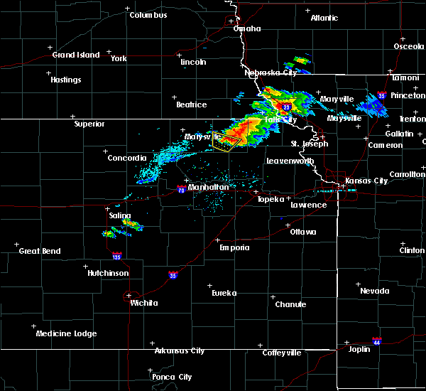 At 746 pm cdt, a severe thunderstorm was located 3 miles northwest of corning, moving east-southeast at 30 mph (radar indicated). Hazards include 60 mph wind gusts and half dollar size hail. Hail damage to vehicles is expected. expect wind damage to roofs, siding and trees. Locations impacted include, corning. At 746 pm cdt, a severe thunderstorm was located 3 miles northwest of corning, moving east-southeast at 30 mph (radar indicated). Hazards include 60 mph wind gusts and half dollar size hail. Hail damage to vehicles is expected. expect wind damage to roofs, siding and trees. Locations impacted include, corning.
|
| 9/17/2015 7:42 PM CDT |
 At 740 pm cdt, a severe thunderstorm was 1 mile north of centralia, moving southeast at 20 mph (radar indicated). Hazards include ping pong ball size hail and 60 mph wind gusts. People and animals outdoors will be injured. expect hail damage to roofs, siding, windows and vehicles. expect wind damage to roofs, siding and trees. locations impacted include, centralia and corning. At 740 pm cdt, a citizen in centralia reported quarter size hail. At 740 pm cdt, a severe thunderstorm was 1 mile north of centralia, moving southeast at 20 mph (radar indicated). Hazards include ping pong ball size hail and 60 mph wind gusts. People and animals outdoors will be injured. expect hail damage to roofs, siding, windows and vehicles. expect wind damage to roofs, siding and trees. locations impacted include, centralia and corning. At 740 pm cdt, a citizen in centralia reported quarter size hail.
|
| 9/17/2015 7:33 PM CDT |
 At 731 pm cdt, a severe thunderstorm was located over centralia, moving east-southeast at 35 mph (radar indicated). Hazards include golf ball size hail and 60 mph wind gusts. People and animals outdoors will be injured. expect hail damage to roofs, siding, windows and vehicles. expect wind damage to roofs, siding and trees. Locations impacted include, centralia and corning. At 731 pm cdt, a severe thunderstorm was located over centralia, moving east-southeast at 35 mph (radar indicated). Hazards include golf ball size hail and 60 mph wind gusts. People and animals outdoors will be injured. expect hail damage to roofs, siding, windows and vehicles. expect wind damage to roofs, siding and trees. Locations impacted include, centralia and corning.
|
| 9/17/2015 7:30 PM CDT |
 At 729 pm cdt, a severe thunderstorm was located over centralia, moving east at 35 mph (radar indicated). Hazards include golf ball size hail and 60 mph wind gusts. People and animals outdoors will be injured. expect hail damage to roofs, siding, windows and vehicles. expect wind damage to roofs, siding and trees. Locations impacted include, centralia and corning. At 729 pm cdt, a severe thunderstorm was located over centralia, moving east at 35 mph (radar indicated). Hazards include golf ball size hail and 60 mph wind gusts. People and animals outdoors will be injured. expect hail damage to roofs, siding, windows and vehicles. expect wind damage to roofs, siding and trees. Locations impacted include, centralia and corning.
|
| 9/17/2015 7:25 PM CDT |
 At 725 pm cdt, a severe thunderstorm was located over vermillion, moving east at 35 mph (radar indicated). Hazards include golf ball size hail and 60 mph wind gusts. People and animals outdoors will be injured. expect hail damage to roofs, siding, windows and vehicles. expect wind damage to roofs, siding and trees. Locations impacted include, centralia, corning and vermillion. At 725 pm cdt, a severe thunderstorm was located over vermillion, moving east at 35 mph (radar indicated). Hazards include golf ball size hail and 60 mph wind gusts. People and animals outdoors will be injured. expect hail damage to roofs, siding, windows and vehicles. expect wind damage to roofs, siding and trees. Locations impacted include, centralia, corning and vermillion.
|
| 9/17/2015 7:21 PM CDT |
 At 719 pm cdt, a severe thunderstorm was located 3 miles northwest of vermillion, moving east-southeast at 25 mph (radar indicated). Hazards include tennis ball size hail and 60 mph wind gusts. People and animals outdoors will be injured. expect hail damage to roofs, siding, windows and vehicles. expect wind damage to roofs, siding and trees. locations impacted include, centralia, corning and vermillion. At 713 pm cdt, a storm spotter reported quarter size 8 miles west- northwest of vermillion. At 719 pm cdt, a severe thunderstorm was located 3 miles northwest of vermillion, moving east-southeast at 25 mph (radar indicated). Hazards include tennis ball size hail and 60 mph wind gusts. People and animals outdoors will be injured. expect hail damage to roofs, siding, windows and vehicles. expect wind damage to roofs, siding and trees. locations impacted include, centralia, corning and vermillion. At 713 pm cdt, a storm spotter reported quarter size 8 miles west- northwest of vermillion.
|
| 9/17/2015 7:12 PM CDT |
 At 711 pm cdt, a severe thunderstorm was located 4 miles northeast of frankfort, moving southeast at 25 mph (radar indicated). Hazards include tennis ball size hail and 60 mph wind gusts. People and animals outdoors will be injured. expect hail damage to roofs, siding, windows and vehicles. Expect wind damage to roofs, siding and trees. At 711 pm cdt, a severe thunderstorm was located 4 miles northeast of frankfort, moving southeast at 25 mph (radar indicated). Hazards include tennis ball size hail and 60 mph wind gusts. People and animals outdoors will be injured. expect hail damage to roofs, siding, windows and vehicles. Expect wind damage to roofs, siding and trees.
|
| 9/17/2015 7:04 PM CDT |
 At 702 pm cdt, a severe thunderstorm was located near beattie, moving southeast at 35 mph (radar indicated). Hazards include tennis ball size hail and 60 mph wind gusts. People and animals outdoors will be injured. expect hail damage to roofs, siding, windows and vehicles. Expect wind damage to roofs, siding and trees. At 702 pm cdt, a severe thunderstorm was located near beattie, moving southeast at 35 mph (radar indicated). Hazards include tennis ball size hail and 60 mph wind gusts. People and animals outdoors will be injured. expect hail damage to roofs, siding, windows and vehicles. Expect wind damage to roofs, siding and trees.
|
| 6/21/2015 11:30 AM CDT |
 At 1126 am cdt, a severe thunderstorm was located near bern, and moving southeast at 40 mph (radar indicated). Hazards include 60 mph wind gusts and quarter size hail. Hail damage to vehicles is expected. Expect wind damage to roofs, siding and trees. At 1126 am cdt, a severe thunderstorm was located near bern, and moving southeast at 40 mph (radar indicated). Hazards include 60 mph wind gusts and quarter size hail. Hail damage to vehicles is expected. Expect wind damage to roofs, siding and trees.
|
| 5/25/2015 6:36 PM CDT | At 632 pm cdt, a severe thunderstorm was located near corning, and moving northeast at 35 mph (radar indicated). Hazards include 60 mph wind gusts and quarter size hail. Hail damage to vehicles is expected. expect wind damage to roofs, siding and trees. Locations impacted include, corning, centralia, goff and wetmore. |
| 5/25/2015 6:24 PM CDT | At 622 pm cdt, a severe thunderstorm was located near onaga, and moving northeast at 35 mph (radar indicated). Hazards include 60 mph wind gusts and quarter size hail. Hail damage to vehicles is expected. expect wind damage to roofs, siding and trees. Locations impacted include, soldier, corning, centralia, goff and wetmore. |
| 5/25/2015 6:12 PM CDT | At 611 pm cdt, a severe thunderstorm was located near onaga, and moving northeast at 35 mph (radar indicated). Hazards include 60 mph wind gusts and quarter size hail. Hail damage to vehicles is expected. Expect wind damage to roofs, siding and trees. |
| 5/25/2015 4:15 PM CDT | At 413 pm cdt, a severe thunderstorm was located 6 miles northeast of lillis, and moving northeast at 25 mph. a second severe thunderstorm was located 5 miles southwest of corning, also moving northeast at 25 mph (radar indicated). Hazards include 60 mph wind gusts and quarter size hail. Hail damage to vehicles is expected. Expect wind damage to roofs, siding and trees. |
| 5/25/2015 4:00 PM CDT | At 357 pm cdt, a severe thunderstorm was located 6 miles northwest of havensville, and moving northeast at 25 mph (trained weather spotters reported quarter size hail 6 miles north of onaga). Hazards include 60 mph wind gusts and quarter size hail. Hail damage to vehicles is expected. expect wind damage to roofs, siding and trees. The severe thunderstorm will be near, corning around 415 pm cdt. |
| 5/25/2015 3:47 PM CDT | At 344 pm cdt, a severe thunderstorm was located near onaga, and moving northeast at 25 mph (radar indicated). Hazards include 60 mph wind gusts and half dollar size hail. Hail damage to vehicles is expected. expect wind damage to roofs, siding and trees. The severe thunderstorm will be near, corning and goff around 415 pm cdt. |
| 5/4/2015 3:37 PM CDT | At 335 pm cdt, a severe thunderstorm was located near soldier, and moving east at 25 mph (trained weather spotters. at 332 pm a spotter reported 50 to 60 mph winds 3 miles northeast of havensville). Hazards include 60 mph wind gusts and quarter size hail. Hail damage to vehicles is expected. expect wind damage to roofs, siding and trees. locations impacted include, corning, soldier, goff, circleville, wetmore and woodlawn. 1. 00in. |
| 5/4/2015 3:24 PM CDT | At 322 pm cdt, a severe thunderstorm was located 5 miles north of havensville, and moving northeast at 30 mph (radar indicated). Hazards include 60 mph wind gusts and quarter size hail. Hail damage to vehicles is expected. expect wind damage to roofs, siding and trees. locations impacted include, soldier, corning, circleville, goff, wetmore and woodlawn. 1. 00in. |
| 5/4/2015 3:08 PM CDT | At 306 pm cdt, a severe thunderstorm was located near onaga, and moving northeast at 35 mph (radar indicated). Hazards include 60 mph wind gusts and quarter size hail. Hail damage to vehicles is expected. Expect wind damage to roofs, siding and trees. |
| 10/2/2014 8:58 AM CDT | Spotter also repored very heavy rain in nemaha county KS, 0.9 miles S of Corning, KS |
| 5/18/2013 11:30 PM CDT | Storm damage reported in nemaha county KS, 4.2 miles NNE of Corning, KS |
| 1/1/0001 12:00 AM | Storm damage reported in nemaha county KS, 1.7 miles E of Corning, KS |
| 1/1/0001 12:00 AM | Quarter sized hail reported 1.7 miles E of Corning, KS |
| 1/1/0001 12:00 AM | Quarter sized hail reported 0.2 miles S of Corning, KS, relayed by wibw tv |
| 1/1/0001 12:00 AM | Half Dollar sized hail reported 1.7 miles E of Corning, KS, hail covering the ground |
Hail Maps for Corning, KS
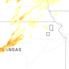
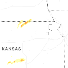
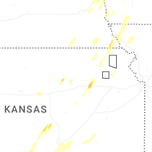
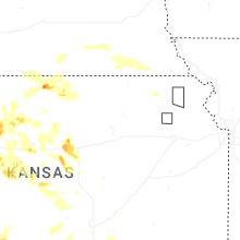
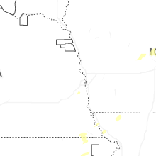


Connect with Interactive Hail Maps