

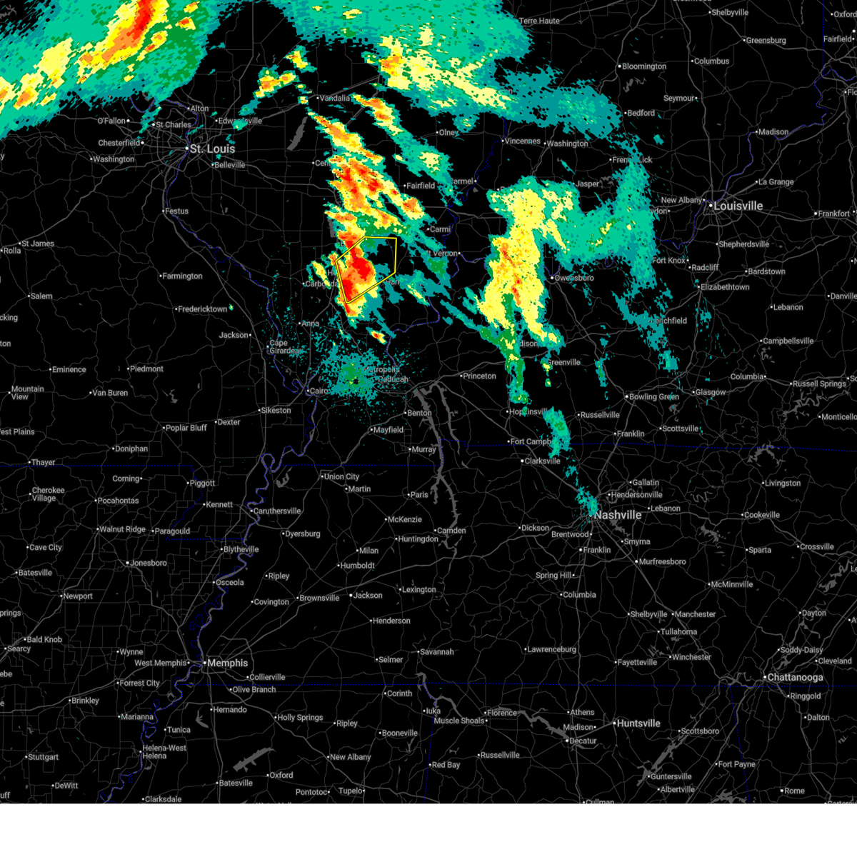
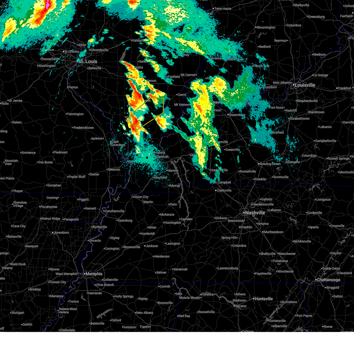
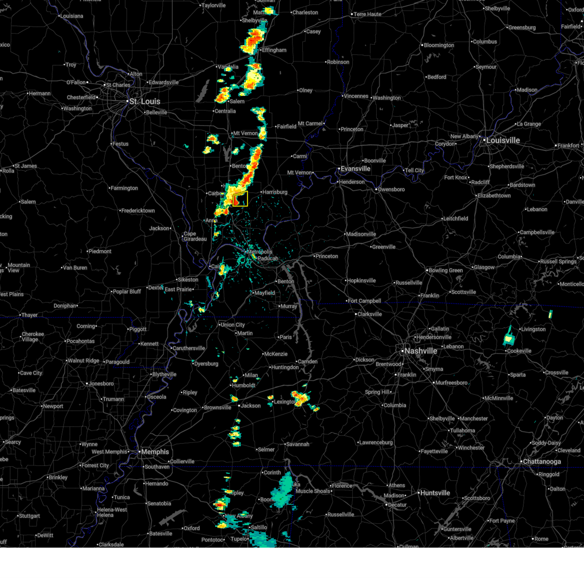
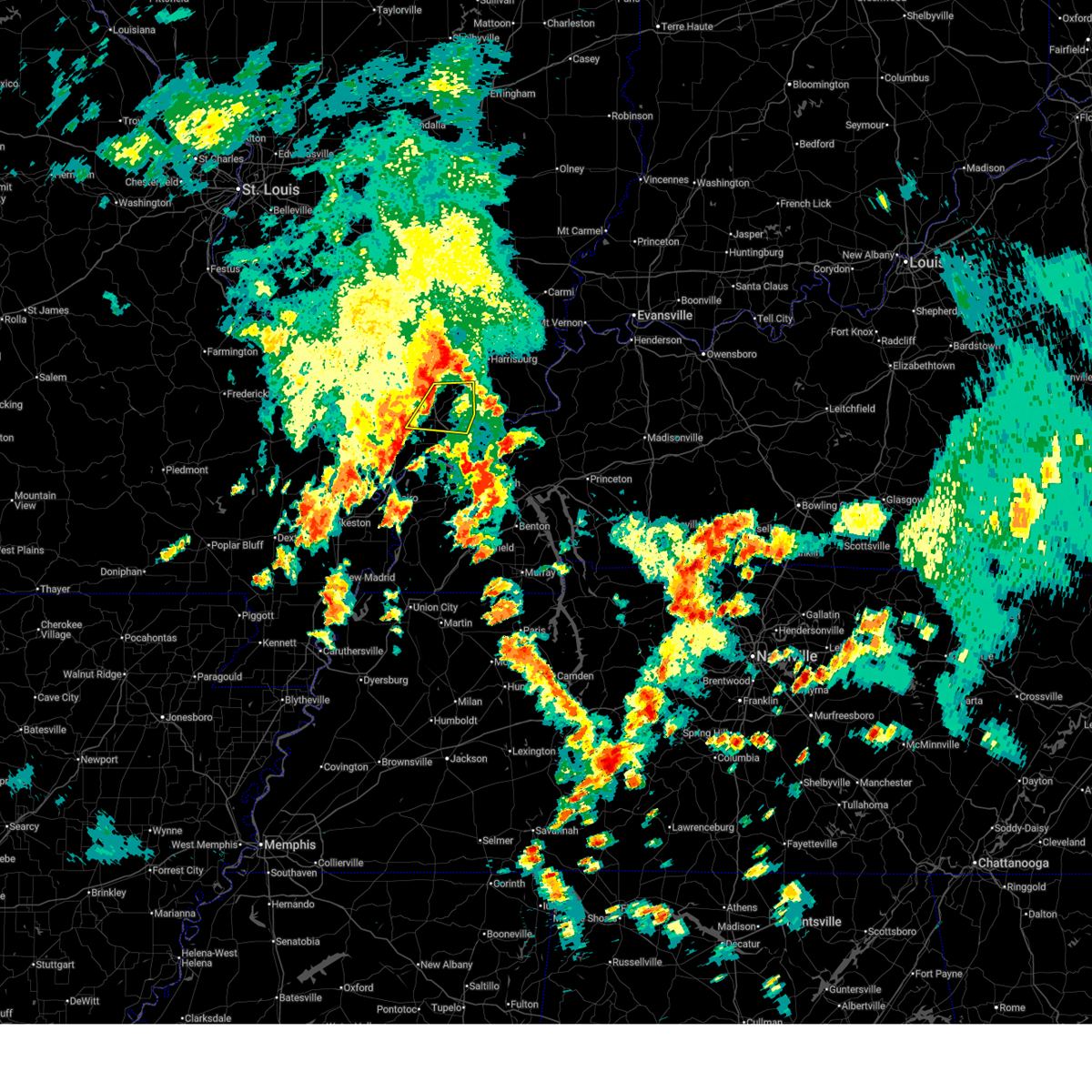
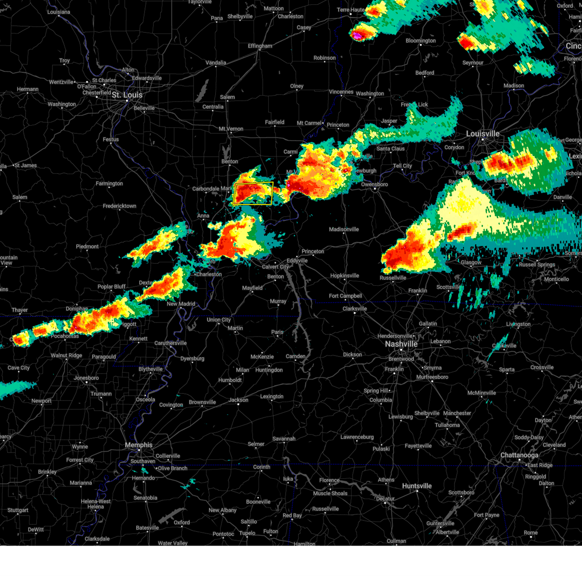
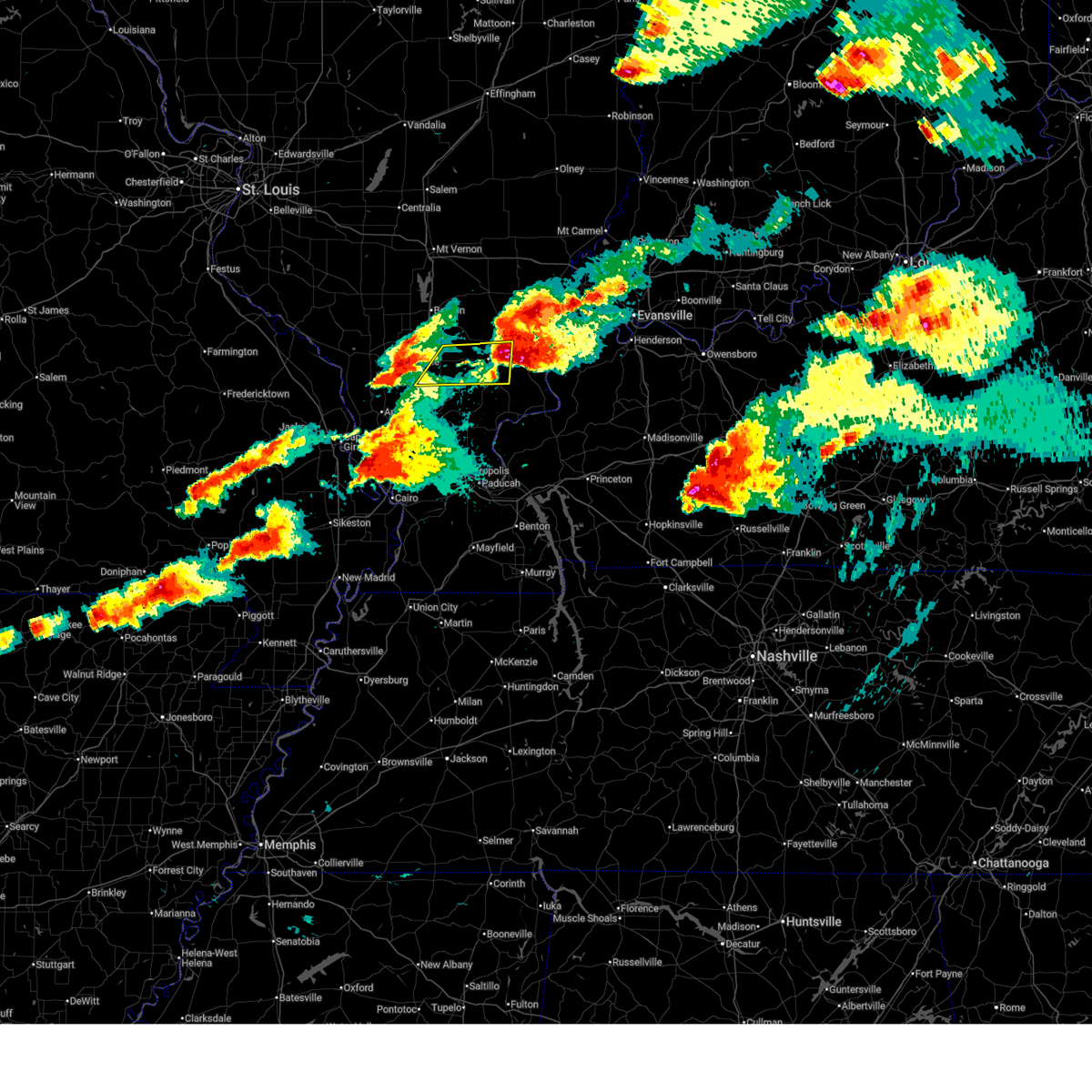
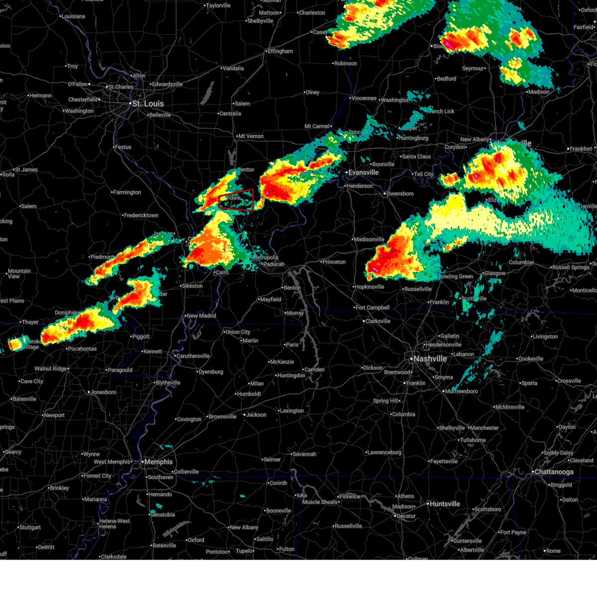
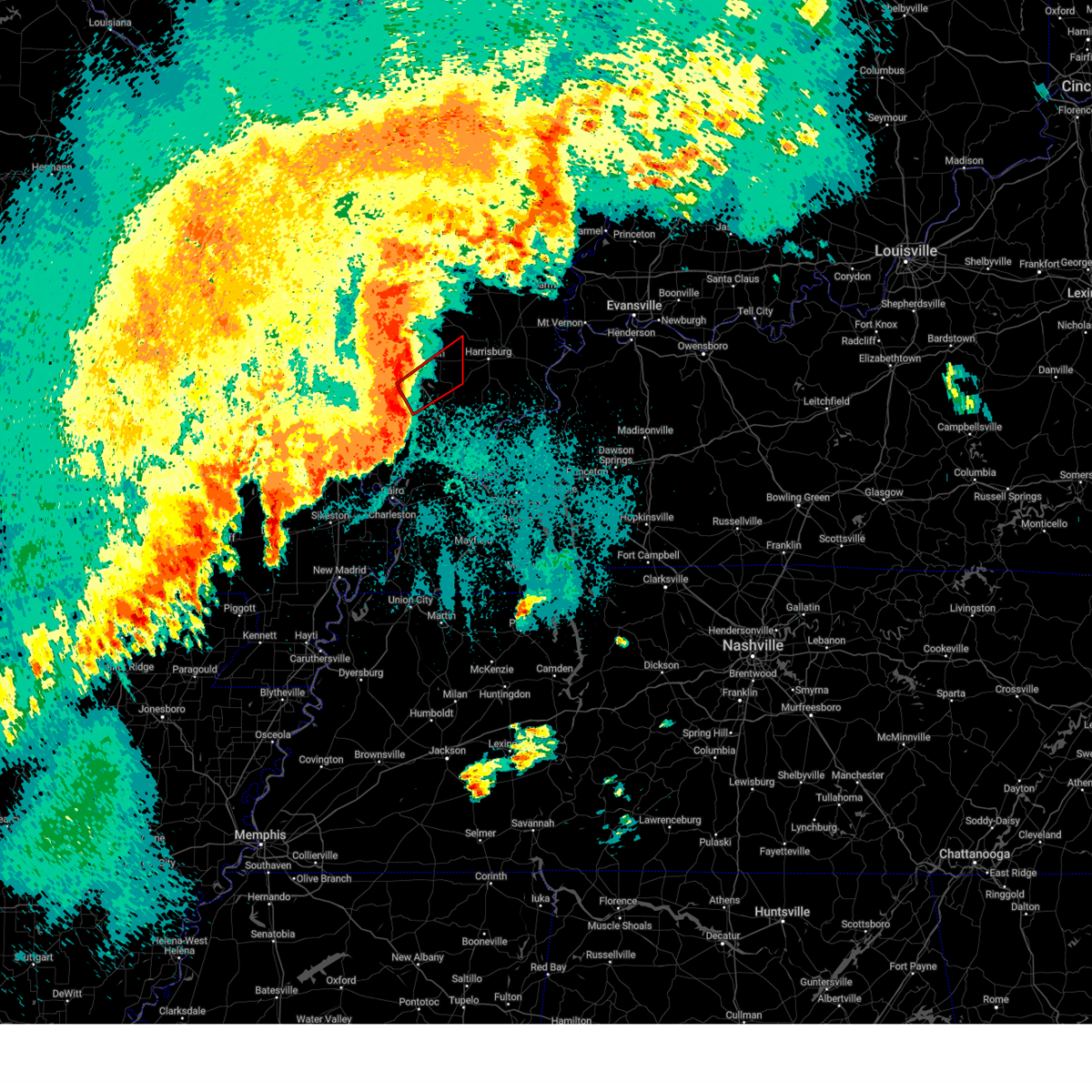
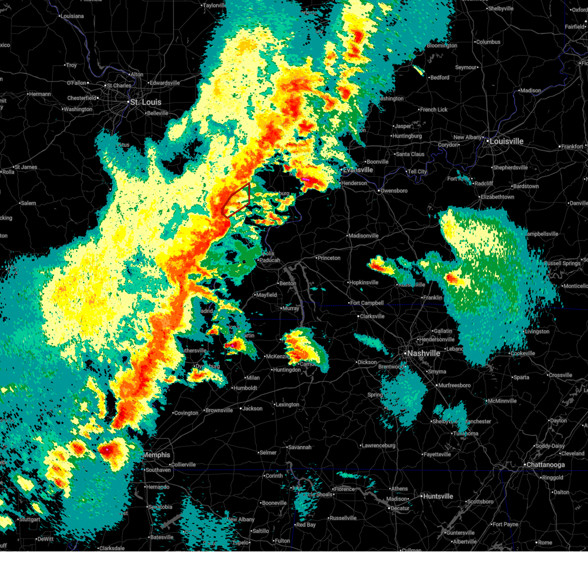
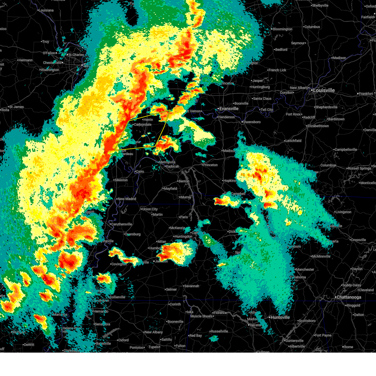
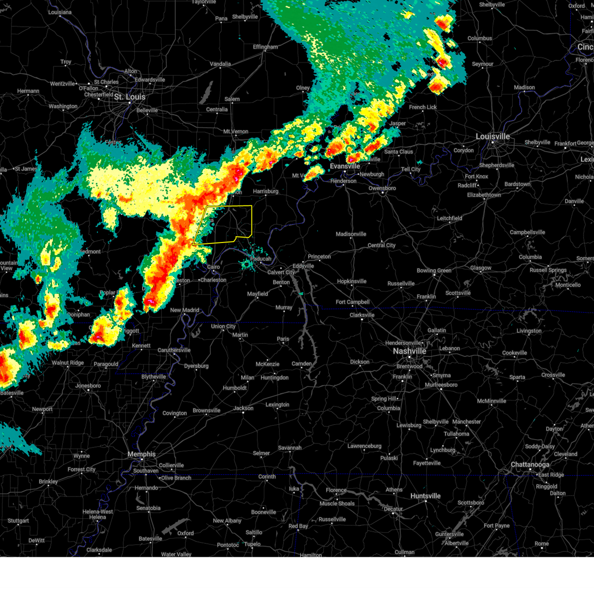
Hail Map for Creal Springs, IL
The Creal Springs, IL area has had 3 reports of on-the-ground hail by trained spotters, and has been under severe weather warnings 15 times during the past 12 months. Doppler radar has detected hail at or near Creal Springs, IL on 54 occasions, including 1 occasion during the past year.
| Name: | Creal Springs, IL |
| Where Located: | 44.6 miles ENE of Cape Girardeau, MO |
| Map: | Google Map for Creal Springs, IL |
| Population: | 543 |
| Housing Units: | 289 |
| More Info: | Search Google for Creal Springs, IL |
1
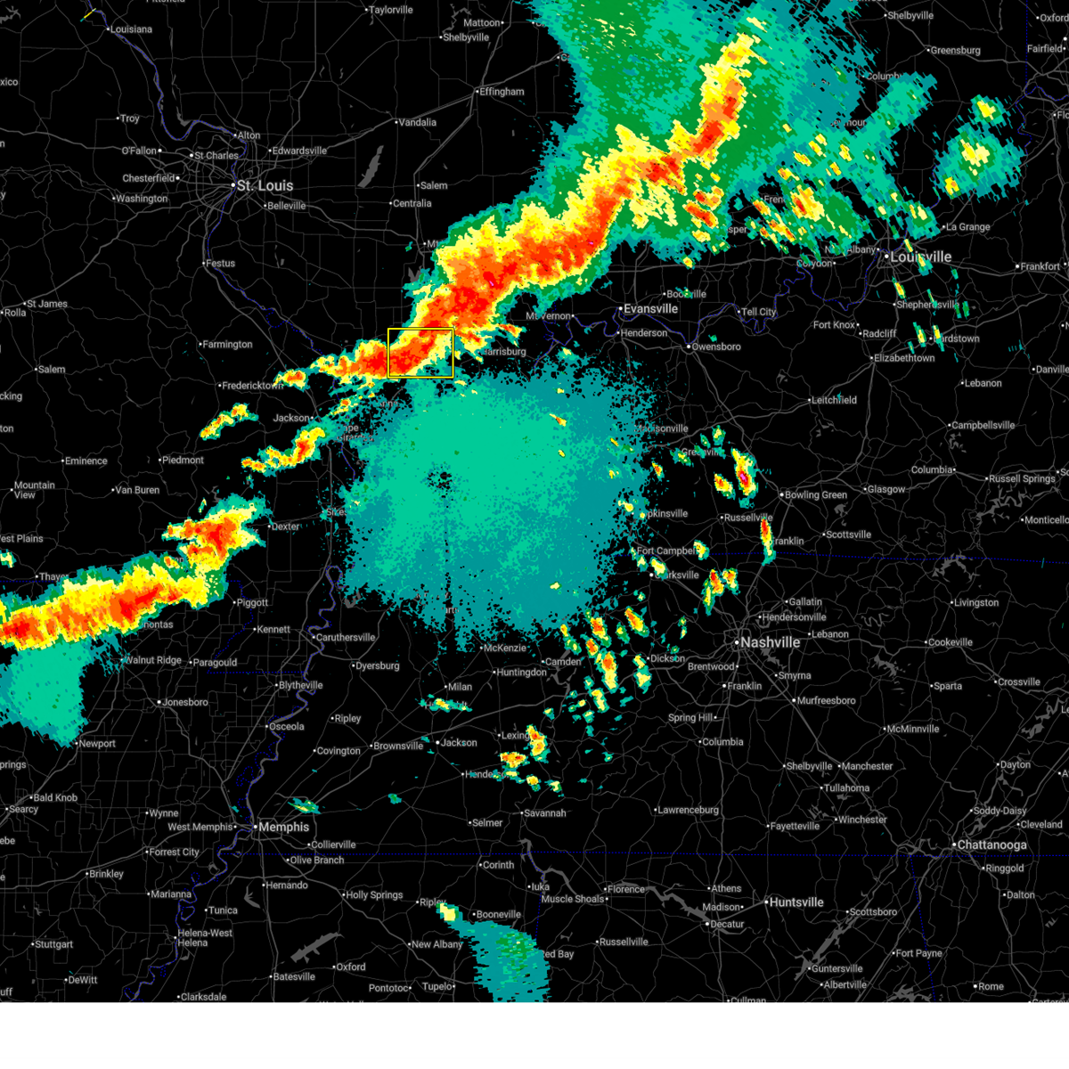
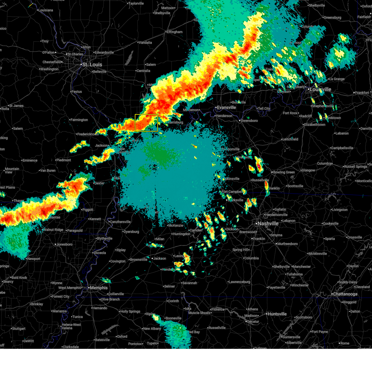
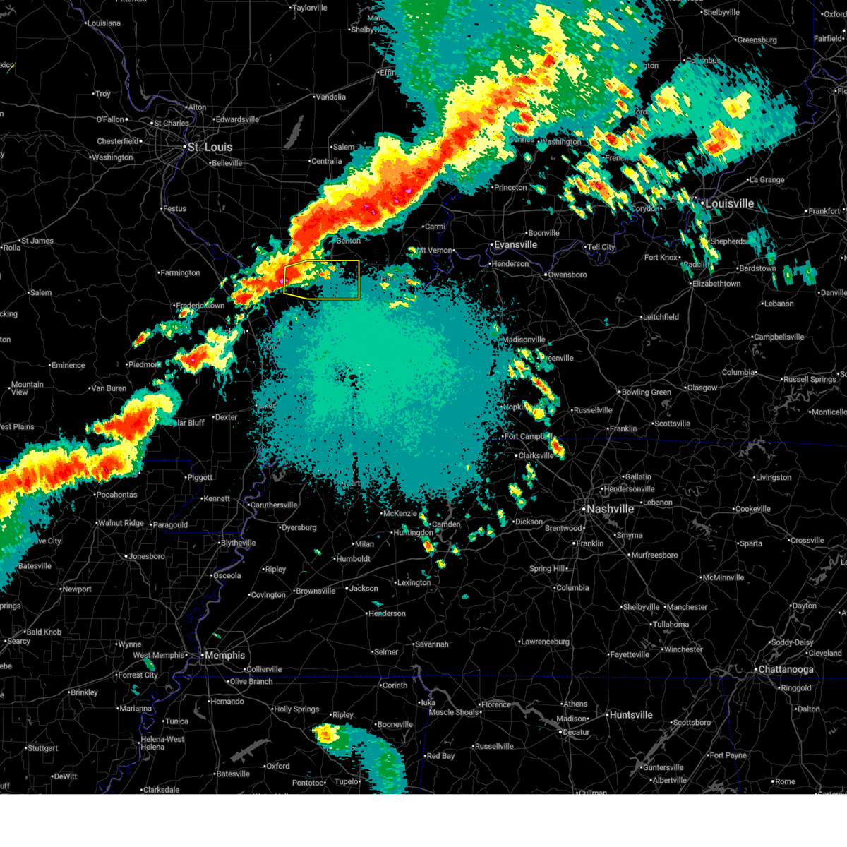
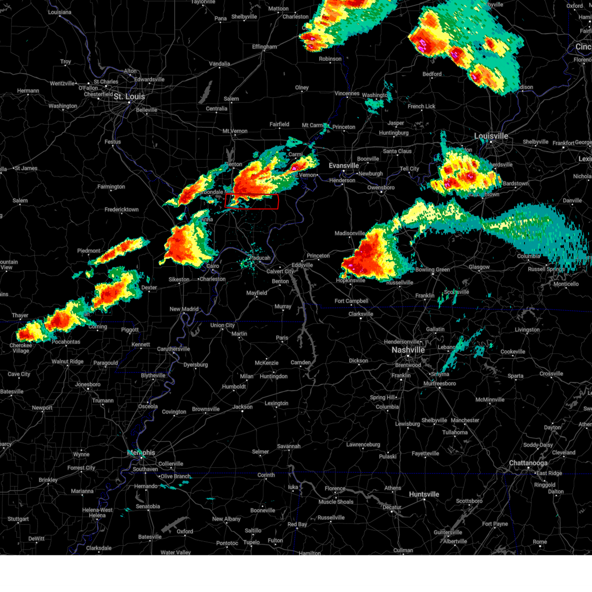
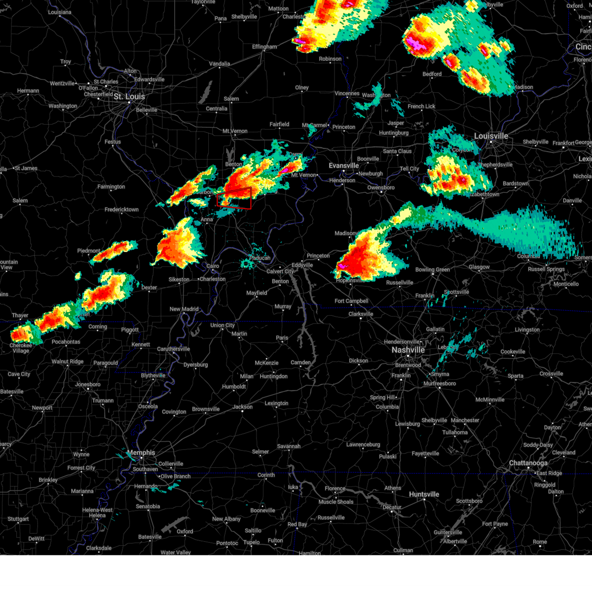
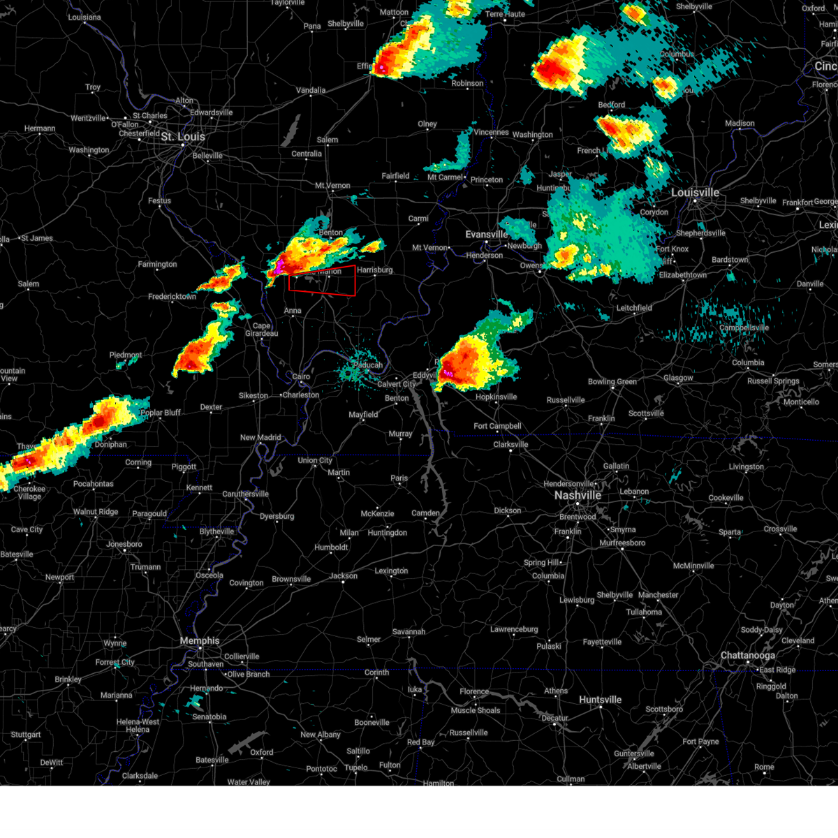
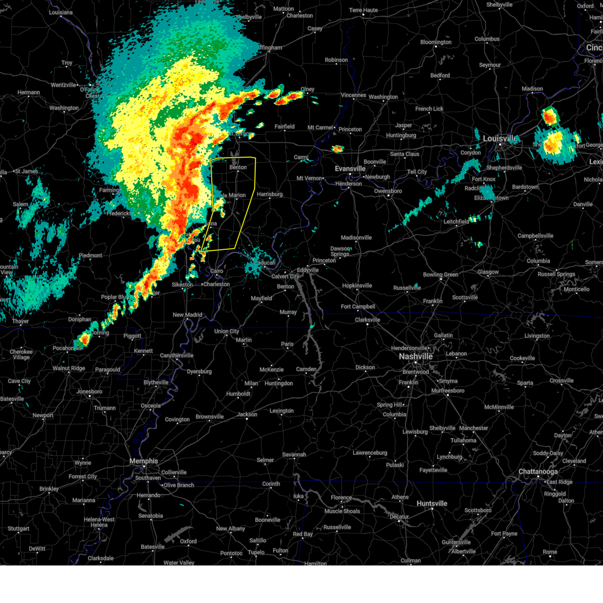
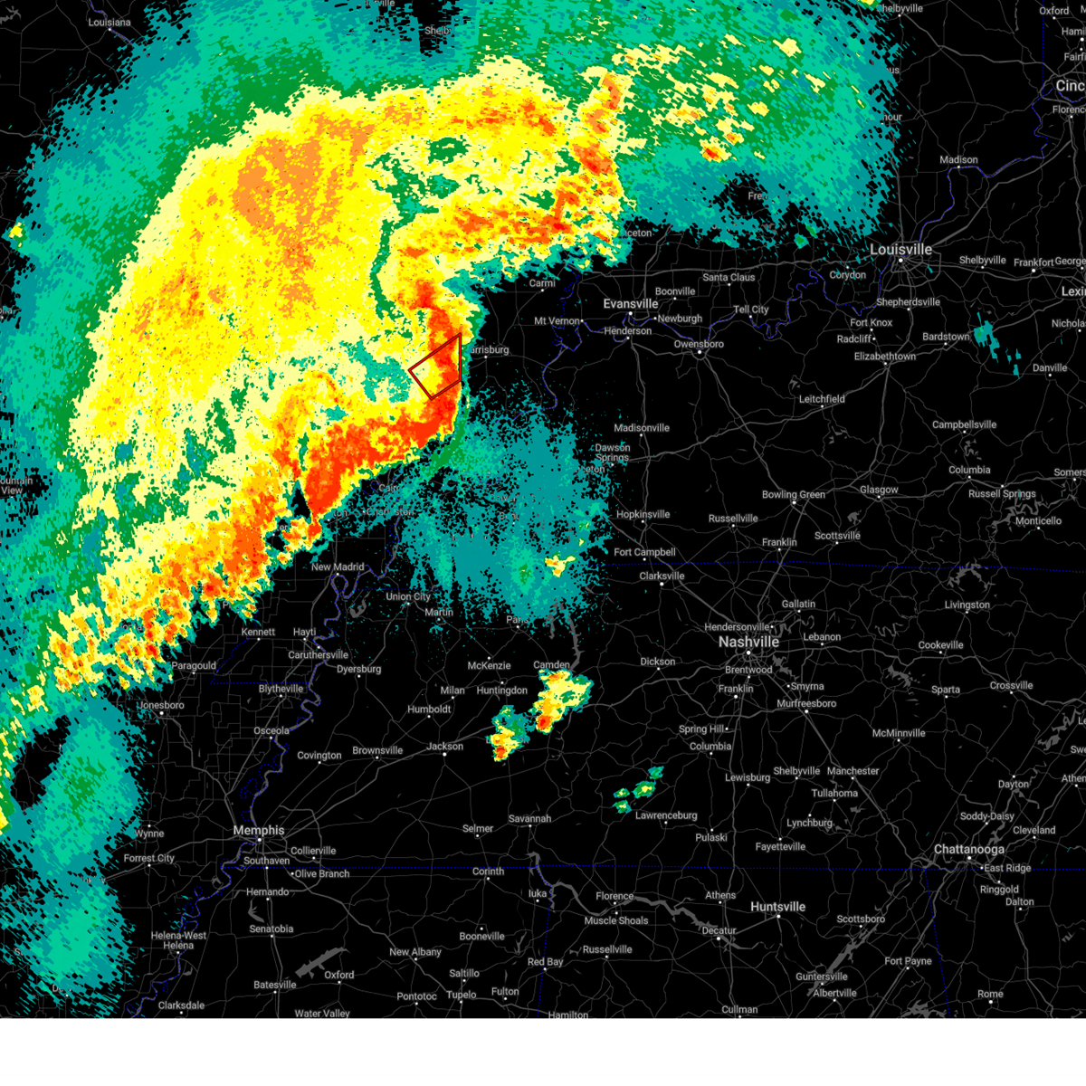
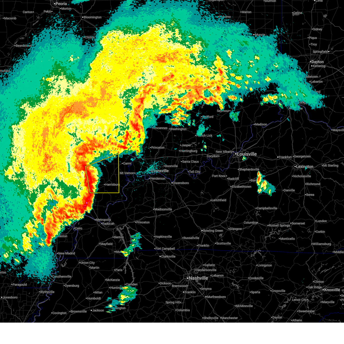
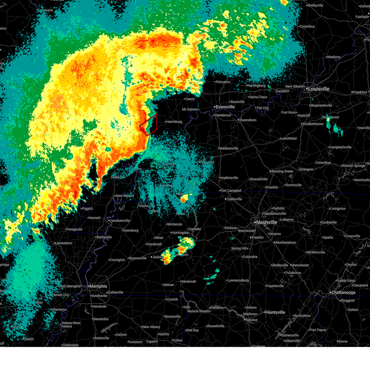
The Top Recent Hail Date for Creal Springs, IL is Monday, April 27, 2026 (9th out of 54)

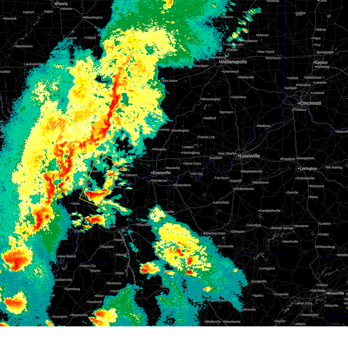
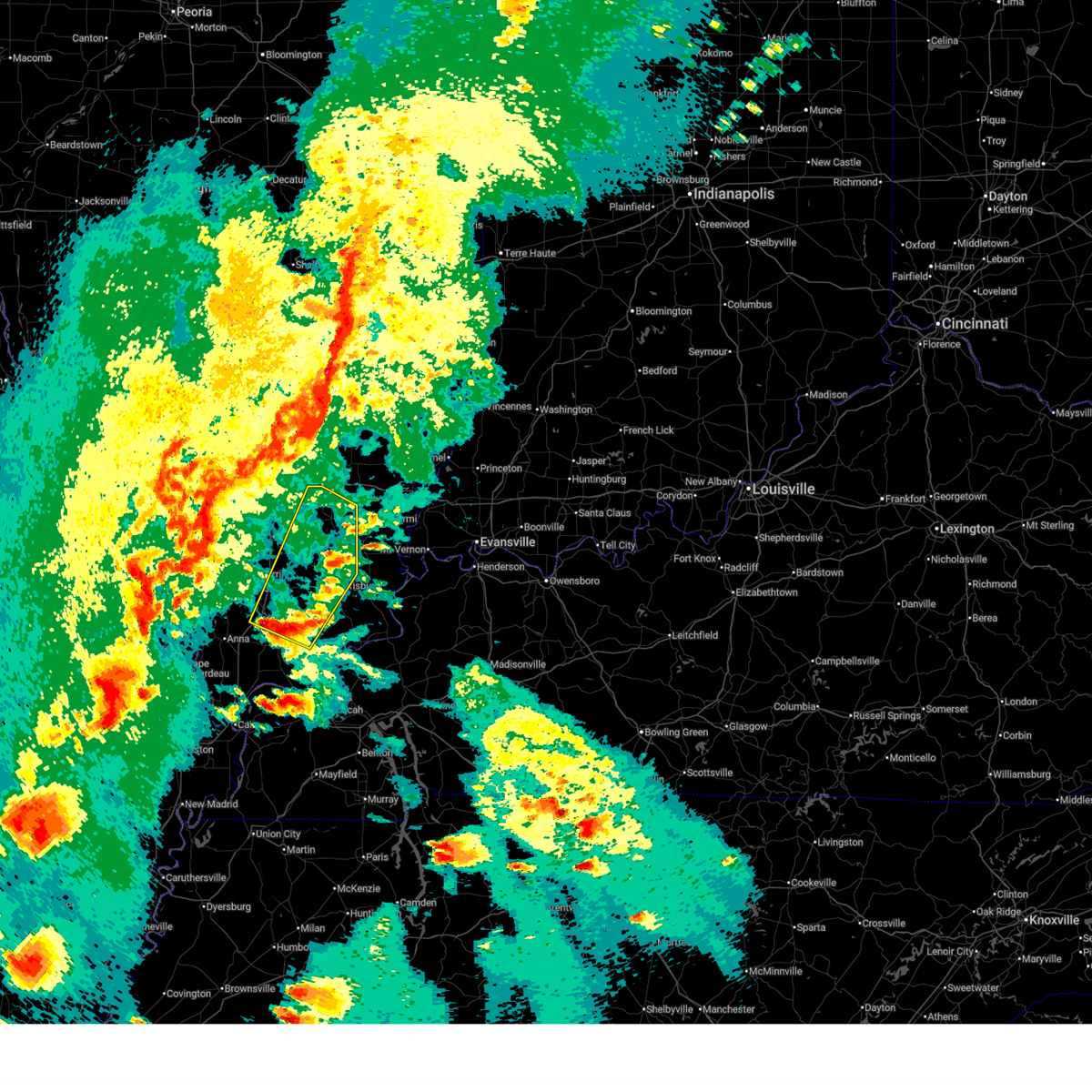
Hail and Wind Damage Spotted near Creal Springs, IL
| Date / Time | Report Details |
|---|---|
| 4/27/2026 10:15 PM CDT |
 At 1015 pm cdt, a severe thunderstorm was located over pittsburg, or near marion, moving east at 55 mph (radar indicated). Hazards include 60 mph wind gusts and penny size hail. Expect damage to roofs, siding, and trees. locations impacted include, marion, herrin, carterville, johnston city, crainville, cambria, energy, hurst, pittsburg, creal springs, lake of egypt area, stonefort, freeman spur, bush, whiteash, williamson county regional airport, colp, and spillertown. this includes the following highways, interstate 24 in illinois near mile marker 1. Interstate 57 in illinois between mile markers 44 and 61. At 1015 pm cdt, a severe thunderstorm was located over pittsburg, or near marion, moving east at 55 mph (radar indicated). Hazards include 60 mph wind gusts and penny size hail. Expect damage to roofs, siding, and trees. locations impacted include, marion, herrin, carterville, johnston city, crainville, cambria, energy, hurst, pittsburg, creal springs, lake of egypt area, stonefort, freeman spur, bush, whiteash, williamson county regional airport, colp, and spillertown. this includes the following highways, interstate 24 in illinois near mile marker 1. Interstate 57 in illinois between mile markers 44 and 61.
|
| 4/27/2026 10:15 PM CDT |
 the severe thunderstorm warning has been cancelled and is no longer in effect the severe thunderstorm warning has been cancelled and is no longer in effect
|
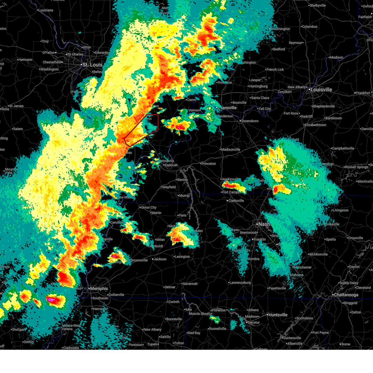
| 4/27/2026 9:52 PM CDT |
 Svrpah the national weather service in paducah has issued a * severe thunderstorm warning for, williamson county in southern illinois, southeastern jackson county in southern illinois, * until 1030 pm cdt. * at 951 pm cdt, a severe thunderstorm was located over carbondale, moving east at 55 mph (radar indicated). Hazards include 70 mph wind gusts and half dollar size hail. Hail damage to vehicles is expected. expect considerable tree damage. Wind damage is also likely to mobile homes, roofs, and outbuildings. Svrpah the national weather service in paducah has issued a * severe thunderstorm warning for, williamson county in southern illinois, southeastern jackson county in southern illinois, * until 1030 pm cdt. * at 951 pm cdt, a severe thunderstorm was located over carbondale, moving east at 55 mph (radar indicated). Hazards include 70 mph wind gusts and half dollar size hail. Hail damage to vehicles is expected. expect considerable tree damage. Wind damage is also likely to mobile homes, roofs, and outbuildings.
|
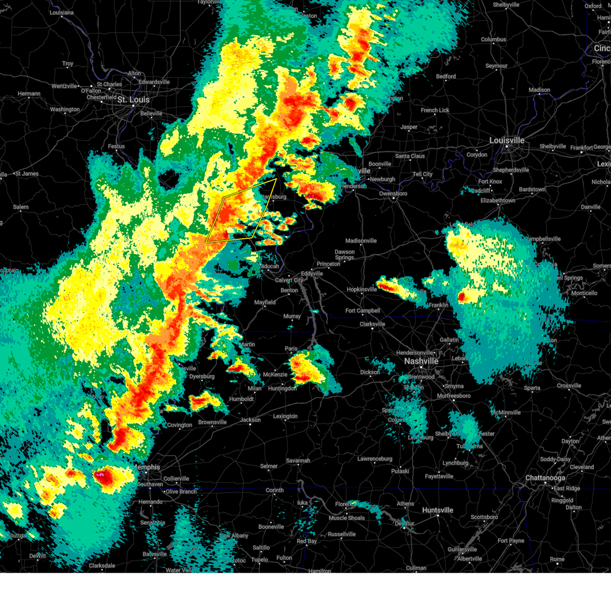
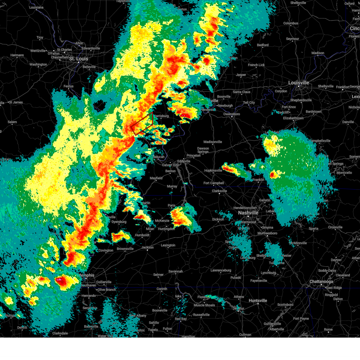
| 4/27/2026 9:33 AM CDT |
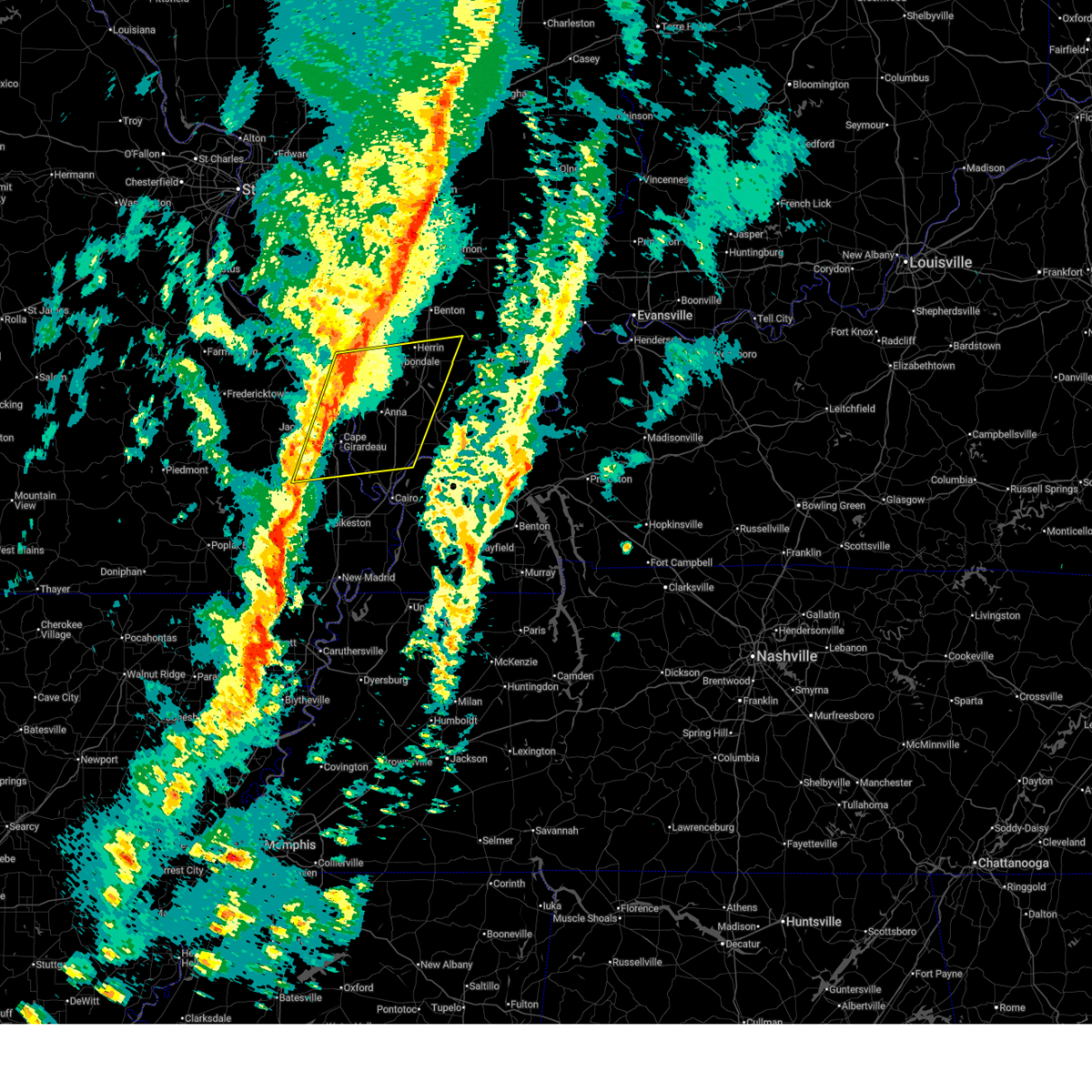
 At 933 am cdt, severe thunderstorms were located along a line extending from west frankfort to creal springs, moving northeast at 50 mph (radar indicated). Hazards include quarter size hail. Damage to vehicles is expected. Locations impacted include, marion, harrisburg, west frankfort, eldorado, johnston city, galatia, pittsburg, creal springs, thompsonville, raleigh, broughton, and muddy. At 933 am cdt, severe thunderstorms were located along a line extending from west frankfort to creal springs, moving northeast at 50 mph (radar indicated). Hazards include quarter size hail. Damage to vehicles is expected. Locations impacted include, marion, harrisburg, west frankfort, eldorado, johnston city, galatia, pittsburg, creal springs, thompsonville, raleigh, broughton, and muddy.
|
| 4/27/2026 9:16 AM CDT |
 Svrpah the national weather service in paducah has issued a * severe thunderstorm warning for, northwestern johnson county in southern illinois, williamson county in southern illinois, northern saline county in southern illinois, southern hamilton county in south central illinois, southeastern franklin county in south central illinois, * until 1000 am cdt. * at 915 am cdt, severe thunderstorms were located along a line extending from carterville to lake of egypt area, moving northeast at 50 mph (radar indicated). Hazards include quarter size hail. damage to vehicles is expected Svrpah the national weather service in paducah has issued a * severe thunderstorm warning for, northwestern johnson county in southern illinois, williamson county in southern illinois, northern saline county in southern illinois, southern hamilton county in south central illinois, southeastern franklin county in south central illinois, * until 1000 am cdt. * at 915 am cdt, severe thunderstorms were located along a line extending from carterville to lake of egypt area, moving northeast at 50 mph (radar indicated). Hazards include quarter size hail. damage to vehicles is expected
|
| 4/27/2026 7:32 AM CDT |
 Svrpah the national weather service in paducah has issued a * severe thunderstorm warning for, northwestern pope county in southern illinois, northeastern johnson county in southern illinois, eastern williamson county in southern illinois, saline county in southern illinois, southwestern hamilton county in south central illinois, southeastern franklin county in south central illinois, * until 815 am cdt. * at 732 am cdt, severe thunderstorms were located along a line extending from near marion to 8 miles southeast of creal springs, moving northeast at 45 mph (radar indicated). Hazards include half dollar size hail. damage to vehicles is expected Svrpah the national weather service in paducah has issued a * severe thunderstorm warning for, northwestern pope county in southern illinois, northeastern johnson county in southern illinois, eastern williamson county in southern illinois, saline county in southern illinois, southwestern hamilton county in south central illinois, southeastern franklin county in south central illinois, * until 815 am cdt. * at 732 am cdt, severe thunderstorms were located along a line extending from near marion to 8 miles southeast of creal springs, moving northeast at 45 mph (radar indicated). Hazards include half dollar size hail. damage to vehicles is expected
|
| 3/15/2026 7:27 PM CDT |
 The storms which prompted the warning have weakened below severe limits, and no longer pose an immediate threat to life or property. therefore, the warning will be allowed to expire. however, gusty winds are still possible with these thunderstorms. a tornado watch remains in effect until 1100 pm cdt for southern illinois, western kentucky, and southeastern missouri. remember, a tornado warning still remains in effect for portions of union, jackson, and williamson county. The storms which prompted the warning have weakened below severe limits, and no longer pose an immediate threat to life or property. therefore, the warning will be allowed to expire. however, gusty winds are still possible with these thunderstorms. a tornado watch remains in effect until 1100 pm cdt for southern illinois, western kentucky, and southeastern missouri. remember, a tornado warning still remains in effect for portions of union, jackson, and williamson county.
|
| 3/15/2026 7:21 PM CDT |
 At 721 pm cdt, severe thunderstorms were located along a line extending from near marion to near horseshoe lake conservation area, moving east at 50 mph (radar indicated). Hazards include 60 mph wind gusts. Expect damage to roofs, siding, and trees. locations impacted include, cape girardeau, carbondale, marion, herrin, murphysboro, carterville, scott city, anna, johnston city, jonesboro, crainville, cambria, cobden, energy, goreville, dongola, tamms, kelso, pittsburg, and creal springs. this includes the following highways, interstate 24 in illinois between mile markers 1 and 11. interstate 57 in illinois between mile markers 10 and 60. Interstate 55 between mile markers 84 and 91. At 721 pm cdt, severe thunderstorms were located along a line extending from near marion to near horseshoe lake conservation area, moving east at 50 mph (radar indicated). Hazards include 60 mph wind gusts. Expect damage to roofs, siding, and trees. locations impacted include, cape girardeau, carbondale, marion, herrin, murphysboro, carterville, scott city, anna, johnston city, jonesboro, crainville, cambria, cobden, energy, goreville, dongola, tamms, kelso, pittsburg, and creal springs. this includes the following highways, interstate 24 in illinois between mile markers 1 and 11. interstate 57 in illinois between mile markers 10 and 60. Interstate 55 between mile markers 84 and 91.
|
| 3/15/2026 7:21 PM CDT |
 the severe thunderstorm warning has been cancelled and is no longer in effect the severe thunderstorm warning has been cancelled and is no longer in effect
|
| 3/15/2026 6:52 PM CDT |
 Svrpah the national weather service in paducah has issued a * severe thunderstorm warning for, union county in southern illinois, pulaski county in southern illinois, western johnson county in southern illinois, williamson county in southern illinois, southern jackson county in southern illinois, alexander county in southern illinois, north central ballard county in western kentucky, northern scott county in southeastern missouri, southeastern perry county in southeastern missouri, central cape girardeau county in southeastern missouri, northern stoddard county in southeastern missouri, * until 730 pm cdt. * at 652 pm cdt, severe thunderstorms were located along a line extending from murphysboro to near oran, moving east at 50 mph (radar indicated). Hazards include 60 mph wind gusts. expect damage to roofs, siding, and trees Svrpah the national weather service in paducah has issued a * severe thunderstorm warning for, union county in southern illinois, pulaski county in southern illinois, western johnson county in southern illinois, williamson county in southern illinois, southern jackson county in southern illinois, alexander county in southern illinois, north central ballard county in western kentucky, northern scott county in southeastern missouri, southeastern perry county in southeastern missouri, central cape girardeau county in southeastern missouri, northern stoddard county in southeastern missouri, * until 730 pm cdt. * at 652 pm cdt, severe thunderstorms were located along a line extending from murphysboro to near oran, moving east at 50 mph (radar indicated). Hazards include 60 mph wind gusts. expect damage to roofs, siding, and trees
|
| 12/28/2025 5:44 PM CST |
 Svrpah the national weather service in paducah has issued a * severe thunderstorm warning for, white county in southeastern illinois, southeastern williamson county in southern illinois, saline county in southern illinois, hamilton county in south central illinois, gallatin county in southern illinois, * until 630 pm cst. * at 544 pm cst, severe thunderstorms were located along a line extending from 7 miles north of mcleansboro to near marion, moving east at 55 mph (radar indicated). Hazards include 60 mph wind gusts. expect damage to roofs, siding, and trees Svrpah the national weather service in paducah has issued a * severe thunderstorm warning for, white county in southeastern illinois, southeastern williamson county in southern illinois, saline county in southern illinois, hamilton county in south central illinois, gallatin county in southern illinois, * until 630 pm cst. * at 544 pm cst, severe thunderstorms were located along a line extending from 7 miles north of mcleansboro to near marion, moving east at 55 mph (radar indicated). Hazards include 60 mph wind gusts. expect damage to roofs, siding, and trees
|
| 12/28/2025 5:15 PM CST |
 Svrpah the national weather service in paducah has issued a * severe thunderstorm warning for, williamson county in southern illinois, eastern jackson county in southern illinois, southern franklin county in south central illinois, * until 600 pm cst. * at 515 pm cst, severe thunderstorms were located along a line extending from near elkville to near grand tower, moving east at 55 mph (trained weather spotters). Hazards include 60 mph wind gusts. expect damage to roofs, siding, and trees Svrpah the national weather service in paducah has issued a * severe thunderstorm warning for, williamson county in southern illinois, eastern jackson county in southern illinois, southern franklin county in south central illinois, * until 600 pm cst. * at 515 pm cst, severe thunderstorms were located along a line extending from near elkville to near grand tower, moving east at 55 mph (trained weather spotters). Hazards include 60 mph wind gusts. expect damage to roofs, siding, and trees
|
| 7/23/2025 3:58 PM CDT |
 The storm which prompted the warning has weakened below severe limits, and no longer poses an immediate threat to life or property. therefore, the warning will be allowed to expire. however, gusty winds are still possible with this thunderstorm. The storm which prompted the warning has weakened below severe limits, and no longer poses an immediate threat to life or property. therefore, the warning will be allowed to expire. however, gusty winds are still possible with this thunderstorm.
|
| 7/23/2025 3:51 PM CDT |
 At 351 pm cdt, a severe thunderstorm was located over creal springs, or 9 miles southeast of marion, moving east at 15 mph (radar indicated). Hazards include 60 mph wind gusts. Expect damage to roofs, siding, and trees. Locations impacted include, creal springs and stonefort. At 351 pm cdt, a severe thunderstorm was located over creal springs, or 9 miles southeast of marion, moving east at 15 mph (radar indicated). Hazards include 60 mph wind gusts. Expect damage to roofs, siding, and trees. Locations impacted include, creal springs and stonefort.
|
| 7/23/2025 3:42 PM CDT |
 Svrpah the national weather service in paducah has issued a * severe thunderstorm warning for, southeastern williamson county in southern illinois, * until 400 pm cdt. * at 342 pm cdt, a severe thunderstorm was located near creal springs, or near marion, moving east at 15 mph (radar indicated). Hazards include 60 mph wind gusts. expect damage to roofs, siding, and trees Svrpah the national weather service in paducah has issued a * severe thunderstorm warning for, southeastern williamson county in southern illinois, * until 400 pm cdt. * at 342 pm cdt, a severe thunderstorm was located near creal springs, or near marion, moving east at 15 mph (radar indicated). Hazards include 60 mph wind gusts. expect damage to roofs, siding, and trees
|
| 6/6/2025 2:17 PM CDT |
 At 217 pm cdt, severe thunderstorms were located along a line extending from lake of egypt area to near vienna to 6 miles north of karnak, moving east at 30 mph (radar indicated). Hazards include 60 mph wind gusts and quarter size hail. Hail damage to vehicles is expected. expect wind damage to roofs, siding, and trees. locations impacted include, vienna, dixon springs, lake of egypt area, stonefort, new burnside, buncombe, and simpson. This includes interstate 24 in illinois between mile markers 6 and 21. At 217 pm cdt, severe thunderstorms were located along a line extending from lake of egypt area to near vienna to 6 miles north of karnak, moving east at 30 mph (radar indicated). Hazards include 60 mph wind gusts and quarter size hail. Hail damage to vehicles is expected. expect wind damage to roofs, siding, and trees. locations impacted include, vienna, dixon springs, lake of egypt area, stonefort, new burnside, buncombe, and simpson. This includes interstate 24 in illinois between mile markers 6 and 21.
|
| 5/16/2025 7:12 PM CDT |
 At 711 pm cdt, a severe thunderstorm was located near creal springs, or 10 miles southeast of marion, moving east at 60 mph (radar indicated). Hazards include golf ball size hail and 60 mph wind gusts. People and animals outdoors will be injured. expect hail damage to roofs, siding, windows, and vehicles. expect wind damage to roofs, siding, and trees. Locations impacted include, harrisburg, eldorado, pittsburg, creal springs, carrier mills, raleigh, stonefort, and muddy. At 711 pm cdt, a severe thunderstorm was located near creal springs, or 10 miles southeast of marion, moving east at 60 mph (radar indicated). Hazards include golf ball size hail and 60 mph wind gusts. People and animals outdoors will be injured. expect hail damage to roofs, siding, windows, and vehicles. expect wind damage to roofs, siding, and trees. Locations impacted include, harrisburg, eldorado, pittsburg, creal springs, carrier mills, raleigh, stonefort, and muddy.
|
| 5/16/2025 7:03 PM CDT |
 Svrpah the national weather service in paducah has issued a * severe thunderstorm warning for, eastern williamson county in southern illinois, saline county in southern illinois, * until 745 pm cdt. * at 703 pm cdt, a severe thunderstorm was located near lake of egypt area, or near marion, moving east at 60 mph (radar indicated). Hazards include 60 mph wind gusts and half dollar size hail. Hail damage to vehicles is expected. Expect wind damage to roofs, siding, and trees. Svrpah the national weather service in paducah has issued a * severe thunderstorm warning for, eastern williamson county in southern illinois, saline county in southern illinois, * until 745 pm cdt. * at 703 pm cdt, a severe thunderstorm was located near lake of egypt area, or near marion, moving east at 60 mph (radar indicated). Hazards include 60 mph wind gusts and half dollar size hail. Hail damage to vehicles is expected. Expect wind damage to roofs, siding, and trees.
|
| 5/16/2025 6:50 PM CDT |
 the tornado warning has been cancelled and is no longer in effect the tornado warning has been cancelled and is no longer in effect
|
| 5/16/2025 6:25 PM CDT |
 Torpah the national weather service in paducah has issued a * tornado warning for, southeastern williamson county in southern illinois, southern saline county in southern illinois, * until 700 pm cdt. * at 623 pm cdt, a confirmed large and destructive tornado was observed near hudgens, or near creal springs, moving east at 60 mph. tornado emergency for southeast williamson, and southern saline county. this is a particularly dangerous situation. take cover now! (radar confirmed tornado). Hazards include deadly tornado. You are in a life-threatening situation. flying debris may be deadly to those caught without shelter. mobile homes will be destroyed. considerable damage to homes, businesses, and vehicles is likely and complete destruction is possible. the tornado will be near, creal springs and carrier mills around 630 pm cdt. harrisburg around 635 pm cdt. other locations impacted by this tornadic thunderstorm include stonefort. This includes interstate 57 in illinois between mile markers 45 and 54. Torpah the national weather service in paducah has issued a * tornado warning for, southeastern williamson county in southern illinois, southern saline county in southern illinois, * until 700 pm cdt. * at 623 pm cdt, a confirmed large and destructive tornado was observed near hudgens, or near creal springs, moving east at 60 mph. tornado emergency for southeast williamson, and southern saline county. this is a particularly dangerous situation. take cover now! (radar confirmed tornado). Hazards include deadly tornado. You are in a life-threatening situation. flying debris may be deadly to those caught without shelter. mobile homes will be destroyed. considerable damage to homes, businesses, and vehicles is likely and complete destruction is possible. the tornado will be near, creal springs and carrier mills around 630 pm cdt. harrisburg around 635 pm cdt. other locations impacted by this tornadic thunderstorm include stonefort. This includes interstate 57 in illinois between mile markers 45 and 54.
|
| 5/16/2025 6:20 PM CDT |
 the tornado warning has been cancelled and is no longer in effect the tornado warning has been cancelled and is no longer in effect
|
| 5/16/2025 6:20 PM CDT |
 At 620 pm cdt, a confirmed large and extremely dangerous tornado was located near lake of egypt area, or 8 miles southwest of marion, moving east at 50 mph. this is a particularly dangerous situation. take cover now! (radar confirmed tornado). Hazards include damaging tornado. You are in a life-threatening situation. flying debris may be deadly to those caught without shelter. mobile homes will be destroyed. considerable damage to homes, businesses, and vehicles is likely and complete destruction is possible. the tornado will be near, marion, creal springs, and lake of egypt area around 625 pm cdt. other locations impacted by this tornadic thunderstorm include spillertown, williamson county regional airport, and stonefort. This includes interstate 57 in illinois between mile markers 46 and 55. At 620 pm cdt, a confirmed large and extremely dangerous tornado was located near lake of egypt area, or 8 miles southwest of marion, moving east at 50 mph. this is a particularly dangerous situation. take cover now! (radar confirmed tornado). Hazards include damaging tornado. You are in a life-threatening situation. flying debris may be deadly to those caught without shelter. mobile homes will be destroyed. considerable damage to homes, businesses, and vehicles is likely and complete destruction is possible. the tornado will be near, marion, creal springs, and lake of egypt area around 625 pm cdt. other locations impacted by this tornadic thunderstorm include spillertown, williamson county regional airport, and stonefort. This includes interstate 57 in illinois between mile markers 46 and 55.
|
| 5/16/2025 6:08 PM CDT |
 Torpah the national weather service in paducah has issued a * tornado warning for, williamson county in southern illinois, southeastern jackson county in southern illinois, * until 700 pm cdt. * at 608 pm cdt, a severe thunderstorm capable of producing a tornado was located near carbondale, moving east at 55 mph (radar indicated rotation). Hazards include tornado and hail up to two inches in diameter. Flying debris will be dangerous to those caught without shelter. mobile homes will be damaged or destroyed. damage to roofs, windows, and vehicles will occur. tree damage is likely. this dangerous storm will be near, marion, carterville, crainville, energy, and lake of egypt area around 615 pm cdt. pittsburg and creal springs around 620 pm cdt. other locations impacted by this tornadic thunderstorm include spillertown, williamson county regional airport, and stonefort. This includes interstate 57 in illinois between mile markers 45 and 56. Torpah the national weather service in paducah has issued a * tornado warning for, williamson county in southern illinois, southeastern jackson county in southern illinois, * until 700 pm cdt. * at 608 pm cdt, a severe thunderstorm capable of producing a tornado was located near carbondale, moving east at 55 mph (radar indicated rotation). Hazards include tornado and hail up to two inches in diameter. Flying debris will be dangerous to those caught without shelter. mobile homes will be damaged or destroyed. damage to roofs, windows, and vehicles will occur. tree damage is likely. this dangerous storm will be near, marion, carterville, crainville, energy, and lake of egypt area around 615 pm cdt. pittsburg and creal springs around 620 pm cdt. other locations impacted by this tornadic thunderstorm include spillertown, williamson county regional airport, and stonefort. This includes interstate 57 in illinois between mile markers 45 and 56.
|
| 4/29/2025 2:03 PM CDT |
 Svrpah the national weather service in paducah has issued a * severe thunderstorm warning for, southeastern perry county in south central illinois, eastern union county in southern illinois, northern pulaski county in southern illinois, western johnson county in southern illinois, williamson county in southern illinois, eastern jackson county in southern illinois, north central alexander county in southern illinois, franklin county in south central illinois, * until 245 pm cdt. * at 202 pm cdt, severe thunderstorms were located along a line extending from du quoin to near carbondale to near scott city, moving east at 40 mph (radar indicated). Hazards include 60 mph wind gusts. expect damage to roofs, siding, and trees Svrpah the national weather service in paducah has issued a * severe thunderstorm warning for, southeastern perry county in south central illinois, eastern union county in southern illinois, northern pulaski county in southern illinois, western johnson county in southern illinois, williamson county in southern illinois, eastern jackson county in southern illinois, north central alexander county in southern illinois, franklin county in south central illinois, * until 245 pm cdt. * at 202 pm cdt, severe thunderstorms were located along a line extending from du quoin to near carbondale to near scott city, moving east at 40 mph (radar indicated). Hazards include 60 mph wind gusts. expect damage to roofs, siding, and trees
|
| 4/4/2025 9:25 PM CDT |
 The storm which prompted the warning has weakened below severe limits, and no longer appears capable of producing a tornado. therefore, the warning will be allowed to expire. a tornado watch remains in effect until 1000 pm cdt for southern illinois. The storm which prompted the warning has weakened below severe limits, and no longer appears capable of producing a tornado. therefore, the warning will be allowed to expire. a tornado watch remains in effect until 1000 pm cdt for southern illinois.
|
| 4/4/2025 9:24 PM CDT |
 Svrpah the national weather service in paducah has issued a * severe thunderstorm warning for, western white county in southeastern illinois, eastern williamson county in southern illinois, saline county in southern illinois, hamilton county in south central illinois, eastern franklin county in south central illinois, western gallatin county in southern illinois, * until 1015 pm cdt. * at 924 pm cdt, severe thunderstorms were located along a line extending from near benton to near creal springs, moving east at 40 mph (radar indicated). Hazards include 60 mph wind gusts. expect damage to roofs, siding, and trees Svrpah the national weather service in paducah has issued a * severe thunderstorm warning for, western white county in southeastern illinois, eastern williamson county in southern illinois, saline county in southern illinois, hamilton county in south central illinois, eastern franklin county in south central illinois, western gallatin county in southern illinois, * until 1015 pm cdt. * at 924 pm cdt, severe thunderstorms were located along a line extending from near benton to near creal springs, moving east at 40 mph (radar indicated). Hazards include 60 mph wind gusts. expect damage to roofs, siding, and trees
|
| 4/4/2025 9:12 PM CDT |
 At 911 pm cdt, a severe squall line capable of producing both tornadoes and extensive straight line wind damage was located over lake of egypt area, or 9 miles south of marion, moving northeast at 55 mph (radar indicated rotation). Hazards include tornado. Flying debris will be dangerous to those caught without shelter. mobile homes will be damaged or destroyed. damage to roofs, windows, and vehicles will occur. tree damage is likely. these dangerous storms will be near, marion, lake of egypt area, and creal springs around 915 pm cdt. pittsburg around 920 pm cdt. This includes interstate 57 in illinois between mile markers 45 and 52. At 911 pm cdt, a severe squall line capable of producing both tornadoes and extensive straight line wind damage was located over lake of egypt area, or 9 miles south of marion, moving northeast at 55 mph (radar indicated rotation). Hazards include tornado. Flying debris will be dangerous to those caught without shelter. mobile homes will be damaged or destroyed. damage to roofs, windows, and vehicles will occur. tree damage is likely. these dangerous storms will be near, marion, lake of egypt area, and creal springs around 915 pm cdt. pittsburg around 920 pm cdt. This includes interstate 57 in illinois between mile markers 45 and 52.
|
| 4/4/2025 9:12 PM CDT |
 the tornado warning has been cancelled and is no longer in effect the tornado warning has been cancelled and is no longer in effect
|
| 4/4/2025 9:04 PM CDT |
 Torpah the national weather service in paducah has issued a * tornado warning for, northeastern union county in southern illinois, northwestern johnson county in southern illinois, southern williamson county in southern illinois, * until 930 pm cdt. * at 904 pm cdt, severe thunderstorms capable of producing both tornadoes and extensive straight line wind damage were located near goreville, or 10 miles northwest of vienna, moving northeast at 50 mph (radar indicated rotation). Hazards include tornado. Flying debris will be dangerous to those caught without shelter. mobile homes will be damaged or destroyed. damage to roofs, windows, and vehicles will occur. tree damage is likely. these dangerous storms will be near, goreville, marion, lake of egypt area, and creal springs around 910 pm cdt. pittsburg around 920 pm cdt. other locations impacted by this tornadic thunderstorm include new burnside and stonefort. this includes the following highways, interstate 24 in illinois between mile markers 1 and 8. Interstate 57 in illinois between mile markers 36 and 52. Torpah the national weather service in paducah has issued a * tornado warning for, northeastern union county in southern illinois, northwestern johnson county in southern illinois, southern williamson county in southern illinois, * until 930 pm cdt. * at 904 pm cdt, severe thunderstorms capable of producing both tornadoes and extensive straight line wind damage were located near goreville, or 10 miles northwest of vienna, moving northeast at 50 mph (radar indicated rotation). Hazards include tornado. Flying debris will be dangerous to those caught without shelter. mobile homes will be damaged or destroyed. damage to roofs, windows, and vehicles will occur. tree damage is likely. these dangerous storms will be near, goreville, marion, lake of egypt area, and creal springs around 910 pm cdt. pittsburg around 920 pm cdt. other locations impacted by this tornadic thunderstorm include new burnside and stonefort. this includes the following highways, interstate 24 in illinois between mile markers 1 and 8. Interstate 57 in illinois between mile markers 36 and 52.
|
| 4/2/2025 8:06 PM CDT |
 The storm which prompted the warning has moved out of the area. therefore, the warning has been allowed to expire. a tornado watch remains in effect until midnight cdt for southern illinois. The storm which prompted the warning has moved out of the area. therefore, the warning has been allowed to expire. a tornado watch remains in effect until midnight cdt for southern illinois.
|
| 4/2/2025 7:54 PM CDT |
 Torpah the national weather service in paducah has issued a * tornado warning for, northwestern hardin county in southern illinois, northern pope county in southern illinois, northeastern johnson county in southern illinois, southeastern williamson county in southern illinois, saline county in southern illinois, gallatin county in southern illinois, * until 845 pm cdt. * at 753 pm cdt, tornado producing storms were located along a line extending from marion to 6 miles southeast of creal springs to near vienna, moving northeast at 45 mph (radar confirmed tornado. this line of storms has a history of producing tornadoes! take shelter immediately!). Hazards include damaging tornado and quarter size hail. Flying debris will be dangerous to those caught without shelter. mobile homes will be damaged or destroyed. damage to roofs, windows, and vehicles will occur. tree damage is likely. these tornadic storms will be near, carrier mills and harrisburg around 800 pm cdt. galatia around 810 pm cdt. eldorado around 815 pm cdt. equality around 820 pm cdt. ridgway around 825 pm cdt. shawneetown around 830 pm cdt. other locations impacted by these tornadic storms include old shawneetown, stonefort, omaha, karbers ridge, muddy, raleigh, new burnside, junction, eddyville, and simpson. This includes interstate 24 in illinois near mile marker 15. Torpah the national weather service in paducah has issued a * tornado warning for, northwestern hardin county in southern illinois, northern pope county in southern illinois, northeastern johnson county in southern illinois, southeastern williamson county in southern illinois, saline county in southern illinois, gallatin county in southern illinois, * until 845 pm cdt. * at 753 pm cdt, tornado producing storms were located along a line extending from marion to 6 miles southeast of creal springs to near vienna, moving northeast at 45 mph (radar confirmed tornado. this line of storms has a history of producing tornadoes! take shelter immediately!). Hazards include damaging tornado and quarter size hail. Flying debris will be dangerous to those caught without shelter. mobile homes will be damaged or destroyed. damage to roofs, windows, and vehicles will occur. tree damage is likely. these tornadic storms will be near, carrier mills and harrisburg around 800 pm cdt. galatia around 810 pm cdt. eldorado around 815 pm cdt. equality around 820 pm cdt. ridgway around 825 pm cdt. shawneetown around 830 pm cdt. other locations impacted by these tornadic storms include old shawneetown, stonefort, omaha, karbers ridge, muddy, raleigh, new burnside, junction, eddyville, and simpson. This includes interstate 24 in illinois near mile marker 15.
|
| 4/2/2025 7:46 PM CDT |
 Svrpah the national weather service in paducah has issued a * severe thunderstorm warning for, white county in southeastern illinois, southeastern williamson county in southern illinois, saline county in southern illinois, southeastern hamilton county in south central illinois, gallatin county in southern illinois, northwestern posey county in southwestern indiana, * until 830 pm cdt. * at 746 pm cdt, severe thunderstorms were located along a line extending from 6 miles north of enfield to 6 miles north of galatia to near lake of egypt area, moving east at 40 mph (radar indicated). Hazards include 70 mph wind gusts and quarter size hail. Hail damage to vehicles is expected. expect considerable tree damage. Wind damage is also likely to mobile homes, roofs, and outbuildings. Svrpah the national weather service in paducah has issued a * severe thunderstorm warning for, white county in southeastern illinois, southeastern williamson county in southern illinois, saline county in southern illinois, southeastern hamilton county in south central illinois, gallatin county in southern illinois, northwestern posey county in southwestern indiana, * until 830 pm cdt. * at 746 pm cdt, severe thunderstorms were located along a line extending from 6 miles north of enfield to 6 miles north of galatia to near lake of egypt area, moving east at 40 mph (radar indicated). Hazards include 70 mph wind gusts and quarter size hail. Hail damage to vehicles is expected. expect considerable tree damage. Wind damage is also likely to mobile homes, roofs, and outbuildings.
|
| 4/2/2025 7:41 PM CDT |
 the tornado warning has been cancelled and is no longer in effect the tornado warning has been cancelled and is no longer in effect
|
| 4/2/2025 7:41 PM CDT |
 At 740 pm cdt, a confirmed tornado was located over lake of egypt area, or 10 miles north of vienna, moving northeast at 65 mph (radar confirmed tornado). Hazards include damaging tornado and quarter size hail. Flying debris will be dangerous to those caught without shelter. mobile homes will be damaged or destroyed. damage to roofs, windows, and vehicles will occur. tree damage is likely. this tornado will be near, marion, lake of egypt area, and creal springs around 745 pm cdt. this includes the following highways, interstate 24 in illinois between mile markers 1 and 7. Interstate 57 in illinois between mile markers 40 and 49. At 740 pm cdt, a confirmed tornado was located over lake of egypt area, or 10 miles north of vienna, moving northeast at 65 mph (radar confirmed tornado). Hazards include damaging tornado and quarter size hail. Flying debris will be dangerous to those caught without shelter. mobile homes will be damaged or destroyed. damage to roofs, windows, and vehicles will occur. tree damage is likely. this tornado will be near, marion, lake of egypt area, and creal springs around 745 pm cdt. this includes the following highways, interstate 24 in illinois between mile markers 1 and 7. Interstate 57 in illinois between mile markers 40 and 49.
|
| 4/2/2025 7:35 PM CDT |
 At 735 pm cdt, severe thunderstorms were located along a line extending from thompsonville to near lake of egypt area to near dongola, moving east at 40 mph (radar indicated). Hazards include 70 mph wind gusts and quarter size hail. Hail damage to vehicles is expected. expect considerable tree damage. wind damage is also likely to mobile homes, roofs, and outbuildings. locations impacted include, whiteash, lake of egypt area, spillertown, pittsburg, buncombe, crainville, johnston city, stonefort, carrier mills, creal springs, energy, jonesboro, williamson county regional airport, vienna, new burnside, goreville, marion, carterville, galatia, and simpson. this includes the following highways, interstate 24 in illinois between mile markers 1 and 18. Interstate 57 in illinois between mile markers 25 and 59. At 735 pm cdt, severe thunderstorms were located along a line extending from thompsonville to near lake of egypt area to near dongola, moving east at 40 mph (radar indicated). Hazards include 70 mph wind gusts and quarter size hail. Hail damage to vehicles is expected. expect considerable tree damage. wind damage is also likely to mobile homes, roofs, and outbuildings. locations impacted include, whiteash, lake of egypt area, spillertown, pittsburg, buncombe, crainville, johnston city, stonefort, carrier mills, creal springs, energy, jonesboro, williamson county regional airport, vienna, new burnside, goreville, marion, carterville, galatia, and simpson. this includes the following highways, interstate 24 in illinois between mile markers 1 and 18. Interstate 57 in illinois between mile markers 25 and 59.
|
| 4/2/2025 7:35 PM CDT |
 At 735 pm cdt, a severe squall line capable of producing both tornadoes and extensive straight line wind damage was located over goreville, or 12 miles northwest of vienna, moving northeast at 60 mph (radar indicated rotation). Hazards include tornado and quarter size hail. Flying debris will be dangerous to those caught without shelter. mobile homes will be damaged or destroyed. damage to roofs, windows, and vehicles will occur. tree damage is likely. these dangerous storms will be near, marion, lake of egypt area, and creal springs around 740 pm cdt. this includes the following highways, interstate 24 in illinois between mile markers 1 and 7. Interstate 57 in illinois between mile markers 36 and 50. At 735 pm cdt, a severe squall line capable of producing both tornadoes and extensive straight line wind damage was located over goreville, or 12 miles northwest of vienna, moving northeast at 60 mph (radar indicated rotation). Hazards include tornado and quarter size hail. Flying debris will be dangerous to those caught without shelter. mobile homes will be damaged or destroyed. damage to roofs, windows, and vehicles will occur. tree damage is likely. these dangerous storms will be near, marion, lake of egypt area, and creal springs around 740 pm cdt. this includes the following highways, interstate 24 in illinois between mile markers 1 and 7. Interstate 57 in illinois between mile markers 36 and 50.
|
| 4/2/2025 7:35 PM CDT |
 the tornado warning has been cancelled and is no longer in effect the tornado warning has been cancelled and is no longer in effect
|
| 4/2/2025 7:35 PM CDT |
 the severe thunderstorm warning has been cancelled and is no longer in effect the severe thunderstorm warning has been cancelled and is no longer in effect
|
| 4/2/2025 7:20 PM CDT |
 Torpah the national weather service in paducah has issued a * tornado warning for, eastern union county in southern illinois, northwestern johnson county in southern illinois, williamson county in southern illinois, southeastern jackson county in southern illinois, * until 800 pm cdt. * at 720 pm cdt, a tornado producing storm was located over anna, moving northeast at 55 mph (radar confirmed tornado). Hazards include damaging tornado and quarter size hail. Flying debris will be dangerous to those caught without shelter. mobile homes will be damaged or destroyed. damage to roofs, windows, and vehicles will occur. tree damage is likely. this tornadic storm will be near, cobden around 725 pm cdt. goreville around 730 pm cdt. lake of egypt area around 735 pm cdt. marion and creal springs around 740 pm cdt. pittsburg around 745 pm cdt. other locations impacted by this tornadic thunderstorm include whiteash, spillertown, and williamson county regional airport. this includes the following highways, interstate 24 in illinois between mile markers 1 and 6. Interstate 57 in illinois between mile markers 29 and 61. Torpah the national weather service in paducah has issued a * tornado warning for, eastern union county in southern illinois, northwestern johnson county in southern illinois, williamson county in southern illinois, southeastern jackson county in southern illinois, * until 800 pm cdt. * at 720 pm cdt, a tornado producing storm was located over anna, moving northeast at 55 mph (radar confirmed tornado). Hazards include damaging tornado and quarter size hail. Flying debris will be dangerous to those caught without shelter. mobile homes will be damaged or destroyed. damage to roofs, windows, and vehicles will occur. tree damage is likely. this tornadic storm will be near, cobden around 725 pm cdt. goreville around 730 pm cdt. lake of egypt area around 735 pm cdt. marion and creal springs around 740 pm cdt. pittsburg around 745 pm cdt. other locations impacted by this tornadic thunderstorm include whiteash, spillertown, and williamson county regional airport. this includes the following highways, interstate 24 in illinois between mile markers 1 and 6. Interstate 57 in illinois between mile markers 29 and 61.
|
| 4/2/2025 6:54 PM CDT |
 Svrpah the national weather service in paducah has issued a * severe thunderstorm warning for, union county in southern illinois, northwestern pope county in southern illinois, johnson county in southern illinois, williamson county in southern illinois, western saline county in southern illinois, southeastern jackson county in southern illinois, south central hamilton county in south central illinois, southeastern franklin county in south central illinois, east central cape girardeau county in southeastern missouri, * until 745 pm cdt. * at 654 pm cdt, severe thunderstorms were located along a line extending from near elkville to 6 miles southwest of cedar lake area to cape girardeau, moving east at 40 mph (radar indicated). Hazards include 60 mph wind gusts and quarter size hail. Hail damage to vehicles is expected. Expect wind damage to roofs, siding, and trees. Svrpah the national weather service in paducah has issued a * severe thunderstorm warning for, union county in southern illinois, northwestern pope county in southern illinois, johnson county in southern illinois, williamson county in southern illinois, western saline county in southern illinois, southeastern jackson county in southern illinois, south central hamilton county in south central illinois, southeastern franklin county in south central illinois, east central cape girardeau county in southeastern missouri, * until 745 pm cdt. * at 654 pm cdt, severe thunderstorms were located along a line extending from near elkville to 6 miles southwest of cedar lake area to cape girardeau, moving east at 40 mph (radar indicated). Hazards include 60 mph wind gusts and quarter size hail. Hail damage to vehicles is expected. Expect wind damage to roofs, siding, and trees.
|
| 4/2/2025 6:31 PM CDT |
 At 631 pm cdt, a severe thunderstorm was located over creal springs, or 9 miles southeast of marion, moving northeast at 70 mph (radar indicated). Hazards include 60 mph wind gusts and quarter size hail. Hail damage to vehicles is expected. expect wind damage to roofs, siding, and trees. locations impacted include, whiteash, lake of egypt area, muddy, spillertown, eldorado, raleigh, pittsburg, hanaford, belle prairie city, johnston city, stonefort, carrier mills, creal springs, dahlgren, thompsonville, new burnside, macedonia, goreville, harrisburg, and mcleansboro. this includes the following highways, interstate 24 in illinois between mile markers 1 and 10. Interstate 57 in illinois between mile markers 39 and 57. At 631 pm cdt, a severe thunderstorm was located over creal springs, or 9 miles southeast of marion, moving northeast at 70 mph (radar indicated). Hazards include 60 mph wind gusts and quarter size hail. Hail damage to vehicles is expected. expect wind damage to roofs, siding, and trees. locations impacted include, whiteash, lake of egypt area, muddy, spillertown, eldorado, raleigh, pittsburg, hanaford, belle prairie city, johnston city, stonefort, carrier mills, creal springs, dahlgren, thompsonville, new burnside, macedonia, goreville, harrisburg, and mcleansboro. this includes the following highways, interstate 24 in illinois between mile markers 1 and 10. Interstate 57 in illinois between mile markers 39 and 57.
|
| 4/2/2025 6:28 PM CDT |
 Svrpah the national weather service in paducah has issued a * severe thunderstorm warning for, eastern union county in southern illinois, northwestern pope county in southern illinois, southeastern jefferson county in south central illinois, northern johnson county in southern illinois, williamson county in southern illinois, saline county in southern illinois, hamilton county in south central illinois, eastern franklin county in south central illinois, * until 715 pm cdt. * at 628 pm cdt, a severe thunderstorm was located near lake of egypt area, or 10 miles north of vienna, moving northeast at 70 mph (radar indicated). Hazards include 60 mph wind gusts. expect damage to roofs, siding, and trees Svrpah the national weather service in paducah has issued a * severe thunderstorm warning for, eastern union county in southern illinois, northwestern pope county in southern illinois, southeastern jefferson county in south central illinois, northern johnson county in southern illinois, williamson county in southern illinois, saline county in southern illinois, hamilton county in south central illinois, eastern franklin county in south central illinois, * until 715 pm cdt. * at 628 pm cdt, a severe thunderstorm was located near lake of egypt area, or 10 miles north of vienna, moving northeast at 70 mph (radar indicated). Hazards include 60 mph wind gusts. expect damage to roofs, siding, and trees
|
| 3/30/2025 6:10 PM CDT |
 Svrpah the national weather service in paducah has issued a * severe thunderstorm warning for, union county in southern illinois, northern pulaski county in southern illinois, johnson county in southern illinois, southern williamson county in southern illinois, southeastern jackson county in southern illinois, north central alexander county in southern illinois, * until 700 pm cdt. * at 610 pm cdt, severe thunderstorms were located along a line extending from near cobden to near tamms, moving east at 55 mph (radar indicated). Hazards include 60 mph wind gusts and quarter size hail. Hail damage to vehicles is expected. Expect wind damage to roofs, siding, and trees. Svrpah the national weather service in paducah has issued a * severe thunderstorm warning for, union county in southern illinois, northern pulaski county in southern illinois, johnson county in southern illinois, southern williamson county in southern illinois, southeastern jackson county in southern illinois, north central alexander county in southern illinois, * until 700 pm cdt. * at 610 pm cdt, severe thunderstorms were located along a line extending from near cobden to near tamms, moving east at 55 mph (radar indicated). Hazards include 60 mph wind gusts and quarter size hail. Hail damage to vehicles is expected. Expect wind damage to roofs, siding, and trees.
|
| 7/12/2024 4:11 PM CDT |
 The storm which prompted the warning has weakened below severe limits, and no longer poses an immediate threat to life or property. therefore, the warning will be allowed to expire. however, gusty winds and heavy rain are still possible with this thunderstorm. The storm which prompted the warning has weakened below severe limits, and no longer poses an immediate threat to life or property. therefore, the warning will be allowed to expire. however, gusty winds and heavy rain are still possible with this thunderstorm.
|
| 7/12/2024 3:47 PM CDT |
 Svrpah the national weather service in paducah has issued a * severe thunderstorm warning for, eastern williamson county in southern illinois, * until 415 pm cdt. * at 347 pm cdt, a severe thunderstorm was located near lake of egypt area, or near marion, moving northeast at 15 mph (radar indicated). Hazards include 60 mph wind gusts. expect damage to roofs, siding, and trees Svrpah the national weather service in paducah has issued a * severe thunderstorm warning for, eastern williamson county in southern illinois, * until 415 pm cdt. * at 347 pm cdt, a severe thunderstorm was located near lake of egypt area, or near marion, moving northeast at 15 mph (radar indicated). Hazards include 60 mph wind gusts. expect damage to roofs, siding, and trees
|
| 5/26/2024 8:58 PM CDT |
 the severe thunderstorm warning has been cancelled and is no longer in effect the severe thunderstorm warning has been cancelled and is no longer in effect
|
| 5/26/2024 8:15 PM CDT |
 Svrpah the national weather service in paducah has issued a * severe thunderstorm warning for, southeastern union county in southern illinois, pulaski county in southern illinois, johnson county in southern illinois, eastern williamson county in southern illinois, alexander county in southern illinois, northern scott county in southeastern missouri, southeastern cape girardeau county in southeastern missouri, * until 915 pm cdt. * at 814 pm cdt, severe thunderstorms were located along a line extending from herrin to near anna to oran, moving east at 55 mph (radar indicated). Hazards include 70 mph wind gusts and quarter size hail. Hail damage to vehicles is expected. expect considerable tree damage. Wind damage is also likely to mobile homes, roofs, and outbuildings. Svrpah the national weather service in paducah has issued a * severe thunderstorm warning for, southeastern union county in southern illinois, pulaski county in southern illinois, johnson county in southern illinois, eastern williamson county in southern illinois, alexander county in southern illinois, northern scott county in southeastern missouri, southeastern cape girardeau county in southeastern missouri, * until 915 pm cdt. * at 814 pm cdt, severe thunderstorms were located along a line extending from herrin to near anna to oran, moving east at 55 mph (radar indicated). Hazards include 70 mph wind gusts and quarter size hail. Hail damage to vehicles is expected. expect considerable tree damage. Wind damage is also likely to mobile homes, roofs, and outbuildings.
|
| 5/26/2024 8:07 PM CDT |
 The storm which prompted the warning has weakened below severe limits, and no longer appears capable of producing a tornado. therefore, the warning will be allowed to expire. a tornado watch remains in effect until 1100 pm cdt for southern illinois. The storm which prompted the warning has weakened below severe limits, and no longer appears capable of producing a tornado. therefore, the warning will be allowed to expire. a tornado watch remains in effect until 1100 pm cdt for southern illinois.
|
| 5/26/2024 7:47 PM CDT |
 At 746 pm cdt, a severe thunderstorm capable of producing a tornado was located over lake of egypt area, or 8 miles south of marion, moving east at 30 mph. creal springs is in the path of this radar observed tornado (radar indicated rotation). Hazards include tornado and quarter size hail. Flying debris will be dangerous to those caught without shelter. mobile homes will be damaged or destroyed. damage to roofs, windows, and vehicles will occur. tree damage is likely. this dangerous storm will be near, creal springs around 750 pm cdt. other locations impacted by this tornadic thunderstorm include stonefort. This includes interstate 57 in illinois between mile markers 47 and 48. At 746 pm cdt, a severe thunderstorm capable of producing a tornado was located over lake of egypt area, or 8 miles south of marion, moving east at 30 mph. creal springs is in the path of this radar observed tornado (radar indicated rotation). Hazards include tornado and quarter size hail. Flying debris will be dangerous to those caught without shelter. mobile homes will be damaged or destroyed. damage to roofs, windows, and vehicles will occur. tree damage is likely. this dangerous storm will be near, creal springs around 750 pm cdt. other locations impacted by this tornadic thunderstorm include stonefort. This includes interstate 57 in illinois between mile markers 47 and 48.
|
| 5/26/2024 7:38 PM CDT |
 Torpah the national weather service in paducah has issued a * tornado warning for, northern johnson county in southern illinois, southeastern williamson county in southern illinois, * until 815 pm cdt. * at 738 pm cdt, a severe thunderstorm capable of producing a tornado was located near lake of egypt area, or 8 miles south of marion, moving east at 30 mph (radar indicated rotation). Hazards include tornado and quarter size hail. Flying debris will be dangerous to those caught without shelter. mobile homes will be damaged or destroyed. damage to roofs, windows, and vehicles will occur. tree damage is likely. this dangerous storm will be near, creal springs and lake of egypt area around 745 pm cdt. other locations impacted by this tornadic thunderstorm include new burnside and stonefort. this includes the following highways, interstate 24 in illinois between mile markers 1 and 5. Interstate 57 in illinois between mile markers 40 and 49. Torpah the national weather service in paducah has issued a * tornado warning for, northern johnson county in southern illinois, southeastern williamson county in southern illinois, * until 815 pm cdt. * at 738 pm cdt, a severe thunderstorm capable of producing a tornado was located near lake of egypt area, or 8 miles south of marion, moving east at 30 mph (radar indicated rotation). Hazards include tornado and quarter size hail. Flying debris will be dangerous to those caught without shelter. mobile homes will be damaged or destroyed. damage to roofs, windows, and vehicles will occur. tree damage is likely. this dangerous storm will be near, creal springs and lake of egypt area around 745 pm cdt. other locations impacted by this tornadic thunderstorm include new burnside and stonefort. this includes the following highways, interstate 24 in illinois between mile markers 1 and 5. Interstate 57 in illinois between mile markers 40 and 49.
|
| 5/26/2024 7:15 PM CDT |
 the tornado warning has been cancelled and is no longer in effect the tornado warning has been cancelled and is no longer in effect
|
| 5/26/2024 7:05 PM CDT |
 At 705 pm cdt, a confirmed large and extremely dangerous tornado was located near creal springs, or 10 miles southeast of marion, moving east at 30 mph. this is a particularly dangerous situation. take cover now! (radar confirmed tornado). Hazards include damaging tornado. You are in a life-threatening situation. flying debris may be deadly to those caught without shelter. mobile homes will be destroyed. considerable damage to homes, businesses, and vehicles is likely and complete destruction is possible. Locations impacted include, creal springs and stonefort. At 705 pm cdt, a confirmed large and extremely dangerous tornado was located near creal springs, or 10 miles southeast of marion, moving east at 30 mph. this is a particularly dangerous situation. take cover now! (radar confirmed tornado). Hazards include damaging tornado. You are in a life-threatening situation. flying debris may be deadly to those caught without shelter. mobile homes will be destroyed. considerable damage to homes, businesses, and vehicles is likely and complete destruction is possible. Locations impacted include, creal springs and stonefort.
|
| 5/26/2024 7:05 PM CDT |
 the tornado warning has been cancelled and is no longer in effect the tornado warning has been cancelled and is no longer in effect
|
| 5/26/2024 7:00 PM CDT | Quarter sized hail reported 4.9 miles SSW of Creal Springs, IL |
| 5/26/2024 6:56 PM CDT |
 At 656 pm cdt, a confirmed large and extremely dangerous tornado was located near creal springs, or 8 miles southeast of marion, moving northeast at 30 mph. this is a particularly dangerous situation. take cover now! (radar confirmed tornado). Hazards include damaging tornado. You are in a life-threatening situation. flying debris may be deadly to those caught without shelter. mobile homes will be destroyed. considerable damage to homes, businesses, and vehicles is likely and complete destruction is possible. This tornadic thunderstorm will remain over mainly rural areas of north central johnson and southeastern williamson counties, including the following locations, stonefort. At 656 pm cdt, a confirmed large and extremely dangerous tornado was located near creal springs, or 8 miles southeast of marion, moving northeast at 30 mph. this is a particularly dangerous situation. take cover now! (radar confirmed tornado). Hazards include damaging tornado. You are in a life-threatening situation. flying debris may be deadly to those caught without shelter. mobile homes will be destroyed. considerable damage to homes, businesses, and vehicles is likely and complete destruction is possible. This tornadic thunderstorm will remain over mainly rural areas of north central johnson and southeastern williamson counties, including the following locations, stonefort.
|
| 5/26/2024 6:49 PM CDT |
 At 648 pm cdt, a confirmed large and extremely dangerous tornado was located over lake of egypt area, or 8 miles south of marion, moving east at 30 mph headed directly for creal springs. this is a particularly dangerous situation. take cover now! (radar confirmed tornado). Hazards include damaging tornado. You are in a life-threatening situation. flying debris may be deadly to those caught without shelter. mobile homes will be destroyed. considerable damage to homes, businesses, and vehicles is likely and complete destruction is possible. the tornado will be near, creal springs around 655 pm cdt. Other locations impacted by this tornadic thunderstorm include stonefort. At 648 pm cdt, a confirmed large and extremely dangerous tornado was located over lake of egypt area, or 8 miles south of marion, moving east at 30 mph headed directly for creal springs. this is a particularly dangerous situation. take cover now! (radar confirmed tornado). Hazards include damaging tornado. You are in a life-threatening situation. flying debris may be deadly to those caught without shelter. mobile homes will be destroyed. considerable damage to homes, businesses, and vehicles is likely and complete destruction is possible. the tornado will be near, creal springs around 655 pm cdt. Other locations impacted by this tornadic thunderstorm include stonefort.
|
| 5/26/2024 6:45 PM CDT |
 At 645 pm cdt, a confirmed large and extremely dangerous tornado was located over lake of egypt area, or 8 miles south of marion, moving northeast at 30 mph. this is a particularly dangerous situation. take cover now! (radar confirmed tornado). Hazards include damaging tornado. You are in a life-threatening situation. flying debris may be deadly to those caught without shelter. mobile homes will be destroyed. considerable damage to homes, businesses, and vehicles is likely and complete destruction is possible. the tornado will be near, creal springs and lake of egypt area around 650 pm cdt. other locations impacted by this tornadic thunderstorm include stonefort. this includes the following highways, interstate 24 in illinois between mile markers 1 and 4. Interstate 57 in illinois between mile markers 44 and 47. At 645 pm cdt, a confirmed large and extremely dangerous tornado was located over lake of egypt area, or 8 miles south of marion, moving northeast at 30 mph. this is a particularly dangerous situation. take cover now! (radar confirmed tornado). Hazards include damaging tornado. You are in a life-threatening situation. flying debris may be deadly to those caught without shelter. mobile homes will be destroyed. considerable damage to homes, businesses, and vehicles is likely and complete destruction is possible. the tornado will be near, creal springs and lake of egypt area around 650 pm cdt. other locations impacted by this tornadic thunderstorm include stonefort. this includes the following highways, interstate 24 in illinois between mile markers 1 and 4. Interstate 57 in illinois between mile markers 44 and 47.
|
| 5/26/2024 6:41 PM CDT |
 Torpah the national weather service in paducah has issued a * tornado warning for, northwestern johnson county in southern illinois, southeastern williamson county in southern illinois, * until 730 pm cdt. * at 640 pm cdt, a confirmed tornado was located over goreville, or 10 miles south of marion, moving northeast at 30 mph (weather spotters confirmed tornado). Hazards include damaging tornado. Flying debris will be dangerous to those caught without shelter. mobile homes will be damaged or destroyed. damage to roofs, windows, and vehicles will occur. tree damage is likely. the tornado will be near, creal springs and lake of egypt area around 645 pm cdt. other locations impacted by this tornadic thunderstorm include stonefort. this includes the following highways, interstate 24 in illinois between mile markers 1 and 5. Interstate 57 in illinois between mile markers 41 and 48. Torpah the national weather service in paducah has issued a * tornado warning for, northwestern johnson county in southern illinois, southeastern williamson county in southern illinois, * until 730 pm cdt. * at 640 pm cdt, a confirmed tornado was located over goreville, or 10 miles south of marion, moving northeast at 30 mph (weather spotters confirmed tornado). Hazards include damaging tornado. Flying debris will be dangerous to those caught without shelter. mobile homes will be damaged or destroyed. damage to roofs, windows, and vehicles will occur. tree damage is likely. the tornado will be near, creal springs and lake of egypt area around 645 pm cdt. other locations impacted by this tornadic thunderstorm include stonefort. this includes the following highways, interstate 24 in illinois between mile markers 1 and 5. Interstate 57 in illinois between mile markers 41 and 48.
|
| 5/26/2024 6:32 PM CDT |
 Svrpah the national weather service in paducah has issued a * severe thunderstorm warning for, northeastern union county in southern illinois, northwestern johnson county in southern illinois, southeastern williamson county in southern illinois, * until 715 pm cdt. * at 632 pm cdt, a severe thunderstorm was located near goreville, or 10 miles south of carterville, moving northeast at 35 mph (radar indicated). Hazards include 60 mph wind gusts and quarter size hail. Hail damage to vehicles is expected. Expect wind damage to roofs, siding, and trees. Svrpah the national weather service in paducah has issued a * severe thunderstorm warning for, northeastern union county in southern illinois, northwestern johnson county in southern illinois, southeastern williamson county in southern illinois, * until 715 pm cdt. * at 632 pm cdt, a severe thunderstorm was located near goreville, or 10 miles south of carterville, moving northeast at 35 mph (radar indicated). Hazards include 60 mph wind gusts and quarter size hail. Hail damage to vehicles is expected. Expect wind damage to roofs, siding, and trees.
|
| 5/26/2024 8:28 AM CDT |
 Svrpah the national weather service in paducah has issued a * severe thunderstorm warning for, hardin county in southern illinois, northwestern massac county in southern illinois, pope county in southern illinois, eastern johnson county in southern illinois, southeastern williamson county in southern illinois, southern saline county in southern illinois, southwestern gallatin county in southern illinois, northwestern crittenden county in western kentucky, north central livingston county in western kentucky, southwestern union county in northwestern kentucky, * until 915 am cdt. * at 827 am cdt, a severe thunderstorm was located near vienna, moving northeast at 55 mph (radar indicated). Hazards include 60 mph wind gusts. expect damage to roofs, siding, and trees Svrpah the national weather service in paducah has issued a * severe thunderstorm warning for, hardin county in southern illinois, northwestern massac county in southern illinois, pope county in southern illinois, eastern johnson county in southern illinois, southeastern williamson county in southern illinois, southern saline county in southern illinois, southwestern gallatin county in southern illinois, northwestern crittenden county in western kentucky, north central livingston county in western kentucky, southwestern union county in northwestern kentucky, * until 915 am cdt. * at 827 am cdt, a severe thunderstorm was located near vienna, moving northeast at 55 mph (radar indicated). Hazards include 60 mph wind gusts. expect damage to roofs, siding, and trees
|
| 5/8/2024 10:45 PM CDT |
 the severe thunderstorm warning has been cancelled and is no longer in effect the severe thunderstorm warning has been cancelled and is no longer in effect
|
| 5/8/2024 10:45 PM CDT |
 At 1045 pm cdt, severe thunderstorms were located along a line extending from near creal springs to 6 miles northeast of mounds, moving east at 55 mph (radar indicated). Hazards include 60 mph wind gusts and half dollar size hail. Hail damage to vehicles is expected. expect wind damage to roofs, siding, and trees. locations impacted include, harrisburg, vienna, creal springs, karnak, dixon springs, carrier mills, new columbia, lake of egypt area, stonefort, cypress, new burnside, new grand chain, belknap, eddyville, muddy, and simpson. This includes interstate 24 in illinois between mile markers 7 and 28. At 1045 pm cdt, severe thunderstorms were located along a line extending from near creal springs to 6 miles northeast of mounds, moving east at 55 mph (radar indicated). Hazards include 60 mph wind gusts and half dollar size hail. Hail damage to vehicles is expected. expect wind damage to roofs, siding, and trees. locations impacted include, harrisburg, vienna, creal springs, karnak, dixon springs, carrier mills, new columbia, lake of egypt area, stonefort, cypress, new burnside, new grand chain, belknap, eddyville, muddy, and simpson. This includes interstate 24 in illinois between mile markers 7 and 28.
|
| 5/8/2024 10:30 PM CDT |
 Svrpah the national weather service in paducah has issued a * severe thunderstorm warning for, eastern union county in southern illinois, pulaski county in southern illinois, northwestern massac county in southern illinois, northwestern pope county in southern illinois, johnson county in southern illinois, southern williamson county in southern illinois, southern saline county in southern illinois, north central alexander county in southern illinois, west central gallatin county in southern illinois, * until 1115 pm cdt. * at 1030 pm cdt, severe thunderstorms were located along a line extending from 7 miles northwest of goreville to near olive branch, moving east at 55 mph (radar indicated). Hazards include 60 mph wind gusts. expect damage to roofs, siding, and trees Svrpah the national weather service in paducah has issued a * severe thunderstorm warning for, eastern union county in southern illinois, pulaski county in southern illinois, northwestern massac county in southern illinois, northwestern pope county in southern illinois, johnson county in southern illinois, southern williamson county in southern illinois, southern saline county in southern illinois, north central alexander county in southern illinois, west central gallatin county in southern illinois, * until 1115 pm cdt. * at 1030 pm cdt, severe thunderstorms were located along a line extending from 7 miles northwest of goreville to near olive branch, moving east at 55 mph (radar indicated). Hazards include 60 mph wind gusts. expect damage to roofs, siding, and trees
|
| 5/8/2024 6:58 PM CDT |
 Svrpah the national weather service in paducah has issued a * severe thunderstorm warning for, williamson county in southern illinois, jackson county in southern illinois, franklin county in south central illinois, * until 745 pm cdt. * at 658 pm cdt, severe thunderstorms were located along a line extending from 6 miles northeast of percy to 9 miles north of altenburg, moving east at 60 mph (radar indicated). Hazards include 60 mph wind gusts and quarter size hail. Hail damage to vehicles is expected. Expect wind damage to roofs, siding, and trees. Svrpah the national weather service in paducah has issued a * severe thunderstorm warning for, williamson county in southern illinois, jackson county in southern illinois, franklin county in south central illinois, * until 745 pm cdt. * at 658 pm cdt, severe thunderstorms were located along a line extending from 6 miles northeast of percy to 9 miles north of altenburg, moving east at 60 mph (radar indicated). Hazards include 60 mph wind gusts and quarter size hail. Hail damage to vehicles is expected. Expect wind damage to roofs, siding, and trees.
|
| 5/8/2024 4:30 PM CDT |
 the tornado warning has been cancelled and is no longer in effect the tornado warning has been cancelled and is no longer in effect
|
| 5/8/2024 4:30 PM CDT |
 At 429 pm cdt, a severe thunderstorm capable of producing a tornado was located near creal springs, or 12 miles southeast of marion, moving east at 30 mph (radar indicated rotation). Hazards include tornado. Flying debris will be dangerous to those caught without shelter. mobile homes will be damaged or destroyed. damage to roofs, windows, and vehicles will occur. tree damage is likely. Locations impacted include, creal springs, carrier mills, and stonefort. At 429 pm cdt, a severe thunderstorm capable of producing a tornado was located near creal springs, or 12 miles southeast of marion, moving east at 30 mph (radar indicated rotation). Hazards include tornado. Flying debris will be dangerous to those caught without shelter. mobile homes will be damaged or destroyed. damage to roofs, windows, and vehicles will occur. tree damage is likely. Locations impacted include, creal springs, carrier mills, and stonefort.
|
| 5/8/2024 4:17 PM CDT |
 Torpah the national weather service in paducah has issued a * tornado warning for, northwestern pope county in southern illinois, northeastern johnson county in southern illinois, southeastern williamson county in southern illinois, southwestern saline county in southern illinois, * until 445 pm cdt. * at 417 pm cdt, a confirmed tornado was located over creal springs, or 9 miles southeast of marion, moving east at 30 mph (weather spotters confirmed tornado). Hazards include damaging tornado. Flying debris will be dangerous to those caught without shelter. mobile homes will be damaged or destroyed. damage to roofs, windows, and vehicles will occur. tree damage is likely. This tornadic thunderstorm will remain over mainly rural areas of northwestern pope, northeastern johnson, southeastern williamson and southwestern saline counties, including the following locations, stonefort and new burnside. Torpah the national weather service in paducah has issued a * tornado warning for, northwestern pope county in southern illinois, northeastern johnson county in southern illinois, southeastern williamson county in southern illinois, southwestern saline county in southern illinois, * until 445 pm cdt. * at 417 pm cdt, a confirmed tornado was located over creal springs, or 9 miles southeast of marion, moving east at 30 mph (weather spotters confirmed tornado). Hazards include damaging tornado. Flying debris will be dangerous to those caught without shelter. mobile homes will be damaged or destroyed. damage to roofs, windows, and vehicles will occur. tree damage is likely. This tornadic thunderstorm will remain over mainly rural areas of northwestern pope, northeastern johnson, southeastern williamson and southwestern saline counties, including the following locations, stonefort and new burnside.
|
| 5/7/2024 10:57 PM CDT |
 The storm which prompted the warning has weakened below severe limits, and no longer poses an immediate threat to life or property. therefore, the warning will be allowed to expire. however, small hail and gusty winds are still possible with this thunderstorm. a tornado watch remains in effect until 200 am cdt for southern illinois. The storm which prompted the warning has weakened below severe limits, and no longer poses an immediate threat to life or property. therefore, the warning will be allowed to expire. however, small hail and gusty winds are still possible with this thunderstorm. a tornado watch remains in effect until 200 am cdt for southern illinois.
|
| 5/7/2024 10:48 PM CDT |
 At 1047 pm cdt, a severe thunderstorm was located near creal springs, or 8 miles southeast of marion, moving east at 35 mph (radar indicated). Hazards include 60 mph wind gusts and quarter size hail. Hail damage to vehicles is expected. expect wind damage to roofs, siding, and trees. Locations impacted include, marion, creal springs, and stonefort. At 1047 pm cdt, a severe thunderstorm was located near creal springs, or 8 miles southeast of marion, moving east at 35 mph (radar indicated). Hazards include 60 mph wind gusts and quarter size hail. Hail damage to vehicles is expected. expect wind damage to roofs, siding, and trees. Locations impacted include, marion, creal springs, and stonefort.
|
| 5/7/2024 10:37 PM CDT |
 At 1037 pm cdt, a severe thunderstorm was located near marion, moving east at 35 mph (radar indicated). Hazards include 60 mph wind gusts and half dollar size hail. Hail damage to vehicles is expected. expect wind damage to roofs, siding, and trees. locations impacted include, marion, creal springs, lake of egypt area, and stonefort. this includes the following highways, interstate 24 in illinois near mile marker 1. Interstate 57 in illinois between mile markers 44 and 53. At 1037 pm cdt, a severe thunderstorm was located near marion, moving east at 35 mph (radar indicated). Hazards include 60 mph wind gusts and half dollar size hail. Hail damage to vehicles is expected. expect wind damage to roofs, siding, and trees. locations impacted include, marion, creal springs, lake of egypt area, and stonefort. this includes the following highways, interstate 24 in illinois near mile marker 1. Interstate 57 in illinois between mile markers 44 and 53.
|
| 5/7/2024 10:31 PM CDT |
 Svrpah the national weather service in paducah has issued a * severe thunderstorm warning for, southern williamson county in southern illinois, * until 1100 pm cdt. * at 1031 pm cdt, a severe thunderstorm was located near lake of egypt area, or near marion, moving east at 35 mph (radar indicated). Hazards include 60 mph wind gusts and quarter size hail. Hail damage to vehicles is expected. Expect wind damage to roofs, siding, and trees. Svrpah the national weather service in paducah has issued a * severe thunderstorm warning for, southern williamson county in southern illinois, * until 1100 pm cdt. * at 1031 pm cdt, a severe thunderstorm was located near lake of egypt area, or near marion, moving east at 35 mph (radar indicated). Hazards include 60 mph wind gusts and quarter size hail. Hail damage to vehicles is expected. Expect wind damage to roofs, siding, and trees.
|
| 4/2/2024 1:11 PM CDT |
 the severe thunderstorm warning has been cancelled and is no longer in effect the severe thunderstorm warning has been cancelled and is no longer in effect
|
| 4/2/2024 12:55 PM CDT |
 Svrpah the national weather service in paducah has issued a * severe thunderstorm warning for, northwestern pope county in southern illinois, northern johnson county in southern illinois, southeastern williamson county in southern illinois, saline county in southern illinois, * until 130 pm cdt. * at 1255 pm cdt, a severe thunderstorm was located over lake of egypt area, or 10 miles south of marion, moving northeast at 60 mph (radar indicated). Hazards include 60 mph wind gusts and quarter size hail. Hail damage to vehicles is expected. Expect wind damage to roofs, siding, and trees. Svrpah the national weather service in paducah has issued a * severe thunderstorm warning for, northwestern pope county in southern illinois, northern johnson county in southern illinois, southeastern williamson county in southern illinois, saline county in southern illinois, * until 130 pm cdt. * at 1255 pm cdt, a severe thunderstorm was located over lake of egypt area, or 10 miles south of marion, moving northeast at 60 mph (radar indicated). Hazards include 60 mph wind gusts and quarter size hail. Hail damage to vehicles is expected. Expect wind damage to roofs, siding, and trees.
|
| 4/2/2024 4:57 AM CDT | Widespread tree/powerline damage. more significant structural damage near lake of egypt and east to stonefort. radar indicated tds in this are in williamson county IL, 0.9 miles W of Creal Springs, IL |
| 4/2/2024 4:56 AM CDT |
 At 456 am cdt, severe thunderstorms were located along a line extending from near pittsburg to near la center, moving east at 55 mph (trained weather spotters). Hazards include 70 mph wind gusts. Expect considerable tree damage. damage is likely to mobile homes, roofs, and outbuildings. locations impacted include, paducah, marion, herrin, harrisburg, west frankfort, metropolis, eldorado, johnston city, vienna, la center, reidland, lone oak, energy, goreville, brookport, galatia, barlow, golconda, mound city, and pittsburg. this includes the following highways, interstate 24 in kentucky between mile markers 1 and 13. interstate 24 in illinois between mile markers 1 and 38. Interstate 57 in illinois between mile markers 37 and 64. At 456 am cdt, severe thunderstorms were located along a line extending from near pittsburg to near la center, moving east at 55 mph (trained weather spotters). Hazards include 70 mph wind gusts. Expect considerable tree damage. damage is likely to mobile homes, roofs, and outbuildings. locations impacted include, paducah, marion, herrin, harrisburg, west frankfort, metropolis, eldorado, johnston city, vienna, la center, reidland, lone oak, energy, goreville, brookport, galatia, barlow, golconda, mound city, and pittsburg. this includes the following highways, interstate 24 in kentucky between mile markers 1 and 13. interstate 24 in illinois between mile markers 1 and 38. Interstate 57 in illinois between mile markers 37 and 64.
|
| 4/2/2024 4:56 AM CDT |
 the severe thunderstorm warning has been cancelled and is no longer in effect the severe thunderstorm warning has been cancelled and is no longer in effect
|
| 4/2/2024 4:55 AM CDT | High winds reported. power out in rural are in williamson county IL, 0.7 miles SSE of Creal Springs, IL |
| 4/2/2024 4:52 AM CDT |
 At 452 am cdt, a confirmed tornado was located over lake of egypt area, or 7 miles south of marion, moving east at 45 mph (radar confirmed tornado). Hazards include damaging tornado. Flying debris will be dangerous to those caught without shelter. mobile homes will be damaged or destroyed. damage to roofs, windows, and vehicles will occur. tree damage is likely. this tornado will be near, marion, creal springs, and lake of egypt area around 455 am cdt. carrier mills around 500 am cdt. harrisburg around 505 am cdt. other locations impacted by this tornadic thunderstorm include stonefort, new burnside, and muddy. this includes the following highways, interstate 24 in illinois between mile markers 1 and 7. Interstate 57 in illinois between mile markers 40 and 52. At 452 am cdt, a confirmed tornado was located over lake of egypt area, or 7 miles south of marion, moving east at 45 mph (radar confirmed tornado). Hazards include damaging tornado. Flying debris will be dangerous to those caught without shelter. mobile homes will be damaged or destroyed. damage to roofs, windows, and vehicles will occur. tree damage is likely. this tornado will be near, marion, creal springs, and lake of egypt area around 455 am cdt. carrier mills around 500 am cdt. harrisburg around 505 am cdt. other locations impacted by this tornadic thunderstorm include stonefort, new burnside, and muddy. this includes the following highways, interstate 24 in illinois between mile markers 1 and 7. Interstate 57 in illinois between mile markers 40 and 52.
|
| 4/2/2024 4:49 AM CDT |
 Torpah the national weather service in paducah has issued a * tornado warning for, northern pope county in southern illinois, northern johnson county in southern illinois, southern williamson county in southern illinois, southern saline county in southern illinois, * until 515 am cdt. * at 449 am cdt, a severe thunderstorm capable of producing a tornado was located near lake of egypt area, or 7 miles south of marion, moving east at 45 mph (radar indicated rotation). Hazards include tornado. Flying debris will be dangerous to those caught without shelter. mobile homes will be damaged or destroyed. damage to roofs, windows, and vehicles will occur. tree damage is likely. this dangerous storm will be near, marion, creal springs, and lake of egypt area around 455 am cdt. carrier mills around 505 am cdt. other locations impacted by this tornadic thunderstorm include stonefort, new burnside, and muddy. this includes the following highways, interstate 24 in illinois between mile markers 1 and 7. Interstate 57 in illinois between mile markers 40 and 52. Torpah the national weather service in paducah has issued a * tornado warning for, northern pope county in southern illinois, northern johnson county in southern illinois, southern williamson county in southern illinois, southern saline county in southern illinois, * until 515 am cdt. * at 449 am cdt, a severe thunderstorm capable of producing a tornado was located near lake of egypt area, or 7 miles south of marion, moving east at 45 mph (radar indicated rotation). Hazards include tornado. Flying debris will be dangerous to those caught without shelter. mobile homes will be damaged or destroyed. damage to roofs, windows, and vehicles will occur. tree damage is likely. this dangerous storm will be near, marion, creal springs, and lake of egypt area around 455 am cdt. carrier mills around 505 am cdt. other locations impacted by this tornadic thunderstorm include stonefort, new burnside, and muddy. this includes the following highways, interstate 24 in illinois between mile markers 1 and 7. Interstate 57 in illinois between mile markers 40 and 52.
|
| 4/2/2024 4:35 AM CDT |
 Svrpah the national weather service in paducah has issued a * severe thunderstorm warning for, union county in southern illinois, pulaski county in southern illinois, pope county in southern illinois, johnson county in southern illinois, saline county in southern illinois, alexander county in southern illinois, southeastern franklin county in south central illinois, massac county in southern illinois, williamson county in southern illinois, southeastern jackson county in southern illinois, ballard county in western kentucky, mccracken county in western kentucky, western livingston county in western kentucky, north central mississippi county in southeastern missouri, east central scott county in southeastern missouri, * until 515 am cdt. * at 435 am cdt, severe thunderstorms were located along a line extending from near hurst to near olive branch, moving east at 55 mph (trained weather spotters. cape girardeau airport reported gusts to 66 mph). Hazards include 70 mph wind gusts. Expect considerable tree damage. Damage is likely to mobile homes, roofs, and outbuildings. Svrpah the national weather service in paducah has issued a * severe thunderstorm warning for, union county in southern illinois, pulaski county in southern illinois, pope county in southern illinois, johnson county in southern illinois, saline county in southern illinois, alexander county in southern illinois, southeastern franklin county in south central illinois, massac county in southern illinois, williamson county in southern illinois, southeastern jackson county in southern illinois, ballard county in western kentucky, mccracken county in western kentucky, western livingston county in western kentucky, north central mississippi county in southeastern missouri, east central scott county in southeastern missouri, * until 515 am cdt. * at 435 am cdt, severe thunderstorms were located along a line extending from near hurst to near olive branch, moving east at 55 mph (trained weather spotters. cape girardeau airport reported gusts to 66 mph). Hazards include 70 mph wind gusts. Expect considerable tree damage. Damage is likely to mobile homes, roofs, and outbuildings.
|
| 8/3/2023 12:29 AM CDT |
 At 1229 am cdt, severe thunderstorms were located along a line extending from near cedar lake area to near tamms to near oran, moving southeast at 45 mph (radar indicated). Hazards include 60 mph wind gusts. expect damage to roofs, siding, and trees At 1229 am cdt, severe thunderstorms were located along a line extending from near cedar lake area to near tamms to near oran, moving southeast at 45 mph (radar indicated). Hazards include 60 mph wind gusts. expect damage to roofs, siding, and trees
|
| 7/29/2023 6:01 PM CDT |
 At 600 pm cdt, severe thunderstorms were located along a line extending from near creal springs to near dongola to near cape girardeau, moving southeast at 35 mph (radar indicated). Hazards include 60 mph wind gusts and quarter size hail. Hail damage to vehicles is expected. Expect wind damage to roofs, siding, and trees. At 600 pm cdt, severe thunderstorms were located along a line extending from near creal springs to near dongola to near cape girardeau, moving southeast at 35 mph (radar indicated). Hazards include 60 mph wind gusts and quarter size hail. Hail damage to vehicles is expected. Expect wind damage to roofs, siding, and trees.
|
| 7/29/2023 5:40 PM CDT |
 At 540 pm cdt, severe thunderstorms were located along a line extending from carterville to 6 miles north of trail of tears state park, moving east at 30 mph (radar indicated). Hazards include 70 mph wind gusts. Expect considerable tree damage. Damage is likely to mobile homes, roofs, and outbuildings. At 540 pm cdt, severe thunderstorms were located along a line extending from carterville to 6 miles north of trail of tears state park, moving east at 30 mph (radar indicated). Hazards include 70 mph wind gusts. Expect considerable tree damage. Damage is likely to mobile homes, roofs, and outbuildings.
|
| 7/24/2023 5:06 AM CDT |
 At 506 am cdt, a severe thunderstorm was located over johnston city, moving southeast at 15 mph (radar indicated). Hazards include 60 mph wind gusts and quarter size hail. Hail damage to vehicles is expected. Expect wind damage to roofs, siding, and trees. At 506 am cdt, a severe thunderstorm was located over johnston city, moving southeast at 15 mph (radar indicated). Hazards include 60 mph wind gusts and quarter size hail. Hail damage to vehicles is expected. Expect wind damage to roofs, siding, and trees.
|
| 7/19/2023 4:33 AM CDT |
 At 433 am cdt, a severe thunderstorm was located over lake of egypt area, or 9 miles north of vienna, moving southeast at 20 mph (radar indicated). Hazards include 60 mph wind gusts and quarter size hail. Hail damage to vehicles is expected. expect wind damage to roofs, siding, and trees. locations impacted include, vienna, goreville, creal springs, lake of egypt area, dixon springs, cypress, new burnside, buncombe and simpson. this includes the following highways, interstate 24 in illinois between mile markers 1 and 23. interstate 57 in illinois between mile markers 40 and 45. hail threat, radar indicated max hail size, 1. 00 in wind threat, radar indicated max wind gust, 60 mph. At 433 am cdt, a severe thunderstorm was located over lake of egypt area, or 9 miles north of vienna, moving southeast at 20 mph (radar indicated). Hazards include 60 mph wind gusts and quarter size hail. Hail damage to vehicles is expected. expect wind damage to roofs, siding, and trees. locations impacted include, vienna, goreville, creal springs, lake of egypt area, dixon springs, cypress, new burnside, buncombe and simpson. this includes the following highways, interstate 24 in illinois between mile markers 1 and 23. interstate 57 in illinois between mile markers 40 and 45. hail threat, radar indicated max hail size, 1. 00 in wind threat, radar indicated max wind gust, 60 mph.
|
| 7/19/2023 4:15 AM CDT |
 At 415 am cdt, a severe thunderstorm was located near goreville, or 8 miles southwest of marion, moving southeast at 20 mph (radar indicated). Hazards include 60 mph wind gusts and quarter size hail. Hail damage to vehicles is expected. Expect wind damage to roofs, siding, and trees. At 415 am cdt, a severe thunderstorm was located near goreville, or 8 miles southwest of marion, moving southeast at 20 mph (radar indicated). Hazards include 60 mph wind gusts and quarter size hail. Hail damage to vehicles is expected. Expect wind damage to roofs, siding, and trees.
|
| 7/18/2023 12:17 PM CDT |
 At 1217 pm cdt, severe thunderstorms were located along a line extending from 6 miles southwest of murphysboro to near scott city to near essex, moving east, southeast at 55 mph (radar indicated). Hazards include 70 mph wind gusts and penny size hail. Expect considerable tree damage. Damage is likely to mobile homes, roofs, and outbuildings. At 1217 pm cdt, severe thunderstorms were located along a line extending from 6 miles southwest of murphysboro to near scott city to near essex, moving east, southeast at 55 mph (radar indicated). Hazards include 70 mph wind gusts and penny size hail. Expect considerable tree damage. Damage is likely to mobile homes, roofs, and outbuildings.
|
| 7/16/2023 6:17 PM CDT |
 At 617 pm cdt, a severe thunderstorm was located near carrier mills, or 9 miles southwest of harrisburg, moving southeast at 35 mph (radar indicated). Hazards include 60 mph wind gusts and penny size hail. Expect damage to roofs, siding, and trees. locations impacted include, harrisburg, creal springs, carrier mills, lake of egypt area, stonefort, new burnside, eddyville and muddy. hail threat, radar indicated max hail size, 0. 75 in wind threat, radar indicated max wind gust, 60 mph. At 617 pm cdt, a severe thunderstorm was located near carrier mills, or 9 miles southwest of harrisburg, moving southeast at 35 mph (radar indicated). Hazards include 60 mph wind gusts and penny size hail. Expect damage to roofs, siding, and trees. locations impacted include, harrisburg, creal springs, carrier mills, lake of egypt area, stonefort, new burnside, eddyville and muddy. hail threat, radar indicated max hail size, 0. 75 in wind threat, radar indicated max wind gust, 60 mph.
|
| 7/16/2023 5:53 PM CDT |
 At 553 pm cdt, a severe thunderstorm was located over pittsburg, or near marion, moving southeast at 40 mph (radar indicated). Hazards include 60 mph wind gusts and penny size hail. expect damage to roofs, siding, and trees At 553 pm cdt, a severe thunderstorm was located over pittsburg, or near marion, moving southeast at 40 mph (radar indicated). Hazards include 60 mph wind gusts and penny size hail. expect damage to roofs, siding, and trees
|
| 6/30/2023 5:21 PM CDT |
 At 521 pm cdt, a severe thunderstorm was located near lake of egypt area, or near marion, moving east at 20 mph (radar indicated. this storm has a history of producing up to golfball size hail). Hazards include golf ball size hail and 60 mph wind gusts. People and animals outdoors will be injured. expect hail damage to roofs, siding, windows, and vehicles. Expect wind damage to roofs, siding, and trees. At 521 pm cdt, a severe thunderstorm was located near lake of egypt area, or near marion, moving east at 20 mph (radar indicated. this storm has a history of producing up to golfball size hail). Hazards include golf ball size hail and 60 mph wind gusts. People and animals outdoors will be injured. expect hail damage to roofs, siding, windows, and vehicles. Expect wind damage to roofs, siding, and trees.
|
| 6/29/2023 3:26 PM CDT |
 At 326 pm cdt, a severe thunderstorm was located over johnston city, moving east at 20 mph (radar indicated). Hazards include 60 mph wind gusts and quarter size hail. Hail damage to vehicles is expected. Expect wind damage to roofs, siding, and trees. At 326 pm cdt, a severe thunderstorm was located over johnston city, moving east at 20 mph (radar indicated). Hazards include 60 mph wind gusts and quarter size hail. Hail damage to vehicles is expected. Expect wind damage to roofs, siding, and trees.
|
| 5/7/2023 2:51 PM CDT |
 At 251 pm cdt, severe thunderstorms were located along a line extending from near benton to 7 miles south of carrier mills to 11 miles south of harrisburg, moving northeast at 35 mph (trained weather spotters). Hazards include 60 mph wind gusts and quarter size hail. Hail damage to vehicles is expected. expect wind damage to roofs, siding, and trees. locations impacted include, marion, herrin, harrisburg, west frankfort, benton, eldorado, johnston city, mcleansboro, christopher, rend lake area, zeigler, galatia, valier, west city, pittsburg, creal springs, thompsonville, carrier mills, lake of egypt area and north city. this includes interstate 57 in illinois between mile markers 52 and 80. hail threat, radar indicated max hail size, 1. 00 in wind threat, radar indicated max wind gust, 60 mph. At 251 pm cdt, severe thunderstorms were located along a line extending from near benton to 7 miles south of carrier mills to 11 miles south of harrisburg, moving northeast at 35 mph (trained weather spotters). Hazards include 60 mph wind gusts and quarter size hail. Hail damage to vehicles is expected. expect wind damage to roofs, siding, and trees. locations impacted include, marion, herrin, harrisburg, west frankfort, benton, eldorado, johnston city, mcleansboro, christopher, rend lake area, zeigler, galatia, valier, west city, pittsburg, creal springs, thompsonville, carrier mills, lake of egypt area and north city. this includes interstate 57 in illinois between mile markers 52 and 80. hail threat, radar indicated max hail size, 1. 00 in wind threat, radar indicated max wind gust, 60 mph.
|
| 5/7/2023 2:26 PM CDT |
 At 225 pm cdt, severe thunderstorms were located along a line extending from royalton to 9 miles south of creal springs to near vienna, moving northeast at 35 mph (trained weather spotters. reports of quarter sized hail have been recieved). Hazards include 60 mph wind gusts and quarter size hail. Hail damage to vehicles is expected. Expect wind damage to roofs, siding, and trees. At 225 pm cdt, severe thunderstorms were located along a line extending from royalton to 9 miles south of creal springs to near vienna, moving northeast at 35 mph (trained weather spotters. reports of quarter sized hail have been recieved). Hazards include 60 mph wind gusts and quarter size hail. Hail damage to vehicles is expected. Expect wind damage to roofs, siding, and trees.
|
| 5/7/2023 2:16 PM CDT |
 At 215 pm cdt, severe thunderstorms were located along a line extending from near du quoin to 7 miles southeast of creal springs to near dixon springs, moving northeast at 50 mph (radar indicated). Hazards include 60 mph wind gusts and quarter size hail. Hail damage to vehicles is expected. expect wind damage to roofs, siding, and trees. locations impacted include, carbondale, marion, herrin, harrisburg, west frankfort, murphysboro, benton, carterville, johnston city, christopher, vienna, zeigler, de soto, crainville, cambria, royalton, energy, goreville, elkville and hurst. this includes the following highways, interstate 24 in illinois between mile markers 1 and 22. interstate 57 in illinois between mile markers 33 and 73. hail threat, radar indicated max hail size, 1. 00 in wind threat, radar indicated max wind gust, 60 mph. At 215 pm cdt, severe thunderstorms were located along a line extending from near du quoin to 7 miles southeast of creal springs to near dixon springs, moving northeast at 50 mph (radar indicated). Hazards include 60 mph wind gusts and quarter size hail. Hail damage to vehicles is expected. expect wind damage to roofs, siding, and trees. locations impacted include, carbondale, marion, herrin, harrisburg, west frankfort, murphysboro, benton, carterville, johnston city, christopher, vienna, zeigler, de soto, crainville, cambria, royalton, energy, goreville, elkville and hurst. this includes the following highways, interstate 24 in illinois between mile markers 1 and 22. interstate 57 in illinois between mile markers 33 and 73. hail threat, radar indicated max hail size, 1. 00 in wind threat, radar indicated max wind gust, 60 mph.
|
| 5/7/2023 2:01 PM CDT |
 At 200 pm cdt, severe thunderstorms were located along a line extending from near ava to 6 miles southeast of goreville to near vienna, moving northeast at 50 mph (radar indicated). Hazards include 60 mph wind gusts and quarter size hail. Hail damage to vehicles is expected. expect wind damage to roofs, siding, and trees. locations impacted include, carbondale, marion, herrin, harrisburg, west frankfort, murphysboro, benton, carterville, anna, johnston city, christopher, jonesboro, vienna, zeigler, de soto, crainville, cambria, cobden, royalton and energy. this includes the following highways, interstate 24 in illinois between mile markers 1 and 22. interstate 57 in illinois between mile markers 24 and 73. hail threat, radar indicated max hail size, 1. 00 in wind threat, radar indicated max wind gust, 60 mph. At 200 pm cdt, severe thunderstorms were located along a line extending from near ava to 6 miles southeast of goreville to near vienna, moving northeast at 50 mph (radar indicated). Hazards include 60 mph wind gusts and quarter size hail. Hail damage to vehicles is expected. expect wind damage to roofs, siding, and trees. locations impacted include, carbondale, marion, herrin, harrisburg, west frankfort, murphysboro, benton, carterville, anna, johnston city, christopher, jonesboro, vienna, zeigler, de soto, crainville, cambria, cobden, royalton and energy. this includes the following highways, interstate 24 in illinois between mile markers 1 and 22. interstate 57 in illinois between mile markers 24 and 73. hail threat, radar indicated max hail size, 1. 00 in wind threat, radar indicated max wind gust, 60 mph.
|
| 5/7/2023 1:47 PM CDT |
 At 146 pm cdt, severe thunderstorms were located along a line extending from 6 miles west of ava to 8 miles northeast of dongola to near karnak, moving east at 50 mph (radar indicated). Hazards include 60 mph wind gusts and quarter size hail. Hail damage to vehicles is expected. Expect wind damage to roofs, siding, and trees. At 146 pm cdt, severe thunderstorms were located along a line extending from 6 miles west of ava to 8 miles northeast of dongola to near karnak, moving east at 50 mph (radar indicated). Hazards include 60 mph wind gusts and quarter size hail. Hail damage to vehicles is expected. Expect wind damage to roofs, siding, and trees.
|
| 5/7/2023 9:53 AM CDT |
 At 953 am cdt, a severe thunderstorm was located 9 miles south of carrier mills, or 13 miles south of harrisburg, moving east at 40 mph (radar indicated). Hazards include 60 mph wind gusts and quarter size hail. Hail damage to vehicles is expected. expect wind damage to roofs, siding, and trees. locations impacted include, harrisburg, creal springs, carrier mills, lake of egypt area, stonefort and new burnside. hail threat, radar indicated max hail size, 1. 00 in wind threat, radar indicated max wind gust, 60 mph. At 953 am cdt, a severe thunderstorm was located 9 miles south of carrier mills, or 13 miles south of harrisburg, moving east at 40 mph (radar indicated). Hazards include 60 mph wind gusts and quarter size hail. Hail damage to vehicles is expected. expect wind damage to roofs, siding, and trees. locations impacted include, harrisburg, creal springs, carrier mills, lake of egypt area, stonefort and new burnside. hail threat, radar indicated max hail size, 1. 00 in wind threat, radar indicated max wind gust, 60 mph.
|
| 5/7/2023 9:41 AM CDT |
 At 940 am cdt, a severe thunderstorm was located near creal springs, or 12 miles northeast of vienna, moving east at 45 mph (radar indicated). Hazards include 60 mph wind gusts and quarter size hail. Hail damage to vehicles is expected. expect wind damage to roofs, siding, and trees. locations impacted include, marion, harrisburg, goreville, creal springs, carrier mills, lake of egypt area, stonefort and new burnside. this includes the following highways, interstate 24 in illinois between mile markers 1 and 8. interstate 57 in illinois between mile markers 43 and 54. hail threat, radar indicated max hail size, 1. 00 in wind threat, radar indicated max wind gust, 60 mph. At 940 am cdt, a severe thunderstorm was located near creal springs, or 12 miles northeast of vienna, moving east at 45 mph (radar indicated). Hazards include 60 mph wind gusts and quarter size hail. Hail damage to vehicles is expected. expect wind damage to roofs, siding, and trees. locations impacted include, marion, harrisburg, goreville, creal springs, carrier mills, lake of egypt area, stonefort and new burnside. this includes the following highways, interstate 24 in illinois between mile markers 1 and 8. interstate 57 in illinois between mile markers 43 and 54. hail threat, radar indicated max hail size, 1. 00 in wind threat, radar indicated max wind gust, 60 mph.
|
| 5/7/2023 9:28 AM CDT |
 At 927 am cdt, a severe thunderstorm was located near crainville, or near carterville, moving east at 35 mph (trained weather spotters). Hazards include 60 mph wind gusts and quarter size hail. Hail damage to vehicles is expected. Expect wind damage to roofs, siding, and trees. At 927 am cdt, a severe thunderstorm was located near crainville, or near carterville, moving east at 35 mph (trained weather spotters). Hazards include 60 mph wind gusts and quarter size hail. Hail damage to vehicles is expected. Expect wind damage to roofs, siding, and trees.
|
| 4/15/2023 9:51 PM CDT |
 At 951 pm cdt, a severe thunderstorm was located 8 miles southeast of creal springs, or 9 miles northeast of vienna, moving east at 35 mph (radar indicated). Hazards include 60 mph wind gusts and penny size hail. Expect damage to roofs, siding, and trees. locations impacted include, golconda, dixon springs, lake of egypt area, stonefort, new burnside, eddyville and simpson. this includes interstate 24 in illinois between mile markers 17 and 21. hail threat, radar indicated max hail size, 0. 75 in wind threat, radar indicated max wind gust, 60 mph. At 951 pm cdt, a severe thunderstorm was located 8 miles southeast of creal springs, or 9 miles northeast of vienna, moving east at 35 mph (radar indicated). Hazards include 60 mph wind gusts and penny size hail. Expect damage to roofs, siding, and trees. locations impacted include, golconda, dixon springs, lake of egypt area, stonefort, new burnside, eddyville and simpson. this includes interstate 24 in illinois between mile markers 17 and 21. hail threat, radar indicated max hail size, 0. 75 in wind threat, radar indicated max wind gust, 60 mph.
|
| 4/15/2023 9:38 PM CDT |
 At 938 pm cdt, a severe thunderstorm was located near vienna, moving east at 35 mph (radar indicated). Hazards include 60 mph wind gusts and penny size hail. Expect damage to roofs, siding, and trees. locations impacted include, vienna, goreville, golconda, lake of egypt area, dixon springs, stonefort, cypress, new burnside, buncombe, eddyville and simpson. this includes the following highways, interstate 24 in illinois between mile markers 2 and 21. interstate 57 in illinois between mile markers 40 and 43. hail threat, radar indicated max hail size, 0. 75 in wind threat, radar indicated max wind gust, 60 mph. At 938 pm cdt, a severe thunderstorm was located near vienna, moving east at 35 mph (radar indicated). Hazards include 60 mph wind gusts and penny size hail. Expect damage to roofs, siding, and trees. locations impacted include, vienna, goreville, golconda, lake of egypt area, dixon springs, stonefort, cypress, new burnside, buncombe, eddyville and simpson. this includes the following highways, interstate 24 in illinois between mile markers 2 and 21. interstate 57 in illinois between mile markers 40 and 43. hail threat, radar indicated max hail size, 0. 75 in wind threat, radar indicated max wind gust, 60 mph.
|
| 4/15/2023 9:23 PM CDT |
 At 922 pm cdt, a severe thunderstorm was located near vienna, moving east at 40 mph (radar indicated). Hazards include 60 mph wind gusts and quarter size hail. Hail damage to vehicles is expected. Expect wind damage to roofs, siding, and trees. At 922 pm cdt, a severe thunderstorm was located near vienna, moving east at 40 mph (radar indicated). Hazards include 60 mph wind gusts and quarter size hail. Hail damage to vehicles is expected. Expect wind damage to roofs, siding, and trees.
|
| 2/22/2023 3:08 PM CST |
 At 307 pm cst, severe thunderstorms were located along a line extending from near wamac to near cedar lake area, moving east at 50 mph (radar indicated). Hazards include 60 mph wind gusts. Expect damage to roofs, siding, and trees. severe thunderstorms will be near, lake of egypt area around 325 pm cst. other locations in the path of these severe thunderstorms include creal springs. this includes the following highways, interstate 24 in illinois near mile marker 1. interstate 57 in illinois between mile markers 44 and 105. interstate 64 in illinois between mile markers 63 and 90. hail threat, radar indicated max hail size, <. 75 in wind threat, radar indicated max wind gust, 60 mph. At 307 pm cst, severe thunderstorms were located along a line extending from near wamac to near cedar lake area, moving east at 50 mph (radar indicated). Hazards include 60 mph wind gusts. Expect damage to roofs, siding, and trees. severe thunderstorms will be near, lake of egypt area around 325 pm cst. other locations in the path of these severe thunderstorms include creal springs. this includes the following highways, interstate 24 in illinois near mile marker 1. interstate 57 in illinois between mile markers 44 and 105. interstate 64 in illinois between mile markers 63 and 90. hail threat, radar indicated max hail size, <. 75 in wind threat, radar indicated max wind gust, 60 mph.
|
| 6/17/2022 7:04 AM CDT |
 At 703 am cdt, severe thunderstorms were located along a line extending from near mcleansboro to near cambria, moving southeast at 35 mph (radar indicated). Hazards include 60 mph wind gusts and nickel size hail. Expect damage to roofs, siding, and trees. severe thunderstorms will be near, herrin, carterville, crainville, cambria and energy around 710 am cdt. marion around 715 am cdt. other locations in the path of these severe thunderstorms include creal springs and lake of egypt area. this includes the following highways, interstate 24 in illinois near mile marker 1. interstate 57 in illinois between mile markers 44 and 61. hail threat, radar indicated max hail size, 0. 88 in wind threat, radar indicated max wind gust, 60 mph. At 703 am cdt, severe thunderstorms were located along a line extending from near mcleansboro to near cambria, moving southeast at 35 mph (radar indicated). Hazards include 60 mph wind gusts and nickel size hail. Expect damage to roofs, siding, and trees. severe thunderstorms will be near, herrin, carterville, crainville, cambria and energy around 710 am cdt. marion around 715 am cdt. other locations in the path of these severe thunderstorms include creal springs and lake of egypt area. this includes the following highways, interstate 24 in illinois near mile marker 1. interstate 57 in illinois between mile markers 44 and 61. hail threat, radar indicated max hail size, 0. 88 in wind threat, radar indicated max wind gust, 60 mph.
|
| 3/30/2022 5:10 PM CDT |
 At 509 pm cdt, severe thunderstorms were located along a line extending from near west city to near karnak, moving east at 30 mph (radar indicated). Hazards include 70 mph wind gusts. Expect considerable tree damage. Damage is likely to mobile homes, roofs, and outbuildings. At 509 pm cdt, severe thunderstorms were located along a line extending from near west city to near karnak, moving east at 30 mph (radar indicated). Hazards include 70 mph wind gusts. Expect considerable tree damage. Damage is likely to mobile homes, roofs, and outbuildings.
|
| 12/5/2021 11:12 PM CST |
 At 1112 pm cst, severe thunderstorms were located along a line extending from near galatia to near carrier mills to near vienna, moving east at 55 mph (radar indicated). Hazards include 60 mph wind gusts. Expect damage to roofs, siding, and trees. locations impacted include, harrisburg, galatia and eldorado. this includes interstate 24 in illinois between mile markers 6 and 16. hail threat, radar indicated max hail size, <. 75 in wind threat, radar indicated max wind gust, 60 mph. At 1112 pm cst, severe thunderstorms were located along a line extending from near galatia to near carrier mills to near vienna, moving east at 55 mph (radar indicated). Hazards include 60 mph wind gusts. Expect damage to roofs, siding, and trees. locations impacted include, harrisburg, galatia and eldorado. this includes interstate 24 in illinois between mile markers 6 and 16. hail threat, radar indicated max hail size, <. 75 in wind threat, radar indicated max wind gust, 60 mph.
|
| 12/5/2021 10:50 PM CST |
 At 1049 pm cst, severe thunderstorms were located along a line extending from johnston city to near lake of egypt area to near anna, moving east at 55 mph (radar indicated). Hazards include 60 mph wind gusts. Expect damage to roofs, siding, and trees. severe thunderstorms will be near, marion, johnston city, pittsburg, creal springs and lake of egypt area around 1055 pm cst. goreville around 1105 pm cst. other locations in the path of these severe thunderstorms include vienna, galatia, carrier mills, harrisburg and eldorado. this includes the following highways, interstate 24 in illinois between mile markers 1 and 16. interstate 57 in illinois between mile markers 27 and 60. hail threat, radar indicated max hail size, <. 75 in wind threat, radar indicated max wind gust, 60 mph. At 1049 pm cst, severe thunderstorms were located along a line extending from johnston city to near lake of egypt area to near anna, moving east at 55 mph (radar indicated). Hazards include 60 mph wind gusts. Expect damage to roofs, siding, and trees. severe thunderstorms will be near, marion, johnston city, pittsburg, creal springs and lake of egypt area around 1055 pm cst. goreville around 1105 pm cst. other locations in the path of these severe thunderstorms include vienna, galatia, carrier mills, harrisburg and eldorado. this includes the following highways, interstate 24 in illinois between mile markers 1 and 16. interstate 57 in illinois between mile markers 27 and 60. hail threat, radar indicated max hail size, <. 75 in wind threat, radar indicated max wind gust, 60 mph.
|
| 5/6/2021 5:40 PM CDT |
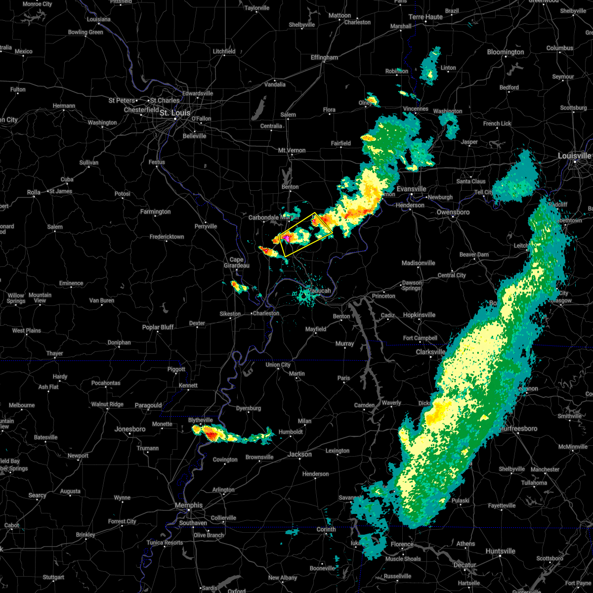 At 538 pm cdt, two severe thunderstorms were located near carrier mills and the lake of egypt area near the intersection of interstates 57 and 24, moving southeast at 25 mph (radar indicated). Hazards include 60 mph wind gusts and half dollar size hail. Hail damage to vehicles is expected. expect wind damage to roofs, siding, and trees. Locations impacted include, harrisburg, goreville, creal springs, carrier mills, lake of egypt area, stonefort, new burnside and buncombe. At 538 pm cdt, two severe thunderstorms were located near carrier mills and the lake of egypt area near the intersection of interstates 57 and 24, moving southeast at 25 mph (radar indicated). Hazards include 60 mph wind gusts and half dollar size hail. Hail damage to vehicles is expected. expect wind damage to roofs, siding, and trees. Locations impacted include, harrisburg, goreville, creal springs, carrier mills, lake of egypt area, stonefort, new burnside and buncombe.
|
| 5/6/2021 5:27 PM CDT |
 At 526 pm cdt, severe thunderstorms were located along a line extending from south of thompsonville to near crab orchard lake, moving southeast at 25 mph (radar indicated). Hazards include 60 mph wind gusts and quarter size hail. Hail damage to vehicles is expected. Expect wind damage to roofs, siding, and trees. At 526 pm cdt, severe thunderstorms were located along a line extending from south of thompsonville to near crab orchard lake, moving southeast at 25 mph (radar indicated). Hazards include 60 mph wind gusts and quarter size hail. Hail damage to vehicles is expected. Expect wind damage to roofs, siding, and trees.
|
| 8/10/2020 8:04 PM CDT |
 At 804 pm cdt, severe thunderstorms were located along a line extending from near carmi to near pittsburg, moving east at 75 mph (radar indicated). Hazards include 60 mph wind gusts. Expect damage to roofs, siding, and trees. Locations impacted include, carbondale, marion, herrin, murphysboro, carterville, johnston city, de soto, crainville, cambria, energy, hurst, grand tower, pittsburg, creal springs, cedar lake area, lake of egypt area, makanda, stonefort, freeman spur and bush. At 804 pm cdt, severe thunderstorms were located along a line extending from near carmi to near pittsburg, moving east at 75 mph (radar indicated). Hazards include 60 mph wind gusts. Expect damage to roofs, siding, and trees. Locations impacted include, carbondale, marion, herrin, murphysboro, carterville, johnston city, de soto, crainville, cambria, energy, hurst, grand tower, pittsburg, creal springs, cedar lake area, lake of egypt area, makanda, stonefort, freeman spur and bush.
|
| 8/10/2020 7:36 PM CDT |
 At 735 pm cdt, severe thunderstorms were located along a line extending from 8 miles west of mcleansboro to near murphysboro, moving east at 65 mph (radar indicated). Hazards include 60 mph wind gusts. expect damage to roofs, siding, and trees At 735 pm cdt, severe thunderstorms were located along a line extending from 8 miles west of mcleansboro to near murphysboro, moving east at 65 mph (radar indicated). Hazards include 60 mph wind gusts. expect damage to roofs, siding, and trees
|
| 4/8/2020 7:28 PM CDT |
 At 728 pm cdt, severe thunderstorms were located along a line extending from herrin to near lake of egypt area to 6 miles southwest of goreville, moving southeast at 40 mph (radar indicated). Hazards include 60 mph wind gusts and nickel size hail. expect damage to roofs, siding, and trees At 728 pm cdt, severe thunderstorms were located along a line extending from herrin to near lake of egypt area to 6 miles southwest of goreville, moving southeast at 40 mph (radar indicated). Hazards include 60 mph wind gusts and nickel size hail. expect damage to roofs, siding, and trees
|
| 3/12/2020 2:47 PM CDT |
 At 247 pm cdt, severe thunderstorms were located along a line extending from near galatia to 6 miles east of creal springs, moving southeast at 45 mph (trained weather spotters). Hazards include 60 mph wind gusts and half dollar size hail. Hail damage to vehicles is expected. expect wind damage to roofs, siding, and trees. Locations impacted include, harrisburg, eldorado, golconda, creal springs, carrier mills, raleigh, stonefort, new burnside, eddyville and muddy. At 247 pm cdt, severe thunderstorms were located along a line extending from near galatia to 6 miles east of creal springs, moving southeast at 45 mph (trained weather spotters). Hazards include 60 mph wind gusts and half dollar size hail. Hail damage to vehicles is expected. expect wind damage to roofs, siding, and trees. Locations impacted include, harrisburg, eldorado, golconda, creal springs, carrier mills, raleigh, stonefort, new burnside, eddyville and muddy.
|
| 3/12/2020 2:39 PM CDT |
 At 238 pm cdt, severe thunderstorms were located along a line extending from galatia to near creal springs, moving east at 50 mph (trained weather spotters). Hazards include two inch hail and 60 mph wind gusts. People and animals outdoors will be injured. expect hail damage to roofs, siding, windows, and vehicles. expect wind damage to roofs, siding, and trees. Locations impacted include, marion, harrisburg, eldorado, galatia, golconda, pittsburg, creal springs, lake of egypt area, carrier mills, raleigh, stonefort, new burnside, broughton, eddyville, muddy and simpson. At 238 pm cdt, severe thunderstorms were located along a line extending from galatia to near creal springs, moving east at 50 mph (trained weather spotters). Hazards include two inch hail and 60 mph wind gusts. People and animals outdoors will be injured. expect hail damage to roofs, siding, windows, and vehicles. expect wind damage to roofs, siding, and trees. Locations impacted include, marion, harrisburg, eldorado, galatia, golconda, pittsburg, creal springs, lake of egypt area, carrier mills, raleigh, stonefort, new burnside, broughton, eddyville, muddy and simpson.
|
| 3/12/2020 2:25 PM CDT |
 At 224 pm cdt, severe thunderstorms were located along a line extending from near west frankfort to near crainville, moving southeast at 45 mph (trained weather spotters. wind driven 2 inch hail was reported along i-57 south of west frankfort). Hazards include two inch hail and 60 mph wind gusts. People and animals outdoors will be injured. expect hail damage to roofs, siding, windows, and vehicles. expect wind damage to roofs, siding, and trees. Locations impacted include, marion, harrisburg, eldorado, johnston city, galatia, golconda, pittsburg, creal springs, thompsonville, lake of egypt area, carrier mills, raleigh, hanaford, stonefort, whiteash, williamson county regional airport, new burnside, spillertown, broughton and eddyville. At 224 pm cdt, severe thunderstorms were located along a line extending from near west frankfort to near crainville, moving southeast at 45 mph (trained weather spotters. wind driven 2 inch hail was reported along i-57 south of west frankfort). Hazards include two inch hail and 60 mph wind gusts. People and animals outdoors will be injured. expect hail damage to roofs, siding, windows, and vehicles. expect wind damage to roofs, siding, and trees. Locations impacted include, marion, harrisburg, eldorado, johnston city, galatia, golconda, pittsburg, creal springs, thompsonville, lake of egypt area, carrier mills, raleigh, hanaford, stonefort, whiteash, williamson county regional airport, new burnside, spillertown, broughton and eddyville.
|
| 3/12/2020 2:21 PM CDT |
 At 221 pm cdt, severe thunderstorms were located along a line extending from west frankfort to near crainville, moving southeast at 45 mph (radar indicated). Hazards include 60 mph wind gusts and half dollar size hail. Hail damage to vehicles is expected. Expect wind damage to roofs, siding, and trees. At 221 pm cdt, severe thunderstorms were located along a line extending from west frankfort to near crainville, moving southeast at 45 mph (radar indicated). Hazards include 60 mph wind gusts and half dollar size hail. Hail damage to vehicles is expected. Expect wind damage to roofs, siding, and trees.
|
| 1/11/2020 2:34 AM CST |
 At 233 am cst, severe thunderstorms were located along a line extending from herrin to near marion to 6 miles west of goreville, moving northeast at 60 mph (radar indicated). Hazards include 60 mph wind gusts. Expect damage to roofs, siding, and trees. Locations impacted include, marion, herrin, carterville, johnston city, crainville, cambria, energy, goreville, hurst, pittsburg, creal springs, lake of egypt area, stonefort, bush, whiteash, williamson county regional airport, colp, new burnside and spillertown. At 233 am cst, severe thunderstorms were located along a line extending from herrin to near marion to 6 miles west of goreville, moving northeast at 60 mph (radar indicated). Hazards include 60 mph wind gusts. Expect damage to roofs, siding, and trees. Locations impacted include, marion, herrin, carterville, johnston city, crainville, cambria, energy, goreville, hurst, pittsburg, creal springs, lake of egypt area, stonefort, bush, whiteash, williamson county regional airport, colp, new burnside and spillertown.
|
| 1/11/2020 2:19 AM CST |
 At 219 am cst, severe thunderstorms were located along a line extending from near carbondale to near cobden to near jonesboro, moving northeast at 60 mph (radar indicated). Hazards include 60 mph wind gusts. expect damage to roofs, siding, and trees At 219 am cst, severe thunderstorms were located along a line extending from near carbondale to near cobden to near jonesboro, moving northeast at 60 mph (radar indicated). Hazards include 60 mph wind gusts. expect damage to roofs, siding, and trees
|
| 10/21/2019 6:11 AM CDT |
 The severe thunderstorm warning for northwestern pope, northeastern johnson, southeastern williamson and southwestern saline counties will expire at 615 am cdt, the storm which prompted the warning has weakened below severe limits, and has exited the warned area. therefore, the warning will be allowed to expire. The severe thunderstorm warning for northwestern pope, northeastern johnson, southeastern williamson and southwestern saline counties will expire at 615 am cdt, the storm which prompted the warning has weakened below severe limits, and has exited the warned area. therefore, the warning will be allowed to expire.
|
| 10/21/2019 5:54 AM CDT |
 At 554 am cdt, a severe thunderstorm was located near creal springs, or 13 miles northeast of vienna, moving northeast at 55 mph (radar indicated). Hazards include 60 mph wind gusts. Expect damage to roofs, siding, and trees. Locations impacted include, creal springs, lake of egypt area, stonefort, new burnside, eddyville and simpson. At 554 am cdt, a severe thunderstorm was located near creal springs, or 13 miles northeast of vienna, moving northeast at 55 mph (radar indicated). Hazards include 60 mph wind gusts. Expect damage to roofs, siding, and trees. Locations impacted include, creal springs, lake of egypt area, stonefort, new burnside, eddyville and simpson.
|
| 10/21/2019 5:40 AM CDT |
 At 540 am cdt, a severe thunderstorm was located near goreville, or near vienna, moving northeast at 55 mph (radar indicated). Hazards include 60 mph wind gusts. expect damage to roofs, siding, and trees At 540 am cdt, a severe thunderstorm was located near goreville, or near vienna, moving northeast at 55 mph (radar indicated). Hazards include 60 mph wind gusts. expect damage to roofs, siding, and trees
|
| 6/21/2019 5:22 PM CDT |
 The severe thunderstorm warning for pulaski, northwestern massac, west central pope, johnson and williamson counties will expire at 530 pm cdt, the storms which prompted the warning have moved out of the area. therefore, the warning will be allowed to expire. these storms produced widespread wind damage. there is still a lot of lightning. if power lines are down in your area, do not try to pick them up or move them. a severe thunderstorm watch remains in effect until 700 pm cdt for southern illinois. a severe thunderstorm watch also remains in effect until 1000 pm cdt for southern illinois, and western kentucky. The severe thunderstorm warning for pulaski, northwestern massac, west central pope, johnson and williamson counties will expire at 530 pm cdt, the storms which prompted the warning have moved out of the area. therefore, the warning will be allowed to expire. these storms produced widespread wind damage. there is still a lot of lightning. if power lines are down in your area, do not try to pick them up or move them. a severe thunderstorm watch remains in effect until 700 pm cdt for southern illinois. a severe thunderstorm watch also remains in effect until 1000 pm cdt for southern illinois, and western kentucky.
|
| 6/21/2019 5:03 PM CDT | Time estimate in williamson county IL, 0.4 miles W of Creal Springs, IL |
| 6/21/2019 4:43 PM CDT |
 At 441 pm cdt, severe thunderstorms were located along a line extending from cambria to near tamms, moving southeast at 50 mph (trained weather spotters). Hazards include 70 mph wind gusts. a 72 mph wind gust was reported in cape girardeau as these storms moved through. Expect considerable tree damage. Damage is likely to mobile homes, roofs, and outbuildings. At 441 pm cdt, severe thunderstorms were located along a line extending from cambria to near tamms, moving southeast at 50 mph (trained weather spotters). Hazards include 70 mph wind gusts. a 72 mph wind gust was reported in cape girardeau as these storms moved through. Expect considerable tree damage. Damage is likely to mobile homes, roofs, and outbuildings.
|
| 6/21/2019 3:57 PM CDT |
 The national weather service in paducah has issued a * severe thunderstorm warning for. northeastern union county in southern illinois. northern johnson county in southern illinois. southern williamson county in southern illinois. Until 430 pm cdt. The national weather service in paducah has issued a * severe thunderstorm warning for. northeastern union county in southern illinois. northern johnson county in southern illinois. southern williamson county in southern illinois. Until 430 pm cdt.
|
| 6/21/2019 3:32 PM CDT |
 At 331 pm cdt, severe thunderstorms were located along a line extending from near mount carmel to new harmony to near pittsburg, moving southeast at 35 mph (radar indicated). Hazards include 60 mph wind gusts and penny size hail. these storms have produced isolated wind gusts to 60 mph and widely scattered power outages. Expect damage to roofs, siding, and trees. Locations impacted include, marion, herrin, harrisburg, princeton, mount carmel, mount vernon, carterville, carmi, eldorado, johnston city, lancaster, owensville, norris city, crainville, cambria, energy, poseyville, galatia, ridgway and new harmony. At 331 pm cdt, severe thunderstorms were located along a line extending from near mount carmel to new harmony to near pittsburg, moving southeast at 35 mph (radar indicated). Hazards include 60 mph wind gusts and penny size hail. these storms have produced isolated wind gusts to 60 mph and widely scattered power outages. Expect damage to roofs, siding, and trees. Locations impacted include, marion, herrin, harrisburg, princeton, mount carmel, mount vernon, carterville, carmi, eldorado, johnston city, lancaster, owensville, norris city, crainville, cambria, energy, poseyville, galatia, ridgway and new harmony.
|
| 6/21/2019 3:17 PM CDT |
 At 317 pm cdt, severe thunderstorms were located along a line extending from near lancaster to near crossville to johnston city, moving southeast at 30 mph (radar indicated). Hazards include 60 mph wind gusts and penny size hail. Expect damage to roofs, siding, and trees. Locations impacted include, marion, herrin, harrisburg, princeton, west frankfort, mount carmel, mount vernon, carterville, carmi, eldorado, johnston city, albion, grayville, lancaster, owensville, norris city, crainville, cambria, energy and poseyville. At 317 pm cdt, severe thunderstorms were located along a line extending from near lancaster to near crossville to johnston city, moving southeast at 30 mph (radar indicated). Hazards include 60 mph wind gusts and penny size hail. Expect damage to roofs, siding, and trees. Locations impacted include, marion, herrin, harrisburg, princeton, west frankfort, mount carmel, mount vernon, carterville, carmi, eldorado, johnston city, albion, grayville, lancaster, owensville, norris city, crainville, cambria, energy and poseyville.
|
| 6/21/2019 2:59 PM CDT |
 At 257 pm cdt, severe thunderstorms were located along a line extending from near parkersburg to 10 miles northwest of crossville to near hurst, moving southeast at 35 mph (radar indicated). Hazards include 60 mph wind gusts and penny size hail. isolated power outages have been reported from these storms. expect damage to roofs, siding, and trees At 257 pm cdt, severe thunderstorms were located along a line extending from near parkersburg to 10 miles northwest of crossville to near hurst, moving southeast at 35 mph (radar indicated). Hazards include 60 mph wind gusts and penny size hail. isolated power outages have been reported from these storms. expect damage to roofs, siding, and trees
|
| 6/28/2018 7:44 PM CDT |
 At 744 pm cdt, severe thunderstorms were located along a line extending from near equality to 8 miles north of golconda to 6 miles northeast of vienna to near cobden, moving southeast at 65 mph (trained weather spotters). Hazards include 70 mph wind gusts and half dollar size hail. Hail damage to vehicles is expected. expect considerable tree damage. wind damage is also likely to mobile homes, roofs, and outbuildings. Locations impacted include, carbondale, marion, herrin, harrisburg, murphysboro, carterville, anna, eldorado, johnston city, jonesboro, vienna, crainville, cambria, cobden, energy, goreville, galatia, ridgway, hurst and dongola. At 744 pm cdt, severe thunderstorms were located along a line extending from near equality to 8 miles north of golconda to 6 miles northeast of vienna to near cobden, moving southeast at 65 mph (trained weather spotters). Hazards include 70 mph wind gusts and half dollar size hail. Hail damage to vehicles is expected. expect considerable tree damage. wind damage is also likely to mobile homes, roofs, and outbuildings. Locations impacted include, carbondale, marion, herrin, harrisburg, murphysboro, carterville, anna, eldorado, johnston city, jonesboro, vienna, crainville, cambria, cobden, energy, goreville, galatia, ridgway, hurst and dongola.
|
| 6/28/2018 7:00 PM CDT |
 At 659 pm cdt, severe thunderstorms were located along a line extending from near bluford to near christopher to percy, moving southeast at 50 mph (radar indicated). Hazards include 70 mph wind gusts and half dollar size hail. Hail damage to vehicles is expected. expect considerable tree damage. Wind damage is also likely to mobile homes, roofs, and outbuildings. At 659 pm cdt, severe thunderstorms were located along a line extending from near bluford to near christopher to percy, moving southeast at 50 mph (radar indicated). Hazards include 70 mph wind gusts and half dollar size hail. Hail damage to vehicles is expected. expect considerable tree damage. Wind damage is also likely to mobile homes, roofs, and outbuildings.
|
| 6/26/2018 7:53 PM CDT |
 At 752 pm cdt, severe thunderstorms were located along a line extending from 6 miles west of carrier mills to 9 miles southeast of creal springs to near new columbia to 6 miles northwest of west paducah, moving east at 60 mph (radar indicated). Hazards include 60 mph wind gusts and nickel size hail. Expect damage to roofs, siding, and trees. Locations impacted include, vienna, creal springs, new columbia, joppa, new burnside, belknap and simpson. At 752 pm cdt, severe thunderstorms were located along a line extending from 6 miles west of carrier mills to 9 miles southeast of creal springs to near new columbia to 6 miles northwest of west paducah, moving east at 60 mph (radar indicated). Hazards include 60 mph wind gusts and nickel size hail. Expect damage to roofs, siding, and trees. Locations impacted include, vienna, creal springs, new columbia, joppa, new burnside, belknap and simpson.
|
| 6/26/2018 7:30 PM CDT |
 At 730 pm cdt, severe thunderstorms were located along a line extending from near carterville to near goreville to near karnak to near mounds, moving east at 60 mph (radar indicated). Hazards include 60 mph wind gusts and nickel size hail. expect damage to roofs, siding, and trees At 730 pm cdt, severe thunderstorms were located along a line extending from near carterville to near goreville to near karnak to near mounds, moving east at 60 mph (radar indicated). Hazards include 60 mph wind gusts and nickel size hail. expect damage to roofs, siding, and trees
|
| 6/26/2018 9:28 AM CDT | Trees blocking north line street in the communit in williamson county IL, 0.2 miles E of Creal Springs, IL |
| 6/26/2018 9:11 AM CDT |
 At 910 am cdt, a severe thunderstorm was located over goreville, or 7 miles northwest of vienna, moving east at 30 mph (radar indicated). Hazards include ping pong ball size hail and 60 mph wind gusts. People and animals outdoors will be injured. expect hail damage to roofs, siding, windows, and vehicles. expect wind damage to roofs, siding, and trees. Locations impacted include, carbondale, goreville, creal springs, lake of egypt area, new burnside and buncombe. At 910 am cdt, a severe thunderstorm was located over goreville, or 7 miles northwest of vienna, moving east at 30 mph (radar indicated). Hazards include ping pong ball size hail and 60 mph wind gusts. People and animals outdoors will be injured. expect hail damage to roofs, siding, windows, and vehicles. expect wind damage to roofs, siding, and trees. Locations impacted include, carbondale, goreville, creal springs, lake of egypt area, new burnside and buncombe.
|
| 6/26/2018 8:58 AM CDT |
 At 858 am cdt, a severe thunderstorm was located over jonesboro, moving northeast at 50 mph (radar indicated). Hazards include 60 mph wind gusts and quarter size hail. Hail damage to vehicles is expected. Expect wind damage to roofs, siding, and trees. At 858 am cdt, a severe thunderstorm was located over jonesboro, moving northeast at 50 mph (radar indicated). Hazards include 60 mph wind gusts and quarter size hail. Hail damage to vehicles is expected. Expect wind damage to roofs, siding, and trees.
|
| 5/31/2018 7:17 PM CDT |
 At 717 pm cdt, a severe thunderstorm was located near creal springs, or 12 miles southeast of marion, moving northeast at 25 mph (radar indicated). Hazards include 60 mph wind gusts and quarter size hail. Hail damage to vehicles is expected. Expect wind damage to roofs, siding, and trees. At 717 pm cdt, a severe thunderstorm was located near creal springs, or 12 miles southeast of marion, moving northeast at 25 mph (radar indicated). Hazards include 60 mph wind gusts and quarter size hail. Hail damage to vehicles is expected. Expect wind damage to roofs, siding, and trees.
|
| 5/31/2018 10:02 AM CDT |
 The national weather service in paducah has issued a * severe thunderstorm warning for. williamson county in southern illinois. saline county in southern illinois. southern franklin county in south central illinois. Southern hamilton county in south central illinois. The national weather service in paducah has issued a * severe thunderstorm warning for. williamson county in southern illinois. saline county in southern illinois. southern franklin county in south central illinois. Southern hamilton county in south central illinois.
|
| 5/14/2018 9:35 PM CDT |
 At 932 pm cdt, a severe thunderstorm was located near ridgway, or near eldorado, moving northeast at 30 mph (public reported quarter inch sized hail with this storm around 920 pm cdt). Hazards include 60 mph wind gusts and quarter size hail. Hail damage to vehicles is expected. expect wind damage to roofs, siding, and trees. Locations impacted include, harrisburg, eldorado, galatia, creal springs, carrier mills, lake of egypt area, raleigh, stonefort, new burnside and muddy. At 932 pm cdt, a severe thunderstorm was located near ridgway, or near eldorado, moving northeast at 30 mph (public reported quarter inch sized hail with this storm around 920 pm cdt). Hazards include 60 mph wind gusts and quarter size hail. Hail damage to vehicles is expected. expect wind damage to roofs, siding, and trees. Locations impacted include, harrisburg, eldorado, galatia, creal springs, carrier mills, lake of egypt area, raleigh, stonefort, new burnside and muddy.
|
| 5/14/2018 9:06 PM CDT |
 At 905 pm cdt, a severe thunderstorm was located near harrisburg, moving northeast at 30 mph (radar indicated). Hazards include 60 mph wind gusts and quarter size hail. Hail damage to vehicles is expected. Expect wind damage to roofs, siding, and trees. At 905 pm cdt, a severe thunderstorm was located near harrisburg, moving northeast at 30 mph (radar indicated). Hazards include 60 mph wind gusts and quarter size hail. Hail damage to vehicles is expected. Expect wind damage to roofs, siding, and trees.
|
| 2/24/2018 5:08 PM CST |
 At 508 pm cst, severe thunderstorms were located along a line extending from 7 miles west of carriers mills to near creal springs, moving northeast at 40 mph (radar indicated). Hazards include 60 mph wind gusts. Expect damage to roofs, siding, and trees. locations impacted include, creal springs. A tornado watch remains in effect until 900 pm cst for southern illinois. At 508 pm cst, severe thunderstorms were located along a line extending from 7 miles west of carriers mills to near creal springs, moving northeast at 40 mph (radar indicated). Hazards include 60 mph wind gusts. Expect damage to roofs, siding, and trees. locations impacted include, creal springs. A tornado watch remains in effect until 900 pm cst for southern illinois.
|
| 2/24/2018 4:41 PM CST |
 At 441 pm cst, severe thunderstorms were located along a line extending from near goreville to 10 miles northwest of vienna to near dongola, moving northeast at 35 mph (radar indicated). Hazards include 60 mph wind gusts. expect damage to roofs, siding, and trees At 441 pm cst, severe thunderstorms were located along a line extending from near goreville to 10 miles northwest of vienna to near dongola, moving northeast at 35 mph (radar indicated). Hazards include 60 mph wind gusts. expect damage to roofs, siding, and trees
|
| 5/27/2017 4:20 PM CDT | Estimated 55-70 mph wind gusts. numerous trees down across southern part of count in williamson county IL, 0.2 miles E of Creal Springs, IL |
| 5/27/2017 4:17 PM CDT |
 At 415 pm cdt, severe thunderstorms were located along a line extending from near carrier mills to near vienna, moving east at 55 mph (trained weather spotters. law enforcement officials reported trees down on the western side of johnson county). Hazards include 60 mph wind gusts and half dollar size hail. Hail damage to vehicles is expected. expect wind damage to roofs, siding, and trees. Locations impacted include, marion, harrisburg, vienna, carrier mills, goreville, creal springs, lake of egypt area, dixon springs, carriers mills, stonefort, cypress, new burnside, buncombe, eddyville, muddy and simpson. At 415 pm cdt, severe thunderstorms were located along a line extending from near carrier mills to near vienna, moving east at 55 mph (trained weather spotters. law enforcement officials reported trees down on the western side of johnson county). Hazards include 60 mph wind gusts and half dollar size hail. Hail damage to vehicles is expected. expect wind damage to roofs, siding, and trees. Locations impacted include, marion, harrisburg, vienna, carrier mills, goreville, creal springs, lake of egypt area, dixon springs, carriers mills, stonefort, cypress, new burnside, buncombe, eddyville, muddy and simpson.
|
| 5/27/2017 4:01 PM CDT |
 At 400 pm cdt, severe thunderstorms were located along a line extending from near pittsburg to dongola, moving east at 45 mph (trained weather spotters. trees were downed by these storms as they moved through carbondale. other spotters reported winds to at least 50 mph near anna-jonesboro). Hazards include 60 mph wind gusts and half dollar size hail. Hail damage to vehicles is expected. Expect wind damage to roofs, siding, and trees. At 400 pm cdt, severe thunderstorms were located along a line extending from near pittsburg to dongola, moving east at 45 mph (trained weather spotters. trees were downed by these storms as they moved through carbondale. other spotters reported winds to at least 50 mph near anna-jonesboro). Hazards include 60 mph wind gusts and half dollar size hail. Hail damage to vehicles is expected. Expect wind damage to roofs, siding, and trees.
|
| 4/28/2017 11:29 PM CDT |
 At 1128 pm cdt, a severe thunderstorm was located near creal springs, or 8 miles northeast of vienna, moving northeast at 55 mph (radar indicated). Hazards include quarter size hail. damage to vehicles is expected At 1128 pm cdt, a severe thunderstorm was located near creal springs, or 8 miles northeast of vienna, moving northeast at 55 mph (radar indicated). Hazards include quarter size hail. damage to vehicles is expected
|
| 4/28/2017 10:49 PM CDT |
 At 1049 pm cdt, a severe thunderstorm was located near creal springs, or 9 miles northeast of vienna, moving northeast at 35 mph (radar indicated). Hazards include 60 mph wind gusts and half dollar size hail. Hail damage to vehicles is expected. Expect wind damage to roofs, siding, and trees. At 1049 pm cdt, a severe thunderstorm was located near creal springs, or 9 miles northeast of vienna, moving northeast at 35 mph (radar indicated). Hazards include 60 mph wind gusts and half dollar size hail. Hail damage to vehicles is expected. Expect wind damage to roofs, siding, and trees.
|
| 3/1/2017 4:39 AM CST |
 At 439 am cst, severe thunderstorms were located along a line extending from near west frankfort to pittsburg to near lake of egypt area, moving east at 65 mph. the warning was corrected for storm movement speed (radar indicated). Hazards include 60 mph wind gusts and half dollar size hail. Hail damage to vehicles is expected. Expect wind damage to roofs, siding, and trees. At 439 am cst, severe thunderstorms were located along a line extending from near west frankfort to pittsburg to near lake of egypt area, moving east at 65 mph. the warning was corrected for storm movement speed (radar indicated). Hazards include 60 mph wind gusts and half dollar size hail. Hail damage to vehicles is expected. Expect wind damage to roofs, siding, and trees.
|
| 3/1/2017 4:33 AM CST |
 At 432 am cst, severe thunderstorms were located along a line extending from west frankfort to near marion to near goreville, moving east at 95 mph (radar indicated). Hazards include 60 mph wind gusts and half dollar size hail. Hail damage to vehicles is expected. Expect wind damage to roofs, siding, and trees. At 432 am cst, severe thunderstorms were located along a line extending from west frankfort to near marion to near goreville, moving east at 95 mph (radar indicated). Hazards include 60 mph wind gusts and half dollar size hail. Hail damage to vehicles is expected. Expect wind damage to roofs, siding, and trees.
|
| 7/13/2016 5:23 PM CDT |
 The severe thunderstorm warning for franklin, jefferson and williamson counties will expire at 530 pm cdt, the main wind damaging part of the storms which prompted the warning have moved out of the area. therefore, the warning will be allowed to expire. however gusty winds 45 to 55 mph are still possible with these thunderstorms lingering across especially southern williamson county. a severe thunderstorm watch remains in effect until 900 pm cdt for south central and southern illinois. The severe thunderstorm warning for franklin, jefferson and williamson counties will expire at 530 pm cdt, the main wind damaging part of the storms which prompted the warning have moved out of the area. therefore, the warning will be allowed to expire. however gusty winds 45 to 55 mph are still possible with these thunderstorms lingering across especially southern williamson county. a severe thunderstorm watch remains in effect until 900 pm cdt for south central and southern illinois.
|
| 7/13/2016 4:53 PM CDT |
 At 452 pm cdt, severe thunderstorms were located along a line extending from near mount vernon to 6 miles northeast of benton to near carterville, moving east at 60 mph. there have been numerous reports of trees and power lines and wind damage with this line of storms as it moved across communities from pinckneyville, to murhphsboro, to carbondale (radar indicated). Hazards include 70 mph wind gusts and penny size hail. Expect considerable tree damage. damage is likely to mobile homes, roofs, and outbuildings. Locations impacted include, marion, mount vernon, herrin, west frankfort, benton, carterville, johnston city, christopher, rend lake area, sesser, zeigler, crainville, cambria, royalton, energy, hurst, woodlawn, bluford, valier and west city. At 452 pm cdt, severe thunderstorms were located along a line extending from near mount vernon to 6 miles northeast of benton to near carterville, moving east at 60 mph. there have been numerous reports of trees and power lines and wind damage with this line of storms as it moved across communities from pinckneyville, to murhphsboro, to carbondale (radar indicated). Hazards include 70 mph wind gusts and penny size hail. Expect considerable tree damage. damage is likely to mobile homes, roofs, and outbuildings. Locations impacted include, marion, mount vernon, herrin, west frankfort, benton, carterville, johnston city, christopher, rend lake area, sesser, zeigler, crainville, cambria, royalton, energy, hurst, woodlawn, bluford, valier and west city.
|
| 7/13/2016 4:27 PM CDT |
 At 427 pm cdt, severe thunderstorms were located along a line extending from near tamaroa to 7 miles west of du quoin to 7 miles west of murphysboro, moving east at 55 mph (radar indicated). Hazards include 70 mph wind gusts and penny size hail. Expect considerable tree damage. Damage is likely to mobile homes, roofs, and outbuildings. At 427 pm cdt, severe thunderstorms were located along a line extending from near tamaroa to 7 miles west of du quoin to 7 miles west of murphysboro, moving east at 55 mph (radar indicated). Hazards include 70 mph wind gusts and penny size hail. Expect considerable tree damage. Damage is likely to mobile homes, roofs, and outbuildings.
|
| 5/11/2016 7:54 PM CDT |
 At 753 pm cdt, a severe thunderstorm was located near creal springs, or 12 miles southeast of marion, moving east at 35 mph (radar indicated). Hazards include 60 mph wind gusts and quarter size hail. Hail damage to vehicles is expected. expect wind damage to roofs, siding, and trees. Locations impacted include, marion, creal springs and stonefort. At 753 pm cdt, a severe thunderstorm was located near creal springs, or 12 miles southeast of marion, moving east at 35 mph (radar indicated). Hazards include 60 mph wind gusts and quarter size hail. Hail damage to vehicles is expected. expect wind damage to roofs, siding, and trees. Locations impacted include, marion, creal springs and stonefort.
|
| 5/11/2016 7:51 PM CDT |
 At 751 pm cdt, severe thunderstorms were located along a line extending from near creal springs to near dongola, moving southeast at 35 mph (radar indicated). Hazards include 60 mph wind gusts and quarter size hail. Hail damage to vehicles is expected. Expect wind damage to roofs, siding, and trees. At 751 pm cdt, severe thunderstorms were located along a line extending from near creal springs to near dongola, moving southeast at 35 mph (radar indicated). Hazards include 60 mph wind gusts and quarter size hail. Hail damage to vehicles is expected. Expect wind damage to roofs, siding, and trees.
|
| 5/11/2016 7:31 PM CDT |
 At 730 pm cdt, a severe thunderstorm was located near marion, moving east at 30 mph. quarter sized hail was just reported in marion (radar indicated). Hazards include 60 mph wind gusts and quarter size hail. Hail damage to vehicles is expected. Expect wind damage to roofs, siding, and trees. At 730 pm cdt, a severe thunderstorm was located near marion, moving east at 30 mph. quarter sized hail was just reported in marion (radar indicated). Hazards include 60 mph wind gusts and quarter size hail. Hail damage to vehicles is expected. Expect wind damage to roofs, siding, and trees.
|
| 5/11/2016 7:06 PM CDT |
 At 705 pm cdt, a severe thunderstorm was located near marion, moving east at 40 mph (radar indicated). Hazards include 60 mph wind gusts and quarter size hail. Hail damage to vehicles is expected. Expect wind damage to roofs, siding, and trees. At 705 pm cdt, a severe thunderstorm was located near marion, moving east at 40 mph (radar indicated). Hazards include 60 mph wind gusts and quarter size hail. Hail damage to vehicles is expected. Expect wind damage to roofs, siding, and trees.
|
| 3/27/2016 4:17 PM CDT |
 At 417 pm cdt, a severe thunderstorm was located near creal springs, or 13 miles southeast of marion, moving northeast at 40 mph (radar indicated). Hazards include 60 mph wind gusts and quarter size hail. Hail damage to vehicles is expected. Expect wind damage to roofs, siding, and trees. At 417 pm cdt, a severe thunderstorm was located near creal springs, or 13 miles southeast of marion, moving northeast at 40 mph (radar indicated). Hazards include 60 mph wind gusts and quarter size hail. Hail damage to vehicles is expected. Expect wind damage to roofs, siding, and trees.
|
| 12/23/2015 12:04 PM CST | At 1203 pm cst, severe thunderstorms were located along a line extending from near wayne city to 8 miles north of galatia to 7 miles southeast of creal springs, moving northeast at 110 mph (radar indicated). Hazards include 60 mph wind gusts. Expect damage to roofs. siding and trees. locations impacted include, marion, vienna, creal springs, stonefort, new burnside, belknap and simpson. A tornado watch remains in effect until 500 pm cst for southern illinois. |
| 12/23/2015 11:56 AM CST | At 1155 am cst, severe thunderstorms were located along a line extending from 10 miles northeast of rend lake area to near pittsburg to near new columbia, moving east at 60 mph (radar indicated. there have been a few reports of 60 mph wind gusts with this line). Hazards include 60 mph wind gusts. Expect damage to roofs. siding and trees. locations impacted include, marion, mount vernon, west frankfort, benton, johnston city, vienna, goreville, bluford, pittsburg, creal springs, thompsonville, lake of egypt area, ina, belle rive, hanaford, ewing, stonefort, cypress, new burnside and buncombe. A tornado watch remains in effect until 500 pm cst for southern illinois. |
| 12/23/2015 11:28 AM CST | At 1127 am cst, severe thunderstorms were located along a line extending from near du quoin to near cobden to near olive branch, moving east at 60 mph (radar indicated). Hazards include 60 mph wind gusts. Expect damage to roofs. Siding and trees. |
| 4/7/2015 2:39 PM CDT | A severe thunderstorm warning remains in effect until 300 pm cdt for williamson county. at 238 pm cdt. severe thunderstorms were located along a line extending from near galatia to near carriers mills to near creal springs to near goreville. moving east at 95 mph. hazard. 60 mph wind gusts and penny size hail. |
| 4/7/2015 2:15 PM CDT | The national weather service in paducah has issued a * severe thunderstorm warning for. east central jackson county in southern illinois. williamson county in southern illinois. until 300 pm cdt * at 214 pm cdt. Severe thunderstorms were located along a line. |
| 1/29/2013 10:00 PM CST | 1/3 of roof decking blown off a mobile hom in williamson county IL, 2.9 miles E of Creal Springs, IL |
| 7/1/2012 3:59 PM CDT | Quarter sized hail reported 3.1 miles NE of Creal Springs, IL, hail reported at egyptian hills resort via facebook. |
| 7/1/2012 3:10 PM CDT | Quarter sized hail reported 0.2 miles E of Creal Springs, IL |
Hail Maps for Creal Springs, IL


Connect with Interactive Hail Maps