

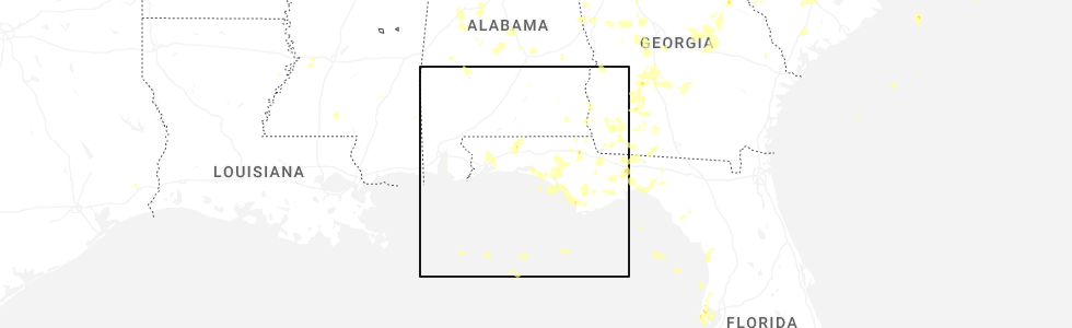
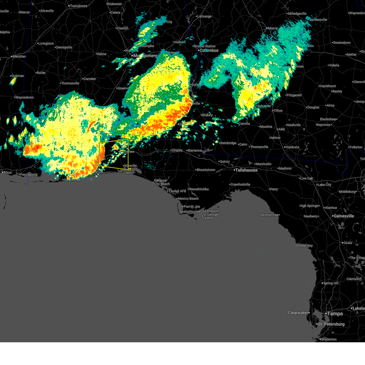
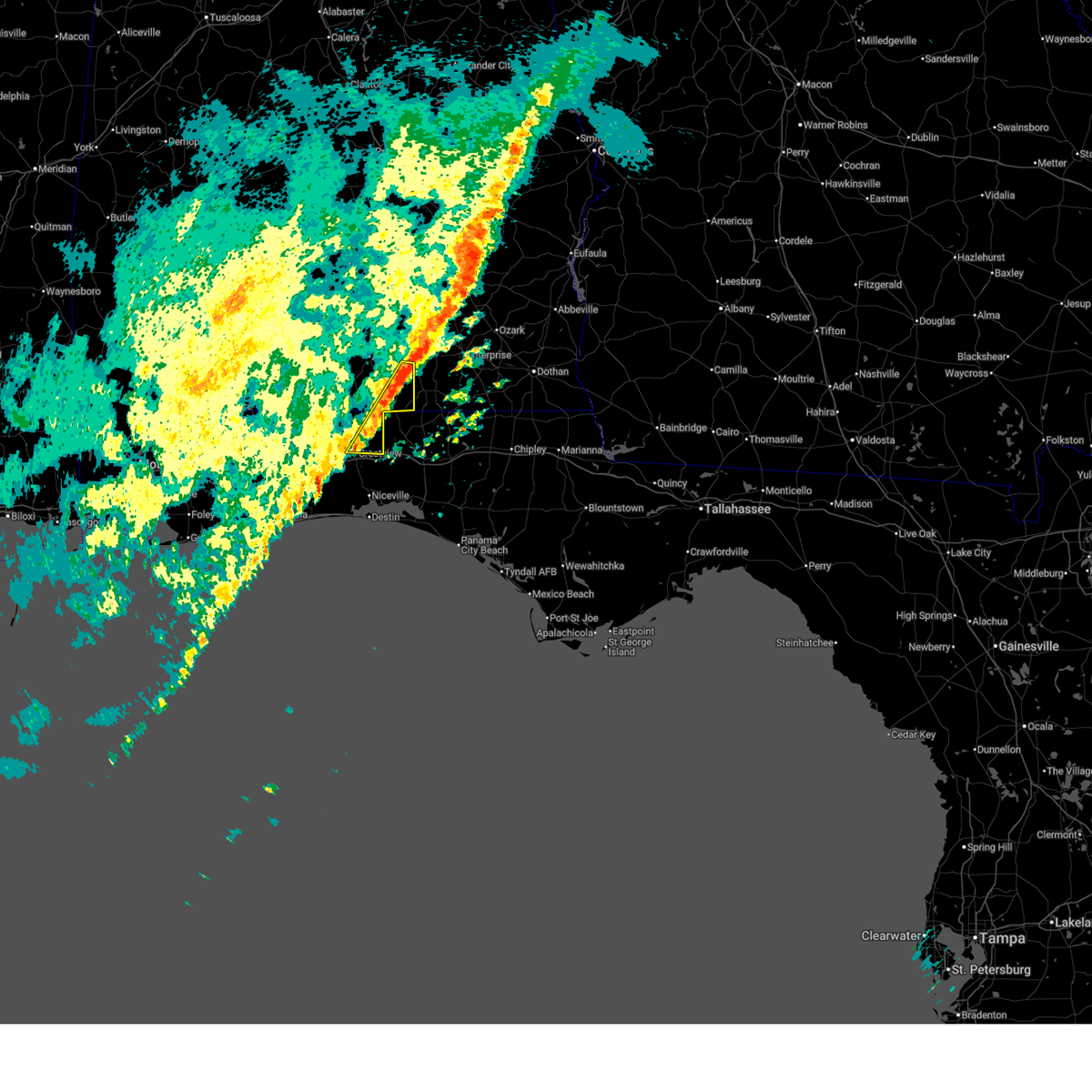
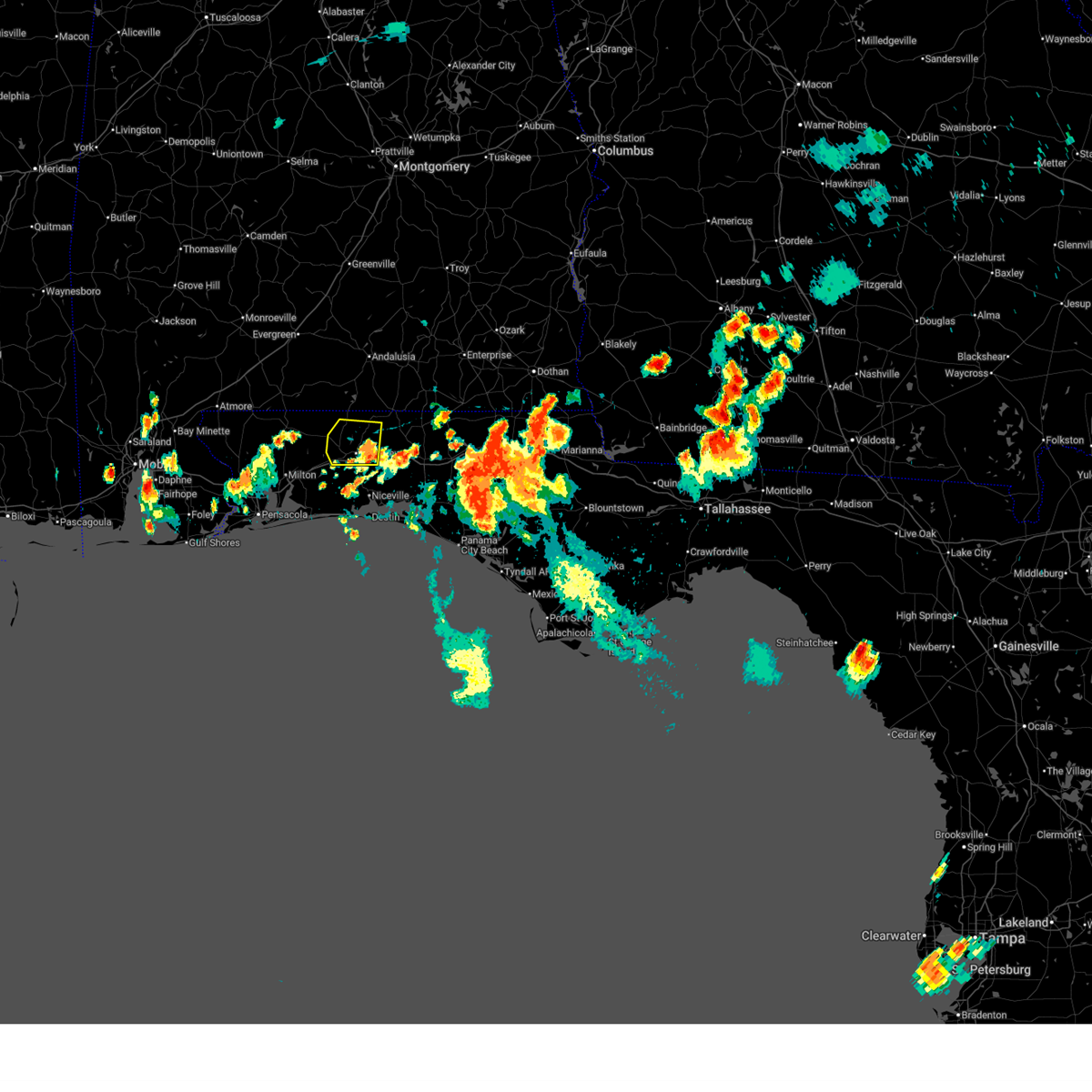
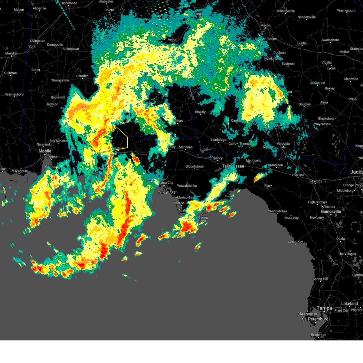
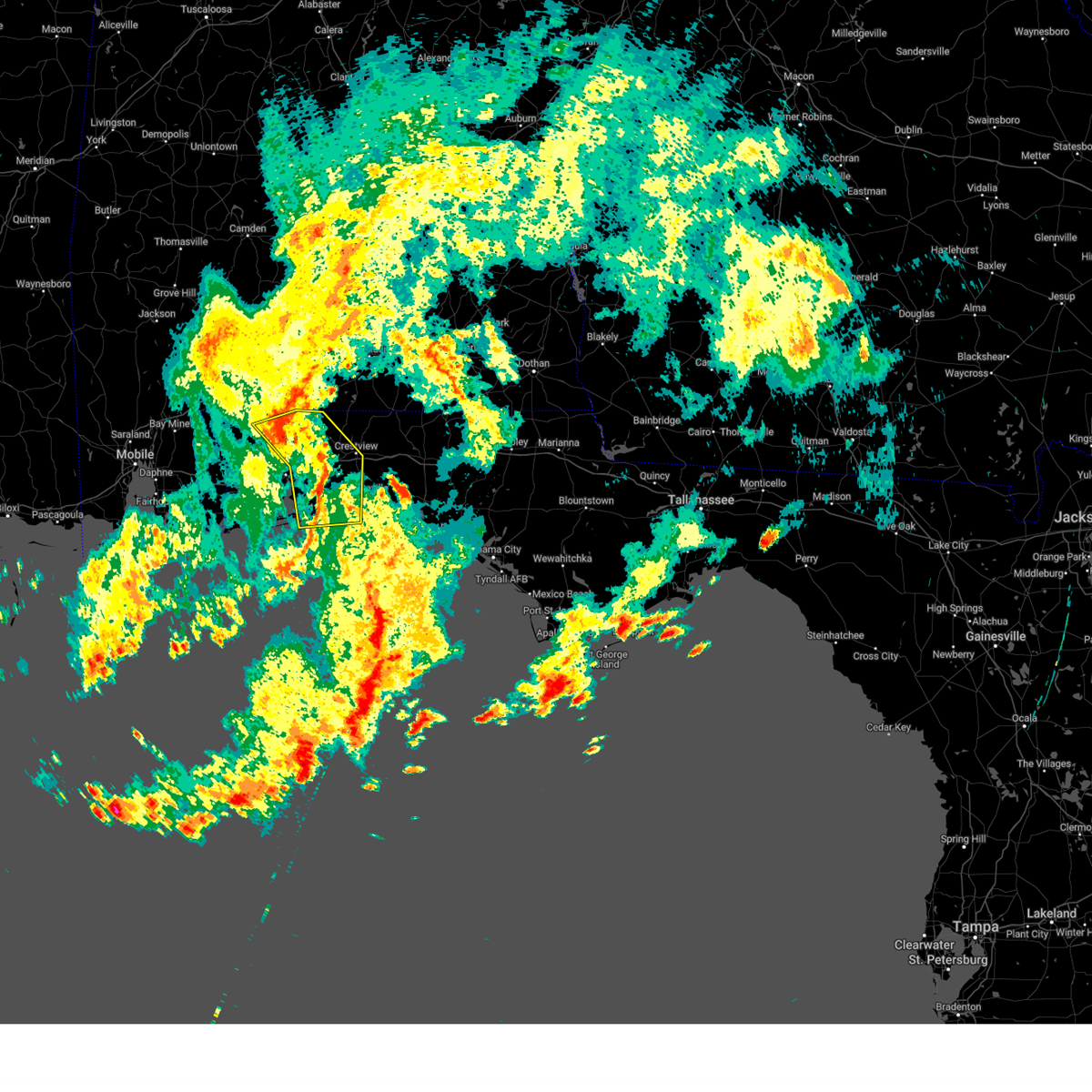
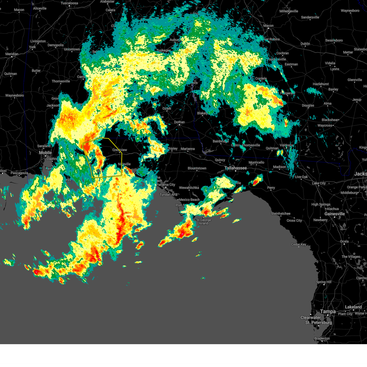
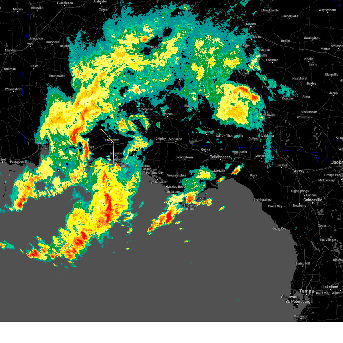
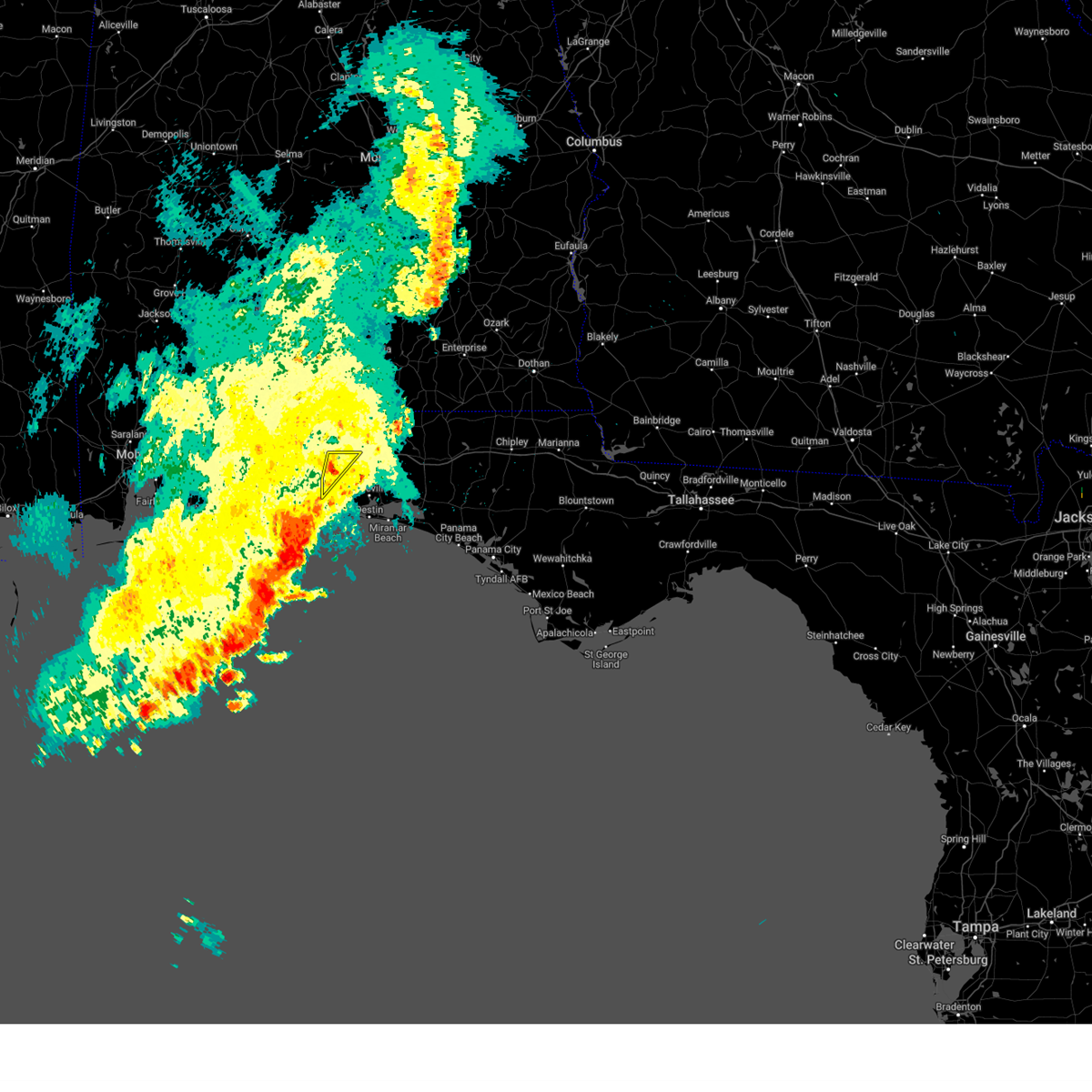
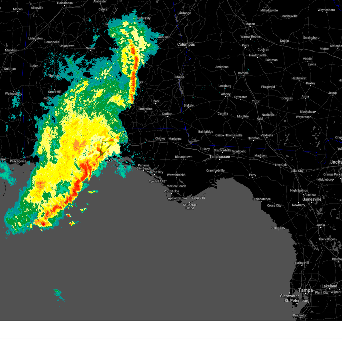
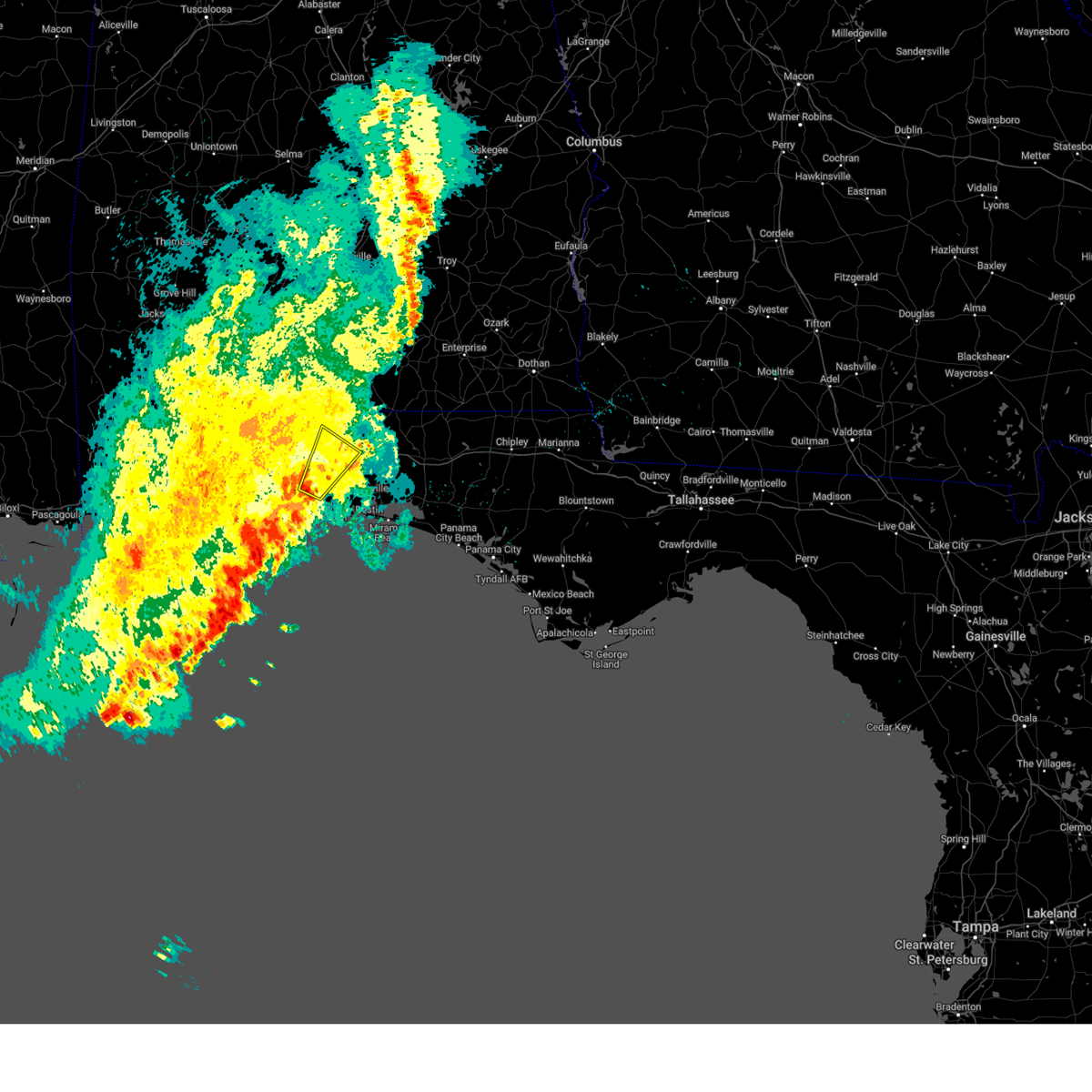
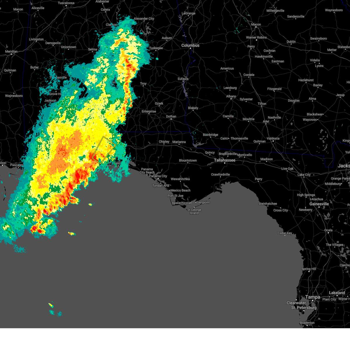
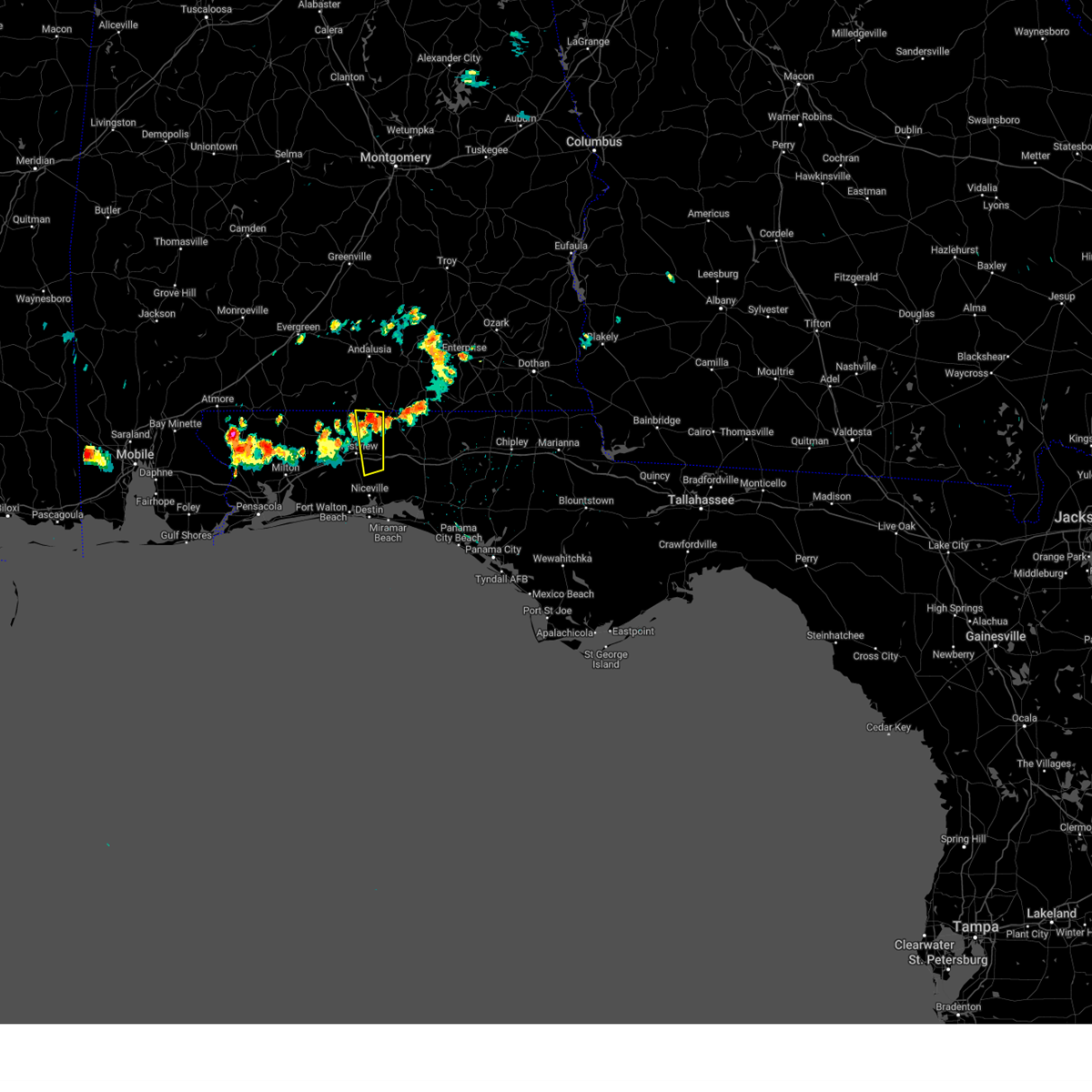
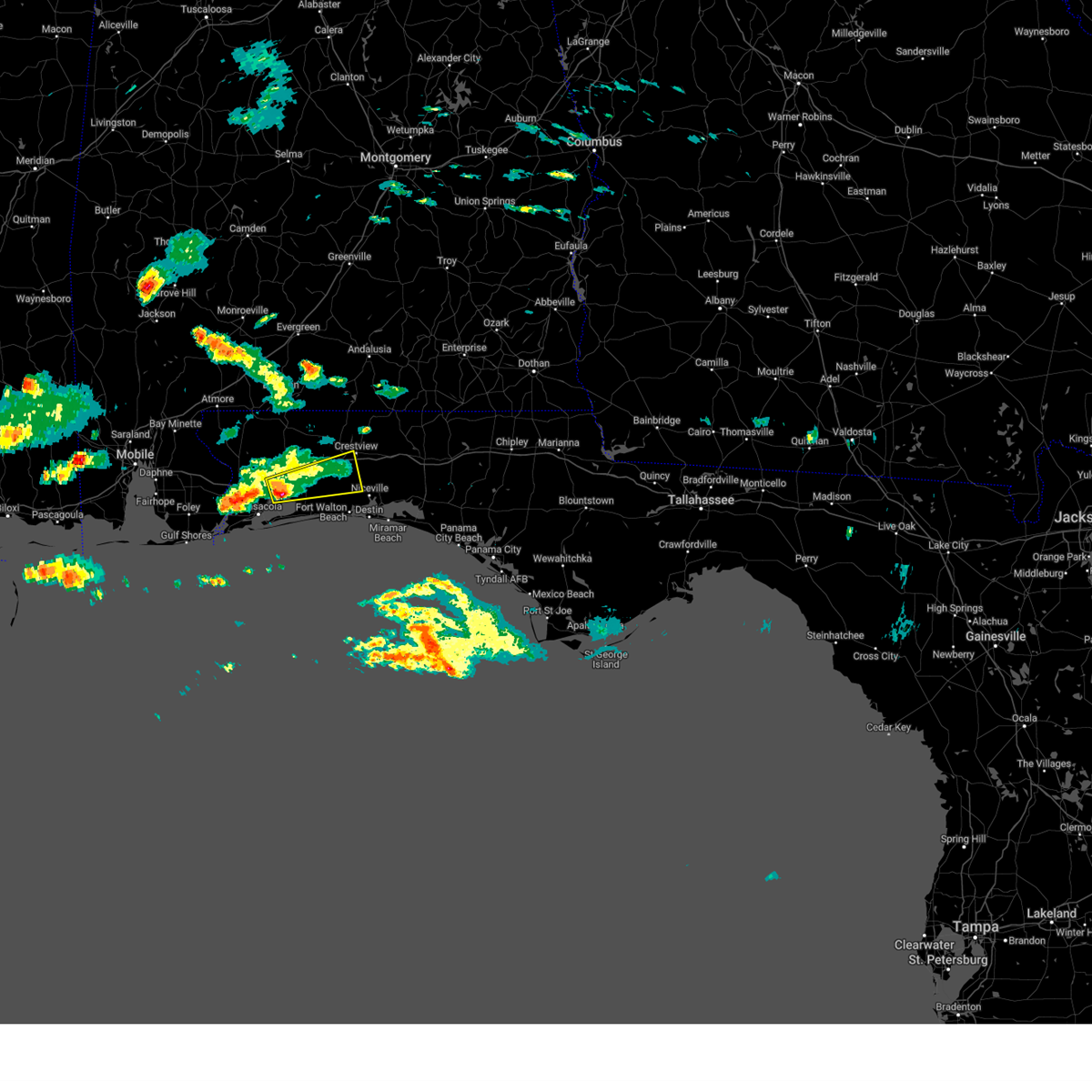
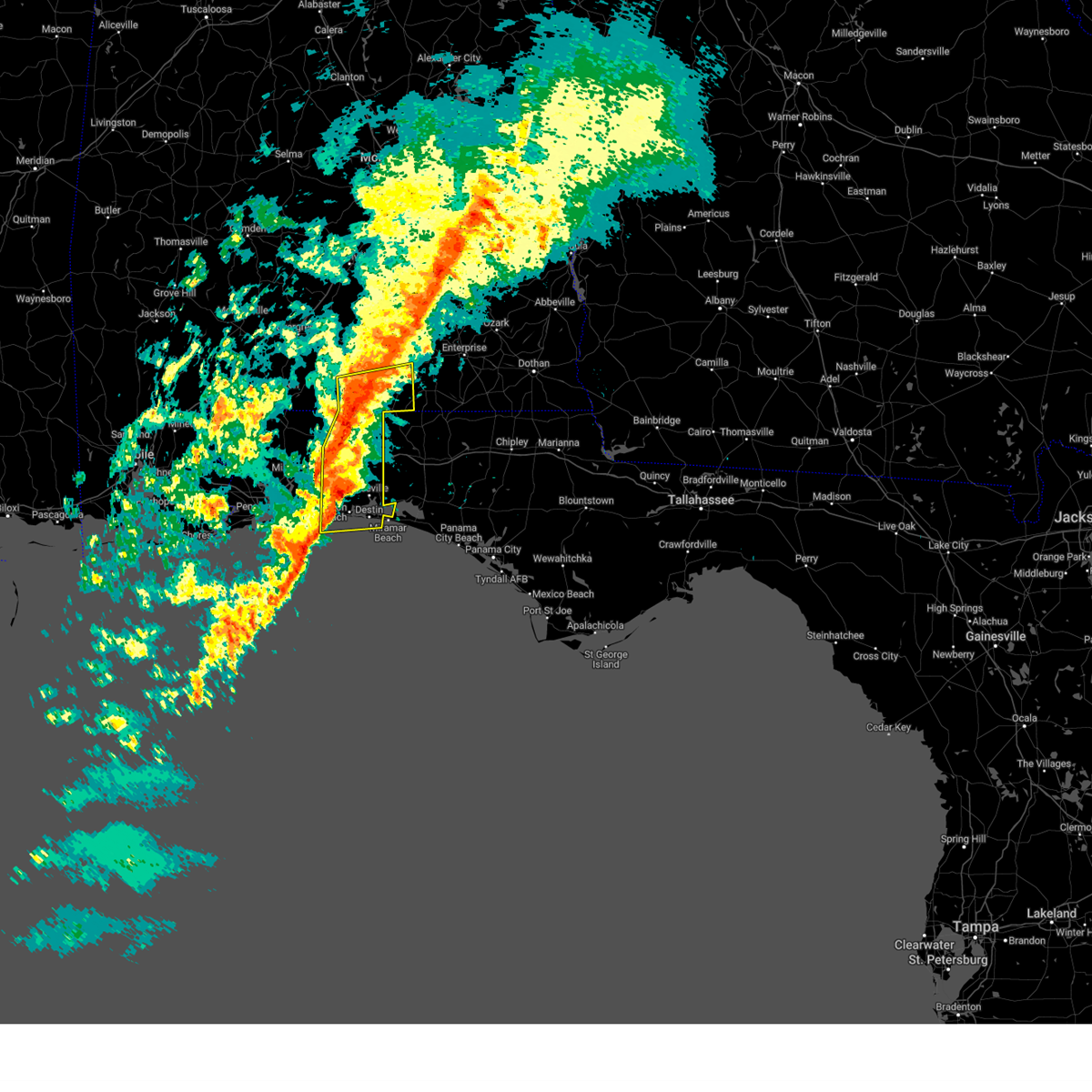
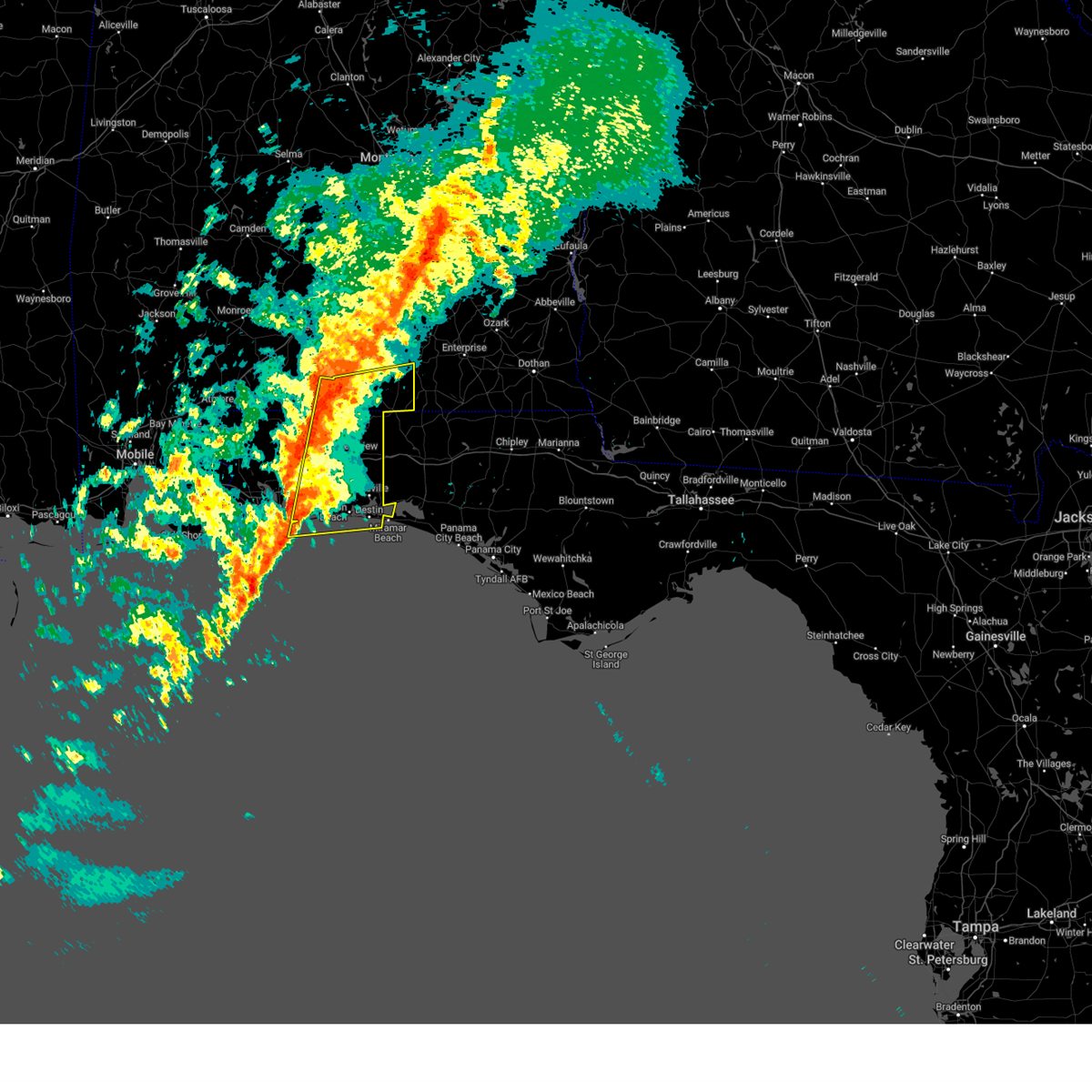
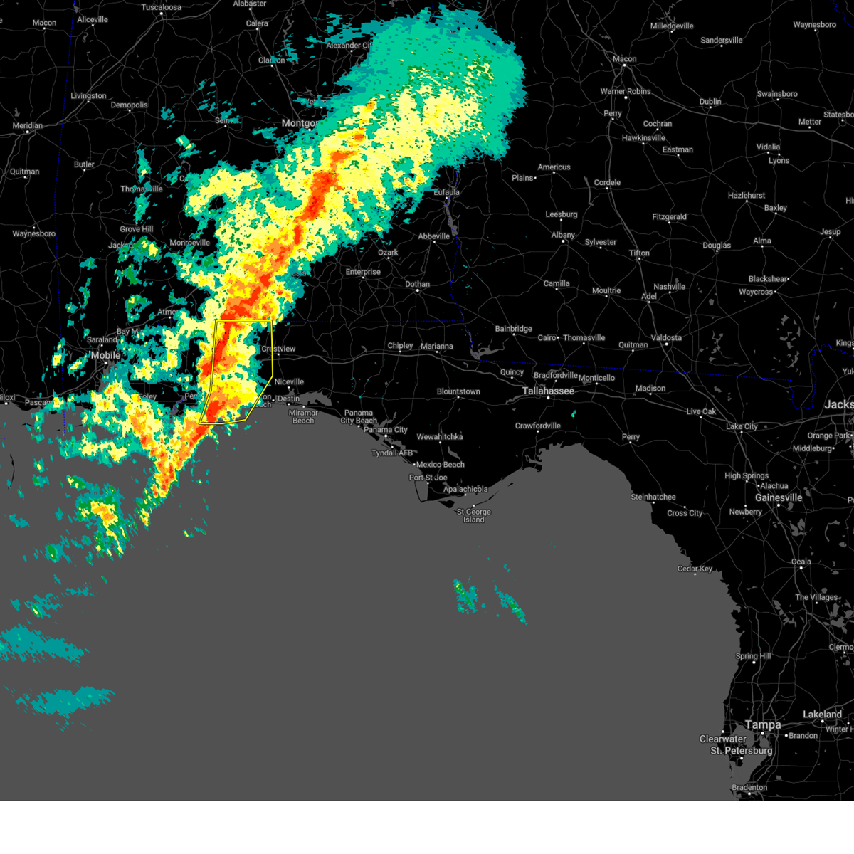
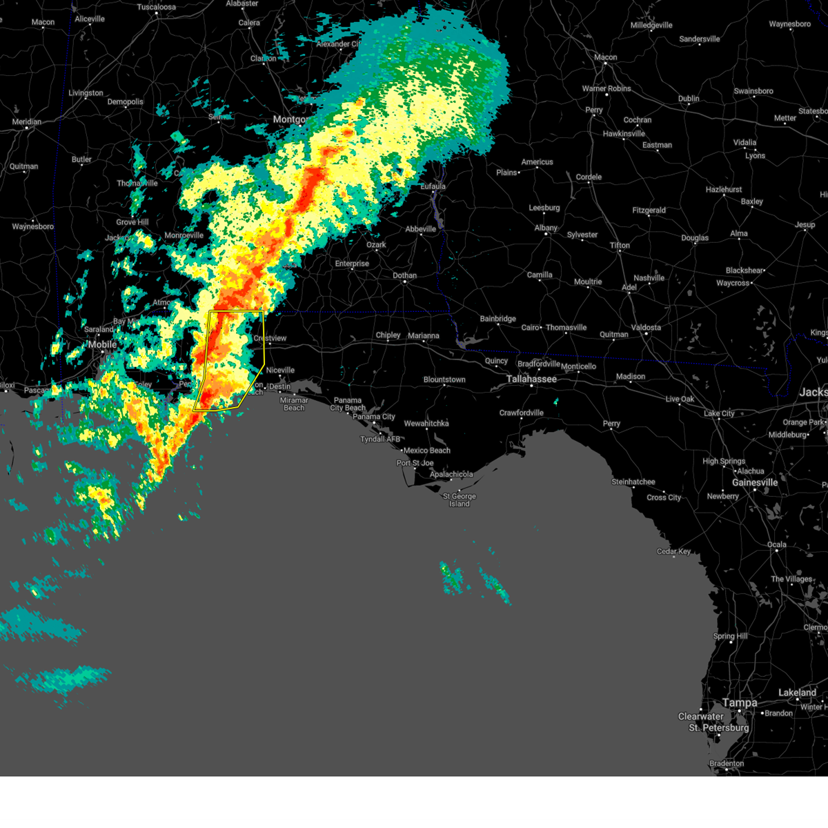
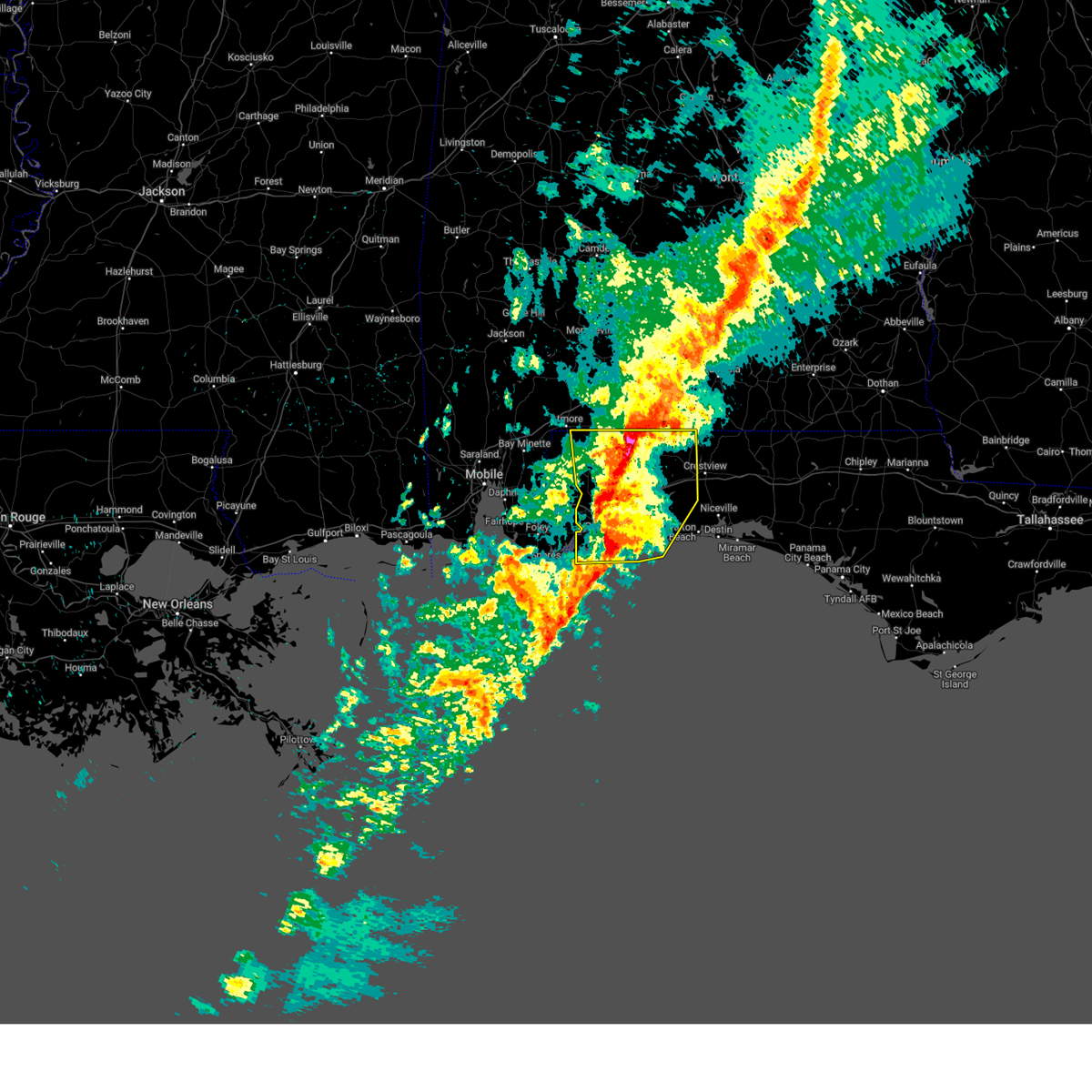
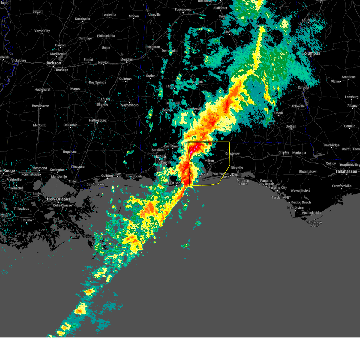
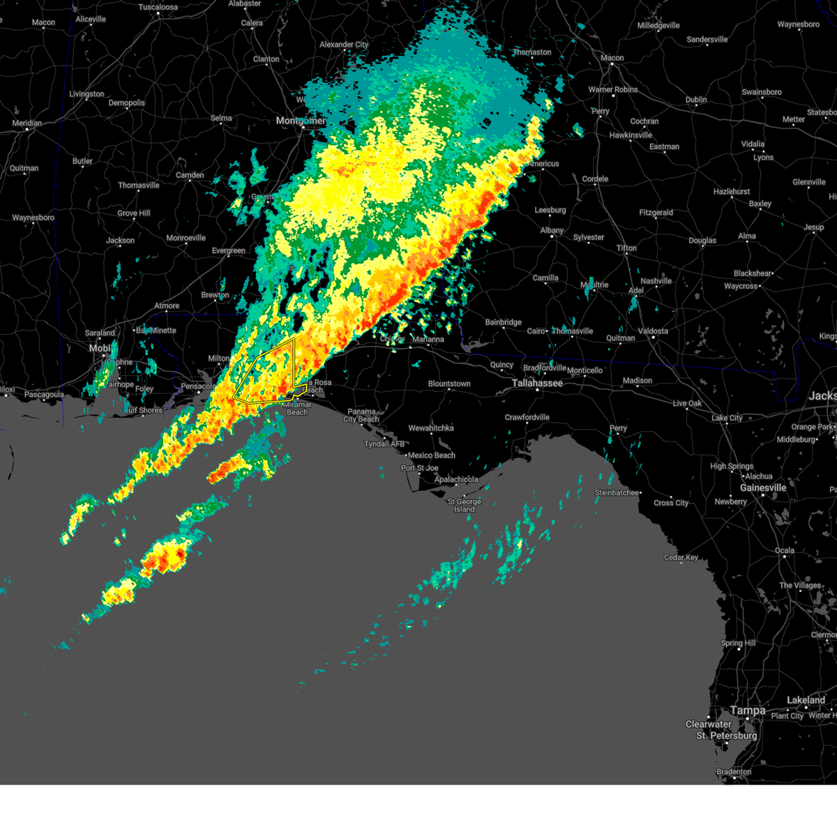
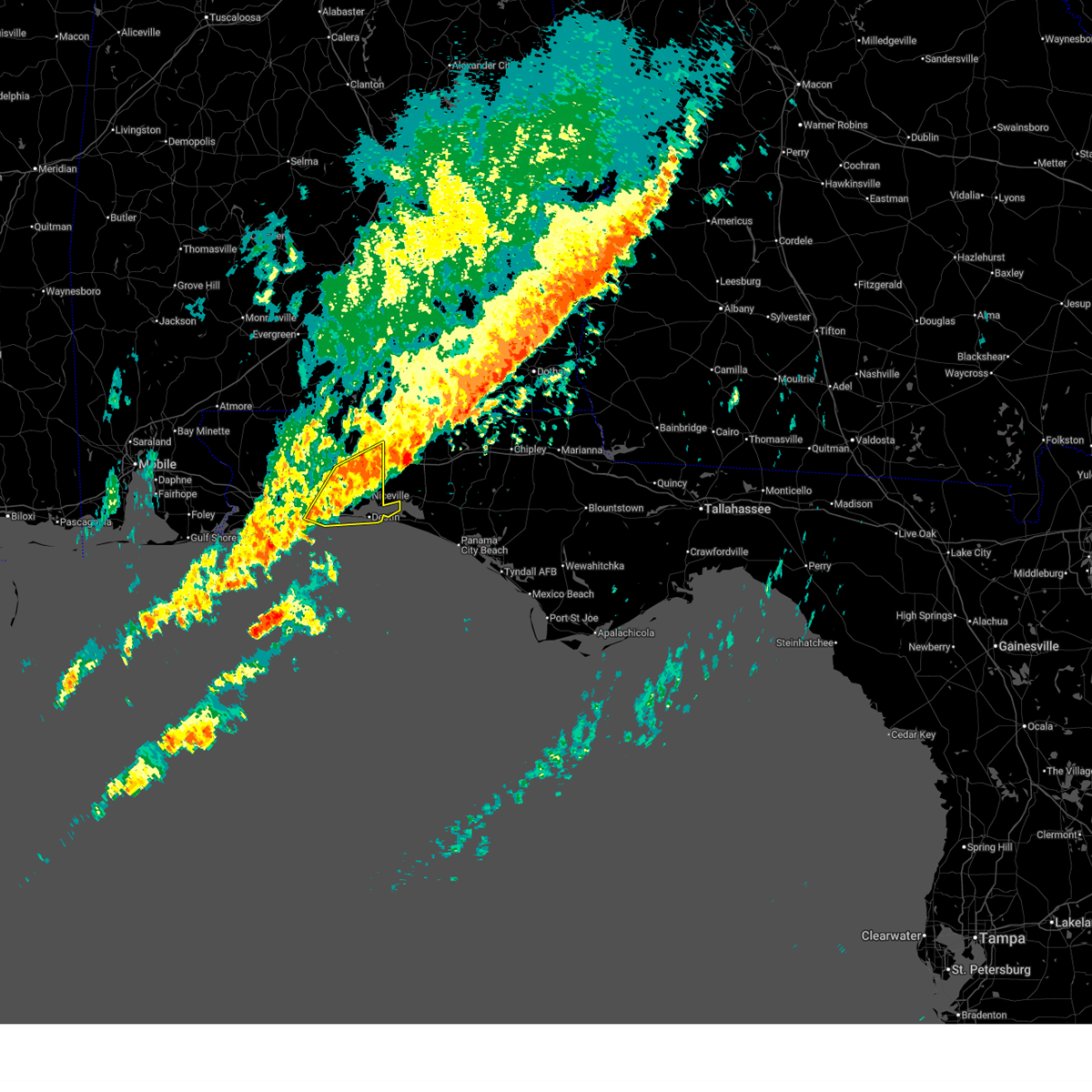
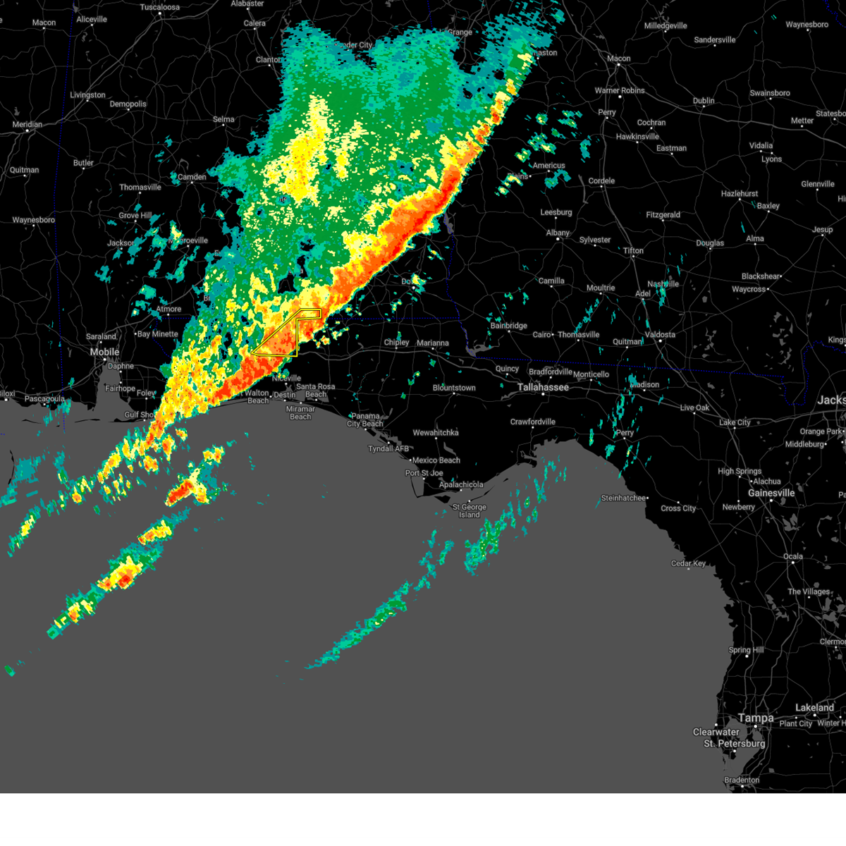
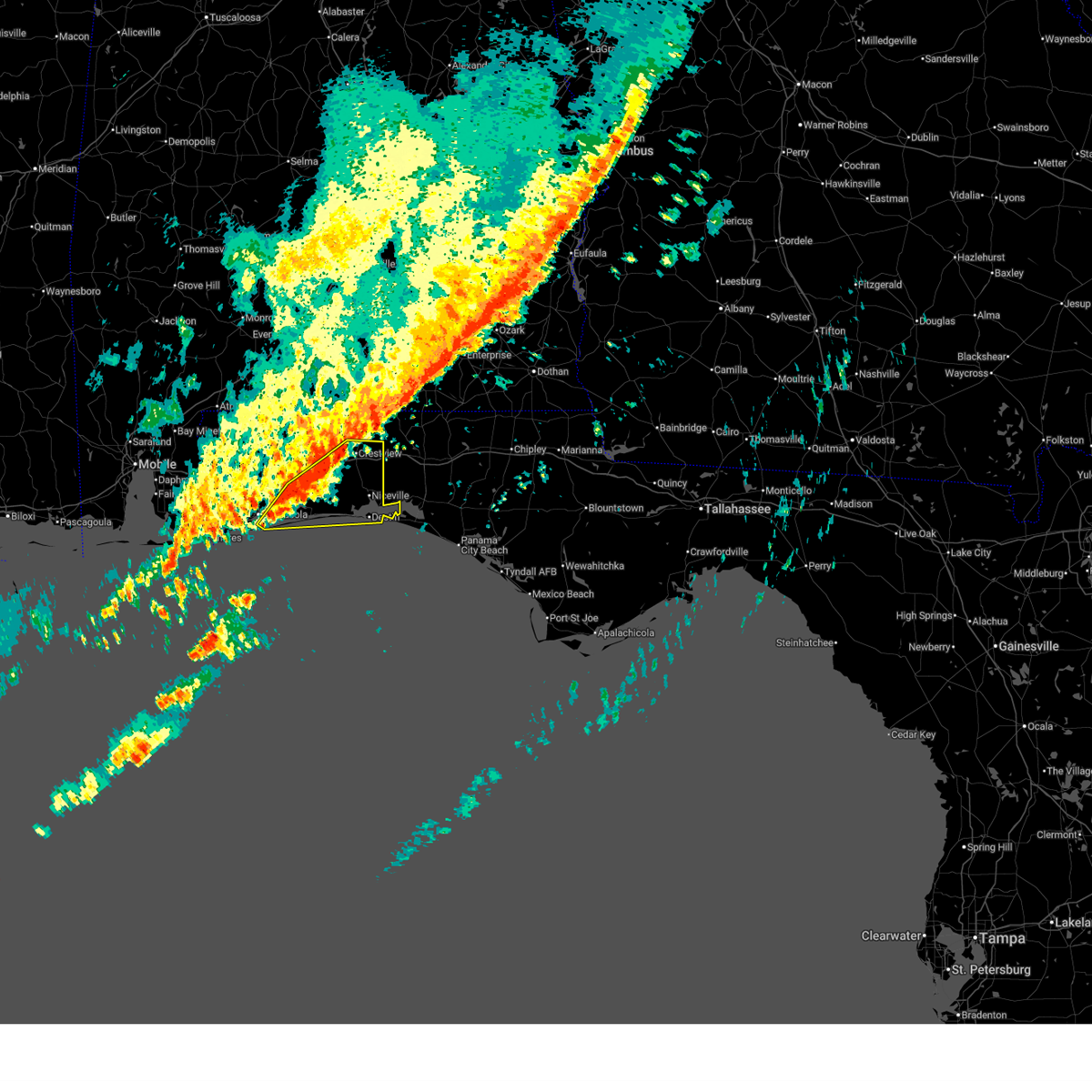
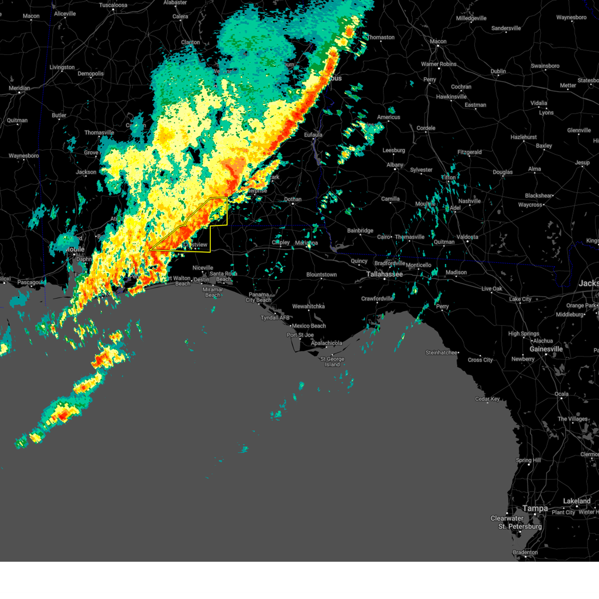
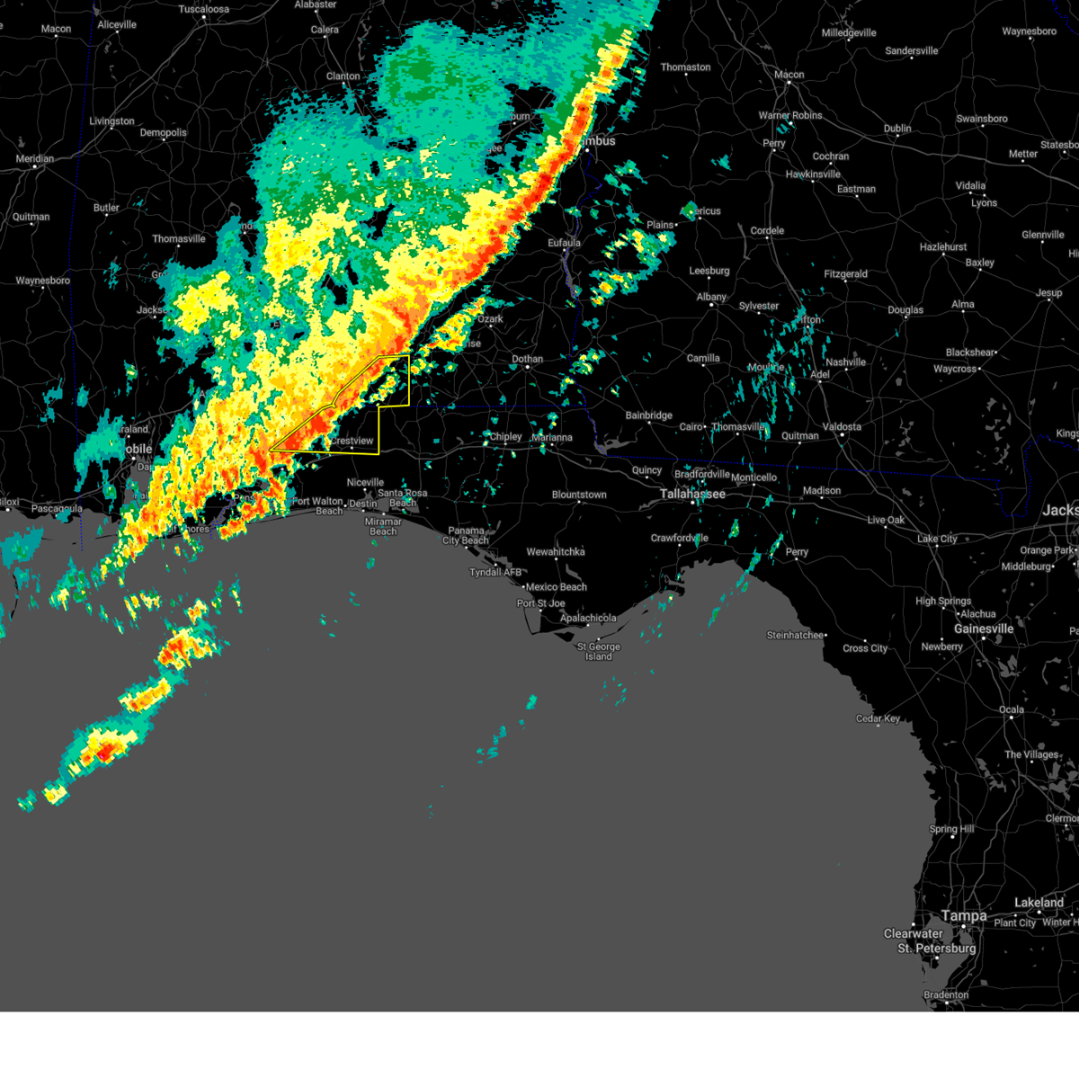
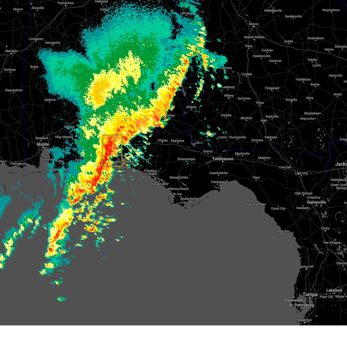
Hail Map for Crestview, FL
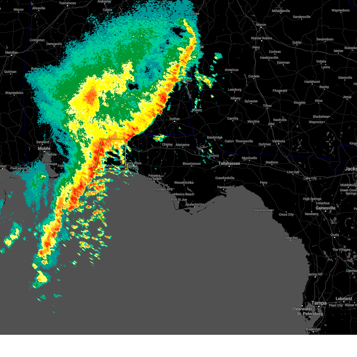
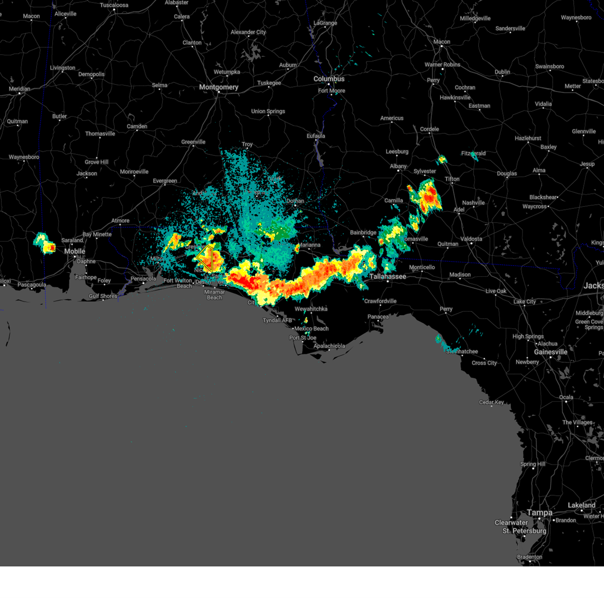
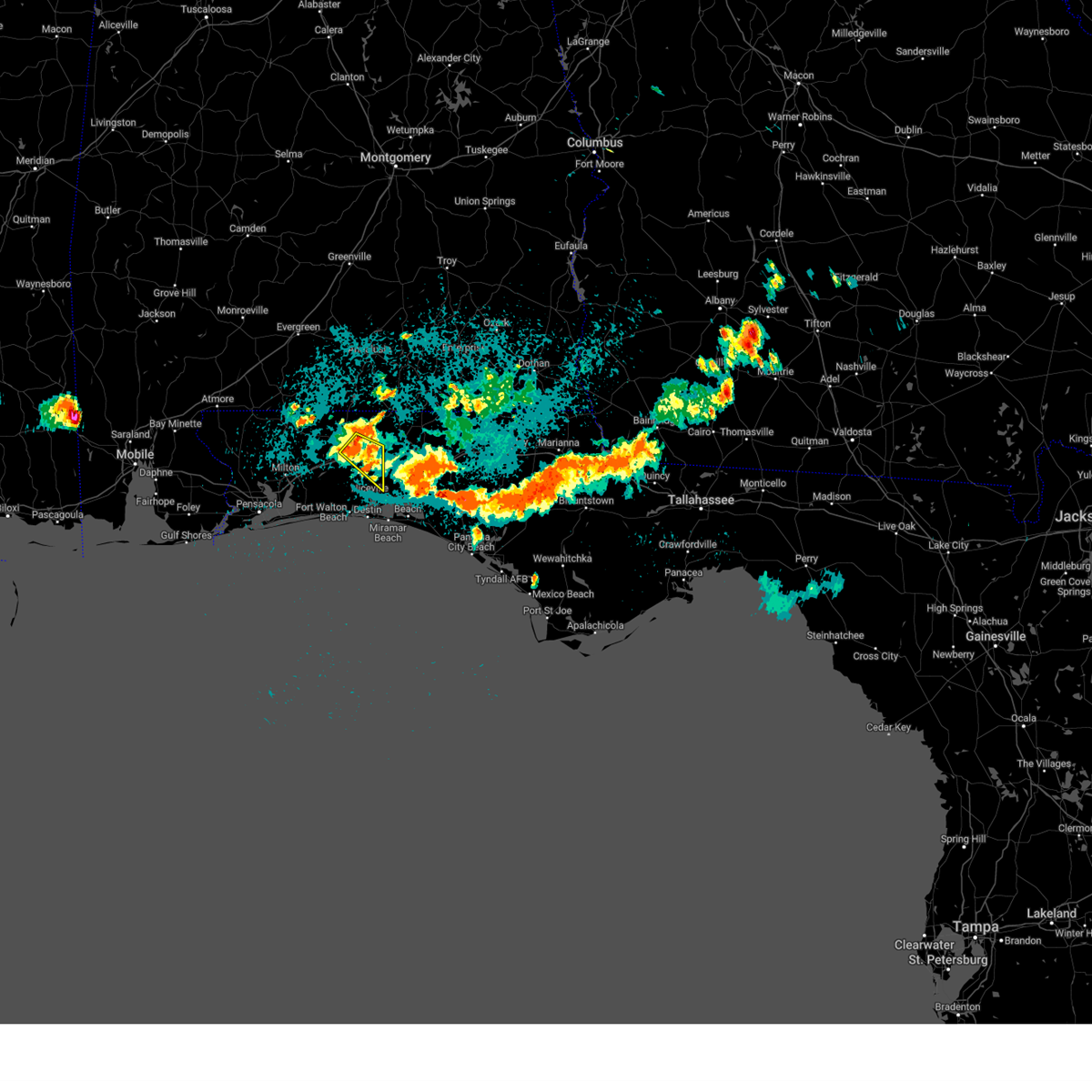
The Crestview, FL area has had 4 reports of on-the-ground hail by trained spotters, and has been under severe weather warnings 11 times during the past 12 months. Doppler radar has detected hail at or near Crestview, FL on 83 occasions, including 4 occasions during the past year.
| Name: | Crestview, FL |
| Where Located: | 29.4 miles NNW of Miramar Beach, FL |
| Map: | Google Map for Crestview, FL |
| Population: | 20978 |
| Housing Units: | 9153 |
| More Info: | Search Google for Crestview, FL |
3
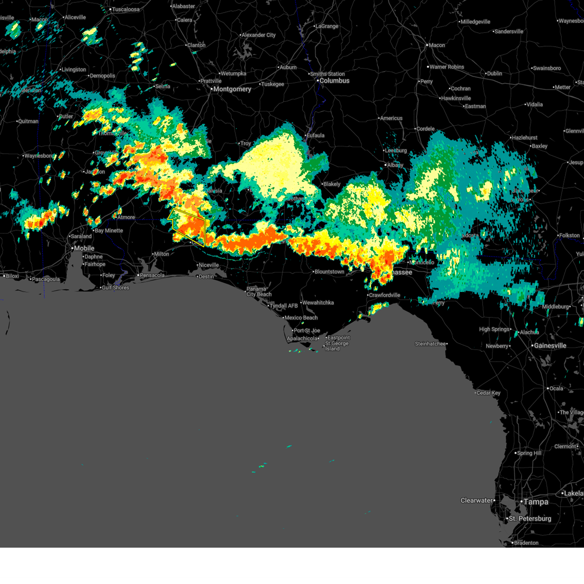
The Top Recent Hail Date for Crestview, FL is Wednesday, June 25, 2025 (6th out of 83)
Hail and Wind Damage Spotted near Crestview, FL
| Date / Time | Report Details |
|---|---|
| 6/19/2026 2:05 PM CDT |
 At 205 pm cdt, a severe thunderstorm was located 6 miles southwest of laurel hill, or 10 miles north of crestview, moving southeast at 25 mph (radar indicated). Hazards include 60 mph wind gusts and quarter size hail. Hail damage to vehicles is expected. expect wind damage to roofs, siding, and trees. Locations impacted include, laurel hill. At 205 pm cdt, a severe thunderstorm was located 6 miles southwest of laurel hill, or 10 miles north of crestview, moving southeast at 25 mph (radar indicated). Hazards include 60 mph wind gusts and quarter size hail. Hail damage to vehicles is expected. expect wind damage to roofs, siding, and trees. Locations impacted include, laurel hill.
|
| 6/19/2026 1:33 PM CDT |
 Svrmob the national weather service in mobile has issued a * severe thunderstorm warning for, southeastern escambia county in south central alabama, southwestern covington county in south central alabama, northern okaloosa county in northwestern florida, * until 215 pm cdt. * at 133 pm cdt, a severe thunderstorm was located 14 miles north of baker, or 19 miles northwest of crestview, moving southeast at 25 mph (radar indicated). Hazards include 60 mph wind gusts and quarter size hail. Hail damage to vehicles is expected. Expect wind damage to roofs, siding, and trees. Svrmob the national weather service in mobile has issued a * severe thunderstorm warning for, southeastern escambia county in south central alabama, southwestern covington county in south central alabama, northern okaloosa county in northwestern florida, * until 215 pm cdt. * at 133 pm cdt, a severe thunderstorm was located 14 miles north of baker, or 19 miles northwest of crestview, moving southeast at 25 mph (radar indicated). Hazards include 60 mph wind gusts and quarter size hail. Hail damage to vehicles is expected. Expect wind damage to roofs, siding, and trees.
|
| 6/18/2026 9:20 PM CDT |
 the severe thunderstorm warning has been cancelled and is no longer in effect the severe thunderstorm warning has been cancelled and is no longer in effect
|
| 6/18/2026 9:20 PM CDT |
 At 919 pm cdt, severe thunderstorms were located along a line extending from 10 miles east of baker to 5 miles southeast of crestview to 3 miles northwest of wright, moving east at 45 mph (radar indicated). Hazards include 60 mph wind gusts. Expect damage to roofs, siding, and trees. Locations impacted include, crestview, niceville, and valparaiso. At 919 pm cdt, severe thunderstorms were located along a line extending from 10 miles east of baker to 5 miles southeast of crestview to 3 miles northwest of wright, moving east at 45 mph (radar indicated). Hazards include 60 mph wind gusts. Expect damage to roofs, siding, and trees. Locations impacted include, crestview, niceville, and valparaiso.
|
| 6/18/2026 8:51 PM CDT |
 Svrmob the national weather service in mobile has issued a * severe thunderstorm warning for, okaloosa county in northwestern florida, northeastern santa rosa county in northwestern florida, * until 945 pm cdt. * at 850 pm cdt, severe thunderstorms were located along a line extending from 13 miles west of baker to 6 miles east of roeville to 5 miles southeast of bagdad, moving east at 40 mph (radar indicated). Hazards include 60 mph wind gusts. expect damage to roofs, siding, and trees Svrmob the national weather service in mobile has issued a * severe thunderstorm warning for, okaloosa county in northwestern florida, northeastern santa rosa county in northwestern florida, * until 945 pm cdt. * at 850 pm cdt, severe thunderstorms were located along a line extending from 13 miles west of baker to 6 miles east of roeville to 5 miles southeast of bagdad, moving east at 40 mph (radar indicated). Hazards include 60 mph wind gusts. expect damage to roofs, siding, and trees
|
| 3/12/2026 3:13 AM CDT |
 Svrmob the national weather service in mobile has issued a * severe thunderstorm warning for, southeastern covington county in south central alabama, northeastern okaloosa county in northwestern florida, * until 345 am cdt. * at 312 am cdt, severe thunderstorms were located along a line extending from near opp to 5 miles north of crestview, moving east at 25 mph (radar indicated). Hazards include 60 mph wind gusts. expect damage to roofs, siding, and trees Svrmob the national weather service in mobile has issued a * severe thunderstorm warning for, southeastern covington county in south central alabama, northeastern okaloosa county in northwestern florida, * until 345 am cdt. * at 312 am cdt, severe thunderstorms were located along a line extending from near opp to 5 miles north of crestview, moving east at 25 mph (radar indicated). Hazards include 60 mph wind gusts. expect damage to roofs, siding, and trees
|
| 1/3/2026 2:09 PM CST |
 The storm which prompted the warning has moved out of the area. therefore, the warning will be allowed to expire. The storm which prompted the warning has moved out of the area. therefore, the warning will be allowed to expire.
|
| 1/3/2026 1:52 PM CST |
 At 152 pm cst, a severe thunderstorm was located 6 miles north of niceville, moving east at 40 mph (radar indicated). Hazards include 60 mph wind gusts and quarter size hail. Hail damage to vehicles is expected. expect wind damage to roofs, siding, and trees. Locations impacted include, niceville. At 152 pm cst, a severe thunderstorm was located 6 miles north of niceville, moving east at 40 mph (radar indicated). Hazards include 60 mph wind gusts and quarter size hail. Hail damage to vehicles is expected. expect wind damage to roofs, siding, and trees. Locations impacted include, niceville.
|
| 1/3/2026 1:40 PM CST |
 At 140 pm cst, a severe thunderstorm was located 9 miles south of crestview, moving east at 40 mph (radar indicated). Hazards include 60 mph wind gusts and half dollar size hail. Hail damage to vehicles is expected. expect wind damage to roofs, siding, and trees. Locations impacted include, niceville and valparaiso. At 140 pm cst, a severe thunderstorm was located 9 miles south of crestview, moving east at 40 mph (radar indicated). Hazards include 60 mph wind gusts and half dollar size hail. Hail damage to vehicles is expected. expect wind damage to roofs, siding, and trees. Locations impacted include, niceville and valparaiso.
|
| 1/3/2026 1:28 PM CST |
 Svrmob the national weather service in mobile has issued a * severe thunderstorm warning for, southern okaloosa county in northwestern florida, * until 215 pm cst. * at 127 pm cst, a severe thunderstorm was located 10 miles south of baker, or 12 miles southwest of crestview, moving east at 40 mph (radar indicated). Hazards include golf ball size hail and 60 mph wind gusts. People and animals outdoors will be injured. expect hail damage to roofs, siding, windows, and vehicles. Expect wind damage to roofs, siding, and trees. Svrmob the national weather service in mobile has issued a * severe thunderstorm warning for, southern okaloosa county in northwestern florida, * until 215 pm cst. * at 127 pm cst, a severe thunderstorm was located 10 miles south of baker, or 12 miles southwest of crestview, moving east at 40 mph (radar indicated). Hazards include golf ball size hail and 60 mph wind gusts. People and animals outdoors will be injured. expect hail damage to roofs, siding, windows, and vehicles. Expect wind damage to roofs, siding, and trees.
|
| 6/25/2025 6:27 PM CDT | Quarter sized hail reported 5.8 miles SW of Crestview, FL, broadcast media relayed report of quarter size hail estimated near auburn... fl. time estimated by radar. |
| 6/25/2025 6:17 PM CDT |
 Svrmob the national weather service in mobile has issued a * severe thunderstorm warning for, northern okaloosa county in northwestern florida, * until 700 pm cdt. * at 617 pm cdt, a severe thunderstorm was located 4 miles northeast of crestview, moving west at 10 mph (radar indicated). Hazards include 60 mph wind gusts and quarter size hail. Hail damage to vehicles is expected. Expect wind damage to roofs, siding, and trees. Svrmob the national weather service in mobile has issued a * severe thunderstorm warning for, northern okaloosa county in northwestern florida, * until 700 pm cdt. * at 617 pm cdt, a severe thunderstorm was located 4 miles northeast of crestview, moving west at 10 mph (radar indicated). Hazards include 60 mph wind gusts and quarter size hail. Hail damage to vehicles is expected. Expect wind damage to roofs, siding, and trees.
|
| 5/29/2025 11:13 AM CDT |
 Svrmob the national weather service in mobile has issued a * severe thunderstorm warning for, southeastern escambia county in south central alabama, southwestern covington county in south central alabama, northern okaloosa county in northwestern florida, northeastern santa rosa county in northwestern florida, * until noon cdt. * at 1113 am cdt, severe thunderstorms were located along a line extending from 7 miles southeast of jay to 5 miles north of point baker, moving east at 40 mph (radar indicated). Hazards include 60 mph wind gusts. expect damage to roofs, siding, and trees Svrmob the national weather service in mobile has issued a * severe thunderstorm warning for, southeastern escambia county in south central alabama, southwestern covington county in south central alabama, northern okaloosa county in northwestern florida, northeastern santa rosa county in northwestern florida, * until noon cdt. * at 1113 am cdt, severe thunderstorms were located along a line extending from 7 miles southeast of jay to 5 miles north of point baker, moving east at 40 mph (radar indicated). Hazards include 60 mph wind gusts. expect damage to roofs, siding, and trees
|
| 5/29/2025 11:05 AM CDT |
 At 1105 am cdt, severe thunderstorms were located along a line extending from 7 miles southeast of jay to 6 miles east of roeville to navarre, moving east at 45 mph (radar indicated). Hazards include 60 mph wind gusts. Expect damage to roofs, siding, and trees. Locations impacted include, cinco bayou, ocean city, mary esther, fort walton beach, shalimar, crestview, wright, lake lorraine, navarre beach, baker, roeville, eglin afb, and navarre. At 1105 am cdt, severe thunderstorms were located along a line extending from 7 miles southeast of jay to 6 miles east of roeville to navarre, moving east at 45 mph (radar indicated). Hazards include 60 mph wind gusts. Expect damage to roofs, siding, and trees. Locations impacted include, cinco bayou, ocean city, mary esther, fort walton beach, shalimar, crestview, wright, lake lorraine, navarre beach, baker, roeville, eglin afb, and navarre.
|
| 5/29/2025 10:53 AM CDT |
 the severe thunderstorm warning has been cancelled and is no longer in effect the severe thunderstorm warning has been cancelled and is no longer in effect
|
| 5/29/2025 10:53 AM CDT |
 At 1052 am cdt, severe thunderstorms were located along a line extending from 8 miles southwest of jay to point baker to near oriole beach, moving east at 45 mph (radar indicated). Hazards include 60 mph wind gusts. Expect damage to roofs, siding, and trees. Locations impacted include, cinco bayou, ocean city, mary esther, fort walton beach, shalimar, crestview, wright, point baker, lake lorraine, oriole beach, navarre beach, pea ridge, pace, baker, roeville, bagdad, floridatown, eglin afb, milton, and navarre. At 1052 am cdt, severe thunderstorms were located along a line extending from 8 miles southwest of jay to point baker to near oriole beach, moving east at 45 mph (radar indicated). Hazards include 60 mph wind gusts. Expect damage to roofs, siding, and trees. Locations impacted include, cinco bayou, ocean city, mary esther, fort walton beach, shalimar, crestview, wright, point baker, lake lorraine, oriole beach, navarre beach, pea ridge, pace, baker, roeville, bagdad, floridatown, eglin afb, milton, and navarre.
|
| 5/29/2025 10:37 AM CDT |
 Svrmob the national weather service in mobile has issued a * severe thunderstorm warning for, western okaloosa county in northwestern florida, santa rosa county in northwestern florida, central escambia county in northwestern florida, * until 1115 am cdt. * at 1037 am cdt, severe thunderstorms were located along a line extending from 8 miles northwest of molino to 4 miles northwest of pace to 3 miles southeast of warrington, moving east at 45 mph (radar indicated). Hazards include 60 mph wind gusts. expect damage to roofs, siding, and trees Svrmob the national weather service in mobile has issued a * severe thunderstorm warning for, western okaloosa county in northwestern florida, santa rosa county in northwestern florida, central escambia county in northwestern florida, * until 1115 am cdt. * at 1037 am cdt, severe thunderstorms were located along a line extending from 8 miles northwest of molino to 4 miles northwest of pace to 3 miles southeast of warrington, moving east at 45 mph (radar indicated). Hazards include 60 mph wind gusts. expect damage to roofs, siding, and trees
|
| 5/3/2025 5:50 AM CDT |
 the severe thunderstorm warning has been cancelled and is no longer in effect the severe thunderstorm warning has been cancelled and is no longer in effect
|
| 5/3/2025 5:38 AM CDT |
 the severe thunderstorm warning has been cancelled and is no longer in effect the severe thunderstorm warning has been cancelled and is no longer in effect
|
| 5/3/2025 5:38 AM CDT |
 At 538 am cdt, a severe thunderstorm was located 12 miles south of baker, or 13 miles northwest of wright, moving northeast at 25 mph (radar indicated). Hazards include 60 mph wind gusts and penny size hail. Expect damage to roofs, siding, and trees. Locations impacted include, crestview. At 538 am cdt, a severe thunderstorm was located 12 miles south of baker, or 13 miles northwest of wright, moving northeast at 25 mph (radar indicated). Hazards include 60 mph wind gusts and penny size hail. Expect damage to roofs, siding, and trees. Locations impacted include, crestview.
|
| 5/3/2025 5:23 AM CDT |
 At 522 am cdt, a severe thunderstorm was located 10 miles southeast of roeville, or 10 miles east of bagdad, moving northeast at 25 mph (radar indicated). Hazards include 60 mph wind gusts. Expect damage to roofs, siding, and trees. Locations impacted include, baker and crestview. At 522 am cdt, a severe thunderstorm was located 10 miles southeast of roeville, or 10 miles east of bagdad, moving northeast at 25 mph (radar indicated). Hazards include 60 mph wind gusts. Expect damage to roofs, siding, and trees. Locations impacted include, baker and crestview.
|
| 5/3/2025 5:10 AM CDT |
 Svrmob the national weather service in mobile has issued a * severe thunderstorm warning for, west central okaloosa county in northwestern florida, southeastern santa rosa county in northwestern florida, * until 600 am cdt. * at 509 am cdt, a severe thunderstorm was located 8 miles southeast of bagdad, moving northeast at 25 mph (radar indicated). Hazards include 60 mph wind gusts. expect damage to roofs, siding, and trees Svrmob the national weather service in mobile has issued a * severe thunderstorm warning for, west central okaloosa county in northwestern florida, southeastern santa rosa county in northwestern florida, * until 600 am cdt. * at 509 am cdt, a severe thunderstorm was located 8 miles southeast of bagdad, moving northeast at 25 mph (radar indicated). Hazards include 60 mph wind gusts. expect damage to roofs, siding, and trees
|
| 4/27/2025 5:09 PM CDT |
 The severe thunderstorm which prompted the warning has weakened. therefore, the warning will be allowed to expire. The severe thunderstorm which prompted the warning has weakened. therefore, the warning will be allowed to expire.
|
| 4/27/2025 4:29 PM CDT |
 Svrmob the national weather service in mobile has issued a * severe thunderstorm warning for, northeastern okaloosa county in northwestern florida, * until 515 pm cdt. * at 429 pm cdt, a severe thunderstorm was located 6 miles north of crestview, and is nearly stationary (radar indicated). Hazards include 60 mph wind gusts and quarter size hail. Hail damage to vehicles is expected. expect wind damage to roofs, siding, and trees. This severe thunderstorm will remain over mainly rural areas of northeastern okaloosa county. Svrmob the national weather service in mobile has issued a * severe thunderstorm warning for, northeastern okaloosa county in northwestern florida, * until 515 pm cdt. * at 429 pm cdt, a severe thunderstorm was located 6 miles north of crestview, and is nearly stationary (radar indicated). Hazards include 60 mph wind gusts and quarter size hail. Hail damage to vehicles is expected. expect wind damage to roofs, siding, and trees. This severe thunderstorm will remain over mainly rural areas of northeastern okaloosa county.
|
| 4/27/2025 3:55 PM CDT |
 Svrmob the national weather service in mobile has issued a * severe thunderstorm warning for, west central okaloosa county in northwestern florida, * until 445 pm cdt. * at 355 pm cdt, a severe thunderstorm was located 7 miles southwest of baker, or 12 miles west of crestview, moving east at 10 mph (radar indicated). Hazards include 60 mph wind gusts and quarter size hail. Hail damage to vehicles is expected. Expect wind damage to roofs, siding, and trees. Svrmob the national weather service in mobile has issued a * severe thunderstorm warning for, west central okaloosa county in northwestern florida, * until 445 pm cdt. * at 355 pm cdt, a severe thunderstorm was located 7 miles southwest of baker, or 12 miles west of crestview, moving east at 10 mph (radar indicated). Hazards include 60 mph wind gusts and quarter size hail. Hail damage to vehicles is expected. Expect wind damage to roofs, siding, and trees.
|
| 4/26/2025 5:34 PM CDT |
 Svrmob the national weather service in mobile has issued a * severe thunderstorm warning for, northeastern okaloosa county in northwestern florida, * until 615 pm cdt. * at 533 pm cdt, a severe thunderstorm was located 4 miles south of laurel hill, or 10 miles southwest of florala, moving south at 15 mph (radar indicated). Hazards include 60 mph wind gusts and quarter size hail. Hail damage to vehicles is expected. Expect wind damage to roofs, siding, and trees. Svrmob the national weather service in mobile has issued a * severe thunderstorm warning for, northeastern okaloosa county in northwestern florida, * until 615 pm cdt. * at 533 pm cdt, a severe thunderstorm was located 4 miles south of laurel hill, or 10 miles southwest of florala, moving south at 15 mph (radar indicated). Hazards include 60 mph wind gusts and quarter size hail. Hail damage to vehicles is expected. Expect wind damage to roofs, siding, and trees.
|
| 3/9/2025 1:17 AM CDT |
 Svrmob the national weather service in mobile has issued a * severe thunderstorm warning for, southwestern okaloosa county in northwestern florida, southeastern santa rosa county in northwestern florida, * until 1245 am cst. * at 1216 am cst, a severe thunderstorm was located near bagdad, moving east at 45 mph (radar indicated). Hazards include quarter size hail. damage to vehicles is expected Svrmob the national weather service in mobile has issued a * severe thunderstorm warning for, southwestern okaloosa county in northwestern florida, southeastern santa rosa county in northwestern florida, * until 1245 am cst. * at 1216 am cst, a severe thunderstorm was located near bagdad, moving east at 45 mph (radar indicated). Hazards include quarter size hail. damage to vehicles is expected
|
| 3/5/2025 12:09 AM CST |
 The storms which prompted the warning have moved out of the area. therefore, the warning will be allowed to expire. a tornado watch remains in effect until 100 am cst for south central alabama, and northwestern florida. The storms which prompted the warning have moved out of the area. therefore, the warning will be allowed to expire. a tornado watch remains in effect until 100 am cst for south central alabama, and northwestern florida.
|
| 3/4/2025 11:55 PM CST |
 At 1154 pm cst, severe thunderstorms were located along a line extending from 8 miles south of opp to near destin, moving east at 35 mph (radar indicated). Hazards include 70 mph wind gusts. Expect considerable tree damage. damage is likely to mobile homes, roofs, and outbuildings. Locations impacted include, cinco bayou, ocean city, fort walton beach, niceville, lockhart, shalimar, destin, valparaiso, eglin afb, florala, and lake lorraine. At 1154 pm cst, severe thunderstorms were located along a line extending from 8 miles south of opp to near destin, moving east at 35 mph (radar indicated). Hazards include 70 mph wind gusts. Expect considerable tree damage. damage is likely to mobile homes, roofs, and outbuildings. Locations impacted include, cinco bayou, ocean city, fort walton beach, niceville, lockhart, shalimar, destin, valparaiso, eglin afb, florala, and lake lorraine.
|
| 3/4/2025 11:36 PM CST |
 At 1134 pm cst, severe thunderstorms were located along a line extending from 10 miles south of andalusia to near mary esther, moving east at 50 mph (radar indicated). Hazards include 70 mph wind gusts. Expect considerable tree damage. damage is likely to mobile homes, roofs, and outbuildings. Locations impacted include, cinco bayou, ocean city, mary esther, fort walton beach, laurel hill, shalimar, crestview, wright, destin, valparaiso, lake lorraine, niceville, baker, lockhart, eglin afb, and florala. At 1134 pm cst, severe thunderstorms were located along a line extending from 10 miles south of andalusia to near mary esther, moving east at 50 mph (radar indicated). Hazards include 70 mph wind gusts. Expect considerable tree damage. damage is likely to mobile homes, roofs, and outbuildings. Locations impacted include, cinco bayou, ocean city, mary esther, fort walton beach, laurel hill, shalimar, crestview, wright, destin, valparaiso, lake lorraine, niceville, baker, lockhart, eglin afb, and florala.
|
| 3/4/2025 11:36 PM CST |
 the severe thunderstorm warning has been cancelled and is no longer in effect the severe thunderstorm warning has been cancelled and is no longer in effect
|
| 3/4/2025 11:09 PM CST |
 Svrmob the national weather service in mobile has issued a * severe thunderstorm warning for, southeastern escambia county in south central alabama, southern covington county in south central alabama, okaloosa county in northwestern florida, eastern santa rosa county in northwestern florida, * until 1215 am cst. * at 1109 pm cst, severe thunderstorms were located along a line extending from 11 miles southwest of andalusia to near navarre, moving east at 55 mph (radar indicated). Hazards include 70 mph wind gusts. Expect considerable tree damage. Damage is likely to mobile homes, roofs, and outbuildings. Svrmob the national weather service in mobile has issued a * severe thunderstorm warning for, southeastern escambia county in south central alabama, southern covington county in south central alabama, okaloosa county in northwestern florida, eastern santa rosa county in northwestern florida, * until 1215 am cst. * at 1109 pm cst, severe thunderstorms were located along a line extending from 11 miles southwest of andalusia to near navarre, moving east at 55 mph (radar indicated). Hazards include 70 mph wind gusts. Expect considerable tree damage. Damage is likely to mobile homes, roofs, and outbuildings.
|
| 3/4/2025 11:04 PM CST |
 the severe thunderstorm warning has been cancelled and is no longer in effect the severe thunderstorm warning has been cancelled and is no longer in effect
|
| 3/4/2025 11:04 PM CST |
 At 1103 pm cst, severe thunderstorms were located along a line extending from 12 miles east of riverview to 6 miles northeast of roeville to navarre to 10 miles south of pensacola beach, moving east at 65 mph (radar indicated). Hazards include 70 mph wind gusts. Expect considerable tree damage. damage is likely to mobile homes, roofs, and outbuildings. Locations impacted include, oriole beach, gulf breeze, navarre beach, pea ridge, pensacola beach, baker, roeville, bagdad, point baker, milton, and navarre. At 1103 pm cst, severe thunderstorms were located along a line extending from 12 miles east of riverview to 6 miles northeast of roeville to navarre to 10 miles south of pensacola beach, moving east at 65 mph (radar indicated). Hazards include 70 mph wind gusts. Expect considerable tree damage. damage is likely to mobile homes, roofs, and outbuildings. Locations impacted include, oriole beach, gulf breeze, navarre beach, pea ridge, pensacola beach, baker, roeville, bagdad, point baker, milton, and navarre.
|
| 3/4/2025 10:54 PM CST |
 At 1053 pm cst, severe thunderstorms were located along a line extending from 5 miles southeast of riverview to point baker to near oriole beach to 16 miles southwest of pensacola beach, moving east at 50 mph (observed. a 70 mph gust was just reported at pensacola nas). Hazards include 70 mph wind gusts. Expect considerable tree damage. damage is likely to mobile homes, roofs, and outbuildings. Locations impacted include, west pensacola, warrington, pensacola, jay, pensacola beach, point baker, myrtle grove, goulding, pea ridge, ferry pass, ensley, gonzalez, baker, pace, roeville, floridatown, flomaton, gulf breeze, bratt, and century. At 1053 pm cst, severe thunderstorms were located along a line extending from 5 miles southeast of riverview to point baker to near oriole beach to 16 miles southwest of pensacola beach, moving east at 50 mph (observed. a 70 mph gust was just reported at pensacola nas). Hazards include 70 mph wind gusts. Expect considerable tree damage. damage is likely to mobile homes, roofs, and outbuildings. Locations impacted include, west pensacola, warrington, pensacola, jay, pensacola beach, point baker, myrtle grove, goulding, pea ridge, ferry pass, ensley, gonzalez, baker, pace, roeville, floridatown, flomaton, gulf breeze, bratt, and century.
|
| 3/4/2025 10:24 PM CST |
 Svrmob the national weather service in mobile has issued a * severe thunderstorm warning for, western okaloosa county in northwestern florida, santa rosa county in northwestern florida, escambia county in northwestern florida, * until 1115 pm cst. * at 1024 pm cst, severe thunderstorms were located along a line extending from 8 miles southeast of bratt to 7 miles west of gonzalez to near myrtle grove to 18 miles south of gulf shores, moving east at 65 mph (radar indicated). Hazards include 60 mph wind gusts. expect damage to roofs, siding, and trees Svrmob the national weather service in mobile has issued a * severe thunderstorm warning for, western okaloosa county in northwestern florida, santa rosa county in northwestern florida, escambia county in northwestern florida, * until 1115 pm cst. * at 1024 pm cst, severe thunderstorms were located along a line extending from 8 miles southeast of bratt to 7 miles west of gonzalez to near myrtle grove to 18 miles south of gulf shores, moving east at 65 mph (radar indicated). Hazards include 60 mph wind gusts. expect damage to roofs, siding, and trees
|
| 2/16/2025 4:45 AM CST |
 The storms which prompted the warning have moved out of the area. therefore, the warning has been allowed to expire. a tornado watch remains in effect until 600 am cst for northwestern florida. The storms which prompted the warning have moved out of the area. therefore, the warning has been allowed to expire. a tornado watch remains in effect until 600 am cst for northwestern florida.
|
| 2/16/2025 4:32 AM CST |
 At 431 am cst, severe thunderstorms were located along a line extending from 8 miles north of eglin air force base to near niceville to 4 miles east of navarre beach, moving east at 45 mph (radar indicated). Hazards include 60 mph wind gusts. Expect damage to roofs, siding, and trees. Locations impacted include, cinco bayou, ocean city, mary esther, navarre beach, fort walton beach, niceville, shalimar, wright, destin, valparaiso, eglin afb, and lake lorraine. At 431 am cst, severe thunderstorms were located along a line extending from 8 miles north of eglin air force base to near niceville to 4 miles east of navarre beach, moving east at 45 mph (radar indicated). Hazards include 60 mph wind gusts. Expect damage to roofs, siding, and trees. Locations impacted include, cinco bayou, ocean city, mary esther, navarre beach, fort walton beach, niceville, shalimar, wright, destin, valparaiso, eglin afb, and lake lorraine.
|
| 2/16/2025 4:32 AM CST |
 the severe thunderstorm warning has been cancelled and is no longer in effect the severe thunderstorm warning has been cancelled and is no longer in effect
|
| 2/16/2025 4:27 AM CST |
 The storms which prompted the warning have moved out of the area. therefore, the warning will be allowed to expire. a tornado watch remains in effect until 600 am cst for south central alabama, and northwestern florida. The storms which prompted the warning have moved out of the area. therefore, the warning will be allowed to expire. a tornado watch remains in effect until 600 am cst for south central alabama, and northwestern florida.
|
| 2/16/2025 4:08 AM CST |
 At 408 am cst, severe thunderstorms were located along a line extending from 6 miles south of enterprise to 4 miles east of crestview, moving east at 50 mph (radar indicated). Hazards include 60 mph wind gusts. Expect damage to roofs, siding, and trees. Locations impacted include, laurel hill, florala, baker, lockhart, and crestview. At 408 am cst, severe thunderstorms were located along a line extending from 6 miles south of enterprise to 4 miles east of crestview, moving east at 50 mph (radar indicated). Hazards include 60 mph wind gusts. Expect damage to roofs, siding, and trees. Locations impacted include, laurel hill, florala, baker, lockhart, and crestview.
|
| 2/16/2025 4:08 AM CST |
 the severe thunderstorm warning has been cancelled and is no longer in effect the severe thunderstorm warning has been cancelled and is no longer in effect
|
| 2/16/2025 3:59 AM CST |
 Svrmob the national weather service in mobile has issued a * severe thunderstorm warning for, okaloosa county in northwestern florida, southeastern santa rosa county in northwestern florida, southeastern escambia county in northwestern florida, * until 445 am cst. * at 359 am cst, severe thunderstorms were located along a line extending from 3 miles south of baker to 11 miles southeast of roeville to oriole beach, moving east at 45 mph (radar indicated). Hazards include 60 mph wind gusts. expect damage to roofs, siding, and trees Svrmob the national weather service in mobile has issued a * severe thunderstorm warning for, okaloosa county in northwestern florida, southeastern santa rosa county in northwestern florida, southeastern escambia county in northwestern florida, * until 445 am cst. * at 359 am cst, severe thunderstorms were located along a line extending from 3 miles south of baker to 11 miles southeast of roeville to oriole beach, moving east at 45 mph (radar indicated). Hazards include 60 mph wind gusts. expect damage to roofs, siding, and trees
|
| 2/16/2025 3:44 AM CST |
 At 344 am cst, severe thunderstorms were located along a line extending from 3 miles south of opp to 8 miles northeast of roeville, moving east at 50 mph (radar indicated). Hazards include 60 mph wind gusts. Expect damage to roofs, siding, and trees. Locations impacted include, laurel hill, florala, baker, opp, lockhart, and crestview. At 344 am cst, severe thunderstorms were located along a line extending from 3 miles south of opp to 8 miles northeast of roeville, moving east at 50 mph (radar indicated). Hazards include 60 mph wind gusts. Expect damage to roofs, siding, and trees. Locations impacted include, laurel hill, florala, baker, opp, lockhart, and crestview.
|
| 2/16/2025 3:39 AM CST |
 Svrmob the national weather service in mobile has issued a * severe thunderstorm warning for, southern covington county in south central alabama, northern okaloosa county in northwestern florida, northeastern santa rosa county in northwestern florida, * until 430 am cst. * at 339 am cst, severe thunderstorms were located along a line extending from 3 miles west of opp to 8 miles northeast of roeville, moving east at 65 mph (radar indicated). Hazards include 60 mph wind gusts. expect damage to roofs, siding, and trees Svrmob the national weather service in mobile has issued a * severe thunderstorm warning for, southern covington county in south central alabama, northern okaloosa county in northwestern florida, northeastern santa rosa county in northwestern florida, * until 430 am cst. * at 339 am cst, severe thunderstorms were located along a line extending from 3 miles west of opp to 8 miles northeast of roeville, moving east at 65 mph (radar indicated). Hazards include 60 mph wind gusts. expect damage to roofs, siding, and trees
|
| 12/29/2024 3:03 AM CST |
 the severe thunderstorm warning has been cancelled and is no longer in effect the severe thunderstorm warning has been cancelled and is no longer in effect
|
| 12/29/2024 3:03 AM CST |
 At 303 am cst, severe thunderstorms were located along a line extending from 4 miles east of crestview to 9 miles northwest of valparaiso to near mary esther to 4 miles south of navarre beach, moving east at 35 mph (radar indicated). Hazards include 60 mph wind gusts. Expect damage to roofs, siding, and trees. Locations impacted include, cinco bayou, ocean city, mary esther, fort walton beach, shalimar, crestview, wright, destin, valparaiso, lake lorraine, niceville, baker, and eglin afb. At 303 am cst, severe thunderstorms were located along a line extending from 4 miles east of crestview to 9 miles northwest of valparaiso to near mary esther to 4 miles south of navarre beach, moving east at 35 mph (radar indicated). Hazards include 60 mph wind gusts. Expect damage to roofs, siding, and trees. Locations impacted include, cinco bayou, ocean city, mary esther, fort walton beach, shalimar, crestview, wright, destin, valparaiso, lake lorraine, niceville, baker, and eglin afb.
|
| 12/29/2024 2:38 AM CST |
 Svrmob the national weather service in mobile has issued a * severe thunderstorm warning for, okaloosa county in northwestern florida, southeastern santa rosa county in northwestern florida, * until 400 am cst. * at 237 am cst, severe thunderstorms were located along a line extending from 10 miles northeast of point baker to near roeville to 6 miles north of oriole beach to 8 miles south of pensacola beach, moving east at 40 mph (radar indicated). Hazards include 60 mph wind gusts. expect damage to roofs, siding, and trees Svrmob the national weather service in mobile has issued a * severe thunderstorm warning for, okaloosa county in northwestern florida, southeastern santa rosa county in northwestern florida, * until 400 am cst. * at 237 am cst, severe thunderstorms were located along a line extending from 10 miles northeast of point baker to near roeville to 6 miles north of oriole beach to 8 miles south of pensacola beach, moving east at 40 mph (radar indicated). Hazards include 60 mph wind gusts. expect damage to roofs, siding, and trees
|
| 8/19/2024 2:11 AM CDT |
 At 210 am cdt, a severe thunderstorm was located 6 miles northwest of eglin air force base, or 11 miles northeast of niceville, moving southeast at 40 mph (radar indicated). Hazards include 60 mph wind gusts and penny size hail. Expect damage to roofs, siding, and trees. This severe thunderstorm will remain over mainly rural areas of east central okaloosa county. At 210 am cdt, a severe thunderstorm was located 6 miles northwest of eglin air force base, or 11 miles northeast of niceville, moving southeast at 40 mph (radar indicated). Hazards include 60 mph wind gusts and penny size hail. Expect damage to roofs, siding, and trees. This severe thunderstorm will remain over mainly rural areas of east central okaloosa county.
|
| 8/19/2024 1:52 AM CDT |
 Svrmob the national weather service in mobile has issued a * severe thunderstorm warning for, northeastern okaloosa county in northwestern florida, * until 230 am cdt. * at 152 am cdt, a severe thunderstorm was located over crestview, moving southeast at 40 mph (radar indicated). Hazards include 60 mph wind gusts and penny size hail. expect damage to roofs, siding, and trees Svrmob the national weather service in mobile has issued a * severe thunderstorm warning for, northeastern okaloosa county in northwestern florida, * until 230 am cdt. * at 152 am cdt, a severe thunderstorm was located over crestview, moving southeast at 40 mph (radar indicated). Hazards include 60 mph wind gusts and penny size hail. expect damage to roofs, siding, and trees
|
| 5/13/2024 11:18 AM CDT |
 Svrmob the national weather service in mobile has issued a * severe thunderstorm warning for, okaloosa county in northwestern florida, southeastern santa rosa county in northwestern florida, southeastern escambia county in northwestern florida, * until noon cdt. * at 1117 am cdt, severe thunderstorms were located along a line extending from 9 miles north of niceville to near eglin afb to mary esther to 9 miles southeast of oriole beach, moving east at 40 mph (radar indicated). Hazards include 70 mph wind gusts. Expect considerable tree damage. Damage is likely to mobile homes, roofs, and outbuildings. Svrmob the national weather service in mobile has issued a * severe thunderstorm warning for, okaloosa county in northwestern florida, southeastern santa rosa county in northwestern florida, southeastern escambia county in northwestern florida, * until noon cdt. * at 1117 am cdt, severe thunderstorms were located along a line extending from 9 miles north of niceville to near eglin afb to mary esther to 9 miles southeast of oriole beach, moving east at 40 mph (radar indicated). Hazards include 70 mph wind gusts. Expect considerable tree damage. Damage is likely to mobile homes, roofs, and outbuildings.
|
| 5/13/2024 10:47 AM CDT |
 the tornado warning has been cancelled and is no longer in effect the tornado warning has been cancelled and is no longer in effect
|
| 5/13/2024 10:38 AM CDT |
 Svrmob the national weather service in mobile has issued a * severe thunderstorm warning for, okaloosa county in northwestern florida, southeastern santa rosa county in northwestern florida, southeastern escambia county in northwestern florida, * until 1115 am cdt. * at 1036 am cdt, severe thunderstorms were located along a line extending from 13 miles west of laurel hill to 8 miles southwest of baker to 3 miles southwest of warrington, moving southeast at 30 mph. these are destructive storms for much of okaloosa county and portions of southeastern santa rosa and escambia counties, including crestview and portions of interstate 10 (radar indicated). Hazards include 80 mph wind gusts. Flying debris will be dangerous to those caught without shelter. mobile homes will be heavily damaged. expect considerable damage to roofs, windows, and vehicles. Extensive tree damage and power outages are likely. Svrmob the national weather service in mobile has issued a * severe thunderstorm warning for, okaloosa county in northwestern florida, southeastern santa rosa county in northwestern florida, southeastern escambia county in northwestern florida, * until 1115 am cdt. * at 1036 am cdt, severe thunderstorms were located along a line extending from 13 miles west of laurel hill to 8 miles southwest of baker to 3 miles southwest of warrington, moving southeast at 30 mph. these are destructive storms for much of okaloosa county and portions of southeastern santa rosa and escambia counties, including crestview and portions of interstate 10 (radar indicated). Hazards include 80 mph wind gusts. Flying debris will be dangerous to those caught without shelter. mobile homes will be heavily damaged. expect considerable damage to roofs, windows, and vehicles. Extensive tree damage and power outages are likely.
|
| 5/13/2024 10:24 AM CDT |
 At 1023 am cdt, severe thunderstorms were located along a line extending from 4 miles north of roeville to 4 miles south of floridatown to 5 miles southwest of bon secour, moving southeast at 40 mph. these are destructive storms for locations near whiting field, allentown, baker (radar indicated). Hazards include 80 mph wind gusts. Flying debris will be dangerous to those caught without shelter. mobile homes will be heavily damaged. expect considerable damage to roofs, windows, and vehicles. extensive tree damage and power outages are likely. Locations impacted include, pensacola, ferry pass, brent, west pensacola, wright, fort walton beach, ensley, warrington, gonzalez, gulf shores, foley, pace, milton, gulf breeze, orange beach, goulding, mary esther, robertsdale, bagdad, and ocean city. At 1023 am cdt, severe thunderstorms were located along a line extending from 4 miles north of roeville to 4 miles south of floridatown to 5 miles southwest of bon secour, moving southeast at 40 mph. these are destructive storms for locations near whiting field, allentown, baker (radar indicated). Hazards include 80 mph wind gusts. Flying debris will be dangerous to those caught without shelter. mobile homes will be heavily damaged. expect considerable damage to roofs, windows, and vehicles. extensive tree damage and power outages are likely. Locations impacted include, pensacola, ferry pass, brent, west pensacola, wright, fort walton beach, ensley, warrington, gonzalez, gulf shores, foley, pace, milton, gulf breeze, orange beach, goulding, mary esther, robertsdale, bagdad, and ocean city.
|
| 5/13/2024 10:16 AM CDT |
 Tormob the national weather service in mobile has issued a * tornado warning for, west central okaloosa county in northwestern florida, east central santa rosa county in northwestern florida, * until 1100 am cdt. * at 1016 am cdt, a severe thunderstorm capable of producing a tornado was located near roeville, or 7 miles northeast of milton, moving east at 40 mph (radar indicated rotation). Hazards include tornado. Flying debris will be dangerous to those caught without shelter. mobile homes will be damaged or destroyed. damage to roofs, windows, and vehicles will occur. tree damage is likely. This tornadic thunderstorm will remain over mainly rural areas of west central okaloosa and east central santa rosa counties. Tormob the national weather service in mobile has issued a * tornado warning for, west central okaloosa county in northwestern florida, east central santa rosa county in northwestern florida, * until 1100 am cdt. * at 1016 am cdt, a severe thunderstorm capable of producing a tornado was located near roeville, or 7 miles northeast of milton, moving east at 40 mph (radar indicated rotation). Hazards include tornado. Flying debris will be dangerous to those caught without shelter. mobile homes will be damaged or destroyed. damage to roofs, windows, and vehicles will occur. tree damage is likely. This tornadic thunderstorm will remain over mainly rural areas of west central okaloosa and east central santa rosa counties.
|
| 5/13/2024 10:14 AM CDT |
 Svrmob the national weather service in mobile has issued a * severe thunderstorm warning for, southeastern baldwin county in southwestern alabama, western okaloosa county in northwestern florida, santa rosa county in northwestern florida, escambia county in northwestern florida, * until 1100 am cdt. * at 1014 am cdt, severe thunderstorms were located along a line extending from 9 miles north of point baker to 3 miles southwest of floridatown to 7 miles west of bon secour, moving southeast at 40 mph (radar indicated). Hazards include 70 mph wind gusts. Expect considerable tree damage. Damage is likely to mobile homes, roofs, and outbuildings. Svrmob the national weather service in mobile has issued a * severe thunderstorm warning for, southeastern baldwin county in southwestern alabama, western okaloosa county in northwestern florida, santa rosa county in northwestern florida, escambia county in northwestern florida, * until 1100 am cdt. * at 1014 am cdt, severe thunderstorms were located along a line extending from 9 miles north of point baker to 3 miles southwest of floridatown to 7 miles west of bon secour, moving southeast at 40 mph (radar indicated). Hazards include 70 mph wind gusts. Expect considerable tree damage. Damage is likely to mobile homes, roofs, and outbuildings.
|
| 5/10/2024 4:29 AM CDT |
 The storms which prompted the warning have moved out of the area. therefore, the warning will be allowed to expire. however, gusty winds are still possible with these thunderstorms. a severe thunderstorm watch remains in effect until 700 am cdt for northwestern florida. The storms which prompted the warning have moved out of the area. therefore, the warning will be allowed to expire. however, gusty winds are still possible with these thunderstorms. a severe thunderstorm watch remains in effect until 700 am cdt for northwestern florida.
|
| 5/10/2024 4:27 AM CDT |
 At 427 am cdt, severe thunderstorms were located along a line extending from 4 miles north of lockhart to 8 miles southeast of laurel hill to valparaiso to 7 miles southwest of mary esther, moving east at 60 mph (radar indicated). Hazards include 70 mph wind gusts. Expect considerable tree damage. damage is likely to mobile homes, roofs, and outbuildings. Locations impacted include, wright, fort walton beach, crestview, niceville, destin, eglin afb, valparaiso, mary esther, florala, ocean city, lake lorraine, navarre, shalimar, lockhart, cinco bayou, and navarre beach. At 427 am cdt, severe thunderstorms were located along a line extending from 4 miles north of lockhart to 8 miles southeast of laurel hill to valparaiso to 7 miles southwest of mary esther, moving east at 60 mph (radar indicated). Hazards include 70 mph wind gusts. Expect considerable tree damage. damage is likely to mobile homes, roofs, and outbuildings. Locations impacted include, wright, fort walton beach, crestview, niceville, destin, eglin afb, valparaiso, mary esther, florala, ocean city, lake lorraine, navarre, shalimar, lockhart, cinco bayou, and navarre beach.
|
| 5/10/2024 4:27 AM CDT |
 the severe thunderstorm warning has been cancelled and is no longer in effect the severe thunderstorm warning has been cancelled and is no longer in effect
|
| 5/10/2024 4:23 AM CDT |
 The storm which prompted the warning has weakened below severe limits, and has exited the warned area. therefore, the warning will be allowed to expire. however, damaging winds are still possible with this thunderstorm. a severe thunderstorm watch remains in effect until 700 am cdt for northwestern florida. remember, a severe thunderstorm warning still remains in effect for okaloosa county until 445 am cdt. The storm which prompted the warning has weakened below severe limits, and has exited the warned area. therefore, the warning will be allowed to expire. however, damaging winds are still possible with this thunderstorm. a severe thunderstorm watch remains in effect until 700 am cdt for northwestern florida. remember, a severe thunderstorm warning still remains in effect for okaloosa county until 445 am cdt.
|
| 5/10/2024 4:17 AM CDT |
 At 417 am cdt, severe thunderstorms were located along a line extending from 5 miles west of wright to 5 miles southwest of navarre to 11 miles south of pensacola beach to 18 miles southeast of perdido beach, moving east at 60 mph (radar indicated). Hazards include 60 mph wind gusts. Expect damage to roofs, siding, and trees. Locations impacted include, pensacola, brent, west pensacola, warrington, gulf breeze, orange beach, goulding, myrtle grove, oriole beach, navarre, navarre beach, and pensacola beach. At 417 am cdt, severe thunderstorms were located along a line extending from 5 miles west of wright to 5 miles southwest of navarre to 11 miles south of pensacola beach to 18 miles southeast of perdido beach, moving east at 60 mph (radar indicated). Hazards include 60 mph wind gusts. Expect damage to roofs, siding, and trees. Locations impacted include, pensacola, brent, west pensacola, warrington, gulf breeze, orange beach, goulding, myrtle grove, oriole beach, navarre, navarre beach, and pensacola beach.
|
| 5/10/2024 4:15 AM CDT | Storm damage reported in okaloosa county FL, 0.8 miles WSW of Crestview, FL |
| 5/10/2024 4:08 AM CDT |
 the tornado warning has been cancelled and is no longer in effect the tornado warning has been cancelled and is no longer in effect
|
| 5/10/2024 4:08 AM CDT |
 At 407 am cdt, a severe thunderstorm capable of producing a tornado was located over baker, or 6 miles northwest of crestview, moving east at 65 mph (radar indicated rotation). Hazards include tornado. Flying debris will be dangerous to those caught without shelter. mobile homes will be damaged or destroyed. damage to roofs, windows, and vehicles will occur. tree damage is likely. This dangerous storm will be near, crestview around 415 am cdt. At 407 am cdt, a severe thunderstorm capable of producing a tornado was located over baker, or 6 miles northwest of crestview, moving east at 65 mph (radar indicated rotation). Hazards include tornado. Flying debris will be dangerous to those caught without shelter. mobile homes will be damaged or destroyed. damage to roofs, windows, and vehicles will occur. tree damage is likely. This dangerous storm will be near, crestview around 415 am cdt.
|
| 5/10/2024 4:05 AM CDT |
 Svrmob the national weather service in mobile has issued a * severe thunderstorm warning for, southeastern escambia county in south central alabama, southern covington county in south central alabama, okaloosa county in northwestern florida, southeastern santa rosa county in northwestern florida, southeastern escambia county in northwestern florida, * until 445 am cdt. * at 405 am cdt, severe thunderstorms were located along a line extending from 15 miles southwest of river falls to 11 miles north of baker to 9 miles southeast of roeville to near oriole beach, moving east at 60 mph (radar indicated). Hazards include 70 mph wind gusts. Expect considerable tree damage. Damage is likely to mobile homes, roofs, and outbuildings. Svrmob the national weather service in mobile has issued a * severe thunderstorm warning for, southeastern escambia county in south central alabama, southern covington county in south central alabama, okaloosa county in northwestern florida, southeastern santa rosa county in northwestern florida, southeastern escambia county in northwestern florida, * until 445 am cdt. * at 405 am cdt, severe thunderstorms were located along a line extending from 15 miles southwest of river falls to 11 miles north of baker to 9 miles southeast of roeville to near oriole beach, moving east at 60 mph (radar indicated). Hazards include 70 mph wind gusts. Expect considerable tree damage. Damage is likely to mobile homes, roofs, and outbuildings.
|
| 5/10/2024 3:59 AM CDT |
 Tormob the national weather service in mobile has issued a * tornado warning for, northern okaloosa county in northwestern florida, northeastern santa rosa county in northwestern florida, * until 430 am cdt. * at 359 am cdt, a severe thunderstorm capable of producing a tornado was located 10 miles west of baker, or 17 miles northwest of crestview, moving east at 50 mph (radar indicated rotation). Hazards include tornado. Flying debris will be dangerous to those caught without shelter. mobile homes will be damaged or destroyed. damage to roofs, windows, and vehicles will occur. tree damage is likely. this dangerous storm will be near, baker around 405 am cdt. Crestview around 415 am cdt. Tormob the national weather service in mobile has issued a * tornado warning for, northern okaloosa county in northwestern florida, northeastern santa rosa county in northwestern florida, * until 430 am cdt. * at 359 am cdt, a severe thunderstorm capable of producing a tornado was located 10 miles west of baker, or 17 miles northwest of crestview, moving east at 50 mph (radar indicated rotation). Hazards include tornado. Flying debris will be dangerous to those caught without shelter. mobile homes will be damaged or destroyed. damage to roofs, windows, and vehicles will occur. tree damage is likely. this dangerous storm will be near, baker around 405 am cdt. Crestview around 415 am cdt.
|
| 5/10/2024 3:39 AM CDT |
 Svrmob the national weather service in mobile has issued a * severe thunderstorm warning for, southern baldwin county in southwestern alabama, southwestern okaloosa county in northwestern florida, central santa rosa county in northwestern florida, southeastern escambia county in northwestern florida, * until 430 am cdt. * at 338 am cdt, severe thunderstorms were located along a line extending from 3 miles south of molino to 8 miles northeast of elberta to near foley to 7 miles northeast of fort morgan, moving east at 60 mph (radar indicated). Hazards include 60 mph wind gusts. expect damage to roofs, siding, and trees Svrmob the national weather service in mobile has issued a * severe thunderstorm warning for, southern baldwin county in southwestern alabama, southwestern okaloosa county in northwestern florida, central santa rosa county in northwestern florida, southeastern escambia county in northwestern florida, * until 430 am cdt. * at 338 am cdt, severe thunderstorms were located along a line extending from 3 miles south of molino to 8 miles northeast of elberta to near foley to 7 miles northeast of fort morgan, moving east at 60 mph (radar indicated). Hazards include 60 mph wind gusts. expect damage to roofs, siding, and trees
|
| 4/10/2024 3:24 PM CDT |
 The storms which prompted the warning have weakened below severe limits, and are exiting the warned area. therefore, the warning will be allowed to expire. a tornado watch remains in effect until 500 pm cdt for south central alabama, and northwestern florida. The storms which prompted the warning have weakened below severe limits, and are exiting the warned area. therefore, the warning will be allowed to expire. a tornado watch remains in effect until 500 pm cdt for south central alabama, and northwestern florida.
|
| 4/10/2024 2:45 PM CDT |
 the severe thunderstorm warning has been cancelled and is no longer in effect the severe thunderstorm warning has been cancelled and is no longer in effect
|
| 4/10/2024 2:45 PM CDT |
 At 244 pm cdt, severe thunderstorms were located along a line extending from 8 miles northwest of laurel hill to 9 miles southeast of crestview to 8 miles southwest of mary esther, moving east at 45 mph (radar indicated). Hazards include 60 mph wind gusts and penny size hail. Expect damage to roofs, siding, and trees. Locations impacted include, wright, fort walton beach, crestview, niceville, destin, eglin afb, valparaiso, mary esther, florala, ocean city, lake lorraine, baker, shalimar, laurel hill, lockhart, and cinco bayou. At 244 pm cdt, severe thunderstorms were located along a line extending from 8 miles northwest of laurel hill to 9 miles southeast of crestview to 8 miles southwest of mary esther, moving east at 45 mph (radar indicated). Hazards include 60 mph wind gusts and penny size hail. Expect damage to roofs, siding, and trees. Locations impacted include, wright, fort walton beach, crestview, niceville, destin, eglin afb, valparaiso, mary esther, florala, ocean city, lake lorraine, baker, shalimar, laurel hill, lockhart, and cinco bayou.
|
| 4/10/2024 2:25 PM CDT |
 Svrmob the national weather service in mobile has issued a * severe thunderstorm warning for, southeastern covington county in south central alabama, okaloosa county in northwestern florida, southeastern santa rosa county in northwestern florida, * until 330 pm cdt. * at 225 pm cdt, severe thunderstorms were located along a line extending from 10 miles northwest of baker to 10 miles north of wright to 10 miles southwest of navarre beach, moving northeast at 50 mph (radar indicated). Hazards include 60 mph wind gusts and penny size hail. expect damage to roofs, siding, and trees Svrmob the national weather service in mobile has issued a * severe thunderstorm warning for, southeastern covington county in south central alabama, okaloosa county in northwestern florida, southeastern santa rosa county in northwestern florida, * until 330 pm cdt. * at 225 pm cdt, severe thunderstorms were located along a line extending from 10 miles northwest of baker to 10 miles north of wright to 10 miles southwest of navarre beach, moving northeast at 50 mph (radar indicated). Hazards include 60 mph wind gusts and penny size hail. expect damage to roofs, siding, and trees
|
| 4/10/2024 2:01 PM CDT |
 At 201 pm cdt, severe thunderstorms were located along a line extending from 8 miles southeast of riverview to 12 miles northeast of roeville to 6 miles south of bagdad to 4 miles south of pensacola beach, moving east at 45 mph (radar indicated). Hazards include 60 mph wind gusts and penny size hail. Expect damage to roofs, siding, and trees. Locations impacted include, wright, crestview, milton, gulf breeze, mary esther, bagdad, baker, oriole beach, navarre, riverview, pensacola beach, point baker, navarre beach, pea ridge, and roeville. At 201 pm cdt, severe thunderstorms were located along a line extending from 8 miles southeast of riverview to 12 miles northeast of roeville to 6 miles south of bagdad to 4 miles south of pensacola beach, moving east at 45 mph (radar indicated). Hazards include 60 mph wind gusts and penny size hail. Expect damage to roofs, siding, and trees. Locations impacted include, wright, crestview, milton, gulf breeze, mary esther, bagdad, baker, oriole beach, navarre, riverview, pensacola beach, point baker, navarre beach, pea ridge, and roeville.
|
| 4/10/2024 1:36 PM CDT |
 Svrmob the national weather service in mobile has issued a * severe thunderstorm warning for, southeastern escambia county in south central alabama, southwestern covington county in south central alabama, okaloosa county in northwestern florida, santa rosa county in northwestern florida, eastern escambia county in northwestern florida, * until 230 pm cdt. * at 136 pm cdt, severe thunderstorms were located along a line extending from 3 miles east of flomaton to 10 miles northeast of molino to near brent to 9 miles southeast of perdido beach, moving east at 45 mph (radar indicated). Hazards include 60 mph wind gusts and penny size hail. expect damage to roofs, siding, and trees Svrmob the national weather service in mobile has issued a * severe thunderstorm warning for, southeastern escambia county in south central alabama, southwestern covington county in south central alabama, okaloosa county in northwestern florida, santa rosa county in northwestern florida, eastern escambia county in northwestern florida, * until 230 pm cdt. * at 136 pm cdt, severe thunderstorms were located along a line extending from 3 miles east of flomaton to 10 miles northeast of molino to near brent to 9 miles southeast of perdido beach, moving east at 45 mph (radar indicated). Hazards include 60 mph wind gusts and penny size hail. expect damage to roofs, siding, and trees
|
| 3/9/2024 3:57 AM CST |
 Svrmob the national weather service in mobile has issued a * severe thunderstorm warning for, southeastern covington county in south central alabama, northeastern okaloosa county in northwestern florida, * until 415 am cst. * at 357 am cst, a severe thunderstorm was located 6 miles south of laurel hill, or 9 miles northeast of crestview, moving east at 55 mph (radar indicated). Hazards include ping pong ball size hail and 60 mph wind gusts. People and animals outdoors will be injured. expect hail damage to roofs, siding, windows, and vehicles. Expect wind damage to roofs, siding, and trees. Svrmob the national weather service in mobile has issued a * severe thunderstorm warning for, southeastern covington county in south central alabama, northeastern okaloosa county in northwestern florida, * until 415 am cst. * at 357 am cst, a severe thunderstorm was located 6 miles south of laurel hill, or 9 miles northeast of crestview, moving east at 55 mph (radar indicated). Hazards include ping pong ball size hail and 60 mph wind gusts. People and animals outdoors will be injured. expect hail damage to roofs, siding, windows, and vehicles. Expect wind damage to roofs, siding, and trees.
|
| 1/9/2024 6:17 AM CST |
 At 617 am cst, severe thunderstorms were located along a line extending from 14 miles northwest of laurel hill to 5 miles south of navarre beach, moving northeast at 40 mph (radar indicated). Hazards include 60 mph wind gusts. Expect damage to roofs, siding, and trees. Locations impacted include, wright, fort walton beach, crestview, niceville, destin, eglin afb, opp, valparaiso, mary esther, florala, ocean city, lake lorraine, baker, navarre, shalimar, laurel hill, lockhart, cinco bayou, and navarre beach. At 617 am cst, severe thunderstorms were located along a line extending from 14 miles northwest of laurel hill to 5 miles south of navarre beach, moving northeast at 40 mph (radar indicated). Hazards include 60 mph wind gusts. Expect damage to roofs, siding, and trees. Locations impacted include, wright, fort walton beach, crestview, niceville, destin, eglin afb, opp, valparaiso, mary esther, florala, ocean city, lake lorraine, baker, navarre, shalimar, laurel hill, lockhart, cinco bayou, and navarre beach.
|
| 1/9/2024 6:08 AM CST |
 At 607 am cst, severe thunderstorms were located along a line extending from 5 miles southwest of andalusia to navarre, moving east at 50 mph (radar indicated). Hazards include 60 mph wind gusts. Expect damage to roofs, siding, and trees. Locations impacted include, milton, bagdad, baker, oriole beach, navarre, navarre beach, and roeville. At 607 am cst, severe thunderstorms were located along a line extending from 5 miles southwest of andalusia to navarre, moving east at 50 mph (radar indicated). Hazards include 60 mph wind gusts. Expect damage to roofs, siding, and trees. Locations impacted include, milton, bagdad, baker, oriole beach, navarre, navarre beach, and roeville.
|
| 1/9/2024 6:01 AM CST | At 601 am cst, severe thunderstorms were located along a line extending from 14 miles southeast of riverview to 9 miles southeast of pensacola beach, moving northeast at 40 mph (radar indicated). Hazards include 60 mph wind gusts. expect damage to roofs, siding, and trees |
| 1/9/2024 6:01 AM CST | At 601 am cst, severe thunderstorms were located along a line extending from 14 miles southeast of riverview to 9 miles southeast of pensacola beach, moving northeast at 40 mph (radar indicated). Hazards include 60 mph wind gusts. expect damage to roofs, siding, and trees |
| 1/9/2024 5:26 AM CST |
 At 525 am cst, severe thunderstorms were located along a line extending from 4 miles south of castleberry to 4 miles east of perdido beach, moving east at 40 mph (radar indicated). Hazards include 60 mph wind gusts. expect damage to roofs, siding, and trees At 525 am cst, severe thunderstorms were located along a line extending from 4 miles south of castleberry to 4 miles east of perdido beach, moving east at 40 mph (radar indicated). Hazards include 60 mph wind gusts. expect damage to roofs, siding, and trees
|
| 1/9/2024 5:26 AM CST |
 The national weather service in mobile has issued a * severe thunderstorm warning for. eastern escambia county in south central alabama. southeastern conecuh county in south central alabama. southern covington county in south central alabama. Western okaloosa county in northwestern florida. The national weather service in mobile has issued a * severe thunderstorm warning for. eastern escambia county in south central alabama. southeastern conecuh county in south central alabama. southern covington county in south central alabama. Western okaloosa county in northwestern florida.
|
| 1/9/2024 2:52 AM CST | The tornado warning for northern okaloosa and east central santa rosa counties will expire at 300 am cst, the storm which prompted the warning has weakened below severe limits, and no longer appears capable of producing a tornado. therefore, the warning will be allowed to expire. a tornado watch remains in effect until 700 am cst for south central alabama, and northwestern florida. |
| 1/9/2024 2:44 AM CST |
 At 244 am cst, a severe thunderstorm capable of producing a tornado was located 8 miles southeast of roeville, or 8 miles east of bagdad, moving northeast at 65 mph (radar indicated rotation). Hazards include tornado. Flying debris will be dangerous to those caught without shelter. mobile homes will be damaged or destroyed. damage to roofs, windows, and vehicles will occur. tree damage is likely. Locations impacted include, crestview, baker, and laurel hill. At 244 am cst, a severe thunderstorm capable of producing a tornado was located 8 miles southeast of roeville, or 8 miles east of bagdad, moving northeast at 65 mph (radar indicated rotation). Hazards include tornado. Flying debris will be dangerous to those caught without shelter. mobile homes will be damaged or destroyed. damage to roofs, windows, and vehicles will occur. tree damage is likely. Locations impacted include, crestview, baker, and laurel hill.
|
| 1/9/2024 2:33 AM CST |
 At 232 am cst, a severe thunderstorm capable of producing a tornado was located 6 miles north of oriole beach, or 9 miles south of bagdad, moving northeast at 65 mph (radar indicated rotation). Hazards include tornado. Flying debris will be dangerous to those caught without shelter. mobile homes will be damaged or destroyed. damage to roofs, windows, and vehicles will occur. tree damage is likely. This tornadic thunderstorm will remain over mainly rural areas of northern okaloosa and southeastern santa rosa counties. At 232 am cst, a severe thunderstorm capable of producing a tornado was located 6 miles north of oriole beach, or 9 miles south of bagdad, moving northeast at 65 mph (radar indicated rotation). Hazards include tornado. Flying debris will be dangerous to those caught without shelter. mobile homes will be damaged or destroyed. damage to roofs, windows, and vehicles will occur. tree damage is likely. This tornadic thunderstorm will remain over mainly rural areas of northern okaloosa and southeastern santa rosa counties.
|
| 1/9/2024 2:26 AM CST |
 At 226 am cst, a severe thunderstorm was located 5 miles southwest of bagdad, moving northeast at 65 mph (radar indicated). Hazards include 70 mph wind gusts. Expect considerable tree damage. damage is likely to mobile homes, roofs, and outbuildings. Locations impacted include, pensacola, ferry pass, brent, pace, milton, goulding, bagdad, baker, oriole beach, laurel hill, point baker, pea ridge, roeville, and floridatown. At 226 am cst, a severe thunderstorm was located 5 miles southwest of bagdad, moving northeast at 65 mph (radar indicated). Hazards include 70 mph wind gusts. Expect considerable tree damage. damage is likely to mobile homes, roofs, and outbuildings. Locations impacted include, pensacola, ferry pass, brent, pace, milton, goulding, bagdad, baker, oriole beach, laurel hill, point baker, pea ridge, roeville, and floridatown.
|
| 1/9/2024 2:22 AM CST |
 At 222 am cst, a severe thunderstorm was located 6 miles southeast of ferry pass, moving northeast at 65 mph (radar indicated). Hazards include 60 mph wind gusts. expect damage to roofs, siding, and trees At 222 am cst, a severe thunderstorm was located 6 miles southeast of ferry pass, moving northeast at 65 mph (radar indicated). Hazards include 60 mph wind gusts. expect damage to roofs, siding, and trees
|
| 12/10/2023 4:13 AM CST |
 At 412 am cst, severe thunderstorms were located along a line extending from 5 miles south of crestview to niceville to 3 miles south of destin, moving northeast at 40 mph (radar indicated). Hazards include 60 mph wind gusts and quarter size hail. Hail damage to vehicles is expected. expect wind damage to roofs, siding, and trees. locations impacted include, wright, fort walton beach, niceville, destin, eglin afb, valparaiso, ocean city, lake lorraine, shalimar, and cinco bayou. hail threat, radar indicated max hail size, 1. 00 in wind threat, radar indicated max wind gust, 60 mph. At 412 am cst, severe thunderstorms were located along a line extending from 5 miles south of crestview to niceville to 3 miles south of destin, moving northeast at 40 mph (radar indicated). Hazards include 60 mph wind gusts and quarter size hail. Hail damage to vehicles is expected. expect wind damage to roofs, siding, and trees. locations impacted include, wright, fort walton beach, niceville, destin, eglin afb, valparaiso, ocean city, lake lorraine, shalimar, and cinco bayou. hail threat, radar indicated max hail size, 1. 00 in wind threat, radar indicated max wind gust, 60 mph.
|
| 12/10/2023 3:38 AM CST |
 At 336 am cst, severe thunderstorms were located along a line extending from 3 miles northeast of navarre to 4 miles southeast of navarre beach to 17 miles southeast of pensacola beach, moving northeast at 40 mph (radar indicated). Hazards include 60 mph wind gusts and penny size hail. expect damage to roofs, siding, and trees At 336 am cst, severe thunderstorms were located along a line extending from 3 miles northeast of navarre to 4 miles southeast of navarre beach to 17 miles southeast of pensacola beach, moving northeast at 40 mph (radar indicated). Hazards include 60 mph wind gusts and penny size hail. expect damage to roofs, siding, and trees
|
| 8/12/2023 5:12 PM CDT |
 At 511 pm cdt, a severe thunderstorm was located 6 miles south of crestview, moving south at 15 mph (radar indicated). Hazards include 60 mph wind gusts. expect damage to roofs, siding, and trees At 511 pm cdt, a severe thunderstorm was located 6 miles south of crestview, moving south at 15 mph (radar indicated). Hazards include 60 mph wind gusts. expect damage to roofs, siding, and trees
|
| 7/16/2023 6:55 PM CDT | Orange trees uproote in okaloosa county FL, 6.6 miles ENE of Crestview, FL |
| 6/26/2023 4:18 AM CDT |
 At 417 am cdt, severe thunderstorms were located along a line extending from 13 miles southeast of laurel hill to 3 miles southwest of crestview to 10 miles northeast of navarre to 6 miles south of navarre beach, moving southeast at 40 mph (radar indicated). Hazards include 60 mph wind gusts. Expect damage to roofs, siding, and trees. locations impacted include, wright, fort walton beach, crestview, niceville, destin, eglin afb, valparaiso, mary esther, ocean city, lake lorraine, baker, navarre, shalimar, cinco bayou and navarre beach. hail threat, radar indicated max hail size, <. 75 in wind threat, radar indicated max wind gust, 60 mph. At 417 am cdt, severe thunderstorms were located along a line extending from 13 miles southeast of laurel hill to 3 miles southwest of crestview to 10 miles northeast of navarre to 6 miles south of navarre beach, moving southeast at 40 mph (radar indicated). Hazards include 60 mph wind gusts. Expect damage to roofs, siding, and trees. locations impacted include, wright, fort walton beach, crestview, niceville, destin, eglin afb, valparaiso, mary esther, ocean city, lake lorraine, baker, navarre, shalimar, cinco bayou and navarre beach. hail threat, radar indicated max hail size, <. 75 in wind threat, radar indicated max wind gust, 60 mph.
|
| 6/26/2023 3:56 AM CDT |
 At 356 am cdt, severe thunderstorms were located along a line extending from 3 miles west of laurel hill to 7 miles northwest of baker to roeville to 5 miles northeast of oriole beach, moving southeast at 40 mph (radar indicated). Hazards include 60 mph wind gusts. expect damage to roofs, siding, and trees At 356 am cdt, severe thunderstorms were located along a line extending from 3 miles west of laurel hill to 7 miles northwest of baker to roeville to 5 miles northeast of oriole beach, moving southeast at 40 mph (radar indicated). Hazards include 60 mph wind gusts. expect damage to roofs, siding, and trees
|
| 6/18/2023 11:57 AM CDT |
 At 1156 am cdt, severe thunderstorms were located along a line extending from 7 miles southeast of crestview to near destin, moving east at 55 mph. these are destructive storms for niceville (radar indicated). Hazards include 80 mph wind gusts. Flying debris will be dangerous to those caught without shelter. mobile homes will be heavily damaged. expect considerable damage to roofs, windows, and vehicles. extensive tree damage and power outages are likely. Locations impacted include, wright, fort walton beach, crestview, niceville, destin, eglin afb, valparaiso, mary esther, ocean city, lake lorraine, shalimar and cinco bayou. At 1156 am cdt, severe thunderstorms were located along a line extending from 7 miles southeast of crestview to near destin, moving east at 55 mph. these are destructive storms for niceville (radar indicated). Hazards include 80 mph wind gusts. Flying debris will be dangerous to those caught without shelter. mobile homes will be heavily damaged. expect considerable damage to roofs, windows, and vehicles. extensive tree damage and power outages are likely. Locations impacted include, wright, fort walton beach, crestview, niceville, destin, eglin afb, valparaiso, mary esther, ocean city, lake lorraine, shalimar and cinco bayou.
|
| 6/18/2023 11:45 AM CDT |
 At 1144 am cdt, severe thunderstorms were located along a line extending from 4 miles south of baker to 4 miles northwest of mary esther, moving east at 60 mph. these are destructive storms for niceville and shalimar! (radar indicated). Hazards include 80 mph wind gusts. Flying debris will be dangerous to those caught without shelter. mobile homes will be heavily damaged. expect considerable damage to roofs, windows, and vehicles. extensive tree damage and power outages are likely. Locations impacted include, wright, fort walton beach, crestview, niceville, destin, eglin afb, valparaiso, mary esther, ocean city, lake lorraine, baker, shalimar, cinco bayou and navarre beach. At 1144 am cdt, severe thunderstorms were located along a line extending from 4 miles south of baker to 4 miles northwest of mary esther, moving east at 60 mph. these are destructive storms for niceville and shalimar! (radar indicated). Hazards include 80 mph wind gusts. Flying debris will be dangerous to those caught without shelter. mobile homes will be heavily damaged. expect considerable damage to roofs, windows, and vehicles. extensive tree damage and power outages are likely. Locations impacted include, wright, fort walton beach, crestview, niceville, destin, eglin afb, valparaiso, mary esther, ocean city, lake lorraine, baker, shalimar, cinco bayou and navarre beach.
|
| 6/18/2023 11:28 AM CDT |
 At 1127 am cdt, severe thunderstorms were located along a line extending from 10 miles northeast of roeville to 7 miles north of navarre, moving east at 55 mph. these are destructive storms for holt, niceville, eglin afb, and fort walton beach! (radar indicated). Hazards include 80 mph wind gusts. Flying debris will be dangerous to those caught without shelter. mobile homes will be heavily damaged. expect considerable damage to roofs, windows, and vehicles. Extensive tree damage and power outages are likely. At 1127 am cdt, severe thunderstorms were located along a line extending from 10 miles northeast of roeville to 7 miles north of navarre, moving east at 55 mph. these are destructive storms for holt, niceville, eglin afb, and fort walton beach! (radar indicated). Hazards include 80 mph wind gusts. Flying debris will be dangerous to those caught without shelter. mobile homes will be heavily damaged. expect considerable damage to roofs, windows, and vehicles. Extensive tree damage and power outages are likely.
|
| 6/17/2023 3:55 PM CDT |
 At 355 pm cdt, a severe thunderstorm was located 11 miles northwest of wright, moving southeast at 40 mph (radar indicated). Hazards include two inch hail and 60 mph wind gusts. People and animals outdoors will be injured. expect hail damage to roofs, siding, windows, and vehicles. Expect wind damage to roofs, siding, and trees. At 355 pm cdt, a severe thunderstorm was located 11 miles northwest of wright, moving southeast at 40 mph (radar indicated). Hazards include two inch hail and 60 mph wind gusts. People and animals outdoors will be injured. expect hail damage to roofs, siding, windows, and vehicles. Expect wind damage to roofs, siding, and trees.
|
| 6/17/2023 3:47 PM CDT |
 At 347 pm cdt, a severe thunderstorm was located 10 miles southwest of baker, or 14 miles west of crestview, moving southeast at 30 mph (radar indicated). Hazards include two inch hail and 60 mph wind gusts. People and animals outdoors will be injured. expect hail damage to roofs, siding, windows, and vehicles. expect wind damage to roofs, siding, and trees. this severe thunderstorm will remain over mainly rural areas of southern okaloosa and east central santa rosa counties. thunderstorm damage threat, considerable hail threat, radar indicated max hail size, 2. 00 in wind threat, radar indicated max wind gust, 60 mph. At 347 pm cdt, a severe thunderstorm was located 10 miles southwest of baker, or 14 miles west of crestview, moving southeast at 30 mph (radar indicated). Hazards include two inch hail and 60 mph wind gusts. People and animals outdoors will be injured. expect hail damage to roofs, siding, windows, and vehicles. expect wind damage to roofs, siding, and trees. this severe thunderstorm will remain over mainly rural areas of southern okaloosa and east central santa rosa counties. thunderstorm damage threat, considerable hail threat, radar indicated max hail size, 2. 00 in wind threat, radar indicated max wind gust, 60 mph.
|
| 6/17/2023 3:32 PM CDT |
 At 332 pm cdt, a severe thunderstorm was located 9 miles northeast of roeville, or 13 miles northeast of milton, moving southeast at 30 mph (radar indicated). Hazards include golf ball size hail and 60 mph wind gusts. People and animals outdoors will be injured. expect hail damage to roofs, siding, windows, and vehicles. expect wind damage to roofs, siding, and trees. this severe thunderstorm will remain over mainly rural areas of southern okaloosa and northeastern santa rosa counties. thunderstorm damage threat, considerable hail threat, radar indicated max hail size, 1. 75 in wind threat, radar indicated max wind gust, 60 mph. At 332 pm cdt, a severe thunderstorm was located 9 miles northeast of roeville, or 13 miles northeast of milton, moving southeast at 30 mph (radar indicated). Hazards include golf ball size hail and 60 mph wind gusts. People and animals outdoors will be injured. expect hail damage to roofs, siding, windows, and vehicles. expect wind damage to roofs, siding, and trees. this severe thunderstorm will remain over mainly rural areas of southern okaloosa and northeastern santa rosa counties. thunderstorm damage threat, considerable hail threat, radar indicated max hail size, 1. 75 in wind threat, radar indicated max wind gust, 60 mph.
|
| 6/17/2023 3:22 PM CDT |
 At 322 pm cdt, a severe thunderstorm was located 12 miles north of roeville, or 15 miles northeast of milton, moving southeast at 30 mph (radar indicated). Hazards include 60 mph wind gusts and half dollar size hail. Hail damage to vehicles is expected. expect wind damage to roofs, siding, and trees. this severe thunderstorm will remain over mainly rural areas of southern okaloosa and northeastern santa rosa counties. hail threat, radar indicated max hail size, 1. 25 in wind threat, radar indicated max wind gust, 60 mph. At 322 pm cdt, a severe thunderstorm was located 12 miles north of roeville, or 15 miles northeast of milton, moving southeast at 30 mph (radar indicated). Hazards include 60 mph wind gusts and half dollar size hail. Hail damage to vehicles is expected. expect wind damage to roofs, siding, and trees. this severe thunderstorm will remain over mainly rural areas of southern okaloosa and northeastern santa rosa counties. hail threat, radar indicated max hail size, 1. 25 in wind threat, radar indicated max wind gust, 60 mph.
|
| 6/16/2023 9:41 AM CDT |
 At 939 am cdt, severe thunderstorms were located along a line extending from 4 miles southwest of eglin air force base to 4 miles east of destin to 10 miles south of mary esther, moving southeast at 50 mph (radar indicated). Hazards include 60 mph wind gusts. Expect damage to roofs, siding, and trees. locations impacted include, wright, fort walton beach, crestview, niceville, destin, eglin afb, milton, valparaiso, gulf breeze, mary esther, bagdad, ocean city, lake lorraine, oriole beach, navarre, shalimar, cinco bayou, pensacola beach, navarre beach and roeville. hail threat, radar indicated max hail size, <. 75 in wind threat, radar indicated max wind gust, 60 mph. At 939 am cdt, severe thunderstorms were located along a line extending from 4 miles southwest of eglin air force base to 4 miles east of destin to 10 miles south of mary esther, moving southeast at 50 mph (radar indicated). Hazards include 60 mph wind gusts. Expect damage to roofs, siding, and trees. locations impacted include, wright, fort walton beach, crestview, niceville, destin, eglin afb, milton, valparaiso, gulf breeze, mary esther, bagdad, ocean city, lake lorraine, oriole beach, navarre, shalimar, cinco bayou, pensacola beach, navarre beach and roeville. hail threat, radar indicated max hail size, <. 75 in wind threat, radar indicated max wind gust, 60 mph.
|
| 6/16/2023 9:14 AM CDT | Severe wind gust observed at kce in okaloosa county FL, 4.1 miles WSW of Crestview, FL |
| 6/16/2023 9:10 AM CDT | Tree reported down on a house. time estimated by rada in okaloosa county FL, 2.7 miles SSW of Crestview, FL |
| 6/16/2023 8:59 AM CDT |
 At 859 am cdt, severe thunderstorms were located along a line extending from 8 miles west of baker to 4 miles east of roeville to ferry pass, moving southeast at 60 mph (radar indicated). Hazards include 70 mph wind gusts and penny size hail. Expect considerable tree damage. Damage is likely to mobile homes, roofs, and outbuildings. At 859 am cdt, severe thunderstorms were located along a line extending from 8 miles west of baker to 4 miles east of roeville to ferry pass, moving southeast at 60 mph (radar indicated). Hazards include 70 mph wind gusts and penny size hail. Expect considerable tree damage. Damage is likely to mobile homes, roofs, and outbuildings.
|
| 6/16/2023 8:28 AM CDT |
 At 827 am cdt, severe thunderstorms were located along a line extending from near pine apple to 6 miles west of i65 and us 84 to 8 miles southwest of bratt, moving east at 65 mph (radar indicated). Hazards include 70 mph wind gusts and penny size hail. Expect considerable tree damage. Damage is likely to mobile homes, roofs, and outbuildings. At 827 am cdt, severe thunderstorms were located along a line extending from near pine apple to 6 miles west of i65 and us 84 to 8 miles southwest of bratt, moving east at 65 mph (radar indicated). Hazards include 70 mph wind gusts and penny size hail. Expect considerable tree damage. Damage is likely to mobile homes, roofs, and outbuildings.
|
| 6/15/2023 6:27 PM CDT |
 At 626 pm cdt, a severe thunderstorm was located 6 miles northwest of niceville, moving southeast at 25 mph (radar indicated). Hazards include ping pong ball size hail and 60 mph wind gusts. People and animals outdoors will be injured. expect hail damage to roofs, siding, windows, and vehicles. expect wind damage to roofs, siding, and trees. locations impacted include, niceville and valparaiso. hail threat, radar indicated max hail size, 1. 50 in wind threat, radar indicated max wind gust, 60 mph. At 626 pm cdt, a severe thunderstorm was located 6 miles northwest of niceville, moving southeast at 25 mph (radar indicated). Hazards include ping pong ball size hail and 60 mph wind gusts. People and animals outdoors will be injured. expect hail damage to roofs, siding, windows, and vehicles. expect wind damage to roofs, siding, and trees. locations impacted include, niceville and valparaiso. hail threat, radar indicated max hail size, 1. 50 in wind threat, radar indicated max wind gust, 60 mph.
|
| 6/15/2023 6:13 PM CDT |
 At 613 pm cdt, a severe thunderstorm was located 7 miles south of crestview, moving southeast at 25 mph (radar indicated). Hazards include 60 mph wind gusts and quarter size hail. Hail damage to vehicles is expected. Expect wind damage to roofs, siding, and trees. At 613 pm cdt, a severe thunderstorm was located 7 miles south of crestview, moving southeast at 25 mph (radar indicated). Hazards include 60 mph wind gusts and quarter size hail. Hail damage to vehicles is expected. Expect wind damage to roofs, siding, and trees.
|
| 6/15/2023 5:32 PM CDT |
 At 531 pm cdt, a severe thunderstorm was located 10 miles northeast of roeville, or 14 miles northeast of milton, moving east at 30 mph (radar indicated). Hazards include 60 mph wind gusts and quarter size hail. Hail damage to vehicles is expected. Expect wind damage to roofs, siding, and trees. At 531 pm cdt, a severe thunderstorm was located 10 miles northeast of roeville, or 14 miles northeast of milton, moving east at 30 mph (radar indicated). Hazards include 60 mph wind gusts and quarter size hail. Hail damage to vehicles is expected. Expect wind damage to roofs, siding, and trees.
|
| 6/15/2023 5:26 PM CDT |
 The severe thunderstorm warning for northern okaloosa county will expire at 530 pm cdt, the storm which prompted the warning has moved out of the area. therefore, the warning will be allowed to expire. a severe thunderstorm watch remains in effect until 900 pm cdt for northwestern florida. remember, a severe thunderstorm warning still remains in effect for northern okaloosa county until 545 pm cdt. The severe thunderstorm warning for northern okaloosa county will expire at 530 pm cdt, the storm which prompted the warning has moved out of the area. therefore, the warning will be allowed to expire. a severe thunderstorm watch remains in effect until 900 pm cdt for northwestern florida. remember, a severe thunderstorm warning still remains in effect for northern okaloosa county until 545 pm cdt.
|
| 6/15/2023 5:15 PM CDT | Tree down along i-10 in north walton count in walton county FL, 14 miles W of Crestview, FL |
| 6/15/2023 5:14 PM CDT |
 At 513 pm cdt, a severe thunderstorm was located over baker, or 7 miles west of crestview, moving southeast at 30 mph (radar indicated). Hazards include 60 mph wind gusts and half dollar size hail. Hail damage to vehicles is expected. expect wind damage to roofs, siding, and trees. Locations impacted include, crestview and baker. At 513 pm cdt, a severe thunderstorm was located over baker, or 7 miles west of crestview, moving southeast at 30 mph (radar indicated). Hazards include 60 mph wind gusts and half dollar size hail. Hail damage to vehicles is expected. expect wind damage to roofs, siding, and trees. Locations impacted include, crestview and baker.
|
| 6/15/2023 4:43 PM CDT |
 The severe thunderstorm warning for southeastern escambia, southwestern covington, northern okaloosa and northeastern santa rosa counties will expire at 445 pm cdt, the storm which prompted the warning has moved out of the area. therefore, the warning will be allowed to expire. a severe thunderstorm watch remains in effect until 900 pm cdt for south central alabama, and northwestern florida. remember, a severe thunderstorm warning still remains in effect for northeastern santa rosa county until 545 pm cdt. The severe thunderstorm warning for southeastern escambia, southwestern covington, northern okaloosa and northeastern santa rosa counties will expire at 445 pm cdt, the storm which prompted the warning has moved out of the area. therefore, the warning will be allowed to expire. a severe thunderstorm watch remains in effect until 900 pm cdt for south central alabama, and northwestern florida. remember, a severe thunderstorm warning still remains in effect for northeastern santa rosa county until 545 pm cdt.
|
| 6/15/2023 4:42 PM CDT |
 At 442 pm cdt, a severe thunderstorm was located 13 miles northwest of baker, or 18 miles southeast of brewton, moving east at 30 mph (radar indicated). Hazards include 60 mph wind gusts and half dollar size hail. Hail damage to vehicles is expected. Expect wind damage to roofs, siding, and trees. At 442 pm cdt, a severe thunderstorm was located 13 miles northwest of baker, or 18 miles southeast of brewton, moving east at 30 mph (radar indicated). Hazards include 60 mph wind gusts and half dollar size hail. Hail damage to vehicles is expected. Expect wind damage to roofs, siding, and trees.
|
| 6/15/2023 4:41 PM CDT |
 At 441 pm cdt, a severe thunderstorm was located 5 miles northeast of baker, or 6 miles north of crestview, moving east at 30 mph (radar indicated). Hazards include 60 mph wind gusts and quarter size hail. Hail damage to vehicles is expected. Expect wind damage to roofs, siding, and trees. At 441 pm cdt, a severe thunderstorm was located 5 miles northeast of baker, or 6 miles north of crestview, moving east at 30 mph (radar indicated). Hazards include 60 mph wind gusts and quarter size hail. Hail damage to vehicles is expected. Expect wind damage to roofs, siding, and trees.
|
| 6/15/2023 4:07 PM CDT |
 At 407 pm cdt, a severe thunderstorm was located 12 miles northwest of baker, or 18 miles northwest of crestview, moving east at 30 mph (radar indicated). Hazards include golf ball size hail and 60 mph wind gusts. People and animals outdoors will be injured. expect hail damage to roofs, siding, windows, and vehicles. expect wind damage to roofs, siding, and trees. locations impacted include, laurel hill. thunderstorm damage threat, considerable hail threat, radar indicated max hail size, 1. 75 in wind threat, radar indicated max wind gust, 60 mph. At 407 pm cdt, a severe thunderstorm was located 12 miles northwest of baker, or 18 miles northwest of crestview, moving east at 30 mph (radar indicated). Hazards include golf ball size hail and 60 mph wind gusts. People and animals outdoors will be injured. expect hail damage to roofs, siding, windows, and vehicles. expect wind damage to roofs, siding, and trees. locations impacted include, laurel hill. thunderstorm damage threat, considerable hail threat, radar indicated max hail size, 1. 75 in wind threat, radar indicated max wind gust, 60 mph.
|
| 6/15/2023 3:54 PM CDT |
 At 354 pm cdt, a severe thunderstorm was located 11 miles southeast of riverview, or 13 miles southeast of brewton, moving east at 30 mph (radar indicated). Hazards include golf ball size hail and 60 mph wind gusts. People and animals outdoors will be injured. expect hail damage to roofs, siding, windows, and vehicles. Expect wind damage to roofs, siding, and trees. At 354 pm cdt, a severe thunderstorm was located 11 miles southeast of riverview, or 13 miles southeast of brewton, moving east at 30 mph (radar indicated). Hazards include golf ball size hail and 60 mph wind gusts. People and animals outdoors will be injured. expect hail damage to roofs, siding, windows, and vehicles. Expect wind damage to roofs, siding, and trees.
|
| 6/14/2023 9:56 PM CDT | Multiple downed trees and power lines reported in crestview. time using rada in okaloosa county FL, 0.8 miles WSW of Crestview, FL |
| 6/14/2023 9:56 PM CDT |
 At 954 pm cdt, severe thunderstorms were located along a line extending from 3 miles north of lockhart to 7 miles south of florala to 13 miles northwest of eglin air force base to 8 miles southwest of crestview, moving east at 65 mph. these are destructive storms for eastern okaloosa county and southern covington county (radar indicated). Hazards include 80 mph wind gusts. Flying debris will be dangerous to those caught without shelter. mobile homes will be heavily damaged. expect considerable damage to roofs, windows, and vehicles. Extensive tree damage and power outages are likely. At 954 pm cdt, severe thunderstorms were located along a line extending from 3 miles north of lockhart to 7 miles south of florala to 13 miles northwest of eglin air force base to 8 miles southwest of crestview, moving east at 65 mph. these are destructive storms for eastern okaloosa county and southern covington county (radar indicated). Hazards include 80 mph wind gusts. Flying debris will be dangerous to those caught without shelter. mobile homes will be heavily damaged. expect considerable damage to roofs, windows, and vehicles. Extensive tree damage and power outages are likely.
|
| 6/14/2023 9:36 PM CDT | Social media report of multiple trees down and widespread power outages in baker... f in okaloosa county FL, 6.5 miles ESE of Crestview, FL |
| 6/14/2023 9:28 PM CDT |
 At 925 pm cdt, severe thunderstorms were located along a line extending from 8 miles east of riverview to 10 miles southeast of jay to 3 miles east of molino, moving east at 50 mph. sifnigicant wind damage could be possible with this storm moving towards baker and crestview florida. these are destructive storms for northeastern santa rosa and north okaloosa county (radar indicated). Hazards include 80 mph wind gusts. Flying debris will be dangerous to those caught without shelter. mobile homes will be heavily damaged. expect considerable damage to roofs, windows, and vehicles. extensive tree damage and power outages are likely. locations impacted include, crestview, niceville, milton, valparaiso, brewton, florala, baker, east brewton, laurel hill, lockhart, riverview, point baker and roeville. thunderstorm damage threat, destructive hail threat, radar indicated max hail size, <. 75 in wind threat, radar indicated max wind gust, 80 mph. At 925 pm cdt, severe thunderstorms were located along a line extending from 8 miles east of riverview to 10 miles southeast of jay to 3 miles east of molino, moving east at 50 mph. sifnigicant wind damage could be possible with this storm moving towards baker and crestview florida. these are destructive storms for northeastern santa rosa and north okaloosa county (radar indicated). Hazards include 80 mph wind gusts. Flying debris will be dangerous to those caught without shelter. mobile homes will be heavily damaged. expect considerable damage to roofs, windows, and vehicles. extensive tree damage and power outages are likely. locations impacted include, crestview, niceville, milton, valparaiso, brewton, florala, baker, east brewton, laurel hill, lockhart, riverview, point baker and roeville. thunderstorm damage threat, destructive hail threat, radar indicated max hail size, <. 75 in wind threat, radar indicated max wind gust, 80 mph.
|
| 6/14/2023 9:09 PM CDT |
 At 908 pm cdt, severe thunderstorms were located along a line extending from 3 miles northeast of pollard to 5 miles southeast of century to 9 miles west of molino, moving east at 50 mph. getting estimated reports of wind in excess of 60 mph with trees down across bay minette alabama (radar indicated). Hazards include 70 mph wind gusts. Expect considerable tree damage. damage is likely to mobile homes, roofs, and outbuildings. locations impacted include, wright, fort walton beach, crestview, niceville, destin, eglin afb, pace, milton, valparaiso, brewton, mary esther, florala, century, flomaton, bagdad, ocean city, lake lorraine, baker, east brewton and molino. thunderstorm damage threat, considerable hail threat, radar indicated max hail size, <. 75 in wind threat, radar indicated max wind gust, 70 mph. At 908 pm cdt, severe thunderstorms were located along a line extending from 3 miles northeast of pollard to 5 miles southeast of century to 9 miles west of molino, moving east at 50 mph. getting estimated reports of wind in excess of 60 mph with trees down across bay minette alabama (radar indicated). Hazards include 70 mph wind gusts. Expect considerable tree damage. damage is likely to mobile homes, roofs, and outbuildings. locations impacted include, wright, fort walton beach, crestview, niceville, destin, eglin afb, pace, milton, valparaiso, brewton, mary esther, florala, century, flomaton, bagdad, ocean city, lake lorraine, baker, east brewton and molino. thunderstorm damage threat, considerable hail threat, radar indicated max hail size, <. 75 in wind threat, radar indicated max wind gust, 70 mph.
|
| 6/14/2023 8:55 PM CDT |
 At 854 pm cdt, severe thunderstorms were located along a line extending from 5 miles south of i65 and al 113 to bratt to 9 miles southeast of bay minette, moving east at 50 mph (radar indicated). Hazards include 60 mph wind gusts. expect damage to roofs, siding, and trees At 854 pm cdt, severe thunderstorms were located along a line extending from 5 miles south of i65 and al 113 to bratt to 9 miles southeast of bay minette, moving east at 50 mph (radar indicated). Hazards include 60 mph wind gusts. expect damage to roofs, siding, and trees
|
| 6/13/2023 4:50 PM CDT |
 The severe thunderstorm warning for northeastern okaloosa county will expire at 500 pm cdt, the storm which prompted the warning has moved out of the area. therefore, the warning will be allowed to expire. however small hail and gusty winds are still possible with this thunderstorm. a severe thunderstorm watch remains in effect until 700 pm cdt for northwestern florida. The severe thunderstorm warning for northeastern okaloosa county will expire at 500 pm cdt, the storm which prompted the warning has moved out of the area. therefore, the warning will be allowed to expire. however small hail and gusty winds are still possible with this thunderstorm. a severe thunderstorm watch remains in effect until 700 pm cdt for northwestern florida.
|
| 6/13/2023 4:27 PM CDT |
 At 426 pm cdt, a severe thunderstorm was located 4 miles east of crestview, moving east at 30 mph (radar indicated). Hazards include 60 mph wind gusts and quarter size hail. Hail damage to vehicles is expected. Expect wind damage to roofs, siding, and trees. At 426 pm cdt, a severe thunderstorm was located 4 miles east of crestview, moving east at 30 mph (radar indicated). Hazards include 60 mph wind gusts and quarter size hail. Hail damage to vehicles is expected. Expect wind damage to roofs, siding, and trees.
|
| 4/27/2023 12:06 PM CDT |
 The severe thunderstorm warning for northern okaloosa county will expire at 1215 pm cdt, the storm which prompted the warning has weakened below severe limits. therefore, the warning will be allowed to expire. however gusty winds and heavy rain are still possible with this thunderstorm. a severe thunderstorm watch remains in effect until 200 pm cdt for northwestern florida. The severe thunderstorm warning for northern okaloosa county will expire at 1215 pm cdt, the storm which prompted the warning has weakened below severe limits. therefore, the warning will be allowed to expire. however gusty winds and heavy rain are still possible with this thunderstorm. a severe thunderstorm watch remains in effect until 200 pm cdt for northwestern florida.
|
| 4/27/2023 11:52 AM CDT |
 At 1152 am cdt, a severe thunderstorm was located 7 miles northeast of baker, or 7 miles north of crestview, moving east at 20 mph (radar indicated). Hazards include 60 mph wind gusts and nickel size hail. Expect damage to roofs, siding, and trees. Locations impacted include, laurel hill. At 1152 am cdt, a severe thunderstorm was located 7 miles northeast of baker, or 7 miles north of crestview, moving east at 20 mph (radar indicated). Hazards include 60 mph wind gusts and nickel size hail. Expect damage to roofs, siding, and trees. Locations impacted include, laurel hill.
|
| 4/27/2023 11:33 AM CDT |
 At 1133 am cdt, a severe thunderstorm was located near baker, or 8 miles northwest of crestview, moving east at 20 mph (radar indicated). Hazards include 60 mph wind gusts and nickel size hail. expect damage to roofs, siding, and trees At 1133 am cdt, a severe thunderstorm was located near baker, or 8 miles northwest of crestview, moving east at 20 mph (radar indicated). Hazards include 60 mph wind gusts and nickel size hail. expect damage to roofs, siding, and trees
|
| 4/15/2023 4:25 PM CDT |
 At 425 pm cdt, severe thunderstorms were located along a line extending from 4 miles northeast of baker to 7 miles northwest of valparaiso to 14 miles southeast of navarre beach, moving east at 60 mph (radar indicated). Hazards include 70 mph wind gusts and penny size hail. Expect considerable tree damage. damage is likely to mobile homes, roofs, and outbuildings. locations impacted include, wright, fort walton beach, crestview, niceville, destin, eglin afb, valparaiso, mary esther, ocean city, lake lorraine, baker, shalimar and cinco bayou. thunderstorm damage threat, considerable hail threat, radar indicated max hail size, 0. 75 in wind threat, observed max wind gust, 70 mph. At 425 pm cdt, severe thunderstorms were located along a line extending from 4 miles northeast of baker to 7 miles northwest of valparaiso to 14 miles southeast of navarre beach, moving east at 60 mph (radar indicated). Hazards include 70 mph wind gusts and penny size hail. Expect considerable tree damage. damage is likely to mobile homes, roofs, and outbuildings. locations impacted include, wright, fort walton beach, crestview, niceville, destin, eglin afb, valparaiso, mary esther, ocean city, lake lorraine, baker, shalimar and cinco bayou. thunderstorm damage threat, considerable hail threat, radar indicated max hail size, 0. 75 in wind threat, observed max wind gust, 70 mph.
|
| 4/15/2023 4:09 PM CDT |
 At 408 pm cdt, severe thunderstorms were located along a line extending from 12 miles southeast of jay to 7 miles east of bagdad to 10 miles southeast of pensacola beach, moving east at 50 mph (public. at 403 pm public reported wind gusts of 55 to 60 mph in bagdad). Hazards include 70 mph wind gusts and penny size hail. Expect considerable tree damage. damage is likely to mobile homes, roofs, and outbuildings. locations impacted include, wright, fort walton beach, crestview, niceville, destin, eglin afb, milton, valparaiso, gulf breeze, mary esther, bagdad, ocean city, lake lorraine, baker, oriole beach, navarre, shalimar, cinco bayou, point baker and navarre beach. thunderstorm damage threat, considerable hail threat, radar indicated max hail size, 0. 75 in wind threat, observed max wind gust, 70 mph. At 408 pm cdt, severe thunderstorms were located along a line extending from 12 miles southeast of jay to 7 miles east of bagdad to 10 miles southeast of pensacola beach, moving east at 50 mph (public. at 403 pm public reported wind gusts of 55 to 60 mph in bagdad). Hazards include 70 mph wind gusts and penny size hail. Expect considerable tree damage. damage is likely to mobile homes, roofs, and outbuildings. locations impacted include, wright, fort walton beach, crestview, niceville, destin, eglin afb, milton, valparaiso, gulf breeze, mary esther, bagdad, ocean city, lake lorraine, baker, oriole beach, navarre, shalimar, cinco bayou, point baker and navarre beach. thunderstorm damage threat, considerable hail threat, radar indicated max hail size, 0. 75 in wind threat, observed max wind gust, 70 mph.
|
| 4/15/2023 3:59 PM CDT |
 At 358 pm cdt, severe thunderstorms were located along a line extending from 6 miles southeast of jay to bagdad to 8 miles south of pensacola beach, moving east at 50 mph (radar indicated). Hazards include 70 mph wind gusts and penny size hail. Expect considerable tree damage. Damage is likely to mobile homes, roofs, and outbuildings. At 358 pm cdt, severe thunderstorms were located along a line extending from 6 miles southeast of jay to bagdad to 8 miles south of pensacola beach, moving east at 50 mph (radar indicated). Hazards include 70 mph wind gusts and penny size hail. Expect considerable tree damage. Damage is likely to mobile homes, roofs, and outbuildings.
|
| 3/12/2023 6:00 PM CDT |
 At 559 pm cdt, severe thunderstorms were located along a line extending from 3 miles north of florala to 6 miles south of laurel hill to baker, moving east at 45 mph (radar indicated). Hazards include 60 mph wind gusts. Expect damage to roofs, siding, and trees. locations impacted include, crestview, florala, baker, laurel hill and lockhart. hail threat, radar indicated max hail size, <. 75 in wind threat, radar indicated max wind gust, 60 mph. At 559 pm cdt, severe thunderstorms were located along a line extending from 3 miles north of florala to 6 miles south of laurel hill to baker, moving east at 45 mph (radar indicated). Hazards include 60 mph wind gusts. Expect damage to roofs, siding, and trees. locations impacted include, crestview, florala, baker, laurel hill and lockhart. hail threat, radar indicated max hail size, <. 75 in wind threat, radar indicated max wind gust, 60 mph.
|
| 3/12/2023 5:41 PM CDT |
 At 540 pm cdt, severe thunderstorms were located along a line extending from 10 miles south of andalusia to 9 miles north of baker to 10 miles north of roeville, moving southeast at 40 mph (radar indicated). Hazards include 60 mph wind gusts. expect damage to roofs, siding, and trees At 540 pm cdt, severe thunderstorms were located along a line extending from 10 miles south of andalusia to 9 miles north of baker to 10 miles north of roeville, moving southeast at 40 mph (radar indicated). Hazards include 60 mph wind gusts. expect damage to roofs, siding, and trees
|
| 1/25/2023 4:14 AM CST |
 At 414 am cst, severe thunderstorms were located along a line extending from 5 miles east of crestview to 4 miles northwest of valparaiso to near fort walton beach, moving northeast at 40 mph (radar indicated). Hazards include 60 mph wind gusts. expect damage to roofs, siding, and trees At 414 am cst, severe thunderstorms were located along a line extending from 5 miles east of crestview to 4 miles northwest of valparaiso to near fort walton beach, moving northeast at 40 mph (radar indicated). Hazards include 60 mph wind gusts. expect damage to roofs, siding, and trees
|
| 1/25/2023 3:47 AM CST |
 At 347 am cst, a severe thunderstorm was located 6 miles north of wright, moving northeast at 50 mph (radar indicated). Hazards include 60 mph wind gusts. Expect damage to roofs, siding, and trees. locations impacted include, wright, fort walton beach, niceville, destin, eglin afb, valparaiso, mary esther, ocean city, lake lorraine, navarre, shalimar, cinco bayou and navarre beach. hail threat, radar indicated max hail size, <. 75 in wind threat, radar indicated max wind gust, 60 mph. At 347 am cst, a severe thunderstorm was located 6 miles north of wright, moving northeast at 50 mph (radar indicated). Hazards include 60 mph wind gusts. Expect damage to roofs, siding, and trees. locations impacted include, wright, fort walton beach, niceville, destin, eglin afb, valparaiso, mary esther, ocean city, lake lorraine, navarre, shalimar, cinco bayou and navarre beach. hail threat, radar indicated max hail size, <. 75 in wind threat, radar indicated max wind gust, 60 mph.
|
| 1/25/2023 3:29 AM CST |
 At 328 am cst, a severe thunderstorm was located over navarre beach, or 11 miles west of mary esther, moving northeast at 50 mph (radar indicated). Hazards include 60 mph wind gusts. expect damage to roofs, siding, and trees At 328 am cst, a severe thunderstorm was located over navarre beach, or 11 miles west of mary esther, moving northeast at 50 mph (radar indicated). Hazards include 60 mph wind gusts. expect damage to roofs, siding, and trees
|
| 11/30/2022 7:01 AM CST |
 At 701 am cst, severe thunderstorms were located along a line extending from 8 miles northwest of de funiak springs to 7 miles east of crestview to 9 miles north of niceville to 8 miles north of wright, moving east at 60 mph (radar indicated). Hazards include 70 mph wind gusts. Expect considerable tree damage. Damage is likely to mobile homes, roofs, and outbuildings. At 701 am cst, severe thunderstorms were located along a line extending from 8 miles northwest of de funiak springs to 7 miles east of crestview to 9 miles north of niceville to 8 miles north of wright, moving east at 60 mph (radar indicated). Hazards include 70 mph wind gusts. Expect considerable tree damage. Damage is likely to mobile homes, roofs, and outbuildings.
|
| 11/30/2022 6:54 AM CST | Emergency manager reports a tree down on a house... resulting in structural damag in okaloosa county FL, 3.2 miles NW of Crestview, FL |
| 11/30/2022 6:08 AM CST |
 At 607 am cst, severe thunderstorms were located along a line extending from 4 miles southwest of riverview to 8 miles southeast of jay to 8 miles east of molino to near gonzalez, moving east at 65 mph (radar indicated). Hazards include 70 mph wind gusts. Expect considerable tree damage. Damage is likely to mobile homes, roofs, and outbuildings. At 607 am cst, severe thunderstorms were located along a line extending from 4 miles southwest of riverview to 8 miles southeast of jay to 8 miles east of molino to near gonzalez, moving east at 65 mph (radar indicated). Hazards include 70 mph wind gusts. Expect considerable tree damage. Damage is likely to mobile homes, roofs, and outbuildings.
|
| 8/17/2022 6:52 PM CDT |
 At 652 pm cdt, a severe thunderstorm was located 7 miles north of niceville, moving east at 20 mph (radar indicated). Hazards include 60 mph wind gusts. expect damage to roofs, siding, and trees At 652 pm cdt, a severe thunderstorm was located 7 miles north of niceville, moving east at 20 mph (radar indicated). Hazards include 60 mph wind gusts. expect damage to roofs, siding, and trees
|
| 7/20/2022 4:35 PM CDT |
 At 434 pm cdt, a severe thunderstorm was located 8 miles south of crestview, moving east at 25 mph (radar indicated). Hazards include 60 mph wind gusts. expect damage to roofs, siding, and trees At 434 pm cdt, a severe thunderstorm was located 8 miles south of crestview, moving east at 25 mph (radar indicated). Hazards include 60 mph wind gusts. expect damage to roofs, siding, and trees
|
| 6/10/2022 6:10 PM CDT |
 At 610 pm cdt, severe thunderstorms were located along a line extending from 10 miles northwest of eglin air force base to 7 miles southwest of mary esther, moving east at 45 mph (radar indicated). Hazards include 60 mph wind gusts and penny size hail. Expect damage to roofs, siding, and trees. locations impacted include, wright, fort walton beach, crestview, niceville, destin, eglin afb, valparaiso, mary esther, ocean city, lake lorraine, shalimar and cinco bayou. hail threat, radar indicated max hail size, 0. 75 in wind threat, radar indicated max wind gust, 60 mph. At 610 pm cdt, severe thunderstorms were located along a line extending from 10 miles northwest of eglin air force base to 7 miles southwest of mary esther, moving east at 45 mph (radar indicated). Hazards include 60 mph wind gusts and penny size hail. Expect damage to roofs, siding, and trees. locations impacted include, wright, fort walton beach, crestview, niceville, destin, eglin afb, valparaiso, mary esther, ocean city, lake lorraine, shalimar and cinco bayou. hail threat, radar indicated max hail size, 0. 75 in wind threat, radar indicated max wind gust, 60 mph.
|
| 6/10/2022 5:36 PM CDT |
 At 535 pm cdt, severe thunderstorms were located along a line extending from 8 miles east of roeville to pensacola beach, moving east at 25 mph (radar indicated). Hazards include 60 mph wind gusts and penny size hail. expect damage to roofs, siding, and trees At 535 pm cdt, severe thunderstorms were located along a line extending from 8 miles east of roeville to pensacola beach, moving east at 25 mph (radar indicated). Hazards include 60 mph wind gusts and penny size hail. expect damage to roofs, siding, and trees
|
| 6/3/2022 4:10 PM CDT | Fire department relayed a report of several trees down near the intersection of poverty creek road and county road 39 in okaloosa county FL, 10.1 miles WSW of Crestview, FL |
| 5/6/2022 5:28 AM CDT |
 At 528 am cdt, severe thunderstorms were located along a line extending from 5 miles northeast of crestview to 3 miles northwest of wright to 15 miles south of navarre beach, moving east at 50 mph (radar indicated). Hazards include 60 mph wind gusts. Expect damage to roofs, siding, and trees. locations impacted include, wright, fort walton beach, crestview, niceville, destin, eglin afb, valparaiso, mary esther, ocean city, lake lorraine, shalimar and cinco bayou. hail threat, radar indicated max hail size, <. 75 in wind threat, radar indicated max wind gust, 60 mph. At 528 am cdt, severe thunderstorms were located along a line extending from 5 miles northeast of crestview to 3 miles northwest of wright to 15 miles south of navarre beach, moving east at 50 mph (radar indicated). Hazards include 60 mph wind gusts. Expect damage to roofs, siding, and trees. locations impacted include, wright, fort walton beach, crestview, niceville, destin, eglin afb, valparaiso, mary esther, ocean city, lake lorraine, shalimar and cinco bayou. hail threat, radar indicated max hail size, <. 75 in wind threat, radar indicated max wind gust, 60 mph.
|
| 5/6/2022 5:27 AM CDT |
 At 526 am cdt, severe thunderstorms were located along a line extending from 13 miles southwest of andalusia to 13 miles west of lockhart to 6 miles southwest of laurel hill to near crestview, moving northeast at 50 mph (radar indicated). Hazards include 70 mph wind gusts. Expect considerable tree damage. Damage is likely to mobile homes, roofs, and outbuildings. At 526 am cdt, severe thunderstorms were located along a line extending from 13 miles southwest of andalusia to 13 miles west of lockhart to 6 miles southwest of laurel hill to near crestview, moving northeast at 50 mph (radar indicated). Hazards include 70 mph wind gusts. Expect considerable tree damage. Damage is likely to mobile homes, roofs, and outbuildings.
|
| 5/6/2022 5:14 AM CDT |
 At 513 am cdt, severe thunderstorms were located along a line extending from 19 miles northwest of laurel hill to 11 miles northwest of crestview to 3 miles west of baker, moving northeast at 60 mph (radar indicated). Hazards include 70 mph wind gusts. Expect considerable tree damage. damage is likely to mobile homes, roofs, and outbuildings. Locations impacted include, crestview, florala, baker, laurel hill and lockhart. At 513 am cdt, severe thunderstorms were located along a line extending from 19 miles northwest of laurel hill to 11 miles northwest of crestview to 3 miles west of baker, moving northeast at 60 mph (radar indicated). Hazards include 70 mph wind gusts. Expect considerable tree damage. damage is likely to mobile homes, roofs, and outbuildings. Locations impacted include, crestview, florala, baker, laurel hill and lockhart.
|
| 5/6/2022 4:59 AM CDT |
 At 457 am cdt, severe thunderstorms were located along a line extending from 8 miles north of roeville to 6 miles north of oriole beach to 15 miles southwest of pensacola beach, moving east at 50 mph (radar indicated). Hazards include 60 mph wind gusts. expect damage to roofs, siding, and trees At 457 am cdt, severe thunderstorms were located along a line extending from 8 miles north of roeville to 6 miles north of oriole beach to 15 miles southwest of pensacola beach, moving east at 50 mph (radar indicated). Hazards include 60 mph wind gusts. expect damage to roofs, siding, and trees
|
| 5/6/2022 4:50 AM CDT |
 At 449 am cdt, severe thunderstorms were located along a line extending from 5 miles east of jay to 12 miles north of roeville to point baker, moving northeast at 60 mph. these are destructive storms for locations in northern santa rosa and northern okaloosa counties in florida and southern escambia and southern covington counties in alabama (radar indicated). Hazards include 80 mph wind gusts. Flying debris will be dangerous to those caught without shelter. mobile homes will be heavily damaged. expect considerable damage to roofs, windows, and vehicles. Extensive tree damage and power outages are likely. At 449 am cdt, severe thunderstorms were located along a line extending from 5 miles east of jay to 12 miles north of roeville to point baker, moving northeast at 60 mph. these are destructive storms for locations in northern santa rosa and northern okaloosa counties in florida and southern escambia and southern covington counties in alabama (radar indicated). Hazards include 80 mph wind gusts. Flying debris will be dangerous to those caught without shelter. mobile homes will be heavily damaged. expect considerable damage to roofs, windows, and vehicles. Extensive tree damage and power outages are likely.
|
| 4/18/2022 12:27 AM CDT |
 The severe thunderstorm warning for okaloosa and southeastern santa rosa counties will expire at 1230 am cdt, the storms which prompted the warning are exiting the warned area and are weakening as they do so. therefore, the warning will be allowed to expire at 1230 am cdt. The severe thunderstorm warning for okaloosa and southeastern santa rosa counties will expire at 1230 am cdt, the storms which prompted the warning are exiting the warned area and are weakening as they do so. therefore, the warning will be allowed to expire at 1230 am cdt.
|
| 4/17/2022 11:54 PM CDT |
 At 1152 pm cdt, severe thunderstorms were located along a line extending from near baker to 5 miles northwest of wright to 4 miles southeast of navarre beach, moving east at 40 mph. these are destructive storms for east-central and southeast santa rosa county and much of okaloosa county in florida (radar indicated). Hazards include 80 mph wind gusts and penny size hail. Flying debris will be dangerous to those caught without shelter. mobile homes will be heavily damaged. expect considerable damage to roofs, windows, and vehicles. extensive tree damage and power outages are likely. Locations impacted include, wright, fort walton beach, crestview, niceville, destin, eglin afb, valparaiso, mary esther, ocean city, lake lorraine, baker, navarre, shalimar, cinco bayou and navarre beach. At 1152 pm cdt, severe thunderstorms were located along a line extending from near baker to 5 miles northwest of wright to 4 miles southeast of navarre beach, moving east at 40 mph. these are destructive storms for east-central and southeast santa rosa county and much of okaloosa county in florida (radar indicated). Hazards include 80 mph wind gusts and penny size hail. Flying debris will be dangerous to those caught without shelter. mobile homes will be heavily damaged. expect considerable damage to roofs, windows, and vehicles. extensive tree damage and power outages are likely. Locations impacted include, wright, fort walton beach, crestview, niceville, destin, eglin afb, valparaiso, mary esther, ocean city, lake lorraine, baker, navarre, shalimar, cinco bayou and navarre beach.
|
| 4/17/2022 11:27 PM CDT |
 At 1125 pm cdt, severe thunderstorms were located along a line extending from 9 miles north of point baker to near bagdad to gulf breeze, moving east at 45 mph. these are destructive storms for south-central santa rosa and south-central okaloosa counties in florida (radar indicated). Hazards include 80 mph wind gusts and penny size hail. Flying debris will be dangerous to those caught without shelter. mobile homes will be heavily damaged. expect considerable damage to roofs, windows, and vehicles. Extensive tree damage and power outages are likely. At 1125 pm cdt, severe thunderstorms were located along a line extending from 9 miles north of point baker to near bagdad to gulf breeze, moving east at 45 mph. these are destructive storms for south-central santa rosa and south-central okaloosa counties in florida (radar indicated). Hazards include 80 mph wind gusts and penny size hail. Flying debris will be dangerous to those caught without shelter. mobile homes will be heavily damaged. expect considerable damage to roofs, windows, and vehicles. Extensive tree damage and power outages are likely.
|
| 4/5/2022 1:44 PM CDT | Measured by kce in okaloosa county FL, 4.1 miles WSW of Crestview, FL |
| 4/5/2022 1:21 PM CDT |
 At 120 pm cdt, severe thunderstorms were located along a line extending from 5 miles south of crestview to 3 miles northeast of navarre beach, moving east at 45 mph (radar indicated). Hazards include 70 mph wind gusts. Expect considerable tree damage. Damage is likely to mobile homes, roofs, and outbuildings. At 120 pm cdt, severe thunderstorms were located along a line extending from 5 miles south of crestview to 3 miles northeast of navarre beach, moving east at 45 mph (radar indicated). Hazards include 70 mph wind gusts. Expect considerable tree damage. Damage is likely to mobile homes, roofs, and outbuildings.
|
| 4/5/2022 1:18 PM CDT |
 At 117 pm cdt, severe thunderstorms were located along a line extending from 8 miles southeast of florala to 5 miles southwest of crestview, moving east at 60 mph (radar indicated). Hazards include 70 mph wind gusts. Expect considerable tree damage. damage is likely to mobile homes, roofs, and outbuildings. locations impacted include, crestview. thunderstorm damage threat, considerable hail threat, radar indicated max hail size, <. 75 in wind threat, radar indicated max wind gust, 70 mph. At 117 pm cdt, severe thunderstorms were located along a line extending from 8 miles southeast of florala to 5 miles southwest of crestview, moving east at 60 mph (radar indicated). Hazards include 70 mph wind gusts. Expect considerable tree damage. damage is likely to mobile homes, roofs, and outbuildings. locations impacted include, crestview. thunderstorm damage threat, considerable hail threat, radar indicated max hail size, <. 75 in wind threat, radar indicated max wind gust, 70 mph.
|
| 4/5/2022 1:04 PM CDT |
 At 104 pm cdt, severe thunderstorms were located along a line extending from near laurel hill to 9 miles east of roeville, moving east at 65 mph (radar indicated). Hazards include 70 mph wind gusts. Expect considerable tree damage. Damage is likely to mobile homes, roofs, and outbuildings. At 104 pm cdt, severe thunderstorms were located along a line extending from near laurel hill to 9 miles east of roeville, moving east at 65 mph (radar indicated). Hazards include 70 mph wind gusts. Expect considerable tree damage. Damage is likely to mobile homes, roofs, and outbuildings.
|
| 3/31/2022 1:52 AM CDT |
 At 152 am cdt, severe thunderstorms were located along a line extending from 11 miles southeast of laurel hill to 9 miles south of crestview to 4 miles southwest of navarre beach, moving northeast at 55 mph (radar indicated). Hazards include 70 mph wind gusts and quarter size hail. Hail damage to vehicles is expected. expect considerable tree damage. wind damage is also likely to mobile homes, roofs, and outbuildings. Locations impacted include, wright, fort walton beach, crestview, niceville, destin, eglin afb, valparaiso, mary esther, ocean city, lake lorraine, navarre, shalimar, laurel hill, cinco bayou and navarre beach. At 152 am cdt, severe thunderstorms were located along a line extending from 11 miles southeast of laurel hill to 9 miles south of crestview to 4 miles southwest of navarre beach, moving northeast at 55 mph (radar indicated). Hazards include 70 mph wind gusts and quarter size hail. Hail damage to vehicles is expected. expect considerable tree damage. wind damage is also likely to mobile homes, roofs, and outbuildings. Locations impacted include, wright, fort walton beach, crestview, niceville, destin, eglin afb, valparaiso, mary esther, ocean city, lake lorraine, navarre, shalimar, laurel hill, cinco bayou and navarre beach.
|
| 3/31/2022 1:41 AM CDT | Crestview asos measured a wind gust of 52 knots at 1:35am cd in okaloosa county FL, 3.8 miles WSW of Crestview, FL |
| 3/31/2022 1:21 AM CDT |
 At 120 am cdt, a severe thunderstorm capable of producing a tornado was located 5 miles southwest of baker, or 11 miles west of crestview, moving northeast at 30 mph (radar indicated rotation). Hazards include tornado and quarter size hail. Flying debris will be dangerous to those caught without shelter. mobile homes will be damaged or destroyed. damage to roofs, windows, and vehicles will occur. tree damage is likely. this dangerous storm will be near, baker around 130 am cdt. Laurel hill around 200 am cdt. At 120 am cdt, a severe thunderstorm capable of producing a tornado was located 5 miles southwest of baker, or 11 miles west of crestview, moving northeast at 30 mph (radar indicated rotation). Hazards include tornado and quarter size hail. Flying debris will be dangerous to those caught without shelter. mobile homes will be damaged or destroyed. damage to roofs, windows, and vehicles will occur. tree damage is likely. this dangerous storm will be near, baker around 130 am cdt. Laurel hill around 200 am cdt.
|
| 3/31/2022 1:15 AM CDT |
 At 114 am cdt, severe thunderstorms were located along a line extending from 17 miles east of riverview to 6 miles south of baker to pensacola beach, moving east at 35 mph (radar indicated). Hazards include 70 mph wind gusts and quarter size hail. Hail damage to vehicles is expected. expect considerable tree damage. Wind damage is also likely to mobile homes, roofs, and outbuildings. At 114 am cdt, severe thunderstorms were located along a line extending from 17 miles east of riverview to 6 miles south of baker to pensacola beach, moving east at 35 mph (radar indicated). Hazards include 70 mph wind gusts and quarter size hail. Hail damage to vehicles is expected. expect considerable tree damage. Wind damage is also likely to mobile homes, roofs, and outbuildings.
|
| 3/31/2022 1:10 AM CDT |
 At 110 am cdt, a large and extremely dangerous tornado was located 8 miles east of roeville, or 12 miles northeast of milton, moving northeast at 35 mph. this is a particularly dangerous situation. take cover now! (radar indicated rotation). Hazards include damaging tornado. You are in a life-threatening situation. flying debris may be deadly to those caught without shelter. mobile homes will be destroyed. considerable damage to homes, businesses, and vehicles is likely and complete destruction is possible. the tornado will be near, baker around 130 am cdt. crestview around 135 am cdt. Laurel hill around 145 am cdt. At 110 am cdt, a large and extremely dangerous tornado was located 8 miles east of roeville, or 12 miles northeast of milton, moving northeast at 35 mph. this is a particularly dangerous situation. take cover now! (radar indicated rotation). Hazards include damaging tornado. You are in a life-threatening situation. flying debris may be deadly to those caught without shelter. mobile homes will be destroyed. considerable damage to homes, businesses, and vehicles is likely and complete destruction is possible. the tornado will be near, baker around 130 am cdt. crestview around 135 am cdt. Laurel hill around 145 am cdt.
|
| 3/31/2022 1:04 AM CDT |
 At 103 am cdt, a severe thunderstorm capable of producing a tornado was located 7 miles east of roeville, or 10 miles east of milton, moving northeast at 45 mph (radar indicated rotation). Hazards include tornado and quarter size hail. Flying debris will be dangerous to those caught without shelter. mobile homes will be damaged or destroyed. damage to roofs, windows, and vehicles will occur. tree damage is likely. this dangerous storm will be near, baker around 120 am cdt. crestview around 125 am cdt. Laurel hill around 145 am cdt. At 103 am cdt, a severe thunderstorm capable of producing a tornado was located 7 miles east of roeville, or 10 miles east of milton, moving northeast at 45 mph (radar indicated rotation). Hazards include tornado and quarter size hail. Flying debris will be dangerous to those caught without shelter. mobile homes will be damaged or destroyed. damage to roofs, windows, and vehicles will occur. tree damage is likely. this dangerous storm will be near, baker around 120 am cdt. crestview around 125 am cdt. Laurel hill around 145 am cdt.
|
| 3/31/2022 1:03 AM CDT |
 At 103 am cdt, severe thunderstorms were located along a line extending from 9 miles southeast of riverview to 8 miles east of roeville to 11 miles southeast of perdido beach, moving east at 40 mph (radar indicated). Hazards include 70 mph wind gusts and ping pong ball size hail. People and animals outdoors will be injured. expect hail damage to roofs, siding, windows, and vehicles. expect considerable tree damage. wind damage is also likely to mobile homes, roofs, and outbuildings. Locations impacted include, pensacola, ferry pass, brent, west pensacola, warrington, crestview, pace, milton, gulf breeze, goulding, bagdad, myrtle grove, baker, oriole beach, navarre, laurel hill, pensacola beach, point baker, pea ridge and roeville. At 103 am cdt, severe thunderstorms were located along a line extending from 9 miles southeast of riverview to 8 miles east of roeville to 11 miles southeast of perdido beach, moving east at 40 mph (radar indicated). Hazards include 70 mph wind gusts and ping pong ball size hail. People and animals outdoors will be injured. expect hail damage to roofs, siding, windows, and vehicles. expect considerable tree damage. wind damage is also likely to mobile homes, roofs, and outbuildings. Locations impacted include, pensacola, ferry pass, brent, west pensacola, warrington, crestview, pace, milton, gulf breeze, goulding, bagdad, myrtle grove, baker, oriole beach, navarre, laurel hill, pensacola beach, point baker, pea ridge and roeville.
|
| 3/31/2022 12:20 AM CDT |
 At 1219 am cdt, a severe thunderstorm was located over beulah and gonzalez, moving northeast at 60 mph (radar indicated). Hazards include 70 mph wind gusts and ping pong ball size hail. People and animals outdoors will be injured. expect hail damage to roofs, siding, windows, and vehicles. expect considerable tree damage. wind damage is also likely to mobile homes, roofs, and outbuildings. Locations impacted include, pensacola, ferry pass, brent, west pensacola, ensley, warrington, crestview, gonzalez, gulf shores, foley, pace, milton, gulf breeze, orange beach, goulding, century, bagdad, lillian, myrtle grove and baker. At 1219 am cdt, a severe thunderstorm was located over beulah and gonzalez, moving northeast at 60 mph (radar indicated). Hazards include 70 mph wind gusts and ping pong ball size hail. People and animals outdoors will be injured. expect hail damage to roofs, siding, windows, and vehicles. expect considerable tree damage. wind damage is also likely to mobile homes, roofs, and outbuildings. Locations impacted include, pensacola, ferry pass, brent, west pensacola, ensley, warrington, crestview, gonzalez, gulf shores, foley, pace, milton, gulf breeze, orange beach, goulding, century, bagdad, lillian, myrtle grove and baker.
|
| 3/31/2022 12:16 AM CDT |
 At 1215 am cdt, severe thunderstorms were located along a line extending from century to 3 miles west of ensley to 12 miles southeast of fort morgan, moving northeast at 70 mph (radar indicated). Hazards include 70 mph wind gusts. Expect considerable tree damage. Damage is likely to mobile homes, roofs, and outbuildings. At 1215 am cdt, severe thunderstorms were located along a line extending from century to 3 miles west of ensley to 12 miles southeast of fort morgan, moving northeast at 70 mph (radar indicated). Hazards include 70 mph wind gusts. Expect considerable tree damage. Damage is likely to mobile homes, roofs, and outbuildings.
|
| 3/23/2022 3:10 AM CDT |
 At 309 am cdt, severe thunderstorms were located along a line extending from 7 miles east of crestview to 6 miles south of mary esther, moving east at 40 mph (radar indicated). Hazards include 60 mph wind gusts. expect damage to roofs, siding, and trees At 309 am cdt, severe thunderstorms were located along a line extending from 7 miles east of crestview to 6 miles south of mary esther, moving east at 40 mph (radar indicated). Hazards include 60 mph wind gusts. expect damage to roofs, siding, and trees
|
| 3/23/2022 3:05 AM CDT |
 The tornado warning for southern okaloosa county will expire at 315 am cdt, the tornadic thunderstorm which prompted the warning has weakened. therefore, the warning will be allowed to expire. a tornado watch remains in effect until 600 am cdt for northwestern florida. The tornado warning for southern okaloosa county will expire at 315 am cdt, the tornadic thunderstorm which prompted the warning has weakened. therefore, the warning will be allowed to expire. a tornado watch remains in effect until 600 am cdt for northwestern florida.
|
| 3/23/2022 2:54 AM CDT |
 At 254 am cdt, a severe thunderstorm capable of producing a tornado was located over wright, moving northeast at 30 mph (weather spotters reported a funnel cloud). Hazards include tornado and quarter size hail. Flying debris will be dangerous to those caught without shelter. mobile homes will be damaged or destroyed. damage to roofs, windows, and vehicles will occur. tree damage is likely. This tornadic thunderstorm will remain over mainly rural areas of southern okaloosa county. At 254 am cdt, a severe thunderstorm capable of producing a tornado was located over wright, moving northeast at 30 mph (weather spotters reported a funnel cloud). Hazards include tornado and quarter size hail. Flying debris will be dangerous to those caught without shelter. mobile homes will be damaged or destroyed. damage to roofs, windows, and vehicles will occur. tree damage is likely. This tornadic thunderstorm will remain over mainly rural areas of southern okaloosa county.
|
| 3/23/2022 2:52 AM CDT |
 At 251 am cdt, a severe thunderstorm capable of producing a tornado was located over wright, moving northeast at 35 mph (radar indicated rotation). Hazards include tornado and quarter size hail. Flying debris will be dangerous to those caught without shelter. mobile homes will be damaged or destroyed. damage to roofs, windows, and vehicles will occur. tree damage is likely. This tornadic thunderstorm will remain over mainly rural areas of southern okaloosa county. At 251 am cdt, a severe thunderstorm capable of producing a tornado was located over wright, moving northeast at 35 mph (radar indicated rotation). Hazards include tornado and quarter size hail. Flying debris will be dangerous to those caught without shelter. mobile homes will be damaged or destroyed. damage to roofs, windows, and vehicles will occur. tree damage is likely. This tornadic thunderstorm will remain over mainly rural areas of southern okaloosa county.
|
| 3/23/2022 2:44 AM CDT |
 At 243 am cdt, a severe thunderstorm capable of producing a tornado was located over mary esther, moving northeast at 35 mph (radar indicated rotation). Hazards include tornado and quarter size hail. Flying debris will be dangerous to those caught without shelter. mobile homes will be damaged or destroyed. damage to roofs, windows, and vehicles will occur. tree damage is likely. this dangerous storm will be near, wright, ocean city and shalimar around 250 am cdt. eglin afb around 255 am cdt. Valparaiso around 300 am cdt. At 243 am cdt, a severe thunderstorm capable of producing a tornado was located over mary esther, moving northeast at 35 mph (radar indicated rotation). Hazards include tornado and quarter size hail. Flying debris will be dangerous to those caught without shelter. mobile homes will be damaged or destroyed. damage to roofs, windows, and vehicles will occur. tree damage is likely. this dangerous storm will be near, wright, ocean city and shalimar around 250 am cdt. eglin afb around 255 am cdt. Valparaiso around 300 am cdt.
|
| 3/23/2022 2:28 AM CDT |
 At 228 am cdt, a severe thunderstorm capable of producing a tornado was located 7 miles southeast of navarre beach, or 9 miles southwest of mary esther, moving northeast at 40 mph (radar indicated rotation). Hazards include tornado. Flying debris will be dangerous to those caught without shelter. mobile homes will be damaged or destroyed. damage to roofs, windows, and vehicles will occur. tree damage is likely. this dangerous storm will be near, fort walton beach, mary esther and cinco bayou around 245 am cdt. wright, ocean city, lake lorraine and shalimar around 250 am cdt. eglin afb around 255 am cdt. Valparaiso around 300 am cdt. At 228 am cdt, a severe thunderstorm capable of producing a tornado was located 7 miles southeast of navarre beach, or 9 miles southwest of mary esther, moving northeast at 40 mph (radar indicated rotation). Hazards include tornado. Flying debris will be dangerous to those caught without shelter. mobile homes will be damaged or destroyed. damage to roofs, windows, and vehicles will occur. tree damage is likely. this dangerous storm will be near, fort walton beach, mary esther and cinco bayou around 245 am cdt. wright, ocean city, lake lorraine and shalimar around 250 am cdt. eglin afb around 255 am cdt. Valparaiso around 300 am cdt.
|
| 3/18/2022 1:21 PM CDT |
 The tornado warning for east central okaloosa county will expire at 130 pm cdt, the storm which prompted the warning has moved out of the area. therefore, the warning will be allowed to expire. however, gusty winds and heavy rain are still possible with this thunderstorm. a tornado watch remains in effect until 200 pm cdt for northwestern florida. The tornado warning for east central okaloosa county will expire at 130 pm cdt, the storm which prompted the warning has moved out of the area. therefore, the warning will be allowed to expire. however, gusty winds and heavy rain are still possible with this thunderstorm. a tornado watch remains in effect until 200 pm cdt for northwestern florida.
|
| 3/18/2022 1:05 PM CDT |
 At 105 pm cdt, a severe thunderstorm capable of producing a tornado was located 4 miles east of crestview, moving northeast at 25 mph (radar indicated rotation). Hazards include tornado and quarter size hail. Flying debris will be dangerous to those caught without shelter. mobile homes will be damaged or destroyed. damage to roofs, windows, and vehicles will occur. tree damage is likely. This tornadic thunderstorm will remain over mainly rural areas of east central okaloosa county. At 105 pm cdt, a severe thunderstorm capable of producing a tornado was located 4 miles east of crestview, moving northeast at 25 mph (radar indicated rotation). Hazards include tornado and quarter size hail. Flying debris will be dangerous to those caught without shelter. mobile homes will be damaged or destroyed. damage to roofs, windows, and vehicles will occur. tree damage is likely. This tornadic thunderstorm will remain over mainly rural areas of east central okaloosa county.
|
| 3/18/2022 1:00 PM CDT |
 At 1259 pm cdt, a severe thunderstorm capable of producing a tornado was located near crestview, moving east at 25 mph (radar indicated rotation). Hazards include tornado and quarter size hail. Flying debris will be dangerous to those caught without shelter. mobile homes will be damaged or destroyed. damage to roofs, windows, and vehicles will occur. tree damage is likely. This tornadic thunderstorm will remain over mainly rural areas of east central okaloosa county. At 1259 pm cdt, a severe thunderstorm capable of producing a tornado was located near crestview, moving east at 25 mph (radar indicated rotation). Hazards include tornado and quarter size hail. Flying debris will be dangerous to those caught without shelter. mobile homes will be damaged or destroyed. damage to roofs, windows, and vehicles will occur. tree damage is likely. This tornadic thunderstorm will remain over mainly rural areas of east central okaloosa county.
|
| 3/18/2022 12:50 PM CDT |
 At 1249 pm cdt, a severe thunderstorm capable of producing a tornado was located 5 miles southwest of crestview, moving east at 35 mph (radar indicated rotation). Hazards include tornado and quarter size hail. Flying debris will be dangerous to those caught without shelter. mobile homes will be damaged or destroyed. damage to roofs, windows, and vehicles will occur. tree damage is likely. This dangerous storm will be near, crestview around 1255 pm cdt. At 1249 pm cdt, a severe thunderstorm capable of producing a tornado was located 5 miles southwest of crestview, moving east at 35 mph (radar indicated rotation). Hazards include tornado and quarter size hail. Flying debris will be dangerous to those caught without shelter. mobile homes will be damaged or destroyed. damage to roofs, windows, and vehicles will occur. tree damage is likely. This dangerous storm will be near, crestview around 1255 pm cdt.
|
| 3/18/2022 12:46 PM CDT |
 At 1246 pm cdt, a severe thunderstorm capable of producing a tornado was located 11 miles north of wright, moving northeast at 35 mph (radar indicated rotation). Hazards include tornado and quarter size hail. Flying debris will be dangerous to those caught without shelter. mobile homes will be damaged or destroyed. damage to roofs, windows, and vehicles will occur. tree damage is likely. This tornadic thunderstorm will remain over mainly rural areas of central okaloosa county. At 1246 pm cdt, a severe thunderstorm capable of producing a tornado was located 11 miles north of wright, moving northeast at 35 mph (radar indicated rotation). Hazards include tornado and quarter size hail. Flying debris will be dangerous to those caught without shelter. mobile homes will be damaged or destroyed. damage to roofs, windows, and vehicles will occur. tree damage is likely. This tornadic thunderstorm will remain over mainly rural areas of central okaloosa county.
|
| 3/18/2022 12:44 PM CDT |
 At 1243 pm cdt, a severe thunderstorm capable of producing a tornado was located 5 miles south of baker, or 5 miles west of crestview, moving east at 25 mph (radar indicated rotation). Hazards include tornado and quarter size hail. Flying debris will be dangerous to those caught without shelter. mobile homes will be damaged or destroyed. damage to roofs, windows, and vehicles will occur. tree damage is likely. This dangerous storm will be near, crestview around 1255 pm cdt. At 1243 pm cdt, a severe thunderstorm capable of producing a tornado was located 5 miles south of baker, or 5 miles west of crestview, moving east at 25 mph (radar indicated rotation). Hazards include tornado and quarter size hail. Flying debris will be dangerous to those caught without shelter. mobile homes will be damaged or destroyed. damage to roofs, windows, and vehicles will occur. tree damage is likely. This dangerous storm will be near, crestview around 1255 pm cdt.
|
| 3/18/2022 12:30 PM CDT |
 At 1230 pm cdt, a confirmed tornado was located 7 miles south of baker, or 10 miles southwest of crestview, moving east at 50 mph (radar confirmed tornado). Hazards include damaging tornado and quarter size hail. Flying debris will be dangerous to those caught without shelter. mobile homes will be damaged or destroyed. damage to roofs, windows, and vehicles will occur. tree damage is likely. This tornado will be near, crestview around 1245 pm cdt. At 1230 pm cdt, a confirmed tornado was located 7 miles south of baker, or 10 miles southwest of crestview, moving east at 50 mph (radar confirmed tornado). Hazards include damaging tornado and quarter size hail. Flying debris will be dangerous to those caught without shelter. mobile homes will be damaged or destroyed. damage to roofs, windows, and vehicles will occur. tree damage is likely. This tornado will be near, crestview around 1245 pm cdt.
|
| 3/18/2022 12:26 PM CDT |
 At 1226 pm cdt, a severe thunderstorm capable of producing a tornado was located 10 miles southwest of baker, or 14 miles west of crestview, moving east at 35 mph (radar indicated rotation). Hazards include tornado and quarter size hail. Flying debris will be dangerous to those caught without shelter. mobile homes will be damaged or destroyed. damage to roofs, windows, and vehicles will occur. tree damage is likely. this dangerous storm will be near, baker around 1240 pm cdt. Crestview around 1250 pm cdt. At 1226 pm cdt, a severe thunderstorm capable of producing a tornado was located 10 miles southwest of baker, or 14 miles west of crestview, moving east at 35 mph (radar indicated rotation). Hazards include tornado and quarter size hail. Flying debris will be dangerous to those caught without shelter. mobile homes will be damaged or destroyed. damage to roofs, windows, and vehicles will occur. tree damage is likely. this dangerous storm will be near, baker around 1240 pm cdt. Crestview around 1250 pm cdt.
|
| 3/18/2022 11:40 AM CDT |
 At 1139 am cdt, severe thunderstorms were located along a line extending from near opp to 8 miles north of point baker, moving southeast at 35 mph (radar indicated). Hazards include 60 mph wind gusts and quarter size hail. Hail damage to vehicles is expected. Expect wind damage to roofs, siding, and trees. At 1139 am cdt, severe thunderstorms were located along a line extending from near opp to 8 miles north of point baker, moving southeast at 35 mph (radar indicated). Hazards include 60 mph wind gusts and quarter size hail. Hail damage to vehicles is expected. Expect wind damage to roofs, siding, and trees.
|
| 1/9/2022 8:54 PM CST |
 The severe thunderstorm warning for northeastern okaloosa county will expire at 900 pm cst, the storm which prompted the warning has moved out of the area. therefore, the warning will be allowed to expire. The severe thunderstorm warning for northeastern okaloosa county will expire at 900 pm cst, the storm which prompted the warning has moved out of the area. therefore, the warning will be allowed to expire.
|
| 1/9/2022 8:39 PM CST |
 At 838 pm cst, a severe thunderstorm was located 6 miles south of laurel hill, or 11 miles northeast of crestview, moving east at 40 mph (radar indicated). Hazards include 60 mph wind gusts. expect damage to roofs, siding, and trees At 838 pm cst, a severe thunderstorm was located 6 miles south of laurel hill, or 11 miles northeast of crestview, moving east at 40 mph (radar indicated). Hazards include 60 mph wind gusts. expect damage to roofs, siding, and trees
|
| 8/20/2021 2:25 PM CDT |
 At 224 pm cdt, a severe thunderstorm was located 4 miles west of crestview, moving southeast at 25 mph (radar indicated). Hazards include 60 mph wind gusts. expect damage to roofs, siding, and trees At 224 pm cdt, a severe thunderstorm was located 4 miles west of crestview, moving southeast at 25 mph (radar indicated). Hazards include 60 mph wind gusts. expect damage to roofs, siding, and trees
|
| 8/20/2021 2:06 PM CDT |
 At 206 pm cdt, a severe thunderstorm capable of producing a tornado was located 6 miles northwest of baker, or 12 miles northwest of crestview, moving southeast at 10 mph (radar indicated rotation). Hazards include tornado. Flying debris will be dangerous to those caught without shelter. mobile homes will be damaged or destroyed. damage to roofs, windows, and vehicles will occur. tree damage is likely. this dangerous storm will be near, baker around 230 pm cdt. Crestview around 245 pm cdt. At 206 pm cdt, a severe thunderstorm capable of producing a tornado was located 6 miles northwest of baker, or 12 miles northwest of crestview, moving southeast at 10 mph (radar indicated rotation). Hazards include tornado. Flying debris will be dangerous to those caught without shelter. mobile homes will be damaged or destroyed. damage to roofs, windows, and vehicles will occur. tree damage is likely. this dangerous storm will be near, baker around 230 pm cdt. Crestview around 245 pm cdt.
|
| 6/20/2021 12:57 PM CDT | 911 call center reports downed power lines... transformers... and trees along martin luther king jr ave. call came in at 1:17pm. time estimated using rada in okaloosa county FL, 0.5 miles NNW of Crestview, FL |
| 6/19/2021 12:54 PM CDT |
 At 1254 pm cdt, a severe thunderstorm was located near crestview, moving northeast at 55 mph (radar indicated). Hazards include 60 mph wind gusts. expect damage to roofs, siding, and trees At 1254 pm cdt, a severe thunderstorm was located near crestview, moving northeast at 55 mph (radar indicated). Hazards include 60 mph wind gusts. expect damage to roofs, siding, and trees
|
| 6/19/2021 11:15 AM CDT |
 At 1114 am cdt, severe thunderstorms were located along a line extending from 12 miles west of baker to 5 miles northeast of roeville to bagdad, moving northeast at 35 mph (radar indicated). Hazards include 60 mph wind gusts. expect damage to roofs, siding, and trees At 1114 am cdt, severe thunderstorms were located along a line extending from 12 miles west of baker to 5 miles northeast of roeville to bagdad, moving northeast at 35 mph (radar indicated). Hazards include 60 mph wind gusts. expect damage to roofs, siding, and trees
|
| 6/19/2021 8:15 AM CDT |
 At 814 am cdt, a severe thunderstorm capable of producing a tornado was located over crestview, moving north at 45 mph (radar indicated rotation). Hazards include tornado. Flying debris will be dangerous to those caught without shelter. mobile homes will be damaged or destroyed. damage to roofs, windows, and vehicles will occur. tree damage is likely. this dangerous storm will be near, laurel hill around 835 am cdt. Lockhart around 840 am cdt. At 814 am cdt, a severe thunderstorm capable of producing a tornado was located over crestview, moving north at 45 mph (radar indicated rotation). Hazards include tornado. Flying debris will be dangerous to those caught without shelter. mobile homes will be damaged or destroyed. damage to roofs, windows, and vehicles will occur. tree damage is likely. this dangerous storm will be near, laurel hill around 835 am cdt. Lockhart around 840 am cdt.
|
| 6/19/2021 8:05 AM CDT | Mesonet site old bethel r in okaloosa county FL, 2.5 miles SSE of Crestview, FL |
| 5/12/2021 6:41 AM CDT |
 At 641 am cdt, severe thunderstorms were located along a line extending from 5 miles west of baker to 5 miles southeast of oriole beach, moving northeast at 30 mph (radar indicated). Hazards include 60 mph wind gusts. expect damage to roofs, siding, and trees At 641 am cdt, severe thunderstorms were located along a line extending from 5 miles west of baker to 5 miles southeast of oriole beach, moving northeast at 30 mph (radar indicated). Hazards include 60 mph wind gusts. expect damage to roofs, siding, and trees
|
| 5/12/2021 6:29 AM CDT |
 At 628 am cdt, severe thunderstorms were located along a line extending from 14 miles northwest of laurel hill to near baker, moving east at 70 mph (radar indicated). Hazards include 60 mph wind gusts. expect damage to roofs, siding, and trees At 628 am cdt, severe thunderstorms were located along a line extending from 14 miles northwest of laurel hill to near baker, moving east at 70 mph (radar indicated). Hazards include 60 mph wind gusts. expect damage to roofs, siding, and trees
|
| 4/24/2021 10:39 AM CDT |
 At 1038 am cdt, a severe thunderstorm was located 7 miles southwest of baker, or 10 miles west of crestview, moving east at 45 mph (radar indicated). Hazards include 60 mph wind gusts and penny size hail. expect damage to roofs, siding, and trees At 1038 am cdt, a severe thunderstorm was located 7 miles southwest of baker, or 10 miles west of crestview, moving east at 45 mph (radar indicated). Hazards include 60 mph wind gusts and penny size hail. expect damage to roofs, siding, and trees
|
| 4/24/2021 10:11 AM CDT |
 The tornado warning for east central okaloosa county will expire at 1015 am cdt, the storm which prompted the warning has moved out of the area. therefore, the warning will be allowed to expire. The tornado warning for east central okaloosa county will expire at 1015 am cdt, the storm which prompted the warning has moved out of the area. therefore, the warning will be allowed to expire.
|
| 4/24/2021 10:01 AM CDT |
 At 1001 am cdt, a severe thunderstorm capable of producing a tornado was located 6 miles east of crestview, moving east at 45 mph (radar indicated rotation). Hazards include tornado. Flying debris will be dangerous to those caught without shelter. mobile homes will be damaged or destroyed. damage to roofs, windows, and vehicles will occur. tree damage is likely. This tornadic thunderstorm will remain over mainly rural areas of east central okaloosa county. At 1001 am cdt, a severe thunderstorm capable of producing a tornado was located 6 miles east of crestview, moving east at 45 mph (radar indicated rotation). Hazards include tornado. Flying debris will be dangerous to those caught without shelter. mobile homes will be damaged or destroyed. damage to roofs, windows, and vehicles will occur. tree damage is likely. This tornadic thunderstorm will remain over mainly rural areas of east central okaloosa county.
|
| 4/24/2021 8:29 AM CDT |
 At 829 am cdt, a severe thunderstorm was located 9 miles northeast of crestview, moving east at 30 mph (radar indicated). Hazards include 60 mph wind gusts. expect damage to roofs, siding, and trees At 829 am cdt, a severe thunderstorm was located 9 miles northeast of crestview, moving east at 30 mph (radar indicated). Hazards include 60 mph wind gusts. expect damage to roofs, siding, and trees
|
| 4/24/2021 8:05 AM CDT |
 At 804 am cdt, a severe thunderstorm was located 5 miles west of baker, or 12 miles west of crestview, moving east at 45 mph (radar indicated). Hazards include 60 mph wind gusts. Expect damage to roofs, siding, and trees. Locations impacted include, crestview, baker and laurel hill. At 804 am cdt, a severe thunderstorm was located 5 miles west of baker, or 12 miles west of crestview, moving east at 45 mph (radar indicated). Hazards include 60 mph wind gusts. Expect damage to roofs, siding, and trees. Locations impacted include, crestview, baker and laurel hill.
|
| 4/24/2021 7:44 AM CDT |
 At 743 am cdt, a severe thunderstorm was located 7 miles north of point baker, or 10 miles north of milton, moving east at 45 mph (radar indicated). Hazards include 60 mph wind gusts. expect damage to roofs, siding, and trees At 743 am cdt, a severe thunderstorm was located 7 miles north of point baker, or 10 miles north of milton, moving east at 45 mph (radar indicated). Hazards include 60 mph wind gusts. expect damage to roofs, siding, and trees
|
| 4/24/2021 7:06 AM CDT | Large trees down along hwy 189 in blackman... fl area. time estimated based on rada in okaloosa county FL, 12.4 miles SSE of Crestview, FL |
| 4/24/2021 6:58 AM CDT |
 At 658 am cdt, severe thunderstorms were located along a line extending from 15 miles east of riverview to 9 miles southeast of jay to 6 miles southwest of molino, moving east at 70 mph (radar indicated). Hazards include 60 mph wind gusts. expect damage to roofs, siding, and trees At 658 am cdt, severe thunderstorms were located along a line extending from 15 miles east of riverview to 9 miles southeast of jay to 6 miles southwest of molino, moving east at 70 mph (radar indicated). Hazards include 60 mph wind gusts. expect damage to roofs, siding, and trees
|
| 4/24/2021 6:36 AM CDT |
 At 636 am cdt, severe thunderstorms were located along a line extending from 6 miles southeast of andalusia to 15 miles west of laurel hill to 12 miles northwest of baker to 5 miles northeast of robertsdale, moving east at 55 mph (radar indicated). Hazards include 60 mph wind gusts. Expect damage to roofs, siding, and trees. Locations impacted include, midtown mobile, downtown mobile, prichard, ferry pass, brent, ensley, daphne, crestview, fairhope, gonzalez, bay minette, pace, milton, chickasaw, spanish fort, robertsdale, bagdad, loxley, baker and stapleton. At 636 am cdt, severe thunderstorms were located along a line extending from 6 miles southeast of andalusia to 15 miles west of laurel hill to 12 miles northwest of baker to 5 miles northeast of robertsdale, moving east at 55 mph (radar indicated). Hazards include 60 mph wind gusts. Expect damage to roofs, siding, and trees. Locations impacted include, midtown mobile, downtown mobile, prichard, ferry pass, brent, ensley, daphne, crestview, fairhope, gonzalez, bay minette, pace, milton, chickasaw, spanish fort, robertsdale, bagdad, loxley, baker and stapleton.
|
| 4/24/2021 6:05 AM CDT |
 At 602 am cdt, severe thunderstorms were located along a line extending from 8 miles southeast of castleberry to pollard to 8 miles southeast of bratt to tillmans corner, moving east at 55 mph. mobile 911 call center reports structural damage and intense winds. radar also showing winds near 80 mph a few hundred feet off the surface. these are very dangerous storms (law enforcement). Hazards include 80 mph wind gusts. Flying debris will be dangerous to those caught without shelter. mobile homes will be heavily damaged. expect considerable damage to roofs, windows, and vehicles. extensive tree damage and power outages are likely. Locations impacted include, midtown mobile, downtown mobile, prichard, ferry pass, brent, west pensacola, ensley, daphne, tillmans corner, crestview, fairhope, saraland, gonzalez, gulf shores, bay minette, foley, pace, milton, theodore and chickasaw. At 602 am cdt, severe thunderstorms were located along a line extending from 8 miles southeast of castleberry to pollard to 8 miles southeast of bratt to tillmans corner, moving east at 55 mph. mobile 911 call center reports structural damage and intense winds. radar also showing winds near 80 mph a few hundred feet off the surface. these are very dangerous storms (law enforcement). Hazards include 80 mph wind gusts. Flying debris will be dangerous to those caught without shelter. mobile homes will be heavily damaged. expect considerable damage to roofs, windows, and vehicles. extensive tree damage and power outages are likely. Locations impacted include, midtown mobile, downtown mobile, prichard, ferry pass, brent, west pensacola, ensley, daphne, tillmans corner, crestview, fairhope, saraland, gonzalez, gulf shores, bay minette, foley, pace, milton, theodore and chickasaw.
|
| 4/24/2021 5:57 AM CDT |
 At 556 am cdt, severe thunderstorms were located along a line extending from 5 miles southeast of castleberry to flomaton to 7 miles south of bratt to near tillmans corner, moving east at 55 mph (radar indicated). Hazards include 70 mph wind gusts. Expect considerable tree damage. Damage is likely to mobile homes, roofs, and outbuildings. At 556 am cdt, severe thunderstorms were located along a line extending from 5 miles southeast of castleberry to flomaton to 7 miles south of bratt to near tillmans corner, moving east at 55 mph (radar indicated). Hazards include 70 mph wind gusts. Expect considerable tree damage. Damage is likely to mobile homes, roofs, and outbuildings.
|
| 4/10/2021 7:54 AM CDT |
 At 753 am cdt, severe thunderstorms were located along a line extending from crestview to 3 miles southwest of mary esther, moving east at 60 mph (radar indicated). Hazards include 70 mph wind gusts and quarter size hail. Hail damage to vehicles is expected. expect considerable tree damage. wind damage is also likely to mobile homes, roofs, and outbuildings. Locations impacted include, wright, fort walton beach, niceville, destin, eglin afb, valparaiso, mary esther, ocean city, lake lorraine, shalimar and cinco bayou. At 753 am cdt, severe thunderstorms were located along a line extending from crestview to 3 miles southwest of mary esther, moving east at 60 mph (radar indicated). Hazards include 70 mph wind gusts and quarter size hail. Hail damage to vehicles is expected. expect considerable tree damage. wind damage is also likely to mobile homes, roofs, and outbuildings. Locations impacted include, wright, fort walton beach, niceville, destin, eglin afb, valparaiso, mary esther, ocean city, lake lorraine, shalimar and cinco bayou.
|
| 4/10/2021 7:35 AM CDT |
 At 733 am cdt, severe thunderstorms were located along a line extending from 7 miles east of roeville to 3 miles southeast of pensacola beach, moving east at 50 mph (radar indicated). Hazards include 70 mph wind gusts and quarter size hail. Hail damage to vehicles is expected. expect considerable tree damage. Wind damage is also likely to mobile homes, roofs, and outbuildings. At 733 am cdt, severe thunderstorms were located along a line extending from 7 miles east of roeville to 3 miles southeast of pensacola beach, moving east at 50 mph (radar indicated). Hazards include 70 mph wind gusts and quarter size hail. Hail damage to vehicles is expected. expect considerable tree damage. Wind damage is also likely to mobile homes, roofs, and outbuildings.
|
| 4/10/2021 6:04 AM CDT |
 At 604 am cdt, a severe thunderstorm capable of producing a tornado was located 5 miles south of crestview, moving east at 50 mph (radar indicated rotation). Hazards include tornado. Flying debris will be dangerous to those caught without shelter. mobile homes will be damaged or destroyed. damage to roofs, windows, and vehicles will occur. tree damage is likely. This tornadic thunderstorm will remain over mainly rural areas of east central okaloosa county. At 604 am cdt, a severe thunderstorm capable of producing a tornado was located 5 miles south of crestview, moving east at 50 mph (radar indicated rotation). Hazards include tornado. Flying debris will be dangerous to those caught without shelter. mobile homes will be damaged or destroyed. damage to roofs, windows, and vehicles will occur. tree damage is likely. This tornadic thunderstorm will remain over mainly rural areas of east central okaloosa county.
|
| 4/10/2021 5:57 AM CDT |
 At 556 am cdt, a severe thunderstorm capable of producing a tornado was located 10 miles south of baker, or 11 miles southwest of crestview, moving east at 50 mph (radar indicated rotation). Hazards include tornado. Flying debris will be dangerous to those caught without shelter. mobile homes will be damaged or destroyed. damage to roofs, windows, and vehicles will occur. tree damage is likely. This dangerous storm will be near, crestview around 610 am cdt. At 556 am cdt, a severe thunderstorm capable of producing a tornado was located 10 miles south of baker, or 11 miles southwest of crestview, moving east at 50 mph (radar indicated rotation). Hazards include tornado. Flying debris will be dangerous to those caught without shelter. mobile homes will be damaged or destroyed. damage to roofs, windows, and vehicles will occur. tree damage is likely. This dangerous storm will be near, crestview around 610 am cdt.
|
| 4/10/2021 5:44 AM CDT |
 At 543 am cdt, severe thunderstorms were located along a line extending from 8 miles northwest of laurel hill to 8 miles north of navarre to 7 miles south of gulf shores, moving east at 45 mph (radar indicated). Hazards include 60 mph wind gusts and penny size hail. expect damage to roofs, siding, and trees At 543 am cdt, severe thunderstorms were located along a line extending from 8 miles northwest of laurel hill to 8 miles north of navarre to 7 miles south of gulf shores, moving east at 45 mph (radar indicated). Hazards include 60 mph wind gusts and penny size hail. expect damage to roofs, siding, and trees
|
| 4/10/2021 4:53 AM CDT |
 At 452 am cdt, severe thunderstorms were located along a line extending from near pollard to 4 miles north of molino to 7 miles west of bon secour to 13 miles southeast of petit bois island, moving east at 60 mph (radar indicated). Hazards include 60 mph wind gusts and penny size hail. expect damage to roofs, siding, and trees At 452 am cdt, severe thunderstorms were located along a line extending from near pollard to 4 miles north of molino to 7 miles west of bon secour to 13 miles southeast of petit bois island, moving east at 60 mph (radar indicated). Hazards include 60 mph wind gusts and penny size hail. expect damage to roofs, siding, and trees
|
| 3/31/2021 6:08 PM CDT |
 The severe thunderstorm warning for central okaloosa county will expire at 615 pm cdt, the storms which prompted the warning have weakened below severe limits, and have exited the warned area. therefore, the warning will be allowed to expire. however gusty winds are still possible with these thunderstorms. a severe thunderstorm watch remains in effect until 700 pm cdt for northwestern florida. The severe thunderstorm warning for central okaloosa county will expire at 615 pm cdt, the storms which prompted the warning have weakened below severe limits, and have exited the warned area. therefore, the warning will be allowed to expire. however gusty winds are still possible with these thunderstorms. a severe thunderstorm watch remains in effect until 700 pm cdt for northwestern florida.
|
| 3/31/2021 5:50 PM CDT |
 At 550 pm cdt, severe thunderstorms were located along a line extending from 8 miles south of laurel hill to 9 miles southwest of baker, moving southeast at 35 mph (radar indicated). Hazards include 60 mph wind gusts. Expect damage to roofs, siding, and trees. Locations impacted include, crestview, niceville and baker. At 550 pm cdt, severe thunderstorms were located along a line extending from 8 miles south of laurel hill to 9 miles southwest of baker, moving southeast at 35 mph (radar indicated). Hazards include 60 mph wind gusts. Expect damage to roofs, siding, and trees. Locations impacted include, crestview, niceville and baker.
|
| 3/31/2021 5:29 PM CDT |
 At 529 pm cdt, severe thunderstorms were located along a line extending from 8 miles west of laurel hill to 3 miles northeast of roeville, moving east at 35 mph (radar indicated). Hazards include 60 mph wind gusts. expect damage to roofs, siding, and trees At 529 pm cdt, severe thunderstorms were located along a line extending from 8 miles west of laurel hill to 3 miles northeast of roeville, moving east at 35 mph (radar indicated). Hazards include 60 mph wind gusts. expect damage to roofs, siding, and trees
|
| 2/15/2021 1:17 PM CST |
 At 117 pm cst, severe thunderstorms were located along a line extending from laurel hill to 3 miles north of niceville to 17 miles south of destin, moving east at 50 mph (radar indicated). Hazards include 60 mph wind gusts and quarter size hail. Hail damage to vehicles is expected. expect wind damage to roofs, siding, and trees. Locations impacted include, crestview, niceville, destin, valparaiso and laurel hill. At 117 pm cst, severe thunderstorms were located along a line extending from laurel hill to 3 miles north of niceville to 17 miles south of destin, moving east at 50 mph (radar indicated). Hazards include 60 mph wind gusts and quarter size hail. Hail damage to vehicles is expected. expect wind damage to roofs, siding, and trees. Locations impacted include, crestview, niceville, destin, valparaiso and laurel hill.
|
| 2/15/2021 12:55 PM CST |
 At 1255 pm cst, severe thunderstorms were located along a line extending from 4 miles south of baker to mary esther to 28 miles south of destin, moving northeast at 50 mph (radar indicated). Hazards include 60 mph wind gusts and quarter size hail. Hail damage to vehicles is expected. Expect wind damage to roofs, siding, and trees. At 1255 pm cst, severe thunderstorms were located along a line extending from 4 miles south of baker to mary esther to 28 miles south of destin, moving northeast at 50 mph (radar indicated). Hazards include 60 mph wind gusts and quarter size hail. Hail damage to vehicles is expected. Expect wind damage to roofs, siding, and trees.
|
| 10/28/2020 11:08 PM CDT |
 At 1107 pm cdt, a severe thunderstorm capable of producing a tornado was located 6 miles north of niceville, moving north at 60 mph (radar indicated rotation). Hazards include tornado. Flying debris will be dangerous to those caught without shelter. mobile homes will be damaged or destroyed. damage to roofs, windows, and vehicles will occur. tree damage is likely. This tornadic thunderstorm will remain over mainly rural areas of northeastern okaloosa county. At 1107 pm cdt, a severe thunderstorm capable of producing a tornado was located 6 miles north of niceville, moving north at 60 mph (radar indicated rotation). Hazards include tornado. Flying debris will be dangerous to those caught without shelter. mobile homes will be damaged or destroyed. damage to roofs, windows, and vehicles will occur. tree damage is likely. This tornadic thunderstorm will remain over mainly rural areas of northeastern okaloosa county.
|
| 10/10/2020 6:16 AM CDT |
 At 616 am cdt, a severe thunderstorm capable of producing a tornado was located 9 miles west of laurel hill, or 14 miles north of crestview, moving north at 35 mph (radar indicated rotation). Hazards include tornado. Flying debris will be dangerous to those caught without shelter. mobile homes will be damaged or destroyed. damage to roofs, windows, and vehicles will occur. tree damage is likely. Locations impacted include, baker. At 616 am cdt, a severe thunderstorm capable of producing a tornado was located 9 miles west of laurel hill, or 14 miles north of crestview, moving north at 35 mph (radar indicated rotation). Hazards include tornado. Flying debris will be dangerous to those caught without shelter. mobile homes will be damaged or destroyed. damage to roofs, windows, and vehicles will occur. tree damage is likely. Locations impacted include, baker.
|
| 10/10/2020 6:01 AM CDT |
 At 601 am cdt, a severe thunderstorm capable of producing a tornado was located 4 miles northeast of baker, or 6 miles northwest of crestview, moving north at 40 mph (radar indicated rotation). Hazards include tornado. Flying debris will be dangerous to those caught without shelter. mobile homes will be damaged or destroyed. damage to roofs, windows, and vehicles will occur. tree damage is likely. This tornadic thunderstorm will remain over mainly rural areas of southwestern covington and north central okaloosa counties. At 601 am cdt, a severe thunderstorm capable of producing a tornado was located 4 miles northeast of baker, or 6 miles northwest of crestview, moving north at 40 mph (radar indicated rotation). Hazards include tornado. Flying debris will be dangerous to those caught without shelter. mobile homes will be damaged or destroyed. damage to roofs, windows, and vehicles will occur. tree damage is likely. This tornadic thunderstorm will remain over mainly rural areas of southwestern covington and north central okaloosa counties.
|
| 10/10/2020 4:41 AM CDT |
 The tornado warning for northeastern okaloosa county will expire at 445 am cdt, the storm which prompted the warning has weakened below severe limits, and no longer appears capable of producing a tornado. therefore, the warning will be allowed to expire. a tornado watch remains in effect until 100 pm cdt for northwestern florida. The tornado warning for northeastern okaloosa county will expire at 445 am cdt, the storm which prompted the warning has weakened below severe limits, and no longer appears capable of producing a tornado. therefore, the warning will be allowed to expire. a tornado watch remains in effect until 100 pm cdt for northwestern florida.
|
| 10/10/2020 4:31 AM CDT |
 At 430 am cdt, a severe thunderstorm capable of producing a tornado was located 6 miles south of crestview, moving north at 30 mph (radar indicated rotation). Hazards include tornado. Flying debris will be dangerous to those caught without shelter. mobile homes will be damaged or destroyed. damage to roofs, windows, and vehicles will occur. tree damage is likely. This dangerous storm will be near, crestview around 445 am cdt. At 430 am cdt, a severe thunderstorm capable of producing a tornado was located 6 miles south of crestview, moving north at 30 mph (radar indicated rotation). Hazards include tornado. Flying debris will be dangerous to those caught without shelter. mobile homes will be damaged or destroyed. damage to roofs, windows, and vehicles will occur. tree damage is likely. This dangerous storm will be near, crestview around 445 am cdt.
|
| 10/10/2020 4:20 AM CDT |
 At 419 am cdt, a severe thunderstorm capable of producing a tornado was located 6 miles northwest of valparaiso, moving north at 30 mph (radar indicated rotation). Hazards include tornado. Flying debris will be dangerous to those caught without shelter. mobile homes will be damaged or destroyed. damage to roofs, windows, and vehicles will occur. tree damage is likely. this dangerous storm will be near, crestview around 445 am cdt. Baker around 450 am cdt. At 419 am cdt, a severe thunderstorm capable of producing a tornado was located 6 miles northwest of valparaiso, moving north at 30 mph (radar indicated rotation). Hazards include tornado. Flying debris will be dangerous to those caught without shelter. mobile homes will be damaged or destroyed. damage to roofs, windows, and vehicles will occur. tree damage is likely. this dangerous storm will be near, crestview around 445 am cdt. Baker around 450 am cdt.
|
| 10/10/2020 4:10 AM CDT |
 At 410 am cdt, a severe thunderstorm capable of producing a tornado was located over eglin afb, moving north at 30 mph (radar indicated rotation). Hazards include tornado. Flying debris will be dangerous to those caught without shelter. mobile homes will be damaged or destroyed. damage to roofs, windows, and vehicles will occur. tree damage is likely. this dangerous storm will be near, crestview around 440 am cdt. Baker around 445 am cdt. At 410 am cdt, a severe thunderstorm capable of producing a tornado was located over eglin afb, moving north at 30 mph (radar indicated rotation). Hazards include tornado. Flying debris will be dangerous to those caught without shelter. mobile homes will be damaged or destroyed. damage to roofs, windows, and vehicles will occur. tree damage is likely. this dangerous storm will be near, crestview around 440 am cdt. Baker around 445 am cdt.
|
| 8/11/2020 4:26 PM CDT |
 At 426 pm cdt, a severe thunderstorm was located 10 miles south of laurel hill, or 10 miles northeast of crestview, moving west at 10 mph (radar indicated). Hazards include 60 mph wind gusts and penny size hail. expect damage to roofs, siding, and trees At 426 pm cdt, a severe thunderstorm was located 10 miles south of laurel hill, or 10 miles northeast of crestview, moving west at 10 mph (radar indicated). Hazards include 60 mph wind gusts and penny size hail. expect damage to roofs, siding, and trees
|
| 7/12/2020 7:19 PM CDT |
 At 718 pm cdt, severe thunderstorms were located along a line extending from 8 miles southeast of de funiak springs to 5 miles north of niceville to 8 miles southwest of crestview, moving southeast at 40 mph (radar indicated). Hazards include 60 mph wind gusts and penny size hail. Expect damage to roofs, siding, and trees. Locations impacted include, wright, fort walton beach, niceville, destin, eglin afb, valparaiso, mary esther, ocean city, lake lorraine, shalimar and cinco bayou. At 718 pm cdt, severe thunderstorms were located along a line extending from 8 miles southeast of de funiak springs to 5 miles north of niceville to 8 miles southwest of crestview, moving southeast at 40 mph (radar indicated). Hazards include 60 mph wind gusts and penny size hail. Expect damage to roofs, siding, and trees. Locations impacted include, wright, fort walton beach, niceville, destin, eglin afb, valparaiso, mary esther, ocean city, lake lorraine, shalimar and cinco bayou.
|
| 7/12/2020 7:01 PM CDT |
 At 700 pm cdt, severe thunderstorms were located along a line extending from 3 miles north of de funiak springs to crestview to 6 miles west of baker, moving southeast at 60 mph (radar indicated). Hazards include 60 mph wind gusts and quarter size hail. Hail damage to vehicles is expected. expect wind damage to roofs, siding, and trees. Locations impacted include, wright, fort walton beach, crestview, niceville, destin, eglin afb, valparaiso, mary esther, ocean city, lake lorraine, baker, shalimar, laurel hill and cinco bayou. At 700 pm cdt, severe thunderstorms were located along a line extending from 3 miles north of de funiak springs to crestview to 6 miles west of baker, moving southeast at 60 mph (radar indicated). Hazards include 60 mph wind gusts and quarter size hail. Hail damage to vehicles is expected. expect wind damage to roofs, siding, and trees. Locations impacted include, wright, fort walton beach, crestview, niceville, destin, eglin afb, valparaiso, mary esther, ocean city, lake lorraine, baker, shalimar, laurel hill and cinco bayou.
|
| 7/12/2020 6:26 PM CDT |
 At 626 pm cdt, severe thunderstorms were located along a line extending from near florala to 15 miles north of baker to pollard, moving southeast at 40 mph (radar indicated). Hazards include 60 mph wind gusts. expect damage to roofs, siding, and trees At 626 pm cdt, severe thunderstorms were located along a line extending from near florala to 15 miles north of baker to pollard, moving southeast at 40 mph (radar indicated). Hazards include 60 mph wind gusts. expect damage to roofs, siding, and trees
|
| 7/1/2020 6:53 PM CDT |
 The severe thunderstorm warning for northern okaloosa and east central santa rosa counties will expire at 700 pm cdt, the storm which prompted the warning has moved out of the area. therefore, the warning will be allowed to expire. The severe thunderstorm warning for northern okaloosa and east central santa rosa counties will expire at 700 pm cdt, the storm which prompted the warning has moved out of the area. therefore, the warning will be allowed to expire.
|
| 7/1/2020 6:10 PM CDT |
 At 609 pm cdt, a severe thunderstorm was located 4 miles southwest of baker, or 9 miles west of crestview, moving southeast at 20 mph (radar indicated). Hazards include 60 mph wind gusts. expect damage to roofs, siding, and trees At 609 pm cdt, a severe thunderstorm was located 4 miles southwest of baker, or 9 miles west of crestview, moving southeast at 20 mph (radar indicated). Hazards include 60 mph wind gusts. expect damage to roofs, siding, and trees
|
| 6/24/2020 6:11 PM CDT |
 The severe thunderstorm warning for east central okaloosa county will expire at 615 pm cdt, the storm which prompted the warning has weakened below severe limits, and will shortly be exiting the warned area. therefore, the warning will be allowed to expire. a severe thunderstorm watch remains in effect until 900 pm cdt for northwestern florida. The severe thunderstorm warning for east central okaloosa county will expire at 615 pm cdt, the storm which prompted the warning has weakened below severe limits, and will shortly be exiting the warned area. therefore, the warning will be allowed to expire. a severe thunderstorm watch remains in effect until 900 pm cdt for northwestern florida.
|
| 6/24/2020 6:04 PM CDT |
 At 604 pm cdt, a severe thunderstorm was located 8 miles southeast of crestview, moving east at 30 mph (radar indicated). Hazards include 60 mph wind gusts and penny size hail. Expect damage to roofs, siding, and trees. This severe thunderstorm will remain over mainly rural areas of east central okaloosa county. At 604 pm cdt, a severe thunderstorm was located 8 miles southeast of crestview, moving east at 30 mph (radar indicated). Hazards include 60 mph wind gusts and penny size hail. Expect damage to roofs, siding, and trees. This severe thunderstorm will remain over mainly rural areas of east central okaloosa county.
|
| 6/24/2020 5:46 PM CDT |
 At 546 pm cdt, a severe thunderstorm was located 9 miles northwest of valparaiso, moving east at 30 mph (radar indicated). Hazards include 60 mph wind gusts and quarter size hail. Hail damage to vehicles is expected. expect wind damage to roofs, siding, and trees. This severe thunderstorm will remain over mainly rural areas of east central okaloosa county. At 546 pm cdt, a severe thunderstorm was located 9 miles northwest of valparaiso, moving east at 30 mph (radar indicated). Hazards include 60 mph wind gusts and quarter size hail. Hail damage to vehicles is expected. expect wind damage to roofs, siding, and trees. This severe thunderstorm will remain over mainly rural areas of east central okaloosa county.
|
| 5/24/2020 4:37 PM CDT |
 The severe thunderstorm warning for west central okaloosa and east central santa rosa counties will expire at 445 pm cdt, the storm which prompted the warning has weakened below severe limits, therefore the warning will be allowed to expire. The severe thunderstorm warning for west central okaloosa and east central santa rosa counties will expire at 445 pm cdt, the storm which prompted the warning has weakened below severe limits, therefore the warning will be allowed to expire.
|
| 5/24/2020 4:01 PM CDT |
 At 401 pm cdt, a severe thunderstorm was located 5 miles south of baker, or 8 miles west of crestview, moving west at 10 mph (radar indicated). Hazards include 60 mph wind gusts. expect damage to roofs, siding, and trees At 401 pm cdt, a severe thunderstorm was located 5 miles south of baker, or 8 miles west of crestview, moving west at 10 mph (radar indicated). Hazards include 60 mph wind gusts. expect damage to roofs, siding, and trees
|
| 4/23/2020 2:28 PM CDT |
 At 228 pm cdt, severe thunderstorms were located along a line extending from 11 miles southeast of jay to 6 miles southeast of roeville to 18 miles southeast of pensacola beach, moving east at 60 mph (radar indicated). Hazards include 60 mph wind gusts and quarter size hail. Hail damage to vehicles is expected. Expect wind damage to roofs, siding, and trees. At 228 pm cdt, severe thunderstorms were located along a line extending from 11 miles southeast of jay to 6 miles southeast of roeville to 18 miles southeast of pensacola beach, moving east at 60 mph (radar indicated). Hazards include 60 mph wind gusts and quarter size hail. Hail damage to vehicles is expected. Expect wind damage to roofs, siding, and trees.
|
| 4/23/2020 12:20 PM CDT |
 At 1219 pm cdt, a severe thunderstorm was located 6 miles north of navarre, or 9 miles southeast of bagdad, moving northeast at 50 mph (radar indicated). Hazards include 60 mph wind gusts and quarter size hail. Hail damage to vehicles is expected. Expect wind damage to roofs, siding, and trees. At 1219 pm cdt, a severe thunderstorm was located 6 miles north of navarre, or 9 miles southeast of bagdad, moving northeast at 50 mph (radar indicated). Hazards include 60 mph wind gusts and quarter size hail. Hail damage to vehicles is expected. Expect wind damage to roofs, siding, and trees.
|
| 4/20/2020 1:17 AM CDT |
 At 115 am cdt, severe thunderstorms were located along a line extending from 3 miles north of wright to elberta, moving east at 75 mph (radar indicated). Hazards include 60 mph wind gusts and penny size hail. Expect damage to roofs, siding, and trees. Locations impacted include, pensacola, ferry pass, brent, west pensacola, wright, fort walton beach, ensley, warrington, niceville, gonzalez, destin, eglin afb, pace, milton, valparaiso, gulf breeze, goulding, mary esther, bagdad and ocean city. At 115 am cdt, severe thunderstorms were located along a line extending from 3 miles north of wright to elberta, moving east at 75 mph (radar indicated). Hazards include 60 mph wind gusts and penny size hail. Expect damage to roofs, siding, and trees. Locations impacted include, pensacola, ferry pass, brent, west pensacola, wright, fort walton beach, ensley, warrington, niceville, gonzalez, destin, eglin afb, pace, milton, valparaiso, gulf breeze, goulding, mary esther, bagdad and ocean city.
|
| 4/20/2020 12:54 AM CDT |
 At 1254 am cdt, severe thunderstorms were located along a line extending from 7 miles north of oriole beach to 3 miles east of alabama port, moving east at 75 mph (radar indicated). Hazards include 60 mph wind gusts and penny size hail. expect damage to roofs, siding, and trees At 1254 am cdt, severe thunderstorms were located along a line extending from 7 miles north of oriole beach to 3 miles east of alabama port, moving east at 75 mph (radar indicated). Hazards include 60 mph wind gusts and penny size hail. expect damage to roofs, siding, and trees
|
| 4/20/2020 12:50 AM CDT | Retired nws employee estimated winds of 60-65 mp in okaloosa county FL, 0.8 miles WSW of Crestview, FL |
| 4/20/2020 12:36 AM CDT |
 At 1236 am cdt, severe thunderstorms were located along a line extending from 4 miles southwest of baker to 8 miles northeast of navarre to 5 miles southwest of warrington, moving east at 60 mph (radar indicated). Hazards include 70 mph wind gusts. Expect considerable tree damage. damage is likely to mobile homes, roofs, and outbuildings. Locations impacted include, pensacola, ferry pass, brent, west pensacola, wright, fort walton beach, ensley, warrington, crestview, niceville, gonzalez, destin, gulf shores, eglin afb, foley, pace, milton, valparaiso, gulf breeze and orange beach. At 1236 am cdt, severe thunderstorms were located along a line extending from 4 miles southwest of baker to 8 miles northeast of navarre to 5 miles southwest of warrington, moving east at 60 mph (radar indicated). Hazards include 70 mph wind gusts. Expect considerable tree damage. damage is likely to mobile homes, roofs, and outbuildings. Locations impacted include, pensacola, ferry pass, brent, west pensacola, wright, fort walton beach, ensley, warrington, crestview, niceville, gonzalez, destin, gulf shores, eglin afb, foley, pace, milton, valparaiso, gulf breeze and orange beach.
|
| 4/20/2020 12:10 AM CDT |
 At 1209 am cdt, severe thunderstorms were located along a line extending from 7 miles east of molino to ensley to 3 miles northwest of bon secour, moving east at 60 mph (radar indicated). Hazards include 70 mph wind gusts. Expect considerable tree damage. Damage is likely to mobile homes, roofs, and outbuildings. At 1209 am cdt, severe thunderstorms were located along a line extending from 7 miles east of molino to ensley to 3 miles northwest of bon secour, moving east at 60 mph (radar indicated). Hazards include 70 mph wind gusts. Expect considerable tree damage. Damage is likely to mobile homes, roofs, and outbuildings.
|
| 4/19/2020 11:58 PM CDT |
 At 1158 pm cdt, a severe thunderstorm was located over crestview, moving northeast at 55 mph (radar indicated). Hazards include 60 mph wind gusts and quarter size hail. Hail damage to vehicles is expected. Expect wind damage to roofs, siding, and trees. At 1158 pm cdt, a severe thunderstorm was located over crestview, moving northeast at 55 mph (radar indicated). Hazards include 60 mph wind gusts and quarter size hail. Hail damage to vehicles is expected. Expect wind damage to roofs, siding, and trees.
|
| 4/13/2020 1:47 AM CDT |
 At 147 am cdt, severe thunderstorms were located along a line extending from 10 miles south of florala to 9 miles northwest of eglin air force base to 6 miles northwest of wright, moving northeast at 55 mph (radar indicated). Hazards include 60 mph wind gusts and penny size hail. Expect damage to roofs, siding, and trees. Locations impacted include, wright, crestview, niceville, eglin afb, valparaiso, ocean city, lake lorraine and shalimar. At 147 am cdt, severe thunderstorms were located along a line extending from 10 miles south of florala to 9 miles northwest of eglin air force base to 6 miles northwest of wright, moving northeast at 55 mph (radar indicated). Hazards include 60 mph wind gusts and penny size hail. Expect damage to roofs, siding, and trees. Locations impacted include, wright, crestview, niceville, eglin afb, valparaiso, ocean city, lake lorraine and shalimar.
|
| 4/13/2020 1:37 AM CDT | Kcew (asos site in crestview... fl) measured a wind gust of 61 mp in okaloosa county FL, 4.1 miles WSW of Crestview, FL |
| 4/13/2020 1:18 AM CDT |
 At 118 am cdt, a severe thunderstorm was located 12 miles east of roeville, or 14 miles east of bagdad, moving northeast at 60 mph (radar indicated). Hazards include 60 mph wind gusts and penny size hail. expect damage to roofs, siding, and trees At 118 am cdt, a severe thunderstorm was located 12 miles east of roeville, or 14 miles east of bagdad, moving northeast at 60 mph (radar indicated). Hazards include 60 mph wind gusts and penny size hail. expect damage to roofs, siding, and trees
|
| 3/31/2020 12:41 PM CDT |
 The severe thunderstorm warning for central okaloosa county will expire at 1245 pm cdt, the storm which prompted the warning has moved out of the area. therefore, the warning will be allowed to expire. a tornado watch remains in effect until 300 pm cdt for northwestern florida. The severe thunderstorm warning for central okaloosa county will expire at 1245 pm cdt, the storm which prompted the warning has moved out of the area. therefore, the warning will be allowed to expire. a tornado watch remains in effect until 300 pm cdt for northwestern florida.
|
| 3/31/2020 12:40 PM CDT |
 The tornado warning for east central okaloosa county will expire at 1245 pm cdt, the storm which prompted the warning has moved out of the area. therefore, the warning will be allowed to expire. a tornado watch remains in effect until 300 pm cdt for northwestern florida. The tornado warning for east central okaloosa county will expire at 1245 pm cdt, the storm which prompted the warning has moved out of the area. therefore, the warning will be allowed to expire. a tornado watch remains in effect until 300 pm cdt for northwestern florida.
|
| 3/31/2020 12:39 PM CDT |
 The tornado warning for east central okaloosa county will expire at 1245 pm cdt, the storm which prompted the warning has moved out of the area. therefore, the warning will be allowed to expire. a tornado warning remains in effect for east central okaloosa county until 1245 pm cdt. a tornado watch remains in effect until 300 pm cdt for northwestern florida. The tornado warning for east central okaloosa county will expire at 1245 pm cdt, the storm which prompted the warning has moved out of the area. therefore, the warning will be allowed to expire. a tornado warning remains in effect for east central okaloosa county until 1245 pm cdt. a tornado watch remains in effect until 300 pm cdt for northwestern florida.
|
| 3/31/2020 12:33 PM CDT |
 At 1232 pm cdt, a severe thunderstorm was located 4 miles southeast of crestview, moving east at 40 mph (radar indicated). Hazards include 60 mph wind gusts. Expect damage to roofs, siding, and trees. Locations impacted include, crestview. At 1232 pm cdt, a severe thunderstorm was located 4 miles southeast of crestview, moving east at 40 mph (radar indicated). Hazards include 60 mph wind gusts. Expect damage to roofs, siding, and trees. Locations impacted include, crestview.
|
| 3/31/2020 12:27 PM CDT |
 At 1227 pm cdt, a severe thunderstorm capable of producing a tornado was located over crestview, moving east at 35 mph (radar indicated rotation). Hazards include tornado. Flying debris will be dangerous to those caught without shelter. mobile homes will be damaged or destroyed. damage to roofs, windows, and vehicles will occur. tree damage is likely. This tornadic thunderstorm will remain over mainly rural areas of east central okaloosa county. At 1227 pm cdt, a severe thunderstorm capable of producing a tornado was located over crestview, moving east at 35 mph (radar indicated rotation). Hazards include tornado. Flying debris will be dangerous to those caught without shelter. mobile homes will be damaged or destroyed. damage to roofs, windows, and vehicles will occur. tree damage is likely. This tornadic thunderstorm will remain over mainly rural areas of east central okaloosa county.
|
| 3/31/2020 12:26 PM CDT |
 At 1226 pm cdt, a severe thunderstorm capable of producing a tornado was located 7 miles southeast of crestview, moving east at 50 mph (radar indicated rotation). Hazards include tornado. Flying debris will be dangerous to those caught without shelter. mobile homes will be damaged or destroyed. damage to roofs, windows, and vehicles will occur. tree damage is likely. This tornadic thunderstorm will remain over mainly rural areas of east central okaloosa county. At 1226 pm cdt, a severe thunderstorm capable of producing a tornado was located 7 miles southeast of crestview, moving east at 50 mph (radar indicated rotation). Hazards include tornado. Flying debris will be dangerous to those caught without shelter. mobile homes will be damaged or destroyed. damage to roofs, windows, and vehicles will occur. tree damage is likely. This tornadic thunderstorm will remain over mainly rural areas of east central okaloosa county.
|
| 3/31/2020 12:25 PM CDT |
 At 1223 pm cdt, a severe thunderstorm was located 4 miles southwest of crestview, moving east at 40 mph. this is a very dangerous storm (radar indicated). Hazards include 80 mph wind gusts. Flying debris will be dangerous to those caught without shelter. mobile homes will be heavily damaged. expect considerable damage to roofs, windows, and vehicles. extensive tree damage and power outages are likely. Locations impacted include, crestview. At 1223 pm cdt, a severe thunderstorm was located 4 miles southwest of crestview, moving east at 40 mph. this is a very dangerous storm (radar indicated). Hazards include 80 mph wind gusts. Flying debris will be dangerous to those caught without shelter. mobile homes will be heavily damaged. expect considerable damage to roofs, windows, and vehicles. extensive tree damage and power outages are likely. Locations impacted include, crestview.
|
| 3/31/2020 12:21 PM CDT |
 At 1220 pm cdt, a severe thunderstorm capable of producing a tornado was located 4 miles south of baker, or 6 miles west of crestview, moving east at 35 mph (radar indicated rotation). Hazards include tornado. Flying debris will be dangerous to those caught without shelter. mobile homes will be damaged or destroyed. damage to roofs, windows, and vehicles will occur. tree damage is likely. This dangerous storm will be near, crestview around 1235 pm cdt. At 1220 pm cdt, a severe thunderstorm capable of producing a tornado was located 4 miles south of baker, or 6 miles west of crestview, moving east at 35 mph (radar indicated rotation). Hazards include tornado. Flying debris will be dangerous to those caught without shelter. mobile homes will be damaged or destroyed. damage to roofs, windows, and vehicles will occur. tree damage is likely. This dangerous storm will be near, crestview around 1235 pm cdt.
|
| 3/31/2020 12:19 PM CDT |
 The national weather service in mobile has issued a * tornado warning for. east central okaloosa county in northwestern florida. until 1245 pm cdt. At 1219 pm cdt, a severe thunderstorm capable of producing a tornado was located 7 miles south of crestview, moving east at 50. The national weather service in mobile has issued a * tornado warning for. east central okaloosa county in northwestern florida. until 1245 pm cdt. At 1219 pm cdt, a severe thunderstorm capable of producing a tornado was located 7 miles south of crestview, moving east at 50.
|
| 3/31/2020 12:13 PM CDT |
 At 1213 pm cdt, a severe thunderstorm capable of producing a tornado was located 7 miles southwest of baker, or 11 miles west of crestview, moving east at 35 mph (radar indicated rotation). Hazards include tornado. Flying debris will be dangerous to those caught without shelter. mobile homes will be damaged or destroyed. damage to roofs, windows, and vehicles will occur. tree damage is likely. this dangerous storm will be near, baker around 1225 pm cdt. Crestview around 1235 pm cdt. At 1213 pm cdt, a severe thunderstorm capable of producing a tornado was located 7 miles southwest of baker, or 11 miles west of crestview, moving east at 35 mph (radar indicated rotation). Hazards include tornado. Flying debris will be dangerous to those caught without shelter. mobile homes will be damaged or destroyed. damage to roofs, windows, and vehicles will occur. tree damage is likely. this dangerous storm will be near, baker around 1225 pm cdt. Crestview around 1235 pm cdt.
|
| 3/31/2020 12:02 PM CDT |
 At 1201 pm cdt, a severe thunderstorm capable of producing a tornado was located 6 miles east of roeville, or 10 miles northeast of milton, moving east at 35 mph (radar indicated rotation). Hazards include tornado. Flying debris will be dangerous to those caught without shelter. mobile homes will be damaged or destroyed. damage to roofs, windows, and vehicles will occur. tree damage is likely. this dangerous storm will be near, baker around 1225 pm cdt. Crestview around 1235 pm cdt. At 1201 pm cdt, a severe thunderstorm capable of producing a tornado was located 6 miles east of roeville, or 10 miles northeast of milton, moving east at 35 mph (radar indicated rotation). Hazards include tornado. Flying debris will be dangerous to those caught without shelter. mobile homes will be damaged or destroyed. damage to roofs, windows, and vehicles will occur. tree damage is likely. this dangerous storm will be near, baker around 1225 pm cdt. Crestview around 1235 pm cdt.
|
| 3/31/2020 11:58 AM CDT |
 At 1158 am cdt, a severe thunderstorm was located 6 miles northeast of roeville, or 10 miles northeast of milton, moving east at 40 mph. this is a very dangerous storm (radar indicated). Hazards include 80 mph wind gusts. Flying debris will be dangerous to those caught without shelter. mobile homes will be heavily damaged. expect considerable damage to roofs, windows, and vehicles. extensive tree damage and power outages are likely. Locations impacted include, crestview, baker, point baker and roeville. At 1158 am cdt, a severe thunderstorm was located 6 miles northeast of roeville, or 10 miles northeast of milton, moving east at 40 mph. this is a very dangerous storm (radar indicated). Hazards include 80 mph wind gusts. Flying debris will be dangerous to those caught without shelter. mobile homes will be heavily damaged. expect considerable damage to roofs, windows, and vehicles. extensive tree damage and power outages are likely. Locations impacted include, crestview, baker, point baker and roeville.
|
| 3/31/2020 11:40 AM CDT |
 At 1139 am cdt, a severe thunderstorm was located 9 miles northwest of point baker, or 13 miles northwest of milton, moving east at 40 mph. this is a very dangerous storm (radar indicated). Hazards include 80 mph wind gusts. Flying debris will be dangerous to those caught without shelter. mobile homes will be heavily damaged. expect considerable damage to roofs, windows, and vehicles. Extensive tree damage and power outages are likely. At 1139 am cdt, a severe thunderstorm was located 9 miles northwest of point baker, or 13 miles northwest of milton, moving east at 40 mph. this is a very dangerous storm (radar indicated). Hazards include 80 mph wind gusts. Flying debris will be dangerous to those caught without shelter. mobile homes will be heavily damaged. expect considerable damage to roofs, windows, and vehicles. Extensive tree damage and power outages are likely.
|
| 3/31/2020 11:31 AM CDT |
 At 1131 am cdt, severe thunderstorms were located along a line extending from 5 miles southwest of new brockton to 7 miles northeast of florala to 12 miles north of baker to 6 miles southeast of jay, moving east at 45 mph (radar indicated). Hazards include 60 mph wind gusts. Expect damage to roofs, siding, and trees. Locations impacted include, crestview, opp, florala, baker, jay, laurel hill, lockhart, riverview, roeville and point baker. At 1131 am cdt, severe thunderstorms were located along a line extending from 5 miles southwest of new brockton to 7 miles northeast of florala to 12 miles north of baker to 6 miles southeast of jay, moving east at 45 mph (radar indicated). Hazards include 60 mph wind gusts. Expect damage to roofs, siding, and trees. Locations impacted include, crestview, opp, florala, baker, jay, laurel hill, lockhart, riverview, roeville and point baker.
|
| 3/31/2020 10:58 AM CDT |
 The national weather service in mobile has issued a * severe thunderstorm warning for. eastern escambia county in south central alabama. southeastern conecuh county in south central alabama. covington county in south central alabama. Northern okaloosa county in northwestern florida. The national weather service in mobile has issued a * severe thunderstorm warning for. eastern escambia county in south central alabama. southeastern conecuh county in south central alabama. covington county in south central alabama. Northern okaloosa county in northwestern florida.
|
| 3/5/2020 3:51 AM CST |
 At 351 am cst, a severe thunderstorm was located 4 miles northeast of crestview, moving northeast at 45 mph (radar indicated). Hazards include quarter size hail and winds up to 40 mph. damage to vehicles is expected At 351 am cst, a severe thunderstorm was located 4 miles northeast of crestview, moving northeast at 45 mph (radar indicated). Hazards include quarter size hail and winds up to 40 mph. damage to vehicles is expected
|
| 1/11/2020 3:38 PM CST | Okaloosa county officials report trees down near the intersection of u.s. hwy 90 and cr 393. relayed by social media. time estimated by rada in okaloosa county FL, 8.5 miles W of Crestview, FL |
| 1/11/2020 3:25 PM CST |
 At 323 pm cst, severe thunderstorms were located along a line extending from near opp to near mary esther, moving east at 25 to 30 mph. this line of thunderstorms appears to be intensifying during the 5 to 10 minutes (radar indicated). Hazards include 70 mph wind gusts. Expect considerable tree damage. damage is likely to mobile homes, roofs, and outbuildings. Locations impacted include, wright, fort walton beach, crestview, niceville, destin, eglin afb, valparaiso, mary esther, florala, ocean city, lake lorraine, baker, shalimar, laurel hill, lockhart, cinco bayou and navarre beach. At 323 pm cst, severe thunderstorms were located along a line extending from near opp to near mary esther, moving east at 25 to 30 mph. this line of thunderstorms appears to be intensifying during the 5 to 10 minutes (radar indicated). Hazards include 70 mph wind gusts. Expect considerable tree damage. damage is likely to mobile homes, roofs, and outbuildings. Locations impacted include, wright, fort walton beach, crestview, niceville, destin, eglin afb, valparaiso, mary esther, florala, ocean city, lake lorraine, baker, shalimar, laurel hill, lockhart, cinco bayou and navarre beach.
|
| 1/11/2020 3:14 PM CST |
 At 314 pm cst, severe thunderstorms were located along a line extending from opp to 3 miles southwest of mary esther, moving east at 40 mph (radar indicated). Hazards include 60 mph wind gusts. Expect damage to roofs, siding, and trees. Locations impacted include, wright, fort walton beach, crestview, niceville, destin, eglin afb, valparaiso, mary esther, florala, ocean city, lake lorraine, baker, shalimar, laurel hill, lockhart, cinco bayou and navarre beach. At 314 pm cst, severe thunderstorms were located along a line extending from opp to 3 miles southwest of mary esther, moving east at 40 mph (radar indicated). Hazards include 60 mph wind gusts. Expect damage to roofs, siding, and trees. Locations impacted include, wright, fort walton beach, crestview, niceville, destin, eglin afb, valparaiso, mary esther, florala, ocean city, lake lorraine, baker, shalimar, laurel hill, lockhart, cinco bayou and navarre beach.
|
| 1/11/2020 3:08 PM CST | Okaloosa county officials report trees down near the vicinity of reeves road and griffith mill road. reported via social media. time estimated by rada in okaloosa county FL, 7.4 miles ESE of Crestview, FL |
| 1/11/2020 2:59 PM CST |
 At 259 pm cst, severe thunderstorms were located along a line extending from 3 miles southeast of andalusia to near navarre beach, moving east at 35 mph (radar indicated). Hazards include 60 mph wind gusts. Expect damage to roofs, siding, and trees. Locations impacted include, wright, crestview, mary esther, baker, navarre, laurel hill, lockhart and navarre beach. At 259 pm cst, severe thunderstorms were located along a line extending from 3 miles southeast of andalusia to near navarre beach, moving east at 35 mph (radar indicated). Hazards include 60 mph wind gusts. Expect damage to roofs, siding, and trees. Locations impacted include, wright, crestview, mary esther, baker, navarre, laurel hill, lockhart and navarre beach.
|
| 1/11/2020 2:55 PM CST |
 At 255 pm cst, severe thunderstorms were located along a line extending from 3 miles southwest of andalusia to 4 miles southwest of navarre, moving east at 15 mph (radar indicated). Hazards include 60 mph wind gusts. expect damage to roofs, siding, and trees At 255 pm cst, severe thunderstorms were located along a line extending from 3 miles southwest of andalusia to 4 miles southwest of navarre, moving east at 15 mph (radar indicated). Hazards include 60 mph wind gusts. expect damage to roofs, siding, and trees
|
| 1/11/2020 2:29 PM CST |
 At 229 pm cst, severe thunderstorms were located along a line extending from 17 miles southwest of river falls to gulf breeze, moving east at 40 mph (radar indicated). Hazards include 60 mph wind gusts. expect damage to roofs, siding, and trees At 229 pm cst, severe thunderstorms were located along a line extending from 17 miles southwest of river falls to gulf breeze, moving east at 40 mph (radar indicated). Hazards include 60 mph wind gusts. expect damage to roofs, siding, and trees
|
| 10/30/2019 7:22 PM CDT |
 At 722 pm cdt, severe thunderstorms were located along a line extending from 9 miles northwest of eglin air force base to mary esther, moving east at 25 mph (radar indicated). Hazards include 60 mph wind gusts. Expect damage to roofs, siding, and trees. These severe thunderstorms will remain over mainly rural areas of southern okaloosa county. At 722 pm cdt, severe thunderstorms were located along a line extending from 9 miles northwest of eglin air force base to mary esther, moving east at 25 mph (radar indicated). Hazards include 60 mph wind gusts. Expect damage to roofs, siding, and trees. These severe thunderstorms will remain over mainly rural areas of southern okaloosa county.
|
| 10/30/2019 7:10 PM CDT |
 At 710 pm cdt, severe thunderstorms were located along a line extending from 9 miles east of crestview to 5 miles north of wright to 5 miles west of mary esther, moving east at 30 mph (radar indicated). Hazards include 60 mph wind gusts. Expect damage to roofs, siding, and trees. Locations impacted include, niceville and valparaiso. At 710 pm cdt, severe thunderstorms were located along a line extending from 9 miles east of crestview to 5 miles north of wright to 5 miles west of mary esther, moving east at 30 mph (radar indicated). Hazards include 60 mph wind gusts. Expect damage to roofs, siding, and trees. Locations impacted include, niceville and valparaiso.
|
| 10/30/2019 6:55 PM CDT |
 At 655 pm cdt, severe thunderstorms were located along a line extending from 4 miles southeast of crestview to 8 miles northwest of valparaiso to 7 miles north of wright, moving east at 20 mph (radar indicated). Hazards include 60 mph wind gusts. expect damage to roofs, siding, and trees At 655 pm cdt, severe thunderstorms were located along a line extending from 4 miles southeast of crestview to 8 miles northwest of valparaiso to 7 miles north of wright, moving east at 20 mph (radar indicated). Hazards include 60 mph wind gusts. expect damage to roofs, siding, and trees
|
| 7/9/2019 3:10 PM CDT |
 At 310 pm cdt, a severe thunderstorm was located over baker, or 6 miles northwest of crestview, moving southwest at 15 mph (radar indicated). Hazards include 60 mph wind gusts and penny size hail. Expect damage to roofs, siding, and trees. Locations impacted include, crestview and baker. At 310 pm cdt, a severe thunderstorm was located over baker, or 6 miles northwest of crestview, moving southwest at 15 mph (radar indicated). Hazards include 60 mph wind gusts and penny size hail. Expect damage to roofs, siding, and trees. Locations impacted include, crestview and baker.
|
| 7/9/2019 2:56 PM CDT |
 At 255 pm cdt, a severe thunderstorm was located 5 miles northeast of baker, or 7 miles north of crestview, moving southwest at 15 mph (radar indicated). Hazards include 60 mph wind gusts. expect damage to roofs, siding, and trees At 255 pm cdt, a severe thunderstorm was located 5 miles northeast of baker, or 7 miles north of crestview, moving southwest at 15 mph (radar indicated). Hazards include 60 mph wind gusts. expect damage to roofs, siding, and trees
|
| 7/2/2019 3:35 PM CDT | Mesonet station fw0856 mossy head measured a wind gust of 61mp in okaloosa county FL, 11.3 miles WNW of Crestview, FL |
| 7/2/2019 3:22 PM CDT |
 At 322 pm cdt, a severe thunderstorm was located 9 miles east of crestview, and is nearly stationary (radar indicated). Hazards include 60 mph wind gusts. Expect damage to roofs, siding, and trees. This severe thunderstorm will remain over mainly rural areas of northeastern okaloosa county. At 322 pm cdt, a severe thunderstorm was located 9 miles east of crestview, and is nearly stationary (radar indicated). Hazards include 60 mph wind gusts. Expect damage to roofs, siding, and trees. This severe thunderstorm will remain over mainly rural areas of northeastern okaloosa county.
|
| 6/25/2019 6:28 PM CDT |
 At 628 pm cdt, a severe thunderstorm was located 6 miles north of niceville, moving southeast at 25 mph (radar indicated). Hazards include 60 mph wind gusts and penny size hail. expect damage to roofs, siding, and trees At 628 pm cdt, a severe thunderstorm was located 6 miles north of niceville, moving southeast at 25 mph (radar indicated). Hazards include 60 mph wind gusts and penny size hail. expect damage to roofs, siding, and trees
|
| 1/1/0001 12:00 AM | Numerous reports of trees down on the north side of crestview... fl. reports and pictures via social medi in okaloosa county FL, 2.7 miles SSW of Crestview, FL |
| 5/12/2019 10:06 AM CDT |
 The severe thunderstorm warning for southeastern okaloosa county will expire at 1015 am cdt, the storms which prompted the warning have moved out of the area. therefore, the warning will be allowed to expire. The severe thunderstorm warning for southeastern okaloosa county will expire at 1015 am cdt, the storms which prompted the warning have moved out of the area. therefore, the warning will be allowed to expire.
|
| 5/12/2019 9:37 AM CDT |
 A severe thunderstorm warning remains in effect until 1015 am cdt for southeastern okaloosa county. at 937 am cdt, severe thunderstorms were located along a line extending from 4 miles southeast of crestview to near mary esther, moving east at 50 mph. hazard. 60 mph wind gusts. A severe thunderstorm warning remains in effect until 1015 am cdt for southeastern okaloosa county. at 937 am cdt, severe thunderstorms were located along a line extending from 4 miles southeast of crestview to near mary esther, moving east at 50 mph. hazard. 60 mph wind gusts.
|
| 5/12/2019 9:09 AM CDT |
 The national weather service in mobile has issued a * severe thunderstorm warning for. southern okaloosa county in northwestern florida. southeastern santa rosa county in northwestern florida. until 1015 am cdt. At 909 am cdt, severe thunderstorms were located along a line. The national weather service in mobile has issued a * severe thunderstorm warning for. southern okaloosa county in northwestern florida. southeastern santa rosa county in northwestern florida. until 1015 am cdt. At 909 am cdt, severe thunderstorms were located along a line.
|
| 4/8/2019 5:43 AM CDT |
 At 538 am cdt, a severe thunderstorm was located 8 miles south of crestview, moving north at 35 mph. a wind gust of 46 mph was reported along the beaches as the thunderstorm moved ashore (radar indicated). Hazards include 60 mph wind gusts. Expect damage to roofs, siding, and trees. Locations impacted include, niceville. At 538 am cdt, a severe thunderstorm was located 8 miles south of crestview, moving north at 35 mph. a wind gust of 46 mph was reported along the beaches as the thunderstorm moved ashore (radar indicated). Hazards include 60 mph wind gusts. Expect damage to roofs, siding, and trees. Locations impacted include, niceville.
|
| 4/8/2019 5:25 AM CDT |
 At 524 am cdt, a severe thunderstorm was located over eglin afb, moving northeast at 40 mph (radar indicated). Hazards include 60 mph wind gusts. expect damage to roofs, siding, and trees At 524 am cdt, a severe thunderstorm was located over eglin afb, moving northeast at 40 mph (radar indicated). Hazards include 60 mph wind gusts. expect damage to roofs, siding, and trees
|
| 3/3/2019 3:53 PM CST |
 At 353 pm cst, a severe thunderstorm was located 11 miles east of crestview, moving east at 55 mph (radar indicated). Hazards include 60 mph wind gusts and nickel size hail. Expect damage to roofs, siding, and trees. this severe thunderstorm will remain over mainly rural areas of northeastern okaloosa county. A tornado watch remains in effect until 600 pm cst for south central alabama, and northwestern florida. At 353 pm cst, a severe thunderstorm was located 11 miles east of crestview, moving east at 55 mph (radar indicated). Hazards include 60 mph wind gusts and nickel size hail. Expect damage to roofs, siding, and trees. this severe thunderstorm will remain over mainly rural areas of northeastern okaloosa county. A tornado watch remains in effect until 600 pm cst for south central alabama, and northwestern florida.
|
| 3/3/2019 3:51 PM CST |
 At 351 pm cst, a severe thunderstorm was located 10 miles north of wright, moving east at 45 mph (radar indicated). Hazards include 60 mph wind gusts and penny size hail. expect damage to roofs, siding, and trees At 351 pm cst, a severe thunderstorm was located 10 miles north of wright, moving east at 45 mph (radar indicated). Hazards include 60 mph wind gusts and penny size hail. expect damage to roofs, siding, and trees
|
| 3/3/2019 3:25 PM CST |
 At 325 pm cst, a severe thunderstorm was located 6 miles northwest of baker, or 12 miles northwest of crestview, moving east at 55 mph (radar indicated). Hazards include 60 mph wind gusts and nickel size hail. expect damage to roofs, siding, and trees At 325 pm cst, a severe thunderstorm was located 6 miles northwest of baker, or 12 miles northwest of crestview, moving east at 55 mph (radar indicated). Hazards include 60 mph wind gusts and nickel size hail. expect damage to roofs, siding, and trees
|
| 12/28/2018 9:53 AM CST |
 The severe thunderstorm warning for east central okaloosa county will expire at 1000 am cst, the storm which prompted the warning has weakened below severe limits, and no longer poses an immediate threat to life or property. therefore, the warning will be allowed to expire. The severe thunderstorm warning for east central okaloosa county will expire at 1000 am cst, the storm which prompted the warning has weakened below severe limits, and no longer poses an immediate threat to life or property. therefore, the warning will be allowed to expire.
|
| 12/28/2018 9:46 AM CST |
 At 946 am cst, a severe thunderstorm was located 8 miles southeast of crestview, moving northeast at 45 mph (radar indicated). Hazards include 60 mph wind gusts. Expect damage to roofs, siding, and trees. Locations impacted include, crestview. At 946 am cst, a severe thunderstorm was located 8 miles southeast of crestview, moving northeast at 45 mph (radar indicated). Hazards include 60 mph wind gusts. Expect damage to roofs, siding, and trees. Locations impacted include, crestview.
|
| 12/28/2018 9:32 AM CST |
 At 932 am cst, a severe thunderstorm was located 8 miles south of crestview, moving east at 20 mph (radar indicated). Hazards include 60 mph wind gusts. Expect damage to roofs, siding, and trees. This severe thunderstorm will remain over mainly rural areas of east central okaloosa county. At 932 am cst, a severe thunderstorm was located 8 miles south of crestview, moving east at 20 mph (radar indicated). Hazards include 60 mph wind gusts. Expect damage to roofs, siding, and trees. This severe thunderstorm will remain over mainly rural areas of east central okaloosa county.
|
| 12/28/2018 9:22 AM CST |
 At 922 am cst, a severe thunderstorm was located 4 miles southwest of crestview, moving northeast at 25 mph (radar indicated). Hazards include 60 mph wind gusts. expect damage to roofs, siding, and trees At 922 am cst, a severe thunderstorm was located 4 miles southwest of crestview, moving northeast at 25 mph (radar indicated). Hazards include 60 mph wind gusts. expect damage to roofs, siding, and trees
|
| 11/12/2018 11:59 AM CST |
 At 1158 am cst, a severe thunderstorm was located 7 miles north of navarre, or 9 miles southeast of bagdad, moving northeast at 30 mph. this severe thunderstorm does still contain rotation, so a tornado could form with little or no advanced warning (radar indicated). Hazards include 60 mph wind gusts. expect damage to roofs, siding, and trees At 1158 am cst, a severe thunderstorm was located 7 miles north of navarre, or 9 miles southeast of bagdad, moving northeast at 30 mph. this severe thunderstorm does still contain rotation, so a tornado could form with little or no advanced warning (radar indicated). Hazards include 60 mph wind gusts. expect damage to roofs, siding, and trees
|
| 11/1/2018 9:20 AM CDT |
 At 919 am cdt, severe thunderstorms were located along a line extending from 11 miles southeast of evergreen to 16 miles north of baker to 8 miles northeast of roeville, moving east at 40 mph (radar indicated). Hazards include 60 mph wind gusts. expect damage to roofs, siding, and trees At 919 am cdt, severe thunderstorms were located along a line extending from 11 miles southeast of evergreen to 16 miles north of baker to 8 miles northeast of roeville, moving east at 40 mph (radar indicated). Hazards include 60 mph wind gusts. expect damage to roofs, siding, and trees
|
| 9/3/2018 5:30 PM CDT |
 At 530 pm cdt, severe thunderstorms were located along a line extending from 3 miles south of baker to 6 miles north of wright, moving west at 35 mph (radar indicated). Hazards include 60 mph wind gusts. Expect damage to roofs, siding, and trees. These severe thunderstorms will remain over mainly rural areas of southwestern okaloosa county. At 530 pm cdt, severe thunderstorms were located along a line extending from 3 miles south of baker to 6 miles north of wright, moving west at 35 mph (radar indicated). Hazards include 60 mph wind gusts. Expect damage to roofs, siding, and trees. These severe thunderstorms will remain over mainly rural areas of southwestern okaloosa county.
|
| 9/3/2018 5:12 PM CDT |
 At 512 pm cdt, severe thunderstorms were located along a line extending from crestview to 3 miles north of niceville, moving west at 35 mph (radar indicated). Hazards include 60 mph wind gusts. Expect damage to roofs, siding, and trees. Locations impacted include, crestview. At 512 pm cdt, severe thunderstorms were located along a line extending from crestview to 3 miles north of niceville, moving west at 35 mph (radar indicated). Hazards include 60 mph wind gusts. Expect damage to roofs, siding, and trees. Locations impacted include, crestview.
|
| 9/3/2018 4:56 PM CDT |
 At 456 pm cdt, severe thunderstorms were located along a line extending from 9 miles east of crestview to 5 miles south of eglin air force base, moving west at 35 mph (radar indicated). Hazards include 60 mph wind gusts. expect damage to roofs, siding, and trees At 456 pm cdt, severe thunderstorms were located along a line extending from 9 miles east of crestview to 5 miles south of eglin air force base, moving west at 35 mph (radar indicated). Hazards include 60 mph wind gusts. expect damage to roofs, siding, and trees
|
| 8/6/2018 7:28 PM CDT | Eglin afb weather ops reported a 59mph wind gust with thunderstorm passag in okaloosa county FL, 10.3 miles NNE of Crestview, FL |
| 8/6/2018 7:19 PM CDT |
 At 717 pm cdt, a severe thunderstorm was located 8 miles northwest of valparaiso, moving west at 15 mph (radar indicated). Hazards include 60 mph wind gusts and penny size hail. Expect damage to roofs, siding, and trees. This severe thunderstorm will remain over mainly rural areas of central okaloosa county, but the storm is impacting portions of state highway 85 on eglin air force base. At 717 pm cdt, a severe thunderstorm was located 8 miles northwest of valparaiso, moving west at 15 mph (radar indicated). Hazards include 60 mph wind gusts and penny size hail. Expect damage to roofs, siding, and trees. This severe thunderstorm will remain over mainly rural areas of central okaloosa county, but the storm is impacting portions of state highway 85 on eglin air force base.
|
| 8/6/2018 7:03 PM CDT |
 The national weather service in mobile has issued a * severe thunderstorm warning for. central okaloosa county in northwestern florida. until 745 pm cdt. At 703 pm cdt, a severe thunderstorm was located 8 miles north of niceville, moving west at 15 mph. The national weather service in mobile has issued a * severe thunderstorm warning for. central okaloosa county in northwestern florida. until 745 pm cdt. At 703 pm cdt, a severe thunderstorm was located 8 miles north of niceville, moving west at 15 mph.
|
| 6/28/2018 6:54 PM CDT |
 At 653 pm cdt, severe thunderstorms were located along a line extending from 5 miles northwest of mccullough to 13 miles southeast of jay to 10 miles east of crestview, moving south at 25 mph (radar indicated). Hazards include 60 mph wind gusts. expect damage to roofs, siding, and trees At 653 pm cdt, severe thunderstorms were located along a line extending from 5 miles northwest of mccullough to 13 miles southeast of jay to 10 miles east of crestview, moving south at 25 mph (radar indicated). Hazards include 60 mph wind gusts. expect damage to roofs, siding, and trees
|
| 6/28/2018 6:50 PM CDT | Sporadic trees and power lines down across the crestview and baker communitie in okaloosa county FL, 0.8 miles WSW of Crestview, FL |
| 10/8/2017 1:37 AM CDT |
 At 135 am cdt, a severe thunderstorm capable of producing a tornado was located 7 miles northeast of baker, or 9 miles north of crestview, moving north at 50 mph. a pair of thunderstorms exhibiting broad rotation have also entered the warned area from the south and are approaching crestview, moving north at 50 mph (radar indicated rotation). Hazards include tornado. Flying debris will be dangerous to those caught without shelter. mobile homes will be damaged or destroyed. damage to roofs, windows, and vehicles will occur. tree damage is likely. Locations impacted include, crestview. At 135 am cdt, a severe thunderstorm capable of producing a tornado was located 7 miles northeast of baker, or 9 miles north of crestview, moving north at 50 mph. a pair of thunderstorms exhibiting broad rotation have also entered the warned area from the south and are approaching crestview, moving north at 50 mph (radar indicated rotation). Hazards include tornado. Flying debris will be dangerous to those caught without shelter. mobile homes will be damaged or destroyed. damage to roofs, windows, and vehicles will occur. tree damage is likely. Locations impacted include, crestview.
|
| 10/8/2017 1:18 AM CDT |
 At 118 am cdt, a severe thunderstorm capable of producing a tornado was located 4 miles south of crestview, moving north at 50 mph (radar indicated rotation). Hazards include tornado. Flying debris will be dangerous to those caught without shelter. mobile homes will be damaged or destroyed. damage to roofs, windows, and vehicles will occur. tree damage is likely. This tornadic thunderstorm will remain over mainly rural areas of north central okaloosa county. At 118 am cdt, a severe thunderstorm capable of producing a tornado was located 4 miles south of crestview, moving north at 50 mph (radar indicated rotation). Hazards include tornado. Flying debris will be dangerous to those caught without shelter. mobile homes will be damaged or destroyed. damage to roofs, windows, and vehicles will occur. tree damage is likely. This tornadic thunderstorm will remain over mainly rural areas of north central okaloosa county.
|
| 10/8/2017 12:58 AM CDT |
 At 1258 am cdt, a severe thunderstorm capable of producing a tornado was located over lake lorraine, moving north at 45 mph (radar indicated rotation). Hazards include tornado. Flying debris will be dangerous to those caught without shelter. mobile homes will be damaged or destroyed. damage to roofs, windows, and vehicles will occur. tree damage is likely. This tornadic thunderstorm will remain over mainly rural areas of southwestern okaloosa county. At 1258 am cdt, a severe thunderstorm capable of producing a tornado was located over lake lorraine, moving north at 45 mph (radar indicated rotation). Hazards include tornado. Flying debris will be dangerous to those caught without shelter. mobile homes will be damaged or destroyed. damage to roofs, windows, and vehicles will occur. tree damage is likely. This tornadic thunderstorm will remain over mainly rural areas of southwestern okaloosa county.
|
| 6/21/2017 7:56 PM CDT |
 At 756 pm cdt, a severe thunderstorm was located near crestview, moving north at 25 mph (radar indicated). Hazards include 60 mph wind gusts. Expect damage to roofs, siding, and trees. locations impacted include, crestview. A tornado watch remains in effect until 300 am cdt for northwestern florida. At 756 pm cdt, a severe thunderstorm was located near crestview, moving north at 25 mph (radar indicated). Hazards include 60 mph wind gusts. Expect damage to roofs, siding, and trees. locations impacted include, crestview. A tornado watch remains in effect until 300 am cdt for northwestern florida.
|
| 6/21/2017 7:37 PM CDT |
 At 737 pm cdt, a severe thunderstorm was located over eglin afb, moving north at 45 mph (radar indicated). Hazards include 60 mph wind gusts. expect damage to roofs, siding, and trees At 737 pm cdt, a severe thunderstorm was located over eglin afb, moving north at 45 mph (radar indicated). Hazards include 60 mph wind gusts. expect damage to roofs, siding, and trees
|
| 6/21/2017 4:48 AM CDT |
 At 448 am cdt, a severe thunderstorm capable of producing a tornado was located over destin, moving northwest at 25 mph (radar indicated rotation). Hazards include tornado. Flying debris will be dangerous to those caught without shelter. mobile homes will be damaged or destroyed. damage to roofs, windows, and vehicles will occur. tree damage is likely. this dangerous storm will be near, fort walton beach, eglin afb, lake lorraine, ocean city, shalimar and cinco bayou around 500 am cdt. Wright, niceville and valparaiso around 505 am cdt. At 448 am cdt, a severe thunderstorm capable of producing a tornado was located over destin, moving northwest at 25 mph (radar indicated rotation). Hazards include tornado. Flying debris will be dangerous to those caught without shelter. mobile homes will be damaged or destroyed. damage to roofs, windows, and vehicles will occur. tree damage is likely. this dangerous storm will be near, fort walton beach, eglin afb, lake lorraine, ocean city, shalimar and cinco bayou around 500 am cdt. Wright, niceville and valparaiso around 505 am cdt.
|
| 6/21/2017 4:33 AM CDT |
 At 432 am cdt, a severe thunderstorm capable of producing a tornado was located near destin, moving northwest at 30 mph (radar indicated rotation). Hazards include tornado. Flying debris will be dangerous to those caught without shelter. mobile homes will be damaged or destroyed. damage to roofs, windows, and vehicles will occur. tree damage is likely. this dangerous storm will be near, destin around 445 am cdt. fort walton beach, niceville, eglin afb, valparaiso, mary esther, lake lorraine, ocean city, shalimar and cinco bayou around 500 am cdt. Wright around 505 am cdt. At 432 am cdt, a severe thunderstorm capable of producing a tornado was located near destin, moving northwest at 30 mph (radar indicated rotation). Hazards include tornado. Flying debris will be dangerous to those caught without shelter. mobile homes will be damaged or destroyed. damage to roofs, windows, and vehicles will occur. tree damage is likely. this dangerous storm will be near, destin around 445 am cdt. fort walton beach, niceville, eglin afb, valparaiso, mary esther, lake lorraine, ocean city, shalimar and cinco bayou around 500 am cdt. Wright around 505 am cdt.
|
| 5/20/2017 11:17 PM CDT |
 At 1116 pm cdt, severe thunderstorms were located along a line extending from laurel hill, to 9 miles south of lockhart, to 11 miles east of crestview, to 9 miles west of eglin air force base, to near niceville, moving east at 25 mph (radar indicated). Hazards include 60 mph wind gusts and quarter size hail. Hail damage to vehicles is expected. expect wind damage to roofs, siding, and trees. Locations impacted include, wright, crestview, niceville, eglin afb, valparaiso, florala, ocean city, laurel hill and lockhart. At 1116 pm cdt, severe thunderstorms were located along a line extending from laurel hill, to 9 miles south of lockhart, to 11 miles east of crestview, to 9 miles west of eglin air force base, to near niceville, moving east at 25 mph (radar indicated). Hazards include 60 mph wind gusts and quarter size hail. Hail damage to vehicles is expected. expect wind damage to roofs, siding, and trees. Locations impacted include, wright, crestview, niceville, eglin afb, valparaiso, florala, ocean city, laurel hill and lockhart.
|
| 5/20/2017 10:58 PM CDT |
 At 1057 pm cdt, severe thunderstorms were located along a line extending from 8 miles southwest of laurel hill, to 6 miles northeast of crestview, to 13 miles northwest of eglin air force base, to 7 miles northwest of valparaiso, to near eglin afb, moving east at 30 mph (radar indicated). Hazards include 60 mph wind gusts and quarter size hail. Hail damage to vehicles is expected. Expect wind damage to roofs, siding, and trees. At 1057 pm cdt, severe thunderstorms were located along a line extending from 8 miles southwest of laurel hill, to 6 miles northeast of crestview, to 13 miles northwest of eglin air force base, to 7 miles northwest of valparaiso, to near eglin afb, moving east at 30 mph (radar indicated). Hazards include 60 mph wind gusts and quarter size hail. Hail damage to vehicles is expected. Expect wind damage to roofs, siding, and trees.
|
| 5/20/2017 10:37 PM CDT |
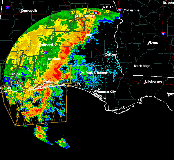 At 1036 pm cdt, a severe thunderstorm was located 7 miles north of niceville, moving northeast at 20 mph (radar indicated). Hazards include 60 mph wind gusts and quarter size hail. Hail damage to vehicles is expected. expect wind damage to roofs, siding, and trees. Locations impacted include, wright, crestview, niceville, eglin afb, valparaiso, laurel hill and eglin air force base. At 1036 pm cdt, a severe thunderstorm was located 7 miles north of niceville, moving northeast at 20 mph (radar indicated). Hazards include 60 mph wind gusts and quarter size hail. Hail damage to vehicles is expected. expect wind damage to roofs, siding, and trees. Locations impacted include, wright, crestview, niceville, eglin afb, valparaiso, laurel hill and eglin air force base.
|
| 5/20/2017 10:17 PM CDT |
 At 1016 pm cdt, a severe thunderstorm was located near niceville, moving northeast at 20 mph (radar indicated). Hazards include 60 mph wind gusts and quarter size hail. Hail damage to vehicles is expected. Expect wind damage to roofs, siding, and trees. At 1016 pm cdt, a severe thunderstorm was located near niceville, moving northeast at 20 mph (radar indicated). Hazards include 60 mph wind gusts and quarter size hail. Hail damage to vehicles is expected. Expect wind damage to roofs, siding, and trees.
|
| 5/12/2017 3:57 PM CDT |
 The severe thunderstorm warning for east central okaloosa county will expire at 400 pm cdt, the storms which prompted the warning have moved out of the area. therefore the warning will be allowed to expire. a severe thunderstorm watch remains in effect until 400 pm cdt for northwestern florida. The severe thunderstorm warning for east central okaloosa county will expire at 400 pm cdt, the storms which prompted the warning have moved out of the area. therefore the warning will be allowed to expire. a severe thunderstorm watch remains in effect until 400 pm cdt for northwestern florida.
|
| 5/12/2017 3:52 PM CDT |
 At 351 pm cdt, severe thunderstorms were located along a line extending from near samson to 10 miles north of de funiak springs to near niceville, moving east at 40 mph (radar indicated). Hazards include 60 mph wind gusts and penny size hail. Expect damage to roofs, siding, and trees. Locations impacted include, crestview. At 351 pm cdt, severe thunderstorms were located along a line extending from near samson to 10 miles north of de funiak springs to near niceville, moving east at 40 mph (radar indicated). Hazards include 60 mph wind gusts and penny size hail. Expect damage to roofs, siding, and trees. Locations impacted include, crestview.
|
| 5/12/2017 3:42 PM CDT |
 At 342 pm cdt, severe thunderstorms were located along a line extending from near opp to 9 miles southeast of florala to 6 miles northwest of valparaiso, moving east at 35 mph (radar indicated). Hazards include 60 mph wind gusts and penny size hail. Expect damage to roofs, siding, and trees. Locations impacted include, crestview, opp, florala, laurel hill and lockhart. At 342 pm cdt, severe thunderstorms were located along a line extending from near opp to 9 miles southeast of florala to 6 miles northwest of valparaiso, moving east at 35 mph (radar indicated). Hazards include 60 mph wind gusts and penny size hail. Expect damage to roofs, siding, and trees. Locations impacted include, crestview, opp, florala, laurel hill and lockhart.
|
| 5/12/2017 3:42 PM CDT |
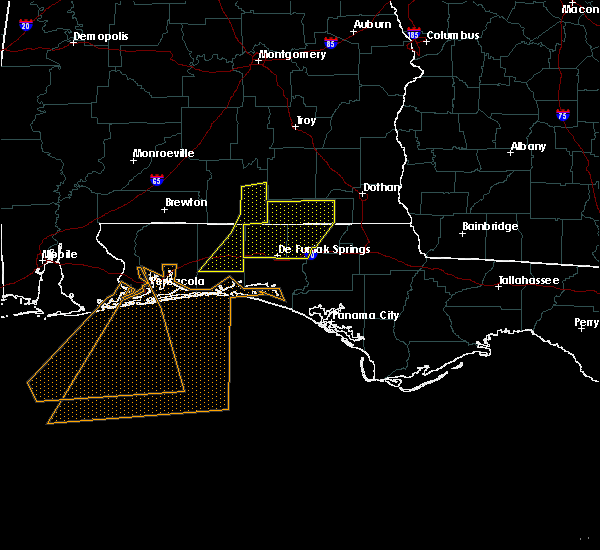 At 342 pm cdt, severe thunderstorms were located along a line extending from near opp to 9 miles southeast of florala to 6 miles northwest of valparaiso, moving east at 35 mph (radar indicated). Hazards include 60 mph wind gusts and penny size hail. Expect damage to roofs, siding, and trees. Locations impacted include, crestview, opp, florala, laurel hill and lockhart. At 342 pm cdt, severe thunderstorms were located along a line extending from near opp to 9 miles southeast of florala to 6 miles northwest of valparaiso, moving east at 35 mph (radar indicated). Hazards include 60 mph wind gusts and penny size hail. Expect damage to roofs, siding, and trees. Locations impacted include, crestview, opp, florala, laurel hill and lockhart.
|
| 5/12/2017 3:28 PM CDT |
 At 328 pm cdt, severe thunderstorms were located along a line extending from 10 miles southwest of opp to florala to 9 miles north of wright, moving east at 40 mph (radar indicated). Hazards include 60 mph wind gusts and penny size hail. Expect damage to roofs, siding, and trees. Locations impacted include, crestview, opp, florala, baker, laurel hill and lockhart. At 328 pm cdt, severe thunderstorms were located along a line extending from 10 miles southwest of opp to florala to 9 miles north of wright, moving east at 40 mph (radar indicated). Hazards include 60 mph wind gusts and penny size hail. Expect damage to roofs, siding, and trees. Locations impacted include, crestview, opp, florala, baker, laurel hill and lockhart.
|
| 5/12/2017 3:20 PM CDT |
 At 320 pm cdt, severe thunderstorms were located along a line extending from 6 miles east of andalusia to near laurel hill to 13 miles northwest of wright, moving northeast at 90 mph (radar indicated). Hazards include 60 mph wind gusts and penny size hail. Expect damage to roofs, siding, and trees. Locations impacted include, crestview, opp, florala, baker, laurel hill and lockhart. At 320 pm cdt, severe thunderstorms were located along a line extending from 6 miles east of andalusia to near laurel hill to 13 miles northwest of wright, moving northeast at 90 mph (radar indicated). Hazards include 60 mph wind gusts and penny size hail. Expect damage to roofs, siding, and trees. Locations impacted include, crestview, opp, florala, baker, laurel hill and lockhart.
|
| 5/12/2017 3:00 PM CDT |
 At 300 pm cdt, severe thunderstorms were located along a line extending from 16 miles southwest of river falls to near baker to bagdad, moving east at 45 mph (radar indicated). Hazards include 60 mph wind gusts and penny size hail. expect damage to roofs, siding, and trees At 300 pm cdt, severe thunderstorms were located along a line extending from 16 miles southwest of river falls to near baker to bagdad, moving east at 45 mph (radar indicated). Hazards include 60 mph wind gusts and penny size hail. expect damage to roofs, siding, and trees
|
| 5/12/2017 3:00 PM CDT |
 The national weather service in mobile has issued a * severe thunderstorm warning for. southern covington county in south central alabama. central okaloosa county in northwestern florida. east central santa rosa county in northwestern florida. Until 400 pm cdt. The national weather service in mobile has issued a * severe thunderstorm warning for. southern covington county in south central alabama. central okaloosa county in northwestern florida. east central santa rosa county in northwestern florida. Until 400 pm cdt.
|
| 4/5/2017 12:23 AM CDT |
 The severe thunderstorm warning for central okaloosa county will expire at 1230 am cdt, the storm which prompted the warning has weakened below severe limits, therefore the warning will be allowed to expire. The severe thunderstorm warning for central okaloosa county will expire at 1230 am cdt, the storm which prompted the warning has weakened below severe limits, therefore the warning will be allowed to expire.
|
| 4/5/2017 12:03 AM CDT |
 At 1202 am cdt, a severe thunderstorm was located 7 miles southwest of crestview, moving northeast at 30 mph (radar indicated). Hazards include 60 mph wind gusts. Expect damage to roofs, siding, and trees. Locations impacted include, crestview. At 1202 am cdt, a severe thunderstorm was located 7 miles southwest of crestview, moving northeast at 30 mph (radar indicated). Hazards include 60 mph wind gusts. Expect damage to roofs, siding, and trees. Locations impacted include, crestview.
|
| 4/4/2017 11:40 PM CDT |
 At 1140 pm cdt, a severe thunderstorm was located 11 miles southeast of roeville, or 12 miles east of bagdad, moving northeast at 30 mph (radar indicated). Hazards include 60 mph wind gusts and quarter size hail. Hail damage to vehicles is expected. Expect wind damage to roofs, siding, and trees. At 1140 pm cdt, a severe thunderstorm was located 11 miles southeast of roeville, or 12 miles east of bagdad, moving northeast at 30 mph (radar indicated). Hazards include 60 mph wind gusts and quarter size hail. Hail damage to vehicles is expected. Expect wind damage to roofs, siding, and trees.
|
| 4/3/2017 11:00 AM CDT |
 At 1100 am cdt, severe thunderstorms were located along a line extending from near navarre to 9 miles south of navarre beach to 15 miles south of pensacola beach, moving northeast at 35 mph (radar indicated). Hazards include 60 mph wind gusts and quarter size hail. Hail damage to vehicles is expected. Expect wind damage to roofs, siding, and trees. At 1100 am cdt, severe thunderstorms were located along a line extending from near navarre to 9 miles south of navarre beach to 15 miles south of pensacola beach, moving northeast at 35 mph (radar indicated). Hazards include 60 mph wind gusts and quarter size hail. Hail damage to vehicles is expected. Expect wind damage to roofs, siding, and trees.
|
| 4/3/2017 10:14 AM CDT |
 At 1014 am cdt, severe thunderstorms were located along a line extending from 10 miles southeast of crestview to navarre beach, moving southeast at 20 mph (radar indicated). Hazards include 60 mph wind gusts and quarter size hail. Hail damage to vehicles is expected. Expect wind damage to roofs, siding, and trees. At 1014 am cdt, severe thunderstorms were located along a line extending from 10 miles southeast of crestview to navarre beach, moving southeast at 20 mph (radar indicated). Hazards include 60 mph wind gusts and quarter size hail. Hail damage to vehicles is expected. Expect wind damage to roofs, siding, and trees.
|
| 4/3/2017 9:52 AM CDT |
 At 951 am cdt, severe thunderstorms were located along a line extending from 9 miles west of samson to near laurel hill to 7 miles northwest of valparaiso, moving east at 40 mph (radar indicated). Hazards include 60 mph wind gusts. Expect damage to roofs, siding, and trees. locations impacted include, wright, fort walton beach, crestview, niceville, destin, andalusia, eglin afb, opp, valparaiso, mary esther, florala, ocean city, lake lorraine, baker, shalimar, river falls, laurel hill, lockhart, cinco bayou and heath. A tornado watch remains in effect until 100 pm cdt for south central alabama, and northwestern florida. At 951 am cdt, severe thunderstorms were located along a line extending from 9 miles west of samson to near laurel hill to 7 miles northwest of valparaiso, moving east at 40 mph (radar indicated). Hazards include 60 mph wind gusts. Expect damage to roofs, siding, and trees. locations impacted include, wright, fort walton beach, crestview, niceville, destin, andalusia, eglin afb, opp, valparaiso, mary esther, florala, ocean city, lake lorraine, baker, shalimar, river falls, laurel hill, lockhart, cinco bayou and heath. A tornado watch remains in effect until 100 pm cdt for south central alabama, and northwestern florida.
|
| 4/3/2017 9:36 AM CDT |
 At 935 am cdt, severe thunderstorms were located along a line extending from 8 miles southeast of andalusia to near baker to 12 miles northwest of wright, moving east at 30 mph (radar indicated). Hazards include 60 mph wind gusts. expect damage to roofs, siding, and trees At 935 am cdt, severe thunderstorms were located along a line extending from 8 miles southeast of andalusia to near baker to 12 miles northwest of wright, moving east at 30 mph (radar indicated). Hazards include 60 mph wind gusts. expect damage to roofs, siding, and trees
|
| 2/7/2017 3:24 PM CST | Tree down on house in crestview... fl. timing estimated by rada in okaloosa county FL, 0.8 miles WSW of Crestview, FL |
| 2/7/2017 3:01 PM CST |
 At 301 pm cst, severe thunderstorms were located along a line extending from roeville to near warrington to near orange beach, moving east at 60 mph (radar indicated). Hazards include 70 mph wind gusts and half dollar size hail. Hail damage to vehicles is expected. expect considerable tree damage. Wind damage is also likely to mobile homes, roofs, and outbuildings. At 301 pm cst, severe thunderstorms were located along a line extending from roeville to near warrington to near orange beach, moving east at 60 mph (radar indicated). Hazards include 70 mph wind gusts and half dollar size hail. Hail damage to vehicles is expected. expect considerable tree damage. Wind damage is also likely to mobile homes, roofs, and outbuildings.
|
| 1/22/2017 11:56 AM CST |
 The severe thunderstorm warning for southeastern covington and okaloosa counties will expire at noon cst, the storms which prompted the warning have both weakened below severe limits, and are also in the process of exiting the warned area. therefore the warning will be allowed to expire. however gusty winds are still possible with these thunderstorms. a tornado watch remains in effect until 200 pm cst for south central alabama, and northwestern florida. The severe thunderstorm warning for southeastern covington and okaloosa counties will expire at noon cst, the storms which prompted the warning have both weakened below severe limits, and are also in the process of exiting the warned area. therefore the warning will be allowed to expire. however gusty winds are still possible with these thunderstorms. a tornado watch remains in effect until 200 pm cst for south central alabama, and northwestern florida.
|
| 1/22/2017 11:30 AM CST |
 At 1129 am cst, severe thunderstorms were located along a line extending from near florala to near mary esther, moving east at 40 mph (radar indicated). Hazards include 60 mph wind gusts. Expect damage to roofs, siding, and trees. locations impacted include, wright, fort walton beach, crestview, niceville, destin, eglin afb, valparaiso, mary esther, florala, ocean city, lake lorraine, shalimar, laurel hill, lockhart, cinco bayou and eglin air force base. A tornado watch remains in effect until 200 pm cst for south central alabama, and northwestern florida. At 1129 am cst, severe thunderstorms were located along a line extending from near florala to near mary esther, moving east at 40 mph (radar indicated). Hazards include 60 mph wind gusts. Expect damage to roofs, siding, and trees. locations impacted include, wright, fort walton beach, crestview, niceville, destin, eglin afb, valparaiso, mary esther, florala, ocean city, lake lorraine, shalimar, laurel hill, lockhart, cinco bayou and eglin air force base. A tornado watch remains in effect until 200 pm cst for south central alabama, and northwestern florida.
|
| 1/22/2017 11:02 AM CST |
 At 1102 am cst, severe thunderstorms were located along a line extending from 7 miles west of laurel hill to near oriole beach, moving east at 40 mph (radar indicated). Hazards include 60 mph wind gusts. expect damage to roofs, siding, and trees At 1102 am cst, severe thunderstorms were located along a line extending from 7 miles west of laurel hill to near oriole beach, moving east at 40 mph (radar indicated). Hazards include 60 mph wind gusts. expect damage to roofs, siding, and trees
|
| 1/22/2017 8:21 AM CST |
 At 821 am cst, a severe thunderstorm was located near navarre beach, or 7 miles west of mary esther, moving northeast at 45 mph (radar indicated). Hazards include 60 mph wind gusts. expect damage to roofs, siding, and trees At 821 am cst, a severe thunderstorm was located near navarre beach, or 7 miles west of mary esther, moving northeast at 45 mph (radar indicated). Hazards include 60 mph wind gusts. expect damage to roofs, siding, and trees
|
| 1/21/2017 9:37 PM CST |
 At 936 pm cst, a severe thunderstorm was located near oriole beach, or 9 miles east of gulf breeze, moving northeast at 45 mph (radar indicated). Hazards include 60 mph wind gusts and quarter size hail. Hail damage to vehicles is expected. Expect wind damage to roofs, siding, and trees. At 936 pm cst, a severe thunderstorm was located near oriole beach, or 9 miles east of gulf breeze, moving northeast at 45 mph (radar indicated). Hazards include 60 mph wind gusts and quarter size hail. Hail damage to vehicles is expected. Expect wind damage to roofs, siding, and trees.
|
| 1/21/2017 7:53 PM CST |
 At 753 pm cst, a severe thunderstorm was located near point baker, or near pace, moving northeast at 55 mph (radar indicated). Hazards include ping pong ball size hail and 60 mph wind gusts. People and animals outdoors will be injured. expect hail damage to roofs, siding, windows, and vehicles. Expect wind damage to roofs, siding, and trees. At 753 pm cst, a severe thunderstorm was located near point baker, or near pace, moving northeast at 55 mph (radar indicated). Hazards include ping pong ball size hail and 60 mph wind gusts. People and animals outdoors will be injured. expect hail damage to roofs, siding, windows, and vehicles. Expect wind damage to roofs, siding, and trees.
|
| 1/21/2017 9:56 AM CST |
 At 956 am cst, severe thunderstorms were located along a line extending from crestview to near navarre beach, moving east at 55 mph (radar indicated). Hazards include 60 mph wind gusts. expect damage to roofs, siding, and trees At 956 am cst, severe thunderstorms were located along a line extending from crestview to near navarre beach, moving east at 55 mph (radar indicated). Hazards include 60 mph wind gusts. expect damage to roofs, siding, and trees
|
| 1/21/2017 9:25 AM CST |
 At 925 am cst, a severe thunderstorm was located near baker, or 7 miles northwest of crestview, moving east at 40 mph (radar indicated). Hazards include 60 mph wind gusts. expect damage to roofs, siding, and trees At 925 am cst, a severe thunderstorm was located near baker, or 7 miles northwest of crestview, moving east at 40 mph (radar indicated). Hazards include 60 mph wind gusts. expect damage to roofs, siding, and trees
|
| 1/2/2017 7:01 PM CST |
 At 700 pm cst, severe thunderstorms were located along a line extending from near new brockton, to 8 miles southwest of geneva, to 11 miles northeast of de funiak springs, to near eglin air force base, to destin, moving east at 65 mph (radar indicated). Hazards include 60 mph wind gusts and nickel size hail. Expect damage to roofs, siding, and trees. locations impacted include, wright, fort walton beach, crestview, niceville, destin, eglin afb, valparaiso, mary esther, ocean city, lake lorraine, navarre, shalimar, cinco bayou, navarre beach and eglin air force base. A tornado watch remains in effect until 800 pm cst for northwestern florida. At 700 pm cst, severe thunderstorms were located along a line extending from near new brockton, to 8 miles southwest of geneva, to 11 miles northeast of de funiak springs, to near eglin air force base, to destin, moving east at 65 mph (radar indicated). Hazards include 60 mph wind gusts and nickel size hail. Expect damage to roofs, siding, and trees. locations impacted include, wright, fort walton beach, crestview, niceville, destin, eglin afb, valparaiso, mary esther, ocean city, lake lorraine, navarre, shalimar, cinco bayou, navarre beach and eglin air force base. A tornado watch remains in effect until 800 pm cst for northwestern florida.
|
| 1/2/2017 6:44 PM CST |
 At 643 pm cst, severe thunderstorms were located along a line extending from opp, to 6 miles southeast of florala, to near niceville, to 7 miles southwest of mary esther, moving east at 60 mph (radar indicated). Hazards include 60 mph wind gusts and nickel size hail. expect damage to roofs, siding, and trees At 643 pm cst, severe thunderstorms were located along a line extending from opp, to 6 miles southeast of florala, to near niceville, to 7 miles southwest of mary esther, moving east at 60 mph (radar indicated). Hazards include 60 mph wind gusts and nickel size hail. expect damage to roofs, siding, and trees
|
| 1/2/2017 6:29 PM CST |
 At 628 pm cst, severe thunderstorms were located along a line extending from red level, to 7 miles south of andalusia, to near laurel hill, to near crestview, to near pensacola beach, moving east at 45 mph (radar indicated). Hazards include 60 mph wind gusts and nickel size hail. Expect damage to roofs, siding, and trees. locations impacted include, pensacola, ferry pass, brent, west pensacola, wright, fort walton beach, ensley, warrington, crestview, niceville, gonzalez, destin, gulf shores, andalusia, eglin afb, foley, pace, milton, opp and valparaiso. A tornado watch remains in effect until 800 pm cst for south central and southwestern alabama, and northwestern florida. At 628 pm cst, severe thunderstorms were located along a line extending from red level, to 7 miles south of andalusia, to near laurel hill, to near crestview, to near pensacola beach, moving east at 45 mph (radar indicated). Hazards include 60 mph wind gusts and nickel size hail. Expect damage to roofs, siding, and trees. locations impacted include, pensacola, ferry pass, brent, west pensacola, wright, fort walton beach, ensley, warrington, crestview, niceville, gonzalez, destin, gulf shores, andalusia, eglin afb, foley, pace, milton, opp and valparaiso. A tornado watch remains in effect until 800 pm cst for south central and southwestern alabama, and northwestern florida.
|
| 1/2/2017 6:13 PM CST |
 At 612 pm cst, severe thunderstorms were located along a line extending from 8 miles east of evergreen, to 13 miles southwest of river falls, to 10 miles north of baker, to 9 miles east of roeville, to 9 miles south of warrington, moving east at 45 mph (radar indicated). Hazards include 60 mph wind gusts and nickel size hail. Expect damage to roofs, siding, and trees. locations impacted include, pensacola, ferry pass, brent, west pensacola, wright, fort walton beach, ensley, warrington, crestview, niceville, gonzalez, destin, gulf shores, andalusia, eglin afb, foley, pace, milton, opp and valparaiso. A tornado watch remains in effect until 800 pm cst for south central and southwestern alabama, and northwestern florida. At 612 pm cst, severe thunderstorms were located along a line extending from 8 miles east of evergreen, to 13 miles southwest of river falls, to 10 miles north of baker, to 9 miles east of roeville, to 9 miles south of warrington, moving east at 45 mph (radar indicated). Hazards include 60 mph wind gusts and nickel size hail. Expect damage to roofs, siding, and trees. locations impacted include, pensacola, ferry pass, brent, west pensacola, wright, fort walton beach, ensley, warrington, crestview, niceville, gonzalez, destin, gulf shores, andalusia, eglin afb, foley, pace, milton, opp and valparaiso. A tornado watch remains in effect until 800 pm cst for south central and southwestern alabama, and northwestern florida.
|
| 1/2/2017 5:42 PM CST |
 At 541 pm cst, severe thunderstorms were located along a line extending from near repton to near brewton to 8 miles east of jay to gulf shores, moving east at 45 mph (radar indicated). Hazards include 60 mph wind gusts and up to quarter size hail. expect damage to roofs, siding, and trees At 541 pm cst, severe thunderstorms were located along a line extending from near repton to near brewton to 8 miles east of jay to gulf shores, moving east at 45 mph (radar indicated). Hazards include 60 mph wind gusts and up to quarter size hail. expect damage to roofs, siding, and trees
|
| 1/2/2017 4:04 PM CST |
 At 403 pm cst, an area of severe thunderstorms was generally located along a line extending from near pace to near goulding to 10 miles south of warrington, moving northeast at 30 mph (radar indicated). Hazards include 60 mph wind gusts. Expect damage to roofs, siding, and trees. locations impacted include, pensacola, ferry pass, brent, west pensacola, wright, fort walton beach, ensley, warrington, crestview, niceville, gonzalez, destin, eglin afb, pace, milton, valparaiso, gulf breeze, goulding, mary esther and bagdad. A tornado watch remains in effect until 800 pm cst for northwestern florida. At 403 pm cst, an area of severe thunderstorms was generally located along a line extending from near pace to near goulding to 10 miles south of warrington, moving northeast at 30 mph (radar indicated). Hazards include 60 mph wind gusts. Expect damage to roofs, siding, and trees. locations impacted include, pensacola, ferry pass, brent, west pensacola, wright, fort walton beach, ensley, warrington, crestview, niceville, gonzalez, destin, eglin afb, pace, milton, valparaiso, gulf breeze, goulding, mary esther and bagdad. A tornado watch remains in effect until 800 pm cst for northwestern florida.
|
| 1/2/2017 3:17 PM CST |
 At 317 pm cst, severe thunderstorms were located along a line extending from near gonzalez to myrtle grove to 10 miles southeast of perdido beach, moving east at 45 mph (radar indicated). Hazards include 70 mph wind gusts and quarter size hail. Hail damage to vehicles is expected. expect considerable tree damage. Wind damage is also likely to mobile homes, roofs, and outbuildings. At 317 pm cst, severe thunderstorms were located along a line extending from near gonzalez to myrtle grove to 10 miles southeast of perdido beach, moving east at 45 mph (radar indicated). Hazards include 70 mph wind gusts and quarter size hail. Hail damage to vehicles is expected. expect considerable tree damage. Wind damage is also likely to mobile homes, roofs, and outbuildings.
|
| 12/4/2016 1:42 PM CST |
 At 142 pm cst, a severe thunderstorm was located over crestview, moving northeast at 25 mph (radar indicated). Hazards include 60 mph wind gusts. Expect damage to roofs. siding. and trees. Locations impacted include, crestview. At 142 pm cst, a severe thunderstorm was located over crestview, moving northeast at 25 mph (radar indicated). Hazards include 60 mph wind gusts. Expect damage to roofs. siding. and trees. Locations impacted include, crestview.
|
| 12/4/2016 1:18 PM CST |
 At 118 pm cst, a severe thunderstorm was located 9 miles south of baker, or 11 miles southwest of crestview, moving northeast at 25 mph (radar indicated). Hazards include 60 mph wind gusts. Expect damage to roofs. siding. And trees. At 118 pm cst, a severe thunderstorm was located 9 miles south of baker, or 11 miles southwest of crestview, moving northeast at 25 mph (radar indicated). Hazards include 60 mph wind gusts. Expect damage to roofs. siding. And trees.
|
| 6/17/2016 7:30 PM CDT | County 911 communications reports numerous trees down county wid in okaloosa county FL, 0.8 miles WSW of Crestview, FL |
| 6/17/2016 7:20 PM CDT |
 At 719 pm cdt, severe thunderstorms were located along a line extending from 6 miles northwest of vancleave to near tillmans corner to 8 miles east of robertsdale to near point baker to 12 miles north of eglin air force base, moving southeast at 45 mph. wind damage will likely occur along a gust front ahead of the rain and lightning and will continue with the thunderstorms that follow (trained weather spotters. numerous reports of wind damage and measured gusts to 60 mph have been received). Hazards include 60 mph wind gusts and penny size hail. Expect damage to roofs. siding. And trees. At 719 pm cdt, severe thunderstorms were located along a line extending from 6 miles northwest of vancleave to near tillmans corner to 8 miles east of robertsdale to near point baker to 12 miles north of eglin air force base, moving southeast at 45 mph. wind damage will likely occur along a gust front ahead of the rain and lightning and will continue with the thunderstorms that follow (trained weather spotters. numerous reports of wind damage and measured gusts to 60 mph have been received). Hazards include 60 mph wind gusts and penny size hail. Expect damage to roofs. siding. And trees.
|
| 6/17/2016 6:53 PM CDT |
 At 652 pm cdt, severe thunderstorms were located along a line extending from near new brockton to near laurel hill to 8 miles southeast of riverview, moving southeast at 50 mph. wind damage will likely occur along a gust front ahead of the rain and lightning and will continue with the thunderstorms that follow (radar indicated). Hazards include 60 mph wind gusts and penny size hail. Expect damage to roofs. siding. And trees. At 652 pm cdt, severe thunderstorms were located along a line extending from near new brockton to near laurel hill to 8 miles southeast of riverview, moving southeast at 50 mph. wind damage will likely occur along a gust front ahead of the rain and lightning and will continue with the thunderstorms that follow (radar indicated). Hazards include 60 mph wind gusts and penny size hail. Expect damage to roofs. siding. And trees.
|
| 3/24/2016 3:36 PM CDT |
 At 335 pm cdt, severe thunderstorms were located along a line extending from 11 miles east of crestview to near lake lorraine to 20 miles south of navarre beach, moving east at 50 mph (radar indicated). Hazards include 60 mph wind gusts and nickel size hail. Expect damage to roofs. siding. and trees. locations impacted include, crestview, fort walton beach, niceville, destin, valparaiso, mary esther, wright, ocean city, eglin afb, lake lorraine, shalimar, cinco bayou, postil and fort walton beach--navarre--wright. A tornado watch remains in effect until 700 pm cdt for northwestern florida. At 335 pm cdt, severe thunderstorms were located along a line extending from 11 miles east of crestview to near lake lorraine to 20 miles south of navarre beach, moving east at 50 mph (radar indicated). Hazards include 60 mph wind gusts and nickel size hail. Expect damage to roofs. siding. and trees. locations impacted include, crestview, fort walton beach, niceville, destin, valparaiso, mary esther, wright, ocean city, eglin afb, lake lorraine, shalimar, cinco bayou, postil and fort walton beach--navarre--wright. A tornado watch remains in effect until 700 pm cdt for northwestern florida.
|
| 3/24/2016 3:16 PM CDT |
 At 316 pm cdt, severe thunderstorms were located along a line extending from near florala to near navarre beach to 16 miles south of gulf breeze, moving east at 45 mph (radar indicated). Hazards include 60 mph wind gusts and nickel size hail. Expect damage to roofs. siding. and trees. locations impacted include, pensacola, crestview, fort walton beach, niceville, destin, milton, valparaiso, mary esther, bagdad, lake lorraine, wright, ocean city, eglin afb, baker, midway, shalimar, laurel hill, cinco bayou, navarre and postil. A tornado watch remains in effect until 700 pm cdt for northwestern florida. At 316 pm cdt, severe thunderstorms were located along a line extending from near florala to near navarre beach to 16 miles south of gulf breeze, moving east at 45 mph (radar indicated). Hazards include 60 mph wind gusts and nickel size hail. Expect damage to roofs. siding. and trees. locations impacted include, pensacola, crestview, fort walton beach, niceville, destin, milton, valparaiso, mary esther, bagdad, lake lorraine, wright, ocean city, eglin afb, baker, midway, shalimar, laurel hill, cinco bayou, navarre and postil. A tornado watch remains in effect until 700 pm cdt for northwestern florida.
|
| 3/24/2016 2:41 PM CDT |
 At 241 pm cdt, severe thunderstorms were located along a line extending from 12 miles north of baker to pensacola to 12 miles south of orange beach, moving east at 50 mph (radar indicated). Hazards include 60 mph wind gusts and nickel size hail. Expect damage to roofs. siding. And trees. At 241 pm cdt, severe thunderstorms were located along a line extending from 12 miles north of baker to pensacola to 12 miles south of orange beach, moving east at 50 mph (radar indicated). Hazards include 60 mph wind gusts and nickel size hail. Expect damage to roofs. siding. And trees.
|
| 3/17/2016 10:15 PM CDT |
 At 1015 pm cdt, a severe thunderstorm was located near niceville, moving southeast at 40 mph (radar indicated). Hazards include 60 mph wind gusts and quarter size hail. Hail damage to vehicles is expected. Expect wind damage to roofs, siding, and trees. At 1015 pm cdt, a severe thunderstorm was located near niceville, moving southeast at 40 mph (radar indicated). Hazards include 60 mph wind gusts and quarter size hail. Hail damage to vehicles is expected. Expect wind damage to roofs, siding, and trees.
|
| 3/17/2016 10:07 PM CDT |
 At 1006 pm cdt, a severe thunderstorm was located near niceville, moving southeast at 45 mph (radar indicated). Hazards include 60 mph wind gusts and quarter size hail. Hail damage to vehicles is expected. expect wind damage to roofs, siding, and trees. Locations impacted include, crestview, niceville, valparaiso, baker and fort walton beach, navarre, wright. At 1006 pm cdt, a severe thunderstorm was located near niceville, moving southeast at 45 mph (radar indicated). Hazards include 60 mph wind gusts and quarter size hail. Hail damage to vehicles is expected. expect wind damage to roofs, siding, and trees. Locations impacted include, crestview, niceville, valparaiso, baker and fort walton beach, navarre, wright.
|
| 3/17/2016 9:51 PM CDT |
 At 949 pm cdt, a severe thunderstorm was located near baker, or 8 miles southwest of crestview, moving east at 45 mph (radar indicated). Hazards include 60 mph wind gusts and quarter size hail. Hail damage to vehicles is expected. expect wind damage to roofs, siding, and trees. Locations impacted include, crestview, niceville, valparaiso, baker and fort walton beach, navarre, wright. At 949 pm cdt, a severe thunderstorm was located near baker, or 8 miles southwest of crestview, moving east at 45 mph (radar indicated). Hazards include 60 mph wind gusts and quarter size hail. Hail damage to vehicles is expected. expect wind damage to roofs, siding, and trees. Locations impacted include, crestview, niceville, valparaiso, baker and fort walton beach, navarre, wright.
|
| 3/17/2016 9:28 PM CDT |
 At 928 pm cdt, a severe thunderstorm was located near whiting field, or 8 miles northeast of milton, moving east at 45 mph (radar indicated). Hazards include 60 mph wind gusts and quarter size hail. Hail damage to vehicles is expected. Expect wind damage to roofs, siding, and trees. At 928 pm cdt, a severe thunderstorm was located near whiting field, or 8 miles northeast of milton, moving east at 45 mph (radar indicated). Hazards include 60 mph wind gusts and quarter size hail. Hail damage to vehicles is expected. Expect wind damage to roofs, siding, and trees.
|
| 3/3/2016 7:10 PM CST | At least 8 large oak trees reported down near lake silver rd...mcdonald rd and genevieve way. relayed via social medi in okaloosa county FL, 5.1 miles S of Crestview, FL |
| 3/3/2016 7:01 PM CST |
 At 700 pm cst, a severe thunderstorm was located near baker, or 7 miles north of crestview, moving east at 60 mph (radar indicated). Hazards include 60 mph wind gusts and quarter size hail. Hail damage to vehicles is expected. expect wind damage to roofs, siding, and trees. Locations impacted include, crestview and baker. At 700 pm cst, a severe thunderstorm was located near baker, or 7 miles north of crestview, moving east at 60 mph (radar indicated). Hazards include 60 mph wind gusts and quarter size hail. Hail damage to vehicles is expected. expect wind damage to roofs, siding, and trees. Locations impacted include, crestview and baker.
|
| 3/3/2016 6:39 PM CST |
 At 639 pm cst, a severe thunderstorm was located near whitfield, or 14 miles south of east brewton, moving east at 45 mph (radar indicated). Hazards include 60 mph wind gusts and quarter size hail. Hail damage to vehicles is expected. Expect wind damage to roofs, siding, and trees. At 639 pm cst, a severe thunderstorm was located near whitfield, or 14 miles south of east brewton, moving east at 45 mph (radar indicated). Hazards include 60 mph wind gusts and quarter size hail. Hail damage to vehicles is expected. Expect wind damage to roofs, siding, and trees.
|
| 2/23/2016 9:19 PM CST |
 At 918 pm cst, a severe thunderstorm capable of producing a tornado was located 8 miles southeast of crestview, moving northeast at 45 mph (radar indicated rotation). Hazards include tornado. Flying debris will be dangerous to those caught without shelter. mobile homes will be damaged or destroyed. damage to roofs, windows, and vehicles will occur. tree damage is likely. Locations impacted include, crestview. At 918 pm cst, a severe thunderstorm capable of producing a tornado was located 8 miles southeast of crestview, moving northeast at 45 mph (radar indicated rotation). Hazards include tornado. Flying debris will be dangerous to those caught without shelter. mobile homes will be damaged or destroyed. damage to roofs, windows, and vehicles will occur. tree damage is likely. Locations impacted include, crestview.
|
| 2/23/2016 9:09 PM CST |
 At 908 pm cst, a severe thunderstorm capable of producing a tornado was located 7 miles northwest of niceville, moving northeast at 40 mph (radar indicated rotation). Hazards include tornado. Flying debris will be dangerous to those caught without shelter. mobile homes will be damaged or destroyed. damage to roofs, windows, and vehicles will occur. tree damage is likely. This tornadic thunderstorm will remain over mainly rural areas of southeastern okaloosa county. At 908 pm cst, a severe thunderstorm capable of producing a tornado was located 7 miles northwest of niceville, moving northeast at 40 mph (radar indicated rotation). Hazards include tornado. Flying debris will be dangerous to those caught without shelter. mobile homes will be damaged or destroyed. damage to roofs, windows, and vehicles will occur. tree damage is likely. This tornadic thunderstorm will remain over mainly rural areas of southeastern okaloosa county.
|
| 2/23/2016 9:00 PM CST |
 At 859 pm cst, a severe thunderstorm capable of producing a tornado was located over baker, or near crestview, moving northeast at 50 mph (radar indicated rotation). Hazards include tornado and quarter size hail. Flying debris will be dangerous to those caught without shelter. mobile homes will be damaged or destroyed. damage to roofs, windows, and vehicles will occur. tree damage is likely. This tornadic thunderstorm will remain over mainly rural areas of central okaloosa county. At 859 pm cst, a severe thunderstorm capable of producing a tornado was located over baker, or near crestview, moving northeast at 50 mph (radar indicated rotation). Hazards include tornado and quarter size hail. Flying debris will be dangerous to those caught without shelter. mobile homes will be damaged or destroyed. damage to roofs, windows, and vehicles will occur. tree damage is likely. This tornadic thunderstorm will remain over mainly rural areas of central okaloosa county.
|
| 2/23/2016 8:43 PM CST |
 At 843 pm cst, a severe thunderstorm capable of producing a tornado was located 8 miles east of roeville, or 11 miles east of milton, moving northeast at 50 mph (radar indicated rotation). Hazards include tornado and quarter size hail. Flying debris will be dangerous to those caught without shelter. mobile homes will be damaged or destroyed. damage to roofs, windows, and vehicles will occur. tree damage is likely. this dangerous storm will be near, baker around 900 pm cst. Crestview around 910 pm cst. At 843 pm cst, a severe thunderstorm capable of producing a tornado was located 8 miles east of roeville, or 11 miles east of milton, moving northeast at 50 mph (radar indicated rotation). Hazards include tornado and quarter size hail. Flying debris will be dangerous to those caught without shelter. mobile homes will be damaged or destroyed. damage to roofs, windows, and vehicles will occur. tree damage is likely. this dangerous storm will be near, baker around 900 pm cst. Crestview around 910 pm cst.
|
| 2/23/2016 8:39 PM CST |
 At 839 pm cst, a severe thunderstorm capable of producing a tornado was located near crestview, moving northeast at 35 mph (radar indicated rotation). Hazards include tornado and quarter size hail. Flying debris will be dangerous to those caught without shelter. mobile homes will be damaged or destroyed. damage to roofs, windows, and vehicles will occur. tree damage is likely. This tornadic thunderstorm will remain over mainly rural areas of northeastern okaloosa county. At 839 pm cst, a severe thunderstorm capable of producing a tornado was located near crestview, moving northeast at 35 mph (radar indicated rotation). Hazards include tornado and quarter size hail. Flying debris will be dangerous to those caught without shelter. mobile homes will be damaged or destroyed. damage to roofs, windows, and vehicles will occur. tree damage is likely. This tornadic thunderstorm will remain over mainly rural areas of northeastern okaloosa county.
|
| 2/23/2016 8:31 PM CST |
 At 831 pm cst, a severe thunderstorm was located near crestview, moving northeast at 45 mph (radar indicated). Hazards include 70 mph wind gusts and quarter size hail. Hail damage to vehicles is expected. expect considerable tree damage. Wind damage is also likely to mobile homes, roofs, and outbuildings. At 831 pm cst, a severe thunderstorm was located near crestview, moving northeast at 45 mph (radar indicated). Hazards include 70 mph wind gusts and quarter size hail. Hail damage to vehicles is expected. expect considerable tree damage. Wind damage is also likely to mobile homes, roofs, and outbuildings.
|
| 2/23/2016 8:14 PM CST |
 At 813 pm cst, a severe thunderstorm capable of producing a tornado was located 11 miles northwest of wright, moving northeast at 35 mph (radar indicated rotation). Hazards include tornado and quarter size hail. Flying debris will be dangerous to those caught without shelter. mobile homes will be damaged or destroyed. damage to roofs, windows, and vehicles will occur. tree damage is likely. Locations impacted include, crestview and baker. At 813 pm cst, a severe thunderstorm capable of producing a tornado was located 11 miles northwest of wright, moving northeast at 35 mph (radar indicated rotation). Hazards include tornado and quarter size hail. Flying debris will be dangerous to those caught without shelter. mobile homes will be damaged or destroyed. damage to roofs, windows, and vehicles will occur. tree damage is likely. Locations impacted include, crestview and baker.
|
| 2/23/2016 8:05 PM CST |
 At 805 pm cst, a severe thunderstorm capable of producing a tornado was located 7 miles northeast of holley, or 11 miles northwest of wright, moving northeast at 35 mph (radar indicated rotation). Hazards include tornado and quarter size hail. Flying debris will be dangerous to those caught without shelter. mobile homes will be damaged or destroyed. damage to roofs, windows, and vehicles will occur. tree damage is likely. This tornadic thunderstorm will remain over mainly rural areas of southeastern santa rosa and okaloosa counties. At 805 pm cst, a severe thunderstorm capable of producing a tornado was located 7 miles northeast of holley, or 11 miles northwest of wright, moving northeast at 35 mph (radar indicated rotation). Hazards include tornado and quarter size hail. Flying debris will be dangerous to those caught without shelter. mobile homes will be damaged or destroyed. damage to roofs, windows, and vehicles will occur. tree damage is likely. This tornadic thunderstorm will remain over mainly rural areas of southeastern santa rosa and okaloosa counties.
|
| 2/23/2016 7:23 PM CST |
 At 722 pm cst, severe thunderstorms were located along a line extending from midway to 19 miles south of destin, moving northeast at 55 mph (radar indicated). Hazards include 70 mph wind gusts and quarter size hail. Hail damage to vehicles is expected. expect considerable tree damage. Wind damage is also likely to mobile homes, roofs, and outbuildings. At 722 pm cst, severe thunderstorms were located along a line extending from midway to 19 miles south of destin, moving northeast at 55 mph (radar indicated). Hazards include 70 mph wind gusts and quarter size hail. Hail damage to vehicles is expected. expect considerable tree damage. Wind damage is also likely to mobile homes, roofs, and outbuildings.
|
| 2/15/2016 6:25 PM CST | At 624 pm cst, severe thunderstorms were located along a line extending from near laurel hill to near crestview to near fort walton beach--navarre--wright to 8 miles south of oriole beach, moving east at 50 mph (radar indicated). Hazards include 70 mph wind gusts and quarter size hail. Hail damage to vehicles is expected. expect considerable tree damage. wind damage is also likely to mobile homes, roofs, and outbuildings. locations impacted include, crestview, fort walton beach, niceville, destin, valparaiso, mary esther, florala, wright, ocean city, eglin afb, lake lorraine and baker. A tornado watch remains in effect until 900 pm cst for south central alabama and northwestern florida. |
| 2/15/2016 6:25 PM CST | At 624 pm cst, severe thunderstorms were located along a line extending from near laurel hill to near crestview to near fort walton beach--navarre--wright to 8 miles south of oriole beach, moving east at 50 mph (radar indicated). Hazards include 70 mph wind gusts and quarter size hail. Hail damage to vehicles is expected. expect considerable tree damage. wind damage is also likely to mobile homes, roofs, and outbuildings. locations impacted include, crestview, fort walton beach, niceville, destin, valparaiso, mary esther, florala, wright, ocean city, eglin afb, lake lorraine and baker. A tornado watch remains in effect until 900 pm cst for south central alabama and northwestern florida. |
| 2/15/2016 5:59 PM CST |
 At 559 pm cst, severe thunderstorms were located along a line extending from 12 miles northwest of baker to 8 miles northeast of roeville to near oriole beach to near johnsons beach, moving east at 60 mph (radar indicated). Hazards include 70 mph wind gusts and quarter size hail. Hail damage to vehicles is expected. expect considerable tree damage. Wind damage is also likely to mobile homes, roofs, and outbuildings. At 559 pm cst, severe thunderstorms were located along a line extending from 12 miles northwest of baker to 8 miles northeast of roeville to near oriole beach to near johnsons beach, moving east at 60 mph (radar indicated). Hazards include 70 mph wind gusts and quarter size hail. Hail damage to vehicles is expected. expect considerable tree damage. Wind damage is also likely to mobile homes, roofs, and outbuildings.
|
| 2/3/2016 8:12 AM CST |
 At 811 am cst, severe thunderstorms were located along a line extending from 5 miles west of laurel hill to 4 miles northeast of crestview to 8 miles northeast of holley, moving east at 55 mph (radar indicated). Hazards include 60 mph wind gusts. Expect damage to roofs. siding and trees. Locations impacted include, crestview, baker and laurel hill. At 811 am cst, severe thunderstorms were located along a line extending from 5 miles west of laurel hill to 4 miles northeast of crestview to 8 miles northeast of holley, moving east at 55 mph (radar indicated). Hazards include 60 mph wind gusts. Expect damage to roofs. siding and trees. Locations impacted include, crestview, baker and laurel hill.
|
| 2/3/2016 7:49 AM CST |
 At 748 am cst, severe thunderstorms were located along a line extending from 10 miles northeast of whiting field to 9 miles east of roeville to 7 miles north of holley, moving northeast at 40 mph (radar indicated). Hazards include 60 mph wind gusts and penny size hail. Expect damage to roofs. Siding and trees. At 748 am cst, severe thunderstorms were located along a line extending from 10 miles northeast of whiting field to 9 miles east of roeville to 7 miles north of holley, moving northeast at 40 mph (radar indicated). Hazards include 60 mph wind gusts and penny size hail. Expect damage to roofs. Siding and trees.
|
| 1/22/2016 1:14 AM CST | At 113 am cst, severe thunderstorms were located along a line extending from crestview to 11 miles southeast of baker to niceville to 3 miles west of destin, moving northeast at 50 to55 mph (radar indicated). Hazards include 70 mph wind gusts. Expect considerable tree damage. Damage is likely to mobile homes, roofs and outbuildings. |
| 1/22/2016 1:07 AM CST | A severe thunderstorm warning remains in effect until 115 am cst for central okaloosa county. at 107 am cst. severe thunderstorms were located along a line extending from baker to 6 miles northwest of valparaiso to fort walton beach. moving northeast at 65 mph. hazard. 70 mph wind gusts. |
| 1/22/2016 12:47 AM CST | At 1246 am cst, severe thunderstorms were located along a line extending from 10 miles northeast of whiting field to near navarre beach, moving northeast at 55 mph (radar indicated). Hazards include 70 mph wind gusts. Expect considerable tree damage. damage is likely to mobile homes, roofs and outbuildings. locations impacted include, pensacola, crestview, fort walton beach, niceville, destin, milton, valparaiso, mary esther, wright, ocean city, bagdad and eglin afb. A tornado watch remains in effect until 500 am cst for northwestern florida. |
| 1/22/2016 12:32 AM CST | At 1232 am cst, a severe thunderstorm was located 9 miles southeast of whitfield, or 14 miles northeast of milton, moving northeast at 50 mph (radar indicated). Hazards include 60 mph wind gusts. Expect damage to roofs. Siding and trees. |
| 1/22/2016 12:11 AM CST | The national weather service in mobile has issued a * severe thunderstorm warning for. south central escambia county in northwestern florida. southern santa rosa county in northwestern florida. okaloosa county in northwestern florida. Until 115 am cst. |
| 1/21/2016 6:39 PM CST | At 638 pm cst, a severe thunderstorm was located over wright, moving northeast at 30 mph (radar indicated). Hazards include 60 mph wind gusts and quarter size hail. Hail damage to vehicles is expected. expect wind damage to roofs, siding and trees. Locations impacted include, crestview, fort walton beach, niceville, valparaiso, mary esther, ocean city, eglin afb, lake lorraine, wright, shalimar, cinco bayou and fort walton beach--navarre--wright. |
| 1/21/2016 6:17 PM CST | The national weather service in mobile has issued a * severe thunderstorm warning for. southern okaloosa county in northwestern florida. until 715 pm cst * at 616 pm cst. a severe thunderstorm was located 5 miles southeast of navarre beach. or 8 miles southwest of mary esther. Moving. |
| 12/28/2015 1:12 PM CST |
 At 112 pm cst, severe thunderstorms were located along a line extending from 8 miles west of laurel hill to 7 miles north of wright, moving northeast at 25 mph (radar indicated). Hazards include 60 mph wind gusts. Expect damage to roofs. Siding and trees. At 112 pm cst, severe thunderstorms were located along a line extending from 8 miles west of laurel hill to 7 miles north of wright, moving northeast at 25 mph (radar indicated). Hazards include 60 mph wind gusts. Expect damage to roofs. Siding and trees.
|
| 12/28/2015 1:02 PM CST |
 A severe thunderstorm warning remains in effect until 115 pm cst for central okaloosa county. at 101 pm cst. severe thunderstorms were located along a line extending from 6 miles north of baker to 10 miles southwest of crestview. moving northeast at 25 mph. hazard. 60 mph wind gusts. A severe thunderstorm warning remains in effect until 115 pm cst for central okaloosa county. at 101 pm cst. severe thunderstorms were located along a line extending from 6 miles north of baker to 10 miles southwest of crestview. moving northeast at 25 mph. hazard. 60 mph wind gusts.
|
| 12/28/2015 12:31 PM CST |
 At 1231 pm cst, severe thunderstorms were located along a line extending from 9 miles west of baker to 6 miles northeast of holley, moving northeast at 25 mph (radar indicated). Hazards include 60 mph wind gusts. Expect damage to roofs. Siding and trees. At 1231 pm cst, severe thunderstorms were located along a line extending from 9 miles west of baker to 6 miles northeast of holley, moving northeast at 25 mph (radar indicated). Hazards include 60 mph wind gusts. Expect damage to roofs. Siding and trees.
|
| 11/18/2015 9:57 AM CST | The severe thunderstorm warning for northern okaloosa county will expire at 1000 am cst, the storm which prompted the warning has weakened below severe limits, and no longer pose an immediate threat to life or property. therefore the warning will be allowed to expire. however gusty winds are still possible with this thunderstorm. a tornado watch remains in effect until 400 pm cst for northwestern florida. to report severe weather, contact your nearest law enforcement agency. they will relay your report to the national weather service mobile. stay tuned for further updates from your national weather service in mobile. |
| 11/18/2015 9:47 AM CST |
 At 946 am cst, a severe thunderstorm was located near baker, or near crestview, moving north at 40 mph (radar indicated). Hazards include 60 mph wind gusts. Expect damage to roofs. siding and trees. locations impacted include, crestview and baker. A tornado watch remains in effect until 400 pm cst for northwestern florida. At 946 am cst, a severe thunderstorm was located near baker, or near crestview, moving north at 40 mph (radar indicated). Hazards include 60 mph wind gusts. Expect damage to roofs. siding and trees. locations impacted include, crestview and baker. A tornado watch remains in effect until 400 pm cst for northwestern florida.
|
| 11/18/2015 9:23 AM CST |
 At 923 am cst, a severe thunderstorm was located 10 miles southwest of crestview, moving north at 30 mph (radar indicated). Hazards include 60 mph wind gusts. Expect damage to roofs. siding and trees. locations impacted include, crestview and baker. A tornado watch remains in effect until 400 pm cst for northwestern florida. At 923 am cst, a severe thunderstorm was located 10 miles southwest of crestview, moving north at 30 mph (radar indicated). Hazards include 60 mph wind gusts. Expect damage to roofs. siding and trees. locations impacted include, crestview and baker. A tornado watch remains in effect until 400 pm cst for northwestern florida.
|
| 11/18/2015 9:09 AM CST |
 At 908 am cst, a severe thunderstorm was located near wright, moving north at 30 mph (radar indicated). Hazards include 60 mph wind gusts. Expect damage to roofs. Siding and trees. At 908 am cst, a severe thunderstorm was located near wright, moving north at 30 mph (radar indicated). Hazards include 60 mph wind gusts. Expect damage to roofs. Siding and trees.
|
| 11/18/2015 7:50 AM CST |
 At 749 am cst, a severe thunderstorm was located near baker, or 10 miles northwest of crestview, moving north at 25 mph (radar indicated). Hazards include 60 mph wind gusts. Expect damage to roofs. Siding and trees. At 749 am cst, a severe thunderstorm was located near baker, or 10 miles northwest of crestview, moving north at 25 mph (radar indicated). Hazards include 60 mph wind gusts. Expect damage to roofs. Siding and trees.
|
| 11/2/2015 4:34 AM CST |
 At 433 am cst, a severe thunderstorm was located near crestview, moving northeast at 55 mph (radar indicated). Hazards include 60 mph wind gusts. Expect damage to roofs. siding and trees. Locations impacted include, crestview. At 433 am cst, a severe thunderstorm was located near crestview, moving northeast at 55 mph (radar indicated). Hazards include 60 mph wind gusts. Expect damage to roofs. siding and trees. Locations impacted include, crestview.
|
| 11/2/2015 4:21 AM CST |
 At 420 am cst, a severe thunderstorm was located 9 miles northwest of wright, moving northeast at 20 mph (radar indicated). Hazards include 60 mph wind gusts. Expect damage to roofs. Siding and trees. At 420 am cst, a severe thunderstorm was located 9 miles northwest of wright, moving northeast at 20 mph (radar indicated). Hazards include 60 mph wind gusts. Expect damage to roofs. Siding and trees.
|
| 7/29/2015 1:17 PM CDT |
 At 116 pm cdt, a severe thunderstorm capable of producing damaging winds over 60 mph was located over lockhart, or near florala, and moving south at 15 mph. At 116 pm cdt, a severe thunderstorm capable of producing damaging winds over 60 mph was located over lockhart, or near florala, and moving south at 15 mph.
|
| 6/27/2015 3:43 PM CDT | Tree reported down across florida avenue near laurel hill. time estimated via radar to be between 340 and 345 cd in okaloosa county FL, 7.2 miles SSW of Crestview, FL |
| 6/27/2015 3:43 PM CDT |
 At 342 pm cdt, a line of severe thunderstorms capable of producing damaging winds over 60 mph was located along a line extending from 6 miles southeast of laurel hill to 6 miles east of molino, and moving southeast at 30 mph. At 342 pm cdt, a line of severe thunderstorms capable of producing damaging winds over 60 mph was located along a line extending from 6 miles southeast of laurel hill to 6 miles east of molino, and moving southeast at 30 mph.
|
| 6/23/2015 6:11 PM CDT |
 At 601 pm cdt, the observation station at duke field eglin afb reported a wind gust of 61 mph. at 609 pm cdt, a severe thunderstorm capable of producing quarter size hail and damaging winds over 60 mph was located near eglin afb, moving southeast at 10 mph. At 601 pm cdt, the observation station at duke field eglin afb reported a wind gust of 61 mph. at 609 pm cdt, a severe thunderstorm capable of producing quarter size hail and damaging winds over 60 mph was located near eglin afb, moving southeast at 10 mph.
|
| 6/23/2015 6:02 PM CDT |
 At 601 pm cdt, a severe thunderstorm capable of producing quarter size hail and damaging winds over 60 mph was located 5 miles southwest of crestview, moving southeast at 10 mph. At 601 pm cdt, a severe thunderstorm capable of producing quarter size hail and damaging winds over 60 mph was located 5 miles southwest of crestview, moving southeast at 10 mph.
|
| 6/23/2015 6:01 PM CDT | Measured at keg in okaloosa county FL, 8.2 miles NNW of Crestview, FL |
| 6/23/2015 5:44 PM CDT |
 At 543 pm cdt, a severe thunderstorm capable of producing quarter size hail and damaging winds over 60 mph was located about 6 miles southwest of crestview, and moving southeast at 5 mph. At 543 pm cdt, a severe thunderstorm capable of producing quarter size hail and damaging winds over 60 mph was located about 6 miles southwest of crestview, and moving southeast at 5 mph.
|
| 6/21/2015 4:51 PM CDT |
 At 450 pm cdt, a severe thunderstorm capable of producing damaging winds over 60 mph was located near wright, moving southwest at 15 mph. At 450 pm cdt, a severe thunderstorm capable of producing damaging winds over 60 mph was located near wright, moving southwest at 15 mph.
|
| 6/21/2015 4:13 PM CDT |
 At 413 pm cdt, a severe thunderstorm capable of producing damaging winds over 60 mph was located 8 miles north of wright, and was nearly stationary. At 413 pm cdt, a severe thunderstorm capable of producing damaging winds over 60 mph was located 8 miles north of wright, and was nearly stationary.
|
| 4/25/2015 4:43 PM CDT | At 442 pm cdt, a line of severe thunderstorms capable of producing damaging winds over 60 mph was located along a line extending from near mckenzie to near crestview, and moving east at 25 mph. |
| 4/25/2015 4:43 PM CDT | At 442 pm cdt, a line of severe thunderstorms capable of producing damaging winds over 60 mph was located along a line extending from near mckenzie to near crestview, and moving east at 25 mph. |
| 4/25/2015 4:26 PM CDT | At 425 pm cdt, a cluster of severe thunderstorm capable of producing quarter size hail and damaging winds over 60 mph was located over eastern santa rosa and central okaloosa counties. strongest storm was near crestview. moving east at 45 mph. |
| 4/25/2015 3:57 PM CDT | The national weather service in mobile has issued a * severe thunderstorm warning for. east central santa rosa county in northwestern florida. central okaloosa county in northwestern florida. until 500 pm cdt * at 356 pm cdt. A severe thunderstorm capable of producing quarter. |
| 4/25/2015 3:57 PM CDT | At 356 pm cdt, a severe thunderstorm capable of producing quarter size hail and damaging winds over 60 mph was located over bagdad, and moving northeast at 45 mph. |
| 4/25/2015 3:57 PM CDT | The national weather service in mobile has issued a * severe thunderstorm warning for. east central santa rosa county in northwestern florida. central okaloosa county in northwestern florida. until 500 pm cdt * at 356 pm cdt. A severe thunderstorm capable of producing quarter. |
| 4/25/2015 6:59 AM CDT | At 659 am cdt, a severe thunderstorm capable of producing damaging winds over 60 mph was located near crestview, and moving east at 35 mph. |
| 4/25/2015 6:48 AM CDT | At 646 am cdt, a line of severe thunderstorms capable of producing damaging winds over 60 mph were located along a line extending from 10 miles south of laurel hill to near baker to near roeville, moving east at 35 mph. a tornado watch remains in effect until noon cdt for northwestern florida. |
| 4/25/2015 6:13 AM CDT | At 613 am cdt, a line of severe thunderstorms capable of producing damaging winds over 60 mph was located along a line extending from 10 miles northwest of baker to 7 miles southeast of whitfield to 7 miles west of point baker, and moving southeast at 45 mph. |
| 4/15/2015 6:03 PM CDT | A severe thunderstorm warning remains in effect until 630 pm cdt for central okaloosa county. at 602 pm cdt. a severe thunderstorm capable of producing damaging winds over 60 mph was located 8 miles southwest of baker. or 11 miles southwest of crestview. Moving east at 25 mph. |
| 4/15/2015 5:30 PM CDT | The national weather service in mobile has issued a * severe thunderstorm warning for. east central santa rosa county in northwestern florida. central okaloosa county in northwestern florida. until 630 pm cdt * at 530 pm cdt. A severe thunderstorm capable of producing damaging. |
| 10/14/2014 1:07 AM CDT | 55 knots measured at crestview asos in okaloosa county FL, 4.1 miles WSW of Crestview, FL |
| 4/5/2014 4:20 PM CDT | Quarter sized hail reported 13.4 miles W of Crestview, FL, quarter size hail reported at store just south of i-10 at mile marker 70. |
| 4/5/2014 4:20 PM CDT | Light pole blown down at store south of i-10 at mm7 in walton county FL, 13.4 miles W of Crestview, FL |
| 12/28/2013 5:48 PM CST | Fire department and law enforcement reported two trees down in crestview on antioch road. a power outage occurred at the same time although power lines were not downe in okaloosa county FL, 0.9 miles WNW of Crestview, FL |
| 7/23/2013 5:50 PM CDT | Tree across gillis drive which also took down several utility lines. time estimate in okaloosa county FL, 0.9 miles WNW of Crestview, FL |
| 7/30/2012 2:10 PM CDT | Trees reported down near the intersection of state route 4 and us 9 in okaloosa county FL, 3.4 miles E of Crestview, FL |
| 6/5/2012 3:35 PM CDT | Several powerlines down on state road 18 in okaloosa county FL, 10.3 miles SE of Crestview, FL |
| 1/1/0001 12:00 AM | Duke field /egi/ asos recorded a gust of 63 mp in okaloosa county FL, 8.2 miles NNW of Crestview, FL |
| 1/1/0001 12:00 AM | Pine tree reported blown down onto a house on wadsworth blv in okaloosa county FL, 6.5 miles ESE of Crestview, FL |
| 1/1/0001 12:00 AM | Half Dollar sized hail reported 5.5 miles W of Crestview, FL, half dollar size hail reported 5 miles east of crestview. |
| 1/1/0001 12:00 AM | Half Dollar sized hail reported 4 miles E of Crestview, FL, half dollar size hail reported 5 miles west of crestview |
Hail Maps for Crestview, FL
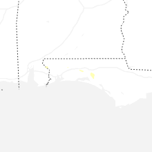
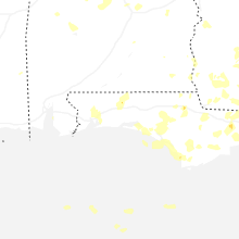
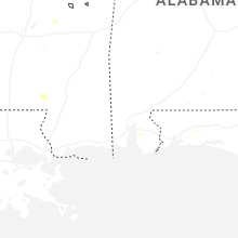
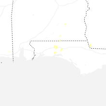
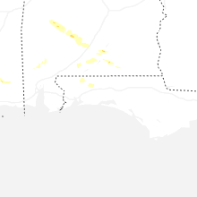
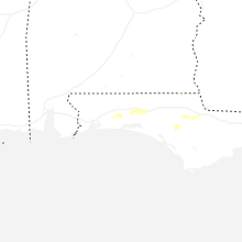
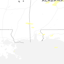
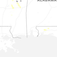
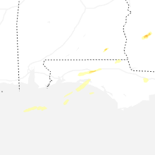


Connect with Interactive Hail Maps