

Hail Map for Cutter, AZ
The Cutter, AZ area has had 0 reports of on-the-ground hail by trained spotters, and has been under severe weather warnings 7 times during the past 12 months. Doppler radar has detected hail at or near Cutter, AZ on 23 occasions.
| Name: | Cutter, AZ |
| Where Located: | 71 miles SSW of Show Low, AZ |
| Map: | Google Map for Cutter, AZ |
| Population: | 74 |
| Housing Units: | 21 |
| More Info: | Search Google for Cutter, AZ |
5
The Top Recent Hail Date for Cutter, AZ is Sunday, July 23, 2017 (1st out of 23)
Hail and Wind Damage Spotted near Cutter, AZ
| Date / Time | Report Details |
|---|---|
| 10/11/2025 10:10 PM MST | the severe thunderstorm warning has been cancelled and is no longer in effect |
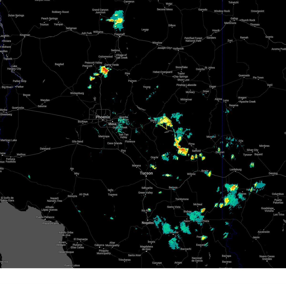
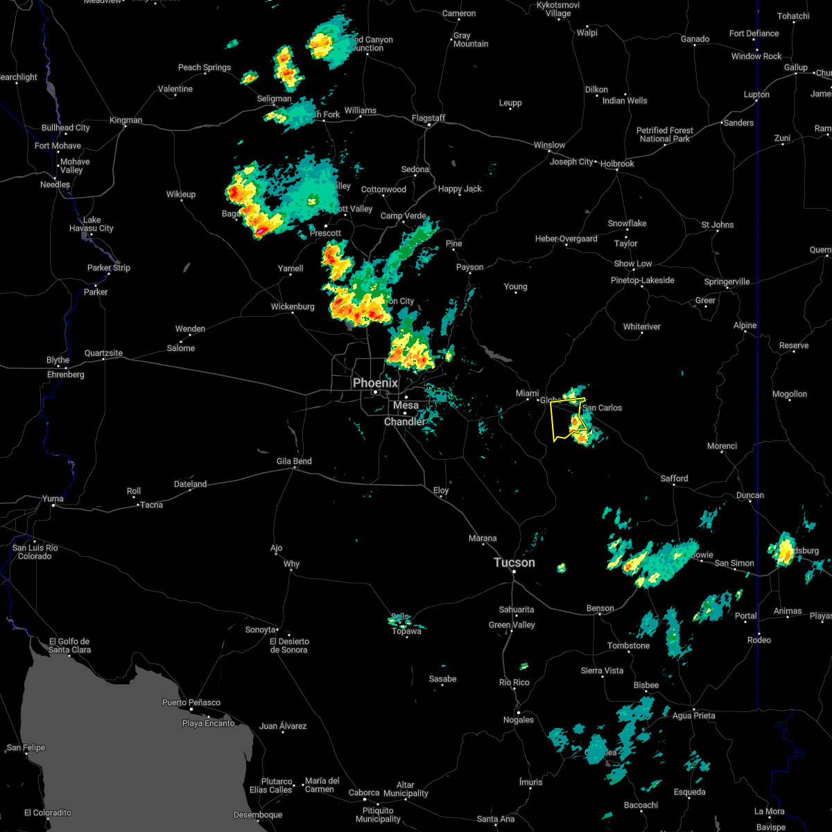
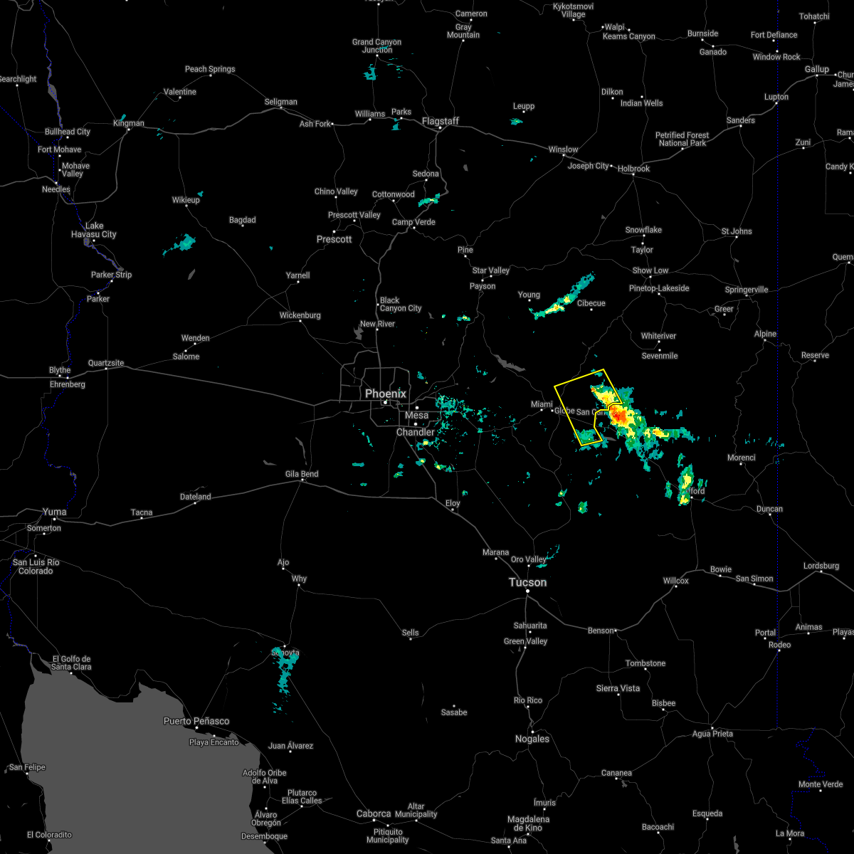
| 10/11/2025 9:55 PM MST | Svrpsr the national weather service in phoenix has issued a * severe thunderstorm warning for, gila county in east central arizona, * until 1030 pm mst. * at 954 pm mst, a severe thunderstorm was located near cutter, or 9 miles south of globe, moving northeast at 25 mph (radar indicated). Hazards include 60 mph wind gusts and quarter size hail. Hail damage to vehicles is expected. Expect wind damage to roofs, siding, and trees. |
| 9/26/2025 6:44 PM MST | The storm which prompted the warning has moved out of the area. therefore, the warning will be allowed to expire. however, gusty winds and heavy rain are still possible with this thunderstorm. a severe thunderstorm watch remains in effect until 700 pm mst for east central arizona. remember, a severe thunderstorm warning still remains in effect for southeast gila county until 715 pm mst. |
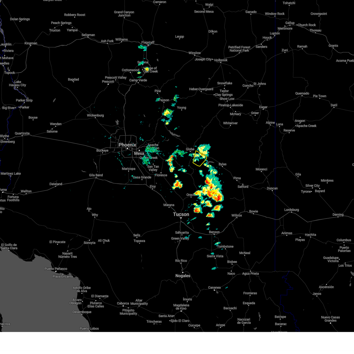
| 9/26/2025 6:42 PM MST | Svrpsr the national weather service in phoenix has issued a * severe thunderstorm warning for, gila county in east central arizona, * until 715 pm mst. * at 642 pm mst, a severe thunderstorm was located near globe, moving northeast at 15 mph (radar indicated). Hazards include 60 mph wind gusts and nickel size hail. expect damage to roofs, siding, and trees |
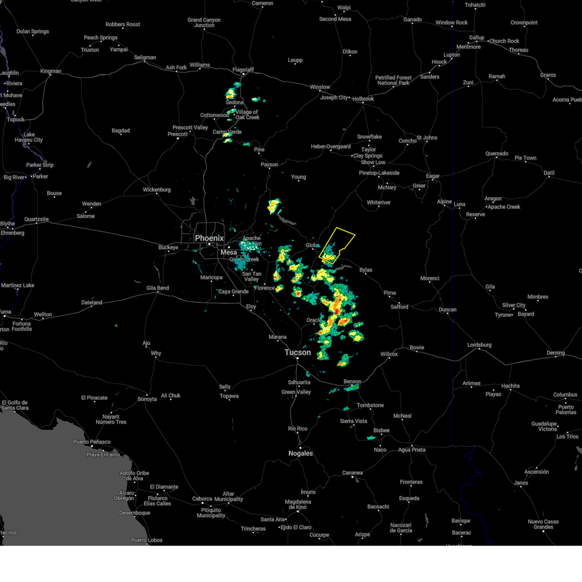
| 9/26/2025 6:32 PM MST | At 632 pm mst, a severe thunderstorm was located near globe, moving northeast at 20 mph (radar indicated). Hazards include 60 mph wind gusts and nickel size hail. Expect damage to roofs, siding, and trees. locations impacted include, globe, miami, central heights-midland city, cutter, claypool, and inspiration. this includes the following highways, us highway 60 between mile markers 245 and 261. az route 70 between mile markers 253 and 265. Az route 77 between mile markers 166 and 170. |
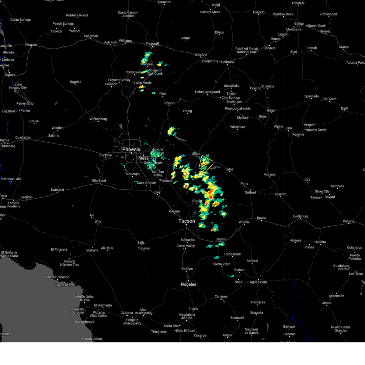
| 9/26/2025 6:15 PM MST | At 615 pm mst, a severe thunderstorm was located over globe, moving northeast at 20 mph (radar indicated). Hazards include 60 mph wind gusts and nickel size hail. Expect damage to roofs, siding, and trees. locations impacted include, globe, miami, central heights-midland city, cutter, claypool, and inspiration. this includes the following highways, us highway 60 between mile markers 239 and 261. az route 70 between mile markers 253 and 265. Az route 77 between mile markers 163 and 170. |
| 9/26/2025 5:54 PM MST | Svrpsr the national weather service in phoenix has issued a * severe thunderstorm warning for, gila county in east central arizona, * until 645 pm mst. * at 554 pm mst, a severe thunderstorm was located near miami, or 9 miles southwest of globe, moving northeast at 20 mph (radar indicated). Hazards include quarter size hail. damage to vehicles is expected |
| 8/8/2024 4:00 PM MST |
 the severe thunderstorm warning has been cancelled and is no longer in effect the severe thunderstorm warning has been cancelled and is no longer in effect
|
| 8/8/2024 3:45 PM MST |
 Svrpsr the national weather service in phoenix has issued a * severe thunderstorm warning for, gila county in east central arizona, * until 430 pm mst. * at 345 pm mst, a severe thunderstorm was located near san carlos, or 12 miles east of globe, moving east at 5 mph (radar indicated). Hazards include 60 mph wind gusts and penny size hail. expect damage to roofs, siding, and trees Svrpsr the national weather service in phoenix has issued a * severe thunderstorm warning for, gila county in east central arizona, * until 430 pm mst. * at 345 pm mst, a severe thunderstorm was located near san carlos, or 12 miles east of globe, moving east at 5 mph (radar indicated). Hazards include 60 mph wind gusts and penny size hail. expect damage to roofs, siding, and trees
|
| 8/7/2024 4:53 PM MST |
 the severe thunderstorm warning has been cancelled and is no longer in effect the severe thunderstorm warning has been cancelled and is no longer in effect
|
| 8/7/2024 4:26 PM MST |
 Svrpsr the national weather service in phoenix has issued a * severe thunderstorm warning for, gila county in east central arizona, * until 515 pm mst. * at 426 pm mst, a severe thunderstorm was located near san carlos, or 18 miles east of globe, and is nearly stationary (radar indicated). Hazards include 60 mph wind gusts and nickel size hail. expect damage to roofs, siding, and trees Svrpsr the national weather service in phoenix has issued a * severe thunderstorm warning for, gila county in east central arizona, * until 515 pm mst. * at 426 pm mst, a severe thunderstorm was located near san carlos, or 18 miles east of globe, and is nearly stationary (radar indicated). Hazards include 60 mph wind gusts and nickel size hail. expect damage to roofs, siding, and trees
|
| 7/26/2024 4:13 PM MST |
 The storm which prompted the warning has weakened below severe limits, and no longer poses an immediate threat to life or property. therefore, the warning will be allowed to expire. however, gusty winds and heavy rain are still possible with this thunderstorm. The storm which prompted the warning has weakened below severe limits, and no longer poses an immediate threat to life or property. therefore, the warning will be allowed to expire. however, gusty winds and heavy rain are still possible with this thunderstorm.
|
| 7/26/2024 4:01 PM MST |
 At 401 pm mst, a severe thunderstorm was located over globe, moving southeast at 10 mph (radar indicated). Hazards include 60 mph wind gusts and penny size hail. Expect damage to roofs, siding, and trees. locations impacted include, globe, miami, cutter, central heights-midland city, claypool, and inspiration. this includes the following highways, us highway 60 between mile markers 242 and 262. az route 70 between mile markers 253 and 259. Az route 77 between mile markers 168 and 170. At 401 pm mst, a severe thunderstorm was located over globe, moving southeast at 10 mph (radar indicated). Hazards include 60 mph wind gusts and penny size hail. Expect damage to roofs, siding, and trees. locations impacted include, globe, miami, cutter, central heights-midland city, claypool, and inspiration. this includes the following highways, us highway 60 between mile markers 242 and 262. az route 70 between mile markers 253 and 259. Az route 77 between mile markers 168 and 170.
|
| 7/26/2024 3:38 PM MST |
 Svrpsr the national weather service in phoenix has issued a * severe thunderstorm warning for, gila county in east central arizona, * until 415 pm mst. * at 337 pm mst, a severe thunderstorm was located near central heights-midland city, or near globe, moving southeast at 10 mph (radar indicated). Hazards include 70 mph wind gusts and quarter size hail. Hail damage to vehicles is expected. expect considerable tree damage. Wind damage is also likely to mobile homes, roofs, and outbuildings. Svrpsr the national weather service in phoenix has issued a * severe thunderstorm warning for, gila county in east central arizona, * until 415 pm mst. * at 337 pm mst, a severe thunderstorm was located near central heights-midland city, or near globe, moving southeast at 10 mph (radar indicated). Hazards include 70 mph wind gusts and quarter size hail. Hail damage to vehicles is expected. expect considerable tree damage. Wind damage is also likely to mobile homes, roofs, and outbuildings.
|
| 7/18/2024 6:15 PM MST |
 The storm which prompted the warning has weakened below severe limits, and no longer poses an immediate threat to life or property. therefore, the warning will be allowed to expire. The storm which prompted the warning has weakened below severe limits, and no longer poses an immediate threat to life or property. therefore, the warning will be allowed to expire.
|
| 7/18/2024 5:59 PM MST |
 At 558 pm mst, a severe thunderstorm was located over central heights-midland city, or near globe, and is nearly stationary (radar indicated). Hazards include 60 mph wind gusts. Expect damage to roofs, siding, and trees. locations impacted include, globe, miami, central heights-midland city, claypool, and inspiration. this includes the following highways, us highway 60 between mile markers 242 and 262. az route 70 between mile markers 253 and 258. Az route 77 between mile markers 169 and 170. At 558 pm mst, a severe thunderstorm was located over central heights-midland city, or near globe, and is nearly stationary (radar indicated). Hazards include 60 mph wind gusts. Expect damage to roofs, siding, and trees. locations impacted include, globe, miami, central heights-midland city, claypool, and inspiration. this includes the following highways, us highway 60 between mile markers 242 and 262. az route 70 between mile markers 253 and 258. Az route 77 between mile markers 169 and 170.
|
| 7/18/2024 5:47 PM MST |
 Svrpsr the national weather service in phoenix has issued a * severe thunderstorm warning for, gila county in east central arizona, * until 615 pm mst. * at 547 pm mst, a severe thunderstorm was located over central heights-midland city, or near globe, and is nearly stationary (radar indicated). Hazards include 60 mph wind gusts. expect damage to roofs, siding, and trees Svrpsr the national weather service in phoenix has issued a * severe thunderstorm warning for, gila county in east central arizona, * until 615 pm mst. * at 547 pm mst, a severe thunderstorm was located over central heights-midland city, or near globe, and is nearly stationary (radar indicated). Hazards include 60 mph wind gusts. expect damage to roofs, siding, and trees
|
| 7/11/2024 3:56 PM MST |
 The storm which prompted the warning has weakened below severe limits, and has exited the warned area. therefore, the warning will be allowed to expire. The storm which prompted the warning has weakened below severe limits, and has exited the warned area. therefore, the warning will be allowed to expire.
|
| 7/11/2024 3:46 PM MST |
 At 346 pm mst, a severe thunderstorm was located over central heights-midland city, or near globe, moving southwest at 15 mph (radar indicated). Hazards include 60 mph wind gusts and penny size hail. Expect damage to roofs, siding, and trees. locations impacted include, globe and central heights-midland city. this includes the following highways, us highway 60 between mile markers 250 and 256. az route 70 between mile markers 253 and 259. Az route 77 between mile markers 164 and 170. At 346 pm mst, a severe thunderstorm was located over central heights-midland city, or near globe, moving southwest at 15 mph (radar indicated). Hazards include 60 mph wind gusts and penny size hail. Expect damage to roofs, siding, and trees. locations impacted include, globe and central heights-midland city. this includes the following highways, us highway 60 between mile markers 250 and 256. az route 70 between mile markers 253 and 259. Az route 77 between mile markers 164 and 170.
|
| 7/11/2024 3:44 PM MST |
 The storm which prompted the warning has weakened below severe limits, and no longer poses an immediate threat to life or property. therefore, the warning will be allowed to expire. remember, a severe thunderstorm warning still remains in effect for 400 pm mst. The storm which prompted the warning has weakened below severe limits, and no longer poses an immediate threat to life or property. therefore, the warning will be allowed to expire. remember, a severe thunderstorm warning still remains in effect for 400 pm mst.
|
| 7/11/2024 3:26 PM MST |
 At 326 pm mst, a severe thunderstorm was located 10 miles southwest of hilltop, or 14 miles northeast of globe, moving southwest at 30 mph (radar indicated). Hazards include 60 mph wind gusts and penny size hail. Expect damage to roofs, siding, and trees. locations impacted include, globe. this includes the following highways, us highway 60 between mile markers 255 and 263. Az route 70 between mile markers 260 and 263. At 326 pm mst, a severe thunderstorm was located 10 miles southwest of hilltop, or 14 miles northeast of globe, moving southwest at 30 mph (radar indicated). Hazards include 60 mph wind gusts and penny size hail. Expect damage to roofs, siding, and trees. locations impacted include, globe. this includes the following highways, us highway 60 between mile markers 255 and 263. Az route 70 between mile markers 260 and 263.
|
| 7/11/2024 3:21 PM MST |
 Svrpsr the national weather service in phoenix has issued a * severe thunderstorm warning for, gila county in east central arizona, * until 400 pm mst. * at 321 pm mst, a severe thunderstorm was located near globe, moving southwest at 15 mph (radar indicated). Hazards include 60 mph wind gusts and penny size hail. expect damage to roofs, siding, and trees Svrpsr the national weather service in phoenix has issued a * severe thunderstorm warning for, gila county in east central arizona, * until 400 pm mst. * at 321 pm mst, a severe thunderstorm was located near globe, moving southwest at 15 mph (radar indicated). Hazards include 60 mph wind gusts and penny size hail. expect damage to roofs, siding, and trees
|
| 7/11/2024 3:02 PM MST |
 Svrpsr the national weather service in phoenix has issued a * severe thunderstorm warning for, gila county in east central arizona, * until 345 pm mst. * at 301 pm mst, a severe thunderstorm was located over sawmill, or 27 miles northeast of globe, moving southwest at 30 mph (radar indicated). Hazards include 60 mph wind gusts and penny size hail. expect damage to roofs, siding, and trees Svrpsr the national weather service in phoenix has issued a * severe thunderstorm warning for, gila county in east central arizona, * until 345 pm mst. * at 301 pm mst, a severe thunderstorm was located over sawmill, or 27 miles northeast of globe, moving southwest at 30 mph (radar indicated). Hazards include 60 mph wind gusts and penny size hail. expect damage to roofs, siding, and trees
|
| 6/20/2024 4:18 PM MST |
 The storm which prompted the warning has moved out of the area. therefore, the warning has been allowed to expire. remember, a severe thunderstorm warning still remains in effect for portions of gila county until 430 pm mst. The storm which prompted the warning has moved out of the area. therefore, the warning has been allowed to expire. remember, a severe thunderstorm warning still remains in effect for portions of gila county until 430 pm mst.
|
| 6/20/2024 4:04 PM MST |
 Svrpsr the national weather service in phoenix has issued a * severe thunderstorm warning for, gila county in east central arizona, * until 430 pm mst. * at 404 pm mst, a severe thunderstorm was located near cutter, or 10 miles east of globe, moving northeast at 40 mph (radar indicated). Hazards include 60 mph wind gusts and penny size hail. expect damage to roofs, siding, and trees Svrpsr the national weather service in phoenix has issued a * severe thunderstorm warning for, gila county in east central arizona, * until 430 pm mst. * at 404 pm mst, a severe thunderstorm was located near cutter, or 10 miles east of globe, moving northeast at 40 mph (radar indicated). Hazards include 60 mph wind gusts and penny size hail. expect damage to roofs, siding, and trees
|
| 6/20/2024 3:51 PM MST |
 At 350 pm mst, a severe thunderstorm was located near cutter, or 10 miles southeast of globe, moving northeast at 20 mph (radar indicated). Hazards include 60 mph wind gusts and penny size hail. Expect damage to roofs, siding, and trees. locations impacted include, cutter and peridot. This includes az route 70 between mile markers 258 and 271. At 350 pm mst, a severe thunderstorm was located near cutter, or 10 miles southeast of globe, moving northeast at 20 mph (radar indicated). Hazards include 60 mph wind gusts and penny size hail. Expect damage to roofs, siding, and trees. locations impacted include, cutter and peridot. This includes az route 70 between mile markers 258 and 271.
|
| 6/20/2024 3:29 PM MST |
 Svrpsr the national weather service in phoenix has issued a * severe thunderstorm warning for, gila county in east central arizona, * until 415 pm mst. * at 328 pm mst, a severe thunderstorm was located 7 miles north of christmas, moving northeast at 20 mph (radar indicated). Hazards include 60 mph wind gusts and penny size hail. expect damage to roofs, siding, and trees Svrpsr the national weather service in phoenix has issued a * severe thunderstorm warning for, gila county in east central arizona, * until 415 pm mst. * at 328 pm mst, a severe thunderstorm was located 7 miles north of christmas, moving northeast at 20 mph (radar indicated). Hazards include 60 mph wind gusts and penny size hail. expect damage to roofs, siding, and trees
|
| 9/13/2023 7:24 AM MST |
 The severe thunderstorm warning for gila county will expire at 730 am mst, the storm which prompted the warning has weakened below severe limits, and no longer poses an immediate threat to life or property. therefore, the warning will be allowed to expire. however gusty winds and heavy rain are still possible with this thunderstorm. The severe thunderstorm warning for gila county will expire at 730 am mst, the storm which prompted the warning has weakened below severe limits, and no longer poses an immediate threat to life or property. therefore, the warning will be allowed to expire. however gusty winds and heavy rain are still possible with this thunderstorm.
|
| 9/13/2023 6:45 AM MST |
 At 645 am mst, a severe thunderstorm was located over miami, or near globe, moving east at 25 mph (radar indicated). Hazards include 60 mph wind gusts and penny size hail. expect damage to roofs, siding, and trees At 645 am mst, a severe thunderstorm was located over miami, or near globe, moving east at 25 mph (radar indicated). Hazards include 60 mph wind gusts and penny size hail. expect damage to roofs, siding, and trees
|
| 9/13/2023 1:41 AM MST |
 The severe thunderstorm warning for gila county will expire at 145 am mst, the storms which prompted the warning have moved out of the area. therefore, the warning will be allowed to expire. however gusty winds are still possible with these thunderstorms. The severe thunderstorm warning for gila county will expire at 145 am mst, the storms which prompted the warning have moved out of the area. therefore, the warning will be allowed to expire. however gusty winds are still possible with these thunderstorms.
|
| 9/13/2023 1:21 AM MST |
 At 121 am mst, severe thunderstorms were located along a line extending from 8 miles southwest of hilltop to 8 miles northwest of san carlos to near cutter, moving southeast at 35 mph (radar indicated). Hazards include 60 mph wind gusts and penny size hail. Expect damage to roofs, siding, and trees. locations impacted include, globe, san carlos, cutter, central heights-midland city, hilltop, claypool, and sawmill. this includes the following highways, us highway 60 between mile markers 246 and 279. az route 70 between mile markers 253 and 269. az route 77 between mile markers 164 and 170. hail threat, radar indicated max hail size, 0. 75 in wind threat, radar indicated max wind gust, 60 mph. At 121 am mst, severe thunderstorms were located along a line extending from 8 miles southwest of hilltop to 8 miles northwest of san carlos to near cutter, moving southeast at 35 mph (radar indicated). Hazards include 60 mph wind gusts and penny size hail. Expect damage to roofs, siding, and trees. locations impacted include, globe, san carlos, cutter, central heights-midland city, hilltop, claypool, and sawmill. this includes the following highways, us highway 60 between mile markers 246 and 279. az route 70 between mile markers 253 and 269. az route 77 between mile markers 164 and 170. hail threat, radar indicated max hail size, 0. 75 in wind threat, radar indicated max wind gust, 60 mph.
|
| 9/13/2023 12:59 AM MST |
 At 1258 am mst, severe thunderstorms were located along a line extending from 15 miles north of globe to 7 miles north of central heights-midland city to claypool, moving southeast at 35 mph (radar indicated). Hazards include 60 mph wind gusts and penny size hail. expect damage to roofs, siding, and trees At 1258 am mst, severe thunderstorms were located along a line extending from 15 miles north of globe to 7 miles north of central heights-midland city to claypool, moving southeast at 35 mph (radar indicated). Hazards include 60 mph wind gusts and penny size hail. expect damage to roofs, siding, and trees
|
| 8/30/2023 6:19 PM MST |
 At 619 pm mst, a severe thunderstorm was located 9 miles north of christmas, moving south at 15 mph (radar indicated). Hazards include 60 mph wind gusts and penny size hail. Expect damage to roofs, siding, and trees. locations impacted include, globe and cutter. this includes the following highways, az route 70 between mile markers 256 and 263. az route 77 between mile markers 158 and 170. hail threat, radar indicated max hail size, 0. 75 in wind threat, radar indicated max wind gust, 60 mph. At 619 pm mst, a severe thunderstorm was located 9 miles north of christmas, moving south at 15 mph (radar indicated). Hazards include 60 mph wind gusts and penny size hail. Expect damage to roofs, siding, and trees. locations impacted include, globe and cutter. this includes the following highways, az route 70 between mile markers 256 and 263. az route 77 between mile markers 158 and 170. hail threat, radar indicated max hail size, 0. 75 in wind threat, radar indicated max wind gust, 60 mph.
|
| 8/30/2023 5:56 PM MST |
 At 556 pm mst, a severe thunderstorm was located near cutter, or 9 miles east of globe, moving south at 5 mph (radar indicated). Hazards include 60 mph wind gusts and nickel size hail. expect damage to roofs, siding, and trees At 556 pm mst, a severe thunderstorm was located near cutter, or 9 miles east of globe, moving south at 5 mph (radar indicated). Hazards include 60 mph wind gusts and nickel size hail. expect damage to roofs, siding, and trees
|
| 8/21/2023 4:03 PM MST |
 At 403 pm mst, a severe thunderstorm was located 8 miles southwest of globe, moving northwest at 20 mph (radar indicated). Hazards include 60 mph wind gusts and penny size hail. expect damage to roofs, siding, and trees At 403 pm mst, a severe thunderstorm was located 8 miles southwest of globe, moving northwest at 20 mph (radar indicated). Hazards include 60 mph wind gusts and penny size hail. expect damage to roofs, siding, and trees
|
| 7/21/2023 5:38 PM MST |
 At 537 pm mst, a severe thunderstorm was located over globe, moving southwest at 10 mph (radar indicated). Hazards include 60 mph wind gusts. Expect damage to roofs, siding, and trees. locations impacted include, globe, miami, cutter, central heights-midland city, claypool, and inspiration. this includes the following highways, us highway 60 between mile markers 240 and 261. az route 70 between mile markers 253 and 261. az route 77 between mile markers 160 and 170. hail threat, radar indicated max hail size, <. 75 in wind threat, radar indicated max wind gust, 60 mph. At 537 pm mst, a severe thunderstorm was located over globe, moving southwest at 10 mph (radar indicated). Hazards include 60 mph wind gusts. Expect damage to roofs, siding, and trees. locations impacted include, globe, miami, cutter, central heights-midland city, claypool, and inspiration. this includes the following highways, us highway 60 between mile markers 240 and 261. az route 70 between mile markers 253 and 261. az route 77 between mile markers 160 and 170. hail threat, radar indicated max hail size, <. 75 in wind threat, radar indicated max wind gust, 60 mph.
|
| 7/21/2023 5:21 PM MST |
 At 520 pm mst, a severe thunderstorm was located over globe, moving southwest at 10 mph (radar indicated). Hazards include 60 mph wind gusts. expect damage to roofs, siding, and trees At 520 pm mst, a severe thunderstorm was located over globe, moving southwest at 10 mph (radar indicated). Hazards include 60 mph wind gusts. expect damage to roofs, siding, and trees
|
| 7/17/2023 7:38 PM MST |
 The severe thunderstorm warning for gila county will expire at 745 pm mst, the storm which prompted the warning has weakened below severe limits, and no longer poses an immediate threat to life or property. therefore, the warning will be allowed to expire. however gusty winds and heavy rain are still occurring with this thunderstorm. The severe thunderstorm warning for gila county will expire at 745 pm mst, the storm which prompted the warning has weakened below severe limits, and no longer poses an immediate threat to life or property. therefore, the warning will be allowed to expire. however gusty winds and heavy rain are still occurring with this thunderstorm.
|
| 7/17/2023 7:02 PM MST |
 At 701 pm mst, a severe thunderstorm was located near cutter, or 9 miles east of globe, moving northwest at 10 mph (radar indicated). Hazards include 60 mph wind gusts and nickel size hail. expect damage to roofs, siding, and trees At 701 pm mst, a severe thunderstorm was located near cutter, or 9 miles east of globe, moving northwest at 10 mph (radar indicated). Hazards include 60 mph wind gusts and nickel size hail. expect damage to roofs, siding, and trees
|
| 8/22/2022 5:08 PM MST | The severe thunderstorm warning for gila county will expire at 515 pm mst, the storm which prompted the warning across southern gila county has weakened below severe limits, and has exited the warned area. therefore, the warning will be allowed to expire. |
| 8/22/2022 4:05 PM MST | At 405 pm mst, a severe thunderstorm was located over cutter, or 9 miles east of globe, moving south at 15 mph (radar indicated). Hazards include 60 mph wind gusts and quarter size hail. Hail damage to vehicles is expected. Expect wind damage to roofs, siding, and trees. |
| 8/21/2022 5:50 PM MST |
 At 549 pm mst, a severe thunderstorm was located 7 miles south of san carlos, or 18 miles northeast of christmas, and is nearly stationary (radar indicated). Hazards include 60 mph wind gusts and quarter size hail. Hail damage to vehicles is expected. expect wind damage to roofs, siding, and trees. locations impacted include, san carlos and cutter. this includes az route 70 between mile markers 258 and 271. hail threat, radar indicated max hail size, 1. 00 in wind threat, radar indicated max wind gust, 60 mph. At 549 pm mst, a severe thunderstorm was located 7 miles south of san carlos, or 18 miles northeast of christmas, and is nearly stationary (radar indicated). Hazards include 60 mph wind gusts and quarter size hail. Hail damage to vehicles is expected. expect wind damage to roofs, siding, and trees. locations impacted include, san carlos and cutter. this includes az route 70 between mile markers 258 and 271. hail threat, radar indicated max hail size, 1. 00 in wind threat, radar indicated max wind gust, 60 mph.
|
| 8/21/2022 5:34 PM MST |
 At 534 pm mst, a severe thunderstorm was located near san carlos, or 19 miles southeast of globe, and is nearly stationary (radar indicated). Hazards include 60 mph wind gusts and quarter size hail. Hail damage to vehicles is expected. Expect wind damage to roofs, siding, and trees. At 534 pm mst, a severe thunderstorm was located near san carlos, or 19 miles southeast of globe, and is nearly stationary (radar indicated). Hazards include 60 mph wind gusts and quarter size hail. Hail damage to vehicles is expected. Expect wind damage to roofs, siding, and trees.
|
| 8/12/2022 2:50 PM MST |
 At 250 pm mst, a severe thunderstorm was located 12 miles west of hilltop, or 14 miles northeast of globe, moving northwest at 5 mph (radar indicated). Hazards include 60 mph wind gusts and nickel size hail. expect damage to roofs, siding, and trees At 250 pm mst, a severe thunderstorm was located 12 miles west of hilltop, or 14 miles northeast of globe, moving northwest at 5 mph (radar indicated). Hazards include 60 mph wind gusts and nickel size hail. expect damage to roofs, siding, and trees
|
| 7/27/2022 5:11 PM MST |
 The severe thunderstorm warning for gila county will expire at 515 pm mst, the storm which prompted the warning has weakened below severe limits, and no longer poses an immediate threat to life or property. therefore, the warning will be allowed to expire. however heavy rain is still possible with this thunderstorm. The severe thunderstorm warning for gila county will expire at 515 pm mst, the storm which prompted the warning has weakened below severe limits, and no longer poses an immediate threat to life or property. therefore, the warning will be allowed to expire. however heavy rain is still possible with this thunderstorm.
|
| 7/27/2022 4:49 PM MST |
 At 449 pm mst, a severe thunderstorm was located near globe, moving northwest at 15 mph (radar indicated). Hazards include 60 mph wind gusts and quarter size hail. Hail damage to vehicles is expected. expect wind damage to roofs, siding, and trees. locations impacted include, globe, miami, cutter, central heights-midland city and claypool. this includes the following highways, us highway 60 between mile markers 243 and 262. az route 70 between mile markers 253 and 260. az route 77 between mile markers 168 and 170. hail threat, radar indicated max hail size, 1. 00 in wind threat, radar indicated max wind gust, 60 mph. At 449 pm mst, a severe thunderstorm was located near globe, moving northwest at 15 mph (radar indicated). Hazards include 60 mph wind gusts and quarter size hail. Hail damage to vehicles is expected. expect wind damage to roofs, siding, and trees. locations impacted include, globe, miami, cutter, central heights-midland city and claypool. this includes the following highways, us highway 60 between mile markers 243 and 262. az route 70 between mile markers 253 and 260. az route 77 between mile markers 168 and 170. hail threat, radar indicated max hail size, 1. 00 in wind threat, radar indicated max wind gust, 60 mph.
|
| 7/27/2022 4:34 PM MST |
 At 434 pm mst, a severe thunderstorm was located near cutter, or 7 miles east of globe, moving northwest at 15 mph (radar indicated). Hazards include 60 mph wind gusts and quarter size hail. Hail damage to vehicles is expected. Expect wind damage to roofs, siding, and trees. At 434 pm mst, a severe thunderstorm was located near cutter, or 7 miles east of globe, moving northwest at 15 mph (radar indicated). Hazards include 60 mph wind gusts and quarter size hail. Hail damage to vehicles is expected. Expect wind damage to roofs, siding, and trees.
|
| 7/16/2022 4:10 PM MST |
 At 410 pm mst, a severe thunderstorm was located over cutter, or 10 miles southeast of globe, moving southwest at 10 mph (radar indicated). Hazards include 60 mph wind gusts and quarter size hail. Hail damage to vehicles is expected. expect wind damage to roofs, siding, and trees. locations impacted include, cutter. this includes az route 70 between mile markers 258 and 266. hail threat, radar indicated max hail size, 1. 00 in wind threat, radar indicated max wind gust, 60 mph. At 410 pm mst, a severe thunderstorm was located over cutter, or 10 miles southeast of globe, moving southwest at 10 mph (radar indicated). Hazards include 60 mph wind gusts and quarter size hail. Hail damage to vehicles is expected. expect wind damage to roofs, siding, and trees. locations impacted include, cutter. this includes az route 70 between mile markers 258 and 266. hail threat, radar indicated max hail size, 1. 00 in wind threat, radar indicated max wind gust, 60 mph.
|
| 7/16/2022 4:09 PM MST |
 At 409 pm mst, a severe thunderstorm was located near globe, moving south at 15 mph (radar indicated). Hazards include 60 mph wind gusts and quarter size hail. Hail damage to vehicles is expected. expect wind damage to roofs, siding, and trees. locations impacted include, globe, miami, central heights-midland city, claypool and inspiration. this includes the following highways, us highway 60 between mile markers 238 and 252. az route 70 between mile markers 253 and 257. az route 77 between mile markers 159 and 170. hail threat, radar indicated max hail size, 1. 00 in wind threat, radar indicated max wind gust, 60 mph. At 409 pm mst, a severe thunderstorm was located near globe, moving south at 15 mph (radar indicated). Hazards include 60 mph wind gusts and quarter size hail. Hail damage to vehicles is expected. expect wind damage to roofs, siding, and trees. locations impacted include, globe, miami, central heights-midland city, claypool and inspiration. this includes the following highways, us highway 60 between mile markers 238 and 252. az route 70 between mile markers 253 and 257. az route 77 between mile markers 159 and 170. hail threat, radar indicated max hail size, 1. 00 in wind threat, radar indicated max wind gust, 60 mph.
|
| 7/16/2022 3:57 PM MST |
 At 357 pm mst, a severe thunderstorm was located over globe, moving southwest at 15 mph (radar indicated). Hazards include 60 mph wind gusts and quarter size hail. Hail damage to vehicles is expected. expect wind damage to roofs, siding, and trees. locations impacted include, globe, miami, central heights-midland city, claypool and inspiration. this includes the following highways, us highway 60 between mile markers 238 and 257. az route 70 between mile markers 253 and 258. az route 77 between mile markers 159 and 170. hail threat, radar indicated max hail size, 1. 00 in wind threat, radar indicated max wind gust, 60 mph. At 357 pm mst, a severe thunderstorm was located over globe, moving southwest at 15 mph (radar indicated). Hazards include 60 mph wind gusts and quarter size hail. Hail damage to vehicles is expected. expect wind damage to roofs, siding, and trees. locations impacted include, globe, miami, central heights-midland city, claypool and inspiration. this includes the following highways, us highway 60 between mile markers 238 and 257. az route 70 between mile markers 253 and 258. az route 77 between mile markers 159 and 170. hail threat, radar indicated max hail size, 1. 00 in wind threat, radar indicated max wind gust, 60 mph.
|
| 7/16/2022 3:55 PM MST |
 At 355 pm mst, a severe thunderstorm was located over cutter, or 10 miles east of globe, moving south at 5 mph (radar indicated). Hazards include 60 mph wind gusts and quarter size hail. Hail damage to vehicles is expected. Expect wind damage to roofs, siding, and trees. At 355 pm mst, a severe thunderstorm was located over cutter, or 10 miles east of globe, moving south at 5 mph (radar indicated). Hazards include 60 mph wind gusts and quarter size hail. Hail damage to vehicles is expected. Expect wind damage to roofs, siding, and trees.
|
| 7/16/2022 3:47 PM MST |
 At 347 pm mst, a severe thunderstorm was located near globe, moving southwest at 15 mph (radar indicated). Hazards include 60 mph wind gusts and quarter size hail. Hail damage to vehicles is expected. Expect wind damage to roofs, siding, and trees. At 347 pm mst, a severe thunderstorm was located near globe, moving southwest at 15 mph (radar indicated). Hazards include 60 mph wind gusts and quarter size hail. Hail damage to vehicles is expected. Expect wind damage to roofs, siding, and trees.
|
| 8/16/2021 6:22 PM MST |
 At 622 pm mst, a severe thunderstorm was located near san carlos, or 19 miles east of globe, moving southeast at 15 mph (radar indicated). Hazards include 60 mph wind gusts and quarter size hail. Hail damage to vehicles is expected. expect wind damage to roofs, siding, and trees. locations impacted include, globe, san carlos, cutter and central heights-midland city. this includes the following highways, us highway 60 between mile markers 251 and 253. az route 70 between mile markers 253 and 271. Az route 77 between mile markers 163 and 170. At 622 pm mst, a severe thunderstorm was located near san carlos, or 19 miles east of globe, moving southeast at 15 mph (radar indicated). Hazards include 60 mph wind gusts and quarter size hail. Hail damage to vehicles is expected. expect wind damage to roofs, siding, and trees. locations impacted include, globe, san carlos, cutter and central heights-midland city. this includes the following highways, us highway 60 between mile markers 251 and 253. az route 70 between mile markers 253 and 271. Az route 77 between mile markers 163 and 170.
|
| 8/16/2021 6:14 PM MST |
 At 613 pm mst, a severe thunderstorm was located near san carlos, or 21 miles east of globe, moving southeast at 10 mph (radar indicated). Hazards include 60 mph wind gusts and quarter size hail. Hail damage to vehicles is expected. Expect wind damage to roofs, siding, and trees. At 613 pm mst, a severe thunderstorm was located near san carlos, or 21 miles east of globe, moving southeast at 10 mph (radar indicated). Hazards include 60 mph wind gusts and quarter size hail. Hail damage to vehicles is expected. Expect wind damage to roofs, siding, and trees.
|
| 8/15/2021 8:58 PM MST |
 At 858 pm mst, severe thunderstorms were located along a line extending from 14 miles west of hilltop to near cutter to 7 miles south of san carlos, moving southwest at 25 mph (radar indicated). Hazards include 60 mph wind gusts and penny size hail. Expect damage to roofs, siding, and trees. locations impacted include, globe, san carlos, miami, cutter, central heights-midland city, claypool and hilltop. this includes the following highways, us highway 60 between mile markers 245 and 297. az route 70 between mile markers 253 and 271. az route 77 between mile markers 158 and 170. hail threat, radar indicated max hail size, 0. 75 in wind threat, radar indicated max wind gust, 60 mph. At 858 pm mst, severe thunderstorms were located along a line extending from 14 miles west of hilltop to near cutter to 7 miles south of san carlos, moving southwest at 25 mph (radar indicated). Hazards include 60 mph wind gusts and penny size hail. Expect damage to roofs, siding, and trees. locations impacted include, globe, san carlos, miami, cutter, central heights-midland city, claypool and hilltop. this includes the following highways, us highway 60 between mile markers 245 and 297. az route 70 between mile markers 253 and 271. az route 77 between mile markers 158 and 170. hail threat, radar indicated max hail size, 0. 75 in wind threat, radar indicated max wind gust, 60 mph.
|
| 8/15/2021 8:26 PM MST |
 At 826 pm mst, severe thunderstorms were located along a line extending from 11 miles north of sawmill to near hilltop to 13 miles east of san carlos, moving southwest at 30 mph (radar indicated). Hazards include 60 mph wind gusts and penny size hail. expect damage to roofs, siding, and trees At 826 pm mst, severe thunderstorms were located along a line extending from 11 miles north of sawmill to near hilltop to 13 miles east of san carlos, moving southwest at 30 mph (radar indicated). Hazards include 60 mph wind gusts and penny size hail. expect damage to roofs, siding, and trees
|
| 8/14/2021 12:10 AM MST |
 The severe thunderstorm warning for gila county will expire at 1215 am mst, the storm which prompted the warning has weakened below severe limits, and no longer poses an immediate threat to life or property. therefore, the warning will be allowed to expire. however gusty winds and heavy rain are still possible with this thunderstorm. a severe thunderstorm watch remains in effect until 300 am mst for east central arizona. The severe thunderstorm warning for gila county will expire at 1215 am mst, the storm which prompted the warning has weakened below severe limits, and no longer poses an immediate threat to life or property. therefore, the warning will be allowed to expire. however gusty winds and heavy rain are still possible with this thunderstorm. a severe thunderstorm watch remains in effect until 300 am mst for east central arizona.
|
| 8/13/2021 11:56 PM MST |
 At 1156 pm mst, a severe thunderstorm was located over cutter, or 9 miles east of globe, moving west at 35 mph (radar indicated). Hazards include 60 mph wind gusts. Expect damage to roofs, siding, and trees. locations impacted include, globe, san carlos and cutter. this includes the following highways, us highway 60 between mile markers 252 and 261. az route 70 between mile markers 253 and 271. az route 77 between mile markers 165 and 170. hail threat, radar indicated max hail size, <. 75 in wind threat, radar indicated max wind gust, 60 mph. At 1156 pm mst, a severe thunderstorm was located over cutter, or 9 miles east of globe, moving west at 35 mph (radar indicated). Hazards include 60 mph wind gusts. Expect damage to roofs, siding, and trees. locations impacted include, globe, san carlos and cutter. this includes the following highways, us highway 60 between mile markers 252 and 261. az route 70 between mile markers 253 and 271. az route 77 between mile markers 165 and 170. hail threat, radar indicated max hail size, <. 75 in wind threat, radar indicated max wind gust, 60 mph.
|
| 8/13/2021 11:31 PM MST |
 At 1131 pm mst, a severe thunderstorm was located near san carlos, or 22 miles east of globe, moving west at 35 mph (radar indicated). Hazards include 60 mph wind gusts and penny size hail. expect damage to roofs, siding, and trees At 1131 pm mst, a severe thunderstorm was located near san carlos, or 22 miles east of globe, moving west at 35 mph (radar indicated). Hazards include 60 mph wind gusts and penny size hail. expect damage to roofs, siding, and trees
|
| 8/13/2021 3:51 PM MST |
 At 350 pm mst, a severe thunderstorm was located 7 miles southwest of san carlos, or 16 miles southeast of globe, moving west at 25 mph (radar indicated). Hazards include 70 mph wind gusts and quarter size hail. Hail damage to vehicles is expected. expect considerable tree damage. wind damage is also likely to mobile homes, roofs, and outbuildings. locations impacted include, globe, san carlos and cutter. this includes the following highways, us highway 60 between mile markers 254 and 259. Az route 70 between mile markers 256 and 271. At 350 pm mst, a severe thunderstorm was located 7 miles southwest of san carlos, or 16 miles southeast of globe, moving west at 25 mph (radar indicated). Hazards include 70 mph wind gusts and quarter size hail. Hail damage to vehicles is expected. expect considerable tree damage. wind damage is also likely to mobile homes, roofs, and outbuildings. locations impacted include, globe, san carlos and cutter. this includes the following highways, us highway 60 between mile markers 254 and 259. Az route 70 between mile markers 256 and 271.
|
| 8/13/2021 3:30 PM MST |
 At 330 pm mst, a severe thunderstorm was located near san carlos, or 21 miles east of globe, moving southwest at 5 mph (radar indicated). Hazards include 60 mph wind gusts and nickel size hail. expect damage to roofs, siding, and trees At 330 pm mst, a severe thunderstorm was located near san carlos, or 21 miles east of globe, moving southwest at 5 mph (radar indicated). Hazards include 60 mph wind gusts and nickel size hail. expect damage to roofs, siding, and trees
|
| 7/10/2021 7:00 PM MST |
 At 659 pm mst, severe thunderstorms were located along a line extending from 7 miles southeast of apache lake to near superior to 9 miles south of globe, moving southwest at 40 mph (radar indicated). Hazards include 70 mph wind gusts and quarter size hail. Hail damage to vehicles is expected. expect considerable tree damage. Wind damage is also likely to mobile homes, roofs, and outbuildings. At 659 pm mst, severe thunderstorms were located along a line extending from 7 miles southeast of apache lake to near superior to 9 miles south of globe, moving southwest at 40 mph (radar indicated). Hazards include 70 mph wind gusts and quarter size hail. Hail damage to vehicles is expected. expect considerable tree damage. Wind damage is also likely to mobile homes, roofs, and outbuildings.
|
| 7/10/2021 6:24 PM MST |
 At 623 pm mst, severe thunderstorms were located along a line extending from 16 miles east of tonto national monument to near hilltop to 12 miles east of san carlos, moving southwest at 25 mph (radar indicated). Hazards include 60 mph wind gusts and quarter size hail. Hail damage to vehicles is expected. Expect wind damage to roofs, siding, and trees. At 623 pm mst, severe thunderstorms were located along a line extending from 16 miles east of tonto national monument to near hilltop to 12 miles east of san carlos, moving southwest at 25 mph (radar indicated). Hazards include 60 mph wind gusts and quarter size hail. Hail damage to vehicles is expected. Expect wind damage to roofs, siding, and trees.
|
| 7/9/2021 9:25 PM MST |
 At 924 pm mst, severe thunderstorms were located along a line extending from 7 miles southeast of tonto national monument to near miami to near globe, moving southwest at 20 mph (radar indicated). Hazards include 60 mph wind gusts and nickel size hail. Expect damage to roofs, siding, and trees. locations impacted include, globe, roosevelt, miami, cutter, central heights-midland city, tonto national monument, roosevelt dam, claypool, top-of-the-world, inspiration and roosevelt estates. this includes the following highways, us highway 60 between mile markers 236 and 263. az route 70 between mile markers 253 and 263. Az route 77 between mile markers 161 and 170. At 924 pm mst, severe thunderstorms were located along a line extending from 7 miles southeast of tonto national monument to near miami to near globe, moving southwest at 20 mph (radar indicated). Hazards include 60 mph wind gusts and nickel size hail. Expect damage to roofs, siding, and trees. locations impacted include, globe, roosevelt, miami, cutter, central heights-midland city, tonto national monument, roosevelt dam, claypool, top-of-the-world, inspiration and roosevelt estates. this includes the following highways, us highway 60 between mile markers 236 and 263. az route 70 between mile markers 253 and 263. Az route 77 between mile markers 161 and 170.
|
| 7/9/2021 8:58 PM MST |
 At 857 pm mst, severe thunderstorms were located along a line extending from 21 miles east of tonto national monument to 14 miles west of hilltop to 10 miles north of cutter, moving southwest at 10 mph (radar indicated). Hazards include 60 mph wind gusts and nickel size hail. expect damage to roofs, siding, and trees At 857 pm mst, severe thunderstorms were located along a line extending from 21 miles east of tonto national monument to 14 miles west of hilltop to 10 miles north of cutter, moving southwest at 10 mph (radar indicated). Hazards include 60 mph wind gusts and nickel size hail. expect damage to roofs, siding, and trees
|
| 7/9/2021 8:37 PM MST |
 At 836 pm mst, severe thunderstorms were located along a line extending from near san carlos to 10 miles west of hilltop, moving west at 20 mph (radar indicated). Hazards include 60 mph wind gusts and quarter size hail. Hail damage to vehicles is expected. expect wind damage to roofs, siding, and trees. locations impacted include, san carlos, cutter and san carlos reservoir. this includes the following highways, us highway 60 between mile markers 258 and 267. Az route 70 between mile markers 259 and 271. At 836 pm mst, severe thunderstorms were located along a line extending from near san carlos to 10 miles west of hilltop, moving west at 20 mph (radar indicated). Hazards include 60 mph wind gusts and quarter size hail. Hail damage to vehicles is expected. expect wind damage to roofs, siding, and trees. locations impacted include, san carlos, cutter and san carlos reservoir. this includes the following highways, us highway 60 between mile markers 258 and 267. Az route 70 between mile markers 259 and 271.
|
| 7/9/2021 8:15 PM MST |
 At 815 pm mst, a severe thunderstorm was located 8 miles northeast of san carlos, or 26 miles east of globe, moving southwest at 15 mph (radar indicated). Hazards include 60 mph wind gusts and nickel size hail. expect damage to roofs, siding, and trees At 815 pm mst, a severe thunderstorm was located 8 miles northeast of san carlos, or 26 miles east of globe, moving southwest at 15 mph (radar indicated). Hazards include 60 mph wind gusts and nickel size hail. expect damage to roofs, siding, and trees
|
| 8/22/2020 6:07 PM MST |
 The severe thunderstorm warning for gila county will expire at 615 pm mst, the storm which prompted the warning has weakened below severe limits, and no longer poses an immediate threat to life or property. therefore, the warning will be allowed to expire. however small hail, gusty winds and heavy rain are still possible with this thunderstorm. The severe thunderstorm warning for gila county will expire at 615 pm mst, the storm which prompted the warning has weakened below severe limits, and no longer poses an immediate threat to life or property. therefore, the warning will be allowed to expire. however small hail, gusty winds and heavy rain are still possible with this thunderstorm.
|
| 8/22/2020 5:55 PM MST |
 At 554 pm mst, a severe thunderstorm was located near san carlos, or 22 miles east of globe, moving southwest at 20 mph (radar indicated). Hazards include 60 mph wind gusts and quarter size hail. Hail damage to vehicles is expected. expect wind damage to roofs, siding, and trees. locations impacted include, san carlos and cutter. This includes az route 70 between mile markers 257 and 271. At 554 pm mst, a severe thunderstorm was located near san carlos, or 22 miles east of globe, moving southwest at 20 mph (radar indicated). Hazards include 60 mph wind gusts and quarter size hail. Hail damage to vehicles is expected. expect wind damage to roofs, siding, and trees. locations impacted include, san carlos and cutter. This includes az route 70 between mile markers 257 and 271.
|
| 8/22/2020 5:37 PM MST |
 The national weather service in phoenix has issued a * severe thunderstorm warning for. gila county in east central arizona. until 615 pm mst. At 537 pm mst, a severe thunderstorm was located near san carlos, or 21 miles east of globe, moving southwest at 30 mph. The national weather service in phoenix has issued a * severe thunderstorm warning for. gila county in east central arizona. until 615 pm mst. At 537 pm mst, a severe thunderstorm was located near san carlos, or 21 miles east of globe, moving southwest at 30 mph.
|
| 8/17/2020 4:38 PM MST |
 At 438 pm mst, a severe thunderstorm was located near san carlos, or 18 miles east of globe, moving southwest at 35 mph (radar indicated). Hazards include 60 mph wind gusts. expect damage to roofs, siding, and trees At 438 pm mst, a severe thunderstorm was located near san carlos, or 18 miles east of globe, moving southwest at 35 mph (radar indicated). Hazards include 60 mph wind gusts. expect damage to roofs, siding, and trees
|
| 8/16/2020 3:52 PM MST |
 At 351 pm mst, a severe thunderstorm was located near top-of-the-world, or 9 miles southwest of globe, moving southwest at 20 mph (radar indicated). Hazards include 60 mph wind gusts and quarter size hail. Hail damage to vehicles is expected. expect wind damage to roofs, siding, and trees. locations impacted include, globe, superior, miami, cutter, central heights-midland city, top-of-the-world, claypool and inspiration. this includes the following highways, us highway 60 between mile markers 227 and 255. az route 70 between mile markers 253 and 260. Az route 77 between mile markers 152 and 170. At 351 pm mst, a severe thunderstorm was located near top-of-the-world, or 9 miles southwest of globe, moving southwest at 20 mph (radar indicated). Hazards include 60 mph wind gusts and quarter size hail. Hail damage to vehicles is expected. expect wind damage to roofs, siding, and trees. locations impacted include, globe, superior, miami, cutter, central heights-midland city, top-of-the-world, claypool and inspiration. this includes the following highways, us highway 60 between mile markers 227 and 255. az route 70 between mile markers 253 and 260. Az route 77 between mile markers 152 and 170.
|
| 8/16/2020 3:30 PM MST |
 At 330 pm mst, a severe thunderstorm was located near miami, or near globe, moving southwest at 15 mph (radar indicated). Hazards include 60 mph wind gusts and quarter size hail. Hail damage to vehicles is expected. Expect wind damage to roofs, siding, and trees. At 330 pm mst, a severe thunderstorm was located near miami, or near globe, moving southwest at 15 mph (radar indicated). Hazards include 60 mph wind gusts and quarter size hail. Hail damage to vehicles is expected. Expect wind damage to roofs, siding, and trees.
|
| 8/1/2020 5:21 PM MST |
 The severe thunderstorm warning for gila county will expire at 530 pm mst, the storm which prompted the warning has weakened below severe limits, and no longer poses an immediate threat to life or property. therefore, the warning will be allowed to expire. however gusty winds are still possible with this thunderstorm. The severe thunderstorm warning for gila county will expire at 530 pm mst, the storm which prompted the warning has weakened below severe limits, and no longer poses an immediate threat to life or property. therefore, the warning will be allowed to expire. however gusty winds are still possible with this thunderstorm.
|
| 8/1/2020 5:10 PM MST |
 At 510 pm mst, a severe thunderstorm was located 7 miles southeast of cutter, or 15 miles southeast of globe, moving south at 15 mph (radar indicated). Hazards include 60 mph wind gusts and penny size hail. Expect damage to roofs, siding, and trees. locations impacted include, cutter and peridot. This includes az route 70 between mile markers 258 and 271. At 510 pm mst, a severe thunderstorm was located 7 miles southeast of cutter, or 15 miles southeast of globe, moving south at 15 mph (radar indicated). Hazards include 60 mph wind gusts and penny size hail. Expect damage to roofs, siding, and trees. locations impacted include, cutter and peridot. This includes az route 70 between mile markers 258 and 271.
|
| 8/1/2020 4:49 PM MST |
 The national weather service in phoenix has issued a * severe thunderstorm warning for. gila county in east central arizona. until 530 pm mst. At 448 pm mst, a severe thunderstorm was located near san carlos, or 14 miles east of globe, moving south at 15 mph. The national weather service in phoenix has issued a * severe thunderstorm warning for. gila county in east central arizona. until 530 pm mst. At 448 pm mst, a severe thunderstorm was located near san carlos, or 14 miles east of globe, moving south at 15 mph.
|
| 7/23/2019 5:11 PM MST |
 At 510 pm mst, a severe thunderstorm was located over globe, and is nearly stationary (radar indicated). Hazards include 60 mph wind gusts and nickel size hail. expect damage to roofs, siding, and trees At 510 pm mst, a severe thunderstorm was located over globe, and is nearly stationary (radar indicated). Hazards include 60 mph wind gusts and nickel size hail. expect damage to roofs, siding, and trees
|
| 7/22/2019 6:27 PM MST |
 At 626 pm mst, a severe thunderstorm was located over globe, moving southwest at 15 mph (radar indicated). Hazards include 60 mph wind gusts. expect damage to roofs, siding, and trees At 626 pm mst, a severe thunderstorm was located over globe, moving southwest at 15 mph (radar indicated). Hazards include 60 mph wind gusts. expect damage to roofs, siding, and trees
|
| 7/22/2019 5:52 PM MST |
 At 552 pm mst, a severe thunderstorm was located over central heights-midland city, or over globe, moving southwest at 15 mph (radar indicated). Hazards include 60 mph wind gusts and quarter size hail. Hail damage to vehicles is expected. Expect wind damage to roofs, siding, and trees. At 552 pm mst, a severe thunderstorm was located over central heights-midland city, or over globe, moving southwest at 15 mph (radar indicated). Hazards include 60 mph wind gusts and quarter size hail. Hail damage to vehicles is expected. Expect wind damage to roofs, siding, and trees.
|
| 7/29/2018 5:40 PM MST |
 The severe thunderstorm warning for gila and pinal counties will expire at 545 pm mst, the storm which prompted the warning has weakened below severe limits, and no longer poses an immediate threat to life or property. therefore, the warning will be allowed to expire. however gusty winds are still possible with this thunderstorm. The severe thunderstorm warning for gila and pinal counties will expire at 545 pm mst, the storm which prompted the warning has weakened below severe limits, and no longer poses an immediate threat to life or property. therefore, the warning will be allowed to expire. however gusty winds are still possible with this thunderstorm.
|
| 7/29/2018 5:16 PM MST |
 At 514 pm mst, a severe thunderstorm was located over globe, moving southwest at 15 mph. a spotter reported 54 mph winds along with 3/8 inch hail just 3 miles north of globe (radar indicated). Hazards include 60 mph wind gusts and quarter size hail. Hail damage to vehicles is expected. expect wind damage to roofs, siding, and trees. locations impacted include, globe, miami, top of the world, cutter, central heights-midland city, top-of-the-world, claypool and inspiration. this includes the following highways, us highway 60 between mile markers 231 and 232, and between mile markers 234 and 256. az route 70 between mile markers 253 and 259. Az route 77 between mile markers 155 and 170. At 514 pm mst, a severe thunderstorm was located over globe, moving southwest at 15 mph. a spotter reported 54 mph winds along with 3/8 inch hail just 3 miles north of globe (radar indicated). Hazards include 60 mph wind gusts and quarter size hail. Hail damage to vehicles is expected. expect wind damage to roofs, siding, and trees. locations impacted include, globe, miami, top of the world, cutter, central heights-midland city, top-of-the-world, claypool and inspiration. this includes the following highways, us highway 60 between mile markers 231 and 232, and between mile markers 234 and 256. az route 70 between mile markers 253 and 259. Az route 77 between mile markers 155 and 170.
|
| 7/29/2018 5:07 PM MST |
 At 507 pm mst, a severe thunderstorm was located over globe, moving southwest at 15 mph (radar indicated). Hazards include 60 mph wind gusts and quarter size hail. Hail damage to vehicles is expected. Expect wind damage to roofs, siding, and trees. At 507 pm mst, a severe thunderstorm was located over globe, moving southwest at 15 mph (radar indicated). Hazards include 60 mph wind gusts and quarter size hail. Hail damage to vehicles is expected. Expect wind damage to roofs, siding, and trees.
|
| 7/23/2017 4:34 PM MST |
 At 433 pm mst, a severe thunderstorm was located over cutter, or 7 miles east of globe, and is nearly stationary (radar indicated). Hazards include 60 mph wind gusts and quarter size hail. Hail damage to vehicles is expected. expect wind damage to roofs, siding, and trees. Locations impacted include, cutter. At 433 pm mst, a severe thunderstorm was located over cutter, or 7 miles east of globe, and is nearly stationary (radar indicated). Hazards include 60 mph wind gusts and quarter size hail. Hail damage to vehicles is expected. expect wind damage to roofs, siding, and trees. Locations impacted include, cutter.
|
| 7/23/2017 4:23 PM MST |
 At 422 pm mst, a severe thunderstorm was located over cutter, or 8 miles southeast of globe, and is nearly stationary (radar indicated). Hazards include 60 mph wind gusts and quarter size hail. Hail damage to vehicles is expected. Expect wind damage to roofs, siding, and trees. At 422 pm mst, a severe thunderstorm was located over cutter, or 8 miles southeast of globe, and is nearly stationary (radar indicated). Hazards include 60 mph wind gusts and quarter size hail. Hail damage to vehicles is expected. Expect wind damage to roofs, siding, and trees.
|
| 7/17/2017 10:37 PM MST |
 At 1036 pm mst, a severe thunderstorm was located over globe, moving west at 15 mph (radar indicated). Hazards include 60 mph wind gusts. expect damage to roofs, siding, and trees At 1036 pm mst, a severe thunderstorm was located over globe, moving west at 15 mph (radar indicated). Hazards include 60 mph wind gusts. expect damage to roofs, siding, and trees
|
| 7/14/2017 4:09 PM MST |
 At 408 pm mst, a few severe thunderstorms were located 9 miles northeast of globe, moving south at 15 mph. Hazards include 60 mph wind gusts and nickel size hail. torrential rainfall is possible. expect damage to roofs, siding, and trees At 408 pm mst, a few severe thunderstorms were located 9 miles northeast of globe, moving south at 15 mph. Hazards include 60 mph wind gusts and nickel size hail. torrential rainfall is possible. expect damage to roofs, siding, and trees
|
| 7/29/2016 4:44 PM MST |
 At 443 pm mst, doppler radar indicated a severe thunderstorm capable of producing damaging winds in excess of 60 mph. this storm was located over globe. this storm was nearly stationary. nickel size hail may also accompany the damaging winds. At 443 pm mst, doppler radar indicated a severe thunderstorm capable of producing damaging winds in excess of 60 mph. this storm was located over globe. this storm was nearly stationary. nickel size hail may also accompany the damaging winds.
|
| 7/29/2016 4:26 PM MST |
 At 425 pm mst, doppler radar continued to detect and sample a severe thunderstorm capable of producing damaging winds in excess of 60 mph near globe. this storm was nearly stationary. nickel size hail may also accompany the damaging winds. locations impacted include, globe, cutter, u.s. highways 60 and 70, state route 77. At 425 pm mst, doppler radar continued to detect and sample a severe thunderstorm capable of producing damaging winds in excess of 60 mph near globe. this storm was nearly stationary. nickel size hail may also accompany the damaging winds. locations impacted include, globe, cutter, u.s. highways 60 and 70, state route 77.
|
| 7/29/2016 4:12 PM MST |
 At 411 pm mst, doppler radar indicated a severe thunderstorm capable of producing damaging winds in excess of 60 mph. this storm was located over globe. this storm was nearly stationary. nickel size hail may also accompany the damaging winds. At 411 pm mst, doppler radar indicated a severe thunderstorm capable of producing damaging winds in excess of 60 mph. this storm was located over globe. this storm was nearly stationary. nickel size hail may also accompany the damaging winds.
|
| 8/23/2015 4:49 PM MST |
 At 448 pm mst, doppler radar indicated a severe thunderstorm capable of producing destructive winds in excess of 70 mph. this storm was located near miami, or near globe, moving southwest at 15 mph. penny size hail may also accompany the damaging winds. locations impacted include, globe, miami, claypool, and cutter. At 448 pm mst, doppler radar indicated a severe thunderstorm capable of producing destructive winds in excess of 70 mph. this storm was located near miami, or near globe, moving southwest at 15 mph. penny size hail may also accompany the damaging winds. locations impacted include, globe, miami, claypool, and cutter.
|
| 8/23/2015 4:35 PM MST |
 At 434 pm mst, doppler radar indicated a severe thunderstorm capable of producing destructive winds in excess of 70 mph. this storm was located over globe. this storm was nearly stationary. At 434 pm mst, doppler radar indicated a severe thunderstorm capable of producing destructive winds in excess of 70 mph. this storm was located over globe. this storm was nearly stationary.
|
| 6/26/2015 5:57 PM MST | At 553 pm mst, doppler radar indicated a severe thunderstorms capable of producing damaging winds in excess of 60 mph. the strongest storms were located just east and southeast of peridot, moving south toward san carlos lake. strong damaging winds are possible. boaters on san carlos lake are vulnerable to severe wind gusts. locations impacted include, san carlos, san carlos lake, cutter and peridot. |
| 6/26/2015 5:36 PM MST | At 535 pm mst, doppler radar indicated a severe thunderstorm capable of producing damaging winds in excess of 60 mph. this storm was located near san carlos, and moving southwest at 20 mph. |
Hail Maps for Cutter, AZ


Connect with Interactive Hail Maps