

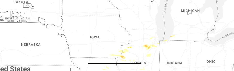
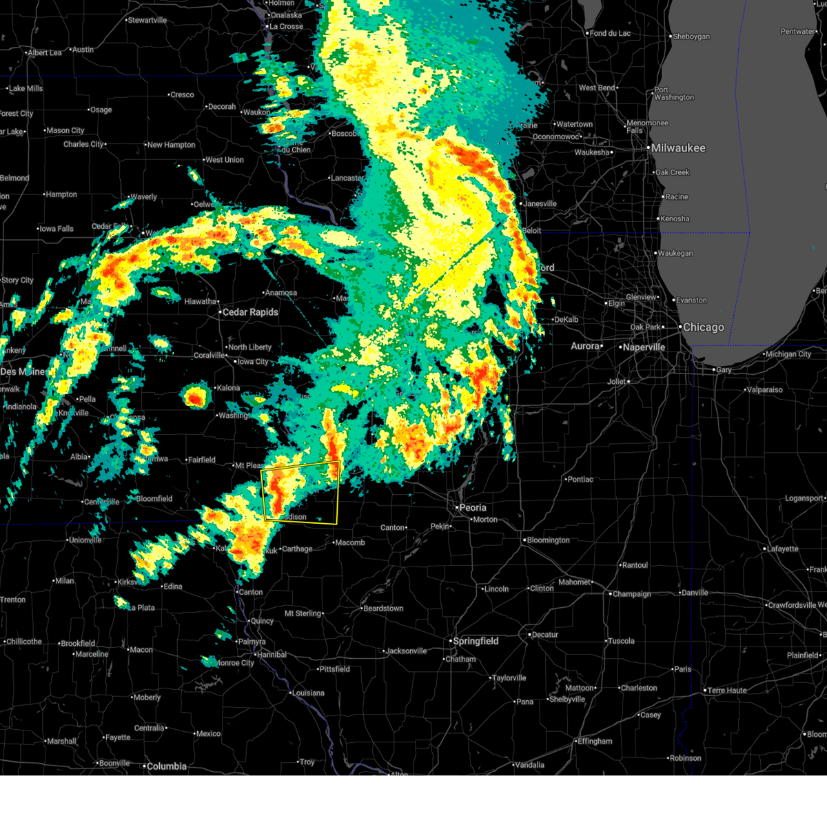
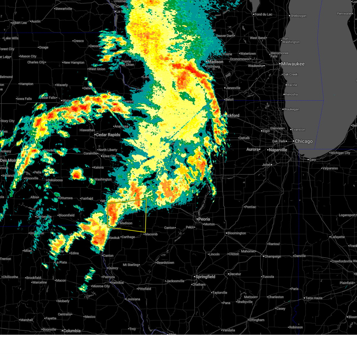
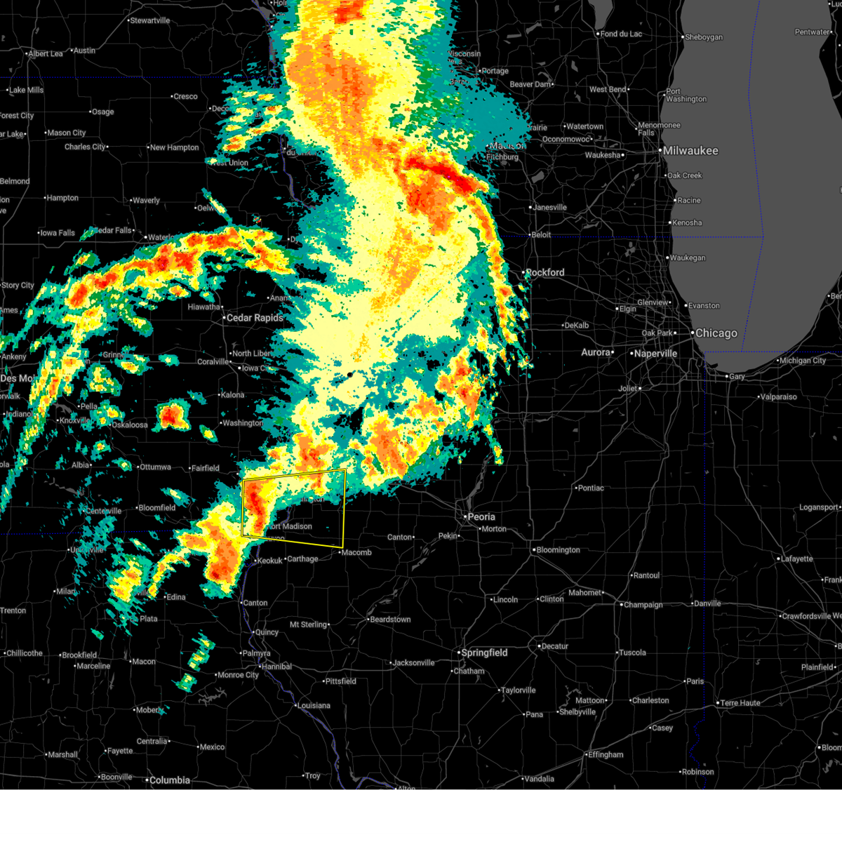
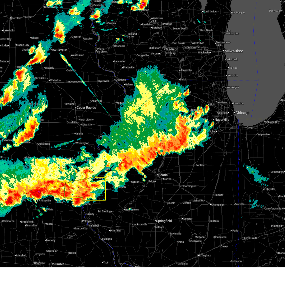
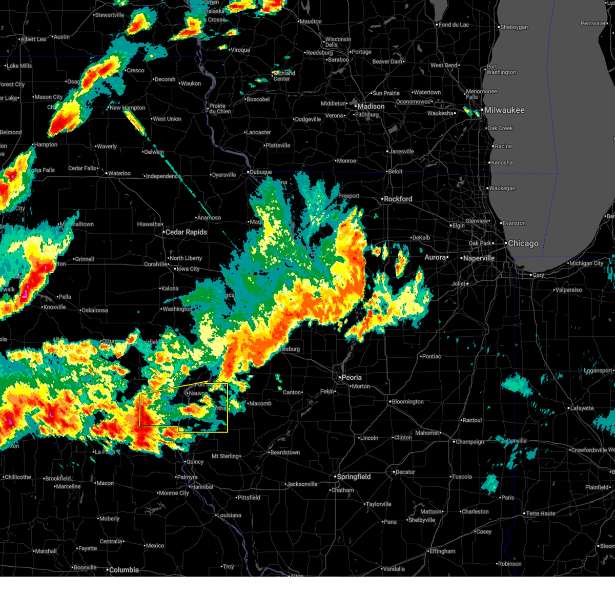
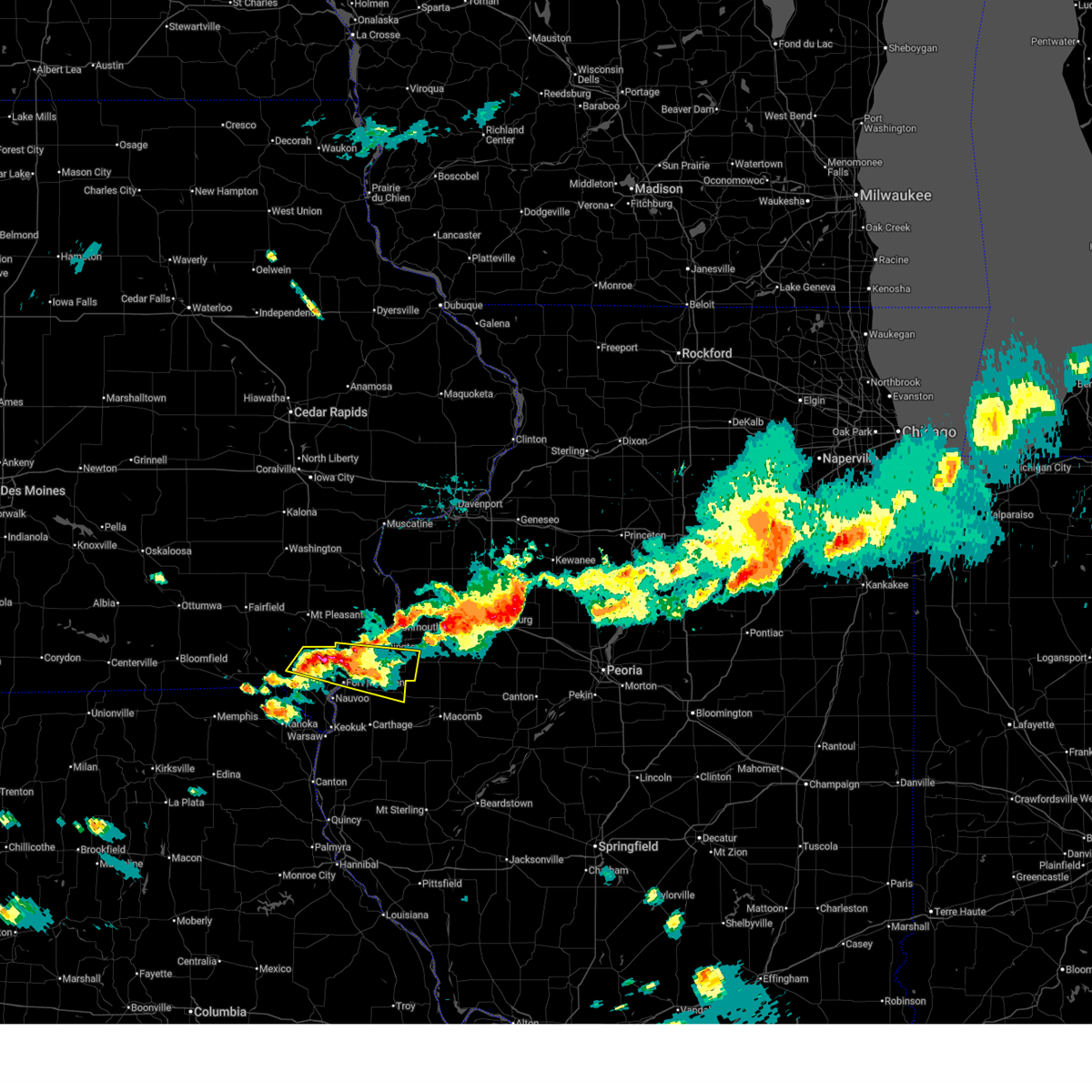
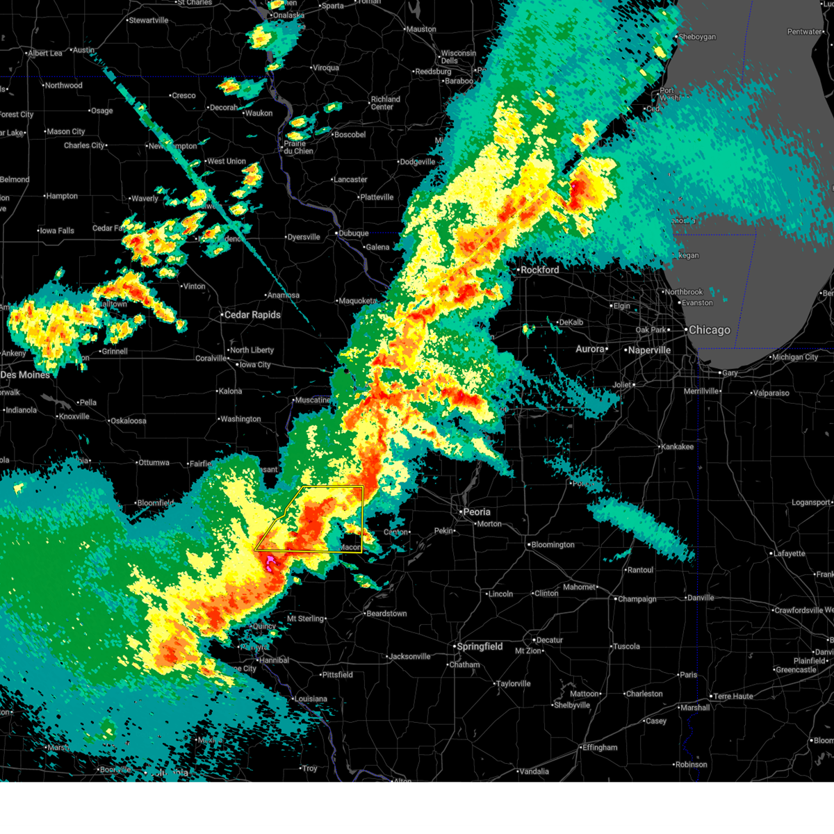
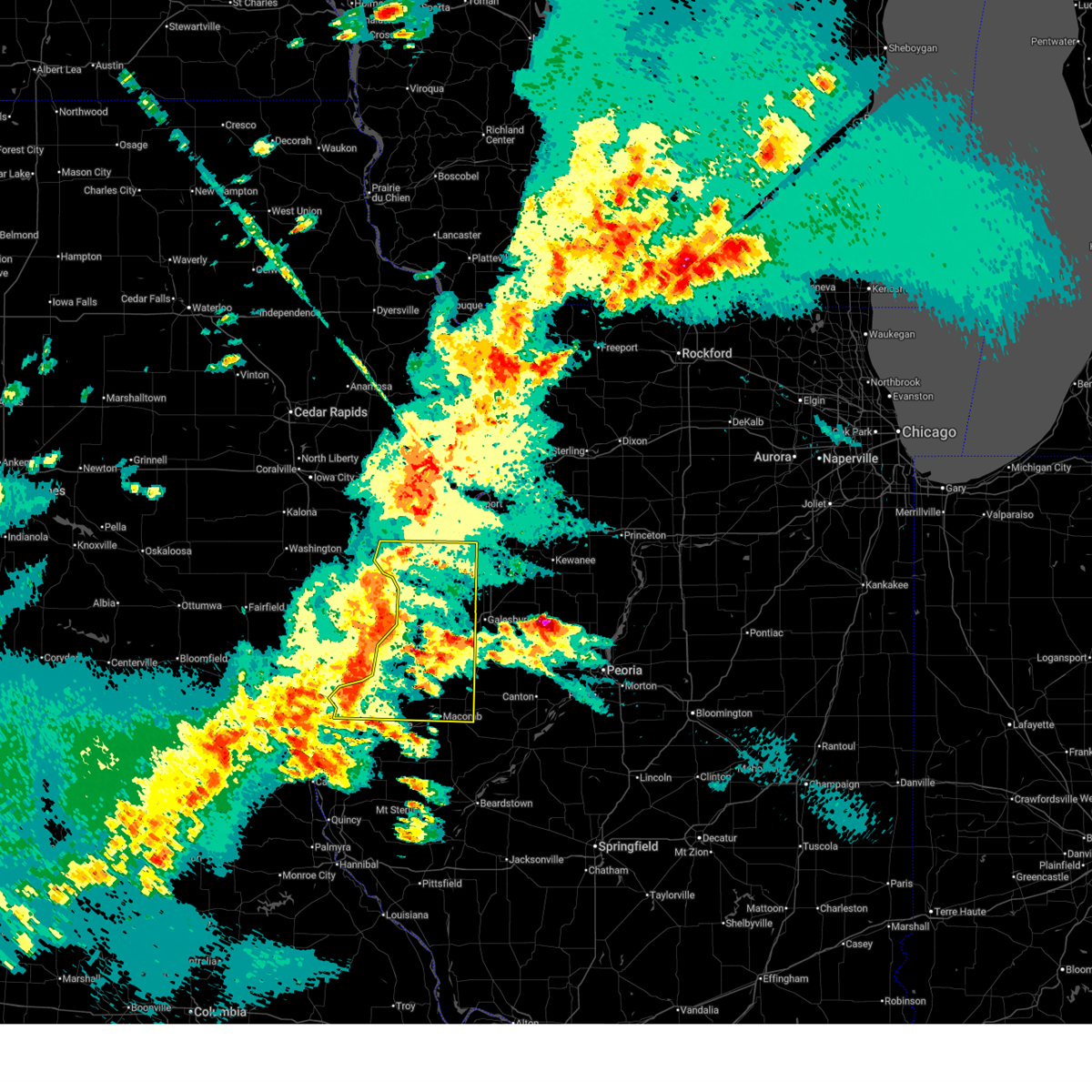
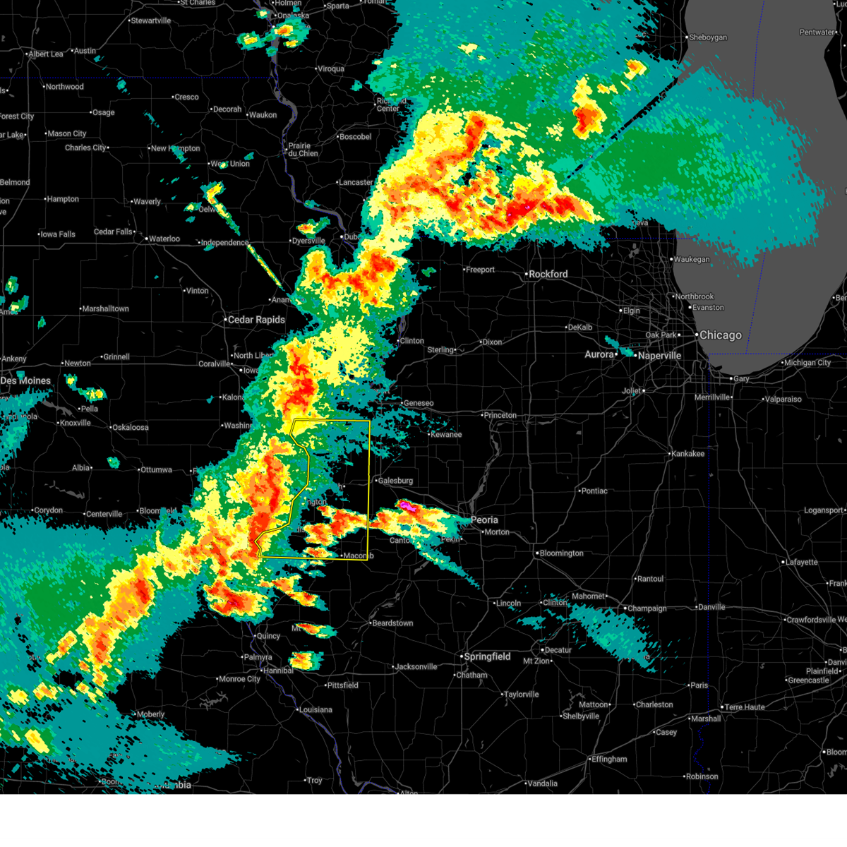
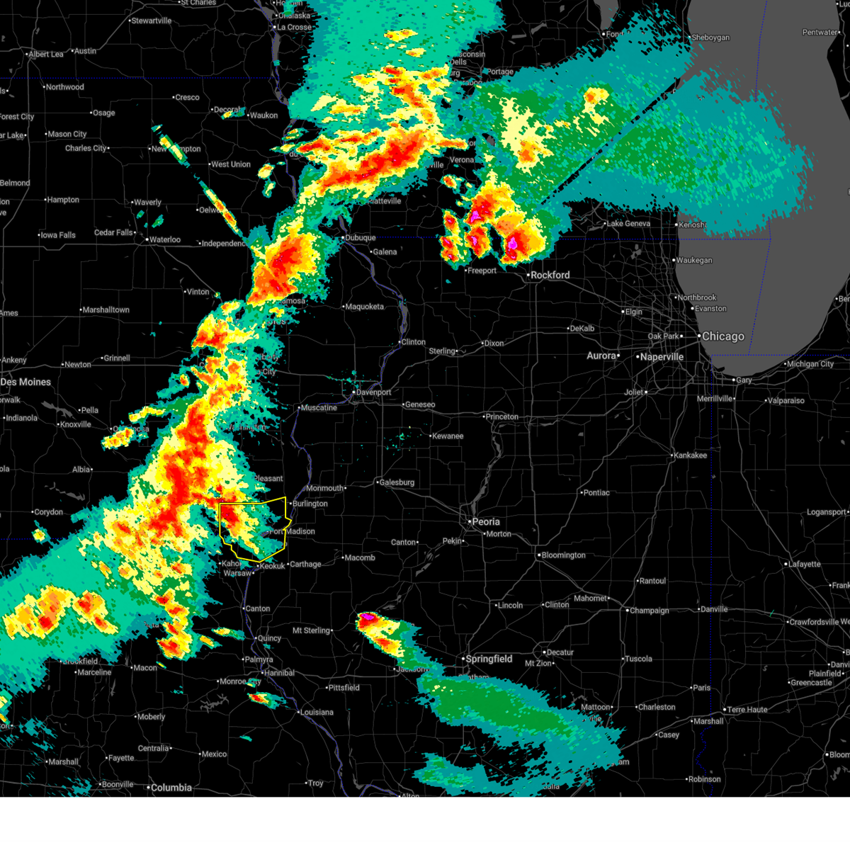
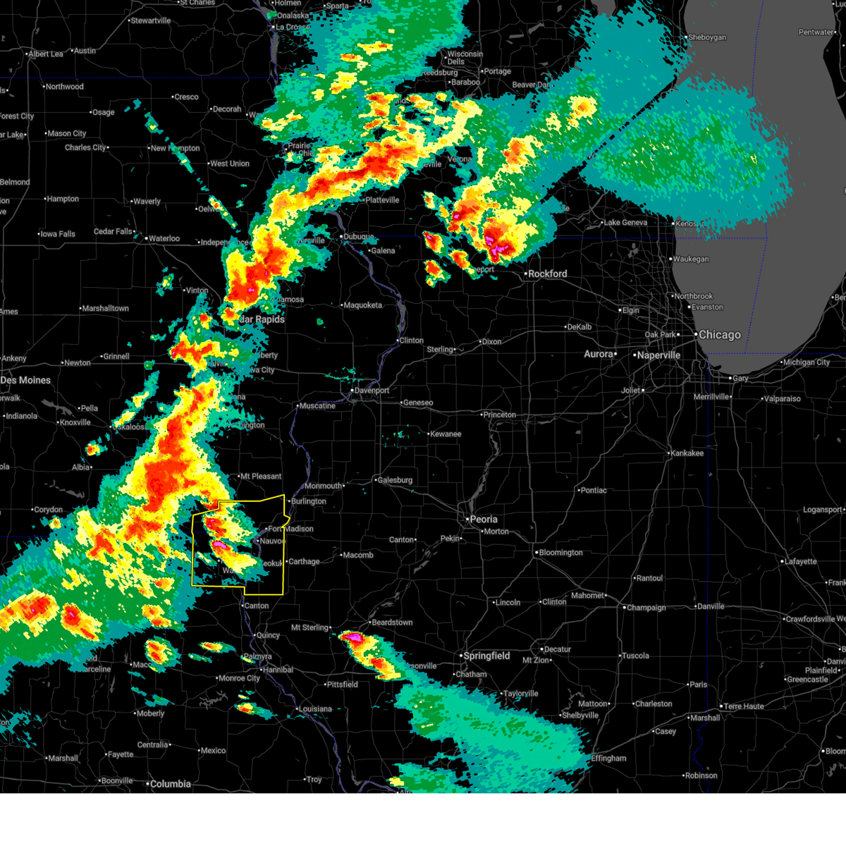
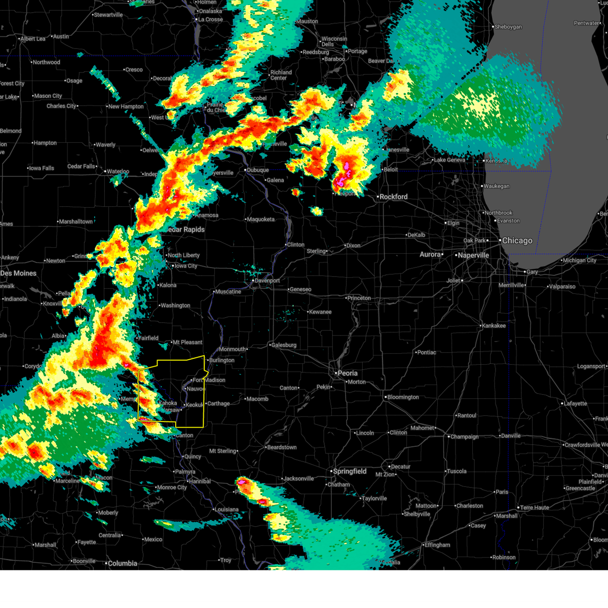
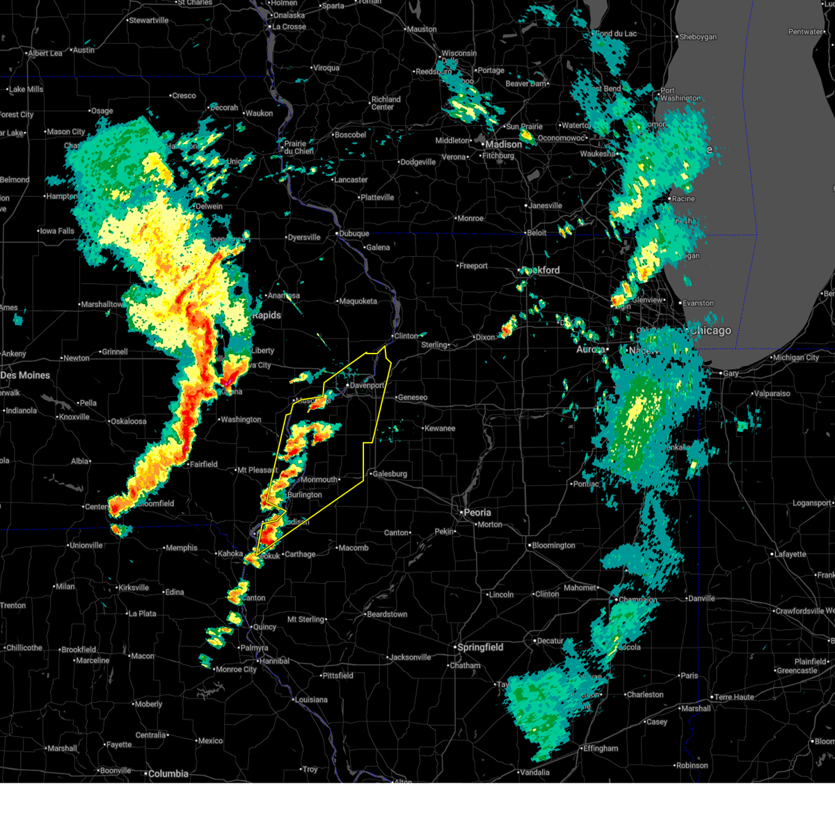
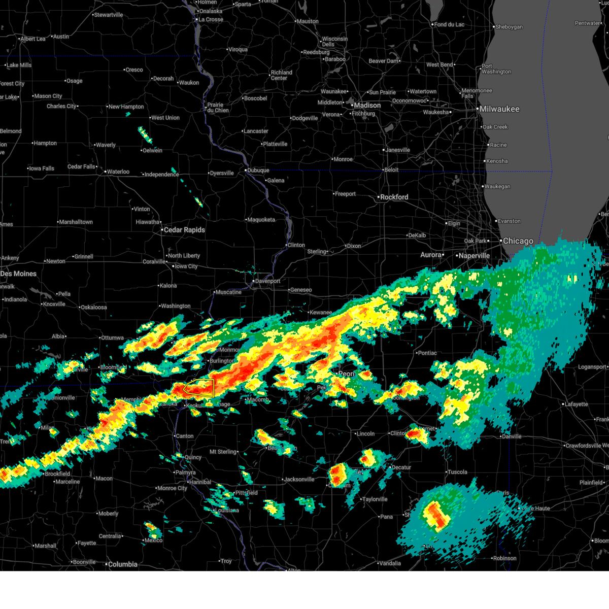
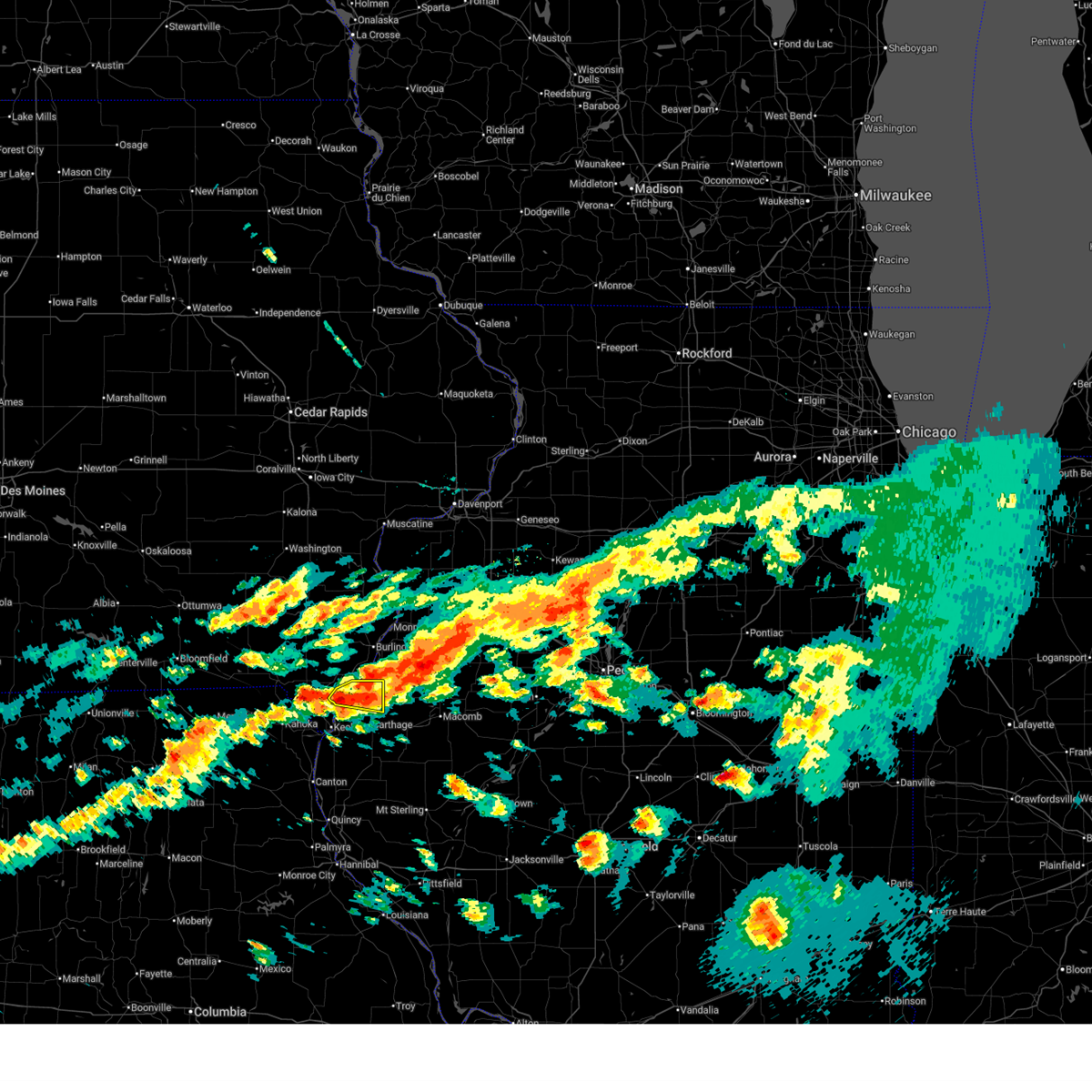
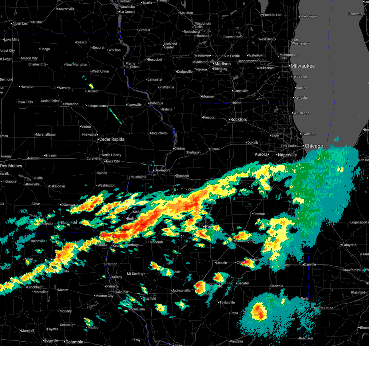
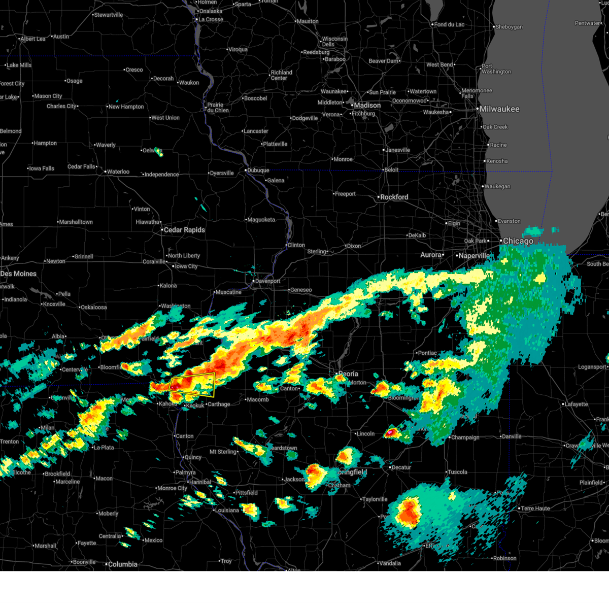
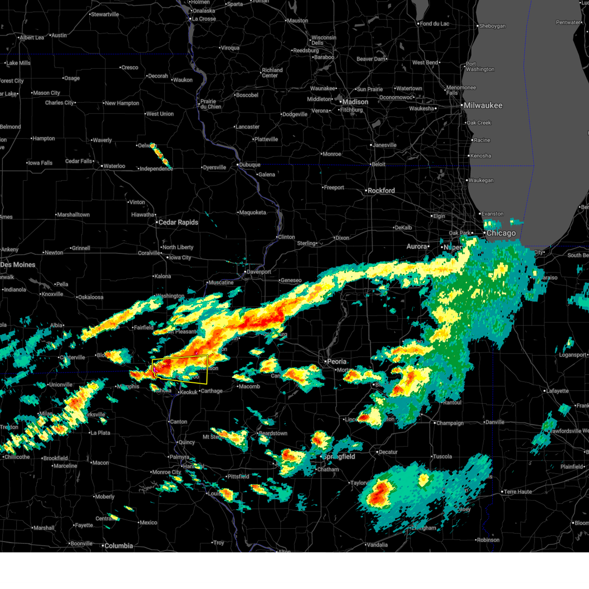
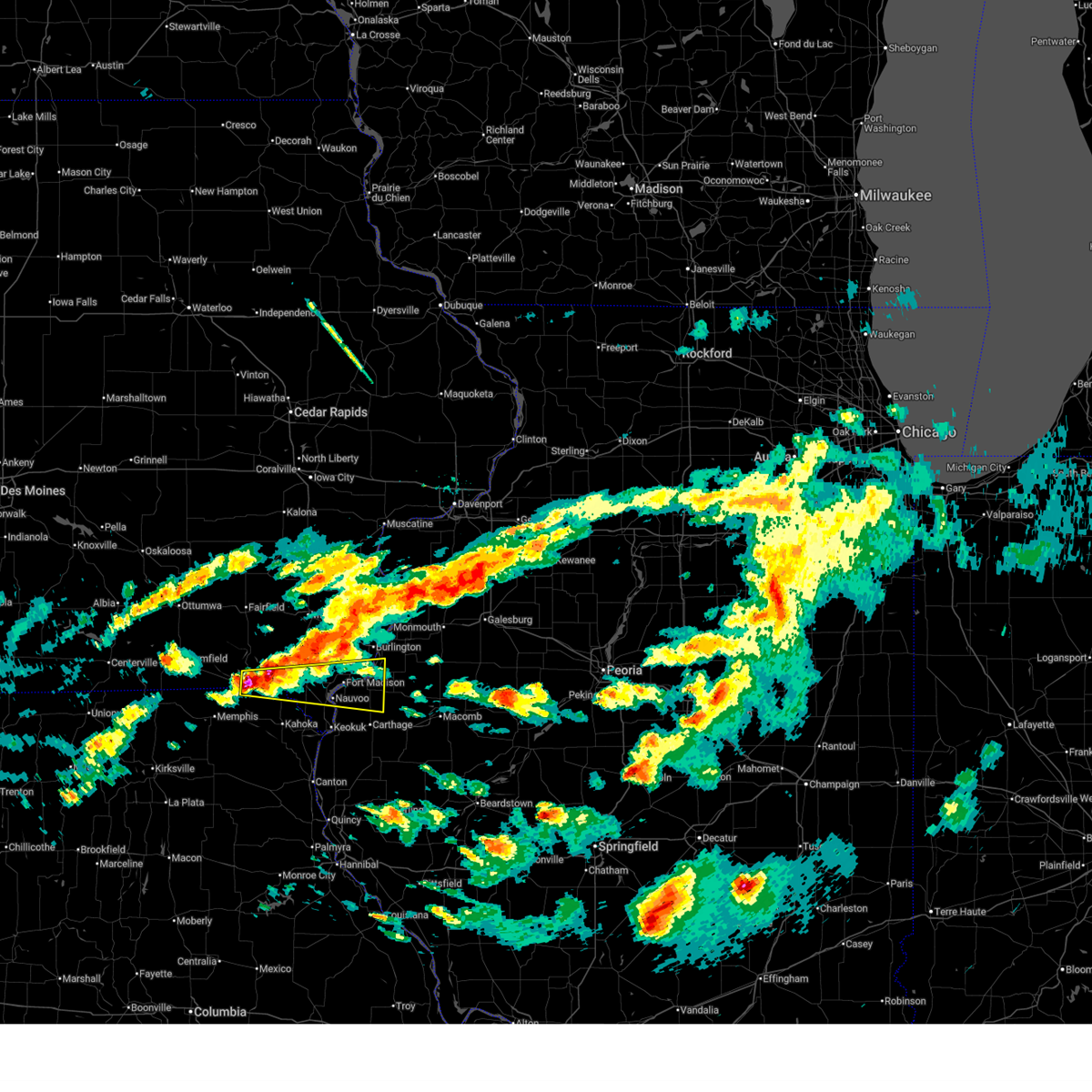
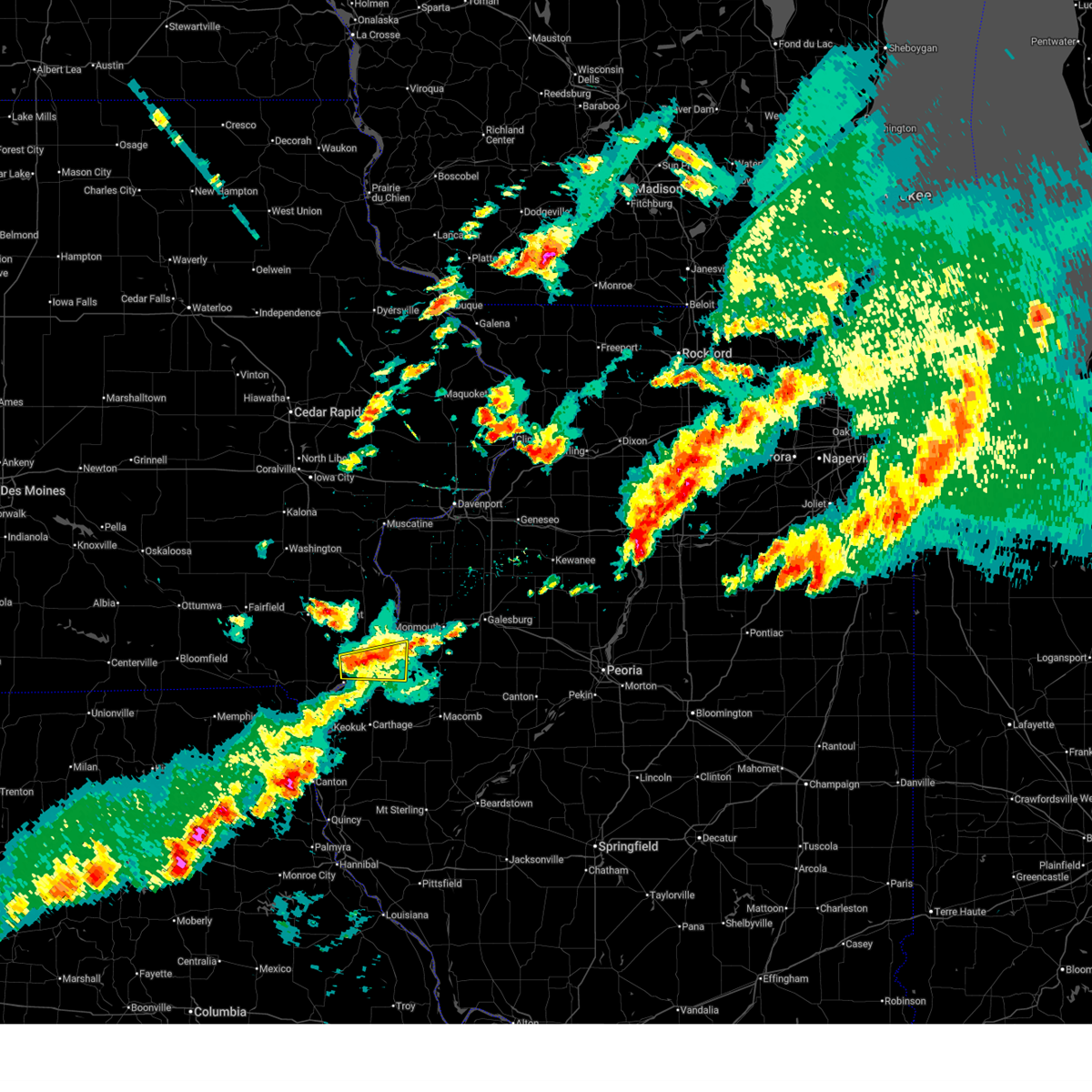
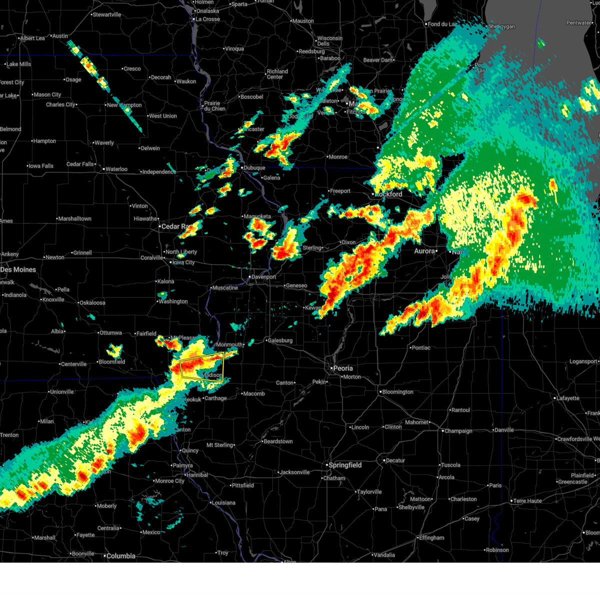
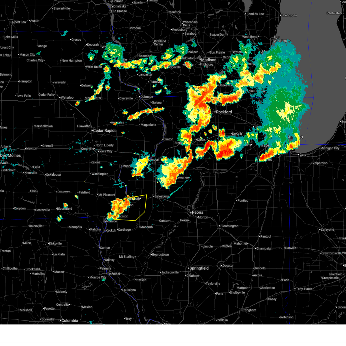
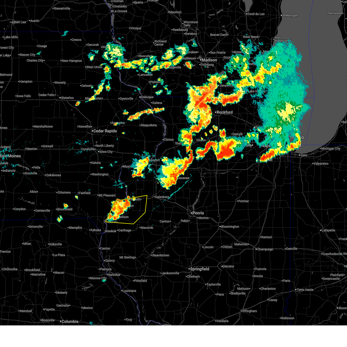
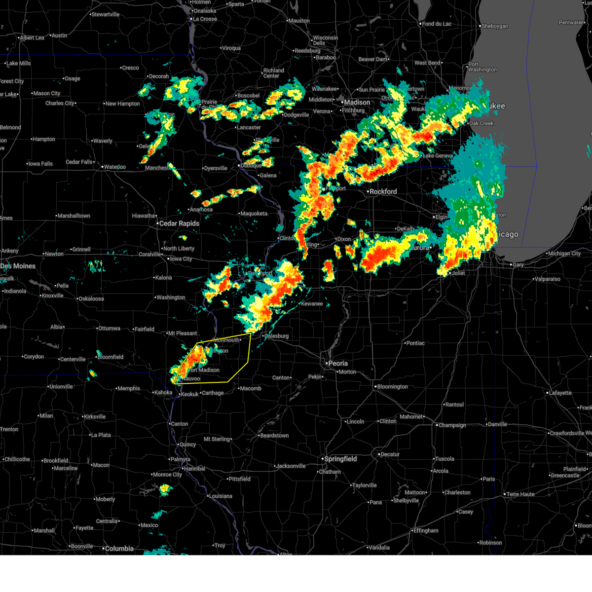
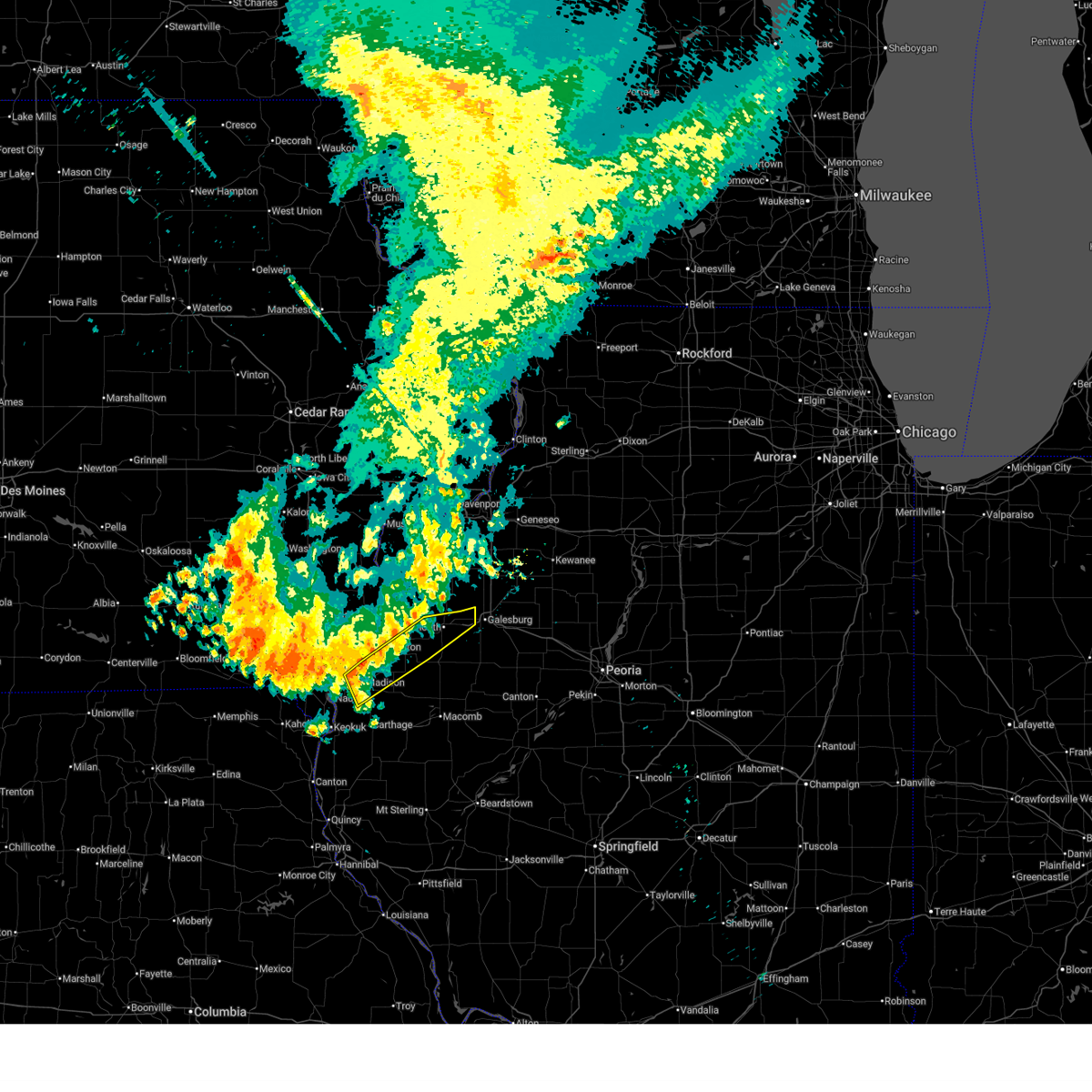
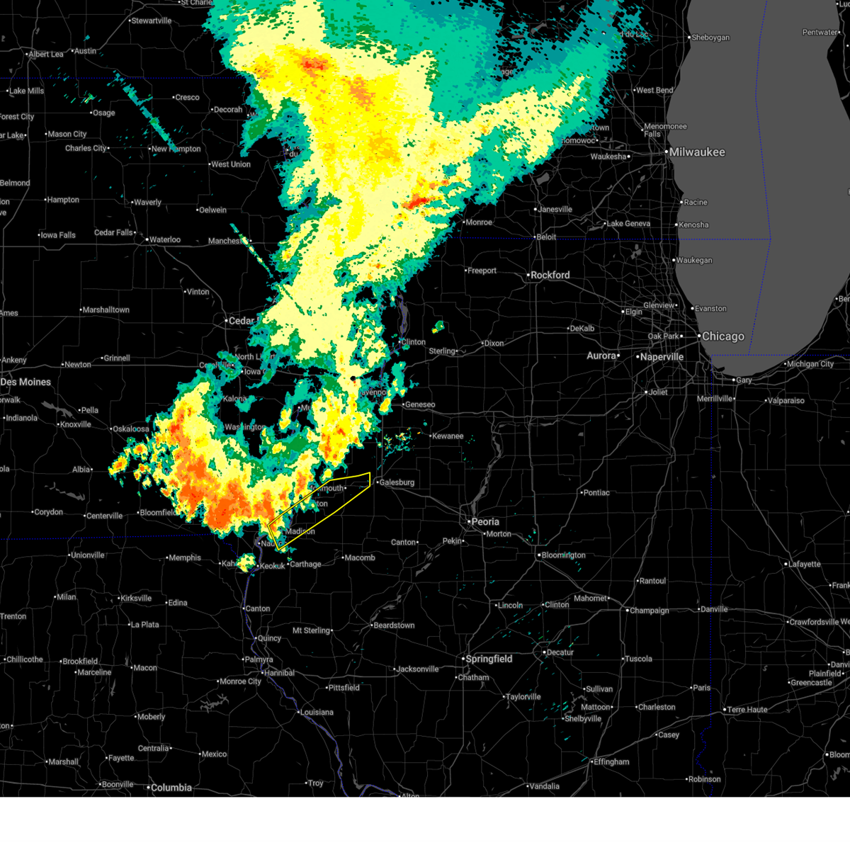
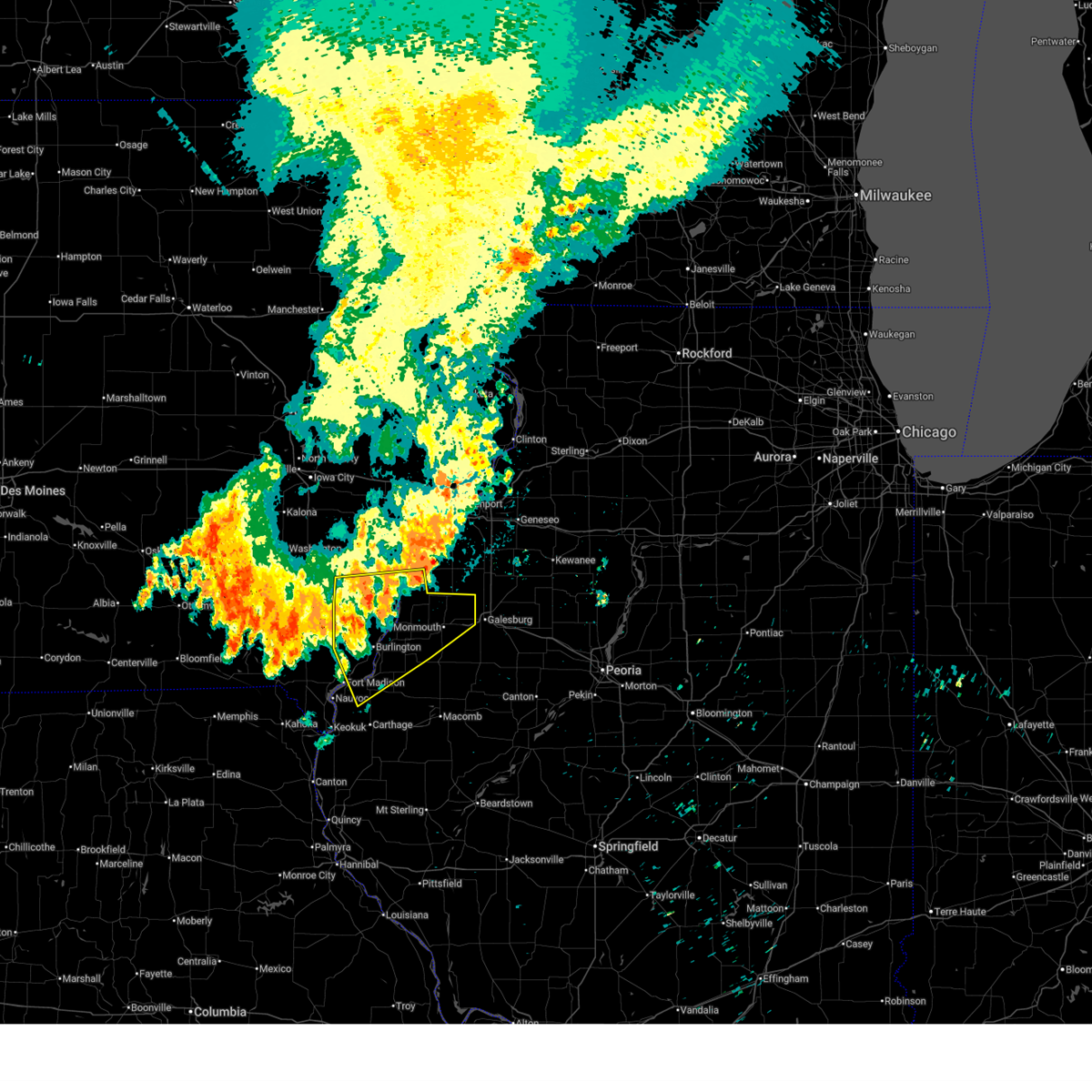
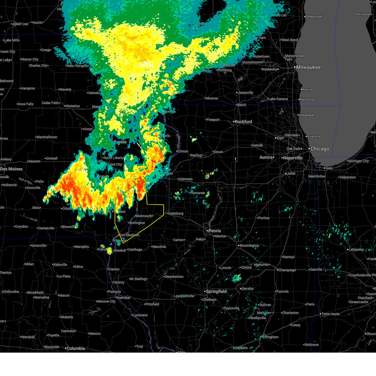
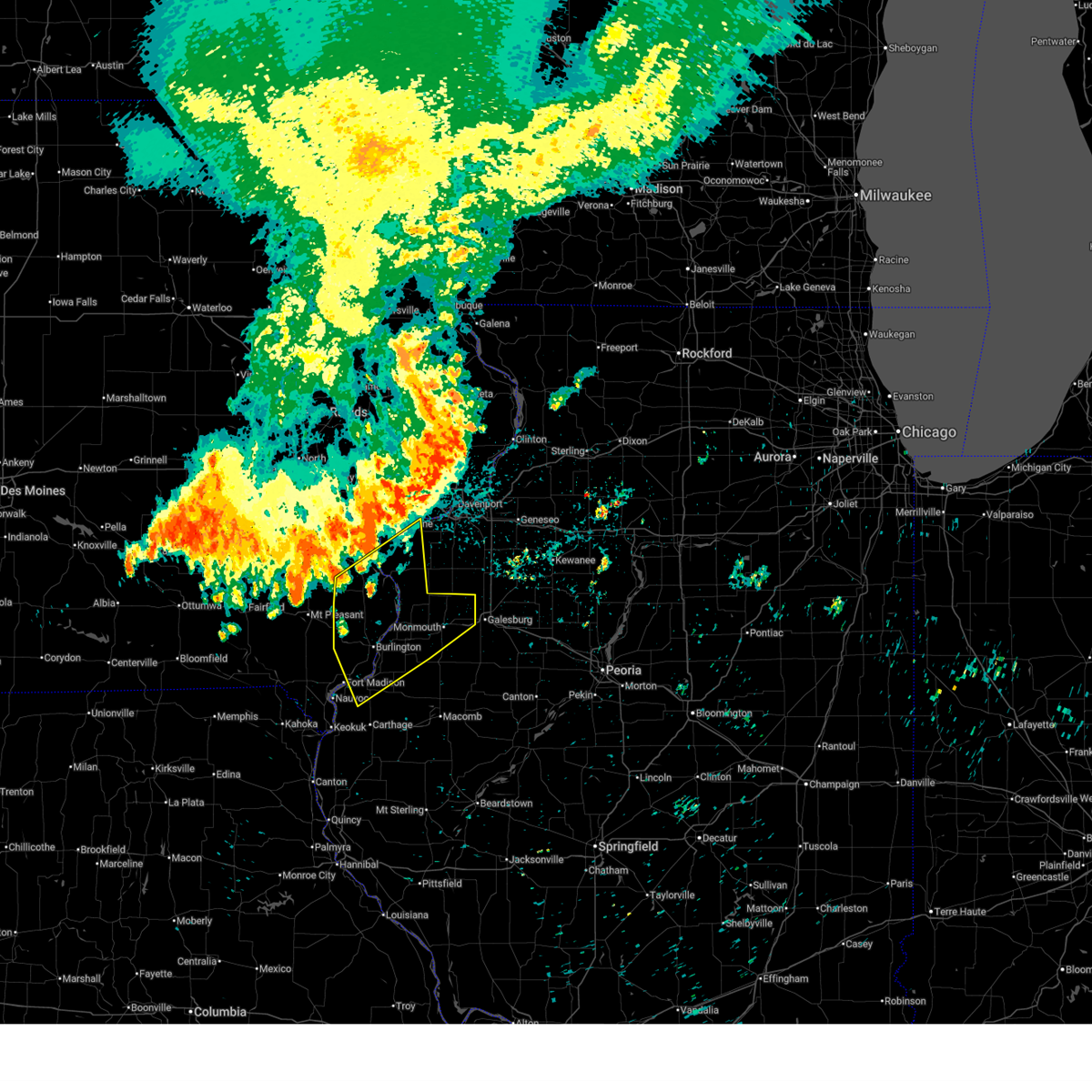
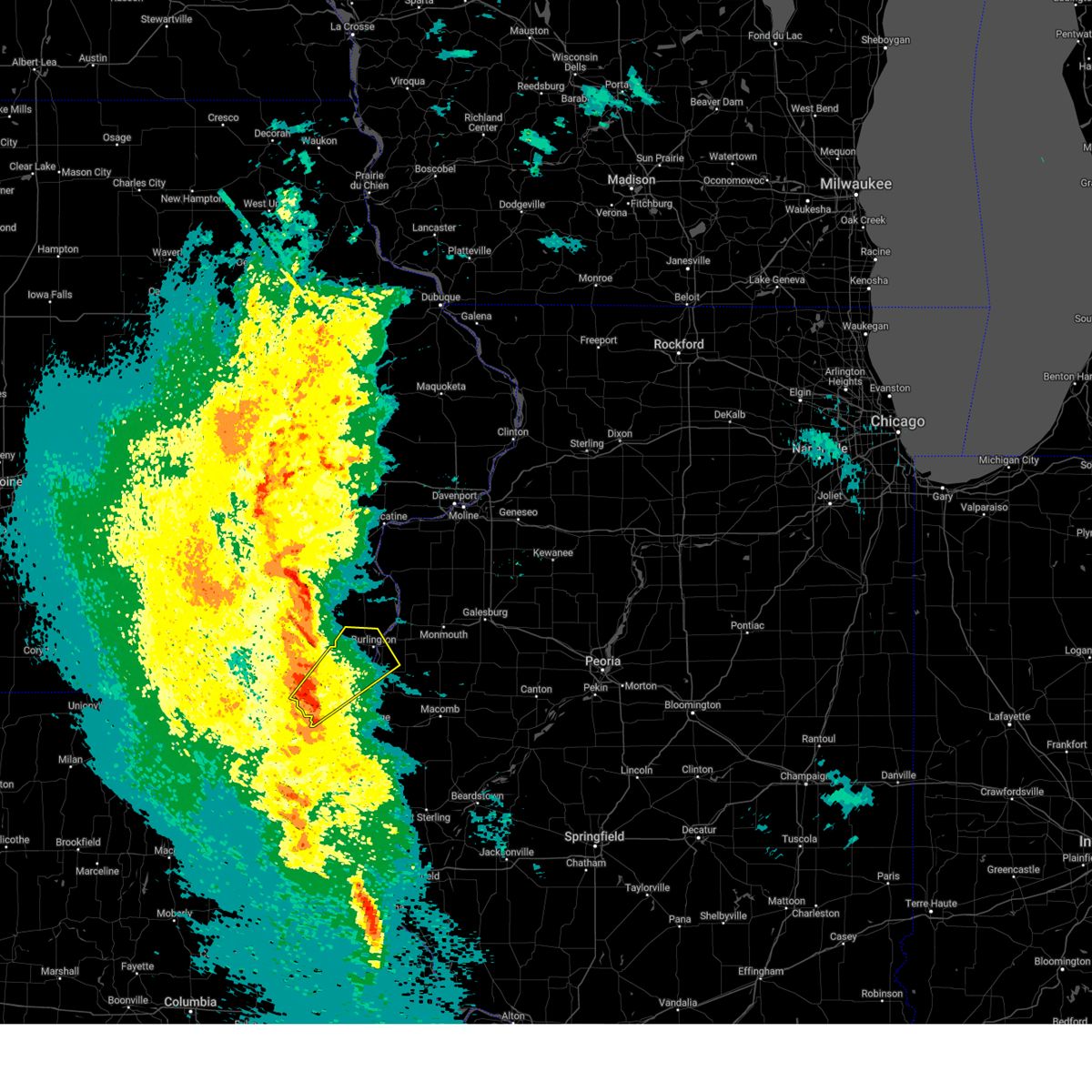
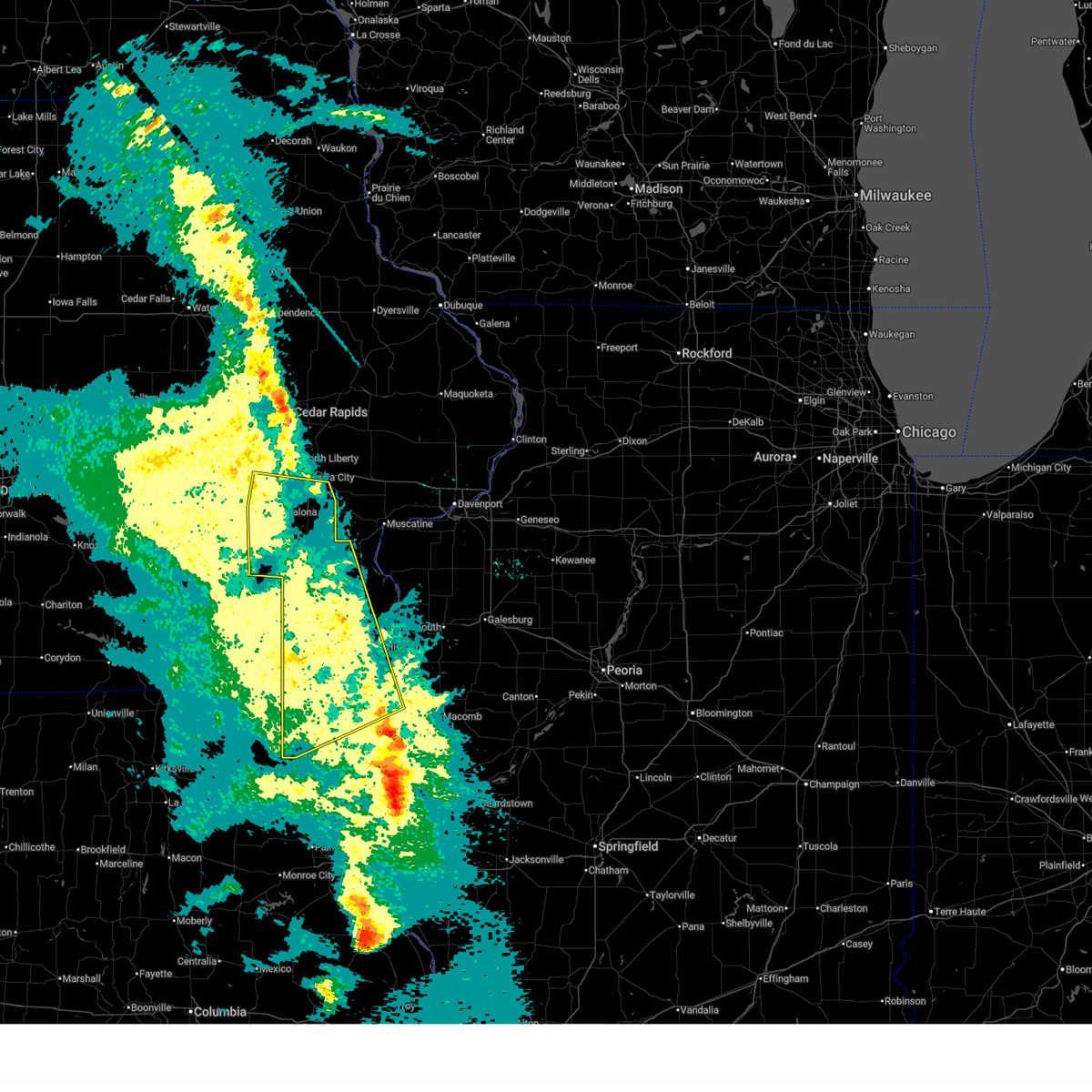
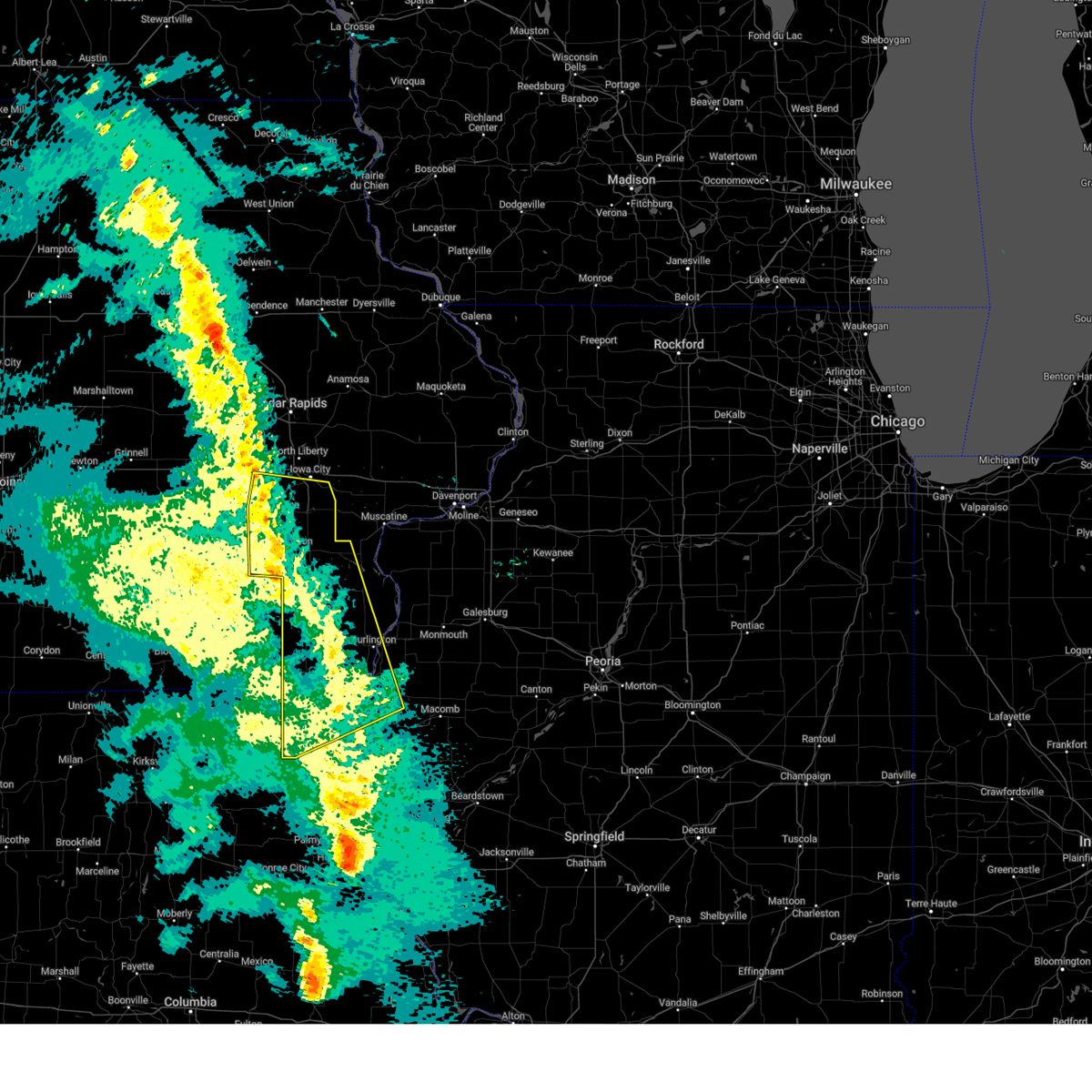
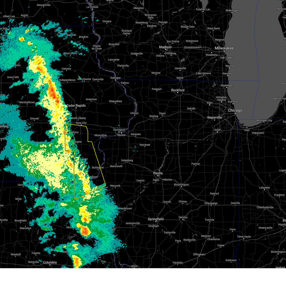
Hail Map for Dallas City, IL
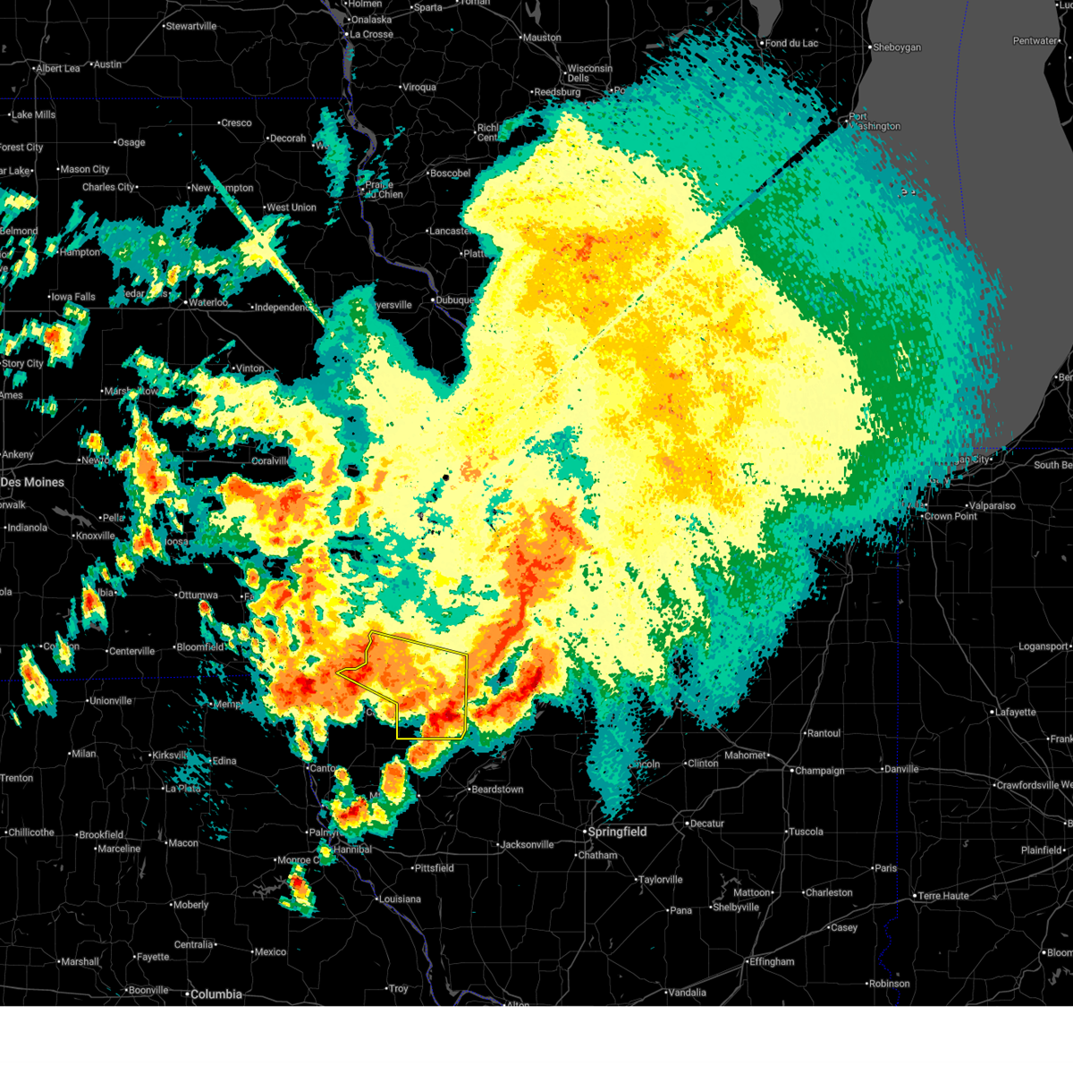
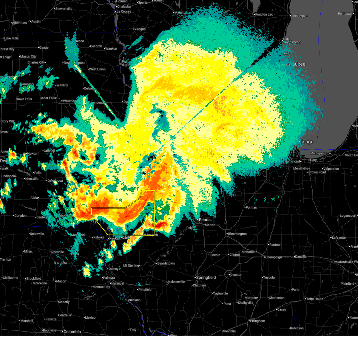
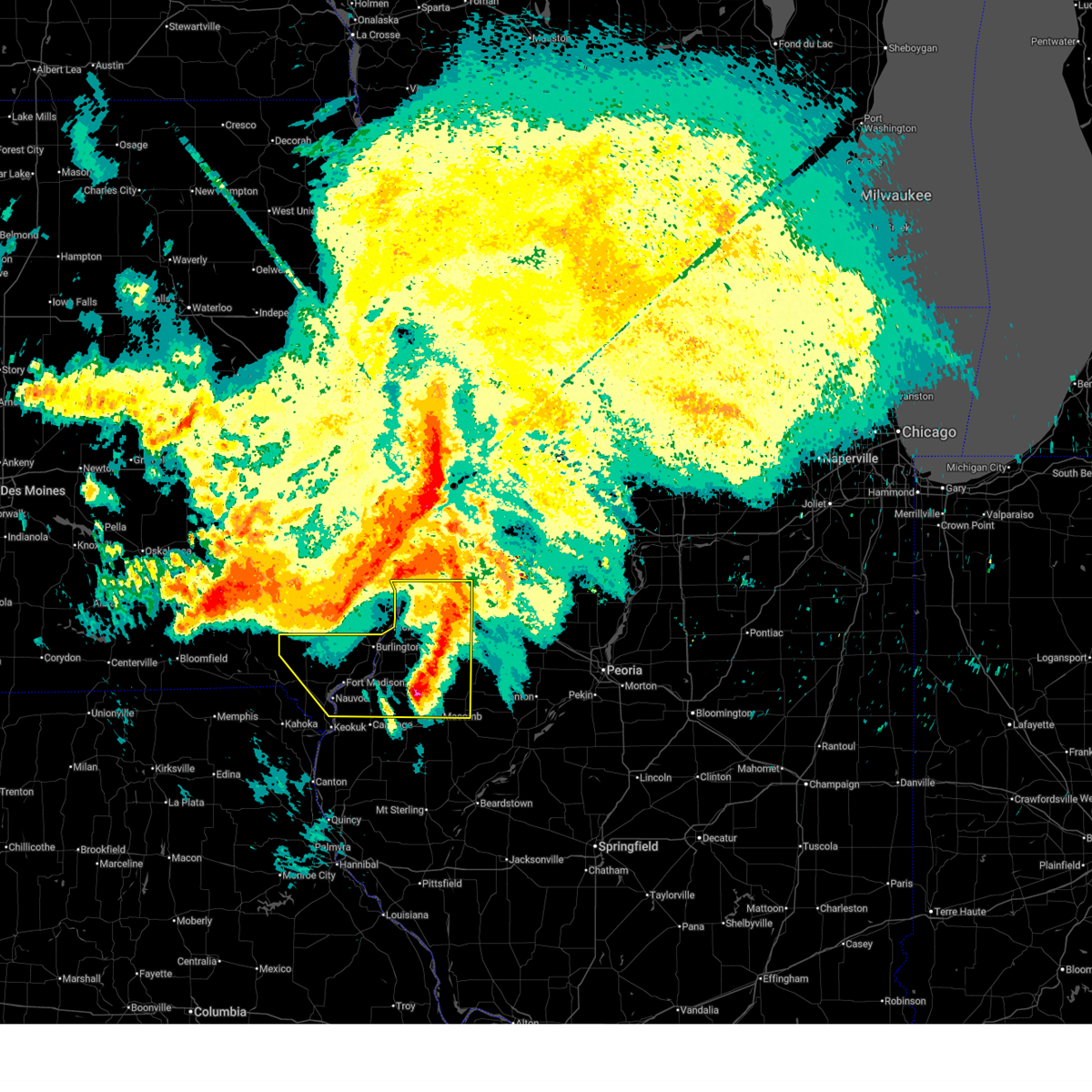
The Dallas City, IL area has had 5 reports of on-the-ground hail by trained spotters, and has been under severe weather warnings 46 times during the past 12 months. Doppler radar has detected hail at or near Dallas City, IL on 51 occasions, including 3 occasions during the past year.
| Name: | Dallas City, IL |
| Where Located: | 32.7 miles ENE of Kahoka, MO |
| Map: | Google Map for Dallas City, IL |
| Population: | 945 |
| Housing Units: | 492 |
| More Info: | Search Google for Dallas City, IL |
1
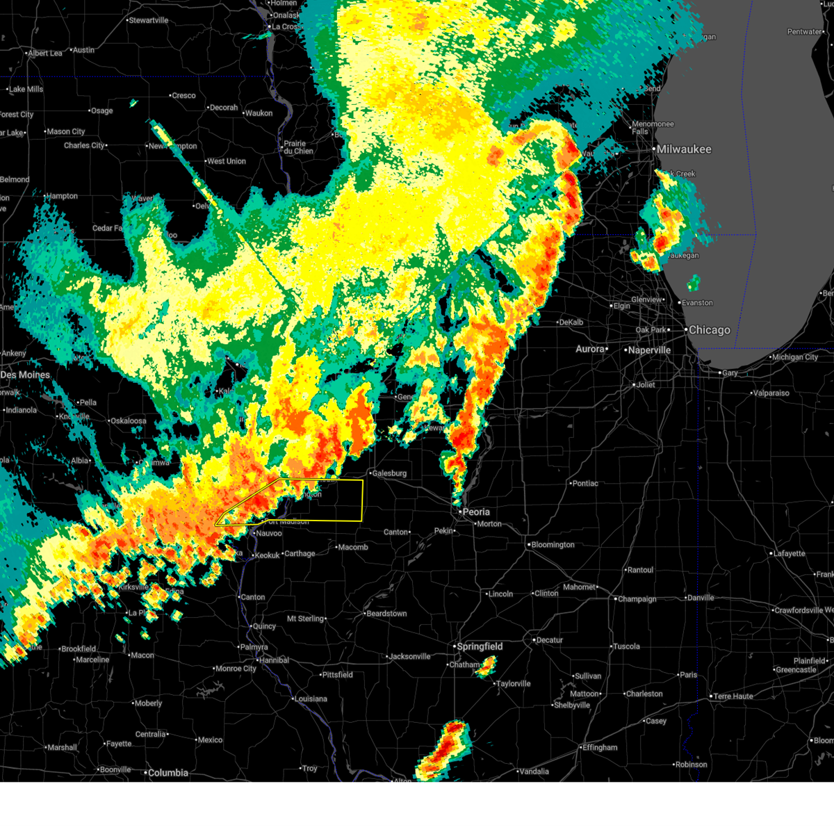
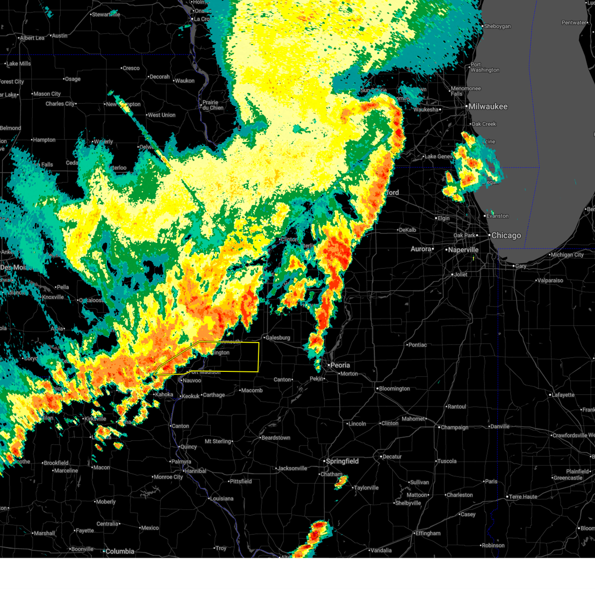
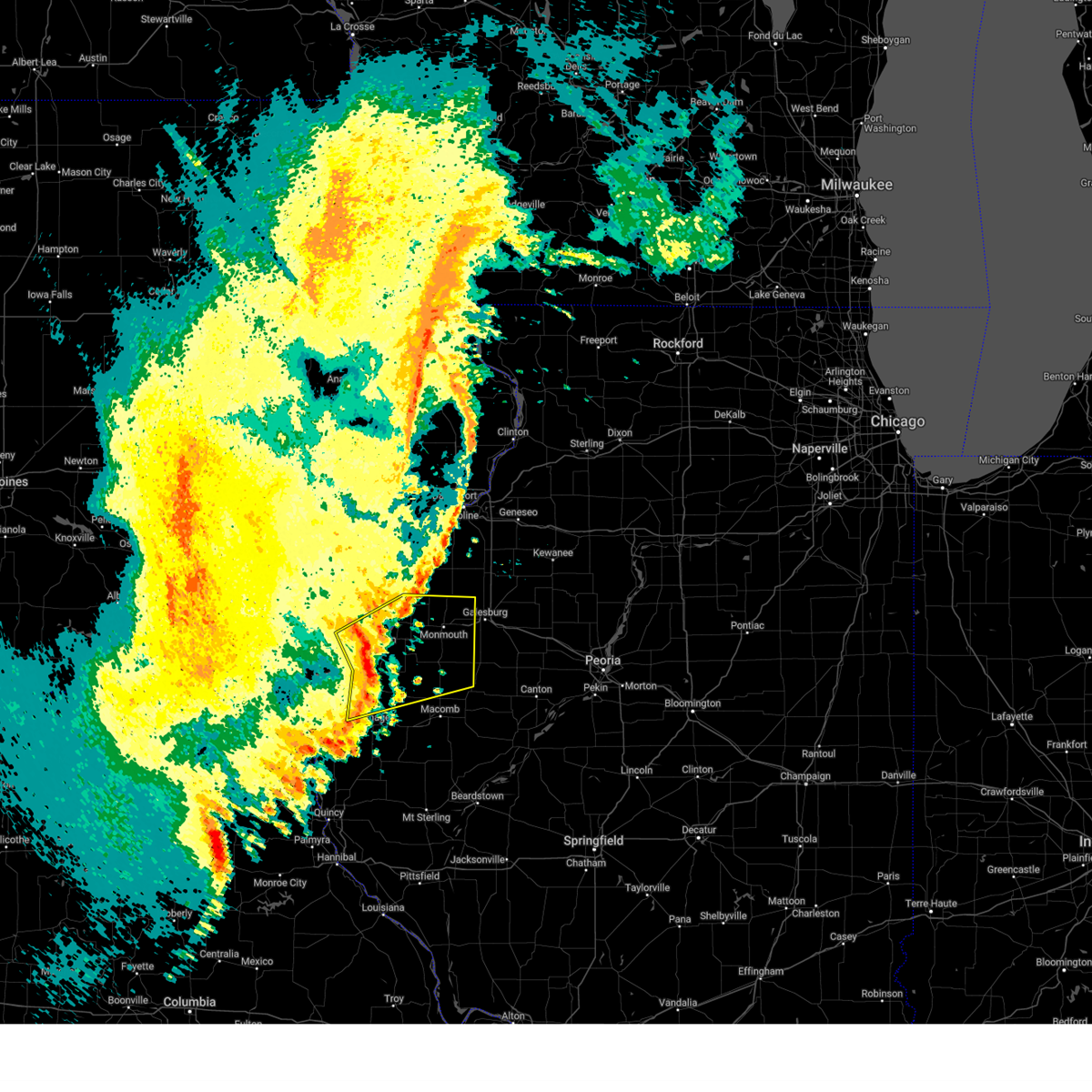
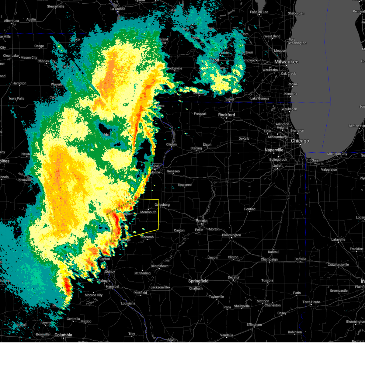
The Top Recent Hail Date for Dallas City, IL is Monday, May 4, 2026 (17th out of 51)
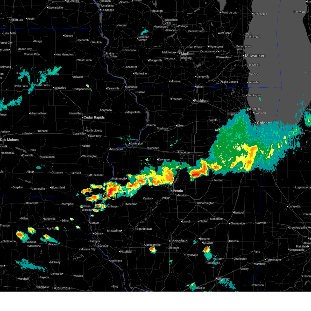
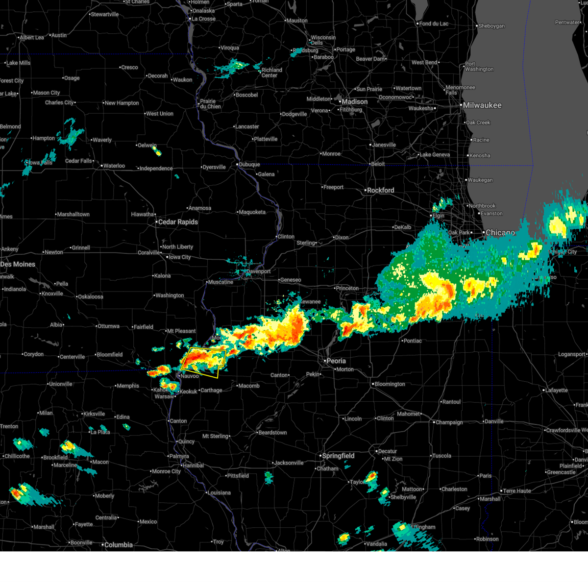
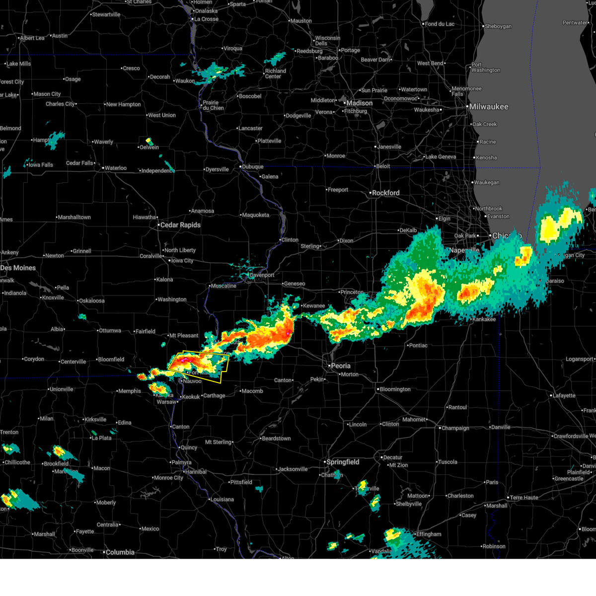
Hail and Wind Damage Spotted near Dallas City, IL
| Date / Time | Report Details |
|---|---|
| 6/17/2026 8:54 AM CDT |
 Svrdvn the national weather service in the quad cities has issued a * severe thunderstorm warning for, northeastern hancock county in west central illinois, southern henderson county in west central illinois, southern warren county in west central illinois, mcdonough county in west central illinois, * until 1000 am cdt. * at 854 am cdt, severe thunderstorms were located along a line extending from hopper to near camp eastman, moving southeast at 60 mph (radar indicated). Hazards include 70 mph wind gusts and quarter size hail. Hail damage to vehicles is expected. expect considerable tree damage. Wind damage is also likely to mobile homes, roofs, and outbuildings. Svrdvn the national weather service in the quad cities has issued a * severe thunderstorm warning for, northeastern hancock county in west central illinois, southern henderson county in west central illinois, southern warren county in west central illinois, mcdonough county in west central illinois, * until 1000 am cdt. * at 854 am cdt, severe thunderstorms were located along a line extending from hopper to near camp eastman, moving southeast at 60 mph (radar indicated). Hazards include 70 mph wind gusts and quarter size hail. Hail damage to vehicles is expected. expect considerable tree damage. Wind damage is also likely to mobile homes, roofs, and outbuildings.
|
| 6/17/2026 8:31 AM CDT |
 At 829 am cdt, severe thunderstorms were located along a line extending from near coldbrook to raritan to near niota, moving east at 75 mph (trained weather spotters. around 821 am, the burlington airport reported a 58 mph wind gust). Hazards include 70 mph wind gusts. Expect considerable tree damage. damage is likely to mobile homes, roofs, and outbuildings. locations impacted include, burlington, macomb, fort madison, monmouth, oquawka, nauvoo, bushnell, west burlington, burgess, la harpe, roseville, west point, dallas city, danville, donnellson, montrose, stronghurst, kirkwood, blandinsville, and good hope. This also includes argyle lake state park, henderson county conservation area, and nauvoo state park. At 829 am cdt, severe thunderstorms were located along a line extending from near coldbrook to raritan to near niota, moving east at 75 mph (trained weather spotters. around 821 am, the burlington airport reported a 58 mph wind gust). Hazards include 70 mph wind gusts. Expect considerable tree damage. damage is likely to mobile homes, roofs, and outbuildings. locations impacted include, burlington, macomb, fort madison, monmouth, oquawka, nauvoo, bushnell, west burlington, burgess, la harpe, roseville, west point, dallas city, danville, donnellson, montrose, stronghurst, kirkwood, blandinsville, and good hope. This also includes argyle lake state park, henderson county conservation area, and nauvoo state park.
|
| 6/17/2026 8:31 AM CDT |
 the severe thunderstorm warning has been cancelled and is no longer in effect the severe thunderstorm warning has been cancelled and is no longer in effect
|
| 6/17/2026 7:57 AM CDT |
 Svrdvn the national weather service in the quad cities has issued a * severe thunderstorm warning for, northern hancock county in west central illinois, henderson county in west central illinois, warren county in west central illinois, northern mcdonough county in west central illinois, southern mercer county in northwestern illinois, southern henry county in southeastern iowa, southeastern des moines county in southeastern iowa, east central van buren county in southeastern iowa, southeastern louisa county in southeastern iowa, lee county in southeastern iowa, * until 900 am cdt. * at 757 am cdt, severe thunderstorms were located along a line extending from near new boston to near danville to near hillsboro, moving southeast at 55 mph (radar indicated). Hazards include 70 mph wind gusts. Expect considerable tree damage. Damage is likely to mobile homes, roofs, and outbuildings. Svrdvn the national weather service in the quad cities has issued a * severe thunderstorm warning for, northern hancock county in west central illinois, henderson county in west central illinois, warren county in west central illinois, northern mcdonough county in west central illinois, southern mercer county in northwestern illinois, southern henry county in southeastern iowa, southeastern des moines county in southeastern iowa, east central van buren county in southeastern iowa, southeastern louisa county in southeastern iowa, lee county in southeastern iowa, * until 900 am cdt. * at 757 am cdt, severe thunderstorms were located along a line extending from near new boston to near danville to near hillsboro, moving southeast at 55 mph (radar indicated). Hazards include 70 mph wind gusts. Expect considerable tree damage. Damage is likely to mobile homes, roofs, and outbuildings.
|
| 6/11/2026 11:34 AM CDT |
 At 1134 am cdt, a severe thunderstorm was located over spring grove, or near burlington, moving east at 45 mph (radar indicated). Hazards include 60 mph wind gusts and quarter size hail. Hail damage to vehicles is expected. expect wind damage to roofs, siding, and trees. locations impacted include, burlington, fort madison, monmouth, oquawka, west burlington, roseville, dallas city, stronghurst, kirkwood, middletown, carman, biggsville, gladstone, rozetta, terre haute, raritan, gulf port, lake warren, disco, and iowa army ammunition plant. This also includes delabar state park and henderson county conservation area. At 1134 am cdt, a severe thunderstorm was located over spring grove, or near burlington, moving east at 45 mph (radar indicated). Hazards include 60 mph wind gusts and quarter size hail. Hail damage to vehicles is expected. expect wind damage to roofs, siding, and trees. locations impacted include, burlington, fort madison, monmouth, oquawka, west burlington, roseville, dallas city, stronghurst, kirkwood, middletown, carman, biggsville, gladstone, rozetta, terre haute, raritan, gulf port, lake warren, disco, and iowa army ammunition plant. This also includes delabar state park and henderson county conservation area.
|
| 6/11/2026 11:28 AM CDT |
 At 1128 am cdt, a severe thunderstorm was located over wever, or 7 miles southwest of burlington, moving east at 45 mph (radar indicated). Hazards include 60 mph wind gusts and quarter size hail. Hail damage to vehicles is expected. expect wind damage to roofs, siding, and trees. locations impacted include, burlington, macomb, fort madison, monmouth, oquawka, west burlington, new london, la harpe, roseville, dallas city, danville, stronghurst, kirkwood, blandinsville, good hope, middletown, carman, biggsville, gladstone, and rozetta. This also includes delabar state park and henderson county conservation area. At 1128 am cdt, a severe thunderstorm was located over wever, or 7 miles southwest of burlington, moving east at 45 mph (radar indicated). Hazards include 60 mph wind gusts and quarter size hail. Hail damage to vehicles is expected. expect wind damage to roofs, siding, and trees. locations impacted include, burlington, macomb, fort madison, monmouth, oquawka, west burlington, new london, la harpe, roseville, dallas city, danville, stronghurst, kirkwood, blandinsville, good hope, middletown, carman, biggsville, gladstone, and rozetta. This also includes delabar state park and henderson county conservation area.
|
| 6/11/2026 11:21 AM CDT |
 Svrdvn the national weather service in the quad cities has issued a * severe thunderstorm warning for, northeastern hancock county in west central illinois, henderson county in west central illinois, western warren county in west central illinois, northwestern mcdonough county in west central illinois, southeastern henry county in southeastern iowa, central des moines county in southeastern iowa, northeastern lee county in southeastern iowa, * until 1215 pm cdt. * at 1121 am cdt, a severe thunderstorm was located over denmark, or 8 miles north of fort madison, moving east at 45 mph (radar indicated). Hazards include 60 mph wind gusts and quarter size hail. Hail damage to vehicles is expected. Expect wind damage to roofs, siding, and trees. Svrdvn the national weather service in the quad cities has issued a * severe thunderstorm warning for, northeastern hancock county in west central illinois, henderson county in west central illinois, western warren county in west central illinois, northwestern mcdonough county in west central illinois, southeastern henry county in southeastern iowa, central des moines county in southeastern iowa, northeastern lee county in southeastern iowa, * until 1215 pm cdt. * at 1121 am cdt, a severe thunderstorm was located over denmark, or 8 miles north of fort madison, moving east at 45 mph (radar indicated). Hazards include 60 mph wind gusts and quarter size hail. Hail damage to vehicles is expected. Expect wind damage to roofs, siding, and trees.
|
| 6/10/2026 7:56 PM CDT |
 At 756 pm cdt, severe thunderstorms were located along a line extending from near new boston to near tioga, moving east at 45 mph (radar indicated). Hazards include 60 mph wind gusts. Expect damage to roofs, siding, and trees. locations impacted include, fort madison, keokuk, carthage, kahoka, nauvoo, hamilton, warsaw, la harpe, dallas city, montrose, augusta, wayland, bowen, wyaconda, west point, alexandria, ferris, luray, colusa, and niota. This also includes nauvoo state park. At 756 pm cdt, severe thunderstorms were located along a line extending from near new boston to near tioga, moving east at 45 mph (radar indicated). Hazards include 60 mph wind gusts. Expect damage to roofs, siding, and trees. locations impacted include, fort madison, keokuk, carthage, kahoka, nauvoo, hamilton, warsaw, la harpe, dallas city, montrose, augusta, wayland, bowen, wyaconda, west point, alexandria, ferris, luray, colusa, and niota. This also includes nauvoo state park.
|
| 6/10/2026 7:30 PM CDT |
 Svrdvn the national weather service in the quad cities has issued a * severe thunderstorm warning for, hancock county in west central illinois, southern lee county in southeastern iowa, clark county in northeastern missouri, * until 845 pm cdt. * at 729 pm cdt, severe thunderstorms were located along a line extending from near chambersburg to near monticello, moving east at 45 mph (radar indicated). Hazards include 60 mph wind gusts. expect damage to roofs, siding, and trees Svrdvn the national weather service in the quad cities has issued a * severe thunderstorm warning for, hancock county in west central illinois, southern lee county in southeastern iowa, clark county in northeastern missouri, * until 845 pm cdt. * at 729 pm cdt, severe thunderstorms were located along a line extending from near chambersburg to near monticello, moving east at 45 mph (radar indicated). Hazards include 60 mph wind gusts. expect damage to roofs, siding, and trees
|
| 5/4/2026 8:17 PM CDT |
 At 816 pm cdt, a severe thunderstorm was located over terre haute, or 10 miles southeast of burlington, moving east at 35 mph (radar indicated). Hazards include 60 mph wind gusts and quarter size hail. Hail damage to vehicles is expected. expect wind damage to roofs, siding, and trees. Locations impacted include, burlington, la harpe, dallas city, stronghurst, carman, terre haute, raritan, gulf port, disco, lomax, media, carthage lake, shokokon, heapsville, henderson county fairgrounds, olena, hopper, and decorra. At 816 pm cdt, a severe thunderstorm was located over terre haute, or 10 miles southeast of burlington, moving east at 35 mph (radar indicated). Hazards include 60 mph wind gusts and quarter size hail. Hail damage to vehicles is expected. expect wind damage to roofs, siding, and trees. Locations impacted include, burlington, la harpe, dallas city, stronghurst, carman, terre haute, raritan, gulf port, disco, lomax, media, carthage lake, shokokon, heapsville, henderson county fairgrounds, olena, hopper, and decorra.
|
| 5/4/2026 8:01 PM CDT |
 At 801 pm cdt, a severe thunderstorm was located over spring grove, or near burlington, moving east at 35 mph (radar indicated). Hazards include 60 mph wind gusts and penny size hail. Expect damage to roofs, siding, and trees. Locations impacted include, burlington, fort madison, west burlington, la harpe, dallas city, stronghurst, carman, terre haute, raritan, gulf port, niota, iowa army ammunition plant, disco, lomax, pontoosuc, media, welter recreation area, shokokon, spring grove, and wever. At 801 pm cdt, a severe thunderstorm was located over spring grove, or near burlington, moving east at 35 mph (radar indicated). Hazards include 60 mph wind gusts and penny size hail. Expect damage to roofs, siding, and trees. Locations impacted include, burlington, fort madison, west burlington, la harpe, dallas city, stronghurst, carman, terre haute, raritan, gulf port, niota, iowa army ammunition plant, disco, lomax, pontoosuc, media, welter recreation area, shokokon, spring grove, and wever.
|
| 5/4/2026 7:47 PM CDT |
 At 747 pm cdt, a severe thunderstorm was located over denmark, or 8 miles north of fort madison, moving east at 35 mph (radar indicated). Hazards include 60 mph wind gusts and quarter size hail. Hail damage to vehicles is expected. expect wind damage to roofs, siding, and trees. Locations impacted include, burlington, fort madison, west burlington, la harpe, west point, dallas city, stronghurst, middletown, carman, terre haute, franklin, raritan, gulf port, niota, iowa army ammunition plant, disco, denmark, lomax, pontoosuc, and media. At 747 pm cdt, a severe thunderstorm was located over denmark, or 8 miles north of fort madison, moving east at 35 mph (radar indicated). Hazards include 60 mph wind gusts and quarter size hail. Hail damage to vehicles is expected. expect wind damage to roofs, siding, and trees. Locations impacted include, burlington, fort madison, west burlington, la harpe, west point, dallas city, stronghurst, middletown, carman, terre haute, franklin, raritan, gulf port, niota, iowa army ammunition plant, disco, denmark, lomax, pontoosuc, and media.
|
| 5/4/2026 7:36 PM CDT |
 Svrdvn the national weather service in the quad cities has issued a * severe thunderstorm warning for, northeastern hancock county in west central illinois, southern henderson county in west central illinois, southwestern des moines county in southeastern iowa, northern lee county in southeastern iowa, * until 830 pm cdt. * at 735 pm cdt, a severe thunderstorm was located over west point, or 10 miles northwest of fort madison, moving east at 35 mph (radar indicated). Hazards include 60 mph wind gusts and quarter size hail. Hail damage to vehicles is expected. Expect wind damage to roofs, siding, and trees. Svrdvn the national weather service in the quad cities has issued a * severe thunderstorm warning for, northeastern hancock county in west central illinois, southern henderson county in west central illinois, southwestern des moines county in southeastern iowa, northern lee county in southeastern iowa, * until 830 pm cdt. * at 735 pm cdt, a severe thunderstorm was located over west point, or 10 miles northwest of fort madison, moving east at 35 mph (radar indicated). Hazards include 60 mph wind gusts and quarter size hail. Hail damage to vehicles is expected. Expect wind damage to roofs, siding, and trees.
|
| 4/17/2026 6:57 PM CDT |
 Svrdvn the national weather service in the quad cities has issued a * severe thunderstorm warning for, northern hancock county in west central illinois, southern henderson county in west central illinois, southern warren county in west central illinois, northern mcdonough county in west central illinois, * until 800 pm cdt. * at 656 pm cdt, severe thunderstorms were located along a line extending from near abingdon to near tennessee, moving east at 30 mph (radar indicated). Hazards include 70 mph wind gusts and penny size hail. Expect considerable tree damage. damage is likely to mobile homes, roofs, and outbuildings. severe thunderstorms will be near, macomb, bushnell, colchester, avon, good hope, prairie city, little swan lake, western illinois university, walnut grove, and prairie city airport around 700 pm cdt. bardolph around 705 pm cdt. New philadelphia around 715 pm cdt. Svrdvn the national weather service in the quad cities has issued a * severe thunderstorm warning for, northern hancock county in west central illinois, southern henderson county in west central illinois, southern warren county in west central illinois, northern mcdonough county in west central illinois, * until 800 pm cdt. * at 656 pm cdt, severe thunderstorms were located along a line extending from near abingdon to near tennessee, moving east at 30 mph (radar indicated). Hazards include 70 mph wind gusts and penny size hail. Expect considerable tree damage. damage is likely to mobile homes, roofs, and outbuildings. severe thunderstorms will be near, macomb, bushnell, colchester, avon, good hope, prairie city, little swan lake, western illinois university, walnut grove, and prairie city airport around 700 pm cdt. bardolph around 705 pm cdt. New philadelphia around 715 pm cdt.
|
| 4/17/2026 6:18 PM CDT | Storm damage reported in hancock county IL, 1.4 miles N of Dallas City, IL |
| 4/17/2026 6:15 PM CDT |
 At 614 pm cdt, severe thunderstorms were located along a line extending from near joy to colusa, moving east at 30 mph (radar indicated). Hazards include 70 mph wind gusts and penny size hail. Expect considerable tree damage. damage is likely to mobile homes, roofs, and outbuildings. Locations impacted include, burlington, macomb, monmouth, aledo, oquawka, nauvoo, bushnell, burgess, la harpe, roseville, viola, dallas city, stronghurst, millersburg, matherville, kirkwood, new boston, blandinsville, sherrard, and keithsburg. At 614 pm cdt, severe thunderstorms were located along a line extending from near joy to colusa, moving east at 30 mph (radar indicated). Hazards include 70 mph wind gusts and penny size hail. Expect considerable tree damage. damage is likely to mobile homes, roofs, and outbuildings. Locations impacted include, burlington, macomb, monmouth, aledo, oquawka, nauvoo, bushnell, burgess, la harpe, roseville, viola, dallas city, stronghurst, millersburg, matherville, kirkwood, new boston, blandinsville, sherrard, and keithsburg.
|
| 4/17/2026 6:00 PM CDT |
 Svrdvn the national weather service in the quad cities has issued a * severe thunderstorm warning for, northern hancock county in west central illinois, henderson county in west central illinois, warren county in west central illinois, southwestern rock island county in northwestern illinois, northern mcdonough county in west central illinois, mercer county in northwestern illinois, * until 700 pm cdt. * at 559 pm cdt, severe thunderstorms were located along a line extending from snively access campground to near nauvoo, moving east at 30 mph (radar indicated). Hazards include 70 mph wind gusts and penny size hail. Expect considerable tree damage. Damage is likely to mobile homes, roofs, and outbuildings. Svrdvn the national weather service in the quad cities has issued a * severe thunderstorm warning for, northern hancock county in west central illinois, henderson county in west central illinois, warren county in west central illinois, southwestern rock island county in northwestern illinois, northern mcdonough county in west central illinois, mercer county in northwestern illinois, * until 700 pm cdt. * at 559 pm cdt, severe thunderstorms were located along a line extending from snively access campground to near nauvoo, moving east at 30 mph (radar indicated). Hazards include 70 mph wind gusts and penny size hail. Expect considerable tree damage. Damage is likely to mobile homes, roofs, and outbuildings.
|
| 4/17/2026 4:52 PM CDT |
 At 452 pm cdt, severe thunderstorms were located along a line extending from geode state park to near warsaw, moving east at 45 mph (radar indicated). Hazards include 60 mph wind gusts and quarter size hail. Hail damage to vehicles is expected. expect wind damage to roofs, siding, and trees. locations impacted include, burlington, fort madison, keokuk, nauvoo, west burlington, west point, dallas city, donnellson, montrose, middletown, franklin, st. Paul, colusa, new boston, pilot grove, croton, niota, iowa army ammunition plant, denmark, and houghton. At 452 pm cdt, severe thunderstorms were located along a line extending from geode state park to near warsaw, moving east at 45 mph (radar indicated). Hazards include 60 mph wind gusts and quarter size hail. Hail damage to vehicles is expected. expect wind damage to roofs, siding, and trees. locations impacted include, burlington, fort madison, keokuk, nauvoo, west burlington, west point, dallas city, donnellson, montrose, middletown, franklin, st. Paul, colusa, new boston, pilot grove, croton, niota, iowa army ammunition plant, denmark, and houghton.
|
| 4/17/2026 4:38 PM CDT |
 At 437 pm cdt, severe thunderstorms were located along a line extending from pilot grove to near st. patrick, moving east at 45 mph (radar indicated). Hazards include 60 mph wind gusts and quarter size hail. Hail damage to vehicles is expected. expect wind damage to roofs, siding, and trees. locations impacted include, burlington, fort madison, keokuk, kahoka, nauvoo, west burlington, hamilton, warsaw, west point, dallas city, donnellson, montrose, wayland, bonaparte, middletown, wyaconda, alexandria, ferris, franklin, and st. Paul. At 437 pm cdt, severe thunderstorms were located along a line extending from pilot grove to near st. patrick, moving east at 45 mph (radar indicated). Hazards include 60 mph wind gusts and quarter size hail. Hail damage to vehicles is expected. expect wind damage to roofs, siding, and trees. locations impacted include, burlington, fort madison, keokuk, kahoka, nauvoo, west burlington, hamilton, warsaw, west point, dallas city, donnellson, montrose, wayland, bonaparte, middletown, wyaconda, alexandria, ferris, franklin, and st. Paul.
|
| 4/17/2026 4:23 PM CDT |
 Svrdvn the national weather service in the quad cities has issued a * severe thunderstorm warning for, western hancock county in west central illinois, southwestern des moines county in southeastern iowa, southeastern van buren county in southeastern iowa, lee county in southeastern iowa, clark county in northeastern missouri, * until 530 pm cdt. * at 422 pm cdt, severe thunderstorms were located along a line extending from near bonaparte to 6 miles south of neeper, moving east at 40 mph (radar indicated). Hazards include 60 mph wind gusts and quarter size hail. Hail damage to vehicles is expected. Expect wind damage to roofs, siding, and trees. Svrdvn the national weather service in the quad cities has issued a * severe thunderstorm warning for, western hancock county in west central illinois, southwestern des moines county in southeastern iowa, southeastern van buren county in southeastern iowa, lee county in southeastern iowa, clark county in northeastern missouri, * until 530 pm cdt. * at 422 pm cdt, severe thunderstorms were located along a line extending from near bonaparte to 6 miles south of neeper, moving east at 40 mph (radar indicated). Hazards include 60 mph wind gusts and quarter size hail. Hail damage to vehicles is expected. Expect wind damage to roofs, siding, and trees.
|
| 4/2/2026 4:28 PM CDT |
 Svrdvn the national weather service in the quad cities has issued a * severe thunderstorm warning for, north central hancock county in west central illinois, henderson county in west central illinois, northern warren county in west central illinois, rock island county in northwestern illinois, mercer county in northwestern illinois, western henry county in northwestern illinois, des moines county in southeastern iowa, southeastern louisa county in southeastern iowa, central scott county in east central iowa, * until 530 pm cdt. * at 427 pm cdt, severe thunderstorms were located along a line extending from mannon to near colusa, moving northeast at 50 mph (radar indicated). Hazards include 60 mph wind gusts and quarter size hail. Hail damage to vehicles is expected. expect wind damage to roofs, siding, and trees. severe thunderstorms will be near, burlington, oquawka, dallas city, millersburg, new boston, keithsburg, joy, carman, gladstone, and gulf port around 435 pm cdt. terre haute, edgington, bald bluff, decorra, and loud thunder scout camp around 440 pm cdt. aledo, buffalo, andalusia, stronghurst, biggsville, rozetta, seaton, hamlet, olena, and gingle corners around 445 pm cdt. other locations in the path of these severe thunderstorms include davenport, rock island, reynolds, taylor ridge, sunbeam, milan, oak grove, little york, media, west lake park, rock island arsenal, credit island, blackhawk state park, mississippi valley fairgrounds, moline, bettendorf, matherville, kirkwood, shale city, preemption, smithshire, eleanor, wanlock, coyne center, east moline, eldridge, burgess, viola, riverdale, boden, panorama park, moline quad-city airport, fruitland, gilchrist, monmouth, silvis, le claire, coal valley, hampton, sherrard, lake warren, campbells island, illiniwek forest preserve and pleasant valley. this includes the following highways, interstate 74 in iowa between mile markers 1 and 5. interstate 80 in iowa between mile markers 291 and 306. interstate 80 in illinois between mile markers 1 and 13. interstate 74 in illinois between mile markers 1 and 27. interstate 88 between mile markers 1 and 6. Interstate 280 between mile markers 1 and 18. Svrdvn the national weather service in the quad cities has issued a * severe thunderstorm warning for, north central hancock county in west central illinois, henderson county in west central illinois, northern warren county in west central illinois, rock island county in northwestern illinois, mercer county in northwestern illinois, western henry county in northwestern illinois, des moines county in southeastern iowa, southeastern louisa county in southeastern iowa, central scott county in east central iowa, * until 530 pm cdt. * at 427 pm cdt, severe thunderstorms were located along a line extending from mannon to near colusa, moving northeast at 50 mph (radar indicated). Hazards include 60 mph wind gusts and quarter size hail. Hail damage to vehicles is expected. expect wind damage to roofs, siding, and trees. severe thunderstorms will be near, burlington, oquawka, dallas city, millersburg, new boston, keithsburg, joy, carman, gladstone, and gulf port around 435 pm cdt. terre haute, edgington, bald bluff, decorra, and loud thunder scout camp around 440 pm cdt. aledo, buffalo, andalusia, stronghurst, biggsville, rozetta, seaton, hamlet, olena, and gingle corners around 445 pm cdt. other locations in the path of these severe thunderstorms include davenport, rock island, reynolds, taylor ridge, sunbeam, milan, oak grove, little york, media, west lake park, rock island arsenal, credit island, blackhawk state park, mississippi valley fairgrounds, moline, bettendorf, matherville, kirkwood, shale city, preemption, smithshire, eleanor, wanlock, coyne center, east moline, eldridge, burgess, viola, riverdale, boden, panorama park, moline quad-city airport, fruitland, gilchrist, monmouth, silvis, le claire, coal valley, hampton, sherrard, lake warren, campbells island, illiniwek forest preserve and pleasant valley. this includes the following highways, interstate 74 in iowa between mile markers 1 and 5. interstate 80 in iowa between mile markers 291 and 306. interstate 80 in illinois between mile markers 1 and 13. interstate 74 in illinois between mile markers 1 and 27. interstate 88 between mile markers 1 and 6. Interstate 280 between mile markers 1 and 18.
|
| 3/26/2026 9:38 PM CDT |
 The storm which prompted the warning has weakened below severe limits, and no longer poses an immediate threat to life or property. therefore, the warning will be allowed to expire. however, small hail is still possible with this thunderstorm. a severe thunderstorm watch remains in effect until 1100 pm cdt for west central illinois, and southeastern iowa. The storm which prompted the warning has weakened below severe limits, and no longer poses an immediate threat to life or property. therefore, the warning will be allowed to expire. however, small hail is still possible with this thunderstorm. a severe thunderstorm watch remains in effect until 1100 pm cdt for west central illinois, and southeastern iowa.
|
| 3/26/2026 9:33 PM CDT |
 At 933 pm cdt, a severe thunderstorm was located near nauvoo, moving east at 50 mph (radar indicated). Hazards include quarter size hail. Damage to vehicles is expected. This severe storm will be near, dallas city, burnside, adrian, colusa, and pontoosuc around 940 pm cdt. At 933 pm cdt, a severe thunderstorm was located near nauvoo, moving east at 50 mph (radar indicated). Hazards include quarter size hail. Damage to vehicles is expected. This severe storm will be near, dallas city, burnside, adrian, colusa, and pontoosuc around 940 pm cdt.
|
| 3/26/2026 9:33 PM CDT |
 the severe thunderstorm warning has been cancelled and is no longer in effect the severe thunderstorm warning has been cancelled and is no longer in effect
|
| 3/26/2026 9:22 PM CDT |
 At 921 pm cdt, a severe thunderstorm was located over new boston, or near nauvoo, moving east at 55 mph (radar indicated). Hazards include quarter size hail. Damage to vehicles is expected. this severe storm will be near, fort madison, nauvoo, montrose, niota, pontoosuc, fort madison municipal arpt, bluff park, and nauvoo state park around 925 pm cdt. dallas city, adrian, and colusa around 930 pm cdt. Other locations in the path of this severe thunderstorm include burnside. At 921 pm cdt, a severe thunderstorm was located over new boston, or near nauvoo, moving east at 55 mph (radar indicated). Hazards include quarter size hail. Damage to vehicles is expected. this severe storm will be near, fort madison, nauvoo, montrose, niota, pontoosuc, fort madison municipal arpt, bluff park, and nauvoo state park around 925 pm cdt. dallas city, adrian, and colusa around 930 pm cdt. Other locations in the path of this severe thunderstorm include burnside.
|
| 3/26/2026 9:22 PM CDT |
 the severe thunderstorm warning has been cancelled and is no longer in effect the severe thunderstorm warning has been cancelled and is no longer in effect
|
| 3/26/2026 9:13 PM CDT |
 the severe thunderstorm warning has been cancelled and is no longer in effect the severe thunderstorm warning has been cancelled and is no longer in effect
|
| 3/26/2026 9:13 PM CDT |
 At 912 pm cdt, a severe thunderstorm was located near croton, or 12 miles northeast of kahoka, moving east at 50 mph (radar indicated). Hazards include 60 mph wind gusts and quarter size hail. Hail damage to vehicles is expected. expect wind damage to roofs, siding, and trees. Locations impacted include, fort madison, nauvoo, montrose, franklin, new boston, wilson lake, bluff park, charleston, nauvoo state park, niota, fort madison municipal arpt, dallas city, adrian, colusa, pontoosuc and burnside. At 912 pm cdt, a severe thunderstorm was located near croton, or 12 miles northeast of kahoka, moving east at 50 mph (radar indicated). Hazards include 60 mph wind gusts and quarter size hail. Hail damage to vehicles is expected. expect wind damage to roofs, siding, and trees. Locations impacted include, fort madison, nauvoo, montrose, franklin, new boston, wilson lake, bluff park, charleston, nauvoo state park, niota, fort madison municipal arpt, dallas city, adrian, colusa, pontoosuc and burnside.
|
| 3/26/2026 8:56 PM CDT |
 Svrdvn the national weather service in the quad cities has issued a * severe thunderstorm warning for, northwestern hancock county in west central illinois, southwestern henderson county in west central illinois, south central des moines county in southeastern iowa, southeastern van buren county in southeastern iowa, central lee county in southeastern iowa, northeastern scotland county in northeastern missouri, northwestern clark county in northeastern missouri, * until 945 pm cdt. * at 855 pm cdt, a severe thunderstorm was located over mount sterling, or 7 miles southeast of keosauqua, moving east at 50 mph (trained weather spotters). Hazards include 60 mph wind gusts and quarter size hail. at 843 pm cdt, trained spotters a mile south of mount sterling reported nickel to quarter size hail. Hail damage to vehicles is expected. expect wind damage to roofs, siding, and trees. this severe thunderstorm will be near, bonaparte, croton, farmington, indian lake park, shimek state forest, battle of athens campground, and anson around 900 pm cdt. donnellson, primrose, and lee county fairgrounds around 905 pm cdt. franklin, new boston, wilson lake, argyle, and charleston around 910 pm cdt. fort madison, west point, and pollmiller park around 915 pm cdt. Other locations in the path of this severe thunderstorm include nauvoo, montrose, bluff park, nauvoo state park, fort madison municipal arpt, sawyer, niota, pontoosuc, dallas city, colusa, wever, adrian and lomax. Svrdvn the national weather service in the quad cities has issued a * severe thunderstorm warning for, northwestern hancock county in west central illinois, southwestern henderson county in west central illinois, south central des moines county in southeastern iowa, southeastern van buren county in southeastern iowa, central lee county in southeastern iowa, northeastern scotland county in northeastern missouri, northwestern clark county in northeastern missouri, * until 945 pm cdt. * at 855 pm cdt, a severe thunderstorm was located over mount sterling, or 7 miles southeast of keosauqua, moving east at 50 mph (trained weather spotters). Hazards include 60 mph wind gusts and quarter size hail. at 843 pm cdt, trained spotters a mile south of mount sterling reported nickel to quarter size hail. Hail damage to vehicles is expected. expect wind damage to roofs, siding, and trees. this severe thunderstorm will be near, bonaparte, croton, farmington, indian lake park, shimek state forest, battle of athens campground, and anson around 900 pm cdt. donnellson, primrose, and lee county fairgrounds around 905 pm cdt. franklin, new boston, wilson lake, argyle, and charleston around 910 pm cdt. fort madison, west point, and pollmiller park around 915 pm cdt. Other locations in the path of this severe thunderstorm include nauvoo, montrose, bluff park, nauvoo state park, fort madison municipal arpt, sawyer, niota, pontoosuc, dallas city, colusa, wever, adrian and lomax.
|
| 3/10/2026 9:48 PM CDT |
 At 948 pm cdt, a severe thunderstorm was located over dallas city, or 9 miles south of burlington, moving east at 30 mph (radar indicated). Hazards include 60 mph wind gusts and quarter size hail. Hail damage to vehicles is expected. expect wind damage to roofs, siding, and trees. Locations impacted include, burlington, fort madison, dallas city, stronghurst, carman, terre haute, gulf port, iowa army ammunition plant, denmark, lomax, augusta, carthage lake, welter recreation area, shokokon, spring grove, heapsville, wever, burlington regional airport, henderson county fairgrounds, and olena. At 948 pm cdt, a severe thunderstorm was located over dallas city, or 9 miles south of burlington, moving east at 30 mph (radar indicated). Hazards include 60 mph wind gusts and quarter size hail. Hail damage to vehicles is expected. expect wind damage to roofs, siding, and trees. Locations impacted include, burlington, fort madison, dallas city, stronghurst, carman, terre haute, gulf port, iowa army ammunition plant, denmark, lomax, augusta, carthage lake, welter recreation area, shokokon, spring grove, heapsville, wever, burlington regional airport, henderson county fairgrounds, and olena.
|
| 3/10/2026 9:48 PM CDT |
 the severe thunderstorm warning has been cancelled and is no longer in effect the severe thunderstorm warning has been cancelled and is no longer in effect
|
| 3/10/2026 9:36 PM CDT |
 Svrdvn the national weather service in the quad cities has issued a * severe thunderstorm warning for, northeastern hancock county in west central illinois, southwestern henderson county in west central illinois, southwestern des moines county in southeastern iowa, northeastern lee county in southeastern iowa, * until 1030 pm cdt. * at 935 pm cdt, a severe thunderstorm was located near fort madison, moving east at 30 mph (radar indicated). Hazards include ping pong ball size hail and 60 mph wind gusts. People and animals outdoors will be injured. expect hail damage to roofs, siding, windows, and vehicles. Expect wind damage to roofs, siding, and trees. Svrdvn the national weather service in the quad cities has issued a * severe thunderstorm warning for, northeastern hancock county in west central illinois, southwestern henderson county in west central illinois, southwestern des moines county in southeastern iowa, northeastern lee county in southeastern iowa, * until 1030 pm cdt. * at 935 pm cdt, a severe thunderstorm was located near fort madison, moving east at 30 mph (radar indicated). Hazards include ping pong ball size hail and 60 mph wind gusts. People and animals outdoors will be injured. expect hail damage to roofs, siding, windows, and vehicles. Expect wind damage to roofs, siding, and trees.
|
| 8/18/2025 7:10 PM CDT |
 At 708 pm cdt, severe thunderstorms were located along a line extending from near ormonde to roseville to near blandinsville, moving east at 30 mph (public. reports of a downed tree and branches in stronghurst). Hazards include 60 mph wind gusts. Expect damage to roofs, siding, and trees. Locations impacted include, monmouth, la harpe, roseville, dallas city, stronghurst, kirkwood, carman, biggsville, gladstone, terre haute, raritan, sciota, gulf port, disco, lomax, media, shokokon, larchland, monmouth municipal airport, and warren county fairgrounds. At 708 pm cdt, severe thunderstorms were located along a line extending from near ormonde to roseville to near blandinsville, moving east at 30 mph (public. reports of a downed tree and branches in stronghurst). Hazards include 60 mph wind gusts. Expect damage to roofs, siding, and trees. Locations impacted include, monmouth, la harpe, roseville, dallas city, stronghurst, kirkwood, carman, biggsville, gladstone, terre haute, raritan, sciota, gulf port, disco, lomax, media, shokokon, larchland, monmouth municipal airport, and warren county fairgrounds.
|
| 8/18/2025 6:58 PM CDT |
 the severe thunderstorm warning has been cancelled and is no longer in effect the severe thunderstorm warning has been cancelled and is no longer in effect
|
| 8/18/2025 6:58 PM CDT |
 At 657 pm cdt, severe thunderstorms were located along a line extending from kirkwood to near roseville to near fountain green, moving east at 30 mph (radar indicated). Hazards include 60 mph wind gusts. Expect damage to roofs, siding, and trees. Locations impacted include, monmouth, la harpe, roseville, dallas city, stronghurst, kirkwood, carman, biggsville, gladstone, terre haute, raritan, sciota, gulf port, disco, lomax, media, shokokon, larchland, monmouth municipal airport, and warren county fairgrounds. At 657 pm cdt, severe thunderstorms were located along a line extending from kirkwood to near roseville to near fountain green, moving east at 30 mph (radar indicated). Hazards include 60 mph wind gusts. Expect damage to roofs, siding, and trees. Locations impacted include, monmouth, la harpe, roseville, dallas city, stronghurst, kirkwood, carman, biggsville, gladstone, terre haute, raritan, sciota, gulf port, disco, lomax, media, shokokon, larchland, monmouth municipal airport, and warren county fairgrounds.
|
| 8/18/2025 6:39 PM CDT |
 At 639 pm cdt, severe thunderstorms were located along a line extending from biggsville to near henderson county fairgrounds to near burnside, moving east at 30 mph (radar indicated). Hazards include 60 mph wind gusts. Expect damage to roofs, siding, and trees. Locations impacted include, burlington, fort madison, monmouth, nauvoo, west burlington, la harpe, roseville, dallas city, stronghurst, kirkwood, blandinsville, carman, biggsville, gladstone, terre haute, raritan, sciota, gulf port, colusa, and niota. At 639 pm cdt, severe thunderstorms were located along a line extending from biggsville to near henderson county fairgrounds to near burnside, moving east at 30 mph (radar indicated). Hazards include 60 mph wind gusts. Expect damage to roofs, siding, and trees. Locations impacted include, burlington, fort madison, monmouth, nauvoo, west burlington, la harpe, roseville, dallas city, stronghurst, kirkwood, blandinsville, carman, biggsville, gladstone, terre haute, raritan, sciota, gulf port, colusa, and niota.
|
| 8/18/2025 6:20 PM CDT |
 Svrdvn the national weather service in the quad cities has issued a * severe thunderstorm warning for, northern hancock county in west central illinois, henderson county in west central illinois, warren county in west central illinois, northwestern mcdonough county in west central illinois, southeastern des moines county in southeastern iowa, northeastern lee county in southeastern iowa, * until 715 pm cdt. * at 619 pm cdt, severe thunderstorms were located along a line extending from near lone tree to carman to near nauvoo, moving east at 30 mph (radar indicated). Hazards include 60 mph wind gusts. expect damage to roofs, siding, and trees Svrdvn the national weather service in the quad cities has issued a * severe thunderstorm warning for, northern hancock county in west central illinois, henderson county in west central illinois, warren county in west central illinois, northwestern mcdonough county in west central illinois, southeastern des moines county in southeastern iowa, northeastern lee county in southeastern iowa, * until 715 pm cdt. * at 619 pm cdt, severe thunderstorms were located along a line extending from near lone tree to carman to near nauvoo, moving east at 30 mph (radar indicated). Hazards include 60 mph wind gusts. expect damage to roofs, siding, and trees
|
| 7/29/2025 4:20 AM CDT |
 The storms which prompted the warning have weakened below severe limits, and no longer pose an immediate threat to life or property. therefore, the warning will be allowed to expire. however, gusty winds are still possible with these thunderstorms. The storms which prompted the warning have weakened below severe limits, and no longer pose an immediate threat to life or property. therefore, the warning will be allowed to expire. however, gusty winds are still possible with these thunderstorms.
|
| 7/29/2025 4:17 AM CDT |
 At 417 am cdt, severe thunderstorms were located along a line extending from gerlaw to near lomax, moving southeast at 35 mph (radar indicated). Hazards include 60 mph wind gusts. Expect damage to roofs, siding, and trees. Locations impacted include, burlington, fort madison, monmouth, dallas city, stronghurst, kirkwood, carman, biggsville, gladstone, terre haute, gulf port, colusa, disco, coldbrook, lomax, pontoosuc, media, shokokon, larchland, and spring grove. At 417 am cdt, severe thunderstorms were located along a line extending from gerlaw to near lomax, moving southeast at 35 mph (radar indicated). Hazards include 60 mph wind gusts. Expect damage to roofs, siding, and trees. Locations impacted include, burlington, fort madison, monmouth, dallas city, stronghurst, kirkwood, carman, biggsville, gladstone, terre haute, gulf port, colusa, disco, coldbrook, lomax, pontoosuc, media, shokokon, larchland, and spring grove.
|
| 7/29/2025 4:17 AM CDT |
 the severe thunderstorm warning has been cancelled and is no longer in effect the severe thunderstorm warning has been cancelled and is no longer in effect
|
| 7/29/2025 4:03 AM CDT |
 the severe thunderstorm warning has been cancelled and is no longer in effect the severe thunderstorm warning has been cancelled and is no longer in effect
|
| 7/29/2025 4:03 AM CDT |
 At 402 am cdt, severe thunderstorms were located along a line extending from near burgess to iowa army ammunition plant, moving southeast at 35 mph (radar indicated). Hazards include 60 mph wind gusts. at 345 am...a 52 mph wind gust was measured northwest of kingston. Expect damage to roofs, siding, and trees. Locations impacted include, burlington, fort madison, monmouth, wapello, oquawka, west burlington, mediapolis, dallas city, danville, stronghurst, morning sun, kirkwood, new boston, keithsburg, joy, little york, middletown, carman, biggsville, and gladstone. At 402 am cdt, severe thunderstorms were located along a line extending from near burgess to iowa army ammunition plant, moving southeast at 35 mph (radar indicated). Hazards include 60 mph wind gusts. at 345 am...a 52 mph wind gust was measured northwest of kingston. Expect damage to roofs, siding, and trees. Locations impacted include, burlington, fort madison, monmouth, wapello, oquawka, west burlington, mediapolis, dallas city, danville, stronghurst, morning sun, kirkwood, new boston, keithsburg, joy, little york, middletown, carman, biggsville, and gladstone.
|
| 7/29/2025 3:43 AM CDT |
 At 343 am cdt, severe thunderstorms were located along a line extending from millersburg to near pleasant grove, moving south at 45 mph (radar indicated). Hazards include 60 mph wind gusts. Expect damage to roofs, siding, and trees. Locations impacted include, burlington, fort madison, monmouth, wapello, oquawka, west burlington, mediapolis, dallas city, danville, stronghurst, morning sun, millersburg, kirkwood, new boston, keithsburg, eliza, joy, little york, middletown, and carman. At 343 am cdt, severe thunderstorms were located along a line extending from millersburg to near pleasant grove, moving south at 45 mph (radar indicated). Hazards include 60 mph wind gusts. Expect damage to roofs, siding, and trees. Locations impacted include, burlington, fort madison, monmouth, wapello, oquawka, west burlington, mediapolis, dallas city, danville, stronghurst, morning sun, millersburg, kirkwood, new boston, keithsburg, eliza, joy, little york, middletown, and carman.
|
| 7/29/2025 3:35 AM CDT |
 Svrdvn the national weather service in the quad cities has issued a * severe thunderstorm warning for, north central hancock county in west central illinois, henderson county in west central illinois, northern warren county in west central illinois, southern rock island county in northwestern illinois, mercer county in northwestern illinois, southeastern henry county in southeastern iowa, des moines county in southeastern iowa, southern louisa county in southeastern iowa, northeastern lee county in southeastern iowa, * until 430 am cdt. * at 334 am cdt, severe thunderstorms were located along a line extending from marston to yarmouth, moving southeast at 35 mph (radar indicated). Hazards include 60 mph wind gusts. expect damage to roofs, siding, and trees Svrdvn the national weather service in the quad cities has issued a * severe thunderstorm warning for, north central hancock county in west central illinois, henderson county in west central illinois, northern warren county in west central illinois, southern rock island county in northwestern illinois, mercer county in northwestern illinois, southeastern henry county in southeastern iowa, des moines county in southeastern iowa, southern louisa county in southeastern iowa, northeastern lee county in southeastern iowa, * until 430 am cdt. * at 334 am cdt, severe thunderstorms were located along a line extending from marston to yarmouth, moving southeast at 35 mph (radar indicated). Hazards include 60 mph wind gusts. expect damage to roofs, siding, and trees
|
| 7/11/2025 7:29 PM CDT |
 the severe thunderstorm warning has been cancelled and is no longer in effect the severe thunderstorm warning has been cancelled and is no longer in effect
|
| 7/11/2025 7:18 PM CDT |
 At 718 pm cdt, severe thunderstorms were located along a line extending from near bald bluff to gladstone to near sawyer, moving east at 40 mph (radar indicated). Hazards include 60 mph wind gusts and quarter size hail. Hail damage to vehicles is expected. expect wind damage to roofs, siding, and trees. Locations impacted include, burlington, fort madison, monmouth, west burlington, roseville, west point, dallas city, donnellson, stronghurst, kirkwood, middletown, carman, biggsville, gladstone, terre haute, franklin, raritan, gulf port, little swan lake, and iowa army ammunition plant. At 718 pm cdt, severe thunderstorms were located along a line extending from near bald bluff to gladstone to near sawyer, moving east at 40 mph (radar indicated). Hazards include 60 mph wind gusts and quarter size hail. Hail damage to vehicles is expected. expect wind damage to roofs, siding, and trees. Locations impacted include, burlington, fort madison, monmouth, west burlington, roseville, west point, dallas city, donnellson, stronghurst, kirkwood, middletown, carman, biggsville, gladstone, terre haute, franklin, raritan, gulf port, little swan lake, and iowa army ammunition plant.
|
| 7/11/2025 6:58 PM CDT |
 Svrdvn the national weather service in the quad cities has issued a * severe thunderstorm warning for, henderson county in west central illinois, warren county in west central illinois, central des moines county in southeastern iowa, northern lee county in southeastern iowa, * until 800 pm cdt. * at 658 pm cdt, severe thunderstorms were located along a line extending from mediapolis to beaverdale to sawyer, moving east at 40 mph (radar indicated). Hazards include 60 mph wind gusts and quarter size hail. Hail damage to vehicles is expected. Expect wind damage to roofs, siding, and trees. Svrdvn the national weather service in the quad cities has issued a * severe thunderstorm warning for, henderson county in west central illinois, warren county in west central illinois, central des moines county in southeastern iowa, northern lee county in southeastern iowa, * until 800 pm cdt. * at 658 pm cdt, severe thunderstorms were located along a line extending from mediapolis to beaverdale to sawyer, moving east at 40 mph (radar indicated). Hazards include 60 mph wind gusts and quarter size hail. Hail damage to vehicles is expected. Expect wind damage to roofs, siding, and trees.
|
| 4/20/2025 7:02 PM CDT |
 At 702 pm cdt, a severe thunderstorm was located over iowa army ammunition plant, or near burlington, moving northeast at 50 mph (radar indicated). Hazards include 60 mph wind gusts. Expect damage to roofs, siding, and trees. Locations impacted include, lomax, west burlington, gulf port, welter recreation area, shokokon, carman, spring grove, wever, beaverdale, burlington, middletown, camp l-kee-ta, decorra, augusta, carthage lake, pontoosuc, heapsville, starr's cave park and preserve, burlington regional airport, and iowa army ammunition plant. At 702 pm cdt, a severe thunderstorm was located over iowa army ammunition plant, or near burlington, moving northeast at 50 mph (radar indicated). Hazards include 60 mph wind gusts. Expect damage to roofs, siding, and trees. Locations impacted include, lomax, west burlington, gulf port, welter recreation area, shokokon, carman, spring grove, wever, beaverdale, burlington, middletown, camp l-kee-ta, decorra, augusta, carthage lake, pontoosuc, heapsville, starr's cave park and preserve, burlington regional airport, and iowa army ammunition plant.
|
| 4/20/2025 6:53 PM CDT |
 At 653 pm cdt, a severe thunderstorm was located over sawyer, or near fort madison, moving northeast at 50 mph (radar indicated). Hazards include 60 mph wind gusts and nickel size hail. Expect damage to roofs, siding, and trees. Locations impacted include, lomax, west burlington, gulf port, welter recreation area, shokokon, carman, spring grove, sawyer, wever, beaverdale, fort madison, burlington, middletown, pollmiller park, camp l-kee-ta, decorra, niota, augusta, carthage lake, and pontoosuc. At 653 pm cdt, a severe thunderstorm was located over sawyer, or near fort madison, moving northeast at 50 mph (radar indicated). Hazards include 60 mph wind gusts and nickel size hail. Expect damage to roofs, siding, and trees. Locations impacted include, lomax, west burlington, gulf port, welter recreation area, shokokon, carman, spring grove, sawyer, wever, beaverdale, fort madison, burlington, middletown, pollmiller park, camp l-kee-ta, decorra, niota, augusta, carthage lake, and pontoosuc.
|
| 4/20/2025 6:43 PM CDT |
 At 643 pm cdt, a severe thunderstorm was located near wilson lake, or near fort madison, moving northeast at 45 mph (radar indicated). Hazards include 60 mph wind gusts and nickel size hail. Expect damage to roofs, siding, and trees. Locations impacted include, franklin, charleston, keokuk airport, lomax, west burlington, gulf port, welter recreation area, shokokon, carman, new boston, spring grove, nauvoo state park, lee county fairgrounds, sawyer, montrose, wever, beaverdale, bluff park, fort madison, and burlington. At 643 pm cdt, a severe thunderstorm was located near wilson lake, or near fort madison, moving northeast at 45 mph (radar indicated). Hazards include 60 mph wind gusts and nickel size hail. Expect damage to roofs, siding, and trees. Locations impacted include, franklin, charleston, keokuk airport, lomax, west burlington, gulf port, welter recreation area, shokokon, carman, new boston, spring grove, nauvoo state park, lee county fairgrounds, sawyer, montrose, wever, beaverdale, bluff park, fort madison, and burlington.
|
| 4/20/2025 6:32 PM CDT |
 Svrdvn the national weather service in the quad cities has issued a * severe thunderstorm warning for, northwestern hancock county in west central illinois, southwestern henderson county in west central illinois, southwestern des moines county in southeastern iowa, lee county in southeastern iowa, * until 715 pm cdt. * at 631 pm cdt, a severe thunderstorm was located over argyle, or 7 miles west of nauvoo, moving northeast at 50 mph (radar indicated). Hazards include 60 mph wind gusts and nickel size hail. expect damage to roofs, siding, and trees Svrdvn the national weather service in the quad cities has issued a * severe thunderstorm warning for, northwestern hancock county in west central illinois, southwestern henderson county in west central illinois, southwestern des moines county in southeastern iowa, lee county in southeastern iowa, * until 715 pm cdt. * at 631 pm cdt, a severe thunderstorm was located over argyle, or 7 miles west of nauvoo, moving northeast at 50 mph (radar indicated). Hazards include 60 mph wind gusts and nickel size hail. expect damage to roofs, siding, and trees
|
| 3/14/2025 8:21 PM CDT |
 At 821 pm cdt, severe thunderstorms were located along a line extending from near kalona to denmark, moving north at 40 mph (trained weather spotters). Hazards include 70 mph wind gusts. Expect considerable tree damage. damage is likely to mobile homes, roofs, and outbuildings. Locations impacted include, geode state park, olds, haskins, cotter, ainsworth, new london, frytown, wyman, mount union, sharon center, marsh, prairie grove, iowa city, pleasant grove, yarmouth, river junction, cairo, columbus city, gladwin, hills, columbus junction, big hollow recreation area, hills access, virginia grove recreation area, iowa city municipal airport, morning sun, johnson county fairgrounds, louisa county fairgrounds, lone tree, garland, fredonia and amber. At 821 pm cdt, severe thunderstorms were located along a line extending from near kalona to denmark, moving north at 40 mph (trained weather spotters). Hazards include 70 mph wind gusts. Expect considerable tree damage. damage is likely to mobile homes, roofs, and outbuildings. Locations impacted include, geode state park, olds, haskins, cotter, ainsworth, new london, frytown, wyman, mount union, sharon center, marsh, prairie grove, iowa city, pleasant grove, yarmouth, river junction, cairo, columbus city, gladwin, hills, columbus junction, big hollow recreation area, hills access, virginia grove recreation area, iowa city municipal airport, morning sun, johnson county fairgrounds, louisa county fairgrounds, lone tree, garland, fredonia and amber.
|
| 3/14/2025 7:53 PM CDT |
 At 750 pm cdt, severe thunderstorms were located along a line extending from near brighton to sandusky, moving north at 40 mph. a trained spotter reported a wind gust of 77 mph in new london iowa at 748 pm. these are destructive storms for henry county and washington county (trained weather spotters). Hazards include 80 mph wind gusts. Flying debris will be dangerous to those caught without shelter. mobile homes will be heavily damaged. expect considerable damage to roofs, windows, and vehicles. extensive tree damage and power outages are likely. these severe storms will be near, coppock, washington airport, west point, bluff park, merrimac, westwood, rome, noble, galland, and washington around 755 pm cdt. fort madison municipal arpt, sawyer, swedesburg, and lowell around 800 pm cdt. Other locations in the path of these severe thunderstorms include geode state park, olds, denmark, new london, niota, richmond, ainsworth, crawfordsville, wellman, kalona, camp l-kee-ta, marr park, augusta, amish, danville, winfield, welter recreation area, haskins, frytown, wyman, mount union, sharon center, riverside, middletown, cotter, cosgrove, windham, marsh, prairie grove, iowa city, pleasant grove and yarmouth. At 750 pm cdt, severe thunderstorms were located along a line extending from near brighton to sandusky, moving north at 40 mph. a trained spotter reported a wind gust of 77 mph in new london iowa at 748 pm. these are destructive storms for henry county and washington county (trained weather spotters). Hazards include 80 mph wind gusts. Flying debris will be dangerous to those caught without shelter. mobile homes will be heavily damaged. expect considerable damage to roofs, windows, and vehicles. extensive tree damage and power outages are likely. these severe storms will be near, coppock, washington airport, west point, bluff park, merrimac, westwood, rome, noble, galland, and washington around 755 pm cdt. fort madison municipal arpt, sawyer, swedesburg, and lowell around 800 pm cdt. Other locations in the path of these severe thunderstorms include geode state park, olds, denmark, new london, niota, richmond, ainsworth, crawfordsville, wellman, kalona, camp l-kee-ta, marr park, augusta, amish, danville, winfield, welter recreation area, haskins, frytown, wyman, mount union, sharon center, riverside, middletown, cotter, cosgrove, windham, marsh, prairie grove, iowa city, pleasant grove and yarmouth.
|
| 3/14/2025 7:41 PM CDT |
 Svrdvn the national weather service in the quad cities has issued a * severe thunderstorm warning for, northern hancock county in west central illinois, southwestern henderson county in west central illinois, henry county in southeastern iowa, des moines county in southeastern iowa, louisa county in southeastern iowa, southern johnson county in east central iowa, washington county in southeastern iowa, southeastern iowa county in east central iowa, lee county in southeastern iowa, central clark county in northeastern missouri, * until 830 pm cdt. * at 741 pm cdt, severe thunderstorms were located along a line extending from near brighton to keokuk, moving north at 40 mph (radar indicated). Hazards include 70 mph wind gusts. Expect considerable tree damage. damage is likely to mobile homes, roofs, and outbuildings. severe thunderstorms will be near, new boston, coppock, summitville, west point, bluff park, merrimac, westwood, mooar, rome, and mt hamill around 745 pm cdt. washington, henry county fairgrounds, and washington county fairgrounds around 750 pm cdt. washington airport, noble, mount pleasant municipal arpt, west chester, lowell, and stephenson park around 755 pm cdt. olds, fort madison municipal arpt, sawyer, and swedesburg around 800 pm cdt. Other locations in the path of these severe thunderstorms include geode state park, denmark, new london, niota, richmond, ainsworth, crawfordsville, kalona, camp l-kee-ta, marr park, augusta, amish, danville, winfield, welter recreation area, haskins, frytown, wyman, mount union, sharon center and middletown. Svrdvn the national weather service in the quad cities has issued a * severe thunderstorm warning for, northern hancock county in west central illinois, southwestern henderson county in west central illinois, henry county in southeastern iowa, des moines county in southeastern iowa, louisa county in southeastern iowa, southern johnson county in east central iowa, washington county in southeastern iowa, southeastern iowa county in east central iowa, lee county in southeastern iowa, central clark county in northeastern missouri, * until 830 pm cdt. * at 741 pm cdt, severe thunderstorms were located along a line extending from near brighton to keokuk, moving north at 40 mph (radar indicated). Hazards include 70 mph wind gusts. Expect considerable tree damage. damage is likely to mobile homes, roofs, and outbuildings. severe thunderstorms will be near, new boston, coppock, summitville, west point, bluff park, merrimac, westwood, mooar, rome, and mt hamill around 745 pm cdt. washington, henry county fairgrounds, and washington county fairgrounds around 750 pm cdt. washington airport, noble, mount pleasant municipal arpt, west chester, lowell, and stephenson park around 755 pm cdt. olds, fort madison municipal arpt, sawyer, and swedesburg around 800 pm cdt. Other locations in the path of these severe thunderstorms include geode state park, denmark, new london, niota, richmond, ainsworth, crawfordsville, kalona, camp l-kee-ta, marr park, augusta, amish, danville, winfield, welter recreation area, haskins, frytown, wyman, mount union, sharon center and middletown.
|
| 10/30/2024 10:53 PM CDT |
 the severe thunderstorm warning has been cancelled and is no longer in effect the severe thunderstorm warning has been cancelled and is no longer in effect
|
| 10/30/2024 10:53 PM CDT |
 At 1053 pm cdt, severe thunderstorms were located along a line extending from prairie grove to burlington regional airport to adrian, moving northeast at 55 mph (trained weather spotters). Hazards include 60 mph wind gusts. Expect damage to roofs, siding, and trees. Locations impacted include, burlington, monmouth, oquawka, west burlington, la harpe, roseville, dallas city, danville, stronghurst, kirkwood, blandinsville, prairie city, little york, middletown, carman, biggsville, gladstone, rozetta, terre haute, and ferris. At 1053 pm cdt, severe thunderstorms were located along a line extending from prairie grove to burlington regional airport to adrian, moving northeast at 55 mph (trained weather spotters). Hazards include 60 mph wind gusts. Expect damage to roofs, siding, and trees. Locations impacted include, burlington, monmouth, oquawka, west burlington, la harpe, roseville, dallas city, danville, stronghurst, kirkwood, blandinsville, prairie city, little york, middletown, carman, biggsville, gladstone, rozetta, terre haute, and ferris.
|
| 10/30/2024 10:46 PM CDT |
 Svrdvn the national weather service in the quad cities has issued a * severe thunderstorm warning for, northern hancock county in west central illinois, henderson county in west central illinois, warren county in west central illinois, northern mcdonough county in west central illinois, southeastern henry county in southeastern iowa, des moines county in southeastern iowa, eastern lee county in southeastern iowa, * until 1130 pm cdt. * at 1045 pm cdt, severe thunderstorms were located along a line extending from near danville to wever to near ferris, moving northeast at 55 mph (trained weather spotters). Hazards include 60 mph wind gusts. expect damage to roofs, siding, and trees Svrdvn the national weather service in the quad cities has issued a * severe thunderstorm warning for, northern hancock county in west central illinois, henderson county in west central illinois, warren county in west central illinois, northern mcdonough county in west central illinois, southeastern henry county in southeastern iowa, des moines county in southeastern iowa, eastern lee county in southeastern iowa, * until 1130 pm cdt. * at 1045 pm cdt, severe thunderstorms were located along a line extending from near danville to wever to near ferris, moving northeast at 55 mph (trained weather spotters). Hazards include 60 mph wind gusts. expect damage to roofs, siding, and trees
|
| 8/27/2024 9:00 PM CDT |
 The storms which prompted the warning have weakened below severe limits, and have exited the warned area. therefore, the warning has been allowed to expire. however, gusty winds and heavy rain are still possible with these thunderstorms. to report severe weather, contact your nearest law enforcement agency. they will relay your report to the national weather service the quad cities. The storms which prompted the warning have weakened below severe limits, and have exited the warned area. therefore, the warning has been allowed to expire. however, gusty winds and heavy rain are still possible with these thunderstorms. to report severe weather, contact your nearest law enforcement agency. they will relay your report to the national weather service the quad cities.
|
| 8/27/2024 8:38 PM CDT |
 At 837 pm cdt, severe thunderstorms were located along a line extending from near starr's cave park and preserve to near raritan, moving northeast at 30 mph (trained weather spotters). Hazards include 60 mph wind gusts. Expect damage to roofs, siding, and trees. Locations impacted include, burlington, monmouth, oquawka, west burlington, new london, mediapolis, la harpe, roseville, dallas city, danville, stronghurst, kirkwood, middletown, carman, biggsville, gladstone, terre haute, raritan, gulf port, and disco. At 837 pm cdt, severe thunderstorms were located along a line extending from near starr's cave park and preserve to near raritan, moving northeast at 30 mph (trained weather spotters). Hazards include 60 mph wind gusts. Expect damage to roofs, siding, and trees. Locations impacted include, burlington, monmouth, oquawka, west burlington, new london, mediapolis, la harpe, roseville, dallas city, danville, stronghurst, kirkwood, middletown, carman, biggsville, gladstone, terre haute, raritan, gulf port, and disco.
|
| 8/27/2024 8:24 PM CDT |
 At 824 pm cdt, severe thunderstorms were located along a line extending from iowa army ammunition plant to la harpe, moving east at 45 mph (radar indicated). Hazards include 60 mph wind gusts and quarter size hail. Hail damage to vehicles is expected. expect wind damage to roofs, siding, and trees. Locations impacted include, burlington, fort madison, monmouth, oquawka, west burlington, new london, mediapolis, la harpe, roseville, west point, dallas city, danville, stronghurst, kirkwood, middletown, carman, biggsville, gladstone, terre haute, and franklin. At 824 pm cdt, severe thunderstorms were located along a line extending from iowa army ammunition plant to la harpe, moving east at 45 mph (radar indicated). Hazards include 60 mph wind gusts and quarter size hail. Hail damage to vehicles is expected. expect wind damage to roofs, siding, and trees. Locations impacted include, burlington, fort madison, monmouth, oquawka, west burlington, new london, mediapolis, la harpe, roseville, west point, dallas city, danville, stronghurst, kirkwood, middletown, carman, biggsville, gladstone, terre haute, and franklin.
|
| 8/27/2024 8:13 PM CDT |
 Svrdvn the national weather service in the quad cities has issued a * severe thunderstorm warning for, northeastern hancock county in west central illinois, henderson county in west central illinois, southern warren county in west central illinois, northwestern mcdonough county in west central illinois, southeastern henry county in southeastern iowa, des moines county in southeastern iowa, northeastern lee county in southeastern iowa, * until 900 pm cdt. * at 813 pm cdt, severe thunderstorms were located along a line extending from near denmark to disco, moving northeast at 40 mph (radar indicated). Hazards include 60 mph wind gusts and quarter size hail. Hail damage to vehicles is expected. Expect wind damage to roofs, siding, and trees. Svrdvn the national weather service in the quad cities has issued a * severe thunderstorm warning for, northeastern hancock county in west central illinois, henderson county in west central illinois, southern warren county in west central illinois, northwestern mcdonough county in west central illinois, southeastern henry county in southeastern iowa, des moines county in southeastern iowa, northeastern lee county in southeastern iowa, * until 900 pm cdt. * at 813 pm cdt, severe thunderstorms were located along a line extending from near denmark to disco, moving northeast at 40 mph (radar indicated). Hazards include 60 mph wind gusts and quarter size hail. Hail damage to vehicles is expected. Expect wind damage to roofs, siding, and trees.
|
| 7/31/2024 5:53 AM CDT |
 At 553 am cdt, severe thunderstorms were located along a line extending from near la harpe to near stillwell, moving east at 45 mph (radar indicated). Hazards include 60 mph wind gusts. Expect damage to roofs, siding, and trees. Locations impacted include, burlington, macomb, keokuk, carthage, nauvoo, bushnell, hamilton, warsaw, colchester, la harpe, roseville, dallas city, stronghurst, blandinsville, augusta, bowen, industry, good hope, prairie city, and carman. At 553 am cdt, severe thunderstorms were located along a line extending from near la harpe to near stillwell, moving east at 45 mph (radar indicated). Hazards include 60 mph wind gusts. Expect damage to roofs, siding, and trees. Locations impacted include, burlington, macomb, keokuk, carthage, nauvoo, bushnell, hamilton, warsaw, colchester, la harpe, roseville, dallas city, stronghurst, blandinsville, augusta, bowen, industry, good hope, prairie city, and carman.
|
| 7/31/2024 5:40 AM CDT |
 At 540 am cdt, severe thunderstorms were located along a line extending from lomax to near sutter, moving east at 45 mph (trained weather spotters). Hazards include 60 mph wind gusts. Expect damage to roofs, siding, and trees. Locations impacted include, burlington, macomb, fort madison, keokuk, carthage, nauvoo, bushnell, hamilton, warsaw, colchester, la harpe, roseville, dallas city, montrose, stronghurst, blandinsville, wayland, bowen, industry, and good hope. At 540 am cdt, severe thunderstorms were located along a line extending from lomax to near sutter, moving east at 45 mph (trained weather spotters). Hazards include 60 mph wind gusts. Expect damage to roofs, siding, and trees. Locations impacted include, burlington, macomb, fort madison, keokuk, carthage, nauvoo, bushnell, hamilton, warsaw, colchester, la harpe, roseville, dallas city, montrose, stronghurst, blandinsville, wayland, bowen, industry, and good hope.
|
| 7/31/2024 5:38 AM CDT |
 At 538 am cdt, severe thunderstorms were located along a line extending from lomax to near sutter, moving east at 45 mph (radar indicated). Hazards include 60 mph wind gusts. Expect damage to roofs, siding, and trees. Locations impacted include, burlington, macomb, fort madison, keokuk, carthage, nauvoo, bushnell, hamilton, warsaw, colchester, la harpe, roseville, dallas city, montrose, stronghurst, blandinsville, wayland, bowen, industry, and good hope. At 538 am cdt, severe thunderstorms were located along a line extending from lomax to near sutter, moving east at 45 mph (radar indicated). Hazards include 60 mph wind gusts. Expect damage to roofs, siding, and trees. Locations impacted include, burlington, macomb, fort madison, keokuk, carthage, nauvoo, bushnell, hamilton, warsaw, colchester, la harpe, roseville, dallas city, montrose, stronghurst, blandinsville, wayland, bowen, industry, and good hope.
|
| 7/31/2024 5:28 AM CDT |
 Svrdvn the national weather service in the quad cities has issued a * severe thunderstorm warning for, hancock county in west central illinois, southern henderson county in west central illinois, southern warren county in west central illinois, mcdonough county in west central illinois, southwestern des moines county in southeastern iowa, central lee county in southeastern iowa, southeastern clark county in northeastern missouri, * until 630 am cdt. * at 527 am cdt, severe thunderstorms were located along a line extending from near wever to gregory landing, moving east at 45 mph (trained weather spotters. at 514 am cdt, a 67 mph wind gust was measured by a personal weather station just northwest of houghton). Hazards include 60 mph wind gusts. expect damage to roofs, siding, and trees Svrdvn the national weather service in the quad cities has issued a * severe thunderstorm warning for, hancock county in west central illinois, southern henderson county in west central illinois, southern warren county in west central illinois, mcdonough county in west central illinois, southwestern des moines county in southeastern iowa, central lee county in southeastern iowa, southeastern clark county in northeastern missouri, * until 630 am cdt. * at 527 am cdt, severe thunderstorms were located along a line extending from near wever to gregory landing, moving east at 45 mph (trained weather spotters. at 514 am cdt, a 67 mph wind gust was measured by a personal weather station just northwest of houghton). Hazards include 60 mph wind gusts. expect damage to roofs, siding, and trees
|
| 7/31/2024 5:17 AM CDT |
 At 517 am cdt, severe thunderstorms were located along a line extending from near pollmiller park to near st. patrick, moving southeast at 40 mph (radar indicated). Hazards include 60 mph wind gusts and penny size hail. Expect damage to roofs, siding, and trees. locations impacted include, fort madison, keokuk, kahoka, nauvoo, hamilton, warsaw, west point, donnellson, montrose, wayland, wyaconda, alexandria, franklin, st. paul, luray, st. Francisville, new boston, pilot grove, croton, and denmark. At 517 am cdt, severe thunderstorms were located along a line extending from near pollmiller park to near st. patrick, moving southeast at 40 mph (radar indicated). Hazards include 60 mph wind gusts and penny size hail. Expect damage to roofs, siding, and trees. locations impacted include, fort madison, keokuk, kahoka, nauvoo, hamilton, warsaw, west point, donnellson, montrose, wayland, wyaconda, alexandria, franklin, st. paul, luray, st. Francisville, new boston, pilot grove, croton, and denmark.
|
| 7/31/2024 5:17 AM CDT |
 the severe thunderstorm warning has been cancelled and is no longer in effect the severe thunderstorm warning has been cancelled and is no longer in effect
|
| 7/31/2024 5:06 AM CDT |
 At 505 am cdt, severe thunderstorms were located along a line extending from pilot grove to near neeper, moving southeast at 40 mph (trained weather spotters. at 454 am cdt, a 58 mph wind gust was measured by a personal weather station 4 miles west of houghton). Hazards include 60 mph wind gusts and penny size hail. Expect damage to roofs, siding, and trees. locations impacted include, fort madison, keokuk, kahoka, memphis, nauvoo, hamilton, warsaw, west point, donnellson, montrose, wayland, bonaparte, wyaconda, cantril, alexandria, franklin, st. Paul, rutledge, luray, and south gorin. At 505 am cdt, severe thunderstorms were located along a line extending from pilot grove to near neeper, moving southeast at 40 mph (trained weather spotters. at 454 am cdt, a 58 mph wind gust was measured by a personal weather station 4 miles west of houghton). Hazards include 60 mph wind gusts and penny size hail. Expect damage to roofs, siding, and trees. locations impacted include, fort madison, keokuk, kahoka, memphis, nauvoo, hamilton, warsaw, west point, donnellson, montrose, wayland, bonaparte, wyaconda, cantril, alexandria, franklin, st. Paul, rutledge, luray, and south gorin.
|
| 7/31/2024 4:53 AM CDT |
 At 453 am cdt, severe thunderstorms were located along a line extending from houghton to near fairmont, moving southeast at 40 mph (radar indicated). Hazards include 60 mph wind gusts and penny size hail. Expect damage to roofs, siding, and trees. Locations impacted include, fort madison, keokuk, kahoka, memphis, nauvoo, keosauqua, hamilton, warsaw, west point, donnellson, montrose, wayland, birmingham, milton, bonaparte, stockport, wyaconda, cantril, alexandria, and franklin. At 453 am cdt, severe thunderstorms were located along a line extending from houghton to near fairmont, moving southeast at 40 mph (radar indicated). Hazards include 60 mph wind gusts and penny size hail. Expect damage to roofs, siding, and trees. Locations impacted include, fort madison, keokuk, kahoka, memphis, nauvoo, keosauqua, hamilton, warsaw, west point, donnellson, montrose, wayland, birmingham, milton, bonaparte, stockport, wyaconda, cantril, alexandria, and franklin.
|
| 7/31/2024 4:43 AM CDT |
 Svrdvn the national weather service in the quad cities has issued a * severe thunderstorm warning for, van buren county in southeastern iowa, lee county in southeastern iowa, scotland county in northeastern missouri, clark county in northeastern missouri, * until 530 am cdt. * at 443 am cdt, severe thunderstorms were located along a line extending from hillsboro to near south gorin, moving southeast at 40 mph (radar indicated). Hazards include 60 mph wind gusts and penny size hail. expect damage to roofs, siding, and trees Svrdvn the national weather service in the quad cities has issued a * severe thunderstorm warning for, van buren county in southeastern iowa, lee county in southeastern iowa, scotland county in northeastern missouri, clark county in northeastern missouri, * until 530 am cdt. * at 443 am cdt, severe thunderstorms were located along a line extending from hillsboro to near south gorin, moving southeast at 40 mph (radar indicated). Hazards include 60 mph wind gusts and penny size hail. expect damage to roofs, siding, and trees
|
| 7/30/2024 5:09 PM CDT |
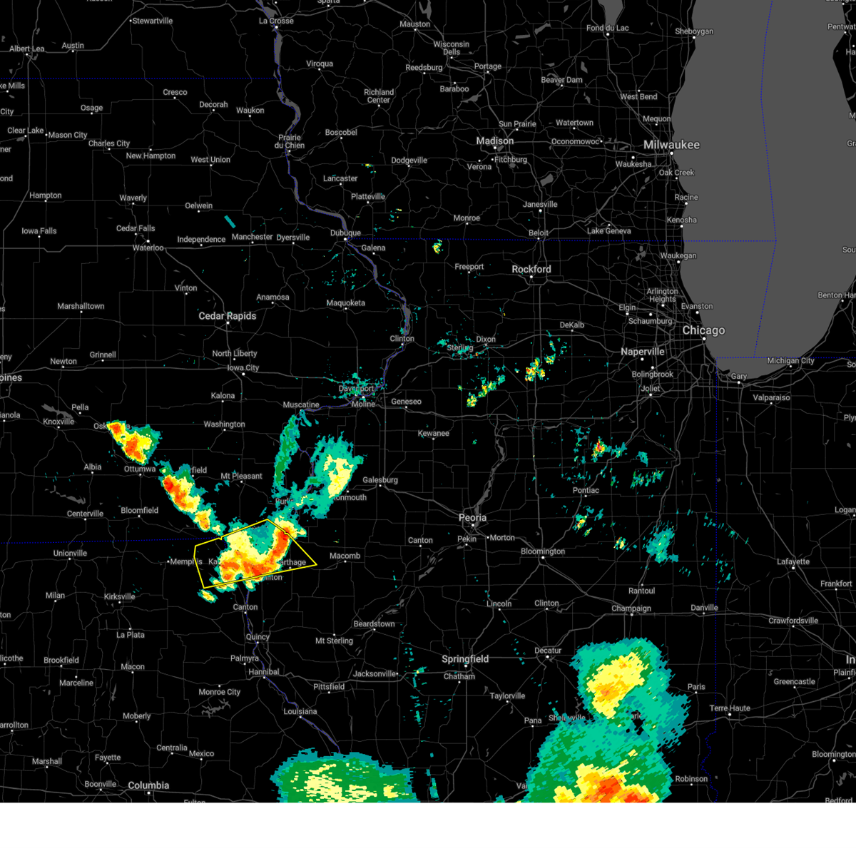 The storms which prompted the warning have weakened below severe limits, and no longer pose an immediate threat to life or property. therefore, the warning will be allowed to expire. gusty winds are still possible. a severe thunderstorm watch remains in effect until 700 pm cdt for west central illinois, southeastern iowa, and northeastern missouri. The storms which prompted the warning have weakened below severe limits, and no longer pose an immediate threat to life or property. therefore, the warning will be allowed to expire. gusty winds are still possible. a severe thunderstorm watch remains in effect until 700 pm cdt for west central illinois, southeastern iowa, and northeastern missouri.
|
| 7/30/2024 4:56 PM CDT |
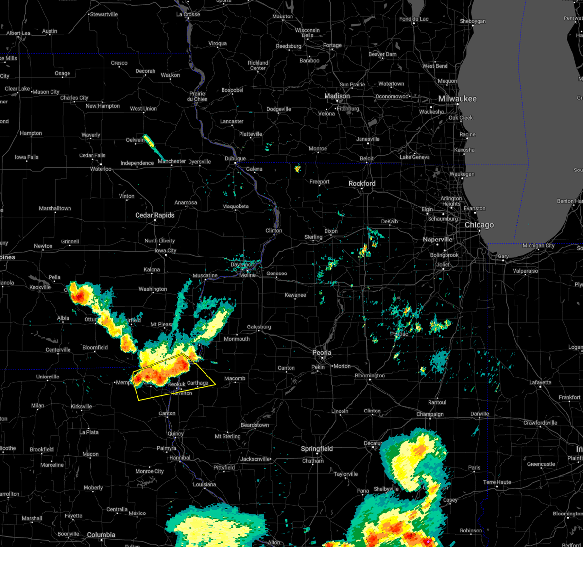 At 456 pm cdt, severe thunderstorms were located along a line extending from near nauvoo to luray, moving east at 45 mph (radar indicated). Hazards include 60 mph wind gusts. Expect damage to roofs, siding, and trees. locations impacted include, fort madison, keokuk, carthage, kahoka, nauvoo, hamilton, warsaw, dallas city, donnellson, montrose, wayland, alexandria, ferris, franklin, luray, colusa, niota, st. Francisville, adrian, and new boston. At 456 pm cdt, severe thunderstorms were located along a line extending from near nauvoo to luray, moving east at 45 mph (radar indicated). Hazards include 60 mph wind gusts. Expect damage to roofs, siding, and trees. locations impacted include, fort madison, keokuk, carthage, kahoka, nauvoo, hamilton, warsaw, dallas city, donnellson, montrose, wayland, alexandria, ferris, franklin, luray, colusa, niota, st. Francisville, adrian, and new boston.
|
| 7/30/2024 4:56 PM CDT |
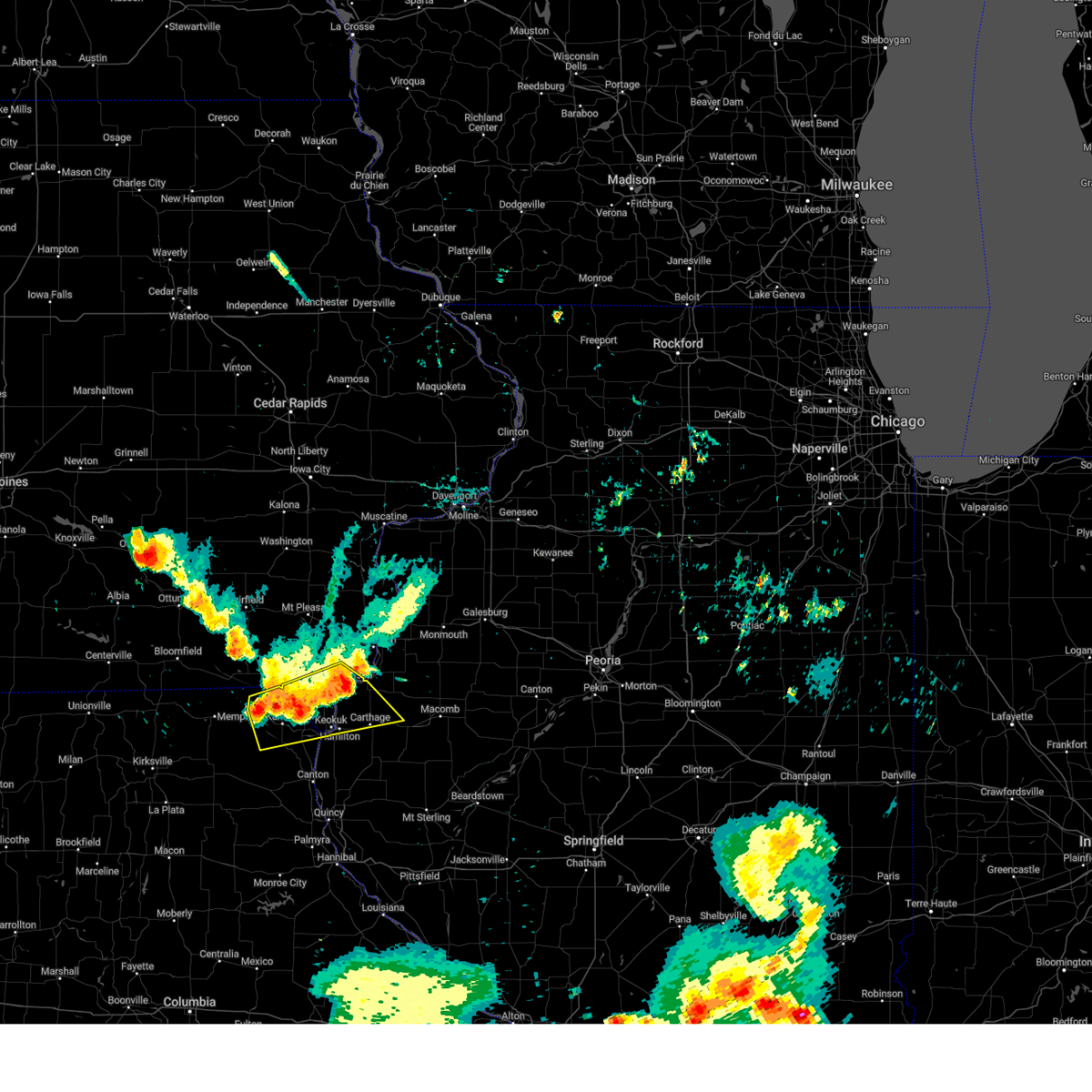 the severe thunderstorm warning has been cancelled and is no longer in effect the severe thunderstorm warning has been cancelled and is no longer in effect
|
| 7/30/2024 4:45 PM CDT |
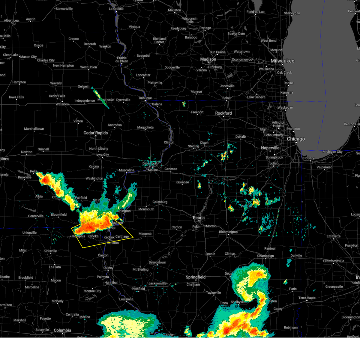 At 444 pm cdt, severe thunderstorms were located along a line extending from near fort madison to prospect grove, moving southeast at 45 mph (radar indicated). Hazards include 60 mph wind gusts. Expect damage to roofs, siding, and trees. locations impacted include, fort madison, keokuk, carthage, kahoka, nauvoo, hamilton, warsaw, west point, dallas city, donnellson, montrose, wayland, bonaparte, wyaconda, alexandria, ferris, franklin, st. Paul, luray, and granger. At 444 pm cdt, severe thunderstorms were located along a line extending from near fort madison to prospect grove, moving southeast at 45 mph (radar indicated). Hazards include 60 mph wind gusts. Expect damage to roofs, siding, and trees. locations impacted include, fort madison, keokuk, carthage, kahoka, nauvoo, hamilton, warsaw, west point, dallas city, donnellson, montrose, wayland, bonaparte, wyaconda, alexandria, ferris, franklin, st. Paul, luray, and granger.
|
| 7/30/2024 4:30 PM CDT |
 Svrdvn the national weather service in the quad cities has issued a * severe thunderstorm warning for, northern hancock county in west central illinois, van buren county in southeastern iowa, lee county in southeastern iowa, eastern scotland county in northeastern missouri, clark county in northeastern missouri, * until 515 pm cdt. * at 429 pm cdt, severe thunderstorms were located along a line extending from near pilot grove to near cantril, moving southeast at 45 mph (radar indicated). Hazards include 60 mph wind gusts and penny size hail. expect damage to roofs, siding, and trees Svrdvn the national weather service in the quad cities has issued a * severe thunderstorm warning for, northern hancock county in west central illinois, van buren county in southeastern iowa, lee county in southeastern iowa, eastern scotland county in northeastern missouri, clark county in northeastern missouri, * until 515 pm cdt. * at 429 pm cdt, severe thunderstorms were located along a line extending from near pilot grove to near cantril, moving southeast at 45 mph (radar indicated). Hazards include 60 mph wind gusts and penny size hail. expect damage to roofs, siding, and trees
|
| 7/30/2024 5:56 AM CDT |
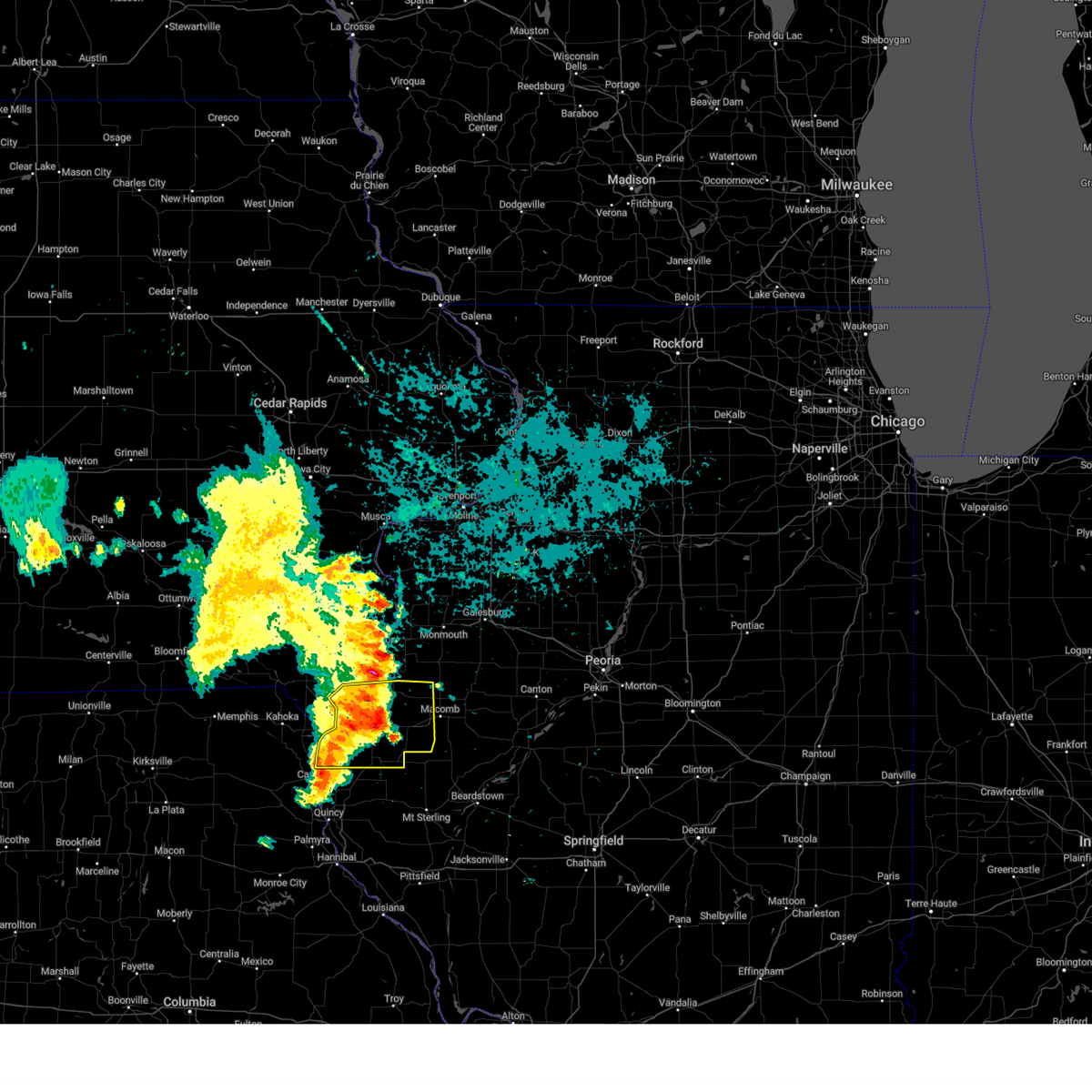 At 556 am cdt, a severe thunderstorm was located over webster, or near carthage, moving east at 55 mph (radar indicated). Hazards include 60 mph wind gusts. Expect damage to roofs, siding, and trees. Locations impacted include, macomb, keokuk, carthage, nauvoo, hamilton, warsaw, colchester, la harpe, dallas city, blandinsville, augusta, bowen, west point, ferris, tennessee, sciota, colusa, adrian, fandon, and burnside. At 556 am cdt, a severe thunderstorm was located over webster, or near carthage, moving east at 55 mph (radar indicated). Hazards include 60 mph wind gusts. Expect damage to roofs, siding, and trees. Locations impacted include, macomb, keokuk, carthage, nauvoo, hamilton, warsaw, colchester, la harpe, dallas city, blandinsville, augusta, bowen, west point, ferris, tennessee, sciota, colusa, adrian, fandon, and burnside.
|
| 7/30/2024 5:56 AM CDT |
 the severe thunderstorm warning has been cancelled and is no longer in effect the severe thunderstorm warning has been cancelled and is no longer in effect
|
| 7/30/2024 5:41 AM CDT |
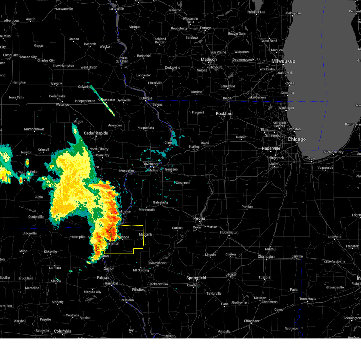 Svrdvn the national weather service in the quad cities has issued a * severe thunderstorm warning for, hancock county in west central illinois, western mcdonough county in west central illinois, southeastern clark county in northeastern missouri, * until 630 am cdt. * at 541 am cdt, a severe thunderstorm was located near adrian, or near nauvoo, moving east at 50 mph (radar indicated). Hazards include 60 mph wind gusts. expect damage to roofs, siding, and trees Svrdvn the national weather service in the quad cities has issued a * severe thunderstorm warning for, hancock county in west central illinois, western mcdonough county in west central illinois, southeastern clark county in northeastern missouri, * until 630 am cdt. * at 541 am cdt, a severe thunderstorm was located near adrian, or near nauvoo, moving east at 50 mph (radar indicated). Hazards include 60 mph wind gusts. expect damage to roofs, siding, and trees
|
| 7/15/2024 8:27 PM CDT |
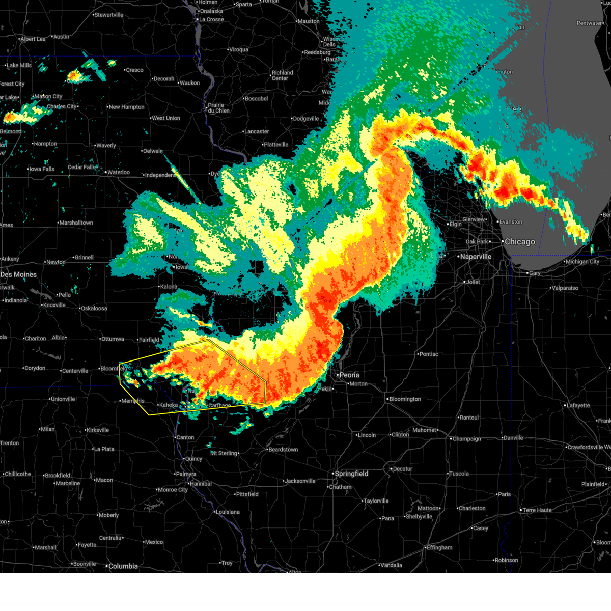 The storms which prompted the warning have weakened below severe limits, and no longer pose an immediate threat to life or property. therefore, the warning will be allowed to expire. however, gusty winds and heavy rain are still possible with these thunderstorms. a severe thunderstorm watch remains in effect until 1100 pm cdt for west central illinois, southeastern iowa, and northeastern missouri. The storms which prompted the warning have weakened below severe limits, and no longer pose an immediate threat to life or property. therefore, the warning will be allowed to expire. however, gusty winds and heavy rain are still possible with these thunderstorms. a severe thunderstorm watch remains in effect until 1100 pm cdt for west central illinois, southeastern iowa, and northeastern missouri.
|
| 7/15/2024 8:00 PM CDT | Storm damage reported in hancock county IL, 0.9 miles E of Dallas City, IL |
| 7/15/2024 7:53 PM CDT |
 At 751 pm cdt, severe thunderstorms were located along a line extending from near oquawka to near lebanon, moving southeast at 45 mph (trained weather spotters. at 747 pm cdt...a 58 mph wind gust was measured at the southeast iowa regional airport in burlington). Hazards include 60 mph wind gusts. Expect damage to roofs, siding, and trees. Locations impacted include, burlington, macomb, fort madison, keokuk, carthage, kahoka, nauvoo, keosauqua, bushnell, west burlington, hamilton, new london, warsaw, mediapolis, colchester, la harpe, roseville, west point, dallas city, and danville. At 751 pm cdt, severe thunderstorms were located along a line extending from near oquawka to near lebanon, moving southeast at 45 mph (trained weather spotters. at 747 pm cdt...a 58 mph wind gust was measured at the southeast iowa regional airport in burlington). Hazards include 60 mph wind gusts. Expect damage to roofs, siding, and trees. Locations impacted include, burlington, macomb, fort madison, keokuk, carthage, kahoka, nauvoo, keosauqua, bushnell, west burlington, hamilton, new london, warsaw, mediapolis, colchester, la harpe, roseville, west point, dallas city, and danville.
|
| 7/15/2024 7:44 PM CDT |
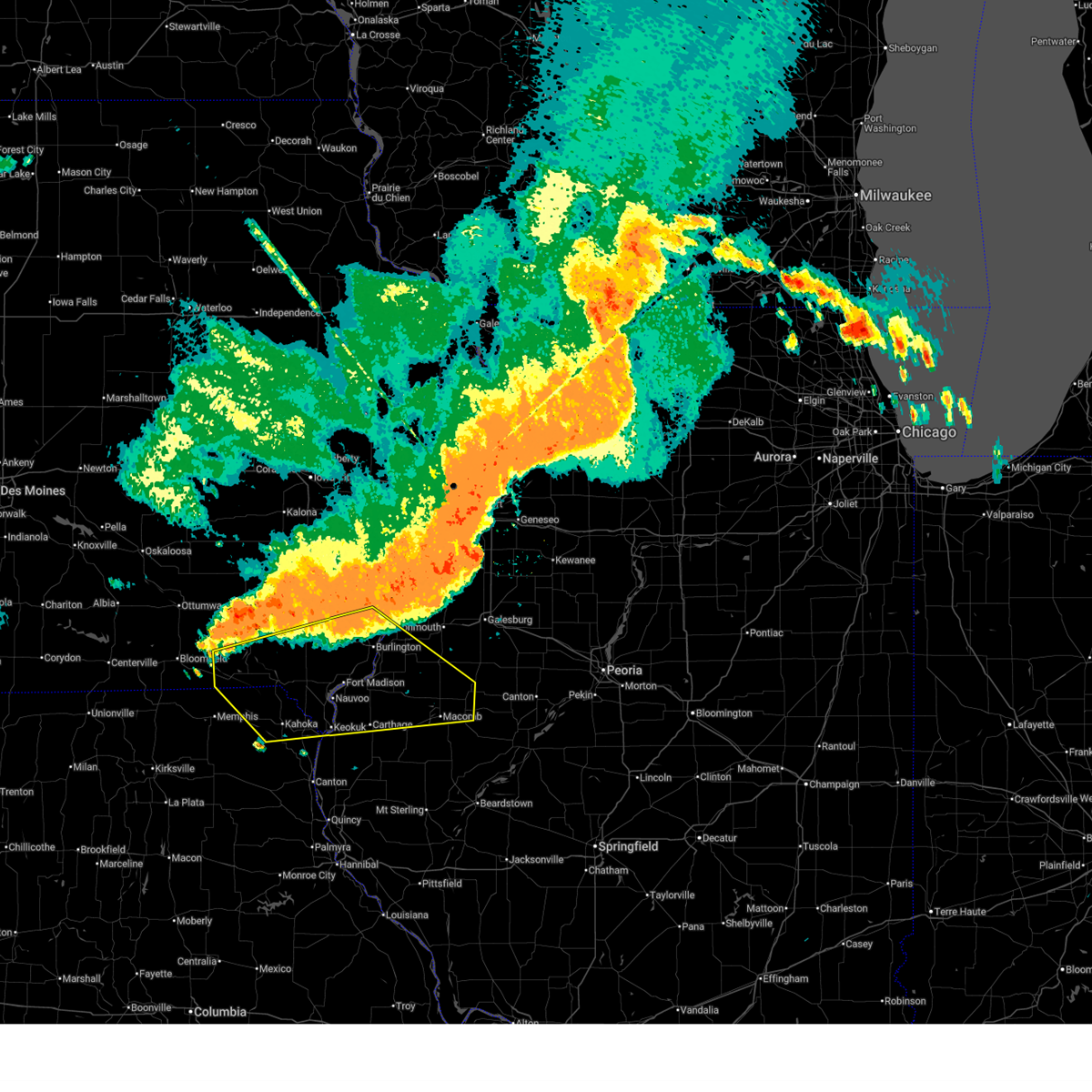 Svrdvn the national weather service in the quad cities has issued a * severe thunderstorm warning for, northern hancock county in west central illinois, henderson county in west central illinois, southern warren county in west central illinois, northern mcdonough county in west central illinois, southern henry county in southeastern iowa, des moines county in southeastern iowa, van buren county in southeastern iowa, lee county in southeastern iowa, northeastern scotland county in northeastern missouri, clark county in northeastern missouri, * until 830 pm cdt. * at 744 pm cdt, severe thunderstorms were located along a line extending from oquawka to leando, moving southeast at 45 mph (radar indicated). Hazards include 60 mph wind gusts. expect damage to roofs, siding, and trees Svrdvn the national weather service in the quad cities has issued a * severe thunderstorm warning for, northern hancock county in west central illinois, henderson county in west central illinois, southern warren county in west central illinois, northern mcdonough county in west central illinois, southern henry county in southeastern iowa, des moines county in southeastern iowa, van buren county in southeastern iowa, lee county in southeastern iowa, northeastern scotland county in northeastern missouri, clark county in northeastern missouri, * until 830 pm cdt. * at 744 pm cdt, severe thunderstorms were located along a line extending from oquawka to leando, moving southeast at 45 mph (radar indicated). Hazards include 60 mph wind gusts. expect damage to roofs, siding, and trees
|
| 7/7/2024 2:19 PM CDT |
 the severe thunderstorm warning has been cancelled and is no longer in effect the severe thunderstorm warning has been cancelled and is no longer in effect
|
| 7/7/2024 2:07 PM CDT |
 At 205 pm cdt, severe thunderstorms was located near new boston, moving east at 20 mph (radar indicated). Hazards include 60 mph wind gusts and quarter size hail. Hail damage to vehicles is expected. expect wind damage to roofs, siding, and trees. these severe storms will be near, fort madison, nauvoo, montrose, fort madison municipal arpt, bluff park, and nauvoo state park around 210 pm cdt. niota and galland around 215 pm cdt. Other locations in the path of these severe thunderstorms include pontoosuc and dallas city. At 205 pm cdt, severe thunderstorms was located near new boston, moving east at 20 mph (radar indicated). Hazards include 60 mph wind gusts and quarter size hail. Hail damage to vehicles is expected. expect wind damage to roofs, siding, and trees. these severe storms will be near, fort madison, nauvoo, montrose, fort madison municipal arpt, bluff park, and nauvoo state park around 210 pm cdt. niota and galland around 215 pm cdt. Other locations in the path of these severe thunderstorms include pontoosuc and dallas city.
|
| 7/7/2024 2:07 PM CDT |
 the severe thunderstorm warning has been cancelled and is no longer in effect the severe thunderstorm warning has been cancelled and is no longer in effect
|
| 7/7/2024 1:56 PM CDT |
 At 155 pm cdt, severe thunderstorms were located along a line extending from near denmark to argyle, moving east at 20 mph (radar indicated). Hazards include 60 mph wind gusts and quarter size hail. Hail damage to vehicles is expected. expect wind damage to roofs, siding, and trees. these severe storms will be near, fort madison, denmark, new boston, sawyer, fort madison municipal arpt, charleston, augusta, camp l-kee-ta, welter recreation area, and pollmiller park around 200 pm cdt. Other locations in the path of these severe thunderstorms include nauvoo, montrose, middletown, iowa army ammunition plant, bluff park, nauvoo state park, wever, burlington, west burlington, niota, galland, spring grove, pontoosuc, burlington regional airport, des moines county fairgrounds, dallas city, gulf port, shokokon, heapsville and carthage lake. At 155 pm cdt, severe thunderstorms were located along a line extending from near denmark to argyle, moving east at 20 mph (radar indicated). Hazards include 60 mph wind gusts and quarter size hail. Hail damage to vehicles is expected. expect wind damage to roofs, siding, and trees. these severe storms will be near, fort madison, denmark, new boston, sawyer, fort madison municipal arpt, charleston, augusta, camp l-kee-ta, welter recreation area, and pollmiller park around 200 pm cdt. Other locations in the path of these severe thunderstorms include nauvoo, montrose, middletown, iowa army ammunition plant, bluff park, nauvoo state park, wever, burlington, west burlington, niota, galland, spring grove, pontoosuc, burlington regional airport, des moines county fairgrounds, dallas city, gulf port, shokokon, heapsville and carthage lake.
|
| 7/7/2024 1:43 PM CDT |
 Svrdvn the national weather service in the quad cities has issued a * severe thunderstorm warning for, northwestern hancock county in west central illinois, southwestern henderson county in west central illinois, southeastern henry county in southeastern iowa, southern des moines county in southeastern iowa, lee county in southeastern iowa, * until 230 pm cdt. * at 143 pm cdt, severe thunderstorms were located along a line extending from near st. paul to near battle of athens campground, moving east at 20 mph (radar indicated). Hazards include 60 mph wind gusts. Expect damage to roofs, siding, and trees. severe thunderstorms will be near, fort madison, west point, donnellson, franklin, denmark, new boston, sawyer, geode state park, argyle, and vincennes around 150 pm cdt. fort madison municipal arpt and augusta around 155 pm cdt. nauvoo, montrose, and welter recreation area around 200 pm cdt. middletown, iowa army ammunition plant, bluff park, nauvoo state park, and wever around 205 pm cdt. niota and galland around 210 pm cdt. Other locations impacted by these severe thunderstorms include charleston, keokuk airport, geode state park, welter recreation area, shokokon, spring grove, nauvoo state park, lee county fairgrounds, sawyer, and wever. Svrdvn the national weather service in the quad cities has issued a * severe thunderstorm warning for, northwestern hancock county in west central illinois, southwestern henderson county in west central illinois, southeastern henry county in southeastern iowa, southern des moines county in southeastern iowa, lee county in southeastern iowa, * until 230 pm cdt. * at 143 pm cdt, severe thunderstorms were located along a line extending from near st. paul to near battle of athens campground, moving east at 20 mph (radar indicated). Hazards include 60 mph wind gusts. Expect damage to roofs, siding, and trees. severe thunderstorms will be near, fort madison, west point, donnellson, franklin, denmark, new boston, sawyer, geode state park, argyle, and vincennes around 150 pm cdt. fort madison municipal arpt and augusta around 155 pm cdt. nauvoo, montrose, and welter recreation area around 200 pm cdt. middletown, iowa army ammunition plant, bluff park, nauvoo state park, and wever around 205 pm cdt. niota and galland around 210 pm cdt. Other locations impacted by these severe thunderstorms include charleston, keokuk airport, geode state park, welter recreation area, shokokon, spring grove, nauvoo state park, lee county fairgrounds, sawyer, and wever.
|
| 6/13/2024 7:07 PM CDT |
 The storm which prompted the warning has weakened below severe limits, and no longer poses an immediate threat to life or property. therefore, the warning will be allowed to expire. a severe thunderstorm watch remains in effect until 1000 pm cdt for west central illinois, and southeastern iowa. The storm which prompted the warning has weakened below severe limits, and no longer poses an immediate threat to life or property. therefore, the warning will be allowed to expire. a severe thunderstorm watch remains in effect until 1000 pm cdt for west central illinois, and southeastern iowa.
|
| 6/13/2024 6:57 PM CDT |
 At 656 pm cdt, a severe thunderstorm was located over niota, or near fort madison, moving southeast at 45 mph (radar indicated). Hazards include 60 mph wind gusts and quarter size hail. Hail damage to vehicles is expected. expect wind damage to roofs, siding, and trees. Locations impacted include, fort madison, nauvoo, dallas city, niota, pontoosuc, nauvoo state park, sawyer, and fort madison municipal arpt. At 656 pm cdt, a severe thunderstorm was located over niota, or near fort madison, moving southeast at 45 mph (radar indicated). Hazards include 60 mph wind gusts and quarter size hail. Hail damage to vehicles is expected. expect wind damage to roofs, siding, and trees. Locations impacted include, fort madison, nauvoo, dallas city, niota, pontoosuc, nauvoo state park, sawyer, and fort madison municipal arpt.
|
| 6/13/2024 6:48 PM CDT |
 At 648 pm cdt, a severe thunderstorm was located over fort madison, moving southeast at 45 mph (radar indicated). Hazards include 60 mph wind gusts and quarter size hail. Hail damage to vehicles is expected. expect wind damage to roofs, siding, and trees. Locations impacted include, fort madison, nauvoo, west point, dallas city, franklin, niota, pontoosuc, nauvoo state park, pollmiller park, wilson lake, sawyer, and fort madison municipal arpt. At 648 pm cdt, a severe thunderstorm was located over fort madison, moving southeast at 45 mph (radar indicated). Hazards include 60 mph wind gusts and quarter size hail. Hail damage to vehicles is expected. expect wind damage to roofs, siding, and trees. Locations impacted include, fort madison, nauvoo, west point, dallas city, franklin, niota, pontoosuc, nauvoo state park, pollmiller park, wilson lake, sawyer, and fort madison municipal arpt.
|
| 6/13/2024 6:39 PM CDT |
 Svrdvn the national weather service in the quad cities has issued a * severe thunderstorm warning for, northwestern hancock county in west central illinois, northern lee county in southeastern iowa, * until 715 pm cdt. * at 638 pm cdt, a severe thunderstorm was located over franklin, or 9 miles northwest of fort madison, moving southeast at 45 mph (radar indicated). Hazards include 60 mph wind gusts and quarter size hail. Hail damage to vehicles is expected. Expect wind damage to roofs, siding, and trees. Svrdvn the national weather service in the quad cities has issued a * severe thunderstorm warning for, northwestern hancock county in west central illinois, northern lee county in southeastern iowa, * until 715 pm cdt. * at 638 pm cdt, a severe thunderstorm was located over franklin, or 9 miles northwest of fort madison, moving southeast at 45 mph (radar indicated). Hazards include 60 mph wind gusts and quarter size hail. Hail damage to vehicles is expected. Expect wind damage to roofs, siding, and trees.
|
| 6/13/2024 6:38 PM CDT |
 Svrdvn the national weather service in the quad cities has issued a * severe thunderstorm warning for, northwestern hancock county in west central illinois, northern lee county in southeastern iowa, * until 715 pm cdt. * at 638 pm cdt, a severe thunderstorm was located over franklin, or 9 miles northwest of fort madison, moving southeast at 45 mph (radar indicated). Hazards include 60 mph wind gusts and quarter size hail. Hail damage to vehicles is expected. Expect wind damage to roofs, siding, and trees. Svrdvn the national weather service in the quad cities has issued a * severe thunderstorm warning for, northwestern hancock county in west central illinois, northern lee county in southeastern iowa, * until 715 pm cdt. * at 638 pm cdt, a severe thunderstorm was located over franklin, or 9 miles northwest of fort madison, moving southeast at 45 mph (radar indicated). Hazards include 60 mph wind gusts and quarter size hail. Hail damage to vehicles is expected. Expect wind damage to roofs, siding, and trees.
|
| 6/13/2024 6:24 PM CDT |
 At 623 pm cdt, a severe thunderstorm was located over shokokon, or near burlington, moving east at 30 mph (radar indicated). Hazards include 60 mph wind gusts and quarter size hail. Hail damage to vehicles is expected. expect wind damage to roofs, siding, and trees. Locations impacted include, burlington, la harpe, roseville, dallas city, stronghurst, blandinsville, carman, terre haute, raritan, sciota, gulf port, disco, lomax, pontoosuc, media, shokokon, spring grove, warren county fairgrounds, decorra, and lone tree. At 623 pm cdt, a severe thunderstorm was located over shokokon, or near burlington, moving east at 30 mph (radar indicated). Hazards include 60 mph wind gusts and quarter size hail. Hail damage to vehicles is expected. expect wind damage to roofs, siding, and trees. Locations impacted include, burlington, la harpe, roseville, dallas city, stronghurst, blandinsville, carman, terre haute, raritan, sciota, gulf port, disco, lomax, pontoosuc, media, shokokon, spring grove, warren county fairgrounds, decorra, and lone tree.
|
| 6/13/2024 6:08 PM CDT |
 Svrdvn the national weather service in the quad cities has issued a * severe thunderstorm warning for, northeastern hancock county in west central illinois, southern henderson county in west central illinois, southwestern warren county in west central illinois, northwestern mcdonough county in west central illinois, southwestern des moines county in southeastern iowa, northeastern lee county in southeastern iowa, * until 700 pm cdt. * at 608 pm cdt, a severe thunderstorm was located over iowa army ammunition plant, or near burlington, moving southeast at 30 mph (radar indicated). Hazards include 60 mph wind gusts and quarter size hail. Hail damage to vehicles is expected. Expect wind damage to roofs, siding, and trees. Svrdvn the national weather service in the quad cities has issued a * severe thunderstorm warning for, northeastern hancock county in west central illinois, southern henderson county in west central illinois, southwestern warren county in west central illinois, northwestern mcdonough county in west central illinois, southwestern des moines county in southeastern iowa, northeastern lee county in southeastern iowa, * until 700 pm cdt. * at 608 pm cdt, a severe thunderstorm was located over iowa army ammunition plant, or near burlington, moving southeast at 30 mph (radar indicated). Hazards include 60 mph wind gusts and quarter size hail. Hail damage to vehicles is expected. Expect wind damage to roofs, siding, and trees.
|
| 5/24/2024 10:28 AM CDT |
 At 1028 am cdt, a severe thunderstorm was located near disco, or 11 miles northeast of carthage, moving east at 40 mph (radar indicated). Hazards include 60 mph wind gusts and quarter size hail. Hail damage to vehicles is expected. expect wind damage to roofs, siding, and trees. Locations impacted include, la harpe, dallas city, stronghurst, blandinsville, terre haute, ferris, raritan, colusa, burnside, disco, adrian, lomax, fountain green, media, henderson county fairgrounds, webster, decorra, and argyle lake state park. At 1028 am cdt, a severe thunderstorm was located near disco, or 11 miles northeast of carthage, moving east at 40 mph (radar indicated). Hazards include 60 mph wind gusts and quarter size hail. Hail damage to vehicles is expected. expect wind damage to roofs, siding, and trees. Locations impacted include, la harpe, dallas city, stronghurst, blandinsville, terre haute, ferris, raritan, colusa, burnside, disco, adrian, lomax, fountain green, media, henderson county fairgrounds, webster, decorra, and argyle lake state park.
|
| 5/24/2024 10:21 AM CDT |
 At 1021 am cdt, a severe thunderstorm was located over webster, or near carthage, moving east at 40 mph (radar indicated). Hazards include 60 mph wind gusts and quarter size hail. Hail damage to vehicles is expected. expect wind damage to roofs, siding, and trees. Locations impacted include, colchester, la harpe, dallas city, stronghurst, blandinsville, terre haute, ferris, raritan, colusa, adrian, burnside, disco, lomax, fountain green, pontoosuc, media, henderson county fairgrounds, webster, decorra, and argyle lake state park. At 1021 am cdt, a severe thunderstorm was located over webster, or near carthage, moving east at 40 mph (radar indicated). Hazards include 60 mph wind gusts and quarter size hail. Hail damage to vehicles is expected. expect wind damage to roofs, siding, and trees. Locations impacted include, colchester, la harpe, dallas city, stronghurst, blandinsville, terre haute, ferris, raritan, colusa, adrian, burnside, disco, lomax, fountain green, pontoosuc, media, henderson county fairgrounds, webster, decorra, and argyle lake state park.
|
| 5/24/2024 10:13 AM CDT |
 At 1013 am cdt, a severe thunderstorm was located over ferris, or near carthage, moving east at 40 mph (radar indicated). Hazards include 60 mph wind gusts and quarter size hail. Hail damage to vehicles is expected. expect wind damage to roofs, siding, and trees. Locations impacted include, fort madison, colchester, la harpe, dallas city, stronghurst, blandinsville, terre haute, ferris, raritan, colusa, adrian, burnside, disco, niota, lomax, fountain green, pontoosuc, media, henderson county fairgrounds, and webster. At 1013 am cdt, a severe thunderstorm was located over ferris, or near carthage, moving east at 40 mph (radar indicated). Hazards include 60 mph wind gusts and quarter size hail. Hail damage to vehicles is expected. expect wind damage to roofs, siding, and trees. Locations impacted include, fort madison, colchester, la harpe, dallas city, stronghurst, blandinsville, terre haute, ferris, raritan, colusa, adrian, burnside, disco, niota, lomax, fountain green, pontoosuc, media, henderson county fairgrounds, and webster.
|
| 5/24/2024 10:03 AM CDT |
 Svrdvn the national weather service in the quad cities has issued a * severe thunderstorm warning for, hancock county in west central illinois, southern henderson county in west central illinois, southwestern warren county in west central illinois, western mcdonough county in west central illinois, central lee county in southeastern iowa, * until 1045 am cdt. * at 1003 am cdt, a severe thunderstorm was located near camp eastman, or near nauvoo, moving east at 40 mph (radar indicated). Hazards include 60 mph wind gusts and half dollar size hail. Hail damage to vehicles is expected. Expect wind damage to roofs, siding, and trees. Svrdvn the national weather service in the quad cities has issued a * severe thunderstorm warning for, hancock county in west central illinois, southern henderson county in west central illinois, southwestern warren county in west central illinois, western mcdonough county in west central illinois, central lee county in southeastern iowa, * until 1045 am cdt. * at 1003 am cdt, a severe thunderstorm was located near camp eastman, or near nauvoo, moving east at 40 mph (radar indicated). Hazards include 60 mph wind gusts and half dollar size hail. Hail damage to vehicles is expected. Expect wind damage to roofs, siding, and trees.
|
| 4/16/2024 5:36 PM CDT |
 At 536 pm cdt, a severe thunderstorm capable of producing a tornado was located over iowa army ammunition plant, or near burlington, moving northeast at 35 mph (radar indicated rotation). Hazards include tornado and quarter size hail. Flying debris will be dangerous to those caught without shelter. mobile homes will be damaged or destroyed. damage to roofs, windows, and vehicles will occur. tree damage is likely. This dangerous storm will be near, burlington, west burlington, middletown, burlington regional airport, spring grove, beaverdale, starr's cave park and preserve, and des moines county fairgrounds around 540 pm cdt. At 536 pm cdt, a severe thunderstorm capable of producing a tornado was located over iowa army ammunition plant, or near burlington, moving northeast at 35 mph (radar indicated rotation). Hazards include tornado and quarter size hail. Flying debris will be dangerous to those caught without shelter. mobile homes will be damaged or destroyed. damage to roofs, windows, and vehicles will occur. tree damage is likely. This dangerous storm will be near, burlington, west burlington, middletown, burlington regional airport, spring grove, beaverdale, starr's cave park and preserve, and des moines county fairgrounds around 540 pm cdt.
|
| 4/16/2024 5:36 PM CDT |
 the tornado warning has been cancelled and is no longer in effect the tornado warning has been cancelled and is no longer in effect
|
| 4/16/2024 5:27 PM CDT |
 At 526 pm cdt, a severe thunderstorm capable of producing a tornado was located over welter recreation area, or 8 miles southwest of burlington, moving northeast at 40 mph (weather spotters reported a funnel cloud near augusta, iowa). Hazards include tornado and half dollar size hail. Flying debris will be dangerous to those caught without shelter. mobile homes will be damaged or destroyed. damage to roofs, windows, and vehicles will occur. tree damage is likely. This dangerous storm will be near, burlington, west burlington, middletown, iowa army ammunition plant, burlington regional airport, spring grove, beaverdale, wever, starr's cave park and preserve, and welter recreation area around 530 pm cdt. At 526 pm cdt, a severe thunderstorm capable of producing a tornado was located over welter recreation area, or 8 miles southwest of burlington, moving northeast at 40 mph (weather spotters reported a funnel cloud near augusta, iowa). Hazards include tornado and half dollar size hail. Flying debris will be dangerous to those caught without shelter. mobile homes will be damaged or destroyed. damage to roofs, windows, and vehicles will occur. tree damage is likely. This dangerous storm will be near, burlington, west burlington, middletown, iowa army ammunition plant, burlington regional airport, spring grove, beaverdale, wever, starr's cave park and preserve, and welter recreation area around 530 pm cdt.
|
| 4/16/2024 5:19 PM CDT |
 At 519 pm cdt, a severe thunderstorm capable of producing a tornado was located over sawyer, or near fort madison, moving northeast at 40 mph (radar indicated rotation). Hazards include tornado and ping pong ball size hail. Flying debris will be dangerous to those caught without shelter. mobile homes will be damaged or destroyed. damage to roofs, windows, and vehicles will occur. tree damage is likely. this dangerous storm will be near, burlington, west burlington, middletown, iowa army ammunition plant, denmark, pontoosuc, augusta, burlington regional airport, spring grove, and wever around 525 pm cdt. Beaverdale and starr's cave park and preserve around 530 pm cdt. At 519 pm cdt, a severe thunderstorm capable of producing a tornado was located over sawyer, or near fort madison, moving northeast at 40 mph (radar indicated rotation). Hazards include tornado and ping pong ball size hail. Flying debris will be dangerous to those caught without shelter. mobile homes will be damaged or destroyed. damage to roofs, windows, and vehicles will occur. tree damage is likely. this dangerous storm will be near, burlington, west burlington, middletown, iowa army ammunition plant, denmark, pontoosuc, augusta, burlington regional airport, spring grove, and wever around 525 pm cdt. Beaverdale and starr's cave park and preserve around 530 pm cdt.
|
| 4/16/2024 5:13 PM CDT |
 At 512 pm cdt, a severe thunderstorm capable of producing a tornado was located near fort madison, moving northeast at 40 mph (radar indicated rotation). Hazards include tornado and half dollar size hail. Flying debris will be dangerous to those caught without shelter. mobile homes will be damaged or destroyed. damage to roofs, windows, and vehicles will occur. tree damage is likely. this dangerous storm will be near, fort madison, dallas city, iowa army ammunition plant, denmark, niota, pontoosuc, sawyer, augusta, fort madison municipal arpt, and spring grove around 520 pm cdt. Other locations in the path of this tornadic thunderstorm include burlington, west burlington, middletown, burlington regional airport, des moines county fairgrounds, lomax, beaverdale and starr's cave park and preserve. At 512 pm cdt, a severe thunderstorm capable of producing a tornado was located near fort madison, moving northeast at 40 mph (radar indicated rotation). Hazards include tornado and half dollar size hail. Flying debris will be dangerous to those caught without shelter. mobile homes will be damaged or destroyed. damage to roofs, windows, and vehicles will occur. tree damage is likely. this dangerous storm will be near, fort madison, dallas city, iowa army ammunition plant, denmark, niota, pontoosuc, sawyer, augusta, fort madison municipal arpt, and spring grove around 520 pm cdt. Other locations in the path of this tornadic thunderstorm include burlington, west burlington, middletown, burlington regional airport, des moines county fairgrounds, lomax, beaverdale and starr's cave park and preserve.
|
| 4/16/2024 5:13 PM CDT |
 the tornado warning has been cancelled and is no longer in effect the tornado warning has been cancelled and is no longer in effect
|
| 4/16/2024 5:03 PM CDT |
 At 503 pm cdt, a severe thunderstorm capable of producing a tornado was located over new boston, or near nauvoo, moving northeast at 40 mph (radar indicated rotation). Hazards include tornado and half dollar size hail. Flying debris will be dangerous to those caught without shelter. mobile homes will be damaged or destroyed. damage to roofs, windows, and vehicles will occur. tree damage is likely. this dangerous storm will be near, fort madison, nauvoo, west point, niota, sawyer, fort madison municipal arpt, and pollmiller park around 510 pm cdt. Other locations in the path of this tornadic thunderstorm include dallas city, denmark, pontoosuc, augusta, wever, welter recreation area, iowa army ammunition plant, spring grove, camp l-kee-ta, burlington, west burlington, middletown, lomax, burlington regional airport, des moines county fairgrounds, beaverdale and starr's cave park and preserve. At 503 pm cdt, a severe thunderstorm capable of producing a tornado was located over new boston, or near nauvoo, moving northeast at 40 mph (radar indicated rotation). Hazards include tornado and half dollar size hail. Flying debris will be dangerous to those caught without shelter. mobile homes will be damaged or destroyed. damage to roofs, windows, and vehicles will occur. tree damage is likely. this dangerous storm will be near, fort madison, nauvoo, west point, niota, sawyer, fort madison municipal arpt, and pollmiller park around 510 pm cdt. Other locations in the path of this tornadic thunderstorm include dallas city, denmark, pontoosuc, augusta, wever, welter recreation area, iowa army ammunition plant, spring grove, camp l-kee-ta, burlington, west burlington, middletown, lomax, burlington regional airport, des moines county fairgrounds, beaverdale and starr's cave park and preserve.
|
| 4/16/2024 4:54 PM CDT |
 Tordvn the national weather service in the quad cities has issued a * tornado warning for, northern hancock county in west central illinois, southwestern henderson county in west central illinois, southwestern des moines county in southeastern iowa, lee county in southeastern iowa, central clark county in northeastern missouri, * until 545 pm cdt. * at 454 pm cdt, a severe thunderstorm capable of producing a tornado was located over argyle, or 10 miles west of nauvoo, moving northeast at 40 mph (radar indicated rotation). Hazards include tornado and quarter size hail. Flying debris will be dangerous to those caught without shelter. mobile homes will be damaged or destroyed. damage to roofs, windows, and vehicles will occur. tree damage is likely. this dangerous storm will be near, fort madison, nauvoo, donnellson, montrose, franklin, new boston, summitville, bluff park, galland, and nauvoo state park around 500 pm cdt. west point, niota, sawyer, fort madison municipal arpt, and pollmiller park around 505 pm cdt. pontoosuc around 510 pm cdt. Other locations in the path of this tornadic thunderstorm include dallas city, denmark, augusta, wever, welter recreation area, iowa army ammunition plant, spring grove, camp l-kee-ta, burlington, west burlington, middletown, lomax, burlington regional airport, des moines county fairgrounds, starr's cave park and preserve and beaverdale. Tordvn the national weather service in the quad cities has issued a * tornado warning for, northern hancock county in west central illinois, southwestern henderson county in west central illinois, southwestern des moines county in southeastern iowa, lee county in southeastern iowa, central clark county in northeastern missouri, * until 545 pm cdt. * at 454 pm cdt, a severe thunderstorm capable of producing a tornado was located over argyle, or 10 miles west of nauvoo, moving northeast at 40 mph (radar indicated rotation). Hazards include tornado and quarter size hail. Flying debris will be dangerous to those caught without shelter. mobile homes will be damaged or destroyed. damage to roofs, windows, and vehicles will occur. tree damage is likely. this dangerous storm will be near, fort madison, nauvoo, donnellson, montrose, franklin, new boston, summitville, bluff park, galland, and nauvoo state park around 500 pm cdt. west point, niota, sawyer, fort madison municipal arpt, and pollmiller park around 505 pm cdt. pontoosuc around 510 pm cdt. Other locations in the path of this tornadic thunderstorm include dallas city, denmark, augusta, wever, welter recreation area, iowa army ammunition plant, spring grove, camp l-kee-ta, burlington, west burlington, middletown, lomax, burlington regional airport, des moines county fairgrounds, starr's cave park and preserve and beaverdale.
|
| 4/16/2024 1:53 PM CDT |
 The storm which prompted the warning has weakened below severe limits, and no longer poses an immediate threat to life or property. therefore, the warning will be allowed to expire. a tornado watch remains in effect until 800 pm cdt for west central illinois, and southeastern iowa. The storm which prompted the warning has weakened below severe limits, and no longer poses an immediate threat to life or property. therefore, the warning will be allowed to expire. a tornado watch remains in effect until 800 pm cdt for west central illinois, and southeastern iowa.
|
| 4/16/2024 1:45 PM CDT |
 At 144 pm cdt, a severe thunderstorm was located over fort madison, moving northeast at 70 mph (radar indicated). Hazards include 60 mph wind gusts and quarter size hail. Hail damage to vehicles is expected. expect wind damage to roofs, siding, and trees. locations impacted include, fort madison, nauvoo, west point, dallas city, donnellson, montrose, franklin, st. Paul, colusa, adrian, new boston, pilot grove, niota, denmark, disco, pontoosuc, houghton, nauvoo state park, lee county fairgrounds, and sawyer. At 144 pm cdt, a severe thunderstorm was located over fort madison, moving northeast at 70 mph (radar indicated). Hazards include 60 mph wind gusts and quarter size hail. Hail damage to vehicles is expected. expect wind damage to roofs, siding, and trees. locations impacted include, fort madison, nauvoo, west point, dallas city, donnellson, montrose, franklin, st. Paul, colusa, adrian, new boston, pilot grove, niota, denmark, disco, pontoosuc, houghton, nauvoo state park, lee county fairgrounds, and sawyer.
|
| 4/16/2024 1:45 PM CDT |
 the severe thunderstorm warning has been cancelled and is no longer in effect the severe thunderstorm warning has been cancelled and is no longer in effect
|
| 4/16/2024 1:34 PM CDT |
 At 134 pm cdt, a severe thunderstorm was located over summitville, or near keokuk, moving northeast at 65 mph (radar indicated). Hazards include 60 mph wind gusts and quarter size hail. Hail damage to vehicles is expected. expect wind damage to roofs, siding, and trees. locations impacted include, fort madison, keokuk, nauvoo, hamilton, warsaw, west point, dallas city, donnellson, montrose, wayland, alexandria, franklin, st. Paul, colusa, adrian, new boston, pilot grove, croton, niota, and denmark. At 134 pm cdt, a severe thunderstorm was located over summitville, or near keokuk, moving northeast at 65 mph (radar indicated). Hazards include 60 mph wind gusts and quarter size hail. Hail damage to vehicles is expected. expect wind damage to roofs, siding, and trees. locations impacted include, fort madison, keokuk, nauvoo, hamilton, warsaw, west point, dallas city, donnellson, montrose, wayland, alexandria, franklin, st. Paul, colusa, adrian, new boston, pilot grove, croton, niota, and denmark.
|
| 4/16/2024 1:27 PM CDT |
 At 127 pm cdt, a severe thunderstorm was located over wayland, or 7 miles west of keokuk, moving northeast at 70 mph (radar indicated). Hazards include 60 mph wind gusts and half dollar size hail. Hail damage to vehicles is expected. expect wind damage to roofs, siding, and trees. locations impacted include, fort madison, keokuk, kahoka, nauvoo, hamilton, warsaw, west point, dallas city, donnellson, montrose, wayland, alexandria, franklin, st. paul, colusa, niota, st. Francisville, adrian, new boston, and pilot grove. At 127 pm cdt, a severe thunderstorm was located over wayland, or 7 miles west of keokuk, moving northeast at 70 mph (radar indicated). Hazards include 60 mph wind gusts and half dollar size hail. Hail damage to vehicles is expected. expect wind damage to roofs, siding, and trees. locations impacted include, fort madison, keokuk, kahoka, nauvoo, hamilton, warsaw, west point, dallas city, donnellson, montrose, wayland, alexandria, franklin, st. paul, colusa, niota, st. Francisville, adrian, new boston, and pilot grove.
|
| 4/16/2024 1:17 PM CDT |
 At 117 pm cdt, a severe thunderstorm was located over st. patrick, or 11 miles northwest of canton, moving northeast at 70 mph (radar indicated). Hazards include 60 mph wind gusts and half dollar size hail. Hail damage to vehicles is expected. expect wind damage to roofs, siding, and trees. locations impacted include, fort madison, keokuk, kahoka, nauvoo, hamilton, warsaw, west point, dallas city, donnellson, montrose, wayland, alexandria, franklin, st. paul, colusa, niota, st. Francisville, adrian, new boston, and pilot grove. At 117 pm cdt, a severe thunderstorm was located over st. patrick, or 11 miles northwest of canton, moving northeast at 70 mph (radar indicated). Hazards include 60 mph wind gusts and half dollar size hail. Hail damage to vehicles is expected. expect wind damage to roofs, siding, and trees. locations impacted include, fort madison, keokuk, kahoka, nauvoo, hamilton, warsaw, west point, dallas city, donnellson, montrose, wayland, alexandria, franklin, st. paul, colusa, niota, st. Francisville, adrian, new boston, and pilot grove.
|
| 4/16/2024 1:14 PM CDT |
 Svrdvn the national weather service in the quad cities has issued a * severe thunderstorm warning for, northwestern hancock county in west central illinois, lee county in southeastern iowa, clark county in northeastern missouri, * until 200 pm cdt. * at 114 pm cdt, a severe thunderstorm was located near monticello, or 10 miles northwest of canton, moving northeast at 70 mph (radar indicated). Hazards include 60 mph wind gusts and quarter size hail. Hail damage to vehicles is expected. Expect wind damage to roofs, siding, and trees. Svrdvn the national weather service in the quad cities has issued a * severe thunderstorm warning for, northwestern hancock county in west central illinois, lee county in southeastern iowa, clark county in northeastern missouri, * until 200 pm cdt. * at 114 pm cdt, a severe thunderstorm was located near monticello, or 10 miles northwest of canton, moving northeast at 70 mph (radar indicated). Hazards include 60 mph wind gusts and quarter size hail. Hail damage to vehicles is expected. Expect wind damage to roofs, siding, and trees.
|
| 3/31/2024 4:47 PM CDT | Half Dollar sized hail reported 7.7 miles N of Dallas City, IL, report from mping: half dollar (1.25 in.). |
| 3/31/2024 4:45 PM CDT |
 At 445 pm cdt, a severe thunderstorm was located over adrian, or 7 miles north of carthage, moving east at 40 mph (trained weather spotters). Hazards include 60 mph wind gusts and quarter size hail. Hail damage to vehicles is expected. expect wind damage to roofs, siding, and trees. Locations impacted include, carthage, hamilton, dallas city, ferris, colusa, burnside, adrian, elvaston, pontoosuc, and basco. At 445 pm cdt, a severe thunderstorm was located over adrian, or 7 miles north of carthage, moving east at 40 mph (trained weather spotters). Hazards include 60 mph wind gusts and quarter size hail. Hail damage to vehicles is expected. expect wind damage to roofs, siding, and trees. Locations impacted include, carthage, hamilton, dallas city, ferris, colusa, burnside, adrian, elvaston, pontoosuc, and basco.
|
| 3/31/2024 4:45 PM CDT |
 the severe thunderstorm warning has been cancelled and is no longer in effect the severe thunderstorm warning has been cancelled and is no longer in effect
|
| 3/31/2024 4:35 PM CDT |
 the severe thunderstorm warning has been cancelled and is no longer in effect the severe thunderstorm warning has been cancelled and is no longer in effect
|
| 3/31/2024 4:35 PM CDT |
 At 434 pm cdt, a severe thunderstorm was located near niota, or near nauvoo, moving east at 45 mph (trained weather spotters). Hazards include 60 mph wind gusts and quarter size hail. Hail damage to vehicles is expected. expect wind damage to roofs, siding, and trees. Locations impacted include, fort madison, keokuk, carthage, nauvoo, hamilton, dallas city, montrose, ferris, colusa, adrian, burnside, niota, elvaston, pontoosuc, basco, keokuk airport, nauvoo state park, mooar, bluff park, and galland. At 434 pm cdt, a severe thunderstorm was located near niota, or near nauvoo, moving east at 45 mph (trained weather spotters). Hazards include 60 mph wind gusts and quarter size hail. Hail damage to vehicles is expected. expect wind damage to roofs, siding, and trees. Locations impacted include, fort madison, keokuk, carthage, nauvoo, hamilton, dallas city, montrose, ferris, colusa, adrian, burnside, niota, elvaston, pontoosuc, basco, keokuk airport, nauvoo state park, mooar, bluff park, and galland.
|
| 3/31/2024 4:24 PM CDT |
 the severe thunderstorm warning has been cancelled and is no longer in effect the severe thunderstorm warning has been cancelled and is no longer in effect
|
| 3/31/2024 4:24 PM CDT |
 At 424 pm cdt, a severe thunderstorm was located over bluff park, or over nauvoo, moving east at 45 mph (radar indicated). Hazards include 60 mph wind gusts and quarter size hail. Hail damage to vehicles is expected. expect wind damage to roofs, siding, and trees. locations impacted include, fort madison, keokuk, carthage, nauvoo, hamilton, warsaw, dallas city, donnellson, montrose, wayland, ferris, franklin, colusa, adrian, new boston, burnside, niota, st. Francisville, elvaston, and pontoosuc. At 424 pm cdt, a severe thunderstorm was located over bluff park, or over nauvoo, moving east at 45 mph (radar indicated). Hazards include 60 mph wind gusts and quarter size hail. Hail damage to vehicles is expected. expect wind damage to roofs, siding, and trees. locations impacted include, fort madison, keokuk, carthage, nauvoo, hamilton, warsaw, dallas city, donnellson, montrose, wayland, ferris, franklin, colusa, adrian, new boston, burnside, niota, st. Francisville, elvaston, and pontoosuc.
|
| 3/31/2024 4:10 PM CDT |
 Svrdvn the national weather service in the quad cities has issued a * severe thunderstorm warning for, northwestern hancock county in west central illinois, southeastern van buren county in southeastern iowa, southern lee county in southeastern iowa, central clark county in northeastern missouri, * until 500 pm cdt. * at 409 pm cdt, a severe thunderstorm was located over croton, or 11 miles northeast of kahoka, moving east at 45 mph (radar indicated). Hazards include 60 mph wind gusts and quarter size hail. Hail damage to vehicles is expected. Expect wind damage to roofs, siding, and trees. Svrdvn the national weather service in the quad cities has issued a * severe thunderstorm warning for, northwestern hancock county in west central illinois, southeastern van buren county in southeastern iowa, southern lee county in southeastern iowa, central clark county in northeastern missouri, * until 500 pm cdt. * at 409 pm cdt, a severe thunderstorm was located over croton, or 11 miles northeast of kahoka, moving east at 45 mph (radar indicated). Hazards include 60 mph wind gusts and quarter size hail. Hail damage to vehicles is expected. Expect wind damage to roofs, siding, and trees.
|
| 3/14/2024 3:42 AM CDT |
 The storm which prompted the warning has weakened below severe limits, and no longer poses an immediate threat to life or property. therefore, the warning will be allowed to expire. however, gusty winds are still possible with this thunderstorm. a severe thunderstorm watch remains in effect until 600 am cdt for west central illinois, southeastern iowa, and northeastern missouri. The storm which prompted the warning has weakened below severe limits, and no longer poses an immediate threat to life or property. therefore, the warning will be allowed to expire. however, gusty winds are still possible with this thunderstorm. a severe thunderstorm watch remains in effect until 600 am cdt for west central illinois, southeastern iowa, and northeastern missouri.
|
| 3/14/2024 3:32 AM CDT |
 the severe thunderstorm warning has been cancelled and is no longer in effect the severe thunderstorm warning has been cancelled and is no longer in effect
|
| 3/14/2024 3:32 AM CDT |
 At 332 am cdt, a severe thunderstorm was located over bowen, or 14 miles south of carthage, moving east at 50 mph (radar indicated). Hazards include 60 mph wind gusts. Expect damage to roofs, siding, and trees. Locations impacted include, fort madison, keokuk, carthage, nauvoo, hamilton, warsaw, la harpe, dallas city, montrose, augusta, bowen, west point, ferris, colusa, adrian, burnside, disco, plymouth, denver, and fountain green. At 332 am cdt, a severe thunderstorm was located over bowen, or 14 miles south of carthage, moving east at 50 mph (radar indicated). Hazards include 60 mph wind gusts. Expect damage to roofs, siding, and trees. Locations impacted include, fort madison, keokuk, carthage, nauvoo, hamilton, warsaw, la harpe, dallas city, montrose, augusta, bowen, west point, ferris, colusa, adrian, burnside, disco, plymouth, denver, and fountain green.
|
| 3/14/2024 3:22 AM CDT |
 At 322 am cdt, a severe thunderstorm was located over woodville, or 15 miles south of carthage, moving east at 50 mph (radar indicated). Hazards include 70 mph wind gusts. Expect considerable tree damage. damage is likely to mobile homes, roofs, and outbuildings. Locations impacted include, fort madison, keokuk, carthage, nauvoo, hamilton, warsaw, la harpe, dallas city, montrose, augusta, wayland, bowen, west point, alexandria, ferris, colusa, adrian, new boston, burnside, and disco. At 322 am cdt, a severe thunderstorm was located over woodville, or 15 miles south of carthage, moving east at 50 mph (radar indicated). Hazards include 70 mph wind gusts. Expect considerable tree damage. damage is likely to mobile homes, roofs, and outbuildings. Locations impacted include, fort madison, keokuk, carthage, nauvoo, hamilton, warsaw, la harpe, dallas city, montrose, augusta, wayland, bowen, west point, alexandria, ferris, colusa, adrian, new boston, burnside, and disco.
|
| 3/14/2024 3:10 AM CDT |
 At 310 am cdt, a severe thunderstorm was located over lima, or 7 miles northeast of canton, moving east at 50 mph (radar indicated). Hazards include 70 mph wind gusts. Expect considerable tree damage. damage is likely to mobile homes, roofs, and outbuildings. locations impacted include, fort madison, keokuk, carthage, kahoka, nauvoo, hamilton, warsaw, la harpe, dallas city, montrose, augusta, wayland, bowen, west point, alexandria, ferris, colusa, disco, st. Francisville, and adrian. At 310 am cdt, a severe thunderstorm was located over lima, or 7 miles northeast of canton, moving east at 50 mph (radar indicated). Hazards include 70 mph wind gusts. Expect considerable tree damage. damage is likely to mobile homes, roofs, and outbuildings. locations impacted include, fort madison, keokuk, carthage, kahoka, nauvoo, hamilton, warsaw, la harpe, dallas city, montrose, augusta, wayland, bowen, west point, alexandria, ferris, colusa, disco, st. Francisville, and adrian.
|
| 3/14/2024 3:00 AM CDT |
 the severe thunderstorm warning has been cancelled and is no longer in effect the severe thunderstorm warning has been cancelled and is no longer in effect
|
| 3/14/2024 3:00 AM CDT |
 At 259 am cdt, a severe thunderstorm was located near canton, moving east at 50 mph (radar indicated). Hazards include 60 mph wind gusts. Expect damage to roofs, siding, and trees. Locations impacted include, fort madison, keokuk, carthage, kahoka, nauvoo, hamilton, warsaw, la harpe, dallas city, montrose, augusta, wayland, bowen, wyaconda, west point, alexandria, ferris, luray, colusa, and disco. At 259 am cdt, a severe thunderstorm was located near canton, moving east at 50 mph (radar indicated). Hazards include 60 mph wind gusts. Expect damage to roofs, siding, and trees. Locations impacted include, fort madison, keokuk, carthage, kahoka, nauvoo, hamilton, warsaw, la harpe, dallas city, montrose, augusta, wayland, bowen, wyaconda, west point, alexandria, ferris, luray, colusa, and disco.
|
| 3/14/2024 2:44 AM CDT |
 Svrdvn the national weather service in the quad cities has issued a * severe thunderstorm warning for, hancock county in west central illinois, southwestern lee county in southeastern iowa, southeastern scotland county in northeastern missouri, clark county in northeastern missouri, * until 345 am cdt. * at 243 am cdt, a line of severe thunderstorms were located near la belle, or 17 miles east of edina, moving east at 50 mph (radar indicated). Hazards include 60 mph wind gusts. expect damage to roofs, siding, and trees Svrdvn the national weather service in the quad cities has issued a * severe thunderstorm warning for, hancock county in west central illinois, southwestern lee county in southeastern iowa, southeastern scotland county in northeastern missouri, clark county in northeastern missouri, * until 345 am cdt. * at 243 am cdt, a line of severe thunderstorms were located near la belle, or 17 miles east of edina, moving east at 50 mph (radar indicated). Hazards include 60 mph wind gusts. expect damage to roofs, siding, and trees
|
| 3/14/2024 12:43 AM CDT |
 the severe thunderstorm warning has been cancelled and is no longer in effect the severe thunderstorm warning has been cancelled and is no longer in effect
|
| 3/14/2024 12:31 AM CDT |
 At 1231 am cdt, a severe thunderstorm was located over sawyer, or near fort madison, moving east at 35 mph (radar indicated). Hazards include quarter size hail. Damage to vehicles is expected. locations impacted include, fort madison, nauvoo, west burlington, west point, dallas city, danville, donnellson, salem, middletown, hillsboro, franklin, st. Paul, new boston, pilot grove, croton, niota, iowa army ammunition plant, lowell, denmark, and farmington. At 1231 am cdt, a severe thunderstorm was located over sawyer, or near fort madison, moving east at 35 mph (radar indicated). Hazards include quarter size hail. Damage to vehicles is expected. locations impacted include, fort madison, nauvoo, west burlington, west point, dallas city, danville, donnellson, salem, middletown, hillsboro, franklin, st. Paul, new boston, pilot grove, croton, niota, iowa army ammunition plant, lowell, denmark, and farmington.
|
| 3/14/2024 12:13 AM CDT |
 At 1213 am cdt, a severe thunderstorm was located over primrose, or 14 miles west of fort madison, moving east at 20 mph (radar indicated). Hazards include quarter size hail. Damage to vehicles is expected. locations impacted include, fort madison, nauvoo, west burlington, west point, dallas city, danville, donnellson, salem, middletown, hillsboro, franklin, st. Paul, new boston, pilot grove, croton, niota, iowa army ammunition plant, lowell, denmark, and farmington. At 1213 am cdt, a severe thunderstorm was located over primrose, or 14 miles west of fort madison, moving east at 20 mph (radar indicated). Hazards include quarter size hail. Damage to vehicles is expected. locations impacted include, fort madison, nauvoo, west burlington, west point, dallas city, danville, donnellson, salem, middletown, hillsboro, franklin, st. Paul, new boston, pilot grove, croton, niota, iowa army ammunition plant, lowell, denmark, and farmington.
|
| 3/13/2024 11:54 PM CDT |
 Svrdvn the national weather service in the quad cities has issued a * severe thunderstorm warning for, northwestern hancock county in west central illinois, southern henry county in southeastern iowa, southwestern des moines county in southeastern iowa, southeastern van buren county in southeastern iowa, lee county in southeastern iowa, north central clark county in northeastern missouri, * until 100 am cdt. * at 1154 pm cdt, a severe thunderstorm was located over indian lake park, or 13 miles southeast of keosauqua, moving east at 20 mph (radar indicated). Hazards include quarter size hail. damage to vehicles is expected Svrdvn the national weather service in the quad cities has issued a * severe thunderstorm warning for, northwestern hancock county in west central illinois, southern henry county in southeastern iowa, southwestern des moines county in southeastern iowa, southeastern van buren county in southeastern iowa, lee county in southeastern iowa, north central clark county in northeastern missouri, * until 100 am cdt. * at 1154 pm cdt, a severe thunderstorm was located over indian lake park, or 13 miles southeast of keosauqua, moving east at 20 mph (radar indicated). Hazards include quarter size hail. damage to vehicles is expected
|
| 8/6/2023 5:18 PM CDT |
 At 518 pm cdt, a severe thunderstorm capable of producing a tornado was located near adrian, or near nauvoo, moving east at 15 mph (weather spotters reported a funnel cloud). Hazards include tornado. Flying debris will be dangerous to those caught without shelter. mobile homes will be damaged or destroyed. damage to roofs, windows, and vehicles will occur. tree damage is likely. Locations impacted include, adrian, pontoosuc and colusa. At 518 pm cdt, a severe thunderstorm capable of producing a tornado was located near adrian, or near nauvoo, moving east at 15 mph (weather spotters reported a funnel cloud). Hazards include tornado. Flying debris will be dangerous to those caught without shelter. mobile homes will be damaged or destroyed. damage to roofs, windows, and vehicles will occur. tree damage is likely. Locations impacted include, adrian, pontoosuc and colusa.
|
| 8/6/2023 5:14 PM CDT |
 At 513 pm cdt, a severe thunderstorm capable of producing a tornado was located near nauvoo, moving east at 10 mph. a second possible tornado was located just north of ferris as well (radar indicated rotation). Hazards include tornado. Flying debris will be dangerous to those caught without shelter. mobile homes will be damaged or destroyed. damage to roofs, windows, and vehicles will occur. tree damage is likely. Locations impacted include, niota, dallas city, colusa, adrian and pontoosuc. At 513 pm cdt, a severe thunderstorm capable of producing a tornado was located near nauvoo, moving east at 10 mph. a second possible tornado was located just north of ferris as well (radar indicated rotation). Hazards include tornado. Flying debris will be dangerous to those caught without shelter. mobile homes will be damaged or destroyed. damage to roofs, windows, and vehicles will occur. tree damage is likely. Locations impacted include, niota, dallas city, colusa, adrian and pontoosuc.
|
| 8/6/2023 5:07 PM CDT |
 At 503 pm cdt, a severe thunderstorm capable of producing a tornado was located near nauvoo, moving east at 20 mph (radar indicated rotation). Hazards include tornado. Flying debris will be dangerous to those caught without shelter. mobile homes will be damaged or destroyed. damage to roofs, windows, and vehicles will occur. tree damage is likely. this dangerous storm will be near, niota around 510 pm cdt. adrian around 520 pm cdt. Other locations in the path of this tornadic thunderstorm include colusa, pontoosuc and dallas city. At 503 pm cdt, a severe thunderstorm capable of producing a tornado was located near nauvoo, moving east at 20 mph (radar indicated rotation). Hazards include tornado. Flying debris will be dangerous to those caught without shelter. mobile homes will be damaged or destroyed. damage to roofs, windows, and vehicles will occur. tree damage is likely. this dangerous storm will be near, niota around 510 pm cdt. adrian around 520 pm cdt. Other locations in the path of this tornadic thunderstorm include colusa, pontoosuc and dallas city.
|
| 6/29/2023 11:14 AM CDT |
 At 1113 am cdt, severe thunderstorms were located along a line extending from near oquawka to macomb municipal airport to near huntsville, moving east at 55 mph. these are destructive storms along a line from monmouth through macomb illinois (trained weather spotters). Hazards include 80 mph wind gusts and quarter size hail. Flying debris will be dangerous to those caught without shelter. mobile homes will be heavily damaged. expect considerable damage to roofs, windows, and vehicles. extensive tree damage and power outages are likely. these severe storms will be near, good hope, bardolph, walnut grove, scottsburg and macomb municipal airport around 1120 am cdt. Other locations in the path of these severe thunderstorms include bushnell, industry, new philadelphia, prairie city airport, kirkwood, prairie city, monmouth, lake warren, eleanor, monmouth municipal airport, coldbrook and gerlaw. At 1113 am cdt, severe thunderstorms were located along a line extending from near oquawka to macomb municipal airport to near huntsville, moving east at 55 mph. these are destructive storms along a line from monmouth through macomb illinois (trained weather spotters). Hazards include 80 mph wind gusts and quarter size hail. Flying debris will be dangerous to those caught without shelter. mobile homes will be heavily damaged. expect considerable damage to roofs, windows, and vehicles. extensive tree damage and power outages are likely. these severe storms will be near, good hope, bardolph, walnut grove, scottsburg and macomb municipal airport around 1120 am cdt. Other locations in the path of these severe thunderstorms include bushnell, industry, new philadelphia, prairie city airport, kirkwood, prairie city, monmouth, lake warren, eleanor, monmouth municipal airport, coldbrook and gerlaw.
|
| 6/29/2023 11:05 AM CDT | Home weather station with a gust around 90 mph... estimated up to 10 in hancock county IL, 7.6 miles N of Dallas City, IL |
| 6/29/2023 11:04 AM CDT |
 At 1102 am cdt, severe thunderstorms were located along a line extending from prairie grove to near blandinsville to la prairie, moving east at 55 mph. these are destructive storms for macomb, roseville, and stronghurst (trained weather spotters). Hazards include 80 mph wind gusts and quarter size hail. Flying debris will be dangerous to those caught without shelter. mobile homes will be heavily damaged. expect considerable damage to roofs, windows, and vehicles. extensive tree damage and power outages are likely. these severe storms will be near, colchester, blandinsville, tennessee and argyle lake state park around 1105 am cdt. Other locations in the path of these severe thunderstorms include sciota, western illinois university, spring lake, mcdonough county 4-h grounds, lone tree, macomb, good hope, gladstone, macomb municipal airport, biggsville, bardolph, walnut grove, scottsburg, bushnell, industry, prairie city, new philadelphia, prairie city airport, doddsville, kirkwood, eleanor, monmouth, lake warren, monmouth municipal airport, coldbrook, gerlaw and cameron. At 1102 am cdt, severe thunderstorms were located along a line extending from prairie grove to near blandinsville to la prairie, moving east at 55 mph. these are destructive storms for macomb, roseville, and stronghurst (trained weather spotters). Hazards include 80 mph wind gusts and quarter size hail. Flying debris will be dangerous to those caught without shelter. mobile homes will be heavily damaged. expect considerable damage to roofs, windows, and vehicles. extensive tree damage and power outages are likely. these severe storms will be near, colchester, blandinsville, tennessee and argyle lake state park around 1105 am cdt. Other locations in the path of these severe thunderstorms include sciota, western illinois university, spring lake, mcdonough county 4-h grounds, lone tree, macomb, good hope, gladstone, macomb municipal airport, biggsville, bardolph, walnut grove, scottsburg, bushnell, industry, prairie city, new philadelphia, prairie city airport, doddsville, kirkwood, eleanor, monmouth, lake warren, monmouth municipal airport, coldbrook, gerlaw and cameron.
|
| 6/29/2023 10:47 AM CDT |
 At 1047 am cdt, a severe squall line capable of producing both tornadoes and extensive straight line wind damage was located over niota, or near fort madison, moving east at 65 mph (radar indicated rotation). Hazards include tornado and quarter size hail. Flying debris will be dangerous to those caught without shelter. mobile homes will be damaged or destroyed. damage to roofs, windows, and vehicles will occur. tree damage is likely. These dangerous storms will be near, dallas city and colusa around 1050 am cdt. At 1047 am cdt, a severe squall line capable of producing both tornadoes and extensive straight line wind damage was located over niota, or near fort madison, moving east at 65 mph (radar indicated rotation). Hazards include tornado and quarter size hail. Flying debris will be dangerous to those caught without shelter. mobile homes will be damaged or destroyed. damage to roofs, windows, and vehicles will occur. tree damage is likely. These dangerous storms will be near, dallas city and colusa around 1050 am cdt.
|
| 6/29/2023 10:46 AM CDT |
 At 1045 am cdt, severe thunderstorms were located along a line extending from stephenson park to carthage to near mendon, moving east at 55 mph. these are destructive storms for carthage and moving into macomb illinois (trained weather spotters). Hazards include 80 mph wind gusts and quarter size hail. Flying debris will be dangerous to those caught without shelter. mobile homes will be heavily damaged. expect considerable damage to roofs, windows, and vehicles. extensive tree damage and power outages are likely. severe thunderstorms will be near, carthage, ferris, burnside, adrian and bentley around 1050 am cdt. fountain green, webster, welter recreation area and augusta around 1055 am cdt. west burlington, blandinsville, bowen, tennessee, iowa army ammunition plant, beaverdale and des moines county fairgrounds around 1100 am cdt. burlington, colchester, augusta, gulf port, starr`s cave park and preserve, argyle lake state park, hancock county fairgrounds, carthage lake and burlington regional airport around 1105 am cdt. Other locations in the path of these severe thunderstorms include macomb, good hope, sciota, western illinois university, spring lake, mcdonough county 4-h grounds, lone tree, gladstone, scottsburg, macomb municipal airport, bushnell, biggsville, bardolph, new philadelphia, walnut grove, doddsville, kirkwood, industry, prairie city and prairie city airport. At 1045 am cdt, severe thunderstorms were located along a line extending from stephenson park to carthage to near mendon, moving east at 55 mph. these are destructive storms for carthage and moving into macomb illinois (trained weather spotters). Hazards include 80 mph wind gusts and quarter size hail. Flying debris will be dangerous to those caught without shelter. mobile homes will be heavily damaged. expect considerable damage to roofs, windows, and vehicles. extensive tree damage and power outages are likely. severe thunderstorms will be near, carthage, ferris, burnside, adrian and bentley around 1050 am cdt. fountain green, webster, welter recreation area and augusta around 1055 am cdt. west burlington, blandinsville, bowen, tennessee, iowa army ammunition plant, beaverdale and des moines county fairgrounds around 1100 am cdt. burlington, colchester, augusta, gulf port, starr`s cave park and preserve, argyle lake state park, hancock county fairgrounds, carthage lake and burlington regional airport around 1105 am cdt. Other locations in the path of these severe thunderstorms include macomb, good hope, sciota, western illinois university, spring lake, mcdonough county 4-h grounds, lone tree, gladstone, scottsburg, macomb municipal airport, bushnell, biggsville, bardolph, new philadelphia, walnut grove, doddsville, kirkwood, industry, prairie city and prairie city airport.
|
| 6/29/2023 10:45 AM CDT | Grain bin destroyed and rolled into field. winds estimated at 100 mph. time estimated based on rada in hancock county IL, 7.7 miles N of Dallas City, IL |
| 6/29/2023 10:39 AM CDT |
 At 1038 am cdt, severe thunderstorms were located along a line extending from lomax to bentley to near la grange, moving east at 70 mph. these are destructive storms for keokuk and heading into carthage (trained weather spotters large tree limbs snapped and power poles down ). Hazards include 80 mph wind gusts and quarter size hail. Flying debris will be dangerous to those caught without shelter. mobile homes will be heavily damaged. expect considerable damage to roofs, windows, and vehicles. extensive tree damage and power outages are likely. Locations impacted include, fort madison, keokuk, carthage, kahoka, nauvoo, hamilton, warsaw, la harpe, west point, dallas city, donnellson, montrose, augusta, wayland, bowen, bonaparte, wyaconda, alexandria, ferris and franklin. At 1038 am cdt, severe thunderstorms were located along a line extending from lomax to bentley to near la grange, moving east at 70 mph. these are destructive storms for keokuk and heading into carthage (trained weather spotters large tree limbs snapped and power poles down ). Hazards include 80 mph wind gusts and quarter size hail. Flying debris will be dangerous to those caught without shelter. mobile homes will be heavily damaged. expect considerable damage to roofs, windows, and vehicles. extensive tree damage and power outages are likely. Locations impacted include, fort madison, keokuk, carthage, kahoka, nauvoo, hamilton, warsaw, la harpe, west point, dallas city, donnellson, montrose, augusta, wayland, bowen, bonaparte, wyaconda, alexandria, ferris and franklin.
|
| 6/29/2023 10:36 AM CDT |
 At 1035 am cdt, a severe squall line capable of producing both tornadoes and extensive straight line wind damage was located over new boston, or near nauvoo, moving east at 65 mph (radar indicated rotation). Hazards include tornado and quarter size hail. Flying debris will be dangerous to those caught without shelter. mobile homes will be damaged or destroyed. damage to roofs, windows, and vehicles will occur. tree damage is likely. these dangerous storms will be near, nauvoo, nauvoo state park, bluff park, galland, sandusky and camp eastman around 1040 am cdt. fort madison, niota and fort madison municipal arpt around 1045 am cdt. Other locations in the path of this tornadic thunderstorm include dallas city, ferris, colusa, adrian, pontoosuc and burnside. At 1035 am cdt, a severe squall line capable of producing both tornadoes and extensive straight line wind damage was located over new boston, or near nauvoo, moving east at 65 mph (radar indicated rotation). Hazards include tornado and quarter size hail. Flying debris will be dangerous to those caught without shelter. mobile homes will be damaged or destroyed. damage to roofs, windows, and vehicles will occur. tree damage is likely. these dangerous storms will be near, nauvoo, nauvoo state park, bluff park, galland, sandusky and camp eastman around 1040 am cdt. fort madison, niota and fort madison municipal arpt around 1045 am cdt. Other locations in the path of this tornadic thunderstorm include dallas city, ferris, colusa, adrian, pontoosuc and burnside.
|
| 6/29/2023 10:33 AM CDT |
 At 1032 am cdt, severe thunderstorms were located along a line extending from near dallas city to basco to near maywood, moving east at 70 mph. trained spotter reported 70 to 80 mph winds in keokuk (trained weather spotters reported 70 to 80 mph winds in keokuk). Hazards include 70 mph wind gusts and quarter size hail. Hail damage to vehicles is expected. expect considerable tree damage. wind damage is also likely to mobile homes, roofs, and outbuildings. Locations impacted include, fort madison, keokuk, carthage, kahoka, nauvoo, hamilton, warsaw, la harpe, west point, dallas city, donnellson, montrose, augusta, wayland, bowen, bonaparte, wyaconda, alexandria, ferris and franklin. At 1032 am cdt, severe thunderstorms were located along a line extending from near dallas city to basco to near maywood, moving east at 70 mph. trained spotter reported 70 to 80 mph winds in keokuk (trained weather spotters reported 70 to 80 mph winds in keokuk). Hazards include 70 mph wind gusts and quarter size hail. Hail damage to vehicles is expected. expect considerable tree damage. wind damage is also likely to mobile homes, roofs, and outbuildings. Locations impacted include, fort madison, keokuk, carthage, kahoka, nauvoo, hamilton, warsaw, la harpe, west point, dallas city, donnellson, montrose, augusta, wayland, bowen, bonaparte, wyaconda, alexandria, ferris and franklin.
|
| 6/29/2023 10:28 AM CDT |
 At 1027 am cdt, severe thunderstorms were located along a line extending from near niota to near elvaston to near ewing, moving east at 70 mph (radar indicated). Hazards include 70 mph wind gusts and quarter size hail. Hail damage to vehicles is expected. expect considerable tree damage. wind damage is also likely to mobile homes, roofs, and outbuildings. Locations impacted include, carthage, dallas city, denver, pontoosuc, basco, bentley, wever, la harpe, disco, webster and plymouth. At 1027 am cdt, severe thunderstorms were located along a line extending from near niota to near elvaston to near ewing, moving east at 70 mph (radar indicated). Hazards include 70 mph wind gusts and quarter size hail. Hail damage to vehicles is expected. expect considerable tree damage. wind damage is also likely to mobile homes, roofs, and outbuildings. Locations impacted include, carthage, dallas city, denver, pontoosuc, basco, bentley, wever, la harpe, disco, webster and plymouth.
|
| 6/29/2023 10:26 AM CDT |
 At 1025 am cdt, severe thunderstorms capable of producing both tornadoes and extensive straight line wind damage were located over peaksville, or near kahoka, moving northeast at 65 mph (radar indicated rotation). Hazards include tornado and quarter size hail. Flying debris will be dangerous to those caught without shelter. mobile homes will be damaged or destroyed. damage to roofs, windows, and vehicles will occur. tree damage is likely. these dangerous storms will be near, st. francisville, argyle and vincennes around 1030 am cdt. donnellson, new boston, charleston, lee county fairgrounds and summitville around 1035 am cdt. nauvoo, montrose, franklin, nauvoo state park, wilson lake, bluff park and galland around 1040 am cdt. fort madison, niota, fort madison municipal arpt and sawyer around 1045 am cdt. Other locations in the path of this tornadic thunderstorm include denmark, colusa, pontoosuc, wever, augusta and dallas city. At 1025 am cdt, severe thunderstorms capable of producing both tornadoes and extensive straight line wind damage were located over peaksville, or near kahoka, moving northeast at 65 mph (radar indicated rotation). Hazards include tornado and quarter size hail. Flying debris will be dangerous to those caught without shelter. mobile homes will be damaged or destroyed. damage to roofs, windows, and vehicles will occur. tree damage is likely. these dangerous storms will be near, st. francisville, argyle and vincennes around 1030 am cdt. donnellson, new boston, charleston, lee county fairgrounds and summitville around 1035 am cdt. nauvoo, montrose, franklin, nauvoo state park, wilson lake, bluff park and galland around 1040 am cdt. fort madison, niota, fort madison municipal arpt and sawyer around 1045 am cdt. Other locations in the path of this tornadic thunderstorm include denmark, colusa, pontoosuc, wever, augusta and dallas city.
|
| 6/29/2023 10:09 AM CDT |
 At 1009 am cdt, severe thunderstorms were located along a line extending from shimek state forest to antioch to plevna, moving east at 70 mph (radar indicated). Hazards include 70 mph wind gusts and quarter size hail. Hail damage to vehicles is expected. expect considerable tree damage. wind damage is also likely to mobile homes, roofs, and outbuildings. these severe storms will be near, donnellson, wayland, franklin, new boston, winchester, lee county fairgrounds, gregory landing, charleston, st. patrick and primrose around 1015 am cdt. nauvoo, warsaw, west point, montrose, alexandria, wilson lake, pollmiller park, nauvoo state park and bluff park around 1020 am cdt. fort madison, hamilton, niota, denmark, fort madison municipal arpt, sutter, sawyer, tioga and augusta around 1025 am cdt. Other locations in the path of these severe thunderstorms include dallas city, west point, colusa, elvaston, pontoosuc, basco, wever, stillwell, carthage, bowen, denver, bentley, la harpe, disco, augusta, plymouth and hancock county fairgrounds. At 1009 am cdt, severe thunderstorms were located along a line extending from shimek state forest to antioch to plevna, moving east at 70 mph (radar indicated). Hazards include 70 mph wind gusts and quarter size hail. Hail damage to vehicles is expected. expect considerable tree damage. wind damage is also likely to mobile homes, roofs, and outbuildings. these severe storms will be near, donnellson, wayland, franklin, new boston, winchester, lee county fairgrounds, gregory landing, charleston, st. patrick and primrose around 1015 am cdt. nauvoo, warsaw, west point, montrose, alexandria, wilson lake, pollmiller park, nauvoo state park and bluff park around 1020 am cdt. fort madison, hamilton, niota, denmark, fort madison municipal arpt, sutter, sawyer, tioga and augusta around 1025 am cdt. Other locations in the path of these severe thunderstorms include dallas city, west point, colusa, elvaston, pontoosuc, basco, wever, stillwell, carthage, bowen, denver, bentley, la harpe, disco, augusta, plymouth and hancock county fairgrounds.
|
| 6/29/2023 10:08 AM CDT |
 At 1008 am cdt, severe thunderstorms were located along a line extending from shimek state forest to antioch to plevna, moving east at 70 mph (radar indicated). Hazards include 70 mph wind gusts and quarter size hail. Hail damage to vehicles is expected. expect considerable tree damage. wind damage is also likely to mobile homes, roofs, and outbuildings. severe thunderstorms will be near, donnellson, wayland, franklin, new boston, winchester, wilson lake, lee county fairgrounds, gregory landing, charleston and st. patrick around 1015 am cdt. keokuk, nauvoo, warsaw, west point, alexandria, pollmiller park, chatfield park and nauvoo state park around 1020 am cdt. fort madison, hamilton, niota, denmark, fort madison municipal arpt, sawyer, sutter, augusta and welter recreation area around 1025 am cdt. other locations in the path of these severe thunderstorms include dallas city, west point, colusa, elvaston, pontoosuc, basco, wever, carthage, disco, denver, bentley, la harpe, plymouth and webster. thunderstorm damage threat, considerable hail threat, radar indicated max hail size, 1. 00 in wind threat, radar indicated max wind gust, 70 mph. At 1008 am cdt, severe thunderstorms were located along a line extending from shimek state forest to antioch to plevna, moving east at 70 mph (radar indicated). Hazards include 70 mph wind gusts and quarter size hail. Hail damage to vehicles is expected. expect considerable tree damage. wind damage is also likely to mobile homes, roofs, and outbuildings. severe thunderstorms will be near, donnellson, wayland, franklin, new boston, winchester, wilson lake, lee county fairgrounds, gregory landing, charleston and st. patrick around 1015 am cdt. keokuk, nauvoo, warsaw, west point, alexandria, pollmiller park, chatfield park and nauvoo state park around 1020 am cdt. fort madison, hamilton, niota, denmark, fort madison municipal arpt, sawyer, sutter, augusta and welter recreation area around 1025 am cdt. other locations in the path of these severe thunderstorms include dallas city, west point, colusa, elvaston, pontoosuc, basco, wever, carthage, disco, denver, bentley, la harpe, plymouth and webster. thunderstorm damage threat, considerable hail threat, radar indicated max hail size, 1. 00 in wind threat, radar indicated max wind gust, 70 mph.
|
| 6/24/2023 7:48 PM CDT |
 At 748 pm cdt, a severe thunderstorm was located over augusta, or 8 miles southwest of burlington, moving east at 25 mph (radar indicated). Hazards include 60 mph wind gusts and nickel size hail. Expect damage to roofs, siding, and trees. locations impacted include, burlington, west burlington, middletown, gulf port, iowa army ammunition plant, denmark, augusta, welter recreation area, spring grove, sawyer, wever, burlington regional airport, des moines county fairgrounds, camp l-kee-ta and fort madison municipal arpt. hail threat, radar indicated max hail size, 0. 88 in wind threat, radar indicated max wind gust, 60 mph. At 748 pm cdt, a severe thunderstorm was located over augusta, or 8 miles southwest of burlington, moving east at 25 mph (radar indicated). Hazards include 60 mph wind gusts and nickel size hail. Expect damage to roofs, siding, and trees. locations impacted include, burlington, west burlington, middletown, gulf port, iowa army ammunition plant, denmark, augusta, welter recreation area, spring grove, sawyer, wever, burlington regional airport, des moines county fairgrounds, camp l-kee-ta and fort madison municipal arpt. hail threat, radar indicated max hail size, 0. 88 in wind threat, radar indicated max wind gust, 60 mph.
|
| 6/24/2023 7:39 PM CDT |
 At 739 pm cdt, a severe thunderstorm was located over denmark, or 9 miles north of fort madison, moving east at 25 mph (radar indicated). Hazards include 60 mph wind gusts and quarter size hail. Hail damage to vehicles is expected. expect wind damage to roofs, siding, and trees. locations impacted include, burlington, fort madison, west burlington, west point, middletown, gulf port, iowa army ammunition plant, denmark, augusta, welter recreation area, spring grove, sawyer, wever, burlington regional airport, des moines county fairgrounds, pollmiller park, camp l-kee-ta and fort madison municipal arpt. hail threat, radar indicated max hail size, 1. 00 in wind threat, radar indicated max wind gust, 60 mph. At 739 pm cdt, a severe thunderstorm was located over denmark, or 9 miles north of fort madison, moving east at 25 mph (radar indicated). Hazards include 60 mph wind gusts and quarter size hail. Hail damage to vehicles is expected. expect wind damage to roofs, siding, and trees. locations impacted include, burlington, fort madison, west burlington, west point, middletown, gulf port, iowa army ammunition plant, denmark, augusta, welter recreation area, spring grove, sawyer, wever, burlington regional airport, des moines county fairgrounds, pollmiller park, camp l-kee-ta and fort madison municipal arpt. hail threat, radar indicated max hail size, 1. 00 in wind threat, radar indicated max wind gust, 60 mph.
|
| 6/24/2023 7:26 PM CDT |
 At 725 pm cdt, a severe thunderstorm was located over pollmiller park, or 10 miles northwest of fort madison, moving east at 25 mph (radar indicated). Hazards include 60 mph wind gusts and quarter size hail. Hail damage to vehicles is expected. Expect wind damage to roofs, siding, and trees. At 725 pm cdt, a severe thunderstorm was located over pollmiller park, or 10 miles northwest of fort madison, moving east at 25 mph (radar indicated). Hazards include 60 mph wind gusts and quarter size hail. Hail damage to vehicles is expected. Expect wind damage to roofs, siding, and trees.
|
| 5/7/2023 8:25 PM CDT |
 At 825 pm cdt, severe thunderstorms were located along a line extending from near norris to sutter, moving east at 35 mph (radar indicated). Hazards include 70 mph wind gusts and quarter size hail. Hail damage to vehicles is expected. expect considerable tree damage. wind damage is also likely to mobile homes, roofs, and outbuildings. locations impacted include, macomb, carthage, bushnell, hamilton, colchester, la harpe, roseville, dallas city, stronghurst, blandinsville, augusta, bowen, industry, good hope, prairie city, carman, terre haute, bardolph, west point and ferris. thunderstorm damage threat, considerable hail threat, radar indicated max hail size, 1. 00 in wind threat, radar indicated max wind gust, 70 mph. At 825 pm cdt, severe thunderstorms were located along a line extending from near norris to sutter, moving east at 35 mph (radar indicated). Hazards include 70 mph wind gusts and quarter size hail. Hail damage to vehicles is expected. expect considerable tree damage. wind damage is also likely to mobile homes, roofs, and outbuildings. locations impacted include, macomb, carthage, bushnell, hamilton, colchester, la harpe, roseville, dallas city, stronghurst, blandinsville, augusta, bowen, industry, good hope, prairie city, carman, terre haute, bardolph, west point and ferris. thunderstorm damage threat, considerable hail threat, radar indicated max hail size, 1. 00 in wind threat, radar indicated max wind gust, 70 mph.
|
| 5/7/2023 8:16 PM CDT |
 At 816 pm cdt, severe thunderstorms were located along a line extending from near norris to near gregory landing, moving east at 35 mph (radar indicated). Hazards include 70 mph wind gusts and quarter size hail. Hail damage to vehicles is expected. expect considerable tree damage. wind damage is also likely to mobile homes, roofs, and outbuildings. locations impacted include, macomb, fort madison, keokuk, carthage, nauvoo, bushnell, hamilton, warsaw, colchester, la harpe, roseville, dallas city, donnellson, montrose, stronghurst, blandinsville, augusta, wayland, bowen and industry. thunderstorm damage threat, considerable hail threat, radar indicated max hail size, 1. 00 in wind threat, radar indicated max wind gust, 70 mph. At 816 pm cdt, severe thunderstorms were located along a line extending from near norris to near gregory landing, moving east at 35 mph (radar indicated). Hazards include 70 mph wind gusts and quarter size hail. Hail damage to vehicles is expected. expect considerable tree damage. wind damage is also likely to mobile homes, roofs, and outbuildings. locations impacted include, macomb, fort madison, keokuk, carthage, nauvoo, bushnell, hamilton, warsaw, colchester, la harpe, roseville, dallas city, donnellson, montrose, stronghurst, blandinsville, augusta, wayland, bowen and industry. thunderstorm damage threat, considerable hail threat, radar indicated max hail size, 1. 00 in wind threat, radar indicated max wind gust, 70 mph.
|
| 5/7/2023 8:10 PM CDT |
 At 809 pm cdt, severe thunderstorms were located along a line extending from middle grove to near gregory landing, moving southeast at 35 mph (radar indicated). Hazards include 60 mph wind gusts and quarter size hail. Hail damage to vehicles is expected. expect wind damage to roofs, siding, and trees. locations impacted include, macomb, fort madison, keokuk, carthage, nauvoo, bushnell, hamilton, warsaw, colchester, la harpe, roseville, dallas city, donnellson, montrose, stronghurst, blandinsville, augusta, wayland, bowen and industry. hail threat, radar indicated max hail size, 1. 00 in wind threat, radar indicated max wind gust, 60 mph. At 809 pm cdt, severe thunderstorms were located along a line extending from middle grove to near gregory landing, moving southeast at 35 mph (radar indicated). Hazards include 60 mph wind gusts and quarter size hail. Hail damage to vehicles is expected. expect wind damage to roofs, siding, and trees. locations impacted include, macomb, fort madison, keokuk, carthage, nauvoo, bushnell, hamilton, warsaw, colchester, la harpe, roseville, dallas city, donnellson, montrose, stronghurst, blandinsville, augusta, wayland, bowen and industry. hail threat, radar indicated max hail size, 1. 00 in wind threat, radar indicated max wind gust, 60 mph.
|
| 5/7/2023 8:05 PM CDT |
 At 805 pm cdt, severe thunderstorms were located along a line extending from near middle grove to near alexandria, moving southeast at 35 mph (radar indicated). Hazards include 70 mph wind gusts and quarter size hail. Hail damage to vehicles is expected. expect considerable tree damage. wind damage is also likely to mobile homes, roofs, and outbuildings. locations impacted include, burlington, macomb, fort madison, keokuk, monmouth, carthage, nauvoo, bushnell, hamilton, warsaw, colchester, la harpe, roseville, west point, dallas city, donnellson, montrose, stronghurst, kirkwood and blandinsville. thunderstorm damage threat, considerable hail threat, radar indicated max hail size, 1. 00 in wind threat, radar indicated max wind gust, 70 mph. At 805 pm cdt, severe thunderstorms were located along a line extending from near middle grove to near alexandria, moving southeast at 35 mph (radar indicated). Hazards include 70 mph wind gusts and quarter size hail. Hail damage to vehicles is expected. expect considerable tree damage. wind damage is also likely to mobile homes, roofs, and outbuildings. locations impacted include, burlington, macomb, fort madison, keokuk, monmouth, carthage, nauvoo, bushnell, hamilton, warsaw, colchester, la harpe, roseville, west point, dallas city, donnellson, montrose, stronghurst, kirkwood and blandinsville. thunderstorm damage threat, considerable hail threat, radar indicated max hail size, 1. 00 in wind threat, radar indicated max wind gust, 70 mph.
|
| 5/7/2023 7:58 PM CDT |
 At 758 pm cdt, severe thunderstorms were located along a line extending from near maquon to near wayland, moving southeast at 35 mph (radar indicated). Hazards include 70 mph wind gusts and quarter size hail. Hail damage to vehicles is expected. expect considerable tree damage. wind damage is also likely to mobile homes, roofs, and outbuildings. locations impacted include, burlington, macomb, fort madison, keokuk, monmouth, carthage, nauvoo, bushnell, west burlington, hamilton, warsaw, colchester, la harpe, roseville, west point, dallas city, donnellson, montrose, stronghurst and kirkwood. thunderstorm damage threat, considerable hail threat, radar indicated max hail size, 1. 00 in wind threat, radar indicated max wind gust, 70 mph. At 758 pm cdt, severe thunderstorms were located along a line extending from near maquon to near wayland, moving southeast at 35 mph (radar indicated). Hazards include 70 mph wind gusts and quarter size hail. Hail damage to vehicles is expected. expect considerable tree damage. wind damage is also likely to mobile homes, roofs, and outbuildings. locations impacted include, burlington, macomb, fort madison, keokuk, monmouth, carthage, nauvoo, bushnell, west burlington, hamilton, warsaw, colchester, la harpe, roseville, west point, dallas city, donnellson, montrose, stronghurst and kirkwood. thunderstorm damage threat, considerable hail threat, radar indicated max hail size, 1. 00 in wind threat, radar indicated max wind gust, 70 mph.
|
| 5/7/2023 7:56 PM CDT | Report of tree down in dallas city. time estimated by rada in hancock county IL, 0.2 miles WNW of Dallas City, IL |
| 5/7/2023 7:49 PM CDT |
 At 749 pm cdt, severe thunderstorms were located along a line extending from near maquon to wayland, moving southeast at 35 mph (radar indicated). Hazards include 70 mph wind gusts and quarter size hail. Hail damage to vehicles is expected. expect considerable tree damage. Wind damage is also likely to mobile homes, roofs, and outbuildings. At 749 pm cdt, severe thunderstorms were located along a line extending from near maquon to wayland, moving southeast at 35 mph (radar indicated). Hazards include 70 mph wind gusts and quarter size hail. Hail damage to vehicles is expected. expect considerable tree damage. Wind damage is also likely to mobile homes, roofs, and outbuildings.
|
| 5/7/2023 7:44 PM CDT |
 At 744 pm cdt, severe thunderstorms were located along a line extending from near delong to montrose, moving southeast at 40 mph (trained weather spotters). Hazards include 60 mph wind gusts and quarter size hail. Hail damage to vehicles is expected. expect wind damage to roofs, siding, and trees. locations impacted include, burlington, macomb, fort madison, keokuk, monmouth, carthage, oquawka, nauvoo, bushnell, west burlington, hamilton, colchester, la harpe, roseville, west point, dallas city, donnellson, montrose, stronghurst and kirkwood. hail threat, radar indicated max hail size, 1. 00 in wind threat, radar indicated max wind gust, 60 mph. At 744 pm cdt, severe thunderstorms were located along a line extending from near delong to montrose, moving southeast at 40 mph (trained weather spotters). Hazards include 60 mph wind gusts and quarter size hail. Hail damage to vehicles is expected. expect wind damage to roofs, siding, and trees. locations impacted include, burlington, macomb, fort madison, keokuk, monmouth, carthage, oquawka, nauvoo, bushnell, west burlington, hamilton, colchester, la harpe, roseville, west point, dallas city, donnellson, montrose, stronghurst and kirkwood. hail threat, radar indicated max hail size, 1. 00 in wind threat, radar indicated max wind gust, 60 mph.
|
| 5/7/2023 7:37 PM CDT |
 At 737 pm cdt, severe thunderstorms were located along a line extending from near gilson to near nauvoo state park, moving southeast at 45 mph (trained weather spotters). Hazards include 60 mph wind gusts and quarter size hail. Hail damage to vehicles is expected. expect wind damage to roofs, siding, and trees. locations impacted include, colusa, ferris, adrian, elvaston, carthage, burnside, bentley, webster and fountain green. hail threat, radar indicated max hail size, 1. 00 in wind threat, radar indicated max wind gust, 60 mph. At 737 pm cdt, severe thunderstorms were located along a line extending from near gilson to near nauvoo state park, moving southeast at 45 mph (trained weather spotters). Hazards include 60 mph wind gusts and quarter size hail. Hail damage to vehicles is expected. expect wind damage to roofs, siding, and trees. locations impacted include, colusa, ferris, adrian, elvaston, carthage, burnside, bentley, webster and fountain green. hail threat, radar indicated max hail size, 1. 00 in wind threat, radar indicated max wind gust, 60 mph.
|
| 5/7/2023 7:19 PM CDT |
 At 719 pm cdt, severe thunderstorms were located along a line extending from near galesburg airport to primrose, moving southeast at 45 mph (radar indicated). Hazards include 70 mph wind gusts and half dollar size hail. Hail damage to vehicles is expected. expect considerable tree damage. wind damage is also likely to mobile homes, roofs, and outbuildings. severe thunderstorms will be near, coldbrook and cameron around 725 pm cdt. other locations in the path of these severe thunderstorms include nauvoo, montrose, niota, nauvoo state park, bluff park, keokuk airport, summitville, keokuk, galland, camp eastman, sandusky, hamilton, colusa, ferris, adrian, elvaston, carthage, burnside, basco and bentley. thunderstorm damage threat, considerable hail threat, radar indicated max hail size, 1. 25 in wind threat, radar indicated max wind gust, 70 mph. At 719 pm cdt, severe thunderstorms were located along a line extending from near galesburg airport to primrose, moving southeast at 45 mph (radar indicated). Hazards include 70 mph wind gusts and half dollar size hail. Hail damage to vehicles is expected. expect considerable tree damage. wind damage is also likely to mobile homes, roofs, and outbuildings. severe thunderstorms will be near, coldbrook and cameron around 725 pm cdt. other locations in the path of these severe thunderstorms include nauvoo, montrose, niota, nauvoo state park, bluff park, keokuk airport, summitville, keokuk, galland, camp eastman, sandusky, hamilton, colusa, ferris, adrian, elvaston, carthage, burnside, basco and bentley. thunderstorm damage threat, considerable hail threat, radar indicated max hail size, 1. 25 in wind threat, radar indicated max wind gust, 70 mph.
|
| 5/7/2023 5:34 PM CDT |
 At 534 pm cdt, a severe thunderstorm was located over carman, or 8 miles southeast of burlington, moving east at 20 mph (trained weather spotters). Hazards include 60 mph wind gusts and quarter size hail. Hail damage to vehicles is expected. expect wind damage to roofs, siding, and trees. this severe storm will be near, terre haute and hopper around 540 pm cdt. Other locations in the path of this severe thunderstorm include la harpe, decorra, stronghurst, henderson county fairgrounds and olena. At 534 pm cdt, a severe thunderstorm was located over carman, or 8 miles southeast of burlington, moving east at 20 mph (trained weather spotters). Hazards include 60 mph wind gusts and quarter size hail. Hail damage to vehicles is expected. expect wind damage to roofs, siding, and trees. this severe storm will be near, terre haute and hopper around 540 pm cdt. Other locations in the path of this severe thunderstorm include la harpe, decorra, stronghurst, henderson county fairgrounds and olena.
|
| 5/7/2023 5:23 PM CDT |
 At 523 pm cdt, a severe thunderstorm was located over lomax, or 7 miles south of burlington, moving east at 20 mph (trained weather spotters). Hazards include golf ball size hail and 60 mph wind gusts. People and animals outdoors will be injured. expect hail damage to roofs, siding, windows, and vehicles. expect wind damage to roofs, siding, and trees. this severe storm will be near, disco around 535 pm cdt. terre haute and hopper around 540 pm cdt. Other locations in the path of this severe thunderstorm include la harpe, decorra, stronghurst, henderson county fairgrounds and olena. At 523 pm cdt, a severe thunderstorm was located over lomax, or 7 miles south of burlington, moving east at 20 mph (trained weather spotters). Hazards include golf ball size hail and 60 mph wind gusts. People and animals outdoors will be injured. expect hail damage to roofs, siding, windows, and vehicles. expect wind damage to roofs, siding, and trees. this severe storm will be near, disco around 535 pm cdt. terre haute and hopper around 540 pm cdt. Other locations in the path of this severe thunderstorm include la harpe, decorra, stronghurst, henderson county fairgrounds and olena.
|
| 5/7/2023 5:20 PM CDT |
 At 520 pm cdt, a severe thunderstorm was located near lomax, or 7 miles south of burlington, moving east at 20 mph (trained weather spotters). Hazards include golf ball size hail and 60 mph wind gusts. People and animals outdoors will be injured. expect hail damage to roofs, siding, windows, and vehicles. expect wind damage to roofs, siding, and trees. this severe storm will be near, carthage lake around 525 pm cdt. carman, gulf port, lomax, shokokon and heapsville around 530 pm cdt. other locations in the path of this severe thunderstorm include disco, terre haute, hopper, la harpe, decorra, stronghurst, henderson county fairgrounds and olena. thunderstorm damage threat, considerable hail threat, radar indicated max hail size, 1. 75 in wind threat, radar indicated max wind gust, 60 mph. At 520 pm cdt, a severe thunderstorm was located near lomax, or 7 miles south of burlington, moving east at 20 mph (trained weather spotters). Hazards include golf ball size hail and 60 mph wind gusts. People and animals outdoors will be injured. expect hail damage to roofs, siding, windows, and vehicles. expect wind damage to roofs, siding, and trees. this severe storm will be near, carthage lake around 525 pm cdt. carman, gulf port, lomax, shokokon and heapsville around 530 pm cdt. other locations in the path of this severe thunderstorm include disco, terre haute, hopper, la harpe, decorra, stronghurst, henderson county fairgrounds and olena. thunderstorm damage threat, considerable hail threat, radar indicated max hail size, 1. 75 in wind threat, radar indicated max wind gust, 60 mph.
|
| 5/7/2023 5:10 PM CDT |
 At 510 pm cdt, a severe thunderstorm was located over wever, or 8 miles southwest of burlington, moving east at 20 mph (trained weather spotters). Hazards include golf ball size hail and 60 mph wind gusts. People and animals outdoors will be injured. expect hail damage to roofs, siding, windows, and vehicles. expect wind damage to roofs, siding, and trees. this severe thunderstorm will be near, dallas city and spring grove around 515 pm cdt. burlington regional airport around 520 pm cdt. carthage lake around 525 pm cdt. carman, gulf port, lomax, shokokon and heapsville around 530 pm cdt. other locations in the path of this severe thunderstorm include disco, terre haute, hopper, la harpe, decorra, stronghurst, henderson county fairgrounds and olena. thunderstorm damage threat, considerable hail threat, radar indicated max hail size, 1. 75 in wind threat, radar indicated max wind gust, 60 mph. At 510 pm cdt, a severe thunderstorm was located over wever, or 8 miles southwest of burlington, moving east at 20 mph (trained weather spotters). Hazards include golf ball size hail and 60 mph wind gusts. People and animals outdoors will be injured. expect hail damage to roofs, siding, windows, and vehicles. expect wind damage to roofs, siding, and trees. this severe thunderstorm will be near, dallas city and spring grove around 515 pm cdt. burlington regional airport around 520 pm cdt. carthage lake around 525 pm cdt. carman, gulf port, lomax, shokokon and heapsville around 530 pm cdt. other locations in the path of this severe thunderstorm include disco, terre haute, hopper, la harpe, decorra, stronghurst, henderson county fairgrounds and olena. thunderstorm damage threat, considerable hail threat, radar indicated max hail size, 1. 75 in wind threat, radar indicated max wind gust, 60 mph.
|
| 5/7/2023 5:05 PM CDT |
 At 504 pm cdt, a severe thunderstorm was located over camp l-kee-ta, or 9 miles west of burlington, moving northeast at 15 mph (trained weather spotters). Hazards include 60 mph wind gusts and quarter size hail. Hail damage to vehicles is expected. expect wind damage to roofs, siding, and trees. locations impacted include, burlington, fort madison, west burlington, west point, dallas city, stronghurst, middletown, carman, gulf port, niota, iowa army ammunition plant, denmark, lomax, pontoosuc, welter recreation area, shokokon, spring grove, sawyer, wever and pollmiller park. hail threat, radar indicated max hail size, 1. 00 in wind threat, radar indicated max wind gust, 60 mph. At 504 pm cdt, a severe thunderstorm was located over camp l-kee-ta, or 9 miles west of burlington, moving northeast at 15 mph (trained weather spotters). Hazards include 60 mph wind gusts and quarter size hail. Hail damage to vehicles is expected. expect wind damage to roofs, siding, and trees. locations impacted include, burlington, fort madison, west burlington, west point, dallas city, stronghurst, middletown, carman, gulf port, niota, iowa army ammunition plant, denmark, lomax, pontoosuc, welter recreation area, shokokon, spring grove, sawyer, wever and pollmiller park. hail threat, radar indicated max hail size, 1. 00 in wind threat, radar indicated max wind gust, 60 mph.
|
| 5/7/2023 5:00 PM CDT |
 At 500 pm cdt, a severe thunderstorm was located over camp l-kee-ta, or 10 miles west of burlington, moving northeast at 15 mph (trained weather spotters). Hazards include 60 mph wind gusts and quarter size hail. Hail damage to vehicles is expected. expect wind damage to roofs, siding, and trees. locations impacted include, augusta, danville, welter recreation area, wever, middletown, iowa army ammunition plant, prairie grove, spring grove, des moines county fairgrounds, beaverdale, west burlington, burlington regional airport, burlington, gulf port, starr`s cave park and preserve, carthage lake, heapsville and shokokon. hail threat, radar indicated max hail size, 1. 00 in wind threat, radar indicated max wind gust, 60 mph. At 500 pm cdt, a severe thunderstorm was located over camp l-kee-ta, or 10 miles west of burlington, moving northeast at 15 mph (trained weather spotters). Hazards include 60 mph wind gusts and quarter size hail. Hail damage to vehicles is expected. expect wind damage to roofs, siding, and trees. locations impacted include, augusta, danville, welter recreation area, wever, middletown, iowa army ammunition plant, prairie grove, spring grove, des moines county fairgrounds, beaverdale, west burlington, burlington regional airport, burlington, gulf port, starr`s cave park and preserve, carthage lake, heapsville and shokokon. hail threat, radar indicated max hail size, 1. 00 in wind threat, radar indicated max wind gust, 60 mph.
|
| 5/7/2023 4:40 PM CDT |
 At 440 pm cdt, a severe thunderstorm was located over denmark, or 9 miles north of fort madison, moving northeast at 15 mph (trained weather spotters). Hazards include 60 mph wind gusts and quarter size hail. Hail damage to vehicles is expected. expect wind damage to roofs, siding, and trees. this severe storm will be near, geode state park around 450 pm cdt. other locations in the path of this severe thunderstorm include denmark, camp l-kee-ta, augusta, danville, welter recreation area, wever, middletown, iowa army ammunition plant, burlington, west burlington, gulf port, des moines county fairgrounds, beaverdale, starr`s cave park and preserve, burlington regional airport, prairie grove, spring grove and carthage lake. hail threat, radar indicated max hail size, 1. 00 in wind threat, radar indicated max wind gust, 60 mph. At 440 pm cdt, a severe thunderstorm was located over denmark, or 9 miles north of fort madison, moving northeast at 15 mph (trained weather spotters). Hazards include 60 mph wind gusts and quarter size hail. Hail damage to vehicles is expected. expect wind damage to roofs, siding, and trees. this severe storm will be near, geode state park around 450 pm cdt. other locations in the path of this severe thunderstorm include denmark, camp l-kee-ta, augusta, danville, welter recreation area, wever, middletown, iowa army ammunition plant, burlington, west burlington, gulf port, des moines county fairgrounds, beaverdale, starr`s cave park and preserve, burlington regional airport, prairie grove, spring grove and carthage lake. hail threat, radar indicated max hail size, 1. 00 in wind threat, radar indicated max wind gust, 60 mph.
|
| 5/7/2023 4:32 PM CDT |
 At 432 pm cdt, a cluster of severe thunderstorms were located over pollmiller park, or 9 miles northwest of fort madison, moving northeast at 15 mph (trained weather spotters). Hazards include 60 mph wind gusts and half dollar size hail. Hail damage to vehicles is expected. expect wind damage to roofs, siding, and trees. this severe thunderstorm will be near, lowell, sawyer, stephenson park and fort madison municipal arpt around 440 pm cdt. denmark and geode state park around 450 pm cdt. other locations in the path of this severe thunderstorm include camp l-kee-ta, augusta, welter recreation area, danville, wever, west burlington, middletown, iowa army ammunition plant, beaverdale, des moines county fairgrounds, prairie grove, spring grove, burlington regional airport and starr`s cave park and preserve. hail threat, radar indicated max hail size, 1. 25 in wind threat, radar indicated max wind gust, 60 mph. At 432 pm cdt, a cluster of severe thunderstorms were located over pollmiller park, or 9 miles northwest of fort madison, moving northeast at 15 mph (trained weather spotters). Hazards include 60 mph wind gusts and half dollar size hail. Hail damage to vehicles is expected. expect wind damage to roofs, siding, and trees. this severe thunderstorm will be near, lowell, sawyer, stephenson park and fort madison municipal arpt around 440 pm cdt. denmark and geode state park around 450 pm cdt. other locations in the path of this severe thunderstorm include camp l-kee-ta, augusta, welter recreation area, danville, wever, west burlington, middletown, iowa army ammunition plant, beaverdale, des moines county fairgrounds, prairie grove, spring grove, burlington regional airport and starr`s cave park and preserve. hail threat, radar indicated max hail size, 1. 25 in wind threat, radar indicated max wind gust, 60 mph.
|
| 5/7/2023 2:16 AM CDT |
 At 215 am cdt, a severe thunderstorm was located over la harpe, or 14 miles northeast of carthage, moving east at 40 mph (radar indicated). Hazards include quarter size hail. Damage to vehicles is expected. this severe thunderstorm will be near, blandinsville around 225 am cdt. sciota around 235 am cdt. other locations in the path of this severe thunderstorm include spring lake, mcdonough county 4-h grounds, macomb, good hope, western illinois university, macomb municipal airport, swan creek and scottsburg. hail threat, radar indicated max hail size, 1. 00 in wind threat, radar indicated max wind gust, <50 mph. At 215 am cdt, a severe thunderstorm was located over la harpe, or 14 miles northeast of carthage, moving east at 40 mph (radar indicated). Hazards include quarter size hail. Damage to vehicles is expected. this severe thunderstorm will be near, blandinsville around 225 am cdt. sciota around 235 am cdt. other locations in the path of this severe thunderstorm include spring lake, mcdonough county 4-h grounds, macomb, good hope, western illinois university, macomb municipal airport, swan creek and scottsburg. hail threat, radar indicated max hail size, 1. 00 in wind threat, radar indicated max wind gust, <50 mph.
|
| 5/6/2023 10:13 PM CDT |
 At 1013 pm cdt, a severe thunderstorm was located over terre haute, or 11 miles southeast of burlington, moving east at 40 mph (radar indicated). Hazards include 60 mph wind gusts and quarter size hail. Hail damage to vehicles is expected. expect wind damage to roofs, siding, and trees. this severe storm will be near, blandinsville and raritan around 1025 pm cdt. other locations in the path of this severe thunderstorm include sciota. hail threat, radar indicated max hail size, 1. 00 in wind threat, radar indicated max wind gust, 60 mph. At 1013 pm cdt, a severe thunderstorm was located over terre haute, or 11 miles southeast of burlington, moving east at 40 mph (radar indicated). Hazards include 60 mph wind gusts and quarter size hail. Hail damage to vehicles is expected. expect wind damage to roofs, siding, and trees. this severe storm will be near, blandinsville and raritan around 1025 pm cdt. other locations in the path of this severe thunderstorm include sciota. hail threat, radar indicated max hail size, 1. 00 in wind threat, radar indicated max wind gust, 60 mph.
|
| 5/6/2023 10:07 PM CDT |
 At 1007 pm cdt, a severe thunderstorm was located over lomax, or 11 miles southeast of burlington, moving east at 35 mph (radar indicated). Hazards include 60 mph wind gusts and quarter size hail. Hail damage to vehicles is expected. expect wind damage to roofs, siding, and trees. this severe storm will be near, la harpe around 1015 pm cdt. stronghurst and henderson county fairgrounds around 1020 pm cdt. other locations in the path of this severe thunderstorm include blandinsville, raritan and sciota. hail threat, radar indicated max hail size, 1. 00 in wind threat, radar indicated max wind gust, 60 mph. At 1007 pm cdt, a severe thunderstorm was located over lomax, or 11 miles southeast of burlington, moving east at 35 mph (radar indicated). Hazards include 60 mph wind gusts and quarter size hail. Hail damage to vehicles is expected. expect wind damage to roofs, siding, and trees. this severe storm will be near, la harpe around 1015 pm cdt. stronghurst and henderson county fairgrounds around 1020 pm cdt. other locations in the path of this severe thunderstorm include blandinsville, raritan and sciota. hail threat, radar indicated max hail size, 1. 00 in wind threat, radar indicated max wind gust, 60 mph.
|
| 5/6/2023 10:04 PM CDT |
 At 1004 pm cdt, a severe thunderstorm was located over lomax, or 7 miles south of burlington, moving east at 30 mph (radar indicated). Hazards include 60 mph wind gusts and quarter size hail. Hail damage to vehicles is expected. expect wind damage to roofs, siding, and trees. this severe storm will be near, disco and hopper around 1010 pm cdt. terre haute, decorra and olena around 1015 pm cdt. la harpe, stronghurst and henderson county fairgrounds around 1020 pm cdt. other locations in the path of this severe thunderstorm include blandinsville, raritan and sciota. hail threat, radar indicated max hail size, 1. 00 in wind threat, radar indicated max wind gust, 60 mph. At 1004 pm cdt, a severe thunderstorm was located over lomax, or 7 miles south of burlington, moving east at 30 mph (radar indicated). Hazards include 60 mph wind gusts and quarter size hail. Hail damage to vehicles is expected. expect wind damage to roofs, siding, and trees. this severe storm will be near, disco and hopper around 1010 pm cdt. terre haute, decorra and olena around 1015 pm cdt. la harpe, stronghurst and henderson county fairgrounds around 1020 pm cdt. other locations in the path of this severe thunderstorm include blandinsville, raritan and sciota. hail threat, radar indicated max hail size, 1. 00 in wind threat, radar indicated max wind gust, 60 mph.
|
| 5/6/2023 10:00 PM CDT |
 At 1000 pm cdt, a severe thunderstorm was located over heapsville, or near burlington, moving east at 30 mph (radar indicated). Hazards include 60 mph wind gusts and quarter size hail. Hail damage to vehicles is expected. expect wind damage to roofs, siding, and trees. this severe storm will be near, hopper and lone tree around 1010 pm cdt. other locations in the path of this severe thunderstorm include gladstone, terre haute, olena, decorra, stronghurst, henderson county fairgrounds, biggsville, raritan, media and smithshire. hail threat, radar indicated max hail size, 1. 00 in wind threat, radar indicated max wind gust, 60 mph. At 1000 pm cdt, a severe thunderstorm was located over heapsville, or near burlington, moving east at 30 mph (radar indicated). Hazards include 60 mph wind gusts and quarter size hail. Hail damage to vehicles is expected. expect wind damage to roofs, siding, and trees. this severe storm will be near, hopper and lone tree around 1010 pm cdt. other locations in the path of this severe thunderstorm include gladstone, terre haute, olena, decorra, stronghurst, henderson county fairgrounds, biggsville, raritan, media and smithshire. hail threat, radar indicated max hail size, 1. 00 in wind threat, radar indicated max wind gust, 60 mph.
|
| 5/6/2023 9:55 PM CDT |
 At 955 pm cdt, a severe thunderstorm was located near argyle, or 9 miles northeast of kahoka, moving east at 40 mph (radar indicated). Hazards include 60 mph wind gusts and quarter size hail. Hail damage to vehicles is expected. expect wind damage to roofs, siding, and trees. this severe storm will be near, donnellson, st. francisville, argyle, vincennes and lee county fairgrounds around 1000 pm cdt. new boston, charleston and wilson lake around 1005 pm cdt. other locations in the path of this severe thunderstorm include montrose, keokuk airport, summitville, mooar, chatfield park, keokuk, nauvoo, nauvoo state park, bluff park, galland, sandusky, camp eastman, niota, dallas city, ferris, adrian, colusa and pontoosuc. hail threat, radar indicated max hail size, 1. 00 in wind threat, radar indicated max wind gust, 60 mph. At 955 pm cdt, a severe thunderstorm was located near argyle, or 9 miles northeast of kahoka, moving east at 40 mph (radar indicated). Hazards include 60 mph wind gusts and quarter size hail. Hail damage to vehicles is expected. expect wind damage to roofs, siding, and trees. this severe storm will be near, donnellson, st. francisville, argyle, vincennes and lee county fairgrounds around 1000 pm cdt. new boston, charleston and wilson lake around 1005 pm cdt. other locations in the path of this severe thunderstorm include montrose, keokuk airport, summitville, mooar, chatfield park, keokuk, nauvoo, nauvoo state park, bluff park, galland, sandusky, camp eastman, niota, dallas city, ferris, adrian, colusa and pontoosuc. hail threat, radar indicated max hail size, 1. 00 in wind threat, radar indicated max wind gust, 60 mph.
|
| 5/6/2023 9:53 PM CDT |
 At 953 pm cdt, a severe thunderstorm was located over des moines county fairgrounds, or over burlington, moving east at 35 mph (radar indicated). Hazards include 60 mph wind gusts and quarter size hail. Hail damage to vehicles is expected. expect wind damage to roofs, siding, and trees. this severe thunderstorm will be near, carthage lake around 1000 pm cdt. carman, gulf port, lomax, heapsville and shokokon around 1005 pm cdt. hopper and lone tree around 1010 pm cdt. other locations in the path of this severe thunderstorm include gladstone, olena, decorra, stronghurst, henderson county fairgrounds, biggsville, raritan, media, smithshire and kirkwood. hail threat, radar indicated max hail size, 1. 00 in wind threat, radar indicated max wind gust, 60 mph. At 953 pm cdt, a severe thunderstorm was located over des moines county fairgrounds, or over burlington, moving east at 35 mph (radar indicated). Hazards include 60 mph wind gusts and quarter size hail. Hail damage to vehicles is expected. expect wind damage to roofs, siding, and trees. this severe thunderstorm will be near, carthage lake around 1000 pm cdt. carman, gulf port, lomax, heapsville and shokokon around 1005 pm cdt. hopper and lone tree around 1010 pm cdt. other locations in the path of this severe thunderstorm include gladstone, olena, decorra, stronghurst, henderson county fairgrounds, biggsville, raritan, media, smithshire and kirkwood. hail threat, radar indicated max hail size, 1. 00 in wind threat, radar indicated max wind gust, 60 mph.
|
| 5/6/2023 9:45 PM CDT |
 At 945 pm cdt, a severe thunderstorm was located over anson, or 8 miles north of kahoka, moving east at 40 mph (radar indicated). Hazards include 60 mph wind gusts and quarter size hail. Hail damage to vehicles is expected. expect wind damage to roofs, siding, and trees. this severe storm will be near, croton, revere, battle of athens campground, peaksville and shimek state forest around 950 pm cdt. other locations in the path of this severe thunderstorm include donnellson, st. francisville, argyle, vincennes, lee county fairgrounds, new boston, charleston, wilson lake, summitville, keokuk airport, mooar, chatfield park, keokuk, nauvoo, montrose, nauvoo state park, bluff park, galland, sandusky, camp eastman, niota, ferris, adrian, colusa, pontoosuc and dallas city. hail threat, radar indicated max hail size, 1. 00 in wind threat, radar indicated max wind gust, 60 mph. At 945 pm cdt, a severe thunderstorm was located over anson, or 8 miles north of kahoka, moving east at 40 mph (radar indicated). Hazards include 60 mph wind gusts and quarter size hail. Hail damage to vehicles is expected. expect wind damage to roofs, siding, and trees. this severe storm will be near, croton, revere, battle of athens campground, peaksville and shimek state forest around 950 pm cdt. other locations in the path of this severe thunderstorm include donnellson, st. francisville, argyle, vincennes, lee county fairgrounds, new boston, charleston, wilson lake, summitville, keokuk airport, mooar, chatfield park, keokuk, nauvoo, montrose, nauvoo state park, bluff park, galland, sandusky, camp eastman, niota, ferris, adrian, colusa, pontoosuc and dallas city. hail threat, radar indicated max hail size, 1. 00 in wind threat, radar indicated max wind gust, 60 mph.
|
| 5/6/2023 9:38 PM CDT |
 At 938 pm cdt, a severe thunderstorm was located near chambersburg, or 10 miles northwest of kahoka, moving east at 40 mph (radar indicated). Hazards include 60 mph wind gusts and quarter size hail. Hail damage to vehicles is expected. expect wind damage to roofs, siding, and trees. this severe thunderstorm will be near, medill around 945 pm cdt. kahoka, croton, revere, battle of athens campground, peaksville and shimek state forest around 950 pm cdt. other locations in the path of this severe thunderstorm include donnellson, st. francisville, argyle, vincennes, lee county fairgrounds, new boston, charleston, wilson lake, montrose, summitville, keokuk airport, mooar, chatfield park, keokuk, nauvoo, nauvoo state park, bluff park, galland, sandusky, camp eastman, niota, ferris, adrian, colusa and pontoosuc. hail threat, radar indicated max hail size, 1. 00 in wind threat, radar indicated max wind gust, 60 mph. At 938 pm cdt, a severe thunderstorm was located near chambersburg, or 10 miles northwest of kahoka, moving east at 40 mph (radar indicated). Hazards include 60 mph wind gusts and quarter size hail. Hail damage to vehicles is expected. expect wind damage to roofs, siding, and trees. this severe thunderstorm will be near, medill around 945 pm cdt. kahoka, croton, revere, battle of athens campground, peaksville and shimek state forest around 950 pm cdt. other locations in the path of this severe thunderstorm include donnellson, st. francisville, argyle, vincennes, lee county fairgrounds, new boston, charleston, wilson lake, montrose, summitville, keokuk airport, mooar, chatfield park, keokuk, nauvoo, nauvoo state park, bluff park, galland, sandusky, camp eastman, niota, ferris, adrian, colusa and pontoosuc. hail threat, radar indicated max hail size, 1. 00 in wind threat, radar indicated max wind gust, 60 mph.
|
| 4/20/2023 2:51 PM CDT |
 The tornado warning for northeastern hancock, southwestern henderson and east central lee counties will expire at 300 pm cdt, the storm which prompted the warning has weakened below severe limits, and no longer appears capable of producing a tornado. therefore, the warning will be allowed to expire. however small hail and gusty winds are still possible with this thunderstorm. a tornado watch remains in effect until 800 pm cdt for west central illinois, and southeastern iowa. The tornado warning for northeastern hancock, southwestern henderson and east central lee counties will expire at 300 pm cdt, the storm which prompted the warning has weakened below severe limits, and no longer appears capable of producing a tornado. therefore, the warning will be allowed to expire. however small hail and gusty winds are still possible with this thunderstorm. a tornado watch remains in effect until 800 pm cdt for west central illinois, and southeastern iowa.
|
| 4/20/2023 2:41 PM CDT |
 At 241 pm cdt, a severe thunderstorm capable of producing a tornado was located over colusa, or 9 miles east of fort madison, moving northeast at 50 mph (radar indicated rotation). Hazards include tornado and half dollar size hail. Flying debris will be dangerous to those caught without shelter. mobile homes will be damaged or destroyed. damage to roofs, windows, and vehicles will occur. tree damage is likely. this dangerous storm will be near, la harpe, disco and lomax around 250 pm cdt. Other locations in the path of this tornadic thunderstorm include carman, terre haute, shokokon, decorra and hopper. At 241 pm cdt, a severe thunderstorm capable of producing a tornado was located over colusa, or 9 miles east of fort madison, moving northeast at 50 mph (radar indicated rotation). Hazards include tornado and half dollar size hail. Flying debris will be dangerous to those caught without shelter. mobile homes will be damaged or destroyed. damage to roofs, windows, and vehicles will occur. tree damage is likely. this dangerous storm will be near, la harpe, disco and lomax around 250 pm cdt. Other locations in the path of this tornadic thunderstorm include carman, terre haute, shokokon, decorra and hopper.
|
| 4/20/2023 2:33 PM CDT |
 At 233 pm cdt, a severe thunderstorm capable of producing a tornado was located near niota, or near nauvoo, moving northeast at 50 mph (radar indicated rotation). Hazards include tornado and half dollar size hail. Flying debris will be dangerous to those caught without shelter. mobile homes will be damaged or destroyed. damage to roofs, windows, and vehicles will occur. tree damage is likely. this dangerous storm will be near, colusa and pontoosuc around 240 pm cdt. Other locations in the path of this tornadic thunderstorm include dallas city, la harpe, disco, lomax, carman, terre haute, shokokon, decorra and hopper. At 233 pm cdt, a severe thunderstorm capable of producing a tornado was located near niota, or near nauvoo, moving northeast at 50 mph (radar indicated rotation). Hazards include tornado and half dollar size hail. Flying debris will be dangerous to those caught without shelter. mobile homes will be damaged or destroyed. damage to roofs, windows, and vehicles will occur. tree damage is likely. this dangerous storm will be near, colusa and pontoosuc around 240 pm cdt. Other locations in the path of this tornadic thunderstorm include dallas city, la harpe, disco, lomax, carman, terre haute, shokokon, decorra and hopper.
|
| 4/20/2023 2:22 PM CDT |
 At 221 pm cdt, a severe thunderstorm capable of producing a tornado was located over keokuk airport, or near keokuk, moving northeast at 50 mph (radar indicated rotation). Hazards include tornado and half dollar size hail. Flying debris will be dangerous to those caught without shelter. mobile homes will be damaged or destroyed. damage to roofs, windows, and vehicles will occur. tree damage is likely. this dangerous storm will be near, montrose, galland, sandusky, camp eastman and bluff park around 225 pm cdt. nauvoo and nauvoo state park around 230 pm cdt. fort madison, ferris and niota around 235 pm cdt. Other locations in the path of this tornadic thunderstorm include colusa, adrian, dallas city, pontoosuc, disco, lomax, la harpe, carman, terre haute, shokokon, decorra and hopper. At 221 pm cdt, a severe thunderstorm capable of producing a tornado was located over keokuk airport, or near keokuk, moving northeast at 50 mph (radar indicated rotation). Hazards include tornado and half dollar size hail. Flying debris will be dangerous to those caught without shelter. mobile homes will be damaged or destroyed. damage to roofs, windows, and vehicles will occur. tree damage is likely. this dangerous storm will be near, montrose, galland, sandusky, camp eastman and bluff park around 225 pm cdt. nauvoo and nauvoo state park around 230 pm cdt. fort madison, ferris and niota around 235 pm cdt. Other locations in the path of this tornadic thunderstorm include colusa, adrian, dallas city, pontoosuc, disco, lomax, la harpe, carman, terre haute, shokokon, decorra and hopper.
|
| 4/20/2023 2:17 PM CDT |
 At 217 pm cdt, a severe thunderstorm capable of producing a tornado was located over chatfield park, or near keokuk, moving northeast at 50 mph (radar indicated rotation). Hazards include tornado. Flying debris will be dangerous to those caught without shelter. mobile homes will be damaged or destroyed. damage to roofs, windows, and vehicles will occur. tree damage is likely. this dangerous storm will be near, mooar, summitville and keokuk airport around 220 pm cdt. keokuk, hamilton, montrose, galland, sandusky, camp eastman and bluff park around 225 pm cdt. nauvoo and nauvoo state park around 230 pm cdt. ferris and niota around 235 pm cdt. Other locations in the path of this tornadic thunderstorm include colusa, adrian, pontoosuc, dallas city, la harpe, disco, lomax, carman, terre haute and shokokon. At 217 pm cdt, a severe thunderstorm capable of producing a tornado was located over chatfield park, or near keokuk, moving northeast at 50 mph (radar indicated rotation). Hazards include tornado. Flying debris will be dangerous to those caught without shelter. mobile homes will be damaged or destroyed. damage to roofs, windows, and vehicles will occur. tree damage is likely. this dangerous storm will be near, mooar, summitville and keokuk airport around 220 pm cdt. keokuk, hamilton, montrose, galland, sandusky, camp eastman and bluff park around 225 pm cdt. nauvoo and nauvoo state park around 230 pm cdt. ferris and niota around 235 pm cdt. Other locations in the path of this tornadic thunderstorm include colusa, adrian, pontoosuc, dallas city, la harpe, disco, lomax, carman, terre haute and shokokon.
|
| 7/5/2022 11:09 PM CDT |
 At 1108 pm cdt, severe thunderstorms were located along a line extending from near coldbrook to near carthage, moving southeast at 60 mph (radar indicated). Hazards include 60 mph wind gusts. Expect damage to roofs, siding, and trees. locations impacted include, macomb, monmouth, carthage, nauvoo, bushnell, burgess, colchester, la harpe, roseville, viola, dallas city, stronghurst, matherville, kirkwood, blandinsville, sherrard, industry, good hope, prairie city and little york. hail threat, radar indicated max hail size, <. 75 in wind threat, radar indicated max wind gust, 60 mph. At 1108 pm cdt, severe thunderstorms were located along a line extending from near coldbrook to near carthage, moving southeast at 60 mph (radar indicated). Hazards include 60 mph wind gusts. Expect damage to roofs, siding, and trees. locations impacted include, macomb, monmouth, carthage, nauvoo, bushnell, burgess, colchester, la harpe, roseville, viola, dallas city, stronghurst, matherville, kirkwood, blandinsville, sherrard, industry, good hope, prairie city and little york. hail threat, radar indicated max hail size, <. 75 in wind threat, radar indicated max wind gust, 60 mph.
|
| 7/5/2022 10:56 PM CDT |
 At 1056 pm cdt, severe thunderstorms were located along a line extending from alexis to adrian, moving south at 35 mph (radar indicated). Hazards include 60 mph wind gusts. Expect damage to roofs, siding, and trees. locations impacted include, burlington, macomb, fort madison, monmouth, aledo, carthage, oquawka, nauvoo, bushnell, west burlington, burgess, colchester, la harpe, roseville, viola, dallas city, stronghurst, millersburg, matherville and kirkwood. hail threat, radar indicated max hail size, <. 75 in wind threat, radar indicated max wind gust, 60 mph. At 1056 pm cdt, severe thunderstorms were located along a line extending from alexis to adrian, moving south at 35 mph (radar indicated). Hazards include 60 mph wind gusts. Expect damage to roofs, siding, and trees. locations impacted include, burlington, macomb, fort madison, monmouth, aledo, carthage, oquawka, nauvoo, bushnell, west burlington, burgess, colchester, la harpe, roseville, viola, dallas city, stronghurst, millersburg, matherville and kirkwood. hail threat, radar indicated max hail size, <. 75 in wind threat, radar indicated max wind gust, 60 mph.
|
| 7/5/2022 10:31 PM CDT |
 At 1031 pm cdt, severe thunderstorms were located along a line extending from gingle corners to denmark, moving southeast at 60 mph (radar indicated). Hazards include 60 mph wind gusts. expect damage to roofs, siding, and trees At 1031 pm cdt, severe thunderstorms were located along a line extending from gingle corners to denmark, moving southeast at 60 mph (radar indicated). Hazards include 60 mph wind gusts. expect damage to roofs, siding, and trees
|
| 5/25/2022 6:32 PM CDT |
 At 631 pm cdt, severe thunderstorms were located along a line extending from bowen to rushville, moving north at 45 mph (radar indicated). Hazards include 60 mph wind gusts. Expect damage to roofs, siding, and trees. severe thunderstorms will be near, augusta, bowen, west point and denver around 635 pm cdt. basco and bentley around 640 pm cdt. carthage and doddsville around 645 pm cdt. industry, ferris and webster around 650 pm cdt. Other locations in the path of these severe thunderstorms include burnside, adrian, fountain green, pennington point, la harpe, adair, mcdonough county 4-h grounds, macomb, dallas city, bardolph, disco, western illinois university, new philadelphia, macomb municipal airport, spring lake, bushnell, good hope and scottsburg. At 631 pm cdt, severe thunderstorms were located along a line extending from bowen to rushville, moving north at 45 mph (radar indicated). Hazards include 60 mph wind gusts. Expect damage to roofs, siding, and trees. severe thunderstorms will be near, augusta, bowen, west point and denver around 635 pm cdt. basco and bentley around 640 pm cdt. carthage and doddsville around 645 pm cdt. industry, ferris and webster around 650 pm cdt. Other locations in the path of these severe thunderstorms include burnside, adrian, fountain green, pennington point, la harpe, adair, mcdonough county 4-h grounds, macomb, dallas city, bardolph, disco, western illinois university, new philadelphia, macomb municipal airport, spring lake, bushnell, good hope and scottsburg.
|
| 5/20/2022 6:35 AM CDT |
 The severe thunderstorm warning for northwestern hancock and central lee counties will expire at 645 am cdt, the storm which prompted the warning has weakened below severe limits, and no longer poses an immediate threat to life or property. therefore, the warning will be allowed to expire. however small hail and gusty winds are still possible with this thunderstorm. The severe thunderstorm warning for northwestern hancock and central lee counties will expire at 645 am cdt, the storm which prompted the warning has weakened below severe limits, and no longer poses an immediate threat to life or property. therefore, the warning will be allowed to expire. however small hail and gusty winds are still possible with this thunderstorm.
|
| 5/20/2022 6:32 AM CDT |
 At 632 am cdt, a severe thunderstorm was located over niota, or over fort madison, moving northeast at 70 mph (radar indicated). Hazards include quarter size hail. Damage to vehicles is expected. this severe storm will be near, colusa and pontoosuc around 635 am cdt. dallas city, wever and augusta around 640 am cdt. hail threat, radar indicated max hail size, 1. 00 in wind threat, radar indicated max wind gust, <50 mph. At 632 am cdt, a severe thunderstorm was located over niota, or over fort madison, moving northeast at 70 mph (radar indicated). Hazards include quarter size hail. Damage to vehicles is expected. this severe storm will be near, colusa and pontoosuc around 635 am cdt. dallas city, wever and augusta around 640 am cdt. hail threat, radar indicated max hail size, 1. 00 in wind threat, radar indicated max wind gust, <50 mph.
|
| 5/20/2022 6:22 AM CDT |
 At 621 am cdt, a severe thunderstorm was located over summitville, or near nauvoo, moving northeast at 55 mph (radar indicated). Hazards include quarter size hail. Damage to vehicles is expected. this severe storm will be near, montrose, galland, sandusky and camp eastman around 625 am cdt. nauvoo, nauvoo state park and bluff park around 630 am cdt. other locations in the path of this severe thunderstorm include fort madison, niota, colusa, fort madison municipal arpt, sawyer, dallas city, pontoosuc, wever and augusta. hail threat, radar indicated max hail size, 1. 00 in wind threat, radar indicated max wind gust, <50 mph. At 621 am cdt, a severe thunderstorm was located over summitville, or near nauvoo, moving northeast at 55 mph (radar indicated). Hazards include quarter size hail. Damage to vehicles is expected. this severe storm will be near, montrose, galland, sandusky and camp eastman around 625 am cdt. nauvoo, nauvoo state park and bluff park around 630 am cdt. other locations in the path of this severe thunderstorm include fort madison, niota, colusa, fort madison municipal arpt, sawyer, dallas city, pontoosuc, wever and augusta. hail threat, radar indicated max hail size, 1. 00 in wind threat, radar indicated max wind gust, <50 mph.
|
| 5/20/2022 6:18 AM CDT |
 At 618 am cdt, a severe thunderstorm was located over st. francisville, or 7 miles northwest of keokuk, moving northeast at 55 mph (radar indicated). Hazards include quarter size hail. Damage to vehicles is expected. this severe storm will be near, montrose, galland, sandusky and camp eastman around 625 am cdt. nauvoo, nauvoo state park and bluff park around 630 am cdt. other locations in the path of this severe thunderstorm include fort madison, niota, colusa, fort madison municipal arpt, sawyer, dallas city, pontoosuc, wever and augusta. hail threat, radar indicated max hail size, 1. 00 in wind threat, radar indicated max wind gust, <50 mph. At 618 am cdt, a severe thunderstorm was located over st. francisville, or 7 miles northwest of keokuk, moving northeast at 55 mph (radar indicated). Hazards include quarter size hail. Damage to vehicles is expected. this severe storm will be near, montrose, galland, sandusky and camp eastman around 625 am cdt. nauvoo, nauvoo state park and bluff park around 630 am cdt. other locations in the path of this severe thunderstorm include fort madison, niota, colusa, fort madison municipal arpt, sawyer, dallas city, pontoosuc, wever and augusta. hail threat, radar indicated max hail size, 1. 00 in wind threat, radar indicated max wind gust, <50 mph.
|
| 5/20/2022 6:13 AM CDT |
 At 612 am cdt, a severe thunderstorm was located over vincennes, or 8 miles northeast of kahoka, moving northeast at 70 mph (radar indicated). Hazards include quarter size hail. Damage to vehicles is expected. this severe thunderstorm will be near, nauvoo, montrose, franklin, wilson lake, bluff park, nauvoo state park and galland around 620 am cdt. west point, niota and pollmiller park around 625 am cdt. fort madison, denmark, pontoosuc, sawyer and fort madison municipal arpt around 630 am cdt. other locations in the path of this severe thunderstorm include dallas city, wever and augusta. hail threat, radar indicated max hail size, 1. 00 in wind threat, radar indicated max wind gust, <50 mph. At 612 am cdt, a severe thunderstorm was located over vincennes, or 8 miles northeast of kahoka, moving northeast at 70 mph (radar indicated). Hazards include quarter size hail. Damage to vehicles is expected. this severe thunderstorm will be near, nauvoo, montrose, franklin, wilson lake, bluff park, nauvoo state park and galland around 620 am cdt. west point, niota and pollmiller park around 625 am cdt. fort madison, denmark, pontoosuc, sawyer and fort madison municipal arpt around 630 am cdt. other locations in the path of this severe thunderstorm include dallas city, wever and augusta. hail threat, radar indicated max hail size, 1. 00 in wind threat, radar indicated max wind gust, <50 mph.
|
| 3/5/2022 8:56 PM CST |
 The severe thunderstorm warning for northeastern lee county will expire at 900 pm cst, the storm which prompted the warning has moved out of the area. therefore, the warning will be allowed to expire. a tornado watch remains in effect until 1100 pm cst for west central illinois, and southeastern iowa. The severe thunderstorm warning for northeastern lee county will expire at 900 pm cst, the storm which prompted the warning has moved out of the area. therefore, the warning will be allowed to expire. a tornado watch remains in effect until 1100 pm cst for west central illinois, and southeastern iowa.
|
| 3/5/2022 8:30 PM CST |
 At 830 pm cst, a severe thunderstorm was located over fort madison, moving east at 55 mph (radar indicated). Hazards include 60 mph wind gusts. Expect damage to roofs, siding, and trees. this severe thunderstorm will remain over mainly rural areas of northeastern lee county, including the following locations, pollmiller park, sawyer, wever, bluff park, fort madison municipal arpt and augusta. hail threat, radar indicated max hail size, <. 75 in wind threat, radar indicated max wind gust, 60 mph. At 830 pm cst, a severe thunderstorm was located over fort madison, moving east at 55 mph (radar indicated). Hazards include 60 mph wind gusts. Expect damage to roofs, siding, and trees. this severe thunderstorm will remain over mainly rural areas of northeastern lee county, including the following locations, pollmiller park, sawyer, wever, bluff park, fort madison municipal arpt and augusta. hail threat, radar indicated max hail size, <. 75 in wind threat, radar indicated max wind gust, 60 mph.
|
| 3/5/2022 8:20 PM CST |
 At 820 pm cst, a severe thunderstorm was located over donnellson, or 11 miles northwest of nauvoo, moving east at 55 mph (radar indicated). Hazards include 60 mph wind gusts. Expect damage to roofs, siding, and trees. this severe storm will be near, franklin around 825 pm cst. nauvoo, west point and montrose around 830 pm cst. other locations in the path of this severe thunderstorm include fort madison and denmark. hail threat, radar indicated max hail size, <. 75 in wind threat, radar indicated max wind gust, 60 mph. At 820 pm cst, a severe thunderstorm was located over donnellson, or 11 miles northwest of nauvoo, moving east at 55 mph (radar indicated). Hazards include 60 mph wind gusts. Expect damage to roofs, siding, and trees. this severe storm will be near, franklin around 825 pm cst. nauvoo, west point and montrose around 830 pm cst. other locations in the path of this severe thunderstorm include fort madison and denmark. hail threat, radar indicated max hail size, <. 75 in wind threat, radar indicated max wind gust, 60 mph.
|
| 3/5/2022 8:13 PM CST |
 At 813 pm cst, a severe thunderstorm was located over croton, or 11 miles north of kahoka, moving east at 55 mph (radar indicated). Hazards include 60 mph wind gusts. Expect damage to roofs, siding, and trees. this severe storm will be near, donnellson around 820 pm cst. franklin and new boston around 825 pm cst. other locations in the path of this severe thunderstorm include nauvoo, west point, montrose, fort madison and denmark. hail threat, radar indicated max hail size, <. 75 in wind threat, radar indicated max wind gust, 60 mph. At 813 pm cst, a severe thunderstorm was located over croton, or 11 miles north of kahoka, moving east at 55 mph (radar indicated). Hazards include 60 mph wind gusts. Expect damage to roofs, siding, and trees. this severe storm will be near, donnellson around 820 pm cst. franklin and new boston around 825 pm cst. other locations in the path of this severe thunderstorm include nauvoo, west point, montrose, fort madison and denmark. hail threat, radar indicated max hail size, <. 75 in wind threat, radar indicated max wind gust, 60 mph.
|
| 3/5/2022 8:05 PM CST |
 At 804 pm cst, a severe thunderstorm was located 7 miles north of luray, or 11 miles northwest of kahoka, moving east at 55 mph (radar indicated). Hazards include 60 mph wind gusts. Expect damage to roofs, siding, and trees. this severe thunderstorm will be near, croton around 815 pm cst. other locations in the path of this severe thunderstorm include donnellson, franklin, new boston, nauvoo, west point, montrose, fort madison and denmark. hail threat, radar indicated max hail size, <. 75 in wind threat, radar indicated max wind gust, 60 mph. At 804 pm cst, a severe thunderstorm was located 7 miles north of luray, or 11 miles northwest of kahoka, moving east at 55 mph (radar indicated). Hazards include 60 mph wind gusts. Expect damage to roofs, siding, and trees. this severe thunderstorm will be near, croton around 815 pm cst. other locations in the path of this severe thunderstorm include donnellson, franklin, new boston, nauvoo, west point, montrose, fort madison and denmark. hail threat, radar indicated max hail size, <. 75 in wind threat, radar indicated max wind gust, 60 mph.
|
| 12/15/2021 9:21 PM CST |
 At 921 pm cst, severe thunderstorms were located along a line extending from near eliza to near west point, moving east at 50 mph (trained weather spotters. a 58 mph wind gust was measured at the keokuk airport at 906 pm). Hazards include 70 mph wind gusts. Expect considerable tree damage. damage is likely to mobile homes, roofs, and outbuildings. Locations impacted include, burlington, fort madison, keokuk, carthage, oquawka, nauvoo, west burlington, hamilton, warsaw, mediapolis, la harpe, dallas city, danville, stronghurst, bowen, middletown, carman, gladstone, terre haute and west point. At 921 pm cst, severe thunderstorms were located along a line extending from near eliza to near west point, moving east at 50 mph (trained weather spotters. a 58 mph wind gust was measured at the keokuk airport at 906 pm). Hazards include 70 mph wind gusts. Expect considerable tree damage. damage is likely to mobile homes, roofs, and outbuildings. Locations impacted include, burlington, fort madison, keokuk, carthage, oquawka, nauvoo, west burlington, hamilton, warsaw, mediapolis, la harpe, dallas city, danville, stronghurst, bowen, middletown, carman, gladstone, terre haute and west point.
|
| 12/15/2021 9:09 PM CST |
 At 908 pm cst, severe thunderstorms were located along a line extending from near grandview to near warsaw, moving east at 50 mph (trained weather spotters). Hazards include 70 mph wind gusts. a 60 mph gust was recorded mount pleasant. Expect considerable tree damage. damage is likely to mobile homes, roofs, and outbuildings. Locations impacted include, burlington, fort madison, keokuk, carthage, oquawka, nauvoo, west burlington, hamilton, warsaw, mediapolis, la harpe, dallas city, danville, stronghurst, bowen, middletown, carman, gladstone, terre haute and west point. At 908 pm cst, severe thunderstorms were located along a line extending from near grandview to near warsaw, moving east at 50 mph (trained weather spotters). Hazards include 70 mph wind gusts. a 60 mph gust was recorded mount pleasant. Expect considerable tree damage. damage is likely to mobile homes, roofs, and outbuildings. Locations impacted include, burlington, fort madison, keokuk, carthage, oquawka, nauvoo, west burlington, hamilton, warsaw, mediapolis, la harpe, dallas city, danville, stronghurst, bowen, middletown, carman, gladstone, terre haute and west point.
|
| 12/15/2021 8:53 PM CST |
 At 853 pm cst, severe thunderstorms were located along a line extending from near cotter to 9 miles southwest of wayland, moving east at 50 mph (radar indicated). Hazards include 70 mph wind gusts. Expect considerable tree damage. Damage is likely to mobile homes, roofs, and outbuildings. At 853 pm cst, severe thunderstorms were located along a line extending from near cotter to 9 miles southwest of wayland, moving east at 50 mph (radar indicated). Hazards include 70 mph wind gusts. Expect considerable tree damage. Damage is likely to mobile homes, roofs, and outbuildings.
|
| 8/11/2021 6:05 AM CDT |
 At 605 am cdt, a severe thunderstorm was located over donnellson, or 9 miles northwest of nauvoo, moving east at 30 mph (radar indicated). Hazards include quarter size hail. Damage to vehicles is expected. this severe storm will be near, nauvoo and montrose around 615 am cdt. other locations in the path of this severe thunderstorm include west point, fort madison, denmark, niota, dallas city and iowa army ammunition plant. hail threat, radar indicated max hail size, 1. 00 in wind threat, radar indicated max wind gust, <50 mph. At 605 am cdt, a severe thunderstorm was located over donnellson, or 9 miles northwest of nauvoo, moving east at 30 mph (radar indicated). Hazards include quarter size hail. Damage to vehicles is expected. this severe storm will be near, nauvoo and montrose around 615 am cdt. other locations in the path of this severe thunderstorm include west point, fort madison, denmark, niota, dallas city and iowa army ammunition plant. hail threat, radar indicated max hail size, 1. 00 in wind threat, radar indicated max wind gust, <50 mph.
|
| 8/11/2021 5:56 AM CDT |
 At 556 am cdt, a severe thunderstorm was located near donnellson, or 12 miles west of nauvoo, moving east at 30 mph (radar indicated). Hazards include quarter size hail. Damage to vehicles is expected. this severe thunderstorm will be near, donnellson and new boston around 605 am cdt. franklin around 610 am cdt. montrose around 615 am cdt. other locations in the path of this severe thunderstorm include nauvoo, west point, fort madison, niota and denmark. hail threat, radar indicated max hail size, 1. 00 in wind threat, radar indicated max wind gust, <50 mph. At 556 am cdt, a severe thunderstorm was located near donnellson, or 12 miles west of nauvoo, moving east at 30 mph (radar indicated). Hazards include quarter size hail. Damage to vehicles is expected. this severe thunderstorm will be near, donnellson and new boston around 605 am cdt. franklin around 610 am cdt. montrose around 615 am cdt. other locations in the path of this severe thunderstorm include nauvoo, west point, fort madison, niota and denmark. hail threat, radar indicated max hail size, 1. 00 in wind threat, radar indicated max wind gust, <50 mph.
|
| 7/9/2021 7:52 PM CDT |
 At 751 pm cdt, a severe thunderstorm was located near carthage, moving southeast at 40 mph. this warning has been replaced with a new warning, which will continue for hancock and mcdonough counties until 845 pm (trained weather spotters). Hazards include golf ball size hail and 60 mph wind gusts. People and animals outdoors will be injured. expect hail damage to roofs, siding, windows, and vehicles. expect wind damage to roofs, siding, and trees. Locations impacted include, macomb, carthage, colchester, la harpe, dallas city, ferris, tennessee, colusa, adrian, burnside, fountain green, elvaston, pontoosuc, basco, bentley, webster, mcdonough county 4-h grounds and argyle lake state park. At 751 pm cdt, a severe thunderstorm was located near carthage, moving southeast at 40 mph. this warning has been replaced with a new warning, which will continue for hancock and mcdonough counties until 845 pm (trained weather spotters). Hazards include golf ball size hail and 60 mph wind gusts. People and animals outdoors will be injured. expect hail damage to roofs, siding, windows, and vehicles. expect wind damage to roofs, siding, and trees. Locations impacted include, macomb, carthage, colchester, la harpe, dallas city, ferris, tennessee, colusa, adrian, burnside, fountain green, elvaston, pontoosuc, basco, bentley, webster, mcdonough county 4-h grounds and argyle lake state park.
|
| 7/9/2021 7:47 PM CDT |
 At 747 pm cdt, a severe thunderstorm was located near la harpe, or 10 miles northeast of carthage, moving southeast at 45 mph (trained weather spotters). Hazards include golf ball size hail and 60 mph wind gusts. People and animals outdoors will be injured. expect hail damage to roofs, siding, windows, and vehicles. expect wind damage to roofs, siding, and trees. Locations impacted include, colchester, tennessee, colmar and fandon. At 747 pm cdt, a severe thunderstorm was located near la harpe, or 10 miles northeast of carthage, moving southeast at 45 mph (trained weather spotters). Hazards include golf ball size hail and 60 mph wind gusts. People and animals outdoors will be injured. expect hail damage to roofs, siding, windows, and vehicles. expect wind damage to roofs, siding, and trees. Locations impacted include, colchester, tennessee, colmar and fandon.
|
| 7/9/2021 7:41 PM CDT |
 At 741 pm cdt, a severe thunderstorm was located over burnside, or 8 miles north of carthage, moving southeast at 40 mph (trained weather spotters). Hazards include tennis ball size hail and 60 mph wind gusts. People and animals outdoors will be injured. expect hail damage to roofs, siding, windows, and vehicles. expect wind damage to roofs, siding, and trees. Locations impacted include, macomb, carthage, colchester, la harpe, dallas city, ferris, tennessee, colusa, adrian, burnside, fountain green, elvaston, pontoosuc, basco, bentley, webster, mcdonough county 4-h grounds and argyle lake state park. At 741 pm cdt, a severe thunderstorm was located over burnside, or 8 miles north of carthage, moving southeast at 40 mph (trained weather spotters). Hazards include tennis ball size hail and 60 mph wind gusts. People and animals outdoors will be injured. expect hail damage to roofs, siding, windows, and vehicles. expect wind damage to roofs, siding, and trees. Locations impacted include, macomb, carthage, colchester, la harpe, dallas city, ferris, tennessee, colusa, adrian, burnside, fountain green, elvaston, pontoosuc, basco, bentley, webster, mcdonough county 4-h grounds and argyle lake state park.
|
| 7/9/2021 7:39 PM CDT |
 At 739 pm cdt, a severe thunderstorm was located near disco, or 12 miles northeast of carthage, moving southeast at 45 mph (radar indicated). Hazards include tennis ball size hail and 60 mph wind gusts. People and animals outdoors will be injured. expect hail damage to roofs, siding, windows, and vehicles. expect wind damage to roofs, siding, and trees. this severe thunderstorm will be near, blandinsville around 745 pm cdt. Other locations in the path of this severe thunderstorm include colchester, tennessee, colmar and fandon. At 739 pm cdt, a severe thunderstorm was located near disco, or 12 miles northeast of carthage, moving southeast at 45 mph (radar indicated). Hazards include tennis ball size hail and 60 mph wind gusts. People and animals outdoors will be injured. expect hail damage to roofs, siding, windows, and vehicles. expect wind damage to roofs, siding, and trees. this severe thunderstorm will be near, blandinsville around 745 pm cdt. Other locations in the path of this severe thunderstorm include colchester, tennessee, colmar and fandon.
|
| 7/9/2021 7:35 PM CDT | Quarter sized hail reported 3.1 miles NW of Dallas City, IL |
| 7/9/2021 7:34 PM CDT | Downed tree branche in hancock county IL, 0.7 miles SSE of Dallas City, IL |
| 7/9/2021 7:29 PM CDT |
 At 729 pm cdt, a severe thunderstorm was located over dallas city, or 10 miles east of fort madison, moving southeast at 40 mph (trained weather spotters). Hazards include tennis ball size hail and 60 mph wind gusts. People and animals outdoors will be injured. expect hail damage to roofs, siding, windows, and vehicles. expect wind damage to roofs, siding, and trees. Locations impacted include, la harpe, ferris, adrian, burnside, carthage, colchester and tennessee. At 729 pm cdt, a severe thunderstorm was located over dallas city, or 10 miles east of fort madison, moving southeast at 40 mph (trained weather spotters). Hazards include tennis ball size hail and 60 mph wind gusts. People and animals outdoors will be injured. expect hail damage to roofs, siding, windows, and vehicles. expect wind damage to roofs, siding, and trees. Locations impacted include, la harpe, ferris, adrian, burnside, carthage, colchester and tennessee.
|
| 7/9/2021 7:19 PM CDT |
 At 718 pm cdt, a severe thunderstorm was located near denmark, or 7 miles northeast of fort madison, moving southeast at 40 mph (radar indicated). Hazards include tennis ball size hail and 60 mph wind gusts. People and animals outdoors will be injured. expect hail damage to roofs, siding, windows, and vehicles. expect wind damage to roofs, siding, and trees. this severe thunderstorm will be near, dallas city and niota around 730 pm cdt. colusa around 735 pm cdt. Other locations in the path of this severe thunderstorm include adrian, ferris, burnside and carthage. At 718 pm cdt, a severe thunderstorm was located near denmark, or 7 miles northeast of fort madison, moving southeast at 40 mph (radar indicated). Hazards include tennis ball size hail and 60 mph wind gusts. People and animals outdoors will be injured. expect hail damage to roofs, siding, windows, and vehicles. expect wind damage to roofs, siding, and trees. this severe thunderstorm will be near, dallas city and niota around 730 pm cdt. colusa around 735 pm cdt. Other locations in the path of this severe thunderstorm include adrian, ferris, burnside and carthage.
|
| 6/20/2021 9:09 PM CDT |
 At 909 pm cdt, a severe thunderstorm capable of producing a tornado was located over dallas city, or 7 miles east of fort madison, moving east at 30 mph (radar indicated rotation). Hazards include tornado and ping pong ball size hail. Flying debris will be dangerous to those caught without shelter. mobile homes will be damaged or destroyed. damage to roofs, windows, and vehicles will occur. tree damage is likely. Locations impacted include, fort madison, dallas city, carman, colusa, niota, lomax, pontoosuc and wever. At 909 pm cdt, a severe thunderstorm capable of producing a tornado was located over dallas city, or 7 miles east of fort madison, moving east at 30 mph (radar indicated rotation). Hazards include tornado and ping pong ball size hail. Flying debris will be dangerous to those caught without shelter. mobile homes will be damaged or destroyed. damage to roofs, windows, and vehicles will occur. tree damage is likely. Locations impacted include, fort madison, dallas city, carman, colusa, niota, lomax, pontoosuc and wever.
|
| 6/20/2021 8:53 PM CDT |
 At 853 pm cdt, a severe thunderstorm capable of producing a tornado was located over fort madison, moving east at 30 mph (radar indicated rotation). Hazards include tornado and ping pong ball size hail. Flying debris will be dangerous to those caught without shelter. mobile homes will be damaged or destroyed. damage to roofs, windows, and vehicles will occur. tree damage is likely. Locations impacted include, niota, dallas city and colusa. At 853 pm cdt, a severe thunderstorm capable of producing a tornado was located over fort madison, moving east at 30 mph (radar indicated rotation). Hazards include tornado and ping pong ball size hail. Flying debris will be dangerous to those caught without shelter. mobile homes will be damaged or destroyed. damage to roofs, windows, and vehicles will occur. tree damage is likely. Locations impacted include, niota, dallas city and colusa.
|
| 6/20/2021 8:37 PM CDT |
 At 837 pm cdt, a severe thunderstorm capable of producing a tornado was located over franklin, or 8 miles west of fort madison, moving east at 30 mph (radar indicated rotation). Hazards include tornado and ping pong ball size hail. Flying debris will be dangerous to those caught without shelter. mobile homes will be damaged or destroyed. damage to roofs, windows, and vehicles will occur. tree damage is likely. this dangerous storm will be near, nauvoo and montrose around 850 pm cdt. fort madison around 855 pm cdt. Other locations in the path of this tornadic thunderstorm include niota, dallas city, colusa and adrian. At 837 pm cdt, a severe thunderstorm capable of producing a tornado was located over franklin, or 8 miles west of fort madison, moving east at 30 mph (radar indicated rotation). Hazards include tornado and ping pong ball size hail. Flying debris will be dangerous to those caught without shelter. mobile homes will be damaged or destroyed. damage to roofs, windows, and vehicles will occur. tree damage is likely. this dangerous storm will be near, nauvoo and montrose around 850 pm cdt. fort madison around 855 pm cdt. Other locations in the path of this tornadic thunderstorm include niota, dallas city, colusa and adrian.
|
| 4/7/2021 7:13 PM CDT |
 The severe thunderstorm warning for northeastern hancock and western mcdonough counties will expire at 715 pm cdt, the storms which prompted the warning have weakened below severe limits, and no longer pose an immediate threat to life or property. therefore, the warning will be allowed to expire. however gusty winds are still possible with these thunderstorms. The severe thunderstorm warning for northeastern hancock and western mcdonough counties will expire at 715 pm cdt, the storms which prompted the warning have weakened below severe limits, and no longer pose an immediate threat to life or property. therefore, the warning will be allowed to expire. however gusty winds are still possible with these thunderstorms.
|
| 4/7/2021 7:06 PM CDT |
 At 706 pm cdt, severe thunderstorms were located along a line extending from near carman to near blandinsville, moving north at 45 mph (radar indicated). Hazards include 60 mph wind gusts. Expect damage to roofs, siding, and trees. Locations impacted include, carthage, la harpe, dallas city, blandinsville, ferris, colusa, adrian, burnside, disco, colmar, plymouth, fountain green, pontoosuc and webster. At 706 pm cdt, severe thunderstorms were located along a line extending from near carman to near blandinsville, moving north at 45 mph (radar indicated). Hazards include 60 mph wind gusts. Expect damage to roofs, siding, and trees. Locations impacted include, carthage, la harpe, dallas city, blandinsville, ferris, colusa, adrian, burnside, disco, colmar, plymouth, fountain green, pontoosuc and webster.
|
| 4/7/2021 6:55 PM CDT |
 At 655 pm cdt, severe thunderstorms were located along a line extending from dallas city to near tennessee, moving north at 45 mph (radar indicated). Hazards include 60 mph wind gusts. Expect damage to roofs, siding, and trees. Locations impacted include, fort madison, carthage, la harpe, dallas city, blandinsville, augusta, bowen, west point, ferris, colusa, adrian, burnside, disco, niota, colmar, plymouth, denver, fountain green, elvaston and pontoosuc. At 655 pm cdt, severe thunderstorms were located along a line extending from dallas city to near tennessee, moving north at 45 mph (radar indicated). Hazards include 60 mph wind gusts. Expect damage to roofs, siding, and trees. Locations impacted include, fort madison, carthage, la harpe, dallas city, blandinsville, augusta, bowen, west point, ferris, colusa, adrian, burnside, disco, niota, colmar, plymouth, denver, fountain green, elvaston and pontoosuc.
|
| 4/7/2021 6:44 PM CDT |
 At 644 pm cdt, severe thunderstorms were located along a line extending from near adrian to near augusta, moving north at 50 mph (radar indicated). Hazards include 60 mph wind gusts. Expect damage to roofs, siding, and trees. Locations impacted include, fort madison, keokuk, carthage, hamilton, warsaw, la harpe, dallas city, blandinsville, augusta, bowen, west point, ferris, colusa, adrian, burnside, niota, colmar, disco, plymouth and denver. At 644 pm cdt, severe thunderstorms were located along a line extending from near adrian to near augusta, moving north at 50 mph (radar indicated). Hazards include 60 mph wind gusts. Expect damage to roofs, siding, and trees. Locations impacted include, fort madison, keokuk, carthage, hamilton, warsaw, la harpe, dallas city, blandinsville, augusta, bowen, west point, ferris, colusa, adrian, burnside, niota, colmar, disco, plymouth and denver.
|
| 4/7/2021 6:28 PM CDT |
 At 628 pm cdt, severe thunderstorms were located along a line extending from near hamilton to near clayton, moving north at 45 mph (radar indicated). Hazards include 60 mph wind gusts. expect damage to roofs, siding, and trees At 628 pm cdt, severe thunderstorms were located along a line extending from near hamilton to near clayton, moving north at 45 mph (radar indicated). Hazards include 60 mph wind gusts. expect damage to roofs, siding, and trees
|
| 11/10/2020 1:44 PM CST |
 At 144 pm cst, severe thunderstorms were located along a line extending from near disco to 7 miles east of burnside to near bowen, moving northeast at 55 mph (radar indicated). Hazards include 60 mph wind gusts and penny size hail. Expect damage to roofs, siding, and trees. Locations impacted include, macomb, carthage, bushnell, colchester, la harpe, dallas city, blandinsville, augusta, bowen, industry, good hope, prairie city, bardolph, west point, ferris, tennessee, sciota, colusa, western illinois university and adrian. At 144 pm cst, severe thunderstorms were located along a line extending from near disco to 7 miles east of burnside to near bowen, moving northeast at 55 mph (radar indicated). Hazards include 60 mph wind gusts and penny size hail. Expect damage to roofs, siding, and trees. Locations impacted include, macomb, carthage, bushnell, colchester, la harpe, dallas city, blandinsville, augusta, bowen, industry, good hope, prairie city, bardolph, west point, ferris, tennessee, sciota, colusa, western illinois university and adrian.
|
| 11/10/2020 1:33 PM CST |
 At 132 pm cst, severe thunderstorms were located along a line extending from near dallas city to near ferris to near west point, moving northeast at 55 mph (radar indicated). Hazards include 60 mph wind gusts and quarter size hail. Hail damage to vehicles is expected. expect wind damage to roofs, siding, and trees. Locations impacted include, macomb, carthage, bushnell, colchester, la harpe, dallas city, blandinsville, augusta, bowen, industry, good hope, prairie city, bardolph, west point, ferris, tennessee, sciota, colusa, western illinois university and adrian. At 132 pm cst, severe thunderstorms were located along a line extending from near dallas city to near ferris to near west point, moving northeast at 55 mph (radar indicated). Hazards include 60 mph wind gusts and quarter size hail. Hail damage to vehicles is expected. expect wind damage to roofs, siding, and trees. Locations impacted include, macomb, carthage, bushnell, colchester, la harpe, dallas city, blandinsville, augusta, bowen, industry, good hope, prairie city, bardolph, west point, ferris, tennessee, sciota, colusa, western illinois university and adrian.
|
| 11/10/2020 1:29 PM CST |
 At 129 pm cst, severe thunderstorms were located along a line extending from dallas city to adrian to near west point, moving east at 45 mph (radar indicated). Hazards include 60 mph wind gusts and quarter size hail. Hail damage to vehicles is expected. Expect wind damage to roofs, siding, and trees. At 129 pm cst, severe thunderstorms were located along a line extending from dallas city to adrian to near west point, moving east at 45 mph (radar indicated). Hazards include 60 mph wind gusts and quarter size hail. Hail damage to vehicles is expected. Expect wind damage to roofs, siding, and trees.
|
| 11/10/2020 1:28 PM CST |
 At 127 pm cst, severe thunderstorms were located along a line extending from near mediapolis to near dallas city, moving northeast at 55 mph (radar indicated). Hazards include 60 mph wind gusts. expect damage to roofs, siding, and trees At 127 pm cst, severe thunderstorms were located along a line extending from near mediapolis to near dallas city, moving northeast at 55 mph (radar indicated). Hazards include 60 mph wind gusts. expect damage to roofs, siding, and trees
|
| 8/10/2020 1:41 PM CDT |
 The national weather service in the quad cities has issued a * severe thunderstorm warning for. northeastern hancock county in west central illinois. mcdonough county in west central illinois. until 230 pm cdt. At 141 pm cdt, severe thunderstorms were located along a line. The national weather service in the quad cities has issued a * severe thunderstorm warning for. northeastern hancock county in west central illinois. mcdonough county in west central illinois. until 230 pm cdt. At 141 pm cdt, severe thunderstorms were located along a line.
|
| 8/10/2020 1:23 PM CDT |
 At 123 pm cdt, severe thunderstorms were located along a line extending from hamlet to niota, moving east at 60 mph (trained weather spotters). Hazards include 60 mph wind gusts. expect damage to roofs, siding, and trees At 123 pm cdt, severe thunderstorms were located along a line extending from hamlet to niota, moving east at 60 mph (trained weather spotters). Hazards include 60 mph wind gusts. expect damage to roofs, siding, and trees
|
| 8/10/2020 12:42 PM CDT |
 At 1242 pm cdt, severe thunderstorms were located along a line extending from near lone tree to near lockridge, moving east at 65 mph (trained weather spotters). Hazards include 60 mph wind gusts. expect damage to roofs, siding, and trees At 1242 pm cdt, severe thunderstorms were located along a line extending from near lone tree to near lockridge, moving east at 65 mph (trained weather spotters). Hazards include 60 mph wind gusts. expect damage to roofs, siding, and trees
|
| 6/22/2020 5:06 PM CDT |
 The severe thunderstorm warning for hancock county will expire at 515 pm cdt, the storms which prompted the warning have weakened below severe limits, and no longer pose an immediate threat to life or property. therefore, the warning will be allowed to expire. however small hail, gusty winds and heavy rain are still possible with the thunderstorms over the southeastern portion of hancock county. The severe thunderstorm warning for hancock county will expire at 515 pm cdt, the storms which prompted the warning have weakened below severe limits, and no longer pose an immediate threat to life or property. therefore, the warning will be allowed to expire. however small hail, gusty winds and heavy rain are still possible with the thunderstorms over the southeastern portion of hancock county.
|
| 6/22/2020 4:46 PM CDT |
 At 445 pm cdt, severe thunderstorms were located along a line extending from dallas city to near colusa to near ferris, moving east at 35 mph. additional thunderstorms are rapidly strengthening from near west point to north of plymouth (radar indicated). Hazards include 60 mph wind gusts and penny size hail. Expect damage to roofs, siding, and trees. Locations impacted include, carthage, la harpe, dallas city, augusta, bowen, west point, ferris, colusa, adrian, burnside, disco, plymouth, denver, fountain green, elvaston, pontoosuc, basco, bentley, tioga and stillwell. At 445 pm cdt, severe thunderstorms were located along a line extending from dallas city to near colusa to near ferris, moving east at 35 mph. additional thunderstorms are rapidly strengthening from near west point to north of plymouth (radar indicated). Hazards include 60 mph wind gusts and penny size hail. Expect damage to roofs, siding, and trees. Locations impacted include, carthage, la harpe, dallas city, augusta, bowen, west point, ferris, colusa, adrian, burnside, disco, plymouth, denver, fountain green, elvaston, pontoosuc, basco, bentley, tioga and stillwell.
|
| 6/22/2020 4:32 PM CDT |
 At 432 pm cdt, severe thunderstorms were located along a line extending from near denmark to near nauvoo to keokuk, moving east at 30 mph (trained weather spotters). Hazards include 60 mph wind gusts and penny size hail. Expect damage to roofs, siding, and trees. Locations impacted include, fort madison, keokuk, carthage, nauvoo, hamilton, warsaw, la harpe, dallas city, montrose, augusta, bowen, west point, ferris, franklin, colusa, adrian, new boston, burnside, niota and disco. At 432 pm cdt, severe thunderstorms were located along a line extending from near denmark to near nauvoo to keokuk, moving east at 30 mph (trained weather spotters). Hazards include 60 mph wind gusts and penny size hail. Expect damage to roofs, siding, and trees. Locations impacted include, fort madison, keokuk, carthage, nauvoo, hamilton, warsaw, la harpe, dallas city, montrose, augusta, bowen, west point, ferris, franklin, colusa, adrian, new boston, burnside, niota and disco.
|
| 6/22/2020 4:24 PM CDT |
 At 424 pm cdt, severe thunderstorms were located along a line extending from near west point to montrose to 8 miles south of kahoka, moving east at 30 mph (trained weather spotters). Hazards include 60 mph wind gusts and penny size hail. Expect damage to roofs, siding, and trees. Locations impacted include, fort madison, keokuk, carthage, kahoka, nauvoo, hamilton, warsaw, la harpe, dallas city, donnellson, montrose, augusta, wayland, bowen, wyaconda, west point, alexandria, ferris, franklin and luray. At 424 pm cdt, severe thunderstorms were located along a line extending from near west point to montrose to 8 miles south of kahoka, moving east at 30 mph (trained weather spotters). Hazards include 60 mph wind gusts and penny size hail. Expect damage to roofs, siding, and trees. Locations impacted include, fort madison, keokuk, carthage, kahoka, nauvoo, hamilton, warsaw, la harpe, dallas city, donnellson, montrose, augusta, wayland, bowen, wyaconda, west point, alexandria, ferris, franklin and luray.
|
| 6/22/2020 4:17 PM CDT |
 At 416 pm cdt, severe thunderstorms were located along a line extending from near west point to near new boston to 7 miles southeast of wyaconda, moving east at 40 mph (radar indicated). Hazards include 60 mph wind gusts and penny size hail. Expect damage to roofs, siding, and trees. Locations impacted include, fort madison, keokuk, carthage, kahoka, nauvoo, hamilton, warsaw, la harpe, dallas city, donnellson, montrose, augusta, wayland, bowen, wyaconda, west point, alexandria, ferris, franklin and luray. At 416 pm cdt, severe thunderstorms were located along a line extending from near west point to near new boston to 7 miles southeast of wyaconda, moving east at 40 mph (radar indicated). Hazards include 60 mph wind gusts and penny size hail. Expect damage to roofs, siding, and trees. Locations impacted include, fort madison, keokuk, carthage, kahoka, nauvoo, hamilton, warsaw, la harpe, dallas city, donnellson, montrose, augusta, wayland, bowen, wyaconda, west point, alexandria, ferris, franklin and luray.
|
| 6/22/2020 4:12 PM CDT |
 At 412 pm cdt, severe thunderstorms were located along a line extending from pilot grove to near st. francisville to near colony, moving east at 30 mph (radar indicated). Hazards include 60 mph wind gusts and quarter size hail. Hail damage to vehicles is expected. Expect wind damage to roofs, siding, and trees. At 412 pm cdt, severe thunderstorms were located along a line extending from pilot grove to near st. francisville to near colony, moving east at 30 mph (radar indicated). Hazards include 60 mph wind gusts and quarter size hail. Hail damage to vehicles is expected. Expect wind damage to roofs, siding, and trees.
|
| 5/14/2020 9:49 PM CDT |
 At 948 pm cdt, severe thunderstorms were located along a line extending from gladstone to near carman to niota, moving east at 50 mph (radar indicated. at 942 pm, a wind gust of 60 mph was measured at burlington airport). Hazards include 60 mph wind gusts. Expect damage to roofs, siding, and trees. Locations impacted include, burlington, oquawka, west burlington, la harpe, dallas city, stronghurst, carman, biggsville, gladstone, terre haute, raritan, gulf port, iowa army ammunition plant, disco, denmark, lomax, media, welter recreation area, shokokon and spring grove. At 948 pm cdt, severe thunderstorms were located along a line extending from gladstone to near carman to niota, moving east at 50 mph (radar indicated. at 942 pm, a wind gust of 60 mph was measured at burlington airport). Hazards include 60 mph wind gusts. Expect damage to roofs, siding, and trees. Locations impacted include, burlington, oquawka, west burlington, la harpe, dallas city, stronghurst, carman, biggsville, gladstone, terre haute, raritan, gulf port, iowa army ammunition plant, disco, denmark, lomax, media, welter recreation area, shokokon and spring grove.
|
| 5/14/2020 9:43 PM CDT |
 At 943 pm cdt, severe thunderstorms were located along a line extending from near gladstone to near carman to niota, moving east at 50 mph (radar indicated). Hazards include 60 mph wind gusts. Expect damage to roofs, siding, and trees. Locations impacted include, burlington, fort madison, oquawka, west burlington, mediapolis, la harpe, west point, dallas city, stronghurst, middletown, carman, biggsville, gladstone, terre haute, raritan, gulf port, colusa, niota, disco and iowa army ammunition plant. At 943 pm cdt, severe thunderstorms were located along a line extending from near gladstone to near carman to niota, moving east at 50 mph (radar indicated). Hazards include 60 mph wind gusts. Expect damage to roofs, siding, and trees. Locations impacted include, burlington, fort madison, oquawka, west burlington, mediapolis, la harpe, west point, dallas city, stronghurst, middletown, carman, biggsville, gladstone, terre haute, raritan, gulf port, colusa, niota, disco and iowa army ammunition plant.
|
| 5/14/2020 9:34 PM CDT |
 At 934 pm cdt, severe thunderstorms were located along a line extending from 6 miles southeast of mediapolis to near iowa army ammunition plant to near fort madison, moving east at 45 mph (radar indicated). Hazards include 60 mph wind gusts. Expect damage to roofs, siding, and trees. locations impacted include, burlington, fort madison, oquawka, west burlington, mediapolis, la harpe, west point, dallas city, danville, donnellson, stronghurst, middletown, carman, biggsville, gladstone, terre haute, franklin, raritan, st. Paul and gulf port. At 934 pm cdt, severe thunderstorms were located along a line extending from 6 miles southeast of mediapolis to near iowa army ammunition plant to near fort madison, moving east at 45 mph (radar indicated). Hazards include 60 mph wind gusts. Expect damage to roofs, siding, and trees. locations impacted include, burlington, fort madison, oquawka, west burlington, mediapolis, la harpe, west point, dallas city, danville, donnellson, stronghurst, middletown, carman, biggsville, gladstone, terre haute, franklin, raritan, st. Paul and gulf port.
|
| 5/14/2020 9:27 PM CDT |
 At 927 pm cdt, severe thunderstorms were located along a line extending from near mediapolis to denmark to franklin, moving southeast at 50 mph (radar indicated). Hazards include 60 mph wind gusts. expect damage to roofs, siding, and trees At 927 pm cdt, severe thunderstorms were located along a line extending from near mediapolis to denmark to franklin, moving southeast at 50 mph (radar indicated). Hazards include 60 mph wind gusts. expect damage to roofs, siding, and trees
|
| 4/11/2020 5:25 PM CDT |
 At 524 pm cdt, a severe thunderstorm was located near disco, or 12 miles north of carthage, moving east at 50 mph (radar indicated). Hazards include quarter size hail. damage to vehicles is expected At 524 pm cdt, a severe thunderstorm was located near disco, or 12 miles north of carthage, moving east at 50 mph (radar indicated). Hazards include quarter size hail. damage to vehicles is expected
|
| 4/8/2020 3:52 PM CDT |
 The severe thunderstorm warning for northeastern hancock and southwestern henderson counties will expire at 400 pm cdt, the storm which prompted the warning has moved out of the area. therefore, the warning will be allowed to expire. a severe thunderstorm watch remains in effect until 900 pm cdt for west central illinois, and southeastern iowa. to report severe weather, contact your nearest law enforcement agency. they will relay your report to the national weather service the quad cities. remember, a severe thunderstorm warning still remains in effect for southeast henderson county. The severe thunderstorm warning for northeastern hancock and southwestern henderson counties will expire at 400 pm cdt, the storm which prompted the warning has moved out of the area. therefore, the warning will be allowed to expire. a severe thunderstorm watch remains in effect until 900 pm cdt for west central illinois, and southeastern iowa. to report severe weather, contact your nearest law enforcement agency. they will relay your report to the national weather service the quad cities. remember, a severe thunderstorm warning still remains in effect for southeast henderson county.
|
| 4/8/2020 3:44 PM CDT |
 At 343 pm cdt, a severe thunderstorm was located over terre haute, or 10 miles southeast of burlington, moving east at 50 mph (radar indicated). Hazards include golf ball size hail. People and animals outdoors will be injured. expect damage to roofs, siding, windows, and vehicles. Locations impacted include, dallas city, carman, terre haute, colusa, burnside, disco, adrian, lomax, shokokon, hopper, heapsville and decorra. At 343 pm cdt, a severe thunderstorm was located over terre haute, or 10 miles southeast of burlington, moving east at 50 mph (radar indicated). Hazards include golf ball size hail. People and animals outdoors will be injured. expect damage to roofs, siding, windows, and vehicles. Locations impacted include, dallas city, carman, terre haute, colusa, burnside, disco, adrian, lomax, shokokon, hopper, heapsville and decorra.
|
| 4/8/2020 3:29 PM CDT |
 At 329 pm cdt, a severe thunderstorm was located near iowa army ammunition plant, or near burlington, moving east at 60 mph. this is a very dangerous storm (emergency management). Hazards include softball size hail. People and animals outdoors will be severely injured. Expect shattered windows, extensive damage to roofs, siding, and vehicles. At 329 pm cdt, a severe thunderstorm was located near iowa army ammunition plant, or near burlington, moving east at 60 mph. this is a very dangerous storm (emergency management). Hazards include softball size hail. People and animals outdoors will be severely injured. Expect shattered windows, extensive damage to roofs, siding, and vehicles.
|
| 4/8/2020 3:22 PM CDT |
 At 322 pm cdt, a severe thunderstorm was located over denmark, or 8 miles north of fort madison, moving southeast at 45 mph. this is a very dangerous storm (emergency management). Hazards include softball size hail and 60 mph wind gusts. People and animals outdoors will be severely injured. expect shattered windows, extensive damage to roofs, siding, and vehicles. locations impacted include, burlington, fort madison, mount pleasant, carthage, nauvoo, west burlington, new london, west point, dallas city, danville, donnellson, salem, middletown, carman, gladstone, terre haute, hillsboro, ferris, franklin and st. Paul. At 322 pm cdt, a severe thunderstorm was located over denmark, or 8 miles north of fort madison, moving southeast at 45 mph. this is a very dangerous storm (emergency management). Hazards include softball size hail and 60 mph wind gusts. People and animals outdoors will be severely injured. expect shattered windows, extensive damage to roofs, siding, and vehicles. locations impacted include, burlington, fort madison, mount pleasant, carthage, nauvoo, west burlington, new london, west point, dallas city, danville, donnellson, salem, middletown, carman, gladstone, terre haute, hillsboro, ferris, franklin and st. Paul.
|
| 4/8/2020 3:14 PM CDT |
 At 313 pm cdt, a severe thunderstorm was located near west point, or 11 miles northwest of fort madison, moving southeast at 40 mph. another strong to severe storm was approaching western henry and northwest lee county as of 313 pm (trained weather spotters). Hazards include two inch hail and 60 mph wind gusts. People and animals outdoors will be injured. expect hail damage to roofs, siding, windows, and vehicles. expect wind damage to roofs, siding, and trees. locations impacted include, burlington, fort madison, mount pleasant, carthage, nauvoo, west burlington, new london, west point, dallas city, danville, donnellson, salem, middletown, carman, gladstone, terre haute, hillsboro, ferris, franklin and st. Paul. At 313 pm cdt, a severe thunderstorm was located near west point, or 11 miles northwest of fort madison, moving southeast at 40 mph. another strong to severe storm was approaching western henry and northwest lee county as of 313 pm (trained weather spotters). Hazards include two inch hail and 60 mph wind gusts. People and animals outdoors will be injured. expect hail damage to roofs, siding, windows, and vehicles. expect wind damage to roofs, siding, and trees. locations impacted include, burlington, fort madison, mount pleasant, carthage, nauvoo, west burlington, new london, west point, dallas city, danville, donnellson, salem, middletown, carman, gladstone, terre haute, hillsboro, ferris, franklin and st. Paul.
|
| 4/8/2020 3:08 PM CDT |
 At 307 pm cdt, a severe thunderstorm was located over st. paul, or 11 miles south of mount pleasant, moving southeast at 40 mph (trained weather spotters). Hazards include two inch hail and 60 mph wind gusts. People and animals outdoors will be injured. expect hail damage to roofs, siding, windows, and vehicles. expect wind damage to roofs, siding, and trees. locations impacted include, burlington, fort madison, mount pleasant, carthage, nauvoo, west burlington, new london, west point, dallas city, danville, donnellson, salem, middletown, carman, gladstone, terre haute, hillsboro, ferris, franklin and st. Paul. At 307 pm cdt, a severe thunderstorm was located over st. paul, or 11 miles south of mount pleasant, moving southeast at 40 mph (trained weather spotters). Hazards include two inch hail and 60 mph wind gusts. People and animals outdoors will be injured. expect hail damage to roofs, siding, windows, and vehicles. expect wind damage to roofs, siding, and trees. locations impacted include, burlington, fort madison, mount pleasant, carthage, nauvoo, west burlington, new london, west point, dallas city, danville, donnellson, salem, middletown, carman, gladstone, terre haute, hillsboro, ferris, franklin and st. Paul.
|
| 4/8/2020 2:56 PM CDT |
 At 256 pm cdt, a severe thunderstorm was located over salem, or 11 miles southwest of mount pleasant, moving southeast at 45 mph (radar indicated). Hazards include ping pong ball size hail and 60 mph wind gusts. People and animals outdoors will be injured. expect hail damage to roofs, siding, windows, and vehicles. Expect wind damage to roofs, siding, and trees. At 256 pm cdt, a severe thunderstorm was located over salem, or 11 miles southwest of mount pleasant, moving southeast at 45 mph (radar indicated). Hazards include ping pong ball size hail and 60 mph wind gusts. People and animals outdoors will be injured. expect hail damage to roofs, siding, windows, and vehicles. Expect wind damage to roofs, siding, and trees.
|
| 3/28/2020 6:33 PM CDT |
 At 633 pm cdt, a severe thunderstorm capable of producing a tornado was located over terre haute, or 11 miles southeast of burlington, moving northeast at 50 mph (radar indicated rotation). Hazards include tornado. Flying debris will be dangerous to those caught without shelter. mobile homes will be damaged or destroyed. damage to roofs, windows, and vehicles will occur. tree damage is likely. this dangerous storm will be near, biggsville around 645 pm cdt. kirkwood around 655 pm cdt. monmouth and little york around 700 pm cdt. lake warren around 705 pm cdt. Other locations impacted by this tornadic thunderstorm include ormonde, lomax, gerlaw, ponemah, media, larchland, monmouth municipal airport, cameron, henderson county fairgrounds and olena. At 633 pm cdt, a severe thunderstorm capable of producing a tornado was located over terre haute, or 11 miles southeast of burlington, moving northeast at 50 mph (radar indicated rotation). Hazards include tornado. Flying debris will be dangerous to those caught without shelter. mobile homes will be damaged or destroyed. damage to roofs, windows, and vehicles will occur. tree damage is likely. this dangerous storm will be near, biggsville around 645 pm cdt. kirkwood around 655 pm cdt. monmouth and little york around 700 pm cdt. lake warren around 705 pm cdt. Other locations impacted by this tornadic thunderstorm include ormonde, lomax, gerlaw, ponemah, media, larchland, monmouth municipal airport, cameron, henderson county fairgrounds and olena.
|
| 11/26/2019 11:04 PM CST |
 At 1104 pm cst, severe thunderstorms were located along a line extending from 6 miles southwest of mediapolis to gulf port to disco, moving northeast at 60 mph (radar indicated). Hazards include 60 mph wind gusts. Expect damage to roofs, siding, and trees. Locations impacted include, burlington, fort madison, west burlington, la harpe, dallas city, danville, stronghurst, middletown, carman, gladstone, terre haute, gulf port, colusa, adrian, burnside, iowa army ammunition plant, disco, denmark, lomax and pontoosuc. At 1104 pm cst, severe thunderstorms were located along a line extending from 6 miles southwest of mediapolis to gulf port to disco, moving northeast at 60 mph (radar indicated). Hazards include 60 mph wind gusts. Expect damage to roofs, siding, and trees. Locations impacted include, burlington, fort madison, west burlington, la harpe, dallas city, danville, stronghurst, middletown, carman, gladstone, terre haute, gulf port, colusa, adrian, burnside, iowa army ammunition plant, disco, denmark, lomax and pontoosuc.
|
| 11/26/2019 10:51 PM CST |
 At 1050 pm cst, severe thunderstorms were located along a line extending from lowell to denmark to near adrian, moving northeast at 50 mph (at 1035 pm cst...the airport at keokuk measured a 58 mph wind gust. a spotter north of keokuk reported 60 mph winds as well). Hazards include 60 mph wind gusts. Expect damage to roofs, siding, and trees. locations impacted include, burlington, fort madison, nauvoo, west burlington, la harpe, west point, dallas city, danville, donnellson, montrose, stronghurst, middletown, carman, gladstone, terre haute, franklin, st. Paul, gulf port, colusa and niota. At 1050 pm cst, severe thunderstorms were located along a line extending from lowell to denmark to near adrian, moving northeast at 50 mph (at 1035 pm cst...the airport at keokuk measured a 58 mph wind gust. a spotter north of keokuk reported 60 mph winds as well). Hazards include 60 mph wind gusts. Expect damage to roofs, siding, and trees. locations impacted include, burlington, fort madison, nauvoo, west burlington, la harpe, west point, dallas city, danville, donnellson, montrose, stronghurst, middletown, carman, gladstone, terre haute, franklin, st. Paul, gulf port, colusa and niota.
|
| 11/26/2019 10:43 PM CST |
 At 1042 pm cst, severe thunderstorms were located along a line extending from near lowell to near denmark to near nauvoo, moving northeast at 60 mph (trained weather spotters). Hazards include 60 mph wind gusts. expect damage to roofs, siding, and trees At 1042 pm cst, severe thunderstorms were located along a line extending from near lowell to near denmark to near nauvoo, moving northeast at 60 mph (trained weather spotters). Hazards include 60 mph wind gusts. expect damage to roofs, siding, and trees
|
| 9/27/2019 7:07 PM CDT |
 At 707 pm cdt, a severe thunderstorm was located near disco, or 11 miles north of carthage, moving east at 40 mph (radar indicated). Hazards include 60 mph wind gusts and quarter size hail. Hail damage to vehicles is expected. expect wind damage to roofs, siding, and trees. Locations impacted include, la harpe, dallas city, ferris, colusa, burnside, disco, adrian, fountain green, pontoosuc, webster and camp eastman. At 707 pm cdt, a severe thunderstorm was located near disco, or 11 miles north of carthage, moving east at 40 mph (radar indicated). Hazards include 60 mph wind gusts and quarter size hail. Hail damage to vehicles is expected. expect wind damage to roofs, siding, and trees. Locations impacted include, la harpe, dallas city, ferris, colusa, burnside, disco, adrian, fountain green, pontoosuc, webster and camp eastman.
|
| 9/27/2019 6:48 PM CDT |
 At 648 pm cdt, a severe thunderstorm was located near nauvoo, moving east at 40 mph (radar indicated). Hazards include 60 mph wind gusts and quarter size hail. Hail damage to vehicles is expected. Expect wind damage to roofs, siding, and trees. At 648 pm cdt, a severe thunderstorm was located near nauvoo, moving east at 40 mph (radar indicated). Hazards include 60 mph wind gusts and quarter size hail. Hail damage to vehicles is expected. Expect wind damage to roofs, siding, and trees.
|
| 9/27/2019 6:22 PM CDT |
 The severe thunderstorm warning for north central hancock and northern lee counties will expire at 630 pm cdt, the storm which prompted the warning has moved out of the area. therefore, the warning will be allowed to expire. however heavy rain is still possible with this thunderstorm. a tornado watch remains in effect until 1100 pm cdt for west central illinois, and southeastern iowa. to report severe weather, contact your nearest law enforcement agency. they will relay your report to the national weather service the quad cities. remember, a severe thunderstorm warning still remains in effect for southern lee county. The severe thunderstorm warning for north central hancock and northern lee counties will expire at 630 pm cdt, the storm which prompted the warning has moved out of the area. therefore, the warning will be allowed to expire. however heavy rain is still possible with this thunderstorm. a tornado watch remains in effect until 1100 pm cdt for west central illinois, and southeastern iowa. to report severe weather, contact your nearest law enforcement agency. they will relay your report to the national weather service the quad cities. remember, a severe thunderstorm warning still remains in effect for southern lee county.
|
| 9/27/2019 6:05 PM CDT |
 At 605 pm cdt, a severe thunderstorm was located over franklin, or 11 miles northwest of fort madison, moving east at 40 mph (radar indicated). Hazards include 60 mph wind gusts and quarter size hail. Hail damage to vehicles is expected. expect wind damage to roofs, siding, and trees. locations impacted include, fort madison, west point, dallas city, donnellson, franklin, st. Paul, pilot grove, denmark, niota, pontoosuc, houghton, mt hamill, lee county fairgrounds, sawyer, wever, primrose, wilson lake, pollmiller park, fort madison municipal arpt and augusta. At 605 pm cdt, a severe thunderstorm was located over franklin, or 11 miles northwest of fort madison, moving east at 40 mph (radar indicated). Hazards include 60 mph wind gusts and quarter size hail. Hail damage to vehicles is expected. expect wind damage to roofs, siding, and trees. locations impacted include, fort madison, west point, dallas city, donnellson, franklin, st. Paul, pilot grove, denmark, niota, pontoosuc, houghton, mt hamill, lee county fairgrounds, sawyer, wever, primrose, wilson lake, pollmiller park, fort madison municipal arpt and augusta.
|
| 9/27/2019 5:59 PM CDT |
 At 559 pm cdt, a severe thunderstorm was located near donnellson, or 14 miles west of fort madison, moving east at 35 mph (radar indicated). Hazards include 60 mph wind gusts and quarter size hail. Hail damage to vehicles is expected. expect wind damage to roofs, siding, and trees. locations impacted include, fort madison, west point, dallas city, donnellson, franklin, st. Paul, pilot grove, denmark, niota, pontoosuc, houghton, mt hamill, lee county fairgrounds, sawyer, wever, primrose, wilson lake, pollmiller park, fort madison municipal arpt and augusta. At 559 pm cdt, a severe thunderstorm was located near donnellson, or 14 miles west of fort madison, moving east at 35 mph (radar indicated). Hazards include 60 mph wind gusts and quarter size hail. Hail damage to vehicles is expected. expect wind damage to roofs, siding, and trees. locations impacted include, fort madison, west point, dallas city, donnellson, franklin, st. Paul, pilot grove, denmark, niota, pontoosuc, houghton, mt hamill, lee county fairgrounds, sawyer, wever, primrose, wilson lake, pollmiller park, fort madison municipal arpt and augusta.
|
| 9/27/2019 5:51 PM CDT |
 At 551 pm cdt, a severe thunderstorm was located near donnellson, or 15 miles west of fort madison, moving east at 40 mph (radar indicated). Hazards include 60 mph wind gusts and quarter size hail. Hail damage to vehicles is expected. Expect wind damage to roofs, siding, and trees. At 551 pm cdt, a severe thunderstorm was located near donnellson, or 15 miles west of fort madison, moving east at 40 mph (radar indicated). Hazards include 60 mph wind gusts and quarter size hail. Hail damage to vehicles is expected. Expect wind damage to roofs, siding, and trees.
|
| 9/27/2019 5:37 PM CDT |
 At 536 pm cdt, a severe thunderstorm was located over carman, or near burlington, moving east at 50 mph (radar indicated). Hazards include two inch hail and 60 mph wind gusts. People and animals outdoors will be injured. expect hail damage to roofs, siding, windows, and vehicles. expect wind damage to roofs, siding, and trees. Locations impacted include, burlington, monmouth, roseville, dallas city, stronghurst, kirkwood, carman, biggsville, gladstone, terre haute, raritan, gulf port, little swan lake, greenbush, lomax, berwick, media, gerlaw, shokokon and larchland. At 536 pm cdt, a severe thunderstorm was located over carman, or near burlington, moving east at 50 mph (radar indicated). Hazards include two inch hail and 60 mph wind gusts. People and animals outdoors will be injured. expect hail damage to roofs, siding, windows, and vehicles. expect wind damage to roofs, siding, and trees. Locations impacted include, burlington, monmouth, roseville, dallas city, stronghurst, kirkwood, carman, biggsville, gladstone, terre haute, raritan, gulf port, little swan lake, greenbush, lomax, berwick, media, gerlaw, shokokon and larchland.
|
| 9/27/2019 5:34 PM CDT |
 At 533 pm cdt, a severe thunderstorm was located over carman, or near burlington, moving east at 50 mph (radar indicated). Hazards include ping pong ball size hail and 60 mph wind gusts. People and animals outdoors will be injured. expect hail damage to roofs, siding, windows, and vehicles. Expect wind damage to roofs, siding, and trees. At 533 pm cdt, a severe thunderstorm was located over carman, or near burlington, moving east at 50 mph (radar indicated). Hazards include ping pong ball size hail and 60 mph wind gusts. People and animals outdoors will be injured. expect hail damage to roofs, siding, windows, and vehicles. Expect wind damage to roofs, siding, and trees.
|
| 9/27/2019 5:29 PM CDT |
 At 529 pm cdt, a severe thunderstorm was located near dallas city, or 8 miles northeast of fort madison, moving east at 35 mph (trained weather spotters). Hazards include 60 mph wind gusts and quarter size hail. Hail damage to vehicles is expected. expect wind damage to roofs, siding, and trees. Locations impacted include, burlington, fort madison, west burlington, dallas city, carman, iowa army ammunition plant, denmark, lomax, pontoosuc, augusta, welter recreation area, shokokon, spring grove, heapsville, wever, burlington regional airport and des moines county fairgrounds. At 529 pm cdt, a severe thunderstorm was located near dallas city, or 8 miles northeast of fort madison, moving east at 35 mph (trained weather spotters). Hazards include 60 mph wind gusts and quarter size hail. Hail damage to vehicles is expected. expect wind damage to roofs, siding, and trees. Locations impacted include, burlington, fort madison, west burlington, dallas city, carman, iowa army ammunition plant, denmark, lomax, pontoosuc, augusta, welter recreation area, shokokon, spring grove, heapsville, wever, burlington regional airport and des moines county fairgrounds.
|
| 9/27/2019 5:27 PM CDT |
 At 527 pm cdt, a severe thunderstorm was located near dallas city, or 7 miles northeast of fort madison, moving east at 35 mph (radar indicated). Hazards include 60 mph wind gusts and quarter size hail. Hail damage to vehicles is expected. expect wind damage to roofs, siding, and trees. Locations impacted include, burlington, fort madison, west burlington, dallas city, carman, iowa army ammunition plant, denmark, lomax, pontoosuc, augusta, welter recreation area, shokokon, spring grove, heapsville, wever, burlington regional airport and des moines county fairgrounds. At 527 pm cdt, a severe thunderstorm was located near dallas city, or 7 miles northeast of fort madison, moving east at 35 mph (radar indicated). Hazards include 60 mph wind gusts and quarter size hail. Hail damage to vehicles is expected. expect wind damage to roofs, siding, and trees. Locations impacted include, burlington, fort madison, west burlington, dallas city, carman, iowa army ammunition plant, denmark, lomax, pontoosuc, augusta, welter recreation area, shokokon, spring grove, heapsville, wever, burlington regional airport and des moines county fairgrounds.
|
| 9/27/2019 5:18 PM CDT |
 At 518 pm cdt, a severe thunderstorm was located over fort madison, moving east at 45 mph (radar indicated). Hazards include 60 mph wind gusts and quarter size hail. Hail damage to vehicles is expected. expect wind damage to roofs, siding, and trees. Locations impacted include, burlington, fort madison, west burlington, dallas city, middletown, carman, gulf port, niota, iowa army ammunition plant, denmark, lomax, pontoosuc, welter recreation area, shokokon, spring grove, sawyer, wever, beaverdale, camp l-kee-ta and augusta. At 518 pm cdt, a severe thunderstorm was located over fort madison, moving east at 45 mph (radar indicated). Hazards include 60 mph wind gusts and quarter size hail. Hail damage to vehicles is expected. expect wind damage to roofs, siding, and trees. Locations impacted include, burlington, fort madison, west burlington, dallas city, middletown, carman, gulf port, niota, iowa army ammunition plant, denmark, lomax, pontoosuc, welter recreation area, shokokon, spring grove, sawyer, wever, beaverdale, camp l-kee-ta and augusta.
|
| 9/27/2019 5:10 PM CDT |
 At 510 pm cdt, a severe thunderstorm was located near fort madison, moving east at 35 mph (radar indicated). Hazards include 60 mph wind gusts and quarter size hail. Hail damage to vehicles is expected. Expect wind damage to roofs, siding, and trees. At 510 pm cdt, a severe thunderstorm was located near fort madison, moving east at 35 mph (radar indicated). Hazards include 60 mph wind gusts and quarter size hail. Hail damage to vehicles is expected. Expect wind damage to roofs, siding, and trees.
|
| 8/20/2019 8:28 AM CDT |
 At 828 am cdt, severe thunderstorms were located along a line extending from near monmouth to blandinsville to near carthage, moving east at 55 mph (radar indicated). Hazards include 60 mph wind gusts. Expect damage to roofs, siding, and trees. Locations impacted include, macomb, keokuk, carthage, bushnell, hamilton, colchester, la harpe, roseville, dallas city, stronghurst, avon, kirkwood, blandinsville, industry, good hope, prairie city, carman, biggsville, gladstone and terre haute. At 828 am cdt, severe thunderstorms were located along a line extending from near monmouth to blandinsville to near carthage, moving east at 55 mph (radar indicated). Hazards include 60 mph wind gusts. Expect damage to roofs, siding, and trees. Locations impacted include, macomb, keokuk, carthage, bushnell, hamilton, colchester, la harpe, roseville, dallas city, stronghurst, avon, kirkwood, blandinsville, industry, good hope, prairie city, carman, biggsville, gladstone and terre haute.
|
| 8/20/2019 8:16 AM CDT |
 At 816 am cdt, severe thunderstorms were located along a line extending from near kirkwood to disco to hamilton, moving east southeast at 55 mph (radar indicated). Hazards include 60 mph wind gusts. Expect damage to roofs, siding, and trees. Locations impacted include, burlington, macomb, fort madison, keokuk, carthage, nauvoo, bushnell, west burlington, hamilton, colchester, la harpe, roseville, dallas city, montrose, stronghurst, avon, kirkwood, blandinsville, industry and good hope. At 816 am cdt, severe thunderstorms were located along a line extending from near kirkwood to disco to hamilton, moving east southeast at 55 mph (radar indicated). Hazards include 60 mph wind gusts. Expect damage to roofs, siding, and trees. Locations impacted include, burlington, macomb, fort madison, keokuk, carthage, nauvoo, bushnell, west burlington, hamilton, colchester, la harpe, roseville, dallas city, montrose, stronghurst, avon, kirkwood, blandinsville, industry and good hope.
|
| 8/20/2019 8:16 AM CDT |
 At 757 am cdt, severe thunderstorms were located along a line extending from near oquawka to near niota to near st. francisville, moving east at 55 mph (radar indicated). Hazards include 60 mph wind gusts. expect damage to roofs, siding, and trees At 757 am cdt, severe thunderstorms were located along a line extending from near oquawka to near niota to near st. francisville, moving east at 55 mph (radar indicated). Hazards include 60 mph wind gusts. expect damage to roofs, siding, and trees
|
| 8/20/2019 8:08 AM CDT |
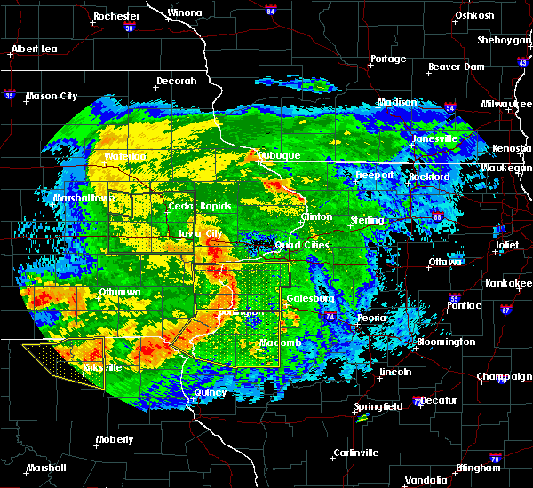 At 757 am cdt, severe thunderstorms were located along a line extending from near oquawka to near niota to near st. francisville, moving east at 55 mph (radar indicated). Hazards include 60 mph wind gusts. expect damage to roofs, siding, and trees At 757 am cdt, severe thunderstorms were located along a line extending from near oquawka to near niota to near st. francisville, moving east at 55 mph (radar indicated). Hazards include 60 mph wind gusts. expect damage to roofs, siding, and trees
|
| 8/20/2019 7:58 AM CDT |
 The national weather service in the quad cities has issued a * severe thunderstorm warning for. hancock county in west central illinois. henderson county in west central illinois. warren county in west central illinois. Mcdonough county in west central illinois. The national weather service in the quad cities has issued a * severe thunderstorm warning for. hancock county in west central illinois. henderson county in west central illinois. warren county in west central illinois. Mcdonough county in west central illinois.
|
| 8/20/2019 7:58 AM CDT |
 At 757 am cdt, severe thunderstorms were located along a line extending from near oquawka to near niota to near st. francisville, moving east at 55 mph (radar indicated). Hazards include 60 mph wind gusts. expect damage to roofs, siding, and trees At 757 am cdt, severe thunderstorms were located along a line extending from near oquawka to near niota to near st. francisville, moving east at 55 mph (radar indicated). Hazards include 60 mph wind gusts. expect damage to roofs, siding, and trees
|
| 8/20/2019 7:38 AM CDT |
 At 737 am cdt, severe thunderstorms were located along a line extending from columbus junction to near new london to near bonaparte, moving east at 60 mph (radar indicated). Hazards include 70 mph wind gusts. Expect considerable tree damage. damage is likely to mobile homes, roofs, and outbuildings. Locations impacted include, burlington, fort madison, mount pleasant, washington, wapello, columbus junction, oquawka, nauvoo, keosauqua, west burlington, new london, mediapolis, winfield, west point, wayland, danville, donnellson, montrose, morning sun and ainsworth. At 737 am cdt, severe thunderstorms were located along a line extending from columbus junction to near new london to near bonaparte, moving east at 60 mph (radar indicated). Hazards include 70 mph wind gusts. Expect considerable tree damage. damage is likely to mobile homes, roofs, and outbuildings. Locations impacted include, burlington, fort madison, mount pleasant, washington, wapello, columbus junction, oquawka, nauvoo, keosauqua, west burlington, new london, mediapolis, winfield, west point, wayland, danville, donnellson, montrose, morning sun and ainsworth.
|
| 8/20/2019 7:08 AM CDT |
 At 707 am cdt, severe thunderstorms were located along a line extending from 6 miles southeast of kinross to near fairfield to near bloomfield, moving east at 60 mph (radar indicated). Hazards include 70 mph wind gusts. Expect considerable tree damage. Damage is likely to mobile homes, roofs, and outbuildings. At 707 am cdt, severe thunderstorms were located along a line extending from 6 miles southeast of kinross to near fairfield to near bloomfield, moving east at 60 mph (radar indicated). Hazards include 70 mph wind gusts. Expect considerable tree damage. Damage is likely to mobile homes, roofs, and outbuildings.
|
| 7/17/2019 3:27 PM CDT |
 At 326 pm cdt, severe thunderstorms were located along a line extending from near carman to near carthage to 6 miles east of canton, moving east at 45 mph (radar indicated. trained spotters have reported 50 to 60 mph winds with these storms). Hazards include 60 mph wind gusts and penny size hail. expect damage to roofs, siding, and trees At 326 pm cdt, severe thunderstorms were located along a line extending from near carman to near carthage to 6 miles east of canton, moving east at 45 mph (radar indicated. trained spotters have reported 50 to 60 mph winds with these storms). Hazards include 60 mph wind gusts and penny size hail. expect damage to roofs, siding, and trees
|
| 7/17/2019 3:20 PM CDT |
 At 320 pm cdt, severe thunderstorms were located along a line extending from near carman to burnside to 7 miles south of warsaw, moving east at 50 mph (radar indicated). Hazards include 60 mph wind gusts. Expect damage to roofs, siding, and trees. Locations impacted include, burlington, fort madison, keokuk, carthage, nauvoo, west burlington, hamilton, warsaw, la harpe, dallas city, montrose, stronghurst, blandinsville, wayland, middletown, carman, terre haute, west point, alexandria and ferris. At 320 pm cdt, severe thunderstorms were located along a line extending from near carman to burnside to 7 miles south of warsaw, moving east at 50 mph (radar indicated). Hazards include 60 mph wind gusts. Expect damage to roofs, siding, and trees. Locations impacted include, burlington, fort madison, keokuk, carthage, nauvoo, west burlington, hamilton, warsaw, la harpe, dallas city, montrose, stronghurst, blandinsville, wayland, middletown, carman, terre haute, west point, alexandria and ferris.
|
| 7/17/2019 3:03 PM CDT |
 A severe thunderstorm warning remains in effect until 330 pm cdt for hancock. southern henderson. northwestern mcdonough. southeastern henry. southwestern des moines. lee and clark counties. At 302 pm cdt, severe thunderstorms were located along a line extending from iowa army ammunition plant to near nauvoo to 9 miles. A severe thunderstorm warning remains in effect until 330 pm cdt for hancock. southern henderson. northwestern mcdonough. southeastern henry. southwestern des moines. lee and clark counties. At 302 pm cdt, severe thunderstorms were located along a line extending from iowa army ammunition plant to near nauvoo to 9 miles.
|
| 7/17/2019 3:03 PM CDT |
 At 302 pm cdt, severe thunderstorms were located along a line extending from iowa army ammunition plant to near nauvoo to 9 miles southwest of wayland, moving southeast at 50 mph (radar indicated. trained spotters have reported 50 to 55 mph wind gusts with these storms). Hazards include 60 mph wind gusts. Expect damage to roofs, siding, and trees. Locations impacted include, burlington, fort madison, keokuk, carthage, kahoka, nauvoo, west burlington, hamilton, warsaw, la harpe, west point, dallas city, danville, donnellson, montrose, stronghurst, blandinsville, wayland, middletown and carman. At 302 pm cdt, severe thunderstorms were located along a line extending from iowa army ammunition plant to near nauvoo to 9 miles southwest of wayland, moving southeast at 50 mph (radar indicated. trained spotters have reported 50 to 55 mph wind gusts with these storms). Hazards include 60 mph wind gusts. Expect damage to roofs, siding, and trees. Locations impacted include, burlington, fort madison, keokuk, carthage, kahoka, nauvoo, west burlington, hamilton, warsaw, la harpe, west point, dallas city, danville, donnellson, montrose, stronghurst, blandinsville, wayland, middletown and carman.
|
| 7/17/2019 2:40 PM CDT |
 At 239 pm cdt, severe thunderstorms were located along a line extending from pilot grove to near croton to south gorin, moving east at 50 mph (radar indicated). Hazards include 60 mph wind gusts and penny size hail. expect damage to roofs, siding, and trees At 239 pm cdt, severe thunderstorms were located along a line extending from pilot grove to near croton to south gorin, moving east at 50 mph (radar indicated). Hazards include 60 mph wind gusts and penny size hail. expect damage to roofs, siding, and trees
|
| 6/30/2019 7:55 PM CDT |
 At 753 pm cdt, outflow boundary with severe winds was located along a line extending from london mills to near colusa to near salem, moving south at 45 mph. thunderstorms behind the outflow boundary will be capable of severe winds to 60 mph (radar indicated). Hazards include 60 mph wind gusts. Expect damage to roofs, siding, and trees. Locations impacted include, burlington, macomb, fort madison, keokuk, fairfield, monmouth, mount pleasant, washington, carthage, kahoka, oquawka, nauvoo, bushnell, west burlington, hamilton, new london, warsaw, mediapolis, colchester and la harpe. At 753 pm cdt, outflow boundary with severe winds was located along a line extending from london mills to near colusa to near salem, moving south at 45 mph. thunderstorms behind the outflow boundary will be capable of severe winds to 60 mph (radar indicated). Hazards include 60 mph wind gusts. Expect damage to roofs, siding, and trees. Locations impacted include, burlington, macomb, fort madison, keokuk, fairfield, monmouth, mount pleasant, washington, carthage, kahoka, oquawka, nauvoo, bushnell, west burlington, hamilton, new london, warsaw, mediapolis, colchester and la harpe.
|
| 6/30/2019 7:45 PM CDT |
 At 744 pm cdt, severe thunderstorms were located along a line extending from abingdon to stronghurst to rome, moving east at 45 mph (radar indicated. a 58 mph wind gust was measured at the burlington airport). Hazards include 60 mph wind gusts. Expect damage to roofs, siding, and trees. Locations impacted include, burlington, macomb, fort madison, keokuk, fairfield, monmouth, mount pleasant, washington, aledo, carthage, kahoka, wapello, columbus junction, oquawka, nauvoo, bushnell, west burlington, hamilton, burgess and new london. At 744 pm cdt, severe thunderstorms were located along a line extending from abingdon to stronghurst to rome, moving east at 45 mph (radar indicated. a 58 mph wind gust was measured at the burlington airport). Hazards include 60 mph wind gusts. Expect damage to roofs, siding, and trees. Locations impacted include, burlington, macomb, fort madison, keokuk, fairfield, monmouth, mount pleasant, washington, aledo, carthage, kahoka, wapello, columbus junction, oquawka, nauvoo, bushnell, west burlington, hamilton, burgess and new london.
|
| 6/30/2019 7:32 PM CDT |
 At 732 pm cdt, severe thunderstorms were located along a line extending from near galesburg to near gladstone to near lockridge, moving south at 45 mph (radar indicated). Hazards include 60 mph wind gusts. expect damage to roofs, siding, and trees At 732 pm cdt, severe thunderstorms were located along a line extending from near galesburg to near gladstone to near lockridge, moving south at 45 mph (radar indicated). Hazards include 60 mph wind gusts. expect damage to roofs, siding, and trees
|
| 6/28/2019 12:59 PM CDT |
 At 1256 pm cdt, severe thunderstorms were located along a line extending from near gulf port to near dallas city to near nauvoo, moving southeast at 35 mph (trained weather spotters reported winds estimated to 60 mph just east of the burlington airport). Hazards include 60 mph wind gusts and quarter size hail. Hail damage to vehicles is expected. expect wind damage to roofs, siding, and trees. Locations impacted include, burlington, fort madison, carthage, nauvoo, west burlington, la harpe, dallas city, montrose, stronghurst, middletown, carman, terre haute, ferris, gulf port, colusa, adrian, new boston, burnside, niota and iowa army ammunition plant. At 1256 pm cdt, severe thunderstorms were located along a line extending from near gulf port to near dallas city to near nauvoo, moving southeast at 35 mph (trained weather spotters reported winds estimated to 60 mph just east of the burlington airport). Hazards include 60 mph wind gusts and quarter size hail. Hail damage to vehicles is expected. expect wind damage to roofs, siding, and trees. Locations impacted include, burlington, fort madison, carthage, nauvoo, west burlington, la harpe, dallas city, montrose, stronghurst, middletown, carman, terre haute, ferris, gulf port, colusa, adrian, new boston, burnside, niota and iowa army ammunition plant.
|
| 6/28/2019 12:57 PM CDT |
 At 1256 pm cdt, severe thunderstorms were located along a line extending from near gulf port to near dallas city to near nauvoo, moving southeast at 35 mph (trained weather spotters reported winds estimated to 60 mph just east of the burlington airport). Hazards include 60 mph wind gusts and quarter size hail. Hail damage to vehicles is expected. expect wind damage to roofs, siding, and trees. Locations impacted include, burlington, fort madison, carthage, nauvoo, west burlington, la harpe, dallas city, montrose, stronghurst, middletown, carman, terre haute, ferris, gulf port, colusa, adrian, new boston, burnside, niota and iowa army ammunition plant. At 1256 pm cdt, severe thunderstorms were located along a line extending from near gulf port to near dallas city to near nauvoo, moving southeast at 35 mph (trained weather spotters reported winds estimated to 60 mph just east of the burlington airport). Hazards include 60 mph wind gusts and quarter size hail. Hail damage to vehicles is expected. expect wind damage to roofs, siding, and trees. Locations impacted include, burlington, fort madison, carthage, nauvoo, west burlington, la harpe, dallas city, montrose, stronghurst, middletown, carman, terre haute, ferris, gulf port, colusa, adrian, new boston, burnside, niota and iowa army ammunition plant.
|
| 6/28/2019 12:46 PM CDT |
 At 1246 pm cdt, severe thunderstorms were located along a line extending from burlington to near dallas city to montrose, moving east southeast at 35 mph (radar indicated). Hazards include 60 mph wind gusts and quarter size hail. Hail damage to vehicles is expected. expect wind damage to roofs, siding, and trees. Locations impacted include, burlington, fort madison, carthage, nauvoo, west burlington, la harpe, dallas city, montrose, stronghurst, middletown, carman, terre haute, ferris, gulf port, colusa, adrian, new boston, burnside, niota and iowa army ammunition plant. At 1246 pm cdt, severe thunderstorms were located along a line extending from burlington to near dallas city to montrose, moving east southeast at 35 mph (radar indicated). Hazards include 60 mph wind gusts and quarter size hail. Hail damage to vehicles is expected. expect wind damage to roofs, siding, and trees. Locations impacted include, burlington, fort madison, carthage, nauvoo, west burlington, la harpe, dallas city, montrose, stronghurst, middletown, carman, terre haute, ferris, gulf port, colusa, adrian, new boston, burnside, niota and iowa army ammunition plant.
|
| 6/28/2019 12:46 PM CDT |
 At 1238 pm cdt, severe thunderstorms were located along a line extending from west burlington to near niota to near new boston, moving southeast at 30 mph (radar indicated). Hazards include 60 mph wind gusts and quarter size hail. Hail damage to vehicles is expected. expect wind damage to roofs, siding, and trees. Locations impacted include, burlington, fort madison, carthage, nauvoo, west burlington, la harpe, west point, dallas city, danville, donnellson, montrose, stronghurst, middletown, carman, terre haute, ferris, franklin, gulf port, colusa and niota. At 1238 pm cdt, severe thunderstorms were located along a line extending from west burlington to near niota to near new boston, moving southeast at 30 mph (radar indicated). Hazards include 60 mph wind gusts and quarter size hail. Hail damage to vehicles is expected. expect wind damage to roofs, siding, and trees. Locations impacted include, burlington, fort madison, carthage, nauvoo, west burlington, la harpe, west point, dallas city, danville, donnellson, montrose, stronghurst, middletown, carman, terre haute, ferris, franklin, gulf port, colusa and niota.
|
| 6/28/2019 12:39 PM CDT |
 At 1238 pm cdt, severe thunderstorms were located along a line extending from west burlington to near niota to near new boston, moving southeast at 30 mph (radar indicated). Hazards include 60 mph wind gusts and quarter size hail. Hail damage to vehicles is expected. expect wind damage to roofs, siding, and trees. Locations impacted include, burlington, fort madison, carthage, nauvoo, west burlington, la harpe, west point, dallas city, danville, donnellson, montrose, stronghurst, middletown, carman, terre haute, ferris, franklin, gulf port, colusa and niota. At 1238 pm cdt, severe thunderstorms were located along a line extending from west burlington to near niota to near new boston, moving southeast at 30 mph (radar indicated). Hazards include 60 mph wind gusts and quarter size hail. Hail damage to vehicles is expected. expect wind damage to roofs, siding, and trees. Locations impacted include, burlington, fort madison, carthage, nauvoo, west burlington, la harpe, west point, dallas city, danville, donnellson, montrose, stronghurst, middletown, carman, terre haute, ferris, franklin, gulf port, colusa and niota.
|
| 6/28/2019 12:29 PM CDT |
 At 1228 pm cdt, severe thunderstorms were located along a line extending from near west burlington to near denmark to new boston, moving east southeast at 35 mph (radar indicated). Hazards include 60 mph wind gusts and quarter size hail. Hail damage to vehicles is expected. Expect wind damage to roofs, siding, and trees. At 1228 pm cdt, severe thunderstorms were located along a line extending from near west burlington to near denmark to new boston, moving east southeast at 35 mph (radar indicated). Hazards include 60 mph wind gusts and quarter size hail. Hail damage to vehicles is expected. Expect wind damage to roofs, siding, and trees.
|
| 6/25/2019 8:06 PM CDT |
 At 806 pm cdt, severe thunderstorms were located along a line extending from disco to near carthage to 8 miles northwest of canton, moving east at 50 mph (trained weather spotters). Hazards include 70 mph wind gusts and quarter size hail. Hail damage to vehicles is expected. expect considerable tree damage. wind damage is also likely to mobile homes, roofs, and outbuildings. Locations impacted include, fort madison, keokuk, carthage, kahoka, memphis, nauvoo, hamilton, warsaw, la harpe, dallas city, montrose, wayland, terre haute, wyaconda, west point, alexandria, ferris, rutledge, luray and south gorin. At 806 pm cdt, severe thunderstorms were located along a line extending from disco to near carthage to 8 miles northwest of canton, moving east at 50 mph (trained weather spotters). Hazards include 70 mph wind gusts and quarter size hail. Hail damage to vehicles is expected. expect considerable tree damage. wind damage is also likely to mobile homes, roofs, and outbuildings. Locations impacted include, fort madison, keokuk, carthage, kahoka, memphis, nauvoo, hamilton, warsaw, la harpe, dallas city, montrose, wayland, terre haute, wyaconda, west point, alexandria, ferris, rutledge, luray and south gorin.
|
| 6/25/2019 8:01 PM CDT |
 At 801 pm cdt, severe thunderstorms were located along a line extending from near dallas city to near carthage to 10 miles northwest of canton, moving east at 45 mph (trained weather spotters). Hazards include 70 mph wind gusts and quarter size hail. Hail damage to vehicles is expected. expect considerable tree damage. wind damage is also likely to mobile homes, roofs, and outbuildings. Locations impacted include, fort madison, keokuk, carthage, kahoka, memphis, nauvoo, hamilton, warsaw, la harpe, dallas city, montrose, stronghurst, wayland, carman, terre haute, wyaconda, west point, alexandria, ferris and rutledge. At 801 pm cdt, severe thunderstorms were located along a line extending from near dallas city to near carthage to 10 miles northwest of canton, moving east at 45 mph (trained weather spotters). Hazards include 70 mph wind gusts and quarter size hail. Hail damage to vehicles is expected. expect considerable tree damage. wind damage is also likely to mobile homes, roofs, and outbuildings. Locations impacted include, fort madison, keokuk, carthage, kahoka, memphis, nauvoo, hamilton, warsaw, la harpe, dallas city, montrose, stronghurst, wayland, carman, terre haute, wyaconda, west point, alexandria, ferris and rutledge.
|
| 6/25/2019 7:57 PM CDT |
 At 750 pm cdt, severe thunderstorms were located along a line extending from near denmark to near keokuk to near colony, moving east at 45 mph (trained weather spotters). Hazards include 60 mph wind gusts and quarter size hail. Hail damage to vehicles is expected. expect wind damage to roofs, siding, and trees. Locations impacted include, fort madison, keokuk, carthage, kahoka, memphis, nauvoo, hamilton, warsaw, la harpe, west point, dallas city, donnellson, montrose, stronghurst, wayland, carman, terre haute, wyaconda, alexandria and ferris. At 750 pm cdt, severe thunderstorms were located along a line extending from near denmark to near keokuk to near colony, moving east at 45 mph (trained weather spotters). Hazards include 60 mph wind gusts and quarter size hail. Hail damage to vehicles is expected. expect wind damage to roofs, siding, and trees. Locations impacted include, fort madison, keokuk, carthage, kahoka, memphis, nauvoo, hamilton, warsaw, la harpe, west point, dallas city, donnellson, montrose, stronghurst, wayland, carman, terre haute, wyaconda, alexandria and ferris.
|
| 6/25/2019 7:50 PM CDT |
 At 750 pm cdt, severe thunderstorms were located along a line extending from near denmark to near keokuk to near colony, moving east at 45 mph (trained weather spotters). Hazards include 60 mph wind gusts and quarter size hail. Hail damage to vehicles is expected. expect wind damage to roofs, siding, and trees. Locations impacted include, fort madison, keokuk, carthage, kahoka, memphis, nauvoo, hamilton, warsaw, la harpe, west point, dallas city, donnellson, montrose, stronghurst, wayland, carman, terre haute, wyaconda, alexandria and ferris. At 750 pm cdt, severe thunderstorms were located along a line extending from near denmark to near keokuk to near colony, moving east at 45 mph (trained weather spotters). Hazards include 60 mph wind gusts and quarter size hail. Hail damage to vehicles is expected. expect wind damage to roofs, siding, and trees. Locations impacted include, fort madison, keokuk, carthage, kahoka, memphis, nauvoo, hamilton, warsaw, la harpe, west point, dallas city, donnellson, montrose, stronghurst, wayland, carman, terre haute, wyaconda, alexandria and ferris.
|
| 6/25/2019 7:44 PM CDT |
 At 744 pm cdt, severe thunderstorms were located along a line extending from near denmark to st. francisville to near south gorin, moving southeast at 40 mph (radar indicated). Hazards include 60 mph wind gusts and quarter size hail. Hail damage to vehicles is expected. expect wind damage to roofs, siding, and trees. Locations impacted include, fort madison, keokuk, carthage, kahoka, memphis, nauvoo, hamilton, warsaw, la harpe, west point, dallas city, donnellson, montrose, stronghurst, wayland, carman, terre haute, wyaconda, alexandria and ferris. At 744 pm cdt, severe thunderstorms were located along a line extending from near denmark to st. francisville to near south gorin, moving southeast at 40 mph (radar indicated). Hazards include 60 mph wind gusts and quarter size hail. Hail damage to vehicles is expected. expect wind damage to roofs, siding, and trees. Locations impacted include, fort madison, keokuk, carthage, kahoka, memphis, nauvoo, hamilton, warsaw, la harpe, west point, dallas city, donnellson, montrose, stronghurst, wayland, carman, terre haute, wyaconda, alexandria and ferris.
|
| 6/25/2019 7:44 PM CDT |
 At 735 pm cdt, severe thunderstorms were located along a line extending from near st. paul to near new boston to south gorin, moving east at 45 mph (radar indicated). Hazards include 60 mph wind gusts and half dollar size hail. Hail damage to vehicles is expected. expect wind damage to roofs, siding, and trees. Locations impacted include, burlington, fort madison, keokuk, carthage, kahoka, memphis, nauvoo, west burlington, hamilton, warsaw, la harpe, west point, dallas city, donnellson, montrose, stronghurst, wayland, middletown, carman and terre haute. At 735 pm cdt, severe thunderstorms were located along a line extending from near st. paul to near new boston to south gorin, moving east at 45 mph (radar indicated). Hazards include 60 mph wind gusts and half dollar size hail. Hail damage to vehicles is expected. expect wind damage to roofs, siding, and trees. Locations impacted include, burlington, fort madison, keokuk, carthage, kahoka, memphis, nauvoo, west burlington, hamilton, warsaw, la harpe, west point, dallas city, donnellson, montrose, stronghurst, wayland, middletown, carman and terre haute.
|
| 6/25/2019 7:36 PM CDT |
 At 735 pm cdt, severe thunderstorms were located along a line extending from near st. paul to near new boston to south gorin, moving east at 45 mph (radar indicated). Hazards include 60 mph wind gusts and half dollar size hail. Hail damage to vehicles is expected. expect wind damage to roofs, siding, and trees. Locations impacted include, burlington, fort madison, keokuk, carthage, kahoka, memphis, nauvoo, west burlington, hamilton, warsaw, la harpe, west point, dallas city, donnellson, montrose, stronghurst, wayland, middletown, carman and terre haute. At 735 pm cdt, severe thunderstorms were located along a line extending from near st. paul to near new boston to south gorin, moving east at 45 mph (radar indicated). Hazards include 60 mph wind gusts and half dollar size hail. Hail damage to vehicles is expected. expect wind damage to roofs, siding, and trees. Locations impacted include, burlington, fort madison, keokuk, carthage, kahoka, memphis, nauvoo, west burlington, hamilton, warsaw, la harpe, west point, dallas city, donnellson, montrose, stronghurst, wayland, middletown, carman and terre haute.
|
| 6/25/2019 7:25 PM CDT |
 At 724 pm cdt, severe thunderstorms were located along a line extending from near pilot grove to near croton to 7 miles south of downing, moving east at 40 mph (radar indicated). Hazards include 60 mph wind gusts and quarter size hail. Hail damage to vehicles is expected. expect wind damage to roofs, siding, and trees. Locations impacted include, burlington, fort madison, keokuk, carthage, kahoka, memphis, nauvoo, west burlington, hamilton, warsaw, la harpe, west point, dallas city, donnellson, montrose, stronghurst, wayland, middletown, carman and terre haute. At 724 pm cdt, severe thunderstorms were located along a line extending from near pilot grove to near croton to 7 miles south of downing, moving east at 40 mph (radar indicated). Hazards include 60 mph wind gusts and quarter size hail. Hail damage to vehicles is expected. expect wind damage to roofs, siding, and trees. Locations impacted include, burlington, fort madison, keokuk, carthage, kahoka, memphis, nauvoo, west burlington, hamilton, warsaw, la harpe, west point, dallas city, donnellson, montrose, stronghurst, wayland, middletown, carman and terre haute.
|
| 6/25/2019 7:16 PM CDT |
 At 716 pm cdt, severe thunderstorms were located along a line extending from near hillsboro to near bonaparte to 6 miles southwest of downing, moving east at 40 mph (radar indicated). Hazards include 60 mph wind gusts and quarter size hail. Hail damage to vehicles is expected. Expect wind damage to roofs, siding, and trees. At 716 pm cdt, severe thunderstorms were located along a line extending from near hillsboro to near bonaparte to 6 miles southwest of downing, moving east at 40 mph (radar indicated). Hazards include 60 mph wind gusts and quarter size hail. Hail damage to vehicles is expected. Expect wind damage to roofs, siding, and trees.
|
| 5/28/2019 7:26 PM CDT |
 At 724 pm cdt, severe thunderstorms were located along a line extending from near oakville to near stronghurst to near la harpe, moving east at 45 mph (the burlington airport gusted to 68 mph at 719 pm). Hazards include 70 mph wind gusts and quarter size hail. Hail damage to vehicles is expected. expect considerable tree damage. wind damage is also likely to mobile homes, roofs, and outbuildings. Locations impacted include, burlington, monmouth, aledo, oquawka, west burlington, burgess, mediapolis, la harpe, roseville, dallas city, stronghurst, kirkwood, new boston, keithsburg, joy, little york, carman, biggsville, gladstone and rozetta. At 724 pm cdt, severe thunderstorms were located along a line extending from near oakville to near stronghurst to near la harpe, moving east at 45 mph (the burlington airport gusted to 68 mph at 719 pm). Hazards include 70 mph wind gusts and quarter size hail. Hail damage to vehicles is expected. expect considerable tree damage. wind damage is also likely to mobile homes, roofs, and outbuildings. Locations impacted include, burlington, monmouth, aledo, oquawka, west burlington, burgess, mediapolis, la harpe, roseville, dallas city, stronghurst, kirkwood, new boston, keithsburg, joy, little york, carman, biggsville, gladstone and rozetta.
|
| 5/28/2019 7:16 PM CDT |
 At 714 pm cdt, severe thunderstorms were located along a line extending from near mediapolis to gulf port to adrian, moving east at 50 mph. this storm is in the burlington area (trained weather spotters report 60 to 65 mph and nickel size hail). Hazards include 60 mph wind gusts and quarter size hail. Hail damage to vehicles is expected. expect wind damage to roofs, siding, and trees. Locations impacted include, burlington, fort madison, monmouth, aledo, oquawka, nauvoo, west burlington, burgess, mediapolis, la harpe, roseville, dallas city, danville, montrose, stronghurst, morning sun, kirkwood, new boston, keithsburg and joy. At 714 pm cdt, severe thunderstorms were located along a line extending from near mediapolis to gulf port to adrian, moving east at 50 mph. this storm is in the burlington area (trained weather spotters report 60 to 65 mph and nickel size hail). Hazards include 60 mph wind gusts and quarter size hail. Hail damage to vehicles is expected. expect wind damage to roofs, siding, and trees. Locations impacted include, burlington, fort madison, monmouth, aledo, oquawka, nauvoo, west burlington, burgess, mediapolis, la harpe, roseville, dallas city, danville, montrose, stronghurst, morning sun, kirkwood, new boston, keithsburg and joy.
|
| 5/28/2019 7:09 PM CDT |
 At 709 pm cdt, severe thunderstorms were located along a line extending from near morning sun to near iowa army ammunition plant to near adrian, moving east at 50 mph (radar indicated). Hazards include 60 mph wind gusts and quarter size hail. Hail damage to vehicles is expected. expect wind damage to roofs, siding, and trees. Locations impacted include, burlington, fort madison, monmouth, aledo, oquawka, nauvoo, west burlington, burgess, new london, mediapolis, la harpe, roseville, dallas city, danville, montrose, stronghurst, morning sun, kirkwood, new boston and keithsburg. At 709 pm cdt, severe thunderstorms were located along a line extending from near morning sun to near iowa army ammunition plant to near adrian, moving east at 50 mph (radar indicated). Hazards include 60 mph wind gusts and quarter size hail. Hail damage to vehicles is expected. expect wind damage to roofs, siding, and trees. Locations impacted include, burlington, fort madison, monmouth, aledo, oquawka, nauvoo, west burlington, burgess, new london, mediapolis, la harpe, roseville, dallas city, danville, montrose, stronghurst, morning sun, kirkwood, new boston and keithsburg.
|
| 5/28/2019 7:09 PM CDT |
 At 704 pm cdt, severe thunderstorms were located along a line extending from near mount union to near iowa army ammunition plant to montrose, moving east at 45 mph (radar indicated). Hazards include 60 mph wind gusts and quarter size hail. Hail damage to vehicles is expected. expect wind damage to roofs, siding, and trees. Locations impacted include, burlington, fort madison, monmouth, mount pleasant, aledo, wapello, oquawka, nauvoo, west burlington, burgess, new london, mediapolis, la harpe, winfield, roseville, west point, dallas city, danville, montrose and stronghurst. At 704 pm cdt, severe thunderstorms were located along a line extending from near mount union to near iowa army ammunition plant to montrose, moving east at 45 mph (radar indicated). Hazards include 60 mph wind gusts and quarter size hail. Hail damage to vehicles is expected. expect wind damage to roofs, siding, and trees. Locations impacted include, burlington, fort madison, monmouth, mount pleasant, aledo, wapello, oquawka, nauvoo, west burlington, burgess, new london, mediapolis, la harpe, winfield, roseville, west point, dallas city, danville, montrose and stronghurst.
|
| 5/28/2019 7:04 PM CDT |
 At 704 pm cdt, severe thunderstorms were located along a line extending from near mount union to near iowa army ammunition plant to montrose, moving east at 45 mph (radar indicated). Hazards include 60 mph wind gusts and quarter size hail. Hail damage to vehicles is expected. expect wind damage to roofs, siding, and trees. Locations impacted include, burlington, fort madison, monmouth, mount pleasant, aledo, wapello, oquawka, nauvoo, west burlington, burgess, new london, mediapolis, la harpe, winfield, roseville, west point, dallas city, danville, montrose and stronghurst. At 704 pm cdt, severe thunderstorms were located along a line extending from near mount union to near iowa army ammunition plant to montrose, moving east at 45 mph (radar indicated). Hazards include 60 mph wind gusts and quarter size hail. Hail damage to vehicles is expected. expect wind damage to roofs, siding, and trees. Locations impacted include, burlington, fort madison, monmouth, mount pleasant, aledo, wapello, oquawka, nauvoo, west burlington, burgess, new london, mediapolis, la harpe, winfield, roseville, west point, dallas city, danville, montrose and stronghurst.
|
| 5/28/2019 6:53 PM CDT |
 At 653 pm cdt, severe thunderstorms were located along a line extending from near olds to near west point to near new boston, moving east at 40 mph (radar indicated). Hazards include 60 mph wind gusts and quarter size hail. Hail damage to vehicles is expected. Expect wind damage to roofs, siding, and trees. At 653 pm cdt, severe thunderstorms were located along a line extending from near olds to near west point to near new boston, moving east at 40 mph (radar indicated). Hazards include 60 mph wind gusts and quarter size hail. Hail damage to vehicles is expected. Expect wind damage to roofs, siding, and trees.
|
| 5/24/2019 11:11 AM CDT |
 The severe thunderstorm warning for northwestern hancock and central lee counties will expire at 1115 am cdt, the storm which prompted the warning has weakened below severe limits, and no longer poses an immediate threat to life or property. therefore, the warning will be allowed to expire. The severe thunderstorm warning for northwestern hancock and central lee counties will expire at 1115 am cdt, the storm which prompted the warning has weakened below severe limits, and no longer poses an immediate threat to life or property. therefore, the warning will be allowed to expire.
|
| 5/24/2019 11:03 AM CDT |
 At 1103 am cdt, a severe thunderstorm was located over niota, or near fort madison, moving northeast at 50 mph (radar indicated). Hazards include 60 mph wind gusts. Expect damage to roofs, siding, and trees. Locations impacted include, fort madison, keokuk, nauvoo, dallas city, montrose, colusa, adrian, niota, pontoosuc, keokuk airport, nauvoo state park, summitville, mooar, bluff park, chatfield park, galland, sandusky and camp eastman. At 1103 am cdt, a severe thunderstorm was located over niota, or near fort madison, moving northeast at 50 mph (radar indicated). Hazards include 60 mph wind gusts. Expect damage to roofs, siding, and trees. Locations impacted include, fort madison, keokuk, nauvoo, dallas city, montrose, colusa, adrian, niota, pontoosuc, keokuk airport, nauvoo state park, summitville, mooar, bluff park, chatfield park, galland, sandusky and camp eastman.
|
| 5/24/2019 10:52 AM CDT |
 At 1051 am cdt, a severe thunderstorm was located over nauvoo, moving northeast at 50 mph (radar indicated). Hazards include 60 mph wind gusts. Expect damage to roofs, siding, and trees. Locations impacted include, fort madison, keokuk, nauvoo, dallas city, montrose, colusa, adrian, new boston, niota, pontoosuc, charleston, keokuk airport, nauvoo state park, summitville, mooar, vincennes, bluff park, chatfield park, galland and sandusky. At 1051 am cdt, a severe thunderstorm was located over nauvoo, moving northeast at 50 mph (radar indicated). Hazards include 60 mph wind gusts. Expect damage to roofs, siding, and trees. Locations impacted include, fort madison, keokuk, nauvoo, dallas city, montrose, colusa, adrian, new boston, niota, pontoosuc, charleston, keokuk airport, nauvoo state park, summitville, mooar, vincennes, bluff park, chatfield park, galland and sandusky.
|
| 5/24/2019 10:45 AM CDT |
 At 1045 am cdt, a severe thunderstorm was located over montrose, or over nauvoo, moving east at 50 mph (radar indicated). Hazards include 60 mph wind gusts. expect damage to roofs, siding, and trees At 1045 am cdt, a severe thunderstorm was located over montrose, or over nauvoo, moving east at 50 mph (radar indicated). Hazards include 60 mph wind gusts. expect damage to roofs, siding, and trees
|
| 5/22/2019 10:36 PM CDT |
 The severe thunderstorm warning for northwestern hancock and central lee counties will expire at 1045 pm cdt, the storm which prompted the warning has weakened below severe limits, and has exited the warned area. therefore, the warning will be allowed to expire. a tornado watch remains in effect until 1100 pm cdt for west central illinois, southeastern iowa, and northeastern missouri. to report severe weather, contact your nearest law enforcement agency. they will relay your report to the national weather service the quad cities. The severe thunderstorm warning for northwestern hancock and central lee counties will expire at 1045 pm cdt, the storm which prompted the warning has weakened below severe limits, and has exited the warned area. therefore, the warning will be allowed to expire. a tornado watch remains in effect until 1100 pm cdt for west central illinois, southeastern iowa, and northeastern missouri. to report severe weather, contact your nearest law enforcement agency. they will relay your report to the national weather service the quad cities.
|
| 5/22/2019 10:29 PM CDT |
 At 1020 pm cdt, a severe thunderstorm was located over montrose, or near nauvoo, moving east at 55 mph (radar indicated). Hazards include 60 mph wind gusts and quarter size hail. Hail damage to vehicles is expected. expect wind damage to roofs, siding, and trees. Locations impacted include, fort madison, keokuk, carthage, nauvoo, dallas city, montrose, ferris, colusa, adrian, new boston, niota, elvaston, pontoosuc, charleston, keokuk airport, nauvoo state park, bluff park, galland, sandusky and argyle. At 1020 pm cdt, a severe thunderstorm was located over montrose, or near nauvoo, moving east at 55 mph (radar indicated). Hazards include 60 mph wind gusts and quarter size hail. Hail damage to vehicles is expected. expect wind damage to roofs, siding, and trees. Locations impacted include, fort madison, keokuk, carthage, nauvoo, dallas city, montrose, ferris, colusa, adrian, new boston, niota, elvaston, pontoosuc, charleston, keokuk airport, nauvoo state park, bluff park, galland, sandusky and argyle.
|
| 5/22/2019 10:20 PM CDT |
 At 1020 pm cdt, a severe thunderstorm was located over montrose, or near nauvoo, moving east at 55 mph (radar indicated). Hazards include 60 mph wind gusts and quarter size hail. Hail damage to vehicles is expected. expect wind damage to roofs, siding, and trees. Locations impacted include, fort madison, keokuk, carthage, nauvoo, dallas city, montrose, ferris, colusa, adrian, new boston, niota, elvaston, pontoosuc, charleston, keokuk airport, nauvoo state park, bluff park, galland, sandusky and argyle. At 1020 pm cdt, a severe thunderstorm was located over montrose, or near nauvoo, moving east at 55 mph (radar indicated). Hazards include 60 mph wind gusts and quarter size hail. Hail damage to vehicles is expected. expect wind damage to roofs, siding, and trees. Locations impacted include, fort madison, keokuk, carthage, nauvoo, dallas city, montrose, ferris, colusa, adrian, new boston, niota, elvaston, pontoosuc, charleston, keokuk airport, nauvoo state park, bluff park, galland, sandusky and argyle.
|
| 5/22/2019 10:11 PM CDT |
 At 1011 pm cdt, a severe thunderstorm was located over st. francisville, or 8 miles northeast of kahoka, moving east at 55 mph (radar indicated). Hazards include 60 mph wind gusts and quarter size hail. Hail damage to vehicles is expected. expect wind damage to roofs, siding, and trees. locations impacted include, fort madison, keokuk, carthage, nauvoo, hamilton, warsaw, dallas city, montrose, wayland, ferris, colusa, adrian, new boston, croton, niota, st. Francisville, elvaston, pontoosuc, revere and charleston. At 1011 pm cdt, a severe thunderstorm was located over st. francisville, or 8 miles northeast of kahoka, moving east at 55 mph (radar indicated). Hazards include 60 mph wind gusts and quarter size hail. Hail damage to vehicles is expected. expect wind damage to roofs, siding, and trees. locations impacted include, fort madison, keokuk, carthage, nauvoo, hamilton, warsaw, dallas city, montrose, wayland, ferris, colusa, adrian, new boston, croton, niota, st. Francisville, elvaston, pontoosuc, revere and charleston.
|
| 5/22/2019 9:59 PM CDT |
 At 959 pm cdt, a severe thunderstorm was located near kahoka, moving east at 55 mph (radar indicated). Hazards include 60 mph wind gusts and quarter size hail. Hail damage to vehicles is expected. Expect wind damage to roofs, siding, and trees. At 959 pm cdt, a severe thunderstorm was located near kahoka, moving east at 55 mph (radar indicated). Hazards include 60 mph wind gusts and quarter size hail. Hail damage to vehicles is expected. Expect wind damage to roofs, siding, and trees.
|
| 5/22/2019 9:59 PM CDT |
 The national weather service in the quad cities has issued a * severe thunderstorm warning for. central hancock county in west central illinois. southern lee county in southeastern iowa. clark county in northeastern missouri. Until 1045 pm cdt. The national weather service in the quad cities has issued a * severe thunderstorm warning for. central hancock county in west central illinois. southern lee county in southeastern iowa. clark county in northeastern missouri. Until 1045 pm cdt.
|
| 5/22/2019 8:06 PM CDT |
 At 806 pm cdt, a severe thunderstorm was located over ferris, or near carthage, moving northeast at 45 mph (radar indicated). Hazards include 60 mph wind gusts and quarter size hail. Hail damage to vehicles is expected. expect wind damage to roofs, siding, and trees. Locations impacted include, keokuk, carthage, nauvoo, hamilton, warsaw, la harpe, dallas city, montrose, alexandria, ferris, colusa, adrian, burnside, disco, fountain green, elvaston, keokuk airport, nauvoo state park, bluff park and galland. At 806 pm cdt, a severe thunderstorm was located over ferris, or near carthage, moving northeast at 45 mph (radar indicated). Hazards include 60 mph wind gusts and quarter size hail. Hail damage to vehicles is expected. expect wind damage to roofs, siding, and trees. Locations impacted include, keokuk, carthage, nauvoo, hamilton, warsaw, la harpe, dallas city, montrose, alexandria, ferris, colusa, adrian, burnside, disco, fountain green, elvaston, keokuk airport, nauvoo state park, bluff park and galland.
|
| 5/22/2019 7:58 PM CDT |
 At 757 pm cdt, severe thunderstorms were located along a line extending from near keokuk to 7 miles southwest of wayland, moving northeast at 25 mph (public. at 752 pm cdt...quarter size hail was reported in keokuk). Hazards include 60 mph wind gusts and quarter size hail. Hail damage to vehicles is expected. expect wind damage to roofs, siding, and trees. locations impacted include, keokuk, carthage, nauvoo, hamilton, warsaw, la harpe, dallas city, montrose, wayland, alexandria, ferris, colusa, adrian, burnside, disco, st. Francisville, winchester, fountain green, elvaston and keokuk airport. At 757 pm cdt, severe thunderstorms were located along a line extending from near keokuk to 7 miles southwest of wayland, moving northeast at 25 mph (public. at 752 pm cdt...quarter size hail was reported in keokuk). Hazards include 60 mph wind gusts and quarter size hail. Hail damage to vehicles is expected. expect wind damage to roofs, siding, and trees. locations impacted include, keokuk, carthage, nauvoo, hamilton, warsaw, la harpe, dallas city, montrose, wayland, alexandria, ferris, colusa, adrian, burnside, disco, st. Francisville, winchester, fountain green, elvaston and keokuk airport.
|
| 5/22/2019 7:46 PM CDT |
 At 746 pm cdt, severe thunderstorms were located along a line extending from alexandria to 7 miles west of canton, moving northeast at 40 mph (radar indicated). Hazards include 60 mph wind gusts and quarter size hail. Hail damage to vehicles is expected. Expect wind damage to roofs, siding, and trees. At 746 pm cdt, severe thunderstorms were located along a line extending from alexandria to 7 miles west of canton, moving northeast at 40 mph (radar indicated). Hazards include 60 mph wind gusts and quarter size hail. Hail damage to vehicles is expected. Expect wind damage to roofs, siding, and trees.
|
| 5/22/2019 7:46 PM CDT |
 The national weather service in the quad cities has issued a * severe thunderstorm warning for. hancock county in west central illinois. southwestern lee county in southeastern iowa. southeastern clark county in northeastern missouri. Until 830 pm cdt. The national weather service in the quad cities has issued a * severe thunderstorm warning for. hancock county in west central illinois. southwestern lee county in southeastern iowa. southeastern clark county in northeastern missouri. Until 830 pm cdt.
|
| 4/30/2019 2:45 AM CDT |
 At 243 am cdt, a severe thunderstorm was located over dallas city, or 11 miles east of fort madison, moving northeast at 50 mph. penny size hail was reported earlier in montrose iowa with this storm (radar indicated). Hazards include quarter size hail. Damage to vehicles is expected. Locations impacted include, fort madison, dallas city, colusa, disco, adrian, niota, pontoosuc, wever, fort madison municipal arpt and augusta. At 243 am cdt, a severe thunderstorm was located over dallas city, or 11 miles east of fort madison, moving northeast at 50 mph. penny size hail was reported earlier in montrose iowa with this storm (radar indicated). Hazards include quarter size hail. Damage to vehicles is expected. Locations impacted include, fort madison, dallas city, colusa, disco, adrian, niota, pontoosuc, wever, fort madison municipal arpt and augusta.
|
| 4/30/2019 2:29 AM CDT |
 At 228 am cdt, a severe thunderstorm was located over nauvoo, moving northeast at 50 mph (radar indicated). Hazards include quarter size hail. damage to vehicles is expected At 228 am cdt, a severe thunderstorm was located over nauvoo, moving northeast at 50 mph (radar indicated). Hazards include quarter size hail. damage to vehicles is expected
|
| 8/28/2018 9:01 PM CDT |
 At 850 pm cdt, severe thunderstorms were located along a line extending from near mediapolis to 7 miles north of canton, moving east at 40 mph (radar indicated). Hazards include 60 mph wind gusts and penny size hail. expect damage to roofs, siding, and trees At 850 pm cdt, severe thunderstorms were located along a line extending from near mediapolis to 7 miles north of canton, moving east at 40 mph (radar indicated). Hazards include 60 mph wind gusts and penny size hail. expect damage to roofs, siding, and trees
|
| 8/28/2018 8:50 PM CDT |
 At 850 pm cdt, severe thunderstorms were located along a line extending from near mediapolis to 7 miles north of canton, moving east at 40 mph (radar indicated). Hazards include 60 mph wind gusts and penny size hail. expect damage to roofs, siding, and trees At 850 pm cdt, severe thunderstorms were located along a line extending from near mediapolis to 7 miles north of canton, moving east at 40 mph (radar indicated). Hazards include 60 mph wind gusts and penny size hail. expect damage to roofs, siding, and trees
|
| 6/28/2018 2:53 PM CDT |
 At 253 pm cdt, severe thunderstorms were located along a line extending from gulf port to disco to near mendon, moving east at 50 mph (radar indicated). Hazards include 60 mph wind gusts. Expect damage to roofs, siding, and trees. Locations impacted include, burlington, fort madison, keokuk, carthage, nauvoo, west burlington, hamilton, warsaw, la harpe, dallas city, danville, montrose, stronghurst, bowen, middletown, carman, terre haute, west point, ferris and gulf port. At 253 pm cdt, severe thunderstorms were located along a line extending from gulf port to disco to near mendon, moving east at 50 mph (radar indicated). Hazards include 60 mph wind gusts. Expect damage to roofs, siding, and trees. Locations impacted include, burlington, fort madison, keokuk, carthage, nauvoo, west burlington, hamilton, warsaw, la harpe, dallas city, danville, montrose, stronghurst, bowen, middletown, carman, terre haute, west point, ferris and gulf port.
|
| 6/28/2018 2:29 PM CDT |
 At 227 pm cdt, severe thunderstorms were located along a line extending from near lowell to near wayland to near colony, moving southeast at 50 mph (radar indicated). Hazards include 60 mph wind gusts and penny size hail. expect damage to roofs, siding, and trees At 227 pm cdt, severe thunderstorms were located along a line extending from near lowell to near wayland to near colony, moving southeast at 50 mph (radar indicated). Hazards include 60 mph wind gusts and penny size hail. expect damage to roofs, siding, and trees
|
| 6/14/2018 1:32 PM CDT | Powerlines down in burnsid in hancock county IL, 9 miles NNW of Dallas City, IL |
| 6/14/2018 1:24 PM CDT |
 At 124 pm cdt, a severe thunderstorm was located near carthage, moving southeast at 50 mph (radar indicated). Hazards include 60 mph wind gusts and quarter size hail. Hail damage to vehicles is expected. expect wind damage to roofs, siding, and trees. Locations impacted include, keokuk, carthage, hamilton, warsaw, dallas city, augusta, bowen, west point, ferris, colusa, adrian, burnside, plymouth, denver, fountain green, elvaston, basco, bentley, tioga and sutter. At 124 pm cdt, a severe thunderstorm was located near carthage, moving southeast at 50 mph (radar indicated). Hazards include 60 mph wind gusts and quarter size hail. Hail damage to vehicles is expected. expect wind damage to roofs, siding, and trees. Locations impacted include, keokuk, carthage, hamilton, warsaw, dallas city, augusta, bowen, west point, ferris, colusa, adrian, burnside, plymouth, denver, fountain green, elvaston, basco, bentley, tioga and sutter.
|
| 6/14/2018 1:16 PM CDT |
 At 116 pm cdt, a severe thunderstorm was located near hamilton, or near keokuk, moving southeast at 45 mph (radar indicated). Hazards include 60 mph wind gusts and quarter size hail. Hail damage to vehicles is expected. expect wind damage to roofs, siding, and trees. Locations impacted include, fort madison, keokuk, carthage, nauvoo, hamilton, warsaw, dallas city, augusta, bowen, west point, ferris, colusa, adrian, burnside, niota, plymouth, denver, fountain green, elvaston and pontoosuc. At 116 pm cdt, a severe thunderstorm was located near hamilton, or near keokuk, moving southeast at 45 mph (radar indicated). Hazards include 60 mph wind gusts and quarter size hail. Hail damage to vehicles is expected. expect wind damage to roofs, siding, and trees. Locations impacted include, fort madison, keokuk, carthage, nauvoo, hamilton, warsaw, dallas city, augusta, bowen, west point, ferris, colusa, adrian, burnside, niota, plymouth, denver, fountain green, elvaston and pontoosuc.
|
| 6/14/2018 1:16 PM CDT |
 At 116 pm cdt, severe thunderstorms were located along a line extending from near oquawka to near carman to near colusa, moving southeast at 50 mph (radar indicated). Hazards include 60 mph wind gusts and quarter size hail. Hail damage to vehicles is expected. expect wind damage to roofs, siding, and trees. Locations impacted include, macomb, bushnell, colchester, la harpe, roseville, dallas city, stronghurst, avon, blandinsville, industry, good hope, prairie city, carman, biggsville, gladstone, terre haute, bardolph, raritan, tennessee and sciota. At 116 pm cdt, severe thunderstorms were located along a line extending from near oquawka to near carman to near colusa, moving southeast at 50 mph (radar indicated). Hazards include 60 mph wind gusts and quarter size hail. Hail damage to vehicles is expected. expect wind damage to roofs, siding, and trees. Locations impacted include, macomb, bushnell, colchester, la harpe, roseville, dallas city, stronghurst, avon, blandinsville, industry, good hope, prairie city, carman, biggsville, gladstone, terre haute, bardolph, raritan, tennessee and sciota.
|
| 6/14/2018 1:12 PM CDT |
 At 112 pm cdt, severe thunderstorms were located along a line extending from near gladstone to near carman to near dallas city, moving southeast at 50 mph (radar indicated). Hazards include 60 mph wind gusts. expect damage to roofs, siding, and trees At 112 pm cdt, severe thunderstorms were located along a line extending from near gladstone to near carman to near dallas city, moving southeast at 50 mph (radar indicated). Hazards include 60 mph wind gusts. expect damage to roofs, siding, and trees
|
| 6/14/2018 1:06 PM CDT |
 At 106 pm cdt, a severe thunderstorm was located near keokuk, moving southeast at 55 mph (trained weather spotters). Hazards include 60 mph wind gusts and quarter size hail. Hail damage to vehicles is expected. expect wind damage to roofs, siding, and trees. Locations impacted include, fort madison, keokuk, carthage, nauvoo, hamilton, warsaw, dallas city, augusta, bowen, west point, ferris, colusa, adrian, burnside, niota, plymouth, denver, fountain green, elvaston and pontoosuc. At 106 pm cdt, a severe thunderstorm was located near keokuk, moving southeast at 55 mph (trained weather spotters). Hazards include 60 mph wind gusts and quarter size hail. Hail damage to vehicles is expected. expect wind damage to roofs, siding, and trees. Locations impacted include, fort madison, keokuk, carthage, nauvoo, hamilton, warsaw, dallas city, augusta, bowen, west point, ferris, colusa, adrian, burnside, niota, plymouth, denver, fountain green, elvaston and pontoosuc.
|
| 6/14/2018 1:03 PM CDT |
 At 102 pm cdt, a severe thunderstorm was located over montrose, or near nauvoo, moving southeast at 45 mph (trained weather spotters). Hazards include 60 mph wind gusts and quarter size hail. Hail damage to vehicles is expected. Expect wind damage to roofs, siding, and trees. At 102 pm cdt, a severe thunderstorm was located over montrose, or near nauvoo, moving southeast at 45 mph (trained weather spotters). Hazards include 60 mph wind gusts and quarter size hail. Hail damage to vehicles is expected. Expect wind damage to roofs, siding, and trees.
|
| 10/14/2017 8:16 PM CDT |
 At 816 pm cdt, severe thunderstorms were located along a line extending from terre haute to la harpe to near bowen, moving east at 60 mph (radar indicated). Hazards include 60 mph wind gusts and quarter size hail. Hail damage to vehicles is expected. expect wind damage to roofs, siding, and trees. locations impacted include, macomb, carthage, bushnell, colchester, la harpe, roseville, dallas city, avon, blandinsville, augusta, bowen, industry, good hope, prairie city, terre haute, bardolph, west point, ferris, raritan and tennessee. A tornado watch remains in effect until 100 am cdt for west central illinois, and southeastern iowa. At 816 pm cdt, severe thunderstorms were located along a line extending from terre haute to la harpe to near bowen, moving east at 60 mph (radar indicated). Hazards include 60 mph wind gusts and quarter size hail. Hail damage to vehicles is expected. expect wind damage to roofs, siding, and trees. locations impacted include, macomb, carthage, bushnell, colchester, la harpe, roseville, dallas city, avon, blandinsville, augusta, bowen, industry, good hope, prairie city, terre haute, bardolph, west point, ferris, raritan and tennessee. A tornado watch remains in effect until 100 am cdt for west central illinois, and southeastern iowa.
|
| 10/14/2017 8:09 PM CDT |
 At 809 pm cdt, severe thunderstorms were located along a line extending from near dallas city to near west point, moving east at 60 mph (radar indicated). Hazards include 60 mph wind gusts and quarter size hail. Hail damage to vehicles is expected. expect wind damage to roofs, siding, and trees. locations impacted include, macomb, fort madison, keokuk, carthage, nauvoo, bushnell, hamilton, warsaw, colchester, la harpe, roseville, dallas city, avon, blandinsville, augusta, bowen, industry, good hope, prairie city and terre haute. A tornado watch remains in effect until 100 am cdt for west central illinois, southeastern iowa, and northeastern missouri. At 809 pm cdt, severe thunderstorms were located along a line extending from near dallas city to near west point, moving east at 60 mph (radar indicated). Hazards include 60 mph wind gusts and quarter size hail. Hail damage to vehicles is expected. expect wind damage to roofs, siding, and trees. locations impacted include, macomb, fort madison, keokuk, carthage, nauvoo, bushnell, hamilton, warsaw, colchester, la harpe, roseville, dallas city, avon, blandinsville, augusta, bowen, industry, good hope, prairie city and terre haute. A tornado watch remains in effect until 100 am cdt for west central illinois, southeastern iowa, and northeastern missouri.
|
| 10/14/2017 7:58 PM CDT |
 At 758 pm cdt, severe thunderstorms were located along a line extending from niota to 8 miles south of warsaw, moving east at 60 mph (radar indicated). Hazards include 60 mph wind gusts and quarter size hail. Hail damage to vehicles is expected. Expect wind damage to roofs, siding, and trees. At 758 pm cdt, severe thunderstorms were located along a line extending from niota to 8 miles south of warsaw, moving east at 60 mph (radar indicated). Hazards include 60 mph wind gusts and quarter size hail. Hail damage to vehicles is expected. Expect wind damage to roofs, siding, and trees.
|
| 10/14/2017 5:43 PM CDT |
 At 543 pm cdt, a severe thunderstorm was located near ferris, or near carthage, moving east at 65 mph (law enforcement). Hazards include 60 mph wind gusts. Expect damage to roofs, siding, and trees. locations impacted include, fort madison, keokuk, carthage, kahoka, nauvoo, hamilton, warsaw, la harpe, dallas city, montrose, augusta, wayland, bowen, west point, alexandria, ferris, colusa, niota, disco and st. francisville. A tornado watch remains in effect until 100 am cdt for west central illinois, southeastern iowa, and northeastern missouri. At 543 pm cdt, a severe thunderstorm was located near ferris, or near carthage, moving east at 65 mph (law enforcement). Hazards include 60 mph wind gusts. Expect damage to roofs, siding, and trees. locations impacted include, fort madison, keokuk, carthage, kahoka, nauvoo, hamilton, warsaw, la harpe, dallas city, montrose, augusta, wayland, bowen, west point, alexandria, ferris, colusa, niota, disco and st. francisville. A tornado watch remains in effect until 100 am cdt for west central illinois, southeastern iowa, and northeastern missouri.
|
| 10/14/2017 5:35 PM CDT |
 At 535 pm cdt, severe thunderstorms were located along a line extending from little york to near biggsville to near terre haute, moving east at 40 mph (radar indicated). Hazards include 60 mph wind gusts and quarter size hail. Hail damage to vehicles is expected. expect wind damage to roofs, siding, and trees. locations impacted include, monmouth, oquawka, roseville, dallas city, stronghurst, kirkwood, little york, carman, biggsville, gladstone, rozetta, terre haute, raritan, little swan lake, alexis, greenbush, coldbrook, lomax, bald bluff and berwick. A tornado watch remains in effect until 100 am cdt for west central illinois, and southeastern iowa. At 535 pm cdt, severe thunderstorms were located along a line extending from little york to near biggsville to near terre haute, moving east at 40 mph (radar indicated). Hazards include 60 mph wind gusts and quarter size hail. Hail damage to vehicles is expected. expect wind damage to roofs, siding, and trees. locations impacted include, monmouth, oquawka, roseville, dallas city, stronghurst, kirkwood, little york, carman, biggsville, gladstone, rozetta, terre haute, raritan, little swan lake, alexis, greenbush, coldbrook, lomax, bald bluff and berwick. A tornado watch remains in effect until 100 am cdt for west central illinois, and southeastern iowa.
|
| 10/14/2017 5:26 PM CDT |
 At 526 pm cdt, severe thunderstorms were located along a line extending from near rozetta to near gladstone to near terre haute, moving east at 30 mph (radar indicated). Hazards include 60 mph wind gusts and quarter size hail. Hail damage to vehicles is expected. Expect wind damage to roofs, siding, and trees. At 526 pm cdt, severe thunderstorms were located along a line extending from near rozetta to near gladstone to near terre haute, moving east at 30 mph (radar indicated). Hazards include 60 mph wind gusts and quarter size hail. Hail damage to vehicles is expected. Expect wind damage to roofs, siding, and trees.
|
| 10/14/2017 5:17 PM CDT |
 At 517 pm cdt, a severe thunderstorm was located near kahoka, moving east at 70 mph (law enforcement). Hazards include 60 mph wind gusts. expect damage to roofs, siding, and trees At 517 pm cdt, a severe thunderstorm was located near kahoka, moving east at 70 mph (law enforcement). Hazards include 60 mph wind gusts. expect damage to roofs, siding, and trees
|
| 8/18/2017 7:08 PM CDT |
 At 701 pm cdt, a severe thunderstorm was located over terre haute, or 10 miles southeast of burlington, moving east at 20 mph (radar indicated). Hazards include 60 mph wind gusts and quarter size hail. Hail damage to vehicles is expected. expect wind damage to roofs, siding, and trees. Locations impacted include, la harpe, dallas city, blandinsville, good hope, terre haute, raritan, sciota, colusa, disco, lomax, pontoosuc and swan creek. At 701 pm cdt, a severe thunderstorm was located over terre haute, or 10 miles southeast of burlington, moving east at 20 mph (radar indicated). Hazards include 60 mph wind gusts and quarter size hail. Hail damage to vehicles is expected. expect wind damage to roofs, siding, and trees. Locations impacted include, la harpe, dallas city, blandinsville, good hope, terre haute, raritan, sciota, colusa, disco, lomax, pontoosuc and swan creek.
|
| 8/18/2017 7:01 PM CDT |
 At 701 pm cdt, a severe thunderstorm was located over terre haute, or 10 miles southeast of burlington, moving east at 20 mph (radar indicated). Hazards include 60 mph wind gusts and quarter size hail. Hail damage to vehicles is expected. expect wind damage to roofs, siding, and trees. Locations impacted include, la harpe, dallas city, blandinsville, good hope, terre haute, raritan, sciota, colusa, disco, lomax, pontoosuc and swan creek. At 701 pm cdt, a severe thunderstorm was located over terre haute, or 10 miles southeast of burlington, moving east at 20 mph (radar indicated). Hazards include 60 mph wind gusts and quarter size hail. Hail damage to vehicles is expected. expect wind damage to roofs, siding, and trees. Locations impacted include, la harpe, dallas city, blandinsville, good hope, terre haute, raritan, sciota, colusa, disco, lomax, pontoosuc and swan creek.
|
| 8/18/2017 6:48 PM CDT |
 At 648 pm cdt, a severe thunderstorm was located over dallas city, or 11 miles south of burlington, moving east at 35 mph (radar indicated). Hazards include 60 mph wind gusts and quarter size hail. Hail damage to vehicles is expected. expect wind damage to roofs, siding, and trees. Locations impacted include, macomb, fort madison, la harpe, dallas city, blandinsville, good hope, terre haute, raritan, sciota, colusa, western illinois university, disco, lomax, pontoosuc, wever, spring lake, swan creek and mcdonough county 4-h grounds. At 648 pm cdt, a severe thunderstorm was located over dallas city, or 11 miles south of burlington, moving east at 35 mph (radar indicated). Hazards include 60 mph wind gusts and quarter size hail. Hail damage to vehicles is expected. expect wind damage to roofs, siding, and trees. Locations impacted include, macomb, fort madison, la harpe, dallas city, blandinsville, good hope, terre haute, raritan, sciota, colusa, western illinois university, disco, lomax, pontoosuc, wever, spring lake, swan creek and mcdonough county 4-h grounds.
|
| 8/18/2017 6:33 PM CDT |
 At 633 pm cdt, a severe thunderstorm was located over niota, or near fort madison, moving east at 35 mph (radar indicated). Hazards include 60 mph wind gusts and quarter size hail. Hail damage to vehicles is expected. Expect wind damage to roofs, siding, and trees. At 633 pm cdt, a severe thunderstorm was located over niota, or near fort madison, moving east at 35 mph (radar indicated). Hazards include 60 mph wind gusts and quarter size hail. Hail damage to vehicles is expected. Expect wind damage to roofs, siding, and trees.
|
| 8/10/2017 6:08 PM CDT |
 At 607 pm cdt, severe thunderstorms were located along a line extending from stronghurst to hamilton, moving southeast at 40 mph (radar indicated). Hazards include 60 mph wind gusts and nickel size hail. Expect damage to roofs, siding, and trees. Locations impacted include, macomb, fort madison, keokuk, carthage, nauvoo, bushnell, hamilton, warsaw, colchester, la harpe, dallas city, stronghurst, avon, blandinsville, augusta, bowen, industry, good hope, prairie city and carman. At 607 pm cdt, severe thunderstorms were located along a line extending from stronghurst to hamilton, moving southeast at 40 mph (radar indicated). Hazards include 60 mph wind gusts and nickel size hail. Expect damage to roofs, siding, and trees. Locations impacted include, macomb, fort madison, keokuk, carthage, nauvoo, bushnell, hamilton, warsaw, colchester, la harpe, dallas city, stronghurst, avon, blandinsville, augusta, bowen, industry, good hope, prairie city and carman.
|
| 8/10/2017 6:04 PM CDT |
 At 604 pm cdt, severe thunderstorms were located along a line extending from stronghurst to hamilton, moving southeast at 40 mph (radar indicated). Hazards include 60 mph wind gusts and nickel size hail. expect damage to roofs, siding, and trees At 604 pm cdt, severe thunderstorms were located along a line extending from stronghurst to hamilton, moving southeast at 40 mph (radar indicated). Hazards include 60 mph wind gusts and nickel size hail. expect damage to roofs, siding, and trees
|
| 7/10/2017 7:25 PM CDT |
 At 725 pm cdt, a severe thunderstorm was located near niota, or near nauvoo, moving southeast at 30 mph (radar indicated). Hazards include 60 mph wind gusts and quarter size hail. Hail damage to vehicles is expected. expect wind damage to roofs, siding, and trees. Locations impacted include, fort madison, carthage, nauvoo, dallas city, montrose, ferris, colusa, adrian, burnside, niota, fountain green, elvaston, pontoosuc, basco, bentley, nauvoo state park, webster, bluff park, galland and fort madison municipal arpt. At 725 pm cdt, a severe thunderstorm was located near niota, or near nauvoo, moving southeast at 30 mph (radar indicated). Hazards include 60 mph wind gusts and quarter size hail. Hail damage to vehicles is expected. expect wind damage to roofs, siding, and trees. Locations impacted include, fort madison, carthage, nauvoo, dallas city, montrose, ferris, colusa, adrian, burnside, niota, fountain green, elvaston, pontoosuc, basco, bentley, nauvoo state park, webster, bluff park, galland and fort madison municipal arpt.
|
| 7/10/2017 7:15 PM CDT |
 At 714 pm cdt, a severe thunderstorm was located near fort madison, moving southeast at 20 mph (radar indicated). Hazards include 60 mph wind gusts and quarter size hail. Hail damage to vehicles is expected. expect wind damage to roofs, siding, and trees. Locations impacted include, fort madison, carthage, nauvoo, west point, dallas city, montrose, ferris, franklin, colusa, adrian, burnside, niota, fountain green, elvaston, pontoosuc, basco, bentley, nauvoo state park, sawyer and bluff park. At 714 pm cdt, a severe thunderstorm was located near fort madison, moving southeast at 20 mph (radar indicated). Hazards include 60 mph wind gusts and quarter size hail. Hail damage to vehicles is expected. expect wind damage to roofs, siding, and trees. Locations impacted include, fort madison, carthage, nauvoo, west point, dallas city, montrose, ferris, franklin, colusa, adrian, burnside, niota, fountain green, elvaston, pontoosuc, basco, bentley, nauvoo state park, sawyer and bluff park.
|
| 7/10/2017 6:56 PM CDT |
 At 656 pm cdt, a severe thunderstorm was located over niota, or near fort madison, moving southeast at 20 mph (radar indicated). Hazards include 60 mph wind gusts and quarter size hail. Hail damage to vehicles is expected. expect wind damage to roofs, siding, and trees. Locations impacted include, fort madison, carthage, nauvoo, la harpe, west point, dallas city, donnellson, montrose, terre haute, ferris, franklin, colusa, adrian, burnside, niota, disco, lomax, fountain green, elvaston and pontoosuc. At 656 pm cdt, a severe thunderstorm was located over niota, or near fort madison, moving southeast at 20 mph (radar indicated). Hazards include 60 mph wind gusts and quarter size hail. Hail damage to vehicles is expected. expect wind damage to roofs, siding, and trees. Locations impacted include, fort madison, carthage, nauvoo, la harpe, west point, dallas city, donnellson, montrose, terre haute, ferris, franklin, colusa, adrian, burnside, niota, disco, lomax, fountain green, elvaston and pontoosuc.
|
| 7/10/2017 6:44 PM CDT |
 At 644 pm cdt, a severe thunderstorm was located over niota, or over fort madison, moving southeast at 20 mph (radar indicated). Hazards include 60 mph wind gusts and quarter size hail. Hail damage to vehicles is expected. expect wind damage to roofs, siding, and trees. Locations impacted include, fort madison, carthage, nauvoo, la harpe, west point, dallas city, donnellson, montrose, terre haute, ferris, franklin, colusa, adrian, burnside, niota, disco, denmark, lomax, fountain green and elvaston. At 644 pm cdt, a severe thunderstorm was located over niota, or over fort madison, moving southeast at 20 mph (radar indicated). Hazards include 60 mph wind gusts and quarter size hail. Hail damage to vehicles is expected. expect wind damage to roofs, siding, and trees. Locations impacted include, fort madison, carthage, nauvoo, la harpe, west point, dallas city, donnellson, montrose, terre haute, ferris, franklin, colusa, adrian, burnside, niota, disco, denmark, lomax, fountain green and elvaston.
|
| 7/10/2017 6:38 PM CDT |
 At 637 pm cdt, a severe thunderstorm was located over niota, or near fort madison, moving southeast at 25 mph (radar indicated). Hazards include 60 mph wind gusts and quarter size hail. Hail damage to vehicles is expected. Expect wind damage to roofs, siding, and trees. At 637 pm cdt, a severe thunderstorm was located over niota, or near fort madison, moving southeast at 25 mph (radar indicated). Hazards include 60 mph wind gusts and quarter size hail. Hail damage to vehicles is expected. Expect wind damage to roofs, siding, and trees.
|
| 7/7/2017 4:18 AM CDT |
 At 418 am cdt, a severe thunderstorm was located near terre haute, or 15 miles southeast of burlington, moving southeast at 35 mph (radar indicated). Hazards include 60 mph wind gusts and nickel size hail. Expect damage to roofs, siding, and trees. Locations impacted include, macomb, bushnell, la harpe, roseville, dallas city, stronghurst, blandinsville, good hope, prairie city, carman, terre haute, bardolph, raritan, sciota, little swan lake, disco, walnut grove, greenbush, lomax and media. At 418 am cdt, a severe thunderstorm was located near terre haute, or 15 miles southeast of burlington, moving southeast at 35 mph (radar indicated). Hazards include 60 mph wind gusts and nickel size hail. Expect damage to roofs, siding, and trees. Locations impacted include, macomb, bushnell, la harpe, roseville, dallas city, stronghurst, blandinsville, good hope, prairie city, carman, terre haute, bardolph, raritan, sciota, little swan lake, disco, walnut grove, greenbush, lomax and media.
|
| 7/7/2017 3:58 AM CDT |
 At 357 am cdt, a severe thunderstorm was located over carman, or near burlington, moving southeast at 40 mph (radar indicated). Hazards include 60 mph wind gusts and quarter size hail. Hail damage to vehicles is expected. Expect wind damage to roofs, siding, and trees. At 357 am cdt, a severe thunderstorm was located over carman, or near burlington, moving southeast at 40 mph (radar indicated). Hazards include 60 mph wind gusts and quarter size hail. Hail damage to vehicles is expected. Expect wind damage to roofs, siding, and trees.
|
| 6/17/2017 8:01 PM CDT |
 At 800 pm cdt, a severe thunderstorm was located near denmark, or near fort madison, moving east at 50 mph (radar indicated). Hazards include 60 mph wind gusts and quarter size hail. Hail damage to vehicles is expected. expect wind damage to roofs, siding, and trees. locations impacted include, fort madison, west point, dallas city, donnellson, franklin, st. Paul, colusa, adrian, pilot grove, burnside, niota, disco, denmark, lomax, houghton, pontoosuc, lee county fairgrounds, sawyer, wever and primrose. At 800 pm cdt, a severe thunderstorm was located near denmark, or near fort madison, moving east at 50 mph (radar indicated). Hazards include 60 mph wind gusts and quarter size hail. Hail damage to vehicles is expected. expect wind damage to roofs, siding, and trees. locations impacted include, fort madison, west point, dallas city, donnellson, franklin, st. Paul, colusa, adrian, pilot grove, burnside, niota, disco, denmark, lomax, houghton, pontoosuc, lee county fairgrounds, sawyer, wever and primrose.
|
| 6/17/2017 7:51 PM CDT |
 At 751 pm cdt, a severe thunderstorm was located over west point, or 8 miles northwest of fort madison, moving east at 50 mph (radar indicated). Hazards include 70 mph wind gusts and quarter size hail. Hail damage to vehicles is expected. expect considerable tree damage. wind damage is also likely to mobile homes, roofs, and outbuildings. locations impacted include, fort madison, west point, dallas city, donnellson, salem, carman, hillsboro, franklin, st. Paul, colusa, adrian, pilot grove, burnside, niota, disco, denmark, lomax, houghton, pontoosuc and welter recreation area. At 751 pm cdt, a severe thunderstorm was located over west point, or 8 miles northwest of fort madison, moving east at 50 mph (radar indicated). Hazards include 70 mph wind gusts and quarter size hail. Hail damage to vehicles is expected. expect considerable tree damage. wind damage is also likely to mobile homes, roofs, and outbuildings. locations impacted include, fort madison, west point, dallas city, donnellson, salem, carman, hillsboro, franklin, st. Paul, colusa, adrian, pilot grove, burnside, niota, disco, denmark, lomax, houghton, pontoosuc and welter recreation area.
|
| 6/17/2017 7:42 PM CDT |
 At 742 pm cdt, a severe thunderstorm was located near pilot grove, or 14 miles south of mount pleasant, moving east at 50 mph (radar indicated). Hazards include 70 mph wind gusts and ping pong ball size hail. People and animals outdoors will be injured. expect hail damage to roofs, siding, windows, and vehicles. expect considerable tree damage. wind damage is also likely to mobile homes, roofs, and outbuildings. locations impacted include, fort madison, west point, dallas city, donnellson, salem, carman, stockport, hillsboro, franklin, st. Paul, colusa, adrian, pilot grove, burnside, niota, disco, denmark, bentonsport/vernon, lomax and houghton. At 742 pm cdt, a severe thunderstorm was located near pilot grove, or 14 miles south of mount pleasant, moving east at 50 mph (radar indicated). Hazards include 70 mph wind gusts and ping pong ball size hail. People and animals outdoors will be injured. expect hail damage to roofs, siding, windows, and vehicles. expect considerable tree damage. wind damage is also likely to mobile homes, roofs, and outbuildings. locations impacted include, fort madison, west point, dallas city, donnellson, salem, carman, stockport, hillsboro, franklin, st. Paul, colusa, adrian, pilot grove, burnside, niota, disco, denmark, bentonsport/vernon, lomax and houghton.
|
| 6/17/2017 7:40 PM CDT |
 At 740 pm cdt, a severe thunderstorm was located near pilot grove, or 14 miles south of mount pleasant, moving east at 50 mph (radar indicated). Hazards include 70 mph wind gusts and ping pong ball size hail. People and animals outdoors will be injured. expect hail damage to roofs, siding, windows, and vehicles. expect considerable tree damage. wind damage is also likely to mobile homes, roofs, and outbuildings. locations impacted include, fort madison, west point, dallas city, donnellson, salem, carman, stockport, hillsboro, franklin, st. Paul, colusa, adrian, pilot grove, burnside, niota, disco, denmark, bentonsport/vernon, lomax and houghton. At 740 pm cdt, a severe thunderstorm was located near pilot grove, or 14 miles south of mount pleasant, moving east at 50 mph (radar indicated). Hazards include 70 mph wind gusts and ping pong ball size hail. People and animals outdoors will be injured. expect hail damage to roofs, siding, windows, and vehicles. expect considerable tree damage. wind damage is also likely to mobile homes, roofs, and outbuildings. locations impacted include, fort madison, west point, dallas city, donnellson, salem, carman, stockport, hillsboro, franklin, st. Paul, colusa, adrian, pilot grove, burnside, niota, disco, denmark, bentonsport/vernon, lomax and houghton.
|
| 6/17/2017 7:34 PM CDT |
 At 734 pm cdt, a severe thunderstorm was located near hillsboro, or 13 miles east of keosauqua, moving east at 40 mph (radar indicated). Hazards include 70 mph wind gusts and ping pong ball size hail. People and animals outdoors will be injured. expect hail damage to roofs, siding, windows, and vehicles. expect considerable tree damage. wind damage is also likely to mobile homes, roofs, and outbuildings. locations impacted include, fort madison, west point, dallas city, donnellson, salem, carman, stockport, hillsboro, franklin, st. Paul, colusa, adrian, pilot grove, burnside, niota, disco, denmark, bentonsport/vernon, lomax and houghton. At 734 pm cdt, a severe thunderstorm was located near hillsboro, or 13 miles east of keosauqua, moving east at 40 mph (radar indicated). Hazards include 70 mph wind gusts and ping pong ball size hail. People and animals outdoors will be injured. expect hail damage to roofs, siding, windows, and vehicles. expect considerable tree damage. wind damage is also likely to mobile homes, roofs, and outbuildings. locations impacted include, fort madison, west point, dallas city, donnellson, salem, carman, stockport, hillsboro, franklin, st. Paul, colusa, adrian, pilot grove, burnside, niota, disco, denmark, bentonsport/vernon, lomax and houghton.
|
| 6/17/2017 7:27 PM CDT |
 At 727 pm cdt, a severe thunderstorm was located near stockport, or 10 miles northeast of keosauqua, moving east at 50 mph (radar indicated). Hazards include 70 mph wind gusts and ping pong ball size hail. People and animals outdoors will be injured. expect hail damage to roofs, siding, windows, and vehicles. expect considerable tree damage. Wind damage is also likely to mobile homes, roofs, and outbuildings. At 727 pm cdt, a severe thunderstorm was located near stockport, or 10 miles northeast of keosauqua, moving east at 50 mph (radar indicated). Hazards include 70 mph wind gusts and ping pong ball size hail. People and animals outdoors will be injured. expect hail damage to roofs, siding, windows, and vehicles. expect considerable tree damage. Wind damage is also likely to mobile homes, roofs, and outbuildings.
|
| 6/14/2017 4:28 PM CDT |
 At 428 pm cdt, severe thunderstorms were located along a line extending from near st. francisville to near keokuk to near hamilton, moving northeast at 40 mph (radar indicated). Hazards include 60 mph wind gusts and penny size hail. Expect damage to roofs, siding, and trees. locations impacted include, fort madison, keokuk, kahoka, nauvoo, hamilton, warsaw, west point, donnellson, montrose, wayland, alexandria, franklin, colusa, new boston, niota, st. Francisville, winchester, pontoosuc, charleston and keokuk airport. At 428 pm cdt, severe thunderstorms were located along a line extending from near st. francisville to near keokuk to near hamilton, moving northeast at 40 mph (radar indicated). Hazards include 60 mph wind gusts and penny size hail. Expect damage to roofs, siding, and trees. locations impacted include, fort madison, keokuk, kahoka, nauvoo, hamilton, warsaw, west point, donnellson, montrose, wayland, alexandria, franklin, colusa, new boston, niota, st. Francisville, winchester, pontoosuc, charleston and keokuk airport.
|
| 6/14/2017 4:18 PM CDT |
 At 418 pm cdt, severe thunderstorms were located along a line extending from near st. francisville to near alexandria to near west point, moving northeast at 35 mph (radar indicated). Hazards include 60 mph wind gusts and penny size hail. Expect damage to roofs, siding, and trees. locations impacted include, fort madison, keokuk, carthage, kahoka, nauvoo, hamilton, warsaw, west point, donnellson, montrose, wayland, alexandria, ferris, franklin, colusa, adrian, new boston, burnside, niota and st. Francisville. At 418 pm cdt, severe thunderstorms were located along a line extending from near st. francisville to near alexandria to near west point, moving northeast at 35 mph (radar indicated). Hazards include 60 mph wind gusts and penny size hail. Expect damage to roofs, siding, and trees. locations impacted include, fort madison, keokuk, carthage, kahoka, nauvoo, hamilton, warsaw, west point, donnellson, montrose, wayland, alexandria, ferris, franklin, colusa, adrian, new boston, burnside, niota and st. Francisville.
|
| 6/14/2017 4:06 PM CDT |
 At 356 pm cdt, severe thunderstorms were located along a line extending from 9 miles south of kahoka to 7 miles north of canton to near mendon, moving north at 35 mph (radar indicated). Hazards include 60 mph wind gusts and quarter size hail. Hail damage to vehicles is expected. Expect wind damage to roofs, siding, and trees. At 356 pm cdt, severe thunderstorms were located along a line extending from 9 miles south of kahoka to 7 miles north of canton to near mendon, moving north at 35 mph (radar indicated). Hazards include 60 mph wind gusts and quarter size hail. Hail damage to vehicles is expected. Expect wind damage to roofs, siding, and trees.
|
| 6/14/2017 4:06 PM CDT |
 At 406 pm cdt, severe thunderstorms were located along a line extending from near kahoka to near alexandria to 6 miles southwest of west point, moving north at 35 mph (radar indicated). Hazards include 60 mph wind gusts and nickel size hail. Expect damage to roofs, siding, and trees. locations impacted include, fort madison, keokuk, carthage, kahoka, nauvoo, hamilton, warsaw, west point, donnellson, montrose, wayland, alexandria, ferris, franklin, colusa, adrian, new boston, burnside, niota and st. Francisville. At 406 pm cdt, severe thunderstorms were located along a line extending from near kahoka to near alexandria to 6 miles southwest of west point, moving north at 35 mph (radar indicated). Hazards include 60 mph wind gusts and nickel size hail. Expect damage to roofs, siding, and trees. locations impacted include, fort madison, keokuk, carthage, kahoka, nauvoo, hamilton, warsaw, west point, donnellson, montrose, wayland, alexandria, ferris, franklin, colusa, adrian, new boston, burnside, niota and st. Francisville.
|
| 6/14/2017 3:56 PM CDT |
 At 356 pm cdt, severe thunderstorms were located along a line extending from 9 miles south of kahoka to 7 miles north of canton to near mendon, moving north at 35 mph (radar indicated). Hazards include 60 mph wind gusts and quarter size hail. Hail damage to vehicles is expected. Expect wind damage to roofs, siding, and trees. At 356 pm cdt, severe thunderstorms were located along a line extending from 9 miles south of kahoka to 7 miles north of canton to near mendon, moving north at 35 mph (radar indicated). Hazards include 60 mph wind gusts and quarter size hail. Hail damage to vehicles is expected. Expect wind damage to roofs, siding, and trees.
|
| 4/10/2017 4:25 AM CDT |
 At 424 am cdt, severe thunderstorms were located along a line extending from near biggsville to near sciota, moving east at 60 mph (radar indicated). Hazards include 60 mph wind gusts and quarter size hail. Hail damage to vehicles is expected. expect wind damage to roofs, siding, and trees. Locations impacted include, monmouth, bushnell, la harpe, roseville, stronghurst, kirkwood, blandinsville, good hope, prairie city, carman, biggsville, terre haute, raritan, sciota, colusa, adrian and burnside. At 424 am cdt, severe thunderstorms were located along a line extending from near biggsville to near sciota, moving east at 60 mph (radar indicated). Hazards include 60 mph wind gusts and quarter size hail. Hail damage to vehicles is expected. expect wind damage to roofs, siding, and trees. Locations impacted include, monmouth, bushnell, la harpe, roseville, stronghurst, kirkwood, blandinsville, good hope, prairie city, carman, biggsville, terre haute, raritan, sciota, colusa, adrian and burnside.
|
| 4/10/2017 4:17 AM CDT |
 At 416 am cdt, severe thunderstorms were located along a line extending from near carman to near la harpe, moving east at 75 mph (radar indicated). Hazards include 60 mph wind gusts and quarter size hail. Hail damage to vehicles is expected. Expect wind damage to roofs, siding, and trees. At 416 am cdt, severe thunderstorms were located along a line extending from near carman to near la harpe, moving east at 75 mph (radar indicated). Hazards include 60 mph wind gusts and quarter size hail. Hail damage to vehicles is expected. Expect wind damage to roofs, siding, and trees.
|
| 3/6/2017 10:13 PM CST |
 At 1012 pm cst, severe thunderstorms were located along a line extending from near keithsburg to near denmark to 6 miles northwest of canton, moving east at 60 mph (trained weather spotters. this line of storms has a history of producing damaging winds). Hazards include 70 mph wind gusts. Expect considerable tree damage. Damage is likely to mobile homes, roofs, and outbuildings. At 1012 pm cst, severe thunderstorms were located along a line extending from near keithsburg to near denmark to 6 miles northwest of canton, moving east at 60 mph (trained weather spotters. this line of storms has a history of producing damaging winds). Hazards include 70 mph wind gusts. Expect considerable tree damage. Damage is likely to mobile homes, roofs, and outbuildings.
|
| 2/28/2017 3:44 PM CST |
 At 344 pm cst, a severe thunderstorm was located near raritan, or 16 miles northwest of macomb, moving northeast at 50 mph. Hazards include golf ball size hail and 60 mph wind gusts. People and animals outdoors will be injured. expect hail amage to roofs, siding, windows, and vehicles. Expect ind damage to roofs, siding, and trees. At 344 pm cst, a severe thunderstorm was located near raritan, or 16 miles northwest of macomb, moving northeast at 50 mph. Hazards include golf ball size hail and 60 mph wind gusts. People and animals outdoors will be injured. expect hail amage to roofs, siding, windows, and vehicles. Expect ind damage to roofs, siding, and trees.
|
| 2/28/2017 3:34 PM CST |
 At 333 pm cst, a severe thunderstorm was located over terre haute, or 14 miles southeast of burlington, moving northeast at 55 mph (radar indicated). Hazards include ping pong ball size hail and 60 mph wind gusts. People and animals outdoors will be injured. expect hail damage to roofs, siding, windows, and vehicles. expect wind damage to roofs, siding, and trees. locations impacted include, fort madison, nauvoo, la harpe, dallas city, terre haute, colusa, adrian, burnside, disco, niota, lomax, pontoosuc, nauvoo state park and bluff park. A tornado watch remains in effect until 1000 pm cst for west central illinois, and southeastern iowa. At 333 pm cst, a severe thunderstorm was located over terre haute, or 14 miles southeast of burlington, moving northeast at 55 mph (radar indicated). Hazards include ping pong ball size hail and 60 mph wind gusts. People and animals outdoors will be injured. expect hail damage to roofs, siding, windows, and vehicles. expect wind damage to roofs, siding, and trees. locations impacted include, fort madison, nauvoo, la harpe, dallas city, terre haute, colusa, adrian, burnside, disco, niota, lomax, pontoosuc, nauvoo state park and bluff park. A tornado watch remains in effect until 1000 pm cst for west central illinois, and southeastern iowa.
|
| 2/28/2017 3:25 PM CST | Quarter sized hail reported 3.1 miles NW of Dallas City, IL, started as pea sized and increased to quarter. hail fell for 2 mintues. |
| 2/28/2017 3:19 PM CST |
 At 317 pm cst, a severe thunderstorm was located over adrian, or 8 miles northwest of carthage, moving northeast at 55 mph (radar indicated). Hazards include ping pong ball size hail and 60 mph wind gusts. People and animals outdoors will be injured. expect hail damage to roofs, siding, windows, and vehicles. expect wind damage to roofs, siding, and trees. locations impacted include, fort madison, keokuk, nauvoo, hamilton, la harpe, dallas city, montrose, terre haute, ferris, colusa, adrian, burnside, niota, disco, lomax, pontoosuc, keokuk airport, nauvoo state park, bluff park and galland. A tornado watch remains in effect until 1000 pm cst for west central illinois, southeastern iowa, and northeastern missouri. At 317 pm cst, a severe thunderstorm was located over adrian, or 8 miles northwest of carthage, moving northeast at 55 mph (radar indicated). Hazards include ping pong ball size hail and 60 mph wind gusts. People and animals outdoors will be injured. expect hail damage to roofs, siding, windows, and vehicles. expect wind damage to roofs, siding, and trees. locations impacted include, fort madison, keokuk, nauvoo, hamilton, la harpe, dallas city, montrose, terre haute, ferris, colusa, adrian, burnside, niota, disco, lomax, pontoosuc, keokuk airport, nauvoo state park, bluff park and galland. A tornado watch remains in effect until 1000 pm cst for west central illinois, southeastern iowa, and northeastern missouri.
|
| 2/28/2017 3:04 PM CST |
 At 303 pm cst, a severe thunderstorm was located over keokuk, moving northeast at 55 mph (radar indicated). Hazards include 60 mph wind gusts and half dollar size hail. Hail damage to vehicles is expected. Expect wind damage to roofs, siding, and trees. At 303 pm cst, a severe thunderstorm was located over keokuk, moving northeast at 55 mph (radar indicated). Hazards include 60 mph wind gusts and half dollar size hail. Hail damage to vehicles is expected. Expect wind damage to roofs, siding, and trees.
|
| 7/24/2016 8:41 PM CDT | The severe thunderstorm warning for northern hancock and east central lee counties will expire at 845 pm cdt, the storms which prompted the warning have moved out of the area. therefore the warning will be allowed to expire. remember, another severe thunderstorm warning remains in effect for eastern hancock county until 930 pm. |
| 7/24/2016 8:41 PM CDT | The severe thunderstorm warning for northern hancock and east central lee counties will expire at 845 pm cdt, the storms which prompted the warning have moved out of the area. therefore the warning will be allowed to expire. remember, another severe thunderstorm warning remains in effect for eastern hancock county until 930 pm. |
| 7/24/2016 8:18 PM CDT |
 At 816 pm cdt, severe thunderstorms were located along a line extending from near west point to carthage, moving east at 25 mph (trained weather spotters. at 811 pm...large tree branches were blown down in montrose). Hazards include 60 mph wind gusts. Expect damage to trees. Locations impacted include, fort madison, keokuk, carthage, nauvoo, hamilton, warsaw, la harpe, west point, dallas city, donnellson, montrose, wayland, alexandria, ferris, franklin, niota, croton, denmark, new boston and adrian. At 816 pm cdt, severe thunderstorms were located along a line extending from near west point to carthage, moving east at 25 mph (trained weather spotters. at 811 pm...large tree branches were blown down in montrose). Hazards include 60 mph wind gusts. Expect damage to trees. Locations impacted include, fort madison, keokuk, carthage, nauvoo, hamilton, warsaw, la harpe, west point, dallas city, donnellson, montrose, wayland, alexandria, ferris, franklin, niota, croton, denmark, new boston and adrian.
|
| 7/24/2016 7:56 PM CDT |
 At 755 pm cdt, severe thunderstorms were located along a line extending from donnellson to near hamilton, moving northeast at 25 mph (trained weather spotters). Hazards include 60 mph wind gusts. Expect damage to roofs. siding. and trees. Locations impacted include, fort madison, keokuk, carthage, nauvoo, hamilton, warsaw, la harpe, west point, dallas city, donnellson, montrose, wayland, alexandria, ferris, franklin, niota, croton, denmark, new boston and adrian. At 755 pm cdt, severe thunderstorms were located along a line extending from donnellson to near hamilton, moving northeast at 25 mph (trained weather spotters). Hazards include 60 mph wind gusts. Expect damage to roofs. siding. and trees. Locations impacted include, fort madison, keokuk, carthage, nauvoo, hamilton, warsaw, la harpe, west point, dallas city, donnellson, montrose, wayland, alexandria, ferris, franklin, niota, croton, denmark, new boston and adrian.
|
| 7/24/2016 7:47 PM CDT |
 At 747 pm cdt, a severe thunderstorm was located near keokuk, moving east at 25 mph (trained weather spotters). Hazards include 60 mph wind gusts. Expect damage to roofs. siding. And trees. At 747 pm cdt, a severe thunderstorm was located near keokuk, moving east at 25 mph (trained weather spotters). Hazards include 60 mph wind gusts. Expect damage to roofs. siding. And trees.
|
| 3/15/2016 6:13 PM CDT |
 At 612 pm cdt, a severe thunderstorm capable of producing a tornado was located over dallas city, or 12 miles east of fort madison, moving east at 30 mph (radar indicated rotation). Hazards include tornado and golf ball size hail. Flying debris will be dangerous to those caught without shelter. mobile homes will be damaged or destroyed. damage to roofs, windows, and vehicles will occur. tree damage is likely. this dangerous storm will be near, carman around 620 pm cdt. la harpe and disco around 625 pm cdt. terre haute around 630 pm cdt. stronghurst around 635 pm cdt. raritan around 645 pm cdt. Other locations impacted by this tornadic thunderstorm include hopper, shokokon, decorra, media, henderson county fairgrounds, lomax, olena and pontoosuc. At 612 pm cdt, a severe thunderstorm capable of producing a tornado was located over dallas city, or 12 miles east of fort madison, moving east at 30 mph (radar indicated rotation). Hazards include tornado and golf ball size hail. Flying debris will be dangerous to those caught without shelter. mobile homes will be damaged or destroyed. damage to roofs, windows, and vehicles will occur. tree damage is likely. this dangerous storm will be near, carman around 620 pm cdt. la harpe and disco around 625 pm cdt. terre haute around 630 pm cdt. stronghurst around 635 pm cdt. raritan around 645 pm cdt. Other locations impacted by this tornadic thunderstorm include hopper, shokokon, decorra, media, henderson county fairgrounds, lomax, olena and pontoosuc.
|
| 3/15/2016 6:10 PM CDT | Ping Pong Ball sized hail reported 0.2 miles WNW of Dallas City, IL, reported relayed by emergency manager. |
| 3/15/2016 6:05 PM CDT |
 At 604 pm cdt, a severe thunderstorm capable of producing a tornado was located over dallas city, or 8 miles east of fort madison, moving northeast at 35 mph (radar indicated rotation). Hazards include tornado and golf ball size hail. Flying debris will be dangerous to those caught without shelter. mobile homes will be damaged or destroyed. damage to roofs, windows, and vehicles will occur. tree damage is likely. this dangerous storm will be near, la harpe and disco around 620 pm cdt. carman and terre haute around 625 pm cdt. stronghurst around 635 pm cdt. gladstone and raritan around 640 pm cdt. biggsville around 645 pm cdt. Other locations impacted by this tornadic thunderstorm include carthage lake, hopper, shokokon, lone tree, decorra, media, henderson county fairgrounds, burlington regional airport, spring grove and lomax. At 604 pm cdt, a severe thunderstorm capable of producing a tornado was located over dallas city, or 8 miles east of fort madison, moving northeast at 35 mph (radar indicated rotation). Hazards include tornado and golf ball size hail. Flying debris will be dangerous to those caught without shelter. mobile homes will be damaged or destroyed. damage to roofs, windows, and vehicles will occur. tree damage is likely. this dangerous storm will be near, la harpe and disco around 620 pm cdt. carman and terre haute around 625 pm cdt. stronghurst around 635 pm cdt. gladstone and raritan around 640 pm cdt. biggsville around 645 pm cdt. Other locations impacted by this tornadic thunderstorm include carthage lake, hopper, shokokon, lone tree, decorra, media, henderson county fairgrounds, burlington regional airport, spring grove and lomax.
|
| 12/23/2015 3:35 PM CST | At 334 pm cst, severe thunderstorms were located along a line extending from niota to near ferris, moving northeast at 50 mph (radar indicated). Hazards include 60 mph wind gusts and quarter size hail. Hail damage to vehicles is expected. Expect wind damage to roofs, siding and trees. |
| 12/23/2015 3:35 PM CST | At 334 pm cst, severe thunderstorms were located along a line extending from niota to near ferris, moving northeast at 50 mph (radar indicated). Hazards include 60 mph wind gusts and quarter size hail. Hail damage to vehicles is expected. Expect wind damage to roofs, siding and trees. |
| 11/11/2015 5:34 PM CST |
 At 534 pm cst, severe thunderstorms were located along a line extending from near winfield to near danville to near ferris, moving northeast at 50 mph (radar indicated). Hazards include 60 mph wind gusts. Expect damage to roofs. siding and trees. locations impacted include, burlington, fort madison, carthage, west burlington, mediapolis, dallas city, danville, bowen, middletown, west point, ferris, gulf port, iowa army ammunition plant, colusa, adrian, burnside, denver, elvaston, pontoosuc and basco. A tornado watch remains in effect until 900 pm cst for west central illinois and southeastern iowa. At 534 pm cst, severe thunderstorms were located along a line extending from near winfield to near danville to near ferris, moving northeast at 50 mph (radar indicated). Hazards include 60 mph wind gusts. Expect damage to roofs. siding and trees. locations impacted include, burlington, fort madison, carthage, west burlington, mediapolis, dallas city, danville, bowen, middletown, west point, ferris, gulf port, iowa army ammunition plant, colusa, adrian, burnside, denver, elvaston, pontoosuc and basco. A tornado watch remains in effect until 900 pm cst for west central illinois and southeastern iowa.
|
| 11/11/2015 5:28 PM CST |
 At 527 pm cst, severe thunderstorms were located along a line extending from near mount union to near west burlington to near west point, moving northeast at 60 mph (radar indicated). Hazards include 60 mph wind gusts. Expect damage to roofs. Siding and trees. At 527 pm cst, severe thunderstorms were located along a line extending from near mount union to near west burlington to near west point, moving northeast at 60 mph (radar indicated). Hazards include 60 mph wind gusts. Expect damage to roofs. Siding and trees.
|
| 11/11/2015 5:13 PM CST |
 At 512 pm cst, severe thunderstorms were located along a line extending from near mount pleasant to west point to near alexandria, moving northeast at 65 mph (radar indicated). Hazards include 60 mph wind gusts. Expect damage to roofs. siding and trees. locations impacted include, burlington, fort madison, keokuk, mount pleasant, carthage, nauvoo, west burlington, hamilton, new london, warsaw, mediapolis, winfield, west point, dallas city, danville, donnellson, montrose, bowen, salem and middletown. A tornado watch remains in effect until 900 pm cst for west central illinois, southeastern iowa and northeastern missouri. At 512 pm cst, severe thunderstorms were located along a line extending from near mount pleasant to west point to near alexandria, moving northeast at 65 mph (radar indicated). Hazards include 60 mph wind gusts. Expect damage to roofs. siding and trees. locations impacted include, burlington, fort madison, keokuk, mount pleasant, carthage, nauvoo, west burlington, hamilton, new london, warsaw, mediapolis, winfield, west point, dallas city, danville, donnellson, montrose, bowen, salem and middletown. A tornado watch remains in effect until 900 pm cst for west central illinois, southeastern iowa and northeastern missouri.
|
| 11/11/2015 4:52 PM CST |
 At 452 pm cst, severe thunderstorms were located along a line extending from near birmingham to 8 miles north of granger to 10 miles north of lewistown, moving northeast at 50 mph (radar indicated). Hazards include 60 mph wind gusts. Expect damage to roofs. Siding and trees. At 452 pm cst, severe thunderstorms were located along a line extending from near birmingham to 8 miles north of granger to 10 miles north of lewistown, moving northeast at 50 mph (radar indicated). Hazards include 60 mph wind gusts. Expect damage to roofs. Siding and trees.
|
| 6/20/2015 8:16 PM CDT |
 At 815 pm cdt, severe thunderstorms were located along a line extending from near joy to near carman to keokuk, moving east at 25 mph (trained weather spotters). Hazards include 60 mph wind gusts. Expect damage to roofs. siding and trees. locations impacted include, burlington, fort madison, keokuk, oquawka, nauvoo, west burlington, hamilton, warsaw, dallas city, montrose, stronghurst, keithsburg, wayland, carman, biggsville, gladstone, rozetta, terre haute, seaton and alexandria. People attending steamboat days should seek safe shelter immediately!. At 815 pm cdt, severe thunderstorms were located along a line extending from near joy to near carman to keokuk, moving east at 25 mph (trained weather spotters). Hazards include 60 mph wind gusts. Expect damage to roofs. siding and trees. locations impacted include, burlington, fort madison, keokuk, oquawka, nauvoo, west burlington, hamilton, warsaw, dallas city, montrose, stronghurst, keithsburg, wayland, carman, biggsville, gladstone, rozetta, terre haute, seaton and alexandria. People attending steamboat days should seek safe shelter immediately!.
|
| 6/20/2015 7:45 PM CDT | Trees down across roads. power out. time estimate in hancock county IL, 0.2 miles WNW of Dallas City, IL |
| 6/20/2015 7:42 PM CDT |
 At 741 pm cdt, severe thunderstorms were located along a line extending from near toolesboro to gulf port to near dallas city, moving east at 55 mph (trained weather spotters). Hazards include 70 mph wind gusts and penny size hail. Expect considerable tree damage. damage is likely to mobile homes, roofs and outbuildings. locations impacted include, burlington, fort madison, keokuk, wapello, oquawka, nauvoo, west burlington, hamilton, warsaw, mediapolis, west point, dallas city, danville, donnellson, montrose, stronghurst, morning sun, keithsburg, wayland and middletown. A tornado watch remains in effect until 1100 pm cdt for northwestern illinois, southeastern iowa and northeastern missouri. At 741 pm cdt, severe thunderstorms were located along a line extending from near toolesboro to gulf port to near dallas city, moving east at 55 mph (trained weather spotters). Hazards include 70 mph wind gusts and penny size hail. Expect considerable tree damage. damage is likely to mobile homes, roofs and outbuildings. locations impacted include, burlington, fort madison, keokuk, wapello, oquawka, nauvoo, west burlington, hamilton, warsaw, mediapolis, west point, dallas city, danville, donnellson, montrose, stronghurst, morning sun, keithsburg, wayland and middletown. A tornado watch remains in effect until 1100 pm cdt for northwestern illinois, southeastern iowa and northeastern missouri.
|
| 6/20/2015 7:25 PM CDT |
 At 724 pm cdt, severe thunderstorms were located along a line extending from near wyman to near lowell to croton, moving east at 45 mph (trained weather spotters). Hazards include 70 mph wind gusts and penny size hail. Expect considerable tree damage. Damage is likely to mobile homes, roofs and outbuildings. At 724 pm cdt, severe thunderstorms were located along a line extending from near wyman to near lowell to croton, moving east at 45 mph (trained weather spotters). Hazards include 70 mph wind gusts and penny size hail. Expect considerable tree damage. Damage is likely to mobile homes, roofs and outbuildings.
|
| 6/7/2015 6:57 PM CDT | The severe thunderstorm warning for hancock, southwestern henderson, southwestern des moines, lee and central clark counties will expire at 700 pm cdt, the storm which prompted the warning has moved out of the area. therefore the warning will be allowed to expire. however heavy rain is still possible with this thunderstorm. a severe thunderstorm watch remains in effect until 800 pm cdt for west central illinois. a severe thunderstorm watch also remains in effect until 900 pm cdt for west central illinois, southeastern iowa and northeastern missouri. remember, a severe thunderstorm warning still remains in effect for southern clark county, and southern hancock county through 745 pm. |
| 6/7/2015 6:57 PM CDT | The severe thunderstorm warning for hancock, southwestern henderson, southwestern des moines, lee and central clark counties will expire at 700 pm cdt, the storm which prompted the warning has moved out of the area. therefore the warning will be allowed to expire. however heavy rain is still possible with this thunderstorm. a severe thunderstorm watch remains in effect until 800 pm cdt for west central illinois. a severe thunderstorm watch also remains in effect until 900 pm cdt for west central illinois, southeastern iowa and northeastern missouri. remember, a severe thunderstorm warning still remains in effect for southern clark county, and southern hancock county through 745 pm. |
| 6/7/2015 6:57 PM CDT | The severe thunderstorm warning for hancock, southwestern henderson, southwestern des moines, lee and central clark counties will expire at 700 pm cdt, the storm which prompted the warning has moved out of the area. therefore the warning will be allowed to expire. however heavy rain is still possible with this thunderstorm. a severe thunderstorm watch remains in effect until 800 pm cdt for west central illinois. a severe thunderstorm watch also remains in effect until 900 pm cdt for west central illinois, southeastern iowa and northeastern missouri. remember, a severe thunderstorm warning still remains in effect for southern clark county, and southern hancock county through 745 pm. |
| 6/7/2015 6:44 PM CDT | At 642 pm cdt, a severe thunderstorm was located near new boston, or 7 miles west of nauvoo, moving east at 60 mph. other intense thunderstorms in hancock county are capable of producing damaging wind gusts as well (trained weather spotters). Hazards include 60 mph wind gusts. Expect damage to roofs. siding and trees. Locations impacted include, burlington, fort madison, keokuk, carthage, kahoka, nauvoo, west burlington, hamilton, warsaw, la harpe, west point, dallas city, donnellson, montrose, stronghurst, wayland, carman, terre haute, alexandria and ferris. |
| 6/7/2015 6:44 PM CDT | At 642 pm cdt, a severe thunderstorm was located near new boston, or 7 miles west of nauvoo, moving east at 60 mph. other intense thunderstorms in hancock county are capable of producing damaging wind gusts as well (trained weather spotters). Hazards include 60 mph wind gusts. Expect damage to roofs. siding and trees. Locations impacted include, burlington, fort madison, keokuk, carthage, kahoka, nauvoo, west burlington, hamilton, warsaw, la harpe, west point, dallas city, donnellson, montrose, stronghurst, wayland, carman, terre haute, alexandria and ferris. |
| 6/7/2015 6:44 PM CDT | At 642 pm cdt, a severe thunderstorm was located near new boston, or 7 miles west of nauvoo, moving east at 60 mph. other intense thunderstorms in hancock county are capable of producing damaging wind gusts as well (trained weather spotters). Hazards include 60 mph wind gusts. Expect damage to roofs. siding and trees. Locations impacted include, burlington, fort madison, keokuk, carthage, kahoka, nauvoo, west burlington, hamilton, warsaw, la harpe, west point, dallas city, donnellson, montrose, stronghurst, wayland, carman, terre haute, alexandria and ferris. |
| 6/7/2015 6:33 PM CDT | At 632 pm cdt, a severe thunderstorm was located over fort madison, moving east at 45 mph (trained weather spotters). Hazards include 60 mph wind gusts. Expect damage to roofs. siding and trees. Locations impacted include, burlington, fort madison, keokuk, carthage, kahoka, nauvoo, west burlington, hamilton, warsaw, la harpe, west point, dallas city, donnellson, montrose, stronghurst, wayland, carman, terre haute, alexandria and ferris. |
| 6/7/2015 6:33 PM CDT | At 632 pm cdt, a severe thunderstorm was located over fort madison, moving east at 45 mph (trained weather spotters). Hazards include 60 mph wind gusts. Expect damage to roofs. siding and trees. Locations impacted include, burlington, fort madison, keokuk, carthage, kahoka, nauvoo, west burlington, hamilton, warsaw, la harpe, west point, dallas city, donnellson, montrose, stronghurst, wayland, carman, terre haute, alexandria and ferris. |
| 6/7/2015 6:33 PM CDT | At 632 pm cdt, a severe thunderstorm was located over fort madison, moving east at 45 mph (trained weather spotters). Hazards include 60 mph wind gusts. Expect damage to roofs. siding and trees. Locations impacted include, burlington, fort madison, keokuk, carthage, kahoka, nauvoo, west burlington, hamilton, warsaw, la harpe, west point, dallas city, donnellson, montrose, stronghurst, wayland, carman, terre haute, alexandria and ferris. |
| 6/7/2015 6:19 PM CDT | At 618 pm cdt, a severe thunderstorm was located over donnellson, or 12 miles northwest of nauvoo, moving east at 50 mph (radar indicated). Hazards include 60 mph wind gusts and quarter size hail. Hail damage to vehicles is expected. expect wind damage to roofs, siding and trees. Locations impacted include, burlington, fort madison, keokuk, carthage, kahoka, nauvoo, west burlington, hamilton, warsaw, la harpe, west point, dallas city, donnellson, montrose, stronghurst, wayland, carman, terre haute, alexandria and ferris. |
| 6/7/2015 6:19 PM CDT | At 618 pm cdt, a severe thunderstorm was located over donnellson, or 12 miles northwest of nauvoo, moving east at 50 mph (radar indicated). Hazards include 60 mph wind gusts and quarter size hail. Hail damage to vehicles is expected. expect wind damage to roofs, siding and trees. Locations impacted include, burlington, fort madison, keokuk, carthage, kahoka, nauvoo, west burlington, hamilton, warsaw, la harpe, west point, dallas city, donnellson, montrose, stronghurst, wayland, carman, terre haute, alexandria and ferris. |
| 6/7/2015 6:19 PM CDT | At 618 pm cdt, a severe thunderstorm was located over donnellson, or 12 miles northwest of nauvoo, moving east at 50 mph (radar indicated). Hazards include 60 mph wind gusts and quarter size hail. Hail damage to vehicles is expected. expect wind damage to roofs, siding and trees. Locations impacted include, burlington, fort madison, keokuk, carthage, kahoka, nauvoo, west burlington, hamilton, warsaw, la harpe, west point, dallas city, donnellson, montrose, stronghurst, wayland, carman, terre haute, alexandria and ferris. |
| 6/7/2015 6:12 PM CDT | At 612 pm cdt, a severe thunderstorm was located near croton, or 14 miles north of kahoka, moving east at 50 mph (radar indicated). Hazards include 60 mph wind gusts and quarter size hail. Hail damage to vehicles is expected. expect wind damage to roofs, siding and trees. Locations impacted include, burlington, fort madison, keokuk, carthage, kahoka, nauvoo, west burlington, hamilton, warsaw, la harpe, west point, dallas city, donnellson, montrose, stronghurst, wayland, carman, terre haute, alexandria and ferris. |
| 6/7/2015 6:12 PM CDT | At 612 pm cdt, a severe thunderstorm was located near croton, or 14 miles north of kahoka, moving east at 50 mph (radar indicated). Hazards include 60 mph wind gusts and quarter size hail. Hail damage to vehicles is expected. expect wind damage to roofs, siding and trees. Locations impacted include, burlington, fort madison, keokuk, carthage, kahoka, nauvoo, west burlington, hamilton, warsaw, la harpe, west point, dallas city, donnellson, montrose, stronghurst, wayland, carman, terre haute, alexandria and ferris. |
| 6/7/2015 6:12 PM CDT | At 612 pm cdt, a severe thunderstorm was located near croton, or 14 miles north of kahoka, moving east at 50 mph (radar indicated). Hazards include 60 mph wind gusts and quarter size hail. Hail damage to vehicles is expected. expect wind damage to roofs, siding and trees. Locations impacted include, burlington, fort madison, keokuk, carthage, kahoka, nauvoo, west burlington, hamilton, warsaw, la harpe, west point, dallas city, donnellson, montrose, stronghurst, wayland, carman, terre haute, alexandria and ferris. |
| 6/7/2015 6:03 PM CDT | At 603 pm cdt, a severe thunderstorm was located over donnellson, or 11 miles northwest of nauvoo, moving east at 45 mph (radar indicated). Hazards include 60 mph wind gusts and quarter size hail. Hail damage to vehicles is expected. expect wind damage to roofs, siding and trees. Locations impacted include, burlington, fort madison, keokuk, carthage, kahoka, nauvoo, west burlington, hamilton, warsaw, la harpe, west point, dallas city, donnellson, montrose, stronghurst, wayland, carman, terre haute, alexandria and ferris. |
| 6/7/2015 6:03 PM CDT | At 603 pm cdt, a severe thunderstorm was located over donnellson, or 11 miles northwest of nauvoo, moving east at 45 mph (radar indicated). Hazards include 60 mph wind gusts and quarter size hail. Hail damage to vehicles is expected. expect wind damage to roofs, siding and trees. Locations impacted include, burlington, fort madison, keokuk, carthage, kahoka, nauvoo, west burlington, hamilton, warsaw, la harpe, west point, dallas city, donnellson, montrose, stronghurst, wayland, carman, terre haute, alexandria and ferris. |
| 6/7/2015 6:03 PM CDT | At 603 pm cdt, a severe thunderstorm was located over donnellson, or 11 miles northwest of nauvoo, moving east at 45 mph (radar indicated). Hazards include 60 mph wind gusts and quarter size hail. Hail damage to vehicles is expected. expect wind damage to roofs, siding and trees. Locations impacted include, burlington, fort madison, keokuk, carthage, kahoka, nauvoo, west burlington, hamilton, warsaw, la harpe, west point, dallas city, donnellson, montrose, stronghurst, wayland, carman, terre haute, alexandria and ferris. |
| 6/7/2015 5:56 PM CDT | At 556 pm cdt, a severe thunderstorm was located over croton, or 11 miles north of kahoka, moving east at 45 mph (radar indicated). Hazards include 60 mph wind gusts and quarter size hail. Hail damage to vehicles is expected. Expect wind damage to roofs, siding and trees. |
| 6/7/2015 5:56 PM CDT | At 556 pm cdt, a severe thunderstorm was located over croton, or 11 miles north of kahoka, moving east at 45 mph (radar indicated). Hazards include 60 mph wind gusts and quarter size hail. Hail damage to vehicles is expected. Expect wind damage to roofs, siding and trees. |
| 6/7/2015 5:56 PM CDT | At 556 pm cdt, a severe thunderstorm was located over croton, or 11 miles north of kahoka, moving east at 45 mph (radar indicated). Hazards include 60 mph wind gusts and quarter size hail. Hail damage to vehicles is expected. Expect wind damage to roofs, siding and trees. |
| 1/1/0001 12:00 AM | Quarter sized hail reported 0.7 miles SSW of Dallas City, IL |
Hail Maps for Dallas City, IL

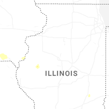
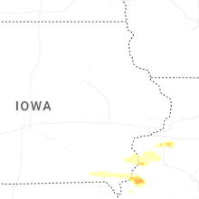
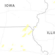


Connect with Interactive Hail Maps