| 2/18/2026 2:28 AM PST |
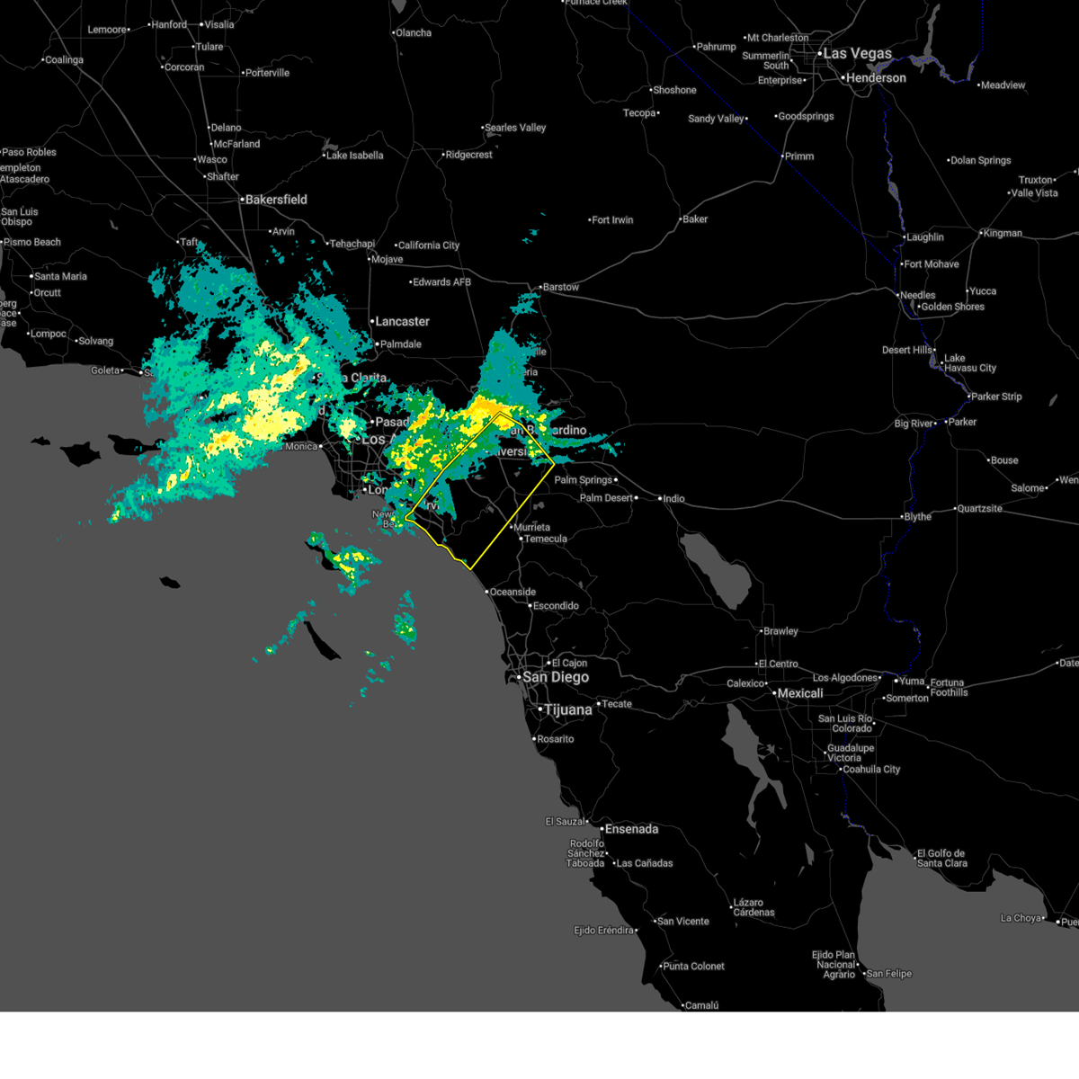 Svrsgx the national weather service in san diego has issued a * severe thunderstorm warning for, san bernardino county in southern california, riverside county in southern california, northwestern san diego county in southwestern california, eastern orange county in southwestern california, * until 330 am pst. * at 226 am pst, a band of severe thunderstorms extended from newport beach to san bernardino and was moving slowly southeast into southern orange county and western riverside county (radar indicated). Hazards include 60 mph wind gusts. expect damage to roofs, siding, and trees Svrsgx the national weather service in san diego has issued a * severe thunderstorm warning for, san bernardino county in southern california, riverside county in southern california, northwestern san diego county in southwestern california, eastern orange county in southwestern california, * until 330 am pst. * at 226 am pst, a band of severe thunderstorms extended from newport beach to san bernardino and was moving slowly southeast into southern orange county and western riverside county (radar indicated). Hazards include 60 mph wind gusts. expect damage to roofs, siding, and trees
|
| 2/18/2026 1:26 AM PST |
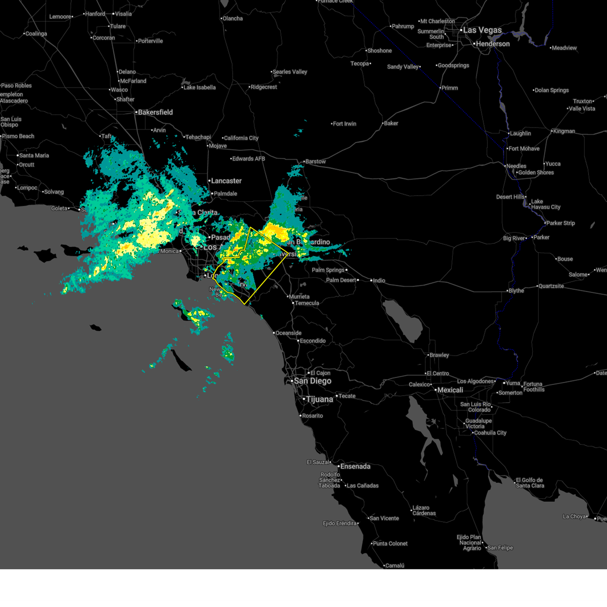 Svrsgx the national weather service in san diego has issued a * severe thunderstorm warning for, san bernardino county in southern california, riverside county in southern california, orange county in southwestern california, * until 230 am pst. * at 124 am pst, a band of severe thunderstorms was located near the the los angeles orange county line moving slowly southeast. it will move through northern orange county and the northwest inland empire through 230 am pst (radar indicated). Hazards include 60 mph wind gusts. expect damage to roofs, siding, and trees Svrsgx the national weather service in san diego has issued a * severe thunderstorm warning for, san bernardino county in southern california, riverside county in southern california, orange county in southwestern california, * until 230 am pst. * at 124 am pst, a band of severe thunderstorms was located near the the los angeles orange county line moving slowly southeast. it will move through northern orange county and the northwest inland empire through 230 am pst (radar indicated). Hazards include 60 mph wind gusts. expect damage to roofs, siding, and trees
|
| 2/17/2017 6:28 PM PST |
 At 625 pm pst, doppler radar indicated severe thunderstorms capable of producing damaging winds in excess of 60 mph over eastern orange county in the santa ana canyons. there are reports of numerous trees down in laguna beach at 600 pm. in addition, dangerous flooding is occurring. this line of storms is moving east at 15 mph. locations impacted include, santa ana, irvine, orange, mission viejo, tustin, yorba linda, dana point, laguna beach, san clemente, fullerton, anaheim, laguna niguel, placentia, rancho santa margarita and aliso viejo. At 625 pm pst, doppler radar indicated severe thunderstorms capable of producing damaging winds in excess of 60 mph over eastern orange county in the santa ana canyons. there are reports of numerous trees down in laguna beach at 600 pm. in addition, dangerous flooding is occurring. this line of storms is moving east at 15 mph. locations impacted include, santa ana, irvine, orange, mission viejo, tustin, yorba linda, dana point, laguna beach, san clemente, fullerton, anaheim, laguna niguel, placentia, rancho santa margarita and aliso viejo.
|
| 2/17/2017 5:48 PM PST |
 At 546 pm pst, nws doppler radar indicated a line of severe thunderstorms moving through laguna beach and irvine. this line of heavy rain and high wind will move across orange county and into the santa ana foothills producing damaging winds. winds will decrease rapidly after the storms move through. At 546 pm pst, nws doppler radar indicated a line of severe thunderstorms moving through laguna beach and irvine. this line of heavy rain and high wind will move across orange county and into the santa ana foothills producing damaging winds. winds will decrease rapidly after the storms move through.
|
| 2/17/2017 4:51 PM PST |
 At 448 pm pst, nws doppler radar indicated a line of severe thunderstorms capable of producing damaging winds in excess of 65 mph. these storms were located along a line extending from los alamitos and huntington beach to offshore 20 miles west of san clemente, and moving east at 15 mph. wind gusts of 65 mph are expected with the line of heavy rain. At 448 pm pst, nws doppler radar indicated a line of severe thunderstorms capable of producing damaging winds in excess of 65 mph. these storms were located along a line extending from los alamitos and huntington beach to offshore 20 miles west of san clemente, and moving east at 15 mph. wind gusts of 65 mph are expected with the line of heavy rain.
|
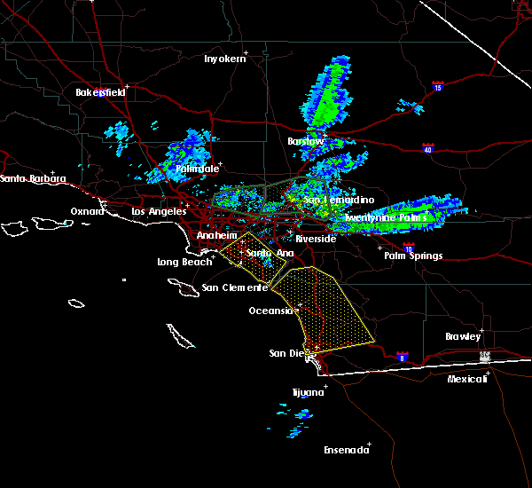
| 3/7/2016 7:43 AM PST |
 At 740 am pst, doppler radar indicated a line of severe thunderstorms capable of producing damaging wind gusts of 45 to 60 mph over eastern orange county. this line of storms was located near canyon lake, moving east at 30 mph. the storms will progress eastward over the next hour, impacting the inland empire and northwest san diego county. locations impacted include but are not limited to, riverside, san bernardino, oceanside, ontario, irvine, moreno valley, corona, rialto, tustin, chino, redlands. At 740 am pst, doppler radar indicated a line of severe thunderstorms capable of producing damaging wind gusts of 45 to 60 mph over eastern orange county. this line of storms was located near canyon lake, moving east at 30 mph. the storms will progress eastward over the next hour, impacting the inland empire and northwest san diego county. locations impacted include but are not limited to, riverside, san bernardino, oceanside, ontario, irvine, moreno valley, corona, rialto, tustin, chino, redlands.
|
| 3/7/2016 7:10 AM PST |
 At 706 am pst, doppler radar indicated a line of severe thunderstorms capable of producing damaging wind gusts of 45 to 60 mph moving through central orange county. this line of storms was located near el toro, moving east at 35 mph. the stroms will progress eastward over the next hour, impacting the inland empire and northwest san diego county. locations impacted include, santa ana, anaheim, riverside, huntington beach, san bernardino, oceanside, ontario, irvine, fontana, orange, rancho cucamonga, corona, costa mesa, mission viejo, rialto. At 706 am pst, doppler radar indicated a line of severe thunderstorms capable of producing damaging wind gusts of 45 to 60 mph moving through central orange county. this line of storms was located near el toro, moving east at 35 mph. the stroms will progress eastward over the next hour, impacting the inland empire and northwest san diego county. locations impacted include, santa ana, anaheim, riverside, huntington beach, san bernardino, oceanside, ontario, irvine, fontana, orange, rancho cucamonga, corona, costa mesa, mission viejo, rialto.
|
| 3/7/2016 6:36 AM PST |
 At 635 am pst, doppler radar indicated a line of severe thunderstorms capable of producing damaging wind gusts of 45 to 60 mph approaching the orange county coast. the leading edge of the storms was located 5 miles southwest of seal beach, and moving east at 35 mph. At 635 am pst, doppler radar indicated a line of severe thunderstorms capable of producing damaging wind gusts of 45 to 60 mph approaching the orange county coast. the leading edge of the storms was located 5 miles southwest of seal beach, and moving east at 35 mph.
|
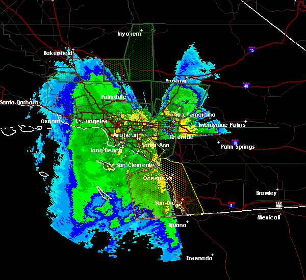
| 1/31/2016 2:51 PM PST |
 The severe thunderstorm warning for orange county will expire at 300 pm pst, the line of storms which prompted the warning have moved out of the area. therefore the warning will be allowed to expire. however gusty winds are still possible in the area following the passage of a cold front. The severe thunderstorm warning for orange county will expire at 300 pm pst, the line of storms which prompted the warning have moved out of the area. therefore the warning will be allowed to expire. however gusty winds are still possible in the area following the passage of a cold front.
|
| 1/31/2016 2:43 PM PST |
 At 236 pm pst, trained weather spotters reported a line of severe thunderstorms producing damaging winds. these storms have moved east out of orange county, and continue to move northeast at 35 mph. damaging winds up to 55 mph were reported in several locations around orange county with these storms. trained spotters have also reported numerous instances of downed tree limbs and power lines. locations impacted include, santa ana, anaheim, huntington beach, garden grove, irvine, orange, costa mesa, mission viejo, westminster, tustin, el toro, laguna niguel, yorba linda, fountain valley, san clemente, placentia, san juan capistrano, laguna hills, tustin foothills and laguna beach. At 236 pm pst, trained weather spotters reported a line of severe thunderstorms producing damaging winds. these storms have moved east out of orange county, and continue to move northeast at 35 mph. damaging winds up to 55 mph were reported in several locations around orange county with these storms. trained spotters have also reported numerous instances of downed tree limbs and power lines. locations impacted include, santa ana, anaheim, huntington beach, garden grove, irvine, orange, costa mesa, mission viejo, westminster, tustin, el toro, laguna niguel, yorba linda, fountain valley, san clemente, placentia, san juan capistrano, laguna hills, tustin foothills and laguna beach.
|
| 1/31/2016 1:38 PM PST |
 At 137 pm pst, doppler radar indicated a line of severe thunderstorms capable of producing damaging winds in excess of 60 mph. these storms were located along a line extending from near westminster to 14 miles southwest of laguna beach to 23 miles southeast of avalon, and moving northeast at 35 mph. At 137 pm pst, doppler radar indicated a line of severe thunderstorms capable of producing damaging winds in excess of 60 mph. these storms were located along a line extending from near westminster to 14 miles southwest of laguna beach to 23 miles southeast of avalon, and moving northeast at 35 mph.
|
| 1/6/2016 1:24 PM PST |
 At 118 pm pst, doppler radar indicated a severe thunderstorm capable of producing damaging winds in excess of 60 mph. this storm was located near fallbrook, moving northeast at 20 mph. this severe storm will impact wildomar. another severe storm is producing a waterspout west of carlsbad. this storm will reach the immediate coast between encinitas and oceanside by 140 pm. locations impacted include, oceanside, vista, carlsbad, encinitas, temecula, san marcos, san clemente, san juan capistrano, fallbrook, wildomar, solana beach, camp pendleton south, canyon lake, camp pendleton north, lakeland village, murrieta, valley center, lake san marcos, hidden meadows and bonsall. At 118 pm pst, doppler radar indicated a severe thunderstorm capable of producing damaging winds in excess of 60 mph. this storm was located near fallbrook, moving northeast at 20 mph. this severe storm will impact wildomar. another severe storm is producing a waterspout west of carlsbad. this storm will reach the immediate coast between encinitas and oceanside by 140 pm. locations impacted include, oceanside, vista, carlsbad, encinitas, temecula, san marcos, san clemente, san juan capistrano, fallbrook, wildomar, solana beach, camp pendleton south, canyon lake, camp pendleton north, lakeland village, murrieta, valley center, lake san marcos, hidden meadows and bonsall.
|
| 1/6/2016 1:04 PM PST |
 At 100 pm pst, doppler radar indicated a cluster of severe thunderstorms capable of producing damaging winds in excess of 60 mph. one storm was located over northeastern camp pendleton, and moving northeast at 25 mph. another storm is moving towards fallbrook. a third cell is over open water moving towards oceanside. the potential for a waterspout or brief tornado is possible given the unstable environment. hail is possible with these storms. At 100 pm pst, doppler radar indicated a cluster of severe thunderstorms capable of producing damaging winds in excess of 60 mph. one storm was located over northeastern camp pendleton, and moving northeast at 25 mph. another storm is moving towards fallbrook. a third cell is over open water moving towards oceanside. the potential for a waterspout or brief tornado is possible given the unstable environment. hail is possible with these storms.
|
| 9/10/2011 7:00 AM PDT |
Quarter sized hail reported 1.1 miles NE of Dana Point, CA, two reports from the public of quarter-sized hail in dana point around 700 am.
|


Connect with Interactive Hail Maps