

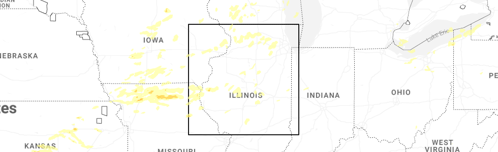
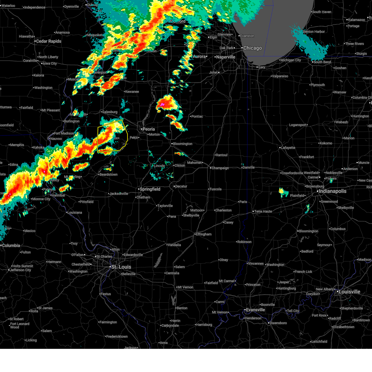
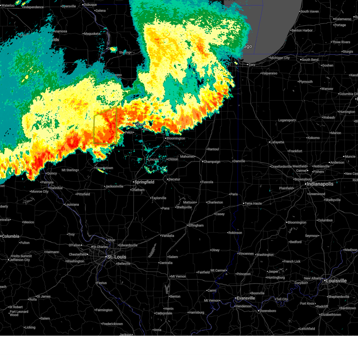
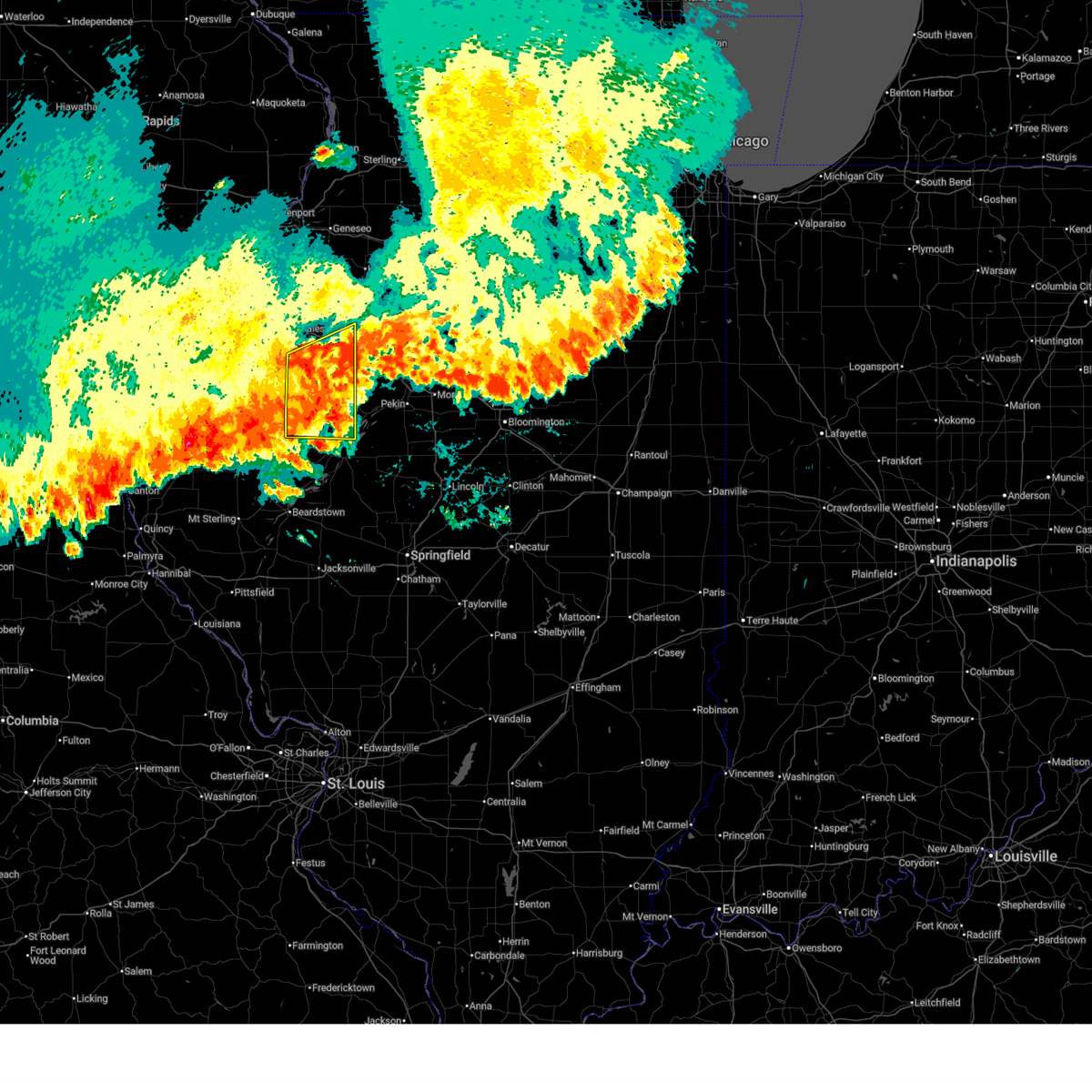
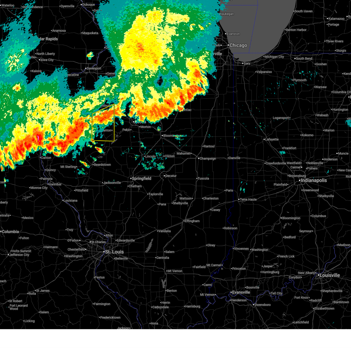
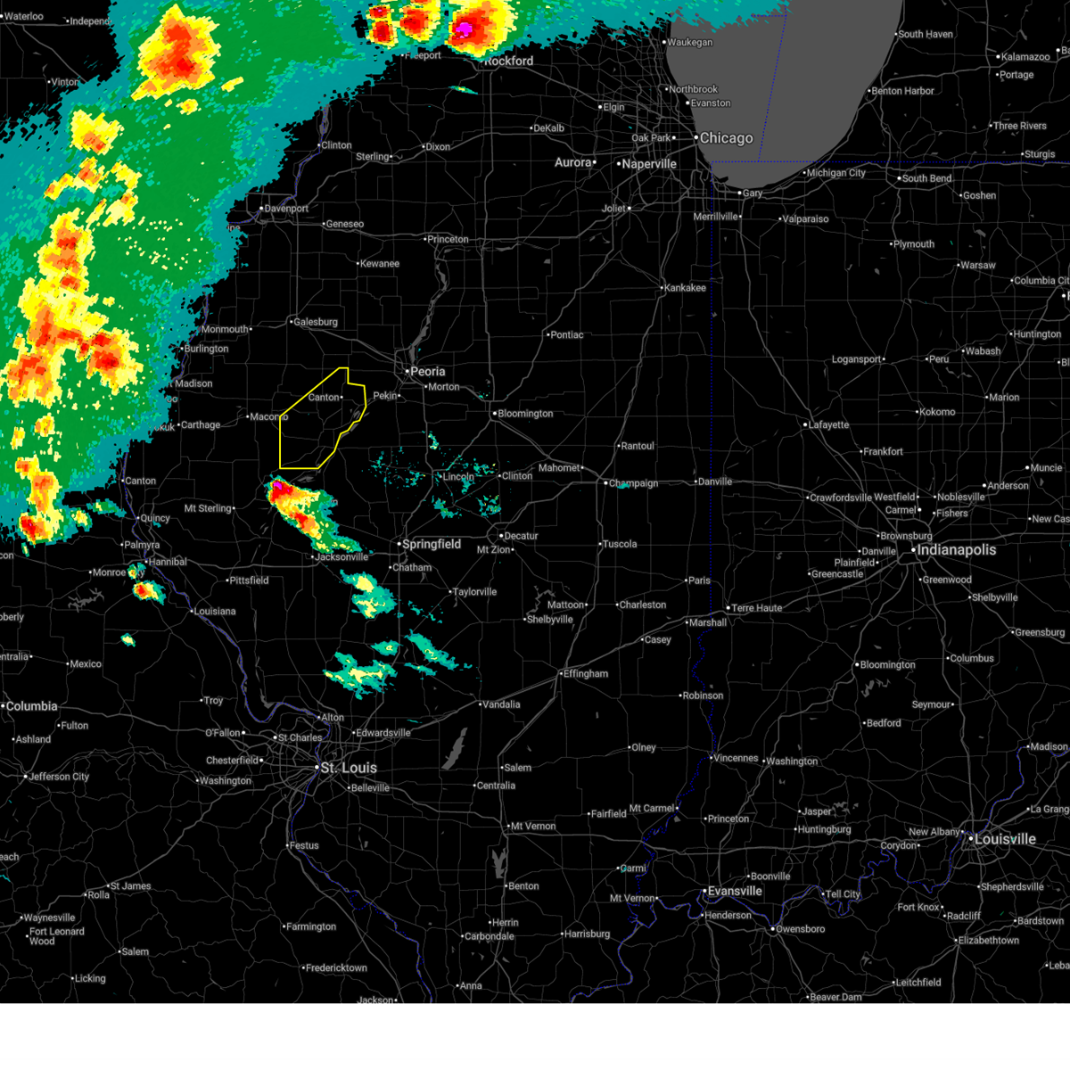
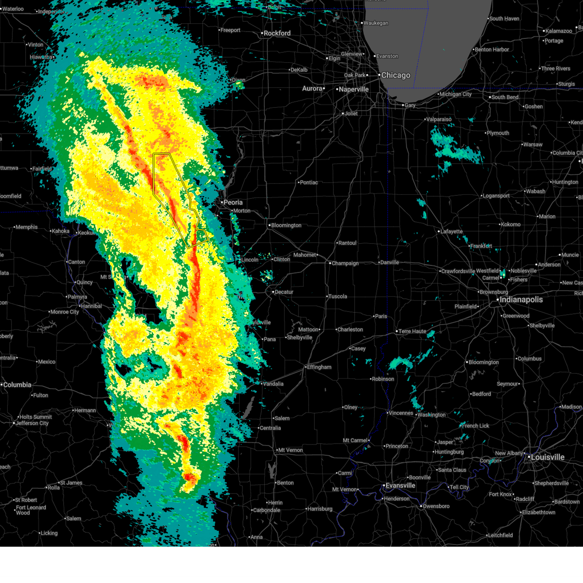
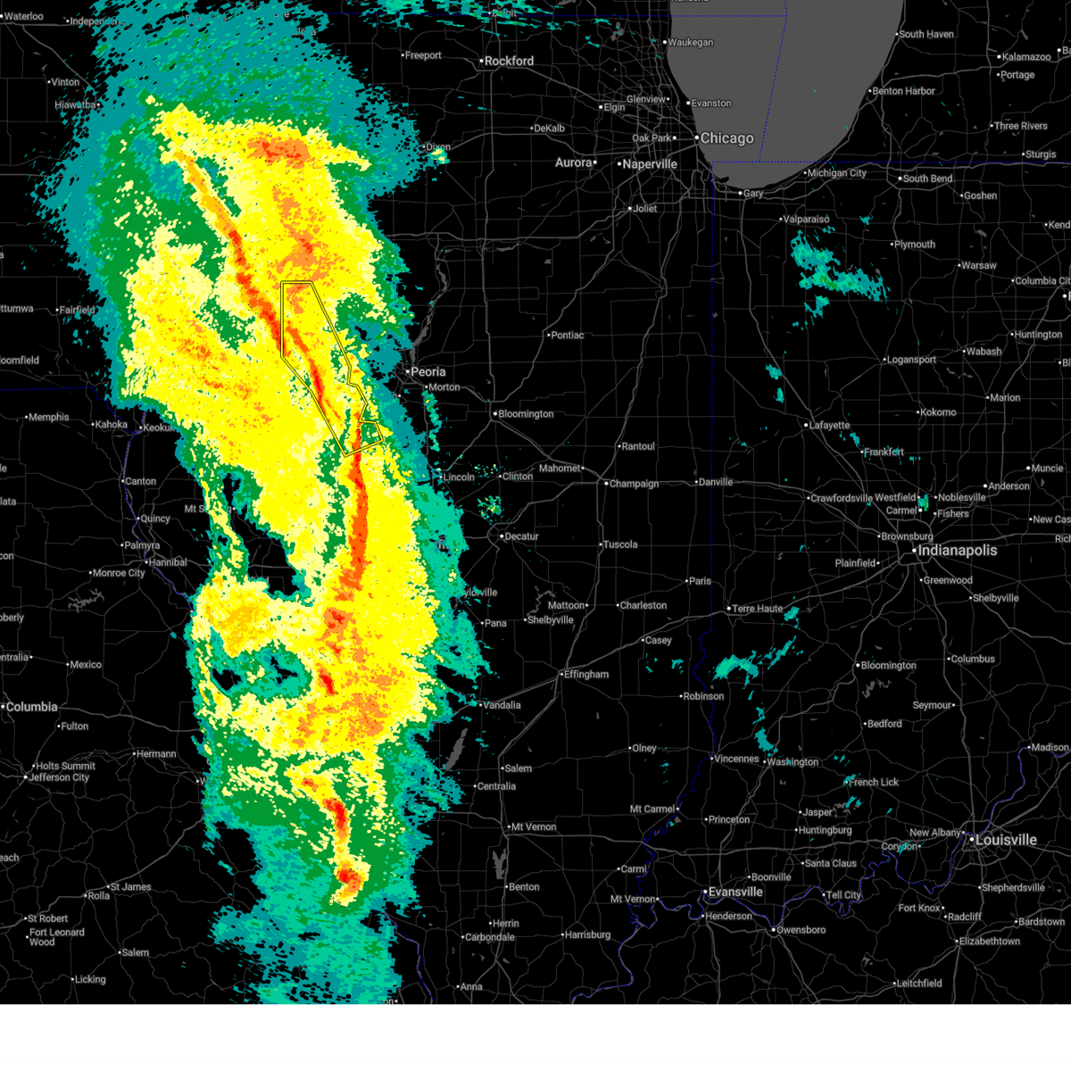
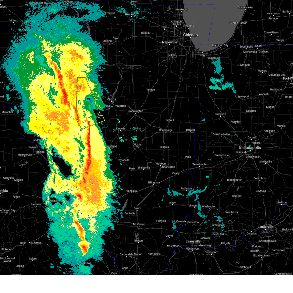
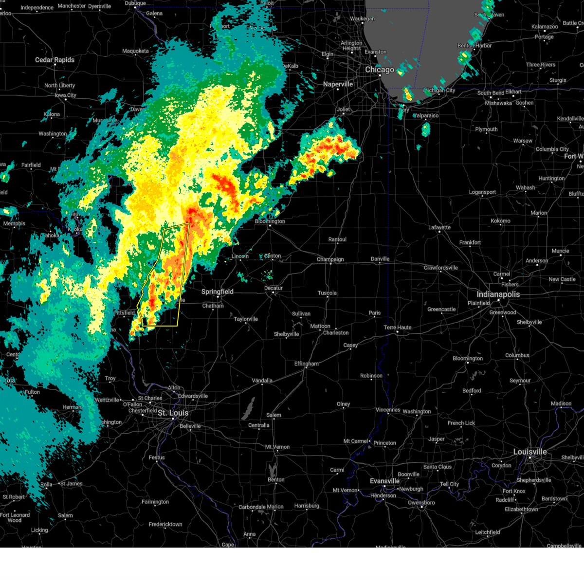
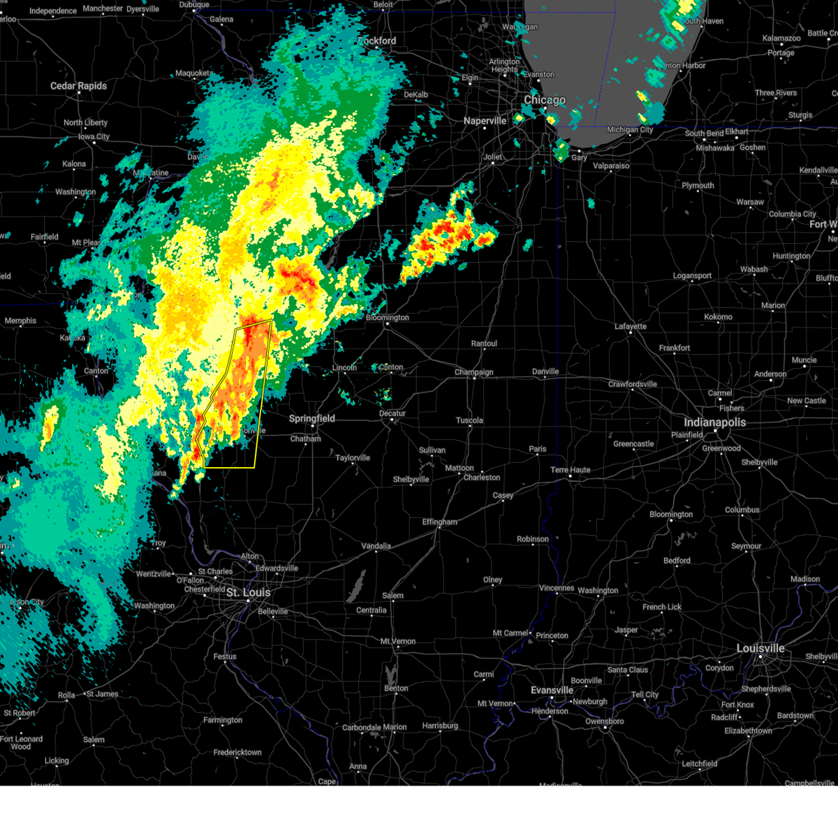
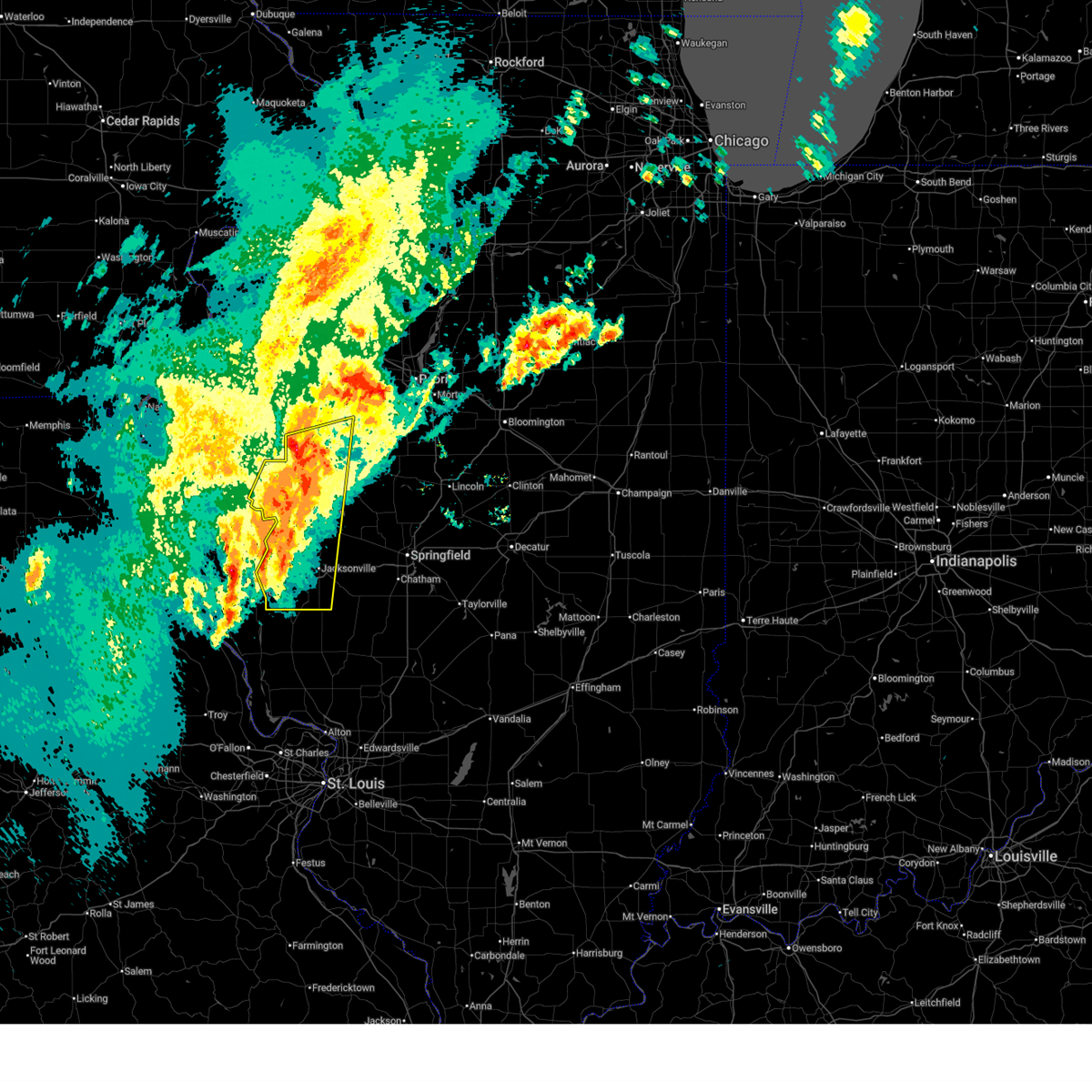
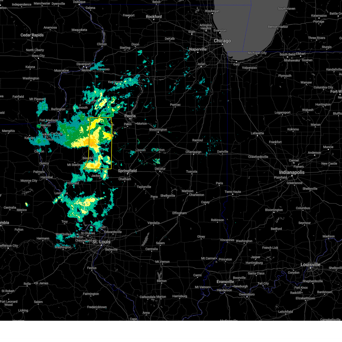
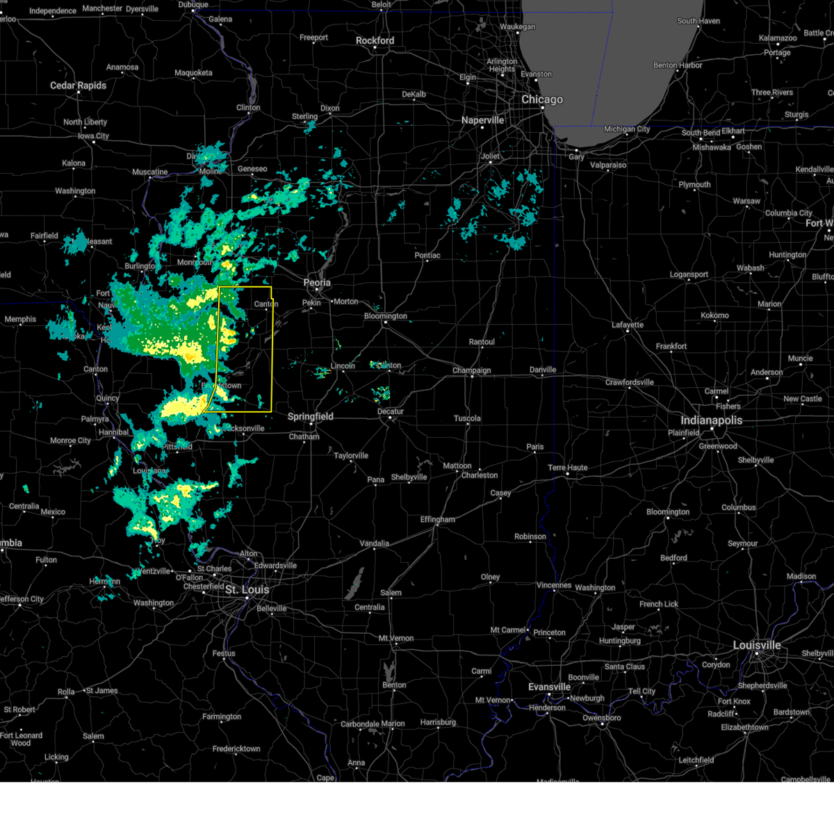
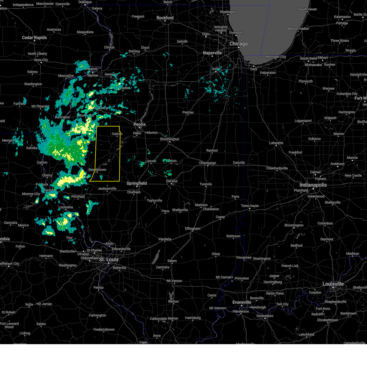
Hail Map for Dunfermline, IL
The Dunfermline, IL area has had 0 reports of on-the-ground hail by trained spotters, and has been under severe weather warnings 41 times during the past 12 months. Doppler radar has detected hail at or near Dunfermline, IL on 70 occasions, including 5 occasions during the past year.
| Name: | Dunfermline, IL |
| Where Located: | 27.1 miles WSW of Peoria, IL |
| Map: | Google Map for Dunfermline, IL |
| Population: | 300 |
| Housing Units: | 132 |
| More Info: | Search Google for Dunfermline, IL |
1
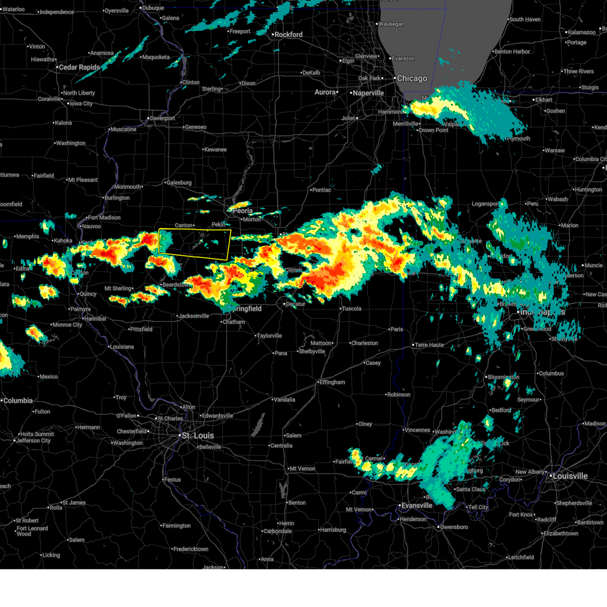
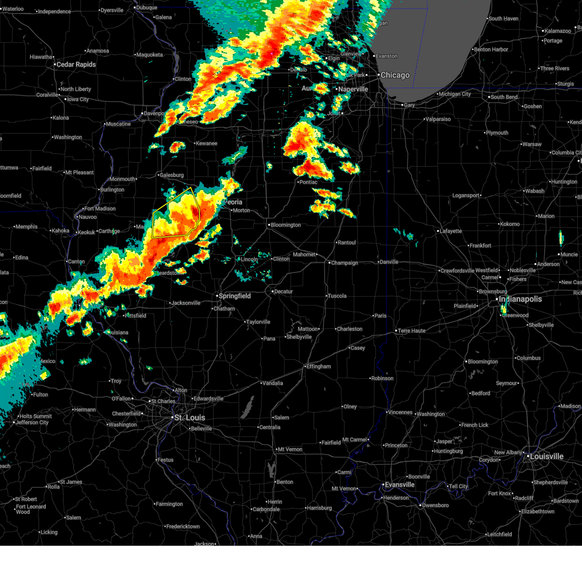
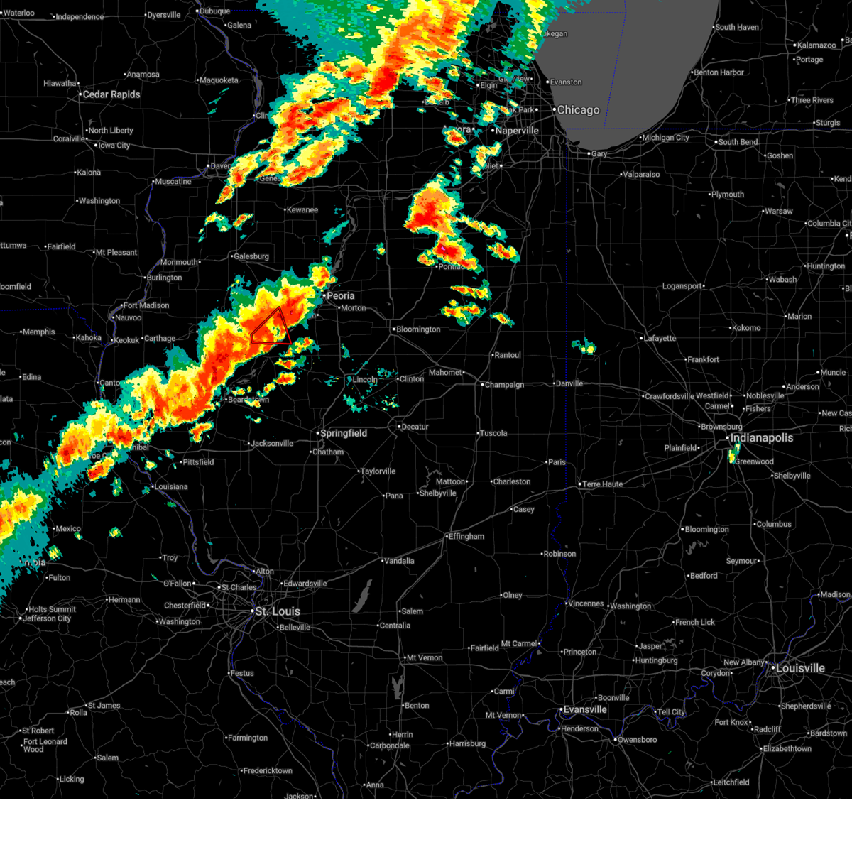
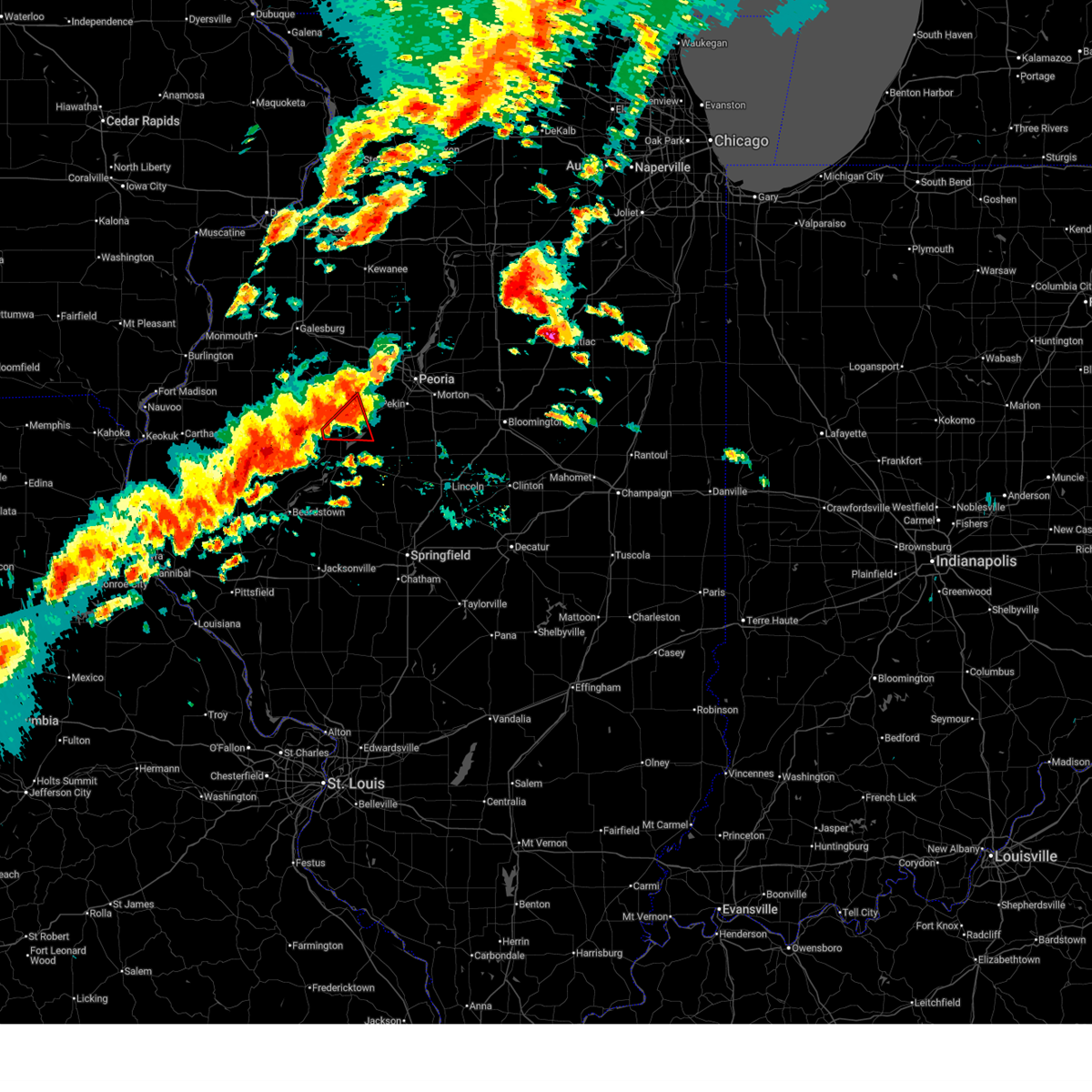
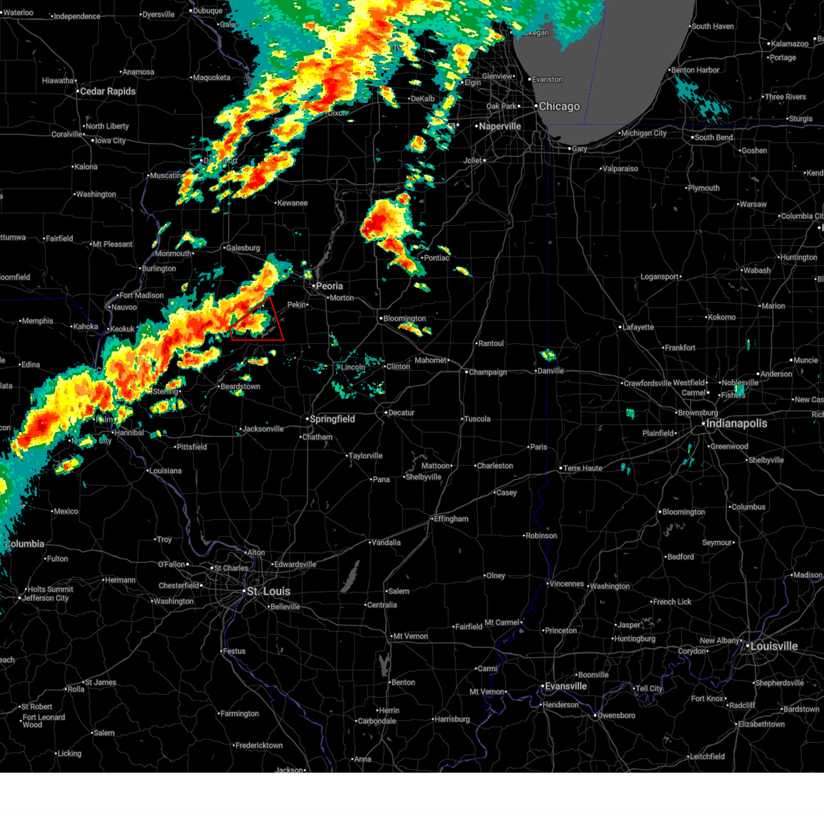
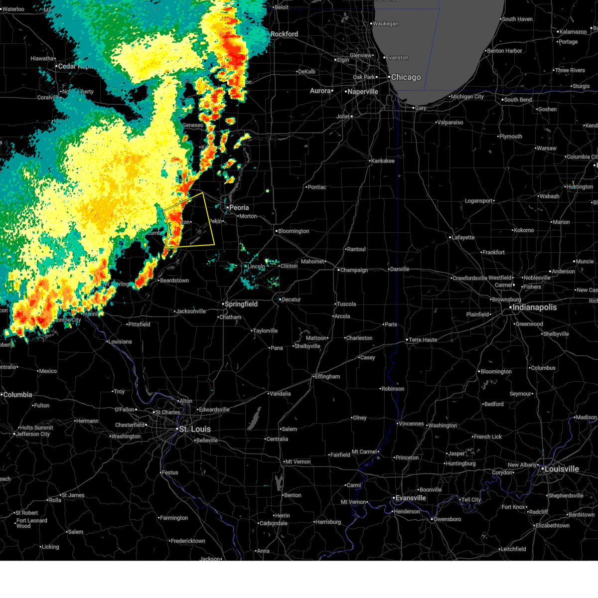
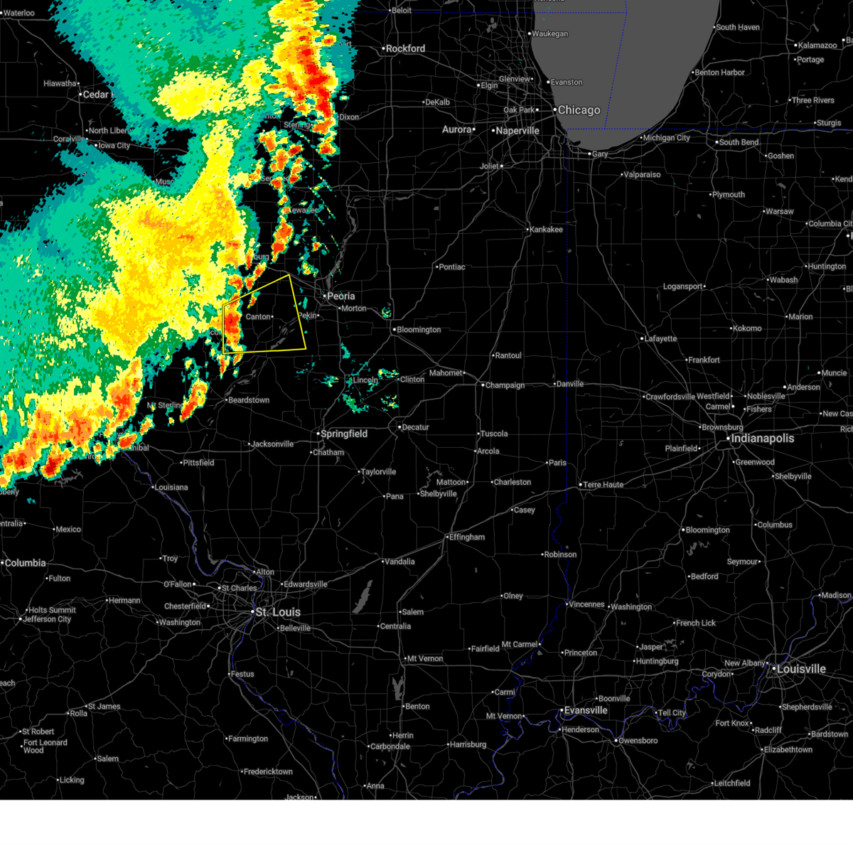
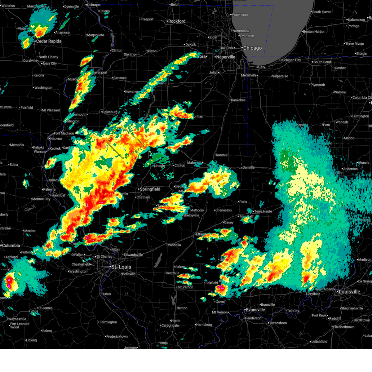
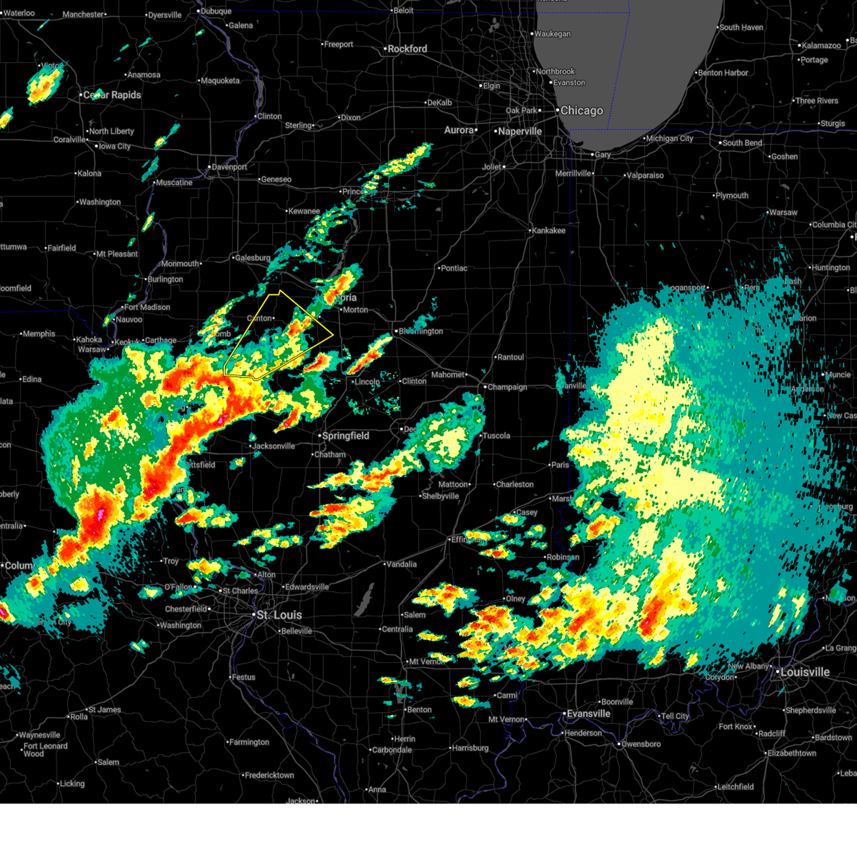
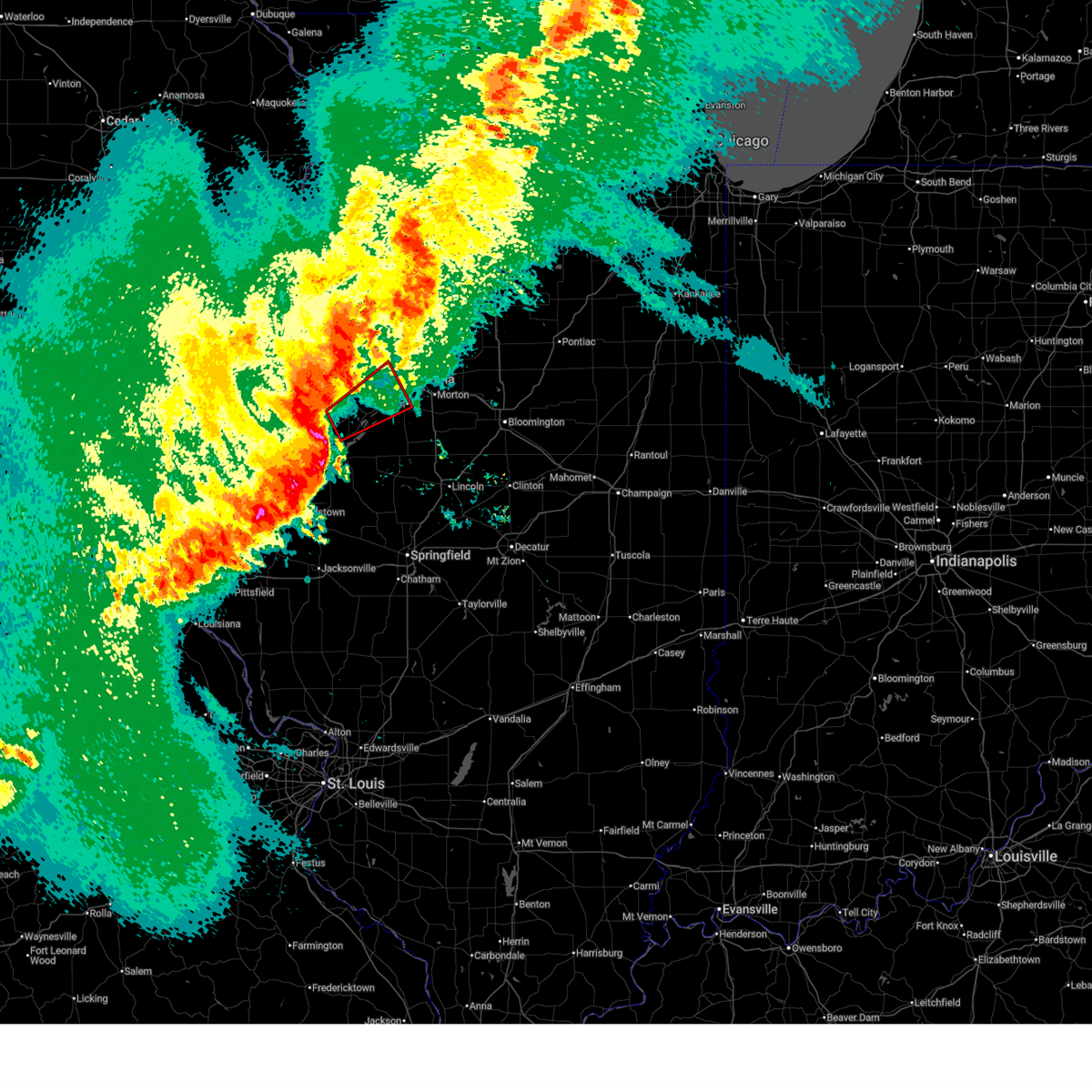
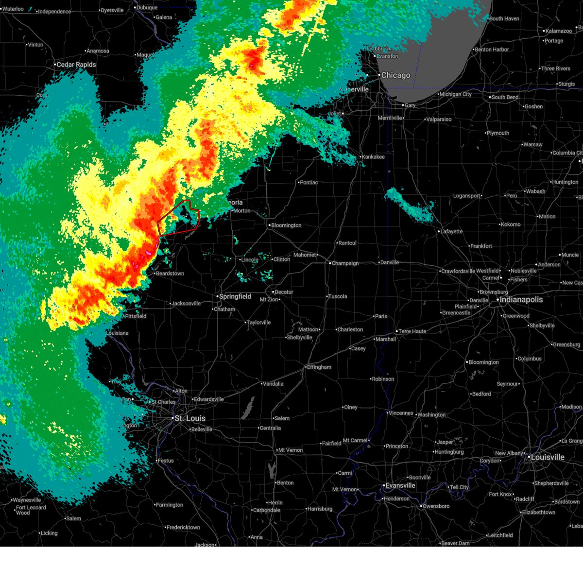
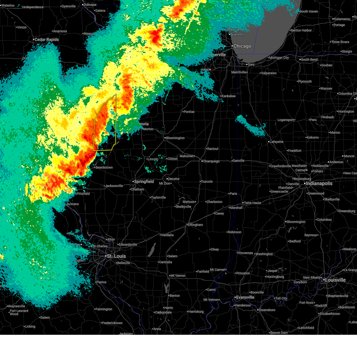
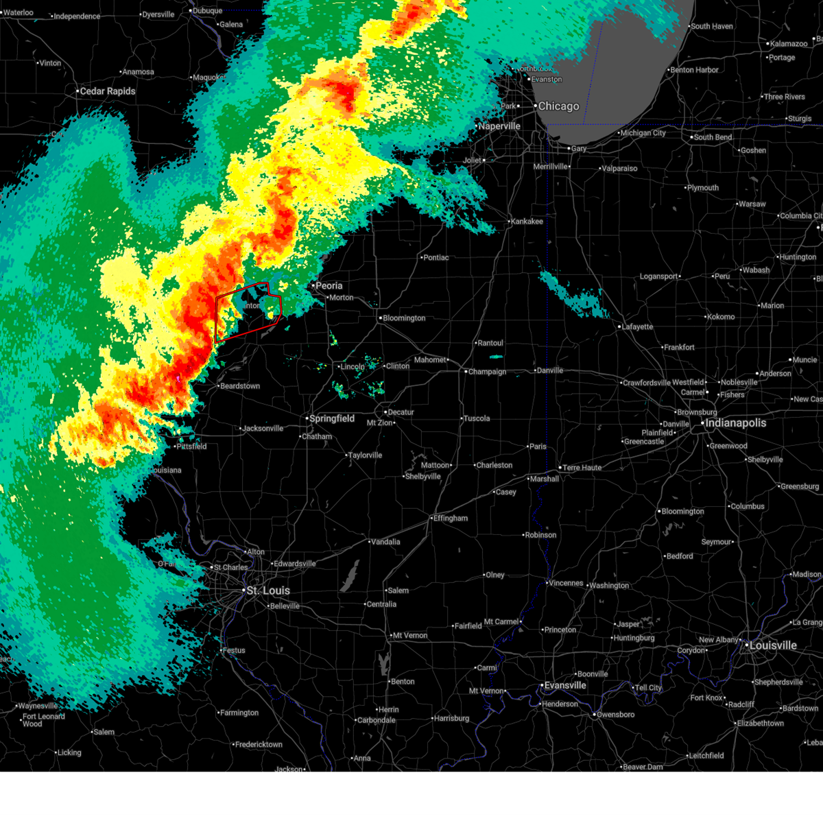
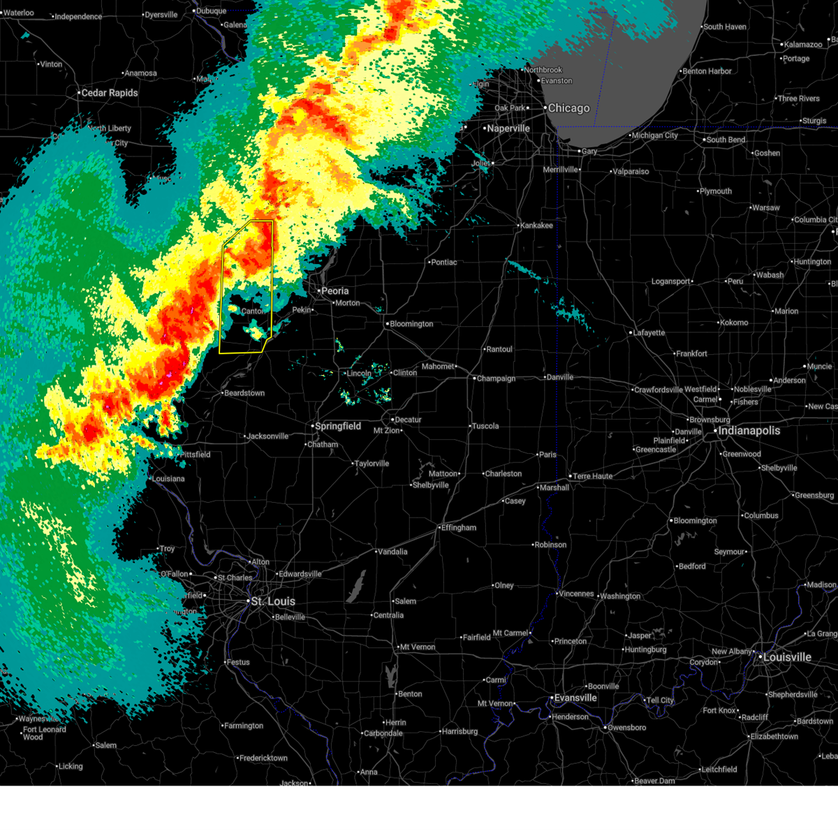
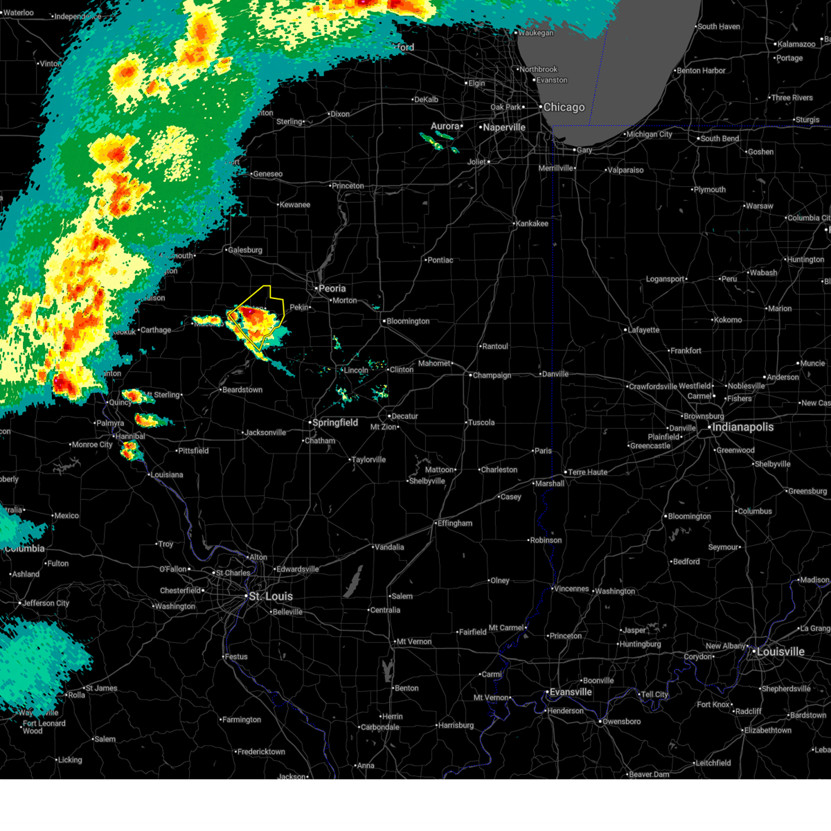
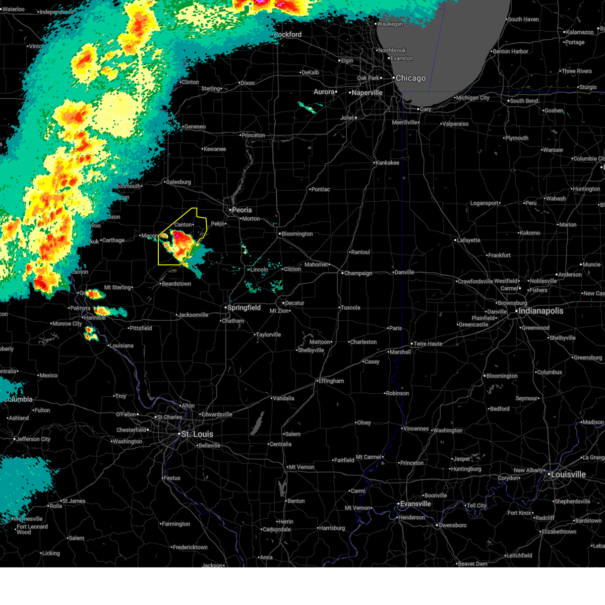
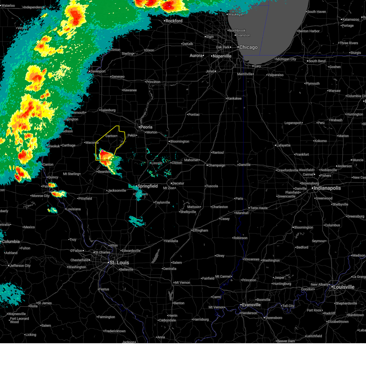
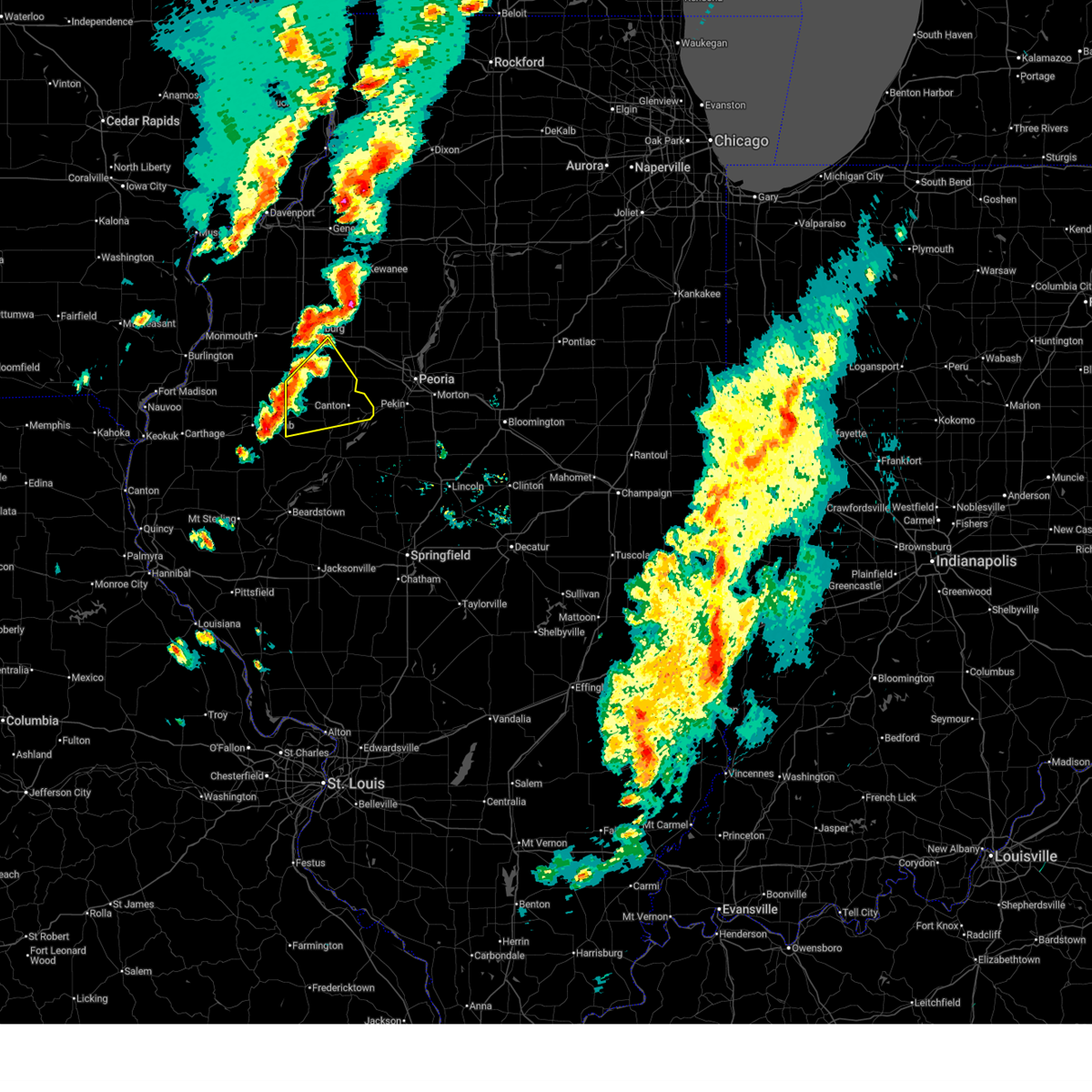
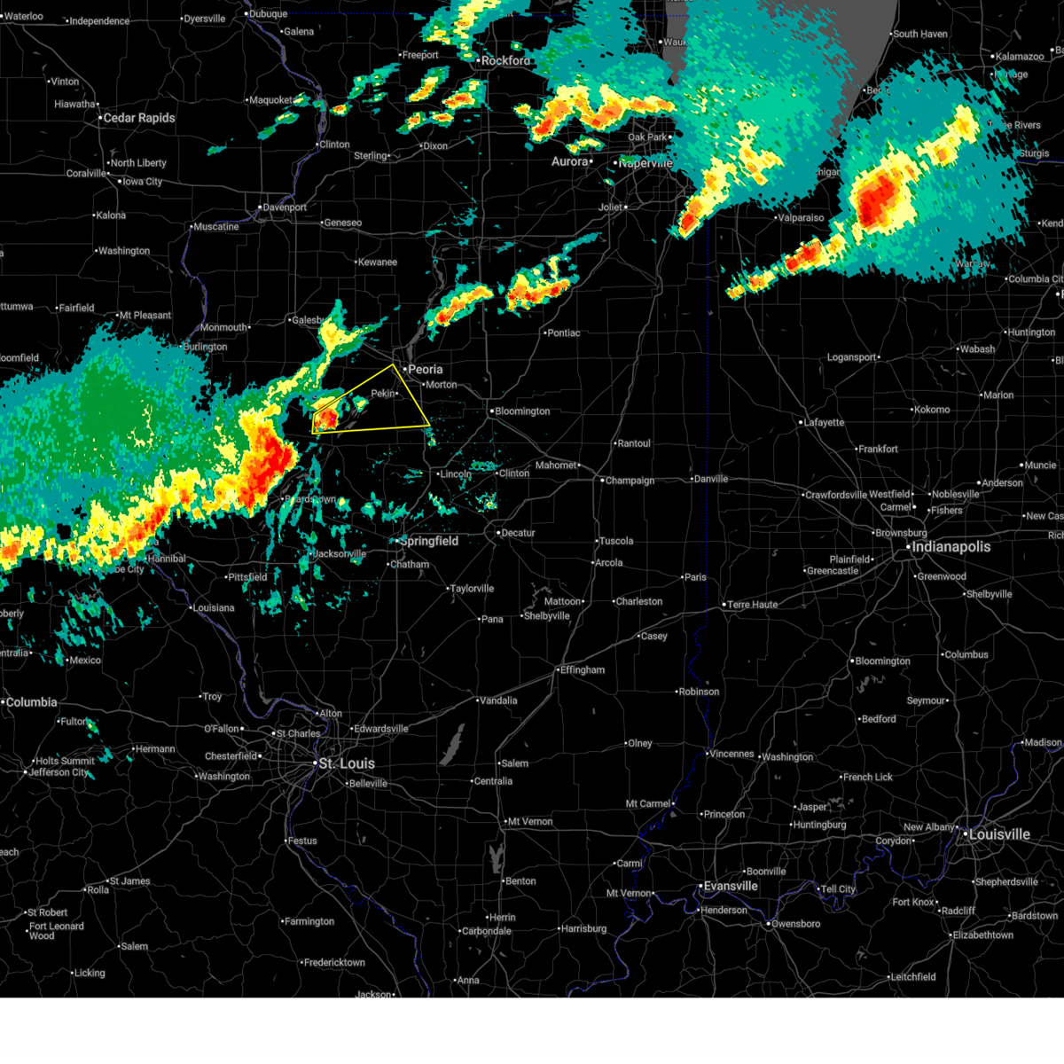
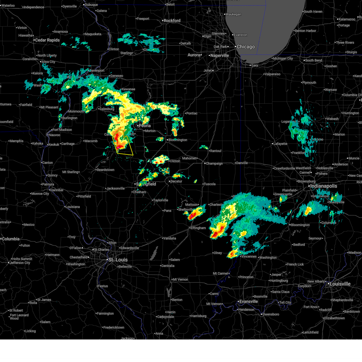
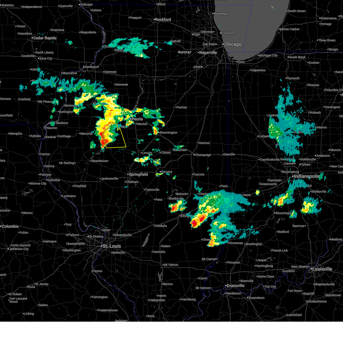
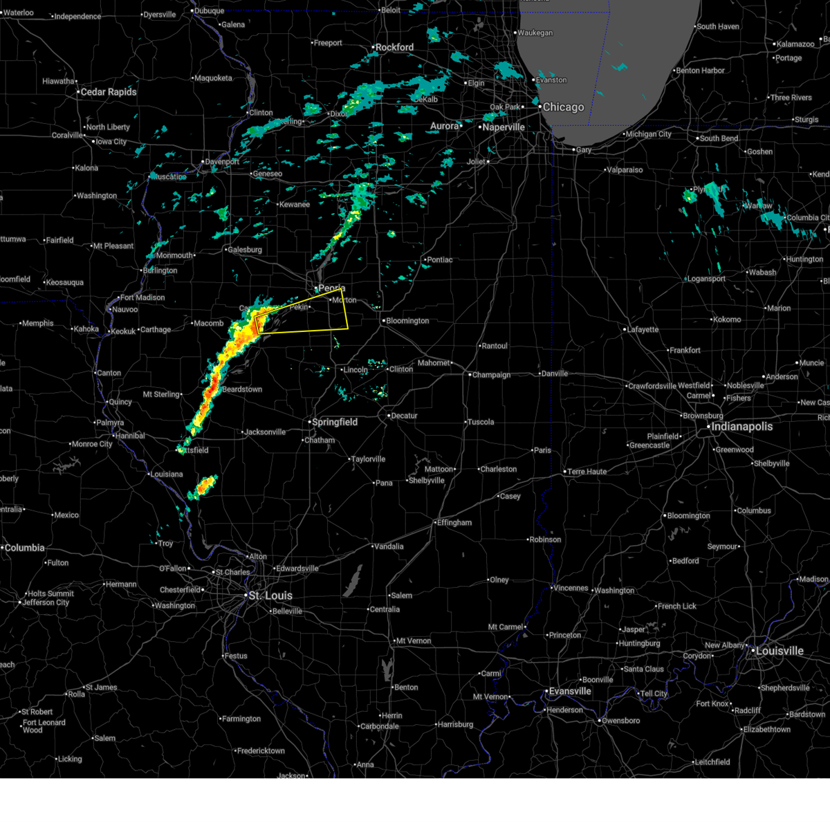
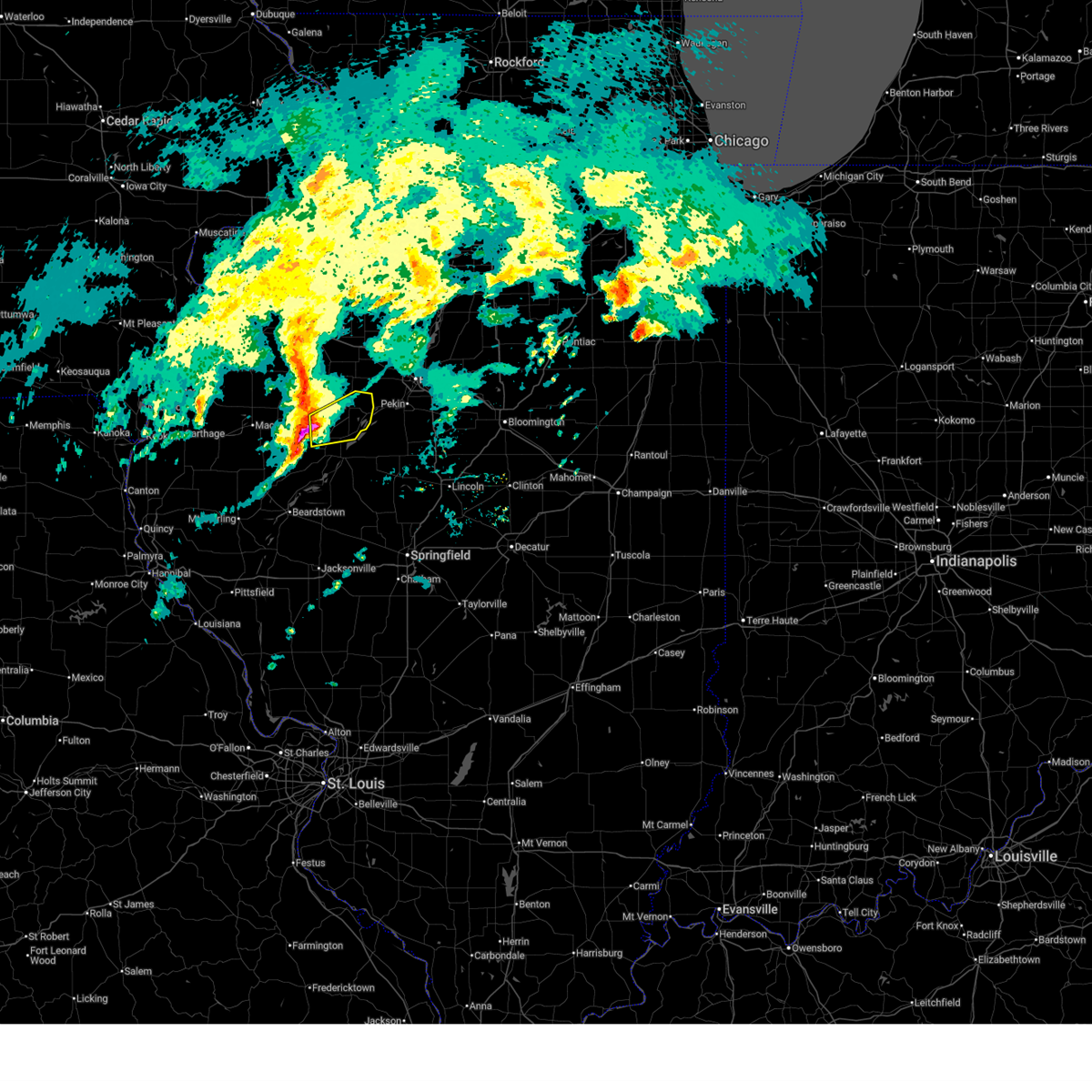
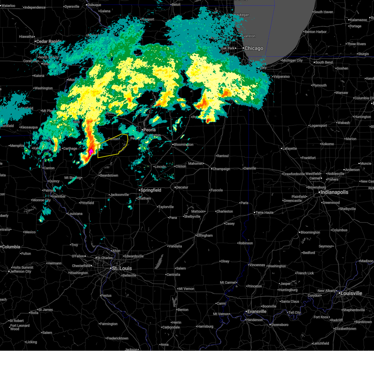
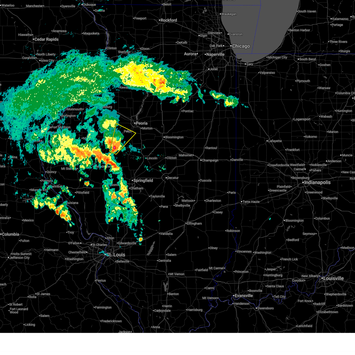
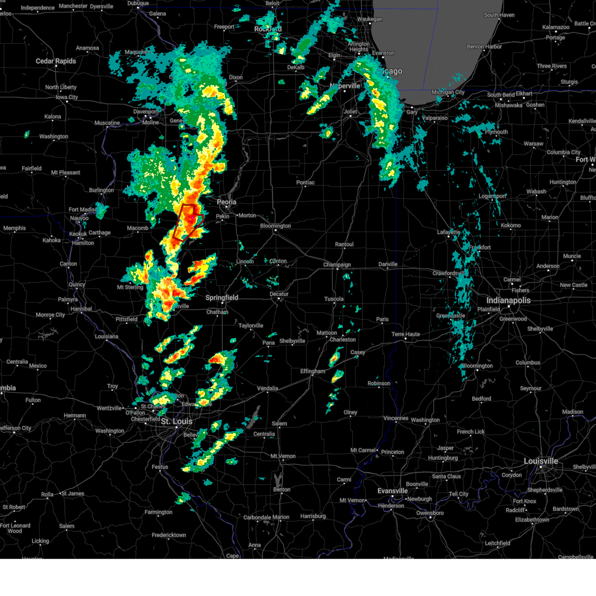
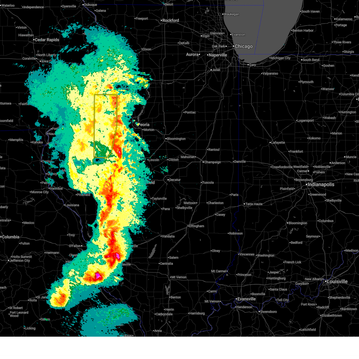
The Top Recent Hail Date for Dunfermline, IL is Wednesday, June 10, 2026 (20th out of 70)
Hail and Wind Damage Spotted near Dunfermline, IL
| Date / Time | Report Details |
|---|---|
| 6/17/2026 4:14 PM CDT |
 Svrilx the national weather service in lincoln has issued a * severe thunderstorm warning for, central fulton county in west central illinois, southwestern tazewell county in central illinois, northeastern mason county in central illinois, * until 515 pm cdt. * at 414 pm cdt, a severe thunderstorm was located over adair, or 12 miles east of macomb, moving east at 50 mph (radar indicated). Hazards include ping pong ball size hail and 60 mph wind gusts. People and animals outdoors will be injured. expect hail damage to roofs, siding, windows, and vehicles. expect wind damage to roofs, siding, and trees. this severe thunderstorm will be near, ipava around 420 pm cdt. lewistown around 430 pm cdt. other locations in the path of this severe thunderstorm include manito and green valley. This also includes rice lake state fish and wildlife area, sand ridge state forest, and spring lake state fish and wildlife area. Svrilx the national weather service in lincoln has issued a * severe thunderstorm warning for, central fulton county in west central illinois, southwestern tazewell county in central illinois, northeastern mason county in central illinois, * until 515 pm cdt. * at 414 pm cdt, a severe thunderstorm was located over adair, or 12 miles east of macomb, moving east at 50 mph (radar indicated). Hazards include ping pong ball size hail and 60 mph wind gusts. People and animals outdoors will be injured. expect hail damage to roofs, siding, windows, and vehicles. expect wind damage to roofs, siding, and trees. this severe thunderstorm will be near, ipava around 420 pm cdt. lewistown around 430 pm cdt. other locations in the path of this severe thunderstorm include manito and green valley. This also includes rice lake state fish and wildlife area, sand ridge state forest, and spring lake state fish and wildlife area.
|
| 6/17/2026 2:53 PM CDT |
 Svrilx the national weather service in lincoln has issued a * severe thunderstorm warning for, northern logan county in central illinois, east central fulton county in west central illinois, northwestern de witt county in central illinois, southern tazewell county in central illinois, southwestern mclean county in central illinois, northeastern mason county in central illinois, * until 400 pm cdt. * at 253 pm cdt, a severe thunderstorm was located over manito, or 13 miles northeast of havana, moving east at 60 mph (radar indicated). Hazards include 60 mph wind gusts and quarter size hail. Hail damage to vehicles is expected. expect wind damage to roofs, siding, and trees. this severe thunderstorm will be near, green valley around 300 pm cdt. delavan around 305 pm cdt. hopedale around 310 pm cdt. other locations in the path of this severe thunderstorm include armington, mclean, heyworth and downs. this includes the following highways, interstate 155 between mile markers 6 and 24. interstate 55 between mile markers 136 and 161. interstate 74 between mile markers 129 and 142. This also includes rice lake state fish and wildlife area, sand ridge state forest, and spring lake state fish and wildlife area. Svrilx the national weather service in lincoln has issued a * severe thunderstorm warning for, northern logan county in central illinois, east central fulton county in west central illinois, northwestern de witt county in central illinois, southern tazewell county in central illinois, southwestern mclean county in central illinois, northeastern mason county in central illinois, * until 400 pm cdt. * at 253 pm cdt, a severe thunderstorm was located over manito, or 13 miles northeast of havana, moving east at 60 mph (radar indicated). Hazards include 60 mph wind gusts and quarter size hail. Hail damage to vehicles is expected. expect wind damage to roofs, siding, and trees. this severe thunderstorm will be near, green valley around 300 pm cdt. delavan around 305 pm cdt. hopedale around 310 pm cdt. other locations in the path of this severe thunderstorm include armington, mclean, heyworth and downs. this includes the following highways, interstate 155 between mile markers 6 and 24. interstate 55 between mile markers 136 and 161. interstate 74 between mile markers 129 and 142. This also includes rice lake state fish and wildlife area, sand ridge state forest, and spring lake state fish and wildlife area.
|
| 6/17/2026 9:03 AM CDT |
 Svrilx the national weather service in lincoln has issued a * severe thunderstorm warning for, marshall county in central illinois, western woodford county in central illinois, northeastern fulton county in west central illinois, stark county in north central illinois, tazewell county in central illinois, peoria county in central illinois, * until 1000 am cdt. * at 902 am cdt, severe thunderstorms were located along a line extending from near laura to near cuba, moving east at 55 mph (radar indicated). Hazards include 70 mph wind gusts and quarter size hail. Hail damage to vehicles is expected. expect considerable tree damage. wind damage is also likely to mobile homes, roofs, and outbuildings. severe thunderstorms will be near, canton, farmington, princeville, dunlap, hanna city, trivoli, st. david, and edelstein around 910 am cdt. peoria, chillicothe, bellevue, and glasford around 915 am cdt. bartonville, west peoria, rome, spring bay, mapleton, and peoria international airport around 920 am cdt. other locations in the path of these severe thunderstorms include pekin, east peoria, washington, creve coeur, germantown hills, marquette heights, morton, metamora, washburn, south pekin, eureka, tremont, green valley, mackinaw, delavan, goodfield, deer creek and hopedale. this includes the following highways, interstate 155 between mile markers 11 and 31. interstate 474 between mile markers 0 and 14. interstate 74 between mile markers 71 and 113. This also includes banner marsh state fish and wildlife area, jubilee college state park, marshall state fish and wildlife area, powerton lake state fish and wildlife area, rice lake state fish and wildlife area, rock island trail state park, spring lake state fish and wildlife area, woodford state fish and wildlife area, and mackinaw river state fish and wildlife area. Svrilx the national weather service in lincoln has issued a * severe thunderstorm warning for, marshall county in central illinois, western woodford county in central illinois, northeastern fulton county in west central illinois, stark county in north central illinois, tazewell county in central illinois, peoria county in central illinois, * until 1000 am cdt. * at 902 am cdt, severe thunderstorms were located along a line extending from near laura to near cuba, moving east at 55 mph (radar indicated). Hazards include 70 mph wind gusts and quarter size hail. Hail damage to vehicles is expected. expect considerable tree damage. wind damage is also likely to mobile homes, roofs, and outbuildings. severe thunderstorms will be near, canton, farmington, princeville, dunlap, hanna city, trivoli, st. david, and edelstein around 910 am cdt. peoria, chillicothe, bellevue, and glasford around 915 am cdt. bartonville, west peoria, rome, spring bay, mapleton, and peoria international airport around 920 am cdt. other locations in the path of these severe thunderstorms include pekin, east peoria, washington, creve coeur, germantown hills, marquette heights, morton, metamora, washburn, south pekin, eureka, tremont, green valley, mackinaw, delavan, goodfield, deer creek and hopedale. this includes the following highways, interstate 155 between mile markers 11 and 31. interstate 474 between mile markers 0 and 14. interstate 74 between mile markers 71 and 113. This also includes banner marsh state fish and wildlife area, jubilee college state park, marshall state fish and wildlife area, powerton lake state fish and wildlife area, rice lake state fish and wildlife area, rock island trail state park, spring lake state fish and wildlife area, woodford state fish and wildlife area, and mackinaw river state fish and wildlife area.
|
| 6/17/2026 8:41 AM CDT |
 At 840 am cdt, severe thunderstorms were located along a line extending from oneida to near little swan lake, moving southeast at 55 mph. these are destructive storms for central and southern knox county and northern fulton county (radar indicated). Hazards include 80 mph wind gusts and quarter size hail. Flying debris will be dangerous to those caught without shelter. mobile homes will be heavily damaged. expect considerable damage to roofs, windows, and vehicles. extensive tree damage and power outages are likely. these severe storms will be near, abingdon, knoxville, avon, victoria, and st. augustine around 845 am cdt. williamsfield, london mills, and maquon around 850 am cdt. laura and elmore around 855 am cdt. farmington, elmwood, brimfield, yates city, and fairview around 900 am cdt. canton, princeville, and cuba around 905 am cdt. hanna city, trivoli, and st. david around 910 am cdt. other locations impacted by these severe thunderstorms include bryant, norris, jubilee college state park, ellisville, banner, smithville, west jersey, gilson, dunfermline, and monica. this also includes banner marsh state fish and wildlife area, jubilee college state park, rice lake state fish and wildlife area, and snakeden hollow state fish and wildlife area. This includes interstate 74 between mile markers 34 and 82. At 840 am cdt, severe thunderstorms were located along a line extending from oneida to near little swan lake, moving southeast at 55 mph. these are destructive storms for central and southern knox county and northern fulton county (radar indicated). Hazards include 80 mph wind gusts and quarter size hail. Flying debris will be dangerous to those caught without shelter. mobile homes will be heavily damaged. expect considerable damage to roofs, windows, and vehicles. extensive tree damage and power outages are likely. these severe storms will be near, abingdon, knoxville, avon, victoria, and st. augustine around 845 am cdt. williamsfield, london mills, and maquon around 850 am cdt. laura and elmore around 855 am cdt. farmington, elmwood, brimfield, yates city, and fairview around 900 am cdt. canton, princeville, and cuba around 905 am cdt. hanna city, trivoli, and st. david around 910 am cdt. other locations impacted by these severe thunderstorms include bryant, norris, jubilee college state park, ellisville, banner, smithville, west jersey, gilson, dunfermline, and monica. this also includes banner marsh state fish and wildlife area, jubilee college state park, rice lake state fish and wildlife area, and snakeden hollow state fish and wildlife area. This includes interstate 74 between mile markers 34 and 82.
|
| 6/17/2026 8:27 AM CDT |
 At 826 am cdt, severe thunderstorms were located along a line extending from near cambridge to kirkwood, moving east at 55 mph (radar indicated). Hazards include 70 mph wind gusts and quarter size hail. Hail damage to vehicles is expected. expect considerable tree damage. wind damage is also likely to mobile homes, roofs, and outbuildings. these severe storms will be near, henderson and rio around 830 am cdt. galesburg, wataga, oneida, and altona around 835 am cdt. abingdon and knoxville around 840 am cdt. victoria, la fayette, and st. augustine around 845 am cdt. toulon, osceola, williamsfield, london mills, elmira, and maquon around 850 am cdt. wyoming, bradford, laura, and elmore around 855 am cdt. elmwood, yates city, and castleton around 900 am cdt. farmington, princeville, brimfield, and camp grove around 905 am cdt. other locations impacted by these severe thunderstorms include bryant, norris, jubilee college state park, ellisville, banner, smithville, west jersey, gilson, dunfermline, and monica. this also includes banner marsh state fish and wildlife area, jubilee college state park, rice lake state fish and wildlife area, and snakeden hollow state fish and wildlife area. This includes interstate 74 between mile markers 34 and 82. At 826 am cdt, severe thunderstorms were located along a line extending from near cambridge to kirkwood, moving east at 55 mph (radar indicated). Hazards include 70 mph wind gusts and quarter size hail. Hail damage to vehicles is expected. expect considerable tree damage. wind damage is also likely to mobile homes, roofs, and outbuildings. these severe storms will be near, henderson and rio around 830 am cdt. galesburg, wataga, oneida, and altona around 835 am cdt. abingdon and knoxville around 840 am cdt. victoria, la fayette, and st. augustine around 845 am cdt. toulon, osceola, williamsfield, london mills, elmira, and maquon around 850 am cdt. wyoming, bradford, laura, and elmore around 855 am cdt. elmwood, yates city, and castleton around 900 am cdt. farmington, princeville, brimfield, and camp grove around 905 am cdt. other locations impacted by these severe thunderstorms include bryant, norris, jubilee college state park, ellisville, banner, smithville, west jersey, gilson, dunfermline, and monica. this also includes banner marsh state fish and wildlife area, jubilee college state park, rice lake state fish and wildlife area, and snakeden hollow state fish and wildlife area. This includes interstate 74 between mile markers 34 and 82.
|
| 6/17/2026 8:14 AM CDT |
 Svrilx the national weather service in lincoln has issued a * severe thunderstorm warning for, fulton county in west central illinois, stark county in north central illinois, knox county in west central illinois, western peoria county in central illinois, * until 915 am cdt. * at 813 am cdt, severe thunderstorms were located along a line extending from warner to near gladstone, moving east at 60 mph (radar indicated). Hazards include 60 mph wind gusts and quarter size hail. Hail damage to vehicles is expected. expect wind damage to roofs, siding, and trees. severe thunderstorms will be near, rio around 820 am cdt. galesburg, wataga, oneida, altona, and henderson around 830 am cdt. other locations in the path of these severe thunderstorms include abingdon, knoxville, victoria, la fayette, st. augustine, toulon, osceola, elmira, wyoming, bradford, williamsfield, london mills, maquon, castleton, elmore, yates city, laura, camp grove, farmington, elmwood, princeville, brimfield and fairview. this includes interstate 74 between mile markers 34 and 82. This also includes banner marsh state fish and wildlife area, jubilee college state park, rice lake state fish and wildlife area, and snakeden hollow state fish and wildlife area. Svrilx the national weather service in lincoln has issued a * severe thunderstorm warning for, fulton county in west central illinois, stark county in north central illinois, knox county in west central illinois, western peoria county in central illinois, * until 915 am cdt. * at 813 am cdt, severe thunderstorms were located along a line extending from warner to near gladstone, moving east at 60 mph (radar indicated). Hazards include 60 mph wind gusts and quarter size hail. Hail damage to vehicles is expected. expect wind damage to roofs, siding, and trees. severe thunderstorms will be near, rio around 820 am cdt. galesburg, wataga, oneida, altona, and henderson around 830 am cdt. other locations in the path of these severe thunderstorms include abingdon, knoxville, victoria, la fayette, st. augustine, toulon, osceola, elmira, wyoming, bradford, williamsfield, london mills, maquon, castleton, elmore, yates city, laura, camp grove, farmington, elmwood, princeville, brimfield and fairview. this includes interstate 74 between mile markers 34 and 82. This also includes banner marsh state fish and wildlife area, jubilee college state park, rice lake state fish and wildlife area, and snakeden hollow state fish and wildlife area.
|
| 6/11/2026 6:02 PM CDT |
 The leading edge of the storm which prompted the warning has moved out of the area. therefore, the warning has been allowed to expire. however, gusty winds and heavy rain are still possible with this thunderstorm. a tornado watch remains in effect until 900 pm cdt for central and west central illinois. The leading edge of the storm which prompted the warning has moved out of the area. therefore, the warning has been allowed to expire. however, gusty winds and heavy rain are still possible with this thunderstorm. a tornado watch remains in effect until 900 pm cdt for central and west central illinois.
|
| 6/11/2026 5:52 PM CDT |
 The tornado threat has diminished and the tornado warning has been cancelled. however, large hail and damaging winds remain likely and a severe thunderstorm warning remains in effect for the area. a tornado watch remains in effect until 900 pm cdt for central and west central illinois. to report severe weather, contact your nearest law enforcement agency. they will relay your report to the national weather service lincoln. remember, a severe thunderstorm warning still remains in effect for northern fulton county until 600 pm cdt. The tornado threat has diminished and the tornado warning has been cancelled. however, large hail and damaging winds remain likely and a severe thunderstorm warning remains in effect for the area. a tornado watch remains in effect until 900 pm cdt for central and west central illinois. to report severe weather, contact your nearest law enforcement agency. they will relay your report to the national weather service lincoln. remember, a severe thunderstorm warning still remains in effect for northern fulton county until 600 pm cdt.
|
| 6/11/2026 5:38 PM CDT |
 At 538 pm cdt, a severe thunderstorm capable of producing a tornado was located near st. david, or near lewistown, moving east at 65 mph (radar indicated rotation). Hazards include tornado and quarter size hail. Flying debris will be dangerous to those caught without shelter. mobile homes will be damaged or destroyed. damage to roofs, windows, and vehicles will occur. tree damage is likely. This tornadic thunderstorm will remain over mainly rural areas of east central fulton, western tazewell and north central mason counties, including the following locations, bryant, liverpool, dunfermline, little america, and goofy ridge. At 538 pm cdt, a severe thunderstorm capable of producing a tornado was located near st. david, or near lewistown, moving east at 65 mph (radar indicated rotation). Hazards include tornado and quarter size hail. Flying debris will be dangerous to those caught without shelter. mobile homes will be damaged or destroyed. damage to roofs, windows, and vehicles will occur. tree damage is likely. This tornadic thunderstorm will remain over mainly rural areas of east central fulton, western tazewell and north central mason counties, including the following locations, bryant, liverpool, dunfermline, little america, and goofy ridge.
|
| 6/11/2026 5:34 PM CDT |
 At 534 pm cdt, a severe thunderstorm was located over canton, moving east at 40 mph (radar indicated). Hazards include 60 mph wind gusts and quarter size hail. Hail damage to vehicles is expected. expect wind damage to roofs, siding, and trees. This severe thunderstorm will remain over mainly rural areas of fulton, southeastern knox and southwestern peoria counties, including the following locations, bryant, norris, liverpool, bernadotte, ellisville, banner, dunfermline, smithfield, marietta, and little america. At 534 pm cdt, a severe thunderstorm was located over canton, moving east at 40 mph (radar indicated). Hazards include 60 mph wind gusts and quarter size hail. Hail damage to vehicles is expected. expect wind damage to roofs, siding, and trees. This severe thunderstorm will remain over mainly rural areas of fulton, southeastern knox and southwestern peoria counties, including the following locations, bryant, norris, liverpool, bernadotte, ellisville, banner, dunfermline, smithfield, marietta, and little america.
|
| 6/11/2026 5:24 PM CDT |
 At 524 pm cdt, a confirmed tornado was located near ipava, or near lewistown, moving northeast at 35 mph (emergency management confirmed tornado). Hazards include damaging tornado and quarter size hail. Flying debris will be dangerous to those caught without shelter. mobile homes will be damaged or destroyed. damage to roofs, windows, and vehicles will occur. tree damage is likely. this tornado will be near, lewistown around 530 pm cdt. st. david around 540 pm cdt. Other locations impacted by this tornadic thunderstorm include bryant, topeka, liverpool, little america, bernadotte, dunfermline, duncan mills, and goofy ridge. At 524 pm cdt, a confirmed tornado was located near ipava, or near lewistown, moving northeast at 35 mph (emergency management confirmed tornado). Hazards include damaging tornado and quarter size hail. Flying debris will be dangerous to those caught without shelter. mobile homes will be damaged or destroyed. damage to roofs, windows, and vehicles will occur. tree damage is likely. this tornado will be near, lewistown around 530 pm cdt. st. david around 540 pm cdt. Other locations impacted by this tornadic thunderstorm include bryant, topeka, liverpool, little america, bernadotte, dunfermline, duncan mills, and goofy ridge.
|
| 6/11/2026 5:12 PM CDT |
 Svrilx the national weather service in lincoln has issued a * severe thunderstorm warning for, fulton county in west central illinois, southern knox county in west central illinois, southwestern peoria county in central illinois, * until 600 pm cdt. * at 512 pm cdt, a severe thunderstorm was located 7 miles northwest of cuba, or 12 miles northwest of lewistown, moving east at 40 mph (radar indicated). Hazards include 60 mph wind gusts and quarter size hail. Hail damage to vehicles is expected. expect wind damage to roofs, siding, and trees. this severe thunderstorm will be near, cuba around 520 pm cdt. Canton around 525 pm cdt. Svrilx the national weather service in lincoln has issued a * severe thunderstorm warning for, fulton county in west central illinois, southern knox county in west central illinois, southwestern peoria county in central illinois, * until 600 pm cdt. * at 512 pm cdt, a severe thunderstorm was located 7 miles northwest of cuba, or 12 miles northwest of lewistown, moving east at 40 mph (radar indicated). Hazards include 60 mph wind gusts and quarter size hail. Hail damage to vehicles is expected. expect wind damage to roofs, siding, and trees. this severe thunderstorm will be near, cuba around 520 pm cdt. Canton around 525 pm cdt.
|
| 6/10/2026 9:36 PM CDT |
 The storm which prompted the warning has weakened below severe limits, and no longer poses an immediate threat to life or property. therefore, the warning will be allowed to expire. however, gusty winds and heavy rain are still possible with this thunderstorm. a tornado watch remains in effect until 1100 pm cdt for central and west central illinois. The storm which prompted the warning has weakened below severe limits, and no longer poses an immediate threat to life or property. therefore, the warning will be allowed to expire. however, gusty winds and heavy rain are still possible with this thunderstorm. a tornado watch remains in effect until 1100 pm cdt for central and west central illinois.
|
| 6/10/2026 9:22 PM CDT |
 At 922 pm cdt, a severe thunderstorm was located near fairview, or 11 miles west of canton, moving east at 50 mph (radar indicated). Hazards include 60 mph wind gusts. Expect damage to roofs, siding, and trees. locations impacted include, canton, lewistown, abingdon, farmington, cuba, avon, yates city, st. david, williamsfield, fairview, london mills, maquon, st. augustine, dunfermline, bernadotte, smithfield, bryant, norris, liverpool, and marietta. This includes interstate 74 between mile markers 57 and 67. At 922 pm cdt, a severe thunderstorm was located near fairview, or 11 miles west of canton, moving east at 50 mph (radar indicated). Hazards include 60 mph wind gusts. Expect damage to roofs, siding, and trees. locations impacted include, canton, lewistown, abingdon, farmington, cuba, avon, yates city, st. david, williamsfield, fairview, london mills, maquon, st. augustine, dunfermline, bernadotte, smithfield, bryant, norris, liverpool, and marietta. This includes interstate 74 between mile markers 57 and 67.
|
| 6/10/2026 8:53 PM CDT |
 Svrilx the national weather service in lincoln has issued a * severe thunderstorm warning for, northern fulton county in west central illinois, southern knox county in west central illinois, * until 945 pm cdt. * at 852 pm cdt, a severe thunderstorm was located over good hope, or 7 miles northeast of macomb, moving east at 50 mph (radar indicated). Hazards include 60 mph wind gusts. expect damage to roofs, siding, and trees Svrilx the national weather service in lincoln has issued a * severe thunderstorm warning for, northern fulton county in west central illinois, southern knox county in west central illinois, * until 945 pm cdt. * at 852 pm cdt, a severe thunderstorm was located over good hope, or 7 miles northeast of macomb, moving east at 50 mph (radar indicated). Hazards include 60 mph wind gusts. expect damage to roofs, siding, and trees
|
| 6/10/2026 1:45 PM CDT |
 At 145 pm cdt, a severe thunderstorm was located over canton, moving east at 50 mph (radar indicated). Hazards include 60 mph wind gusts. Expect damage to roofs, siding, and trees. this severe storm will be near, canton around 150 pm cdt. glasford around 200 pm cdt. Other locations impacted by this severe thunderstorm include bryant, norris, liverpool, bernadotte, ellisville, banner, dunfermline, duncan mills, goofy ridge, and smithfield. At 145 pm cdt, a severe thunderstorm was located over canton, moving east at 50 mph (radar indicated). Hazards include 60 mph wind gusts. Expect damage to roofs, siding, and trees. this severe storm will be near, canton around 150 pm cdt. glasford around 200 pm cdt. Other locations impacted by this severe thunderstorm include bryant, norris, liverpool, bernadotte, ellisville, banner, dunfermline, duncan mills, goofy ridge, and smithfield.
|
| 6/10/2026 1:34 PM CDT |
 Svrilx the national weather service in lincoln has issued a * severe thunderstorm warning for, fulton county in west central illinois, southeastern knox county in west central illinois, west central tazewell county in central illinois, northeastern mason county in central illinois, southwestern peoria county in central illinois, * until 200 pm cdt. * at 134 pm cdt, a severe thunderstorm was located over cuba, or 7 miles northwest of lewistown, moving east at 55 mph (radar indicated). Hazards include 60 mph wind gusts and penny size hail. Expect damage to roofs, siding, and trees. this severe thunderstorm will be near, canton, cuba, and st. David around 140 pm cdt. Svrilx the national weather service in lincoln has issued a * severe thunderstorm warning for, fulton county in west central illinois, southeastern knox county in west central illinois, west central tazewell county in central illinois, northeastern mason county in central illinois, southwestern peoria county in central illinois, * until 200 pm cdt. * at 134 pm cdt, a severe thunderstorm was located over cuba, or 7 miles northwest of lewistown, moving east at 55 mph (radar indicated). Hazards include 60 mph wind gusts and penny size hail. Expect damage to roofs, siding, and trees. this severe thunderstorm will be near, canton, cuba, and st. David around 140 pm cdt.
|
| 4/27/2026 5:32 PM CDT |
 At 532 pm cdt, a severe thunderstorm was located near glasford, or 10 miles east of canton, moving northeast at 60 mph (radar indicated). Hazards include 60 mph wind gusts and quarter size hail. Hail damage to vehicles is expected. expect wind damage to roofs, siding, and trees. this severe storm will be near, glasford and mapleton around 535 pm cdt. Other locations impacted by this severe thunderstorm include bryant, norris, topeka, liverpool, little america, fiatt, banner, powerton, dunfermline, and forest city. At 532 pm cdt, a severe thunderstorm was located near glasford, or 10 miles east of canton, moving northeast at 60 mph (radar indicated). Hazards include 60 mph wind gusts and quarter size hail. Hail damage to vehicles is expected. expect wind damage to roofs, siding, and trees. this severe storm will be near, glasford and mapleton around 535 pm cdt. Other locations impacted by this severe thunderstorm include bryant, norris, topeka, liverpool, little america, fiatt, banner, powerton, dunfermline, and forest city.
|
| 4/27/2026 5:07 PM CDT |
 Svrilx the national weather service in lincoln has issued a * severe thunderstorm warning for, fulton county in west central illinois, southwestern tazewell county in central illinois, northern mason county in central illinois, southwestern peoria county in central illinois, * until 545 pm cdt. * at 507 pm cdt, a severe thunderstorm was located near bath, or 9 miles west of havana, moving northeast at 60 mph (radar indicated). Hazards include 60 mph wind gusts and quarter size hail. Hail damage to vehicles is expected. expect wind damage to roofs, siding, and trees. this severe thunderstorm will be near, havana and lewistown around 515 pm cdt. Other locations in the path of this severe thunderstorm include glasford and mapleton. Svrilx the national weather service in lincoln has issued a * severe thunderstorm warning for, fulton county in west central illinois, southwestern tazewell county in central illinois, northern mason county in central illinois, southwestern peoria county in central illinois, * until 545 pm cdt. * at 507 pm cdt, a severe thunderstorm was located near bath, or 9 miles west of havana, moving northeast at 60 mph (radar indicated). Hazards include 60 mph wind gusts and quarter size hail. Hail damage to vehicles is expected. expect wind damage to roofs, siding, and trees. this severe thunderstorm will be near, havana and lewistown around 515 pm cdt. Other locations in the path of this severe thunderstorm include glasford and mapleton.
|
| 4/27/2026 9:37 AM CDT |
 Svrilx the national weather service in lincoln has issued a * severe thunderstorm warning for, fulton county in west central illinois, knox county in west central illinois, north central mason county in central illinois, * until 1000 am cdt. * at 936 am cdt, severe thunderstorms were located along a line extending from near abingdon to near vermont, moving northeast at 60 mph (radar indicated). Hazards include 60 mph wind gusts. Expect damage to roofs, siding, and trees. severe thunderstorms will be near, abingdon, avon, ipava, and st. augustine around 940 am cdt. lewistown, knoxville, cuba, fairview, and london mills around 945 am cdt. canton, st. david, and maquon around 950 am cdt. farmington, yates city, and williamsfield around 955 am cdt. This includes interstate 74 between mile markers 44 and 67. Svrilx the national weather service in lincoln has issued a * severe thunderstorm warning for, fulton county in west central illinois, knox county in west central illinois, north central mason county in central illinois, * until 1000 am cdt. * at 936 am cdt, severe thunderstorms were located along a line extending from near abingdon to near vermont, moving northeast at 60 mph (radar indicated). Hazards include 60 mph wind gusts. Expect damage to roofs, siding, and trees. severe thunderstorms will be near, abingdon, avon, ipava, and st. augustine around 940 am cdt. lewistown, knoxville, cuba, fairview, and london mills around 945 am cdt. canton, st. david, and maquon around 950 am cdt. farmington, yates city, and williamsfield around 955 am cdt. This includes interstate 74 between mile markers 44 and 67.
|
| 4/17/2026 8:02 PM CDT |
 Torilx the national weather service in lincoln has issued a * tornado warning for, northeastern fulton county in west central illinois, west central tazewell county in central illinois, southwestern peoria county in central illinois, * until 830 pm cdt. * at 802 pm cdt, severe thunderstorms capable of producing both tornadoes and extensive straight line wind damage were located over st. david, or near canton, moving northeast at 65 mph (radar indicated rotation). Hazards include tornado. Flying debris will be dangerous to those caught without shelter. mobile homes will be damaged or destroyed. damage to roofs, windows, and vehicles will occur. tree damage is likely. these dangerous storms will be near, glasford around 810 pm cdt. mapleton around 815 pm cdt. Bartonville and peoria international airport around 820 pm cdt. Torilx the national weather service in lincoln has issued a * tornado warning for, northeastern fulton county in west central illinois, west central tazewell county in central illinois, southwestern peoria county in central illinois, * until 830 pm cdt. * at 802 pm cdt, severe thunderstorms capable of producing both tornadoes and extensive straight line wind damage were located over st. david, or near canton, moving northeast at 65 mph (radar indicated rotation). Hazards include tornado. Flying debris will be dangerous to those caught without shelter. mobile homes will be damaged or destroyed. damage to roofs, windows, and vehicles will occur. tree damage is likely. these dangerous storms will be near, glasford around 810 pm cdt. mapleton around 815 pm cdt. Bartonville and peoria international airport around 820 pm cdt.
|
| 4/17/2026 7:58 PM CDT |
 Svrilx the national weather service in lincoln has issued a * severe thunderstorm warning for, marshall county in central illinois, western menard county in central illinois, northwestern woodford county in central illinois, fulton county in west central illinois, stark county in north central illinois, eastern knox county in west central illinois, western tazewell county in central illinois, cass county in west central illinois, southeastern schuyler county in west central illinois, mason county in central illinois, peoria county in central illinois, * until 900 pm cdt. * at 756 pm cdt, severe thunderstorms were located along a line extending from near elmore to near beardstown, moving east at 40 mph (radar indicated). Hazards include 70 mph wind gusts and nickel size hail. Expect considerable tree damage. damage is likely to mobile homes, roofs, and outbuildings. severe thunderstorms will be near, canton, beardstown, lewistown, wyoming, farmington, elmwood, bluff springs, brimfield, yates city, and st. david around 800 pm cdt. princeville, trivoli, and bath around 805 pm cdt. havana around 810 pm cdt. virginia, dunlap, hanna city, chandlerville, camp grove, and edelstein around 815 pm cdt. other locations in the path of these severe thunderstorms include peoria, glasford, kilbourne, chillicothe, manito, sparland, pekin, lacon, creve coeur, marquette heights, henry, and easton. this includes the following highways, interstate 474 between mile markers 0 and 14. Interstate 74 between mile markers 59 and 98. Svrilx the national weather service in lincoln has issued a * severe thunderstorm warning for, marshall county in central illinois, western menard county in central illinois, northwestern woodford county in central illinois, fulton county in west central illinois, stark county in north central illinois, eastern knox county in west central illinois, western tazewell county in central illinois, cass county in west central illinois, southeastern schuyler county in west central illinois, mason county in central illinois, peoria county in central illinois, * until 900 pm cdt. * at 756 pm cdt, severe thunderstorms were located along a line extending from near elmore to near beardstown, moving east at 40 mph (radar indicated). Hazards include 70 mph wind gusts and nickel size hail. Expect considerable tree damage. damage is likely to mobile homes, roofs, and outbuildings. severe thunderstorms will be near, canton, beardstown, lewistown, wyoming, farmington, elmwood, bluff springs, brimfield, yates city, and st. david around 800 pm cdt. princeville, trivoli, and bath around 805 pm cdt. havana around 810 pm cdt. virginia, dunlap, hanna city, chandlerville, camp grove, and edelstein around 815 pm cdt. other locations in the path of these severe thunderstorms include peoria, glasford, kilbourne, chillicothe, manito, sparland, pekin, lacon, creve coeur, marquette heights, henry, and easton. this includes the following highways, interstate 474 between mile markers 0 and 14. Interstate 74 between mile markers 59 and 98.
|
| 4/17/2026 7:48 PM CDT |
 At 748 pm cdt, a confirmed tornado was located near ipava, or 9 miles northwest of lewistown, moving northeast at 55 mph (radar confirmed tornado). Hazards include damaging tornado. Flying debris will be dangerous to those caught without shelter. mobile homes will be damaged or destroyed. damage to roofs, windows, and vehicles will occur. tree damage is likely. this tornado will be near, cuba around 755 pm cdt. fairview around 800 pm cdt. Other locations impacted by this tornadic thunderstorm include bryant, norris, smithfield, little america, fiatt, bernadotte, banner, dunfermline, and marietta. At 748 pm cdt, a confirmed tornado was located near ipava, or 9 miles northwest of lewistown, moving northeast at 55 mph (radar confirmed tornado). Hazards include damaging tornado. Flying debris will be dangerous to those caught without shelter. mobile homes will be damaged or destroyed. damage to roofs, windows, and vehicles will occur. tree damage is likely. this tornado will be near, cuba around 755 pm cdt. fairview around 800 pm cdt. Other locations impacted by this tornadic thunderstorm include bryant, norris, smithfield, little america, fiatt, bernadotte, banner, dunfermline, and marietta.
|
| 4/17/2026 7:47 PM CDT |
 At 746 pm cdt, severe thunderstorms were located along a line extending from near williamsfield to near ipava, moving east at 35 mph. the greatest damage is most likely across southern fulton county from ipava to lewistown (radar indicated). Hazards include 70 mph wind gusts. Expect considerable tree damage. damage is likely to mobile homes, roofs, and outbuildings. these severe storms will be near, lewistown, farmington, cuba, yates city, williamsfield, and fairview around 750 pm cdt. canton and st. david around 755 pm cdt. other locations impacted by these severe thunderstorms include bryant, norris, liverpool, bernadotte, ellisville, gilson, dunfermline, duncan mills, smithfield, and marietta. This includes interstate 74 between mile markers 51 and 67. At 746 pm cdt, severe thunderstorms were located along a line extending from near williamsfield to near ipava, moving east at 35 mph. the greatest damage is most likely across southern fulton county from ipava to lewistown (radar indicated). Hazards include 70 mph wind gusts. Expect considerable tree damage. damage is likely to mobile homes, roofs, and outbuildings. these severe storms will be near, lewistown, farmington, cuba, yates city, williamsfield, and fairview around 750 pm cdt. canton and st. david around 755 pm cdt. other locations impacted by these severe thunderstorms include bryant, norris, liverpool, bernadotte, ellisville, gilson, dunfermline, duncan mills, smithfield, and marietta. This includes interstate 74 between mile markers 51 and 67.
|
| 4/17/2026 7:36 PM CDT |
 Torilx the national weather service in lincoln has issued a * tornado warning for, fulton county in west central illinois, * until 800 pm cdt. * at 736 pm cdt, severe thunderstorms capable of producing both tornadoes and extensive straight line wind damage were located over adair, or 11 miles southeast of macomb, moving northeast at 65 mph (radar indicated rotation). Hazards include tornado. Flying debris will be dangerous to those caught without shelter. mobile homes will be damaged or destroyed. damage to roofs, windows, and vehicles will occur. tree damage is likely. these dangerous storms will be near, cuba around 750 pm cdt. canton and st. David around 755 pm cdt. Torilx the national weather service in lincoln has issued a * tornado warning for, fulton county in west central illinois, * until 800 pm cdt. * at 736 pm cdt, severe thunderstorms capable of producing both tornadoes and extensive straight line wind damage were located over adair, or 11 miles southeast of macomb, moving northeast at 65 mph (radar indicated rotation). Hazards include tornado. Flying debris will be dangerous to those caught without shelter. mobile homes will be damaged or destroyed. damage to roofs, windows, and vehicles will occur. tree damage is likely. these dangerous storms will be near, cuba around 750 pm cdt. canton and st. David around 755 pm cdt.
|
| 4/17/2026 7:35 PM CDT |
 At 734 pm cdt, severe thunderstorms were located along a line extending from near elmira to near brimfield to near london mills to near industry, moving east at 45 mph. the strongest portion of the line of storms will be moving across southern fulton county (radar indicated). Hazards include 70 mph wind gusts. Expect considerable tree damage. damage is likely to mobile homes, roofs, and outbuildings. these severe storms will be near, farmington, yates city, vermont, fairview, and ipava around 740 pm cdt. cuba around 745 pm cdt. canton and lewistown around 750 pm cdt. st. david around 755 pm cdt. other locations impacted by these severe thunderstorms include bryant, norris, liverpool, bernadotte, ellisville, gilson, dunfermline, duncan mills, smithfield, and marietta. This includes interstate 74 between mile markers 42 and 67. At 734 pm cdt, severe thunderstorms were located along a line extending from near elmira to near brimfield to near london mills to near industry, moving east at 45 mph. the strongest portion of the line of storms will be moving across southern fulton county (radar indicated). Hazards include 70 mph wind gusts. Expect considerable tree damage. damage is likely to mobile homes, roofs, and outbuildings. these severe storms will be near, farmington, yates city, vermont, fairview, and ipava around 740 pm cdt. cuba around 745 pm cdt. canton and lewistown around 750 pm cdt. st. david around 755 pm cdt. other locations impacted by these severe thunderstorms include bryant, norris, liverpool, bernadotte, ellisville, gilson, dunfermline, duncan mills, smithfield, and marietta. This includes interstate 74 between mile markers 42 and 67.
|
| 4/17/2026 7:21 PM CDT |
 Svrilx the national weather service in lincoln has issued a * severe thunderstorm warning for, fulton county in west central illinois, knox county in west central illinois, * until 815 pm cdt. * at 721 pm cdt, severe thunderstorms were located along a line extending from near la fayette to near williamsfield to prairie city to near fandon, moving east at 45 mph (radar indicated). Hazards include 70 mph wind gusts. Expect considerable tree damage. damage is likely to mobile homes, roofs, and outbuildings. severe thunderstorms will be near, avon, yates city, london mills, and maquon around 725 pm cdt. farmington, vermont, and fairview around 735 pm cdt. cuba and ipava around 740 pm cdt. other locations in the path of these severe thunderstorms include canton, lewistown and st. david. This includes interstate 74 between mile markers 42 and 67. Svrilx the national weather service in lincoln has issued a * severe thunderstorm warning for, fulton county in west central illinois, knox county in west central illinois, * until 815 pm cdt. * at 721 pm cdt, severe thunderstorms were located along a line extending from near la fayette to near williamsfield to prairie city to near fandon, moving east at 45 mph (radar indicated). Hazards include 70 mph wind gusts. Expect considerable tree damage. damage is likely to mobile homes, roofs, and outbuildings. severe thunderstorms will be near, avon, yates city, london mills, and maquon around 725 pm cdt. farmington, vermont, and fairview around 735 pm cdt. cuba and ipava around 740 pm cdt. other locations in the path of these severe thunderstorms include canton, lewistown and st. david. This includes interstate 74 between mile markers 42 and 67.
|
| 4/17/2026 5:40 PM CDT |
 The storm which prompted the warning has moved out of the area. therefore, the warning will be allowed to expire. however, a severe thunderstorm warning still remains in effect for northern fulton county until 615 pm. a tornado watch remains in effect until 1100 pm cdt for central and west central illinois. to report severe weather, contact your nearest law enforcement agency. they will relay your report to the national weather service lincoln. The storm which prompted the warning has moved out of the area. therefore, the warning will be allowed to expire. however, a severe thunderstorm warning still remains in effect for northern fulton county until 615 pm. a tornado watch remains in effect until 1100 pm cdt for central and west central illinois. to report severe weather, contact your nearest law enforcement agency. they will relay your report to the national weather service lincoln.
|
| 4/17/2026 5:23 PM CDT |
 At 522 pm cdt, a severe thunderstorm was located near lewistown, moving northeast at 60 mph (emergency management. at 520 pm, ping pong ball size hail was reported near ipava, and an industrial building was damaged). Hazards include ping pong ball size hail and 60 mph wind gusts. People and animals outdoors will be injured. expect hail damage to roofs, siding, windows, and vehicles. expect wind damage to roofs, siding, and trees. this severe storm will be near, lewistown and cuba around 525 pm cdt. canton and st. david around 530 pm cdt. Other locations impacted by this severe thunderstorm include bryant, norris, smithfield, liverpool, little america, fiatt, bernadotte, banner, dunfermline, and duncan mills. At 522 pm cdt, a severe thunderstorm was located near lewistown, moving northeast at 60 mph (emergency management. at 520 pm, ping pong ball size hail was reported near ipava, and an industrial building was damaged). Hazards include ping pong ball size hail and 60 mph wind gusts. People and animals outdoors will be injured. expect hail damage to roofs, siding, windows, and vehicles. expect wind damage to roofs, siding, and trees. this severe storm will be near, lewistown and cuba around 525 pm cdt. canton and st. david around 530 pm cdt. Other locations impacted by this severe thunderstorm include bryant, norris, smithfield, liverpool, little america, fiatt, bernadotte, banner, dunfermline, and duncan mills.
|
| 4/17/2026 5:13 PM CDT |
 At 512 pm cdt, a severe thunderstorm was located over astoria, or 12 miles southwest of lewistown, moving northeast at 50 mph (emergency management. at 509 pm, quarter size hail was reported in astoria. at 5 pm, trees were uprooted 3 miles northwest of browning, in schuyler county). Hazards include golf ball size hail and 60 mph wind gusts. People and animals outdoors will be injured. expect hail damage to roofs, siding, windows, and vehicles. expect wind damage to roofs, siding, and trees. this severe storm will be near, lewistown around 520 pm cdt. canton and st. david around 535 pm cdt. Other locations impacted by this severe thunderstorm include bryant, norris, smithfield, liverpool, little america, fiatt, bernadotte, banner, dunfermline, and duncan mills. At 512 pm cdt, a severe thunderstorm was located over astoria, or 12 miles southwest of lewistown, moving northeast at 50 mph (emergency management. at 509 pm, quarter size hail was reported in astoria. at 5 pm, trees were uprooted 3 miles northwest of browning, in schuyler county). Hazards include golf ball size hail and 60 mph wind gusts. People and animals outdoors will be injured. expect hail damage to roofs, siding, windows, and vehicles. expect wind damage to roofs, siding, and trees. this severe storm will be near, lewistown around 520 pm cdt. canton and st. david around 535 pm cdt. Other locations impacted by this severe thunderstorm include bryant, norris, smithfield, liverpool, little america, fiatt, bernadotte, banner, dunfermline, and duncan mills.
|
| 4/17/2026 5:03 PM CDT |
 Svrilx the national weather service in lincoln has issued a * severe thunderstorm warning for, fulton county in west central illinois, * until 545 pm cdt. * at 502 pm cdt, a severe thunderstorm was located near browning, or 8 miles east of rushville, moving northeast at 50 mph (trained weather spotters. at 459 pm, 60 mph wind gusts and golfball size hail were reported 4 miles east of rushville). Hazards include golf ball size hail and 60 mph wind gusts. People and animals outdoors will be injured. expect hail damage to roofs, siding, windows, and vehicles. expect wind damage to roofs, siding, and trees. this severe thunderstorm will be near, astoria around 510 pm cdt. lewistown around 520 pm cdt. other locations in the path of this severe thunderstorm include canton and st. David. Svrilx the national weather service in lincoln has issued a * severe thunderstorm warning for, fulton county in west central illinois, * until 545 pm cdt. * at 502 pm cdt, a severe thunderstorm was located near browning, or 8 miles east of rushville, moving northeast at 50 mph (trained weather spotters. at 459 pm, 60 mph wind gusts and golfball size hail were reported 4 miles east of rushville). Hazards include golf ball size hail and 60 mph wind gusts. People and animals outdoors will be injured. expect hail damage to roofs, siding, windows, and vehicles. expect wind damage to roofs, siding, and trees. this severe thunderstorm will be near, astoria around 510 pm cdt. lewistown around 520 pm cdt. other locations in the path of this severe thunderstorm include canton and st. David.
|
| 4/15/2026 10:40 PM CDT |
 At 1039 pm cdt, a severe thunderstorm was located near ipava, or 13 miles west of lewistown, moving northeast at 35 mph (radar indicated). Hazards include 60 mph wind gusts. Expect damage to roofs, siding, and trees. this severe storm will be near, ipava around 1045 pm cdt. lewistown around 1100 pm cdt. st. david around 1110 pm cdt. Other locations impacted by this severe thunderstorm include bryant, liverpool, little america, bernadotte, banner, dunfermline, and table grove. At 1039 pm cdt, a severe thunderstorm was located near ipava, or 13 miles west of lewistown, moving northeast at 35 mph (radar indicated). Hazards include 60 mph wind gusts. Expect damage to roofs, siding, and trees. this severe storm will be near, ipava around 1045 pm cdt. lewistown around 1100 pm cdt. st. david around 1110 pm cdt. Other locations impacted by this severe thunderstorm include bryant, liverpool, little america, bernadotte, banner, dunfermline, and table grove.
|
| 4/15/2026 10:27 PM CDT |
 Svrilx the national weather service in lincoln has issued a * severe thunderstorm warning for, southern fulton county in west central illinois, * until 1115 pm cdt. * at 1026 pm cdt, a severe thunderstorm was located over vermont, or 15 miles west of lewistown, moving east at 55 mph (radar indicated). Hazards include 60 mph wind gusts. Expect damage to roofs, siding, and trees. this severe thunderstorm will be near, ipava around 1030 pm cdt. Lewistown around 1040 pm cdt. Svrilx the national weather service in lincoln has issued a * severe thunderstorm warning for, southern fulton county in west central illinois, * until 1115 pm cdt. * at 1026 pm cdt, a severe thunderstorm was located over vermont, or 15 miles west of lewistown, moving east at 55 mph (radar indicated). Hazards include 60 mph wind gusts. Expect damage to roofs, siding, and trees. this severe thunderstorm will be near, ipava around 1030 pm cdt. Lewistown around 1040 pm cdt.
|
| 4/3/2026 6:28 PM CDT |
 Svrilx the national weather service in lincoln has issued a * severe thunderstorm warning for, southeastern fulton county in west central illinois, southwestern tazewell county in central illinois, mason county in central illinois, * until 715 pm cdt. * at 628 pm cdt, a severe thunderstorm was located near havana, moving east at 35 mph (radar indicated). Hazards include 60 mph wind gusts and quarter size hail. Hail damage to vehicles is expected. Expect wind damage to roofs, siding, and trees. Svrilx the national weather service in lincoln has issued a * severe thunderstorm warning for, southeastern fulton county in west central illinois, southwestern tazewell county in central illinois, mason county in central illinois, * until 715 pm cdt. * at 628 pm cdt, a severe thunderstorm was located near havana, moving east at 35 mph (radar indicated). Hazards include 60 mph wind gusts and quarter size hail. Hail damage to vehicles is expected. Expect wind damage to roofs, siding, and trees.
|
| 4/2/2026 6:00 PM CDT |
 Svrilx the national weather service in lincoln has issued a * severe thunderstorm warning for, northern fulton county in west central illinois, south central knox county in west central illinois, * until 645 pm cdt. * at 600 pm cdt, a severe thunderstorm was located over new philadelphia, or 10 miles east of macomb, moving northeast at 50 mph (radar indicated). Hazards include 60 mph wind gusts and quarter size hail. Hail damage to vehicles is expected. expect wind damage to roofs, siding, and trees. this severe thunderstorm will be near, fairview around 620 pm cdt. Other locations in the path of this severe thunderstorm include farmington. Svrilx the national weather service in lincoln has issued a * severe thunderstorm warning for, northern fulton county in west central illinois, south central knox county in west central illinois, * until 645 pm cdt. * at 600 pm cdt, a severe thunderstorm was located over new philadelphia, or 10 miles east of macomb, moving northeast at 50 mph (radar indicated). Hazards include 60 mph wind gusts and quarter size hail. Hail damage to vehicles is expected. expect wind damage to roofs, siding, and trees. this severe thunderstorm will be near, fairview around 620 pm cdt. Other locations in the path of this severe thunderstorm include farmington.
|
| 3/10/2026 11:34 PM CDT |
 Svrilx the national weather service in lincoln has issued a * severe thunderstorm warning for, east central fulton county in west central illinois, central tazewell county in central illinois, north central mason county in central illinois, southwestern peoria county in central illinois, * until 1215 am cdt. * at 1133 pm cdt, a severe thunderstorm was located near st. david, or near lewistown, moving east at 45 mph (radar indicated). Hazards include 60 mph wind gusts and quarter size hail. Hail damage to vehicles is expected. Expect wind damage to roofs, siding, and trees. Svrilx the national weather service in lincoln has issued a * severe thunderstorm warning for, east central fulton county in west central illinois, central tazewell county in central illinois, north central mason county in central illinois, southwestern peoria county in central illinois, * until 1215 am cdt. * at 1133 pm cdt, a severe thunderstorm was located near st. david, or near lewistown, moving east at 45 mph (radar indicated). Hazards include 60 mph wind gusts and quarter size hail. Hail damage to vehicles is expected. Expect wind damage to roofs, siding, and trees.
|
| 2/19/2026 7:18 PM CST |
 At 717 pm cst, a severe thunderstorm was located near havana, moving northeast at 35 mph (radar indicated). Hazards include 60 mph wind gusts and quarter size hail. Hail damage to vehicles is expected. expect wind damage to roofs, siding, and trees. this severe storm will be near, manito around 730 pm cst. Other locations impacted by this severe thunderstorm include topeka, liverpool, little america, banner, dunfermline, forest city, and goofy ridge. At 717 pm cst, a severe thunderstorm was located near havana, moving northeast at 35 mph (radar indicated). Hazards include 60 mph wind gusts and quarter size hail. Hail damage to vehicles is expected. expect wind damage to roofs, siding, and trees. this severe storm will be near, manito around 730 pm cst. Other locations impacted by this severe thunderstorm include topeka, liverpool, little america, banner, dunfermline, forest city, and goofy ridge.
|
| 2/19/2026 6:58 PM CST |
 Svrilx the national weather service in lincoln has issued a * severe thunderstorm warning for, southeastern fulton county in west central illinois, west central tazewell county in central illinois, northeastern mason county in central illinois, * until 745 pm cst. * at 657 pm cst, a severe thunderstorm was located near bath, or near havana, moving northeast at 35 mph (radar indicated). Hazards include 60 mph wind gusts and quarter size hail. Hail damage to vehicles is expected. expect wind damage to roofs, siding, and trees. this severe thunderstorm will be near, havana around 705 pm cst. Other locations in the path of this severe thunderstorm include manito. Svrilx the national weather service in lincoln has issued a * severe thunderstorm warning for, southeastern fulton county in west central illinois, west central tazewell county in central illinois, northeastern mason county in central illinois, * until 745 pm cst. * at 657 pm cst, a severe thunderstorm was located near bath, or near havana, moving northeast at 35 mph (radar indicated). Hazards include 60 mph wind gusts and quarter size hail. Hail damage to vehicles is expected. expect wind damage to roofs, siding, and trees. this severe thunderstorm will be near, havana around 705 pm cst. Other locations in the path of this severe thunderstorm include manito.
|
| 12/28/2025 1:24 PM CST |
 Svrilx the national weather service in lincoln has issued a * severe thunderstorm warning for, east central fulton county in west central illinois, central tazewell county in central illinois, north central mason county in central illinois, south central peoria county in central illinois, * until 200 pm cst. * at 124 pm cst, a severe thunderstorm was located near st. david, or 8 miles south of canton, moving east at 55 mph (radar indicated). Hazards include 60 mph wind gusts. Expect damage to roofs, siding, and trees. this severe thunderstorm will be near, pekin, south pekin, and mapleton around 140 pm cst. other locations in the path of this severe thunderstorm include morton and tremont. this includes the following highways, interstate 155 between mile markers 18 and 31. interstate 474 between mile markers 10 and 14. Interstate 74 between mile markers 98 and 107. Svrilx the national weather service in lincoln has issued a * severe thunderstorm warning for, east central fulton county in west central illinois, central tazewell county in central illinois, north central mason county in central illinois, south central peoria county in central illinois, * until 200 pm cst. * at 124 pm cst, a severe thunderstorm was located near st. david, or 8 miles south of canton, moving east at 55 mph (radar indicated). Hazards include 60 mph wind gusts. Expect damage to roofs, siding, and trees. this severe thunderstorm will be near, pekin, south pekin, and mapleton around 140 pm cst. other locations in the path of this severe thunderstorm include morton and tremont. this includes the following highways, interstate 155 between mile markers 18 and 31. interstate 474 between mile markers 10 and 14. Interstate 74 between mile markers 98 and 107.
|
| 12/28/2025 8:55 AM CST |
 At 855 am cst, a severe thunderstorm was located near cuba, or near lewistown, moving east at 60 mph (radar indicated). Hazards include quarter size hail. Damage to vehicles is expected. this severe storm will be near, canton and st. david around 900 am cst. Other locations impacted by this severe thunderstorm include bryant, liverpool, dunfermline, little america, and banner. At 855 am cst, a severe thunderstorm was located near cuba, or near lewistown, moving east at 60 mph (radar indicated). Hazards include quarter size hail. Damage to vehicles is expected. this severe storm will be near, canton and st. david around 900 am cst. Other locations impacted by this severe thunderstorm include bryant, liverpool, dunfermline, little america, and banner.
|
| 12/28/2025 8:41 AM CST |
 Svrilx the national weather service in lincoln has issued a * severe thunderstorm warning for, central fulton county in west central illinois, * until 915 am cst. * at 841 am cst, a severe thunderstorm was located near adair, or 13 miles southeast of macomb, moving east at 60 mph (radar indicated). Hazards include quarter size hail. Damage to vehicles is expected. this severe thunderstorm will be near, lewistown and cuba around 855 am cst. st. david around 900 am cst. Other locations in the path of this severe thunderstorm include canton. Svrilx the national weather service in lincoln has issued a * severe thunderstorm warning for, central fulton county in west central illinois, * until 915 am cst. * at 841 am cst, a severe thunderstorm was located near adair, or 13 miles southeast of macomb, moving east at 60 mph (radar indicated). Hazards include quarter size hail. Damage to vehicles is expected. this severe thunderstorm will be near, lewistown and cuba around 855 am cst. st. david around 900 am cst. Other locations in the path of this severe thunderstorm include canton.
|
| 6/18/2025 10:36 AM CDT |
 Svrilx the national weather service in lincoln has issued a * severe thunderstorm warning for, eastern fulton county in west central illinois, west central tazewell county in central illinois, north central mason county in central illinois, southwestern peoria county in central illinois, * until 1100 am cdt. * at 1036 am cdt, a severe thunderstorm was located 7 miles northeast of havana, moving northeast at 45 mph (radar indicated). Hazards include 60 mph wind gusts and quarter size hail. Hail damage to vehicles is expected. expect wind damage to roofs, siding, and trees. this severe thunderstorm will be near, glasford around 1050 am cdt. Mapleton around 1055 am cdt. Svrilx the national weather service in lincoln has issued a * severe thunderstorm warning for, eastern fulton county in west central illinois, west central tazewell county in central illinois, north central mason county in central illinois, southwestern peoria county in central illinois, * until 1100 am cdt. * at 1036 am cdt, a severe thunderstorm was located 7 miles northeast of havana, moving northeast at 45 mph (radar indicated). Hazards include 60 mph wind gusts and quarter size hail. Hail damage to vehicles is expected. expect wind damage to roofs, siding, and trees. this severe thunderstorm will be near, glasford around 1050 am cdt. Mapleton around 1055 am cdt.
|
| 4/20/2025 8:15 PM CDT |
 the severe thunderstorm warning has been cancelled and is no longer in effect the severe thunderstorm warning has been cancelled and is no longer in effect
|
| 4/20/2025 8:15 PM CDT |
 At 814 pm cdt, severe thunderstorms were located along a line extending from reynolds to near lewistown, moving northeast at 50 mph (emergency management). Hazards include 60 mph wind gusts. Expect damage to roofs, siding, and trees. these severe storms will be near, rio, fairview, knoxville, st. david, henderson, maquon, wataga, galesburg, and canton around 820 pm cdt. farmington and oneida around 825 pm cdt. yates city around 830 pm cdt. other locations impacted by these severe thunderstorms include bryant, norris, topeka, liverpool, banner, chatauqua park, gilson, dunfermline, goofy ridge, and little america. This includes interstate 74 between mile markers 34 and 63. At 814 pm cdt, severe thunderstorms were located along a line extending from reynolds to near lewistown, moving northeast at 50 mph (emergency management). Hazards include 60 mph wind gusts. Expect damage to roofs, siding, and trees. these severe storms will be near, rio, fairview, knoxville, st. david, henderson, maquon, wataga, galesburg, and canton around 820 pm cdt. farmington and oneida around 825 pm cdt. yates city around 830 pm cdt. other locations impacted by these severe thunderstorms include bryant, norris, topeka, liverpool, banner, chatauqua park, gilson, dunfermline, goofy ridge, and little america. This includes interstate 74 between mile markers 34 and 63.
|
| 4/20/2025 7:59 PM CDT |
 Svrilx the national weather service in lincoln has issued a * severe thunderstorm warning for, fulton county in west central illinois, knox county in west central illinois, eastern schuyler county in west central illinois, northeastern mason county in central illinois, * until 830 pm cdt. * at 758 pm cdt, severe thunderstorms were located along a line extending from joy to near astoria, moving northeast at 50 mph (radar indicated). Hazards include 60 mph wind gusts. Expect damage to roofs, siding, and trees. severe thunderstorms will be near, abingdon, lewistown, st. augustine, cuba, and avon around 805 pm cdt. london mills and galesburg around 810 pm cdt. rio, fairview, knoxville, st. david, and henderson around 815 pm cdt. other locations in the path of these severe thunderstorms include maquon, wataga and canton. This includes interstate 74 between mile markers 35 and 63. Svrilx the national weather service in lincoln has issued a * severe thunderstorm warning for, fulton county in west central illinois, knox county in west central illinois, eastern schuyler county in west central illinois, northeastern mason county in central illinois, * until 830 pm cdt. * at 758 pm cdt, severe thunderstorms were located along a line extending from joy to near astoria, moving northeast at 50 mph (radar indicated). Hazards include 60 mph wind gusts. Expect damage to roofs, siding, and trees. severe thunderstorms will be near, abingdon, lewistown, st. augustine, cuba, and avon around 805 pm cdt. london mills and galesburg around 810 pm cdt. rio, fairview, knoxville, st. david, and henderson around 815 pm cdt. other locations in the path of these severe thunderstorms include maquon, wataga and canton. This includes interstate 74 between mile markers 35 and 63.
|
| 4/2/2025 9:58 AM CDT |
 The storms still within this warning which prompted it have weakened below severe limits, and the rest have both weakened and exited the warned area. therefore, the warning will be allowed to expire. however, gusty winds are still possible with these thunderstorms. The storms still within this warning which prompted it have weakened below severe limits, and the rest have both weakened and exited the warned area. therefore, the warning will be allowed to expire. however, gusty winds are still possible with these thunderstorms.
|
| 4/2/2025 9:45 AM CDT |
 At 945 am cdt, severe thunderstorms were located along a line extending from st. david to chandlerville to near glasgow, moving northeast at 65 mph (radar indicated). Hazards include 60 mph wind gusts and penny size hail. Expect damage to roofs, siding, and trees. locations impacted include, bluffs, beardstown, glasgow, dunfermline, snicarte, bath, arenzville, murrayville, astoria, lynnville, meredosia, jacksonville municipal airport, woodson, naples, ipava, havana, jacksonville, lewistown, bryant, and frederick. This includes interstate 72 between mile markers 43 and 72. At 945 am cdt, severe thunderstorms were located along a line extending from st. david to chandlerville to near glasgow, moving northeast at 65 mph (radar indicated). Hazards include 60 mph wind gusts and penny size hail. Expect damage to roofs, siding, and trees. locations impacted include, bluffs, beardstown, glasgow, dunfermline, snicarte, bath, arenzville, murrayville, astoria, lynnville, meredosia, jacksonville municipal airport, woodson, naples, ipava, havana, jacksonville, lewistown, bryant, and frederick. This includes interstate 72 between mile markers 43 and 72.
|
| 4/2/2025 9:33 AM CDT |
 Svrilx the national weather service in lincoln has issued a * severe thunderstorm warning for, scott county in west central illinois, southern fulton county in west central illinois, cass county in west central illinois, central schuyler county in west central illinois, western mason county in central illinois, morgan county in west central illinois, * until 1000 am cdt. * at 932 am cdt, severe thunderstorms were located along a line extending from 8 miles southeast of buckhorn to near pittsfield, moving northeast at 65 mph (radar indicated). Hazards include 60 mph wind gusts and penny size hail. expect damage to roofs, siding, and trees Svrilx the national weather service in lincoln has issued a * severe thunderstorm warning for, scott county in west central illinois, southern fulton county in west central illinois, cass county in west central illinois, central schuyler county in west central illinois, western mason county in central illinois, morgan county in west central illinois, * until 1000 am cdt. * at 932 am cdt, severe thunderstorms were located along a line extending from 8 miles southeast of buckhorn to near pittsfield, moving northeast at 65 mph (radar indicated). Hazards include 60 mph wind gusts and penny size hail. expect damage to roofs, siding, and trees
|
| 3/21/2025 9:23 PM CDT |
 The storm which prompted the warning has moved out of the area. therefore, the warning will be allowed to expire. however, gusty winds are still possible with showers moving across the area. The storm which prompted the warning has moved out of the area. therefore, the warning will be allowed to expire. however, gusty winds are still possible with showers moving across the area.
|
| 3/21/2025 9:02 PM CDT |
 At 902 pm cdt, a severe thunderstorm was located over lewistown, moving east at 45 mph (radar indicated). Hazards include 60 mph wind gusts. Expect damage to roofs, siding, and trees. this severe storm will be near, lewistown around 905 pm cdt. Other locations impacted by this severe thunderstorm include bryant, norris, frederick, liverpool, bluff city, bernadotte, ellisville, chatauqua park, dunfermline, and snicarte. At 902 pm cdt, a severe thunderstorm was located over lewistown, moving east at 45 mph (radar indicated). Hazards include 60 mph wind gusts. Expect damage to roofs, siding, and trees. this severe storm will be near, lewistown around 905 pm cdt. Other locations impacted by this severe thunderstorm include bryant, norris, frederick, liverpool, bluff city, bernadotte, ellisville, chatauqua park, dunfermline, and snicarte.
|
| 3/21/2025 8:40 PM CDT |
 Svrilx the national weather service in lincoln has issued a * severe thunderstorm warning for, fulton county in west central illinois, cass county in west central illinois, eastern schuyler county in west central illinois, western mason county in central illinois, * until 930 pm cdt. * at 839 pm cdt, a severe thunderstorm was located over adair, or 9 miles southeast of macomb, moving east at 50 mph (trained weather spotters). Hazards include 60 mph wind gusts. Expect damage to roofs, siding, and trees. this severe thunderstorm will be near, ipava around 850 pm cdt. Other locations in the path of this severe thunderstorm include lewistown. Svrilx the national weather service in lincoln has issued a * severe thunderstorm warning for, fulton county in west central illinois, cass county in west central illinois, eastern schuyler county in west central illinois, western mason county in central illinois, * until 930 pm cdt. * at 839 pm cdt, a severe thunderstorm was located over adair, or 9 miles southeast of macomb, moving east at 50 mph (trained weather spotters). Hazards include 60 mph wind gusts. Expect damage to roofs, siding, and trees. this severe thunderstorm will be near, ipava around 850 pm cdt. Other locations in the path of this severe thunderstorm include lewistown.
|
| 3/19/2025 2:33 PM CDT |
 At 232 pm cdt, a confirmed tornado was located over st. david, or near dumfermland, moving northeast at 45 mph (weather spotters confirmed tornado). Hazards include damaging tornado and quarter size hail. Flying debris will be dangerous to those caught without shelter. mobile homes will be damaged or destroyed. damage to roofs, windows, and vehicles will occur. tree damage is likely. this tornado will be near, canton around 240 pm cdt. farmington around 245 pm cdt. Other locations impacted by this tornadic thunderstorm include bryant, norris, dunfermline, fiatt, and middle grove. At 232 pm cdt, a confirmed tornado was located over st. david, or near dumfermland, moving northeast at 45 mph (weather spotters confirmed tornado). Hazards include damaging tornado and quarter size hail. Flying debris will be dangerous to those caught without shelter. mobile homes will be damaged or destroyed. damage to roofs, windows, and vehicles will occur. tree damage is likely. this tornado will be near, canton around 240 pm cdt. farmington around 245 pm cdt. Other locations impacted by this tornadic thunderstorm include bryant, norris, dunfermline, fiatt, and middle grove.
|
| 3/19/2025 2:23 PM CDT |
 Torilx the national weather service in lincoln has issued a * tornado warning for, northeastern fulton county in west central illinois, * until 300 pm cdt. * at 223 pm cdt, a severe thunderstorm capable of producing a tornado was located near st. david, or near lewistown, moving northeast at 55 mph (radar indicated rotation). Hazards include tornado and quarter size hail. Flying debris will be dangerous to those caught without shelter. mobile homes will be damaged or destroyed. damage to roofs, windows, and vehicles will occur. tree damage is likely. this dangerous storm will be near, st. david and canton around 230 pm cdt. Farmington around 240 pm cdt. Torilx the national weather service in lincoln has issued a * tornado warning for, northeastern fulton county in west central illinois, * until 300 pm cdt. * at 223 pm cdt, a severe thunderstorm capable of producing a tornado was located near st. david, or near lewistown, moving northeast at 55 mph (radar indicated rotation). Hazards include tornado and quarter size hail. Flying debris will be dangerous to those caught without shelter. mobile homes will be damaged or destroyed. damage to roofs, windows, and vehicles will occur. tree damage is likely. this dangerous storm will be near, st. david and canton around 230 pm cdt. Farmington around 240 pm cdt.
|
| 3/19/2025 2:15 PM CDT |
 Svrilx the national weather service in lincoln has issued a * severe thunderstorm warning for, central fulton county in west central illinois, * until 245 pm cdt. * at 215 pm cdt, a severe thunderstorm was located over lewistown, moving northeast at 45 mph (radar indicated). Hazards include 60 mph wind gusts and penny size hail. Expect damage to roofs, siding, and trees. this severe thunderstorm will be near, lewistown and st. david around 220 pm cdt. Canton around 225 pm cdt. Svrilx the national weather service in lincoln has issued a * severe thunderstorm warning for, central fulton county in west central illinois, * until 245 pm cdt. * at 215 pm cdt, a severe thunderstorm was located over lewistown, moving northeast at 45 mph (radar indicated). Hazards include 60 mph wind gusts and penny size hail. Expect damage to roofs, siding, and trees. this severe thunderstorm will be near, lewistown and st. david around 220 pm cdt. Canton around 225 pm cdt.
|
| 3/14/2025 9:56 PM CDT |
 The storms which prompted the warning have moved out of the area. therefore, the warning will be allowed to expire. however, gusty winds are still possible with these thunderstorms. a severe thunderstorm warning remains in effect until 1045 pm cdt for far northeastern fulton county. a tornado watch remains in effect until 300 am cdt for central and west central illinois. The storms which prompted the warning have moved out of the area. therefore, the warning will be allowed to expire. however, gusty winds are still possible with these thunderstorms. a severe thunderstorm warning remains in effect until 1045 pm cdt for far northeastern fulton county. a tornado watch remains in effect until 300 am cdt for central and west central illinois.
|
| 3/14/2025 9:46 PM CDT |
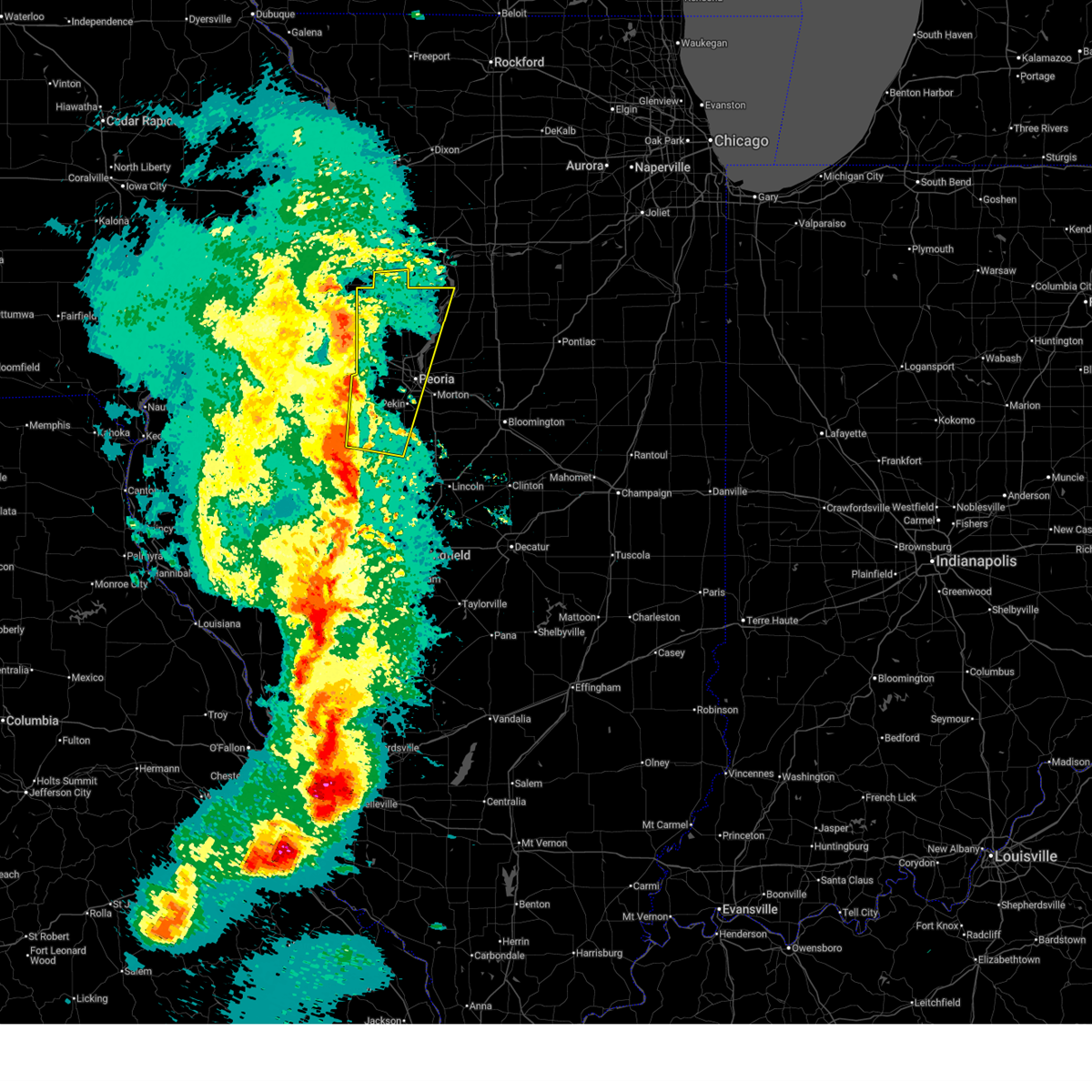 Svrilx the national weather service in lincoln has issued a * severe thunderstorm warning for, western marshall county in central illinois, northwestern woodford county in central illinois, northeastern fulton county in west central illinois, stark county in north central illinois, western tazewell county in central illinois, northeastern mason county in central illinois, peoria county in central illinois, * until 1045 pm cdt. * at 946 pm cdt, severe thunderstorms were located along a line extending from near galva to yates city to near havana, moving northeast at 65 mph (radar indicated). Hazards include 70 mph wind gusts. Expect considerable tree damage. damage is likely to mobile homes, roofs, and outbuildings. severe thunderstorms will be near, laura, elmwood, trivoli, elmore, brimfield, farmington, la fayette, canton, and toulon around 950 pm cdt. elmira around 955 pm cdt. glasford, princeville, hanna city, osceola, and wyoming around 1000 pm cdt. castleton and bradford around 1005 pm cdt. other locations in the path of these severe thunderstorms include peoria, camp grove, dunlap and edelstein. this includes the following highways, interstate 474 between mile markers 0 and 13. Interstate 74 between mile markers 69 and 98. Svrilx the national weather service in lincoln has issued a * severe thunderstorm warning for, western marshall county in central illinois, northwestern woodford county in central illinois, northeastern fulton county in west central illinois, stark county in north central illinois, western tazewell county in central illinois, northeastern mason county in central illinois, peoria county in central illinois, * until 1045 pm cdt. * at 946 pm cdt, severe thunderstorms were located along a line extending from near galva to yates city to near havana, moving northeast at 65 mph (radar indicated). Hazards include 70 mph wind gusts. Expect considerable tree damage. damage is likely to mobile homes, roofs, and outbuildings. severe thunderstorms will be near, laura, elmwood, trivoli, elmore, brimfield, farmington, la fayette, canton, and toulon around 950 pm cdt. elmira around 955 pm cdt. glasford, princeville, hanna city, osceola, and wyoming around 1000 pm cdt. castleton and bradford around 1005 pm cdt. other locations in the path of these severe thunderstorms include peoria, camp grove, dunlap and edelstein. this includes the following highways, interstate 474 between mile markers 0 and 13. Interstate 74 between mile markers 69 and 98.
|
| 3/14/2025 9:42 PM CDT |
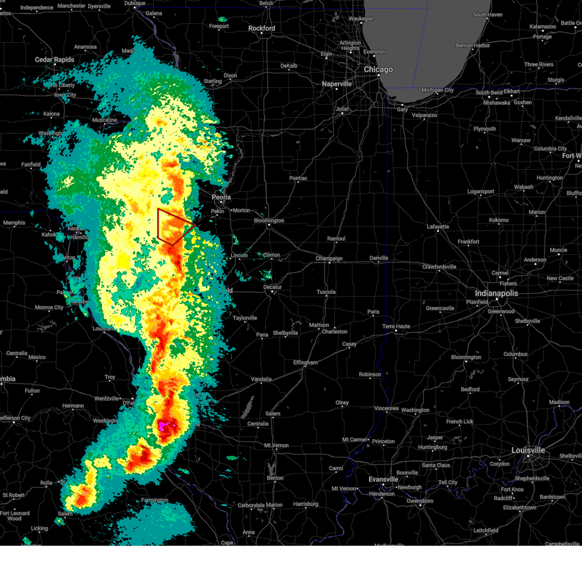 The tornado threat has diminished and the tornado warning has been cancelled. however, large hail and damaging winds remain likely and a severe thunderstorm warning remains in effect for the area. a tornado watch remains in effect until 300 am cdt for west central illinois. remember, a severe thunderstorm warning still remains in effect for portions of fulton county until 1000 pm cdt. The tornado threat has diminished and the tornado warning has been cancelled. however, large hail and damaging winds remain likely and a severe thunderstorm warning remains in effect for the area. a tornado watch remains in effect until 300 am cdt for west central illinois. remember, a severe thunderstorm warning still remains in effect for portions of fulton county until 1000 pm cdt.
|
| 3/14/2025 9:29 PM CDT |
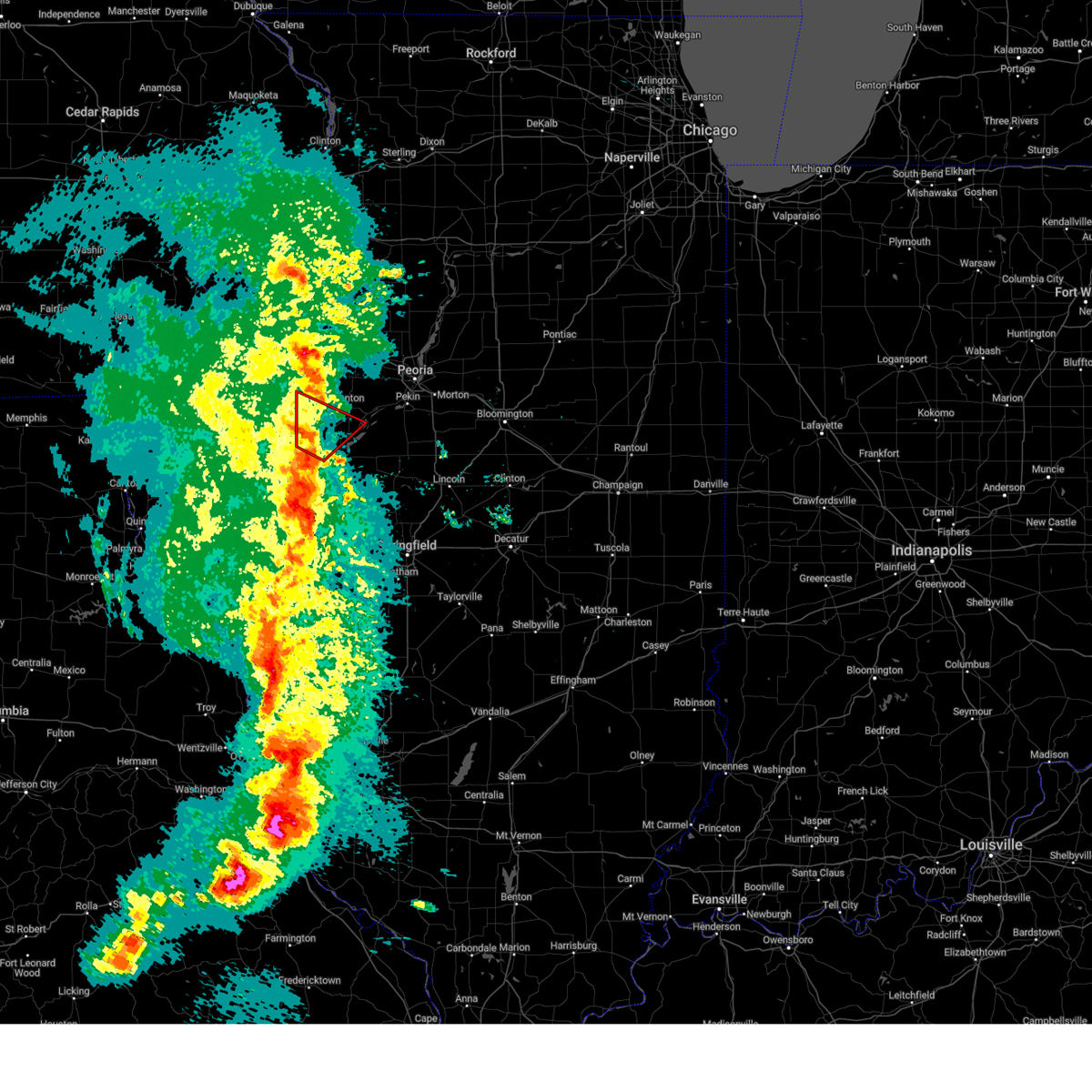 At 929 pm cdt, a severe squall line capable of producing both tornadoes and extensive straight line wind damage was located over cuba, or near lewistown, moving northeast at 70 mph (radar indicated rotation). Hazards include tornado and quarter size hail. Flying debris will be dangerous to those caught without shelter. mobile homes will be damaged or destroyed. damage to roofs, windows, and vehicles will occur. tree damage is likely. This tornadic thunderstorm will remain over mainly rural areas of central fulton county, including the following locations, bryant, smithfield, little america, fiatt, bernadotte, dunfermline, and duncan mills. At 929 pm cdt, a severe squall line capable of producing both tornadoes and extensive straight line wind damage was located over cuba, or near lewistown, moving northeast at 70 mph (radar indicated rotation). Hazards include tornado and quarter size hail. Flying debris will be dangerous to those caught without shelter. mobile homes will be damaged or destroyed. damage to roofs, windows, and vehicles will occur. tree damage is likely. This tornadic thunderstorm will remain over mainly rural areas of central fulton county, including the following locations, bryant, smithfield, little america, fiatt, bernadotte, dunfermline, and duncan mills.
|
| 3/14/2025 9:18 PM CDT |
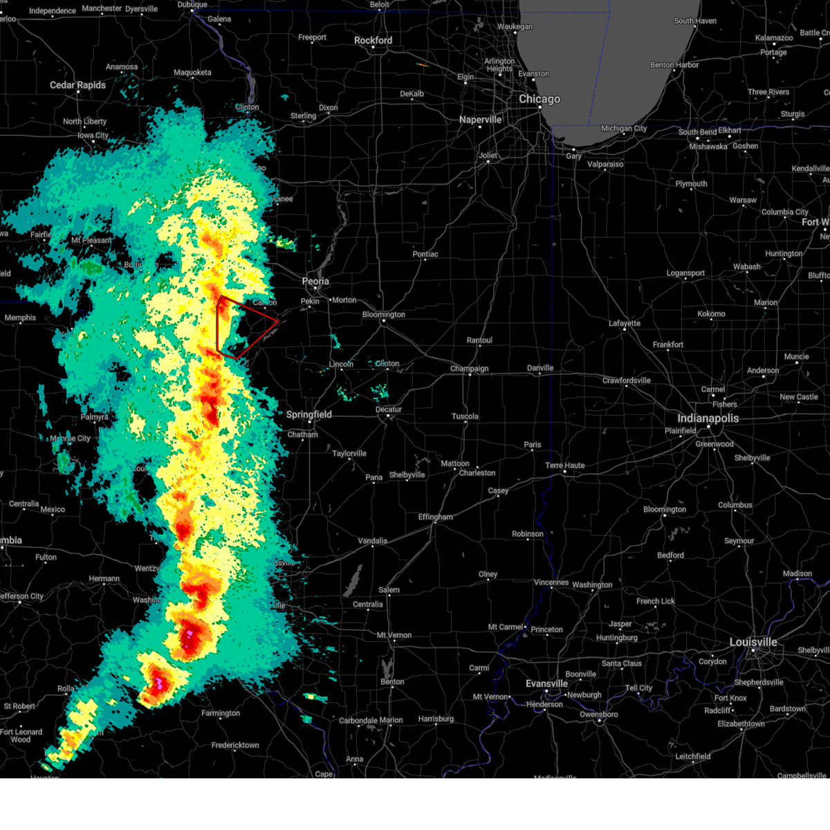 the tornado warning has been cancelled and is no longer in effect the tornado warning has been cancelled and is no longer in effect
|
| 3/14/2025 9:18 PM CDT |
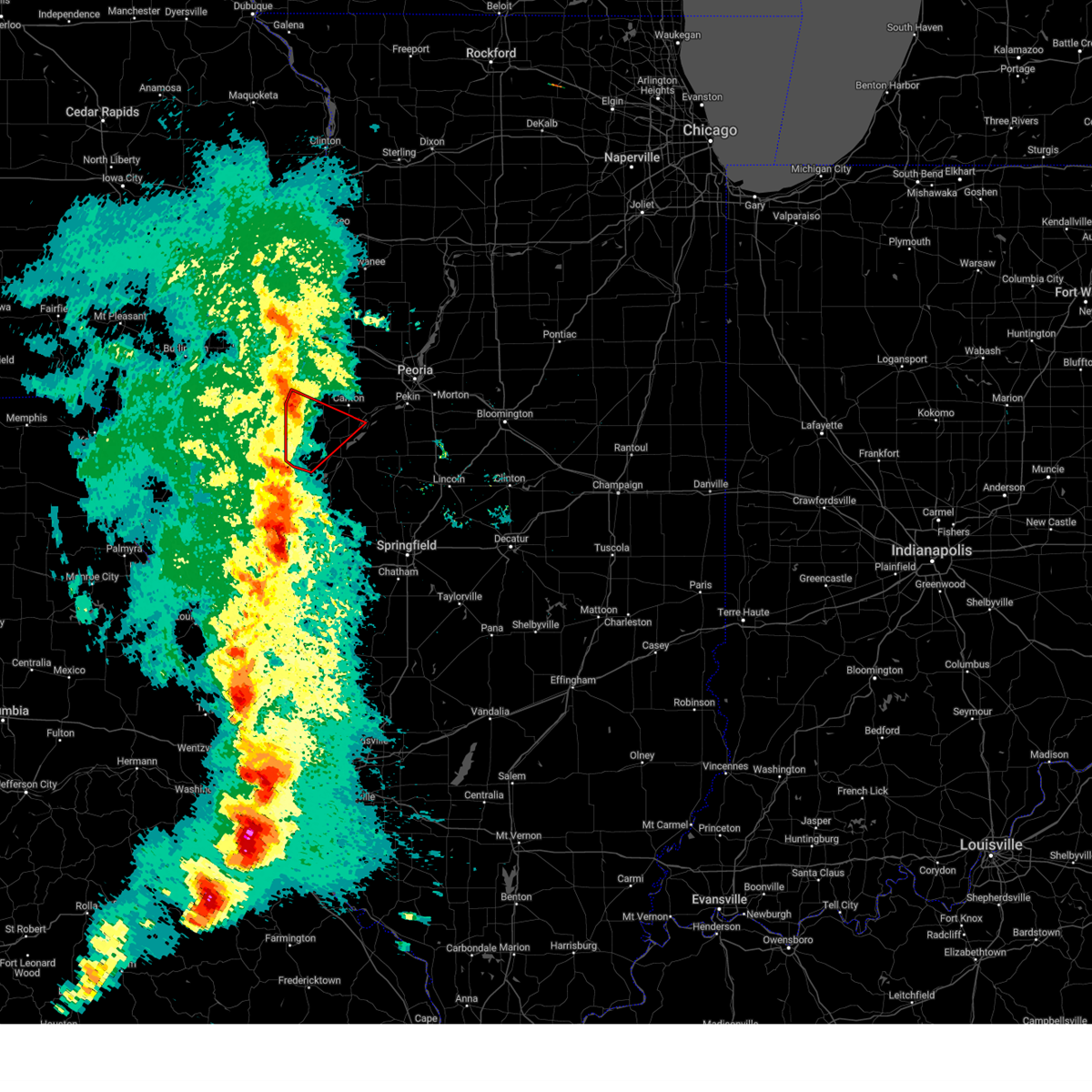 At 918 pm cdt, a severe squall line capable of producing both tornadoes and extensive straight line wind damage was located near ipava, or 12 miles southwest of lewistown, moving northeast at 70 mph (radar indicated rotation). Hazards include tornado and quarter size hail. Flying debris will be dangerous to those caught without shelter. mobile homes will be damaged or destroyed. damage to roofs, windows, and vehicles will occur. tree damage is likely. these dangerous storms will be near, cuba around 930 pm cdt. Other locations impacted by this tornadic thunderstorm include bryant, smithfield, marietta, little america, fiatt, bernadotte, dunfermline, duncan mills, and table grove. At 918 pm cdt, a severe squall line capable of producing both tornadoes and extensive straight line wind damage was located near ipava, or 12 miles southwest of lewistown, moving northeast at 70 mph (radar indicated rotation). Hazards include tornado and quarter size hail. Flying debris will be dangerous to those caught without shelter. mobile homes will be damaged or destroyed. damage to roofs, windows, and vehicles will occur. tree damage is likely. these dangerous storms will be near, cuba around 930 pm cdt. Other locations impacted by this tornadic thunderstorm include bryant, smithfield, marietta, little america, fiatt, bernadotte, dunfermline, duncan mills, and table grove.
|
| 3/14/2025 9:09 PM CDT |
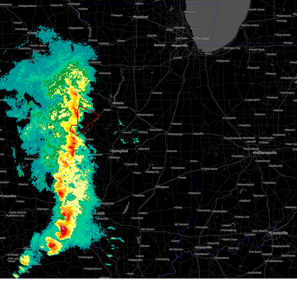 Torilx the national weather service in lincoln has issued a * tornado warning for, fulton county in west central illinois, northeastern schuyler county in west central illinois, * until 945 pm cdt. * at 909 pm cdt, severe thunderstorms capable of producing both tornadoes and extensive straight line wind damage were located near rushville, moving northeast at 70 mph (radar indicated rotation). Hazards include tornado and quarter size hail. Flying debris will be dangerous to those caught without shelter. mobile homes will be damaged or destroyed. damage to roofs, windows, and vehicles will occur. tree damage is likely. these dangerous storms will be near, ipava and vermont around 915 pm cdt. Cuba around 925 pm cdt. Torilx the national weather service in lincoln has issued a * tornado warning for, fulton county in west central illinois, northeastern schuyler county in west central illinois, * until 945 pm cdt. * at 909 pm cdt, severe thunderstorms capable of producing both tornadoes and extensive straight line wind damage were located near rushville, moving northeast at 70 mph (radar indicated rotation). Hazards include tornado and quarter size hail. Flying debris will be dangerous to those caught without shelter. mobile homes will be damaged or destroyed. damage to roofs, windows, and vehicles will occur. tree damage is likely. these dangerous storms will be near, ipava and vermont around 915 pm cdt. Cuba around 925 pm cdt.
|
| 3/14/2025 8:57 PM CDT |
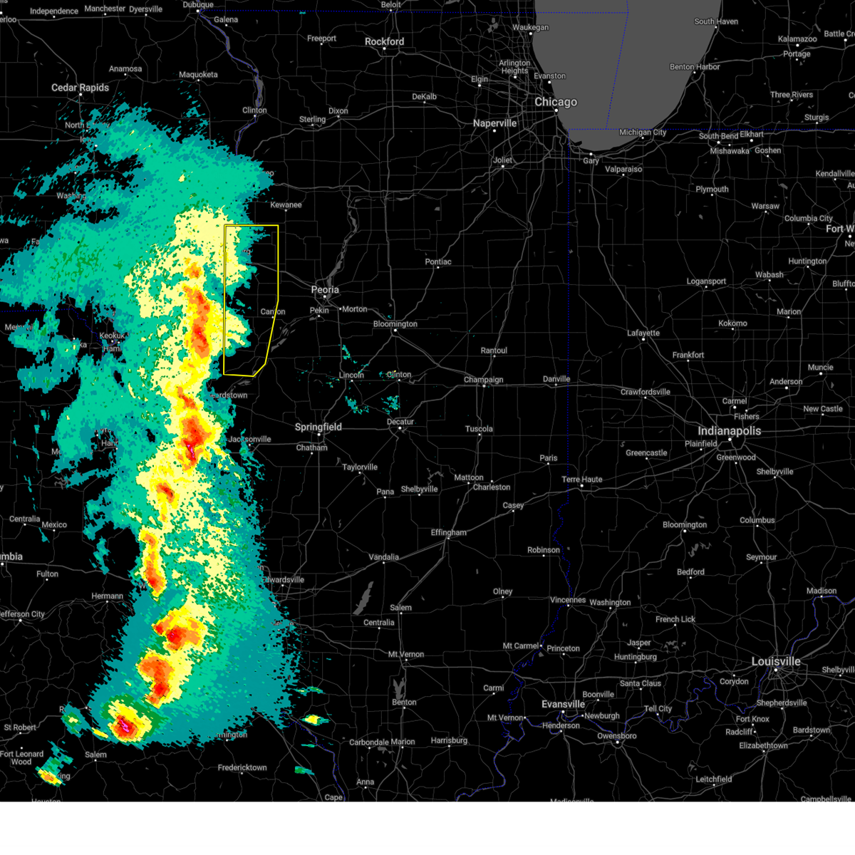 Svrilx the national weather service in lincoln has issued a * severe thunderstorm warning for, fulton county in west central illinois, knox county in west central illinois, * until 1000 pm cdt. * at 857 pm cdt, severe thunderstorms were located along a line extending from lake warren to near bushnell to near industry, moving northeast at 65 mph (radar indicated). Hazards include 70 mph wind gusts and quarter size hail. Hail damage to vehicles is expected. expect considerable tree damage. wind damage is also likely to mobile homes, roofs, and outbuildings. severe thunderstorms will be near, st. augustine and avon around 900 pm cdt. abingdon and galesburg around 905 pm cdt. rio and henderson around 910 pm cdt. knoxville, wataga, and london mills around 915 pm cdt. other locations in the path of these severe thunderstorms include oneida, maquon, altona, victoria and williamsfield. This includes interstate 74 between mile markers 34 and 67. Svrilx the national weather service in lincoln has issued a * severe thunderstorm warning for, fulton county in west central illinois, knox county in west central illinois, * until 1000 pm cdt. * at 857 pm cdt, severe thunderstorms were located along a line extending from lake warren to near bushnell to near industry, moving northeast at 65 mph (radar indicated). Hazards include 70 mph wind gusts and quarter size hail. Hail damage to vehicles is expected. expect considerable tree damage. wind damage is also likely to mobile homes, roofs, and outbuildings. severe thunderstorms will be near, st. augustine and avon around 900 pm cdt. abingdon and galesburg around 905 pm cdt. rio and henderson around 910 pm cdt. knoxville, wataga, and london mills around 915 pm cdt. other locations in the path of these severe thunderstorms include oneida, maquon, altona, victoria and williamsfield. This includes interstate 74 between mile markers 34 and 67.
|
| 7/31/2024 6:47 AM CDT |
 At 646 am cdt, severe thunderstorms were located along a line extending from st. david to browning to near mount sterling, moving east at 55 mph (radar indicated). Hazards include 60 mph wind gusts. Expect damage to roofs, siding, and trees. locations impacted include, canton, rushville, lewistown, cuba, astoria, vermont, st. David, fairview, ipava, littleton, browning, dunfermline, bernadotte, smithfield, bryant, norris, banner, frederick, huntsville, and camden. At 646 am cdt, severe thunderstorms were located along a line extending from st. david to browning to near mount sterling, moving east at 55 mph (radar indicated). Hazards include 60 mph wind gusts. Expect damage to roofs, siding, and trees. locations impacted include, canton, rushville, lewistown, cuba, astoria, vermont, st. David, fairview, ipava, littleton, browning, dunfermline, bernadotte, smithfield, bryant, norris, banner, frederick, huntsville, and camden.
|
| 7/31/2024 6:23 AM CDT |
 At 622 am cdt, severe thunderstorms were located along a line extending from prairie city to near augusta to near quincy regional airport, moving east at 50 mph (radar indicated). Hazards include 60 mph wind gusts and nickel size hail. Expect damage to roofs, siding, and trees. locations impacted include, canton, rushville, lewistown, farmington, cuba, astoria, avon, vermont, st. David, fairview, ipava, london mills, littleton, browning, table grove, dunfermline, bernadotte, smithfield, bryant, and norris. At 622 am cdt, severe thunderstorms were located along a line extending from prairie city to near augusta to near quincy regional airport, moving east at 50 mph (radar indicated). Hazards include 60 mph wind gusts and nickel size hail. Expect damage to roofs, siding, and trees. locations impacted include, canton, rushville, lewistown, farmington, cuba, astoria, avon, vermont, st. David, fairview, ipava, london mills, littleton, browning, table grove, dunfermline, bernadotte, smithfield, bryant, and norris.
|
| 7/31/2024 6:05 AM CDT |
 Svrilx the national weather service in lincoln has issued a * severe thunderstorm warning for, fulton county in west central illinois, schuyler county in west central illinois, * until 700 am cdt. * at 604 am cdt, severe thunderstorms were located along a line extending from near good hope to near la grange, moving east at 45 mph (radar indicated). Hazards include 60 mph wind gusts and nickel size hail. expect damage to roofs, siding, and trees Svrilx the national weather service in lincoln has issued a * severe thunderstorm warning for, fulton county in west central illinois, schuyler county in west central illinois, * until 700 am cdt. * at 604 am cdt, severe thunderstorms were located along a line extending from near good hope to near la grange, moving east at 45 mph (radar indicated). Hazards include 60 mph wind gusts and nickel size hail. expect damage to roofs, siding, and trees
|
| 7/30/2024 6:49 AM CDT |
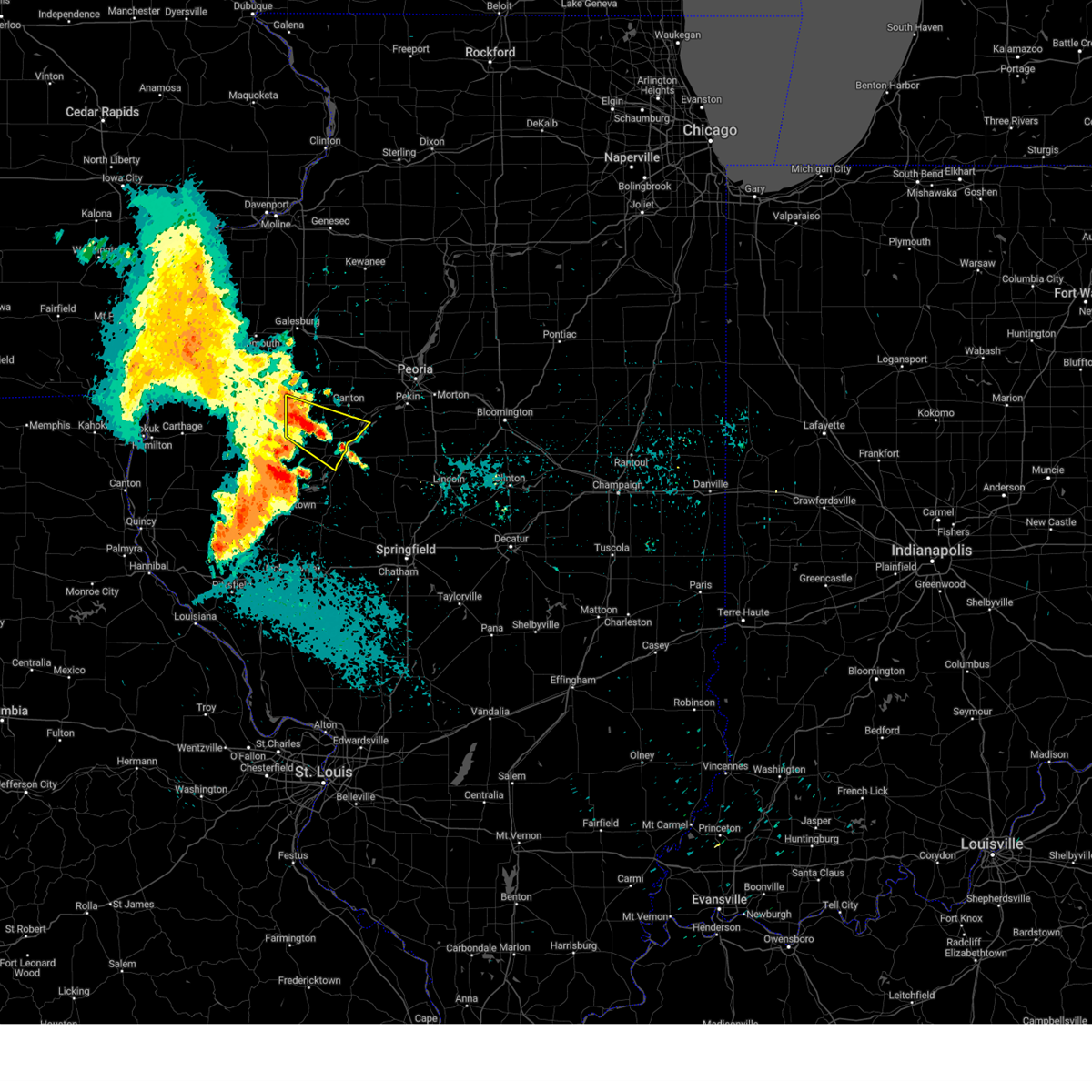 At 648 am cdt, a severe thunderstorm was located near cuba, moving east at 50 mph (emergency management. at 645 am, 50 to 60 mph wind gusts were reported near marietta). Hazards include 60 mph wind gusts. Expect damage to roofs, siding, and trees. this severe storm will be near, lewistown around 655 am cdt. Other locations impacted by this severe thunderstorm include bryant, smithfield, marietta, liverpool, little america, bernadotte, dunfermline, and duncan mills. At 648 am cdt, a severe thunderstorm was located near cuba, moving east at 50 mph (emergency management. at 645 am, 50 to 60 mph wind gusts were reported near marietta). Hazards include 60 mph wind gusts. Expect damage to roofs, siding, and trees. this severe storm will be near, lewistown around 655 am cdt. Other locations impacted by this severe thunderstorm include bryant, smithfield, marietta, liverpool, little america, bernadotte, dunfermline, and duncan mills.
|
| 7/30/2024 6:33 AM CDT |
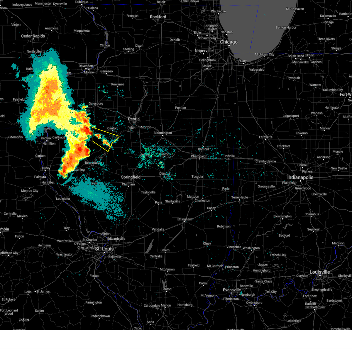 Svrilx the national weather service in lincoln has issued a * severe thunderstorm warning for, central fulton county in west central illinois, * until 715 am cdt. * at 632 am cdt, a severe thunderstorm was located over new philadelphia, or 12 miles east of macomb, moving east at 50 mph (radar indicated). Hazards include 60 mph wind gusts. Expect damage to roofs, siding, and trees. This severe thunderstorm will be near, lewistown and cuba around 645 am cdt. Svrilx the national weather service in lincoln has issued a * severe thunderstorm warning for, central fulton county in west central illinois, * until 715 am cdt. * at 632 am cdt, a severe thunderstorm was located over new philadelphia, or 12 miles east of macomb, moving east at 50 mph (radar indicated). Hazards include 60 mph wind gusts. Expect damage to roofs, siding, and trees. This severe thunderstorm will be near, lewistown and cuba around 645 am cdt.
|
| 7/15/2024 8:59 PM CDT |
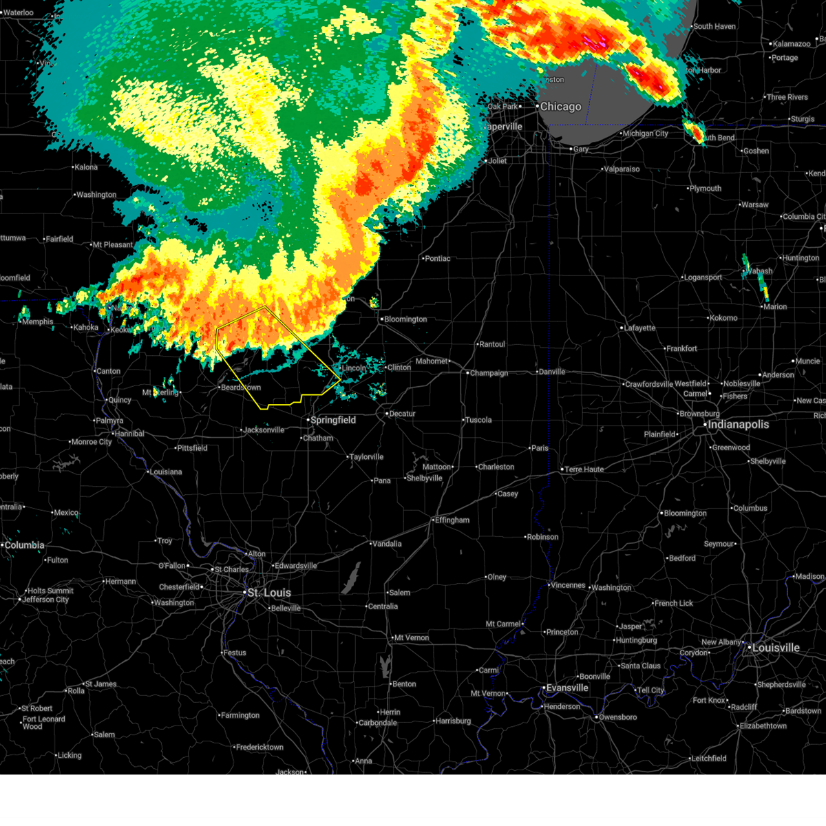 At 858 pm cdt, severe thunderstorms were located along a line extending from near new holland to near greenview to chandlerville, moving southeast at 50 mph (radar indicated). Hazards include 60 mph wind gusts and penny size hail. Expect damage to roofs, siding, and trees. these severe storms will be near, petersburg, athens, greenview, tallula, and middletown around 905 pm cdt. ashland and elkhart around 910 pm cdt. other locations impacted by these severe thunderstorms include bryant, topeka, liverpool, bluff city, bernadotte, chatauqua park, atterberry, dunfermline, snicarte, and broadwell. This includes interstate 55 between mile markers 111 and 122. At 858 pm cdt, severe thunderstorms were located along a line extending from near new holland to near greenview to chandlerville, moving southeast at 50 mph (radar indicated). Hazards include 60 mph wind gusts and penny size hail. Expect damage to roofs, siding, and trees. these severe storms will be near, petersburg, athens, greenview, tallula, and middletown around 905 pm cdt. ashland and elkhart around 910 pm cdt. other locations impacted by these severe thunderstorms include bryant, topeka, liverpool, bluff city, bernadotte, chatauqua park, atterberry, dunfermline, snicarte, and broadwell. This includes interstate 55 between mile markers 111 and 122.
|
| 7/15/2024 8:37 PM CDT |
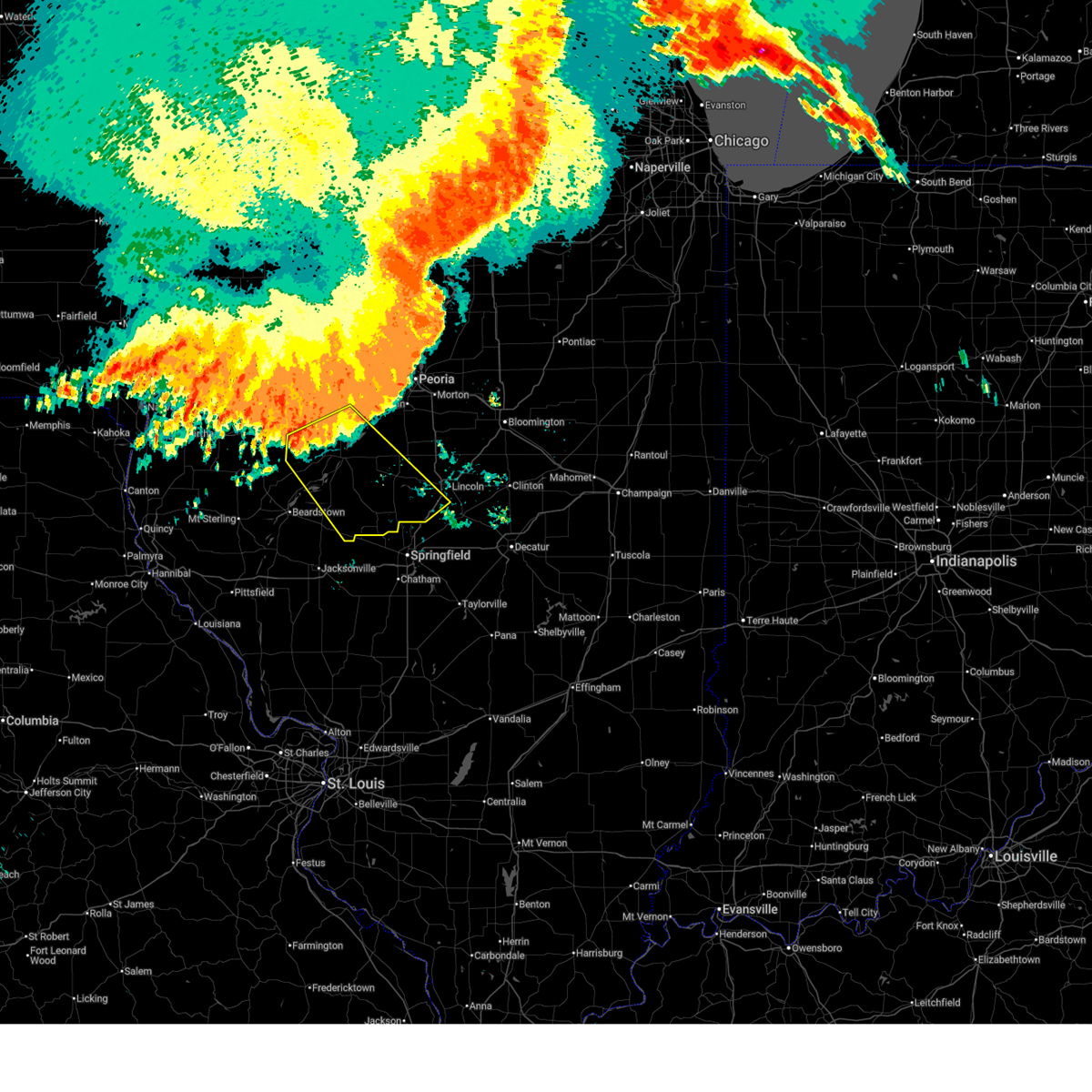 Svrilx the national weather service in lincoln has issued a * severe thunderstorm warning for, menard county in central illinois, southwestern logan county in central illinois, southern fulton county in west central illinois, southwestern tazewell county in central illinois, eastern cass county in west central illinois, eastern schuyler county in west central illinois, mason county in central illinois, * until 915 pm cdt. * at 836 pm cdt, severe thunderstorms were located along a line extending from 6 miles west of manito to near havana to vermont, moving southeast at 50 mph (radar indicated). Hazards include 60 mph wind gusts and penny size hail. Expect damage to roofs, siding, and trees. severe thunderstorms will be near, havana and astoria around 840 pm cdt. bath and easton around 845 pm cdt. kilbourne around 850 pm cdt. mason city and chandlerville around 855 pm cdt. other locations in the path of these severe thunderstorms include greenview, new holland, petersburg, middletown and tallula. This includes interstate 55 between mile markers 111 and 122. Svrilx the national weather service in lincoln has issued a * severe thunderstorm warning for, menard county in central illinois, southwestern logan county in central illinois, southern fulton county in west central illinois, southwestern tazewell county in central illinois, eastern cass county in west central illinois, eastern schuyler county in west central illinois, mason county in central illinois, * until 915 pm cdt. * at 836 pm cdt, severe thunderstorms were located along a line extending from 6 miles west of manito to near havana to vermont, moving southeast at 50 mph (radar indicated). Hazards include 60 mph wind gusts and penny size hail. Expect damage to roofs, siding, and trees. severe thunderstorms will be near, havana and astoria around 840 pm cdt. bath and easton around 845 pm cdt. kilbourne around 850 pm cdt. mason city and chandlerville around 855 pm cdt. other locations in the path of these severe thunderstorms include greenview, new holland, petersburg, middletown and tallula. This includes interstate 55 between mile markers 111 and 122.
|
| 7/15/2024 8:31 PM CDT |
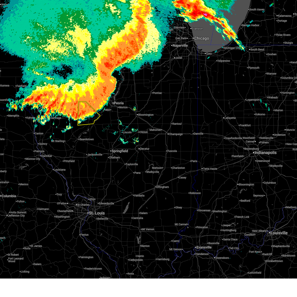 At 830 pm cdt, severe thunderstorms were located along a line extending from near st. david to near industry, moving southeast at 55 mph (radar indicated). Hazards include 60 mph wind gusts and penny size hail. Expect damage to roofs, siding, and trees. these severe storms will be near, lewistown, vermont, and ipava around 835 pm cdt. Other locations impacted by these severe thunderstorms include bryant, smithfield, marietta, liverpool, little america, fiatt, bernadotte, ellisville, dunfermline, and duncan mills. At 830 pm cdt, severe thunderstorms were located along a line extending from near st. david to near industry, moving southeast at 55 mph (radar indicated). Hazards include 60 mph wind gusts and penny size hail. Expect damage to roofs, siding, and trees. these severe storms will be near, lewistown, vermont, and ipava around 835 pm cdt. Other locations impacted by these severe thunderstorms include bryant, smithfield, marietta, liverpool, little america, fiatt, bernadotte, ellisville, dunfermline, and duncan mills.
|
| 7/15/2024 8:07 PM CDT |
 Svrilx the national weather service in lincoln has issued a * severe thunderstorm warning for, fulton county in west central illinois, southwestern knox county in west central illinois, * until 845 pm cdt. * at 806 pm cdt, severe thunderstorms were located along a line extending from near st. augustine to near la harpe, moving south at 55 mph (radar indicated). Hazards include 60 mph wind gusts and penny size hail. Expect damage to roofs, siding, and trees. severe thunderstorms will be near, avon, london mills, and st. augustine around 810 pm cdt. cuba around 825 pm cdt. Other locations in the path of these severe thunderstorms include lewistown, ipava and vermont. Svrilx the national weather service in lincoln has issued a * severe thunderstorm warning for, fulton county in west central illinois, southwestern knox county in west central illinois, * until 845 pm cdt. * at 806 pm cdt, severe thunderstorms were located along a line extending from near st. augustine to near la harpe, moving south at 55 mph (radar indicated). Hazards include 60 mph wind gusts and penny size hail. Expect damage to roofs, siding, and trees. severe thunderstorms will be near, avon, london mills, and st. augustine around 810 pm cdt. cuba around 825 pm cdt. Other locations in the path of these severe thunderstorms include lewistown, ipava and vermont.
|
| 7/2/2024 10:48 PM CDT |
 the severe thunderstorm warning has been cancelled and is no longer in effect the severe thunderstorm warning has been cancelled and is no longer in effect
|
| 7/2/2024 10:45 PM CDT |
 At 1044 pm cdt, a severe thunderstorm was located near manito, or 10 miles southeast of canton, moving east at 50 mph (radar indicated). Hazards include 60 mph wind gusts. Expect damage to roofs, siding, and trees. Locations impacted include, canton, dunfermline, banner, liverpool, and little america. At 1044 pm cdt, a severe thunderstorm was located near manito, or 10 miles southeast of canton, moving east at 50 mph (radar indicated). Hazards include 60 mph wind gusts. Expect damage to roofs, siding, and trees. Locations impacted include, canton, dunfermline, banner, liverpool, and little america.
|
| 7/2/2024 10:37 PM CDT |
 At 1037 pm cdt, a severe thunderstorm was located near st. david, or 7 miles east of lewistown, moving east at 50 mph (radar indicated). Hazards include 60 mph wind gusts. Expect damage to roofs, siding, and trees. locations impacted include, canton, st. David, dunfermline, bryant, banner, liverpool, and little america. At 1037 pm cdt, a severe thunderstorm was located near st. david, or 7 miles east of lewistown, moving east at 50 mph (radar indicated). Hazards include 60 mph wind gusts. Expect damage to roofs, siding, and trees. locations impacted include, canton, st. David, dunfermline, bryant, banner, liverpool, and little america.
|
| 7/2/2024 10:25 PM CDT |
 At 1025 pm cdt, a severe thunderstorm was located over lewistown, moving east at 45 mph (radar indicated). Hazards include 60 mph wind gusts and quarter size hail. Hail damage to vehicles is expected. expect wind damage to roofs, siding, and trees. This severe thunderstorm will remain over mainly rural areas of central fulton county, including the following locations, bryant, smithfield, liverpool, little america, banner, dunfermline, duncan mills, and fiatt. At 1025 pm cdt, a severe thunderstorm was located over lewistown, moving east at 45 mph (radar indicated). Hazards include 60 mph wind gusts and quarter size hail. Hail damage to vehicles is expected. expect wind damage to roofs, siding, and trees. This severe thunderstorm will remain over mainly rural areas of central fulton county, including the following locations, bryant, smithfield, liverpool, little america, banner, dunfermline, duncan mills, and fiatt.
|
| 7/2/2024 10:06 PM CDT |
 Svrilx the national weather service in lincoln has issued a * severe thunderstorm warning for, fulton county in west central illinois, * until 1100 pm cdt. * at 1006 pm cdt, a severe thunderstorm was located over new philadelphia, or 11 miles east of macomb, moving east at 35 mph (radar indicated). Hazards include 60 mph wind gusts and quarter size hail. Hail damage to vehicles is expected. expect wind damage to roofs, siding, and trees. this severe thunderstorm will be near, cuba around 1025 pm cdt. other locations in the path of this severe thunderstorm include st. David and canton. Svrilx the national weather service in lincoln has issued a * severe thunderstorm warning for, fulton county in west central illinois, * until 1100 pm cdt. * at 1006 pm cdt, a severe thunderstorm was located over new philadelphia, or 11 miles east of macomb, moving east at 35 mph (radar indicated). Hazards include 60 mph wind gusts and quarter size hail. Hail damage to vehicles is expected. expect wind damage to roofs, siding, and trees. this severe thunderstorm will be near, cuba around 1025 pm cdt. other locations in the path of this severe thunderstorm include st. David and canton.
|
| 6/25/2024 9:53 PM CDT |
 The storm which prompted the warning has weakened below severe limits, and no longer poses an immediate threat to life or property. therefore, the warning will be allowed to expire. however, gusty winds and heavy rain are still possible with this thunderstorm. a severe thunderstorm watch remains in effect until midnight cdt for central and west central illinois. The storm which prompted the warning has weakened below severe limits, and no longer poses an immediate threat to life or property. therefore, the warning will be allowed to expire. however, gusty winds and heavy rain are still possible with this thunderstorm. a severe thunderstorm watch remains in effect until midnight cdt for central and west central illinois.
|
| 6/25/2024 9:15 PM CDT |
 Svrilx the national weather service in lincoln has issued a * severe thunderstorm warning for, northern logan county in central illinois, central fulton county in west central illinois, tazewell county in central illinois, northeastern mason county in central illinois, south central peoria county in central illinois, * until 1000 pm cdt. * at 915 pm cdt, a severe thunderstorm was located near tremont, or 9 miles southeast of pekin, moving southeast at 35 mph (radar indicated). Hazards include 60 mph wind gusts and quarter size hail. Hail damage to vehicles is expected. expect wind damage to roofs, siding, and trees. this severe thunderstorm will be near, delavan and hopedale around 920 pm cdt. emden around 930 pm cdt. hartsburg around 935 pm cdt. this includes the following highways, interstate 155 between mile markers 5 and 29. Interstate 55 between mile markers 136 and 138. Svrilx the national weather service in lincoln has issued a * severe thunderstorm warning for, northern logan county in central illinois, central fulton county in west central illinois, tazewell county in central illinois, northeastern mason county in central illinois, south central peoria county in central illinois, * until 1000 pm cdt. * at 915 pm cdt, a severe thunderstorm was located near tremont, or 9 miles southeast of pekin, moving southeast at 35 mph (radar indicated). Hazards include 60 mph wind gusts and quarter size hail. Hail damage to vehicles is expected. expect wind damage to roofs, siding, and trees. this severe thunderstorm will be near, delavan and hopedale around 920 pm cdt. emden around 930 pm cdt. hartsburg around 935 pm cdt. this includes the following highways, interstate 155 between mile markers 5 and 29. Interstate 55 between mile markers 136 and 138.
|
| 6/25/2024 8:53 PM CDT |
 At 852 pm cdt, a severe thunderstorm was located over bartonville, or near pekin, moving south at 35 mph (radar indicated). Hazards include 70 mph wind gusts and quarter size hail. Hail damage to vehicles is expected. expect considerable tree damage. wind damage is also likely to mobile homes, roofs, and outbuildings. this severe storm will be near, pekin and south pekin around 900 pm cdt. other locations impacted by this severe thunderstorm include smithville, dillon, powerton, west jersey, dunfermline, norwood, kickapoo, fiatt, dahinda, and peoria heights. this includes the following highways, interstate 155 between mile markers 19 and 31. interstate 474 between mile markers 0 and 14. Interstate 74 between mile markers 58 and 106. At 852 pm cdt, a severe thunderstorm was located over bartonville, or near pekin, moving south at 35 mph (radar indicated). Hazards include 70 mph wind gusts and quarter size hail. Hail damage to vehicles is expected. expect considerable tree damage. wind damage is also likely to mobile homes, roofs, and outbuildings. this severe storm will be near, pekin and south pekin around 900 pm cdt. other locations impacted by this severe thunderstorm include smithville, dillon, powerton, west jersey, dunfermline, norwood, kickapoo, fiatt, dahinda, and peoria heights. this includes the following highways, interstate 155 between mile markers 19 and 31. interstate 474 between mile markers 0 and 14. Interstate 74 between mile markers 58 and 106.
|
| 6/25/2024 8:53 PM CDT |
 the severe thunderstorm warning has been cancelled and is no longer in effect the severe thunderstorm warning has been cancelled and is no longer in effect
|
| 6/25/2024 8:41 PM CDT |
 At 840 pm cdt, a severe thunderstorm was located over bellevue, or near peoria, moving south at 30 mph (radar indicated). Hazards include 70 mph wind gusts and quarter size hail. Hail damage to vehicles is expected. expect considerable tree damage. wind damage is also likely to mobile homes, roofs, and outbuildings. this severe storm will be near, peoria, bartonville, west peoria, bellevue, and peoria international airport around 845 pm cdt. pekin around 850 pm cdt. mapleton around 855 pm cdt. south pekin around 905 pm cdt. other locations impacted by this severe thunderstorm include smithville, dillon, powerton, west jersey, dunfermline, norwood, kickapoo, fiatt, dahinda, and peoria heights. this includes the following highways, interstate 155 between mile markers 19 and 31. interstate 474 between mile markers 0 and 14. Interstate 74 between mile markers 58 and 117. At 840 pm cdt, a severe thunderstorm was located over bellevue, or near peoria, moving south at 30 mph (radar indicated). Hazards include 70 mph wind gusts and quarter size hail. Hail damage to vehicles is expected. expect considerable tree damage. wind damage is also likely to mobile homes, roofs, and outbuildings. this severe storm will be near, peoria, bartonville, west peoria, bellevue, and peoria international airport around 845 pm cdt. pekin around 850 pm cdt. mapleton around 855 pm cdt. south pekin around 905 pm cdt. other locations impacted by this severe thunderstorm include smithville, dillon, powerton, west jersey, dunfermline, norwood, kickapoo, fiatt, dahinda, and peoria heights. this includes the following highways, interstate 155 between mile markers 19 and 31. interstate 474 between mile markers 0 and 14. Interstate 74 between mile markers 58 and 117.
|
| 6/25/2024 8:20 PM CDT |
 Svrilx the national weather service in lincoln has issued a * severe thunderstorm warning for, southwestern marshall county in central illinois, western woodford county in central illinois, northeastern fulton county in west central illinois, southern stark county in north central illinois, southeastern knox county in west central illinois, tazewell county in central illinois, west central mclean county in central illinois, peoria county in central illinois, * until 915 pm cdt. * at 820 pm cdt, severe thunderstorms were located along a line extending from near benson to 6 miles east of knoxville, moving south at 20 mph (radar indicated). Hazards include 70 mph wind gusts and half dollar size hail. Hail damage to vehicles is expected. expect considerable tree damage. wind damage is also likely to mobile homes, roofs, and outbuildings. severe thunderstorms will be near, peoria, metamora, germantown hills, elmwood, roanoke, dunlap, brimfield, yates city, spring bay, and maquon around 825 pm cdt. east peoria, eureka, and washington around 830 pm cdt. west peoria, farmington, bellevue, hanna city, and trivoli around 835 pm cdt. morton, bartonville, creve coeur, goodfield, deer creek, congerville, and peoria international airport around 840 pm cdt. other locations in the path of these severe thunderstorms include marquette heights, pekin, canton, glasford, mapleton, tremont, mackinaw, danvers, south pekin and st. david. this includes the following highways, interstate 155 between mile markers 19 and 31. interstate 474 between mile markers 0 and 14. Interstate 74 between mile markers 58 and 117. Svrilx the national weather service in lincoln has issued a * severe thunderstorm warning for, southwestern marshall county in central illinois, western woodford county in central illinois, northeastern fulton county in west central illinois, southern stark county in north central illinois, southeastern knox county in west central illinois, tazewell county in central illinois, west central mclean county in central illinois, peoria county in central illinois, * until 915 pm cdt. * at 820 pm cdt, severe thunderstorms were located along a line extending from near benson to 6 miles east of knoxville, moving south at 20 mph (radar indicated). Hazards include 70 mph wind gusts and half dollar size hail. Hail damage to vehicles is expected. expect considerable tree damage. wind damage is also likely to mobile homes, roofs, and outbuildings. severe thunderstorms will be near, peoria, metamora, germantown hills, elmwood, roanoke, dunlap, brimfield, yates city, spring bay, and maquon around 825 pm cdt. east peoria, eureka, and washington around 830 pm cdt. west peoria, farmington, bellevue, hanna city, and trivoli around 835 pm cdt. morton, bartonville, creve coeur, goodfield, deer creek, congerville, and peoria international airport around 840 pm cdt. other locations in the path of these severe thunderstorms include marquette heights, pekin, canton, glasford, mapleton, tremont, mackinaw, danvers, south pekin and st. david. this includes the following highways, interstate 155 between mile markers 19 and 31. interstate 474 between mile markers 0 and 14. Interstate 74 between mile markers 58 and 117.
|
| 6/13/2024 7:40 PM CDT |
 The storm which prompted the warning has weakened below severe limits, and no longer poses an immediate threat to life or property. therefore, the warning will be allowed to expire. however, gusty winds and heavy rain are still possible with this thunderstorm. a severe thunderstorm watch remains in effect until 1000 pm cdt for central and west central illinois. The storm which prompted the warning has weakened below severe limits, and no longer poses an immediate threat to life or property. therefore, the warning will be allowed to expire. however, gusty winds and heavy rain are still possible with this thunderstorm. a severe thunderstorm watch remains in effect until 1000 pm cdt for central and west central illinois.
|
| 6/13/2024 7:20 PM CDT |
 At 719 pm cdt, a severe thunderstorm was located near cuba, or 9 miles northwest of lewistown, moving east at 35 mph (radar indicated). Hazards include 60 mph wind gusts and quarter size hail. Hail damage to vehicles is expected. expect wind damage to roofs, siding, and trees. locations impacted include, canton, lewistown, cuba, avon, st. David, fairview, ipava, dunfermline, bernadotte, smithfield, bryant, norris, banner, liverpool, marietta, ellisville, smithville, duncan mills, little america, and fiatt. At 719 pm cdt, a severe thunderstorm was located near cuba, or 9 miles northwest of lewistown, moving east at 35 mph (radar indicated). Hazards include 60 mph wind gusts and quarter size hail. Hail damage to vehicles is expected. expect wind damage to roofs, siding, and trees. locations impacted include, canton, lewistown, cuba, avon, st. David, fairview, ipava, dunfermline, bernadotte, smithfield, bryant, norris, banner, liverpool, marietta, ellisville, smithville, duncan mills, little america, and fiatt.
|
| 6/13/2024 7:20 PM CDT |
 the severe thunderstorm warning has been cancelled and is no longer in effect the severe thunderstorm warning has been cancelled and is no longer in effect
|
| 6/13/2024 6:57 PM CDT |
 Svrilx the national weather service in lincoln has issued a * severe thunderstorm warning for, fulton county in west central illinois, southwestern knox county in west central illinois, west central tazewell county in central illinois, north central mason county in central illinois, southwestern peoria county in central illinois, * until 745 pm cdt. * at 657 pm cdt, a severe thunderstorm was located over bushnell, or 8 miles northeast of macomb, moving east at 40 mph (radar indicated). Hazards include 60 mph wind gusts and quarter size hail. Hail damage to vehicles is expected. Expect wind damage to roofs, siding, and trees. Svrilx the national weather service in lincoln has issued a * severe thunderstorm warning for, fulton county in west central illinois, southwestern knox county in west central illinois, west central tazewell county in central illinois, north central mason county in central illinois, southwestern peoria county in central illinois, * until 745 pm cdt. * at 657 pm cdt, a severe thunderstorm was located over bushnell, or 8 miles northeast of macomb, moving east at 40 mph (radar indicated). Hazards include 60 mph wind gusts and quarter size hail. Hail damage to vehicles is expected. Expect wind damage to roofs, siding, and trees.
|
| 6/13/2024 6:43 PM CDT |
 At 642 pm cdt, a severe thunderstorm was located over prairie city, or 15 miles northeast of macomb, moving east at 45 mph (radar indicated). Hazards include 60 mph wind gusts and quarter size hail. Hail damage to vehicles is expected. expect wind damage to roofs, siding, and trees. this severe storm will be near, avon around 645 pm cdt. canton around 705 pm cdt. st. david around 710 pm cdt. Other locations impacted by this severe thunderstorm include bryant, norris, smithfield, marietta, little america, fiatt, ellisville, dunfermline, and middle grove. At 642 pm cdt, a severe thunderstorm was located over prairie city, or 15 miles northeast of macomb, moving east at 45 mph (radar indicated). Hazards include 60 mph wind gusts and quarter size hail. Hail damage to vehicles is expected. expect wind damage to roofs, siding, and trees. this severe storm will be near, avon around 645 pm cdt. canton around 705 pm cdt. st. david around 710 pm cdt. Other locations impacted by this severe thunderstorm include bryant, norris, smithfield, marietta, little america, fiatt, ellisville, dunfermline, and middle grove.
|
| 6/13/2024 6:43 PM CDT |
 the severe thunderstorm warning has been cancelled and is no longer in effect the severe thunderstorm warning has been cancelled and is no longer in effect
|
| 6/13/2024 6:16 PM CDT |
 Svrilx the national weather service in lincoln has issued a * severe thunderstorm warning for, fulton county in west central illinois, southern knox county in west central illinois, schuyler county in west central illinois, western mason county in central illinois, southwestern peoria county in central illinois, * until 700 pm cdt. * at 615 pm cdt, severe thunderstorms were located along a line extending from near st. augustine to near augusta, moving east at 45 mph (radar indicated). Hazards include 60 mph wind gusts and quarter size hail. Hail damage to vehicles is expected. expect wind damage to roofs, siding, and trees. severe thunderstorms will be near, avon and st. augustine around 620 pm cdt. london mills around 625 pm cdt. littleton around 630 pm cdt. fairview around 635 pm cdt. other locations in the path of these severe thunderstorms include rushville, farmington, cuba, vermont, ipava, canton, astoria, lewistown, trivoli, st. David and browning. Svrilx the national weather service in lincoln has issued a * severe thunderstorm warning for, fulton county in west central illinois, southern knox county in west central illinois, schuyler county in west central illinois, western mason county in central illinois, southwestern peoria county in central illinois, * until 700 pm cdt. * at 615 pm cdt, severe thunderstorms were located along a line extending from near st. augustine to near augusta, moving east at 45 mph (radar indicated). Hazards include 60 mph wind gusts and quarter size hail. Hail damage to vehicles is expected. expect wind damage to roofs, siding, and trees. severe thunderstorms will be near, avon and st. augustine around 620 pm cdt. london mills around 625 pm cdt. littleton around 630 pm cdt. fairview around 635 pm cdt. other locations in the path of these severe thunderstorms include rushville, farmington, cuba, vermont, ipava, canton, astoria, lewistown, trivoli, st. David and browning.
|
| 5/7/2024 5:19 AM CDT |
 the severe thunderstorm warning has been cancelled and is no longer in effect the severe thunderstorm warning has been cancelled and is no longer in effect
|
| 5/7/2024 5:19 AM CDT |
 At 519 am cdt, severe thunderstorms were located along a line extending from near farmington to 6 miles west of manito, moving northeast at 45 mph (radar indicated). Hazards include 60 mph wind gusts and penny size hail. Expect damage to roofs, siding, and trees. These severe thunderstorms will remain over mainly rural areas of northeastern fulton county, including the following locations, norris, banner, and dunfermline. At 519 am cdt, severe thunderstorms were located along a line extending from near farmington to 6 miles west of manito, moving northeast at 45 mph (radar indicated). Hazards include 60 mph wind gusts and penny size hail. Expect damage to roofs, siding, and trees. These severe thunderstorms will remain over mainly rural areas of northeastern fulton county, including the following locations, norris, banner, and dunfermline.
|
| 5/7/2024 5:18 AM CDT |
 Svrilx the national weather service in lincoln has issued a * severe thunderstorm warning for, northeastern fulton county in west central illinois, southeastern knox county in west central illinois, peoria county in central illinois, * until 600 am cdt. * at 517 am cdt, severe thunderstorms were located along a line extending from near fairview to near st. david, moving northeast at 50 mph (radar indicated). Hazards include 60 mph wind gusts and penny size hail. Expect damage to roofs, siding, and trees. severe thunderstorms will be near, farmington, elmwood, trivoli, and yates city around 525 am cdt. hanna city and brimfield around 535 am cdt. laura around 540 am cdt. peoria, princeville, and dunlap around 545 am cdt. other locations impacted by these severe thunderstorms include norwood, norris, kickapoo, jubilee college state park, smithville, alta, dunfermline, middle grove, monica, and banner. this includes the following highways, interstate 474 between mile markers 0 and 5. Interstate 74 between mile markers 62 and 89. Svrilx the national weather service in lincoln has issued a * severe thunderstorm warning for, northeastern fulton county in west central illinois, southeastern knox county in west central illinois, peoria county in central illinois, * until 600 am cdt. * at 517 am cdt, severe thunderstorms were located along a line extending from near fairview to near st. david, moving northeast at 50 mph (radar indicated). Hazards include 60 mph wind gusts and penny size hail. Expect damage to roofs, siding, and trees. severe thunderstorms will be near, farmington, elmwood, trivoli, and yates city around 525 am cdt. hanna city and brimfield around 535 am cdt. laura around 540 am cdt. peoria, princeville, and dunlap around 545 am cdt. other locations impacted by these severe thunderstorms include norwood, norris, kickapoo, jubilee college state park, smithville, alta, dunfermline, middle grove, monica, and banner. this includes the following highways, interstate 474 between mile markers 0 and 5. Interstate 74 between mile markers 62 and 89.
|
| 5/7/2024 5:07 AM CDT |
 At 507 am cdt, severe thunderstorms were located along a line extending from fairview to near havana, moving northeast at 50 mph (radar indicated). Hazards include 60 mph wind gusts. Expect damage to roofs, siding, and trees. these severe storms will be near, canton and st. david around 515 am cdt. Other locations impacted by these severe thunderstorms include bryant, norris, topeka, liverpool, little america, fiatt, banner, chatauqua park, dunfermline, and goofy ridge. At 507 am cdt, severe thunderstorms were located along a line extending from fairview to near havana, moving northeast at 50 mph (radar indicated). Hazards include 60 mph wind gusts. Expect damage to roofs, siding, and trees. these severe storms will be near, canton and st. david around 515 am cdt. Other locations impacted by these severe thunderstorms include bryant, norris, topeka, liverpool, little america, fiatt, banner, chatauqua park, dunfermline, and goofy ridge.
|
| 5/7/2024 4:50 AM CDT |
 Svrilx the national weather service in lincoln has issued a * severe thunderstorm warning for, fulton county in west central illinois, north central mason county in central illinois, * until 530 am cdt. * at 450 am cdt, severe thunderstorms were located along a line extending from near new philadelphia to near bath, moving northeast at 45 mph (radar indicated). Hazards include 60 mph wind gusts. Expect damage to roofs, siding, and trees. severe thunderstorms will be near, havana, lewistown, and cuba around 455 am cdt. st. david and fairview around 505 am cdt. Canton around 510 am cdt. Svrilx the national weather service in lincoln has issued a * severe thunderstorm warning for, fulton county in west central illinois, north central mason county in central illinois, * until 530 am cdt. * at 450 am cdt, severe thunderstorms were located along a line extending from near new philadelphia to near bath, moving northeast at 45 mph (radar indicated). Hazards include 60 mph wind gusts. Expect damage to roofs, siding, and trees. severe thunderstorms will be near, havana, lewistown, and cuba around 455 am cdt. st. david and fairview around 505 am cdt. Canton around 510 am cdt.
|
| 5/2/2024 6:27 PM CDT |
 The storm which prompted the warning has weakened below severe limits, and no longer poses an immediate threat to life or property. therefore, the warning will be allowed to expire. however, heavy rain is still possible with this thunderstorm. The storm which prompted the warning has weakened below severe limits, and no longer poses an immediate threat to life or property. therefore, the warning will be allowed to expire. however, heavy rain is still possible with this thunderstorm.
|
| 5/2/2024 6:11 PM CDT |
 At 611 pm cdt, a severe thunderstorm was located over elmwood, or 15 miles west of peoria, moving northeast at 40 mph (radar indicated). Hazards include 60 mph wind gusts and quarter size hail. Hail damage to vehicles is expected. expect wind damage to roofs, siding, and trees. this severe storm will be near, brimfield around 615 pm cdt. other locations impacted by this severe thunderstorm include norris, kickapoo, jubilee college state park, dahinda, smithville, dunfermline, and middle grove. this includes the following highways, interstate 474 near mile marker 0. Interstate 74 between mile markers 58 and 86. At 611 pm cdt, a severe thunderstorm was located over elmwood, or 15 miles west of peoria, moving northeast at 40 mph (radar indicated). Hazards include 60 mph wind gusts and quarter size hail. Hail damage to vehicles is expected. expect wind damage to roofs, siding, and trees. this severe storm will be near, brimfield around 615 pm cdt. other locations impacted by this severe thunderstorm include norris, kickapoo, jubilee college state park, dahinda, smithville, dunfermline, and middle grove. this includes the following highways, interstate 474 near mile marker 0. Interstate 74 between mile markers 58 and 86.
|
| 5/2/2024 5:51 PM CDT |
 the severe thunderstorm warning has been cancelled and is no longer in effect the severe thunderstorm warning has been cancelled and is no longer in effect
|
| 5/2/2024 5:51 PM CDT |
 At 550 pm cdt, a severe thunderstorm was located 7 miles southeast of prairie city, or 15 miles northwest of lewistown, moving northeast at 40 mph (radar indicated). Hazards include 60 mph wind gusts and quarter size hail. Hail damage to vehicles is expected. expect wind damage to roofs, siding, and trees. locations impacted include, canton, lewistown, cuba, avon, st. David, fairview, ipava, dunfermline, bernadotte, smithfield, bryant, banner, marietta, ellisville, and fiatt. At 550 pm cdt, a severe thunderstorm was located 7 miles southeast of prairie city, or 15 miles northwest of lewistown, moving northeast at 40 mph (radar indicated). Hazards include 60 mph wind gusts and quarter size hail. Hail damage to vehicles is expected. expect wind damage to roofs, siding, and trees. locations impacted include, canton, lewistown, cuba, avon, st. David, fairview, ipava, dunfermline, bernadotte, smithfield, bryant, banner, marietta, ellisville, and fiatt.
|
| 5/2/2024 5:45 PM CDT |
 Svrilx the national weather service in lincoln has issued a * severe thunderstorm warning for, northern fulton county in west central illinois, southern knox county in west central illinois, southwestern peoria county in central illinois, * until 630 pm cdt. * at 543 pm cdt, a severe thunderstorm was located near fairview, or near canton, moving northeast at 35 mph. a line of storms behind that are located from roughly adair to smithfield, moving northeast at 50 mph (radar indicated. though spotter indicate the line of storms further southwest is producing intense straight line winds). Hazards include 60 mph wind gusts and half dollar size hail. Hail damage to vehicles is expected. expect wind damage to roofs, siding, and trees. the storms further southwest are producing strong winds, while the storm near fairview is producing mainly hail. this severe thunderstorm will be near, farmington around 550 pm cdt. elmwood and yates city around 600 pm cdt. other locations in the path of this severe thunderstorm include trivoli and brimfield. this includes the following highways, interstate 474 between mile markers 0 and 5. Interstate 74 between mile markers 42 and 91. Svrilx the national weather service in lincoln has issued a * severe thunderstorm warning for, northern fulton county in west central illinois, southern knox county in west central illinois, southwestern peoria county in central illinois, * until 630 pm cdt. * at 543 pm cdt, a severe thunderstorm was located near fairview, or near canton, moving northeast at 35 mph. a line of storms behind that are located from roughly adair to smithfield, moving northeast at 50 mph (radar indicated. though spotter indicate the line of storms further southwest is producing intense straight line winds). Hazards include 60 mph wind gusts and half dollar size hail. Hail damage to vehicles is expected. expect wind damage to roofs, siding, and trees. the storms further southwest are producing strong winds, while the storm near fairview is producing mainly hail. this severe thunderstorm will be near, farmington around 550 pm cdt. elmwood and yates city around 600 pm cdt. other locations in the path of this severe thunderstorm include trivoli and brimfield. this includes the following highways, interstate 474 between mile markers 0 and 5. Interstate 74 between mile markers 42 and 91.
|
| 5/2/2024 5:40 PM CDT |
 At 539 pm cdt, a severe thunderstorm was located near adair, or 13 miles west of lewistown, moving northeast at 35 mph (trained weather spotters. at 635 pm, a trained weather spotter reported sustained 60 to 70 mph winds north of table grove, and noted numerous trees down along highway 136). Hazards include 70 mph wind gusts and half dollar size hail. Hail damage to vehicles is expected. expect considerable tree damage. wind damage is also likely to mobile homes, roofs, and outbuildings. locations impacted include, canton, lewistown, cuba, avon, vermont, st. David, fairview, ipava, table grove, dunfermline, bernadotte, smithfield, bryant, banner, marietta, ellisville, and fiatt. At 539 pm cdt, a severe thunderstorm was located near adair, or 13 miles west of lewistown, moving northeast at 35 mph (trained weather spotters. at 635 pm, a trained weather spotter reported sustained 60 to 70 mph winds north of table grove, and noted numerous trees down along highway 136). Hazards include 70 mph wind gusts and half dollar size hail. Hail damage to vehicles is expected. expect considerable tree damage. wind damage is also likely to mobile homes, roofs, and outbuildings. locations impacted include, canton, lewistown, cuba, avon, vermont, st. David, fairview, ipava, table grove, dunfermline, bernadotte, smithfield, bryant, banner, marietta, ellisville, and fiatt.
|
| 5/2/2024 5:27 PM CDT |
 Svrilx the national weather service in lincoln has issued a * severe thunderstorm warning for, fulton county in west central illinois, northeastern schuyler county in west central illinois, southwestern peoria county in central illinois, * until 615 pm cdt. * at 526 pm cdt, a severe thunderstorm was located near vermont, or 13 miles southeast of macomb, moving northeast at 35 mph. a second storm was located near smithfield, moving northeast at 35 mph (radar indicated). Hazards include 60 mph wind gusts and half dollar size hail. Hail damage to vehicles is expected. Expect wind damage to roofs, siding, and trees. Svrilx the national weather service in lincoln has issued a * severe thunderstorm warning for, fulton county in west central illinois, northeastern schuyler county in west central illinois, southwestern peoria county in central illinois, * until 615 pm cdt. * at 526 pm cdt, a severe thunderstorm was located near vermont, or 13 miles southeast of macomb, moving northeast at 35 mph. a second storm was located near smithfield, moving northeast at 35 mph (radar indicated). Hazards include 60 mph wind gusts and half dollar size hail. Hail damage to vehicles is expected. Expect wind damage to roofs, siding, and trees.
|
| 5/2/2024 5:17 PM CDT |
 At 516 pm cdt, a severe thunderstorm was located near ipava, or 8 miles west of lewistown, moving northeast at 35 mph (law enforcement. at 512 pm, law enforcement observed golf ball size hail north of ipava). Hazards include golf ball size hail and 60 mph wind gusts. People and animals outdoors will be injured. expect hail damage to roofs, siding, windows, and vehicles. expect wind damage to roofs, siding, and trees. this severe storm will be near, cuba around 520 pm cdt. Other locations impacted by this severe thunderstorm include bryant, smithfield, marietta, fiatt, bernadotte, ellisville, and dunfermline. At 516 pm cdt, a severe thunderstorm was located near ipava, or 8 miles west of lewistown, moving northeast at 35 mph (law enforcement. at 512 pm, law enforcement observed golf ball size hail north of ipava). Hazards include golf ball size hail and 60 mph wind gusts. People and animals outdoors will be injured. expect hail damage to roofs, siding, windows, and vehicles. expect wind damage to roofs, siding, and trees. this severe storm will be near, cuba around 520 pm cdt. Other locations impacted by this severe thunderstorm include bryant, smithfield, marietta, fiatt, bernadotte, ellisville, and dunfermline.
|
| 5/2/2024 5:15 PM CDT |
 At 515 pm cdt, a severe thunderstorm was located near cuba, or 7 miles northwest of lewistown, moving northeast at 35 mph (law enforcement). Hazards include golf ball size hail and 60 mph wind gusts. People and animals outdoors will be injured. expect hail damage to roofs, siding, windows, and vehicles. expect wind damage to roofs, siding, and trees. this severe storm will be near, cuba around 520 pm cdt. canton around 535 pm cdt. Other locations impacted by this severe thunderstorm include bryant, smithfield, marietta, fiatt, bernadotte, ellisville, and dunfermline. At 515 pm cdt, a severe thunderstorm was located near cuba, or 7 miles northwest of lewistown, moving northeast at 35 mph (law enforcement). Hazards include golf ball size hail and 60 mph wind gusts. People and animals outdoors will be injured. expect hail damage to roofs, siding, windows, and vehicles. expect wind damage to roofs, siding, and trees. this severe storm will be near, cuba around 520 pm cdt. canton around 535 pm cdt. Other locations impacted by this severe thunderstorm include bryant, smithfield, marietta, fiatt, bernadotte, ellisville, and dunfermline.
|
| 5/2/2024 5:10 PM CDT |
 At 510 pm cdt, a severe thunderstorm was located near ipava, or 9 miles west of lewistown, moving northeast at 30 mph (radar indicated). Hazards include golf ball size hail and 60 mph wind gusts. People and animals outdoors will be injured. expect hail damage to roofs, siding, windows, and vehicles. expect wind damage to roofs, siding, and trees. this severe storm will be near, cuba around 520 pm cdt. Other locations impacted by this severe thunderstorm include bryant, smithfield, marietta, fiatt, bernadotte, ellisville, and dunfermline. At 510 pm cdt, a severe thunderstorm was located near ipava, or 9 miles west of lewistown, moving northeast at 30 mph (radar indicated). Hazards include golf ball size hail and 60 mph wind gusts. People and animals outdoors will be injured. expect hail damage to roofs, siding, windows, and vehicles. expect wind damage to roofs, siding, and trees. this severe storm will be near, cuba around 520 pm cdt. Other locations impacted by this severe thunderstorm include bryant, smithfield, marietta, fiatt, bernadotte, ellisville, and dunfermline.
|
| 5/2/2024 4:57 PM CDT |
 Svrilx the national weather service in lincoln has issued a * severe thunderstorm warning for, northern fulton county in west central illinois, * until 530 pm cdt. * at 457 pm cdt, a severe thunderstorm was located near ipava, or 13 miles west of lewistown, moving northeast at 35 mph (law enforcement. at 456 pm, law enforcement reported golf ball size hail in table grove). Hazards include golf ball size hail and 60 mph wind gusts. People and animals outdoors will be injured. expect hail damage to roofs, siding, windows, and vehicles. expect wind damage to roofs, siding, and trees. this severe thunderstorm will be near, ipava around 500 pm cdt. Cuba around 515 pm cdt. Svrilx the national weather service in lincoln has issued a * severe thunderstorm warning for, northern fulton county in west central illinois, * until 530 pm cdt. * at 457 pm cdt, a severe thunderstorm was located near ipava, or 13 miles west of lewistown, moving northeast at 35 mph (law enforcement. at 456 pm, law enforcement reported golf ball size hail in table grove). Hazards include golf ball size hail and 60 mph wind gusts. People and animals outdoors will be injured. expect hail damage to roofs, siding, windows, and vehicles. expect wind damage to roofs, siding, and trees. this severe thunderstorm will be near, ipava around 500 pm cdt. Cuba around 515 pm cdt.
|
| 3/31/2024 5:47 PM CDT |
 At 546 pm cdt, a severe thunderstorm was located over vermont, or 14 miles northeast of rushville, moving east at 40 mph (radar indicated). Hazards include 60 mph wind gusts and half dollar size hail. Hail damage to vehicles is expected. expect wind damage to roofs, siding, and trees. this severe storm will be near, astoria around 550 pm cdt. Other locations impacted by this severe thunderstorm include bryant, smithfield, little america, bernadotte, banner, dunfermline, duncan mills, table grove, and liverpool. At 546 pm cdt, a severe thunderstorm was located over vermont, or 14 miles northeast of rushville, moving east at 40 mph (radar indicated). Hazards include 60 mph wind gusts and half dollar size hail. Hail damage to vehicles is expected. expect wind damage to roofs, siding, and trees. this severe storm will be near, astoria around 550 pm cdt. Other locations impacted by this severe thunderstorm include bryant, smithfield, little america, bernadotte, banner, dunfermline, duncan mills, table grove, and liverpool.
|
| 3/31/2024 5:26 PM CDT |
 Svrilx the national weather service in lincoln has issued a * severe thunderstorm warning for, fulton county in west central illinois, north central schuyler county in west central illinois, * until 615 pm cdt. * at 525 pm cdt, a severe thunderstorm was located near industry, or near macomb, moving east at 45 mph (radar indicated). Hazards include 60 mph wind gusts and half dollar size hail. Hail damage to vehicles is expected. expect wind damage to roofs, siding, and trees. this severe thunderstorm will be near, ipava around 545 pm cdt. Other locations in the path of this severe thunderstorm include lewistown. Svrilx the national weather service in lincoln has issued a * severe thunderstorm warning for, fulton county in west central illinois, north central schuyler county in west central illinois, * until 615 pm cdt. * at 525 pm cdt, a severe thunderstorm was located near industry, or near macomb, moving east at 45 mph (radar indicated). Hazards include 60 mph wind gusts and half dollar size hail. Hail damage to vehicles is expected. expect wind damage to roofs, siding, and trees. this severe thunderstorm will be near, ipava around 545 pm cdt. Other locations in the path of this severe thunderstorm include lewistown.
|
| 8/17/2023 7:58 AM CDT |
 At 757 am cdt, a severe thunderstorm was located 5 miles northeast of lewistown, moving east at 55 mph (radar indicated). Hazards include quarter size hail. Damage to vehicles is expected. locations impacted include, st. david, dunfermline, bryant, liverpool and little america. hail threat, radar indicated max hail size, 1. 00 in wind threat, radar indicated max wind gust, <50 mph. At 757 am cdt, a severe thunderstorm was located 5 miles northeast of lewistown, moving east at 55 mph (radar indicated). Hazards include quarter size hail. Damage to vehicles is expected. locations impacted include, st. david, dunfermline, bryant, liverpool and little america. hail threat, radar indicated max hail size, 1. 00 in wind threat, radar indicated max wind gust, <50 mph.
|
| 8/17/2023 7:45 AM CDT |
 At 745 am cdt, a severe thunderstorm was located between smithfield and lewistown, moving east at 55 mph (radar indicated). Hazards include quarter size hail. Damage to vehicles is expected. locations impacted include, lewistown and st. david. hail threat, radar indicated max hail size, 1. 00 in wind threat, radar indicated max wind gust, <50 mph. At 745 am cdt, a severe thunderstorm was located between smithfield and lewistown, moving east at 55 mph (radar indicated). Hazards include quarter size hail. Damage to vehicles is expected. locations impacted include, lewistown and st. david. hail threat, radar indicated max hail size, 1. 00 in wind threat, radar indicated max wind gust, <50 mph.
|
| 8/17/2023 7:34 AM CDT |
 At 733 am cdt, a severe thunderstorm was located over new philadelphia, or 11 miles east of macomb, moving east at 55 mph (radar indicated). Hazards include quarter size hail. Damage to vehicles is expected. this severe thunderstorm will be near, cuba around 750 am cdt. other locations in the path of this severe thunderstorm include lewistown, st. david and canton. hail threat, radar indicated max hail size, 1. 00 in wind threat, radar indicated max wind gust, <50 mph. At 733 am cdt, a severe thunderstorm was located over new philadelphia, or 11 miles east of macomb, moving east at 55 mph (radar indicated). Hazards include quarter size hail. Damage to vehicles is expected. this severe thunderstorm will be near, cuba around 750 am cdt. other locations in the path of this severe thunderstorm include lewistown, st. david and canton. hail threat, radar indicated max hail size, 1. 00 in wind threat, radar indicated max wind gust, <50 mph.
|
| 7/5/2023 3:03 PM CDT |
 At 303 pm cdt, a severe thunderstorm was located 7 miles southeast of st. david, or 10 miles southeast of canton, moving northeast at 40 mph (radar indicated). Hazards include 60 mph wind gusts and quarter size hail. Hail damage to vehicles is expected. expect wind damage to roofs, siding, and trees. this severe thunderstorm will be near, manito around 315 pm cdt. glasford around 320 pm cdt. hail threat, radar indicated max hail size, 1. 00 in wind threat, radar indicated max wind gust, 60 mph. At 303 pm cdt, a severe thunderstorm was located 7 miles southeast of st. david, or 10 miles southeast of canton, moving northeast at 40 mph (radar indicated). Hazards include 60 mph wind gusts and quarter size hail. Hail damage to vehicles is expected. expect wind damage to roofs, siding, and trees. this severe thunderstorm will be near, manito around 315 pm cdt. glasford around 320 pm cdt. hail threat, radar indicated max hail size, 1. 00 in wind threat, radar indicated max wind gust, 60 mph.
|
| 6/29/2023 11:46 AM CDT |
 At 1145 am cdt, severe thunderstorms were located along a line extending from near maquon to near canton to 6 miles southeast of st. david, moving east at 65 mph (radar indicated). Hazards include 70 mph wind gusts and half dollar size hail. Hail damage to vehicles is expected. expect considerable tree damage. wind damage is also likely to mobile homes, roofs, and outbuildings. severe thunderstorms will be near, glasford and trivoli around 1150 am cdt. manito and brimfield around 1155 am cdt. bartonville, hanna city and south pekin around 1200 pm cdt. peoria, pekin, morton, creve coeur, marquette heights, bellevue, dunlap and green valley around 1205 pm cdt. other locations in the path of these severe thunderstorms include west peoria, tremont, delavan, east peoria, washington, germantown hills, mackinaw, hopedale, deer creek, spring bay, bay view gardens, metamora, minier, goodfield, armington and eureka. this includes the following highways, interstate 155 between mile markers 12 and 31. interstate 474 between mile markers 0 and 14. Interstate 74 between mile markers 70 and 112. At 1145 am cdt, severe thunderstorms were located along a line extending from near maquon to near canton to 6 miles southeast of st. david, moving east at 65 mph (radar indicated). Hazards include 70 mph wind gusts and half dollar size hail. Hail damage to vehicles is expected. expect considerable tree damage. wind damage is also likely to mobile homes, roofs, and outbuildings. severe thunderstorms will be near, glasford and trivoli around 1150 am cdt. manito and brimfield around 1155 am cdt. bartonville, hanna city and south pekin around 1200 pm cdt. peoria, pekin, morton, creve coeur, marquette heights, bellevue, dunlap and green valley around 1205 pm cdt. other locations in the path of these severe thunderstorms include west peoria, tremont, delavan, east peoria, washington, germantown hills, mackinaw, hopedale, deer creek, spring bay, bay view gardens, metamora, minier, goodfield, armington and eureka. this includes the following highways, interstate 155 between mile markers 12 and 31. interstate 474 between mile markers 0 and 14. Interstate 74 between mile markers 70 and 112.
|
| 6/29/2023 11:41 AM CDT |
 At 1139 am cdt, severe thunderstorms were located along a line extending from near maquon to near canton to lewistown, moving east at 65 mph. these are destructive storms for canton, st. david, and little america (emergency management). Hazards include 80 mph wind gusts and half dollar size hail. Flying debris will be dangerous to those caught without shelter. mobile homes will be heavily damaged. expect considerable damage to roofs, windows, and vehicles. extensive tree damage and power outages are likely. locations impacted include, farmington. This includes interstate 74 between mile markers 38 and 58. At 1139 am cdt, severe thunderstorms were located along a line extending from near maquon to near canton to lewistown, moving east at 65 mph. these are destructive storms for canton, st. david, and little america (emergency management). Hazards include 80 mph wind gusts and half dollar size hail. Flying debris will be dangerous to those caught without shelter. mobile homes will be heavily damaged. expect considerable damage to roofs, windows, and vehicles. extensive tree damage and power outages are likely. locations impacted include, farmington. This includes interstate 74 between mile markers 38 and 58.
|
| 6/29/2023 11:20 AM CDT |
 At 1119 am cdt, severe thunderstorms were located along a line extending from near roseville to bushnell to near adair, moving east at 70 mph. these are destructive storms for avon, marietta, and ellisville (emergency management). Hazards include 80 mph wind gusts and half dollar size hail. Flying debris will be dangerous to those caught without shelter. mobile homes will be heavily damaged. expect considerable damage to roofs, windows, and vehicles. extensive tree damage and power outages are likely. these severe storms will be near, abingdon around 1130 am cdt. other locations in the path of these severe thunderstorms include lewistown, cuba, fairview, london mills, canton, st. david, maquon and farmington. This includes interstate 74 between mile markers 38 and 58. At 1119 am cdt, severe thunderstorms were located along a line extending from near roseville to bushnell to near adair, moving east at 70 mph. these are destructive storms for avon, marietta, and ellisville (emergency management). Hazards include 80 mph wind gusts and half dollar size hail. Flying debris will be dangerous to those caught without shelter. mobile homes will be heavily damaged. expect considerable damage to roofs, windows, and vehicles. extensive tree damage and power outages are likely. these severe storms will be near, abingdon around 1130 am cdt. other locations in the path of these severe thunderstorms include lewistown, cuba, fairview, london mills, canton, st. david, maquon and farmington. This includes interstate 74 between mile markers 38 and 58.
|
| 6/29/2023 11:10 AM CDT |
 At 1107 am cdt, severe thunderstorms were located along a line extending from near stronghurst to near western illinois university to near fandon, moving east at 70 mph. these are destructive storms for avon, marietta, and ellisville (radar indicated). Hazards include 80 mph wind gusts and half dollar size hail. Flying debris will be dangerous to those caught without shelter. mobile homes will be heavily damaged. expect considerable damage to roofs, windows, and vehicles. extensive tree damage and power outages are likely. severe thunderstorms will be near, avon around 1125 am cdt. other locations in the path of these severe thunderstorms include abingdon, lewistown, knoxville, cuba, fairview, london mills, canton, farmington, st. david, maquon and gilson. This includes interstate 74 between mile markers 38 and 58. At 1107 am cdt, severe thunderstorms were located along a line extending from near stronghurst to near western illinois university to near fandon, moving east at 70 mph. these are destructive storms for avon, marietta, and ellisville (radar indicated). Hazards include 80 mph wind gusts and half dollar size hail. Flying debris will be dangerous to those caught without shelter. mobile homes will be heavily damaged. expect considerable damage to roofs, windows, and vehicles. extensive tree damage and power outages are likely. severe thunderstorms will be near, avon around 1125 am cdt. other locations in the path of these severe thunderstorms include abingdon, lewistown, knoxville, cuba, fairview, london mills, canton, farmington, st. david, maquon and gilson. This includes interstate 74 between mile markers 38 and 58.
|
| 5/7/2023 8:53 PM CDT |
 At 853 pm cdt, a severe thunderstorm was located over ipava, or near lewistown, moving southeast at 30 mph (radar indicated). Hazards include 60 mph wind gusts. Expect damage to roofs, siding, and trees. locations impacted include, lewistown and havana. hail threat, radar indicated max hail size, <. 75 in wind threat, radar indicated max wind gust, 60 mph. At 853 pm cdt, a severe thunderstorm was located over ipava, or near lewistown, moving southeast at 30 mph (radar indicated). Hazards include 60 mph wind gusts. Expect damage to roofs, siding, and trees. locations impacted include, lewistown and havana. hail threat, radar indicated max hail size, <. 75 in wind threat, radar indicated max wind gust, 60 mph.
|
| 5/7/2023 8:30 PM CDT |
 At 829 pm cdt, a severe thunderstorm was located over new philadelphia, or 11 miles east of macomb, moving southeast at 45 mph (radar indicated). Hazards include 60 mph wind gusts. Expect damage to roofs, siding, and trees. this severe thunderstorm will be near, ipava around 845 pm cdt. other locations in the path of this severe thunderstorm include lewistown and havana. hail threat, radar indicated max hail size, <. 75 in wind threat, radar indicated max wind gust, 60 mph. At 829 pm cdt, a severe thunderstorm was located over new philadelphia, or 11 miles east of macomb, moving southeast at 45 mph (radar indicated). Hazards include 60 mph wind gusts. Expect damage to roofs, siding, and trees. this severe thunderstorm will be near, ipava around 845 pm cdt. other locations in the path of this severe thunderstorm include lewistown and havana. hail threat, radar indicated max hail size, <. 75 in wind threat, radar indicated max wind gust, 60 mph.
|
| 5/6/2023 11:40 PM CDT |
 At 1139 pm cdt, severe thunderstorms were located along a line extending from glasford to 7 miles west of manito to near bath, moving east at 40 mph (radar indicated). Hazards include 60 mph wind gusts and nickel size hail. Expect damage to roofs, siding, and trees. these severe storms will be near, glasford around 1145 pm cdt. manito around 1150 pm cdt. pekin, marquette heights and south pekin around 1155 pm cdt. green valley around 1200 am cdt. tremont around 1205 am cdt. other locations impacted by these severe thunderstorms include bryant, topeka, liverpool, north pekin, banner, chatauqua park, dillon, mapleton, powerton and dunfermline. This includes interstate 155 between mile markers 25 and 31. At 1139 pm cdt, severe thunderstorms were located along a line extending from glasford to 7 miles west of manito to near bath, moving east at 40 mph (radar indicated). Hazards include 60 mph wind gusts and nickel size hail. Expect damage to roofs, siding, and trees. these severe storms will be near, glasford around 1145 pm cdt. manito around 1150 pm cdt. pekin, marquette heights and south pekin around 1155 pm cdt. green valley around 1200 am cdt. tremont around 1205 am cdt. other locations impacted by these severe thunderstorms include bryant, topeka, liverpool, north pekin, banner, chatauqua park, dillon, mapleton, powerton and dunfermline. This includes interstate 155 between mile markers 25 and 31.
|
| 5/6/2023 11:26 PM CDT |
 At 1125 pm cdt, severe thunderstorms were located along a line extending from near glasford to near astoria, moving east at 35 mph (radar indicated). Hazards include 60 mph wind gusts and nickel size hail. Expect damage to roofs, siding, and trees. severe thunderstorms will be near, glasford around 1130 pm cdt. manito around 1135 pm cdt. havana and south pekin around 1145 pm cdt. other locations in the path of these severe thunderstorms include pekin, green valley and tremont. This includes interstate 155 between mile markers 25 and 31. At 1125 pm cdt, severe thunderstorms were located along a line extending from near glasford to near astoria, moving east at 35 mph (radar indicated). Hazards include 60 mph wind gusts and nickel size hail. Expect damage to roofs, siding, and trees. severe thunderstorms will be near, glasford around 1130 pm cdt. manito around 1135 pm cdt. havana and south pekin around 1145 pm cdt. other locations in the path of these severe thunderstorms include pekin, green valley and tremont. This includes interstate 155 between mile markers 25 and 31.
|
| 5/6/2023 11:15 PM CDT |
 At 1115 pm cdt, severe thunderstorms were located along a line extending from canton to ipava to near industry, moving southeast at 40 mph (radar indicated). Hazards include 60 mph wind gusts and nickel size hail. Expect damage to roofs, siding, and trees. these severe storms will be near, canton and st. david around 1120 pm cdt. other locations in the path of these severe thunderstorms include lewistown, astoria, havana, bath and kilbourne. hail threat, radar indicated max hail size, 0. 88 in wind threat, radar indicated max wind gust, 60 mph. At 1115 pm cdt, severe thunderstorms were located along a line extending from canton to ipava to near industry, moving southeast at 40 mph (radar indicated). Hazards include 60 mph wind gusts and nickel size hail. Expect damage to roofs, siding, and trees. these severe storms will be near, canton and st. david around 1120 pm cdt. other locations in the path of these severe thunderstorms include lewistown, astoria, havana, bath and kilbourne. hail threat, radar indicated max hail size, 0. 88 in wind threat, radar indicated max wind gust, 60 mph.
|
| 5/6/2023 11:07 PM CDT |
 At 1107 pm cdt, severe thunderstorms were located along a line extending from near maquon to cuba to near industry, moving east at 55 mph (radar indicated). Hazards include 60 mph wind gusts and nickel size hail. Expect damage to roofs, siding, and trees. these severe storms will be near, farmington, yates city and st. david around 1115 pm cdt. other locations in the path of these severe thunderstorms include canton, astoria, ipava, lewistown, bath, havana and kilbourne. hail threat, radar indicated max hail size, 0. 88 in wind threat, radar indicated max wind gust, 60 mph. At 1107 pm cdt, severe thunderstorms were located along a line extending from near maquon to cuba to near industry, moving east at 55 mph (radar indicated). Hazards include 60 mph wind gusts and nickel size hail. Expect damage to roofs, siding, and trees. these severe storms will be near, farmington, yates city and st. david around 1115 pm cdt. other locations in the path of these severe thunderstorms include canton, astoria, ipava, lewistown, bath, havana and kilbourne. hail threat, radar indicated max hail size, 0. 88 in wind threat, radar indicated max wind gust, 60 mph.
|
| 5/6/2023 10:59 PM CDT |
 At 1058 pm cdt, severe thunderstorms were located along a line extending from near gilson to near new philadelphia to near fandon, moving east at 50 mph (radar indicated). Hazards include 60 mph wind gusts and quarter size hail. Hail damage to vehicles is expected. expect wind damage to roofs, siding, and trees. these severe storms will be near, maquon around 1105 pm cdt. other locations in the path of these severe thunderstorms include farmington, cuba, yates city, vermont, astoria, canton, st. david, ipava, lewistown, bath, havana and kilbourne. hail threat, radar indicated max hail size, 1. 00 in wind threat, radar indicated max wind gust, 60 mph. At 1058 pm cdt, severe thunderstorms were located along a line extending from near gilson to near new philadelphia to near fandon, moving east at 50 mph (radar indicated). Hazards include 60 mph wind gusts and quarter size hail. Hail damage to vehicles is expected. expect wind damage to roofs, siding, and trees. these severe storms will be near, maquon around 1105 pm cdt. other locations in the path of these severe thunderstorms include farmington, cuba, yates city, vermont, astoria, canton, st. david, ipava, lewistown, bath, havana and kilbourne. hail threat, radar indicated max hail size, 1. 00 in wind threat, radar indicated max wind gust, 60 mph.
|
| 5/6/2023 10:45 PM CDT |
 At 1044 pm cdt, severe thunderstorms were located along a line extending from near abingdon to bardolph to near colmar, moving east at 50 mph (radar indicated). Hazards include 60 mph wind gusts and quarter size hail. Hail damage to vehicles is expected. expect wind damage to roofs, siding, and trees. severe thunderstorms will be near, abingdon around 1050 pm cdt. london mills around 1055 pm cdt. littleton around 1100 pm cdt. other locations in the path of these severe thunderstorms include maquon, cuba, yates city, lewistown, farmington, vermont, canton, astoria, st. david, ipava, havana and bath. hail threat, radar indicated max hail size, 1. 00 in wind threat, radar indicated max wind gust, 60 mph. At 1044 pm cdt, severe thunderstorms were located along a line extending from near abingdon to bardolph to near colmar, moving east at 50 mph (radar indicated). Hazards include 60 mph wind gusts and quarter size hail. Hail damage to vehicles is expected. expect wind damage to roofs, siding, and trees. severe thunderstorms will be near, abingdon around 1050 pm cdt. london mills around 1055 pm cdt. littleton around 1100 pm cdt. other locations in the path of these severe thunderstorms include maquon, cuba, yates city, lewistown, farmington, vermont, canton, astoria, st. david, ipava, havana and bath. hail threat, radar indicated max hail size, 1. 00 in wind threat, radar indicated max wind gust, 60 mph.
|
| 4/20/2023 4:40 PM CDT |
 At 440 pm cdt, severe thunderstorms were located along a line extending from near glasford to near st. david, moving northeast at 55 mph (trained weather spotters). Hazards include 60 mph wind gusts and quarter size hail. Hail damage to vehicles is expected. expect wind damage to roofs, siding, and trees. these severe storms will be near, hanna city around 445 pm cdt. other locations in the path of these severe thunderstorms include bartonville, manito, peoria, west peoria, bellevue, glasford, washington, germantown hills, spring bay, bay view gardens, pekin, creve coeur, marquette heights, east peoria and morton. this includes the following highways, interstate 155 between mile markers 25 and 31. interstate 474 between mile markers 0 and 14. interstate 74 between mile markers 85 and 110. hail threat, observed max hail size, 1. 00 in wind threat, radar indicated max wind gust, 60 mph. At 440 pm cdt, severe thunderstorms were located along a line extending from near glasford to near st. david, moving northeast at 55 mph (trained weather spotters). Hazards include 60 mph wind gusts and quarter size hail. Hail damage to vehicles is expected. expect wind damage to roofs, siding, and trees. these severe storms will be near, hanna city around 445 pm cdt. other locations in the path of these severe thunderstorms include bartonville, manito, peoria, west peoria, bellevue, glasford, washington, germantown hills, spring bay, bay view gardens, pekin, creve coeur, marquette heights, east peoria and morton. this includes the following highways, interstate 155 between mile markers 25 and 31. interstate 474 between mile markers 0 and 14. interstate 74 between mile markers 85 and 110. hail threat, observed max hail size, 1. 00 in wind threat, radar indicated max wind gust, 60 mph.
|
| 4/20/2023 4:28 PM CDT |
 At 428 pm cdt, severe thunderstorms were located along a line extending from near canton to lewistown, moving northeast at 55 mph (emergency management). Hazards include 60 mph wind gusts and quarter size hail. Hail damage to vehicles is expected. expect wind damage to roofs, siding, and trees. severe thunderstorms will be near, hanna city around 445 pm cdt. other locations in the path of these severe thunderstorms include west peoria, bellevue, glasford, peoria, bartonville, creve coeur, germantown hills, spring bay and bay view gardens. this includes the following highways, interstate 155 between mile markers 23 and 31. interstate 474 between mile markers 0 and 14. interstate 74 between mile markers 85 and 110. hail threat, observed max hail size, 1. 00 in wind threat, radar indicated max wind gust, 60 mph. At 428 pm cdt, severe thunderstorms were located along a line extending from near canton to lewistown, moving northeast at 55 mph (emergency management). Hazards include 60 mph wind gusts and quarter size hail. Hail damage to vehicles is expected. expect wind damage to roofs, siding, and trees. severe thunderstorms will be near, hanna city around 445 pm cdt. other locations in the path of these severe thunderstorms include west peoria, bellevue, glasford, peoria, bartonville, creve coeur, germantown hills, spring bay and bay view gardens. this includes the following highways, interstate 155 between mile markers 23 and 31. interstate 474 between mile markers 0 and 14. interstate 74 between mile markers 85 and 110. hail threat, observed max hail size, 1. 00 in wind threat, radar indicated max wind gust, 60 mph.
|
| 4/20/2023 4:19 PM CDT |
 At 419 pm cdt, a severe thunderstorm was located near glasford, or 9 miles east of canton, moving northeast at 50 mph (emergency management reported quarter size hail in canton at 409 pm). Hazards include 60 mph wind gusts and quarter size hail. Hail damage to vehicles is expected. expect wind damage to roofs, siding, and trees. locations impacted include, pekin, canton, hanna city, glasford, trivoli, st. david, kingston mines, dunfermline, mapleton, bryant, norris, banner, smithville, powerton and fiatt. hail threat, observed max hail size, 1. 00 in wind threat, radar indicated max wind gust, 60 mph. At 419 pm cdt, a severe thunderstorm was located near glasford, or 9 miles east of canton, moving northeast at 50 mph (emergency management reported quarter size hail in canton at 409 pm). Hazards include 60 mph wind gusts and quarter size hail. Hail damage to vehicles is expected. expect wind damage to roofs, siding, and trees. locations impacted include, pekin, canton, hanna city, glasford, trivoli, st. david, kingston mines, dunfermline, mapleton, bryant, norris, banner, smithville, powerton and fiatt. hail threat, observed max hail size, 1. 00 in wind threat, radar indicated max wind gust, 60 mph.
|
| 4/20/2023 4:08 PM CDT |
 At 408 pm cdt, a severe thunderstorm was located over canton, moving northeast at 40 mph (radar indicated). Hazards include 60 mph wind gusts and quarter size hail. Hail damage to vehicles is expected. expect wind damage to roofs, siding, and trees. locations impacted include, glasford, trivoli and hanna city. hail threat, radar indicated max hail size, 1. 00 in wind threat, radar indicated max wind gust, 60 mph. At 408 pm cdt, a severe thunderstorm was located over canton, moving northeast at 40 mph (radar indicated). Hazards include 60 mph wind gusts and quarter size hail. Hail damage to vehicles is expected. expect wind damage to roofs, siding, and trees. locations impacted include, glasford, trivoli and hanna city. hail threat, radar indicated max hail size, 1. 00 in wind threat, radar indicated max wind gust, 60 mph.
|
| 4/20/2023 3:59 PM CDT |
 At 358 pm cdt, a severe thunderstorm was located over cuba, or near lewistown, moving northeast at 50 mph (radar indicated). Hazards include ping pong ball size hail and 60 mph wind gusts. People and animals outdoors will be injured. expect hail damage to roofs, siding, windows, and vehicles. expect wind damage to roofs, siding, and trees. this severe thunderstorm will be near, st. david around 405 pm cdt. canton around 410 pm cdt. Other locations in the path of this severe thunderstorm include glasford, trivoli and hanna city. At 358 pm cdt, a severe thunderstorm was located over cuba, or near lewistown, moving northeast at 50 mph (radar indicated). Hazards include ping pong ball size hail and 60 mph wind gusts. People and animals outdoors will be injured. expect hail damage to roofs, siding, windows, and vehicles. expect wind damage to roofs, siding, and trees. this severe thunderstorm will be near, st. david around 405 pm cdt. canton around 410 pm cdt. Other locations in the path of this severe thunderstorm include glasford, trivoli and hanna city.
|
| 4/20/2023 3:52 PM CDT |
 At 352 pm cdt, a severe thunderstorm capable of producing a tornado was located over cuba, or near lewistown, moving northeast at 40 mph (radar indicated rotation). Hazards include tornado and ping pong ball size hail. Flying debris will be dangerous to those caught without shelter. mobile homes will be damaged or destroyed. damage to roofs, windows, and vehicles will occur. tree damage is likely. locations impacted include, canton, lewistown, cuba, st. David, dunfermline, smithfield, bryant, little america and fiatt. At 352 pm cdt, a severe thunderstorm capable of producing a tornado was located over cuba, or near lewistown, moving northeast at 40 mph (radar indicated rotation). Hazards include tornado and ping pong ball size hail. Flying debris will be dangerous to those caught without shelter. mobile homes will be damaged or destroyed. damage to roofs, windows, and vehicles will occur. tree damage is likely. locations impacted include, canton, lewistown, cuba, st. David, dunfermline, smithfield, bryant, little america and fiatt.
|
| 4/20/2023 3:41 PM CDT |
 At 341 pm cdt, a severe thunderstorm capable of producing a tornado was located near ipava, or 8 miles west of lewistown, moving northeast at 35 mph (radar indicated rotation). Hazards include tornado and ping pong ball size hail. Flying debris will be dangerous to those caught without shelter. mobile homes will be damaged or destroyed. damage to roofs, windows, and vehicles will occur. tree damage is likely. locations impacted include, lewistown, cuba and st. David. At 341 pm cdt, a severe thunderstorm capable of producing a tornado was located near ipava, or 8 miles west of lewistown, moving northeast at 35 mph (radar indicated rotation). Hazards include tornado and ping pong ball size hail. Flying debris will be dangerous to those caught without shelter. mobile homes will be damaged or destroyed. damage to roofs, windows, and vehicles will occur. tree damage is likely. locations impacted include, lewistown, cuba and st. David.
|
| 4/20/2023 3:34 PM CDT |
 At 334 pm cdt, a severe thunderstorm capable of producing a tornado was located near ipava, or 12 miles west of lewistown, moving northeast at 40 mph (radar indicated rotation). Hazards include tornado and ping pong ball size hail. Flying debris will be dangerous to those caught without shelter. mobile homes will be damaged or destroyed. damage to roofs, windows, and vehicles will occur. tree damage is likely. this dangerous storm will be near, lewistown and cuba around 350 pm cdt. other locations in the path of this tornadic thunderstorm include canton and st. David. At 334 pm cdt, a severe thunderstorm capable of producing a tornado was located near ipava, or 12 miles west of lewistown, moving northeast at 40 mph (radar indicated rotation). Hazards include tornado and ping pong ball size hail. Flying debris will be dangerous to those caught without shelter. mobile homes will be damaged or destroyed. damage to roofs, windows, and vehicles will occur. tree damage is likely. this dangerous storm will be near, lewistown and cuba around 350 pm cdt. other locations in the path of this tornadic thunderstorm include canton and st. David.
|
| 4/19/2023 12:15 PM CDT |
 At 1215 pm cdt, a severe thunderstorm was located over cuba, or near lewistown, moving northeast at 35 mph (radar indicated). Hazards include 60 mph wind gusts and quarter size hail. Hail damage to vehicles is expected. expect wind damage to roofs, siding, and trees. this severe thunderstorm will be near, st. david around 1225 pm cdt. canton around 1230 pm cdt. other locations in the path of this severe thunderstorm include farmington and glasford. hail threat, radar indicated max hail size, 1. 00 in wind threat, radar indicated max wind gust, 60 mph. At 1215 pm cdt, a severe thunderstorm was located over cuba, or near lewistown, moving northeast at 35 mph (radar indicated). Hazards include 60 mph wind gusts and quarter size hail. Hail damage to vehicles is expected. expect wind damage to roofs, siding, and trees. this severe thunderstorm will be near, st. david around 1225 pm cdt. canton around 1230 pm cdt. other locations in the path of this severe thunderstorm include farmington and glasford. hail threat, radar indicated max hail size, 1. 00 in wind threat, radar indicated max wind gust, 60 mph.
|
| 4/15/2023 7:20 PM CDT |
 At 719 pm cdt, a severe thunderstorm was located near lewistown, moving northeast at 35 mph (radar indicated). Hazards include 60 mph wind gusts and quarter size hail. Hail damage to vehicles is expected. expect wind damage to roofs, siding, and trees. this severe thunderstorm will be near, st. david around 735 pm cdt. other locations in the path of this severe thunderstorm include canton and manito. hail threat, radar indicated max hail size, 1. 00 in wind threat, radar indicated max wind gust, 60 mph. At 719 pm cdt, a severe thunderstorm was located near lewistown, moving northeast at 35 mph (radar indicated). Hazards include 60 mph wind gusts and quarter size hail. Hail damage to vehicles is expected. expect wind damage to roofs, siding, and trees. this severe thunderstorm will be near, st. david around 735 pm cdt. other locations in the path of this severe thunderstorm include canton and manito. hail threat, radar indicated max hail size, 1. 00 in wind threat, radar indicated max wind gust, 60 mph.
|
| 4/4/2023 7:57 PM CDT |
 The tornado warning for northeastern fulton, west central tazewell and southwestern peoria counties will expire at 800 pm cdt, the storm which prompted the warning has moved out of the area. therefore, the warning will be allowed to expire. a tornado watch remains in effect until 1000 pm cdt for central and west central illinois. remember, a tornado warning still remains in effect for portions of fulton, peoria, and tazewell counties. The tornado warning for northeastern fulton, west central tazewell and southwestern peoria counties will expire at 800 pm cdt, the storm which prompted the warning has moved out of the area. therefore, the warning will be allowed to expire. a tornado watch remains in effect until 1000 pm cdt for central and west central illinois. remember, a tornado warning still remains in effect for portions of fulton, peoria, and tazewell counties.
|
| 4/4/2023 7:42 PM CDT |
 At 742 pm cdt, a severe thunderstorm capable of producing a tornado was located near canton, moving northeast at 45 mph (radar indicated rotation). Hazards include tornado and two inch hail. Flying debris will be dangerous to those caught without shelter. mobile homes will be damaged or destroyed. damage to roofs, windows, and vehicles will occur. tree damage is likely. This dangerous storm will be near, glasford around 750 pm cdt. At 742 pm cdt, a severe thunderstorm capable of producing a tornado was located near canton, moving northeast at 45 mph (radar indicated rotation). Hazards include tornado and two inch hail. Flying debris will be dangerous to those caught without shelter. mobile homes will be damaged or destroyed. damage to roofs, windows, and vehicles will occur. tree damage is likely. This dangerous storm will be near, glasford around 750 pm cdt.
|
| 4/4/2023 7:42 PM CDT |
 At 741 pm cdt, a severe thunderstorm was located near glasford, or 7 miles northwest of pekin, moving northeast at 60 mph (radar indicated). Hazards include golf ball size hail and 60 mph wind gusts. People and animals outdoors will be injured. expect hail damage to roofs, siding, windows, and vehicles. expect wind damage to roofs, siding, and trees. this severe storm will be near, peoria, pekin, bartonville, creve coeur, west peoria, marquette heights and bellevue around 750 pm cdt. other locations in the path of this severe thunderstorm include east peoria and morton. this includes the following highways, interstate 155 between mile markers 20 and 31. interstate 474 between mile markers 0 and 14. Interstate 74 between mile markers 77 and 102. At 741 pm cdt, a severe thunderstorm was located near glasford, or 7 miles northwest of pekin, moving northeast at 60 mph (radar indicated). Hazards include golf ball size hail and 60 mph wind gusts. People and animals outdoors will be injured. expect hail damage to roofs, siding, windows, and vehicles. expect wind damage to roofs, siding, and trees. this severe storm will be near, peoria, pekin, bartonville, creve coeur, west peoria, marquette heights and bellevue around 750 pm cdt. other locations in the path of this severe thunderstorm include east peoria and morton. this includes the following highways, interstate 155 between mile markers 20 and 31. interstate 474 between mile markers 0 and 14. Interstate 74 between mile markers 77 and 102.
|
| 4/4/2023 7:33 PM CDT |
 At 732 pm cdt, a confirmed large and extremely dangerous tornado was located over st. david, or near canton, moving northeast at 45 mph. this is a particularly dangerous situation. take cover now! (weather spotters confirmed tornado. at 7:25 pm, a tornado was reported northwest of lewistown!). Hazards include damaging tornado. You are in a life-threatening situation. flying debris may be deadly to those caught without shelter. mobile homes will be destroyed. considerable damage to homes, businesses, and vehicles is likely and complete destruction is possible. The tornado will be near, glasford around 750 pm cdt. At 732 pm cdt, a confirmed large and extremely dangerous tornado was located over st. david, or near canton, moving northeast at 45 mph. this is a particularly dangerous situation. take cover now! (weather spotters confirmed tornado. at 7:25 pm, a tornado was reported northwest of lewistown!). Hazards include damaging tornado. You are in a life-threatening situation. flying debris may be deadly to those caught without shelter. mobile homes will be destroyed. considerable damage to homes, businesses, and vehicles is likely and complete destruction is possible. The tornado will be near, glasford around 750 pm cdt.
|
| 4/4/2023 7:31 PM CDT |
 At 731 pm cdt, a severe thunderstorm was located near glasford, or 8 miles east of canton, moving northeast at 60 mph (radar indicated). Hazards include two inch hail and 60 mph wind gusts. People and animals outdoors will be injured. expect hail damage to roofs, siding, windows, and vehicles. expect wind damage to roofs, siding, and trees. this severe storm will be near, hanna city around 740 pm cdt. other locations in the path of this severe thunderstorm include peoria, pekin, bartonville, creve coeur, west peoria, marquette heights, bellevue, morton and east peoria. this includes the following highways, interstate 155 between mile markers 16 and 31. interstate 474 between mile markers 0 and 14. Interstate 74 between mile markers 77 and 102. At 731 pm cdt, a severe thunderstorm was located near glasford, or 8 miles east of canton, moving northeast at 60 mph (radar indicated). Hazards include two inch hail and 60 mph wind gusts. People and animals outdoors will be injured. expect hail damage to roofs, siding, windows, and vehicles. expect wind damage to roofs, siding, and trees. this severe storm will be near, hanna city around 740 pm cdt. other locations in the path of this severe thunderstorm include peoria, pekin, bartonville, creve coeur, west peoria, marquette heights, bellevue, morton and east peoria. this includes the following highways, interstate 155 between mile markers 16 and 31. interstate 474 between mile markers 0 and 14. Interstate 74 between mile markers 77 and 102.
|
| 4/4/2023 7:31 PM CDT |
 At 731 pm cdt, a confirmed large and extremely dangerous tornado was located near st. david, or near lewistown, moving northeast at 50 mph. this is a particularly dangerous situation. take cover now! (weather spotters confirmed tornado. at 7:25 pm, a tornado was reported northwest of lewistown!). Hazards include damaging tornado. You are in a life-threatening situation. flying debris may be deadly to those caught without shelter. mobile homes will be destroyed. considerable damage to homes, businesses, and vehicles is likely and complete destruction is possible. the tornado will be near, st. David around 735 pm cdt. At 731 pm cdt, a confirmed large and extremely dangerous tornado was located near st. david, or near lewistown, moving northeast at 50 mph. this is a particularly dangerous situation. take cover now! (weather spotters confirmed tornado. at 7:25 pm, a tornado was reported northwest of lewistown!). Hazards include damaging tornado. You are in a life-threatening situation. flying debris may be deadly to those caught without shelter. mobile homes will be destroyed. considerable damage to homes, businesses, and vehicles is likely and complete destruction is possible. the tornado will be near, st. David around 735 pm cdt.
|
| 4/4/2023 7:25 PM CDT |
 At 725 pm cdt, a confirmed large and extremely dangerous tornado was located over lewistown, moving northeast at 45 mph. this is a particularly dangerous situation. take cover now! (weather spotters confirmed tornado. at 7:25 pm, a tornado was reported northwest of lewistown!). Hazards include damaging tornado. You are in a life-threatening situation. flying debris may be deadly to those caught without shelter. mobile homes will be destroyed. considerable damage to homes, businesses, and vehicles is likely and complete destruction is possible. the tornado will be near, st. David around 735 pm cdt. At 725 pm cdt, a confirmed large and extremely dangerous tornado was located over lewistown, moving northeast at 45 mph. this is a particularly dangerous situation. take cover now! (weather spotters confirmed tornado. at 7:25 pm, a tornado was reported northwest of lewistown!). Hazards include damaging tornado. You are in a life-threatening situation. flying debris may be deadly to those caught without shelter. mobile homes will be destroyed. considerable damage to homes, businesses, and vehicles is likely and complete destruction is possible. the tornado will be near, st. David around 735 pm cdt.
|
| 4/4/2023 7:23 PM CDT |
 At 722 pm cdt, a confirmed large and extremely dangerous tornado was located over lewistown, moving east at 50 mph. this is a particularly dangerous situation. take cover now! (weather spotters confirmed tornado. at 7:18, a tornado was reported northwest of duncan mills). Hazards include damaging tornado. You are in a life-threatening situation. flying debris may be deadly to those caught without shelter. mobile homes will be destroyed. considerable damage to homes, businesses, and vehicles is likely and complete destruction is possible. the tornado will be near, st. David around 735 pm cdt. At 722 pm cdt, a confirmed large and extremely dangerous tornado was located over lewistown, moving east at 50 mph. this is a particularly dangerous situation. take cover now! (weather spotters confirmed tornado. at 7:18, a tornado was reported northwest of duncan mills). Hazards include damaging tornado. You are in a life-threatening situation. flying debris may be deadly to those caught without shelter. mobile homes will be destroyed. considerable damage to homes, businesses, and vehicles is likely and complete destruction is possible. the tornado will be near, st. David around 735 pm cdt.
|
| 4/4/2023 7:22 PM CDT |
 At 721 pm cdt, a severe thunderstorm was located over st. david, or near canton, moving northeast at 60 mph (radar indicated). Hazards include two inch hail and 60 mph wind gusts. People and animals outdoors will be injured. expect hail damage to roofs, siding, windows, and vehicles. expect wind damage to roofs, siding, and trees. this severe thunderstorm will be near, glasford and trivoli around 735 pm cdt. hanna city around 740 pm cdt. other locations in the path of this severe thunderstorm include pekin, bartonville, marquette heights, bellevue, peoria, creve coeur, west peoria, east peoria and morton. this includes the following highways, interstate 155 between mile markers 15 and 31. interstate 474 between mile markers 0 and 14. Interstate 74 between mile markers 77 and 102. At 721 pm cdt, a severe thunderstorm was located over st. david, or near canton, moving northeast at 60 mph (radar indicated). Hazards include two inch hail and 60 mph wind gusts. People and animals outdoors will be injured. expect hail damage to roofs, siding, windows, and vehicles. expect wind damage to roofs, siding, and trees. this severe thunderstorm will be near, glasford and trivoli around 735 pm cdt. hanna city around 740 pm cdt. other locations in the path of this severe thunderstorm include pekin, bartonville, marquette heights, bellevue, peoria, creve coeur, west peoria, east peoria and morton. this includes the following highways, interstate 155 between mile markers 15 and 31. interstate 474 between mile markers 0 and 14. Interstate 74 between mile markers 77 and 102.
|
| 4/4/2023 7:19 PM CDT |
 At 718 pm cdt, a confirmed tornado was located near ipava, or near lewistown, moving east at 50 mph (weather spotters confirmed tornado. at 7:18 pm, a tornado was reported northwest of duncan mills). Hazards include damaging tornado and hail up to two inches in diameter. Flying debris will be dangerous to those caught without shelter. mobile homes will be damaged or destroyed. damage to roofs, windows, and vehicles will occur. tree damage is likely. the tornado will be near, st. David around 735 pm cdt. At 718 pm cdt, a confirmed tornado was located near ipava, or near lewistown, moving east at 50 mph (weather spotters confirmed tornado. at 7:18 pm, a tornado was reported northwest of duncan mills). Hazards include damaging tornado and hail up to two inches in diameter. Flying debris will be dangerous to those caught without shelter. mobile homes will be damaged or destroyed. damage to roofs, windows, and vehicles will occur. tree damage is likely. the tornado will be near, st. David around 735 pm cdt.
|
| 8/2/2022 7:36 AM CDT |
 At 735 am cdt, a severe thunderstorm was located near trivoli, or 7 miles northeast of canton, moving southeast at 55 mph (radar indicated). Hazards include 60 mph wind gusts. expect damage to roofs, siding, and trees At 735 am cdt, a severe thunderstorm was located near trivoli, or 7 miles northeast of canton, moving southeast at 55 mph (radar indicated). Hazards include 60 mph wind gusts. expect damage to roofs, siding, and trees
|
| 8/1/2022 4:02 AM CDT |
 At 401 am cdt, a severe thunderstorm was located over london mills, or 13 miles northwest of canton, moving southeast at 60 mph (radar indicated). Hazards include 60 mph wind gusts and penny size hail. expect damage to roofs, siding, and trees At 401 am cdt, a severe thunderstorm was located over london mills, or 13 miles northwest of canton, moving southeast at 60 mph (radar indicated). Hazards include 60 mph wind gusts and penny size hail. expect damage to roofs, siding, and trees
|
| 8/24/2021 8:43 PM CDT |
 At 843 pm cdt, severe thunderstorms were located along a line extending from near peoria to near glasford, moving southeast at 35 mph (trained weather spotters). Hazards include 60 mph wind gusts. Expect damage to roofs, siding, and trees. severe thunderstorms will be near, east peoria, washington, creve coeur and marquette heights around 850 pm cdt. pekin and morton around 855 pm cdt. manito and south pekin around 900 pm cdt. other locations in the path of these severe thunderstorms include tremont, mackinaw, green valley, delavan, hopedale, minier and stanford. this includes the following highways, interstate 155 between mile markers 14 and 31. interstate 39 between mile markers 0 and 13. interstate 474 between mile markers 0 and 14. interstate 55 between mile markers 159 and 168, and between mile markers 170 and 172. interstate 74 between mile markers 87 and 132. hail threat, radar indicated max hail size, <. 75 in wind threat, observed max wind gust, 60 mph. At 843 pm cdt, severe thunderstorms were located along a line extending from near peoria to near glasford, moving southeast at 35 mph (trained weather spotters). Hazards include 60 mph wind gusts. Expect damage to roofs, siding, and trees. severe thunderstorms will be near, east peoria, washington, creve coeur and marquette heights around 850 pm cdt. pekin and morton around 855 pm cdt. manito and south pekin around 900 pm cdt. other locations in the path of these severe thunderstorms include tremont, mackinaw, green valley, delavan, hopedale, minier and stanford. this includes the following highways, interstate 155 between mile markers 14 and 31. interstate 39 between mile markers 0 and 13. interstate 474 between mile markers 0 and 14. interstate 55 between mile markers 159 and 168, and between mile markers 170 and 172. interstate 74 between mile markers 87 and 132. hail threat, radar indicated max hail size, <. 75 in wind threat, observed max wind gust, 60 mph.
|
| 6/20/2021 11:00 PM CDT |
 At 1059 pm cdt, a severe thunderstorm was located near fairview, or near canton, moving east at 40 mph (radar indicated). Hazards include 60 mph wind gusts. Expect damage to roofs, siding, and trees. locations impacted include, canton, cuba, st. David, fairview, dunfermline, norris, banner, ellisville and fiatt. At 1059 pm cdt, a severe thunderstorm was located near fairview, or near canton, moving east at 40 mph (radar indicated). Hazards include 60 mph wind gusts. Expect damage to roofs, siding, and trees. locations impacted include, canton, cuba, st. David, fairview, dunfermline, norris, banner, ellisville and fiatt.
|
| 6/20/2021 10:36 PM CDT |
 At 1036 pm cdt, emergency management reported a severe thunderstorm located over bardolph, or 8 miles east of macomb, moving east at 35 mph (emergency management). Hazards include 60 mph wind gusts and penny size hail. expect damage to roofs, siding, and trees At 1036 pm cdt, emergency management reported a severe thunderstorm located over bardolph, or 8 miles east of macomb, moving east at 35 mph (emergency management). Hazards include 60 mph wind gusts and penny size hail. expect damage to roofs, siding, and trees
|
| 6/19/2021 12:40 AM CDT |
 At 1240 am cdt, a severe thunderstorm was located over green valley, or 11 miles south of pekin, moving southeast at 45 mph (radar indicated). Hazards include 60 mph wind gusts and quarter size hail. Hail damage to vehicles is expected. expect wind damage to roofs, siding, and trees. locations impacted include, delavan. this includes the following highways, interstate 155 between mile markers 20 and 31. Interstate 474 between mile markers 5 and 14. At 1240 am cdt, a severe thunderstorm was located over green valley, or 11 miles south of pekin, moving southeast at 45 mph (radar indicated). Hazards include 60 mph wind gusts and quarter size hail. Hail damage to vehicles is expected. expect wind damage to roofs, siding, and trees. locations impacted include, delavan. this includes the following highways, interstate 155 between mile markers 20 and 31. Interstate 474 between mile markers 5 and 14.
|
| 6/19/2021 12:13 AM CDT |
 At 1212 am cdt, a severe thunderstorm was located over canton, moving southeast at 45 mph. this is a very dangerous storm (radar indicated). Hazards include 80 mph wind gusts and golf ball size hail. Flying debris will be dangerous to those caught without shelter. mobile homes will be heavily damaged. expect considerable damage to roofs, windows, and vehicles. extensive tree damage and power outages are likely. this severe thunderstorm will be near, glasford around 1225 am cdt. other locations in the path of this severe thunderstorm include manito, south pekin, green valley and delavan. this includes the following highways, interstate 155 between mile markers 20 and 31. Interstate 474 between mile markers 5 and 14. At 1212 am cdt, a severe thunderstorm was located over canton, moving southeast at 45 mph. this is a very dangerous storm (radar indicated). Hazards include 80 mph wind gusts and golf ball size hail. Flying debris will be dangerous to those caught without shelter. mobile homes will be heavily damaged. expect considerable damage to roofs, windows, and vehicles. extensive tree damage and power outages are likely. this severe thunderstorm will be near, glasford around 1225 am cdt. other locations in the path of this severe thunderstorm include manito, south pekin, green valley and delavan. this includes the following highways, interstate 155 between mile markers 20 and 31. Interstate 474 between mile markers 5 and 14.
|
| 11/10/2020 3:25 PM CST |
 At 325 pm cst, severe thunderstorms were located along a line extending from near tiskilwa to near bath, moving east at 45 mph (radar indicated). Hazards include 60 mph wind gusts and penny size hail. expect damage to roofs, siding, and trees At 325 pm cst, severe thunderstorms were located along a line extending from near tiskilwa to near bath, moving east at 45 mph (radar indicated). Hazards include 60 mph wind gusts and penny size hail. expect damage to roofs, siding, and trees
|
| 11/10/2020 3:17 PM CST |
 At 317 pm cst, severe thunderstorms were located along a line extending from near buda to near bath, moving east at 45 mph (radar indicated). Hazards include 60 mph wind gusts and penny size hail. Expect damage to roofs, siding, and trees. locations impacted include, canton, havana, lewistown, elmwood, princeville, manito, wyoming, toulon, hanna city, glasford, trivoli, osceola, brimfield, bradford, st. david, bath, easton, elmira, castleton and laura. This includes interstate 74 between mile markers 71 and 84. At 317 pm cst, severe thunderstorms were located along a line extending from near buda to near bath, moving east at 45 mph (radar indicated). Hazards include 60 mph wind gusts and penny size hail. Expect damage to roofs, siding, and trees. locations impacted include, canton, havana, lewistown, elmwood, princeville, manito, wyoming, toulon, hanna city, glasford, trivoli, osceola, brimfield, bradford, st. david, bath, easton, elmira, castleton and laura. This includes interstate 74 between mile markers 71 and 84.
|
| 11/10/2020 3:08 PM CST |
 At 308 pm cst, severe thunderstorms were located along a line extending from near sheffield to near bath, moving east at 30 mph (radar indicated). Hazards include 60 mph wind gusts and penny size hail. Expect damage to roofs, siding, and trees. locations impacted include, canton, havana, lewistown, farmington, elmwood, princeville, manito, wyoming, cuba, toulon, hanna city, astoria, glasford, trivoli, osceola, brimfield, bradford, yates city, st. david and williamsfield. This includes interstate 74 between mile markers 63 and 84. At 308 pm cst, severe thunderstorms were located along a line extending from near sheffield to near bath, moving east at 30 mph (radar indicated). Hazards include 60 mph wind gusts and penny size hail. Expect damage to roofs, siding, and trees. locations impacted include, canton, havana, lewistown, farmington, elmwood, princeville, manito, wyoming, cuba, toulon, hanna city, astoria, glasford, trivoli, osceola, brimfield, bradford, yates city, st. david and williamsfield. This includes interstate 74 between mile markers 63 and 84.
|
| 11/10/2020 2:41 PM CST |
 At 241 pm cst, severe thunderstorms were located along a line extending from 7 miles northwest of kewanee to near rushville, moving east at 45 mph (radar indicated). Hazards include 60 mph wind gusts and penny size hail. expect damage to roofs, siding, and trees At 241 pm cst, severe thunderstorms were located along a line extending from 7 miles northwest of kewanee to near rushville, moving east at 45 mph (radar indicated). Hazards include 60 mph wind gusts and penny size hail. expect damage to roofs, siding, and trees
|
| 9/6/2020 9:09 AM CDT |
 At 909 am cdt, a severe thunderstorm was located 7 miles northwest of manito, or 9 miles southeast of canton, moving southeast at 40 mph (radar indicated). Hazards include 60 mph wind gusts and quarter size hail. Hail damage to vehicles is expected. Expect wind damage to roofs, siding, and trees. At 909 am cdt, a severe thunderstorm was located 7 miles northwest of manito, or 9 miles southeast of canton, moving southeast at 40 mph (radar indicated). Hazards include 60 mph wind gusts and quarter size hail. Hail damage to vehicles is expected. Expect wind damage to roofs, siding, and trees.
|
| 8/10/2020 2:50 PM CDT |
 At 250 pm cdt, severe thunderstorms were located along a line extending from near roanoke to near st. david, moving southeast at 30 mph (radar indicated). Hazards include 70 mph wind gusts. Expect considerable tree damage. Damage is likely to mobile homes, roofs, and outbuildings. At 250 pm cdt, severe thunderstorms were located along a line extending from near roanoke to near st. david, moving southeast at 30 mph (radar indicated). Hazards include 70 mph wind gusts. Expect considerable tree damage. Damage is likely to mobile homes, roofs, and outbuildings.
|
| 7/9/2020 8:41 PM CDT |
 At 841 pm cdt, severe thunderstorms were located along a line extending from princeville to st. david to near ipava, moving east at 30 mph (radar indicated). Hazards include 60 mph wind gusts. expect damage to roofs, siding, and trees At 841 pm cdt, severe thunderstorms were located along a line extending from princeville to st. david to near ipava, moving east at 30 mph (radar indicated). Hazards include 60 mph wind gusts. expect damage to roofs, siding, and trees
|
| 7/9/2020 8:21 PM CDT |
 At 820 pm cdt, severe thunderstorms were located along a line extending from laura to near cuba, moving east at 45 mph (radar indicated). Hazards include 60 mph wind gusts. Expect damage to roofs, siding, and trees. locations impacted include, canton, farmington, elmwood, princeville, cuba, hanna city, glasford, trivoli, brimfield, yates city, st. david, williamsfield, fairview, london mills, maquon, laura, elmore, dunfermline, duncan and norris. This includes interstate 74 between mile markers 59 and 80. At 820 pm cdt, severe thunderstorms were located along a line extending from laura to near cuba, moving east at 45 mph (radar indicated). Hazards include 60 mph wind gusts. Expect damage to roofs, siding, and trees. locations impacted include, canton, farmington, elmwood, princeville, cuba, hanna city, glasford, trivoli, brimfield, yates city, st. david, williamsfield, fairview, london mills, maquon, laura, elmore, dunfermline, duncan and norris. This includes interstate 74 between mile markers 59 and 80.
|
| 7/9/2020 7:38 PM CDT |
 At 738 pm cdt, severe thunderstorms were located along a line extending from altona to near prairie city, moving northeast at 40 mph (radar indicated). Hazards include 60 mph wind gusts. expect damage to roofs, siding, and trees At 738 pm cdt, severe thunderstorms were located along a line extending from altona to near prairie city, moving northeast at 40 mph (radar indicated). Hazards include 60 mph wind gusts. expect damage to roofs, siding, and trees
|
| 6/3/2020 8:45 PM CDT |
 At 844 pm cdt, a severe thunderstorm was located 5 miles northeast of marietta, 11 miles northwest of lewistown, moving southeast at 20 mph (radar indicated). Hazards include 60 mph wind gusts and quarter size hail. Hail damage to vehicles is expected. expect wind damage to roofs, siding, and trees. locations impacted include, lewistown, cuba, st. David, ipava, bernadotte, smithfield, bryant, marietta, little america and fiatt. At 844 pm cdt, a severe thunderstorm was located 5 miles northeast of marietta, 11 miles northwest of lewistown, moving southeast at 20 mph (radar indicated). Hazards include 60 mph wind gusts and quarter size hail. Hail damage to vehicles is expected. expect wind damage to roofs, siding, and trees. locations impacted include, lewistown, cuba, st. David, ipava, bernadotte, smithfield, bryant, marietta, little america and fiatt.
|
| 6/3/2020 8:32 PM CDT |
 At 832 pm cdt, a severe thunderstorm was located near cuba, or 12 miles northwest of lewistown, moving southeast at 15 mph (radar indicated). Hazards include 60 mph wind gusts and quarter size hail. Hail damage to vehicles is expected. expect wind damage to roofs, siding, and trees. locations impacted include, lewistown, cuba, st. David, ipava, bernadotte, smithfield, bryant, marietta, little america and fiatt. At 832 pm cdt, a severe thunderstorm was located near cuba, or 12 miles northwest of lewistown, moving southeast at 15 mph (radar indicated). Hazards include 60 mph wind gusts and quarter size hail. Hail damage to vehicles is expected. expect wind damage to roofs, siding, and trees. locations impacted include, lewistown, cuba, st. David, ipava, bernadotte, smithfield, bryant, marietta, little america and fiatt.
|
| 6/3/2020 8:18 PM CDT |
 At 817 pm cdt, a severe thunderstorm was located 8 miles east of prairie city, or 14 miles west of canton, moving southeast at 20 mph (radar indicated). Hazards include 60 mph wind gusts and quarter size hail. Hail damage to vehicles is expected. Expect wind damage to roofs, siding, and trees. At 817 pm cdt, a severe thunderstorm was located 8 miles east of prairie city, or 14 miles west of canton, moving southeast at 20 mph (radar indicated). Hazards include 60 mph wind gusts and quarter size hail. Hail damage to vehicles is expected. Expect wind damage to roofs, siding, and trees.
|
| 4/8/2020 4:40 PM CDT |
 At 439 pm cdt, a severe thunderstorm was located over lewistown, moving east at 55 mph (radar indicated). Hazards include golf ball size hail and 70 mph wind gusts. People and animals outdoors will be injured. expect hail damage to roofs, siding, windows, and vehicles. expect considerable tree damage. Wind damage is also likely to mobile homes, roofs, and outbuildings. At 439 pm cdt, a severe thunderstorm was located over lewistown, moving east at 55 mph (radar indicated). Hazards include golf ball size hail and 70 mph wind gusts. People and animals outdoors will be injured. expect hail damage to roofs, siding, windows, and vehicles. expect considerable tree damage. Wind damage is also likely to mobile homes, roofs, and outbuildings.
|
| 4/8/2020 4:40 PM CDT |
 The national weather service in lincoln has issued a * severe thunderstorm warning for. northeastern menard county in central illinois. northwestern logan county in central illinois. central fulton county in west central illinois. Southern tazewell county in central illinois. The national weather service in lincoln has issued a * severe thunderstorm warning for. northeastern menard county in central illinois. northwestern logan county in central illinois. central fulton county in west central illinois. Southern tazewell county in central illinois.
|
| 4/8/2020 4:26 PM CDT |
 At 425 pm cdt, a severe thunderstorm was located near new philadelphia, or 13 miles west of lewistown, moving east at 45 mph (radar indicated). Hazards include golf ball size hail and 60 mph wind gusts. People and animals outdoors will be injured. expect hail damage to roofs, siding, windows, and vehicles. expect wind damage to roofs, siding, and trees. locations impacted include, canton, lewistown, cuba, astoria, vermont, st. David, ipava, table grove, dunfermline, bernadotte, smithfield, bryant, banner, liverpool, marietta, duncan mills, marbletown, little america and fiatt. At 425 pm cdt, a severe thunderstorm was located near new philadelphia, or 13 miles west of lewistown, moving east at 45 mph (radar indicated). Hazards include golf ball size hail and 60 mph wind gusts. People and animals outdoors will be injured. expect hail damage to roofs, siding, windows, and vehicles. expect wind damage to roofs, siding, and trees. locations impacted include, canton, lewistown, cuba, astoria, vermont, st. David, ipava, table grove, dunfermline, bernadotte, smithfield, bryant, banner, liverpool, marietta, duncan mills, marbletown, little america and fiatt.
|
| 4/8/2020 4:02 PM CDT |
 At 401 pm cdt, a severe thunderstorm was located near western illinois university, or near macomb, moving east at 45 mph (radar indicated). Hazards include golf ball size hail and 60 mph wind gusts. People and animals outdoors will be injured. expect hail damage to roofs, siding, windows, and vehicles. Expect wind damage to roofs, siding, and trees. At 401 pm cdt, a severe thunderstorm was located near western illinois university, or near macomb, moving east at 45 mph (radar indicated). Hazards include golf ball size hail and 60 mph wind gusts. People and animals outdoors will be injured. expect hail damage to roofs, siding, windows, and vehicles. Expect wind damage to roofs, siding, and trees.
|
| 11/27/2019 12:02 AM CST |
 At 1202 am cst, a severe thunderstorm was located near trivoli, or near canton, moving northeast at 60 mph (radar indicated). Hazards include 60 mph wind gusts. Expect damage to roofs, siding, and trees. locations impacted include, peoria, canton, bartonville, west peoria, farmington, elmwood, bellevue, hanna city, glasford, trivoli, brimfield, kickapoo, norwood, dunfermline, norris, banner, smithville and peoria international airport. this includes the following highways, interstate 474 between mile markers 2 and 7. Interstate 74 between mile markers 73 and 86. At 1202 am cst, a severe thunderstorm was located near trivoli, or near canton, moving northeast at 60 mph (radar indicated). Hazards include 60 mph wind gusts. Expect damage to roofs, siding, and trees. locations impacted include, peoria, canton, bartonville, west peoria, farmington, elmwood, bellevue, hanna city, glasford, trivoli, brimfield, kickapoo, norwood, dunfermline, norris, banner, smithville and peoria international airport. this includes the following highways, interstate 474 between mile markers 2 and 7. Interstate 74 between mile markers 73 and 86.
|
| 11/26/2019 11:53 PM CST |
 At 1153 pm cst, a severe thunderstorm was located over canton, moving northeast at 60 mph (radar indicated). Hazards include 60 mph wind gusts. expect damage to roofs, siding, and trees At 1153 pm cst, a severe thunderstorm was located over canton, moving northeast at 60 mph (radar indicated). Hazards include 60 mph wind gusts. expect damage to roofs, siding, and trees
|
| 9/29/2019 3:17 PM CDT |
 At 316 pm cdt, a severe thunderstorm capable of producing a tornado was located over lewistown, moving east at 30 mph (radar indicated rotation). Hazards include tornado and hail up to two inches in diameter. Flying debris will be dangerous to those caught without shelter. mobile homes will be damaged or destroyed. damage to roofs, windows, and vehicles will occur. tree damage is likely. this dangerous storm will be near, st. david around 325 pm cdt. manito around 345 pm cdt. Other locations impacted by this tornadic thunderstorm include bryant, topeka, liverpool, little america, chatauqua park, dunfermline, forest city, goofy ridge and banner. At 316 pm cdt, a severe thunderstorm capable of producing a tornado was located over lewistown, moving east at 30 mph (radar indicated rotation). Hazards include tornado and hail up to two inches in diameter. Flying debris will be dangerous to those caught without shelter. mobile homes will be damaged or destroyed. damage to roofs, windows, and vehicles will occur. tree damage is likely. this dangerous storm will be near, st. david around 325 pm cdt. manito around 345 pm cdt. Other locations impacted by this tornadic thunderstorm include bryant, topeka, liverpool, little america, chatauqua park, dunfermline, forest city, goofy ridge and banner.
|
| 9/27/2019 8:53 PM CDT |
 At 853 pm cdt, a severe thunderstorm was located over st. david, or near canton, moving east at 40 mph (radar indicated). Hazards include 60 mph wind gusts and quarter size hail. Hail damage to vehicles is expected. Expect wind damage to roofs, siding, and trees. At 853 pm cdt, a severe thunderstorm was located over st. david, or near canton, moving east at 40 mph (radar indicated). Hazards include 60 mph wind gusts and quarter size hail. Hail damage to vehicles is expected. Expect wind damage to roofs, siding, and trees.
|
| 9/27/2019 8:20 PM CDT |
 At 819 pm cdt, a severe thunderstorm was located near fairview, or near canton, moving east at 45 mph (radar indicated). Hazards include 60 mph wind gusts and nickel size hail. Expect damage to roofs, siding, and trees. locations impacted include, canton, lewistown, farmington, cuba, st. David, fairview, dunfermline, bernadotte, smithfield, bryant, norris, banner, liverpool, marietta, ellisville, little america and fiatt. At 819 pm cdt, a severe thunderstorm was located near fairview, or near canton, moving east at 45 mph (radar indicated). Hazards include 60 mph wind gusts and nickel size hail. Expect damage to roofs, siding, and trees. locations impacted include, canton, lewistown, farmington, cuba, st. David, fairview, dunfermline, bernadotte, smithfield, bryant, norris, banner, liverpool, marietta, ellisville, little america and fiatt.
|
| 9/27/2019 7:53 PM CDT |
 At 753 pm cdt, a severe thunderstorm was located over bushnell, or 9 miles northeast of macomb, moving east at 45 mph (radar indicated). Hazards include ping pong ball size hail and 60 mph wind gusts. People and animals outdoors will be injured. expect hail damage to roofs, siding, windows, and vehicles. Expect wind damage to roofs, siding, and trees. At 753 pm cdt, a severe thunderstorm was located over bushnell, or 9 miles northeast of macomb, moving east at 45 mph (radar indicated). Hazards include ping pong ball size hail and 60 mph wind gusts. People and animals outdoors will be injured. expect hail damage to roofs, siding, windows, and vehicles. Expect wind damage to roofs, siding, and trees.
|
| 8/20/2019 8:46 AM CDT |
 A severe thunderstorm warning remains in effect until 930 am cdt for fulton. stark. knox. schuyler and peoria counties. at 846 am cdt, severe thunderstorms were located along a line extending from andover to near abingdon to near bowen, moving east at 55 mph. hazard. 60 mph wind gusts and quarter size hail. A severe thunderstorm warning remains in effect until 930 am cdt for fulton. stark. knox. schuyler and peoria counties. at 846 am cdt, severe thunderstorms were located along a line extending from andover to near abingdon to near bowen, moving east at 55 mph. hazard. 60 mph wind gusts and quarter size hail.
|
| 8/20/2019 8:20 AM CDT |
 At 819 am cdt, severe thunderstorms were located along a line extending from andalusia to kirkwood to near warsaw, moving east at 55 mph (radar indicated). Hazards include 60 mph wind gusts and quarter size hail. Hail damage to vehicles is expected. Expect wind damage to roofs, siding, and trees. At 819 am cdt, severe thunderstorms were located along a line extending from andalusia to kirkwood to near warsaw, moving east at 55 mph (radar indicated). Hazards include 60 mph wind gusts and quarter size hail. Hail damage to vehicles is expected. Expect wind damage to roofs, siding, and trees.
|
| 7/17/2019 4:41 PM CDT |
 The severe thunderstorm warning for fulton and schuyler counties will expire at 445 pm cdt, the storms which prompted the warning have weakened below severe limits, and no longer pose an immediate threat to life or property. therefore, the warning will be allowed to expire. however gusty winds are still possible with these thunderstorms. a severe thunderstorm watch remains in effect until 900 pm cdt for central and west central illinois. The severe thunderstorm warning for fulton and schuyler counties will expire at 445 pm cdt, the storms which prompted the warning have weakened below severe limits, and no longer pose an immediate threat to life or property. therefore, the warning will be allowed to expire. however gusty winds are still possible with these thunderstorms. a severe thunderstorm watch remains in effect until 900 pm cdt for central and west central illinois.
|
| 7/17/2019 4:15 PM CDT |
 At 415 pm cdt, severe thunderstorms were located along a line extending from near bushnell to near rushville to near atlas, moving southeast at 40 mph (radar indicated). Hazards include 60 mph wind gusts and quarter size hail. Hail damage to vehicles is expected. expect wind damage to roofs, siding, and trees. locations impacted include, beardstown, rushville, lewistown, cuba, astoria, avon, vermont, st. David, ipava, littleton, browning, table grove, dunfermline, bernadotte, smithfield, bryant, frederick, huntsville, marietta and ellisville. At 415 pm cdt, severe thunderstorms were located along a line extending from near bushnell to near rushville to near atlas, moving southeast at 40 mph (radar indicated). Hazards include 60 mph wind gusts and quarter size hail. Hail damage to vehicles is expected. expect wind damage to roofs, siding, and trees. locations impacted include, beardstown, rushville, lewistown, cuba, astoria, avon, vermont, st. David, ipava, littleton, browning, table grove, dunfermline, bernadotte, smithfield, bryant, frederick, huntsville, marietta and ellisville.
|
| 7/17/2019 3:32 PM CDT |
 At 332 pm cdt, severe thunderstorms were located along a line extending from near biggsville to near colmar to near quincy, moving southeast at 45 mph (radar indicated). Hazards include 60 mph wind gusts and quarter size hail. Hail damage to vehicles is expected. Expect wind damage to roofs, siding, and trees. At 332 pm cdt, severe thunderstorms were located along a line extending from near biggsville to near colmar to near quincy, moving southeast at 45 mph (radar indicated). Hazards include 60 mph wind gusts and quarter size hail. Hail damage to vehicles is expected. Expect wind damage to roofs, siding, and trees.
|
| 6/15/2019 10:02 PM CDT |
 At 1001 pm cdt, a severe thunderstorm was located near trivoli, or 11 miles northeast of canton, moving east at 45 mph (radar indicated). Hazards include 60 mph wind gusts and nickel size hail. Expect damage to roofs, siding, and trees. locations impacted include, peoria, canton, chillicothe, elmwood, princeville, dunlap, hanna city, glasford, trivoli, brimfield, st. david, laura, elmore, kickapoo, norwood, dunfermline, banner, smithville, alta and monica. this includes the following highways, interstate 474 between mile markers 0 and 2. Interstate 74 between mile markers 69 and 87. At 1001 pm cdt, a severe thunderstorm was located near trivoli, or 11 miles northeast of canton, moving east at 45 mph (radar indicated). Hazards include 60 mph wind gusts and nickel size hail. Expect damage to roofs, siding, and trees. locations impacted include, peoria, canton, chillicothe, elmwood, princeville, dunlap, hanna city, glasford, trivoli, brimfield, st. david, laura, elmore, kickapoo, norwood, dunfermline, banner, smithville, alta and monica. this includes the following highways, interstate 474 between mile markers 0 and 2. Interstate 74 between mile markers 69 and 87.
|
| 6/15/2019 9:47 PM CDT |
 At 947 pm cdt, a severe thunderstorm was located over farmington, or 11 miles north of canton, moving east at 45 mph (radar indicated). Hazards include 60 mph wind gusts and nickel size hail. expect damage to roofs, siding, and trees At 947 pm cdt, a severe thunderstorm was located over farmington, or 11 miles north of canton, moving east at 45 mph (radar indicated). Hazards include 60 mph wind gusts and nickel size hail. expect damage to roofs, siding, and trees
|
| 5/28/2019 8:41 PM CDT |
 At 840 pm cdt, severe thunderstorms were located along a line extending from near kewanee to st. david, moving east at 40 mph (trained weather spotters). Hazards include 70 mph wind gusts and half dollar size hail. Hail damage to vehicles is expected. expect considerable tree damage. wind damage is also likely to mobile homes, roofs, and outbuildings. locations impacted include, peoria, canton, lewistown, bartonville, west peoria, farmington, elmwood, bellevue, princeville, wyoming, dunlap, cuba, toulon, hanna city, glasford, trivoli, osceola, brimfield, bradford and yates city. this includes the following highways, interstate 474 between mile markers 0 and 8. Interstate 74 between mile markers 57 and 88. At 840 pm cdt, severe thunderstorms were located along a line extending from near kewanee to st. david, moving east at 40 mph (trained weather spotters). Hazards include 70 mph wind gusts and half dollar size hail. Hail damage to vehicles is expected. expect considerable tree damage. wind damage is also likely to mobile homes, roofs, and outbuildings. locations impacted include, peoria, canton, lewistown, bartonville, west peoria, farmington, elmwood, bellevue, princeville, wyoming, dunlap, cuba, toulon, hanna city, glasford, trivoli, osceola, brimfield, bradford and yates city. this includes the following highways, interstate 474 between mile markers 0 and 8. Interstate 74 between mile markers 57 and 88.
|
| 5/28/2019 8:37 PM CDT |
 At 836 pm cdt, severe thunderstorms were located along a line extending from near st. david to near bath, moving east at 40 mph (radar indicated). Hazards include 60 mph wind gusts and quarter size hail. Hail damage to vehicles is expected. Expect wind damage to roofs, siding, and trees. At 836 pm cdt, severe thunderstorms were located along a line extending from near st. david to near bath, moving east at 40 mph (radar indicated). Hazards include 60 mph wind gusts and quarter size hail. Hail damage to vehicles is expected. Expect wind damage to roofs, siding, and trees.
|
| 5/28/2019 8:22 PM CDT |
 At 822 pm cdt, severe thunderstorms were located along a line extending from near altona to lewistown, moving northeast at 40 mph (trained weather spotters). Hazards include 70 mph wind gusts and half dollar size hail. Hail damage to vehicles is expected. expect considerable tree damage. Wind damage is also likely to mobile homes, roofs, and outbuildings. At 822 pm cdt, severe thunderstorms were located along a line extending from near altona to lewistown, moving northeast at 40 mph (trained weather spotters). Hazards include 70 mph wind gusts and half dollar size hail. Hail damage to vehicles is expected. expect considerable tree damage. Wind damage is also likely to mobile homes, roofs, and outbuildings.
|
| 5/28/2019 8:16 PM CDT |
 At 815 pm cdt, severe thunderstorms were located along a line extending from near altona to near lewistown, moving east at 50 mph. a spotter reported 70 mph wind gust 2 miles north of abingdon at 806 pm with this storm (trained weather spotters). Hazards include 70 mph wind gusts and quarter size hail. Hail damage to vehicles is expected. expect considerable tree damage. wind damage is also likely to mobile homes, roofs, and outbuildings. locations impacted include, galesburg, canton, lewistown, abingdon, knoxville, farmington, cuba, wataga, avon, oneida, yates city, vermont, st. david, williamsfield, altona, fairview, ipava, london mills, victoria and maquon. This includes interstate 74 between mile markers 34 and 68. At 815 pm cdt, severe thunderstorms were located along a line extending from near altona to near lewistown, moving east at 50 mph. a spotter reported 70 mph wind gust 2 miles north of abingdon at 806 pm with this storm (trained weather spotters). Hazards include 70 mph wind gusts and quarter size hail. Hail damage to vehicles is expected. expect considerable tree damage. wind damage is also likely to mobile homes, roofs, and outbuildings. locations impacted include, galesburg, canton, lewistown, abingdon, knoxville, farmington, cuba, wataga, avon, oneida, yates city, vermont, st. david, williamsfield, altona, fairview, ipava, london mills, victoria and maquon. This includes interstate 74 between mile markers 34 and 68.
|
| 5/28/2019 8:01 PM CDT |
 At 800 pm cdt, severe thunderstorms were located along a line extending from near alpha to near vermont, moving east at 50 mph (radar indicated). Hazards include 70 mph wind gusts and quarter size hail. Hail damage to vehicles is expected. expect considerable tree damage. wind damage is also likely to mobile homes, roofs, and outbuildings. locations impacted include, galesburg, canton, lewistown, abingdon, knoxville, farmington, cuba, wataga, avon, oneida, yates city, vermont, st. david, williamsfield, altona, fairview, ipava, london mills, victoria and maquon. This includes interstate 74 between mile markers 34 and 68. At 800 pm cdt, severe thunderstorms were located along a line extending from near alpha to near vermont, moving east at 50 mph (radar indicated). Hazards include 70 mph wind gusts and quarter size hail. Hail damage to vehicles is expected. expect considerable tree damage. wind damage is also likely to mobile homes, roofs, and outbuildings. locations impacted include, galesburg, canton, lewistown, abingdon, knoxville, farmington, cuba, wataga, avon, oneida, yates city, vermont, st. david, williamsfield, altona, fairview, ipava, london mills, victoria and maquon. This includes interstate 74 between mile markers 34 and 68.
|
| 5/28/2019 7:41 PM CDT |
 At 740 pm cdt, severe thunderstorms were located along a line extending from shale city to near littleton, moving east at 60 mph (radar indicated). Hazards include 70 mph wind gusts and quarter size hail. Hail damage to vehicles is expected. expect considerable tree damage. Wind damage is also likely to mobile homes, roofs, and outbuildings. At 740 pm cdt, severe thunderstorms were located along a line extending from shale city to near littleton, moving east at 60 mph (radar indicated). Hazards include 70 mph wind gusts and quarter size hail. Hail damage to vehicles is expected. expect considerable tree damage. Wind damage is also likely to mobile homes, roofs, and outbuildings.
|
| 5/25/2019 10:48 PM CDT |
 At 1047 pm cdt, severe thunderstorms were located along a line extending from near st. david to 6 miles northeast of havana to near bath, moving east at 40 mph (emergency management. at 1045 pm, 50 to 60 mph winds were reported at lewistown). Hazards include 60 mph wind gusts and quarter size hail. Hail damage to vehicles is expected. expect wind damage to roofs, siding, and trees. locations impacted include, havana, mason city, manito, south pekin, green valley, st. David, bath, easton, kilbourne, dunfermline, forest city, bryant, banner, liverpool, topeka, bluff city, chatauqua park, goofy ridge, little america and poplar city. At 1047 pm cdt, severe thunderstorms were located along a line extending from near st. david to 6 miles northeast of havana to near bath, moving east at 40 mph (emergency management. at 1045 pm, 50 to 60 mph winds were reported at lewistown). Hazards include 60 mph wind gusts and quarter size hail. Hail damage to vehicles is expected. expect wind damage to roofs, siding, and trees. locations impacted include, havana, mason city, manito, south pekin, green valley, st. David, bath, easton, kilbourne, dunfermline, forest city, bryant, banner, liverpool, topeka, bluff city, chatauqua park, goofy ridge, little america and poplar city.
|
| 5/25/2019 10:40 PM CDT |
 At 1040 pm cdt, severe thunderstorms were located along a line extending from near st. david to near havana to near bath, moving east at 45 mph (radar indicated). Hazards include 60 mph wind gusts and quarter size hail. Hail damage to vehicles is expected. Expect wind damage to roofs, siding, and trees. At 1040 pm cdt, severe thunderstorms were located along a line extending from near st. david to near havana to near bath, moving east at 45 mph (radar indicated). Hazards include 60 mph wind gusts and quarter size hail. Hail damage to vehicles is expected. Expect wind damage to roofs, siding, and trees.
|
| 5/22/2019 10:20 PM CDT |
 At 1019 pm cdt, a severe thunderstorm capable of producing a tornado was located near st. david, moving northeast at 45 mph (radar indicated rotation). Hazards include tornado. Flying debris will be dangerous to those caught without shelter. mobile homes will be damaged or destroyed. damage to roofs, windows, and vehicles will occur. tree damage is likely. This tornadic thunderstorm will remain over mainly rural areas of east central fulton county, including the following locations, bryant, dunfermline and little america. At 1019 pm cdt, a severe thunderstorm capable of producing a tornado was located near st. david, moving northeast at 45 mph (radar indicated rotation). Hazards include tornado. Flying debris will be dangerous to those caught without shelter. mobile homes will be damaged or destroyed. damage to roofs, windows, and vehicles will occur. tree damage is likely. This tornadic thunderstorm will remain over mainly rural areas of east central fulton county, including the following locations, bryant, dunfermline and little america.
|
| 5/22/2019 10:13 PM CDT |
 At 1013 pm cdt, a severe thunderstorm capable of producing a tornado was located near st. david, moving northeast at 35 mph (radar indicated rotation). Hazards include tornado. Flying debris will be dangerous to those caught without shelter. mobile homes will be damaged or destroyed. damage to roofs, windows, and vehicles will occur. tree damage is likely. this dangerous storm will be near, canton around 1030 pm cdt. Other locations impacted by this tornadic thunderstorm include bryant, dunfermline and little america. At 1013 pm cdt, a severe thunderstorm capable of producing a tornado was located near st. david, moving northeast at 35 mph (radar indicated rotation). Hazards include tornado. Flying debris will be dangerous to those caught without shelter. mobile homes will be damaged or destroyed. damage to roofs, windows, and vehicles will occur. tree damage is likely. this dangerous storm will be near, canton around 1030 pm cdt. Other locations impacted by this tornadic thunderstorm include bryant, dunfermline and little america.
|
| 5/22/2019 10:04 PM CDT |
 At 1004 pm cdt, a severe thunderstorm capable of producing a tornado was located near lewistown, moving northeast at 35 mph (radar indicated rotation). Hazards include tornado. Flying debris will be dangerous to those caught without shelter. mobile homes will be damaged or destroyed. damage to roofs, windows, and vehicles will occur. tree damage is likely. this dangerous storm will be near, st. david around 1020 pm cdt. canton around 1025 pm cdt. Other locations impacted by this tornadic thunderstorm include bryant, dunfermline and little america. At 1004 pm cdt, a severe thunderstorm capable of producing a tornado was located near lewistown, moving northeast at 35 mph (radar indicated rotation). Hazards include tornado. Flying debris will be dangerous to those caught without shelter. mobile homes will be damaged or destroyed. damage to roofs, windows, and vehicles will occur. tree damage is likely. this dangerous storm will be near, st. david around 1020 pm cdt. canton around 1025 pm cdt. Other locations impacted by this tornadic thunderstorm include bryant, dunfermline and little america.
|
| 5/22/2019 10:01 PM CDT |
 At 1001 pm cdt, severe thunderstorms were located along a line extending from near cuba to near ipava, moving northeast at 30 mph (radar indicated). Hazards include 60 mph wind gusts and half dollar size hail. Hail damage to vehicles is expected. expect wind damage to roofs, siding, and trees. locations impacted include, canton, lewistown, farmington, cuba, vermont, st. David, ipava, dunfermline, bernadotte, smithfield, bryant, norris, fiatt and little america. At 1001 pm cdt, severe thunderstorms were located along a line extending from near cuba to near ipava, moving northeast at 30 mph (radar indicated). Hazards include 60 mph wind gusts and half dollar size hail. Hail damage to vehicles is expected. expect wind damage to roofs, siding, and trees. locations impacted include, canton, lewistown, farmington, cuba, vermont, st. David, ipava, dunfermline, bernadotte, smithfield, bryant, norris, fiatt and little america.
|
| 5/22/2019 9:47 PM CDT |
 At 947 pm cdt, severe thunderstorms were located along a line extending from 6 miles southwest of cuba to vermont, moving east at 45 mph (radar indicated). Hazards include 60 mph wind gusts and half dollar size hail. Hail damage to vehicles is expected. expect wind damage to roofs, siding, and trees. locations impacted include, canton, lewistown, farmington, cuba, vermont, st. David, fairview, ipava, london mills, table grove, dunfermline, bernadotte, smithfield, bryant, norris, marietta, ellisville, fiatt, little america and middle grove. At 947 pm cdt, severe thunderstorms were located along a line extending from 6 miles southwest of cuba to vermont, moving east at 45 mph (radar indicated). Hazards include 60 mph wind gusts and half dollar size hail. Hail damage to vehicles is expected. expect wind damage to roofs, siding, and trees. locations impacted include, canton, lewistown, farmington, cuba, vermont, st. David, fairview, ipava, london mills, table grove, dunfermline, bernadotte, smithfield, bryant, norris, marietta, ellisville, fiatt, little america and middle grove.
|
| 5/22/2019 9:26 PM CDT |
 At 926 pm cdt, severe thunderstorms were located along a line extending from near fairview to industry, moving east at 30 mph (radar indicated). Hazards include 60 mph wind gusts. expect damage to roofs, siding, and trees At 926 pm cdt, severe thunderstorms were located along a line extending from near fairview to industry, moving east at 30 mph (radar indicated). Hazards include 60 mph wind gusts. expect damage to roofs, siding, and trees
|
| 12/1/2018 4:47 PM CST |
 At 445 pm cst, doppler radar indicated a tornado north of littel america, moving northeast at 30 mph (radar indicated rotation). Hazards include tornado and quarter size hail. Flying debris will be dangerous to those caught without shelter. mobile homes will be damaged or destroyed. damage to roofs, windows, and vehicles will occur. tree damage is likely. this tornado will be near, banner around 500 pm cst. Other locations impacted by this tornadic thunderstorm include dunfermline, little america and banner. At 445 pm cst, doppler radar indicated a tornado north of littel america, moving northeast at 30 mph (radar indicated rotation). Hazards include tornado and quarter size hail. Flying debris will be dangerous to those caught without shelter. mobile homes will be damaged or destroyed. damage to roofs, windows, and vehicles will occur. tree damage is likely. this tornado will be near, banner around 500 pm cst. Other locations impacted by this tornadic thunderstorm include dunfermline, little america and banner.
|
| 12/1/2018 4:22 PM CST |
 At 420 pm cst, a confirmed tornado was located south of lewistown, moving northeast at 30 mph (emergency manager confirmed). Hazards include tornado and quarter size hail. Flying debris will be dangerous to those caught without shelter. mobile homes will be damaged or destroyed. damage to roofs, windows, and vehicles will occur. tree damage is likely. this dangerous storm will be near, lewistown around 425 pm cst. st. david around 445 pm cst. canton around 455 pm cst. Other locations impacted by this tornadic thunderstorm include bryant, liverpool, banner, chatauqua park, dunfermline, duncan mills and little america. At 420 pm cst, a confirmed tornado was located south of lewistown, moving northeast at 30 mph (emergency manager confirmed). Hazards include tornado and quarter size hail. Flying debris will be dangerous to those caught without shelter. mobile homes will be damaged or destroyed. damage to roofs, windows, and vehicles will occur. tree damage is likely. this dangerous storm will be near, lewistown around 425 pm cst. st. david around 445 pm cst. canton around 455 pm cst. Other locations impacted by this tornadic thunderstorm include bryant, liverpool, banner, chatauqua park, dunfermline, duncan mills and little america.
|
| 8/28/2018 10:00 PM CDT |
 The national weather service in lincoln has issued a * severe thunderstorm warning for. northeastern fulton county in west central illinois. tazewell county in central illinois. northeastern mason county in central illinois. Southern peoria county in central illinois. The national weather service in lincoln has issued a * severe thunderstorm warning for. northeastern fulton county in west central illinois. tazewell county in central illinois. northeastern mason county in central illinois. Southern peoria county in central illinois.
|
| 8/28/2018 9:46 PM CDT |
 At 945 pm cdt, severe thunderstorms were located along a line extending from oneida to near london mills to near adair, moving east at 50 mph (radar indicated). Hazards include 60 mph wind gusts and penny size hail. Expect damage to roofs, siding, and trees. locations impacted include, galesburg, canton, lewistown, abingdon, knoxville, farmington, elmwood, cuba, toulon, brimfield, wataga, avon, oneida, yates city, vermont, st. david, williamsfield, altona, fairview and ipava. This includes interstate 74 between mile markers 34 and 75. At 945 pm cdt, severe thunderstorms were located along a line extending from oneida to near london mills to near adair, moving east at 50 mph (radar indicated). Hazards include 60 mph wind gusts and penny size hail. Expect damage to roofs, siding, and trees. locations impacted include, galesburg, canton, lewistown, abingdon, knoxville, farmington, elmwood, cuba, toulon, brimfield, wataga, avon, oneida, yates city, vermont, st. david, williamsfield, altona, fairview and ipava. This includes interstate 74 between mile markers 34 and 75.
|
| 8/28/2018 9:20 PM CDT |
 At 919 pm cdt, severe thunderstorms were located along a line extending from 6 miles east of little york to roseville to near tennessee, moving east at 50 mph (radar indicated). Hazards include 60 mph wind gusts and penny size hail. expect damage to roofs, siding, and trees At 919 pm cdt, severe thunderstorms were located along a line extending from 6 miles east of little york to roseville to near tennessee, moving east at 50 mph (radar indicated). Hazards include 60 mph wind gusts and penny size hail. expect damage to roofs, siding, and trees
|
| 8/16/2018 4:39 PM CDT |
 At 439 pm cdt, a severe thunderstorm capable of producing a tornado was located near cuba, or 7 miles northwest of lewistown, moving southeast at 15 mph (radar indicated rotation). Hazards include tornado and quarter size hail. Flying debris will be dangerous to those caught without shelter. mobile homes will be damaged or destroyed. damage to roofs, windows, and vehicles will occur. tree damage is likely. this dangerous storm will be near, cuba around 450 pm cdt. lewistown around 505 pm cdt. st. david around 510 pm cdt. Other locations impacted by this tornadic thunderstorm include bryant, smithfield, liverpool, little america and dunfermline. At 439 pm cdt, a severe thunderstorm capable of producing a tornado was located near cuba, or 7 miles northwest of lewistown, moving southeast at 15 mph (radar indicated rotation). Hazards include tornado and quarter size hail. Flying debris will be dangerous to those caught without shelter. mobile homes will be damaged or destroyed. damage to roofs, windows, and vehicles will occur. tree damage is likely. this dangerous storm will be near, cuba around 450 pm cdt. lewistown around 505 pm cdt. st. david around 510 pm cdt. Other locations impacted by this tornadic thunderstorm include bryant, smithfield, liverpool, little america and dunfermline.
|
| 8/7/2018 12:59 AM CDT |
 At 1234 am cdt, severe thunderstorms were located along a line extending from near fairview to near ipava to near littleton, moving southeast at 25 mph (radar indicated). Hazards include 60 mph wind gusts and quarter size hail. Hail damage to vehicles is expected. Expect wind damage to roofs, siding, and trees. At 1234 am cdt, severe thunderstorms were located along a line extending from near fairview to near ipava to near littleton, moving southeast at 25 mph (radar indicated). Hazards include 60 mph wind gusts and quarter size hail. Hail damage to vehicles is expected. Expect wind damage to roofs, siding, and trees.
|
| 8/7/2018 12:35 AM CDT |
 At 1234 am cdt, severe thunderstorms were located along a line extending from near fairview to near ipava to near littleton, moving southeast at 25 mph (radar indicated). Hazards include 60 mph wind gusts and quarter size hail. Hail damage to vehicles is expected. Expect wind damage to roofs, siding, and trees. At 1234 am cdt, severe thunderstorms were located along a line extending from near fairview to near ipava to near littleton, moving southeast at 25 mph (radar indicated). Hazards include 60 mph wind gusts and quarter size hail. Hail damage to vehicles is expected. Expect wind damage to roofs, siding, and trees.
|
| 6/28/2018 4:25 PM CDT |
 The severe thunderstorm warning for fulton and eastern schuyler counties will expire at 430 pm cdt, the storms which prompted the warning have weakened below severe limits, and have exited the warned area. therefore the warning will be allowed to expire. a severe thunderstorm watch remains in effect until 700 pm cdt for central and west central illinois. The severe thunderstorm warning for fulton and eastern schuyler counties will expire at 430 pm cdt, the storms which prompted the warning have weakened below severe limits, and have exited the warned area. therefore the warning will be allowed to expire. a severe thunderstorm watch remains in effect until 700 pm cdt for central and west central illinois.
|
| 6/28/2018 4:03 PM CDT |
 At 402 pm cdt, severe thunderstorms were located along a line extending from canton to havana to near chandlerville, moving east at 50 mph (radar indicated). Hazards include 70 mph wind gusts. Expect considerable tree damage. damage is likely to mobile homes, roofs, and outbuildings. locations impacted include, canton, lewistown, farmington, cuba, astoria, avon, vermont, st. David, fairview, ipava, london mills, browning, table grove, dunfermline, bernadotte, smithfield, bryant, norris, banner and frederick. At 402 pm cdt, severe thunderstorms were located along a line extending from canton to havana to near chandlerville, moving east at 50 mph (radar indicated). Hazards include 70 mph wind gusts. Expect considerable tree damage. damage is likely to mobile homes, roofs, and outbuildings. locations impacted include, canton, lewistown, farmington, cuba, astoria, avon, vermont, st. David, fairview, ipava, london mills, browning, table grove, dunfermline, bernadotte, smithfield, bryant, norris, banner and frederick.
|
| 6/28/2018 3:49 PM CDT |
 At 348 pm cdt, severe thunderstorms were located along a line extending from near fairview to near ipava to browning, moving east at 45 mph (radar indicated). Hazards include 70 mph wind gusts. Expect considerable tree damage. damage is likely to mobile homes, roofs, and outbuildings. locations impacted include, canton, lewistown, farmington, cuba, astoria, avon, vermont, st. David, fairview, ipava, london mills, browning, table grove, dunfermline, bernadotte, smithfield, bryant, norris, banner and frederick. At 348 pm cdt, severe thunderstorms were located along a line extending from near fairview to near ipava to browning, moving east at 45 mph (radar indicated). Hazards include 70 mph wind gusts. Expect considerable tree damage. damage is likely to mobile homes, roofs, and outbuildings. locations impacted include, canton, lewistown, farmington, cuba, astoria, avon, vermont, st. David, fairview, ipava, london mills, browning, table grove, dunfermline, bernadotte, smithfield, bryant, norris, banner and frederick.
|
| 6/28/2018 3:28 PM CDT |
 At 328 pm cdt, severe thunderstorms were located along a line extending from near little swan lake to near industry to 6 miles west of littleton, moving east at 50 mph (radar indicated). Hazards include 70 mph wind gusts. Expect considerable tree damage. Damage is likely to mobile homes, roofs, and outbuildings. At 328 pm cdt, severe thunderstorms were located along a line extending from near little swan lake to near industry to 6 miles west of littleton, moving east at 50 mph (radar indicated). Hazards include 70 mph wind gusts. Expect considerable tree damage. Damage is likely to mobile homes, roofs, and outbuildings.
|
| 6/14/2018 2:15 PM CDT |
 At 214 pm cdt, a severe thunderstorm was located near adair, or 12 miles southeast of macomb, moving east at 30 mph (radar indicated). Hazards include 60 mph wind gusts and quarter size hail. Hail damage to vehicles is expected. Expect wind damage to roofs, siding, and trees. At 214 pm cdt, a severe thunderstorm was located near adair, or 12 miles southeast of macomb, moving east at 30 mph (radar indicated). Hazards include 60 mph wind gusts and quarter size hail. Hail damage to vehicles is expected. Expect wind damage to roofs, siding, and trees.
|
| 6/10/2018 12:48 PM CDT |
 At 1247 pm cdt, a severe thunderstorm was located near canton, moving east at 55 mph (radar indicated). Hazards include 60 mph wind gusts and quarter size hail. Hail damage to vehicles is expected. Expect wind damage to roofs, siding, and trees. At 1247 pm cdt, a severe thunderstorm was located near canton, moving east at 55 mph (radar indicated). Hazards include 60 mph wind gusts and quarter size hail. Hail damage to vehicles is expected. Expect wind damage to roofs, siding, and trees.
|
| 6/10/2018 2:06 AM CDT |
 At 204 am cdt, severe thunderstorms were located along a line extending from near castleton to elmore to near knoxville, moving southeast at 25 mph (radar indicated). Hazards include 60 mph wind gusts. expect damage to roofs, siding, and trees At 204 am cdt, severe thunderstorms were located along a line extending from near castleton to elmore to near knoxville, moving southeast at 25 mph (radar indicated). Hazards include 60 mph wind gusts. expect damage to roofs, siding, and trees
|
| 5/27/2018 3:58 PM CDT |
 At 358 pm cdt, a severe thunderstorm was located near glasford, or near canton, moving southwest at 5 mph (radar indicated). Hazards include 60 mph wind gusts and quarter size hail. Hail damage to vehicles is expected. expect wind damage to roofs, siding, and trees. Locations impacted include, canton, glasford, trivoli, dunfermline, norris, banner and smithville. At 358 pm cdt, a severe thunderstorm was located near glasford, or near canton, moving southwest at 5 mph (radar indicated). Hazards include 60 mph wind gusts and quarter size hail. Hail damage to vehicles is expected. expect wind damage to roofs, siding, and trees. Locations impacted include, canton, glasford, trivoli, dunfermline, norris, banner and smithville.
|
| 5/27/2018 3:39 PM CDT |
 At 338 pm cdt, a severe thunderstorm was located near trivoli, or 9 miles northeast of canton, moving southwest at 5 mph (radar indicated). Hazards include 60 mph wind gusts and quarter size hail. Hail damage to vehicles is expected. Expect wind damage to roofs, siding, and trees. At 338 pm cdt, a severe thunderstorm was located near trivoli, or 9 miles northeast of canton, moving southwest at 5 mph (radar indicated). Hazards include 60 mph wind gusts and quarter size hail. Hail damage to vehicles is expected. Expect wind damage to roofs, siding, and trees.
|
| 10/14/2017 7:22 PM CDT |
 The severe thunderstorm warning for central fulton and southwestern peoria counties will expire at 730 pm cdt, the storm which prompted the warning has weakened below severe limits, and has exited the warned area. therefore, the warning will be allowed to expire. however small hail and gusty winds are still possible with this thunderstorm. a tornado watch remains in effect until 100 am cdt for central and west central illinois. The severe thunderstorm warning for central fulton and southwestern peoria counties will expire at 730 pm cdt, the storm which prompted the warning has weakened below severe limits, and has exited the warned area. therefore, the warning will be allowed to expire. however small hail and gusty winds are still possible with this thunderstorm. a tornado watch remains in effect until 100 am cdt for central and west central illinois.
|
| 10/14/2017 7:05 PM CDT |
 At 705 pm cdt, a severe thunderstorm was located near canton, moving east at 50 mph (radar indicated). Hazards include 60 mph wind gusts and quarter size hail. Hail damage to vehicles is expected. expect wind damage to roofs, siding, and trees. locations impacted include, canton, lewistown, farmington, cuba, hanna city, trivoli, st. david, dunfermline, bernadotte, smithfield, bryant, norris, banner, smithville, fiatt and little america. A tornado watch remains in effect until 100 am cdt for central and west central illinois. At 705 pm cdt, a severe thunderstorm was located near canton, moving east at 50 mph (radar indicated). Hazards include 60 mph wind gusts and quarter size hail. Hail damage to vehicles is expected. expect wind damage to roofs, siding, and trees. locations impacted include, canton, lewistown, farmington, cuba, hanna city, trivoli, st. david, dunfermline, bernadotte, smithfield, bryant, norris, banner, smithville, fiatt and little america. A tornado watch remains in effect until 100 am cdt for central and west central illinois.
|
| 10/14/2017 6:49 PM CDT |
 At 649 pm cdt, a severe thunderstorm was located near cuba, or 11 miles west of canton, moving east at 55 mph (radar indicated). Hazards include 60 mph wind gusts and quarter size hail. Hail damage to vehicles is expected. expect wind damage to roofs, siding, and trees. locations impacted include, canton, lewistown, farmington, cuba, hanna city, trivoli, st. david, fairview, london mills, dunfermline, bernadotte, smithfield, bryant, norris, banner, marietta, ellisville, smithville, fiatt and little america. A tornado watch remains in effect until 100 am cdt for central and west central illinois. At 649 pm cdt, a severe thunderstorm was located near cuba, or 11 miles west of canton, moving east at 55 mph (radar indicated). Hazards include 60 mph wind gusts and quarter size hail. Hail damage to vehicles is expected. expect wind damage to roofs, siding, and trees. locations impacted include, canton, lewistown, farmington, cuba, hanna city, trivoli, st. david, fairview, london mills, dunfermline, bernadotte, smithfield, bryant, norris, banner, marietta, ellisville, smithville, fiatt and little america. A tornado watch remains in effect until 100 am cdt for central and west central illinois.
|
| 10/14/2017 6:39 PM CDT |
 At 639 pm cdt, a severe thunderstorm was located near new philadelphia, or 13 miles east of macomb, moving east at 55 mph (radar indicated). Hazards include 60 mph wind gusts and quarter size hail. Hail damage to vehicles is expected. Expect wind damage to roofs, siding, and trees. At 639 pm cdt, a severe thunderstorm was located near new philadelphia, or 13 miles east of macomb, moving east at 55 mph (radar indicated). Hazards include 60 mph wind gusts and quarter size hail. Hail damage to vehicles is expected. Expect wind damage to roofs, siding, and trees.
|
| 7/10/2017 7:58 PM CDT |
 The national weather service in lincoln has issued a * severe thunderstorm warning for. central fulton county in west central illinois. Until 830 pm cdt * at 758 pm cdt, a severe thunderstorm was located over bushnell, or 13 miles northeast of macomb, moving southeast at 35 mph. The national weather service in lincoln has issued a * severe thunderstorm warning for. central fulton county in west central illinois. Until 830 pm cdt * at 758 pm cdt, a severe thunderstorm was located over bushnell, or 13 miles northeast of macomb, moving southeast at 35 mph.
|
| 7/10/2017 7:39 PM CDT |
 At 738 pm cdt, a severe thunderstorm was located near canton, moving southeast at 35 mph. additional strong to severe storms were located along the warren and mcdonough county line, and were moving southeast toward western fulton county (radar indicated). Hazards include 60 mph wind gusts and quarter size hail. Hail damage to vehicles is expected. expect wind damage to roofs, siding, and trees. locations impacted include, canton, havana, lewistown, farmington, manito, cuba, glasford, avon, green valley, st. David, fairview, ipava, london mills, easton, kingston mines, dunfermline, bernadotte, forest city, smithfield and bryant. At 738 pm cdt, a severe thunderstorm was located near canton, moving southeast at 35 mph. additional strong to severe storms were located along the warren and mcdonough county line, and were moving southeast toward western fulton county (radar indicated). Hazards include 60 mph wind gusts and quarter size hail. Hail damage to vehicles is expected. expect wind damage to roofs, siding, and trees. locations impacted include, canton, havana, lewistown, farmington, manito, cuba, glasford, avon, green valley, st. David, fairview, ipava, london mills, easton, kingston mines, dunfermline, bernadotte, forest city, smithfield and bryant.
|
| 7/10/2017 7:24 PM CDT |
 At 724 pm cdt, a severe thunderstorm was located between fairview and canton, moving east at 35 mph (radar indicated. at 723 pm, golfball size hail was reported by the public 3 miles north of fairview). Hazards include golf ball size hail and 60 mph wind gusts. People and animals outdoors will be injured. expect hail damage to roofs, siding, windows, and vehicles. expect wind damage to roofs, siding, and trees. locations impacted include, canton, havana, lewistown, farmington, manito, cuba, glasford, avon, green valley, st. David, fairview, ipava, london mills, easton, kingston mines, dunfermline, bernadotte, forest city, smithfield and bryant. At 724 pm cdt, a severe thunderstorm was located between fairview and canton, moving east at 35 mph (radar indicated. at 723 pm, golfball size hail was reported by the public 3 miles north of fairview). Hazards include golf ball size hail and 60 mph wind gusts. People and animals outdoors will be injured. expect hail damage to roofs, siding, windows, and vehicles. expect wind damage to roofs, siding, and trees. locations impacted include, canton, havana, lewistown, farmington, manito, cuba, glasford, avon, green valley, st. David, fairview, ipava, london mills, easton, kingston mines, dunfermline, bernadotte, forest city, smithfield and bryant.
|
| 7/10/2017 7:12 PM CDT |
 At 711 pm cdt, a severe thunderstorm was located near fairview, or 8 miles west of canton, moving southeast at 50 mph (radar indicated). Hazards include 60 mph wind gusts and half dollar size hail. Hail damage to vehicles is expected. Expect wind damage to roofs, siding, and trees. At 711 pm cdt, a severe thunderstorm was located near fairview, or 8 miles west of canton, moving southeast at 50 mph (radar indicated). Hazards include 60 mph wind gusts and half dollar size hail. Hail damage to vehicles is expected. Expect wind damage to roofs, siding, and trees.
|
| 7/10/2017 7:02 PM CDT |
 At 702 pm cdt, a severe thunderstorm was located near avon, or 17 miles west of canton, moving southeast at 40 mph (radar indicated). Hazards include 60 mph wind gusts and quarter size hail. Hail damage to vehicles is expected. expect wind damage to roofs, siding, and trees. locations impacted include, canton, lewistown, farmington, cuba, avon, st. David, fairview, london mills, dunfermline, smithfield, bryant, norris, marietta, ellisville, fiatt and middle grove. At 702 pm cdt, a severe thunderstorm was located near avon, or 17 miles west of canton, moving southeast at 40 mph (radar indicated). Hazards include 60 mph wind gusts and quarter size hail. Hail damage to vehicles is expected. expect wind damage to roofs, siding, and trees. locations impacted include, canton, lewistown, farmington, cuba, avon, st. David, fairview, london mills, dunfermline, smithfield, bryant, norris, marietta, ellisville, fiatt and middle grove.
|
| 7/10/2017 6:45 PM CDT |
 At 644 pm cdt, a severe thunderstorm was located near cuba, or 10 miles west of canton, moving southeast at 40 mph. additional strong to severe storms were in southeast warren county, and will move into northern fulton county shortly (radar indicated). Hazards include 60 mph wind gusts and quarter size hail. Hail damage to vehicles is expected. expect wind damage to roofs, siding, and trees. locations impacted include, canton, lewistown, farmington, cuba, avon, st. David, fairview, london mills, dunfermline, smithfield, bryant, norris, marietta, ellisville, fiatt and middle grove. At 644 pm cdt, a severe thunderstorm was located near cuba, or 10 miles west of canton, moving southeast at 40 mph. additional strong to severe storms were in southeast warren county, and will move into northern fulton county shortly (radar indicated). Hazards include 60 mph wind gusts and quarter size hail. Hail damage to vehicles is expected. expect wind damage to roofs, siding, and trees. locations impacted include, canton, lewistown, farmington, cuba, avon, st. David, fairview, london mills, dunfermline, smithfield, bryant, norris, marietta, ellisville, fiatt and middle grove.
|
| 7/10/2017 6:42 PM CDT |
 At 642 pm cdt, a severe thunderstorm was located over trivoli, or 10 miles northeast of canton, moving southeast at 40 mph (radar indicated). Hazards include 60 mph wind gusts and quarter size hail. Hail damage to vehicles is expected. Expect wind damage to roofs, siding, and trees. At 642 pm cdt, a severe thunderstorm was located over trivoli, or 10 miles northeast of canton, moving southeast at 40 mph (radar indicated). Hazards include 60 mph wind gusts and quarter size hail. Hail damage to vehicles is expected. Expect wind damage to roofs, siding, and trees.
|
| 7/10/2017 6:29 PM CDT |
 At 629 pm cdt, a severe thunderstorm was located over prairie city, or 17 miles northeast of macomb, moving southeast at 40 mph (radar indicated). Hazards include 60 mph wind gusts and quarter size hail. Hail damage to vehicles is expected. Expect wind damage to roofs, siding, and trees. At 629 pm cdt, a severe thunderstorm was located over prairie city, or 17 miles northeast of macomb, moving southeast at 40 mph (radar indicated). Hazards include 60 mph wind gusts and quarter size hail. Hail damage to vehicles is expected. Expect wind damage to roofs, siding, and trees.
|
| 5/10/2017 6:10 PM CDT |
 At 610 pm cdt, severe thunderstorms were located along a line extending from near fairview to near bath, moving east at 50 mph (radar indicated). Hazards include 60 mph wind gusts. expect damage to roofs, siding, and trees At 610 pm cdt, severe thunderstorms were located along a line extending from near fairview to near bath, moving east at 50 mph (radar indicated). Hazards include 60 mph wind gusts. expect damage to roofs, siding, and trees
|
| 5/10/2017 6:05 PM CDT |
 At 605 pm cdt, severe thunderstorms were located along a line extending from london mills to near ipava, moving east at 55 mph (radar indicated). Hazards include 60 mph wind gusts. Expect damage to roofs, siding, and trees. locations impacted include, canton, lewistown, farmington, cuba, avon, st. David, fairview, london mills, dunfermline, smithfield, bryant, norris, banner, marietta, ellisville, fiatt, little america and middle grove. At 605 pm cdt, severe thunderstorms were located along a line extending from london mills to near ipava, moving east at 55 mph (radar indicated). Hazards include 60 mph wind gusts. Expect damage to roofs, siding, and trees. locations impacted include, canton, lewistown, farmington, cuba, avon, st. David, fairview, london mills, dunfermline, smithfield, bryant, norris, banner, marietta, ellisville, fiatt, little america and middle grove.
|
| 5/10/2017 5:53 PM CDT |
 At 553 pm cdt, severe thunderstorms were located along a line extending from avon to vermont, moving northeast at 60 mph (trained weather spotters). Hazards include 60 mph wind gusts. expect damage to roofs, siding, and trees At 553 pm cdt, severe thunderstorms were located along a line extending from avon to vermont, moving northeast at 60 mph (trained weather spotters). Hazards include 60 mph wind gusts. expect damage to roofs, siding, and trees
|
| 4/10/2017 5:18 AM CDT |
 At 516 am cdt, a severe thunderstorm was located just east of canton, moving east at 55 to 60 mph (radar indicated). Hazards include 60 mph wind gusts and quarter size hail. Hail damage to vehicles is expected. expect wind damage to roofs, siding, and trees. locations impacted include, pekin, lewistown, bartonville, farmington, hanna city, glasford, trivoli, st. david, fairview, london mills, kingston mines, dunfermline, mapleton, bryant, norris, banner, smithville, fiatt and little america. This includes interstate 74 between mile markers 79 and 82. At 516 am cdt, a severe thunderstorm was located just east of canton, moving east at 55 to 60 mph (radar indicated). Hazards include 60 mph wind gusts and quarter size hail. Hail damage to vehicles is expected. expect wind damage to roofs, siding, and trees. locations impacted include, pekin, lewistown, bartonville, farmington, hanna city, glasford, trivoli, st. david, fairview, london mills, kingston mines, dunfermline, mapleton, bryant, norris, banner, smithville, fiatt and little america. This includes interstate 74 between mile markers 79 and 82.
|
| 4/10/2017 4:56 AM CDT |
 At 456 am cdt, a severe thunderstorm was located near new philadelphia, or 14 miles northwest of lewistown, moving east at 55 mph (radar indicated). Hazards include 60 mph wind gusts and quarter size hail. Hail damage to vehicles is expected. Expect wind damage to roofs, siding, and trees. At 456 am cdt, a severe thunderstorm was located near new philadelphia, or 14 miles northwest of lewistown, moving east at 55 mph (radar indicated). Hazards include 60 mph wind gusts and quarter size hail. Hail damage to vehicles is expected. Expect wind damage to roofs, siding, and trees.
|
| 3/6/2017 11:36 PM CST |
 At 1135 pm cst, severe thunderstorms were located along a line extending from near elmira to near arenzville, moving northeast at 60 mph (radar indicated). Hazards include 70 mph wind gusts and quarter size hail. Hail damage to vehicles is expected. expect considerable tree damage. wind damage is also likely to mobile homes, roofs, and outbuildings. locations impacted include, canton, lewistown, farmington, elmwood, princeville, wyoming, cuba, toulon, hanna city, astoria, trivoli, osceola, brimfield, bradford, yates city, st. david, williamsfield, altona, fairview and ipava. this includes interstate 74 between mile markers 54 and 82. A tornado watch remains in effect until 400 am cst for central, north central and west central illinois. At 1135 pm cst, severe thunderstorms were located along a line extending from near elmira to near arenzville, moving northeast at 60 mph (radar indicated). Hazards include 70 mph wind gusts and quarter size hail. Hail damage to vehicles is expected. expect considerable tree damage. wind damage is also likely to mobile homes, roofs, and outbuildings. locations impacted include, canton, lewistown, farmington, elmwood, princeville, wyoming, cuba, toulon, hanna city, astoria, trivoli, osceola, brimfield, bradford, yates city, st. david, williamsfield, altona, fairview and ipava. this includes interstate 74 between mile markers 54 and 82. A tornado watch remains in effect until 400 am cst for central, north central and west central illinois.
|
| 3/6/2017 11:25 PM CST |
 A severe thunderstorm warning remains in effect until midnight cst for fulton, stark, knox, schuyler and western peoria counties, , a tornado warning remains in effect for portions of knox and northern fulton county. at 1124 pm cst, severe thunderstorms were located along a line extending from near galva to near meredosia, moving northeast at 70 mph (radar indicated). Hazards include 70 mph wind gusts and quarter size hail. Hail damage to vehicles is expected. expect considerable tree damage. wind damage is also likely to mobile homes, roofs, and outbuildings. locations impacted include, galesburg, canton, beardstown, rushville, lewistown, abingdon, knoxville, farmington, elmwood, princeville, wyoming, cuba, toulon, hanna city, astoria, trivoli, osceola, brimfield, wataga and avon. this includes interstate 74 between mile markers 35 and 82. A tornado watch remains in effect until 400 am cst for central, north central and west central illinois. A severe thunderstorm warning remains in effect until midnight cst for fulton, stark, knox, schuyler and western peoria counties, , a tornado warning remains in effect for portions of knox and northern fulton county. at 1124 pm cst, severe thunderstorms were located along a line extending from near galva to near meredosia, moving northeast at 70 mph (radar indicated). Hazards include 70 mph wind gusts and quarter size hail. Hail damage to vehicles is expected. expect considerable tree damage. wind damage is also likely to mobile homes, roofs, and outbuildings. locations impacted include, galesburg, canton, beardstown, rushville, lewistown, abingdon, knoxville, farmington, elmwood, princeville, wyoming, cuba, toulon, hanna city, astoria, trivoli, osceola, brimfield, wataga and avon. this includes interstate 74 between mile markers 35 and 82. A tornado watch remains in effect until 400 am cst for central, north central and west central illinois.
|
| 3/6/2017 11:12 PM CST |
 At 1109 pm cst, severe thunderstorms were located along a line extending from abingdon to 7 miles west of griggsville, moving east at 60 mph (radar indicated). Hazards include 70 mph wind gusts and quarter size hail. Hail damage to vehicles is expected. expect considerable tree damage. wind damage is also likely to mobile homes, roofs, and outbuildings. locations impacted include, galesburg, canton, beardstown, rushville, lewistown, abingdon, knoxville, farmington, elmwood, princeville, wyoming, cuba, toulon, hanna city, astoria, trivoli, osceola, brimfield, wataga and avon. this includes interstate 74 between mile markers 35 and 82. A tornado watch remains in effect until 400 am cst for central, north central and west central illinois. At 1109 pm cst, severe thunderstorms were located along a line extending from abingdon to 7 miles west of griggsville, moving east at 60 mph (radar indicated). Hazards include 70 mph wind gusts and quarter size hail. Hail damage to vehicles is expected. expect considerable tree damage. wind damage is also likely to mobile homes, roofs, and outbuildings. locations impacted include, galesburg, canton, beardstown, rushville, lewistown, abingdon, knoxville, farmington, elmwood, princeville, wyoming, cuba, toulon, hanna city, astoria, trivoli, osceola, brimfield, wataga and avon. this includes interstate 74 between mile markers 35 and 82. A tornado watch remains in effect until 400 am cst for central, north central and west central illinois.
|
| 3/6/2017 10:58 PM CST |
 At 1058 pm cst, severe thunderstorms were located along a line extending from north henderson to near clayton, moving northeast at 60 mph (radar indicated). Hazards include 70 mph wind gusts and quarter size hail. Hail damage to vehicles is expected. expect considerable tree damage. Wind damage is also likely to mobile homes, roofs, and outbuildings. At 1058 pm cst, severe thunderstorms were located along a line extending from north henderson to near clayton, moving northeast at 60 mph (radar indicated). Hazards include 70 mph wind gusts and quarter size hail. Hail damage to vehicles is expected. expect considerable tree damage. Wind damage is also likely to mobile homes, roofs, and outbuildings.
|
| 3/6/2017 10:49 PM CST |
 At 1049 pm cst, severe thunderstorms were located along a line extending from near kirkwood to near beverly, moving northeast at 60 mph (radar indicated). Hazards include 70 mph wind gusts and quarter size hail. Hail damage to vehicles is expected. expect considerable tree damage. wind damage is also likely to mobile homes, roofs, and outbuildings. locations impacted include, galesburg, canton, rushville, lewistown, abingdon, knoxville, farmington, elmwood, princeville, wyoming, cuba, toulon, hanna city, astoria, trivoli, osceola, brimfield, wataga, avon and bradford. this includes interstate 74 between mile markers 34 and 82. A tornado watch remains in effect until 400 am cst for central, north central and west central illinois. At 1049 pm cst, severe thunderstorms were located along a line extending from near kirkwood to near beverly, moving northeast at 60 mph (radar indicated). Hazards include 70 mph wind gusts and quarter size hail. Hail damage to vehicles is expected. expect considerable tree damage. wind damage is also likely to mobile homes, roofs, and outbuildings. locations impacted include, galesburg, canton, rushville, lewistown, abingdon, knoxville, farmington, elmwood, princeville, wyoming, cuba, toulon, hanna city, astoria, trivoli, osceola, brimfield, wataga, avon and bradford. this includes interstate 74 between mile markers 34 and 82. A tornado watch remains in effect until 400 am cst for central, north central and west central illinois.
|
| 3/6/2017 10:32 PM CST |
 At 1031 pm cst, severe thunderstorms were located along a line extending from near rock island to near stronghurst to near palmyra, moving northeast at 65 mph (radar indicated). Hazards include 70 mph wind gusts and quarter size hail. Hail damage to vehicles is expected. expect considerable tree damage. Wind damage is also likely to mobile homes, roofs, and outbuildings. At 1031 pm cst, severe thunderstorms were located along a line extending from near rock island to near stronghurst to near palmyra, moving northeast at 65 mph (radar indicated). Hazards include 70 mph wind gusts and quarter size hail. Hail damage to vehicles is expected. expect considerable tree damage. Wind damage is also likely to mobile homes, roofs, and outbuildings.
|
| 8/24/2016 11:58 PM CDT |
 At 1157 pm cdt, a severe thunderstorm was located over cuba, or near lewistown, moving east at 35 mph (radar indicated). Hazards include 60 mph wind gusts. Expect damage to roofs. siding. and trees. locations impacted include, canton, lewistown, manito, cuba, st. David, dunfermline, bryant, norris, banner, fiatt and little america. At 1157 pm cdt, a severe thunderstorm was located over cuba, or near lewistown, moving east at 35 mph (radar indicated). Hazards include 60 mph wind gusts. Expect damage to roofs. siding. and trees. locations impacted include, canton, lewistown, manito, cuba, st. David, dunfermline, bryant, norris, banner, fiatt and little america.
|
| 8/24/2016 11:39 PM CDT |
 At 1139 pm cdt, a severe thunderstorm was located near new philadelphia, or 11 miles northwest of lewistown, moving east at 35 mph (radar indicated). Hazards include 60 mph wind gusts. Expect damage to roofs. siding. And trees. At 1139 pm cdt, a severe thunderstorm was located near new philadelphia, or 11 miles northwest of lewistown, moving east at 35 mph (radar indicated). Hazards include 60 mph wind gusts. Expect damage to roofs. siding. And trees.
|
| 7/24/2016 9:57 PM CDT |
 At 956 pm cdt, a severe thunderstorm was located over cuba, or near lewistown, moving east at 50 mph (radar indicated). Hazards include 60 mph wind gusts. Expect damage to roofs. siding. and trees. locations impacted include, canton, lewistown, cuba, st. David, fairview, dunfermline, bernadotte, smithfield, bryant, norris, banner, liverpool, ellisville, fiatt and little america. At 956 pm cdt, a severe thunderstorm was located over cuba, or near lewistown, moving east at 50 mph (radar indicated). Hazards include 60 mph wind gusts. Expect damage to roofs. siding. and trees. locations impacted include, canton, lewistown, cuba, st. David, fairview, dunfermline, bernadotte, smithfield, bryant, norris, banner, liverpool, ellisville, fiatt and little america.
|
| 7/24/2016 9:43 PM CDT |
 At 943 pm cdt, a severe thunderstorm was located near new philadelphia, or 13 miles northwest of lewistown, moving east at 50 mph (radar indicated). Hazards include 60 mph wind gusts. Expect damage to roofs. siding. And trees. At 943 pm cdt, a severe thunderstorm was located near new philadelphia, or 13 miles northwest of lewistown, moving east at 50 mph (radar indicated). Hazards include 60 mph wind gusts. Expect damage to roofs. siding. And trees.
|
| 7/18/2016 7:51 AM CDT |
 At 750 am cdt, severe thunderstorms were located along a line extending from near glasford to near kilbourne, moving east at 45 mph (radar indicated). Hazards include 60 mph wind gusts and quarter size hail. Hail damage to vehicles is expected. expect wind damage to roofs, siding, and trees. locations impacted include, peoria, pekin, canton, havana, lewistown, mason city, east peoria, bartonville, creve coeur, west peoria, marquette heights, farmington, bellevue, manito, cuba, hanna city, south pekin, glasford, trivoli and green valley. this includes the following highways, interstate 474 between mile markers 2 and 11. Interstate 74 between mile markers 91 and 95. At 750 am cdt, severe thunderstorms were located along a line extending from near glasford to near kilbourne, moving east at 45 mph (radar indicated). Hazards include 60 mph wind gusts and quarter size hail. Hail damage to vehicles is expected. expect wind damage to roofs, siding, and trees. locations impacted include, peoria, pekin, canton, havana, lewistown, mason city, east peoria, bartonville, creve coeur, west peoria, marquette heights, farmington, bellevue, manito, cuba, hanna city, south pekin, glasford, trivoli and green valley. this includes the following highways, interstate 474 between mile markers 2 and 11. Interstate 74 between mile markers 91 and 95.
|
| 7/18/2016 7:32 AM CDT |
 At 732 am cdt, severe thunderstorms were located along a line extending from farmington to near bath, moving southeast at 35 mph (radar indicated). Hazards include 60 mph wind gusts and quarter size hail. Hail damage to vehicles is expected. Expect wind damage to roofs, siding, and trees. At 732 am cdt, severe thunderstorms were located along a line extending from farmington to near bath, moving southeast at 35 mph (radar indicated). Hazards include 60 mph wind gusts and quarter size hail. Hail damage to vehicles is expected. Expect wind damage to roofs, siding, and trees.
|
| 6/22/2016 4:34 AM CDT |
 At 434 am cdt, severe thunderstorms were located along a line extending from near fairview to cuba, moving southeast at 50 mph (radar indicated). Hazards include 60 mph wind gusts. Expect damage to roofs. siding. and trees. locations impacted include, canton, lewistown, cuba, st. David, fairview, dunfermline, smithfield, bryant, norris, ellisville, fiatt, duncan mills and little america. At 434 am cdt, severe thunderstorms were located along a line extending from near fairview to cuba, moving southeast at 50 mph (radar indicated). Hazards include 60 mph wind gusts. Expect damage to roofs. siding. and trees. locations impacted include, canton, lewistown, cuba, st. David, fairview, dunfermline, smithfield, bryant, norris, ellisville, fiatt, duncan mills and little america.
|
| 6/22/2016 4:20 AM CDT |
 At 420 am cdt, severe thunderstorms were located along a line extending from near maquon to near avon, moving southeast at 45 mph (radar indicated). Hazards include 60 mph wind gusts. Expect damage to roofs. siding. and trees. locations impacted include, canton, lewistown, abingdon, farmington, cuba, avon, yates city, st. david, fairview, london mills, maquon, gilson, dunfermline, smithfield, bryant, norris, st. Augustine, marietta, ellisville and fiatt. At 420 am cdt, severe thunderstorms were located along a line extending from near maquon to near avon, moving southeast at 45 mph (radar indicated). Hazards include 60 mph wind gusts. Expect damage to roofs. siding. and trees. locations impacted include, canton, lewistown, abingdon, farmington, cuba, avon, yates city, st. david, fairview, london mills, maquon, gilson, dunfermline, smithfield, bryant, norris, st. Augustine, marietta, ellisville and fiatt.
|
| 6/22/2016 3:58 AM CDT |
 At 358 am cdt, severe thunderstorms were located along a line extending from near galesburg to 6 miles south of monmouth, moving southeast at 35 mph (trained weather spotters). Hazards include 60 mph wind gusts and quarter size hail. Hail damage to vehicles is expected. Expect wind damage to roofs, siding, and trees. At 358 am cdt, severe thunderstorms were located along a line extending from near galesburg to 6 miles south of monmouth, moving southeast at 35 mph (trained weather spotters). Hazards include 60 mph wind gusts and quarter size hail. Hail damage to vehicles is expected. Expect wind damage to roofs, siding, and trees.
|
| 4/27/2016 10:27 PM CDT |
 At 1027 pm cdt, a severe thunderstorm was located over vermont, or 11 miles northeast of rushville, moving northeast at 25 mph (radar indicated). Hazards include 60 mph wind gusts and quarter size hail. Hail damage to vehicles is expected. Expect wind damage to roofs, siding, and trees. At 1027 pm cdt, a severe thunderstorm was located over vermont, or 11 miles northeast of rushville, moving northeast at 25 mph (radar indicated). Hazards include 60 mph wind gusts and quarter size hail. Hail damage to vehicles is expected. Expect wind damage to roofs, siding, and trees.
|
| 3/15/2016 7:38 PM CDT |
 At 738 pm cdt, severe thunderstorms were located along a line extending from near brimfield to trivoli to near canton, moving east at 35 mph (radar indicated). Hazards include 70 mph wind gusts and quarter size hail. Hail damage to vehicles is expected. expect considerable tree damage. Wind damage is also likely to mobile homes, roofs and outbuildings. At 738 pm cdt, severe thunderstorms were located along a line extending from near brimfield to trivoli to near canton, moving east at 35 mph (radar indicated). Hazards include 70 mph wind gusts and quarter size hail. Hail damage to vehicles is expected. expect considerable tree damage. Wind damage is also likely to mobile homes, roofs and outbuildings.
|
| 11/11/2015 7:14 PM CST |
 At 712 pm cst, severe thunderstorms were located along a line extending from near buda to 4 miles northeast of brimfield to 4 miles southeast of lewistown, moving northeast at 60 mph (trained weather spotters. at 706 pm...60 mph winds were reported in lewistown in fulton county. also multiple reports of wind damage were reported in knox county in the last 30 minutes). Hazards include 70 mph wind gusts. Expect considerable tree damage. damage is likely to mobile homes, roofs and outbuildings. locations impacted include, peoria, pekin, canton, lewistown, lacon, east peoria, morton, washington, bartonville, chillicothe, creve coeur, west peoria, metamora, germantown hills, marquette heights, henry, farmington, tremont, elmwood and bellevue. this includes the following highways, interstate 155 between mile markers 28 and 31. interstate 474 between mile markers 0 and 14. interstate 74 between mile markers 67 and 102. A tornado watch remains in effect until 900 pm cst for northwestern illinois. At 712 pm cst, severe thunderstorms were located along a line extending from near buda to 4 miles northeast of brimfield to 4 miles southeast of lewistown, moving northeast at 60 mph (trained weather spotters. at 706 pm...60 mph winds were reported in lewistown in fulton county. also multiple reports of wind damage were reported in knox county in the last 30 minutes). Hazards include 70 mph wind gusts. Expect considerable tree damage. damage is likely to mobile homes, roofs and outbuildings. locations impacted include, peoria, pekin, canton, lewistown, lacon, east peoria, morton, washington, bartonville, chillicothe, creve coeur, west peoria, metamora, germantown hills, marquette heights, henry, farmington, tremont, elmwood and bellevue. this includes the following highways, interstate 155 between mile markers 28 and 31. interstate 474 between mile markers 0 and 14. interstate 74 between mile markers 67 and 102. A tornado watch remains in effect until 900 pm cst for northwestern illinois.
|
| 11/11/2015 6:54 PM CST |
 At 654 pm cst, severe thunderstorms were located along a line extending from near galva to 4 miles southeast of maquon to astoria, moving northeast at 60 mph (radar indicated). Hazards include 70 mph wind gusts. Expect considerable tree damage. Damage is likely to mobile homes, roofs and outbuildings. At 654 pm cst, severe thunderstorms were located along a line extending from near galva to 4 miles southeast of maquon to astoria, moving northeast at 60 mph (radar indicated). Hazards include 70 mph wind gusts. Expect considerable tree damage. Damage is likely to mobile homes, roofs and outbuildings.
|
| 11/11/2015 6:25 PM CST |
 At 624 pm cst, severe thunderstorms were located along a line extending from near warner to prairie city, moving northeast at 55 mph (radar indicated). Hazards include 70 mph wind gusts. Expect considerable tree damage. damage is likely to mobile homes, roofs and outbuildings. locations impacted include, peoria, galesburg, canton, bartonville, abingdon, knoxville, farmington, elmwood, bellevue, princeville, wyoming, dunlap, cuba, toulon, hanna city, glasford, trivoli, osceola, brimfield and wataga. this includes the following highways, interstate 474 between mile markers 0 and 6. interstate 74 between mile markers 34 and 87. A tornado watch remains in effect until 900 pm cst for northwestern illinois. At 624 pm cst, severe thunderstorms were located along a line extending from near warner to prairie city, moving northeast at 55 mph (radar indicated). Hazards include 70 mph wind gusts. Expect considerable tree damage. damage is likely to mobile homes, roofs and outbuildings. locations impacted include, peoria, galesburg, canton, bartonville, abingdon, knoxville, farmington, elmwood, bellevue, princeville, wyoming, dunlap, cuba, toulon, hanna city, glasford, trivoli, osceola, brimfield and wataga. this includes the following highways, interstate 474 between mile markers 0 and 6. interstate 74 between mile markers 34 and 87. A tornado watch remains in effect until 900 pm cst for northwestern illinois.
|
| 11/11/2015 6:01 PM CST |
 At 600 pm cst, severe thunderstorms were located along a line extending from near shale city to fandon, moving northeast at 70 mph (radar indicated). Hazards include 70 mph wind gusts. Expect considerable tree damage. Damage is likely to mobile homes, roofs and outbuildings. At 600 pm cst, severe thunderstorms were located along a line extending from near shale city to fandon, moving northeast at 70 mph (radar indicated). Hazards include 70 mph wind gusts. Expect considerable tree damage. Damage is likely to mobile homes, roofs and outbuildings.
|
| 9/10/2015 4:18 PM CDT |
 At 418 pm cdt, severe thunderstorms were located along a line extending from st. david to 7 miles northeast of havana to 4 miles northeast of astoria, moving southeast at 35 mph (radar indicated). Hazards include 60 mph wind gusts and nickel size hail. Expect damage to roofs. siding and trees. locations impacted include, canton, havana, lewistown, manito, cuba, astoria, vermont, st. David, ipava, bath, easton, kilbourne, dunfermline, forest city, bryant, banner, liverpool, topeka, bluff city and chatauqua park. At 418 pm cdt, severe thunderstorms were located along a line extending from st. david to 7 miles northeast of havana to 4 miles northeast of astoria, moving southeast at 35 mph (radar indicated). Hazards include 60 mph wind gusts and nickel size hail. Expect damage to roofs. siding and trees. locations impacted include, canton, havana, lewistown, manito, cuba, astoria, vermont, st. David, ipava, bath, easton, kilbourne, dunfermline, forest city, bryant, banner, liverpool, topeka, bluff city and chatauqua park.
|
| 9/10/2015 4:04 PM CDT |
 At 404 pm cdt, severe thunderstorms were located along a line extending from near canton to lewistown to near vermont, moving southeast at 40 mph (radar indicated). Hazards include 60 mph wind gusts and nickel size hail. Expect damage to roofs. Siding and trees. At 404 pm cdt, severe thunderstorms were located along a line extending from near canton to lewistown to near vermont, moving southeast at 40 mph (radar indicated). Hazards include 60 mph wind gusts and nickel size hail. Expect damage to roofs. Siding and trees.
|
| 8/18/2015 5:09 PM CDT |
 The severe thunderstorm warning for north central mason and central fulton counties will expire at 515 pm cdt, the storm which prompted the warning has weakened below severe limits, and no longer pose an immediate threat to life or property. therefore the warning will be allowed to expire. however heavy rain is still possible with this thunderstorm. a tornado watch remains in effect until 1000 pm cdt for west central illinois. a severe thunderstorm watch remains in effect until 900 pm cdt for central illinois. to report severe weather, contact your nearest law enforcement agency. they will relay your report to the national weather service lincoln. The severe thunderstorm warning for north central mason and central fulton counties will expire at 515 pm cdt, the storm which prompted the warning has weakened below severe limits, and no longer pose an immediate threat to life or property. therefore the warning will be allowed to expire. however heavy rain is still possible with this thunderstorm. a tornado watch remains in effect until 1000 pm cdt for west central illinois. a severe thunderstorm watch remains in effect until 900 pm cdt for central illinois. to report severe weather, contact your nearest law enforcement agency. they will relay your report to the national weather service lincoln.
|
| 8/18/2015 4:52 PM CDT |
 At 452 pm cdt, a severe thunderstorm was located near st. david, or 8 miles south of canton, moving northeast at 50 mph (radar indicated). Hazards include 60 mph wind gusts. Expect damage to roofs. siding and trees. locations impacted include, canton, havana, lewistown, st. david, dunfermline, bryant, liverpool, topeka, goofy ridge, chatauqua park, duncan mills and little america. A tornado watch remains in effect until 1000 pm cdt for west central illinois. At 452 pm cdt, a severe thunderstorm was located near st. david, or 8 miles south of canton, moving northeast at 50 mph (radar indicated). Hazards include 60 mph wind gusts. Expect damage to roofs. siding and trees. locations impacted include, canton, havana, lewistown, st. david, dunfermline, bryant, liverpool, topeka, goofy ridge, chatauqua park, duncan mills and little america. A tornado watch remains in effect until 1000 pm cdt for west central illinois.
|
| 8/18/2015 4:33 PM CDT |
 At 432 pm cdt, a severe thunderstorm was located near ipava, or 13 miles west of havana, moving northeast at 50 mph (radar indicated). Hazards include 60 mph wind gusts and quarter size hail. Hail damage to vehicles is expected. Expect wind damage to roofs, siding and trees. At 432 pm cdt, a severe thunderstorm was located near ipava, or 13 miles west of havana, moving northeast at 50 mph (radar indicated). Hazards include 60 mph wind gusts and quarter size hail. Hail damage to vehicles is expected. Expect wind damage to roofs, siding and trees.
|
| 6/28/2015 7:40 PM CDT |
 The severe thunderstorm warning for north central mason, west central tazewell, south central peoria and east central fulton counties will expire at 745 pm cdt, the storm which prompted the warning has weakened below severe limits, and no longer pose an immediate threat to life or property. therefore the warning will be allowed to expire. however small hail is still possible with this thunderstorm. The severe thunderstorm warning for north central mason, west central tazewell, south central peoria and east central fulton counties will expire at 745 pm cdt, the storm which prompted the warning has weakened below severe limits, and no longer pose an immediate threat to life or property. therefore the warning will be allowed to expire. however small hail is still possible with this thunderstorm.
|
| 6/28/2015 7:15 PM CDT |
 At 715 pm cdt, a severe thunderstorm was located 5 miles east of st. david, or 5 miles southeast of canton, moving southeast at 25 mph (radar indicated). Hazards include quarter size hail. Damage to vehicles is expected. locations impacted include, pekin, manito, south pekin, glasford, st. David, union, kingston mines, dunfermline, forest city, banner, topeka and goofy ridge. At 715 pm cdt, a severe thunderstorm was located 5 miles east of st. david, or 5 miles southeast of canton, moving southeast at 25 mph (radar indicated). Hazards include quarter size hail. Damage to vehicles is expected. locations impacted include, pekin, manito, south pekin, glasford, st. David, union, kingston mines, dunfermline, forest city, banner, topeka and goofy ridge.
|
| 6/28/2015 7:01 PM CDT |
 At 701 pm cdt, a severe thunderstorm was located over canton, moving southeast at 25 mph (radar indicated). Hazards include quarter size hail. damage to vehicles is expected At 701 pm cdt, a severe thunderstorm was located over canton, moving southeast at 25 mph (radar indicated). Hazards include quarter size hail. damage to vehicles is expected
|
| 6/20/2015 8:55 PM CDT |
 At 855 pm cdt, severe thunderstorms were located along a line extending from victoria to 4 miles northeast of cuba to near astoria, moving east at 50 mph (radar indicated). Hazards include 60 mph wind gusts. Expect damage to roofs. siding and trees. locations impacted include, canton, havana, rushville, knoxville, farmington, lewistown, cuba, astoria, wataga, brooklyn, oneida, yates city, vermont, st. david, williamsfield, altona, fairview, ipava, london mills and victoria. this includes interstate 74 between mile markers 51 and 68. A tornado watch remains in effect until 1100 pm cdt for northwestern illinois. At 855 pm cdt, severe thunderstorms were located along a line extending from victoria to 4 miles northeast of cuba to near astoria, moving east at 50 mph (radar indicated). Hazards include 60 mph wind gusts. Expect damage to roofs. siding and trees. locations impacted include, canton, havana, rushville, knoxville, farmington, lewistown, cuba, astoria, wataga, brooklyn, oneida, yates city, vermont, st. david, williamsfield, altona, fairview, ipava, london mills and victoria. this includes interstate 74 between mile markers 51 and 68. A tornado watch remains in effect until 1100 pm cdt for northwestern illinois.
|
| 6/20/2015 8:39 PM CDT |
 At 839 pm cdt, severe thunderstorms were located along a line extending from wataga to 7 miles northwest of cuba to 7 miles north of rushville, moving east at 50 mph (radar indicated). Hazards include 60 mph wind gusts and penny size hail. Expect damage to roofs. siding and trees. locations impacted include, galesburg, canton, havana, rushville, abingdon, knoxville, farmington, lewistown, cuba, astoria, wataga, avon, brooklyn, oneida, yates city, vermont, st. david, williamsfield, altona and fairview. this includes interstate 74 between mile markers 34 and 68. A tornado watch remains in effect until 1100 pm cdt for northwestern illinois. At 839 pm cdt, severe thunderstorms were located along a line extending from wataga to 7 miles northwest of cuba to 7 miles north of rushville, moving east at 50 mph (radar indicated). Hazards include 60 mph wind gusts and penny size hail. Expect damage to roofs. siding and trees. locations impacted include, galesburg, canton, havana, rushville, abingdon, knoxville, farmington, lewistown, cuba, astoria, wataga, avon, brooklyn, oneida, yates city, vermont, st. david, williamsfield, altona and fairview. this includes interstate 74 between mile markers 34 and 68. A tornado watch remains in effect until 1100 pm cdt for northwestern illinois.
|
| 6/20/2015 8:14 PM CDT |
 At 813 pm cdt, severe thunderstorms were located along a line extending from 10 miles northwest of abingdon to 11 miles west of avon to 11 miles north of brooklyn, moving east at 55 mph (trained weather spotters). Hazards include 60 mph wind gusts and penny size hail. Expect damage to roofs. Siding and trees. At 813 pm cdt, severe thunderstorms were located along a line extending from 10 miles northwest of abingdon to 11 miles west of avon to 11 miles north of brooklyn, moving east at 55 mph (trained weather spotters). Hazards include 60 mph wind gusts and penny size hail. Expect damage to roofs. Siding and trees.
|
| 6/10/2015 11:37 PM CDT |
 At 1137 pm cdt, a severe thunderstorm was located near havana, moving southeast at 40 mph (radar indicated). Hazards include 70 mph wind gusts. Expect considerable tree damage. damage is likely to mobile homes, roofs and outbuildings. locations impacted include, canton, havana, lewistown, manito, cuba, south pekin, astoria, green valley, vermont, st. David, ipava, easton, union, table grove, dunfermline, bernadotte, forest city, smithfield, bryant and banner. At 1137 pm cdt, a severe thunderstorm was located near havana, moving southeast at 40 mph (radar indicated). Hazards include 70 mph wind gusts. Expect considerable tree damage. damage is likely to mobile homes, roofs and outbuildings. locations impacted include, canton, havana, lewistown, manito, cuba, south pekin, astoria, green valley, vermont, st. David, ipava, easton, union, table grove, dunfermline, bernadotte, forest city, smithfield, bryant and banner.
|
| 6/10/2015 11:11 PM CDT |
 At 1111 pm cdt, severe thunderstorms were located along a line extending from near knoxville to 4 miles southeast of cuba to 5 miles northeast of brooklyn, moving east at 55 mph (radar indicated). Hazards include 70 mph wind gusts. Expect considerable tree damage. Damage is likely to mobile homes, roofs and outbuildings. At 1111 pm cdt, severe thunderstorms were located along a line extending from near knoxville to 4 miles southeast of cuba to 5 miles northeast of brooklyn, moving east at 55 mph (radar indicated). Hazards include 70 mph wind gusts. Expect considerable tree damage. Damage is likely to mobile homes, roofs and outbuildings.
|
| 6/10/2015 10:51 PM CDT |
 At 1050 pm cdt, severe thunderstorms were located along a line extending from 10 miles southwest of rio to 6 miles southwest of avon to 9 miles northwest of brooklyn, moving east at 30 mph (radar indicated). Hazards include 70 mph wind gusts. Expect considerable tree damage. Damage is likely to mobile homes, roofs and outbuildings. At 1050 pm cdt, severe thunderstorms were located along a line extending from 10 miles southwest of rio to 6 miles southwest of avon to 9 miles northwest of brooklyn, moving east at 30 mph (radar indicated). Hazards include 70 mph wind gusts. Expect considerable tree damage. Damage is likely to mobile homes, roofs and outbuildings.
|
| 6/7/2015 7:55 PM CDT | The severe thunderstorm warning for mason, central tazewell, southern peoria and fulton counties will expire at 800 pm cdt, the storms which prompted the warning have moved out of the area. therefore the warning will be allowed to expire. however gusty winds and heavy rain are still possible with these thunderstorms. a severe thunderstorm watch remains in effect until 300 am cdt for west central illinois. |
| 6/7/2015 7:18 PM CDT | At 718 pm cdt, severe thunderstorms were located along a line extending from near maquon to 4 miles north of cuba to vermont, moving east at 55 mph (radar indicated). Hazards include 60 mph wind gusts. Expect damage to roofs. Siding and trees. |
| 4/8/2015 3:59 AM CDT | The national weather service in lincoln has issued a * severe thunderstorm warning for. east central fulton county in west central illinois. north central mason county in central illinois. central tazewell county in central illinois. Until 445 am cdt. |
| 1/1/0001 12:00 AM | Storm damage reported in fulton county IL, 0.2 miles NW of Dunfermline, IL |
Hail Maps for Dunfermline, IL

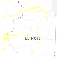
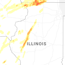
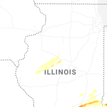
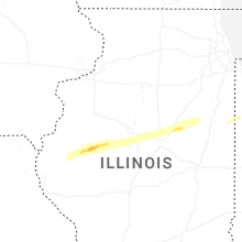


Connect with Interactive Hail Maps