

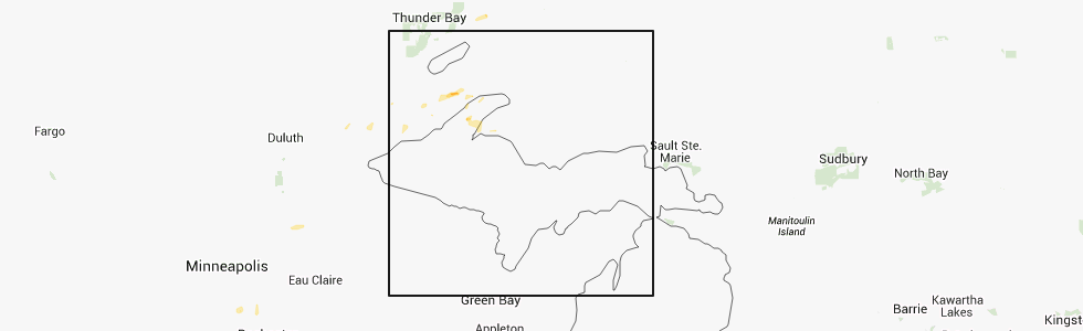
Hail Map for Eagle River, MI
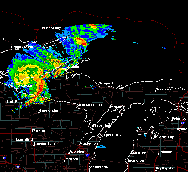
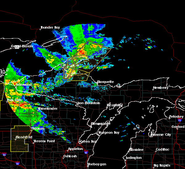
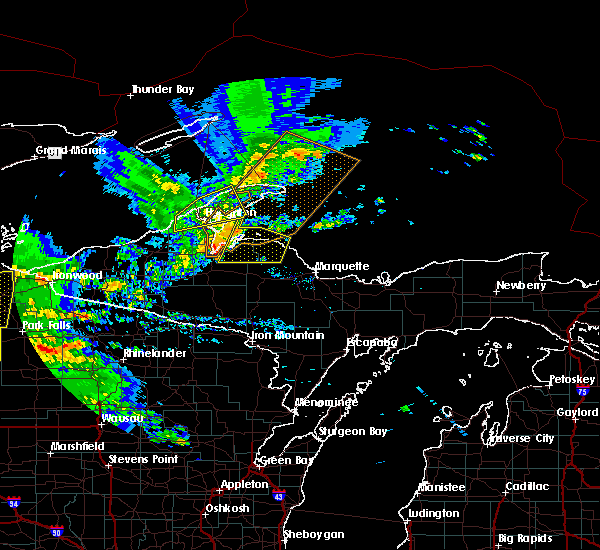
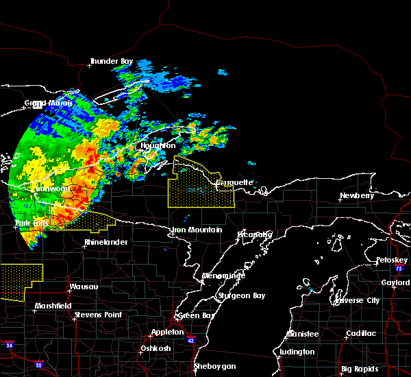
The Eagle River, MI area has had 0 reports of on-the-ground hail by trained spotters, and has been under severe weather warnings 0 times during the past 12 months. Doppler radar has detected hail at or near Eagle River, MI on 5 occasions.
| Name: | Eagle River, MI |
| Where Located: | 71.7 miles NW of Marquette, MI |
| Map: | Google Map for Eagle River, MI |
| Population: | 71 |
| Housing Units: | 149 |
| More Info: | Search Google for Eagle River, MI |
5
The Top Recent Hail Date for Eagle River, MI is Sunday, September 2, 2012 (1st out of 5)
Hail and Wind Damage Spotted near Eagle River, MI
| Date / Time | Report Details |
|---|---|
| 8/9/2020 9:05 PM EDT |
 At 905 pm edt, severe thunderstorms were located along a line extending from 7 miles southwest of lac la belle to near gay, moving northeast at 30 mph (radar indicated). Hazards include 60 mph wind gusts and quarter size hail. Hail damage to vehicles is expected. Expect wind damage to roofs, siding, and trees. At 905 pm edt, severe thunderstorms were located along a line extending from 7 miles southwest of lac la belle to near gay, moving northeast at 30 mph (radar indicated). Hazards include 60 mph wind gusts and quarter size hail. Hail damage to vehicles is expected. Expect wind damage to roofs, siding, and trees.
|
| 7/19/2020 12:40 AM EDT |
 At 1239 am edt, a severe thunderstorm was located over dollar bay, or near houghton, moving east at 45 mph (radar indicated). Hazards include ping pong ball size hail and 60 mph wind gusts. People and animals outdoors will be injured. expect hail damage to roofs, siding, windows, and vehicles. expect wind damage to roofs, siding, and trees. Locations impacted include, houghton, calumet, eagle river, hancock, laurium, chassell, lake linden, hubbell, houghton county airport, the upper entrance of portage canal, the lower entrance of portage canal and phoenix. At 1239 am edt, a severe thunderstorm was located over dollar bay, or near houghton, moving east at 45 mph (radar indicated). Hazards include ping pong ball size hail and 60 mph wind gusts. People and animals outdoors will be injured. expect hail damage to roofs, siding, windows, and vehicles. expect wind damage to roofs, siding, and trees. Locations impacted include, houghton, calumet, eagle river, hancock, laurium, chassell, lake linden, hubbell, houghton county airport, the upper entrance of portage canal, the lower entrance of portage canal and phoenix.
|
| 7/19/2020 12:34 AM EDT |
 At 1233 am edt, a severe thunderstorm was located over south range, or near houghton, moving east at 35 mph (radar indicated). Hazards include 60 mph wind gusts and quarter size hail. Hail damage to vehicles is expected. expect wind damage to roofs, siding, and trees. Locations impacted include, houghton, calumet, eagle river, hancock, laurium, chassell, lake linden, south range, hubbell, redridge, houghton county airport and the upper entrance of portage canal. At 1233 am edt, a severe thunderstorm was located over south range, or near houghton, moving east at 35 mph (radar indicated). Hazards include 60 mph wind gusts and quarter size hail. Hail damage to vehicles is expected. expect wind damage to roofs, siding, and trees. Locations impacted include, houghton, calumet, eagle river, hancock, laurium, chassell, lake linden, south range, hubbell, redridge, houghton county airport and the upper entrance of portage canal.
|
| 7/19/2020 12:08 AM EDT |
 At 1208 am edt, a severe thunderstorm was located 10 miles southwest of redridge, or 16 miles southwest of houghton, moving east at 45 mph (radar indicated). Hazards include 60 mph wind gusts and quarter size hail. Hail damage to vehicles is expected. Expect wind damage to roofs, siding, and trees. At 1208 am edt, a severe thunderstorm was located 10 miles southwest of redridge, or 16 miles southwest of houghton, moving east at 45 mph (radar indicated). Hazards include 60 mph wind gusts and quarter size hail. Hail damage to vehicles is expected. Expect wind damage to roofs, siding, and trees.
|
| 9/24/2019 9:11 PM EDT |
 At 911 pm edt, a severe thunderstorm was located over the upper entrance of portage canal, or near houghton, moving northeast at 20 mph (radar indicated). Hazards include 60 mph wind gusts and quarter size hail. Hail damage to vehicles is expected. expect wind damage to roofs, siding, and trees. locations impacted include, houghton, calumet, eagle harbor, eagle river, hancock, laurium, lake linden, hubbell, houghton county airport, the upper entrance of portage canal, phoenix and dollar bay. A tornado watch remains in effect until 100 am edt for western upper michigan. At 911 pm edt, a severe thunderstorm was located over the upper entrance of portage canal, or near houghton, moving northeast at 20 mph (radar indicated). Hazards include 60 mph wind gusts and quarter size hail. Hail damage to vehicles is expected. expect wind damage to roofs, siding, and trees. locations impacted include, houghton, calumet, eagle harbor, eagle river, hancock, laurium, lake linden, hubbell, houghton county airport, the upper entrance of portage canal, phoenix and dollar bay. A tornado watch remains in effect until 100 am edt for western upper michigan.
|
| 9/24/2019 8:48 PM EDT |
 At 848 pm edt, a severe thunderstorm was located over redridge, or 7 miles northwest of houghton, moving east at 35 mph (radar indicated). Hazards include 60 mph wind gusts and quarter size hail. Hail damage to vehicles is expected. Expect wind damage to roofs, siding, and trees. At 848 pm edt, a severe thunderstorm was located over redridge, or 7 miles northwest of houghton, moving east at 35 mph (radar indicated). Hazards include 60 mph wind gusts and quarter size hail. Hail damage to vehicles is expected. Expect wind damage to roofs, siding, and trees.
|
| 8/27/2018 8:54 PM EDT |
 At 853 pm edt, a severe thunderstorm was located near gay, or 9 miles southeast of eagle river, moving northeast at 30 mph (radar indicated). Hazards include 60 mph wind gusts. expect damage to roofs, siding, and trees At 853 pm edt, a severe thunderstorm was located near gay, or 9 miles southeast of eagle river, moving northeast at 30 mph (radar indicated). Hazards include 60 mph wind gusts. expect damage to roofs, siding, and trees
|
| 8/27/2018 8:47 PM EDT |
 At 847 pm edt, severe thunderstorms were located along a line extending from near phoenix to 6 miles southeast of hubbell, moving east at 35 mph (radar indicated). Hazards include 60 mph wind gusts. Expect damage to roofs, siding, and trees. Locations impacted include, eagle river, lake linden, phoenix, mohawk, gay and copper city. At 847 pm edt, severe thunderstorms were located along a line extending from near phoenix to 6 miles southeast of hubbell, moving east at 35 mph (radar indicated). Hazards include 60 mph wind gusts. Expect damage to roofs, siding, and trees. Locations impacted include, eagle river, lake linden, phoenix, mohawk, gay and copper city.
|
| 8/27/2018 8:22 PM EDT |
 At 753 pm edt, a severe thunderstorm was located near redridge, or 12 miles west of houghton, moving east at 35 mph (radar indicated). Hazards include 60 mph wind gusts and nickel size hail. expect damage to roofs, siding, and trees At 753 pm edt, a severe thunderstorm was located near redridge, or 12 miles west of houghton, moving east at 35 mph (radar indicated). Hazards include 60 mph wind gusts and nickel size hail. expect damage to roofs, siding, and trees
|
| 8/27/2018 7:53 PM EDT |
 At 753 pm edt, a severe thunderstorm was located near redridge, or 12 miles west of houghton, moving east at 35 mph (radar indicated). Hazards include 60 mph wind gusts and nickel size hail. expect damage to roofs, siding, and trees At 753 pm edt, a severe thunderstorm was located near redridge, or 12 miles west of houghton, moving east at 35 mph (radar indicated). Hazards include 60 mph wind gusts and nickel size hail. expect damage to roofs, siding, and trees
|
| 9/22/2017 11:31 AM EDT |
 At 1130 am edt, a severe thunderstorm was located near hubbell, or 7 miles east of houghton, moving east at 40 mph (radar indicated). Hazards include quarter size hail. damage to vehicles is expected At 1130 am edt, a severe thunderstorm was located near hubbell, or 7 miles east of houghton, moving east at 40 mph (radar indicated). Hazards include quarter size hail. damage to vehicles is expected
|
| 6/15/2017 2:55 PM EDT |
 The severe thunderstorm warning for keweenaw and northeastern houghton counties will expire at 300 pm edt, the storm which prompted the warning has weakened below severe limits, and no longer pose an immediate threat to life or property. therefore the warning will be allowed to expire. however gusty winds are still possible with this thunderstorm. The severe thunderstorm warning for keweenaw and northeastern houghton counties will expire at 300 pm edt, the storm which prompted the warning has weakened below severe limits, and no longer pose an immediate threat to life or property. therefore the warning will be allowed to expire. however gusty winds are still possible with this thunderstorm.
|
| 6/15/2017 2:37 PM EDT |
 At 237 pm edt, a severe thunderstorm was located near lake linden, or 7 miles east of calumet, moving northeast at 25 mph (radar indicated). Hazards include 60 mph wind gusts and penny size hail. Expect damage to roofs, siding, and trees. Locations impacted include, calumet, eagle harbor, eagle river, laurium, lake linden, bete grise, hubbell, lac la belle, phoenix, mohawk, gay, allouez, delaware, copper city, ahmeek, gratiot lake and betsy. At 237 pm edt, a severe thunderstorm was located near lake linden, or 7 miles east of calumet, moving northeast at 25 mph (radar indicated). Hazards include 60 mph wind gusts and penny size hail. Expect damage to roofs, siding, and trees. Locations impacted include, calumet, eagle harbor, eagle river, laurium, lake linden, bete grise, hubbell, lac la belle, phoenix, mohawk, gay, allouez, delaware, copper city, ahmeek, gratiot lake and betsy.
|
| 6/15/2017 2:21 PM EDT |
 At 221 pm edt, a severe thunderstorm was located over lake linden, or near calumet, moving northeast at 30 mph (radar indicated). Hazards include 60 mph wind gusts and quarter size hail. Hail damage to vehicles is expected. Expect wind damage to roofs, siding, and trees. At 221 pm edt, a severe thunderstorm was located over lake linden, or near calumet, moving northeast at 30 mph (radar indicated). Hazards include 60 mph wind gusts and quarter size hail. Hail damage to vehicles is expected. Expect wind damage to roofs, siding, and trees.
|
| 7/21/2016 7:26 AM EDT |
 At 725 am edt, a severe thunderstorm was located over lac la belle, or 8 miles southeast of eagle harbor, moving northeast at 55 mph (radar indicated). Hazards include 60 mph wind gusts and penny size hail. Expect damage to roofs. Siding and trees. At 725 am edt, a severe thunderstorm was located over lac la belle, or 8 miles southeast of eagle harbor, moving northeast at 55 mph (radar indicated). Hazards include 60 mph wind gusts and penny size hail. Expect damage to roofs. Siding and trees.
|
| 6/25/2016 12:36 PM EDT |
 At 1235 pm edt, a severe thunderstorm was located near calumet and mohawk, moving east at 30 mph (radar indicated). Hazards include 60 mph wind gusts and quarter size hail. Hail damage to vehicles is expected. expect wind damage to roofs, siding and trees. Locations impacted include, houghton, baraga, calumet, eagle river, hancock, laurium, chassell, lake linden, south range, phoenix, point abbaye, dollar bay, the lower entrance of portage canal, hubbell, gay, redridge, houghton county airport, torch lake, mclain state park and jacobsville. At 1235 pm edt, a severe thunderstorm was located near calumet and mohawk, moving east at 30 mph (radar indicated). Hazards include 60 mph wind gusts and quarter size hail. Hail damage to vehicles is expected. expect wind damage to roofs, siding and trees. Locations impacted include, houghton, baraga, calumet, eagle river, hancock, laurium, chassell, lake linden, south range, phoenix, point abbaye, dollar bay, the lower entrance of portage canal, hubbell, gay, redridge, houghton county airport, torch lake, mclain state park and jacobsville.
|
| 6/25/2016 11:54 AM EDT |
 At 1153 am edt, severe thunderstorms were located along a line extending from 13 miles northwest of eagle river to 11 miles north of fourteen mile point, moving southeast at 35 mph (radar indicated). Hazards include quarter size hail and 60 mph wind gusts. Hail damage to vehicles is expected. Expect wind damage to roofs, siding and trees. At 1153 am edt, severe thunderstorms were located along a line extending from 13 miles northwest of eagle river to 11 miles north of fourteen mile point, moving southeast at 35 mph (radar indicated). Hazards include quarter size hail and 60 mph wind gusts. Hail damage to vehicles is expected. Expect wind damage to roofs, siding and trees.
|
Hail Maps for Eagle River, MI


Connect with Interactive Hail Maps