

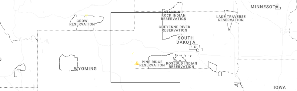
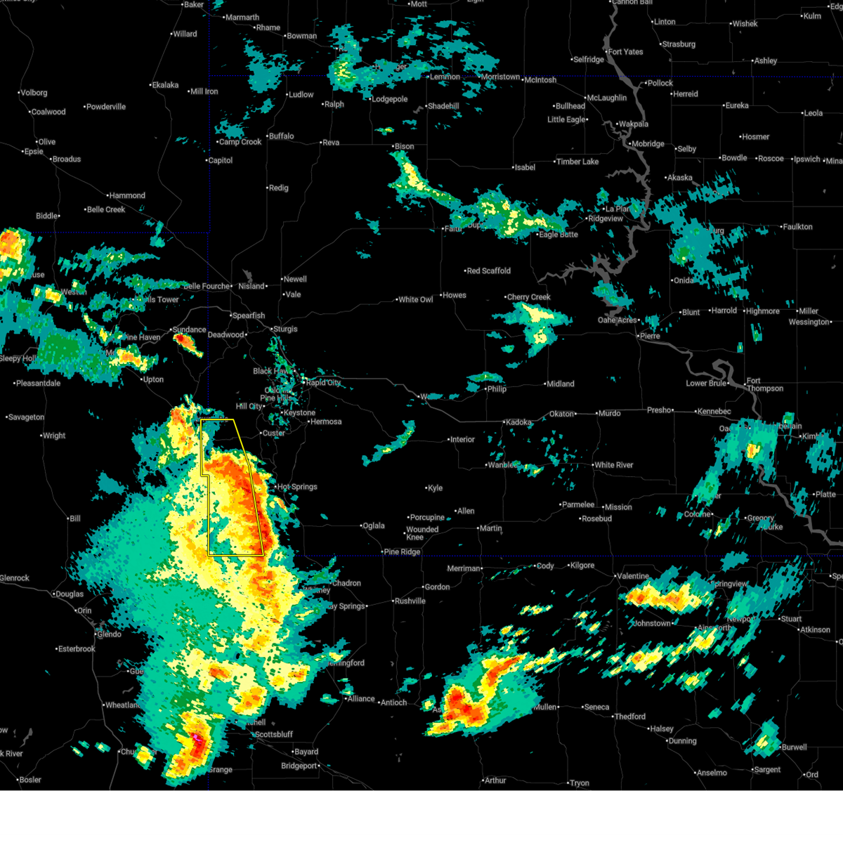
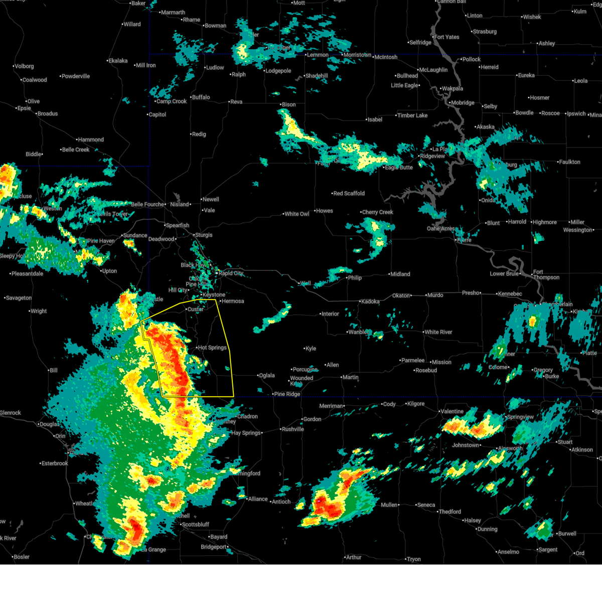
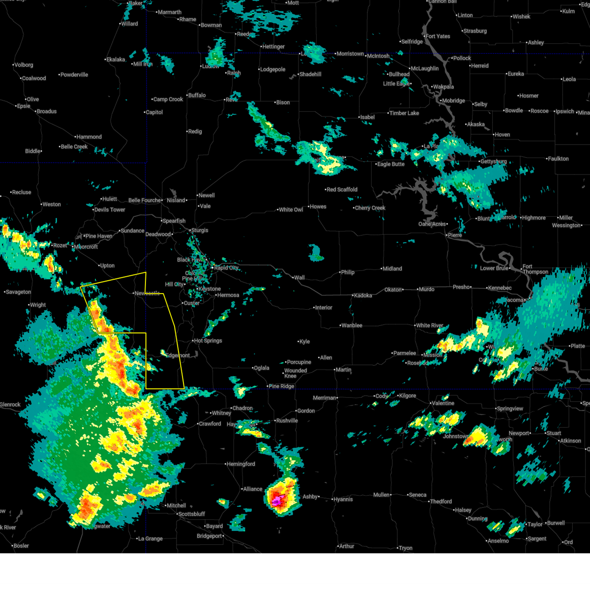
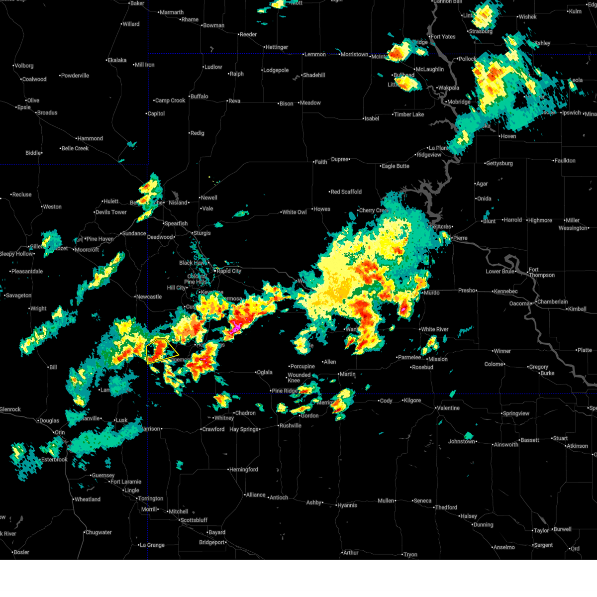
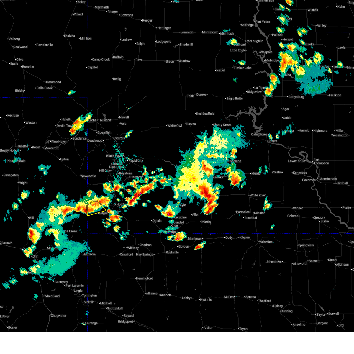
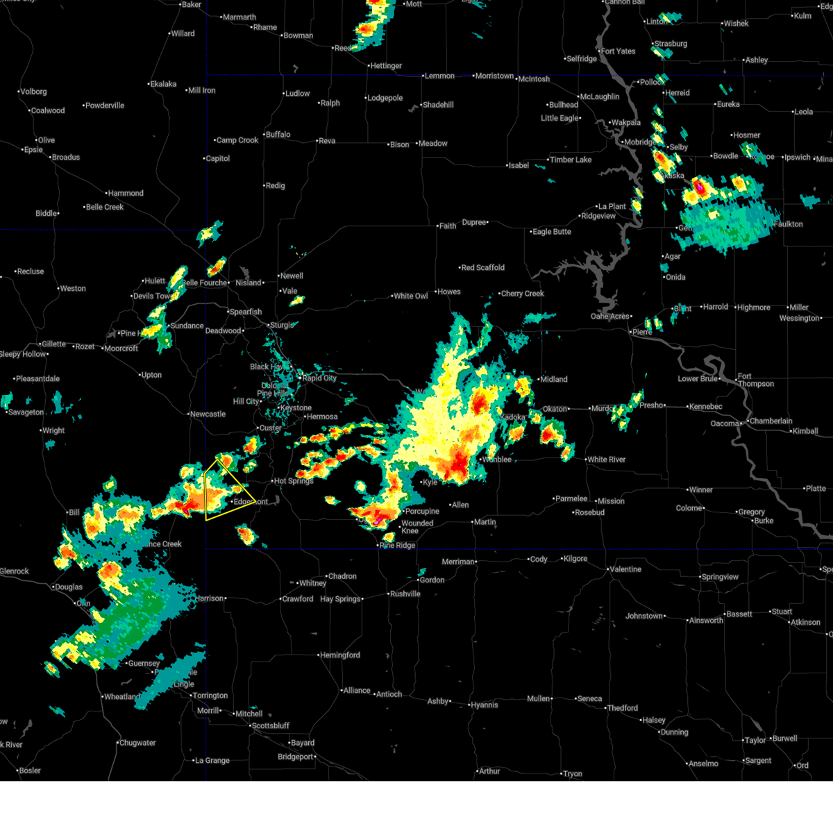
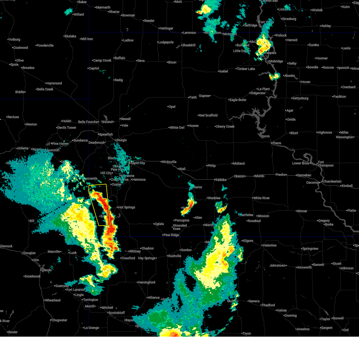
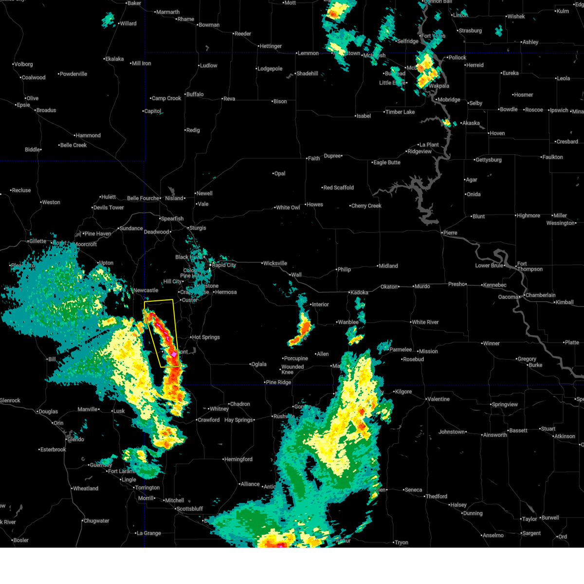
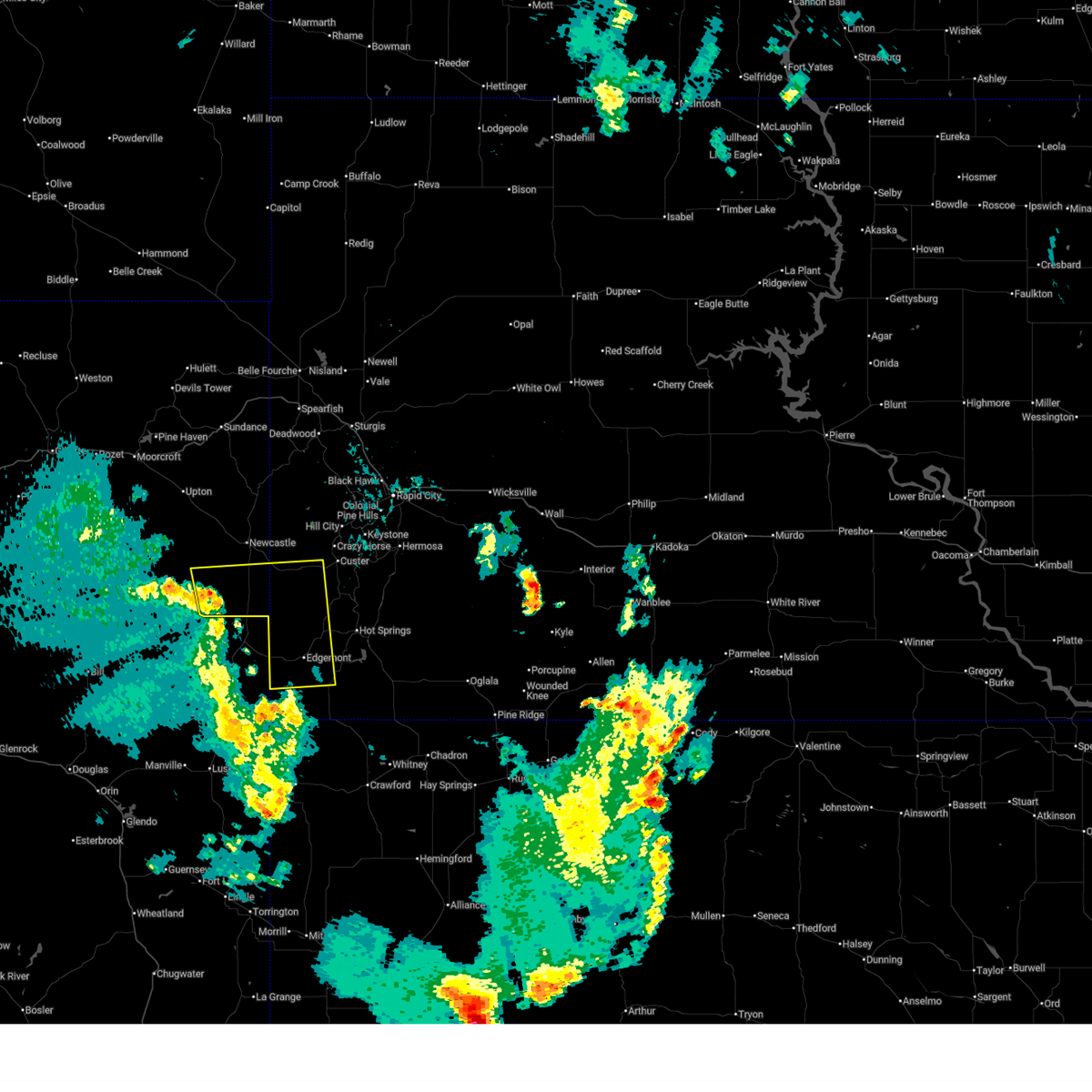
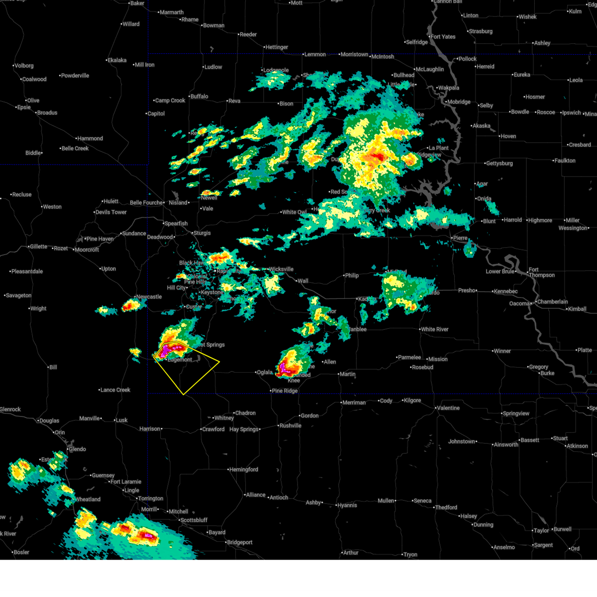
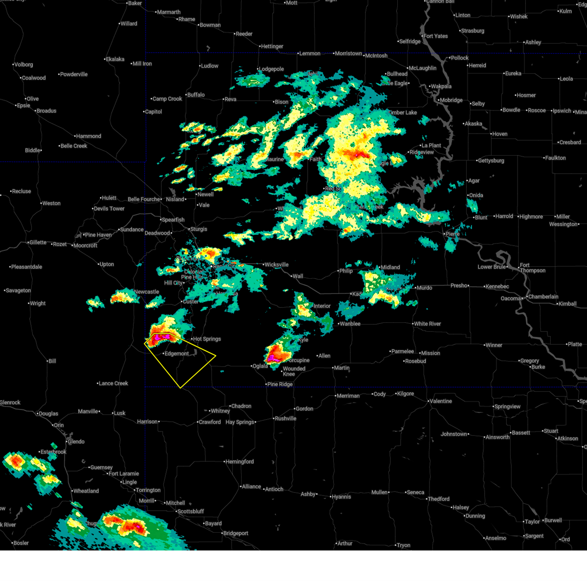
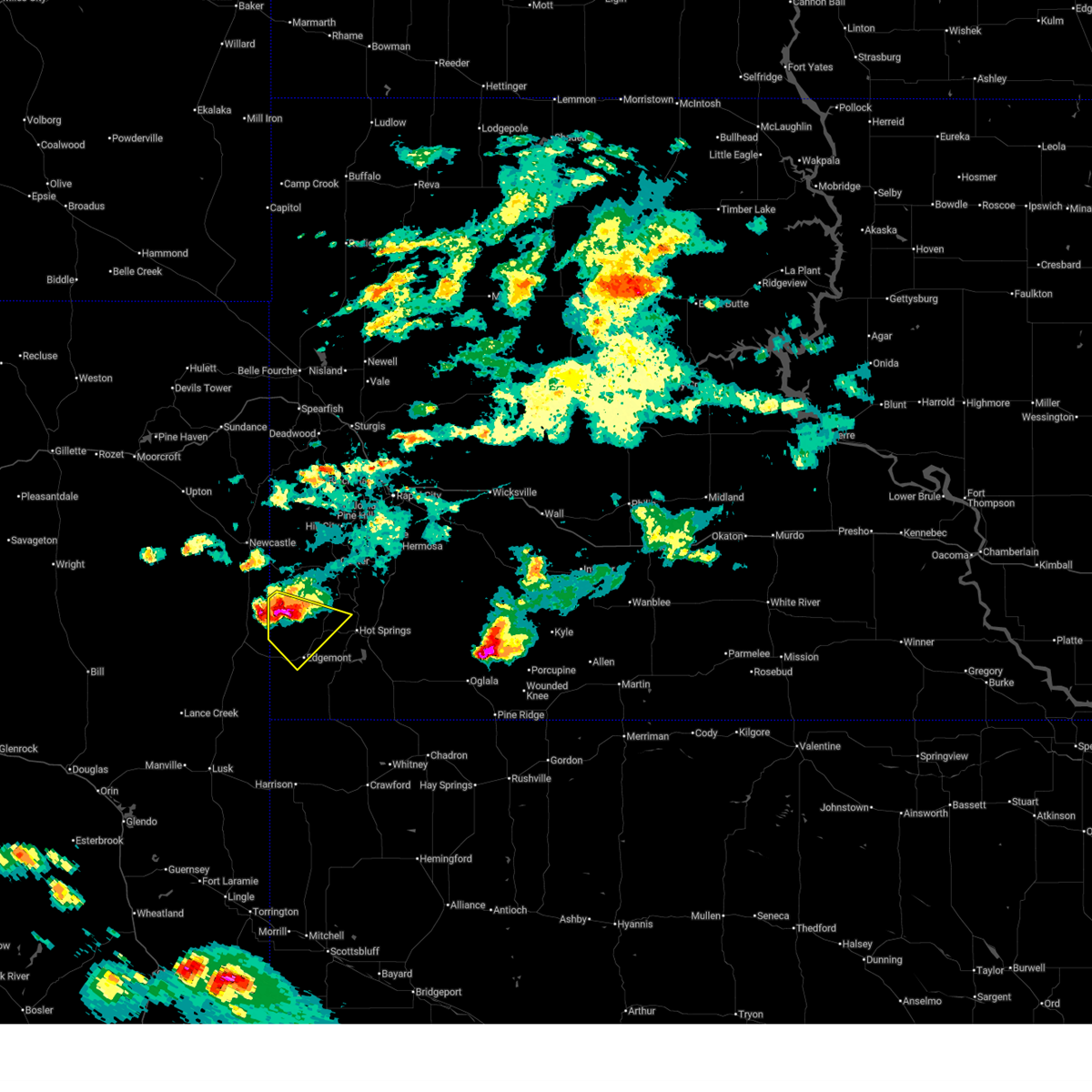
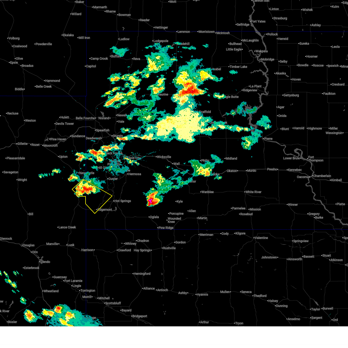
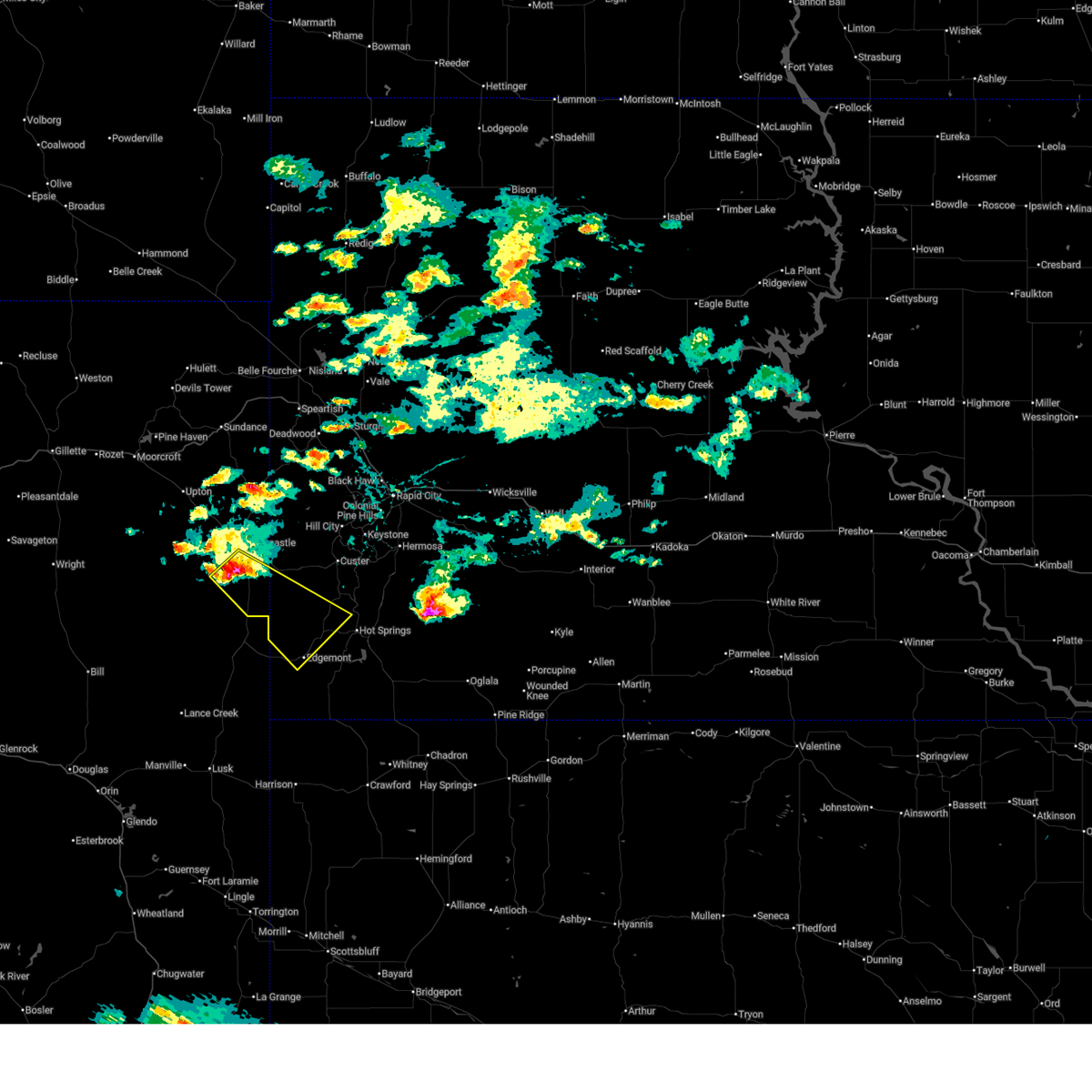
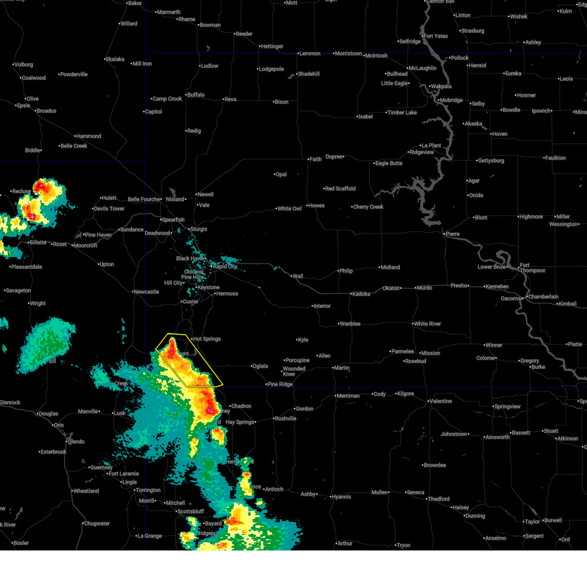
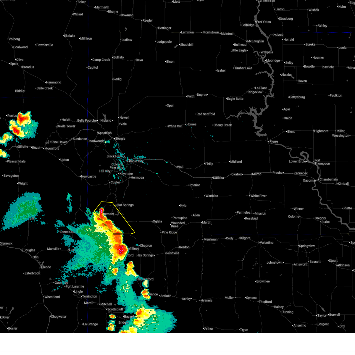
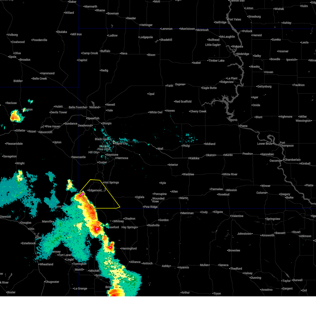
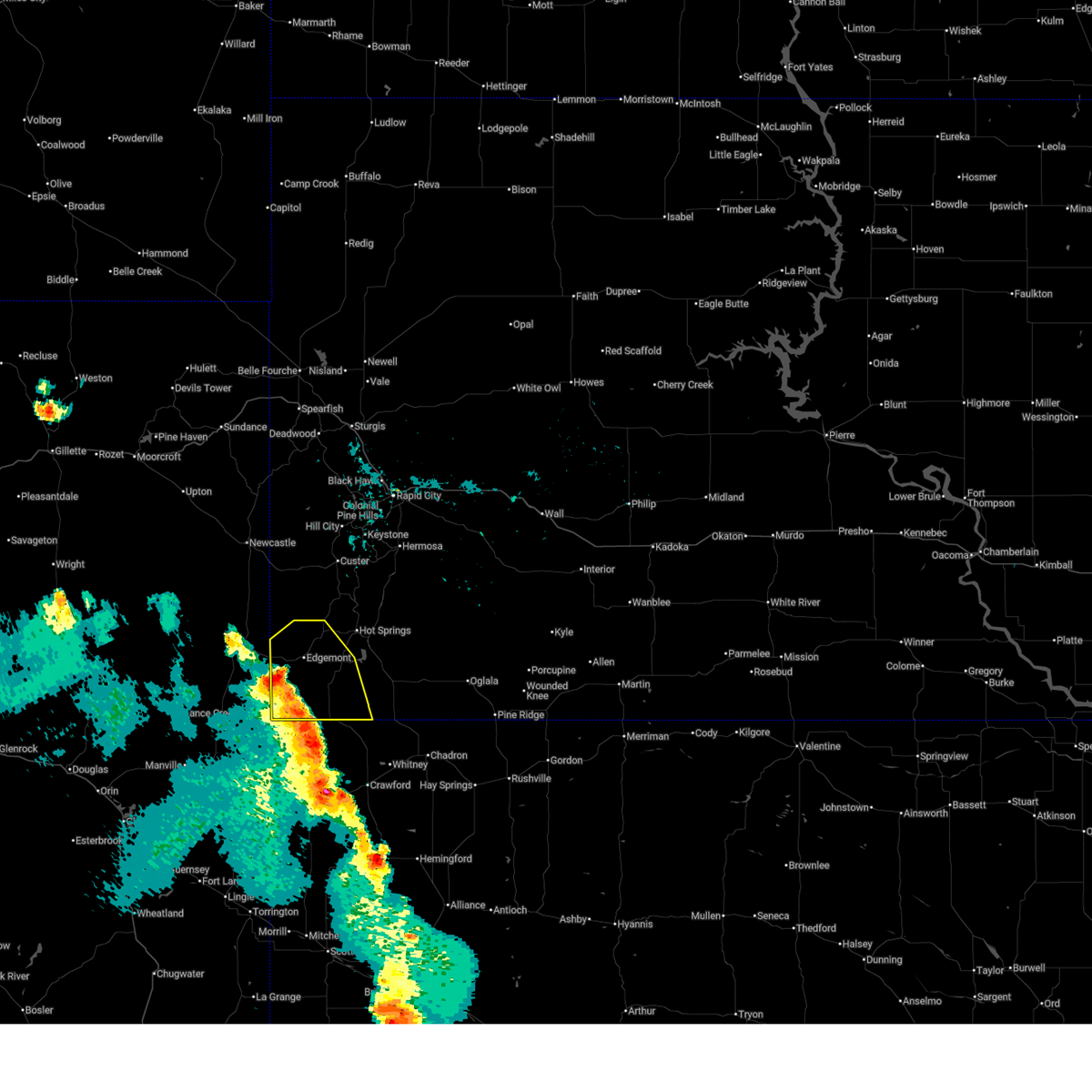
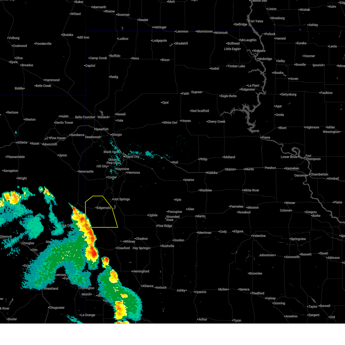
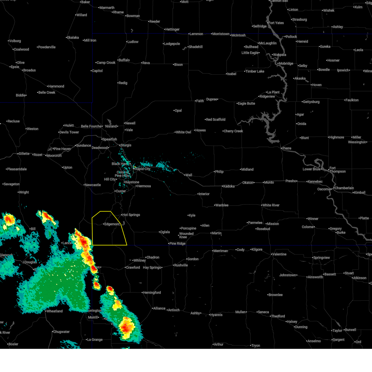
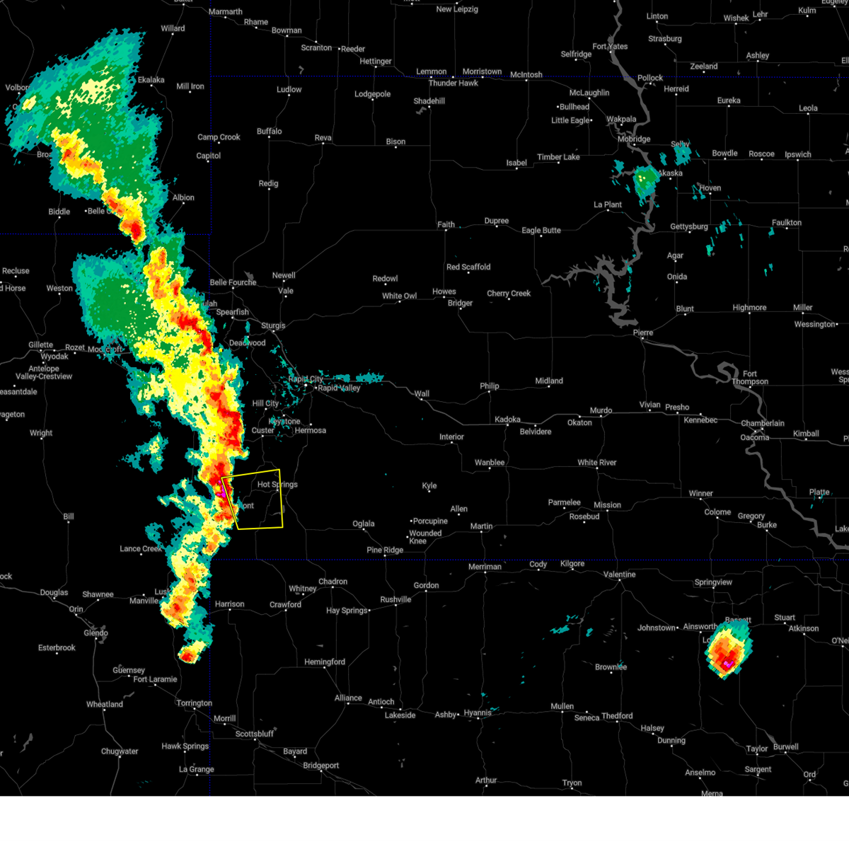
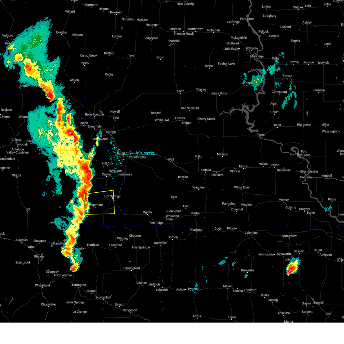
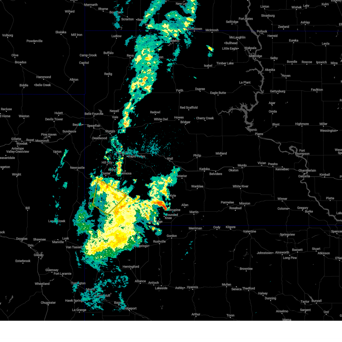
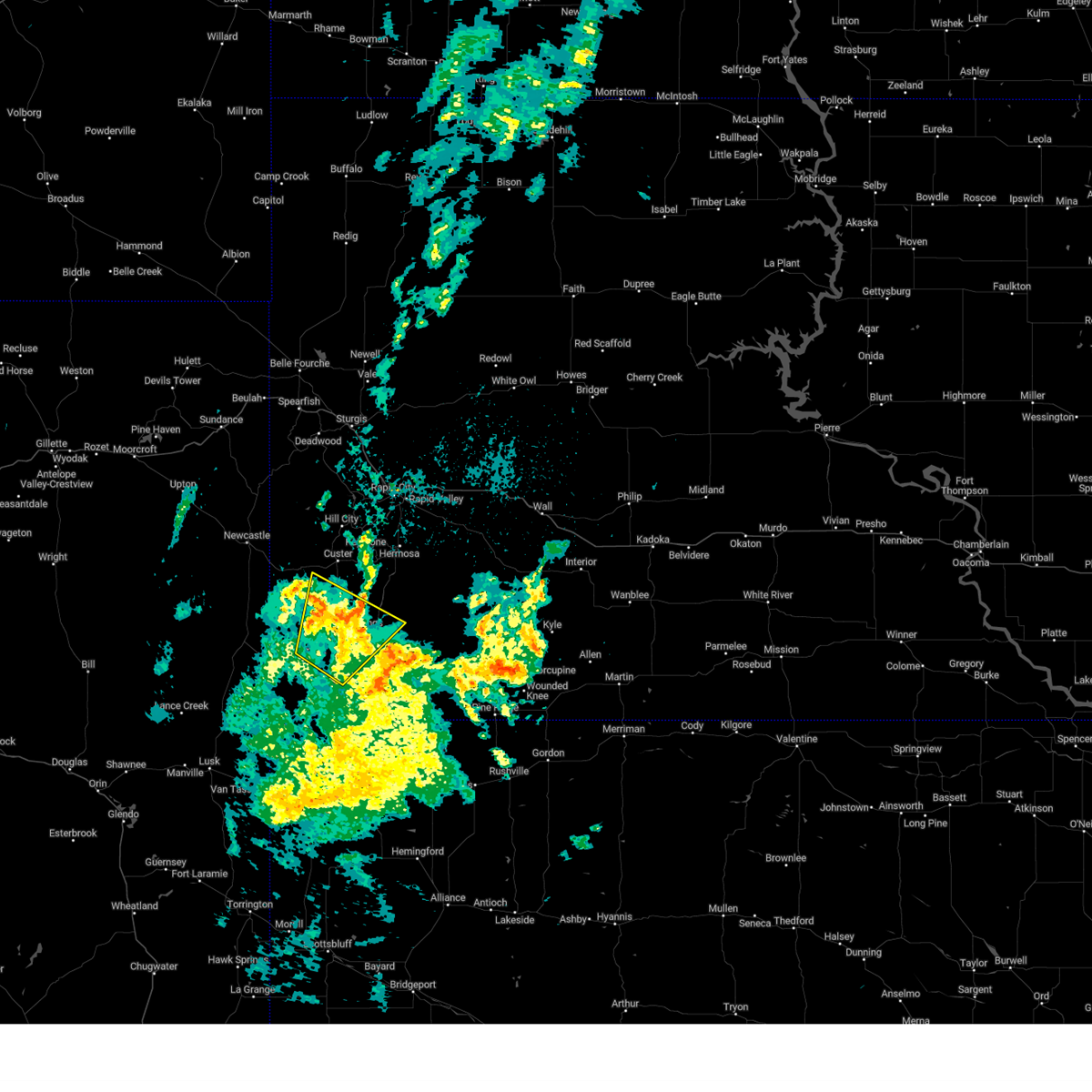
Hail Map for Edgemont, SD
The Edgemont, SD area has had 47 reports of on-the-ground hail by trained spotters, and has been under severe weather warnings 15 times during the past 12 months. Doppler radar has detected hail at or near Edgemont, SD on 78 occasions, including 6 occasions during the past year.
| Name: | Edgemont, SD |
| Where Located: | 61.7 miles SSW of Rapid City, SD |
| Map: | Google Map for Edgemont, SD |
| Population: | 774 |
| Housing Units: | 509 |
| More Info: | Search Google for Edgemont, SD |
2
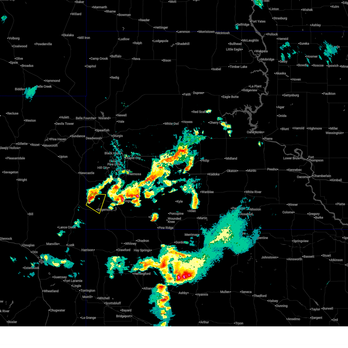
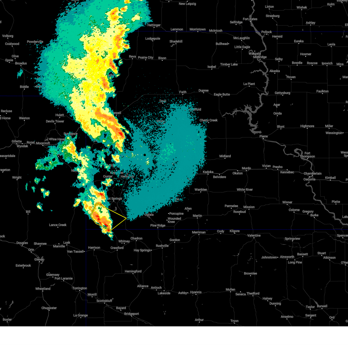
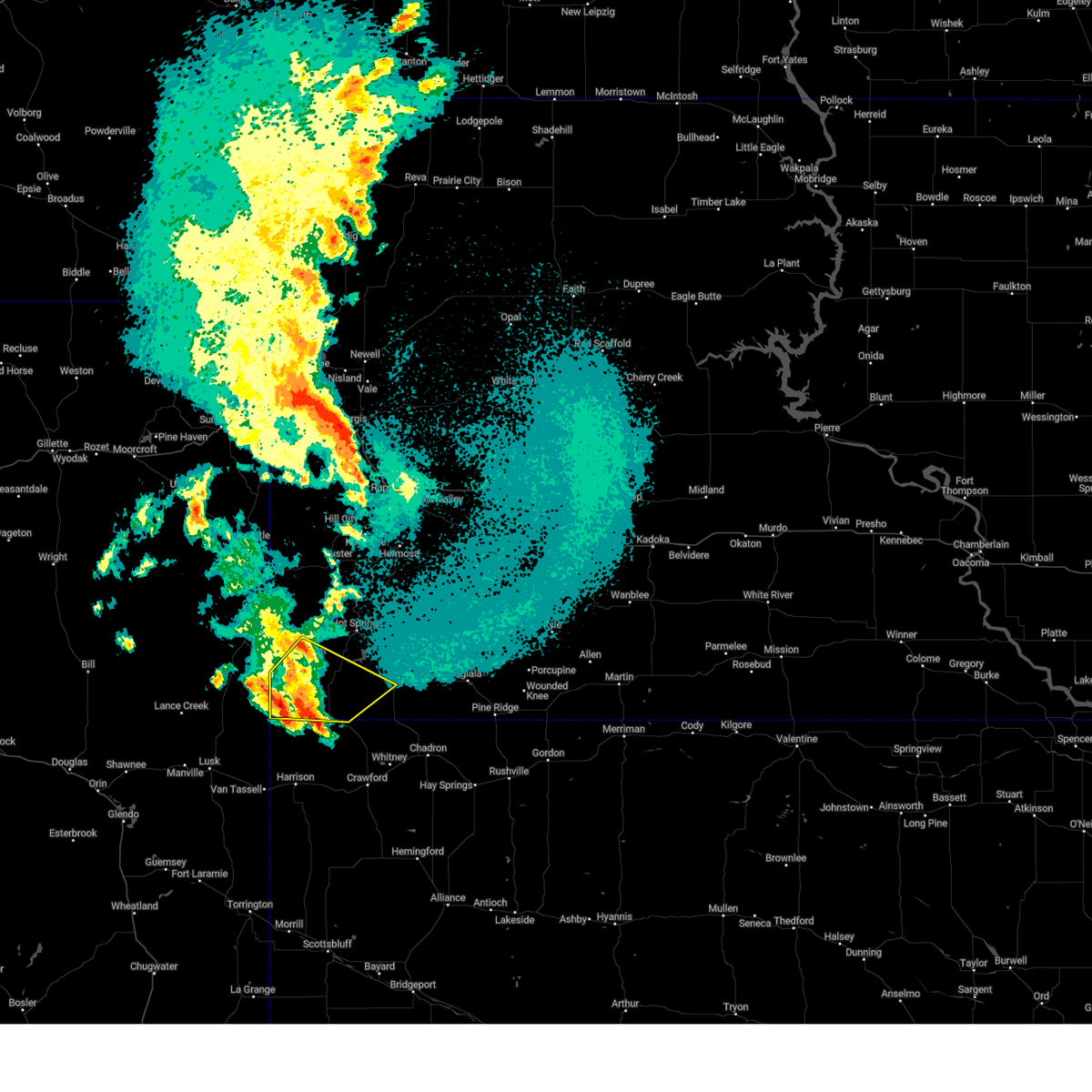
The Top Recent Hail Date for Edgemont, SD is Wednesday, September 10, 2025 (9th out of 78)
Hail and Wind Damage Spotted near Edgemont, SD
| Date / Time | Report Details |
|---|---|
| 7/3/2026 6:50 PM MDT |
 At 650 pm mdt, a severe thunderstorm was located near burdock, or 11 miles northwest of edgemont, moving east at 20 mph (radar indicated). Hazards include golf ball size hail. People and animals outdoors will be injured. expect damage to roofs, siding, windows, and vehicles. Locations impacted include, edgemont and burdock. At 650 pm mdt, a severe thunderstorm was located near burdock, or 11 miles northwest of edgemont, moving east at 20 mph (radar indicated). Hazards include golf ball size hail. People and animals outdoors will be injured. expect damage to roofs, siding, windows, and vehicles. Locations impacted include, edgemont and burdock.
|
| 7/3/2026 6:45 PM MDT | Golf Ball sized hail reported 13.7 miles SSE of Edgemont, SD |
| 7/3/2026 6:43 PM MDT | Ping Pong Ball sized hail reported 14.5 miles SSE of Edgemont, SD |
| 7/3/2026 6:36 PM MDT |
 Svrunr the national weather service in rapid city has issued a * severe thunderstorm warning for, southwestern custer county in southwestern south dakota, northwestern fall river county in southwestern south dakota, * until 730 pm mdt. * at 636 pm mdt, a severe thunderstorm was located over burdock, or 14 miles northwest of edgemont, moving east at 20 mph (radar indicated). Hazards include ping pong ball size hail. People and animals outdoors will be injured. Expect damage to roofs, siding, windows, and vehicles. Svrunr the national weather service in rapid city has issued a * severe thunderstorm warning for, southwestern custer county in southwestern south dakota, northwestern fall river county in southwestern south dakota, * until 730 pm mdt. * at 636 pm mdt, a severe thunderstorm was located over burdock, or 14 miles northwest of edgemont, moving east at 20 mph (radar indicated). Hazards include ping pong ball size hail. People and animals outdoors will be injured. Expect damage to roofs, siding, windows, and vehicles.
|
| 6/20/2026 7:31 PM MDT |
 The storms which prompted the warning have weakened below severe limits, and no longer pose an immediate threat to life or property. therefore, the warning has been allowed to expire. however, gusty winds as high as 50 mph are still possible with these thunderstorms east of hot springs and oelrichs. a severe thunderstorm watch remains in effect until 900 pm mdt saturday for portions of southwest south dakota and northeast wyoming. if you observed hail, wind damage, or flooding, please report your observations to the national weather service office in rapid city via phone, email, or social media, as soon as it is safe to do so. The storms which prompted the warning have weakened below severe limits, and no longer pose an immediate threat to life or property. therefore, the warning has been allowed to expire. however, gusty winds as high as 50 mph are still possible with these thunderstorms east of hot springs and oelrichs. a severe thunderstorm watch remains in effect until 900 pm mdt saturday for portions of southwest south dakota and northeast wyoming. if you observed hail, wind damage, or flooding, please report your observations to the national weather service office in rapid city via phone, email, or social media, as soon as it is safe to do so.
|
| 6/20/2026 6:53 PM MDT |
 At 653 pm mdt, severe thunderstorms were located along a line from near newcastle to 6 miles northwest of provo, or along a line from near newcastle to 7 miles southwest of edgemont, moving east at 25 mph (radar indicated). Hazards include 60 mph wind gusts and small hail. Expect damage to roofs, siding, and trees. Locations impacted include, edgemont, dewey, provo, rumford, ardmore, burdock, jewel cave national monument and elk mountain lookout. At 653 pm mdt, severe thunderstorms were located along a line from near newcastle to 6 miles northwest of provo, or along a line from near newcastle to 7 miles southwest of edgemont, moving east at 25 mph (radar indicated). Hazards include 60 mph wind gusts and small hail. Expect damage to roofs, siding, and trees. Locations impacted include, edgemont, dewey, provo, rumford, ardmore, burdock, jewel cave national monument and elk mountain lookout.
|
| 6/20/2026 6:48 PM MDT |
 Svrunr the national weather service in rapid city has issued a * severe thunderstorm warning for, custer county in southwestern south dakota, fall river county in southwestern south dakota, southeastern weston county in northeastern wyoming, * until 730 pm mdt. * at 648 pm mdt, severe thunderstorms were located along a line from 9 miles southwest of jewel cave national monument to 6 miles south of ardmore, or along a line from 19 miles southwest of custer to 26 miles south of edgemont, moving east at 30 mph (radar indicated). Hazards include 60 mph wind gusts and small hail. expect damage to roofs, siding, and trees Svrunr the national weather service in rapid city has issued a * severe thunderstorm warning for, custer county in southwestern south dakota, fall river county in southwestern south dakota, southeastern weston county in northeastern wyoming, * until 730 pm mdt. * at 648 pm mdt, severe thunderstorms were located along a line from 9 miles southwest of jewel cave national monument to 6 miles south of ardmore, or along a line from 19 miles southwest of custer to 26 miles south of edgemont, moving east at 30 mph (radar indicated). Hazards include 60 mph wind gusts and small hail. expect damage to roofs, siding, and trees
|
| 6/20/2026 6:12 PM MDT |
 Svrunr the national weather service in rapid city has issued a * severe thunderstorm warning for, western custer county in southwestern south dakota, western fall river county in southwestern south dakota, southeastern weston county in northeastern wyoming, * until 715 pm mdt. * at 612 pm mdt, severe thunderstorms were located along a line from 12 miles south of osage to 26 miles south of morrisey, or along a line from 14 miles west of newcastle to 25 miles west of edgemont, moving east at 25 mph (radar indicated). Hazards include 60 mph wind gusts and small hail. expect damage to roofs, siding, and trees Svrunr the national weather service in rapid city has issued a * severe thunderstorm warning for, western custer county in southwestern south dakota, western fall river county in southwestern south dakota, southeastern weston county in northeastern wyoming, * until 715 pm mdt. * at 612 pm mdt, severe thunderstorms were located along a line from 12 miles south of osage to 26 miles south of morrisey, or along a line from 14 miles west of newcastle to 25 miles west of edgemont, moving east at 25 mph (radar indicated). Hazards include 60 mph wind gusts and small hail. expect damage to roofs, siding, and trees
|
| 6/2/2026 5:05 PM MDT |
 The storm which prompted the warning has weakened below severe limits, and no longer poses an immediate threat to life or property. therefore, the warning will be allowed to expire. however, small hail and gusty winds are still possible with this thunderstorm. a severe thunderstorm watch remains in effect until 900 pm mdt for southwestern south dakota. The storm which prompted the warning has weakened below severe limits, and no longer poses an immediate threat to life or property. therefore, the warning will be allowed to expire. however, small hail and gusty winds are still possible with this thunderstorm. a severe thunderstorm watch remains in effect until 900 pm mdt for southwestern south dakota.
|
| 6/2/2026 4:44 PM MDT |
 At 442 pm mdt, a severe thunderstorm was located 8 miles southwest of burdock, or 12 miles west of edgemont, moving northeast at 20 mph (radar indicated). Hazards include ping pong ball size hail and 60 mph wind gusts. People and animals outdoors will be injured. expect hail damage to roofs, siding, windows, and vehicles. expect wind damage to roofs, siding, and trees. This severe thunderstorm will remain over mainly rural areas of northwestern fall river county. At 442 pm mdt, a severe thunderstorm was located 8 miles southwest of burdock, or 12 miles west of edgemont, moving northeast at 20 mph (radar indicated). Hazards include ping pong ball size hail and 60 mph wind gusts. People and animals outdoors will be injured. expect hail damage to roofs, siding, windows, and vehicles. expect wind damage to roofs, siding, and trees. This severe thunderstorm will remain over mainly rural areas of northwestern fall river county.
|
| 6/2/2026 4:44 PM MDT |
 the severe thunderstorm warning has been cancelled and is no longer in effect the severe thunderstorm warning has been cancelled and is no longer in effect
|
| 6/2/2026 4:15 PM MDT |
 Svrunr the national weather service in rapid city has issued a * severe thunderstorm warning for, southwestern custer county in southwestern south dakota, northwestern fall river county in southwestern south dakota, * until 515 pm mdt. * at 415 pm mdt, a severe thunderstorm was located 6 miles northeast of redbird, or 16 miles west of edgemont, moving northeast at 20 mph (radar indicated). Hazards include golf ball size hail and 60 mph wind gusts. People and animals outdoors will be injured. expect hail damage to roofs, siding, windows, and vehicles. Expect wind damage to roofs, siding, and trees. Svrunr the national weather service in rapid city has issued a * severe thunderstorm warning for, southwestern custer county in southwestern south dakota, northwestern fall river county in southwestern south dakota, * until 515 pm mdt. * at 415 pm mdt, a severe thunderstorm was located 6 miles northeast of redbird, or 16 miles west of edgemont, moving northeast at 20 mph (radar indicated). Hazards include golf ball size hail and 60 mph wind gusts. People and animals outdoors will be injured. expect hail damage to roofs, siding, windows, and vehicles. Expect wind damage to roofs, siding, and trees.
|
| 9/15/2025 6:10 PM MDT | Storm damage reported in custer county SD, 30.9 miles SSE of Edgemont, SD |
| 9/15/2025 6:08 PM MDT | Storm damage reported in custer county SD, 30.9 miles SSE of Edgemont, SD |
| 9/15/2025 6:00 PM MDT | Storm damage reported in custer county SD, 30.9 miles SSE of Edgemont, SD |
| 9/10/2025 5:58 PM MDT | the severe thunderstorm warning has been cancelled and is no longer in effect |
| 9/10/2025 5:48 PM MDT | At 548 pm mdt, a severe thunderstorm was located 5 miles northeast of provo, or 5 miles southeast of edgemont, moving east at 20 mph (radar indicated). Hazards include 60 mph wind gusts and quarter size hail. Hail damage to vehicles is expected. expect wind damage to roofs, siding, and trees. Locations impacted include, edgemont and provo. |
| 9/10/2025 5:37 PM MDT | At 537 pm mdt, a severe thunderstorm was located 3 miles south of edgemont, moving east at 15 mph (radar indicated). Hazards include ping pong ball size hail and 60 mph wind gusts. People and animals outdoors will be injured. expect hail damage to roofs, siding, windows, and vehicles. expect wind damage to roofs, siding, and trees. Locations impacted include, edgemont and provo. |
| 9/10/2025 5:27 PM MDT | At 527 pm mdt, a severe thunderstorm was located 4 miles southwest of edgemont, moving northeast at 20 mph (radar indicated). Hazards include ping pong ball size hail and 60 mph wind gusts. People and animals outdoors will be injured. expect hail damage to roofs, siding, windows, and vehicles. expect wind damage to roofs, siding, and trees. Locations impacted include, edgemont and provo. |
| 9/10/2025 5:22 PM MDT | Svrunr the national weather service in rapid city has issued a * severe thunderstorm warning for, northwestern fall river county in southwestern south dakota, * until 615 pm mdt. * at 522 pm mdt, a severe thunderstorm was located 5 miles northwest of provo, or 6 miles southwest of edgemont, moving northeast at 20 mph (radar indicated). Hazards include 60 mph wind gusts and quarter size hail. Hail damage to vehicles is expected. Expect wind damage to roofs, siding, and trees. |
| 8/13/2025 4:24 PM MDT | Storm damage reported in fall river county SD, 9.6 miles E of Edgemont, SD |
| 8/13/2025 4:14 PM MDT | Storm damage reported in fall river county SD, 9.6 miles E of Edgemont, SD |
| 7/23/2025 5:45 PM MDT | Storm damage reported in fall river county SD, 9.6 miles E of Edgemont, SD |
| 7/23/2025 5:35 PM MDT | Storm damage reported in fall river county SD, 9.6 miles E of Edgemont, SD |
| 7/23/2025 5:25 PM MDT | Storm damage reported in fall river county SD, 13.7 miles SSE of Edgemont, SD |
| 7/23/2025 12:15 AM MDT | Storm damage reported in custer county SD, 30.9 miles SSE of Edgemont, SD |
| 7/4/2025 9:20 PM MDT |
 The storms which prompted the warning have weakened below severe limits, and no longer pose an immediate threat to life or property. therefore, the warning will be allowed to expire. however, small hail and gusty winds are still possible with these thunderstorms. The storms which prompted the warning have weakened below severe limits, and no longer pose an immediate threat to life or property. therefore, the warning will be allowed to expire. however, small hail and gusty winds are still possible with these thunderstorms.
|
| 7/4/2025 9:11 PM MDT |
 At 911 pm mdt, severe thunderstorms were located along a line extending from elk mountain lookout to 2 miles southwest of argyle to 5 miles northeast of rumford, moving east at 30 mph (radar indicated). Hazards include 60 mph wind gusts and quarter size hail. Hail damage to vehicles is expected. expect wind damage to roofs, siding, and trees. Locations impacted include, edgemont, provo, jewel cave national monument, and elk mountain lookout. At 911 pm mdt, severe thunderstorms were located along a line extending from elk mountain lookout to 2 miles southwest of argyle to 5 miles northeast of rumford, moving east at 30 mph (radar indicated). Hazards include 60 mph wind gusts and quarter size hail. Hail damage to vehicles is expected. expect wind damage to roofs, siding, and trees. Locations impacted include, edgemont, provo, jewel cave national monument, and elk mountain lookout.
|
| 7/4/2025 9:11 PM MDT |
 the severe thunderstorm warning has been cancelled and is no longer in effect the severe thunderstorm warning has been cancelled and is no longer in effect
|
| 7/4/2025 8:45 PM MDT |
 Svrunr the national weather service in rapid city has issued a * severe thunderstorm warning for, southwestern custer county in southwestern south dakota, northwestern fall river county in southwestern south dakota, southeastern weston county in northeastern wyoming, * until 930 pm mdt. * at 845 pm mdt, severe thunderstorms were located along a line extending from 7 miles east of clareton to 7 miles north of mule creek junction to 9 miles southeast of redbird, moving east at 40 mph (radar indicated). Hazards include 60 mph wind gusts. expect damage to roofs, siding, and trees Svrunr the national weather service in rapid city has issued a * severe thunderstorm warning for, southwestern custer county in southwestern south dakota, northwestern fall river county in southwestern south dakota, southeastern weston county in northeastern wyoming, * until 930 pm mdt. * at 845 pm mdt, severe thunderstorms were located along a line extending from 7 miles east of clareton to 7 miles north of mule creek junction to 9 miles southeast of redbird, moving east at 40 mph (radar indicated). Hazards include 60 mph wind gusts. expect damage to roofs, siding, and trees
|
| 6/29/2025 5:25 PM MDT | Half Dollar sized hail reported 0 miles NNW of Edgemont, SD |
| 6/29/2025 5:25 PM MDT |
 At 524 pm mdt, a severe thunderstorm was located 5 miles northeast of edgemont, moving southeast at 30 mph (radar indicated). Hazards include ping pong ball size hail and 60 mph wind gusts. People and animals outdoors will be injured. expect hail damage to roofs, siding, windows, and vehicles. expect wind damage to roofs, siding, and trees. Locations impacted include, edgemont, provo, rumford, ardmore, cascade falls, and angostura reservoir. At 524 pm mdt, a severe thunderstorm was located 5 miles northeast of edgemont, moving southeast at 30 mph (radar indicated). Hazards include ping pong ball size hail and 60 mph wind gusts. People and animals outdoors will be injured. expect hail damage to roofs, siding, windows, and vehicles. expect wind damage to roofs, siding, and trees. Locations impacted include, edgemont, provo, rumford, ardmore, cascade falls, and angostura reservoir.
|
| 6/29/2025 5:22 PM MDT | Quarter sized hail reported 0 miles NNW of Edgemont, SD, nickel to quarter size hail. ongoing during call around 527 pm. |
| 6/29/2025 5:13 PM MDT |
 Svrunr the national weather service in rapid city has issued a * severe thunderstorm warning for, central fall river county in southwestern south dakota, * until 615 pm mdt. * at 512 pm mdt, a severe thunderstorm was located 6 miles north of edgemont, moving southeast at 30 mph (radar indicated). Hazards include 60 mph wind gusts and quarter size hail. Hail damage to vehicles is expected. Expect wind damage to roofs, siding, and trees. Svrunr the national weather service in rapid city has issued a * severe thunderstorm warning for, central fall river county in southwestern south dakota, * until 615 pm mdt. * at 512 pm mdt, a severe thunderstorm was located 6 miles north of edgemont, moving southeast at 30 mph (radar indicated). Hazards include 60 mph wind gusts and quarter size hail. Hail damage to vehicles is expected. Expect wind damage to roofs, siding, and trees.
|
| 6/29/2025 5:02 PM MDT |
 At 501 pm mdt, a severe thunderstorm was located 5 miles west of cottonwood springs dam, or 9 miles west of hot springs, moving southeast at 35 mph (radar indicated). Hazards include 60 mph wind gusts and quarter size hail. Hail damage to vehicles is expected. expect wind damage to roofs, siding, and trees. Locations impacted include, edgemont, dewey, argyle, and burdock. At 501 pm mdt, a severe thunderstorm was located 5 miles west of cottonwood springs dam, or 9 miles west of hot springs, moving southeast at 35 mph (radar indicated). Hazards include 60 mph wind gusts and quarter size hail. Hail damage to vehicles is expected. expect wind damage to roofs, siding, and trees. Locations impacted include, edgemont, dewey, argyle, and burdock.
|
| 6/29/2025 5:02 PM MDT |
 the severe thunderstorm warning has been cancelled and is no longer in effect the severe thunderstorm warning has been cancelled and is no longer in effect
|
| 6/29/2025 5:00 PM MDT | Storm damage reported in fall river county SD, 13.7 miles SSE of Edgemont, SD |
| 6/29/2025 4:38 PM MDT |
 At 438 pm mdt, a severe thunderstorm was located 6 miles northeast of burdock, or 15 miles north of edgemont, moving southeast at 35 mph (radar indicated). Hazards include 60 mph wind gusts and quarter size hail. Hail damage to vehicles is expected. expect wind damage to roofs, siding, and trees. Locations impacted include, edgemont, dewey, argyle, burdock, and elk mountain lookout. At 438 pm mdt, a severe thunderstorm was located 6 miles northeast of burdock, or 15 miles north of edgemont, moving southeast at 35 mph (radar indicated). Hazards include 60 mph wind gusts and quarter size hail. Hail damage to vehicles is expected. expect wind damage to roofs, siding, and trees. Locations impacted include, edgemont, dewey, argyle, burdock, and elk mountain lookout.
|
| 6/29/2025 4:09 PM MDT |
 Svrunr the national weather service in rapid city has issued a * severe thunderstorm warning for, southwestern custer county in southwestern south dakota, northwestern fall river county in southwestern south dakota, southeastern weston county in northeastern wyoming, * until 515 pm mdt. * at 409 pm mdt, a severe thunderstorm was located 9 miles southwest of elk mountain lookout, or 12 miles south of newcastle, moving southeast at 35 mph (radar indicated). Hazards include 60 mph wind gusts and quarter size hail. Hail damage to vehicles is expected. Expect wind damage to roofs, siding, and trees. Svrunr the national weather service in rapid city has issued a * severe thunderstorm warning for, southwestern custer county in southwestern south dakota, northwestern fall river county in southwestern south dakota, southeastern weston county in northeastern wyoming, * until 515 pm mdt. * at 409 pm mdt, a severe thunderstorm was located 9 miles southwest of elk mountain lookout, or 12 miles south of newcastle, moving southeast at 35 mph (radar indicated). Hazards include 60 mph wind gusts and quarter size hail. Hail damage to vehicles is expected. Expect wind damage to roofs, siding, and trees.
|
| 6/15/2025 8:40 PM MDT | Storm damage reported in fall river county SD, 13.7 miles SSE of Edgemont, SD |
| 6/13/2025 6:51 PM MDT |
 the severe thunderstorm warning has been cancelled and is no longer in effect the severe thunderstorm warning has been cancelled and is no longer in effect
|
| 6/13/2025 6:36 PM MDT |
 At 636 pm mdt, severe thunderstorms were located along a line extending from 4 miles northeast of edgemont to 13 miles southwest of oelrichs, moving northeast at 25 mph (radar indicated). Hazards include 60 mph wind gusts and nickel size hail. Expect damage to roofs, siding, and trees. Locations impacted include, edgemont, cottonwood springs dam, cascade falls, and angostura reservoir. At 636 pm mdt, severe thunderstorms were located along a line extending from 4 miles northeast of edgemont to 13 miles southwest of oelrichs, moving northeast at 25 mph (radar indicated). Hazards include 60 mph wind gusts and nickel size hail. Expect damage to roofs, siding, and trees. Locations impacted include, edgemont, cottonwood springs dam, cascade falls, and angostura reservoir.
|
| 6/13/2025 6:13 PM MDT |
 Svrunr the national weather service in rapid city has issued a * severe thunderstorm warning for, central fall river county in southwestern south dakota, * until 715 pm mdt. * at 613 pm mdt, severe thunderstorms were located along a line extending from 4 miles west of edgemont to 7 miles southeast of ardmore, moving northeast at 20 mph (radar indicated). Hazards include 60 mph wind gusts and quarter size hail. Hail damage to vehicles is expected. Expect wind damage to roofs, siding, and trees. Svrunr the national weather service in rapid city has issued a * severe thunderstorm warning for, central fall river county in southwestern south dakota, * until 715 pm mdt. * at 613 pm mdt, severe thunderstorms were located along a line extending from 4 miles west of edgemont to 7 miles southeast of ardmore, moving northeast at 20 mph (radar indicated). Hazards include 60 mph wind gusts and quarter size hail. Hail damage to vehicles is expected. Expect wind damage to roofs, siding, and trees.
|
| 6/13/2025 6:05 PM MDT | Quarter sized hail reported 5.8 miles NE of Edgemont, SD |
| 6/13/2025 6:03 PM MDT |
 At 603 pm mdt, severe thunderstorms were located along a line extending from 9 miles west of edgemont to 4 miles southwest of rumford to 11 miles south of montrose, moving east at 25 mph (radar indicated). Hazards include 60 mph wind gusts and quarter size hail. Hail damage to vehicles is expected. expect wind damage to roofs, siding, and trees. Locations impacted include, edgemont, provo, ardmore, rumford, and cascade falls. At 603 pm mdt, severe thunderstorms were located along a line extending from 9 miles west of edgemont to 4 miles southwest of rumford to 11 miles south of montrose, moving east at 25 mph (radar indicated). Hazards include 60 mph wind gusts and quarter size hail. Hail damage to vehicles is expected. expect wind damage to roofs, siding, and trees. Locations impacted include, edgemont, provo, ardmore, rumford, and cascade falls.
|
| 6/13/2025 5:38 PM MDT |
 At 537 pm mdt, severe thunderstorms were located along a line extending from 4 miles northeast of redbird to 9 miles southwest of provo to 6 miles north of harrison, moving east at 25 mph (radar indicated). Hazards include 60 mph wind gusts. Expect damage to roofs, siding, and trees. Locations impacted include, edgemont, provo, ardmore, rumford, and cascade falls. At 537 pm mdt, severe thunderstorms were located along a line extending from 4 miles northeast of redbird to 9 miles southwest of provo to 6 miles north of harrison, moving east at 25 mph (radar indicated). Hazards include 60 mph wind gusts. Expect damage to roofs, siding, and trees. Locations impacted include, edgemont, provo, ardmore, rumford, and cascade falls.
|
| 6/13/2025 5:12 PM MDT |
 Svrunr the national weather service in rapid city has issued a * severe thunderstorm warning for, western fall river county in southwestern south dakota, * until 615 pm mdt. * at 512 pm mdt, severe thunderstorms were located along a line extending from 5 miles southwest of redbird to 18 miles west of montrose to 5 miles west of harrison, moving northeast at 40 mph (radar indicated). Hazards include 70 mph wind gusts and quarter size hail. Hail damage to vehicles is expected. expect considerable tree damage. Wind damage is also likely to mobile homes, roofs, and outbuildings. Svrunr the national weather service in rapid city has issued a * severe thunderstorm warning for, western fall river county in southwestern south dakota, * until 615 pm mdt. * at 512 pm mdt, severe thunderstorms were located along a line extending from 5 miles southwest of redbird to 18 miles west of montrose to 5 miles west of harrison, moving northeast at 40 mph (radar indicated). Hazards include 70 mph wind gusts and quarter size hail. Hail damage to vehicles is expected. expect considerable tree damage. Wind damage is also likely to mobile homes, roofs, and outbuildings.
|
| 5/14/2025 1:03 AM MDT |
 At 102 am mdt, a severe thunderstorm was located 5 miles northeast of rumford, or 12 miles southeast of edgemont, moving northeast at 25 mph (radar indicated). Hazards include 60 mph wind gusts and quarter size hail. Hail damage to vehicles is expected. expect wind damage to roofs, siding, and trees. This severe thunderstorm will remain over mainly rural areas of southwestern fall river county, from a line from provo to ardmore and to the northeast. At 102 am mdt, a severe thunderstorm was located 5 miles northeast of rumford, or 12 miles southeast of edgemont, moving northeast at 25 mph (radar indicated). Hazards include 60 mph wind gusts and quarter size hail. Hail damage to vehicles is expected. expect wind damage to roofs, siding, and trees. This severe thunderstorm will remain over mainly rural areas of southwestern fall river county, from a line from provo to ardmore and to the northeast.
|
| 5/14/2025 12:44 AM MDT |
 Svrunr the national weather service in rapid city has issued a * severe thunderstorm warning for, southwestern fall river county in southwestern south dakota, * until 130 am mdt. * at 1244 am mdt, a severe thunderstorm was located 3 miles southwest of rumford, or 15 miles south of edgemont, moving northeast at 25 mph (radar indicated). Hazards include 60 mph wind gusts and half dollar size hail. Hail damage to vehicles is expected. expect wind damage to roofs, siding, and trees. This severe thunderstorm will be near, provo and rumford around 1250 am mdt. Svrunr the national weather service in rapid city has issued a * severe thunderstorm warning for, southwestern fall river county in southwestern south dakota, * until 130 am mdt. * at 1244 am mdt, a severe thunderstorm was located 3 miles southwest of rumford, or 15 miles south of edgemont, moving northeast at 25 mph (radar indicated). Hazards include 60 mph wind gusts and half dollar size hail. Hail damage to vehicles is expected. expect wind damage to roofs, siding, and trees. This severe thunderstorm will be near, provo and rumford around 1250 am mdt.
|
| 9/15/2024 8:50 PM MDT |
 Svrunr the national weather service in rapid city has issued a * severe thunderstorm warning for, south central custer county in southwestern south dakota, southwestern oglala lakota county in southwestern south dakota, fall river county in southwestern south dakota, * until 945 pm mdt. * at 850 pm mdt, severe thunderstorms were located along a line extending from near edgemont to 10 miles east of ardmore to 3 miles north of whitney lake, moving northeast at 40 mph (radar indicated). Hazards include 60 mph wind gusts. Expect damage to roofs, siding, and trees. severe thunderstorms will be near, oelrichs, cascade falls, angostura reservoir, and cottonwood springs dam around 855 pm mdt. hot springs, smithwick, argyle, hay canyon butte, cold brook reservoir, and maverick junction around 900 pm mdt. oral and wind cave national park around 905 pm mdt. buffalo gap, prairie winds casino, and slim butte around 910 pm mdt. Other locations in the path of these severe thunderstorms include southeastern custer state park, buffalo corrals, slim buttes housing and south lakeside. Svrunr the national weather service in rapid city has issued a * severe thunderstorm warning for, south central custer county in southwestern south dakota, southwestern oglala lakota county in southwestern south dakota, fall river county in southwestern south dakota, * until 945 pm mdt. * at 850 pm mdt, severe thunderstorms were located along a line extending from near edgemont to 10 miles east of ardmore to 3 miles north of whitney lake, moving northeast at 40 mph (radar indicated). Hazards include 60 mph wind gusts. Expect damage to roofs, siding, and trees. severe thunderstorms will be near, oelrichs, cascade falls, angostura reservoir, and cottonwood springs dam around 855 pm mdt. hot springs, smithwick, argyle, hay canyon butte, cold brook reservoir, and maverick junction around 900 pm mdt. oral and wind cave national park around 905 pm mdt. buffalo gap, prairie winds casino, and slim butte around 910 pm mdt. Other locations in the path of these severe thunderstorms include southeastern custer state park, buffalo corrals, slim buttes housing and south lakeside.
|
| 9/15/2024 8:38 PM MDT | Storm damage reported in fall river county SD, 9.6 miles E of Edgemont, SD |
| 8/26/2024 3:10 PM MDT |
 Svrunr the national weather service in rapid city has issued a * severe thunderstorm warning for, southwestern meade county in west central south dakota, custer county in southwestern south dakota, southeastern lawrence county in west central south dakota, northern fall river county in southwestern south dakota, southwestern pennington county in west central south dakota, * until 415 pm mdt. * at 310 pm mdt, severe thunderstorms were located along a line extending from 2 miles north of flag mountain to 2 miles west of custer to 7 miles southwest of cascade falls, moving northeast at 40 mph (radar indicated). Hazards include 70 mph wind gusts and quarter size hail. Hail damage to vehicles is expected. expect considerable tree damage. wind damage is also likely to mobile homes, roofs, and outbuildings. severe thunderstorms will be near, hot springs, custer, hill city, nemo, keystone, pringle, silver city, rochford, argyle, and mystic around 315 pm mdt. johnson siding, buffalo gap, hisega, hayward, rockerville, and dalton lake around 320 pm mdt. rapid city, black hawk, summerset, hermosa, piedmont, oral, fairburn, bear country, and reptile gardens around 325 pm mdt. smithwick, hart ranch, and black gap around 330 pm mdt. other locations in the path of these severe thunderstorms include rapid valley, ellsworth air force base, southwestern box elder and rapid city airport. This includes interstate 90 in south dakota between mile markers 42 and 65. Svrunr the national weather service in rapid city has issued a * severe thunderstorm warning for, southwestern meade county in west central south dakota, custer county in southwestern south dakota, southeastern lawrence county in west central south dakota, northern fall river county in southwestern south dakota, southwestern pennington county in west central south dakota, * until 415 pm mdt. * at 310 pm mdt, severe thunderstorms were located along a line extending from 2 miles north of flag mountain to 2 miles west of custer to 7 miles southwest of cascade falls, moving northeast at 40 mph (radar indicated). Hazards include 70 mph wind gusts and quarter size hail. Hail damage to vehicles is expected. expect considerable tree damage. wind damage is also likely to mobile homes, roofs, and outbuildings. severe thunderstorms will be near, hot springs, custer, hill city, nemo, keystone, pringle, silver city, rochford, argyle, and mystic around 315 pm mdt. johnson siding, buffalo gap, hisega, hayward, rockerville, and dalton lake around 320 pm mdt. rapid city, black hawk, summerset, hermosa, piedmont, oral, fairburn, bear country, and reptile gardens around 325 pm mdt. smithwick, hart ranch, and black gap around 330 pm mdt. other locations in the path of these severe thunderstorms include rapid valley, ellsworth air force base, southwestern box elder and rapid city airport. This includes interstate 90 in south dakota between mile markers 42 and 65.
|
| 8/26/2024 3:04 PM MDT |
 At 304 pm mdt, a severe thunderstorm was located 7 miles southwest of argyle, or 12 miles north of edgemont, moving east at 35 mph (radar indicated). Hazards include 70 mph wind gusts and quarter size hail. Hail damage to vehicles is expected. expect considerable tree damage. wind damage is also likely to mobile homes, roofs, and outbuildings. Locations impacted include, hot springs, argyle, cottonwood springs dam, southwestern wind cave national park, cascade falls, cold brook reservoir and northwestern angostura reservoir. At 304 pm mdt, a severe thunderstorm was located 7 miles southwest of argyle, or 12 miles north of edgemont, moving east at 35 mph (radar indicated). Hazards include 70 mph wind gusts and quarter size hail. Hail damage to vehicles is expected. expect considerable tree damage. wind damage is also likely to mobile homes, roofs, and outbuildings. Locations impacted include, hot springs, argyle, cottonwood springs dam, southwestern wind cave national park, cascade falls, cold brook reservoir and northwestern angostura reservoir.
|
| 8/26/2024 2:50 PM MDT | Storm damage reported in fall river county SD, 15.1 miles SE of Edgemont, SD |
| 8/26/2024 2:46 PM MDT |
 Svrunr the national weather service in rapid city has issued a * severe thunderstorm warning for, southwestern custer county in southwestern south dakota, northwestern fall river county in southwestern south dakota, * until 330 pm mdt. * at 245 pm mdt, a severe thunderstorm was located over burdock, or 13 miles northwest of edgemont, moving east at 35 mph (radar indicated). Hazards include 70 mph wind gusts and quarter size hail. Hail damage to vehicles is expected. expect considerable tree damage. wind damage is also likely to mobile homes, roofs, and outbuildings. this severe thunderstorm will be near, edgemont and argyle around 255 pm mdt. cottonwood springs dam and southwestern wind cave national park around 305 pm mdt. Other locations in the path of this severe thunderstorm include hot springs, cold brook reservoir, cascade falls and northwestern angostura reservoir. Svrunr the national weather service in rapid city has issued a * severe thunderstorm warning for, southwestern custer county in southwestern south dakota, northwestern fall river county in southwestern south dakota, * until 330 pm mdt. * at 245 pm mdt, a severe thunderstorm was located over burdock, or 13 miles northwest of edgemont, moving east at 35 mph (radar indicated). Hazards include 70 mph wind gusts and quarter size hail. Hail damage to vehicles is expected. expect considerable tree damage. wind damage is also likely to mobile homes, roofs, and outbuildings. this severe thunderstorm will be near, edgemont and argyle around 255 pm mdt. cottonwood springs dam and southwestern wind cave national park around 305 pm mdt. Other locations in the path of this severe thunderstorm include hot springs, cold brook reservoir, cascade falls and northwestern angostura reservoir.
|
| 8/26/2024 2:45 PM MDT | Storm damage reported in custer county SD, 30.9 miles SSE of Edgemont, SD |
| 8/26/2024 2:33 PM MDT | Storm damage reported in fall river county SD, 9.6 miles E of Edgemont, SD |
| 8/6/2024 8:30 PM MDT | Storm damage reported in custer county SD, 30.9 miles SSE of Edgemont, SD |
| 7/26/2024 7:24 PM MDT |
 the severe thunderstorm warning has been cancelled and is no longer in effect the severe thunderstorm warning has been cancelled and is no longer in effect
|
| 7/26/2024 7:09 PM MDT |
 At 708 pm mdt, a severe thunderstorm was located near cold brook reservoir, or 4 miles northwest of hot springs, moving northeast at 25 mph (radar indicated). Hazards include 60 mph wind gusts and penny size hail. Expect damage to roofs, siding, and trees. Locations impacted include, buffalo gap, pringle and southwestern wind cave national park. At 708 pm mdt, a severe thunderstorm was located near cold brook reservoir, or 4 miles northwest of hot springs, moving northeast at 25 mph (radar indicated). Hazards include 60 mph wind gusts and penny size hail. Expect damage to roofs, siding, and trees. Locations impacted include, buffalo gap, pringle and southwestern wind cave national park.
|
| 7/26/2024 6:39 PM MDT |
 Svrunr the national weather service in rapid city has issued a * severe thunderstorm warning for, southwestern custer county in southwestern south dakota, central fall river county in southwestern south dakota, * until 745 pm mdt. * at 638 pm mdt, a severe thunderstorm was located near cascade falls, or 10 miles southwest of hot springs, moving northeast at 15 mph (radar indicated). Hazards include 60 mph wind gusts and penny size hail. Expect damage to roofs, siding, and trees. this severe thunderstorm will be near, hot springs, cascade falls, cold brook reservoir, maverick junction, angostura reservoir, and cottonwood springs dam around 645 pm mdt. southwestern wind cave national park around 650 pm mdt. argyle around 655 pm mdt. buffalo gap around 710 pm mdt. Oral and pringle around 720 pm mdt. Svrunr the national weather service in rapid city has issued a * severe thunderstorm warning for, southwestern custer county in southwestern south dakota, central fall river county in southwestern south dakota, * until 745 pm mdt. * at 638 pm mdt, a severe thunderstorm was located near cascade falls, or 10 miles southwest of hot springs, moving northeast at 15 mph (radar indicated). Hazards include 60 mph wind gusts and penny size hail. Expect damage to roofs, siding, and trees. this severe thunderstorm will be near, hot springs, cascade falls, cold brook reservoir, maverick junction, angostura reservoir, and cottonwood springs dam around 645 pm mdt. southwestern wind cave national park around 650 pm mdt. argyle around 655 pm mdt. buffalo gap around 710 pm mdt. Oral and pringle around 720 pm mdt.
|
| 7/12/2024 9:46 PM MDT |
 the severe thunderstorm warning has been cancelled and is no longer in effect the severe thunderstorm warning has been cancelled and is no longer in effect
|
| 7/12/2024 9:25 PM MDT | Quarter sized hail reported 0.7 miles S of Edgemont, SD |
| 7/12/2024 9:25 PM MDT |
 At 924 pm mdt, a severe thunderstorm was located over edgemont, moving southeast at 15 mph (radar indicated). Hazards include 60 mph wind gusts and half dollar size hail. Hail damage to vehicles is expected. expect wind damage to roofs, siding, and trees. This severe thunderstorm will remain over mainly rural areas of northwestern fall river county. At 924 pm mdt, a severe thunderstorm was located over edgemont, moving southeast at 15 mph (radar indicated). Hazards include 60 mph wind gusts and half dollar size hail. Hail damage to vehicles is expected. expect wind damage to roofs, siding, and trees. This severe thunderstorm will remain over mainly rural areas of northwestern fall river county.
|
| 7/12/2024 9:13 PM MDT |
 At 913 pm mdt, a severe thunderstorm was located 3 miles north of edgemont, moving southeast at 25 mph (radar indicated). Hazards include 60 mph wind gusts and half dollar size hail. Hail damage to vehicles is expected. expect wind damage to roofs, siding, and trees. This severe storm will be near, edgemont around 920 pm mdt. At 913 pm mdt, a severe thunderstorm was located 3 miles north of edgemont, moving southeast at 25 mph (radar indicated). Hazards include 60 mph wind gusts and half dollar size hail. Hail damage to vehicles is expected. expect wind damage to roofs, siding, and trees. This severe storm will be near, edgemont around 920 pm mdt.
|
| 7/12/2024 9:00 PM MDT |
 Svrunr the national weather service in rapid city has issued a * severe thunderstorm warning for, northwestern fall river county in southwestern south dakota, * until 1000 pm mdt. * at 900 pm mdt, a severe thunderstorm was located 6 miles east of burdock, or 8 miles north of edgemont, moving southeast at 15 mph (radar indicated). Hazards include 60 mph wind gusts and half dollar size hail. Hail damage to vehicles is expected. expect wind damage to roofs, siding, and trees. this severe thunderstorm will be near, edgemont around 905 pm mdt. Cottonwood springs dam around 920 pm mdt. Svrunr the national weather service in rapid city has issued a * severe thunderstorm warning for, northwestern fall river county in southwestern south dakota, * until 1000 pm mdt. * at 900 pm mdt, a severe thunderstorm was located 6 miles east of burdock, or 8 miles north of edgemont, moving southeast at 15 mph (radar indicated). Hazards include 60 mph wind gusts and half dollar size hail. Hail damage to vehicles is expected. expect wind damage to roofs, siding, and trees. this severe thunderstorm will be near, edgemont around 905 pm mdt. Cottonwood springs dam around 920 pm mdt.
|
| 6/15/2024 5:25 PM MDT | Storm damage reported in fall river county SD, 18 miles N of Edgemont, SD |
| 6/10/2024 3:12 PM MDT | Golf Ball sized hail reported 20.4 miles NNE of Edgemont, SD, tstm wind gusts estimated 60 to 70 mph. |
| 6/10/2024 3:12 PM MDT | Tstm wind gusts estimated 60 to 70 mp in fall river county SD, 20.4 miles NNE of Edgemont, SD |
| 6/10/2024 2:45 PM MDT | Golf Ball sized hail reported 20.4 miles NNE of Edgemont, SD, tstm wind gusts estimated 60 to 70 mph. |
| 6/10/2024 2:45 PM MDT | Tstm wind gusts estimated 60 to 70 mp in fall river county SD, 20.4 miles NNE of Edgemont, SD |
| 5/17/2024 5:10 PM MDT | Storm damage reported in fall river county SD, 9.6 miles E of Edgemont, SD |
| 10/2/2023 6:35 PM MDT |
 At 634 pm mdt, severe thunderstorms were located along a line extending from 3 miles north of edgemont to 3 miles northwest of montrose, moving northeast at 35 mph (radar indicated). Hazards include 60 mph wind gusts and penny size hail. Expect damage to roofs, siding, and trees. severe thunderstorms will be near, edgemont, provo, argyle, ardmore, rumford, cascade falls, and cottonwood springs dam around 640 pm mdt. hot springs, pringle, angostura reservoir, cold brook reservoir, and wind cave national park around 650 pm mdt. southern custer state park around 700 pm mdt. blue bell and maverick junction around 705 pm mdt. hail threat, radar indicated max hail size, 0. 75 in wind threat, radar indicated max wind gust, 60 mph. At 634 pm mdt, severe thunderstorms were located along a line extending from 3 miles north of edgemont to 3 miles northwest of montrose, moving northeast at 35 mph (radar indicated). Hazards include 60 mph wind gusts and penny size hail. Expect damage to roofs, siding, and trees. severe thunderstorms will be near, edgemont, provo, argyle, ardmore, rumford, cascade falls, and cottonwood springs dam around 640 pm mdt. hot springs, pringle, angostura reservoir, cold brook reservoir, and wind cave national park around 650 pm mdt. southern custer state park around 700 pm mdt. blue bell and maverick junction around 705 pm mdt. hail threat, radar indicated max hail size, 0. 75 in wind threat, radar indicated max wind gust, 60 mph.
|
| 7/30/2023 10:10 PM MDT |
 The severe thunderstorm warning for southwestern custer and northwestern fall river counties will expire at 1015 pm mdt, the storm which prompted the warning has weakened below severe limits, and no longer poses an immediate threat to life or property. therefore, the warning will be allowed to expire. however small hail and gusty winds are still possible with this thunderstorm. a severe thunderstorm watch remains in effect until midnight mdt for southwestern south dakota. The severe thunderstorm warning for southwestern custer and northwestern fall river counties will expire at 1015 pm mdt, the storm which prompted the warning has weakened below severe limits, and no longer poses an immediate threat to life or property. therefore, the warning will be allowed to expire. however small hail and gusty winds are still possible with this thunderstorm. a severe thunderstorm watch remains in effect until midnight mdt for southwestern south dakota.
|
| 7/30/2023 10:04 PM MDT |
 At 1003 pm mdt, a severe thunderstorm was located over cascade falls, or 7 miles south of hot springs, moving southeast at 40 mph (radar indicated). Hazards include 60 mph wind gusts and half dollar size hail. Hail damage to vehicles is expected. expect wind damage to roofs, siding, and trees. locations impacted include, hot springs, edgemont, rumford, cottonwood springs dam, cascade falls and angostura reservoir. hail threat, radar indicated max hail size, 1. 25 in wind threat, radar indicated max wind gust, 60 mph. At 1003 pm mdt, a severe thunderstorm was located over cascade falls, or 7 miles south of hot springs, moving southeast at 40 mph (radar indicated). Hazards include 60 mph wind gusts and half dollar size hail. Hail damage to vehicles is expected. expect wind damage to roofs, siding, and trees. locations impacted include, hot springs, edgemont, rumford, cottonwood springs dam, cascade falls and angostura reservoir. hail threat, radar indicated max hail size, 1. 25 in wind threat, radar indicated max wind gust, 60 mph.
|
| 7/30/2023 9:42 PM MDT | Storm damage reported in fall river county SD, 9.6 miles E of Edgemont, SD |
| 7/30/2023 9:41 PM MDT |
 At 941 pm mdt, a severe thunderstorm was located 5 miles west of cottonwood springs dam, or 9 miles west of hot springs, moving southeast at 30 mph (radar indicated). Hazards include ping pong ball size hail and 60 mph wind gusts. People and animals outdoors will be injured. expect hail damage to roofs, siding, windows, and vehicles. expect wind damage to roofs, siding, and trees. locations impacted include, hot springs, edgemont, rumford, argyle, cottonwood springs dam, cascade falls, maverick junction, angostura reservoir and cold brook reservoir. hail threat, radar indicated max hail size, 1. 50 in wind threat, radar indicated max wind gust, 60 mph. At 941 pm mdt, a severe thunderstorm was located 5 miles west of cottonwood springs dam, or 9 miles west of hot springs, moving southeast at 30 mph (radar indicated). Hazards include ping pong ball size hail and 60 mph wind gusts. People and animals outdoors will be injured. expect hail damage to roofs, siding, windows, and vehicles. expect wind damage to roofs, siding, and trees. locations impacted include, hot springs, edgemont, rumford, argyle, cottonwood springs dam, cascade falls, maverick junction, angostura reservoir and cold brook reservoir. hail threat, radar indicated max hail size, 1. 50 in wind threat, radar indicated max wind gust, 60 mph.
|
| 7/30/2023 9:32 PM MDT | Storm damage reported in fall river county SD, 9.6 miles E of Edgemont, SD |
| 7/30/2023 9:25 PM MDT | Storm damage reported in fall river county SD, 13.7 miles SSE of Edgemont, SD |
| 7/30/2023 9:21 PM MDT |
 At 921 pm mdt, a severe thunderstorm was located 9 miles northeast of burdock, or 14 miles north of edgemont, moving southeast at 30 mph (radar indicated). Hazards include tennis ball size hail and 60 mph wind gusts. People and animals outdoors will be injured. expect hail damage to roofs, siding, windows, and vehicles. Expect wind damage to roofs, siding, and trees. At 921 pm mdt, a severe thunderstorm was located 9 miles northeast of burdock, or 14 miles north of edgemont, moving southeast at 30 mph (radar indicated). Hazards include tennis ball size hail and 60 mph wind gusts. People and animals outdoors will be injured. expect hail damage to roofs, siding, windows, and vehicles. Expect wind damage to roofs, siding, and trees.
|
| 7/30/2023 8:45 PM MDT | Quarter sized hail reported 31.2 miles SSE of Edgemont, SD, 50-60 mph wind gusts. wind changed direction multiple times. |
| 7/30/2023 8:45 PM MDT | 50-60 mph wind gusts. wind changed direction multiple time in custer county SD, 31.2 miles SSE of Edgemont, SD |
| 7/30/2023 6:43 PM MDT | Quarter sized hail reported 20.8 miles NNE of Edgemont, SD |
| 7/24/2023 10:02 PM MDT |
 At 1001 pm mdt, severe thunderstorms were located along a line extending from 6 miles southwest of bear mountain lookout to 3 miles south of argyle to near ardmore, moving northeast at 40 mph (radar indicated). Hazards include 60 mph wind gusts and quarter size hail. Hail damage to vehicles is expected. expect wind damage to roofs, siding, and trees. locations impacted include, hot springs, custer, hill city, edgemont, pringle, provo, mystic, moon, deerfield, argyle, rumford, ardmore, deerfield reservoir, wind cave national park, stockade lake, maverick junction, legion lake, crazy horse memorial, angostura reservoir and blue bell. hail threat, radar indicated max hail size, 1. 00 in wind threat, observed max wind gust, 60 mph. At 1001 pm mdt, severe thunderstorms were located along a line extending from 6 miles southwest of bear mountain lookout to 3 miles south of argyle to near ardmore, moving northeast at 40 mph (radar indicated). Hazards include 60 mph wind gusts and quarter size hail. Hail damage to vehicles is expected. expect wind damage to roofs, siding, and trees. locations impacted include, hot springs, custer, hill city, edgemont, pringle, provo, mystic, moon, deerfield, argyle, rumford, ardmore, deerfield reservoir, wind cave national park, stockade lake, maverick junction, legion lake, crazy horse memorial, angostura reservoir and blue bell. hail threat, radar indicated max hail size, 1. 00 in wind threat, observed max wind gust, 60 mph.
|
| 7/24/2023 9:55 PM MDT | Storm damage reported in fall river county SD, 18 miles N of Edgemont, SD |
| 7/24/2023 9:50 PM MDT | Storm damage reported in fall river county SD, 18 miles N of Edgemont, SD |
| 7/24/2023 9:50 PM MDT |
 At 950 pm mdt, severe thunderstorms were located along a line extending from 7 miles northeast of elk mountain lookout to 7 miles southwest of argyle to 4 miles west of ardmore, moving east at 35 mph (radar indicated). Hazards include 60 mph wind gusts and quarter size hail. Hail damage to vehicles is expected. expect wind damage to roofs, siding, and trees. locations impacted include, rumford, ardmore, argyle, cottonwood springs dam, bear mountain lookout, wind cave national park, medicine mountain, hot springs, cold brook reservoir, custer, crazy horse memorial, maverick junction, hill city, sylvan lake, custer state park, black elk peak, palmer gulch resort, stockade lake, mount coolidge, blue bell and legion lake. hail threat, radar indicated max hail size, 1. 00 in wind threat, radar indicated max wind gust, 60 mph. At 950 pm mdt, severe thunderstorms were located along a line extending from 7 miles northeast of elk mountain lookout to 7 miles southwest of argyle to 4 miles west of ardmore, moving east at 35 mph (radar indicated). Hazards include 60 mph wind gusts and quarter size hail. Hail damage to vehicles is expected. expect wind damage to roofs, siding, and trees. locations impacted include, rumford, ardmore, argyle, cottonwood springs dam, bear mountain lookout, wind cave national park, medicine mountain, hot springs, cold brook reservoir, custer, crazy horse memorial, maverick junction, hill city, sylvan lake, custer state park, black elk peak, palmer gulch resort, stockade lake, mount coolidge, blue bell and legion lake. hail threat, radar indicated max hail size, 1. 00 in wind threat, radar indicated max wind gust, 60 mph.
|
| 7/24/2023 9:23 PM MDT | Storm damage reported in fall river county SD, 9.6 miles E of Edgemont, SD |
| 7/24/2023 9:20 PM MDT |
 At 920 pm mdt, severe thunderstorms were located along a line extending from 7 miles southwest of newcastle to 4 miles east of mule creek junction to 17 miles southwest of provo, moving northeast at 40 mph (radar indicated). Hazards include 60 mph wind gusts. Expect damage to roofs, siding, and trees. severe thunderstorms will be near, newcastle around 925 pm mdt. burdock around 930 pm mdt. dewey around 935 pm mdt. other locations in the path of these severe thunderstorms include provo, moon, rumford, deerfield, argyle, deerfield reservoir, bear mountain lookout, pringle, medicine mountain, wind cave national park and cascade falls. hail threat, radar indicated max hail size, <. 75 in wind threat, radar indicated max wind gust, 60 mph. At 920 pm mdt, severe thunderstorms were located along a line extending from 7 miles southwest of newcastle to 4 miles east of mule creek junction to 17 miles southwest of provo, moving northeast at 40 mph (radar indicated). Hazards include 60 mph wind gusts. Expect damage to roofs, siding, and trees. severe thunderstorms will be near, newcastle around 925 pm mdt. burdock around 930 pm mdt. dewey around 935 pm mdt. other locations in the path of these severe thunderstorms include provo, moon, rumford, deerfield, argyle, deerfield reservoir, bear mountain lookout, pringle, medicine mountain, wind cave national park and cascade falls. hail threat, radar indicated max hail size, <. 75 in wind threat, radar indicated max wind gust, 60 mph.
|
| 7/3/2023 9:30 PM MDT |
 At 929 pm mdt, severe thunderstorms were located along a line extending from 8 miles southwest of newcastle to 6 miles northeast of edgemont to 7 miles east of ardmore, moving northeast at 40 mph (radar indicated). Hazards include 60 mph wind gusts and quarter size hail. Hail damage to vehicles is expected. expect wind damage to roofs, siding, and trees. severe thunderstorms will be near, argyle and cottonwood springs dam around 945 pm mdt. Other locations in the path of these severe thunderstorms include hot springs, cold brook reservoir, pringle, wind cave national park, oelrichs, moon, buffalo gap, smithwick, redbank spring campground, hay canyon butte, buffalo corrals, deerfield, deerfield reservoir and flag mountain. At 929 pm mdt, severe thunderstorms were located along a line extending from 8 miles southwest of newcastle to 6 miles northeast of edgemont to 7 miles east of ardmore, moving northeast at 40 mph (radar indicated). Hazards include 60 mph wind gusts and quarter size hail. Hail damage to vehicles is expected. expect wind damage to roofs, siding, and trees. severe thunderstorms will be near, argyle and cottonwood springs dam around 945 pm mdt. Other locations in the path of these severe thunderstorms include hot springs, cold brook reservoir, pringle, wind cave national park, oelrichs, moon, buffalo gap, smithwick, redbank spring campground, hay canyon butte, buffalo corrals, deerfield, deerfield reservoir and flag mountain.
|
| 7/3/2023 9:25 PM MDT | Storm damage reported in fall river county SD, 13.7 miles SSE of Edgemont, SD |
| 7/3/2023 9:11 PM MDT |
 At 910 pm mdt, severe thunderstorms were located along a line extending from 7 miles east of clareton to 6 miles southwest of edgemont to 8 miles southeast of montrose, moving northeast at 60 mph (radar indicated). Hazards include 70 mph wind gusts and quarter size hail. Hail damage to vehicles is expected. expect considerable tree damage. wind damage is also likely to mobile homes, roofs, and outbuildings. Locations impacted include, hot springs, edgemont, dewey, oral, buffalo gap, oelrichs, pringle, smithwick, provo, morrisey, rumford, ardmore, argyle, wind cave national park, cottonwood springs dam, burdock, maverick junction, angostura reservoir, hay canyon butte and cascade falls. At 910 pm mdt, severe thunderstorms were located along a line extending from 7 miles east of clareton to 6 miles southwest of edgemont to 8 miles southeast of montrose, moving northeast at 60 mph (radar indicated). Hazards include 70 mph wind gusts and quarter size hail. Hail damage to vehicles is expected. expect considerable tree damage. wind damage is also likely to mobile homes, roofs, and outbuildings. Locations impacted include, hot springs, edgemont, dewey, oral, buffalo gap, oelrichs, pringle, smithwick, provo, morrisey, rumford, ardmore, argyle, wind cave national park, cottonwood springs dam, burdock, maverick junction, angostura reservoir, hay canyon butte and cascade falls.
|
| 7/3/2023 9:02 PM MDT |
 At 902 pm mdt, severe thunderstorms were located along a line extending from 9 miles west of morrisey to 9 miles west of provo to 7 miles south of montrose, moving northeast at 45 mph (radar indicated). Hazards include 70 mph wind gusts and quarter size hail. Hail damage to vehicles is expected. expect considerable tree damage. wind damage is also likely to mobile homes, roofs, and outbuildings. locations impacted include, hot springs, edgemont, dewey, oral, buffalo gap, oelrichs, pringle, smithwick, provo, morrisey, rumford, ardmore, argyle, wind cave national park, cottonwood springs dam, burdock, maverick junction, angostura reservoir, hay canyon butte and cascade falls. thunderstorm damage threat, considerable hail threat, radar indicated max hail size, 1. 00 in wind threat, radar indicated max wind gust, 70 mph. At 902 pm mdt, severe thunderstorms were located along a line extending from 9 miles west of morrisey to 9 miles west of provo to 7 miles south of montrose, moving northeast at 45 mph (radar indicated). Hazards include 70 mph wind gusts and quarter size hail. Hail damage to vehicles is expected. expect considerable tree damage. wind damage is also likely to mobile homes, roofs, and outbuildings. locations impacted include, hot springs, edgemont, dewey, oral, buffalo gap, oelrichs, pringle, smithwick, provo, morrisey, rumford, ardmore, argyle, wind cave national park, cottonwood springs dam, burdock, maverick junction, angostura reservoir, hay canyon butte and cascade falls. thunderstorm damage threat, considerable hail threat, radar indicated max hail size, 1. 00 in wind threat, radar indicated max wind gust, 70 mph.
|
| 7/3/2023 8:37 PM MDT |
 At 836 pm mdt, severe thunderstorms were located along a line extending from 14 miles southeast of dull center to 14 miles south of redbird to 8 miles northwest of agate bed national monument, moving northeast at 55 mph (radar indicated). Hazards include 70 mph wind gusts and quarter size hail. Hail damage to vehicles is expected. expect considerable tree damage. Wind damage is also likely to mobile homes, roofs, and outbuildings. At 836 pm mdt, severe thunderstorms were located along a line extending from 14 miles southeast of dull center to 14 miles south of redbird to 8 miles northwest of agate bed national monument, moving northeast at 55 mph (radar indicated). Hazards include 70 mph wind gusts and quarter size hail. Hail damage to vehicles is expected. expect considerable tree damage. Wind damage is also likely to mobile homes, roofs, and outbuildings.
|
| 6/26/2023 5:40 AM MDT | Storm damage reported in fall river county SD, 18 miles N of Edgemont, SD |
| 4/18/2023 6:05 PM MDT | Storm damage reported in fall river county SD, 18 miles N of Edgemont, SD |
| 4/18/2023 5:45 PM MDT | Storm damage reported in fall river county SD, 9.6 miles E of Edgemont, SD |
| 8/25/2022 7:28 PM MDT | At 728 pm mdt, a severe thunderstorm was located 5 miles northwest of provo, or 7 miles southwest of edgemont, moving northeast at 30 mph (radar indicated). Hazards include 60 mph wind gusts. Expect damage to roofs, siding, and trees. locations impacted include, edgemont, provo and cascade falls. hail threat, radar indicated max hail size, <. 75 in wind threat, radar indicated max wind gust, 60 mph. |
| 8/25/2022 7:09 PM MDT | At 708 pm mdt, a severe thunderstorm was located 11 miles southeast of redbird, or 17 miles southwest of edgemont, moving northeast at 35 mph (radar indicated). Hazards include 60 mph wind gusts and quarter size hail. Hail damage to vehicles is expected. Expect wind damage to roofs, siding, and trees. |
| 7/3/2022 3:56 PM MDT |
 At 356 pm mdt, a severe thunderstorm was located 3 miles north of edgemont, moving northeast at 20 mph. wind gusts up to 65 mph were recently recorded 10 miles west of edgemont (automated observations). Hazards include 60 mph wind gusts and half dollar size hail. Hail damage to vehicles is expected. expect wind damage to roofs, siding, and trees. locations impacted include, cascade falls and cottonwood springs dam. hail threat, radar indicated max hail size, 1. 25 in wind threat, observed max wind gust, 60 mph. At 356 pm mdt, a severe thunderstorm was located 3 miles north of edgemont, moving northeast at 20 mph. wind gusts up to 65 mph were recently recorded 10 miles west of edgemont (automated observations). Hazards include 60 mph wind gusts and half dollar size hail. Hail damage to vehicles is expected. expect wind damage to roofs, siding, and trees. locations impacted include, cascade falls and cottonwood springs dam. hail threat, radar indicated max hail size, 1. 25 in wind threat, observed max wind gust, 60 mph.
|
| 7/3/2022 3:48 PM MDT | Storm damage reported in fall river county SD, 9.6 miles E of Edgemont, SD |
| 7/3/2022 3:43 PM MDT | Storm damage reported in fall river county SD, 9.6 miles E of Edgemont, SD |
| 7/3/2022 3:41 PM MDT |
 At 341 pm mdt, a severe thunderstorm was located 6 miles west of edgemont, moving east at 20 mph (radar indicated). Hazards include ping pong ball size hail and 60 mph wind gusts. People and animals outdoors will be injured. expect hail damage to roofs, siding, windows, and vehicles. expect wind damage to roofs, siding, and trees. this severe thunderstorm will be near, edgemont around 400 pm mdt. other locations in the path of this severe thunderstorm include cascade falls and cottonwood springs dam. hail threat, radar indicated max hail size, 1. 50 in wind threat, radar indicated max wind gust, 60 mph. At 341 pm mdt, a severe thunderstorm was located 6 miles west of edgemont, moving east at 20 mph (radar indicated). Hazards include ping pong ball size hail and 60 mph wind gusts. People and animals outdoors will be injured. expect hail damage to roofs, siding, windows, and vehicles. expect wind damage to roofs, siding, and trees. this severe thunderstorm will be near, edgemont around 400 pm mdt. other locations in the path of this severe thunderstorm include cascade falls and cottonwood springs dam. hail threat, radar indicated max hail size, 1. 50 in wind threat, radar indicated max wind gust, 60 mph.
|
| 7/3/2022 3:38 PM MDT | Storm damage reported in fall river county SD, 9.6 miles E of Edgemont, SD |
| 7/3/2022 3:33 PM MDT | Storm damage reported in fall river county SD, 9.6 miles E of Edgemont, SD |
| 7/2/2022 6:51 PM MDT |
 At 651 pm mdt, severe thunderstorms were located along a line extending from 5 miles north of elk mountain lookout to 5 miles north of dewey to near mule creek junction, moving east at 30 mph (radar indicated). Hazards include 60 mph wind gusts and quarter size hail. Hail damage to vehicles is expected. expect wind damage to roofs, siding, and trees. these severe storms will be near, dewey and elk mountain lookout around 655 pm mdt. other locations in the path of these severe thunderstorms include jewel cave national monument, burdock, custer, edgemont, argyle, crazy horse memorial, northwestern custer state park, sylvan lake and black elk peak. hail threat, radar indicated max hail size, 1. 00 in wind threat, radar indicated max wind gust, 60 mph. At 651 pm mdt, severe thunderstorms were located along a line extending from 5 miles north of elk mountain lookout to 5 miles north of dewey to near mule creek junction, moving east at 30 mph (radar indicated). Hazards include 60 mph wind gusts and quarter size hail. Hail damage to vehicles is expected. expect wind damage to roofs, siding, and trees. these severe storms will be near, dewey and elk mountain lookout around 655 pm mdt. other locations in the path of these severe thunderstorms include jewel cave national monument, burdock, custer, edgemont, argyle, crazy horse memorial, northwestern custer state park, sylvan lake and black elk peak. hail threat, radar indicated max hail size, 1. 00 in wind threat, radar indicated max wind gust, 60 mph.
|
| 7/2/2022 6:35 PM MDT |
 At 635 pm mdt, severe thunderstorms were located along a line extending from 7 miles west of newcastle to 8 miles northwest of dewey to 7 miles west of mule creek junction, moving east at 35 mph (radar indicated). Hazards include 60 mph wind gusts and quarter size hail. Hail damage to vehicles is expected. expect wind damage to roofs, siding, and trees. severe thunderstorms will be near, dewey and elk mountain lookout around 645 pm mdt. other locations in the path of these severe thunderstorms include burdock and argyle. hail threat, radar indicated max hail size, 1. 00 in wind threat, radar indicated max wind gust, 60 mph. At 635 pm mdt, severe thunderstorms were located along a line extending from 7 miles west of newcastle to 8 miles northwest of dewey to 7 miles west of mule creek junction, moving east at 35 mph (radar indicated). Hazards include 60 mph wind gusts and quarter size hail. Hail damage to vehicles is expected. expect wind damage to roofs, siding, and trees. severe thunderstorms will be near, dewey and elk mountain lookout around 645 pm mdt. other locations in the path of these severe thunderstorms include burdock and argyle. hail threat, radar indicated max hail size, 1. 00 in wind threat, radar indicated max wind gust, 60 mph.
|
| 6/13/2022 8:36 PM MDT |
 At 835 pm mdt, a severe thunderstorm was located 7 miles southwest of cascade falls, or 9 miles southeast of edgemont, moving northeast at 40 mph (radar indicated). Hazards include golf ball size hail and 60 mph wind gusts. People and animals outdoors will be injured. expect hail damage to roofs, siding, windows, and vehicles. expect wind damage to roofs, siding, and trees. locations impacted include, cascade falls, angostura reservoir, cottonwood springs dam and hot springs. thunderstorm damage threat, considerable hail threat, radar indicated max hail size, 1. 75 in wind threat, radar indicated max wind gust, 60 mph. At 835 pm mdt, a severe thunderstorm was located 7 miles southwest of cascade falls, or 9 miles southeast of edgemont, moving northeast at 40 mph (radar indicated). Hazards include golf ball size hail and 60 mph wind gusts. People and animals outdoors will be injured. expect hail damage to roofs, siding, windows, and vehicles. expect wind damage to roofs, siding, and trees. locations impacted include, cascade falls, angostura reservoir, cottonwood springs dam and hot springs. thunderstorm damage threat, considerable hail threat, radar indicated max hail size, 1. 75 in wind threat, radar indicated max wind gust, 60 mph.
|
| 6/13/2022 8:19 PM MDT |
 At 818 pm mdt, a severe thunderstorm was located 5 miles south of provo, or 13 miles south of edgemont, moving northeast at 30 mph (radar indicated). Hazards include golf ball size hail and 60 mph wind gusts. People and animals outdoors will be injured. expect hail damage to roofs, siding, windows, and vehicles. expect wind damage to roofs, siding, and trees. this severe thunderstorm will be near, provo around 825 pm mdt. rumford around 830 pm mdt. other locations in the path of this severe thunderstorm include cascade falls, angostura reservoir, cottonwood springs dam and hot springs. thunderstorm damage threat, considerable hail threat, radar indicated max hail size, 1. 75 in wind threat, radar indicated max wind gust, 60 mph. At 818 pm mdt, a severe thunderstorm was located 5 miles south of provo, or 13 miles south of edgemont, moving northeast at 30 mph (radar indicated). Hazards include golf ball size hail and 60 mph wind gusts. People and animals outdoors will be injured. expect hail damage to roofs, siding, windows, and vehicles. expect wind damage to roofs, siding, and trees. this severe thunderstorm will be near, provo around 825 pm mdt. rumford around 830 pm mdt. other locations in the path of this severe thunderstorm include cascade falls, angostura reservoir, cottonwood springs dam and hot springs. thunderstorm damage threat, considerable hail threat, radar indicated max hail size, 1. 75 in wind threat, radar indicated max wind gust, 60 mph.
|
| 6/13/2022 7:43 PM MDT | Quarter sized hail reported 0.5 miles E of Edgemont, SD |
| 6/13/2022 7:16 PM MDT |
 A severe thunderstorm warning remains in effect until 800 pm mdt for southwestern custer and northwestern fall river counties. at 716 pm mdt, a severe thunderstorm was located 6 miles west of provo, or 10 miles southwest of edgemont, moving northeast at 35 mph. hazard. ping pong ball size hail and 60 mph wind gusts. source. Radar indicated. A severe thunderstorm warning remains in effect until 800 pm mdt for southwestern custer and northwestern fall river counties. at 716 pm mdt, a severe thunderstorm was located 6 miles west of provo, or 10 miles southwest of edgemont, moving northeast at 35 mph. hazard. ping pong ball size hail and 60 mph wind gusts. source. Radar indicated.
|
| 6/13/2022 7:01 PM MDT |
 The national weather service in rapid city has issued a * severe thunderstorm warning for. southwestern custer county in southwestern south dakota. northwestern fall river county in southwestern south dakota. until 800 pm mdt. At 701 pm mdt, a severe thunderstorm was located 13 miles southeast. The national weather service in rapid city has issued a * severe thunderstorm warning for. southwestern custer county in southwestern south dakota. northwestern fall river county in southwestern south dakota. until 800 pm mdt. At 701 pm mdt, a severe thunderstorm was located 13 miles southeast.
|
| 6/6/2022 3:05 PM MDT | Quarter sized hail reported 21.8 miles S of Edgemont, SD |
| 4/22/2022 7:25 PM MDT |
 At 725 pm mdt, a severe thunderstorm was located 7 miles northwest of edgemont, moving northeast at 35 mph (radar indicated). Hazards include ping pong ball size hail and 60 mph wind gusts. People and animals outdoors will be injured. expect hail damage to roofs, siding, windows, and vehicles. expect wind damage to roofs, siding, and trees. this severe thunderstorm will be near, burdock around 735 pm mdt. other locations in the path of this severe thunderstorm include jewel cave national monument. hail threat, radar indicated max hail size, 1. 50 in wind threat, radar indicated max wind gust, 60 mph. At 725 pm mdt, a severe thunderstorm was located 7 miles northwest of edgemont, moving northeast at 35 mph (radar indicated). Hazards include ping pong ball size hail and 60 mph wind gusts. People and animals outdoors will be injured. expect hail damage to roofs, siding, windows, and vehicles. expect wind damage to roofs, siding, and trees. this severe thunderstorm will be near, burdock around 735 pm mdt. other locations in the path of this severe thunderstorm include jewel cave national monument. hail threat, radar indicated max hail size, 1. 50 in wind threat, radar indicated max wind gust, 60 mph.
|
| 8/23/2021 8:02 PM MDT | No lightning activity... but was associated with high-based convective cloud in fall river county SD, 9.6 miles E of Edgemont, SD |
| 8/6/2021 5:24 PM MDT |
 At 524 pm mdt, severe thunderstorms were located along a line extending from 2 miles south of cascade falls to 7 miles east of rumford to 5 miles east of ardmore, moving northeast at 30 mph. trained spotters recently reported wind gusts up to 60 mph 15 miles west of ardmore (trained weather spotters). Hazards include 60 mph wind gusts. Expect damage to roofs, siding, and trees. locations impacted include, cascade falls, angostura reservoir, oelrichs, smithwick, oral and hay canyon butte. hail threat, radar indicated max hail size, <. 75 in wind threat, observed max wind gust, 60 mph. At 524 pm mdt, severe thunderstorms were located along a line extending from 2 miles south of cascade falls to 7 miles east of rumford to 5 miles east of ardmore, moving northeast at 30 mph. trained spotters recently reported wind gusts up to 60 mph 15 miles west of ardmore (trained weather spotters). Hazards include 60 mph wind gusts. Expect damage to roofs, siding, and trees. locations impacted include, cascade falls, angostura reservoir, oelrichs, smithwick, oral and hay canyon butte. hail threat, radar indicated max hail size, <. 75 in wind threat, observed max wind gust, 60 mph.
|
| 8/6/2021 5:00 PM MDT | Storm damage reported in fall river county SD, 20.8 miles NNE of Edgemont, SD |
| 8/6/2021 4:53 PM MDT |
 At 453 pm mdt, severe thunderstorms were located along a line extending from 7 miles west of provo to 13 miles southwest of rumford to 9 miles west of montrose, moving east at 45 mph (radar indicated). Hazards include 60 mph wind gusts. Expect damage to roofs, siding, and trees. severe thunderstorms will be near, provo around 500 pm mdt. edgemont around 505 pm mdt. rumford around 510 pm mdt. other locations in the path of these severe thunderstorms include ardmore, cascade falls, angostura reservoir, oral, oelrichs, smithwick and hay canyon butte. hail threat, radar indicated max hail size, <. 75 in wind threat, radar indicated max wind gust, 60 mph. At 453 pm mdt, severe thunderstorms were located along a line extending from 7 miles west of provo to 13 miles southwest of rumford to 9 miles west of montrose, moving east at 45 mph (radar indicated). Hazards include 60 mph wind gusts. Expect damage to roofs, siding, and trees. severe thunderstorms will be near, provo around 500 pm mdt. edgemont around 505 pm mdt. rumford around 510 pm mdt. other locations in the path of these severe thunderstorms include ardmore, cascade falls, angostura reservoir, oral, oelrichs, smithwick and hay canyon butte. hail threat, radar indicated max hail size, <. 75 in wind threat, radar indicated max wind gust, 60 mph.
|
| 8/5/2021 4:10 PM MDT | Storm damage reported in fall river county SD, 9.6 miles E of Edgemont, SD |
| 7/17/2021 6:55 PM MDT | Roof blown off barn... needles stripped off trees in fall river county SD, 9 miles NNW of Edgemont, SD |
| 7/17/2021 6:55 PM MDT | Ping Pong Ball sized hail reported 9 miles NNW of Edgemont, SD, hail came with 50-60 mph winds and very heavy rain. individual reported that front yard is now flooded. |
| 7/17/2021 6:26 PM MDT |
 At 626 pm mdt, a severe thunderstorm was located 6 miles east of edgemont, moving south at 20 mph (radar indicated). Hazards include half dollar size hail. Damage to vehicles is expected. This severe thunderstorm will remain over mainly rural areas of north central fall river county. At 626 pm mdt, a severe thunderstorm was located 6 miles east of edgemont, moving south at 20 mph (radar indicated). Hazards include half dollar size hail. Damage to vehicles is expected. This severe thunderstorm will remain over mainly rural areas of north central fall river county.
|
| 7/17/2021 6:10 PM MDT |
 At 609 pm mdt, a severe thunderstorm was located 6 miles northeast of edgemont, moving south at 20 mph (radar indicated). Hazards include ping pong ball size hail. People and animals outdoors will be injured. expect damage to roofs, siding, windows, and vehicles. This severe thunderstorm will be near, cascade falls around 625 pm mdt. At 609 pm mdt, a severe thunderstorm was located 6 miles northeast of edgemont, moving south at 20 mph (radar indicated). Hazards include ping pong ball size hail. People and animals outdoors will be injured. expect damage to roofs, siding, windows, and vehicles. This severe thunderstorm will be near, cascade falls around 625 pm mdt.
|
| 7/17/2021 5:55 PM MDT | Hen Egg sized hail reported 9.7 miles S of Edgemont, SD |
| 7/17/2021 5:54 PM MDT |
 At 554 pm mdt, a severe thunderstorm was located 8 miles northeast of edgemont, moving south at 20 mph (radar indicated). Hazards include tennis ball size hail. People and animals outdoors will be injured. expect damage to roofs, siding, windows, and vehicles. This severe thunderstorm will affect areas north of edgemont. At 554 pm mdt, a severe thunderstorm was located 8 miles northeast of edgemont, moving south at 20 mph (radar indicated). Hazards include tennis ball size hail. People and animals outdoors will be injured. expect damage to roofs, siding, windows, and vehicles. This severe thunderstorm will affect areas north of edgemont.
|
| 7/17/2021 5:50 PM MDT |
 At 549 pm mdt, a severe thunderstorm was located 8 miles southwest of argyle, or 10 miles north of edgemont, moving south at 20 mph (radar indicated. at 546 pm mdt golf ball size hail was reported 8 miles east of dewey). Hazards include golf ball size hail. People and animals outdoors will be injured. expect damage to roofs, siding, windows, and vehicles. Locations impacted include, areas north of edgemont. At 549 pm mdt, a severe thunderstorm was located 8 miles southwest of argyle, or 10 miles north of edgemont, moving south at 20 mph (radar indicated. at 546 pm mdt golf ball size hail was reported 8 miles east of dewey). Hazards include golf ball size hail. People and animals outdoors will be injured. expect damage to roofs, siding, windows, and vehicles. Locations impacted include, areas north of edgemont.
|
| 7/17/2021 5:46 PM MDT | Golf Ball sized hail reported 16 miles S of Edgemont, SD |
| 7/17/2021 5:45 PM MDT |
 At 544 pm mdt, a severe thunderstorm was located 7 miles southwest of argyle, or 12 miles north of edgemont, moving south at 20 mph (radar indicated). Hazards include golf ball size hail and 60 mph wind gusts. People and animals outdoors will be injured. expect hail damage to roofs, siding, windows, and vehicles. expect wind damage to roofs, siding, and trees. This severe thunderstorm will affect areas north of edgemont. At 544 pm mdt, a severe thunderstorm was located 7 miles southwest of argyle, or 12 miles north of edgemont, moving south at 20 mph (radar indicated). Hazards include golf ball size hail and 60 mph wind gusts. People and animals outdoors will be injured. expect hail damage to roofs, siding, windows, and vehicles. expect wind damage to roofs, siding, and trees. This severe thunderstorm will affect areas north of edgemont.
|
| 7/17/2021 5:35 PM MDT | Hen Egg sized hail reported 16.6 miles S of Edgemont, SD, windshield broken in car. |
| 7/17/2021 5:34 PM MDT |
 At 534 pm mdt, a severe thunderstorm was located 6 miles west of argyle, or 16 miles north of edgemont, moving south at 20 mph (radar indicated). Hazards include ping pong ball size hail. People and animals outdoors will be injured. expect damage to roofs, siding, windows, and vehicles. This severe thunderstorm will remain over mainly rural areas of southwestern custer and northwestern fall river counties. At 534 pm mdt, a severe thunderstorm was located 6 miles west of argyle, or 16 miles north of edgemont, moving south at 20 mph (radar indicated). Hazards include ping pong ball size hail. People and animals outdoors will be injured. expect damage to roofs, siding, windows, and vehicles. This severe thunderstorm will remain over mainly rural areas of southwestern custer and northwestern fall river counties.
|
| 7/9/2021 8:52 PM MDT |
 The severe thunderstorm warning for southwestern fall river county will expire at 900 pm mdt, the storm which prompted the warning has weakened below severe limits, and no longer poses an immediate threat to life or property. therefore, the warning will be allowed to expire. however gusty winds and heavy rain are still possible with this thunderstorm. a severe thunderstorm watch remains in effect until 1100 pm mdt for southwestern south dakota. The severe thunderstorm warning for southwestern fall river county will expire at 900 pm mdt, the storm which prompted the warning has weakened below severe limits, and no longer poses an immediate threat to life or property. therefore, the warning will be allowed to expire. however gusty winds and heavy rain are still possible with this thunderstorm. a severe thunderstorm watch remains in effect until 1100 pm mdt for southwestern south dakota.
|
| 7/9/2021 8:36 PM MDT |
 At 835 pm mdt, a severe thunderstorm was located 3 miles southwest of rumford, or 14 miles south of edgemont, moving southeast at 55 mph (radar indicated). Hazards include 60 mph wind gusts and penny size hail. Expect damage to roofs, siding, and trees. Locations impacted include, provo, ardmore and rumford. At 835 pm mdt, a severe thunderstorm was located 3 miles southwest of rumford, or 14 miles south of edgemont, moving southeast at 55 mph (radar indicated). Hazards include 60 mph wind gusts and penny size hail. Expect damage to roofs, siding, and trees. Locations impacted include, provo, ardmore and rumford.
|
| 7/9/2021 8:16 PM MDT | Storm damage reported in fall river county SD, 9.6 miles E of Edgemont, SD |
| 7/9/2021 8:11 PM MDT | Storm damage reported in fall river county SD, 9.6 miles E of Edgemont, SD |
| 7/9/2021 8:10 PM MDT |
 At 810 pm mdt, a severe thunderstorm was located 9 miles southeast of redbird, or 17 miles southwest of edgemont, moving southeast at 55 mph (radar indicated). Hazards include golf ball size hail and 60 mph wind gusts. People and animals outdoors will be injured. expect hail damage to roofs, siding, windows, and vehicles. Expect wind damage to roofs, siding, and trees. At 810 pm mdt, a severe thunderstorm was located 9 miles southeast of redbird, or 17 miles southwest of edgemont, moving southeast at 55 mph (radar indicated). Hazards include golf ball size hail and 60 mph wind gusts. People and animals outdoors will be injured. expect hail damage to roofs, siding, windows, and vehicles. Expect wind damage to roofs, siding, and trees.
|
| 7/9/2021 7:58 PM MDT | Quarter sized hail reported 24.3 miles SSE of Edgemont, SD |
| 6/13/2021 9:34 PM MDT |
 At 934 pm mdt, a severe thunderstorm was located 6 miles east of edgemont, moving northeast at 20 mph (radar indicated). Hazards include ping pong ball size hail. People and animals outdoors will be injured. expect damage to roofs, siding, windows, and vehicles. Locations impacted include, cascade falls and southwestern angostura reservoir. At 934 pm mdt, a severe thunderstorm was located 6 miles east of edgemont, moving northeast at 20 mph (radar indicated). Hazards include ping pong ball size hail. People and animals outdoors will be injured. expect damage to roofs, siding, windows, and vehicles. Locations impacted include, cascade falls and southwestern angostura reservoir.
|
| 6/13/2021 9:24 PM MDT |
 At 924 pm mdt, a severe thunderstorm was located 3 miles north of provo, or 4 miles south of edgemont, moving northeast at 20 mph (radar indicated). Hazards include golf ball size hail. People and animals outdoors will be injured. expect damage to roofs, siding, windows, and vehicles. this severe thunderstorm will be near, edgemont around 930 pm mdt. Other locations in the path of this severe thunderstorm include cascade falls. At 924 pm mdt, a severe thunderstorm was located 3 miles north of provo, or 4 miles south of edgemont, moving northeast at 20 mph (radar indicated). Hazards include golf ball size hail. People and animals outdoors will be injured. expect damage to roofs, siding, windows, and vehicles. this severe thunderstorm will be near, edgemont around 930 pm mdt. Other locations in the path of this severe thunderstorm include cascade falls.
|
| 6/10/2021 9:30 PM MDT | Storm damage reported in fall river county SD, 0.7 miles S of Edgemont, SD |
| 6/10/2021 9:23 PM MDT |
 At 923 pm mdt, a severe thunderstorm was located 3 miles east of edgemont, moving northeast at 60 mph (radar indicated). Hazards include 60 mph wind gusts and quarter size hail. Hail damage to vehicles is expected. expect wind damage to roofs, siding, and trees. this severe thunderstorm will be near, cascade falls around 935 pm mdt. hot springs, cold brook reservoir and cottonwood springs dam around 940 pm mdt. Other locations in the path of this severe thunderstorm include maverick junction, oral, buffalo gap, fairburn and red shirt. At 923 pm mdt, a severe thunderstorm was located 3 miles east of edgemont, moving northeast at 60 mph (radar indicated). Hazards include 60 mph wind gusts and quarter size hail. Hail damage to vehicles is expected. expect wind damage to roofs, siding, and trees. this severe thunderstorm will be near, cascade falls around 935 pm mdt. hot springs, cold brook reservoir and cottonwood springs dam around 940 pm mdt. Other locations in the path of this severe thunderstorm include maverick junction, oral, buffalo gap, fairburn and red shirt.
|
| 6/8/2021 9:36 PM MDT | Storm damage reported in fall river county SD, 9.6 miles E of Edgemont, SD |
| 8/27/2020 6:43 PM MDT |
 At 643 pm mdt, severe thunderstorms were located along a line extending from 4 miles west of cottonwood springs dam to 11 miles south of oelrichs, moving east at 50 mph (radar indicated). Hazards include 60 mph wind gusts and penny size hail. Expect damage to roofs, siding, and trees. these severe storms will be near, maverick junction around 700 pm mdt. Oral around 705 pm mdt. At 643 pm mdt, severe thunderstorms were located along a line extending from 4 miles west of cottonwood springs dam to 11 miles south of oelrichs, moving east at 50 mph (radar indicated). Hazards include 60 mph wind gusts and penny size hail. Expect damage to roofs, siding, and trees. these severe storms will be near, maverick junction around 700 pm mdt. Oral around 705 pm mdt.
|
| 8/27/2020 6:26 PM MDT |
 At 626 pm mdt, severe thunderstorms were located along a line extending from 3 miles east of burdock to 8 miles east of ardmore, moving east at 50 mph (radar indicated). Hazards include 60 mph wind gusts and penny size hail. Expect damage to roofs, siding, and trees. these severe storms will be near, cold brook reservoir and cottonwood springs dam around 650 pm mdt. hot springs and maverick junction around 655 pm mdt. Oral around 705 pm mdt. At 626 pm mdt, severe thunderstorms were located along a line extending from 3 miles east of burdock to 8 miles east of ardmore, moving east at 50 mph (radar indicated). Hazards include 60 mph wind gusts and penny size hail. Expect damage to roofs, siding, and trees. these severe storms will be near, cold brook reservoir and cottonwood springs dam around 650 pm mdt. hot springs and maverick junction around 655 pm mdt. Oral around 705 pm mdt.
|
| 8/27/2020 6:08 PM MDT |
 At 607 pm mdt, severe thunderstorms were located along a line extending from 3 miles north of mule creek junction to 6 miles northwest of montrose, moving east at 50 mph (radar indicated). Hazards include 60 mph wind gusts and penny size hail. Expect damage to roofs, siding, and trees. severe thunderstorms will be near, ardmore around 615 pm mdt. cottonwood springs dam and cold brook reservoir around 650 pm mdt. hot springs around 655 pm mdt. maverick junction around 700 pm mdt. Oral around 705 pm mdt. At 607 pm mdt, severe thunderstorms were located along a line extending from 3 miles north of mule creek junction to 6 miles northwest of montrose, moving east at 50 mph (radar indicated). Hazards include 60 mph wind gusts and penny size hail. Expect damage to roofs, siding, and trees. severe thunderstorms will be near, ardmore around 615 pm mdt. cottonwood springs dam and cold brook reservoir around 650 pm mdt. hot springs around 655 pm mdt. maverick junction around 700 pm mdt. Oral around 705 pm mdt.
|
| 8/8/2020 5:20 PM MDT | Quarter sized hail reported 7 miles SE of Edgemont, SD, mainly half-inch hail with a few one inch pieces. hail completely covered the ground. |
| 8/8/2020 5:16 PM MDT |
 At 516 pm mdt, a severe thunderstorm was located 5 miles northwest of edgemont, moving northeast at 25 mph (radar indicated). Hazards include 60 mph wind gusts and half dollar size hail. Hail damage to vehicles is expected. expect wind damage to roofs, siding, and trees. this severe storm will be near, argyle and cottonwood springs dam around 555 pm mdt. cold brook reservoir around 605 pm mdt. Southwestern wind cave national park around 610 pm mdt. At 516 pm mdt, a severe thunderstorm was located 5 miles northwest of edgemont, moving northeast at 25 mph (radar indicated). Hazards include 60 mph wind gusts and half dollar size hail. Hail damage to vehicles is expected. expect wind damage to roofs, siding, and trees. this severe storm will be near, argyle and cottonwood springs dam around 555 pm mdt. cold brook reservoir around 605 pm mdt. Southwestern wind cave national park around 610 pm mdt.
|
| 8/8/2020 5:15 PM MDT | Quarter sized hail reported 2 miles SE of Edgemont, SD, mainly pea to marble hail with biggest pieces around 1 inch. |
| 8/8/2020 5:05 PM MDT |
 At 505 pm mdt, a severe thunderstorm was located 5 miles northwest of edgemont, moving northeast at 25 mph (radar indicated). Hazards include ping pong ball size hail and 60 mph wind gusts. People and animals outdoors will be injured. expect hail damage to roofs, siding, windows, and vehicles. expect wind damage to roofs, siding, and trees. this severe thunderstorm will be near, edgemont around 510 pm mdt. argyle around 550 pm mdt. Southwestern wind cave national park around 600 pm mdt. At 505 pm mdt, a severe thunderstorm was located 5 miles northwest of edgemont, moving northeast at 25 mph (radar indicated). Hazards include ping pong ball size hail and 60 mph wind gusts. People and animals outdoors will be injured. expect hail damage to roofs, siding, windows, and vehicles. expect wind damage to roofs, siding, and trees. this severe thunderstorm will be near, edgemont around 510 pm mdt. argyle around 550 pm mdt. Southwestern wind cave national park around 600 pm mdt.
|
| 7/7/2020 6:13 PM MDT | Storm damage reported in fall river county SD, 9.6 miles E of Edgemont, SD |
| 7/5/2020 7:30 PM MDT |
 At 729 pm mdt, severe thunderstorms were located along a line extending from 5 miles south of jewel cave national monument to 5 miles west of cottonwood springs dam to 3 miles east of provo, moving northeast at 45 mph (radar indicated). Hazards include golf ball size hail and 70 mph wind gusts. People and animals outdoors will be injured. expect hail damage to roofs, siding, windows, and vehicles. expect considerable tree damage. wind damage is also likely to mobile homes, roofs, and outbuildings. these severe storms will be near, argyle and cottonwood springs dam around 735 pm mdt. cold brook reservoir around 740 pm mdt. custer, pringle, wind cave national park and cascade falls around 745 pm mdt. stockade lake, angostura reservoir, custer state park, and blue bell around 750 pm mdt. hot springs, maverick junction, center lake and state game lodge around 800 pm mdt. Oral and buffalo gap around 810 pm mdt. At 729 pm mdt, severe thunderstorms were located along a line extending from 5 miles south of jewel cave national monument to 5 miles west of cottonwood springs dam to 3 miles east of provo, moving northeast at 45 mph (radar indicated). Hazards include golf ball size hail and 70 mph wind gusts. People and animals outdoors will be injured. expect hail damage to roofs, siding, windows, and vehicles. expect considerable tree damage. wind damage is also likely to mobile homes, roofs, and outbuildings. these severe storms will be near, argyle and cottonwood springs dam around 735 pm mdt. cold brook reservoir around 740 pm mdt. custer, pringle, wind cave national park and cascade falls around 745 pm mdt. stockade lake, angostura reservoir, custer state park, and blue bell around 750 pm mdt. hot springs, maverick junction, center lake and state game lodge around 800 pm mdt. Oral and buffalo gap around 810 pm mdt.
|
| 7/5/2020 7:14 PM MDT | Storm damage reported in fall river county SD, 9.6 miles E of Edgemont, SD |
| 7/5/2020 7:09 PM MDT |
 At 708 pm mdt, severe thunderstorms were located along a line extending from 2 miles west of dewey to 5 miles southwest of edgemont to 8 miles northwest of montrose, moving northeast at 40 mph (radar indicated). Hazards include 70 mph wind gusts and quarter size hail. Hail damage to vehicles is expected. expect considerable tree damage. wind damage is also likely to mobile homes, roofs, and outbuildings. severe thunderstorms will be near, edgemont around 715 pm mdt. ardmore around 720 pm mdt. cascade falls around 735 pm mdt. hot springs, cold brook reservoir, wind cave national park and angostura reservoir around 745 pm mdt. maverick junction around 750 pm mdt. Buffalo gap, oelrichs, and custer state park around 755 pm mdt. At 708 pm mdt, severe thunderstorms were located along a line extending from 2 miles west of dewey to 5 miles southwest of edgemont to 8 miles northwest of montrose, moving northeast at 40 mph (radar indicated). Hazards include 70 mph wind gusts and quarter size hail. Hail damage to vehicles is expected. expect considerable tree damage. wind damage is also likely to mobile homes, roofs, and outbuildings. severe thunderstorms will be near, edgemont around 715 pm mdt. ardmore around 720 pm mdt. cascade falls around 735 pm mdt. hot springs, cold brook reservoir, wind cave national park and angostura reservoir around 745 pm mdt. maverick junction around 750 pm mdt. Buffalo gap, oelrichs, and custer state park around 755 pm mdt.
|
| 7/4/2020 5:15 PM MDT | Quarter sized hail reported 12.8 miles NNW of Edgemont, SD |
| 6/6/2020 6:00 PM MDT |
 At 600 pm mdt, severe thunderstorms were located along a line extending from 3 miles northwest of medicine mountain to near cement ridge lookout to 4 miles east of lightning flat, moving northeast at 65 mph (radar indicated). Hazards include 70 mph wind gusts. Expect considerable tree damage. damage is likely to mobile homes, roofs, and outbuildings. these severe storms will be near, iron creek lake, roughlock falls and savoy around 605 pm mdt. crow peak and spearfish canyon around 610 pm mdt. northwestern spearfish around 615 pm mdt. this includes, interstate 90 in south dakota between mile markers 1 and 9. Interstate 90 in wyoming between mile markers 166 and 207. At 600 pm mdt, severe thunderstorms were located along a line extending from 3 miles northwest of medicine mountain to near cement ridge lookout to 4 miles east of lightning flat, moving northeast at 65 mph (radar indicated). Hazards include 70 mph wind gusts. Expect considerable tree damage. damage is likely to mobile homes, roofs, and outbuildings. these severe storms will be near, iron creek lake, roughlock falls and savoy around 605 pm mdt. crow peak and spearfish canyon around 610 pm mdt. northwestern spearfish around 615 pm mdt. this includes, interstate 90 in south dakota between mile markers 1 and 9. Interstate 90 in wyoming between mile markers 166 and 207.
|
| 6/6/2020 5:49 PM MDT | 4 inch branches broken... trash dumpster blown away in custer county SD, 31.2 miles SSE of Edgemont, SD |
| 6/6/2020 5:49 PM MDT | 4 inch branches broken... trash dumpster blown away in custer county SD, 31.2 miles SSE of Edgemont, SD |
| 6/6/2020 5:42 PM MDT |
 At 542 pm mdt, severe thunderstorms were located along a line extending from 3 miles east of dewey to 7 miles northeast of osage to 2 miles northeast of oshoto, moving northeast at 70 mph (radar indicated). Hazards include 70 mph wind gusts. Expect considerable tree damage. damage is likely to mobile homes, roofs, and outbuildings. these severe storms will be near, oshoto around 545 pm mdt. new haven, buckhorn and four corners around 550 pm mdt. jewel cave national monument and o`neil pass around 555 pm mdt. moskee around 600 pm mdt. cement ridge lookout, iron creek lake, roughlock falls and savoy around 605 pm mdt. crow peak, bridal veil falls and spearfish canyon around 610 pm mdt. northwestern spearfish and beulah around 615 pm mdt. this includes, interstate 90 in south dakota between mile markers 1 and 9. Interstate 90 in wyoming between mile markers 149 and 207. At 542 pm mdt, severe thunderstorms were located along a line extending from 3 miles east of dewey to 7 miles northeast of osage to 2 miles northeast of oshoto, moving northeast at 70 mph (radar indicated). Hazards include 70 mph wind gusts. Expect considerable tree damage. damage is likely to mobile homes, roofs, and outbuildings. these severe storms will be near, oshoto around 545 pm mdt. new haven, buckhorn and four corners around 550 pm mdt. jewel cave national monument and o`neil pass around 555 pm mdt. moskee around 600 pm mdt. cement ridge lookout, iron creek lake, roughlock falls and savoy around 605 pm mdt. crow peak, bridal veil falls and spearfish canyon around 610 pm mdt. northwestern spearfish and beulah around 615 pm mdt. this includes, interstate 90 in south dakota between mile markers 1 and 9. Interstate 90 in wyoming between mile markers 149 and 207.
|
| 6/6/2020 5:34 PM MDT | Storm damage reported in fall river county SD, 9.6 miles E of Edgemont, SD |
| 6/6/2020 5:15 PM MDT |
 At 515 pm mdt, severe thunderstorms were located along a line extending from 8 miles northeast of lusk to 5 miles southeast of clareton to 8 miles south of moorcroft, moving northeast at 55 mph (radar indicated). Hazards include 70 mph wind gusts. Expect considerable tree damage. damage is likely to mobile homes, roofs, and outbuildings. these severe storms will be near, clareton around 520 pm mdt. moorcroft around 525 pm mdt. keyhole reservoir around 530 pm mdt. pine haven around 535 pm mdt. newcastle around 540 pm mdt. devils tower junction around 545 pm mdt. provo, moon and warren peak around 555 pm mdt. edgemont, four corners, cook lake, mallo camp and redbank spring campground around 600 pm mdt. this includes, interstate 90 in south dakota between mile markers 1 and 9. Interstate 90 in wyoming between mile markers 149 and 207. At 515 pm mdt, severe thunderstorms were located along a line extending from 8 miles northeast of lusk to 5 miles southeast of clareton to 8 miles south of moorcroft, moving northeast at 55 mph (radar indicated). Hazards include 70 mph wind gusts. Expect considerable tree damage. damage is likely to mobile homes, roofs, and outbuildings. these severe storms will be near, clareton around 520 pm mdt. moorcroft around 525 pm mdt. keyhole reservoir around 530 pm mdt. pine haven around 535 pm mdt. newcastle around 540 pm mdt. devils tower junction around 545 pm mdt. provo, moon and warren peak around 555 pm mdt. edgemont, four corners, cook lake, mallo camp and redbank spring campground around 600 pm mdt. this includes, interstate 90 in south dakota between mile markers 1 and 9. Interstate 90 in wyoming between mile markers 149 and 207.
|
| 6/6/2020 5:09 PM MDT |
 At 509 pm mdt, severe thunderstorms were located along a line extending from 6 miles northeast of lusk to 12 miles south of clareton to 13 miles southwest of moorcroft, moving north at 100 mph (radar indicated). Hazards include 70 mph wind gusts. Expect considerable tree damage. damage is likely to mobile homes, roofs, and outbuildings. severe thunderstorms will be near, moorcroft and clareton around 515 pm mdt. keyhole reservoir around 520 pm mdt. carlile around 525 pm mdt. osage and oshoto around 530 pm mdt. upton and new haven around 535 pm mdt. dewey and inyan kara mountain around 540 pm mdt. sundance around 545 pm mdt. elk mountain lookout and warren peak around 550 pm mdt. this includes, interstate 90 in south dakota between mile markers 1 and 9. Interstate 90 in wyoming between mile markers 149 and 207. At 509 pm mdt, severe thunderstorms were located along a line extending from 6 miles northeast of lusk to 12 miles south of clareton to 13 miles southwest of moorcroft, moving north at 100 mph (radar indicated). Hazards include 70 mph wind gusts. Expect considerable tree damage. damage is likely to mobile homes, roofs, and outbuildings. severe thunderstorms will be near, moorcroft and clareton around 515 pm mdt. keyhole reservoir around 520 pm mdt. carlile around 525 pm mdt. osage and oshoto around 530 pm mdt. upton and new haven around 535 pm mdt. dewey and inyan kara mountain around 540 pm mdt. sundance around 545 pm mdt. elk mountain lookout and warren peak around 550 pm mdt. this includes, interstate 90 in south dakota between mile markers 1 and 9. Interstate 90 in wyoming between mile markers 149 and 207.
|
| 9/20/2019 1:20 AM MDT | Storm damage reported in fall river county SD, 9.6 miles E of Edgemont, SD |
| 8/16/2019 5:53 PM MDT |
 At 553 pm mdt, a severe thunderstorm was located 4 miles northeast of provo, or 5 miles southeast of edgemont, moving east at 40 mph (radar indicated). Hazards include 60 mph wind gusts and quarter size hail. Hail damage to vehicles is expected. expect wind damage to roofs, siding, and trees. Locations impacted include, edgemont, provo, ardmore and rumford. At 553 pm mdt, a severe thunderstorm was located 4 miles northeast of provo, or 5 miles southeast of edgemont, moving east at 40 mph (radar indicated). Hazards include 60 mph wind gusts and quarter size hail. Hail damage to vehicles is expected. expect wind damage to roofs, siding, and trees. Locations impacted include, edgemont, provo, ardmore and rumford.
|
| 8/16/2019 5:50 PM MDT | Quarter sized hail reported 3.3 miles ENE of Edgemont, SD |
| 8/16/2019 5:36 PM MDT |
 At 536 pm mdt, a severe thunderstorm was located 10 miles southeast of mule creek junction, or 11 miles west of edgemont, moving southeast at 25 mph (radar indicated). Hazards include golf ball size hail and 60 mph wind gusts. People and animals outdoors will be injured. expect hail damage to roofs, siding, windows, and vehicles. Expect wind damage to roofs, siding, and trees. At 536 pm mdt, a severe thunderstorm was located 10 miles southeast of mule creek junction, or 11 miles west of edgemont, moving southeast at 25 mph (radar indicated). Hazards include golf ball size hail and 60 mph wind gusts. People and animals outdoors will be injured. expect hail damage to roofs, siding, windows, and vehicles. Expect wind damage to roofs, siding, and trees.
|
| 8/15/2019 2:16 AM MDT |
 At 216 am mdt, a severe thunderstorm was located 3 miles northwest of edgemont, moving southeast at 35 mph (radar indicated). Hazards include 60 mph wind gusts and quarter size hail. Hail damage to vehicles is expected. Expect wind damage to roofs, siding, and trees. At 216 am mdt, a severe thunderstorm was located 3 miles northwest of edgemont, moving southeast at 35 mph (radar indicated). Hazards include 60 mph wind gusts and quarter size hail. Hail damage to vehicles is expected. Expect wind damage to roofs, siding, and trees.
|
| 8/15/2019 1:59 AM MDT |
 At 159 am mdt, severe thunderstorms were located along a line extending from 4 miles southwest of cascade falls to 6 miles northeast of ardmore to montrose, moving southeast at 40 mph (radar indicated). Hazards include two inch hail and 70 mph wind gusts. People and animals outdoors will be injured. expect hail damage to roofs, siding, windows, and vehicles. expect considerable tree damage. wind damage is also likely to mobile homes, roofs, and outbuildings. Locations impacted include, edgemont, provo, ardmore, rumford and burdock. At 159 am mdt, severe thunderstorms were located along a line extending from 4 miles southwest of cascade falls to 6 miles northeast of ardmore to montrose, moving southeast at 40 mph (radar indicated). Hazards include two inch hail and 70 mph wind gusts. People and animals outdoors will be injured. expect hail damage to roofs, siding, windows, and vehicles. expect considerable tree damage. wind damage is also likely to mobile homes, roofs, and outbuildings. Locations impacted include, edgemont, provo, ardmore, rumford and burdock.
|
| 8/15/2019 1:35 AM MDT |
 At 135 am mdt, severe thunderstorms were located along a line extending from 6 miles north of edgemont to near provo to 11 miles west of rumford, moving southeast at 45 mph (radar indicated). Hazards include two inch hail and 70 mph wind gusts. People and animals outdoors will be injured. expect hail damage to roofs, siding, windows, and vehicles. expect considerable tree damage. wind damage is also likely to mobile homes, roofs, and outbuildings. Locations impacted include, edgemont, provo, ardmore, rumford and burdock. At 135 am mdt, severe thunderstorms were located along a line extending from 6 miles north of edgemont to near provo to 11 miles west of rumford, moving southeast at 45 mph (radar indicated). Hazards include two inch hail and 70 mph wind gusts. People and animals outdoors will be injured. expect hail damage to roofs, siding, windows, and vehicles. expect considerable tree damage. wind damage is also likely to mobile homes, roofs, and outbuildings. Locations impacted include, edgemont, provo, ardmore, rumford and burdock.
|
| 8/15/2019 1:04 AM MDT |
 The national weather service in rapid city has issued a * severe thunderstorm warning for. western fall river county in southwestern south dakota. until 215 am mdt. At 104 am mdt, a severe thunderstorm was located 5 miles southwest of burdock, or 15 miles northwest of edgemont, moving southeast at. The national weather service in rapid city has issued a * severe thunderstorm warning for. western fall river county in southwestern south dakota. until 215 am mdt. At 104 am mdt, a severe thunderstorm was located 5 miles southwest of burdock, or 15 miles northwest of edgemont, moving southeast at.
|
| 8/11/2019 5:11 PM MDT |
 At 511 pm mdt, severe thunderstorms were located along a line extending from 4 miles northwest of dewey to 5 miles west of cascade falls to 15 miles southwest of provo, moving northeast at 40 mph. a 66 mph wind gust was recently recorded west of edgemont (automated observations). Hazards include 70 mph wind gusts and quarter size hail. Hail damage to vehicles is expected. expect considerable tree damage. wind damage is also likely to mobile homes, roofs, and outbuildings. Locations impacted include, hot springs, custer, edgemont, dewey, hermosa, oral, buffalo gap, oelrichs, pringle, fairburn, smithwick, provo, argyle, rumford, ardmore, wind cave national park, stockade lake, maverick junction, legion lake and buffalo corrals. At 511 pm mdt, severe thunderstorms were located along a line extending from 4 miles northwest of dewey to 5 miles west of cascade falls to 15 miles southwest of provo, moving northeast at 40 mph. a 66 mph wind gust was recently recorded west of edgemont (automated observations). Hazards include 70 mph wind gusts and quarter size hail. Hail damage to vehicles is expected. expect considerable tree damage. wind damage is also likely to mobile homes, roofs, and outbuildings. Locations impacted include, hot springs, custer, edgemont, dewey, hermosa, oral, buffalo gap, oelrichs, pringle, fairburn, smithwick, provo, argyle, rumford, ardmore, wind cave national park, stockade lake, maverick junction, legion lake and buffalo corrals.
|
| 8/11/2019 5:08 PM MDT | Pea size hail...wind gusts 50 to 60 mph in fall river county SD, 0.5 miles E of Edgemont, SD |
| 8/11/2019 5:02 PM MDT |
 At 502 pm mdt, severe thunderstorms were located along a line extending from 8 miles west of dewey to 4 miles east of edgemont to 17 miles south of redbird, moving northeast at 40 mph (radar indicated). Hazards include 60 mph wind gusts and quarter size hail. Hail damage to vehicles is expected. Expect wind damage to roofs, siding, and trees. At 502 pm mdt, severe thunderstorms were located along a line extending from 8 miles west of dewey to 4 miles east of edgemont to 17 miles south of redbird, moving northeast at 40 mph (radar indicated). Hazards include 60 mph wind gusts and quarter size hail. Hail damage to vehicles is expected. Expect wind damage to roofs, siding, and trees.
|
| 8/11/2019 4:59 PM MDT | Storm damage reported in fall river county SD, 9.6 miles E of Edgemont, SD |
| 8/10/2019 4:35 PM MDT | Storm damage reported in fall river county SD, 15 miles NW of Edgemont, SD |
| 7/30/2019 5:56 PM MDT |
 At 556 pm mdt, a severe thunderstorm was located 8 miles north of edgemont, moving east at 35 mph (radar indicated). Hazards include 60 mph wind gusts and half dollar size hail. Hail damage to vehicles is expected. Expect wind damage to roofs, siding, and trees. At 556 pm mdt, a severe thunderstorm was located 8 miles north of edgemont, moving east at 35 mph (radar indicated). Hazards include 60 mph wind gusts and half dollar size hail. Hail damage to vehicles is expected. Expect wind damage to roofs, siding, and trees.
|
| 7/16/2019 6:36 PM MDT |
 At 635 pm mdt, a severe thunderstorm was located 3 miles south of argyle, or 8 miles northwest of hot springs, moving northeast at 30 mph (radar indicated. at 616 pm, a 70 mph wind gust was measured 10 miles west of edgemont). Hazards include 70 mph wind gusts and quarter size hail. Hail damage to vehicles is expected. expect considerable tree damage. wind damage is also likely to mobile homes, roofs, and outbuildings. Locations impacted include, hot springs, edgemont, oral, argyle, cottonwood springs dam, burdock, cascade falls, maverick junction, cold brook reservoir, angostura reservoir and southwestern wind cave national park. At 635 pm mdt, a severe thunderstorm was located 3 miles south of argyle, or 8 miles northwest of hot springs, moving northeast at 30 mph (radar indicated. at 616 pm, a 70 mph wind gust was measured 10 miles west of edgemont). Hazards include 70 mph wind gusts and quarter size hail. Hail damage to vehicles is expected. expect considerable tree damage. wind damage is also likely to mobile homes, roofs, and outbuildings. Locations impacted include, hot springs, edgemont, oral, argyle, cottonwood springs dam, burdock, cascade falls, maverick junction, cold brook reservoir, angostura reservoir and southwestern wind cave national park.
|
| 7/16/2019 6:16 PM MDT | Storm damage reported in fall river county SD, 9.6 miles E of Edgemont, SD |
| 7/16/2019 6:11 PM MDT |
 At 611 pm mdt, a severe thunderstorm was located 4 miles northeast of edgemont, moving northeast at 30 mph (radar indicated). Hazards include 60 mph wind gusts and half dollar size hail. Hail damage to vehicles is expected. Expect wind damage to roofs, siding, and trees. At 611 pm mdt, a severe thunderstorm was located 4 miles northeast of edgemont, moving northeast at 30 mph (radar indicated). Hazards include 60 mph wind gusts and half dollar size hail. Hail damage to vehicles is expected. Expect wind damage to roofs, siding, and trees.
|
| 7/16/2019 5:51 PM MDT |
 At 528 pm mdt, a severe thunderstorm was located 11 miles southwest of provo, or 18 miles southwest of edgemont, moving northeast at 30 mph (radar indicated). Hazards include ping pong ball size hail and 60 mph wind gusts. People and animals outdoors will be injured. expect hail damage to roofs, siding, windows, and vehicles. Expect wind damage to roofs, siding, and trees. At 528 pm mdt, a severe thunderstorm was located 11 miles southwest of provo, or 18 miles southwest of edgemont, moving northeast at 30 mph (radar indicated). Hazards include ping pong ball size hail and 60 mph wind gusts. People and animals outdoors will be injured. expect hail damage to roofs, siding, windows, and vehicles. Expect wind damage to roofs, siding, and trees.
|
| 7/16/2019 5:29 PM MDT |
 The national weather service in rapid city has issued a * severe thunderstorm warning for. western fall river county in southwestern south dakota. until 615 pm mdt. At 528 pm mdt, a severe thunderstorm was located 11 miles southwest of provo, or 18 miles southwest of edgemont, moving northeast at 30. The national weather service in rapid city has issued a * severe thunderstorm warning for. western fall river county in southwestern south dakota. until 615 pm mdt. At 528 pm mdt, a severe thunderstorm was located 11 miles southwest of provo, or 18 miles southwest of edgemont, moving northeast at 30.
|
| 7/12/2019 8:56 PM MDT | Wind gust from outflow boundary well ahead of thunderstorms in fall river county SD, 9.6 miles E of Edgemont, SD |
| 7/9/2019 2:52 PM MDT | Several trees down in ardmore. 70-90 mph winds. delayed repor in fall river county SD, 21.2 miles NNW of Edgemont, SD |
| 7/9/2019 2:52 PM MDT | Several trees down in ardmore. 70-90 mph winds. delayed repor in fall river county SD, 21.2 miles NNW of Edgemont, SD |
| 7/3/2019 11:56 PM MDT |
 The severe thunderstorm warning for southwestern custer and northwestern fall river counties will expire at midnight mdt, the storm which prompted the warning has weakened below severe limits, and no longer poses an immediate threat to life or property. therefore, the warning will be allowed to expire. however small hail, gusty winds and heavy rain are still possible with this thunderstorm. to report severe weather, contact your nearest law enforcement agency. they will relay your report to the national weather service rapid city. The severe thunderstorm warning for southwestern custer and northwestern fall river counties will expire at midnight mdt, the storm which prompted the warning has weakened below severe limits, and no longer poses an immediate threat to life or property. therefore, the warning will be allowed to expire. however small hail, gusty winds and heavy rain are still possible with this thunderstorm. to report severe weather, contact your nearest law enforcement agency. they will relay your report to the national weather service rapid city.
|
| 7/3/2019 11:38 PM MDT |
 At 1137 pm mdt, a severe thunderstorm was located over burdock, or 13 miles northwest of edgemont, moving east at 40 mph (radar indicated). Hazards include half dollar size hail. Damage to vehicles is expected. Locations impacted include, edgemont, dewey, pringle, argyle and burdock. At 1137 pm mdt, a severe thunderstorm was located over burdock, or 13 miles northwest of edgemont, moving east at 40 mph (radar indicated). Hazards include half dollar size hail. Damage to vehicles is expected. Locations impacted include, edgemont, dewey, pringle, argyle and burdock.
|
| 7/3/2019 11:26 PM MDT |
 At 1126 pm mdt, severe thunderstorms were located along a line extending from 5 miles northeast of dewey to 2 miles north of mule creek junction, moving east at 40 mph (radar indicated). Hazards include half dollar size hail. Damage to vehicles is expected. Locations impacted include, edgemont, dewey, pringle, argyle and burdock. At 1126 pm mdt, severe thunderstorms were located along a line extending from 5 miles northeast of dewey to 2 miles north of mule creek junction, moving east at 40 mph (radar indicated). Hazards include half dollar size hail. Damage to vehicles is expected. Locations impacted include, edgemont, dewey, pringle, argyle and burdock.
|
| 7/3/2019 10:59 PM MDT |
 At 1059 pm mdt, severe thunderstorms were located along a line extending from 8 miles northeast of morrisey to 15 miles west of mule creek junction, moving east at 35 mph (radar indicated). Hazards include two inch hail. People and animals outdoors will be injured. Expect damage to roofs, siding, windows, and vehicles. At 1059 pm mdt, severe thunderstorms were located along a line extending from 8 miles northeast of morrisey to 15 miles west of mule creek junction, moving east at 35 mph (radar indicated). Hazards include two inch hail. People and animals outdoors will be injured. Expect damage to roofs, siding, windows, and vehicles.
|
| 7/3/2019 6:52 PM MDT |
 At 651 pm mdt, a severe thunderstorm was located 8 miles southwest of argyle, or 12 miles north of edgemont, moving east at 20 mph. quarter sized hail was recently reported 9 miles east southeast of dewey (radar indicated). Hazards include ping pong ball size hail and 60 mph wind gusts. People and animals outdoors will be injured. expect hail damage to roofs, siding, windows, and vehicles. expect wind damage to roofs, siding, and trees. Locations impacted include, edgemont, argyle, cottonwood springs dam, burdock, cascade falls and southwestern wind cave national park. At 651 pm mdt, a severe thunderstorm was located 8 miles southwest of argyle, or 12 miles north of edgemont, moving east at 20 mph. quarter sized hail was recently reported 9 miles east southeast of dewey (radar indicated). Hazards include ping pong ball size hail and 60 mph wind gusts. People and animals outdoors will be injured. expect hail damage to roofs, siding, windows, and vehicles. expect wind damage to roofs, siding, and trees. Locations impacted include, edgemont, argyle, cottonwood springs dam, burdock, cascade falls and southwestern wind cave national park.
|
| 7/3/2019 6:48 PM MDT | Quarter sized hail reported 13.8 miles S of Edgemont, SD |
| 7/3/2019 6:31 PM MDT |
 The national weather service in rapid city has issued a * severe thunderstorm warning for. southwestern custer county in southwestern south dakota. northwestern fall river county in southwestern south dakota. until 730 pm mdt. At 631 pm mdt, a severe thunderstorm was located 4 miles northeast. The national weather service in rapid city has issued a * severe thunderstorm warning for. southwestern custer county in southwestern south dakota. northwestern fall river county in southwestern south dakota. until 730 pm mdt. At 631 pm mdt, a severe thunderstorm was located 4 miles northeast.
|
| 7/3/2019 6:24 PM MDT | Quarter sized hail reported 18.8 miles SSE of Edgemont, SD |
| 7/3/2019 5:31 PM MDT | Golf Ball sized hail reported 22.5 miles SSE of Edgemont, SD |
| 6/25/2019 6:12 PM MDT |
 At 612 pm mdt, a severe thunderstorm was located 5 miles east of edgemont, moving east at 35 mph (radar indicated). Hazards include 60 mph wind gusts and half dollar size hail. Hail damage to vehicles is expected. expect wind damage to roofs, siding, and trees. Locations impacted include, edgemont, cottonwood springs dam and cascade falls. At 612 pm mdt, a severe thunderstorm was located 5 miles east of edgemont, moving east at 35 mph (radar indicated). Hazards include 60 mph wind gusts and half dollar size hail. Hail damage to vehicles is expected. expect wind damage to roofs, siding, and trees. Locations impacted include, edgemont, cottonwood springs dam and cascade falls.
|
| 6/25/2019 5:57 PM MDT |
 At 557 pm mdt, a severe thunderstorm was located over edgemont, moving east at 30 mph (radar indicated). Hazards include ping pong ball size hail and 60 mph wind gusts. People and animals outdoors will be injured. expect hail damage to roofs, siding, windows, and vehicles. expect wind damage to roofs, siding, and trees. Locations impacted include, edgemont, provo, cottonwood springs dam and cascade falls. At 557 pm mdt, a severe thunderstorm was located over edgemont, moving east at 30 mph (radar indicated). Hazards include ping pong ball size hail and 60 mph wind gusts. People and animals outdoors will be injured. expect hail damage to roofs, siding, windows, and vehicles. expect wind damage to roofs, siding, and trees. Locations impacted include, edgemont, provo, cottonwood springs dam and cascade falls.
|
| 6/25/2019 5:41 PM MDT |
 At 540 pm mdt, a severe thunderstorm was located 7 miles south of burdock, or 8 miles west of edgemont, moving east at 35 mph (radar indicated). Hazards include 60 mph wind gusts and quarter size hail. Hail damage to vehicles is expected. Expect wind damage to roofs, siding, and trees. At 540 pm mdt, a severe thunderstorm was located 7 miles south of burdock, or 8 miles west of edgemont, moving east at 35 mph (radar indicated). Hazards include 60 mph wind gusts and quarter size hail. Hail damage to vehicles is expected. Expect wind damage to roofs, siding, and trees.
|
| 6/19/2019 10:37 PM MDT |
 At 1037 pm mdt, a severe thunderstorm was located 5 miles southeast of edgemont, moving east at 40 mph (radar indicated). Hazards include 60 mph wind gusts and half dollar size hail. Hail damage to vehicles is expected. expect wind damage to roofs, siding, and trees. Locations impacted include, edgemont, provo, ardmore, rumford, cascade falls and angostura reservoir. At 1037 pm mdt, a severe thunderstorm was located 5 miles southeast of edgemont, moving east at 40 mph (radar indicated). Hazards include 60 mph wind gusts and half dollar size hail. Hail damage to vehicles is expected. expect wind damage to roofs, siding, and trees. Locations impacted include, edgemont, provo, ardmore, rumford, cascade falls and angostura reservoir.
|
| 6/19/2019 10:12 PM MDT |
 At 1012 pm mdt, a severe thunderstorm was located 5 miles southeast of mule creek junction, or 14 miles west of edgemont, moving east at 40 mph (radar indicated). Hazards include 60 mph wind gusts and half dollar size hail. Hail damage to vehicles is expected. Expect wind damage to roofs, siding, and trees. At 1012 pm mdt, a severe thunderstorm was located 5 miles southeast of mule creek junction, or 14 miles west of edgemont, moving east at 40 mph (radar indicated). Hazards include 60 mph wind gusts and half dollar size hail. Hail damage to vehicles is expected. Expect wind damage to roofs, siding, and trees.
|
| 5/14/2019 5:50 PM MDT | Quarter sized hail reported 20.8 miles NNE of Edgemont, SD, nickel to quarter size hail |
| 7/29/2018 6:05 PM MDT | Quarter sized hail reported 8.6 miles SE of Edgemont, SD |
| 7/29/2018 6:02 PM MDT |
 At 602 pm mdt, a severe thunderstorm was located 7 miles south of burdock, or 8 miles northwest of edgemont, moving southeast at 25 mph (radar indicated). Hazards include 60 mph wind gusts and quarter size hail. Hail damage to vehicles is expected. Expect wind damage to roofs, siding, and trees. At 602 pm mdt, a severe thunderstorm was located 7 miles south of burdock, or 8 miles northwest of edgemont, moving southeast at 25 mph (radar indicated). Hazards include 60 mph wind gusts and quarter size hail. Hail damage to vehicles is expected. Expect wind damage to roofs, siding, and trees.
|
| 7/29/2018 6:00 PM MDT | Quarter sized hail reported 8.6 miles SE of Edgemont, SD |
| 7/17/2018 9:35 PM MDT |
 A severe thunderstorm warning remains in effect until 1015 pm mdt for fall river county. at 935 pm mdt, a severe thunderstorm was located 6 miles south of cascade falls, or 13 miles east of edgemont, moving east at 35 mph. hazard. 70 mph wind gusts and nickel size hail. source. Radar indicated. A severe thunderstorm warning remains in effect until 1015 pm mdt for fall river county. at 935 pm mdt, a severe thunderstorm was located 6 miles south of cascade falls, or 13 miles east of edgemont, moving east at 35 mph. hazard. 70 mph wind gusts and nickel size hail. source. Radar indicated.
|
| 7/17/2018 9:13 PM MDT |
 At 911 pm mdt, a severe thunderstorm was located over edgemont, moving southeast at 35 mph (radar indicated. 70 mph winds were reported 10 miles west of edgemont). Hazards include 70 mph wind gusts and nickel size hail. Expect considerable tree damage. Damage is likely to mobile homes, roofs, and outbuildings. At 911 pm mdt, a severe thunderstorm was located over edgemont, moving southeast at 35 mph (radar indicated. 70 mph winds were reported 10 miles west of edgemont). Hazards include 70 mph wind gusts and nickel size hail. Expect considerable tree damage. Damage is likely to mobile homes, roofs, and outbuildings.
|
| 7/17/2018 8:53 PM MDT | Storm damage reported in fall river county SD, 9.6 miles E of Edgemont, SD |
| 7/3/2018 8:35 PM MDT | Storm damage reported in custer county SD, 19.1 miles SSE of Edgemont, SD |
| 7/3/2018 6:17 PM MDT | Storm damage reported in custer county SD, 19.1 miles SSE of Edgemont, SD |
| 6/29/2018 6:33 PM MDT |
 At 633 pm mdt, a severe thunderstorm was located near edgemont, moving northeast at 35 mph. quarter sized hail was recently reported in edgemont (trained weather spotters). Hazards include 60 mph wind gusts and quarter size hail. Hail damage to vehicles is expected. expect wind damage to roofs, siding, and trees. Locations impacted include, hot springs, edgemont, pringle, argyle, wind cave national park, cottonwood springs dam, cascade falls and cold brook reservoir. At 633 pm mdt, a severe thunderstorm was located near edgemont, moving northeast at 35 mph. quarter sized hail was recently reported in edgemont (trained weather spotters). Hazards include 60 mph wind gusts and quarter size hail. Hail damage to vehicles is expected. expect wind damage to roofs, siding, and trees. Locations impacted include, hot springs, edgemont, pringle, argyle, wind cave national park, cottonwood springs dam, cascade falls and cold brook reservoir.
|
| 6/29/2018 6:30 PM MDT | Quarter sized hail reported 0 miles NNW of Edgemont, SD, lot of pea size hail with some quarter |
| 6/29/2018 6:17 PM MDT | Golf Ball sized hail reported 7.6 miles N of Edgemont, SD, lots of pea size hail with golf ball |
| 6/29/2018 6:14 PM MDT |
 At 614 pm mdt, a severe thunderstorm was located over provo, or 8 miles south of edgemont, moving northeast at 35 mph (radar indicated). Hazards include golf ball size hail and 60 mph wind gusts. People and animals outdoors will be injured. expect hail damage to roofs, siding, windows, and vehicles. Expect wind damage to roofs, siding, and trees. At 614 pm mdt, a severe thunderstorm was located over provo, or 8 miles south of edgemont, moving northeast at 35 mph (radar indicated). Hazards include golf ball size hail and 60 mph wind gusts. People and animals outdoors will be injured. expect hail damage to roofs, siding, windows, and vehicles. Expect wind damage to roofs, siding, and trees.
|
| 6/29/2018 5:19 PM MDT | Quarter sized hail reported 29.8 miles S of Edgemont, SD, lots of nickle sized hail with some quarter. |
| 6/7/2018 8:17 PM MDT | Half Dollar sized hail reported 20.8 miles NNE of Edgemont, SD, hail covering the ground |
| 6/5/2018 4:54 PM MDT |
 At 453 pm mdt, a severe thunderstorm was located near cascade falls, or 9 miles east of edgemont, moving northeast at 45 mph (radar indicated). Hazards include 60 mph wind gusts. expect damage to roofs, siding, and trees At 453 pm mdt, a severe thunderstorm was located near cascade falls, or 9 miles east of edgemont, moving northeast at 45 mph (radar indicated). Hazards include 60 mph wind gusts. expect damage to roofs, siding, and trees
|
| 5/17/2018 3:00 PM MDT | Quarter sized hail reported 19.1 miles SSE of Edgemont, SD |
| 7/12/2017 9:30 PM MDT | Lots of lightning as wel in fall river county SD, 18.8 miles NNE of Edgemont, SD |
| 6/27/2017 4:57 PM MDT | Storm damage reported in fall river county SD, 9.6 miles SSW of Edgemont, SD |
| 6/12/2017 6:23 PM MDT |
 At 623 pm mdt, severe thunderstorms were located along a line extending from near provo to 12 miles north of whitney lake to chadron, moving northeast at 35 mph (radar indicated). Hazards include ping pong ball size hail and 60 mph wind gusts. People and animals outdoors will be injured. expect hail damage to roofs, siding, windows, and vehicles. Expect wind damage to roofs, siding, and trees. At 623 pm mdt, severe thunderstorms were located along a line extending from near provo to 12 miles north of whitney lake to chadron, moving northeast at 35 mph (radar indicated). Hazards include ping pong ball size hail and 60 mph wind gusts. People and animals outdoors will be injured. expect hail damage to roofs, siding, windows, and vehicles. Expect wind damage to roofs, siding, and trees.
|
| 5/15/2017 12:34 AM MDT |
 At 1233 am mdt, a severe thunderstorm was located 8 miles south of burdock, or 9 miles west of edgemont, moving east at 40 mph (radar indicated). Hazards include 60 mph wind gusts and quarter size hail. Hail damage to vehicles is expected. Expect wind damage to roofs, siding, and trees. At 1233 am mdt, a severe thunderstorm was located 8 miles south of burdock, or 9 miles west of edgemont, moving east at 40 mph (radar indicated). Hazards include 60 mph wind gusts and quarter size hail. Hail damage to vehicles is expected. Expect wind damage to roofs, siding, and trees.
|
| 9/23/2016 6:09 PM MDT |
 The severe thunderstorm warning for central fall river and southern custer counties will expire at 615 pm mdt, the storm which prompted the warning has weakened below severe limits, and no longer pose an immediate threat to life or property. therefore the warning will be allowed to expire. however gusty winds and heavy rain are still possible with this thunderstorm. a severe thunderstorm watch remains in effect until 1000 pm mdt for southwestern south dakota. The severe thunderstorm warning for central fall river and southern custer counties will expire at 615 pm mdt, the storm which prompted the warning has weakened below severe limits, and no longer pose an immediate threat to life or property. therefore the warning will be allowed to expire. however gusty winds and heavy rain are still possible with this thunderstorm. a severe thunderstorm watch remains in effect until 1000 pm mdt for southwestern south dakota.
|
| 9/23/2016 5:57 PM MDT |
 At 556 pm mdt, a severe thunderstorm was located near rumford, or 18 miles southeast of edgemont, moving north at 50 mph (radar indicated). Hazards include 60 mph wind gusts and quarter size hail. Hail damage to vehicles is expected. expect wind damage to roofs, siding, and trees. Locations impacted include, edgemont, oral, provo, ardmore, rumford, angostura reservoir, and cascade falls. At 556 pm mdt, a severe thunderstorm was located near rumford, or 18 miles southeast of edgemont, moving north at 50 mph (radar indicated). Hazards include 60 mph wind gusts and quarter size hail. Hail damage to vehicles is expected. expect wind damage to roofs, siding, and trees. Locations impacted include, edgemont, oral, provo, ardmore, rumford, angostura reservoir, and cascade falls.
|
| 9/23/2016 5:36 PM MDT |
 At 535 pm mdt, a severe thunderstorm was located near cascade falls, or 13 miles south of hot springs, moving north at 35 mph (radar indicated). Hazards include 60 mph wind gusts and quarter size hail. Hail damage to vehicles is expected. Expect wind damage to roofs, siding, and trees. At 535 pm mdt, a severe thunderstorm was located near cascade falls, or 13 miles south of hot springs, moving north at 35 mph (radar indicated). Hazards include 60 mph wind gusts and quarter size hail. Hail damage to vehicles is expected. Expect wind damage to roofs, siding, and trees.
|
| 9/23/2016 5:15 PM MDT | Pea size hail lasted a few minutes in fall river county SD, 14.8 miles SE of Edgemont, SD |
| 9/23/2016 5:14 PM MDT |
 At 514 pm mdt, a severe thunderstorm was located near edgemont, moving northeast at 35 mph (radar indicated). Hazards include 60 mph wind gusts and quarter size hail. Hail damage to vehicles is expected. Expect wind damage to roofs, siding, and trees. At 514 pm mdt, a severe thunderstorm was located near edgemont, moving northeast at 35 mph (radar indicated). Hazards include 60 mph wind gusts and quarter size hail. Hail damage to vehicles is expected. Expect wind damage to roofs, siding, and trees.
|
| 7/30/2016 8:26 PM MDT |
 At 825 pm mdt, severe thunderstorms were located along a line extending from 7 miles east of farmingdale to 8 miles northwest of edgemont, moving southeast at 45 mph (radar indicated). Hazards include 60 mph wind gusts and nickel size hail. Expect damage to roofs. siding. And trees. At 825 pm mdt, severe thunderstorms were located along a line extending from 7 miles east of farmingdale to 8 miles northwest of edgemont, moving southeast at 45 mph (radar indicated). Hazards include 60 mph wind gusts and nickel size hail. Expect damage to roofs. siding. And trees.
|
| 7/30/2016 8:00 PM MDT | Storm damage reported in custer county SD, 31.2 miles SSE of Edgemont, SD |
| 7/18/2016 4:57 PM MDT |
 At 456 pm mdt, severe thunderstorms were located along a line extending from 8 miles west of jewel cave national monument to near argyle, moving northeast at 45 mph (radar indicated). Hazards include 70 mph wind gusts and nickel size hail. Expect considerable tree damage. damage is likely to mobile homes, roofs, and outbuildings. Locations impacted include, custer, dewey, pringle, sanator, argyle, custer state park, custer park game lodge, stockade lake, wind cave visitors center, wind cave national park, blue bell and jewel cave national monument. At 456 pm mdt, severe thunderstorms were located along a line extending from 8 miles west of jewel cave national monument to near argyle, moving northeast at 45 mph (radar indicated). Hazards include 70 mph wind gusts and nickel size hail. Expect considerable tree damage. damage is likely to mobile homes, roofs, and outbuildings. Locations impacted include, custer, dewey, pringle, sanator, argyle, custer state park, custer park game lodge, stockade lake, wind cave visitors center, wind cave national park, blue bell and jewel cave national monument.
|
| 7/18/2016 4:42 PM MDT | Storm damage reported in fall river county SD, 14.8 miles SE of Edgemont, SD |
| 7/18/2016 4:35 PM MDT |
 At 435 pm mdt, severe thunderstorms were located along a line extending from 9 miles west of dewey to near edgemont, moving northeast at 40 mph (radar indicated). Hazards include 70 mph wind gusts and nickel size hail. Expect considerable tree damage. damage is likely to mobile homes, roofs, and outbuildings. Locations impacted include, newcastle, custer, edgemont, dewey, pringle, sanator, argyle, custer state park, stockade lake, jewel cave national monument, custer park game lodge, wind cave visitors center, wind cave national park and blue bell. At 435 pm mdt, severe thunderstorms were located along a line extending from 9 miles west of dewey to near edgemont, moving northeast at 40 mph (radar indicated). Hazards include 70 mph wind gusts and nickel size hail. Expect considerable tree damage. damage is likely to mobile homes, roofs, and outbuildings. Locations impacted include, newcastle, custer, edgemont, dewey, pringle, sanator, argyle, custer state park, stockade lake, jewel cave national monument, custer park game lodge, wind cave visitors center, wind cave national park and blue bell.
|
| 7/18/2016 4:16 PM MDT |
 At 416 pm mdt, a severe thunderstorm was located 7 miles southeast of mule creek junction, or 14 miles west of edgemont, moving northeast at 45 mph (radar indicated). Hazards include 70 mph wind gusts and half dollar size hail. Hail damage to vehicles is expected. expect considerable tree damage. Wind damage is also likely to mobile homes, roofs, and outbuildings. At 416 pm mdt, a severe thunderstorm was located 7 miles southeast of mule creek junction, or 14 miles west of edgemont, moving northeast at 45 mph (radar indicated). Hazards include 70 mph wind gusts and half dollar size hail. Hail damage to vehicles is expected. expect considerable tree damage. Wind damage is also likely to mobile homes, roofs, and outbuildings.
|
| 7/17/2016 8:10 PM MDT |
 At 810 pm mdt, a severe thunderstorm was located near provo, or 7 miles southwest of edgemont, moving east at 30 mph (radar indicated). Hazards include golf ball size hail and 60 mph wind gusts. People and animals outdoors will be injured. expect hail damage to roofs, siding, windows, and vehicles. expect wind damage to roofs, siding, and trees. Locations impacted include, edgemont, provo and rumford. At 810 pm mdt, a severe thunderstorm was located near provo, or 7 miles southwest of edgemont, moving east at 30 mph (radar indicated). Hazards include golf ball size hail and 60 mph wind gusts. People and animals outdoors will be injured. expect hail damage to roofs, siding, windows, and vehicles. expect wind damage to roofs, siding, and trees. Locations impacted include, edgemont, provo and rumford.
|
| 7/17/2016 7:59 PM MDT |
 At 758 pm mdt, a severe thunderstorm was located 10 miles west of edgemont, moving east at 35 mph (radar indicated). Hazards include 60 mph wind gusts and quarter size hail. Hail damage to vehicles is expected. Expect wind damage to roofs, siding, and trees. At 758 pm mdt, a severe thunderstorm was located 10 miles west of edgemont, moving east at 35 mph (radar indicated). Hazards include 60 mph wind gusts and quarter size hail. Hail damage to vehicles is expected. Expect wind damage to roofs, siding, and trees.
|
| 7/16/2016 4:00 PM MDT | Winds of 50 to 60 mp in custer county SD, 31.2 miles SSE of Edgemont, SD |
| 7/16/2016 3:55 PM MDT | Storm damage reported in custer county SD, 31.2 miles SSE of Edgemont, SD |
| 7/6/2016 4:31 PM MDT |
 At 431 pm mdt, severe thunderstorms were located along a line extending from custer state park to near ardmore, moving east at 45 mph (radar indicated). Hazards include 60 mph wind gusts and quarter size hail. Hail damage to vehicles is expected. expect wind damage to roofs, siding, and trees. these severe storms will be near, custer park game lodge around 435 pm mdt. hermosa and fairburn around 445 pm mdt. A tornado watch remains in effect until 900 pm mdt for southwestern south dakota. At 431 pm mdt, severe thunderstorms were located along a line extending from custer state park to near ardmore, moving east at 45 mph (radar indicated). Hazards include 60 mph wind gusts and quarter size hail. Hail damage to vehicles is expected. expect wind damage to roofs, siding, and trees. these severe storms will be near, custer park game lodge around 435 pm mdt. hermosa and fairburn around 445 pm mdt. A tornado watch remains in effect until 900 pm mdt for southwestern south dakota.
|
| 7/6/2016 3:53 PM MDT |
 At 353 pm mdt, severe thunderstorms were located along a line extending from 8 miles south of moon to 12 miles south of redbird, moving east at 55 mph (radar indicated). Hazards include 60 mph wind gusts and quarter size hail. Hail damage to vehicles is expected. expect wind damage to roofs, siding, and trees. severe thunderstorms will be near, jewel cave national monument around 400 pm mdt. custer, sanator, crazy horse memorial and custer state park around 415 pm mdt. rumford, stockade lake and blue bell around 420 pm mdt. ardmore, center lake and custer park game lodge around 425 pm mdt. fairburn around 435 pm mdt. hermosa around 440 pm mdt. A tornado watch remains in effect until 900 pm mdt for southwestern south dakota. At 353 pm mdt, severe thunderstorms were located along a line extending from 8 miles south of moon to 12 miles south of redbird, moving east at 55 mph (radar indicated). Hazards include 60 mph wind gusts and quarter size hail. Hail damage to vehicles is expected. expect wind damage to roofs, siding, and trees. severe thunderstorms will be near, jewel cave national monument around 400 pm mdt. custer, sanator, crazy horse memorial and custer state park around 415 pm mdt. rumford, stockade lake and blue bell around 420 pm mdt. ardmore, center lake and custer park game lodge around 425 pm mdt. fairburn around 435 pm mdt. hermosa around 440 pm mdt. A tornado watch remains in effect until 900 pm mdt for southwestern south dakota.
|
| 6/8/2016 5:09 PM MDT |
 The national weather service in rapid city has issued a * severe thunderstorm warning for. west central fall river county in southwestern south dakota. until 600 pm mdt * at 508 pm mdt. a severe thunderstorm was located 9 miles southeast of mule creek junction. or 11 miles west of edgemont. Moving. The national weather service in rapid city has issued a * severe thunderstorm warning for. west central fall river county in southwestern south dakota. until 600 pm mdt * at 508 pm mdt. a severe thunderstorm was located 9 miles southeast of mule creek junction. or 11 miles west of edgemont. Moving.
|
| 7/27/2015 5:09 PM MDT |
 The severe thunderstorm warning for central fall river and south central custer counties will expire at 515 pm mdt, the storm which prompted the warning has weakened below severe limits, and no longer pose an immediate threat to life or property. therefore the warning will be allowed to expire. however small hail and gusty winds are still possible with this thunderstorm. a severe thunderstorm watch remains in effect until 1000 pm mdt for southwestern south dakota. The severe thunderstorm warning for central fall river and south central custer counties will expire at 515 pm mdt, the storm which prompted the warning has weakened below severe limits, and no longer pose an immediate threat to life or property. therefore the warning will be allowed to expire. however small hail and gusty winds are still possible with this thunderstorm. a severe thunderstorm watch remains in effect until 1000 pm mdt for southwestern south dakota.
|
| 7/27/2015 4:42 PM MDT |
 At 441 pm mdt, a severe thunderstorm was located near rumford, or 10 miles southeast of edgemont, moving northeast at 35 mph (radar indicated). Hazards include 60 mph wind gusts and quarter size hail. Hail damage to vehicles is expected. expect wind damage to roofs, siding and trees. this severe storm will be near, angostura reservoir around 505 pm mdt. Hot springs, oral, smithwick and maverick junction around 515 pm mdt. At 441 pm mdt, a severe thunderstorm was located near rumford, or 10 miles southeast of edgemont, moving northeast at 35 mph (radar indicated). Hazards include 60 mph wind gusts and quarter size hail. Hail damage to vehicles is expected. expect wind damage to roofs, siding and trees. this severe storm will be near, angostura reservoir around 505 pm mdt. Hot springs, oral, smithwick and maverick junction around 515 pm mdt.
|
| 7/27/2015 4:16 PM MDT |
 At 415 pm mdt, a severe thunderstorm was located near provo, or 13 miles south of edgemont, moving northeast at 40 mph (radar indicated). Hazards include 60 mph wind gusts and quarter size hail. Hail damage to vehicles is expected. expect wind damage to roofs, siding and trees. this severe thunderstorm will be near, provo around 425 pm mdt. edgemont around 435 pm mdt. hot springs, argyle and cottonwood springs dam around 500 pm mdt. cold brook reservoir and maverick junction around 505 pm mdt. Wind cave visitors center and southwestern wind cave national park around 510 pm mdt. At 415 pm mdt, a severe thunderstorm was located near provo, or 13 miles south of edgemont, moving northeast at 40 mph (radar indicated). Hazards include 60 mph wind gusts and quarter size hail. Hail damage to vehicles is expected. expect wind damage to roofs, siding and trees. this severe thunderstorm will be near, provo around 425 pm mdt. edgemont around 435 pm mdt. hot springs, argyle and cottonwood springs dam around 500 pm mdt. cold brook reservoir and maverick junction around 505 pm mdt. Wind cave visitors center and southwestern wind cave national park around 510 pm mdt.
|
| 7/15/2015 7:28 PM MDT |
 At 727 pm mdt, severe thunderstorms were located along a line extending from custer to near argyle to near provo, moving east at 35 mph (radar indicated). Hazards include 60 mph wind gusts. Expect damage to roofs. Siding and trees. At 727 pm mdt, severe thunderstorms were located along a line extending from custer to near argyle to near provo, moving east at 35 mph (radar indicated). Hazards include 60 mph wind gusts. Expect damage to roofs. Siding and trees.
|
| 7/15/2015 7:09 PM MDT |
 At 708 pm mdt, severe thunderstorms were located along a line extending from near crazy horse memorial to edgemont, moving east at 35 mph (radar indicated). Hazards include 60 mph wind gusts and quarter size hail. Hail damage to vehicles is expected. expect wind damage to roofs, siding and trees. Locations impacted include, hot springs, custer, edgemont, dewey, pringle, sanator, argyle, jewell cave national monument, cottonwood springs dam, sylvan lake, custer state park, center lake, stockade lake, cold brook reservoir, crazy horse memorial, custer park game lodge, wind cave visitors center, wind cave national park and blue bell. At 708 pm mdt, severe thunderstorms were located along a line extending from near crazy horse memorial to edgemont, moving east at 35 mph (radar indicated). Hazards include 60 mph wind gusts and quarter size hail. Hail damage to vehicles is expected. expect wind damage to roofs, siding and trees. Locations impacted include, hot springs, custer, edgemont, dewey, pringle, sanator, argyle, jewell cave national monument, cottonwood springs dam, sylvan lake, custer state park, center lake, stockade lake, cold brook reservoir, crazy horse memorial, custer park game lodge, wind cave visitors center, wind cave national park and blue bell.
|
| 7/15/2015 6:55 PM MDT |
 At 654 pm mdt, severe thunderstorms were located along a line extending from 6 miles north of jewell cave national monument to 7 miles west of edgemont, moving east at 35 mph (radar indicated). Hazards include 60 mph wind gusts and quarter size hail. Hail damage to vehicles is expected. expect wind damage to roofs, siding and trees. Locations impacted include, hot springs, custer, edgemont, dewey, pringle, sanator, argyle, jewell cave national monument, cottonwood springs dam, sylvan lake, custer state park, center lake, stockade lake, cold brook reservoir, crazy horse memorial, custer park game lodge, wind cave visitors center, wind cave national park and blue bell. At 654 pm mdt, severe thunderstorms were located along a line extending from 6 miles north of jewell cave national monument to 7 miles west of edgemont, moving east at 35 mph (radar indicated). Hazards include 60 mph wind gusts and quarter size hail. Hail damage to vehicles is expected. expect wind damage to roofs, siding and trees. Locations impacted include, hot springs, custer, edgemont, dewey, pringle, sanator, argyle, jewell cave national monument, cottonwood springs dam, sylvan lake, custer state park, center lake, stockade lake, cold brook reservoir, crazy horse memorial, custer park game lodge, wind cave visitors center, wind cave national park and blue bell.
|
| 7/15/2015 6:35 PM MDT |
 At 635 pm mdt, severe thunderstorms were located along a line extending from near newcastle to near redbird, moving east at 35 mph (radar indicated). Hazards include 60 mph wind gusts and quarter size hail. Hail damage to vehicles is expected. Expect wind damage to roofs, siding and trees. At 635 pm mdt, severe thunderstorms were located along a line extending from near newcastle to near redbird, moving east at 35 mph (radar indicated). Hazards include 60 mph wind gusts and quarter size hail. Hail damage to vehicles is expected. Expect wind damage to roofs, siding and trees.
|
| 7/1/2015 11:33 PM MDT |
 At 1132 pm mdt, a severe thunderstorm was located near ardmore, or 17 miles southeast of edgemont, moving southeast at 50 mph (radar indicated). Hazards include 70 mph wind gusts and half dollar size hail. Hail damage to vehicles is expected. expect considerable tree damage. wind damage is also likely to mobile homes, roofs and outbuildings. Locations impacted include, hot springs, edgemont, oral, oelrichs, smithwick, provo, ardmore, rumford, cottonwood springs dam, maverick junction, angostura reservoir and cold brook reservoir. At 1132 pm mdt, a severe thunderstorm was located near ardmore, or 17 miles southeast of edgemont, moving southeast at 50 mph (radar indicated). Hazards include 70 mph wind gusts and half dollar size hail. Hail damage to vehicles is expected. expect considerable tree damage. wind damage is also likely to mobile homes, roofs and outbuildings. Locations impacted include, hot springs, edgemont, oral, oelrichs, smithwick, provo, ardmore, rumford, cottonwood springs dam, maverick junction, angostura reservoir and cold brook reservoir.
|
| 7/1/2015 11:22 PM MDT |
 At 1122 pm mdt, a severe thunderstorm was located near provo, or near edgemont, moving southeast at 40 mph. another severe thunderstorm ws located over ardmore (radar indicated). Hazards include 70 mph wind gusts and half dollar size hail. Hail damage to vehicles is expected. expect considerable tree damage. wind damage is also likely to mobile homes, roofs and outbuildings. Locations impacted include, hot springs, edgemont, oral, buffalo gap, oelrichs, smithwick, provo, ardmore, rumford, cottonwood springs dam, maverick junction, angostura reservoir and cold brook reservoir. At 1122 pm mdt, a severe thunderstorm was located near provo, or near edgemont, moving southeast at 40 mph. another severe thunderstorm ws located over ardmore (radar indicated). Hazards include 70 mph wind gusts and half dollar size hail. Hail damage to vehicles is expected. expect considerable tree damage. wind damage is also likely to mobile homes, roofs and outbuildings. Locations impacted include, hot springs, edgemont, oral, buffalo gap, oelrichs, smithwick, provo, ardmore, rumford, cottonwood springs dam, maverick junction, angostura reservoir and cold brook reservoir.
|
| 7/1/2015 11:11 PM MDT |
 At 1109 pm mdt, a severe thunderstorm was located over edgemont, moving southeast at 50 mph. another severe thunderstorm was located near smithwick moving southeast at 40 mph. a third severe thunderstorm was located west of ardmore moving northeast at 20 mph (radar indicated). Hazards include 70 mph wind gusts and ping pong ball size hail. Hail damage to vehicles is expected. expect considerable tree damage. wind damage is also likely to mobile homes, roofs and outbuildings. Locations impacted include, hot springs, edgemont, oral, buffalo gap, oelrichs, pringle, fairburn, smithwick, provo, rumford, sanator, ardmore, argyle, cottonwood springs dam, custer state park, angostura reservoir, cold brook reservoir, maverick junction, wind cave visitors center and wind cave national park. At 1109 pm mdt, a severe thunderstorm was located over edgemont, moving southeast at 50 mph. another severe thunderstorm was located near smithwick moving southeast at 40 mph. a third severe thunderstorm was located west of ardmore moving northeast at 20 mph (radar indicated). Hazards include 70 mph wind gusts and ping pong ball size hail. Hail damage to vehicles is expected. expect considerable tree damage. wind damage is also likely to mobile homes, roofs and outbuildings. Locations impacted include, hot springs, edgemont, oral, buffalo gap, oelrichs, pringle, fairburn, smithwick, provo, rumford, sanator, ardmore, argyle, cottonwood springs dam, custer state park, angostura reservoir, cold brook reservoir, maverick junction, wind cave visitors center and wind cave national park.
|
| 7/1/2015 11:10 PM MDT | Storm damage reported in fall river county SD, 9.6 miles E of Edgemont, SD |
| 7/1/2015 11:02 PM MDT |
 At 1100 pm mdt, severe thunderstorms were located along a line extending from near fairburn to 8 miles southwest of argyle to 8 miles southeast of mule creek junction, moving southeast at 50 mph. another severe thunderstorm was located near smithwick, moving southeast at 40 mph (radar indicated). Hazards include 70 mph wind gusts and quarter size hail. Hail damage to vehicles is expected. expect wind damage to roofs, siding and trees. Locations impacted include, hot springs, edgemont, oral, buffalo gap, oelrichs, pringle, fairburn, smithwick, provo, rumford, sanator, ardmore, argyle, cottonwood springs dam, custer state park, angostura reservoir, cold brook reservoir, maverick junction, wind cave visitors center and wind cave national park. At 1100 pm mdt, severe thunderstorms were located along a line extending from near fairburn to 8 miles southwest of argyle to 8 miles southeast of mule creek junction, moving southeast at 50 mph. another severe thunderstorm was located near smithwick, moving southeast at 40 mph (radar indicated). Hazards include 70 mph wind gusts and quarter size hail. Hail damage to vehicles is expected. expect wind damage to roofs, siding and trees. Locations impacted include, hot springs, edgemont, oral, buffalo gap, oelrichs, pringle, fairburn, smithwick, provo, rumford, sanator, ardmore, argyle, cottonwood springs dam, custer state park, angostura reservoir, cold brook reservoir, maverick junction, wind cave visitors center and wind cave national park.
|
| 7/1/2015 10:55 PM MDT | Storm damage reported in fall river county SD, 13.6 miles SE of Edgemont, SD |
| 7/1/2015 10:46 PM MDT |
 At 1044 pm mdt, a severe thunderstorm was located 9 miles northeast of dewey, or 18 miles southwest of custer, moving southeast at 40 mph. another severe thundesrtorm was located near oral, also moving southeast at 40 mph (trained weather spotters). Hazards include 60 mph wind gusts. quarter size hail is also possible. Hail damage to vehicles is expected. Expect wind damage to roofs, siding and trees. At 1044 pm mdt, a severe thunderstorm was located 9 miles northeast of dewey, or 18 miles southwest of custer, moving southeast at 40 mph. another severe thundesrtorm was located near oral, also moving southeast at 40 mph (trained weather spotters). Hazards include 60 mph wind gusts. quarter size hail is also possible. Hail damage to vehicles is expected. Expect wind damage to roofs, siding and trees.
|
| 6/20/2015 6:26 PM MDT |
 At 625 pm mdt, a severe thunderstorm was located 7 miles northeast of edgemont, moving southeast at 45 mph (radar indicated). Hazards include tennis ball size hail and 70 mph wind gusts. People and animals outdoors will be injured. expect hail damage to roofs, siding, windows and vehicles. expect considerable tree damage. wind damage is also likely to mobile homes, roofs and outbuildings. Locations impacted include, hot springs, edgemont, provo, argyle, cottonwood springs dam, wind cave visitors center, cold brook reservoir and southwestern wind cave national park. At 625 pm mdt, a severe thunderstorm was located 7 miles northeast of edgemont, moving southeast at 45 mph (radar indicated). Hazards include tennis ball size hail and 70 mph wind gusts. People and animals outdoors will be injured. expect hail damage to roofs, siding, windows and vehicles. expect considerable tree damage. wind damage is also likely to mobile homes, roofs and outbuildings. Locations impacted include, hot springs, edgemont, provo, argyle, cottonwood springs dam, wind cave visitors center, cold brook reservoir and southwestern wind cave national park.
|
| 6/20/2015 6:16 PM MDT |
 At 615 pm mdt, a severe thunderstorm was located 8 miles north of edgemont, moving southeast at 45 mph (radar indicated). Hazards include tennis ball size hail and 60 mph wind gusts. People and animals outdoors will be injured. expect hail damage to roofs, siding, windows and vehicles. expect wind damage to roofs, siding and trees. Locations impacted include, hot springs, edgemont, pringle, provo, argyle, cottonwood springs dam, wind cave visitors center, cold brook reservoir and southern wind cave national park. At 615 pm mdt, a severe thunderstorm was located 8 miles north of edgemont, moving southeast at 45 mph (radar indicated). Hazards include tennis ball size hail and 60 mph wind gusts. People and animals outdoors will be injured. expect hail damage to roofs, siding, windows and vehicles. expect wind damage to roofs, siding and trees. Locations impacted include, hot springs, edgemont, pringle, provo, argyle, cottonwood springs dam, wind cave visitors center, cold brook reservoir and southern wind cave national park.
|
| 6/20/2015 6:05 PM MDT |
 At 604 pm mdt, a severe thunderstorm was located near dewey, or 13 miles north of edgemont, moving southeast at 45 mph (radar indicated). Hazards include tennis ball size hail and 60 mph wind gusts. People and animals outdoors will be injured. expect hail damage to roofs, siding, windows and vehicles. expect wind damage to roofs, siding and trees. Locations impacted include, hot springs, edgemont, dewey, pringle, provo, argyle, cottonwood springs dam, wind cave visitors center, cold brook reservoir and southern wind cave national park. At 604 pm mdt, a severe thunderstorm was located near dewey, or 13 miles north of edgemont, moving southeast at 45 mph (radar indicated). Hazards include tennis ball size hail and 60 mph wind gusts. People and animals outdoors will be injured. expect hail damage to roofs, siding, windows and vehicles. expect wind damage to roofs, siding and trees. Locations impacted include, hot springs, edgemont, dewey, pringle, provo, argyle, cottonwood springs dam, wind cave visitors center, cold brook reservoir and southern wind cave national park.
|
| 6/20/2015 5:51 PM MDT |
 At 550 pm mdt, a severe thunderstorm was located near dewey, or 19 miles south of newcastle, moving southeast at 45 mph (radar indicated). Hazards include tennis ball size hail and 60 mph wind gusts. golf ball size hail was reported at 4:42pm 14 miles southwest of gillette. People and animals outdoors will be injured. expect hail damage to roofs, siding, windows and vehicles. expect wind damage to roofs, siding and trees. Locations impacted include, hot springs, edgemont, dewey, pringle, provo, argyle, cottonwood springs dam, wind cave visitors center, cold brook reservoir and southern wind cave national park. At 550 pm mdt, a severe thunderstorm was located near dewey, or 19 miles south of newcastle, moving southeast at 45 mph (radar indicated). Hazards include tennis ball size hail and 60 mph wind gusts. golf ball size hail was reported at 4:42pm 14 miles southwest of gillette. People and animals outdoors will be injured. expect hail damage to roofs, siding, windows and vehicles. expect wind damage to roofs, siding and trees. Locations impacted include, hot springs, edgemont, dewey, pringle, provo, argyle, cottonwood springs dam, wind cave visitors center, cold brook reservoir and southern wind cave national park.
|
| 6/20/2015 5:40 PM MDT |
 At 539 pm mdt, a severe thunderstorm was located 10 miles northeast of morrisey, or 14 miles south of newcastle, moving southeast at 40 mph (radar indicated). Hazards include tennis ball size hail and 60 mph wind gusts. People and animals outdoors will be injured. expect hail damage to roofs, siding, windows and vehicles. Expect wind damage to roofs, siding and trees. At 539 pm mdt, a severe thunderstorm was located 10 miles northeast of morrisey, or 14 miles south of newcastle, moving southeast at 40 mph (radar indicated). Hazards include tennis ball size hail and 60 mph wind gusts. People and animals outdoors will be injured. expect hail damage to roofs, siding, windows and vehicles. Expect wind damage to roofs, siding and trees.
|
| 7/22/2014 7:05 PM MDT | Golf Ball sized hail reported 31.2 miles SSE of Edgemont, SD |
| 6/27/2014 5:05 PM MDT | Half Dollar sized hail reported 0 miles NNW of Edgemont, SD |
| 6/27/2014 4:40 PM MDT | Quarter sized hail reported 0 miles NNW of Edgemont, SD |
| 6/25/2014 6:30 PM MDT | Edgemont rwis in fall river county SD, 10.1 miles E of Edgemont, SD |
| 6/25/2014 6:22 PM MDT | Half Dollar sized hail reported 14.3 miles NNW of Edgemont, SD |
| 6/17/2014 8:36 PM MDT | Storm damage reported in fall river county SD, 3.3 miles SW of Edgemont, SD |
| 6/17/2014 8:05 PM MDT | Quarter sized hail reported 11.1 miles NE of Edgemont, SD |
| 6/14/2014 7:30 PM MDT | Storm damage reported in fall river county SD, 11.8 miles NE of Edgemont, SD |
| 6/4/2014 4:55 PM MDT | Pea sized hail in fall river county SD, 0 miles NNW of Edgemont, SD |
| 9/8/2013 7:40 PM MDT | Storm damage reported in fall river county SD, 10.1 miles E of Edgemont, SD |
| 8/28/2013 8:00 PM MDT | Quarter sized hail reported 19.1 miles SSE of Edgemont, SD, accompanied by heavy rain and very strong winds. |
| 8/28/2013 8:00 PM MDT | Winds likely over 60 mph. accompanied by quarter size hail and heavy rai in custer county SD, 19.1 miles SSE of Edgemont, SD |
| 8/11/2013 5:40 PM MDT | Quarter sized hail reported 11.1 miles S of Edgemont, SD |
| 8/7/2013 8:40 PM MDT | Storm damage reported in fall river county SD, 0.7 miles S of Edgemont, SD |
| 7/6/2013 8:00 PM MDT | Storm damage reported in fall river county SD, 10.1 miles E of Edgemont, SD |
| 6/24/2013 3:10 PM MDT | Golf Ball sized hail reported 7.9 miles NNW of Edgemont, SD |
| 6/21/2013 4:45 PM MDT | Quarter sized hail reported 19.1 miles SSE of Edgemont, SD, strong winds. standing water in driveway. hail lasted about 10 minutes. |
| 6/21/2013 4:30 PM MDT | Golf Ball sized hail reported 22.5 miles SSE of Edgemont, SD, damage to house and car windows. basement flooding. |
| 8/10/2012 7:40 PM MDT | Storm damage reported in fall river county SD, 0 miles NNW of Edgemont, SD |
| 7/5/2012 8:20 PM MDT | Storm damage reported in fall river county SD, 2 miles NE of Edgemont, SD |
| 7/1/2012 6:15 PM MDT | Half Dollar sized hail reported 12.4 miles N of Edgemont, SD |
| 6/30/2012 4:04 PM MDT | Half Dollar sized hail reported 0 miles NNW of Edgemont, SD |
| 6/25/2012 5:44 PM MDT | Tree damage in fall river county SD, 19.7 miles NNW of Edgemont, SD |
| 6/25/2012 5:30 PM MDT | Storm damage reported in fall river county SD, 0 miles NNW of Edgemont, SD |
| 6/22/2012 7:50 PM MDT | Baseball sized hail reported 8.2 miles NNW of Edgemont, SD |
| 6/22/2012 7:38 PM MDT | Grapefruit sized hail reported 4 miles E of Edgemont, SD, golfball to softball size hail |
| 8/29/2011 3:27 PM MDT | Half Dollar sized hail reported 20.8 miles NNE of Edgemont, SD |
| 1/1/0001 12:00 AM | Sdsu mesonet sit in fall river county SD, 13.6 miles SE of Edgemont, SD |
| 1/1/0001 12:00 AM | Storm damage reported in fall river county SD, 7.7 miles N of Edgemont, SD |
Hail Maps for Edgemont, SD
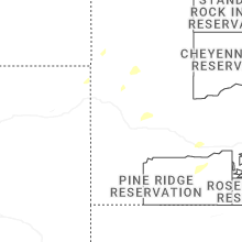
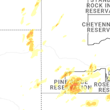
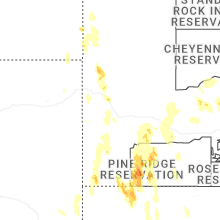

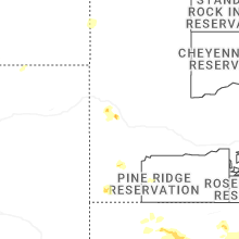
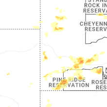
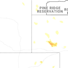
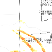
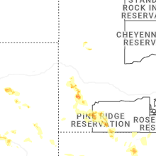
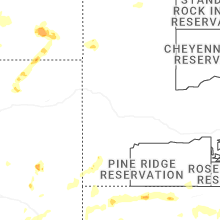


Connect with Interactive Hail Maps