

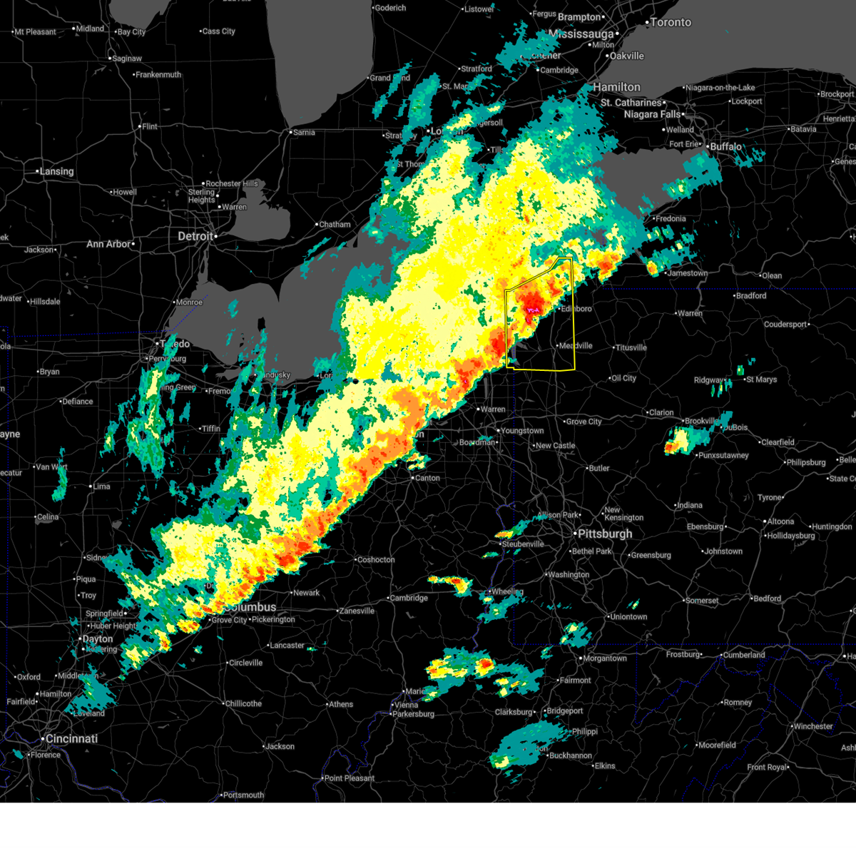
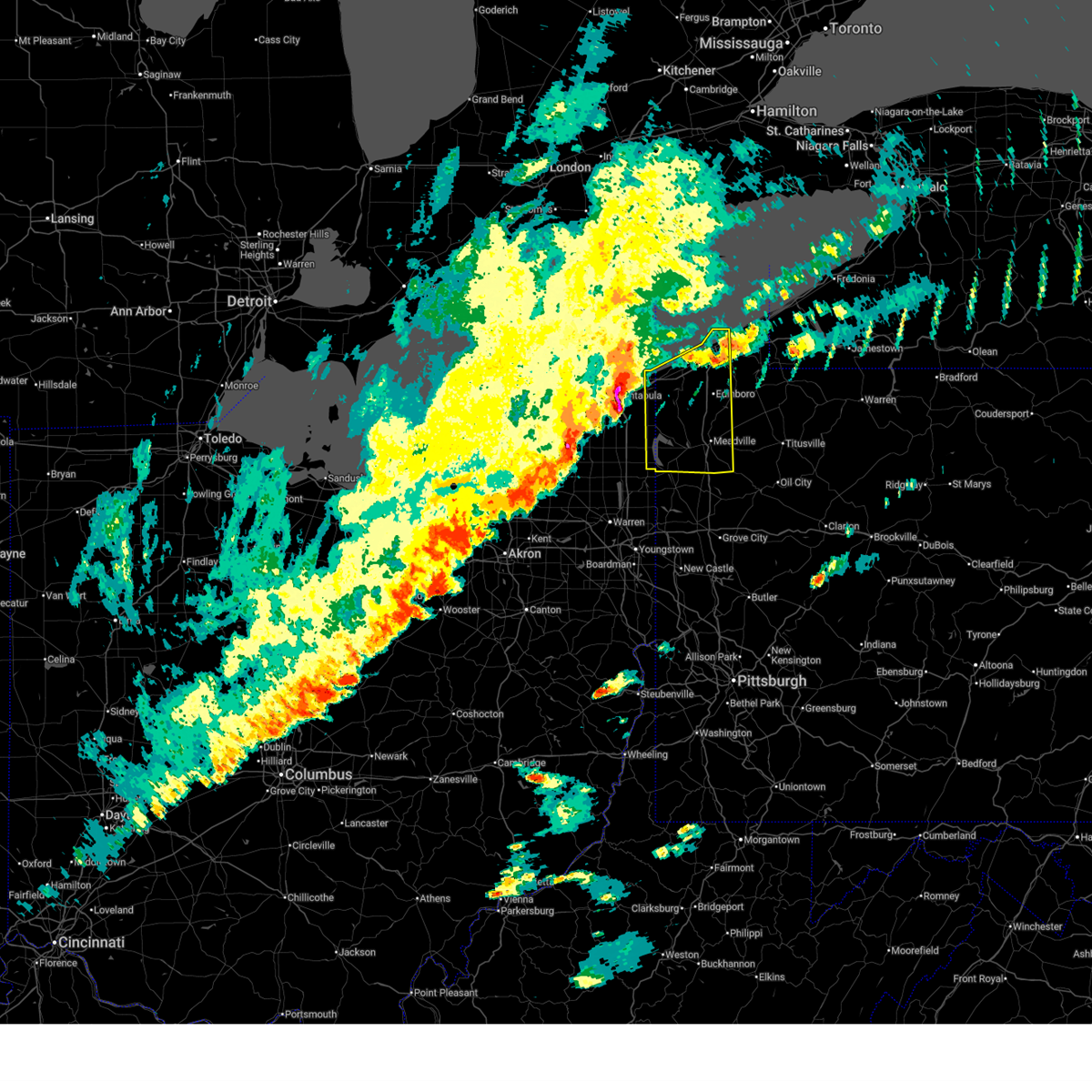
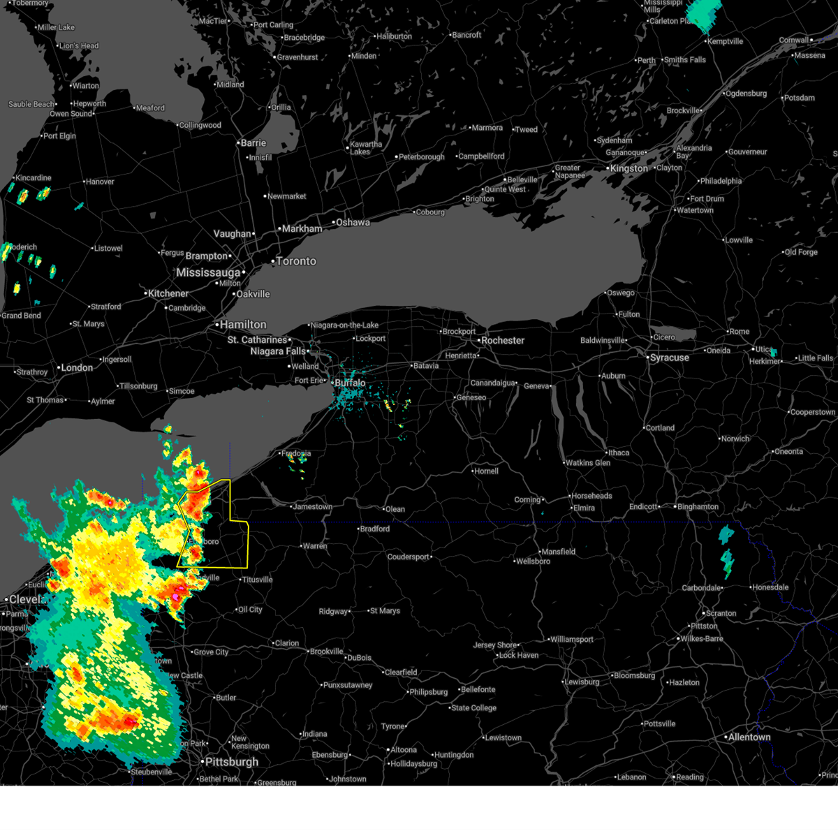
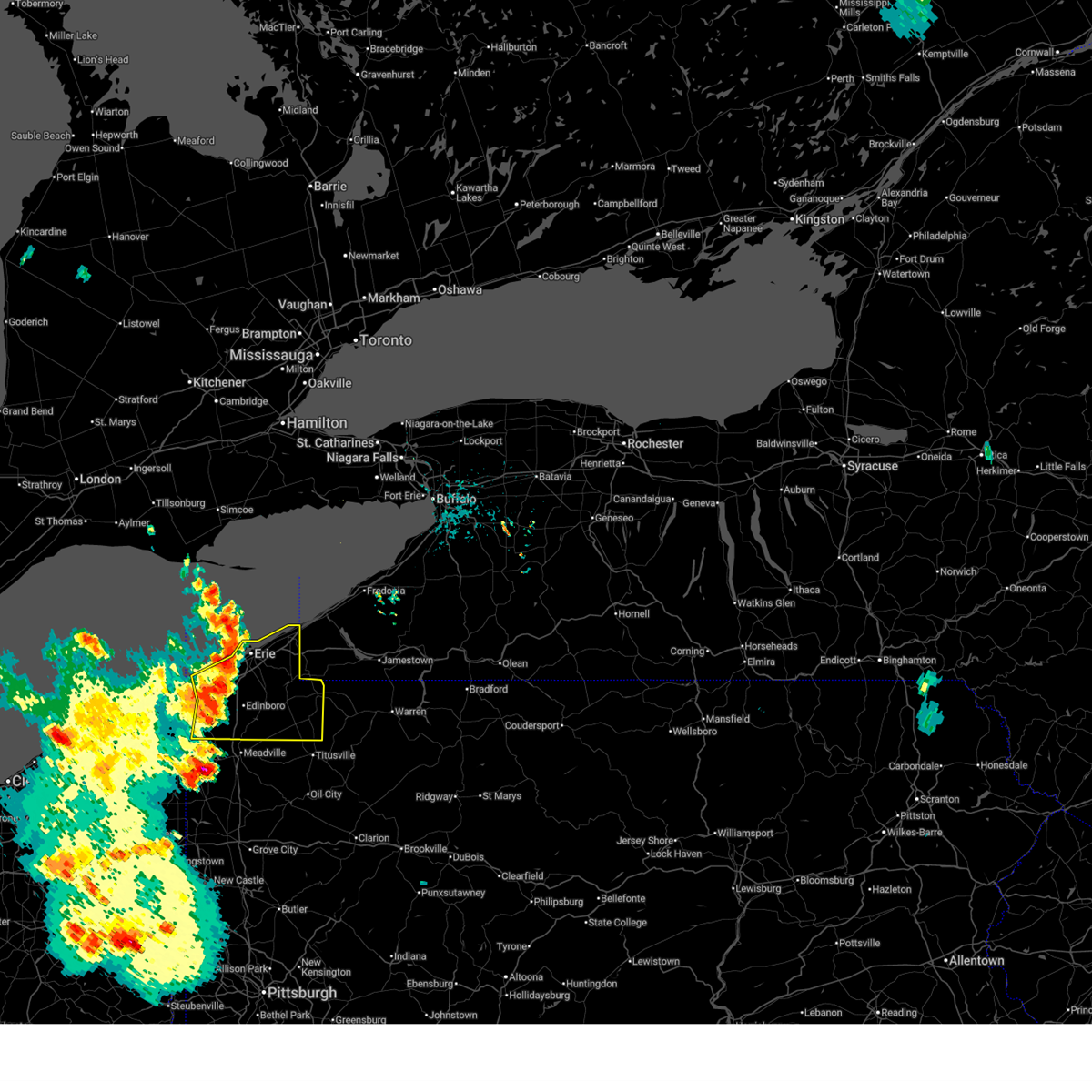
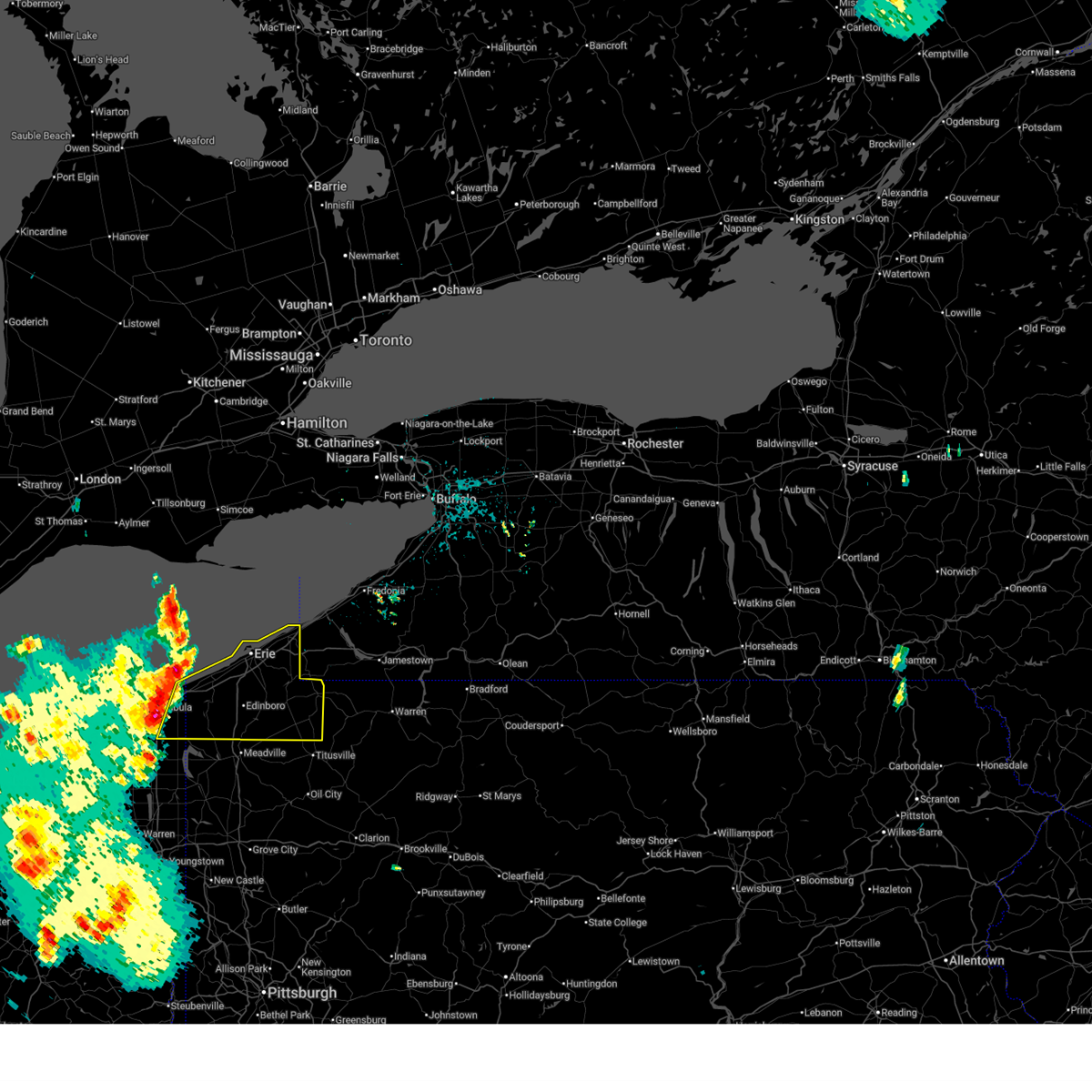
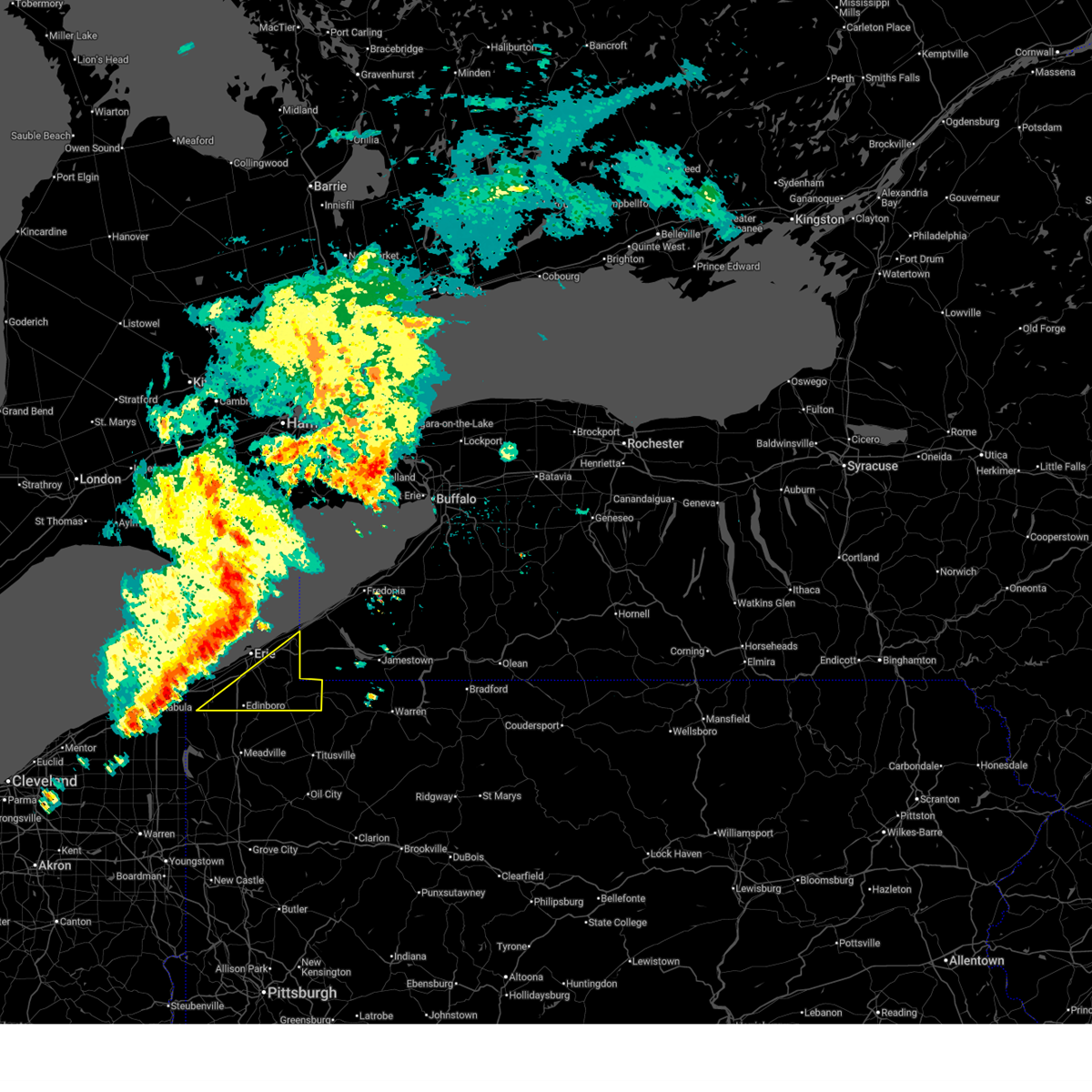
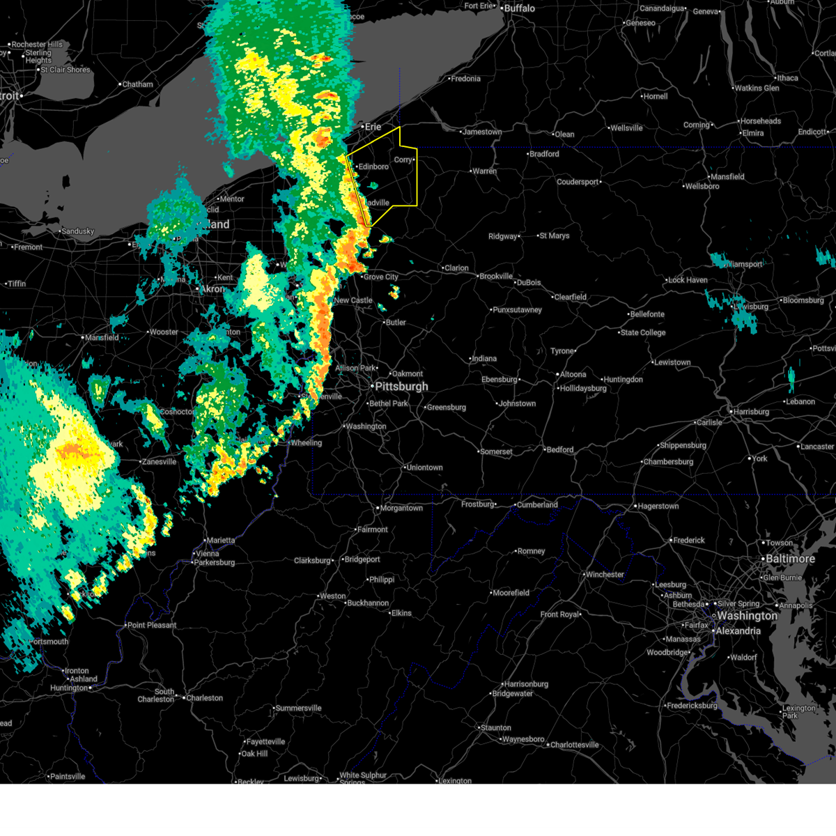
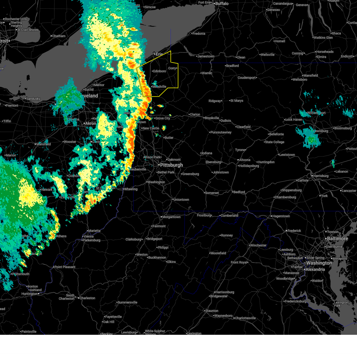
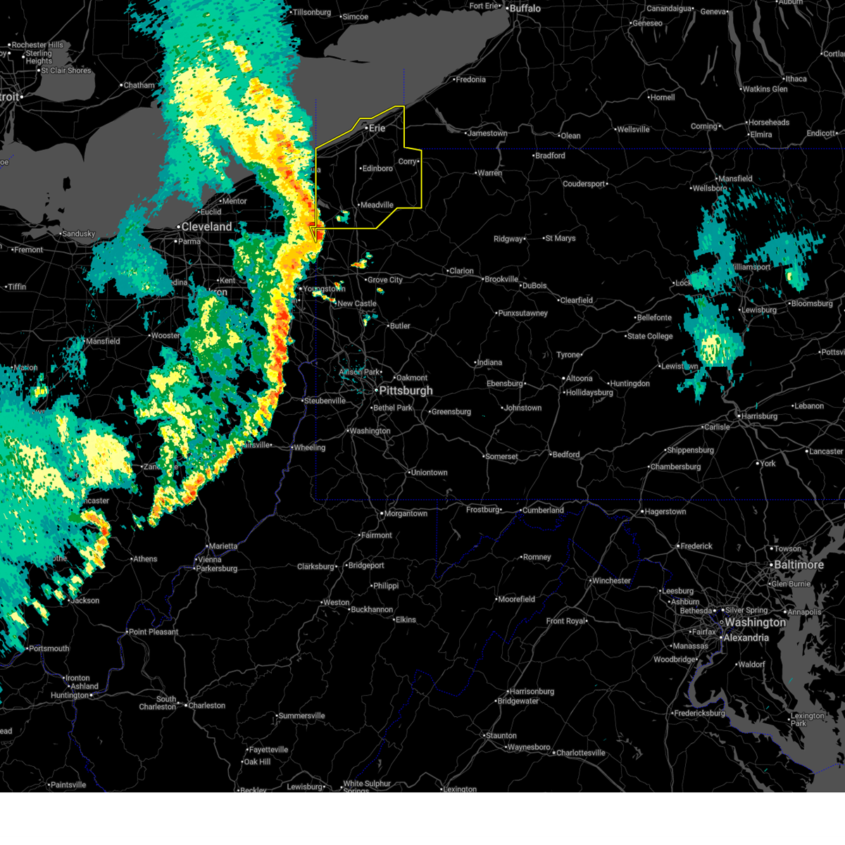
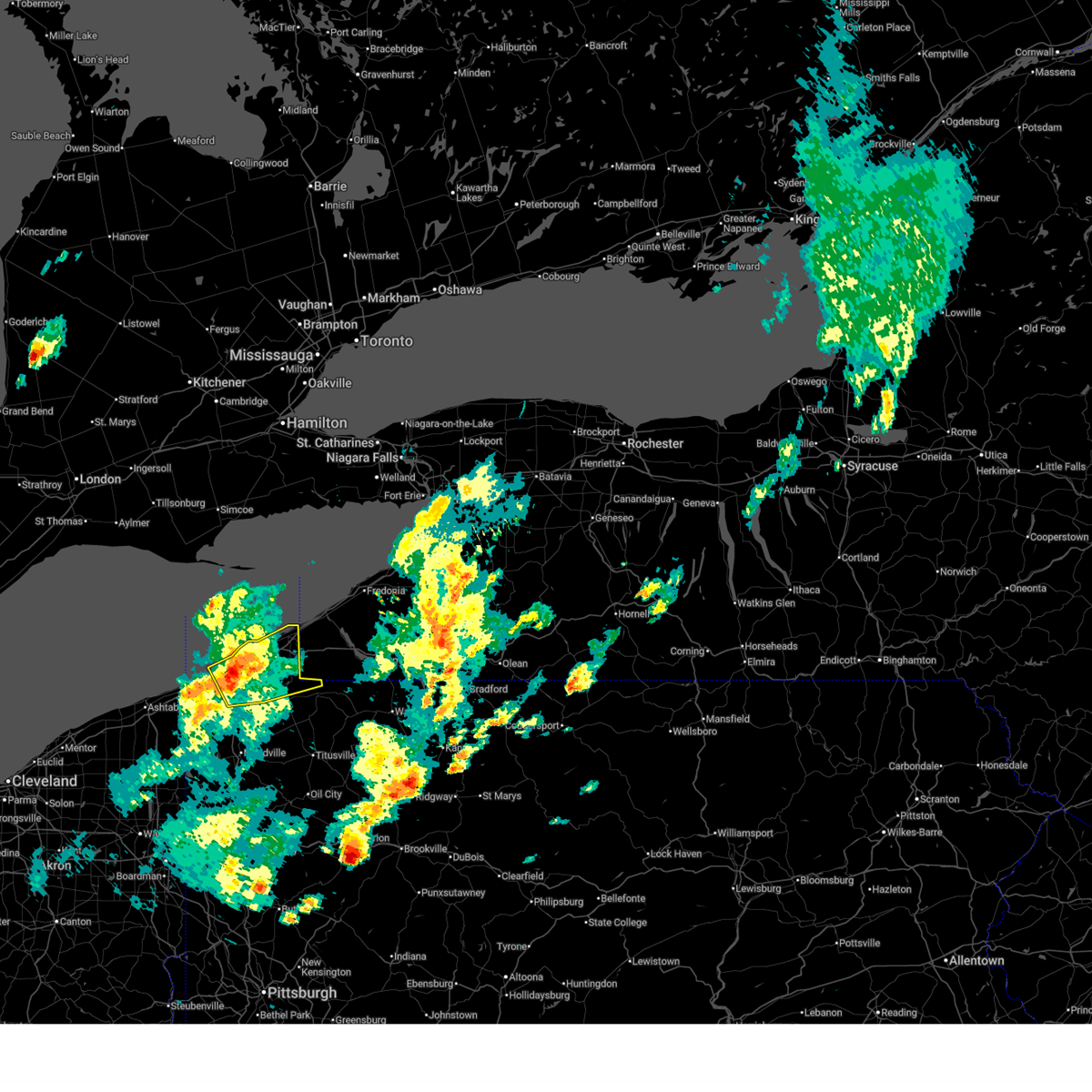
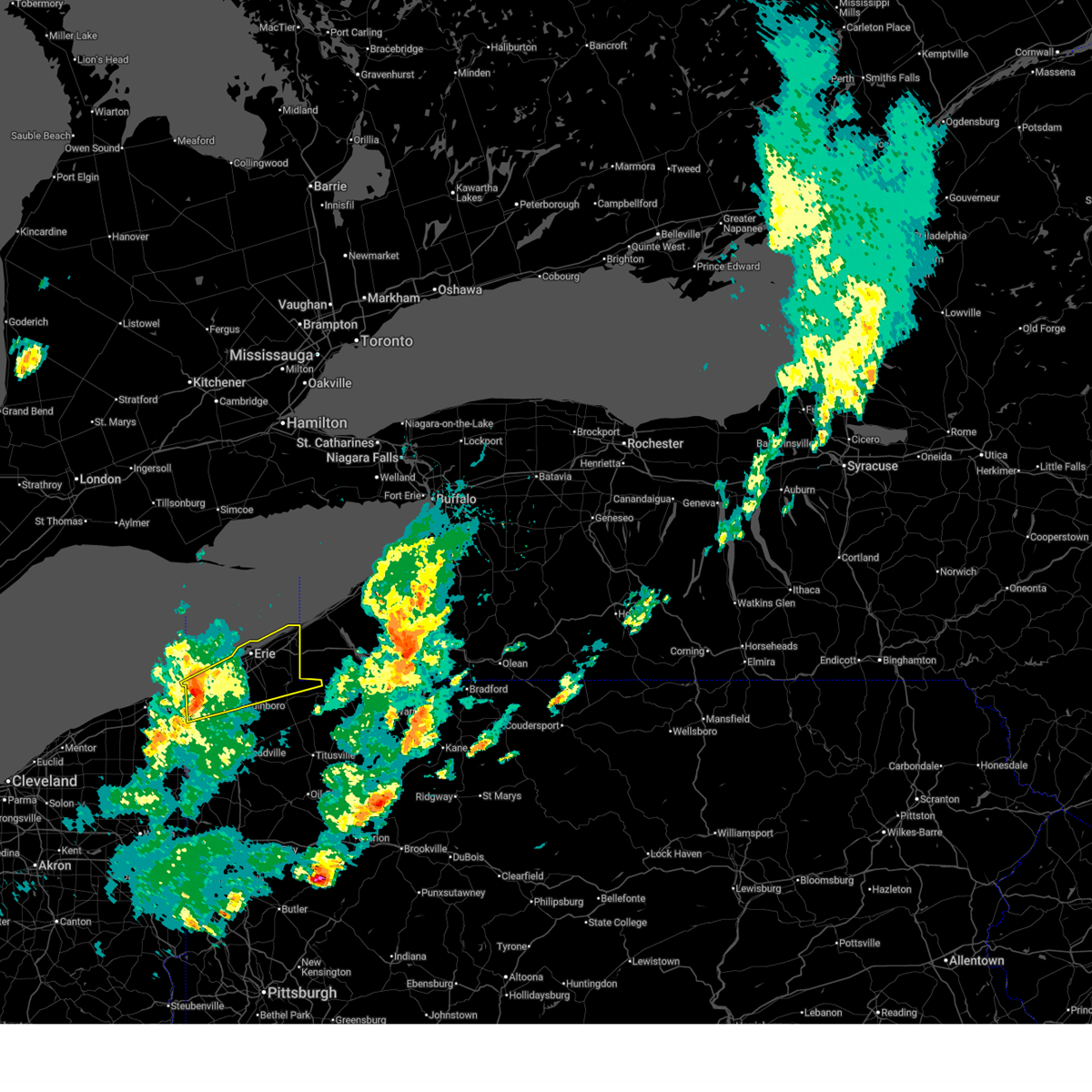
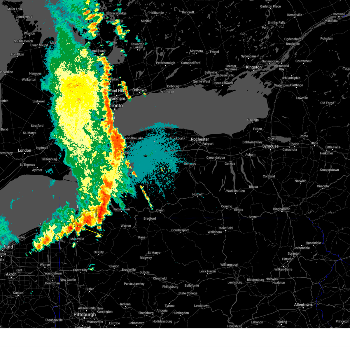
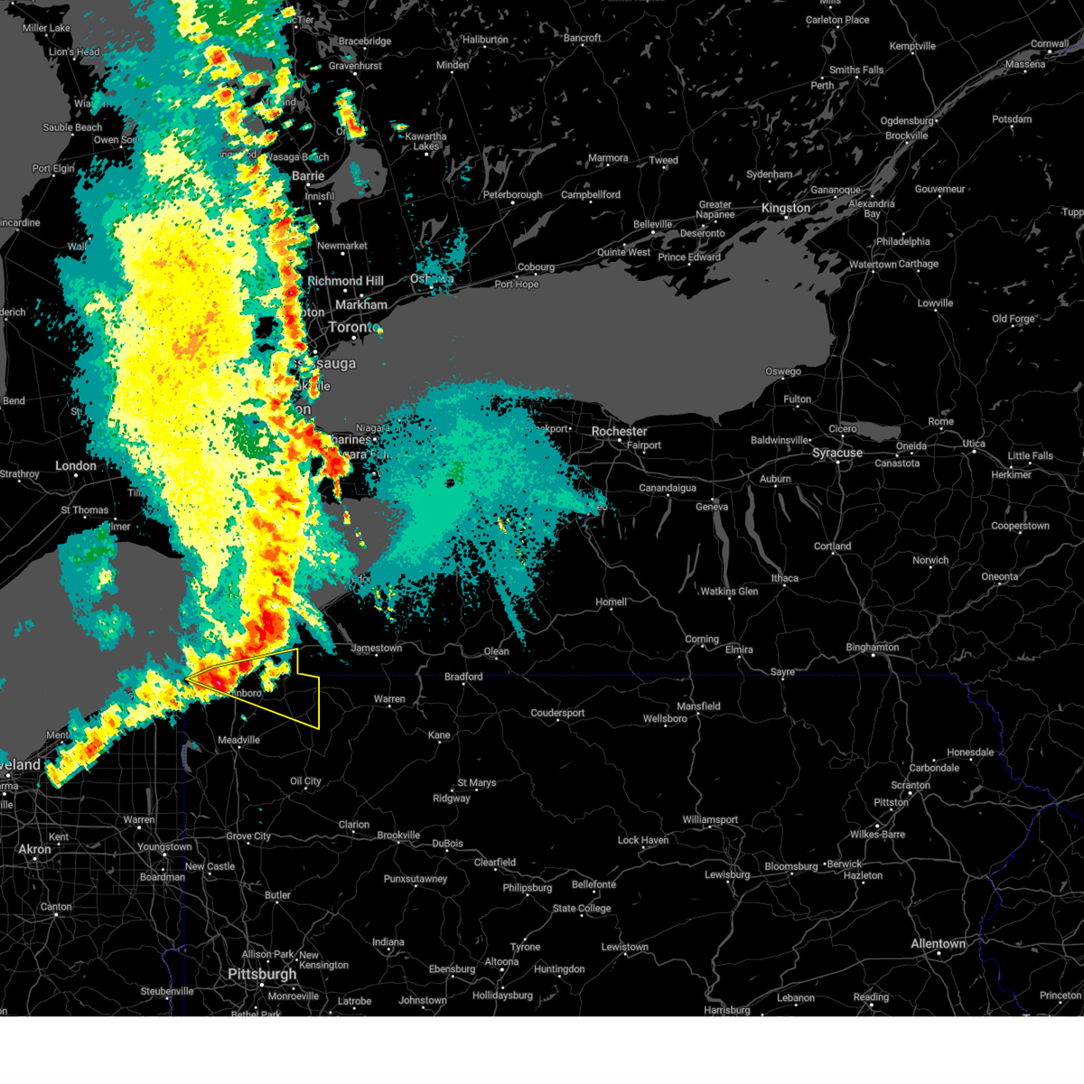
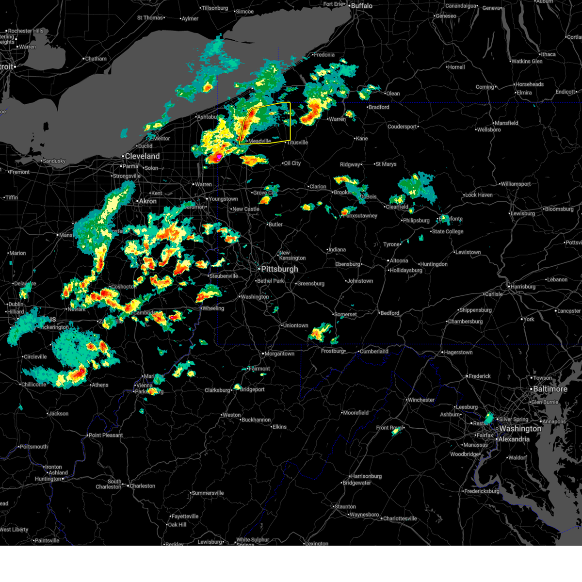
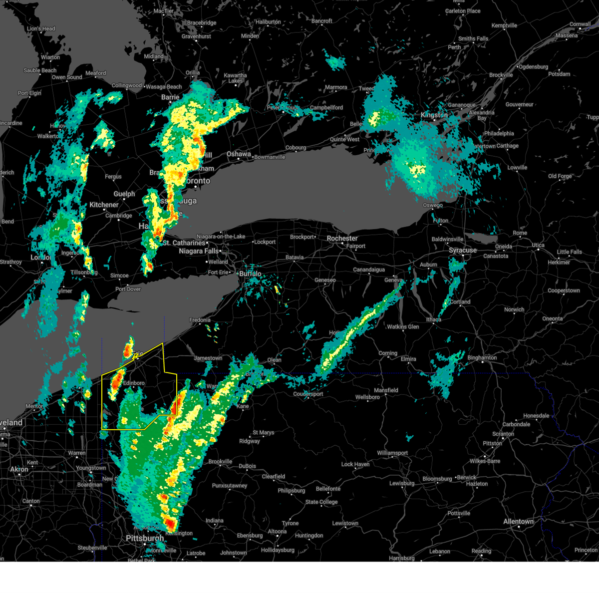
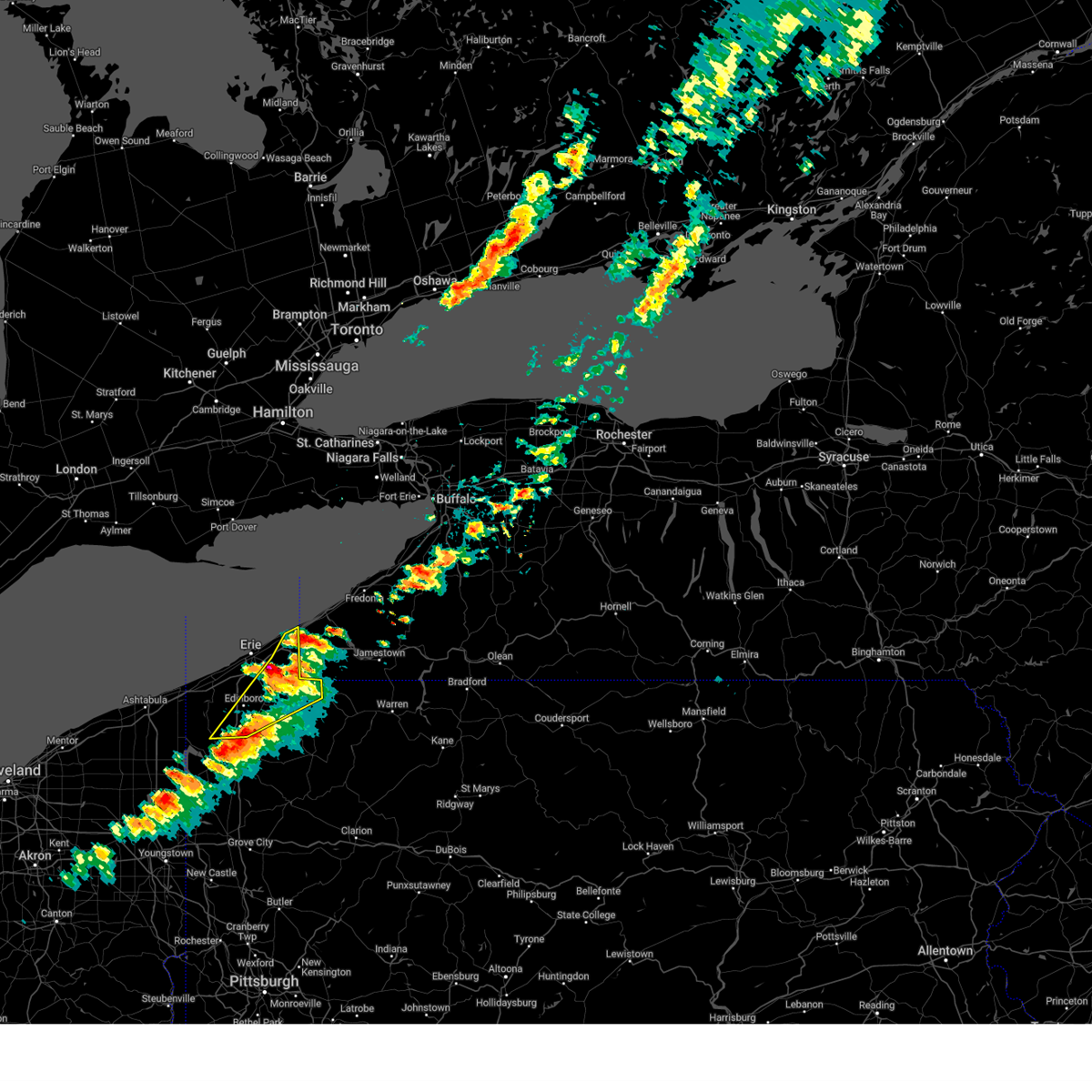
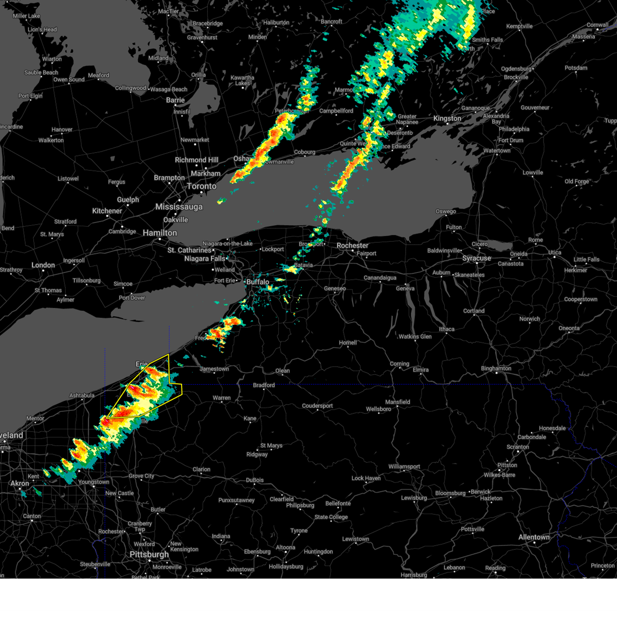
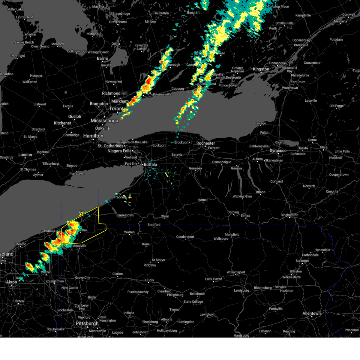
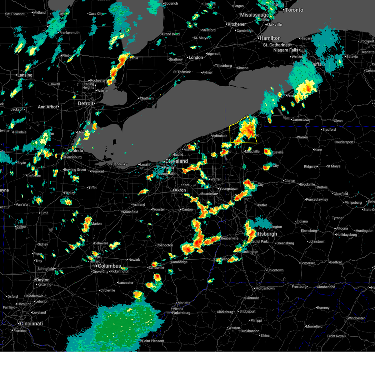
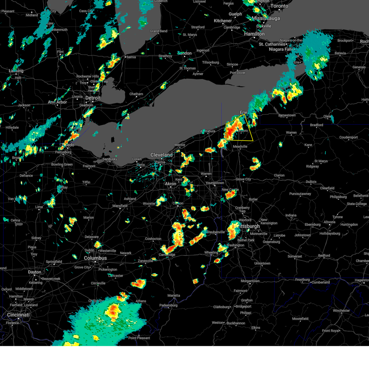
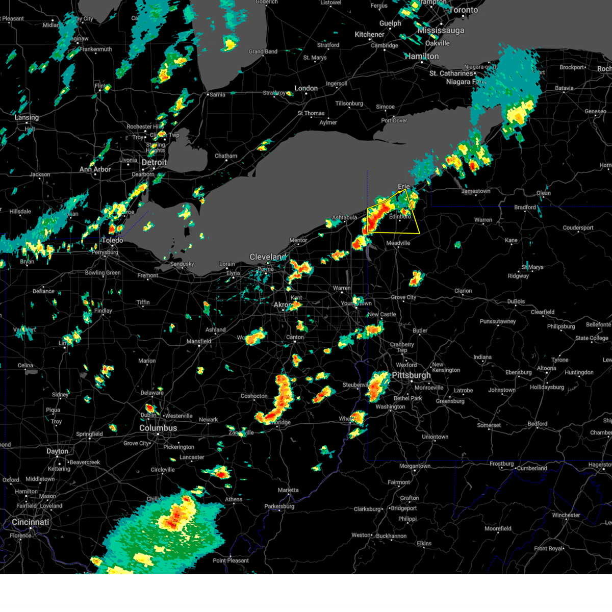
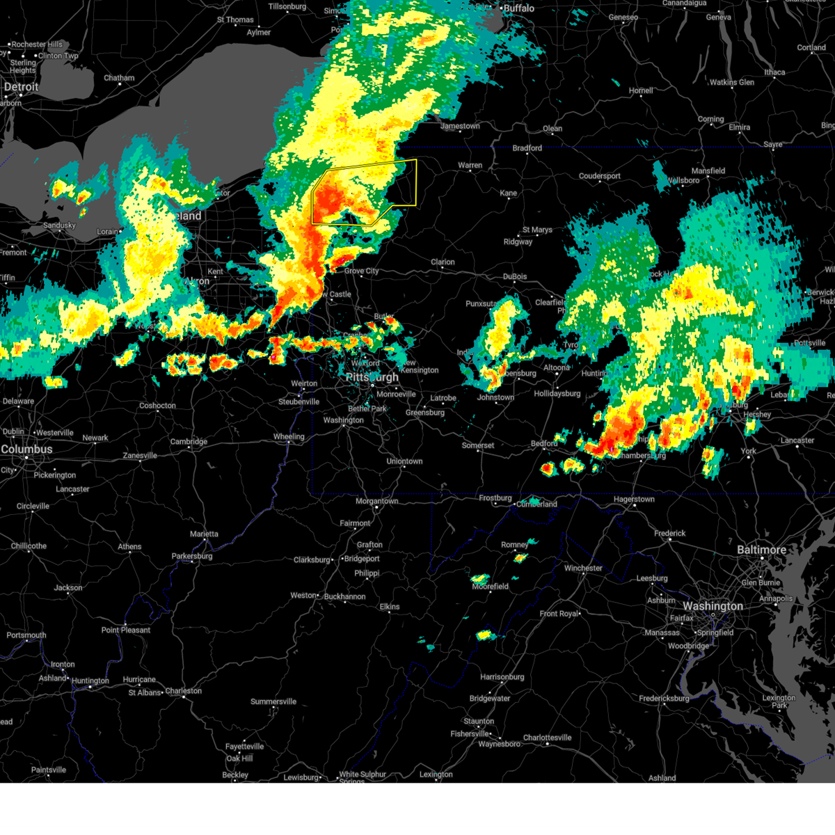
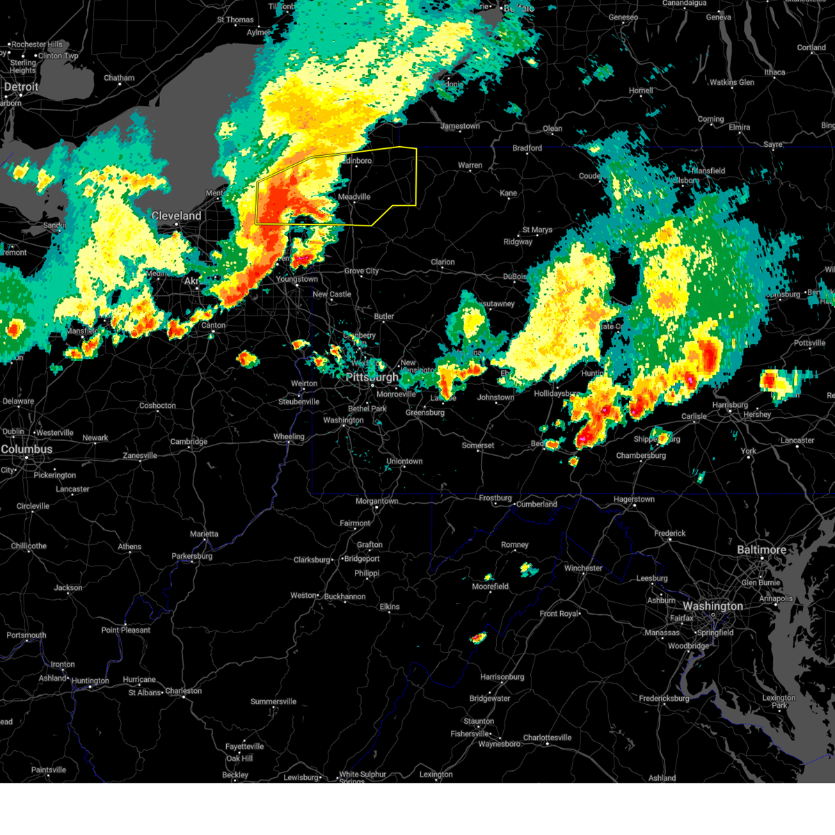
Hail Map for Edinboro, PA
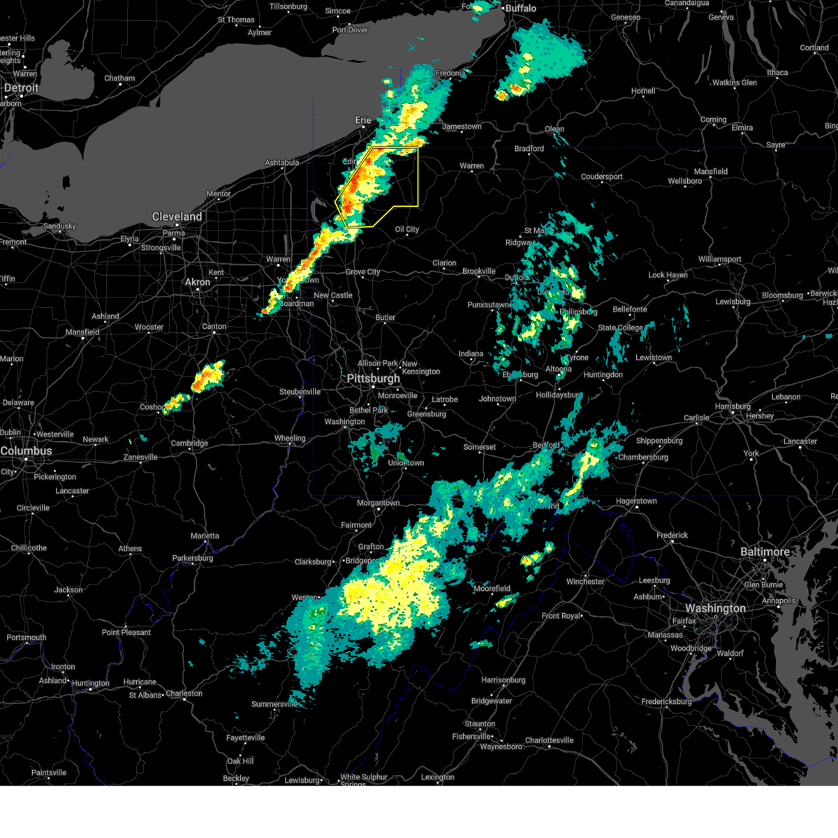
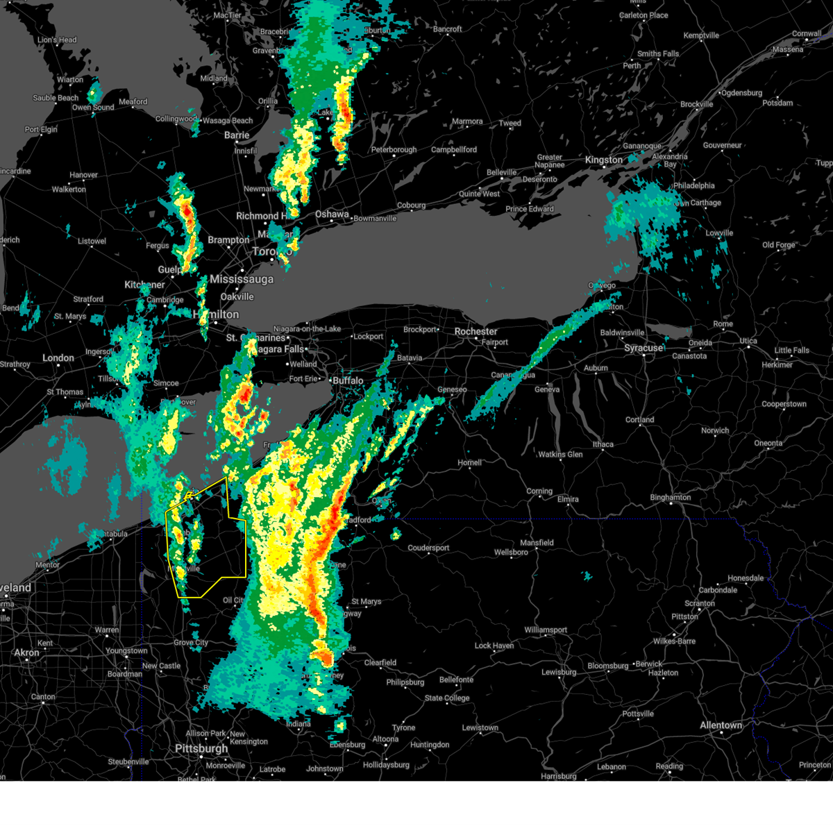
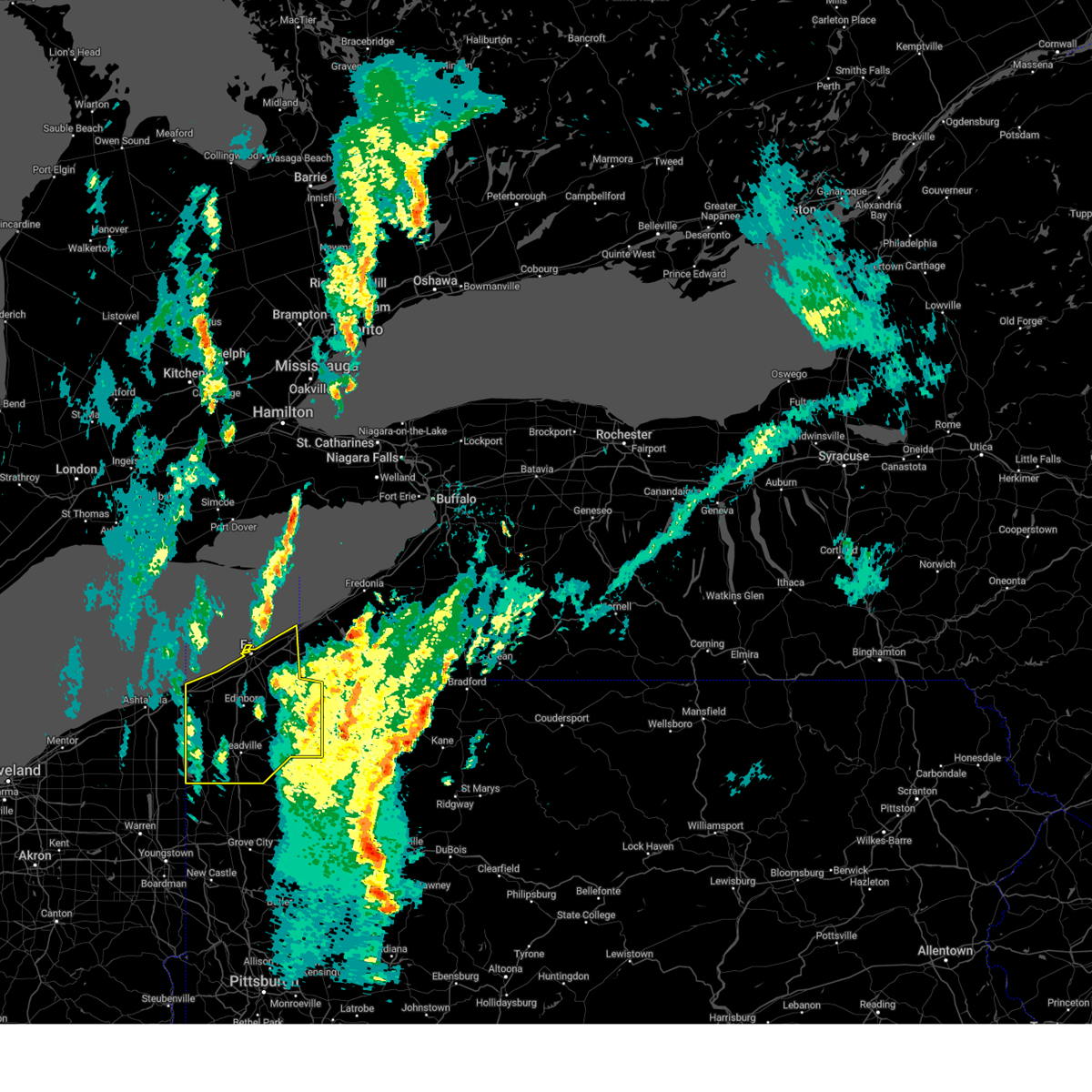
The Edinboro, PA area has had 4 reports of on-the-ground hail by trained spotters, and has been under severe weather warnings 21 times during the past 12 months. Doppler radar has detected hail at or near Edinboro, PA on 34 occasions, including 1 occasion during the past year.
| Name: | Edinboro, PA |
| Where Located: | 84.7 miles ENE of Cleveland, OH |
| Map: | Google Map for Edinboro, PA |
| Population: | 6438 |
| Housing Units: | 2346 |
| More Info: | Search Google for Edinboro, PA |
3
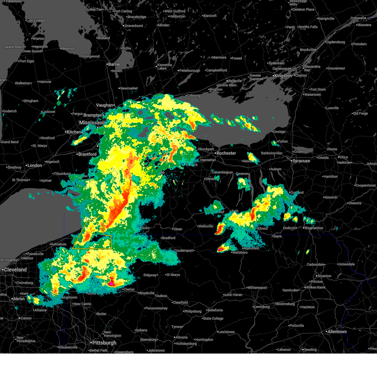
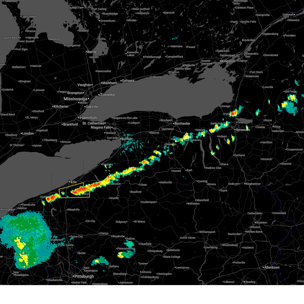
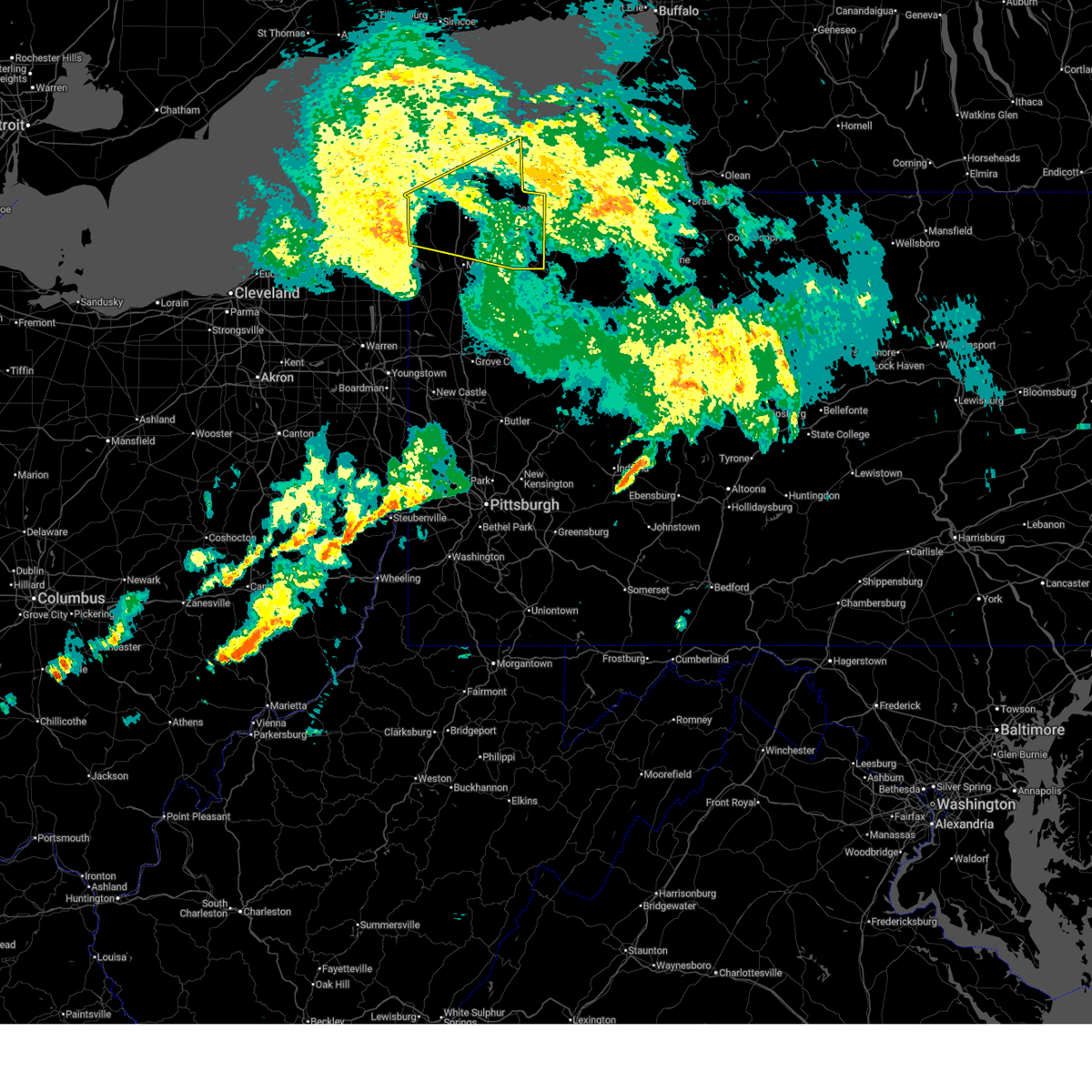
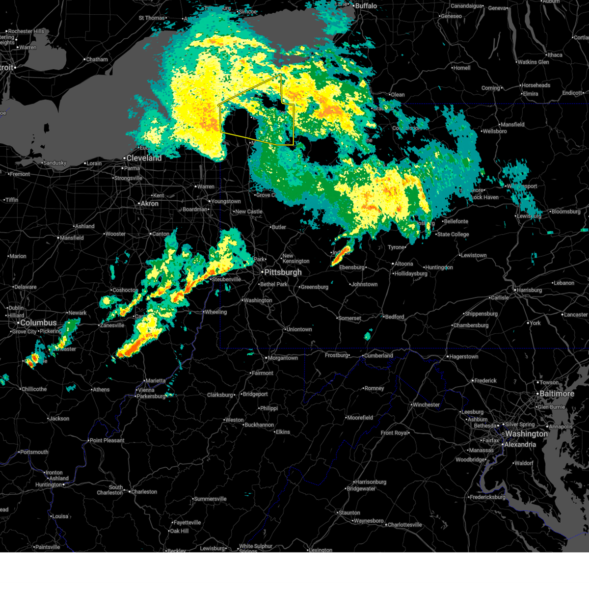
The Top Recent Hail Date for Edinboro, PA is Sunday, June 14, 2026 (4th out of 34)
Hail and Wind Damage Spotted near Edinboro, PA
| Date / Time | Report Details |
|---|---|
| 6/25/2026 9:50 PM EDT |
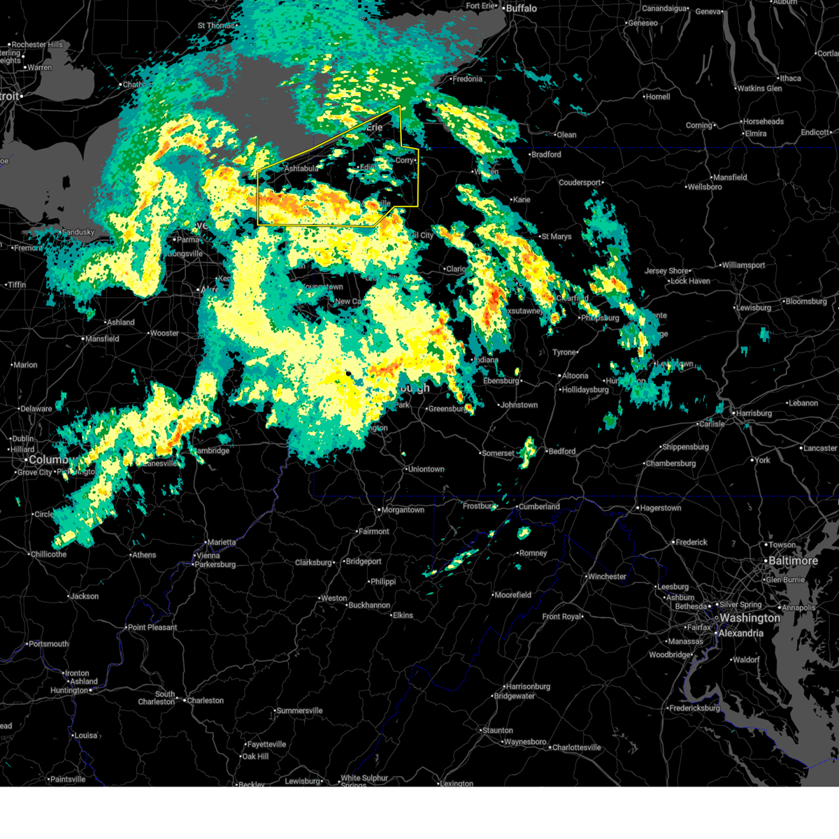
 Svrcle the national weather service in cleveland has issued a * severe thunderstorm warning for, northeastern ashtabula county in northeastern ohio, southern erie county in northwestern pennsylvania, northwestern crawford county in northwestern pennsylvania, * until 1045 pm edt. * at 950 pm edt, a severe thunderstorm was located 13 miles northwest of girard, or 15 miles north of conneaut, moving southeast at 30 mph (radar indicated). Hazards include 60 mph wind gusts and quarter size hail. Minor damage to vehicles is possible. Expect damage to trees and power lines. Svrcle the national weather service in cleveland has issued a * severe thunderstorm warning for, northeastern ashtabula county in northeastern ohio, southern erie county in northwestern pennsylvania, northwestern crawford county in northwestern pennsylvania, * until 1045 pm edt. * at 950 pm edt, a severe thunderstorm was located 13 miles northwest of girard, or 15 miles north of conneaut, moving southeast at 30 mph (radar indicated). Hazards include 60 mph wind gusts and quarter size hail. Minor damage to vehicles is possible. Expect damage to trees and power lines.
|
| 6/18/2026 7:41 AM EDT |
 At 741 am edt, a severe thunderstorm was located near cambridge springs, or 9 miles north of meadville, moving east at 50 mph (radar indicated). Hazards include 60 mph wind gusts. Expect damage to trees and power lines. Locations impacted include, meadville, edinboro, cambridge springs, saegertown, conneautville, springboro, mill village, blooming valley, venango, and woodcock. At 741 am edt, a severe thunderstorm was located near cambridge springs, or 9 miles north of meadville, moving east at 50 mph (radar indicated). Hazards include 60 mph wind gusts. Expect damage to trees and power lines. Locations impacted include, meadville, edinboro, cambridge springs, saegertown, conneautville, springboro, mill village, blooming valley, venango, and woodcock.
|
| 6/18/2026 7:17 AM EDT |
 Svrcle the national weather service in cleveland has issued a * severe thunderstorm warning for, south central erie county in northwestern pennsylvania, northwestern crawford county in northwestern pennsylvania, * until 800 am edt. * at 717 am edt, a severe thunderstorm was located near pymatuning north, or 14 miles south of conneaut, moving east at 50 mph (radar indicated). Hazards include 60 mph wind gusts. expect damage to trees and power lines Svrcle the national weather service in cleveland has issued a * severe thunderstorm warning for, south central erie county in northwestern pennsylvania, northwestern crawford county in northwestern pennsylvania, * until 800 am edt. * at 717 am edt, a severe thunderstorm was located near pymatuning north, or 14 miles south of conneaut, moving east at 50 mph (radar indicated). Hazards include 60 mph wind gusts. expect damage to trees and power lines
|
| 6/14/2026 4:17 PM EDT |
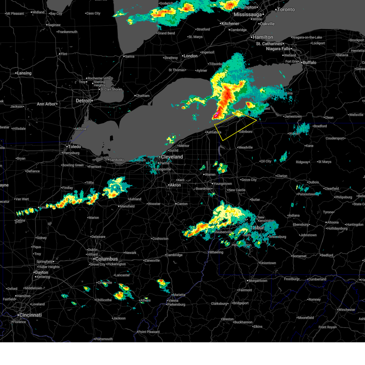
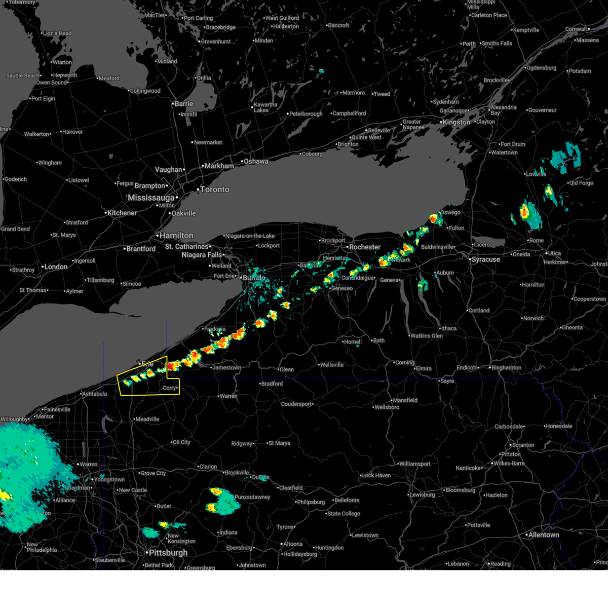
 At 417 pm edt, severe thunderstorms were located along a line extending from 7 miles northwest of girard to near linesville to near west farmington, moving east at 40 mph (radar indicated). Hazards include 70 mph wind gusts and quarter size hail. Minor damage to vehicles is possible. expect considerable tree damage. wind damage is also likely to mobile homes, roofs, and outbuildings. Locations impacted include, erie, meadville, conneaut, edinboro, girard, cambridge springs, albion, andover, linesville, adamsville, pymatuning central, harmonsburg, pymatuning north, atlantic, lawrence park, lake city, pierpont, cochranton, saegertown, and conneautville. At 417 pm edt, severe thunderstorms were located along a line extending from 7 miles northwest of girard to near linesville to near west farmington, moving east at 40 mph (radar indicated). Hazards include 70 mph wind gusts and quarter size hail. Minor damage to vehicles is possible. expect considerable tree damage. wind damage is also likely to mobile homes, roofs, and outbuildings. Locations impacted include, erie, meadville, conneaut, edinboro, girard, cambridge springs, albion, andover, linesville, adamsville, pymatuning central, harmonsburg, pymatuning north, atlantic, lawrence park, lake city, pierpont, cochranton, saegertown, and conneautville.
|
| 6/14/2026 3:55 PM EDT |
 Svrcle the national weather service in cleveland has issued a * severe thunderstorm warning for, eastern ashtabula county in northeastern ohio, southwestern erie county in northwestern pennsylvania, crawford county in northwestern pennsylvania, * until 500 pm edt. * at 355 pm edt, severe thunderstorms were located along a line extending from 15 miles north of north kingsville to 10 miles northwest of andover to 6 miles north of mantua, moving east at 40 mph (radar indicated). Hazards include 60 mph wind gusts and quarter size hail. Minor damage to vehicles is possible. Expect damage to trees and power lines. Svrcle the national weather service in cleveland has issued a * severe thunderstorm warning for, eastern ashtabula county in northeastern ohio, southwestern erie county in northwestern pennsylvania, crawford county in northwestern pennsylvania, * until 500 pm edt. * at 355 pm edt, severe thunderstorms were located along a line extending from 15 miles north of north kingsville to 10 miles northwest of andover to 6 miles north of mantua, moving east at 40 mph (radar indicated). Hazards include 60 mph wind gusts and quarter size hail. Minor damage to vehicles is possible. Expect damage to trees and power lines.
|
| 6/10/2026 10:55 PM EDT |
 At 1055 pm edt, severe thunderstorms were located along a line extending from near north east to near lincolnville, moving east at 50 mph (radar indicated). Hazards include 60 mph wind gusts. Expect damage to trees and power lines. Locations impacted include, erie, corry, edinboro, north east, union city, cambridge springs, waterford, wattsburg, riceville, northwest harborcreek, lincolnville, canadohta lake, harborcreek, lawrence park, wesleyville, saegertown, mill village, mckean, spartansburg, and venango. At 1055 pm edt, severe thunderstorms were located along a line extending from near north east to near lincolnville, moving east at 50 mph (radar indicated). Hazards include 60 mph wind gusts. Expect damage to trees and power lines. Locations impacted include, erie, corry, edinboro, north east, union city, cambridge springs, waterford, wattsburg, riceville, northwest harborcreek, lincolnville, canadohta lake, harborcreek, lawrence park, wesleyville, saegertown, mill village, mckean, spartansburg, and venango.
|
| 6/10/2026 10:36 PM EDT |
 At 1036 pm edt, severe thunderstorms were located along a line extending from near northwest harborcreek to 6 miles northeast of harmonsburg, moving east at 50 mph (radar indicated). Hazards include 60 mph wind gusts and penny size hail. Expect damage to trees and power lines. Locations impacted include, erie, corry, edinboro, north east, union city, girard, cambridge springs, waterford, albion, wattsburg, canadohta lake, riceville, northwest harborcreek, lincolnville, harborcreek, lawrence park, wesleyville, lake city, saegertown, and conneautville. At 1036 pm edt, severe thunderstorms were located along a line extending from near northwest harborcreek to 6 miles northeast of harmonsburg, moving east at 50 mph (radar indicated). Hazards include 60 mph wind gusts and penny size hail. Expect damage to trees and power lines. Locations impacted include, erie, corry, edinboro, north east, union city, girard, cambridge springs, waterford, albion, wattsburg, canadohta lake, riceville, northwest harborcreek, lincolnville, harborcreek, lawrence park, wesleyville, lake city, saegertown, and conneautville.
|
| 6/10/2026 10:11 PM EDT |
 Svrcle the national weather service in cleveland has issued a * severe thunderstorm warning for, northeastern ashtabula county in northeastern ohio, erie county in northwestern pennsylvania, northern crawford county in northwestern pennsylvania, * until 1130 pm edt. * at 1010 pm edt, severe thunderstorms were located along a line extending from 12 miles northwest of girard to 7 miles north of andover, moving east at 50 mph (radar indicated). Hazards include 60 mph wind gusts and penny size hail. expect damage to trees and power lines Svrcle the national weather service in cleveland has issued a * severe thunderstorm warning for, northeastern ashtabula county in northeastern ohio, erie county in northwestern pennsylvania, northern crawford county in northwestern pennsylvania, * until 1130 pm edt. * at 1010 pm edt, severe thunderstorms were located along a line extending from 12 miles northwest of girard to 7 miles north of andover, moving east at 50 mph (radar indicated). Hazards include 60 mph wind gusts and penny size hail. expect damage to trees and power lines
|
| 4/15/2026 7:22 PM EDT |
 At 722 pm edt, severe thunderstorms were located along a line extending from near dunkirk to near clymer to near edinboro, moving east at 50 mph (radar indicated). Hazards include 60 mph wind gusts and penny size hail. Expect damage to trees and power lines. Locations impacted include, erie, corry, edinboro, north east, union city, cambridge springs, waterford, wattsburg, northwest harborcreek, canadohta lake, harborcreek, lawrence park, wesleyville, mill village, mckean, spartansburg, elgin, and northwest harborcr. At 722 pm edt, severe thunderstorms were located along a line extending from near dunkirk to near clymer to near edinboro, moving east at 50 mph (radar indicated). Hazards include 60 mph wind gusts and penny size hail. Expect damage to trees and power lines. Locations impacted include, erie, corry, edinboro, north east, union city, cambridge springs, waterford, wattsburg, northwest harborcreek, canadohta lake, harborcreek, lawrence park, wesleyville, mill village, mckean, spartansburg, elgin, and northwest harborcr.
|
| 4/15/2026 7:19 PM EDT | Pine tree snappe in erie county PA, 2.2 miles SE of Edinboro, PA |
| 4/15/2026 7:08 PM EDT |
 Svrcle the national weather service in cleveland has issued a * severe thunderstorm warning for, erie county in northwestern pennsylvania, northern crawford county in northwestern pennsylvania, * until 845 pm edt. * at 708 pm edt, severe thunderstorms were located along a line extending from 7 miles west of westfield to near wattsburg to near girard, moving east at 50 mph (radar indicated). Hazards include 60 mph wind gusts and penny size hail. expect damage to trees and power lines Svrcle the national weather service in cleveland has issued a * severe thunderstorm warning for, erie county in northwestern pennsylvania, northern crawford county in northwestern pennsylvania, * until 845 pm edt. * at 708 pm edt, severe thunderstorms were located along a line extending from 7 miles west of westfield to near wattsburg to near girard, moving east at 50 mph (radar indicated). Hazards include 60 mph wind gusts and penny size hail. expect damage to trees and power lines
|
| 4/14/2026 3:46 PM EDT |
 At 346 pm edt, a severe thunderstorm was located over edinboro, or 15 miles south of erie, moving east at 35 mph (radar indicated). Hazards include 60 mph wind gusts and quarter size hail. Minor damage to vehicles is possible. expect damage to trees and power lines. Locations impacted include, corry, edinboro, union city, waterford, wattsburg, platea, mill village, mckean, and elgin. At 346 pm edt, a severe thunderstorm was located over edinboro, or 15 miles south of erie, moving east at 35 mph (radar indicated). Hazards include 60 mph wind gusts and quarter size hail. Minor damage to vehicles is possible. expect damage to trees and power lines. Locations impacted include, corry, edinboro, union city, waterford, wattsburg, platea, mill village, mckean, and elgin.
|
| 4/14/2026 3:26 PM EDT |
 At 325 pm edt, a severe thunderstorm was located over waterford, or 12 miles south of erie, moving east at 25 mph (radar indicated). Hazards include 60 mph wind gusts and quarter size hail. Minor damage to vehicles is possible. expect damage to trees and power lines. Locations impacted include, corry, edinboro, union city, girard, waterford, wattsburg, platea, mill village, mckean, and elgin. At 325 pm edt, a severe thunderstorm was located over waterford, or 12 miles south of erie, moving east at 25 mph (radar indicated). Hazards include 60 mph wind gusts and quarter size hail. Minor damage to vehicles is possible. expect damage to trees and power lines. Locations impacted include, corry, edinboro, union city, girard, waterford, wattsburg, platea, mill village, mckean, and elgin.
|
| 4/14/2026 3:04 PM EDT |
 Svrcle the national weather service in cleveland has issued a * severe thunderstorm warning for, erie county in northwestern pennsylvania, * until 400 pm edt. * at 304 pm edt, a severe thunderstorm was located near waterford, or 9 miles southeast of erie, moving east at 30 mph (radar indicated). Hazards include 60 mph wind gusts and quarter size hail. Minor damage to vehicles is possible. Expect damage to trees and power lines. Svrcle the national weather service in cleveland has issued a * severe thunderstorm warning for, erie county in northwestern pennsylvania, * until 400 pm edt. * at 304 pm edt, a severe thunderstorm was located near waterford, or 9 miles southeast of erie, moving east at 30 mph (radar indicated). Hazards include 60 mph wind gusts and quarter size hail. Minor damage to vehicles is possible. Expect damage to trees and power lines.
|
| 3/31/2026 6:26 PM EDT |
 Svrcle the national weather service in cleveland has issued a * severe thunderstorm warning for, erie county in northwestern pennsylvania, crawford county in northwestern pennsylvania, * until 800 pm edt. * at 626 pm edt, severe thunderstorms were located along a line extending from 8 miles northwest of girard to 8 miles northwest of pymatuning north to near kinsman, moving east at 50 mph (radar indicated). Hazards include 70 mph wind gusts and penny size hail. Expect considerable tree damage. Damage is likely to mobile homes, roofs, and outbuildings. Svrcle the national weather service in cleveland has issued a * severe thunderstorm warning for, erie county in northwestern pennsylvania, crawford county in northwestern pennsylvania, * until 800 pm edt. * at 626 pm edt, severe thunderstorms were located along a line extending from 8 miles northwest of girard to 8 miles northwest of pymatuning north to near kinsman, moving east at 50 mph (radar indicated). Hazards include 70 mph wind gusts and penny size hail. Expect considerable tree damage. Damage is likely to mobile homes, roofs, and outbuildings.
|
| 3/11/2026 1:22 PM EDT |
 The storms which prompted the warning have weakened below severe limits, and no longer pose an immediate threat to life or property. therefore, the warning will be allowed to expire. a tornado watch remains in effect until 500 pm edt for northeastern ohio. The storms which prompted the warning have weakened below severe limits, and no longer pose an immediate threat to life or property. therefore, the warning will be allowed to expire. a tornado watch remains in effect until 500 pm edt for northeastern ohio.
|
| 3/11/2026 1:10 PM EDT |
 the severe thunderstorm warning has been cancelled and is no longer in effect the severe thunderstorm warning has been cancelled and is no longer in effect
|
| 3/11/2026 1:10 PM EDT |
 At 109 pm edt, showers producing gusty winds were located along a line extending from 8 miles west of girard to near northwest harborcreek to near columbus, moving northeast at 70 mph (radar indicated). Hazards include 60 mph wind gusts. Expect damage to trees and power lines. Locations impacted include, erie, conneaut, corry, edinboro, titusville, north east, union city, girard, cambridge springs, waterford, albion, wattsburg, canadohta lake, riceville, northwest harborcreek, lincolnville, harborcreek, lawrence park, wesleyville, and lake city. At 109 pm edt, showers producing gusty winds were located along a line extending from 8 miles west of girard to near northwest harborcreek to near columbus, moving northeast at 70 mph (radar indicated). Hazards include 60 mph wind gusts. Expect damage to trees and power lines. Locations impacted include, erie, conneaut, corry, edinboro, titusville, north east, union city, girard, cambridge springs, waterford, albion, wattsburg, canadohta lake, riceville, northwest harborcreek, lincolnville, harborcreek, lawrence park, wesleyville, and lake city.
|
| 3/11/2026 12:14 PM EDT |
 Svrcle the national weather service in cleveland has issued a * severe thunderstorm warning for, ashtabula county in northeastern ohio, erie county in northwestern pennsylvania, crawford county in northwestern pennsylvania, * until 130 pm edt. * at 1214 pm edt, severe thunderstorms were located along a line extending from near geneva to 7 miles south of albion to 6 miles northeast of guys mills, moving northeast at 55 mph (radar indicated). Hazards include 60 mph wind gusts. expect damage to trees and power lines Svrcle the national weather service in cleveland has issued a * severe thunderstorm warning for, ashtabula county in northeastern ohio, erie county in northwestern pennsylvania, crawford county in northwestern pennsylvania, * until 130 pm edt. * at 1214 pm edt, severe thunderstorms were located along a line extending from near geneva to 7 miles south of albion to 6 miles northeast of guys mills, moving northeast at 55 mph (radar indicated). Hazards include 60 mph wind gusts. expect damage to trees and power lines
|
| 8/17/2025 6:58 AM EDT |
 The storms which prompted the warning have weakened below severe limits, and have exited the warned area. therefore, the warning will be allowed to expire. to report severe weather, contact your nearest law enforcement agency. they will relay your report to the national weather service cleveland. The storms which prompted the warning have weakened below severe limits, and have exited the warned area. therefore, the warning will be allowed to expire. to report severe weather, contact your nearest law enforcement agency. they will relay your report to the national weather service cleveland.
|
| 8/17/2025 6:48 AM EDT |
 At 647 am edt, severe thunderstorms were located along a line extending from near findley lake to 6 miles southeast of albion, moving southeast at 40 mph (radar indicated). Hazards include 60 mph wind gusts and penny size hail. Expect damage to trees and power lines. Locations impacted include, corry, edinboro, union city, waterford, albion, wattsburg, cranesville, mill village, mckean, and elgin. At 647 am edt, severe thunderstorms were located along a line extending from near findley lake to 6 miles southeast of albion, moving southeast at 40 mph (radar indicated). Hazards include 60 mph wind gusts and penny size hail. Expect damage to trees and power lines. Locations impacted include, corry, edinboro, union city, waterford, albion, wattsburg, cranesville, mill village, mckean, and elgin.
|
| 8/17/2025 6:19 AM EDT |
 Svrcle the national weather service in cleveland has issued a * severe thunderstorm warning for, erie county in northwestern pennsylvania, * until 700 am edt. * at 619 am edt, severe thunderstorms were located along a line extending from 7 miles northwest of north east to girard, moving east at 45 mph (radar indicated). Hazards include 60 mph wind gusts and quarter size hail. Minor damage to vehicles is possible. Expect damage to trees and power lines. Svrcle the national weather service in cleveland has issued a * severe thunderstorm warning for, erie county in northwestern pennsylvania, * until 700 am edt. * at 619 am edt, severe thunderstorms were located along a line extending from 7 miles northwest of north east to girard, moving east at 45 mph (radar indicated). Hazards include 60 mph wind gusts and quarter size hail. Minor damage to vehicles is possible. Expect damage to trees and power lines.
|
| 6/18/2025 11:14 PM EDT |
 At 1114 pm edt, severe thunderstorms were located along a line extending from near edinboro to near franklin, moving east at 45 mph (radar indicated). Hazards include 60 mph wind gusts. Expect damage to trees and power lines. Locations impacted include, corry, edinboro, titusville, union city, cambridge springs, waterford, wattsburg, riceville, lincolnville, canadohta lake, guys mills, cochranton, saegertown, hydetown, mill village, blooming valley, townville, spartansburg, venango, and elgin. At 1114 pm edt, severe thunderstorms were located along a line extending from near edinboro to near franklin, moving east at 45 mph (radar indicated). Hazards include 60 mph wind gusts. Expect damage to trees and power lines. Locations impacted include, corry, edinboro, titusville, union city, cambridge springs, waterford, wattsburg, riceville, lincolnville, canadohta lake, guys mills, cochranton, saegertown, hydetown, mill village, blooming valley, townville, spartansburg, venango, and elgin.
|
| 6/18/2025 10:56 PM EDT |
 the severe thunderstorm warning has been cancelled and is no longer in effect the severe thunderstorm warning has been cancelled and is no longer in effect
|
| 6/18/2025 10:56 PM EDT |
 At 1055 pm edt, severe thunderstorms were located along a line extending from albion to 13 miles north of grove city, moving northeast at 40 mph (radar indicated). Hazards include 60 mph wind gusts. Expect damage to trees and power lines. Locations impacted include, meadville, corry, edinboro, titusville, union city, cambridge springs, waterford, albion, wattsburg, canadohta lake, riceville, harmonsburg, lincolnville, guys mills, cochranton, saegertown, conneautville, conneaut lake, cranesville, and hydetown. At 1055 pm edt, severe thunderstorms were located along a line extending from albion to 13 miles north of grove city, moving northeast at 40 mph (radar indicated). Hazards include 60 mph wind gusts. Expect damage to trees and power lines. Locations impacted include, meadville, corry, edinboro, titusville, union city, cambridge springs, waterford, albion, wattsburg, canadohta lake, riceville, harmonsburg, lincolnville, guys mills, cochranton, saegertown, conneautville, conneaut lake, cranesville, and hydetown.
|
| 6/18/2025 10:36 PM EDT |
 Svrcle the national weather service in cleveland has issued a * severe thunderstorm warning for, northeastern trumbull county in northeastern ohio, erie county in northwestern pennsylvania, crawford county in northwestern pennsylvania, * until 1145 pm edt. * at 1036 pm edt, severe thunderstorms were located along a line extending from near north kingsville to near greenville, moving east at 45 mph (radar indicated). Hazards include 60 mph wind gusts and quarter size hail. Minor damage to vehicles is possible. Expect damage to trees and power lines. Svrcle the national weather service in cleveland has issued a * severe thunderstorm warning for, northeastern trumbull county in northeastern ohio, erie county in northwestern pennsylvania, crawford county in northwestern pennsylvania, * until 1145 pm edt. * at 1036 pm edt, severe thunderstorms were located along a line extending from near north kingsville to near greenville, moving east at 45 mph (radar indicated). Hazards include 60 mph wind gusts and quarter size hail. Minor damage to vehicles is possible. Expect damage to trees and power lines.
|
| 6/9/2025 5:20 PM EDT |
 the severe thunderstorm warning has been cancelled and is no longer in effect the severe thunderstorm warning has been cancelled and is no longer in effect
|
| 6/9/2025 5:20 PM EDT |
 At 520 pm edt, a severe thunderstorm was located 7 miles south of erie, moving northeast at 45 mph (radar indicated). Hazards include 60 mph wind gusts and penny size hail. Expect damage to trees and power lines. Locations impacted include, erie, edinboro, north east, girard, waterford, wattsburg, northwest harborcreek, harborcreek, lawrence park, wesleyville, lake city, mckean, northwest harborcr, and avonia. At 520 pm edt, a severe thunderstorm was located 7 miles south of erie, moving northeast at 45 mph (radar indicated). Hazards include 60 mph wind gusts and penny size hail. Expect damage to trees and power lines. Locations impacted include, erie, edinboro, north east, girard, waterford, wattsburg, northwest harborcreek, harborcreek, lawrence park, wesleyville, lake city, mckean, northwest harborcr, and avonia.
|
| 6/9/2025 4:55 PM EDT |
 Svrcle the national weather service in cleveland has issued a * severe thunderstorm warning for, erie county in northwestern pennsylvania, northwestern crawford county in northwestern pennsylvania, * until 615 pm edt. * at 455 pm edt, a severe thunderstorm was located near albion, or 8 miles east of conneaut, moving northeast at 45 mph (radar indicated). Hazards include 60 mph wind gusts and penny size hail. expect damage to trees and power lines Svrcle the national weather service in cleveland has issued a * severe thunderstorm warning for, erie county in northwestern pennsylvania, northwestern crawford county in northwestern pennsylvania, * until 615 pm edt. * at 455 pm edt, a severe thunderstorm was located near albion, or 8 miles east of conneaut, moving northeast at 45 mph (radar indicated). Hazards include 60 mph wind gusts and penny size hail. expect damage to trees and power lines
|
| 6/9/2025 3:30 PM EDT |
 Svrcle the national weather service in cleveland has issued a * severe thunderstorm warning for, southeastern erie county in northwestern pennsylvania, northeastern crawford county in northwestern pennsylvania, * until 430 pm edt. * at 330 pm edt, a severe thunderstorm was located near cambridge springs, or 12 miles northeast of meadville, moving northeast at 30 mph (radar indicated). Hazards include 60 mph wind gusts and penny size hail. expect damage to trees and power lines Svrcle the national weather service in cleveland has issued a * severe thunderstorm warning for, southeastern erie county in northwestern pennsylvania, northeastern crawford county in northwestern pennsylvania, * until 430 pm edt. * at 330 pm edt, a severe thunderstorm was located near cambridge springs, or 12 miles northeast of meadville, moving northeast at 30 mph (radar indicated). Hazards include 60 mph wind gusts and penny size hail. expect damage to trees and power lines
|
| 5/16/2025 4:57 AM EDT |
 At 456 am edt, a severe thunderstorm was located over corry, or 23 miles southwest of jamestown, moving east at 70 mph (radar indicated). Hazards include 60 mph wind gusts and half dollar size hail. People and animals outdoors will be injured. expect hail damage to roofs, siding, windows, and vehicles. expect damage to trees and power lines. Locations impacted include, corry, edinboro, union city, waterford, wattsburg, canadohta lake, lincolnville, riceville, mill village, mckean, spartansburg, and elgin. At 456 am edt, a severe thunderstorm was located over corry, or 23 miles southwest of jamestown, moving east at 70 mph (radar indicated). Hazards include 60 mph wind gusts and half dollar size hail. People and animals outdoors will be injured. expect hail damage to roofs, siding, windows, and vehicles. expect damage to trees and power lines. Locations impacted include, corry, edinboro, union city, waterford, wattsburg, canadohta lake, lincolnville, riceville, mill village, mckean, spartansburg, and elgin.
|
| 5/16/2025 4:31 AM EDT |
 Svrcle the national weather service in cleveland has issued a * severe thunderstorm warning for, erie county in northwestern pennsylvania, northeastern crawford county in northwestern pennsylvania, * until 515 am edt. * at 431 am edt, a severe thunderstorm was located near edinboro, or 13 miles southwest of erie, moving east at 70 mph (radar indicated). Hazards include 60 mph wind gusts and half dollar size hail. People and animals outdoors will be injured. expect hail damage to roofs, siding, windows, and vehicles. Expect damage to trees and power lines. Svrcle the national weather service in cleveland has issued a * severe thunderstorm warning for, erie county in northwestern pennsylvania, northeastern crawford county in northwestern pennsylvania, * until 515 am edt. * at 431 am edt, a severe thunderstorm was located near edinboro, or 13 miles southwest of erie, moving east at 70 mph (radar indicated). Hazards include 60 mph wind gusts and half dollar size hail. People and animals outdoors will be injured. expect hail damage to roofs, siding, windows, and vehicles. Expect damage to trees and power lines.
|
| 5/2/2025 4:07 PM EDT |
 Svrcle the national weather service in cleveland has issued a * severe thunderstorm warning for, southeastern erie county in northwestern pennsylvania, northeastern crawford county in northwestern pennsylvania, * until 445 pm edt. * at 407 pm edt, severe thunderstorms were located along a line extending from near cambridge springs to near meadville, moving east at 45 mph (radar indicated). Hazards include quarter size hail. minor damage to vehicles is possible Svrcle the national weather service in cleveland has issued a * severe thunderstorm warning for, southeastern erie county in northwestern pennsylvania, northeastern crawford county in northwestern pennsylvania, * until 445 pm edt. * at 407 pm edt, severe thunderstorms were located along a line extending from near cambridge springs to near meadville, moving east at 45 mph (radar indicated). Hazards include quarter size hail. minor damage to vehicles is possible
|
| 4/21/2025 5:28 PM EDT |
 Svrcle the national weather service in cleveland has issued a * severe thunderstorm warning for, southeastern erie county in northwestern pennsylvania, crawford county in northwestern pennsylvania, * until 630 pm edt. * at 528 pm edt, a severe thunderstorm was located near meadville, moving east at 50 mph (radar indicated). Hazards include 60 mph wind gusts and penny size hail. expect damage to trees and power lines Svrcle the national weather service in cleveland has issued a * severe thunderstorm warning for, southeastern erie county in northwestern pennsylvania, crawford county in northwestern pennsylvania, * until 630 pm edt. * at 528 pm edt, a severe thunderstorm was located near meadville, moving east at 50 mph (radar indicated). Hazards include 60 mph wind gusts and penny size hail. expect damage to trees and power lines
|
| 3/16/2025 1:54 PM EDT |
 At 153 pm edt, severe thunderstorms were located along a line extending from near edinboro to meadville, moving northeast at 65 mph (radar indicated). Hazards include 60 mph wind gusts. Expect damage to trees and power lines. Locations impacted include, erie, meadville, corry, edinboro, titusville, north east, union city, girard, cambridge springs, waterford, wattsburg, canadohta lake, riceville, northwest harborcreek, lincolnville, guys mills, harborcreek, lawrence park, wesleyville, and cochranton. At 153 pm edt, severe thunderstorms were located along a line extending from near edinboro to meadville, moving northeast at 65 mph (radar indicated). Hazards include 60 mph wind gusts. Expect damage to trees and power lines. Locations impacted include, erie, meadville, corry, edinboro, titusville, north east, union city, girard, cambridge springs, waterford, wattsburg, canadohta lake, riceville, northwest harborcreek, lincolnville, guys mills, harborcreek, lawrence park, wesleyville, and cochranton.
|
| 3/16/2025 1:29 PM EDT |
 At 128 pm edt, severe thunderstorms were located along a line extending from near north kingsville to andover to sharon, moving northeast at 60 mph (radar indicated. at 118 pm edt, a 63 mph wind gust was reported at youngstown-warren airport. at 119 pm edt, a 55 mph wind gust was reported at ashtabula county airport). Hazards include 70 mph wind gusts. Expect considerable tree damage. damage is likely to mobile homes, roofs, and outbuildings. Locations impacted include, erie, meadville, corry, edinboro, titusville, north east, union city, girard, cambridge springs, waterford, albion, linesville, wattsburg, adamsville, pymatuning central, riceville, harmonsburg, guys mills, pymatuning north, and atlantic. At 128 pm edt, severe thunderstorms were located along a line extending from near north kingsville to andover to sharon, moving northeast at 60 mph (radar indicated. at 118 pm edt, a 63 mph wind gust was reported at youngstown-warren airport. at 119 pm edt, a 55 mph wind gust was reported at ashtabula county airport). Hazards include 70 mph wind gusts. Expect considerable tree damage. damage is likely to mobile homes, roofs, and outbuildings. Locations impacted include, erie, meadville, corry, edinboro, titusville, north east, union city, girard, cambridge springs, waterford, albion, linesville, wattsburg, adamsville, pymatuning central, riceville, harmonsburg, guys mills, pymatuning north, and atlantic.
|
| 3/16/2025 12:59 PM EDT |
 Svrcle the national weather service in cleveland has issued a * severe thunderstorm warning for, erie county in northwestern pennsylvania, crawford county in northwestern pennsylvania, * until 230 pm edt. * at 1259 pm edt, severe thunderstorms were located along a line extending from albion to 6 miles northeast of atlantic, moving northeast at 45 mph (radar indicated). Hazards include 60 mph wind gusts and nickel size hail. expect damage to trees and power lines Svrcle the national weather service in cleveland has issued a * severe thunderstorm warning for, erie county in northwestern pennsylvania, crawford county in northwestern pennsylvania, * until 230 pm edt. * at 1259 pm edt, severe thunderstorms were located along a line extending from albion to 6 miles northeast of atlantic, moving northeast at 45 mph (radar indicated). Hazards include 60 mph wind gusts and nickel size hail. expect damage to trees and power lines
|
| 10/6/2024 5:33 PM EDT |
 At 532 pm edt, severe thunderstorms were located along a line extending from 6 miles northeast of north east to wattsburg to 8 miles southeast of albion, moving east at 70 mph (radar indicated). Hazards include 60 mph wind gusts and quarter size hail. Minor damage to vehicles is possible. expect damage to trees and power lines. Locations impacted include, corry, edinboro, north east, union city, cambridge springs, waterford, wattsburg, canadohta lake, saegertown, mill village, venango, elgin, and woodcock. At 532 pm edt, severe thunderstorms were located along a line extending from 6 miles northeast of north east to wattsburg to 8 miles southeast of albion, moving east at 70 mph (radar indicated). Hazards include 60 mph wind gusts and quarter size hail. Minor damage to vehicles is possible. expect damage to trees and power lines. Locations impacted include, corry, edinboro, north east, union city, cambridge springs, waterford, wattsburg, canadohta lake, saegertown, mill village, venango, elgin, and woodcock.
|
| 10/6/2024 5:18 PM EDT |
 At 518 pm edt, severe thunderstorms were located along a line extending from near north east to waterford to near linesville, moving east at 55 mph (radar indicated). Hazards include 60 mph wind gusts and quarter size hail. Minor damage to vehicles is possible. expect damage to trees and power lines. Locations impacted include, erie, corry, edinboro, north east, union city, cambridge springs, waterford, wattsburg, northwest harborcreek, canadohta lake, harborcreek, lawrence park, wesleyville, saegertown, conneautville, springboro, mill village, mckean, venango, and elgin. At 518 pm edt, severe thunderstorms were located along a line extending from near north east to waterford to near linesville, moving east at 55 mph (radar indicated). Hazards include 60 mph wind gusts and quarter size hail. Minor damage to vehicles is possible. expect damage to trees and power lines. Locations impacted include, erie, corry, edinboro, north east, union city, cambridge springs, waterford, wattsburg, northwest harborcreek, canadohta lake, harborcreek, lawrence park, wesleyville, saegertown, conneautville, springboro, mill village, mckean, venango, and elgin.
|
| 10/6/2024 4:57 PM EDT |
 Svrcle the national weather service in cleveland has issued a * severe thunderstorm warning for, erie county in northwestern pennsylvania, northwestern crawford county in northwestern pennsylvania, * until 545 pm edt. * at 457 pm edt, severe thunderstorms were located along a line extending from near albion to 10 miles north of harmonsburg to near pymatuning north, moving east at 55 mph (radar indicated). Hazards include 60 mph wind gusts and quarter size hail. Minor damage to vehicles is possible. Expect damage to trees and power lines. Svrcle the national weather service in cleveland has issued a * severe thunderstorm warning for, erie county in northwestern pennsylvania, northwestern crawford county in northwestern pennsylvania, * until 545 pm edt. * at 457 pm edt, severe thunderstorms were located along a line extending from near albion to 10 miles north of harmonsburg to near pymatuning north, moving east at 55 mph (radar indicated). Hazards include 60 mph wind gusts and quarter size hail. Minor damage to vehicles is possible. Expect damage to trees and power lines.
|
| 8/17/2024 4:09 PM EDT |
 The storm which prompted the warning has moved out of the area. therefore, the warning will be allowed to expire. The storm which prompted the warning has moved out of the area. therefore, the warning will be allowed to expire.
|
| 8/17/2024 3:39 PM EDT |
 At 339 pm edt, a severe thunderstorm was located over albion, or 13 miles east of conneaut, moving east at 25 mph (radar indicated). Hazards include 60 mph wind gusts and quarter size hail. Minor damage to vehicles is possible. expect damage to trees and power lines. Locations impacted include, erie, edinboro, girard, cambridge springs, waterford, albion, lake city, cranesville, springboro, platea, mill village, mckean, venango, and avonia. At 339 pm edt, a severe thunderstorm was located over albion, or 13 miles east of conneaut, moving east at 25 mph (radar indicated). Hazards include 60 mph wind gusts and quarter size hail. Minor damage to vehicles is possible. expect damage to trees and power lines. Locations impacted include, erie, edinboro, girard, cambridge springs, waterford, albion, lake city, cranesville, springboro, platea, mill village, mckean, venango, and avonia.
|
| 8/17/2024 3:22 PM EDT |
 Svrcle the national weather service in cleveland has issued a * severe thunderstorm warning for, southwestern erie county in northwestern pennsylvania, northwestern crawford county in northwestern pennsylvania, * until 415 pm edt. * at 322 pm edt, a severe thunderstorm was located near albion, or 8 miles southeast of conneaut, moving east at 25 mph (radar indicated). Hazards include 60 mph wind gusts and quarter size hail. Minor damage to vehicles is possible. Expect damage to trees and power lines. Svrcle the national weather service in cleveland has issued a * severe thunderstorm warning for, southwestern erie county in northwestern pennsylvania, northwestern crawford county in northwestern pennsylvania, * until 415 pm edt. * at 322 pm edt, a severe thunderstorm was located near albion, or 8 miles southeast of conneaut, moving east at 25 mph (radar indicated). Hazards include 60 mph wind gusts and quarter size hail. Minor damage to vehicles is possible. Expect damage to trees and power lines.
|
| 8/17/2024 2:37 PM EDT |
 Svrcle the national weather service in cleveland has issued a * severe thunderstorm warning for, southwestern erie county in northwestern pennsylvania, * until 315 pm edt. * at 237 pm edt, a severe thunderstorm was located near albion, or 11 miles east of conneaut, moving east at 20 mph (radar indicated). Hazards include 60 mph wind gusts and penny size hail. expect damage to trees and power lines Svrcle the national weather service in cleveland has issued a * severe thunderstorm warning for, southwestern erie county in northwestern pennsylvania, * until 315 pm edt. * at 237 pm edt, a severe thunderstorm was located near albion, or 11 miles east of conneaut, moving east at 20 mph (radar indicated). Hazards include 60 mph wind gusts and penny size hail. expect damage to trees and power lines
|
| 8/6/2024 5:46 PM EDT |
 the severe thunderstorm warning has been cancelled and is no longer in effect the severe thunderstorm warning has been cancelled and is no longer in effect
|
| 8/6/2024 5:46 PM EDT |
 At 545 pm edt, severe thunderstorms were located along a line extending from near albion to near kinsman, moving east at 35 mph (radar indicated). Hazards include 70 mph wind gusts. Expect considerable tree damage. damage is likely to mobile homes, roofs, and outbuildings. Locations impacted include, meadville, corry, edinboro, titusville, union city, cambridge springs, linesville, adamsville, canadohta lake, pymatuning central, riceville, harmonsburg, lincolnville, guys mills, pymatuning north, atlantic, cochranton, saegertown, conneautville, and conneaut lake. At 545 pm edt, severe thunderstorms were located along a line extending from near albion to near kinsman, moving east at 35 mph (radar indicated). Hazards include 70 mph wind gusts. Expect considerable tree damage. damage is likely to mobile homes, roofs, and outbuildings. Locations impacted include, meadville, corry, edinboro, titusville, union city, cambridge springs, linesville, adamsville, canadohta lake, pymatuning central, riceville, harmonsburg, lincolnville, guys mills, pymatuning north, atlantic, cochranton, saegertown, conneautville, and conneaut lake.
|
| 8/6/2024 5:13 PM EDT |
 Svrcle the national weather service in cleveland has issued a * severe thunderstorm warning for, ashtabula county in northeastern ohio, southern erie county in northwestern pennsylvania, crawford county in northwestern pennsylvania, * until 630 pm edt. * at 513 pm edt, severe thunderstorms were located along a line extending from near north kingsville to near orwell, moving east at 65 mph (trained weather spotters). Hazards include 70 mph wind gusts and quarter size hail. Minor damage to vehicles is possible. expect considerable tree damage. Wind damage is also likely to mobile homes, roofs, and outbuildings. Svrcle the national weather service in cleveland has issued a * severe thunderstorm warning for, ashtabula county in northeastern ohio, southern erie county in northwestern pennsylvania, crawford county in northwestern pennsylvania, * until 630 pm edt. * at 513 pm edt, severe thunderstorms were located along a line extending from near north kingsville to near orwell, moving east at 65 mph (trained weather spotters). Hazards include 70 mph wind gusts and quarter size hail. Minor damage to vehicles is possible. expect considerable tree damage. Wind damage is also likely to mobile homes, roofs, and outbuildings.
|
| 6/29/2024 1:30 PM EDT |
 At 130 pm edt, severe thunderstorms were located along a line extending from near edinboro to near harmonsburg to near pymatuning central, moving east at 45 mph (radar indicated). Hazards include 60 mph wind gusts. Expect damage to trees and power lines. Locations impacted include, meadville, corry, edinboro, titusville, union city, cambridge springs, waterford, linesville, adamsville, canadohta lake, pymatuning central, riceville, harmonsburg, lincolnville, guys mills, atlantic, cochranton, saegertown, conneaut lake, and jamestown. At 130 pm edt, severe thunderstorms were located along a line extending from near edinboro to near harmonsburg to near pymatuning central, moving east at 45 mph (radar indicated). Hazards include 60 mph wind gusts. Expect damage to trees and power lines. Locations impacted include, meadville, corry, edinboro, titusville, union city, cambridge springs, waterford, linesville, adamsville, canadohta lake, pymatuning central, riceville, harmonsburg, lincolnville, guys mills, atlantic, cochranton, saegertown, conneaut lake, and jamestown.
|
| 6/29/2024 1:19 PM EDT |
 At 118 pm edt, severe thunderstorms were located along a line extending from near albion to linesville, moving east at 55 mph (radar indicated). Hazards include 60 mph wind gusts. Expect damage to trees and power lines. Locations impacted include, erie, meadville, corry, edinboro, titusville, north east, union city, girard, cambridge springs, waterford, albion, linesville, wattsburg, adamsville, pymatuning central, riceville, harmonsburg, guys mills, pymatuning north, and atlantic. At 118 pm edt, severe thunderstorms were located along a line extending from near albion to linesville, moving east at 55 mph (radar indicated). Hazards include 60 mph wind gusts. Expect damage to trees and power lines. Locations impacted include, erie, meadville, corry, edinboro, titusville, north east, union city, girard, cambridge springs, waterford, albion, linesville, wattsburg, adamsville, pymatuning central, riceville, harmonsburg, guys mills, pymatuning north, and atlantic.
|
| 6/29/2024 1:05 PM EDT |
 Svrcle the national weather service in cleveland has issued a * severe thunderstorm warning for, erie county in northwestern pennsylvania, crawford county in northwestern pennsylvania, * until 215 pm edt. * at 105 pm edt, severe thunderstorms were located along a line extending from near north kingsville to near andover, moving east at 55 mph (radar indicated). Hazards include 60 mph wind gusts. expect damage to trees and power lines Svrcle the national weather service in cleveland has issued a * severe thunderstorm warning for, erie county in northwestern pennsylvania, crawford county in northwestern pennsylvania, * until 215 pm edt. * at 105 pm edt, severe thunderstorms were located along a line extending from near north kingsville to near andover, moving east at 55 mph (radar indicated). Hazards include 60 mph wind gusts. expect damage to trees and power lines
|
| 6/26/2024 2:42 PM EDT |
 The storm which prompted the warning has weakened below severe limits, and has exited the warned area. therefore, the warning will be allowed to expire. however, heavy rain is still possible with this thunderstorm. a severe thunderstorm watch remains in effect until 900 pm edt for northwestern pennsylvania. The storm which prompted the warning has weakened below severe limits, and has exited the warned area. therefore, the warning will be allowed to expire. however, heavy rain is still possible with this thunderstorm. a severe thunderstorm watch remains in effect until 900 pm edt for northwestern pennsylvania.
|
| 6/26/2024 2:29 PM EDT |
 At 229 pm edt, a severe thunderstorm was located near edinboro, or 16 miles north of meadville, moving east at 20 mph (radar indicated). Hazards include 60 mph wind gusts. Expect damage to trees and power lines. Locations impacted include, edinboro, girard, albion, cranesville, platea, mckean, and venango. At 229 pm edt, a severe thunderstorm was located near edinboro, or 16 miles north of meadville, moving east at 20 mph (radar indicated). Hazards include 60 mph wind gusts. Expect damage to trees and power lines. Locations impacted include, edinboro, girard, albion, cranesville, platea, mckean, and venango.
|
| 6/26/2024 2:29 PM EDT |
 the severe thunderstorm warning has been cancelled and is no longer in effect the severe thunderstorm warning has been cancelled and is no longer in effect
|
| 6/26/2024 2:12 PM EDT |
 At 212 pm edt, a severe thunderstorm was located over albion, or 11 miles east of conneaut, moving east at 20 mph (radar indicated). Hazards include 60 mph wind gusts and quarter size hail. Minor damage to vehicles is possible. expect damage to trees and power lines. Locations impacted include, conneaut, edinboro, girard, north kingsville, albion, kingsville, conneautville, cranesville, springboro, platea, mckean, venango, edgewood, plymouth center, and kelloggsville. At 212 pm edt, a severe thunderstorm was located over albion, or 11 miles east of conneaut, moving east at 20 mph (radar indicated). Hazards include 60 mph wind gusts and quarter size hail. Minor damage to vehicles is possible. expect damage to trees and power lines. Locations impacted include, conneaut, edinboro, girard, north kingsville, albion, kingsville, conneautville, cranesville, springboro, platea, mckean, venango, edgewood, plymouth center, and kelloggsville.
|
| 6/26/2024 1:53 PM EDT |
 At 153 pm edt, a severe thunderstorm was located near albion, or 7 miles southeast of conneaut, moving east at 20 mph (radar indicated). Hazards include ping pong ball size hail and 60 mph wind gusts. People and animals outdoors will be injured. expect hail damage to roofs, siding, windows, and vehicles. expect damage to trees and power lines. Locations impacted include, conneaut, edinboro, girard, north kingsville, albion, kingsville, conneautville, cranesville, springboro, platea, mckean, venango, edgewood, plymouth center, and kelloggsville. At 153 pm edt, a severe thunderstorm was located near albion, or 7 miles southeast of conneaut, moving east at 20 mph (radar indicated). Hazards include ping pong ball size hail and 60 mph wind gusts. People and animals outdoors will be injured. expect hail damage to roofs, siding, windows, and vehicles. expect damage to trees and power lines. Locations impacted include, conneaut, edinboro, girard, north kingsville, albion, kingsville, conneautville, cranesville, springboro, platea, mckean, venango, edgewood, plymouth center, and kelloggsville.
|
| 6/26/2024 1:44 PM EDT |
 Svrcle the national weather service in cleveland has issued a * severe thunderstorm warning for, northeastern ashtabula county in northeastern ohio, southwestern erie county in northwestern pennsylvania, northwestern crawford county in northwestern pennsylvania, * until 245 pm edt. * at 144 pm edt, a severe thunderstorm was located near conneaut, moving east at 20 mph (radar indicated). Hazards include ping pong ball size hail and 60 mph wind gusts. People and animals outdoors will be injured. expect hail damage to roofs, siding, windows, and vehicles. Expect damage to trees and power lines. Svrcle the national weather service in cleveland has issued a * severe thunderstorm warning for, northeastern ashtabula county in northeastern ohio, southwestern erie county in northwestern pennsylvania, northwestern crawford county in northwestern pennsylvania, * until 245 pm edt. * at 144 pm edt, a severe thunderstorm was located near conneaut, moving east at 20 mph (radar indicated). Hazards include ping pong ball size hail and 60 mph wind gusts. People and animals outdoors will be injured. expect hail damage to roofs, siding, windows, and vehicles. Expect damage to trees and power lines.
|
| 5/22/2024 11:45 PM EDT |
 The storm which prompted the warning has weakened below severe limits, and no longer poses an immediate threat to life or property. therefore, the warning will be allowed to expire. however, gusty winds and frequent lightning are still possible with this thunderstorm. The storm which prompted the warning has weakened below severe limits, and no longer poses an immediate threat to life or property. therefore, the warning will be allowed to expire. however, gusty winds and frequent lightning are still possible with this thunderstorm.
|
| 5/22/2024 11:39 PM EDT |
 At 1138 pm edt, a severe thunderstorm was located over wattsburg, or 18 miles southeast of erie, moving east at 50 mph (radar indicated). Hazards include 60 mph wind gusts and penny size hail. Expect damage to trees and power lines. Locations impacted include, erie, corry, edinboro, north east, union city, waterford, wattsburg, northwest harborcreek, harborcreek, lawrence park, wesleyville, mill village, mckean, elgin, and northwest harborcr. At 1138 pm edt, a severe thunderstorm was located over wattsburg, or 18 miles southeast of erie, moving east at 50 mph (radar indicated). Hazards include 60 mph wind gusts and penny size hail. Expect damage to trees and power lines. Locations impacted include, erie, corry, edinboro, north east, union city, waterford, wattsburg, northwest harborcreek, harborcreek, lawrence park, wesleyville, mill village, mckean, elgin, and northwest harborcr.
|
| 5/22/2024 11:19 PM EDT |
 At 1119 pm edt, a severe thunderstorm was located near erie, moving east at 50 mph (radar indicated). Hazards include 60 mph wind gusts and penny size hail. Expect damage to trees and power lines. Locations impacted include, erie, corry, edinboro, north east, union city, girard, waterford, albion, wattsburg, northwest harborcreek, harborcreek, lawrence park, wesleyville, lake city, cranesville, platea, mill village, mckean, elgin, and northwest harborcr. At 1119 pm edt, a severe thunderstorm was located near erie, moving east at 50 mph (radar indicated). Hazards include 60 mph wind gusts and penny size hail. Expect damage to trees and power lines. Locations impacted include, erie, corry, edinboro, north east, union city, girard, waterford, albion, wattsburg, northwest harborcreek, harborcreek, lawrence park, wesleyville, lake city, cranesville, platea, mill village, mckean, elgin, and northwest harborcr.
|
| 5/22/2024 11:19 PM EDT |
 the severe thunderstorm warning has been cancelled and is no longer in effect the severe thunderstorm warning has been cancelled and is no longer in effect
|
| 5/22/2024 10:46 PM EDT |
 Svrcle the national weather service in cleveland has issued a * severe thunderstorm warning for, northeastern ashtabula county in northeastern ohio, erie county in northwestern pennsylvania, * until 1145 pm edt. * at 1046 pm edt, a severe thunderstorm was located near conneaut, moving east at 45 mph (radar indicated). Hazards include 60 mph wind gusts and quarter size hail. Minor damage to vehicles is possible. Expect damage to trees and power lines. Svrcle the national weather service in cleveland has issued a * severe thunderstorm warning for, northeastern ashtabula county in northeastern ohio, erie county in northwestern pennsylvania, * until 1145 pm edt. * at 1046 pm edt, a severe thunderstorm was located near conneaut, moving east at 45 mph (radar indicated). Hazards include 60 mph wind gusts and quarter size hail. Minor damage to vehicles is possible. Expect damage to trees and power lines.
|
| 5/22/2024 12:29 PM EDT |
 The severe thunderstorm which prompted the warning has moved out of the warned area. therefore, the warning will be allowed to expire. to report severe weather, contact your nearest law enforcement agency. they will relay your report to the national weather service cleveland. remember, a severe thunderstorm warning still remains in effect for portions of erie and crawford counties. The severe thunderstorm which prompted the warning has moved out of the warned area. therefore, the warning will be allowed to expire. to report severe weather, contact your nearest law enforcement agency. they will relay your report to the national weather service cleveland. remember, a severe thunderstorm warning still remains in effect for portions of erie and crawford counties.
|
| 5/22/2024 12:27 PM EDT |
 Svrcle the national weather service in cleveland has issued a * severe thunderstorm warning for, erie county in northwestern pennsylvania, eastern crawford county in northwestern pennsylvania, * until 115 pm edt. * at 1227 pm edt, severe thunderstorms were located along a line extending from near girard to near waterford to 7 miles east of guys mills, moving northeast at 45 mph (radar indicated). Hazards include 60 mph wind gusts and quarter size hail. Minor damage to vehicles is possible. Expect damage to trees and power lines. Svrcle the national weather service in cleveland has issued a * severe thunderstorm warning for, erie county in northwestern pennsylvania, eastern crawford county in northwestern pennsylvania, * until 115 pm edt. * at 1227 pm edt, severe thunderstorms were located along a line extending from near girard to near waterford to 7 miles east of guys mills, moving northeast at 45 mph (radar indicated). Hazards include 60 mph wind gusts and quarter size hail. Minor damage to vehicles is possible. Expect damage to trees and power lines.
|
| 5/22/2024 12:19 PM EDT |
 At 1219 pm edt, a severe thunderstorm was located near lincolnville, or 14 miles northeast of meadville, moving east at 45 mph (radar indicated). Hazards include 60 mph wind gusts and quarter size hail. Minor damage to vehicles is possible. expect damage to trees and power lines. Locations impacted include, meadville, corry, edinboro, titusville, union city, cambridge springs, waterford, wattsburg, riceville, lincolnville, canadohta lake, guys mills, cochranton, saegertown, hydetown, mill village, blooming valley, townville, spartansburg, and venango. At 1219 pm edt, a severe thunderstorm was located near lincolnville, or 14 miles northeast of meadville, moving east at 45 mph (radar indicated). Hazards include 60 mph wind gusts and quarter size hail. Minor damage to vehicles is possible. expect damage to trees and power lines. Locations impacted include, meadville, corry, edinboro, titusville, union city, cambridge springs, waterford, wattsburg, riceville, lincolnville, canadohta lake, guys mills, cochranton, saegertown, hydetown, mill village, blooming valley, townville, spartansburg, and venango.
|
| 5/22/2024 11:51 AM EDT |
 Svrcle the national weather service in cleveland has issued a * severe thunderstorm warning for, southeastern erie county in northwestern pennsylvania, crawford county in northwestern pennsylvania, * until 1230 pm edt. * at 1151 am edt, a severe thunderstorm was located over harmonsburg, or 7 miles west of meadville, moving east at 45 mph (radar indicated). Hazards include 60 mph wind gusts and quarter size hail. Minor damage to vehicles is possible. Expect damage to trees and power lines. Svrcle the national weather service in cleveland has issued a * severe thunderstorm warning for, southeastern erie county in northwestern pennsylvania, crawford county in northwestern pennsylvania, * until 1230 pm edt. * at 1151 am edt, a severe thunderstorm was located over harmonsburg, or 7 miles west of meadville, moving east at 45 mph (radar indicated). Hazards include 60 mph wind gusts and quarter size hail. Minor damage to vehicles is possible. Expect damage to trees and power lines.
|
| 2/28/2024 3:06 AM EST |
 The storms which prompted the warning have weakened below severe limits, and have exited the warned area. therefore, the warning will be allowed to expire. to report severe weather, contact your nearest law enforcement agency. they will relay your report to the national weather service cleveland. The storms which prompted the warning have weakened below severe limits, and have exited the warned area. therefore, the warning will be allowed to expire. to report severe weather, contact your nearest law enforcement agency. they will relay your report to the national weather service cleveland.
|
| 2/28/2024 2:34 AM EST |
 At 234 am est, severe thunderstorms were located along a line extending from near girard to 6 miles southwest of lincolnville, moving east at 60 mph (radar indicated). Hazards include quarter size hail. Minor damage to vehicles is possible. Locations impacted include, erie, corry, edinboro, north east, union city, girard, cambridge springs, waterford, wattsburg, riceville, northwest harborcreek, lincolnville, canadohta lake, harborcreek, lawrence park, wesleyville, lake city, mill village, mckean, and spartansburg. At 234 am est, severe thunderstorms were located along a line extending from near girard to 6 miles southwest of lincolnville, moving east at 60 mph (radar indicated). Hazards include quarter size hail. Minor damage to vehicles is possible. Locations impacted include, erie, corry, edinboro, north east, union city, girard, cambridge springs, waterford, wattsburg, riceville, northwest harborcreek, lincolnville, canadohta lake, harborcreek, lawrence park, wesleyville, lake city, mill village, mckean, and spartansburg.
|
| 2/28/2024 2:13 AM EST |
 Svrcle the national weather service in cleveland has issued a * severe thunderstorm warning for, northeastern ashtabula county in northeastern ohio, erie county in northwestern pennsylvania, crawford county in northwestern pennsylvania, * until 315 am est. * at 213 am est, severe thunderstorms were located along a line extending from conneaut to near harmonsburg, moving east at 60 mph (radar indicated). Hazards include quarter size hail. minor damage to vehicles is possible Svrcle the national weather service in cleveland has issued a * severe thunderstorm warning for, northeastern ashtabula county in northeastern ohio, erie county in northwestern pennsylvania, crawford county in northwestern pennsylvania, * until 315 am est. * at 213 am est, severe thunderstorms were located along a line extending from conneaut to near harmonsburg, moving east at 60 mph (radar indicated). Hazards include quarter size hail. minor damage to vehicles is possible
|
| 8/25/2023 12:29 AM EDT |
 At 1229 am edt, severe thunderstorms were located along a line extending from near madison to near north bloomfield to near ravenna, moving east at 35 mph (radar indicated). Hazards include 70 mph wind gusts. Expect considerable tree damage. damage is likely to mobile homes, roofs, and outbuildings. Locations impacted include, youngstown, warren, ashtabula, meadville, conneaut, boardman, niles, campbell, hubbard, cortland, edinboro, titusville, newton falls, lordstown, north kingsville, middlefield, cambridge springs, garrettsville, kinsman and north bloomfield. At 1229 am edt, severe thunderstorms were located along a line extending from near madison to near north bloomfield to near ravenna, moving east at 35 mph (radar indicated). Hazards include 70 mph wind gusts. Expect considerable tree damage. damage is likely to mobile homes, roofs, and outbuildings. Locations impacted include, youngstown, warren, ashtabula, meadville, conneaut, boardman, niles, campbell, hubbard, cortland, edinboro, titusville, newton falls, lordstown, north kingsville, middlefield, cambridge springs, garrettsville, kinsman and north bloomfield.
|
| 8/25/2023 12:26 AM EDT |
 At 1226 am edt, severe thunderstorms were located along a line extending from near madison to near west farmington to near ravenna, moving east at 35 mph (radar indicated). Hazards include 60 mph wind gusts. expect damage to trees and power lines At 1226 am edt, severe thunderstorms were located along a line extending from near madison to near west farmington to near ravenna, moving east at 35 mph (radar indicated). Hazards include 60 mph wind gusts. expect damage to trees and power lines
|
| 8/24/2023 11:20 PM EDT |
 At 1119 pm edt, severe thunderstorms were located along a line extending from 9 miles northwest of lake erie state park to 8 miles northwest of erie to 15 miles north of north kingsville, moving southeast at 40 mph (radar indicated). Hazards include 60 mph wind gusts and quarter size hail. Minor damage to vehicles is possible. Expect damage to trees and power lines. At 1119 pm edt, severe thunderstorms were located along a line extending from 9 miles northwest of lake erie state park to 8 miles northwest of erie to 15 miles north of north kingsville, moving southeast at 40 mph (radar indicated). Hazards include 60 mph wind gusts and quarter size hail. Minor damage to vehicles is possible. Expect damage to trees and power lines.
|
| 7/28/2023 6:08 PM EDT |
 The severe thunderstorm warning for south central erie and north central crawford counties will expire at 615 pm edt, the storm which prompted the warning has weakened below severe limits, and no longer poses an immediate threat to life or property. therefore, the warning will be allowed to expire. however gusty winds are still possible with this thunderstorm. remember, a severe thunderstorm warning remains in effect for northeastern crawford county until 630 pm edt for a seperate thunderstorm. a severe thunderstorm watch remains in effect until 800 pm edt for northwestern pennsylvania. The severe thunderstorm warning for south central erie and north central crawford counties will expire at 615 pm edt, the storm which prompted the warning has weakened below severe limits, and no longer poses an immediate threat to life or property. therefore, the warning will be allowed to expire. however gusty winds are still possible with this thunderstorm. remember, a severe thunderstorm warning remains in effect for northeastern crawford county until 630 pm edt for a seperate thunderstorm. a severe thunderstorm watch remains in effect until 800 pm edt for northwestern pennsylvania.
|
| 7/28/2023 5:51 PM EDT |
 At 551 pm edt, a severe thunderstorm was located near edinboro, or 12 miles north of meadville, moving east at 20 mph (radar indicated). Hazards include 60 mph wind gusts. expect damage to trees and power lines At 551 pm edt, a severe thunderstorm was located near edinboro, or 12 miles north of meadville, moving east at 20 mph (radar indicated). Hazards include 60 mph wind gusts. expect damage to trees and power lines
|
| 7/26/2023 7:19 PM EDT |
 At 718 pm edt, severe thunderstorms were located along a line extending from near north east to near union city to near greenville, moving east at 55 mph (radar indicated). Hazards include 60 mph wind gusts and quarter size hail. Minor damage to vehicles is possible. expect damage to trees and power lines. locations impacted include, meadville, corry, edinboro, union city, cambridge springs, waterford, linesville, adamsville, canadohta lake, pymatuning central, riceville, harmonsburg, lincolnville, guys mills, atlantic, pymatuning north, cochranton, saegertown, conneaut lake and mill village. hail threat, radar indicated max hail size, 1. 00 in wind threat, radar indicated max wind gust, 60 mph. At 718 pm edt, severe thunderstorms were located along a line extending from near north east to near union city to near greenville, moving east at 55 mph (radar indicated). Hazards include 60 mph wind gusts and quarter size hail. Minor damage to vehicles is possible. expect damage to trees and power lines. locations impacted include, meadville, corry, edinboro, union city, cambridge springs, waterford, linesville, adamsville, canadohta lake, pymatuning central, riceville, harmonsburg, lincolnville, guys mills, atlantic, pymatuning north, cochranton, saegertown, conneaut lake and mill village. hail threat, radar indicated max hail size, 1. 00 in wind threat, radar indicated max wind gust, 60 mph.
|
| 7/26/2023 6:37 PM EDT |
 At 636 pm edt, severe thunderstorms were located along a line extending from near albion to near andover to near orwell, moving northeast at 55 mph (radar indicated). Hazards include 60 mph wind gusts and quarter size hail. Minor damage to vehicles is possible. Expect damage to trees and power lines. At 636 pm edt, severe thunderstorms were located along a line extending from near albion to near andover to near orwell, moving northeast at 55 mph (radar indicated). Hazards include 60 mph wind gusts and quarter size hail. Minor damage to vehicles is possible. Expect damage to trees and power lines.
|
| 7/20/2023 6:59 PM EDT |
 At 658 pm edt, severe thunderstorms were located along a line extending from 8 miles west of westfield to 7 miles north of harmonsburg to 7 miles west of orwell, moving southeast at 35 mph (radar indicated). Hazards include 70 mph wind gusts and quarter size hail. Minor damage to vehicles is possible. expect considerable tree damage. Wind damage is also likely to mobile homes, roofs, and outbuildings. At 658 pm edt, severe thunderstorms were located along a line extending from 8 miles west of westfield to 7 miles north of harmonsburg to 7 miles west of orwell, moving southeast at 35 mph (radar indicated). Hazards include 70 mph wind gusts and quarter size hail. Minor damage to vehicles is possible. expect considerable tree damage. Wind damage is also likely to mobile homes, roofs, and outbuildings.
|
| 7/20/2023 6:29 PM EDT |
 At 629 pm edt, severe thunderstorms were located along a line extending from 15 miles northwest of erie to 9 miles north of girard to near geneva, moving east at 50 mph (radar indicated). Hazards include 60 mph wind gusts and quarter size hail. Minor damage to vehicles is possible. Expect damage to trees and power lines. At 629 pm edt, severe thunderstorms were located along a line extending from 15 miles northwest of erie to 9 miles north of girard to near geneva, moving east at 50 mph (radar indicated). Hazards include 60 mph wind gusts and quarter size hail. Minor damage to vehicles is possible. Expect damage to trees and power lines.
|
| 7/20/2023 5:00 PM EDT |
 At 459 pm edt, a severe thunderstorm was located near girard, or 14 miles east of conneaut, moving east at 25 mph (radar indicated). Hazards include 60 mph wind gusts and quarter size hail. Minor damage to vehicles is possible. Expect damage to trees and power lines. At 459 pm edt, a severe thunderstorm was located near girard, or 14 miles east of conneaut, moving east at 25 mph (radar indicated). Hazards include 60 mph wind gusts and quarter size hail. Minor damage to vehicles is possible. Expect damage to trees and power lines.
|
| 7/20/2023 4:49 PM EDT |
 At 449 pm edt, a severe thunderstorm was located near edinboro, or 13 miles south of erie, moving east at 20 mph (radar indicated). Hazards include 60 mph wind gusts and quarter size hail. Minor damage to vehicles is possible. expect damage to trees and power lines. locations impacted include, erie, edinboro, north east, union city, girard, waterford, wattsburg, northwest harborcreek, harborcreek, lawrence park, wesleyville, lake city, cranesville, platea, mill village, mckean, elgin, northwest harborcr and avonia. hail threat, radar indicated max hail size, 1. 00 in wind threat, radar indicated max wind gust, 60 mph. At 449 pm edt, a severe thunderstorm was located near edinboro, or 13 miles south of erie, moving east at 20 mph (radar indicated). Hazards include 60 mph wind gusts and quarter size hail. Minor damage to vehicles is possible. expect damage to trees and power lines. locations impacted include, erie, edinboro, north east, union city, girard, waterford, wattsburg, northwest harborcreek, harborcreek, lawrence park, wesleyville, lake city, cranesville, platea, mill village, mckean, elgin, northwest harborcr and avonia. hail threat, radar indicated max hail size, 1. 00 in wind threat, radar indicated max wind gust, 60 mph.
|
| 7/20/2023 4:17 PM EDT |
 At 416 pm edt, a severe thunderstorm was located near girard, or 15 miles east of conneaut, moving east at 25 mph (radar indicated). Hazards include golf ball size hail and 60 mph wind gusts. People and animals outdoors will be injured. expect hail damage to roofs, siding, windows, and vehicles. expect damage to trees and power lines. locations impacted include, erie, edinboro, north east, union city, girard, waterford, albion, wattsburg, northwest harborcreek, harborcreek, lawrence park, wesleyville, lake city, cranesville, platea, mill village, mckean, elgin, and avonia. thunderstorm damage threat, considerable hail threat, radar indicated max hail size, 1. 75 in wind threat, radar indicated max wind gust, 60 mph. At 416 pm edt, a severe thunderstorm was located near girard, or 15 miles east of conneaut, moving east at 25 mph (radar indicated). Hazards include golf ball size hail and 60 mph wind gusts. People and animals outdoors will be injured. expect hail damage to roofs, siding, windows, and vehicles. expect damage to trees and power lines. locations impacted include, erie, edinboro, north east, union city, girard, waterford, albion, wattsburg, northwest harborcreek, harborcreek, lawrence park, wesleyville, lake city, cranesville, platea, mill village, mckean, elgin, and avonia. thunderstorm damage threat, considerable hail threat, radar indicated max hail size, 1. 75 in wind threat, radar indicated max wind gust, 60 mph.
|
| 7/20/2023 4:04 PM EDT |
 At 403 pm edt, a severe thunderstorm was located over albion, or 9 miles east of conneaut, moving east at 25 mph (radar indicated). Hazards include 60 mph wind gusts and half dollar size hail. People and animals outdoors will be injured. expect hail damage to roofs, siding, windows, and vehicles. Expect damage to trees and power lines. At 403 pm edt, a severe thunderstorm was located over albion, or 9 miles east of conneaut, moving east at 25 mph (radar indicated). Hazards include 60 mph wind gusts and half dollar size hail. People and animals outdoors will be injured. expect hail damage to roofs, siding, windows, and vehicles. Expect damage to trees and power lines.
|
| 7/15/2023 5:57 PM EDT |
 At 557 pm edt, severe thunderstorms were located along a line extending from 11 miles north of north kingsville to conneaut to near albion to near andover, moving northeast at 30 mph (radar indicated). Hazards include 60 mph wind gusts. Expect damage to trees and power lines. locations impacted include, conneaut, edinboro, girard, cambridge springs, albion, andover, linesville, pymatuning north, harmonsburg, pymatuning central, lake city, pierpont, saegertown, conneautville, cranesville, springboro, platea, mckean, venango and woodcock. hail threat, radar indicated max hail size, <. 75 in wind threat, radar indicated max wind gust, 60 mph. At 557 pm edt, severe thunderstorms were located along a line extending from 11 miles north of north kingsville to conneaut to near albion to near andover, moving northeast at 30 mph (radar indicated). Hazards include 60 mph wind gusts. Expect damage to trees and power lines. locations impacted include, conneaut, edinboro, girard, cambridge springs, albion, andover, linesville, pymatuning north, harmonsburg, pymatuning central, lake city, pierpont, saegertown, conneautville, cranesville, springboro, platea, mckean, venango and woodcock. hail threat, radar indicated max hail size, <. 75 in wind threat, radar indicated max wind gust, 60 mph.
|
| 7/15/2023 5:28 PM EDT |
 At 528 pm edt, severe thunderstorms were located along a line extending from ashtabula to 10 miles west of pymatuning north to near andover, moving northeast at 35 mph (radar indicated). Hazards include 60 mph wind gusts and penny size hail. expect damage to trees and power lines At 528 pm edt, severe thunderstorms were located along a line extending from ashtabula to 10 miles west of pymatuning north to near andover, moving northeast at 35 mph (radar indicated). Hazards include 60 mph wind gusts and penny size hail. expect damage to trees and power lines
|
| 4/1/2023 2:22 PM EDT |
 The severe thunderstorm warning for erie and eastern crawford counties will expire at 230 pm edt, the storms which prompted the warning have moved out of the area. therefore, the warning will be allowed to expire. wind gusts in excess of 50 mph will continue for the next several hours and a wind advisory remains in effect until 800 pm edt. The severe thunderstorm warning for erie and eastern crawford counties will expire at 230 pm edt, the storms which prompted the warning have moved out of the area. therefore, the warning will be allowed to expire. wind gusts in excess of 50 mph will continue for the next several hours and a wind advisory remains in effect until 800 pm edt.
|
| 4/1/2023 2:06 PM EDT |
 At 205 pm edt, severe thunderstorms were located along a line extending from near lottsville to enterprise, moving east at 65 mph. an area of stronger winds east of i-79 may still be capable of producing gusts to 60 mph behind this leading line of storms (radar indicated). Hazards include 60 mph wind gusts. Expect damage to trees and power lines. locations impacted include, erie, corry, edinboro, titusville, north east, union city, cambridge springs, waterford, wattsburg, canadohta lake, riceville, northwest harborcreek, lincolnville, guys mills, harborcreek, lawrence park, wesleyville, hydetown, mill village and mckean. hail threat, radar indicated max hail size, <. 75 in wind threat, radar indicated max wind gust, 60 mph. At 205 pm edt, severe thunderstorms were located along a line extending from near lottsville to enterprise, moving east at 65 mph. an area of stronger winds east of i-79 may still be capable of producing gusts to 60 mph behind this leading line of storms (radar indicated). Hazards include 60 mph wind gusts. Expect damage to trees and power lines. locations impacted include, erie, corry, edinboro, titusville, north east, union city, cambridge springs, waterford, wattsburg, canadohta lake, riceville, northwest harborcreek, lincolnville, guys mills, harborcreek, lawrence park, wesleyville, hydetown, mill village and mckean. hail threat, radar indicated max hail size, <. 75 in wind threat, radar indicated max wind gust, 60 mph.
|
| 4/1/2023 1:40 PM EDT |
 At 139 pm edt, severe thunderstorms were located along a line extending from near north east to 6 miles southeast of meadville, moving east at 75 mph. another area of damaging winds is moving out of ashtabula county behind the leading line of thunderstorms (law enforcement. tree damage was recently reported near girard. a 62 mph wind gust was recently measured in ashtabula county ohio). Hazards include 70 mph wind gusts and penny size hail. Expect considerable tree damage. damage is likely to mobile homes, roofs, and outbuildings. locations impacted include, erie, meadville, conneaut, corry, edinboro, titusville, north east, union city, girard, cambridge springs, waterford, albion, linesville, wattsburg, adamsville, pymatuning central, riceville, harmonsburg, guys mills and pymatuning north. thunderstorm damage threat, considerable hail threat, radar indicated max hail size, 0. 75 in wind threat, observed max wind gust, 70 mph. At 139 pm edt, severe thunderstorms were located along a line extending from near north east to 6 miles southeast of meadville, moving east at 75 mph. another area of damaging winds is moving out of ashtabula county behind the leading line of thunderstorms (law enforcement. tree damage was recently reported near girard. a 62 mph wind gust was recently measured in ashtabula county ohio). Hazards include 70 mph wind gusts and penny size hail. Expect considerable tree damage. damage is likely to mobile homes, roofs, and outbuildings. locations impacted include, erie, meadville, conneaut, corry, edinboro, titusville, north east, union city, girard, cambridge springs, waterford, albion, linesville, wattsburg, adamsville, pymatuning central, riceville, harmonsburg, guys mills and pymatuning north. thunderstorm damage threat, considerable hail threat, radar indicated max hail size, 0. 75 in wind threat, observed max wind gust, 70 mph.
|
| 4/1/2023 12:54 PM EDT |
 At 1253 pm edt, severe thunderstorms were located along a line extending from north kingsville to 6 miles northeast of middlefield, moving east at 60 mph (trained weather spotters. there have been numerous reports of tree and power-line damage and measured gusts in excess of 60 mph in ohio with these storms). Hazards include 70 mph wind gusts and penny size hail. Expect considerable tree damage. Damage is likely to mobile homes, roofs, and outbuildings. At 1253 pm edt, severe thunderstorms were located along a line extending from north kingsville to 6 miles northeast of middlefield, moving east at 60 mph (trained weather spotters. there have been numerous reports of tree and power-line damage and measured gusts in excess of 60 mph in ohio with these storms). Hazards include 70 mph wind gusts and penny size hail. Expect considerable tree damage. Damage is likely to mobile homes, roofs, and outbuildings.
|
| 3/25/2023 3:23 PM EDT |
 At 323 pm edt, severe thunderstorms were located along a line extending from 7 miles north of north east to wattsburg to near guys mills, moving northeast at 65 mph (radar indicated). Hazards include 60 mph wind gusts. Expect damage to trees and power lines. locations impacted include, erie, meadville, corry, edinboro, titusville, north east, union city, cambridge springs, waterford, wattsburg, canadohta lake, riceville, northwest harborcreek, lincolnville, guys mills, harborcreek, lawrence park, wesleyville, cochranton and saegertown. hail threat, radar indicated max hail size, <. 75 in wind threat, radar indicated max wind gust, 60 mph. At 323 pm edt, severe thunderstorms were located along a line extending from 7 miles north of north east to wattsburg to near guys mills, moving northeast at 65 mph (radar indicated). Hazards include 60 mph wind gusts. Expect damage to trees and power lines. locations impacted include, erie, meadville, corry, edinboro, titusville, north east, union city, cambridge springs, waterford, wattsburg, canadohta lake, riceville, northwest harborcreek, lincolnville, guys mills, harborcreek, lawrence park, wesleyville, cochranton and saegertown. hail threat, radar indicated max hail size, <. 75 in wind threat, radar indicated max wind gust, 60 mph.
|
| 3/25/2023 3:14 PM EDT |
 At 313 pm edt, severe thunderstorms were located along a line extending from 6 miles north of northwest harborcreek to waterford to near guys mills, moving northeast at 65 mph (radar indicated). Hazards include 60 mph wind gusts. expect damage to trees and power lines At 313 pm edt, severe thunderstorms were located along a line extending from 6 miles north of northwest harborcreek to waterford to near guys mills, moving northeast at 65 mph (radar indicated). Hazards include 60 mph wind gusts. expect damage to trees and power lines
|
| 3/25/2023 2:56 PM EDT |
 At 256 pm edt, severe thunderstorms were located along a line extending from near girard to 8 miles northwest of edinboro to near albion, moving northeast at 70 mph (radar indicated). Hazards include 70 mph wind gusts. Expect considerable tree damage. damage is likely to mobile homes, roofs, and outbuildings. Locations impacted include, erie, corry, edinboro, north east, union city, girard, cambridge springs, waterford, albion, wattsburg, canadohta lake, northwest harborcreek, harborcreek, lawrence park, wesleyville, lake city, conneautville, cranesville, springboro and platea. At 256 pm edt, severe thunderstorms were located along a line extending from near girard to 8 miles northwest of edinboro to near albion, moving northeast at 70 mph (radar indicated). Hazards include 70 mph wind gusts. Expect considerable tree damage. damage is likely to mobile homes, roofs, and outbuildings. Locations impacted include, erie, corry, edinboro, north east, union city, girard, cambridge springs, waterford, albion, wattsburg, canadohta lake, northwest harborcreek, harborcreek, lawrence park, wesleyville, lake city, conneautville, cranesville, springboro and platea.
|
| 3/25/2023 2:35 PM EDT |
 At 234 pm edt, severe thunderstorms were located along a line extending from near north kingsville to 7 miles northwest of andover to near west farmington, moving northeast at 70 mph (radar indicated). Hazards include 70 mph wind gusts. Expect considerable tree damage. Damage is likely to mobile homes, roofs, and outbuildings. At 234 pm edt, severe thunderstorms were located along a line extending from near north kingsville to 7 miles northwest of andover to near west farmington, moving northeast at 70 mph (radar indicated). Hazards include 70 mph wind gusts. Expect considerable tree damage. Damage is likely to mobile homes, roofs, and outbuildings.
|
| 7/25/2022 12:33 AM EDT |
 At 1233 am edt, a severe thunderstorm was located near canadohta lake, or 18 miles northeast of meadville, moving east at 40 mph (radar indicated). Hazards include 60 mph wind gusts. Expect damage to trees and power lines. locations impacted include, corry, edinboro, union city, cambridge springs, riceville, lincolnville, canadohta lake, saegertown, hydetown, mill village, blooming valley, townville, spartansburg, venango, elgin and woodcock. hail threat, radar indicated max hail size, <. 75 in wind threat, radar indicated max wind gust, 60 mph. At 1233 am edt, a severe thunderstorm was located near canadohta lake, or 18 miles northeast of meadville, moving east at 40 mph (radar indicated). Hazards include 60 mph wind gusts. Expect damage to trees and power lines. locations impacted include, corry, edinboro, union city, cambridge springs, riceville, lincolnville, canadohta lake, saegertown, hydetown, mill village, blooming valley, townville, spartansburg, venango, elgin and woodcock. hail threat, radar indicated max hail size, <. 75 in wind threat, radar indicated max wind gust, 60 mph.
|
| 7/25/2022 12:18 AM EDT | Report of tree down at fry road and irish road. time estimated via rada in crawford county PA, 3.8 miles NNE of Edinboro, PA |
| 7/25/2022 12:12 AM EDT |
 At 1212 am edt, a severe thunderstorm was located near cambridge springs, or 10 miles north of meadville, moving east at 40 mph (radar indicated). Hazards include 60 mph wind gusts. expect damage to trees and power lines At 1212 am edt, a severe thunderstorm was located near cambridge springs, or 10 miles north of meadville, moving east at 40 mph (radar indicated). Hazards include 60 mph wind gusts. expect damage to trees and power lines
|
| 7/24/2022 11:41 PM EDT |
 The severe thunderstorm warning for erie county will expire at 1145 pm edt, the storms which prompted the warning have weakened below severe limits, and no longer pose an immediate threat to life or property. therefore, the warning will be allowed to expire. The severe thunderstorm warning for erie county will expire at 1145 pm edt, the storms which prompted the warning have weakened below severe limits, and no longer pose an immediate threat to life or property. therefore, the warning will be allowed to expire.
|
| 7/24/2022 11:02 PM EDT |
 At 1102 pm edt, severe thunderstorms were located along a line extending from 6 miles northwest of north east to near north kingsville, moving east at 45 mph (radar indicated). Hazards include 60 mph wind gusts. expect damage to trees and power lines At 1102 pm edt, severe thunderstorms were located along a line extending from 6 miles northwest of north east to near north kingsville, moving east at 45 mph (radar indicated). Hazards include 60 mph wind gusts. expect damage to trees and power lines
|
| 6/16/2022 3:22 PM EDT |
 At 322 pm edt, a severe thunderstorm was located over lottsville, or 13 miles southwest of jamestown, moving east at 45 mph (radar indicated). Hazards include 60 mph wind gusts and half dollar size hail. People and animals outdoors will be injured. expect hail damage to roofs, siding, windows, and vehicles. expect damage to trees and power lines. locations impacted include, corry, edinboro, union city, cambridge springs, riceville, lincolnville, canadohta lake, saegertown, conneautville, mill village, spartansburg, venango, elgin and woodcock. hail threat, radar indicated max hail size, 1. 25 in wind threat, radar indicated max wind gust, 60 mph. At 322 pm edt, a severe thunderstorm was located over lottsville, or 13 miles southwest of jamestown, moving east at 45 mph (radar indicated). Hazards include 60 mph wind gusts and half dollar size hail. People and animals outdoors will be injured. expect hail damage to roofs, siding, windows, and vehicles. expect damage to trees and power lines. locations impacted include, corry, edinboro, union city, cambridge springs, riceville, lincolnville, canadohta lake, saegertown, conneautville, mill village, spartansburg, venango, elgin and woodcock. hail threat, radar indicated max hail size, 1. 25 in wind threat, radar indicated max wind gust, 60 mph.
|
| 6/16/2022 3:15 PM EDT |
 At 315 pm edt, a severe thunderstorm was located near columbus, or 18 miles southwest of jamestown, moving east at 45 mph (radar indicated). Hazards include 60 mph wind gusts and half dollar size hail. People and animals outdoors will be injured. expect hail damage to roofs, siding, windows, and vehicles. expect damage to trees and power lines. locations impacted include, corry, edinboro, north east, union city, cambridge springs, waterford, wattsburg, riceville, lincolnville, canadohta lake, saegertown, conneautville, mill village, spartansburg, venango, elgin and woodcock. hail threat, radar indicated max hail size, 1. 25 in wind threat, radar indicated max wind gust, 60 mph. At 315 pm edt, a severe thunderstorm was located near columbus, or 18 miles southwest of jamestown, moving east at 45 mph (radar indicated). Hazards include 60 mph wind gusts and half dollar size hail. People and animals outdoors will be injured. expect hail damage to roofs, siding, windows, and vehicles. expect damage to trees and power lines. locations impacted include, corry, edinboro, north east, union city, cambridge springs, waterford, wattsburg, riceville, lincolnville, canadohta lake, saegertown, conneautville, mill village, spartansburg, venango, elgin and woodcock. hail threat, radar indicated max hail size, 1. 25 in wind threat, radar indicated max wind gust, 60 mph.
|
| 6/16/2022 3:03 PM EDT |
 At 303 pm edt, a severe thunderstorm was located near corry, or 23 miles southeast of erie, moving east at 45 mph (radar indicated). Hazards include 60 mph wind gusts and half dollar size hail. People and animals outdoors will be injured. expect hail damage to roofs, siding, windows, and vehicles. expect damage to trees and power lines. locations impacted include, erie, corry, edinboro, north east, union city, cambridge springs, waterford, albion, wattsburg, canadohta lake, riceville, northwest harborcreek, lincolnville, pymatuning north, harborcreek, lawrence park, wesleyville, saegertown, conneautville and cranesville. hail threat, radar indicated max hail size, 1. 25 in wind threat, radar indicated max wind gust, 60 mph. At 303 pm edt, a severe thunderstorm was located near corry, or 23 miles southeast of erie, moving east at 45 mph (radar indicated). Hazards include 60 mph wind gusts and half dollar size hail. People and animals outdoors will be injured. expect hail damage to roofs, siding, windows, and vehicles. expect damage to trees and power lines. locations impacted include, erie, corry, edinboro, north east, union city, cambridge springs, waterford, albion, wattsburg, canadohta lake, riceville, northwest harborcreek, lincolnville, pymatuning north, harborcreek, lawrence park, wesleyville, saegertown, conneautville and cranesville. hail threat, radar indicated max hail size, 1. 25 in wind threat, radar indicated max wind gust, 60 mph.
|
| 6/16/2022 2:41 PM EDT |
 At 241 pm edt, a severe thunderstorm was located near waterford, or 15 miles south of erie, moving east at 45 mph (radar indicated). Hazards include 60 mph wind gusts and half dollar size hail. People and animals outdoors will be injured. expect hail damage to roofs, siding, windows, and vehicles. expect damage to trees and power lines. locations impacted include, erie, corry, edinboro, north east, union city, girard, cambridge springs, waterford, albion, wattsburg, canadohta lake, riceville, northwest harborcreek, lincolnville, pymatuning north, harborcreek, lawrence park, wesleyville, lake city and saegertown. hail threat, radar indicated max hail size, 1. 25 in wind threat, radar indicated max wind gust, 60 mph. At 241 pm edt, a severe thunderstorm was located near waterford, or 15 miles south of erie, moving east at 45 mph (radar indicated). Hazards include 60 mph wind gusts and half dollar size hail. People and animals outdoors will be injured. expect hail damage to roofs, siding, windows, and vehicles. expect damage to trees and power lines. locations impacted include, erie, corry, edinboro, north east, union city, girard, cambridge springs, waterford, albion, wattsburg, canadohta lake, riceville, northwest harborcreek, lincolnville, pymatuning north, harborcreek, lawrence park, wesleyville, lake city and saegertown. hail threat, radar indicated max hail size, 1. 25 in wind threat, radar indicated max wind gust, 60 mph.
|
| 6/16/2022 2:28 PM EDT |
 At 228 pm edt, a severe thunderstorm was located near edinboro, or 17 miles north of meadville, moving east at 45 mph (radar indicated). Hazards include 60 mph wind gusts and quarter size hail. Minor damage to vehicles is possible. expect damage to trees and power lines. locations impacted include, erie, conneaut, corry, edinboro, north east, union city, girard, cambridge springs, waterford, albion, wattsburg, canadohta lake, riceville, northwest harborcreek, lincolnville, pymatuning north, harborcreek, lawrence park, wesleyville and lake city. hail threat, radar indicated max hail size, 1. 00 in wind threat, radar indicated max wind gust, 60 mph. At 228 pm edt, a severe thunderstorm was located near edinboro, or 17 miles north of meadville, moving east at 45 mph (radar indicated). Hazards include 60 mph wind gusts and quarter size hail. Minor damage to vehicles is possible. expect damage to trees and power lines. locations impacted include, erie, conneaut, corry, edinboro, north east, union city, girard, cambridge springs, waterford, albion, wattsburg, canadohta lake, riceville, northwest harborcreek, lincolnville, pymatuning north, harborcreek, lawrence park, wesleyville and lake city. hail threat, radar indicated max hail size, 1. 00 in wind threat, radar indicated max wind gust, 60 mph.
|
| 6/16/2022 2:10 PM EDT |
 At 210 pm edt, a severe thunderstorm was located near conneaut, moving east at 45 mph (radar indicated). Hazards include 60 mph wind gusts and quarter size hail. Minor damage to vehicles is possible. Expect damage to trees and power lines. At 210 pm edt, a severe thunderstorm was located near conneaut, moving east at 45 mph (radar indicated). Hazards include 60 mph wind gusts and quarter size hail. Minor damage to vehicles is possible. Expect damage to trees and power lines.
|
| 4/25/2022 4:41 PM EDT |
 At 440 pm edt, severe thunderstorms were located along a line extending from near erie to near waterford to near edinboro, moving east at 45 mph (trained weather spotters. as recent as 435 pm, tree damage was reported between mckean and edinboro due to damaging wind gusts). Hazards include 60 mph wind gusts. Expect damage to trees and power lines. locations impacted include, erie, corry, edinboro, union city, waterford, wattsburg, northwest harborcreek, mill village and mckean. hail threat, radar indicated max hail size, <. 75 in wind threat, observed max wind gust, 60 mph. At 440 pm edt, severe thunderstorms were located along a line extending from near erie to near waterford to near edinboro, moving east at 45 mph (trained weather spotters. as recent as 435 pm, tree damage was reported between mckean and edinboro due to damaging wind gusts). Hazards include 60 mph wind gusts. Expect damage to trees and power lines. locations impacted include, erie, corry, edinboro, union city, waterford, wattsburg, northwest harborcreek, mill village and mckean. hail threat, radar indicated max hail size, <. 75 in wind threat, observed max wind gust, 60 mph.
|
| 4/25/2022 4:31 PM EDT | Tree dow in erie county PA, 4 miles SSE of Edinboro, PA |
| 4/25/2022 4:30 PM EDT | About 6 pine trees dow in erie county PA, 4.8 miles SE of Edinboro, PA |
| 4/25/2022 4:17 PM EDT |
 At 417 pm edt, a severe thunderstorm was located over albion, or 11 miles east of conneaut, moving east at 50 mph (trained weather spotters). Hazards include 60 mph wind gusts. expect damage to trees and power lines At 417 pm edt, a severe thunderstorm was located over albion, or 11 miles east of conneaut, moving east at 50 mph (trained weather spotters). Hazards include 60 mph wind gusts. expect damage to trees and power lines
|
| 9/13/2021 5:05 PM EDT |
 At 504 pm edt, a severe thunderstorm was located over union city, or 17 miles southeast of erie, moving east at 55 mph (radar indicated). Hazards include 60 mph wind gusts and penny size hail. expect damage to trees and power lines At 504 pm edt, a severe thunderstorm was located over union city, or 17 miles southeast of erie, moving east at 55 mph (radar indicated). Hazards include 60 mph wind gusts and penny size hail. expect damage to trees and power lines
|
| 8/11/2021 6:39 PM EDT | Several 8 inch diameter trees snapped off and estimated 50-60 mph wind gus in crawford county PA, 2.6 miles NNW of Edinboro, PA |
| 8/11/2021 6:09 PM EDT |
 At 608 pm edt, severe thunderstorms were located along a line extending from 6 miles west of girard to near bristolville, moving east at 45 mph (radar indicated). Hazards include 70 mph wind gusts and penny size hail. Expect considerable tree damage. Damage is likely to mobile homes, roofs, and outbuildings. At 608 pm edt, severe thunderstorms were located along a line extending from 6 miles west of girard to near bristolville, moving east at 45 mph (radar indicated). Hazards include 70 mph wind gusts and penny size hail. Expect considerable tree damage. Damage is likely to mobile homes, roofs, and outbuildings.
|
| 7/29/2021 10:21 AM EDT |
 At 1021 am edt, severe thunderstorms were located along a line extending from near northwest harborcreek to 9 miles east of atlantic, moving east at 40 mph (radar indicated). Hazards include 60 mph wind gusts. expect damage to trees and power lines At 1021 am edt, severe thunderstorms were located along a line extending from near northwest harborcreek to 9 miles east of atlantic, moving east at 40 mph (radar indicated). Hazards include 60 mph wind gusts. expect damage to trees and power lines
|
| 7/13/2021 4:25 PM EDT |
 At 423 pm edt, severe thunderstorms were located along a line extending from near girard to cambridge springs to near guys mills to near oil city, moving northeast at 45 mph (radar indicated). Hazards include 60 mph wind gusts. expect damage to trees and power lines At 423 pm edt, severe thunderstorms were located along a line extending from near girard to cambridge springs to near guys mills to near oil city, moving northeast at 45 mph (radar indicated). Hazards include 60 mph wind gusts. expect damage to trees and power lines
|
| 7/13/2021 4:20 PM EDT |
 At 419 pm edt, severe thunderstorms were located along a line extending from near girard to cambridge springs to near guys mills to near sugarcreek, moving northeast at 45 mph (radar indicated). Hazards include 60 mph wind gusts. Expect damage to trees and power lines. Locations impacted include, erie, meadville, edinboro, union city, girard, cambridge springs, waterford, albion, wattsburg, canadohta lake, riceville, northwest harborcreek, lincolnville, guys mills, harborcreek, lawrence park, wesleyville, lake city, saegertown and cranesville. At 419 pm edt, severe thunderstorms were located along a line extending from near girard to cambridge springs to near guys mills to near sugarcreek, moving northeast at 45 mph (radar indicated). Hazards include 60 mph wind gusts. Expect damage to trees and power lines. Locations impacted include, erie, meadville, edinboro, union city, girard, cambridge springs, waterford, albion, wattsburg, canadohta lake, riceville, northwest harborcreek, lincolnville, guys mills, harborcreek, lawrence park, wesleyville, lake city, saegertown and cranesville.
|
| 7/13/2021 4:17 PM EDT |
 At 417 pm edt, severe thunderstorms were located along a line extending from girard to near edinboro to near meadville, moving northeast at 30 mph (radar indicated). Hazards include 60 mph wind gusts. Expect damage to trees and power lines. Locations impacted include, edinboro, girard, albion, lake city, cranesville, platea and avonia. At 417 pm edt, severe thunderstorms were located along a line extending from girard to near edinboro to near meadville, moving northeast at 30 mph (radar indicated). Hazards include 60 mph wind gusts. Expect damage to trees and power lines. Locations impacted include, edinboro, girard, albion, lake city, cranesville, platea and avonia.
|
| 7/13/2021 3:55 PM EDT |
 At 353 pm edt, severe thunderstorms were located along a line extending from 8 miles north of pymatuning north to near harmonsburg to near atlantic, moving northeast at 30 mph. law enforcement in crawford county report trees and wires down in southwest crawford county (radar indicated). Hazards include 60 mph wind gusts. Expect damage to trees and power lines. Locations impacted include, edinboro, girard, albion, linesville, harmonsburg, adamsville, pymatuning north, pymatuning central, atlantic, lake city, conneautville, conneaut lake, cranesville, jamestown, springboro, platea, conneaut lakeshore, hartstown and avonia. At 353 pm edt, severe thunderstorms were located along a line extending from 8 miles north of pymatuning north to near harmonsburg to near atlantic, moving northeast at 30 mph. law enforcement in crawford county report trees and wires down in southwest crawford county (radar indicated). Hazards include 60 mph wind gusts. Expect damage to trees and power lines. Locations impacted include, edinboro, girard, albion, linesville, harmonsburg, adamsville, pymatuning north, pymatuning central, atlantic, lake city, conneautville, conneaut lake, cranesville, jamestown, springboro, platea, conneaut lakeshore, hartstown and avonia.
|
| 7/13/2021 3:51 PM EDT |
 At 350 pm edt, severe thunderstorms were located along a line extending from near linesville to 11 miles southeast of greenville, moving northeast at 35 mph (radar indicated). Hazards include 60 mph wind gusts. expect damage to trees and power lines At 350 pm edt, severe thunderstorms were located along a line extending from near linesville to 11 miles southeast of greenville, moving northeast at 35 mph (radar indicated). Hazards include 60 mph wind gusts. expect damage to trees and power lines
|
| 7/13/2021 3:31 PM EDT |
 At 330 pm edt, a severe thunderstorm was located near andover, or 18 miles southeast of ashtabula, moving northeast at 30 mph (radar indicated). Hazards include 60 mph wind gusts. expect damage to trees and power lines At 330 pm edt, a severe thunderstorm was located near andover, or 18 miles southeast of ashtabula, moving northeast at 30 mph (radar indicated). Hazards include 60 mph wind gusts. expect damage to trees and power lines
|
| 11/15/2020 2:29 PM EST |
 At 229 pm est, severe thunderstorms were located along a line extending from near girard to near boardman, moving east at 60 mph (radar indicated). Hazards include 60 mph wind gusts. Expect damage to trees and power lines. Locations impacted include, erie, meadville, corry, edinboro, titusville, north east, union city, cambridge springs, waterford, wattsburg, canadohta lake, riceville, northwest harborcreek, lincolnville, guys mills, harmonsburg, harborcreek, lawrence park, wesleyville and cochranton. At 229 pm est, severe thunderstorms were located along a line extending from near girard to near boardman, moving east at 60 mph (radar indicated). Hazards include 60 mph wind gusts. Expect damage to trees and power lines. Locations impacted include, erie, meadville, corry, edinboro, titusville, north east, union city, cambridge springs, waterford, wattsburg, canadohta lake, riceville, northwest harborcreek, lincolnville, guys mills, harmonsburg, harborcreek, lawrence park, wesleyville and cochranton.
|
| 11/15/2020 2:19 PM EST |
 At 219 pm est, severe thunderstorms were located along a line extending from near conneaut to near leetonia, moving east at 60 mph (radar indicated). Hazards include 60 mph wind gusts. Expect damage to trees and power lines. Locations impacted include, erie, meadville, corry, edinboro, titusville, north east, union city, girard, cambridge springs, waterford, albion, linesville, wattsburg, adamsville, pymatuning central, riceville, harmonsburg, guys mills, pymatuning north and atlantic. At 219 pm est, severe thunderstorms were located along a line extending from near conneaut to near leetonia, moving east at 60 mph (radar indicated). Hazards include 60 mph wind gusts. Expect damage to trees and power lines. Locations impacted include, erie, meadville, corry, edinboro, titusville, north east, union city, girard, cambridge springs, waterford, albion, linesville, wattsburg, adamsville, pymatuning central, riceville, harmonsburg, guys mills, pymatuning north and atlantic.
|
| 11/15/2020 2:03 PM EST |
 At 203 pm est, severe thunderstorms were located along a line extending from near ashtabula to near sebring, moving northeast at 60 mph (radar indicated). Hazards include 70 mph wind gusts. Expect considerable tree damage. damage is likely to mobile homes, roofs, and outbuildings. Locations impacted include, erie, youngstown, warren, meadville, conneaut, salem, columbiana, boardman, niles, campbell, hubbard, canfield, cortland, corry, edinboro, titusville, north east, lordstown, union city and north kingsville. At 203 pm est, severe thunderstorms were located along a line extending from near ashtabula to near sebring, moving northeast at 60 mph (radar indicated). Hazards include 70 mph wind gusts. Expect considerable tree damage. damage is likely to mobile homes, roofs, and outbuildings. Locations impacted include, erie, youngstown, warren, meadville, conneaut, salem, columbiana, boardman, niles, campbell, hubbard, canfield, cortland, corry, edinboro, titusville, north east, lordstown, union city and north kingsville.
|
| 11/15/2020 1:50 PM EST |
 At 150 pm est, severe thunderstorms were located along a line extending from geneva-on-the-lake to near louisville, moving east at 60 mph (radar indicated). Hazards include 70 mph wind gusts. Expect considerable tree damage. damage is likely to mobile homes, roofs, and outbuildings. Locations impacted include, erie, youngstown, warren, ashtabula, meadville, conneaut, salem, columbiana, geneva-on-the-lake, boardman, niles, campbell, hubbard, canfield, cortland, corry, edinboro, titusville, newton falls and sebring. At 150 pm est, severe thunderstorms were located along a line extending from geneva-on-the-lake to near louisville, moving east at 60 mph (radar indicated). Hazards include 70 mph wind gusts. Expect considerable tree damage. damage is likely to mobile homes, roofs, and outbuildings. Locations impacted include, erie, youngstown, warren, ashtabula, meadville, conneaut, salem, columbiana, geneva-on-the-lake, boardman, niles, campbell, hubbard, canfield, cortland, corry, edinboro, titusville, newton falls and sebring.
|
| 11/15/2020 1:32 PM EST |
 At 132 pm est, severe thunderstorms were located along a line extending from painesville to near strasburg, moving northeast at 60 mph (radar indicated). Hazards include 70 mph wind gusts. Expect considerable tree damage. Damage is likely to mobile homes, roofs, and outbuildings. At 132 pm est, severe thunderstorms were located along a line extending from painesville to near strasburg, moving northeast at 60 mph (radar indicated). Hazards include 70 mph wind gusts. Expect considerable tree damage. Damage is likely to mobile homes, roofs, and outbuildings.
|
| 6/10/2020 10:25 PM EDT |
 At 1024 pm edt, severe thunderstorms were located along a line extending from erie to near cambridge springs to guys mills, moving northeast at 65 mph (radar indicated). Hazards include 60 mph wind gusts and penny size hail. Expect damage to trees and power lines. Locations impacted include, erie, meadville, corry, edinboro, titusville, north east, union city, girard, cambridge springs, waterford, wattsburg, canadohta lake, riceville, northwest harborcreek, lincolnville, guys mills, harborcreek, lawrence park, wesleyville and lake city. At 1024 pm edt, severe thunderstorms were located along a line extending from erie to near cambridge springs to guys mills, moving northeast at 65 mph (radar indicated). Hazards include 60 mph wind gusts and penny size hail. Expect damage to trees and power lines. Locations impacted include, erie, meadville, corry, edinboro, titusville, north east, union city, girard, cambridge springs, waterford, wattsburg, canadohta lake, riceville, northwest harborcreek, lincolnville, guys mills, harborcreek, lawrence park, wesleyville and lake city.
|
| 6/10/2020 10:03 PM EDT |
 At 1002 pm edt, severe thunderstorms were located along a line extending from near girard to near harmonsburg, moving northeast at 35 mph (radar indicated). Hazards include 60 mph wind gusts and penny size hail. Expect damage to trees and power lines. Locations impacted include, erie, meadville, conneaut, corry, edinboro, titusville, north east, union city, girard, cambridge springs, waterford, albion, linesville, wattsburg, adamsville, pymatuning central, riceville, harmonsburg, guys mills and pymatuning north. At 1002 pm edt, severe thunderstorms were located along a line extending from near girard to near harmonsburg, moving northeast at 35 mph (radar indicated). Hazards include 60 mph wind gusts and penny size hail. Expect damage to trees and power lines. Locations impacted include, erie, meadville, conneaut, corry, edinboro, titusville, north east, union city, girard, cambridge springs, waterford, albion, linesville, wattsburg, adamsville, pymatuning central, riceville, harmonsburg, guys mills and pymatuning north.
|
| 6/10/2020 9:44 PM EDT |
 At 944 pm edt, severe thunderstorms were located along a line extending from near andover to near greenville, moving northeast at 35 mph (radar indicated). Hazards include 60 mph wind gusts and penny size hail. expect damage to trees and power lines At 944 pm edt, severe thunderstorms were located along a line extending from near andover to near greenville, moving northeast at 35 mph (radar indicated). Hazards include 60 mph wind gusts and penny size hail. expect damage to trees and power lines
|
| 9/13/2019 9:21 PM EDT |
 The severe thunderstorm warning for northern ashtabula, southwestern erie and northwestern crawford counties will expire at 930 pm edt, the storm which prompted the warning has weakened below severe limits, and no longer poses an immediate threat to life or property. therefore, the warning will be allowed to expire. however small hail, gusty winds and heavy rain are still possible with this thunderstorm. The severe thunderstorm warning for northern ashtabula, southwestern erie and northwestern crawford counties will expire at 930 pm edt, the storm which prompted the warning has weakened below severe limits, and no longer poses an immediate threat to life or property. therefore, the warning will be allowed to expire. however small hail, gusty winds and heavy rain are still possible with this thunderstorm.
|
| 9/13/2019 9:21 PM EDT |
 At 851 pm edt, a severe thunderstorm was located near ashtabula, moving east at 55 mph (radar indicated). Hazards include 70 mph wind gusts and penny size hail. Expect considerable tree damage. Damage is likely to mobile homes, roofs, and outbuildings. At 851 pm edt, a severe thunderstorm was located near ashtabula, moving east at 55 mph (radar indicated). Hazards include 70 mph wind gusts and penny size hail. Expect considerable tree damage. Damage is likely to mobile homes, roofs, and outbuildings.
|
| 9/13/2019 8:52 PM EDT |
 At 851 pm edt, a severe thunderstorm was located near ashtabula, moving east at 55 mph (radar indicated). Hazards include 70 mph wind gusts and penny size hail. Expect considerable tree damage. Damage is likely to mobile homes, roofs, and outbuildings. At 851 pm edt, a severe thunderstorm was located near ashtabula, moving east at 55 mph (radar indicated). Hazards include 70 mph wind gusts and penny size hail. Expect considerable tree damage. Damage is likely to mobile homes, roofs, and outbuildings.
|
| 9/11/2019 5:41 PM EDT |
 At 523 pm edt, a severe thunderstorm was located over cambridge springs, or 10 miles northeast of meadville, moving east at 25 mph (radar indicated). Hazards include 60 mph wind gusts and quarter size hail. Minor damage to vehicles is possible. expect damage to trees and power lines. Locations impacted include, meadville, edinboro, titusville, union city, cambridge springs, waterford, riceville, lincolnville, canadohta lake, saegertown, hydetown, mill village, blooming valley, townville, venango, elgin and woodcock. At 523 pm edt, a severe thunderstorm was located over cambridge springs, or 10 miles northeast of meadville, moving east at 25 mph (radar indicated). Hazards include 60 mph wind gusts and quarter size hail. Minor damage to vehicles is possible. expect damage to trees and power lines. Locations impacted include, meadville, edinboro, titusville, union city, cambridge springs, waterford, riceville, lincolnville, canadohta lake, saegertown, hydetown, mill village, blooming valley, townville, venango, elgin and woodcock.
|
| 9/11/2019 5:24 PM EDT |
 At 523 pm edt, a severe thunderstorm was located over cambridge springs, or 10 miles northeast of meadville, moving east at 25 mph (radar indicated). Hazards include 60 mph wind gusts and quarter size hail. Minor damage to vehicles is possible. expect damage to trees and power lines. Locations impacted include, meadville, edinboro, titusville, union city, cambridge springs, waterford, riceville, lincolnville, canadohta lake, saegertown, hydetown, mill village, blooming valley, townville, venango, elgin and woodcock. At 523 pm edt, a severe thunderstorm was located over cambridge springs, or 10 miles northeast of meadville, moving east at 25 mph (radar indicated). Hazards include 60 mph wind gusts and quarter size hail. Minor damage to vehicles is possible. expect damage to trees and power lines. Locations impacted include, meadville, edinboro, titusville, union city, cambridge springs, waterford, riceville, lincolnville, canadohta lake, saegertown, hydetown, mill village, blooming valley, townville, venango, elgin and woodcock.
|
| 9/11/2019 5:14 PM EDT |
 At 513 pm edt, a severe thunderstorm was located near cambridge springs, or 8 miles north of meadville, moving east at 30 mph (quarter size hail was recently reported in the conneautville area). Hazards include 60 mph wind gusts and quarter size hail. Minor damage to vehicles is possible. Expect damage to trees and power lines. At 513 pm edt, a severe thunderstorm was located near cambridge springs, or 8 miles north of meadville, moving east at 30 mph (quarter size hail was recently reported in the conneautville area). Hazards include 60 mph wind gusts and quarter size hail. Minor damage to vehicles is possible. Expect damage to trees and power lines.
|
| 9/4/2019 3:55 AM EDT |
 At 354 am edt, severe thunderstorms were located along a line extending from 9 miles northwest of girard to albion to 6 miles north of linesville, moving northeast at 65 mph (radar indicated). Hazards include 60 mph wind gusts. Expect damage to trees and power lines. Locations impacted include, erie, corry, edinboro, north east, union city, girard, cambridge springs, waterford, albion, wattsburg, canadohta lake, riceville, northwest harborcreek, lincolnville, harborcreek, lawrence park, wesleyville, lake city, saegertown and conneautville. At 354 am edt, severe thunderstorms were located along a line extending from 9 miles northwest of girard to albion to 6 miles north of linesville, moving northeast at 65 mph (radar indicated). Hazards include 60 mph wind gusts. Expect damage to trees and power lines. Locations impacted include, erie, corry, edinboro, north east, union city, girard, cambridge springs, waterford, albion, wattsburg, canadohta lake, riceville, northwest harborcreek, lincolnville, harborcreek, lawrence park, wesleyville, lake city, saegertown and conneautville.
|
| 9/4/2019 3:46 AM EDT |
 At 345 am edt, severe thunderstorms were located along a line extending from near conneaut to 8 miles southwest of albion to 6 miles northwest of pymatuning north, moving east at 55 mph (radar indicated). Hazards include 60 mph wind gusts. Expect damage to trees and power lines. Locations impacted include, erie, meadville, conneaut, corry, edinboro, titusville, north east, union city, girard, north kingsville, cambridge springs, waterford, albion, linesville, wattsburg, canadohta lake, riceville, harmonsburg, northwest harborcreek and lincolnville. At 345 am edt, severe thunderstorms were located along a line extending from near conneaut to 8 miles southwest of albion to 6 miles northwest of pymatuning north, moving east at 55 mph (radar indicated). Hazards include 60 mph wind gusts. Expect damage to trees and power lines. Locations impacted include, erie, meadville, conneaut, corry, edinboro, titusville, north east, union city, girard, north kingsville, cambridge springs, waterford, albion, linesville, wattsburg, canadohta lake, riceville, harmonsburg, northwest harborcreek and lincolnville.
|
| 9/4/2019 3:46 AM EDT |
 At 328 am edt, severe thunderstorms were located along a line extending from near geneva-on-the-lake to 7 miles southeast of geneva to 7 miles northwest of orwell, moving east at 55 mph (radar indicated). Hazards include 60 mph wind gusts and nickel size hail. expect damage to trees and power lines At 328 am edt, severe thunderstorms were located along a line extending from near geneva-on-the-lake to 7 miles southeast of geneva to 7 miles northwest of orwell, moving east at 55 mph (radar indicated). Hazards include 60 mph wind gusts and nickel size hail. expect damage to trees and power lines
|
| 9/4/2019 3:29 AM EDT |
 At 328 am edt, severe thunderstorms were located along a line extending from near geneva-on-the-lake to 7 miles southeast of geneva to 7 miles northwest of orwell, moving east at 55 mph (radar indicated). Hazards include 60 mph wind gusts and nickel size hail. expect damage to trees and power lines At 328 am edt, severe thunderstorms were located along a line extending from near geneva-on-the-lake to 7 miles southeast of geneva to 7 miles northwest of orwell, moving east at 55 mph (radar indicated). Hazards include 60 mph wind gusts and nickel size hail. expect damage to trees and power lines
|
| 8/18/2019 5:37 PM EDT | Quarter sized hail reported 1.9 miles N of Edinboro, PA |
| 8/18/2019 5:34 PM EDT |
 At 534 pm edt, severe thunderstorms were located along a line extending from near edinboro to near harmonsburg, moving east at 45 mph (radar indicated). Hazards include 60 mph wind gusts and quarter size hail. Minor damage to vehicles is possible. Expect damage to trees and power lines. At 534 pm edt, severe thunderstorms were located along a line extending from near edinboro to near harmonsburg, moving east at 45 mph (radar indicated). Hazards include 60 mph wind gusts and quarter size hail. Minor damage to vehicles is possible. Expect damage to trees and power lines.
|
| 8/18/2019 8:07 AM EDT |
 At 806 am edt, severe thunderstorms were located along a line extending from near northwest harborcreek to near union city, moving east at 55 mph (radar indicated). Hazards include 60 mph wind gusts. Expect damage to trees and power lines. Locations impacted include, erie, corry, edinboro, north east, union city, cambridge springs, waterford, wattsburg, northwest harborcreek, lincolnville, canadohta lake, riceville, harborcreek, lawrence park, wesleyville, mill village, mckean, spartansburg, venango and elgin. At 806 am edt, severe thunderstorms were located along a line extending from near northwest harborcreek to near union city, moving east at 55 mph (radar indicated). Hazards include 60 mph wind gusts. Expect damage to trees and power lines. Locations impacted include, erie, corry, edinboro, north east, union city, cambridge springs, waterford, wattsburg, northwest harborcreek, lincolnville, canadohta lake, riceville, harborcreek, lawrence park, wesleyville, mill village, mckean, spartansburg, venango and elgin.
|
| 8/18/2019 7:47 AM EDT |
 At 747 am edt, severe thunderstorms were located along a line extending from near girard to near edinboro, moving east at 55 mph (radar indicated). Hazards include 60 mph wind gusts. Expect damage to trees and power lines. Locations impacted include, erie, corry, edinboro, north east, union city, girard, cambridge springs, waterford, albion, wattsburg, canadohta lake, northwest harborcreek, lincolnville, riceville, pymatuning north, harborcreek, lawrence park, wesleyville, lake city and conneautville. At 747 am edt, severe thunderstorms were located along a line extending from near girard to near edinboro, moving east at 55 mph (radar indicated). Hazards include 60 mph wind gusts. Expect damage to trees and power lines. Locations impacted include, erie, corry, edinboro, north east, union city, girard, cambridge springs, waterford, albion, wattsburg, canadohta lake, northwest harborcreek, lincolnville, riceville, pymatuning north, harborcreek, lawrence park, wesleyville, lake city and conneautville.
|
| 8/18/2019 7:27 AM EDT |
 At 726 am edt, severe thunderstorms were located along a line extending from conneaut to 6 miles north of pymatuning north, moving east at 55 mph (radar indicated). Hazards include 60 mph wind gusts. expect damage to trees and power lines At 726 am edt, severe thunderstorms were located along a line extending from conneaut to 6 miles north of pymatuning north, moving east at 55 mph (radar indicated). Hazards include 60 mph wind gusts. expect damage to trees and power lines
|
| 8/5/2019 3:44 PM EDT |
 At 344 pm edt, a severe thunderstorm was located near albion, or 13 miles east of conneaut, moving northeast at 5 mph (radar indicated). Hazards include 60 mph wind gusts and quarter size hail. Minor damage to vehicles is possible. Expect damage to trees and power lines. At 344 pm edt, a severe thunderstorm was located near albion, or 13 miles east of conneaut, moving northeast at 5 mph (radar indicated). Hazards include 60 mph wind gusts and quarter size hail. Minor damage to vehicles is possible. Expect damage to trees and power lines.
|
| 7/20/2019 10:47 PM EDT |
 At 1046 pm edt, a severe thunderstorm was located near waterford, or 8 miles south of erie, moving east at 35 mph (radar indicated). Hazards include 60 mph wind gusts. Expect damage to trees and power lines. Locations impacted include, erie, edinboro, north east, union city, waterford, wattsburg, northwest harborcreek, harborcreek, lawrence park, wesleyville, mill village, mckean, elgin and northwest harborcr. At 1046 pm edt, a severe thunderstorm was located near waterford, or 8 miles south of erie, moving east at 35 mph (radar indicated). Hazards include 60 mph wind gusts. Expect damage to trees and power lines. Locations impacted include, erie, edinboro, north east, union city, waterford, wattsburg, northwest harborcreek, harborcreek, lawrence park, wesleyville, mill village, mckean, elgin and northwest harborcr.
|
| 7/20/2019 10:20 PM EDT |
 At 1019 pm edt, a severe thunderstorm was located near conneaut, moving east at 35 mph (radar indicated. law enforcement reported numerous trees down in saybrook township). Hazards include 60 mph wind gusts. expect damage to trees and power lines At 1019 pm edt, a severe thunderstorm was located near conneaut, moving east at 35 mph (radar indicated. law enforcement reported numerous trees down in saybrook township). Hazards include 60 mph wind gusts. expect damage to trees and power lines
|
| 6/1/2019 6:27 PM EDT |
 The severe thunderstorm warning for southeastern ashtabula, southeastern erie and crawford counties will expire at 630 pm edt, the storms which prompted the warning have weakened below severe limits, and have exited the warned area. therefore, the warning will be allowed to expire. a severe thunderstorm watch remains in effect until 1000 pm edt for northeastern ohio, and northwestern pennsylvania. The severe thunderstorm warning for southeastern ashtabula, southeastern erie and crawford counties will expire at 630 pm edt, the storms which prompted the warning have weakened below severe limits, and have exited the warned area. therefore, the warning will be allowed to expire. a severe thunderstorm watch remains in effect until 1000 pm edt for northeastern ohio, and northwestern pennsylvania.
|
| 6/1/2019 6:18 PM EDT |
 At 618 pm edt, severe thunderstorms were located along a line extending from near riceville to near adamsville, moving southeast at 55 mph (radar indicated). Hazards include 60 mph wind gusts and quarter size hail. Minor damage to vehicles is possible. expect damage to trees and power lines. Locations impacted include, meadville, edinboro, titusville, union city, cambridge springs, orwell, waterford, andover, linesville, adamsville, canadohta lake, pymatuning central, riceville, harmonsburg, lincolnville, guys mills, pymatuning north, atlantic, cochranton and saegertown. At 618 pm edt, severe thunderstorms were located along a line extending from near riceville to near adamsville, moving southeast at 55 mph (radar indicated). Hazards include 60 mph wind gusts and quarter size hail. Minor damage to vehicles is possible. expect damage to trees and power lines. Locations impacted include, meadville, edinboro, titusville, union city, cambridge springs, orwell, waterford, andover, linesville, adamsville, canadohta lake, pymatuning central, riceville, harmonsburg, lincolnville, guys mills, pymatuning north, atlantic, cochranton and saegertown.
|
| 6/1/2019 6:02 PM EDT |
 At 602 pm edt, severe thunderstorms were located along a line extending from waterford to near andover, moving southeast at 55 mph (radar indicated). Hazards include 60 mph wind gusts and quarter size hail. Minor damage to vehicles is possible. expect damage to trees and power lines. Locations impacted include, erie, meadville, edinboro, titusville, north east, union city, cambridge springs, orwell, waterford, albion, andover, linesville, wattsburg, adamsville, pymatuning central, riceville, harmonsburg, guys mills, pymatuning north and atlantic. At 602 pm edt, severe thunderstorms were located along a line extending from waterford to near andover, moving southeast at 55 mph (radar indicated). Hazards include 60 mph wind gusts and quarter size hail. Minor damage to vehicles is possible. expect damage to trees and power lines. Locations impacted include, erie, meadville, edinboro, titusville, north east, union city, cambridge springs, orwell, waterford, albion, andover, linesville, wattsburg, adamsville, pymatuning central, riceville, harmonsburg, guys mills, pymatuning north and atlantic.
|
| 6/1/2019 5:49 PM EDT |
 At 548 pm edt, severe thunderstorms were located along a line extending from 7 miles northwest of waterford to 10 miles southeast of geneva, moving southeast at 55 mph (radar indicated). Hazards include 60 mph wind gusts and quarter size hail. Minor damage to vehicles is possible. expect damage to trees and power lines. Locations impacted include, erie, ashtabula, meadville, conneaut, geneva-on-the-lake, edinboro, geneva, titusville, north east, union city, girard, north kingsville, cambridge springs, orwell, waterford, albion, andover, linesville, wattsburg and adamsville. At 548 pm edt, severe thunderstorms were located along a line extending from 7 miles northwest of waterford to 10 miles southeast of geneva, moving southeast at 55 mph (radar indicated). Hazards include 60 mph wind gusts and quarter size hail. Minor damage to vehicles is possible. expect damage to trees and power lines. Locations impacted include, erie, ashtabula, meadville, conneaut, geneva-on-the-lake, edinboro, geneva, titusville, north east, union city, girard, north kingsville, cambridge springs, orwell, waterford, albion, andover, linesville, wattsburg and adamsville.
|
| 6/1/2019 5:24 PM EDT |
 At 524 pm edt, severe thunderstorms were located along a line extending from 12 miles northwest of girard to near perry, moving southeast at 55 mph (radar indicated). Hazards include 60 mph wind gusts and quarter size hail. Minor damage to vehicles is possible. Expect damage to trees and power lines. At 524 pm edt, severe thunderstorms were located along a line extending from 12 miles northwest of girard to near perry, moving southeast at 55 mph (radar indicated). Hazards include 60 mph wind gusts and quarter size hail. Minor damage to vehicles is possible. Expect damage to trees and power lines.
|
| 5/25/2019 6:20 PM EDT |
 At 618 pm edt, severe thunderstorms were located along a line extending from meadville to wattsburg, moving east at 45 mph. these storms have a history of producing damaging winds capable of downing trees (law enforcement). Hazards include 60 mph wind gusts and penny size hail. Expect damage to trees and power lines. Locations impacted include, meadville, edinboro, titusville, union city, cambridge springs, waterford, linesville, wattsburg, adamsville, canadohta lake, pymatuning central, riceville, harmonsburg, lincolnville, guys mills, pymatuning north, atlantic, cochranton, saegertown and conneautville. At 618 pm edt, severe thunderstorms were located along a line extending from meadville to wattsburg, moving east at 45 mph. these storms have a history of producing damaging winds capable of downing trees (law enforcement). Hazards include 60 mph wind gusts and penny size hail. Expect damage to trees and power lines. Locations impacted include, meadville, edinboro, titusville, union city, cambridge springs, waterford, linesville, wattsburg, adamsville, canadohta lake, pymatuning central, riceville, harmonsburg, lincolnville, guys mills, pymatuning north, atlantic, cochranton, saegertown and conneautville.
|
| 5/25/2019 6:06 PM EDT |
 At 605 pm edt, severe thunderstorms were located along a line extending from pymatuning lake to wattsburg, moving east at 45 mph (radar indicated). Hazards include 60 mph wind gusts and penny size hail. expect damage to trees and power lines At 605 pm edt, severe thunderstorms were located along a line extending from pymatuning lake to wattsburg, moving east at 45 mph (radar indicated). Hazards include 60 mph wind gusts and penny size hail. expect damage to trees and power lines
|
| 5/23/2019 9:35 AM EDT |
 At 935 am edt, severe thunderstorms were located along a line extending from near edinboro to near meadville, moving east at 50 mph (radar indicated). Hazards include 60 mph wind gusts and quarter size hail. Minor damage to vehicles is possible. expect damage to trees and power lines. Locations impacted include, erie, meadville, edinboro, titusville, north east, union city, cambridge springs, waterford, linesville, wattsburg, adamsville, canadohta lake, pymatuning central, riceville, harmonsburg, northwest harborcreek, lincolnville, guys mills, atlantic and pymatuning north. At 935 am edt, severe thunderstorms were located along a line extending from near edinboro to near meadville, moving east at 50 mph (radar indicated). Hazards include 60 mph wind gusts and quarter size hail. Minor damage to vehicles is possible. expect damage to trees and power lines. Locations impacted include, erie, meadville, edinboro, titusville, north east, union city, cambridge springs, waterford, linesville, wattsburg, adamsville, canadohta lake, pymatuning central, riceville, harmonsburg, northwest harborcreek, lincolnville, guys mills, atlantic and pymatuning north.
|
| 5/23/2019 9:30 AM EDT | Picture from local broadcast media and social media showed large tree smashed a truc in erie county PA, 0.2 miles S of Edinboro, PA |
| 5/23/2019 9:15 AM EDT |
 At 915 am edt, severe thunderstorms were located along a line extending from near conneaut to near andover, moving east at 50 mph (radar indicated). Hazards include 60 mph wind gusts and quarter size hail. Minor damage to vehicles is possible. Expect damage to trees and power lines. At 915 am edt, severe thunderstorms were located along a line extending from near conneaut to near andover, moving east at 50 mph (radar indicated). Hazards include 60 mph wind gusts and quarter size hail. Minor damage to vehicles is possible. Expect damage to trees and power lines.
|
| 4/14/2019 7:34 PM EDT |
 At 734 pm edt, severe thunderstorms were located along a line extending from 16 miles northwest of westfield to 6 miles south of north east, moving northeast at 60 mph (radar indicated). Hazards include 70 mph wind gusts and ping pong ball size hail. People and animals outdoors will be injured. expect hail damage to roofs, siding, windows, and vehicles. expect considerable tree damage. wind damage is also likely to mobile homes, roofs, and outbuildings. Locations impacted include, erie, meadville, edinboro, titusville, north east, union city, cambridge springs, waterford, wattsburg, canadohta lake, riceville, northwest harborcreek, lincolnville, guys mills, harborcreek, lawrence park, wesleyville, cochranton, saegertown and hydetown. At 734 pm edt, severe thunderstorms were located along a line extending from 16 miles northwest of westfield to 6 miles south of north east, moving northeast at 60 mph (radar indicated). Hazards include 70 mph wind gusts and ping pong ball size hail. People and animals outdoors will be injured. expect hail damage to roofs, siding, windows, and vehicles. expect considerable tree damage. wind damage is also likely to mobile homes, roofs, and outbuildings. Locations impacted include, erie, meadville, edinboro, titusville, north east, union city, cambridge springs, waterford, wattsburg, canadohta lake, riceville, northwest harborcreek, lincolnville, guys mills, harborcreek, lawrence park, wesleyville, cochranton, saegertown and hydetown.
|
| 4/14/2019 7:12 PM EDT |
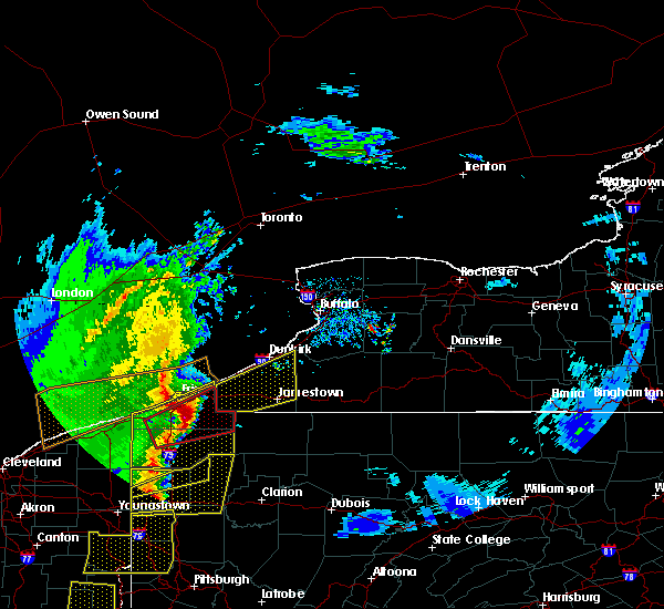 At 711 pm edt, severe thunderstorms were located along a line extending from near erie to edinboro, moving northeast at 60 mph. at 711 pm, public reports ping pong ball size hail near edinboro (trained weather spotters). Hazards include 70 mph wind gusts and ping pong ball size hail. People and animals outdoors will be injured. expect hail damage to roofs, siding, windows, and vehicles. expect considerable tree damage. wind damage is also likely to mobile homes, roofs, and outbuildings. Locations impacted include, erie, meadville, edinboro, titusville, north east, union city, girard, cambridge springs, waterford, albion, linesville, wattsburg, adamsville, canadohta lake, pymatuning central, riceville, harmonsburg, northwest harborcreek, lincolnville and guys mills. At 711 pm edt, severe thunderstorms were located along a line extending from near erie to edinboro, moving northeast at 60 mph. at 711 pm, public reports ping pong ball size hail near edinboro (trained weather spotters). Hazards include 70 mph wind gusts and ping pong ball size hail. People and animals outdoors will be injured. expect hail damage to roofs, siding, windows, and vehicles. expect considerable tree damage. wind damage is also likely to mobile homes, roofs, and outbuildings. Locations impacted include, erie, meadville, edinboro, titusville, north east, union city, girard, cambridge springs, waterford, albion, linesville, wattsburg, adamsville, canadohta lake, pymatuning central, riceville, harmonsburg, northwest harborcreek, lincolnville and guys mills.
|
| 4/14/2019 7:08 PM EDT | Ping Pong Ball sized hail reported 1.9 miles NNW of Edinboro, PA |
| 4/14/2019 7:05 PM EDT | Ping Pong Ball sized hail reported 0.7 miles NW of Edinboro, PA |
| 4/14/2019 7:05 PM EDT |
 At 703 pm edt, severe thunderstorms were located along a line extending from near erie to 7 miles southwest of edinboro, moving northeast at 60 mph. at 703 pm, trained spotter reports quarter- sized hail 5 miles east of conneautville (trained weather spotters). Hazards include 70 mph wind gusts and ping pong ball size hail. People and animals outdoors will be injured. expect hail damage to roofs, siding, windows, and vehicles. expect considerable tree damage. wind damage is also likely to mobile homes, roofs, and outbuildings. Locations impacted include, erie, meadville, edinboro, titusville, north east, union city, girard, cambridge springs, waterford, albion, linesville, wattsburg, adamsville, canadohta lake, pymatuning central, riceville, harmonsburg, northwest harborcreek, lincolnville and guys mills. At 703 pm edt, severe thunderstorms were located along a line extending from near erie to 7 miles southwest of edinboro, moving northeast at 60 mph. at 703 pm, trained spotter reports quarter- sized hail 5 miles east of conneautville (trained weather spotters). Hazards include 70 mph wind gusts and ping pong ball size hail. People and animals outdoors will be injured. expect hail damage to roofs, siding, windows, and vehicles. expect considerable tree damage. wind damage is also likely to mobile homes, roofs, and outbuildings. Locations impacted include, erie, meadville, edinboro, titusville, north east, union city, girard, cambridge springs, waterford, albion, linesville, wattsburg, adamsville, canadohta lake, pymatuning central, riceville, harmonsburg, northwest harborcreek, lincolnville and guys mills.
|
| 4/14/2019 6:59 PM EDT |
 At 659 pm edt, a severe thunderstorm capable of producing a tornado was located near edinboro, or 11 miles north of meadville, moving northeast at 55 mph (radar indicated rotation). Hazards include tornado and ping pong ball size hail. Flying debris will be dangerous to those caught without shelter. mobile homes will be damaged or destroyed. damage to roofs, windows, and vehicles will occur. Tree damage is likely. At 659 pm edt, a severe thunderstorm capable of producing a tornado was located near edinboro, or 11 miles north of meadville, moving northeast at 55 mph (radar indicated rotation). Hazards include tornado and ping pong ball size hail. Flying debris will be dangerous to those caught without shelter. mobile homes will be damaged or destroyed. damage to roofs, windows, and vehicles will occur. Tree damage is likely.
|
| 4/14/2019 6:54 PM EDT | Barn roof blown off near crossingville and pageville rd in erie county PA, 7.3 miles E of Edinboro, PA |
| 4/14/2019 6:46 PM EDT |
 At 646 pm edt, severe thunderstorms were located along a line extending from near girard to near linesville, moving northeast at 60 mph (radar indicated). Hazards include 70 mph wind gusts and ping pong ball size hail. People and animals outdoors will be injured. expect hail damage to roofs, siding, windows, and vehicles. expect considerable tree damage. wind damage is also likely to mobile homes, roofs, and outbuildings. Locations impacted include, erie, meadville, conneaut, edinboro, titusville, north east, union city, girard, north kingsville, cambridge springs, waterford, albion, andover, linesville, wattsburg, adamsville, pymatuning central, riceville, harmonsburg and guys mills. At 646 pm edt, severe thunderstorms were located along a line extending from near girard to near linesville, moving northeast at 60 mph (radar indicated). Hazards include 70 mph wind gusts and ping pong ball size hail. People and animals outdoors will be injured. expect hail damage to roofs, siding, windows, and vehicles. expect considerable tree damage. wind damage is also likely to mobile homes, roofs, and outbuildings. Locations impacted include, erie, meadville, conneaut, edinboro, titusville, north east, union city, girard, north kingsville, cambridge springs, waterford, albion, andover, linesville, wattsburg, adamsville, pymatuning central, riceville, harmonsburg and guys mills.
|
| 4/14/2019 6:42 PM EDT |
 At 642 pm edt, severe thunderstorms were located along a line extending from near albion to pymatuning central, moving northeast at 60 mph (radar indicated). Hazards include 60 mph wind gusts and quarter size hail. Minor damage to vehicles is possible. Expect damage to trees and power lines. At 642 pm edt, severe thunderstorms were located along a line extending from near albion to pymatuning central, moving northeast at 60 mph (radar indicated). Hazards include 60 mph wind gusts and quarter size hail. Minor damage to vehicles is possible. Expect damage to trees and power lines.
|
| 9/3/2018 5:23 PM EDT | One tree down on darrow rd on the southeast side of tow in erie county PA, 1.6 miles NW of Edinboro, PA |
| 9/3/2018 5:10 PM EDT |
 At 510 pm edt, a severe thunderstorm was located near albion, or 16 miles north of meadville, and is nearly stationary (radar indicated). Hazards include 60 mph wind gusts. Expect damage to trees and power lines. Locations impacted include, edinboro, cambridge springs, mill village and venango. At 510 pm edt, a severe thunderstorm was located near albion, or 16 miles north of meadville, and is nearly stationary (radar indicated). Hazards include 60 mph wind gusts. Expect damage to trees and power lines. Locations impacted include, edinboro, cambridge springs, mill village and venango.
|
| 9/3/2018 4:48 PM EDT |
 At 448 pm edt, a severe thunderstorm was located near albion, or 15 miles east of conneaut, and is nearly stationary (radar indicated). Hazards include 60 mph wind gusts and quarter size hail. Minor damage to vehicles is possible. Expect damage to trees and power lines. At 448 pm edt, a severe thunderstorm was located near albion, or 15 miles east of conneaut, and is nearly stationary (radar indicated). Hazards include 60 mph wind gusts and quarter size hail. Minor damage to vehicles is possible. Expect damage to trees and power lines.
|
| 1/1/0001 12:00 AM | Trees down reported from viewer and news photographe in erie county PA, 0.7 miles NW of Edinboro, PA |
| 1/1/0001 12:00 AM | Numerous trees down at water st. and minter hill rd.... floreck and fries rd.... rt. 99 near campbell pottery... and gibson hall and capp road in erie county PA, 0.7 miles NW of Edinboro, PA |
| 7/26/2018 6:56 PM EDT |
 At 655 pm edt, a severe thunderstorm was located over albion, or 13 miles southeast of conneaut, moving northeast at 45 mph (radar indicated). Hazards include 70 mph wind gusts and quarter size hail. Minor damage to vehicles is possible. expect considerable tree damage. wind damage is also likely to mobile homes#commaorellipsis()roofs#commaorellipsis()and outbuildings. Locations impacted include, erie, edinboro, north east, union city, girard, cambridge springs, waterford, albion, wattsburg, northwest harborcreek, harborcreek, lawrence park, wesleyville, lake city, conneautville, cranesville, springboro, platea, mill village and mckean. At 655 pm edt, a severe thunderstorm was located over albion, or 13 miles southeast of conneaut, moving northeast at 45 mph (radar indicated). Hazards include 70 mph wind gusts and quarter size hail. Minor damage to vehicles is possible. expect considerable tree damage. wind damage is also likely to mobile homes#commaorellipsis()roofs#commaorellipsis()and outbuildings. Locations impacted include, erie, edinboro, north east, union city, girard, cambridge springs, waterford, albion, wattsburg, northwest harborcreek, harborcreek, lawrence park, wesleyville, lake city, conneautville, cranesville, springboro, platea, mill village and mckean.
|
| 7/26/2018 6:36 PM EDT |
 At 636 pm edt, a severe thunderstorm was located 8 miles south of conneaut, moving east at 40 mph (radar indicated). Hazards include 60 mph wind gusts and quarter size hail. Minor damage to vehicles is possible. Expect damage to trees and power lines. At 636 pm edt, a severe thunderstorm was located 8 miles south of conneaut, moving east at 40 mph (radar indicated). Hazards include 60 mph wind gusts and quarter size hail. Minor damage to vehicles is possible. Expect damage to trees and power lines.
|
| 5/4/2018 3:56 PM EDT |
 At 356 pm edt, a severe thunderstorm was located near edinboro, or 15 miles south of erie, moving northeast at 55 mph (radar indicated). Hazards include 60 mph wind gusts and nickel size hail. expect damage to trees and power lines At 356 pm edt, a severe thunderstorm was located near edinboro, or 15 miles south of erie, moving northeast at 55 mph (radar indicated). Hazards include 60 mph wind gusts and nickel size hail. expect damage to trees and power lines
|
| 11/5/2017 7:14 PM EST |
 At 714 pm est, a severe thunderstorm was located near edinboro, or 12 miles south of erie, moving east at 50 mph (radar indicated). Hazards include 70 mph wind gusts and penny size hail. Expect considerable tree damage. damage is likely to mobile homes, roofs, and outbuildings. Locations impacted include, erie, corry, edinboro, north east, union city, waterford, wattsburg, northwest harborcreek, harborcreek, lawrence park, wesleyville, mill village, mckean, elgin and middleboro. At 714 pm est, a severe thunderstorm was located near edinboro, or 12 miles south of erie, moving east at 50 mph (radar indicated). Hazards include 70 mph wind gusts and penny size hail. Expect considerable tree damage. damage is likely to mobile homes, roofs, and outbuildings. Locations impacted include, erie, corry, edinboro, north east, union city, waterford, wattsburg, northwest harborcreek, harborcreek, lawrence park, wesleyville, mill village, mckean, elgin and middleboro.
|
| 11/5/2017 7:31 PM EDT |
 At 630 pm est, a severe thunderstorm was located near albion, or 7 miles east of conneaut, moving east at 75 mph (radar indicated). Hazards include 70 mph wind gusts and quarter size hail. Minor damage to vehicles is possible. expect considerable tree damage. Wind damage is also likely to mobile homes, roofs, and outbuildings. At 630 pm est, a severe thunderstorm was located near albion, or 7 miles east of conneaut, moving east at 75 mph (radar indicated). Hazards include 70 mph wind gusts and quarter size hail. Minor damage to vehicles is possible. expect considerable tree damage. Wind damage is also likely to mobile homes, roofs, and outbuildings.
|
| 8/4/2017 4:12 PM EDT |
 At 412 pm edt, a severe thunderstorm was located 8 miles south of albion, or 14 miles southeast of conneaut, moving northeast at 50 mph (radar indicated). Hazards include 60 mph wind gusts. expect damage to trees and power lines At 412 pm edt, a severe thunderstorm was located 8 miles south of albion, or 14 miles southeast of conneaut, moving northeast at 50 mph (radar indicated). Hazards include 60 mph wind gusts. expect damage to trees and power lines
|
| 8/4/2017 3:42 PM EDT |
 At 341 pm edt, severe thunderstorms were located along a line extending from near newton falls to near bristolville moving northeast at 30 mph. this is a secondary line of storms about to move into the area (radar indicated). Hazards include 60 mph wind gusts. Expect damage to trees and power lines. Locations impacted include, meadville, corry, edinboro, titusville, union city, cambridge springs, waterford, albion, andover, linesville, wattsburg, adamsville, canadohta lake, riceville, harmonsburg, lincolnville, guys mills, atlantic, pierpont and cochranton. At 341 pm edt, severe thunderstorms were located along a line extending from near newton falls to near bristolville moving northeast at 30 mph. this is a secondary line of storms about to move into the area (radar indicated). Hazards include 60 mph wind gusts. Expect damage to trees and power lines. Locations impacted include, meadville, corry, edinboro, titusville, union city, cambridge springs, waterford, albion, andover, linesville, wattsburg, adamsville, canadohta lake, riceville, harmonsburg, lincolnville, guys mills, atlantic, pierpont and cochranton.
|
| 8/4/2017 2:58 PM EDT |
 At 258 pm edt, a severe thunderstorm was located over andover, or 23 miles west of meadville, moving northeast at 45 mph (radar indicated). Hazards include 60 mph wind gusts. expect damage to trees and power lines At 258 pm edt, a severe thunderstorm was located over andover, or 23 miles west of meadville, moving northeast at 45 mph (radar indicated). Hazards include 60 mph wind gusts. expect damage to trees and power lines
|
| 8/4/2017 12:57 PM EDT |
 At 1257 pm edt, severe thunderstorms were located along a line extending from near waterford to 6 miles west of union city to near meadville to 6 miles east of atlantic, moving northeast at 30 mph (radar indicated). Hazards include 60 mph wind gusts and quarter size hail. Minor damage to vehicles is possible. Expect damage to trees and power lines. At 1257 pm edt, severe thunderstorms were located along a line extending from near waterford to 6 miles west of union city to near meadville to 6 miles east of atlantic, moving northeast at 30 mph (radar indicated). Hazards include 60 mph wind gusts and quarter size hail. Minor damage to vehicles is possible. Expect damage to trees and power lines.
|
| 8/4/2017 12:37 PM EDT |
 At 1237 pm edt, a severe thunderstorm was located over wattsburg, or 11 miles northwest of corry, moving northeast at 30 mph (radar indicated). Hazards include 60 mph wind gusts and quarter size hail. Minor damage to vehicles is possible. expect damage to trees and power lines. Locations impacted include, corry, edinboro, union city, waterford, wattsburg, mill village and elgin. At 1237 pm edt, a severe thunderstorm was located over wattsburg, or 11 miles northwest of corry, moving northeast at 30 mph (radar indicated). Hazards include 60 mph wind gusts and quarter size hail. Minor damage to vehicles is possible. expect damage to trees and power lines. Locations impacted include, corry, edinboro, union city, waterford, wattsburg, mill village and elgin.
|
| 8/4/2017 12:19 PM EDT |
 At 1218 pm edt, a severe thunderstorm was located over waterford, or 15 miles west of corry, moving northeast at 25 mph. additional potentially severe thunderstorms were located east of harborcreek and near edinboro (radar indicated). Hazards include 60 mph wind gusts and quarter size hail. Minor damage to vehicles is possible. expect damage to trees and power lines. Locations impacted include, erie, corry, edinboro, north east, union city, waterford, wattsburg, northwest harborcreek, harborcreek, wesleyville, mill village, mckean, elgin and middleboro. At 1218 pm edt, a severe thunderstorm was located over waterford, or 15 miles west of corry, moving northeast at 25 mph. additional potentially severe thunderstorms were located east of harborcreek and near edinboro (radar indicated). Hazards include 60 mph wind gusts and quarter size hail. Minor damage to vehicles is possible. expect damage to trees and power lines. Locations impacted include, erie, corry, edinboro, north east, union city, waterford, wattsburg, northwest harborcreek, harborcreek, wesleyville, mill village, mckean, elgin and middleboro.
|
| 8/4/2017 11:58 AM EDT |
 At 1158 am edt, a severe thunderstorm was located near edinboro, or 17 miles south of erie, moving northeast at 25 mph (radar indicated). Hazards include 60 mph wind gusts and quarter size hail. Minor damage to vehicles is possible. Expect damage to trees and power lines. At 1158 am edt, a severe thunderstorm was located near edinboro, or 17 miles south of erie, moving northeast at 25 mph (radar indicated). Hazards include 60 mph wind gusts and quarter size hail. Minor damage to vehicles is possible. Expect damage to trees and power lines.
|
| 6/18/2017 7:09 PM EDT |
 At 709 pm edt, severe thunderstorms were located along a line extending from near north east to wattsburg to near lincolnville to near meadville to 6 miles east of greenville, moving east at 40 mph (radar indicated). Hazards include 60 mph wind gusts. Expect damage to trees and power lines. Locations impacted include, meadville, corry, edinboro, titusville, north east, union city, cambridge springs, waterford, wattsburg, canadohta lake, riceville, lincolnville, guys mills, northwest harborcreek, harborcreek, cochranton, saegertown, hydetown, mill village and blooming valley. At 709 pm edt, severe thunderstorms were located along a line extending from near north east to wattsburg to near lincolnville to near meadville to 6 miles east of greenville, moving east at 40 mph (radar indicated). Hazards include 60 mph wind gusts. Expect damage to trees and power lines. Locations impacted include, meadville, corry, edinboro, titusville, north east, union city, cambridge springs, waterford, wattsburg, canadohta lake, riceville, lincolnville, guys mills, northwest harborcreek, harborcreek, cochranton, saegertown, hydetown, mill village and blooming valley.
|
| 6/18/2017 6:37 PM EDT |
 At 637 pm edt, severe thunderstorms were located along a line extending from near erie to harmonsburg to near cortland, moving east at 40 mph (radar indicated). Hazards include 60 mph wind gusts. expect damage to trees and power lines At 637 pm edt, severe thunderstorms were located along a line extending from near erie to harmonsburg to near cortland, moving east at 40 mph (radar indicated). Hazards include 60 mph wind gusts. expect damage to trees and power lines
|
| 6/18/2017 2:40 PM EDT |
 At 239 pm edt, a severe thunderstorm was located near guys mills, or near meadville, moving northeast at 35 mph (radar indicated). Hazards include 60 mph wind gusts and quarter size hail. Minor damage to vehicles is possible. Expect damage to trees and power lines. At 239 pm edt, a severe thunderstorm was located near guys mills, or near meadville, moving northeast at 35 mph (radar indicated). Hazards include 60 mph wind gusts and quarter size hail. Minor damage to vehicles is possible. Expect damage to trees and power lines.
|
| 5/1/2017 2:30 PM EDT | Trees down from thunderstorm wind in erie county PA, 0.7 miles NW of Edinboro, PA |
| 5/1/2017 2:30 PM EDT | Trees down by thunderstorm wind in erie county PA, 6.7 miles E of Edinboro, PA |
| 5/1/2017 2:29 PM EDT |
 At 228 pm edt, severe thunderstorms were located along a line extending from near erie to 7 miles southeast of atlantic, moving northeast at 30 mph (radar indicated). Hazards include 60 mph wind gusts. Expect damage to roofs, siding, and trees. locations impacted include, erie, meadville, edinboro, cambridge springs, harmonsburg, northwest harborcreek, lawrence park, wesleyville, cochranton, saegertown, conneaut lake, mckean, blooming valley, venango, woodcock, middleboro, conneaut lakeshore, geneva and avonia. A tornado watch remains in effect until 700 pm edt for northwestern pennsylvania. At 228 pm edt, severe thunderstorms were located along a line extending from near erie to 7 miles southeast of atlantic, moving northeast at 30 mph (radar indicated). Hazards include 60 mph wind gusts. Expect damage to roofs, siding, and trees. locations impacted include, erie, meadville, edinboro, cambridge springs, harmonsburg, northwest harborcreek, lawrence park, wesleyville, cochranton, saegertown, conneaut lake, mckean, blooming valley, venango, woodcock, middleboro, conneaut lakeshore, geneva and avonia. A tornado watch remains in effect until 700 pm edt for northwestern pennsylvania.
|
| 5/1/2017 1:59 PM EDT |
 At 158 pm edt, severe thunderstorms were located along a line extending from near conneaut to near sharon, moving northeast at 40 mph (radar indicated). Hazards include 60 mph wind gusts. Expect damage to roofs, siding, and trees. locations impacted include, erie, meadville, conneaut, cortland, edinboro, girard, cambridge springs, kinsman, albion, andover, linesville, vienna center, adamsville, pymatuning central, harmonsburg, pymatuning north, atlantic, northwest harborcreek, vienna and lawrence park. A tornado watch remains in effect until 700 pm edt for northeastern ohio, and northwestern pennsylvania. At 158 pm edt, severe thunderstorms were located along a line extending from near conneaut to near sharon, moving northeast at 40 mph (radar indicated). Hazards include 60 mph wind gusts. Expect damage to roofs, siding, and trees. locations impacted include, erie, meadville, conneaut, cortland, edinboro, girard, cambridge springs, kinsman, albion, andover, linesville, vienna center, adamsville, pymatuning central, harmonsburg, pymatuning north, atlantic, northwest harborcreek, vienna and lawrence park. A tornado watch remains in effect until 700 pm edt for northeastern ohio, and northwestern pennsylvania.
|
| 5/1/2017 1:45 PM EDT |
 At 144 pm edt, a severe thunderstorm was located near andover, or 23 miles north of sharpsville, moving northeast at 45 mph (radar indicated). Hazards include 60 mph wind gusts. expect damage to roofs, siding, and trees At 144 pm edt, a severe thunderstorm was located near andover, or 23 miles north of sharpsville, moving northeast at 45 mph (radar indicated). Hazards include 60 mph wind gusts. expect damage to roofs, siding, and trees
|
| 3/1/2017 5:13 PM EST |
 At 512 pm est, severe thunderstorms were located along a line extending from near erie to near edinboro to near pymatuning north, moving east at 40 mph (radar indicated). Hazards include 60 mph wind gusts. Expect damage to roofs, siding, and trees. Locations impacted include, erie, meadville, corry, edinboro, titusville, north east, union city, girard, cambridge springs, waterford, albion, linesville, wattsburg, adamsville, pymatuning central, riceville, harmonsburg, guys mills, pymatuning north and atlantic. At 512 pm est, severe thunderstorms were located along a line extending from near erie to near edinboro to near pymatuning north, moving east at 40 mph (radar indicated). Hazards include 60 mph wind gusts. Expect damage to roofs, siding, and trees. Locations impacted include, erie, meadville, corry, edinboro, titusville, north east, union city, girard, cambridge springs, waterford, albion, linesville, wattsburg, adamsville, pymatuning central, riceville, harmonsburg, guys mills, pymatuning north and atlantic.
|
| 3/1/2017 4:49 PM EST |
 At 449 pm est, severe thunderstorms were located along a line extending from near girard to near albion to 7 miles northeast of orwell, moving east at 70 mph (radar indicated). Hazards include 60 mph wind gusts. expect damage to roofs, siding, and trees At 449 pm est, severe thunderstorms were located along a line extending from near girard to near albion to 7 miles northeast of orwell, moving east at 70 mph (radar indicated). Hazards include 60 mph wind gusts. expect damage to roofs, siding, and trees
|
| 3/1/2017 6:47 AM EST |
 At 646 am est, severe thunderstorms were located along a line extending from 10 miles northwest of lake erie state park to near union city to near atlantic, moving east at 55 mph (radar indicated). Hazards include 60 mph wind gusts. Expect damage to roofs, siding, and trees. Locations impacted include, meadville, corry, edinboro, titusville, north east, union city, cambridge springs, waterford, wattsburg, adamsville, riceville, guys mills, atlantic, canadohta lake, lincolnville, harmonsburg, cochranton, saegertown, conneaut lake and hydetown. At 646 am est, severe thunderstorms were located along a line extending from 10 miles northwest of lake erie state park to near union city to near atlantic, moving east at 55 mph (radar indicated). Hazards include 60 mph wind gusts. Expect damage to roofs, siding, and trees. Locations impacted include, meadville, corry, edinboro, titusville, north east, union city, cambridge springs, waterford, wattsburg, adamsville, riceville, guys mills, atlantic, canadohta lake, lincolnville, harmonsburg, cochranton, saegertown, conneaut lake and hydetown.
|
| 3/1/2017 6:17 AM EST |
 At 617 am est, severe thunderstorms were located along a line extending from 21 miles northwest of north east to albion to 6 miles east of orwell, moving east at 40 mph (radar indicated). Hazards include 60 mph wind gusts and quarter size hail. Hail damage to vehicles is expected. expect wind damage to roofs, siding, and trees. Locations impacted include, erie, meadville, corry, edinboro, titusville, north east, union city, girard, cambridge springs, waterford, albion, andover, linesville, wattsburg, adamsville, pymatuning central, riceville, harmonsburg, guys mills and pymatuning north. At 617 am est, severe thunderstorms were located along a line extending from 21 miles northwest of north east to albion to 6 miles east of orwell, moving east at 40 mph (radar indicated). Hazards include 60 mph wind gusts and quarter size hail. Hail damage to vehicles is expected. expect wind damage to roofs, siding, and trees. Locations impacted include, erie, meadville, corry, edinboro, titusville, north east, union city, girard, cambridge springs, waterford, albion, andover, linesville, wattsburg, adamsville, pymatuning central, riceville, harmonsburg, guys mills and pymatuning north.
|
| 3/1/2017 5:45 AM EST |
 At 545 am est, severe thunderstorms were located along a line extending from 31 miles north of conneaut to 6 miles southeast of madison, moving east at 55 mph (radar indicated). Hazards include 60 mph wind gusts and quarter size hail. Hail damage to vehicles is expected. Expect wind damage to roofs, siding, and trees. At 545 am est, severe thunderstorms were located along a line extending from 31 miles north of conneaut to 6 miles southeast of madison, moving east at 55 mph (radar indicated). Hazards include 60 mph wind gusts and quarter size hail. Hail damage to vehicles is expected. Expect wind damage to roofs, siding, and trees.
|
| 3/1/2017 3:28 AM EST |
 The severe thunderstorm warning for erie and crawford counties will expire at 330 am est, the storms which prompted the warning have moved out of the area. therefore the warning will be allowed to expire. however gusty winds are still possible with these thunderstorms. The severe thunderstorm warning for erie and crawford counties will expire at 330 am est, the storms which prompted the warning have moved out of the area. therefore the warning will be allowed to expire. however gusty winds are still possible with these thunderstorms.
|
| 3/1/2017 2:59 AM EST |
 At 259 am est, severe thunderstorms were located along a line extending from 6 miles southeast of albion to 9 miles east of greenville, moving northeast at 65 mph (radar indicated). Hazards include 70 mph wind gusts. Expect considerable tree damage. damage is likely to mobile homes, roofs, and outbuildings. Locations impacted include, erie, meadville, corry, edinboro, titusville, union city, girard, cambridge springs, waterford, albion, linesville, wattsburg, adamsville, pymatuning central, riceville, harmonsburg, guys mills, pymatuning north, atlantic and canadohta lake. At 259 am est, severe thunderstorms were located along a line extending from 6 miles southeast of albion to 9 miles east of greenville, moving northeast at 65 mph (radar indicated). Hazards include 70 mph wind gusts. Expect considerable tree damage. damage is likely to mobile homes, roofs, and outbuildings. Locations impacted include, erie, meadville, corry, edinboro, titusville, union city, girard, cambridge springs, waterford, albion, linesville, wattsburg, adamsville, pymatuning central, riceville, harmonsburg, guys mills, pymatuning north, atlantic and canadohta lake.
|
| 3/1/2017 2:10 AM EST |
 At 209 am est, severe thunderstorms were located along a line extending from near cleveland heights to near middlefield to near newton falls, moving east at 80 mph (radar indicated). Hazards include 70 mph wind gusts. Expect considerable tree damage. Damage is likely to mobile homes, roofs, and outbuildings. At 209 am est, severe thunderstorms were located along a line extending from near cleveland heights to near middlefield to near newton falls, moving east at 80 mph (radar indicated). Hazards include 70 mph wind gusts. Expect considerable tree damage. Damage is likely to mobile homes, roofs, and outbuildings.
|
| 9/10/2016 7:28 PM EDT |
 At 727 pm edt, severe thunderstorms were located along a line extending from north east to cambridge springs, moving northeast at 45 mph (radar indicated). Hazards include 60 mph wind gusts and nickel size hail. Expect damage to roofs. siding and trees. Locations impacted include, erie, meadville, edinboro, north east, union city, cambridge springs, waterford, wattsburg, adamsville, atlantic, northwest harborcreek, harmonsburg, pymatuning central, harborcreek, lawrence park, wesleyville, saegertown, conneaut lake, mill village and mckean. At 727 pm edt, severe thunderstorms were located along a line extending from north east to cambridge springs, moving northeast at 45 mph (radar indicated). Hazards include 60 mph wind gusts and nickel size hail. Expect damage to roofs. siding and trees. Locations impacted include, erie, meadville, edinboro, north east, union city, cambridge springs, waterford, wattsburg, adamsville, atlantic, northwest harborcreek, harmonsburg, pymatuning central, harborcreek, lawrence park, wesleyville, saegertown, conneaut lake, mill village and mckean.
|
| 9/10/2016 7:02 PM EDT |
 At 637 pm edt, severe thunderstorms were located along a line extending from near conneaut to near andover, moving east at 30 mph (radar indicated). Hazards include 60 mph wind gusts and nickel size hail. Expect damage to roofs. Siding and trees. At 637 pm edt, severe thunderstorms were located along a line extending from near conneaut to near andover, moving east at 30 mph (radar indicated). Hazards include 60 mph wind gusts and nickel size hail. Expect damage to roofs. Siding and trees.
|
| 9/10/2016 6:38 PM EDT |
 At 637 pm edt, severe thunderstorms were located along a line extending from near conneaut to near andover, moving east at 30 mph (radar indicated). Hazards include 60 mph wind gusts and nickel size hail. Expect damage to roofs. Siding and trees. At 637 pm edt, severe thunderstorms were located along a line extending from near conneaut to near andover, moving east at 30 mph (radar indicated). Hazards include 60 mph wind gusts and nickel size hail. Expect damage to roofs. Siding and trees.
|
| 9/8/2016 4:16 PM EDT |
 At 416 pm edt, severe thunderstorms were located along a line extending from waterford to near cambridge springs to near kinsman, moving east at 40 mph (radar indicated). Hazards include 60 mph wind gusts. Expect damage to roofs. Siding and trees. At 416 pm edt, severe thunderstorms were located along a line extending from waterford to near cambridge springs to near kinsman, moving east at 40 mph (radar indicated). Hazards include 60 mph wind gusts. Expect damage to roofs. Siding and trees.
|
| 8/13/2016 4:33 PM EDT |
 At 433 pm edt, a severe thunderstorm was located near girard, or 12 miles southwest of erie, moving northeast at 40 mph (radar indicated). Hazards include 60 mph wind gusts and quarter size hail. Expect wind damage to roofs. Siding and trees. At 433 pm edt, a severe thunderstorm was located near girard, or 12 miles southwest of erie, moving northeast at 40 mph (radar indicated). Hazards include 60 mph wind gusts and quarter size hail. Expect wind damage to roofs. Siding and trees.
|
| 8/11/2016 6:21 PM EDT |
 At 620 pm edt, severe thunderstorms were located along a line extending from 6 miles south of ashtabula to near jefferson to near orwell, moving east at 60 mph (radar indicated). Hazards include 60 mph wind gusts and quarter size hail. Hail damage to vehicles is expected. Expect wind damage to roofs, siding and trees. At 620 pm edt, severe thunderstorms were located along a line extending from 6 miles south of ashtabula to near jefferson to near orwell, moving east at 60 mph (radar indicated). Hazards include 60 mph wind gusts and quarter size hail. Hail damage to vehicles is expected. Expect wind damage to roofs, siding and trees.
|
| 7/13/2016 11:59 PM EDT |
 At 1158 pm edt, severe thunderstorms were located along a line extending from near girard to 7 miles southwest of meadville, moving east at 30 mph (radar indicated). Hazards include 60 mph wind gusts. Expect damage to roofs. siding and trees. Locations impacted include, erie, ashtabula, meadville, conneaut, corry, edinboro, titusville, north east, union city, girard, north kingsville, cambridge springs, waterford, wattsburg, lincolnville, canadohta lake, guys mills, riceville, northwest harborcreek and harborcreek. At 1158 pm edt, severe thunderstorms were located along a line extending from near girard to 7 miles southwest of meadville, moving east at 30 mph (radar indicated). Hazards include 60 mph wind gusts. Expect damage to roofs. siding and trees. Locations impacted include, erie, ashtabula, meadville, conneaut, corry, edinboro, titusville, north east, union city, girard, north kingsville, cambridge springs, waterford, wattsburg, lincolnville, canadohta lake, guys mills, riceville, northwest harborcreek and harborcreek.
|
| 7/13/2016 11:13 PM EDT |
 At 1112 pm edt, severe thunderstorms were located along a line extending from near geneva-on-the-lake to near north bloomfield, moving east at 50 mph (radar indicated). Hazards include 60 mph wind gusts. Hail damage to vehicles is expected. Expect wind damage to roofs, siding and trees. At 1112 pm edt, severe thunderstorms were located along a line extending from near geneva-on-the-lake to near north bloomfield, moving east at 50 mph (radar indicated). Hazards include 60 mph wind gusts. Hail damage to vehicles is expected. Expect wind damage to roofs, siding and trees.
|
| 7/8/2016 10:02 PM EDT |
 At 1002 pm edt, a severe thunderstorm was located 8 miles northwest of waterford, or 9 miles south of erie, moving east at 25 mph (radar indicated). Hazards include 60 mph wind gusts and quarter size hail. Hail damage to vehicles is expected. Expect wind damage to roofs, siding and trees. At 1002 pm edt, a severe thunderstorm was located 8 miles northwest of waterford, or 9 miles south of erie, moving east at 25 mph (radar indicated). Hazards include 60 mph wind gusts and quarter size hail. Hail damage to vehicles is expected. Expect wind damage to roofs, siding and trees.
|
| 6/21/2016 12:45 AM EDT |
 At 1245 am edt, a severe thunderstorm was located near ashtabula, moving east at 40 mph (radar indicated). Hazards include 60 mph wind gusts and quarter size hail. Hail damage to vehicles is expected. Expect wind damage to roofs, siding and trees. At 1245 am edt, a severe thunderstorm was located near ashtabula, moving east at 40 mph (radar indicated). Hazards include 60 mph wind gusts and quarter size hail. Hail damage to vehicles is expected. Expect wind damage to roofs, siding and trees.
|
| 6/5/2016 4:16 PM EDT |
 At 415 pm edt, severe thunderstorms were located along a line extending from near findley lake to near union city to near pymatuning central, moving east at 40 mph. trained weather spotters reported some trees down in the cranesville area earlier and law enforcementreported some trees down as well in the northwest portion ofcrawford county (trained weather spotters and law enforcement). Hazards include 60 mph wind gusts and quarter size hail. Hail damage to vehicles is expected. expect wind damage to roofs, siding and trees. Locations impacted include, erie, meadville, corry, edinboro, titusville, north east, union city, cambridge springs, waterford, linesville, wattsburg, lincolnville, pymatuning central, canadohta lake, guys mills, harmonsburg, riceville, adamsville, pymatuning north and atlantic. At 415 pm edt, severe thunderstorms were located along a line extending from near findley lake to near union city to near pymatuning central, moving east at 40 mph. trained weather spotters reported some trees down in the cranesville area earlier and law enforcementreported some trees down as well in the northwest portion ofcrawford county (trained weather spotters and law enforcement). Hazards include 60 mph wind gusts and quarter size hail. Hail damage to vehicles is expected. expect wind damage to roofs, siding and trees. Locations impacted include, erie, meadville, corry, edinboro, titusville, north east, union city, cambridge springs, waterford, linesville, wattsburg, lincolnville, pymatuning central, canadohta lake, guys mills, harmonsburg, riceville, adamsville, pymatuning north and atlantic.
|
| 6/5/2016 3:42 PM EDT |
 At 342 pm edt, severe thunderstorms were located along a line extending from near girard to near andover, moving northeast at 40 mph (radar indicated). Hazards include 60 mph wind gusts and quarter size hail. Hail damage to vehicles is expected. Expect wind damage to roofs, siding and trees. At 342 pm edt, severe thunderstorms were located along a line extending from near girard to near andover, moving northeast at 40 mph (radar indicated). Hazards include 60 mph wind gusts and quarter size hail. Hail damage to vehicles is expected. Expect wind damage to roofs, siding and trees.
|
| 9/4/2015 9:12 PM EDT |
 At 911 pm edt, severe thunderstorms were located along a line extending from near wattsburg to near edinboro, moving north at 30 mph (radar indicated). Hazards include 60 mph wind gusts and penny size hail. Expect damage to roofs. Siding and trees. At 911 pm edt, severe thunderstorms were located along a line extending from near wattsburg to near edinboro, moving north at 30 mph (radar indicated). Hazards include 60 mph wind gusts and penny size hail. Expect damage to roofs. Siding and trees.
|
| 9/3/2015 4:10 PM EDT |
 At 409 pm edt, a severe thunderstorm was located near wattsburg, or 22 miles southeast of erie, moving east at 15 mph. another storm was located northwest of union city moving east at 15 mph (radar indicated). Hazards include 60 mph wind gusts and quarter size hail. Hail damage to vehicles is expected. expect wind damage to roofs, siding and trees. Locations impacted include, corry, edinboro, union city, waterford, wattsburg, mill village and elgin. At 409 pm edt, a severe thunderstorm was located near wattsburg, or 22 miles southeast of erie, moving east at 15 mph. another storm was located northwest of union city moving east at 15 mph (radar indicated). Hazards include 60 mph wind gusts and quarter size hail. Hail damage to vehicles is expected. expect wind damage to roofs, siding and trees. Locations impacted include, corry, edinboro, union city, waterford, wattsburg, mill village and elgin.
|
| 9/3/2015 3:48 PM EDT |
 At 347 pm edt, a severe thunderstorm was located near wattsburg, or 17 miles southeast of erie, moving southwest at 5 mph (radar indicated). Hazards include 60 mph wind gusts and quarter size hail. Hail damage to vehicles is expected. Expect wind damage to roofs, siding and trees. At 347 pm edt, a severe thunderstorm was located near wattsburg, or 17 miles southeast of erie, moving southwest at 5 mph (radar indicated). Hazards include 60 mph wind gusts and quarter size hail. Hail damage to vehicles is expected. Expect wind damage to roofs, siding and trees.
|
| 6/23/2015 4:44 AM EDT |
 At 443 am edt, severe thunderstorms were located along a line extending from 8 miles north of northwest harborcreek to near waterford to near andover, moving east at 50 mph. this line has weakened but is still capable of producing 60 mph wind gusts (radar indicated). Hazards include 60 mph wind gusts. Expect damage to roofs. siding and trees. Locations impacted include, erie, meadville, edinboro, titusville, north east, union city, girard, cambridge springs, waterford, albion, linesville, wattsburg, northwest harborcreek, harborcreek, lawrence park, wesleyville, lake city, cochranton, saegertown and conneautville. At 443 am edt, severe thunderstorms were located along a line extending from 8 miles north of northwest harborcreek to near waterford to near andover, moving east at 50 mph. this line has weakened but is still capable of producing 60 mph wind gusts (radar indicated). Hazards include 60 mph wind gusts. Expect damage to roofs. siding and trees. Locations impacted include, erie, meadville, edinboro, titusville, north east, union city, girard, cambridge springs, waterford, albion, linesville, wattsburg, northwest harborcreek, harborcreek, lawrence park, wesleyville, lake city, cochranton, saegertown and conneautville.
|
| 6/23/2015 4:05 AM EDT |
 At 404 am edt, severe thunderstorms were located along a line extending from 24 miles northwest of conneaut to north kingsville to near chardon, moving east at 60 mph. these are very dangerous storms (radar indicated). Hazards include 80 mph wind gusts. Flying debris will be dangerous to those caught without shelter. mobile homes will be heavily damaged. expect considerable damage to roofs, windows and vehicles. Extensive tree damage and power outages are likely. At 404 am edt, severe thunderstorms were located along a line extending from 24 miles northwest of conneaut to north kingsville to near chardon, moving east at 60 mph. these are very dangerous storms (radar indicated). Hazards include 80 mph wind gusts. Flying debris will be dangerous to those caught without shelter. mobile homes will be heavily damaged. expect considerable damage to roofs, windows and vehicles. Extensive tree damage and power outages are likely.
|
| 6/14/2015 7:13 PM EDT |
 At 712 pm edt, severe thunderstorms were located along a line extending from near northwest harborcreek to near wattsburg to near union city to near meadville, moving east at 45 mph (radar indicated). Hazards include 60 mph wind gusts. Expect damage to roofs. siding and trees. Locations impacted include, erie, meadville, edinboro, titusville, north east, union city, cambridge springs, waterford, wattsburg, northwest harborcreek, harborcreek, lawrence park, wesleyville, cochranton, saegertown, hydetown, mill village, blooming valley, townville and spartansburg. At 712 pm edt, severe thunderstorms were located along a line extending from near northwest harborcreek to near wattsburg to near union city to near meadville, moving east at 45 mph (radar indicated). Hazards include 60 mph wind gusts. Expect damage to roofs. siding and trees. Locations impacted include, erie, meadville, edinboro, titusville, north east, union city, cambridge springs, waterford, wattsburg, northwest harborcreek, harborcreek, lawrence park, wesleyville, cochranton, saegertown, hydetown, mill village, blooming valley, townville and spartansburg.
|
| 6/14/2015 6:53 PM EDT | Tree down in franklin township in erie county PA, 3.9 miles SE of Edinboro, PA |
| 6/14/2015 6:41 PM EDT |
 At 640 pm edt, severe thunderstorms were located along a line extending from near girard to 7 miles north of andover, moving east at 45 mph (radar indicated). Hazards include 60 mph wind gusts. Expect damage to roofs. Siding and trees. At 640 pm edt, severe thunderstorms were located along a line extending from near girard to 7 miles north of andover, moving east at 45 mph (radar indicated). Hazards include 60 mph wind gusts. Expect damage to roofs. Siding and trees.
|
| 6/12/2015 4:10 PM EDT |
 At 410 pm edt, severe thunderstorms were located along a line extending from near waterford to near greenville, moving east at 50 mph (radar indicated). Hazards include 60 mph wind gusts. Expect damage to roofs. Siding and trees. At 410 pm edt, severe thunderstorms were located along a line extending from near waterford to near greenville, moving east at 50 mph (radar indicated). Hazards include 60 mph wind gusts. Expect damage to roofs. Siding and trees.
|
| 5/11/2015 8:34 PM EDT | At 832 pm edt, a severe thunderstorm was located near north east, and moving northeast at 50 mph. additional storms in crawford county may move northeast into eastern erie before 9 pm (radar indicated). Hazards include 60 mph wind gusts and quarter size hail. Hail damage to vehicles is expected. Expect wind damage to roofs, siding and trees. |
| 5/11/2015 8:30 PM EDT | Large beech tree fell at trained spotters location 2 s of edinbor in crawford county PA, 1.9 miles NNW of Edinboro, PA |
| 5/11/2015 7:51 PM EDT | At 747 pm edt, a severe thunderstorm was located near girard, and moving northeast at 45 mph. additionally there is another severe thunderstorm near jefferson ohio which will move into erie county around 8 pm (radar indicated). Hazards include 60 mph wind gusts and quarter size hail. Hail damage to vehicles is expected. Expect wind damage to roofs, siding and trees. |
| 4/4/2014 5:45 PM EDT | One tree down near cypress and jefferso in erie county PA, 0.7 miles NW of Edinboro, PA |
| 7/23/2013 4:34 PM EDT | Multiple trees down blocking one lane of i-7 in erie county PA, 1.6 miles ENE of Edinboro, PA |
| 5/28/2013 7:59 PM EDT | Mobile home destroyed in washington township by possible tornado. reported by pem in erie county PA, 4.3 miles SW of Edinboro, PA |
| 7/26/2012 1:34 PM EDT | Trees and large limbs dow in erie county PA, 0.7 miles NW of Edinboro, PA |
| 7/3/2012 8:15 PM EDT | Storm damage reported in crawford county PA, 1.9 miles NNW of Edinboro, PA |
| 7/3/2012 8:01 PM EDT | Quarter sized hail reported 0.7 miles NW of Edinboro, PA |
Hail Maps for Edinboro, PA


Connect with Interactive Hail Maps