

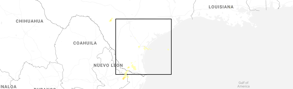
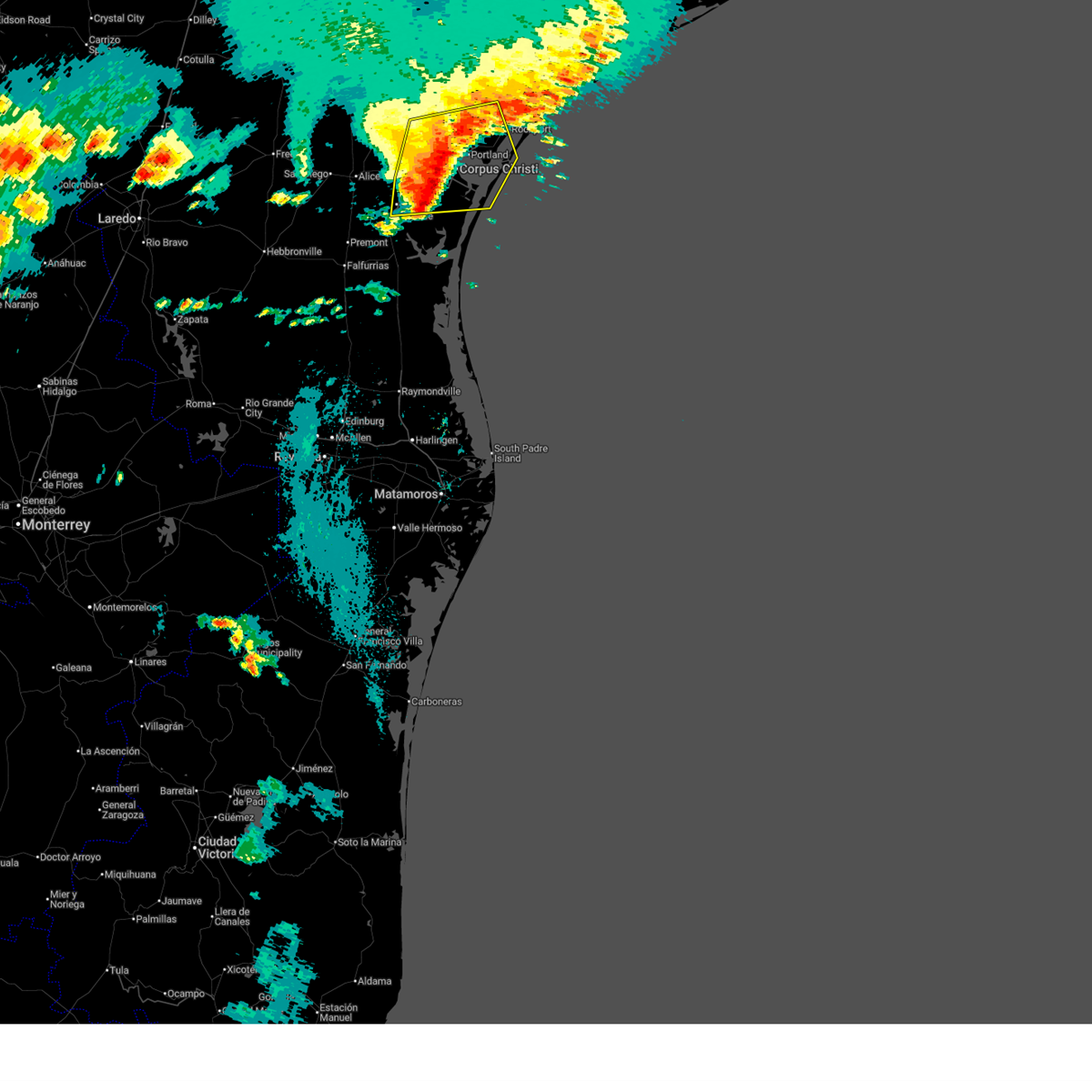
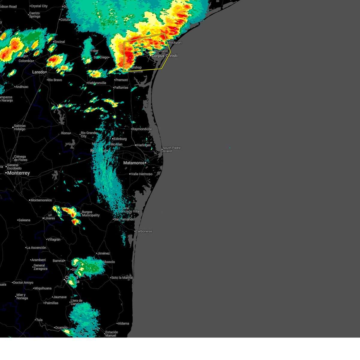
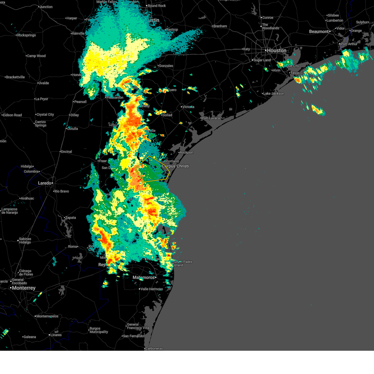
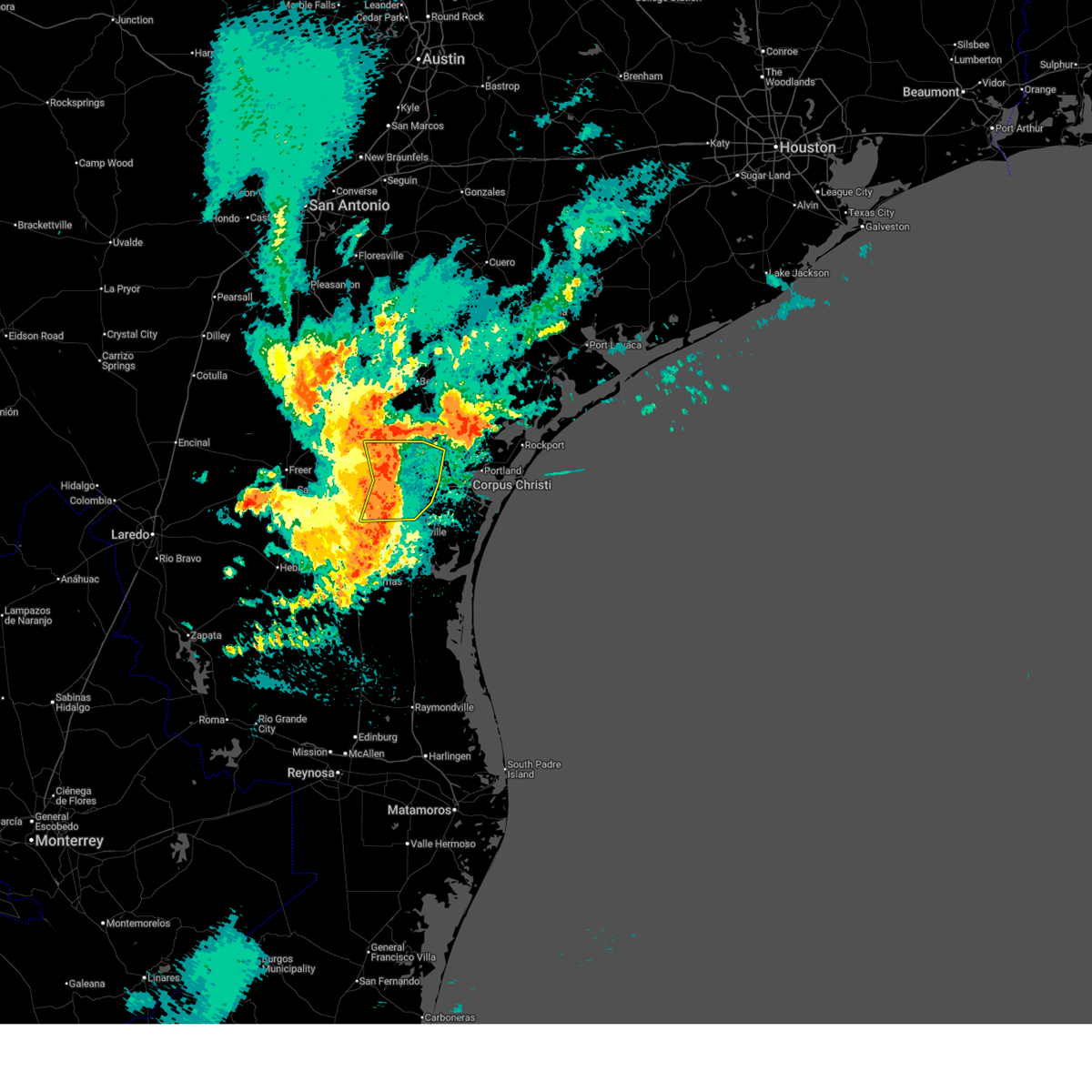
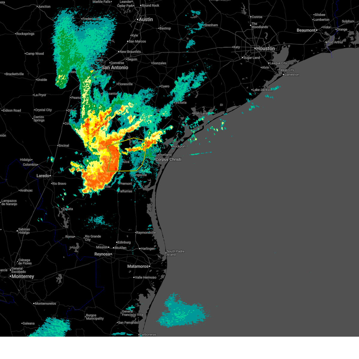
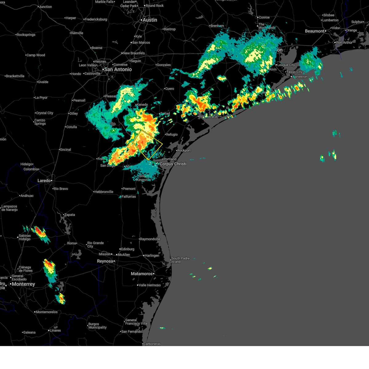
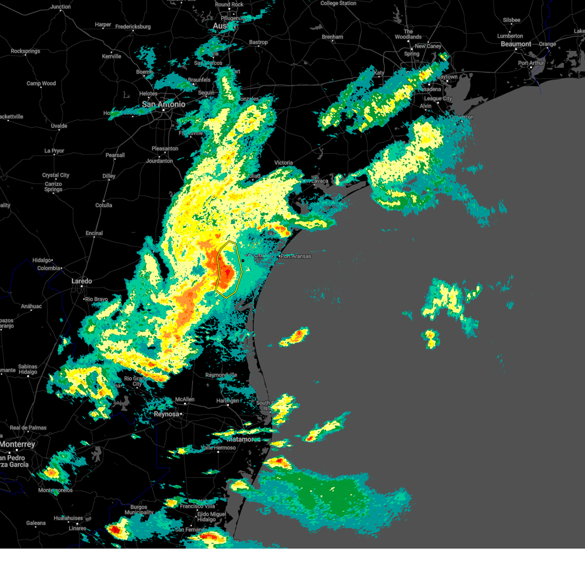
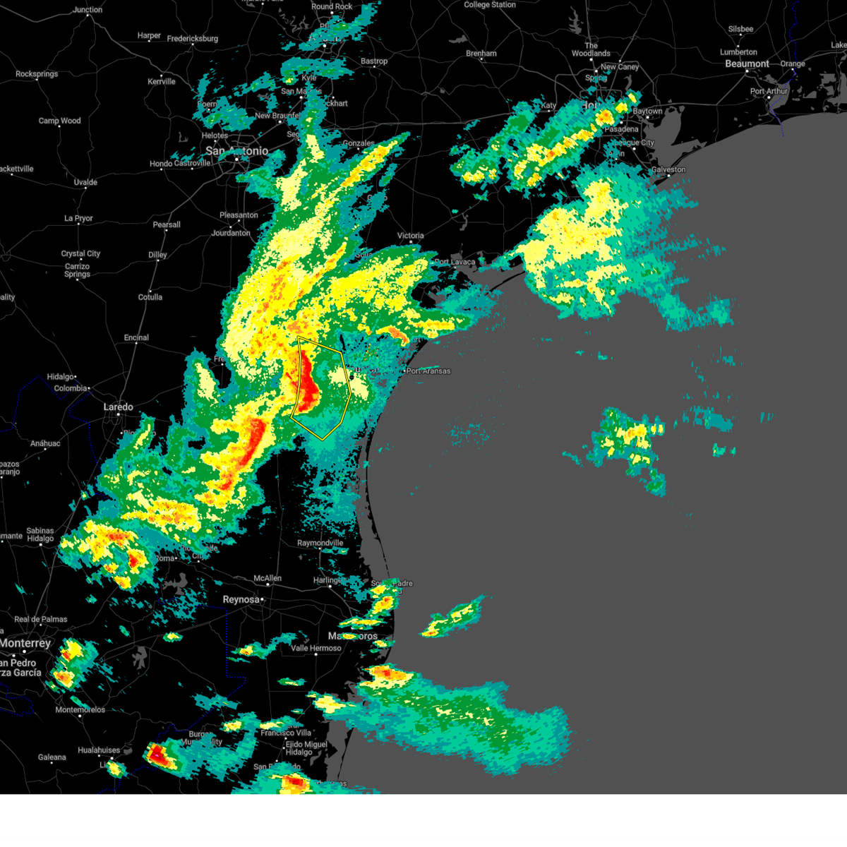
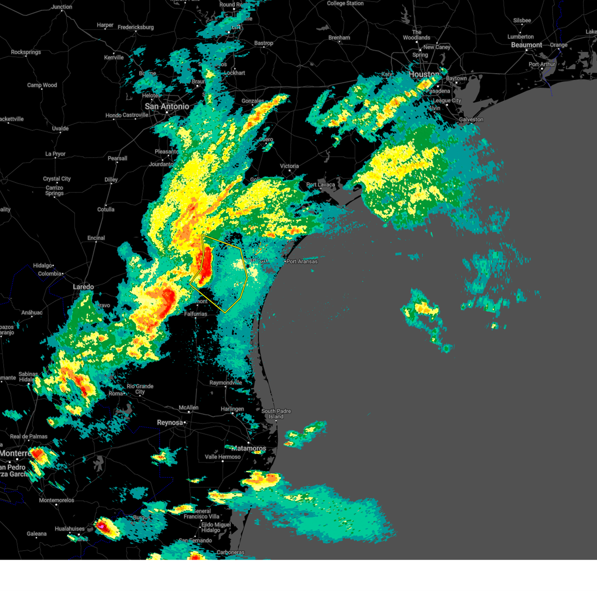
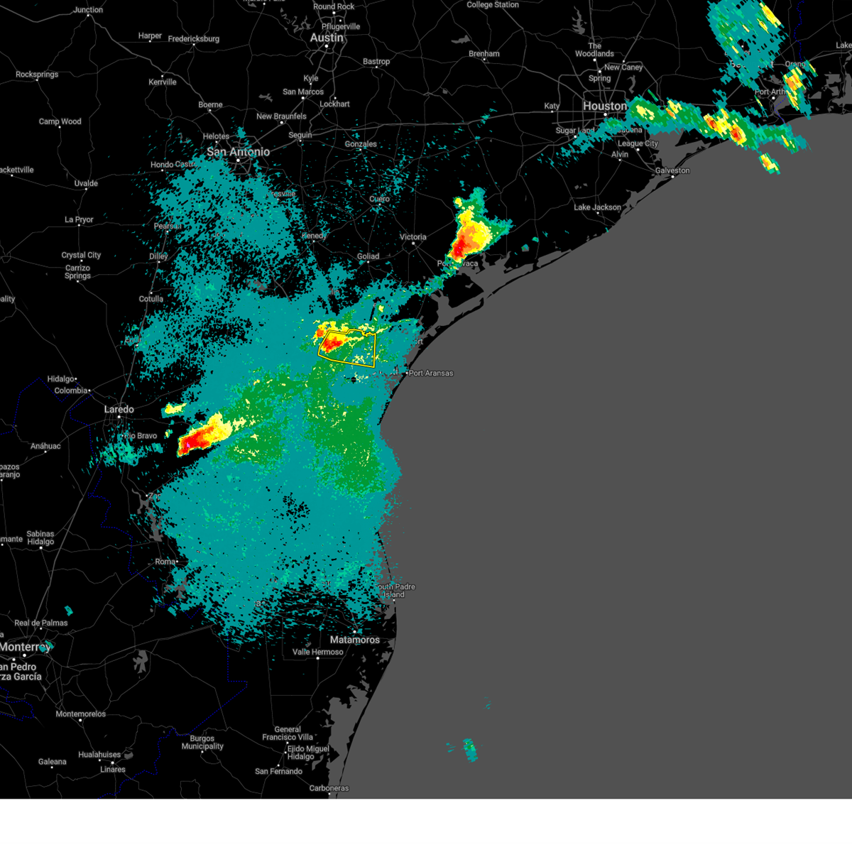
Hail Map for Edroy, TX
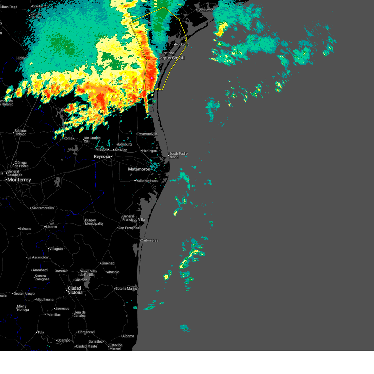
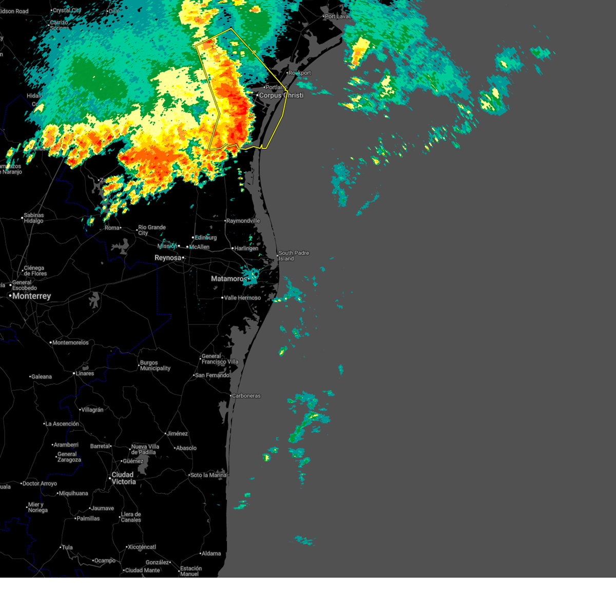
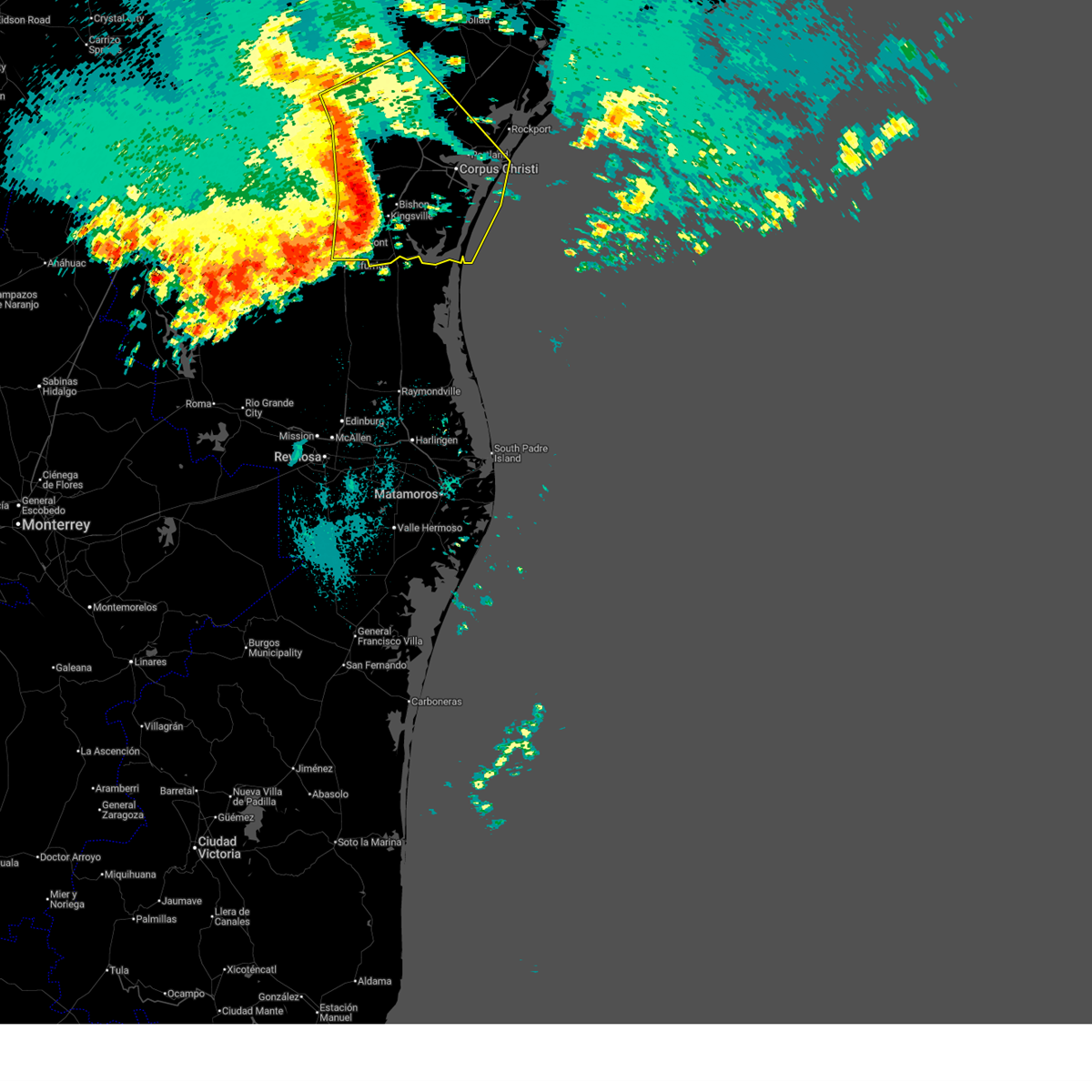
The Edroy, TX area has had 0 reports of on-the-ground hail by trained spotters, and has been under severe weather warnings 12 times during the past 12 months. Doppler radar has detected hail at or near Edroy, TX on 26 occasions.
| Name: | Edroy, TX |
| Where Located: | 20.2 miles NW of Corpus Christi, TX |
| Map: | Google Map for Edroy, TX |
| Population: | 331 |
| Housing Units: | 141 |
| More Info: | Search Google for Edroy, TX |
0
The Top Recent Hail Date for Edroy, TX is Thursday, June 12, 2025 (17th out of 26)
Hail and Wind Damage Spotted near Edroy, TX
| Date / Time | Report Details |
|---|---|
| 5/27/2026 6:41 AM CDT |
 Svrcrp the national weather service in corpus christi has issued a * severe thunderstorm warning for, aransas county in south central texas, southeastern nueces county in south central texas, san patricio county in south central texas, southwestern victoria county in south central texas, southeastern goliad county in south central texas, refugio county in south central texas, eastern kleberg county in south central texas, bee county in south central texas, * until 745 am cdt. * at 641 am cdt, severe thunderstorms were located along a line extending from 6 miles southwest of normanna to near skidmore to cole park to 7 miles west of malaquite beach to 11 miles southeast of riviera beach, moving east at 40 mph (radar indicated). Hazards include 70 mph wind gusts and nickel size hail. Expect considerable tree damage. Damage is likely to mobile homes, roofs, and outbuildings. Svrcrp the national weather service in corpus christi has issued a * severe thunderstorm warning for, aransas county in south central texas, southeastern nueces county in south central texas, san patricio county in south central texas, southwestern victoria county in south central texas, southeastern goliad county in south central texas, refugio county in south central texas, eastern kleberg county in south central texas, bee county in south central texas, * until 745 am cdt. * at 641 am cdt, severe thunderstorms were located along a line extending from 6 miles southwest of normanna to near skidmore to cole park to 7 miles west of malaquite beach to 11 miles southeast of riviera beach, moving east at 40 mph (radar indicated). Hazards include 70 mph wind gusts and nickel size hail. Expect considerable tree damage. Damage is likely to mobile homes, roofs, and outbuildings.
|
| 5/27/2026 6:25 AM CDT |
 At 625 am cdt, severe thunderstorms were located along a line extending from near argenta to near robstown to near clarkwood to 6 miles west of south texas botanical gardens to 13 miles west of malaquite beach to 15 miles east of riviera to near riviera beach, moving east at 45 mph (radar indicated). Hazards include 70 mph wind gusts and quarter size hail. Hail damage to vehicles is expected. expect considerable tree damage. wind damage is also likely to mobile homes, roofs, and outbuildings. locations impacted include, corpus christi, kingsville, portland, beeville, robstown, sinton, mathis, port aransas, taft, driscoll, corpus christi international airport, skidmore, ingleside, aransas pass, bishop, odem, gregory, orange grove, st. paul, and ingleside on the bay. this includes the following highways, interstate 37 between mile markers 1 and 57. us highway 281 between mile markers 634 and 636. us highway 181 between mile markers 588 and 648. us highway 59 between mile markers 692 and 718. Us highway 77 between mile markers 634 and 708. At 625 am cdt, severe thunderstorms were located along a line extending from near argenta to near robstown to near clarkwood to 6 miles west of south texas botanical gardens to 13 miles west of malaquite beach to 15 miles east of riviera to near riviera beach, moving east at 45 mph (radar indicated). Hazards include 70 mph wind gusts and quarter size hail. Hail damage to vehicles is expected. expect considerable tree damage. wind damage is also likely to mobile homes, roofs, and outbuildings. locations impacted include, corpus christi, kingsville, portland, beeville, robstown, sinton, mathis, port aransas, taft, driscoll, corpus christi international airport, skidmore, ingleside, aransas pass, bishop, odem, gregory, orange grove, st. paul, and ingleside on the bay. this includes the following highways, interstate 37 between mile markers 1 and 57. us highway 281 between mile markers 634 and 636. us highway 181 between mile markers 588 and 648. us highway 59 between mile markers 692 and 718. Us highway 77 between mile markers 634 and 708.
|
| 5/27/2026 5:46 AM CDT |
 Svrcrp the national weather service in corpus christi has issued a * severe thunderstorm warning for, nueces county in south central texas, san patricio county in south central texas, jim wells county in south central texas, southwestern refugio county in south central texas, southern live oak county in south central texas, kleberg county in south central texas, southern bee county in south central texas, * until 645 am cdt. * at 546 am cdt, severe thunderstorms were located along a line extending from 8 miles southwest of george west to near alice to 8 miles east of alice acres to 7 miles west of bishop to near kingsville to 9 miles east of premont to near airport road addition, moving east at 50 mph (radar indicated). Hazards include 70 mph wind gusts and quarter size hail. Hail damage to vehicles is expected. expect considerable tree damage. Wind damage is also likely to mobile homes, roofs, and outbuildings. Svrcrp the national weather service in corpus christi has issued a * severe thunderstorm warning for, nueces county in south central texas, san patricio county in south central texas, jim wells county in south central texas, southwestern refugio county in south central texas, southern live oak county in south central texas, kleberg county in south central texas, southern bee county in south central texas, * until 645 am cdt. * at 546 am cdt, severe thunderstorms were located along a line extending from 8 miles southwest of george west to near alice to 8 miles east of alice acres to 7 miles west of bishop to near kingsville to 9 miles east of premont to near airport road addition, moving east at 50 mph (radar indicated). Hazards include 70 mph wind gusts and quarter size hail. Hail damage to vehicles is expected. expect considerable tree damage. Wind damage is also likely to mobile homes, roofs, and outbuildings.
|
| 5/27/2026 2:02 AM CDT |
 At 200 am cdt, severe thunderstorms were located along a line extending from near edroy to near clarkwood to near driscoll, moving east at 50 mph (radar indicated). Hazards include 60 mph wind gusts and quarter size hail. Hail damage to vehicles is expected. expect wind damage to roofs, siding, and trees. locations impacted include, corpus christi, kingsville, portland, robstown, rockport, sinton, port aransas, taft, driscoll, corpus christi international airport, ingleside, aransas pass, bishop, odem, gregory, st. paul, ingleside on the bay, bayside, palm harbor, and corpus christi north beach. this includes the following highways, interstate 37 between mile markers 1 and 27. us highway 181 between mile markers 618 and 648. Us highway 77 between mile markers 638 and 690. At 200 am cdt, severe thunderstorms were located along a line extending from near edroy to near clarkwood to near driscoll, moving east at 50 mph (radar indicated). Hazards include 60 mph wind gusts and quarter size hail. Hail damage to vehicles is expected. expect wind damage to roofs, siding, and trees. locations impacted include, corpus christi, kingsville, portland, robstown, rockport, sinton, port aransas, taft, driscoll, corpus christi international airport, ingleside, aransas pass, bishop, odem, gregory, st. paul, ingleside on the bay, bayside, palm harbor, and corpus christi north beach. this includes the following highways, interstate 37 between mile markers 1 and 27. us highway 181 between mile markers 618 and 648. Us highway 77 between mile markers 638 and 690.
|
| 5/27/2026 1:38 AM CDT |
 Svrcrp the national weather service in corpus christi has issued a * severe thunderstorm warning for, southwestern aransas county in south central texas, nueces county in south central texas, san patricio county in south central texas, northeastern jim wells county in south central texas, south central refugio county in south central texas, northern kleberg county in south central texas, * until 245 am cdt. * at 138 am cdt, severe thunderstorms were located along a line extending from near bluntzer to near banquete to 6 miles northwest of kingsville, moving east at 50 mph (radar indicated). Hazards include 60 mph wind gusts and quarter size hail. Hail damage to vehicles is expected. Expect wind damage to roofs, siding, and trees. Svrcrp the national weather service in corpus christi has issued a * severe thunderstorm warning for, southwestern aransas county in south central texas, nueces county in south central texas, san patricio county in south central texas, northeastern jim wells county in south central texas, south central refugio county in south central texas, northern kleberg county in south central texas, * until 245 am cdt. * at 138 am cdt, severe thunderstorms were located along a line extending from near bluntzer to near banquete to 6 miles northwest of kingsville, moving east at 50 mph (radar indicated). Hazards include 60 mph wind gusts and quarter size hail. Hail damage to vehicles is expected. Expect wind damage to roofs, siding, and trees.
|
| 5/23/2026 11:23 AM CDT |
 Svrcrp the national weather service in corpus christi has issued a * severe thunderstorm warning for, nueces county in south central texas, south central san patricio county in south central texas, north central kleberg county in south central texas, * until 1215 pm cdt. * at 1122 am cdt, a severe thunderstorm was located near driscoll, moving northeast at 40 mph (radar indicated). Hazards include 60 mph wind gusts and penny size hail. expect damage to roofs, siding, and trees Svrcrp the national weather service in corpus christi has issued a * severe thunderstorm warning for, nueces county in south central texas, south central san patricio county in south central texas, north central kleberg county in south central texas, * until 1215 pm cdt. * at 1122 am cdt, a severe thunderstorm was located near driscoll, moving northeast at 40 mph (radar indicated). Hazards include 60 mph wind gusts and penny size hail. expect damage to roofs, siding, and trees
|
| 5/19/2026 2:26 AM CDT |
 At 226 am cdt, severe thunderstorms were located along a line extending from near river creek acres to lagarto to sandia to 7 miles southwest of banquete to 8 miles southeast of ben bolt to 8 miles north of premont, moving east at 35 mph (radar indicated). Hazards include 60 mph wind gusts and quarter size hail. Hail damage to vehicles is expected. expect wind damage to roofs, siding, and trees. locations impacted include, alice, robstown, driscoll, bishop, odem, orange grove, san patricio, edroy, alfred-south la paloma, bluntzer, banquete, westdale, ben bolt, sandia, west sinton, alfred, calallen, agua dulce, and north san pedro. this includes the following highways, interstate 37 between mile markers 14 and 30. us highway 281 between mile markers 678 and 684. Us highway 77 between mile markers 654 and 684. At 226 am cdt, severe thunderstorms were located along a line extending from near river creek acres to lagarto to sandia to 7 miles southwest of banquete to 8 miles southeast of ben bolt to 8 miles north of premont, moving east at 35 mph (radar indicated). Hazards include 60 mph wind gusts and quarter size hail. Hail damage to vehicles is expected. expect wind damage to roofs, siding, and trees. locations impacted include, alice, robstown, driscoll, bishop, odem, orange grove, san patricio, edroy, alfred-south la paloma, bluntzer, banquete, westdale, ben bolt, sandia, west sinton, alfred, calallen, agua dulce, and north san pedro. this includes the following highways, interstate 37 between mile markers 14 and 30. us highway 281 between mile markers 678 and 684. Us highway 77 between mile markers 654 and 684.
|
| 5/19/2026 1:58 AM CDT |
 Svrcrp the national weather service in corpus christi has issued a * severe thunderstorm warning for, northeastern duval county in south central texas, western nueces county in south central texas, western san patricio county in south central texas, jim wells county in south central texas, southeastern live oak county in south central texas, northwestern kleberg county in south central texas, * until 300 am cdt. * at 157 am cdt, severe thunderstorms were located along a line extending from near clegg to near rancho de la parita to near tecalote to near ben bolt to near palito blanco to near cruz calle, moving east at 35 mph (radar indicated). Hazards include 60 mph wind gusts and quarter size hail. Hail damage to vehicles is expected. Expect wind damage to roofs, siding, and trees. Svrcrp the national weather service in corpus christi has issued a * severe thunderstorm warning for, northeastern duval county in south central texas, western nueces county in south central texas, western san patricio county in south central texas, jim wells county in south central texas, southeastern live oak county in south central texas, northwestern kleberg county in south central texas, * until 300 am cdt. * at 157 am cdt, severe thunderstorms were located along a line extending from near clegg to near rancho de la parita to near tecalote to near ben bolt to near palito blanco to near cruz calle, moving east at 35 mph (radar indicated). Hazards include 60 mph wind gusts and quarter size hail. Hail damage to vehicles is expected. Expect wind damage to roofs, siding, and trees.
|
| 5/11/2026 12:55 AM CDT |
 Svrcrp the national weather service in corpus christi has issued a * severe thunderstorm warning for, aransas county in south central texas, southwestern calhoun county in south texas, central nueces county in south central texas, san patricio county in south central texas, south central goliad county in south central texas, northeastern jim wells county in south central texas, southwestern refugio county in south central texas, eastern kleberg county in south central texas, southeastern bee county in south central texas, * until 200 am cdt. * at 1255 am cdt, severe thunderstorms were located along a line extending from near refugio to st. paul to edroy to near alice to near ben bolt to near san jose, moving southeast at 40 mph (radar indicated). Hazards include 60 mph wind gusts and quarter size hail. Hail damage to vehicles is expected. Expect wind damage to roofs, siding, and trees. Svrcrp the national weather service in corpus christi has issued a * severe thunderstorm warning for, aransas county in south central texas, southwestern calhoun county in south texas, central nueces county in south central texas, san patricio county in south central texas, south central goliad county in south central texas, northeastern jim wells county in south central texas, southwestern refugio county in south central texas, eastern kleberg county in south central texas, southeastern bee county in south central texas, * until 200 am cdt. * at 1255 am cdt, severe thunderstorms were located along a line extending from near refugio to st. paul to edroy to near alice to near ben bolt to near san jose, moving southeast at 40 mph (radar indicated). Hazards include 60 mph wind gusts and quarter size hail. Hail damage to vehicles is expected. Expect wind damage to roofs, siding, and trees.
|
| 5/11/2026 12:37 AM CDT |
 At 1236 am cdt, severe thunderstorms were located along a line extending from 7 miles west of blanconia to near tynan to near sandia to near alfred to near san diego, moving southeast at 45 mph (radar indicated). Hazards include 60 mph wind gusts and quarter size hail. Hail damage to vehicles is expected. expect wind damage to roofs, siding, and trees. locations impacted include, alice, beeville, sinton, mathis, san diego, refugio, woodsboro, skidmore, odem, orange grove, st. paul, lake city, san patricio, midway, edroy, tynan, sandia, west sinton, tecalote, and annarose. this includes the following highways, interstate 37 between mile markers 19 and 48. us highway 281 between mile markers 644 and 676. us highway 181 between mile markers 588 and 622. us highway 59 between mile markers 682 and 704, and between mile markers 750 and 754. Us highway 77 between mile markers 622 and 650. At 1236 am cdt, severe thunderstorms were located along a line extending from 7 miles west of blanconia to near tynan to near sandia to near alfred to near san diego, moving southeast at 45 mph (radar indicated). Hazards include 60 mph wind gusts and quarter size hail. Hail damage to vehicles is expected. expect wind damage to roofs, siding, and trees. locations impacted include, alice, beeville, sinton, mathis, san diego, refugio, woodsboro, skidmore, odem, orange grove, st. paul, lake city, san patricio, midway, edroy, tynan, sandia, west sinton, tecalote, and annarose. this includes the following highways, interstate 37 between mile markers 19 and 48. us highway 281 between mile markers 644 and 676. us highway 181 between mile markers 588 and 622. us highway 59 between mile markers 682 and 704, and between mile markers 750 and 754. Us highway 77 between mile markers 622 and 650.
|
| 5/11/2026 12:37 AM CDT |
 the severe thunderstorm warning has been cancelled and is no longer in effect the severe thunderstorm warning has been cancelled and is no longer in effect
|
| 5/11/2026 12:11 AM CDT |
 Svrcrp the national weather service in corpus christi has issued a * severe thunderstorm warning for, northeastern duval county in south central texas, northwestern nueces county in south central texas, western san patricio county in south central texas, southeastern mcmullen county in south central texas, southwestern goliad county in south central texas, northern jim wells county in south central texas, southwestern refugio county in south central texas, southern live oak county in south central texas, bee county in south central texas, * until 100 am cdt. * at 1210 am cdt, severe thunderstorms were located along a line extending from 7 miles east of pettus to 8 miles northeast of dinero to near river creek acres to near annarose to 9 miles east of seven sisters, moving southeast at 40 mph (radar indicated). Hazards include 60 mph wind gusts and quarter size hail. Hail damage to vehicles is expected. Expect wind damage to roofs, siding, and trees. Svrcrp the national weather service in corpus christi has issued a * severe thunderstorm warning for, northeastern duval county in south central texas, northwestern nueces county in south central texas, western san patricio county in south central texas, southeastern mcmullen county in south central texas, southwestern goliad county in south central texas, northern jim wells county in south central texas, southwestern refugio county in south central texas, southern live oak county in south central texas, bee county in south central texas, * until 100 am cdt. * at 1210 am cdt, severe thunderstorms were located along a line extending from 7 miles east of pettus to 8 miles northeast of dinero to near river creek acres to near annarose to 9 miles east of seven sisters, moving southeast at 40 mph (radar indicated). Hazards include 60 mph wind gusts and quarter size hail. Hail damage to vehicles is expected. Expect wind damage to roofs, siding, and trees.
|
| 6/15/2025 9:15 PM CDT |
 the severe thunderstorm warning has been cancelled and is no longer in effect the severe thunderstorm warning has been cancelled and is no longer in effect
|
| 6/15/2025 8:49 PM CDT |
 At 848 pm cdt, a severe thunderstorm was located over tynan, or 7 miles southwest of skidmore, moving southeast at 30 mph (radar indicated). Hazards include 60 mph wind gusts. Expect damage to roofs, siding, and trees. locations impacted include, sinton, mathis, skidmore, odem, st. paul, west sinton, argenta, papalote, edroy, and tynan. this includes the following highways, interstate 37 between mile markers 16 and 43. us highway 181 between mile markers 596 and 624. Us highway 77 between mile markers 634 and 658. At 848 pm cdt, a severe thunderstorm was located over tynan, or 7 miles southwest of skidmore, moving southeast at 30 mph (radar indicated). Hazards include 60 mph wind gusts. Expect damage to roofs, siding, and trees. locations impacted include, sinton, mathis, skidmore, odem, st. paul, west sinton, argenta, papalote, edroy, and tynan. this includes the following highways, interstate 37 between mile markers 16 and 43. us highway 181 between mile markers 596 and 624. Us highway 77 between mile markers 634 and 658.
|
| 6/15/2025 8:33 PM CDT |
 Svrcrp the national weather service in corpus christi has issued a * severe thunderstorm warning for, western san patricio county in south central texas, southwestern refugio county in south central texas, southeastern live oak county in south central texas, southeastern bee county in south central texas, * until 930 pm cdt. * at 832 pm cdt, a severe thunderstorm was located near argenta, or 10 miles west of skidmore, moving southeast at 30 mph (radar indicated). Hazards include 60 mph wind gusts and penny size hail. expect damage to roofs, siding, and trees Svrcrp the national weather service in corpus christi has issued a * severe thunderstorm warning for, western san patricio county in south central texas, southwestern refugio county in south central texas, southeastern live oak county in south central texas, southeastern bee county in south central texas, * until 930 pm cdt. * at 832 pm cdt, a severe thunderstorm was located near argenta, or 10 miles west of skidmore, moving southeast at 30 mph (radar indicated). Hazards include 60 mph wind gusts and penny size hail. expect damage to roofs, siding, and trees
|
| 5/8/2025 10:07 PM CDT |
 the severe thunderstorm warning has been cancelled and is no longer in effect the severe thunderstorm warning has been cancelled and is no longer in effect
|
| 5/8/2025 10:07 PM CDT |
 At 1006 pm cdt, severe thunderstorms were located along a line extending from near robstown to near driscoll to near kingsville naval air station to ricardo, moving southeast at 35 mph (emergency management). Hazards include 70 mph wind gusts and nickel size hail. Expect considerable tree damage. damage is likely to mobile homes, roofs, and outbuildings. locations impacted include, corpus christi, kingsville, robstown, driscoll, bishop, odem, edroy, bluntzer, banquete, annaville, calallen, kingsville naval air station, petronila, and north san pedro. this includes the following highways, interstate 37 between mile markers 12 and 24. Us highway 77 between mile markers 656 and 688. At 1006 pm cdt, severe thunderstorms were located along a line extending from near robstown to near driscoll to near kingsville naval air station to ricardo, moving southeast at 35 mph (emergency management). Hazards include 70 mph wind gusts and nickel size hail. Expect considerable tree damage. damage is likely to mobile homes, roofs, and outbuildings. locations impacted include, corpus christi, kingsville, robstown, driscoll, bishop, odem, edroy, bluntzer, banquete, annaville, calallen, kingsville naval air station, petronila, and north san pedro. this includes the following highways, interstate 37 between mile markers 12 and 24. Us highway 77 between mile markers 656 and 688.
|
| 5/8/2025 9:46 PM CDT |
 At 945 pm cdt, severe thunderstorms were located along a line extending from near bluntzer to banquete to near bishop to 7 miles west of kingsville, moving southeast at 35 mph (emergency management). Hazards include 70 mph wind gusts and nickel size hail. Expect considerable tree damage. damage is likely to mobile homes, roofs, and outbuildings. locations impacted include, corpus christi, kingsville, robstown, driscoll, bishop, odem, orange grove, san patricio, ricardo, edroy, bluntzer, banquete, sandia, annaville, calallen, kingsville naval air station, alfred-south la paloma, agua dulce, petronila, and north san pedro. this includes the following highways, interstate 37 between mile markers 12 and 25. Us highway 77 between mile markers 656 and 702. At 945 pm cdt, severe thunderstorms were located along a line extending from near bluntzer to banquete to near bishop to 7 miles west of kingsville, moving southeast at 35 mph (emergency management). Hazards include 70 mph wind gusts and nickel size hail. Expect considerable tree damage. damage is likely to mobile homes, roofs, and outbuildings. locations impacted include, corpus christi, kingsville, robstown, driscoll, bishop, odem, orange grove, san patricio, ricardo, edroy, bluntzer, banquete, sandia, annaville, calallen, kingsville naval air station, alfred-south la paloma, agua dulce, petronila, and north san pedro. this includes the following highways, interstate 37 between mile markers 12 and 25. Us highway 77 between mile markers 656 and 702.
|
| 5/8/2025 9:25 PM CDT |
 Svrcrp the national weather service in corpus christi has issued a * severe thunderstorm warning for, nueces county in south central texas, southwestern san patricio county in south central texas, northern jim wells county in south central texas, southeastern live oak county in south central texas, western kleberg county in south central texas, * until 1015 pm cdt. * at 924 pm cdt, severe thunderstorms were located along a line extending from near westdale to alfred-south la paloma to near ben bolt to near palito blanco, moving southeast at 35 mph (radar indicated. wind observed by kali). Hazards include 70 mph wind gusts and quarter size hail. Hail damage to vehicles is expected. expect considerable tree damage. Wind damage is also likely to mobile homes, roofs, and outbuildings. Svrcrp the national weather service in corpus christi has issued a * severe thunderstorm warning for, nueces county in south central texas, southwestern san patricio county in south central texas, northern jim wells county in south central texas, southeastern live oak county in south central texas, western kleberg county in south central texas, * until 1015 pm cdt. * at 924 pm cdt, severe thunderstorms were located along a line extending from near westdale to alfred-south la paloma to near ben bolt to near palito blanco, moving southeast at 35 mph (radar indicated. wind observed by kali). Hazards include 70 mph wind gusts and quarter size hail. Hail damage to vehicles is expected. expect considerable tree damage. Wind damage is also likely to mobile homes, roofs, and outbuildings.
|
| 5/6/2025 9:55 PM CDT |
 Svrcrp the national weather service in corpus christi has issued a * severe thunderstorm warning for, san patricio county in south central texas, * until 1030 pm cdt. * at 955 pm cdt, a severe thunderstorm was located over west sinton, or 7 miles west of sinton, moving east at 25 mph (radar indicated). Hazards include ping pong ball size hail and 60 mph wind gusts. People and animals outdoors will be injured. expect hail damage to roofs, siding, windows, and vehicles. Expect wind damage to roofs, siding, and trees. Svrcrp the national weather service in corpus christi has issued a * severe thunderstorm warning for, san patricio county in south central texas, * until 1030 pm cdt. * at 955 pm cdt, a severe thunderstorm was located over west sinton, or 7 miles west of sinton, moving east at 25 mph (radar indicated). Hazards include ping pong ball size hail and 60 mph wind gusts. People and animals outdoors will be injured. expect hail damage to roofs, siding, windows, and vehicles. Expect wind damage to roofs, siding, and trees.
|
| 5/29/2024 1:18 AM CDT |
 the severe thunderstorm warning has been cancelled and is no longer in effect the severe thunderstorm warning has been cancelled and is no longer in effect
|
| 5/29/2024 1:09 AM CDT |
 At 108 am cdt, severe thunderstorms were located along a line extending from near dinero to lake city to 6 miles southeast of alfred-south la paloma, moving east at 30 mph (radar indicated). Hazards include 60 mph wind gusts. Expect damage to roofs, siding, and trees. these severe storms will be near, mathis, lake city, san patricio, sandia, and bluntzer around 115 am cdt. corpus christi around 120 am cdt. west sinton, tynan, and edroy around 125 am cdt. calallen around 135 am cdt. odem around 140 am cdt. other locations impacted by these severe thunderstorms include lake corpus christi, pernitas point, and lakeside. this includes the following highways, interstate 37 between mile markers 14 and 38. Us highway 77 between mile markers 656 and 658. At 108 am cdt, severe thunderstorms were located along a line extending from near dinero to lake city to 6 miles southeast of alfred-south la paloma, moving east at 30 mph (radar indicated). Hazards include 60 mph wind gusts. Expect damage to roofs, siding, and trees. these severe storms will be near, mathis, lake city, san patricio, sandia, and bluntzer around 115 am cdt. corpus christi around 120 am cdt. west sinton, tynan, and edroy around 125 am cdt. calallen around 135 am cdt. odem around 140 am cdt. other locations impacted by these severe thunderstorms include lake corpus christi, pernitas point, and lakeside. this includes the following highways, interstate 37 between mile markers 14 and 38. Us highway 77 between mile markers 656 and 658.
|
| 5/29/2024 1:05 AM CDT |
 the severe thunderstorm warning has been cancelled and is no longer in effect the severe thunderstorm warning has been cancelled and is no longer in effect
|
| 5/29/2024 1:05 AM CDT |
 At 105 am cdt, severe thunderstorms were located along a line extending from 7 miles west of dinero to near lake city to near alfred-south la paloma, moving east at 30 mph (radar indicated). Hazards include 60 mph wind gusts. Expect damage to roofs, siding, and trees. these severe storms will be near, mathis, lake city, san patricio, lagarto, mount lucas, dinero, and sandia around 110 am cdt. argenta and bluntzer around 115 am cdt. corpus christi and tynan around 120 am cdt. west sinton and edroy around 125 am cdt. odem and calallen around 135 am cdt. skidmore around 140 am cdt. other locations impacted by these severe thunderstorms include lake corpus christi, pernitas point, and lakeside. this includes the following highways, interstate 37 between mile markers 14 and 46. us highway 281 between mile markers 644 and 662. Us highway 77 between mile markers 656 and 658. At 105 am cdt, severe thunderstorms were located along a line extending from 7 miles west of dinero to near lake city to near alfred-south la paloma, moving east at 30 mph (radar indicated). Hazards include 60 mph wind gusts. Expect damage to roofs, siding, and trees. these severe storms will be near, mathis, lake city, san patricio, lagarto, mount lucas, dinero, and sandia around 110 am cdt. argenta and bluntzer around 115 am cdt. corpus christi and tynan around 120 am cdt. west sinton and edroy around 125 am cdt. odem and calallen around 135 am cdt. skidmore around 140 am cdt. other locations impacted by these severe thunderstorms include lake corpus christi, pernitas point, and lakeside. this includes the following highways, interstate 37 between mile markers 14 and 46. us highway 281 between mile markers 644 and 662. Us highway 77 between mile markers 656 and 658.
|
| 5/29/2024 12:57 AM CDT |
 Svrcrp the national weather service in corpus christi has issued a * severe thunderstorm warning for, northeastern duval county in south central texas, northwestern nueces county in south central texas, western san patricio county in south central texas, northern jim wells county in south central texas, southern live oak county in south central texas, south central bee county in south central texas, * until 145 am cdt. * at 1257 am cdt, severe thunderstorms were located along a line extending from 7 miles north of annarose to near lagarto to near alfred, moving east at 30 mph (radar indicated). Hazards include 70 mph wind gusts. Expect considerable tree damage. damage is likely to mobile homes, roofs, and outbuildings. severe thunderstorms will be near, orange grove, lake city, lagarto, sandia, and alfred-south la paloma around 100 am cdt. mathis and mount lucas around 105 am cdt. san patricio, dinero, and bluntzer around 110 am cdt. corpus christi and argenta around 115 am cdt. tynan around 120 am cdt. west sinton and edroy around 125 am cdt. calallen around 130 am cdt. odem around 135 am cdt. other locations impacted by these severe thunderstorms include lake corpus christi, pernitas point, and lakeside. this includes the following highways, interstate 37 between mile markers 14 and 46. us highway 281 between mile markers 644 and 664. Us highway 77 between mile markers 656 and 658. Svrcrp the national weather service in corpus christi has issued a * severe thunderstorm warning for, northeastern duval county in south central texas, northwestern nueces county in south central texas, western san patricio county in south central texas, northern jim wells county in south central texas, southern live oak county in south central texas, south central bee county in south central texas, * until 145 am cdt. * at 1257 am cdt, severe thunderstorms were located along a line extending from 7 miles north of annarose to near lagarto to near alfred, moving east at 30 mph (radar indicated). Hazards include 70 mph wind gusts. Expect considerable tree damage. damage is likely to mobile homes, roofs, and outbuildings. severe thunderstorms will be near, orange grove, lake city, lagarto, sandia, and alfred-south la paloma around 100 am cdt. mathis and mount lucas around 105 am cdt. san patricio, dinero, and bluntzer around 110 am cdt. corpus christi and argenta around 115 am cdt. tynan around 120 am cdt. west sinton and edroy around 125 am cdt. calallen around 130 am cdt. odem around 135 am cdt. other locations impacted by these severe thunderstorms include lake corpus christi, pernitas point, and lakeside. this includes the following highways, interstate 37 between mile markers 14 and 46. us highway 281 between mile markers 644 and 664. Us highway 77 between mile markers 656 and 658.
|
| 8/22/2023 11:23 AM CDT |
 At 1122 am cdt, a severe thunderstorm capable of producing a tornado was located over sinton, moving west at 55 mph (radar indicated rotation). Hazards include tornado. Flying debris will be dangerous to those caught without shelter. mobile homes will be damaged or destroyed. damage to roofs, windows, and vehicles will occur. tree damage is likely. this dangerous storm will be near, west sinton and edroy around 1135 am cdt. san patricio around 1140 am cdt. mathis and lake city around 1145 am cdt. sandia around 1150 am cdt. other locations impacted by this tornadic thunderstorm include lake corpus christi, pernitas point and lakeside. this includes the following highways, interstate 37 between mile markers 20 and 38. us highway 181 between mile markers 618 and 626. Us highway 77 between mile markers 642 and 652. At 1122 am cdt, a severe thunderstorm capable of producing a tornado was located over sinton, moving west at 55 mph (radar indicated rotation). Hazards include tornado. Flying debris will be dangerous to those caught without shelter. mobile homes will be damaged or destroyed. damage to roofs, windows, and vehicles will occur. tree damage is likely. this dangerous storm will be near, west sinton and edroy around 1135 am cdt. san patricio around 1140 am cdt. mathis and lake city around 1145 am cdt. sandia around 1150 am cdt. other locations impacted by this tornadic thunderstorm include lake corpus christi, pernitas point and lakeside. this includes the following highways, interstate 37 between mile markers 20 and 38. us highway 181 between mile markers 618 and 626. Us highway 77 between mile markers 642 and 652.
|
| 4/23/2023 10:33 AM CDT |
 At 1033 am cdt, severe thunderstorms were located along a line extending from near bayside to near ingleside on the bay to 7 miles southeast of driscoll, moving east at 45 mph (radar indicated). Hazards include 60 mph wind gusts and half dollar size hail. Hail damage to vehicles is expected. Expect wind damage to roofs, siding, and trees. At 1033 am cdt, severe thunderstorms were located along a line extending from near bayside to near ingleside on the bay to 7 miles southeast of driscoll, moving east at 45 mph (radar indicated). Hazards include 60 mph wind gusts and half dollar size hail. Hail damage to vehicles is expected. Expect wind damage to roofs, siding, and trees.
|
| 9/9/2022 4:57 PM CDT |
 At 457 pm cdt, a severe thunderstorm was located near edroy, or 7 miles north of robstown, moving southwest at 15 mph (radar indicated). Hazards include quarter size hail. Damage to vehicles is expected. locations impacted include, robstown, sinton, odem, san patricio, edroy, bluntzer, banquete, west sinton, annaville, calallen, agua dulce, petronila and north san pedro. this includes the following highways, interstate 37 between mile markers 10 and 27. us highway 77 between mile markers 648 and 676. hail threat, radar indicated max hail size, 1. 00 in wind threat, radar indicated max wind gust, <50 mph. At 457 pm cdt, a severe thunderstorm was located near edroy, or 7 miles north of robstown, moving southwest at 15 mph (radar indicated). Hazards include quarter size hail. Damage to vehicles is expected. locations impacted include, robstown, sinton, odem, san patricio, edroy, bluntzer, banquete, west sinton, annaville, calallen, agua dulce, petronila and north san pedro. this includes the following highways, interstate 37 between mile markers 10 and 27. us highway 77 between mile markers 648 and 676. hail threat, radar indicated max hail size, 1. 00 in wind threat, radar indicated max wind gust, <50 mph.
|
| 9/9/2022 4:43 PM CDT |
 At 442 pm cdt, a severe thunderstorm was located over edroy, or 10 miles southwest of sinton, moving southwest at 15 mph (radar indicated). Hazards include half dollar size hail. damage to vehicles is expected At 442 pm cdt, a severe thunderstorm was located over edroy, or 10 miles southwest of sinton, moving southwest at 15 mph (radar indicated). Hazards include half dollar size hail. damage to vehicles is expected
|
| 12/18/2021 2:31 PM CST |
 At 231 pm cst, a severe thunderstorm was located over odem, or 7 miles southwest of sinton, moving east at 25 mph (radar indicated). Hazards include quarter size hail. damage to vehicles is expected At 231 pm cst, a severe thunderstorm was located over odem, or 7 miles southwest of sinton, moving east at 25 mph (radar indicated). Hazards include quarter size hail. damage to vehicles is expected
|
| 9/28/2021 6:59 PM CDT |
 At 637 pm cdt, a severe thunderstorm was located over calallen, or near robstown, and is nearly stationary (radar indicated). Hazards include 60 mph wind gusts and quarter size hail. Hail damage to vehicles is expected. Expect wind damage to roofs, siding, and trees. At 637 pm cdt, a severe thunderstorm was located over calallen, or near robstown, and is nearly stationary (radar indicated). Hazards include 60 mph wind gusts and quarter size hail. Hail damage to vehicles is expected. Expect wind damage to roofs, siding, and trees.
|
| 9/28/2021 6:37 PM CDT |
 At 637 pm cdt, a severe thunderstorm was located over calallen, or near robstown, and is nearly stationary (radar indicated). Hazards include 60 mph wind gusts and quarter size hail. Hail damage to vehicles is expected. Expect wind damage to roofs, siding, and trees. At 637 pm cdt, a severe thunderstorm was located over calallen, or near robstown, and is nearly stationary (radar indicated). Hazards include 60 mph wind gusts and quarter size hail. Hail damage to vehicles is expected. Expect wind damage to roofs, siding, and trees.
|
| 5/18/2021 2:40 AM CDT |
 At 240 am cdt, severe thunderstorms were located along a line extending from 7 miles east of beeville to 6 miles west of bonnie view to near gregory, moving east at 50 mph (radar indicated). Hazards include 60 mph wind gusts and penny size hail. Expect damage to roofs, siding, and trees. these severe thunderstorms will remain over mainly rural areas of northwestern nueces, san patricio, northeastern jim wells, southeastern live oak and south central bee counties, including the following locations, pernitas point, lake corpus christi, taft southwest and lakeside. this includes the following highways, interstate 37 between mile markers 11 and 49. us highway 281 between mile markers 644 and 646. us highway 181 between mile markers 600 and 630. Us highway 77 between mile markers 642 and 658. At 240 am cdt, severe thunderstorms were located along a line extending from 7 miles east of beeville to 6 miles west of bonnie view to near gregory, moving east at 50 mph (radar indicated). Hazards include 60 mph wind gusts and penny size hail. Expect damage to roofs, siding, and trees. these severe thunderstorms will remain over mainly rural areas of northwestern nueces, san patricio, northeastern jim wells, southeastern live oak and south central bee counties, including the following locations, pernitas point, lake corpus christi, taft southwest and lakeside. this includes the following highways, interstate 37 between mile markers 11 and 49. us highway 281 between mile markers 644 and 646. us highway 181 between mile markers 600 and 630. Us highway 77 between mile markers 642 and 658.
|
| 5/18/2021 2:16 AM CDT |
 At 216 am cdt, severe thunderstorms were located along a line extending from near dinero to west sinton to near annaville, moving northeast at 50 mph (radar indicated). Hazards include 60 mph wind gusts and penny size hail. Expect damage to roofs, siding, and trees. severe thunderstorms will be near, odem around 220 am cdt. st. paul, papalote and tynan around 225 am cdt. sinton, taft and skidmore around 230 am cdt. other locations impacted by these severe thunderstorms include pernitas point, lake corpus christi, north san pedro, taft southwest and lakeside. this includes the following highways, interstate 37 between mile markers 11 and 49. us highway 281 between mile markers 644 and 646. us highway 181 between mile markers 600 and 630. Us highway 77 between mile markers 642 and 658. At 216 am cdt, severe thunderstorms were located along a line extending from near dinero to west sinton to near annaville, moving northeast at 50 mph (radar indicated). Hazards include 60 mph wind gusts and penny size hail. Expect damage to roofs, siding, and trees. severe thunderstorms will be near, odem around 220 am cdt. st. paul, papalote and tynan around 225 am cdt. sinton, taft and skidmore around 230 am cdt. other locations impacted by these severe thunderstorms include pernitas point, lake corpus christi, north san pedro, taft southwest and lakeside. this includes the following highways, interstate 37 between mile markers 11 and 49. us highway 281 between mile markers 644 and 646. us highway 181 between mile markers 600 and 630. Us highway 77 between mile markers 642 and 658.
|
| 5/11/2021 9:08 PM CDT |
 At 908 pm cdt, a severe thunderstorm was located over westdale, or 14 miles southwest of mathis, moving east at 20 mph (radar indicated). Hazards include 60 mph wind gusts and quarter size hail. Hail damage to vehicles is expected. expect wind damage to roofs, siding, and trees. locations impacted include, alice, robstown, mathis, san diego, driscoll, orange grove, lake city, san patricio, midway, edroy, banquete, sandia, west sinton, tecalote, annarose, rancho de la parita, alfred-south la paloma, bluntzer, westdale and alice acres. this includes the following highways, interstate 37 between mile markers 21 and 35. us highway 281 between mile markers 648 and 678. Us highway 77 between mile markers 678 and 682. At 908 pm cdt, a severe thunderstorm was located over westdale, or 14 miles southwest of mathis, moving east at 20 mph (radar indicated). Hazards include 60 mph wind gusts and quarter size hail. Hail damage to vehicles is expected. expect wind damage to roofs, siding, and trees. locations impacted include, alice, robstown, mathis, san diego, driscoll, orange grove, lake city, san patricio, midway, edroy, banquete, sandia, west sinton, tecalote, annarose, rancho de la parita, alfred-south la paloma, bluntzer, westdale and alice acres. this includes the following highways, interstate 37 between mile markers 21 and 35. us highway 281 between mile markers 648 and 678. Us highway 77 between mile markers 678 and 682.
|
| 5/11/2021 8:52 PM CDT |
 At 851 pm cdt, a severe thunderstorm was located over midway, or 16 miles north of alice, moving east at 20 mph (radar indicated). Hazards include 60 mph wind gusts and quarter size hail. Hail damage to vehicles is expected. Expect wind damage to roofs, siding, and trees. At 851 pm cdt, a severe thunderstorm was located over midway, or 16 miles north of alice, moving east at 20 mph (radar indicated). Hazards include 60 mph wind gusts and quarter size hail. Hail damage to vehicles is expected. Expect wind damage to roofs, siding, and trees.
|
| 8/18/2020 5:28 PM CDT |
 The national weather service in corpus christi has issued a * severe thunderstorm warning for. western nueces county in south central texas. central san patricio county in south central texas. until 615 pm cdt. At 528 pm cdt, severe thunderstorms were located along a line. The national weather service in corpus christi has issued a * severe thunderstorm warning for. western nueces county in south central texas. central san patricio county in south central texas. until 615 pm cdt. At 528 pm cdt, severe thunderstorms were located along a line.
|
| 8/18/2020 5:18 PM CDT |
 At 518 pm cdt, severe thunderstorms were located along a line extending from near mathis to sinton, moving southwest at 10 mph (radar indicated). Hazards include 60 mph wind gusts and quarter size hail. Hail damage to vehicles is expected. expect wind damage to roofs, siding, and trees. locations impacted include, sinton, mathis, taft, odem, st. Paul, lake city, san patricio, edroy, tynan, sandia, west sinton, papalote, lakeside, lake corpus christi, taft southwest and pernitas point. At 518 pm cdt, severe thunderstorms were located along a line extending from near mathis to sinton, moving southwest at 10 mph (radar indicated). Hazards include 60 mph wind gusts and quarter size hail. Hail damage to vehicles is expected. expect wind damage to roofs, siding, and trees. locations impacted include, sinton, mathis, taft, odem, st. Paul, lake city, san patricio, edroy, tynan, sandia, west sinton, papalote, lakeside, lake corpus christi, taft southwest and pernitas point.
|
| 8/18/2020 4:52 PM CDT |
 At 451 pm cdt, severe thunderstorms were located along a line extending from tynan to near sinton, moving southwest at 10 mph (radar indicated). Hazards include 60 mph wind gusts and quarter size hail. Hail damage to vehicles is expected. Expect wind damage to roofs, siding, and trees. At 451 pm cdt, severe thunderstorms were located along a line extending from tynan to near sinton, moving southwest at 10 mph (radar indicated). Hazards include 60 mph wind gusts and quarter size hail. Hail damage to vehicles is expected. Expect wind damage to roofs, siding, and trees.
|
| 8/18/2020 4:26 PM CDT |
 At 426 pm cdt, a severe thunderstorm was located near papalote, or 7 miles south of skidmore, moving southwest at 15 mph (radar indicated). Hazards include 60 mph wind gusts and quarter size hail. Hail damage to vehicles is expected. Expect wind damage to roofs, siding, and trees. At 426 pm cdt, a severe thunderstorm was located near papalote, or 7 miles south of skidmore, moving southwest at 15 mph (radar indicated). Hazards include 60 mph wind gusts and quarter size hail. Hail damage to vehicles is expected. Expect wind damage to roofs, siding, and trees.
|
| 5/28/2020 9:03 PM CDT |
 At 903 pm cdt, a severe thunderstorm was located over bluntzer, or 10 miles northwest of robstown, moving southwest at 20 mph (radar indicated). Hazards include 60 mph wind gusts and quarter size hail. Hail damage to vehicles is expected. expect wind damage to roofs, siding, and trees. Locations impacted include, corpus christi, portland, robstown, sinton, taft, corpus christi international airport, ingleside, aransas pass, odem, gregory, ingleside on the bay, san patricio, corpus christi north beach, edroy, banquete, clarkwood, annaville, calallen, alfred-south la paloma and corpus christi del mar west campus. At 903 pm cdt, a severe thunderstorm was located over bluntzer, or 10 miles northwest of robstown, moving southwest at 20 mph (radar indicated). Hazards include 60 mph wind gusts and quarter size hail. Hail damage to vehicles is expected. expect wind damage to roofs, siding, and trees. Locations impacted include, corpus christi, portland, robstown, sinton, taft, corpus christi international airport, ingleside, aransas pass, odem, gregory, ingleside on the bay, san patricio, corpus christi north beach, edroy, banquete, clarkwood, annaville, calallen, alfred-south la paloma and corpus christi del mar west campus.
|
| 5/28/2020 8:32 PM CDT |
 At 831 pm cdt, a line of severe thunderstorms was located from edroy, or 10 miles southeast of mathis, to rockport, moving southwest at 20 mph (radar indicated). Hazards include 60 mph wind gusts and quarter size hail. Hail damage to vehicles is expected. Expect wind damage to roofs, siding, and trees. At 831 pm cdt, a line of severe thunderstorms was located from edroy, or 10 miles southeast of mathis, to rockport, moving southwest at 20 mph (radar indicated). Hazards include 60 mph wind gusts and quarter size hail. Hail damage to vehicles is expected. Expect wind damage to roofs, siding, and trees.
|
| 5/24/2020 11:59 PM CDT |
 At 1159 pm cdt, severe thunderstorms were located along a line extending from near sinton to corpus christi international airport to 9 miles east of driscoll, moving east at 35 mph (radar indicated). Hazards include 60 mph wind gusts. Expect damage to roofs, siding, and trees. Locations impacted include, corpus christi, portland, robstown, taft, driscoll, corpus christi international airport, ingleside, odem, gregory, ingleside on the bay, flour bluff, christus spohn hospital south, corpus christi north beach, edroy, bay area medical center, corpus christi del mar east campus, texas a&m university corpus christi, clarkwood, annaville and waldron field. At 1159 pm cdt, severe thunderstorms were located along a line extending from near sinton to corpus christi international airport to 9 miles east of driscoll, moving east at 35 mph (radar indicated). Hazards include 60 mph wind gusts. Expect damage to roofs, siding, and trees. Locations impacted include, corpus christi, portland, robstown, taft, driscoll, corpus christi international airport, ingleside, odem, gregory, ingleside on the bay, flour bluff, christus spohn hospital south, corpus christi north beach, edroy, bay area medical center, corpus christi del mar east campus, texas a&m university corpus christi, clarkwood, annaville and waldron field.
|
| 5/24/2020 11:36 PM CDT |
 At 1135 pm cdt, severe thunderstorms were located along a line extending from near san patricio to near bluntzer to near driscoll, moving east at 35 mph (radar indicated). Hazards include 60 mph wind gusts. expect damage to roofs, siding, and trees At 1135 pm cdt, severe thunderstorms were located along a line extending from near san patricio to near bluntzer to near driscoll, moving east at 35 mph (radar indicated). Hazards include 60 mph wind gusts. expect damage to roofs, siding, and trees
|
| 5/16/2020 1:37 AM CDT |
 At 137 am cdt, severe thunderstorms were located along a line extending from 6 miles southwest of woodsboro to near kingsville, moving east at 45 mph (radar indicated). Hazards include 60 mph wind gusts and penny size hail. expect damage to roofs, siding, and trees At 137 am cdt, severe thunderstorms were located along a line extending from 6 miles southwest of woodsboro to near kingsville, moving east at 45 mph (radar indicated). Hazards include 60 mph wind gusts and penny size hail. expect damage to roofs, siding, and trees
|
| 5/16/2020 1:22 AM CDT |
 At 121 am cdt, severe thunderstorms were located along a line extending from near westdale to near benavides, moving east at 50 mph (radar indicated). Hazards include 60 mph wind gusts and penny size hail. Expect damage to roofs, siding, and trees. Locations impacted include, alice, mathis, san diego, benavides, orange grove, lake city, san patricio, midway, tynan, san jose, sandia, west sinton, tecalote, annarose, argenta, rancho de la parita, rosita, lagarto, alfred-south la paloma and bluntzer. At 121 am cdt, severe thunderstorms were located along a line extending from near westdale to near benavides, moving east at 50 mph (radar indicated). Hazards include 60 mph wind gusts and penny size hail. Expect damage to roofs, siding, and trees. Locations impacted include, alice, mathis, san diego, benavides, orange grove, lake city, san patricio, midway, tynan, san jose, sandia, west sinton, tecalote, annarose, argenta, rancho de la parita, rosita, lagarto, alfred-south la paloma and bluntzer.
|
| 5/16/2020 12:54 AM CDT |
 At 1254 am cdt, severe thunderstorms were located along a line extending from 9 miles east of seven sisters to 7 miles northeast of bruni, moving east at 50 mph (radar indicated). Hazards include 60 mph wind gusts and penny size hail. expect damage to roofs, siding, and trees At 1254 am cdt, severe thunderstorms were located along a line extending from 9 miles east of seven sisters to 7 miles northeast of bruni, moving east at 50 mph (radar indicated). Hazards include 60 mph wind gusts and penny size hail. expect damage to roofs, siding, and trees
|
| 5/6/2019 12:50 PM CDT |
 At 1250 pm cdt, severe thunderstorms were located along a line extending from near edroy to near odem to corpus christi, moving northeast at 40 mph (radar indicated). Hazards include 60 mph wind gusts and penny size hail. Expect damage to roofs, siding, and trees. locations impacted include, corpus christi, portland, robstown, sinton, mathis, taft, corpus christi international airport, ingleside, odem, gregory, st. Paul, ingleside on the bay, san patricio, christus spohn hospital south, corpus christi north beach, edroy, bay area medical center, banquete, west sinton and corpus christi del mar east campus. At 1250 pm cdt, severe thunderstorms were located along a line extending from near edroy to near odem to corpus christi, moving northeast at 40 mph (radar indicated). Hazards include 60 mph wind gusts and penny size hail. Expect damage to roofs, siding, and trees. locations impacted include, corpus christi, portland, robstown, sinton, mathis, taft, corpus christi international airport, ingleside, odem, gregory, st. Paul, ingleside on the bay, san patricio, christus spohn hospital south, corpus christi north beach, edroy, bay area medical center, banquete, west sinton and corpus christi del mar east campus.
|
| 5/6/2019 12:16 PM CDT |
 At 1216 pm cdt, severe thunderstorms were located along a line extending from 6 miles south of banquete to near driscoll to 10 miles east of kingsville naval air station, moving northeast at 40 mph (radar indicated). Hazards include 60 mph wind gusts and penny size hail. expect damage to roofs, siding, and trees At 1216 pm cdt, severe thunderstorms were located along a line extending from 6 miles south of banquete to near driscoll to 10 miles east of kingsville naval air station, moving northeast at 40 mph (radar indicated). Hazards include 60 mph wind gusts and penny size hail. expect damage to roofs, siding, and trees
|
| 5/3/2019 9:25 AM CDT |
 The severe thunderstorm warning for nueces, san patricio and northeastern jim wells counties will expire at 930 am cdt, the storm which prompted the warning has weakened below severe limits, and no longer poses an immediate threat to life or property. therefore, the warning will be allowed to expire. however gusty winds are still possible. a severe thunderstorm watch remains in effect until 100 pm cdt for south central texas. The severe thunderstorm warning for nueces, san patricio and northeastern jim wells counties will expire at 930 am cdt, the storm which prompted the warning has weakened below severe limits, and no longer poses an immediate threat to life or property. therefore, the warning will be allowed to expire. however gusty winds are still possible. a severe thunderstorm watch remains in effect until 100 pm cdt for south central texas.
|
| 5/3/2019 9:14 AM CDT |
 At 914 am cdt, a severe thunderstorm was located 7 miles northwest of corpus christi north beach, or 7 miles southwest of taft, moving northeast at 40 mph (radar indicated). Hazards include 60 mph wind gusts. Expect damage to roofs, siding, and trees. locations impacted include, corpus christi, portland, robstown, sinton, mathis, port aransas, taft, driscoll, corpus christi international airport, ingleside, aransas pass, bishop, odem, gregory, orange grove, st. Paul, ingleside on the bay, san patricio, christus spohn hospital south and corpus christi north beach. At 914 am cdt, a severe thunderstorm was located 7 miles northwest of corpus christi north beach, or 7 miles southwest of taft, moving northeast at 40 mph (radar indicated). Hazards include 60 mph wind gusts. Expect damage to roofs, siding, and trees. locations impacted include, corpus christi, portland, robstown, sinton, mathis, port aransas, taft, driscoll, corpus christi international airport, ingleside, aransas pass, bishop, odem, gregory, orange grove, st. Paul, ingleside on the bay, san patricio, christus spohn hospital south and corpus christi north beach.
|
| 5/3/2019 9:02 AM CDT |
 At 902 am cdt, a severe thunderstorm was located over annaville, or near robstown, moving northeast at 40 mph (radar indicated). Hazards include 70 mph wind gusts. Expect considerable tree damage. damage is likely to mobile homes, roofs, and outbuildings. locations impacted include, corpus christi, kingsville, alice, portland, robstown, sinton, mathis, port aransas, taft, driscoll, corpus christi international airport, skidmore, ingleside, aransas pass, bishop, odem, gregory, orange grove, st. Paul and ingleside on the bay. At 902 am cdt, a severe thunderstorm was located over annaville, or near robstown, moving northeast at 40 mph (radar indicated). Hazards include 70 mph wind gusts. Expect considerable tree damage. damage is likely to mobile homes, roofs, and outbuildings. locations impacted include, corpus christi, kingsville, alice, portland, robstown, sinton, mathis, port aransas, taft, driscoll, corpus christi international airport, skidmore, ingleside, aransas pass, bishop, odem, gregory, orange grove, st. Paul and ingleside on the bay.
|
| 5/3/2019 8:26 AM CDT |
 At 825 am cdt, a severe thunderstorm was located 8 miles southeast of alice, moving northeast at 40 mph. this is a very dangerous storm (radar indicated). Hazards include 80 mph wind gusts. Flying debris will be dangerous to those caught without shelter. mobile homes will be heavily damaged. expect considerable damage to roofs, windows, and vehicles. Extensive tree damage and power outages are likely. At 825 am cdt, a severe thunderstorm was located 8 miles southeast of alice, moving northeast at 40 mph. this is a very dangerous storm (radar indicated). Hazards include 80 mph wind gusts. Flying debris will be dangerous to those caught without shelter. mobile homes will be heavily damaged. expect considerable damage to roofs, windows, and vehicles. Extensive tree damage and power outages are likely.
|
| 4/24/2019 6:35 PM CDT |
 At 633 pm cdt, severe thunderstorms were located along a line extending from near beeville to near tecalote, moving east at 35 mph (radar indicated). Hazards include 70 mph wind gusts and quarter size hail. Hail damage to vehicles is expected. expect considerable tree damage. Wind damage is also likely to mobile homes, roofs, and outbuildings. At 633 pm cdt, severe thunderstorms were located along a line extending from near beeville to near tecalote, moving east at 35 mph (radar indicated). Hazards include 70 mph wind gusts and quarter size hail. Hail damage to vehicles is expected. expect considerable tree damage. Wind damage is also likely to mobile homes, roofs, and outbuildings.
|
| 4/7/2019 7:46 AM CDT |
 At 746 am cdt, severe thunderstorms were located along a line extending from 6 miles east of tuleta to 9 miles northeast of skidmore to st. paul to near robstown, moving east at 35 mph (radar indicated). Hazards include 60 mph wind gusts and quarter size hail. Hail damage to vehicles is expected. expect wind damage to roofs, siding, and trees. locations impacted include, corpus christi, portland, beeville, robstown, sinton, taft, refugio, goliad, woodsboro, corpus christi international airport, skidmore, odem, gregory, st. Paul, san patricio, corpus christi north beach, edroy, banquete, tynan and west sinton. At 746 am cdt, severe thunderstorms were located along a line extending from 6 miles east of tuleta to 9 miles northeast of skidmore to st. paul to near robstown, moving east at 35 mph (radar indicated). Hazards include 60 mph wind gusts and quarter size hail. Hail damage to vehicles is expected. expect wind damage to roofs, siding, and trees. locations impacted include, corpus christi, portland, beeville, robstown, sinton, taft, refugio, goliad, woodsboro, corpus christi international airport, skidmore, odem, gregory, st. Paul, san patricio, corpus christi north beach, edroy, banquete, tynan and west sinton.
|
| 4/7/2019 7:27 AM CDT |
 At 727 am cdt, severe thunderstorms were located along a line extending from near tuleta to near skidmore to near west sinton to near banquete, moving east at 35 mph (radar indicated). Hazards include 60 mph wind gusts and quarter size hail. Hail damage to vehicles is expected. Expect wind damage to roofs, siding, and trees. At 727 am cdt, severe thunderstorms were located along a line extending from near tuleta to near skidmore to near west sinton to near banquete, moving east at 35 mph (radar indicated). Hazards include 60 mph wind gusts and quarter size hail. Hail damage to vehicles is expected. Expect wind damage to roofs, siding, and trees.
|
| 4/7/2019 7:14 AM CDT |
 At 713 am cdt, severe thunderstorms were located along a line extending from argenta to 6 miles east of alice to premont, moving east at 40 mph (radar indicated). Hazards include 70 mph wind gusts and quarter size hail. Hail damage to vehicles is expected. expect considerable tree damage. wind damage is also likely to mobile homes, roofs, and outbuildings. Locations impacted include, kingsville, alice, robstown, mathis, san diego, premont, george west, driscoll, skidmore, bishop, orange grove, lake city, san patricio, midway, edroy, river creek acres, banquete, tynan, san jose and sandia. At 713 am cdt, severe thunderstorms were located along a line extending from argenta to 6 miles east of alice to premont, moving east at 40 mph (radar indicated). Hazards include 70 mph wind gusts and quarter size hail. Hail damage to vehicles is expected. expect considerable tree damage. wind damage is also likely to mobile homes, roofs, and outbuildings. Locations impacted include, kingsville, alice, robstown, mathis, san diego, premont, george west, driscoll, skidmore, bishop, orange grove, lake city, san patricio, midway, edroy, river creek acres, banquete, tynan, san jose and sandia.
|
| 4/7/2019 6:51 AM CDT |
 At 650 am cdt, severe thunderstorms were located along a line extending from near river creek acres to near tecalote to rios, moving east at 45 mph (radar indicated). Hazards include 60 mph wind gusts and nickel size hail. expect damage to roofs, siding, and trees At 650 am cdt, severe thunderstorms were located along a line extending from near river creek acres to near tecalote to rios, moving east at 45 mph (radar indicated). Hazards include 60 mph wind gusts and nickel size hail. expect damage to roofs, siding, and trees
|
| 7/6/2018 2:21 PM CDT |
 At 221 pm cdt, a severe thunderstorm was located near refugio, moving west at 20 mph (radar indicated). Hazards include 60 mph wind gusts and quarter size hail. Hail damage to vehicles is expected. Expect wind damage to roofs, siding, and trees. At 221 pm cdt, a severe thunderstorm was located near refugio, moving west at 20 mph (radar indicated). Hazards include 60 mph wind gusts and quarter size hail. Hail damage to vehicles is expected. Expect wind damage to roofs, siding, and trees.
|
| 4/14/2018 2:09 AM CDT |
 At 208 am cdt, severe thunderstorms were located along a line extending from edroy to near ben bolt, moving southeast at 50 mph (radar indicated). Hazards include 60 mph wind gusts. Expect damage to roofs, siding, and trees. Locations impacted include, corpus christi, kingsville, alice, portland, robstown, mathis, port aransas, driscoll, corpus christi international airport, ingleside, aransas pass, bishop, odem, gregory, orange grove, ingleside on the bay, san patricio, christus spohn hospital south, corpus christi north beach and bay area medical center. At 208 am cdt, severe thunderstorms were located along a line extending from edroy to near ben bolt, moving southeast at 50 mph (radar indicated). Hazards include 60 mph wind gusts. Expect damage to roofs, siding, and trees. Locations impacted include, corpus christi, kingsville, alice, portland, robstown, mathis, port aransas, driscoll, corpus christi international airport, ingleside, aransas pass, bishop, odem, gregory, orange grove, ingleside on the bay, san patricio, christus spohn hospital south, corpus christi north beach and bay area medical center.
|
| 4/14/2018 1:58 AM CDT |
 At 157 am cdt, severe thunderstorms were located along a line extending from near west sinton to near alice acres, moving southeast at 50 mph (radar indicated). Hazards include 60 mph wind gusts. expect damage to roofs, siding, and trees At 157 am cdt, severe thunderstorms were located along a line extending from near west sinton to near alice acres, moving southeast at 50 mph (radar indicated). Hazards include 60 mph wind gusts. expect damage to roofs, siding, and trees
|
| 3/29/2018 12:56 AM CDT |
 At 1255 am cdt, severe thunderstorms were located along a line extending from near oak village to near sinton to near driscoll, moving east at 45 mph (radar indicated). Hazards include 70 mph wind gusts and penny size hail. Expect considerable tree damage. Damage is likely to mobile homes, roofs, and outbuildings. At 1255 am cdt, severe thunderstorms were located along a line extending from near oak village to near sinton to near driscoll, moving east at 45 mph (radar indicated). Hazards include 70 mph wind gusts and penny size hail. Expect considerable tree damage. Damage is likely to mobile homes, roofs, and outbuildings.
|
| 3/29/2018 12:52 AM CDT |
 At 1251 am cdt, a severe thunderstorm capable of producing a tornadoes near robtown, anaville, and odem moving east at 35 mph (radar indicated rotation). Hazards include tornado. Flying debris will be dangerous to those caught without shelter. mobile homes will be damaged or destroyed. damage to roofs, windows, and vehicles will occur. tree damage is likely. this dangerous storm will be near, annaville around 100 am cdt. clarkwood around 105 am cdt. corpus christi international airport around 110 am cdt. corpus christi del mar west campus, corpus christi del mar east campus, naval air station cabaniss field, cole park, driscoll childrens hospital, corpus christi country club, downtown corpus christi, christus spohn hospital south, corpus christi north beach and bay area medical center around 115 am cdt. Other locations impacted by this tornadic thunderstorm include tuloso, north san pedro, taft southwest and corpus christi naval air station. At 1251 am cdt, a severe thunderstorm capable of producing a tornadoes near robtown, anaville, and odem moving east at 35 mph (radar indicated rotation). Hazards include tornado. Flying debris will be dangerous to those caught without shelter. mobile homes will be damaged or destroyed. damage to roofs, windows, and vehicles will occur. tree damage is likely. this dangerous storm will be near, annaville around 100 am cdt. clarkwood around 105 am cdt. corpus christi international airport around 110 am cdt. corpus christi del mar west campus, corpus christi del mar east campus, naval air station cabaniss field, cole park, driscoll childrens hospital, corpus christi country club, downtown corpus christi, christus spohn hospital south, corpus christi north beach and bay area medical center around 115 am cdt. Other locations impacted by this tornadic thunderstorm include tuloso, north san pedro, taft southwest and corpus christi naval air station.
|
| 3/29/2018 12:47 AM CDT |
 At 1247 am cdt, severe thunderstorms were located along a line extending from near schroeder to sinton to 9 miles east of ben bolt, moving east at 45 mph (radar indicated). Hazards include 70 mph wind gusts and penny size hail. Expect considerable tree damage. damage is likely to mobile homes, roofs, and outbuildings. Locations impacted include, corpus christi, victoria, portland, robstown, sinton, mathis, taft, refugio, goliad, woodsboro, driscoll, mcfaddin, corpus christi international airport, skidmore, guadalupe, fannin, bishop, odem, gregory and orange grove. At 1247 am cdt, severe thunderstorms were located along a line extending from near schroeder to sinton to 9 miles east of ben bolt, moving east at 45 mph (radar indicated). Hazards include 70 mph wind gusts and penny size hail. Expect considerable tree damage. damage is likely to mobile homes, roofs, and outbuildings. Locations impacted include, corpus christi, victoria, portland, robstown, sinton, mathis, taft, refugio, goliad, woodsboro, driscoll, mcfaddin, corpus christi international airport, skidmore, guadalupe, fannin, bishop, odem, gregory and orange grove.
|
| 3/29/2018 12:33 AM CDT |
 At 1232 am cdt, severe thunderstorms were located along a line extending from near weesatche to near west sinton to near alice acres, moving east at 45 mph (radar indicated). Hazards include 70 mph wind gusts and penny size hail. Expect considerable tree damage. damage is likely to mobile homes, roofs, and outbuildings. Locations impacted include, corpus christi, victoria, alice, portland, beeville, robstown, sinton, mathis, san diego, taft, refugio, george west, goliad, woodsboro, driscoll, mcfaddin, corpus christi international airport, skidmore, guadalupe and fannin. At 1232 am cdt, severe thunderstorms were located along a line extending from near weesatche to near west sinton to near alice acres, moving east at 45 mph (radar indicated). Hazards include 70 mph wind gusts and penny size hail. Expect considerable tree damage. damage is likely to mobile homes, roofs, and outbuildings. Locations impacted include, corpus christi, victoria, alice, portland, beeville, robstown, sinton, mathis, san diego, taft, refugio, george west, goliad, woodsboro, driscoll, mcfaddin, corpus christi international airport, skidmore, guadalupe and fannin.
|
| 3/29/2018 12:14 AM CDT |
 At 1213 am cdt, severe thunderstorms were located along a line extending from near charco to near sandia to near benavides, moving east at 45 mph (radar indicated). Hazards include 70 mph wind gusts. Expect considerable tree damage. Damage is likely to mobile homes, roofs, and outbuildings. At 1213 am cdt, severe thunderstorms were located along a line extending from near charco to near sandia to near benavides, moving east at 45 mph (radar indicated). Hazards include 70 mph wind gusts. Expect considerable tree damage. Damage is likely to mobile homes, roofs, and outbuildings.
|
| 6/4/2017 9:01 PM CDT |
 A severe thunderstorm warning remains in effect until 915 pm cdt for central san patricio county. at 900 pm cdt, a severe thunderstorm was located over odem, or 7 miles southwest of sinton, moving southeast at 25 mph. hazard. 60 mph wind gusts and quarter size hail. source. Radar indicated. A severe thunderstorm warning remains in effect until 915 pm cdt for central san patricio county. at 900 pm cdt, a severe thunderstorm was located over odem, or 7 miles southwest of sinton, moving southeast at 25 mph. hazard. 60 mph wind gusts and quarter size hail. source. Radar indicated.
|
| 6/4/2017 8:49 PM CDT |
 At 847 pm cdt, a severe thunderstorm was located over west sinton, or 9 miles west of sinton, moving southeast at 25 mph (radar indicated). Hazards include 60 mph wind gusts and quarter size hail. Hail damage to vehicles is expected. expect wind damage to roofs, siding, and trees. Locations impacted include, sinton, mathis, odem, san patricio, west sinton, edroy, tynan, lakeside and lake corpus christi. At 847 pm cdt, a severe thunderstorm was located over west sinton, or 9 miles west of sinton, moving southeast at 25 mph (radar indicated). Hazards include 60 mph wind gusts and quarter size hail. Hail damage to vehicles is expected. expect wind damage to roofs, siding, and trees. Locations impacted include, sinton, mathis, odem, san patricio, west sinton, edroy, tynan, lakeside and lake corpus christi.
|
| 6/4/2017 8:26 PM CDT |
 At 825 pm cdt, a severe thunderstorm was located over tynan, or near mathis, moving southeast at 25 mph (radar indicated). Hazards include 60 mph wind gusts and quarter size hail. Hail damage to vehicles is expected. Expect wind damage to roofs, siding, and trees. At 825 pm cdt, a severe thunderstorm was located over tynan, or near mathis, moving southeast at 25 mph (radar indicated). Hazards include 60 mph wind gusts and quarter size hail. Hail damage to vehicles is expected. Expect wind damage to roofs, siding, and trees.
|
| 6/4/2017 5:54 PM CDT |
 At 553 pm cdt, a severe thunderstorm was located over edroy, or 9 miles north of robstown, moving east at 25 mph (radar indicated). Hazards include 60 mph wind gusts and quarter size hail. Hail damage to vehicles is expected. expect wind damage to roofs, siding, and trees. Locations impacted include, corpus christi, sinton, taft, odem, san patricio, west sinton, edroy, annaville, calallen, bluntzer and taft southwest. At 553 pm cdt, a severe thunderstorm was located over edroy, or 9 miles north of robstown, moving east at 25 mph (radar indicated). Hazards include 60 mph wind gusts and quarter size hail. Hail damage to vehicles is expected. expect wind damage to roofs, siding, and trees. Locations impacted include, corpus christi, sinton, taft, odem, san patricio, west sinton, edroy, annaville, calallen, bluntzer and taft southwest.
|
| 6/4/2017 5:34 PM CDT |
 At 534 pm cdt, a severe thunderstorm was located over bluntzer, or 11 miles south of mathis, moving east at 25 mph (radar indicated). Hazards include 60 mph wind gusts and quarter size hail. Hail damage to vehicles is expected. Expect wind damage to roofs, siding, and trees. At 534 pm cdt, a severe thunderstorm was located over bluntzer, or 11 miles south of mathis, moving east at 25 mph (radar indicated). Hazards include 60 mph wind gusts and quarter size hail. Hail damage to vehicles is expected. Expect wind damage to roofs, siding, and trees.
|
| 5/29/2017 2:34 AM CDT |
 At 233 am cdt, a severe thunderstorm was located over annaville, or near robstown, moving south at 5 mph (radar indicated). Hazards include 60 mph wind gusts and nickel size hail. expect damage to roofs, siding, and trees At 233 am cdt, a severe thunderstorm was located over annaville, or near robstown, moving south at 5 mph (radar indicated). Hazards include 60 mph wind gusts and nickel size hail. expect damage to roofs, siding, and trees
|
| 5/23/2017 7:59 PM CDT |
 At 758 pm cdt, a severe thunderstorm was located over edroy, or 10 miles north of robstown, moving southeast at 55 mph (radar indicated). Hazards include 70 mph wind gusts and half dollar size hail. Hail damage to vehicles is expected. expect considerable tree damage. Wind damage is also likely to mobile homes, roofs, and outbuildings. At 758 pm cdt, a severe thunderstorm was located over edroy, or 10 miles north of robstown, moving southeast at 55 mph (radar indicated). Hazards include 70 mph wind gusts and half dollar size hail. Hail damage to vehicles is expected. expect considerable tree damage. Wind damage is also likely to mobile homes, roofs, and outbuildings.
|
| 4/24/2016 6:06 PM CDT |
 The severe thunderstorm warning for south central san patricio and central nueces counties will expire at 615 pm cdt, the storm which prompted the warning has weakened below severe limits, and no longer pose an immediate threat to life or property. therefore the warning will be allowed to expire. however small. The severe thunderstorm warning for south central san patricio and central nueces counties will expire at 615 pm cdt, the storm which prompted the warning has weakened below severe limits, and no longer pose an immediate threat to life or property. therefore the warning will be allowed to expire. however small.
|
| 4/24/2016 6:01 PM CDT |
 At 559 pm cdt, a severe thunderstorm was located over corpus christi international airport, moving south to southeast at 15 mph. the strongest part of the storm is expected to move south of corpus christi and move closer toward petronia (radar indicated). Hazards include 60 mph wind gusts and quarter size hail. Hail damage to vehicles is expected. expect wind damage to roofs, siding, and trees. Locations impacted include, corpus christi, robstown, corpus christi international airport, odem, calallen, downtown corpus christi, corpus christi del mar west campus, annaville, la palmera mall, corpus christi country club, naval air station cabaniss field, corpus christi del mar east campus, clarkwood, driscoll childrens hospital, corpus christi north beach, cole park, north san pedro and tuloso. At 559 pm cdt, a severe thunderstorm was located over corpus christi international airport, moving south to southeast at 15 mph. the strongest part of the storm is expected to move south of corpus christi and move closer toward petronia (radar indicated). Hazards include 60 mph wind gusts and quarter size hail. Hail damage to vehicles is expected. expect wind damage to roofs, siding, and trees. Locations impacted include, corpus christi, robstown, corpus christi international airport, odem, calallen, downtown corpus christi, corpus christi del mar west campus, annaville, la palmera mall, corpus christi country club, naval air station cabaniss field, corpus christi del mar east campus, clarkwood, driscoll childrens hospital, corpus christi north beach, cole park, north san pedro and tuloso.
|
| 4/24/2016 5:30 PM CDT |
 At 529 pm cdt, a severe thunderstorm was located over calallen, or over robstown, moving southeast at 20 mph (radar indicated). Hazards include two inch hail and 60 mph wind gusts. People and animals outdoors will be injured. expect hail damage to roofs, siding, windows, and vehicles. Expect wind damage to roofs, siding, and trees. At 529 pm cdt, a severe thunderstorm was located over calallen, or over robstown, moving southeast at 20 mph (radar indicated). Hazards include two inch hail and 60 mph wind gusts. People and animals outdoors will be injured. expect hail damage to roofs, siding, windows, and vehicles. Expect wind damage to roofs, siding, and trees.
|
| 4/24/2016 5:07 PM CDT |
 At 507 pm cdt, a severe thunderstorm was located near bluntzer, or 8 miles northwest of robstown, moving southeast at 20 mph (radar indicated). Hazards include 60 mph wind gusts and half dollar size hail. Hail damage to vehicles is expected. Expect wind damage to roofs, siding, and trees. At 507 pm cdt, a severe thunderstorm was located near bluntzer, or 8 miles northwest of robstown, moving southeast at 20 mph (radar indicated). Hazards include 60 mph wind gusts and half dollar size hail. Hail damage to vehicles is expected. Expect wind damage to roofs, siding, and trees.
|
| 4/24/2016 4:55 PM CDT |
 At 455 pm cdt, a severe thunderstorm was located near edroy, or 10 miles north of robstown, moving southeast at 15 mph (radar indicated). Hazards include 60 mph wind gusts and quarter size hail. Hail damage to vehicles is expected. expect wind damage to roofs, siding, and trees. Locations impacted include, corpus christi, robstown, odem, san patricio, calallen, edroy, bluntzer, west sinton, annaville, tuloso and north san pedro. At 455 pm cdt, a severe thunderstorm was located near edroy, or 10 miles north of robstown, moving southeast at 15 mph (radar indicated). Hazards include 60 mph wind gusts and quarter size hail. Hail damage to vehicles is expected. expect wind damage to roofs, siding, and trees. Locations impacted include, corpus christi, robstown, odem, san patricio, calallen, edroy, bluntzer, west sinton, annaville, tuloso and north san pedro.
|
| 4/24/2016 4:40 PM CDT |
 At 440 pm cdt, a severe thunderstorm was located over san patricio, or 9 miles south of mathis, moving southeast at 15 mph (radar indicated). Hazards include 60 mph wind gusts and quarter size hail. Hail damage to vehicles is expected. Expect wind damage to roofs, siding, and trees. At 440 pm cdt, a severe thunderstorm was located over san patricio, or 9 miles south of mathis, moving southeast at 15 mph (radar indicated). Hazards include 60 mph wind gusts and quarter size hail. Hail damage to vehicles is expected. Expect wind damage to roofs, siding, and trees.
|
| 3/19/2016 12:45 AM CDT |
 At 1244 am cdt, severe thunderstorms were located along a line extending from clarkwood to naval air station cabaniss field to 12 miles northeast of riviera beach, moving east at 40 mph. this storm produced 68 mph winds as it moved into corpus christi airport (radar indicated). Hazards include 70 mph wind gusts and quarter size hail. Hail damage to vehicles is expected. expect considerable tree damage. Wind damage is also likely to mobile homes, roofs, and outbuildings. At 1244 am cdt, severe thunderstorms were located along a line extending from clarkwood to naval air station cabaniss field to 12 miles northeast of riviera beach, moving east at 40 mph. this storm produced 68 mph winds as it moved into corpus christi airport (radar indicated). Hazards include 70 mph wind gusts and quarter size hail. Hail damage to vehicles is expected. expect considerable tree damage. Wind damage is also likely to mobile homes, roofs, and outbuildings.
|
| 3/19/2016 12:04 AM CDT |
 At 1203 am cdt, severe thunderstorms were located along a line extending from near alfred to 8 miles west of ricardo, moving east at 45 mph (radar indicated). Hazards include 60 mph wind gusts and quarter size hail. Hail damage to vehicles is expected. Expect wind damage to roofs, siding, and trees. At 1203 am cdt, severe thunderstorms were located along a line extending from near alfred to 8 miles west of ricardo, moving east at 45 mph (radar indicated). Hazards include 60 mph wind gusts and quarter size hail. Hail damage to vehicles is expected. Expect wind damage to roofs, siding, and trees.
|
| 3/9/2016 7:22 AM CST |
 At 721 am cst, a severe thunderstorm was located near clarkwood, or near robstown, moving north at 45 mph (radar indicated). Hazards include 60 mph wind gusts and nickel size hail. Expect damage to roofs. siding. And trees. At 721 am cst, a severe thunderstorm was located near clarkwood, or near robstown, moving north at 45 mph (radar indicated). Hazards include 60 mph wind gusts and nickel size hail. Expect damage to roofs. siding. And trees.
|
| 10/24/2015 12:48 PM CDT |
 At 1247 pm cdt, severe thunderstorms were located along a line extending from near skidmore to near alfred, moving east at 25 mph (radar indicated). Hazards include 60 mph wind gusts. Expect damage to roofs. Siding and trees. At 1247 pm cdt, severe thunderstorms were located along a line extending from near skidmore to near alfred, moving east at 25 mph (radar indicated). Hazards include 60 mph wind gusts. Expect damage to roofs. Siding and trees.
|
| 5/15/2015 12:28 PM CDT | Trained spotter at rest stop on i-37 near edroy estimated 60-65 mph wind gust in san patricio county TX, 2.3 miles N of Edroy, TX |
| 5/15/2015 12:02 PM CDT | At 1202 pm cdt, doppler radar indicated a line of severe thunderstorms capable of producing damaging winds in excess of 60 mph. these storms were located along a line extending from near mount lucas to near alfred to near alice, and moving northeast at 50 mph. |
| 5/15/2015 12:02 PM CDT | At 1202 pm cdt, doppler radar indicated a line of severe thunderstorms capable of producing damaging winds in excess of 60 mph. these storms were located along a line extending from near mount lucas to near alfred to near alice, and moving northeast at 50 mph. |
| 5/15/2015 12:02 PM CDT | At 1202 pm cdt, doppler radar indicated a line of severe thunderstorms capable of producing damaging winds in excess of 60 mph. these storms were located along a line extending from near mount lucas to near alfred to near alice, and moving northeast at 50 mph. |
| 4/22/2015 12:46 PM CDT | At 1246 pm cdt, doppler radar indicated a severe thunderstorm capable of producing half dollar size hail and damaging winds in excess of 60 mph. this storm was located over banquete, or 10 miles northwest of driscoll. this storm was moving east-southeast at 45 mph. locations impacted include, corpus christi, alice, robstown, odem, orange grove, san patricio, calallen, edroy, banquete, bluntzer, west sinton, annaville, clarkwood, alfred, sandia, agua dulce, north san pedro and tuloso. a tornado watch remains in effect until 500 pm cdt for south texas. |
| 4/22/2015 12:27 PM CDT | At 1226 pm cdt, doppler radar indicated a severe thunderstorm capable of producing half dollar size hail and damaging winds in excess of 60 mph. this storm was located near alfred, or near alice, and moving east at 50 mph. |
| 4/17/2015 9:09 PM CDT | At 908 pm cdt, doppler radar indicated a severe thunderstorm capable of producing quarter size hail and damaging winds in excess of 60 mph. this storm was located over st. paul, or 5 miles northwest of sinton, moving east at 20 mph. locations impacted include, sinton, taft, odem, st. paul, edroy, west sinton and taft southwest. a tornado watch remains in effect until 200 am cdt for south central texas. |
| 4/17/2015 8:52 PM CDT | At 851 pm cdt, doppler radar indicated a severe thunderstorm capable of producing quarter size hail and damaging winds in excess of 60 mph. this storm was located near west sinton, or 9 miles east of mathis, and moving east-southeast at 20 mph. |
| 4/14/2015 6:17 AM CDT | The national weather service in corpus christi has issued a * severe thunderstorm warning for. northern nueces county in south central texas. southern san patricio county in south central texas. until 715 am cdt * at 616 am cdt. Doppler radar indicated a severe thunderstorm. |
| 4/12/2015 11:51 PM CDT | The national weather service in corpus christi has issued a * severe thunderstorm warning for. central nueces county in south central texas. san patricio county in south central texas. southwestern aransas county in south central texas. Northeastern jim wells county in south central texas. |
| 4/12/2015 11:18 PM CDT | The national weather service in corpus christi has issued a * severe thunderstorm warning for. nueces county in south central texas. central san patricio county in south central texas. southwestern aransas county in south central texas. Northern jim wells county in south central texas. |
Hail Maps for Edroy, TX
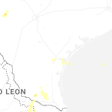
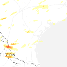


Connect with Interactive Hail Maps