

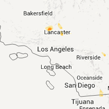
Hail Map for Edwards AFB, CA
The Edwards AFB, CA area has had 0 reports of on-the-ground hail by trained spotters, and has been under severe weather warnings 0 times during the past 12 months. Doppler radar has detected hail at or near Edwards AFB, CA on 2 occasions.
| Name: | Edwards AFB, CA |
| Where Located: | 61.5 miles NNE of Los Angeles, CA |
| Map: | Google Map for Edwards AFB, CA |
| Population: | 2063 |
| Housing Units: | 785 |
| More Info: | Search Google for Edwards AFB, CA |
5
The Top Recent Hail Date for Edwards AFB, CA is Saturday, September 10, 2011 (1st out of 2)

Hail and Wind Damage Spotted near Edwards AFB, CA
| Date / Time | Report Details |
|---|---|
| 9/9/2021 3:01 PM PDT | Asos station kedw edwards af in kern county CA, 4 miles WNW of Edwards AFB, CA |
| 9/10/2012 4:59 PM PDT | At runway 222 lake bed wind sensor in kern county CA, 0.2 miles SW of Edwards AFB, CA |
| 8/30/2012 4:26 PM PDT | Edwards wind tower network in kern county CA, 4.8 miles NW of Edwards AFB, CA |
| 8/14/2012 4:12 PM PDT | Runway 15 threshold wind speed of 58 knots or 67 mp in kern county CA, 0.2 miles SW of Edwards AFB, CA |
| 8/14/2012 4:05 PM PDT | Runway 023 wind speed of 52 knots or 60 mp in kern county CA, 0.2 miles SW of Edwards AFB, CA |
| 8/14/2012 3:50 PM PDT | Runway 04 left wind speeds of 51 knots or 59 mp in kern county CA, 0.2 miles SW of Edwards AFB, CA |
| 1/1/0001 12:00 AM | Measured by wind tower on runway 0 in kern county CA, 0.2 miles SW of Edwards AFB, CA |
Hail Maps for Edwards AFB, CA

Connect with Interactive Hail Maps