

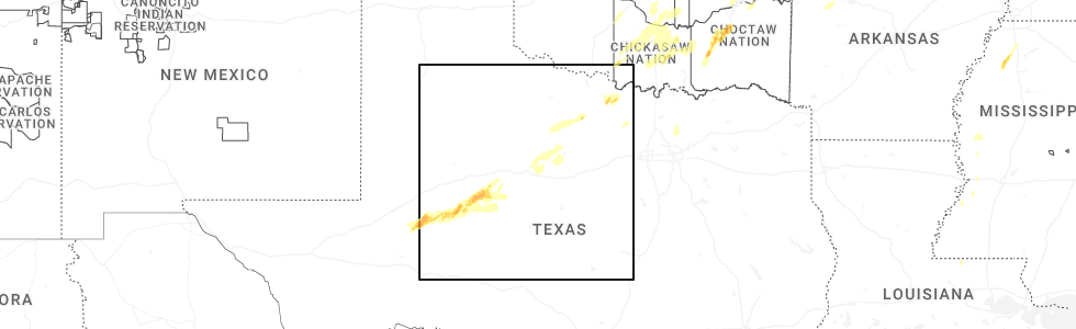
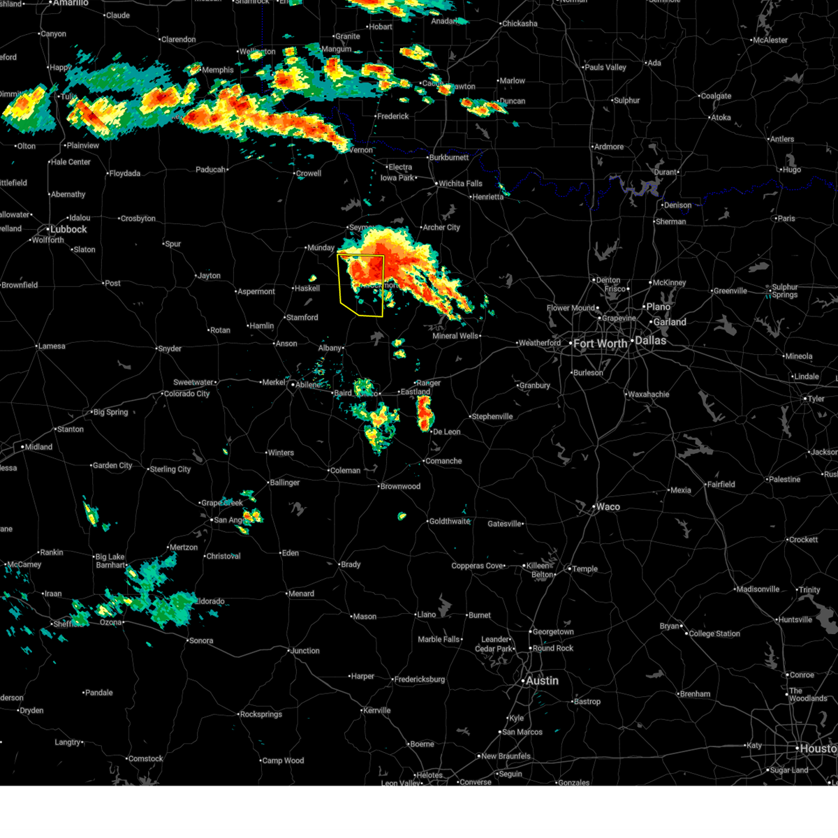
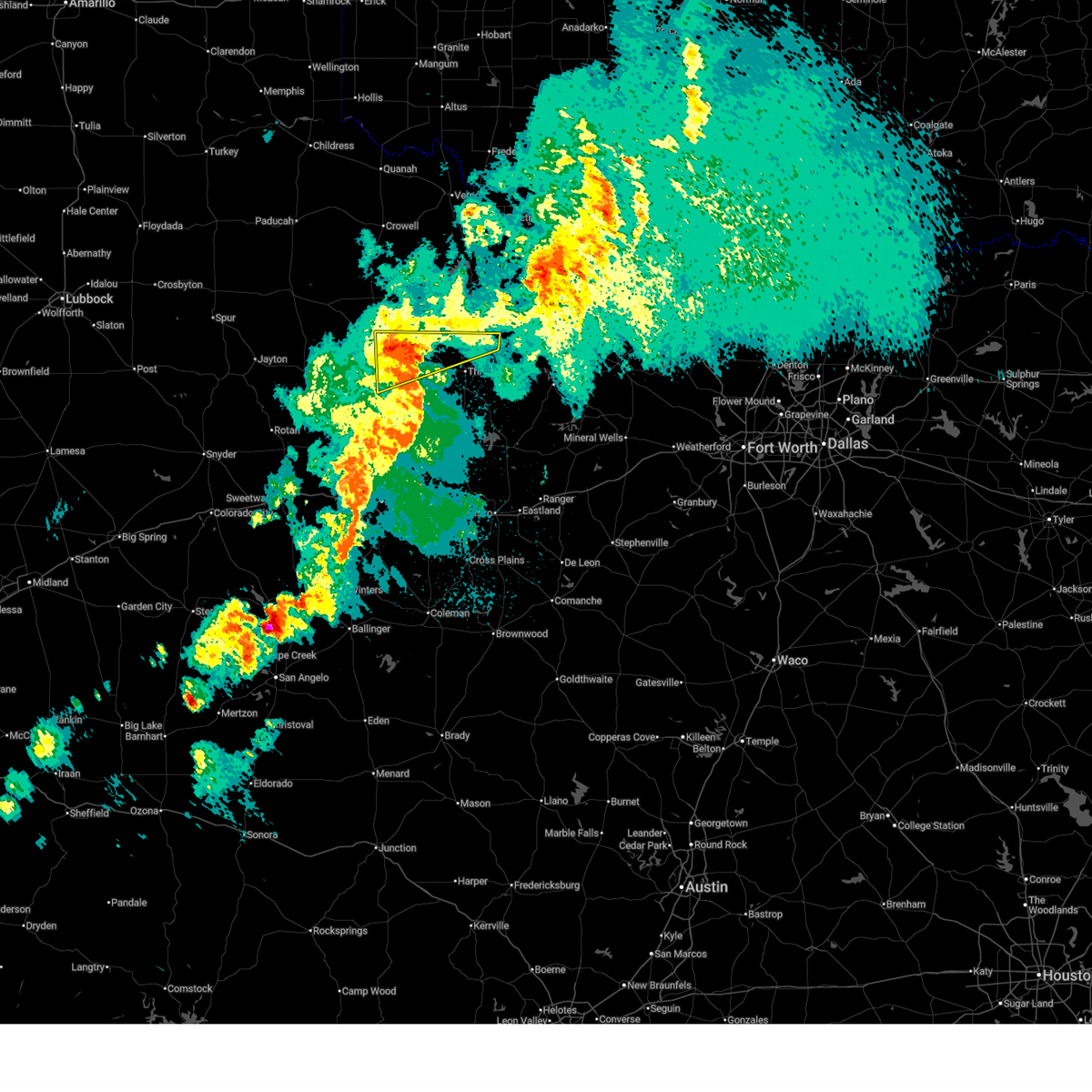
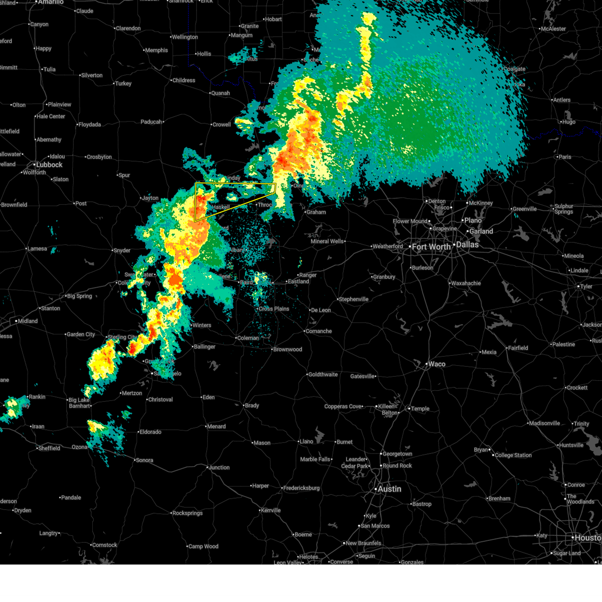
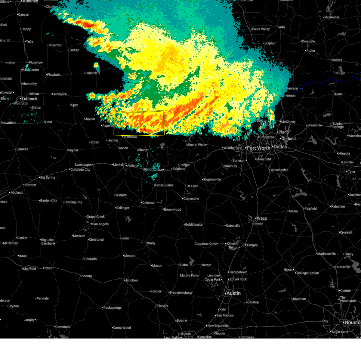
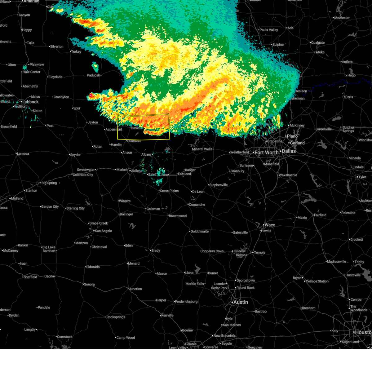
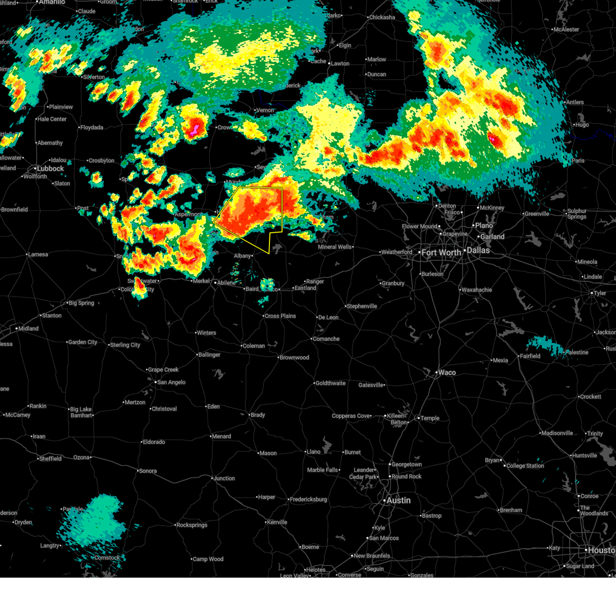
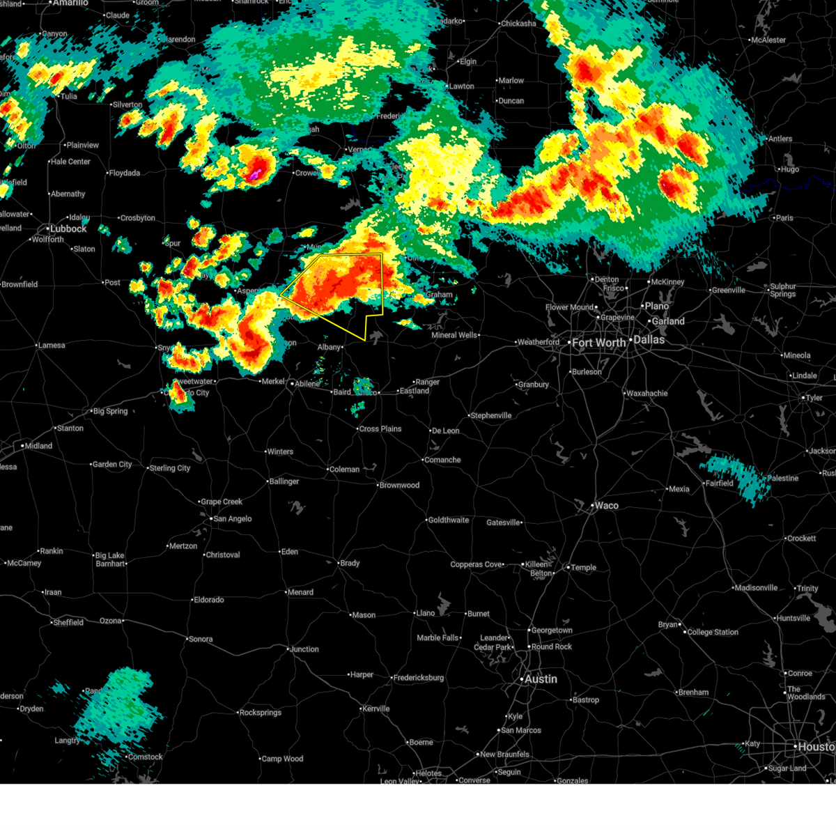
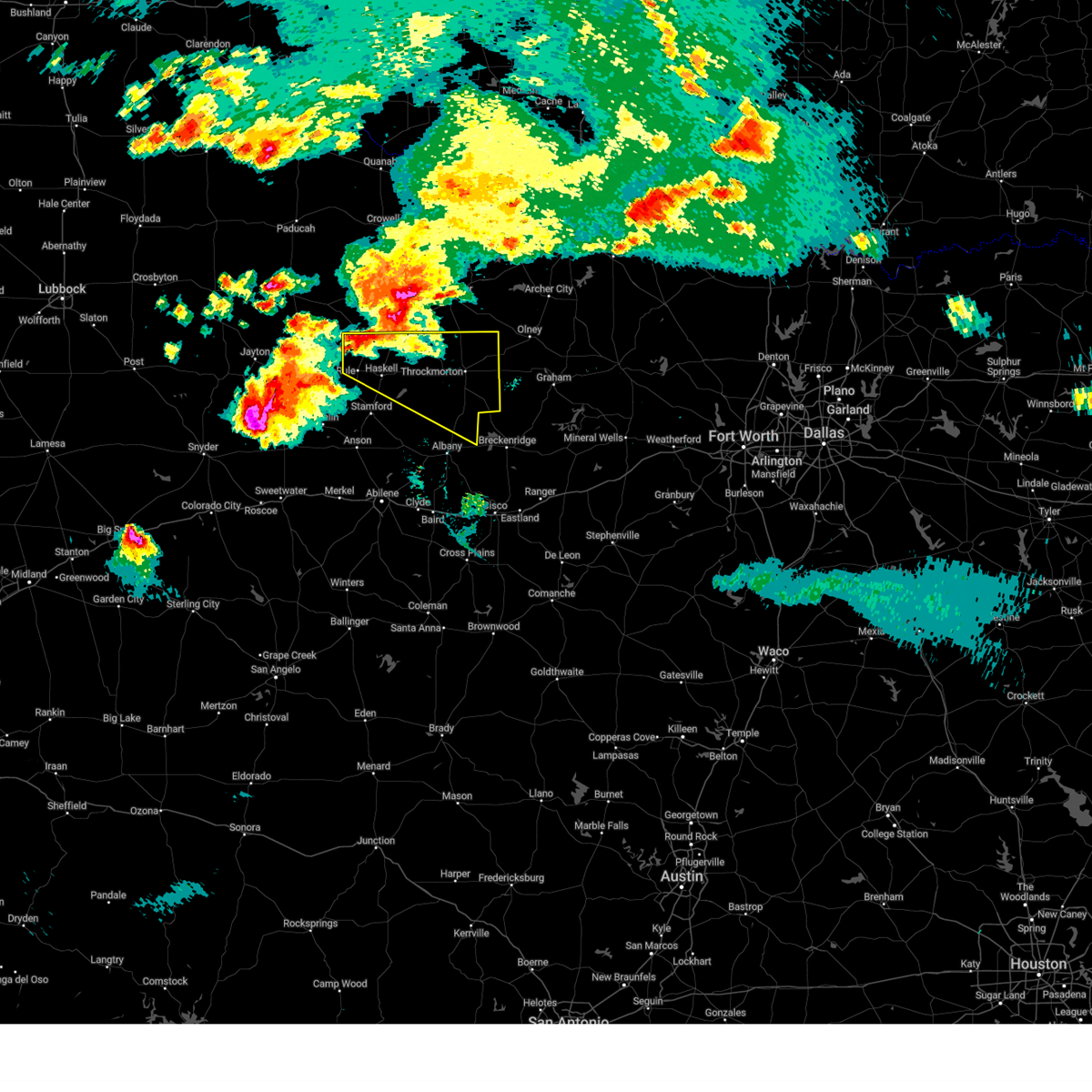
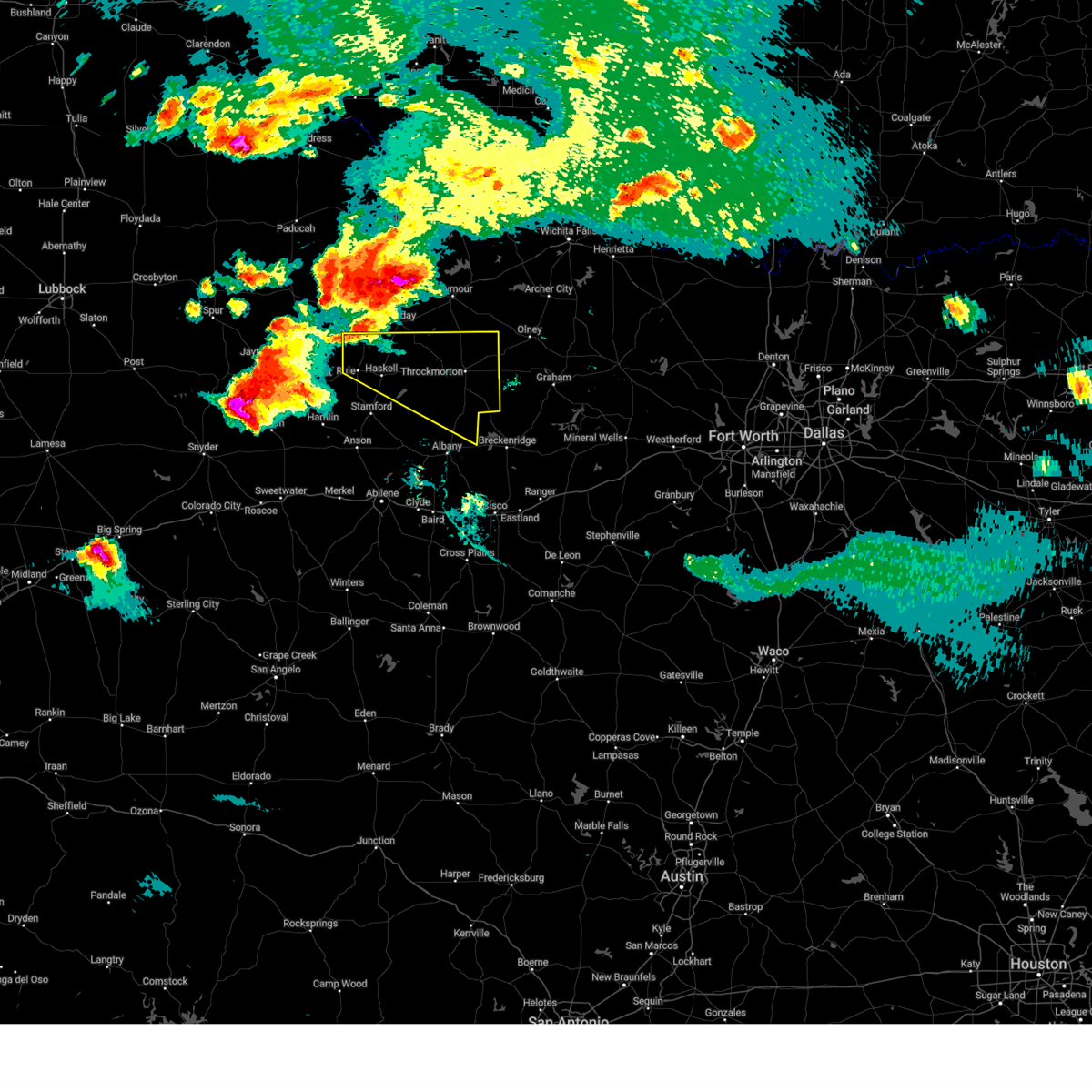
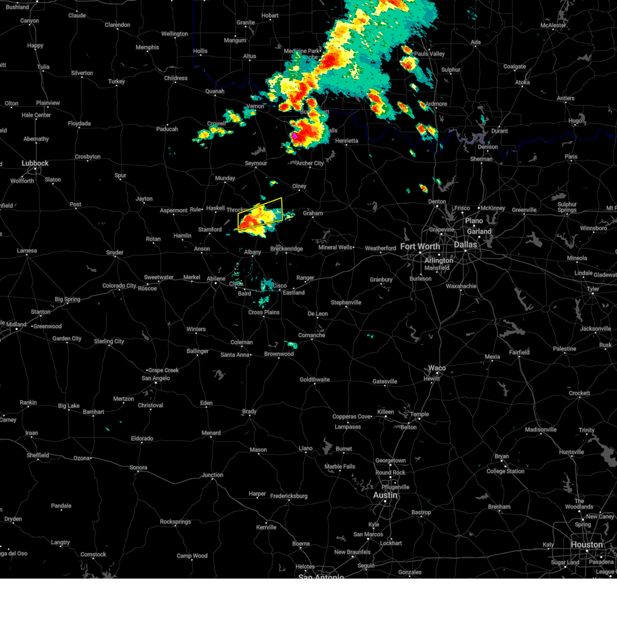
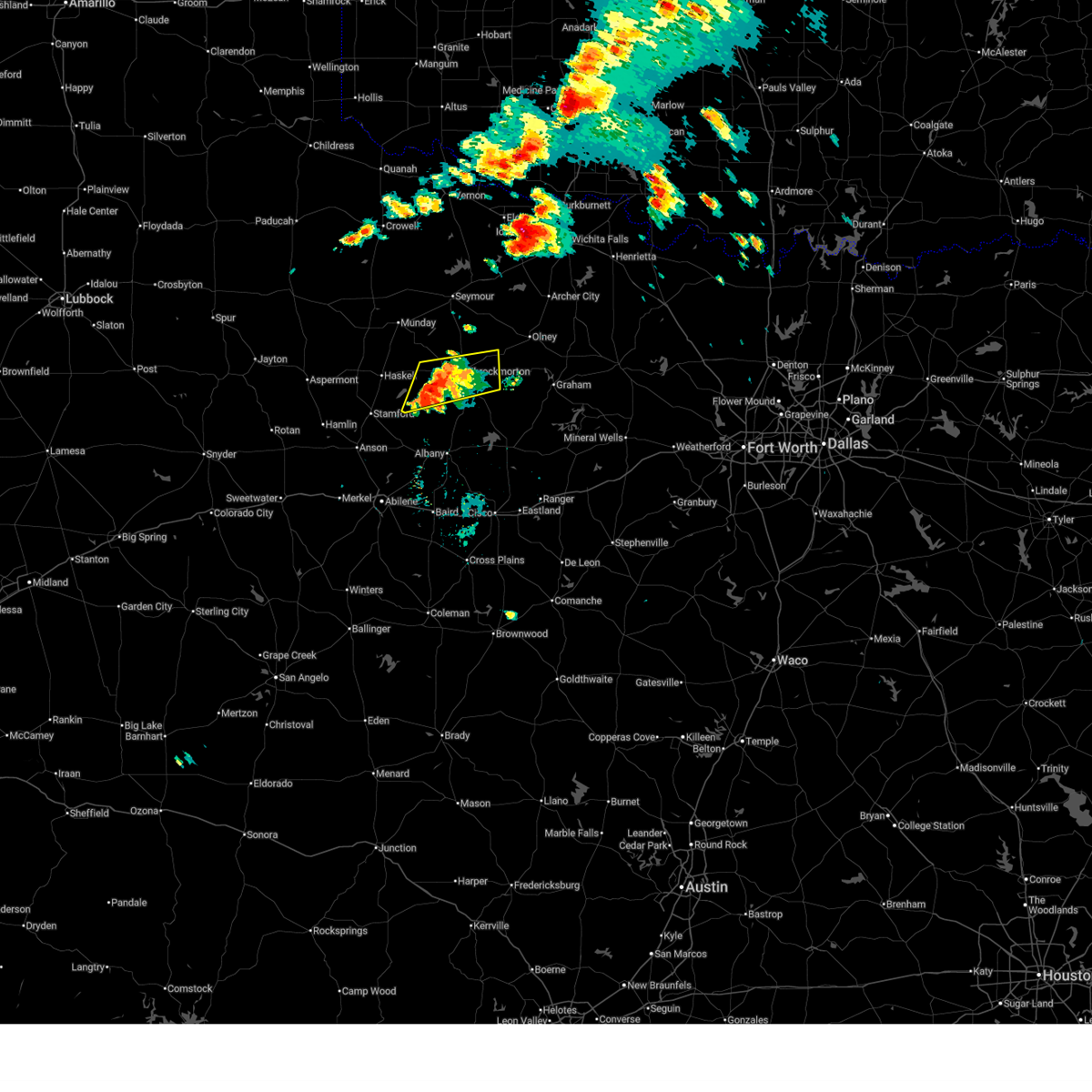
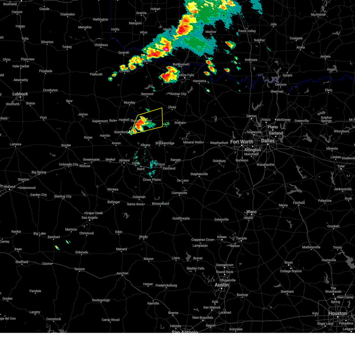
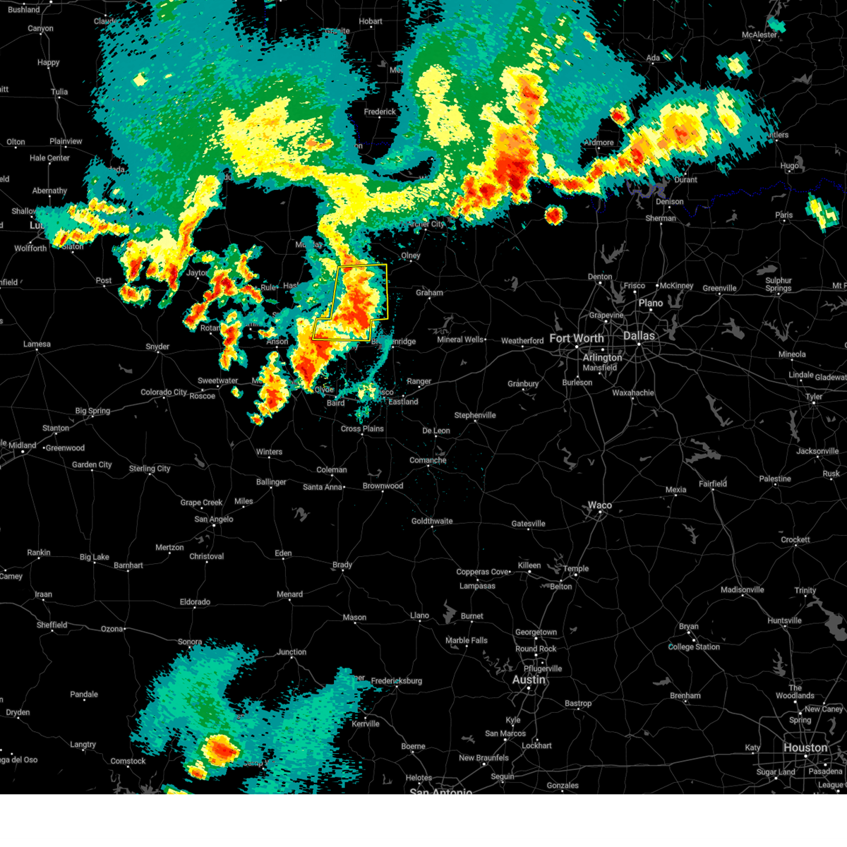
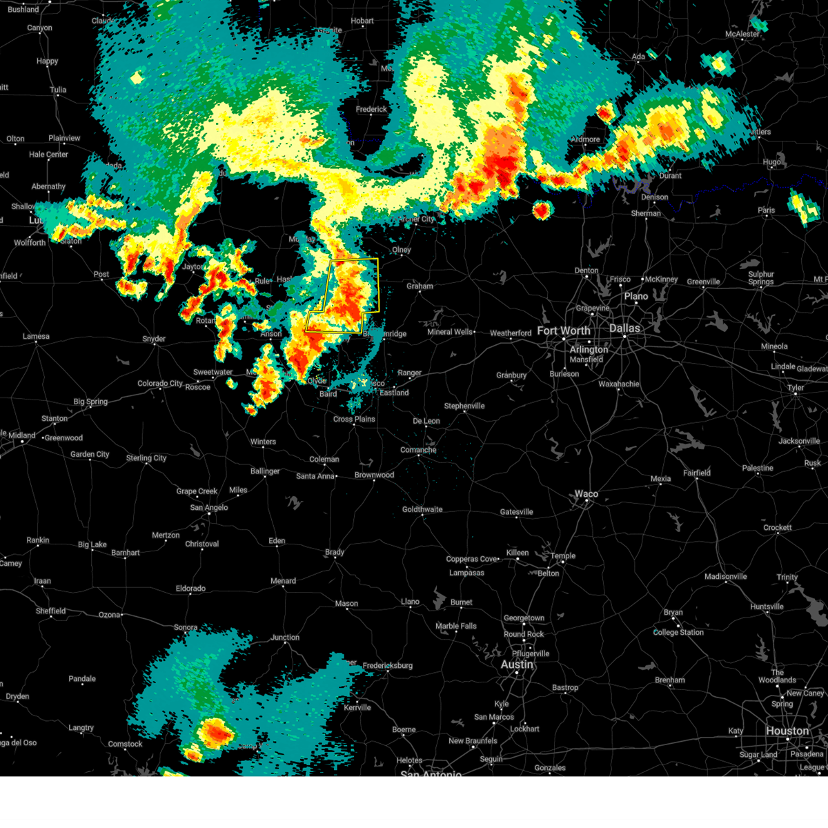
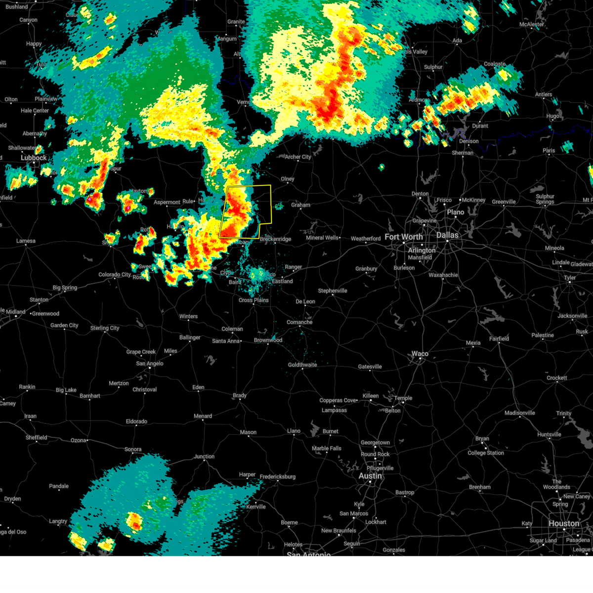
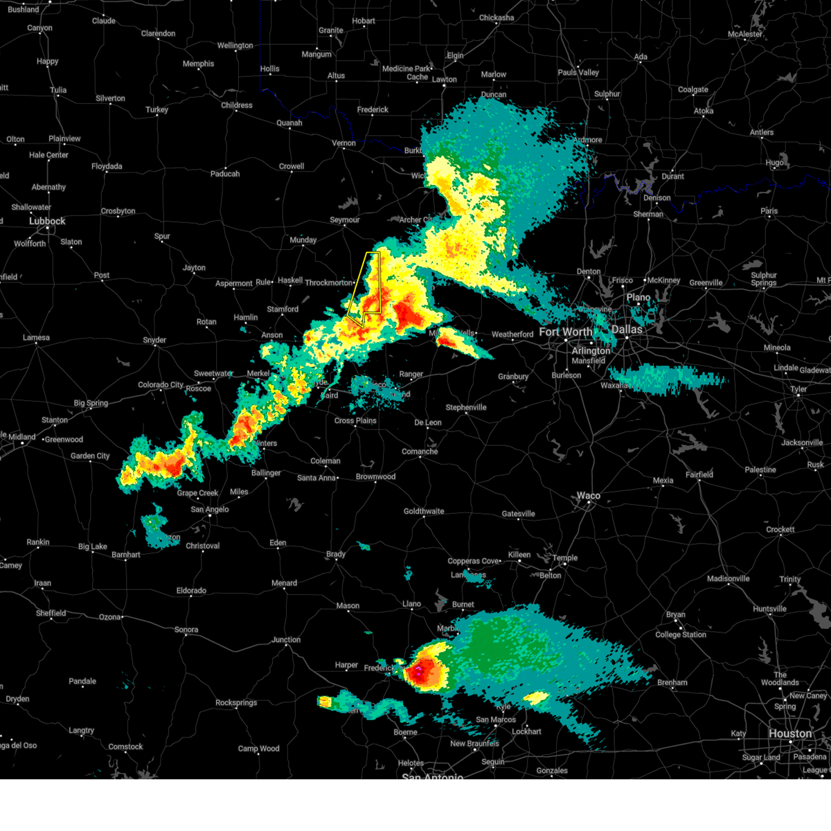
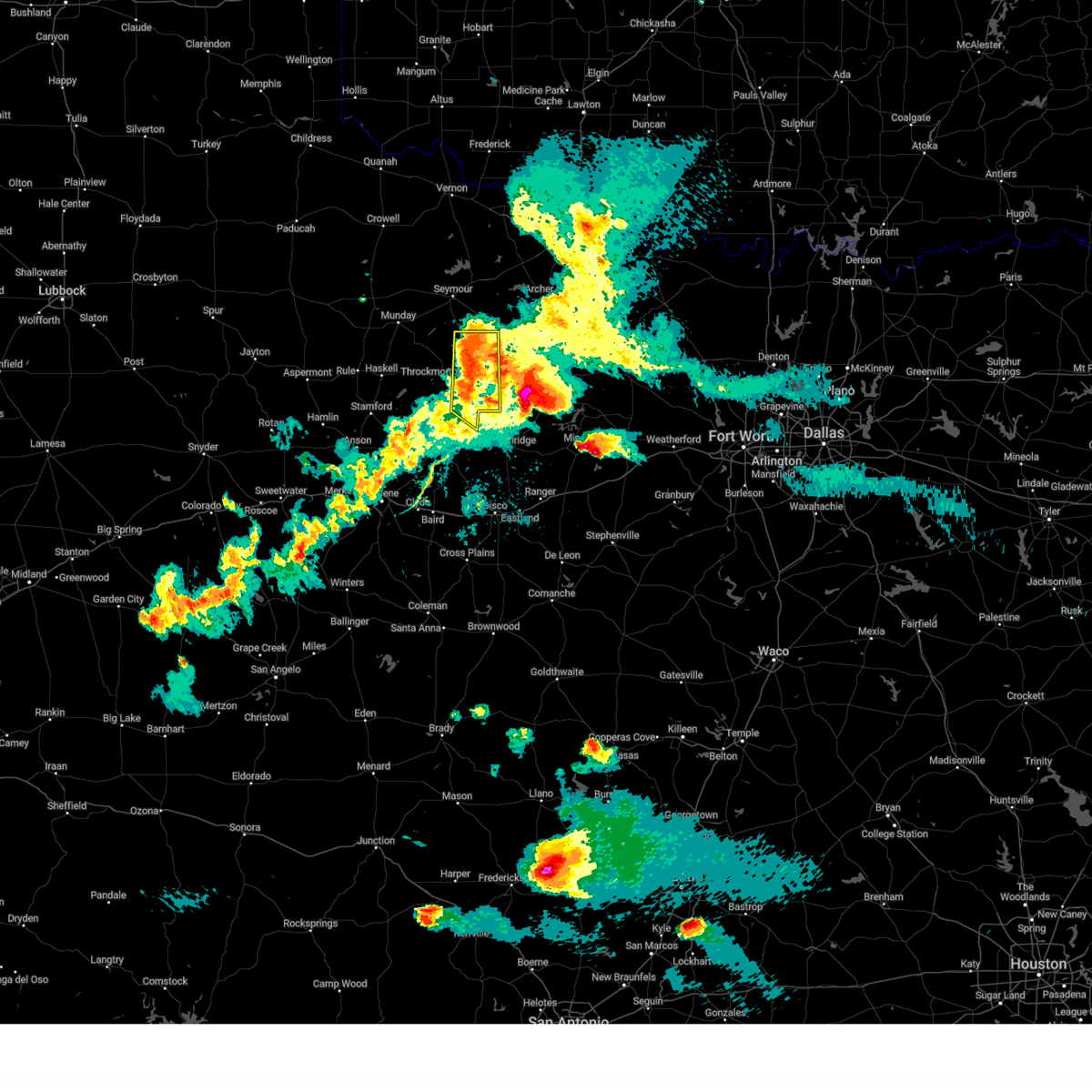
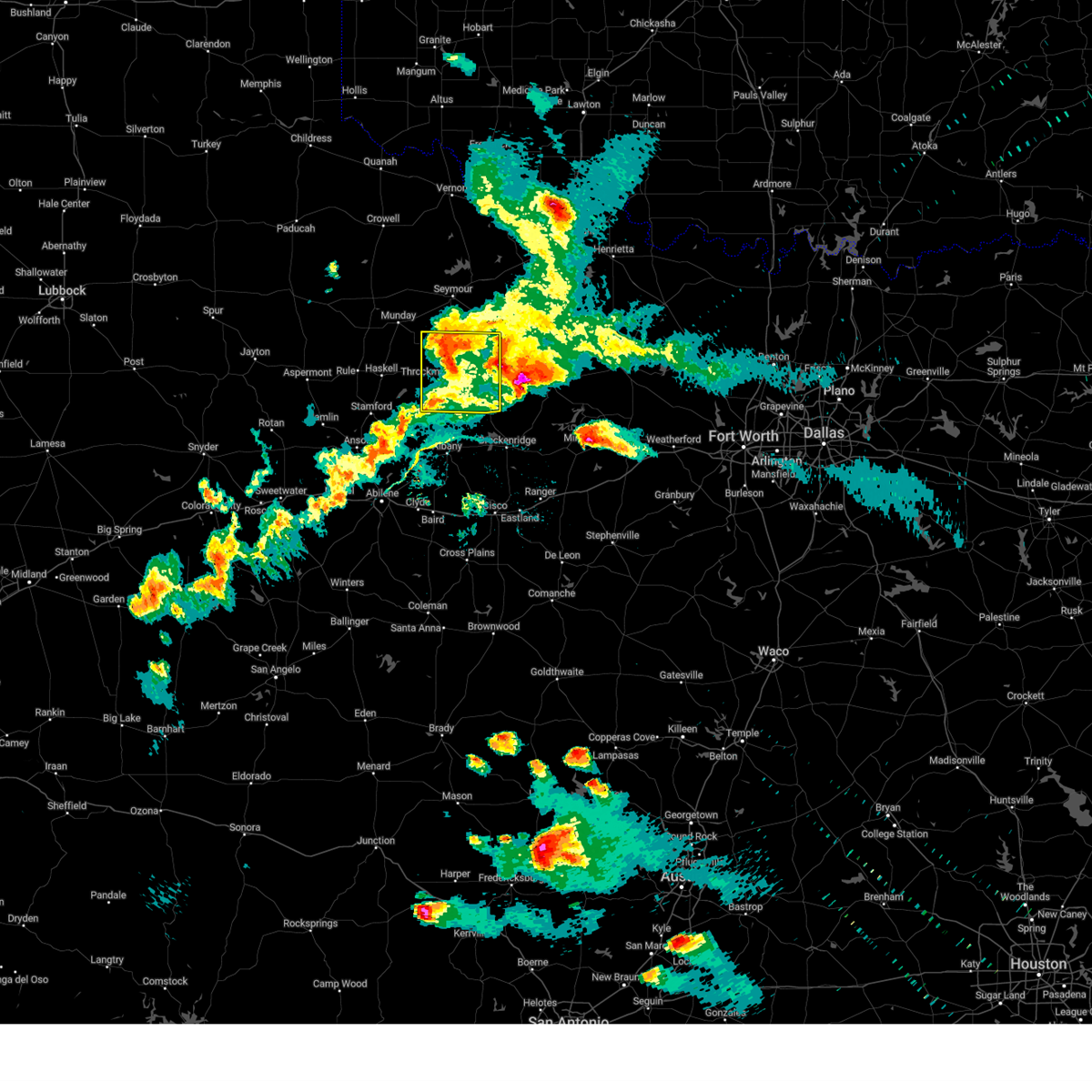
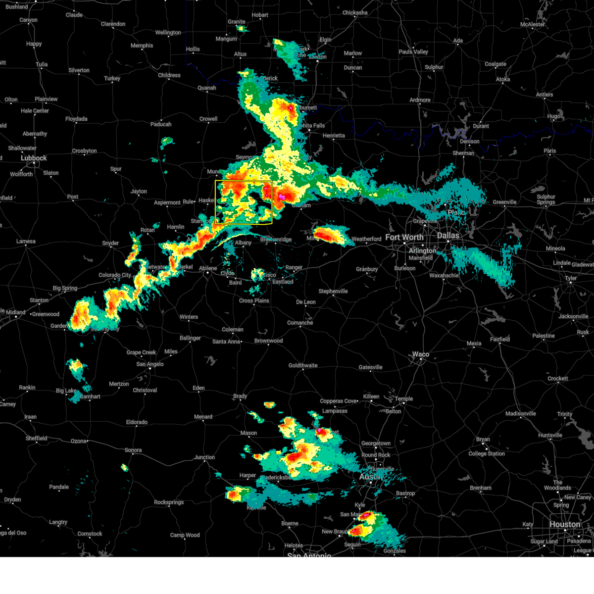
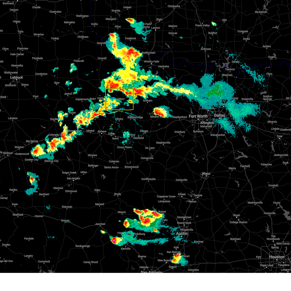
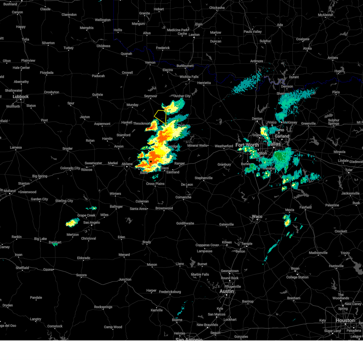
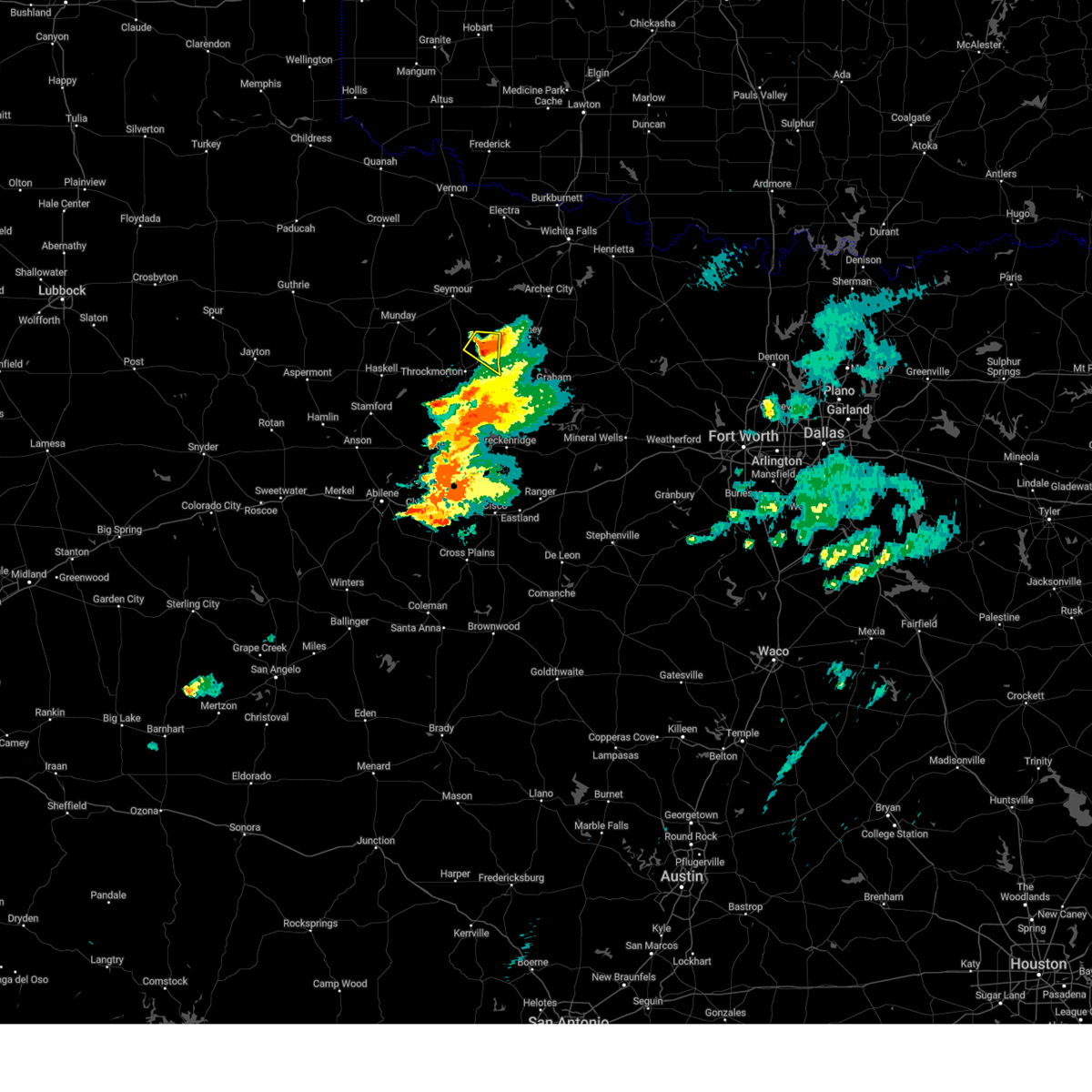
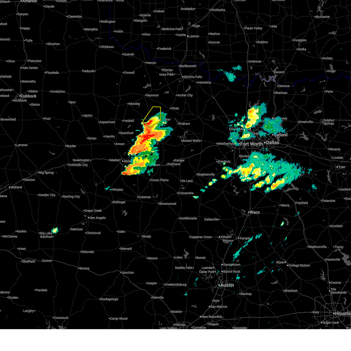
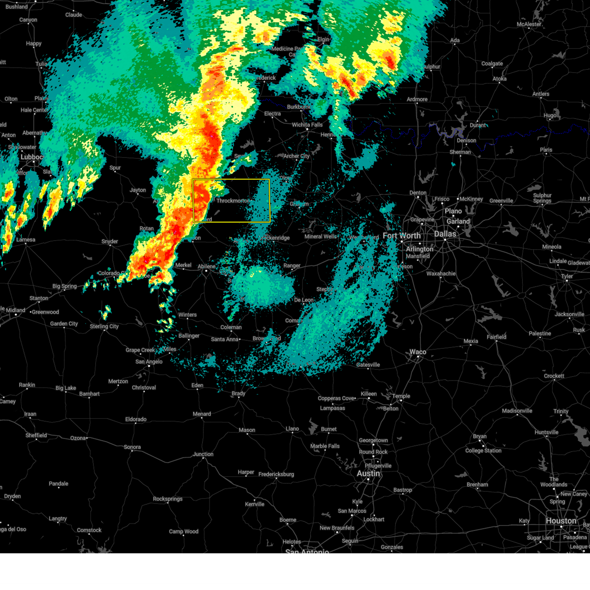
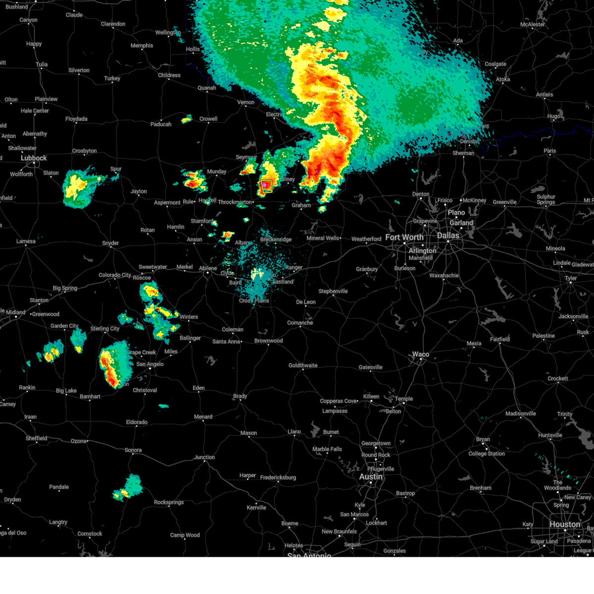
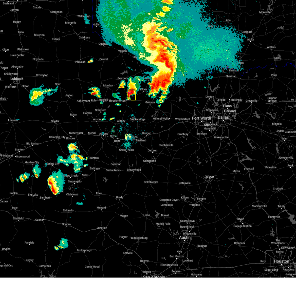
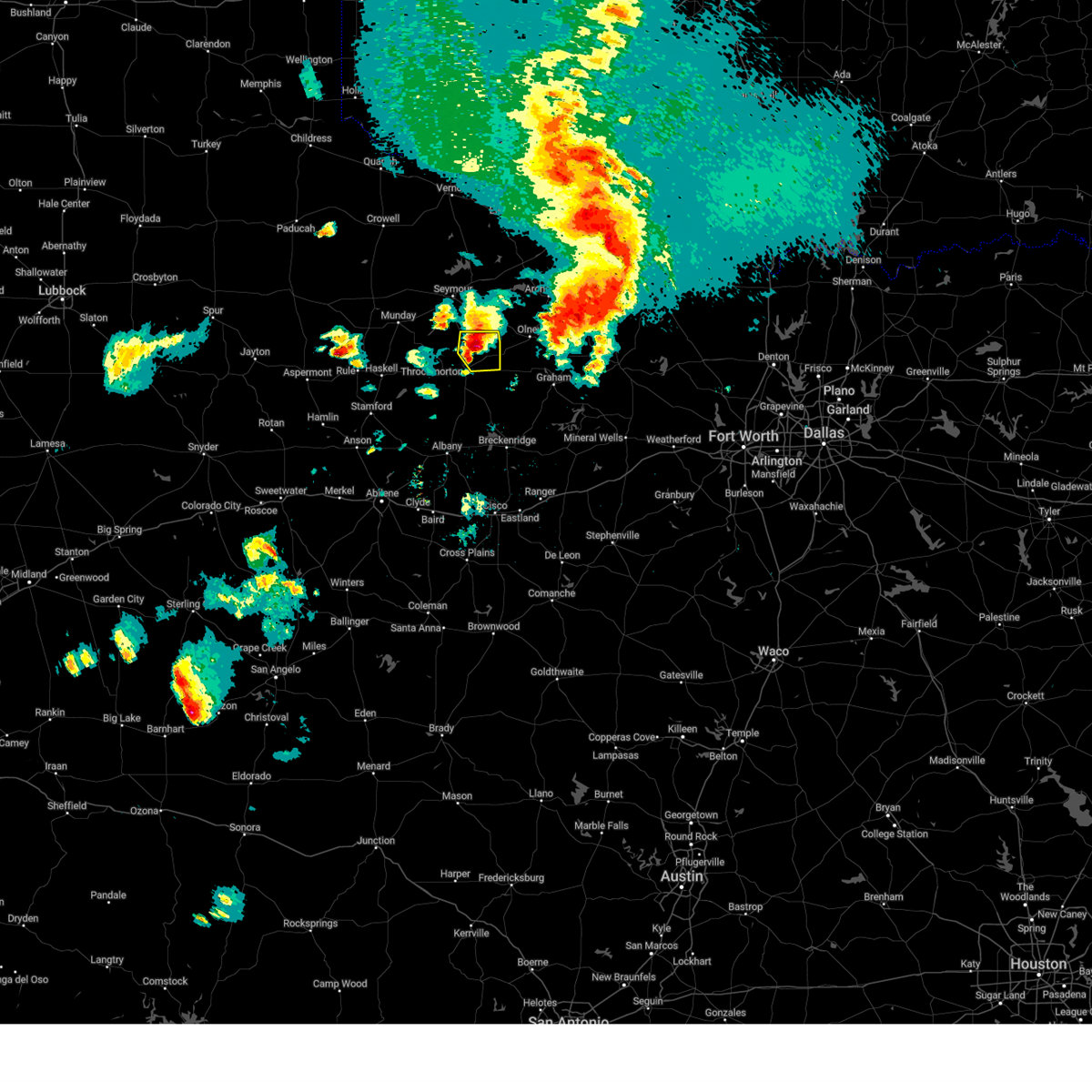
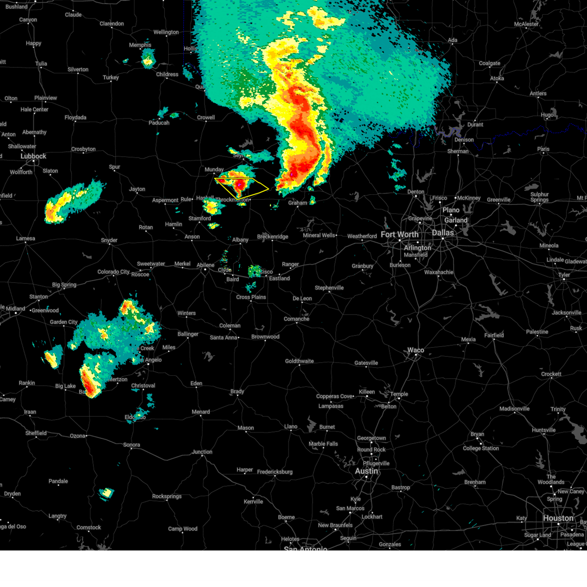
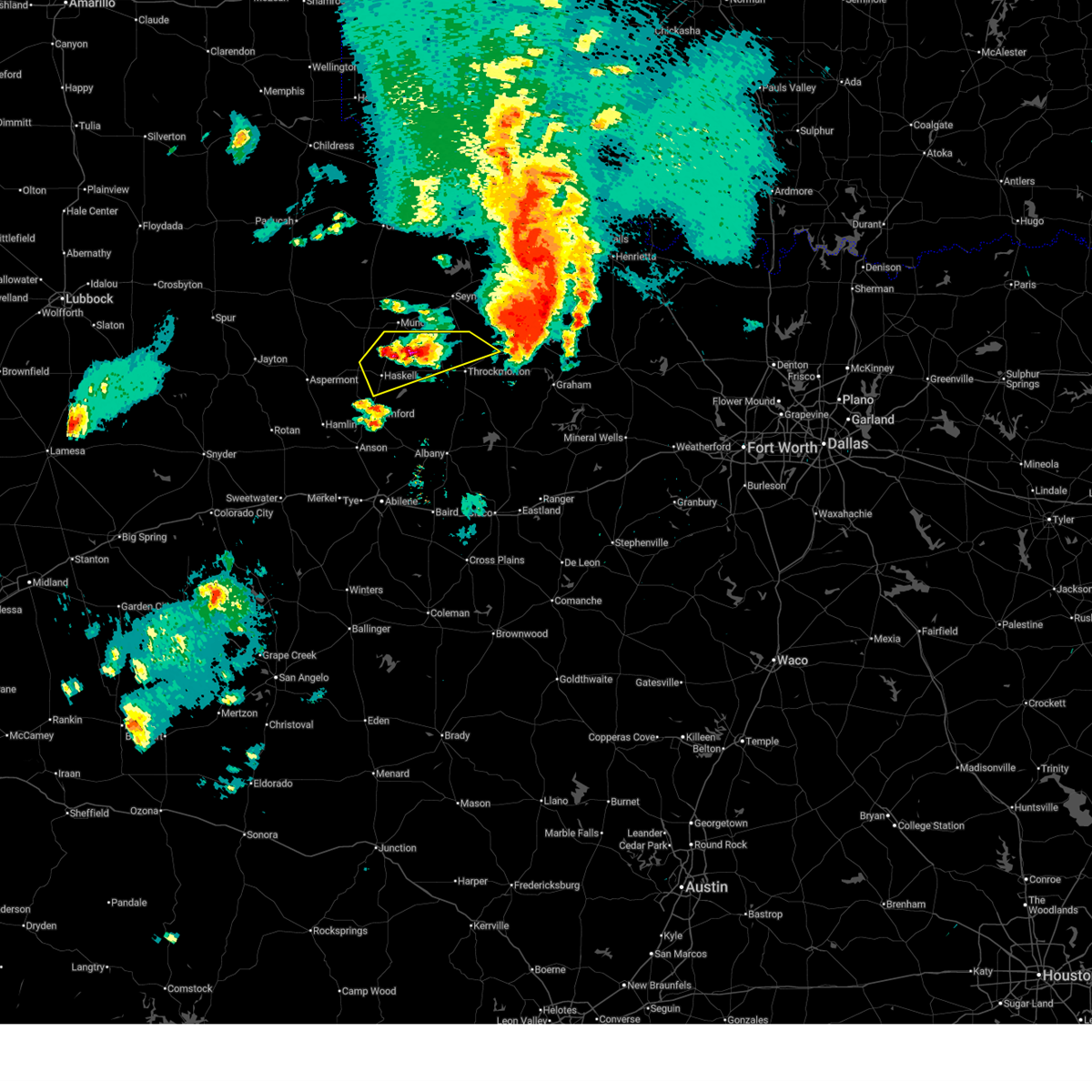
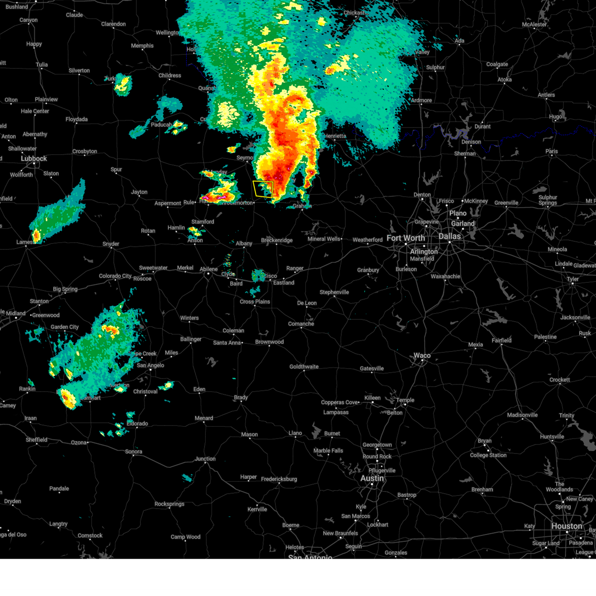
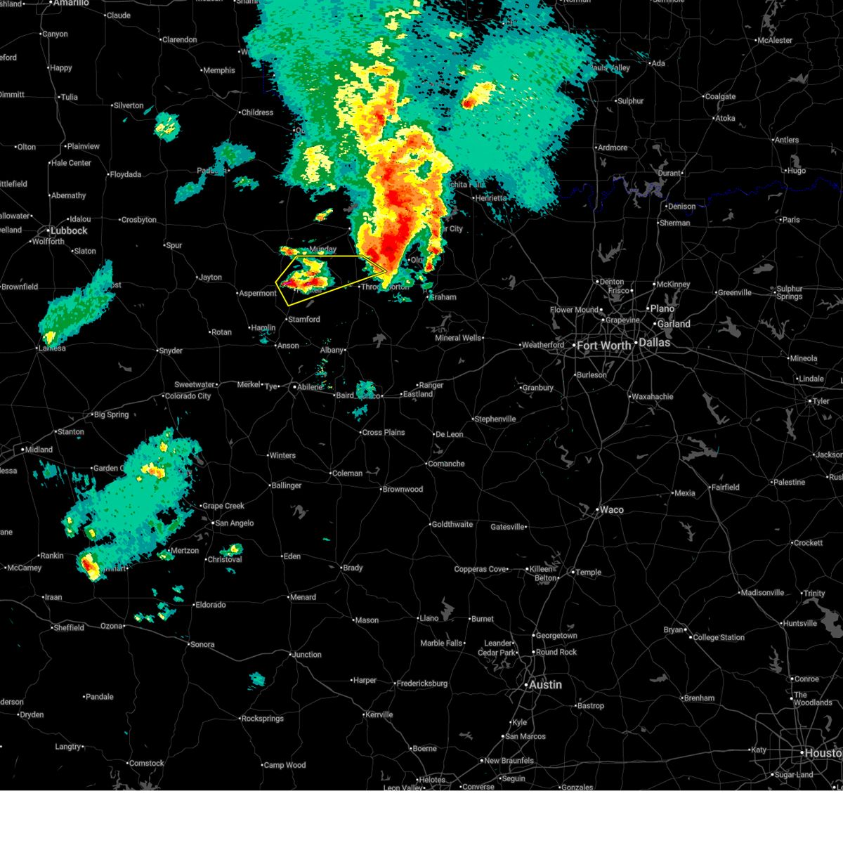
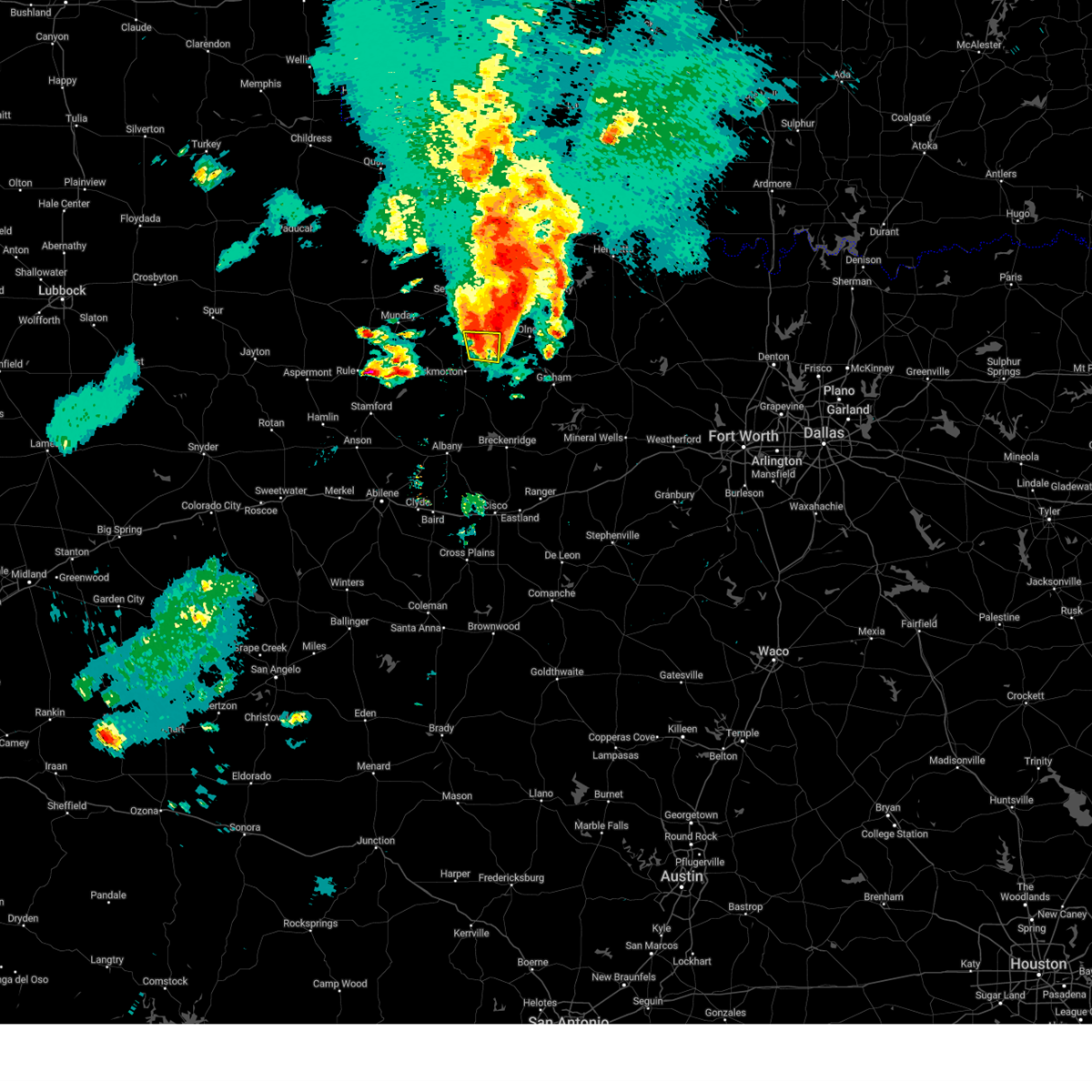
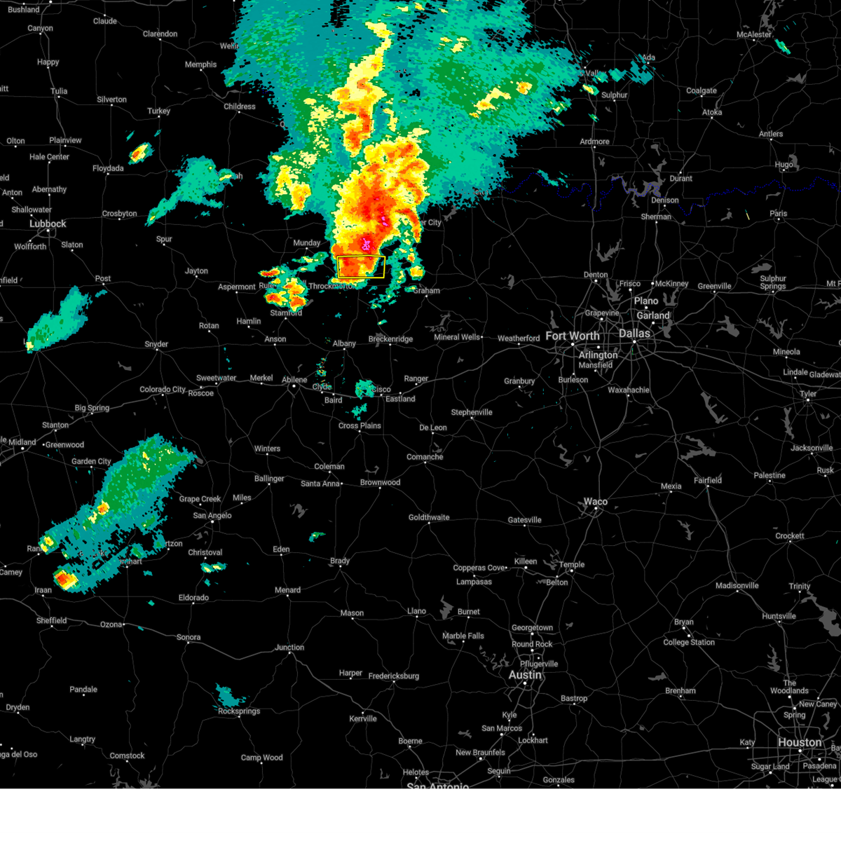
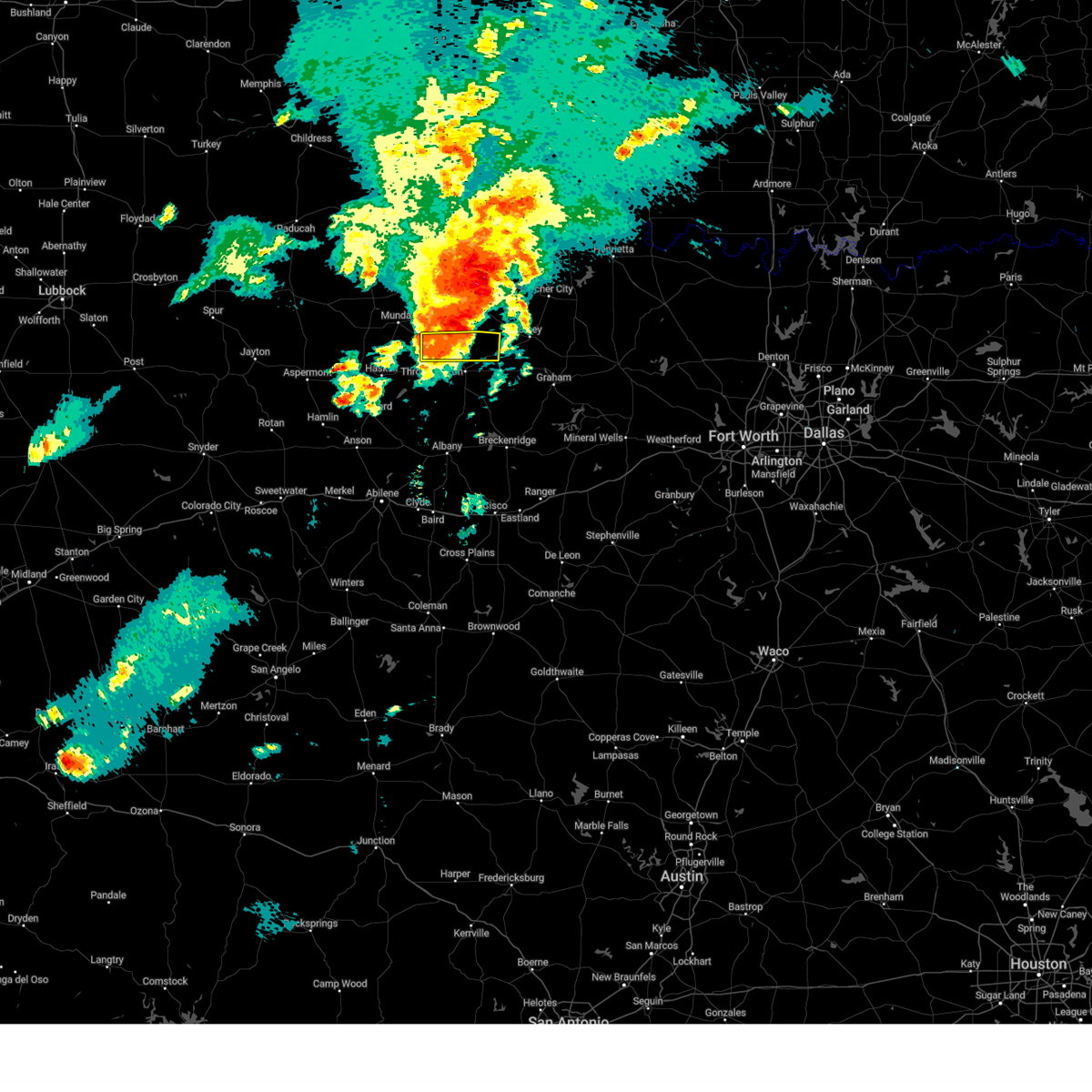
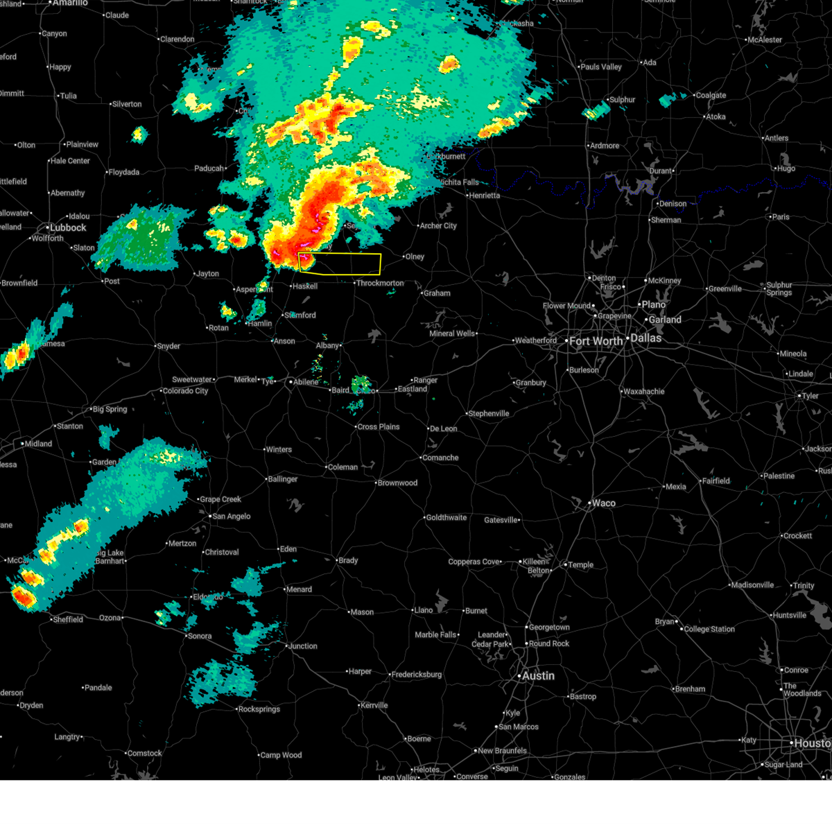
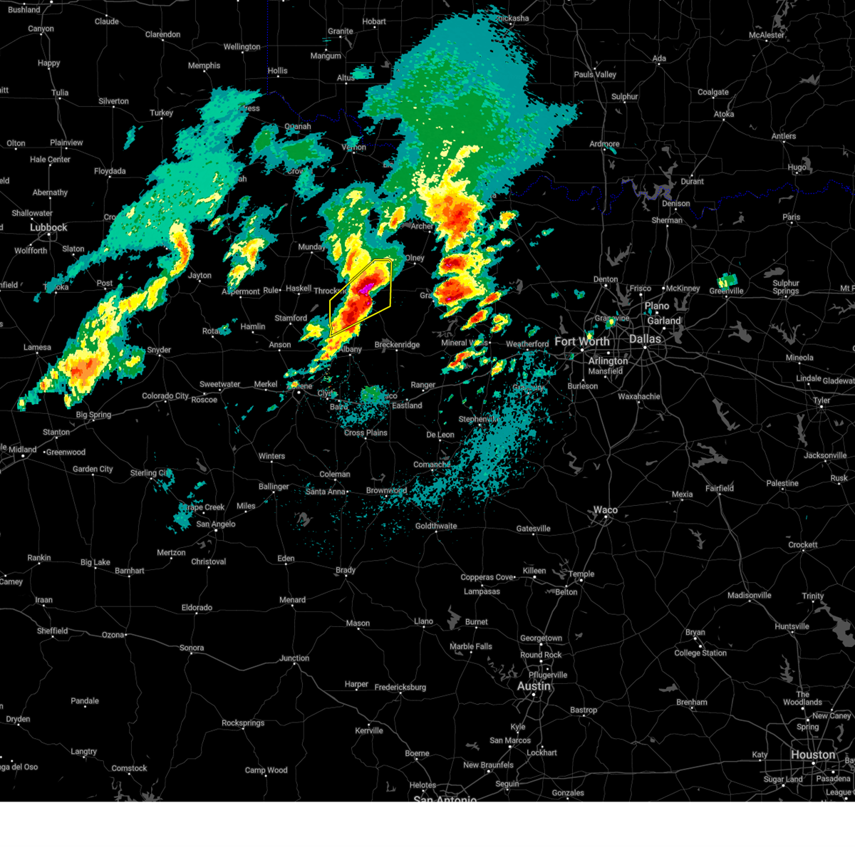
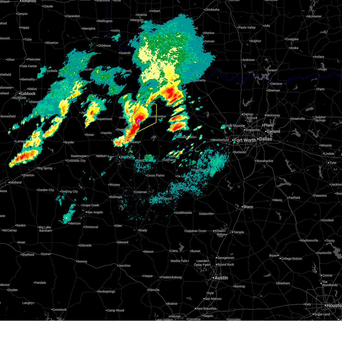
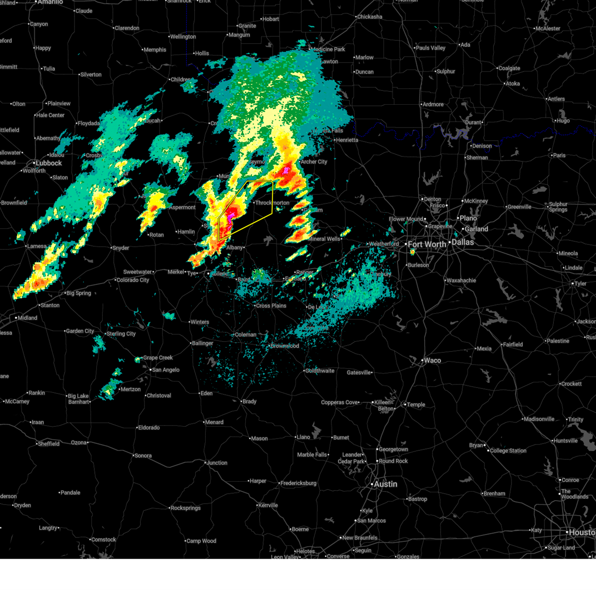
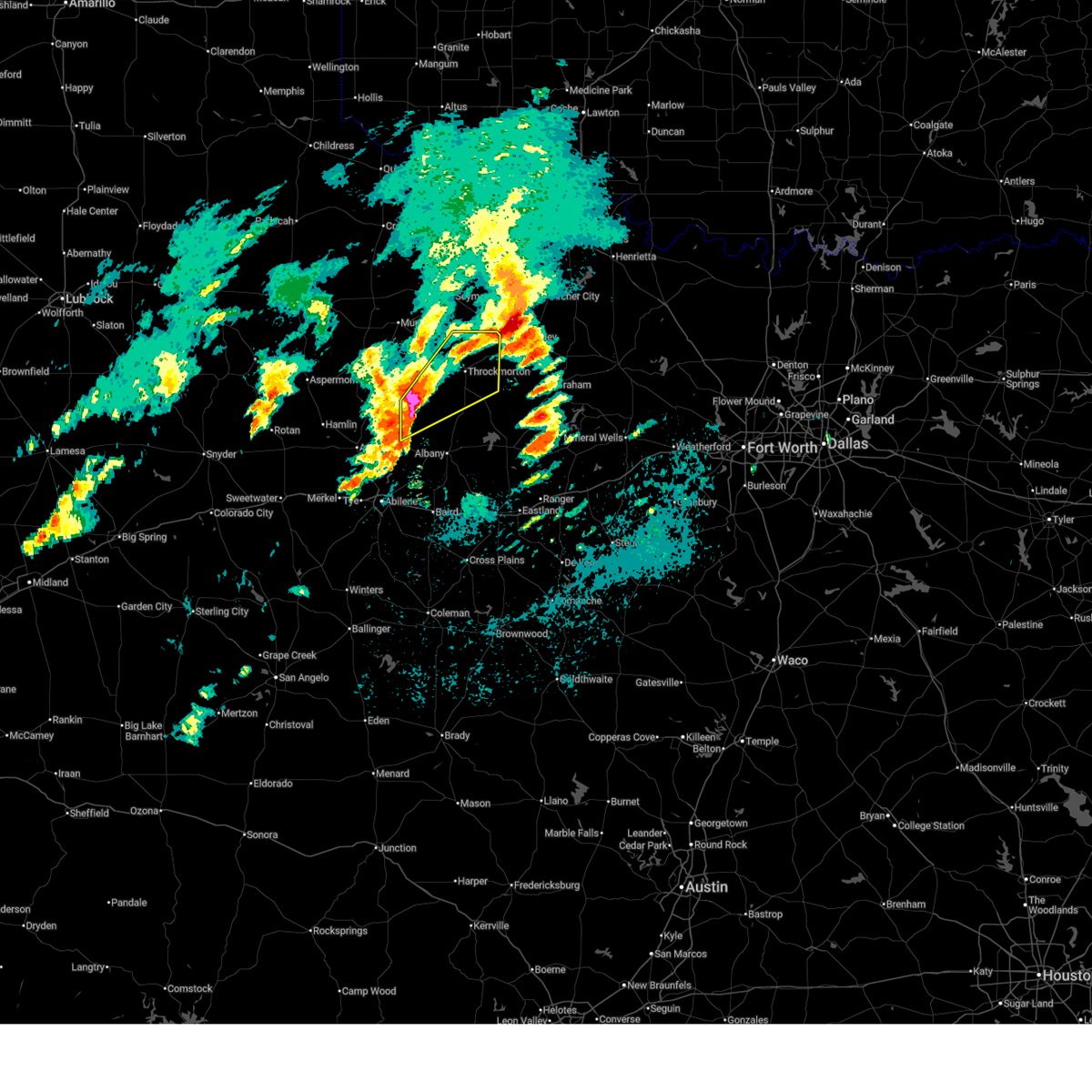
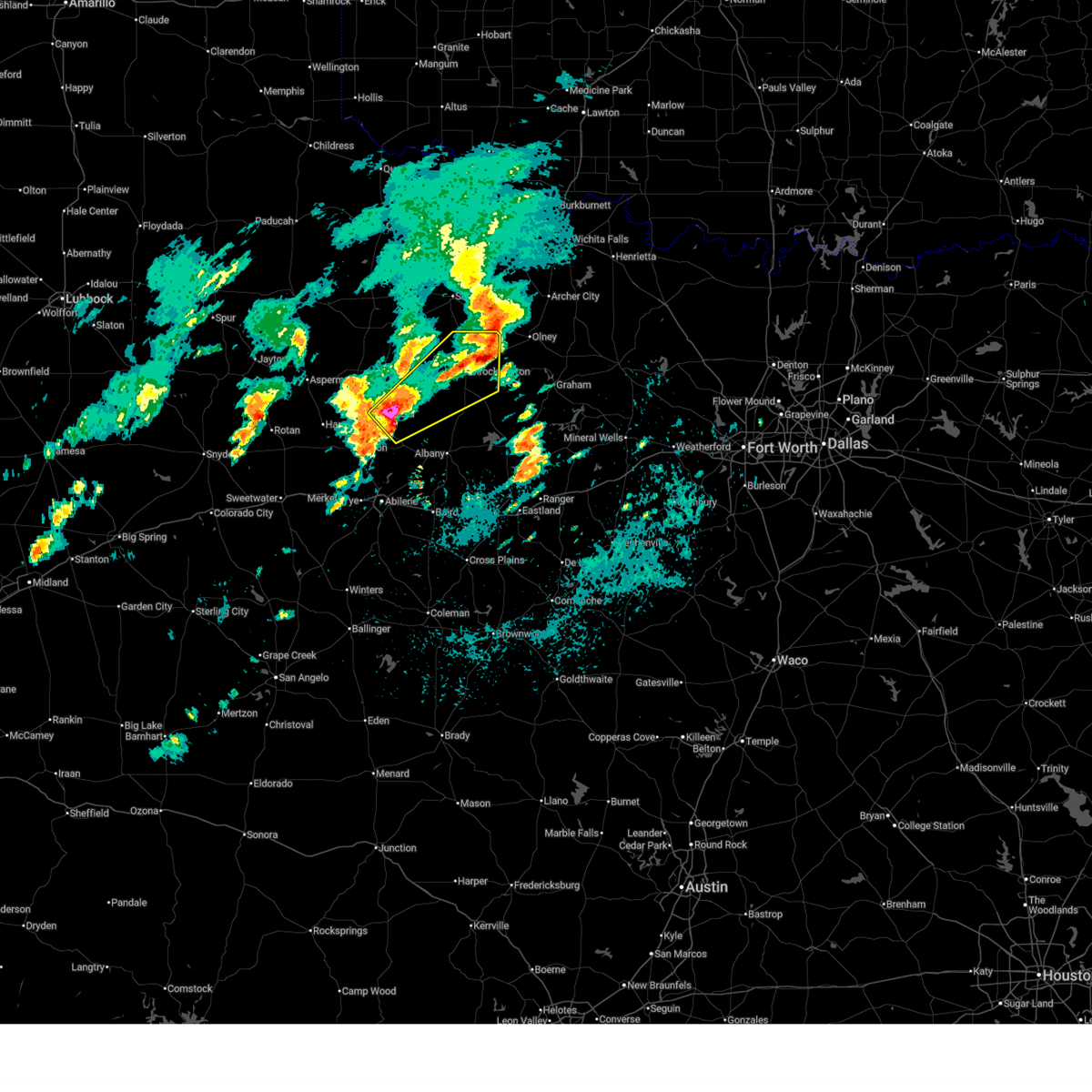
Hail Map for Elbert, TX
The Elbert, TX area has had 1 report of on-the-ground hail by trained spotters, and has been under severe weather warnings 11 times during the past 12 months. Doppler radar has detected hail at or near Elbert, TX on 119 occasions, including 6 occasions during the past year.
| Name: | Elbert, TX |
| Where Located: | 52.3 miles SSW of Wichita Falls, TX |
| Map: | Google Map for Elbert, TX |
| Population: | 30 |
| Housing Units: | 17 |
| More Info: | Search Google for Elbert, TX |
1
The Top Recent Hail Date for Elbert, TX is Friday, March 6, 2026 (30th out of 119)
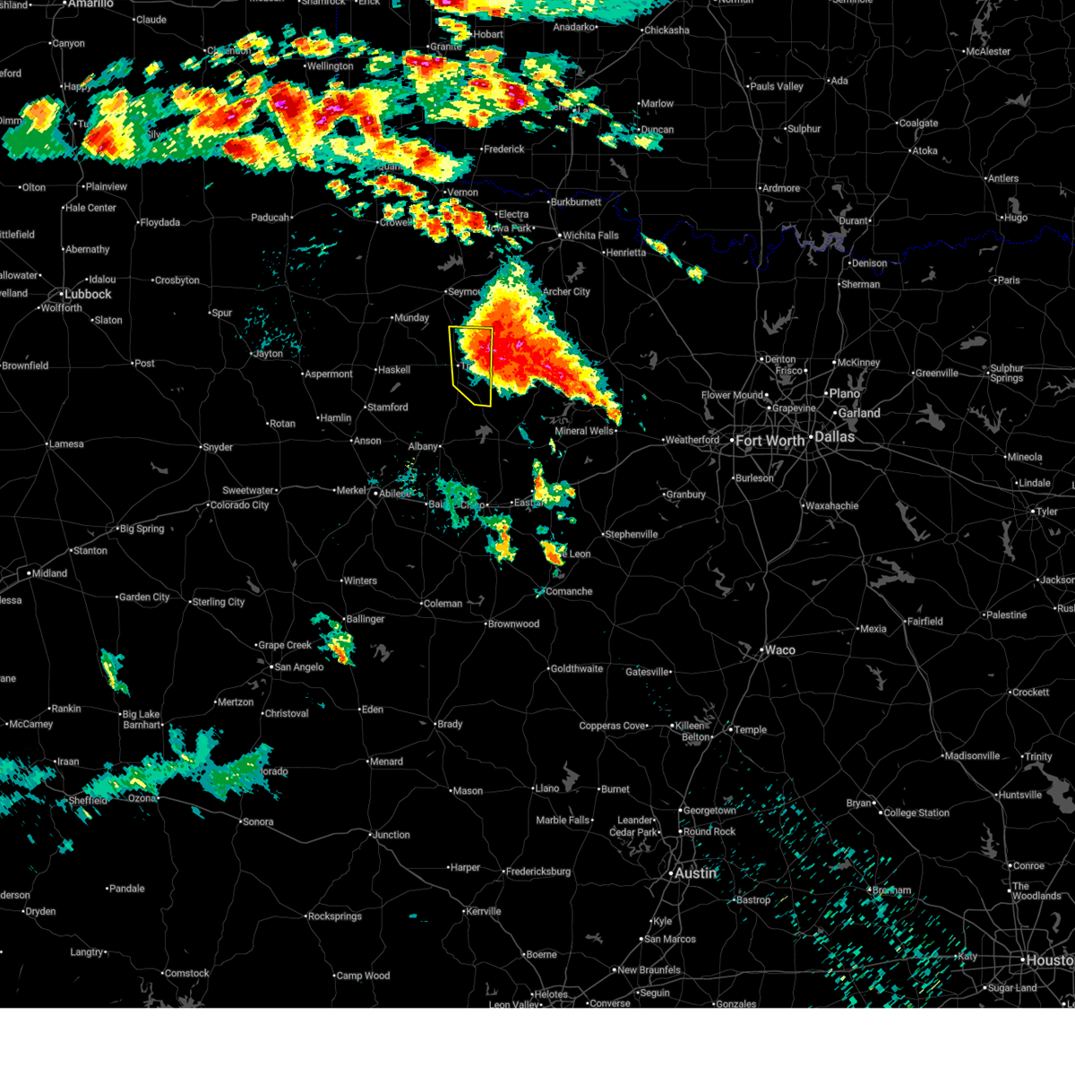
Hail and Wind Damage Spotted near Elbert, TX
| Date / Time | Report Details |
|---|---|
| 6/23/2026 4:00 PM CDT |
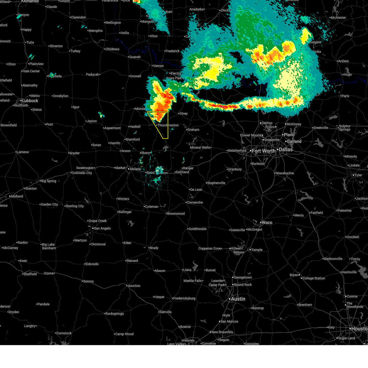 At 359 pm cdt, a severe thunderstorm was located near elbert, moving southeast at 45 mph (radar indicated). Hazards include 60 mph wind gusts and nickel size hail. Expect damage to roofs, siding, and trees. This severe thunderstorm will remain over mainly rural areas of eastern throckmorton county, including the following locations, lusk and us-183 near the throckmorton-baylor county line. At 359 pm cdt, a severe thunderstorm was located near elbert, moving southeast at 45 mph (radar indicated). Hazards include 60 mph wind gusts and nickel size hail. Expect damage to roofs, siding, and trees. This severe thunderstorm will remain over mainly rural areas of eastern throckmorton county, including the following locations, lusk and us-183 near the throckmorton-baylor county line.
|
| 6/23/2026 3:44 PM CDT |
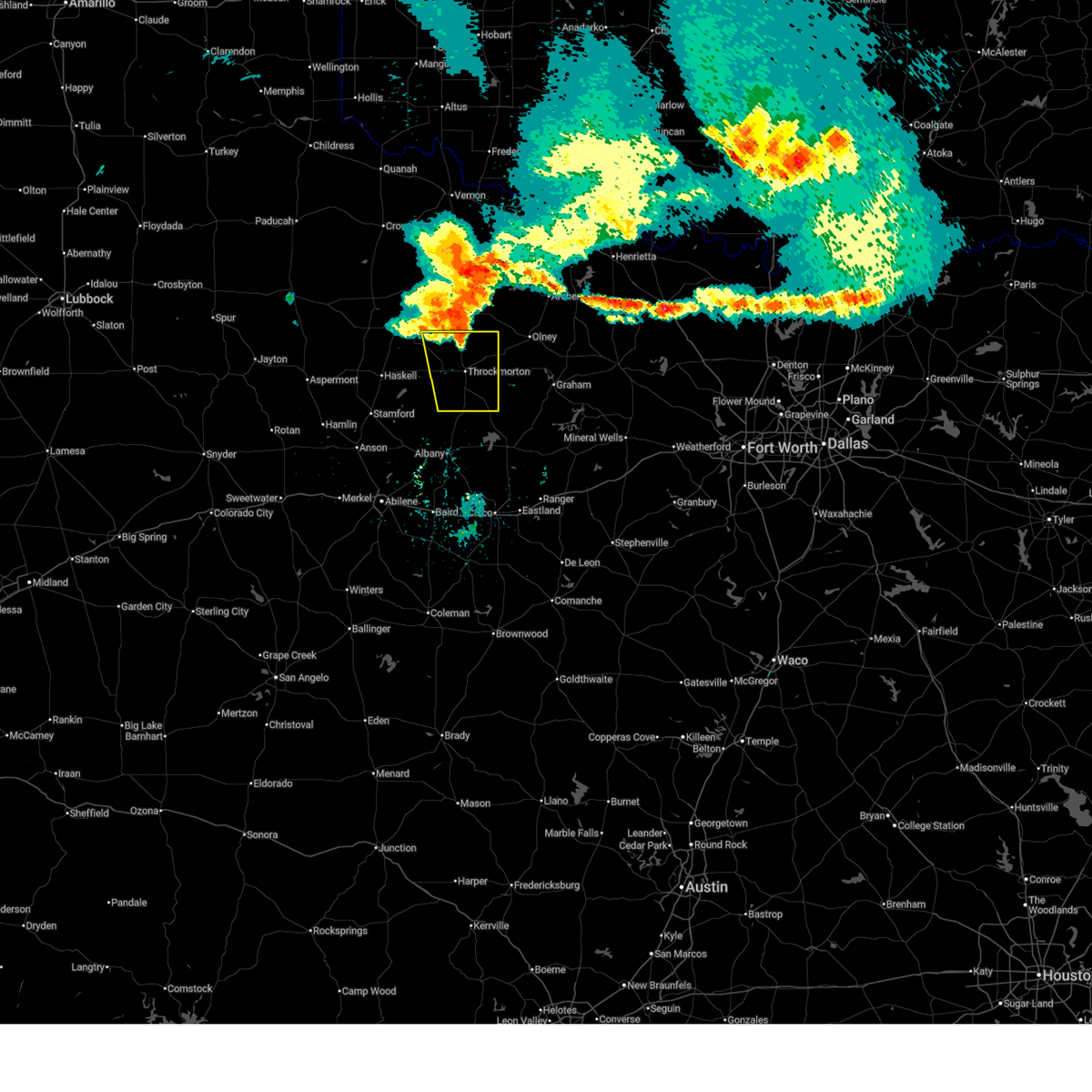 Svrsjt the national weather service in san angelo has issued a * severe thunderstorm warning for, throckmorton county in west central texas, * until 430 pm cdt. * at 344 pm cdt, a severe thunderstorm was located near us-183 near the throckmorton-baylor county line, or 11 miles northwest of elbert, moving southeast at 50 mph (radar indicated). Hazards include 70 mph wind gusts and quarter size hail. Hail damage to vehicles is expected. expect considerable tree damage. wind damage is also likely to mobile homes, roofs, and outbuildings. this severe thunderstorm will be near, elbert around 350 pm cdt. Other locations impacted by this severe thunderstorm include us- 183 near the throckmorton-baylor county line, the intersection of us- 183 and us-283, the intersection of us- 283 and ranch road 209, lusk, and the intersection of us- 380 and highway 222. Svrsjt the national weather service in san angelo has issued a * severe thunderstorm warning for, throckmorton county in west central texas, * until 430 pm cdt. * at 344 pm cdt, a severe thunderstorm was located near us-183 near the throckmorton-baylor county line, or 11 miles northwest of elbert, moving southeast at 50 mph (radar indicated). Hazards include 70 mph wind gusts and quarter size hail. Hail damage to vehicles is expected. expect considerable tree damage. wind damage is also likely to mobile homes, roofs, and outbuildings. this severe thunderstorm will be near, elbert around 350 pm cdt. Other locations impacted by this severe thunderstorm include us- 183 near the throckmorton-baylor county line, the intersection of us- 183 and us-283, the intersection of us- 283 and ranch road 209, lusk, and the intersection of us- 380 and highway 222.
|
| 6/19/2026 2:58 AM CDT |
 At 257 am cdt, a severe thunderstorm was located near elbert, moving southeast at 10 mph (radar indicated). Hazards include 60 mph wind gusts and quarter size hail. Hail damage to vehicles is expected. expect wind damage to roofs, siding, and trees. This severe thunderstorm will remain over mainly rural areas of eastern throckmorton county, including the following locations, lusk, us-183 near the throckmorton- baylor county line, and the intersection of us-183 and us-283. At 257 am cdt, a severe thunderstorm was located near elbert, moving southeast at 10 mph (radar indicated). Hazards include 60 mph wind gusts and quarter size hail. Hail damage to vehicles is expected. expect wind damage to roofs, siding, and trees. This severe thunderstorm will remain over mainly rural areas of eastern throckmorton county, including the following locations, lusk, us-183 near the throckmorton- baylor county line, and the intersection of us-183 and us-283.
|
| 6/19/2026 2:44 AM CDT |
 At 243 am cdt, a severe thunderstorm was located over elbert, moving southeast at 10 mph (radar indicated). Hazards include 60 mph wind gusts and quarter size hail. Hail damage to vehicles is expected. expect wind damage to roofs, siding, and trees. this severe storm will be near, elbert around 250 am cdt. Other locations impacted by this severe thunderstorm include us- 183 near the throckmorton-baylor county line, the intersection of us- 183 and us-283, the intersection of us- 283 and ranch road 209, lusk, and the intersection of us- 380 and highway 222. At 243 am cdt, a severe thunderstorm was located over elbert, moving southeast at 10 mph (radar indicated). Hazards include 60 mph wind gusts and quarter size hail. Hail damage to vehicles is expected. expect wind damage to roofs, siding, and trees. this severe storm will be near, elbert around 250 am cdt. Other locations impacted by this severe thunderstorm include us- 183 near the throckmorton-baylor county line, the intersection of us- 183 and us-283, the intersection of us- 283 and ranch road 209, lusk, and the intersection of us- 380 and highway 222.
|
| 6/19/2026 2:27 AM CDT |
 Svrsjt the national weather service in san angelo has issued a * severe thunderstorm warning for, throckmorton county in west central texas, * until 330 am cdt. * at 226 am cdt, a severe thunderstorm was located over elbert, moving southeast at 15 mph (radar indicated). Hazards include ping pong ball size hail and 60 mph wind gusts. People and animals outdoors will be injured. expect hail damage to roofs, siding, windows, and vehicles. expect wind damage to roofs, siding, and trees. this severe thunderstorm will be near, elbert around 230 am cdt. Other locations impacted by this severe thunderstorm include us- 183 near the throckmorton-baylor county line, the intersection of us- 183 and us-283, the intersection of us- 283 and ranch road 209, lusk, and the intersection of us- 380 and highway 222. Svrsjt the national weather service in san angelo has issued a * severe thunderstorm warning for, throckmorton county in west central texas, * until 330 am cdt. * at 226 am cdt, a severe thunderstorm was located over elbert, moving southeast at 15 mph (radar indicated). Hazards include ping pong ball size hail and 60 mph wind gusts. People and animals outdoors will be injured. expect hail damage to roofs, siding, windows, and vehicles. expect wind damage to roofs, siding, and trees. this severe thunderstorm will be near, elbert around 230 am cdt. Other locations impacted by this severe thunderstorm include us- 183 near the throckmorton-baylor county line, the intersection of us- 183 and us-283, the intersection of us- 283 and ranch road 209, lusk, and the intersection of us- 380 and highway 222.
|
| 5/9/2026 12:20 AM CDT |
 At 1219 am cdt, a severe thunderstorm was located 7 miles north of woodson, moving south at 45 mph (radar indicated). Hazards include quarter size hail. Damage to vehicles is expected. this severe storm will be near, woodson around 1225 am cdt. Other locations impacted by this severe thunderstorm include lusk. At 1219 am cdt, a severe thunderstorm was located 7 miles north of woodson, moving south at 45 mph (radar indicated). Hazards include quarter size hail. Damage to vehicles is expected. this severe storm will be near, woodson around 1225 am cdt. Other locations impacted by this severe thunderstorm include lusk.
|
| 5/8/2026 11:45 PM CDT |
 Svrsjt the national weather service in san angelo has issued a * severe thunderstorm warning for, eastern throckmorton county in west central texas, * until 1245 am cdt. * at 1144 pm cdt, a severe thunderstorm was located near padgett, or near elbert, moving south at 40 mph (radar indicated). Hazards include 60 mph wind gusts and quarter size hail. Hail damage to vehicles is expected. expect wind damage to roofs, siding, and trees. this severe thunderstorm will be near, elbert around 1150 pm cdt. woodson around 1215 am cdt. Other locations impacted by this severe thunderstorm include lusk. Svrsjt the national weather service in san angelo has issued a * severe thunderstorm warning for, eastern throckmorton county in west central texas, * until 1245 am cdt. * at 1144 pm cdt, a severe thunderstorm was located near padgett, or near elbert, moving south at 40 mph (radar indicated). Hazards include 60 mph wind gusts and quarter size hail. Hail damage to vehicles is expected. expect wind damage to roofs, siding, and trees. this severe thunderstorm will be near, elbert around 1150 pm cdt. woodson around 1215 am cdt. Other locations impacted by this severe thunderstorm include lusk.
|
| 4/1/2026 10:34 PM CDT |
 At 1034 pm cdt, a severe thunderstorm was located near seymour, moving northeast at 45 mph (radar indicated). Hazards include 60 mph wind gusts and penny size hail. Expect damage to roofs, siding, and trees. This severe thunderstorm will remain over mainly rural areas of northern throckmorton county, including the following locations, us-183 near the throckmorton-baylor county line. At 1034 pm cdt, a severe thunderstorm was located near seymour, moving northeast at 45 mph (radar indicated). Hazards include 60 mph wind gusts and penny size hail. Expect damage to roofs, siding, and trees. This severe thunderstorm will remain over mainly rural areas of northern throckmorton county, including the following locations, us-183 near the throckmorton-baylor county line.
|
| 4/1/2026 10:34 PM CDT |
 the severe thunderstorm warning has been cancelled and is no longer in effect the severe thunderstorm warning has been cancelled and is no longer in effect
|
| 4/1/2026 10:20 PM CDT |
 At 1019 pm cdt, a severe thunderstorm was located near millers creek reservoir, moving northeast at 45 mph (radar indicated). Hazards include 60 mph wind gusts and penny size hail. Expect damage to roofs, siding, and trees. this severe storm will be near, millers creek reservoir around 1025 pm cdt. Other locations impacted by this severe thunderstorm include us- 277 near the haskell-knox county line and us- 183 near the throckmorton-baylor county line. At 1019 pm cdt, a severe thunderstorm was located near millers creek reservoir, moving northeast at 45 mph (radar indicated). Hazards include 60 mph wind gusts and penny size hail. Expect damage to roofs, siding, and trees. this severe storm will be near, millers creek reservoir around 1025 pm cdt. Other locations impacted by this severe thunderstorm include us- 277 near the haskell-knox county line and us- 183 near the throckmorton-baylor county line.
|
| 4/1/2026 10:04 PM CDT |
 Svrsjt the national weather service in san angelo has issued a * severe thunderstorm warning for, haskell county in west central texas, northern throckmorton county in west central texas, * until 1100 pm cdt. * at 1003 pm cdt, a severe thunderstorm was located over weinert, moving northeast at 45 mph (radar indicated). Hazards include 60 mph wind gusts and penny size hail. Expect damage to roofs, siding, and trees. this severe thunderstorm will be near, millers creek reservoir around 1015 pm cdt. Other locations impacted by this severe thunderstorm include us- 277 near the haskell-knox county line and us- 183 near the throckmorton-baylor county line. Svrsjt the national weather service in san angelo has issued a * severe thunderstorm warning for, haskell county in west central texas, northern throckmorton county in west central texas, * until 1100 pm cdt. * at 1003 pm cdt, a severe thunderstorm was located over weinert, moving northeast at 45 mph (radar indicated). Hazards include 60 mph wind gusts and penny size hail. Expect damage to roofs, siding, and trees. this severe thunderstorm will be near, millers creek reservoir around 1015 pm cdt. Other locations impacted by this severe thunderstorm include us- 277 near the haskell-knox county line and us- 183 near the throckmorton-baylor county line.
|
| 6/15/2025 9:59 AM CDT |
 At 958 am cdt, severe thunderstorms were located along a line extending from sagerton to 10 miles southeast of irby to near murray, moving south at 45 mph (radar indicated). Hazards include 60 mph wind gusts and penny size hail. Expect damage to roofs, siding, and trees. these severe storms will be near, stamford and woodson around 1005 am cdt. Other locations impacted by these severe thunderstorms include jud, the intersection of us-183 and us-283, the intersection of us- 283 and ranch road 209, lusk, and the intersection of us- 380 and highway 222. At 958 am cdt, severe thunderstorms were located along a line extending from sagerton to 10 miles southeast of irby to near murray, moving south at 45 mph (radar indicated). Hazards include 60 mph wind gusts and penny size hail. Expect damage to roofs, siding, and trees. these severe storms will be near, stamford and woodson around 1005 am cdt. Other locations impacted by these severe thunderstorms include jud, the intersection of us-183 and us-283, the intersection of us- 283 and ranch road 209, lusk, and the intersection of us- 380 and highway 222.
|
| 6/15/2025 9:47 AM CDT |
 Svrsjt the national weather service in san angelo has issued a * severe thunderstorm warning for, haskell county in west central texas, throckmorton county in west central texas, * until 1030 am cdt. * at 946 am cdt, severe thunderstorms were located along a line extending from near us-380 near the haskell-stonewall county line to near irby to near elbert, moving south at 45 mph (radar indicated). Hazards include 60 mph wind gusts and penny size hail. Expect damage to roofs, siding, and trees. severe thunderstorms will be near, haskell, stamford, throckmorton, rule, woodson, irby, lake stamford marina, paint creek, and sagerton around 950 am cdt. Other locations impacted by these severe thunderstorms include jud, the intersection of us-183 and us-283, the intersection of us- 283 and ranch road 209, lusk, and the intersection of us- 380 and highway 222. Svrsjt the national weather service in san angelo has issued a * severe thunderstorm warning for, haskell county in west central texas, throckmorton county in west central texas, * until 1030 am cdt. * at 946 am cdt, severe thunderstorms were located along a line extending from near us-380 near the haskell-stonewall county line to near irby to near elbert, moving south at 45 mph (radar indicated). Hazards include 60 mph wind gusts and penny size hail. Expect damage to roofs, siding, and trees. severe thunderstorms will be near, haskell, stamford, throckmorton, rule, woodson, irby, lake stamford marina, paint creek, and sagerton around 950 am cdt. Other locations impacted by these severe thunderstorms include jud, the intersection of us-183 and us-283, the intersection of us- 283 and ranch road 209, lusk, and the intersection of us- 380 and highway 222.
|
| 6/8/2025 8:55 PM CDT |
 Svrsjt the national weather service in san angelo has issued a * severe thunderstorm warning for, southeastern haskell county in west central texas, northeastern shackelford county in west central texas, throckmorton county in west central texas, * until 1000 pm cdt. * at 853 pm cdt, a severe thunderstorm was located near fort griffin, moving southeast at 45 mph. this is a destructive storm for fort griffin and woodson (radar indicated). Hazards include 90 mph wind gusts and ping pong ball size hail. You are in a life-threatening situation. flying debris may be deadly to those caught without shelter. mobile homes will be heavily damaged or destroyed. homes and businesses will have substantial roof and window damage. expect extensive tree damage and power outages. this severe thunderstorm will be near, fort griffin around 900 pm cdt. Other locations impacted by this severe thunderstorm include us- 183 near the throckmorton-baylor county line, the intersection of us- 183 and us-283, the intersection of us-283 and ranch road 209, us- 180 near the shackelford- stephens county line, lusk, and the intersection of us- 380 and highway 222. Svrsjt the national weather service in san angelo has issued a * severe thunderstorm warning for, southeastern haskell county in west central texas, northeastern shackelford county in west central texas, throckmorton county in west central texas, * until 1000 pm cdt. * at 853 pm cdt, a severe thunderstorm was located near fort griffin, moving southeast at 45 mph. this is a destructive storm for fort griffin and woodson (radar indicated). Hazards include 90 mph wind gusts and ping pong ball size hail. You are in a life-threatening situation. flying debris may be deadly to those caught without shelter. mobile homes will be heavily damaged or destroyed. homes and businesses will have substantial roof and window damage. expect extensive tree damage and power outages. this severe thunderstorm will be near, fort griffin around 900 pm cdt. Other locations impacted by this severe thunderstorm include us- 183 near the throckmorton-baylor county line, the intersection of us- 183 and us-283, the intersection of us-283 and ranch road 209, us- 180 near the shackelford- stephens county line, lusk, and the intersection of us- 380 and highway 222.
|
| 6/8/2025 8:44 PM CDT |
 At 843 pm cdt, a severe thunderstorm was located near throckmorton, moving southeast at 45 mph. this is a destructive storm for eastern haskell and western throckmorton counties (radar indicated). Hazards include 80 mph wind gusts and ping pong ball size hail. Flying debris will be dangerous to those caught without shelter. mobile homes will be heavily damaged. expect considerable damage to roofs, windows, and vehicles. extensive tree damage and power outages are likely. this severe storm will be near, elbert around 850 pm cdt. Other locations impacted by this severe thunderstorm include us- 183 near the throckmorton-baylor county line, the intersection of us- 183 and us-283, the intersection of us- 283 and ranch road 209, lusk, and the intersection of us- 380 and highway 222. At 843 pm cdt, a severe thunderstorm was located near throckmorton, moving southeast at 45 mph. this is a destructive storm for eastern haskell and western throckmorton counties (radar indicated). Hazards include 80 mph wind gusts and ping pong ball size hail. Flying debris will be dangerous to those caught without shelter. mobile homes will be heavily damaged. expect considerable damage to roofs, windows, and vehicles. extensive tree damage and power outages are likely. this severe storm will be near, elbert around 850 pm cdt. Other locations impacted by this severe thunderstorm include us- 183 near the throckmorton-baylor county line, the intersection of us- 183 and us-283, the intersection of us- 283 and ranch road 209, lusk, and the intersection of us- 380 and highway 222.
|
| 6/8/2025 8:08 PM CDT |
 At 805 pm cdt, a severe thunderstorm was located over bomarton, moving southeast at 45 mph (radar indicated. at 758 pm cdt, a mesonet station recorded 68 mph winds near weinert). Hazards include golf ball size hail and 70 mph wind gusts. People and animals outdoors will be injured. expect hail damage to roofs, siding, windows, and vehicles. expect considerable tree damage. wind damage is also likely to mobile homes, roofs, and outbuildings. this severe storm will be near, millers creek reservoir around 810 pm cdt. throckmorton around 835 pm cdt. elbert around 840 pm cdt. Other locations impacted by this severe thunderstorm include us- 183 near the throckmorton-baylor county line, the intersection of us- 183 and us-283, us-277 near the haskell- knox county line, lusk, the intersection of us- 380 and highway 222, jud, us-380 near the haskell- stonewall county line, and the intersection of us- 283 and ranch road 209. At 805 pm cdt, a severe thunderstorm was located over bomarton, moving southeast at 45 mph (radar indicated. at 758 pm cdt, a mesonet station recorded 68 mph winds near weinert). Hazards include golf ball size hail and 70 mph wind gusts. People and animals outdoors will be injured. expect hail damage to roofs, siding, windows, and vehicles. expect considerable tree damage. wind damage is also likely to mobile homes, roofs, and outbuildings. this severe storm will be near, millers creek reservoir around 810 pm cdt. throckmorton around 835 pm cdt. elbert around 840 pm cdt. Other locations impacted by this severe thunderstorm include us- 183 near the throckmorton-baylor county line, the intersection of us- 183 and us-283, us-277 near the haskell- knox county line, lusk, the intersection of us- 380 and highway 222, jud, us-380 near the haskell- stonewall county line, and the intersection of us- 283 and ranch road 209.
|
| 6/8/2025 7:41 PM CDT |
 Svrsjt the national weather service in san angelo has issued a * severe thunderstorm warning for, haskell county in west central texas, northeastern shackelford county in west central texas, throckmorton county in west central texas, * until 900 pm cdt. * at 739 pm cdt, a severe thunderstorm was located near vera, moving southeast at 45 mph (radar indicated). Hazards include 70 mph wind gusts and ping pong ball size hail. People and animals outdoors will be injured. expect hail damage to roofs, siding, windows, and vehicles. expect considerable tree damage. wind damage is also likely to mobile homes, roofs, and outbuildings. this severe thunderstorm will be near, millers creek reservoir around 805 pm cdt. throckmorton around 835 pm cdt. elbert around 840 pm cdt. Other locations impacted by this severe thunderstorm include us- 183 near the throckmorton-baylor county line, the intersection of us- 183 and us-283, us-277 near the haskell- knox county line, lusk, the intersection of us- 380 and highway 222, jud, us-380 near the haskell- stonewall county line, and the intersection of us- 283 and ranch road 209. Svrsjt the national weather service in san angelo has issued a * severe thunderstorm warning for, haskell county in west central texas, northeastern shackelford county in west central texas, throckmorton county in west central texas, * until 900 pm cdt. * at 739 pm cdt, a severe thunderstorm was located near vera, moving southeast at 45 mph (radar indicated). Hazards include 70 mph wind gusts and ping pong ball size hail. People and animals outdoors will be injured. expect hail damage to roofs, siding, windows, and vehicles. expect considerable tree damage. wind damage is also likely to mobile homes, roofs, and outbuildings. this severe thunderstorm will be near, millers creek reservoir around 805 pm cdt. throckmorton around 835 pm cdt. elbert around 840 pm cdt. Other locations impacted by this severe thunderstorm include us- 183 near the throckmorton-baylor county line, the intersection of us- 183 and us-283, us-277 near the haskell- knox county line, lusk, the intersection of us- 380 and highway 222, jud, us-380 near the haskell- stonewall county line, and the intersection of us- 283 and ranch road 209.
|
| 6/3/2025 4:59 PM CDT |
 the severe thunderstorm warning has been cancelled and is no longer in effect the severe thunderstorm warning has been cancelled and is no longer in effect
|
| 6/3/2025 4:59 PM CDT |
 At 458 pm cdt, a severe thunderstorm was located 10 miles northwest of fort griffin, moving east at 15 mph (radar indicated). Hazards include 60 mph wind gusts and half dollar size hail. Hail damage to vehicles is expected. expect wind damage to roofs, siding, and trees. This severe thunderstorm will remain over mainly rural areas of central throckmorton county, including the following locations, the intersection of us-183 and us-283 and the intersection of us- 380 and highway 222. At 458 pm cdt, a severe thunderstorm was located 10 miles northwest of fort griffin, moving east at 15 mph (radar indicated). Hazards include 60 mph wind gusts and half dollar size hail. Hail damage to vehicles is expected. expect wind damage to roofs, siding, and trees. This severe thunderstorm will remain over mainly rural areas of central throckmorton county, including the following locations, the intersection of us-183 and us-283 and the intersection of us- 380 and highway 222.
|
| 6/3/2025 4:47 PM CDT |
 At 447 pm cdt, a severe thunderstorm was located near the intersection of us- 380 and highway 222, or 11 miles southeast of irby, moving east at 15 mph (radar indicated). Hazards include 60 mph wind gusts and quarter size hail. Hail damage to vehicles is expected. expect wind damage to roofs, siding, and trees. this severe storm will be near, throckmorton around 500 pm cdt. Other locations impacted by this severe thunderstorm include the intersection of us-183 and us-283 and the intersection of us- 380 and highway 222. At 447 pm cdt, a severe thunderstorm was located near the intersection of us- 380 and highway 222, or 11 miles southeast of irby, moving east at 15 mph (radar indicated). Hazards include 60 mph wind gusts and quarter size hail. Hail damage to vehicles is expected. expect wind damage to roofs, siding, and trees. this severe storm will be near, throckmorton around 500 pm cdt. Other locations impacted by this severe thunderstorm include the intersection of us-183 and us-283 and the intersection of us- 380 and highway 222.
|
| 6/3/2025 4:31 PM CDT |
 Svrsjt the national weather service in san angelo has issued a * severe thunderstorm warning for, southeastern haskell county in west central texas, throckmorton county in west central texas, * until 515 pm cdt. * at 431 pm cdt, a severe thunderstorm was located over the intersection of us-380 and highway 222, or 9 miles east of irby, moving east at 25 mph (radar indicated). Hazards include 60 mph wind gusts and quarter size hail. Hail damage to vehicles is expected. expect wind damage to roofs, siding, and trees. this severe thunderstorm will be near, throckmorton around 435 pm cdt. Other locations impacted by this severe thunderstorm include the intersection of us-183 and us-283 and the intersection of us- 380 and highway 222. Svrsjt the national weather service in san angelo has issued a * severe thunderstorm warning for, southeastern haskell county in west central texas, throckmorton county in west central texas, * until 515 pm cdt. * at 431 pm cdt, a severe thunderstorm was located over the intersection of us-380 and highway 222, or 9 miles east of irby, moving east at 25 mph (radar indicated). Hazards include 60 mph wind gusts and quarter size hail. Hail damage to vehicles is expected. expect wind damage to roofs, siding, and trees. this severe thunderstorm will be near, throckmorton around 435 pm cdt. Other locations impacted by this severe thunderstorm include the intersection of us-183 and us-283 and the intersection of us- 380 and highway 222.
|
| 5/25/2025 10:49 PM CDT |
 At 1048 pm cdt, a severe thunderstorm was located near woodson, moving east at 25 mph (radar indicated). Hazards include 60 mph wind gusts and quarter size hail. Hail damage to vehicles is expected. expect wind damage to roofs, siding, and trees. This severe thunderstorm will remain over mainly rural areas of northern shackelford and throckmorton counties, including the following locations, the intersection of us-183 and us- 283, the intersection of us- 283 and ranch road 209, lusk, and the intersection of us- 380 and highway 222. At 1048 pm cdt, a severe thunderstorm was located near woodson, moving east at 25 mph (radar indicated). Hazards include 60 mph wind gusts and quarter size hail. Hail damage to vehicles is expected. expect wind damage to roofs, siding, and trees. This severe thunderstorm will remain over mainly rural areas of northern shackelford and throckmorton counties, including the following locations, the intersection of us-183 and us- 283, the intersection of us- 283 and ranch road 209, lusk, and the intersection of us- 380 and highway 222.
|
| 5/25/2025 10:49 PM CDT |
 the severe thunderstorm warning has been cancelled and is no longer in effect the severe thunderstorm warning has been cancelled and is no longer in effect
|
| 5/25/2025 10:12 PM CDT |
 Svrsjt the national weather service in san angelo has issued a * severe thunderstorm warning for, southeastern haskell county in west central texas, northern shackelford county in west central texas, throckmorton county in west central texas, * until 1100 pm cdt. * at 1012 pm cdt, a severe thunderstorm was located 9 miles east of big country baptist assembly, or 10 miles east of lueders, moving east at 30 mph (radar indicated). Hazards include 70 mph wind gusts and half dollar size hail. Hail damage to vehicles is expected. expect considerable tree damage. wind damage is also likely to mobile homes, roofs, and outbuildings. this severe thunderstorm will be near, fort griffin around 1025 pm cdt. Other locations impacted by this severe thunderstorm include the intersection of us-183 and us-283, the intersection of us- 283 and ranch road 209, lusk, and the intersection of us- 380 and highway 222. Svrsjt the national weather service in san angelo has issued a * severe thunderstorm warning for, southeastern haskell county in west central texas, northern shackelford county in west central texas, throckmorton county in west central texas, * until 1100 pm cdt. * at 1012 pm cdt, a severe thunderstorm was located 9 miles east of big country baptist assembly, or 10 miles east of lueders, moving east at 30 mph (radar indicated). Hazards include 70 mph wind gusts and half dollar size hail. Hail damage to vehicles is expected. expect considerable tree damage. wind damage is also likely to mobile homes, roofs, and outbuildings. this severe thunderstorm will be near, fort griffin around 1025 pm cdt. Other locations impacted by this severe thunderstorm include the intersection of us-183 and us-283, the intersection of us- 283 and ranch road 209, lusk, and the intersection of us- 380 and highway 222.
|
| 5/22/2025 8:15 PM CDT |
 At 815 pm cdt, a severe thunderstorm was located 8 miles east of throckmorton, moving southeast at 20 mph (radar indicated). Hazards include 70 mph wind gusts and penny size hail. Expect considerable tree damage. damage is likely to mobile homes, roofs, and outbuildings. this severe storm will be near, elbert around 820 pm cdt. Other locations impacted by this severe thunderstorm include lusk, the intersection of us-183 and us-283, and the intersection of us- 283 and ranch road 209. At 815 pm cdt, a severe thunderstorm was located 8 miles east of throckmorton, moving southeast at 20 mph (radar indicated). Hazards include 70 mph wind gusts and penny size hail. Expect considerable tree damage. damage is likely to mobile homes, roofs, and outbuildings. this severe storm will be near, elbert around 820 pm cdt. Other locations impacted by this severe thunderstorm include lusk, the intersection of us-183 and us-283, and the intersection of us- 283 and ranch road 209.
|
| 5/22/2025 7:58 PM CDT |
 Svrsjt the national weather service in san angelo has issued a * severe thunderstorm warning for, northeastern shackelford county in west central texas, eastern throckmorton county in west central texas, * until 845 pm cdt. * at 758 pm cdt, a severe thunderstorm was located near throckmorton, moving southeast at 20 mph (radar indicated). Hazards include 60 mph wind gusts and penny size hail. Expect damage to roofs, siding, and trees. this severe thunderstorm will be near, elbert around 805 pm cdt. Other locations impacted by this severe thunderstorm include us- 183 near the throckmorton-baylor county line, the intersection of us- 183 and us-283, the intersection of us- 283 and ranch road 209, and lusk. Svrsjt the national weather service in san angelo has issued a * severe thunderstorm warning for, northeastern shackelford county in west central texas, eastern throckmorton county in west central texas, * until 845 pm cdt. * at 758 pm cdt, a severe thunderstorm was located near throckmorton, moving southeast at 20 mph (radar indicated). Hazards include 60 mph wind gusts and penny size hail. Expect damage to roofs, siding, and trees. this severe thunderstorm will be near, elbert around 805 pm cdt. Other locations impacted by this severe thunderstorm include us- 183 near the throckmorton-baylor county line, the intersection of us- 183 and us-283, the intersection of us- 283 and ranch road 209, and lusk.
|
| 5/22/2025 7:31 PM CDT |
 At 730 pm cdt, a severe thunderstorm was located over padgett, or near elbert, moving east at 15 mph (radar indicated). Hazards include 60 mph wind gusts and nickel size hail. Expect damage to roofs, siding, and trees. This severe thunderstorm will remain over mainly rural areas of throckmorton county, including the following locations, us- 183 near the throckmorton-baylor county line, the intersection of us- 183 and us-283, the intersection of us- 283 and ranch road 209, lusk, and the intersection of us- 380 and highway 222. At 730 pm cdt, a severe thunderstorm was located over padgett, or near elbert, moving east at 15 mph (radar indicated). Hazards include 60 mph wind gusts and nickel size hail. Expect damage to roofs, siding, and trees. This severe thunderstorm will remain over mainly rural areas of throckmorton county, including the following locations, us- 183 near the throckmorton-baylor county line, the intersection of us- 183 and us-283, the intersection of us- 283 and ranch road 209, lusk, and the intersection of us- 380 and highway 222.
|
| 5/22/2025 7:31 PM CDT |
 the severe thunderstorm warning has been cancelled and is no longer in effect the severe thunderstorm warning has been cancelled and is no longer in effect
|
| 5/22/2025 7:15 PM CDT |
 At 715 pm cdt, a severe thunderstorm was located over elbert, moving east at 15 mph (radar indicated). Hazards include 60 mph wind gusts and half dollar size hail. Hail damage to vehicles is expected. expect wind damage to roofs, siding, and trees. This severe thunderstorm will remain over mainly rural areas of eastern haskell and throckmorton counties, including the following locations, us-183 near the throckmorton- baylor county line, the intersection of us-183 and us- 283, the intersection of us- 283 and ranch road 209, lusk, the intersection of us- 380 and highway 222, and us-277 near the haskell-knox county line. At 715 pm cdt, a severe thunderstorm was located over elbert, moving east at 15 mph (radar indicated). Hazards include 60 mph wind gusts and half dollar size hail. Hail damage to vehicles is expected. expect wind damage to roofs, siding, and trees. This severe thunderstorm will remain over mainly rural areas of eastern haskell and throckmorton counties, including the following locations, us-183 near the throckmorton- baylor county line, the intersection of us-183 and us- 283, the intersection of us- 283 and ranch road 209, lusk, the intersection of us- 380 and highway 222, and us-277 near the haskell-knox county line.
|
| 5/22/2025 6:59 PM CDT |
 Svrsjt the national weather service in san angelo has issued a * severe thunderstorm warning for, eastern haskell county in west central texas, throckmorton county in west central texas, * until 800 pm cdt. * at 659 pm cdt, a severe thunderstorm was located over elbert, moving east at 15 mph (radar indicated). Hazards include 60 mph wind gusts and half dollar size hail. Hail damage to vehicles is expected. expect wind damage to roofs, siding, and trees. this severe thunderstorm will be near, elbert around 705 pm cdt. Other locations impacted by this severe thunderstorm include us- 183 near the throckmorton-baylor county line, the intersection of us- 183 and us-283, the intersection of us- 283 and ranch road 209, lusk, the intersection of us- 380 and highway 222, and us-277 near the haskell-knox county line. Svrsjt the national weather service in san angelo has issued a * severe thunderstorm warning for, eastern haskell county in west central texas, throckmorton county in west central texas, * until 800 pm cdt. * at 659 pm cdt, a severe thunderstorm was located over elbert, moving east at 15 mph (radar indicated). Hazards include 60 mph wind gusts and half dollar size hail. Hail damage to vehicles is expected. expect wind damage to roofs, siding, and trees. this severe thunderstorm will be near, elbert around 705 pm cdt. Other locations impacted by this severe thunderstorm include us- 183 near the throckmorton-baylor county line, the intersection of us- 183 and us-283, the intersection of us- 283 and ranch road 209, lusk, the intersection of us- 380 and highway 222, and us-277 near the haskell-knox county line.
|
| 5/18/2025 5:48 PM CDT |
 the severe thunderstorm warning has been cancelled and is no longer in effect the severe thunderstorm warning has been cancelled and is no longer in effect
|
| 5/18/2025 5:33 PM CDT |
 At 533 pm cdt, a severe thunderstorm was located near elbert, moving northeast at 40 mph (radar indicated). Hazards include 60 mph wind gusts and quarter size hail. Hail damage to vehicles is expected. expect wind damage to roofs, siding, and trees. This severe storm will be near, elbert around 540 pm cdt. At 533 pm cdt, a severe thunderstorm was located near elbert, moving northeast at 40 mph (radar indicated). Hazards include 60 mph wind gusts and quarter size hail. Hail damage to vehicles is expected. expect wind damage to roofs, siding, and trees. This severe storm will be near, elbert around 540 pm cdt.
|
| 5/18/2025 5:13 PM CDT |
 Svrsjt the national weather service in san angelo has issued a * severe thunderstorm warning for, eastern throckmorton county in west central texas, * until 600 pm cdt. * at 512 pm cdt, a severe thunderstorm was located near the intersection of us-183 and us-283, or near throckmorton, moving northeast at 40 mph (radar indicated). Hazards include 60 mph wind gusts and quarter size hail. Hail damage to vehicles is expected. expect wind damage to roofs, siding, and trees. this severe thunderstorm will be near, throckmorton and elbert around 520 pm cdt. Other locations impacted by this severe thunderstorm include the intersection of us-183 and us-283. Svrsjt the national weather service in san angelo has issued a * severe thunderstorm warning for, eastern throckmorton county in west central texas, * until 600 pm cdt. * at 512 pm cdt, a severe thunderstorm was located near the intersection of us-183 and us-283, or near throckmorton, moving northeast at 40 mph (radar indicated). Hazards include 60 mph wind gusts and quarter size hail. Hail damage to vehicles is expected. expect wind damage to roofs, siding, and trees. this severe thunderstorm will be near, throckmorton and elbert around 520 pm cdt. Other locations impacted by this severe thunderstorm include the intersection of us-183 and us-283.
|
| 4/30/2025 4:20 AM CDT |
 Svrsjt the national weather service in san angelo has issued a * severe thunderstorm warning for, haskell county in west central texas, throckmorton county in west central texas, * until 515 am cdt. * at 419 am cdt, a severe thunderstorm was located over haskell, moving east at 45 mph (radar indicated). Hazards include 60 mph wind gusts and nickel size hail. Expect damage to roofs, siding, and trees. this severe thunderstorm will be near, paint creek, stamford, and irby around 425 am cdt. throckmorton around 450 am cdt. elbert around 510 am cdt. Other locations impacted by this severe thunderstorm include the intersection of us-183 and us-283, us-183 near the throckmorton- baylor county line, the intersection of us- 283 and ranch road 209, us-277 near the haskell- knox county line, lusk, and the intersection of us- 380 and highway 222. Svrsjt the national weather service in san angelo has issued a * severe thunderstorm warning for, haskell county in west central texas, throckmorton county in west central texas, * until 515 am cdt. * at 419 am cdt, a severe thunderstorm was located over haskell, moving east at 45 mph (radar indicated). Hazards include 60 mph wind gusts and nickel size hail. Expect damage to roofs, siding, and trees. this severe thunderstorm will be near, paint creek, stamford, and irby around 425 am cdt. throckmorton around 450 am cdt. elbert around 510 am cdt. Other locations impacted by this severe thunderstorm include the intersection of us-183 and us-283, us-183 near the throckmorton- baylor county line, the intersection of us- 283 and ranch road 209, us-277 near the haskell- knox county line, lusk, and the intersection of us- 380 and highway 222.
|
| 4/29/2025 10:23 PM CDT |
 Svrsjt the national weather service in san angelo has issued a * severe thunderstorm warning for, eastern haskell county in west central texas, north central shackelford county in west central texas, throckmorton county in west central texas, * until 1100 pm cdt. * at 1023 pm cdt, a severe thunderstorm was located 9 miles east of lake stamford marina, moving northeast at 45 mph (radar indicated). Hazards include 60 mph wind gusts and quarter size hail. Hail damage to vehicles is expected. expect wind damage to roofs, siding, and trees. this severe thunderstorm will be near, throckmorton around 1040 pm cdt. Other locations impacted by this severe thunderstorm include the intersection of us-380 and highway 222. Svrsjt the national weather service in san angelo has issued a * severe thunderstorm warning for, eastern haskell county in west central texas, north central shackelford county in west central texas, throckmorton county in west central texas, * until 1100 pm cdt. * at 1023 pm cdt, a severe thunderstorm was located 9 miles east of lake stamford marina, moving northeast at 45 mph (radar indicated). Hazards include 60 mph wind gusts and quarter size hail. Hail damage to vehicles is expected. expect wind damage to roofs, siding, and trees. this severe thunderstorm will be near, throckmorton around 1040 pm cdt. Other locations impacted by this severe thunderstorm include the intersection of us-380 and highway 222.
|
| 4/29/2025 9:04 PM CDT |
 At 904 pm cdt, a severe thunderstorm was located near padgett, or near elbert, moving northeast at 25 mph (radar indicated). Hazards include ping pong ball size hail and 60 mph wind gusts. People and animals outdoors will be injured. expect hail damage to roofs, siding, windows, and vehicles. expect wind damage to roofs, siding, and trees. This severe thunderstorm will remain over mainly rural areas of northeastern throckmorton county. At 904 pm cdt, a severe thunderstorm was located near padgett, or near elbert, moving northeast at 25 mph (radar indicated). Hazards include ping pong ball size hail and 60 mph wind gusts. People and animals outdoors will be injured. expect hail damage to roofs, siding, windows, and vehicles. expect wind damage to roofs, siding, and trees. This severe thunderstorm will remain over mainly rural areas of northeastern throckmorton county.
|
| 4/29/2025 8:54 PM CDT |
 At 854 pm cdt, a severe thunderstorm was located near elbert, moving northeast at 25 mph (radar indicated). Hazards include ping pong ball size hail and 60 mph wind gusts. People and animals outdoors will be injured. expect hail damage to roofs, siding, windows, and vehicles. expect wind damage to roofs, siding, and trees. This severe storm will be near, elbert around 900 pm cdt. At 854 pm cdt, a severe thunderstorm was located near elbert, moving northeast at 25 mph (radar indicated). Hazards include ping pong ball size hail and 60 mph wind gusts. People and animals outdoors will be injured. expect hail damage to roofs, siding, windows, and vehicles. expect wind damage to roofs, siding, and trees. This severe storm will be near, elbert around 900 pm cdt.
|
| 4/29/2025 8:44 PM CDT |
 Svrsjt the national weather service in san angelo has issued a * severe thunderstorm warning for, northeastern throckmorton county in west central texas, * until 915 pm cdt. * at 844 pm cdt, a severe thunderstorm was located near throckmorton, moving northeast at 30 mph (radar indicated). Hazards include 60 mph wind gusts and quarter size hail. Hail damage to vehicles is expected. expect wind damage to roofs, siding, and trees. this severe thunderstorm will be near, elbert around 850 pm cdt. Other locations impacted by this severe thunderstorm include us- 183 near the throckmorton-baylor county line. Svrsjt the national weather service in san angelo has issued a * severe thunderstorm warning for, northeastern throckmorton county in west central texas, * until 915 pm cdt. * at 844 pm cdt, a severe thunderstorm was located near throckmorton, moving northeast at 30 mph (radar indicated). Hazards include 60 mph wind gusts and quarter size hail. Hail damage to vehicles is expected. expect wind damage to roofs, siding, and trees. this severe thunderstorm will be near, elbert around 850 pm cdt. Other locations impacted by this severe thunderstorm include us- 183 near the throckmorton-baylor county line.
|
| 4/29/2025 8:24 PM CDT |
 At 824 pm cdt, a severe thunderstorm was located 7 miles southeast of millers creek reservoir, moving northeast at 20 mph (radar indicated). Hazards include 60 mph wind gusts and quarter size hail. Hail damage to vehicles is expected. expect wind damage to roofs, siding, and trees. This severe thunderstorm will remain over mainly rural areas of northeastern haskell and northern throckmorton counties, including the following locations, us-183 near the throckmorton- baylor county line. At 824 pm cdt, a severe thunderstorm was located 7 miles southeast of millers creek reservoir, moving northeast at 20 mph (radar indicated). Hazards include 60 mph wind gusts and quarter size hail. Hail damage to vehicles is expected. expect wind damage to roofs, siding, and trees. This severe thunderstorm will remain over mainly rural areas of northeastern haskell and northern throckmorton counties, including the following locations, us-183 near the throckmorton- baylor county line.
|
| 4/29/2025 8:05 PM CDT |
 At 805 pm cdt, a severe thunderstorm was located near weinert, moving northeast at 45 mph (radar indicated). Hazards include 60 mph wind gusts and quarter size hail. Hail damage to vehicles is expected. expect wind damage to roofs, siding, and trees. this severe storm will be near, millers creek reservoir around 815 pm cdt. Other locations impacted by this severe thunderstorm include us- 277 near the haskell-knox county line, us-183 near the throckmorton- baylor county line, and the intersection of us-380 and highway 222. At 805 pm cdt, a severe thunderstorm was located near weinert, moving northeast at 45 mph (radar indicated). Hazards include 60 mph wind gusts and quarter size hail. Hail damage to vehicles is expected. expect wind damage to roofs, siding, and trees. this severe storm will be near, millers creek reservoir around 815 pm cdt. Other locations impacted by this severe thunderstorm include us- 277 near the haskell-knox county line, us-183 near the throckmorton- baylor county line, and the intersection of us-380 and highway 222.
|
| 4/29/2025 8:01 PM CDT |
 the severe thunderstorm warning has been cancelled and is no longer in effect the severe thunderstorm warning has been cancelled and is no longer in effect
|
| 4/29/2025 7:55 PM CDT |
 Svrsjt the national weather service in san angelo has issued a * severe thunderstorm warning for, central haskell county in west central texas, northern throckmorton county in west central texas, * until 845 pm cdt. * at 754 pm cdt, a severe thunderstorm was located near haskell, moving northeast at 45 mph (radar indicated). Hazards include 60 mph wind gusts and quarter size hail. Hail damage to vehicles is expected. expect wind damage to roofs, siding, and trees. this severe thunderstorm will be near, weinert around 800 pm cdt. millers creek reservoir around 815 pm cdt. Other locations impacted by this severe thunderstorm include us- 277 near the haskell-knox county line, us-183 near the throckmorton- baylor county line, and the intersection of us-380 and highway 222. Svrsjt the national weather service in san angelo has issued a * severe thunderstorm warning for, central haskell county in west central texas, northern throckmorton county in west central texas, * until 845 pm cdt. * at 754 pm cdt, a severe thunderstorm was located near haskell, moving northeast at 45 mph (radar indicated). Hazards include 60 mph wind gusts and quarter size hail. Hail damage to vehicles is expected. expect wind damage to roofs, siding, and trees. this severe thunderstorm will be near, weinert around 800 pm cdt. millers creek reservoir around 815 pm cdt. Other locations impacted by this severe thunderstorm include us- 277 near the haskell-knox county line, us-183 near the throckmorton- baylor county line, and the intersection of us-380 and highway 222.
|
| 4/29/2025 7:44 PM CDT |
 Svrsjt the national weather service in san angelo has issued a * severe thunderstorm warning for, northeastern throckmorton county in west central texas, * until 830 pm cdt. * at 744 pm cdt, a severe thunderstorm was located near us-183 near the throckmorton-baylor county line, or 8 miles northwest of elbert, moving east at 30 mph (radar indicated). Hazards include 60 mph wind gusts and quarter size hail. Hail damage to vehicles is expected. expect wind damage to roofs, siding, and trees. This severe thunderstorm will be near, elbert around 750 pm cdt. Svrsjt the national weather service in san angelo has issued a * severe thunderstorm warning for, northeastern throckmorton county in west central texas, * until 830 pm cdt. * at 744 pm cdt, a severe thunderstorm was located near us-183 near the throckmorton-baylor county line, or 8 miles northwest of elbert, moving east at 30 mph (radar indicated). Hazards include 60 mph wind gusts and quarter size hail. Hail damage to vehicles is expected. expect wind damage to roofs, siding, and trees. This severe thunderstorm will be near, elbert around 750 pm cdt.
|
| 4/29/2025 7:32 PM CDT |
 At 732 pm cdt, a severe thunderstorm was located near us- 183 near the throckmorton- baylor county line, or 8 miles southeast of millers creek reservoir, moving east at 30 mph (radar indicated). Hazards include 60 mph wind gusts and half dollar size hail. Hail damage to vehicles is expected. expect wind damage to roofs, siding, and trees. this severe storm will be near, elbert around 750 pm cdt. Other locations impacted by this severe thunderstorm include us- 183 near the throckmorton-baylor county line. At 732 pm cdt, a severe thunderstorm was located near us- 183 near the throckmorton- baylor county line, or 8 miles southeast of millers creek reservoir, moving east at 30 mph (radar indicated). Hazards include 60 mph wind gusts and half dollar size hail. Hail damage to vehicles is expected. expect wind damage to roofs, siding, and trees. this severe storm will be near, elbert around 750 pm cdt. Other locations impacted by this severe thunderstorm include us- 183 near the throckmorton-baylor county line.
|
| 4/29/2025 7:22 PM CDT |
 the severe thunderstorm warning has been cancelled and is no longer in effect the severe thunderstorm warning has been cancelled and is no longer in effect
|
| 4/29/2025 7:22 PM CDT |
 At 722 pm cdt, a severe thunderstorm was located 8 miles southeast of millers creek reservoir, moving east at 30 mph (radar indicated). Hazards include 60 mph wind gusts and half dollar size hail. Hail damage to vehicles is expected. expect wind damage to roofs, siding, and trees. this severe storm will be near, elbert around 740 pm cdt. Other locations impacted by this severe thunderstorm include us- 183 near the throckmorton-baylor county line. At 722 pm cdt, a severe thunderstorm was located 8 miles southeast of millers creek reservoir, moving east at 30 mph (radar indicated). Hazards include 60 mph wind gusts and half dollar size hail. Hail damage to vehicles is expected. expect wind damage to roofs, siding, and trees. this severe storm will be near, elbert around 740 pm cdt. Other locations impacted by this severe thunderstorm include us- 183 near the throckmorton-baylor county line.
|
| 4/29/2025 6:48 PM CDT |
 Svrsjt the national weather service in san angelo has issued a * severe thunderstorm warning for, northeastern haskell county in west central texas, northern throckmorton county in west central texas, * until 745 pm cdt. * at 648 pm cdt, a severe thunderstorm was located near us-277 near the haskell-knox county line, or near weinert, moving east at 35 mph (radar indicated). Hazards include 70 mph wind gusts and half dollar size hail. Hail damage to vehicles is expected. expect considerable tree damage. wind damage is also likely to mobile homes, roofs, and outbuildings. this severe thunderstorm will be near, millers creek reservoir around 655 pm cdt. elbert around 740 pm cdt. Other locations impacted by this severe thunderstorm include us- 277 near the haskell-knox county line and us- 183 near the throckmorton-baylor county line. Svrsjt the national weather service in san angelo has issued a * severe thunderstorm warning for, northeastern haskell county in west central texas, northern throckmorton county in west central texas, * until 745 pm cdt. * at 648 pm cdt, a severe thunderstorm was located near us-277 near the haskell-knox county line, or near weinert, moving east at 35 mph (radar indicated). Hazards include 70 mph wind gusts and half dollar size hail. Hail damage to vehicles is expected. expect considerable tree damage. wind damage is also likely to mobile homes, roofs, and outbuildings. this severe thunderstorm will be near, millers creek reservoir around 655 pm cdt. elbert around 740 pm cdt. Other locations impacted by this severe thunderstorm include us- 277 near the haskell-knox county line and us- 183 near the throckmorton-baylor county line.
|
| 4/3/2025 3:06 AM CDT |
 At 306 am cdt, a severe thunderstorm was located over throckmorton, moving northeast at 40 mph (radar indicated). Hazards include two inch hail and 60 mph wind gusts. People and animals outdoors will be injured. expect hail damage to roofs, siding, windows, and vehicles. expect wind damage to roofs, siding, and trees. this severe storm will be near, elbert around 310 am cdt. Other locations impacted by this severe thunderstorm include the intersection of us-183 and us-283, the intersection of us- 283 and ranch road 209, and the intersection of us- 380 and highway 222. At 306 am cdt, a severe thunderstorm was located over throckmorton, moving northeast at 40 mph (radar indicated). Hazards include two inch hail and 60 mph wind gusts. People and animals outdoors will be injured. expect hail damage to roofs, siding, windows, and vehicles. expect wind damage to roofs, siding, and trees. this severe storm will be near, elbert around 310 am cdt. Other locations impacted by this severe thunderstorm include the intersection of us-183 and us-283, the intersection of us- 283 and ranch road 209, and the intersection of us- 380 and highway 222.
|
| 4/3/2025 2:54 AM CDT |
 the severe thunderstorm warning has been cancelled and is no longer in effect the severe thunderstorm warning has been cancelled and is no longer in effect
|
| 4/3/2025 2:54 AM CDT |
 At 253 am cdt, a severe thunderstorm was located near the intersection of us- 380 and highway 222, or near throckmorton, moving northeast at 45 mph (radar indicated). Hazards include golf ball size hail and 60 mph wind gusts. People and animals outdoors will be injured. expect hail damage to roofs, siding, windows, and vehicles. expect wind damage to roofs, siding, and trees. this severe storm will be near, throckmorton around 300 am cdt. elbert around 305 am cdt. Other locations impacted by this severe thunderstorm include big country baptist assembly, the intersection of us-183 and us-283, us- 183 near the throckmorton-baylor county line, the intersection of us- 283 and ranch road 209, and the intersection of us- 380 and highway 222. At 253 am cdt, a severe thunderstorm was located near the intersection of us- 380 and highway 222, or near throckmorton, moving northeast at 45 mph (radar indicated). Hazards include golf ball size hail and 60 mph wind gusts. People and animals outdoors will be injured. expect hail damage to roofs, siding, windows, and vehicles. expect wind damage to roofs, siding, and trees. this severe storm will be near, throckmorton around 300 am cdt. elbert around 305 am cdt. Other locations impacted by this severe thunderstorm include big country baptist assembly, the intersection of us-183 and us-283, us- 183 near the throckmorton-baylor county line, the intersection of us- 283 and ranch road 209, and the intersection of us- 380 and highway 222.
|
| 4/3/2025 2:42 AM CDT |
 At 242 am cdt, a severe thunderstorm was located 9 miles southeast of irby, moving northeast at 40 mph (radar indicated). Hazards include tennis ball size hail and 60 mph wind gusts. People and animals outdoors will be injured. expect hail damage to roofs, siding, windows, and vehicles. expect wind damage to roofs, siding, and trees. this severe storm will be near, throckmorton around 255 am cdt. elbert around 310 am cdt. Other locations impacted by this severe thunderstorm include big country baptist assembly, the intersection of us-183 and us-283, us- 183 near the throckmorton-baylor county line, the intersection of us- 283 and ranch road 209, and the intersection of us- 380 and highway 222. At 242 am cdt, a severe thunderstorm was located 9 miles southeast of irby, moving northeast at 40 mph (radar indicated). Hazards include tennis ball size hail and 60 mph wind gusts. People and animals outdoors will be injured. expect hail damage to roofs, siding, windows, and vehicles. expect wind damage to roofs, siding, and trees. this severe storm will be near, throckmorton around 255 am cdt. elbert around 310 am cdt. Other locations impacted by this severe thunderstorm include big country baptist assembly, the intersection of us-183 and us-283, us- 183 near the throckmorton-baylor county line, the intersection of us- 283 and ranch road 209, and the intersection of us- 380 and highway 222.
|
| 4/3/2025 2:37 AM CDT |
 At 236 am cdt, a severe thunderstorm was located 7 miles east of lake stamford marina, moving northeast at 45 mph (radar indicated). Hazards include golf ball size hail and 60 mph wind gusts. People and animals outdoors will be injured. expect hail damage to roofs, siding, windows, and vehicles. expect wind damage to roofs, siding, and trees. this severe storm will be near, throckmorton around 250 am cdt. elbert around 310 am cdt. Other locations impacted by this severe thunderstorm include big country baptist assembly, the intersection of us-183 and us-283, us- 183 near the throckmorton-baylor county line, the intersection of us- 283 and ranch road 209, and the intersection of us- 380 and highway 222. At 236 am cdt, a severe thunderstorm was located 7 miles east of lake stamford marina, moving northeast at 45 mph (radar indicated). Hazards include golf ball size hail and 60 mph wind gusts. People and animals outdoors will be injured. expect hail damage to roofs, siding, windows, and vehicles. expect wind damage to roofs, siding, and trees. this severe storm will be near, throckmorton around 250 am cdt. elbert around 310 am cdt. Other locations impacted by this severe thunderstorm include big country baptist assembly, the intersection of us-183 and us-283, us- 183 near the throckmorton-baylor county line, the intersection of us- 283 and ranch road 209, and the intersection of us- 380 and highway 222.
|
| 4/3/2025 2:37 AM CDT |
 the severe thunderstorm warning has been cancelled and is no longer in effect the severe thunderstorm warning has been cancelled and is no longer in effect
|
| 4/3/2025 2:23 AM CDT |
 Svrsjt the national weather service in san angelo has issued a * severe thunderstorm warning for, southeastern haskell county in west central texas, northeastern jones county in west central texas, northwestern shackelford county in west central texas, throckmorton county in west central texas, * until 330 am cdt. * at 223 am cdt, a severe thunderstorm was located near stamford, moving northeast at 45 mph (radar indicated). Hazards include two inch hail and 60 mph wind gusts. People and animals outdoors will be injured. expect hail damage to roofs, siding, windows, and vehicles. expect wind damage to roofs, siding, and trees. this severe thunderstorm will be near, lake stamford marina, paint creek, and stamford around 230 am cdt. irby around 235 am cdt. throckmorton around 300 am cdt. Other locations impacted by this severe thunderstorm include big country baptist assembly, the intersection of us-183 and us-283, us- 183 near the throckmorton-baylor county line, the intersection of us- 283 and ranch road 209, and the intersection of us- 380 and highway 222. Svrsjt the national weather service in san angelo has issued a * severe thunderstorm warning for, southeastern haskell county in west central texas, northeastern jones county in west central texas, northwestern shackelford county in west central texas, throckmorton county in west central texas, * until 330 am cdt. * at 223 am cdt, a severe thunderstorm was located near stamford, moving northeast at 45 mph (radar indicated). Hazards include two inch hail and 60 mph wind gusts. People and animals outdoors will be injured. expect hail damage to roofs, siding, windows, and vehicles. expect wind damage to roofs, siding, and trees. this severe thunderstorm will be near, lake stamford marina, paint creek, and stamford around 230 am cdt. irby around 235 am cdt. throckmorton around 300 am cdt. Other locations impacted by this severe thunderstorm include big country baptist assembly, the intersection of us-183 and us-283, us- 183 near the throckmorton-baylor county line, the intersection of us- 283 and ranch road 209, and the intersection of us- 380 and highway 222.
|
| 6/2/2024 3:45 PM CDT |
 the severe thunderstorm warning has been cancelled and is no longer in effect the severe thunderstorm warning has been cancelled and is no longer in effect
|
| 6/2/2024 3:45 PM CDT |
 At 344 pm cdt, a severe thunderstorm was located near hubbard creek reservoir, moving east at 25 mph (radar indicated). Hazards include quarter size hail. Damage to vehicles is expected. This severe thunderstorm will remain over mainly rural areas of northern throckmorton county, including the following locations, us-183 near the throckmorton- baylor county line and the intersection of us-380 and highway 222. At 344 pm cdt, a severe thunderstorm was located near hubbard creek reservoir, moving east at 25 mph (radar indicated). Hazards include quarter size hail. Damage to vehicles is expected. This severe thunderstorm will remain over mainly rural areas of northern throckmorton county, including the following locations, us-183 near the throckmorton- baylor county line and the intersection of us-380 and highway 222.
|
| 6/2/2024 3:28 PM CDT |
 At 328 pm cdt, a severe thunderstorm was located near the intersection of us-283 and ranch road 209, or near woodson, moving southeast at 15 mph (radar indicated). Hazards include quarter size hail. Damage to vehicles is expected. This severe thunderstorm will remain over mainly rural areas of eastern haskell and throckmorton counties, including the following locations, the intersection of us-183 and us-283, us- 183 near the throckmorton-baylor county line, the intersection of us- 283 and ranch road 209, lusk, and the intersection of us- 380 and highway 222. At 328 pm cdt, a severe thunderstorm was located near the intersection of us-283 and ranch road 209, or near woodson, moving southeast at 15 mph (radar indicated). Hazards include quarter size hail. Damage to vehicles is expected. This severe thunderstorm will remain over mainly rural areas of eastern haskell and throckmorton counties, including the following locations, the intersection of us-183 and us-283, us- 183 near the throckmorton-baylor county line, the intersection of us- 283 and ranch road 209, lusk, and the intersection of us- 380 and highway 222.
|
| 6/2/2024 3:19 PM CDT |
 At 319 pm cdt, a severe thunderstorm was located over the intersection of us-283 and ranch road 209, or near fort griffin, moving southeast at 15 mph (radar indicated). Hazards include 60 mph wind gusts and quarter size hail. Hail damage to vehicles is expected. expect wind damage to roofs, siding, and trees. this severe storm will be near, woodson around 325 pm cdt. Other locations impacted by this severe thunderstorm include the intersection of us-183 and us-283, us-183 near the throckmorton- baylor county line, us-277 near the haskell- knox county line, lusk, the intersection of us- 380 and highway 222, jud, the intersection of us- 283 and ranch road 209, and us-380 near the haskell- stonewall county line. At 319 pm cdt, a severe thunderstorm was located over the intersection of us-283 and ranch road 209, or near fort griffin, moving southeast at 15 mph (radar indicated). Hazards include 60 mph wind gusts and quarter size hail. Hail damage to vehicles is expected. expect wind damage to roofs, siding, and trees. this severe storm will be near, woodson around 325 pm cdt. Other locations impacted by this severe thunderstorm include the intersection of us-183 and us-283, us-183 near the throckmorton- baylor county line, us-277 near the haskell- knox county line, lusk, the intersection of us- 380 and highway 222, jud, the intersection of us- 283 and ranch road 209, and us-380 near the haskell- stonewall county line.
|
| 6/2/2024 3:00 PM CDT |
 Svrsjt the national weather service in san angelo has issued a * severe thunderstorm warning for, haskell county in west central texas, throckmorton county in west central texas, * until 400 pm cdt. * at 300 pm cdt, a severe thunderstorm was located near the intersection of us-380 and highway 222, or 7 miles southwest of throckmorton, moving southeast at 15 mph (radar indicated). Hazards include 60 mph wind gusts and half dollar size hail. Hail damage to vehicles is expected. expect wind damage to roofs, siding, and trees. this severe thunderstorm will be near, woodson around 315 pm cdt. Other locations impacted by this severe thunderstorm include the intersection of us-183 and us-283, us-183 near the throckmorton- baylor county line, us-277 near the haskell- knox county line, lusk, the intersection of us- 380 and highway 222, jud, the intersection of us- 283 and ranch road 209, and us-380 near the haskell- stonewall county line. Svrsjt the national weather service in san angelo has issued a * severe thunderstorm warning for, haskell county in west central texas, throckmorton county in west central texas, * until 400 pm cdt. * at 300 pm cdt, a severe thunderstorm was located near the intersection of us-380 and highway 222, or 7 miles southwest of throckmorton, moving southeast at 15 mph (radar indicated). Hazards include 60 mph wind gusts and half dollar size hail. Hail damage to vehicles is expected. expect wind damage to roofs, siding, and trees. this severe thunderstorm will be near, woodson around 315 pm cdt. Other locations impacted by this severe thunderstorm include the intersection of us-183 and us-283, us-183 near the throckmorton- baylor county line, us-277 near the haskell- knox county line, lusk, the intersection of us- 380 and highway 222, jud, the intersection of us- 283 and ranch road 209, and us-380 near the haskell- stonewall county line.
|
| 6/2/2024 2:49 PM CDT |
 At 249 pm cdt, a severe thunderstorm was located near the intersection of us-380 and highway 222, or 9 miles east of irby, moving southeast at 15 mph (radar indicated). Hazards include 60 mph wind gusts and half dollar size hail. Hail damage to vehicles is expected. expect wind damage to roofs, siding, and trees. This severe thunderstorm will remain over mainly rural areas of haskell and throckmorton counties, including the following locations, jud, the intersection of us-183 and us-283, us- 183 near the throckmorton-baylor county line, us- 277 near the haskell-knox county line, the intersection of us- 380 and highway 222, and us-380 near the haskell- stonewall county line. At 249 pm cdt, a severe thunderstorm was located near the intersection of us-380 and highway 222, or 9 miles east of irby, moving southeast at 15 mph (radar indicated). Hazards include 60 mph wind gusts and half dollar size hail. Hail damage to vehicles is expected. expect wind damage to roofs, siding, and trees. This severe thunderstorm will remain over mainly rural areas of haskell and throckmorton counties, including the following locations, jud, the intersection of us-183 and us-283, us- 183 near the throckmorton-baylor county line, us- 277 near the haskell-knox county line, the intersection of us- 380 and highway 222, and us-380 near the haskell- stonewall county line.
|
| 6/2/2024 2:22 PM CDT |
 At 221 pm cdt, a severe thunderstorm was located 7 miles north of irby, moving southeast at 15 mph (radar indicated). Hazards include 60 mph wind gusts and half dollar size hail. Hail damage to vehicles is expected. expect wind damage to roofs, siding, and trees. this severe storm will be near, irby around 225 pm cdt. Other locations impacted by this severe thunderstorm include jud, the intersection of us-183 and us-283, us-183 near the throckmorton- baylor county line, us-277 near the haskell- knox county line, the intersection of us-380 and highway 222, and us- 380 near the haskell-stonewall county line. At 221 pm cdt, a severe thunderstorm was located 7 miles north of irby, moving southeast at 15 mph (radar indicated). Hazards include 60 mph wind gusts and half dollar size hail. Hail damage to vehicles is expected. expect wind damage to roofs, siding, and trees. this severe storm will be near, irby around 225 pm cdt. Other locations impacted by this severe thunderstorm include jud, the intersection of us-183 and us-283, us-183 near the throckmorton- baylor county line, us-277 near the haskell- knox county line, the intersection of us-380 and highway 222, and us- 380 near the haskell-stonewall county line.
|
| 6/2/2024 1:54 PM CDT |
 Svrsjt the national weather service in san angelo has issued a * severe thunderstorm warning for, haskell county in west central texas, throckmorton county in west central texas, * until 300 pm cdt. * at 152 pm cdt, a severe thunderstorm was located over munday, moving southeast at 25 mph (radar indicated). Hazards include 60 mph wind gusts and half dollar size hail. Hail damage to vehicles is expected. expect wind damage to roofs, siding, and trees. this severe thunderstorm will be near, weinert around 200 pm cdt. irby around 220 pm cdt. Other locations impacted by this severe thunderstorm include jud, the intersection of us-183 and us-283, us-183 near the throckmorton- baylor county line, us-277 near the haskell- knox county line, the intersection of us-380 and highway 222, and us- 380 near the haskell-stonewall county line. Svrsjt the national weather service in san angelo has issued a * severe thunderstorm warning for, haskell county in west central texas, throckmorton county in west central texas, * until 300 pm cdt. * at 152 pm cdt, a severe thunderstorm was located over munday, moving southeast at 25 mph (radar indicated). Hazards include 60 mph wind gusts and half dollar size hail. Hail damage to vehicles is expected. expect wind damage to roofs, siding, and trees. this severe thunderstorm will be near, weinert around 200 pm cdt. irby around 220 pm cdt. Other locations impacted by this severe thunderstorm include jud, the intersection of us-183 and us-283, us-183 near the throckmorton- baylor county line, us-277 near the haskell- knox county line, the intersection of us-380 and highway 222, and us- 380 near the haskell-stonewall county line.
|
| 4/9/2024 12:06 AM CDT |
 The storm which prompted the warning has weakened below severe limits, and has exited the warned area. therefore, the warning will be allowed to expire. a severe thunderstorm watch remains in effect until 100 am cdt for west central texas. to report severe weather, contact your nearest law enforcement agency. they will relay your report to the national weather service san angelo. The storm which prompted the warning has weakened below severe limits, and has exited the warned area. therefore, the warning will be allowed to expire. a severe thunderstorm watch remains in effect until 100 am cdt for west central texas. to report severe weather, contact your nearest law enforcement agency. they will relay your report to the national weather service san angelo.
|
| 4/8/2024 11:50 PM CDT |
 At 1150 pm cdt, a severe thunderstorm was located near the intersection of us-183 and us- 283, or near woodson, moving northeast at 30 mph (radar indicated). Hazards include 60 mph wind gusts and penny size hail. Expect damage to roofs, siding, and trees. This severe storm will be near, elbert around 1200 am cdt. At 1150 pm cdt, a severe thunderstorm was located near the intersection of us-183 and us- 283, or near woodson, moving northeast at 30 mph (radar indicated). Hazards include 60 mph wind gusts and penny size hail. Expect damage to roofs, siding, and trees. This severe storm will be near, elbert around 1200 am cdt.
|
| 4/8/2024 11:32 PM CDT |
 the severe thunderstorm warning has been cancelled and is no longer in effect the severe thunderstorm warning has been cancelled and is no longer in effect
|
| 4/8/2024 11:32 PM CDT |
 At 1131 pm cdt, a severe thunderstorm was located over the intersection of us- 283 and ranch road 209, or near fort griffin, moving east at 20 mph (radar indicated). Hazards include 60 mph wind gusts and quarter size hail. Hail damage to vehicles is expected. expect wind damage to roofs, siding, and trees. this severe storm will be near, woodson around 1135 pm cdt. Other locations impacted by this severe thunderstorm include lusk, the intersection of us-183 and us-283, and the intersection of us- 283 and ranch road 209. At 1131 pm cdt, a severe thunderstorm was located over the intersection of us- 283 and ranch road 209, or near fort griffin, moving east at 20 mph (radar indicated). Hazards include 60 mph wind gusts and quarter size hail. Hail damage to vehicles is expected. expect wind damage to roofs, siding, and trees. this severe storm will be near, woodson around 1135 pm cdt. Other locations impacted by this severe thunderstorm include lusk, the intersection of us-183 and us-283, and the intersection of us- 283 and ranch road 209.
|
| 4/8/2024 11:13 PM CDT |
 Svrsjt the national weather service in san angelo has issued a * severe thunderstorm warning for, northeastern shackelford county in west central texas, southern throckmorton county in west central texas, * until 1215 am cdt. * at 1113 pm cdt, a severe thunderstorm was located 8 miles northwest of fort griffin, moving northeast at 30 mph (radar indicated). Hazards include 60 mph wind gusts and half dollar size hail. Hail damage to vehicles is expected. expect wind damage to roofs, siding, and trees. this severe thunderstorm will be near, throckmorton around 1125 pm cdt. elbert around 1150 pm cdt. Other locations impacted by this severe thunderstorm include lusk, the intersection of us-183 and us-283, and the intersection of us- 283 and ranch road 209. Svrsjt the national weather service in san angelo has issued a * severe thunderstorm warning for, northeastern shackelford county in west central texas, southern throckmorton county in west central texas, * until 1215 am cdt. * at 1113 pm cdt, a severe thunderstorm was located 8 miles northwest of fort griffin, moving northeast at 30 mph (radar indicated). Hazards include 60 mph wind gusts and half dollar size hail. Hail damage to vehicles is expected. expect wind damage to roofs, siding, and trees. this severe thunderstorm will be near, throckmorton around 1125 pm cdt. elbert around 1150 pm cdt. Other locations impacted by this severe thunderstorm include lusk, the intersection of us-183 and us-283, and the intersection of us- 283 and ranch road 209.
|
| 4/8/2024 10:59 PM CDT |
 Svrsjt the national weather service in san angelo has issued a * severe thunderstorm warning for, northeastern throckmorton county in west central texas, * until 1130 pm cdt. * at 1059 pm cdt, a severe thunderstorm was located near elbert, moving east at 35 mph (radar indicated). Hazards include 60 mph wind gusts and half dollar size hail. Hail damage to vehicles is expected. expect wind damage to roofs, siding, and trees. This severe thunderstorm will remain over mainly rural areas of northeastern throckmorton county. Svrsjt the national weather service in san angelo has issued a * severe thunderstorm warning for, northeastern throckmorton county in west central texas, * until 1130 pm cdt. * at 1059 pm cdt, a severe thunderstorm was located near elbert, moving east at 35 mph (radar indicated). Hazards include 60 mph wind gusts and half dollar size hail. Hail damage to vehicles is expected. expect wind damage to roofs, siding, and trees. This severe thunderstorm will remain over mainly rural areas of northeastern throckmorton county.
|
| 4/8/2024 10:47 PM CDT |
 At 1044 pm cdt, a severe thunderstorm was located near elbert, moving east at 35 mph (radar indicated). Hazards include 60 mph wind gusts and half dollar size hail. Hail damage to vehicles is expected. expect wind damage to roofs, siding, and trees. This severe thunderstorm will remain over mainly rural areas of eastern throckmorton county, including the following locations, lusk, the intersection of us-183 and us- 283, and the intersection of us-283 and ranch road 209. At 1044 pm cdt, a severe thunderstorm was located near elbert, moving east at 35 mph (radar indicated). Hazards include 60 mph wind gusts and half dollar size hail. Hail damage to vehicles is expected. expect wind damage to roofs, siding, and trees. This severe thunderstorm will remain over mainly rural areas of eastern throckmorton county, including the following locations, lusk, the intersection of us-183 and us- 283, and the intersection of us-283 and ranch road 209.
|
| 4/8/2024 10:34 PM CDT |
 At 1033 pm cdt, a severe thunderstorm was located 7 miles southwest of elbert, moving east at 35 mph (radar indicated). Hazards include 60 mph wind gusts and half dollar size hail. Hail damage to vehicles is expected. expect wind damage to roofs, siding, and trees. this severe storm will be near, elbert around 1040 pm cdt. Other locations impacted by this severe thunderstorm include the intersection of us-183 and us-283, the intersection of us- 283 and ranch road 209, lusk, and the intersection of us- 380 and highway 222. At 1033 pm cdt, a severe thunderstorm was located 7 miles southwest of elbert, moving east at 35 mph (radar indicated). Hazards include 60 mph wind gusts and half dollar size hail. Hail damage to vehicles is expected. expect wind damage to roofs, siding, and trees. this severe storm will be near, elbert around 1040 pm cdt. Other locations impacted by this severe thunderstorm include the intersection of us-183 and us-283, the intersection of us- 283 and ranch road 209, lusk, and the intersection of us- 380 and highway 222.
|
| 4/8/2024 10:24 PM CDT |
 the severe thunderstorm warning has been cancelled and is no longer in effect the severe thunderstorm warning has been cancelled and is no longer in effect
|
| 4/8/2024 10:24 PM CDT |
 At 1023 pm cdt, a severe thunderstorm was located over throckmorton, moving east at 35 mph (radar indicated). Hazards include golf ball size hail and 60 mph wind gusts. People and animals outdoors will be injured. expect hail damage to roofs, siding, windows, and vehicles. expect wind damage to roofs, siding, and trees. this severe storm will be near, elbert around 1030 pm cdt. Other locations impacted by this severe thunderstorm include the intersection of us-183 and us-283, the intersection of us- 283 and ranch road 209, lusk, and the intersection of us- 380 and highway 222. At 1023 pm cdt, a severe thunderstorm was located over throckmorton, moving east at 35 mph (radar indicated). Hazards include golf ball size hail and 60 mph wind gusts. People and animals outdoors will be injured. expect hail damage to roofs, siding, windows, and vehicles. expect wind damage to roofs, siding, and trees. this severe storm will be near, elbert around 1030 pm cdt. Other locations impacted by this severe thunderstorm include the intersection of us-183 and us-283, the intersection of us- 283 and ranch road 209, lusk, and the intersection of us- 380 and highway 222.
|
| 4/8/2024 10:03 PM CDT |
 Svrsjt the national weather service in san angelo has issued a * severe thunderstorm warning for, southeastern haskell county in west central texas, throckmorton county in west central texas, * until 1100 pm cdt. * at 1002 pm cdt, a severe thunderstorm was located near the intersection of us-380 and highway 222, or 9 miles east of irby, moving east at 35 mph (radar indicated). Hazards include tennis ball size hail and 70 mph wind gusts. People and animals outdoors will be injured. expect hail damage to roofs, siding, windows, and vehicles. expect considerable tree damage. wind damage is also likely to mobile homes, roofs, and outbuildings. this severe thunderstorm will be near, throckmorton around 1010 pm cdt. elbert around 1030 pm cdt. Other locations impacted by this severe thunderstorm include the intersection of us-183 and us-283, the intersection of us- 283 and ranch road 209, lusk, and the intersection of us- 380 and highway 222. Svrsjt the national weather service in san angelo has issued a * severe thunderstorm warning for, southeastern haskell county in west central texas, throckmorton county in west central texas, * until 1100 pm cdt. * at 1002 pm cdt, a severe thunderstorm was located near the intersection of us-380 and highway 222, or 9 miles east of irby, moving east at 35 mph (radar indicated). Hazards include tennis ball size hail and 70 mph wind gusts. People and animals outdoors will be injured. expect hail damage to roofs, siding, windows, and vehicles. expect considerable tree damage. wind damage is also likely to mobile homes, roofs, and outbuildings. this severe thunderstorm will be near, throckmorton around 1010 pm cdt. elbert around 1030 pm cdt. Other locations impacted by this severe thunderstorm include the intersection of us-183 and us-283, the intersection of us- 283 and ranch road 209, lusk, and the intersection of us- 380 and highway 222.
|
| 2/2/2024 7:35 PM CST |
 At 735 pm cst, a severe thunderstorm was located near megargel, moving east at 35 mph (radar indicated). Hazards include 60 mph wind gusts and quarter size hail. Hail damage to vehicles is expected. expect wind damage to roofs, siding, and trees. this severe thunderstorm will remain over mainly rural areas of northeastern throckmorton county. hail threat, radar indicated max hail size, 1. 00 in wind threat, radar indicated max wind gust, 60 mph. At 735 pm cst, a severe thunderstorm was located near megargel, moving east at 35 mph (radar indicated). Hazards include 60 mph wind gusts and quarter size hail. Hail damage to vehicles is expected. expect wind damage to roofs, siding, and trees. this severe thunderstorm will remain over mainly rural areas of northeastern throckmorton county. hail threat, radar indicated max hail size, 1. 00 in wind threat, radar indicated max wind gust, 60 mph.
|
| 2/2/2024 7:14 PM CST |
 At 714 pm cst, a severe thunderstorm was located over us-183 near the throckmorton-baylor county line, or 12 miles north of throckmorton, moving east at 35 mph (radar indicated). Hazards include 60 mph wind gusts and quarter size hail. Hail damage to vehicles is expected. expect wind damage to roofs, siding, and trees. this severe thunderstorm will be near, elbert around 720 pm cst. other locations impacted by this severe thunderstorm include us- 183 near the throckmorton-baylor county line. hail threat, radar indicated max hail size, 1. 00 in wind threat, radar indicated max wind gust, 60 mph. At 714 pm cst, a severe thunderstorm was located over us-183 near the throckmorton-baylor county line, or 12 miles north of throckmorton, moving east at 35 mph (radar indicated). Hazards include 60 mph wind gusts and quarter size hail. Hail damage to vehicles is expected. expect wind damage to roofs, siding, and trees. this severe thunderstorm will be near, elbert around 720 pm cst. other locations impacted by this severe thunderstorm include us- 183 near the throckmorton-baylor county line. hail threat, radar indicated max hail size, 1. 00 in wind threat, radar indicated max wind gust, 60 mph.
|
| 9/19/2023 9:05 PM CDT |
 At 905 pm cdt, a severe thunderstorm was located 7 miles northwest of murray, or 8 miles northeast of woodson, moving southeast at 30 mph (radar indicated). Hazards include golf ball size hail and 70 mph wind gusts. People and animals outdoors will be injured. expect hail damage to roofs, siding, windows, and vehicles. expect considerable tree damage. wind damage is also likely to mobile homes, roofs, and outbuildings. This severe thunderstorm will remain over mainly rural areas of southeastern throckmorton county. At 905 pm cdt, a severe thunderstorm was located 7 miles northwest of murray, or 8 miles northeast of woodson, moving southeast at 30 mph (radar indicated). Hazards include golf ball size hail and 70 mph wind gusts. People and animals outdoors will be injured. expect hail damage to roofs, siding, windows, and vehicles. expect considerable tree damage. wind damage is also likely to mobile homes, roofs, and outbuildings. This severe thunderstorm will remain over mainly rural areas of southeastern throckmorton county.
|
| 9/19/2023 8:50 PM CDT |
 At 850 pm cdt, a severe thunderstorm was located near throckmorton, moving southeast at 30 mph (radar indicated). Hazards include golf ball size hail and 70 mph wind gusts. People and animals outdoors will be injured. expect hail damage to roofs, siding, windows, and vehicles. expect considerable tree damage. wind damage is also likely to mobile homes, roofs, and outbuildings. This severe thunderstorm will be near, elbert around 855 pm cdt. At 850 pm cdt, a severe thunderstorm was located near throckmorton, moving southeast at 30 mph (radar indicated). Hazards include golf ball size hail and 70 mph wind gusts. People and animals outdoors will be injured. expect hail damage to roofs, siding, windows, and vehicles. expect considerable tree damage. wind damage is also likely to mobile homes, roofs, and outbuildings. This severe thunderstorm will be near, elbert around 855 pm cdt.
|
| 9/19/2023 8:31 PM CDT |
 At 831 pm cdt, a severe thunderstorm was located near us-183 near the throckmorton-baylor county line, or 9 miles northwest of elbert, moving southeast at 25 mph (radar indicated). Hazards include 60 mph wind gusts and quarter size hail. Hail damage to vehicles is expected. expect wind damage to roofs, siding, and trees. this severe thunderstorm will be near, elbert around 835 pm cdt. other locations impacted by this severe thunderstorm include us- 183 near the throckmorton-baylor county line. hail threat, radar indicated max hail size, 1. 00 in wind threat, radar indicated max wind gust, 60 mph. At 831 pm cdt, a severe thunderstorm was located near us-183 near the throckmorton-baylor county line, or 9 miles northwest of elbert, moving southeast at 25 mph (radar indicated). Hazards include 60 mph wind gusts and quarter size hail. Hail damage to vehicles is expected. expect wind damage to roofs, siding, and trees. this severe thunderstorm will be near, elbert around 835 pm cdt. other locations impacted by this severe thunderstorm include us- 183 near the throckmorton-baylor county line. hail threat, radar indicated max hail size, 1. 00 in wind threat, radar indicated max wind gust, 60 mph.
|
| 6/12/2023 2:17 AM CDT |
 At 216 am cdt, a severe thunderstorm was located near elbert, moving northeast at 35 mph (radar indicated). Hazards include ping pong ball size hail and 60 mph wind gusts. People and animals outdoors will be injured. expect hail damage to roofs, siding, windows, and vehicles. expect wind damage to roofs, siding, and trees. this severe thunderstorm will remain over mainly rural areas of northeastern throckmorton county. hail threat, radar indicated max hail size, 1. 50 in wind threat, radar indicated max wind gust, 60 mph. At 216 am cdt, a severe thunderstorm was located near elbert, moving northeast at 35 mph (radar indicated). Hazards include ping pong ball size hail and 60 mph wind gusts. People and animals outdoors will be injured. expect hail damage to roofs, siding, windows, and vehicles. expect wind damage to roofs, siding, and trees. this severe thunderstorm will remain over mainly rural areas of northeastern throckmorton county. hail threat, radar indicated max hail size, 1. 50 in wind threat, radar indicated max wind gust, 60 mph.
|
| 6/12/2023 2:07 AM CDT |
 At 206 am cdt, a severe thunderstorm was located near elbert, moving northeast at 35 mph (radar indicated). Hazards include 60 mph wind gusts and quarter size hail. Hail damage to vehicles is expected. expect wind damage to roofs, siding, and trees. this severe thunderstorm will remain over mainly rural areas of northeastern throckmorton county, including the following locations, us-183 near the throckmorton-baylor county line. hail threat, radar indicated max hail size, 1. 00 in wind threat, radar indicated max wind gust, 60 mph. At 206 am cdt, a severe thunderstorm was located near elbert, moving northeast at 35 mph (radar indicated). Hazards include 60 mph wind gusts and quarter size hail. Hail damage to vehicles is expected. expect wind damage to roofs, siding, and trees. this severe thunderstorm will remain over mainly rural areas of northeastern throckmorton county, including the following locations, us-183 near the throckmorton-baylor county line. hail threat, radar indicated max hail size, 1. 00 in wind threat, radar indicated max wind gust, 60 mph.
|
| 6/12/2023 1:41 AM CDT |
 At 140 am cdt, a severe thunderstorm was located near throckmorton, moving northeast at 35 mph (radar indicated). Hazards include 60 mph wind gusts and quarter size hail. Hail damage to vehicles is expected. expect wind damage to roofs, siding, and trees. this severe thunderstorm will be near, elbert around 210 am cdt. other locations impacted by this severe thunderstorm include us- 183 near the throckmorton- baylor county line and the intersection of us-380 and highway 222. hail threat, radar indicated max hail size, 1. 00 in wind threat, radar indicated max wind gust, 60 mph. At 140 am cdt, a severe thunderstorm was located near throckmorton, moving northeast at 35 mph (radar indicated). Hazards include 60 mph wind gusts and quarter size hail. Hail damage to vehicles is expected. expect wind damage to roofs, siding, and trees. this severe thunderstorm will be near, elbert around 210 am cdt. other locations impacted by this severe thunderstorm include us- 183 near the throckmorton- baylor county line and the intersection of us-380 and highway 222. hail threat, radar indicated max hail size, 1. 00 in wind threat, radar indicated max wind gust, 60 mph.
|
| 6/2/2023 9:03 PM CDT |
 At 901 pm cdt, severe thunderstorms were located along a line extending from albany to fort griffin to throckmorton, moving east at 45 mph (radar indicated). Hazards include 60 mph wind gusts. Expect damage to roofs, siding, and trees. these severe storms will be near, throckmorton around 905 pm cdt. woodson around 915 pm cdt. ibex around 920 pm cdt. elbert around 925 pm cdt. other locations impacted by these severe thunderstorms include mccarty lake, the intersection of us-183 and us-283, us- 183 near the throckmorton- baylor county line, lusk, the intersection of us- 380 and highway 222, big country baptist assembly, the intersection of us-283 and ranch road 209 and us-180 near the shackelford- stephens county line. hail threat, radar indicated max hail size, <. 75 in wind threat, radar indicated max wind gust, 60 mph. At 901 pm cdt, severe thunderstorms were located along a line extending from albany to fort griffin to throckmorton, moving east at 45 mph (radar indicated). Hazards include 60 mph wind gusts. Expect damage to roofs, siding, and trees. these severe storms will be near, throckmorton around 905 pm cdt. woodson around 915 pm cdt. ibex around 920 pm cdt. elbert around 925 pm cdt. other locations impacted by these severe thunderstorms include mccarty lake, the intersection of us-183 and us-283, us- 183 near the throckmorton- baylor county line, lusk, the intersection of us- 380 and highway 222, big country baptist assembly, the intersection of us-283 and ranch road 209 and us-180 near the shackelford- stephens county line. hail threat, radar indicated max hail size, <. 75 in wind threat, radar indicated max wind gust, 60 mph.
|
| 6/2/2023 8:23 PM CDT |
 At 822 pm cdt, severe thunderstorms were located along a line extending from near weinert to paint creek to near funston, moving east at 45 mph (radar indicated). Hazards include 60 mph wind gusts. Expect damage to roofs, siding, and trees. severe thunderstorms will be near, lake stamford marina and irby around 830 pm cdt. lueders around 835 pm cdt. millers creek reservoir around 845 pm cdt. fort griffin around 900 pm cdt. albany and throckmorton around 905 pm cdt. woodson around 910 pm cdt. ibex and elbert around 920 pm cdt. other locations impacted by these severe thunderstorms include funston, mccarty lake, the intersection of us-183 and us-283, us- 183 near the throckmorton-baylor county line, us- 277 near the haskell-knox county line, lusk, the intersection of us- 380 and highway 222, big country baptist assembly, the intersection of us-283 and ranch road 209 and us-180 near the shackelford- stephens county line. hail threat, radar indicated max hail size, <. 75 in wind threat, radar indicated max wind gust, 60 mph. At 822 pm cdt, severe thunderstorms were located along a line extending from near weinert to paint creek to near funston, moving east at 45 mph (radar indicated). Hazards include 60 mph wind gusts. Expect damage to roofs, siding, and trees. severe thunderstorms will be near, lake stamford marina and irby around 830 pm cdt. lueders around 835 pm cdt. millers creek reservoir around 845 pm cdt. fort griffin around 900 pm cdt. albany and throckmorton around 905 pm cdt. woodson around 910 pm cdt. ibex and elbert around 920 pm cdt. other locations impacted by these severe thunderstorms include funston, mccarty lake, the intersection of us-183 and us-283, us- 183 near the throckmorton-baylor county line, us- 277 near the haskell-knox county line, lusk, the intersection of us- 380 and highway 222, big country baptist assembly, the intersection of us-283 and ranch road 209 and us-180 near the shackelford- stephens county line. hail threat, radar indicated max hail size, <. 75 in wind threat, radar indicated max wind gust, 60 mph.
|
| 5/6/2023 6:55 PM CDT |
 At 655 pm cdt, a severe thunderstorm was located near fort griffin, moving north at 30 mph (radar indicated). Hazards include two inch hail and 70 mph wind gusts. People and animals outdoors will be injured. expect hail damage to roofs, siding, windows, and vehicles. expect considerable tree damage. wind damage is also likely to mobile homes, roofs, and outbuildings. this severe thunderstorm will be near, fort griffin around 700 pm cdt. throckmorton around 730 pm cdt. other locations impacted by this severe thunderstorm include the intersection of us-183 and us-283, the intersection of us- 380 and highway 222 and the intersection of us- 283 and ranch road 209. thunderstorm damage threat, considerable hail threat, radar indicated max hail size, 2. 00 in wind threat, radar indicated max wind gust, 70 mph. At 655 pm cdt, a severe thunderstorm was located near fort griffin, moving north at 30 mph (radar indicated). Hazards include two inch hail and 70 mph wind gusts. People and animals outdoors will be injured. expect hail damage to roofs, siding, windows, and vehicles. expect considerable tree damage. wind damage is also likely to mobile homes, roofs, and outbuildings. this severe thunderstorm will be near, fort griffin around 700 pm cdt. throckmorton around 730 pm cdt. other locations impacted by this severe thunderstorm include the intersection of us-183 and us-283, the intersection of us- 380 and highway 222 and the intersection of us- 283 and ranch road 209. thunderstorm damage threat, considerable hail threat, radar indicated max hail size, 2. 00 in wind threat, radar indicated max wind gust, 70 mph.
|
| 5/6/2023 5:35 PM CDT |
 At 535 pm cdt, a severe thunderstorm was located near us-183 near the throckmorton-baylor county line, or 8 miles north of throckmorton, moving northeast at 15 mph (radar indicated). Hazards include 60 mph wind gusts and quarter size hail. Hail damage to vehicles is expected. expect wind damage to roofs, siding, and trees. this severe thunderstorm will be near, elbert around 630 pm cdt. other locations impacted by this severe thunderstorm include us- 183 near the throckmorton-baylor county line. hail threat, radar indicated max hail size, 1. 00 in wind threat, radar indicated max wind gust, 60 mph. At 535 pm cdt, a severe thunderstorm was located near us-183 near the throckmorton-baylor county line, or 8 miles north of throckmorton, moving northeast at 15 mph (radar indicated). Hazards include 60 mph wind gusts and quarter size hail. Hail damage to vehicles is expected. expect wind damage to roofs, siding, and trees. this severe thunderstorm will be near, elbert around 630 pm cdt. other locations impacted by this severe thunderstorm include us- 183 near the throckmorton-baylor county line. hail threat, radar indicated max hail size, 1. 00 in wind threat, radar indicated max wind gust, 60 mph.
|
| 4/19/2023 8:58 PM CDT |
 At 858 pm cdt, a severe thunderstorm was located near fort griffin, moving rapidly northeast at 50 mph (radar indicated). Hazards include 60 mph wind gusts and half dollar size hail. Hail damage to vehicles is expected. expect wind damage to roofs, siding, and trees. this severe thunderstorm will be near, woodson around 920 pm cdt. other locations impacted by this severe thunderstorm include lusk, the intersection of us-183 and us-283 and the intersection of us- 283 and ranch road 209. hail threat, radar indicated max hail size, 1. 25 in wind threat, radar indicated max wind gust, 60 mph. At 858 pm cdt, a severe thunderstorm was located near fort griffin, moving rapidly northeast at 50 mph (radar indicated). Hazards include 60 mph wind gusts and half dollar size hail. Hail damage to vehicles is expected. expect wind damage to roofs, siding, and trees. this severe thunderstorm will be near, woodson around 920 pm cdt. other locations impacted by this severe thunderstorm include lusk, the intersection of us-183 and us-283 and the intersection of us- 283 and ranch road 209. hail threat, radar indicated max hail size, 1. 25 in wind threat, radar indicated max wind gust, 60 mph.
|
| 3/8/2023 8:23 PM CST |
 At 823 pm cst, a severe thunderstorm was located over elbert, moving east at 30 mph (radar indicated). Hazards include 60 mph wind gusts and quarter size hail. Hail damage to vehicles is expected. expect wind damage to roofs, siding, and trees. this severe thunderstorm will remain over mainly rural areas of northern throckmorton county, including the following locations, the intersection of us-380 and highway 222. hail threat, radar indicated max hail size, 1. 00 in wind threat, radar indicated max wind gust, 60 mph. At 823 pm cst, a severe thunderstorm was located over elbert, moving east at 30 mph (radar indicated). Hazards include 60 mph wind gusts and quarter size hail. Hail damage to vehicles is expected. expect wind damage to roofs, siding, and trees. this severe thunderstorm will remain over mainly rural areas of northern throckmorton county, including the following locations, the intersection of us-380 and highway 222. hail threat, radar indicated max hail size, 1. 00 in wind threat, radar indicated max wind gust, 60 mph.
|
| 3/8/2023 8:08 PM CST |
 At 808 pm cst, a severe thunderstorm was located near throckmorton, moving east at 30 mph (radar indicated). Hazards include ping pong ball size hail and 60 mph wind gusts. People and animals outdoors will be injured. expect hail damage to roofs, siding, windows, and vehicles. expect wind damage to roofs, siding, and trees. this severe thunderstorm will be near, elbert around 825 pm cst. other locations impacted by this severe thunderstorm include the intersection of us-380 and highway 222. hail threat, radar indicated max hail size, 1. 50 in wind threat, radar indicated max wind gust, 60 mph. At 808 pm cst, a severe thunderstorm was located near throckmorton, moving east at 30 mph (radar indicated). Hazards include ping pong ball size hail and 60 mph wind gusts. People and animals outdoors will be injured. expect hail damage to roofs, siding, windows, and vehicles. expect wind damage to roofs, siding, and trees. this severe thunderstorm will be near, elbert around 825 pm cst. other locations impacted by this severe thunderstorm include the intersection of us-380 and highway 222. hail threat, radar indicated max hail size, 1. 50 in wind threat, radar indicated max wind gust, 60 mph.
|
| 3/2/2023 3:58 PM CST |
 At 355 pm cst, a severe thunderstorm was located over the intersection of us-183 and us-283, or near throckmorton, moving east at 50 mph (radar indicated). Hazards include 70 mph wind gusts and quarter size hail. Hail damage to vehicles is expected. expect considerable tree damage. wind damage is also likely to mobile homes, roofs, and outbuildings. this severe thunderstorm will be near, woodson around 400 pm cst. other locations impacted by this severe thunderstorm include lusk, the intersection of us-183 and us-283 and the intersection of us- 283 and ranch road 209. thunderstorm damage threat, considerable hail threat, radar indicated max hail size, 1. 00 in wind threat, radar indicated max wind gust, 70 mph. At 355 pm cst, a severe thunderstorm was located over the intersection of us-183 and us-283, or near throckmorton, moving east at 50 mph (radar indicated). Hazards include 70 mph wind gusts and quarter size hail. Hail damage to vehicles is expected. expect considerable tree damage. wind damage is also likely to mobile homes, roofs, and outbuildings. this severe thunderstorm will be near, woodson around 400 pm cst. other locations impacted by this severe thunderstorm include lusk, the intersection of us-183 and us-283 and the intersection of us- 283 and ranch road 209. thunderstorm damage threat, considerable hail threat, radar indicated max hail size, 1. 00 in wind threat, radar indicated max wind gust, 70 mph.
|
| 2/26/2023 9:01 PM CST |
 At 900 pm cst, severe thunderstorms were located along a line extending from 7 miles southwest of megargel to near throckmorton to near the intersection of us- 283 and ranch road 209, moving east at 55 mph (radar indicated). Hazards include 60 mph wind gusts and nickel size hail. Expect damage to roofs, siding, and trees. these severe storms will be near, elbert around 905 pm cst. other locations impacted by these severe thunderstorms include lusk, the intersection of us-183 and us-283 and the intersection of us- 283 and ranch road 209. hail threat, radar indicated max hail size, 0. 88 in wind threat, radar indicated max wind gust, 60 mph. At 900 pm cst, severe thunderstorms were located along a line extending from 7 miles southwest of megargel to near throckmorton to near the intersection of us- 283 and ranch road 209, moving east at 55 mph (radar indicated). Hazards include 60 mph wind gusts and nickel size hail. Expect damage to roofs, siding, and trees. these severe storms will be near, elbert around 905 pm cst. other locations impacted by these severe thunderstorms include lusk, the intersection of us-183 and us-283 and the intersection of us- 283 and ranch road 209. hail threat, radar indicated max hail size, 0. 88 in wind threat, radar indicated max wind gust, 60 mph.
|
| 2/26/2023 8:53 PM CST |
 At 852 pm cst, severe thunderstorms were located along a line extending from near us-183 near the throckmorton- baylor county line to throckmorton to near fort griffin, moving east at 55 mph (radar indicated). Hazards include 60 mph wind gusts and nickel size hail. Expect damage to roofs, siding, and trees. these severe storms will be near, elbert around 905 pm cst. woodson around 910 pm cst. other locations impacted by these severe thunderstorms include the intersection of us-183 and us-283, us-183 near the throckmorton- baylor county line, the intersection of us- 283 and ranch road 209, lusk and the intersection of us- 380 and highway 222. hail threat, radar indicated max hail size, 0. 88 in wind threat, radar indicated max wind gust, 60 mph. At 852 pm cst, severe thunderstorms were located along a line extending from near us-183 near the throckmorton- baylor county line to throckmorton to near fort griffin, moving east at 55 mph (radar indicated). Hazards include 60 mph wind gusts and nickel size hail. Expect damage to roofs, siding, and trees. these severe storms will be near, elbert around 905 pm cst. woodson around 910 pm cst. other locations impacted by these severe thunderstorms include the intersection of us-183 and us-283, us-183 near the throckmorton- baylor county line, the intersection of us- 283 and ranch road 209, lusk and the intersection of us- 380 and highway 222. hail threat, radar indicated max hail size, 0. 88 in wind threat, radar indicated max wind gust, 60 mph.
|
| 2/26/2023 8:35 PM CST |
 At 834 pm cst, severe thunderstorms were located along a line extending from near millers creek reservoir to near the intersection of us-380 and highway 222 to 8 miles southeast of lake stamford marina, moving east at 55 mph (radar indicated). Hazards include 70 mph wind gusts and quarter size hail. Hail damage to vehicles is expected. expect considerable tree damage. wind damage is also likely to mobile homes, roofs, and outbuildings. severe thunderstorms will be near, throckmorton around 850 pm cst. elbert around 900 pm cst. woodson around 905 pm cst. other locations impacted by these severe thunderstorms include the intersection of us-183 and us-283, us-183 near the throckmorton- baylor county line, the intersection of us- 283 and ranch road 209, lusk and the intersection of us- 380 and highway 222. thunderstorm damage threat, considerable hail threat, radar indicated max hail size, 1. 00 in wind threat, radar indicated max wind gust, 70 mph. At 834 pm cst, severe thunderstorms were located along a line extending from near millers creek reservoir to near the intersection of us-380 and highway 222 to 8 miles southeast of lake stamford marina, moving east at 55 mph (radar indicated). Hazards include 70 mph wind gusts and quarter size hail. Hail damage to vehicles is expected. expect considerable tree damage. wind damage is also likely to mobile homes, roofs, and outbuildings. severe thunderstorms will be near, throckmorton around 850 pm cst. elbert around 900 pm cst. woodson around 905 pm cst. other locations impacted by these severe thunderstorms include the intersection of us-183 and us-283, us-183 near the throckmorton- baylor county line, the intersection of us- 283 and ranch road 209, lusk and the intersection of us- 380 and highway 222. thunderstorm damage threat, considerable hail threat, radar indicated max hail size, 1. 00 in wind threat, radar indicated max wind gust, 70 mph.
|
| 6/8/2022 10:35 AM CDT |
 At 1034 am cdt, strong thunderstorm outflow winds were located along a line extending from 9 miles west of graham to near fort griffin to near trent, moving southeast at 50 mph (radar indicated). Hazards include 60 mph wind gusts. Expect damage to roofs, siding, and trees. severe thunderstorms will be near, merkel around 1045 am cdt. ibex around 1050 am cdt. coronados camp around 1100 am cdt. other locations impacted by these severe thunderstorms include funston, admiral, jud, big country baptist assembly, impact, lake abilene, mccarty lake, camp tonkawa, hitson and lusk. this includes interstate 20 between mile markers 264 and 323. hail threat, radar indicated max hail size, <. 75 in wind threat, radar indicated max wind gust, 60 mph. At 1034 am cdt, strong thunderstorm outflow winds were located along a line extending from 9 miles west of graham to near fort griffin to near trent, moving southeast at 50 mph (radar indicated). Hazards include 60 mph wind gusts. Expect damage to roofs, siding, and trees. severe thunderstorms will be near, merkel around 1045 am cdt. ibex around 1050 am cdt. coronados camp around 1100 am cdt. other locations impacted by these severe thunderstorms include funston, admiral, jud, big country baptist assembly, impact, lake abilene, mccarty lake, camp tonkawa, hitson and lusk. this includes interstate 20 between mile markers 264 and 323. hail threat, radar indicated max hail size, <. 75 in wind threat, radar indicated max wind gust, 60 mph.
|
| 6/1/2022 10:43 PM CDT |
 At 1042 pm cdt, a severe thunderstorm was located near elbert, moving south at 15 mph (radar indicated). Hazards include golf ball size hail and 60 mph wind gusts. People and animals outdoors will be injured. expect hail damage to roofs, siding, windows, and vehicles. expect wind damage to roofs, siding, and trees. this severe storm will be near, elbert around 1100 pm cdt. thunderstorm damage threat, considerable hail threat, radar indicated max hail size, 1. 75 in wind threat, radar indicated max wind gust, 60 mph. At 1042 pm cdt, a severe thunderstorm was located near elbert, moving south at 15 mph (radar indicated). Hazards include golf ball size hail and 60 mph wind gusts. People and animals outdoors will be injured. expect hail damage to roofs, siding, windows, and vehicles. expect wind damage to roofs, siding, and trees. this severe storm will be near, elbert around 1100 pm cdt. thunderstorm damage threat, considerable hail threat, radar indicated max hail size, 1. 75 in wind threat, radar indicated max wind gust, 60 mph.
|
| 6/1/2022 10:32 PM CDT |
 At 1031 pm cdt, a severe thunderstorm was located 8 miles northwest of elbert, moving south at 15 mph (radar indicated). Hazards include tennis ball size hail and 60 mph wind gusts. People and animals outdoors will be injured. expect hail damage to roofs, siding, windows, and vehicles. expect wind damage to roofs, siding, and trees. this severe storm will be near, elbert around 1100 pm cdt. thunderstorm damage threat, considerable hail threat, radar indicated max hail size, 2. 50 in wind threat, radar indicated max wind gust, 60 mph. At 1031 pm cdt, a severe thunderstorm was located 8 miles northwest of elbert, moving south at 15 mph (radar indicated). Hazards include tennis ball size hail and 60 mph wind gusts. People and animals outdoors will be injured. expect hail damage to roofs, siding, windows, and vehicles. expect wind damage to roofs, siding, and trees. this severe storm will be near, elbert around 1100 pm cdt. thunderstorm damage threat, considerable hail threat, radar indicated max hail size, 2. 50 in wind threat, radar indicated max wind gust, 60 mph.
|
| 6/1/2022 10:24 PM CDT |
 At 1023 pm cdt, a severe thunderstorm was located 10 miles northwest of elbert, moving south at 10 mph (radar indicated). Hazards include golf ball size hail. People and animals outdoors will be injured. expect damage to roofs, siding, windows, and vehicles. this severe thunderstorm will be near, elbert around 1105 pm cdt. thunderstorm damage threat, considerable hail threat, radar indicated max hail size, 1. 75 in wind threat, radar indicated max wind gust, <50 mph. At 1023 pm cdt, a severe thunderstorm was located 10 miles northwest of elbert, moving south at 10 mph (radar indicated). Hazards include golf ball size hail. People and animals outdoors will be injured. expect damage to roofs, siding, windows, and vehicles. this severe thunderstorm will be near, elbert around 1105 pm cdt. thunderstorm damage threat, considerable hail threat, radar indicated max hail size, 1. 75 in wind threat, radar indicated max wind gust, <50 mph.
|
| 5/20/2022 7:11 PM CDT |
 At 709 pm cdt, a second severe thunderstorm had developed and was located 7 miles south of throckmorton, moving northeast at 25 mph (radar indicated). Hazards include 60 mph wind gusts and quarter size hail. Hail damage to vehicles is expected. expect wind damage to roofs, siding, and trees. this severe thunderstorm will be near, throckmorton around 725 pm cdt. elbert around 800 pm cdt. other locations impacted by this severe thunderstorm include the intersection of us-183 and us-283. hail threat, radar indicated max hail size, 1. 00 in wind threat, radar indicated max wind gust, 60 mph. At 709 pm cdt, a second severe thunderstorm had developed and was located 7 miles south of throckmorton, moving northeast at 25 mph (radar indicated). Hazards include 60 mph wind gusts and quarter size hail. Hail damage to vehicles is expected. expect wind damage to roofs, siding, and trees. this severe thunderstorm will be near, throckmorton around 725 pm cdt. elbert around 800 pm cdt. other locations impacted by this severe thunderstorm include the intersection of us-183 and us-283. hail threat, radar indicated max hail size, 1. 00 in wind threat, radar indicated max wind gust, 60 mph.
|
| 5/4/2022 10:00 PM CDT |
 At 1000 pm cdt, a severe thunderstorm was located near elbert, moving northeast at 30 mph (radar indicated). Hazards include 60 mph wind gusts and quarter size hail. Hail damage to vehicles is expected. expect wind damage to roofs, siding, and trees. this severe thunderstorm will remain over mainly rural areas of northeastern throckmorton county. hail threat, radar indicated max hail size, 1. 00 in wind threat, radar indicated max wind gust, 60 mph. At 1000 pm cdt, a severe thunderstorm was located near elbert, moving northeast at 30 mph (radar indicated). Hazards include 60 mph wind gusts and quarter size hail. Hail damage to vehicles is expected. expect wind damage to roofs, siding, and trees. this severe thunderstorm will remain over mainly rural areas of northeastern throckmorton county. hail threat, radar indicated max hail size, 1. 00 in wind threat, radar indicated max wind gust, 60 mph.
|
| 5/4/2022 9:40 PM CDT |
 At 939 pm cdt, a severe thunderstorm was located near throckmorton, moving northeast at 30 mph (radar indicated). Hazards include 60 mph wind gusts and quarter size hail. Hail damage to vehicles is expected. expect wind damage to roofs, siding, and trees. this severe thunderstorm will be near, elbert around 1005 pm cdt. other locations impacted by this severe thunderstorm include the intersection of us-380 and highway 222. hail threat, radar indicated max hail size, 1. 00 in wind threat, radar indicated max wind gust, 60 mph. At 939 pm cdt, a severe thunderstorm was located near throckmorton, moving northeast at 30 mph (radar indicated). Hazards include 60 mph wind gusts and quarter size hail. Hail damage to vehicles is expected. expect wind damage to roofs, siding, and trees. this severe thunderstorm will be near, elbert around 1005 pm cdt. other locations impacted by this severe thunderstorm include the intersection of us-380 and highway 222. hail threat, radar indicated max hail size, 1. 00 in wind threat, radar indicated max wind gust, 60 mph.
|
| 3/29/2022 10:32 PM CDT |
 At 1031 pm cdt, a severe thunderstorm was located just southwest of throckmorton, moving east at 40 mph (radar indicated). Hazards include 60 mph wind gusts. Expect damage to roofs, siding, and trees. this severe storm will be near, elbert around 1050 pm cdt. other locations impacted by this severe thunderstorm include us- 183 near the throckmorton- baylor county line and the intersection of us-380 and highway 222. hail threat, radar indicated max hail size, <. 75 in wind threat, radar indicated max wind gust, 60 mph. At 1031 pm cdt, a severe thunderstorm was located just southwest of throckmorton, moving east at 40 mph (radar indicated). Hazards include 60 mph wind gusts. Expect damage to roofs, siding, and trees. this severe storm will be near, elbert around 1050 pm cdt. other locations impacted by this severe thunderstorm include us- 183 near the throckmorton- baylor county line and the intersection of us-380 and highway 222. hail threat, radar indicated max hail size, <. 75 in wind threat, radar indicated max wind gust, 60 mph.
|
| 3/29/2022 10:04 PM CDT |
 At 1002 pm cdt, a severe thunderstorm was located in northeastern haskell county 7 miles north of irby, and moving east at 30 mph (radar indicated). Hazards include 60 mph wind gusts and half inch hail. Expect damage to roofs, siding, and trees. this severe thunderstorm will be near, millers creek reservoir around 1015 pm cdt. throckmorton around 1030 pm cdt. other locations impacted by this severe thunderstorm include us- 183 near the throckmorton- baylor county line and the intersection of us-380 and highway 222. hail threat, radar indicated max hail size, <. 75 in wind threat, radar indicated max wind gust, 60 mph. At 1002 pm cdt, a severe thunderstorm was located in northeastern haskell county 7 miles north of irby, and moving east at 30 mph (radar indicated). Hazards include 60 mph wind gusts and half inch hail. Expect damage to roofs, siding, and trees. this severe thunderstorm will be near, millers creek reservoir around 1015 pm cdt. throckmorton around 1030 pm cdt. other locations impacted by this severe thunderstorm include us- 183 near the throckmorton- baylor county line and the intersection of us-380 and highway 222. hail threat, radar indicated max hail size, <. 75 in wind threat, radar indicated max wind gust, 60 mph.
|
| 2/17/2022 1:05 AM CST |
 At 105 am cst, a severe thunderstorm was located near elbert, moving northeast at 55 mph (radar indicated). Hazards include 60 mph wind gusts. Expect damage to roofs, siding, and trees. this severe thunderstorm will be near, elbert around 115 am cst. other locations impacted by this severe thunderstorm include lusk and us-183 near the throckmorton-baylor county line. hail threat, radar indicated max hail size, <. 75 in wind threat, radar indicated max wind gust, 60 mph. At 105 am cst, a severe thunderstorm was located near elbert, moving northeast at 55 mph (radar indicated). Hazards include 60 mph wind gusts. Expect damage to roofs, siding, and trees. this severe thunderstorm will be near, elbert around 115 am cst. other locations impacted by this severe thunderstorm include lusk and us-183 near the throckmorton-baylor county line. hail threat, radar indicated max hail size, <. 75 in wind threat, radar indicated max wind gust, 60 mph.
|
| 2/17/2022 12:43 AM CST |
 At 1242 am cst, a severe thunderstorm was located 7 miles southeast of irby, moving northeast at 60 mph (radar indicated). Hazards include 60 mph wind gusts. Expect damage to roofs, siding, and trees. this severe storm will be near, throckmorton around 1255 am cst. elbert around 110 am cst. other locations impacted by this severe thunderstorm include us- 183 near the throckmorton-baylor county line, the intersection of us- 183 and us-283, the intersection of us- 283 and ranch road 209 and the intersection of us- 380 and highway 222. hail threat, radar indicated max hail size, <. 75 in wind threat, radar indicated max wind gust, 60 mph. At 1242 am cst, a severe thunderstorm was located 7 miles southeast of irby, moving northeast at 60 mph (radar indicated). Hazards include 60 mph wind gusts. Expect damage to roofs, siding, and trees. this severe storm will be near, throckmorton around 1255 am cst. elbert around 110 am cst. other locations impacted by this severe thunderstorm include us- 183 near the throckmorton-baylor county line, the intersection of us- 183 and us-283, the intersection of us- 283 and ranch road 209 and the intersection of us- 380 and highway 222. hail threat, radar indicated max hail size, <. 75 in wind threat, radar indicated max wind gust, 60 mph.
|
| 2/17/2022 12:17 AM CST |
 At 1216 am cst, a severe thunderstorm was located from stamford to avoca, moving northeast at 65 mph (radar indicated). Hazards include 70 mph wind gusts and penny size hail. Expect considerable tree damage. damage is likely to mobile homes, roofs, and outbuildings. this severe thunderstorm will be near, throckmorton and woodson around 1245 am cst. other locations impacted by this severe thunderstorm include big country baptist assembly, us-183 near the throckmorton- baylor county line, the intersection of us-183 and us- 283, the intersection of us- 283 and ranch road 209 and the intersection of us- 380 and highway 222. thunderstorm damage threat, considerable hail threat, radar indicated max hail size, 0. 75 in wind threat, radar indicated max wind gust, 70 mph. At 1216 am cst, a severe thunderstorm was located from stamford to avoca, moving northeast at 65 mph (radar indicated). Hazards include 70 mph wind gusts and penny size hail. Expect considerable tree damage. damage is likely to mobile homes, roofs, and outbuildings. this severe thunderstorm will be near, throckmorton and woodson around 1245 am cst. other locations impacted by this severe thunderstorm include big country baptist assembly, us-183 near the throckmorton- baylor county line, the intersection of us-183 and us- 283, the intersection of us- 283 and ranch road 209 and the intersection of us- 380 and highway 222. thunderstorm damage threat, considerable hail threat, radar indicated max hail size, 0. 75 in wind threat, radar indicated max wind gust, 70 mph.
|
| 7/11/2021 3:47 AM CDT |
 At 346 am cdt, a severe thunderstorm was located over throckmorton, moving south at 35 mph (radar indicated). Hazards include 70 mph wind gusts and penny size hail. Expect considerable tree damage. damage is likely to mobile homes, roofs, and outbuildings. This severe thunderstorm will remain over mainly rural areas of throckmorton county, including the following locations, lusk, us- 183 near the throckmorton-baylor county line, the intersection of us- 183 and us-283, the intersection of us- 283 and ranch road 209 and the intersection of us- 380 and highway 222. At 346 am cdt, a severe thunderstorm was located over throckmorton, moving south at 35 mph (radar indicated). Hazards include 70 mph wind gusts and penny size hail. Expect considerable tree damage. damage is likely to mobile homes, roofs, and outbuildings. This severe thunderstorm will remain over mainly rural areas of throckmorton county, including the following locations, lusk, us- 183 near the throckmorton-baylor county line, the intersection of us- 183 and us-283, the intersection of us- 283 and ranch road 209 and the intersection of us- 380 and highway 222.
|
| 7/11/2021 3:33 AM CDT |
 At 333 am cdt, a severe thunderstorm was located near throckmorton, moving south at 35 mph (radar indicated). Hazards include 70 mph wind gusts. Expect considerable tree damage. damage is likely to mobile homes, roofs, and outbuildings. this severe thunderstorm will be near, throckmorton around 345 am cdt. Other locations impacted by this severe thunderstorm include lusk, us-183 near the throckmorton- baylor county line, the intersection of us-183 and us- 283, the intersection of us- 283 and ranch road 209 and the intersection of us- 380 and highway 222. At 333 am cdt, a severe thunderstorm was located near throckmorton, moving south at 35 mph (radar indicated). Hazards include 70 mph wind gusts. Expect considerable tree damage. damage is likely to mobile homes, roofs, and outbuildings. this severe thunderstorm will be near, throckmorton around 345 am cdt. Other locations impacted by this severe thunderstorm include lusk, us-183 near the throckmorton- baylor county line, the intersection of us-183 and us- 283, the intersection of us- 283 and ranch road 209 and the intersection of us- 380 and highway 222.
|
| 5/17/2021 9:06 PM CDT |
 At 905 pm cdt, a severe thunderstorm was located near fort griffin, moving northeast at 45 mph (radar indicated). Hazards include 70 mph wind gusts. Expect considerable tree damage. damage is likely to mobile homes, roofs, and outbuildings. this severe thunderstorm will be near, woodson around 925 pm cdt. Other locations impacted by this severe thunderstorm include the intersection of us-183 and us-283, the intersection of us- 283 and ranch road 209, us-180 near the shackelford- stephens county line and lusk. At 905 pm cdt, a severe thunderstorm was located near fort griffin, moving northeast at 45 mph (radar indicated). Hazards include 70 mph wind gusts. Expect considerable tree damage. damage is likely to mobile homes, roofs, and outbuildings. this severe thunderstorm will be near, woodson around 925 pm cdt. Other locations impacted by this severe thunderstorm include the intersection of us-183 and us-283, the intersection of us- 283 and ranch road 209, us-180 near the shackelford- stephens county line and lusk.
|
| 4/28/2021 8:54 PM CDT |
 At 854 pm cdt, a severe thunderstorm was located near throckmorton, moving east at 40 mph (radar indicated). Hazards include 60 mph wind gusts and half dollar size hail. Hail damage to vehicles is expected. expect wind damage to roofs, siding, and trees. this severe storm will be near, elbert around 905 pm cdt. Other locations impacted by this severe thunderstorm include the intersection of us-183 and us-283, us-183 near the throckmorton- baylor county line and the intersection of us-380 and highway 222. At 854 pm cdt, a severe thunderstorm was located near throckmorton, moving east at 40 mph (radar indicated). Hazards include 60 mph wind gusts and half dollar size hail. Hail damage to vehicles is expected. expect wind damage to roofs, siding, and trees. this severe storm will be near, elbert around 905 pm cdt. Other locations impacted by this severe thunderstorm include the intersection of us-183 and us-283, us-183 near the throckmorton- baylor county line and the intersection of us-380 and highway 222.
|
| 4/28/2021 8:39 PM CDT |
 At 838 pm cdt, a severe thunderstorm was located 7 miles northwest of throckmorton, moving east at 45 mph (radar indicated). Hazards include tennis ball size hail and 60 mph wind gusts. People and animals outdoors will be injured. expect hail damage to roofs, siding, windows, and vehicles. expect wind damage to roofs, siding, and trees. this severe storm will be near, throckmorton around 845 pm cdt. elbert around 905 pm cdt. Other locations impacted by this severe thunderstorm include the intersection of us-183 and us-283, us-183 near the throckmorton- baylor county line and the intersection of us-380 and highway 222. At 838 pm cdt, a severe thunderstorm was located 7 miles northwest of throckmorton, moving east at 45 mph (radar indicated). Hazards include tennis ball size hail and 60 mph wind gusts. People and animals outdoors will be injured. expect hail damage to roofs, siding, windows, and vehicles. expect wind damage to roofs, siding, and trees. this severe storm will be near, throckmorton around 845 pm cdt. elbert around 905 pm cdt. Other locations impacted by this severe thunderstorm include the intersection of us-183 and us-283, us-183 near the throckmorton- baylor county line and the intersection of us-380 and highway 222.
|
| 4/28/2021 8:22 PM CDT |
 At 821 pm cdt, a severe thunderstorm was located near irby, or 14 miles east of haskell, moving east at 40 mph (radar indicated). Hazards include tennis ball size hail and 60 mph wind gusts. People and animals outdoors will be injured. expect hail damage to roofs, siding, windows, and vehicles. expect wind damage to roofs, siding, and trees. this severe thunderstorm will be near, throckmorton around 840 pm cdt. elbert around 900 pm cdt. Other locations impacted by this severe thunderstorm include the intersection of us-183 and us-283, us-183 near the throckmorton- baylor county line and the intersection of us-380 and highway 222. At 821 pm cdt, a severe thunderstorm was located near irby, or 14 miles east of haskell, moving east at 40 mph (radar indicated). Hazards include tennis ball size hail and 60 mph wind gusts. People and animals outdoors will be injured. expect hail damage to roofs, siding, windows, and vehicles. expect wind damage to roofs, siding, and trees. this severe thunderstorm will be near, throckmorton around 840 pm cdt. elbert around 900 pm cdt. Other locations impacted by this severe thunderstorm include the intersection of us-183 and us-283, us-183 near the throckmorton- baylor county line and the intersection of us-380 and highway 222.
|
| 4/27/2021 10:08 PM CDT |
 At 1007 pm cdt, a severe thunderstorm was located over throckmorton, moving east at 25 mph (radar indicated). Hazards include 60 mph wind gusts and penny size hail. Expect damage to roofs, siding, and trees. this severe storm will be near, elbert around 1040 pm cdt. Other locations impacted by this severe thunderstorm include the intersection of us-183 and us-283, us-183 near the throckmorton- baylor county line, the intersection of us- 283 and ranch road 209, lusk and the intersection of us- 380 and highway 222. At 1007 pm cdt, a severe thunderstorm was located over throckmorton, moving east at 25 mph (radar indicated). Hazards include 60 mph wind gusts and penny size hail. Expect damage to roofs, siding, and trees. this severe storm will be near, elbert around 1040 pm cdt. Other locations impacted by this severe thunderstorm include the intersection of us-183 and us-283, us-183 near the throckmorton- baylor county line, the intersection of us- 283 and ranch road 209, lusk and the intersection of us- 380 and highway 222.
|
| 4/27/2021 9:55 PM CDT |
 At 955 pm cdt, a severe thunderstorm was located near throckmorton, moving east at 25 mph (radar indicated). Hazards include 60 mph wind gusts and penny size hail. Expect damage to roofs, siding, and trees. this severe storm will be near, throckmorton around 1000 pm cdt. elbert around 1040 pm cdt. Other locations impacted by this severe thunderstorm include the intersection of us-183 and us-283, us-183 near the throckmorton- baylor county line, the intersection of us- 283 and ranch road 209, lusk and the intersection of us- 380 and highway 222. At 955 pm cdt, a severe thunderstorm was located near throckmorton, moving east at 25 mph (radar indicated). Hazards include 60 mph wind gusts and penny size hail. Expect damage to roofs, siding, and trees. this severe storm will be near, throckmorton around 1000 pm cdt. elbert around 1040 pm cdt. Other locations impacted by this severe thunderstorm include the intersection of us-183 and us-283, us-183 near the throckmorton- baylor county line, the intersection of us- 283 and ranch road 209, lusk and the intersection of us- 380 and highway 222.
|
| 4/27/2021 9:33 PM CDT |
 At 932 pm cdt, a severe thunderstorm was located 8 miles southeast of irby, or 13 miles west of throckmorton, moving east at 25 mph (radar indicated). Hazards include 60 mph wind gusts and penny size hail. Expect damage to roofs, siding, and trees. this severe thunderstorm will be near, throckmorton around 1005 pm cdt. elbert around 1030 pm cdt. Other locations impacted by this severe thunderstorm include the intersection of us-183 and us-283, us-183 near the throckmorton- baylor county line, the intersection of us- 283 and ranch road 209, lusk and the intersection of us- 380 and highway 222. At 932 pm cdt, a severe thunderstorm was located 8 miles southeast of irby, or 13 miles west of throckmorton, moving east at 25 mph (radar indicated). Hazards include 60 mph wind gusts and penny size hail. Expect damage to roofs, siding, and trees. this severe thunderstorm will be near, throckmorton around 1005 pm cdt. elbert around 1030 pm cdt. Other locations impacted by this severe thunderstorm include the intersection of us-183 and us-283, us-183 near the throckmorton- baylor county line, the intersection of us- 283 and ranch road 209, lusk and the intersection of us- 380 and highway 222.
|
| 4/14/2021 4:51 PM CDT |
 At 450 pm cdt, a severe thunderstorm was located over avoca, or near stamford, moving northeast at 45 mph (radar indicated). Hazards include ping pong ball size hail. People and animals outdoors will be injured. expect damage to roofs, siding, windows, and vehicles. this severe thunderstorm will be near, lake stamford marina around 505 pm cdt. irby around 520 pm cdt. throckmorton around 535 pm cdt. Other locations impacted by this severe thunderstorm include us- 183 near the throckmorton- baylor county line and the intersection of us-380 and highway 222. At 450 pm cdt, a severe thunderstorm was located over avoca, or near stamford, moving northeast at 45 mph (radar indicated). Hazards include ping pong ball size hail. People and animals outdoors will be injured. expect damage to roofs, siding, windows, and vehicles. this severe thunderstorm will be near, lake stamford marina around 505 pm cdt. irby around 520 pm cdt. throckmorton around 535 pm cdt. Other locations impacted by this severe thunderstorm include us- 183 near the throckmorton- baylor county line and the intersection of us-380 and highway 222.
|
| 4/13/2021 1:35 AM CDT |
 At 134 am cdt, a severe thunderstorm was located near throckmorton, moving northeast at 45 mph (radar indicated). Hazards include quarter size hail. Damage to vehicles is expected. this severe storm will be near, elbert around 150 am cdt. Other locations impacted by this severe thunderstorm include the intersection of us-183 and us-283, us-183 near the throckmorton- baylor county line and the intersection of us-380 and highway 222. At 134 am cdt, a severe thunderstorm was located near throckmorton, moving northeast at 45 mph (radar indicated). Hazards include quarter size hail. Damage to vehicles is expected. this severe storm will be near, elbert around 150 am cdt. Other locations impacted by this severe thunderstorm include the intersection of us-183 and us-283, us-183 near the throckmorton- baylor county line and the intersection of us-380 and highway 222.
|
| 4/13/2021 1:16 AM CDT |
 At 115 am cdt, a severe thunderstorm was located 9 miles southwest of throckmorton, moving northeast at 40 mph (radar indicated). Hazards include quarter size hail. Damage to vehicles is expected. this severe storm will be near, throckmorton around 130 am cdt. elbert around 155 am cdt. Other locations impacted by this severe thunderstorm include the intersection of us-183 and us-283, us-183 near the throckmorton- baylor county line and the intersection of us-380 and highway 222. At 115 am cdt, a severe thunderstorm was located 9 miles southwest of throckmorton, moving northeast at 40 mph (radar indicated). Hazards include quarter size hail. Damage to vehicles is expected. this severe storm will be near, throckmorton around 130 am cdt. elbert around 155 am cdt. Other locations impacted by this severe thunderstorm include the intersection of us-183 and us-283, us-183 near the throckmorton- baylor county line and the intersection of us-380 and highway 222.
|
| 4/13/2021 12:59 AM CDT |
 At 1259 am cdt, a severe thunderstorm was located 8 miles east of lake stamford marina, or 17 miles southeast of haskell, moving northeast at 45 mph (radar indicated). Hazards include 60 mph wind gusts and quarter size hail. Hail damage to vehicles is expected. expect wind damage to roofs, siding, and trees. this severe thunderstorm will be near, throckmorton around 125 am cdt. elbert around 145 am cdt. Other locations impacted by this severe thunderstorm include the intersection of us-183 and us-283, us-183 near the throckmorton- baylor county line and the intersection of us-380 and highway 222. At 1259 am cdt, a severe thunderstorm was located 8 miles east of lake stamford marina, or 17 miles southeast of haskell, moving northeast at 45 mph (radar indicated). Hazards include 60 mph wind gusts and quarter size hail. Hail damage to vehicles is expected. expect wind damage to roofs, siding, and trees. this severe thunderstorm will be near, throckmorton around 125 am cdt. elbert around 145 am cdt. Other locations impacted by this severe thunderstorm include the intersection of us-183 and us-283, us-183 near the throckmorton- baylor county line and the intersection of us-380 and highway 222.
|
| 5/23/2020 11:31 PM CDT |
 At 1130 pm cdt, a severe thunderstorm was located over crystal falls, or 11 miles north of breckenridge, moving east at 45 mph (radar indicated). Hazards include 60 mph wind gusts and nickel size hail. Expect damage to roofs, siding, and trees. This severe thunderstorm will remain over mainly rural areas of eastern throckmorton county, including the following locations, lusk. At 1130 pm cdt, a severe thunderstorm was located over crystal falls, or 11 miles north of breckenridge, moving east at 45 mph (radar indicated). Hazards include 60 mph wind gusts and nickel size hail. Expect damage to roofs, siding, and trees. This severe thunderstorm will remain over mainly rural areas of eastern throckmorton county, including the following locations, lusk.
|
| 5/23/2020 10:59 PM CDT |
 At 1058 pm cdt, a severe thunderstorm was located over fort griffin, or 12 miles north of albany, moving east at 40 mph (radar indicated). Hazards include 60 mph wind gusts and quarter size hail. Hail damage to vehicles is expected. expect wind damage to roofs, siding, and trees. this severe thunderstorm will be near, fort griffin around 1105 pm cdt, woodson around 1115 pm cdt. Other locations impacted by this severe thunderstorm include the intersection of us-183 and us-283, us-183 near the throckmorton- baylor county line, the intersection of us- 283 and ranch road 209, us-180 near the shackelford- stephens county line, lusk and the intersection of us- 380 and highway 222. At 1058 pm cdt, a severe thunderstorm was located over fort griffin, or 12 miles north of albany, moving east at 40 mph (radar indicated). Hazards include 60 mph wind gusts and quarter size hail. Hail damage to vehicles is expected. expect wind damage to roofs, siding, and trees. this severe thunderstorm will be near, fort griffin around 1105 pm cdt, woodson around 1115 pm cdt. Other locations impacted by this severe thunderstorm include the intersection of us-183 and us-283, us-183 near the throckmorton- baylor county line, the intersection of us- 283 and ranch road 209, us-180 near the shackelford- stephens county line, lusk and the intersection of us- 380 and highway 222.
|
| 5/23/2020 10:38 PM CDT |
 At 1037 pm cdt, a severe thunderstorm was located 8 miles north of lueders, or 16 miles east of stamford, moving east at 40 mph (radar indicated). Hazards include 60 mph wind gusts and quarter size hail. Hail damage to vehicles is expected. expect wind damage to roofs, siding, and trees. this severe storm will be near, fort griffin around 1100 pm cdt. woodson around 1120 pm cdt. Other locations impacted by this severe thunderstorm include funston, the intersection of us-180 and ranch road 126, us- 183 near the throckmorton- baylor county line, lusk, tuxedo, the intersection of us- 283 and ranch road 209, the intersection of us- 180 and farm road 600, the intersection of us-183 and us-283, us- 277 near the haskell-knox county line and the intersection of us- 380 and highway 222. At 1037 pm cdt, a severe thunderstorm was located 8 miles north of lueders, or 16 miles east of stamford, moving east at 40 mph (radar indicated). Hazards include 60 mph wind gusts and quarter size hail. Hail damage to vehicles is expected. expect wind damage to roofs, siding, and trees. this severe storm will be near, fort griffin around 1100 pm cdt. woodson around 1120 pm cdt. Other locations impacted by this severe thunderstorm include funston, the intersection of us-180 and ranch road 126, us- 183 near the throckmorton- baylor county line, lusk, tuxedo, the intersection of us- 283 and ranch road 209, the intersection of us- 180 and farm road 600, the intersection of us-183 and us-283, us- 277 near the haskell-knox county line and the intersection of us- 380 and highway 222.
|
| 5/23/2020 10:07 PM CDT |
 At 1004 pm cdt, a severe thunderstorm was located from haskell and irby to stamford and lake stamford to anson, moving east at 25 mph. the west texas mesonet 1 mile northwest of haskell registered 60 mph winds at 950 pm cdt (radar indicated). Hazards include 60 mph wind gusts and quarter size hail. Hail damage to vehicles is expected. expect wind damage to roofs, siding, and trees. this severe storm will be near, woodson around 1115 pm cdt. Other locations impacted by this severe thunderstorm include funston, the intersection of us-180 and ranch road 126, us- 183 near the throckmorton- baylor county line, lusk, tuxedo, the intersection of us- 283 and ranch road 209, the intersection of us- 180 and farm road 600, the intersection of us-183 and us-283, us- 277 near the haskell-knox county line and the intersection of us- 380 and highway 222. At 1004 pm cdt, a severe thunderstorm was located from haskell and irby to stamford and lake stamford to anson, moving east at 25 mph. the west texas mesonet 1 mile northwest of haskell registered 60 mph winds at 950 pm cdt (radar indicated). Hazards include 60 mph wind gusts and quarter size hail. Hail damage to vehicles is expected. expect wind damage to roofs, siding, and trees. this severe storm will be near, woodson around 1115 pm cdt. Other locations impacted by this severe thunderstorm include funston, the intersection of us-180 and ranch road 126, us- 183 near the throckmorton- baylor county line, lusk, tuxedo, the intersection of us- 283 and ranch road 209, the intersection of us- 180 and farm road 600, the intersection of us-183 and us-283, us- 277 near the haskell-knox county line and the intersection of us- 380 and highway 222.
|
| 5/23/2020 9:39 PM CDT |
 At 937 pm cdt, a line of severe thunderstorms was located from weinert to haskel to stamford to anson, moving east at 25 mph (radar indicated). Hazards include 60 mph wind gusts and quarter size hail. Hail damage to vehicles is expected. expect wind damage to roofs, siding, and trees. the severe thunderstorms will be near, paint creek around 950 pm cdt. lake stamford marina around 955 pm cdt. stamford around 1000 pm cdt. irby around 1005 pm cdt. woodson around 1100 pm cdt. Other locations impacted by this severe thunderstorm include funston, the intersection of us-180 and ranch road 126, us- 183 near the throckmorton- baylor county line, lusk, tuxedo, the intersection of us- 283 and ranch road 209, the intersection of us- 180 and farm road 600, the intersection of us-183 and us-283, us- 277 near the haskell-knox county line and the intersection of us- 380 and highway 222. At 937 pm cdt, a line of severe thunderstorms was located from weinert to haskel to stamford to anson, moving east at 25 mph (radar indicated). Hazards include 60 mph wind gusts and quarter size hail. Hail damage to vehicles is expected. expect wind damage to roofs, siding, and trees. the severe thunderstorms will be near, paint creek around 950 pm cdt. lake stamford marina around 955 pm cdt. stamford around 1000 pm cdt. irby around 1005 pm cdt. woodson around 1100 pm cdt. Other locations impacted by this severe thunderstorm include funston, the intersection of us-180 and ranch road 126, us- 183 near the throckmorton- baylor county line, lusk, tuxedo, the intersection of us- 283 and ranch road 209, the intersection of us- 180 and farm road 600, the intersection of us-183 and us-283, us- 277 near the haskell-knox county line and the intersection of us- 380 and highway 222.
|
| 5/15/2020 8:43 PM CDT |
 At 842 pm cdt, a severe thunderstorm was located 11 miles southeast of elbert, or 17 miles east of throckmorton, moving east at 35 mph (trained weather spotters reported quarter size hail in woodson). Hazards include 60 mph wind gusts and quarter size hail. Hail damage to vehicles is expected. expect wind damage to roofs, siding, and trees. This severe thunderstorm will remain over mainly rural areas of eastern throckmorton county, including the following locations, lusk and the intersection of us-283 and ranch road 209. At 842 pm cdt, a severe thunderstorm was located 11 miles southeast of elbert, or 17 miles east of throckmorton, moving east at 35 mph (trained weather spotters reported quarter size hail in woodson). Hazards include 60 mph wind gusts and quarter size hail. Hail damage to vehicles is expected. expect wind damage to roofs, siding, and trees. This severe thunderstorm will remain over mainly rural areas of eastern throckmorton county, including the following locations, lusk and the intersection of us-283 and ranch road 209.
|
| 5/15/2020 8:33 PM CDT |
 At 832 pm cdt, a severe thunderstorm was located near elbert, or 13 miles northeast of throckmorton, moving east at 15 mph (trained weather spotters reported quarter size hail in woodson). Hazards include quarter size hail. Damage to vehicles is expected. This severe thunderstorm will remain over mainly rural areas of throckmorton county, including the following locations, the intersection of us-183 and us-283, us-183 near the throckmorton- baylor county line, the intersection of us- 283 and ranch road 209 and lusk. At 832 pm cdt, a severe thunderstorm was located near elbert, or 13 miles northeast of throckmorton, moving east at 15 mph (trained weather spotters reported quarter size hail in woodson). Hazards include quarter size hail. Damage to vehicles is expected. This severe thunderstorm will remain over mainly rural areas of throckmorton county, including the following locations, the intersection of us-183 and us-283, us-183 near the throckmorton- baylor county line, the intersection of us- 283 and ranch road 209 and lusk.
|
| 5/15/2020 7:49 PM CDT |
 The national weather service in san angelo has issued a * severe thunderstorm warning for. throckmorton county in west central texas. until 845 pm cdt. At 749 pm cdt, a severe thunderstorm was located 7 miles north of throckmorton, moving east at 15 mph. The national weather service in san angelo has issued a * severe thunderstorm warning for. throckmorton county in west central texas. until 845 pm cdt. At 749 pm cdt, a severe thunderstorm was located 7 miles north of throckmorton, moving east at 15 mph.
|
| 4/28/2020 8:49 PM CDT |
 At 849 pm cdt, a severe thunderstorm was located near throckmorton, moving southeast at 30 mph (radar indicated). Hazards include 60 mph wind gusts and quarter size hail. Hail damage to vehicles is expected. expect wind damage to roofs, siding, and trees. This severe thunderstorm will remain over mainly rural areas of northeastern throckmorton county. At 849 pm cdt, a severe thunderstorm was located near throckmorton, moving southeast at 30 mph (radar indicated). Hazards include 60 mph wind gusts and quarter size hail. Hail damage to vehicles is expected. expect wind damage to roofs, siding, and trees. This severe thunderstorm will remain over mainly rural areas of northeastern throckmorton county.
|
| 4/11/2020 4:38 PM CDT |
 At 437 pm cdt, a severe thunderstorm was located near weinert, or 8 miles northeast of haskell, moving east at 35 mph (radar indicated). Hazards include 60 mph wind gusts and half dollar size hail. Hail damage to vehicles is expected. expect wind damage to roofs, siding, and trees. this severe thunderstorm will be near, irby around 445 pm cdt. millers creek reservoir around 505 pm cdt. Other locations impacted by this severe thunderstorm include us- 183 near the throckmorton-baylor county line. At 437 pm cdt, a severe thunderstorm was located near weinert, or 8 miles northeast of haskell, moving east at 35 mph (radar indicated). Hazards include 60 mph wind gusts and half dollar size hail. Hail damage to vehicles is expected. expect wind damage to roofs, siding, and trees. this severe thunderstorm will be near, irby around 445 pm cdt. millers creek reservoir around 505 pm cdt. Other locations impacted by this severe thunderstorm include us- 183 near the throckmorton-baylor county line.
|
| 3/18/2020 8:01 PM CDT |
 At 800 pm cdt, a severe thunderstorm was located near elbert, or near throckmorton, moving northeast at 35 mph (radar indicated). Hazards include 60 mph wind gusts and quarter size hail. Hail damage to vehicles is expected. expect wind damage to roofs, siding, and trees. This severe storm will be near, elbert around 815 pm cdt. At 800 pm cdt, a severe thunderstorm was located near elbert, or near throckmorton, moving northeast at 35 mph (radar indicated). Hazards include 60 mph wind gusts and quarter size hail. Hail damage to vehicles is expected. expect wind damage to roofs, siding, and trees. This severe storm will be near, elbert around 815 pm cdt.
|
| 3/18/2020 7:45 PM CDT |
 At 745 pm cdt, a severe thunderstorm was located near throckmorton, moving northeast at 35 mph (radar indicated). Hazards include 60 mph wind gusts and quarter size hail. Hail damage to vehicles is expected. expect wind damage to roofs, siding, and trees. this severe storm will be near, throckmorton around 750 pm cdt. elbert around 815 pm cdt. Other locations impacted by this severe thunderstorm include lusk, the intersection of us-183 and us-283 and the intersection of us- 283 and ranch road 209. At 745 pm cdt, a severe thunderstorm was located near throckmorton, moving northeast at 35 mph (radar indicated). Hazards include 60 mph wind gusts and quarter size hail. Hail damage to vehicles is expected. expect wind damage to roofs, siding, and trees. this severe storm will be near, throckmorton around 750 pm cdt. elbert around 815 pm cdt. Other locations impacted by this severe thunderstorm include lusk, the intersection of us-183 and us-283 and the intersection of us- 283 and ranch road 209.
|
| 3/18/2020 7:36 PM CDT |
 At 734 pm cdt, a severe thunderstorm was located 8 miles north of fort griffin, or 10 miles southwest of throckmorton, moving northeast at 35 mph (radar indicated). Hazards include 60 mph wind gusts and quarter size hail. Hail damage to vehicles is expected. expect wind damage to roofs, siding, and trees. this severe thunderstorm will be near, throckmorton around 750 pm cdt. elbert around 820 pm cdt. Other locations impacted by this severe thunderstorm include lusk, the intersection of us-183 and us-283 and the intersection of us- 283 and ranch road 209. At 734 pm cdt, a severe thunderstorm was located 8 miles north of fort griffin, or 10 miles southwest of throckmorton, moving northeast at 35 mph (radar indicated). Hazards include 60 mph wind gusts and quarter size hail. Hail damage to vehicles is expected. expect wind damage to roofs, siding, and trees. this severe thunderstorm will be near, throckmorton around 750 pm cdt. elbert around 820 pm cdt. Other locations impacted by this severe thunderstorm include lusk, the intersection of us-183 and us-283 and the intersection of us- 283 and ranch road 209.
|
| 3/17/2020 7:56 PM CDT |
 At 755 pm cdt, a severe thunderstorm was located 8 miles southeast of elbert, or 14 miles southwest of olney, moving east at 45 mph (radar indicated). Hazards include 60 mph wind gusts and quarter size hail. Hail damage to vehicles is expected. expect wind damage to roofs, siding, and trees. Locations impacted include, elbert. At 755 pm cdt, a severe thunderstorm was located 8 miles southeast of elbert, or 14 miles southwest of olney, moving east at 45 mph (radar indicated). Hazards include 60 mph wind gusts and quarter size hail. Hail damage to vehicles is expected. expect wind damage to roofs, siding, and trees. Locations impacted include, elbert.
|
| 3/17/2020 7:43 PM CDT |
 At 743 pm cdt, a severe thunderstorm was located 7 miles south of elbert, or 8 miles east of throckmorton, moving east at 45 mph (radar indicated). Hazards include 60 mph wind gusts and quarter size hail. Hail damage to vehicles is expected. expect wind damage to roofs, siding, and trees. This severe thunderstorm will remain over mainly rural areas of eastern throckmorton county. At 743 pm cdt, a severe thunderstorm was located 7 miles south of elbert, or 8 miles east of throckmorton, moving east at 45 mph (radar indicated). Hazards include 60 mph wind gusts and quarter size hail. Hail damage to vehicles is expected. expect wind damage to roofs, siding, and trees. This severe thunderstorm will remain over mainly rural areas of eastern throckmorton county.
|
| 3/17/2020 4:47 PM CDT |
 At 446 pm cdt, a severe thunderstorm was located near westover, or 14 miles southeast of seymour, moving northeast at 25 mph (radar indicated). Hazards include 60 mph wind gusts and nickel size hail. Expect damage to roofs, siding, and trees. Locations impacted include, elbert and us-183 near the throckmorton-baylor county line. At 446 pm cdt, a severe thunderstorm was located near westover, or 14 miles southeast of seymour, moving northeast at 25 mph (radar indicated). Hazards include 60 mph wind gusts and nickel size hail. Expect damage to roofs, siding, and trees. Locations impacted include, elbert and us-183 near the throckmorton-baylor county line.
|
| 3/17/2020 4:35 PM CDT |
 At 434 pm cdt, a severe thunderstorm was located 9 miles southwest of westover, or 15 miles north of throckmorton, moving northeast at 25 mph (radar indicated). Hazards include 60 mph wind gusts and nickel size hail. Expect damage to roofs, siding, and trees. This severe thunderstorm will remain over mainly rural areas of northern throckmorton county, including the following locations, us-183 near the throckmorton-baylor county line. At 434 pm cdt, a severe thunderstorm was located 9 miles southwest of westover, or 15 miles north of throckmorton, moving northeast at 25 mph (radar indicated). Hazards include 60 mph wind gusts and nickel size hail. Expect damage to roofs, siding, and trees. This severe thunderstorm will remain over mainly rural areas of northern throckmorton county, including the following locations, us-183 near the throckmorton-baylor county line.
|
| 7/6/2019 2:46 PM CDT |
 At 245 pm cdt, a severe thunderstorm was located near throckmorton, moving northeast at 5 mph (radar indicated). Hazards include 60 mph wind gusts. expect damage to roofs, siding, and trees At 245 pm cdt, a severe thunderstorm was located near throckmorton, moving northeast at 5 mph (radar indicated). Hazards include 60 mph wind gusts. expect damage to roofs, siding, and trees
|
| 6/23/2019 6:28 PM CDT |
 At 628 pm cdt, a severe thunderstorm was located near irby, or 15 miles west of throckmorton, moving east at 15 mph (radar indicated). Hazards include ping pong ball size hail and 60 mph wind gusts. People and animals outdoors will be injured. expect hail damage to roofs, siding, windows, and vehicles. expect wind damage to roofs, siding, and trees. this severe thunderstorm will be near, throckmorton around 715 pm cdt. Other locations impacted by this severe thunderstorm include the intersection of us-183 and us-283, us-183 near the throckmorton- baylor county line and the intersection of us-380 and highway 222. At 628 pm cdt, a severe thunderstorm was located near irby, or 15 miles west of throckmorton, moving east at 15 mph (radar indicated). Hazards include ping pong ball size hail and 60 mph wind gusts. People and animals outdoors will be injured. expect hail damage to roofs, siding, windows, and vehicles. expect wind damage to roofs, siding, and trees. this severe thunderstorm will be near, throckmorton around 715 pm cdt. Other locations impacted by this severe thunderstorm include the intersection of us-183 and us-283, us-183 near the throckmorton- baylor county line and the intersection of us-380 and highway 222.
|
| 6/15/2019 11:44 PM CDT |
 At 1143 pm cdt, a severe thunderstorm was located 9 miles east of irby, or 11 miles west of throckmorton, moving northeast at 35 mph (radar indicated). Hazards include 60 mph wind gusts and nickel size hail. Expect damage to roofs, siding, and trees. this severe storm will be near, throckmorton around 1155 pm cdt. Other locations impacted by this severe thunderstorm include the intersection of us-183 and us-283, us-183 near the throckmorton- baylor county line and the intersection of us-380 and highway 222. At 1143 pm cdt, a severe thunderstorm was located 9 miles east of irby, or 11 miles west of throckmorton, moving northeast at 35 mph (radar indicated). Hazards include 60 mph wind gusts and nickel size hail. Expect damage to roofs, siding, and trees. this severe storm will be near, throckmorton around 1155 pm cdt. Other locations impacted by this severe thunderstorm include the intersection of us-183 and us-283, us-183 near the throckmorton- baylor county line and the intersection of us-380 and highway 222.
|
| 6/15/2019 11:18 PM CDT |
 At 1117 pm cdt, a severe thunderstorm was located near weinert, or 7 miles north of haskell, moving northeast at 35 mph (radar indicated). Hazards include 60 mph wind gusts and nickel size hail. Expect damage to roofs, siding, and trees. this severe thunderstorm will be near, millers creek reservoir around 1150 pm cdt. Other locations impacted by this severe thunderstorm include the intersection of us-183 and us-283, us-183 near the throckmorton- baylor county line and the intersection of us-380 and highway 222. At 1117 pm cdt, a severe thunderstorm was located near weinert, or 7 miles north of haskell, moving northeast at 35 mph (radar indicated). Hazards include 60 mph wind gusts and nickel size hail. Expect damage to roofs, siding, and trees. this severe thunderstorm will be near, millers creek reservoir around 1150 pm cdt. Other locations impacted by this severe thunderstorm include the intersection of us-183 and us-283, us-183 near the throckmorton- baylor county line and the intersection of us-380 and highway 222.
|
| 6/2/2019 3:06 AM CDT |
 At 305 am cdt, severe thunderstorms were located near albany and woodson, moving southeast at 25 mph (radar indicated). Hazards include 60 mph wind gusts. Expect damage to roofs, siding, and trees. this severe thunderstorm will be near, albany around 320 am cdt. ibex around 345 am cdt. moran around 355 am cdt. Other locations impacted by this severe thunderstorm include big country baptist assembly, mccarty lake, the intersection of us- 183 and us-283, the intersection of us-283 and ranch road 209, us- 180 near the shackelford-stephens county line and lusk. At 305 am cdt, severe thunderstorms were located near albany and woodson, moving southeast at 25 mph (radar indicated). Hazards include 60 mph wind gusts. Expect damage to roofs, siding, and trees. this severe thunderstorm will be near, albany around 320 am cdt. ibex around 345 am cdt. moran around 355 am cdt. Other locations impacted by this severe thunderstorm include big country baptist assembly, mccarty lake, the intersection of us- 183 and us-283, the intersection of us-283 and ranch road 209, us- 180 near the shackelford-stephens county line and lusk.
|
| 6/2/2019 2:29 AM CDT |
 At 226 am cdt, a line of severe thunderstorm was located from lake stamford to irby to 7 miles west of throckmorton to 12 miles north of throckmorton, moving southeast at 35 mph (radar indicated). Hazards include 60 mph wind gusts. Expect damage to roofs, siding, and trees. the severe storms will be near, throckmorton around 235 am woodson around 300 am cdt. other locations impacted by this severe thunderstorm include the intersection of us-183 and us-283, us-183 near the throckmorton- baylor county line, us-277 near the haskell- knox county line, lusk, the intersection of us- 380 and highway 222, jud, us-380 near the haskell- stonewall county line and the intersection of us- 283 and ranch road 209. At 226 am cdt, a line of severe thunderstorm was located from lake stamford to irby to 7 miles west of throckmorton to 12 miles north of throckmorton, moving southeast at 35 mph (radar indicated). Hazards include 60 mph wind gusts. Expect damage to roofs, siding, and trees. the severe storms will be near, throckmorton around 235 am woodson around 300 am cdt. other locations impacted by this severe thunderstorm include the intersection of us-183 and us-283, us-183 near the throckmorton- baylor county line, us-277 near the haskell- knox county line, lusk, the intersection of us- 380 and highway 222, jud, us-380 near the haskell- stonewall county line and the intersection of us- 283 and ranch road 209.
|
| 6/2/2019 1:59 AM CDT |
 At 159 am cdt, a severe thunderstorm was located near weinert, or 7 miles northeast of haskell, moving southeast at 50 mph (radar indicated). Hazards include 60 mph wind gusts. Expect damage to roofs, siding, and trees. this severe thunderstorm will be near, irby around 210 am cdt. throckmorton around 230 am cdt. woodson around 245 am cdt. Other locations impacted by this severe thunderstorm include the intersection of us-183 and us-283, us-183 near the throckmorton- baylor county line, us-277 near the haskell- knox county line, lusk, the intersection of us- 380 and highway 222, jud, us-380 near the haskell- stonewall county line and the intersection of us- 283 and ranch road 209. At 159 am cdt, a severe thunderstorm was located near weinert, or 7 miles northeast of haskell, moving southeast at 50 mph (radar indicated). Hazards include 60 mph wind gusts. Expect damage to roofs, siding, and trees. this severe thunderstorm will be near, irby around 210 am cdt. throckmorton around 230 am cdt. woodson around 245 am cdt. Other locations impacted by this severe thunderstorm include the intersection of us-183 and us-283, us-183 near the throckmorton- baylor county line, us-277 near the haskell- knox county line, lusk, the intersection of us- 380 and highway 222, jud, us-380 near the haskell- stonewall county line and the intersection of us- 283 and ranch road 209.
|
| 6/1/2019 9:05 PM CDT |
 At 904 pm cdt, a severe thunderstorm was located near elbert, or 9 miles northeast of throckmorton, moving southeast at 25 mph (radar indicated). Hazards include 60 mph wind gusts and quarter size hail. Hail damage to vehicles is expected. expect wind damage to roofs, siding, and trees. this severe storm will be near, elbert around 925 pm cdt. Other locations impacted by this severe thunderstorm include us- 183 near the throckmorton- baylor county line and the intersection of us-380 and highway 222. At 904 pm cdt, a severe thunderstorm was located near elbert, or 9 miles northeast of throckmorton, moving southeast at 25 mph (radar indicated). Hazards include 60 mph wind gusts and quarter size hail. Hail damage to vehicles is expected. expect wind damage to roofs, siding, and trees. this severe storm will be near, elbert around 925 pm cdt. Other locations impacted by this severe thunderstorm include us- 183 near the throckmorton- baylor county line and the intersection of us-380 and highway 222.
|
| 6/1/2019 8:45 PM CDT |
 At 845 pm cdt, a severe thunderstorm was located 11 miles east of millers creek reservoir, or 12 miles north of throckmorton, moving southeast at 30 mph (radar indicated). Hazards include 60 mph wind gusts and quarter size hail. Hail damage to vehicles is expected. expect wind damage to roofs, siding, and trees. this severe thunderstorm will be near, elbert around 915 pm cdt. Other locations impacted by this severe thunderstorm include us- 183 near the throckmorton- baylor county line and the intersection of us-380 and highway 222. At 845 pm cdt, a severe thunderstorm was located 11 miles east of millers creek reservoir, or 12 miles north of throckmorton, moving southeast at 30 mph (radar indicated). Hazards include 60 mph wind gusts and quarter size hail. Hail damage to vehicles is expected. expect wind damage to roofs, siding, and trees. this severe thunderstorm will be near, elbert around 915 pm cdt. Other locations impacted by this severe thunderstorm include us- 183 near the throckmorton- baylor county line and the intersection of us-380 and highway 222.
|
| 5/29/2019 8:13 AM CDT |
 At 813 am cdt, a severe thunderstorm was located near woodson, or 9 miles south of throckmorton, moving northeast at 35 mph (radar indicated). Hazards include 60 mph wind gusts and half dollar size hail. Hail damage to vehicles is expected. expect wind damage to roofs, siding, and trees. this severe thunderstorm will be near, elbert around 850 am cdt. Other locations impacted by this severe thunderstorm include lusk, the intersection of us-183 and us-283 and the intersection of us- 283 and ranch road 209. At 813 am cdt, a severe thunderstorm was located near woodson, or 9 miles south of throckmorton, moving northeast at 35 mph (radar indicated). Hazards include 60 mph wind gusts and half dollar size hail. Hail damage to vehicles is expected. expect wind damage to roofs, siding, and trees. this severe thunderstorm will be near, elbert around 850 am cdt. Other locations impacted by this severe thunderstorm include lusk, the intersection of us-183 and us-283 and the intersection of us- 283 and ranch road 209.
|
| 5/1/2019 7:08 PM CDT |
 At 707 pm cdt, a severe thunderstorm was located 7 miles south of throckmorton, moving east at 25 mph (radar indicated). Hazards include 60 mph wind gusts and quarter size hail. Hail damage to vehicles is expected. expect wind damage to roofs, siding, and trees. Locations impacted include, throckmorton, woodson, irby, elbert, fort griffin, the intersection of us-183 and us-283, lusk, the intersection of us- 380 and highway 222 and the intersection of us- 283 and ranch road 209. At 707 pm cdt, a severe thunderstorm was located 7 miles south of throckmorton, moving east at 25 mph (radar indicated). Hazards include 60 mph wind gusts and quarter size hail. Hail damage to vehicles is expected. expect wind damage to roofs, siding, and trees. Locations impacted include, throckmorton, woodson, irby, elbert, fort griffin, the intersection of us-183 and us-283, lusk, the intersection of us- 380 and highway 222 and the intersection of us- 283 and ranch road 209.
|
| 5/1/2019 6:55 PM CDT |
 At 653 pm cdt, a severe thunderstorm was located 7 miles east of throckmorton, moving east at 20 mph. other strong to severe thunderstorms were over southern throckmorton county (radar indicated). Hazards include 60 mph wind gusts and quarter size hail. Hail damage to vehicles is expected. expect wind damage to roofs, siding, and trees. This severe thunderstorm will remain over mainly rural areas of southeastern haskell, northeastern shackelford and throckmorton counties, including the following locations, the intersection of us-183 and us-283, the intersection of us-283 and ranch road 209, lusk and the intersection of us-380 and highway 222. At 653 pm cdt, a severe thunderstorm was located 7 miles east of throckmorton, moving east at 20 mph. other strong to severe thunderstorms were over southern throckmorton county (radar indicated). Hazards include 60 mph wind gusts and quarter size hail. Hail damage to vehicles is expected. expect wind damage to roofs, siding, and trees. This severe thunderstorm will remain over mainly rural areas of southeastern haskell, northeastern shackelford and throckmorton counties, including the following locations, the intersection of us-183 and us-283, the intersection of us-283 and ranch road 209, lusk and the intersection of us-380 and highway 222.
|
| 5/1/2019 6:40 PM CDT |
 At 639 pm cdt, a severe thunderstorm capable of producing a tornado was located near woodson, or 9 miles southeast of throckmorton, moving east at 20 mph (radar indicated rotation). Hazards include tornado and quarter size hail. Flying debris will be dangerous to those caught without shelter. mobile homes will be damaged or destroyed. damage to roofs, windows, and vehicles will occur. tree damage is likely. Locations impacted include, throckmorton, woodson, elbert, the intersection of us-183 and us- 283, the intersection of us-283 and ranch road 209 and lusk. At 639 pm cdt, a severe thunderstorm capable of producing a tornado was located near woodson, or 9 miles southeast of throckmorton, moving east at 20 mph (radar indicated rotation). Hazards include tornado and quarter size hail. Flying debris will be dangerous to those caught without shelter. mobile homes will be damaged or destroyed. damage to roofs, windows, and vehicles will occur. tree damage is likely. Locations impacted include, throckmorton, woodson, elbert, the intersection of us-183 and us- 283, the intersection of us-283 and ranch road 209 and lusk.
|
| 5/1/2019 6:26 PM CDT |
 At 625 pm cdt, a severe thunderstorm capable of producing a tornado was located near throckmorton, moving east at 20 mph (radar indicated rotation). Hazards include tornado and quarter size hail. Flying debris will be dangerous to those caught without shelter. mobile homes will be damaged or destroyed. damage to roofs, windows, and vehicles will occur. tree damage is likely. This tornadic thunderstorm will remain over mainly rural areas of southeastern throckmorton county, including the following locations, the intersection of us-183 and us-283, the intersection of us-283 and ranch road 209, lusk and the intersection of us-380 and highway 222. At 625 pm cdt, a severe thunderstorm capable of producing a tornado was located near throckmorton, moving east at 20 mph (radar indicated rotation). Hazards include tornado and quarter size hail. Flying debris will be dangerous to those caught without shelter. mobile homes will be damaged or destroyed. damage to roofs, windows, and vehicles will occur. tree damage is likely. This tornadic thunderstorm will remain over mainly rural areas of southeastern throckmorton county, including the following locations, the intersection of us-183 and us-283, the intersection of us-283 and ranch road 209, lusk and the intersection of us-380 and highway 222.
|
| 5/1/2019 4:59 PM CDT |
 At 459 pm cdt, a severe thunderstorm was located near irby, or 13 miles west of throckmorton, moving east at 30 mph (radar indicated). Hazards include 60 mph wind gusts and half dollar size hail. Hail damage to vehicles is expected. expect wind damage to roofs, siding, and trees. this severe storm will be near, throckmorton around 525 pm cdt. Other locations impacted by this severe thunderstorm include us- 183 near the throckmorton- baylor county line and the intersection of us-380 and highway 222. At 459 pm cdt, a severe thunderstorm was located near irby, or 13 miles west of throckmorton, moving east at 30 mph (radar indicated). Hazards include 60 mph wind gusts and half dollar size hail. Hail damage to vehicles is expected. expect wind damage to roofs, siding, and trees. this severe storm will be near, throckmorton around 525 pm cdt. Other locations impacted by this severe thunderstorm include us- 183 near the throckmorton- baylor county line and the intersection of us-380 and highway 222.
|
| 5/1/2019 4:46 PM CDT |
 At 444 pm cdt, severe thunderstorms were located from irby to 10 mile north of throckmorton, moving northeast at 30 mph (radar indicated). Hazards include 60 mph wind gusts and half dollar size hail. Hail damage to vehicles is expected. expect wind damage to roofs, siding, and trees. this severe thunderstorm will be near, elbert around 505 pm cdt. Other locations impacted by this severe thunderstorm include us- 183 near the throckmorton- baylor county line and the intersection of us-380 and highway 222. At 444 pm cdt, severe thunderstorms were located from irby to 10 mile north of throckmorton, moving northeast at 30 mph (radar indicated). Hazards include 60 mph wind gusts and half dollar size hail. Hail damage to vehicles is expected. expect wind damage to roofs, siding, and trees. this severe thunderstorm will be near, elbert around 505 pm cdt. Other locations impacted by this severe thunderstorm include us- 183 near the throckmorton- baylor county line and the intersection of us-380 and highway 222.
|
| 5/1/2019 4:01 PM CDT |
 At 400 pm cdt, a severe thunderstorm capable of producing a tornado was located near throckmorton, moving east at 20 mph (radar indicated rotation). Hazards include tornado and half dollar size hail. Flying debris will be dangerous to those caught without shelter. mobile homes will be damaged or destroyed. damage to roofs, windows, and vehicles will occur. tree damage is likely. This tornadic thunderstorm will remain over mainly rural areas of central throckmorton county, including the following locations, the intersection of us-183 and us-283 and the intersection of us- 380 and highway 222. At 400 pm cdt, a severe thunderstorm capable of producing a tornado was located near throckmorton, moving east at 20 mph (radar indicated rotation). Hazards include tornado and half dollar size hail. Flying debris will be dangerous to those caught without shelter. mobile homes will be damaged or destroyed. damage to roofs, windows, and vehicles will occur. tree damage is likely. This tornadic thunderstorm will remain over mainly rural areas of central throckmorton county, including the following locations, the intersection of us-183 and us-283 and the intersection of us- 380 and highway 222.
|
| 5/1/2019 3:52 PM CDT |
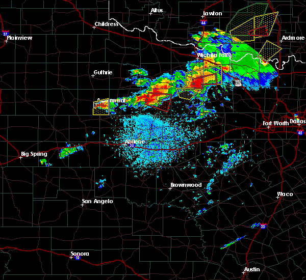 At 351 pm cdt, a severe thunderstorm capable of producing a tornado was located over throckmorton, moving east at 20 mph (radar indicated rotation). Hazards include tornado and half dollar size hail. Flying debris will be dangerous to those caught without shelter. mobile homes will be damaged or destroyed. damage to roofs, windows, and vehicles will occur. tree damage is likely. this dangerous storm will be near, throckmorton around 355 pm cdt. Other locations impacted by this tornadic thunderstorm include the intersection of us-183 and us-283 and the intersection of us- 380 and highway 222. At 351 pm cdt, a severe thunderstorm capable of producing a tornado was located over throckmorton, moving east at 20 mph (radar indicated rotation). Hazards include tornado and half dollar size hail. Flying debris will be dangerous to those caught without shelter. mobile homes will be damaged or destroyed. damage to roofs, windows, and vehicles will occur. tree damage is likely. this dangerous storm will be near, throckmorton around 355 pm cdt. Other locations impacted by this tornadic thunderstorm include the intersection of us-183 and us-283 and the intersection of us- 380 and highway 222.
|
| 5/1/2019 3:39 PM CDT |
 At 339 pm cdt, a severe thunderstorm capable of producing a tornado was located near throckmorton, moving east at 20 mph (radar indicated rotation). Hazards include tornado and half dollar size hail. Flying debris will be dangerous to those caught without shelter. mobile homes will be damaged or destroyed. damage to roofs, windows, and vehicles will occur. tree damage is likely. this dangerous storm will be near, throckmorton around 350 pm cdt. Other locations impacted by this tornadic thunderstorm include the intersection of us-183 and us-283 and the intersection of us- 380 and highway 222. At 339 pm cdt, a severe thunderstorm capable of producing a tornado was located near throckmorton, moving east at 20 mph (radar indicated rotation). Hazards include tornado and half dollar size hail. Flying debris will be dangerous to those caught without shelter. mobile homes will be damaged or destroyed. damage to roofs, windows, and vehicles will occur. tree damage is likely. this dangerous storm will be near, throckmorton around 350 pm cdt. Other locations impacted by this tornadic thunderstorm include the intersection of us-183 and us-283 and the intersection of us- 380 and highway 222.
|
| 7/15/2018 6:05 PM CDT |
 The severe thunderstorm warning for northeastern throckmorton county will expire at 615 pm cdt, the storm which prompted the warning has weakened below severe limits, and no longer pose an immediate threat to life or property. therefore, the warning will be allowed to expire. The severe thunderstorm warning for northeastern throckmorton county will expire at 615 pm cdt, the storm which prompted the warning has weakened below severe limits, and no longer pose an immediate threat to life or property. therefore, the warning will be allowed to expire.
|
| 7/15/2018 5:52 PM CDT |
 At 552 pm cdt, a severe thunderstorm was located near elbert, or 12 miles east of throckmorton, moving north at 15 mph (radar indicated). Hazards include 60 mph wind gusts and quarter size hail. Hail damage to vehicles is expected. expect wind damage to roofs, siding, and trees. This severe storm will be near, elbert around 615 pm cdt. At 552 pm cdt, a severe thunderstorm was located near elbert, or 12 miles east of throckmorton, moving north at 15 mph (radar indicated). Hazards include 60 mph wind gusts and quarter size hail. Hail damage to vehicles is expected. expect wind damage to roofs, siding, and trees. This severe storm will be near, elbert around 615 pm cdt.
|
| 7/15/2018 5:37 PM CDT |
 At 537 pm cdt, a severe thunderstorm was located 8 miles south of elbert, or 12 miles east of throckmorton, moving north at 15 mph (radar indicated). Hazards include 60 mph wind gusts and quarter size hail. Hail damage to vehicles is expected. expect wind damage to roofs, siding, and trees. This severe thunderstorm will be near, elbert around 615 pm cdt. At 537 pm cdt, a severe thunderstorm was located 8 miles south of elbert, or 12 miles east of throckmorton, moving north at 15 mph (radar indicated). Hazards include 60 mph wind gusts and quarter size hail. Hail damage to vehicles is expected. expect wind damage to roofs, siding, and trees. This severe thunderstorm will be near, elbert around 615 pm cdt.
|
| 5/25/2018 9:00 PM CDT |
 At 858 pm cdt, a severe thunderstorm was located 7 miles east of sagerton, or 7 miles southwest of haskell, moving southeast at 35 mph. another severe thunderstorm was in throckmorton county, and also moving southeast at 35 mph (radar indicated). Hazards include 60 mph wind gusts and quarter size hail. Hail damage to vehicles is expected. expect wind damage to roofs, siding, and trees. this severe thunderstorm will be near, paint creek around 905 pm cdt. avoca around 925 pm cdt. lueders around 930 pm cdt. nugent around 940 pm cdt. Other locations impacted by this severe thunderstorm include funston, the intersection of us-183 and us-283, lusk, the intersection of us- 380 and highway 222, big country baptist assembly, the intersection of us-283 and ranch road 209, us-180 near the shackelford-stephens county line. At 858 pm cdt, a severe thunderstorm was located 7 miles east of sagerton, or 7 miles southwest of haskell, moving southeast at 35 mph. another severe thunderstorm was in throckmorton county, and also moving southeast at 35 mph (radar indicated). Hazards include 60 mph wind gusts and quarter size hail. Hail damage to vehicles is expected. expect wind damage to roofs, siding, and trees. this severe thunderstorm will be near, paint creek around 905 pm cdt. avoca around 925 pm cdt. lueders around 930 pm cdt. nugent around 940 pm cdt. Other locations impacted by this severe thunderstorm include funston, the intersection of us-183 and us-283, lusk, the intersection of us- 380 and highway 222, big country baptist assembly, the intersection of us-283 and ranch road 209, us-180 near the shackelford-stephens county line.
|
| 5/25/2018 8:25 PM CDT |
 At 824 pm cdt, the leading edge of a cluster of a severe thunderstorms was located 8 miles southeast of millers creek reservoir, or 11 miles northwest of throckmorton, and moving southeast at 35 mph (radar indicated). Hazards include 60 mph wind gusts and quarter size hail. Hail damage to vehicles is expected. expect wind damage to roofs, siding, and trees. this severe thunderstorm will be near, throckmorton around 845 pm cdt. woodson around 910 pm cdt. Other locations impacted by this severe thunderstorm include the intersection of us-183 and us-283, us-183 near the throckmorton- baylor county line and the intersection of us-380 and highway 222. At 824 pm cdt, the leading edge of a cluster of a severe thunderstorms was located 8 miles southeast of millers creek reservoir, or 11 miles northwest of throckmorton, and moving southeast at 35 mph (radar indicated). Hazards include 60 mph wind gusts and quarter size hail. Hail damage to vehicles is expected. expect wind damage to roofs, siding, and trees. this severe thunderstorm will be near, throckmorton around 845 pm cdt. woodson around 910 pm cdt. Other locations impacted by this severe thunderstorm include the intersection of us-183 and us-283, us-183 near the throckmorton- baylor county line and the intersection of us-380 and highway 222.
|
| 5/15/2018 9:00 PM CDT |
 At 824 pm cdt, a severe thunderstorm was located 10 miles southeast of irby, or 16 miles southwest of throckmorton, moving northeast at 25 mph (radar indicated). Hazards include ping pong ball size hail and 60 mph wind gusts. People and animals outdoors will be injured. expect hail damage to roofs, siding, windows, and vehicles. expect wind damage to roofs, siding, and trees. this severe thunderstorm will be near, throckmorton around 905 pm cdt. Other locations impacted by this severe thunderstorm include the intersection of us-183 and us-283, the intersection of us- 380 and highway 222 and the intersection of us- 283 and ranch road 209. At 824 pm cdt, a severe thunderstorm was located 10 miles southeast of irby, or 16 miles southwest of throckmorton, moving northeast at 25 mph (radar indicated). Hazards include ping pong ball size hail and 60 mph wind gusts. People and animals outdoors will be injured. expect hail damage to roofs, siding, windows, and vehicles. expect wind damage to roofs, siding, and trees. this severe thunderstorm will be near, throckmorton around 905 pm cdt. Other locations impacted by this severe thunderstorm include the intersection of us-183 and us-283, the intersection of us- 380 and highway 222 and the intersection of us- 283 and ranch road 209.
|
| 5/15/2018 8:24 PM CDT |
 At 824 pm cdt, a severe thunderstorm was located 10 miles southeast of irby, or 16 miles southwest of throckmorton, moving northeast at 25 mph (radar indicated). Hazards include ping pong ball size hail and 60 mph wind gusts. People and animals outdoors will be injured. expect hail damage to roofs, siding, windows, and vehicles. expect wind damage to roofs, siding, and trees. this severe thunderstorm will be near, throckmorton around 905 pm cdt. Other locations impacted by this severe thunderstorm include the intersection of us-183 and us-283, the intersection of us- 380 and highway 222 and the intersection of us- 283 and ranch road 209. At 824 pm cdt, a severe thunderstorm was located 10 miles southeast of irby, or 16 miles southwest of throckmorton, moving northeast at 25 mph (radar indicated). Hazards include ping pong ball size hail and 60 mph wind gusts. People and animals outdoors will be injured. expect hail damage to roofs, siding, windows, and vehicles. expect wind damage to roofs, siding, and trees. this severe thunderstorm will be near, throckmorton around 905 pm cdt. Other locations impacted by this severe thunderstorm include the intersection of us-183 and us-283, the intersection of us- 380 and highway 222 and the intersection of us- 283 and ranch road 209.
|
| 5/3/2018 12:12 AM CDT |
 At 1212 am cdt, a severe thunderstorm was located 8 miles northwest of elbert, or 12 miles northeast of throckmorton, moving northeast at 30 mph (radar indicated). Hazards include 60 mph wind gusts and quarter size hail. Hail damage to vehicles is expected. expect wind damage to roofs, siding, and trees. this severe storm will be near, elbert around 1220 am cdt. Other locations impacted by this severe thunderstorm include us- 183 near the throckmorton-baylor county line. At 1212 am cdt, a severe thunderstorm was located 8 miles northwest of elbert, or 12 miles northeast of throckmorton, moving northeast at 30 mph (radar indicated). Hazards include 60 mph wind gusts and quarter size hail. Hail damage to vehicles is expected. expect wind damage to roofs, siding, and trees. this severe storm will be near, elbert around 1220 am cdt. Other locations impacted by this severe thunderstorm include us- 183 near the throckmorton-baylor county line.
|
| 5/2/2018 11:43 PM CDT |
 At 1143 pm cdt, a severe thunderstorm was located 7 miles northwest of throckmorton, moving northeast at 30 mph (radar indicated). Hazards include 60 mph wind gusts and quarter size hail. Hail damage to vehicles is expected. expect wind damage to roofs, siding, and trees. this severe thunderstorm will be near, throckmorton around 1150 pm cdt. elbert around 1220 am cdt. Other locations impacted by this severe thunderstorm include us- 183 near the throckmorton- baylor county line and the intersection of us-380 and highway 222. At 1143 pm cdt, a severe thunderstorm was located 7 miles northwest of throckmorton, moving northeast at 30 mph (radar indicated). Hazards include 60 mph wind gusts and quarter size hail. Hail damage to vehicles is expected. expect wind damage to roofs, siding, and trees. this severe thunderstorm will be near, throckmorton around 1150 pm cdt. elbert around 1220 am cdt. Other locations impacted by this severe thunderstorm include us- 183 near the throckmorton- baylor county line and the intersection of us-380 and highway 222.
|
| 5/2/2018 9:39 PM CDT |
 At 938 pm cdt, a severe thunderstorm was located 8 miles south of elbert, or 11 miles east of throckmorton, moving northeast at 50 mph (radar indicated). Hazards include 60 mph wind gusts and quarter size hail. Hail damage to vehicles is expected. expect wind damage to roofs, siding, and trees. This severe thunderstorm will remain over mainly rural areas of southeastern throckmorton county, including the following locations: lusk and the intersection of us-183 and us-283. At 938 pm cdt, a severe thunderstorm was located 8 miles south of elbert, or 11 miles east of throckmorton, moving northeast at 50 mph (radar indicated). Hazards include 60 mph wind gusts and quarter size hail. Hail damage to vehicles is expected. expect wind damage to roofs, siding, and trees. This severe thunderstorm will remain over mainly rural areas of southeastern throckmorton county, including the following locations: lusk and the intersection of us-183 and us-283.
|
| 5/2/2018 9:20 PM CDT |
 At 920 pm cdt, a severe thunderstorm was located near fort griffin, or 10 miles south of throckmorton, moving northeast at 50 mph (radar indicated). Hazards include 60 mph wind gusts and quarter size hail. Hail damage to vehicles is expected. expect wind damage to roofs, siding, and trees. this severe thunderstorm will be near, woodson around 930 pm cdt. Other locations impacted by this severe thunderstorm include lusk, the intersection of us-183 and us-283 and the intersection of us- 283 and ranch road 209. At 920 pm cdt, a severe thunderstorm was located near fort griffin, or 10 miles south of throckmorton, moving northeast at 50 mph (radar indicated). Hazards include 60 mph wind gusts and quarter size hail. Hail damage to vehicles is expected. expect wind damage to roofs, siding, and trees. this severe thunderstorm will be near, woodson around 930 pm cdt. Other locations impacted by this severe thunderstorm include lusk, the intersection of us-183 and us-283 and the intersection of us- 283 and ranch road 209.
|
| 5/2/2018 8:17 PM CDT |
 At 817 pm cdt, a severe thunderstorm was located 8 miles south of archer city, moving northeast at 45 mph (radar indicated). Hazards include 60 mph wind gusts and quarter size hail. Hail damage to vehicles is expected. expect wind damage to roofs, siding, and trees. Locations impacted include, throckmorton, woodson, elbert, fort griffin, the intersection of us- 183 and us-283, lusk and the intersection of us- 283 and ranch road 209. At 817 pm cdt, a severe thunderstorm was located 8 miles south of archer city, moving northeast at 45 mph (radar indicated). Hazards include 60 mph wind gusts and quarter size hail. Hail damage to vehicles is expected. expect wind damage to roofs, siding, and trees. Locations impacted include, throckmorton, woodson, elbert, fort griffin, the intersection of us- 183 and us-283, lusk and the intersection of us- 283 and ranch road 209.
|
| 5/2/2018 7:56 PM CDT |
 At 755 pm cdt, a severe thunderstorm was located near elbert, or 9 miles west of olney, moving northeast at 45 mph (radar indicated). Hazards include 60 mph wind gusts and quarter size hail. Hail damage to vehicles is expected. expect wind damage to roofs, siding, and trees. Locations impacted include, throckmorton, woodson, elbert, fort griffin, the intersection of us- 183 and us-283, lusk, the intersection of us- 380 and highway 222 and the intersection of us- 283 and ranch road 209. At 755 pm cdt, a severe thunderstorm was located near elbert, or 9 miles west of olney, moving northeast at 45 mph (radar indicated). Hazards include 60 mph wind gusts and quarter size hail. Hail damage to vehicles is expected. expect wind damage to roofs, siding, and trees. Locations impacted include, throckmorton, woodson, elbert, fort griffin, the intersection of us- 183 and us-283, lusk, the intersection of us- 380 and highway 222 and the intersection of us- 283 and ranch road 209.
|
| 5/2/2018 7:46 PM CDT |
 At 746 pm cdt, a severe thunderstorm was located over elbert, or 11 miles northeast of throckmorton, moving northeast at 45 mph (radar indicated). Hazards include 60 mph wind gusts and quarter size hail. Hail damage to vehicles is expected. expect wind damage to roofs, siding, and trees. This severe thunderstorm will remain over mainly rural areas of northern shackelford and throckmorton counties, including the following locations: the intersection of us-183 and us-283, us-183 near the throckmorton-baylor county line, the intersection of us-283 and ranch road 209, lusk and the intersection of us-380 and highway 222. At 746 pm cdt, a severe thunderstorm was located over elbert, or 11 miles northeast of throckmorton, moving northeast at 45 mph (radar indicated). Hazards include 60 mph wind gusts and quarter size hail. Hail damage to vehicles is expected. expect wind damage to roofs, siding, and trees. This severe thunderstorm will remain over mainly rural areas of northern shackelford and throckmorton counties, including the following locations: the intersection of us-183 and us-283, us-183 near the throckmorton-baylor county line, the intersection of us-283 and ranch road 209, lusk and the intersection of us-380 and highway 222.
|
| 5/2/2018 7:35 PM CDT |
 At 734 pm cdt, a severe thunderstorm was located near elbert, or 9 miles northeast of throckmorton, moving northeast at 45 mph (radar indicated). Hazards include 60 mph wind gusts and quarter size hail. Hail damage to vehicles is expected. expect wind damage to roofs, siding, and trees. This severe thunderstorm will remain over mainly rural areas of southeastern haskell, northern shackelford and throckmorton counties, including the following locations: the intersection of us-183 and us-283, us-183 near the throckmorton-baylor county line, the intersection of us-283 and ranch road 209, lusk and the intersection of us-380 and highway 222. At 734 pm cdt, a severe thunderstorm was located near elbert, or 9 miles northeast of throckmorton, moving northeast at 45 mph (radar indicated). Hazards include 60 mph wind gusts and quarter size hail. Hail damage to vehicles is expected. expect wind damage to roofs, siding, and trees. This severe thunderstorm will remain over mainly rural areas of southeastern haskell, northern shackelford and throckmorton counties, including the following locations: the intersection of us-183 and us-283, us-183 near the throckmorton-baylor county line, the intersection of us-283 and ranch road 209, lusk and the intersection of us-380 and highway 222.
|
| 5/2/2018 7:09 PM CDT |
 At 709 pm cdt, a severe thunderstorm was located 9 miles southwest of throckmorton, moving northeast at 45 mph (radar indicated). Hazards include golf ball size hail and 60 mph wind gusts. People and animals outdoors will be injured. expect hail damage to roofs, siding, windows, and vehicles. expect wind damage to roofs, siding, and trees. this severe storm will be near, throckmorton around 720 pm cdt. elbert around 740 pm cdt. Other locations impacted by this severe thunderstorm include big country baptist assembly, the intersection of us-183 and us-283, us- 183 near the throckmorton-baylor county line, the intersection of us- 283 and ranch road 209, lusk and the intersection of us- 380 and highway 222. At 709 pm cdt, a severe thunderstorm was located 9 miles southwest of throckmorton, moving northeast at 45 mph (radar indicated). Hazards include golf ball size hail and 60 mph wind gusts. People and animals outdoors will be injured. expect hail damage to roofs, siding, windows, and vehicles. expect wind damage to roofs, siding, and trees. this severe storm will be near, throckmorton around 720 pm cdt. elbert around 740 pm cdt. Other locations impacted by this severe thunderstorm include big country baptist assembly, the intersection of us-183 and us-283, us- 183 near the throckmorton-baylor county line, the intersection of us- 283 and ranch road 209, lusk and the intersection of us- 380 and highway 222.
|
| 5/2/2018 6:58 PM CDT |
 At 658 pm cdt, a severe thunderstorm was located 10 miles east of lake stamford marina, or 18 miles southwest of throckmorton, moving northeast at 45 mph (radar indicated). Hazards include 60 mph wind gusts and quarter size hail. Hail damage to vehicles is expected. expect wind damage to roofs, siding, and trees. this severe thunderstorm will be near, throckmorton around 720 pm cdt. elbert around 745 pm cdt. Other locations impacted by this severe thunderstorm include big country baptist assembly, the intersection of us-183 and us-283, us- 183 near the throckmorton-baylor county line, the intersection of us- 283 and ranch road 209, lusk and the intersection of us- 380 and highway 222. At 658 pm cdt, a severe thunderstorm was located 10 miles east of lake stamford marina, or 18 miles southwest of throckmorton, moving northeast at 45 mph (radar indicated). Hazards include 60 mph wind gusts and quarter size hail. Hail damage to vehicles is expected. expect wind damage to roofs, siding, and trees. this severe thunderstorm will be near, throckmorton around 720 pm cdt. elbert around 745 pm cdt. Other locations impacted by this severe thunderstorm include big country baptist assembly, the intersection of us-183 and us-283, us- 183 near the throckmorton-baylor county line, the intersection of us- 283 and ranch road 209, lusk and the intersection of us- 380 and highway 222.
|
| 3/26/2018 8:30 PM CDT |
 At 830 pm cdt, a severe thunderstorm was located 7 miles north of fort griffin, or 9 miles south of throckmorton, moving northeast at 30 mph (radar indicated). Hazards include tennis ball size hail and 60 mph wind gusts. People and animals outdoors will be injured. expect hail damage to roofs, siding, windows, and vehicles. expect wind damage to roofs, siding, and trees. this severe thunderstorm will be near, woodson around 840 pm cdt. elbert around 905 pm cdt. Other locations impacted by this severe thunderstorm include the intersection of us-283 and ranch road 209, the intersection of us- 183 and us-283 and us-183 near the throckmorton-stephens county line. At 830 pm cdt, a severe thunderstorm was located 7 miles north of fort griffin, or 9 miles south of throckmorton, moving northeast at 30 mph (radar indicated). Hazards include tennis ball size hail and 60 mph wind gusts. People and animals outdoors will be injured. expect hail damage to roofs, siding, windows, and vehicles. expect wind damage to roofs, siding, and trees. this severe thunderstorm will be near, woodson around 840 pm cdt. elbert around 905 pm cdt. Other locations impacted by this severe thunderstorm include the intersection of us-283 and ranch road 209, the intersection of us- 183 and us-283 and us-183 near the throckmorton-stephens county line.
|
| 3/26/2018 5:45 PM CDT |
 At 545 pm cdt, a severe thunderstorm was located near elbert, or 13 miles northeast of throckmorton, moving northeast at 45 mph (radar indicated). Hazards include 60 mph wind gusts and quarter size hail. Hail damage to vehicles is expected. expect wind damage to roofs, siding, and trees. Locations impacted include, throckmorton and elbert. At 545 pm cdt, a severe thunderstorm was located near elbert, or 13 miles northeast of throckmorton, moving northeast at 45 mph (radar indicated). Hazards include 60 mph wind gusts and quarter size hail. Hail damage to vehicles is expected. expect wind damage to roofs, siding, and trees. Locations impacted include, throckmorton and elbert.
|
| 3/26/2018 5:28 PM CDT |
 At 527 pm cdt, a severe thunderstorm was located near woodson, or 11 miles southeast of throckmorton, moving northeast at 45 mph (radar indicated). Hazards include golf ball size hail and 60 mph wind gusts. People and animals outdoors will be injured. expect hail damage to roofs, siding, windows, and vehicles. expect wind damage to roofs, siding, and trees. This severe thunderstorm will remain over mainly rural areas of eastern throckmorton county, including the following locations: the intersection of us-183 and us-283, us-183 near the throckmorton-stephens county line and the intersection of us-380 and highway 222. At 527 pm cdt, a severe thunderstorm was located near woodson, or 11 miles southeast of throckmorton, moving northeast at 45 mph (radar indicated). Hazards include golf ball size hail and 60 mph wind gusts. People and animals outdoors will be injured. expect hail damage to roofs, siding, windows, and vehicles. expect wind damage to roofs, siding, and trees. This severe thunderstorm will remain over mainly rural areas of eastern throckmorton county, including the following locations: the intersection of us-183 and us-283, us-183 near the throckmorton-stephens county line and the intersection of us-380 and highway 222.
|
| 3/26/2018 4:56 PM CDT |
 At 455 pm cdt, a severe thunderstorm was located near elbert, or 7 miles northeast of throckmorton, moving northeast at 55 mph (radar indicated). Hazards include 60 mph wind gusts and quarter size hail. Hail damage to vehicles is expected. expect wind damage to roofs, siding, and trees. This severe thunderstorm will be near, elbert around 500 pm cdt. At 455 pm cdt, a severe thunderstorm was located near elbert, or 7 miles northeast of throckmorton, moving northeast at 55 mph (radar indicated). Hazards include 60 mph wind gusts and quarter size hail. Hail damage to vehicles is expected. expect wind damage to roofs, siding, and trees. This severe thunderstorm will be near, elbert around 500 pm cdt.
|
| 10/21/2017 9:07 PM CDT |
 At 906 pm cdt, a severe thunderstorm was located near millers creek reservoir, or 8 miles southeast of munday, moving northeast at 35 mph (radar indicated). Hazards include 60 mph wind gusts and half dollar size hail. Hail damage to vehicles is expected. expect wind damage to roofs, siding, and trees. this severe storm will be near, millers creek reservoir around 920 pm cdt. Other locations impacted by this severe thunderstorm include the intersection of us-380 and highway 222. At 906 pm cdt, a severe thunderstorm was located near millers creek reservoir, or 8 miles southeast of munday, moving northeast at 35 mph (radar indicated). Hazards include 60 mph wind gusts and half dollar size hail. Hail damage to vehicles is expected. expect wind damage to roofs, siding, and trees. this severe storm will be near, millers creek reservoir around 920 pm cdt. Other locations impacted by this severe thunderstorm include the intersection of us-380 and highway 222.
|
| 10/21/2017 8:52 PM CDT |
 At 852 pm cdt, a severe thunderstorm was located over weinert, or 9 miles south of munday, moving northeast at 35 mph (radar indicated). Hazards include 60 mph wind gusts and half dollar size hail. Hail damage to vehicles is expected. expect wind damage to roofs, siding, and trees. this severe thunderstorm will be near, millers creek reservoir around 920 pm cdt. Other locations impacted by this severe thunderstorm include the intersection of us-380 and highway 222. At 852 pm cdt, a severe thunderstorm was located over weinert, or 9 miles south of munday, moving northeast at 35 mph (radar indicated). Hazards include 60 mph wind gusts and half dollar size hail. Hail damage to vehicles is expected. expect wind damage to roofs, siding, and trees. this severe thunderstorm will be near, millers creek reservoir around 920 pm cdt. Other locations impacted by this severe thunderstorm include the intersection of us-380 and highway 222.
|
| 10/21/2017 8:29 PM CDT |
 At 828 pm cdt, a severe thunderstorm was located over throckmorton, moving east at 35 mph. this storm has a history of producing ping pong size hail (radar indicated). Hazards include ping pong ball size hail and 60 mph wind gusts. People and animals outdoors will be injured. expect hail damage to roofs, siding, windows, and vehicles. expect wind damage to roofs, siding, and trees. this severe thunderstorm will be near, elbert around 845 pm cdt. Other locations impacted by this severe thunderstorm include the intersection of us-283 and ranch road 209 and the intersection of us- 183 and us-283. At 828 pm cdt, a severe thunderstorm was located over throckmorton, moving east at 35 mph. this storm has a history of producing ping pong size hail (radar indicated). Hazards include ping pong ball size hail and 60 mph wind gusts. People and animals outdoors will be injured. expect hail damage to roofs, siding, windows, and vehicles. expect wind damage to roofs, siding, and trees. this severe thunderstorm will be near, elbert around 845 pm cdt. Other locations impacted by this severe thunderstorm include the intersection of us-283 and ranch road 209 and the intersection of us- 183 and us-283.
|
| 10/21/2017 8:04 PM CDT |
 At 804 pm cdt, a severe thunderstorm was located 9 miles west of throckmorton, moving northeast at 35 mph (radar indicated). Hazards include 60 mph wind gusts and quarter size hail. Hail damage to vehicles is expected. expect wind damage to roofs, siding, and trees. this severe storm will be near, throckmorton around 820 pm cdt. elbert around 830 pm cdt. Other locations impacted by this severe thunderstorm include the intersection of us-183 and us-283 and the intersection of us- 380 and highway 222. At 804 pm cdt, a severe thunderstorm was located 9 miles west of throckmorton, moving northeast at 35 mph (radar indicated). Hazards include 60 mph wind gusts and quarter size hail. Hail damage to vehicles is expected. expect wind damage to roofs, siding, and trees. this severe storm will be near, throckmorton around 820 pm cdt. elbert around 830 pm cdt. Other locations impacted by this severe thunderstorm include the intersection of us-183 and us-283 and the intersection of us- 380 and highway 222.
|
| 10/21/2017 7:46 PM CDT |
 At 745 pm cdt, a severe thunderstorm was located near lake stamford marina, or 14 miles southeast of haskell, moving northeast at 35 mph (radar indicated). Hazards include 60 mph wind gusts and quarter size hail. Hail damage to vehicles is expected. expect wind damage to roofs, siding, and trees. this severe thunderstorm will be near, irby around 750 pm cdt. throckmorton around 820 pm cdt. elbert around 830 pm cdt. Other locations impacted by this severe thunderstorm include the intersection of us-183 and us-283 and the intersection of us- 380 and highway 222. At 745 pm cdt, a severe thunderstorm was located near lake stamford marina, or 14 miles southeast of haskell, moving northeast at 35 mph (radar indicated). Hazards include 60 mph wind gusts and quarter size hail. Hail damage to vehicles is expected. expect wind damage to roofs, siding, and trees. this severe thunderstorm will be near, irby around 750 pm cdt. throckmorton around 820 pm cdt. elbert around 830 pm cdt. Other locations impacted by this severe thunderstorm include the intersection of us-183 and us-283 and the intersection of us- 380 and highway 222.
|
| 9/19/2017 9:34 PM CDT |
 At 933 pm cdt, a severe thunderstorm was located near elbert, or 14 miles east of throckmorton, moving southeast at 10 mph (radar indicated). Hazards include 60 mph wind gusts and quarter size hail. Hail damage to vehicles is expected. expect wind damage to roofs, siding, and trees. Locations impacted include, elbert. At 933 pm cdt, a severe thunderstorm was located near elbert, or 14 miles east of throckmorton, moving southeast at 10 mph (radar indicated). Hazards include 60 mph wind gusts and quarter size hail. Hail damage to vehicles is expected. expect wind damage to roofs, siding, and trees. Locations impacted include, elbert.
|
| 9/19/2017 9:17 PM CDT |
 At 916 pm cdt, a severe thunderstorm was located over elbert, or 12 miles east of throckmorton, moving southeast at 10 mph (radar indicated). Hazards include 60 mph wind gusts and quarter size hail. Hail damage to vehicles is expected. expect wind damage to roofs, siding, and trees. This severe thunderstorm will remain over mainly rural areas of east central throckmorton county. At 916 pm cdt, a severe thunderstorm was located over elbert, or 12 miles east of throckmorton, moving southeast at 10 mph (radar indicated). Hazards include 60 mph wind gusts and quarter size hail. Hail damage to vehicles is expected. expect wind damage to roofs, siding, and trees. This severe thunderstorm will remain over mainly rural areas of east central throckmorton county.
|
| 9/19/2017 8:50 PM CDT |
 At 849 pm cdt, a severe thunderstorm was located near bangs, or 10 miles southwest of brownwood, and is nearly stationary (radar indicated). Hazards include 60 mph wind gusts and quarter size hail. Hail damage to vehicles is expected. expect wind damage to roofs, siding, and trees. This severe thunderstorm will remain over mainly rural areas of northeastern throckmorton county. At 849 pm cdt, a severe thunderstorm was located near bangs, or 10 miles southwest of brownwood, and is nearly stationary (radar indicated). Hazards include 60 mph wind gusts and quarter size hail. Hail damage to vehicles is expected. expect wind damage to roofs, siding, and trees. This severe thunderstorm will remain over mainly rural areas of northeastern throckmorton county.
|
| 9/19/2017 8:32 PM CDT |
 At 831 pm cdt, a severe thunderstorm was located near elbert, or 12 miles northeast of throckmorton, moving east at 15 mph (radar indicated). Hazards include 60 mph wind gusts and quarter size hail. Hail damage to vehicles is expected. expect wind damage to roofs, siding, and trees. This severe thunderstorm will be near, elbert around 905 pm cdt. At 831 pm cdt, a severe thunderstorm was located near elbert, or 12 miles northeast of throckmorton, moving east at 15 mph (radar indicated). Hazards include 60 mph wind gusts and quarter size hail. Hail damage to vehicles is expected. expect wind damage to roofs, siding, and trees. This severe thunderstorm will be near, elbert around 905 pm cdt.
|
| 8/5/2017 7:22 PM CDT |
 At 721 pm cdt, a severe thunderstorm was located just northwest of elbert, or 12 miles northeast of throckmorton, moving slowly east at 10 mph (radar indicated). Hazards include 60 mph wind gusts and penny size hail. Expect damage to roofs, siding, and trees. This severe storm will be near, elbert around 725 pm cdt. At 721 pm cdt, a severe thunderstorm was located just northwest of elbert, or 12 miles northeast of throckmorton, moving slowly east at 10 mph (radar indicated). Hazards include 60 mph wind gusts and penny size hail. Expect damage to roofs, siding, and trees. This severe storm will be near, elbert around 725 pm cdt.
|
| 8/5/2017 7:00 PM CDT |
 At 659 pm cdt, a severe thunderstorm was located 2 miles northwest of elbert, or 13 miles northeast of throckmorton, moving slowly east at 10 mph (radar indicated). Hazards include 60 mph wind gusts and quarter size hail. Hail damage to vehicles is expected. expect wind damage to roofs, siding, and trees. This severe thunderstorm will be near, elbert around 720 pm cdt. At 659 pm cdt, a severe thunderstorm was located 2 miles northwest of elbert, or 13 miles northeast of throckmorton, moving slowly east at 10 mph (radar indicated). Hazards include 60 mph wind gusts and quarter size hail. Hail damage to vehicles is expected. expect wind damage to roofs, siding, and trees. This severe thunderstorm will be near, elbert around 720 pm cdt.
|
| 8/5/2017 6:46 PM CDT |
 At 645 pm cdt, a severe thunderstorm was located 7 miles northwest of elbert, or 13 miles northeast of throckmorton, moving east at 10 mph (radar indicated). Hazards include 60 mph wind gusts and penny size hail. Expect damage to roofs, siding, and trees. This severe storm will be near, elbert around 655 pm cdt. At 645 pm cdt, a severe thunderstorm was located 7 miles northwest of elbert, or 13 miles northeast of throckmorton, moving east at 10 mph (radar indicated). Hazards include 60 mph wind gusts and penny size hail. Expect damage to roofs, siding, and trees. This severe storm will be near, elbert around 655 pm cdt.
|
| 8/5/2017 6:24 PM CDT |
 At 623 pm cdt, a severe thunderstorm was located 8 miles northwest of elbert, or 11 miles north of throckmorton, moving east at 15 mph (radar indicated). Hazards include 60 mph wind gusts and penny size hail. Expect damage to roofs, siding, and trees. This severe thunderstorm will be near, elbert around 650 pm cdt. At 623 pm cdt, a severe thunderstorm was located 8 miles northwest of elbert, or 11 miles north of throckmorton, moving east at 15 mph (radar indicated). Hazards include 60 mph wind gusts and penny size hail. Expect damage to roofs, siding, and trees. This severe thunderstorm will be near, elbert around 650 pm cdt.
|
| 5/19/2017 8:48 PM CDT |
 At 848 pm cdt, a severe thunderstorm was located 7 miles southeast of millers creek reservoir, or 12 miles northwest of throckmorton, moving east at 35 mph (radar indicated). Hazards include 60 mph wind gusts and quarter size hail. Hail damage to vehicles is expected. expect wind damage to roofs, siding, and trees. this severe thunderstorm will be near, elbert around 920 pm cdt. other locations impacted by this severe thunderstorm include the intersection of us-380 and highway 222. A tornado watch remains in effect until 300 am cdt for west central texas. At 848 pm cdt, a severe thunderstorm was located 7 miles southeast of millers creek reservoir, or 12 miles northwest of throckmorton, moving east at 35 mph (radar indicated). Hazards include 60 mph wind gusts and quarter size hail. Hail damage to vehicles is expected. expect wind damage to roofs, siding, and trees. this severe thunderstorm will be near, elbert around 920 pm cdt. other locations impacted by this severe thunderstorm include the intersection of us-380 and highway 222. A tornado watch remains in effect until 300 am cdt for west central texas.
|
| 5/19/2017 7:23 PM CDT |
 At 723 pm cdt, a severe thunderstorm was located 8 miles southeast of millers creek reservoir, or 11 miles northwest of throckmorton, moving northeast at 25 mph (radar indicated). Hazards include 60 mph wind gusts and half dollar size hail. Hail damage to vehicles is expected. expect wind damage to roofs, siding, and trees. this severe thunderstorm will remain over mainly rural areas of northern throckmorton county, including the following locations: the intersection of us-380 and highway 222. A tornado watch remains in effect until 800 pm cdt for west central texas. At 723 pm cdt, a severe thunderstorm was located 8 miles southeast of millers creek reservoir, or 11 miles northwest of throckmorton, moving northeast at 25 mph (radar indicated). Hazards include 60 mph wind gusts and half dollar size hail. Hail damage to vehicles is expected. expect wind damage to roofs, siding, and trees. this severe thunderstorm will remain over mainly rural areas of northern throckmorton county, including the following locations: the intersection of us-380 and highway 222. A tornado watch remains in effect until 800 pm cdt for west central texas.
|
| 5/19/2017 1:04 PM CDT |
 At 103 pm cdt, a severe thunderstorm was located near elbert, or 7 miles east of throckmorton, moving northeast at 30 mph (radar indicated). Hazards include 60 mph wind gusts and quarter size hail. Hail damage to vehicles is expected. expect wind damage to roofs, siding, and trees. this severe storm will be near, elbert around 115 pm cdt. A tornado watch remains in effect until 800 pm cdt for west central texas. At 103 pm cdt, a severe thunderstorm was located near elbert, or 7 miles east of throckmorton, moving northeast at 30 mph (radar indicated). Hazards include 60 mph wind gusts and quarter size hail. Hail damage to vehicles is expected. expect wind damage to roofs, siding, and trees. this severe storm will be near, elbert around 115 pm cdt. A tornado watch remains in effect until 800 pm cdt for west central texas.
|
| 5/19/2017 12:50 PM CDT |
 At 1250 pm cdt, a severe thunderstorm was located near throckmorton, moving northeast at 40 mph (radar indicated). Hazards include 60 mph wind gusts and quarter size hail. Hail damage to vehicles is expected. expect wind damage to roofs, siding, and trees. this severe storm will be near, elbert around 105 pm cdt. other locations impacted by this severe thunderstorm include the intersection of us-283 and ranch road 209 and the intersection of us- 183 and us-283. A tornado watch remains in effect until 800 pm cdt for west central texas. At 1250 pm cdt, a severe thunderstorm was located near throckmorton, moving northeast at 40 mph (radar indicated). Hazards include 60 mph wind gusts and quarter size hail. Hail damage to vehicles is expected. expect wind damage to roofs, siding, and trees. this severe storm will be near, elbert around 105 pm cdt. other locations impacted by this severe thunderstorm include the intersection of us-283 and ranch road 209 and the intersection of us- 183 and us-283. A tornado watch remains in effect until 800 pm cdt for west central texas.
|
| 5/19/2017 12:31 PM CDT |
 At 1230 pm cdt, a severe thunderstorm was located 10 miles northwest of fort griffin, or 13 miles southwest of throckmorton, moving northeast at 35 mph (radar indicated). Hazards include 60 mph wind gusts and half dollar size hail. Hail damage to vehicles is expected. expect wind damage to roofs, siding, and trees. this severe thunderstorm will be near, throckmorton around 1255 pm cdt. elbert around 115 pm cdt. other locations impacted by this severe thunderstorm include the intersection of us-283 and ranch road 209, the intersection of us- 183 and us-283 and us-183 near the throckmorton-stephens county line. A tornado watch remains in effect until 800 pm cdt for west central texas. At 1230 pm cdt, a severe thunderstorm was located 10 miles northwest of fort griffin, or 13 miles southwest of throckmorton, moving northeast at 35 mph (radar indicated). Hazards include 60 mph wind gusts and half dollar size hail. Hail damage to vehicles is expected. expect wind damage to roofs, siding, and trees. this severe thunderstorm will be near, throckmorton around 1255 pm cdt. elbert around 115 pm cdt. other locations impacted by this severe thunderstorm include the intersection of us-283 and ranch road 209, the intersection of us- 183 and us-283 and us-183 near the throckmorton-stephens county line. A tornado watch remains in effect until 800 pm cdt for west central texas.
|
| 5/19/2017 11:10 AM CDT |
 At 1109 am cdt, a severe thunderstorm was located near elbert, or 7 miles northeast of throckmorton, moving northeast at 40 mph (radar indicated). Hazards include 60 mph wind gusts and half dollar size hail. Hail damage to vehicles is expected. expect wind damage to roofs, siding, and trees. This severe storm will be near, elbert around 1120 am cdt. At 1109 am cdt, a severe thunderstorm was located near elbert, or 7 miles northeast of throckmorton, moving northeast at 40 mph (radar indicated). Hazards include 60 mph wind gusts and half dollar size hail. Hail damage to vehicles is expected. expect wind damage to roofs, siding, and trees. This severe storm will be near, elbert around 1120 am cdt.
|
| 5/19/2017 10:46 AM CDT |
 At 1046 am cdt, a severe thunderstorm was located near throckmorton, moving northeast at 55 mph (radar indicated). Hazards include 60 mph wind gusts and half dollar size hail. Hail damage to vehicles is expected. expect wind damage to roofs, siding, and trees. this severe thunderstorm will be near, throckmorton around 1050 am cdt. elbert around 1105 am cdt. Other locations impacted by this severe thunderstorm include the intersection of us-183 and us-283 and the intersection of us- 380 and highway 222. At 1046 am cdt, a severe thunderstorm was located near throckmorton, moving northeast at 55 mph (radar indicated). Hazards include 60 mph wind gusts and half dollar size hail. Hail damage to vehicles is expected. expect wind damage to roofs, siding, and trees. this severe thunderstorm will be near, throckmorton around 1050 am cdt. elbert around 1105 am cdt. Other locations impacted by this severe thunderstorm include the intersection of us-183 and us-283 and the intersection of us- 380 and highway 222.
|
| 5/18/2017 6:37 PM CDT |
 At 637 pm cdt, a severe thunderstorm was located near millers creek reservoir, or 15 miles northwest of throckmorton, moving northeast at 45 mph (radar indicated). Hazards include 60 mph wind gusts and half dollar size hail. Hail damage to vehicles is expected. expect wind damage to roofs, siding, and trees. this severe thunderstorm will remain over mainly rural areas of northeastern haskell and northern throckmorton counties, including the following locations: the intersection of us-380 and highway 222. A tornado watch remains in effect until 1000 pm cdt for west central texas. At 637 pm cdt, a severe thunderstorm was located near millers creek reservoir, or 15 miles northwest of throckmorton, moving northeast at 45 mph (radar indicated). Hazards include 60 mph wind gusts and half dollar size hail. Hail damage to vehicles is expected. expect wind damage to roofs, siding, and trees. this severe thunderstorm will remain over mainly rural areas of northeastern haskell and northern throckmorton counties, including the following locations: the intersection of us-380 and highway 222. A tornado watch remains in effect until 1000 pm cdt for west central texas.
|
| 3/28/2017 10:36 PM CDT |
 At 1035 pm cdt, severe thunderstorms were located along a line extending from near weinert to near lueders to hamby to oplin, moving east at 25 mph (radar indicated). Hazards include 60 mph wind gusts and penny size hail. Expect damage to roofs, siding, and trees. these severe storms will be near, clyde, eula, oplin and dudley around 1040 pm cdt. baird around 1100 pm cdt. Albany and putnam around 1115 pm cdt. At 1035 pm cdt, severe thunderstorms were located along a line extending from near weinert to near lueders to hamby to oplin, moving east at 25 mph (radar indicated). Hazards include 60 mph wind gusts and penny size hail. Expect damage to roofs, siding, and trees. these severe storms will be near, clyde, eula, oplin and dudley around 1040 pm cdt. baird around 1100 pm cdt. Albany and putnam around 1115 pm cdt.
|
| 3/28/2017 10:14 PM CDT |
 At 1013 pm cdt, severe thunderstorms were located along a line extending from near weinert to near stamford to near hawley to near dyess afb to near lawn, moving east at 45 mph (radar indicated). Hazards include 60 to 70 mph wind gusts and penny size hail. Expect considerable tree damage. damage is likely to mobile homes, roofs, and outbuildings. severe thunderstorms will be near, oplin, hamby and nugent around 1020 pm cdt. lueders, potosi and dudley around 1025 pm cdt. clyde and eula around 1030 pm cdt. baird around 1040 pm cdt. albany, throckmorton, cross plains, moran and fort griffin around 1050 pm cdt. putnam around 1055 pm cdt. atwell around 1100 pm cdt. elbert around 1105 pm cdt. other locations impacted by these severe thunderstorms include funston, us-180 near the shackelford-stephens county line, us- 183 near the throckmorton- stephens county line, admiral, big country baptist assembly, the intersection of us- 180 and farm road 600, impact, lake abilene, camp tonkawa and tuxedo. This includes interstate 20 between mile markers 265 and 323. At 1013 pm cdt, severe thunderstorms were located along a line extending from near weinert to near stamford to near hawley to near dyess afb to near lawn, moving east at 45 mph (radar indicated). Hazards include 60 to 70 mph wind gusts and penny size hail. Expect considerable tree damage. damage is likely to mobile homes, roofs, and outbuildings. severe thunderstorms will be near, oplin, hamby and nugent around 1020 pm cdt. lueders, potosi and dudley around 1025 pm cdt. clyde and eula around 1030 pm cdt. baird around 1040 pm cdt. albany, throckmorton, cross plains, moran and fort griffin around 1050 pm cdt. putnam around 1055 pm cdt. atwell around 1100 pm cdt. elbert around 1105 pm cdt. other locations impacted by these severe thunderstorms include funston, us-180 near the shackelford-stephens county line, us- 183 near the throckmorton- stephens county line, admiral, big country baptist assembly, the intersection of us- 180 and farm road 600, impact, lake abilene, camp tonkawa and tuxedo. This includes interstate 20 between mile markers 265 and 323.
|
| 10/19/2016 11:09 PM CDT |
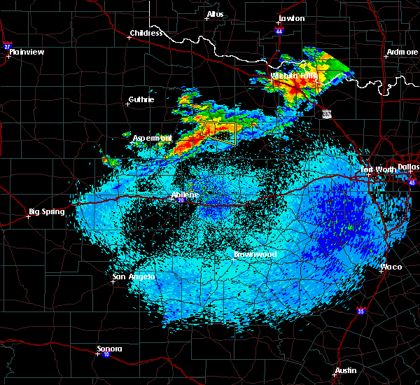 At 1109 pm cdt, a severe thunderstorm was located 9 miles southeast of millers creek reservoir, or 10 miles northwest of throckmorton, moving east at 15 mph (radar indicated). Hazards include 60 mph wind gusts and quarter size hail. Hail damage to vehicles is expected. expect wind damage to roofs, siding, and trees. This severe storm will be near, throckmorton around 1130 pm cdt. At 1109 pm cdt, a severe thunderstorm was located 9 miles southeast of millers creek reservoir, or 10 miles northwest of throckmorton, moving east at 15 mph (radar indicated). Hazards include 60 mph wind gusts and quarter size hail. Hail damage to vehicles is expected. expect wind damage to roofs, siding, and trees. This severe storm will be near, throckmorton around 1130 pm cdt.
|
| 10/19/2016 10:31 PM CDT |
 At 1030 pm cdt, a severe thunderstorm was located 9 miles east of millers creek reservoir, or 14 miles north of throckmorton, moving southeast at 20 mph (radar indicated). Hazards include 60 mph wind gusts and quarter size hail. Hail damage to vehicles is expected. expect wind damage to roofs, siding, and trees. This severe thunderstorm will be near, elbert around 1120 pm cdt. At 1030 pm cdt, a severe thunderstorm was located 9 miles east of millers creek reservoir, or 14 miles north of throckmorton, moving southeast at 20 mph (radar indicated). Hazards include 60 mph wind gusts and quarter size hail. Hail damage to vehicles is expected. expect wind damage to roofs, siding, and trees. This severe thunderstorm will be near, elbert around 1120 pm cdt.
|
| 6/28/2016 11:30 PM CDT |
 At 1129 pm cdt, severe thunderstorms were located along a line extending from near elbert to 6 miles southeast of irby to near old glory, moving south at 40 mph (radar indicated). Hazards include 60 mph wind gusts. Expect damage to roofs. siding. and trees. these severe storms will be near, sagerton around 1145 pm cdt. woodson around 1200 am cdt. Other locations impacted by these severe thunderstorms include the intersection of us-283 and ranch road 209, the intersection of us- 183 and us-283, the intersection of us-380 and highway 222, us- 380 near the haskell-stonewall county line and us- 183 near the throckmorton-stephens county line. At 1129 pm cdt, severe thunderstorms were located along a line extending from near elbert to 6 miles southeast of irby to near old glory, moving south at 40 mph (radar indicated). Hazards include 60 mph wind gusts. Expect damage to roofs. siding. and trees. these severe storms will be near, sagerton around 1145 pm cdt. woodson around 1200 am cdt. Other locations impacted by these severe thunderstorms include the intersection of us-283 and ranch road 209, the intersection of us- 183 and us-283, the intersection of us-380 and highway 222, us- 380 near the haskell-stonewall county line and us- 183 near the throckmorton-stephens county line.
|
| 6/28/2016 10:53 PM CDT |
 At 1052 pm cdt, severe thunderstorms were located along a line extending from near kamay to near goree to 7 miles east of guthrie, moving south at 30 mph (radar indicated). Hazards include 60 mph wind gusts and quarter size hail. Hail damage to vehicles is expected. expect wind damage to roofs, siding, and trees. severe thunderstorms will be near, millers creek reservoir around 1100 pm cdt. irby around 1130 pm cdt. lake stamford marina around 1150 pm cdt. stamford around 1155 pm cdt. Other locations impacted by these severe thunderstorms include the intersection of us-283 and ranch road 209, the intersection of us- 183 and us-283, the intersection of us-380 and highway 222, us- 380 near the haskell-stonewall county line and us- 183 near the throckmorton-stephens county line. At 1052 pm cdt, severe thunderstorms were located along a line extending from near kamay to near goree to 7 miles east of guthrie, moving south at 30 mph (radar indicated). Hazards include 60 mph wind gusts and quarter size hail. Hail damage to vehicles is expected. expect wind damage to roofs, siding, and trees. severe thunderstorms will be near, millers creek reservoir around 1100 pm cdt. irby around 1130 pm cdt. lake stamford marina around 1150 pm cdt. stamford around 1155 pm cdt. Other locations impacted by these severe thunderstorms include the intersection of us-283 and ranch road 209, the intersection of us- 183 and us-283, the intersection of us-380 and highway 222, us- 380 near the haskell-stonewall county line and us- 183 near the throckmorton-stephens county line.
|
| 5/29/2016 9:04 PM CDT |
 At 904 pm cdt, a severe thunderstorm was located near throckmorton, moving east at 15 mph (radar indicated). Hazards include 60 mph wind gusts and half dollar size hail. Hail damage to vehicles is expected. expect wind damage to roofs, siding, and trees. This severe storm will be near, elbert around 930 pm cdt. At 904 pm cdt, a severe thunderstorm was located near throckmorton, moving east at 15 mph (radar indicated). Hazards include 60 mph wind gusts and half dollar size hail. Hail damage to vehicles is expected. expect wind damage to roofs, siding, and trees. This severe storm will be near, elbert around 930 pm cdt.
|
| 5/29/2016 8:43 PM CDT |
 At 842 pm cdt, a severe thunderstorm was located 10 miles southeast of millers creek reservoir, or 10 miles north of throckmorton, moving east at 30 mph (radar indicated). Hazards include 60 mph wind gusts and half dollar size hail. Hail damage to vehicles is expected. expect wind damage to roofs, siding, and trees. This severe thunderstorm will be near, elbert around 915 pm cdt. At 842 pm cdt, a severe thunderstorm was located 10 miles southeast of millers creek reservoir, or 10 miles north of throckmorton, moving east at 30 mph (radar indicated). Hazards include 60 mph wind gusts and half dollar size hail. Hail damage to vehicles is expected. expect wind damage to roofs, siding, and trees. This severe thunderstorm will be near, elbert around 915 pm cdt.
|
| 5/29/2016 8:38 PM CDT |
 At 838 pm cdt, a severe thunderstorm capable of producing a tornado was located just east of elbert, moving east at 15 mph (radar indicated rotation). Hazards include tornado and golf ball size hail. Flying debris will be dangerous to those caught without shelter. mobile homes will be damaged or destroyed. damage to roofs, windows, and vehicles will occur. tree damage is likely. This tornadic thunderstorm will remain over mainly rural areas of northeastern throckmorton county. At 838 pm cdt, a severe thunderstorm capable of producing a tornado was located just east of elbert, moving east at 15 mph (radar indicated rotation). Hazards include tornado and golf ball size hail. Flying debris will be dangerous to those caught without shelter. mobile homes will be damaged or destroyed. damage to roofs, windows, and vehicles will occur. tree damage is likely. This tornadic thunderstorm will remain over mainly rural areas of northeastern throckmorton county.
|
| 5/29/2016 8:24 PM CDT |
 At 824 pm cdt, a severe thunderstorm was located near millers creek reservoir, or 15 miles northwest of throckmorton, moving east at 20 mph (radar indicated). Hazards include golf ball size hail and 60 mph wind gusts. People and animals outdoors will be injured. expect hail damage to roofs, siding, windows, and vehicles. expect wind damage to roofs, siding, and trees. This severe thunderstorm will remain over mainly rural areas of northeastern haskell and northern throckmorton counties. At 824 pm cdt, a severe thunderstorm was located near millers creek reservoir, or 15 miles northwest of throckmorton, moving east at 20 mph (radar indicated). Hazards include golf ball size hail and 60 mph wind gusts. People and animals outdoors will be injured. expect hail damage to roofs, siding, windows, and vehicles. expect wind damage to roofs, siding, and trees. This severe thunderstorm will remain over mainly rural areas of northeastern haskell and northern throckmorton counties.
|
| 5/29/2016 8:15 PM CDT |
 At 814 pm cdt, a confirmed tornado was located near elbert, or 10 miles northeast of throckmorton, moving southeast at 20 mph (weather spotters confirmed tornado). Hazards include tornado and golf ball size hail. Flying debris will be dangerous to those caught without shelter. mobile homes will be damaged or destroyed. damage to roofs, windows, and vehicles will occur. tree damage is likely. The tornado will be near, elbert around 830 pm cdt. At 814 pm cdt, a confirmed tornado was located near elbert, or 10 miles northeast of throckmorton, moving southeast at 20 mph (weather spotters confirmed tornado). Hazards include tornado and golf ball size hail. Flying debris will be dangerous to those caught without shelter. mobile homes will be damaged or destroyed. damage to roofs, windows, and vehicles will occur. tree damage is likely. The tornado will be near, elbert around 830 pm cdt.
|
| 5/29/2016 8:05 PM CDT |
 At 805 pm cdt, a severe thunderstorm was located 10 miles northwest of elbert, or 11 miles north of throckmorton, moving east at 25 mph (radar indicated). Hazards include golf ball size hail and 60 mph wind gusts. People and animals outdoors will be injured. expect hail damage to roofs, siding, windows, and vehicles. expect wind damage to roofs, siding, and trees. This severe thunderstorm will be near, elbert around 830 pm cdt. At 805 pm cdt, a severe thunderstorm was located 10 miles northwest of elbert, or 11 miles north of throckmorton, moving east at 25 mph (radar indicated). Hazards include golf ball size hail and 60 mph wind gusts. People and animals outdoors will be injured. expect hail damage to roofs, siding, windows, and vehicles. expect wind damage to roofs, siding, and trees. This severe thunderstorm will be near, elbert around 830 pm cdt.
|
| 5/29/2016 7:52 PM CDT |
 At 751 pm cdt, a severe thunderstorm capable of producing a tornado was located 11 miles east of millers creek reservoir, or 12 miles north of throckmorton, moving east at 25 mph (radar indicated rotation). Hazards include tornado and golf ball size hail. Flying debris will be dangerous to those caught without shelter. mobile homes will be damaged or destroyed. damage to roofs, windows, and vehicles will occur. tree damage is likely. This dangerous storm will be near, elbert around 815 pm cdt. At 751 pm cdt, a severe thunderstorm capable of producing a tornado was located 11 miles east of millers creek reservoir, or 12 miles north of throckmorton, moving east at 25 mph (radar indicated rotation). Hazards include tornado and golf ball size hail. Flying debris will be dangerous to those caught without shelter. mobile homes will be damaged or destroyed. damage to roofs, windows, and vehicles will occur. tree damage is likely. This dangerous storm will be near, elbert around 815 pm cdt.
|
| 5/29/2016 7:39 PM CDT |
 At 738 pm cdt, a severe thunderstorm capable of producing a tornado was located 7 miles east of millers creek reservoir, or 13 miles south of seymour, moving east at 35 mph (radar indicated rotation). Hazards include tornado and golf ball size hail. Flying debris will be dangerous to those caught without shelter. mobile homes will be damaged or destroyed. damage to roofs, windows, and vehicles will occur. tree damage is likely. This dangerous storm will be near, elbert around 810 pm cdt. At 738 pm cdt, a severe thunderstorm capable of producing a tornado was located 7 miles east of millers creek reservoir, or 13 miles south of seymour, moving east at 35 mph (radar indicated rotation). Hazards include tornado and golf ball size hail. Flying debris will be dangerous to those caught without shelter. mobile homes will be damaged or destroyed. damage to roofs, windows, and vehicles will occur. tree damage is likely. This dangerous storm will be near, elbert around 810 pm cdt.
|
| 5/28/2016 8:31 PM CDT |
 At 831 pm cdt, a severe thunderstorm was located near fort griffin, or 12 miles northeast of albany, moving north at 30 mph (radar indicated). Hazards include 60 mph wind gusts and quarter size hail. Hail damage to vehicles is expected. expect wind damage to roofs, siding, and trees. this severe thunderstorm will be near, fort griffin around 840 pm cdt. woodson around 855 pm cdt. throckmorton around 915 pm cdt. Other locations impacted by this severe thunderstorm include the intersection of us-283 and ranch road 209, us- 180 near the shackelford- stephens county line, the intersection of us-183 and us-283 and us- 183 near the throckmorton-stephens county line. At 831 pm cdt, a severe thunderstorm was located near fort griffin, or 12 miles northeast of albany, moving north at 30 mph (radar indicated). Hazards include 60 mph wind gusts and quarter size hail. Hail damage to vehicles is expected. expect wind damage to roofs, siding, and trees. this severe thunderstorm will be near, fort griffin around 840 pm cdt. woodson around 855 pm cdt. throckmorton around 915 pm cdt. Other locations impacted by this severe thunderstorm include the intersection of us-283 and ranch road 209, us- 180 near the shackelford- stephens county line, the intersection of us-183 and us-283 and us- 183 near the throckmorton-stephens county line.
|
| 5/8/2016 4:56 PM CDT |
 At 456 pm cdt, a severe thunderstorm was located 9 miles northwest of fort griffin, or 15 miles southwest of throckmorton, moving northeast at 40 mph (radar indicated). Hazards include ping pong ball size hail and 60 mph wind gusts. People and animals outdoors will be injured. expect hail damage to roofs, siding, windows, and vehicles. expect wind damage to roofs, siding, and trees. this severe thunderstorm will be near, throckmorton around 520 pm cdt. elbert around 535 pm cdt. Other locations impacted by this severe thunderstorm include the intersection of us-283 and ranch road 209, the intersection of us- 183 and us-283, us-183 near the throckmorton- stephens county line and the intersection of us-380 and highway 222. At 456 pm cdt, a severe thunderstorm was located 9 miles northwest of fort griffin, or 15 miles southwest of throckmorton, moving northeast at 40 mph (radar indicated). Hazards include ping pong ball size hail and 60 mph wind gusts. People and animals outdoors will be injured. expect hail damage to roofs, siding, windows, and vehicles. expect wind damage to roofs, siding, and trees. this severe thunderstorm will be near, throckmorton around 520 pm cdt. elbert around 535 pm cdt. Other locations impacted by this severe thunderstorm include the intersection of us-283 and ranch road 209, the intersection of us- 183 and us-283, us-183 near the throckmorton- stephens county line and the intersection of us-380 and highway 222.
|
| 4/26/2016 6:40 PM CDT |
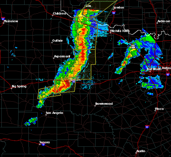 At 639 pm cdt, severe thunderstorms were located along a line extending from near seymour to near throckmorton to 7 miles southeast of nugent, moving east at 35 mph (radar indicated). Hazards include 60 mph wind gusts and quarter size hail. Hail damage to vehicles is expected. expect wind damage to roofs, siding, and trees. these severe storms will be near, throckmorton around 645 pm cdt. albany and elbert around 700 pm cdt. other locations impacted by these severe thunderstorms include mccarty lake, us-180 near the shackelford- stephens county line, the intersection of us- 283 and ranch road 209, us-183 near the throckmorton- stephens county line, lake fort phantom hill, the intersection of us- 183 and us-283 and the intersection of us-380 and highway 222. A tornado watch remains in effect until midnight cdt for west central texas. At 639 pm cdt, severe thunderstorms were located along a line extending from near seymour to near throckmorton to 7 miles southeast of nugent, moving east at 35 mph (radar indicated). Hazards include 60 mph wind gusts and quarter size hail. Hail damage to vehicles is expected. expect wind damage to roofs, siding, and trees. these severe storms will be near, throckmorton around 645 pm cdt. albany and elbert around 700 pm cdt. other locations impacted by these severe thunderstorms include mccarty lake, us-180 near the shackelford- stephens county line, the intersection of us- 283 and ranch road 209, us-183 near the throckmorton- stephens county line, lake fort phantom hill, the intersection of us- 183 and us-283 and the intersection of us-380 and highway 222. A tornado watch remains in effect until midnight cdt for west central texas.
|
| 4/26/2016 6:15 PM CDT |
 At 615 pm cdt, severe thunderstorms were located along a line extending from goree to 6 miles southeast of irby to near hawley, moving northeast at 75 mph (radar indicated). Hazards include 60 mph wind gusts and half dollar size hail. Hail damage to vehicles is expected. expect wind damage to roofs, siding, and trees. severe thunderstorms will be near, millers creek reservoir around 620 pm cdt. nugent around 625 pm cdt. throckmorton around 630 pm cdt. albany and elbert around 640 pm cdt. other locations impacted by these severe thunderstorms include mccarty lake, us-180 near the shackelford- stephens county line, the intersection of us- 283 and ranch road 209, us-183 near the throckmorton- stephens county line, lake fort phantom hill, the intersection of us- 180 and farm road 600, the intersection of us-183 and us- 283, the intersection of us- 380 and highway 222, big country baptist assembly and us- 283 near the callahan-shackelford county line. A tornado watch remains in effect until midnight cdt for west central texas. At 615 pm cdt, severe thunderstorms were located along a line extending from goree to 6 miles southeast of irby to near hawley, moving northeast at 75 mph (radar indicated). Hazards include 60 mph wind gusts and half dollar size hail. Hail damage to vehicles is expected. expect wind damage to roofs, siding, and trees. severe thunderstorms will be near, millers creek reservoir around 620 pm cdt. nugent around 625 pm cdt. throckmorton around 630 pm cdt. albany and elbert around 640 pm cdt. other locations impacted by these severe thunderstorms include mccarty lake, us-180 near the shackelford- stephens county line, the intersection of us- 283 and ranch road 209, us-183 near the throckmorton- stephens county line, lake fort phantom hill, the intersection of us- 180 and farm road 600, the intersection of us-183 and us- 283, the intersection of us- 380 and highway 222, big country baptist assembly and us- 283 near the callahan-shackelford county line. A tornado watch remains in effect until midnight cdt for west central texas.
|
| 4/19/2016 9:54 PM CDT |
 At 953 pm cdt, a severe thunderstorm was located near elbert, or 13 miles northeast of throckmorton, moving east at 40 mph (radar indicated). Hazards include ping pong ball size hail and 60 mph wind gusts. People and animals outdoors will be injured. expect hail damage to roofs, siding, windows, and vehicles. expect wind damage to roofs, siding, and trees. This severe thunderstorm will remain over mainly rural areas of northeastern throckmorton county. At 953 pm cdt, a severe thunderstorm was located near elbert, or 13 miles northeast of throckmorton, moving east at 40 mph (radar indicated). Hazards include ping pong ball size hail and 60 mph wind gusts. People and animals outdoors will be injured. expect hail damage to roofs, siding, windows, and vehicles. expect wind damage to roofs, siding, and trees. This severe thunderstorm will remain over mainly rural areas of northeastern throckmorton county.
|
| 4/19/2016 9:30 PM CDT |
 At 930 pm cdt, a severe thunderstorm was located 9 miles southeast of millers creek reservoir, or 10 miles northwest of throckmorton, moving east at 25 mph (radar indicated). Hazards include 60 mph wind gusts and nickel size hail. Expect damage to roofs. siding. and trees. This severe thunderstorm will remain over mainly rural areas of northeastern haskell and northern throckmorton counties, including the following locations: the intersection of us-380 and highway 222. At 930 pm cdt, a severe thunderstorm was located 9 miles southeast of millers creek reservoir, or 10 miles northwest of throckmorton, moving east at 25 mph (radar indicated). Hazards include 60 mph wind gusts and nickel size hail. Expect damage to roofs. siding. and trees. This severe thunderstorm will remain over mainly rural areas of northeastern haskell and northern throckmorton counties, including the following locations: the intersection of us-380 and highway 222.
|
| 4/19/2016 9:19 PM CDT |
 At 918 pm cdt, a severe thunderstorm was located 7 miles southeast of millers creek reservoir, or 12 miles northwest of throckmorton, moving east at 40 mph (radar indicated). Hazards include 60 mph wind gusts and nickel size hail. Expect damage to roofs. siding. and trees. this severe thunderstorm will be near, throckmorton around 930 pm cdt. Other locations impacted by this severe thunderstorm include the intersection of us-380 and highway 222. At 918 pm cdt, a severe thunderstorm was located 7 miles southeast of millers creek reservoir, or 12 miles northwest of throckmorton, moving east at 40 mph (radar indicated). Hazards include 60 mph wind gusts and nickel size hail. Expect damage to roofs. siding. and trees. this severe thunderstorm will be near, throckmorton around 930 pm cdt. Other locations impacted by this severe thunderstorm include the intersection of us-380 and highway 222.
|
| 4/11/2016 6:05 PM CDT |
 At 604 pm cdt, a severe thunderstorm was located over throckmorton, moving southeast at 40 mph (radar indicated). Hazards include 70 mph wind gusts and quarter size hail. Hail damage to vehicles is expected. expect considerable tree damage. wind damage is also likely to mobile homes, roofs, and outbuildings. this severe thunderstorm will be near, woodson around 620 pm cdt. Other locations impacted by this severe thunderstorm include the intersection of us-283 and ranch road 209, the intersection of us- 183 and us-283, us-183 near the throckmorton- stephens county line and the intersection of us-380 and highway 222. At 604 pm cdt, a severe thunderstorm was located over throckmorton, moving southeast at 40 mph (radar indicated). Hazards include 70 mph wind gusts and quarter size hail. Hail damage to vehicles is expected. expect considerable tree damage. wind damage is also likely to mobile homes, roofs, and outbuildings. this severe thunderstorm will be near, woodson around 620 pm cdt. Other locations impacted by this severe thunderstorm include the intersection of us-283 and ranch road 209, the intersection of us- 183 and us-283, us-183 near the throckmorton- stephens county line and the intersection of us-380 and highway 222.
|
| 5/30/2015 1:47 AM CDT | At 145 am cdt, a severe thunderstorm was located 9 miles southwest of throckmorton, moving northeast at 20 mph (radar indicated). Hazards include 60 mph wind gusts and quarter size hail. Hail damage to vehicles is expected. expect wind damage to roofs, siding and trees. very heavy rainfall could cause localized flooding. the severe thunderstorm will be near, throckmorton around 205 am cdt. Other locations in the warning include the intersection of us-183 and us-283 and us-380 near the throckmorton-young county line. |
| 5/28/2015 5:50 PM CDT | At 547 pm cdt, a severe thunderstorm was located 10 miles southwest of throckmorton, and moving northeast at 40 mph. at 540 pm the woodson sheriffs office estimated wind gusts to near 60 mph in woodson (law enforcement). Hazards include 60 mph wind gusts and quarter size hail. Hail damage to vehicles is expected. expect wind damage to roofs, siding and trees. The severe thunderstorm will be near, throckmorton around 600 pm cdt. |
| 5/28/2015 5:46 PM CDT | At 544 pm cdt, a severe thunderstorm was located 11 miles northwest of fort griffin, and moving northeast at 40 mph (radar indicated). Hazards include 60 mph wind gusts and quarter size hail. Hail damage to vehicles is expected. expect wind damage to roofs, siding and trees. the severe thunderstorm will be near, throckmorton around 605 pm cdt. Other locations in the warning include the intersection of us-380 and highway 222. |
| 5/28/2015 5:27 PM CDT | At 524 pm cdt, a severe thunderstorm was located 11 miles northeast of lueders, moving northeast at 35 mph (radar indicated). Hazards include 60 mph wind gusts and quarter size hail. Hail damage to vehicles is expected. expect wind damage to roofs, siding and trees. the severe thunderstorm will be near, throckmorton around 605 pm cdt. Other locations in the warning include the intersection of us-380 and highway 222. |
| 5/26/2015 3:54 PM CDT | At 351 pm cdt, a severe thunderstorm was located 8 miles north of woodson, and moving east at 35 mph. a second severe thunderstorm was located near woodson (trained weather spotters). Hazards include ping pong ball size hail and 60 mph wind gusts. People and pets outdoors will be injured. expect hail damage to roofs, siding, windows and vehicles. expect wind damage to roofs, siding and trees. Locations impacted include, lusk and us-380 near the throckmorton-young county line. |
| 5/26/2015 3:40 PM CDT | At 337 pm cdt, a severe thunderstorm was located near throckmorton, moving east at 35 mph (radar indicated). Hazards include ping pong ball size hail and 60 mph wind gusts. People and pets outdoors will be injured. expect hail damage to roofs, siding, windows and vehicles. expect wind damage to roofs, siding and trees. The severe thunderstorm will affect mainly rural areas of southeastern throckmorton county, including the following locations, us-380 near the throckmorton-young county line. |
| 5/25/2015 12:13 PM CDT | At 1209 pm cdt, a severe thunderstorm was located near elbert, moving northeast at 40 mph (radar indicated). Hazards include 60 mph wind gusts. Expect damage to roofs. siding and trees. The severe thunderstorm will affect mainly rural areas of northeastern throckmorton county. |
| 5/25/2015 11:43 AM CDT | At 1140 am cdt, severe thunderstorms were located along a line extending from 8 miles east of irby to cross plains, and moving northeast at 40 mph (radar indicated). Hazards include 60 mph wind gusts. Expect damage to roofs. siding and trees. severe thunderstorms will be near, fort griffin around 1150 am cdt. ibex around 1155 am cdt. throckmorton around noon cdt. woodson around 1205 pm cdt. elbert around 1215 pm cdt. other locations in the warning include the intersection of us-183 and us-283, the intersection of us-283 and ranch road 209, us-180 near the shackelford-stephens county line, lusk and us-380 near the throckmorton-young county line. This includes interstate 20 between mile markers 299 and 316. |
| 5/25/2015 11:17 AM CDT | At 1112 am cdt, severe thunderstorms were located along a line extending from haskell to just west of albany to oplin, moving northeast at 40 mph. the highest winds will likely approach albany (radar indicated). Hazards include 70 mph wind gusts. Expect considerable tree damage. damage is likely to mobile homes, roofs and outbuildings. severe thunderstorms will be near, cross plains around 1120 am cdt. irby and cottonwood around 1125 am cdt. atwell and putnam around 1130 am cdt. albany around 1135 am cdt. moran around 1140 am cdt. ibex and fort griffin around 1145 am cdt. other locations in the warning include us-283 near the callahan-shackelford county line, mccarty lake, i-20 near the callahan-eastland county line, the intersection of us-380 and highway 222, the intersection of us-283 and ranch road 209, us-180 near the shackelford-stephens county line, the intersection of us-183 and us-283, lusk and us-380 near the throckmorton-young county line. This includes interstate 20 between mile markers 287 and 316. |
| 5/9/2015 5:06 PM CDT | At 503 pm cdt, a severe thunderstorm was located near woodson, moving northeast at 25 mph (radar indicated). Hazards include ping pong ball size hail. People and pets outdoors will be injured. expect damage to roofs, siding, windows and vehicles. the severe thunderstorm will affect mainly rural areas of eastern throckmorton county. 1. 50in. |
| 5/9/2015 5:04 PM CDT | At 500 pm cdt, a severe thunderstorm was located near woodson, and moving northeast at 30 mph (radar indicated). Hazards include ping pong ball size hail. People and pets outdoors will be injured. expect damage to roofs, siding, windows and vehicles. locations impacted include, woodson, elbert and us-380 near the throckmorton-young county line. 1. 50in. |
| 5/9/2015 4:56 PM CDT | At 452 pm cdt, a severe thunderstorm was located near elbert, and moving northeast at 25 mph (radar indicated). Hazards include ping pong ball size hail. People and pets outdoors will be injured. expect damage to roofs, siding, windows and vehicles. locations impacted include, mainly rural areas of extreme eastern throckmorton county. 1. 50in. |
| 5/9/2015 4:36 PM CDT | At 431 pm cdt, a severe thunderstorm was located 5 miles northeast of woodson, moving northeast at 25 mph (radar indicated). Hazards include ping pong ball size hail. People and pets outdoors will be injured. expect damage to roofs, siding, windows and vehicles. the severe thunderstorm will affect mainly rural areas of eastern throckmorton county. 1. 50in. |
| 5/9/2015 4:34 PM CDT | At 431 pm cdt, a severe thunderstorm was located near woodson, and moving northeast at 30 mph (radar indicated). Hazards include ping pong ball size hail. People and pets outdoors will be injured. expect damage to roofs, siding, windows and vehicles. locations impacted include, elbert, us-183 near the throckmorton-baylor county line and us-380 near the throckmorton-young county line. 1. 50in. |
| 5/9/2015 4:21 PM CDT | At 418 pm cdt, a severe thunderstorm was located near woodson, moving northeast at 30 mph (radar indicated). Hazards include ping pong ball size hail. People and pets outdoors will be injured. expect damage to roofs, siding, windows and vehicles. the severe thunderstorm will affect mainly rural areas of eastern throckmorton county. 1. 50in. |
| 5/9/2015 3:42 PM CDT | At 340 pm cdt, a severe thunderstorm was located near throckmorton, moving northeast at 35 mph (radar indicated). Hazards include half dollar size hail. Damage to vehicles is expected. the severe thunderstorm will be near, elbert around 355 pm cdt. 1. 25in. |
| 5/8/2015 7:33 PM CDT | At 731 pm cdt, a severe thunderstorm capable of producing a tornado was located 7 miles northeast of woodson, and moving southeast at 30 mph (radar indicated rotation). Hazards include tornado...golf ball size hail and 70 mph winds. Flying debris will be dangerous to those caught without shelter. mobile homes will be damaged or destroyed. damage to roofs, windows and vehicles will occur. tree damage is likely. locations impacted include, mainly rural areas of extreme southeastern throckmorton county. Radar indicated. |
| 5/8/2015 7:24 PM CDT | At 722 pm cdt, a severe thunderstorm capable of producing a tornado was located 6 miles north of woodson, and moving southeast at 30 mph (radar indicated rotation). Hazards include tornado...golf ball size hail and 70 mph winds. Flying debris will be dangerous to those caught without shelter. mobile homes will be damaged or destroyed. damage to roofs, windows and vehicles will occur. tree damage is likely. locations impacted include, mainly rural areas of southeastern throckmorton county. Radar indicated. |
| 5/8/2015 7:15 PM CDT | Ping Pong Ball sized hail reported 0.9 miles WNW of Elbert, TX |
| 5/8/2015 7:15 PM CDT | At 713 pm cdt, a severe thunderstorm capable of producing a tornado was located 5 miles southeast of throckmorton, and moving east at 20 mph (radar indicated rotation). Hazards include tornado...ping pong ball size hail and 70 mph winds. Flying debris will be dangerous to those caught without shelter. mobile homes will be damaged or destroyed. damage to roofs, windows and vehicles will occur. tree damage is likely. locations impacted include, elbert and us-380 near the throckmorton-young county line. Radar indicated. |
| 5/8/2015 7:02 PM CDT | At 658 pm cdt, a confirmed tornado was located near throckmorton, and moving east at 20 mph (weather spotters confirmed tornado). Hazards include damaging tornado and ping pong ball size hail. Flying debris will be dangerous to those caught without shelter. mobile homes will be damaged or destroyed. damage to roofs, windows and vehicles will occur. tree damage is likely. this tornadic storm will affect mainly rural areas of eastern throckmorton county, including the following locations, us-380 near the throckmorton-young county line. Observed. |
| 5/8/2015 6:53 PM CDT | At 650 pm cdt, a confirmed tornado was located near throckmorton, and moving east at 25 mph (radar confirmed tornado). Hazards include damaging tornado and ping pong ball size hail. Flying debris will be dangerous to those caught without shelter. mobile homes will be damaged or destroyed. damage to roofs, windows and vehicles will occur. tree damage is likely. the tornado will be near, elbert around 720 pm cdt. other locations in the warning include us-380 near the throckmorton-young county line. Observed. |
| 5/8/2015 6:42 PM CDT | At 638 pm cdt, a confirmed tornado was located near throckmorton, and moving east at 30 mph (radar confirmed tornado). Hazards include damaging tornado and ping pong ball size hail. Flying debris will be dangerous to those caught without shelter. mobile homes will be damaged or destroyed. damage to roofs, windows and vehicles will occur. tree damage is likely. the tornado will be near, throckmorton around 650 pm cdt. Observed. |
| 5/8/2015 6:33 PM CDT | At 630 pm cdt, a severe thunderstorm capable of producing a tornado was located 9 miles northwest of throckmorton, and moving east at 35 mph (radar indicated rotation). Hazards include tornado...half dollar size hail and 60 mph winds. Flying debris will be dangerous to those caught without shelter. mobile homes will be damaged or destroyed. damage to roofs, windows and vehicles will occur. tree damage is likely. this dangerous storm will be near, throckmorton around 645 pm cdt. elbert around 700 pm cdt. other locations in the warning include us-380 near the throckmorton-young county line. Radar indicated. |
| 5/8/2015 6:19 PM CDT | At 617 pm cdt, a severe thunderstorm capable of producing a tornado was located 6 miles south of millers creek reservoir, and moving east at 40 mph (radar indicated rotation). Hazards include tornado...half dollar size hail and 60 mph wind gusts. Flying debris will be dangerous to those caught without shelter. mobile homes will be damaged or destroyed. damage to roofs, windows and vehicles will occur. tree damage is likely. this dangerous storm will be near, elbert around 655 pm cdt. other locations in the warning include us-380 near the throckmorton-young county line. Radar indicated. |
| 5/7/2015 6:40 PM CDT | At 638 pm cdt, a severe thunderstorm was located 5 miles northeast of throckmorton, and moving northeast at 30 mph. this storm continues to have the potential of producing wind gusts to near 60 mph and quarter size hail (radar indicated). Hazards include 60 mph wind gusts and quarter size hail. Hail damage to vehicles is expected. expect wind damage to roofs, siding and trees. the severe thunderstorm will be near, elbert around 650 pm cdt. 1. 00in. |
| 5/7/2015 6:28 PM CDT | At 625 pm cdt, a severe thunderstorm was located near throckmorton, moving northeast at 30 mph (radar indicated). Hazards include 60 mph wind gusts and quarter size hail. Hail damage to vehicles is expected. expect wind damage to roofs, siding and trees. the severe thunderstorm will be near, elbert around 650 pm cdt. 1. 00in. |
| 5/6/2015 11:08 PM CDT | At 1104 pm cdt, a severe thunderstorm capable of producing a tornado was located near elbert, and moving northeast at 10 mph (radar indicated rotation). Hazards include tornado and baseball size hail. Flying debris will be dangerous to those caught without shelter. mobile homes will be damaged or destroyed. damage to roofs, windows and vehicles will occur. tree damage is likely. this dangerous storm will affect mainly rural areas of northeastern throckmorton county. Radar indicated. |
| 5/6/2015 10:53 PM CDT | At 1051 pm cdt, a severe thunderstorm capable of producing a tornado was located 5 miles northwest of elbert, and moving northeast at 10 mph (radar indicated rotation). Hazards include tornado...baseball size hail and 70 mph wind gusts. Flying debris will be dangerous to those caught without shelter. mobile homes will be damaged or destroyed. damage to roofs, windows and vehicles will occur. tree damage is likely. this dangerous storm will be near, elbert around 1110 pm cdt. Radar indicated. |
| 5/6/2015 10:48 PM CDT | At 1046 pm cdt, a severe thunderstorm was located 10 miles northwest of elbert, and moving east at 15 mph. this is a very dangerous storm (radar indicated). Hazards include baseball size hail and 70 mph wind gusts. People and pets outdoors will be severely injured. expect shattered windows, extensive damage to roofs, siding and vehicles. locations impacted include, elbert. Possible. |
| 5/6/2015 10:45 PM CDT | At 1043 pm cdt, a severe thunderstorm capable of producing a tornado was located 7 miles northwest of elbert, and moving east at 15 mph (radar indicated rotation). Hazards include tornado and softball size hail. Flying debris will be dangerous to those caught without shelter. mobile homes will be damaged or destroyed. damage to roofs, windows and vehicles will occur. tree damage is likely. locations impacted include, elbert. Radar indicated. |
| 5/6/2015 10:36 PM CDT | At 1032 pm cdt, a severe thunderstorm capable of producing a tornado was located 10 miles north of throckmorton, and moving northeast at 15 mph (weather spotters reported funnel cloud). Hazards include tornado and softball size hail. Flying debris will be dangerous to those caught without shelter. mobile homes will be damaged or destroyed. damage to roofs, windows and vehicles will occur. tree damage is likely. locations impacted include, elbert. Radar indicated. |
| 5/6/2015 10:31 PM CDT | At 1030 pm cdt, a severe thunderstorm capable of producing a tornado was located 10 miles north of throckmorton, and moving northeast at 15 mph (radar indicated rotation). Hazards include tornado and softball size hail. Flying debris will be dangerous to those caught without shelter. mobile homes will be damaged or destroyed. damage to roofs, windows and vehicles will occur. tree damage is likely. locations impacted include, elbert. Radar indicated. |
| 5/6/2015 10:25 PM CDT | At 1023 pm cdt, a severe thunderstorm was located 10 miles east of millers creek reservoir, and moving northeast at 20 mph. this is a very dangerous storm (radar indicated). Hazards include softball size hail and 70 mph wind gusts. People and pets outdoors will be severely injured. expect shattered windows, extensive damage to roofs, siding and vehicles. the severe thunderstorm will affect mainly rural areas of northern throckmorton county. Possible. |
| 5/6/2015 10:22 PM CDT | At 1021 pm cdt, a severe thunderstorm capable of producing a tornado was located 9 miles north of throckmorton, and moving northeast at 20 mph (radar indicated rotation). Hazards include tornado and softball size hail. Flying debris will be dangerous to those caught without shelter. mobile homes will be damaged or destroyed. damage to roofs, windows and vehicles will occur. tree damage is likely. this dangerous storm will affect mainly rural areas of northeastern throckmorton county. Radar indicated. |
| 5/6/2015 10:08 PM CDT | At 1005 pm cdt, a confirmed tornado was located 6 miles northwest of throckmorton, and moving east at 15 mph (weather spotters confirmed tornado). Hazards include damaging tornado and tennis ball size hail. Flying debris will be dangerous to those caught without shelter. mobile homes will be damaged or destroyed. damage to roofs, windows and vehicles will occur. tree damage is likely. the tornado will be near, throckmorton around 1015 pm cdt. elbert around 1055 pm cdt. Observed. |
| 5/6/2015 9:54 PM CDT | At 952 pm cdt, severe thunderstorms were located along a line extending from munday to 7 miles south of millers creek reservoir to throckmorton, moving northeast at 20 mph (radar indicated). Hazards include tennis ball size hail and 70 mph wind gusts. People and pets outdoors will be injured. expect hail damage to roofs, siding, windows and vehicles. expect considerable tree damage. wind damage is also likely to mobile homes, roofs and outbuildings. severe thunderstorms will be near, millers creek reservoir around 1015 pm cdt. elbert around 1020 pm cdt. other locations in the warning include us-380 near the throckmorton-young county line and us-183 near the throckmorton-baylor county line. Possible. |
| 5/6/2015 9:54 PM CDT | At 952 pm cdt, severe thunderstorms were located along a line extending from munday to 7 miles south of millers creek reservoir to throckmorton, moving northeast at 20 mph (radar indicated). Hazards include tennis ball size hail and 70 mph wind gusts. People and pets outdoors will be injured. expect hail damage to roofs, siding, windows and vehicles. expect considerable tree damage. wind damage is also likely to mobile homes, roofs and outbuildings. severe thunderstorms will be near, millers creek reservoir around 1015 pm cdt. elbert around 1020 pm cdt. other locations in the warning include us-380 near the throckmorton-young county line and us-183 near the throckmorton-baylor county line. Possible. |
| 5/6/2015 6:13 PM CDT | At 610 pm cdt, a severe thunderstorm was located near elbert, and moving northeast at 40 mph. this is a very dangerous storm (radar indicated). Hazards include 80 mph wind gusts and hen egg size hail. Flying debris will be dangerous to those caught without shelter. mobile homes will be heavily damaged. expect considerable damage to roofs, windows and vehicles. extensive tree damage and power outages are likely. the severe thunderstorm will affect mainly rural areas of eastern throckmorton county. 2. 00in. |
| 5/6/2015 5:57 PM CDT | At 554 pm cdt, a severe thunderstorm was located 5 miles north of woodson, and moving north at 40 mph. this is a very dangerous storm (radar indicated). Hazards include 80 mph wind gusts and baseball size hail. Flying debris will be dangerous to those caught without shelter. mobile homes will be heavily damaged. expect considerable damage to roofs, windows and vehicles. extensive tree damage and power outages are likely. the severe thunderstorm will be near, elbert around 615 pm cdt. other locations in the warning include us-380 near the throckmorton-young county line. 2. 75in. |
| 5/6/2015 5:48 PM CDT | At 547 pm cdt, a severe thunderstorm was located near woodson, and moving north at 40 mph. this is a very dangerous storm (radar indicated). Hazards include 80 mph wind gusts and baseball size hail. Flying debris will be dangerous to those caught without shelter. mobile homes will be heavily damaged. expect considerable damage to roofs, windows and vehicles. extensive tree damage and power outages are likely. the severe thunderstorm will be near, elbert around 615 pm cdt. other locations in the warning include us-380 near the throckmorton-young county line. 2. 75in. |
| 5/6/2015 5:34 PM CDT | At 532 pm cdt, a severe thunderstorm was located near fort griffin, moving north at 40 mph. this is a very dangerous storm (radar indicated). Hazards include 80 mph wind gusts and tennis ball size hail. Flying debris will be dangerous to those caught without shelter. mobile homes will be heavily damaged. expect considerable damage to roofs, windows and vehicles. extensive tree damage and power outages are likely. the severe thunderstorm will be near, woodson around 550 pm cdt. throckmorton around 600 pm cdt. elbert around 615 pm cdt. other locations in the warning include the intersection of us-283 and ranch road 209, lusk, the intersection of us-183 and us-283 and us-380 near the throckmorton-young county line. 2. 50in. |
| 4/26/2015 6:04 PM CDT | At 602 pm cdt, a severe thunderstorm was located 11 miles southeast of irby, and moving northeast at 35 mph (radar indicated). Hazards include ping pong ball size hail and 60 mph wind gusts. People and pets outdoors will be injured. expect hail damage to roofs, siding, windows and vehicles. expect wind damage to roofs, siding and trees. the severe thunderstorm will be near, throckmorton around 630 pm cdt. other locations in the warning include the intersection of us-380 and highway 222. 1. 50in. |
| 4/26/2015 5:38 PM CDT | At 534 pm cdt, a severe thunderstorm was located 7 miles northeast of avoca, moving northeast at 35 mph (radar indicated). Hazards include ping pong ball size hail and 60 mph wind gusts. People and pets outdoors will be injured. expect hail damage to roofs, siding, windows and vehicles. expect wind damage to roofs, siding and trees. the severe thunderstorm will be near, throckmorton around 625 pm cdt. other locations in the warning include the intersection of us-380 and highway 222 and the intersection of us-183 and us-283. 1. 50in. |
| 4/26/2015 4:24 PM CDT | The severe thunderstorm warning for northeastern throckmorton county will expire at 430 pm cdt, the storm which prompted the warning has weakened. |
| 4/26/2015 4:13 PM CDT | At 412 pm cdt, a severe thunderstorm was located 5 miles northeast of throckmorton, and moving northeast at 35 mph (radar indicated). Hazards include 60 mph wind gusts and quarter size hail. Hail damage to vehicles is expected. expect wind damage to roofs, siding and trees. the severe thunderstorm will be near, elbert around 425 pm cdt. 1. 00in. |
| 4/26/2015 4:01 PM CDT | At 359 pm cdt, a severe thunderstorm was located near throckmorton, and moving northeast at 35 mph (radar indicated). Hazards include 70 mph wind gusts and ping pong ball size hail. People and pets outdoors will be injured. expect hail damage to roofs, siding, windows and vehicles. expect considerable tree damage. wind damage is also likely to mobile homes, roofs and outbuildings. the severe thunderstorm will be near, elbert around 420 pm cdt. 1. 50in. |
| 4/26/2015 3:37 PM CDT | At 334 pm cdt, a severe thunderstorm was located 8 miles northwest of fort griffin, moving northeast at 30 mph (radar indicated). Hazards include hen egg size hail and 70 mph wind gusts. People and pets outdoors will be injured. expect hail damage to roofs, siding, windows and vehicles. expect considerable tree damage. wind damage is also likely to mobile homes, roofs and outbuildings. the severe thunderstorm will be near, throckmorton around 405 pm cdt. elbert around 425 pm cdt. other locations in the warning include the intersection of us-283 and ranch road 209, the intersection of us-183 and us-283 and us-380 near the throckmorton-young county line. 2. 00in. |
| 4/22/2015 11:09 PM CDT | At 1107 pm cdt, a severe thunderstorm was located near throckmorton, moving southeast at 25 mph (radar indicated). Hazards include tennis ball size hail and 70 mph wind gusts. People and pets outdoors will be injured. expect hail damage to roofs, siding, windows and vehicles. expect considerable tree damage. wind damage is also likely to mobile homes, roofs and outbuildings. the severe thunderstorm will be near, throckmorton around 1115 pm cdt. other locations in the warning include us-380 near the throckmorton-young county line. Possible. |
| 4/18/2015 3:43 PM CDT | At 342 pm cdt, a severe thunderstorm was located 6 miles north of elbert, and moving north at 20 mph (radar indicated). Hazards include 60 mph wind gusts and half dollar size hail. Hail damage to vehicles is expected. expect wind damage to roofs, siding and trees. locations impacted include, mainly rural areas of extreme northeastern throckmorton county. Possible. |
| 4/18/2015 3:37 PM CDT | At 334 pm cdt, a severe thunderstorm was located near elbert, and moving north at 20 mph (radar indicated). Hazards include 60 mph wind gusts and half dollar size hail. Hail damage to vehicles is expected. expect wind damage to roofs, siding and trees. locations impacted include, mainly rural areas of northeastern throckmorton county. Possible. |
| 4/18/2015 3:23 PM CDT | At 319 pm cdt, a severe thunderstorm was located near elbert, moving north at 35 mph (radar indicated). Hazards include 60 mph wind gusts and half dollar size hail. Hail damage to vehicles is expected. expect wind damage to roofs, siding and trees. the severe thunderstorm will affect mainly rural areas of eastern throckmorton county. 1. 25in. |
| 4/18/2015 3:13 PM CDT | At 312 pm cdt, a severe thunderstorm was located near throckmorton, and moving north at 15 mph (radar indicated). Hazards include ping pong ball size hail and 60 mph wind gusts. People and pets outdoors will be injured. expect hail damage to roofs, siding, windows and vehicles. expect wind damage to roofs, siding and trees. the severe thunderstorm will affect mainly rural areas of southeastern throckmorton county. Possible. |
| 4/18/2015 3:03 PM CDT | At 301 pm cdt, a severe thunderstorm was located 6 miles southeast of throckmorton, and moving north at 15 mph (radar indicated). Hazards include 60 mph wind gusts and quarter size hail. Hail damage to vehicles is expected. expect wind damage to roofs, siding and trees. the severe thunderstorm will be near, throckmorton around 315 pm cdt. Possible. |
| 4/18/2015 2:46 PM CDT | At 244 pm cdt, a severe thunderstorm was located 5 miles west of woodson, moving north at 15 mph (radar indicated). Hazards include 60 mph wind gusts and quarter size hail. Hail damage to vehicles is expected. expect wind damage to roofs, siding and trees. the severe thunderstorm will be near, throckmorton around 320 pm cdt. other locations in the warning include the intersection of us-183 and us-283. 1. 00in. |
| 4/17/2015 1:51 PM CDT | At 149 pm cdt, a severe thunderstorm was located 6 miles southeast of throckmorton, and moving northeast at 40 mph (radar indicated). Hazards include 60 mph wind gusts and quarter size hail. Hail damage to vehicles is expected. expect wind damage to roofs, siding and trees. the severe thunderstorm will be near, elbert around 210 pm cdt. 1. 00in. |
| 4/17/2015 1:40 PM CDT | At 138 pm cdt, a severe thunderstorm was located near fort griffin, and moving northeast at 25 mph (radar indicated). Hazards include 60 mph wind gusts and quarter size hail. Hail damage to vehicles is expected. expect wind damage to roofs, siding and trees. the severe thunderstorm will be near, woodson around 200 pm cdt. other locations in the warning include the intersection of us-283 and ranch road 209, the intersection of us-183 and us-283 and lusk. 1. 00in. |
| 4/17/2015 1:30 PM CDT | At 129 pm cdt, a severe thunderstorm was located near fort griffin, moving northeast at 25 mph (radar indicated). Hazards include 60 mph wind gusts and quarter size hail. Hail damage to vehicles is expected. expect wind damage to roofs, siding and trees. the severe thunderstorm will be near, fort griffin around 135 pm cdt. woodson around 205 pm cdt. other locations in the warning include the intersection of us-283 and ranch road 209, the intersection of us-183 and us-283 and lusk. 1. 00in. |
| 4/16/2015 7:10 PM CDT | At 707 pm cdt, a severe thunderstorm was located 11 miles southwest of throckmorton, moving east at 25 mph (radar indicated). Hazards include golf ball size hail and 60 mph wind gusts. People and pets outdoors will be injured. expect hail damage to roofs, siding, windows and vehicles. expect wind damage to roofs, siding and trees. the severe thunderstorm will be near, throckmorton around 730 pm cdt. woodson around 745 pm cdt. other locations in the warning include the intersection of us-183 and us-283 and us-380 near the throckmorton-young county line. 1. 75in. |
| 8/15/2013 4:30 PM CDT | Storm damage reported in throckmorton county TX, 6.7 miles NNW of Elbert, TX |
Hail Maps for Elbert, TX
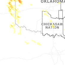
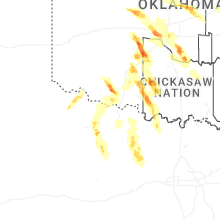
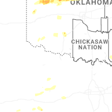
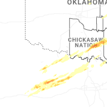
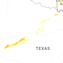
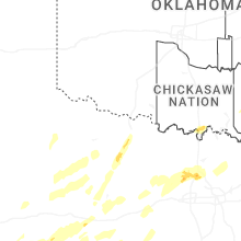


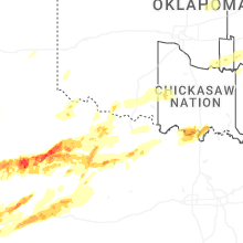
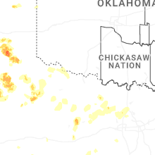
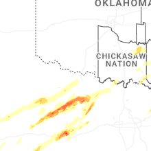


Connect with Interactive Hail Maps