

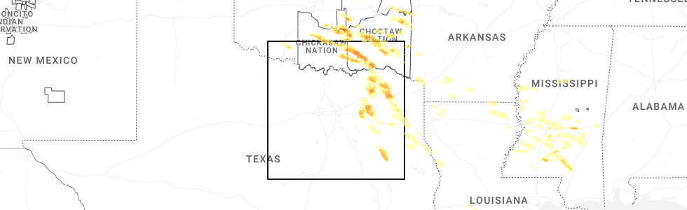
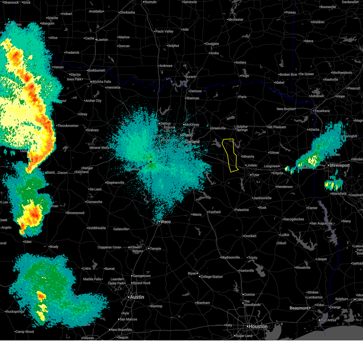
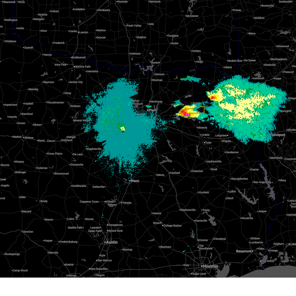
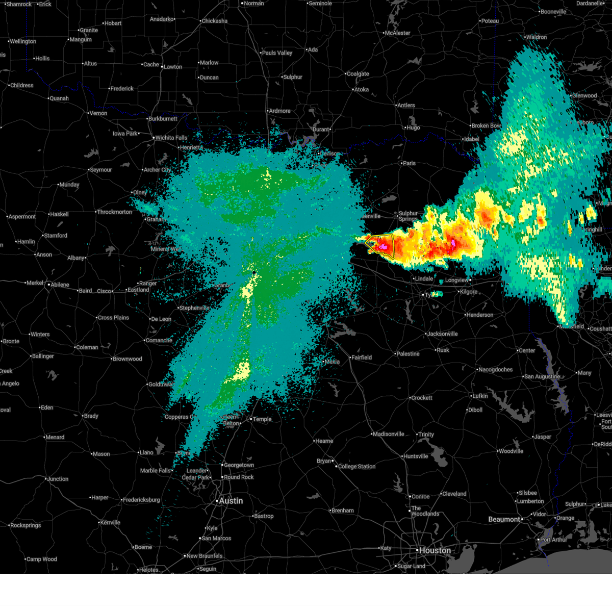
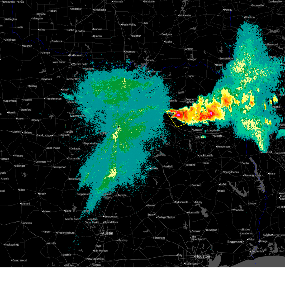
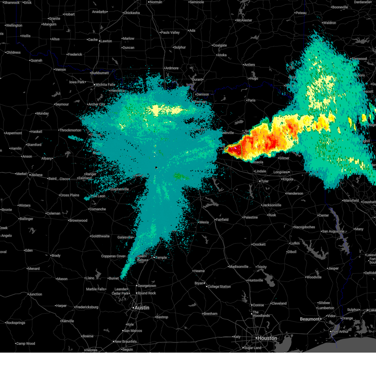
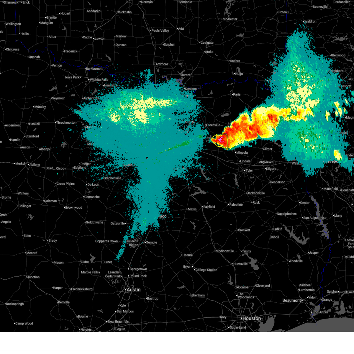
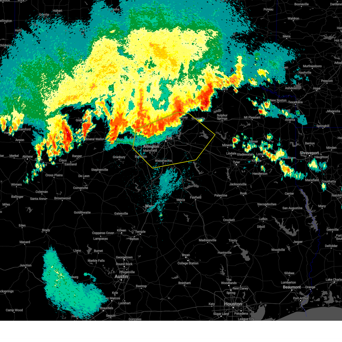
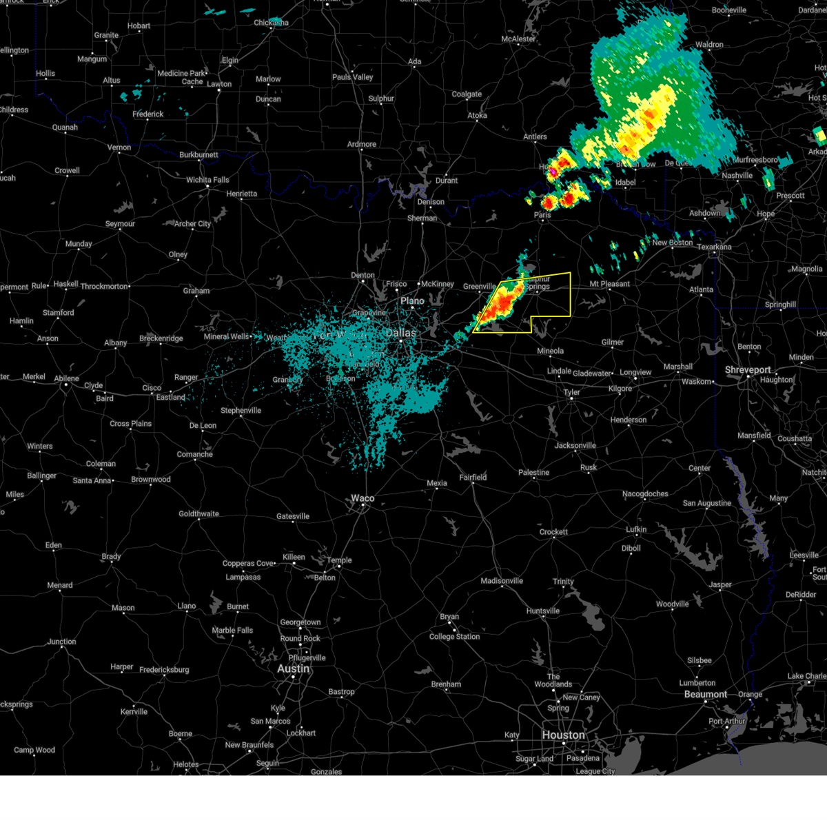
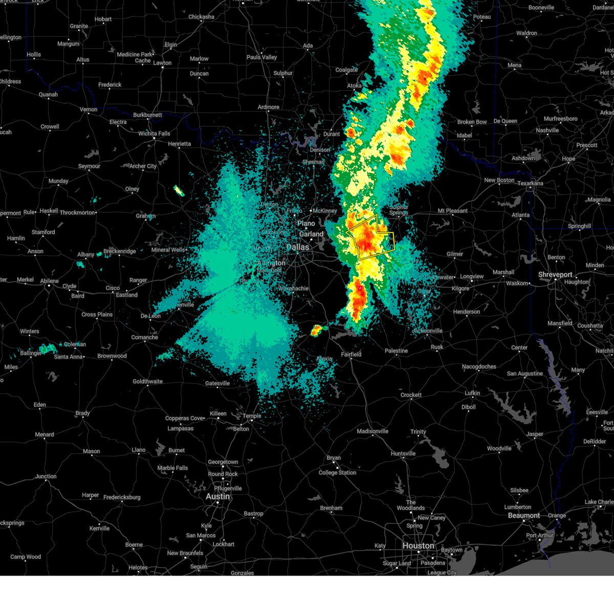
Hail Map for Emory, TX
The Emory, TX area has had 12 reports of on-the-ground hail by trained spotters, and has been under severe weather warnings 15 times during the past 12 months. Doppler radar has detected hail at or near Emory, TX on 64 occasions, including 3 occasions during the past year.
| Name: | Emory, TX |
| Where Located: | 60.4 miles E of Dallas, TX |
| Map: | Google Map for Emory, TX |
| Population: | 1239 |
| Housing Units: | 543 |
| More Info: | Search Google for Emory, TX |
5
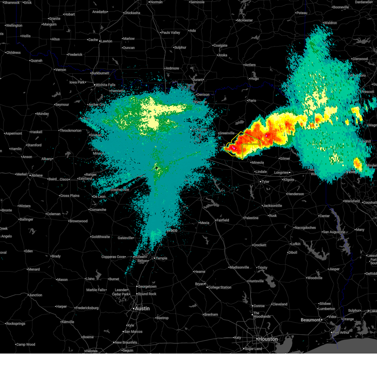
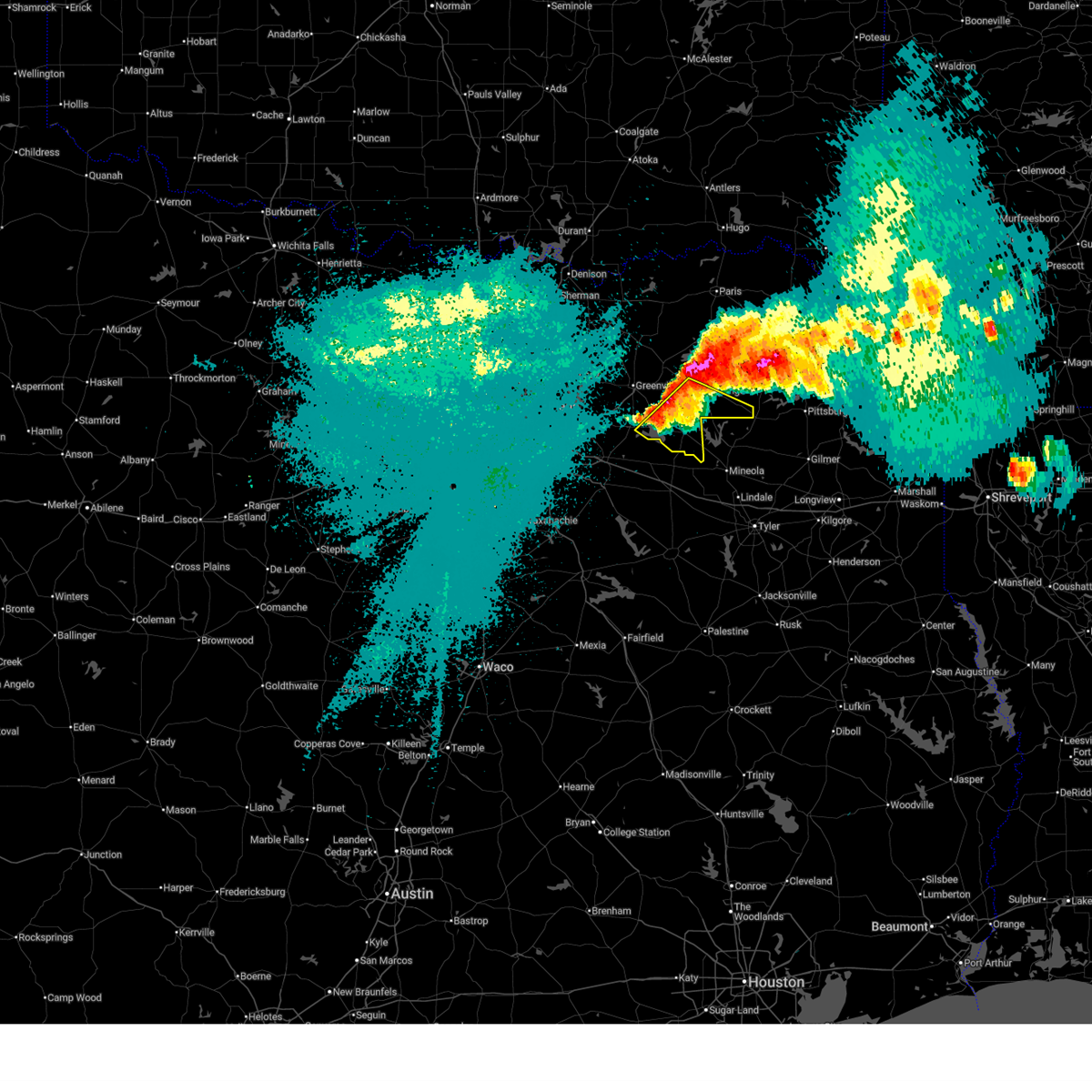
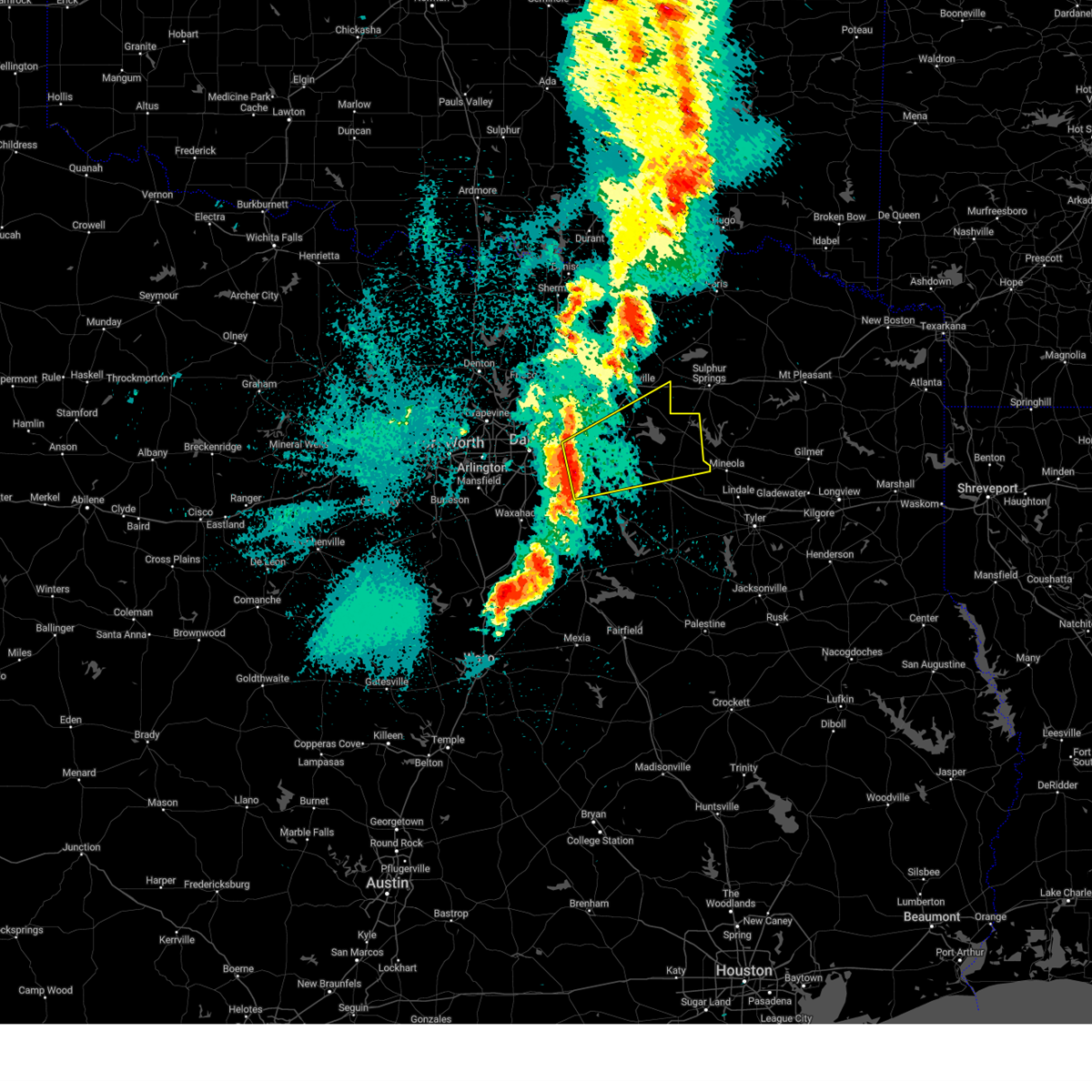
The Top Recent Hail Date for Emory, TX is Friday, April 24, 2026 (1st out of 64)
Hail and Wind Damage Spotted near Emory, TX
| Date / Time | Report Details |
|---|---|
| 6/2/2026 4:04 PM CDT |
 At 404 pm cdt, severe thunderstorms were located along a line extending from near grand saline to near east tawakoni, moving southwest at 5 mph (radar indicated. at 350 pm cdt...penny size hail was reported near emory with these storms). Hazards include 60 mph wind gusts and penny size hail. Expect damage to roofs, siding, and trees. Locations impacted include, canton, wills point, grand saline, west tawakoni, edgewood, emory, east tawakoni, point, fruitvale, lake tawakoni, lake tawakoni state park, myrtle springs, alsa, willow springs, flats, and hermits cove. At 404 pm cdt, severe thunderstorms were located along a line extending from near grand saline to near east tawakoni, moving southwest at 5 mph (radar indicated. at 350 pm cdt...penny size hail was reported near emory with these storms). Hazards include 60 mph wind gusts and penny size hail. Expect damage to roofs, siding, and trees. Locations impacted include, canton, wills point, grand saline, west tawakoni, edgewood, emory, east tawakoni, point, fruitvale, lake tawakoni, lake tawakoni state park, myrtle springs, alsa, willow springs, flats, and hermits cove.
|
| 6/2/2026 3:38 PM CDT |
 Svrfwd the national weather service in fort worth has issued a * severe thunderstorm warning for, southeastern hunt county in north central texas, northwestern van zandt county in north central texas, rains county in north central texas, * until 445 pm cdt. * at 338 pm cdt, a severe thunderstorm was located near lake tawakoni state park, or 8 miles northeast of wills point, moving southwest at 5 mph (radar indicated). Hazards include 60 mph wind gusts and penny size hail. expect damage to roofs, siding, and trees Svrfwd the national weather service in fort worth has issued a * severe thunderstorm warning for, southeastern hunt county in north central texas, northwestern van zandt county in north central texas, rains county in north central texas, * until 445 pm cdt. * at 338 pm cdt, a severe thunderstorm was located near lake tawakoni state park, or 8 miles northeast of wills point, moving southwest at 5 mph (radar indicated). Hazards include 60 mph wind gusts and penny size hail. expect damage to roofs, siding, and trees
|
| 5/23/2026 5:10 AM CDT |
 The storm which prompted the warning has moved out of the area. therefore the warning will be allowed to expire. however gusty winds are still possible with this thunderstorm. to report severe weather, contact your nearest law enforcement agency. they will relay your report to the national weather service fort worth. The storm which prompted the warning has moved out of the area. therefore the warning will be allowed to expire. however gusty winds are still possible with this thunderstorm. to report severe weather, contact your nearest law enforcement agency. they will relay your report to the national weather service fort worth.
|
| 5/23/2026 4:44 AM CDT |
 At 444 am cdt, a severe thunderstorm was located near grand saline, or 11 miles west of mineola, moving east at 25 mph (radar indicated). Hazards include 60 mph wind gusts and half dollar size hail. Hail damage to vehicles is expected. expect wind damage to roofs, siding, and trees. This severe thunderstorm will remain over mainly rural areas of central van zandt and rains counties, including the following locations, jones, ben wheeler, willow springs, primrose, colfax, and pruitt. At 444 am cdt, a severe thunderstorm was located near grand saline, or 11 miles west of mineola, moving east at 25 mph (radar indicated). Hazards include 60 mph wind gusts and half dollar size hail. Hail damage to vehicles is expected. expect wind damage to roofs, siding, and trees. This severe thunderstorm will remain over mainly rural areas of central van zandt and rains counties, including the following locations, jones, ben wheeler, willow springs, primrose, colfax, and pruitt.
|
| 5/23/2026 4:19 AM CDT |
 Svrfwd the national weather service in fort worth has issued a * severe thunderstorm warning for, van zandt county in north central texas, rains county in north central texas, * until 515 am cdt. * at 418 am cdt, a severe thunderstorm was located over canton, moving east at 25 mph (radar indicated). Hazards include 60 mph wind gusts and half dollar size hail. Hail damage to vehicles is expected. expect wind damage to roofs, siding, and trees. this severe thunderstorm will be near, canton around 425 am cdt. other locations impacted by this severe thunderstorm include ben wheeler, whitton, phalba, jackson, oakland, myrtle springs, jones, willow springs, primrose, and pruitt. This includes interstate 20 between mile markers 516 and 542. Svrfwd the national weather service in fort worth has issued a * severe thunderstorm warning for, van zandt county in north central texas, rains county in north central texas, * until 515 am cdt. * at 418 am cdt, a severe thunderstorm was located over canton, moving east at 25 mph (radar indicated). Hazards include 60 mph wind gusts and half dollar size hail. Hail damage to vehicles is expected. expect wind damage to roofs, siding, and trees. this severe thunderstorm will be near, canton around 425 am cdt. other locations impacted by this severe thunderstorm include ben wheeler, whitton, phalba, jackson, oakland, myrtle springs, jones, willow springs, primrose, and pruitt. This includes interstate 20 between mile markers 516 and 542.
|
| 4/27/2026 9:19 PM CDT |
 At 919 pm cdt, a severe thunderstorm was located near emory, or 16 miles south of sulphur springs, moving east at 40 mph (radar indicated). Hazards include 60 mph wind gusts and quarter size hail. Hail damage to vehicles is expected. expect wind damage to roofs, siding, and trees. This severe thunderstorm will remain over mainly rural areas of southern hopkins and northeastern rains counties, including the following locations, miller grove, arabla, cornersville, and seymore. At 919 pm cdt, a severe thunderstorm was located near emory, or 16 miles south of sulphur springs, moving east at 40 mph (radar indicated). Hazards include 60 mph wind gusts and quarter size hail. Hail damage to vehicles is expected. expect wind damage to roofs, siding, and trees. This severe thunderstorm will remain over mainly rural areas of southern hopkins and northeastern rains counties, including the following locations, miller grove, arabla, cornersville, and seymore.
|
| 4/27/2026 9:10 PM CDT |
 At 910 pm cdt, a severe thunderstorm was located over emory, or 17 miles northeast of wills point, moving east at 40 mph (radar indicated). Hazards include ping pong ball size hail and 60 mph wind gusts. People and animals outdoors will be injured. expect hail damage to roofs, siding, windows, and vehicles. expect wind damage to roofs, siding, and trees. this severe storm will be near, emory and lake fork reservoir around 915 pm cdt. Other locations impacted by this severe thunderstorm include miller grove, lone oak, flats, seymore, arabla, cornersville, and hermits cove. At 910 pm cdt, a severe thunderstorm was located over emory, or 17 miles northeast of wills point, moving east at 40 mph (radar indicated). Hazards include ping pong ball size hail and 60 mph wind gusts. People and animals outdoors will be injured. expect hail damage to roofs, siding, windows, and vehicles. expect wind damage to roofs, siding, and trees. this severe storm will be near, emory and lake fork reservoir around 915 pm cdt. Other locations impacted by this severe thunderstorm include miller grove, lone oak, flats, seymore, arabla, cornersville, and hermits cove.
|
| 4/27/2026 8:55 PM CDT |
 Svrfwd the national weather service in fort worth has issued a * severe thunderstorm warning for, southeastern hunt county in north central texas, northwestern van zandt county in north central texas, southern hopkins county in north central texas, rains county in north central texas, * until 1000 pm cdt. * at 855 pm cdt, a severe thunderstorm was located over east tawakoni, or 12 miles north of wills point, moving east at 40 mph (public). Hazards include golf ball size hail and 60 mph wind gusts. People and animals outdoors will be injured. expect hail damage to roofs, siding, windows, and vehicles. expect wind damage to roofs, siding, and trees. this severe thunderstorm will be near, point and lake tawakoni around 900 pm cdt. emory and lake fork reservoir around 905 pm cdt. Other locations impacted by this severe thunderstorm include miller grove, lone oak, willow springs, flats, alsa, seymore, arabla, cornersville, cash, and hermits cove. Svrfwd the national weather service in fort worth has issued a * severe thunderstorm warning for, southeastern hunt county in north central texas, northwestern van zandt county in north central texas, southern hopkins county in north central texas, rains county in north central texas, * until 1000 pm cdt. * at 855 pm cdt, a severe thunderstorm was located over east tawakoni, or 12 miles north of wills point, moving east at 40 mph (public). Hazards include golf ball size hail and 60 mph wind gusts. People and animals outdoors will be injured. expect hail damage to roofs, siding, windows, and vehicles. expect wind damage to roofs, siding, and trees. this severe thunderstorm will be near, point and lake tawakoni around 900 pm cdt. emory and lake fork reservoir around 905 pm cdt. Other locations impacted by this severe thunderstorm include miller grove, lone oak, willow springs, flats, alsa, seymore, arabla, cornersville, cash, and hermits cove.
|
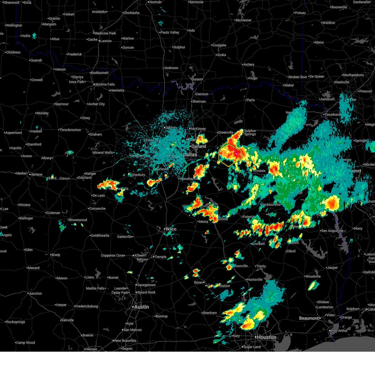
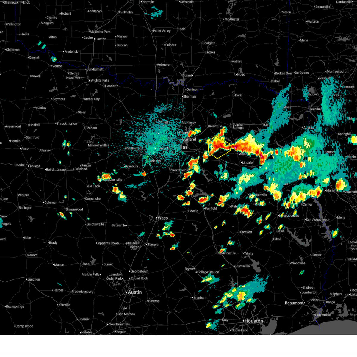
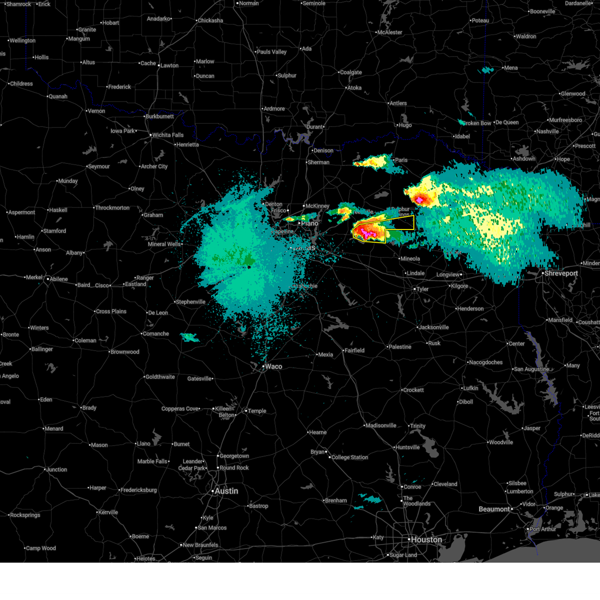
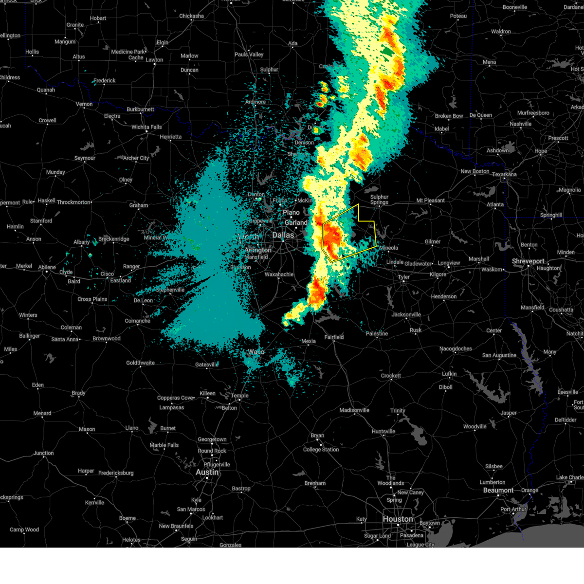
| 4/24/2026 11:06 PM CDT |
 At 1106 pm cdt, a severe thunderstorm was located near grand saline, or 14 miles northeast of canton, moving southeast at 15 mph (radar indicated). Hazards include ping pong ball size hail and 60 mph wind gusts. People and animals outdoors will be injured. expect hail damage to roofs, siding, windows, and vehicles. expect wind damage to roofs, siding, and trees. Locations impacted include, grand saline, edgewood, emory, east tawakoni, point, fruitvale, lake tawakoni, lake fork reservoir, willow springs, flats, hermits cove, alsa, and jones. At 1106 pm cdt, a severe thunderstorm was located near grand saline, or 14 miles northeast of canton, moving southeast at 15 mph (radar indicated). Hazards include ping pong ball size hail and 60 mph wind gusts. People and animals outdoors will be injured. expect hail damage to roofs, siding, windows, and vehicles. expect wind damage to roofs, siding, and trees. Locations impacted include, grand saline, edgewood, emory, east tawakoni, point, fruitvale, lake tawakoni, lake fork reservoir, willow springs, flats, hermits cove, alsa, and jones.
|
| 4/24/2026 10:50 PM CDT | Golf Ball sized hail reported 4.4 miles E of Emory, TX, social media photo. |
| 4/24/2026 10:40 PM CDT | Tennis Ball sized hail reported 0.5 miles NE of Emory, TX, photo of approximately tennis ball size hail. |
| 4/24/2026 10:37 PM CDT |
 The severe thunderstorm which prompted the warning continues to pose a large hail and damaging wind threat to rains county. therefore, the warning will be reissued. a severe thunderstorm watch remains in effect until 400 am cdt for north central texas. The severe thunderstorm which prompted the warning continues to pose a large hail and damaging wind threat to rains county. therefore, the warning will be reissued. a severe thunderstorm watch remains in effect until 400 am cdt for north central texas.
|
| 4/24/2026 10:36 PM CDT |
 Svrfwd the national weather service in fort worth has issued a * severe thunderstorm warning for, south central hunt county in north central texas, northwestern van zandt county in north central texas, rains county in north central texas, * until 1130 pm cdt. * at 1036 pm cdt, a severe thunderstorm was located near emory, or 14 miles east of wills point, moving southeast at 10 mph (radar indicated). Hazards include ping pong ball size hail and 60 mph wind gusts. People and animals outdoors will be injured. expect hail damage to roofs, siding, windows, and vehicles. expect wind damage to roofs, siding, and trees. this severe thunderstorm will be near, grand saline around 1055 pm cdt. Other locations impacted by this severe thunderstorm include willow springs, hermits cove, flats, jones, and alsa. Svrfwd the national weather service in fort worth has issued a * severe thunderstorm warning for, south central hunt county in north central texas, northwestern van zandt county in north central texas, rains county in north central texas, * until 1130 pm cdt. * at 1036 pm cdt, a severe thunderstorm was located near emory, or 14 miles east of wills point, moving southeast at 10 mph (radar indicated). Hazards include ping pong ball size hail and 60 mph wind gusts. People and animals outdoors will be injured. expect hail damage to roofs, siding, windows, and vehicles. expect wind damage to roofs, siding, and trees. this severe thunderstorm will be near, grand saline around 1055 pm cdt. Other locations impacted by this severe thunderstorm include willow springs, hermits cove, flats, jones, and alsa.
|
| 4/24/2026 10:20 PM CDT |
 At 1020 pm cdt, a severe thunderstorm was located 7 miles northwest of golden, or 13 miles northwest of mineola, moving southeast at 25 mph (radar indicated). Hazards include two inch hail and 60 mph wind gusts. People and animals outdoors will be injured. expect hail damage to roofs, siding, windows, and vehicles. expect wind damage to roofs, siding, and trees. Locations impacted include, emory, east tawakoni, point, lake tawakoni, lake fork reservoir, willow springs, flats, and hermits cove. At 1020 pm cdt, a severe thunderstorm was located 7 miles northwest of golden, or 13 miles northwest of mineola, moving southeast at 25 mph (radar indicated). Hazards include two inch hail and 60 mph wind gusts. People and animals outdoors will be injured. expect hail damage to roofs, siding, windows, and vehicles. expect wind damage to roofs, siding, and trees. Locations impacted include, emory, east tawakoni, point, lake tawakoni, lake fork reservoir, willow springs, flats, and hermits cove.
|
| 4/24/2026 10:17 PM CDT | Hen Egg sized hail reported 3.8 miles E of Emory, TX |
| 4/24/2026 10:17 PM CDT | Golf Ball sized hail reported 0.5 miles NE of Emory, TX |
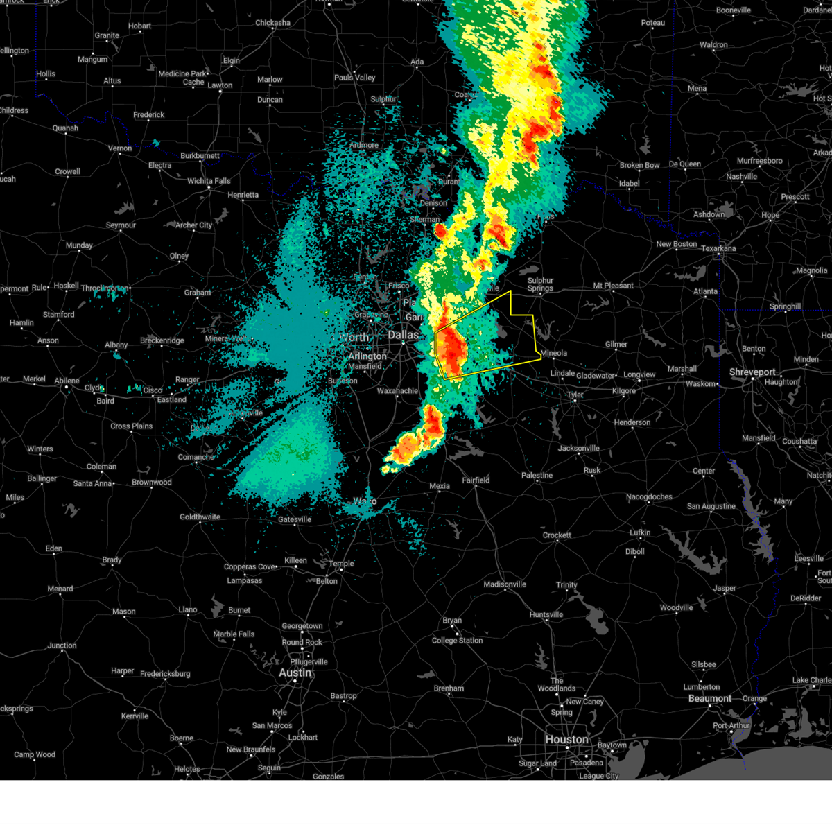
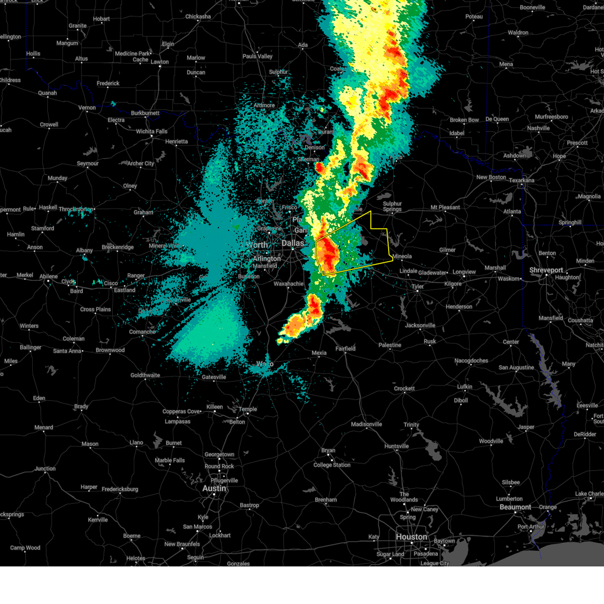
| 4/24/2026 10:11 PM CDT |
 At 1010 pm cdt, a severe thunderstorm was located near emory, or 17 miles northwest of mineola, moving east at 35 mph (radar indicated). Hazards include tennis ball size hail and 60 mph wind gusts. People and animals outdoors will be injured. expect hail damage to roofs, siding, windows, and vehicles. expect wind damage to roofs, siding, and trees. Locations impacted include, emory, east tawakoni, point, lake tawakoni, lake fork reservoir, willow springs, flats, and hermits cove. At 1010 pm cdt, a severe thunderstorm was located near emory, or 17 miles northwest of mineola, moving east at 35 mph (radar indicated). Hazards include tennis ball size hail and 60 mph wind gusts. People and animals outdoors will be injured. expect hail damage to roofs, siding, windows, and vehicles. expect wind damage to roofs, siding, and trees. Locations impacted include, emory, east tawakoni, point, lake tawakoni, lake fork reservoir, willow springs, flats, and hermits cove.
|
| 4/24/2026 10:09 PM CDT | Quarter sized hail reported 0.5 miles NE of Emory, TX |
| 4/24/2026 10:07 PM CDT |
 At 1006 pm cdt, a severe thunderstorm was located over emory, or 18 miles northeast of wills point, moving southeast at 30 mph (radar indicated). Hazards include tennis ball size hail and 60 mph wind gusts. the greatest hail threat will be in rains county. People and animals outdoors will be injured. expect hail damage to roofs, siding, windows, and vehicles. expect wind damage to roofs, siding, and trees. This severe thunderstorm will remain over mainly rural areas of southern hopkins and rains counties, including the following locations, miller grove, martin springs, willow springs, flats, seymore, arabla, cornersville, and hermits cove. At 1006 pm cdt, a severe thunderstorm was located over emory, or 18 miles northeast of wills point, moving southeast at 30 mph (radar indicated). Hazards include tennis ball size hail and 60 mph wind gusts. the greatest hail threat will be in rains county. People and animals outdoors will be injured. expect hail damage to roofs, siding, windows, and vehicles. expect wind damage to roofs, siding, and trees. This severe thunderstorm will remain over mainly rural areas of southern hopkins and rains counties, including the following locations, miller grove, martin springs, willow springs, flats, seymore, arabla, cornersville, and hermits cove.
|
| 4/24/2026 9:40 PM CDT |
 Svrfwd the national weather service in fort worth has issued a * severe thunderstorm warning for, southeastern hunt county in north central texas, southern hopkins county in north central texas, rains county in north central texas, * until 1045 pm cdt. * at 940 pm cdt, severe thunderstorms were located along a line extending from brashear to near west tawakoni, moving east at 35 mph (radar indicated). Hazards include 60 mph wind gusts and quarter size hail. Hail damage to vehicles is expected. expect wind damage to roofs, siding, and trees. severe thunderstorms will be near, sulphur springs, east tawakoni, point, brashear, and lake tawakoni around 945 pm cdt. lake fork reservoir around 950 pm cdt. emory around 955 pm cdt. como around 1000 pm cdt. pickton around 1010 pm cdt. other locations impacted by these severe thunderstorms include miller grove, martin springs, lone oak, willow springs, flats, seymore, arabla, cornersville, and hermits cove. This includes interstate 30 between mile markers 113 and 125. Svrfwd the national weather service in fort worth has issued a * severe thunderstorm warning for, southeastern hunt county in north central texas, southern hopkins county in north central texas, rains county in north central texas, * until 1045 pm cdt. * at 940 pm cdt, severe thunderstorms were located along a line extending from brashear to near west tawakoni, moving east at 35 mph (radar indicated). Hazards include 60 mph wind gusts and quarter size hail. Hail damage to vehicles is expected. expect wind damage to roofs, siding, and trees. severe thunderstorms will be near, sulphur springs, east tawakoni, point, brashear, and lake tawakoni around 945 pm cdt. lake fork reservoir around 950 pm cdt. emory around 955 pm cdt. como around 1000 pm cdt. pickton around 1010 pm cdt. other locations impacted by these severe thunderstorms include miller grove, martin springs, lone oak, willow springs, flats, seymore, arabla, cornersville, and hermits cove. This includes interstate 30 between mile markers 113 and 125.
|
| 6/8/2025 11:01 PM CDT |
 Svrfwd the national weather service in fort worth has issued a * severe thunderstorm warning for, van zandt county in north central texas, northeastern henderson county in central texas, rains county in north central texas, * until 1215 am cdt. * at 1100 pm cdt, a severe thunderstorm was located over east tawakoni, or 11 miles northeast of wills point, moving southeast at 50 mph (radar indicated). Hazards include 70 mph wind gusts. Expect considerable tree damage. damage is likely to mobile homes, roofs, and outbuildings. this severe thunderstorm will be near, lake tawakoni around 1105 pm cdt. grand saline around 1115 pm cdt. other locations impacted by this severe thunderstorm include ben wheeler, whitton, moore station, alsa, phalba, roddy, jackson, oakland, wise, and walton. This includes interstate 20 between mile markers 513 and 542. Svrfwd the national weather service in fort worth has issued a * severe thunderstorm warning for, van zandt county in north central texas, northeastern henderson county in central texas, rains county in north central texas, * until 1215 am cdt. * at 1100 pm cdt, a severe thunderstorm was located over east tawakoni, or 11 miles northeast of wills point, moving southeast at 50 mph (radar indicated). Hazards include 70 mph wind gusts. Expect considerable tree damage. damage is likely to mobile homes, roofs, and outbuildings. this severe thunderstorm will be near, lake tawakoni around 1105 pm cdt. grand saline around 1115 pm cdt. other locations impacted by this severe thunderstorm include ben wheeler, whitton, moore station, alsa, phalba, roddy, jackson, oakland, wise, and walton. This includes interstate 20 between mile markers 513 and 542.
|
| 5/26/2025 2:48 AM CDT |
 At 248 am cdt, severe thunderstorms were located along a line extending from caddo mills to near balch springs to near rendon, moving southeast at 35 mph (radar indicated). Hazards include 65 mph wind gusts and quarter size hail. Hail damage to vehicles is expected. expect wind damage to roofs, siding, and trees. these severe storms will be near, cedar hill state park, hutchins, cedar hill, duncanville, rendon, dallas, red oak, glenn heights, talty, and grand prairie around 255 am cdt. ferris, hawk cove, and greenville club lake around 300 am cdt. new terrell city lake, west tawakoni, waxahachie, venus, and kaufman around 305 am cdt. east tawakoni and lake tawakoni state park around 310 am cdt. ennis, cottonwood, palmer, and grays prairie around 315 am cdt. point and wills point around 320 am cdt. maypearl and kemp around 325 am cdt. Other locations impacted by these severe thunderstorms include ola, elmo, mountain creek lake, sand branch, lewisville lake, bristol, pecan hill, floyd, new hope, and hermits cove. At 248 am cdt, severe thunderstorms were located along a line extending from caddo mills to near balch springs to near rendon, moving southeast at 35 mph (radar indicated). Hazards include 65 mph wind gusts and quarter size hail. Hail damage to vehicles is expected. expect wind damage to roofs, siding, and trees. these severe storms will be near, cedar hill state park, hutchins, cedar hill, duncanville, rendon, dallas, red oak, glenn heights, talty, and grand prairie around 255 am cdt. ferris, hawk cove, and greenville club lake around 300 am cdt. new terrell city lake, west tawakoni, waxahachie, venus, and kaufman around 305 am cdt. east tawakoni and lake tawakoni state park around 310 am cdt. ennis, cottonwood, palmer, and grays prairie around 315 am cdt. point and wills point around 320 am cdt. maypearl and kemp around 325 am cdt. Other locations impacted by these severe thunderstorms include ola, elmo, mountain creek lake, sand branch, lewisville lake, bristol, pecan hill, floyd, new hope, and hermits cove.
|
| 5/26/2025 2:23 AM CDT |
 Svrfwd the national weather service in fort worth has issued a * severe thunderstorm warning for, rockwall county in north central texas, southern hunt county in north central texas, kaufman county in north central texas, northeastern johnson county in north central texas, northwestern van zandt county in north central texas, southern denton county in north central texas, tarrant county in north central texas, western rains county in north central texas, northern ellis county in north central texas, collin county in north central texas, dallas county in north central texas, * until 330 am cdt. * at 222 am cdt, severe thunderstorms were located along a line extending from farmersville to near dallas to benbrook, moving southeast at 35 mph (radar indicated). Hazards include 60 mph wind gusts and quarter size hail. Hail damage to vehicles is expected. expect wind damage to roofs, siding, and trees. severe thunderstorms will be near, edgecliff village, sunnyvale, duncanville, fate, pantego, mesquite, heath, edgecliff, rendon, and rowlett around 230 am cdt. cedar hill state park, hutchins, cedar hill, caddo mills, burleson, mobile city, mansfield, and desoto around 235 am cdt. greenville, forney, seagoville, and lancaster around 240 am cdt. wilmer around 245 am cdt. red oak, glenn heights, talty, alvarado, ovilla, midlothian, quinlan, crandall, combine, and terrell around 250 am cdt. ferris, oak leaf, and lake tawakoni around 255 am cdt. new terrell city lake, west tawakoni, hawk cove, waxahachie, venus, and greenville club lake around 300 am cdt. east tawakoni, kaufman, and lake tawakoni state park around 305 am cdt. other locations impacted by these severe thunderstorms include ola, elmo, mountain creek lake, sand branch, lewisville lake, bristol, pecan hill, floyd, new hope, and hermits cove. this includes the following highways, interstate 35w between mile markers 27 and 71. interstate 35e between mile markers 395 and 456. interstate 20 between mile markers 427 and 517. interstate 30 between mile markers 6 and 95. Interstate 45 between mile markers 254 and 284. Svrfwd the national weather service in fort worth has issued a * severe thunderstorm warning for, rockwall county in north central texas, southern hunt county in north central texas, kaufman county in north central texas, northeastern johnson county in north central texas, northwestern van zandt county in north central texas, southern denton county in north central texas, tarrant county in north central texas, western rains county in north central texas, northern ellis county in north central texas, collin county in north central texas, dallas county in north central texas, * until 330 am cdt. * at 222 am cdt, severe thunderstorms were located along a line extending from farmersville to near dallas to benbrook, moving southeast at 35 mph (radar indicated). Hazards include 60 mph wind gusts and quarter size hail. Hail damage to vehicles is expected. expect wind damage to roofs, siding, and trees. severe thunderstorms will be near, edgecliff village, sunnyvale, duncanville, fate, pantego, mesquite, heath, edgecliff, rendon, and rowlett around 230 am cdt. cedar hill state park, hutchins, cedar hill, caddo mills, burleson, mobile city, mansfield, and desoto around 235 am cdt. greenville, forney, seagoville, and lancaster around 240 am cdt. wilmer around 245 am cdt. red oak, glenn heights, talty, alvarado, ovilla, midlothian, quinlan, crandall, combine, and terrell around 250 am cdt. ferris, oak leaf, and lake tawakoni around 255 am cdt. new terrell city lake, west tawakoni, hawk cove, waxahachie, venus, and greenville club lake around 300 am cdt. east tawakoni, kaufman, and lake tawakoni state park around 305 am cdt. other locations impacted by these severe thunderstorms include ola, elmo, mountain creek lake, sand branch, lewisville lake, bristol, pecan hill, floyd, new hope, and hermits cove. this includes the following highways, interstate 35w between mile markers 27 and 71. interstate 35e between mile markers 395 and 456. interstate 20 between mile markers 427 and 517. interstate 30 between mile markers 6 and 95. Interstate 45 between mile markers 254 and 284.
|
| 5/20/2025 2:01 AM CDT |
 Svrfwd the national weather service in fort worth has issued a * severe thunderstorm warning for, southeastern hunt county in north central texas, hopkins county in north central texas, rains county in north central texas, * until 245 am cdt. * at 200 am cdt, a severe thunderstorm was located near cumby, or 13 miles southwest of sulphur springs, moving east at 50 mph (radar indicated). Hazards include 65 mph wind gusts and quarter size hail. Hail damage to vehicles is expected. expect wind damage to roofs, siding, and trees. this severe thunderstorm will remain over mainly rural areas of southeastern hunt, hopkins and rains counties, including the following locations, martin springs, weaver, lone oak, flora, ridgeway, cornersville, pine forest, hermits cove, dike, and flats. This includes interstate 30 between mile markers 103 and 142. Svrfwd the national weather service in fort worth has issued a * severe thunderstorm warning for, southeastern hunt county in north central texas, hopkins county in north central texas, rains county in north central texas, * until 245 am cdt. * at 200 am cdt, a severe thunderstorm was located near cumby, or 13 miles southwest of sulphur springs, moving east at 50 mph (radar indicated). Hazards include 65 mph wind gusts and quarter size hail. Hail damage to vehicles is expected. expect wind damage to roofs, siding, and trees. this severe thunderstorm will remain over mainly rural areas of southeastern hunt, hopkins and rains counties, including the following locations, martin springs, weaver, lone oak, flora, ridgeway, cornersville, pine forest, hermits cove, dike, and flats. This includes interstate 30 between mile markers 103 and 142.
|
| 3/30/2025 1:34 AM CDT |
 the severe thunderstorm warning has been cancelled and is no longer in effect the severe thunderstorm warning has been cancelled and is no longer in effect
|
| 3/30/2025 1:25 AM CDT |
 The storms which prompted the warning have moved out of the warned area. therefore, the warning has been cancelled. a severe thunderstorm watch remains in effect until 200 am cdt for north central texas. The storms which prompted the warning have moved out of the warned area. therefore, the warning has been cancelled. a severe thunderstorm watch remains in effect until 200 am cdt for north central texas.
|
| 3/30/2025 1:25 AM CDT |
 At 125 am cdt, severe thunderstorms were located along a line extending from near campbell to near point to near emory, moving east at 45 mph (radar indicated). Hazards include 60 mph wind gusts and nickel size hail. Expect damage to roofs, siding, and trees. these severe storms will be near, emory and lake fork reservoir around 130 am cdt. Other locations impacted by these severe thunderstorms include lone oak, flats, alsa, cash, hermits cove, and dixon. At 125 am cdt, severe thunderstorms were located along a line extending from near campbell to near point to near emory, moving east at 45 mph (radar indicated). Hazards include 60 mph wind gusts and nickel size hail. Expect damage to roofs, siding, and trees. these severe storms will be near, emory and lake fork reservoir around 130 am cdt. Other locations impacted by these severe thunderstorms include lone oak, flats, alsa, cash, hermits cove, and dixon.
|
| 3/30/2025 1:24 AM CDT |
 the severe thunderstorm warning has been cancelled and is no longer in effect the severe thunderstorm warning has been cancelled and is no longer in effect
|
| 3/30/2025 1:24 AM CDT |
 At 124 am cdt, severe thunderstorms were located along a line extending from near campbell to near point to near emory, moving northeast at 45 mph (public). Hazards include 60 mph wind gusts and nickel size hail. Expect damage to roofs, siding, and trees. these severe storms will be near, emory and lake fork reservoir around 130 am cdt. Other locations impacted by these severe thunderstorms include lone oak, flats, alsa, cash, hermits cove, and dixon. At 124 am cdt, severe thunderstorms were located along a line extending from near campbell to near point to near emory, moving northeast at 45 mph (public). Hazards include 60 mph wind gusts and nickel size hail. Expect damage to roofs, siding, and trees. these severe storms will be near, emory and lake fork reservoir around 130 am cdt. Other locations impacted by these severe thunderstorms include lone oak, flats, alsa, cash, hermits cove, and dixon.
|
| 3/30/2025 1:07 AM CDT |
 At 107 am cdt, severe thunderstorms were located along a line extending from near royse city to near lake tawakoni to near new terrell city lake, moving northeast at 55 mph (public). Hazards include 60 mph wind gusts and quarter size hail. Hail damage to vehicles is expected. expect wind damage to roofs, siding, and trees. these severe storms will be near, west tawakoni, wills point, hawk cove, quinlan, east tawakoni, lake tawakoni state park, and lake tawakoni around 110 am cdt. point, greenville, and greenville club lake around 115 am cdt. emory and lake fork reservoir around 125 am cdt. Other locations impacted by these severe thunderstorms include lone oak, ola, flats, alsa, elmo, cash, hermits cove, dixon, oak ridge, and union valley. At 107 am cdt, severe thunderstorms were located along a line extending from near royse city to near lake tawakoni to near new terrell city lake, moving northeast at 55 mph (public). Hazards include 60 mph wind gusts and quarter size hail. Hail damage to vehicles is expected. expect wind damage to roofs, siding, and trees. these severe storms will be near, west tawakoni, wills point, hawk cove, quinlan, east tawakoni, lake tawakoni state park, and lake tawakoni around 110 am cdt. point, greenville, and greenville club lake around 115 am cdt. emory and lake fork reservoir around 125 am cdt. Other locations impacted by these severe thunderstorms include lone oak, ola, flats, alsa, elmo, cash, hermits cove, dixon, oak ridge, and union valley.
|
| 3/30/2025 1:07 AM CDT |
 the severe thunderstorm warning has been cancelled and is no longer in effect the severe thunderstorm warning has been cancelled and is no longer in effect
|
| 3/30/2025 12:55 AM CDT |
 the severe thunderstorm warning has been cancelled and is no longer in effect the severe thunderstorm warning has been cancelled and is no longer in effect
|
| 3/30/2025 12:55 AM CDT |
 At 1254 am cdt, severe thunderstorms were located along a line extending from near fate to new terrell city lake to kaufman, moving northeast at 60 mph (public. at 1253 am cdt, a 58 mph wind gust was reported at terrell municipal airport). Hazards include 60 mph wind gusts and quarter size hail. Hail damage to vehicles is expected. expect wind damage to roofs, siding, and trees. these severe storms will be near, new terrell city lake, hawk cove, quinlan, and lake tawakoni around 100 am cdt. west tawakoni, wills point, and lake tawakoni state park around 105 am cdt. greenville, east tawakoni, and greenville club lake around 110 am cdt. point around 115 am cdt. emory and lake fork reservoir around 120 am cdt. Other locations impacted by these severe thunderstorms include heartland, ola, alsa, lawrence, elmo, cash, union valley, myrtle springs, lone oak, and post oak bend city. At 1254 am cdt, severe thunderstorms were located along a line extending from near fate to new terrell city lake to kaufman, moving northeast at 60 mph (public. at 1253 am cdt, a 58 mph wind gust was reported at terrell municipal airport). Hazards include 60 mph wind gusts and quarter size hail. Hail damage to vehicles is expected. expect wind damage to roofs, siding, and trees. these severe storms will be near, new terrell city lake, hawk cove, quinlan, and lake tawakoni around 100 am cdt. west tawakoni, wills point, and lake tawakoni state park around 105 am cdt. greenville, east tawakoni, and greenville club lake around 110 am cdt. point around 115 am cdt. emory and lake fork reservoir around 120 am cdt. Other locations impacted by these severe thunderstorms include heartland, ola, alsa, lawrence, elmo, cash, union valley, myrtle springs, lone oak, and post oak bend city.
|
| 3/30/2025 12:38 AM CDT |
 Svrfwd the national weather service in fort worth has issued a * severe thunderstorm warning for, southern rockwall county in north central texas, southern hunt county in north central texas, kaufman county in north central texas, northwestern van zandt county in north central texas, rains county in north central texas, east central dallas county in north central texas, * until 145 am cdt. * at 1238 am cdt, severe thunderstorms were located along a line extending from near sunnyvale to near crandall to near combine, moving northeast at 50 mph (radar indicated). Hazards include 60 mph wind gusts and quarter size hail. Hail damage to vehicles is expected. expect wind damage to roofs, siding, and trees. severe thunderstorms will be near, heath, rockwall, talty, forney, terrell, and kaufman around 1245 am cdt. new terrell city lake around 1255 am cdt. quinlan and lake tawakoni around 100 am cdt. wills point and hawk cove around 105 am cdt. west tawakoni and lake tawakoni state park around 110 am cdt. east tawakoni and greenville club lake around 115 am cdt. point and edgewood around 120 am cdt. emory and lake fork reservoir around 130 am cdt. other locations impacted by these severe thunderstorms include heartland, ola, alsa, lawrence, elmo, cash, union valley, myrtle springs, lone oak, and post oak bend city. this includes the following highways, interstate 20 between mile markers 484 and 521. Interstate 30 between mile markers 106 and 109. Svrfwd the national weather service in fort worth has issued a * severe thunderstorm warning for, southern rockwall county in north central texas, southern hunt county in north central texas, kaufman county in north central texas, northwestern van zandt county in north central texas, rains county in north central texas, east central dallas county in north central texas, * until 145 am cdt. * at 1238 am cdt, severe thunderstorms were located along a line extending from near sunnyvale to near crandall to near combine, moving northeast at 50 mph (radar indicated). Hazards include 60 mph wind gusts and quarter size hail. Hail damage to vehicles is expected. expect wind damage to roofs, siding, and trees. severe thunderstorms will be near, heath, rockwall, talty, forney, terrell, and kaufman around 1245 am cdt. new terrell city lake around 1255 am cdt. quinlan and lake tawakoni around 100 am cdt. wills point and hawk cove around 105 am cdt. west tawakoni and lake tawakoni state park around 110 am cdt. east tawakoni and greenville club lake around 115 am cdt. point and edgewood around 120 am cdt. emory and lake fork reservoir around 130 am cdt. other locations impacted by these severe thunderstorms include heartland, ola, alsa, lawrence, elmo, cash, union valley, myrtle springs, lone oak, and post oak bend city. this includes the following highways, interstate 20 between mile markers 484 and 521. Interstate 30 between mile markers 106 and 109.
|
| 3/8/2025 6:51 AM CST |
 The storm which prompted the warning is moving out of the area. therefore the warning will be allowed to expire. The storm which prompted the warning is moving out of the area. therefore the warning will be allowed to expire.
|
| 3/8/2025 6:22 AM CST |
 Svrfwd the national weather service in fort worth has issued a * severe thunderstorm warning for, van zandt county in north central texas, rains county in north central texas, * until 700 am cst. * at 621 am cst, a severe thunderstorm was located near canton, moving east at 55 mph (radar indicated). Hazards include 60 mph wind gusts and quarter size hail. Hail damage to vehicles is expected. expect wind damage to roofs, siding, and trees. this severe thunderstorm will be near, canton around 625 am cst. van around 635 am cst. other locations impacted by this severe thunderstorm include myrtle springs, jones, ben wheeler, primrose, flats, alsa, pruitt, jackson, oakland, and tundra. This includes interstate 20 between mile markers 516 and 542. Svrfwd the national weather service in fort worth has issued a * severe thunderstorm warning for, van zandt county in north central texas, rains county in north central texas, * until 700 am cst. * at 621 am cst, a severe thunderstorm was located near canton, moving east at 55 mph (radar indicated). Hazards include 60 mph wind gusts and quarter size hail. Hail damage to vehicles is expected. expect wind damage to roofs, siding, and trees. this severe thunderstorm will be near, canton around 625 am cst. van around 635 am cst. other locations impacted by this severe thunderstorm include myrtle springs, jones, ben wheeler, primrose, flats, alsa, pruitt, jackson, oakland, and tundra. This includes interstate 20 between mile markers 516 and 542.
|
| 3/4/2025 6:44 AM CST | Damage to trees... carports... and awnings was reported in rains county. time estimated via rada in rains county TX, 1 miles ENE of Emory, TX |
| 6/2/2024 7:06 PM CDT |
 the severe thunderstorm warning has been cancelled and is no longer in effect the severe thunderstorm warning has been cancelled and is no longer in effect
|
| 6/2/2024 6:53 PM CDT |
 At 652 pm cdt, a severe thunderstorm was located near lake tawakoni state park, or near wills point, moving east at 25 mph (radar indicated). Hazards include 60 mph wind gusts and quarter size hail. Hail damage to vehicles is expected. expect wind damage to roofs, siding, and trees. This severe storm will be near, lake tawakoni around 700 pm cdt. At 652 pm cdt, a severe thunderstorm was located near lake tawakoni state park, or near wills point, moving east at 25 mph (radar indicated). Hazards include 60 mph wind gusts and quarter size hail. Hail damage to vehicles is expected. expect wind damage to roofs, siding, and trees. This severe storm will be near, lake tawakoni around 700 pm cdt.
|
| 6/2/2024 6:53 PM CDT |
 the severe thunderstorm warning has been cancelled and is no longer in effect the severe thunderstorm warning has been cancelled and is no longer in effect
|
| 6/2/2024 6:37 PM CDT |
 Svrfwd the national weather service in fort worth has issued a * severe thunderstorm warning for, southeastern hunt county in north central texas, northwestern van zandt county in north central texas, rains county in north central texas, * until 730 pm cdt. * at 637 pm cdt, a severe thunderstorm was located near new terrell city lake, or near wills point, moving east at 15 mph (radar indicated). Hazards include 60 mph wind gusts and half dollar size hail. Hail damage to vehicles is expected. expect wind damage to roofs, siding, and trees. this severe thunderstorm will be near, wills point around 640 pm cdt. Edgewood around 715 pm cdt. Svrfwd the national weather service in fort worth has issued a * severe thunderstorm warning for, southeastern hunt county in north central texas, northwestern van zandt county in north central texas, rains county in north central texas, * until 730 pm cdt. * at 637 pm cdt, a severe thunderstorm was located near new terrell city lake, or near wills point, moving east at 15 mph (radar indicated). Hazards include 60 mph wind gusts and half dollar size hail. Hail damage to vehicles is expected. expect wind damage to roofs, siding, and trees. this severe thunderstorm will be near, wills point around 640 pm cdt. Edgewood around 715 pm cdt.
|
| 5/28/2024 8:28 AM CDT |
 The storm which prompted the warning has moved out of the area. therefore, the warning will be allowed to expire. however, gusty winds and heavy rain are still possible with this thunderstorm in henderson county. a severe thunderstorm watch remains in effect until 1100 am cdt for central and north central texas. The storm which prompted the warning has moved out of the area. therefore, the warning will be allowed to expire. however, gusty winds and heavy rain are still possible with this thunderstorm in henderson county. a severe thunderstorm watch remains in effect until 1100 am cdt for central and north central texas.
|
| 5/28/2024 7:46 AM CDT |
 At 745 am cdt, a severe thunderstorm was located 7 miles southwest of van, or 8 miles southeast of canton, moving southeast at 45 mph (radar indicated). Hazards include golf ball size hail and 70 mph wind gusts. People and animals outdoors will be injured. expect hail damage to roofs, siding, windows, and vehicles. expect considerable tree damage. wind damage is also likely to mobile homes, roofs, and outbuildings. this severe storm will be near, edom around 750 am cdt. chandler and lake palestine around 805 am cdt. Other locations impacted by this severe thunderstorm include ben wheeler, whitton, moore station, log cabin, bradford, bois d'arc, star harbor, roddy, jackson, and oakland. At 745 am cdt, a severe thunderstorm was located 7 miles southwest of van, or 8 miles southeast of canton, moving southeast at 45 mph (radar indicated). Hazards include golf ball size hail and 70 mph wind gusts. People and animals outdoors will be injured. expect hail damage to roofs, siding, windows, and vehicles. expect considerable tree damage. wind damage is also likely to mobile homes, roofs, and outbuildings. this severe storm will be near, edom around 750 am cdt. chandler and lake palestine around 805 am cdt. Other locations impacted by this severe thunderstorm include ben wheeler, whitton, moore station, log cabin, bradford, bois d'arc, star harbor, roddy, jackson, and oakland.
|
| 5/28/2024 7:46 AM CDT |
 the severe thunderstorm warning has been cancelled and is no longer in effect the severe thunderstorm warning has been cancelled and is no longer in effect
|
| 5/28/2024 7:26 AM CDT |
 Svrfwd the national weather service in fort worth has issued a * severe thunderstorm warning for, south central hunt county in north central texas, eastern kaufman county in north central texas, van zandt county in north central texas, henderson county in central texas, rains county in north central texas, northern anderson county in central texas, northeastern navarro county in north central texas, * until 830 am cdt. * at 725 am cdt, a severe thunderstorm was located 8 miles west of canton, moving southeast at 45 mph (radar indicated). Hazards include golf ball size hail and 70 mph wind gusts. People and animals outdoors will be injured. expect hail damage to roofs, siding, windows, and vehicles. expect considerable tree damage. wind damage is also likely to mobile homes, roofs, and outbuildings. this severe thunderstorm will be near, canton around 730 am cdt. edom around 750 am cdt. chandler and lake palestine around 805 am cdt. other locations impacted by this severe thunderstorm include ben wheeler, bradford, ola, elmo, tolosa, jackson, oakland, poynor, redland, and cross roads. This includes interstate 20 between mile markers 502 and 542. Svrfwd the national weather service in fort worth has issued a * severe thunderstorm warning for, south central hunt county in north central texas, eastern kaufman county in north central texas, van zandt county in north central texas, henderson county in central texas, rains county in north central texas, northern anderson county in central texas, northeastern navarro county in north central texas, * until 830 am cdt. * at 725 am cdt, a severe thunderstorm was located 8 miles west of canton, moving southeast at 45 mph (radar indicated). Hazards include golf ball size hail and 70 mph wind gusts. People and animals outdoors will be injured. expect hail damage to roofs, siding, windows, and vehicles. expect considerable tree damage. wind damage is also likely to mobile homes, roofs, and outbuildings. this severe thunderstorm will be near, canton around 730 am cdt. edom around 750 am cdt. chandler and lake palestine around 805 am cdt. other locations impacted by this severe thunderstorm include ben wheeler, bradford, ola, elmo, tolosa, jackson, oakland, poynor, redland, and cross roads. This includes interstate 20 between mile markers 502 and 542.
|
| 5/28/2024 7:15 AM CDT |
 At 715 am cdt, severe thunderstorms were located along a line extending from near greenville club lake to 10 miles west of flag lake, moving southeast at 35 mph (radar indicated). Hazards include golf ball size hail and 70 mph wind gusts. People and animals outdoors will be injured. expect hail damage to roofs, siding, windows, and vehicles. expect considerable tree damage. wind damage is also likely to mobile homes, roofs, and outbuildings. these severe storms will be near, wills point, mabank, tool, west tawakoni, seven points, quinlan, kemp, east tawakoni, lake tawakoni state park, and flag lake around 720 am cdt. gun barrel city and point around 725 am cdt. canton, edgewood, and enchanted oaks around 735 am cdt. emory, eustace, fruitvale, purtis creek state park, and lake fork reservoir around 740 am cdt. grand saline around 755 am cdt. Other locations impacted by these severe thunderstorms include whitton, ola, alsa, elmo, tolosa, roddy, jackson, oakland, payne springs, and union valley. At 715 am cdt, severe thunderstorms were located along a line extending from near greenville club lake to 10 miles west of flag lake, moving southeast at 35 mph (radar indicated). Hazards include golf ball size hail and 70 mph wind gusts. People and animals outdoors will be injured. expect hail damage to roofs, siding, windows, and vehicles. expect considerable tree damage. wind damage is also likely to mobile homes, roofs, and outbuildings. these severe storms will be near, wills point, mabank, tool, west tawakoni, seven points, quinlan, kemp, east tawakoni, lake tawakoni state park, and flag lake around 720 am cdt. gun barrel city and point around 725 am cdt. canton, edgewood, and enchanted oaks around 735 am cdt. emory, eustace, fruitvale, purtis creek state park, and lake fork reservoir around 740 am cdt. grand saline around 755 am cdt. Other locations impacted by these severe thunderstorms include whitton, ola, alsa, elmo, tolosa, roddy, jackson, oakland, payne springs, and union valley.
|
| 5/28/2024 7:15 AM CDT |
 the severe thunderstorm warning has been cancelled and is no longer in effect the severe thunderstorm warning has been cancelled and is no longer in effect
|
| 5/28/2024 6:53 AM CDT |
 the severe thunderstorm warning has been cancelled and is no longer in effect the severe thunderstorm warning has been cancelled and is no longer in effect
|
| 5/28/2024 6:53 AM CDT |
 At 652 am cdt, a severe thunderstorm was located near terrell, moving southeast at 40 mph (radar indicated). Hazards include golf ball size hail and 70 mph wind gusts. People and animals outdoors will be injured. expect hail damage to roofs, siding, windows, and vehicles. expect considerable tree damage. wind damage is also likely to mobile homes, roofs, and outbuildings. this severe storm will be near, kaufman around 655 am cdt. Other locations impacted by this severe thunderstorm include ola, elmo, tolosa, jackson, sand branch, oakland, bristol, floyd, hermits cove, and martins mill. At 652 am cdt, a severe thunderstorm was located near terrell, moving southeast at 40 mph (radar indicated). Hazards include golf ball size hail and 70 mph wind gusts. People and animals outdoors will be injured. expect hail damage to roofs, siding, windows, and vehicles. expect considerable tree damage. wind damage is also likely to mobile homes, roofs, and outbuildings. this severe storm will be near, kaufman around 655 am cdt. Other locations impacted by this severe thunderstorm include ola, elmo, tolosa, jackson, sand branch, oakland, bristol, floyd, hermits cove, and martins mill.
|
| 5/28/2024 6:30 AM CDT |
 Svrfwd the national weather service in fort worth has issued a * severe thunderstorm warning for, rockwall county in north central texas, hunt county in north central texas, kaufman county in north central texas, van zandt county in north central texas, northwestern henderson county in central texas, southeastern tarrant county in north central texas, rains county in north central texas, ellis county in north central texas, southeastern collin county in north central texas, dallas county in north central texas, north central navarro county in north central texas, * until 730 am cdt. * at 630 am cdt, a severe thunderstorm was located near seagoville, moving southeast at 45 mph (radar indicated). Hazards include 70 mph wind gusts and ping pong ball size hail. People and animals outdoors will be injured. expect hail damage to roofs, siding, windows, and vehicles. expect considerable tree damage. wind damage is also likely to mobile homes, roofs, and outbuildings. this severe thunderstorm will be near, seagoville, crandall, and combine around 635 am cdt. kaufman around 645 am cdt. grays prairie and cottonwood around 650 am cdt. kemp around 655 am cdt. cedar creek reservoir around 700 am cdt. mabank and seven points around 705 am cdt. gun barrel city and tool around 710 am cdt. enchanted oaks around 715 am cdt. other locations impacted by this severe thunderstorm include ola, avalon, elmo, tolosa, jackson, sand branch, oakland, mountain creek lake, howard, and bristol. this includes the following highways, interstate 35w between mile markers 59 and 60. interstate 35e between mile markers 384 and 437. interstate 20 between mile markers 444 and 538. interstate 30 between mile markers 19 and 108. Interstate 45 between mile markers 239 and 284. Svrfwd the national weather service in fort worth has issued a * severe thunderstorm warning for, rockwall county in north central texas, hunt county in north central texas, kaufman county in north central texas, van zandt county in north central texas, northwestern henderson county in central texas, southeastern tarrant county in north central texas, rains county in north central texas, ellis county in north central texas, southeastern collin county in north central texas, dallas county in north central texas, north central navarro county in north central texas, * until 730 am cdt. * at 630 am cdt, a severe thunderstorm was located near seagoville, moving southeast at 45 mph (radar indicated). Hazards include 70 mph wind gusts and ping pong ball size hail. People and animals outdoors will be injured. expect hail damage to roofs, siding, windows, and vehicles. expect considerable tree damage. wind damage is also likely to mobile homes, roofs, and outbuildings. this severe thunderstorm will be near, seagoville, crandall, and combine around 635 am cdt. kaufman around 645 am cdt. grays prairie and cottonwood around 650 am cdt. kemp around 655 am cdt. cedar creek reservoir around 700 am cdt. mabank and seven points around 705 am cdt. gun barrel city and tool around 710 am cdt. enchanted oaks around 715 am cdt. other locations impacted by this severe thunderstorm include ola, avalon, elmo, tolosa, jackson, sand branch, oakland, mountain creek lake, howard, and bristol. this includes the following highways, interstate 35w between mile markers 59 and 60. interstate 35e between mile markers 384 and 437. interstate 20 between mile markers 444 and 538. interstate 30 between mile markers 19 and 108. Interstate 45 between mile markers 239 and 284.
|
| 5/24/2024 6:02 PM CDT |
 At 601 pm cdt, a severe thunderstorm was located near campbell, or 9 miles east of greenville, moving northeast at 35 mph (radar indicated). Hazards include quarter size hail. Damage to vehicles is possible. Locations impacted include, greenville, sulphur springs, west tawakoni, emory, east tawakoni, point, cumby, como, campbell, greenville club lake, cooper lake state park, lake sulphur springs, lake tawakoni, lake fork reservoir, lone oak, pine forest, tira, new birthright, ridgeway, and nelta. At 601 pm cdt, a severe thunderstorm was located near campbell, or 9 miles east of greenville, moving northeast at 35 mph (radar indicated). Hazards include quarter size hail. Damage to vehicles is possible. Locations impacted include, greenville, sulphur springs, west tawakoni, emory, east tawakoni, point, cumby, como, campbell, greenville club lake, cooper lake state park, lake sulphur springs, lake tawakoni, lake fork reservoir, lone oak, pine forest, tira, new birthright, ridgeway, and nelta.
|
| 5/24/2024 5:51 PM CDT |
 Svrfwd the national weather service in fort worth has issued a * severe thunderstorm warning for, southern hunt county in north central texas, hopkins county in north central texas, rains county in north central texas, * until 645 pm cdt. * at 550 pm cdt, a severe thunderstorm was located over greenville club lake, or 9 miles southeast of greenville, moving east at 40 mph (radar indicated). Hazards include half dollar size hail. Damage to vehicles is possible. this severe thunderstorm will remain over mainly rural areas of southern hunt, hopkins and rains counties, including the following locations, martin springs, weaver, tira, new birthright, ridgeway, cash, pine forest, lone oak, flora, and flats. This includes interstate 30 between mile markers 85 and 93, and between mile markers 99 and 142. Svrfwd the national weather service in fort worth has issued a * severe thunderstorm warning for, southern hunt county in north central texas, hopkins county in north central texas, rains county in north central texas, * until 645 pm cdt. * at 550 pm cdt, a severe thunderstorm was located over greenville club lake, or 9 miles southeast of greenville, moving east at 40 mph (radar indicated). Hazards include half dollar size hail. Damage to vehicles is possible. this severe thunderstorm will remain over mainly rural areas of southern hunt, hopkins and rains counties, including the following locations, martin springs, weaver, tira, new birthright, ridgeway, cash, pine forest, lone oak, flora, and flats. This includes interstate 30 between mile markers 85 and 93, and between mile markers 99 and 142.
|
| 5/22/2024 5:24 PM CDT |
 The storm which prompted the warning has weakened below severe limits and is exiting the warned area. therefore, the warning will be allowed to expire. a tornado watch remains in effect until 800 pm cdt for north central texas. The storm which prompted the warning has weakened below severe limits and is exiting the warned area. therefore, the warning will be allowed to expire. a tornado watch remains in effect until 800 pm cdt for north central texas.
|
| 5/22/2024 4:35 PM CDT |
 Svrfwd the national weather service in fort worth has issued a * severe thunderstorm warning for, southeastern hunt county in north central texas, hopkins county in north central texas, northern rains county in north central texas, * until 530 pm cdt. * at 435 pm cdt, a severe thunderstorm was located near cumby, or 9 miles south of commerce, moving east at 30 mph (radar indicated). Hazards include 60 mph wind gusts and quarter size hail. Hail damage to vehicles is expected. expect wind damage to roofs, siding, and trees. this severe thunderstorm will remain over mainly rural areas of southeastern hunt, hopkins and northern rains counties, including the following locations, martin springs, weaver, ridgeway, pine forest, lone oak, flora, cornersville, hermits cove, dike, and new birthright. This includes interstate 30 between mile markers 104 and 142. Svrfwd the national weather service in fort worth has issued a * severe thunderstorm warning for, southeastern hunt county in north central texas, hopkins county in north central texas, northern rains county in north central texas, * until 530 pm cdt. * at 435 pm cdt, a severe thunderstorm was located near cumby, or 9 miles south of commerce, moving east at 30 mph (radar indicated). Hazards include 60 mph wind gusts and quarter size hail. Hail damage to vehicles is expected. expect wind damage to roofs, siding, and trees. this severe thunderstorm will remain over mainly rural areas of southeastern hunt, hopkins and northern rains counties, including the following locations, martin springs, weaver, ridgeway, pine forest, lone oak, flora, cornersville, hermits cove, dike, and new birthright. This includes interstate 30 between mile markers 104 and 142.
|
| 5/8/2024 9:58 PM CDT |
 At 957 pm cdt, a severe thunderstorm was located over lake tawakoni state park, or 7 miles north of wills point, moving east at 25 mph (radar indicated). Hazards include 60 mph wind gusts and quarter size hail. Hail damage to vehicles is expected. expect wind damage to roofs, siding, and trees. this severe storm will be near, lake tawakoni around 1005 pm cdt. emory around 1020 pm cdt. Other locations impacted by this severe thunderstorm include hermits cove, flats, and alsa. At 957 pm cdt, a severe thunderstorm was located over lake tawakoni state park, or 7 miles north of wills point, moving east at 25 mph (radar indicated). Hazards include 60 mph wind gusts and quarter size hail. Hail damage to vehicles is expected. expect wind damage to roofs, siding, and trees. this severe storm will be near, lake tawakoni around 1005 pm cdt. emory around 1020 pm cdt. Other locations impacted by this severe thunderstorm include hermits cove, flats, and alsa.
|
| 5/8/2024 9:58 PM CDT |
 the severe thunderstorm warning has been cancelled and is no longer in effect the severe thunderstorm warning has been cancelled and is no longer in effect
|
| 5/8/2024 9:45 PM CDT |
 Svrfwd the national weather service in fort worth has issued a * severe thunderstorm warning for, northeastern kaufman county in north central texas, northwestern van zandt county in north central texas, rains county in north central texas, * until 1045 pm cdt. * at 944 pm cdt, a line of severe thunderstorms was located from near lake tawakoni state park to 7 miles north of wills point, moving east at 25 mph (radar indicated). Hazards include 60 mph wind gusts and half dollar size hail. Hail damage to vehicles is expected. expect wind damage to roofs, siding, and trees. this severe thunderstorm will be near, lake tawakoni around 950 pm cdt. emory around 1025 pm cdt. Other locations impacted by this severe thunderstorm include hermits cove, flats, and alsa. Svrfwd the national weather service in fort worth has issued a * severe thunderstorm warning for, northeastern kaufman county in north central texas, northwestern van zandt county in north central texas, rains county in north central texas, * until 1045 pm cdt. * at 944 pm cdt, a line of severe thunderstorms was located from near lake tawakoni state park to 7 miles north of wills point, moving east at 25 mph (radar indicated). Hazards include 60 mph wind gusts and half dollar size hail. Hail damage to vehicles is expected. expect wind damage to roofs, siding, and trees. this severe thunderstorm will be near, lake tawakoni around 950 pm cdt. emory around 1025 pm cdt. Other locations impacted by this severe thunderstorm include hermits cove, flats, and alsa.
|
| 5/8/2024 8:39 PM CDT |
 Svrfwd the national weather service in fort worth has issued a * severe thunderstorm warning for, central hunt county in north central texas, southwestern hopkins county in north central texas, northern rains county in north central texas, * until 945 pm cdt. * at 839 pm cdt, a severe thunderstorm was located near greenville, moving east at 25 mph (radar indicated). Hazards include ping pong ball size hail and 60 mph wind gusts. People and animals outdoors will be injured. expect hail damage to roofs, siding, windows, and vehicles. Expect wind damage to roofs, siding, and trees. Svrfwd the national weather service in fort worth has issued a * severe thunderstorm warning for, central hunt county in north central texas, southwestern hopkins county in north central texas, northern rains county in north central texas, * until 945 pm cdt. * at 839 pm cdt, a severe thunderstorm was located near greenville, moving east at 25 mph (radar indicated). Hazards include ping pong ball size hail and 60 mph wind gusts. People and animals outdoors will be injured. expect hail damage to roofs, siding, windows, and vehicles. Expect wind damage to roofs, siding, and trees.
|
| 4/26/2024 5:29 PM CDT |
 The storms which prompted the warning has weakened below severe limits. therefore the warning will be allowed to expire. gusty winds and heavy rain are still possible with these thunderstorms. a tornado watch remains in effect until 600 pm cdt for north central texas. The storms which prompted the warning has weakened below severe limits. therefore the warning will be allowed to expire. gusty winds and heavy rain are still possible with these thunderstorms. a tornado watch remains in effect until 600 pm cdt for north central texas.
|
| 4/26/2024 5:17 PM CDT |
 At 516 pm cdt, a cluster of severe thunderstorms was located from near wills point to cottonwood, moving east at 35 mph (radar indicated). Hazards include 60 mph wind gusts and penny size hail. Expect damage to roofs, siding, and trees. this severe storm will be near, canton around 525 pm cdt. edgewood around 535 pm cdt. fruitvale around 540 pm cdt. grand saline around 545 pm cdt. Other locations impacted by this severe thunderstorm include ben wheeler, whitton, ola, alsa, elmo, tolosa, roddy, jackson, oakland, and redland. At 516 pm cdt, a cluster of severe thunderstorms was located from near wills point to cottonwood, moving east at 35 mph (radar indicated). Hazards include 60 mph wind gusts and penny size hail. Expect damage to roofs, siding, and trees. this severe storm will be near, canton around 525 pm cdt. edgewood around 535 pm cdt. fruitvale around 540 pm cdt. grand saline around 545 pm cdt. Other locations impacted by this severe thunderstorm include ben wheeler, whitton, ola, alsa, elmo, tolosa, roddy, jackson, oakland, and redland.
|
| 4/26/2024 5:17 PM CDT |
 the severe thunderstorm warning has been cancelled and is no longer in effect the severe thunderstorm warning has been cancelled and is no longer in effect
|
| 4/26/2024 4:55 PM CDT |
 the severe thunderstorm warning has been cancelled and is no longer in effect the severe thunderstorm warning has been cancelled and is no longer in effect
|
| 4/26/2024 4:55 PM CDT |
 At 455 pm cdt, a cluster of severe thunderstorms was located from near canton to emory, moving northeast at 30 mph (radar indicated). Hazards include 70 mph wind gusts and penny size hail. Expect considerable tree damage. damage is likely to mobile homes, roofs, and outbuildings. this severe storm will be near, grand saline around 505 pm cdt. Other locations impacted by this severe thunderstorm include ben wheeler, whitton, ola, alsa, elmo, tolosa, roddy, jackson, oakland, and redland. At 455 pm cdt, a cluster of severe thunderstorms was located from near canton to emory, moving northeast at 30 mph (radar indicated). Hazards include 70 mph wind gusts and penny size hail. Expect considerable tree damage. damage is likely to mobile homes, roofs, and outbuildings. this severe storm will be near, grand saline around 505 pm cdt. Other locations impacted by this severe thunderstorm include ben wheeler, whitton, ola, alsa, elmo, tolosa, roddy, jackson, oakland, and redland.
|
| 4/26/2024 4:29 PM CDT |
 Svrfwd the national weather service in fort worth has issued a * severe thunderstorm warning for, southeastern hunt county in north central texas, kaufman county in north central texas, van zandt county in north central texas, northwestern henderson county in central texas, rains county in north central texas, * until 530 pm cdt. * at 428 pm cdt, a line of severe thunderstorms was located from near emory to gun barrel city, moving northeast at 30 mph (radar indicated). Hazards include 70 mph wind gusts and penny size hail. Expect considerable tree damage. damage is likely to mobile homes, roofs, and outbuildings. this severe thunderstorm will be near, canton around 450 pm cdt. grand saline around 520 pm cdt. other locations impacted by this severe thunderstorm include ben wheeler, whitton, ola, alsa, elmo, tolosa, roddy, jackson, oakland, and payne springs. This includes interstate 20 between mile markers 502 and 542. Svrfwd the national weather service in fort worth has issued a * severe thunderstorm warning for, southeastern hunt county in north central texas, kaufman county in north central texas, van zandt county in north central texas, northwestern henderson county in central texas, rains county in north central texas, * until 530 pm cdt. * at 428 pm cdt, a line of severe thunderstorms was located from near emory to gun barrel city, moving northeast at 30 mph (radar indicated). Hazards include 70 mph wind gusts and penny size hail. Expect considerable tree damage. damage is likely to mobile homes, roofs, and outbuildings. this severe thunderstorm will be near, canton around 450 pm cdt. grand saline around 520 pm cdt. other locations impacted by this severe thunderstorm include ben wheeler, whitton, ola, alsa, elmo, tolosa, roddy, jackson, oakland, and payne springs. This includes interstate 20 between mile markers 502 and 542.
|
| 4/26/2024 4:15 PM CDT |
 At 415 pm cdt, a cluster of severe thunderstorms was located from emory to kemp, moving northeast at 35 mph. the strongest winds with these storms will impact kemp and wills point shortly (radar indicated). Hazards include 70 mph wind gusts and nickel size hail. Expect considerable tree damage. damage is likely to mobile homes, roofs, and outbuildings. this severe storm will be near, edgewood around 420 pm cdt. emory around 440 pm cdt. lake fork reservoir around 445 pm cdt. Other locations impacted by this severe thunderstorm include whitton, ola, alsa, elmo, tolosa, roddy, jackson, oakland, jones, and rosser. At 415 pm cdt, a cluster of severe thunderstorms was located from emory to kemp, moving northeast at 35 mph. the strongest winds with these storms will impact kemp and wills point shortly (radar indicated). Hazards include 70 mph wind gusts and nickel size hail. Expect considerable tree damage. damage is likely to mobile homes, roofs, and outbuildings. this severe storm will be near, edgewood around 420 pm cdt. emory around 440 pm cdt. lake fork reservoir around 445 pm cdt. Other locations impacted by this severe thunderstorm include whitton, ola, alsa, elmo, tolosa, roddy, jackson, oakland, jones, and rosser.
|
| 4/26/2024 4:02 PM CDT |
 At 401 pm cdt, a cluster of severe thunderstorms was located from near emory to rosser, moving northeast at 35 mph (radar indicated). Hazards include 65 mph wind gusts and nickel size hail. Expect damage to roofs, siding, and trees. this severe storm will be near, wills point around 405 pm cdt. edgewood around 415 pm cdt. emory around 440 pm cdt. Other locations impacted by this severe thunderstorm include whitton, ola, alsa, elmo, tolosa, roddy, jackson, oakland, jones, and rosser. At 401 pm cdt, a cluster of severe thunderstorms was located from near emory to rosser, moving northeast at 35 mph (radar indicated). Hazards include 65 mph wind gusts and nickel size hail. Expect damage to roofs, siding, and trees. this severe storm will be near, wills point around 405 pm cdt. edgewood around 415 pm cdt. emory around 440 pm cdt. Other locations impacted by this severe thunderstorm include whitton, ola, alsa, elmo, tolosa, roddy, jackson, oakland, jones, and rosser.
|
| 4/26/2024 3:49 PM CDT |
 Svrfwd the national weather service in fort worth has issued a * severe thunderstorm warning for, southeastern hunt county in north central texas, kaufman county in north central texas, van zandt county in north central texas, northwestern henderson county in central texas, rains county in north central texas, * until 430 pm cdt. * at 348 pm cdt, a line of severe thunderstorma was located from near rosser to emory, moving northeast at 35 mph (radar indicated). Hazards include 65 mph wind gusts and nickel size hail. Expect damage to roofs, siding, and trees. this severe thunderstorm will be near, wills point around 405 pm cdt. edgewood around 415 pm cdt. other locations impacted by this severe thunderstorm include whitton, ola, alsa, elmo, tolosa, roddy, jackson, oakland, jones, and rosser. This includes interstate 20 between mile markers 488 and 535. Svrfwd the national weather service in fort worth has issued a * severe thunderstorm warning for, southeastern hunt county in north central texas, kaufman county in north central texas, van zandt county in north central texas, northwestern henderson county in central texas, rains county in north central texas, * until 430 pm cdt. * at 348 pm cdt, a line of severe thunderstorma was located from near rosser to emory, moving northeast at 35 mph (radar indicated). Hazards include 65 mph wind gusts and nickel size hail. Expect damage to roofs, siding, and trees. this severe thunderstorm will be near, wills point around 405 pm cdt. edgewood around 415 pm cdt. other locations impacted by this severe thunderstorm include whitton, ola, alsa, elmo, tolosa, roddy, jackson, oakland, jones, and rosser. This includes interstate 20 between mile markers 488 and 535.
|
| 3/5/2024 4:39 AM CST |
 At 437 am cst, severe thunderstorms were located along a line extending from near east tawakoni to wills point, moving east at 20 mph (radar indicated). Hazards include quarter size hail. Damage to vehicles is possible. these severe storms will be near, wills point, edgewood, east tawakoni, point, and lake tawakoni around 445 am cst. emory and lake fork reservoir around 500 am cst. fruitvale around 505 am cst. Other locations impacted by these severe thunderstorms include alsa, cash, oakland, myrtle springs, jones, lone oak, pruitt, flats, hermits cove, and dixon. At 437 am cst, severe thunderstorms were located along a line extending from near east tawakoni to wills point, moving east at 20 mph (radar indicated). Hazards include quarter size hail. Damage to vehicles is possible. these severe storms will be near, wills point, edgewood, east tawakoni, point, and lake tawakoni around 445 am cst. emory and lake fork reservoir around 500 am cst. fruitvale around 505 am cst. Other locations impacted by these severe thunderstorms include alsa, cash, oakland, myrtle springs, jones, lone oak, pruitt, flats, hermits cove, and dixon.
|
| 3/5/2024 4:13 AM CST |
 Svrfwd the national weather service in fort worth has issued a * severe thunderstorm warning for, southern hunt county in north central texas, eastern kaufman county in north central texas, van zandt county in north central texas, southwestern hopkins county in north central texas, rains county in north central texas, * until 515 am cst. * at 412 am cst, a cluster of severe thunderstorms were located along a line extending from near hawk cove to 10 miles south of wills point, moving northeast at 15 mph (radar indicated). Hazards include quarter size hail. Damage to vehicles is possible. severe thunderstorms will be near, wills point, west tawakoni, quinlan, lake tawakoni state park, and lake tawakoni around 415 am cst. canton and east tawakoni around 430 am cst. edgewood around 440 am cst. point around 450 am cst. fruitvale around 455 am cst. other locations impacted by these severe thunderstorms include ben wheeler, whitton, ola, alsa, elmo, roddy, jackson, cash, oakland, and jones. this includes the following highways, interstate 20 between mile markers 504 and 542. Interstate 30 between mile markers 82 and 88, and between mile markers 108 and 122. Svrfwd the national weather service in fort worth has issued a * severe thunderstorm warning for, southern hunt county in north central texas, eastern kaufman county in north central texas, van zandt county in north central texas, southwestern hopkins county in north central texas, rains county in north central texas, * until 515 am cst. * at 412 am cst, a cluster of severe thunderstorms were located along a line extending from near hawk cove to 10 miles south of wills point, moving northeast at 15 mph (radar indicated). Hazards include quarter size hail. Damage to vehicles is possible. severe thunderstorms will be near, wills point, west tawakoni, quinlan, lake tawakoni state park, and lake tawakoni around 415 am cst. canton and east tawakoni around 430 am cst. edgewood around 440 am cst. point around 450 am cst. fruitvale around 455 am cst. other locations impacted by these severe thunderstorms include ben wheeler, whitton, ola, alsa, elmo, roddy, jackson, cash, oakland, and jones. this includes the following highways, interstate 20 between mile markers 504 and 542. Interstate 30 between mile markers 82 and 88, and between mile markers 108 and 122.
|
| 10/4/2023 10:10 PM CDT |
 At 1009 pm cdt, severe thunderstorms were located along a line extending from tira to sulphur springs to emory, moving east at 30 mph (radar indicated). Hazards include 65 mph wind gusts and quarter size hail. Hail damage to vehicles is expected. expect wind damage to roofs, siding, and trees. locations impacted include, sulphur springs, emory, como, lake sulphur springs, lake fork reservoir, pine forest, martin springs, weaver, cornersville, dike and flora. hail threat, radar indicated max hail size, 1. 00 in wind threat, radar indicated max wind gust, 65 mph. At 1009 pm cdt, severe thunderstorms were located along a line extending from tira to sulphur springs to emory, moving east at 30 mph (radar indicated). Hazards include 65 mph wind gusts and quarter size hail. Hail damage to vehicles is expected. expect wind damage to roofs, siding, and trees. locations impacted include, sulphur springs, emory, como, lake sulphur springs, lake fork reservoir, pine forest, martin springs, weaver, cornersville, dike and flora. hail threat, radar indicated max hail size, 1. 00 in wind threat, radar indicated max wind gust, 65 mph.
|
| 10/4/2023 9:44 PM CDT |
 At 943 pm cdt, severe thunderstorms were located along a line extending from near cooper lake state park to near sulphur springs to near emory, moving east at 30 mph (radar indicated). Hazards include 60 mph wind gusts and quarter size hail. Hail damage to vehicles is expected. Expect wind damage to roofs, siding, and trees. At 943 pm cdt, severe thunderstorms were located along a line extending from near cooper lake state park to near sulphur springs to near emory, moving east at 30 mph (radar indicated). Hazards include 60 mph wind gusts and quarter size hail. Hail damage to vehicles is expected. Expect wind damage to roofs, siding, and trees.
|
| 10/4/2023 9:29 PM CDT |
 At 929 pm cdt, severe thunderstorms were located along a line extending from near klondike to cumby to quinlan, moving east at 35 mph (radar indicated). Hazards include 65 mph wind gusts and quarter size hail. Hail damage to vehicles is expected. expect wind damage to roofs, siding, and trees. locations impacted include, greenville, sulphur springs, commerce, cooper, west tawakoni, quinlan, emory, east tawakoni, point, cumby, campbell, cooper lake, big creek lake, greenville club lake, cooper lake state park, lake sulphur springs, klondike, lake tawakoni, lone oak and tira. hail threat, radar indicated max hail size, 1. 00 in wind threat, radar indicated max wind gust, 65 mph. At 929 pm cdt, severe thunderstorms were located along a line extending from near klondike to cumby to quinlan, moving east at 35 mph (radar indicated). Hazards include 65 mph wind gusts and quarter size hail. Hail damage to vehicles is expected. expect wind damage to roofs, siding, and trees. locations impacted include, greenville, sulphur springs, commerce, cooper, west tawakoni, quinlan, emory, east tawakoni, point, cumby, campbell, cooper lake, big creek lake, greenville club lake, cooper lake state park, lake sulphur springs, klondike, lake tawakoni, lone oak and tira. hail threat, radar indicated max hail size, 1. 00 in wind threat, radar indicated max wind gust, 65 mph.
|
| 10/4/2023 9:04 PM CDT |
 At 904 pm cdt, severe thunderstorms were located along a line extending from near wolfe city to near greenville city lakes to near caddo mills, moving east at 30 mph (radar indicated). Hazards include 60 mph wind gusts and quarter size hail. Hail damage to vehicles is expected. Expect wind damage to roofs, siding, and trees. At 904 pm cdt, severe thunderstorms were located along a line extending from near wolfe city to near greenville city lakes to near caddo mills, moving east at 30 mph (radar indicated). Hazards include 60 mph wind gusts and quarter size hail. Hail damage to vehicles is expected. Expect wind damage to roofs, siding, and trees.
|
| 9/24/2023 8:57 PM CDT |
 At 856 pm cdt, a severe thunderstorm was located over quinlan, or 13 miles south of greenville, moving southeast at 20 mph (radar indicated). Hazards include 60 mph wind gusts and quarter size hail. Hail damage to vehicles is expected. Expect wind damage to roofs, siding, and trees. At 856 pm cdt, a severe thunderstorm was located over quinlan, or 13 miles south of greenville, moving southeast at 20 mph (radar indicated). Hazards include 60 mph wind gusts and quarter size hail. Hail damage to vehicles is expected. Expect wind damage to roofs, siding, and trees.
|
| 9/24/2023 8:42 PM CDT |
 At 842 pm cdt, a severe thunderstorm was located over grand saline, or 13 miles northeast of canton, moving southeast at 20 mph (radar indicated). Hazards include 70 mph wind gusts and half dollar size hail. Hail damage to vehicles is expected. expect considerable tree damage. wind damage is also likely to mobile homes, roofs, and outbuildings. locations impacted include, grand saline, van, emory, fruitvale, lake fork reservoir, jones, pruitt, oakland, colfax, and ben wheeler. thunderstorm damage threat, considerable hail threat, radar indicated max hail size, 1. 25 in wind threat, radar indicated max wind gust, 70 mph. At 842 pm cdt, a severe thunderstorm was located over grand saline, or 13 miles northeast of canton, moving southeast at 20 mph (radar indicated). Hazards include 70 mph wind gusts and half dollar size hail. Hail damage to vehicles is expected. expect considerable tree damage. wind damage is also likely to mobile homes, roofs, and outbuildings. locations impacted include, grand saline, van, emory, fruitvale, lake fork reservoir, jones, pruitt, oakland, colfax, and ben wheeler. thunderstorm damage threat, considerable hail threat, radar indicated max hail size, 1. 25 in wind threat, radar indicated max wind gust, 70 mph.
|
| 9/24/2023 8:29 PM CDT |
 At 829 pm cdt, a severe thunderstorm was located near fruitvale, or 13 miles east of wills point, moving southeast at 20 mph (radar indicated). Hazards include 70 mph wind gusts and half dollar size hail. Hail damage to vehicles is expected. expect considerable tree damage. Wind damage is also likely to mobile homes, roofs, and outbuildings. At 829 pm cdt, a severe thunderstorm was located near fruitvale, or 13 miles east of wills point, moving southeast at 20 mph (radar indicated). Hazards include 70 mph wind gusts and half dollar size hail. Hail damage to vehicles is expected. expect considerable tree damage. Wind damage is also likely to mobile homes, roofs, and outbuildings.
|
| 9/24/2023 8:26 PM CDT | Report from mping: trees uprooted or snapped; roof blown of in rains county TX, 0.5 miles NE of Emory, TX |
| 9/24/2023 8:25 PM CDT | Power lines down and major tree damage on the nw side of emory... tx on hwy 6 in rains county TX, 1 miles ESE of Emory, TX |
| 9/24/2023 8:17 PM CDT |
 At 817 pm cdt, a severe thunderstorm was located over emory, or 16 miles northeast of wills point, moving southeast at 25 mph (radar indicated). Hazards include 70 mph wind gusts and half dollar size hail. Hail damage to vehicles is expected. expect considerable tree damage. wind damage is also likely to mobile homes, roofs, and outbuildings. locations impacted include, wills point, grand saline, edgewood, emory, east tawakoni, point, fruitvale, lake tawakoni, lake fork reservoir, myrtle springs, flats, hermits cove, and alsa. thunderstorm damage threat, considerable hail threat, radar indicated max hail size, 1. 25 in wind threat, radar indicated max wind gust, 70 mph. At 817 pm cdt, a severe thunderstorm was located over emory, or 16 miles northeast of wills point, moving southeast at 25 mph (radar indicated). Hazards include 70 mph wind gusts and half dollar size hail. Hail damage to vehicles is expected. expect considerable tree damage. wind damage is also likely to mobile homes, roofs, and outbuildings. locations impacted include, wills point, grand saline, edgewood, emory, east tawakoni, point, fruitvale, lake tawakoni, lake fork reservoir, myrtle springs, flats, hermits cove, and alsa. thunderstorm damage threat, considerable hail threat, radar indicated max hail size, 1. 25 in wind threat, radar indicated max wind gust, 70 mph.
|
| 9/24/2023 8:15 PM CDT | Emory fire station reporting flagpoles bowing over... small limbs blowing across parking lot... bay doors of fire station bowing i in rains county TX, 0.5 miles SE of Emory, TX |
| 9/24/2023 7:57 PM CDT |
 At 757 pm cdt, a severe thunderstorm was located over point, or 18 miles southwest of sulphur springs, moving south at 25 mph (radar indicated). Hazards include 70 mph wind gusts and half dollar size hail. Hail damage to vehicles is expected. expect considerable tree damage. wind damage is also likely to mobile homes, roofs, and outbuildings. locations impacted include, sulphur springs, wills point, grand saline, west tawakoni, edgewood, emory, east tawakoni, point, cumby, fruitvale, greenville club lake, lake tawakoni, lake tawakoni state park, lake sulphur springs, lake fork reservoir, myrtle springs, lone oak, flats, hermits cove, and alsa. thunderstorm damage threat, considerable hail threat, radar indicated max hail size, 1. 25 in wind threat, radar indicated max wind gust, 70 mph. At 757 pm cdt, a severe thunderstorm was located over point, or 18 miles southwest of sulphur springs, moving south at 25 mph (radar indicated). Hazards include 70 mph wind gusts and half dollar size hail. Hail damage to vehicles is expected. expect considerable tree damage. wind damage is also likely to mobile homes, roofs, and outbuildings. locations impacted include, sulphur springs, wills point, grand saline, west tawakoni, edgewood, emory, east tawakoni, point, cumby, fruitvale, greenville club lake, lake tawakoni, lake tawakoni state park, lake sulphur springs, lake fork reservoir, myrtle springs, lone oak, flats, hermits cove, and alsa. thunderstorm damage threat, considerable hail threat, radar indicated max hail size, 1. 25 in wind threat, radar indicated max wind gust, 70 mph.
|
| 9/24/2023 7:29 PM CDT |
 At 729 pm cdt, severe thunderstorms were located along a line extending from near cumby to near greenville, moving southeast at 25 mph (radar indicated). Hazards include 60 mph wind gusts and half dollar size hail. Hail damage to vehicles is expected. Expect wind damage to roofs, siding, and trees. At 729 pm cdt, severe thunderstorms were located along a line extending from near cumby to near greenville, moving southeast at 25 mph (radar indicated). Hazards include 60 mph wind gusts and half dollar size hail. Hail damage to vehicles is expected. Expect wind damage to roofs, siding, and trees.
|
| 6/16/2023 3:34 AM CDT |
 At 333 am cdt, severe thunderstorms were located along a line extending from near pleasant grove to near emory to near fruitvale, moving east at 45 mph (radar indicated). Hazards include 60 mph wind gusts and quarter size hail. Hail damage to vehicles is expected. expect wind damage to roofs, siding, and trees. locations impacted include, sulphur springs, wills point, grand saline, van, edgewood, emory, point, como, fruitvale, lake tawakoni, lake fork reservoir, pine forest, alsa, oakland, jones, hermits cove, martin springs, flats, pruitt and cornersville. hail threat, radar indicated max hail size, 1. 00 in wind threat, radar indicated max wind gust, 60 mph. At 333 am cdt, severe thunderstorms were located along a line extending from near pleasant grove to near emory to near fruitvale, moving east at 45 mph (radar indicated). Hazards include 60 mph wind gusts and quarter size hail. Hail damage to vehicles is expected. expect wind damage to roofs, siding, and trees. locations impacted include, sulphur springs, wills point, grand saline, van, edgewood, emory, point, como, fruitvale, lake tawakoni, lake fork reservoir, pine forest, alsa, oakland, jones, hermits cove, martin springs, flats, pruitt and cornersville. hail threat, radar indicated max hail size, 1. 00 in wind threat, radar indicated max wind gust, 60 mph.
|
| 6/16/2023 3:10 AM CDT |
 At 310 am cdt, severe thunderstorms were located along a line extending from sulphur springs to east tawakoni to wills point, moving southeast at 50 mph (radar indicated). Hazards include 60 mph wind gusts and quarter size hail. Hail damage to vehicles is expected. expect wind damage to roofs, siding, and trees. locations impacted include, greenville, sulphur springs, wills point, grand saline, van, west tawakoni, edgewood, quinlan, emory, east tawakoni, point, cumby, como, campbell, hawk cove, fruitvale, lake tawakoni, greenville club lake, lake tawakoni state park and lake fork reservoir. hail threat, radar indicated max hail size, 1. 00 in wind threat, radar indicated max wind gust, 60 mph. At 310 am cdt, severe thunderstorms were located along a line extending from sulphur springs to east tawakoni to wills point, moving southeast at 50 mph (radar indicated). Hazards include 60 mph wind gusts and quarter size hail. Hail damage to vehicles is expected. expect wind damage to roofs, siding, and trees. locations impacted include, greenville, sulphur springs, wills point, grand saline, van, west tawakoni, edgewood, quinlan, emory, east tawakoni, point, cumby, como, campbell, hawk cove, fruitvale, lake tawakoni, greenville club lake, lake tawakoni state park and lake fork reservoir. hail threat, radar indicated max hail size, 1. 00 in wind threat, radar indicated max wind gust, 60 mph.
|
| 6/16/2023 3:00 AM CDT |
 At 259 am cdt, severe thunderstorms were located along a line extending from near quinlan to lone oak to cumby, moving southeast at 45 mph (radar indicated). Hazards include quarter size hail. damage to vehicles is possible At 259 am cdt, severe thunderstorms were located along a line extending from near quinlan to lone oak to cumby, moving southeast at 45 mph (radar indicated). Hazards include quarter size hail. damage to vehicles is possible
|
| 6/16/2023 1:50 AM CDT |
 At 150 am cdt, a severe thunderstorm was located near emory, moving southeast at 45 mph (radar indicated). Hazards include ping pong ball size hail. People and animals outdoors will be injured. expect damage to roofs, siding, windows, and vehicles. locations impacted include, grand saline, emory, point, fruitvale, lake tawakoni, lake fork reservoir, flats and hermits cove. hail threat, radar indicated max hail size, 1. 50 in wind threat, radar indicated max wind gust, <50 mph. At 150 am cdt, a severe thunderstorm was located near emory, moving southeast at 45 mph (radar indicated). Hazards include ping pong ball size hail. People and animals outdoors will be injured. expect damage to roofs, siding, windows, and vehicles. locations impacted include, grand saline, emory, point, fruitvale, lake tawakoni, lake fork reservoir, flats and hermits cove. hail threat, radar indicated max hail size, 1. 50 in wind threat, radar indicated max wind gust, <50 mph.
|
| 6/16/2023 1:40 AM CDT |
 At 139 am cdt, a severe thunderstorm was located near east tawakoni, moving southeast at 45 mph (radar indicated). Hazards include ping pong ball size hail. People and animals outdoors will be injured. expect damage to roofs, siding, windows, and vehicles. locations impacted include, grand saline, emory, east tawakoni, point, fruitvale, lake tawakoni, lake fork reservoir, flats, cornersville and hermits cove. hail threat, radar indicated max hail size, 1. 50 in wind threat, radar indicated max wind gust, <50 mph. At 139 am cdt, a severe thunderstorm was located near east tawakoni, moving southeast at 45 mph (radar indicated). Hazards include ping pong ball size hail. People and animals outdoors will be injured. expect damage to roofs, siding, windows, and vehicles. locations impacted include, grand saline, emory, east tawakoni, point, fruitvale, lake tawakoni, lake fork reservoir, flats, cornersville and hermits cove. hail threat, radar indicated max hail size, 1. 50 in wind threat, radar indicated max wind gust, <50 mph.
|
| 6/16/2023 1:22 AM CDT |
 At 121 am cdt, a severe thunderstorm was located near quinlan, moving southeast at 40 mph (radar indicated). Hazards include golf ball size hail. People and animals outdoors will be injured. Expect damage to roofs, siding, windows, and vehicles. At 121 am cdt, a severe thunderstorm was located near quinlan, moving southeast at 40 mph (radar indicated). Hazards include golf ball size hail. People and animals outdoors will be injured. Expect damage to roofs, siding, windows, and vehicles.
|
| 6/16/2023 12:43 AM CDT |
 The severe thunderstorm warning for van zandt, northeastern henderson and rains counties will expire at 1245 am cdt, the storm which prompted the warning has moved out of the area. therefore the warning will be allowed to expire. a severe thunderstorm watch remains in effect until 400 am cdt for central and north central texas. The severe thunderstorm warning for van zandt, northeastern henderson and rains counties will expire at 1245 am cdt, the storm which prompted the warning has moved out of the area. therefore the warning will be allowed to expire. a severe thunderstorm watch remains in effect until 400 am cdt for central and north central texas.
|
| 6/15/2023 11:53 PM CDT |
 At 1152 pm cdt, a severe thunderstorm was located near edgewood, or near wills point, moving southeast at 40 mph (radar indicated). Hazards include 70 mph wind gusts and ping pong ball size hail. People and animals outdoors will be injured. expect hail damage to roofs, siding, windows, and vehicles. expect considerable tree damage. Wind damage is also likely to mobile homes, roofs, and outbuildings. At 1152 pm cdt, a severe thunderstorm was located near edgewood, or near wills point, moving southeast at 40 mph (radar indicated). Hazards include 70 mph wind gusts and ping pong ball size hail. People and animals outdoors will be injured. expect hail damage to roofs, siding, windows, and vehicles. expect considerable tree damage. Wind damage is also likely to mobile homes, roofs, and outbuildings.
|
| 6/15/2023 11:43 PM CDT |
 At 1142 pm cdt, severe thunderstorms were located along a line extending from 7 miles southwest of hagansport to west tawakoni, moving southeast at 25 mph (radar indicated). Hazards include 70 mph wind gusts and ping pong ball size hail. People and animals outdoors will be injured. expect hail damage to roofs, siding, windows, and vehicles. expect considerable tree damage. wind damage is also likely to mobile homes, roofs, and outbuildings. locations impacted include, greenville, terrell, sulphur springs, wills point, grand saline, west tawakoni, edgewood, quinlan, caddo mills, emory, east tawakoni, point, cumby, como, campbell, hawk cove, fruitvale, lake tawakoni, greenville club lake and new terrell city lake. thunderstorm damage threat, considerable hail threat, radar indicated max hail size, 1. 50 in wind threat, radar indicated max wind gust, 70 mph. At 1142 pm cdt, severe thunderstorms were located along a line extending from 7 miles southwest of hagansport to west tawakoni, moving southeast at 25 mph (radar indicated). Hazards include 70 mph wind gusts and ping pong ball size hail. People and animals outdoors will be injured. expect hail damage to roofs, siding, windows, and vehicles. expect considerable tree damage. wind damage is also likely to mobile homes, roofs, and outbuildings. locations impacted include, greenville, terrell, sulphur springs, wills point, grand saline, west tawakoni, edgewood, quinlan, caddo mills, emory, east tawakoni, point, cumby, como, campbell, hawk cove, fruitvale, lake tawakoni, greenville club lake and new terrell city lake. thunderstorm damage threat, considerable hail threat, radar indicated max hail size, 1. 50 in wind threat, radar indicated max wind gust, 70 mph.
|
| 6/15/2023 11:23 PM CDT |
 At 1122 pm cdt, severe thunderstorms were located along a line extending from 12 miles northeast of cooper lake state park to near quinlan, moving southeast at 30 mph (radar indicated). Hazards include 70 mph wind gusts and ping pong ball size hail. People and animals outdoors will be injured. expect hail damage to roofs, siding, windows, and vehicles. expect considerable tree damage. wind damage is also likely to mobile homes, roofs, and outbuildings. locations impacted include, rowlett, wylie, rockwall, greenville, terrell, sulphur springs, forney, commerce, wills point, royse city, heath, fate, farmersville, grand saline, crandall, cooper, west tawakoni, talty, edgewood and quinlan. thunderstorm damage threat, considerable hail threat, radar indicated max hail size, 1. 50 in wind threat, radar indicated max wind gust, 70 mph. At 1122 pm cdt, severe thunderstorms were located along a line extending from 12 miles northeast of cooper lake state park to near quinlan, moving southeast at 30 mph (radar indicated). Hazards include 70 mph wind gusts and ping pong ball size hail. People and animals outdoors will be injured. expect hail damage to roofs, siding, windows, and vehicles. expect considerable tree damage. wind damage is also likely to mobile homes, roofs, and outbuildings. locations impacted include, rowlett, wylie, rockwall, greenville, terrell, sulphur springs, forney, commerce, wills point, royse city, heath, fate, farmersville, grand saline, crandall, cooper, west tawakoni, talty, edgewood and quinlan. thunderstorm damage threat, considerable hail threat, radar indicated max hail size, 1. 50 in wind threat, radar indicated max wind gust, 70 mph.
|
| 6/15/2023 10:57 PM CDT |
 At 1056 pm cdt, severe thunderstorms were located along a line extending from near roxton to near caddo mills, moving southeast at 25 mph (radar indicated). Hazards include two inch hail and 70 mph wind gusts. People and animals outdoors will be injured. expect hail damage to roofs, siding, windows, and vehicles. expect considerable tree damage. Wind damage is also likely to mobile homes, roofs, and outbuildings. At 1056 pm cdt, severe thunderstorms were located along a line extending from near roxton to near caddo mills, moving southeast at 25 mph (radar indicated). Hazards include two inch hail and 70 mph wind gusts. People and animals outdoors will be injured. expect hail damage to roofs, siding, windows, and vehicles. expect considerable tree damage. Wind damage is also likely to mobile homes, roofs, and outbuildings.
|
| 6/14/2023 5:40 PM CDT |
 At 539 pm cdt, a severe thunderstorm was located near fruitvale, or 7 miles northeast of canton, moving east at 30 mph (radar indicated). Hazards include ping pong ball size hail and 60 mph wind gusts. People and animals outdoors will be injured. expect hail damage to roofs, siding, windows, and vehicles. expect wind damage to roofs, siding, and trees. locations impacted include, canton, wills point, grand saline, edgewood, emory, fruitvale, lake tawakoni, lake fork reservoir, myrtle springs, oakland, jones, flats and pruitt. hail threat, radar indicated max hail size, 1. 50 in wind threat, radar indicated max wind gust, 60 mph. At 539 pm cdt, a severe thunderstorm was located near fruitvale, or 7 miles northeast of canton, moving east at 30 mph (radar indicated). Hazards include ping pong ball size hail and 60 mph wind gusts. People and animals outdoors will be injured. expect hail damage to roofs, siding, windows, and vehicles. expect wind damage to roofs, siding, and trees. locations impacted include, canton, wills point, grand saline, edgewood, emory, fruitvale, lake tawakoni, lake fork reservoir, myrtle springs, oakland, jones, flats and pruitt. hail threat, radar indicated max hail size, 1. 50 in wind threat, radar indicated max wind gust, 60 mph.
|
| 6/14/2023 5:16 PM CDT |
 At 516 pm cdt, a severe thunderstorm was located over wills point, moving east at 30 mph (radar indicated). Hazards include ping pong ball size hail. People and animals outdoors will be injured. expect damage to roofs, siding, windows, and vehicles. locations impacted include, canton, wills point, grand saline, edgewood, emory, fruitvale, lake tawakoni, lake fork reservoir, myrtle springs, alsa, oakland, jones, flats and pruitt. hail threat, radar indicated max hail size, 1. 50 in wind threat, radar indicated max wind gust, <50 mph. At 516 pm cdt, a severe thunderstorm was located over wills point, moving east at 30 mph (radar indicated). Hazards include ping pong ball size hail. People and animals outdoors will be injured. expect damage to roofs, siding, windows, and vehicles. locations impacted include, canton, wills point, grand saline, edgewood, emory, fruitvale, lake tawakoni, lake fork reservoir, myrtle springs, alsa, oakland, jones, flats and pruitt. hail threat, radar indicated max hail size, 1. 50 in wind threat, radar indicated max wind gust, <50 mph.
|
| 6/14/2023 4:56 PM CDT |
 At 455 pm cdt, a severe thunderstorm was located over new terrell city lake, or 7 miles west of wills point, moving east at 30 mph (radar indicated). Hazards include quarter size hail. damage to vehicles is possible At 455 pm cdt, a severe thunderstorm was located over new terrell city lake, or 7 miles west of wills point, moving east at 30 mph (radar indicated). Hazards include quarter size hail. damage to vehicles is possible
|
| 4/28/2023 6:38 PM CDT |
 The severe thunderstorm warning for rains county will expire at 645 pm cdt, the storm which prompted the warning has moved out of the area. therefore the warning will be allowed to expire. The severe thunderstorm warning for rains county will expire at 645 pm cdt, the storm which prompted the warning has moved out of the area. therefore the warning will be allowed to expire.
|
| 4/28/2023 6:06 PM CDT |
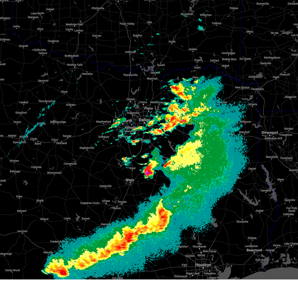 At 606 pm cdt, a severe thunderstorm was located near emory, or 12 miles northeast of wills point, moving east at 20 mph (radar indicated). Hazards include 60 mph wind gusts and half dollar size hail. Hail damage to vehicles is expected. Expect wind damage to roofs, siding, and trees. At 606 pm cdt, a severe thunderstorm was located near emory, or 12 miles northeast of wills point, moving east at 20 mph (radar indicated). Hazards include 60 mph wind gusts and half dollar size hail. Hail damage to vehicles is expected. Expect wind damage to roofs, siding, and trees.
|
| 4/25/2023 11:48 PM CDT |
 At 1147 pm cdt, a severe thunderstorm was located over lake tawakoni state park, or 10 miles north of wills point, moving northeast at 35 mph (radar indicated). Hazards include quarter size hail. Damage to vehicles is possible. locations impacted include, west tawakoni, quinlan, emory, east tawakoni, point, hawk cove, lake tawakoni, lake tawakoni state park, lake fork reservoir, lone oak, alsa, flats and hermits cove. hail threat, radar indicated max hail size, 1. 00 in wind threat, radar indicated max wind gust, <50 mph. At 1147 pm cdt, a severe thunderstorm was located over lake tawakoni state park, or 10 miles north of wills point, moving northeast at 35 mph (radar indicated). Hazards include quarter size hail. Damage to vehicles is possible. locations impacted include, west tawakoni, quinlan, emory, east tawakoni, point, hawk cove, lake tawakoni, lake tawakoni state park, lake fork reservoir, lone oak, alsa, flats and hermits cove. hail threat, radar indicated max hail size, 1. 00 in wind threat, radar indicated max wind gust, <50 mph.
|
| 4/25/2023 11:36 PM CDT |
 At 1135 pm cdt, a severe thunderstorm was located near lake tawakoni state park, or 7 miles northwest of wills point, moving northeast at 35 mph (radar indicated). Hazards include quarter size hail. damage to vehicles is possible At 1135 pm cdt, a severe thunderstorm was located near lake tawakoni state park, or 7 miles northwest of wills point, moving northeast at 35 mph (radar indicated). Hazards include quarter size hail. damage to vehicles is possible
|
| 4/20/2023 4:00 PM CDT |
 At 400 pm cdt, a severe thunderstorm was located near quinlan, or 12 miles southwest of greenville, moving east at 25 mph (radar indicated). Hazards include 60 mph wind gusts and quarter size hail. Hail damage to vehicles is expected. Expect wind damage to roofs, siding, and trees. At 400 pm cdt, a severe thunderstorm was located near quinlan, or 12 miles southwest of greenville, moving east at 25 mph (radar indicated). Hazards include 60 mph wind gusts and quarter size hail. Hail damage to vehicles is expected. Expect wind damage to roofs, siding, and trees.
|
| 3/16/2023 6:37 PM CDT |
 At 637 pm cdt, a severe thunderstorm was located near terrell, moving east at 40 mph (radar indicated). Hazards include golf ball size hail and 65 mph wind gusts. People and animals outdoors will be injured. expect hail damage to roofs, siding, windows, and vehicles. Expect wind damage to roofs, siding, and trees. At 637 pm cdt, a severe thunderstorm was located near terrell, moving east at 40 mph (radar indicated). Hazards include golf ball size hail and 65 mph wind gusts. People and animals outdoors will be injured. expect hail damage to roofs, siding, windows, and vehicles. Expect wind damage to roofs, siding, and trees.
|
| 3/2/2023 8:42 PM CST |
 The severe thunderstorm warning for southeastern kaufman, van zandt, hopkins and rains counties will expire at 845 pm cst, the storms which prompted the warning have moved out of the area. therefore the warning will be allowed to expire. however gusty winds are still possible. a tornado watch remains in effect until 1000 pm cst for north central texas. remember, a severe thunderstorm warning still remains in effect for southern van zandt county until 930 pm cst. The severe thunderstorm warning for southeastern kaufman, van zandt, hopkins and rains counties will expire at 845 pm cst, the storms which prompted the warning have moved out of the area. therefore the warning will be allowed to expire. however gusty winds are still possible. a tornado watch remains in effect until 1000 pm cst for north central texas. remember, a severe thunderstorm warning still remains in effect for southern van zandt county until 930 pm cst.
|
| 3/2/2023 8:29 PM CST |
 At 828 pm cst, severe thunderstorms were located along a line extending from sulfur bluf to como to canton, moving east at 50 mph (radar indicated). Hazards include 70 mph wind gusts. Expect considerable tree damage. damage is likely to mobile homes, roofs, and outbuildings. locations impacted include, sulphur springs, canton, wills point, grand saline, mabank, van, edgewood, emory, kemp, como, fruitvale, edom, purtis creek state park, lake sulphur springs, cooper lake state park, cooper lake, cedar creek reservoir, lake fork reservoir, redland and myrtle springs. thunderstorm damage threat, considerable hail threat, radar indicated max hail size, <. 75 in wind threat, radar indicated max wind gust, 70 mph. At 828 pm cst, severe thunderstorms were located along a line extending from sulfur bluf to como to canton, moving east at 50 mph (radar indicated). Hazards include 70 mph wind gusts. Expect considerable tree damage. damage is likely to mobile homes, roofs, and outbuildings. locations impacted include, sulphur springs, canton, wills point, grand saline, mabank, van, edgewood, emory, kemp, como, fruitvale, edom, purtis creek state park, lake sulphur springs, cooper lake state park, cooper lake, cedar creek reservoir, lake fork reservoir, redland and myrtle springs. thunderstorm damage threat, considerable hail threat, radar indicated max hail size, <. 75 in wind threat, radar indicated max wind gust, 70 mph.
|
| 3/2/2023 8:04 PM CST |
 At 804 pm cst, severe thunderstorms were located along a line extending from near cooper lake state park to emory to mabank, moving east at 50 mph (radar indicated). Hazards include 70 mph wind gusts. Expect considerable tree damage. damage is likely to mobile homes, roofs, and outbuildings. locations impacted include, sulphur springs, canton, wills point, grand saline, mabank, van, edgewood, emory, kemp, east tawakoni, point, cumby, como, fruitvale, edom, purtis creek state park, lake sulphur springs, cooper lake state park, lake tawakoni and cooper lake. thunderstorm damage threat, considerable hail threat, radar indicated max hail size, <. 75 in wind threat, observed max wind gust, 70 mph. At 804 pm cst, severe thunderstorms were located along a line extending from near cooper lake state park to emory to mabank, moving east at 50 mph (radar indicated). Hazards include 70 mph wind gusts. Expect considerable tree damage. damage is likely to mobile homes, roofs, and outbuildings. locations impacted include, sulphur springs, canton, wills point, grand saline, mabank, van, edgewood, emory, kemp, east tawakoni, point, cumby, como, fruitvale, edom, purtis creek state park, lake sulphur springs, cooper lake state park, lake tawakoni and cooper lake. thunderstorm damage threat, considerable hail threat, radar indicated max hail size, <. 75 in wind threat, observed max wind gust, 70 mph.
|
| 3/2/2023 7:36 PM CST |
 At 735 pm cst, severe thunderstorms were located along a line extending from commerce to lake tawakoni to kemp, moving east at 50 mph (radar indicated). Hazards include 70 mph wind gusts. Expect considerable tree damage. Damage is likely to mobile homes, roofs, and outbuildings. At 735 pm cst, severe thunderstorms were located along a line extending from commerce to lake tawakoni to kemp, moving east at 50 mph (radar indicated). Hazards include 70 mph wind gusts. Expect considerable tree damage. Damage is likely to mobile homes, roofs, and outbuildings.
|
| 12/13/2022 11:52 AM CST |
 At 1151 am cst, severe thunderstorms were located along a line extending from near bagwell to 8 miles northwest of lake fork reservoir, moving east at 40 mph (radar indicated). Hazards include 60 mph wind gusts and quarter size hail. Hail damage to vehicles is expected. expect wind damage to roofs, siding, and trees. locations impacted include, sulphur springs, emory, como, lake sulphur springs, lake fork reservoir, pine forest, martin springs, weaver, flora, nelta, cornersville and dike. hail threat, radar indicated max hail size, 1. 00 in wind threat, radar indicated max wind gust, 60 mph. At 1151 am cst, severe thunderstorms were located along a line extending from near bagwell to 8 miles northwest of lake fork reservoir, moving east at 40 mph (radar indicated). Hazards include 60 mph wind gusts and quarter size hail. Hail damage to vehicles is expected. expect wind damage to roofs, siding, and trees. locations impacted include, sulphur springs, emory, como, lake sulphur springs, lake fork reservoir, pine forest, martin springs, weaver, flora, nelta, cornersville and dike. hail threat, radar indicated max hail size, 1. 00 in wind threat, radar indicated max wind gust, 60 mph.
|
| 12/13/2022 11:24 AM CST |
 At 1124 am cst, severe thunderstorms were located along a line extending from near pattonville to near east tawakoni, moving east at 40 mph (radar indicated). Hazards include 60 mph wind gusts and quarter size hail. Hail damage to vehicles is expected. Expect wind damage to roofs, siding, and trees. At 1124 am cst, severe thunderstorms were located along a line extending from near pattonville to near east tawakoni, moving east at 40 mph (radar indicated). Hazards include 60 mph wind gusts and quarter size hail. Hail damage to vehicles is expected. Expect wind damage to roofs, siding, and trees.
|
| 12/13/2022 10:29 AM CST |
 At 1028 am cst, severe thunderstorms were located along a line extending from near honey grove to greenville club lake, moving east at 55 mph (radar indicated). Hazards include 60 mph wind gusts and half dollar size hail. Hail damage to vehicles is expected. Expect wind damage to roofs, siding, and trees. At 1028 am cst, severe thunderstorms were located along a line extending from near honey grove to greenville club lake, moving east at 55 mph (radar indicated). Hazards include 60 mph wind gusts and half dollar size hail. Hail damage to vehicles is expected. Expect wind damage to roofs, siding, and trees.
|
| 11/4/2022 5:07 PM CDT |
 At 506 pm cdt, a confirmed tornado was located over point, or 17 miles southeast of greenville, moving northeast at 55 mph (weather spotters confirmed tornado. trained spotters have reported a tornado in northern rains county). Hazards include damaging tornado and golf ball size hail. Flying debris will be dangerous to those caught without shelter. mobile homes will be damaged or destroyed. damage to roofs, windows, and vehicles will occur. Tree damage is likely. At 506 pm cdt, a confirmed tornado was located over point, or 17 miles southeast of greenville, moving northeast at 55 mph (weather spotters confirmed tornado. trained spotters have reported a tornado in northern rains county). Hazards include damaging tornado and golf ball size hail. Flying debris will be dangerous to those caught without shelter. mobile homes will be damaged or destroyed. damage to roofs, windows, and vehicles will occur. Tree damage is likely.
|
| 11/4/2022 5:07 PM CDT |
 At 505 pm cdt, a confirmed tornado was located over point, or 17 miles northeast of wills point, moving east at 35 mph (weather spotters confirmed tornado near point a few minutes ago). Hazards include damaging tornado and golf ball size hail. Flying debris will be dangerous to those caught without shelter. mobile homes will be damaged or destroyed. damage to roofs, windows, and vehicles will occur. tree damage is likely. Locations impacted include, east tawakoni, point, cumby, lake tawakoni, lone oak and hermits cove. At 505 pm cdt, a confirmed tornado was located over point, or 17 miles northeast of wills point, moving east at 35 mph (weather spotters confirmed tornado near point a few minutes ago). Hazards include damaging tornado and golf ball size hail. Flying debris will be dangerous to those caught without shelter. mobile homes will be damaged or destroyed. damage to roofs, windows, and vehicles will occur. tree damage is likely. Locations impacted include, east tawakoni, point, cumby, lake tawakoni, lone oak and hermits cove.
|
| 11/4/2022 4:56 PM CDT |
 At 452 pm cdt, a severe thunderstorm was located over west tawakoni, or 14 miles southeast of greenville, moving northeast at 40 mph. a tornado warning is in effect for southeastern hunt, northwestern van zandt, southwestern hopkins, and northwestern rains counties until 5:15 pm (radar indicated). Hazards include golf ball size hail and 60 mph wind gusts. People and animals outdoors will be injured. expect hail damage to roofs, siding, windows, and vehicles. expect wind damage to roofs, siding, and trees. locations impacted include, greenville, west tawakoni, quinlan, east tawakoni, point, cumby, campbell, hawk cove, greenville club lake, lake tawakoni, lake tawakoni state park, lone oak, alsa, cash, flats, hermits cove, dixon and center point. thunderstorm damage threat, considerable hail threat, radar indicated max hail size, 1. 75 in wind threat, radar indicated max wind gust, 60 mph. At 452 pm cdt, a severe thunderstorm was located over west tawakoni, or 14 miles southeast of greenville, moving northeast at 40 mph. a tornado warning is in effect for southeastern hunt, northwestern van zandt, southwestern hopkins, and northwestern rains counties until 5:15 pm (radar indicated). Hazards include golf ball size hail and 60 mph wind gusts. People and animals outdoors will be injured. expect hail damage to roofs, siding, windows, and vehicles. expect wind damage to roofs, siding, and trees. locations impacted include, greenville, west tawakoni, quinlan, east tawakoni, point, cumby, campbell, hawk cove, greenville club lake, lake tawakoni, lake tawakoni state park, lone oak, alsa, cash, flats, hermits cove, dixon and center point. thunderstorm damage threat, considerable hail threat, radar indicated max hail size, 1. 75 in wind threat, radar indicated max wind gust, 60 mph.
|
| 11/4/2022 4:50 PM CDT |
 At 449 pm cdt, a severe thunderstorm capable of producing a tornado was located over lake tawakoni, or 12 miles north of wills point, moving northeast at 45 mph (radar indicated rotation). Hazards include tornado and golf ball size hail. Flying debris will be dangerous to those caught without shelter. mobile homes will be damaged or destroyed. damage to roofs, windows, and vehicles will occur. tree damage is likely. Locations impacted include, west tawakoni, quinlan, emory, east tawakoni, point, cumby, hawk cove, lake tawakoni, lake tawakoni state park, greenville club lake, lone oak, alsa, flats and hermits cove. At 449 pm cdt, a severe thunderstorm capable of producing a tornado was located over lake tawakoni, or 12 miles north of wills point, moving northeast at 45 mph (radar indicated rotation). Hazards include tornado and golf ball size hail. Flying debris will be dangerous to those caught without shelter. mobile homes will be damaged or destroyed. damage to roofs, windows, and vehicles will occur. tree damage is likely. Locations impacted include, west tawakoni, quinlan, emory, east tawakoni, point, cumby, hawk cove, lake tawakoni, lake tawakoni state park, greenville club lake, lone oak, alsa, flats and hermits cove.
|
| 11/4/2022 4:44 PM CDT |
 At 444 pm cdt, a severe thunderstorm capable of producing a tornado was located near lake tawakoni state park, or 9 miles north of wills point, moving northeast at 60 mph (radar indicated rotation). Hazards include tornado and quarter size hail. Flying debris will be dangerous to those caught without shelter. mobile homes will be damaged or destroyed. damage to roofs, windows, and vehicles will occur. Tree damage is likely. At 444 pm cdt, a severe thunderstorm capable of producing a tornado was located near lake tawakoni state park, or 9 miles north of wills point, moving northeast at 60 mph (radar indicated rotation). Hazards include tornado and quarter size hail. Flying debris will be dangerous to those caught without shelter. mobile homes will be damaged or destroyed. damage to roofs, windows, and vehicles will occur. Tree damage is likely.
|
| 11/4/2022 4:42 PM CDT |
 At 441 pm cdt, a severe thunderstorm was located near hawk cove, or 8 miles northwest of wills point, moving northeast at 45 mph (radar indicated). Hazards include 60 mph wind gusts and quarter size hail. Hail damage to vehicles is expected. expect wind damage to roofs, siding, and trees. locations impacted include, greenville, terrell, west tawakoni, quinlan, east tawakoni, point, cumby, campbell, hawk cove, greenville club lake, lake tawakoni, lake tawakoni state park, new terrell city lake, elmo, lone oak, alsa, cash, flats, center point and hermits cove. hail threat, radar indicated max hail size, 1. 00 in wind threat, radar indicated max wind gust, 60 mph. At 441 pm cdt, a severe thunderstorm was located near hawk cove, or 8 miles northwest of wills point, moving northeast at 45 mph (radar indicated). Hazards include 60 mph wind gusts and quarter size hail. Hail damage to vehicles is expected. expect wind damage to roofs, siding, and trees. locations impacted include, greenville, terrell, west tawakoni, quinlan, east tawakoni, point, cumby, campbell, hawk cove, greenville club lake, lake tawakoni, lake tawakoni state park, new terrell city lake, elmo, lone oak, alsa, cash, flats, center point and hermits cove. hail threat, radar indicated max hail size, 1. 00 in wind threat, radar indicated max wind gust, 60 mph.
|
| 11/4/2022 4:28 PM CDT |
 At 427 pm cdt, a severe thunderstorm was located near terrell, moving northeast at 60 mph (radar indicated). Hazards include 60 mph wind gusts and quarter size hail. Hail damage to vehicles is expected. Expect wind damage to roofs, siding, and trees. At 427 pm cdt, a severe thunderstorm was located near terrell, moving northeast at 60 mph (radar indicated). Hazards include 60 mph wind gusts and quarter size hail. Hail damage to vehicles is expected. Expect wind damage to roofs, siding, and trees.
|
| 5/15/2022 11:04 PM CDT |
 At 1104 pm cdt, severe thunderstorms were located along a line extending from near grand saline to 10 miles northeast of kemp, moving southeast at 65 mph (radar indicated). Hazards include 60 mph wind gusts and nickel size hail. Expect damage to roofs, siding, and trees. locations impacted include, dallas, garland, mesquite, rowlett, wylie, rockwall, balch springs, sachse, terrell, seagoville, forney, kaufman, hutchins, canton, wills point, royse city, heath, fate, sunnyvale and wilmer. hail threat, radar indicated max hail size, 0. 88 in wind threat, radar indicated max wind gust, 60 mph. At 1104 pm cdt, severe thunderstorms were located along a line extending from near grand saline to 10 miles northeast of kemp, moving southeast at 65 mph (radar indicated). Hazards include 60 mph wind gusts and nickel size hail. Expect damage to roofs, siding, and trees. locations impacted include, dallas, garland, mesquite, rowlett, wylie, rockwall, balch springs, sachse, terrell, seagoville, forney, kaufman, hutchins, canton, wills point, royse city, heath, fate, sunnyvale and wilmer. hail threat, radar indicated max hail size, 0. 88 in wind threat, radar indicated max wind gust, 60 mph.
|
| 5/15/2022 10:43 PM CDT |
 At 1043 pm cdt, severe thunderstorms were located along a line extending from near east tawakoni to 8 miles southeast of fate, moving southeast at 65 mph (radar indicated). Hazards include 65 mph wind gusts and nickel size hail. Expect damage to roofs, siding, and trees. locations impacted include, dallas, garland, mesquite, rowlett, wylie, rockwall, greenville, balch springs, sachse, terrell, seagoville, forney, commerce, kaufman, hutchins, canton, wills point, royse city, heath and princeton. hail threat, radar indicated max hail size, 0. 88 in wind threat, radar indicated max wind gust, 65 mph. At 1043 pm cdt, severe thunderstorms were located along a line extending from near east tawakoni to 8 miles southeast of fate, moving southeast at 65 mph (radar indicated). Hazards include 65 mph wind gusts and nickel size hail. Expect damage to roofs, siding, and trees. locations impacted include, dallas, garland, mesquite, rowlett, wylie, rockwall, greenville, balch springs, sachse, terrell, seagoville, forney, commerce, kaufman, hutchins, canton, wills point, royse city, heath and princeton. hail threat, radar indicated max hail size, 0. 88 in wind threat, radar indicated max wind gust, 65 mph.
|
| 5/15/2022 10:30 PM CDT |
 At 1029 pm cdt, severe thunderstorms were located along a line extending from 6 miles south of campbell to near royse city, moving southeast at 65 mph (radar indicated). Hazards include 60 mph wind gusts and nickel size hail. expect damage to roofs, siding, and trees At 1029 pm cdt, severe thunderstorms were located along a line extending from 6 miles south of campbell to near royse city, moving southeast at 65 mph (radar indicated). Hazards include 60 mph wind gusts and nickel size hail. expect damage to roofs, siding, and trees
|
| 5/3/2022 4:05 AM CDT |
 At 404 am cdt, a severe thunderstorm was located 10 miles east of emory, or 15 miles northwest of mineola, moving east at 45 mph (radar indicated). Hazards include 60 mph wind gusts. Expect damage to roofs, siding, and trees. locations impacted include, grand saline and emory. hail threat, radar indicated max hail size, <. 75 in wind threat, radar indicated max wind gust, 60 mph. At 404 am cdt, a severe thunderstorm was located 10 miles east of emory, or 15 miles northwest of mineola, moving east at 45 mph (radar indicated). Hazards include 60 mph wind gusts. Expect damage to roofs, siding, and trees. locations impacted include, grand saline and emory. hail threat, radar indicated max hail size, <. 75 in wind threat, radar indicated max wind gust, 60 mph.
|
| 5/3/2022 3:52 AM CDT |
 At 351 am cdt, a severe thunderstorm was located near emory, or 15 miles northeast of wills point, moving east at 50 mph (radar indicated). Hazards include 60 mph wind gusts. Expect damage to roofs, siding, and trees. locations impacted include, grand saline, edgewood, emory, east tawakoni, fruitvale and point. hail threat, radar indicated max hail size, <. 75 in wind threat, radar indicated max wind gust, 60 mph. At 351 am cdt, a severe thunderstorm was located near emory, or 15 miles northeast of wills point, moving east at 50 mph (radar indicated). Hazards include 60 mph wind gusts. Expect damage to roofs, siding, and trees. locations impacted include, grand saline, edgewood, emory, east tawakoni, fruitvale and point. hail threat, radar indicated max hail size, <. 75 in wind threat, radar indicated max wind gust, 60 mph.
|
| 5/3/2022 3:37 AM CDT |
 At 337 am cdt, a severe thunderstorm was located over lake tawakoni state park, or 5 miles northeast of wills point, moving east at 50 mph (radar indicated). Hazards include 60 mph wind gusts. expect damage to roofs, siding, and trees At 337 am cdt, a severe thunderstorm was located over lake tawakoni state park, or 5 miles northeast of wills point, moving east at 50 mph (radar indicated). Hazards include 60 mph wind gusts. expect damage to roofs, siding, and trees
|
| 4/12/2022 8:06 PM CDT |
 The severe thunderstorm warning for central van zandt, southern hopkins and rains counties will expire at 815 pm cdt, the storms which prompted the warning have moved out of the area. therefore the warning will be allowed to expire. a tornado watch remains in effect until 1100 pm cdt for north central texas. The severe thunderstorm warning for central van zandt, southern hopkins and rains counties will expire at 815 pm cdt, the storms which prompted the warning have moved out of the area. therefore the warning will be allowed to expire. a tornado watch remains in effect until 1100 pm cdt for north central texas.
|
| 4/12/2022 7:41 PM CDT |
 At 741 pm cdt, severe thunderstorms were located along a line extending from cumby to grand saline to martins mill, moving east at 40 mph (radar indicated). Hazards include 60 mph wind gusts. Expect damage to roofs, siding, and trees. locations impacted include, sulphur springs, canton, grand saline, van, emory, como, fruitvale and edom. hail threat, radar indicated max hail size, <. 75 in wind threat, radar indicated max wind gust, 60 mph. At 741 pm cdt, severe thunderstorms were located along a line extending from cumby to grand saline to martins mill, moving east at 40 mph (radar indicated). Hazards include 60 mph wind gusts. Expect damage to roofs, siding, and trees. locations impacted include, sulphur springs, canton, grand saline, van, emory, como, fruitvale and edom. hail threat, radar indicated max hail size, <. 75 in wind threat, radar indicated max wind gust, 60 mph.
|
| 4/12/2022 7:11 PM CDT |
 At 710 pm cdt, severe thunderstorms were located along a line extending from near hawk cove to near purtis creek state park, moving east at 55 mph (radar indicated). Hazards include 60 mph wind gusts. expect damage to roofs, siding, and trees At 710 pm cdt, severe thunderstorms were located along a line extending from near hawk cove to near purtis creek state park, moving east at 55 mph (radar indicated). Hazards include 60 mph wind gusts. expect damage to roofs, siding, and trees
|
| 3/21/2022 9:22 PM CDT |
 At 921 pm cdt, a severe thunderstorm was located over fruitvale, or 9 miles northeast of canton, moving northeast at 50 mph (radar indicated). Hazards include 60 mph wind gusts and penny size hail. Expect damage to roofs, siding, and trees. locations impacted include, canton, grand saline, van, edgewood, emory, fruitvale, edom and point. hail threat, radar indicated max hail size, 0. 75 in wind threat, radar indicated max wind gust, 60 mph. At 921 pm cdt, a severe thunderstorm was located over fruitvale, or 9 miles northeast of canton, moving northeast at 50 mph (radar indicated). Hazards include 60 mph wind gusts and penny size hail. Expect damage to roofs, siding, and trees. locations impacted include, canton, grand saline, van, edgewood, emory, fruitvale, edom and point. hail threat, radar indicated max hail size, 0. 75 in wind threat, radar indicated max wind gust, 60 mph.
|
| 3/21/2022 9:05 PM CDT |
 At 905 pm cdt, a severe thunderstorm was located 7 miles west of canton, moving northeast at 50 mph (radar indicated). Hazards include 60 mph wind gusts and penny size hail. expect damage to roofs, siding, and trees At 905 pm cdt, a severe thunderstorm was located 7 miles west of canton, moving northeast at 50 mph (radar indicated). Hazards include 60 mph wind gusts and penny size hail. expect damage to roofs, siding, and trees
|
| 10/11/2021 12:10 AM CDT |
 The severe thunderstorm warning for southeastern hunt, northwestern van zandt, hopkins, rains, southeastern lamar and delta counties will expire at 1215 am cdt, the storms which prompted the warning have moved out of the area. therefore the warning will be allowed to expire. a tornado watch remains in effect until 200 am cdt for north central texas. The severe thunderstorm warning for southeastern hunt, northwestern van zandt, hopkins, rains, southeastern lamar and delta counties will expire at 1215 am cdt, the storms which prompted the warning have moved out of the area. therefore the warning will be allowed to expire. a tornado watch remains in effect until 200 am cdt for north central texas.
|
| 10/10/2021 11:28 PM CDT |
 At 1126 pm cdt, severe thunderstorms were located along a line extending from near paris to near wills point, moving east at 40 mph (radar indicated). Hazards include 60 mph wind gusts. expect damage to roofs, siding, and trees At 1126 pm cdt, severe thunderstorms were located along a line extending from near paris to near wills point, moving east at 40 mph (radar indicated). Hazards include 60 mph wind gusts. expect damage to roofs, siding, and trees
|
| 10/10/2021 10:34 PM CDT |
 At 1034 pm cdt, severe thunderstorms were located along a line extending from 11 miles southeast of albany to near greenville to near combine, moving east at 60 mph (radar indicated). Hazards include 60 mph wind gusts and penny size hail. expect damage to roofs, siding, and trees At 1034 pm cdt, severe thunderstorms were located along a line extending from 11 miles southeast of albany to near greenville to near combine, moving east at 60 mph (radar indicated). Hazards include 60 mph wind gusts and penny size hail. expect damage to roofs, siding, and trees
|
| 7/12/2021 2:13 PM CDT |
 At 210 pm cdt, a severe thunderstorm was located near edgewood, or 8 miles northeast of wills point, moving east at 20 mph (radar indicated). Hazards include 60 mph wind gusts and nickel size hail. Expect damage to roofs, siding, and trees. Locations impacted include, flats, wills point, edgewood, emory, east tawakoni and lake tawakoni state park. At 210 pm cdt, a severe thunderstorm was located near edgewood, or 8 miles northeast of wills point, moving east at 20 mph (radar indicated). Hazards include 60 mph wind gusts and nickel size hail. Expect damage to roofs, siding, and trees. Locations impacted include, flats, wills point, edgewood, emory, east tawakoni and lake tawakoni state park.
|
| 7/12/2021 1:50 PM CDT |
 At 149 pm cdt, a severe thunderstorm was located over lake tawakoni state park, or near wills point, moving northeast at 20 mph (radar indicated). Hazards include 70 mph wind gusts and nickel size hail. Expect considerable tree damage. Damage is likely to mobile homes, roofs, and outbuildings. At 149 pm cdt, a severe thunderstorm was located over lake tawakoni state park, or near wills point, moving northeast at 20 mph (radar indicated). Hazards include 70 mph wind gusts and nickel size hail. Expect considerable tree damage. Damage is likely to mobile homes, roofs, and outbuildings.
|
| 5/3/2021 11:28 PM CDT |
 The severe thunderstorm warning for hopkins, rains, southeastern lamar and delta counties will expire at 1130 pm cdt, the storms which prompted the warning have moved out of the area. therefore the warning will be allowed to expire. however gusty winds and heavy rain are still possible with these thunderstorms. a severe thunderstorm watch remains in effect until 300 am cdt for north central texas. The severe thunderstorm warning for hopkins, rains, southeastern lamar and delta counties will expire at 1130 pm cdt, the storms which prompted the warning have moved out of the area. therefore the warning will be allowed to expire. however gusty winds and heavy rain are still possible with these thunderstorms. a severe thunderstorm watch remains in effect until 300 am cdt for north central texas.
|
| 5/3/2021 11:09 PM CDT |
 At 1108 pm cdt, severe thunderstorms were extending along a line from tira to sulphur springs to yantis, moving east at 35 mph. at 1104pm cdt, 87 mph wind gusts were observed at sulphur springs airport. these are very dangerous storms (radar indicated). Hazards include 80 mph wind gusts and quarter size hail. Flying debris will be dangerous to those caught without shelter. mobile homes will be heavily damaged. expect considerable damage to roofs, windows, and vehicles. extensive tree damage and power outages are likely. Locations impacted include, sulphur springs, cooper, emory, cumby, como, deport, cooper lake park south sulphur, cooper lake park doctors creek and tira. At 1108 pm cdt, severe thunderstorms were extending along a line from tira to sulphur springs to yantis, moving east at 35 mph. at 1104pm cdt, 87 mph wind gusts were observed at sulphur springs airport. these are very dangerous storms (radar indicated). Hazards include 80 mph wind gusts and quarter size hail. Flying debris will be dangerous to those caught without shelter. mobile homes will be heavily damaged. expect considerable damage to roofs, windows, and vehicles. extensive tree damage and power outages are likely. Locations impacted include, sulphur springs, cooper, emory, cumby, como, deport, cooper lake park south sulphur, cooper lake park doctors creek and tira.
|
| 5/3/2021 11:05 PM CDT |
 At 1104 pm cdt, a severe thunderstorm was located over sulphur springs, moving northeast at 40 mph (radar indicated). Hazards include 60 mph wind gusts and quarter size hail. Hail damage to vehicles is expected. expect wind damage to roofs, siding, and trees. Locations impacted include, sulphur springs, cooper, emory, cumby, como, deport, cooper lake park south sulphur, cooper lake park doctors creek and tira. At 1104 pm cdt, a severe thunderstorm was located over sulphur springs, moving northeast at 40 mph (radar indicated). Hazards include 60 mph wind gusts and quarter size hail. Hail damage to vehicles is expected. expect wind damage to roofs, siding, and trees. Locations impacted include, sulphur springs, cooper, emory, cumby, como, deport, cooper lake park south sulphur, cooper lake park doctors creek and tira.
|
| 5/3/2021 10:36 PM CDT |
 At 1036 pm cdt, a severe thunderstorm was located near cumby, or 8 miles south of commerce, moving northeast at 40 mph (radar indicated). Hazards include 60 mph wind gusts and quarter size hail. Hail damage to vehicles is expected. Expect wind damage to roofs, siding, and trees. At 1036 pm cdt, a severe thunderstorm was located near cumby, or 8 miles south of commerce, moving northeast at 40 mph (radar indicated). Hazards include 60 mph wind gusts and quarter size hail. Hail damage to vehicles is expected. Expect wind damage to roofs, siding, and trees.
|
| 4/9/2021 11:24 PM CDT |
 At 1123 pm cdt, a severe thunderstorm was located over wills point, moving east at 40 mph (radar indicated). Hazards include 60 mph wind gusts and half dollar size hail. Hail damage to vehicles is expected. Expect wind damage to roofs, siding, and trees. At 1123 pm cdt, a severe thunderstorm was located over wills point, moving east at 40 mph (radar indicated). Hazards include 60 mph wind gusts and half dollar size hail. Hail damage to vehicles is expected. Expect wind damage to roofs, siding, and trees.
|
| 3/24/2021 6:50 PM CDT |
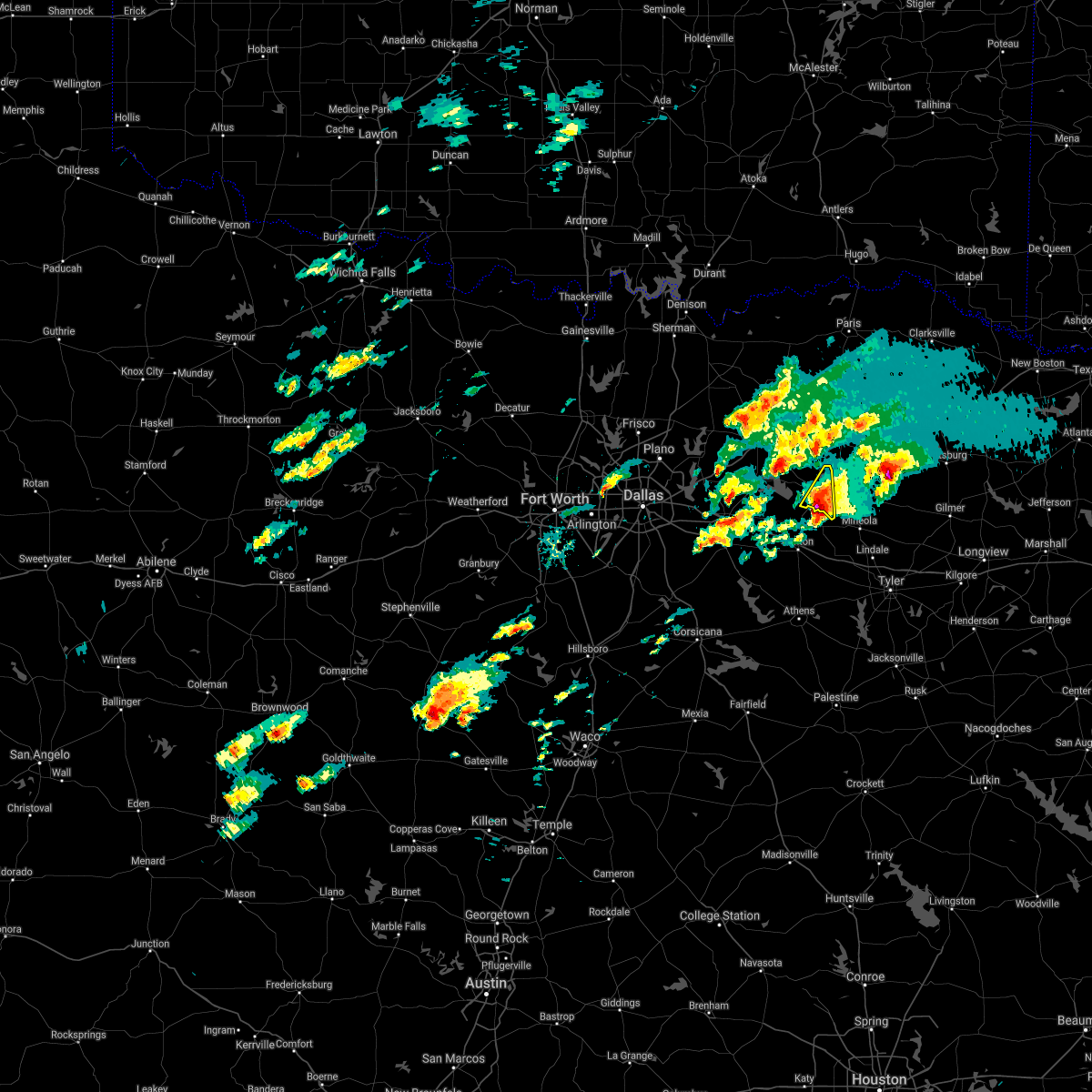 At 649 pm cdt, a severe thunderstorm was located near fruitvale, or 15 miles east of wills point, moving northeast at 20 mph (radar indicated). Hazards include golf ball size hail and 60 mph wind gusts. People and animals outdoors will be injured. expect hail damage to roofs, siding, windows, and vehicles. Expect wind damage to roofs, siding, and trees. At 649 pm cdt, a severe thunderstorm was located near fruitvale, or 15 miles east of wills point, moving northeast at 20 mph (radar indicated). Hazards include golf ball size hail and 60 mph wind gusts. People and animals outdoors will be injured. expect hail damage to roofs, siding, windows, and vehicles. Expect wind damage to roofs, siding, and trees.
|
| 3/17/2021 6:50 AM CDT |
 The severe thunderstorm warning for van zandt, hopkins, rains and east central delta counties will expire at 700 am cdt, the storms which prompted the warning are moving out of the area. therefore the warning will be allowed to expire. a severe thunderstorm watch remains in effect until 1000 am cdt for north central texas. The severe thunderstorm warning for van zandt, hopkins, rains and east central delta counties will expire at 700 am cdt, the storms which prompted the warning are moving out of the area. therefore the warning will be allowed to expire. a severe thunderstorm watch remains in effect until 1000 am cdt for north central texas.
|
| 3/17/2021 6:33 AM CDT |
 At 632 am cdt, severe thunderstorms were located along a line extending from near sulphur springs to near van, moving east at 50 mph (radar indicated). Hazards include 60 mph wind gusts and penny size hail. Expect damage to roofs, siding, and trees. Locations impacted include, sulphur springs, canton, grand saline, van, edgewood, emory, como, fruitvale and edom. At 632 am cdt, severe thunderstorms were located along a line extending from near sulphur springs to near van, moving east at 50 mph (radar indicated). Hazards include 60 mph wind gusts and penny size hail. Expect damage to roofs, siding, and trees. Locations impacted include, sulphur springs, canton, grand saline, van, edgewood, emory, como, fruitvale and edom.
|
| 3/17/2021 6:06 AM CDT |
 At 605 am cdt, severe thunderstorms were located along a line extending from greenville to canton, moving northeast at 55 mph (radar indicated). Hazards include 60 mph wind gusts and penny size hail. expect damage to roofs, siding, and trees At 605 am cdt, severe thunderstorms were located along a line extending from greenville to canton, moving northeast at 55 mph (radar indicated). Hazards include 60 mph wind gusts and penny size hail. expect damage to roofs, siding, and trees
|
| 4/28/2020 11:57 PM CDT |
 A severe thunderstorm warning remains in effect until 1215 am cdt for southern hunt. hopkins and rains counties. at 1157 pm cdt, severe thunderstorms were located along a line extending from near purley to sulphur springs to 8 miles south of campbell to near quinlan, moving south at 35 mph. hazard. 60 mph wind gusts and quarter size hail. A severe thunderstorm warning remains in effect until 1215 am cdt for southern hunt. hopkins and rains counties. at 1157 pm cdt, severe thunderstorms were located along a line extending from near purley to sulphur springs to 8 miles south of campbell to near quinlan, moving south at 35 mph. hazard. 60 mph wind gusts and quarter size hail.
|
| 4/28/2020 11:37 PM CDT |
 At 1136 pm cdt, severe thunderstorms were located along a line extending from 6 miles southeast of hagansport to 6 miles southwest of cooper lake park south sulphur to near caddo mills, moving southeast at 30 mph (radar indicated). Hazards include 60 mph wind gusts and quarter size hail. Hail damage to vehicles is expected. expect wind damage to roofs, siding, and trees. Locations impacted include, mckinney, greenville, sulphur springs, commerce, royse city, princeton, farmersville, cooper, lowry crossing, west tawakoni, wolfe city, quinlan, caddo mills, emory, east tawakoni, celeste, cumby, como, campbell and hawk cove. At 1136 pm cdt, severe thunderstorms were located along a line extending from 6 miles southeast of hagansport to 6 miles southwest of cooper lake park south sulphur to near caddo mills, moving southeast at 30 mph (radar indicated). Hazards include 60 mph wind gusts and quarter size hail. Hail damage to vehicles is expected. expect wind damage to roofs, siding, and trees. Locations impacted include, mckinney, greenville, sulphur springs, commerce, royse city, princeton, farmersville, cooper, lowry crossing, west tawakoni, wolfe city, quinlan, caddo mills, emory, east tawakoni, celeste, cumby, como, campbell and hawk cove.
|
| 4/28/2020 11:05 PM CDT |
 At 1105 pm cdt, severe thunderstorms were located along a line extending from near deport to 9 miles south of honey grove to mckinney, moving southeast at 30 mph (radar indicated). Hazards include 60 mph wind gusts and quarter size hail. Hail damage to vehicles is expected. Expect wind damage to roofs, siding, and trees. At 1105 pm cdt, severe thunderstorms were located along a line extending from near deport to 9 miles south of honey grove to mckinney, moving southeast at 30 mph (radar indicated). Hazards include 60 mph wind gusts and quarter size hail. Hail damage to vehicles is expected. Expect wind damage to roofs, siding, and trees.
|
| 4/19/2020 12:10 PM CDT |
 At 1209 pm cdt, a severe thunderstorm was located over lake tawakoni state park, or 10 miles north of wills point, moving east at 50 mph (radar indicated). Hazards include quarter size hail. Damage to vehicles is possible. Locations impacted include, terrell, wills point, west tawakoni, edgewood, quinlan, emory, east tawakoni, hawk cove, fruitvale, lake tawakoni state park, point and oak ridge. At 1209 pm cdt, a severe thunderstorm was located over lake tawakoni state park, or 10 miles north of wills point, moving east at 50 mph (radar indicated). Hazards include quarter size hail. Damage to vehicles is possible. Locations impacted include, terrell, wills point, west tawakoni, edgewood, quinlan, emory, east tawakoni, hawk cove, fruitvale, lake tawakoni state park, point and oak ridge.
|
| 4/19/2020 11:51 AM CDT |
 At 1149 am cdt, a severe thunderstorm was located near hawk cove, or 10 miles northeast of terrell, moving northeast at 50 mph (radar indicated). Hazards include quarter size hail. Damage to vehicles is possible. Locations impacted include, greenville, terrell, wills point, crandall, west tawakoni, talty, edgewood, quinlan, emory, east tawakoni, campbell, hawk cove, fruitvale, lake tawakoni state park, point, lone oak, oak ridge and lawrence. At 1149 am cdt, a severe thunderstorm was located near hawk cove, or 10 miles northeast of terrell, moving northeast at 50 mph (radar indicated). Hazards include quarter size hail. Damage to vehicles is possible. Locations impacted include, greenville, terrell, wills point, crandall, west tawakoni, talty, edgewood, quinlan, emory, east tawakoni, campbell, hawk cove, fruitvale, lake tawakoni state park, point, lone oak, oak ridge and lawrence.
|
| 4/19/2020 11:40 AM CDT |
 At 1139 am cdt, a severe thunderstorm was located near terrell, moving northeast at 55 mph (radar indicated). Hazards include quarter size hail. damage to vehicles is possible At 1139 am cdt, a severe thunderstorm was located near terrell, moving northeast at 55 mph (radar indicated). Hazards include quarter size hail. damage to vehicles is possible
|
| 4/12/2020 6:14 PM CDT | Numerous trees down and several county roads blocked around emor in rains county TX, 0.4 miles SW of Emory, TX |
| 4/12/2020 6:11 PM CDT |
 At 611 pm cdt, a cluster of severe thunderstorms were located near grand saline, or 7 miles northeast of canton, moving east at 50 mph (trained weather spotters). Hazards include 60 mph wind gusts. expect damage to roofs, siding, and trees At 611 pm cdt, a cluster of severe thunderstorms were located near grand saline, or 7 miles northeast of canton, moving east at 50 mph (trained weather spotters). Hazards include 60 mph wind gusts. expect damage to roofs, siding, and trees
|
| 11/30/2019 10:05 AM CST |
 The severe thunderstorm warning for north central van zandt and eastern rains counties will expire at 1015 am cst, the storm which prompted the warning has weakened below severe limits, and has exited the warned area. therefore, the warning will be allowed to expire. The severe thunderstorm warning for north central van zandt and eastern rains counties will expire at 1015 am cst, the storm which prompted the warning has weakened below severe limits, and has exited the warned area. therefore, the warning will be allowed to expire.
|
| 11/30/2019 9:51 AM CST |
 At 950 am cst, a severe thunderstorm was located near emory, or 17 miles south of sulphur springs, moving east at 50 mph (radar indicated). Hazards include 60 mph wind gusts and quarter size hail. Hail damage to vehicles is expected. expect wind damage to roofs, siding, and trees. Locations impacted include, grand saline, emory and fruitvale. At 950 am cst, a severe thunderstorm was located near emory, or 17 miles south of sulphur springs, moving east at 50 mph (radar indicated). Hazards include 60 mph wind gusts and quarter size hail. Hail damage to vehicles is expected. expect wind damage to roofs, siding, and trees. Locations impacted include, grand saline, emory and fruitvale.
|
| 11/30/2019 9:32 AM CST |
 At 932 am cst, a severe thunderstorm was located over lake tawakoni state park, or 9 miles northeast of wills point, moving east at 55 mph (radar indicated). Hazards include 60 mph wind gusts and quarter size hail. Hail damage to vehicles is expected. Expect wind damage to roofs, siding, and trees. At 932 am cst, a severe thunderstorm was located over lake tawakoni state park, or 9 miles northeast of wills point, moving east at 55 mph (radar indicated). Hazards include 60 mph wind gusts and quarter size hail. Hail damage to vehicles is expected. Expect wind damage to roofs, siding, and trees.
|
| 10/20/2019 11:34 PM CDT | Quarter sized hail reported 4 miles NNE of Emory, TX, quarter size hail reported at rcr 1280 and hwy 19 s of emory |
| 10/20/2019 11:32 PM CDT |
 At 1132 pm cdt, a severe thunderstorm capable of producing a tornado was located near emory, moving east at 30 mph (radar indicated rotation). Hazards include tornado and quarter size hail. Flying debris will be dangerous to those caught without shelter. mobile homes will be damaged or destroyed. damage to roofs, windows, and vehicles will occur. tree damage is likely. Locations impacted include, emory. At 1132 pm cdt, a severe thunderstorm capable of producing a tornado was located near emory, moving east at 30 mph (radar indicated rotation). Hazards include tornado and quarter size hail. Flying debris will be dangerous to those caught without shelter. mobile homes will be damaged or destroyed. damage to roofs, windows, and vehicles will occur. tree damage is likely. Locations impacted include, emory.
|
| 10/20/2019 11:28 PM CDT | Half Dollar sized hail reported 6.1 miles NNE of Emory, TX, half dollar size hail at rcr 1495. |
| 10/20/2019 11:21 PM CDT |
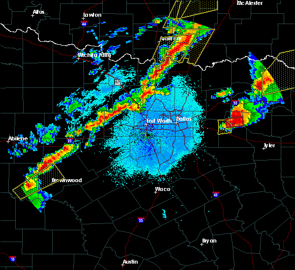 At 1121 pm cdt, a severe thunderstorm capable of producing a tornado was located near emory, or 16 miles northeast of wills point, moving east at 35 mph (radar indicated rotation). Hazards include tornado and quarter size hail. Flying debris will be dangerous to those caught without shelter. mobile homes will be damaged or destroyed. damage to roofs, windows, and vehicles will occur. tree damage is likely. This tornadic thunderstorm will remain over mainly rural areas of central rains county. At 1121 pm cdt, a severe thunderstorm capable of producing a tornado was located near emory, or 16 miles northeast of wills point, moving east at 35 mph (radar indicated rotation). Hazards include tornado and quarter size hail. Flying debris will be dangerous to those caught without shelter. mobile homes will be damaged or destroyed. damage to roofs, windows, and vehicles will occur. tree damage is likely. This tornadic thunderstorm will remain over mainly rural areas of central rains county.
|
| 10/20/2019 11:12 PM CDT | Quarter sized hail reported 2.1 miles E of Emory, TX, quarter size hal reported at the intersection of fm 47 and fm 276. |
| 10/20/2019 11:11 PM CDT |
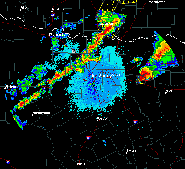 At 1110 pm cdt, a severe thunderstorm capable of producing a tornado was located 7 miles southwest of emory, or 10 miles northeast of wills point, moving east at 35 mph (radar indicated rotation). Hazards include tornado and quarter size hail. Flying debris will be dangerous to those caught without shelter. mobile homes will be damaged or destroyed. damage to roofs, windows, and vehicles will occur. tree damage is likely. This dangerous storm will be near, emory around 1120 pm cdt. At 1110 pm cdt, a severe thunderstorm capable of producing a tornado was located 7 miles southwest of emory, or 10 miles northeast of wills point, moving east at 35 mph (radar indicated rotation). Hazards include tornado and quarter size hail. Flying debris will be dangerous to those caught without shelter. mobile homes will be damaged or destroyed. damage to roofs, windows, and vehicles will occur. tree damage is likely. This dangerous storm will be near, emory around 1120 pm cdt.
|
| 10/20/2019 11:01 PM CDT |
 At 1101 pm cdt, a severe thunderstorm capable of producing a tornado was located near wills point, moving east at 35 mph (radar indicated rotation). Hazards include tornado and half dollar size hail. Flying debris will be dangerous to those caught without shelter. mobile homes will be damaged or destroyed. damage to roofs, windows, and vehicles will occur. tree damage is likely. this dangerous storm will be near, edgewood around 1110 pm cdt. fruitvale around 1115 pm cdt. Emory around 1120 pm cdt. At 1101 pm cdt, a severe thunderstorm capable of producing a tornado was located near wills point, moving east at 35 mph (radar indicated rotation). Hazards include tornado and half dollar size hail. Flying debris will be dangerous to those caught without shelter. mobile homes will be damaged or destroyed. damage to roofs, windows, and vehicles will occur. tree damage is likely. this dangerous storm will be near, edgewood around 1110 pm cdt. fruitvale around 1115 pm cdt. Emory around 1120 pm cdt.
|
| 6/20/2019 12:21 AM CDT |
 The severe thunderstorm warning for rains county will expire at 1230 am cdt, the storm which prompted the warning has weakened below severe limits. therefore the warning will be allowed to expire. The severe thunderstorm warning for rains county will expire at 1230 am cdt, the storm which prompted the warning has weakened below severe limits. therefore the warning will be allowed to expire.
|
| 6/19/2019 11:29 PM CDT |
 At 1128 pm cdt, a severe thunderstorm was located over east tawakoni, or 14 miles northeast of wills point, moving southeast at 30 mph (radar indicated). Hazards include 60 mph wind gusts and half dollar size hail. Hail damage to vehicles is expected. Expect wind damage to roofs, siding, and trees. At 1128 pm cdt, a severe thunderstorm was located over east tawakoni, or 14 miles northeast of wills point, moving southeast at 30 mph (radar indicated). Hazards include 60 mph wind gusts and half dollar size hail. Hail damage to vehicles is expected. Expect wind damage to roofs, siding, and trees.
|
| 6/19/2019 11:20 PM CDT |
 At 1120 pm cdt, a severe thunderstorm was located near east tawakoni, or 17 miles southeast of greenville, moving southeast at 25 mph (radar indicated). Hazards include 60 mph wind gusts and quarter size hail. Hail damage to vehicles is expected. expect wind damage to roofs, siding, and trees. locations impacted include, emory, east tawakoni and point. A tornado watch remains in effect until midnight cdt for north central texas. At 1120 pm cdt, a severe thunderstorm was located near east tawakoni, or 17 miles southeast of greenville, moving southeast at 25 mph (radar indicated). Hazards include 60 mph wind gusts and quarter size hail. Hail damage to vehicles is expected. expect wind damage to roofs, siding, and trees. locations impacted include, emory, east tawakoni and point. A tornado watch remains in effect until midnight cdt for north central texas.
|
| 6/19/2019 10:53 PM CDT |
 At 1052 pm cdt, severe thunderstorms were located along a line extending from near como to near emory, moving southeast at 25 mph (radar indicated. sulphur springs airport reported a 61 mph gust at 1035 pm). Hazards include 60 mph wind gusts and quarter size hail. Hail damage to vehicles is expected. expect wind damage to roofs, siding, and trees. locations impacted include, sulphur springs, emory, east tawakoni, cumby, como and point. A tornado watch remains in effect until midnight cdt for north central texas. At 1052 pm cdt, severe thunderstorms were located along a line extending from near como to near emory, moving southeast at 25 mph (radar indicated. sulphur springs airport reported a 61 mph gust at 1035 pm). Hazards include 60 mph wind gusts and quarter size hail. Hail damage to vehicles is expected. expect wind damage to roofs, siding, and trees. locations impacted include, sulphur springs, emory, east tawakoni, cumby, como and point. A tornado watch remains in effect until midnight cdt for north central texas.
|
| 6/19/2019 10:26 PM CDT |
 At 1026 pm cdt, severe thunderstorms were located along a line extending from near sulphur springs to near east tawakoni, moving east at 35 mph (radar indicated). Hazards include 60 mph wind gusts and quarter size hail. Hail damage to vehicles is expected. Expect wind damage to roofs, siding, and trees. At 1026 pm cdt, severe thunderstorms were located along a line extending from near sulphur springs to near east tawakoni, moving east at 35 mph (radar indicated). Hazards include 60 mph wind gusts and quarter size hail. Hail damage to vehicles is expected. Expect wind damage to roofs, siding, and trees.
|
| 6/19/2019 6:22 PM CDT |
 At 621 pm cdt, a severe thunderstorm was located near cumby, or 10 miles southwest of sulphur springs, moving southeast at 25 mph (trained weather spotters). Hazards include golf ball size hail and 65 mph wind gusts. People and animals outdoors will be injured. expect hail damage to roofs, siding, windows, and vehicles. expect wind damage to roofs, siding, and trees. locations impacted include, sulphur springs, commerce, emory, cumby, campbell, cooper lake park south sulphur, point, lone oak and tira. A tornado watch remains in effect until midnight cdt for north central texas. At 621 pm cdt, a severe thunderstorm was located near cumby, or 10 miles southwest of sulphur springs, moving southeast at 25 mph (trained weather spotters). Hazards include golf ball size hail and 65 mph wind gusts. People and animals outdoors will be injured. expect hail damage to roofs, siding, windows, and vehicles. expect wind damage to roofs, siding, and trees. locations impacted include, sulphur springs, commerce, emory, cumby, campbell, cooper lake park south sulphur, point, lone oak and tira. A tornado watch remains in effect until midnight cdt for north central texas.
|
| 6/19/2019 5:59 PM CDT |
 The national weather service in fort worth has issued a * severe thunderstorm warning for. eastern hunt county in north central texas. western hopkins county in north central texas. northern rains county in north central texas. Southwestern delta county in north central texas. The national weather service in fort worth has issued a * severe thunderstorm warning for. eastern hunt county in north central texas. western hopkins county in north central texas. northern rains county in north central texas. Southwestern delta county in north central texas.
|
| 5/29/2019 3:34 PM CDT |
 At 333 pm cdt, a confirmed tornado was located over grand saline, or 10 miles northeast of canton, moving northeast at 35 mph (fire department confirmed tornado). Hazards include damaging tornado and quarter size hail. Flying debris will be dangerous to those caught without shelter. mobile homes will be damaged or destroyed. damage to roofs, windows, and vehicles will occur. tree damage is likely. This tornadic thunderstorm will remain over mainly rural areas of central van zandt and rains counties. At 333 pm cdt, a confirmed tornado was located over grand saline, or 10 miles northeast of canton, moving northeast at 35 mph (fire department confirmed tornado). Hazards include damaging tornado and quarter size hail. Flying debris will be dangerous to those caught without shelter. mobile homes will be damaged or destroyed. damage to roofs, windows, and vehicles will occur. tree damage is likely. This tornadic thunderstorm will remain over mainly rural areas of central van zandt and rains counties.
|
| 5/29/2019 3:19 PM CDT |
 At 319 pm cdt, a confirmed tornado was located over canton, moving northeast at 25 mph (fire department confirmed tornado). Hazards include damaging tornado and quarter size hail. Flying debris will be dangerous to those caught without shelter. mobile homes will be damaged or destroyed. damage to roofs, windows, and vehicles will occur. tree damage is likely. this tornado will be near, edgewood and fruitvale around 335 pm cdt. grand saline around 345 pm cdt. Other locations impacted by this tornadic thunderstorm include point. At 319 pm cdt, a confirmed tornado was located over canton, moving northeast at 25 mph (fire department confirmed tornado). Hazards include damaging tornado and quarter size hail. Flying debris will be dangerous to those caught without shelter. mobile homes will be damaged or destroyed. damage to roofs, windows, and vehicles will occur. tree damage is likely. this tornado will be near, edgewood and fruitvale around 335 pm cdt. grand saline around 345 pm cdt. Other locations impacted by this tornadic thunderstorm include point.
|
| 5/29/2019 3:04 PM CDT |
 At 303 pm cdt, a severe thunderstorm capable of producing a tornado was located near canton, moving northeast at 50 mph (radar indicated rotation). Hazards include tornado and quarter size hail. Flying debris will be dangerous to those caught without shelter. mobile homes will be damaged or destroyed. damage to roofs, windows, and vehicles will occur. tree damage is likely. this dangerous storm will be near, edgewood and fruitvale around 320 pm cdt. grand saline around 325 pm cdt. other locations impacted by this tornadic thunderstorm include point. This includes interstate 20 between mile markers 517 and 535. At 303 pm cdt, a severe thunderstorm capable of producing a tornado was located near canton, moving northeast at 50 mph (radar indicated rotation). Hazards include tornado and quarter size hail. Flying debris will be dangerous to those caught without shelter. mobile homes will be damaged or destroyed. damage to roofs, windows, and vehicles will occur. tree damage is likely. this dangerous storm will be near, edgewood and fruitvale around 320 pm cdt. grand saline around 325 pm cdt. other locations impacted by this tornadic thunderstorm include point. This includes interstate 20 between mile markers 517 and 535.
|
| 5/18/2019 3:58 PM CDT |
 At 357 pm cdt, a severe thunderstorm was located near wills point, moving northeast at 50 mph (radar indicated). Hazards include 70 mph wind gusts and nickel size hail. Expect considerable tree damage. Damage is likely to mobile homes, roofs, and outbuildings. At 357 pm cdt, a severe thunderstorm was located near wills point, moving northeast at 50 mph (radar indicated). Hazards include 70 mph wind gusts and nickel size hail. Expect considerable tree damage. Damage is likely to mobile homes, roofs, and outbuildings.
|
| 3/24/2019 10:15 PM CDT |
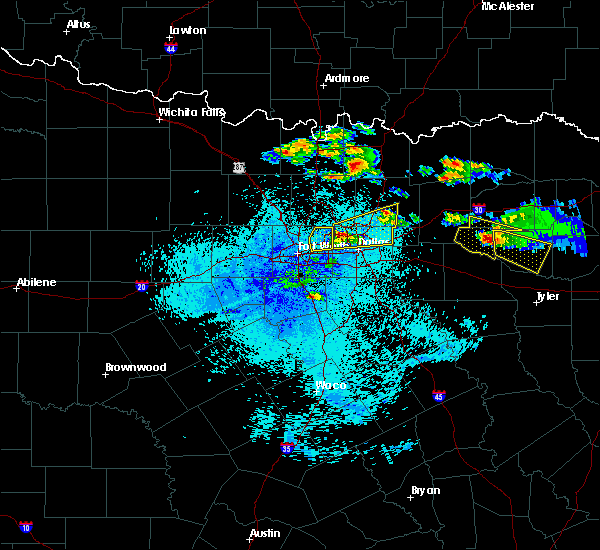 At 1012 pm cdt, a severe thunderstorm was located over emory, or 18 miles northeast of wills point, moving southeast at 30 mph (officials at greenville majors airport measured 1" hail around 920pm). Hazards include golf ball size hail and 65 mph wind gusts. People and animals outdoors will be injured. expect hail and wind damage to trees, roofs, siding, windows, and vehicles. Locations impacted include, areas between emory and alba. At 1012 pm cdt, a severe thunderstorm was located over emory, or 18 miles northeast of wills point, moving southeast at 30 mph (officials at greenville majors airport measured 1" hail around 920pm). Hazards include golf ball size hail and 65 mph wind gusts. People and animals outdoors will be injured. expect hail and wind damage to trees, roofs, siding, windows, and vehicles. Locations impacted include, areas between emory and alba.
|
| 3/24/2019 10:03 PM CDT |
 At 1000 pm cdt, a severe thunderstorm was located near emory, or 16 miles northeast of wills point, moving southeast at 30 mph (officials at greenville majors airport measured 1" hail around 920pm). Hazards include golf ball size hail and 65 mph wind gusts. People and animals outdoors will be injured. expect hail and wind damage to trees, roofs, siding, windows, and vehicles. Locations impacted include, emory, east tawakoni and point. At 1000 pm cdt, a severe thunderstorm was located near emory, or 16 miles northeast of wills point, moving southeast at 30 mph (officials at greenville majors airport measured 1" hail around 920pm). Hazards include golf ball size hail and 65 mph wind gusts. People and animals outdoors will be injured. expect hail and wind damage to trees, roofs, siding, windows, and vehicles. Locations impacted include, emory, east tawakoni and point.
|
| 3/24/2019 9:24 PM CDT |
 At 923 pm cdt, a severe thunderstorm was located 7 miles north of west tawakoni, or 8 miles southeast of greenville, moving southeast at 30 mph (radar indicated). Hazards include golf ball size hail and 65 mph wind gusts. People and animals outdoors will be injured. expect hail damage to roofs, siding, windows, and vehicles. Expect wind damage to roofs, siding, and trees. At 923 pm cdt, a severe thunderstorm was located 7 miles north of west tawakoni, or 8 miles southeast of greenville, moving southeast at 30 mph (radar indicated). Hazards include golf ball size hail and 65 mph wind gusts. People and animals outdoors will be injured. expect hail damage to roofs, siding, windows, and vehicles. Expect wind damage to roofs, siding, and trees.
|
| 3/13/2019 6:38 AM CDT |
 At 637 am cdt, severe thunderstorms were located along a line extending from north of paris to near sulphur springs to canton, moving east at 45 mph (radar indicated). Hazards include 60 mph wind gusts. Expect damage to roofs, siding, and trees. Locations impacted include, paris, sulphur springs, canton, grand saline, van, cooper, blossom, edgewood, emory, como, deport, fruitvale, edom, cooper lake park south sulphur, cooper lake park doctors creek, roxton, tira, toco and sun valley. At 637 am cdt, severe thunderstorms were located along a line extending from north of paris to near sulphur springs to canton, moving east at 45 mph (radar indicated). Hazards include 60 mph wind gusts. Expect damage to roofs, siding, and trees. Locations impacted include, paris, sulphur springs, canton, grand saline, van, cooper, blossom, edgewood, emory, como, deport, fruitvale, edom, cooper lake park south sulphur, cooper lake park doctors creek, roxton, tira, toco and sun valley.
|
| 3/13/2019 6:06 AM CDT |
 At 605 am cdt, severe thunderstorms were located along a line extending from the red river north of honey grove to commerce to kemp, moving east at 45 mph (radar indicated). Hazards include 60 mph wind gusts. expect damage to roofs, siding, and trees At 605 am cdt, severe thunderstorms were located along a line extending from the red river north of honey grove to commerce to kemp, moving east at 45 mph (radar indicated). Hazards include 60 mph wind gusts. expect damage to roofs, siding, and trees
|
| 3/9/2019 8:34 AM CST |
 At 834 am cst, severe thunderstorms were located along a line extending from near sulphur springs to near emory to near wills point, moving east at 50 mph (radar indicated). Hazards include 60 mph wind gusts and quarter size hail. Hail damage to vehicles is expected. expect wind damage to roofs, siding, and trees. Locations impacted include, sulphur springs, kaufman, canton, wills point, edgewood, emory, east tawakoni, fruitvale, cooper lake park south sulphur, lake tawakoni state park, point, oak grove, tira and oak ridge. At 834 am cst, severe thunderstorms were located along a line extending from near sulphur springs to near emory to near wills point, moving east at 50 mph (radar indicated). Hazards include 60 mph wind gusts and quarter size hail. Hail damage to vehicles is expected. expect wind damage to roofs, siding, and trees. Locations impacted include, sulphur springs, kaufman, canton, wills point, edgewood, emory, east tawakoni, fruitvale, cooper lake park south sulphur, lake tawakoni state park, point, oak grove, tira and oak ridge.
|
| 3/9/2019 8:13 AM CST |
 At 812 am cst, severe thunderstorms were located along a line extending from near campbell to near quinlan to near talty, moving east at 50 mph (radar indicated). Hazards include 60 mph wind gusts and quarter size hail. Hail damage to vehicles is expected. expect wind damage to roofs, siding, and trees. Locations impacted include, greenville, terrell, sulphur springs, commerce, kaufman, canton, wills point, crandall, cooper, combine, west tawakoni, talty, edgewood, quinlan, emory, east tawakoni, cumby, campbell, hawk cove and fruitvale. At 812 am cst, severe thunderstorms were located along a line extending from near campbell to near quinlan to near talty, moving east at 50 mph (radar indicated). Hazards include 60 mph wind gusts and quarter size hail. Hail damage to vehicles is expected. expect wind damage to roofs, siding, and trees. Locations impacted include, greenville, terrell, sulphur springs, commerce, kaufman, canton, wills point, crandall, cooper, combine, west tawakoni, talty, edgewood, quinlan, emory, east tawakoni, cumby, campbell, hawk cove and fruitvale.
|
| 3/9/2019 7:57 AM CST |
 At 756 am cst, severe thunderstorms were located along a line extending from near caddo mills to 6 miles southeast of mobile city to near seagoville, moving east at 50 mph (radar indicated). Hazards include 60 mph wind gusts and quarter size hail. Hail damage to vehicles is expected. Expect wind damage to roofs, siding, and trees. At 756 am cst, severe thunderstorms were located along a line extending from near caddo mills to 6 miles southeast of mobile city to near seagoville, moving east at 50 mph (radar indicated). Hazards include 60 mph wind gusts and quarter size hail. Hail damage to vehicles is expected. Expect wind damage to roofs, siding, and trees.
|
| 12/1/2018 12:35 AM CST |
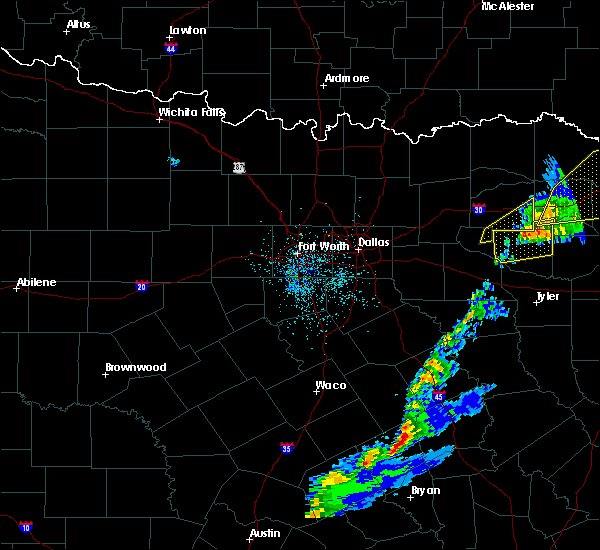 The severe thunderstorm warning for southeastern hopkins and northeastern rains counties will expire at 1245 am cst, the storm which prompted the warning has moved out of the area. therefore the warning will be allowed to expire. a tornado watch remains in effect until 100 am cst for north central texas. The severe thunderstorm warning for southeastern hopkins and northeastern rains counties will expire at 1245 am cst, the storm which prompted the warning has moved out of the area. therefore the warning will be allowed to expire. a tornado watch remains in effect until 100 am cst for north central texas.
|
| 12/1/2018 12:17 AM CST |
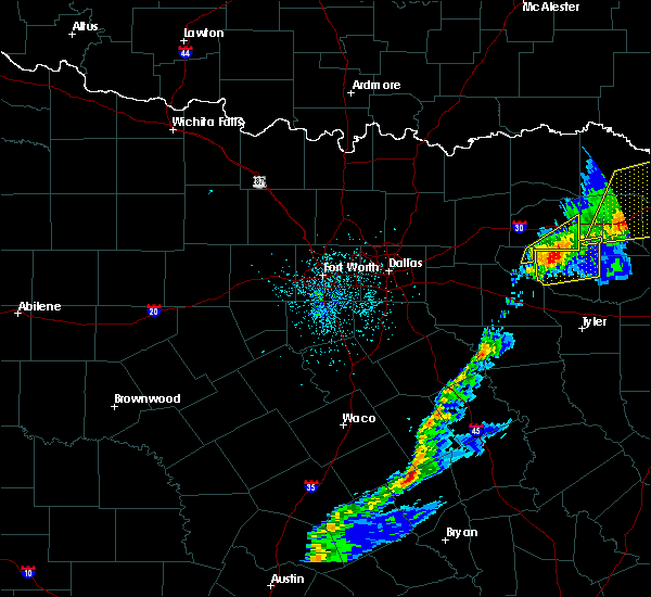 At 1216 am cst, a severe thunderstorm was located 7 miles east of emory, or 16 miles south of sulphur springs, moving northeast at 50 mph (radar indicated). Hazards include 60 mph wind gusts and nickel size hail. Expect damage to roofs, siding, and trees. locations impacted include, emory and como. A tornado watch remains in effect until 100 am cst for north central texas. At 1216 am cst, a severe thunderstorm was located 7 miles east of emory, or 16 miles south of sulphur springs, moving northeast at 50 mph (radar indicated). Hazards include 60 mph wind gusts and nickel size hail. Expect damage to roofs, siding, and trees. locations impacted include, emory and como. A tornado watch remains in effect until 100 am cst for north central texas.
|
| 12/1/2018 12:07 AM CST |
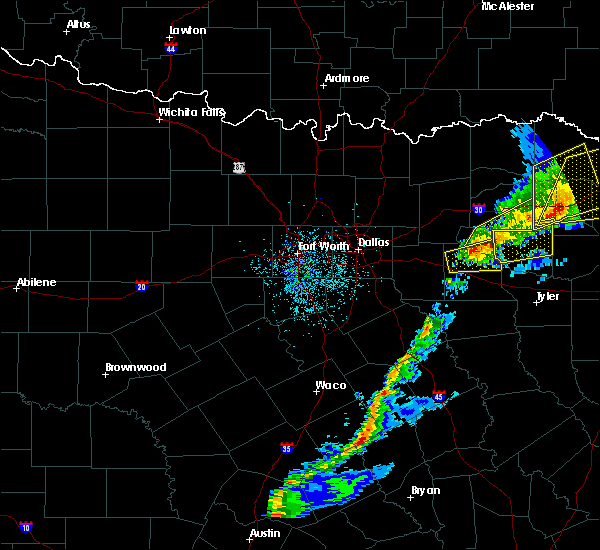 At 1205 am cst, a severe thunderstorm was located near emory, or 11 miles northeast of wills point, moving northeast at 45 mph (radar indicated). Hazards include 60 mph wind gusts and nickel size hail. Expect damage to roofs, siding, and trees. locations impacted include, emory and como. A tornado watch remains in effect until 100 am cst for north central texas. At 1205 am cst, a severe thunderstorm was located near emory, or 11 miles northeast of wills point, moving northeast at 45 mph (radar indicated). Hazards include 60 mph wind gusts and nickel size hail. Expect damage to roofs, siding, and trees. locations impacted include, emory and como. A tornado watch remains in effect until 100 am cst for north central texas.
|
| 11/30/2018 11:43 PM CST |
 At 1141 pm cst, a line of severe thunderstorms was located from sulphur springs to wills point, moving east at 45 mph (radar indicated). Hazards include 60 mph wind gusts and quarter size hail. Hail damage to vehicles is expected. Expect wind damage to roofs, siding, and trees. At 1141 pm cst, a line of severe thunderstorms was located from sulphur springs to wills point, moving east at 45 mph (radar indicated). Hazards include 60 mph wind gusts and quarter size hail. Hail damage to vehicles is expected. Expect wind damage to roofs, siding, and trees.
|
| 11/30/2018 11:19 PM CST |
 At 1117 pm cst, severe thunderstorms were located along a line extending from near sulphur springs to near terrell, moving northeast at 35 mph (radar indicated). Hazards include 60 mph wind gusts and quarter size hail. Hail damage to vehicles is expected. expect wind damage to roofs, siding, and trees. locations impacted include, greenville, terrell, sulphur springs, west tawakoni, quinlan, caddo mills, emory, east tawakoni, cumby, como, campbell, hawk cove, cooper lake park south sulphur, lake tawakoni state park, point, lone oak and tira. A tornado watch remains in effect until midnight cst for north central texas. At 1117 pm cst, severe thunderstorms were located along a line extending from near sulphur springs to near terrell, moving northeast at 35 mph (radar indicated). Hazards include 60 mph wind gusts and quarter size hail. Hail damage to vehicles is expected. expect wind damage to roofs, siding, and trees. locations impacted include, greenville, terrell, sulphur springs, west tawakoni, quinlan, caddo mills, emory, east tawakoni, cumby, como, campbell, hawk cove, cooper lake park south sulphur, lake tawakoni state park, point, lone oak and tira. A tornado watch remains in effect until midnight cst for north central texas.
|
| 3/11/2018 4:34 AM CDT |
 At 433 am cdt, a severe thunderstorm was located 10 miles south of sulphur springs, moving southeast at 35 mph (radar indicated). Hazards include 60 mph wind gusts and quarter size hail. Hail damage to vehicles is expected. expect wind damage to roofs, siding, and trees. Locations impacted include, como. At 433 am cdt, a severe thunderstorm was located 10 miles south of sulphur springs, moving southeast at 35 mph (radar indicated). Hazards include 60 mph wind gusts and quarter size hail. Hail damage to vehicles is expected. expect wind damage to roofs, siding, and trees. Locations impacted include, como.
|
| 3/11/2018 4:05 AM CDT |
 At 404 am cdt, a severe thunderstorm was located near cumby, or 9 miles south of commerce, moving southeast at 35 mph (radar indicated). Hazards include 60 mph wind gusts and quarter size hail. Hail damage to vehicles is expected. Expect wind damage to roofs, siding, and trees. At 404 am cdt, a severe thunderstorm was located near cumby, or 9 miles south of commerce, moving southeast at 35 mph (radar indicated). Hazards include 60 mph wind gusts and quarter size hail. Hail damage to vehicles is expected. Expect wind damage to roofs, siding, and trees.
|
| 1/21/2018 7:54 PM CST |
 The tornado warning for north central van zandt and southeastern rains counties will expire at 800 pm cst, the storm which prompted the warning has moved out of the area. therefore the warning will be allowed to expire. however gusty winds are still possible with this thunderstorm. a tornado watch remains in effect until 1100 pm cst for north central texas. The tornado warning for north central van zandt and southeastern rains counties will expire at 800 pm cst, the storm which prompted the warning has moved out of the area. therefore the warning will be allowed to expire. however gusty winds are still possible with this thunderstorm. a tornado watch remains in effect until 1100 pm cst for north central texas.
|
| 1/21/2018 7:36 PM CST |
 At 736 pm cst, a severe thunderstorm capable of producing a tornado was located over fruitvale, or 10 miles northeast of canton, moving northeast at 50 mph (radar indicated rotation). Hazards include tornado. Flying debris will be dangerous to those caught without shelter. mobile homes will be damaged or destroyed. damage to roofs, windows, and vehicles will occur. tree damage is likely. This tornadic thunderstorm will remain over mainly rural areas of north central van zandt and southeastern rains counties. At 736 pm cst, a severe thunderstorm capable of producing a tornado was located over fruitvale, or 10 miles northeast of canton, moving northeast at 50 mph (radar indicated rotation). Hazards include tornado. Flying debris will be dangerous to those caught without shelter. mobile homes will be damaged or destroyed. damage to roofs, windows, and vehicles will occur. tree damage is likely. This tornadic thunderstorm will remain over mainly rural areas of north central van zandt and southeastern rains counties.
|
| 1/21/2018 7:24 PM CST |
 At 723 pm cst, a severe thunderstorm capable of producing a tornado was located over canton, moving northeast at 40 mph (radar indicated rotation). Hazards include tornado. Flying debris will be dangerous to those caught without shelter. mobile homes will be damaged or destroyed. damage to roofs, windows, and vehicles will occur. tree damage is likely. this dangerous storm will be near, edgewood around 735 pm cst. fruitvale around 740 pm cst. grand saline around 745 pm cst. Emory around 755 pm cst. At 723 pm cst, a severe thunderstorm capable of producing a tornado was located over canton, moving northeast at 40 mph (radar indicated rotation). Hazards include tornado. Flying debris will be dangerous to those caught without shelter. mobile homes will be damaged or destroyed. damage to roofs, windows, and vehicles will occur. tree damage is likely. this dangerous storm will be near, edgewood around 735 pm cst. fruitvale around 740 pm cst. grand saline around 745 pm cst. Emory around 755 pm cst.
|
| 1/21/2018 7:11 PM CST |
 At 710 pm cst, a severe thunderstorm capable of producing a tornado was located near purtis creek state park, or 10 miles southwest of canton, moving northeast at 40 mph (radar indicated rotation). Hazards include tornado. Flying debris will be dangerous to those caught without shelter. mobile homes will be damaged or destroyed. damage to roofs, windows, and vehicles will occur. tree damage is likely. this dangerous storm will be near, canton around 730 pm cst. edgewood and fruitvale around 740 pm cst. grand saline around 745 pm cst. emory around 800 pm cst. This includes interstate 20 between mile markers 517 and 534. At 710 pm cst, a severe thunderstorm capable of producing a tornado was located near purtis creek state park, or 10 miles southwest of canton, moving northeast at 40 mph (radar indicated rotation). Hazards include tornado. Flying debris will be dangerous to those caught without shelter. mobile homes will be damaged or destroyed. damage to roofs, windows, and vehicles will occur. tree damage is likely. this dangerous storm will be near, canton around 730 pm cst. edgewood and fruitvale around 740 pm cst. grand saline around 745 pm cst. emory around 800 pm cst. This includes interstate 20 between mile markers 517 and 534.
|
| 1/21/2018 5:58 PM CST |
 At 557 pm cst, a severe thunderstorm capable of producing a tornado was located near terrell, moving northeast at 45 mph (radar indicated rotation). Hazards include tornado. Flying debris will be dangerous to those caught without shelter. mobile homes will be damaged or destroyed. damage to roofs, windows, and vehicles will occur. tree damage is likely. this dangerous storm will be near, lake tawakoni state park around 615 pm cst. quinlan and hawk cove around 620 pm cst. west tawakoni and east tawakoni around 625 pm cst. other locations impacted by this tornadic thunderstorm include oak ridge, lone oak and point. this includes the following interstates, interstate 20 between mile markers 498 and 512. Interstate 30 between mile markers 89 and 98. At 557 pm cst, a severe thunderstorm capable of producing a tornado was located near terrell, moving northeast at 45 mph (radar indicated rotation). Hazards include tornado. Flying debris will be dangerous to those caught without shelter. mobile homes will be damaged or destroyed. damage to roofs, windows, and vehicles will occur. tree damage is likely. this dangerous storm will be near, lake tawakoni state park around 615 pm cst. quinlan and hawk cove around 620 pm cst. west tawakoni and east tawakoni around 625 pm cst. other locations impacted by this tornadic thunderstorm include oak ridge, lone oak and point. this includes the following interstates, interstate 20 between mile markers 498 and 512. Interstate 30 between mile markers 89 and 98.
|
| 5/28/2017 3:51 PM CDT |
 At 350 pm cdt, a severe thunderstorm was located over emory, or 15 miles northeast of wills point, moving east at 40 mph (radar indicated). Hazards include quarter size hail. Damage to vehicles is possible. Locations impacted include, emory, east tawakoni and point. At 350 pm cdt, a severe thunderstorm was located over emory, or 15 miles northeast of wills point, moving east at 40 mph (radar indicated). Hazards include quarter size hail. Damage to vehicles is possible. Locations impacted include, emory, east tawakoni and point.
|
| 5/28/2017 3:41 PM CDT |
 At 340 pm cdt, a severe thunderstorm was located over east tawakoni, or 11 miles northeast of wills point, moving east at 40 mph (radar indicated). Hazards include quarter size hail. Damage to vehicles is possible. Locations impacted include, emory, east tawakoni and point. At 340 pm cdt, a severe thunderstorm was located over east tawakoni, or 11 miles northeast of wills point, moving east at 40 mph (radar indicated). Hazards include quarter size hail. Damage to vehicles is possible. Locations impacted include, emory, east tawakoni and point.
|
| 5/28/2017 3:18 PM CDT |
 At 318 pm cdt, a severe thunderstorm was located near quinlan, or 11 miles northeast of terrell, moving east at 40 mph (radar indicated). Hazards include quarter size hail. damage to vehicles is possible At 318 pm cdt, a severe thunderstorm was located near quinlan, or 11 miles northeast of terrell, moving east at 40 mph (radar indicated). Hazards include quarter size hail. damage to vehicles is possible
|
| 4/29/2017 8:08 PM CDT |
 At 808 pm cdt, severe thunderstorms were located along a line extending from 10 miles east of emory to near golden to near van to 6 miles northwest of edom, moving east at 30 mph (radar indicated). Hazards include two inch hail and 70 mph wind gusts. People and animals outdoors will be injured. expect hail damage to roofs, siding, windows, and vehicles. expect considerable tree damage. wind damage is also likely to mobile homes, roofs, and outbuildings. locations impacted include, canton, grand saline, van, edgewood, emory, fruitvale, edom and point. A tornado watch remains in effect until 1000 pm cdt for north central texas. At 808 pm cdt, severe thunderstorms were located along a line extending from 10 miles east of emory to near golden to near van to 6 miles northwest of edom, moving east at 30 mph (radar indicated). Hazards include two inch hail and 70 mph wind gusts. People and animals outdoors will be injured. expect hail damage to roofs, siding, windows, and vehicles. expect considerable tree damage. wind damage is also likely to mobile homes, roofs, and outbuildings. locations impacted include, canton, grand saline, van, edgewood, emory, fruitvale, edom and point. A tornado watch remains in effect until 1000 pm cdt for north central texas.
|
| 4/29/2017 7:53 PM CDT |
 At 753 pm cdt, severe thunderstorms were located along a line extending from near emory to near grand saline to near van to 11 miles west of edom, moving east at 25 mph (radar indicated). Hazards include 70 mph wind gusts and half dollar size hail. Hail damage to vehicles is expected. expect considerable tree damage. wind damage is also likely to mobile homes, roofs, and outbuildings. locations impacted include, ben wheeler, canton, grand saline, van, edgewood, emory, fruitvale, edom and point. A tornado watch remains in effect until 1000 pm cdt for north central texas. At 753 pm cdt, severe thunderstorms were located along a line extending from near emory to near grand saline to near van to 11 miles west of edom, moving east at 25 mph (radar indicated). Hazards include 70 mph wind gusts and half dollar size hail. Hail damage to vehicles is expected. expect considerable tree damage. wind damage is also likely to mobile homes, roofs, and outbuildings. locations impacted include, ben wheeler, canton, grand saline, van, edgewood, emory, fruitvale, edom and point. A tornado watch remains in effect until 1000 pm cdt for north central texas.
|
| 4/29/2017 7:32 PM CDT |
 At 732 pm cdt, severe thunderstorms were located along a line extending from near emory to 6 miles south of fruitvale to canton to near purtis creek state park, moving east at 30 mph (radar indicated). Hazards include 70 mph wind gusts and half dollar size hail. Hail damage to vehicles is expected. expect considerable tree damage. Wind damage is also likely to mobile homes, roofs, and outbuildings. At 732 pm cdt, severe thunderstorms were located along a line extending from near emory to 6 miles south of fruitvale to canton to near purtis creek state park, moving east at 30 mph (radar indicated). Hazards include 70 mph wind gusts and half dollar size hail. Hail damage to vehicles is expected. expect considerable tree damage. Wind damage is also likely to mobile homes, roofs, and outbuildings.
|
| 4/29/2017 7:28 PM CDT | Ping Pong Ball sized hail reported 0.9 miles WNW of Emory, TX, report of 1.5 inch hail reported in emory |
| 4/29/2017 7:12 PM CDT |
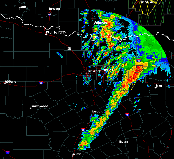 At 711 pm cdt, a confirmed tornado was located near emory, or 18 miles southwest of sulphur springs, moving north at 30 mph (weather spotters confirmed tornado). Hazards include damaging tornado and ping pong ball size hail. Flying debris will be dangerous to those caught without shelter. mobile homes will be damaged or destroyed. damage to roofs, windows, and vehicles will occur. tree damage is likely. Locations impacted include, emory. At 711 pm cdt, a confirmed tornado was located near emory, or 18 miles southwest of sulphur springs, moving north at 30 mph (weather spotters confirmed tornado). Hazards include damaging tornado and ping pong ball size hail. Flying debris will be dangerous to those caught without shelter. mobile homes will be damaged or destroyed. damage to roofs, windows, and vehicles will occur. tree damage is likely. Locations impacted include, emory.
|
| 4/29/2017 7:07 PM CDT |
 At 707 pm cdt, a severe thunderstorm capable of producing a tornado was located near emory, or 19 miles northeast of wills point, moving north at 30 mph (radar indicated rotation). Hazards include tornado and ping pong ball size hail. Flying debris will be dangerous to those caught without shelter. mobile homes will be damaged or destroyed. damage to roofs, windows, and vehicles will occur. tree damage is likely. This tornadic thunderstorm will remain over mainly rural areas of north central van zandt and rains counties, including the following locations: point. At 707 pm cdt, a severe thunderstorm capable of producing a tornado was located near emory, or 19 miles northeast of wills point, moving north at 30 mph (radar indicated rotation). Hazards include tornado and ping pong ball size hail. Flying debris will be dangerous to those caught without shelter. mobile homes will be damaged or destroyed. damage to roofs, windows, and vehicles will occur. tree damage is likely. This tornadic thunderstorm will remain over mainly rural areas of north central van zandt and rains counties, including the following locations: point.
|
| 4/29/2017 6:54 PM CDT |
 At 653 pm cdt, a severe thunderstorm capable of producing a tornado was located north of fruitvale, or 13 miles east of wills point, moving north at 30 mph (radar indicated rotation). Hazards include tornado and half dollar size hail. Flying debris will be dangerous to those caught without shelter. mobile homes will be damaged or destroyed. damage to roofs, windows, and vehicles will occur. tree damage is likely. this dangerous storm will be near, emory around 710 pm cdt. Other locations impacted by this tornadic thunderstorm include point. At 653 pm cdt, a severe thunderstorm capable of producing a tornado was located north of fruitvale, or 13 miles east of wills point, moving north at 30 mph (radar indicated rotation). Hazards include tornado and half dollar size hail. Flying debris will be dangerous to those caught without shelter. mobile homes will be damaged or destroyed. damage to roofs, windows, and vehicles will occur. tree damage is likely. this dangerous storm will be near, emory around 710 pm cdt. Other locations impacted by this tornadic thunderstorm include point.
|
| 4/29/2017 6:38 PM CDT |
 At 638 pm cdt, a confirmed large and extremely dangerous tornado was located just south of fruitvale, moving north at 25 mph. if you are in fruitvale, seek shelter now! this is a particularly dangerous situation. take cover now! (weather spotters confirmed tornado). Hazards include damaging tornado. You are in a life-threatening situation. flying debris may be deadly to those caught without shelter. mobile homes will be destroyed. considerable damage to homes, businesses, and vehicles is likely and complete destruction is possible. Locations impacted include, canton, grand saline, edgewood, emory, east tawakoni, fruitvale and point. At 638 pm cdt, a confirmed large and extremely dangerous tornado was located just south of fruitvale, moving north at 25 mph. if you are in fruitvale, seek shelter now! this is a particularly dangerous situation. take cover now! (weather spotters confirmed tornado). Hazards include damaging tornado. You are in a life-threatening situation. flying debris may be deadly to those caught without shelter. mobile homes will be destroyed. considerable damage to homes, businesses, and vehicles is likely and complete destruction is possible. Locations impacted include, canton, grand saline, edgewood, emory, east tawakoni, fruitvale and point.
|
| 4/29/2017 6:34 PM CDT |
 At 634 pm cdt, a confirmed large and extremely dangerous tornado was located northeast of canton, moving north at 30 mph. this is a particularly dangerous situation. take cover now! (weather spotters confirmed tornado). Hazards include damaging tornado. You are in a life-threatening situation. flying debris may be deadly to those caught without shelter. mobile homes will be destroyed. considerable damage to homes, businesses, and vehicles is likely and complete destruction is possible. Locations impacted include, canton, wills point, grand saline, edgewood, emory, east tawakoni, fruitvale and point. At 634 pm cdt, a confirmed large and extremely dangerous tornado was located northeast of canton, moving north at 30 mph. this is a particularly dangerous situation. take cover now! (weather spotters confirmed tornado). Hazards include damaging tornado. You are in a life-threatening situation. flying debris may be deadly to those caught without shelter. mobile homes will be destroyed. considerable damage to homes, businesses, and vehicles is likely and complete destruction is possible. Locations impacted include, canton, wills point, grand saline, edgewood, emory, east tawakoni, fruitvale and point.
|
| 4/29/2017 6:27 PM CDT |
 At 626 pm cdt, a confirmed large and extremely dangerous tornado was located over canton, moving north at 25 mph. this is a particularly dangerous situation. take cover now! (weather spotters confirmed tornado near i-20). Hazards include damaging tornado. You are in a life-threatening situation. flying debris may be deadly to those caught without shelter. mobile homes will be destroyed. considerable damage to homes, businesses, and vehicles is likely and complete destruction is possible. Locations impacted include, canton, wills point, grand saline, edgewood, emory, east tawakoni, fruitvale and point. At 626 pm cdt, a confirmed large and extremely dangerous tornado was located over canton, moving north at 25 mph. this is a particularly dangerous situation. take cover now! (weather spotters confirmed tornado near i-20). Hazards include damaging tornado. You are in a life-threatening situation. flying debris may be deadly to those caught without shelter. mobile homes will be destroyed. considerable damage to homes, businesses, and vehicles is likely and complete destruction is possible. Locations impacted include, canton, wills point, grand saline, edgewood, emory, east tawakoni, fruitvale and point.
|
| 4/29/2017 6:23 PM CDT |
 At 623 pm cdt, a confirmed large and extremely dangerous tornado was located near canton, moving north at 15 to 20 mph. this is a particularly dangerous situation. take cover now! (weather spotters confirmed tornado). Hazards include damaging tornado. You are in a life-threatening situation. flying debris may be deadly to those caught without shelter. mobile homes will be destroyed. considerable damage to homes, businesses, and vehicles is likely and complete destruction is possible. Locations impacted include, canton, wills point, grand saline, edgewood, emory, east tawakoni, fruitvale and point. At 623 pm cdt, a confirmed large and extremely dangerous tornado was located near canton, moving north at 15 to 20 mph. this is a particularly dangerous situation. take cover now! (weather spotters confirmed tornado). Hazards include damaging tornado. You are in a life-threatening situation. flying debris may be deadly to those caught without shelter. mobile homes will be destroyed. considerable damage to homes, businesses, and vehicles is likely and complete destruction is possible. Locations impacted include, canton, wills point, grand saline, edgewood, emory, east tawakoni, fruitvale and point.
|
| 4/29/2017 6:19 PM CDT |
 At 618 pm cdt, a confirmed dangerous tornado was located near canton, moving north at 25 mph. this is a particularly dangerous situation. take cover now! (weather spotters and radar confirmed tornado). Hazards include damaging tornado. You are in a life-threatening situation. flying debris may be deadly to those caught without shelter. mobile homes will be destroyed. considerable damage to homes, businesses, and vehicles is likely and complete destruction is possible. the tornado will be near, canton around 640 pm cdt. wills point, edgewood and fruitvale around 655 pm cdt. Other locations impacted by this tornadic thunderstorm include point. At 618 pm cdt, a confirmed dangerous tornado was located near canton, moving north at 25 mph. this is a particularly dangerous situation. take cover now! (weather spotters and radar confirmed tornado). Hazards include damaging tornado. You are in a life-threatening situation. flying debris may be deadly to those caught without shelter. mobile homes will be destroyed. considerable damage to homes, businesses, and vehicles is likely and complete destruction is possible. the tornado will be near, canton around 640 pm cdt. wills point, edgewood and fruitvale around 655 pm cdt. Other locations impacted by this tornadic thunderstorm include point.
|
| 4/29/2017 6:13 PM CDT |
 At 612 pm cdt, a severe thunderstorm capable of producing a tornado was located 7 miles south of canton, moving north at 25 mph. another possible tornado was located near canton moving north at 25 mph as well (radar indicated rotation). Hazards include developing tornado. Flying debris will be dangerous to those caught without shelter. mobile homes will be damaged or destroyed. damage to roofs, windows, and vehicles will occur. tree damage is likely. this dangerous storm will be near, canton around 640 pm cdt. wills point, edgewood and fruitvale around 655 pm cdt. other locations impacted by this tornadic thunderstorm include point. This includes interstate 20 between mile markers 519 and 533. At 612 pm cdt, a severe thunderstorm capable of producing a tornado was located 7 miles south of canton, moving north at 25 mph. another possible tornado was located near canton moving north at 25 mph as well (radar indicated rotation). Hazards include developing tornado. Flying debris will be dangerous to those caught without shelter. mobile homes will be damaged or destroyed. damage to roofs, windows, and vehicles will occur. tree damage is likely. this dangerous storm will be near, canton around 640 pm cdt. wills point, edgewood and fruitvale around 655 pm cdt. other locations impacted by this tornadic thunderstorm include point. This includes interstate 20 between mile markers 519 and 533.
|
| 4/29/2017 4:26 PM CDT |
 At 425 pm cdt, a severe thunderstorm was located over grand saline, or 12 miles northeast of canton, moving north at 25 mph (radar indicated). Hazards include 60 mph wind gusts and quarter size hail. Hail damage to vehicles is expected. Expect wind damage to roofs, siding, and trees. At 425 pm cdt, a severe thunderstorm was located over grand saline, or 12 miles northeast of canton, moving north at 25 mph (radar indicated). Hazards include 60 mph wind gusts and quarter size hail. Hail damage to vehicles is expected. Expect wind damage to roofs, siding, and trees.
|
| 4/26/2017 8:28 AM CDT |
 At 828 am cdt, a severe thunderstorm was located near terrell, moving northeast at 40 mph (radar indicated). Hazards include quarter size hail. damage to vehicles is possible At 828 am cdt, a severe thunderstorm was located near terrell, moving northeast at 40 mph (radar indicated). Hazards include quarter size hail. damage to vehicles is possible
|
| 4/21/2017 11:00 PM CDT |
 At 1059 pm cdt, a severe thunderstorm was located over east tawakoni, or 12 miles north of wills point, moving southeast at 30 mph (radar indicated). Hazards include quarter size hail. Damage to vehicles is possible. locations impacted include, wills point, grand saline, west tawakoni, edgewood, emory, east tawakoni, hawk cove, fruitvale, lake tawakoni state park, point and lone oak. A tornado watch remains in effect until 100 am cdt for north central texas. At 1059 pm cdt, a severe thunderstorm was located over east tawakoni, or 12 miles north of wills point, moving southeast at 30 mph (radar indicated). Hazards include quarter size hail. Damage to vehicles is possible. locations impacted include, wills point, grand saline, west tawakoni, edgewood, emory, east tawakoni, hawk cove, fruitvale, lake tawakoni state park, point and lone oak. A tornado watch remains in effect until 100 am cdt for north central texas.
|
| 4/21/2017 10:43 PM CDT |
 At 1043 pm cdt, a severe thunderstorm was located over west tawakoni, or 13 miles north of wills point, moving east at 35 mph (radar indicated). Hazards include quarter size hail. Damage to vehicles is possible. locations impacted include, wills point, grand saline, west tawakoni, edgewood, quinlan, emory, east tawakoni, hawk cove, fruitvale, lake tawakoni state park, point and lone oak. A tornado watch remains in effect until 100 am cdt for north central texas. At 1043 pm cdt, a severe thunderstorm was located over west tawakoni, or 13 miles north of wills point, moving east at 35 mph (radar indicated). Hazards include quarter size hail. Damage to vehicles is possible. locations impacted include, wills point, grand saline, west tawakoni, edgewood, quinlan, emory, east tawakoni, hawk cove, fruitvale, lake tawakoni state park, point and lone oak. A tornado watch remains in effect until 100 am cdt for north central texas.
|
| 4/21/2017 10:12 PM CDT |
 At 1012 pm cdt, a severe thunderstorm was located near royse city, or 11 miles east of rockwall, moving southeast at 45 mph (radar indicated). Hazards include ping pong ball size hail. People and animals outdoors will be injured. Expect damage to roofs, siding, windows, and vehicles. At 1012 pm cdt, a severe thunderstorm was located near royse city, or 11 miles east of rockwall, moving southeast at 45 mph (radar indicated). Hazards include ping pong ball size hail. People and animals outdoors will be injured. Expect damage to roofs, siding, windows, and vehicles.
|
| 3/29/2017 3:54 AM CDT |
 The severe thunderstorm warning for hunt, eastern kaufman, van zandt and rains counties will expire at 400 am cdt, the storms which prompted the warning have moved out of the area. therefore the warning will be allowed to expire. however gusty winds are still possible with these thunderstorms. a severe thunderstorm watch remains in effect until 500 am cdt for north central texas. The severe thunderstorm warning for hunt, eastern kaufman, van zandt and rains counties will expire at 400 am cdt, the storms which prompted the warning have moved out of the area. therefore the warning will be allowed to expire. however gusty winds are still possible with these thunderstorms. a severe thunderstorm watch remains in effect until 500 am cdt for north central texas.
|
| 3/29/2017 3:16 AM CDT |
 At 316 am cdt, severe thunderstorms were located along a line extending from 8 miles north of farmersville to kemp, moving northeast at 60 mph (radar indicated). Hazards include 65 mph wind gusts and penny size hail. Expect damage to roofs, siding, and trees. severe thunderstorms will be near, celeste around 325 am cdt. wolfe city around 335 am cdt. canton around 340 am cdt. edgewood and fruitvale around 345 am cdt. grand saline around 350 am cdt. other locations impacted by these severe thunderstorms include neylandville, lone oak, point and josephine. this includes the following interstates, interstate 20 between mile markers 502 and 542. Interstate 30 between mile markers 80 and 109. At 316 am cdt, severe thunderstorms were located along a line extending from 8 miles north of farmersville to kemp, moving northeast at 60 mph (radar indicated). Hazards include 65 mph wind gusts and penny size hail. Expect damage to roofs, siding, and trees. severe thunderstorms will be near, celeste around 325 am cdt. wolfe city around 335 am cdt. canton around 340 am cdt. edgewood and fruitvale around 345 am cdt. grand saline around 350 am cdt. other locations impacted by these severe thunderstorms include neylandville, lone oak, point and josephine. this includes the following interstates, interstate 20 between mile markers 502 and 542. Interstate 30 between mile markers 80 and 109.
|
| 1/15/2017 11:39 PM CST |
 At 1139 pm cst, a severe thunderstorm was located near cumby, or 10 miles southwest of sulphur springs, moving northeast at 40 mph (radar indicated). Hazards include 60 mph wind gusts and penny size hail. Expect damage to roofs, siding, and trees. this severe storm will be near, sulphur springs around 1155 pm cst. Other locations impacted by this severe thunderstorm include point and tira. At 1139 pm cst, a severe thunderstorm was located near cumby, or 10 miles southwest of sulphur springs, moving northeast at 40 mph (radar indicated). Hazards include 60 mph wind gusts and penny size hail. Expect damage to roofs, siding, and trees. this severe storm will be near, sulphur springs around 1155 pm cst. Other locations impacted by this severe thunderstorm include point and tira.
|
| 1/15/2017 11:16 PM CST |
 At 1116 pm cst, a severe thunderstorm was located 8 miles southeast of greenville, moving east at 25 mph (radar indicated). Hazards include 60 mph wind gusts and penny size hail. Expect damage to roofs, siding, and trees. this severe thunderstorm will be near, cumby around 1140 pm cst. sulphur springs around 1210 am cst. como around 1215 am cst. other locations impacted by this severe thunderstorm include lone oak, point and tira. This includes interstate 30 between mile markers 99 and 131. At 1116 pm cst, a severe thunderstorm was located 8 miles southeast of greenville, moving east at 25 mph (radar indicated). Hazards include 60 mph wind gusts and penny size hail. Expect damage to roofs, siding, and trees. this severe thunderstorm will be near, cumby around 1140 pm cst. sulphur springs around 1210 am cst. como around 1215 am cst. other locations impacted by this severe thunderstorm include lone oak, point and tira. This includes interstate 30 between mile markers 99 and 131.
|
| 1/2/2017 6:47 AM CST |
 At 646 am cst, severe thunderstorms were located along a line extending from 6 miles south of wolfe city to 6 miles east of emory to near coffee city, moving northeast at 45 mph (radar indicated). Hazards include 60 mph wind gusts. Expect damage to roofs, siding, and trees. Locations impacted include, greenville, commerce, grand saline, chandler, van, wolfe city, emory, brownsboro, berryville, east tawakoni, celeste, campbell, fruitvale, edom, coffee city, point, lone oak, poynor, moore station and neylandville. At 646 am cst, severe thunderstorms were located along a line extending from 6 miles south of wolfe city to 6 miles east of emory to near coffee city, moving northeast at 45 mph (radar indicated). Hazards include 60 mph wind gusts. Expect damage to roofs, siding, and trees. Locations impacted include, greenville, commerce, grand saline, chandler, van, wolfe city, emory, brownsboro, berryville, east tawakoni, celeste, campbell, fruitvale, edom, coffee city, point, lone oak, poynor, moore station and neylandville.
|
| 1/2/2017 6:30 AM CST | Large tree down in rains county TX, 0.9 miles WNW of Emory, TX |
| 1/2/2017 6:22 AM CST |
 At 621 am cst, severe thunderstorms were located along a line extending from near farmersville to near wills point to near athens, moving northeast at 50 mph (radar indicated). Hazards include 60 mph wind gusts. Expect damage to roofs, siding, and trees. Locations impacted include, greenville, athens, commerce, gun barrel city, canton, wills point, grand saline, mabank, chandler, van, malakoff, west tawakoni, edgewood, wolfe city, quinlan, caddo mills, emory, brownsboro, eustace and berryville. At 621 am cst, severe thunderstorms were located along a line extending from near farmersville to near wills point to near athens, moving northeast at 50 mph (radar indicated). Hazards include 60 mph wind gusts. Expect damage to roofs, siding, and trees. Locations impacted include, greenville, athens, commerce, gun barrel city, canton, wills point, grand saline, mabank, chandler, van, malakoff, west tawakoni, edgewood, wolfe city, quinlan, caddo mills, emory, brownsboro, eustace and berryville.
|
| 4/11/2016 7:10 PM CDT | Quarter sized hail reported 0.9 miles WNW of Emory, TX, dime to quarter sized hail in emory |
| 4/11/2016 7:05 PM CDT | Hen Egg sized hail reported 0.9 miles WNW of Emory, TX, hail to the size of hen eggs fell several miles ssw of the city of emory. |
| 4/11/2016 6:41 PM CDT |
 At 640 pm cdt, a severe thunderstorm was located over west tawakoni, or 14 miles south of greenville, moving east at 45 mph (radar indicated). Hazards include hen egg size hail and 60 mph wind gusts. People and animals outdoors will be injured. expect hail damage to roofs, siding, windows, and vehicles. expect wind damage to roofs, siding, and trees. this severe thunderstorm will be near, lake tawakoni state park around 645 pm cdt. east tawakoni around 650 pm cdt. emory around 700 pm cdt. other locations impacted by this severe thunderstorm include point. This includes interstate 20 between mile markers 512 and 520, between mile markers 522 and 532, and between mile markers 539 and 542. At 640 pm cdt, a severe thunderstorm was located over west tawakoni, or 14 miles south of greenville, moving east at 45 mph (radar indicated). Hazards include hen egg size hail and 60 mph wind gusts. People and animals outdoors will be injured. expect hail damage to roofs, siding, windows, and vehicles. expect wind damage to roofs, siding, and trees. this severe thunderstorm will be near, lake tawakoni state park around 645 pm cdt. east tawakoni around 650 pm cdt. emory around 700 pm cdt. other locations impacted by this severe thunderstorm include point. This includes interstate 20 between mile markers 512 and 520, between mile markers 522 and 532, and between mile markers 539 and 542.
|
| 4/11/2016 4:40 PM CDT |
 At 440 pm cdt, a severe thunderstorm was located near campbell, or 8 miles east of greenville, moving east at 40 mph (radar indicated). Hazards include 60 mph wind gusts and half dollar size hail. Hail damage to vehicles is expected. expect wind damage to roofs, siding, and trees. this severe thunderstorm will be near, cumby around 450 pm cdt. sulphur springs around 510 pm cdt. como around 525 pm cdt. other locations impacted by this severe thunderstorm include lone oak, neylandville and point. This includes interstate 30 between mile markers 99 and 142. At 440 pm cdt, a severe thunderstorm was located near campbell, or 8 miles east of greenville, moving east at 40 mph (radar indicated). Hazards include 60 mph wind gusts and half dollar size hail. Hail damage to vehicles is expected. expect wind damage to roofs, siding, and trees. this severe thunderstorm will be near, cumby around 450 pm cdt. sulphur springs around 510 pm cdt. como around 525 pm cdt. other locations impacted by this severe thunderstorm include lone oak, neylandville and point. This includes interstate 30 between mile markers 99 and 142.
|
| 4/11/2016 7:05 AM CDT | Hen Egg sized hail reported 6.9 miles NNE of Emory, TX, very large hail to hen egg size and very strong winds several miles ssw of the city of emory. |
| 3/24/2016 12:19 AM CDT |
 At 1217 am cdt, severe thunderstorms were located along a line extending from 11 miles west of deport to near sulphur springs to 6 miles southeast of emory, moving east at 55 mph (radar indicated). Hazards include 70 mph wind gusts and quarter size hail. Hail damage to vehicles is expected. expect considerable tree damage. wind damage is also likely to mobile homes, roofs, and outbuildings. Locations impacted include, sulphur springs, cooper, emory, east tawakoni, cumby, como, deport, cooper lake park south sulphur, cooper lake park doctors creek, point, tira and pecan gap. At 1217 am cdt, severe thunderstorms were located along a line extending from 11 miles west of deport to near sulphur springs to 6 miles southeast of emory, moving east at 55 mph (radar indicated). Hazards include 70 mph wind gusts and quarter size hail. Hail damage to vehicles is expected. expect considerable tree damage. wind damage is also likely to mobile homes, roofs, and outbuildings. Locations impacted include, sulphur springs, cooper, emory, east tawakoni, cumby, como, deport, cooper lake park south sulphur, cooper lake park doctors creek, point, tira and pecan gap.
|
| 3/24/2016 12:00 AM CDT |
 At 1159 pm cdt, severe thunderstorms were located along a line extending from near cooper to near cumby to near edgewood, moving east at 55 mph (radar indicated). Hazards include 60 mph wind gusts and quarter size hail. Hail damage to vehicles is expected. expect wind damage to roofs, siding, and trees. Locations impacted include, sulphur springs, commerce, wills point, cooper, west tawakoni, edgewood, emory, east tawakoni, cumby, como, campbell, deport, fruitvale, lake tawakoni state park, cooper lake park south sulphur, cooper lake park doctors creek, point, lone oak, tira and pecan gap. At 1159 pm cdt, severe thunderstorms were located along a line extending from near cooper to near cumby to near edgewood, moving east at 55 mph (radar indicated). Hazards include 60 mph wind gusts and quarter size hail. Hail damage to vehicles is expected. expect wind damage to roofs, siding, and trees. Locations impacted include, sulphur springs, commerce, wills point, cooper, west tawakoni, edgewood, emory, east tawakoni, cumby, como, campbell, deport, fruitvale, lake tawakoni state park, cooper lake park south sulphur, cooper lake park doctors creek, point, lone oak, tira and pecan gap.
|
| 3/23/2016 11:55 PM CDT |
 At 1154 pm cdt, severe thunderstorms were located along a line extending from near cooper to near cumby to near edgewood, moving east at 55 mph (radar indicated). Hazards include 60 mph wind gusts and quarter size hail. Hail damage to vehicles is expected. Expect wind damage to roofs, siding, and trees. At 1154 pm cdt, severe thunderstorms were located along a line extending from near cooper to near cumby to near edgewood, moving east at 55 mph (radar indicated). Hazards include 60 mph wind gusts and quarter size hail. Hail damage to vehicles is expected. Expect wind damage to roofs, siding, and trees.
|
| 12/26/2015 5:27 PM CST | The tornado warning for southeastern rains county will expire at 530 pm cst, the storm which prompted the warning has weakened below severe limits, and no longer appears capable of producing a tornado. therefore the warning will be allowed to expire. however gusty winds are still possible with this thunderstorm. a tornado watch remains in effect until 800 pm cst for north central texas. |
| 12/26/2015 5:18 PM CST |
 At 517 pm cst, a severe thunderstorm capable of producing a tornado was located near emory, or 16 miles northeast of wills point, moving north at 40 mph (radar indicated rotation). Hazards include tornado. Flying debris will be dangerous to those caught without shelter. mobile homes will be damaged or destroyed. damage to roofs, windows and vehicles will occur. tree damage is likely. This tornadic thunderstorm will remain over mainly rural areas of southeastern rains county. At 517 pm cst, a severe thunderstorm capable of producing a tornado was located near emory, or 16 miles northeast of wills point, moving north at 40 mph (radar indicated rotation). Hazards include tornado. Flying debris will be dangerous to those caught without shelter. mobile homes will be damaged or destroyed. damage to roofs, windows and vehicles will occur. tree damage is likely. This tornadic thunderstorm will remain over mainly rural areas of southeastern rains county.
|
| 12/26/2015 5:04 PM CST |
 At 503 pm cst, a severe thunderstorm capable of producing a tornado was located over fruitvale, or 9 miles north of canton, moving northeast at 35 mph (radar indicated rotation). Hazards include tornado. Flying debris will be dangerous to those caught without shelter. mobile homes will be damaged or destroyed. damage to roofs, windows and vehicles will occur. tree damage is likely. This dangerous storm will be near, emory around 525 pm cst. At 503 pm cst, a severe thunderstorm capable of producing a tornado was located over fruitvale, or 9 miles north of canton, moving northeast at 35 mph (radar indicated rotation). Hazards include tornado. Flying debris will be dangerous to those caught without shelter. mobile homes will be damaged or destroyed. damage to roofs, windows and vehicles will occur. tree damage is likely. This dangerous storm will be near, emory around 525 pm cst.
|
| 12/26/2015 4:52 PM CST |
 At 451 pm cst, a severe thunderstorm capable of producing a tornado was located over canton, moving northeast at 35 mph (radar indicated rotation). Hazards include tornado. Flying debris will be dangerous to those caught without shelter. mobile homes will be damaged or destroyed. damage to roofs, windows and vehicles will occur. tree damage is likely. this dangerous storm will be near, edgewood and fruitvale around 505 pm cst. grand saline around 510 pm cst. emory around 525 pm cst. This includes interstate 20 between mile markers 522 and 529. At 451 pm cst, a severe thunderstorm capable of producing a tornado was located over canton, moving northeast at 35 mph (radar indicated rotation). Hazards include tornado. Flying debris will be dangerous to those caught without shelter. mobile homes will be damaged or destroyed. damage to roofs, windows and vehicles will occur. tree damage is likely. this dangerous storm will be near, edgewood and fruitvale around 505 pm cst. grand saline around 510 pm cst. emory around 525 pm cst. This includes interstate 20 between mile markers 522 and 529.
|
| 12/26/2015 4:22 PM CST |
 At 421 pm cst, a severe thunderstorm capable of producing a tornado was located near emory, or 17 miles northwest of mineola, moving northeast at 45 mph (radar indicated rotation). Hazards include tornado and quarter size hail. Flying debris will be dangerous to those caught without shelter. mobile homes will be damaged or destroyed. damage to roofs, windows and vehicles will occur. tree damage is likely. This tornadic thunderstorm will remain over mainly rural areas of northeastern rains county. At 421 pm cst, a severe thunderstorm capable of producing a tornado was located near emory, or 17 miles northwest of mineola, moving northeast at 45 mph (radar indicated rotation). Hazards include tornado and quarter size hail. Flying debris will be dangerous to those caught without shelter. mobile homes will be damaged or destroyed. damage to roofs, windows and vehicles will occur. tree damage is likely. This tornadic thunderstorm will remain over mainly rural areas of northeastern rains county.
|
| 12/26/2015 4:07 PM CST |
 At 407 pm cst, a severe thunderstorm capable of producing a tornado was located near grand saline, or 14 miles northeast of canton, moving north at 50 mph (radar indicated rotation). Hazards include tornado and quarter size hail. Flying debris will be dangerous to those caught without shelter. mobile homes will be damaged or destroyed. damage to roofs, windows and vehicles will occur. tree damage is likely. This dangerous storm will be near, emory around 420 pm cst. At 407 pm cst, a severe thunderstorm capable of producing a tornado was located near grand saline, or 14 miles northeast of canton, moving north at 50 mph (radar indicated rotation). Hazards include tornado and quarter size hail. Flying debris will be dangerous to those caught without shelter. mobile homes will be damaged or destroyed. damage to roofs, windows and vehicles will occur. tree damage is likely. This dangerous storm will be near, emory around 420 pm cst.
|
| 12/26/2015 3:51 PM CST |
 The tornado warning for eastern rains county will expire at 400 pm cst, the storm which prompted the warning has moved out of the area. therefore the warning will be allowed to expire. however, another tornadic thunderstorm moving north through van zandt county may impact rains county by 420 pm cst. a tornado watch remains in effect until 800 pm cst for north central texas. The tornado warning for eastern rains county will expire at 400 pm cst, the storm which prompted the warning has moved out of the area. therefore the warning will be allowed to expire. however, another tornadic thunderstorm moving north through van zandt county may impact rains county by 420 pm cst. a tornado watch remains in effect until 800 pm cst for north central texas.
|
| 12/26/2015 3:32 PM CST |
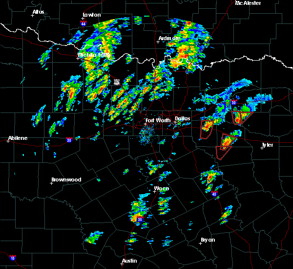 At 331 pm cst, a severe thunderstorm capable of producing a tornado was located near emory, or 15 miles northwest of mineola, moving north at 40 mph (radar indicated rotation). Hazards include tornado. Flying debris will be dangerous to those caught without shelter. mobile homes will be damaged or destroyed. damage to roofs, windows and vehicles will occur. tree damage is likely. This dangerous storm will be near, emory around 335 pm cst. At 331 pm cst, a severe thunderstorm capable of producing a tornado was located near emory, or 15 miles northwest of mineola, moving north at 40 mph (radar indicated rotation). Hazards include tornado. Flying debris will be dangerous to those caught without shelter. mobile homes will be damaged or destroyed. damage to roofs, windows and vehicles will occur. tree damage is likely. This dangerous storm will be near, emory around 335 pm cst.
|
| 12/26/2015 3:25 PM CST |
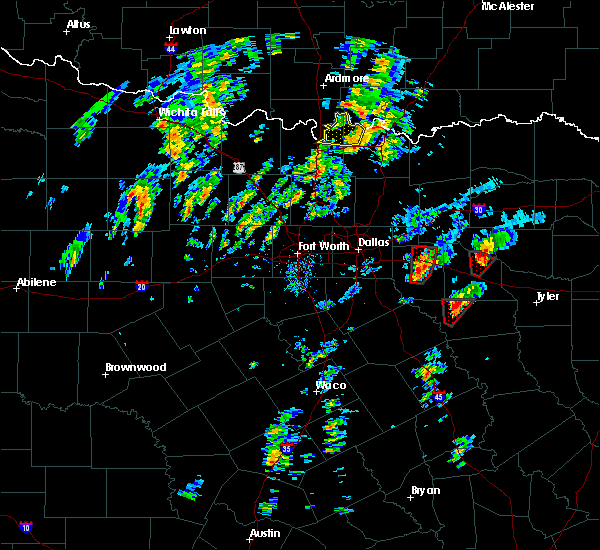 At 324 pm cst, a severe thunderstorm capable of producing a tornado was located near grand saline, or 14 miles northeast of canton, moving north at 35 mph (radar indicated rotation). Hazards include tornado. Flying debris will be dangerous to those caught without shelter. mobile homes will be damaged or destroyed. damage to roofs, windows and vehicles will occur. tree damage is likely. This dangerous storm will be near, emory around 340 pm cst. At 324 pm cst, a severe thunderstorm capable of producing a tornado was located near grand saline, or 14 miles northeast of canton, moving north at 35 mph (radar indicated rotation). Hazards include tornado. Flying debris will be dangerous to those caught without shelter. mobile homes will be damaged or destroyed. damage to roofs, windows and vehicles will occur. tree damage is likely. This dangerous storm will be near, emory around 340 pm cst.
|
| 5/25/2015 5:01 PM CDT | At 500 pm cdt, severe thunderstorms were located along a line extending from 9 miles northeast of cooper lake park doctors creek to como, moving east at 50 mph (radar indicated). Hazards include 60 mph wind gusts and penny size hail. Expect damage to roofs. siding and trees. locations impacted include, sulphur springs, cooper, emory, east tawakoni, cumby, como, cooper lake park south sulphur, cooper lake park doctors creek, point, tira and pecan gap. this includes interstate 30 between mile markers 110 and 142. A tornado watch remains in effect until 1000 pm cdt for north central texas. |
| 5/25/2015 4:43 PM CDT | At 442 pm cdt, severe thunderstorms were located along a line extending from near cooper to 8 miles northeast of emory, moving east at 50 mph (radar indicated). Hazards include 70 mph wind gusts and penny size hail. Expect considerable tree damage. damage is likely to mobile homes, roofs and outbuildings. locations impacted include, greenville, sulphur springs, commerce, cooper, west tawakoni, wolfe city, emory, east tawakoni, cumby, como, campbell, hawk cove, cooper lake park south sulphur, cooper lake park doctors creek, point, ladonia, lone oak, tira, pecan gap and neylandville. this includes interstate 30 between mile markers 96 and 142. A tornado watch remains in effect until 1000 pm cdt for north central texas. |
| 5/25/2015 4:00 PM CDT | At 400 pm cdt, severe thunderstorms were located along a line extending from farmersville to 8 miles north of terrell, moving east at 45 mph (radar indicated). Hazards include 60 mph wind gusts and penny size hail. Expect damage to roofs. Siding and trees. |
| 4/24/2015 7:51 PM CDT | At 751 pm cdt, a severe thunderstorm was located near emory, or 18 miles southwest of sulphur springs, moving east at 40 mph (radar indicated). Hazards include quarter size hail. damage to vehicles is expected |
| 4/1/2015 8:25 PM CDT | A severe thunderstorm warning remains in effect until 900 pm cdt for southeastern rains and north central van zandt counties. at 824 pm cdt. a severe thunderstorm was located near edgewood. or 10 miles northeast of wills point. moving northeast at 25 mph. hazard. quarter size hail. source. Radar indicated. |
| 4/1/2015 8:14 PM CDT | The national weather service in fort worth has issued a * severe thunderstorm warning for. southeastern rains county in northeastern texas. northwestern van zandt county in northeastern texas. until 900 pm cdt * at 814 pm cdt. A severe thunderstorm was located over edgewood. |
| 4/1/2015 7:57 PM CDT | The severe thunderstorm warning for rains and northwestern van zandt counties will expire at 800 pm cdt. the storm which prompted the warning has weakened below severe limits. therefore the warning will be allowed to expire. however small hail. Gusty winds and heavy rain are still possible with this thunderstorm. |
| 4/1/2015 7:46 PM CDT | A severe thunderstorm warning remains in effect until 800 pm cdt for rains and northwestern van zandt counties. at 744 pm cdt. a severe thunderstorm was located near wills point. moving northeast at 30 mph. hazard. 60 mph wind gusts and half dollar size hail. source. Radar indicated. |
| 4/1/2015 7:38 PM CDT | The national weather service in fort worth has issued a * severe thunderstorm warning for. rains county in northeastern texas. south central hunt county in north central texas. east central kaufman county in north central texas. Northwestern van zandt county in northeastern texas. |
| 7/9/2012 7:30 PM CDT | Trees blown down throughout the western half of the county in rains county TX, 3.3 miles E of Emory, TX |
| 1/1/0001 12:00 AM | Numerous trees down near west end of lake fork...state highway 19...and county roads 3150...3325...and 440 in rains county TX, 5.3 miles SW of Emory, TX |
Hail Maps for Emory, TX
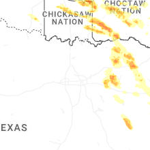
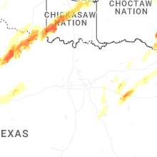


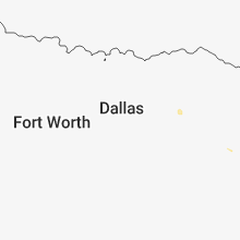


Connect with Interactive Hail Maps