

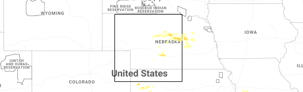
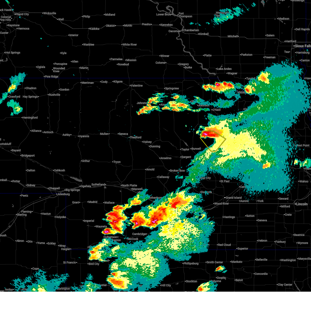
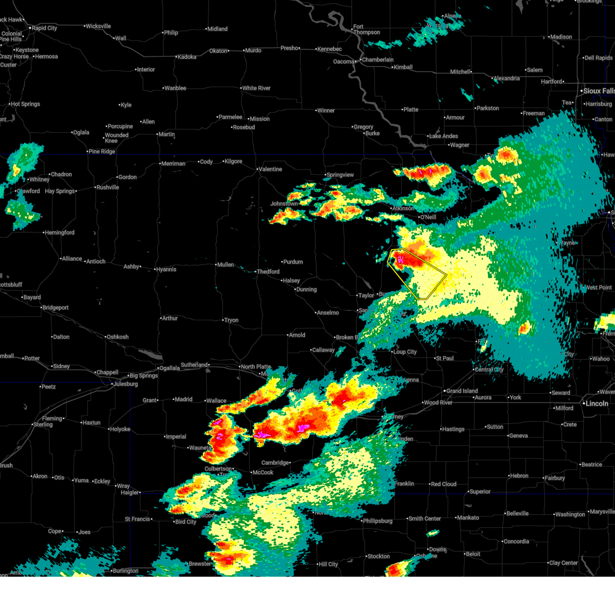
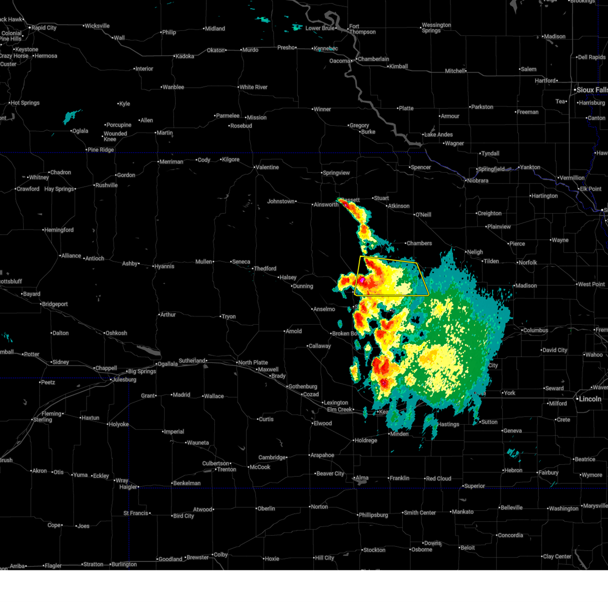
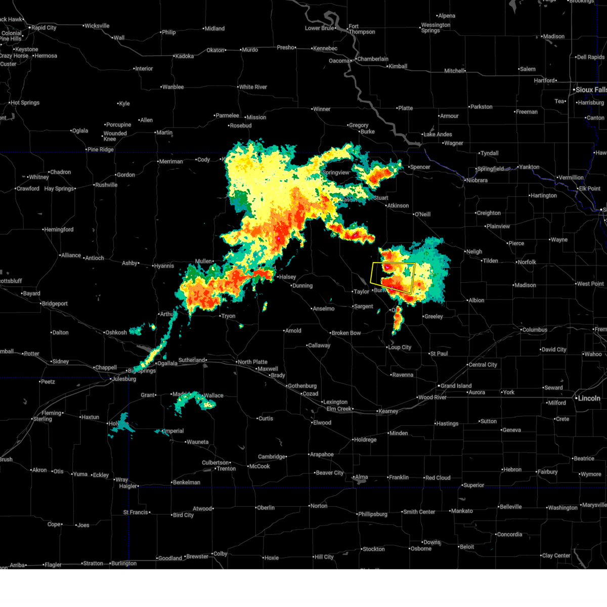
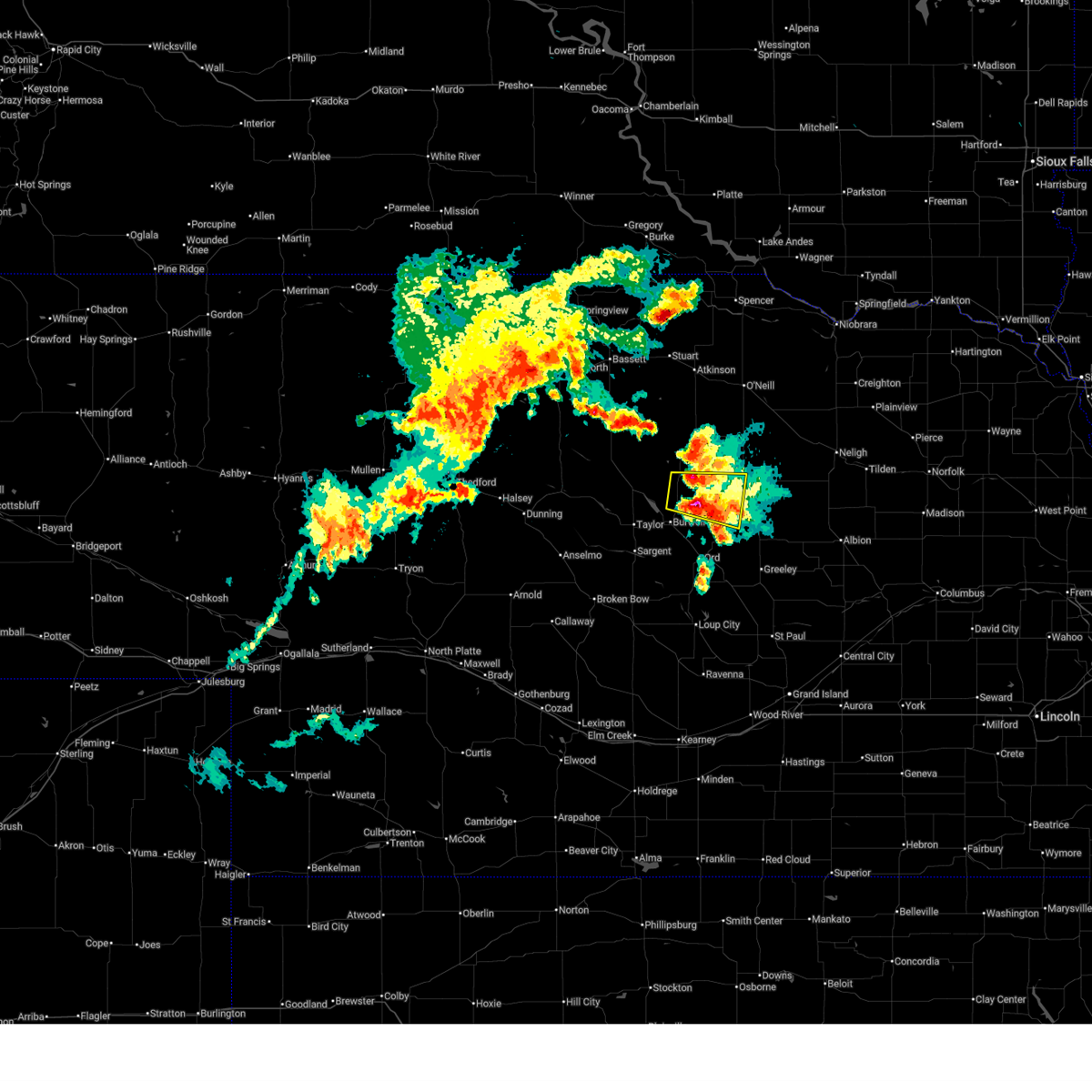
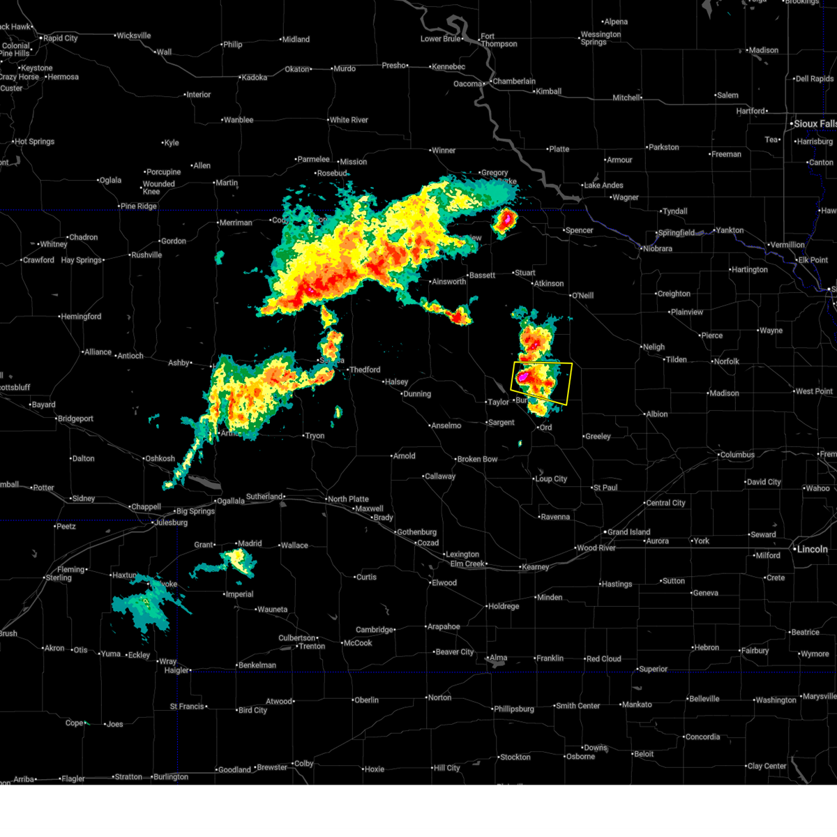
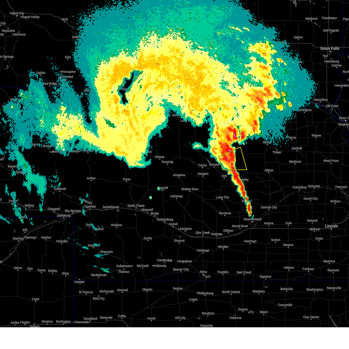
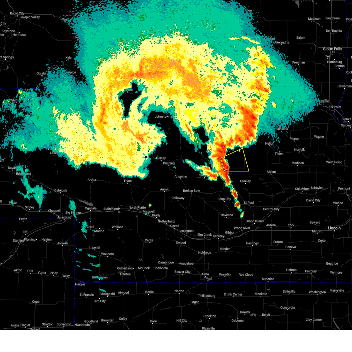
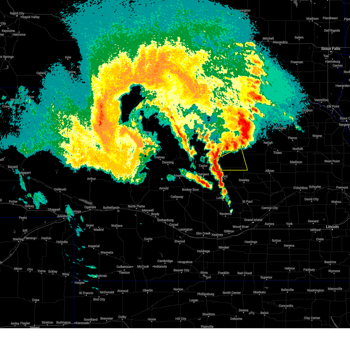
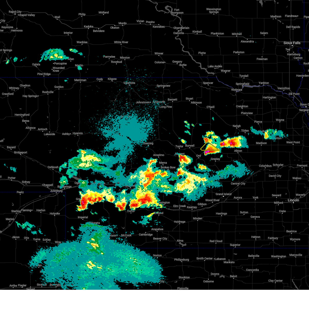
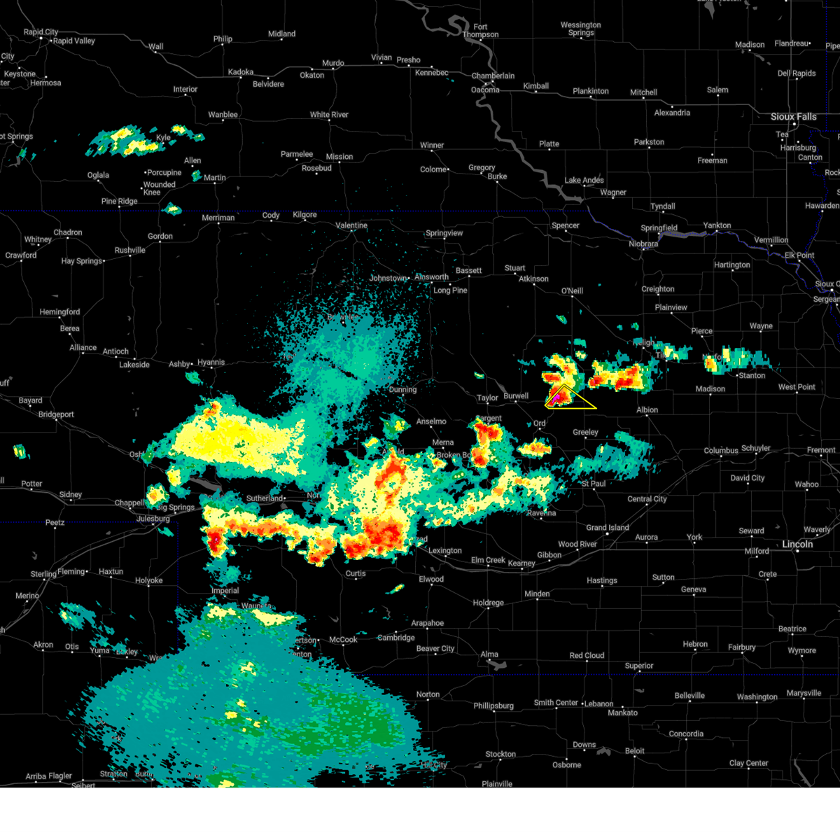
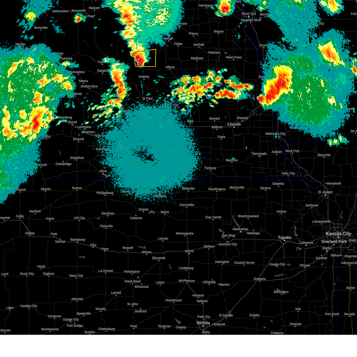
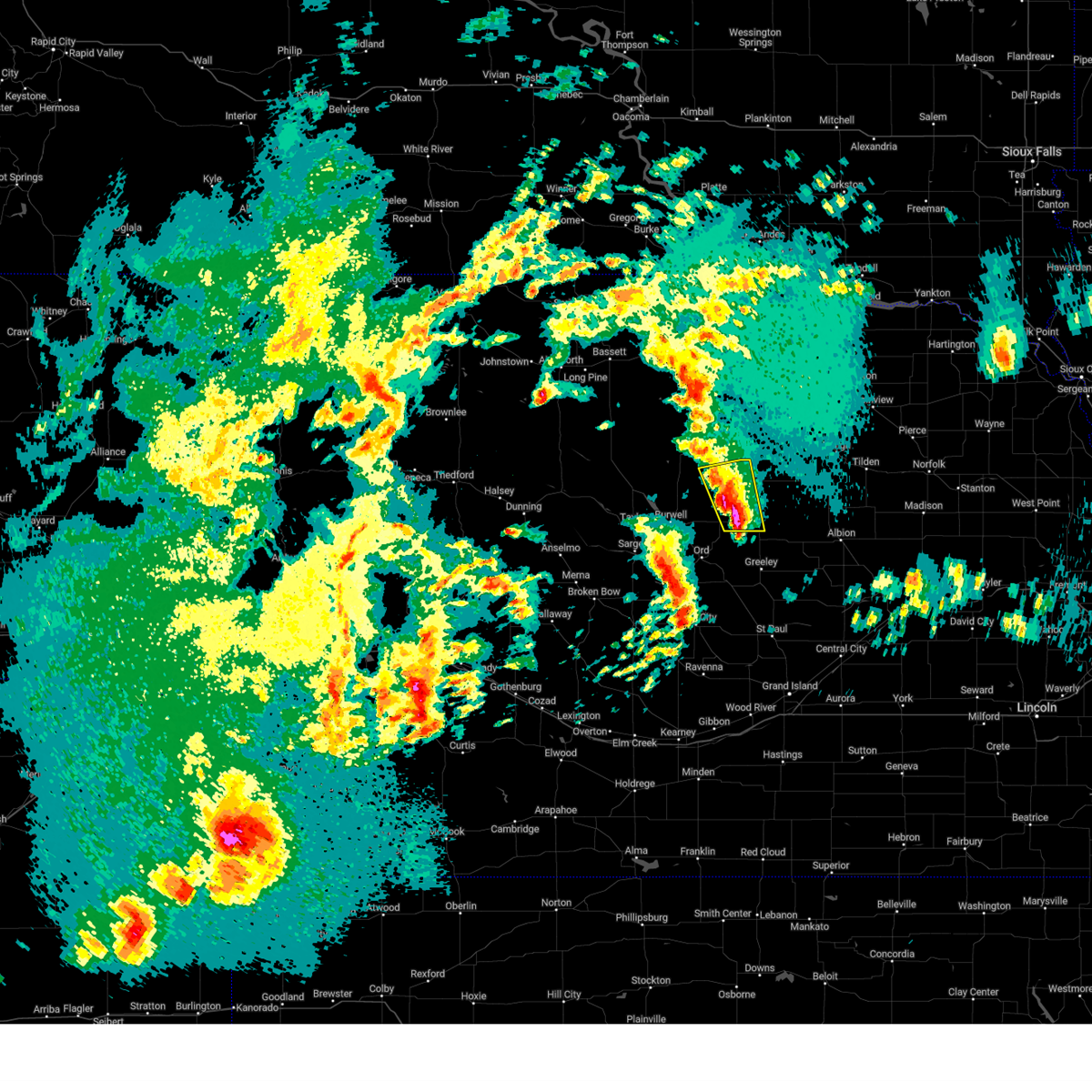
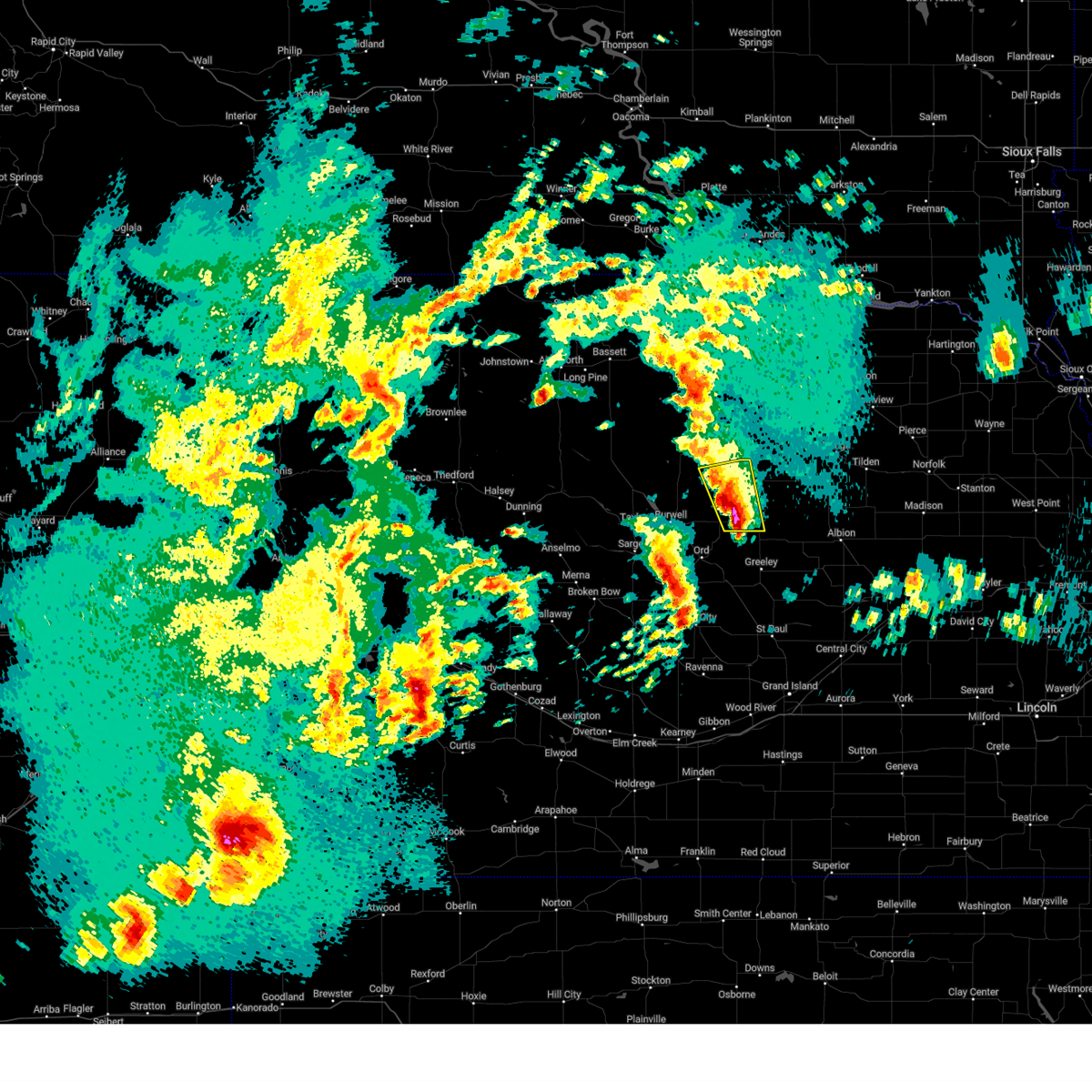
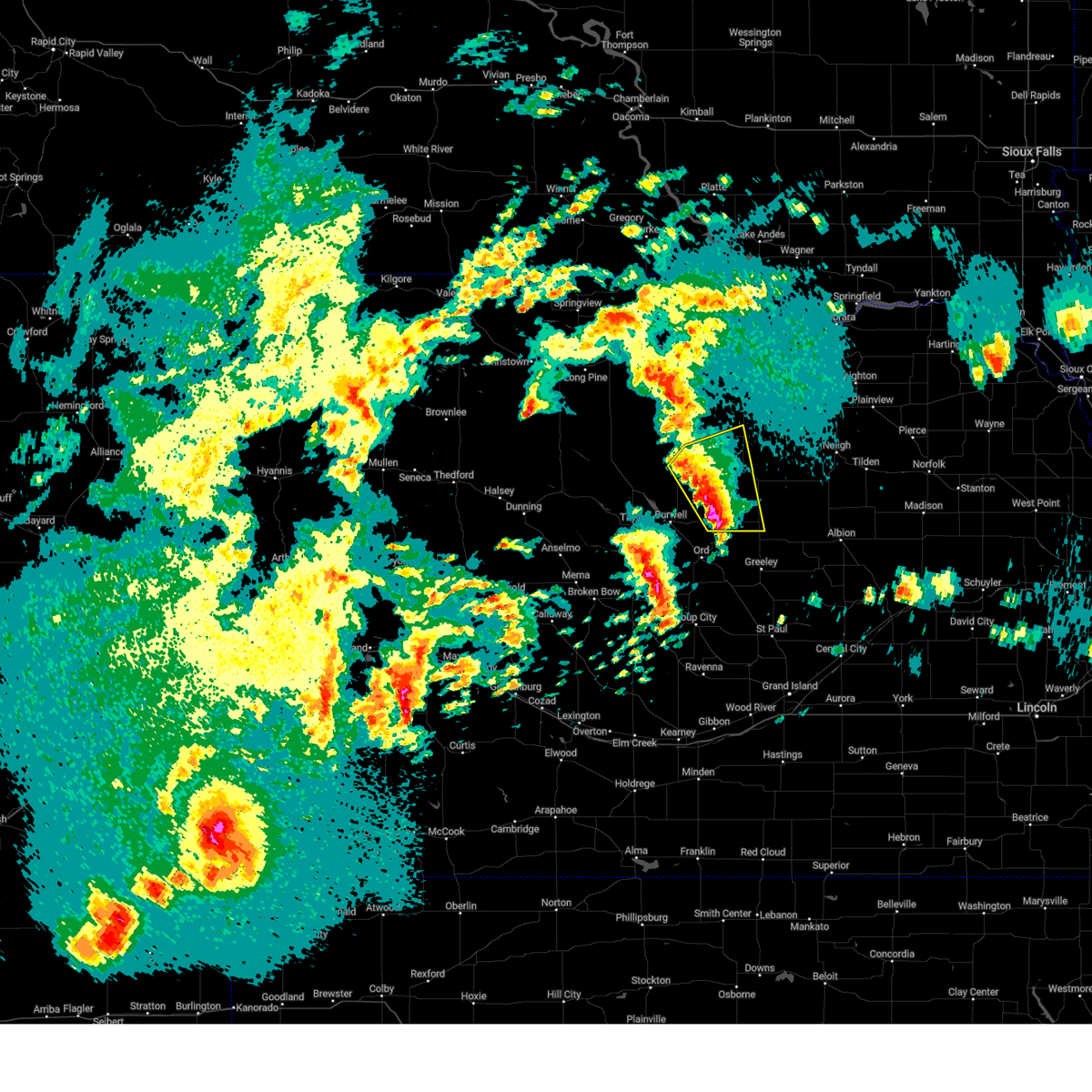
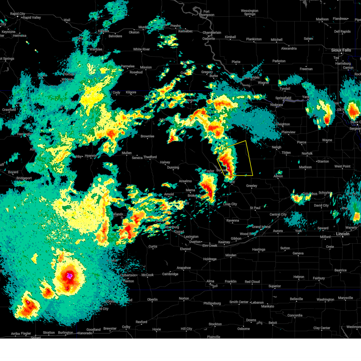
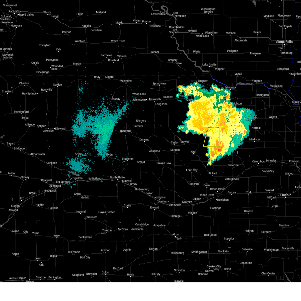
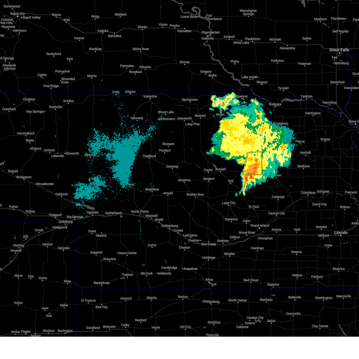
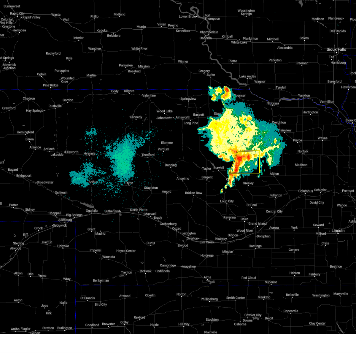
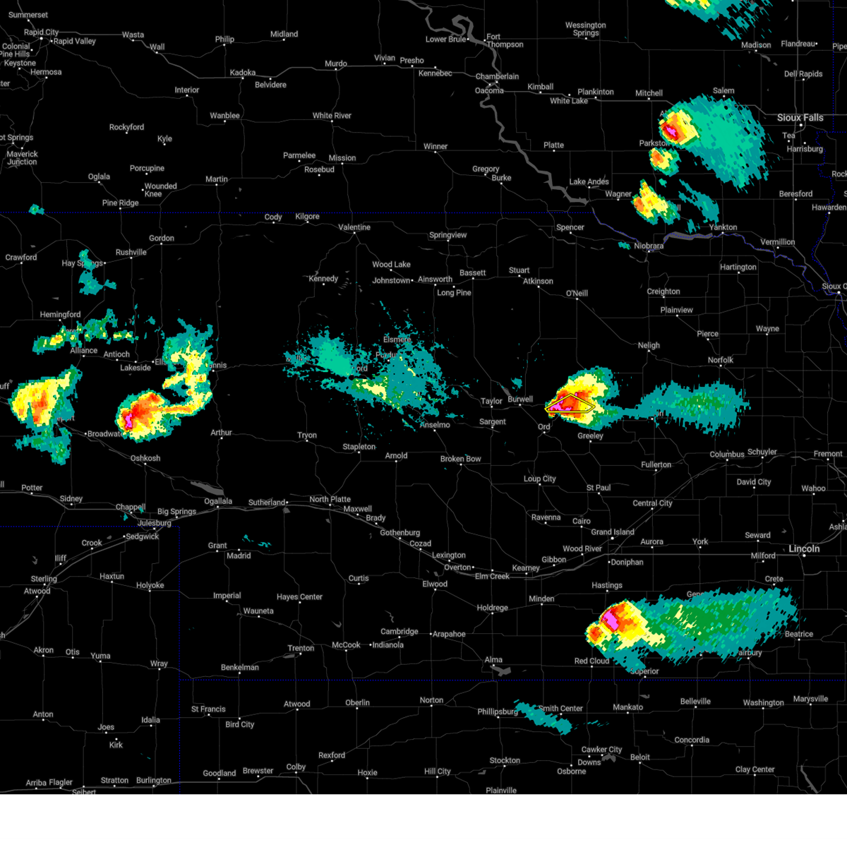
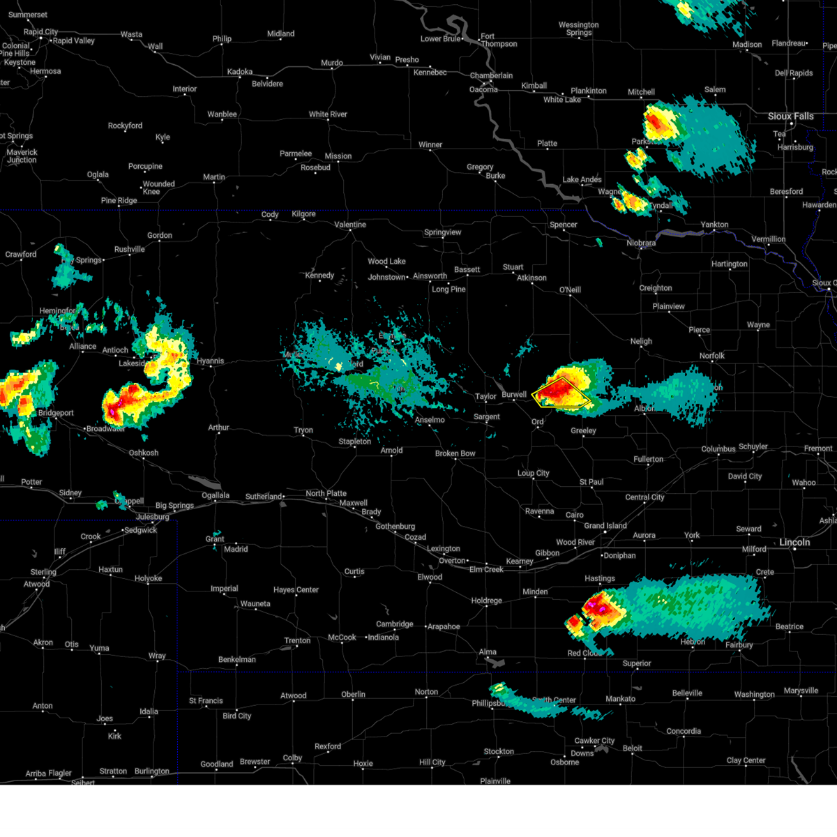
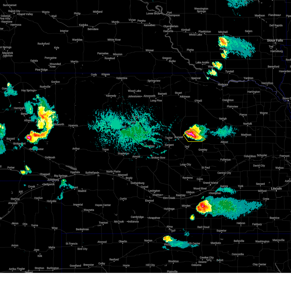
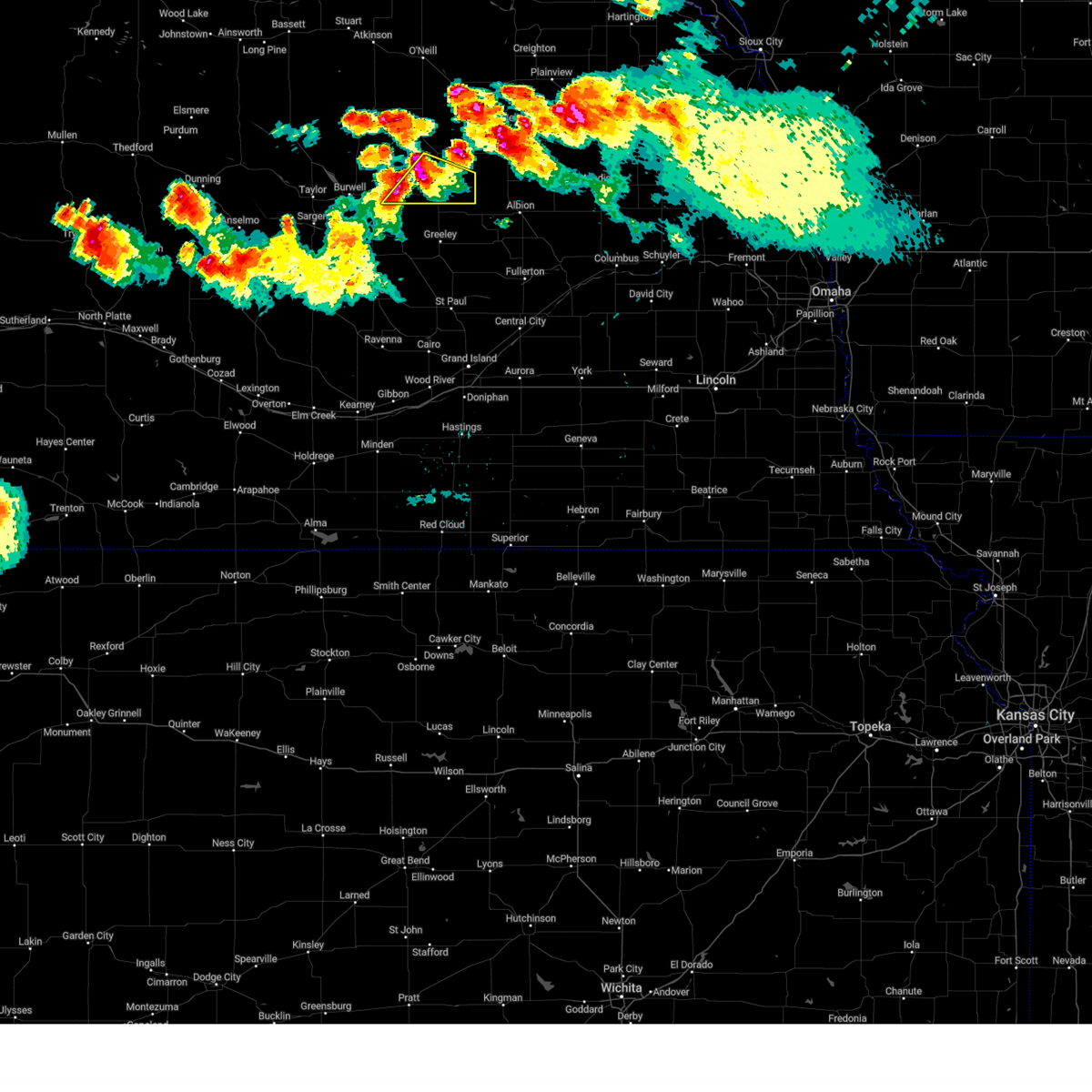
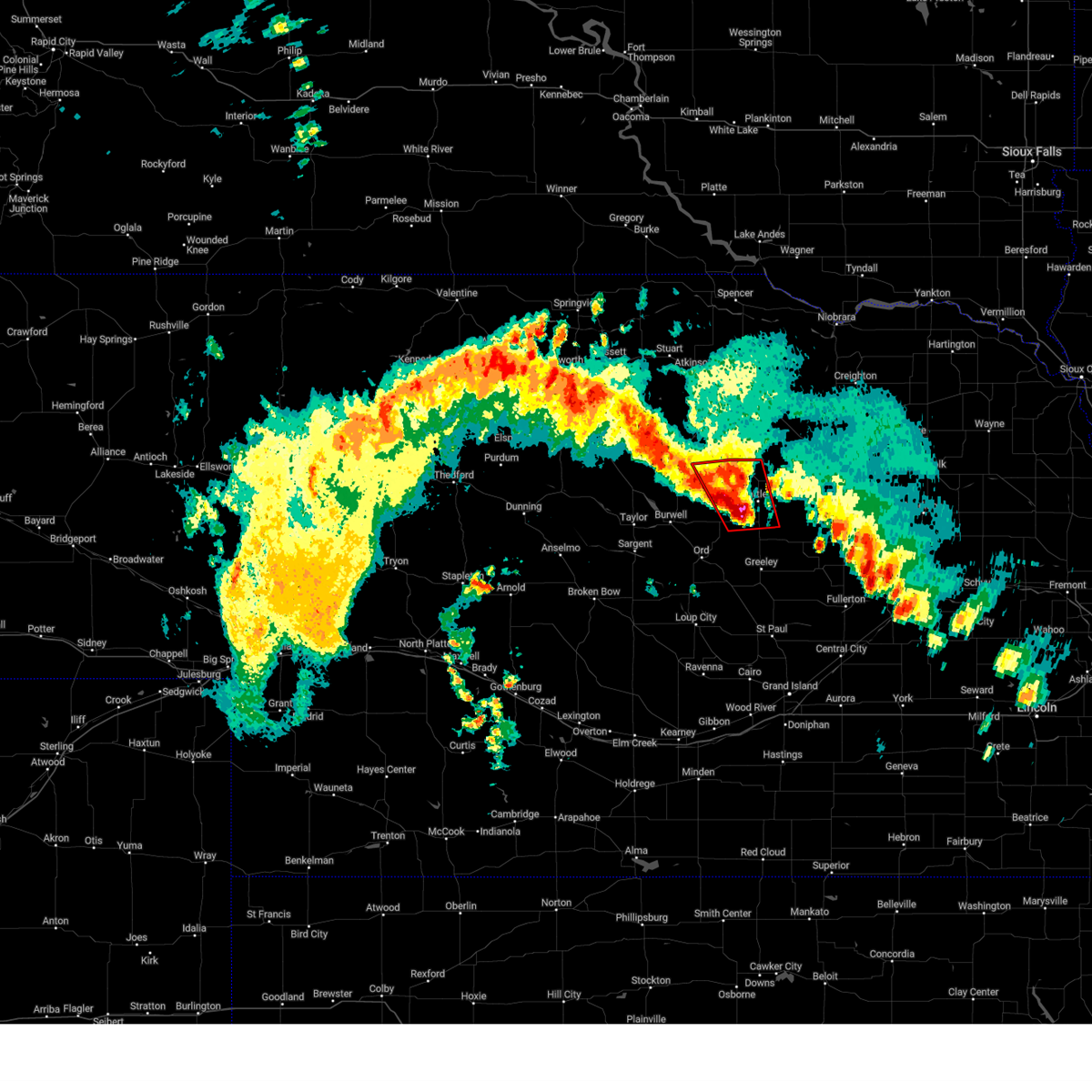
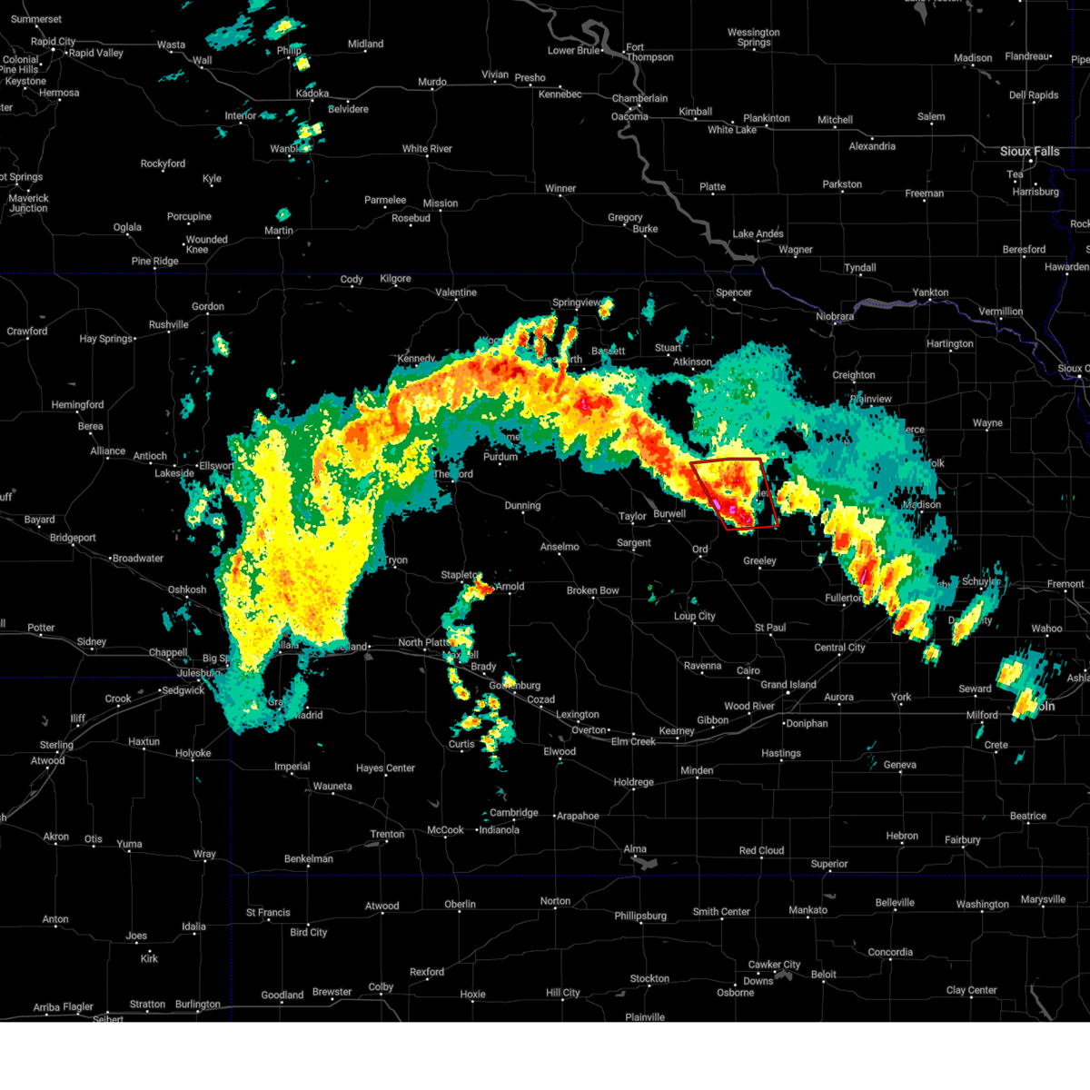
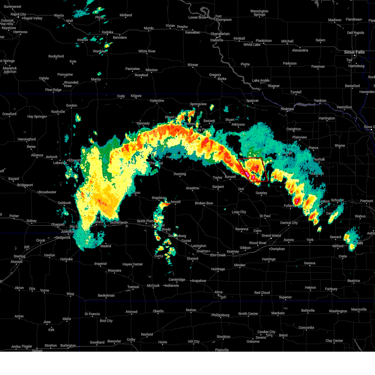
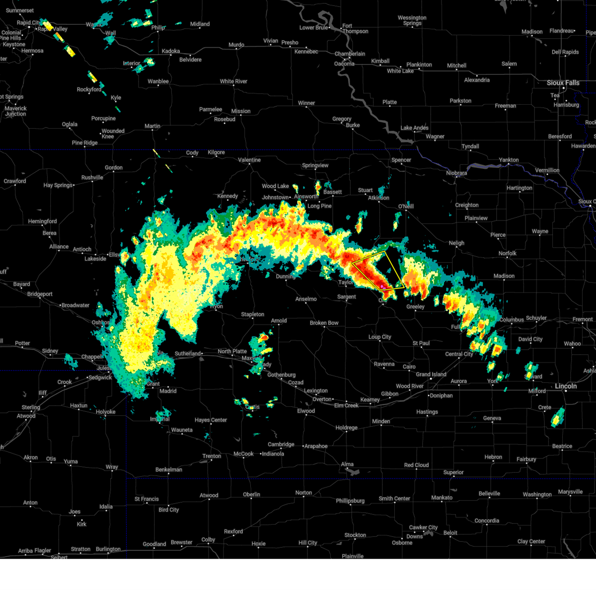
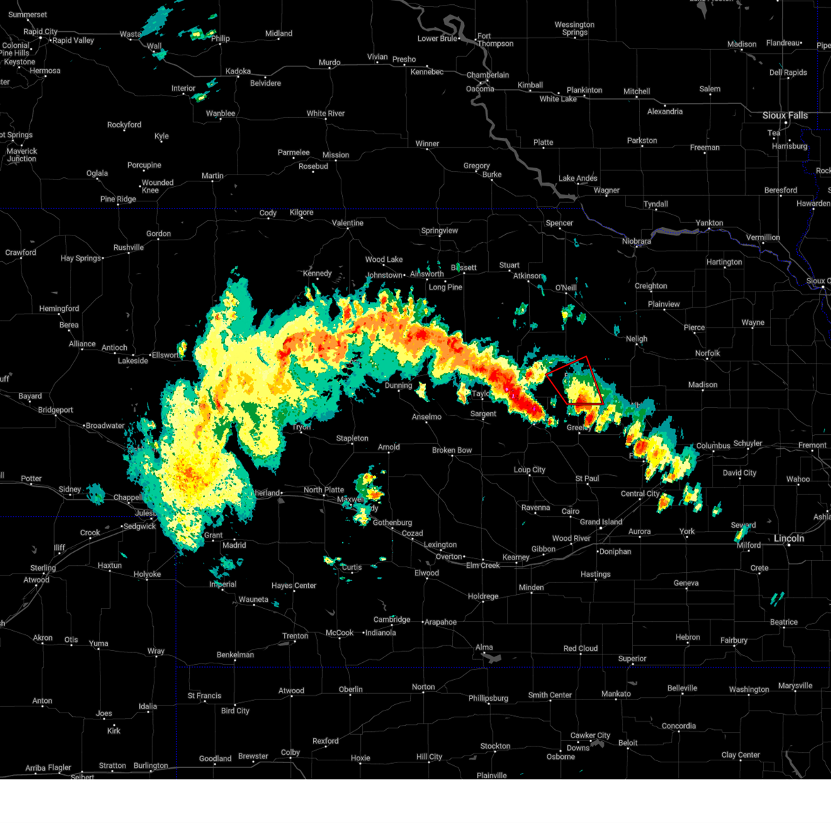
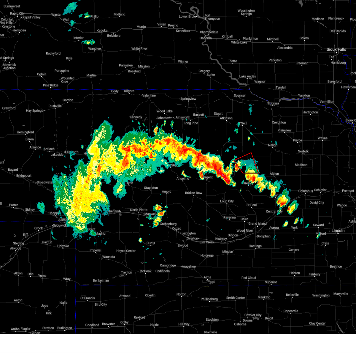
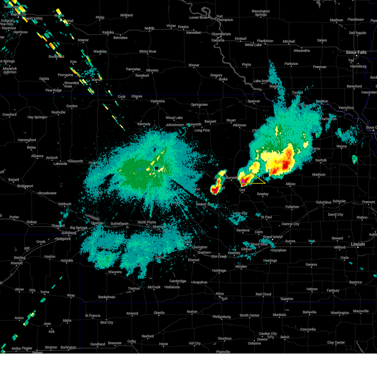
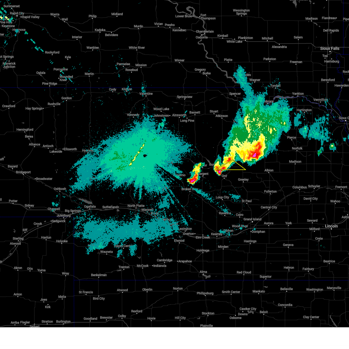
Hail Map for Ericson, NE
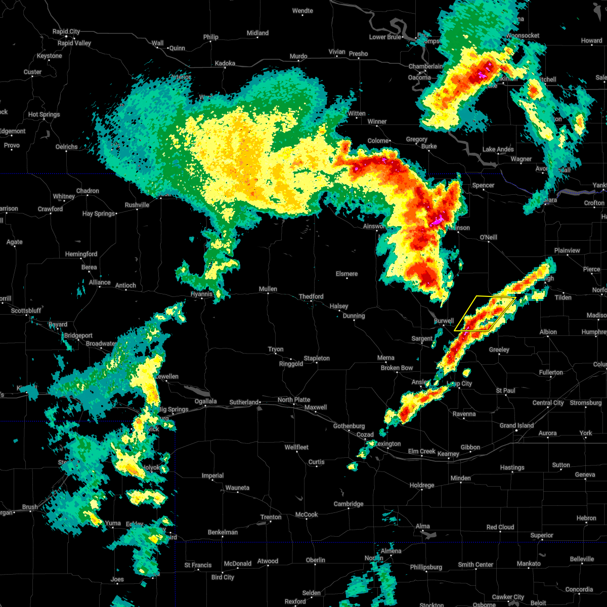
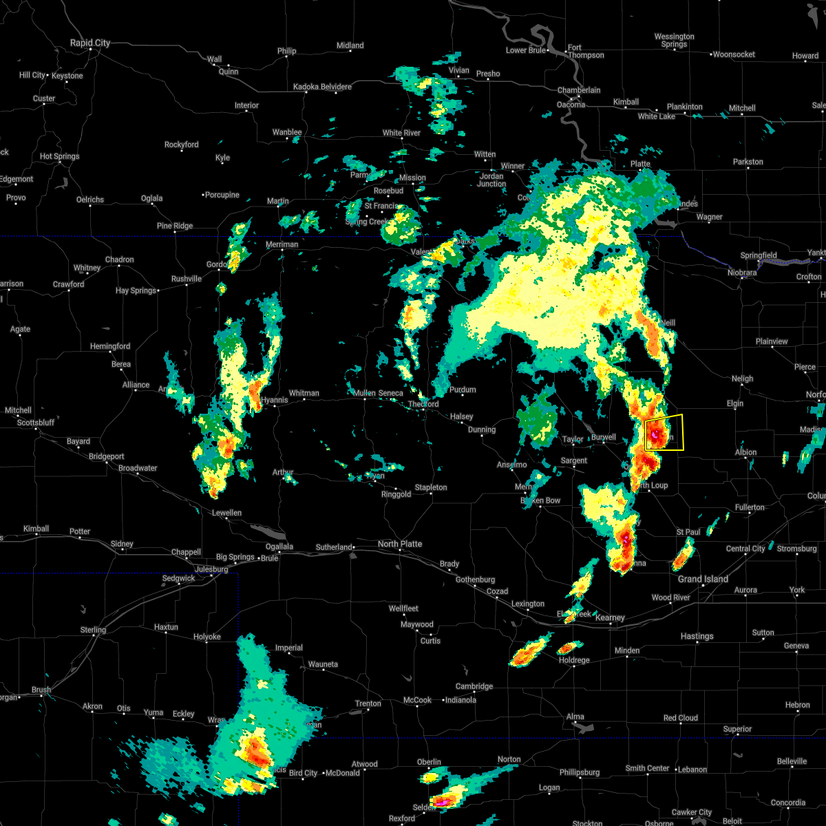
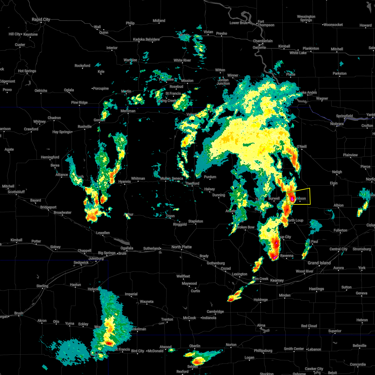
The Ericson, NE area has had 8 reports of on-the-ground hail by trained spotters, and has been under severe weather warnings 8 times during the past 12 months. Doppler radar has detected hail at or near Ericson, NE on 114 occasions, including 6 occasions during the past year.
| Name: | Ericson, NE |
| Where Located: | 46.7 miles S of Oneill, NE |
| Map: | Google Map for Ericson, NE |
| Population: | 92 |
| Housing Units: | 72 |
| More Info: | Search Google for Ericson, NE |
2
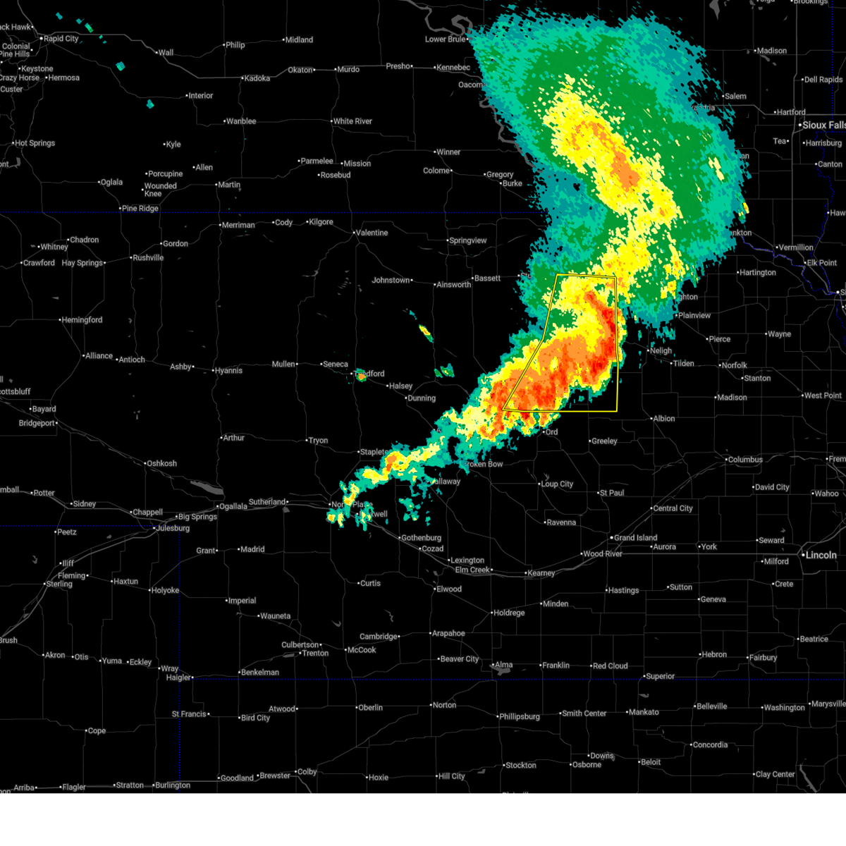
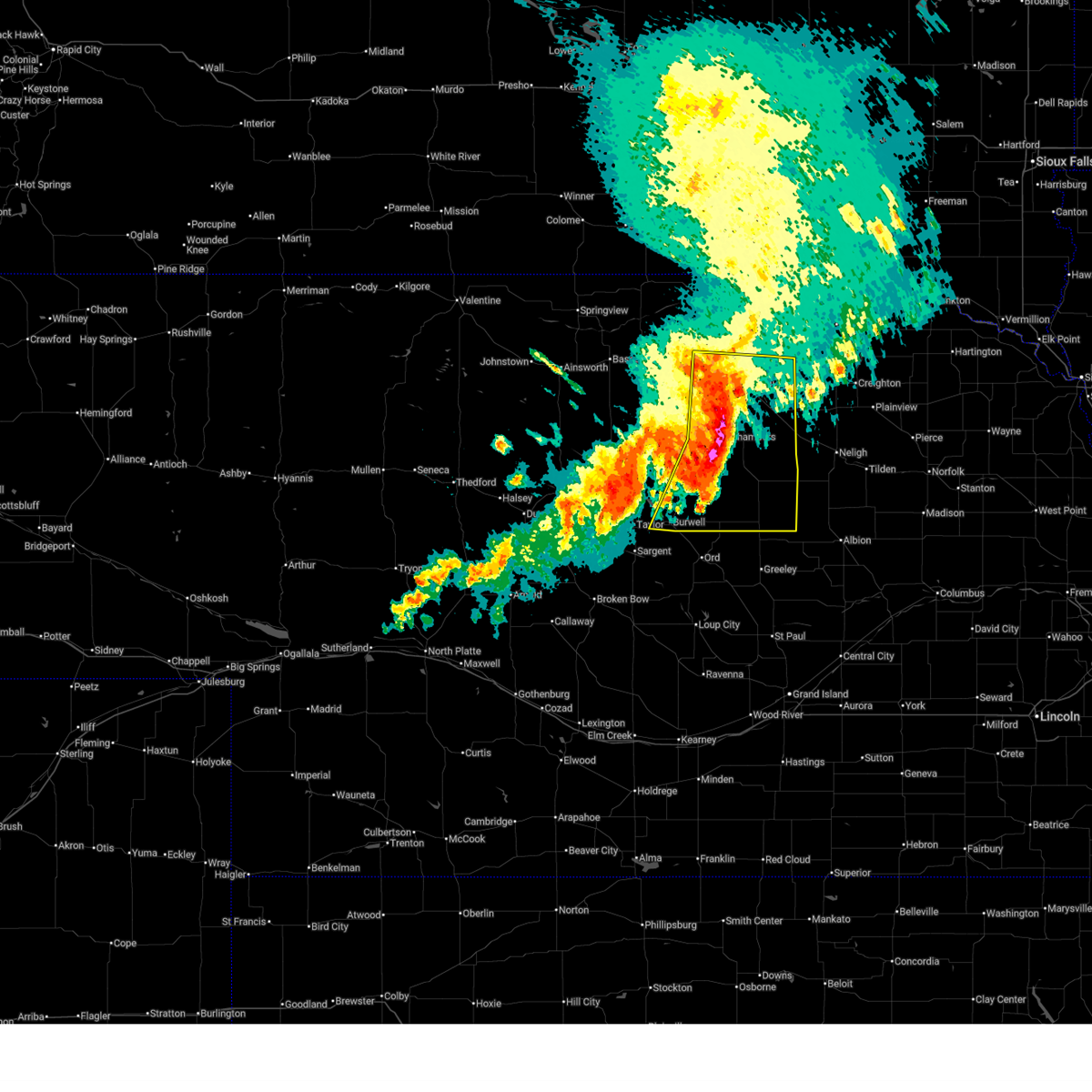
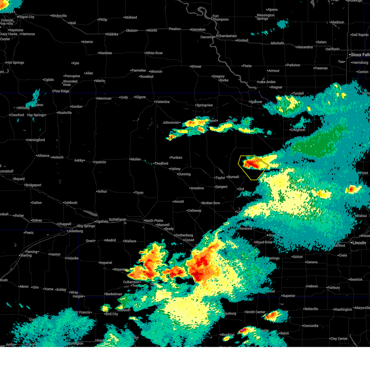
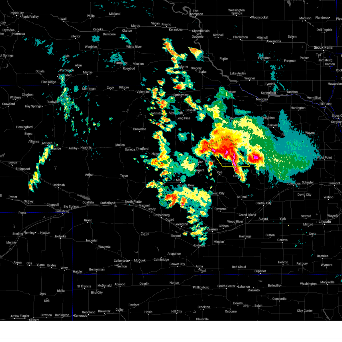
The Top Recent Hail Date for Ericson, NE is Friday, June 12, 2026 (33rd out of 114)
Hail and Wind Damage Spotted near Ericson, NE
| Date / Time | Report Details |
|---|---|
| 8/14/2025 1:09 AM CDT |
 The storms which prompted the warning have weakened below severe limits, and have exited the warned area. therefore, the warning will be allowed to expire. The storms which prompted the warning have weakened below severe limits, and have exited the warned area. therefore, the warning will be allowed to expire.
|
| 8/14/2025 12:59 AM CDT |
 At 1258 am cdt, severe thunderstorms were located along a line extending from 9 miles north of page to 6 miles west of clearwater to near ericson, moving east at 35 mph (radar indicated). Hazards include 60 mph wind gusts. Expect damage to roofs, siding, and trees. locations impacted include, o'neill, burwell, ewing, chambers, page, bartlett, ericson, inman, emmet, knievels corner, virginia smith dam, buffalo flats, kent diversion dam state wildlife management area, sunfish lake, cumminsville, four corners, pibel lake state recreation area, opportunity, goose lake state wildlife management area, and deverre. this includes the following highways, highway 20 between mile markers 298 and 328. Highway 281 between mile markers 132 and 193. At 1258 am cdt, severe thunderstorms were located along a line extending from 9 miles north of page to 6 miles west of clearwater to near ericson, moving east at 35 mph (radar indicated). Hazards include 60 mph wind gusts. Expect damage to roofs, siding, and trees. locations impacted include, o'neill, burwell, ewing, chambers, page, bartlett, ericson, inman, emmet, knievels corner, virginia smith dam, buffalo flats, kent diversion dam state wildlife management area, sunfish lake, cumminsville, four corners, pibel lake state recreation area, opportunity, goose lake state wildlife management area, and deverre. this includes the following highways, highway 20 between mile markers 298 and 328. Highway 281 between mile markers 132 and 193.
|
| 8/14/2025 12:25 AM CDT |
 Svrlbf the national weather service in north platte has issued a * severe thunderstorm warning for, southeastern loup county in north central nebraska, garfield county in north central nebraska, southeastern holt county in north central nebraska, wheeler county in north central nebraska, * until 115 am cdt. * at 1225 am cdt, severe thunderstorms were located along a line extending from near atkinson to near chambers to near burwell, moving east at 35 mph (radar indicated). Hazards include 60 mph wind gusts. expect damage to roofs, siding, and trees Svrlbf the national weather service in north platte has issued a * severe thunderstorm warning for, southeastern loup county in north central nebraska, garfield county in north central nebraska, southeastern holt county in north central nebraska, wheeler county in north central nebraska, * until 115 am cdt. * at 1225 am cdt, severe thunderstorms were located along a line extending from near atkinson to near chambers to near burwell, moving east at 35 mph (radar indicated). Hazards include 60 mph wind gusts. expect damage to roofs, siding, and trees
|
| 7/19/2025 7:55 PM CDT |
 The storm which prompted the warning has weakened below severe limits, and no longer poses an immediate threat to life or property. therefore, the warning will be allowed to expire. a tornado watch remains in effect until 1100 pm cdt for north central nebraska. to report severe weather, contact your nearest law enforcement agency. they will relay your report to the national weather service north platte. The storm which prompted the warning has weakened below severe limits, and no longer poses an immediate threat to life or property. therefore, the warning will be allowed to expire. a tornado watch remains in effect until 1100 pm cdt for north central nebraska. to report severe weather, contact your nearest law enforcement agency. they will relay your report to the national weather service north platte.
|
| 7/19/2025 7:21 PM CDT |
 the severe thunderstorm warning has been cancelled and is no longer in effect the severe thunderstorm warning has been cancelled and is no longer in effect
|
| 7/19/2025 7:21 PM CDT |
 At 721 pm cdt, a severe thunderstorm was located 13 miles south of chambers, or 24 miles northeast of burwell, moving southeast at 25 mph (radar indicated). Hazards include 60 mph wind gusts and quarter size hail. Hail damage to vehicles is expected. expect wind damage to roofs, siding, and trees. locations impacted include, bartlett, ericson, buffalo flats, cumminsville, four corners, and gables. This includes highway 281 between mile markers 133 and 157. At 721 pm cdt, a severe thunderstorm was located 13 miles south of chambers, or 24 miles northeast of burwell, moving southeast at 25 mph (radar indicated). Hazards include 60 mph wind gusts and quarter size hail. Hail damage to vehicles is expected. expect wind damage to roofs, siding, and trees. locations impacted include, bartlett, ericson, buffalo flats, cumminsville, four corners, and gables. This includes highway 281 between mile markers 133 and 157.
|
| 7/19/2025 7:08 PM CDT |
 Svrlbf the national weather service in north platte has issued a * severe thunderstorm warning for, northeastern garfield county in north central nebraska, south central holt county in north central nebraska, wheeler county in north central nebraska, * until 800 pm cdt. * at 707 pm cdt, a severe thunderstorm was located 10 miles southwest of chambers, or 24 miles northeast of burwell, moving southeast at 25 mph (radar indicated). Hazards include 60 mph wind gusts and quarter size hail. Hail damage to vehicles is expected. Expect wind damage to roofs, siding, and trees. Svrlbf the national weather service in north platte has issued a * severe thunderstorm warning for, northeastern garfield county in north central nebraska, south central holt county in north central nebraska, wheeler county in north central nebraska, * until 800 pm cdt. * at 707 pm cdt, a severe thunderstorm was located 10 miles southwest of chambers, or 24 miles northeast of burwell, moving southeast at 25 mph (radar indicated). Hazards include 60 mph wind gusts and quarter size hail. Hail damage to vehicles is expected. Expect wind damage to roofs, siding, and trees.
|
| 7/10/2025 3:59 AM CDT |
 Svrlbf the national weather service in north platte has issued a * severe thunderstorm warning for, eastern loup county in north central nebraska, garfield county in north central nebraska, western wheeler county in north central nebraska, * until 445 am cdt. * at 358 am cdt, severe thunderstorms were located along a line extending from 11 miles northeast of calamus reservoir state recreation area to near burwell, moving east at 30 mph (radar indicated). Hazards include 60 mph wind gusts and quarter size hail. Hail damage to vehicles is expected. expect wind damage to roofs, siding, and trees. severe thunderstorms will be near, burwell around 405 am cdt. ericson around 435 am cdt. other locations impacted by these severe thunderstorms include homestead knolls campground, virginia smith dam, pibel lake state recreation area, hannamon bayou campground, buffalo flats, nunda shoal campground, deverre, valley view flat campground, kent diversion dam state wildlife management area, and gables. This includes highway 281 between mile markers 132 and 142. Svrlbf the national weather service in north platte has issued a * severe thunderstorm warning for, eastern loup county in north central nebraska, garfield county in north central nebraska, western wheeler county in north central nebraska, * until 445 am cdt. * at 358 am cdt, severe thunderstorms were located along a line extending from 11 miles northeast of calamus reservoir state recreation area to near burwell, moving east at 30 mph (radar indicated). Hazards include 60 mph wind gusts and quarter size hail. Hail damage to vehicles is expected. expect wind damage to roofs, siding, and trees. severe thunderstorms will be near, burwell around 405 am cdt. ericson around 435 am cdt. other locations impacted by these severe thunderstorms include homestead knolls campground, virginia smith dam, pibel lake state recreation area, hannamon bayou campground, buffalo flats, nunda shoal campground, deverre, valley view flat campground, kent diversion dam state wildlife management area, and gables. This includes highway 281 between mile markers 132 and 142.
|
| 7/1/2025 11:33 PM CDT |
 the severe thunderstorm warning has been cancelled and is no longer in effect the severe thunderstorm warning has been cancelled and is no longer in effect
|
| 7/1/2025 11:21 PM CDT |
 At 1121 pm cdt, a severe thunderstorm was located 9 miles north of fort hartsuff state park, or 11 miles northeast of burwell, moving southeast at 15 mph (radar indicated). Hazards include 60 mph wind gusts and quarter size hail. Hail damage to vehicles is expected. expect wind damage to roofs, siding, and trees. Locations impacted include, ericson, buffalo flats, deverre, and gables. At 1121 pm cdt, a severe thunderstorm was located 9 miles north of fort hartsuff state park, or 11 miles northeast of burwell, moving southeast at 15 mph (radar indicated). Hazards include 60 mph wind gusts and quarter size hail. Hail damage to vehicles is expected. expect wind damage to roofs, siding, and trees. Locations impacted include, ericson, buffalo flats, deverre, and gables.
|
| 7/1/2025 10:54 PM CDT |
 Svrlbf the national weather service in north platte has issued a * severe thunderstorm warning for, central garfield county in north central nebraska, western wheeler county in north central nebraska, * until midnight cdt. * at 1054 pm cdt, a severe thunderstorm was located 11 miles north of burwell, moving east at 15 mph (radar indicated). Hazards include ping pong ball size hail and 60 mph wind gusts. People and animals outdoors will be injured. expect hail damage to roofs, siding, windows, and vehicles. Expect wind damage to roofs, siding, and trees. Svrlbf the national weather service in north platte has issued a * severe thunderstorm warning for, central garfield county in north central nebraska, western wheeler county in north central nebraska, * until midnight cdt. * at 1054 pm cdt, a severe thunderstorm was located 11 miles north of burwell, moving east at 15 mph (radar indicated). Hazards include ping pong ball size hail and 60 mph wind gusts. People and animals outdoors will be injured. expect hail damage to roofs, siding, windows, and vehicles. Expect wind damage to roofs, siding, and trees.
|
| 5/15/2025 12:07 AM CDT |
 The storms which prompted the warning have weakened below severe limits, and no longer pose an immediate threat to life or property. therefore, the warning will be allowed to expire. however, gusty winds are still possible with these thunderstorms. a severe thunderstorm watch remains in effect until 300 am cdt for north central nebraska. The storms which prompted the warning have weakened below severe limits, and no longer pose an immediate threat to life or property. therefore, the warning will be allowed to expire. however, gusty winds are still possible with these thunderstorms. a severe thunderstorm watch remains in effect until 300 am cdt for north central nebraska.
|
| 5/14/2025 11:41 PM CDT |
 At 1141 pm cdt, severe thunderstorms were located along a line extending from 14 miles north of fort hartsuff state park to 7 miles west of ericson to 7 miles northeast of ord, moving east at 35 mph (radar indicated). Hazards include 60 mph wind gusts and nickel size hail. Expect damage to roofs, siding, and trees. locations impacted include, bartlett, ericson, buffalo flats, pibel lake state recreation area, and gables. This includes highway 281 between mile markers 132 and 147, and between mile markers 149 and 156. At 1141 pm cdt, severe thunderstorms were located along a line extending from 14 miles north of fort hartsuff state park to 7 miles west of ericson to 7 miles northeast of ord, moving east at 35 mph (radar indicated). Hazards include 60 mph wind gusts and nickel size hail. Expect damage to roofs, siding, and trees. locations impacted include, bartlett, ericson, buffalo flats, pibel lake state recreation area, and gables. This includes highway 281 between mile markers 132 and 147, and between mile markers 149 and 156.
|
| 5/14/2025 11:24 PM CDT |
 Svrlbf the national weather service in north platte has issued a * severe thunderstorm warning for, southern garfield county in north central nebraska, western wheeler county in north central nebraska, * until 1215 am cdt. * at 1123 pm cdt, severe thunderstorms were located along a line extending from 6 miles north of burwell to fort hartsuff state park to ord, moving northeast at 35 mph (radar indicated). Hazards include 60 mph wind gusts and nickel size hail. expect damage to roofs, siding, and trees Svrlbf the national weather service in north platte has issued a * severe thunderstorm warning for, southern garfield county in north central nebraska, western wheeler county in north central nebraska, * until 1215 am cdt. * at 1123 pm cdt, severe thunderstorms were located along a line extending from 6 miles north of burwell to fort hartsuff state park to ord, moving northeast at 35 mph (radar indicated). Hazards include 60 mph wind gusts and nickel size hail. expect damage to roofs, siding, and trees
|
| 8/18/2024 7:42 AM CDT |
 At 741 am cdt, severe thunderstorms were located along a line extending from 6 miles southeast of chambers to 8 miles west of bartlett to 10 miles north of fort hartsuff state park, moving southeast at 40 mph (radar indicated). Hazards include 60 mph wind gusts and quarter size hail. Hail damage to vehicles is expected. expect wind damage to roofs, siding, and trees. locations impacted include, chambers, bartlett, ericson, sunfish lake, cumminsville, four corners, pibel lake state recreation area, buffalo flats, and gables. This includes highway 281 between mile markers 132 and 159. At 741 am cdt, severe thunderstorms were located along a line extending from 6 miles southeast of chambers to 8 miles west of bartlett to 10 miles north of fort hartsuff state park, moving southeast at 40 mph (radar indicated). Hazards include 60 mph wind gusts and quarter size hail. Hail damage to vehicles is expected. expect wind damage to roofs, siding, and trees. locations impacted include, chambers, bartlett, ericson, sunfish lake, cumminsville, four corners, pibel lake state recreation area, buffalo flats, and gables. This includes highway 281 between mile markers 132 and 159.
|
| 8/18/2024 7:32 AM CDT |
 At 732 am cdt, severe thunderstorms were located along a line extending from near chambers to 12 miles northwest of bartlett to 12 miles northeast of burwell, moving southeast at 40 mph (radar indicated). Hazards include 60 mph wind gusts and quarter size hail. Hail damage to vehicles is expected. expect wind damage to roofs, siding, and trees. locations impacted include, chambers, bartlett, ericson, amelia, sunfish lake, cumminsville, four corners, pibel lake state recreation area, buffalo flats, carson lake, and gables. This includes highway 281 between mile markers 132 and 159. At 732 am cdt, severe thunderstorms were located along a line extending from near chambers to 12 miles northwest of bartlett to 12 miles northeast of burwell, moving southeast at 40 mph (radar indicated). Hazards include 60 mph wind gusts and quarter size hail. Hail damage to vehicles is expected. expect wind damage to roofs, siding, and trees. locations impacted include, chambers, bartlett, ericson, amelia, sunfish lake, cumminsville, four corners, pibel lake state recreation area, buffalo flats, carson lake, and gables. This includes highway 281 between mile markers 132 and 159.
|
| 8/18/2024 7:09 AM CDT |
 Svrlbf the national weather service in north platte has issued a * severe thunderstorm warning for, garfield county in north central nebraska, southwestern holt county in north central nebraska, wheeler county in north central nebraska, * until 800 am cdt. * at 709 am cdt, severe thunderstorms were located along a line extending from 7 miles northeast of amelia to 12 miles southwest of chambers to 15 miles north of calamus reservoir state recreation area, moving southeast at 40 mph (radar indicated). Hazards include 60 mph wind gusts and quarter size hail. Hail damage to vehicles is expected. Expect wind damage to roofs, siding, and trees. Svrlbf the national weather service in north platte has issued a * severe thunderstorm warning for, garfield county in north central nebraska, southwestern holt county in north central nebraska, wheeler county in north central nebraska, * until 800 am cdt. * at 709 am cdt, severe thunderstorms were located along a line extending from 7 miles northeast of amelia to 12 miles southwest of chambers to 15 miles north of calamus reservoir state recreation area, moving southeast at 40 mph (radar indicated). Hazards include 60 mph wind gusts and quarter size hail. Hail damage to vehicles is expected. Expect wind damage to roofs, siding, and trees.
|
| 8/7/2024 10:38 PM CDT |
 The storm which prompted the warning has moved out of the area. therefore, the warning will be allowed to expire. The storm which prompted the warning has moved out of the area. therefore, the warning will be allowed to expire.
|
| 8/7/2024 10:25 PM CDT |
 Svrlbf the national weather service in north platte has issued a * severe thunderstorm warning for, southeastern garfield county in north central nebraska, southwestern wheeler county in north central nebraska, * until 1045 pm cdt. * at 1025 pm cdt, a severe thunderstorm was located over ericson, or 15 miles northeast of ord, moving southeast at 35 mph (radar indicated). Hazards include ping pong ball size hail and 60 mph wind gusts. People and animals outdoors will be injured. expect hail damage to roofs, siding, windows, and vehicles. Expect wind damage to roofs, siding, and trees. Svrlbf the national weather service in north platte has issued a * severe thunderstorm warning for, southeastern garfield county in north central nebraska, southwestern wheeler county in north central nebraska, * until 1045 pm cdt. * at 1025 pm cdt, a severe thunderstorm was located over ericson, or 15 miles northeast of ord, moving southeast at 35 mph (radar indicated). Hazards include ping pong ball size hail and 60 mph wind gusts. People and animals outdoors will be injured. expect hail damage to roofs, siding, windows, and vehicles. Expect wind damage to roofs, siding, and trees.
|
| 6/7/2024 6:22 PM CDT |
 The storm which prompted the warning has moved out of the area. therefore, the warning has been allowed to expire. a severe thunderstorm watch remains in effect until 900 pm cdt for north central nebraska. to report severe weather, contact your nearest law enforcement agency. they will relay your report to the national weather service north platte. The storm which prompted the warning has moved out of the area. therefore, the warning has been allowed to expire. a severe thunderstorm watch remains in effect until 900 pm cdt for north central nebraska. to report severe weather, contact your nearest law enforcement agency. they will relay your report to the national weather service north platte.
|
| 6/7/2024 5:24 PM CDT |
 Svrlbf the national weather service in north platte has issued a * severe thunderstorm warning for, southeastern garfield county in north central nebraska, southwestern wheeler county in north central nebraska, * until 615 pm cdt. * at 523 pm cdt, a severe thunderstorm was located over fort hartsuff state park, or 7 miles east of burwell, moving southeast at 30 mph (public). Hazards include 60 mph wind gusts and quarter size hail. Hail damage to vehicles is expected. Expect wind damage to roofs, siding, and trees. Svrlbf the national weather service in north platte has issued a * severe thunderstorm warning for, southeastern garfield county in north central nebraska, southwestern wheeler county in north central nebraska, * until 615 pm cdt. * at 523 pm cdt, a severe thunderstorm was located over fort hartsuff state park, or 7 miles east of burwell, moving southeast at 30 mph (public). Hazards include 60 mph wind gusts and quarter size hail. Hail damage to vehicles is expected. Expect wind damage to roofs, siding, and trees.
|
| 5/20/2024 11:55 PM CDT |
 Svrlbf the national weather service in north platte has issued a * severe thunderstorm warning for, wheeler county in north central nebraska, * until 1230 am cdt. * at 1155 pm cdt, a severe thunderstorm was located near bartlett, or 23 miles northeast of ord, moving east at 30 mph (radar indicated). Hazards include 60 mph wind gusts and quarter size hail. Hail damage to vehicles is expected. Expect wind damage to roofs, siding, and trees. Svrlbf the national weather service in north platte has issued a * severe thunderstorm warning for, wheeler county in north central nebraska, * until 1230 am cdt. * at 1155 pm cdt, a severe thunderstorm was located near bartlett, or 23 miles northeast of ord, moving east at 30 mph (radar indicated). Hazards include 60 mph wind gusts and quarter size hail. Hail damage to vehicles is expected. Expect wind damage to roofs, siding, and trees.
|
| 5/20/2024 11:44 PM CDT |
 the severe thunderstorm warning has been cancelled and is no longer in effect the severe thunderstorm warning has been cancelled and is no longer in effect
|
| 5/20/2024 11:44 PM CDT |
 At 1144 pm cdt, a severe thunderstorm was located near ericson, or 21 miles northeast of ord, moving east at 30 mph (radar indicated). Hazards include ping pong ball size hail and 60 mph wind gusts. People and animals outdoors will be injured. expect hail damage to roofs, siding, windows, and vehicles. expect wind damage to roofs, siding, and trees. locations impacted include, bartlett, ericson, buffalo flats, pibel lake state recreation area, and gables. This includes highway 281 between mile markers 132 and 140, and between mile markers 152 and 157. At 1144 pm cdt, a severe thunderstorm was located near ericson, or 21 miles northeast of ord, moving east at 30 mph (radar indicated). Hazards include ping pong ball size hail and 60 mph wind gusts. People and animals outdoors will be injured. expect hail damage to roofs, siding, windows, and vehicles. expect wind damage to roofs, siding, and trees. locations impacted include, bartlett, ericson, buffalo flats, pibel lake state recreation area, and gables. This includes highway 281 between mile markers 132 and 140, and between mile markers 152 and 157.
|
| 5/20/2024 11:32 PM CDT |
 At 1132 pm cdt, a severe thunderstorm was located 8 miles northwest of ericson, or 16 miles east of burwell, moving east at 25 mph (radar indicated). Hazards include 60 mph wind gusts and quarter size hail. Hail damage to vehicles is expected. expect wind damage to roofs, siding, and trees. locations impacted include, chambers, bartlett, ericson, sunfish lake, pibel lake state recreation area, buffalo flats, and gables. This includes highway 281 between mile markers 132 and 140, and between mile markers 152 and 169. At 1132 pm cdt, a severe thunderstorm was located 8 miles northwest of ericson, or 16 miles east of burwell, moving east at 25 mph (radar indicated). Hazards include 60 mph wind gusts and quarter size hail. Hail damage to vehicles is expected. expect wind damage to roofs, siding, and trees. locations impacted include, chambers, bartlett, ericson, sunfish lake, pibel lake state recreation area, buffalo flats, and gables. This includes highway 281 between mile markers 132 and 140, and between mile markers 152 and 169.
|
| 5/20/2024 11:14 PM CDT |
 Svrlbf the national weather service in north platte has issued a * severe thunderstorm warning for, garfield county in north central nebraska, south central holt county in north central nebraska, western wheeler county in north central nebraska, * until midnight cdt. * at 1114 pm cdt, a severe thunderstorm was located 9 miles northeast of burwell, moving east at 30 mph (radar indicated). Hazards include 60 mph wind gusts and quarter size hail. Hail damage to vehicles is expected. Expect wind damage to roofs, siding, and trees. Svrlbf the national weather service in north platte has issued a * severe thunderstorm warning for, garfield county in north central nebraska, south central holt county in north central nebraska, western wheeler county in north central nebraska, * until midnight cdt. * at 1114 pm cdt, a severe thunderstorm was located 9 miles northeast of burwell, moving east at 30 mph (radar indicated). Hazards include 60 mph wind gusts and quarter size hail. Hail damage to vehicles is expected. Expect wind damage to roofs, siding, and trees.
|
| 4/16/2024 4:44 AM CDT |
 The storms which prompted the warning have weakened below severe limits, and no longer pose an immediate threat to life or property. therefore, the warning will be allowed to expire. however, gusty winds are still possible with these thunderstorms. The storms which prompted the warning have weakened below severe limits, and no longer pose an immediate threat to life or property. therefore, the warning will be allowed to expire. however, gusty winds are still possible with these thunderstorms.
|
| 4/16/2024 4:32 AM CDT |
 the severe thunderstorm warning has been cancelled and is no longer in effect the severe thunderstorm warning has been cancelled and is no longer in effect
|
| 4/16/2024 4:32 AM CDT |
 At 432 am cdt, severe thunderstorms were located along a line extending from 10 miles north of bartlett to 13 miles southwest of amelia to 10 miles northwest of calamus reservoir state recreation area, moving north at 55 mph (radar indicated). Hazards include 60 mph wind gusts. Expect damage to roofs, siding, and trees. locations impacted include, burwell, taylor, chambers, bartlett, ericson, amelia, calamus reservoir state recreation area, virginia smith dam, hannamon bayou campground, buffalo flats, kent diversion dam state wildlife management area, carson lake, sunfish lake, homestead knolls campground, cumminsville, four corners, horseshoe bend lake, pibel lake state recreation area, nunda shoal campground, and goose lake state wildlife management area. this includes the following highways, highway 183 between mile markers 123 and 145, and near mile marker 154. Highway 281 between mile markers 132 and 170. At 432 am cdt, severe thunderstorms were located along a line extending from 10 miles north of bartlett to 13 miles southwest of amelia to 10 miles northwest of calamus reservoir state recreation area, moving north at 55 mph (radar indicated). Hazards include 60 mph wind gusts. Expect damage to roofs, siding, and trees. locations impacted include, burwell, taylor, chambers, bartlett, ericson, amelia, calamus reservoir state recreation area, virginia smith dam, hannamon bayou campground, buffalo flats, kent diversion dam state wildlife management area, carson lake, sunfish lake, homestead knolls campground, cumminsville, four corners, horseshoe bend lake, pibel lake state recreation area, nunda shoal campground, and goose lake state wildlife management area. this includes the following highways, highway 183 between mile markers 123 and 145, and near mile marker 154. Highway 281 between mile markers 132 and 170.
|
| 4/16/2024 4:00 AM CDT |
 Svrlbf the national weather service in north platte has issued a * severe thunderstorm warning for, southeastern rock county in north central nebraska, eastern loup county in north central nebraska, garfield county in north central nebraska, southern holt county in north central nebraska, northeastern custer county in central nebraska, wheeler county in north central nebraska, * until 445 am cdt. * at 400 am cdt, severe thunderstorms were located along a line extending from near greeley center to near elyria to near comstock, moving north at 55 mph (radar indicated). Hazards include 70 mph wind gusts. Expect considerable tree damage. Damage is likely to mobile homes, roofs, and outbuildings. Svrlbf the national weather service in north platte has issued a * severe thunderstorm warning for, southeastern rock county in north central nebraska, eastern loup county in north central nebraska, garfield county in north central nebraska, southern holt county in north central nebraska, northeastern custer county in central nebraska, wheeler county in north central nebraska, * until 445 am cdt. * at 400 am cdt, severe thunderstorms were located along a line extending from near greeley center to near elyria to near comstock, moving north at 55 mph (radar indicated). Hazards include 70 mph wind gusts. Expect considerable tree damage. Damage is likely to mobile homes, roofs, and outbuildings.
|
| 9/7/2023 10:24 PM CDT |
 The severe thunderstorm warning for wheeler county will expire at 1030 pm cdt, the storms which prompted the warning have weakened below severe limits, and have exited the warned area. therefore, the warning will be allowed to expire. however, gusty winds are still possible with these thunderstorms. The severe thunderstorm warning for wheeler county will expire at 1030 pm cdt, the storms which prompted the warning have weakened below severe limits, and have exited the warned area. therefore, the warning will be allowed to expire. however, gusty winds are still possible with these thunderstorms.
|
| 9/7/2023 10:10 PM CDT |
 At 1010 pm cdt, severe thunderstorms were located along a line extending from 14 miles west of elgin to 8 miles south of bartlett, moving east at 45 mph (radar indicated). Hazards include 60 mph wind gusts. Expect damage to roofs, siding, and trees. locations impacted include, bartlett, ericson, cumminsville, four corners and pibel lake state recreation area. this includes highway 281 between mile markers 132 and 152. hail threat, radar indicated max hail size, <. 75 in wind threat, radar indicated max wind gust, 60 mph. At 1010 pm cdt, severe thunderstorms were located along a line extending from 14 miles west of elgin to 8 miles south of bartlett, moving east at 45 mph (radar indicated). Hazards include 60 mph wind gusts. Expect damage to roofs, siding, and trees. locations impacted include, bartlett, ericson, cumminsville, four corners and pibel lake state recreation area. this includes highway 281 between mile markers 132 and 152. hail threat, radar indicated max hail size, <. 75 in wind threat, radar indicated max wind gust, 60 mph.
|
| 9/7/2023 9:52 PM CDT |
 At 951 pm cdt, severe thunderstorms were located along a line extending from 10 miles northwest of bartlett to near ericson, moving east at 40 mph (radar indicated. automated weather station reported 70 mph winds in ord). Hazards include 70 mph wind gusts. Expect considerable tree damage. Damage is likely to mobile homes, roofs, and outbuildings. At 951 pm cdt, severe thunderstorms were located along a line extending from 10 miles northwest of bartlett to near ericson, moving east at 40 mph (radar indicated. automated weather station reported 70 mph winds in ord). Hazards include 70 mph wind gusts. Expect considerable tree damage. Damage is likely to mobile homes, roofs, and outbuildings.
|
| 8/10/2023 7:37 PM CDT |
 At 737 pm cdt, a severe thunderstorm was located near ericson, or 13 miles northeast of ord, moving southeast at 15 mph (radar indicated). Hazards include two inch hail and 60 mph wind gusts. People and animals outdoors will be injured. expect hail damage to roofs, siding, windows, and vehicles. expect wind damage to roofs, siding, and trees. locations impacted include, ericson and pibel lake state recreation area. this includes highway 281 between mile markers 132 and 134. thunderstorm damage threat, considerable hail threat, radar indicated max hail size, 2. 00 in wind threat, radar indicated max wind gust, 60 mph. At 737 pm cdt, a severe thunderstorm was located near ericson, or 13 miles northeast of ord, moving southeast at 15 mph (radar indicated). Hazards include two inch hail and 60 mph wind gusts. People and animals outdoors will be injured. expect hail damage to roofs, siding, windows, and vehicles. expect wind damage to roofs, siding, and trees. locations impacted include, ericson and pibel lake state recreation area. this includes highway 281 between mile markers 132 and 134. thunderstorm damage threat, considerable hail threat, radar indicated max hail size, 2. 00 in wind threat, radar indicated max wind gust, 60 mph.
|
| 8/10/2023 7:26 PM CDT |
 At 726 pm cdt, a severe thunderstorm was located 8 miles west of ericson, or 14 miles north of ord, moving southeast at 20 mph (radar indicated). Hazards include two inch hail and 60 mph wind gusts. People and animals outdoors will be injured. expect hail damage to roofs, siding, windows, and vehicles. expect wind damage to roofs, siding, and trees. locations impacted include, ericson and pibel lake state recreation area. This includes highway 281 between mile markers 132 and 137. At 726 pm cdt, a severe thunderstorm was located 8 miles west of ericson, or 14 miles north of ord, moving southeast at 20 mph (radar indicated). Hazards include two inch hail and 60 mph wind gusts. People and animals outdoors will be injured. expect hail damage to roofs, siding, windows, and vehicles. expect wind damage to roofs, siding, and trees. locations impacted include, ericson and pibel lake state recreation area. This includes highway 281 between mile markers 132 and 137.
|
| 8/10/2023 7:09 PM CDT |
 At 708 pm cdt, a severe thunderstorm was located 9 miles northwest of ericson, or 16 miles east of burwell, moving southeast at 20 mph (radar indicated). Hazards include two inch hail and 60 mph wind gusts. People and animals outdoors will be injured. expect hail damage to roofs, siding, windows, and vehicles. Expect wind damage to roofs, siding, and trees. At 708 pm cdt, a severe thunderstorm was located 9 miles northwest of ericson, or 16 miles east of burwell, moving southeast at 20 mph (radar indicated). Hazards include two inch hail and 60 mph wind gusts. People and animals outdoors will be injured. expect hail damage to roofs, siding, windows, and vehicles. Expect wind damage to roofs, siding, and trees.
|
| 7/12/2023 4:30 AM CDT |
 At 429 am cdt, severe thunderstorms were located along a line extending from near ewing to 7 miles northwest of ericson, moving southeast at 50 mph (radar indicated). Hazards include 70 mph wind gusts. Expect considerable tree damage. damage is likely to mobile homes, roofs, and outbuildings. locations impacted include, o`neill, burwell, ewing, chambers, page, bartlett, ericson, amelia, inman, knievels corner, virginia smith dam, buffalo flats, carson lake, sunfish lake, cumminsville, four corners, pibel lake state recreation area, goose lake state wildlife management area, deverre and gables. this includes the following highways, highway 20 between mile markers 308 and 328. highway 281 between mile markers 133 and 183. thunderstorm damage threat, considerable hail threat, radar indicated max hail size, <. 75 in wind threat, radar indicated max wind gust, 70 mph. At 429 am cdt, severe thunderstorms were located along a line extending from near ewing to 7 miles northwest of ericson, moving southeast at 50 mph (radar indicated). Hazards include 70 mph wind gusts. Expect considerable tree damage. damage is likely to mobile homes, roofs, and outbuildings. locations impacted include, o`neill, burwell, ewing, chambers, page, bartlett, ericson, amelia, inman, knievels corner, virginia smith dam, buffalo flats, carson lake, sunfish lake, cumminsville, four corners, pibel lake state recreation area, goose lake state wildlife management area, deverre and gables. this includes the following highways, highway 20 between mile markers 308 and 328. highway 281 between mile markers 133 and 183. thunderstorm damage threat, considerable hail threat, radar indicated max hail size, <. 75 in wind threat, radar indicated max wind gust, 70 mph.
|
| 7/12/2023 4:01 AM CDT |
 At 400 am cdt, severe thunderstorms were located along a line extending from near verdel to 6 miles south of amelia, moving southeast at 60 mph (radar indicated). Hazards include 70 mph wind gusts. Expect considerable tree damage. Damage is likely to mobile homes, roofs, and outbuildings. At 400 am cdt, severe thunderstorms were located along a line extending from near verdel to 6 miles south of amelia, moving southeast at 60 mph (radar indicated). Hazards include 70 mph wind gusts. Expect considerable tree damage. Damage is likely to mobile homes, roofs, and outbuildings.
|
| 7/10/2023 6:01 PM CDT |
 At 601 pm cdt, severe thunderstorms were located along a line extending from near bartlett to near ericson, moving southeast at 30 mph (radar indicated). Hazards include 60 mph wind gusts and half dollar size hail. Hail damage to vehicles is expected. Expect wind damage to roofs, siding, and trees. At 601 pm cdt, severe thunderstorms were located along a line extending from near bartlett to near ericson, moving southeast at 30 mph (radar indicated). Hazards include 60 mph wind gusts and half dollar size hail. Hail damage to vehicles is expected. Expect wind damage to roofs, siding, and trees.
|
| 6/30/2023 12:49 AM CDT |
 At 1249 am cdt, severe thunderstorms were located along a line extending from near amelia to near burwell, moving east at 30 mph (radar indicated). Hazards include 60 mph wind gusts and quarter size hail. Hail damage to vehicles is expected. expect wind damage to roofs, siding, and trees. locations impacted include, burwell, chambers, bartlett, ericson, amelia, virginia smith dam, buffalo flats, carson lake, sunfish lake, homestead knolls campground, cumminsville, four corners, pibel lake state recreation area, goose lake state wildlife management area, deverre and gables. this includes the following highways, highway 20 between mile markers 321 and 326. highway 281 between mile markers 132 and 173. hail threat, radar indicated max hail size, 1. 00 in wind threat, radar indicated max wind gust, 60 mph. At 1249 am cdt, severe thunderstorms were located along a line extending from near amelia to near burwell, moving east at 30 mph (radar indicated). Hazards include 60 mph wind gusts and quarter size hail. Hail damage to vehicles is expected. expect wind damage to roofs, siding, and trees. locations impacted include, burwell, chambers, bartlett, ericson, amelia, virginia smith dam, buffalo flats, carson lake, sunfish lake, homestead knolls campground, cumminsville, four corners, pibel lake state recreation area, goose lake state wildlife management area, deverre and gables. this includes the following highways, highway 20 between mile markers 321 and 326. highway 281 between mile markers 132 and 173. hail threat, radar indicated max hail size, 1. 00 in wind threat, radar indicated max wind gust, 60 mph.
|
| 6/30/2023 12:26 AM CDT |
 At 1224 am cdt, severe thunderstorms were located along a line extending from 9 miles west of amelia to near calamus reservoir state recreation area, moving east at 30 mph (radar indicated). Hazards include ping pong ball size hail and 60 mph wind gusts. People and animals outdoors will be injured. expect hail damage to roofs, siding, windows, and vehicles. Expect wind damage to roofs, siding, and trees. At 1224 am cdt, severe thunderstorms were located along a line extending from 9 miles west of amelia to near calamus reservoir state recreation area, moving east at 30 mph (radar indicated). Hazards include ping pong ball size hail and 60 mph wind gusts. People and animals outdoors will be injured. expect hail damage to roofs, siding, windows, and vehicles. Expect wind damage to roofs, siding, and trees.
|
| 6/24/2023 3:12 AM CDT |
 The severe thunderstorm warning for eastern holt, eastern boyd and wheeler counties will expire at 315 am cdt, the storms which prompted the warning have moved out of the area. therefore, the warning will be allowed to expire. however gusty winds and heavy rain are still possible with these thunderstorms. a severe thunderstorm watch remains in effect until 600 am cdt for north central nebraska. to report severe weather, contact your nearest law enforcement agency. they will relay your report to the national weather service north platte. The severe thunderstorm warning for eastern holt, eastern boyd and wheeler counties will expire at 315 am cdt, the storms which prompted the warning have moved out of the area. therefore, the warning will be allowed to expire. however gusty winds and heavy rain are still possible with these thunderstorms. a severe thunderstorm watch remains in effect until 600 am cdt for north central nebraska. to report severe weather, contact your nearest law enforcement agency. they will relay your report to the national weather service north platte.
|
| 6/24/2023 2:47 AM CDT |
 At 246 am cdt, severe thunderstorms were located along a line extending from 8 miles southwest of lynch to near bartlett, moving east at 45 mph (radar indicated. at 230 am cdt, a 76 mph gust was reported at o`neill airport). Hazards include 70 mph wind gusts. Expect considerable tree damage. Damage is likely to mobile homes, roofs, and outbuildings. At 246 am cdt, severe thunderstorms were located along a line extending from 8 miles southwest of lynch to near bartlett, moving east at 45 mph (radar indicated. at 230 am cdt, a 76 mph gust was reported at o`neill airport). Hazards include 70 mph wind gusts. Expect considerable tree damage. Damage is likely to mobile homes, roofs, and outbuildings.
|
| 5/29/2023 7:53 PM CDT |
 The severe thunderstorm warning for garfield and western wheeler counties will expire at 800 pm cdt, the storm which prompted the warning has weakened below severe limits, and no longer poses an immediate threat to life or property. therefore, the warning will be allowed to expire. a severe thunderstorm watch remains in effect until 1000 pm cdt for north central nebraska. The severe thunderstorm warning for garfield and western wheeler counties will expire at 800 pm cdt, the storm which prompted the warning has weakened below severe limits, and no longer poses an immediate threat to life or property. therefore, the warning will be allowed to expire. a severe thunderstorm watch remains in effect until 1000 pm cdt for north central nebraska.
|
| 5/29/2023 7:32 PM CDT |
 At 732 pm cdt, a severe thunderstorm was located 12 miles northeast of fort hartsuff state park, or 14 miles northeast of burwell, moving east at 30 mph (radar indicated). Hazards include 60 mph wind gusts and quarter size hail. Hail damage to vehicles is expected. expect wind damage to roofs, siding, and trees. locations impacted include, burwell, bartlett, ericson, cumminsville, four corners, buffalo flats, deverre and gables. this includes highway 281 between mile markers 142 and 153. hail threat, radar indicated max hail size, 1. 00 in wind threat, radar indicated max wind gust, 60 mph. At 732 pm cdt, a severe thunderstorm was located 12 miles northeast of fort hartsuff state park, or 14 miles northeast of burwell, moving east at 30 mph (radar indicated). Hazards include 60 mph wind gusts and quarter size hail. Hail damage to vehicles is expected. expect wind damage to roofs, siding, and trees. locations impacted include, burwell, bartlett, ericson, cumminsville, four corners, buffalo flats, deverre and gables. this includes highway 281 between mile markers 142 and 153. hail threat, radar indicated max hail size, 1. 00 in wind threat, radar indicated max wind gust, 60 mph.
|
| 5/29/2023 7:11 PM CDT |
 At 711 pm cdt, a severe thunderstorm was located 9 miles east of calamus reservoir state recreation area, or 9 miles north of burwell, moving east at 35 mph (radar indicated). Hazards include 60 mph wind gusts and quarter size hail. Hail damage to vehicles is expected. Expect wind damage to roofs, siding, and trees. At 711 pm cdt, a severe thunderstorm was located 9 miles east of calamus reservoir state recreation area, or 9 miles north of burwell, moving east at 35 mph (radar indicated). Hazards include 60 mph wind gusts and quarter size hail. Hail damage to vehicles is expected. Expect wind damage to roofs, siding, and trees.
|
| 5/12/2023 3:46 PM CDT |
 At 345 pm cdt, a confirmed large and extremely dangerous tornado was located near to just west of bartlett, or 24 miles northeast of ord, moving north at 30 mph. this is a particularly dangerous situation. take cover now! (weather spotters confirmed tornado). Hazards include damaging tornado. You are in a life-threatening situation. flying debris may be deadly to those caught without shelter. mobile homes will be destroyed. considerable damage to homes, businesses, and vehicles is likely and complete destruction is possible. this tornadic thunderstorm will remain over mainly rural areas of northeastern garfield and wheeler counties, including the following locations, buffalo flats, cumminsville, four corners, pibel lake state recreation area and gables. This includes highway 281 between mile markers 133 and 157. At 345 pm cdt, a confirmed large and extremely dangerous tornado was located near to just west of bartlett, or 24 miles northeast of ord, moving north at 30 mph. this is a particularly dangerous situation. take cover now! (weather spotters confirmed tornado). Hazards include damaging tornado. You are in a life-threatening situation. flying debris may be deadly to those caught without shelter. mobile homes will be destroyed. considerable damage to homes, businesses, and vehicles is likely and complete destruction is possible. this tornadic thunderstorm will remain over mainly rural areas of northeastern garfield and wheeler counties, including the following locations, buffalo flats, cumminsville, four corners, pibel lake state recreation area and gables. This includes highway 281 between mile markers 133 and 157.
|
| 5/12/2023 3:40 PM CDT |
 At 340 pm cdt, a confirmed large and extremely dangerous tornado was located near bartlett, or 23 miles northeast of ord, moving north at 25 mph. this is a particularly dangerous situation. take cover now! (weather spotters confirmed tornado). Hazards include damaging tornado. You are in a life-threatening situation. flying debris may be deadly to those caught without shelter. mobile homes will be destroyed. considerable damage to homes, businesses, and vehicles is likely and complete destruction is possible. this tornadic thunderstorm will remain over mainly rural areas of northeastern garfield and wheeler counties, including the following locations, buffalo flats, cumminsville, four corners, pibel lake state recreation area and gables. This includes highway 281 between mile markers 133 and 157. At 340 pm cdt, a confirmed large and extremely dangerous tornado was located near bartlett, or 23 miles northeast of ord, moving north at 25 mph. this is a particularly dangerous situation. take cover now! (weather spotters confirmed tornado). Hazards include damaging tornado. You are in a life-threatening situation. flying debris may be deadly to those caught without shelter. mobile homes will be destroyed. considerable damage to homes, businesses, and vehicles is likely and complete destruction is possible. this tornadic thunderstorm will remain over mainly rural areas of northeastern garfield and wheeler counties, including the following locations, buffalo flats, cumminsville, four corners, pibel lake state recreation area and gables. This includes highway 281 between mile markers 133 and 157.
|
| 5/12/2023 3:32 PM CDT |
 At 330 pm cdt, a confirmed large and extremely dangerous tornado was located near ericson, or 22 miles northeast of ord, moving north at 30 mph. an additional tornado was also reported 2 miles south of bartlett. this tornado was also moving north at 30 mph. this is a particularly dangerous situation. take cover now! (weather spotters confirmed tornado). Hazards include damaging tornado. You are in a life-threatening situation. flying debris may be deadly to those caught without shelter. mobile homes will be destroyed. considerable damage to homes, businesses, and vehicles is likely and complete destruction is possible. the tornado will be near, bartlett around 340 pm cdt. other locations impacted by this tornadic thunderstorm include buffalo flats, cumminsville, four corners, pibel lake state recreation area and gables. This includes highway 281 between mile markers 133 and 157. At 330 pm cdt, a confirmed large and extremely dangerous tornado was located near ericson, or 22 miles northeast of ord, moving north at 30 mph. an additional tornado was also reported 2 miles south of bartlett. this tornado was also moving north at 30 mph. this is a particularly dangerous situation. take cover now! (weather spotters confirmed tornado). Hazards include damaging tornado. You are in a life-threatening situation. flying debris may be deadly to those caught without shelter. mobile homes will be destroyed. considerable damage to homes, businesses, and vehicles is likely and complete destruction is possible. the tornado will be near, bartlett around 340 pm cdt. other locations impacted by this tornadic thunderstorm include buffalo flats, cumminsville, four corners, pibel lake state recreation area and gables. This includes highway 281 between mile markers 133 and 157.
|
| 5/12/2023 3:25 PM CDT |
 At 324 pm cdt, a confirmed tornado was located over ericson, or 20 miles northeast of ord, moving north at 30 mph (broadcast media confirmed tornado). Hazards include damaging tornado and quarter size hail. Flying debris will be dangerous to those caught without shelter. mobile homes will be damaged or destroyed. damage to roofs, windows, and vehicles will occur. tree damage is likely. the tornado will be near, bartlett around 330 pm cdt. other locations impacted by this tornadic thunderstorm include buffalo flats, cumminsville, four corners, pibel lake state recreation area and gables. This includes highway 281 between mile markers 133 and 157. At 324 pm cdt, a confirmed tornado was located over ericson, or 20 miles northeast of ord, moving north at 30 mph (broadcast media confirmed tornado). Hazards include damaging tornado and quarter size hail. Flying debris will be dangerous to those caught without shelter. mobile homes will be damaged or destroyed. damage to roofs, windows, and vehicles will occur. tree damage is likely. the tornado will be near, bartlett around 330 pm cdt. other locations impacted by this tornadic thunderstorm include buffalo flats, cumminsville, four corners, pibel lake state recreation area and gables. This includes highway 281 between mile markers 133 and 157.
|
| 5/12/2023 3:19 PM CDT |
 At 319 pm cdt, a severe thunderstorm was located 10 miles northeast of fort hartsuff state park, or 13 miles east of burwell, moving north at 20 mph (radar indicated). Hazards include 60 mph wind gusts and quarter size hail. Hail damage to vehicles is expected. expect wind damage to roofs, siding, and trees. Locations impacted include, ericson, deverre, sunfish lake and gables. At 319 pm cdt, a severe thunderstorm was located 10 miles northeast of fort hartsuff state park, or 13 miles east of burwell, moving north at 20 mph (radar indicated). Hazards include 60 mph wind gusts and quarter size hail. Hail damage to vehicles is expected. expect wind damage to roofs, siding, and trees. Locations impacted include, ericson, deverre, sunfish lake and gables.
|
| 5/12/2023 3:03 PM CDT |
 At 303 pm cdt, a severe thunderstorm capable of producing a tornado was located near ericson, or 22 miles northeast of ord, moving northwest at 25 mph (radar indicated rotation). Hazards include tornado and quarter size hail. Flying debris will be dangerous to those caught without shelter. mobile homes will be damaged or destroyed. damage to roofs, windows, and vehicles will occur. tree damage is likely. this tornadic thunderstorm will remain over mainly rural areas of east central garfield and wheeler counties, including the following locations, cumminsville, four corners and pibel lake state recreation area. This includes highway 281 between mile markers 132 and 151. At 303 pm cdt, a severe thunderstorm capable of producing a tornado was located near ericson, or 22 miles northeast of ord, moving northwest at 25 mph (radar indicated rotation). Hazards include tornado and quarter size hail. Flying debris will be dangerous to those caught without shelter. mobile homes will be damaged or destroyed. damage to roofs, windows, and vehicles will occur. tree damage is likely. this tornadic thunderstorm will remain over mainly rural areas of east central garfield and wheeler counties, including the following locations, cumminsville, four corners and pibel lake state recreation area. This includes highway 281 between mile markers 132 and 151.
|
| 5/12/2023 2:55 PM CDT |
 At 255 pm cdt, a severe thunderstorm was located near fort hartsuff state park, or 10 miles north of ord, moving northwest at 30 mph (radar indicated). Hazards include half dollar size hail. damage to vehicles is expected At 255 pm cdt, a severe thunderstorm was located near fort hartsuff state park, or 10 miles north of ord, moving northwest at 30 mph (radar indicated). Hazards include half dollar size hail. damage to vehicles is expected
|
| 5/12/2023 2:44 PM CDT |
 At 244 pm cdt, a confirmed large and extremely dangerous tornado was located 7 miles south of bartlett, or 24 miles northeast of ord, moving northwest at 30 mph. this is a particularly dangerous situation. take cover now! (weather spotters confirmed tornado). Hazards include damaging tornado. You are in a life-threatening situation. flying debris may be deadly to those caught without shelter. mobile homes will be destroyed. considerable damage to homes, businesses, and vehicles is likely and complete destruction is possible. the tornado will be near, ericson around 250 pm cdt. bartlett around 300 pm cdt. other locations impacted by this tornadic thunderstorm include cumminsville, four corners and pibel lake state recreation area. This includes highway 281 between mile markers 132 and 151. At 244 pm cdt, a confirmed large and extremely dangerous tornado was located 7 miles south of bartlett, or 24 miles northeast of ord, moving northwest at 30 mph. this is a particularly dangerous situation. take cover now! (weather spotters confirmed tornado). Hazards include damaging tornado. You are in a life-threatening situation. flying debris may be deadly to those caught without shelter. mobile homes will be destroyed. considerable damage to homes, businesses, and vehicles is likely and complete destruction is possible. the tornado will be near, ericson around 250 pm cdt. bartlett around 300 pm cdt. other locations impacted by this tornadic thunderstorm include cumminsville, four corners and pibel lake state recreation area. This includes highway 281 between mile markers 132 and 151.
|
| 5/12/2023 2:30 PM CDT |
 At 229 pm cdt, a confirmed tornado was located near spalding, or 22 miles west of albion, moving northwest at 30 mph (public confirmed tornado). Hazards include damaging tornado and quarter size hail. Flying debris will be dangerous to those caught without shelter. mobile homes will be damaged or destroyed. damage to roofs, windows, and vehicles will occur. tree damage is likely. the tornado will be near, bartlett around 255 pm cdt. other locations impacted by this tornadic thunderstorm include cumminsville, four corners and pibel lake state recreation area. This includes highway 281 between mile markers 132 and 151. At 229 pm cdt, a confirmed tornado was located near spalding, or 22 miles west of albion, moving northwest at 30 mph (public confirmed tornado). Hazards include damaging tornado and quarter size hail. Flying debris will be dangerous to those caught without shelter. mobile homes will be damaged or destroyed. damage to roofs, windows, and vehicles will occur. tree damage is likely. the tornado will be near, bartlett around 255 pm cdt. other locations impacted by this tornadic thunderstorm include cumminsville, four corners and pibel lake state recreation area. This includes highway 281 between mile markers 132 and 151.
|
| 5/7/2023 4:13 AM CDT |
 At 413 am cdt, a severe thunderstorm was located 7 miles west of ericson, or 12 miles northeast of ord, moving northeast at 35 mph (radar indicated). Hazards include ping pong ball size hail. People and animals outdoors will be injured. expect damage to roofs, siding, windows, and vehicles. locations impacted include, ericson and pibel lake state recreation area. this includes highway 281 between mile markers 132 and 134. hail threat, radar indicated max hail size, 1. 50 in wind threat, radar indicated max wind gust, <50 mph. At 413 am cdt, a severe thunderstorm was located 7 miles west of ericson, or 12 miles northeast of ord, moving northeast at 35 mph (radar indicated). Hazards include ping pong ball size hail. People and animals outdoors will be injured. expect damage to roofs, siding, windows, and vehicles. locations impacted include, ericson and pibel lake state recreation area. this includes highway 281 between mile markers 132 and 134. hail threat, radar indicated max hail size, 1. 50 in wind threat, radar indicated max wind gust, <50 mph.
|
| 5/7/2023 4:00 AM CDT |
 At 359 am cdt, a severe thunderstorm was located over fort hartsuff state park, or 8 miles north of ord, moving northeast at 40 mph (radar indicated). Hazards include ping pong ball size hail. People and animals outdoors will be injured. Expect damage to roofs, siding, windows, and vehicles. At 359 am cdt, a severe thunderstorm was located over fort hartsuff state park, or 8 miles north of ord, moving northeast at 40 mph (radar indicated). Hazards include ping pong ball size hail. People and animals outdoors will be injured. Expect damage to roofs, siding, windows, and vehicles.
|
| 7/11/2022 12:43 AM CDT |
 The severe thunderstorm warning for southeastern garfield and wheeler counties will expire at 1245 am cdt, the storms which prompted the warning have moved out of the area. therefore, the warning will be allowed to expire. however gusty winds and heavy rain are still possible with these thunderstorms. The severe thunderstorm warning for southeastern garfield and wheeler counties will expire at 1245 am cdt, the storms which prompted the warning have moved out of the area. therefore, the warning will be allowed to expire. however gusty winds and heavy rain are still possible with these thunderstorms.
|
| 7/11/2022 12:30 AM CDT |
 At 1230 am cdt, severe thunderstorms were located along a line extending from near bartlett to near spalding to 6 miles east of greeley, moving east at 45 mph (radar indicated). Hazards include 60 mph wind gusts. Expect damage to roofs, siding, and trees. locations impacted include, bartlett, ericson and pibel lake state recreation area. this includes highway 281 between mile markers 132 and 146. hail threat, radar indicated max hail size, <. 75 in wind threat, radar indicated max wind gust, 60 mph. At 1230 am cdt, severe thunderstorms were located along a line extending from near bartlett to near spalding to 6 miles east of greeley, moving east at 45 mph (radar indicated). Hazards include 60 mph wind gusts. Expect damage to roofs, siding, and trees. locations impacted include, bartlett, ericson and pibel lake state recreation area. this includes highway 281 between mile markers 132 and 146. hail threat, radar indicated max hail size, <. 75 in wind threat, radar indicated max wind gust, 60 mph.
|
| 7/11/2022 12:06 AM CDT |
 At 1206 am cdt, severe thunderstorms were located along a line extending from 8 miles east of fort hartsuff state park to 9 miles south of ericson to near scotia, moving east at 35 mph (radar indicated). Hazards include 60 mph wind gusts. expect damage to roofs, siding, and trees At 1206 am cdt, severe thunderstorms were located along a line extending from 8 miles east of fort hartsuff state park to 9 miles south of ericson to near scotia, moving east at 35 mph (radar indicated). Hazards include 60 mph wind gusts. expect damage to roofs, siding, and trees
|
| 5/30/2022 11:15 AM CDT |
 At 1114 am cdt, a severe thunderstorm was located near ericson, or 15 miles northeast of ord, moving north at 45 mph (radar indicated). Hazards include 60 mph wind gusts and quarter size hail. Hail damage to vehicles is expected. Expect wind damage to roofs, siding, and trees. At 1114 am cdt, a severe thunderstorm was located near ericson, or 15 miles northeast of ord, moving north at 45 mph (radar indicated). Hazards include 60 mph wind gusts and quarter size hail. Hail damage to vehicles is expected. Expect wind damage to roofs, siding, and trees.
|
| 5/30/2022 12:37 AM CDT |
 At 1237 am cdt, severe thunderstorms were located along a line extending from 18 miles southeast of chambers to bartlett to near ericson, moving east at 30 mph (radar indicated). Hazards include 60 mph wind gusts and quarter size hail. Hail damage to vehicles is expected. expect wind damage to roofs, siding, and trees. locations impacted include, bartlett, ericson, buffalo flats, cumminsville, four corners and pibel lake state recreation area. this includes highway 281 between mile markers 132 and 152. hail threat, radar indicated max hail size, 1. 00 in wind threat, radar indicated max wind gust, 60 mph. At 1237 am cdt, severe thunderstorms were located along a line extending from 18 miles southeast of chambers to bartlett to near ericson, moving east at 30 mph (radar indicated). Hazards include 60 mph wind gusts and quarter size hail. Hail damage to vehicles is expected. expect wind damage to roofs, siding, and trees. locations impacted include, bartlett, ericson, buffalo flats, cumminsville, four corners and pibel lake state recreation area. this includes highway 281 between mile markers 132 and 152. hail threat, radar indicated max hail size, 1. 00 in wind threat, radar indicated max wind gust, 60 mph.
|
| 5/30/2022 12:10 AM CDT |
 At 1210 am cdt, severe thunderstorms were located along a line extending from 13 miles southwest of clearwater to near bartlett to near ericson, moving east at 20 mph (radar indicated). Hazards include 60 mph wind gusts and half dollar size hail. Hail damage to vehicles is expected. Expect wind damage to roofs, siding, and trees. At 1210 am cdt, severe thunderstorms were located along a line extending from 13 miles southwest of clearwater to near bartlett to near ericson, moving east at 20 mph (radar indicated). Hazards include 60 mph wind gusts and half dollar size hail. Hail damage to vehicles is expected. Expect wind damage to roofs, siding, and trees.
|
| 5/29/2022 11:45 PM CDT |
 At 1144 pm cdt, a severe thunderstorm was located 7 miles north of ericson, or 22 miles northeast of ord, moving northeast at 30 mph (radar indicated). Hazards include ping pong ball size hail and 60 mph wind gusts. People and animals outdoors will be injured. expect hail damage to roofs, siding, windows, and vehicles. expect wind damage to roofs, siding, and trees. locations impacted include, bartlett, ericson, buffalo flats, cumminsville, four corners and gables. this includes highway 281 between mile markers 138 and 151. hail threat, radar indicated max hail size, 1. 50 in wind threat, radar indicated max wind gust, 60 mph. At 1144 pm cdt, a severe thunderstorm was located 7 miles north of ericson, or 22 miles northeast of ord, moving northeast at 30 mph (radar indicated). Hazards include ping pong ball size hail and 60 mph wind gusts. People and animals outdoors will be injured. expect hail damage to roofs, siding, windows, and vehicles. expect wind damage to roofs, siding, and trees. locations impacted include, bartlett, ericson, buffalo flats, cumminsville, four corners and gables. this includes highway 281 between mile markers 138 and 151. hail threat, radar indicated max hail size, 1. 50 in wind threat, radar indicated max wind gust, 60 mph.
|
| 5/29/2022 11:24 PM CDT |
 At 1124 pm cdt, a severe thunderstorm was located 8 miles west of ericson, or 12 miles north of ord, moving northeast at 30 mph (radar indicated). Hazards include 60 mph wind gusts and half dollar size hail. Hail damage to vehicles is expected. Expect wind damage to roofs, siding, and trees. At 1124 pm cdt, a severe thunderstorm was located 8 miles west of ericson, or 12 miles north of ord, moving northeast at 30 mph (radar indicated). Hazards include 60 mph wind gusts and half dollar size hail. Hail damage to vehicles is expected. Expect wind damage to roofs, siding, and trees.
|
| 5/12/2022 2:53 PM CDT |
 At 251 pm cdt, severe thunderstorms were located along a line extending from near burwell to 8 miles east of fort hartsuff state park to 8 miles northwest of greeley center, moving northeast at 75 mph (radar indicated). Hazards include 70 mph wind gusts and ping pong ball size hail. People and animals outdoors will be injured. expect hail damage to roofs, siding, windows, and vehicles. expect considerable tree damage. Wind damage is also likely to mobile homes, roofs, and outbuildings. At 251 pm cdt, severe thunderstorms were located along a line extending from near burwell to 8 miles east of fort hartsuff state park to 8 miles northwest of greeley center, moving northeast at 75 mph (radar indicated). Hazards include 70 mph wind gusts and ping pong ball size hail. People and animals outdoors will be injured. expect hail damage to roofs, siding, windows, and vehicles. expect considerable tree damage. Wind damage is also likely to mobile homes, roofs, and outbuildings.
|
| 8/28/2021 7:50 PM CDT |
 At 749 pm cdt, severe thunderstorms were located along a line extending from near ewing to 7 miles east of bartlett to near ericson, moving southeast at 50 mph (radar indicated). Hazards include 60 mph wind gusts and quarter size hail. Hail damage to vehicles is expected. expect wind damage to roofs, siding, and trees. locations impacted include, ewing, chambers, bartlett, ericson, knievels corner, sunfish lake, cumminsville, four corners, pibel lake state recreation area, buffalo flats, goose lake state wildlife management area and gables. this includes highway 281 between mile markers 132 and 170. hail threat, radar indicated max hail size, 1. 00 in wind threat, radar indicated max wind gust, 60 mph. At 749 pm cdt, severe thunderstorms were located along a line extending from near ewing to 7 miles east of bartlett to near ericson, moving southeast at 50 mph (radar indicated). Hazards include 60 mph wind gusts and quarter size hail. Hail damage to vehicles is expected. expect wind damage to roofs, siding, and trees. locations impacted include, ewing, chambers, bartlett, ericson, knievels corner, sunfish lake, cumminsville, four corners, pibel lake state recreation area, buffalo flats, goose lake state wildlife management area and gables. this includes highway 281 between mile markers 132 and 170. hail threat, radar indicated max hail size, 1. 00 in wind threat, radar indicated max wind gust, 60 mph.
|
| 8/28/2021 7:30 PM CDT |
 At 729 pm cdt, severe thunderstorms were located along a line extending from near ewing to 10 miles northwest of bartlett to 14 miles northeast of burwell, moving east at 30 mph (radar indicated). Hazards include 60 mph wind gusts and quarter size hail. Hail damage to vehicles is expected. expect wind damage to roofs, siding, and trees. locations impacted include, ewing, chambers, bartlett, ericson, knievels corner, sunfish lake, cumminsville, four corners, pibel lake state recreation area, buffalo flats, goose lake state wildlife management area and gables. this includes highway 281 between mile markers 132 and 170. hail threat, radar indicated max hail size, 1. 00 in wind threat, radar indicated max wind gust, 60 mph. At 729 pm cdt, severe thunderstorms were located along a line extending from near ewing to 10 miles northwest of bartlett to 14 miles northeast of burwell, moving east at 30 mph (radar indicated). Hazards include 60 mph wind gusts and quarter size hail. Hail damage to vehicles is expected. expect wind damage to roofs, siding, and trees. locations impacted include, ewing, chambers, bartlett, ericson, knievels corner, sunfish lake, cumminsville, four corners, pibel lake state recreation area, buffalo flats, goose lake state wildlife management area and gables. this includes highway 281 between mile markers 132 and 170. hail threat, radar indicated max hail size, 1. 00 in wind threat, radar indicated max wind gust, 60 mph.
|
| 8/28/2021 7:09 PM CDT |
 At 708 pm cdt, a severe thunderstorm was located 10 miles south of chambers, or 26 miles northeast of burwell, moving southeast at 40 mph (radar indicated). Hazards include 70 mph wind gusts and ping pong ball size hail. People and animals outdoors will be injured. expect hail damage to roofs, siding, windows, and vehicles. expect considerable tree damage. Wind damage is also likely to mobile homes, roofs, and outbuildings. At 708 pm cdt, a severe thunderstorm was located 10 miles south of chambers, or 26 miles northeast of burwell, moving southeast at 40 mph (radar indicated). Hazards include 70 mph wind gusts and ping pong ball size hail. People and animals outdoors will be injured. expect hail damage to roofs, siding, windows, and vehicles. expect considerable tree damage. Wind damage is also likely to mobile homes, roofs, and outbuildings.
|
| 6/25/2021 6:03 PM CDT |
 At 602 pm cdt, a severe thunderstorm was located over ericson, or 18 miles northeast of ord, moving east at 15 mph (radar indicated). Hazards include 60 mph wind gusts and quarter size hail. Hail damage to vehicles is expected. expect wind damage to roofs, siding, and trees. locations impacted include, bartlett, ericson and pibel lake state recreation area. This includes highway 281 between mile markers 132 and 145. At 602 pm cdt, a severe thunderstorm was located over ericson, or 18 miles northeast of ord, moving east at 15 mph (radar indicated). Hazards include 60 mph wind gusts and quarter size hail. Hail damage to vehicles is expected. expect wind damage to roofs, siding, and trees. locations impacted include, bartlett, ericson and pibel lake state recreation area. This includes highway 281 between mile markers 132 and 145.
|
| 6/25/2021 5:41 PM CDT |
 At 541 pm cdt, a severe thunderstorm was located 7 miles west of ericson, or 15 miles north of ord, moving east at 15 mph (radar indicated). Hazards include 60 mph wind gusts and quarter size hail. Hail damage to vehicles is expected. Expect wind damage to roofs, siding, and trees. At 541 pm cdt, a severe thunderstorm was located 7 miles west of ericson, or 15 miles north of ord, moving east at 15 mph (radar indicated). Hazards include 60 mph wind gusts and quarter size hail. Hail damage to vehicles is expected. Expect wind damage to roofs, siding, and trees.
|
| 6/24/2021 12:58 AM CDT |
 The severe thunderstorm warning for southeastern loup, garfield, southeastern holt, northeastern custer and wheeler counties will expire at 100 am cdt, the storms which prompted the warning have moved out of the area. therefore, the warning will be allowed to expire. however gusty winds are still possible. The severe thunderstorm warning for southeastern loup, garfield, southeastern holt, northeastern custer and wheeler counties will expire at 100 am cdt, the storms which prompted the warning have moved out of the area. therefore, the warning will be allowed to expire. however gusty winds are still possible.
|
| 6/24/2021 12:47 AM CDT |
 At 1246 am cdt, severe thunderstorms were located along a line extending from near plainview to 9 miles north of spalding to near elyria, moving east at 60 mph (radar indicated). Hazards include 60 mph wind gusts and quarter size hail. Hail damage to vehicles is expected. expect wind damage to roofs, siding, and trees. locations impacted include, burwell, taylor, ewing, bartlett, ericson, knievels corner, virginia smith dam, buffalo flats, kent diversion dam state wildlife management area, homestead knolls campground, cumminsville, four corners, pibel lake state recreation area, goose lake state wildlife management area, deverre and gables. this includes the following highways, highway 183 between mile markers 121 and 124. highway 20 between mile markers 321 and 328. Highway 281 between mile markers 132 and 166. At 1246 am cdt, severe thunderstorms were located along a line extending from near plainview to 9 miles north of spalding to near elyria, moving east at 60 mph (radar indicated). Hazards include 60 mph wind gusts and quarter size hail. Hail damage to vehicles is expected. expect wind damage to roofs, siding, and trees. locations impacted include, burwell, taylor, ewing, bartlett, ericson, knievels corner, virginia smith dam, buffalo flats, kent diversion dam state wildlife management area, homestead knolls campground, cumminsville, four corners, pibel lake state recreation area, goose lake state wildlife management area, deverre and gables. this includes the following highways, highway 183 between mile markers 121 and 124. highway 20 between mile markers 321 and 328. Highway 281 between mile markers 132 and 166.
|
| 6/24/2021 12:30 AM CDT |
 At 1229 am cdt, severe thunderstorms were located along a line extending from 7 miles southwest of creighton to near bartlett to near taylor, moving east at 50 mph (radar indicated). Hazards include 60 mph wind gusts and quarter size hail. Hail damage to vehicles is expected. Expect wind damage to roofs, siding, and trees. At 1229 am cdt, severe thunderstorms were located along a line extending from 7 miles southwest of creighton to near bartlett to near taylor, moving east at 50 mph (radar indicated). Hazards include 60 mph wind gusts and quarter size hail. Hail damage to vehicles is expected. Expect wind damage to roofs, siding, and trees.
|
| 6/24/2021 12:13 AM CDT |
 At 1212 am cdt, severe thunderstorms were located along a line extending from 8 miles southeast of atkinson to 10 miles south of amelia to near sargent, moving east at 45 mph (public). Hazards include 60 mph wind gusts and quarter size hail. Hail damage to vehicles is expected. expect wind damage to roofs, siding, and trees. locations impacted include, o`neill, burwell, taylor, o`neill, atkinson, stuart, sargent, ewing, chambers, bartlett, ericson, amelia, calamus reservoir state recreation area, inman, milburn, emmet. this includes the following highways, highway 183 between mile markers 115 and 153. highway 20 between mile markers 280 and 328. Highway 281 between mile markers 132 and 196. At 1212 am cdt, severe thunderstorms were located along a line extending from 8 miles southeast of atkinson to 10 miles south of amelia to near sargent, moving east at 45 mph (public). Hazards include 60 mph wind gusts and quarter size hail. Hail damage to vehicles is expected. expect wind damage to roofs, siding, and trees. locations impacted include, o`neill, burwell, taylor, o`neill, atkinson, stuart, sargent, ewing, chambers, bartlett, ericson, amelia, calamus reservoir state recreation area, inman, milburn, emmet. this includes the following highways, highway 183 between mile markers 115 and 153. highway 20 between mile markers 280 and 328. Highway 281 between mile markers 132 and 196.
|
| 6/23/2021 11:40 PM CDT |
 At 1139 pm cdt, severe thunderstorms were located along a line extending from 6 miles south of newport to 8 miles east of rose to 8 miles north of anselmo, moving east at 45 mph (radar indicated). Hazards include 60 mph wind gusts and quarter size hail. Hail damage to vehicles is expected. Expect wind damage to roofs, siding, and trees. At 1139 pm cdt, severe thunderstorms were located along a line extending from 6 miles south of newport to 8 miles east of rose to 8 miles north of anselmo, moving east at 45 mph (radar indicated). Hazards include 60 mph wind gusts and quarter size hail. Hail damage to vehicles is expected. Expect wind damage to roofs, siding, and trees.
|
| 6/4/2020 9:09 PM CDT |
 The severe thunderstorm warning for garfield, southwestern holt and western wheeler counties will expire at 915 pm cdt, the storms which prompted the warning have moved out of the area. therefore, the warning will be allowed to expire. however gusty winds are still possible with these thunderstorms. a severe thunderstorm watch remains in effect until 200 am cdt for north central nebraska. The severe thunderstorm warning for garfield, southwestern holt and western wheeler counties will expire at 915 pm cdt, the storms which prompted the warning have moved out of the area. therefore, the warning will be allowed to expire. however gusty winds are still possible with these thunderstorms. a severe thunderstorm watch remains in effect until 200 am cdt for north central nebraska.
|
| 6/4/2020 9:01 PM CDT |
 At 859 pm cdt, severe thunderstorms were located along a line extending from near chambers to 13 miles northwest of bartlett to near ericson, moving east at 40 mph (radar indicated). Hazards include 60 mph wind gusts and quarter size hail. Hail damage to vehicles is expected. expect wind damage to roofs, siding, and trees. locations impacted include, burwell, chambers, bartlett, ericson, amelia, virginia smith dam, buffalo flats, carson lake, sunfish lake, homestead knolls campground, cumminsville, four corners, pibel lake state recreation area, goose lake state wildlife management area, deverre and gables. This includes highway 281 between mile markers 132 and 177. At 859 pm cdt, severe thunderstorms were located along a line extending from near chambers to 13 miles northwest of bartlett to near ericson, moving east at 40 mph (radar indicated). Hazards include 60 mph wind gusts and quarter size hail. Hail damage to vehicles is expected. expect wind damage to roofs, siding, and trees. locations impacted include, burwell, chambers, bartlett, ericson, amelia, virginia smith dam, buffalo flats, carson lake, sunfish lake, homestead knolls campground, cumminsville, four corners, pibel lake state recreation area, goose lake state wildlife management area, deverre and gables. This includes highway 281 between mile markers 132 and 177.
|
| 6/4/2020 8:52 PM CDT |
 At 851 pm cdt, severe thunderstorms were located along a line extending from near amelia to 13 miles south of chambers to 7 miles northwest of ericson, moving east at 40 mph (radar indicated). Hazards include 60 mph wind gusts and quarter size hail. Hail damage to vehicles is expected. expect wind damage to roofs, siding, and trees. locations impacted include, burwell, chambers, bartlett, ericson, amelia, calamus reservoir state recreation area, virginia smith dam, buffalo flats, carson lake, sunfish lake, homestead knolls campground, four corners, pibel lake state recreation area, nunda shoal campground, goose lake state wildlife management area, deverre, valley view flat campground and gables. This includes highway 281 between mile markers 132 and 178. At 851 pm cdt, severe thunderstorms were located along a line extending from near amelia to 13 miles south of chambers to 7 miles northwest of ericson, moving east at 40 mph (radar indicated). Hazards include 60 mph wind gusts and quarter size hail. Hail damage to vehicles is expected. expect wind damage to roofs, siding, and trees. locations impacted include, burwell, chambers, bartlett, ericson, amelia, calamus reservoir state recreation area, virginia smith dam, buffalo flats, carson lake, sunfish lake, homestead knolls campground, four corners, pibel lake state recreation area, nunda shoal campground, goose lake state wildlife management area, deverre, valley view flat campground and gables. This includes highway 281 between mile markers 132 and 178.
|
| 6/4/2020 8:28 PM CDT |
 At 828 pm cdt, severe thunderstorms were located along a line extending from 11 miles west of amelia to 11 miles northeast of calamus reservoir state recreation area to burwell, moving east at 40 mph (radar indicated). Hazards include 60 mph wind gusts and quarter size hail. Hail damage to vehicles is expected. Expect wind damage to roofs, siding, and trees. At 828 pm cdt, severe thunderstorms were located along a line extending from 11 miles west of amelia to 11 miles northeast of calamus reservoir state recreation area to burwell, moving east at 40 mph (radar indicated). Hazards include 60 mph wind gusts and quarter size hail. Hail damage to vehicles is expected. Expect wind damage to roofs, siding, and trees.
|
| 6/3/2020 7:12 PM CDT |
 At 711 pm cdt, severe thunderstorms were located along a line extending from 13 miles northeast of calamus reservoir state recreation area to near burwell to 7 miles north of comstock, moving southeast at 45 mph (radar indicated). Hazards include 70 mph wind gusts and quarter size hail. Hail damage to vehicles is expected. expect considerable tree damage. Wind damage is also likely to mobile homes, roofs, and outbuildings. At 711 pm cdt, severe thunderstorms were located along a line extending from 13 miles northeast of calamus reservoir state recreation area to near burwell to 7 miles north of comstock, moving southeast at 45 mph (radar indicated). Hazards include 70 mph wind gusts and quarter size hail. Hail damage to vehicles is expected. expect considerable tree damage. Wind damage is also likely to mobile homes, roofs, and outbuildings.
|
| 6/3/2020 7:11 PM CDT |
 At 710 pm cdt, severe thunderstorms were located along a line extending from 12 miles northeast of calamus reservoir state recreation area to near burwell to 7 miles north of comstock, moving southeast at 45 mph (radar indicated). Hazards include 70 mph wind gusts and quarter size hail. Hail damage to vehicles is expected. expect considerable tree damage. Wind damage is also likely to mobile homes, roofs, and outbuildings. At 710 pm cdt, severe thunderstorms were located along a line extending from 12 miles northeast of calamus reservoir state recreation area to near burwell to 7 miles north of comstock, moving southeast at 45 mph (radar indicated). Hazards include 70 mph wind gusts and quarter size hail. Hail damage to vehicles is expected. expect considerable tree damage. Wind damage is also likely to mobile homes, roofs, and outbuildings.
|
| 5/24/2020 1:56 AM CDT |
 At 155 am cdt, severe thunderstorms were located along a line extending from 8 miles north of page to near ewing to 8 miles south of bartlett, moving east at 35 mph (radar indicated). Hazards include 70 mph wind gusts and quarter size hail. Hail damage to vehicles is expected. expect considerable tree damage. Wind damage is also likely to mobile homes, roofs, and outbuildings. At 155 am cdt, severe thunderstorms were located along a line extending from 8 miles north of page to near ewing to 8 miles south of bartlett, moving east at 35 mph (radar indicated). Hazards include 70 mph wind gusts and quarter size hail. Hail damage to vehicles is expected. expect considerable tree damage. Wind damage is also likely to mobile homes, roofs, and outbuildings.
|
| 5/24/2020 1:36 AM CDT |
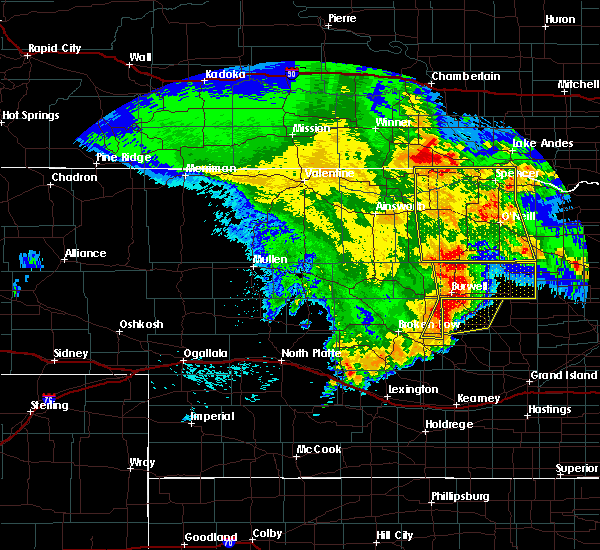 At 135 am cdt, severe thunderstorms were located along a line extending from 10 miles south of chambers to near ericson, moving east at 35 mph (radar indicated). Hazards include 70 mph wind gusts and quarter size hail. Hail damage to vehicles is expected. expect considerable tree damage. wind damage is also likely to mobile homes, roofs, and outbuildings. locations impacted include, bartlett, ericson, sunfish lake, cumminsville, four corners, pibel lake, buffalo flats, deverre and gables. This includes highway 281 between mile markers 132 and 157. At 135 am cdt, severe thunderstorms were located along a line extending from 10 miles south of chambers to near ericson, moving east at 35 mph (radar indicated). Hazards include 70 mph wind gusts and quarter size hail. Hail damage to vehicles is expected. expect considerable tree damage. wind damage is also likely to mobile homes, roofs, and outbuildings. locations impacted include, bartlett, ericson, sunfish lake, cumminsville, four corners, pibel lake, buffalo flats, deverre and gables. This includes highway 281 between mile markers 132 and 157.
|
| 5/24/2020 12:57 AM CDT |
 At 1256 am cdt, severe thunderstorms were located along a line extending from 13 miles north of calamus reservoir state recreation area to near burwell to 8 miles west of arcadia, moving east at 40 mph (radar indicated). Hazards include ping pong ball size hail and 60 mph wind gusts. People and animals outdoors will be injured. expect hail damage to roofs, siding, windows, and vehicles. Expect wind damage to roofs, siding, and trees. At 1256 am cdt, severe thunderstorms were located along a line extending from 13 miles north of calamus reservoir state recreation area to near burwell to 8 miles west of arcadia, moving east at 40 mph (radar indicated). Hazards include ping pong ball size hail and 60 mph wind gusts. People and animals outdoors will be injured. expect hail damage to roofs, siding, windows, and vehicles. Expect wind damage to roofs, siding, and trees.
|
| 5/24/2020 12:12 AM CDT |
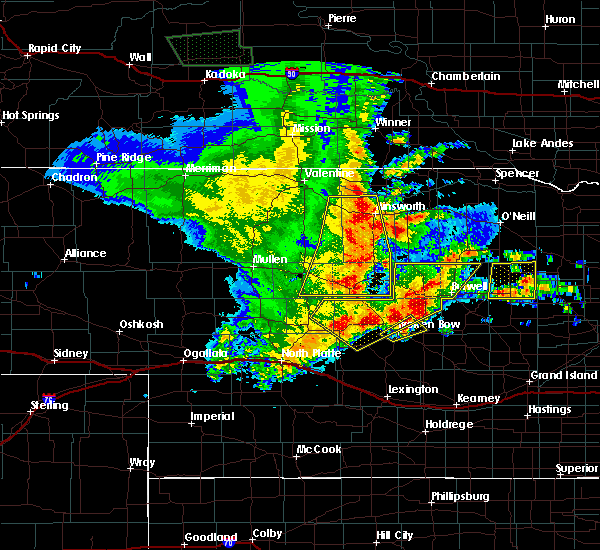 At 1212 am cdt, a severe thunderstorm was located near ericson, or 21 miles northeast of ord, moving north at 35 mph (radar indicated). Hazards include ping pong ball size hail and 60 mph wind gusts. People and animals outdoors will be injured. expect hail damage to roofs, siding, windows, and vehicles. Expect wind damage to roofs, siding, and trees. At 1212 am cdt, a severe thunderstorm was located near ericson, or 21 miles northeast of ord, moving north at 35 mph (radar indicated). Hazards include ping pong ball size hail and 60 mph wind gusts. People and animals outdoors will be injured. expect hail damage to roofs, siding, windows, and vehicles. Expect wind damage to roofs, siding, and trees.
|
| 9/2/2019 4:57 AM CDT |
 At 457 am cdt, a severe thunderstorm was located 7 miles northeast of fort hartsuff state park, or 10 miles east of burwell, moving southeast at 25 mph (radar indicated). Hazards include quarter size hail. Damage to vehicles is expected. Locations impacted include, burwell, ericson, deverre and gables. At 457 am cdt, a severe thunderstorm was located 7 miles northeast of fort hartsuff state park, or 10 miles east of burwell, moving southeast at 25 mph (radar indicated). Hazards include quarter size hail. Damage to vehicles is expected. Locations impacted include, burwell, ericson, deverre and gables.
|
| 9/2/2019 4:33 AM CDT |
 At 432 am cdt, a severe thunderstorm was located 13 miles northeast of calamus reservoir state recreation area, or 13 miles north of burwell, moving southeast at 30 mph (radar indicated). Hazards include half dollar size hail. damage to vehicles is expected At 432 am cdt, a severe thunderstorm was located 13 miles northeast of calamus reservoir state recreation area, or 13 miles north of burwell, moving southeast at 30 mph (radar indicated). Hazards include half dollar size hail. damage to vehicles is expected
|
| 8/7/2019 1:37 AM CDT |
 At 136 am cdt, severe thunderstorms were located along a line extending from near spalding to 6 miles west of ericson to burwell, moving southeast at 45 mph (radar indicated). Hazards include 70 mph wind gusts and quarter size hail. Hail damage to vehicles is expected. expect considerable tree damage. wind damage is also likely to mobile homes, roofs, and outbuildings. locations impacted include, burwell, bartlett, ericson, homestead knolls campground, virginia smith dam, pibel lake state recreation area and deverre. This includes highway 281 between mile markers 132 and 142. At 136 am cdt, severe thunderstorms were located along a line extending from near spalding to 6 miles west of ericson to burwell, moving southeast at 45 mph (radar indicated). Hazards include 70 mph wind gusts and quarter size hail. Hail damage to vehicles is expected. expect considerable tree damage. wind damage is also likely to mobile homes, roofs, and outbuildings. locations impacted include, burwell, bartlett, ericson, homestead knolls campground, virginia smith dam, pibel lake state recreation area and deverre. This includes highway 281 between mile markers 132 and 142.
|
| 8/7/2019 1:24 AM CDT |
 At 124 am cdt, severe thunderstorms were located along a line extending from near ericson to near fort hartsuff state park to near burwell, moving southeast at 40 mph (radar indicated). Hazards include 70 mph wind gusts. Expect considerable tree damage. Damage is likely to mobile homes, roofs, and outbuildings. At 124 am cdt, severe thunderstorms were located along a line extending from near ericson to near fort hartsuff state park to near burwell, moving southeast at 40 mph (radar indicated). Hazards include 70 mph wind gusts. Expect considerable tree damage. Damage is likely to mobile homes, roofs, and outbuildings.
|
| 7/28/2019 11:28 PM CDT |
 The severe thunderstorm warning for southwestern wheeler county will expire at 1130 pm cdt, the storm which prompted the warning has moved out of the area. therefore, the warning will be allowed to expire. The severe thunderstorm warning for southwestern wheeler county will expire at 1130 pm cdt, the storm which prompted the warning has moved out of the area. therefore, the warning will be allowed to expire.
|
| 7/28/2019 11:16 PM CDT |
 At 1115 pm cdt, a severe thunderstorm was located near bartlett, or 23 miles northeast of ord, moving southeast at 35 mph (radar indicated). Hazards include 60 mph wind gusts and penny size hail. Expect damage to roofs, siding, and trees. locations impacted include, bartlett, ericson and pibel lake state recreation area. This includes highway 281 between mile markers 132 and 142. At 1115 pm cdt, a severe thunderstorm was located near bartlett, or 23 miles northeast of ord, moving southeast at 35 mph (radar indicated). Hazards include 60 mph wind gusts and penny size hail. Expect damage to roofs, siding, and trees. locations impacted include, bartlett, ericson and pibel lake state recreation area. This includes highway 281 between mile markers 132 and 142.
|
| 7/28/2019 11:03 PM CDT |
 At 1103 pm cdt, a severe thunderstorm was located near bartlett, or 25 miles northeast of ord, moving southeast at 30 mph (radar indicated). Hazards include 60 mph wind gusts and quarter size hail. Hail damage to vehicles is expected. Expect wind damage to roofs, siding, and trees. At 1103 pm cdt, a severe thunderstorm was located near bartlett, or 25 miles northeast of ord, moving southeast at 30 mph (radar indicated). Hazards include 60 mph wind gusts and quarter size hail. Hail damage to vehicles is expected. Expect wind damage to roofs, siding, and trees.
|
| 7/5/2019 4:25 AM CDT |
 The severe thunderstorm warning for southeastern cherry, rock, brown, eastern garfield, holt, central keya paha, southern boyd and wheeler counties will expire at 430 am cdt/330 am mdt/, the storms which prompted the warning have weakened below severe limits, and no longer pose an immediate threat to life or property. therefore, the warning will be allowed to expire. however gusty winds and heavy rain are still possible with these thunderstorms. a severe thunderstorm watch remains in effect until 700 am cdt/600 am mdt/ for north central nebraska. The severe thunderstorm warning for southeastern cherry, rock, brown, eastern garfield, holt, central keya paha, southern boyd and wheeler counties will expire at 430 am cdt/330 am mdt/, the storms which prompted the warning have weakened below severe limits, and no longer pose an immediate threat to life or property. therefore, the warning will be allowed to expire. however gusty winds and heavy rain are still possible with these thunderstorms. a severe thunderstorm watch remains in effect until 700 am cdt/600 am mdt/ for north central nebraska.
|
| 7/5/2019 3:56 AM CDT |
 At 356 am cdt/256 am mdt/, severe thunderstorms were located along a line extending from 8 miles northwest of brownlee to springview to near bartlett, moving northeast at 35 mph (radar indicated). Hazards include 60 mph wind gusts and quarter size hail. Hail damage to vehicles is expected. expect wind damage to roofs, siding, and trees. locations impacted include, ainsworth, bassett, spencer, springview, o`neill, atkinson, stuart, long pine, chambers, lynch, page, bartlett, newport, ericson, johnstown, brownlee, amelia and inman. this includes the following highways, highway 183 between mile markers 156 and 128. highway 20 between mile markers 212 and 324. highway 281 between mile markers 133 and 214. highway 83 between mile markers 169 and 198. Highway 12 between mile markers 38 and 51, between mile markers 53 and 72, and between mile markers 118 and 128. At 356 am cdt/256 am mdt/, severe thunderstorms were located along a line extending from 8 miles northwest of brownlee to springview to near bartlett, moving northeast at 35 mph (radar indicated). Hazards include 60 mph wind gusts and quarter size hail. Hail damage to vehicles is expected. expect wind damage to roofs, siding, and trees. locations impacted include, ainsworth, bassett, spencer, springview, o`neill, atkinson, stuart, long pine, chambers, lynch, page, bartlett, newport, ericson, johnstown, brownlee, amelia and inman. this includes the following highways, highway 183 between mile markers 156 and 128. highway 20 between mile markers 212 and 324. highway 281 between mile markers 133 and 214. highway 83 between mile markers 169 and 198. Highway 12 between mile markers 38 and 51, between mile markers 53 and 72, and between mile markers 118 and 128.
|
| 7/5/2019 3:36 AM CDT |
 At 335 am cdt/235 am mdt/, severe thunderstorms were located along a line extending from 16 miles north of mullen to 7 miles north of long pine to burwell, moving east at 45 mph (radar indicated). Hazards include 60 mph wind gusts and quarter size hail. Hail damage to vehicles is expected. Expect wind damage to roofs, siding, and trees. At 335 am cdt/235 am mdt/, severe thunderstorms were located along a line extending from 16 miles north of mullen to 7 miles north of long pine to burwell, moving east at 45 mph (radar indicated). Hazards include 60 mph wind gusts and quarter size hail. Hail damage to vehicles is expected. Expect wind damage to roofs, siding, and trees.
|
| 6/26/2019 3:14 AM CDT |
 At 313 am cdt, severe thunderstorms were located along a line extending from 7 miles southeast of bartlett to near ord, moving east at 45 mph (radar indicated). Hazards include 60 mph wind gusts and half dollar size hail. Hail damage to vehicles is expected. expect wind damage to roofs, siding, and trees. locations impacted include, sargent, bartlett, comstock, ericson, pibel lake state recreation area, big oak canyon, arcadia diversion dam state wildlife management area, divide hill and wescott. this includes the following highways, highway 183 between mile markers 105 and 119. Highway 281 between mile markers 132 and 144. At 313 am cdt, severe thunderstorms were located along a line extending from 7 miles southeast of bartlett to near ord, moving east at 45 mph (radar indicated). Hazards include 60 mph wind gusts and half dollar size hail. Hail damage to vehicles is expected. expect wind damage to roofs, siding, and trees. locations impacted include, sargent, bartlett, comstock, ericson, pibel lake state recreation area, big oak canyon, arcadia diversion dam state wildlife management area, divide hill and wescott. this includes the following highways, highway 183 between mile markers 105 and 119. Highway 281 between mile markers 132 and 144.
|
| 6/26/2019 2:53 AM CDT |
 At 252 am cdt, severe thunderstorms were located along a line extending from near ericson to near comstock, moving east at 40 mph (radar indicated). Hazards include 60 mph wind gusts and half dollar size hail. Hail damage to vehicles is expected. Expect wind damage to roofs, siding, and trees. At 252 am cdt, severe thunderstorms were located along a line extending from near ericson to near comstock, moving east at 40 mph (radar indicated). Hazards include 60 mph wind gusts and half dollar size hail. Hail damage to vehicles is expected. Expect wind damage to roofs, siding, and trees.
|
| 5/17/2019 10:47 PM CDT |
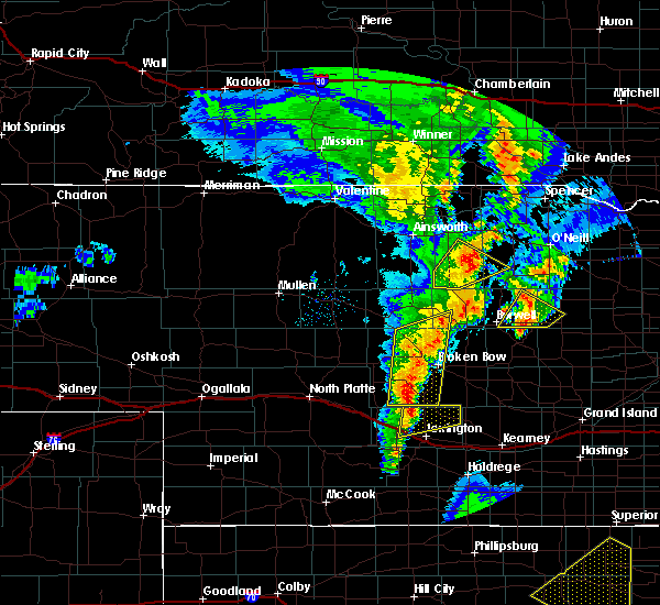 At 1047 pm cdt, a severe thunderstorm was located 7 miles east of fort hartsuff state park, or 10 miles north of ord, moving northeast at 25 mph (radar indicated). Hazards include 60 mph wind gusts and quarter size hail. Hail damage to vehicles is expected. expect wind damage to roofs, siding, and trees. locations impacted include, bartlett, ericson and gables. this includes highway 281 between mile markers 138 and 141. A tornado watch remains in effect until midnight cdt for north central nebraska. At 1047 pm cdt, a severe thunderstorm was located 7 miles east of fort hartsuff state park, or 10 miles north of ord, moving northeast at 25 mph (radar indicated). Hazards include 60 mph wind gusts and quarter size hail. Hail damage to vehicles is expected. expect wind damage to roofs, siding, and trees. locations impacted include, bartlett, ericson and gables. this includes highway 281 between mile markers 138 and 141. A tornado watch remains in effect until midnight cdt for north central nebraska.
|
| 5/17/2019 10:30 PM CDT |
 At 1030 pm cdt, a severe thunderstorm was located over elyria, or near ord, moving northeast at 25 mph (radar indicated). Hazards include golf ball size hail and 60 mph wind gusts. People and animals outdoors will be injured. expect hail damage to roofs, siding, windows, and vehicles. Expect wind damage to roofs, siding, and trees. At 1030 pm cdt, a severe thunderstorm was located over elyria, or near ord, moving northeast at 25 mph (radar indicated). Hazards include golf ball size hail and 60 mph wind gusts. People and animals outdoors will be injured. expect hail damage to roofs, siding, windows, and vehicles. Expect wind damage to roofs, siding, and trees.
|
| 6/28/2018 7:02 AM CDT |
 At 702 am cdt, severe thunderstorms were located along a line extending from 8 miles southwest of ewing to 10 miles northeast of bartlett to near ericson, moving east at 40 mph (radar indicated). Hazards include 70 mph wind gusts and penny size hail. Expect considerable tree damage. damage is likely to mobile homes, roofs, and outbuildings. locations impacted include, bartlett, ericson, knievels corner, cumminsville, four corners, pibel lake state recreation area, buffalo flats and goose lake state wildlife management area. This includes highway 281 between mile markers 132 and 162. At 702 am cdt, severe thunderstorms were located along a line extending from 8 miles southwest of ewing to 10 miles northeast of bartlett to near ericson, moving east at 40 mph (radar indicated). Hazards include 70 mph wind gusts and penny size hail. Expect considerable tree damage. damage is likely to mobile homes, roofs, and outbuildings. locations impacted include, bartlett, ericson, knievels corner, cumminsville, four corners, pibel lake state recreation area, buffalo flats and goose lake state wildlife management area. This includes highway 281 between mile markers 132 and 162.
|
| 6/28/2018 6:54 AM CDT |
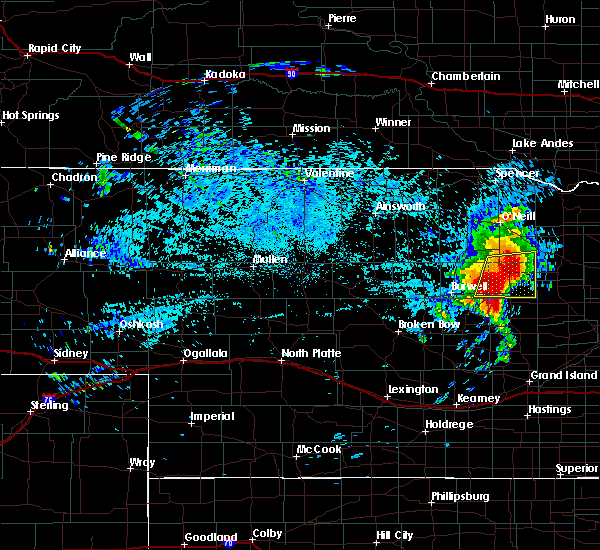 At 654 am cdt, severe thunderstorms were located along a line extending from 11 miles southwest of ewing to near ericson, moving east at 35 mph (radar indicated). Hazards include 70 mph wind gusts and penny size hail. Expect considerable tree damage. damage is likely to mobile homes, roofs, and outbuildings. locations impacted include, bartlett, ericson, knievels corner, cumminsville, four corners, pibel lake state recreation area, buffalo flats and goose lake state wildlife management area. This includes highway 281 between mile markers 132 and 162. At 654 am cdt, severe thunderstorms were located along a line extending from 11 miles southwest of ewing to near ericson, moving east at 35 mph (radar indicated). Hazards include 70 mph wind gusts and penny size hail. Expect considerable tree damage. damage is likely to mobile homes, roofs, and outbuildings. locations impacted include, bartlett, ericson, knievels corner, cumminsville, four corners, pibel lake state recreation area, buffalo flats and goose lake state wildlife management area. This includes highway 281 between mile markers 132 and 162.
|
| 6/28/2018 6:32 AM CDT |
 At 632 am cdt, severe thunderstorms were located along a line extending from 7 miles south of chambers to near fort hartsuff state park, moving east at 35 mph (radar indicated). Hazards include 70 mph wind gusts and penny size hail. Expect considerable tree damage. Damage is likely to mobile homes, roofs, and outbuildings. At 632 am cdt, severe thunderstorms were located along a line extending from 7 miles south of chambers to near fort hartsuff state park, moving east at 35 mph (radar indicated). Hazards include 70 mph wind gusts and penny size hail. Expect considerable tree damage. Damage is likely to mobile homes, roofs, and outbuildings.
|
| 6/10/2018 1:09 AM CDT |
 The severe thunderstorm warning for east central garfield and southwestern wheeler counties will expire at 115 am cdt, the storms which prompted the warning have weakened below severe limits, and no longer pose an immediate threat to life or property. therefore, the warning will be allowed to expire. however small hail is still possible with these thunderstorms. The severe thunderstorm warning for east central garfield and southwestern wheeler counties will expire at 115 am cdt, the storms which prompted the warning have weakened below severe limits, and no longer pose an immediate threat to life or property. therefore, the warning will be allowed to expire. however small hail is still possible with these thunderstorms.
|
| 6/10/2018 1:03 AM CDT |
 At 103 am cdt, severe thunderstorms were located along a line extending from 14 miles northeast of fort hartsuff state park to 6 miles east of ericson, moving northeast at 15 mph (radar indicated). Hazards include quarter size hail. Damage to vehicles is expected. locations impacted include, ericson, pibel lake state recreation area and gables. This includes highway 281 between mile markers 132 and 139. At 103 am cdt, severe thunderstorms were located along a line extending from 14 miles northeast of fort hartsuff state park to 6 miles east of ericson, moving northeast at 15 mph (radar indicated). Hazards include quarter size hail. Damage to vehicles is expected. locations impacted include, ericson, pibel lake state recreation area and gables. This includes highway 281 between mile markers 132 and 139.
|
| 6/10/2018 12:47 AM CDT |
 At 1247 am cdt, severe thunderstorms were located along a line extending from 11 miles northeast of fort hartsuff state park to near ericson, moving northeast at 15 mph (radar indicated). Hazards include quarter size hail. damage to vehicles is expected At 1247 am cdt, severe thunderstorms were located along a line extending from 11 miles northeast of fort hartsuff state park to near ericson, moving northeast at 15 mph (radar indicated). Hazards include quarter size hail. damage to vehicles is expected
|
| 6/9/2018 12:58 AM CDT |
 At 1257 am cdt, a severe thunderstorm was located over bartlett, or 29 miles northeast of ord, moving southeast at 40 mph (radar indicated). Hazards include 60 mph wind gusts and quarter size hail. Hail damage to vehicles is expected. expect wind damage to roofs, siding, and trees. locations impacted include, burwell, bartlett, ericson, knievels corner, cumminsville, four corners, pibel lake state recreation area, buffalo flats, goose lake state wildlife management area and gables. This includes highway 281 between mile markers 132 and 160. At 1257 am cdt, a severe thunderstorm was located over bartlett, or 29 miles northeast of ord, moving southeast at 40 mph (radar indicated). Hazards include 60 mph wind gusts and quarter size hail. Hail damage to vehicles is expected. expect wind damage to roofs, siding, and trees. locations impacted include, burwell, bartlett, ericson, knievels corner, cumminsville, four corners, pibel lake state recreation area, buffalo flats, goose lake state wildlife management area and gables. This includes highway 281 between mile markers 132 and 160.
|
| 6/9/2018 12:38 AM CDT |
 At 1238 am cdt, a severe thunderstorm was located 11 miles northwest of bartlett, or 26 miles northeast of burwell, moving east at 35 mph (radar indicated). Hazards include 60 mph wind gusts and half dollar size hail. Hail damage to vehicles is expected. Expect wind damage to roofs, siding, and trees. At 1238 am cdt, a severe thunderstorm was located 11 miles northwest of bartlett, or 26 miles northeast of burwell, moving east at 35 mph (radar indicated). Hazards include 60 mph wind gusts and half dollar size hail. Hail damage to vehicles is expected. Expect wind damage to roofs, siding, and trees.
|
| 6/6/2018 10:58 PM CDT |
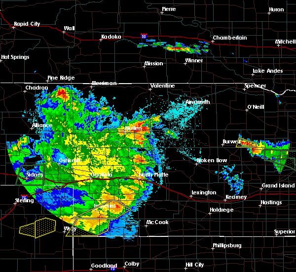 At 1057 pm cdt, a severe thunderstorm was located 8 miles east of ericson, or 23 miles northeast of ord, and is nearly stationary (radar indicated). Hazards include 60 mph wind gusts and penny size hail. Expect damage to roofs, siding, and trees. locations impacted include, ericson and pibel lake state recreation area. This includes highway 281 between mile markers 132 and 138. At 1057 pm cdt, a severe thunderstorm was located 8 miles east of ericson, or 23 miles northeast of ord, and is nearly stationary (radar indicated). Hazards include 60 mph wind gusts and penny size hail. Expect damage to roofs, siding, and trees. locations impacted include, ericson and pibel lake state recreation area. This includes highway 281 between mile markers 132 and 138.
|
| 6/6/2018 10:29 PM CDT |
 At 1028 pm cdt, a severe thunderstorm was located near ericson, or 21 miles northeast of ord, moving west at 10 mph (radar indicated). Hazards include 60 mph wind gusts and half dollar size hail. Hail damage to vehicles is expected. Expect wind damage to roofs, siding, and trees. At 1028 pm cdt, a severe thunderstorm was located near ericson, or 21 miles northeast of ord, moving west at 10 mph (radar indicated). Hazards include 60 mph wind gusts and half dollar size hail. Hail damage to vehicles is expected. Expect wind damage to roofs, siding, and trees.
|
| 6/1/2018 9:43 PM CDT |
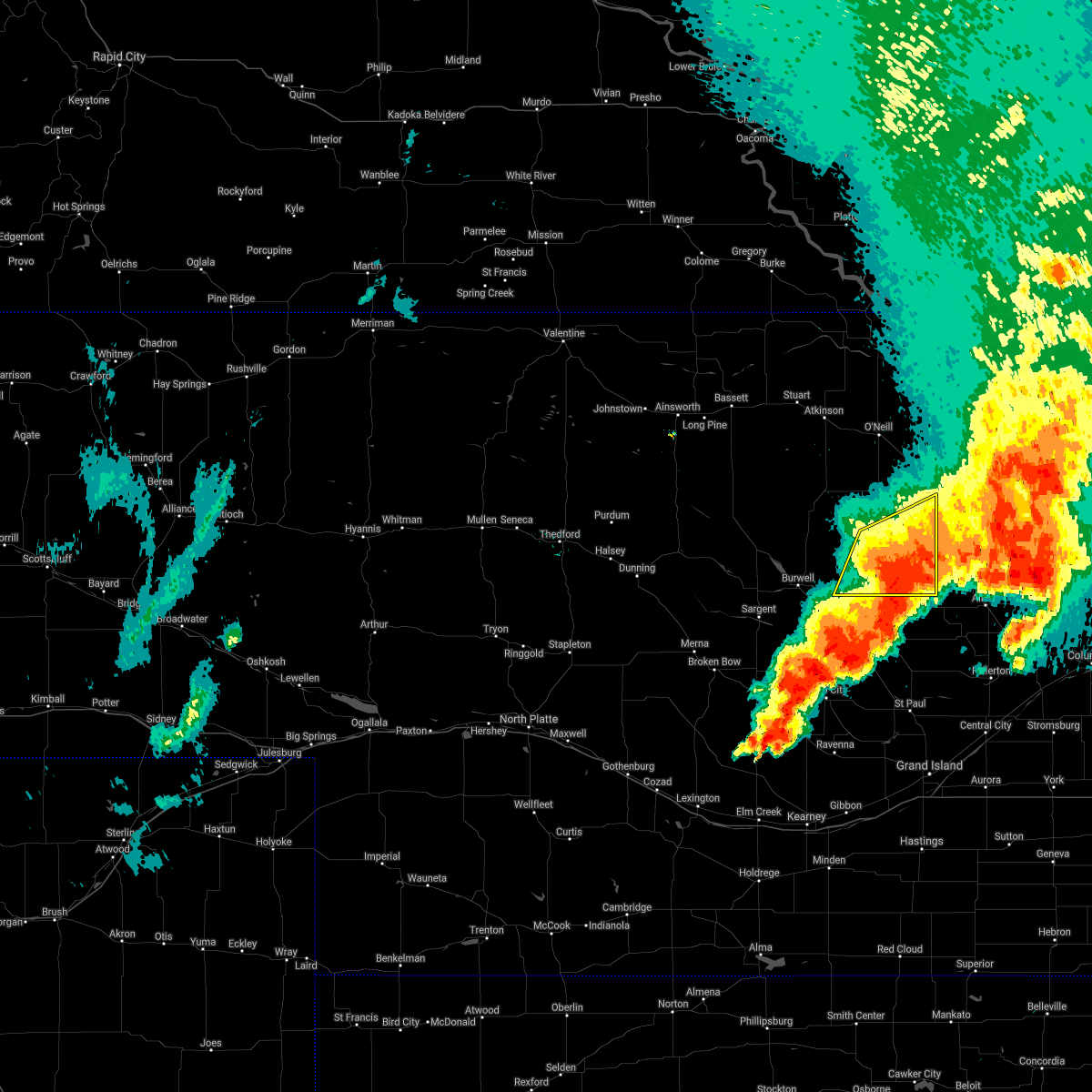 At 931 pm cdt, severe thunderstorms were located along a line extending from 6 miles southwest of clearwater to near bartlett to near ericson, moving east at 30 mph (radar indicated). Hazards include 70 mph wind gusts and quarter size hail. Hail damage to vehicles is expected. expect considerable tree damage. wind damage is also likely to mobile homes, roofs, and outbuildings. locations impacted include, bartlett, ericson, knievels corner, cumminsville, four corners, pibel lake state recreation area and buffalo flats. this includes highway 281 between mile markers 132 and 156. A tornado watch remains in effect until 1100 pm cdt for north central nebraska. At 931 pm cdt, severe thunderstorms were located along a line extending from 6 miles southwest of clearwater to near bartlett to near ericson, moving east at 30 mph (radar indicated). Hazards include 70 mph wind gusts and quarter size hail. Hail damage to vehicles is expected. expect considerable tree damage. wind damage is also likely to mobile homes, roofs, and outbuildings. locations impacted include, bartlett, ericson, knievels corner, cumminsville, four corners, pibel lake state recreation area and buffalo flats. this includes highway 281 between mile markers 132 and 156. A tornado watch remains in effect until 1100 pm cdt for north central nebraska.
|
| 6/1/2018 9:32 PM CDT |
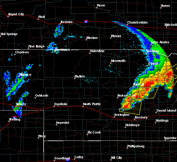 At 931 pm cdt, severe thunderstorms were located along a line extending from 6 miles southwest of clearwater to near bartlett to near ericson, moving east at 30 mph (radar indicated). Hazards include 70 mph wind gusts and quarter size hail. Hail damage to vehicles is expected. expect considerable tree damage. wind damage is also likely to mobile homes, roofs, and outbuildings. locations impacted include, bartlett, ericson, knievels corner, cumminsville, four corners, pibel lake state recreation area and buffalo flats. this includes highway 281 between mile markers 132 and 156. A tornado watch remains in effect until 1100 pm cdt for north central nebraska. At 931 pm cdt, severe thunderstorms were located along a line extending from 6 miles southwest of clearwater to near bartlett to near ericson, moving east at 30 mph (radar indicated). Hazards include 70 mph wind gusts and quarter size hail. Hail damage to vehicles is expected. expect considerable tree damage. wind damage is also likely to mobile homes, roofs, and outbuildings. locations impacted include, bartlett, ericson, knievels corner, cumminsville, four corners, pibel lake state recreation area and buffalo flats. this includes highway 281 between mile markers 132 and 156. A tornado watch remains in effect until 1100 pm cdt for north central nebraska.
|
| 6/1/2018 9:06 PM CDT |
 At 905 pm cdt, severe thunderstorms were located along a line extending from 8 miles west of ewing to 7 miles west of bartlett to near fort hartsuff state park, moving east at 35 mph (radar indicated). Hazards include 70 mph wind gusts and half dollar size hail. Hail damage to vehicles is expected. expect considerable tree damage. wind damage is also likely to mobile homes, roofs, and outbuildings. locations impacted include, burwell, ewing, chambers, bartlett, ericson, knievels corner, cumminsville, four corners, pibel lake state recreation area, buffalo flats, goose lake state wildlife management area and gables. this includes highway 281 between mile markers 132 and 174. A tornado watch remains in effect until 1100 pm cdt for central and north central nebraska. At 905 pm cdt, severe thunderstorms were located along a line extending from 8 miles west of ewing to 7 miles west of bartlett to near fort hartsuff state park, moving east at 35 mph (radar indicated). Hazards include 70 mph wind gusts and half dollar size hail. Hail damage to vehicles is expected. expect considerable tree damage. wind damage is also likely to mobile homes, roofs, and outbuildings. locations impacted include, burwell, ewing, chambers, bartlett, ericson, knievels corner, cumminsville, four corners, pibel lake state recreation area, buffalo flats, goose lake state wildlife management area and gables. this includes highway 281 between mile markers 132 and 174. A tornado watch remains in effect until 1100 pm cdt for central and north central nebraska.
|
| 6/1/2018 8:43 PM CDT |
 At 843 pm cdt, severe thunderstorms were located along a line extending from 6 miles northeast of chambers to 14 miles northwest of ericson to near burwell, moving east at 30 mph (radar indicated). Hazards include 70 mph wind gusts and half dollar size hail. Hail damage to vehicles is expected. expect considerable tree damage. Wind damage is also likely to mobile homes, roofs, and outbuildings. At 843 pm cdt, severe thunderstorms were located along a line extending from 6 miles northeast of chambers to 14 miles northwest of ericson to near burwell, moving east at 30 mph (radar indicated). Hazards include 70 mph wind gusts and half dollar size hail. Hail damage to vehicles is expected. expect considerable tree damage. Wind damage is also likely to mobile homes, roofs, and outbuildings.
|
| 6/1/2018 8:11 PM CDT |
 At 811 pm cdt, severe thunderstorms were located along a line extending from 8 miles northeast of atkinson to 7 miles northeast of amelia to 9 miles northeast of calamus reservoir state recreation area, moving east at 35 mph (radar indicated). Hazards include 70 mph wind gusts and ping pong ball size hail. People and animals outdoors will be injured. expect hail damage to roofs, siding, windows, and vehicles. expect considerable tree damage. wind damage is also likely to mobile homes, roofs, and outbuildings. locations impacted include, o`neill, burwell, taylor, atkinson, chambers, ericson, amelia, calamus reservoir state recreation area, emmet, virginia smith dam, hannamon bayou campground, kent diversion dam state wildlife management area, carson lake, sunfish lake, homestead knolls campground, nunda shoal campground, deverre, midway, valley view flat campground and gables. this includes the following highways, highway 183 between mile markers 122 and 125. highway 20 between mile markers 287 and 307. highway 281 between mile markers 184 and 207. A tornado watch remains in effect until 1100 pm cdt for central and north central nebraska. At 811 pm cdt, severe thunderstorms were located along a line extending from 8 miles northeast of atkinson to 7 miles northeast of amelia to 9 miles northeast of calamus reservoir state recreation area, moving east at 35 mph (radar indicated). Hazards include 70 mph wind gusts and ping pong ball size hail. People and animals outdoors will be injured. expect hail damage to roofs, siding, windows, and vehicles. expect considerable tree damage. wind damage is also likely to mobile homes, roofs, and outbuildings. locations impacted include, o`neill, burwell, taylor, atkinson, chambers, ericson, amelia, calamus reservoir state recreation area, emmet, virginia smith dam, hannamon bayou campground, kent diversion dam state wildlife management area, carson lake, sunfish lake, homestead knolls campground, nunda shoal campground, deverre, midway, valley view flat campground and gables. this includes the following highways, highway 183 between mile markers 122 and 125. highway 20 between mile markers 287 and 307. highway 281 between mile markers 184 and 207. A tornado watch remains in effect until 1100 pm cdt for central and north central nebraska.
|
| 6/1/2018 7:44 PM CDT |
 At 743 pm cdt, severe thunderstorms were located along a line extending from near atkinson to near calamus reservoir state recreation area, moving northeast at 30 mph (radar indicated). Hazards include ping pong ball size hail and 60 mph wind gusts. People and animals outdoors will be injured. expect hail damage to roofs, siding, windows, and vehicles. Expect wind damage to roofs, siding, and trees. At 743 pm cdt, severe thunderstorms were located along a line extending from near atkinson to near calamus reservoir state recreation area, moving northeast at 30 mph (radar indicated). Hazards include ping pong ball size hail and 60 mph wind gusts. People and animals outdoors will be injured. expect hail damage to roofs, siding, windows, and vehicles. Expect wind damage to roofs, siding, and trees.
|
| 7/26/2017 2:03 AM CDT |
 At 203 am cdt, severe thunderstorms were located along a line extending from 7 miles southwest of o`neill to 9 miles southeast of chambers to 6 miles northwest of ericson, moving east at 35 mph (radar indicated). Hazards include 60 mph wind gusts. Expect damage to roofs, siding, and trees. locations impacted include, o`neill, o`neill, ewing, chambers, page, bartlett, ericson, inman, emmet, knievels corner, buffalo flats, sunfish lake, cumminsville, four corners, goose lake state wildlife management area and gables. this includes the following highways, highway 20 between mile markers 297 and 328. Highway 281 between mile markers 134 and 189. At 203 am cdt, severe thunderstorms were located along a line extending from 7 miles southwest of o`neill to 9 miles southeast of chambers to 6 miles northwest of ericson, moving east at 35 mph (radar indicated). Hazards include 60 mph wind gusts. Expect damage to roofs, siding, and trees. locations impacted include, o`neill, o`neill, ewing, chambers, page, bartlett, ericson, inman, emmet, knievels corner, buffalo flats, sunfish lake, cumminsville, four corners, goose lake state wildlife management area and gables. this includes the following highways, highway 20 between mile markers 297 and 328. Highway 281 between mile markers 134 and 189.
|
| 7/26/2017 1:37 AM CDT |
 At 137 am cdt, severe thunderstorms were located along a line extending from 7 miles west of o`neill to near burwell, moving east at 35 mph (radar indicated). Hazards include 60 mph wind gusts and penny size hail. expect damage to roofs, siding, and trees At 137 am cdt, severe thunderstorms were located along a line extending from 7 miles west of o`neill to near burwell, moving east at 35 mph (radar indicated). Hazards include 60 mph wind gusts and penny size hail. expect damage to roofs, siding, and trees
|
| 7/21/2017 7:47 PM CDT |
 At 747 pm cdt, a severe thunderstorm was located 8 miles northwest of ericson, or 19 miles east of burwell, and is nearly stationary (trained weather spotters). Hazards include quarter size hail. Damage to vehicles is expected. locations impacted include, ericson and gables. This includes highway 281 between mile markers 143 and 146. At 747 pm cdt, a severe thunderstorm was located 8 miles northwest of ericson, or 19 miles east of burwell, and is nearly stationary (trained weather spotters). Hazards include quarter size hail. Damage to vehicles is expected. locations impacted include, ericson and gables. This includes highway 281 between mile markers 143 and 146.
|
| 7/21/2017 7:20 PM CDT |
 At 719 pm cdt, a severe thunderstorm was located 9 miles northwest of ericson, or 18 miles east of burwell, and is nearly stationary (trained weather spotters). Hazards include quarter size hail. damage to vehicles is expected At 719 pm cdt, a severe thunderstorm was located 9 miles northwest of ericson, or 18 miles east of burwell, and is nearly stationary (trained weather spotters). Hazards include quarter size hail. damage to vehicles is expected
|
| 7/21/2017 7:12 PM CDT | Quarter sized hail reported 6.6 miles W of Ericson, NE |
| 7/21/2017 6:30 PM CDT | Baseball sized hail reported 6.6 miles W of Ericson, NE |
| 7/8/2017 4:25 PM CDT |
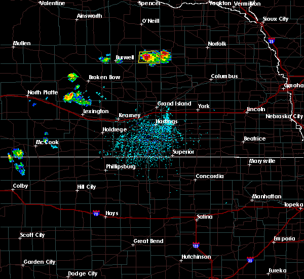 At 424 pm cdt, a severe thunderstorm was located over bartlett, or 26 miles northeast of ord, moving south at 10 mph (radar indicated). Hazards include 60 mph wind gusts and quarter size hail. Hail damage to vehicles is expected. Expect wind damage to roofs, siding, and trees. At 424 pm cdt, a severe thunderstorm was located over bartlett, or 26 miles northeast of ord, moving south at 10 mph (radar indicated). Hazards include 60 mph wind gusts and quarter size hail. Hail damage to vehicles is expected. Expect wind damage to roofs, siding, and trees.
|
| 7/2/2017 3:46 PM CDT |
 At 346 pm cdt, a severe thunderstorm was located 7 miles west of ericson, or 13 miles northeast of ord, moving south at 5 mph (radar indicated). Hazards include 60 mph wind gusts and quarter size hail. Hail damage to vehicles is expected. expect wind damage to roofs, siding, and trees. Locations impacted include, ericson. At 346 pm cdt, a severe thunderstorm was located 7 miles west of ericson, or 13 miles northeast of ord, moving south at 5 mph (radar indicated). Hazards include 60 mph wind gusts and quarter size hail. Hail damage to vehicles is expected. expect wind damage to roofs, siding, and trees. Locations impacted include, ericson.
|
| 7/2/2017 3:11 PM CDT |
 At 309 pm cdt, a severe thunderstorm was located 8 miles northwest of ericson, or 17 miles east of burwell, moving south at 10 mph (radar indicated). Hazards include 60 mph wind gusts and quarter size hail. Hail damage to vehicles is expected. Expect wind damage to roofs, siding, and trees. At 309 pm cdt, a severe thunderstorm was located 8 miles northwest of ericson, or 17 miles east of burwell, moving south at 10 mph (radar indicated). Hazards include 60 mph wind gusts and quarter size hail. Hail damage to vehicles is expected. Expect wind damage to roofs, siding, and trees.
|
| 7/17/2015 6:48 PM CDT |
 At 646 pm cdt, a severe thunderstorm was located near comstock, and moving northeast at 35 mph (radar indicated). Hazards include ping pong ball size hail. People and animals outdoors will be injured. Expect damage to roofs, siding, windows and vehicles. At 646 pm cdt, a severe thunderstorm was located near comstock, and moving northeast at 35 mph (radar indicated). Hazards include ping pong ball size hail. People and animals outdoors will be injured. Expect damage to roofs, siding, windows and vehicles.
|
| 7/14/2015 6:00 PM CDT |
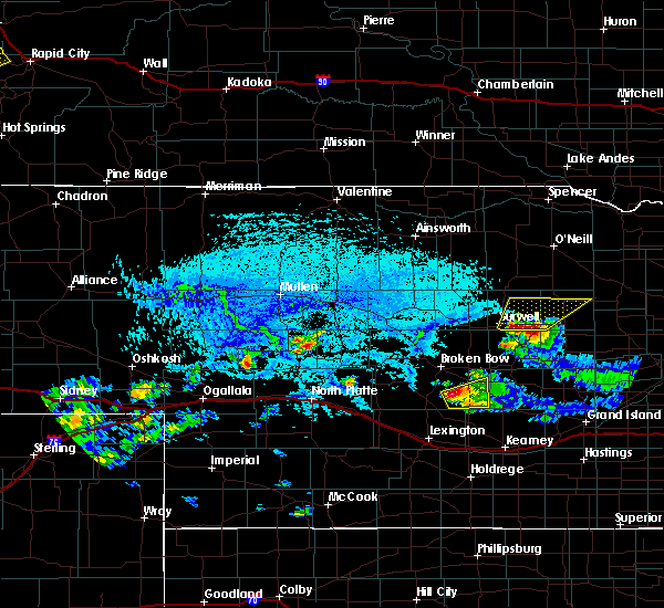 At 558 pm cdt, a severe thunderstorm was located 8 miles east of fort hartsuff state park, and moving northeast at 10 mph (radar indicated). Hazards include 60 mph wind gusts and quarter size hail. Hail damage to vehicles is expected. Expect wind damage to roofs, siding and trees. At 558 pm cdt, a severe thunderstorm was located 8 miles east of fort hartsuff state park, and moving northeast at 10 mph (radar indicated). Hazards include 60 mph wind gusts and quarter size hail. Hail damage to vehicles is expected. Expect wind damage to roofs, siding and trees.
|
| 6/10/2015 6:47 PM CDT |
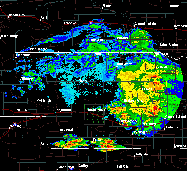 At 643 pm cdt, severe thunderstorms were located along a line extending from 14 miles southwest of clearwater to 10 miles east of bartlett to spalding, and moving east at 50 mph (radar indicated). Hazards include 70 mph wind gusts. Expect considerable tree damage. damage is likely to mobile homes, roofs and outbuildings. Locations impacted include,. At 643 pm cdt, severe thunderstorms were located along a line extending from 14 miles southwest of clearwater to 10 miles east of bartlett to spalding, and moving east at 50 mph (radar indicated). Hazards include 70 mph wind gusts. Expect considerable tree damage. damage is likely to mobile homes, roofs and outbuildings. Locations impacted include,.
|
| 6/10/2015 6:37 PM CDT |
 At 633 pm cdt, severe thunderstorms were located along a line extending from 11 miles north of bartlett to bartlett to 8 miles east of ericson, and moving east at 50 mph (radar indicated). Hazards include 70 mph wind gusts. Expect considerable tree damage. damage is likely to mobile homes, roofs and outbuildings. Locations impacted include, mainly rural areas of eastern wheeler county near and east of bartlett. At 633 pm cdt, severe thunderstorms were located along a line extending from 11 miles north of bartlett to bartlett to 8 miles east of ericson, and moving east at 50 mph (radar indicated). Hazards include 70 mph wind gusts. Expect considerable tree damage. damage is likely to mobile homes, roofs and outbuildings. Locations impacted include, mainly rural areas of eastern wheeler county near and east of bartlett.
|
| 6/10/2015 6:19 PM CDT |
 At 616 pm cdt, severe thunderstorms were located along a line extending from 12 miles south of chambers to 7 miles northwest of ericson to 6 miles southwest of ericson, and moving east at 45 mph (radar indicated). Hazards include 60 mph wind gusts. Expect damage to roofs. Siding and trees. At 616 pm cdt, severe thunderstorms were located along a line extending from 12 miles south of chambers to 7 miles northwest of ericson to 6 miles southwest of ericson, and moving east at 45 mph (radar indicated). Hazards include 60 mph wind gusts. Expect damage to roofs. Siding and trees.
|
| 6/3/2014 5:03 PM CDT | Golf Ball sized hail reported 2 miles NW of Ericson, NE, tree branches broken from the hail and wind... hail lasted approx. 15 mins. |
| 8/1/2013 10:30 AM CDT | Quarter sized hail reported 7.1 miles W of Ericson, NE |
| 5/19/2013 5:46 PM CDT | Quarter sized hail reported 0.2 miles ENE of Ericson, NE |
| 5/19/2013 4:45 PM CDT | Quarter sized hail reported 1.2 miles NW of Ericson, NE, quarter size hail reported at 445 pm near ericson. |
| 5/27/2012 4:37 PM CDT | Quarter sized hail reported 8.1 miles W of Ericson, NE, left moving storm |
| 1/1/0001 12:00 AM | Quarter sized hail reported 5 miles WNW of Ericson, NE, mainly penny to nickel size hail with a few to the size of quarters. |
Hail Maps for Ericson, NE
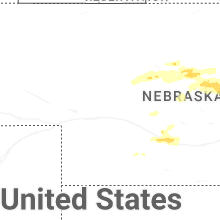
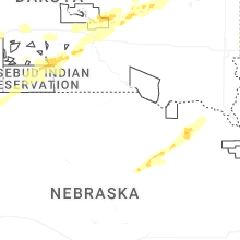
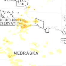

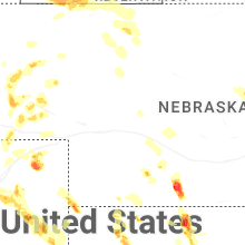
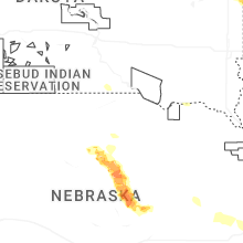
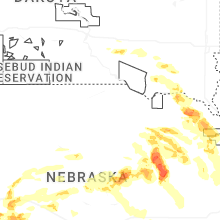
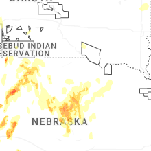


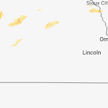


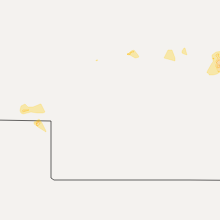


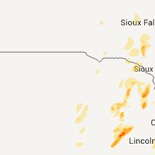
Connect with Interactive Hail Maps