

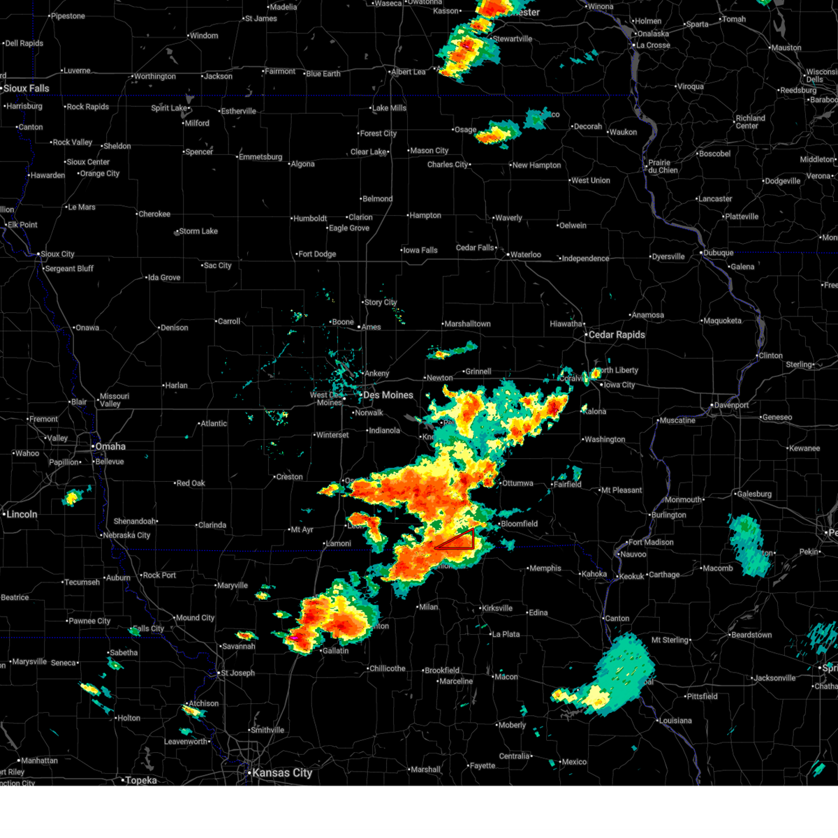
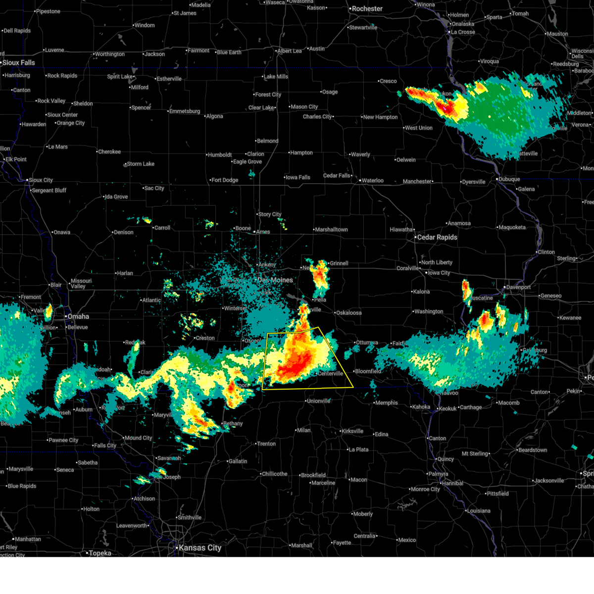
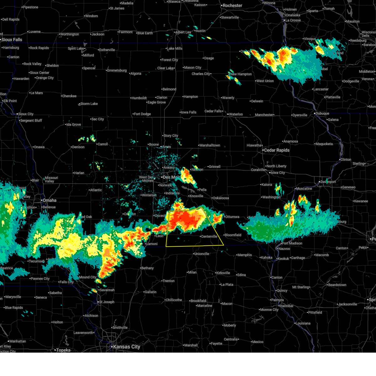
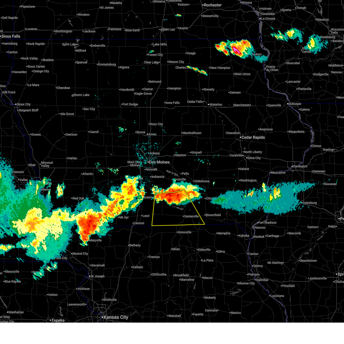
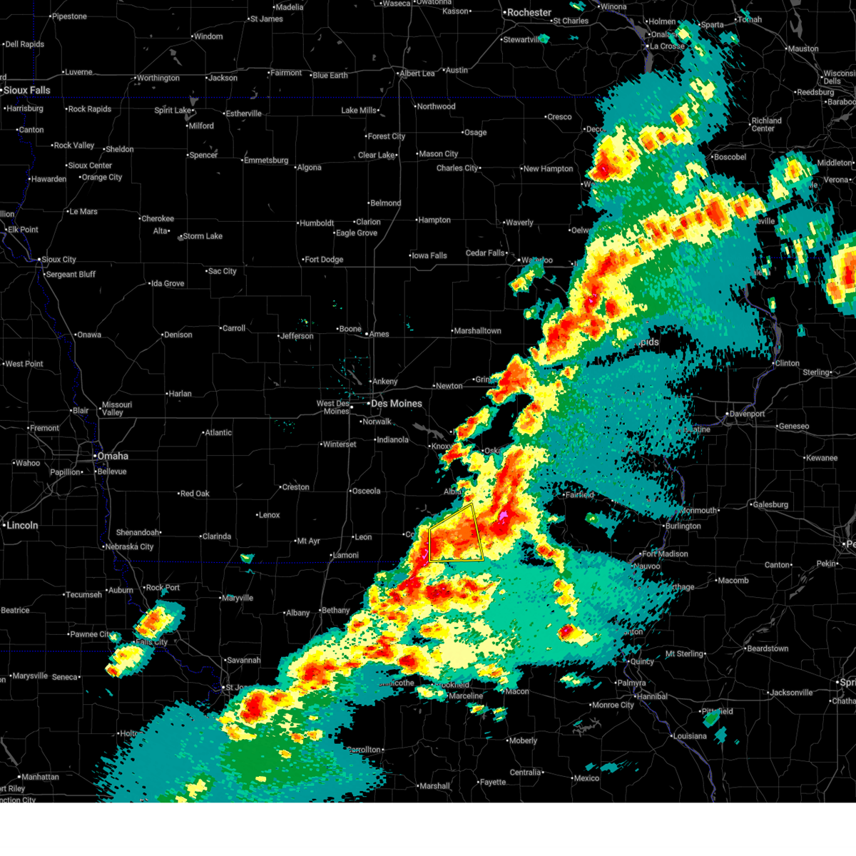
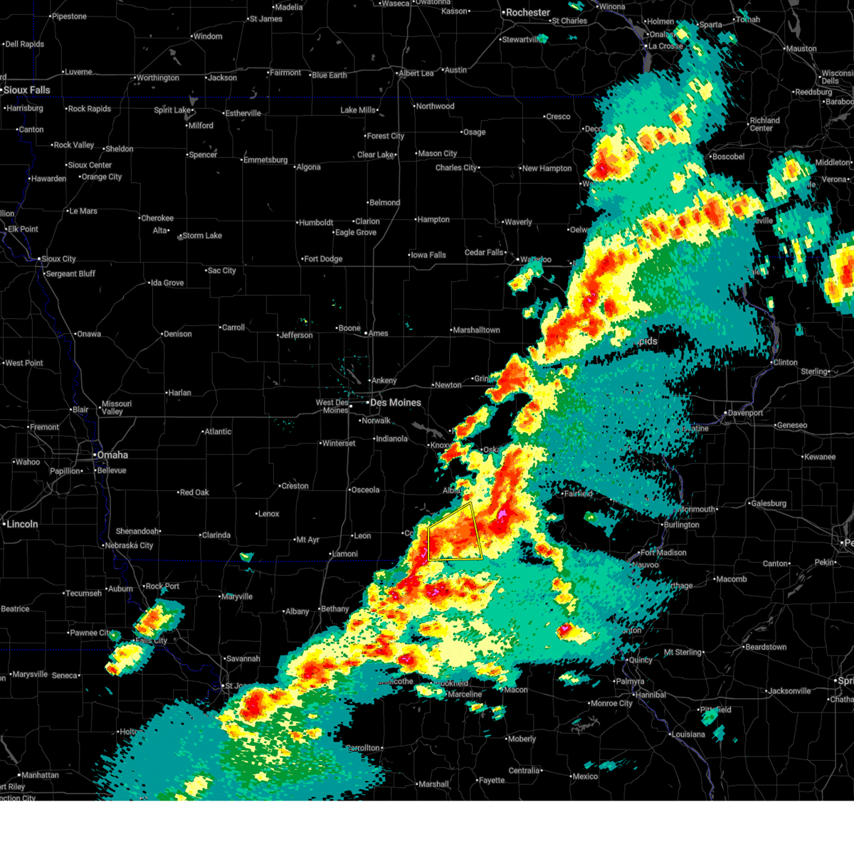
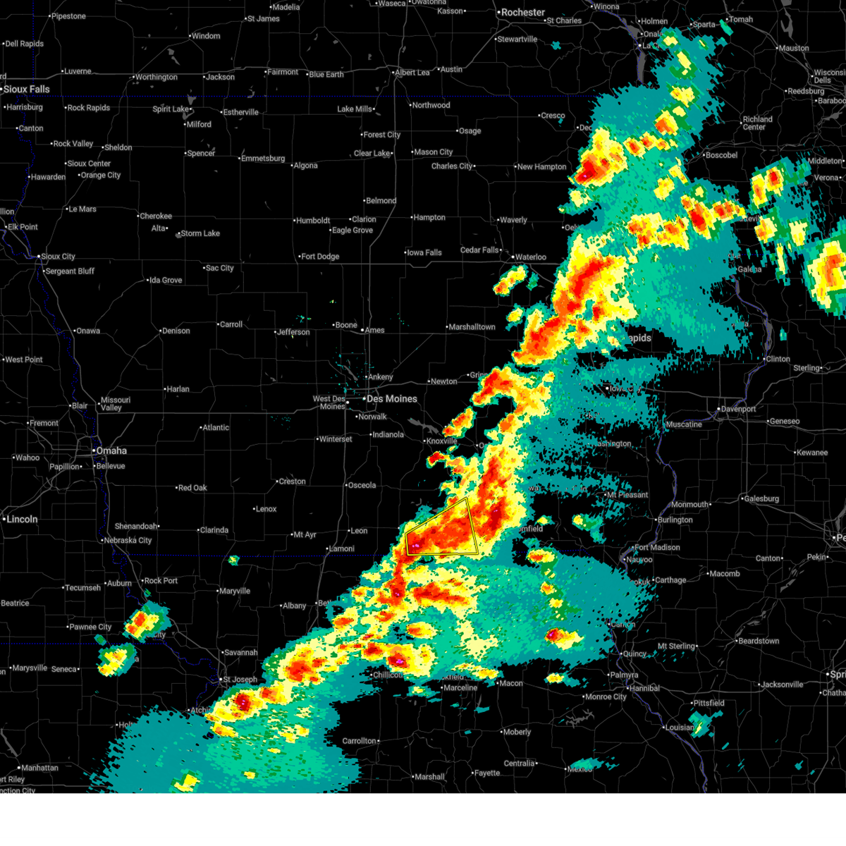
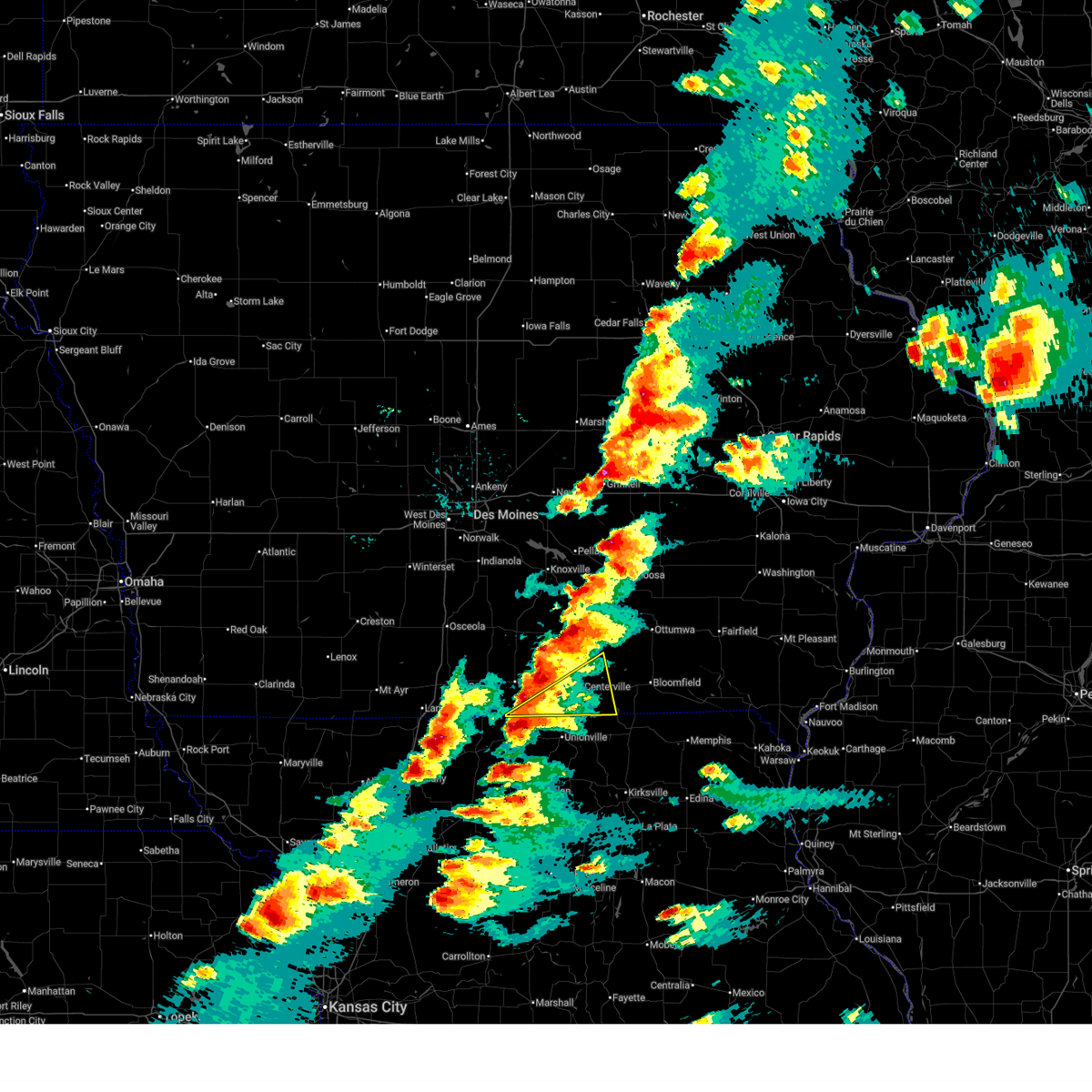
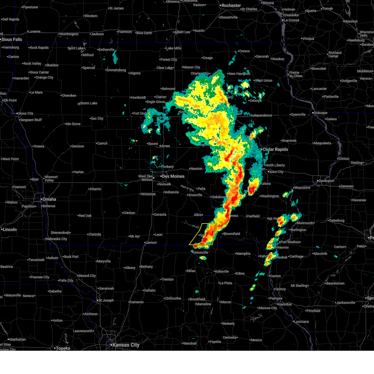
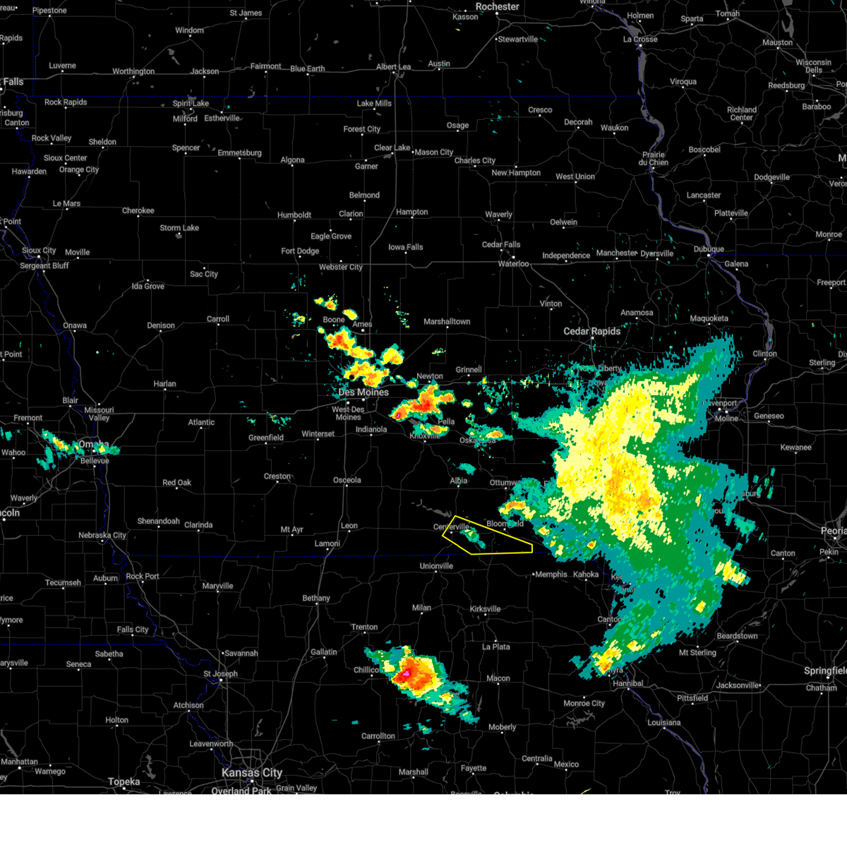
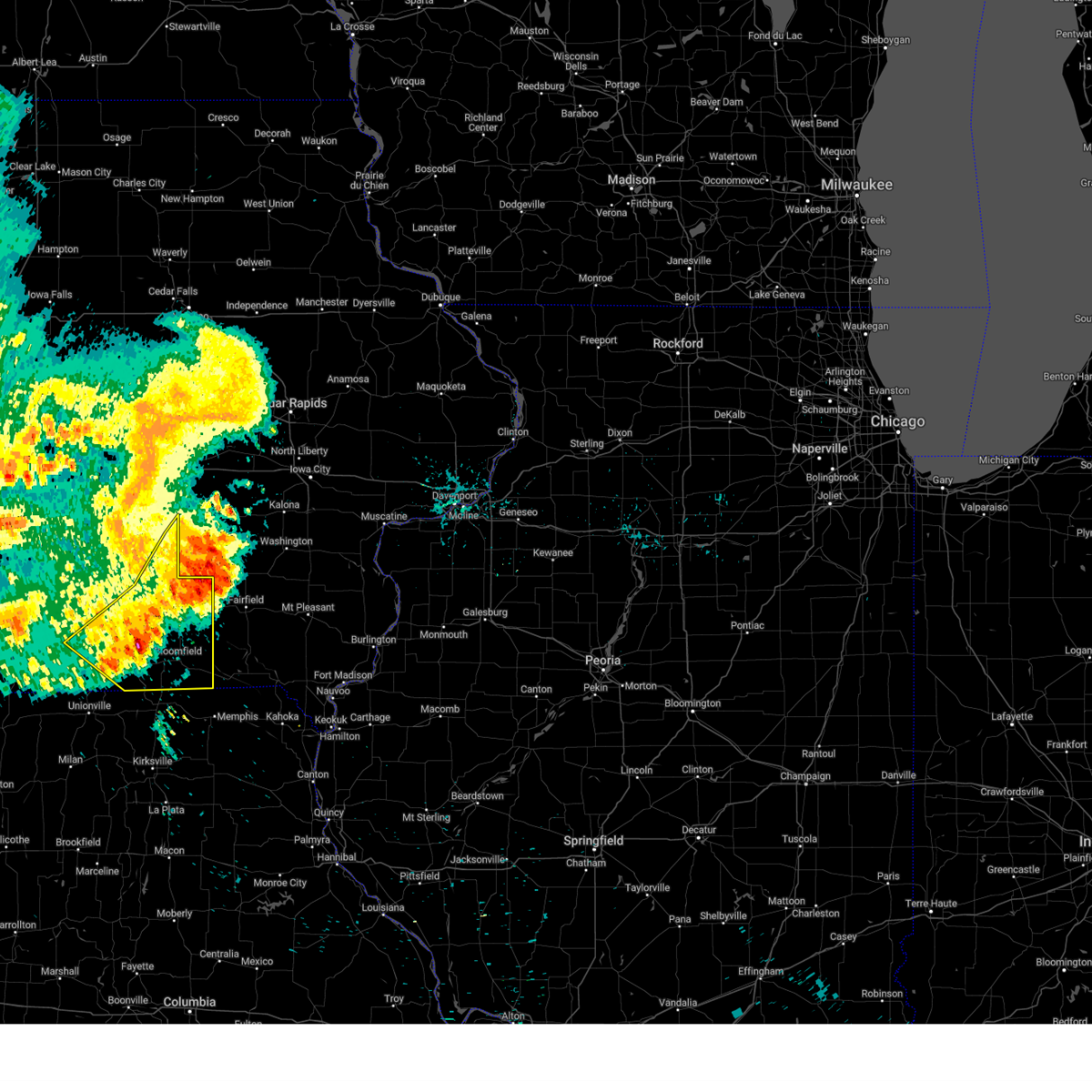
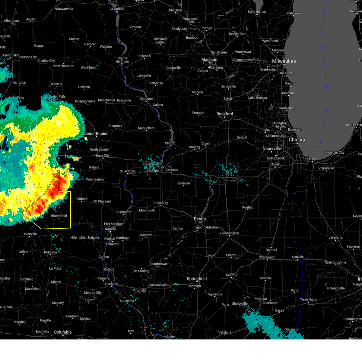
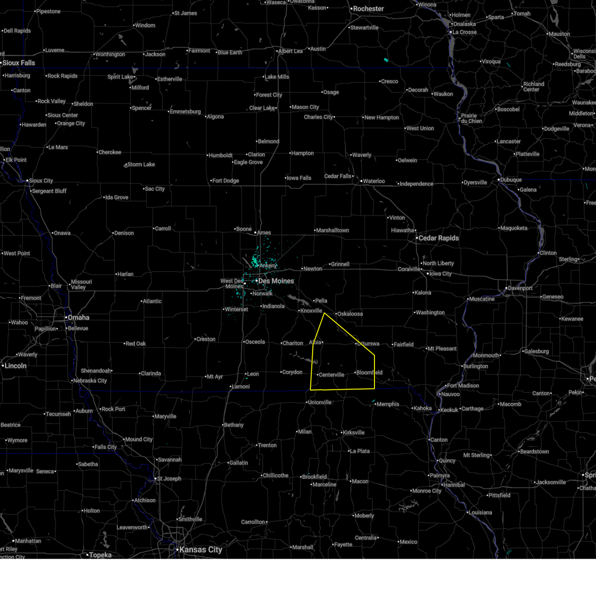
Hail Map for Exline, IA
The Exline, IA area has had 1 report of on-the-ground hail by trained spotters, and has been under severe weather warnings 22 times during the past 12 months. Doppler radar has detected hail at or near Exline, IA on 60 occasions, including 5 occasions during the past year.
| Name: | Exline, IA |
| Where Located: | 61.2 miles WNW of Kahoka, MO |
| Map: | Google Map for Exline, IA |
| Population: | 160 |
| Housing Units: | 85 |
| More Info: | Search Google for Exline, IA |
1
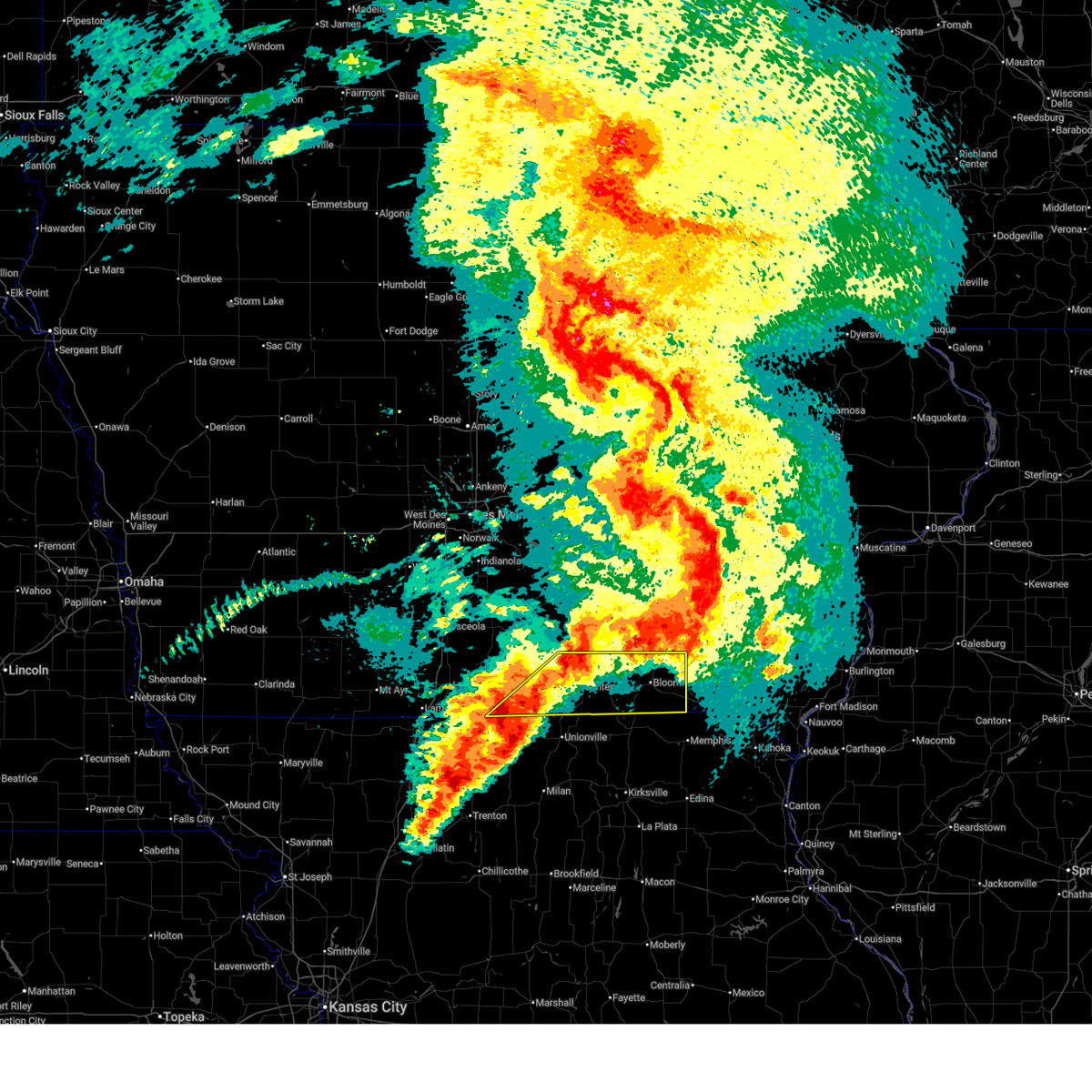
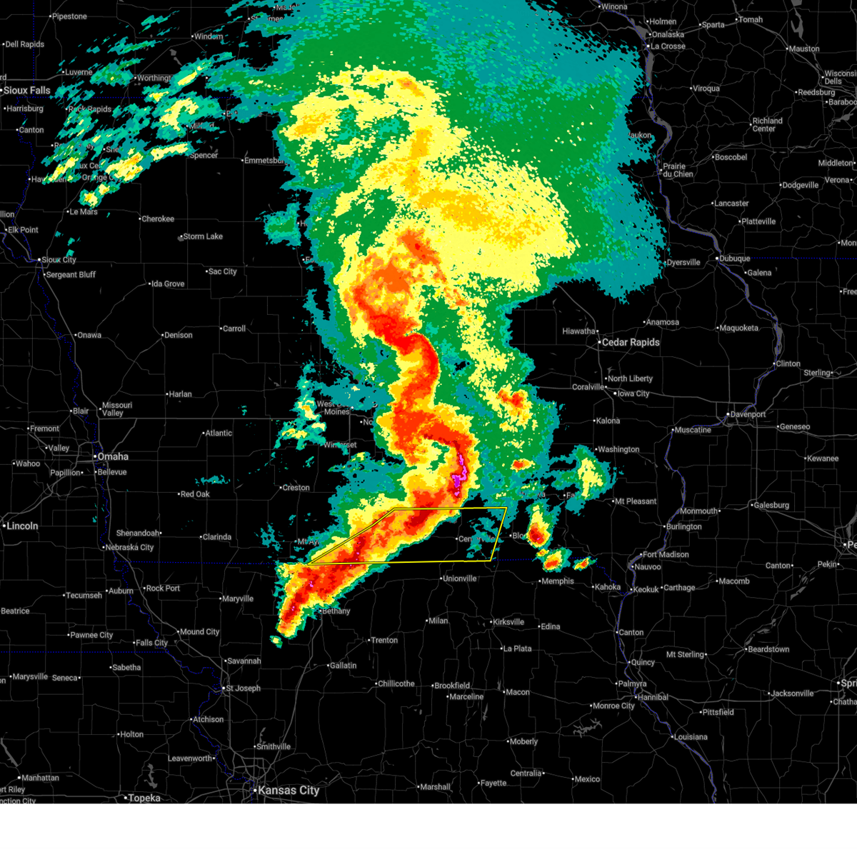
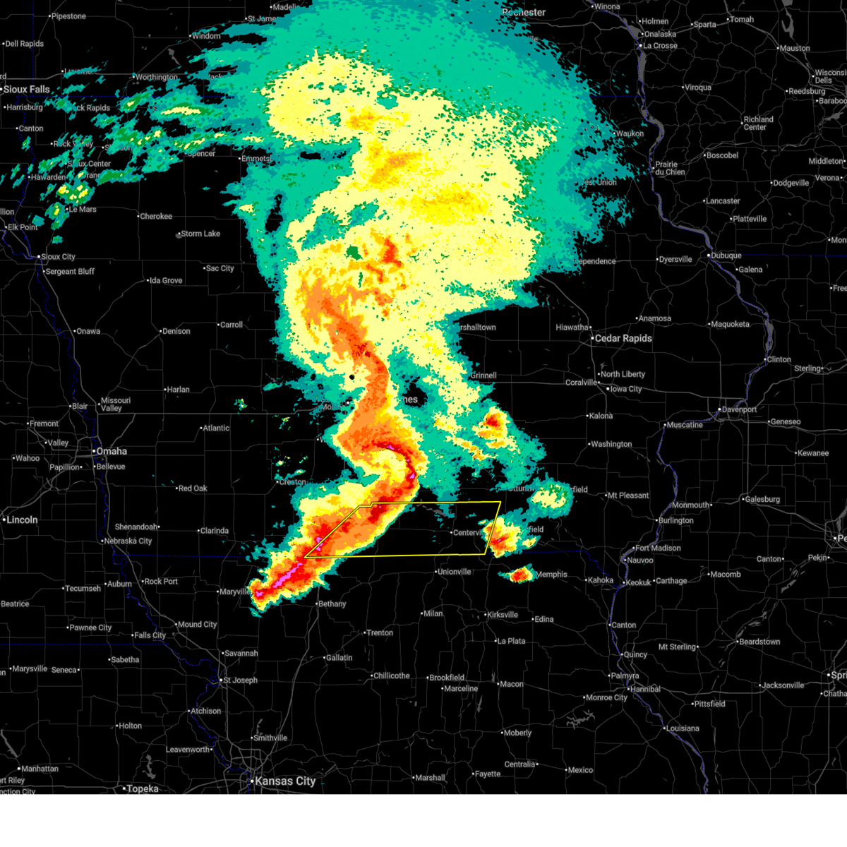
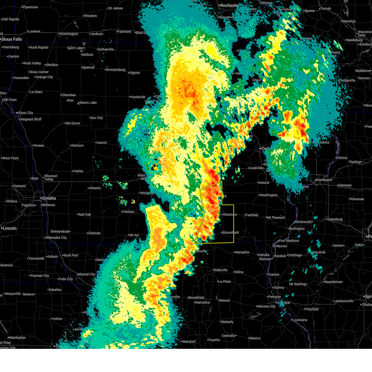
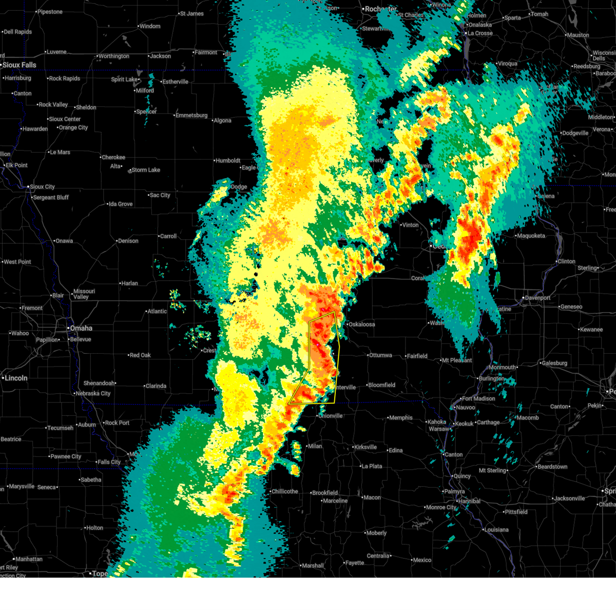
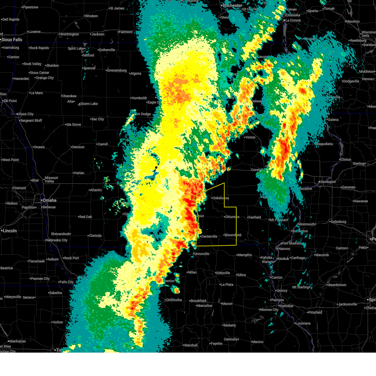
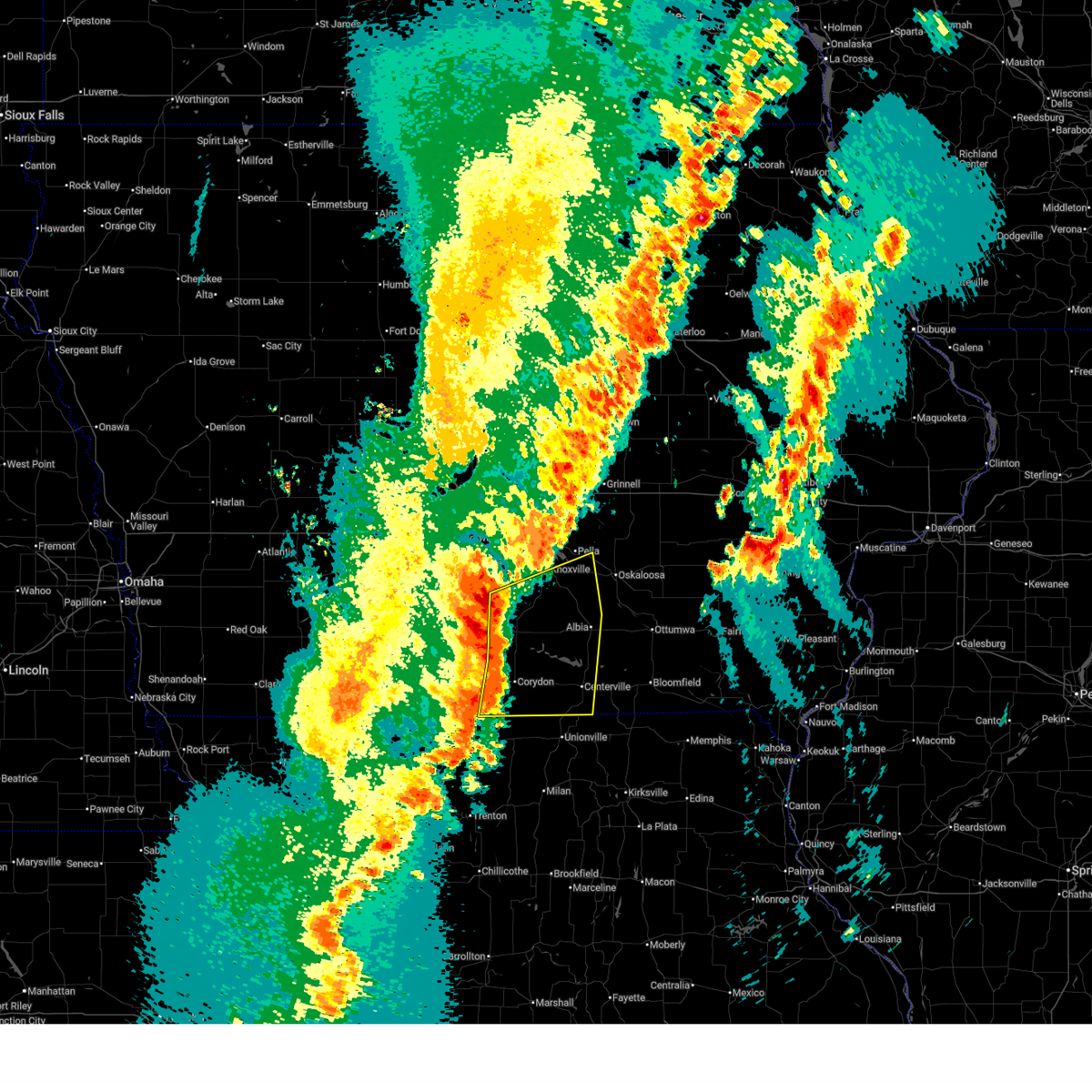
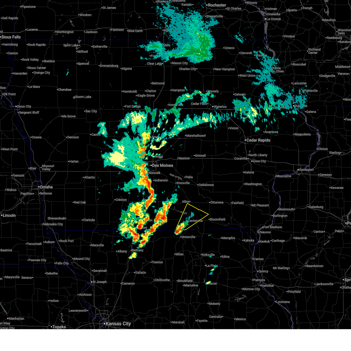
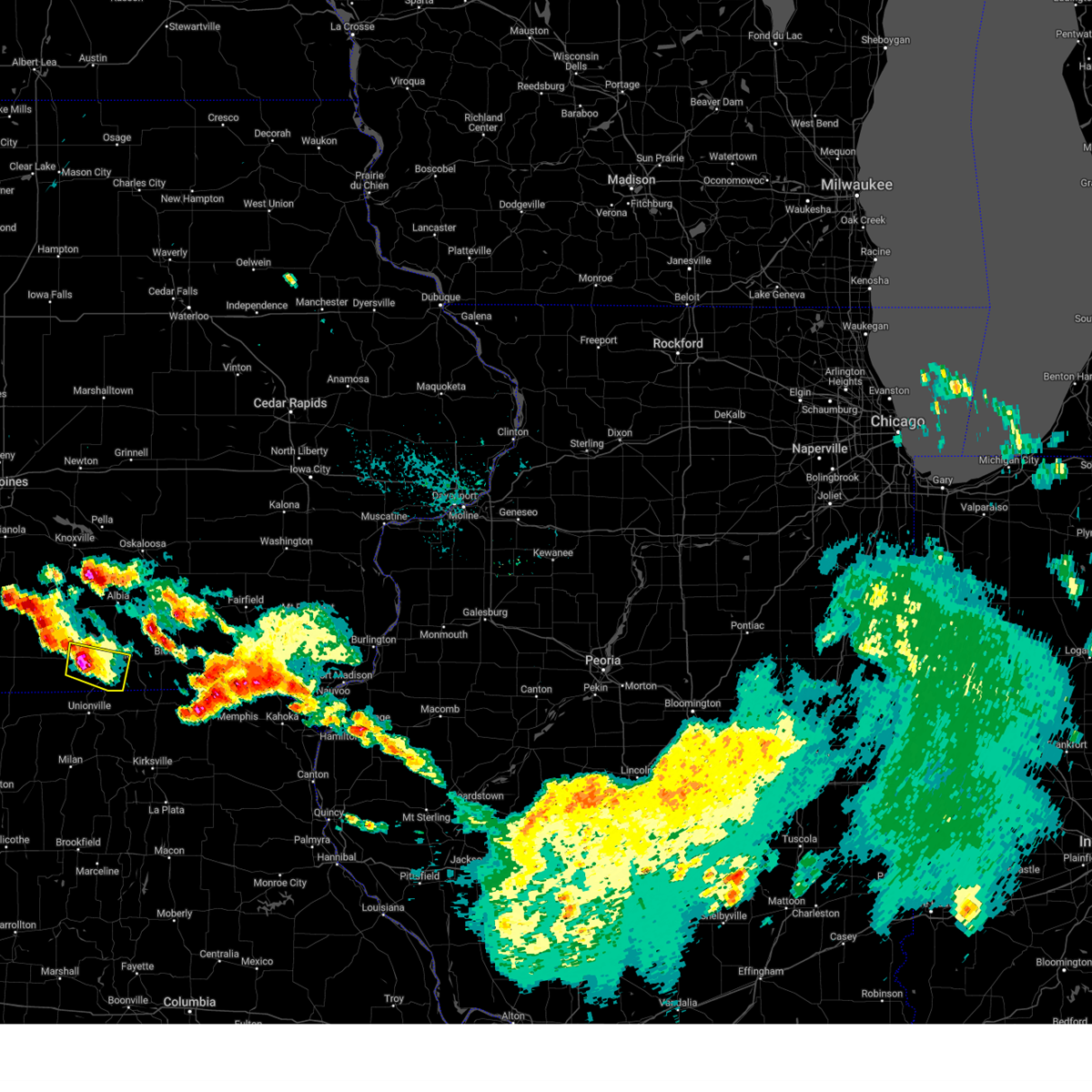
The Top Recent Hail Date for Exline, IA is Thursday, June 11, 2026 (10th out of 60)

Hail and Wind Damage Spotted near Exline, IA
| Date / Time | Report Details |
|---|---|
| 6/11/2026 9:16 AM CDT |
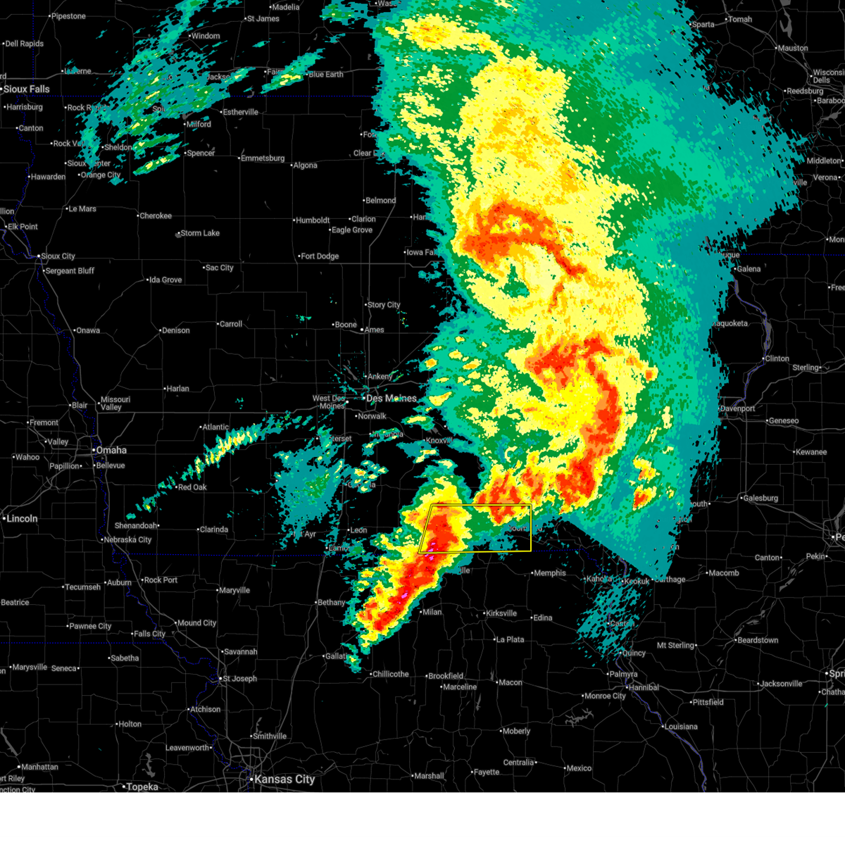 At 916 am cdt, a severe thunderstorm was located near exline, or 6 miles southeast of centerville, moving east at 30 mph (radar indicated). Hazards include 60 mph wind gusts. Expect damage to roofs, siding, and trees. Locations impacted include, centerville, bloomfield, lake sundown, rathbun lake, seymour, moravia, moulton, mystic, cincinnati, pulaski, drakesville, exline, floris, unionville, numa, rathbun, plano, udell, lake wapello state park, and honey creek state park. At 916 am cdt, a severe thunderstorm was located near exline, or 6 miles southeast of centerville, moving east at 30 mph (radar indicated). Hazards include 60 mph wind gusts. Expect damage to roofs, siding, and trees. Locations impacted include, centerville, bloomfield, lake sundown, rathbun lake, seymour, moravia, moulton, mystic, cincinnati, pulaski, drakesville, exline, floris, unionville, numa, rathbun, plano, udell, lake wapello state park, and honey creek state park.
|
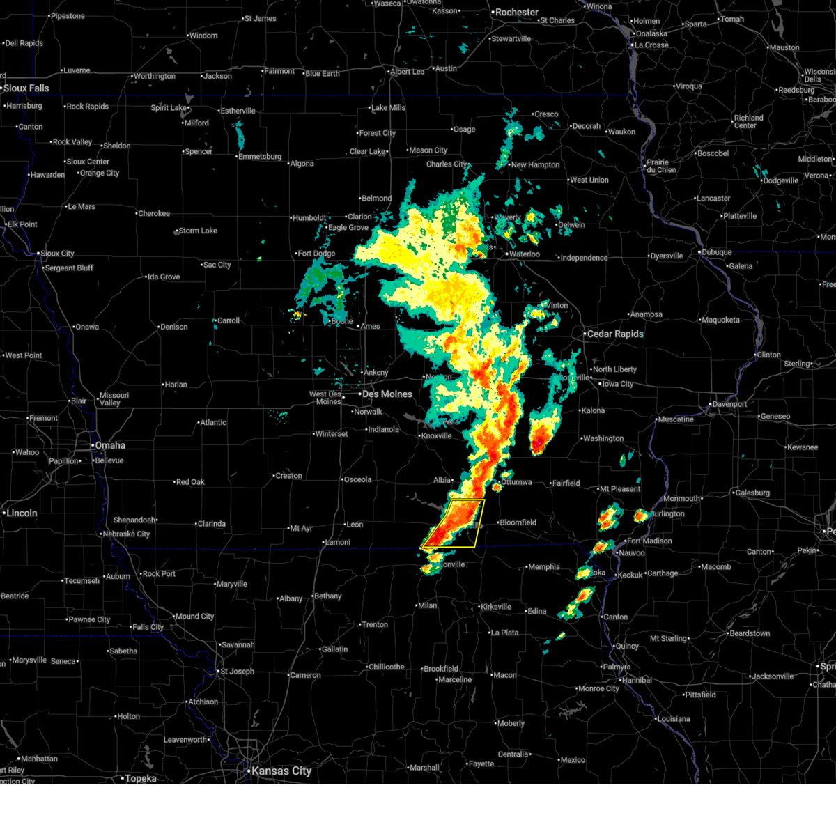
| 6/11/2026 8:45 AM CDT |
 Svrdmx the national weather service in des moines has issued a * severe thunderstorm warning for, davis county in southeastern iowa, southeastern wayne county in south central iowa, appanoose county in south central iowa, * until 945 am cdt. * at 845 am cdt, a severe thunderstorm was located over mystic, or near centerville, moving east at 45 mph (radar indicated). Hazards include 60 mph wind gusts. expect damage to roofs, siding, and trees Svrdmx the national weather service in des moines has issued a * severe thunderstorm warning for, davis county in southeastern iowa, southeastern wayne county in south central iowa, appanoose county in south central iowa, * until 945 am cdt. * at 845 am cdt, a severe thunderstorm was located over mystic, or near centerville, moving east at 45 mph (radar indicated). Hazards include 60 mph wind gusts. expect damage to roofs, siding, and trees
|
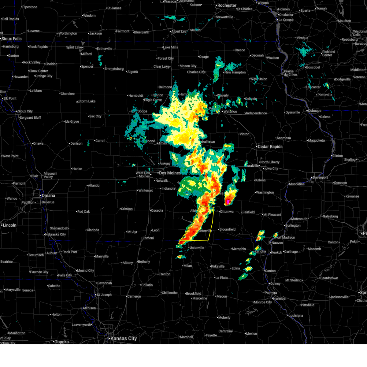
| 6/11/2026 8:05 AM CDT |
 At 805 am cdt, severe thunderstorms were located along a line extending from 4 miles northwest of moravia to near promise city to near mercer, moving east at 55 mph (radar indicated). Hazards include 60 mph wind gusts and quarter size hail. Hail damage to vehicles is expected. expect wind damage to roofs, siding, and trees. locations impacted include, centerville, leon, corydon, lamoni, lake sundown, rathbun lake, seymour, moravia, moulton, allerton, humeston, mystic, cincinnati, lineville, davis city, exline, promise city, unionville, numa, and rathbun. This includes interstate 35 between mile markers 1 and 10. At 805 am cdt, severe thunderstorms were located along a line extending from 4 miles northwest of moravia to near promise city to near mercer, moving east at 55 mph (radar indicated). Hazards include 60 mph wind gusts and quarter size hail. Hail damage to vehicles is expected. expect wind damage to roofs, siding, and trees. locations impacted include, centerville, leon, corydon, lamoni, lake sundown, rathbun lake, seymour, moravia, moulton, allerton, humeston, mystic, cincinnati, lineville, davis city, exline, promise city, unionville, numa, and rathbun. This includes interstate 35 between mile markers 1 and 10.
|
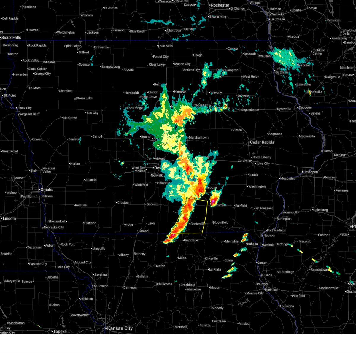
| 6/11/2026 7:49 AM CDT |
 Svrdmx the national weather service in des moines has issued a * severe thunderstorm warning for, southern lucas county in south central iowa, southern monroe county in south central iowa, decatur county in south central iowa, western davis county in southeastern iowa, southwestern wapello county in southeastern iowa, wayne county in south central iowa, southeastern ringgold county in south central iowa, appanoose county in south central iowa, * until 845 am cdt. * at 748 am cdt, severe thunderstorms were located along a line extending from 6 miles southeast of russell to allerton to 4 miles north of cainsville, moving east at 65 mph (trained weather spotters. the lamoni airport recently gusted to 64 mph). Hazards include 70 mph wind gusts and quarter size hail. Hail damage to vehicles is expected. expect considerable tree damage. Wind damage is also likely to mobile homes, roofs, and outbuildings. Svrdmx the national weather service in des moines has issued a * severe thunderstorm warning for, southern lucas county in south central iowa, southern monroe county in south central iowa, decatur county in south central iowa, western davis county in southeastern iowa, southwestern wapello county in southeastern iowa, wayne county in south central iowa, southeastern ringgold county in south central iowa, appanoose county in south central iowa, * until 845 am cdt. * at 748 am cdt, severe thunderstorms were located along a line extending from 6 miles southeast of russell to allerton to 4 miles north of cainsville, moving east at 65 mph (trained weather spotters. the lamoni airport recently gusted to 64 mph). Hazards include 70 mph wind gusts and quarter size hail. Hail damage to vehicles is expected. expect considerable tree damage. Wind damage is also likely to mobile homes, roofs, and outbuildings.
|
| 6/10/2026 4:41 PM CDT |
 Tordmx the national weather service in des moines has issued a * tornado warning for, southeastern appanoose county in south central iowa, * until 530 pm cdt. * at 439 pm cdt, a confirmed large and extremely dangerous tornado was located 5 miles northeast of unionville, moving northeast at 25 mph. this is a particularly dangerous situation. take cover now! (weather spotters confirmed tornado in missouri). Hazards include damaging tornado. You are in a life-threatening situation. flying debris may be deadly to those caught without shelter. mobile homes will be destroyed. considerable damage to homes, businesses, and vehicles is likely and complete destruction is possible. the tornado will be near, moulton around 510 pm cdt. Other locations impacted by this tornadic thunderstorm include moulton and exline. Tordmx the national weather service in des moines has issued a * tornado warning for, southeastern appanoose county in south central iowa, * until 530 pm cdt. * at 439 pm cdt, a confirmed large and extremely dangerous tornado was located 5 miles northeast of unionville, moving northeast at 25 mph. this is a particularly dangerous situation. take cover now! (weather spotters confirmed tornado in missouri). Hazards include damaging tornado. You are in a life-threatening situation. flying debris may be deadly to those caught without shelter. mobile homes will be destroyed. considerable damage to homes, businesses, and vehicles is likely and complete destruction is possible. the tornado will be near, moulton around 510 pm cdt. Other locations impacted by this tornadic thunderstorm include moulton and exline.
|
| 6/6/2026 1:55 AM CDT |
 The storms which prompted the warning have weakened below severe limits, and no longer pose an immediate threat to life or property. therefore, the warning will be allowed to expire. however, gusty winds are still possible with these thunderstorms. a severe thunderstorm watch remains in effect until 300 am cdt for south central and southeastern iowa. The storms which prompted the warning have weakened below severe limits, and no longer pose an immediate threat to life or property. therefore, the warning will be allowed to expire. however, gusty winds are still possible with these thunderstorms. a severe thunderstorm watch remains in effect until 300 am cdt for south central and southeastern iowa.
|
| 6/6/2026 1:19 AM CDT |
 At 119 am cdt, severe thunderstorms were located along a line extending from near albia municipal airport to rathbun lake to near millerton, moving south at 10 mph (radar indicated). Hazards include 60 mph wind gusts and quarter size hail. Hail damage to vehicles is expected. expect wind damage to roofs, siding, and trees. Locations impacted include, centerville, chariton, albia, corydon, lake sundown, rathbun lake, seymour, moravia, moulton, russell, lovilia, allerton, humeston, mystic, cincinnati, lineville, lucas, exline, williamson, and derby. At 119 am cdt, severe thunderstorms were located along a line extending from near albia municipal airport to rathbun lake to near millerton, moving south at 10 mph (radar indicated). Hazards include 60 mph wind gusts and quarter size hail. Hail damage to vehicles is expected. expect wind damage to roofs, siding, and trees. Locations impacted include, centerville, chariton, albia, corydon, lake sundown, rathbun lake, seymour, moravia, moulton, russell, lovilia, allerton, humeston, mystic, cincinnati, lineville, lucas, exline, williamson, and derby.
|
| 6/6/2026 12:42 AM CDT |
 Svrdmx the national weather service in des moines has issued a * severe thunderstorm warning for, lucas county in south central iowa, monroe county in south central iowa, southwestern davis county in southeastern iowa, wayne county in south central iowa, appanoose county in south central iowa, * until 200 am cdt. * at 1242 am cdt, severe thunderstorms were located along a line extending from near albia to near melrose to 4 miles south of chariton municipal airport, moving south at 20 mph (radar indicated). Hazards include 60 mph wind gusts and quarter size hail. Hail damage to vehicles is expected. Expect wind damage to roofs, siding, and trees. Svrdmx the national weather service in des moines has issued a * severe thunderstorm warning for, lucas county in south central iowa, monroe county in south central iowa, southwestern davis county in southeastern iowa, wayne county in south central iowa, appanoose county in south central iowa, * until 200 am cdt. * at 1242 am cdt, severe thunderstorms were located along a line extending from near albia to near melrose to 4 miles south of chariton municipal airport, moving south at 20 mph (radar indicated). Hazards include 60 mph wind gusts and quarter size hail. Hail damage to vehicles is expected. Expect wind damage to roofs, siding, and trees.
|
| 4/23/2026 10:08 PM CDT |
 At 1008 pm cdt, severe thunderstorms were located along a line extending from near coal creek to ottumwa industrial airport to near bloomfield municipal airport, moving northeast at 50 mph (radar indicated). Hazards include 60 mph wind gusts and penny size hail. Expect damage to roofs, siding, and trees. Locations impacted include, ottumwa, oskaloosa, centerville, bloomfield, eddyville, ottumwa industrial airport, lake sundown, eldon, fremont, agency, moulton, beacon, university park, cincinnati, blakesburg, pulaski, drakesville, rose hill, kirkville, and leighton. At 1008 pm cdt, severe thunderstorms were located along a line extending from near coal creek to ottumwa industrial airport to near bloomfield municipal airport, moving northeast at 50 mph (radar indicated). Hazards include 60 mph wind gusts and penny size hail. Expect damage to roofs, siding, and trees. Locations impacted include, ottumwa, oskaloosa, centerville, bloomfield, eddyville, ottumwa industrial airport, lake sundown, eldon, fremont, agency, moulton, beacon, university park, cincinnati, blakesburg, pulaski, drakesville, rose hill, kirkville, and leighton.
|
| 4/23/2026 9:43 PM CDT |
 At 943 pm cdt, severe thunderstorms were located along a line extending from harvey to near albia to centerville, moving east at 50 mph (radar indicated). Hazards include 60 mph wind gusts and penny size hail. Expect damage to roofs, siding, and trees. Locations impacted include, knoxville, centerville, albia, rathbun lake, seymour, moravia, lovilia, mystic, bussey, cincinnati, harvey, leighton, exline, hamilton, melrose, promise city, numa, rathbun, plano, and marysville. At 943 pm cdt, severe thunderstorms were located along a line extending from harvey to near albia to centerville, moving east at 50 mph (radar indicated). Hazards include 60 mph wind gusts and penny size hail. Expect damage to roofs, siding, and trees. Locations impacted include, knoxville, centerville, albia, rathbun lake, seymour, moravia, lovilia, mystic, bussey, cincinnati, harvey, leighton, exline, hamilton, melrose, promise city, numa, rathbun, plano, and marysville.
|
| 4/23/2026 9:40 PM CDT |
 Svrdmx the national weather service in des moines has issued a * severe thunderstorm warning for, monroe county in south central iowa, southeastern marion county in south central iowa, davis county in southeastern iowa, wapello county in southeastern iowa, mahaska county in south central iowa, appanoose county in south central iowa, * until 1045 pm cdt. * at 939 pm cdt, severe thunderstorms were located along a line extending from near marysville to near albia to near cincinnati, moving east at 50 mph (radar indicated). Hazards include 60 mph wind gusts and penny size hail. expect damage to roofs, siding, and trees Svrdmx the national weather service in des moines has issued a * severe thunderstorm warning for, monroe county in south central iowa, southeastern marion county in south central iowa, davis county in southeastern iowa, wapello county in southeastern iowa, mahaska county in south central iowa, appanoose county in south central iowa, * until 1045 pm cdt. * at 939 pm cdt, severe thunderstorms were located along a line extending from near marysville to near albia to near cincinnati, moving east at 50 mph (radar indicated). Hazards include 60 mph wind gusts and penny size hail. expect damage to roofs, siding, and trees
|
| 4/23/2026 9:02 PM CDT |
 Svrdmx the national weather service in des moines has issued a * severe thunderstorm warning for, lucas county in south central iowa, monroe county in south central iowa, southern marion county in south central iowa, wayne county in south central iowa, southwestern mahaska county in south central iowa, appanoose county in south central iowa, southeastern warren county in south central iowa, * until 1000 pm cdt. * at 901 pm cdt, severe thunderstorms were located along a line extending from 4 miles southeast of otter creek county park to near humeston to near lineville, moving northeast at 40 mph (radar indicated). Hazards include 60 mph wind gusts and penny size hail. expect damage to roofs, siding, and trees Svrdmx the national weather service in des moines has issued a * severe thunderstorm warning for, lucas county in south central iowa, monroe county in south central iowa, southern marion county in south central iowa, wayne county in south central iowa, southwestern mahaska county in south central iowa, appanoose county in south central iowa, southeastern warren county in south central iowa, * until 1000 pm cdt. * at 901 pm cdt, severe thunderstorms were located along a line extending from 4 miles southeast of otter creek county park to near humeston to near lineville, moving northeast at 40 mph (radar indicated). Hazards include 60 mph wind gusts and penny size hail. expect damage to roofs, siding, and trees
|
| 4/17/2026 4:19 PM CDT |
 the severe thunderstorm warning has been cancelled and is no longer in effect the severe thunderstorm warning has been cancelled and is no longer in effect
|
| 4/17/2026 4:19 PM CDT |
 At 419 pm cdt, a severe thunderstorm was located over numa, or 8 miles southwest of centerville, moving east at 45 mph (radar indicated). Hazards include 60 mph wind gusts and quarter size hail. Hail damage to vehicles is expected. expect wind damage to roofs, siding, and trees. Locations impacted include, centerville, lake sundown, rathbun lake, moravia, moulton, mystic, cincinnati, exline, unionville, numa, rathbun, plano, udell, honey creek state park, sharon bluffs state park, and centerville municipal airport. At 419 pm cdt, a severe thunderstorm was located over numa, or 8 miles southwest of centerville, moving east at 45 mph (radar indicated). Hazards include 60 mph wind gusts and quarter size hail. Hail damage to vehicles is expected. expect wind damage to roofs, siding, and trees. Locations impacted include, centerville, lake sundown, rathbun lake, moravia, moulton, mystic, cincinnati, exline, unionville, numa, rathbun, plano, udell, honey creek state park, sharon bluffs state park, and centerville municipal airport.
|
| 4/17/2026 4:13 PM CDT |
 Svrdmx the national weather service in des moines has issued a * severe thunderstorm warning for, south central monroe county in south central iowa, southeastern wayne county in south central iowa, appanoose county in south central iowa, * until 445 pm cdt. * at 413 pm cdt, a severe thunderstorm was located over seymour, or 12 miles southwest of centerville, moving east at 45 mph (radar indicated). Hazards include 60 mph wind gusts and quarter size hail. Hail damage to vehicles is expected. Expect wind damage to roofs, siding, and trees. Svrdmx the national weather service in des moines has issued a * severe thunderstorm warning for, south central monroe county in south central iowa, southeastern wayne county in south central iowa, appanoose county in south central iowa, * until 445 pm cdt. * at 413 pm cdt, a severe thunderstorm was located over seymour, or 12 miles southwest of centerville, moving east at 45 mph (radar indicated). Hazards include 60 mph wind gusts and quarter size hail. Hail damage to vehicles is expected. Expect wind damage to roofs, siding, and trees.
|
| 4/17/2026 3:28 PM CDT |
 Svrdmx the national weather service in des moines has issued a * severe thunderstorm warning for, southeastern wayne county in south central iowa, appanoose county in south central iowa, * until 415 pm cdt. * at 328 pm cdt, a severe thunderstorm was located 7 miles south of seymour, or 10 miles northwest of unionville, moving east at 35 mph (radar indicated). Hazards include 60 mph wind gusts and quarter size hail. Hail damage to vehicles is expected. Expect wind damage to roofs, siding, and trees. Svrdmx the national weather service in des moines has issued a * severe thunderstorm warning for, southeastern wayne county in south central iowa, appanoose county in south central iowa, * until 415 pm cdt. * at 328 pm cdt, a severe thunderstorm was located 7 miles south of seymour, or 10 miles northwest of unionville, moving east at 35 mph (radar indicated). Hazards include 60 mph wind gusts and quarter size hail. Hail damage to vehicles is expected. Expect wind damage to roofs, siding, and trees.
|
| 4/2/2026 4:00 PM CDT |
 The storms which prompted the warning have weakened below severe limits, and no longer pose an immediate threat to life or property. therefore, the warning has been allowed to expire. a tornado watch remains in effect until 800 pm cdt for south central and southeastern iowa. The storms which prompted the warning have weakened below severe limits, and no longer pose an immediate threat to life or property. therefore, the warning has been allowed to expire. a tornado watch remains in effect until 800 pm cdt for south central and southeastern iowa.
|
| 4/2/2026 3:44 PM CDT |
 At 343 pm cdt, severe thunderstorms were located along a line extending from 4 miles west of ottumwa to lake wapello state park to 4 miles south of exline, moving east at 40 mph (radar indicated). Hazards include 60 mph wind gusts and penny size hail. Expect damage to roofs, siding, and trees. Locations impacted include, centerville, lake sundown, moravia, moulton, cincinnati, exline, unionville, numa, udell, lake wapello state park, sharon bluffs state park, and centerville municipal airport. At 343 pm cdt, severe thunderstorms were located along a line extending from 4 miles west of ottumwa to lake wapello state park to 4 miles south of exline, moving east at 40 mph (radar indicated). Hazards include 60 mph wind gusts and penny size hail. Expect damage to roofs, siding, and trees. Locations impacted include, centerville, lake sundown, moravia, moulton, cincinnati, exline, unionville, numa, udell, lake wapello state park, sharon bluffs state park, and centerville municipal airport.
|
| 4/2/2026 3:44 PM CDT |
 the severe thunderstorm warning has been cancelled and is no longer in effect the severe thunderstorm warning has been cancelled and is no longer in effect
|
| 4/2/2026 3:31 PM CDT |
 At 330 pm cdt, severe thunderstorms were located along a line extending from 4 miles southwest of chillicothe to unionville to near cincinnati, moving east at 35 mph (radar indicated). Hazards include 60 mph wind gusts and penny size hail. Expect damage to roofs, siding, and trees. Locations impacted include, centerville, albia, lake sundown, rathbun lake, moravia, moulton, mystic, cincinnati, blakesburg, exline, unionville, chillicothe, numa, rathbun, udell, lake wapello state park, albia municipal airport, sharon bluffs state park, centerville municipal airport, and honey creek state park. At 330 pm cdt, severe thunderstorms were located along a line extending from 4 miles southwest of chillicothe to unionville to near cincinnati, moving east at 35 mph (radar indicated). Hazards include 60 mph wind gusts and penny size hail. Expect damage to roofs, siding, and trees. Locations impacted include, centerville, albia, lake sundown, rathbun lake, moravia, moulton, mystic, cincinnati, blakesburg, exline, unionville, chillicothe, numa, rathbun, udell, lake wapello state park, albia municipal airport, sharon bluffs state park, centerville municipal airport, and honey creek state park.
|
| 4/2/2026 3:14 PM CDT |
 Svrdmx the national weather service in des moines has issued a * severe thunderstorm warning for, monroe county in south central iowa, western davis county in southeastern iowa, southwestern wapello county in southeastern iowa, southeastern wayne county in south central iowa, appanoose county in south central iowa, * until 400 pm cdt. * at 313 pm cdt, severe thunderstorms were located along a line extending from near albia to moravia to 6 miles north of unionville, moving east at 35 mph (radar indicated). Hazards include 60 mph wind gusts and penny size hail. expect damage to roofs, siding, and trees Svrdmx the national weather service in des moines has issued a * severe thunderstorm warning for, monroe county in south central iowa, western davis county in southeastern iowa, southwestern wapello county in southeastern iowa, southeastern wayne county in south central iowa, appanoose county in south central iowa, * until 400 pm cdt. * at 313 pm cdt, severe thunderstorms were located along a line extending from near albia to moravia to 6 miles north of unionville, moving east at 35 mph (radar indicated). Hazards include 60 mph wind gusts and penny size hail. expect damage to roofs, siding, and trees
|
| 4/2/2026 2:13 PM CDT |
 Svrdmx the national weather service in des moines has issued a * severe thunderstorm warning for, southeastern monroe county in south central iowa, northwestern davis county in southeastern iowa, appanoose county in south central iowa, * until 300 pm cdt. * at 213 pm cdt, a severe thunderstorm was located 6 miles southwest of cincinnati, or 8 miles north of unionville, moving northeast at 55 mph (radar indicated). Hazards include 60 mph wind gusts and quarter size hail. Hail damage to vehicles is expected. Expect wind damage to roofs, siding, and trees. Svrdmx the national weather service in des moines has issued a * severe thunderstorm warning for, southeastern monroe county in south central iowa, northwestern davis county in southeastern iowa, appanoose county in south central iowa, * until 300 pm cdt. * at 213 pm cdt, a severe thunderstorm was located 6 miles southwest of cincinnati, or 8 miles north of unionville, moving northeast at 55 mph (radar indicated). Hazards include 60 mph wind gusts and quarter size hail. Hail damage to vehicles is expected. Expect wind damage to roofs, siding, and trees.
|
| 7/31/2024 8:59 PM CDT |
 The storms which prompted the warning have weakened below severe limits, and no longer pose an immediate threat to life or property. therefore, the warning will be allowed to expire. a severe thunderstorm watch remains in effect until 100 am cdt for south central and southeastern iowa. The storms which prompted the warning have weakened below severe limits, and no longer pose an immediate threat to life or property. therefore, the warning will be allowed to expire. a severe thunderstorm watch remains in effect until 100 am cdt for south central and southeastern iowa.
|
| 7/31/2024 8:47 PM CDT |
 the severe thunderstorm warning has been cancelled and is no longer in effect the severe thunderstorm warning has been cancelled and is no longer in effect
|
| 7/31/2024 8:47 PM CDT |
 At 845 pm cdt, severe thunderstorms were located along a line extending from 4 miles east of melcher-dallas to 6 miles east of millerton to near south lineville, moving east at 50 mph (radar indicated). Hazards include 60 mph wind gusts. Expect damage to roofs, siding, and trees. locations impacted include, oskaloosa, centerville, osceola, chariton, albia, leon, corydon, lamoni, melcher-dallas, eddyville, lake sundown, rathbun lake, seymour, moravia, moulton, russell, lovilia, allerton, humeston, and beacon. This includes interstate 35 between mile markers 1 and 30. At 845 pm cdt, severe thunderstorms were located along a line extending from 4 miles east of melcher-dallas to 6 miles east of millerton to near south lineville, moving east at 50 mph (radar indicated). Hazards include 60 mph wind gusts. Expect damage to roofs, siding, and trees. locations impacted include, oskaloosa, centerville, osceola, chariton, albia, leon, corydon, lamoni, melcher-dallas, eddyville, lake sundown, rathbun lake, seymour, moravia, moulton, russell, lovilia, allerton, humeston, and beacon. This includes interstate 35 between mile markers 1 and 30.
|
| 7/31/2024 8:21 PM CDT |
 Svrdmx the national weather service in des moines has issued a * severe thunderstorm warning for, monroe county in south central iowa, lucas county in south central iowa, decatur county in south central iowa, southeastern madison county in south central iowa, southern marion county in south central iowa, wayne county in south central iowa, southwestern mahaska county in south central iowa, southeastern ringgold county in south central iowa, appanoose county in south central iowa, clarke county in south central iowa, southern warren county in south central iowa, * until 900 pm cdt. * at 821 pm cdt, severe thunderstorms were located along a line extending from near otter creek county park to humeston to near nine eagles state park, moving east at 70 mph (radar indicated). Hazards include 60 mph wind gusts. lamoni airport gusted to 59 mph. expect damage to roofs, siding, and trees Svrdmx the national weather service in des moines has issued a * severe thunderstorm warning for, monroe county in south central iowa, lucas county in south central iowa, decatur county in south central iowa, southeastern madison county in south central iowa, southern marion county in south central iowa, wayne county in south central iowa, southwestern mahaska county in south central iowa, southeastern ringgold county in south central iowa, appanoose county in south central iowa, clarke county in south central iowa, southern warren county in south central iowa, * until 900 pm cdt. * at 821 pm cdt, severe thunderstorms were located along a line extending from near otter creek county park to humeston to near nine eagles state park, moving east at 70 mph (radar indicated). Hazards include 60 mph wind gusts. lamoni airport gusted to 59 mph. expect damage to roofs, siding, and trees
|
| 7/31/2024 11:27 AM CDT |
 Svrdmx the national weather service in des moines has issued a * severe thunderstorm warning for, southern davis county in southeastern iowa, southeastern appanoose county in south central iowa, * until 1215 pm cdt. * at 1127 am cdt, a severe thunderstorm was located near moulton, or 7 miles southeast of centerville, moving southeast at 40 mph (radar indicated). Hazards include half dollar size hail. damage to vehicles is expected Svrdmx the national weather service in des moines has issued a * severe thunderstorm warning for, southern davis county in southeastern iowa, southeastern appanoose county in south central iowa, * until 1215 pm cdt. * at 1127 am cdt, a severe thunderstorm was located near moulton, or 7 miles southeast of centerville, moving southeast at 40 mph (radar indicated). Hazards include half dollar size hail. damage to vehicles is expected
|
| 7/31/2024 11:22 AM CDT |
 The storm which prompted the warning has weakened below severe limits, and has exited the warned area. therefore, the warning will be allowed to expire. however, heavy rain is still possible with this thunderstorm. The storm which prompted the warning has weakened below severe limits, and has exited the warned area. therefore, the warning will be allowed to expire. however, heavy rain is still possible with this thunderstorm.
|
| 7/31/2024 11:00 AM CDT |
 the severe thunderstorm warning has been cancelled and is no longer in effect the severe thunderstorm warning has been cancelled and is no longer in effect
|
| 7/31/2024 11:00 AM CDT |
 At 1059 am cdt, a severe thunderstorm was located near centerville municipal airport, or near centerville, moving east at 30 mph (radar indicated. at 1050am, half dollar sized hail was reported southwest of centerville). Hazards include quarter size hail. Damage to vehicles is expected. Locations impacted include, centerville, mystic, exline, plano, sharon bluffs state park, and centerville municipal airport. At 1059 am cdt, a severe thunderstorm was located near centerville municipal airport, or near centerville, moving east at 30 mph (radar indicated. at 1050am, half dollar sized hail was reported southwest of centerville). Hazards include quarter size hail. Damage to vehicles is expected. Locations impacted include, centerville, mystic, exline, plano, sharon bluffs state park, and centerville municipal airport.
|
| 7/31/2024 10:47 AM CDT |
 Svrdmx the national weather service in des moines has issued a * severe thunderstorm warning for, east central wayne county in south central iowa, central appanoose county in south central iowa, * until 1130 am cdt. * at 1046 am cdt, a severe thunderstorm was located over plano, or 10 miles west of centerville, moving east at 25 mph (radar indicated). Hazards include quarter size hail. damage to vehicles is expected Svrdmx the national weather service in des moines has issued a * severe thunderstorm warning for, east central wayne county in south central iowa, central appanoose county in south central iowa, * until 1130 am cdt. * at 1046 am cdt, a severe thunderstorm was located over plano, or 10 miles west of centerville, moving east at 25 mph (radar indicated). Hazards include quarter size hail. damage to vehicles is expected
|
| 7/31/2024 3:42 AM CDT |
 Svrdmx the national weather service in des moines has issued a * severe thunderstorm warning for, southern davis county in southeastern iowa, eastern appanoose county in south central iowa, * until 430 am cdt. * at 341 am cdt, a severe thunderstorm was located near centerville, moving southeast at 45 mph (radar indicated). Hazards include ping pong ball size hail and 60 mph wind gusts. People and animals outdoors will be injured. expect hail damage to roofs, siding, windows, and vehicles. Expect wind damage to roofs, siding, and trees. Svrdmx the national weather service in des moines has issued a * severe thunderstorm warning for, southern davis county in southeastern iowa, eastern appanoose county in south central iowa, * until 430 am cdt. * at 341 am cdt, a severe thunderstorm was located near centerville, moving southeast at 45 mph (radar indicated). Hazards include ping pong ball size hail and 60 mph wind gusts. People and animals outdoors will be injured. expect hail damage to roofs, siding, windows, and vehicles. Expect wind damage to roofs, siding, and trees.
|
| 7/30/2024 11:28 AM CDT |
 The storms which prompted the warning have weakened below severe limits, and no longer pose an immediate threat to life or property. therefore, the warning will be allowed to expire. however, gusty winds are still possible with these thunderstorms. a severe thunderstorm watch remains in effect until 400 pm cdt for south central and southeastern iowa. to report severe weather, contact your nearest law enforcement agency. they will relay your report to the national weather service des moines. The storms which prompted the warning have weakened below severe limits, and no longer pose an immediate threat to life or property. therefore, the warning will be allowed to expire. however, gusty winds are still possible with these thunderstorms. a severe thunderstorm watch remains in effect until 400 pm cdt for south central and southeastern iowa. to report severe weather, contact your nearest law enforcement agency. they will relay your report to the national weather service des moines.
|
| 7/30/2024 11:11 AM CDT |
 the severe thunderstorm warning has been cancelled and is no longer in effect the severe thunderstorm warning has been cancelled and is no longer in effect
|
| 7/30/2024 11:11 AM CDT |
 At 1111 am cdt, severe thunderstorms were located along a line extending from near hayesville to ottumwa to rathbun, moving southeast at 55 mph (radar indicated). Hazards include 60 mph wind gusts. Expect damage to roofs, siding, and trees. Locations impacted include, ottumwa, centerville, albia, bloomfield, eddyville, ottumwa industrial airport, lake sundown, rathbun lake, eldon, fremont, moravia, agency, moulton, mystic, blakesburg, pulaski, drakesville, rose hill, kirkville, and exline. At 1111 am cdt, severe thunderstorms were located along a line extending from near hayesville to ottumwa to rathbun, moving southeast at 55 mph (radar indicated). Hazards include 60 mph wind gusts. Expect damage to roofs, siding, and trees. Locations impacted include, ottumwa, centerville, albia, bloomfield, eddyville, ottumwa industrial airport, lake sundown, rathbun lake, eldon, fremont, moravia, agency, moulton, mystic, blakesburg, pulaski, drakesville, rose hill, kirkville, and exline.
|
| 7/30/2024 10:47 AM CDT |
 At 1047 am cdt, severe thunderstorms were located along a line extending from 4 miles east of new sharon to near beacon to russell, moving east at 35 mph (radar indicated). Hazards include 60 mph wind gusts. Expect damage to roofs, siding, and trees. Locations impacted include, ottumwa, oskaloosa, centerville, chariton, albia, bloomfield, new sharon, eddyville, ottumwa industrial airport, lake sundown, rathbun lake, eldon, fremont, moravia, agency, moulton, russell, lovilia, beacon, and university park. At 1047 am cdt, severe thunderstorms were located along a line extending from 4 miles east of new sharon to near beacon to russell, moving east at 35 mph (radar indicated). Hazards include 60 mph wind gusts. Expect damage to roofs, siding, and trees. Locations impacted include, ottumwa, oskaloosa, centerville, chariton, albia, bloomfield, new sharon, eddyville, ottumwa industrial airport, lake sundown, rathbun lake, eldon, fremont, moravia, agency, moulton, russell, lovilia, beacon, and university park.
|
| 7/30/2024 10:47 AM CDT |
 the severe thunderstorm warning has been cancelled and is no longer in effect the severe thunderstorm warning has been cancelled and is no longer in effect
|
| 7/30/2024 10:12 AM CDT |
 Svrdmx the national weather service in des moines has issued a * severe thunderstorm warning for, monroe county in south central iowa, southeastern lucas county in south central iowa, southern poweshiek county in central iowa, southeastern marion county in south central iowa, davis county in southeastern iowa, wapello county in southeastern iowa, northeastern wayne county in south central iowa, mahaska county in south central iowa, appanoose county in south central iowa, * until 1130 am cdt. * at 1012 am cdt, severe thunderstorms were located along a line extending from near reasnor to 4 miles east of knoxville to 5 miles north of lucas, moving southeast at 60 mph (radar indicated). Hazards include 60 mph wind gusts and quarter size hail. Hail damage to vehicles is expected. Expect wind damage to roofs, siding, and trees. Svrdmx the national weather service in des moines has issued a * severe thunderstorm warning for, monroe county in south central iowa, southeastern lucas county in south central iowa, southern poweshiek county in central iowa, southeastern marion county in south central iowa, davis county in southeastern iowa, wapello county in southeastern iowa, northeastern wayne county in south central iowa, mahaska county in south central iowa, appanoose county in south central iowa, * until 1130 am cdt. * at 1012 am cdt, severe thunderstorms were located along a line extending from near reasnor to 4 miles east of knoxville to 5 miles north of lucas, moving southeast at 60 mph (radar indicated). Hazards include 60 mph wind gusts and quarter size hail. Hail damage to vehicles is expected. Expect wind damage to roofs, siding, and trees.
|
| 7/30/2024 4:27 AM CDT |
 the severe thunderstorm warning has been cancelled and is no longer in effect the severe thunderstorm warning has been cancelled and is no longer in effect
|
| 7/30/2024 4:27 AM CDT |
 At 426 am cdt, severe thunderstorms were located along a line extending from ottumwa to near bloomfield to 4 miles northeast of lancaster to near queen city to green castle, moving southeast at 50 mph (radar indicated). Hazards include 60 mph wind gusts. Expect damage to roofs, siding, and trees. these severe storms will be near, ottumwa, bloomfield, agency, pulaski, floris and bloomfield municipal airport around 430 am cdt. Other locations in the path of these severe thunderstorms include eldon. At 426 am cdt, severe thunderstorms were located along a line extending from ottumwa to near bloomfield to 4 miles northeast of lancaster to near queen city to green castle, moving southeast at 50 mph (radar indicated). Hazards include 60 mph wind gusts. Expect damage to roofs, siding, and trees. these severe storms will be near, ottumwa, bloomfield, agency, pulaski, floris and bloomfield municipal airport around 430 am cdt. Other locations in the path of these severe thunderstorms include eldon.
|
| 7/30/2024 4:16 AM CDT |
 the severe thunderstorm warning has been cancelled and is no longer in effect the severe thunderstorm warning has been cancelled and is no longer in effect
|
| 7/30/2024 4:16 AM CDT |
 At 415 am cdt, severe thunderstorms were located along a line extending from near chillicothe to 5 miles northeast of lake wapello state park to near moulton to near livonia to near lemons, moving southeast at 50 mph (public report. at 359 am, a wind gust of 62 mph was measured from a personal weather station in mystic). Hazards include 60 mph wind gusts. Expect damage to roofs, siding, and trees. these severe storms will be near, ottumwa, bloomfield, drakesville, chillicothe and bloomfield municipal airport around 420 am cdt. floris around 425 am cdt. Other locations in the path of these severe thunderstorms include agency, pulaski and eldon. At 415 am cdt, severe thunderstorms were located along a line extending from near chillicothe to 5 miles northeast of lake wapello state park to near moulton to near livonia to near lemons, moving southeast at 50 mph (public report. at 359 am, a wind gust of 62 mph was measured from a personal weather station in mystic). Hazards include 60 mph wind gusts. Expect damage to roofs, siding, and trees. these severe storms will be near, ottumwa, bloomfield, drakesville, chillicothe and bloomfield municipal airport around 420 am cdt. floris around 425 am cdt. Other locations in the path of these severe thunderstorms include agency, pulaski and eldon.
|
| 7/30/2024 4:09 AM CDT |
 At 408 am cdt, severe thunderstorms were located along a line extending from eddyville to near blakesburg to near moulton to 6 miles northwest of livonia to lemons, moving southeast at 50 mph (public report. at 359 am, a wind gust of 62 mph was measured from a personal weather station in mystic). Hazards include 60 mph wind gusts. Expect damage to roofs, siding, and trees. these severe storms will be near, ottumwa, ottumwa industrial airport, drakesville, kirkville, chillicothe and lake wapello state park around 415 am cdt. bloomfield and bloomfield municipal airport around 420 am cdt. Other locations in the path of these severe thunderstorms include floris, agency, pulaski and eldon. At 408 am cdt, severe thunderstorms were located along a line extending from eddyville to near blakesburg to near moulton to 6 miles northwest of livonia to lemons, moving southeast at 50 mph (public report. at 359 am, a wind gust of 62 mph was measured from a personal weather station in mystic). Hazards include 60 mph wind gusts. Expect damage to roofs, siding, and trees. these severe storms will be near, ottumwa, ottumwa industrial airport, drakesville, kirkville, chillicothe and lake wapello state park around 415 am cdt. bloomfield and bloomfield municipal airport around 420 am cdt. Other locations in the path of these severe thunderstorms include floris, agency, pulaski and eldon.
|
| 7/30/2024 4:02 AM CDT |
 the severe thunderstorm warning has been cancelled and is no longer in effect the severe thunderstorm warning has been cancelled and is no longer in effect
|
| 7/30/2024 4:02 AM CDT |
 At 401 am cdt, severe thunderstorms were located along a line extending from 4 miles southwest of beacon to near blakesburg to udell to near cincinnati to 7 miles east of lucerne, moving southeast at 50 mph (automated systems. at 335 am, a measured wind gust of 66 mph was reported at the chariton airport). Hazards include 70 mph wind gusts. Expect considerable tree damage. damage is likely to mobile homes, roofs, and outbuildings. these severe storms will be near, eddyville, lake sundown, moulton, blakesburg, exline, unionville, udell and sharon bluffs state park around 405 am cdt. Other locations in the path of these severe thunderstorms include kirkville, chillicothe, ottumwa, ottumwa industrial airport, drakesville, bloomfield and bloomfield municipal airport. At 401 am cdt, severe thunderstorms were located along a line extending from 4 miles southwest of beacon to near blakesburg to udell to near cincinnati to 7 miles east of lucerne, moving southeast at 50 mph (automated systems. at 335 am, a measured wind gust of 66 mph was reported at the chariton airport). Hazards include 70 mph wind gusts. Expect considerable tree damage. damage is likely to mobile homes, roofs, and outbuildings. these severe storms will be near, eddyville, lake sundown, moulton, blakesburg, exline, unionville, udell and sharon bluffs state park around 405 am cdt. Other locations in the path of these severe thunderstorms include kirkville, chillicothe, ottumwa, ottumwa industrial airport, drakesville, bloomfield and bloomfield municipal airport.
|
| 7/30/2024 3:45 AM CDT |
 At 344 am cdt, severe thunderstorms were located along a line extending from near pella to near hamilton to 5 miles north of honey creek state park to plano to 5 miles south of allerton, moving southeast at 50 mph (automated systems. at 335 am, a measured wind gust of 66 mph was reported at the chariton airport). Hazards include 70 mph wind gusts. Expect considerable tree damage. damage is likely to mobile homes, roofs, and outbuildings. these severe storms will be near, centerville, albia, rathbun lake, seymour, moravia, mystic, bussey and cincinnati around 350 am cdt. eddyville, lake sundown, beacon, exline, unionville, udell and sharon bluffs state park around 355 am cdt. moulton and blakesburg around 400 am cdt. Other locations in the path of these severe thunderstorms include chillicothe, lake wapello state park, ottumwa, drakesville, kirkville, bloomfield, ottumwa industrial airport, bloomfield municipal airport and floris. At 344 am cdt, severe thunderstorms were located along a line extending from near pella to near hamilton to 5 miles north of honey creek state park to plano to 5 miles south of allerton, moving southeast at 50 mph (automated systems. at 335 am, a measured wind gust of 66 mph was reported at the chariton airport). Hazards include 70 mph wind gusts. Expect considerable tree damage. damage is likely to mobile homes, roofs, and outbuildings. these severe storms will be near, centerville, albia, rathbun lake, seymour, moravia, mystic, bussey and cincinnati around 350 am cdt. eddyville, lake sundown, beacon, exline, unionville, udell and sharon bluffs state park around 355 am cdt. moulton and blakesburg around 400 am cdt. Other locations in the path of these severe thunderstorms include chillicothe, lake wapello state park, ottumwa, drakesville, kirkville, bloomfield, ottumwa industrial airport, bloomfield municipal airport and floris.
|
| 7/30/2024 3:40 AM CDT |
 Svrdmx the national weather service in des moines has issued a * severe thunderstorm warning for, lucas county in south central iowa, monroe county in south central iowa, marion county in south central iowa, davis county in southeastern iowa, wapello county in southeastern iowa, wayne county in south central iowa, southwestern mahaska county in south central iowa, appanoose county in south central iowa, southeastern warren county in south central iowa, * until 445 am cdt. * at 339 am cdt, severe thunderstorms were located along a line extending from pella municipal airport to hamilton to near melrose to 4 miles north of promise city to near allerton, moving southeast at 50 mph (radar indicated). Hazards include 60 mph wind gusts. Expect damage to roofs, siding, and trees. severe thunderstorms will be near, pella, albia, rathbun lake, seymour, moravia, lovilia, mystic and bussey around 345 am cdt. centerville, cincinnati, albia municipal airport and centerville municipal airport around 350 am cdt. eddyville, lake sundown, beacon, exline, unionville, udell and sharon bluffs state park around 355 am cdt. Other locations in the path of these severe thunderstorms include blakesburg, moulton, chillicothe, lake wapello state park, drakesville, kirkville, ottumwa, bloomfield, ottumwa industrial airport and bloomfield municipal airport. Svrdmx the national weather service in des moines has issued a * severe thunderstorm warning for, lucas county in south central iowa, monroe county in south central iowa, marion county in south central iowa, davis county in southeastern iowa, wapello county in southeastern iowa, wayne county in south central iowa, southwestern mahaska county in south central iowa, appanoose county in south central iowa, southeastern warren county in south central iowa, * until 445 am cdt. * at 339 am cdt, severe thunderstorms were located along a line extending from pella municipal airport to hamilton to near melrose to 4 miles north of promise city to near allerton, moving southeast at 50 mph (radar indicated). Hazards include 60 mph wind gusts. Expect damage to roofs, siding, and trees. severe thunderstorms will be near, pella, albia, rathbun lake, seymour, moravia, lovilia, mystic and bussey around 345 am cdt. centerville, cincinnati, albia municipal airport and centerville municipal airport around 350 am cdt. eddyville, lake sundown, beacon, exline, unionville, udell and sharon bluffs state park around 355 am cdt. Other locations in the path of these severe thunderstorms include blakesburg, moulton, chillicothe, lake wapello state park, drakesville, kirkville, ottumwa, bloomfield, ottumwa industrial airport and bloomfield municipal airport.
|
| 7/2/2024 5:54 PM CDT |
 The storms which prompted the warning have weakened below severe limits, and no longer pose an immediate threat to life or property. therefore, the warning will be allowed to expire. however, storms with gusty winds, small hail, and heavy rain are still likely with these and additional thunderstorms through at least 7pm. a tornado watch remains in effect until 900 pm cdt for south central and southeastern iowa. The storms which prompted the warning have weakened below severe limits, and no longer pose an immediate threat to life or property. therefore, the warning will be allowed to expire. however, storms with gusty winds, small hail, and heavy rain are still likely with these and additional thunderstorms through at least 7pm. a tornado watch remains in effect until 900 pm cdt for south central and southeastern iowa.
|
| 7/2/2024 5:38 PM CDT |
 The storm which prompted the warning has weakened below severe limits, and no longer appears capable of producing a tornado. therefore, the warning will be allowed to expire. however, gusty winds and heavy rain are still possible with this thunderstorm. a tornado watch remains in effect until 900 pm cdt for south central iowa. The storm which prompted the warning has weakened below severe limits, and no longer appears capable of producing a tornado. therefore, the warning will be allowed to expire. however, gusty winds and heavy rain are still possible with this thunderstorm. a tornado watch remains in effect until 900 pm cdt for south central iowa.
|
| 7/2/2024 5:30 PM CDT |
 At 529 pm cdt, a severe thunderstorm capable of producing a tornado was located over centerville municipal airport, or over centerville, moving northeast at 50 mph (radar indicated rotation). Hazards include tornado. Flying debris will be dangerous to those caught without shelter. mobile homes will be damaged or destroyed. damage to roofs, windows, and vehicles will occur. tree damage is likely. this dangerous storm will be near, centerville, udell, and sharon bluffs state park around 535 pm cdt. lake sundown and unionville around 540 pm cdt. Other locations impacted by this tornadic thunderstorm include rathbun, mystic, moulton, cincinnati, udell, exline, sharon bluffs state park, unionville, numa, and centerville municipal airport. At 529 pm cdt, a severe thunderstorm capable of producing a tornado was located over centerville municipal airport, or over centerville, moving northeast at 50 mph (radar indicated rotation). Hazards include tornado. Flying debris will be dangerous to those caught without shelter. mobile homes will be damaged or destroyed. damage to roofs, windows, and vehicles will occur. tree damage is likely. this dangerous storm will be near, centerville, udell, and sharon bluffs state park around 535 pm cdt. lake sundown and unionville around 540 pm cdt. Other locations impacted by this tornadic thunderstorm include rathbun, mystic, moulton, cincinnati, udell, exline, sharon bluffs state park, unionville, numa, and centerville municipal airport.
|
| 7/2/2024 5:21 PM CDT |
 Svrdmx the national weather service in des moines has issued a * severe thunderstorm warning for, davis county in southeastern iowa, wapello county in southeastern iowa, eastern appanoose county in south central iowa, * until 600 pm cdt. * at 521 pm cdt, severe thunderstorms were located along a line extending from hedrick to near exline, moving east at 40 mph (radar indicated). Hazards include 60 mph wind gusts and nickel size hail. expect damage to roofs, siding, and trees Svrdmx the national weather service in des moines has issued a * severe thunderstorm warning for, davis county in southeastern iowa, wapello county in southeastern iowa, eastern appanoose county in south central iowa, * until 600 pm cdt. * at 521 pm cdt, severe thunderstorms were located along a line extending from hedrick to near exline, moving east at 40 mph (radar indicated). Hazards include 60 mph wind gusts and nickel size hail. expect damage to roofs, siding, and trees
|
| 7/2/2024 5:07 PM CDT |
 At 507 pm cdt, a severe thunderstorm capable of producing a tornado was located over centerville, moving east at 40 mph (radar indicated rotation). Hazards include tornado and quarter size hail. Flying debris will be dangerous to those caught without shelter. mobile homes will be damaged or destroyed. damage to roofs, windows, and vehicles will occur. tree damage is likely. this dangerous storm will be near, udell and sharon bluffs state park around 515 pm cdt. moulton around 520 pm cdt. Other locations impacted by this tornadic thunderstorm include rathbun, mystic, moulton, cincinnati, udell, exline, sharon bluffs state park, unionville, numa, and centerville municipal airport. At 507 pm cdt, a severe thunderstorm capable of producing a tornado was located over centerville, moving east at 40 mph (radar indicated rotation). Hazards include tornado and quarter size hail. Flying debris will be dangerous to those caught without shelter. mobile homes will be damaged or destroyed. damage to roofs, windows, and vehicles will occur. tree damage is likely. this dangerous storm will be near, udell and sharon bluffs state park around 515 pm cdt. moulton around 520 pm cdt. Other locations impacted by this tornadic thunderstorm include rathbun, mystic, moulton, cincinnati, udell, exline, sharon bluffs state park, unionville, numa, and centerville municipal airport.
|
| 7/2/2024 4:58 PM CDT |
 Tordmx the national weather service in des moines has issued a * tornado warning for, appanoose county in south central iowa, * until 545 pm cdt. * at 458 pm cdt, a severe thunderstorm capable of producing a tornado was located over numa, or 6 miles west of centerville, moving east at 50 mph (radar indicated rotation). Hazards include tornado and quarter size hail. Flying debris will be dangerous to those caught without shelter. mobile homes will be damaged or destroyed. damage to roofs, windows, and vehicles will occur. tree damage is likely. this dangerous storm will be near, centerville, mystic, sharon bluffs state park, and centerville municipal airport around 505 pm cdt. udell around 510 pm cdt. unionville around 515 pm cdt. Other locations impacted by this tornadic thunderstorm include rathbun, mystic, moulton, cincinnati, udell, exline, sharon bluffs state park, unionville, numa, and plano. Tordmx the national weather service in des moines has issued a * tornado warning for, appanoose county in south central iowa, * until 545 pm cdt. * at 458 pm cdt, a severe thunderstorm capable of producing a tornado was located over numa, or 6 miles west of centerville, moving east at 50 mph (radar indicated rotation). Hazards include tornado and quarter size hail. Flying debris will be dangerous to those caught without shelter. mobile homes will be damaged or destroyed. damage to roofs, windows, and vehicles will occur. tree damage is likely. this dangerous storm will be near, centerville, mystic, sharon bluffs state park, and centerville municipal airport around 505 pm cdt. udell around 510 pm cdt. unionville around 515 pm cdt. Other locations impacted by this tornadic thunderstorm include rathbun, mystic, moulton, cincinnati, udell, exline, sharon bluffs state park, unionville, numa, and plano.
|
| 7/2/2024 4:52 PM CDT |
 Svrdmx the national weather service in des moines has issued a * severe thunderstorm warning for, southeastern monroe county in south central iowa, eastern wayne county in south central iowa, appanoose county in south central iowa, * until 530 pm cdt. * at 452 pm cdt, a severe thunderstorm was located over seymour, or 11 miles west of centerville, moving east at 50 mph (radar indicated). Hazards include 60 mph wind gusts and quarter size hail. Hail damage to vehicles is expected. Expect wind damage to roofs, siding, and trees. Svrdmx the national weather service in des moines has issued a * severe thunderstorm warning for, southeastern monroe county in south central iowa, eastern wayne county in south central iowa, appanoose county in south central iowa, * until 530 pm cdt. * at 452 pm cdt, a severe thunderstorm was located over seymour, or 11 miles west of centerville, moving east at 50 mph (radar indicated). Hazards include 60 mph wind gusts and quarter size hail. Hail damage to vehicles is expected. Expect wind damage to roofs, siding, and trees.
|
| 6/25/2024 8:12 PM CDT |
 Svrdmx the national weather service in des moines has issued a * severe thunderstorm warning for, southwestern davis county in southeastern iowa, southern wayne county in south central iowa, appanoose county in south central iowa, * until 900 pm cdt. * at 812 pm cdt, severe thunderstorms were located along a line extending from centerville to near seymour to near allerton, moving southeast at 15 mph (radar indicated). Hazards include 60 mph wind gusts and quarter size hail. Hail damage to vehicles is expected. Expect wind damage to roofs, siding, and trees. Svrdmx the national weather service in des moines has issued a * severe thunderstorm warning for, southwestern davis county in southeastern iowa, southern wayne county in south central iowa, appanoose county in south central iowa, * until 900 pm cdt. * at 812 pm cdt, severe thunderstorms were located along a line extending from centerville to near seymour to near allerton, moving southeast at 15 mph (radar indicated). Hazards include 60 mph wind gusts and quarter size hail. Hail damage to vehicles is expected. Expect wind damage to roofs, siding, and trees.
|
| 6/13/2024 3:28 PM CDT |
 At 327 pm cdt, a severe thunderstorm was located 6 miles north of livonia, or 10 miles northwest of lancaster, moving southeast at 30 mph (radar indicated). Hazards include 60 mph wind gusts and half dollar size hail. Hail damage to vehicles is expected. expect wind damage to roofs, siding, and trees. Locations impacted include, moulton, cincinnati, exline, and centerville municipal airport. At 327 pm cdt, a severe thunderstorm was located 6 miles north of livonia, or 10 miles northwest of lancaster, moving southeast at 30 mph (radar indicated). Hazards include 60 mph wind gusts and half dollar size hail. Hail damage to vehicles is expected. expect wind damage to roofs, siding, and trees. Locations impacted include, moulton, cincinnati, exline, and centerville municipal airport.
|
| 6/13/2024 3:11 PM CDT |
 At 311 pm cdt, a severe thunderstorm was located over exline, or 7 miles south of centerville, moving east at 30 mph (radar indicated). Hazards include tennis ball size hail and 60 mph wind gusts. People and animals outdoors will be injured. expect hail damage to roofs, siding, windows, and vehicles. expect wind damage to roofs, siding, and trees. Locations impacted include, centerville, moulton, mystic, cincinnati, exline, numa, sharon bluffs state park, and centerville municipal airport. At 311 pm cdt, a severe thunderstorm was located over exline, or 7 miles south of centerville, moving east at 30 mph (radar indicated). Hazards include tennis ball size hail and 60 mph wind gusts. People and animals outdoors will be injured. expect hail damage to roofs, siding, windows, and vehicles. expect wind damage to roofs, siding, and trees. Locations impacted include, centerville, moulton, mystic, cincinnati, exline, numa, sharon bluffs state park, and centerville municipal airport.
|
| 6/13/2024 2:55 PM CDT |
 Svrdmx the national weather service in des moines has issued a * severe thunderstorm warning for, southwestern davis county in southeastern iowa, southern appanoose county in south central iowa, * until 345 pm cdt. * at 254 pm cdt, a severe thunderstorm was located over cincinnati, or 7 miles southwest of centerville, moving east at 45 mph (radar indicated). Hazards include 60 mph wind gusts and half dollar size hail. Hail damage to vehicles is expected. Expect wind damage to roofs, siding, and trees. Svrdmx the national weather service in des moines has issued a * severe thunderstorm warning for, southwestern davis county in southeastern iowa, southern appanoose county in south central iowa, * until 345 pm cdt. * at 254 pm cdt, a severe thunderstorm was located over cincinnati, or 7 miles southwest of centerville, moving east at 45 mph (radar indicated). Hazards include 60 mph wind gusts and half dollar size hail. Hail damage to vehicles is expected. Expect wind damage to roofs, siding, and trees.
|
| 5/24/2024 3:27 AM CDT |
 The storm which prompted the warning has moved out of the area. therefore, the warning will be allowed to expire. a severe thunderstorm watch remains in effect until 1000 am cdt for south central and southeastern iowa. The storm which prompted the warning has moved out of the area. therefore, the warning will be allowed to expire. a severe thunderstorm watch remains in effect until 1000 am cdt for south central and southeastern iowa.
|
| 5/24/2024 2:31 AM CDT |
 Svrdmx the national weather service in des moines has issued a * severe thunderstorm warning for, southern monroe county in south central iowa, western davis county in southeastern iowa, southwestern wapello county in southeastern iowa, appanoose county in south central iowa, * until 330 am cdt. * at 231 am cdt, a severe thunderstorm was located over numa, or 5 miles southwest of centerville, moving northeast at 40 mph (radar indicated). Hazards include 60 mph wind gusts and quarter size hail. Hail damage to vehicles is expected. Expect wind damage to roofs, siding, and trees. Svrdmx the national weather service in des moines has issued a * severe thunderstorm warning for, southern monroe county in south central iowa, western davis county in southeastern iowa, southwestern wapello county in southeastern iowa, appanoose county in south central iowa, * until 330 am cdt. * at 231 am cdt, a severe thunderstorm was located over numa, or 5 miles southwest of centerville, moving northeast at 40 mph (radar indicated). Hazards include 60 mph wind gusts and quarter size hail. Hail damage to vehicles is expected. Expect wind damage to roofs, siding, and trees.
|
| 5/20/2024 2:01 AM CDT |
 the severe thunderstorm warning has been cancelled and is no longer in effect the severe thunderstorm warning has been cancelled and is no longer in effect
|
| 5/20/2024 2:01 AM CDT |
 At 200 am cdt, severe thunderstorms were located along a line extending from pleasantville to 5 miles northwest of marysville to 4 miles southwest of blakesburg, moving northeast at 50 mph (radar indicated). Hazards include 60 mph wind gusts and penny size hail. Expect damage to roofs, siding, and trees. Locations impacted include, knoxville, centerville, albia, pleasantville, melcher-dallas, lake sundown, rathbun lake, knoxville raceway, lake red rock, milo, hartford, moravia, moulton, lovilia, mystic, bussey, lacona, harvey, williamson, and hamilton. At 200 am cdt, severe thunderstorms were located along a line extending from pleasantville to 5 miles northwest of marysville to 4 miles southwest of blakesburg, moving northeast at 50 mph (radar indicated). Hazards include 60 mph wind gusts and penny size hail. Expect damage to roofs, siding, and trees. Locations impacted include, knoxville, centerville, albia, pleasantville, melcher-dallas, lake sundown, rathbun lake, knoxville raceway, lake red rock, milo, hartford, moravia, moulton, lovilia, mystic, bussey, lacona, harvey, williamson, and hamilton.
|
| 5/20/2024 1:36 AM CDT |
 Svrdmx the national weather service in des moines has issued a * severe thunderstorm warning for, lucas county in south central iowa, monroe county in south central iowa, marion county in south central iowa, eastern wayne county in south central iowa, appanoose county in south central iowa, northeastern clarke county in south central iowa, eastern warren county in south central iowa, * until 230 am cdt. * at 136 am cdt, severe thunderstorms were located along a line extending from 6 miles south of otter creek county park to red haw lake state park to near cincinnati, moving northeast at 30 mph (radar indicated). Hazards include 60 mph wind gusts and penny size hail. expect damage to roofs, siding, and trees Svrdmx the national weather service in des moines has issued a * severe thunderstorm warning for, lucas county in south central iowa, monroe county in south central iowa, marion county in south central iowa, eastern wayne county in south central iowa, appanoose county in south central iowa, northeastern clarke county in south central iowa, eastern warren county in south central iowa, * until 230 am cdt. * at 136 am cdt, severe thunderstorms were located along a line extending from 6 miles south of otter creek county park to red haw lake state park to near cincinnati, moving northeast at 30 mph (radar indicated). Hazards include 60 mph wind gusts and penny size hail. expect damage to roofs, siding, and trees
|
| 5/7/2024 1:46 AM CDT |
 the severe thunderstorm warning has been cancelled and is no longer in effect the severe thunderstorm warning has been cancelled and is no longer in effect
|
| 5/7/2024 1:46 AM CDT |
 At 145 am cdt, severe thunderstorms were located along a line extending from near monroe to lovilia to centerville municipal airport, moving east at 50 mph (radar indicated). Hazards include 60 mph wind gusts and penny size hail. Expect damage to roofs, siding, and trees. locations impacted include, ottumwa, newton, oskaloosa, pella, grinnell, knoxville, centerville, albia, bloomfield, montezuma, colfax, monroe, pleasantville, prairie city, new sharon, melcher-dallas, eddyville, ottumwa industrial airport, lake sundown, and rathbun lake. This includes interstate 80 between mile markers 159 and 192. At 145 am cdt, severe thunderstorms were located along a line extending from near monroe to lovilia to centerville municipal airport, moving east at 50 mph (radar indicated). Hazards include 60 mph wind gusts and penny size hail. Expect damage to roofs, siding, and trees. locations impacted include, ottumwa, newton, oskaloosa, pella, grinnell, knoxville, centerville, albia, bloomfield, montezuma, colfax, monroe, pleasantville, prairie city, new sharon, melcher-dallas, eddyville, ottumwa industrial airport, lake sundown, and rathbun lake. This includes interstate 80 between mile markers 159 and 192.
|
| 5/7/2024 1:26 AM CDT |
 Svrdmx the national weather service in des moines has issued a * severe thunderstorm warning for, lucas county in south central iowa, western poweshiek county in central iowa, monroe county in south central iowa, southeastern polk county in central iowa, davis county in southeastern iowa, marion county in south central iowa, wapello county in southeastern iowa, wayne county in south central iowa, mahaska county in south central iowa, appanoose county in south central iowa, jasper county in central iowa, eastern warren county in south central iowa, * until 230 am cdt. * at 126 am cdt, severe thunderstorms were located along a line extending from near runnells to 5 miles northeast of russell to 5 miles south of seymour, moving east at 50 mph (radar indicated). Hazards include 60 mph wind gusts and penny size hail. expect damage to roofs, siding, and trees Svrdmx the national weather service in des moines has issued a * severe thunderstorm warning for, lucas county in south central iowa, western poweshiek county in central iowa, monroe county in south central iowa, southeastern polk county in central iowa, davis county in southeastern iowa, marion county in south central iowa, wapello county in southeastern iowa, wayne county in south central iowa, mahaska county in south central iowa, appanoose county in south central iowa, jasper county in central iowa, eastern warren county in south central iowa, * until 230 am cdt. * at 126 am cdt, severe thunderstorms were located along a line extending from near runnells to 5 miles northeast of russell to 5 miles south of seymour, moving east at 50 mph (radar indicated). Hazards include 60 mph wind gusts and penny size hail. expect damage to roofs, siding, and trees
|
| 4/30/2024 7:59 PM CDT |
 the severe thunderstorm warning has been cancelled and is no longer in effect the severe thunderstorm warning has been cancelled and is no longer in effect
|
| 4/30/2024 7:59 PM CDT |
 At 758 pm cdt, a severe thunderstorm was located over lake wapello state park, or 11 miles west of bloomfield, moving east at 45 mph (radar indicated). Hazards include ping pong ball size hail and 60 mph wind gusts. People and animals outdoors will be injured. expect hail damage to roofs, siding, windows, and vehicles. expect wind damage to roofs, siding, and trees. Locations impacted include, centerville, bloomfield, lake sundown, eldon, moravia, moulton, pulaski, drakesville, exline, floris, unionville, udell, lake wapello state park, sharon bluffs state park, and bloomfield municipal airport. At 758 pm cdt, a severe thunderstorm was located over lake wapello state park, or 11 miles west of bloomfield, moving east at 45 mph (radar indicated). Hazards include ping pong ball size hail and 60 mph wind gusts. People and animals outdoors will be injured. expect hail damage to roofs, siding, windows, and vehicles. expect wind damage to roofs, siding, and trees. Locations impacted include, centerville, bloomfield, lake sundown, eldon, moravia, moulton, pulaski, drakesville, exline, floris, unionville, udell, lake wapello state park, sharon bluffs state park, and bloomfield municipal airport.
|
| 4/30/2024 7:35 PM CDT |
 Svrdmx the national weather service in des moines has issued a * severe thunderstorm warning for, monroe county in south central iowa, davis county in southeastern iowa, wapello county in southeastern iowa, southeastern mahaska county in south central iowa, appanoose county in south central iowa, * until 830 pm cdt. * at 735 pm cdt, a severe thunderstorm was located over mystic, or 7 miles northwest of centerville, moving east at 45 mph (radar indicated). Hazards include ping pong ball size hail and 60 mph wind gusts. People and animals outdoors will be injured. expect hail damage to roofs, siding, windows, and vehicles. Expect wind damage to roofs, siding, and trees. Svrdmx the national weather service in des moines has issued a * severe thunderstorm warning for, monroe county in south central iowa, davis county in southeastern iowa, wapello county in southeastern iowa, southeastern mahaska county in south central iowa, appanoose county in south central iowa, * until 830 pm cdt. * at 735 pm cdt, a severe thunderstorm was located over mystic, or 7 miles northwest of centerville, moving east at 45 mph (radar indicated). Hazards include ping pong ball size hail and 60 mph wind gusts. People and animals outdoors will be injured. expect hail damage to roofs, siding, windows, and vehicles. Expect wind damage to roofs, siding, and trees.
|
| 4/27/2024 6:47 PM CDT |
 The storms which prompted the warning have moved out of the area. therefore, the warning has been allowed to expire. however, a warning still continues for portions of mahaska, wapello and davis counties until 715 pm cdt. a tornado watch remains in effect until 900 pm cdt for south central and southeastern iowa. The storms which prompted the warning have moved out of the area. therefore, the warning has been allowed to expire. however, a warning still continues for portions of mahaska, wapello and davis counties until 715 pm cdt. a tornado watch remains in effect until 900 pm cdt for south central and southeastern iowa.
|
| 4/27/2024 6:16 PM CDT |
 the severe thunderstorm warning has been cancelled and is no longer in effect the severe thunderstorm warning has been cancelled and is no longer in effect
|
| 4/27/2024 6:16 PM CDT |
 At 615 pm cdt, severe thunderstorms were located along a line extending from harvey to 4 miles east of lovilia to near sharon bluffs state park, moving northeast at 45 mph (radar indicated). Hazards include 60 mph wind gusts. Expect damage to roofs, siding, and trees. Locations impacted include, oskaloosa, pella, knoxville, centerville, albia, eddyville, lake sundown, rathbun lake, knoxville raceway, lake red rock, moravia, moulton, lovilia, beacon, university park, mystic, bussey, cincinnati, blakesburg, and harvey. At 615 pm cdt, severe thunderstorms were located along a line extending from harvey to 4 miles east of lovilia to near sharon bluffs state park, moving northeast at 45 mph (radar indicated). Hazards include 60 mph wind gusts. Expect damage to roofs, siding, and trees. Locations impacted include, oskaloosa, pella, knoxville, centerville, albia, eddyville, lake sundown, rathbun lake, knoxville raceway, lake red rock, moravia, moulton, lovilia, beacon, university park, mystic, bussey, cincinnati, blakesburg, and harvey.
|
| 4/27/2024 5:53 PM CDT |
 Svrdmx the national weather service in des moines has issued a * severe thunderstorm warning for, eastern lucas county in south central iowa, monroe county in south central iowa, western davis county in southeastern iowa, southern marion county in south central iowa, western wapello county in southeastern iowa, eastern wayne county in south central iowa, western mahaska county in south central iowa, appanoose county in south central iowa, * until 645 pm cdt. * at 553 pm cdt, severe thunderstorms were located along a line extending from near melcher-dallas to near melrose to 4 miles southeast of seymour, moving northeast at 45 mph (radar indicated). Hazards include 60 mph wind gusts. expect damage to roofs, siding, and trees Svrdmx the national weather service in des moines has issued a * severe thunderstorm warning for, eastern lucas county in south central iowa, monroe county in south central iowa, western davis county in southeastern iowa, southern marion county in south central iowa, western wapello county in southeastern iowa, eastern wayne county in south central iowa, western mahaska county in south central iowa, appanoose county in south central iowa, * until 645 pm cdt. * at 553 pm cdt, severe thunderstorms were located along a line extending from near melcher-dallas to near melrose to 4 miles southeast of seymour, moving northeast at 45 mph (radar indicated). Hazards include 60 mph wind gusts. expect damage to roofs, siding, and trees
|
| 4/16/2024 2:25 PM CDT |
 Svrdmx the national weather service in des moines has issued a * severe thunderstorm warning for, western davis county in southeastern iowa, appanoose county in south central iowa, * until 300 pm cdt. * at 225 pm cdt, a severe thunderstorm was located near cincinnati, or 9 miles northeast of unionville, moving northeast at 65 mph (radar indicated). Hazards include 60 mph wind gusts and quarter size hail. Hail damage to vehicles is expected. Expect wind damage to roofs, siding, and trees. Svrdmx the national weather service in des moines has issued a * severe thunderstorm warning for, western davis county in southeastern iowa, appanoose county in south central iowa, * until 300 pm cdt. * at 225 pm cdt, a severe thunderstorm was located near cincinnati, or 9 miles northeast of unionville, moving northeast at 65 mph (radar indicated). Hazards include 60 mph wind gusts and quarter size hail. Hail damage to vehicles is expected. Expect wind damage to roofs, siding, and trees.
|
| 4/16/2024 2:01 PM CDT |
 the severe thunderstorm warning has been cancelled and is no longer in effect the severe thunderstorm warning has been cancelled and is no longer in effect
|
| 4/16/2024 1:38 PM CDT |
 Svrdmx the national weather service in des moines has issued a * severe thunderstorm warning for, southern monroe county in south central iowa, southwestern wapello county in southeastern iowa, southeastern wayne county in south central iowa, appanoose county in south central iowa, * until 230 pm cdt. * at 138 pm cdt, a severe thunderstorm was located near cincinnati, or 10 miles southwest of centerville, moving northeast at 55 mph (radar indicated). Hazards include 60 mph wind gusts and nickel size hail. expect damage to roofs, siding, and trees Svrdmx the national weather service in des moines has issued a * severe thunderstorm warning for, southern monroe county in south central iowa, southwestern wapello county in southeastern iowa, southeastern wayne county in south central iowa, appanoose county in south central iowa, * until 230 pm cdt. * at 138 pm cdt, a severe thunderstorm was located near cincinnati, or 10 miles southwest of centerville, moving northeast at 55 mph (radar indicated). Hazards include 60 mph wind gusts and nickel size hail. expect damage to roofs, siding, and trees
|
| 6/30/2023 8:30 AM CDT |
 At 830 am cdt, severe thunderstorms were located along a line extending from 4 miles northeast of moravia to near moulton, moving east at 55 mph (radar indicated). Hazards include 60 mph wind gusts. Expect damage to roofs, siding, and trees. locations impacted include, centerville, albia, lake sundown, rathbun lake, moravia, moulton, cincinnati, exline, unionville, rathbun, udell, albia municipal airport, sharon bluffs state park, centerville municipal airport and honey creek state park. hail threat, radar indicated max hail size, <. 75 in wind threat, radar indicated max wind gust, 60 mph. At 830 am cdt, severe thunderstorms were located along a line extending from 4 miles northeast of moravia to near moulton, moving east at 55 mph (radar indicated). Hazards include 60 mph wind gusts. Expect damage to roofs, siding, and trees. locations impacted include, centerville, albia, lake sundown, rathbun lake, moravia, moulton, cincinnati, exline, unionville, rathbun, udell, albia municipal airport, sharon bluffs state park, centerville municipal airport and honey creek state park. hail threat, radar indicated max hail size, <. 75 in wind threat, radar indicated max wind gust, 60 mph.
|
| 6/30/2023 8:09 AM CDT |
 At 808 am cdt, severe thunderstorms were located along a line extending from 6 miles south of russell to 6 miles south of seymour, moving east at 45 mph (radar indicated. at wind just to 60 mph was reported near powersville, mo). Hazards include 60 mph wind gusts and penny size hail. Expect damage to roofs, siding, and trees. locations impacted include, rathbun lake, numa, cincinnati, honey creek state park, centerville municipal airport, exline, rathbun, albia, moravia, lake sundown, moulton, albia municipal airport and unionville. hail threat, radar indicated max hail size, 0. 75 in wind threat, radar indicated max wind gust, 60 mph. At 808 am cdt, severe thunderstorms were located along a line extending from 6 miles south of russell to 6 miles south of seymour, moving east at 45 mph (radar indicated. at wind just to 60 mph was reported near powersville, mo). Hazards include 60 mph wind gusts and penny size hail. Expect damage to roofs, siding, and trees. locations impacted include, rathbun lake, numa, cincinnati, honey creek state park, centerville municipal airport, exline, rathbun, albia, moravia, lake sundown, moulton, albia municipal airport and unionville. hail threat, radar indicated max hail size, 0. 75 in wind threat, radar indicated max wind gust, 60 mph.
|
| 6/30/2023 7:54 AM CDT |
 At 753 am cdt, severe thunderstorms were located along a line extending from near millerton to near powersville, moving east at 45 mph (radar indicated). Hazards include 60 mph wind gusts and penny size hail. Expect damage to roofs, siding, and trees. severe thunderstorms will be near, seymour around 805 am cdt. rathbun lake around 810 am cdt. other locations in the path of these severe thunderstorms include melrose, numa, cincinnati, honey creek state park, centerville municipal airport, exline, rathbun, albia, moravia, albia municipal airport, lake sundown, moulton and unionville. hail threat, radar indicated max hail size, 0. 75 in wind threat, radar indicated max wind gust, 60 mph. At 753 am cdt, severe thunderstorms were located along a line extending from near millerton to near powersville, moving east at 45 mph (radar indicated). Hazards include 60 mph wind gusts and penny size hail. Expect damage to roofs, siding, and trees. severe thunderstorms will be near, seymour around 805 am cdt. rathbun lake around 810 am cdt. other locations in the path of these severe thunderstorms include melrose, numa, cincinnati, honey creek state park, centerville municipal airport, exline, rathbun, albia, moravia, albia municipal airport, lake sundown, moulton and unionville. hail threat, radar indicated max hail size, 0. 75 in wind threat, radar indicated max wind gust, 60 mph.
|
| 6/29/2023 9:35 AM CDT |
 At 935 am cdt, severe thunderstorms were located along a line extending from 5 miles northwest of promise city to 5 miles south of exline to 6 miles northwest of brashear, moving northeast at 55 mph (radar indicated). Hazards include 60 mph wind gusts and penny size hail. expect damage to roofs, siding, and trees At 935 am cdt, severe thunderstorms were located along a line extending from 5 miles northwest of promise city to 5 miles south of exline to 6 miles northwest of brashear, moving northeast at 55 mph (radar indicated). Hazards include 60 mph wind gusts and penny size hail. expect damage to roofs, siding, and trees
|
| 12/15/2021 7:37 PM CST |
 At 736 pm cst, severe thunderstorms were located along a line extending from near ladora to near lancaster, moving east at 65 mph (radar indicated). Hazards include 70 mph wind gusts. Expect considerable tree damage. damage is likely to mobile homes, roofs, and outbuildings. Locations impacted include, ottumwa, oskaloosa, grinnell, centerville, albia, bloomfield, montezuma, brooklyn, new sharon, eddyville, ottumwa industrial airport, lake sundown, rathbun lake, eldon, victor, fremont, moravia, agency, moulton and beacon. At 736 pm cst, severe thunderstorms were located along a line extending from near ladora to near lancaster, moving east at 65 mph (radar indicated). Hazards include 70 mph wind gusts. Expect considerable tree damage. damage is likely to mobile homes, roofs, and outbuildings. Locations impacted include, ottumwa, oskaloosa, grinnell, centerville, albia, bloomfield, montezuma, brooklyn, new sharon, eddyville, ottumwa industrial airport, lake sundown, rathbun lake, eldon, victor, fremont, moravia, agency, moulton and beacon.
|
| 12/15/2021 7:09 PM CST |
 At 708 pm cst, severe thunderstorms were located along a line extending from near grinnell to 11 miles west of unionville, moving east at 65 mph (radar indicated). Hazards include 70 mph wind gusts. Expect considerable tree damage. Damage is likely to mobile homes, roofs, and outbuildings. At 708 pm cst, severe thunderstorms were located along a line extending from near grinnell to 11 miles west of unionville, moving east at 65 mph (radar indicated). Hazards include 70 mph wind gusts. Expect considerable tree damage. Damage is likely to mobile homes, roofs, and outbuildings.
|
| 9/20/2021 7:01 PM CDT |
 At 700 pm cdt, a severe thunderstorm was located 9 miles east of centerville, moving east at 35 mph (radar indicated). Hazards include 60 mph wind gusts and nickel size hail. Expect damage to roofs, siding, and trees. locations impacted include, centerville, moulton, cincinnati, exline, udell, lake wapello state park, sharon bluffs state park and centerville municipal airport. hail threat, radar indicated max hail size, 0. 88 in wind threat, radar indicated max wind gust, 60 mph. At 700 pm cdt, a severe thunderstorm was located 9 miles east of centerville, moving east at 35 mph (radar indicated). Hazards include 60 mph wind gusts and nickel size hail. Expect damage to roofs, siding, and trees. locations impacted include, centerville, moulton, cincinnati, exline, udell, lake wapello state park, sharon bluffs state park and centerville municipal airport. hail threat, radar indicated max hail size, 0. 88 in wind threat, radar indicated max wind gust, 60 mph.
|
| 9/20/2021 6:48 PM CDT |
 At 647 pm cdt, a severe thunderstorm was located near centerville, moving east at 50 mph (radar indicated). Hazards include 60 mph wind gusts and nickel size hail. Expect damage to roofs, siding, and trees. locations impacted include, centerville, moulton, cincinnati, exline, numa, udell, lake wapello state park, sharon bluffs state park and centerville municipal airport. hail threat, radar indicated max hail size, 0. 88 in wind threat, radar indicated max wind gust, 60 mph. At 647 pm cdt, a severe thunderstorm was located near centerville, moving east at 50 mph (radar indicated). Hazards include 60 mph wind gusts and nickel size hail. Expect damage to roofs, siding, and trees. locations impacted include, centerville, moulton, cincinnati, exline, numa, udell, lake wapello state park, sharon bluffs state park and centerville municipal airport. hail threat, radar indicated max hail size, 0. 88 in wind threat, radar indicated max wind gust, 60 mph.
|
| 9/20/2021 6:34 PM CDT |
 At 634 pm cdt, a severe thunderstorm was located 10 miles north of unionville, moving east at 35 mph (radar indicated). Hazards include 60 mph wind gusts and quarter size hail. Hail damage to vehicles is expected. Expect wind damage to roofs, siding, and trees. At 634 pm cdt, a severe thunderstorm was located 10 miles north of unionville, moving east at 35 mph (radar indicated). Hazards include 60 mph wind gusts and quarter size hail. Hail damage to vehicles is expected. Expect wind damage to roofs, siding, and trees.
|
| 6/19/2021 12:43 AM CDT |
 The severe thunderstorm warning for appanoose county will expire at 1245 am cdt, the storm which prompted the warning has moved out of the area. therefore, the warning will be allowed to expire. a severe thunderstorm watch remains in effect until 500 am cdt for south central iowa. remember, a severe thunderstorm warning still remains in effect for far western appanoose county. The severe thunderstorm warning for appanoose county will expire at 1245 am cdt, the storm which prompted the warning has moved out of the area. therefore, the warning will be allowed to expire. a severe thunderstorm watch remains in effect until 500 am cdt for south central iowa. remember, a severe thunderstorm warning still remains in effect for far western appanoose county.
|
| 6/19/2021 12:29 AM CDT |
 At 1227 am cdt, a severe thunderstorm was located near centerville, moving southeast at 40 mph (radar indicated). Hazards include 60 mph wind gusts and quarter size hail. Hail damage to vehicles is expected. expect wind damage to roofs, siding, and trees. This severe thunderstorm will remain over mainly rural areas of southern davis and eastern appanoose counties, including the following locations, lake wapello state park, bloomfield municipal airport, moulton, cincinnati, udell, exline, sharon bluffs state park, unionville, centerville municipal airport and drakesville. At 1227 am cdt, a severe thunderstorm was located near centerville, moving southeast at 40 mph (radar indicated). Hazards include 60 mph wind gusts and quarter size hail. Hail damage to vehicles is expected. expect wind damage to roofs, siding, and trees. This severe thunderstorm will remain over mainly rural areas of southern davis and eastern appanoose counties, including the following locations, lake wapello state park, bloomfield municipal airport, moulton, cincinnati, udell, exline, sharon bluffs state park, unionville, centerville municipal airport and drakesville.
|
| 6/19/2021 12:16 AM CDT |
 At 1216 am cdt, a severe thunderstorm was located near rathbun lake, or 8 miles northwest of centerville, moving southeast at 45 mph (radar indicated). Hazards include 60 mph wind gusts and half dollar size hail. Hail damage to vehicles is expected. expect wind damage to roofs, siding, and trees. Locations impacted include, centerville. At 1216 am cdt, a severe thunderstorm was located near rathbun lake, or 8 miles northwest of centerville, moving southeast at 45 mph (radar indicated). Hazards include 60 mph wind gusts and half dollar size hail. Hail damage to vehicles is expected. expect wind damage to roofs, siding, and trees. Locations impacted include, centerville.
|
| 6/18/2021 11:55 PM CDT |
 At 1155 pm cdt, a severe thunderstorm was located 8 miles north of corydon, moving southeast at 30 mph (radar indicated). Hazards include ping pong ball size hail and 60 mph wind gusts. People and animals outdoors will be injured. expect hail damage to roofs, siding, windows, and vehicles. expect wind damage to roofs, siding, and trees. this severe thunderstorm will be near, rathbun lake around 1210 am cdt. Other locations in the path of this severe thunderstorm include centerville. At 1155 pm cdt, a severe thunderstorm was located 8 miles north of corydon, moving southeast at 30 mph (radar indicated). Hazards include ping pong ball size hail and 60 mph wind gusts. People and animals outdoors will be injured. expect hail damage to roofs, siding, windows, and vehicles. expect wind damage to roofs, siding, and trees. this severe thunderstorm will be near, rathbun lake around 1210 am cdt. Other locations in the path of this severe thunderstorm include centerville.
|
| 8/10/2020 12:07 PM CDT |
 The severe thunderstorm warning for monroe, eastern lucas, western wapello, southern marion, eastern wayne, southern mahaska and appanoose counties will expire at 1215 pm cdt, the storms which prompted the warning have moved out of the area. therefore, the warning will be allowed to expire. a severe thunderstorm watch remains in effect until 200 pm cdt for south central and southeastern iowa. The severe thunderstorm warning for monroe, eastern lucas, western wapello, southern marion, eastern wayne, southern mahaska and appanoose counties will expire at 1215 pm cdt, the storms which prompted the warning have moved out of the area. therefore, the warning will be allowed to expire. a severe thunderstorm watch remains in effect until 200 pm cdt for south central and southeastern iowa.
|
| 8/10/2020 11:58 AM CDT |
 The national weather service in des moines has issued a * severe thunderstorm warning for. southeastern monroe county in south central iowa. davis county in southeastern iowa. wapello county in southeastern iowa. Southeastern mahaska county in south central iowa. The national weather service in des moines has issued a * severe thunderstorm warning for. southeastern monroe county in south central iowa. davis county in southeastern iowa. wapello county in southeastern iowa. Southeastern mahaska county in south central iowa.
|
| 8/10/2020 11:55 AM CDT |
 At 1154 am cdt, severe thunderstorms were located along a line extending from 7 miles east of pella to near albia to 7 miles southwest of rathbun lake, moving east at 50 mph (radar indicated). Hazards include 60 mph wind gusts. Expect damage to roofs, siding, and trees. Locations impacted include, oskaloosa, knoxville, centerville, albia, pleasantville, melcher-dallas, eddyville, lake sundown, rathbun lake, knoxville raceway, ottumwa industrial airport, lake red rock, fremont, seymour, moravia, lovilia, beacon, university park, mystic and bussey. At 1154 am cdt, severe thunderstorms were located along a line extending from 7 miles east of pella to near albia to 7 miles southwest of rathbun lake, moving east at 50 mph (radar indicated). Hazards include 60 mph wind gusts. Expect damage to roofs, siding, and trees. Locations impacted include, oskaloosa, knoxville, centerville, albia, pleasantville, melcher-dallas, eddyville, lake sundown, rathbun lake, knoxville raceway, ottumwa industrial airport, lake red rock, fremont, seymour, moravia, lovilia, beacon, university park, mystic and bussey.
|
| 8/10/2020 11:28 AM CDT |
 At 1128 am cdt, severe thunderstorms were located along a line extending from 6 miles southwest of monroe to 6 miles south of melcher-dallas to 11 miles northwest of corydon, moving east at 50 mph (radar indicated). Hazards include 60 mph wind gusts. expect damage to roofs, siding, and trees At 1128 am cdt, severe thunderstorms were located along a line extending from 6 miles southwest of monroe to 6 miles south of melcher-dallas to 11 miles northwest of corydon, moving east at 50 mph (radar indicated). Hazards include 60 mph wind gusts. expect damage to roofs, siding, and trees
|
| 9/27/2019 8:12 PM CDT |
 The severe thunderstorm warning for southern appanoose county will expire at 815 pm cdt, the storm which prompted the warning has moved out of the area. therefore, the warning will be allowed to expire. a severe thunderstorm watch remains in effect until 1100 pm cdt for south central iowa. The severe thunderstorm warning for southern appanoose county will expire at 815 pm cdt, the storm which prompted the warning has moved out of the area. therefore, the warning will be allowed to expire. a severe thunderstorm watch remains in effect until 1100 pm cdt for south central iowa.
|
| 9/27/2019 7:52 PM CDT |
 At 752 pm cdt, a severe thunderstorm was located near centerville, moving east at 40 mph (radar indicated). Hazards include 60 mph wind gusts and quarter size hail. Hail damage to vehicles is expected. expect wind damage to roofs, siding, and trees. Locations impacted include, centerville, moulton, cincinnati, exline, numa, udell, sharon bluffs state park and centerville municipal airport. At 752 pm cdt, a severe thunderstorm was located near centerville, moving east at 40 mph (radar indicated). Hazards include 60 mph wind gusts and quarter size hail. Hail damage to vehicles is expected. expect wind damage to roofs, siding, and trees. Locations impacted include, centerville, moulton, cincinnati, exline, numa, udell, sharon bluffs state park and centerville municipal airport.
|
| 9/27/2019 7:41 PM CDT |
 At 741 pm cdt, a severe thunderstorm was located near centerville, moving east at 40 mph (radar indicated). Hazards include 60 mph wind gusts and quarter size hail. Hail damage to vehicles is expected. expect wind damage to roofs, siding, and trees. Locations impacted include, centerville, moulton, mystic, cincinnati, exline, numa, plano, udell, sharon bluffs state park and centerville municipal airport. At 741 pm cdt, a severe thunderstorm was located near centerville, moving east at 40 mph (radar indicated). Hazards include 60 mph wind gusts and quarter size hail. Hail damage to vehicles is expected. expect wind damage to roofs, siding, and trees. Locations impacted include, centerville, moulton, mystic, cincinnati, exline, numa, plano, udell, sharon bluffs state park and centerville municipal airport.
|
| 9/27/2019 7:27 PM CDT |
 At 727 pm cdt, a severe thunderstorm was located 11 miles southeast of corydon, moving east at 40 mph (radar indicated). Hazards include 60 mph wind gusts and quarter size hail. Hail damage to vehicles is expected. Expect wind damage to roofs, siding, and trees. At 727 pm cdt, a severe thunderstorm was located 11 miles southeast of corydon, moving east at 40 mph (radar indicated). Hazards include 60 mph wind gusts and quarter size hail. Hail damage to vehicles is expected. Expect wind damage to roofs, siding, and trees.
|
| 8/29/2019 11:15 AM CDT |
 At 1114 am cdt, a severe thunderstorm was located 10 miles northwest of lancaster, moving southeast at 50 mph (radar indicated). Hazards include 60 mph wind gusts and quarter size hail. Hail damage to vehicles is expected. Expect wind damage to roofs, siding, and trees. At 1114 am cdt, a severe thunderstorm was located 10 miles northwest of lancaster, moving southeast at 50 mph (radar indicated). Hazards include 60 mph wind gusts and quarter size hail. Hail damage to vehicles is expected. Expect wind damage to roofs, siding, and trees.
|
| 8/20/2019 7:05 AM CDT |
 At 704 am cdt, severe thunderstorms were located along a line extending from batavia to near bloomfield to near unionville, moving southeast at 45 mph (radar indicated). Hazards include 60 mph wind gusts. Expect damage to roofs, siding, and trees. Locations impacted include, ottumwa, centerville, albia, bloomfield, corydon, ottumwa industrial airport, lake sundown, rathbun lake, eldon, seymour, moravia, agency, moulton, allerton, mystic, cincinnati, blakesburg, drakesville, exline and floris. At 704 am cdt, severe thunderstorms were located along a line extending from batavia to near bloomfield to near unionville, moving southeast at 45 mph (radar indicated). Hazards include 60 mph wind gusts. Expect damage to roofs, siding, and trees. Locations impacted include, ottumwa, centerville, albia, bloomfield, corydon, ottumwa industrial airport, lake sundown, rathbun lake, eldon, seymour, moravia, agency, moulton, allerton, mystic, cincinnati, blakesburg, drakesville, exline and floris.
|
| 8/20/2019 6:34 AM CDT |
 The national weather service in des moines has issued a * severe thunderstorm warning for. southern monroe county in south central iowa. southeastern lucas county in south central iowa. wapello county in southeastern iowa. Davis county in southeastern iowa. The national weather service in des moines has issued a * severe thunderstorm warning for. southern monroe county in south central iowa. southeastern lucas county in south central iowa. wapello county in southeastern iowa. Davis county in southeastern iowa.
|
| 7/20/2019 8:07 PM CDT |
 The severe thunderstorm warning for southern davis and southern appanoose counties will expire at 815 pm cdt, the strongest portion of the storms which prompted the warning have moved out of the area. therefore, the warning will be allowed to expire. however gusty winds and heavy rain are still possible with these thunderstorms. a severe thunderstorm watch remains in effect until 1000 pm cdt for south central and southeastern iowa. The severe thunderstorm warning for southern davis and southern appanoose counties will expire at 815 pm cdt, the strongest portion of the storms which prompted the warning have moved out of the area. therefore, the warning will be allowed to expire. however gusty winds and heavy rain are still possible with these thunderstorms. a severe thunderstorm watch remains in effect until 1000 pm cdt for south central and southeastern iowa.
|
| 7/20/2019 8:02 PM CDT |
 At 802 pm cdt, severe thunderstorms were located along a line extending from near stockport to novinger, moving southeast at 55 mph (radar indicated). Hazards include 60 mph wind gusts and penny size hail. Expect damage to roofs, siding, and trees. Locations impacted include, moulton, cincinnati, pulaski, exline and centerville municipal airport. At 802 pm cdt, severe thunderstorms were located along a line extending from near stockport to novinger, moving southeast at 55 mph (radar indicated). Hazards include 60 mph wind gusts and penny size hail. Expect damage to roofs, siding, and trees. Locations impacted include, moulton, cincinnati, pulaski, exline and centerville municipal airport.
|
| 7/20/2019 7:57 PM CDT |
 At 756 pm cdt, severe thunderstorms were located along a line extending from near stockport to novinger, moving southeast at 35 mph (radar indicated). Hazards include 60 mph wind gusts and penny size hail. Expect damage to roofs, siding, and trees. Locations impacted include, centerville, bloomfield, lake sundown, seymour, moulton, mystic, cincinnati, pulaski, drakesville, exline, floris, unionville, numa, rathbun, plano, udell, sharon bluffs state park, centerville municipal airport, lake wapello state park and bloomfield municipal airport. At 756 pm cdt, severe thunderstorms were located along a line extending from near stockport to novinger, moving southeast at 35 mph (radar indicated). Hazards include 60 mph wind gusts and penny size hail. Expect damage to roofs, siding, and trees. Locations impacted include, centerville, bloomfield, lake sundown, seymour, moulton, mystic, cincinnati, pulaski, drakesville, exline, floris, unionville, numa, rathbun, plano, udell, sharon bluffs state park, centerville municipal airport, lake wapello state park and bloomfield municipal airport.
|
| 7/20/2019 7:32 PM CDT |
 At 732 pm cdt, severe thunderstorms were located along a line extending from near abingdon to unionville, moving southeast at 55 mph (radar indicated). Hazards include 60 mph wind gusts and penny size hail. expect damage to roofs, siding, and trees At 732 pm cdt, severe thunderstorms were located along a line extending from near abingdon to unionville, moving southeast at 55 mph (radar indicated). Hazards include 60 mph wind gusts and penny size hail. expect damage to roofs, siding, and trees
|
| 7/20/2019 7:09 PM CDT |
 At 708 pm cdt, severe thunderstorms were located along a line extending from near leando to 8 miles east of unionville, moving southeast at 35 mph (radar indicated). Hazards include 60 mph wind gusts and quarter size hail. Hail damage to vehicles is expected. expect wind damage to roofs, siding, and trees. Locations impacted include, ottumwa, centerville, albia, bloomfield, corydon, eddyville, ottumwa industrial airport, lake sundown, rathbun lake, eldon, fremont, seymour, moravia, agency, moulton, mystic, cincinnati, blakesburg, pulaski and drakesville. At 708 pm cdt, severe thunderstorms were located along a line extending from near leando to 8 miles east of unionville, moving southeast at 35 mph (radar indicated). Hazards include 60 mph wind gusts and quarter size hail. Hail damage to vehicles is expected. expect wind damage to roofs, siding, and trees. Locations impacted include, ottumwa, centerville, albia, bloomfield, corydon, eddyville, ottumwa industrial airport, lake sundown, rathbun lake, eldon, fremont, seymour, moravia, agency, moulton, mystic, cincinnati, blakesburg, pulaski and drakesville.
|
| 7/20/2019 6:27 PM CDT |
 At 626 pm cdt, severe thunderstorms were located along a line extending from eddyville to near corydon, moving southeast at 55 mph. winds have been as high as 68 mph with some of these storms (radar indicated). Hazards include 60 mph wind gusts and quarter size hail. Hail damage to vehicles is expected. Expect wind damage to roofs, siding, and trees. At 626 pm cdt, severe thunderstorms were located along a line extending from eddyville to near corydon, moving southeast at 55 mph. winds have been as high as 68 mph with some of these storms (radar indicated). Hazards include 60 mph wind gusts and quarter size hail. Hail damage to vehicles is expected. Expect wind damage to roofs, siding, and trees.
|
| 6/28/2019 12:11 PM CDT |
 The severe thunderstorm warning for southeastern monroe, southern wapello, davis, southeastern wayne and appanoose counties will expire at 1215 pm cdt, the storms which prompted the warning are moving out of the area. therefore, the warning will be allowed to expire. The severe thunderstorm warning for southeastern monroe, southern wapello, davis, southeastern wayne and appanoose counties will expire at 1215 pm cdt, the storms which prompted the warning are moving out of the area. therefore, the warning will be allowed to expire.
|
| 6/28/2019 11:48 AM CDT |
 At 1147 am cdt, severe thunderstorms were located along a line extending from near milton to 8 miles southeast of centerville to near corydon, moving south at 25 mph (trained weather spotters have reported strong winds and wind damage, including large branches and other tree damage). Hazards include 60 mph wind gusts and quarter size hail. Hail damage to vehicles is expected. expect wind damage to roofs, siding, and trees. Locations impacted include, centerville, bloomfield, corydon, lake sundown, eldon, seymour, moulton, allerton, mystic, cincinnati, pulaski, drakesville, exline, floris, promise city, unionville, numa, rathbun, plano and udell. At 1147 am cdt, severe thunderstorms were located along a line extending from near milton to 8 miles southeast of centerville to near corydon, moving south at 25 mph (trained weather spotters have reported strong winds and wind damage, including large branches and other tree damage). Hazards include 60 mph wind gusts and quarter size hail. Hail damage to vehicles is expected. expect wind damage to roofs, siding, and trees. Locations impacted include, centerville, bloomfield, corydon, lake sundown, eldon, seymour, moulton, allerton, mystic, cincinnati, pulaski, drakesville, exline, floris, promise city, unionville, numa, rathbun, plano and udell.
|
| 6/28/2019 11:20 AM CDT |
 At 1118 am cdt, severe thunderstorms were located along a line extending from near batavia to lake sundown to 9 miles southwest of chariton, moving south at 25 mph (trained weather spotters and law enforcement have reported wind damage including trees down). Hazards include 60 mph wind gusts and quarter size hail. Hail damage to vehicles is expected. Expect wind damage to roofs, siding, and trees. At 1118 am cdt, severe thunderstorms were located along a line extending from near batavia to lake sundown to 9 miles southwest of chariton, moving south at 25 mph (trained weather spotters and law enforcement have reported wind damage including trees down). Hazards include 60 mph wind gusts and quarter size hail. Hail damage to vehicles is expected. Expect wind damage to roofs, siding, and trees.
|
| 6/25/2019 7:36 PM CDT |
 At 736 pm cdt, severe thunderstorms were located along a line extending from centerville to 6 miles northeast of unionville, moving east at 50 mph (radar indicated). Hazards include 60 mph wind gusts and quarter size hail. Hail damage to vehicles is expected. expect wind damage to roofs, siding, and trees. Locations impacted include, centerville, moulton, cincinnati, exline, numa, sharon bluffs state park and centerville municipal airport. At 736 pm cdt, severe thunderstorms were located along a line extending from centerville to 6 miles northeast of unionville, moving east at 50 mph (radar indicated). Hazards include 60 mph wind gusts and quarter size hail. Hail damage to vehicles is expected. expect wind damage to roofs, siding, and trees. Locations impacted include, centerville, moulton, cincinnati, exline, numa, sharon bluffs state park and centerville municipal airport.
|
| 6/25/2019 7:26 PM CDT |
 At 726 pm cdt, severe thunderstorms were located along a line extending from 6 miles west of centerville to near unionville, moving east at 55 mph (radar indicated). Hazards include 60 mph wind gusts and quarter size hail. Hail damage to vehicles is expected. Expect wind damage to roofs, siding, and trees. At 726 pm cdt, severe thunderstorms were located along a line extending from 6 miles west of centerville to near unionville, moving east at 55 mph (radar indicated). Hazards include 60 mph wind gusts and quarter size hail. Hail damage to vehicles is expected. Expect wind damage to roofs, siding, and trees.
|
| 6/25/2019 6:58 PM CDT |
 At 657 pm cdt, a severe thunderstorm was located 7 miles southeast of centerville, moving east at 40 mph. law enforcement reported quarter size hail in centerville at 649 pm (law enforcement). Hazards include 60 mph wind gusts and quarter size hail. Hail damage to vehicles is expected. expect wind damage to roofs, siding, and trees. Locations impacted include, centerville, rathbun lake, moulton, mystic, cincinnati, exline, numa, rathbun, udell, sharon bluffs state park, centerville municipal airport and honey creek state park. At 657 pm cdt, a severe thunderstorm was located 7 miles southeast of centerville, moving east at 40 mph. law enforcement reported quarter size hail in centerville at 649 pm (law enforcement). Hazards include 60 mph wind gusts and quarter size hail. Hail damage to vehicles is expected. expect wind damage to roofs, siding, and trees. Locations impacted include, centerville, rathbun lake, moulton, mystic, cincinnati, exline, numa, rathbun, udell, sharon bluffs state park, centerville municipal airport and honey creek state park.
|
| 6/25/2019 6:46 PM CDT |
 At 646 pm cdt, a severe thunderstorm was located over centerville, moving east at 40 mph (radar indicated). Hazards include 60 mph wind gusts and quarter size hail. Hail damage to vehicles is expected. Expect wind damage to roofs, siding, and trees. At 646 pm cdt, a severe thunderstorm was located over centerville, moving east at 40 mph (radar indicated). Hazards include 60 mph wind gusts and quarter size hail. Hail damage to vehicles is expected. Expect wind damage to roofs, siding, and trees.
|
| 6/25/2019 6:08 PM CDT |
 At 608 pm cdt, severe thunderstorms were located along a line extending from near ottumwa to near centerville, moving east at 50 mph (radar indicated). Hazards include 60 mph wind gusts and quarter size hail. Hail damage to vehicles is expected. Expect wind damage to roofs, siding, and trees. At 608 pm cdt, severe thunderstorms were located along a line extending from near ottumwa to near centerville, moving east at 50 mph (radar indicated). Hazards include 60 mph wind gusts and quarter size hail. Hail damage to vehicles is expected. Expect wind damage to roofs, siding, and trees.
|
| 10/8/2018 6:50 PM CDT |
 At 648 pm cdt, a trained spotter reported a rotating wall cloud south of centerville at 6:47pm moving northeast at 25 mph (radar indicated rotation). Hazards include tornado. Flying debris will be dangerous to those caught without shelter. mobile homes will be damaged or destroyed. damage to roofs, windows, and vehicles will occur. tree damage is likely. This tornadic thunderstorm will remain over mainly rural areas of central appanoose county, including the following locations, rathbun, mystic, cincinnati, sharon bluffs state park, numa, plano, centerville municipal airport, exline and honey creek state park. At 648 pm cdt, a trained spotter reported a rotating wall cloud south of centerville at 6:47pm moving northeast at 25 mph (radar indicated rotation). Hazards include tornado. Flying debris will be dangerous to those caught without shelter. mobile homes will be damaged or destroyed. damage to roofs, windows, and vehicles will occur. tree damage is likely. This tornadic thunderstorm will remain over mainly rural areas of central appanoose county, including the following locations, rathbun, mystic, cincinnati, sharon bluffs state park, numa, plano, centerville municipal airport, exline and honey creek state park.
|
| 10/8/2018 6:45 PM CDT |
 At 645 pm cdt, a severe thunderstorm capable of producing a tornado was located near centerville, moving northeast at 25 mph (radar indicated rotation). Hazards include tornado. Flying debris will be dangerous to those caught without shelter. mobile homes will be damaged or destroyed. damage to roofs, windows, and vehicles will occur. tree damage is likely. this dangerous storm will be near, centerville around 655 pm cdt. Other locations impacted by this tornadic thunderstorm include rathbun, mystic, cincinnati, sharon bluffs state park, numa, plano, centerville municipal airport, exline and honey creek state park. At 645 pm cdt, a severe thunderstorm capable of producing a tornado was located near centerville, moving northeast at 25 mph (radar indicated rotation). Hazards include tornado. Flying debris will be dangerous to those caught without shelter. mobile homes will be damaged or destroyed. damage to roofs, windows, and vehicles will occur. tree damage is likely. this dangerous storm will be near, centerville around 655 pm cdt. Other locations impacted by this tornadic thunderstorm include rathbun, mystic, cincinnati, sharon bluffs state park, numa, plano, centerville municipal airport, exline and honey creek state park.
|
| 10/8/2018 6:38 PM CDT |
 At 637 pm cdt, a severe thunderstorm was located near rathbun lake, or 7 miles north of centerville, moving northeast at 40 mph (radar indicated). Hazards include 60 mph wind gusts and penny size hail. Expect damage to roofs, siding, and trees. locations impacted include, centerville, lake sundown, rathbun lake, mystic, cincinnati, exline, numa, rathbun, plano, honey creek state park, sharon bluffs state park and centerville municipal airport. A tornado watch remains in effect until 1000 pm cdt for south central iowa. At 637 pm cdt, a severe thunderstorm was located near rathbun lake, or 7 miles north of centerville, moving northeast at 40 mph (radar indicated). Hazards include 60 mph wind gusts and penny size hail. Expect damage to roofs, siding, and trees. locations impacted include, centerville, lake sundown, rathbun lake, mystic, cincinnati, exline, numa, rathbun, plano, honey creek state park, sharon bluffs state park and centerville municipal airport. A tornado watch remains in effect until 1000 pm cdt for south central iowa.
|
| 10/8/2018 6:36 PM CDT |
 At 636 pm cdt, a severe thunderstorm capable of producing a tornado was located 7 miles west of centerville, moving northeast at 25 mph (radar indicated rotation). Hazards include tornado. Flying debris will be dangerous to those caught without shelter. mobile homes will be damaged or destroyed. damage to roofs, windows, and vehicles will occur. tree damage is likely. this dangerous storm will be near, centerville around 655 pm cdt. Other locations impacted by this tornadic thunderstorm include rathbun, mystic, cincinnati, sharon bluffs state park, numa, plano, centerville municipal airport, exline and honey creek state park. At 636 pm cdt, a severe thunderstorm capable of producing a tornado was located 7 miles west of centerville, moving northeast at 25 mph (radar indicated rotation). Hazards include tornado. Flying debris will be dangerous to those caught without shelter. mobile homes will be damaged or destroyed. damage to roofs, windows, and vehicles will occur. tree damage is likely. this dangerous storm will be near, centerville around 655 pm cdt. Other locations impacted by this tornadic thunderstorm include rathbun, mystic, cincinnati, sharon bluffs state park, numa, plano, centerville municipal airport, exline and honey creek state park.
|
| 10/8/2018 6:14 PM CDT |
 At 614 pm cdt, a severe thunderstorm was located 10 miles north of unionville, moving northeast at 40 mph (radar indicated). Hazards include 60 mph wind gusts. expect damage to roofs, siding, and trees At 614 pm cdt, a severe thunderstorm was located 10 miles north of unionville, moving northeast at 40 mph (radar indicated). Hazards include 60 mph wind gusts. expect damage to roofs, siding, and trees
|
| 8/28/2018 6:10 PM CDT |
 The severe thunderstorm warning for southwestern monroe and central appanoose counties will expire at 615 pm cdt, the storm which prompted the warning has moved out of the area. therefore, the warning will be allowed to expire. however gusty winds are still possible with this thunderstorm. a severe thunderstorm watch remains in effect until 1100 pm cdt for south central iowa. to report severe weather, contact your nearest law enforcement agency. they will relay your report to the national weather service des moines. The severe thunderstorm warning for southwestern monroe and central appanoose counties will expire at 615 pm cdt, the storm which prompted the warning has moved out of the area. therefore, the warning will be allowed to expire. however gusty winds are still possible with this thunderstorm. a severe thunderstorm watch remains in effect until 1100 pm cdt for south central iowa. to report severe weather, contact your nearest law enforcement agency. they will relay your report to the national weather service des moines.
|
| 8/28/2018 6:04 PM CDT |
 A severe thunderstorm warning remains in effect until 615 pm cdt for southwestern monroe and central appanoose counties. at 603 pm cdt, a severe thunderstorm was located near albia, moving northeast at 45 mph. hazard. 60 mph wind gusts and quarter size hail. source. Radar indicated. A severe thunderstorm warning remains in effect until 615 pm cdt for southwestern monroe and central appanoose counties. at 603 pm cdt, a severe thunderstorm was located near albia, moving northeast at 45 mph. hazard. 60 mph wind gusts and quarter size hail. source. Radar indicated.
|
| 8/28/2018 5:30 PM CDT |
 At 529 pm cdt, a severe thunderstorm was located near corydon, moving northeast at 45 mph (radar indicated). Hazards include 60 mph wind gusts and quarter size hail. Hail damage to vehicles is expected. Expect wind damage to roofs, siding, and trees. At 529 pm cdt, a severe thunderstorm was located near corydon, moving northeast at 45 mph (radar indicated). Hazards include 60 mph wind gusts and quarter size hail. Hail damage to vehicles is expected. Expect wind damage to roofs, siding, and trees.
|
| 6/28/2018 1:33 PM CDT |
 At 133 pm cdt, severe thunderstorms were located along a line extending from centerville to 10 miles north of milan, moving east at 40 mph (radar indicated). Hazards include 60 mph wind gusts and penny size hail. Expect damage to roofs, siding, and trees. Locations impacted include, centerville, seymour, cincinnati, exline, numa, plano and centerville municipal airport. At 133 pm cdt, severe thunderstorms were located along a line extending from centerville to 10 miles north of milan, moving east at 40 mph (radar indicated). Hazards include 60 mph wind gusts and penny size hail. Expect damage to roofs, siding, and trees. Locations impacted include, centerville, seymour, cincinnati, exline, numa, plano and centerville municipal airport.
|
| 6/28/2018 1:18 PM CDT |
 At 118 pm cdt, severe thunderstorms were located along a line extending from near rathbun lake to 13 miles southeast of mercer, moving east at 40 mph (radar indicated). Hazards include 60 mph wind gusts and penny size hail. Expect damage to roofs, siding, and trees. Locations impacted include, centerville, corydon, seymour, allerton, cincinnati, lineville, exline, promise city, numa, clio, plano and centerville municipal airport. At 118 pm cdt, severe thunderstorms were located along a line extending from near rathbun lake to 13 miles southeast of mercer, moving east at 40 mph (radar indicated). Hazards include 60 mph wind gusts and penny size hail. Expect damage to roofs, siding, and trees. Locations impacted include, centerville, corydon, seymour, allerton, cincinnati, lineville, exline, promise city, numa, clio, plano and centerville municipal airport.
|
| 6/28/2018 12:57 PM CDT |
 At 1256 pm cdt, severe thunderstorms were located along a line extending from near corydon to near mercer, moving east at 40 mph (radar indicated). Hazards include 60 mph wind gusts and penny size hail. expect damage to roofs, siding, and trees At 1256 pm cdt, severe thunderstorms were located along a line extending from near corydon to near mercer, moving east at 40 mph (radar indicated). Hazards include 60 mph wind gusts and penny size hail. expect damage to roofs, siding, and trees
|
| 6/6/2018 8:34 PM CDT |
 At 834 pm cdt, severe thunderstorms were located along a line extending from 8 miles north of bloomfield to 7 miles northwest of lancaster to 9 miles south of centerville, moving south at 50 mph (radar indicated). Hazards include 60 mph wind gusts and nickel size hail. Expect damage to roofs, siding, and trees. Locations impacted include, ottumwa, centerville, bloomfield, lake sundown, rathbun lake, eldon, moravia, agency, moulton, mystic, cincinnati, pulaski, drakesville, exline, floris, unionville, numa, rathbun, udell and honey creek state park. At 834 pm cdt, severe thunderstorms were located along a line extending from 8 miles north of bloomfield to 7 miles northwest of lancaster to 9 miles south of centerville, moving south at 50 mph (radar indicated). Hazards include 60 mph wind gusts and nickel size hail. Expect damage to roofs, siding, and trees. Locations impacted include, ottumwa, centerville, bloomfield, lake sundown, rathbun lake, eldon, moravia, agency, moulton, mystic, cincinnati, pulaski, drakesville, exline, floris, unionville, numa, rathbun, udell and honey creek state park.
|
| 6/6/2018 8:18 PM CDT |
 At 818 pm cdt, severe thunderstorms were located along a line extending from near ottumwa to 7 miles northeast of lake sundown to near rathbun lake, moving south at 30 mph (radar indicated). Hazards include 60 mph wind gusts and nickel size hail. expect damage to roofs, siding, and trees At 818 pm cdt, severe thunderstorms were located along a line extending from near ottumwa to 7 miles northeast of lake sundown to near rathbun lake, moving south at 30 mph (radar indicated). Hazards include 60 mph wind gusts and nickel size hail. expect damage to roofs, siding, and trees
|
| 5/2/2018 11:33 PM CDT |
 At 1133 pm cdt, a severe thunderstorm was located 11 miles northwest of queen city, or 11 miles west of lancaster, moving north at 55 mph (radar indicated). Hazards include 60 mph wind gusts and penny size hail. expect damage to roofs, siding, and trees At 1133 pm cdt, a severe thunderstorm was located 11 miles northwest of queen city, or 11 miles west of lancaster, moving north at 55 mph (radar indicated). Hazards include 60 mph wind gusts and penny size hail. expect damage to roofs, siding, and trees
|
| 6/17/2017 6:13 PM CDT |
 At 612 pm cdt, a severe thunderstorm was located 7 miles southeast of centerville, moving southeast at 55 mph. this is a very dangerous storm (radar indicated). Hazards include baseball size hail and 60 mph wind gusts. People and animals outdoors will be severely injured. Expect shattered windows, extensive damage to roofs, siding, and vehicles. At 612 pm cdt, a severe thunderstorm was located 7 miles southeast of centerville, moving southeast at 55 mph. this is a very dangerous storm (radar indicated). Hazards include baseball size hail and 60 mph wind gusts. People and animals outdoors will be severely injured. Expect shattered windows, extensive damage to roofs, siding, and vehicles.
|
| 6/15/2017 11:02 PM CDT |
 At 1101 pm cdt, a severe thunderstorm was located near lake sundown, or near centerville, moving east at 35 mph (radar indicated). Hazards include 60 mph wind gusts and quarter size hail. Hail damage to vehicles is expected. expect wind damage to roofs, siding, and trees. Locations impacted include, centerville, lake sundown, rathbun lake, moulton, mystic, cincinnati, exline, unionville, numa, rathbun, udell, sharon bluffs state park and centerville municipal airport. At 1101 pm cdt, a severe thunderstorm was located near lake sundown, or near centerville, moving east at 35 mph (radar indicated). Hazards include 60 mph wind gusts and quarter size hail. Hail damage to vehicles is expected. expect wind damage to roofs, siding, and trees. Locations impacted include, centerville, lake sundown, rathbun lake, moulton, mystic, cincinnati, exline, unionville, numa, rathbun, udell, sharon bluffs state park and centerville municipal airport.
|
| 6/15/2017 10:57 PM CDT |
 The national weather service in des moines has issued a * severe thunderstorm warning for. appanoose county in south central iowa. until 1145 pm cdt. At 1057 pm cdt, a severe thunderstorm was located near centerville, moving east at 35 mph. The national weather service in des moines has issued a * severe thunderstorm warning for. appanoose county in south central iowa. until 1145 pm cdt. At 1057 pm cdt, a severe thunderstorm was located near centerville, moving east at 35 mph.
|
| 6/15/2017 10:40 PM CDT |
 At 1040 pm cdt, a severe thunderstorm was located near rathbun lake, or near centerville, moving east at 35 mph (radar indicated). Hazards include 60 mph wind gusts and quarter size hail. Hail damage to vehicles is expected. Expect wind damage to roofs, siding, and trees. At 1040 pm cdt, a severe thunderstorm was located near rathbun lake, or near centerville, moving east at 35 mph (radar indicated). Hazards include 60 mph wind gusts and quarter size hail. Hail damage to vehicles is expected. Expect wind damage to roofs, siding, and trees.
|
| 3/6/2017 8:38 PM CST |
 At 837 pm cst, severe thunderstorms were located along a line extending from near eddyville to 10 miles southeast of centerville, moving east at 40 mph (trained weather spotters. these have a history of producing damaging and strong winds in excess of 60 mph). Hazards include 60 mph wind gusts and quarter size hail. Hail damage to vehicles is expected. Expect wind damage to roofs, siding, and trees. At 837 pm cst, severe thunderstorms were located along a line extending from near eddyville to 10 miles southeast of centerville, moving east at 40 mph (trained weather spotters. these have a history of producing damaging and strong winds in excess of 60 mph). Hazards include 60 mph wind gusts and quarter size hail. Hail damage to vehicles is expected. Expect wind damage to roofs, siding, and trees.
|
| 3/6/2017 8:31 PM CST |
 At 830 pm cst, severe thunderstorms were located along a line extending from eddyville to 8 miles south of centerville, moving east at 50 mph (trained weather spotters. these storms have a history of producing winds in excess of 60 mph). Hazards include 60 mph wind gusts and quarter size hail. Hail damage to vehicles is expected. expect wind damage to roofs, siding, and trees. locations impacted include, centerville, albia, eddyville, lake sundown, rathbun lake, seymour, moravia, moulton, lovilia, mystic, cincinnati, exline, melrose, unionville, numa, rathbun, plano, udell, albia municipal airport and honey creek state park. A tornado watch remains in effect until 1000 pm cst for south central and southeastern iowa. At 830 pm cst, severe thunderstorms were located along a line extending from eddyville to 8 miles south of centerville, moving east at 50 mph (trained weather spotters. these storms have a history of producing winds in excess of 60 mph). Hazards include 60 mph wind gusts and quarter size hail. Hail damage to vehicles is expected. expect wind damage to roofs, siding, and trees. locations impacted include, centerville, albia, eddyville, lake sundown, rathbun lake, seymour, moravia, moulton, lovilia, mystic, cincinnati, exline, melrose, unionville, numa, rathbun, plano, udell, albia municipal airport and honey creek state park. A tornado watch remains in effect until 1000 pm cst for south central and southeastern iowa.
|
| 3/6/2017 8:31 PM CST |
 At 831 pm cst, a severe thunderstorm capable of producing a tornado was located near centerville, moving northeast at 65 mph (radar indicated rotation). Hazards include tornado. Flying debris will be dangerous to those caught without shelter. mobile homes will be damaged or destroyed. damage to roofs, windows, and vehicles will occur. tree damage is likely. This tornadic thunderstorm will remain over mainly rural areas of central appanoose county, including the following locations: rathbun, mystic, honey creek state park, cincinnati, exline, sharon bluffs state park, numa and centerville municipal airport. At 831 pm cst, a severe thunderstorm capable of producing a tornado was located near centerville, moving northeast at 65 mph (radar indicated rotation). Hazards include tornado. Flying debris will be dangerous to those caught without shelter. mobile homes will be damaged or destroyed. damage to roofs, windows, and vehicles will occur. tree damage is likely. This tornadic thunderstorm will remain over mainly rural areas of central appanoose county, including the following locations: rathbun, mystic, honey creek state park, cincinnati, exline, sharon bluffs state park, numa and centerville municipal airport.
|
| 3/6/2017 8:22 PM CST |
 At 822 pm cst, a severe thunderstorm capable of producing a tornado was located 11 miles west of centerville, moving northeast at 70 mph (radar indicated rotation). Hazards include tornado. Flying debris will be dangerous to those caught without shelter. mobile homes will be damaged or destroyed. damage to roofs, windows, and vehicles will occur. tree damage is likely. this dangerous storm will be near, centerville around 835 pm cst. Other locations impacted by this tornadic thunderstorm include rathbun, mystic, honey creek state park, cincinnati, promise city, exline, sharon bluffs state park, seymour, numa and plano. At 822 pm cst, a severe thunderstorm capable of producing a tornado was located 11 miles west of centerville, moving northeast at 70 mph (radar indicated rotation). Hazards include tornado. Flying debris will be dangerous to those caught without shelter. mobile homes will be damaged or destroyed. damage to roofs, windows, and vehicles will occur. tree damage is likely. this dangerous storm will be near, centerville around 835 pm cst. Other locations impacted by this tornadic thunderstorm include rathbun, mystic, honey creek state park, cincinnati, promise city, exline, sharon bluffs state park, seymour, numa and plano.
|
| 3/6/2017 8:08 PM CST |
 At 807 pm cst, severe thunderstorms were located along a line extending from 12 miles northwest of albia to 11 miles south of corydon, moving east at 50 mph (trained weather spotters. these storms have a history of producing winds in excess of 60 mph). Hazards include 60 mph wind gusts and quarter size hail. Hail damage to vehicles is expected. Expect wind damage to roofs, siding, and trees. At 807 pm cst, severe thunderstorms were located along a line extending from 12 miles northwest of albia to 11 miles south of corydon, moving east at 50 mph (trained weather spotters. these storms have a history of producing winds in excess of 60 mph). Hazards include 60 mph wind gusts and quarter size hail. Hail damage to vehicles is expected. Expect wind damage to roofs, siding, and trees.
|
| 7/19/2016 3:23 PM CDT |
 The severe thunderstorm warning for monroe, eastern wayne, southeastern lucas, appanoose and western davis counties will expire at 330 pm cdt, the storms which prompted the warning have moved out of the area. therefore the warning will be allowed to expire. however gusty winds and heavy rain are still possible with these thunderstorms. a severe thunderstorm watch remains in effect until 800 pm cdt for south central and southeastern iowa. remember, a tornado warning still remains in effect for monroe county until 345pm. The severe thunderstorm warning for monroe, eastern wayne, southeastern lucas, appanoose and western davis counties will expire at 330 pm cdt, the storms which prompted the warning have moved out of the area. therefore the warning will be allowed to expire. however gusty winds and heavy rain are still possible with these thunderstorms. a severe thunderstorm watch remains in effect until 800 pm cdt for south central and southeastern iowa. remember, a tornado warning still remains in effect for monroe county until 345pm.
|
| 7/19/2016 2:57 PM CDT |
 At 256 pm cdt, severe thunderstorms were located along a line extending from near albia to near centerville to 10 miles north of unionville, moving east at 40 mph (radar indicated). Hazards include 60 mph wind gusts...quarter size hail...brief tornado. Hail damage to vehicles is expected. Expect wind damage to roofs, siding, and trees. At 256 pm cdt, severe thunderstorms were located along a line extending from near albia to near centerville to 10 miles north of unionville, moving east at 40 mph (radar indicated). Hazards include 60 mph wind gusts...quarter size hail...brief tornado. Hail damage to vehicles is expected. Expect wind damage to roofs, siding, and trees.
|
| 7/19/2016 2:42 PM CDT |
 At 241 pm cdt, severe thunderstorms were located along a line extending from near rathbun lake to 11 miles southeast of corydon to 8 miles northeast of mercer, moving southeast at 40 mph (radar indicated. at 220pm...60 mph winds were reported near chariton). Hazards include 70 mph wind gusts. Expect considerable tree damage. damage is likely to mobile homes, roofs, and outbuildings. Locations impacted include, centerville, chariton, leon, corydon, rathbun lake, seymour, russell, allerton, humeston, mystic, cincinnati, lineville, garden grove, davis city, exline, derby, promise city, numa, clio and plano. At 241 pm cdt, severe thunderstorms were located along a line extending from near rathbun lake to 11 miles southeast of corydon to 8 miles northeast of mercer, moving southeast at 40 mph (radar indicated. at 220pm...60 mph winds were reported near chariton). Hazards include 70 mph wind gusts. Expect considerable tree damage. damage is likely to mobile homes, roofs, and outbuildings. Locations impacted include, centerville, chariton, leon, corydon, rathbun lake, seymour, russell, allerton, humeston, mystic, cincinnati, lineville, garden grove, davis city, exline, derby, promise city, numa, clio and plano.
|
| 7/19/2016 2:23 PM CDT |
 At 222 pm cdt, severe thunderstorms were located along a line extending from near chariton to near corydon to near leon, moving southeast at 40 mph (radar indicated). Hazards include 70 mph wind gusts and quarter size hail. Hail damage to vehicles is expected. expect considerable tree damage. wind damage is also likely to mobile homes, roofs, and outbuildings. Locations impacted include, centerville, chariton, leon, corydon, rathbun lake, seymour, russell, allerton, humeston, mystic, cincinnati, van wert, lineville, lucas, garden grove, davis city, decatur city, exline, williamson and weldon. At 222 pm cdt, severe thunderstorms were located along a line extending from near chariton to near corydon to near leon, moving southeast at 40 mph (radar indicated). Hazards include 70 mph wind gusts and quarter size hail. Hail damage to vehicles is expected. expect considerable tree damage. wind damage is also likely to mobile homes, roofs, and outbuildings. Locations impacted include, centerville, chariton, leon, corydon, rathbun lake, seymour, russell, allerton, humeston, mystic, cincinnati, van wert, lineville, lucas, garden grove, davis city, decatur city, exline, williamson and weldon.
|
| 7/19/2016 2:11 PM CDT |
 At 211 pm cdt, severe thunderstorms were located along a line extending from near chariton to 10 miles northwest of corydon to near leon, moving southeast at 40 mph (radar indicated). Hazards include 60 mph wind gusts and penny size hail. Expect damage to roofs. siding. And trees. At 211 pm cdt, severe thunderstorms were located along a line extending from near chariton to 10 miles northwest of corydon to near leon, moving southeast at 40 mph (radar indicated). Hazards include 60 mph wind gusts and penny size hail. Expect damage to roofs. siding. And trees.
|
| 6/21/2016 10:35 PM CDT |
 At 1035 pm cdt, a severe thunderstorm was located 11 miles southeast of centerville, moving southeast at 30 mph (radar indicated). Hazards include 60 mph wind gusts and quarter size hail. Hail damage to vehicles is expected. expect wind damage to roofs, siding, and trees. Locations impacted include, centerville, moulton, exline and sharon bluffs state park. At 1035 pm cdt, a severe thunderstorm was located 11 miles southeast of centerville, moving southeast at 30 mph (radar indicated). Hazards include 60 mph wind gusts and quarter size hail. Hail damage to vehicles is expected. expect wind damage to roofs, siding, and trees. Locations impacted include, centerville, moulton, exline and sharon bluffs state park.
|
| 6/21/2016 10:12 PM CDT |
 At 1012 pm cdt, a severe thunderstorm was located 7 miles south of lake sundown, or 7 miles east of centerville, moving southeast at 40 mph (radar indicated). Hazards include 60 mph wind gusts and quarter size hail. Hail damage to vehicles is expected. expect wind damage to roofs, siding, and trees. Locations impacted include, centerville, lake sundown, rathbun lake, moravia, moulton, mystic, cincinnati, exline, unionville, numa, rathbun, udell, centerville municipal airport, sharon bluffs state park and honey creek state park. At 1012 pm cdt, a severe thunderstorm was located 7 miles south of lake sundown, or 7 miles east of centerville, moving southeast at 40 mph (radar indicated). Hazards include 60 mph wind gusts and quarter size hail. Hail damage to vehicles is expected. expect wind damage to roofs, siding, and trees. Locations impacted include, centerville, lake sundown, rathbun lake, moravia, moulton, mystic, cincinnati, exline, unionville, numa, rathbun, udell, centerville municipal airport, sharon bluffs state park and honey creek state park.
|
| 6/21/2016 9:55 PM CDT |
 At 954 pm cdt, a severe thunderstorm was located near rathbun lake, or 8 miles north of centerville, moving southeast at 40 mph. this replaces the previous warning in effect for appanoose county (radar indicated). Hazards include 60 mph wind gusts and quarter size hail. Hail damage to vehicles is expected. Expect wind damage to roofs, siding, and trees. At 954 pm cdt, a severe thunderstorm was located near rathbun lake, or 8 miles north of centerville, moving southeast at 40 mph. this replaces the previous warning in effect for appanoose county (radar indicated). Hazards include 60 mph wind gusts and quarter size hail. Hail damage to vehicles is expected. Expect wind damage to roofs, siding, and trees.
|
| 6/21/2016 9:36 PM CDT |
 At 936 pm cdt, a severe thunderstorm was located over rathbun lake, or 9 miles northwest of centerville, moving southeast at 45 mph (radar indicated). Hazards include 60 mph wind gusts and quarter size hail. Hail damage to vehicles is expected. Expect wind damage to roofs, siding, and trees. At 936 pm cdt, a severe thunderstorm was located over rathbun lake, or 9 miles northwest of centerville, moving southeast at 45 mph (radar indicated). Hazards include 60 mph wind gusts and quarter size hail. Hail damage to vehicles is expected. Expect wind damage to roofs, siding, and trees.
|
| 11/11/2015 3:31 PM CST |
 At 331 pm cst, a severe thunderstorm was located 7 miles southwest of centerville, moving northeast at 55 mph (radar indicated). Hazards include 60 mph wind gusts. Expect damage to roofs. Siding and trees. At 331 pm cst, a severe thunderstorm was located 7 miles southwest of centerville, moving northeast at 55 mph (radar indicated). Hazards include 60 mph wind gusts. Expect damage to roofs. Siding and trees.
|
| 9/7/2015 2:39 AM CDT |
 The severe thunderstorm warning for southern mahaska, monroe, wapello, appanoose and davis counties will expire at 245 am cdt, the storm which prompted the warning has weakened below severe limits, and no longer pose an immediate threat to life or property. therefore the warning will be allowed to expire. however heavy rain is still possible with this thunderstorm. The severe thunderstorm warning for southern mahaska, monroe, wapello, appanoose and davis counties will expire at 245 am cdt, the storm which prompted the warning has weakened below severe limits, and no longer pose an immediate threat to life or property. therefore the warning will be allowed to expire. however heavy rain is still possible with this thunderstorm.
|
| 9/7/2015 1:51 AM CDT |
 At 151 am cdt, a severe thunderstorm was located near albia, moving southeast at 40 mph (radar indicated). Hazards include 60 mph wind gusts. Expect damage to roofs. Siding and trees. At 151 am cdt, a severe thunderstorm was located near albia, moving southeast at 40 mph (radar indicated). Hazards include 60 mph wind gusts. Expect damage to roofs. Siding and trees.
|
| 7/28/2015 10:39 PM CDT |
 The severe thunderstorm warning for southwestern davis and appanoose counties will expire at 1045 pm cdt, the storm which prompted the warning has moved out of the area. therefore the warning will be allowed to expire. however gusty winds are still possible with this thunderstorm. a severe thunderstorm watch remains in effect until midnight cdt for southeastern iowa. remember, another severe thunderstorm warning still remains in effect for davis county until 1115 pm cdt. The severe thunderstorm warning for southwestern davis and appanoose counties will expire at 1045 pm cdt, the storm which prompted the warning has moved out of the area. therefore the warning will be allowed to expire. however gusty winds are still possible with this thunderstorm. a severe thunderstorm watch remains in effect until midnight cdt for southeastern iowa. remember, another severe thunderstorm warning still remains in effect for davis county until 1115 pm cdt.
|
| 7/28/2015 10:30 PM CDT |
 At 1030 pm cdt, a severe thunderstorm was located 4 miles northwest of lancaster, moving southeast at 35 mph (radar indicated). Hazards include 60 mph wind gusts. Expect damage to roofs. siding and trees. Locations impacted include, centerville, lake sundown, rathbun lake, moravia, moulton, mystic, cincinnati, exline, unionville, numa, rathbun, plano, udell, centerville municipal airport, honey creek state park, lake wapello state park and sharon bluffs state park. At 1030 pm cdt, a severe thunderstorm was located 4 miles northwest of lancaster, moving southeast at 35 mph (radar indicated). Hazards include 60 mph wind gusts. Expect damage to roofs. siding and trees. Locations impacted include, centerville, lake sundown, rathbun lake, moravia, moulton, mystic, cincinnati, exline, unionville, numa, rathbun, plano, udell, centerville municipal airport, honey creek state park, lake wapello state park and sharon bluffs state park.
|
| 7/28/2015 10:25 PM CDT |
 At 1024 pm cdt, a severe thunderstorm was located 8 miles northwest of lancaster, moving southeast at 35 mph (radar indicated). Hazards include 60 mph wind gusts. Expect damage to roofs. siding and trees. Locations impacted include, centerville, albia, lake sundown, rathbun lake, moravia, moulton, mystic, cincinnati, exline, unionville, numa, rathbun, plano, udell, centerville municipal airport, albia municipal airport, honey creek state park, lake wapello state park and sharon bluffs state park. At 1024 pm cdt, a severe thunderstorm was located 8 miles northwest of lancaster, moving southeast at 35 mph (radar indicated). Hazards include 60 mph wind gusts. Expect damage to roofs. siding and trees. Locations impacted include, centerville, albia, lake sundown, rathbun lake, moravia, moulton, mystic, cincinnati, exline, unionville, numa, rathbun, plano, udell, centerville municipal airport, albia municipal airport, honey creek state park, lake wapello state park and sharon bluffs state park.
|
| 7/28/2015 10:17 PM CDT |
 At 1017 pm cdt, a severe thunderstorm was located 11 miles northwest of lancaster, moving southeast at 35 mph (radar indicated). Hazards include 60 mph wind gusts. Expect damage to roofs. siding and trees. Locations impacted include, centerville, albia, lake sundown, rathbun lake, seymour, moravia, moulton, russell, mystic, cincinnati, exline, melrose, promise city, unionville, numa, rathbun, plano, udell, millerton and centerville municipal airport. At 1017 pm cdt, a severe thunderstorm was located 11 miles northwest of lancaster, moving southeast at 35 mph (radar indicated). Hazards include 60 mph wind gusts. Expect damage to roofs. siding and trees. Locations impacted include, centerville, albia, lake sundown, rathbun lake, seymour, moravia, moulton, russell, mystic, cincinnati, exline, melrose, promise city, unionville, numa, rathbun, plano, udell, millerton and centerville municipal airport.
|
| 7/28/2015 9:35 PM CDT |
 At 935 pm cdt, a severe thunderstorm was located near rathbun lake, or 12 miles southwest of albia, moving southeast at 35 mph (radar indicated). Hazards include 60 mph wind gusts. Expect damage to roofs. Siding and trees. At 935 pm cdt, a severe thunderstorm was located near rathbun lake, or 12 miles southwest of albia, moving southeast at 35 mph (radar indicated). Hazards include 60 mph wind gusts. Expect damage to roofs. Siding and trees.
|
| 7/27/2015 3:42 PM CDT |
 At 342 pm cdt, the leading edge of a severe thunderstorm was located 10 miles southeast of centerville, moving southeast at 20 mph (radar indicated). Hazards include 60 mph wind gusts and penny size hail. Expect damage to roofs. siding and trees. Locations impacted include, centerville, lake sundown, moulton, mystic, cincinnati, exline, unionville, numa, rathbun, plano, udell, centerville municipal airport and sharon bluffs state park. At 342 pm cdt, the leading edge of a severe thunderstorm was located 10 miles southeast of centerville, moving southeast at 20 mph (radar indicated). Hazards include 60 mph wind gusts and penny size hail. Expect damage to roofs. siding and trees. Locations impacted include, centerville, lake sundown, moulton, mystic, cincinnati, exline, unionville, numa, rathbun, plano, udell, centerville municipal airport and sharon bluffs state park.
|
| 7/27/2015 3:15 PM CDT |
 At 315 pm cdt, a severe thunderstorm was located near centerville, moving east at 15 mph (radar indicated). Hazards include 60 mph wind gusts and quarter size hail. Hail damage to vehicles is expected. Expect wind damage to roofs, siding and trees. At 315 pm cdt, a severe thunderstorm was located near centerville, moving east at 15 mph (radar indicated). Hazards include 60 mph wind gusts and quarter size hail. Hail damage to vehicles is expected. Expect wind damage to roofs, siding and trees.
|
| 7/24/2015 1:45 PM CDT |
 At 143 pm cdt, severe thunderstorms were located along a line extending from 8 miles southeast of lake sundown to 12 miles west of centerville, moving south at 30 mph (law enforcement). Hazards include 60 mph wind gusts and quarter size hail. Hail damage to vehicles is expected. Expect wind damage to roofs, siding and trees. At 143 pm cdt, severe thunderstorms were located along a line extending from 8 miles southeast of lake sundown to 12 miles west of centerville, moving south at 30 mph (law enforcement). Hazards include 60 mph wind gusts and quarter size hail. Hail damage to vehicles is expected. Expect wind damage to roofs, siding and trees.
|
| 6/24/2015 10:52 PM CDT |
 At 1051 pm cdt, severe thunderstorms were located along a line extending from 10 miles northwest of lancaster to 9 miles northeast of unionville to 13 miles southeast of corydon, moving southeast at 25 mph (radar indicated). Hazards include 60 mph wind gusts. Expect damage to roofs. siding and trees. locations impacted include, cincinnati, exline and centerville municipal airport. A tornado watch remains in effect until 200 am cdt for south central iowa. At 1051 pm cdt, severe thunderstorms were located along a line extending from 10 miles northwest of lancaster to 9 miles northeast of unionville to 13 miles southeast of corydon, moving southeast at 25 mph (radar indicated). Hazards include 60 mph wind gusts. Expect damage to roofs. siding and trees. locations impacted include, cincinnati, exline and centerville municipal airport. A tornado watch remains in effect until 200 am cdt for south central iowa.
|
| 6/24/2015 10:35 PM CDT |
 At 1035 pm cdt, severe thunderstorms were located along a line extending from 8 miles southeast of centerville to 7 miles north of unionville to 10 miles southeast of corydon, moving southeast at 45 mph (radar indicated). Hazards include 60 mph wind gusts. Expect damage to roofs. siding and trees. locations impacted include, centerville, seymour, mystic, cincinnati, exline, promise city, numa, plano and centerville municipal airport. A tornado watch remains in effect until 200 am cdt for south central iowa. At 1035 pm cdt, severe thunderstorms were located along a line extending from 8 miles southeast of centerville to 7 miles north of unionville to 10 miles southeast of corydon, moving southeast at 45 mph (radar indicated). Hazards include 60 mph wind gusts. Expect damage to roofs. siding and trees. locations impacted include, centerville, seymour, mystic, cincinnati, exline, promise city, numa, plano and centerville municipal airport. A tornado watch remains in effect until 200 am cdt for south central iowa.
|
| 6/24/2015 10:15 PM CDT |
 At 1015 pm cdt, severe thunderstorms were located along a line extending from 4 miles east of rathbun lake to 5 miles northwest of corydon, moving east at 25 mph (radar indicated). Hazards include 60 mph wind gusts and quarter size hail. Hail damage to vehicles is expected. Expect wind damage to roofs, siding and trees. At 1015 pm cdt, severe thunderstorms were located along a line extending from 4 miles east of rathbun lake to 5 miles northwest of corydon, moving east at 25 mph (radar indicated). Hazards include 60 mph wind gusts and quarter size hail. Hail damage to vehicles is expected. Expect wind damage to roofs, siding and trees.
|
| 6/24/2015 10:00 PM CDT |
 At 959 pm cdt, severe thunderstorms were located along a line extending from 6 miles east of rathbun lake to near corydon to 8 miles northeast of leon, moving southeast at 30 mph (trained weather spotters). Hazards include 60 mph wind gusts and quarter size hail. Hail damage to vehicles is expected. expect wind damage to roofs, siding and trees. locations impacted include, centerville, corydon, rathbun lake, seymour, allerton, humeston, mystic, cincinnati, lineville, garden grove, exline, promise city, numa, clio, plano, pleasanton, millerton, le roy and centerville municipal airport. A tornado watch remains in effect until 200 am cdt for south central iowa. At 959 pm cdt, severe thunderstorms were located along a line extending from 6 miles east of rathbun lake to near corydon to 8 miles northeast of leon, moving southeast at 30 mph (trained weather spotters). Hazards include 60 mph wind gusts and quarter size hail. Hail damage to vehicles is expected. expect wind damage to roofs, siding and trees. locations impacted include, centerville, corydon, rathbun lake, seymour, allerton, humeston, mystic, cincinnati, lineville, garden grove, exline, promise city, numa, clio, plano, pleasanton, millerton, le roy and centerville municipal airport. A tornado watch remains in effect until 200 am cdt for south central iowa.
|
| 6/24/2015 9:17 PM CDT |
 At 917 pm cdt, severe thunderstorms were located along a line extending from 6 miles east of chariton to 9 miles southeast of osceola to 8 miles northeast of sun valley lake, moving southeast at 50 mph (trained weather spotters). Hazards include 60 mph wind gusts. Expect damage to roofs. Siding and trees. At 917 pm cdt, severe thunderstorms were located along a line extending from 6 miles east of chariton to 9 miles southeast of osceola to 8 miles northeast of sun valley lake, moving southeast at 50 mph (trained weather spotters). Hazards include 60 mph wind gusts. Expect damage to roofs. Siding and trees.
|
| 6/22/2015 7:13 PM CDT |
 At 712 pm cdt, severe thunderstorms were located along a line extending from 4 miles north of milton to 10 miles northwest of unionville, moving southeast at 70 mph (radar indicated). Hazards include 70 mph wind gusts and quarter size hail. Hail damage to vehicles is expected. expect considerable tree damage. Wind damage is also likely to mobile homes, roofs and outbuildings. At 712 pm cdt, severe thunderstorms were located along a line extending from 4 miles north of milton to 10 miles northwest of unionville, moving southeast at 70 mph (radar indicated). Hazards include 70 mph wind gusts and quarter size hail. Hail damage to vehicles is expected. expect considerable tree damage. Wind damage is also likely to mobile homes, roofs and outbuildings.
|
| 6/20/2015 7:35 PM CDT |
 The severe thunderstorm warning for central appanoose county will expire at 745 pm cdt, the storm which prompted the warning has weakened below severe limits and exited the warned area. therefore the warning will be allowed to expire. however heavy rain is still possible with this thunderstorm. a tornado watch remains in effect until 1100 pm cdt for south central iowa. The severe thunderstorm warning for central appanoose county will expire at 745 pm cdt, the storm which prompted the warning has weakened below severe limits and exited the warned area. therefore the warning will be allowed to expire. however heavy rain is still possible with this thunderstorm. a tornado watch remains in effect until 1100 pm cdt for south central iowa.
|
| 6/20/2015 6:57 PM CDT |
 At 657 pm cdt, a severe thunderstorm was located near centerville, moving southeast at 30 mph (radar indicated). Hazards include 60 mph wind gusts and quarter size hail. Hail damage to vehicles is expected. Expect wind damage to roofs, siding and trees. At 657 pm cdt, a severe thunderstorm was located near centerville, moving southeast at 30 mph (radar indicated). Hazards include 60 mph wind gusts and quarter size hail. Hail damage to vehicles is expected. Expect wind damage to roofs, siding and trees.
|
| 6/11/2015 8:23 PM CDT |
 At 821 pm cdt, the leading edge of a line of severe thunderstorms was located along a line extending from 5 miles southwest of albia to 4 miles south of lake sundown to 9 miles northwest of lancaster, moving east at 35 mph (radar indicated. at 802 pm a wind gust to 52 mph was recorded at the centerville airport). Hazards include 60 mph wind gusts. Expect damage to roofs. siding and trees. locations impacted include, centerville, lake sundown, rathbun lake, moravia, moulton, mystic, exline, unionville, rathbun, udell, honey creek state park, centerville municipal airport and sharon bluffs state park. A tornado watch remains in effect until 900 pm cdt for south central iowa. At 821 pm cdt, the leading edge of a line of severe thunderstorms was located along a line extending from 5 miles southwest of albia to 4 miles south of lake sundown to 9 miles northwest of lancaster, moving east at 35 mph (radar indicated. at 802 pm a wind gust to 52 mph was recorded at the centerville airport). Hazards include 60 mph wind gusts. Expect damage to roofs. siding and trees. locations impacted include, centerville, lake sundown, rathbun lake, moravia, moulton, mystic, exline, unionville, rathbun, udell, honey creek state park, centerville municipal airport and sharon bluffs state park. A tornado watch remains in effect until 900 pm cdt for south central iowa.
|
| 6/11/2015 8:01 PM CDT |
 At 801 pm cdt, a severe thunderstorm was located near rathbun lake, or 8 miles northwest of centerville, moving east at 35 mph (radar indicated). Hazards include 60 mph wind gusts. Expect damage to roofs. Siding and trees. At 801 pm cdt, a severe thunderstorm was located near rathbun lake, or 8 miles northwest of centerville, moving east at 35 mph (radar indicated). Hazards include 60 mph wind gusts. Expect damage to roofs. Siding and trees.
|
| 6/10/2015 8:06 PM CDT |
 At 806 pm cdt, a severe thunderstorm was located 7 miles southwest of bloomfield, moving east at 20 mph (radar indicated). Hazards include 60 mph wind gusts and quarter size hail. Hail damage to vehicles is expected. expect wind damage to roofs, siding and trees. Locations impacted include, centerville, bloomfield, moulton, cincinnati, pulaski, drakesville, exline, floris, unionville, numa, udell, bloomfield municipal airport, centerville municipal airport, sharon bluffs state park and lake wapello state park. At 806 pm cdt, a severe thunderstorm was located 7 miles southwest of bloomfield, moving east at 20 mph (radar indicated). Hazards include 60 mph wind gusts and quarter size hail. Hail damage to vehicles is expected. expect wind damage to roofs, siding and trees. Locations impacted include, centerville, bloomfield, moulton, cincinnati, pulaski, drakesville, exline, floris, unionville, numa, udell, bloomfield municipal airport, centerville municipal airport, sharon bluffs state park and lake wapello state park.
|
| 6/10/2015 7:41 PM CDT |
 At 741 pm cdt, a severe thunderstorm was located 8 miles southeast of centerville, moving east at 20 mph (radar indicated). Hazards include 60 mph wind gusts and quarter size hail. Hail damage to vehicles is expected. Expect wind damage to roofs, siding and trees. At 741 pm cdt, a severe thunderstorm was located 8 miles southeast of centerville, moving east at 20 mph (radar indicated). Hazards include 60 mph wind gusts and quarter size hail. Hail damage to vehicles is expected. Expect wind damage to roofs, siding and trees.
|
| 1/1/0001 12:00 AM | Half Dollar sized hail reported 0.2 miles WSW of Exline, IA, from iowa state patrol. |
Hail Maps for Exline, IA
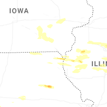

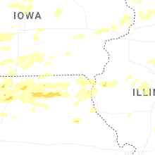
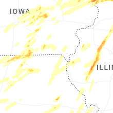


Connect with Interactive Hail Maps