

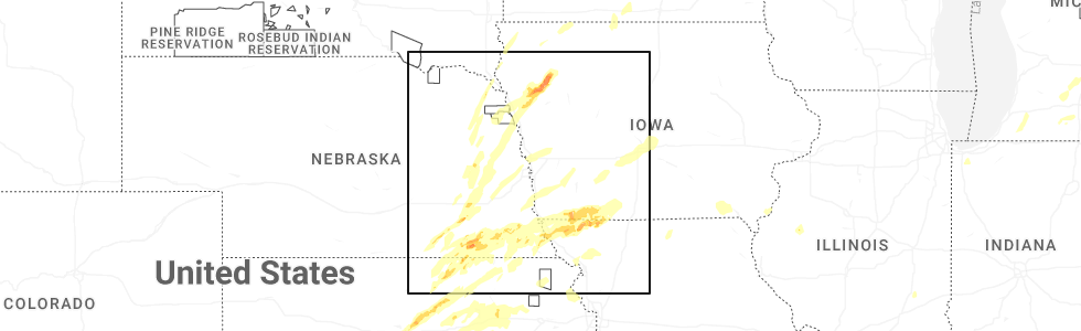
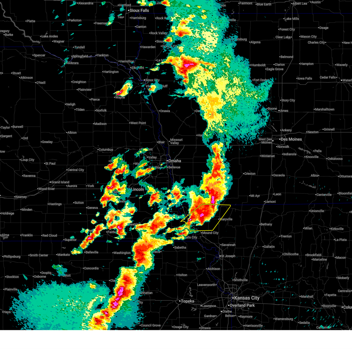
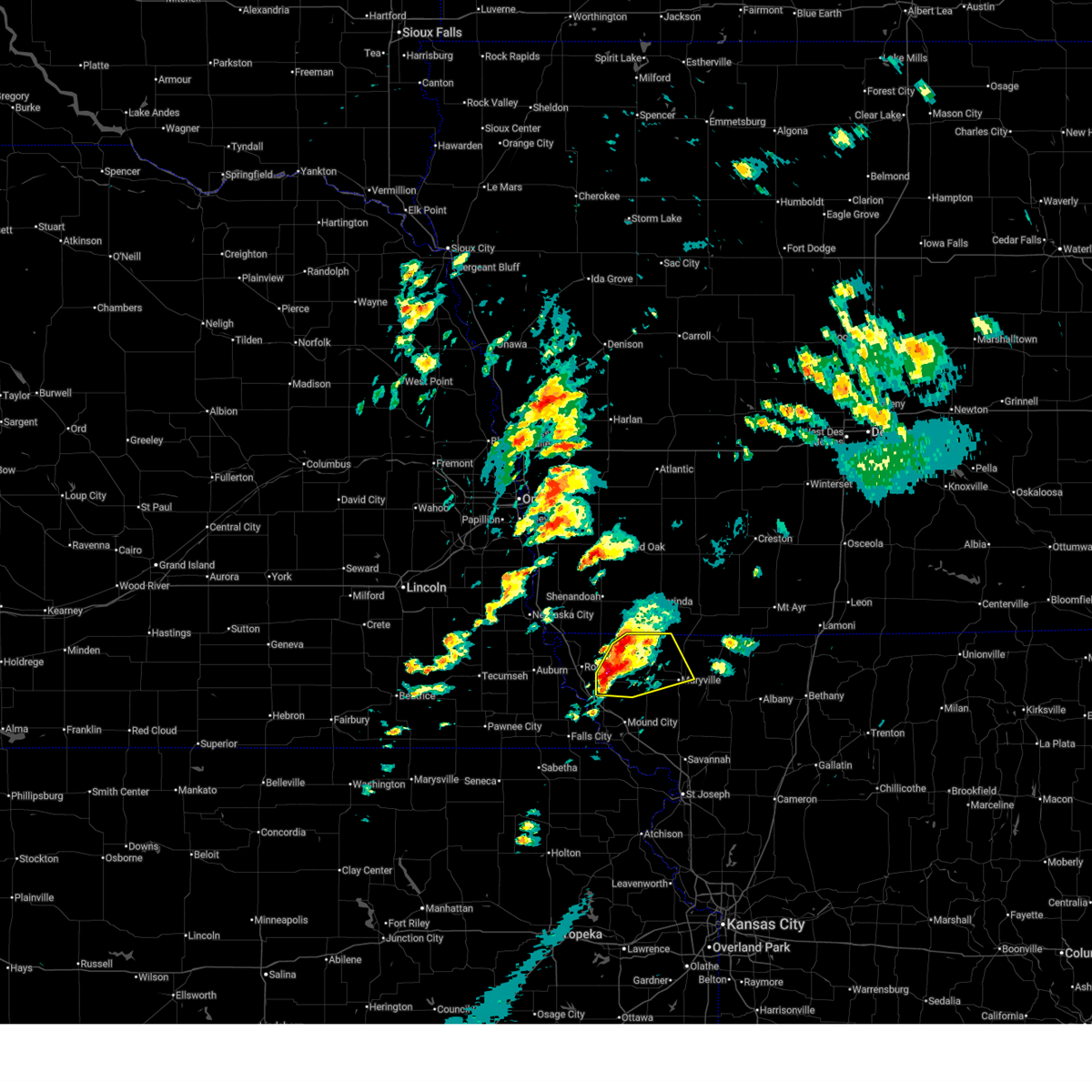
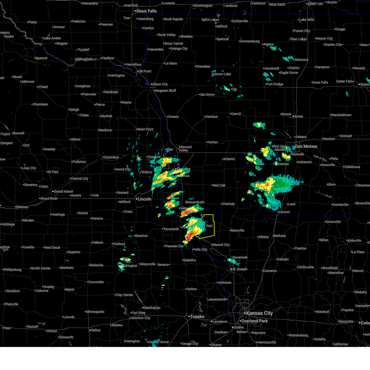
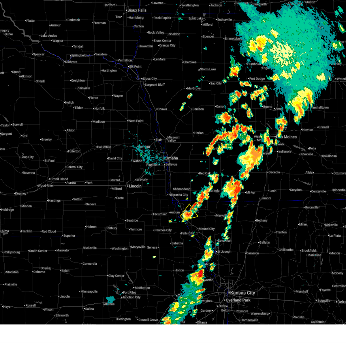
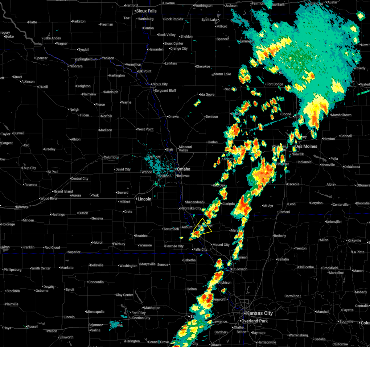
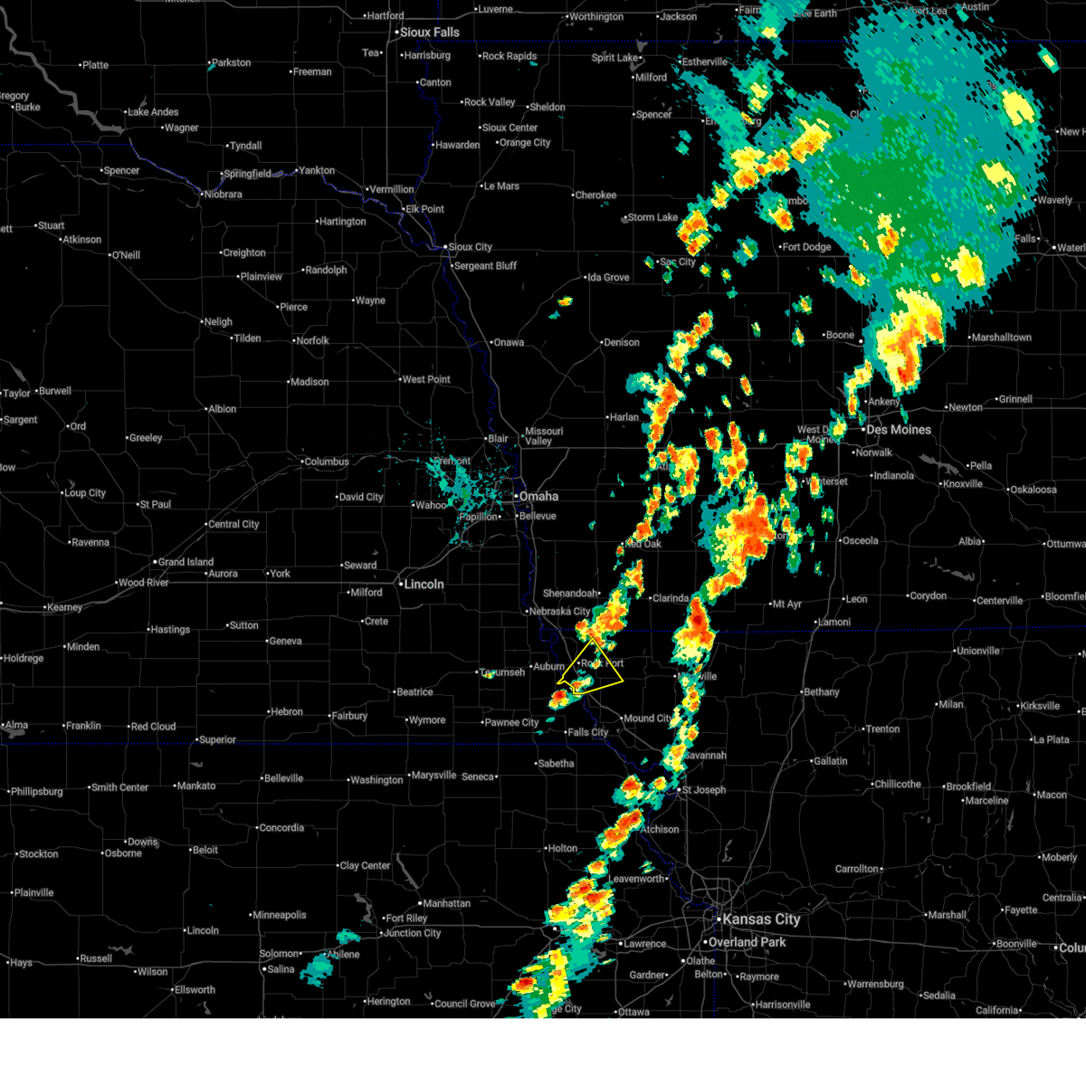
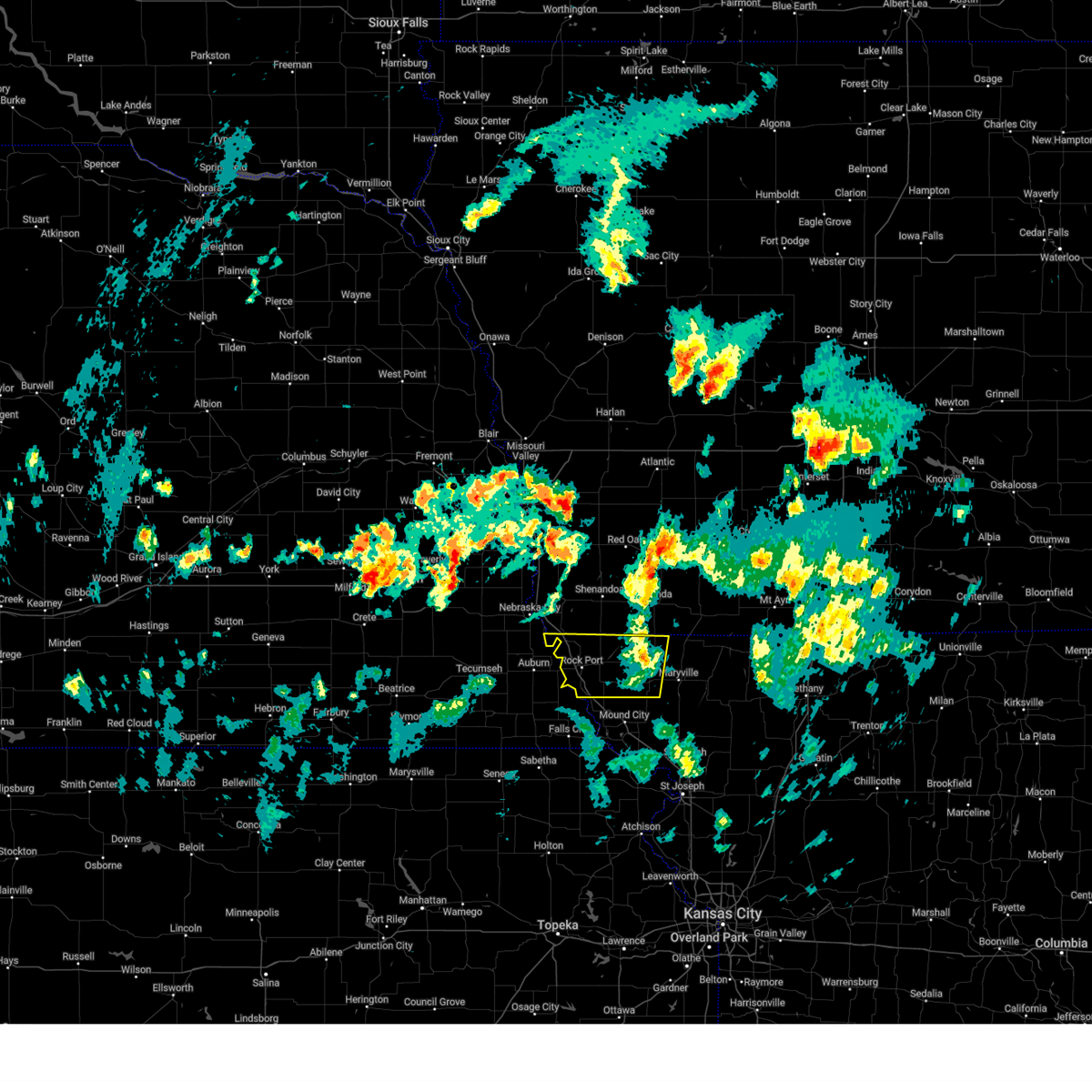
Hail Map for Fairfax, MO
The Fairfax, MO area has had 8 reports of on-the-ground hail by trained spotters, and has been under severe weather warnings 26 times during the past 12 months. Doppler radar has detected hail at or near Fairfax, MO on 87 occasions, including 9 occasions during the past year.
| Name: | Fairfax, MO |
| Where Located: | 69.8 miles SSE of Omaha, NE |
| Map: | Google Map for Fairfax, MO |
| Population: | 638 |
| Housing Units: | 343 |
| More Info: | Search Google for Fairfax, MO |
2
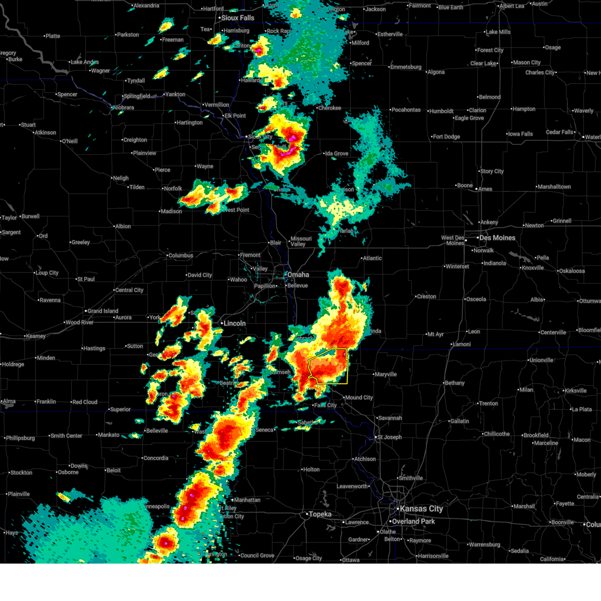
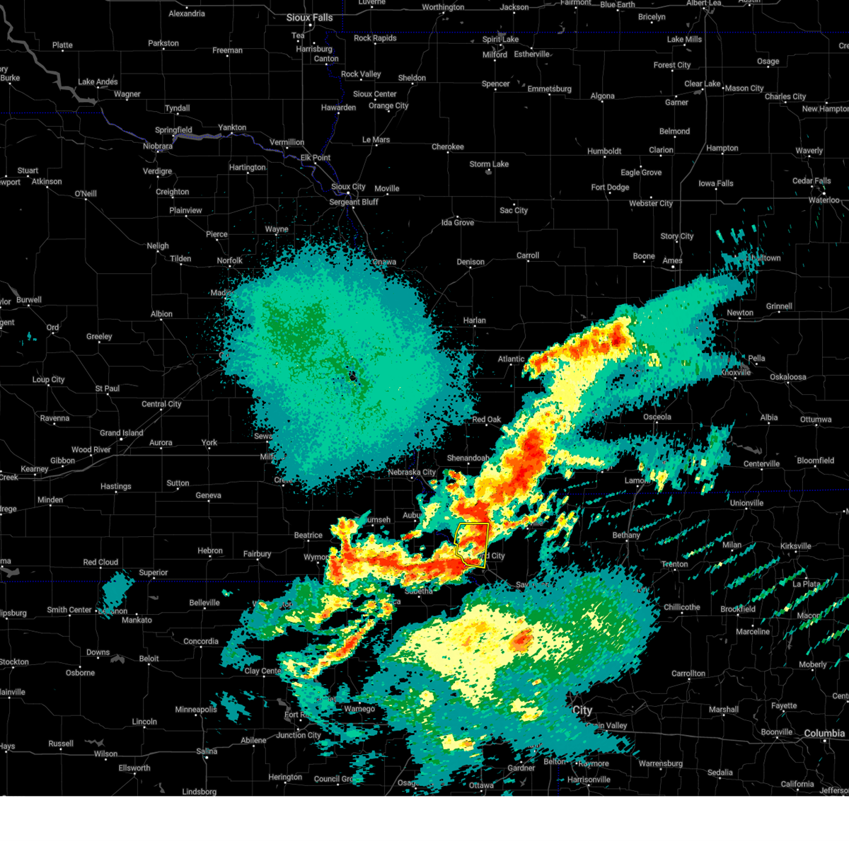
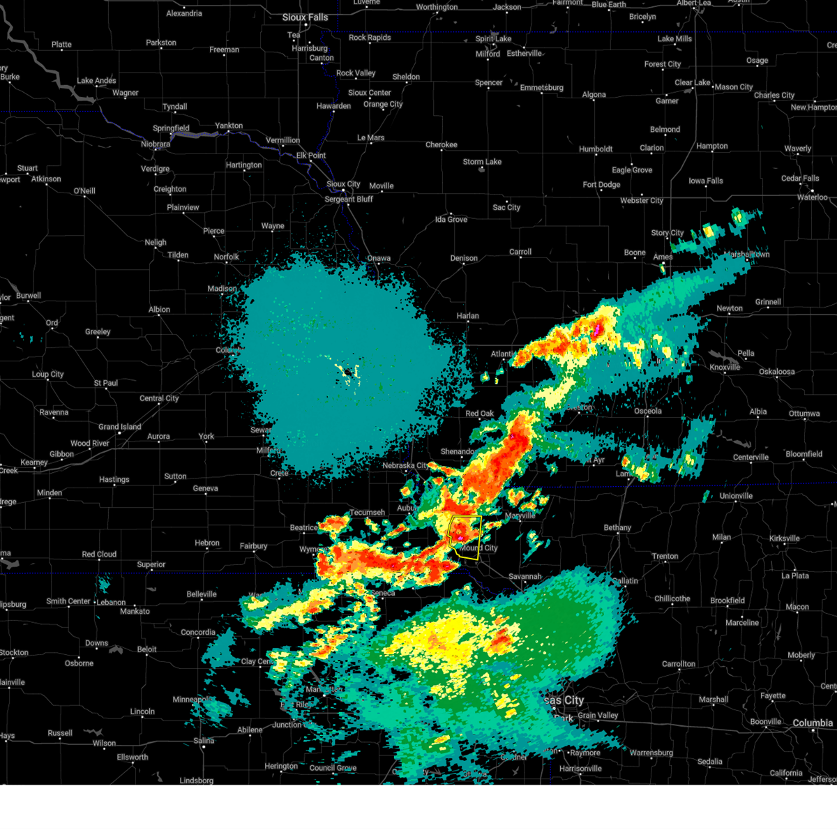
The Top Recent Hail Date for Fairfax, MO is Monday, May 18, 2026 (26th out of 87)
Hail and Wind Damage Spotted near Fairfax, MO
| Date / Time | Report Details |
|---|---|
| 5/18/2026 7:08 PM CDT | Multiple reports of downed wires west of fairfax. time estimated from rada in atchison county MO, 1.6 miles E of Fairfax, MO |
| 5/18/2026 7:07 PM CDT |
 At 706 pm cdt, a severe thunderstorm capable of producing a tornado was located near tarkio, moving northeast at 40 mph (radar indicated rotation). Hazards include tornado and ping pong ball size hail. Flying debris will be dangerous to those caught without shelter. mobile homes will be damaged or destroyed. damage to roofs, windows, and vehicles will occur. tree damage is likely. Locations impacted include, tarkio, fairfax, and blanchard. At 706 pm cdt, a severe thunderstorm capable of producing a tornado was located near tarkio, moving northeast at 40 mph (radar indicated rotation). Hazards include tornado and ping pong ball size hail. Flying debris will be dangerous to those caught without shelter. mobile homes will be damaged or destroyed. damage to roofs, windows, and vehicles will occur. tree damage is likely. Locations impacted include, tarkio, fairfax, and blanchard.
|
| 5/18/2026 6:48 PM CDT | Downed wires near route u. time confirmed from rada in atchison county MO, 11.6 miles E of Fairfax, MO |
| 5/18/2026 6:38 PM CDT |
 Svreax the national weather service in pleasant hill has issued a * severe thunderstorm warning for, atchison county in northwestern missouri, * until 730 pm cdt. * at 637 pm cdt, a severe thunderstorm was located near shubert, or 10 miles southeast of auburn, moving northeast at 40 mph. other storms are intensifying near watson and tarkio (radar indicated). Hazards include ping pong ball size hail and 60 mph wind gusts. People and animals outdoors will be injured. expect hail damage to roofs, siding, windows, and vehicles. Expect wind damage to roofs, siding, and trees. Svreax the national weather service in pleasant hill has issued a * severe thunderstorm warning for, atchison county in northwestern missouri, * until 730 pm cdt. * at 637 pm cdt, a severe thunderstorm was located near shubert, or 10 miles southeast of auburn, moving northeast at 40 mph. other storms are intensifying near watson and tarkio (radar indicated). Hazards include ping pong ball size hail and 60 mph wind gusts. People and animals outdoors will be injured. expect hail damage to roofs, siding, windows, and vehicles. Expect wind damage to roofs, siding, and trees.
|
| 5/18/2026 6:06 PM CDT |
 Svreax the national weather service in pleasant hill has issued a * severe thunderstorm warning for, eastern atchison county in northwestern missouri, northern holt county in northwestern missouri, nodaway county in northwestern missouri, * until 645 pm cdt. * at 605 pm cdt, severe thunderstorms were located along a line extending from hopkins to 6 miles northwest of craig, moving east at 25 mph (emergency management). Hazards include golf ball size hail and 70 mph wind gusts. People and animals outdoors will be injured. expect hail damage to roofs, siding, windows, and vehicles. expect considerable tree damage. Wind damage is also likely to mobile homes, roofs, and outbuildings. Svreax the national weather service in pleasant hill has issued a * severe thunderstorm warning for, eastern atchison county in northwestern missouri, northern holt county in northwestern missouri, nodaway county in northwestern missouri, * until 645 pm cdt. * at 605 pm cdt, severe thunderstorms were located along a line extending from hopkins to 6 miles northwest of craig, moving east at 25 mph (emergency management). Hazards include golf ball size hail and 70 mph wind gusts. People and animals outdoors will be injured. expect hail damage to roofs, siding, windows, and vehicles. expect considerable tree damage. Wind damage is also likely to mobile homes, roofs, and outbuildings.
|
| 5/18/2026 5:56 PM CDT |
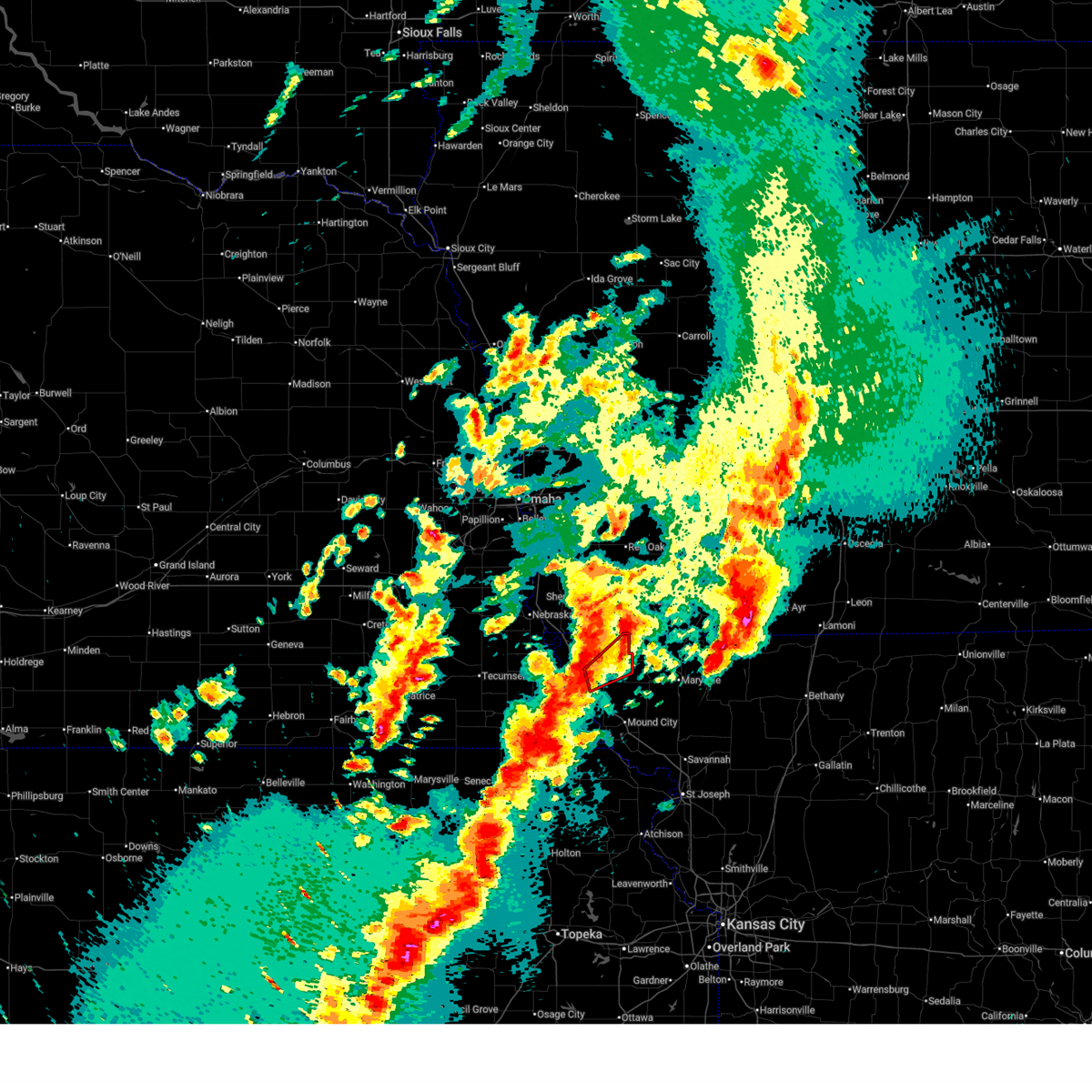
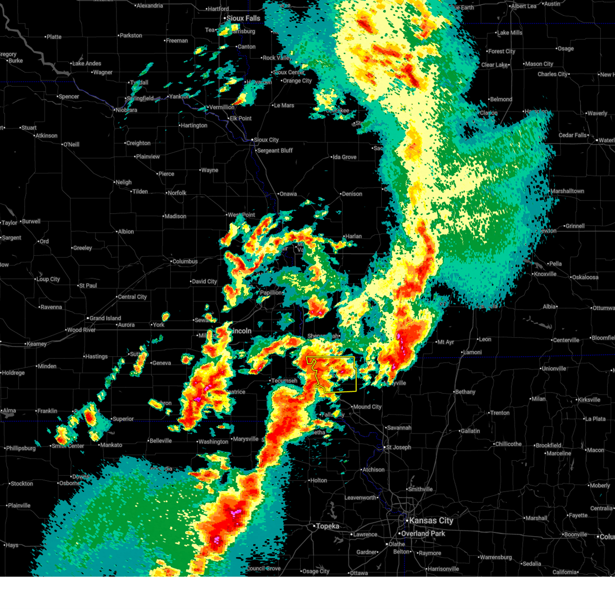
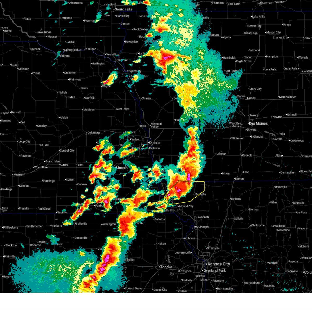
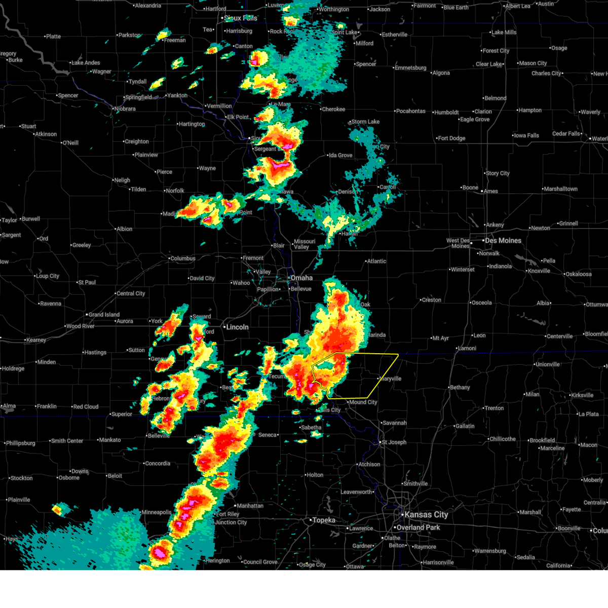
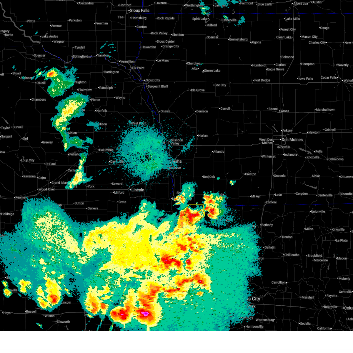
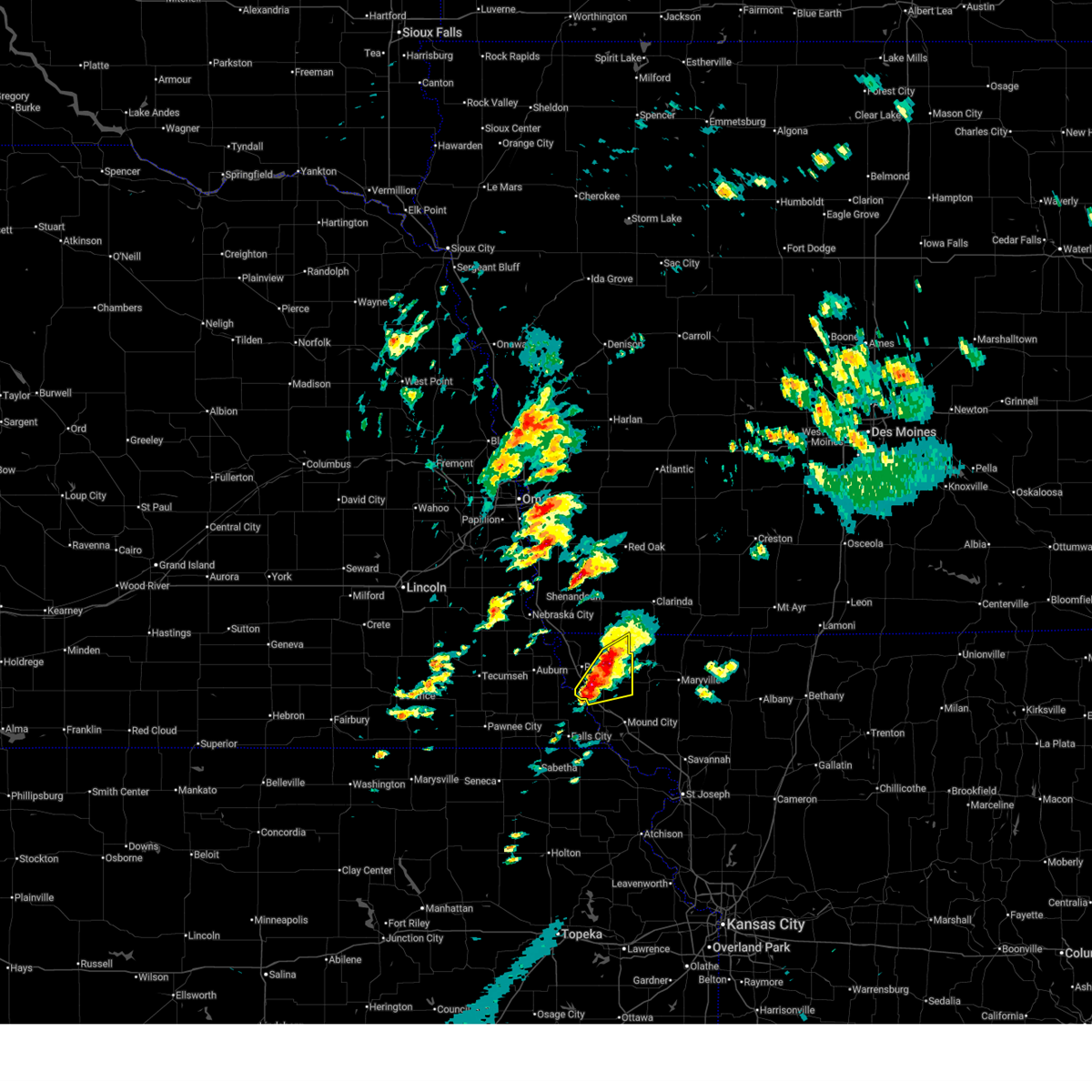
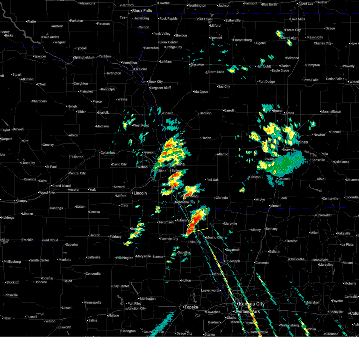
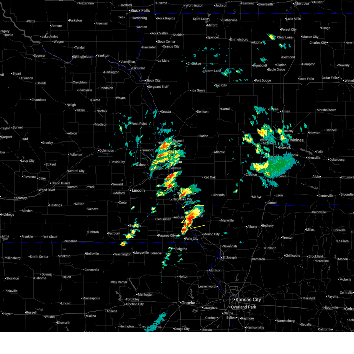
 At 556 pm cdt, severe thunderstorms were located along a line extending from near shambaugh to near fairfax, moving northeast at 40 mph (radar indicated). Hazards include two inch hail and 70 mph wind gusts. People and animals outdoors will be injured. expect hail damage to roofs, siding, windows, and vehicles. expect considerable tree damage. wind damage is also likely to mobile homes, roofs, and outbuildings. locations impacted include, maryville, tarkio, rock port, fairfax, burlington junction, hopkins, maitland, skidmore, craig, braddyville, blanchard, graham, clearmont, elmo, pickering, quitman, corning, and indian cave state park. This includes interstate 29 between mile markers 88 and 109. At 556 pm cdt, severe thunderstorms were located along a line extending from near shambaugh to near fairfax, moving northeast at 40 mph (radar indicated). Hazards include two inch hail and 70 mph wind gusts. People and animals outdoors will be injured. expect hail damage to roofs, siding, windows, and vehicles. expect considerable tree damage. wind damage is also likely to mobile homes, roofs, and outbuildings. locations impacted include, maryville, tarkio, rock port, fairfax, burlington junction, hopkins, maitland, skidmore, craig, braddyville, blanchard, graham, clearmont, elmo, pickering, quitman, corning, and indian cave state park. This includes interstate 29 between mile markers 88 and 109.
|
| 5/18/2026 5:44 PM CDT |
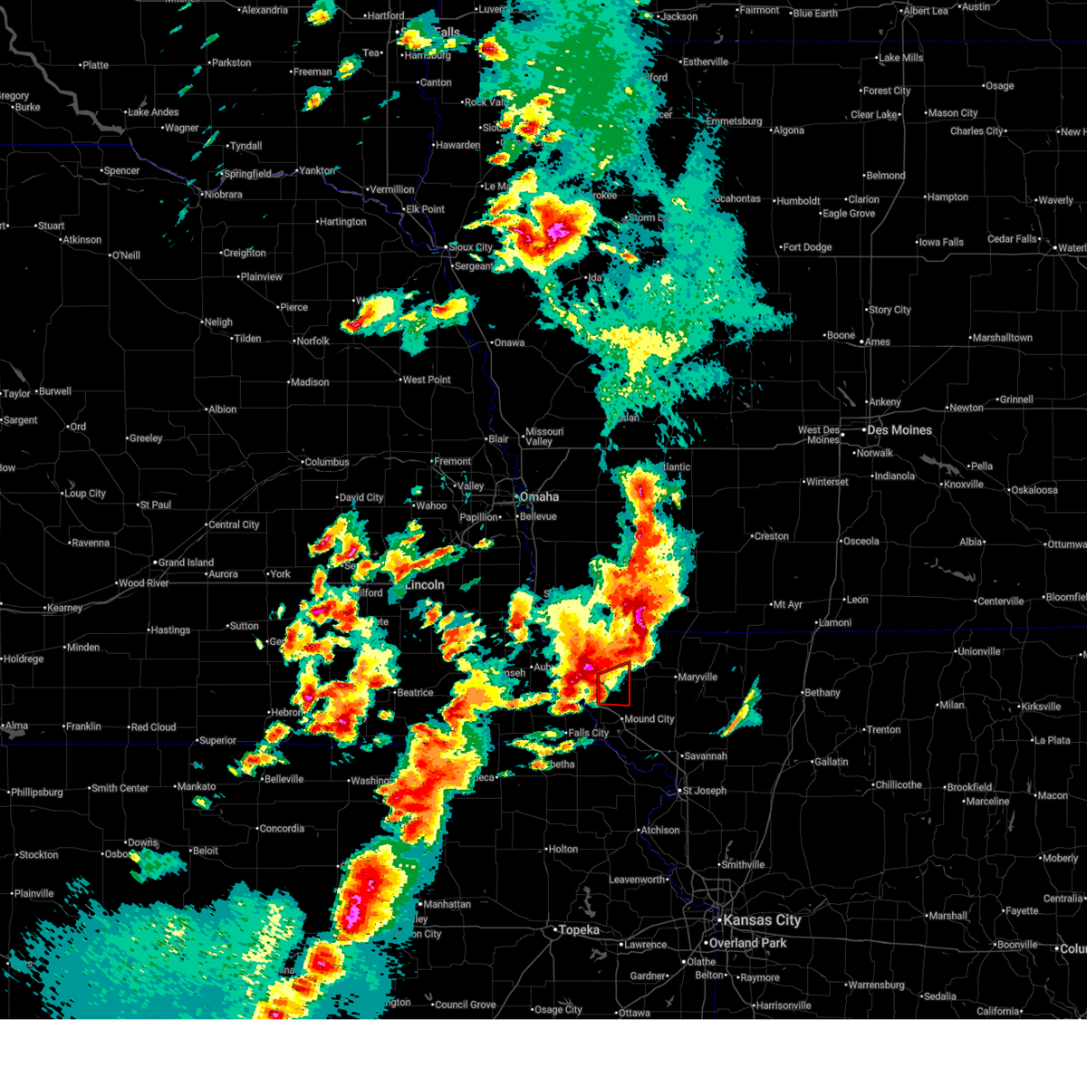 At 544 pm cdt, a dangerous tornado was located near fairfax, or 10 miles southeast of tarkio, moving northeast at 50 mph. this is a particularly dangerous situation. take cover now! (radar indicated rotation). Hazards include damaging tornado. You are in a life-threatening situation. flying debris may be deadly to those caught without shelter. mobile homes will be destroyed. considerable damage to homes, businesses, and vehicles is likely and complete destruction is possible. Locations impacted include, fairfax. At 544 pm cdt, a dangerous tornado was located near fairfax, or 10 miles southeast of tarkio, moving northeast at 50 mph. this is a particularly dangerous situation. take cover now! (radar indicated rotation). Hazards include damaging tornado. You are in a life-threatening situation. flying debris may be deadly to those caught without shelter. mobile homes will be destroyed. considerable damage to homes, businesses, and vehicles is likely and complete destruction is possible. Locations impacted include, fairfax.
|
| 5/18/2026 5:37 PM CDT |
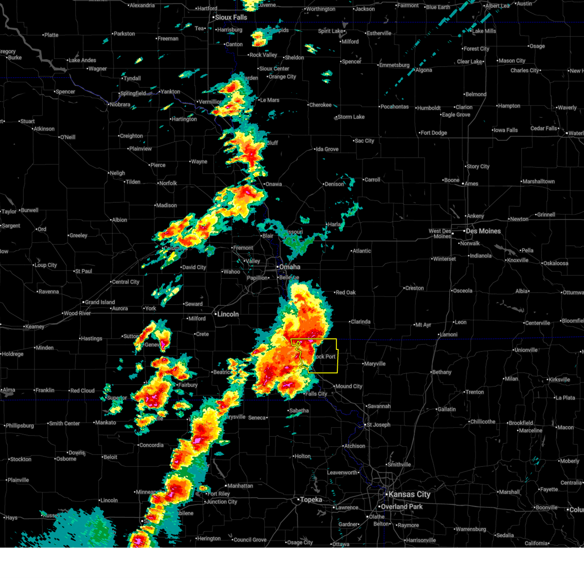
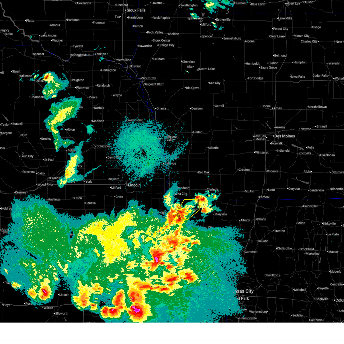
 At 536 pm cdt, a potentially dangerous tornado was located near fairfax, or 10 miles south of tarkio, moving northeast at 50 mph. this is a particularly dangerous situation. take cover now! (radar indicated rotation). Hazards include damaging tornado. You are in a life-threatening situation. flying debris may be deadly to those caught without shelter. mobile homes will be destroyed. considerable damage to homes, businesses, and vehicles is likely and complete destruction is possible. locations impacted include, fairfax, craig, and corning. This includes interstate 29 between mile markers 88 and 99. At 536 pm cdt, a potentially dangerous tornado was located near fairfax, or 10 miles south of tarkio, moving northeast at 50 mph. this is a particularly dangerous situation. take cover now! (radar indicated rotation). Hazards include damaging tornado. You are in a life-threatening situation. flying debris may be deadly to those caught without shelter. mobile homes will be destroyed. considerable damage to homes, businesses, and vehicles is likely and complete destruction is possible. locations impacted include, fairfax, craig, and corning. This includes interstate 29 between mile markers 88 and 99.
|
| 5/18/2026 5:28 PM CDT |
 At 527 pm cdt, a confirmed dangerous tornado was located near barada, or 13 miles northwest of mound city, moving northeast at 50 mph. this is a particularly dangerous situation. take cover now! (weather spotters confirmed tornado). Hazards include damaging tornado. You are in a life-threatening situation. flying debris may be deadly to those caught without shelter. mobile homes will be destroyed. considerable damage to homes, businesses, and vehicles is likely and complete destruction is possible. locations impacted include, mound city, fairfax, craig, corning, and indian cave state park. This includes interstate 29 between mile markers 84 and 104. At 527 pm cdt, a confirmed dangerous tornado was located near barada, or 13 miles northwest of mound city, moving northeast at 50 mph. this is a particularly dangerous situation. take cover now! (weather spotters confirmed tornado). Hazards include damaging tornado. You are in a life-threatening situation. flying debris may be deadly to those caught without shelter. mobile homes will be destroyed. considerable damage to homes, businesses, and vehicles is likely and complete destruction is possible. locations impacted include, mound city, fairfax, craig, corning, and indian cave state park. This includes interstate 29 between mile markers 84 and 104.
|
| 5/18/2026 5:26 PM CDT |
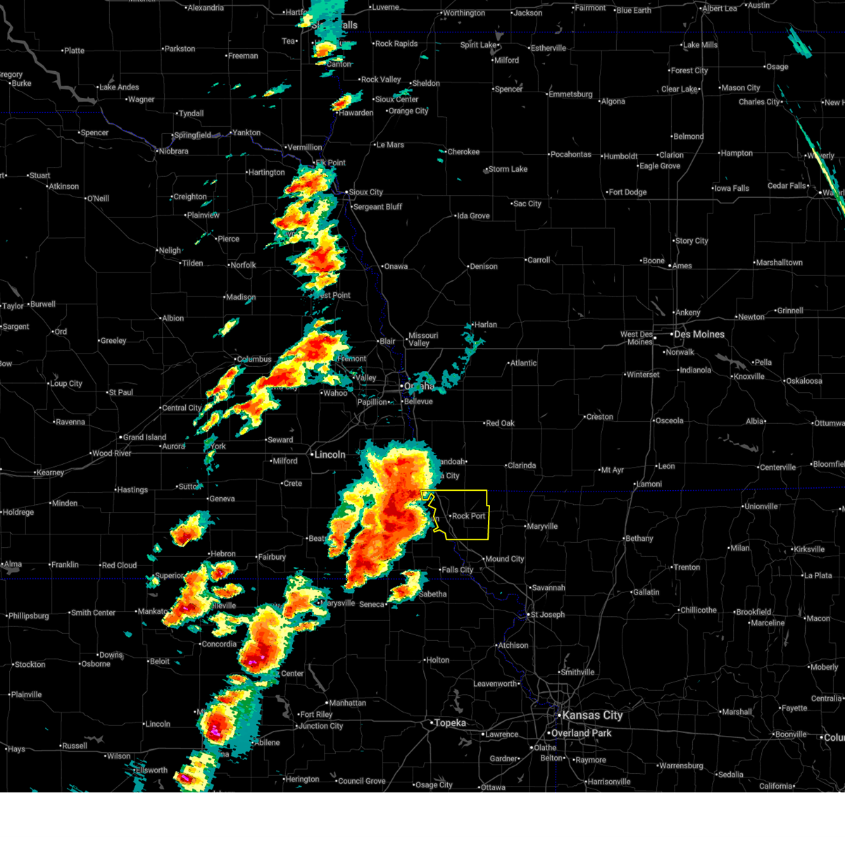
 At 525 pm cdt, severe thunderstorms were located along a line extending from near coin to near shubert, moving northeast at 40 mph (automated weather station). Hazards include 70 mph wind gusts and ping pong ball size hail. People and animals outdoors will be injured. expect hail damage to roofs, siding, windows, and vehicles. expect considerable tree damage. wind damage is also likely to mobile homes, roofs, and outbuildings. locations impacted include, tarkio, rock port, fairfax, blanchard, westboro, watson, indian cave state park, and phelps city. This includes interstate 29 between mile markers 99 and 117. At 525 pm cdt, severe thunderstorms were located along a line extending from near coin to near shubert, moving northeast at 40 mph (automated weather station). Hazards include 70 mph wind gusts and ping pong ball size hail. People and animals outdoors will be injured. expect hail damage to roofs, siding, windows, and vehicles. expect considerable tree damage. wind damage is also likely to mobile homes, roofs, and outbuildings. locations impacted include, tarkio, rock port, fairfax, blanchard, westboro, watson, indian cave state park, and phelps city. This includes interstate 29 between mile markers 99 and 117.
|
| 5/18/2026 5:22 PM CDT |
 Svreax the national weather service in pleasant hill has issued a * severe thunderstorm warning for, atchison county in northwestern missouri, northern holt county in northwestern missouri, northwestern nodaway county in northwestern missouri, * until 615 pm cdt. * at 522 pm cdt, severe thunderstorms were located along a line extending from blanchard to near shubert, moving east at 45 mph (automated weather station). Hazards include two inch hail and 70 mph wind gusts. People and animals outdoors will be injured. expect hail damage to roofs, siding, windows, and vehicles. expect considerable tree damage. Wind damage is also likely to mobile homes, roofs, and outbuildings. Svreax the national weather service in pleasant hill has issued a * severe thunderstorm warning for, atchison county in northwestern missouri, northern holt county in northwestern missouri, northwestern nodaway county in northwestern missouri, * until 615 pm cdt. * at 522 pm cdt, severe thunderstorms were located along a line extending from blanchard to near shubert, moving east at 45 mph (automated weather station). Hazards include two inch hail and 70 mph wind gusts. People and animals outdoors will be injured. expect hail damage to roofs, siding, windows, and vehicles. expect considerable tree damage. Wind damage is also likely to mobile homes, roofs, and outbuildings.
|
| 5/18/2026 5:16 PM CDT |
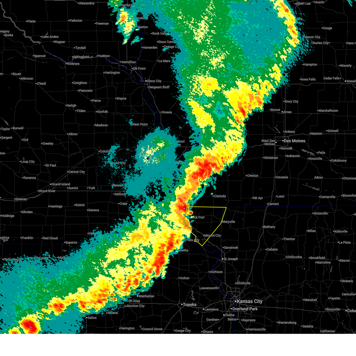
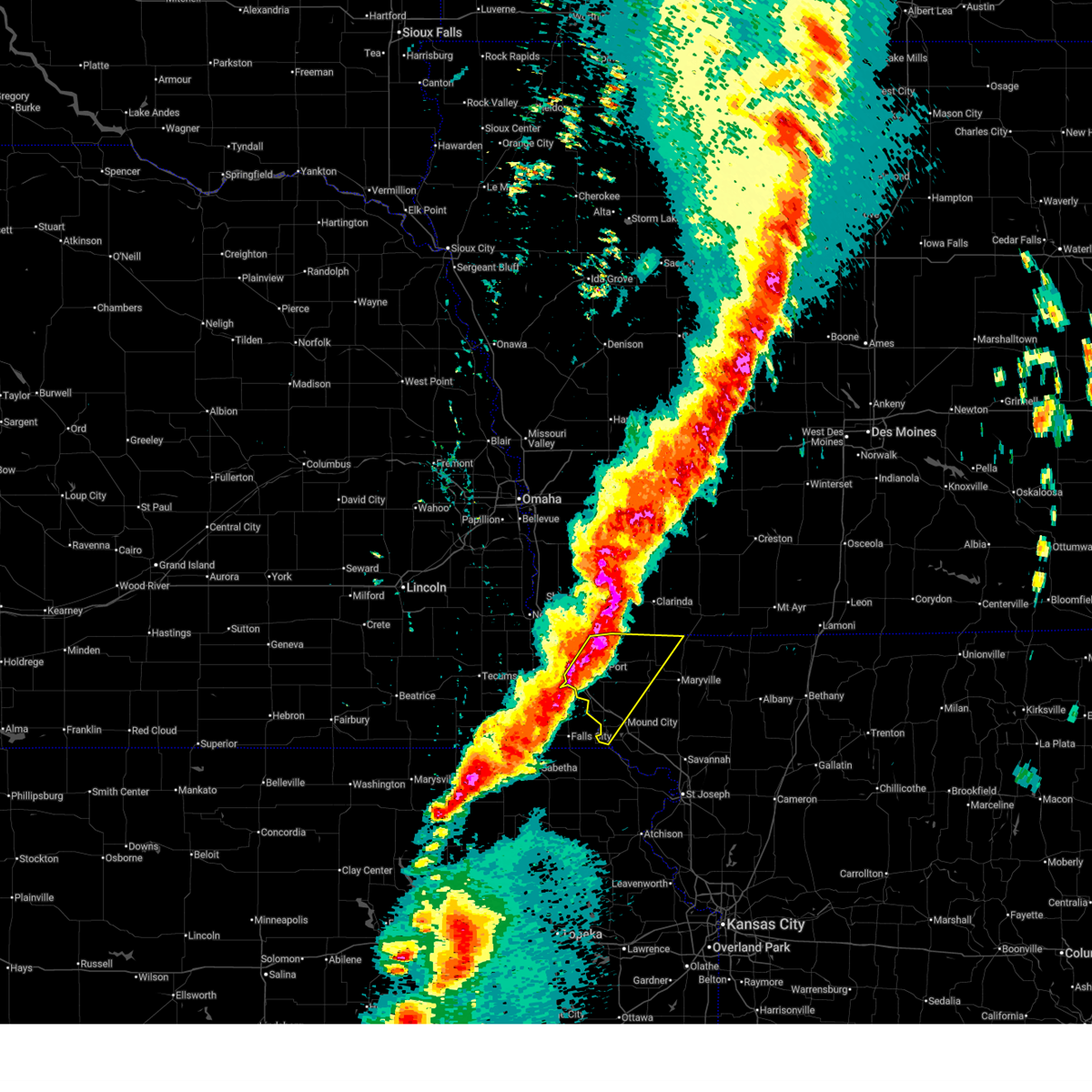
 Toreax the national weather service in pleasant hill has issued a * tornado warning for, southeastern atchison county in northwestern missouri, northwestern holt county in northwestern missouri, * until 600 pm cdt. * at 516 pm cdt, a confirmed tornado was located near verdon, or near falls city, moving northeast at 50 mph (weather spotters confirmed tornado). Hazards include damaging tornado and hail up to two inches in diameter. Flying debris will be dangerous to those caught without shelter. mobile homes will be damaged or destroyed. damage to roofs, windows, and vehicles will occur. Tree damage is likely. Toreax the national weather service in pleasant hill has issued a * tornado warning for, southeastern atchison county in northwestern missouri, northwestern holt county in northwestern missouri, * until 600 pm cdt. * at 516 pm cdt, a confirmed tornado was located near verdon, or near falls city, moving northeast at 50 mph (weather spotters confirmed tornado). Hazards include damaging tornado and hail up to two inches in diameter. Flying debris will be dangerous to those caught without shelter. mobile homes will be damaged or destroyed. damage to roofs, windows, and vehicles will occur. Tree damage is likely.
|
| 5/18/2026 4:58 PM CDT |
 At 457 pm cdt, a severe thunderstorm was located 8 miles northwest of tarkio, moving northeast at 40 mph. this is a destructive storm for atchison county (automated weather station). Hazards include 80 mph wind gusts and golf ball size hail. Flying debris will be dangerous to those caught without shelter. mobile homes will be heavily damaged. expect considerable damage to roofs, windows, and vehicles. extensive tree damage and power outages are likely. locations impacted include, tarkio, rock port, fairfax, blanchard, westboro, watson, indian cave state park, and phelps city. This includes interstate 29 between mile markers 99 and 123. At 457 pm cdt, a severe thunderstorm was located 8 miles northwest of tarkio, moving northeast at 40 mph. this is a destructive storm for atchison county (automated weather station). Hazards include 80 mph wind gusts and golf ball size hail. Flying debris will be dangerous to those caught without shelter. mobile homes will be heavily damaged. expect considerable damage to roofs, windows, and vehicles. extensive tree damage and power outages are likely. locations impacted include, tarkio, rock port, fairfax, blanchard, westboro, watson, indian cave state park, and phelps city. This includes interstate 29 between mile markers 99 and 123.
|
| 5/18/2026 4:27 PM CDT |
 Svreax the national weather service in pleasant hill has issued a * severe thunderstorm warning for, atchison county in northwestern missouri, * until 545 pm cdt. * at 426 pm cdt, a severe thunderstorm was located over auburn, moving northeast at 55 mph. this is a destructive storm for atchison county (automated weather station). Hazards include 80 mph wind gusts and ping pong ball size hail. Flying debris will be dangerous to those caught without shelter. mobile homes will be heavily damaged. expect considerable damage to roofs, windows, and vehicles. Extensive tree damage and power outages are likely. Svreax the national weather service in pleasant hill has issued a * severe thunderstorm warning for, atchison county in northwestern missouri, * until 545 pm cdt. * at 426 pm cdt, a severe thunderstorm was located over auburn, moving northeast at 55 mph. this is a destructive storm for atchison county (automated weather station). Hazards include 80 mph wind gusts and ping pong ball size hail. Flying debris will be dangerous to those caught without shelter. mobile homes will be heavily damaged. expect considerable damage to roofs, windows, and vehicles. Extensive tree damage and power outages are likely.
|
| 5/17/2026 10:19 PM CDT |
 Svreax the national weather service in pleasant hill has issued a * severe thunderstorm warning for, atchison county in northwestern missouri, holt county in northwestern missouri, western nodaway county in northwestern missouri, * until 1115 pm cdt. * at 1019 pm cdt, severe thunderstorms were located along a line extending from 7 miles west of coin to near falls city to near corning, moving northeast at 60 mph (radar indicated). Hazards include 60 mph wind gusts and penny size hail. expect damage to roofs, siding, and trees Svreax the national weather service in pleasant hill has issued a * severe thunderstorm warning for, atchison county in northwestern missouri, holt county in northwestern missouri, western nodaway county in northwestern missouri, * until 1115 pm cdt. * at 1019 pm cdt, severe thunderstorms were located along a line extending from 7 miles west of coin to near falls city to near corning, moving northeast at 60 mph (radar indicated). Hazards include 60 mph wind gusts and penny size hail. expect damage to roofs, siding, and trees
|
| 4/27/2026 1:38 AM CDT |
 At 138 am cdt, a severe thunderstorm was located near tarkio, moving northeast at 35 mph (radar indicated). Hazards include 60 mph wind gusts and quarter size hail. Hail damage to vehicles is expected. expect wind damage to roofs, siding, and trees. locations impacted include, tarkio, rock port, fairfax, blanchard, and westboro. This includes interstate 29 between mile markers 110 and 115. At 138 am cdt, a severe thunderstorm was located near tarkio, moving northeast at 35 mph (radar indicated). Hazards include 60 mph wind gusts and quarter size hail. Hail damage to vehicles is expected. expect wind damage to roofs, siding, and trees. locations impacted include, tarkio, rock port, fairfax, blanchard, and westboro. This includes interstate 29 between mile markers 110 and 115.
|
| 4/27/2026 1:27 AM CDT |
 Svreax the national weather service in pleasant hill has issued a * severe thunderstorm warning for, atchison county in northwestern missouri, * until 215 am cdt. * at 127 am cdt, a severe thunderstorm was located near rock port, or 11 miles southwest of tarkio, moving northeast at 40 mph (radar indicated). Hazards include 60 mph wind gusts and quarter size hail. Hail damage to vehicles is expected. Expect wind damage to roofs, siding, and trees. Svreax the national weather service in pleasant hill has issued a * severe thunderstorm warning for, atchison county in northwestern missouri, * until 215 am cdt. * at 127 am cdt, a severe thunderstorm was located near rock port, or 11 miles southwest of tarkio, moving northeast at 40 mph (radar indicated). Hazards include 60 mph wind gusts and quarter size hail. Hail damage to vehicles is expected. Expect wind damage to roofs, siding, and trees.
|
| 4/23/2026 6:36 PM CDT |
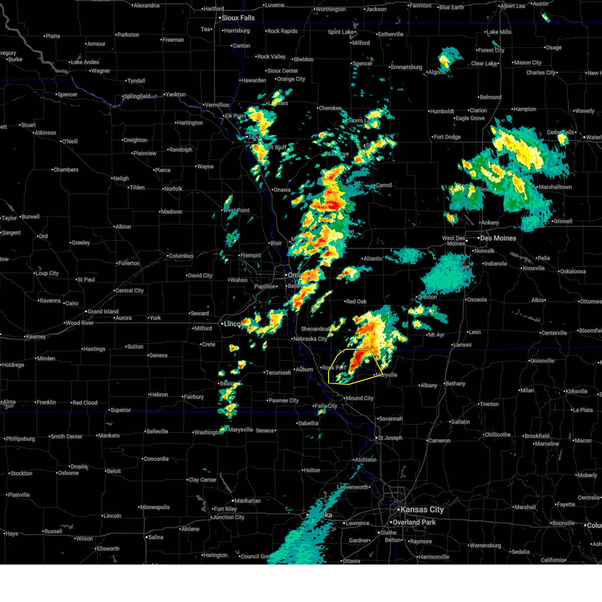
 At 636 pm cdt, severe thunderstorms were located along a line extending from braddyville to near falls city, moving east at 25 mph (radar indicated). Hazards include 60 mph wind gusts and quarter size hail. Hail damage to vehicles is expected. expect wind damage to roofs, siding, and trees. locations impacted include, tarkio, mound city, fairfax, burlington junction, craig, clearmont, elmo, big lake, westboro, quitman, fortescue, bigelow, corning, indian cave state park, and iowa reservation of kansas and nebraska. This includes interstate 29 between mile markers 85 and 106. At 636 pm cdt, severe thunderstorms were located along a line extending from braddyville to near falls city, moving east at 25 mph (radar indicated). Hazards include 60 mph wind gusts and quarter size hail. Hail damage to vehicles is expected. expect wind damage to roofs, siding, and trees. locations impacted include, tarkio, mound city, fairfax, burlington junction, craig, clearmont, elmo, big lake, westboro, quitman, fortescue, bigelow, corning, indian cave state park, and iowa reservation of kansas and nebraska. This includes interstate 29 between mile markers 85 and 106.
|
| 4/23/2026 6:14 PM CDT |
 Svreax the national weather service in pleasant hill has issued a * severe thunderstorm warning for, atchison county in northwestern missouri, northwestern holt county in northwestern missouri, northwestern nodaway county in northwestern missouri, * until 700 pm cdt. * at 613 pm cdt, severe thunderstorms were located along a line extending from blanchard to near salem, moving east at 25 mph (radar indicated). Hazards include 60 mph wind gusts and quarter size hail. Hail damage to vehicles is expected. Expect wind damage to roofs, siding, and trees. Svreax the national weather service in pleasant hill has issued a * severe thunderstorm warning for, atchison county in northwestern missouri, northwestern holt county in northwestern missouri, northwestern nodaway county in northwestern missouri, * until 700 pm cdt. * at 613 pm cdt, severe thunderstorms were located along a line extending from blanchard to near salem, moving east at 25 mph (radar indicated). Hazards include 60 mph wind gusts and quarter size hail. Hail damage to vehicles is expected. Expect wind damage to roofs, siding, and trees.
|
| 4/11/2026 9:06 PM CDT | Report from personal weather station. time matches with when the core of the storm passed over the station on rada in atchison county MO, 6.3 miles W of Fairfax, MO |
| 4/3/2026 4:14 PM CDT |
 the severe thunderstorm warning has been cancelled and is no longer in effect the severe thunderstorm warning has been cancelled and is no longer in effect
|
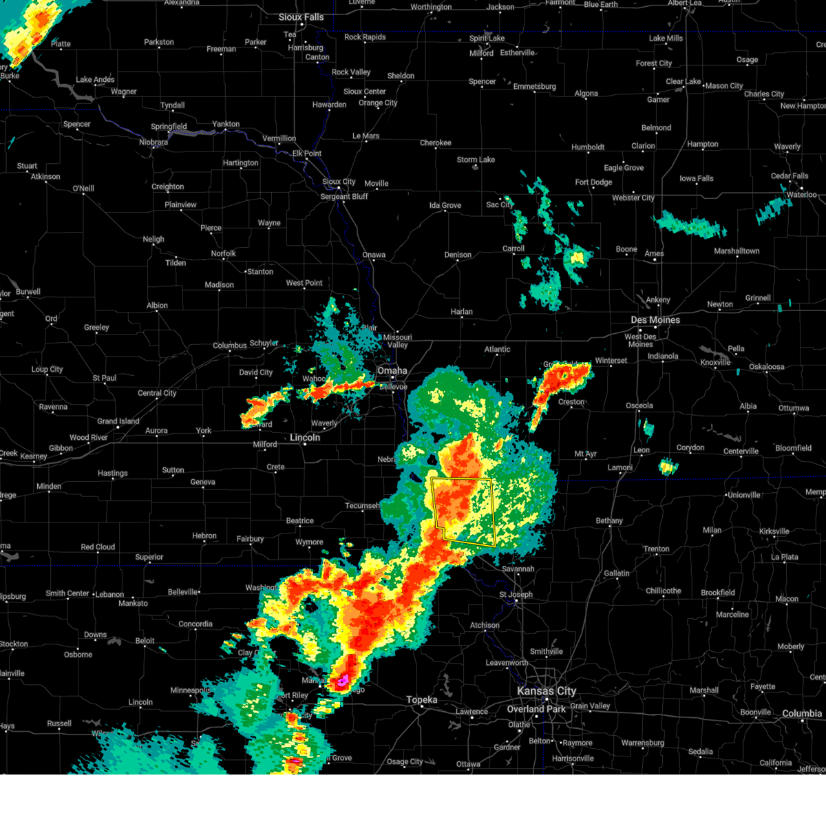
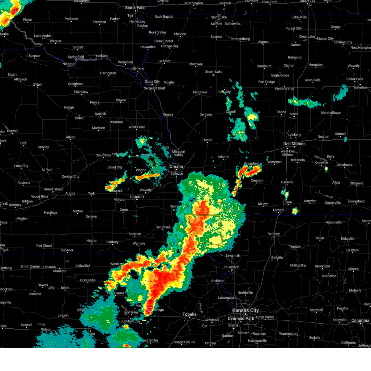
| 4/3/2026 3:42 PM CDT | Quarter sized hail reported 3.7 miles SSW of Fairfax, MO, report from mping: quarter (1.00 in.). |
| 4/3/2026 3:42 PM CDT |
 Svreax the national weather service in pleasant hill has issued a * severe thunderstorm warning for, eastern atchison county in northwestern missouri, northwestern nodaway county in northwestern missouri, * until 430 pm cdt. * at 342 pm cdt, a severe thunderstorm was located near fairfax, or near tarkio, moving northeast at 35 mph (radar indicated). Hazards include ping pong ball size hail and 60 mph wind gusts. People and animals outdoors will be injured. expect hail damage to roofs, siding, windows, and vehicles. Expect wind damage to roofs, siding, and trees. Svreax the national weather service in pleasant hill has issued a * severe thunderstorm warning for, eastern atchison county in northwestern missouri, northwestern nodaway county in northwestern missouri, * until 430 pm cdt. * at 342 pm cdt, a severe thunderstorm was located near fairfax, or near tarkio, moving northeast at 35 mph (radar indicated). Hazards include ping pong ball size hail and 60 mph wind gusts. People and animals outdoors will be injured. expect hail damage to roofs, siding, windows, and vehicles. Expect wind damage to roofs, siding, and trees.
|
| 4/3/2026 3:35 PM CDT | Golf Ball sized hail reported 0.1 miles SSE of Fairfax, MO, report of golf ball sized hail. time estimated from radar. |
| 4/3/2026 3:33 PM CDT |
 At 333 pm cdt, a severe thunderstorm was located near fairfax, or 10 miles south of tarkio, moving northeast at 35 mph (radar indicated). Hazards include 60 mph wind gusts and quarter size hail. Hail damage to vehicles is expected. expect wind damage to roofs, siding, and trees. locations impacted include, tarkio, fairfax, and corning. This includes interstate 29 between mile markers 96 and 106. At 333 pm cdt, a severe thunderstorm was located near fairfax, or 10 miles south of tarkio, moving northeast at 35 mph (radar indicated). Hazards include 60 mph wind gusts and quarter size hail. Hail damage to vehicles is expected. expect wind damage to roofs, siding, and trees. locations impacted include, tarkio, fairfax, and corning. This includes interstate 29 between mile markers 96 and 106.
|
| 4/3/2026 3:20 PM CDT |
 At 320 pm cdt, a severe thunderstorm was located over fairfax, or near tarkio, moving northeast at 30 mph (radar indicated). Hazards include 60 mph wind gusts and quarter size hail. Hail damage to vehicles is expected. expect wind damage to roofs, siding, and trees. locations impacted include, tarkio, fairfax, westboro, and corning. This includes interstate 29 between mile markers 96 and 108. At 320 pm cdt, a severe thunderstorm was located over fairfax, or near tarkio, moving northeast at 30 mph (radar indicated). Hazards include 60 mph wind gusts and quarter size hail. Hail damage to vehicles is expected. expect wind damage to roofs, siding, and trees. locations impacted include, tarkio, fairfax, westboro, and corning. This includes interstate 29 between mile markers 96 and 108.
|
| 4/3/2026 3:14 PM CDT |
 At 314 pm cdt, a severe thunderstorm was located near fairfax, or 7 miles southwest of tarkio, moving northeast at 35 mph (radar indicated). Hazards include 60 mph wind gusts and quarter size hail. Hail damage to vehicles is expected. expect wind damage to roofs, siding, and trees. locations impacted include, tarkio, rock port, fairfax, blanchard, westboro, and corning. This includes interstate 29 between mile markers 96 and 110. At 314 pm cdt, a severe thunderstorm was located near fairfax, or 7 miles southwest of tarkio, moving northeast at 35 mph (radar indicated). Hazards include 60 mph wind gusts and quarter size hail. Hail damage to vehicles is expected. expect wind damage to roofs, siding, and trees. locations impacted include, tarkio, rock port, fairfax, blanchard, westboro, and corning. This includes interstate 29 between mile markers 96 and 110.
|
| 4/3/2026 2:56 PM CDT |
 Svreax the national weather service in pleasant hill has issued a * severe thunderstorm warning for, atchison county in northwestern missouri, north central holt county in northwestern missouri, * until 345 pm cdt. * at 256 pm cdt, a severe thunderstorm was located near shubert, or 13 miles southeast of auburn, moving northeast at 40 mph (radar indicated). Hazards include 60 mph wind gusts and quarter size hail. Hail damage to vehicles is expected. Expect wind damage to roofs, siding, and trees. Svreax the national weather service in pleasant hill has issued a * severe thunderstorm warning for, atchison county in northwestern missouri, north central holt county in northwestern missouri, * until 345 pm cdt. * at 256 pm cdt, a severe thunderstorm was located near shubert, or 13 miles southeast of auburn, moving northeast at 40 mph (radar indicated). Hazards include 60 mph wind gusts and quarter size hail. Hail damage to vehicles is expected. Expect wind damage to roofs, siding, and trees.
|
| 6/26/2025 4:12 PM CDT |
 The storm which prompted the warning has weakened below severe limits, and no longer poses an immediate threat to life or property. therefore, the warning will be allowed to expire. however, gusty winds to 50 mph and heavy rain are still possible with this thunderstorm. a severe thunderstorm watch remains in effect until 900 pm cdt for northwestern missouri. The storm which prompted the warning has weakened below severe limits, and no longer poses an immediate threat to life or property. therefore, the warning will be allowed to expire. however, gusty winds to 50 mph and heavy rain are still possible with this thunderstorm. a severe thunderstorm watch remains in effect until 900 pm cdt for northwestern missouri.
|
| 6/26/2025 4:04 PM CDT |
 At 403 pm cdt, a severe thunderstorm was located near rock port, or 8 miles southwest of tarkio, moving northeast at 35 mph (radar indicated). Hazards include 60 mph wind gusts and penny size hail. Expect damage to roofs, siding, and trees. locations impacted include, tarkio, rock port, and fairfax. This includes interstate 29 between mile markers 101 and 109. At 403 pm cdt, a severe thunderstorm was located near rock port, or 8 miles southwest of tarkio, moving northeast at 35 mph (radar indicated). Hazards include 60 mph wind gusts and penny size hail. Expect damage to roofs, siding, and trees. locations impacted include, tarkio, rock port, and fairfax. This includes interstate 29 between mile markers 101 and 109.
|
| 6/26/2025 3:49 PM CDT |
 Svreax the national weather service in pleasant hill has issued a * severe thunderstorm warning for, eastern atchison county in northwestern missouri, * until 415 pm cdt. * at 349 pm cdt, a severe thunderstorm was located near shubert, or 14 miles southeast of auburn, moving northeast at 35 mph (radar indicated). Hazards include 60 mph wind gusts and quarter size hail. Hail damage to vehicles is expected. Expect wind damage to roofs, siding, and trees. Svreax the national weather service in pleasant hill has issued a * severe thunderstorm warning for, eastern atchison county in northwestern missouri, * until 415 pm cdt. * at 349 pm cdt, a severe thunderstorm was located near shubert, or 14 miles southeast of auburn, moving northeast at 35 mph (radar indicated). Hazards include 60 mph wind gusts and quarter size hail. Hail damage to vehicles is expected. Expect wind damage to roofs, siding, and trees.
|
| 3/14/2025 4:51 PM CDT |
 The storm which prompted the warning has moved out of the area. therefore, the warning will be allowed to expire. however, gusty winds are still expected. a severe thunderstorm watch remains in effect until 700 pm cdt for northwestern missouri. The storm which prompted the warning has moved out of the area. therefore, the warning will be allowed to expire. however, gusty winds are still expected. a severe thunderstorm watch remains in effect until 700 pm cdt for northwestern missouri.
|
| 3/14/2025 4:15 PM CDT |
 Svreax the national weather service in pleasant hill has issued a * severe thunderstorm warning for, atchison county in northwestern missouri, northwestern nodaway county in northwestern missouri, * until 500 pm cdt. * at 414 pm cdt, a cluster of severe thunderstorms were located near rock port, or 9 miles west of tarkio, moving north at 65 mph (radar indicated). Hazards include 70 mph wind gusts and penny size hail. Expect considerable tree damage. Damage is likely to mobile homes, roofs, and outbuildings. Svreax the national weather service in pleasant hill has issued a * severe thunderstorm warning for, atchison county in northwestern missouri, northwestern nodaway county in northwestern missouri, * until 500 pm cdt. * at 414 pm cdt, a cluster of severe thunderstorms were located near rock port, or 9 miles west of tarkio, moving north at 65 mph (radar indicated). Hazards include 70 mph wind gusts and penny size hail. Expect considerable tree damage. Damage is likely to mobile homes, roofs, and outbuildings.
|
| 10/30/2024 1:41 PM CDT |
 The storm which prompted the warning has moved out of the area. therefore, the warning will be allowed to expire. a severe thunderstorm watch remains in effect until 700 pm cdt for northwestern missouri. remember, a severe thunderstorm warning still remains in effect for eastern atchison county. The storm which prompted the warning has moved out of the area. therefore, the warning will be allowed to expire. a severe thunderstorm watch remains in effect until 700 pm cdt for northwestern missouri. remember, a severe thunderstorm warning still remains in effect for eastern atchison county.
|
| 10/30/2024 1:24 PM CDT | Downed wires and widespread power outages in southeastern atchison county. time estimated from rada in atchison county MO, 2.5 miles WNW of Fairfax, MO |
| 10/30/2024 1:14 PM CDT | Private weather statio in atchison county MO, 6.7 miles NE of Fairfax, MO |
| 10/30/2024 1:09 PM CDT |
 Svreax the national weather service in pleasant hill has issued a * severe thunderstorm warning for, southeastern atchison county in northwestern missouri, northwestern holt county in northwestern missouri, * until 145 pm cdt. * at 108 pm cdt, a severe thunderstorm was located 7 miles east of shubert, or 12 miles north of falls city, moving northeast at 65 mph. this is a destructive storm for holt and atchison county (radar indicated). Hazards include 80 mph wind gusts and quarter size hail. Flying debris will be dangerous to those caught without shelter. mobile homes will be heavily damaged. expect considerable damage to roofs, windows, and vehicles. Extensive tree damage and power outages are likely. Svreax the national weather service in pleasant hill has issued a * severe thunderstorm warning for, southeastern atchison county in northwestern missouri, northwestern holt county in northwestern missouri, * until 145 pm cdt. * at 108 pm cdt, a severe thunderstorm was located 7 miles east of shubert, or 12 miles north of falls city, moving northeast at 65 mph. this is a destructive storm for holt and atchison county (radar indicated). Hazards include 80 mph wind gusts and quarter size hail. Flying debris will be dangerous to those caught without shelter. mobile homes will be heavily damaged. expect considerable damage to roofs, windows, and vehicles. Extensive tree damage and power outages are likely.
|
| 9/21/2024 8:40 PM CDT |
 The storm which prompted the warning has weakened below severe limits, and has exited the warned area. therefore, the warning will be allowed to expire. The storm which prompted the warning has weakened below severe limits, and has exited the warned area. therefore, the warning will be allowed to expire.
|
| 9/21/2024 8:29 PM CDT |
 At 829 pm cdt, a severe thunderstorm was located over craig, or 9 miles northwest of mound city, moving east at 30 mph (radar indicated). Hazards include 60 mph wind gusts and quarter size hail. Hail damage to vehicles is expected. expect wind damage to roofs, siding, and trees. locations impacted include, mound city, fairfax, craig, bigelow, and corning. This includes interstate 29 between mile markers 84 and 102. At 829 pm cdt, a severe thunderstorm was located over craig, or 9 miles northwest of mound city, moving east at 30 mph (radar indicated). Hazards include 60 mph wind gusts and quarter size hail. Hail damage to vehicles is expected. expect wind damage to roofs, siding, and trees. locations impacted include, mound city, fairfax, craig, bigelow, and corning. This includes interstate 29 between mile markers 84 and 102.
|
| 9/21/2024 8:03 PM CDT |
 Svreax the national weather service in pleasant hill has issued a * severe thunderstorm warning for, southern atchison county in northwestern missouri, northwestern holt county in northwestern missouri, * until 845 pm cdt. * at 803 pm cdt, a severe thunderstorm was located over nemaha, or 10 miles southeast of auburn, moving east at 30 mph (radar indicated). Hazards include 60 mph wind gusts and quarter size hail. Hail damage to vehicles is expected. Expect wind damage to roofs, siding, and trees. Svreax the national weather service in pleasant hill has issued a * severe thunderstorm warning for, southern atchison county in northwestern missouri, northwestern holt county in northwestern missouri, * until 845 pm cdt. * at 803 pm cdt, a severe thunderstorm was located over nemaha, or 10 miles southeast of auburn, moving east at 30 mph (radar indicated). Hazards include 60 mph wind gusts and quarter size hail. Hail damage to vehicles is expected. Expect wind damage to roofs, siding, and trees.
|
| 8/14/2024 9:02 PM CDT |
 At 902 pm cdt, a severe thunderstorm was located near burlington junction, moving east at 45 mph (radar indicated). Hazards include 60 mph wind gusts and penny size hail. Expect damage to roofs, siding, and trees. Locations impacted include, tarkio, rock port, fairfax, burlington junction, maitland, skidmore, craig, and blanchard. At 902 pm cdt, a severe thunderstorm was located near burlington junction, moving east at 45 mph (radar indicated). Hazards include 60 mph wind gusts and penny size hail. Expect damage to roofs, siding, and trees. Locations impacted include, tarkio, rock port, fairfax, burlington junction, maitland, skidmore, craig, and blanchard.
|
| 8/14/2024 8:44 PM CDT |
 Svreax the national weather service in pleasant hill has issued a * severe thunderstorm warning for, atchison county in northwestern missouri, northern holt county in northwestern missouri, western nodaway county in northwestern missouri, * until 915 pm cdt. * at 843 pm cdt, a severe thunderstorm was located over tarkio, moving east at 40 mph (radar indicated). Hazards include 60 mph wind gusts and penny size hail. expect damage to roofs, siding, and trees Svreax the national weather service in pleasant hill has issued a * severe thunderstorm warning for, atchison county in northwestern missouri, northern holt county in northwestern missouri, western nodaway county in northwestern missouri, * until 915 pm cdt. * at 843 pm cdt, a severe thunderstorm was located over tarkio, moving east at 40 mph (radar indicated). Hazards include 60 mph wind gusts and penny size hail. expect damage to roofs, siding, and trees
|
| 6/28/2024 9:37 PM CDT |
 The storm which prompted the warning has weakened below severe limits, and no longer appears capable of producing a tornado. therefore, the warning will be allowed to expire. however, gusty winds are still possible with this thunderstorm. a tornado watch remains in effect until 1100 pm cdt for northwestern missouri. The storm which prompted the warning has weakened below severe limits, and no longer appears capable of producing a tornado. therefore, the warning will be allowed to expire. however, gusty winds are still possible with this thunderstorm. a tornado watch remains in effect until 1100 pm cdt for northwestern missouri.
|
| 6/28/2024 9:11 PM CDT |
 Toreax the national weather service in pleasant hill has issued a * tornado warning for, southeastern atchison county in northwestern missouri, northwestern holt county in northwestern missouri, west central nodaway county in northwestern missouri, * until 945 pm cdt. * at 910 pm cdt, a severe thunderstorm capable of producing a tornado was located near fairfax, or 13 miles south of tarkio, moving northeast at 40 mph (radar indicated rotation). Hazards include tornado. Flying debris will be dangerous to those caught without shelter. mobile homes will be damaged or destroyed. damage to roofs, windows, and vehicles will occur. Tree damage is likely. Toreax the national weather service in pleasant hill has issued a * tornado warning for, southeastern atchison county in northwestern missouri, northwestern holt county in northwestern missouri, west central nodaway county in northwestern missouri, * until 945 pm cdt. * at 910 pm cdt, a severe thunderstorm capable of producing a tornado was located near fairfax, or 13 miles south of tarkio, moving northeast at 40 mph (radar indicated rotation). Hazards include tornado. Flying debris will be dangerous to those caught without shelter. mobile homes will be damaged or destroyed. damage to roofs, windows, and vehicles will occur. Tree damage is likely.
|
| 6/28/2024 9:07 PM CDT |
 At 907 pm cdt, a severe thunderstorm was located near fairfax, or near tarkio, moving east at 25 mph (radar indicated). Hazards include 60 mph wind gusts and quarter size hail. Hail damage to vehicles is expected. expect wind damage to roofs, siding, and trees. locations impacted include, tarkio, rock port, fairfax, craig, and corning. This includes interstate 29 between mile markers 93 and 107. At 907 pm cdt, a severe thunderstorm was located near fairfax, or near tarkio, moving east at 25 mph (radar indicated). Hazards include 60 mph wind gusts and quarter size hail. Hail damage to vehicles is expected. expect wind damage to roofs, siding, and trees. locations impacted include, tarkio, rock port, fairfax, craig, and corning. This includes interstate 29 between mile markers 93 and 107.
|
| 6/28/2024 9:00 PM CDT |
 Svreax the national weather service in pleasant hill has issued a * severe thunderstorm warning for, southeastern atchison county in northwestern missouri, northwestern holt county in northwestern missouri, west central nodaway county in northwestern missouri, * until 930 pm cdt. * at 859 pm cdt, a severe thunderstorm was located over fairfax, or near tarkio, moving east at 25 mph (radar indicated). Hazards include 60 mph wind gusts and quarter size hail. Hail damage to vehicles is expected. Expect wind damage to roofs, siding, and trees. Svreax the national weather service in pleasant hill has issued a * severe thunderstorm warning for, southeastern atchison county in northwestern missouri, northwestern holt county in northwestern missouri, west central nodaway county in northwestern missouri, * until 930 pm cdt. * at 859 pm cdt, a severe thunderstorm was located over fairfax, or near tarkio, moving east at 25 mph (radar indicated). Hazards include 60 mph wind gusts and quarter size hail. Hail damage to vehicles is expected. Expect wind damage to roofs, siding, and trees.
|
| 6/26/2024 12:24 AM CDT |
 Svreax the national weather service in pleasant hill has issued a * severe thunderstorm warning for, southeastern atchison county in northwestern missouri, holt county in northwestern missouri, southwestern nodaway county in northwestern missouri, western andrew county in northwestern missouri, * until 100 am cdt. * at 1224 am cdt, a severe thunderstorm was located near fairfax, or 12 miles southwest of tarkio, moving southeast at 40 mph (radar indicated). Hazards include 60 mph wind gusts and quarter size hail. Hail damage to vehicles is expected. Expect wind damage to roofs, siding, and trees. Svreax the national weather service in pleasant hill has issued a * severe thunderstorm warning for, southeastern atchison county in northwestern missouri, holt county in northwestern missouri, southwestern nodaway county in northwestern missouri, western andrew county in northwestern missouri, * until 100 am cdt. * at 1224 am cdt, a severe thunderstorm was located near fairfax, or 12 miles southwest of tarkio, moving southeast at 40 mph (radar indicated). Hazards include 60 mph wind gusts and quarter size hail. Hail damage to vehicles is expected. Expect wind damage to roofs, siding, and trees.
|
| 6/25/2024 11:58 PM CDT |
 Svreax the national weather service in pleasant hill has issued a * severe thunderstorm warning for, central atchison county in northwestern missouri, northwestern holt county in northwestern missouri, * until 1230 am cdt. * at 1158 pm cdt, a severe thunderstorm was located near peru, or near auburn, moving southeast at 25 mph (radar indicated). Hazards include 60 mph wind gusts and quarter size hail. Hail damage to vehicles is expected. Expect wind damage to roofs, siding, and trees. Svreax the national weather service in pleasant hill has issued a * severe thunderstorm warning for, central atchison county in northwestern missouri, northwestern holt county in northwestern missouri, * until 1230 am cdt. * at 1158 pm cdt, a severe thunderstorm was located near peru, or near auburn, moving southeast at 25 mph (radar indicated). Hazards include 60 mph wind gusts and quarter size hail. Hail damage to vehicles is expected. Expect wind damage to roofs, siding, and trees.
|
| 6/15/2024 8:12 PM CDT |
 At 812 pm cdt, severe thunderstorms were located along a line extending from near farragut to 7 miles northwest of skidmore to highland, moving northeast at 45 mph (trained weather spotters). Hazards include 60 mph wind gusts and penny size hail. Expect damage to roofs, siding, and trees. locations impacted include, tarkio, mound city, rock port, fairfax, burlington junction, maitland, skidmore, craig, graham, clearmont, elmo, big lake, westboro, quitman, fortescue, bigelow, and corning. This includes interstate 29 between mile markers 80 and 112. At 812 pm cdt, severe thunderstorms were located along a line extending from near farragut to 7 miles northwest of skidmore to highland, moving northeast at 45 mph (trained weather spotters). Hazards include 60 mph wind gusts and penny size hail. Expect damage to roofs, siding, and trees. locations impacted include, tarkio, mound city, rock port, fairfax, burlington junction, maitland, skidmore, craig, graham, clearmont, elmo, big lake, westboro, quitman, fortescue, bigelow, and corning. This includes interstate 29 between mile markers 80 and 112.
|
| 6/15/2024 7:49 PM CDT |
 At 749 pm cdt, severe thunderstorms were located along a line extending from near nebraska city to 7 miles west of craig to near powhattan, moving northeast at 40 mph (trained weather spotters). Hazards include 70 mph wind gusts and penny size hail. Expect considerable tree damage. damage is likely to mobile homes, roofs, and outbuildings. locations impacted include, tarkio, mound city, rock port, fairfax, burlington junction, maitland, skidmore, craig, graham, clearmont, elmo, big lake, westboro, watson, quitman, fortescue, bigelow, corning, phelps city, and brownville state recreation area. This includes interstate 29 between mile markers 80 and 123. At 749 pm cdt, severe thunderstorms were located along a line extending from near nebraska city to 7 miles west of craig to near powhattan, moving northeast at 40 mph (trained weather spotters). Hazards include 70 mph wind gusts and penny size hail. Expect considerable tree damage. damage is likely to mobile homes, roofs, and outbuildings. locations impacted include, tarkio, mound city, rock port, fairfax, burlington junction, maitland, skidmore, craig, graham, clearmont, elmo, big lake, westboro, watson, quitman, fortescue, bigelow, corning, phelps city, and brownville state recreation area. This includes interstate 29 between mile markers 80 and 123.
|
| 6/15/2024 7:35 PM CDT |
 Svreax the national weather service in pleasant hill has issued a * severe thunderstorm warning for, atchison county in northwestern missouri, northern holt county in northwestern missouri, western nodaway county in northwestern missouri, * until 830 pm cdt. * at 734 pm cdt, severe thunderstorms were located along a line extending from near lorton to near verdon to near kickapoo reservation, moving northeast at 45 mph (radar indicated). Hazards include 60 mph wind gusts and quarter size hail. Hail damage to vehicles is expected. Expect wind damage to roofs, siding, and trees. Svreax the national weather service in pleasant hill has issued a * severe thunderstorm warning for, atchison county in northwestern missouri, northern holt county in northwestern missouri, western nodaway county in northwestern missouri, * until 830 pm cdt. * at 734 pm cdt, severe thunderstorms were located along a line extending from near lorton to near verdon to near kickapoo reservation, moving northeast at 45 mph (radar indicated). Hazards include 60 mph wind gusts and quarter size hail. Hail damage to vehicles is expected. Expect wind damage to roofs, siding, and trees.
|
| 6/4/2024 5:47 PM CDT |
 At 547 pm cdt, a severe thunderstorm was located near fairfax, or 10 miles north of mound city, moving east at 20 mph (radar indicated). Hazards include 60 mph wind gusts and nickel size hail. Expect damage to roofs, siding, and trees. locations impacted include, fairfax, craig, and corning. This includes interstate 29 between mile markers 90 and 99. At 547 pm cdt, a severe thunderstorm was located near fairfax, or 10 miles north of mound city, moving east at 20 mph (radar indicated). Hazards include 60 mph wind gusts and nickel size hail. Expect damage to roofs, siding, and trees. locations impacted include, fairfax, craig, and corning. This includes interstate 29 between mile markers 90 and 99.
|
| 6/4/2024 5:39 PM CDT |
 At 538 pm cdt, a severe thunderstorm was located near fairfax, or 11 miles south of tarkio, moving east at 25 mph (radar indicated). Hazards include 60 mph wind gusts and nickel size hail. Expect damage to roofs, siding, and trees. locations impacted include, tarkio, rock port, fairfax, craig, and corning. This includes interstate 29 between mile markers 90 and 107. At 538 pm cdt, a severe thunderstorm was located near fairfax, or 11 miles south of tarkio, moving east at 25 mph (radar indicated). Hazards include 60 mph wind gusts and nickel size hail. Expect damage to roofs, siding, and trees. locations impacted include, tarkio, rock port, fairfax, craig, and corning. This includes interstate 29 between mile markers 90 and 107.
|
| 6/4/2024 5:12 PM CDT |
 Svreax the national weather service in pleasant hill has issued a * severe thunderstorm warning for, southwestern atchison county in northwestern missouri, northwestern holt county in northwestern missouri, * until 600 pm cdt. * at 512 pm cdt, a severe thunderstorm was located near shubert, or 12 miles southeast of auburn, moving east at 20 mph (radar indicated). Hazards include 60 mph wind gusts and quarter size hail. Hail damage to vehicles is expected. Expect wind damage to roofs, siding, and trees. Svreax the national weather service in pleasant hill has issued a * severe thunderstorm warning for, southwestern atchison county in northwestern missouri, northwestern holt county in northwestern missouri, * until 600 pm cdt. * at 512 pm cdt, a severe thunderstorm was located near shubert, or 12 miles southeast of auburn, moving east at 20 mph (radar indicated). Hazards include 60 mph wind gusts and quarter size hail. Hail damage to vehicles is expected. Expect wind damage to roofs, siding, and trees.
|
| 5/25/2024 11:18 PM CDT |
 Svreax the national weather service in pleasant hill has issued a * severe thunderstorm warning for, doniphan county in northeastern kansas, northern atchison county in northeastern kansas, central buchanan county in northwestern missouri, southeastern atchison county in northwestern missouri, holt county in northwestern missouri, southwestern nodaway county in northwestern missouri, andrew county in northwestern missouri, * until 1215 am cdt. * at 1117 pm cdt, severe thunderstorms were located along a line extending from 6 miles southeast of nemaha to near hiawatha to near muscotah, moving east at 50 mph (radar indicated). Hazards include 60 mph wind gusts and penny size hail. expect damage to roofs, siding, and trees Svreax the national weather service in pleasant hill has issued a * severe thunderstorm warning for, doniphan county in northeastern kansas, northern atchison county in northeastern kansas, central buchanan county in northwestern missouri, southeastern atchison county in northwestern missouri, holt county in northwestern missouri, southwestern nodaway county in northwestern missouri, andrew county in northwestern missouri, * until 1215 am cdt. * at 1117 pm cdt, severe thunderstorms were located along a line extending from 6 miles southeast of nemaha to near hiawatha to near muscotah, moving east at 50 mph (radar indicated). Hazards include 60 mph wind gusts and penny size hail. expect damage to roofs, siding, and trees
|
| 5/24/2024 4:00 AM CDT |
 At 400 am cdt, severe thunderstorms were located along a line extending from near blanchard to 6 miles west of skidmore to near white cloud, moving east at 45 mph (radar indicated). Hazards include 60 mph wind gusts. Expect damage to roofs, siding, and trees. locations impacted include, maryville, tarkio, mound city, rock port, fairfax, burlington junction, hopkins, maitland, skidmore, craig, graham, clearmont, elmo, pickering, big lake, westboro, arkoe, quitman, fortescue, and bigelow. This includes interstate 29 between mile markers 76 and 113. At 400 am cdt, severe thunderstorms were located along a line extending from near blanchard to 6 miles west of skidmore to near white cloud, moving east at 45 mph (radar indicated). Hazards include 60 mph wind gusts. Expect damage to roofs, siding, and trees. locations impacted include, maryville, tarkio, mound city, rock port, fairfax, burlington junction, hopkins, maitland, skidmore, craig, graham, clearmont, elmo, pickering, big lake, westboro, arkoe, quitman, fortescue, and bigelow. This includes interstate 29 between mile markers 76 and 113.
|
| 5/24/2024 3:44 AM CDT | Personal weather station measured 63 mph wind gust just northwest of cornin in atchison county MO, 6.7 miles ENE of Fairfax, MO |
| 5/24/2024 3:16 AM CDT |
 Svreax the national weather service in pleasant hill has issued a * severe thunderstorm warning for, atchison county in northwestern missouri, holt county in northwestern missouri, nodaway county in northwestern missouri, * until 415 am cdt. * at 315 am cdt, severe thunderstorms were located along a line extending from near nebraska city to near auburn to near du bois, moving east at 50 mph (radar indicated). Hazards include 60 mph wind gusts. expect damage to roofs, siding, and trees Svreax the national weather service in pleasant hill has issued a * severe thunderstorm warning for, atchison county in northwestern missouri, holt county in northwestern missouri, nodaway county in northwestern missouri, * until 415 am cdt. * at 315 am cdt, severe thunderstorms were located along a line extending from near nebraska city to near auburn to near du bois, moving east at 50 mph (radar indicated). Hazards include 60 mph wind gusts. expect damage to roofs, siding, and trees
|
| 5/19/2024 7:20 PM CDT |
 Svreax the national weather service in pleasant hill has issued a * severe thunderstorm warning for, atchison county in northwestern missouri, * until 800 pm cdt. * at 719 pm cdt, a severe thunderstorm was located near nemaha, or 10 miles southeast of auburn, moving northeast at 30 mph (radar indicated). Hazards include 60 mph wind gusts and half dollar size hail. Hail damage to vehicles is expected. Expect wind damage to roofs, siding, and trees. Svreax the national weather service in pleasant hill has issued a * severe thunderstorm warning for, atchison county in northwestern missouri, * until 800 pm cdt. * at 719 pm cdt, a severe thunderstorm was located near nemaha, or 10 miles southeast of auburn, moving northeast at 30 mph (radar indicated). Hazards include 60 mph wind gusts and half dollar size hail. Hail damage to vehicles is expected. Expect wind damage to roofs, siding, and trees.
|
| 5/6/2024 9:51 PM CDT |
 The storms which prompted the warning have weakened below severe limits, and no longer pose an immediate threat to life or property. therefore, the warning will be allowed to expire. however, gusty winds and heavy rain are still possible with these thunderstorms. a tornado watch remains in effect until 1100 pm cdt for northeastern kansas, and northwestern missouri. a tornado watch also remains in effect until 400 am cdt for northwestern missouri. to report severe weather, contact your nearest law enforcement agency. they will relay your report to the national weather service pleasant hill. The storms which prompted the warning have weakened below severe limits, and no longer pose an immediate threat to life or property. therefore, the warning will be allowed to expire. however, gusty winds and heavy rain are still possible with these thunderstorms. a tornado watch remains in effect until 1100 pm cdt for northeastern kansas, and northwestern missouri. a tornado watch also remains in effect until 400 am cdt for northwestern missouri. to report severe weather, contact your nearest law enforcement agency. they will relay your report to the national weather service pleasant hill.
|
| 5/6/2024 9:33 PM CDT |
 At 933 pm cdt, severe thunderstorms were located along a line extending from near red oak to near tarkio to near falls city, moving northeast at 50 mph (radar indicated). Hazards include 60 mph wind gusts and penny size hail. Expect damage to roofs, siding, and trees. locations impacted include, tarkio, mound city, rock port, fairfax, craig, blanchard, big lake, westboro, fortescue, bigelow, corning, and indian cave state park. This includes interstate 29 between mile markers 80 and 113. At 933 pm cdt, severe thunderstorms were located along a line extending from near red oak to near tarkio to near falls city, moving northeast at 50 mph (radar indicated). Hazards include 60 mph wind gusts and penny size hail. Expect damage to roofs, siding, and trees. locations impacted include, tarkio, mound city, rock port, fairfax, craig, blanchard, big lake, westboro, fortescue, bigelow, corning, and indian cave state park. This includes interstate 29 between mile markers 80 and 113.
|
| 5/6/2024 9:14 PM CDT |
 At 913 pm cdt, severe thunderstorms were located along a line extending from 6 miles northwest of essex to 6 miles southwest of fairfax to near morrill, moving northeast at 55 mph (trained weather spotters. a 64 mph wind gust was reported southwest of nemaha, nebraska, as these storms passed). Hazards include 70 mph wind gusts and quarter size hail. Hail damage to vehicles is expected. expect considerable tree damage. wind damage is also likely to mobile homes, roofs, and outbuildings. locations impacted include, tarkio, mound city, rock port, fairfax, craig, blanchard, big lake, westboro, watson, fortescue, bigelow, corning, phelps city, and indian cave state park. This includes interstate 29 between mile markers 80 and 123. At 913 pm cdt, severe thunderstorms were located along a line extending from 6 miles northwest of essex to 6 miles southwest of fairfax to near morrill, moving northeast at 55 mph (trained weather spotters. a 64 mph wind gust was reported southwest of nemaha, nebraska, as these storms passed). Hazards include 70 mph wind gusts and quarter size hail. Hail damage to vehicles is expected. expect considerable tree damage. wind damage is also likely to mobile homes, roofs, and outbuildings. locations impacted include, tarkio, mound city, rock port, fairfax, craig, blanchard, big lake, westboro, watson, fortescue, bigelow, corning, phelps city, and indian cave state park. This includes interstate 29 between mile markers 80 and 123.
|
| 5/6/2024 8:44 PM CDT |
 Svreax the national weather service in pleasant hill has issued a * severe thunderstorm warning for, atchison county in northwestern missouri, northwestern holt county in northwestern missouri, * until 1000 pm cdt. * at 844 pm cdt, severe thunderstorms were located along a line extending from near nebraska city to near dawson to near corning, moving northeast at 50 mph (radar indicated). Hazards include 60 mph wind gusts and quarter size hail. Hail damage to vehicles is expected. Expect wind damage to roofs, siding, and trees. Svreax the national weather service in pleasant hill has issued a * severe thunderstorm warning for, atchison county in northwestern missouri, northwestern holt county in northwestern missouri, * until 1000 pm cdt. * at 844 pm cdt, severe thunderstorms were located along a line extending from near nebraska city to near dawson to near corning, moving northeast at 50 mph (radar indicated). Hazards include 60 mph wind gusts and quarter size hail. Hail damage to vehicles is expected. Expect wind damage to roofs, siding, and trees.
|
| 4/30/2024 6:00 PM CDT | Tea Cup sized hail reported 2.1 miles NNW of Fairfax, MO, public posted picture of 3 inch sized hail. |
| 4/30/2024 5:53 PM CDT |
 Svreax the national weather service in pleasant hill has issued a * severe thunderstorm warning for, southeastern atchison county in northwestern missouri, northeastern holt county in northwestern missouri, southern nodaway county in northwestern missouri, * until 645 pm cdt. * at 552 pm cdt, a severe thunderstorm was located near craig, or 8 miles north of mound city, moving east at 40 mph (emergency management. golf ball size hail was reported on interstate 29 at mile marker 99 when this storm passed). Hazards include two inch hail and 70 mph wind gusts. People and animals outdoors will be injured. expect hail damage to roofs, siding, windows, and vehicles. expect considerable tree damage. Wind damage is also likely to mobile homes, roofs, and outbuildings. Svreax the national weather service in pleasant hill has issued a * severe thunderstorm warning for, southeastern atchison county in northwestern missouri, northeastern holt county in northwestern missouri, southern nodaway county in northwestern missouri, * until 645 pm cdt. * at 552 pm cdt, a severe thunderstorm was located near craig, or 8 miles north of mound city, moving east at 40 mph (emergency management. golf ball size hail was reported on interstate 29 at mile marker 99 when this storm passed). Hazards include two inch hail and 70 mph wind gusts. People and animals outdoors will be injured. expect hail damage to roofs, siding, windows, and vehicles. expect considerable tree damage. Wind damage is also likely to mobile homes, roofs, and outbuildings.
|
| 4/30/2024 5:41 PM CDT | Golf Ball sized hail reported 6.1 miles NNE of Fairfax, MO, golf ball-sized hail reported by law enforcement. |
| 4/30/2024 5:41 PM CDT | Law enforcement reported 60-70 mph wind gust in holt county MO, 6.1 miles NNE of Fairfax, MO |
| 4/30/2024 5:39 PM CDT |
 At 538 pm cdt, a severe thunderstorm was located near craig, or 13 miles northwest of mound city, moving east at 50 mph. this is a destructive storm for northern holt county (radar indicated). Hazards include baseball size hail and 60 mph wind gusts. People and animals outdoors will be severely injured. expect shattered windows, extensive damage to roofs, siding, and vehicles. locations impacted include, mound city, fairfax, burlington junction, maitland, skidmore, craig, graham, quitman, corning, and indian cave state park. This includes interstate 29 between mile markers 86 and 107. At 538 pm cdt, a severe thunderstorm was located near craig, or 13 miles northwest of mound city, moving east at 50 mph. this is a destructive storm for northern holt county (radar indicated). Hazards include baseball size hail and 60 mph wind gusts. People and animals outdoors will be severely injured. expect shattered windows, extensive damage to roofs, siding, and vehicles. locations impacted include, mound city, fairfax, burlington junction, maitland, skidmore, craig, graham, quitman, corning, and indian cave state park. This includes interstate 29 between mile markers 86 and 107.
|
| 4/30/2024 5:30 PM CDT |
 At 530 pm cdt, severe thunderstorms were located along a line extending from fairfax to near shubert, moving east at 45 mph (radar indicated). Hazards include two inch hail and 60 mph wind gusts. People and animals outdoors will be injured. expect hail damage to roofs, siding, windows, and vehicles. expect wind damage to roofs, siding, and trees. locations impacted include, mound city, fairfax, burlington junction, maitland, skidmore, craig, graham, quitman, corning, and indian cave state park. This includes interstate 29 between mile markers 86 and 107. At 530 pm cdt, severe thunderstorms were located along a line extending from fairfax to near shubert, moving east at 45 mph (radar indicated). Hazards include two inch hail and 60 mph wind gusts. People and animals outdoors will be injured. expect hail damage to roofs, siding, windows, and vehicles. expect wind damage to roofs, siding, and trees. locations impacted include, mound city, fairfax, burlington junction, maitland, skidmore, craig, graham, quitman, corning, and indian cave state park. This includes interstate 29 between mile markers 86 and 107.
|
| 4/30/2024 5:29 PM CDT | Private weather station reported a 65 mph gust at 529 p in atchison county MO, 6.7 miles NE of Fairfax, MO |
| 4/30/2024 5:06 PM CDT |
 Svreax the national weather service in pleasant hill has issued a * severe thunderstorm warning for, southern atchison county in northwestern missouri, northern holt county in northwestern missouri, southwestern nodaway county in northwestern missouri, * until 600 pm cdt. * at 506 pm cdt, a severe thunderstorm was located near nemaha, or 12 miles southeast of auburn, moving east at 35 mph (radar indicated). Hazards include ping pong ball size hail and 60 mph wind gusts. People and animals outdoors will be injured. expect hail damage to roofs, siding, windows, and vehicles. Expect wind damage to roofs, siding, and trees. Svreax the national weather service in pleasant hill has issued a * severe thunderstorm warning for, southern atchison county in northwestern missouri, northern holt county in northwestern missouri, southwestern nodaway county in northwestern missouri, * until 600 pm cdt. * at 506 pm cdt, a severe thunderstorm was located near nemaha, or 12 miles southeast of auburn, moving east at 35 mph (radar indicated). Hazards include ping pong ball size hail and 60 mph wind gusts. People and animals outdoors will be injured. expect hail damage to roofs, siding, windows, and vehicles. Expect wind damage to roofs, siding, and trees.
|
| 4/27/2024 2:47 PM CDT |
 the severe thunderstorm warning has been cancelled and is no longer in effect the severe thunderstorm warning has been cancelled and is no longer in effect
|
| 4/27/2024 2:24 PM CDT |
 Svreax the national weather service in pleasant hill has issued a * severe thunderstorm warning for, southeastern atchison county in northwestern missouri, northwestern holt county in northwestern missouri, west central nodaway county in northwestern missouri, * until 315 pm cdt. * at 224 pm cdt, a severe thunderstorm was located near craig, or 11 miles northeast of falls city, moving northeast at 30 mph (radar indicated). Hazards include 60 mph wind gusts and quarter size hail. Hail damage to vehicles is expected. Expect wind damage to roofs, siding, and trees. Svreax the national weather service in pleasant hill has issued a * severe thunderstorm warning for, southeastern atchison county in northwestern missouri, northwestern holt county in northwestern missouri, west central nodaway county in northwestern missouri, * until 315 pm cdt. * at 224 pm cdt, a severe thunderstorm was located near craig, or 11 miles northeast of falls city, moving northeast at 30 mph (radar indicated). Hazards include 60 mph wind gusts and quarter size hail. Hail damage to vehicles is expected. Expect wind damage to roofs, siding, and trees.
|
| 4/26/2024 5:30 PM CDT | Quarter sized hail reported 5.8 miles NE of Fairfax, MO, social media report of quarter size hail. time estimated from radar. |
| 4/26/2024 5:26 PM CDT |
 At 526 pm cdt, a severe thunderstorm was located near fairfax, or 8 miles southwest of tarkio, moving northeast at 55 mph (radar indicated). Hazards include 60 mph wind gusts and quarter size hail. Hail damage to vehicles is expected. expect wind damage to roofs, siding, and trees. locations impacted include, tarkio, rock port, fairfax, blanchard, westboro, and indian cave state park. This includes interstate 29 between mile markers 99 and 111. At 526 pm cdt, a severe thunderstorm was located near fairfax, or 8 miles southwest of tarkio, moving northeast at 55 mph (radar indicated). Hazards include 60 mph wind gusts and quarter size hail. Hail damage to vehicles is expected. expect wind damage to roofs, siding, and trees. locations impacted include, tarkio, rock port, fairfax, blanchard, westboro, and indian cave state park. This includes interstate 29 between mile markers 99 and 111.
|
| 4/26/2024 5:24 PM CDT |
 Svreax the national weather service in pleasant hill has issued a * severe thunderstorm warning for, eastern atchison county in northwestern missouri, northwestern holt county in northwestern missouri, * until 615 pm cdt. * at 523 pm cdt, a severe thunderstorm was located near falls city, moving northeast at 55 mph (radar indicated). Hazards include ping pong ball size hail and 60 mph wind gusts. People and animals outdoors will be injured. expect hail damage to roofs, siding, windows, and vehicles. Expect wind damage to roofs, siding, and trees. Svreax the national weather service in pleasant hill has issued a * severe thunderstorm warning for, eastern atchison county in northwestern missouri, northwestern holt county in northwestern missouri, * until 615 pm cdt. * at 523 pm cdt, a severe thunderstorm was located near falls city, moving northeast at 55 mph (radar indicated). Hazards include ping pong ball size hail and 60 mph wind gusts. People and animals outdoors will be injured. expect hail damage to roofs, siding, windows, and vehicles. Expect wind damage to roofs, siding, and trees.
|
| 4/26/2024 4:48 PM CDT |
 Svreax the national weather service in pleasant hill has issued a * severe thunderstorm warning for, atchison county in northwestern missouri, * until 545 pm cdt. * at 448 pm cdt, a severe thunderstorm was located near shubert, or 11 miles northwest of falls city, moving northeast at 55 mph (radar indicated). Hazards include 60 mph wind gusts and half dollar size hail. Hail damage to vehicles is expected. Expect wind damage to roofs, siding, and trees. Svreax the national weather service in pleasant hill has issued a * severe thunderstorm warning for, atchison county in northwestern missouri, * until 545 pm cdt. * at 448 pm cdt, a severe thunderstorm was located near shubert, or 11 miles northwest of falls city, moving northeast at 55 mph (radar indicated). Hazards include 60 mph wind gusts and half dollar size hail. Hail damage to vehicles is expected. Expect wind damage to roofs, siding, and trees.
|
| 4/16/2024 8:13 AM CDT |
 Svreax the national weather service in pleasant hill has issued a * severe thunderstorm warning for, doniphan county in northeastern kansas, atchison county in northeastern kansas, eastern atchison county in northwestern missouri, holt county in northwestern missouri, nodaway county in northwestern missouri, northwestern andrew county in northwestern missouri, * until 900 am cdt. * at 813 am cdt, severe thunderstorms were located along a line extending from rulo to highland, moving northeast at 55 mph (radar indicated). Hazards include 60 mph wind gusts. expect damage to roofs, siding, and trees Svreax the national weather service in pleasant hill has issued a * severe thunderstorm warning for, doniphan county in northeastern kansas, atchison county in northeastern kansas, eastern atchison county in northwestern missouri, holt county in northwestern missouri, nodaway county in northwestern missouri, northwestern andrew county in northwestern missouri, * until 900 am cdt. * at 813 am cdt, severe thunderstorms were located along a line extending from rulo to highland, moving northeast at 55 mph (radar indicated). Hazards include 60 mph wind gusts. expect damage to roofs, siding, and trees
|
| 8/5/2023 11:49 PM CDT |
 At 1149 pm cdt, a severe thunderstorm was located near craig, or 10 miles northeast of falls city, moving east at 35 mph (radar indicated). Hazards include 60 mph wind gusts and quarter size hail. Hail damage to vehicles is expected. Expect wind damage to roofs, siding, and trees. At 1149 pm cdt, a severe thunderstorm was located near craig, or 10 miles northeast of falls city, moving east at 35 mph (radar indicated). Hazards include 60 mph wind gusts and quarter size hail. Hail damage to vehicles is expected. Expect wind damage to roofs, siding, and trees.
|
| 7/29/2023 9:56 AM CDT |
 At 955 am cdt, severe thunderstorms were located along a line extending from near tarkio to near mound city to near hiawatha, moving east at 45 mph (radar indicated). Hazards include 60 mph wind gusts and nickel size hail. expect damage to roofs, siding, and trees At 955 am cdt, severe thunderstorms were located along a line extending from near tarkio to near mound city to near hiawatha, moving east at 45 mph (radar indicated). Hazards include 60 mph wind gusts and nickel size hail. expect damage to roofs, siding, and trees
|
| 7/29/2023 9:48 AM CDT |
 At 948 am cdt, severe thunderstorms were located along a line extending from near tarkio to near craig to powhattan, moving east at 50 mph (radar indicated). Hazards include 60 mph wind gusts and nickel size hail. Expect damage to roofs, siding, and trees. locations impacted include, tarkio, mound city, rock port, fairfax, craig, white cloud, big lake, westboro, watson, fortescue, bigelow, corning, phelps city and iowa reservation of kansas and nebraska. this includes interstate 29 between mile markers 78 and 123. hail threat, radar indicated max hail size, 0. 88 in wind threat, observed max wind gust, 60 mph. At 948 am cdt, severe thunderstorms were located along a line extending from near tarkio to near craig to powhattan, moving east at 50 mph (radar indicated). Hazards include 60 mph wind gusts and nickel size hail. Expect damage to roofs, siding, and trees. locations impacted include, tarkio, mound city, rock port, fairfax, craig, white cloud, big lake, westboro, watson, fortescue, bigelow, corning, phelps city and iowa reservation of kansas and nebraska. this includes interstate 29 between mile markers 78 and 123. hail threat, radar indicated max hail size, 0. 88 in wind threat, observed max wind gust, 60 mph.
|
| 7/29/2023 9:30 AM CDT |
 At 929 am cdt, severe thunderstorms were located along a line extending from near peru to 6 miles east of shubert to woodlawn, moving east at 50 mph (radar indicated). Hazards include 60 mph wind gusts and nickel size hail. Expect damage to roofs, siding, and trees. locations impacted include, tarkio, mound city, rock port, fairfax, craig, white cloud, big lake, westboro, watson, fortescue, bigelow, corning, phelps city and iowa reservation of kansas and nebraska. this includes interstate 29 between mile markers 78 and 123. hail threat, radar indicated max hail size, 0. 88 in wind threat, observed max wind gust, 60 mph. At 929 am cdt, severe thunderstorms were located along a line extending from near peru to 6 miles east of shubert to woodlawn, moving east at 50 mph (radar indicated). Hazards include 60 mph wind gusts and nickel size hail. Expect damage to roofs, siding, and trees. locations impacted include, tarkio, mound city, rock port, fairfax, craig, white cloud, big lake, westboro, watson, fortescue, bigelow, corning, phelps city and iowa reservation of kansas and nebraska. this includes interstate 29 between mile markers 78 and 123. hail threat, radar indicated max hail size, 0. 88 in wind threat, observed max wind gust, 60 mph.
|
| 7/29/2023 9:15 AM CDT |
 At 914 am cdt, severe thunderstorms were located along a line extending from near julian to near stella to seneca, moving east at 50 mph (trained spotters have reported 60 to 70 mph wind). Hazards include 70 mph wind gusts and nickel size hail. Expect considerable tree damage. Damage is likely to mobile homes, roofs, and outbuildings. At 914 am cdt, severe thunderstorms were located along a line extending from near julian to near stella to seneca, moving east at 50 mph (trained spotters have reported 60 to 70 mph wind). Hazards include 70 mph wind gusts and nickel size hail. Expect considerable tree damage. Damage is likely to mobile homes, roofs, and outbuildings.
|
| 7/24/2023 6:12 AM CDT |
 The severe thunderstorm warning for northwestern doniphan, atchison, holt, western nodaway and northwestern andrew counties will expire at 615 am cdt, the storms which prompted the warning have weakened below severe limits, and no longer pose an immediate threat to life or property. therefore, the warning will be allowed to expire. however small hail and gusty winds are still possible with these thunderstorms. a severe thunderstorm watch remains in effect until 900 am cdt for northwestern missouri. a severe thunderstorm watch also remains in effect until noon cdt for northeastern kansas, and northwestern missouri. The severe thunderstorm warning for northwestern doniphan, atchison, holt, western nodaway and northwestern andrew counties will expire at 615 am cdt, the storms which prompted the warning have weakened below severe limits, and no longer pose an immediate threat to life or property. therefore, the warning will be allowed to expire. however small hail and gusty winds are still possible with these thunderstorms. a severe thunderstorm watch remains in effect until 900 am cdt for northwestern missouri. a severe thunderstorm watch also remains in effect until noon cdt for northeastern kansas, and northwestern missouri.
|
| 7/24/2023 6:07 AM CDT |
 At 604 am cdt, severe thunderstorms were located along a line extending from 6 miles south of blanchard to near white cloud, moving southeast at 35 mph (radar indicated). Hazards include 60 mph wind gusts and nickel size hail. Expect damage to roofs, siding, and trees. locations impacted include, tarkio, mound city, rock port, oregon, fairfax, burlington junction, maitland, skidmore, forest city, craig, white cloud, graham, clearmont, elmo, big lake, westboro, watson, quitman, fortescue and bigelow. this includes interstate 29 between mile markers 68 and 122. hail threat, radar indicated max hail size, 0. 88 in wind threat, radar indicated max wind gust, 60 mph. At 604 am cdt, severe thunderstorms were located along a line extending from 6 miles south of blanchard to near white cloud, moving southeast at 35 mph (radar indicated). Hazards include 60 mph wind gusts and nickel size hail. Expect damage to roofs, siding, and trees. locations impacted include, tarkio, mound city, rock port, oregon, fairfax, burlington junction, maitland, skidmore, forest city, craig, white cloud, graham, clearmont, elmo, big lake, westboro, watson, quitman, fortescue and bigelow. this includes interstate 29 between mile markers 68 and 122. hail threat, radar indicated max hail size, 0. 88 in wind threat, radar indicated max wind gust, 60 mph.
|
| 7/24/2023 5:58 AM CDT |
 At 558 am cdt, severe thunderstorms were located along a line extending from near blanchard to near rulo, moving southeast at 35 mph (radar indicated). Hazards include 60 mph wind gusts and nickel size hail. Expect damage to roofs, siding, and trees. locations impacted include, tarkio, mound city, rock port, oregon, fairfax, burlington junction, maitland, skidmore, forest city, craig, white cloud, graham, clearmont, elmo, big lake, westboro, watson, quitman, fortescue and bigelow. this includes interstate 29 between mile markers 68 and 122. hail threat, radar indicated max hail size, 0. 88 in wind threat, radar indicated max wind gust, 60 mph. At 558 am cdt, severe thunderstorms were located along a line extending from near blanchard to near rulo, moving southeast at 35 mph (radar indicated). Hazards include 60 mph wind gusts and nickel size hail. Expect damage to roofs, siding, and trees. locations impacted include, tarkio, mound city, rock port, oregon, fairfax, burlington junction, maitland, skidmore, forest city, craig, white cloud, graham, clearmont, elmo, big lake, westboro, watson, quitman, fortescue and bigelow. this includes interstate 29 between mile markers 68 and 122. hail threat, radar indicated max hail size, 0. 88 in wind threat, radar indicated max wind gust, 60 mph.
|
| 7/24/2023 5:50 AM CDT |
 At 549 am cdt, severe thunderstorms were located along a line extending from 8 miles west of blanchard to near rulo, moving southeast at 35 mph (radar indicated). Hazards include 60 mph wind gusts and half dollar size hail. Hail damage to vehicles is expected. expect wind damage to roofs, siding, and trees. locations impacted include, tarkio, mound city, rock port, oregon, fairfax, burlington junction, maitland, skidmore, forest city, craig, white cloud, graham, clearmont, elmo, big lake, westboro, watson, quitman, fortescue and bigelow. this includes interstate 29 between mile markers 68 and 123. hail threat, radar indicated max hail size, 1. 25 in wind threat, radar indicated max wind gust, 60 mph. At 549 am cdt, severe thunderstorms were located along a line extending from 8 miles west of blanchard to near rulo, moving southeast at 35 mph (radar indicated). Hazards include 60 mph wind gusts and half dollar size hail. Hail damage to vehicles is expected. expect wind damage to roofs, siding, and trees. locations impacted include, tarkio, mound city, rock port, oregon, fairfax, burlington junction, maitland, skidmore, forest city, craig, white cloud, graham, clearmont, elmo, big lake, westboro, watson, quitman, fortescue and bigelow. this includes interstate 29 between mile markers 68 and 123. hail threat, radar indicated max hail size, 1. 25 in wind threat, radar indicated max wind gust, 60 mph.
|
| 7/24/2023 5:38 AM CDT |
 At 538 am cdt, severe thunderstorms were located along a line extending from 6 miles north of tarkio to near rulo, moving southeast at 35 mph (radar indicated). Hazards include 60 mph wind gusts and half dollar size hail. Hail damage to vehicles is expected. Expect wind damage to roofs, siding, and trees. At 538 am cdt, severe thunderstorms were located along a line extending from 6 miles north of tarkio to near rulo, moving southeast at 35 mph (radar indicated). Hazards include 60 mph wind gusts and half dollar size hail. Hail damage to vehicles is expected. Expect wind damage to roofs, siding, and trees.
|
| 7/24/2023 5:33 AM CDT |
 At 532 am cdt, a severe thunderstorm was located near fairfax, or 11 miles southwest of tarkio, moving southeast at 35 mph (radar indicated). Hazards include 60 mph wind gusts and half dollar size hail. Hail damage to vehicles is expected. expect wind damage to roofs, siding, and trees. locations impacted include, tarkio, rock port, fairfax, craig, brownville, big lake, westboro, watson, fortescue, bigelow, corning, phelps city, indian cave state park and brownville state recreation area. this includes interstate 29 between mile markers 87 and 122. hail threat, radar indicated max hail size, 1. 25 in wind threat, radar indicated max wind gust, 60 mph. At 532 am cdt, a severe thunderstorm was located near fairfax, or 11 miles southwest of tarkio, moving southeast at 35 mph (radar indicated). Hazards include 60 mph wind gusts and half dollar size hail. Hail damage to vehicles is expected. expect wind damage to roofs, siding, and trees. locations impacted include, tarkio, rock port, fairfax, craig, brownville, big lake, westboro, watson, fortescue, bigelow, corning, phelps city, indian cave state park and brownville state recreation area. this includes interstate 29 between mile markers 87 and 122. hail threat, radar indicated max hail size, 1. 25 in wind threat, radar indicated max wind gust, 60 mph.
|
| 7/24/2023 5:27 AM CDT |
 At 526 am cdt, a severe thunderstorm was located near rock port, or 12 miles southwest of tarkio, moving southeast at 35 mph (radar indicated). Hazards include 60 mph wind gusts and quarter size hail. Hail damage to vehicles is expected. expect wind damage to roofs, siding, and trees. locations impacted include, tarkio, rock port, fairfax, craig, blanchard, big lake, westboro, watson, fortescue, bigelow, corning, phelps city and indian cave state park. this includes interstate 29 between mile markers 87 and 123. hail threat, radar indicated max hail size, 1. 00 in wind threat, radar indicated max wind gust, 60 mph. At 526 am cdt, a severe thunderstorm was located near rock port, or 12 miles southwest of tarkio, moving southeast at 35 mph (radar indicated). Hazards include 60 mph wind gusts and quarter size hail. Hail damage to vehicles is expected. expect wind damage to roofs, siding, and trees. locations impacted include, tarkio, rock port, fairfax, craig, blanchard, big lake, westboro, watson, fortescue, bigelow, corning, phelps city and indian cave state park. this includes interstate 29 between mile markers 87 and 123. hail threat, radar indicated max hail size, 1. 00 in wind threat, radar indicated max wind gust, 60 mph.
|
| 7/24/2023 5:19 AM CDT |
 At 519 am cdt, a severe thunderstorm was located near brownville, or 11 miles west of tarkio, moving southeast at 35 mph (radar indicated). Hazards include 60 mph wind gusts and nickel size hail. expect damage to roofs, siding, and trees At 519 am cdt, a severe thunderstorm was located near brownville, or 11 miles west of tarkio, moving southeast at 35 mph (radar indicated). Hazards include 60 mph wind gusts and nickel size hail. expect damage to roofs, siding, and trees
|
| 6/29/2023 7:09 AM CDT |
 At 708 am cdt, a severe thunderstorm was located near maitland, or near mound city, moving east at 45 mph (radar indicated). Hazards include 60 mph wind gusts and half dollar size hail. Hail damage to vehicles is expected. expect wind damage to roofs, siding, and trees. locations impacted include, maryville, savannah, mound city, oregon, fairfax, ravenwood, maitland, amazonia, skidmore, forest city, craig, fillmore, white cloud, barnard, conception junction, bolckow, graham, big lake, rosendale and cosby. this includes the following highways, interstate 29 between mile markers 55 and 103, and near mile marker 109. interstate 229 near mile marker 14. hail threat, radar indicated max hail size, 1. 25 in wind threat, radar indicated max wind gust, 60 mph. At 708 am cdt, a severe thunderstorm was located near maitland, or near mound city, moving east at 45 mph (radar indicated). Hazards include 60 mph wind gusts and half dollar size hail. Hail damage to vehicles is expected. expect wind damage to roofs, siding, and trees. locations impacted include, maryville, savannah, mound city, oregon, fairfax, ravenwood, maitland, amazonia, skidmore, forest city, craig, fillmore, white cloud, barnard, conception junction, bolckow, graham, big lake, rosendale and cosby. this includes the following highways, interstate 29 between mile markers 55 and 103, and near mile marker 109. interstate 229 near mile marker 14. hail threat, radar indicated max hail size, 1. 25 in wind threat, radar indicated max wind gust, 60 mph.
|
| 6/29/2023 6:45 AM CDT |
 At 645 am cdt, a severe thunderstorm was located near craig, or 10 miles northeast of falls city, moving east at 45 mph (radar indicated). Hazards include 60 mph wind gusts and half dollar size hail. Hail damage to vehicles is expected. Expect wind damage to roofs, siding, and trees. At 645 am cdt, a severe thunderstorm was located near craig, or 10 miles northeast of falls city, moving east at 45 mph (radar indicated). Hazards include 60 mph wind gusts and half dollar size hail. Hail damage to vehicles is expected. Expect wind damage to roofs, siding, and trees.
|
| 6/2/2023 7:40 PM CDT |
 The severe thunderstorm warning for central atchison county will expire at 745 pm cdt, the storm which prompted the warning has moved out of the area. therefore, the warning will be allowed to expire. however gusty winds are still possible with this thunderstorm. The severe thunderstorm warning for central atchison county will expire at 745 pm cdt, the storm which prompted the warning has moved out of the area. therefore, the warning will be allowed to expire. however gusty winds are still possible with this thunderstorm.
|
| 6/2/2023 7:31 PM CDT |
 At 730 pm cdt, a severe thunderstorm was located over tarkio, moving northwest at 15 mph (radar indicated). Hazards include 60 mph wind gusts and quarter size hail. Hail damage to vehicles is expected. expect wind damage to roofs, siding, and trees. locations impacted include, tarkio, rock port, fairfax, westboro, indian cave state park and phelps city. this includes interstate 29 between mile markers 102 and 116. hail threat, radar indicated max hail size, 1. 00 in wind threat, radar indicated max wind gust, 60 mph. At 730 pm cdt, a severe thunderstorm was located over tarkio, moving northwest at 15 mph (radar indicated). Hazards include 60 mph wind gusts and quarter size hail. Hail damage to vehicles is expected. expect wind damage to roofs, siding, and trees. locations impacted include, tarkio, rock port, fairfax, westboro, indian cave state park and phelps city. this includes interstate 29 between mile markers 102 and 116. hail threat, radar indicated max hail size, 1. 00 in wind threat, radar indicated max wind gust, 60 mph.
|
| 6/2/2023 7:17 PM CDT |
 At 717 pm cdt, a severe thunderstorm was located near fairfax, or near tarkio, moving northwest at 15 mph (radar indicated). Hazards include 60 mph wind gusts and nickel size hail. expect damage to roofs, siding, and trees At 717 pm cdt, a severe thunderstorm was located near fairfax, or near tarkio, moving northwest at 15 mph (radar indicated). Hazards include 60 mph wind gusts and nickel size hail. expect damage to roofs, siding, and trees
|
| 5/7/2023 9:23 PM CDT |
 At 922 pm cdt, severe thunderstorms were located along a line extending from 9 miles east of clarinda to near burlington junction to shubert, moving east at 45 mph (radar indicated). Hazards include 60 mph wind gusts and quarter size hail. Hail damage to vehicles is expected. Expect wind damage to roofs, siding, and trees. At 922 pm cdt, severe thunderstorms were located along a line extending from 9 miles east of clarinda to near burlington junction to shubert, moving east at 45 mph (radar indicated). Hazards include 60 mph wind gusts and quarter size hail. Hail damage to vehicles is expected. Expect wind damage to roofs, siding, and trees.
|
| 4/19/2023 8:53 PM CDT |
 At 853 pm cdt, a severe thunderstorm was located near fairfax, or 9 miles southeast of tarkio, moving northeast at 45 mph (radar indicated). Hazards include 60 mph wind gusts and quarter size hail. Hail damage to vehicles is expected. Expect wind damage to roofs, siding, and trees. At 853 pm cdt, a severe thunderstorm was located near fairfax, or 9 miles southeast of tarkio, moving northeast at 45 mph (radar indicated). Hazards include 60 mph wind gusts and quarter size hail. Hail damage to vehicles is expected. Expect wind damage to roofs, siding, and trees.
|
| 4/19/2023 8:39 PM CDT |
 At 839 pm cdt, a severe thunderstorm was located over craig, or 9 miles northwest of mound city, moving northeast at 35 mph (radar indicated). Hazards include 60 mph wind gusts and quarter size hail. Hail damage to vehicles is expected. expect wind damage to roofs, siding, and trees. locations impacted include, mound city, fairfax, burlington junction, maitland, skidmore, craig, elmo, big lake, quitman, bigelow, corning and indian cave state park. this includes interstate 29 between mile markers 84 and 106. hail threat, radar indicated max hail size, 1. 00 in wind threat, radar indicated max wind gust, 60 mph. At 839 pm cdt, a severe thunderstorm was located over craig, or 9 miles northwest of mound city, moving northeast at 35 mph (radar indicated). Hazards include 60 mph wind gusts and quarter size hail. Hail damage to vehicles is expected. expect wind damage to roofs, siding, and trees. locations impacted include, mound city, fairfax, burlington junction, maitland, skidmore, craig, elmo, big lake, quitman, bigelow, corning and indian cave state park. this includes interstate 29 between mile markers 84 and 106. hail threat, radar indicated max hail size, 1. 00 in wind threat, radar indicated max wind gust, 60 mph.
|
| 4/19/2023 8:25 PM CDT |
 At 824 pm cdt, a severe thunderstorm was located near falls city, moving northeast at 35 mph (radar indicated). Hazards include 60 mph wind gusts and quarter size hail. Hail damage to vehicles is expected. Expect wind damage to roofs, siding, and trees. At 824 pm cdt, a severe thunderstorm was located near falls city, moving northeast at 35 mph (radar indicated). Hazards include 60 mph wind gusts and quarter size hail. Hail damage to vehicles is expected. Expect wind damage to roofs, siding, and trees.
|
| 4/19/2023 8:07 PM CDT |
 At 806 pm cdt, a severe thunderstorm was located over rock port, or 10 miles west of tarkio, moving northeast at 40 mph (radar indicated). Hazards include 60 mph wind gusts and quarter size hail. Hail damage to vehicles is expected. expect wind damage to roofs, siding, and trees. locations impacted include, tarkio, rock port, fairfax, westboro, watson and phelps city. this includes interstate 29 between mile markers 100 and 123. hail threat, radar indicated max hail size, 1. 00 in wind threat, radar indicated max wind gust, 60 mph. At 806 pm cdt, a severe thunderstorm was located over rock port, or 10 miles west of tarkio, moving northeast at 40 mph (radar indicated). Hazards include 60 mph wind gusts and quarter size hail. Hail damage to vehicles is expected. expect wind damage to roofs, siding, and trees. locations impacted include, tarkio, rock port, fairfax, westboro, watson and phelps city. this includes interstate 29 between mile markers 100 and 123. hail threat, radar indicated max hail size, 1. 00 in wind threat, radar indicated max wind gust, 60 mph.
|
| 4/19/2023 7:48 PM CDT |
 At 747 pm cdt, a severe thunderstorm was located near stella, or 8 miles southeast of auburn, moving northeast at 40 mph (radar indicated). Hazards include 60 mph wind gusts and half dollar size hail. Hail damage to vehicles is expected. Expect wind damage to roofs, siding, and trees. At 747 pm cdt, a severe thunderstorm was located near stella, or 8 miles southeast of auburn, moving northeast at 40 mph (radar indicated). Hazards include 60 mph wind gusts and half dollar size hail. Hail damage to vehicles is expected. Expect wind damage to roofs, siding, and trees.
|
| 4/4/2023 7:27 PM CDT |
 At 727 pm cdt, a severe thunderstorm was located near burlington junction, or 15 miles northwest of maryville, moving northeast at 40 mph (radar indicated). Hazards include 60 mph wind gusts and quarter size hail. Hail damage to vehicles is expected. expect wind damage to roofs, siding, and trees. locations impacted include, fairfax, burlington junction, hopkins, craig, blanchard, clearmont, elmo, quitman and corning. this includes interstate 29 between mile markers 89 and 99. hail threat, radar indicated max hail size, 1. 00 in wind threat, radar indicated max wind gust, 60 mph. At 727 pm cdt, a severe thunderstorm was located near burlington junction, or 15 miles northwest of maryville, moving northeast at 40 mph (radar indicated). Hazards include 60 mph wind gusts and quarter size hail. Hail damage to vehicles is expected. expect wind damage to roofs, siding, and trees. locations impacted include, fairfax, burlington junction, hopkins, craig, blanchard, clearmont, elmo, quitman and corning. this includes interstate 29 between mile markers 89 and 99. hail threat, radar indicated max hail size, 1. 00 in wind threat, radar indicated max wind gust, 60 mph.
|
| 4/4/2023 7:00 PM CDT |
 At 659 pm cdt, a severe thunderstorm was located over fairfax, or 9 miles south of tarkio, moving northeast at 45 mph (radar indicated). Hazards include 60 mph wind gusts and quarter size hail. Hail damage to vehicles is expected. Expect wind damage to roofs, siding, and trees. At 659 pm cdt, a severe thunderstorm was located over fairfax, or 9 miles south of tarkio, moving northeast at 45 mph (radar indicated). Hazards include 60 mph wind gusts and quarter size hail. Hail damage to vehicles is expected. Expect wind damage to roofs, siding, and trees.
|
| 11/4/2022 5:04 AM CDT |
 At 504 am cdt, a severe thunderstorm was located near rock port, or 7 miles southwest of tarkio, moving northeast at 60 mph (radar indicated). Hazards include 60 mph wind gusts and quarter size hail. Hail damage to vehicles is expected. Expect wind damage to roofs, siding, and trees. At 504 am cdt, a severe thunderstorm was located near rock port, or 7 miles southwest of tarkio, moving northeast at 60 mph (radar indicated). Hazards include 60 mph wind gusts and quarter size hail. Hail damage to vehicles is expected. Expect wind damage to roofs, siding, and trees.
|
| 7/7/2022 2:07 AM CDT |
 At 206 am cdt, severe thunderstorms were located along a line extending from near shenandoah to near skidmore to near nortonville, moving northeast at 50 mph (radar indicated). Hazards include 60 mph wind gusts and nickel size hail. expect damage to roofs, siding, and trees At 206 am cdt, severe thunderstorms were located along a line extending from near shenandoah to near skidmore to near nortonville, moving northeast at 50 mph (radar indicated). Hazards include 60 mph wind gusts and nickel size hail. expect damage to roofs, siding, and trees
|
| 6/16/2022 11:39 PM CDT |
 At 1139 pm cdt, a severe thunderstorm was located over fairfax, or 9 miles south of tarkio, moving east at 45 mph (radar indicated). Hazards include 60 mph wind gusts and nickel size hail. Expect damage to roofs, siding, and trees. locations impacted include, tarkio, mound city, rock port, fairfax, burlington junction, craig, quitman, bigelow, corning, indian cave state park and phelps city. this includes interstate 29 between mile markers 82 and 115. hail threat, radar indicated max hail size, 0. 88 in wind threat, radar indicated max wind gust, 60 mph. At 1139 pm cdt, a severe thunderstorm was located over fairfax, or 9 miles south of tarkio, moving east at 45 mph (radar indicated). Hazards include 60 mph wind gusts and nickel size hail. Expect damage to roofs, siding, and trees. locations impacted include, tarkio, mound city, rock port, fairfax, burlington junction, craig, quitman, bigelow, corning, indian cave state park and phelps city. this includes interstate 29 between mile markers 82 and 115. hail threat, radar indicated max hail size, 0. 88 in wind threat, radar indicated max wind gust, 60 mph.
|
| 6/16/2022 11:29 PM CDT | Public weather station reported 59.9 mp in atchison county MO, 10.1 miles E of Fairfax, MO |
| 6/16/2022 11:19 PM CDT |
 At 1119 pm cdt, a severe thunderstorm was located over nemaha, or 9 miles east of auburn, moving east at 45 mph (radar indicated). Hazards include 60 mph wind gusts and nickel size hail. expect damage to roofs, siding, and trees At 1119 pm cdt, a severe thunderstorm was located over nemaha, or 9 miles east of auburn, moving east at 45 mph (radar indicated). Hazards include 60 mph wind gusts and nickel size hail. expect damage to roofs, siding, and trees
|
| 6/7/2022 11:13 PM CDT |
 At 1113 pm cdt, a severe thunderstorm was located near craig, or 11 miles northeast of falls city, moving southeast at 40 mph (radar indicated). Hazards include 60 mph wind gusts and quarter size hail. Hail damage to vehicles is expected. Expect wind damage to roofs, siding, and trees. At 1113 pm cdt, a severe thunderstorm was located near craig, or 11 miles northeast of falls city, moving southeast at 40 mph (radar indicated). Hazards include 60 mph wind gusts and quarter size hail. Hail damage to vehicles is expected. Expect wind damage to roofs, siding, and trees.
|
| 6/7/2022 10:53 PM CDT |
 At 1053 pm cdt, a severe thunderstorm was located near shubert, or 15 miles southwest of tarkio, moving southeast at 35 mph (radar indicated). Hazards include 60 mph wind gusts and quarter size hail. Hail damage to vehicles is expected. expect wind damage to roofs, siding, and trees. locations impacted include, rock port, fairfax, craig, corning, indian cave state park and phelps city. this includes interstate 29 between mile markers 88 and 116. hail threat, radar indicated max hail size, 1. 00 in wind threat, radar indicated max wind gust, 60 mph. At 1053 pm cdt, a severe thunderstorm was located near shubert, or 15 miles southwest of tarkio, moving southeast at 35 mph (radar indicated). Hazards include 60 mph wind gusts and quarter size hail. Hail damage to vehicles is expected. expect wind damage to roofs, siding, and trees. locations impacted include, rock port, fairfax, craig, corning, indian cave state park and phelps city. this includes interstate 29 between mile markers 88 and 116. hail threat, radar indicated max hail size, 1. 00 in wind threat, radar indicated max wind gust, 60 mph.
|
| 6/7/2022 10:35 PM CDT |
 At 1034 pm cdt, a severe thunderstorm was located over auburn, or 23 miles west of tarkio, moving southeast at 35 mph (radar indicated). Hazards include 60 mph wind gusts and quarter size hail. Hail damage to vehicles is expected. Expect wind damage to roofs, siding, and trees. At 1034 pm cdt, a severe thunderstorm was located over auburn, or 23 miles west of tarkio, moving southeast at 35 mph (radar indicated). Hazards include 60 mph wind gusts and quarter size hail. Hail damage to vehicles is expected. Expect wind damage to roofs, siding, and trees.
|
| 6/7/2022 8:37 PM CDT |
 At 837 pm cdt, a severe thunderstorm was located 8 miles east of shubert, or 13 miles north of falls city, moving east at 50 mph (radar indicated). Hazards include golf ball size hail and 60 mph wind gusts. People and animals outdoors will be injured. expect hail damage to roofs, siding, windows, and vehicles. expect wind damage to roofs, siding, and trees. locations impacted include, fairfax, craig, corning and indian cave state park. this includes interstate 29 between mile markers 94 and 107. thunderstorm damage threat, considerable hail threat, radar indicated max hail size, 1. 75 in wind threat, radar indicated max wind gust, 60 mph. At 837 pm cdt, a severe thunderstorm was located 8 miles east of shubert, or 13 miles north of falls city, moving east at 50 mph (radar indicated). Hazards include golf ball size hail and 60 mph wind gusts. People and animals outdoors will be injured. expect hail damage to roofs, siding, windows, and vehicles. expect wind damage to roofs, siding, and trees. locations impacted include, fairfax, craig, corning and indian cave state park. this includes interstate 29 between mile markers 94 and 107. thunderstorm damage threat, considerable hail threat, radar indicated max hail size, 1. 75 in wind threat, radar indicated max wind gust, 60 mph.
|
| 6/7/2022 8:19 PM CDT |
 At 818 pm cdt, a severe thunderstorm was located near auburn, or 19 miles west of tarkio, moving southeast at 35 mph (radar indicated). Hazards include golf ball size hail and 60 mph wind gusts. People and animals outdoors will be injured. expect hail damage to roofs, siding, windows, and vehicles. Expect wind damage to roofs, siding, and trees. At 818 pm cdt, a severe thunderstorm was located near auburn, or 19 miles west of tarkio, moving southeast at 35 mph (radar indicated). Hazards include golf ball size hail and 60 mph wind gusts. People and animals outdoors will be injured. expect hail damage to roofs, siding, windows, and vehicles. Expect wind damage to roofs, siding, and trees.
|
| 4/23/2022 5:06 PM CDT |
 At 505 pm cdt, severe thunderstorms were located along a line extending from near burlington junction to 7 miles northwest of skidmore to near craig, moving northeast at 45 mph (radar indicated). Hazards include 60 mph wind gusts and penny size hail. Expect damage to roofs, siding, and trees. locations impacted include, mound city, fairfax, burlington junction, skidmore, craig, clearmont, elmo, big lake, quitman, blanchard, bigelow and corning. this includes interstate 29 between mile markers 85 and 99. hail threat, radar indicated max hail size, 0. 75 in wind threat, radar indicated max wind gust, 60 mph. At 505 pm cdt, severe thunderstorms were located along a line extending from near burlington junction to 7 miles northwest of skidmore to near craig, moving northeast at 45 mph (radar indicated). Hazards include 60 mph wind gusts and penny size hail. Expect damage to roofs, siding, and trees. locations impacted include, mound city, fairfax, burlington junction, skidmore, craig, clearmont, elmo, big lake, quitman, blanchard, bigelow and corning. this includes interstate 29 between mile markers 85 and 99. hail threat, radar indicated max hail size, 0. 75 in wind threat, radar indicated max wind gust, 60 mph.
|
| 4/23/2022 4:50 PM CDT |
 At 449 pm cdt, a severe thunderstorm was located near craig, or 11 miles northwest of mound city, moving northeast at 45 mph (radar indicated). Hazards include 60 mph wind gusts and quarter size hail. Hail damage to vehicles is expected. Expect wind damage to roofs, siding, and trees. At 449 pm cdt, a severe thunderstorm was located near craig, or 11 miles northwest of mound city, moving northeast at 45 mph (radar indicated). Hazards include 60 mph wind gusts and quarter size hail. Hail damage to vehicles is expected. Expect wind damage to roofs, siding, and trees.
|
| 12/15/2021 4:51 PM CST | Trained spotter reported 90 mph winds relayed by law enforcemen in atchison county MO, 5 miles NE of Fairfax, MO |
| 8/31/2021 7:49 AM CDT |
 At 749 am cdt, severe thunderstorms were located along a line extending from 6 miles east of fairfax to near craig to near humboldt, moving southeast at 45 mph (radar indicated). Hazards include 60 mph wind gusts and penny size hail. Expect damage to roofs, siding, and trees. locations impacted include, tarkio, rock port, fairfax, burlington junction, skidmore, craig, clearmont, elmo, braddyville, quitman, corning and indian cave state park. this includes interstate 29 between mile markers 86 and 109. hail threat, radar indicated max hail size, 0. 75 in wind threat, radar indicated max wind gust, 60 mph. At 749 am cdt, severe thunderstorms were located along a line extending from 6 miles east of fairfax to near craig to near humboldt, moving southeast at 45 mph (radar indicated). Hazards include 60 mph wind gusts and penny size hail. Expect damage to roofs, siding, and trees. locations impacted include, tarkio, rock port, fairfax, burlington junction, skidmore, craig, clearmont, elmo, braddyville, quitman, corning and indian cave state park. this includes interstate 29 between mile markers 86 and 109. hail threat, radar indicated max hail size, 0. 75 in wind threat, radar indicated max wind gust, 60 mph.
|
| 8/31/2021 7:16 AM CDT |
 At 716 am cdt, severe thunderstorms were located along a line extending from near riverton to near peru to near tecumseh, moving southeast at 40 mph (radar indicated). Hazards include 60 mph wind gusts and penny size hail. expect damage to roofs, siding, and trees At 716 am cdt, severe thunderstorms were located along a line extending from near riverton to near peru to near tecumseh, moving southeast at 40 mph (radar indicated). Hazards include 60 mph wind gusts and penny size hail. expect damage to roofs, siding, and trees
|
| 8/20/2021 8:11 PM CDT |
 At 811 pm cdt, severe thunderstorms were located along a line extending from 6 miles north of tarkio to near fairfax to near falls city, moving east at 55 mph (radar indicated). Hazards include 60 mph wind gusts and nickel size hail. Expect damage to roofs, siding, and trees. locations impacted include, mound city, oregon, fairfax, maitland, skidmore, forest city, craig, white cloud, graham, big lake, quitman, fortescue, bigelow, corning and indian cave state park. this includes interstate 29 between mile markers 71 and 106. hail threat, radar indicated max hail size, 0. 88 in wind threat, radar indicated max wind gust, 60 mph. At 811 pm cdt, severe thunderstorms were located along a line extending from 6 miles north of tarkio to near fairfax to near falls city, moving east at 55 mph (radar indicated). Hazards include 60 mph wind gusts and nickel size hail. Expect damage to roofs, siding, and trees. locations impacted include, mound city, oregon, fairfax, maitland, skidmore, forest city, craig, white cloud, graham, big lake, quitman, fortescue, bigelow, corning and indian cave state park. this includes interstate 29 between mile markers 71 and 106. hail threat, radar indicated max hail size, 0. 88 in wind threat, radar indicated max wind gust, 60 mph.
|
| 8/20/2021 7:51 PM CDT |
 At 750 pm cdt, severe thunderstorms were located along a line extending from peru to shubert to 6 miles northeast of bern, moving east at 45 mph (radar indicated). Hazards include 60 mph wind gusts and nickel size hail. Expect damage to roofs, siding, and trees. locations impacted include, tarkio, mound city, rock port, oregon, fairfax, maitland, skidmore, forest city, craig, white cloud, graham, big lake, quitman, fortescue, bigelow, corning, phelps city and indian cave state park. this includes interstate 29 between mile markers 71 and 114. hail threat, radar indicated max hail size, 0. 88 in wind threat, radar indicated max wind gust, 60 mph. At 750 pm cdt, severe thunderstorms were located along a line extending from peru to shubert to 6 miles northeast of bern, moving east at 45 mph (radar indicated). Hazards include 60 mph wind gusts and nickel size hail. Expect damage to roofs, siding, and trees. locations impacted include, tarkio, mound city, rock port, oregon, fairfax, maitland, skidmore, forest city, craig, white cloud, graham, big lake, quitman, fortescue, bigelow, corning, phelps city and indian cave state park. this includes interstate 29 between mile markers 71 and 114. hail threat, radar indicated max hail size, 0. 88 in wind threat, radar indicated max wind gust, 60 mph.
|
| 8/20/2021 7:39 PM CDT |
 At 739 pm cdt, severe thunderstorms were located along a line extending from near johnson to near humboldt to near bern, moving east at 55 mph (radar indicated). Hazards include 60 mph wind gusts and nickel size hail. expect damage to roofs, siding, and trees At 739 pm cdt, severe thunderstorms were located along a line extending from near johnson to near humboldt to near bern, moving east at 55 mph (radar indicated). Hazards include 60 mph wind gusts and nickel size hail. expect damage to roofs, siding, and trees
|
| 8/7/2021 11:55 PM CDT |
 The severe thunderstorm warning for atchison and northwestern holt counties will expire at midnight cdt, the storm which prompted the warning has weakened below severe limits, and no longer poses an immediate threat to life or property. therefore, the warning will be allowed to expire. however gusty winds are still possible with this thunderstorm. The severe thunderstorm warning for atchison and northwestern holt counties will expire at midnight cdt, the storm which prompted the warning has weakened below severe limits, and no longer poses an immediate threat to life or property. therefore, the warning will be allowed to expire. however gusty winds are still possible with this thunderstorm.
|
| 8/7/2021 11:41 PM CDT |
 At 1140 pm cdt, a severe thunderstorm was located over fairfax, or near tarkio, moving east at 45 mph (radar indicated). Hazards include 60 mph wind gusts and quarter size hail. Hail damage to vehicles is expected. expect wind damage to roofs, siding, and trees. locations impacted include, tarkio, fairfax, westboro, blanchard and corning. this includes interstate 29 between mile markers 94 and 101. hail threat, radar indicated max hail size, 1. 00 in wind threat, radar indicated max wind gust, 60 mph. At 1140 pm cdt, a severe thunderstorm was located over fairfax, or near tarkio, moving east at 45 mph (radar indicated). Hazards include 60 mph wind gusts and quarter size hail. Hail damage to vehicles is expected. expect wind damage to roofs, siding, and trees. locations impacted include, tarkio, fairfax, westboro, blanchard and corning. this includes interstate 29 between mile markers 94 and 101. hail threat, radar indicated max hail size, 1. 00 in wind threat, radar indicated max wind gust, 60 mph.
|
| 8/7/2021 11:16 PM CDT |
 At 1115 pm cdt, a severe thunderstorm was located near peru, or 14 miles west of tarkio, moving northeast at 55 mph (radar indicated). Hazards include 60 mph wind gusts and quarter size hail. Hail damage to vehicles is expected. Expect wind damage to roofs, siding, and trees. At 1115 pm cdt, a severe thunderstorm was located near peru, or 14 miles west of tarkio, moving northeast at 55 mph (radar indicated). Hazards include 60 mph wind gusts and quarter size hail. Hail damage to vehicles is expected. Expect wind damage to roofs, siding, and trees.
|
| 7/10/2021 1:11 AM CDT |
 At 110 am cdt, severe thunderstorms were located along a line extending from 9 miles north of bedford to 7 miles northeast of braddyville to near hamburg, moving southeast at 40 mph. trained weather spotters and automated gauges have reported 70 mph winds and damage from this storm (trained weather spotters). Hazards include 70 mph wind gusts and penny size hail. Expect considerable tree damage. damage is likely to mobile homes, roofs, and outbuildings. Locations impacted include, maryville, tarkio, rock port, fairfax, burlington junction, hopkins, ravenwood, maitland, skidmore, craig, irena, athelstan, sheridan, parnell, graham, clearmont, elmo, pickering, westboro and watson. At 110 am cdt, severe thunderstorms were located along a line extending from 9 miles north of bedford to 7 miles northeast of braddyville to near hamburg, moving southeast at 40 mph. trained weather spotters and automated gauges have reported 70 mph winds and damage from this storm (trained weather spotters). Hazards include 70 mph wind gusts and penny size hail. Expect considerable tree damage. damage is likely to mobile homes, roofs, and outbuildings. Locations impacted include, maryville, tarkio, rock port, fairfax, burlington junction, hopkins, ravenwood, maitland, skidmore, craig, irena, athelstan, sheridan, parnell, graham, clearmont, elmo, pickering, westboro and watson.
|
| 7/10/2021 12:53 AM CDT |
 At 1253 am cdt, severe thunderstorms were located along a line extending from 6 miles southwest of corning to near clarinda to near murray, moving south at 40 mph (radar indicated). Hazards include 70 mph wind gusts and penny size hail. Expect considerable tree damage. Damage is likely to mobile homes, roofs, and outbuildings. At 1253 am cdt, severe thunderstorms were located along a line extending from 6 miles southwest of corning to near clarinda to near murray, moving south at 40 mph (radar indicated). Hazards include 70 mph wind gusts and penny size hail. Expect considerable tree damage. Damage is likely to mobile homes, roofs, and outbuildings.
|
| 6/24/2021 7:07 PM CDT |
 At 706 pm cdt, a severe thunderstorm was located over maitland, or 7 miles northeast of mound city, moving northeast at 30 mph (radar indicated). Hazards include 60 mph wind gusts and quarter size hail. Hail damage to vehicles is expected. expect wind damage to roofs, siding, and trees. Locations impacted include, mound city, fairfax, burlington junction, maitland, skidmore, craig, graham, big lake, quitman, bigelow, corning and indian cave state park. At 706 pm cdt, a severe thunderstorm was located over maitland, or 7 miles northeast of mound city, moving northeast at 30 mph (radar indicated). Hazards include 60 mph wind gusts and quarter size hail. Hail damage to vehicles is expected. expect wind damage to roofs, siding, and trees. Locations impacted include, mound city, fairfax, burlington junction, maitland, skidmore, craig, graham, big lake, quitman, bigelow, corning and indian cave state park.
|
| 6/24/2021 6:53 PM CDT |
 At 653 pm cdt, a severe thunderstorm was located 7 miles northeast of craig, or 8 miles north of mound city, moving east at 25 mph (radar indicated). Hazards include 60 mph wind gusts and nickel size hail. expect damage to roofs, siding, and trees At 653 pm cdt, a severe thunderstorm was located 7 miles northeast of craig, or 8 miles north of mound city, moving east at 25 mph (radar indicated). Hazards include 60 mph wind gusts and nickel size hail. expect damage to roofs, siding, and trees
|
| 6/24/2021 4:30 AM CDT |
 At 429 am cdt, severe thunderstorms were located along a line extending from 6 miles northeast of braddyville to 7 miles northeast of craig to near humboldt, moving east at 45 mph (radar indicated). Hazards include 60 mph wind gusts and half dollar size hail. Hail damage to vehicles is expected. expect wind damage to roofs, siding, and trees. Locations impacted include, tarkio, mound city, rock port, fairfax, burlington junction, maitland, skidmore, craig, graham, clearmont, elmo, big lake, westboro, quitman, bigelow, corning, phelps city and indian cave state park. At 429 am cdt, severe thunderstorms were located along a line extending from 6 miles northeast of braddyville to 7 miles northeast of craig to near humboldt, moving east at 45 mph (radar indicated). Hazards include 60 mph wind gusts and half dollar size hail. Hail damage to vehicles is expected. expect wind damage to roofs, siding, and trees. Locations impacted include, tarkio, mound city, rock port, fairfax, burlington junction, maitland, skidmore, craig, graham, clearmont, elmo, big lake, westboro, quitman, bigelow, corning, phelps city and indian cave state park.
|
| 6/24/2021 4:14 AM CDT |
 At 414 am cdt, severe thunderstorms were located along a line extending from near coin to near fairfax to near table rock, moving southeast at 45 mph (radar indicated). Hazards include 60 mph wind gusts and penny size hail. expect damage to roofs, siding, and trees At 414 am cdt, severe thunderstorms were located along a line extending from near coin to near fairfax to near table rock, moving southeast at 45 mph (radar indicated). Hazards include 60 mph wind gusts and penny size hail. expect damage to roofs, siding, and trees
|
| 6/24/2021 4:07 AM CDT |
 At 406 am cdt, severe thunderstorms were located along a line extending from near fairfax to near bern, moving southeast at 45 mph (radar indicated). Hazards include 60 mph wind gusts and penny size hail. Expect damage to roofs, siding, and trees. Locations impacted include, tarkio, rock port, fairfax, westboro, watson, blanchard, indian cave state park and phelps city. At 406 am cdt, severe thunderstorms were located along a line extending from near fairfax to near bern, moving southeast at 45 mph (radar indicated). Hazards include 60 mph wind gusts and penny size hail. Expect damage to roofs, siding, and trees. Locations impacted include, tarkio, rock port, fairfax, westboro, watson, blanchard, indian cave state park and phelps city.
|
| 6/24/2021 3:28 AM CDT |
 At 328 am cdt, severe thunderstorms were located along a line extending from 6 miles northwest of hamburg to near tecumseh, moving southeast at 45 mph (radar indicated). Hazards include 60 mph wind gusts and quarter size hail. Hail damage to vehicles is expected. Expect wind damage to roofs, siding, and trees. At 328 am cdt, severe thunderstorms were located along a line extending from 6 miles northwest of hamburg to near tecumseh, moving southeast at 45 mph (radar indicated). Hazards include 60 mph wind gusts and quarter size hail. Hail damage to vehicles is expected. Expect wind damage to roofs, siding, and trees.
|
| 6/11/2021 12:10 PM CDT |
 At 1210 pm cdt, a severe thunderstorm was located near auburn, or 21 miles northwest of falls city, moving east at 20 mph (radar indicated). Hazards include 60 mph wind gusts and quarter size hail. Hail damage to vehicles is expected. Expect wind damage to roofs, siding, and trees. At 1210 pm cdt, a severe thunderstorm was located near auburn, or 21 miles northwest of falls city, moving east at 20 mph (radar indicated). Hazards include 60 mph wind gusts and quarter size hail. Hail damage to vehicles is expected. Expect wind damage to roofs, siding, and trees.
|
| 10/11/2020 11:36 PM CDT |
 At 1135 pm cdt, severe thunderstorms were located along a line extending from 7 miles southeast of villisca to 6 miles northeast of reserve, moving east at 50 mph (radar indicated). Hazards include 70 mph wind gusts. Expect considerable tree damage. Damage is likely to mobile homes, roofs, and outbuildings. At 1135 pm cdt, severe thunderstorms were located along a line extending from 7 miles southeast of villisca to 6 miles northeast of reserve, moving east at 50 mph (radar indicated). Hazards include 70 mph wind gusts. Expect considerable tree damage. Damage is likely to mobile homes, roofs, and outbuildings.
|
| 10/11/2020 11:27 PM CDT |
 At 1126 pm cdt, severe thunderstorms were located along a line extending from near clarinda to 7 miles southwest of craig, moving east at 45 mph (public). Hazards include 70 mph wind gusts. Expect considerable tree damage. damage is likely to mobile homes, roofs, and outbuildings. Locations impacted include, tarkio, mound city, rock port, fairfax, burlington junction, craig, rockport, clearmont, elmo, big lake, westboro, watson, quitman, fortescue, bigelow, corning, phelps city and indian cave state park. At 1126 pm cdt, severe thunderstorms were located along a line extending from near clarinda to 7 miles southwest of craig, moving east at 45 mph (public). Hazards include 70 mph wind gusts. Expect considerable tree damage. damage is likely to mobile homes, roofs, and outbuildings. Locations impacted include, tarkio, mound city, rock port, fairfax, burlington junction, craig, rockport, clearmont, elmo, big lake, westboro, watson, quitman, fortescue, bigelow, corning, phelps city and indian cave state park.
|
| 10/11/2020 10:51 PM CDT |
 At 1050 pm cdt, severe thunderstorms were located along a line extending from near sidney to near table rock, moving east at 45 mph (radar indicated). Hazards include 70 mph wind gusts. Expect considerable tree damage. damage is likely to mobile homes, roofs, and outbuildings. Blowing dust will also occur, which may reduce visibility below 1 mile. At 1050 pm cdt, severe thunderstorms were located along a line extending from near sidney to near table rock, moving east at 45 mph (radar indicated). Hazards include 70 mph wind gusts. Expect considerable tree damage. damage is likely to mobile homes, roofs, and outbuildings. Blowing dust will also occur, which may reduce visibility below 1 mile.
|
| 7/9/2020 3:06 AM CDT |
 The severe thunderstorm warning for atchison, holt, nodaway and western andrew counties will expire at 315 am cdt, the storms which prompted the warning have weakened below severe limits, and no longer pose an immediate threat to life or property. therefore, the warning will be allowed to expire. however gusty winds are still possible with these thunderstorms. a severe thunderstorm watch remains in effect until 1000 am cdt for northeastern kansas, and northwestern missouri. The severe thunderstorm warning for atchison, holt, nodaway and western andrew counties will expire at 315 am cdt, the storms which prompted the warning have weakened below severe limits, and no longer pose an immediate threat to life or property. therefore, the warning will be allowed to expire. however gusty winds are still possible with these thunderstorms. a severe thunderstorm watch remains in effect until 1000 am cdt for northeastern kansas, and northwestern missouri.
|
| 7/9/2020 2:40 AM CDT |
 At 240 am cdt, severe thunderstorms were located along a line extending from craig to near willis to near hoyt, moving east at 55 mph (radar indicated). Hazards include 60 mph wind gusts. expect damage to roofs, siding, and trees At 240 am cdt, severe thunderstorms were located along a line extending from craig to near willis to near hoyt, moving east at 55 mph (radar indicated). Hazards include 60 mph wind gusts. expect damage to roofs, siding, and trees
|
| 7/9/2020 2:09 AM CDT |
 At 209 am cdt, severe thunderstorms were located along a line extending from near auburn to near oneida to 7 miles south of onaga, moving east at 55 mph (radar indicated). Hazards include 60 mph wind gusts. expect damage to roofs, siding, and trees At 209 am cdt, severe thunderstorms were located along a line extending from near auburn to near oneida to 7 miles south of onaga, moving east at 55 mph (radar indicated). Hazards include 60 mph wind gusts. expect damage to roofs, siding, and trees
|
| 7/1/2020 2:41 AM CDT |
 The severe thunderstorm warning for atchison and northwestern nodaway counties will expire at 245 am cdt, the storms which prompted the warning have weakened below severe limits, and no longer pose an immediate threat to life or property. therefore, the warning will be allowed to expire. however gusty winds are still possible with these thunderstorms. a severe thunderstorm watch remains in effect until 600 am cdt for northwestern missouri. The severe thunderstorm warning for atchison and northwestern nodaway counties will expire at 245 am cdt, the storms which prompted the warning have weakened below severe limits, and no longer pose an immediate threat to life or property. therefore, the warning will be allowed to expire. however gusty winds are still possible with these thunderstorms. a severe thunderstorm watch remains in effect until 600 am cdt for northwestern missouri.
|
| 7/1/2020 2:24 AM CDT |
 At 223 am cdt, severe thunderstorms were located along a line extending from 9 miles southwest of blanchard to near tarkio to near rockport to 6 miles north of shubert, moving southeast at 30 mph (radar indicated). Hazards include 60 mph wind gusts. Expect damage to roofs, siding, and trees. Locations impacted include, tarkio, rock port, fairfax, rockport, elmo, braddyville, westboro, watson, blanchard, indian cave state park and phelps city. At 223 am cdt, severe thunderstorms were located along a line extending from 9 miles southwest of blanchard to near tarkio to near rockport to 6 miles north of shubert, moving southeast at 30 mph (radar indicated). Hazards include 60 mph wind gusts. Expect damage to roofs, siding, and trees. Locations impacted include, tarkio, rock port, fairfax, rockport, elmo, braddyville, westboro, watson, blanchard, indian cave state park and phelps city.
|
| 7/1/2020 1:49 AM CDT |
 At 148 am cdt, severe thunderstorms were located along a line extending from farragut to near riverton to near hamburg to near peru, moving southeast at 35 mph (radar indicated). Hazards include 60 mph wind gusts. expect damage to roofs, siding, and trees At 148 am cdt, severe thunderstorms were located along a line extending from farragut to near riverton to near hamburg to near peru, moving southeast at 35 mph (radar indicated). Hazards include 60 mph wind gusts. expect damage to roofs, siding, and trees
|
| 6/26/2020 11:09 PM CDT |
 At 1108 pm cdt, a severe thunderstorm was located over rockport, or near tarkio, moving southeast at 15 mph (radar indicated). Hazards include 60 mph wind gusts and quarter size hail. Hail damage to vehicles is expected. Expect wind damage to roofs, siding, and trees. At 1108 pm cdt, a severe thunderstorm was located over rockport, or near tarkio, moving southeast at 15 mph (radar indicated). Hazards include 60 mph wind gusts and quarter size hail. Hail damage to vehicles is expected. Expect wind damage to roofs, siding, and trees.
|
| 6/9/2020 8:24 PM CDT |
 At 824 pm cdt, a severe thunderstorm was located over fairfax, or near tarkio, moving north at 25 mph (radar indicated). Hazards include 70 mph wind gusts and half dollar size hail. Hail damage to vehicles is expected. expect considerable tree damage. Wind damage is also likely to mobile homes, roofs, and outbuildings. At 824 pm cdt, a severe thunderstorm was located over fairfax, or near tarkio, moving north at 25 mph (radar indicated). Hazards include 70 mph wind gusts and half dollar size hail. Hail damage to vehicles is expected. expect considerable tree damage. Wind damage is also likely to mobile homes, roofs, and outbuildings.
|
| 6/9/2020 7:48 PM CDT |
 At 747 pm cdt, severe thunderstorms were located along a line extending from near johnson to 6 miles southeast of shubert, moving north at 30 mph (radar indicated). Hazards include golf ball size hail and 70 mph wind gusts. People and animals outdoors will be injured. expect hail damage to roofs, siding, windows, and vehicles. expect considerable tree damage. Wind damage is also likely to mobile homes, roofs, and outbuildings. At 747 pm cdt, severe thunderstorms were located along a line extending from near johnson to 6 miles southeast of shubert, moving north at 30 mph (radar indicated). Hazards include golf ball size hail and 70 mph wind gusts. People and animals outdoors will be injured. expect hail damage to roofs, siding, windows, and vehicles. expect considerable tree damage. Wind damage is also likely to mobile homes, roofs, and outbuildings.
|
| 6/5/2020 1:46 AM CDT |
 At 146 am cdt, a severe thunderstorm was located 7 miles southeast of tarkio, moving east at 35 mph (radar indicated). Hazards include 60 mph wind gusts and quarter size hail. Hail damage to vehicles is expected. expect wind damage to roofs, siding, and trees. Locations impacted include, tarkio, fairfax, burlington junction, maitland, skidmore, graham, clearmont, elmo, westboro, quitman and corning. At 146 am cdt, a severe thunderstorm was located 7 miles southeast of tarkio, moving east at 35 mph (radar indicated). Hazards include 60 mph wind gusts and quarter size hail. Hail damage to vehicles is expected. expect wind damage to roofs, siding, and trees. Locations impacted include, tarkio, fairfax, burlington junction, maitland, skidmore, graham, clearmont, elmo, westboro, quitman and corning.
|
| 6/5/2020 1:26 AM CDT |
 At 126 am cdt, a severe thunderstorm was located near rockport, or near tarkio, moving east at 40 mph (radar indicated). Hazards include 60 mph wind gusts and quarter size hail. Hail damage to vehicles is expected. Expect wind damage to roofs, siding, and trees. At 126 am cdt, a severe thunderstorm was located near rockport, or near tarkio, moving east at 40 mph (radar indicated). Hazards include 60 mph wind gusts and quarter size hail. Hail damage to vehicles is expected. Expect wind damage to roofs, siding, and trees.
|
| 6/5/2020 1:16 AM CDT |
 At 116 am cdt, a severe thunderstorm was located near rock port, or 8 miles west of tarkio, moving east at 40 mph (radar indicated). Hazards include 60 mph wind gusts and quarter size hail. Hail damage to vehicles is expected. expect wind damage to roofs, siding, and trees. Locations impacted include, tarkio, rock port, fairfax, rockport, westboro, watson, blanchard and phelps city. At 116 am cdt, a severe thunderstorm was located near rock port, or 8 miles west of tarkio, moving east at 40 mph (radar indicated). Hazards include 60 mph wind gusts and quarter size hail. Hail damage to vehicles is expected. expect wind damage to roofs, siding, and trees. Locations impacted include, tarkio, rock port, fairfax, rockport, westboro, watson, blanchard and phelps city.
|
| 6/5/2020 1:00 AM CDT |
 At 1259 am cdt, a severe thunderstorm was located near peru, or 17 miles west of tarkio, moving east at 45 mph (radar indicated). Hazards include 60 mph wind gusts and quarter size hail. Hail damage to vehicles is expected. Expect wind damage to roofs, siding, and trees. At 1259 am cdt, a severe thunderstorm was located near peru, or 17 miles west of tarkio, moving east at 45 mph (radar indicated). Hazards include 60 mph wind gusts and quarter size hail. Hail damage to vehicles is expected. Expect wind damage to roofs, siding, and trees.
|
| 6/25/2019 7:26 PM CDT |
 The severe thunderstorm warning for central atchison county will expire at 730 pm cdt, the storm which prompted the warning has weakened below severe limits, and no longer poses an immediate threat to life or property. therefore, the warning will be allowed to expire. however small hail and gusty winds are still possible with this thunderstorm. a severe thunderstorm watch remains in effect until 1000 pm cdt for northwestern missouri. The severe thunderstorm warning for central atchison county will expire at 730 pm cdt, the storm which prompted the warning has weakened below severe limits, and no longer poses an immediate threat to life or property. therefore, the warning will be allowed to expire. however small hail and gusty winds are still possible with this thunderstorm. a severe thunderstorm watch remains in effect until 1000 pm cdt for northwestern missouri.
|
| 6/25/2019 7:21 PM CDT |
 At 721 pm cdt, a severe thunderstorm was located over rockport, or near tarkio, moving east at 15 mph (radar indicated). Hazards include 60 mph wind gusts and quarter size hail. Hail damage to vehicles is expected. expect wind damage to roofs, siding, and trees. Locations impacted include, tarkio, rock port, fairfax, rockport, watson and phelps city. At 721 pm cdt, a severe thunderstorm was located over rockport, or near tarkio, moving east at 15 mph (radar indicated). Hazards include 60 mph wind gusts and quarter size hail. Hail damage to vehicles is expected. expect wind damage to roofs, siding, and trees. Locations impacted include, tarkio, rock port, fairfax, rockport, watson and phelps city.
|
| 6/25/2019 6:57 PM CDT |
 At 656 pm cdt, a severe thunderstorm was located near peru, or 14 miles west of tarkio, moving east at 15 mph (radar indicated). Hazards include golf ball size hail and 60 mph wind gusts. People and animals outdoors will be injured. expect hail damage to roofs, siding, windows, and vehicles. Expect wind damage to roofs, siding, and trees. At 656 pm cdt, a severe thunderstorm was located near peru, or 14 miles west of tarkio, moving east at 15 mph (radar indicated). Hazards include golf ball size hail and 60 mph wind gusts. People and animals outdoors will be injured. expect hail damage to roofs, siding, windows, and vehicles. Expect wind damage to roofs, siding, and trees.
|
| 6/25/2019 6:48 PM CDT |
 At 635 pm cdt, a severe thunderstorm was located over peru, or 20 miles west of tarkio, moving east at 15 mph (radar indicated). Hazards include golf ball size hail and 60 mph wind gusts. People and animals outdoors will be injured. expect hail damage to roofs, siding, windows, and vehicles. Expect wind damage to roofs, siding, and trees. At 635 pm cdt, a severe thunderstorm was located over peru, or 20 miles west of tarkio, moving east at 15 mph (radar indicated). Hazards include golf ball size hail and 60 mph wind gusts. People and animals outdoors will be injured. expect hail damage to roofs, siding, windows, and vehicles. Expect wind damage to roofs, siding, and trees.
|
| 6/25/2019 6:36 PM CDT |
 At 635 pm cdt, a severe thunderstorm was located over peru, or 20 miles west of tarkio, moving east at 15 mph (radar indicated). Hazards include golf ball size hail and 60 mph wind gusts. People and animals outdoors will be injured. expect hail damage to roofs, siding, windows, and vehicles. Expect wind damage to roofs, siding, and trees. At 635 pm cdt, a severe thunderstorm was located over peru, or 20 miles west of tarkio, moving east at 15 mph (radar indicated). Hazards include golf ball size hail and 60 mph wind gusts. People and animals outdoors will be injured. expect hail damage to roofs, siding, windows, and vehicles. Expect wind damage to roofs, siding, and trees.
|
| 6/21/2019 8:14 AM CDT |
 At 814 am cdt, a severe thunderstorm was located near tarkio, moving northeast at 60 mph (radar indicated). Hazards include 60 mph wind gusts. expect damage to roofs, siding, and trees At 814 am cdt, a severe thunderstorm was located near tarkio, moving northeast at 60 mph (radar indicated). Hazards include 60 mph wind gusts. expect damage to roofs, siding, and trees
|
| 5/28/2019 10:02 PM CDT |
 At 1001 pm cdt, severe thunderstorms were located along a line extending from near shubert to 6 miles east of falls city to near powhattan, moving northeast at 55 mph (radar indicated). Hazards include 60 mph wind gusts and quarter size hail. Hail damage to vehicles is expected. Expect wind damage to roofs, siding, and trees. At 1001 pm cdt, severe thunderstorms were located along a line extending from near shubert to 6 miles east of falls city to near powhattan, moving northeast at 55 mph (radar indicated). Hazards include 60 mph wind gusts and quarter size hail. Hail damage to vehicles is expected. Expect wind damage to roofs, siding, and trees.
|
| 5/28/2019 9:24 PM CDT |
 At 923 pm cdt, a severe thunderstorm was located over fairfax, or near tarkio, moving northeast at 40 mph (radar indicated). Hazards include 60 mph wind gusts and quarter size hail. Hail damage to vehicles is expected. Expect wind damage to roofs, siding, and trees. At 923 pm cdt, a severe thunderstorm was located over fairfax, or near tarkio, moving northeast at 40 mph (radar indicated). Hazards include 60 mph wind gusts and quarter size hail. Hail damage to vehicles is expected. Expect wind damage to roofs, siding, and trees.
|
| 5/28/2019 2:42 AM CDT |
 The severe thunderstorm warning for central atchison county will expire at 245 am cdt, the storm which prompted the warning has weakened below severe limits, and no longer poses an immediate threat to life or property. therefore, the warning will be allowed to expire. however nickel sized hail and gusty winds are still possible with this thunderstorm. a severe thunderstorm watch remains in effect until 400 am cdt for northwestern missouri. The severe thunderstorm warning for central atchison county will expire at 245 am cdt, the storm which prompted the warning has weakened below severe limits, and no longer poses an immediate threat to life or property. therefore, the warning will be allowed to expire. however nickel sized hail and gusty winds are still possible with this thunderstorm. a severe thunderstorm watch remains in effect until 400 am cdt for northwestern missouri.
|
| 5/28/2019 2:34 AM CDT |
 At 234 am cdt, a severe thunderstorm was located near tarkio, moving east at 35 mph (radar indicated). Hazards include 60 mph wind gusts and quarter size hail. Hail damage to vehicles is expected. expect wind damage to roofs, siding, and trees. Locations impacted include, tarkio, rock port, fairfax, rockport and westboro. At 234 am cdt, a severe thunderstorm was located near tarkio, moving east at 35 mph (radar indicated). Hazards include 60 mph wind gusts and quarter size hail. Hail damage to vehicles is expected. expect wind damage to roofs, siding, and trees. Locations impacted include, tarkio, rock port, fairfax, rockport and westboro.
|
| 5/28/2019 2:15 AM CDT |
 At 215 am cdt, a severe thunderstorm was located near peru, or 13 miles west of tarkio, moving east at 35 mph (radar indicated). Hazards include 60 mph wind gusts and quarter size hail. Hail damage to vehicles is expected. Expect wind damage to roofs, siding, and trees. At 215 am cdt, a severe thunderstorm was located near peru, or 13 miles west of tarkio, moving east at 35 mph (radar indicated). Hazards include 60 mph wind gusts and quarter size hail. Hail damage to vehicles is expected. Expect wind damage to roofs, siding, and trees.
|
| 5/24/2019 5:22 AM CDT |
 The severe thunderstorm warning for atchison and northwestern holt counties will expire at 530 am cdt, the storm which prompted the warning has moved out of the area. therefore, the warning will be allowed to expire. however gusty winds are still possible with this thunderstorm. a severe thunderstorm watch remains in effect until 1000 am cdt for northwestern missouri. The severe thunderstorm warning for atchison and northwestern holt counties will expire at 530 am cdt, the storm which prompted the warning has moved out of the area. therefore, the warning will be allowed to expire. however gusty winds are still possible with this thunderstorm. a severe thunderstorm watch remains in effect until 1000 am cdt for northwestern missouri.
|
| 5/24/2019 4:38 AM CDT |
 At 438 am cdt, a severe thunderstorm was located over peru, or 18 miles west of tarkio, moving northeast at 50 mph (radar indicated). Hazards include 60 mph wind gusts and quarter size hail. Hail damage to vehicles is expected. Expect wind damage to roofs, siding, and trees. At 438 am cdt, a severe thunderstorm was located over peru, or 18 miles west of tarkio, moving northeast at 50 mph (radar indicated). Hazards include 60 mph wind gusts and quarter size hail. Hail damage to vehicles is expected. Expect wind damage to roofs, siding, and trees.
|
| 5/21/2019 6:15 PM CDT |
 At 1114 pm cdt, a severe thunderstorm was located near fairfax, or 10 miles south of tarkio, moving north at 55 mph (radar indicated). Hazards include 60 mph wind gusts and quarter size hail. Hail damage to vehicles is expected. Expect wind damage to roofs, siding, and trees. At 1114 pm cdt, a severe thunderstorm was located near fairfax, or 10 miles south of tarkio, moving north at 55 mph (radar indicated). Hazards include 60 mph wind gusts and quarter size hail. Hail damage to vehicles is expected. Expect wind damage to roofs, siding, and trees.
|
| 5/5/2019 7:54 PM CDT |
 The severe thunderstorm warning for atchison and northwestern holt counties will expire at 800 pm cdt, the storms which prompted the warning have weakened below severe limits, and no longer pose an immediate threat to life or property. therefore, the warning will be allowed to expire. however gusty winds are still possible with these thunderstorms. a severe thunderstorm watch remains in effect until 100 am cdt for northwestern missouri. The severe thunderstorm warning for atchison and northwestern holt counties will expire at 800 pm cdt, the storms which prompted the warning have weakened below severe limits, and no longer pose an immediate threat to life or property. therefore, the warning will be allowed to expire. however gusty winds are still possible with these thunderstorms. a severe thunderstorm watch remains in effect until 100 am cdt for northwestern missouri.
|
| 5/5/2019 7:14 PM CDT |
 At 714 pm cdt, severe thunderstorms were located along a line extending from near nebraska city to near peru to 6 miles southeast of johnson, moving southeast at 35 mph (radar indicated). Hazards include 60 mph wind gusts and nickel size hail. expect damage to roofs, siding, and trees At 714 pm cdt, severe thunderstorms were located along a line extending from near nebraska city to near peru to 6 miles southeast of johnson, moving southeast at 35 mph (radar indicated). Hazards include 60 mph wind gusts and nickel size hail. expect damage to roofs, siding, and trees
|
| 9/20/2018 9:38 PM CDT |
 The national weather service in pleasant hill has issued a * severe thunderstorm warning for. northwestern doniphan county in northeastern kansas. eastern atchison county in northwestern missouri. holt county in northwestern missouri. Nodaway county in northwestern missouri. The national weather service in pleasant hill has issued a * severe thunderstorm warning for. northwestern doniphan county in northeastern kansas. eastern atchison county in northwestern missouri. holt county in northwestern missouri. Nodaway county in northwestern missouri.
|
| 9/20/2018 9:38 PM CDT |
 At 938 pm cdt, severe thunderstorms were located along a line extending from near braddyville to near reserve, moving east at 40 mph (radar indicated). Hazards include 60 mph wind gusts. expect damage to roofs, siding, and trees At 938 pm cdt, severe thunderstorms were located along a line extending from near braddyville to near reserve, moving east at 40 mph (radar indicated). Hazards include 60 mph wind gusts. expect damage to roofs, siding, and trees
|
| 6/11/2018 8:49 PM CDT |
 At 848 pm cdt, severe thunderstorms were located along a line extending from near bedford to 6 miles southwest of craig, moving southeast at 30 mph (radar indicated). Hazards include 70 mph wind gusts and half dollar size hail. Hail damage to vehicles is expected. expect considerable tree damage. wind damage is also likely to mobile homes, roofs, and outbuildings. locations impacted include, maryville, tarkio, mound city, rock port, fairfax, burlington junction, hopkins, maitland, skidmore, craig, rockport, graham, clearmont, elmo, pickering, quitman, corning, phelps city and indian cave state park. This includes interstate 29 between mile markers 85 and 111. At 848 pm cdt, severe thunderstorms were located along a line extending from near bedford to 6 miles southwest of craig, moving southeast at 30 mph (radar indicated). Hazards include 70 mph wind gusts and half dollar size hail. Hail damage to vehicles is expected. expect considerable tree damage. wind damage is also likely to mobile homes, roofs, and outbuildings. locations impacted include, maryville, tarkio, mound city, rock port, fairfax, burlington junction, hopkins, maitland, skidmore, craig, rockport, graham, clearmont, elmo, pickering, quitman, corning, phelps city and indian cave state park. This includes interstate 29 between mile markers 85 and 111.
|
| 6/11/2018 8:38 PM CDT |
 At 837 pm cdt, severe thunderstorms were located along a line extending from near bedford to 6 miles north of falls city, moving southeast at 30 mph (radar indicated). Hazards include 70 mph wind gusts and ping pong ball size hail. People and animals outdoors will be injured. expect hail damage to roofs, siding, windows, and vehicles. expect considerable tree damage. wind damage is also likely to mobile homes, roofs, and outbuildings. locations impacted include, maryville, tarkio, mound city, rock port, fairfax, burlington junction, hopkins, maitland, skidmore, craig, rockport, graham, clearmont, elmo, pickering, westboro, watson, quitman, corning and phelps city. This includes interstate 29 between mile markers 85 and 116. At 837 pm cdt, severe thunderstorms were located along a line extending from near bedford to 6 miles north of falls city, moving southeast at 30 mph (radar indicated). Hazards include 70 mph wind gusts and ping pong ball size hail. People and animals outdoors will be injured. expect hail damage to roofs, siding, windows, and vehicles. expect considerable tree damage. wind damage is also likely to mobile homes, roofs, and outbuildings. locations impacted include, maryville, tarkio, mound city, rock port, fairfax, burlington junction, hopkins, maitland, skidmore, craig, rockport, graham, clearmont, elmo, pickering, westboro, watson, quitman, corning and phelps city. This includes interstate 29 between mile markers 85 and 116.
|
| 6/11/2018 8:17 PM CDT | Storm damage reported in atchison county MO, 4.8 miles N of Fairfax, MO |
| 6/11/2018 8:14 PM CDT |
 At 813 pm cdt, severe thunderstorms were located along a line extending from near clarinda to near stella, moving southeast at 35 mph (radar indicated). Hazards include 70 mph wind gusts and ping pong ball size hail. People and animals outdoors will be injured. expect hail damage to roofs, siding, windows, and vehicles. expect considerable tree damage. Wind damage is also likely to mobile homes, roofs, and outbuildings. At 813 pm cdt, severe thunderstorms were located along a line extending from near clarinda to near stella, moving southeast at 35 mph (radar indicated). Hazards include 70 mph wind gusts and ping pong ball size hail. People and animals outdoors will be injured. expect hail damage to roofs, siding, windows, and vehicles. expect considerable tree damage. Wind damage is also likely to mobile homes, roofs, and outbuildings.
|
| 6/11/2018 7:38 PM CDT |
 At 734 pm cdt, severe thunderstorms were located along a line extending from near red oak to 9 miles northwest of pawnee city, moving southeast at 40 mph (radar indicated). Hazards include two inch hail and 70 mph wind gusts. People and animals outdoors will be injured. expect hail damage to roofs, siding, windows, and vehicles. expect considerable tree damage. Wind damage is also likely to mobile homes, roofs, and outbuildings. At 734 pm cdt, severe thunderstorms were located along a line extending from near red oak to 9 miles northwest of pawnee city, moving southeast at 40 mph (radar indicated). Hazards include two inch hail and 70 mph wind gusts. People and animals outdoors will be injured. expect hail damage to roofs, siding, windows, and vehicles. expect considerable tree damage. Wind damage is also likely to mobile homes, roofs, and outbuildings.
|
| 6/6/2018 11:54 PM CDT |
 At 1153 pm cdt, a severe thunderstorm was located over rock port, or 10 miles west of tarkio, moving south at 25 mph (radar indicated). Hazards include 60 mph wind gusts and quarter size hail. Hail damage to vehicles is expected. Expect wind damage to roofs, siding, and trees. At 1153 pm cdt, a severe thunderstorm was located over rock port, or 10 miles west of tarkio, moving south at 25 mph (radar indicated). Hazards include 60 mph wind gusts and quarter size hail. Hail damage to vehicles is expected. Expect wind damage to roofs, siding, and trees.
|
| 6/6/2018 11:21 PM CDT |
 At 1120 pm cdt, a severe thunderstorm was located over hamburg, or 20 miles northwest of tarkio, moving south at 25 mph (radar indicated). Hazards include 60 mph wind gusts and quarter size hail. Hail damage to vehicles is expected. Expect wind damage to roofs, siding, and trees. At 1120 pm cdt, a severe thunderstorm was located over hamburg, or 20 miles northwest of tarkio, moving south at 25 mph (radar indicated). Hazards include 60 mph wind gusts and quarter size hail. Hail damage to vehicles is expected. Expect wind damage to roofs, siding, and trees.
|
| 5/2/2018 7:50 PM CDT |
 At 749 pm cdt, severe thunderstorms were located along a line extending from near burlington junction to near skidmore to near maitland to 6 miles south of fillmore to 7 miles north of atchison to 7 miles northeast of nortonville, moving northeast at 50 mph (trained weather spotters reported 65 mph winds west of st. joseph). Hazards include 70 mph wind gusts and quarter size hail. Hail damage to vehicles is expected. expect considerable tree damage. wind damage is also likely to mobile homes, roofs, and outbuildings. locations impacted include, st. joseph, maryville, atchison, savannah, tarkio, wathena, elwood, mound city, highland, troy, country club, oregon, fairfax, effingham, burlington junction, hopkins, maitland, amazonia, rushville and lancaster. this includes the following highways, interstate 29 between mile markers 54 and 94. interstate 229 between mile markers 5 and 14. A tornado watch remains in effect until 100 am cdt for northeastern kansas, and northwestern and west central missouri. At 749 pm cdt, severe thunderstorms were located along a line extending from near burlington junction to near skidmore to near maitland to 6 miles south of fillmore to 7 miles north of atchison to 7 miles northeast of nortonville, moving northeast at 50 mph (trained weather spotters reported 65 mph winds west of st. joseph). Hazards include 70 mph wind gusts and quarter size hail. Hail damage to vehicles is expected. expect considerable tree damage. wind damage is also likely to mobile homes, roofs, and outbuildings. locations impacted include, st. joseph, maryville, atchison, savannah, tarkio, wathena, elwood, mound city, highland, troy, country club, oregon, fairfax, effingham, burlington junction, hopkins, maitland, amazonia, rushville and lancaster. this includes the following highways, interstate 29 between mile markers 54 and 94. interstate 229 between mile markers 5 and 14. A tornado watch remains in effect until 100 am cdt for northeastern kansas, and northwestern and west central missouri.
|
| 5/2/2018 7:27 PM CDT |
 At 727 pm cdt, severe thunderstorms were located along a line extending from near fairfax to mound city to near forest city to near denton to near effingham, moving northeast at 50 mph (radar indicated). Hazards include 70 mph wind gusts and quarter size hail. Hail damage to vehicles is expected. expect considerable tree damage. Wind damage is also likely to mobile homes, roofs, and outbuildings. At 727 pm cdt, severe thunderstorms were located along a line extending from near fairfax to mound city to near forest city to near denton to near effingham, moving northeast at 50 mph (radar indicated). Hazards include 70 mph wind gusts and quarter size hail. Hail damage to vehicles is expected. expect considerable tree damage. Wind damage is also likely to mobile homes, roofs, and outbuildings.
|
| 5/2/2018 7:03 PM CDT |
 At 703 pm cdt, a severe thunderstorm capable of producing a tornado was located near shubert, or 9 miles north of falls city, moving northeast at 35 mph (radar indicated rotation). Hazards include tornado. Flying debris will be dangerous to those caught without shelter. mobile homes will be damaged or destroyed. damage to roofs, windows, and vehicles will occur. Tree damage is likely. At 703 pm cdt, a severe thunderstorm capable of producing a tornado was located near shubert, or 9 miles north of falls city, moving northeast at 35 mph (radar indicated rotation). Hazards include tornado. Flying debris will be dangerous to those caught without shelter. mobile homes will be damaged or destroyed. damage to roofs, windows, and vehicles will occur. Tree damage is likely.
|
| 4/13/2018 6:39 PM CDT |
 At 638 pm cdt, a severe thunderstorm was located 7 miles northeast of craig, or 8 miles north of mound city, moving northeast at 50 mph. this warning replaces the severe thunderstorm warning that was already in effect (radar indicated). Hazards include 60 mph wind gusts and half dollar size hail. Hail damage to vehicles is expected. Expect wind damage to roofs, siding, and trees. At 638 pm cdt, a severe thunderstorm was located 7 miles northeast of craig, or 8 miles north of mound city, moving northeast at 50 mph. this warning replaces the severe thunderstorm warning that was already in effect (radar indicated). Hazards include 60 mph wind gusts and half dollar size hail. Hail damage to vehicles is expected. Expect wind damage to roofs, siding, and trees.
|
| 4/13/2018 6:13 PM CDT |
 At 613 pm cdt, a severe thunderstorm was located 8 miles east of falls city, moving northeast at 45 mph (radar indicated). Hazards include ping pong ball size hail and 60 mph wind gusts. People and animals outdoors will be injured. expect hail damage to roofs, siding, windows, and vehicles. Expect wind damage to roofs, siding, and trees. At 613 pm cdt, a severe thunderstorm was located 8 miles east of falls city, moving northeast at 45 mph (radar indicated). Hazards include ping pong ball size hail and 60 mph wind gusts. People and animals outdoors will be injured. expect hail damage to roofs, siding, windows, and vehicles. Expect wind damage to roofs, siding, and trees.
|
| 4/13/2018 5:10 PM CDT |
 At 510 pm cdt, a severe thunderstorm was located near fairfax, or 9 miles southwest of tarkio, moving northeast at 45 mph (radar indicated). Hazards include 60 mph wind gusts and quarter size hail. Hail damage to vehicles is expected. expect wind damage to roofs, siding, and trees. locations impacted include, tarkio, rock port, fairfax, rockport, elmo, westboro, blanchard and indian cave state park. this includes interstate 29 between mile markers 100 and 110. A tornado watch remains in effect until 900 pm cdt for northwestern missouri. At 510 pm cdt, a severe thunderstorm was located near fairfax, or 9 miles southwest of tarkio, moving northeast at 45 mph (radar indicated). Hazards include 60 mph wind gusts and quarter size hail. Hail damage to vehicles is expected. expect wind damage to roofs, siding, and trees. locations impacted include, tarkio, rock port, fairfax, rockport, elmo, westboro, blanchard and indian cave state park. this includes interstate 29 between mile markers 100 and 110. A tornado watch remains in effect until 900 pm cdt for northwestern missouri.
|
| 4/13/2018 4:56 PM CDT |
 At 456 pm cdt, a severe thunderstorm was located near shubert, or 9 miles north of falls city, moving northeast at 45 mph (radar indicated). Hazards include 60 mph wind gusts and quarter size hail. Hail damage to vehicles is expected. Expect wind damage to roofs, siding, and trees. At 456 pm cdt, a severe thunderstorm was located near shubert, or 9 miles north of falls city, moving northeast at 45 mph (radar indicated). Hazards include 60 mph wind gusts and quarter size hail. Hail damage to vehicles is expected. Expect wind damage to roofs, siding, and trees.
|
| 6/28/2017 2:10 PM CDT |
 At 710 pm cdt, severe thunderstorms were located along a line extending from near grant city to near maryville to near rock port, moving east at 55 mph (radar indicated). Hazards include ping pong ball size hail. People and animals outdoors will be injured. Expect damage to roofs, siding, windows, and vehicles. At 710 pm cdt, severe thunderstorms were located along a line extending from near grant city to near maryville to near rock port, moving east at 55 mph (radar indicated). Hazards include ping pong ball size hail. People and animals outdoors will be injured. Expect damage to roofs, siding, windows, and vehicles.
|
| 6/16/2017 9:48 PM CDT |
 At 948 pm cdt, severe thunderstorms were located along a line extending from 6 miles northwest of ravenwood to 6 miles east of fairfax, moving southeast at 45 mph (radar indicated). Hazards include 70 mph wind gusts and quarter size hail. Hail damage to vehicles is expected. expect considerable tree damage. wind damage is also likely to mobile homes, roofs, and outbuildings. locations impacted include, maryville, tarkio, rock port, fairfax, burlington junction, hopkins, skidmore, rockport, clearmont, elmo, pickering, westboro, watson, quitman and phelps city. This includes interstate 29 between mile markers 99 and 117. At 948 pm cdt, severe thunderstorms were located along a line extending from 6 miles northwest of ravenwood to 6 miles east of fairfax, moving southeast at 45 mph (radar indicated). Hazards include 70 mph wind gusts and quarter size hail. Hail damage to vehicles is expected. expect considerable tree damage. wind damage is also likely to mobile homes, roofs, and outbuildings. locations impacted include, maryville, tarkio, rock port, fairfax, burlington junction, hopkins, skidmore, rockport, clearmont, elmo, pickering, westboro, watson, quitman and phelps city. This includes interstate 29 between mile markers 99 and 117.
|
| 6/16/2017 9:35 PM CDT |
 At 935 pm cdt, a severe thunderstorm capable of producing a tornado was located near tarkio, moving southeast at 40 mph (radar indicated rotation). Hazards include tornado. Flying debris will be dangerous to those caught without shelter. mobile homes will be damaged or destroyed. damage to roofs, windows, and vehicles will occur. Tree damage is likely. At 935 pm cdt, a severe thunderstorm capable of producing a tornado was located near tarkio, moving southeast at 40 mph (radar indicated rotation). Hazards include tornado. Flying debris will be dangerous to those caught without shelter. mobile homes will be damaged or destroyed. damage to roofs, windows, and vehicles will occur. Tree damage is likely.
|
| 6/16/2017 9:26 PM CDT |
 At 926 pm cdt, severe thunderstorms were located along a line extending from near braddyville to near rock port, moving southeast at 55 mph. these are very dangerous storms (radar indicated). Hazards include 80 mph wind gusts and quarter size hail. Flying debris will be dangerous to those caught without shelter. mobile homes will be heavily damaged. expect considerable damage to roofs, windows, and vehicles. extensive tree damage and power outages are likely. locations impacted include, maryville, tarkio, rock port, fairfax, burlington junction, hopkins, skidmore, rockport, clearmont, elmo, pickering, westboro, watson, quitman, phelps city and indian cave state park. This includes interstate 29 between mile markers 99 and 123. At 926 pm cdt, severe thunderstorms were located along a line extending from near braddyville to near rock port, moving southeast at 55 mph. these are very dangerous storms (radar indicated). Hazards include 80 mph wind gusts and quarter size hail. Flying debris will be dangerous to those caught without shelter. mobile homes will be heavily damaged. expect considerable damage to roofs, windows, and vehicles. extensive tree damage and power outages are likely. locations impacted include, maryville, tarkio, rock port, fairfax, burlington junction, hopkins, skidmore, rockport, clearmont, elmo, pickering, westboro, watson, quitman, phelps city and indian cave state park. This includes interstate 29 between mile markers 99 and 123.
|
| 6/16/2017 9:12 PM CDT |
 At 911 pm cdt, severe thunderstorms were located along a line extending from near blanchard to near peru, moving southeast at 45 mph. these are very dangerous storms (radar indicated). Hazards include 80 mph wind gusts and quarter size hail. Flying debris will be dangerous to those caught without shelter. mobile homes will be heavily damaged. expect considerable damage to roofs, windows, and vehicles. Extensive tree damage and power outages are likely. At 911 pm cdt, severe thunderstorms were located along a line extending from near blanchard to near peru, moving southeast at 45 mph. these are very dangerous storms (radar indicated). Hazards include 80 mph wind gusts and quarter size hail. Flying debris will be dangerous to those caught without shelter. mobile homes will be heavily damaged. expect considerable damage to roofs, windows, and vehicles. Extensive tree damage and power outages are likely.
|
| 5/16/2017 10:15 PM CDT |
 At 1014 pm cdt, severe thunderstorms were located along a line extending from near hamburg to rockport to shubert, moving east at 60 mph (radar indicated). Hazards include 60 mph wind gusts. Expect damage to roofs, siding, and trees. locations impacted include, tarkio, rock port, fairfax, rockport, westboro, watson, blanchard, indian cave state park and phelps city. This includes interstate 29 between mile markers 101 and 123. At 1014 pm cdt, severe thunderstorms were located along a line extending from near hamburg to rockport to shubert, moving east at 60 mph (radar indicated). Hazards include 60 mph wind gusts. Expect damage to roofs, siding, and trees. locations impacted include, tarkio, rock port, fairfax, rockport, westboro, watson, blanchard, indian cave state park and phelps city. This includes interstate 29 between mile markers 101 and 123.
|
| 5/16/2017 9:56 PM CDT |
 At 955 pm cdt, severe thunderstorms were located along a line extending from 6 miles west of peru to near stella to near humboldt, moving east at 55 mph (radar indicated). Hazards include 60 mph wind gusts. expect damage to roofs, siding, and trees At 955 pm cdt, severe thunderstorms were located along a line extending from 6 miles west of peru to near stella to near humboldt, moving east at 55 mph (radar indicated). Hazards include 60 mph wind gusts. expect damage to roofs, siding, and trees
|
| 4/9/2017 11:53 PM CDT |
 At 1152 pm cdt, a severe thunderstorm was located near falls city, moving east at 45 mph (radar indicated). Hazards include quarter size hail. damage to vehicles is expected At 1152 pm cdt, a severe thunderstorm was located near falls city, moving east at 45 mph (radar indicated). Hazards include quarter size hail. damage to vehicles is expected
|
| 3/6/2017 5:59 PM CST |
 At 558 pm cst, a severe thunderstorm was located 7 miles west of craig, or 11 miles north of falls city, moving east northeast at 45 mph (radar indicated). Hazards include 60 mph wind gusts and quarter size hail. Hail damage to vehicles is expected. Expect wind damage to roofs, siding, and trees. At 558 pm cst, a severe thunderstorm was located 7 miles west of craig, or 11 miles north of falls city, moving east northeast at 45 mph (radar indicated). Hazards include 60 mph wind gusts and quarter size hail. Hail damage to vehicles is expected. Expect wind damage to roofs, siding, and trees.
|
| 8/24/2016 12:56 AM CDT |
 The severe thunderstorm warning for atchison, northern andrew, northwestern gentry, western worth, nodaway and holt counties will expire at 100 am cdt, the storms which prompted the warning have weakened below severe limits, and no longer pose an immediate threat to life or property. therefore the warning will be allowed to expire. however gusty winds and heavy rain are still possible with these thunderstorms. to report severe weather, contact your nearest law enforcement agency. they will relay your report to the national weather service pleasant hill. The severe thunderstorm warning for atchison, northern andrew, northwestern gentry, western worth, nodaway and holt counties will expire at 100 am cdt, the storms which prompted the warning have weakened below severe limits, and no longer pose an immediate threat to life or property. therefore the warning will be allowed to expire. however gusty winds and heavy rain are still possible with these thunderstorms. to report severe weather, contact your nearest law enforcement agency. they will relay your report to the national weather service pleasant hill.
|
| 8/24/2016 12:15 AM CDT |
 At 1214 am cdt, severe thunderstorms were located along a line extending from 11 miles north of bedford to near tarkio to near auburn, moving south at 40 mph (radar indicated). Hazards include 60 mph wind gusts. Expect damage to roofs. siding. And trees. At 1214 am cdt, severe thunderstorms were located along a line extending from 11 miles north of bedford to near tarkio to near auburn, moving south at 40 mph (radar indicated). Hazards include 60 mph wind gusts. Expect damage to roofs. siding. And trees.
|
| 7/7/2016 3:54 AM CDT |
 The severe thunderstorm warning for eastern atchison and northwestern holt counties will expire at 400 am cdt, the storms which prompted the warning have moved out of the area. therefore the warning will be allowed to expire. a severe thunderstorm watch remains in effect until 900 am cdt for northwestern missouri. The severe thunderstorm warning for eastern atchison and northwestern holt counties will expire at 400 am cdt, the storms which prompted the warning have moved out of the area. therefore the warning will be allowed to expire. a severe thunderstorm watch remains in effect until 900 am cdt for northwestern missouri.
|
| 7/7/2016 3:42 AM CDT |
 At 341 am cdt, severe thunderstorms were located along a line extending from near blanchard to near tarkio to 7 miles west of maitland to 6 miles southwest of mound city, moving east at 50 mph. this storm has knocked tree limbs down in the town of fairfax (emergency management). Hazards include 70 mph wind gusts. Expect considerable tree damage. Damage is likely to mobile homes, roofs, and outbuildings. At 341 am cdt, severe thunderstorms were located along a line extending from near blanchard to near tarkio to 7 miles west of maitland to 6 miles southwest of mound city, moving east at 50 mph. this storm has knocked tree limbs down in the town of fairfax (emergency management). Hazards include 70 mph wind gusts. Expect considerable tree damage. Damage is likely to mobile homes, roofs, and outbuildings.
|
| 7/7/2016 3:25 AM CDT | Trailer truck blown over on j highway west of tow in atchison county MO, 2.1 miles E of Fairfax, MO |
| 7/7/2016 3:25 AM CDT | Numerous trees/power lines down throughout the city. hwy 59 near fairfax closed due to grain bin in roa in atchison county MO, 0.1 miles SSE of Fairfax, MO |
| 7/7/2016 3:24 AM CDT |
 At 322 am cdt, severe thunderstorms were located along a line extending from 6 miles north of tarkio to near rockport to near craig to near falls city, moving east at 60 mph. law enforcement in rockport also reported high winds and observing equipment in falls city nebraska recorded a 68 mph wind gust (radar indicated). Hazards include 70 mph wind gusts and penny size hail. Expect considerable tree damage. damage is likely to mobile homes, roofs, and outbuildings. locations impacted include, tarkio, mound city, rock port, fairfax, craig, rockport, big lake, westboro, watson, blanchard, fortescue, bigelow, corning, indian cave state park and phelps city. This includes interstate 29 between mile markers 78 and 123. At 322 am cdt, severe thunderstorms were located along a line extending from 6 miles north of tarkio to near rockport to near craig to near falls city, moving east at 60 mph. law enforcement in rockport also reported high winds and observing equipment in falls city nebraska recorded a 68 mph wind gust (radar indicated). Hazards include 70 mph wind gusts and penny size hail. Expect considerable tree damage. damage is likely to mobile homes, roofs, and outbuildings. locations impacted include, tarkio, mound city, rock port, fairfax, craig, rockport, big lake, westboro, watson, blanchard, fortescue, bigelow, corning, indian cave state park and phelps city. This includes interstate 29 between mile markers 78 and 123.
|
| 7/7/2016 3:17 AM CDT | Tractor trailer flipped on its side near corning. i-29 close in holt county MO, 6.9 miles NNE of Fairfax, MO |
| 7/7/2016 3:17 AM CDT |
 At 316 am cdt, severe thunderstorms were located along a line extending from near hamburg to near rock port to 7 miles southwest of fairfax to near falls city, moving east at 65 mph (radar indicated). Hazards include 70 mph wind gusts and nickel size hail. Expect considerable tree damage. damage is likely to mobile homes, roofs, and outbuildings. locations impacted include, tarkio, mound city, rock port, fairfax, craig, rockport, big lake, westboro, watson, blanchard, fortescue, bigelow, corning, indian cave state park and phelps city. This includes interstate 29 between mile markers 78 and 123. At 316 am cdt, severe thunderstorms were located along a line extending from near hamburg to near rock port to 7 miles southwest of fairfax to near falls city, moving east at 65 mph (radar indicated). Hazards include 70 mph wind gusts and nickel size hail. Expect considerable tree damage. damage is likely to mobile homes, roofs, and outbuildings. locations impacted include, tarkio, mound city, rock port, fairfax, craig, rockport, big lake, westboro, watson, blanchard, fortescue, bigelow, corning, indian cave state park and phelps city. This includes interstate 29 between mile markers 78 and 123.
|
| 7/7/2016 3:05 AM CDT |
 At 304 am cdt, severe thunderstorms were located along a line extending from near hamburg to near peru to near shubert, moving east at 55 mph (radar indicated). Hazards include 70 mph wind gusts and nickel size hail. Expect considerable tree damage. damage is likely to mobile homes, roofs, and outbuildings. locations impacted include, tarkio, mound city, rock port, fairfax, craig, rockport, big lake, westboro, watson, blanchard, fortescue, bigelow, corning, indian cave state park and phelps city. This includes interstate 29 between mile markers 78 and 123. At 304 am cdt, severe thunderstorms were located along a line extending from near hamburg to near peru to near shubert, moving east at 55 mph (radar indicated). Hazards include 70 mph wind gusts and nickel size hail. Expect considerable tree damage. damage is likely to mobile homes, roofs, and outbuildings. locations impacted include, tarkio, mound city, rock port, fairfax, craig, rockport, big lake, westboro, watson, blanchard, fortescue, bigelow, corning, indian cave state park and phelps city. This includes interstate 29 between mile markers 78 and 123.
|
| 7/7/2016 2:51 AM CDT |
 At 250 am cdt, severe thunderstorms were located along a line extending from near nebraska city to near johnson to near table rock, moving east at 55 mph (radar indicated). Hazards include 70 mph wind gusts and nickel size hail. Expect considerable tree damage. Damage is likely to mobile homes, roofs, and outbuildings. At 250 am cdt, severe thunderstorms were located along a line extending from near nebraska city to near johnson to near table rock, moving east at 55 mph (radar indicated). Hazards include 70 mph wind gusts and nickel size hail. Expect considerable tree damage. Damage is likely to mobile homes, roofs, and outbuildings.
|
| 6/27/2016 4:11 PM CDT |
 At 410 pm cdt, a severe thunderstorm was located over rockport, or 9 miles southwest of tarkio, moving southeast at 20 mph (radar indicated). Hazards include 60 mph wind gusts and half dollar size hail. Hail damage to vehicles is expected. Expect wind damage to roofs, siding, and trees. At 410 pm cdt, a severe thunderstorm was located over rockport, or 9 miles southwest of tarkio, moving southeast at 20 mph (radar indicated). Hazards include 60 mph wind gusts and half dollar size hail. Hail damage to vehicles is expected. Expect wind damage to roofs, siding, and trees.
|
| 6/27/2016 3:51 PM CDT |
 At 351 pm cdt, a severe thunderstorm was located near rock port, or 12 miles west of tarkio, moving southeast at 25 mph (radar indicated). Hazards include 60 mph wind gusts and half dollar size hail. Hail damage to vehicles is expected. Expect wind damage to roofs, siding, and trees. At 351 pm cdt, a severe thunderstorm was located near rock port, or 12 miles west of tarkio, moving southeast at 25 mph (radar indicated). Hazards include 60 mph wind gusts and half dollar size hail. Hail damage to vehicles is expected. Expect wind damage to roofs, siding, and trees.
|
| 5/26/2016 2:08 PM CDT |
 At 208 pm cdt, a severe thunderstorm was located near fairfax, or 7 miles southeast of tarkio, moving northeast at 20 mph (radar indicated). Hazards include golf ball size hail and 60 mph wind gusts. People and animals outdoors will be injured. expect hail damage to roofs, siding, windows, and vehicles. expect wind damage to roofs, siding, and trees. locations impacted include, fairfax, burlington junction, clearmont, elmo and blanchard. A tornado watch remains in effect until 1000 pm cdt for northwestern missouri. At 208 pm cdt, a severe thunderstorm was located near fairfax, or 7 miles southeast of tarkio, moving northeast at 20 mph (radar indicated). Hazards include golf ball size hail and 60 mph wind gusts. People and animals outdoors will be injured. expect hail damage to roofs, siding, windows, and vehicles. expect wind damage to roofs, siding, and trees. locations impacted include, fairfax, burlington junction, clearmont, elmo and blanchard. A tornado watch remains in effect until 1000 pm cdt for northwestern missouri.
|
| 5/26/2016 1:58 PM CDT |
 At 158 pm cdt, severe thunderstorms were located along a line extending from near fairfax to near maryville, moving northeast at 30 mph (radar indicated). Hazards include golf ball size hail and 60 mph wind gusts. People and animals outdoors will be injured. expect hail damage to roofs, siding, windows, and vehicles. expect wind damage to roofs, siding, and trees. Locations impacted include, maryville, fairfax, burlington junction, hopkins, ravenwood, skidmore, athelstan, conception junction, sheridan, parnell, clearmont, elmo, pickering, braddyville, clyde, arkoe, quitman, blanchard and conception. At 158 pm cdt, severe thunderstorms were located along a line extending from near fairfax to near maryville, moving northeast at 30 mph (radar indicated). Hazards include golf ball size hail and 60 mph wind gusts. People and animals outdoors will be injured. expect hail damage to roofs, siding, windows, and vehicles. expect wind damage to roofs, siding, and trees. Locations impacted include, maryville, fairfax, burlington junction, hopkins, ravenwood, skidmore, athelstan, conception junction, sheridan, parnell, clearmont, elmo, pickering, braddyville, clyde, arkoe, quitman, blanchard and conception.
|
| 5/26/2016 1:48 PM CDT |
 At 148 pm cdt, severe thunderstorms were located along a line extending from near fairfax to 7 miles south of maryville, moving northeast at 30 mph (radar indicated). Hazards include golf ball size hail and 60 mph wind gusts. People and animals outdoors will be injured. expect hail damage to roofs, siding, windows, and vehicles. Expect wind damage to roofs, siding, and trees. At 148 pm cdt, severe thunderstorms were located along a line extending from near fairfax to 7 miles south of maryville, moving northeast at 30 mph (radar indicated). Hazards include golf ball size hail and 60 mph wind gusts. People and animals outdoors will be injured. expect hail damage to roofs, siding, windows, and vehicles. Expect wind damage to roofs, siding, and trees.
|
| 9/8/2015 3:28 AM CDT |
 At 327 am cdt, severe thunderstorms were located along a line extending from near blanchard to near tarkio to rockport, moving southeast at 45 mph (radar indicated). Hazards include 70 mph wind gusts. Expect considerable tree damage. damage is likely to mobile homes, roofs and outbuildings. locations impacted include, tarkio, rock port, fairfax, rockport, elmo, westboro and blanchard. This includes interstate 29 between mile markers 111 and 115. At 327 am cdt, severe thunderstorms were located along a line extending from near blanchard to near tarkio to rockport, moving southeast at 45 mph (radar indicated). Hazards include 70 mph wind gusts. Expect considerable tree damage. damage is likely to mobile homes, roofs and outbuildings. locations impacted include, tarkio, rock port, fairfax, rockport, elmo, westboro and blanchard. This includes interstate 29 between mile markers 111 and 115.
|
| 9/8/2015 3:09 AM CDT |
 At 307 am cdt, a severe thunderstorm was located near hamburg, or 15 miles northwest of tarkio, moving southeast at 40 mph (radar indicated. at 255 am cdt winds gusted to around 65 mph in nebraska city). Hazards include 70 mph wind gusts. Expect considerable tree damage. Damage is likely to mobile homes, roofs and outbuildings. At 307 am cdt, a severe thunderstorm was located near hamburg, or 15 miles northwest of tarkio, moving southeast at 40 mph (radar indicated. at 255 am cdt winds gusted to around 65 mph in nebraska city). Hazards include 70 mph wind gusts. Expect considerable tree damage. Damage is likely to mobile homes, roofs and outbuildings.
|
| 8/8/2015 10:31 PM CDT |
 At 1030 pm cdt, a severe thunderstorm was located 7 miles west of craig, or 10 miles northeast of falls city, moving east at 30 mph (radar indicated). Hazards include 60 mph wind gusts and quarter size hail. Hail damage to vehicles is expected. Expect wind damage to roofs, siding and trees. At 1030 pm cdt, a severe thunderstorm was located 7 miles west of craig, or 10 miles northeast of falls city, moving east at 30 mph (radar indicated). Hazards include 60 mph wind gusts and quarter size hail. Hail damage to vehicles is expected. Expect wind damage to roofs, siding and trees.
|
| 6/4/2015 8:24 AM CDT | At 822 am cdt, severe thunderstorms were located along a line extending from 8 miles north of tarkio to falls city, and moving east at 30 mph. at 807 am, the public reported a 60 mph wind gust 11 miles southwest of rockport (radar indicated). Hazards include 60 mph wind gusts and quarter size hail. Hail damage to vehicles is expected. Expect wind damage to roofs, siding and trees. |
| 6/4/2015 8:24 AM CDT | At 822 am cdt, severe thunderstorms were located along a line extending from 8 miles north of tarkio to falls city, and moving east at 30 mph. at 807 am, the public reported a 60 mph wind gust 11 miles southwest of rockport (radar indicated). Hazards include 60 mph wind gusts and quarter size hail. Hail damage to vehicles is expected. Expect wind damage to roofs, siding and trees. |
| 6/4/2015 8:03 AM CDT | At 801 am cdt, severe thunderstorms were located along a line extending from peru to verdon, and moving east at 25 mph (radar indicated). Hazards include 60 mph wind gusts and quarter size hail. Hail damage to vehicles is expected. expect wind damage to roofs, siding and trees. locations impacted include, tarkio, rockport, fairfax, craig, watson, phelps city and corning. This will impact i-29 between mile markers 92 and 123. |
| 6/4/2015 7:52 AM CDT | At 750 am cdt, severe thunderstorms were located along a line extending from 6 miles northwest of peru to 7 miles southwest of stella, and moving east at 25 mph (radar indicated). Hazards include 60 mph wind gusts and quarter size hail. Hail damage to vehicles is expected. Expect wind damage to roofs, siding and trees. |
| 9/9/2014 6:15 PM CDT | Storm damage reported in atchison county MO, 1.1 miles E of Fairfax, MO |
| 4/12/2014 8:58 PM CDT | Quarter sized hail reported 0.1 miles SSE of Fairfax, MO, photo of quarter-size hail via social media |
| 6/8/2013 8:09 PM CDT | Storm damage reported in atchison county MO, 0.1 miles SSE of Fairfax, MO |
| 5/27/2013 11:18 PM CDT | Power outage in fairfa in atchison county MO, 0.1 miles SSE of Fairfax, MO |
| 5/27/2013 10:51 PM CDT | Quarter sized hail reported 1.6 miles E of Fairfax, MO, reported west of fairfax. |
| 1/1/0001 12:00 AM | Trees down in atchison county MO, 3.2 miles W of Fairfax, MO |
| 1/1/0001 12:00 AM | Quarter sized hail reported 0.1 miles SSE of Fairfax, MO |
Hail Maps for Fairfax, MO


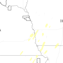
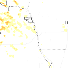
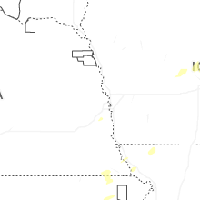
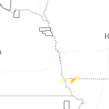
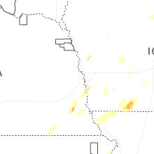


Connect with Interactive Hail Maps