

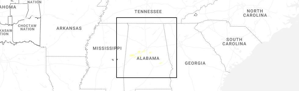
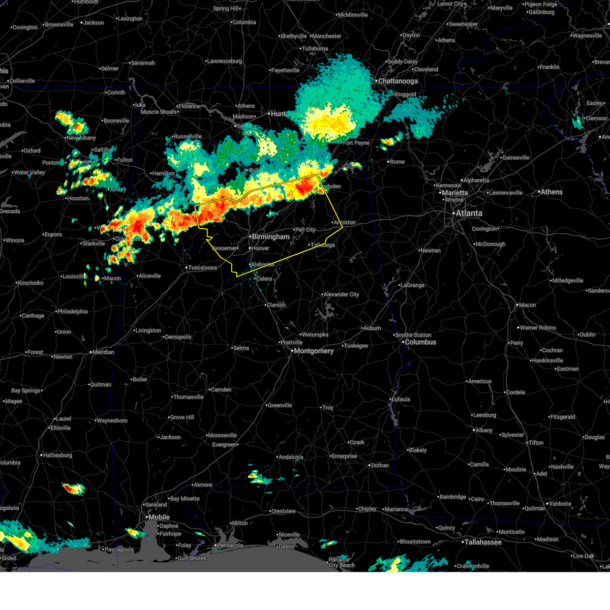
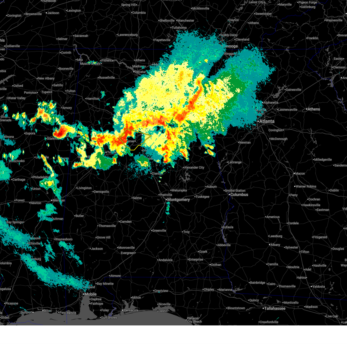
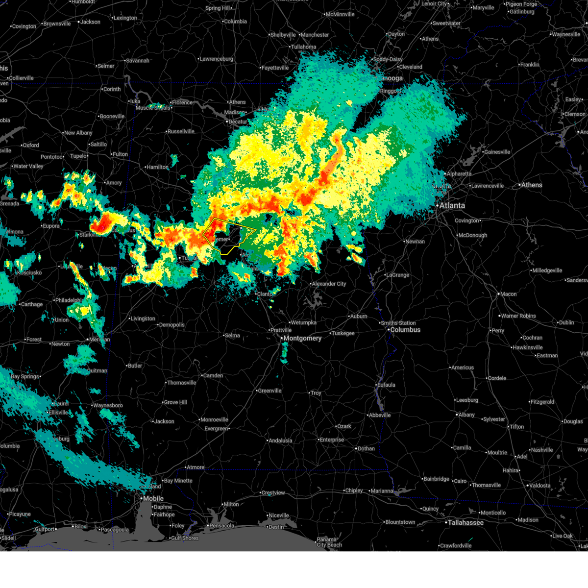
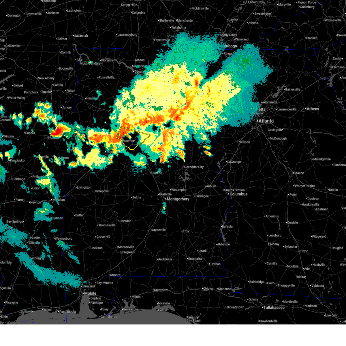
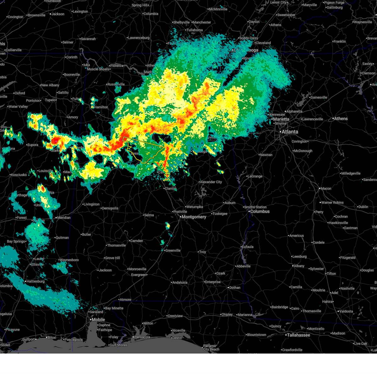
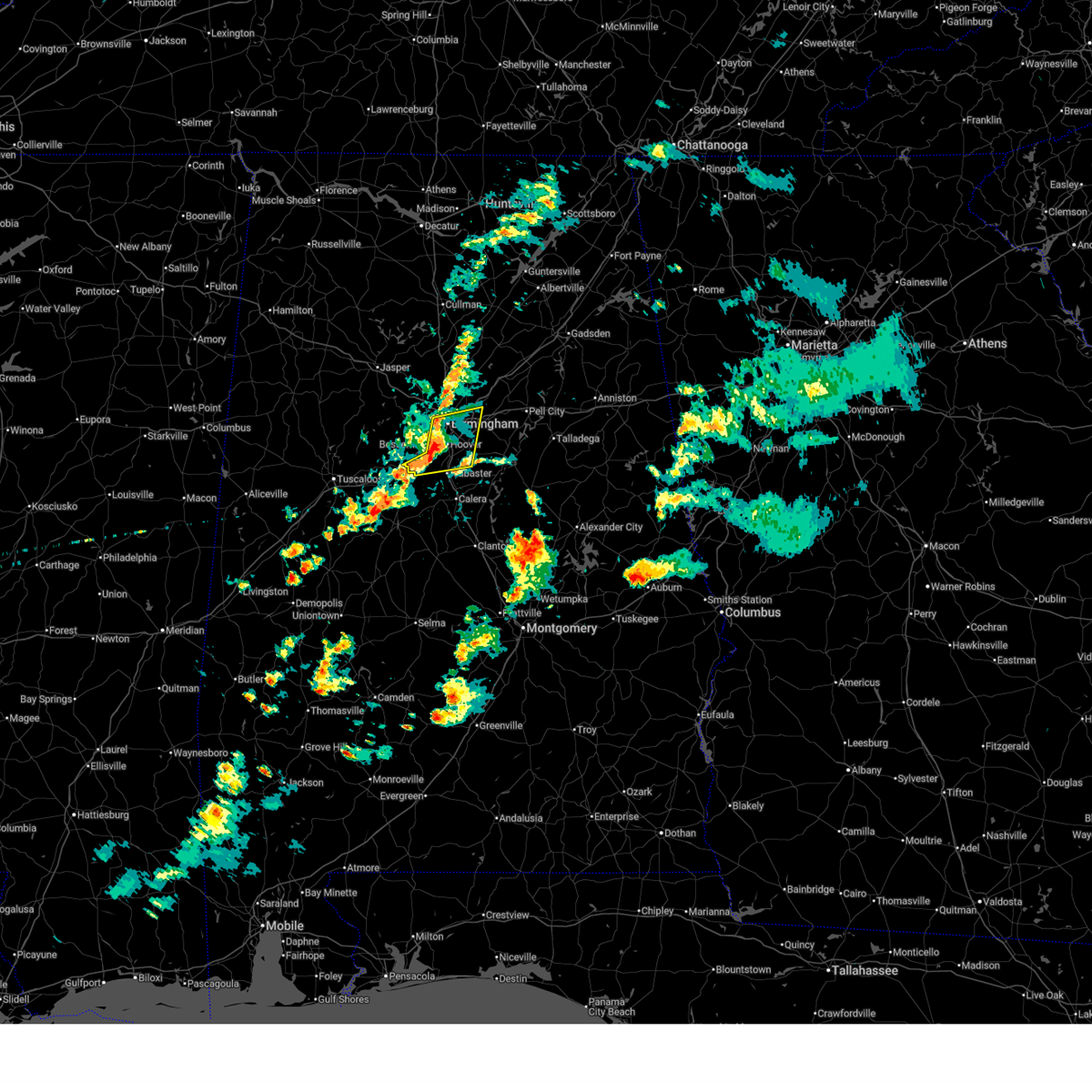
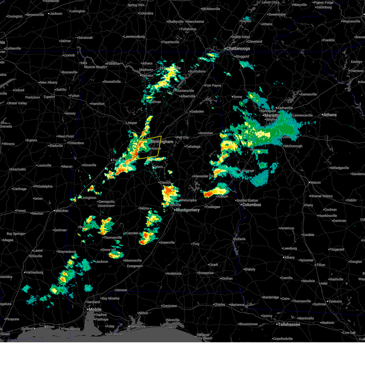
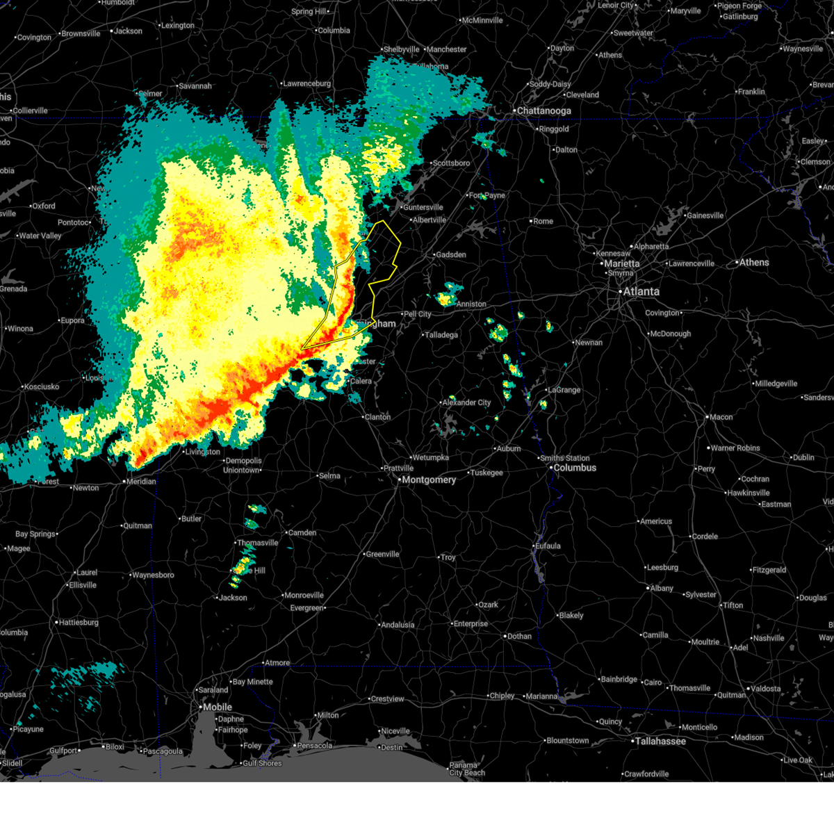
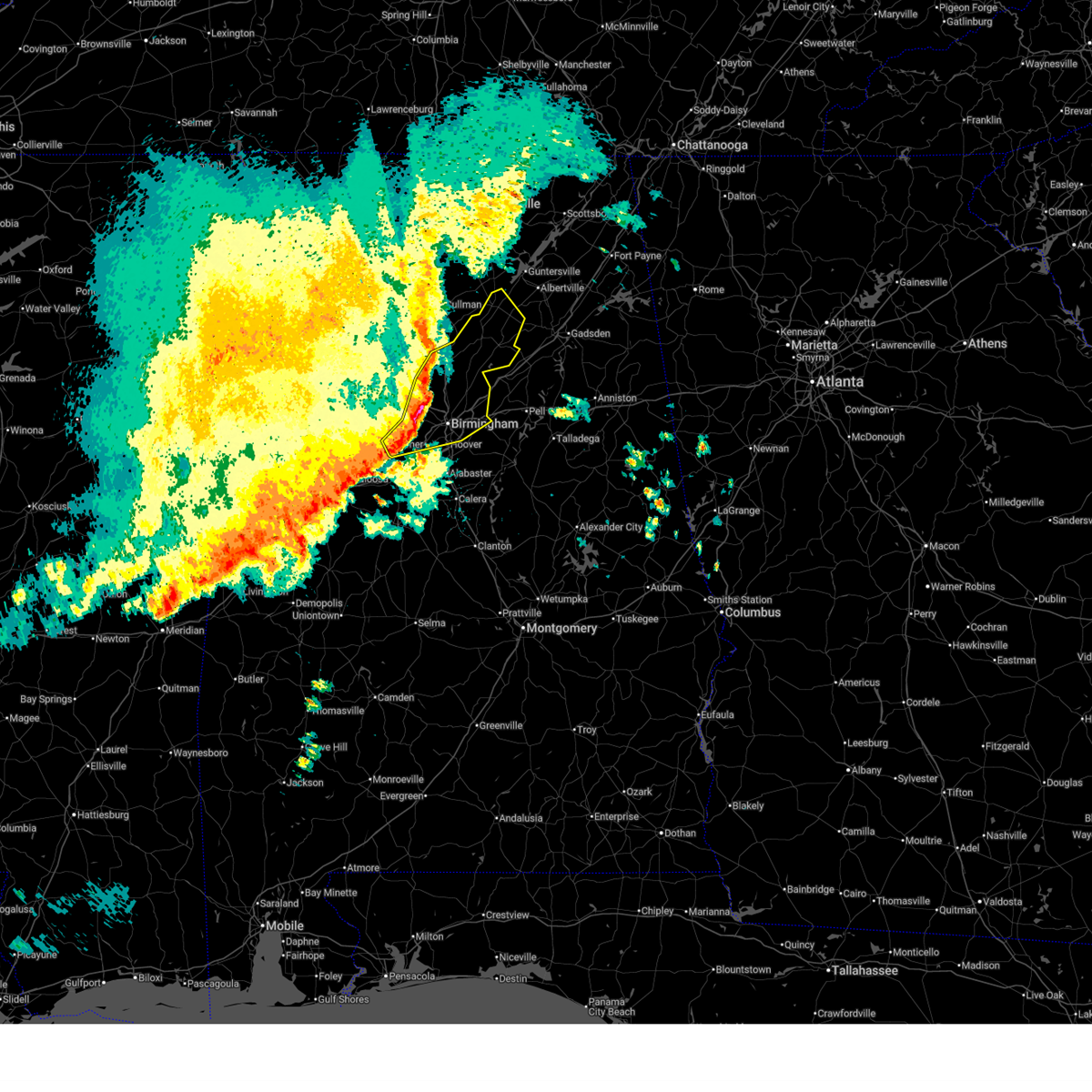
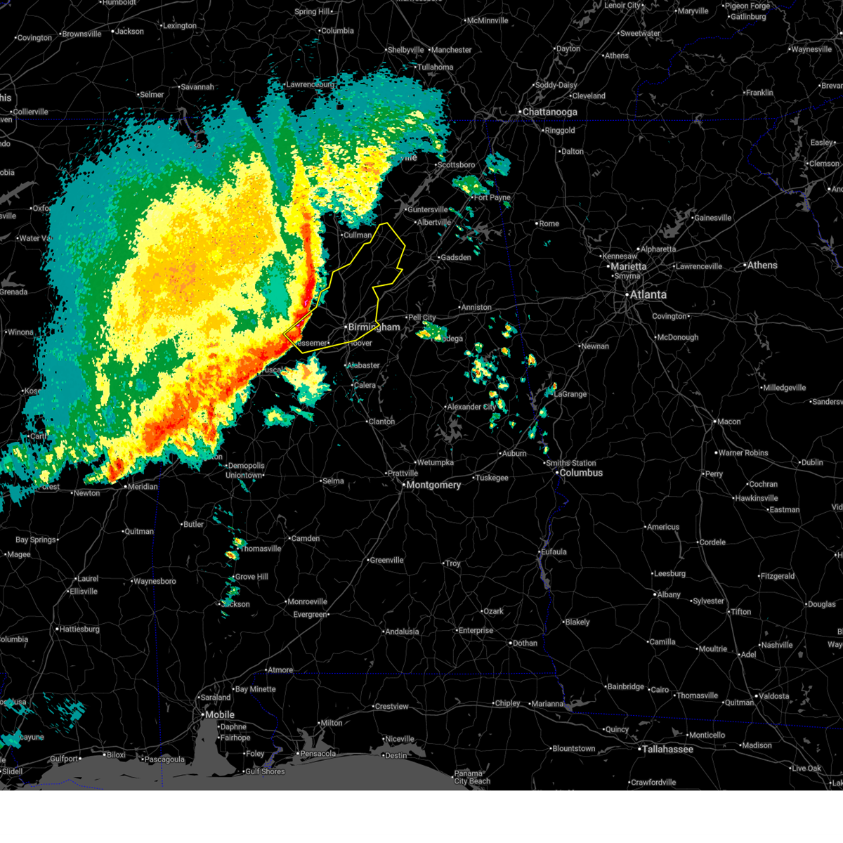
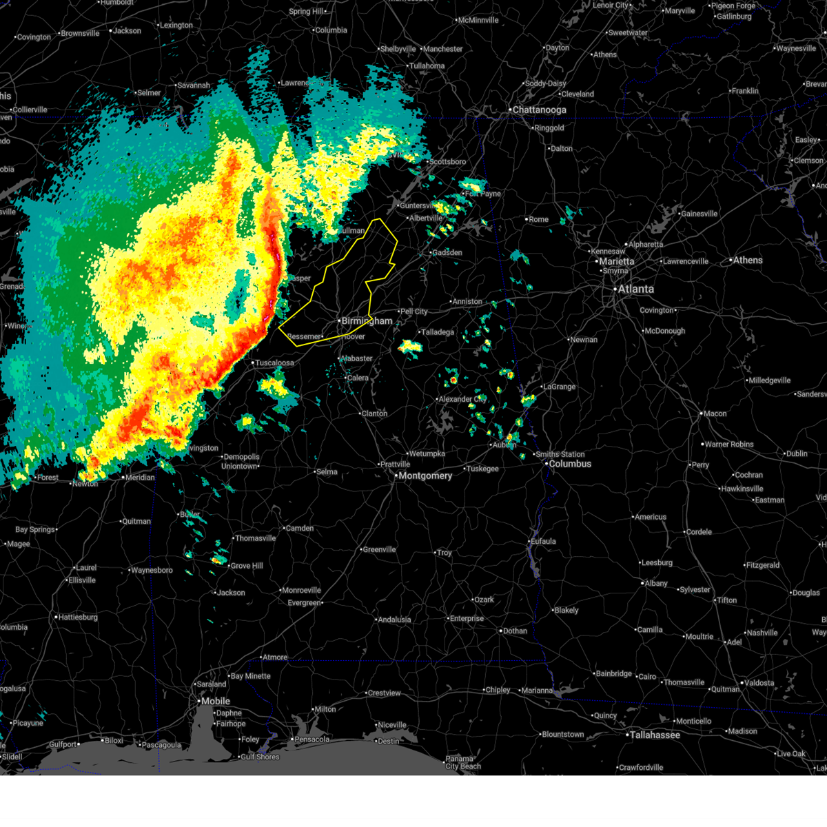
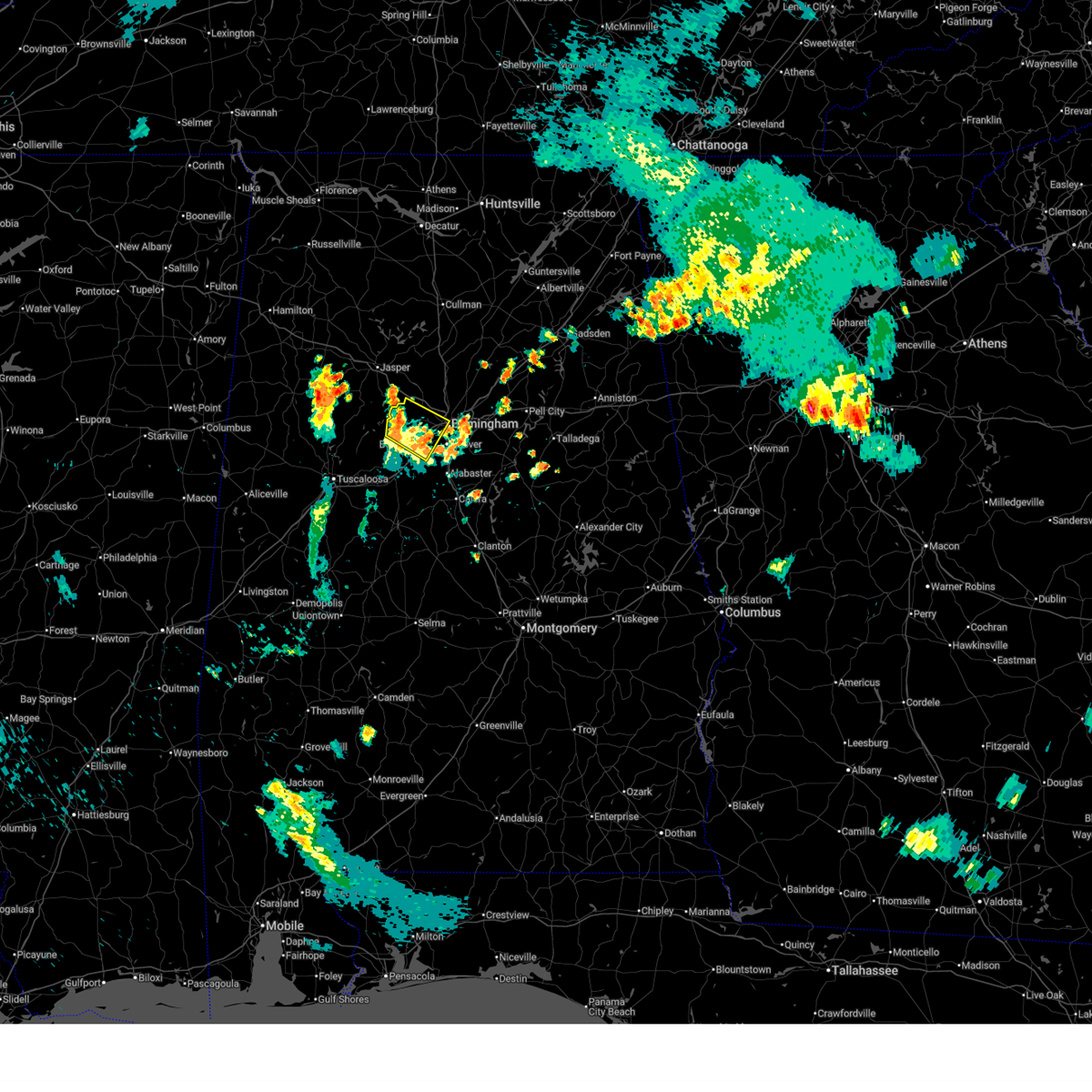
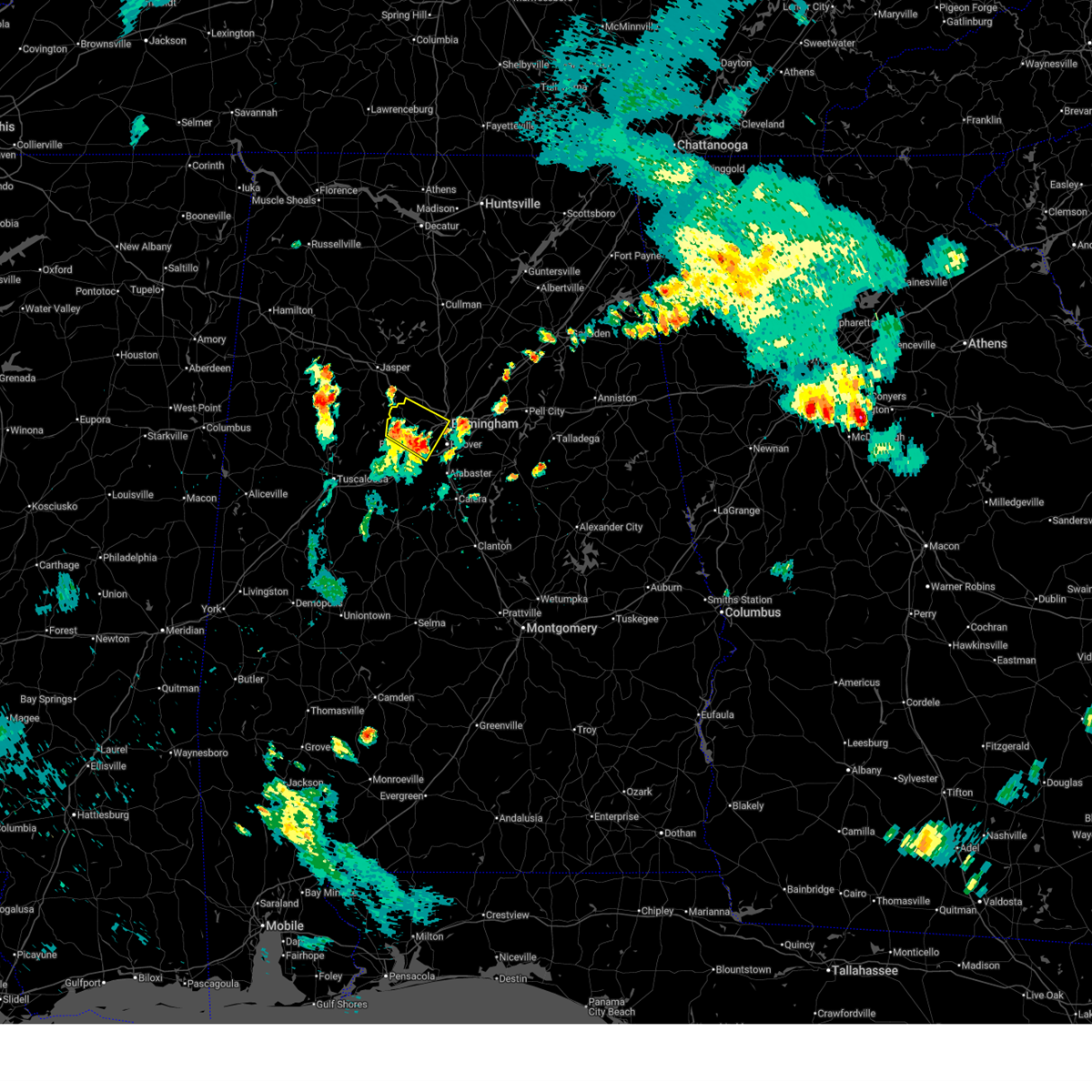
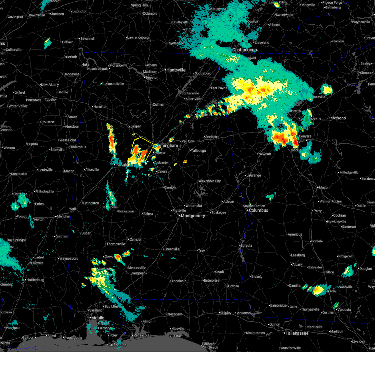
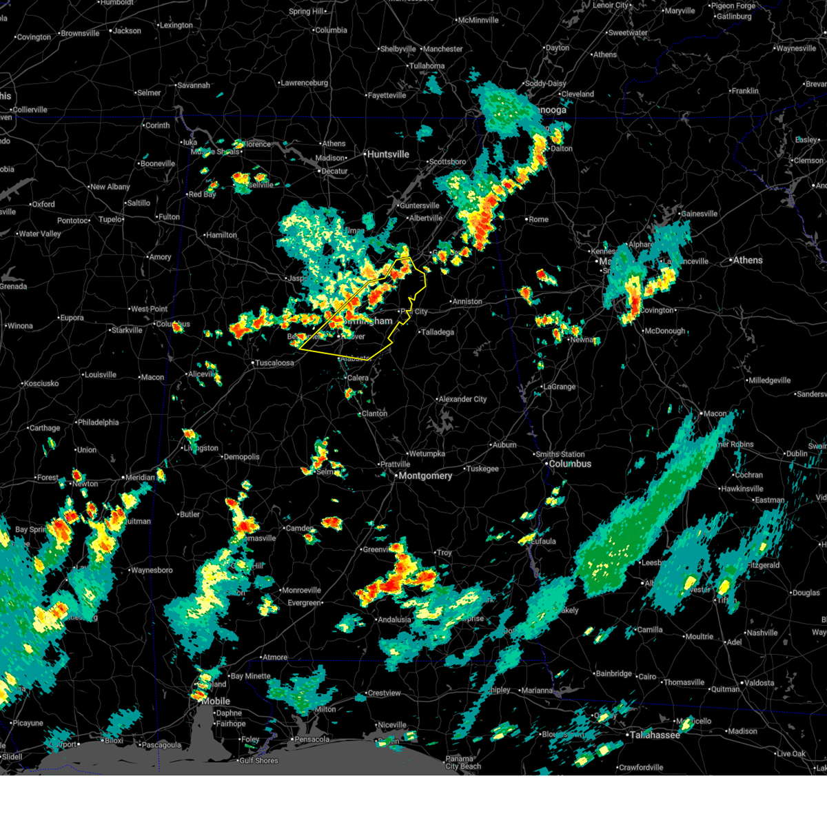
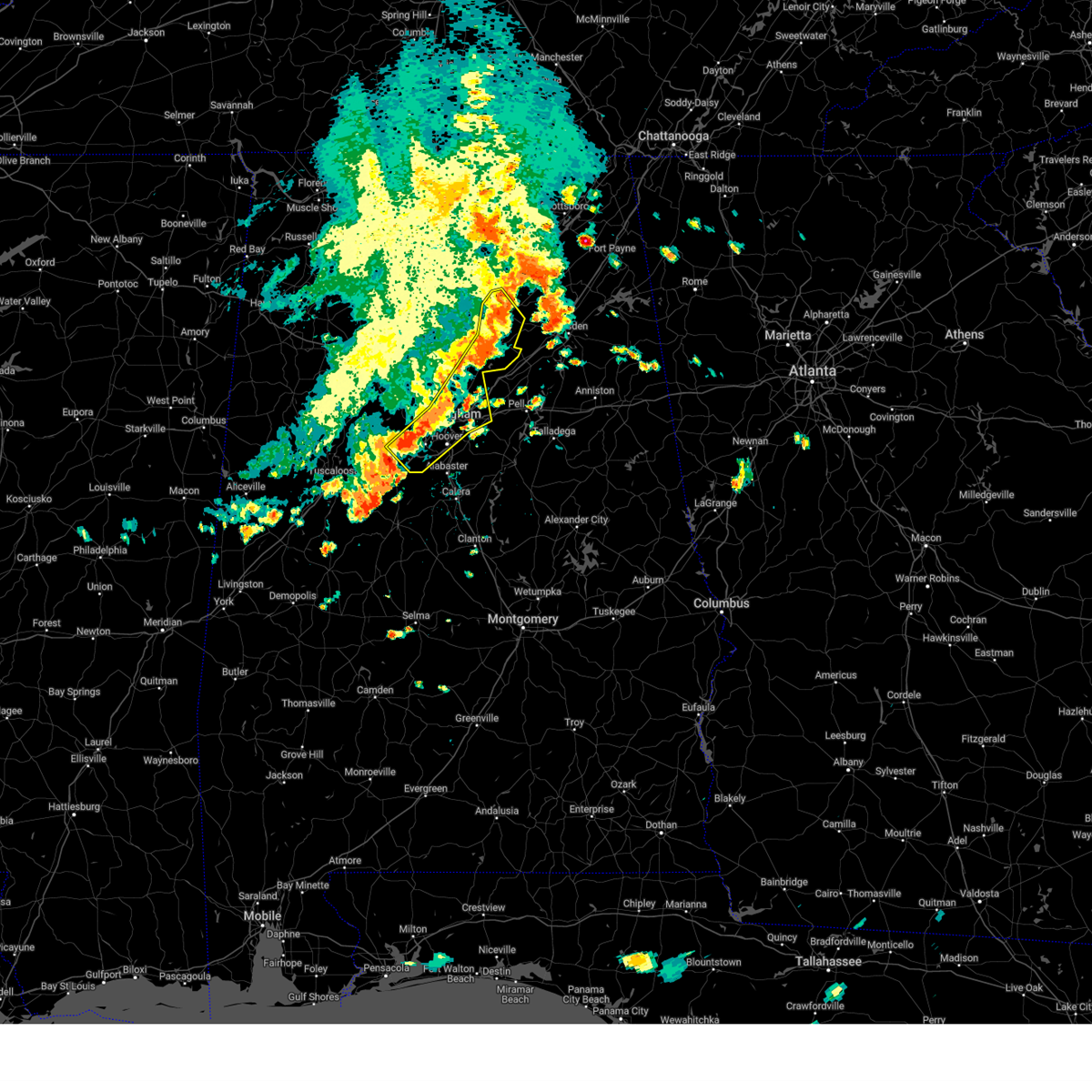
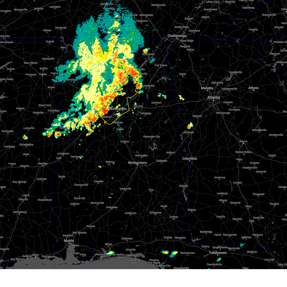
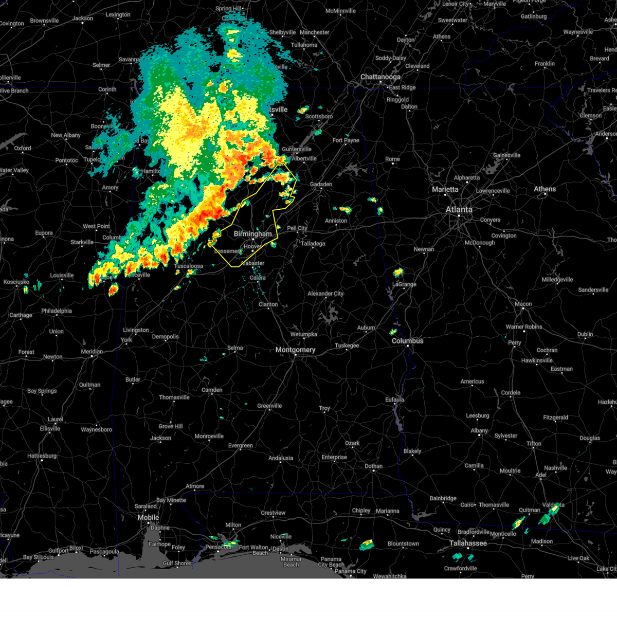
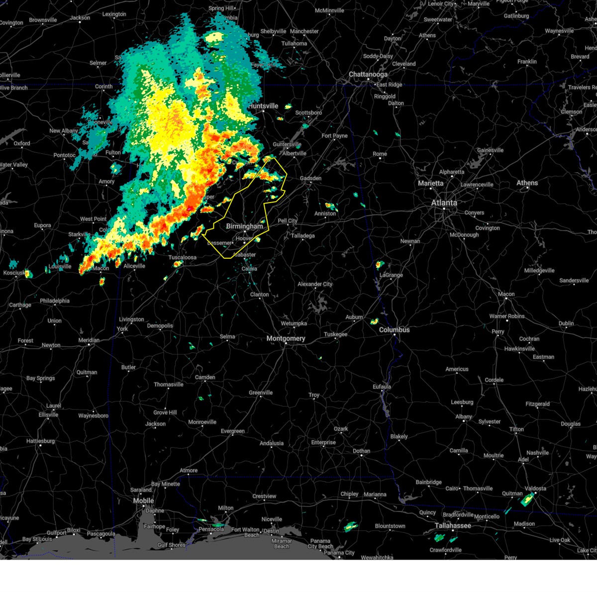
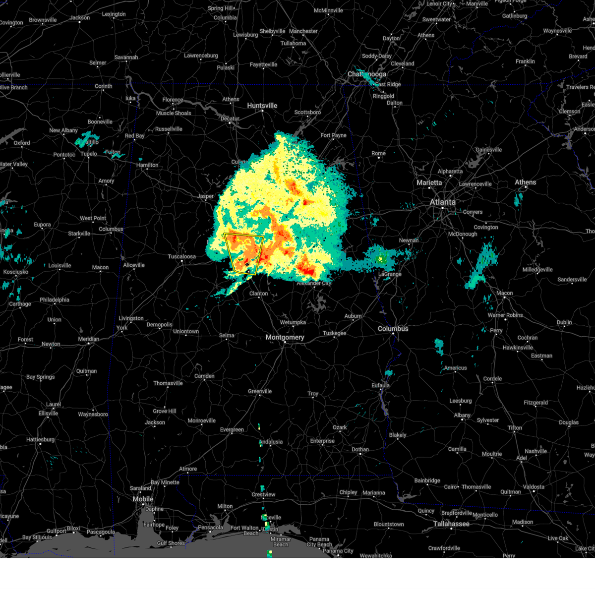
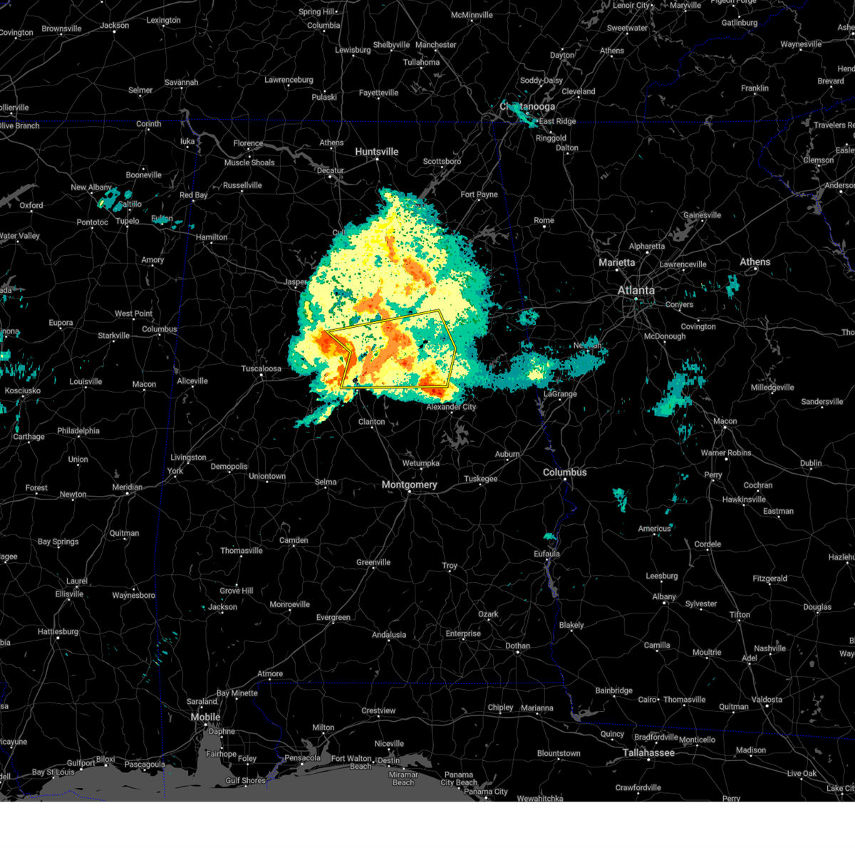
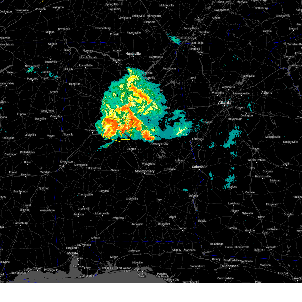
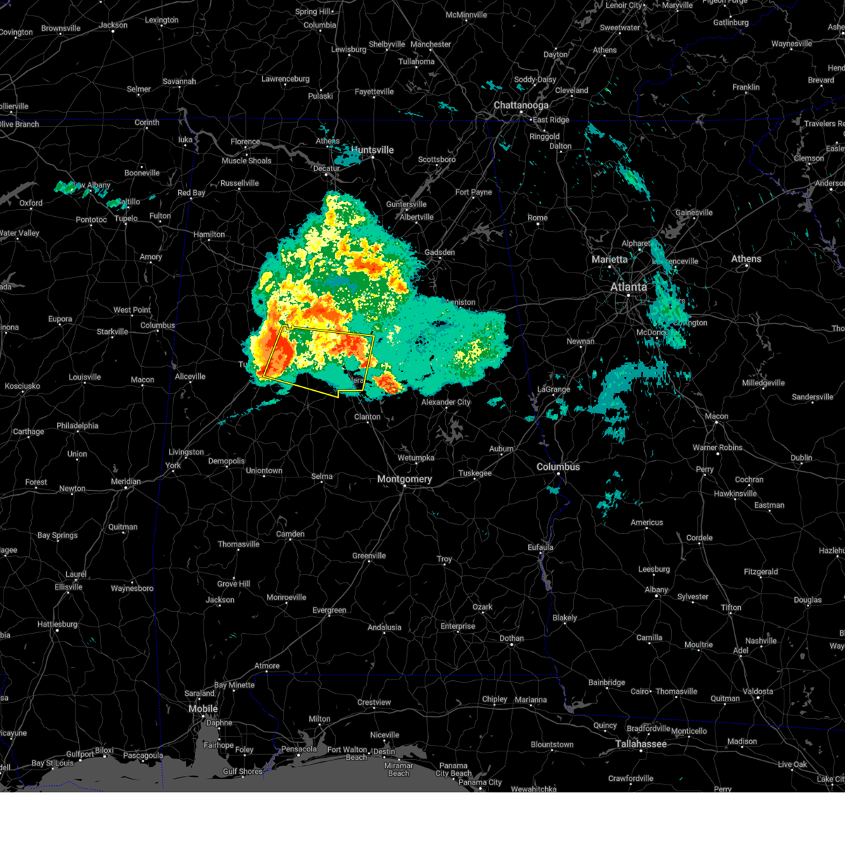
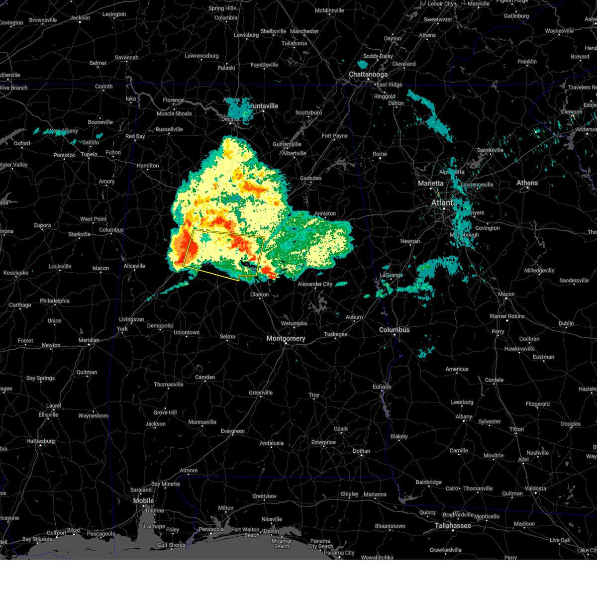
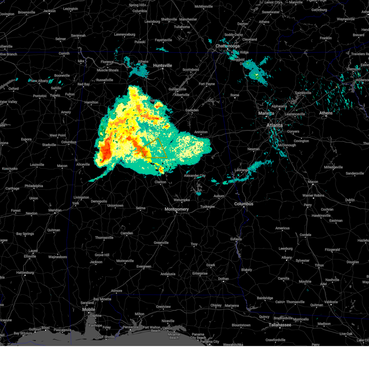
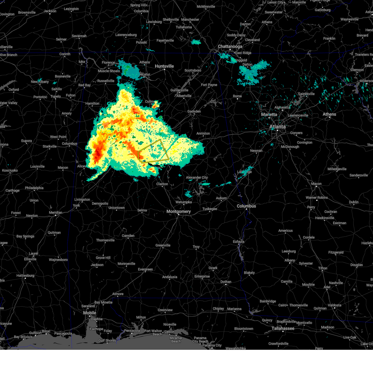
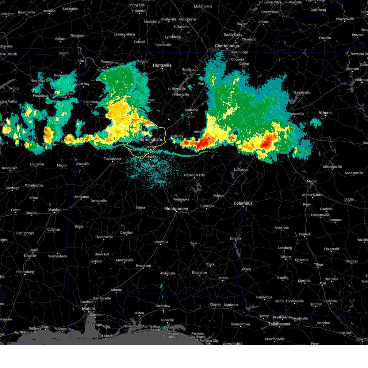
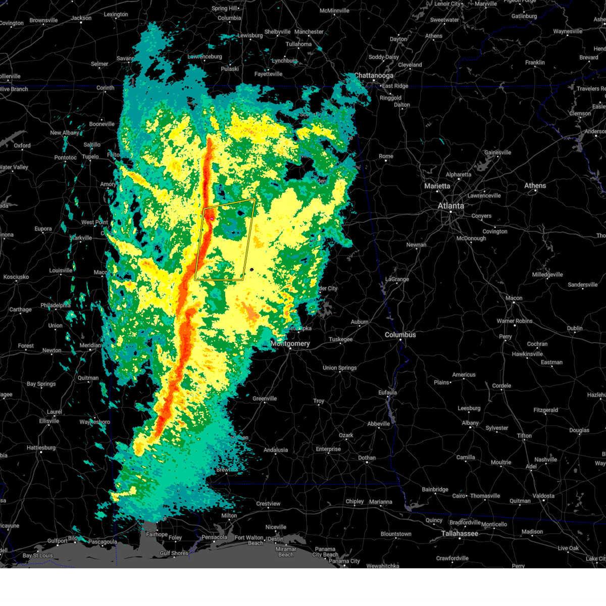
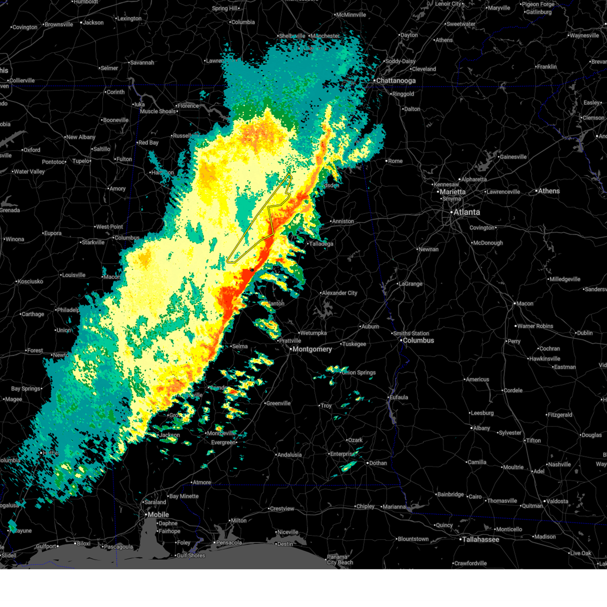
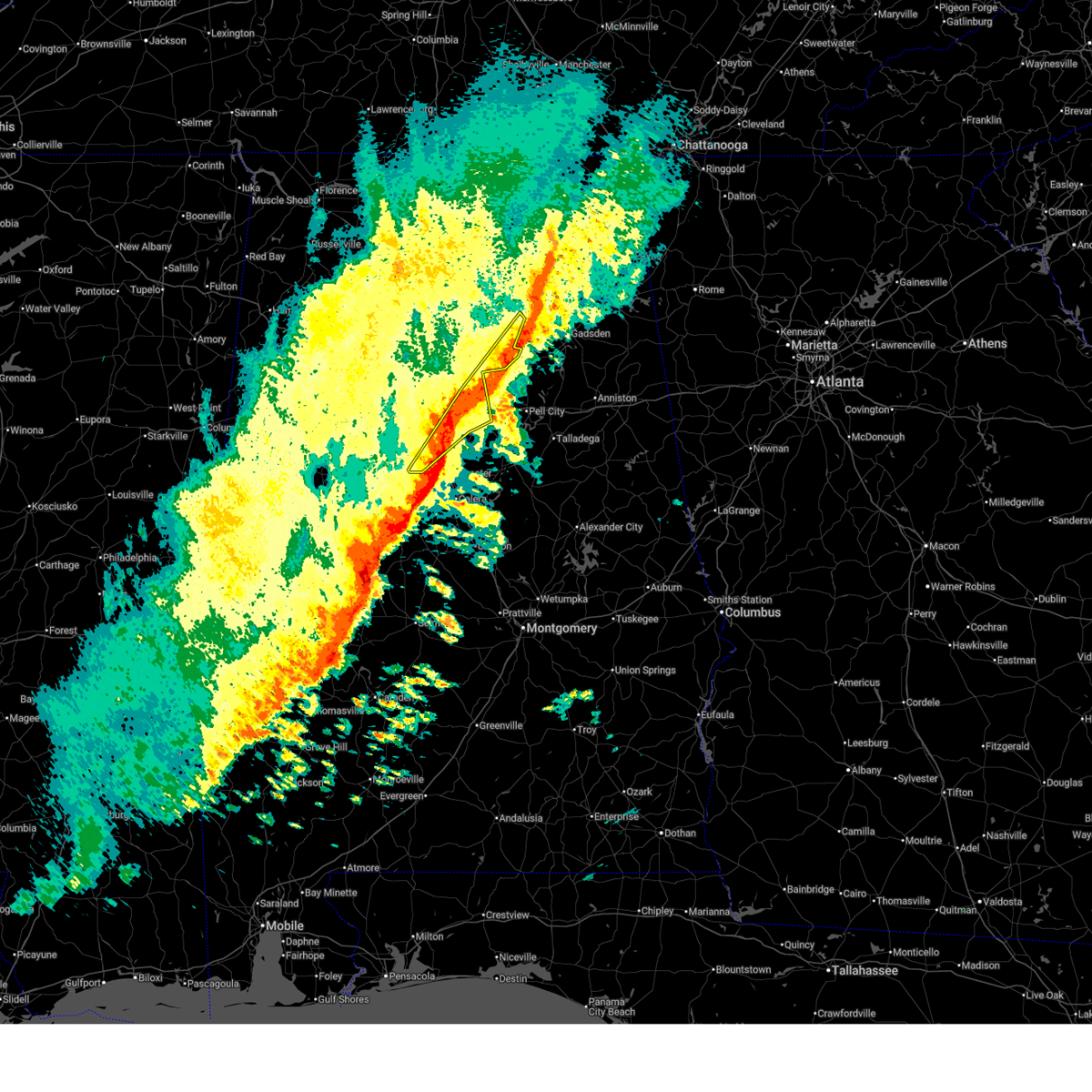
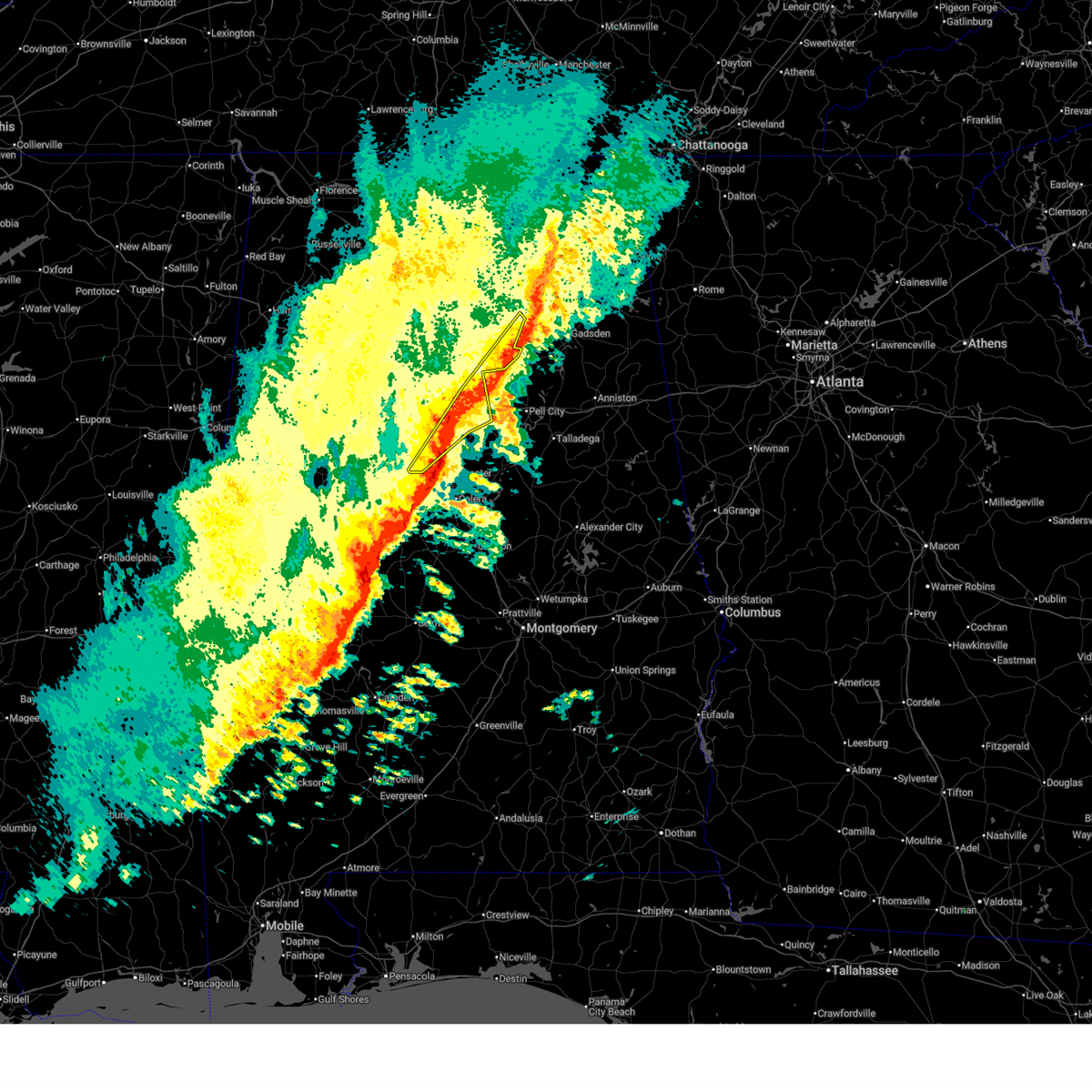
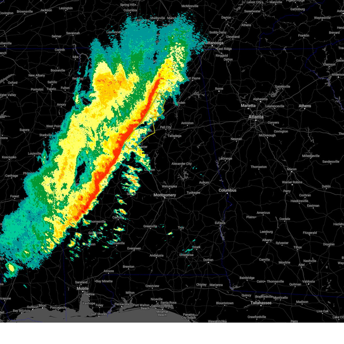
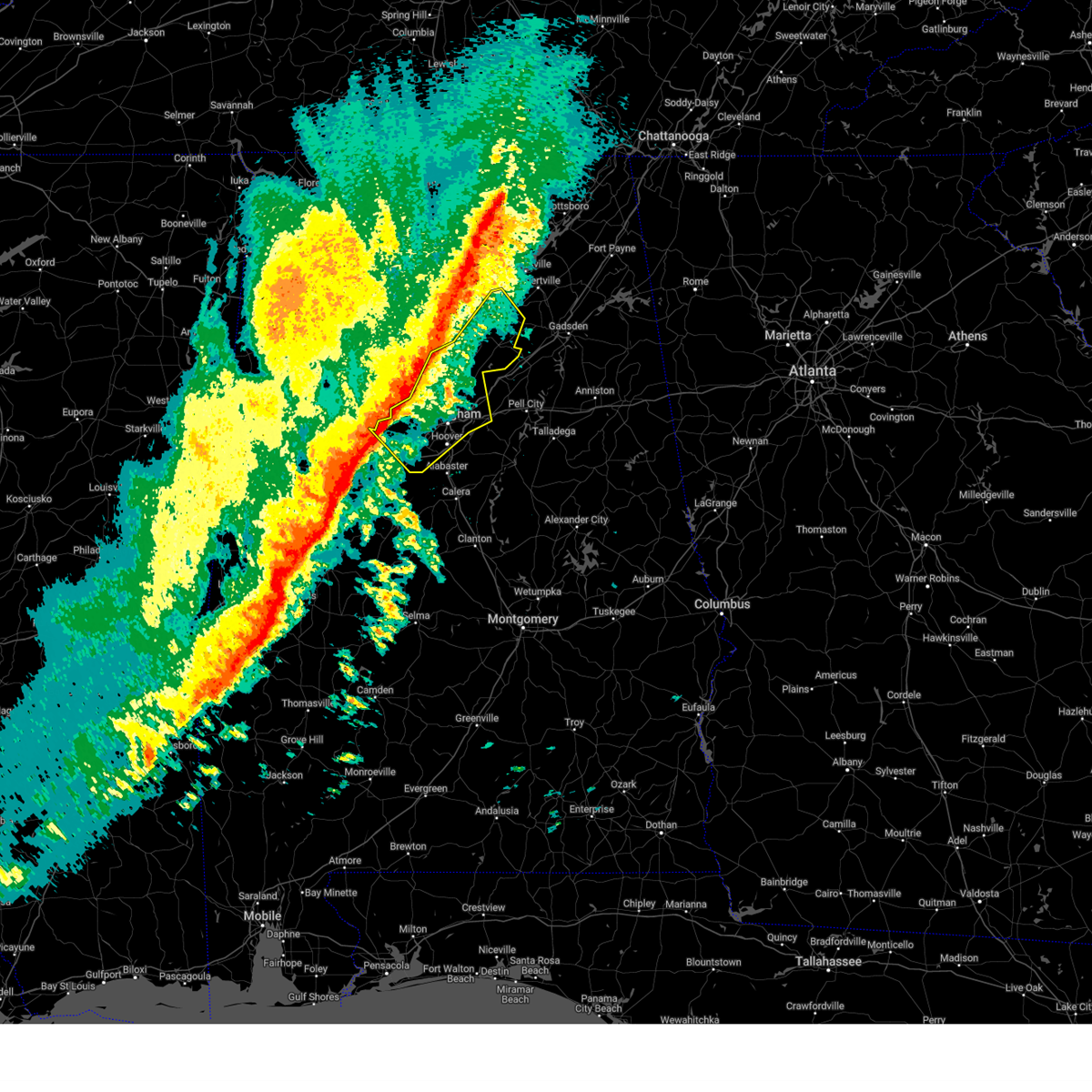
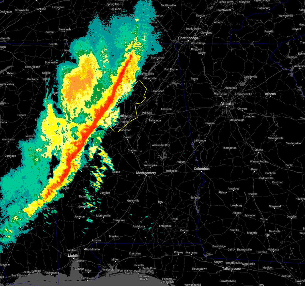
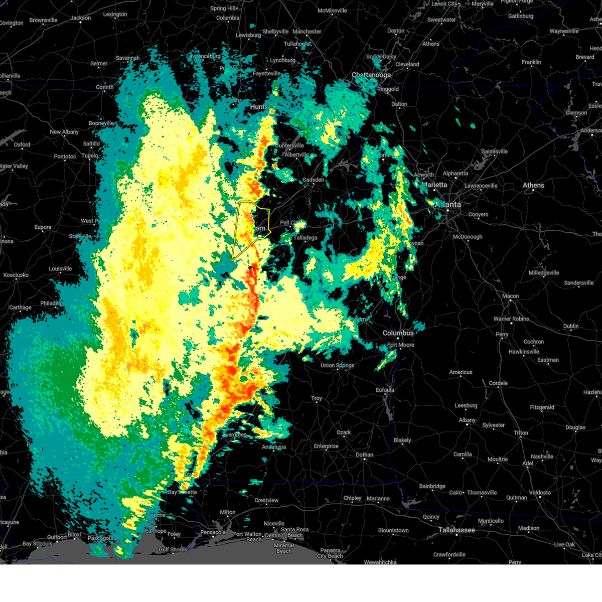
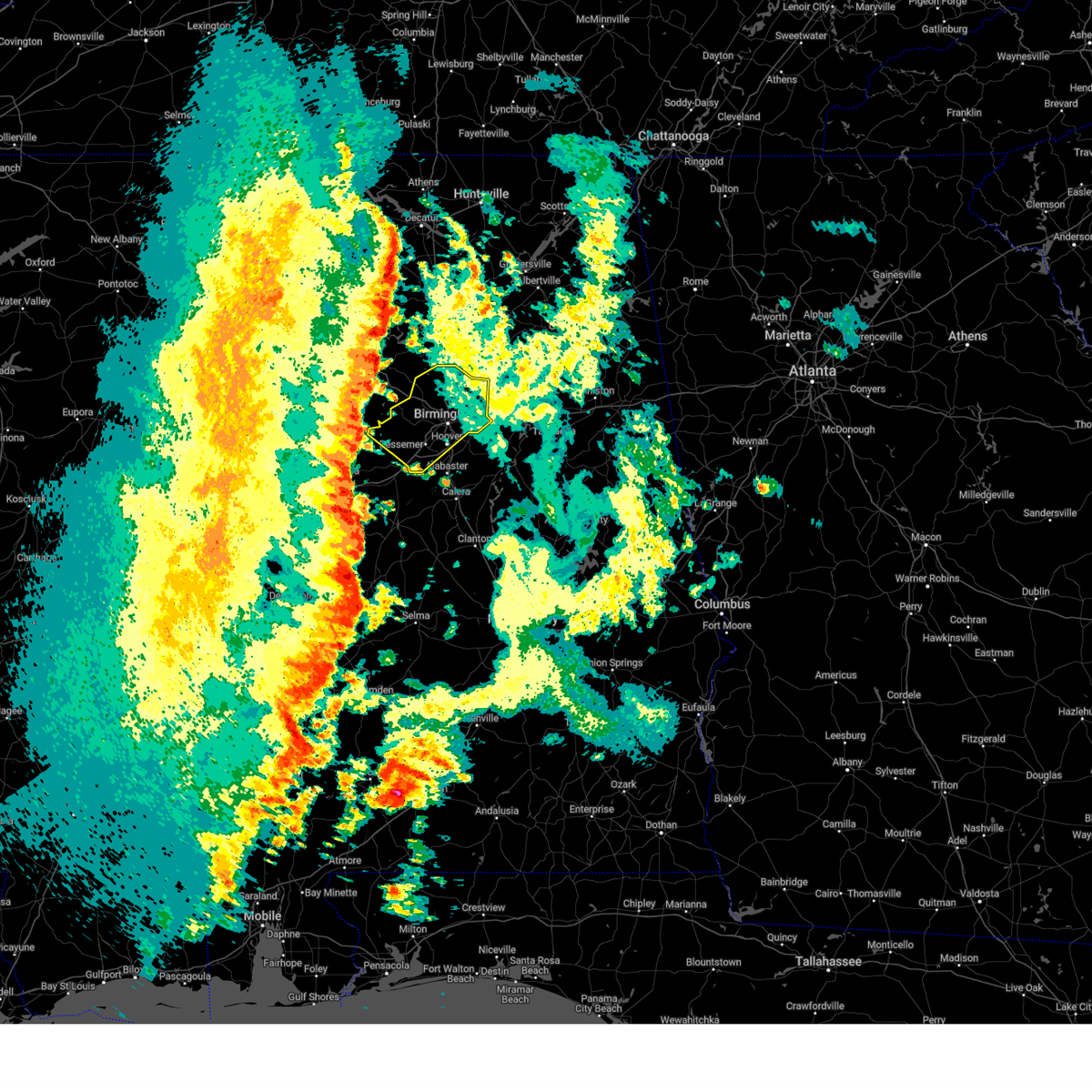
Hail Map for Fairfield, AL
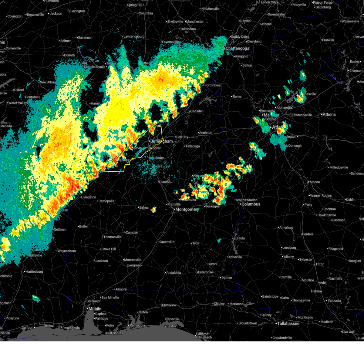
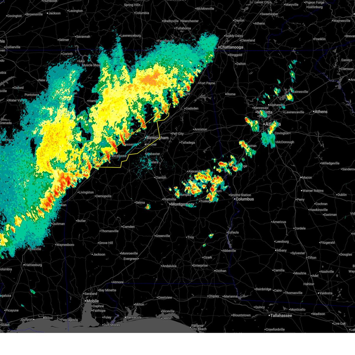
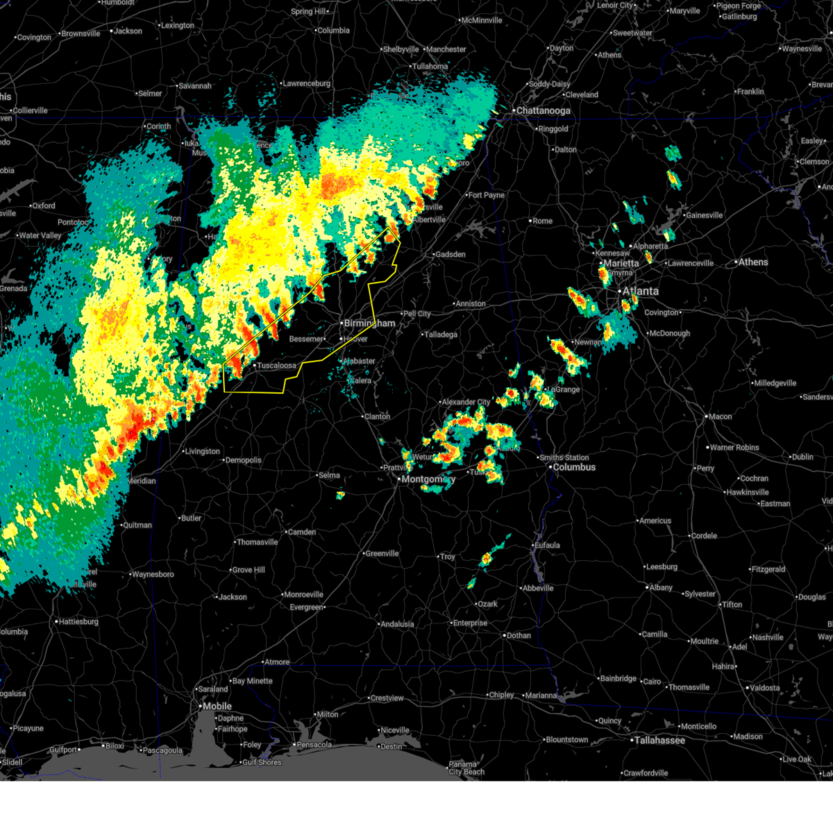
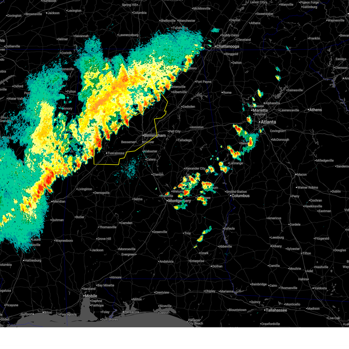
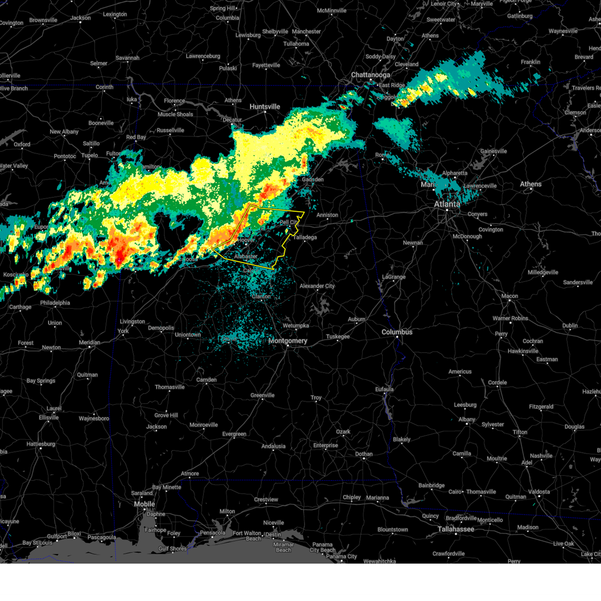
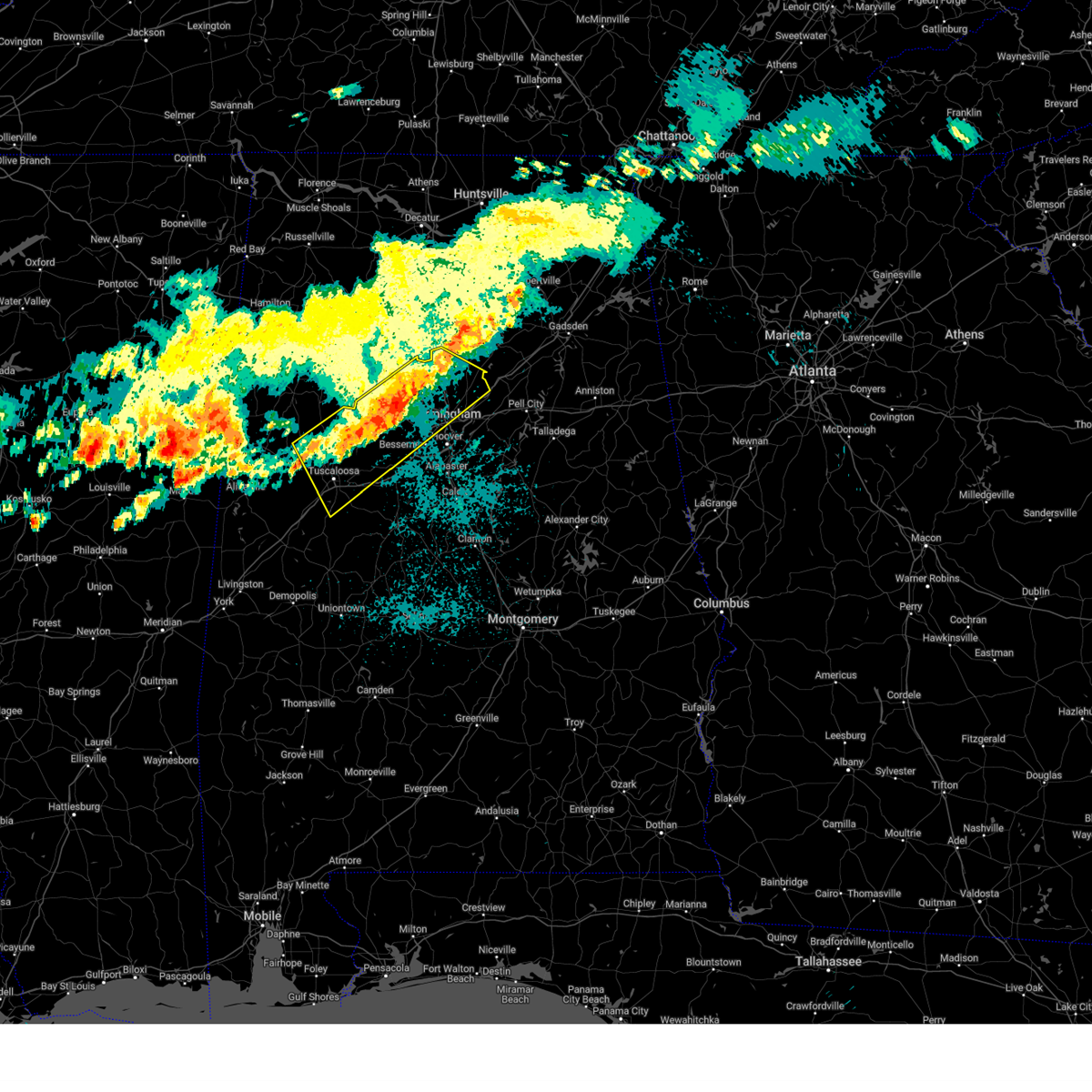
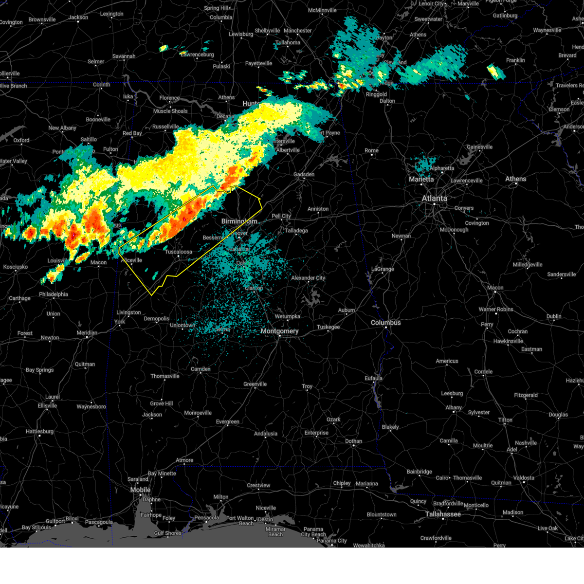
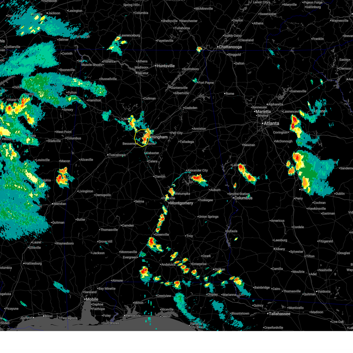
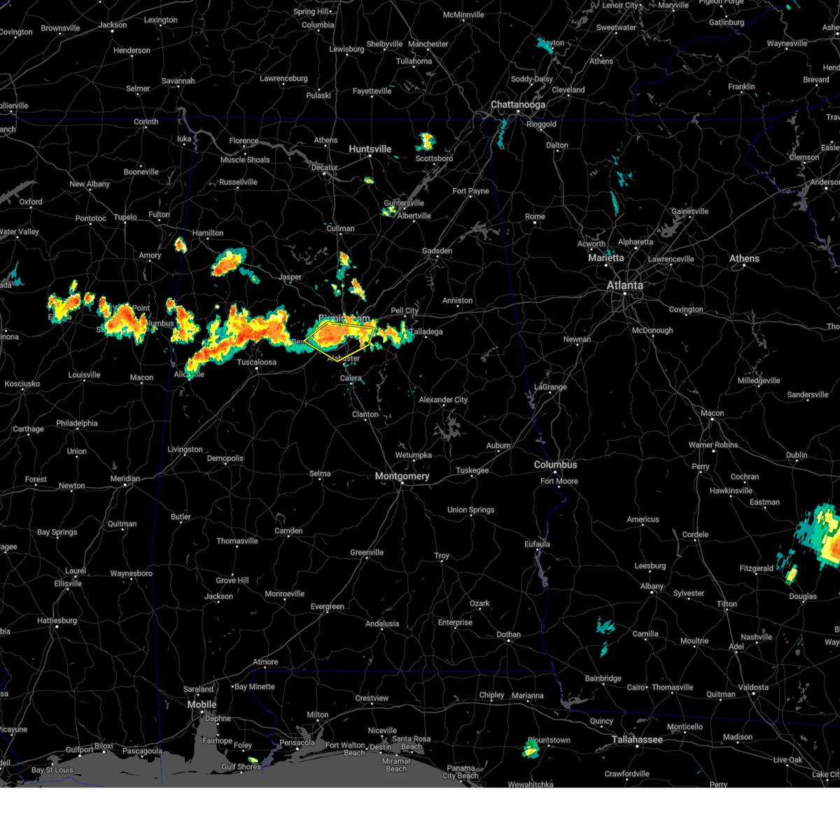
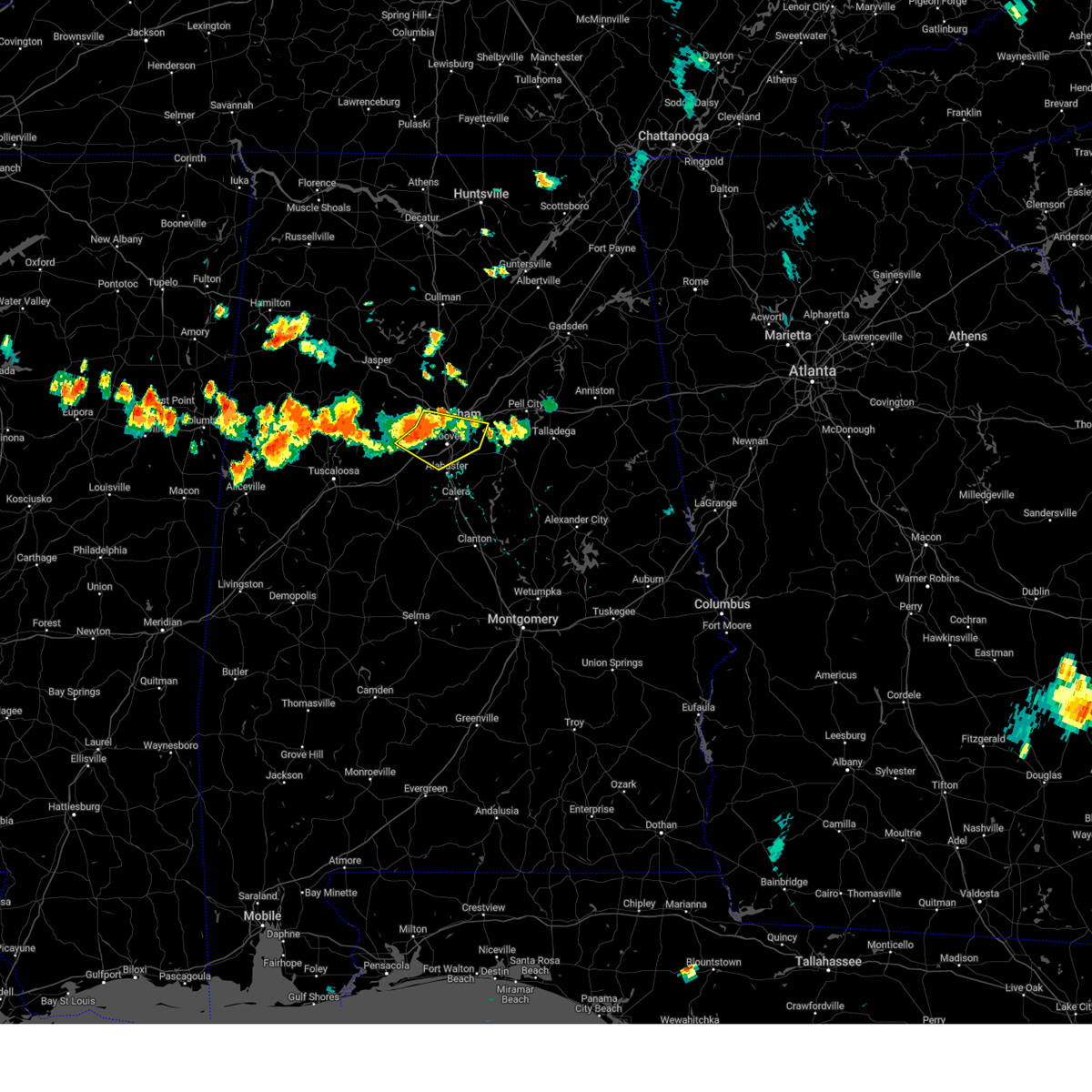
The Fairfield, AL area has had 0 reports of on-the-ground hail by trained spotters, and has been under severe weather warnings 27 times during the past 12 months. Doppler radar has detected hail at or near Fairfield, AL on 67 occasions, including 2 occasions during the past year.
| Name: | Fairfield, AL |
| Where Located: | 7.2 miles WSW of Birmingham, AL |
| Map: | Google Map for Fairfield, AL |
| Population: | 11117 |
| Housing Units: | 4935 |
| More Info: | Search Google for Fairfield, AL |
0
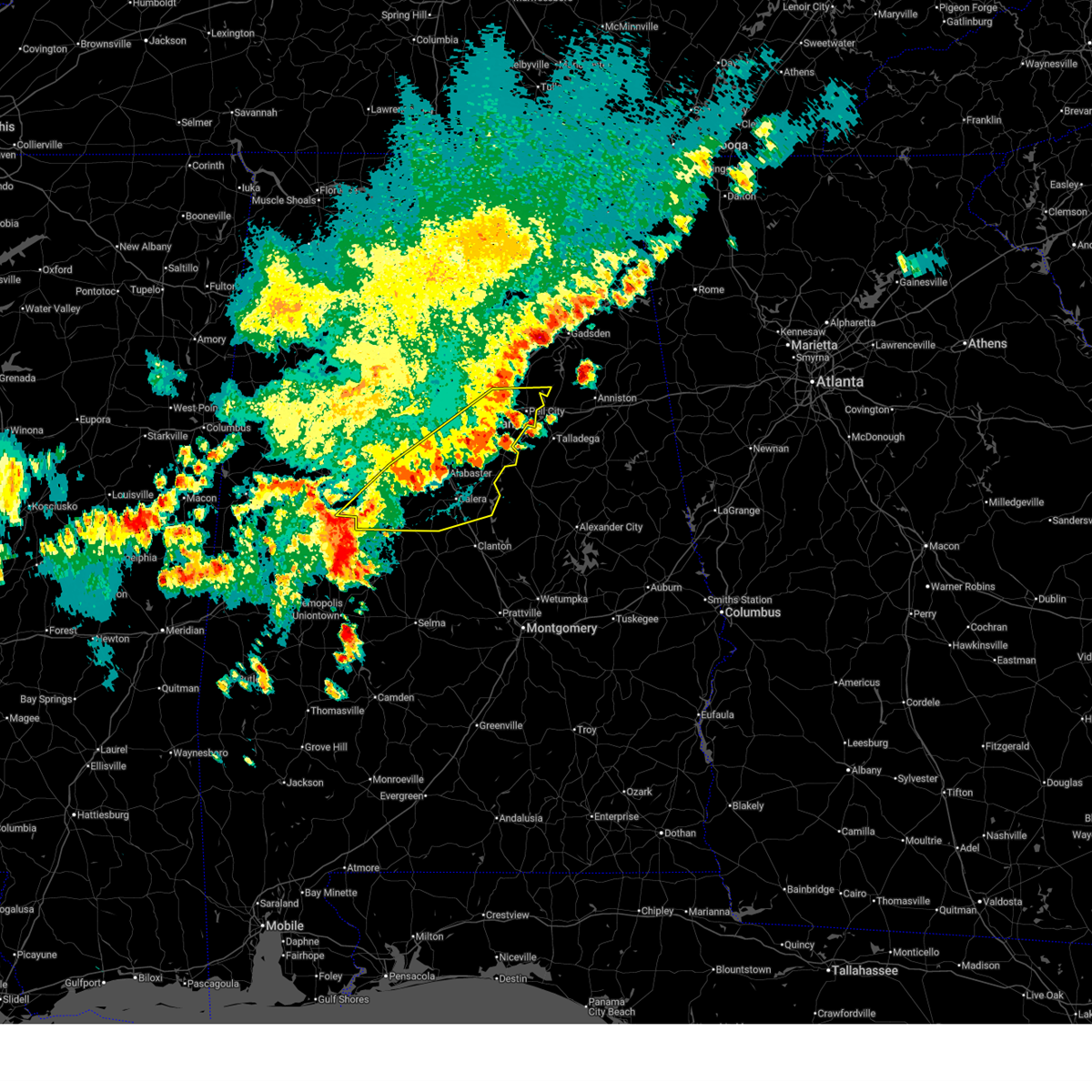
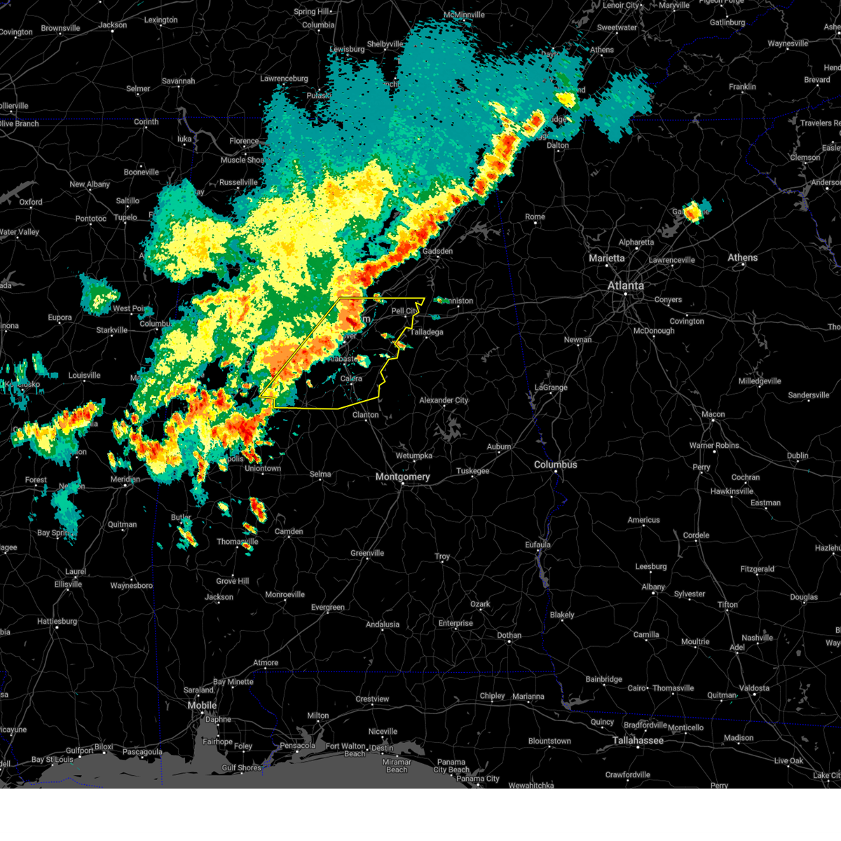
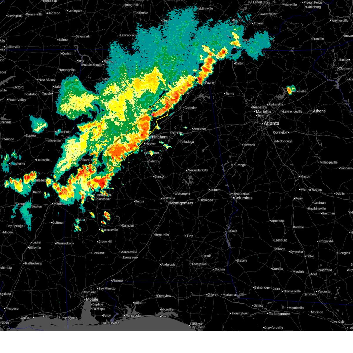
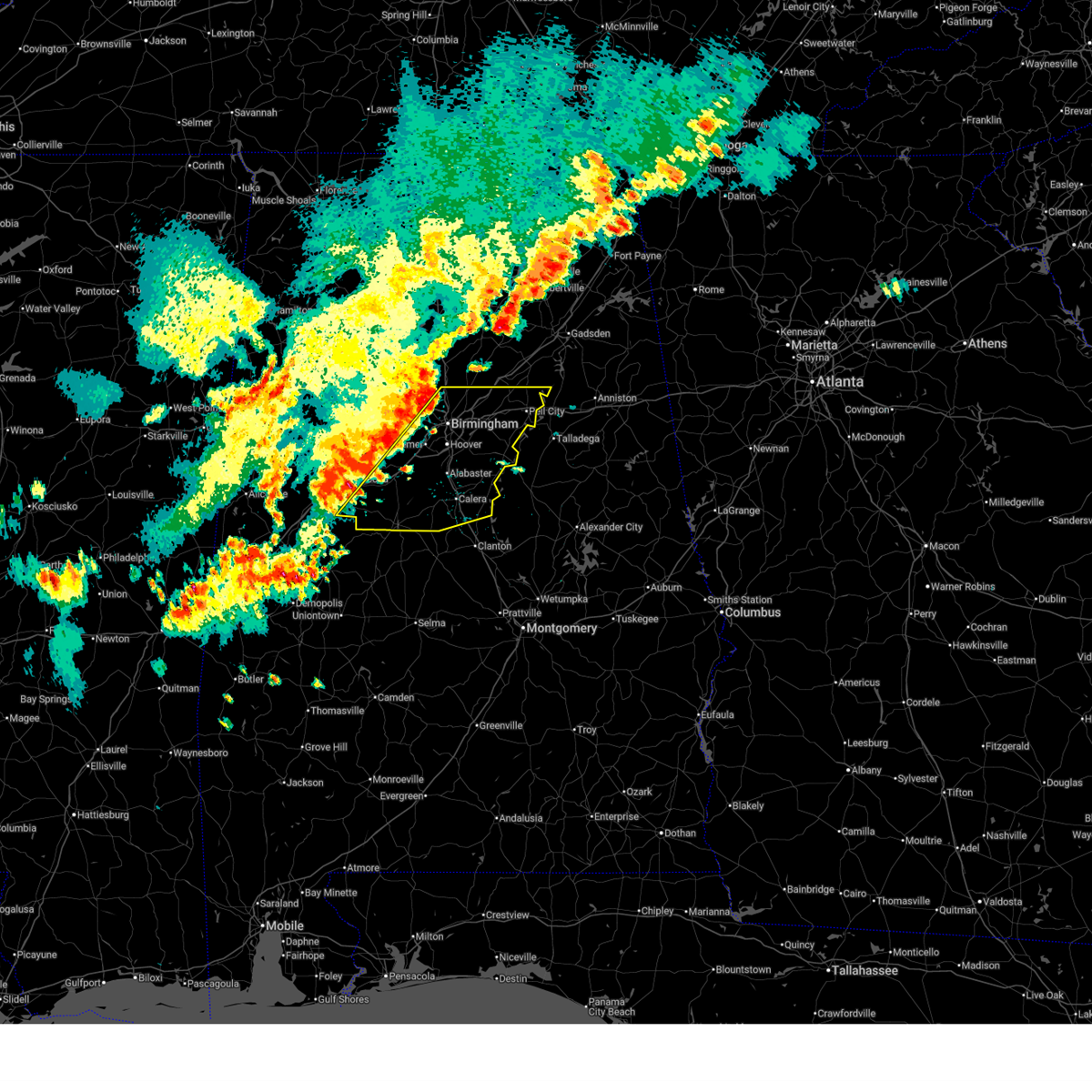
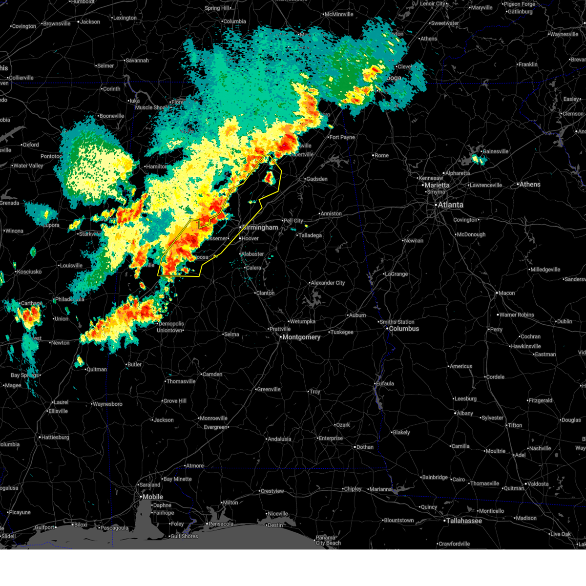
The Top Recent Hail Date for Fairfield, AL is Tuesday, November 25, 2025 (55th out of 67)
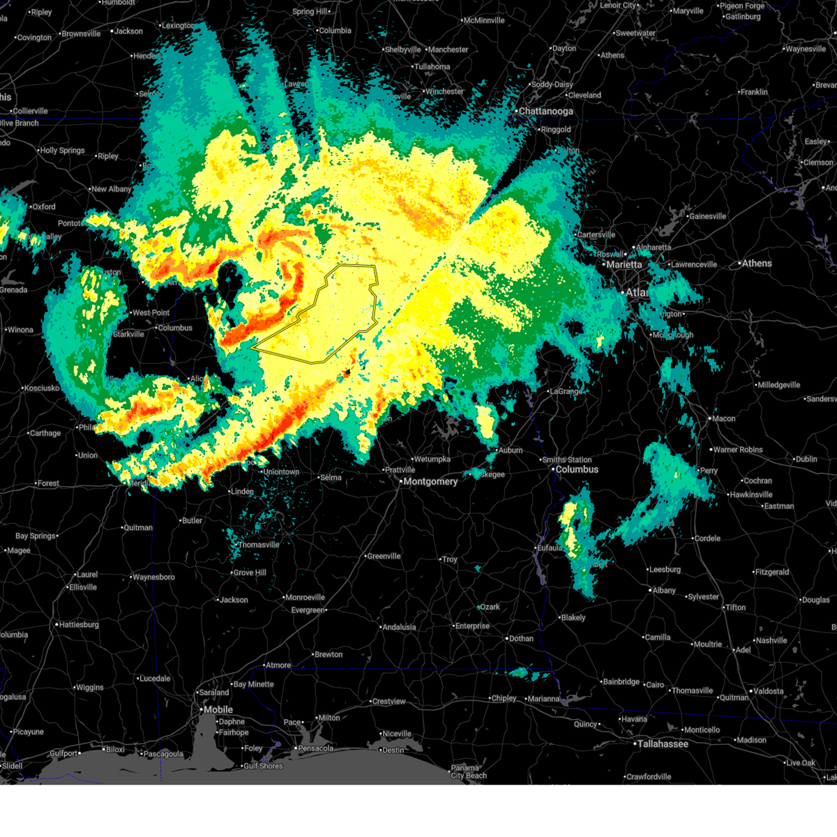
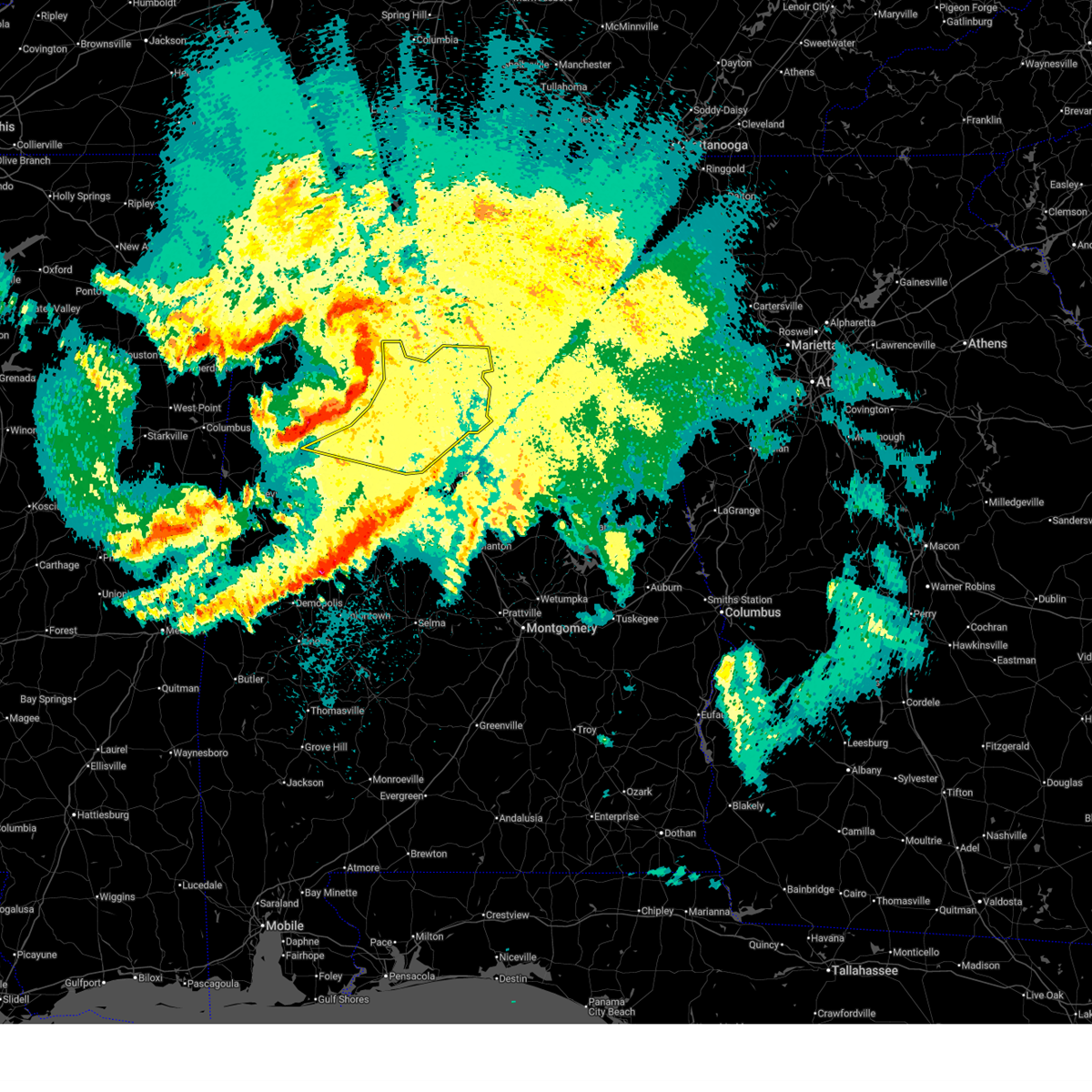
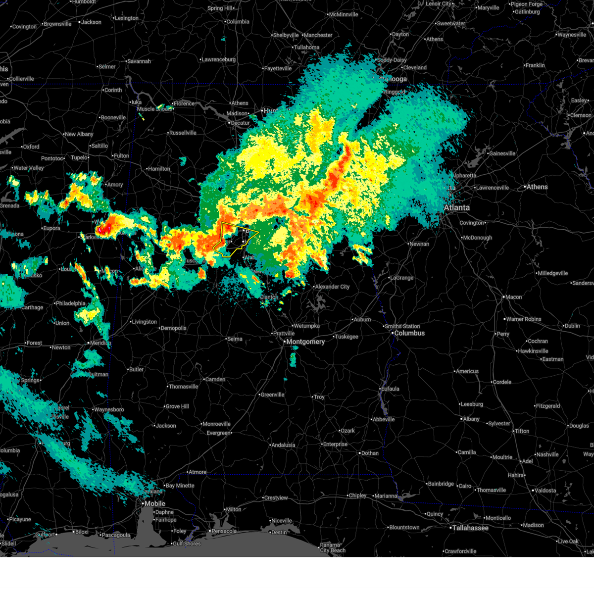
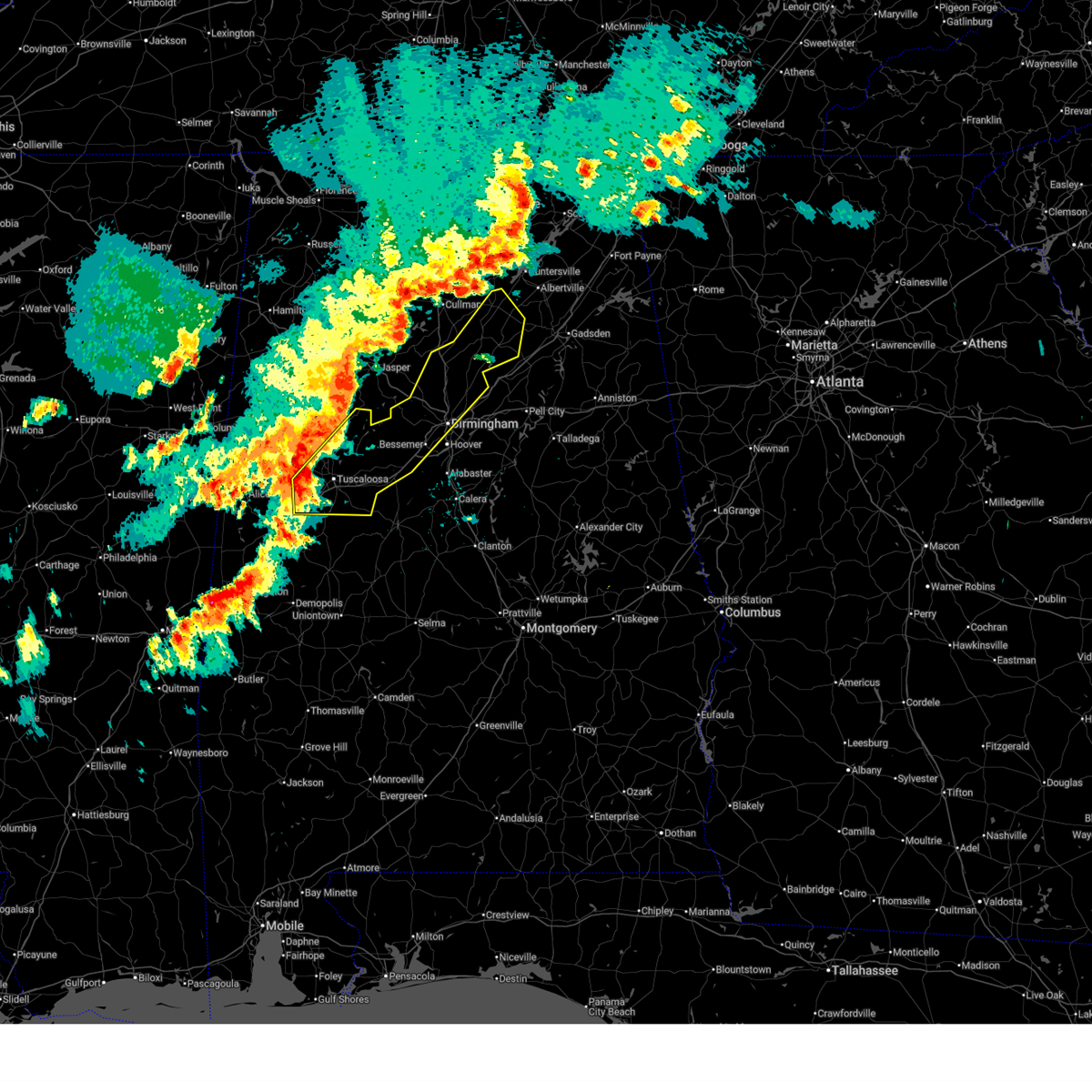
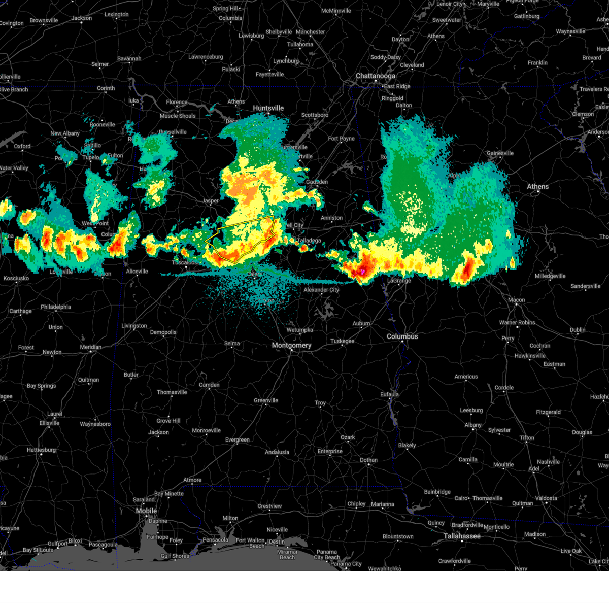
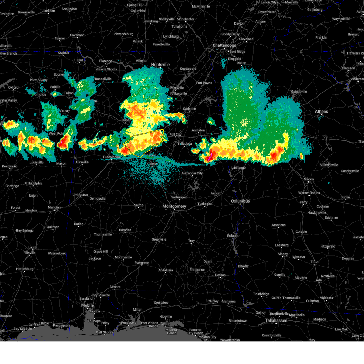
Hail and Wind Damage Spotted near Fairfield, AL
| Date / Time | Report Details |
|---|---|
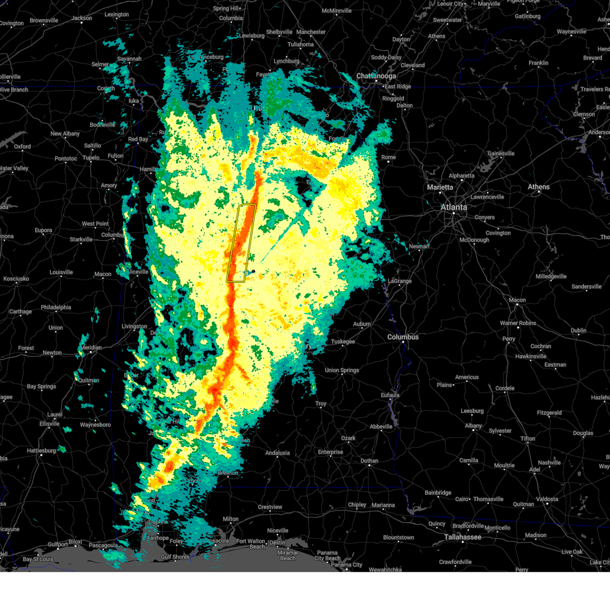
| 6/1/2026 3:10 PM CDT |
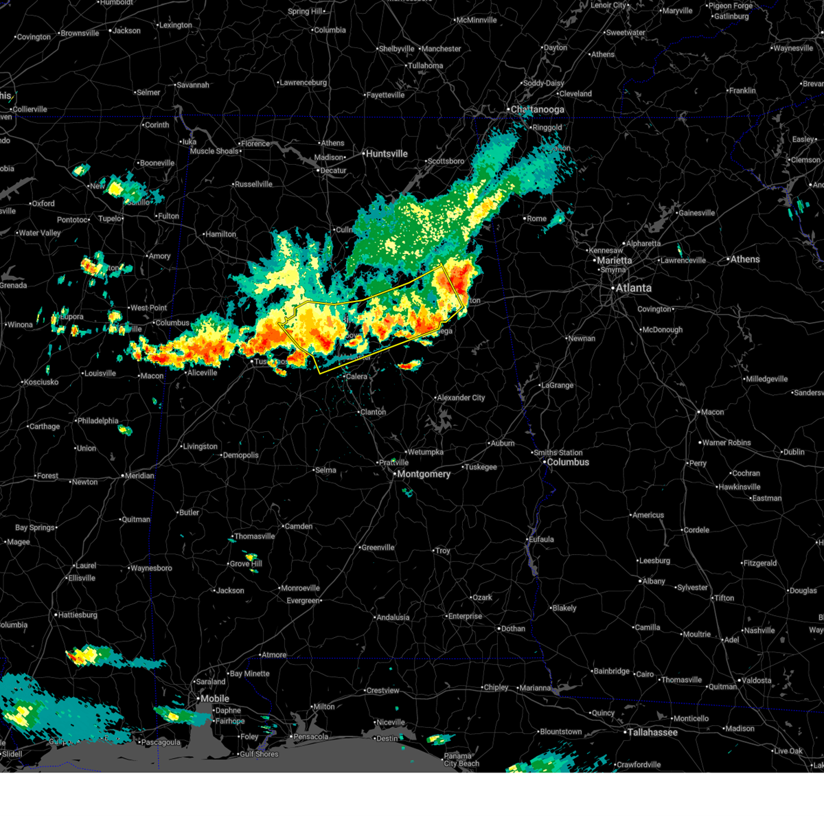 At 310 pm cdt, severe thunderstorms were located along a line extending from anniston to splash adventure, moving southeast at 40 mph (radar indicated). Hazards include 60 mph wind gusts and half dollar size hail. Hail damage to vehicles is expected. expect wind damage to roofs, siding, and trees. Locations impacted include, birmingham, hoover, vestavia hills, alabaster, bessemer, homewood, anniston, pelham, oxford, mountain brook, trussville, helena, hueytown, talladega, gardendale, pell city, irondale, leeds, moody, and fairfield. At 310 pm cdt, severe thunderstorms were located along a line extending from anniston to splash adventure, moving southeast at 40 mph (radar indicated). Hazards include 60 mph wind gusts and half dollar size hail. Hail damage to vehicles is expected. expect wind damage to roofs, siding, and trees. Locations impacted include, birmingham, hoover, vestavia hills, alabaster, bessemer, homewood, anniston, pelham, oxford, mountain brook, trussville, helena, hueytown, talladega, gardendale, pell city, irondale, leeds, moody, and fairfield.
|
| 6/1/2026 2:58 PM CDT |
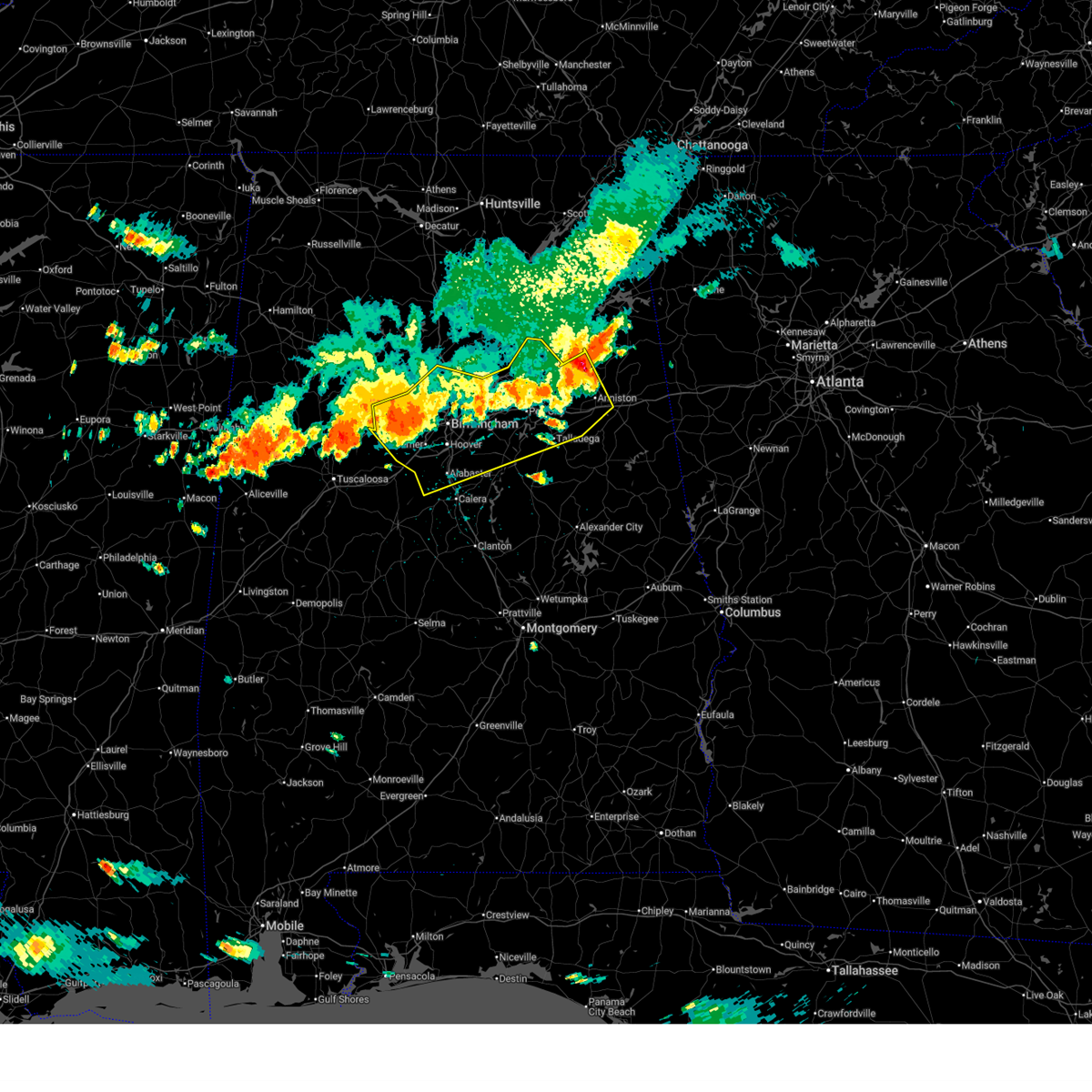 At 258 pm cdt, severe thunderstorms were located along a line extending from near alexandria to near concord, moving southeast at 40 mph (radar indicated). Hazards include 60 mph wind gusts and half dollar size hail. Hail damage to vehicles is expected. expect wind damage to roofs, siding, and trees. Locations impacted include, birmingham, hoover, vestavia hills, alabaster, bessemer, homewood, anniston, pelham, oxford, mountain brook, trussville, helena, hueytown, talladega, gardendale, pell city, irondale, leeds, moody, and fairfield. At 258 pm cdt, severe thunderstorms were located along a line extending from near alexandria to near concord, moving southeast at 40 mph (radar indicated). Hazards include 60 mph wind gusts and half dollar size hail. Hail damage to vehicles is expected. expect wind damage to roofs, siding, and trees. Locations impacted include, birmingham, hoover, vestavia hills, alabaster, bessemer, homewood, anniston, pelham, oxford, mountain brook, trussville, helena, hueytown, talladega, gardendale, pell city, irondale, leeds, moody, and fairfield.
|
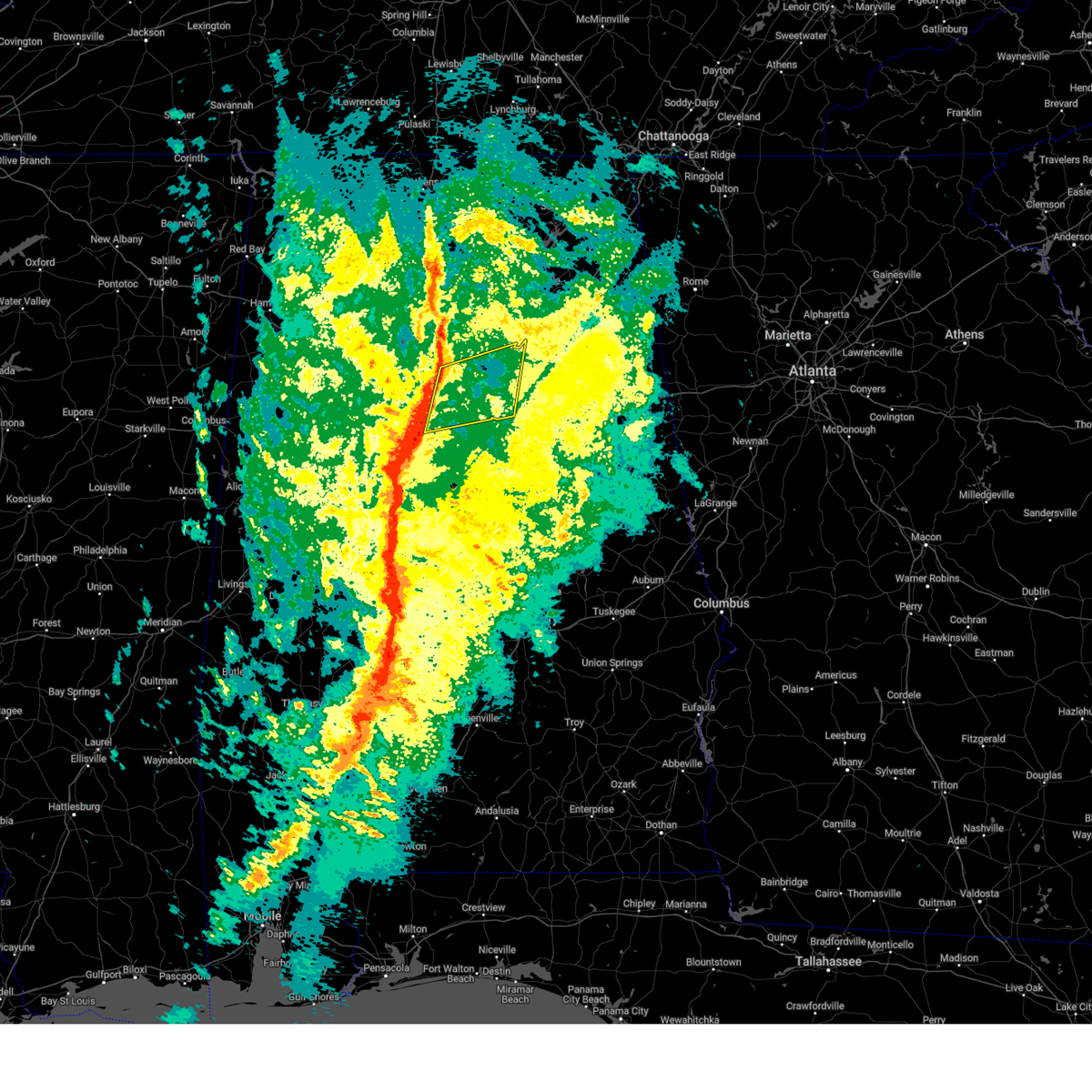
| 6/1/2026 2:35 PM CDT |
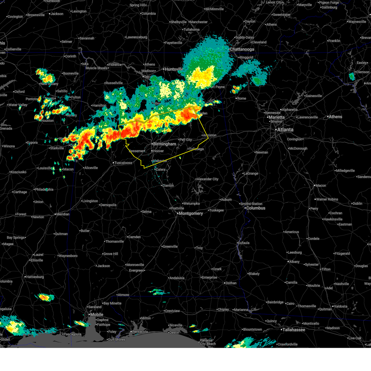 At 234 pm cdt, severe thunderstorms were located along a line extending from near neely henry lake to 6 miles southwest of gorgas, moving southeast at 40 mph (radar indicated). Hazards include 60 mph wind gusts and half dollar size hail. Hail damage to vehicles is expected. expect wind damage to roofs, siding, and trees. Locations impacted include, birmingham, hoover, gadsden, vestavia hills, alabaster, bessemer, homewood, anniston, pelham, oxford, mountain brook, trussville, helena, hueytown, talladega, jasper, gardendale, pell city, irondale, and leeds. At 234 pm cdt, severe thunderstorms were located along a line extending from near neely henry lake to 6 miles southwest of gorgas, moving southeast at 40 mph (radar indicated). Hazards include 60 mph wind gusts and half dollar size hail. Hail damage to vehicles is expected. expect wind damage to roofs, siding, and trees. Locations impacted include, birmingham, hoover, gadsden, vestavia hills, alabaster, bessemer, homewood, anniston, pelham, oxford, mountain brook, trussville, helena, hueytown, talladega, jasper, gardendale, pell city, irondale, and leeds.
|
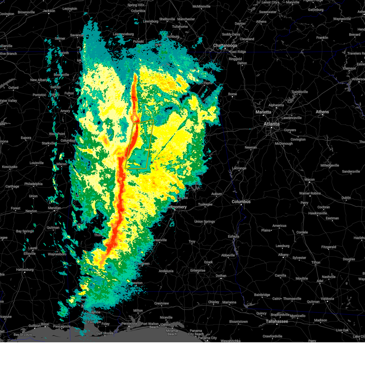
| 6/1/2026 2:27 PM CDT |
 Svrbmx the national weather service in birmingham has issued a * severe thunderstorm warning for, central walker county in central alabama, northern talladega county in east central alabama, blount county in central alabama, western calhoun county in east central alabama, shelby county in central alabama, central etowah county in northeastern alabama, jefferson county in central alabama, st. clair county in central alabama, * until 345 pm cdt. * at 226 pm cdt, severe thunderstorms were located along a line extending from near steele to 6 miles southeast of oakman, moving southeast at 40 mph (radar indicated). Hazards include 60 mph wind gusts and quarter size hail. Hail damage to vehicles is expected. Expect wind damage to roofs, siding, and trees. Svrbmx the national weather service in birmingham has issued a * severe thunderstorm warning for, central walker county in central alabama, northern talladega county in east central alabama, blount county in central alabama, western calhoun county in east central alabama, shelby county in central alabama, central etowah county in northeastern alabama, jefferson county in central alabama, st. clair county in central alabama, * until 345 pm cdt. * at 226 pm cdt, severe thunderstorms were located along a line extending from near steele to 6 miles southeast of oakman, moving southeast at 40 mph (radar indicated). Hazards include 60 mph wind gusts and quarter size hail. Hail damage to vehicles is expected. Expect wind damage to roofs, siding, and trees.
|
| 4/29/2026 1:18 AM CDT |
 At 118 am cdt, severe thunderstorms were located along a line extending from near trafford to near gardendale to birmingham to brighton to near abernant, moving east at 50 mph (radar indicated). Hazards include 60 mph wind gusts. Expect damage to roofs, siding, and trees. Locations impacted include, birmingham, hoover, vestavia hills, bessemer, homewood, mountain brook, trussville, hueytown, gardendale, irondale, leeds, moody, fairfield, fultondale, dallas, center point, pleasant grove, clay, pinson, and tarrant. At 118 am cdt, severe thunderstorms were located along a line extending from near trafford to near gardendale to birmingham to brighton to near abernant, moving east at 50 mph (radar indicated). Hazards include 60 mph wind gusts. Expect damage to roofs, siding, and trees. Locations impacted include, birmingham, hoover, vestavia hills, bessemer, homewood, mountain brook, trussville, hueytown, gardendale, irondale, leeds, moody, fairfield, fultondale, dallas, center point, pleasant grove, clay, pinson, and tarrant.
|
| 4/29/2026 1:04 AM CDT |
 At 104 am cdt, severe thunderstorms were located along a line extending from near arkadelphia to near cardiff to near maytown to 6 miles west of concord to near bankhead lock and dam, moving east at 50 mph (radar indicated). Hazards include 60 mph wind gusts. Expect damage to roofs, siding, and trees. Locations impacted include, birmingham, hoover, vestavia hills, bessemer, homewood, mountain brook, trussville, hueytown, gardendale, irondale, leeds, moody, fairfield, fultondale, sumiton, dallas, center point, pleasant grove, clay, and pinson. At 104 am cdt, severe thunderstorms were located along a line extending from near arkadelphia to near cardiff to near maytown to 6 miles west of concord to near bankhead lock and dam, moving east at 50 mph (radar indicated). Hazards include 60 mph wind gusts. Expect damage to roofs, siding, and trees. Locations impacted include, birmingham, hoover, vestavia hills, bessemer, homewood, mountain brook, trussville, hueytown, gardendale, irondale, leeds, moody, fairfield, fultondale, sumiton, dallas, center point, pleasant grove, clay, and pinson.
|
| 4/29/2026 12:48 AM CDT |
 Svrbmx the national weather service in birmingham has issued a * severe thunderstorm warning for, eastern walker county in central alabama, central tuscaloosa county in west central alabama, southwestern blount county in central alabama, jefferson county in central alabama, * until 130 am cdt. * at 1248 am cdt, severe thunderstorms were located along a line extending from near curry to beloit to near gorgas to near bankhead lock and dam to samantha, moving east at 50 mph (radar indicated). Hazards include 60 mph wind gusts. expect damage to roofs, siding, and trees Svrbmx the national weather service in birmingham has issued a * severe thunderstorm warning for, eastern walker county in central alabama, central tuscaloosa county in west central alabama, southwestern blount county in central alabama, jefferson county in central alabama, * until 130 am cdt. * at 1248 am cdt, severe thunderstorms were located along a line extending from near curry to beloit to near gorgas to near bankhead lock and dam to samantha, moving east at 50 mph (radar indicated). Hazards include 60 mph wind gusts. expect damage to roofs, siding, and trees
|
| 3/9/2026 8:02 PM CDT |
 At 802 pm cdt, severe thunderstorms were located along a line extending from birmingham to ross bridge to near tannehill ironworks state park, moving east at 55 mph (radar indicated). Hazards include 70 mph wind gusts. Expect considerable tree damage. damage is likely to mobile homes, roofs, and outbuildings. Locations impacted include, birmingham, hoover, vestavia hills, bessemer, homewood, mountain brook, hueytown, irondale, fairfield, pleasant grove, midfield, adamsville, brighton, lipscomb, sylvan springs, mulga, maytown, north johns, birmingham fairgounds, and five points south. At 802 pm cdt, severe thunderstorms were located along a line extending from birmingham to ross bridge to near tannehill ironworks state park, moving east at 55 mph (radar indicated). Hazards include 70 mph wind gusts. Expect considerable tree damage. damage is likely to mobile homes, roofs, and outbuildings. Locations impacted include, birmingham, hoover, vestavia hills, bessemer, homewood, mountain brook, hueytown, irondale, fairfield, pleasant grove, midfield, adamsville, brighton, lipscomb, sylvan springs, mulga, maytown, north johns, birmingham fairgounds, and five points south.
|
| 3/9/2026 7:51 PM CDT |
 the severe thunderstorm warning has been cancelled and is no longer in effect the severe thunderstorm warning has been cancelled and is no longer in effect
|
| 3/9/2026 7:51 PM CDT |
 At 751 pm cdt, severe thunderstorms were located along a line extending from near sylvan springs to near north johns to near abernant, moving southeast at 50 mph (radar indicated). Hazards include 70 mph wind gusts. Expect considerable tree damage. damage is likely to mobile homes, roofs, and outbuildings. Locations impacted include, birmingham, hoover, vestavia hills, bessemer, homewood, mountain brook, hueytown, irondale, fairfield, pleasant grove, midfield, adamsville, brighton, lipscomb, sylvan springs, mulga, maytown, north johns, birmingham fairgounds, and five points south. At 751 pm cdt, severe thunderstorms were located along a line extending from near sylvan springs to near north johns to near abernant, moving southeast at 50 mph (radar indicated). Hazards include 70 mph wind gusts. Expect considerable tree damage. damage is likely to mobile homes, roofs, and outbuildings. Locations impacted include, birmingham, hoover, vestavia hills, bessemer, homewood, mountain brook, hueytown, irondale, fairfield, pleasant grove, midfield, adamsville, brighton, lipscomb, sylvan springs, mulga, maytown, north johns, birmingham fairgounds, and five points south.
|
| 3/9/2026 7:42 PM CDT |
 At 741 pm cdt, severe thunderstorms were located along a line extending from near gorgas steam plant to near bull city to near bankhead lock and dam, moving southeast at 50 mph (radar indicated). Hazards include 70 mph wind gusts. Expect considerable tree damage. damage is likely to mobile homes, roofs, and outbuildings. Locations impacted include, birmingham, hoover, vestavia hills, bessemer, homewood, mountain brook, hueytown, irondale, fairfield, pleasant grove, midfield, adamsville, brighton, lipscomb, sylvan springs, mulga, maytown, north johns, birmingham fairgounds, and five points south. At 741 pm cdt, severe thunderstorms were located along a line extending from near gorgas steam plant to near bull city to near bankhead lock and dam, moving southeast at 50 mph (radar indicated). Hazards include 70 mph wind gusts. Expect considerable tree damage. damage is likely to mobile homes, roofs, and outbuildings. Locations impacted include, birmingham, hoover, vestavia hills, bessemer, homewood, mountain brook, hueytown, irondale, fairfield, pleasant grove, midfield, adamsville, brighton, lipscomb, sylvan springs, mulga, maytown, north johns, birmingham fairgounds, and five points south.
|
| 3/9/2026 7:27 PM CDT |
 Svrbmx the national weather service in birmingham has issued a * severe thunderstorm warning for, south central walker county in central alabama, southern jefferson county in central alabama, * until 830 pm cdt. * at 727 pm cdt, severe thunderstorms were located along a line extending from near oakman to near bankhead lock and dam to near samantha, moving southeast at 45 mph (radar indicated). Hazards include 60 mph wind gusts. expect damage to roofs, siding, and trees Svrbmx the national weather service in birmingham has issued a * severe thunderstorm warning for, south central walker county in central alabama, southern jefferson county in central alabama, * until 830 pm cdt. * at 727 pm cdt, severe thunderstorms were located along a line extending from near oakman to near bankhead lock and dam to near samantha, moving southeast at 45 mph (radar indicated). Hazards include 60 mph wind gusts. expect damage to roofs, siding, and trees
|
| 3/7/2026 6:43 PM CST |
 At 643 pm cst, severe thunderstorms were located along a line extending from near aurora to near low gap, moving southeast at 20 mph (radar indicated). Hazards include 60 mph wind gusts. Expect damage to roofs, siding, and trees. Locations impacted include, birmingham, southeastern tuscaloosa, hoover, vestavia hills, bessemer, homewood, mountain brook, trussville, hueytown, gardendale, irondale, leeds, fairfield, fultondale, holt, center point, pleasant grove, clay, pinson, and tarrant. At 643 pm cst, severe thunderstorms were located along a line extending from near aurora to near low gap, moving southeast at 20 mph (radar indicated). Hazards include 60 mph wind gusts. Expect damage to roofs, siding, and trees. Locations impacted include, birmingham, southeastern tuscaloosa, hoover, vestavia hills, bessemer, homewood, mountain brook, trussville, hueytown, gardendale, irondale, leeds, fairfield, fultondale, holt, center point, pleasant grove, clay, pinson, and tarrant.
|
| 3/7/2026 6:43 PM CST |
 the severe thunderstorm warning has been cancelled and is no longer in effect the severe thunderstorm warning has been cancelled and is no longer in effect
|
| 3/7/2026 6:33 PM CST |
 the severe thunderstorm warning has been cancelled and is no longer in effect the severe thunderstorm warning has been cancelled and is no longer in effect
|
| 3/7/2026 6:33 PM CST |
 At 633 pm cst, severe thunderstorms were located along a line extending from near aurora to 6 miles east of moundville, moving east at 30 mph (radar indicated). Hazards include 60 mph wind gusts. Expect damage to roofs, siding, and trees. Locations impacted include, birmingham, tuscaloosa, hoover, vestavia hills, bessemer, homewood, northport, mountain brook, trussville, hueytown, gardendale, irondale, leeds, moody, fairfield, fultondale, oneonta, holt, dallas, and center point. At 633 pm cst, severe thunderstorms were located along a line extending from near aurora to 6 miles east of moundville, moving east at 30 mph (radar indicated). Hazards include 60 mph wind gusts. Expect damage to roofs, siding, and trees. Locations impacted include, birmingham, tuscaloosa, hoover, vestavia hills, bessemer, homewood, northport, mountain brook, trussville, hueytown, gardendale, irondale, leeds, moody, fairfield, fultondale, oneonta, holt, dallas, and center point.
|
| 3/7/2026 6:12 PM CST |
 At 612 pm cst, severe thunderstorms were located along a line extending from near walnut grove to near moundville, moving east at 30 mph (radar indicated). Hazards include 60 mph wind gusts. Expect damage to roofs, siding, and trees. Locations impacted include, birmingham, tuscaloosa, hoover, vestavia hills, bessemer, homewood, northport, mountain brook, trussville, hueytown, gardendale, irondale, leeds, moody, fairfield, fultondale, oneonta, sumiton, dora, and blountsville. At 612 pm cst, severe thunderstorms were located along a line extending from near walnut grove to near moundville, moving east at 30 mph (radar indicated). Hazards include 60 mph wind gusts. Expect damage to roofs, siding, and trees. Locations impacted include, birmingham, tuscaloosa, hoover, vestavia hills, bessemer, homewood, northport, mountain brook, trussville, hueytown, gardendale, irondale, leeds, moody, fairfield, fultondale, oneonta, sumiton, dora, and blountsville.
|
| 3/7/2026 6:00 PM CST |
 Svrbmx the national weather service in birmingham has issued a * severe thunderstorm warning for, southeastern walker county in central alabama, tuscaloosa county in west central alabama, blount county in central alabama, jefferson county in central alabama, * until 700 pm cst. * at 600 pm cst, severe thunderstorms were located along a line extending from near snead to 7 miles northeast of knoxville, moving east at 25 mph (radar indicated). Hazards include 60 mph wind gusts. expect damage to roofs, siding, and trees Svrbmx the national weather service in birmingham has issued a * severe thunderstorm warning for, southeastern walker county in central alabama, tuscaloosa county in west central alabama, blount county in central alabama, jefferson county in central alabama, * until 700 pm cst. * at 600 pm cst, severe thunderstorms were located along a line extending from near snead to 7 miles northeast of knoxville, moving east at 25 mph (radar indicated). Hazards include 60 mph wind gusts. expect damage to roofs, siding, and trees
|
| 11/25/2025 2:43 PM CST |
 At 243 pm cst, severe thunderstorms were located along a line extending from birmingham to bluff park to near helena, moving east at 40 mph (radar indicated). Hazards include 60 mph wind gusts. Expect damage to roofs, siding, and trees. Locations impacted include, birmingham, hoover, vestavia hills, alabaster, bessemer, homewood, pelham, mountain brook, trussville, helena, irondale, leeds, fairfield, chelsea, tarrant, midfield, brighton, indian springs village, lipscomb, and birmingham fairgounds. At 243 pm cst, severe thunderstorms were located along a line extending from birmingham to bluff park to near helena, moving east at 40 mph (radar indicated). Hazards include 60 mph wind gusts. Expect damage to roofs, siding, and trees. Locations impacted include, birmingham, hoover, vestavia hills, alabaster, bessemer, homewood, pelham, mountain brook, trussville, helena, irondale, leeds, fairfield, chelsea, tarrant, midfield, brighton, indian springs village, lipscomb, and birmingham fairgounds.
|
| 11/25/2025 2:27 PM CST |
 Svrbmx the national weather service in birmingham has issued a * severe thunderstorm warning for, central shelby county in central alabama, southeastern jefferson county in central alabama, * until 315 pm cst. * at 227 pm cst, severe thunderstorms were located along a line extending from birmingham to splash adventure to tannehill ironworks state park, moving east at 35 mph (radar indicated). Hazards include 60 mph wind gusts and quarter size hail. Hail damage to vehicles is expected. Expect wind damage to roofs, siding, and trees. Svrbmx the national weather service in birmingham has issued a * severe thunderstorm warning for, central shelby county in central alabama, southeastern jefferson county in central alabama, * until 315 pm cst. * at 227 pm cst, severe thunderstorms were located along a line extending from birmingham to splash adventure to tannehill ironworks state park, moving east at 35 mph (radar indicated). Hazards include 60 mph wind gusts and quarter size hail. Hail damage to vehicles is expected. Expect wind damage to roofs, siding, and trees.
|
| 11/25/2025 4:51 AM CST |
 At 451 am cst, severe thunderstorms were located along a line extending from near cullman to dallas to birmingham to near ross bridge, moving east at 55 mph (radar indicated). Hazards include 70 mph wind gusts. Expect considerable tree damage. damage is likely to mobile homes, roofs, and outbuildings. Locations impacted include, birmingham, hoover, vestavia hills, bessemer, homewood, mountain brook, trussville, hueytown, gardendale, irondale, leeds, moody, fairfield, fultondale, oneonta, blountsville, cleveland, dallas, center point, and pleasant grove. At 451 am cst, severe thunderstorms were located along a line extending from near cullman to dallas to birmingham to near ross bridge, moving east at 55 mph (radar indicated). Hazards include 70 mph wind gusts. Expect considerable tree damage. damage is likely to mobile homes, roofs, and outbuildings. Locations impacted include, birmingham, hoover, vestavia hills, bessemer, homewood, mountain brook, trussville, hueytown, gardendale, irondale, leeds, moody, fairfield, fultondale, oneonta, blountsville, cleveland, dallas, center point, and pleasant grove.
|
| 11/25/2025 4:39 AM CST |
 At 439 am cst, severe thunderstorms were located along a line extending from near cullman to warrior to minor to north johns, moving east at 55 mph (radar indicated). Hazards include 70 mph wind gusts. Expect considerable tree damage. damage is likely to mobile homes, roofs, and outbuildings. Locations impacted include, birmingham, hoover, vestavia hills, bessemer, homewood, mountain brook, trussville, hueytown, gardendale, irondale, leeds, moody, fairfield, fultondale, oneonta, sumiton, blountsville, cleveland, dallas, and center point. At 439 am cst, severe thunderstorms were located along a line extending from near cullman to warrior to minor to north johns, moving east at 55 mph (radar indicated). Hazards include 70 mph wind gusts. Expect considerable tree damage. damage is likely to mobile homes, roofs, and outbuildings. Locations impacted include, birmingham, hoover, vestavia hills, bessemer, homewood, mountain brook, trussville, hueytown, gardendale, irondale, leeds, moody, fairfield, fultondale, oneonta, sumiton, blountsville, cleveland, dallas, and center point.
|
| 11/25/2025 4:28 AM CST |
 At 428 am cst, severe thunderstorms were located along a line extending from near nesmith to near sumiton to near sylvan springs to near brookwood, moving east at 55 mph (radar indicated). Hazards include 60 mph wind gusts. Expect damage to roofs, siding, and trees. Locations impacted include, birmingham, hoover, vestavia hills, bessemer, homewood, mountain brook, trussville, hueytown, gardendale, irondale, leeds, moody, fairfield, fultondale, oneonta, sumiton, blountsville, cleveland, dallas, and center point. At 428 am cst, severe thunderstorms were located along a line extending from near nesmith to near sumiton to near sylvan springs to near brookwood, moving east at 55 mph (radar indicated). Hazards include 60 mph wind gusts. Expect damage to roofs, siding, and trees. Locations impacted include, birmingham, hoover, vestavia hills, bessemer, homewood, mountain brook, trussville, hueytown, gardendale, irondale, leeds, moody, fairfield, fultondale, oneonta, sumiton, blountsville, cleveland, dallas, and center point.
|
| 11/25/2025 4:09 AM CST |
 Svrbmx the national weather service in birmingham has issued a * severe thunderstorm warning for, blount county in central alabama, jefferson county in central alabama, * until 530 am cst. * at 409 am cst, severe thunderstorms were located along a line extending from corinth rec area to near parrish to near bankhead lock and dam to lake lurleen state park, moving east at 50 mph (radar indicated). Hazards include 60 mph wind gusts. expect damage to roofs, siding, and trees Svrbmx the national weather service in birmingham has issued a * severe thunderstorm warning for, blount county in central alabama, jefferson county in central alabama, * until 530 am cst. * at 409 am cst, severe thunderstorms were located along a line extending from corinth rec area to near parrish to near bankhead lock and dam to lake lurleen state park, moving east at 50 mph (radar indicated). Hazards include 60 mph wind gusts. expect damage to roofs, siding, and trees
|
| 6/27/2025 7:50 PM CDT |
 the severe thunderstorm warning has been cancelled and is no longer in effect the severe thunderstorm warning has been cancelled and is no longer in effect
|
| 6/27/2025 7:33 PM CDT |
 At 733 pm cdt, severe thunderstorms were located along a line extending from 6 miles west of concord to bessemer, moving northeast at 10 mph (radar indicated). Hazards include 60 mph wind gusts and penny size hail. Expect damage to roofs, siding, and trees. locations impacted include, southwestern birmingham, bessemer, hueytown, fairfield, pleasant grove, midfield, adamsville, brighton, lipscomb, sylvan springs, mulga, maytown, west jefferson, birmingham fairgounds, b. j. c. c. Edgewater, ensley, legion field, forestdale, and splash adventure. At 733 pm cdt, severe thunderstorms were located along a line extending from 6 miles west of concord to bessemer, moving northeast at 10 mph (radar indicated). Hazards include 60 mph wind gusts and penny size hail. Expect damage to roofs, siding, and trees. locations impacted include, southwestern birmingham, bessemer, hueytown, fairfield, pleasant grove, midfield, adamsville, brighton, lipscomb, sylvan springs, mulga, maytown, west jefferson, birmingham fairgounds, b. j. c. c. Edgewater, ensley, legion field, forestdale, and splash adventure.
|
| 6/27/2025 7:20 PM CDT |
 Svrbmx the national weather service in birmingham has issued a * severe thunderstorm warning for, southwestern jefferson county in central alabama, * until 800 pm cdt. * at 720 pm cdt, severe thunderstorms were located along a line extending from near bull city to splash adventure, moving northeast at 10 mph (radar indicated). Hazards include 60 mph wind gusts and penny size hail. expect damage to roofs, siding, and trees Svrbmx the national weather service in birmingham has issued a * severe thunderstorm warning for, southwestern jefferson county in central alabama, * until 800 pm cdt. * at 720 pm cdt, severe thunderstorms were located along a line extending from near bull city to splash adventure, moving northeast at 10 mph (radar indicated). Hazards include 60 mph wind gusts and penny size hail. expect damage to roofs, siding, and trees
|
| 6/14/2025 3:15 PM CDT |
 Svrbmx the national weather service in birmingham has issued a * severe thunderstorm warning for, northern shelby county in central alabama, southeastern jefferson county in central alabama, st. clair county in central alabama, * until 415 pm cdt. * at 315 pm cdt, severe thunderstorms were located along a line extending from near springville to near bessemer, moving east at 45 mph (radar indicated). Hazards include 60 mph wind gusts and quarter size hail. Hail damage to vehicles is expected. Expect wind damage to roofs, siding, and trees. Svrbmx the national weather service in birmingham has issued a * severe thunderstorm warning for, northern shelby county in central alabama, southeastern jefferson county in central alabama, st. clair county in central alabama, * until 415 pm cdt. * at 315 pm cdt, severe thunderstorms were located along a line extending from near springville to near bessemer, moving east at 45 mph (radar indicated). Hazards include 60 mph wind gusts and quarter size hail. Hail damage to vehicles is expected. Expect wind damage to roofs, siding, and trees.
|
| 6/7/2025 2:31 PM CDT |
 At 231 pm cdt, severe thunderstorms were located along a line extending from near mclarty to oneonta to birmingham to near tannehill ironworks state park, moving east at 45 mph (radar indicated). Hazards include 60 mph wind gusts and penny size hail. Expect damage to roofs, siding, and trees. Locations impacted include, birmingham, hoover, vestavia hills, bessemer, homewood, mountain brook, trussville, hueytown, gardendale, irondale, leeds, moody, fairfield, fultondale, oneonta, blountsville, cleveland, dallas, center point, and pleasant grove. At 231 pm cdt, severe thunderstorms were located along a line extending from near mclarty to oneonta to birmingham to near tannehill ironworks state park, moving east at 45 mph (radar indicated). Hazards include 60 mph wind gusts and penny size hail. Expect damage to roofs, siding, and trees. Locations impacted include, birmingham, hoover, vestavia hills, bessemer, homewood, mountain brook, trussville, hueytown, gardendale, irondale, leeds, moody, fairfield, fultondale, oneonta, blountsville, cleveland, dallas, center point, and pleasant grove.
|
| 6/7/2025 2:12 PM CDT |
 At 212 pm cdt, severe thunderstorms were located along a line extending from near holly pond to near blountsville to adamsville to near bull city, moving east at 70 mph (radar indicated). Hazards include 70 mph wind gusts and penny size hail. Expect considerable tree damage. damage is likely to mobile homes, roofs, and outbuildings. Locations impacted include, birmingham, hoover, vestavia hills, bessemer, homewood, mountain brook, trussville, hueytown, gardendale, irondale, leeds, moody, fairfield, fultondale, oneonta, blountsville, cleveland, dallas, center point, and pleasant grove. At 212 pm cdt, severe thunderstorms were located along a line extending from near holly pond to near blountsville to adamsville to near bull city, moving east at 70 mph (radar indicated). Hazards include 70 mph wind gusts and penny size hail. Expect considerable tree damage. damage is likely to mobile homes, roofs, and outbuildings. Locations impacted include, birmingham, hoover, vestavia hills, bessemer, homewood, mountain brook, trussville, hueytown, gardendale, irondale, leeds, moody, fairfield, fultondale, oneonta, blountsville, cleveland, dallas, center point, and pleasant grove.
|
| 6/7/2025 2:02 PM CDT |
 At 202 pm cdt, severe thunderstorms were located along a line extending from 8 miles southeast of falkville to near cullman to near sipsey to gorgas steam plant to near binion creek landing, moving east at 50 mph (radar indicated). Hazards include 70 mph wind gusts and penny size hail. Expect considerable tree damage. damage is likely to mobile homes, roofs, and outbuildings. Locations impacted include, birmingham, hoover, vestavia hills, bessemer, homewood, mountain brook, trussville, hueytown, gardendale, irondale, leeds, moody, fairfield, fultondale, oneonta, blountsville, cleveland, dallas, center point, and pleasant grove. At 202 pm cdt, severe thunderstorms were located along a line extending from 8 miles southeast of falkville to near cullman to near sipsey to gorgas steam plant to near binion creek landing, moving east at 50 mph (radar indicated). Hazards include 70 mph wind gusts and penny size hail. Expect considerable tree damage. damage is likely to mobile homes, roofs, and outbuildings. Locations impacted include, birmingham, hoover, vestavia hills, bessemer, homewood, mountain brook, trussville, hueytown, gardendale, irondale, leeds, moody, fairfield, fultondale, oneonta, blountsville, cleveland, dallas, center point, and pleasant grove.
|
| 6/7/2025 1:47 PM CDT |
 Svrbmx the national weather service in birmingham has issued a * severe thunderstorm warning for, blount county in central alabama, jefferson county in central alabama, * until 300 pm cdt. * at 146 pm cdt, severe thunderstorms were located along a line extending from addison to jasper to oakman to near binion creek landing, moving east at 65 mph (radar indicated). Hazards include 70 mph wind gusts and penny size hail. Expect considerable tree damage. Damage is likely to mobile homes, roofs, and outbuildings. Svrbmx the national weather service in birmingham has issued a * severe thunderstorm warning for, blount county in central alabama, jefferson county in central alabama, * until 300 pm cdt. * at 146 pm cdt, severe thunderstorms were located along a line extending from addison to jasper to oakman to near binion creek landing, moving east at 65 mph (radar indicated). Hazards include 70 mph wind gusts and penny size hail. Expect considerable tree damage. Damage is likely to mobile homes, roofs, and outbuildings.
|
| 5/18/2025 6:47 AM CDT |
 At 647 am cdt, a severe thunderstorm was located near chelsea, moving east at 65 mph (radar indicated). Hazards include 70 mph wind gusts and quarter size hail. Hail damage to vehicles is expected. expect considerable tree damage. wind damage is also likely to mobile homes, roofs, and outbuildings. Locations impacted include, lipscomb, american village, shannon, oak mountain state park, camp branch, hoover veterans park, alabaster veterans park, vestavia hills, maylene, helena, chelsea, inverness, cahaba heights, patton creek, hoover metropolitan stadium, university of montevallo, the summit, bessemer airport, shelby county airport, and calera. At 647 am cdt, a severe thunderstorm was located near chelsea, moving east at 65 mph (radar indicated). Hazards include 70 mph wind gusts and quarter size hail. Hail damage to vehicles is expected. expect considerable tree damage. wind damage is also likely to mobile homes, roofs, and outbuildings. Locations impacted include, lipscomb, american village, shannon, oak mountain state park, camp branch, hoover veterans park, alabaster veterans park, vestavia hills, maylene, helena, chelsea, inverness, cahaba heights, patton creek, hoover metropolitan stadium, university of montevallo, the summit, bessemer airport, shelby county airport, and calera.
|
| 5/18/2025 6:47 AM CDT |
 the severe thunderstorm warning has been cancelled and is no longer in effect the severe thunderstorm warning has been cancelled and is no longer in effect
|
| 5/18/2025 6:44 AM CDT |
 Svrbmx the national weather service in birmingham has issued a * severe thunderstorm warning for, talladega county in east central alabama, shelby county in central alabama, southeastern jefferson county in central alabama, southwestern st. clair county in central alabama, southwestern clay county in east central alabama, * until 730 am cdt. * at 644 am cdt, severe thunderstorms were located along a line extending from near homewood to indian springs village to shelby county airport, moving east at 60 mph (radar indicated). Hazards include 70 mph wind gusts and quarter size hail. Hail damage to vehicles is expected. expect considerable tree damage. Wind damage is also likely to mobile homes, roofs, and outbuildings. Svrbmx the national weather service in birmingham has issued a * severe thunderstorm warning for, talladega county in east central alabama, shelby county in central alabama, southeastern jefferson county in central alabama, southwestern st. clair county in central alabama, southwestern clay county in east central alabama, * until 730 am cdt. * at 644 am cdt, severe thunderstorms were located along a line extending from near homewood to indian springs village to shelby county airport, moving east at 60 mph (radar indicated). Hazards include 70 mph wind gusts and quarter size hail. Hail damage to vehicles is expected. expect considerable tree damage. Wind damage is also likely to mobile homes, roofs, and outbuildings.
|
| 5/18/2025 6:32 AM CDT |
 At 632 am cdt, a severe thunderstorm was located near helena, moving east at 65 mph. this is a destructive storm for bibb, shelby, tuscaloosa counties (radar indicated). Hazards include 80 mph wind gusts and quarter size hail. Flying debris will be dangerous to those caught without shelter. mobile homes will be heavily damaged. expect considerable damage to roofs, windows, and vehicles. extensive tree damage and power outages are likely. Locations impacted include, bull city, lipscomb, american village, shannon, oak mountain state park, woodstock, camp branch, hoover veterans park, alabaster veterans park, green pond, pleasant grove, vestavia hills, maylene, caffee junction, helena, chelsea, mccalla, inverness, cahaba heights, and brierfield ironworks park. At 632 am cdt, a severe thunderstorm was located near helena, moving east at 65 mph. this is a destructive storm for bibb, shelby, tuscaloosa counties (radar indicated). Hazards include 80 mph wind gusts and quarter size hail. Flying debris will be dangerous to those caught without shelter. mobile homes will be heavily damaged. expect considerable damage to roofs, windows, and vehicles. extensive tree damage and power outages are likely. Locations impacted include, bull city, lipscomb, american village, shannon, oak mountain state park, woodstock, camp branch, hoover veterans park, alabaster veterans park, green pond, pleasant grove, vestavia hills, maylene, caffee junction, helena, chelsea, mccalla, inverness, cahaba heights, and brierfield ironworks park.
|
| 5/18/2025 6:18 AM CDT |
 At 617 am cdt, a severe thunderstorm was located over abernant, or 13 miles west of bessemer, moving east at 65 mph. this is a destructive storm for bibb, jefferson, shelby counties (radar indicated). Hazards include 80 mph wind gusts and quarter size hail. Flying debris will be dangerous to those caught without shelter. mobile homes will be heavily damaged. expect considerable damage to roofs, windows, and vehicles. extensive tree damage and power outages are likely. locations impacted include, american village, brookwood, oak mountain state park, camp branch, green pond, maylene, helena, camp horne b. s. a. Wilton, patton creek, weller, mcadory, west blocton, the summit, shelby county airport, calera, meadowbrook, dolomite, abernant, and east brookwood. At 617 am cdt, a severe thunderstorm was located over abernant, or 13 miles west of bessemer, moving east at 65 mph. this is a destructive storm for bibb, jefferson, shelby counties (radar indicated). Hazards include 80 mph wind gusts and quarter size hail. Flying debris will be dangerous to those caught without shelter. mobile homes will be heavily damaged. expect considerable damage to roofs, windows, and vehicles. extensive tree damage and power outages are likely. locations impacted include, american village, brookwood, oak mountain state park, camp branch, green pond, maylene, helena, camp horne b. s. a. Wilton, patton creek, weller, mcadory, west blocton, the summit, shelby county airport, calera, meadowbrook, dolomite, abernant, and east brookwood.
|
| 5/18/2025 6:08 AM CDT |
 Svrbmx the national weather service in birmingham has issued a * severe thunderstorm warning for, central tuscaloosa county in west central alabama, western shelby county in central alabama, northeastern bibb county in central alabama, southern jefferson county in central alabama, * until 700 am cdt. * at 607 am cdt, a severe thunderstorm was located near bankhead lock and dam, or 10 miles northeast of holt, moving east at 65 mph (radar indicated). Hazards include 70 mph wind gusts and quarter size hail. Hail damage to vehicles is expected. expect considerable tree damage. Wind damage is also likely to mobile homes, roofs, and outbuildings. Svrbmx the national weather service in birmingham has issued a * severe thunderstorm warning for, central tuscaloosa county in west central alabama, western shelby county in central alabama, northeastern bibb county in central alabama, southern jefferson county in central alabama, * until 700 am cdt. * at 607 am cdt, a severe thunderstorm was located near bankhead lock and dam, or 10 miles northeast of holt, moving east at 65 mph (radar indicated). Hazards include 70 mph wind gusts and quarter size hail. Hail damage to vehicles is expected. expect considerable tree damage. Wind damage is also likely to mobile homes, roofs, and outbuildings.
|
| 5/18/2025 6:03 AM CDT |
 At 603 am cdt, a severe thunderstorm was located over oak mountain amphitheater, or near hoover, moving east at 45 mph (radar indicated). Hazards include 60 mph wind gusts and quarter size hail. Hail damage to vehicles is expected. expect wind damage to roofs, siding, and trees. locations impacted include, mountain brook, lipscomb, five points south, shannon, oak mountain state park, liberty park, hoover veterans park, vestavia hills, helena, chelsea, u. a. b. Campus, highland park golf course, inverness, grants mill road bridge, cahaba heights, patton creek, birmingham race course, ruffner mountain, hoover metropolitan stadium, and the summit. At 603 am cdt, a severe thunderstorm was located over oak mountain amphitheater, or near hoover, moving east at 45 mph (radar indicated). Hazards include 60 mph wind gusts and quarter size hail. Hail damage to vehicles is expected. expect wind damage to roofs, siding, and trees. locations impacted include, mountain brook, lipscomb, five points south, shannon, oak mountain state park, liberty park, hoover veterans park, vestavia hills, helena, chelsea, u. a. b. Campus, highland park golf course, inverness, grants mill road bridge, cahaba heights, patton creek, birmingham race course, ruffner mountain, hoover metropolitan stadium, and the summit.
|
| 5/18/2025 5:48 AM CDT |
 Svrbmx the national weather service in birmingham has issued a * severe thunderstorm warning for, central shelby county in central alabama, southeastern jefferson county in central alabama, * until 615 am cdt. * at 548 am cdt, a severe thunderstorm was located near bessemer, moving east at 45 mph (radar indicated). Hazards include 60 mph wind gusts and quarter size hail. Hail damage to vehicles is expected. Expect wind damage to roofs, siding, and trees. Svrbmx the national weather service in birmingham has issued a * severe thunderstorm warning for, central shelby county in central alabama, southeastern jefferson county in central alabama, * until 615 am cdt. * at 548 am cdt, a severe thunderstorm was located near bessemer, moving east at 45 mph (radar indicated). Hazards include 60 mph wind gusts and quarter size hail. Hail damage to vehicles is expected. Expect wind damage to roofs, siding, and trees.
|
| 5/17/2025 4:59 AM CDT |
 Svrbmx the national weather service in birmingham has issued a * severe thunderstorm warning for, shelby county in central alabama, southeastern jefferson county in central alabama, central st. clair county in central alabama, * until 545 am cdt. * at 459 am cdt, severe thunderstorms were located along a line extending from near morris to brighton to near deerlick creek campgrounds, moving east at 50 mph (radar indicated). Hazards include 60 mph wind gusts. expect damage to roofs, siding, and trees Svrbmx the national weather service in birmingham has issued a * severe thunderstorm warning for, shelby county in central alabama, southeastern jefferson county in central alabama, central st. clair county in central alabama, * until 545 am cdt. * at 459 am cdt, severe thunderstorms were located along a line extending from near morris to brighton to near deerlick creek campgrounds, moving east at 50 mph (radar indicated). Hazards include 60 mph wind gusts. expect damage to roofs, siding, and trees
|
| 5/17/2025 4:41 AM CDT |
 At 440 am cdt, severe thunderstorms were located along a line extending from near morris to near benevola, moving southeast at 35 mph (radar indicated). Hazards include 60 mph wind gusts and quarter size hail. Hail damage to vehicles is expected. expect wind damage to roofs, siding, and trees. locations impacted include, lake tuscaloosa, palmerdale, englewood, northport, smoke rise, samantha, brookwood, mulga, new castle, mcfarland mall, ensley, miller steam plant, wiley, echola, tuscaloosa regional airport, lake tuscaloosa dam, camp horne b. s. a. Burnwell, village springs, and weller. At 440 am cdt, severe thunderstorms were located along a line extending from near morris to near benevola, moving southeast at 35 mph (radar indicated). Hazards include 60 mph wind gusts and quarter size hail. Hail damage to vehicles is expected. expect wind damage to roofs, siding, and trees. locations impacted include, lake tuscaloosa, palmerdale, englewood, northport, smoke rise, samantha, brookwood, mulga, new castle, mcfarland mall, ensley, miller steam plant, wiley, echola, tuscaloosa regional airport, lake tuscaloosa dam, camp horne b. s. a. Burnwell, village springs, and weller.
|
| 5/17/2025 4:41 AM CDT |
 the severe thunderstorm warning has been cancelled and is no longer in effect the severe thunderstorm warning has been cancelled and is no longer in effect
|
| 5/17/2025 4:23 AM CDT |
 the severe thunderstorm warning has been cancelled and is no longer in effect the severe thunderstorm warning has been cancelled and is no longer in effect
|
| 5/17/2025 4:23 AM CDT |
 At 423 am cdt, severe thunderstorms were located along a line extending from near arkadelphia to near carrollton, moving southeast at 35 mph (radar indicated). Hazards include 60 mph wind gusts and quarter size hail. Hail damage to vehicles is expected. expect wind damage to roofs, siding, and trees. Locations impacted include, aliceville, lake tuscaloosa, palmerdale, carrollton, englewood, ralph, northport, smoke rise, samantha, brookwood, mulga, new castle, mcfarland mall, kirk, ensley, miller steam plant, pleasant ridge, wiley, lewiston, and benevola. At 423 am cdt, severe thunderstorms were located along a line extending from near arkadelphia to near carrollton, moving southeast at 35 mph (radar indicated). Hazards include 60 mph wind gusts and quarter size hail. Hail damage to vehicles is expected. expect wind damage to roofs, siding, and trees. Locations impacted include, aliceville, lake tuscaloosa, palmerdale, carrollton, englewood, ralph, northport, smoke rise, samantha, brookwood, mulga, new castle, mcfarland mall, kirk, ensley, miller steam plant, pleasant ridge, wiley, lewiston, and benevola.
|
| 5/17/2025 4:00 AM CDT |
 Svrbmx the national weather service in birmingham has issued a * severe thunderstorm warning for, walker county in central alabama, tuscaloosa county in west central alabama, pickens county in west central alabama, southwestern blount county in central alabama, northern greene county in west central alabama, jefferson county in central alabama, southeastern winston county in northwestern alabama, fayette county in west central alabama, southeastern lamar county in west central alabama, * until 500 am cdt. * at 400 am cdt, severe thunderstorms were located along a line extending from smith dam to near ethelsville, moving southeast at 35 mph (radar indicated). Hazards include 60 mph wind gusts and quarter size hail. Hail damage to vehicles is expected. Expect wind damage to roofs, siding, and trees. Svrbmx the national weather service in birmingham has issued a * severe thunderstorm warning for, walker county in central alabama, tuscaloosa county in west central alabama, pickens county in west central alabama, southwestern blount county in central alabama, northern greene county in west central alabama, jefferson county in central alabama, southeastern winston county in northwestern alabama, fayette county in west central alabama, southeastern lamar county in west central alabama, * until 500 am cdt. * at 400 am cdt, severe thunderstorms were located along a line extending from smith dam to near ethelsville, moving southeast at 35 mph (radar indicated). Hazards include 60 mph wind gusts and quarter size hail. Hail damage to vehicles is expected. Expect wind damage to roofs, siding, and trees.
|
| 5/2/2025 6:13 PM CDT |
 At 613 pm cdt, severe thunderstorms were located along a line extending from near odenville to 6 miles northwest of ashby, moving east at 40 mph (radar indicated). Hazards include 60 mph wind gusts and quarter size hail. Hail damage to vehicles is expected. expect wind damage to roofs, siding, and trees. Locations impacted include, minooka park, mountain brook, wattsville, american village, westover, oak mountain state park, bibb county airport, camp branch, liberty park, green pond, pearson, maylene, camp winnataska, helena, highland park golf course, grants mill road bridge, leeds, wilton, patton creek, and chula vista. At 613 pm cdt, severe thunderstorms were located along a line extending from near odenville to 6 miles northwest of ashby, moving east at 40 mph (radar indicated). Hazards include 60 mph wind gusts and quarter size hail. Hail damage to vehicles is expected. expect wind damage to roofs, siding, and trees. Locations impacted include, minooka park, mountain brook, wattsville, american village, westover, oak mountain state park, bibb county airport, camp branch, liberty park, green pond, pearson, maylene, camp winnataska, helena, highland park golf course, grants mill road bridge, leeds, wilton, patton creek, and chula vista.
|
| 5/2/2025 5:47 PM CDT |
 At 547 pm cdt, severe thunderstorms were located along a line extending from clay to near eoline, moving east at 40 mph (radar indicated). Hazards include 60 mph wind gusts and quarter size hail. Hail damage to vehicles is expected. expect wind damage to roofs, siding, and trees. Locations impacted include, minooka park, mountain brook, wattsville, american village, westover, mulga, new castle, oak mountain state park, bibb county airport, camp branch, liberty park, green pond, ensley, pearson, maylene, camp winnataska, helena, highland park golf course, grants mill road bridge, and leeds. At 547 pm cdt, severe thunderstorms were located along a line extending from clay to near eoline, moving east at 40 mph (radar indicated). Hazards include 60 mph wind gusts and quarter size hail. Hail damage to vehicles is expected. expect wind damage to roofs, siding, and trees. Locations impacted include, minooka park, mountain brook, wattsville, american village, westover, mulga, new castle, oak mountain state park, bibb county airport, camp branch, liberty park, green pond, ensley, pearson, maylene, camp winnataska, helena, highland park golf course, grants mill road bridge, and leeds.
|
| 5/2/2025 5:41 PM CDT |
 At 541 pm cdt, severe thunderstorms were located along a line extending from near albertville to birmingham fairgounds to near low gap, moving east at 40 mph (radar indicated). Hazards include 60 mph wind gusts and quarter size hail. Hail damage to vehicles is expected. expect wind damage to roofs, siding, and trees. locations impacted include, palmerdale, englewood, smoke rise, brookwood, mulga, new castle, mcfarland mall, green pond, ensley, miller steam plant, pearson, highland park golf course, lake tuscaloosa dam, snead, camp horne b. s. a. Village springs, weller, locust fork, mcadory, and duncanville. At 541 pm cdt, severe thunderstorms were located along a line extending from near albertville to birmingham fairgounds to near low gap, moving east at 40 mph (radar indicated). Hazards include 60 mph wind gusts and quarter size hail. Hail damage to vehicles is expected. expect wind damage to roofs, siding, and trees. locations impacted include, palmerdale, englewood, smoke rise, brookwood, mulga, new castle, mcfarland mall, green pond, ensley, miller steam plant, pearson, highland park golf course, lake tuscaloosa dam, snead, camp horne b. s. a. Village springs, weller, locust fork, mcadory, and duncanville.
|
| 5/2/2025 5:23 PM CDT |
 Svrbmx the national weather service in birmingham has issued a * severe thunderstorm warning for, north central chilton county in central alabama, southeastern tuscaloosa county in west central alabama, shelby county in central alabama, bibb county in central alabama, jefferson county in central alabama, southern st. clair county in central alabama, * until 700 pm cdt. * at 523 pm cdt, severe thunderstorms were located along a line extending from gardendale to near low gap, moving east at 40 mph (radar indicated). Hazards include 60 mph wind gusts and quarter size hail. Hail damage to vehicles is expected. Expect wind damage to roofs, siding, and trees. Svrbmx the national weather service in birmingham has issued a * severe thunderstorm warning for, north central chilton county in central alabama, southeastern tuscaloosa county in west central alabama, shelby county in central alabama, bibb county in central alabama, jefferson county in central alabama, southern st. clair county in central alabama, * until 700 pm cdt. * at 523 pm cdt, severe thunderstorms were located along a line extending from gardendale to near low gap, moving east at 40 mph (radar indicated). Hazards include 60 mph wind gusts and quarter size hail. Hail damage to vehicles is expected. Expect wind damage to roofs, siding, and trees.
|
| 5/2/2025 5:10 PM CDT |
 At 510 pm cdt, severe thunderstorms were located along a line extending from near strawberry to 6 miles west of concord to moundville, moving east at 40 mph (radar indicated). Hazards include 60 mph wind gusts and quarter size hail. Hail damage to vehicles is expected. expect wind damage to roofs, siding, and trees. Locations impacted include, lake tuscaloosa, palmerdale, englewood, ralph, northport, smoke rise, brookwood, mulga, new castle, bangor, mcfarland mall, green pond, ensley, miller steam plant, pearson, wiley, tuscaloosa regional airport, highland park golf course, lake tuscaloosa dam, and chamblees mill. At 510 pm cdt, severe thunderstorms were located along a line extending from near strawberry to 6 miles west of concord to moundville, moving east at 40 mph (radar indicated). Hazards include 60 mph wind gusts and quarter size hail. Hail damage to vehicles is expected. expect wind damage to roofs, siding, and trees. Locations impacted include, lake tuscaloosa, palmerdale, englewood, ralph, northport, smoke rise, brookwood, mulga, new castle, bangor, mcfarland mall, green pond, ensley, miller steam plant, pearson, wiley, tuscaloosa regional airport, highland park golf course, lake tuscaloosa dam, and chamblees mill.
|
| 5/2/2025 4:39 PM CDT |
 Svrbmx the national weather service in birmingham has issued a * severe thunderstorm warning for, tuscaloosa county in west central alabama, blount county in central alabama, jefferson county in central alabama, * until 600 pm cdt. * at 438 pm cdt, severe thunderstorms were located along a line extending from near cullman to 6 miles west of bankhead lock and dam to union, moving east at 40 mph (radar indicated). Hazards include 60 mph wind gusts and quarter size hail. Hail damage to vehicles is expected. Expect wind damage to roofs, siding, and trees. Svrbmx the national weather service in birmingham has issued a * severe thunderstorm warning for, tuscaloosa county in west central alabama, blount county in central alabama, jefferson county in central alabama, * until 600 pm cdt. * at 438 pm cdt, severe thunderstorms were located along a line extending from near cullman to 6 miles west of bankhead lock and dam to union, moving east at 40 mph (radar indicated). Hazards include 60 mph wind gusts and quarter size hail. Hail damage to vehicles is expected. Expect wind damage to roofs, siding, and trees.
|
| 4/10/2025 9:07 PM CDT |
 the severe thunderstorm warning has been cancelled and is no longer in effect the severe thunderstorm warning has been cancelled and is no longer in effect
|
| 4/10/2025 9:01 PM CDT |
 At 901 pm cdt, severe thunderstorms were located along a line extending from near vandiver to woodstock, moving southeast at 65 mph (radar indicated). Hazards include 60 mph wind gusts. Expect damage to roofs, siding, and trees. locations impacted include, birmingham fairgounds, mountain brook, chalkville, lipscomb, shops of grand river, adamsville, watson, five points south, shannon, mulga, new castle, liberty park, pleasant grove, gardendale, ensley, vestavia hills, docena, u. a. b. Campus, highland park golf course, and mccalla. At 901 pm cdt, severe thunderstorms were located along a line extending from near vandiver to woodstock, moving southeast at 65 mph (radar indicated). Hazards include 60 mph wind gusts. Expect damage to roofs, siding, and trees. locations impacted include, birmingham fairgounds, mountain brook, chalkville, lipscomb, shops of grand river, adamsville, watson, five points south, shannon, mulga, new castle, liberty park, pleasant grove, gardendale, ensley, vestavia hills, docena, u. a. b. Campus, highland park golf course, and mccalla.
|
| 4/10/2025 8:30 PM CDT |
 Svrbmx the national weather service in birmingham has issued a * severe thunderstorm warning for, jefferson county in central alabama, * until 930 pm cdt. * at 830 pm cdt, severe thunderstorms were located along a line extending from near arkadelphia to 7 miles southwest of gorgas steam plant, moving east at 55 mph (radar indicated). Hazards include 60 mph wind gusts. expect damage to roofs, siding, and trees Svrbmx the national weather service in birmingham has issued a * severe thunderstorm warning for, jefferson county in central alabama, * until 930 pm cdt. * at 830 pm cdt, severe thunderstorms were located along a line extending from near arkadelphia to 7 miles southwest of gorgas steam plant, moving east at 55 mph (radar indicated). Hazards include 60 mph wind gusts. expect damage to roofs, siding, and trees
|
| 3/4/2025 9:03 PM CST |
 At 903 pm cst, severe thunderstorms were located along a line extending from dallas to inverness, moving east at 35 mph (radar indicated). Hazards include 60 mph wind gusts. Expect damage to roofs, siding, and trees. locations impacted include, birmingham fairgounds, cardiff, lipscomb, adamsville, watson, shannon, mulga, pleasant grove, gardendale, ensley, docena, maylene, helena, morris, u. a. b. Campus, mccalla, wilton, mcadory, hoover metropolitan stadium, and brookside. At 903 pm cst, severe thunderstorms were located along a line extending from dallas to inverness, moving east at 35 mph (radar indicated). Hazards include 60 mph wind gusts. Expect damage to roofs, siding, and trees. locations impacted include, birmingham fairgounds, cardiff, lipscomb, adamsville, watson, shannon, mulga, pleasant grove, gardendale, ensley, docena, maylene, helena, morris, u. a. b. Campus, mccalla, wilton, mcadory, hoover metropolitan stadium, and brookside.
|
| 3/4/2025 9:03 PM CST |
 the severe thunderstorm warning has been cancelled and is no longer in effect the severe thunderstorm warning has been cancelled and is no longer in effect
|
| 3/4/2025 8:47 PM CST |
 Svrbmx the national weather service in birmingham has issued a * severe thunderstorm warning for, southeastern blount county in central alabama, northeastern jefferson county in central alabama, northwestern st. clair county in central alabama, * until 945 pm cst. * at 846 pm cst, severe thunderstorms were located along a line extending from warrior to mcdonald chapel, moving northeast at 45 mph (radar indicated). Hazards include 60 mph wind gusts. expect damage to roofs, siding, and trees Svrbmx the national weather service in birmingham has issued a * severe thunderstorm warning for, southeastern blount county in central alabama, northeastern jefferson county in central alabama, northwestern st. clair county in central alabama, * until 945 pm cst. * at 846 pm cst, severe thunderstorms were located along a line extending from warrior to mcdonald chapel, moving northeast at 45 mph (radar indicated). Hazards include 60 mph wind gusts. expect damage to roofs, siding, and trees
|
| 3/4/2025 8:30 PM CST |
 At 830 pm cst, severe thunderstorms were located along a line extending from near arkadelphia to near splash adventure, moving northeast at 55 mph (radar indicated). Hazards include 60 mph wind gusts. Expect damage to roofs, siding, and trees. Locations impacted include, sayre, birmingham fairgounds, cardiff, lipscomb, sumiton, adamsville, watson, shannon, mulga, woodstock, green pond, pleasant grove, gardendale, ensley, miller steam plant, docena, maylene, caffee junction, helena, and morris. At 830 pm cst, severe thunderstorms were located along a line extending from near arkadelphia to near splash adventure, moving northeast at 55 mph (radar indicated). Hazards include 60 mph wind gusts. Expect damage to roofs, siding, and trees. Locations impacted include, sayre, birmingham fairgounds, cardiff, lipscomb, sumiton, adamsville, watson, shannon, mulga, woodstock, green pond, pleasant grove, gardendale, ensley, miller steam plant, docena, maylene, caffee junction, helena, and morris.
|
| 3/4/2025 8:09 PM CST |
 Svrbmx the national weather service in birmingham has issued a * severe thunderstorm warning for, southeastern walker county in central alabama, eastern tuscaloosa county in west central alabama, southwestern blount county in central alabama, southwestern shelby county in central alabama, northern bibb county in central alabama, jefferson county in central alabama, * until 915 pm cst. * at 808 pm cst, severe thunderstorms were located along a line extending from 6 miles southwest of gorgas to near coaling, moving east at 35 mph (radar indicated). Hazards include 60 mph wind gusts. expect damage to roofs, siding, and trees Svrbmx the national weather service in birmingham has issued a * severe thunderstorm warning for, southeastern walker county in central alabama, eastern tuscaloosa county in west central alabama, southwestern blount county in central alabama, southwestern shelby county in central alabama, northern bibb county in central alabama, jefferson county in central alabama, * until 915 pm cst. * at 808 pm cst, severe thunderstorms were located along a line extending from 6 miles southwest of gorgas to near coaling, moving east at 35 mph (radar indicated). Hazards include 60 mph wind gusts. expect damage to roofs, siding, and trees
|
| 2/16/2025 1:32 AM CST |
 the severe thunderstorm warning has been cancelled and is no longer in effect the severe thunderstorm warning has been cancelled and is no longer in effect
|
| 2/16/2025 1:18 AM CST |
 At 117 am cst, severe thunderstorms were located along a line extending from near sardis city to near trussville to near helena, moving east at 70 mph (radar indicated). Hazards include 70 mph wind gusts. Expect considerable tree damage. damage is likely to mobile homes, roofs, and outbuildings. Locations impacted include, birmingham, hoover, vestavia hills, bessemer, homewood, mountain brook, trussville, gardendale, irondale, leeds, moody, fultondale, oneonta, center point, clay, pinson, tarrant, midfield, lipscomb, and altoona. At 117 am cst, severe thunderstorms were located along a line extending from near sardis city to near trussville to near helena, moving east at 70 mph (radar indicated). Hazards include 70 mph wind gusts. Expect considerable tree damage. damage is likely to mobile homes, roofs, and outbuildings. Locations impacted include, birmingham, hoover, vestavia hills, bessemer, homewood, mountain brook, trussville, gardendale, irondale, leeds, moody, fultondale, oneonta, center point, clay, pinson, tarrant, midfield, lipscomb, and altoona.
|
| 2/16/2025 1:17 AM CST |
 At 117 am cst, severe thunderstorms were located along a line extending from near sardis city to near trussville to near helena, moving east at 70 mph (radar indicated). Hazards include 70 mph wind gusts. Expect considerable tree damage. damage is likely to mobile homes, roofs, and outbuildings. Locations impacted include, birmingham, hoover, vestavia hills, bessemer, homewood, mountain brook, trussville, gardendale, irondale, leeds, moody, fultondale, oneonta, center point, clay, pinson, tarrant, midfield, lipscomb, and altoona. At 117 am cst, severe thunderstorms were located along a line extending from near sardis city to near trussville to near helena, moving east at 70 mph (radar indicated). Hazards include 70 mph wind gusts. Expect considerable tree damage. damage is likely to mobile homes, roofs, and outbuildings. Locations impacted include, birmingham, hoover, vestavia hills, bessemer, homewood, mountain brook, trussville, gardendale, irondale, leeds, moody, fultondale, oneonta, center point, clay, pinson, tarrant, midfield, lipscomb, and altoona.
|
| 2/16/2025 1:06 AM CST |
 At 105 am cst, severe thunderstorms were located along a line extending from near albertville to near clay to near tannehill ironworks state park, moving east at 50 mph (radar indicated). Hazards include 70 mph wind gusts. Expect considerable tree damage. damage is likely to mobile homes, roofs, and outbuildings. Locations impacted include, birmingham, hoover, vestavia hills, bessemer, homewood, mountain brook, trussville, hueytown, gardendale, irondale, leeds, moody, fairfield, fultondale, oneonta, cleveland, dallas, center point, pleasant grove, and clay. At 105 am cst, severe thunderstorms were located along a line extending from near albertville to near clay to near tannehill ironworks state park, moving east at 50 mph (radar indicated). Hazards include 70 mph wind gusts. Expect considerable tree damage. damage is likely to mobile homes, roofs, and outbuildings. Locations impacted include, birmingham, hoover, vestavia hills, bessemer, homewood, mountain brook, trussville, hueytown, gardendale, irondale, leeds, moody, fairfield, fultondale, oneonta, cleveland, dallas, center point, pleasant grove, and clay.
|
| 2/16/2025 12:38 AM CST |
 At 1238 am cst, severe thunderstorms were located along a line extending from 8 miles northwest of holly pond to deerlick creek campgrounds, moving east at 50 mph (radar indicated). Hazards include 70 mph wind gusts. Expect considerable tree damage. damage is likely to mobile homes, roofs, and outbuildings. Locations impacted include, birmingham, hoover, vestavia hills, bessemer, homewood, mountain brook, trussville, hueytown, gardendale, irondale, leeds, moody, fairfield, fultondale, oneonta, blountsville, cleveland, dallas, center point, and pleasant grove. At 1238 am cst, severe thunderstorms were located along a line extending from 8 miles northwest of holly pond to deerlick creek campgrounds, moving east at 50 mph (radar indicated). Hazards include 70 mph wind gusts. Expect considerable tree damage. damage is likely to mobile homes, roofs, and outbuildings. Locations impacted include, birmingham, hoover, vestavia hills, bessemer, homewood, mountain brook, trussville, hueytown, gardendale, irondale, leeds, moody, fairfield, fultondale, oneonta, blountsville, cleveland, dallas, center point, and pleasant grove.
|
| 2/16/2025 12:25 AM CST |
 Svrbmx the national weather service in birmingham has issued a * severe thunderstorm warning for, blount county in central alabama, jefferson county in central alabama, * until 145 am cst. * at 1225 am cst, severe thunderstorms were located along a line extending from 6 miles south of falkville to near northport, moving east at 50 mph (radar indicated). Hazards include 70 mph wind gusts. Expect considerable tree damage. Damage is likely to mobile homes, roofs, and outbuildings. Svrbmx the national weather service in birmingham has issued a * severe thunderstorm warning for, blount county in central alabama, jefferson county in central alabama, * until 145 am cst. * at 1225 am cst, severe thunderstorms were located along a line extending from 6 miles south of falkville to near northport, moving east at 50 mph (radar indicated). Hazards include 70 mph wind gusts. Expect considerable tree damage. Damage is likely to mobile homes, roofs, and outbuildings.
|
| 12/28/2024 11:57 PM CST |
 At 1156 pm cst, severe thunderstorms were located along a line extending from near blountsville to near pelham, moving northeast at 60 mph (radar indicated). Hazards include 60 mph wind gusts. Expect damage to roofs, siding, and trees. Locations impacted include, birmingham, hoover, vestavia hills, bessemer, homewood, mountain brook, trussville, hueytown, gardendale, irondale, leeds, moody, fairfield, fultondale, center point, pleasant grove, clay, pinson, tarrant, and midfield. At 1156 pm cst, severe thunderstorms were located along a line extending from near blountsville to near pelham, moving northeast at 60 mph (radar indicated). Hazards include 60 mph wind gusts. Expect damage to roofs, siding, and trees. Locations impacted include, birmingham, hoover, vestavia hills, bessemer, homewood, mountain brook, trussville, hueytown, gardendale, irondale, leeds, moody, fairfield, fultondale, center point, pleasant grove, clay, pinson, tarrant, and midfield.
|
| 12/28/2024 10:55 PM CST |
 Svrbmx the national weather service in birmingham has issued a * severe thunderstorm warning for, jefferson county in central alabama, * until 1215 am cst. * at 1055 pm cst, severe thunderstorms were located along a line extending from near jasper to near coaling, moving east at 50 mph (radar indicated). Hazards include 60 mph wind gusts. expect damage to roofs, siding, and trees Svrbmx the national weather service in birmingham has issued a * severe thunderstorm warning for, jefferson county in central alabama, * until 1215 am cst. * at 1055 pm cst, severe thunderstorms were located along a line extending from near jasper to near coaling, moving east at 50 mph (radar indicated). Hazards include 60 mph wind gusts. expect damage to roofs, siding, and trees
|
| 8/29/2024 6:11 PM CDT |
 the severe thunderstorm warning has been cancelled and is no longer in effect the severe thunderstorm warning has been cancelled and is no longer in effect
|
| 8/29/2024 5:55 PM CDT |
 Svrbmx the national weather service in birmingham has issued a * severe thunderstorm warning for, central jefferson county in central alabama, * until 645 pm cdt. * at 555 pm cdt, a severe thunderstorm was located over southwestern birmingham, moving west at 5 mph (radar indicated). Hazards include 60 mph wind gusts. expect damage to roofs, siding, and trees Svrbmx the national weather service in birmingham has issued a * severe thunderstorm warning for, central jefferson county in central alabama, * until 645 pm cdt. * at 555 pm cdt, a severe thunderstorm was located over southwestern birmingham, moving west at 5 mph (radar indicated). Hazards include 60 mph wind gusts. expect damage to roofs, siding, and trees
|
| 8/2/2024 5:35 PM CDT |
 At 535 pm cdt, severe thunderstorms were located along a line extending from near mountain brook to riverchase galleria to near helena, moving southeast at 35 mph (radar indicated). Hazards include 60 mph wind gusts. Expect damage to roofs, siding, and trees. Locations impacted include, birmingham, hoover, vestavia hills, bessemer, homewood, pelham, mountain brook, helena, hueytown, irondale, fairfield, chelsea, pleasant grove, midfield, brighton, indian springs village, lipscomb, sylvan springs, birmingham fairgounds, and five points south. At 535 pm cdt, severe thunderstorms were located along a line extending from near mountain brook to riverchase galleria to near helena, moving southeast at 35 mph (radar indicated). Hazards include 60 mph wind gusts. Expect damage to roofs, siding, and trees. Locations impacted include, birmingham, hoover, vestavia hills, bessemer, homewood, pelham, mountain brook, helena, hueytown, irondale, fairfield, chelsea, pleasant grove, midfield, brighton, indian springs village, lipscomb, sylvan springs, birmingham fairgounds, and five points south.
|
| 8/2/2024 5:20 PM CDT |
 Svrbmx the national weather service in birmingham has issued a * severe thunderstorm warning for, northwestern shelby county in central alabama, southern jefferson county in central alabama, * until 600 pm cdt. * at 520 pm cdt, severe thunderstorms were located along a line extending from minor to hueytown to near concord, moving east at 30 mph (radar indicated). Hazards include 60 mph wind gusts. expect damage to roofs, siding, and trees Svrbmx the national weather service in birmingham has issued a * severe thunderstorm warning for, northwestern shelby county in central alabama, southern jefferson county in central alabama, * until 600 pm cdt. * at 520 pm cdt, severe thunderstorms were located along a line extending from minor to hueytown to near concord, moving east at 30 mph (radar indicated). Hazards include 60 mph wind gusts. expect damage to roofs, siding, and trees
|
| 6/26/2024 3:47 PM CDT |
 At 345 pm cdt, a severe thunderstorm was located over forestdale, or 7 miles west of fultondale, moving east at 25 mph (radar indicated). Hazards include 60 mph wind gusts. Expect damage to roofs, siding, and trees. Locations impacted include, birmingham, vestavia hills, bessemer, homewood, mountain brook, hueytown, gardendale, irondale, fairfield, fultondale, center point, pleasant grove, pinson, tarrant, midfield, adamsville, brighton, lipscomb, graysville, and morris. At 345 pm cdt, a severe thunderstorm was located over forestdale, or 7 miles west of fultondale, moving east at 25 mph (radar indicated). Hazards include 60 mph wind gusts. Expect damage to roofs, siding, and trees. Locations impacted include, birmingham, vestavia hills, bessemer, homewood, mountain brook, hueytown, gardendale, irondale, fairfield, fultondale, center point, pleasant grove, pinson, tarrant, midfield, adamsville, brighton, lipscomb, graysville, and morris.
|
| 6/26/2024 3:29 PM CDT |
 Svrbmx the national weather service in birmingham has issued a * severe thunderstorm warning for, central jefferson county in central alabama, * until 415 pm cdt. * at 329 pm cdt, a severe thunderstorm was located over sylvan springs, or 7 miles northwest of hueytown, moving east at 30 mph (radar indicated). Hazards include 60 mph wind gusts. expect damage to roofs, siding, and trees Svrbmx the national weather service in birmingham has issued a * severe thunderstorm warning for, central jefferson county in central alabama, * until 415 pm cdt. * at 329 pm cdt, a severe thunderstorm was located over sylvan springs, or 7 miles northwest of hueytown, moving east at 30 mph (radar indicated). Hazards include 60 mph wind gusts. expect damage to roofs, siding, and trees
|
| 6/5/2024 8:13 PM CDT |
 At 813 pm cdt, severe thunderstorms were located along a line extending from near sumiton to birmingham to riverchase galleria, moving northeast at 55 mph (radar indicated). Hazards include 60 mph wind gusts. Expect damage to roofs, siding, and trees. Locations impacted include, birmingham, hoover, vestavia hills, bessemer, homewood, pelham, mountain brook, trussville, helena, hueytown, gardendale, pell city, irondale, leeds, moody, fairfield, rainbow city, fultondale, oneonta, and springville. At 813 pm cdt, severe thunderstorms were located along a line extending from near sumiton to birmingham to riverchase galleria, moving northeast at 55 mph (radar indicated). Hazards include 60 mph wind gusts. Expect damage to roofs, siding, and trees. Locations impacted include, birmingham, hoover, vestavia hills, bessemer, homewood, pelham, mountain brook, trussville, helena, hueytown, gardendale, pell city, irondale, leeds, moody, fairfield, rainbow city, fultondale, oneonta, and springville.
|
| 6/5/2024 8:00 PM CDT |
 Svrbmx the national weather service in birmingham has issued a * severe thunderstorm warning for, blount county in central alabama, shelby county in central alabama, jefferson county in central alabama, st. clair county in central alabama, * until 900 pm cdt. * at 759 pm cdt, severe thunderstorms were located along a line extending from near gorgas steam plant to wilton, moving northeast at 50 mph (radar indicated). Hazards include 60 mph wind gusts. expect damage to roofs, siding, and trees Svrbmx the national weather service in birmingham has issued a * severe thunderstorm warning for, blount county in central alabama, shelby county in central alabama, jefferson county in central alabama, st. clair county in central alabama, * until 900 pm cdt. * at 759 pm cdt, severe thunderstorms were located along a line extending from near gorgas steam plant to wilton, moving northeast at 50 mph (radar indicated). Hazards include 60 mph wind gusts. expect damage to roofs, siding, and trees
|
| 6/5/2024 6:58 PM CDT |
 Svrbmx the national weather service in birmingham has issued a * severe thunderstorm warning for, southeastern walker county in central alabama, north central chilton county in central alabama, eastern tuscaloosa county in west central alabama, western shelby county in central alabama, bibb county in central alabama, jefferson county in central alabama, * until 800 pm cdt. * at 658 pm cdt, severe thunderstorms were located along a line extending from near concord to near centreville, moving northeast at 45 mph (radar indicated). Hazards include 60 mph wind gusts. expect damage to roofs, siding, and trees Svrbmx the national weather service in birmingham has issued a * severe thunderstorm warning for, southeastern walker county in central alabama, north central chilton county in central alabama, eastern tuscaloosa county in west central alabama, western shelby county in central alabama, bibb county in central alabama, jefferson county in central alabama, * until 800 pm cdt. * at 658 pm cdt, severe thunderstorms were located along a line extending from near concord to near centreville, moving northeast at 45 mph (radar indicated). Hazards include 60 mph wind gusts. expect damage to roofs, siding, and trees
|
| 5/9/2024 8:15 PM CDT |
 At 815 pm cdt, severe thunderstorms were located along a line extending from near wilsonville to near tannehill ironworks state park to near vance to mertz, moving southeast at 30 mph (radar indicated). Hazards include 60 mph wind gusts and penny size hail. Expect damage to roofs, siding, and trees. Locations impacted include, southwestern birmingham, southeastern tuscaloosa, hoover, vestavia hills, alabaster, bessemer, homewood, pelham, helena, hueytown, calera, fairfield, chelsea, montevallo, brent, columbiana, centreville, jemison, wilsonville, and pleasant grove. At 815 pm cdt, severe thunderstorms were located along a line extending from near wilsonville to near tannehill ironworks state park to near vance to mertz, moving southeast at 30 mph (radar indicated). Hazards include 60 mph wind gusts and penny size hail. Expect damage to roofs, siding, and trees. Locations impacted include, southwestern birmingham, southeastern tuscaloosa, hoover, vestavia hills, alabaster, bessemer, homewood, pelham, helena, hueytown, calera, fairfield, chelsea, montevallo, brent, columbiana, centreville, jemison, wilsonville, and pleasant grove.
|
| 5/9/2024 8:00 PM CDT |
 Svrbmx the national weather service in birmingham has issued a * severe thunderstorm warning for, northwestern chilton county in central alabama, southern tuscaloosa county in west central alabama, shelby county in central alabama, northeastern hale county in west central alabama, bibb county in central alabama, southern jefferson county in central alabama, * until 915 pm cdt. * at 800 pm cdt, severe thunderstorms were located along a line extending from samford university to 6 miles west of shelton state community college, moving southeast at 50 mph (radar indicated). Hazards include 60 mph wind gusts and penny size hail. expect damage to roofs, siding, and trees Svrbmx the national weather service in birmingham has issued a * severe thunderstorm warning for, northwestern chilton county in central alabama, southern tuscaloosa county in west central alabama, shelby county in central alabama, northeastern hale county in west central alabama, bibb county in central alabama, southern jefferson county in central alabama, * until 915 pm cdt. * at 800 pm cdt, severe thunderstorms were located along a line extending from samford university to 6 miles west of shelton state community college, moving southeast at 50 mph (radar indicated). Hazards include 60 mph wind gusts and penny size hail. expect damage to roofs, siding, and trees
|
| 5/9/2024 8:31 AM CDT |
 Svrbmx the national weather service in birmingham has issued a * severe thunderstorm warning for, northeastern jefferson county in central alabama, * until 915 am cdt. * at 830 am cdt, severe thunderstorms were located along a line extending from near dallas to dora, moving southeast at 30 mph (radar indicated). Hazards include 60 mph wind gusts and quarter size hail. Hail damage to vehicles is expected. Expect wind damage to roofs, siding, and trees. Svrbmx the national weather service in birmingham has issued a * severe thunderstorm warning for, northeastern jefferson county in central alabama, * until 915 am cdt. * at 830 am cdt, severe thunderstorms were located along a line extending from near dallas to dora, moving southeast at 30 mph (radar indicated). Hazards include 60 mph wind gusts and quarter size hail. Hail damage to vehicles is expected. Expect wind damage to roofs, siding, and trees.
|
| 12/9/2023 11:59 PM CST |
 At 1159 pm cst, severe thunderstorms were located along a line extending from near cardiff to mcdonald chapel to near hoover metropolitan stadium, moving northeast at 55 mph (radar indicated). Hazards include 60 mph wind gusts and quarter size hail. Hail damage to vehicles is expected. Expect wind damage to roofs, siding, and trees. At 1159 pm cst, severe thunderstorms were located along a line extending from near cardiff to mcdonald chapel to near hoover metropolitan stadium, moving northeast at 55 mph (radar indicated). Hazards include 60 mph wind gusts and quarter size hail. Hail damage to vehicles is expected. Expect wind damage to roofs, siding, and trees.
|
| 12/9/2023 11:52 PM CST |
 At 1152 pm cst, severe thunderstorms were located along a line extending from quinton to concord to near tannehill ironworks state park, moving northeast at 50 mph (radar indicated). Hazards include 60 mph wind gusts and quarter size hail. Hail damage to vehicles is expected. expect wind damage to roofs, siding, and trees. locations impacted include, southwestern birmingham, bessemer, hueytown, fairfield, pleasant grove, midfield, adamsville, brighton, lipscomb, graysville, sylvan springs, brookside, mulga, maytown, west jefferson, north johns, cardiff, edgewater, splash adventure, and mcdonald chapel. hail threat, radar indicated max hail size, 1. 00 in wind threat, radar indicated max wind gust, 60 mph. At 1152 pm cst, severe thunderstorms were located along a line extending from quinton to concord to near tannehill ironworks state park, moving northeast at 50 mph (radar indicated). Hazards include 60 mph wind gusts and quarter size hail. Hail damage to vehicles is expected. expect wind damage to roofs, siding, and trees. locations impacted include, southwestern birmingham, bessemer, hueytown, fairfield, pleasant grove, midfield, adamsville, brighton, lipscomb, graysville, sylvan springs, brookside, mulga, maytown, west jefferson, north johns, cardiff, edgewater, splash adventure, and mcdonald chapel. hail threat, radar indicated max hail size, 1. 00 in wind threat, radar indicated max wind gust, 60 mph.
|
| 12/9/2023 11:39 PM CST |
 At 1139 pm cst, severe thunderstorms were located along a line extending from gorgas steam plant to near bull city to vance, moving northeast at 45 mph (radar indicated). Hazards include 60 mph wind gusts and quarter size hail. Hail damage to vehicles is expected. expect wind damage to roofs, siding, and trees. locations impacted include, southwestern birmingham, bessemer, hueytown, fairfield, pleasant grove, midfield, adamsville, brighton, lipscomb, graysville, lake view, sylvan springs, vance, brookside, mulga, maytown, west jefferson, north johns, cardiff, and tannehill ironworks state park. hail threat, radar indicated max hail size, 1. 00 in wind threat, radar indicated max wind gust, 60 mph. At 1139 pm cst, severe thunderstorms were located along a line extending from gorgas steam plant to near bull city to vance, moving northeast at 45 mph (radar indicated). Hazards include 60 mph wind gusts and quarter size hail. Hail damage to vehicles is expected. expect wind damage to roofs, siding, and trees. locations impacted include, southwestern birmingham, bessemer, hueytown, fairfield, pleasant grove, midfield, adamsville, brighton, lipscomb, graysville, lake view, sylvan springs, vance, brookside, mulga, maytown, west jefferson, north johns, cardiff, and tannehill ironworks state park. hail threat, radar indicated max hail size, 1. 00 in wind threat, radar indicated max wind gust, 60 mph.
|
| 12/9/2023 11:12 PM CST |
 At 1111 pm cst, severe thunderstorms were located along a line extending from near boley springs to 6 miles northwest of deerlick creek campgrounds to near shelton state community college, moving northeast at 50 mph (radar indicated). Hazards include 60 mph wind gusts and quarter size hail. Hail damage to vehicles is expected. Expect wind damage to roofs, siding, and trees. At 1111 pm cst, severe thunderstorms were located along a line extending from near boley springs to 6 miles northwest of deerlick creek campgrounds to near shelton state community college, moving northeast at 50 mph (radar indicated). Hazards include 60 mph wind gusts and quarter size hail. Hail damage to vehicles is expected. Expect wind damage to roofs, siding, and trees.
|
| 9/6/2023 4:44 PM CDT |
 At 444 pm cdt, a severe thunderstorm was located near west jefferson, or 7 miles south of dora, moving southeast at 15 mph (radar indicated). Hazards include 60 mph wind gusts and quarter size hail. Hail damage to vehicles is expected. Expect wind damage to roofs, siding, and trees. At 444 pm cdt, a severe thunderstorm was located near west jefferson, or 7 miles south of dora, moving southeast at 15 mph (radar indicated). Hazards include 60 mph wind gusts and quarter size hail. Hail damage to vehicles is expected. Expect wind damage to roofs, siding, and trees.
|
| 8/11/2023 4:25 AM CDT |
 The severe thunderstorm warning for central jefferson county will expire at 430 am cdt, the storms which prompted the warning have weakened below severe limits, and have exited the warned area. therefore, the warning will be allowed to expire. The severe thunderstorm warning for central jefferson county will expire at 430 am cdt, the storms which prompted the warning have weakened below severe limits, and have exited the warned area. therefore, the warning will be allowed to expire.
|
| 8/11/2023 4:04 AM CDT |
 At 404 am cdt, severe thunderstorms were located along a line extending from birmingham to near bessemer, moving east at 40 mph (radar indicated). Hazards include 60 mph wind gusts. Expect damage to roofs, siding, and trees. locations impacted include, birmingham, hoover, vestavia hills, bessemer, homewood, mountain brook, trussville, hueytown, gardendale, irondale, leeds, fairfield, fultondale, center point, pleasant grove, tarrant, midfield, adamsville, brighton and lipscomb. hail threat, radar indicated max hail size, <. 75 in wind threat, radar indicated max wind gust, 60 mph. At 404 am cdt, severe thunderstorms were located along a line extending from birmingham to near bessemer, moving east at 40 mph (radar indicated). Hazards include 60 mph wind gusts. Expect damage to roofs, siding, and trees. locations impacted include, birmingham, hoover, vestavia hills, bessemer, homewood, mountain brook, trussville, hueytown, gardendale, irondale, leeds, fairfield, fultondale, center point, pleasant grove, tarrant, midfield, adamsville, brighton and lipscomb. hail threat, radar indicated max hail size, <. 75 in wind threat, radar indicated max wind gust, 60 mph.
|
| 8/11/2023 3:47 AM CDT |
 At 347 am cdt, severe thunderstorms were located along a line extending from forestdale to north johns, moving east at 30 mph (radar indicated). Hazards include 60 mph wind gusts. expect damage to roofs, siding, and trees At 347 am cdt, severe thunderstorms were located along a line extending from forestdale to north johns, moving east at 30 mph (radar indicated). Hazards include 60 mph wind gusts. expect damage to roofs, siding, and trees
|
| 8/9/2023 8:28 PM CDT |
 At 828 pm cdt, a severe thunderstorm was located over bluff park, or over hoover, moving southeast at 30 mph (radar indicated). Hazards include ping pong ball size hail and 60 mph wind gusts. People and animals outdoors will be injured. expect hail damage to roofs, siding, windows, and vehicles. expect wind damage to roofs, siding, and trees. locations impacted include, southwestern birmingham, hoover, vestavia hills, alabaster, bessemer, homewood, pelham, mountain brook, helena, hueytown, fairfield, chelsea, columbiana, pleasant grove, midfield, adamsville, brighton, indian springs village, lipscomb and sylvan springs. hail threat, radar indicated max hail size, 1. 50 in wind threat, radar indicated max wind gust, 60 mph. At 828 pm cdt, a severe thunderstorm was located over bluff park, or over hoover, moving southeast at 30 mph (radar indicated). Hazards include ping pong ball size hail and 60 mph wind gusts. People and animals outdoors will be injured. expect hail damage to roofs, siding, windows, and vehicles. expect wind damage to roofs, siding, and trees. locations impacted include, southwestern birmingham, hoover, vestavia hills, alabaster, bessemer, homewood, pelham, mountain brook, helena, hueytown, fairfield, chelsea, columbiana, pleasant grove, midfield, adamsville, brighton, indian springs village, lipscomb and sylvan springs. hail threat, radar indicated max hail size, 1. 50 in wind threat, radar indicated max wind gust, 60 mph.
|
| 8/9/2023 8:11 PM CDT |
 At 811 pm cdt, a severe thunderstorm was located over hueytown, moving southeast at 30 mph (radar indicated). Hazards include 60 mph wind gusts and quarter size hail. Hail damage to vehicles is expected. Expect wind damage to roofs, siding, and trees. At 811 pm cdt, a severe thunderstorm was located over hueytown, moving southeast at 30 mph (radar indicated). Hazards include 60 mph wind gusts and quarter size hail. Hail damage to vehicles is expected. Expect wind damage to roofs, siding, and trees.
|
| 8/7/2023 4:07 PM CDT |
 The severe thunderstorm warning for talladega, southwestern calhoun, shelby, jefferson and st. clair counties will expire at 415 pm cdt, the storms which prompted the warning have weakened below severe limits, and have exited the warned area. therefore, the warning will be allowed to expire. however gusty winds are still possible with these thunderstorms. a severe thunderstorm watch remains in effect until 700 pm cdt for central, northeastern, west central and east central alabama. The severe thunderstorm warning for talladega, southwestern calhoun, shelby, jefferson and st. clair counties will expire at 415 pm cdt, the storms which prompted the warning have weakened below severe limits, and have exited the warned area. therefore, the warning will be allowed to expire. however gusty winds are still possible with these thunderstorms. a severe thunderstorm watch remains in effect until 700 pm cdt for central, northeastern, west central and east central alabama.
|
| 8/7/2023 3:41 PM CDT |
 At 341 pm cdt, severe thunderstorms were located along a line extending from hobson city to logan martin dam to hoover metropolitan stadium, moving southeast at 40 mph (radar indicated). Hazards include 60 mph wind gusts. Expect damage to roofs, siding, and trees. locations impacted include, birmingham, hoover, vestavia hills, alabaster, bessemer, homewood, anniston, pelham, oxford, mountain brook, trussville, helena, hueytown, talladega, pell city, irondale, leeds, moody, fairfield and chelsea. hail threat, radar indicated max hail size, <. 75 in wind threat, radar indicated max wind gust, 60 mph. At 341 pm cdt, severe thunderstorms were located along a line extending from hobson city to logan martin dam to hoover metropolitan stadium, moving southeast at 40 mph (radar indicated). Hazards include 60 mph wind gusts. Expect damage to roofs, siding, and trees. locations impacted include, birmingham, hoover, vestavia hills, alabaster, bessemer, homewood, anniston, pelham, oxford, mountain brook, trussville, helena, hueytown, talladega, pell city, irondale, leeds, moody, fairfield and chelsea. hail threat, radar indicated max hail size, <. 75 in wind threat, radar indicated max wind gust, 60 mph.
|
| 8/7/2023 3:06 PM CDT |
 At 305 pm cdt, severe thunderstorms were located along a line extending from near ragland to trussville to 6 miles west of sylvan springs, moving southeast at 40 mph (radar indicated). Hazards include 60 mph wind gusts. expect damage to roofs, siding, and trees At 305 pm cdt, severe thunderstorms were located along a line extending from near ragland to trussville to 6 miles west of sylvan springs, moving southeast at 40 mph (radar indicated). Hazards include 60 mph wind gusts. expect damage to roofs, siding, and trees
|
| 8/6/2023 3:26 PM CDT |
 At 325 pm cdt, severe thunderstorms were located along a line extending from near dallas to birmingham to near deerlick creek campgrounds, moving east at 45 mph (radar indicated). Hazards include 60 mph wind gusts. Expect damage to roofs, siding, and trees. locations impacted include, birmingham, hoover, vestavia hills, bessemer, homewood, northport, mountain brook, trussville, hueytown, gardendale, irondale, leeds, moody, fairfield, fultondale, center point, pleasant grove, clay, pinson and tarrant. hail threat, radar indicated max hail size, <. 75 in wind threat, radar indicated max wind gust, 60 mph. At 325 pm cdt, severe thunderstorms were located along a line extending from near dallas to birmingham to near deerlick creek campgrounds, moving east at 45 mph (radar indicated). Hazards include 60 mph wind gusts. Expect damage to roofs, siding, and trees. locations impacted include, birmingham, hoover, vestavia hills, bessemer, homewood, northport, mountain brook, trussville, hueytown, gardendale, irondale, leeds, moody, fairfield, fultondale, center point, pleasant grove, clay, pinson and tarrant. hail threat, radar indicated max hail size, <. 75 in wind threat, radar indicated max wind gust, 60 mph.
|
| 8/6/2023 3:15 PM CDT |
 At 315 pm cdt, severe thunderstorms were located along a line extending from near warrior to maytown to near holt, moving east at 50 mph (radar indicated). Hazards include 60 mph wind gusts. Expect damage to roofs, siding, and trees. locations impacted include, birmingham, hoover, vestavia hills, bessemer, homewood, northport, mountain brook, trussville, hueytown, gardendale, irondale, leeds, moody, fairfield, fultondale, sumiton, center point, pleasant grove, clay and pinson. hail threat, radar indicated max hail size, <. 75 in wind threat, radar indicated max wind gust, 60 mph. At 315 pm cdt, severe thunderstorms were located along a line extending from near warrior to maytown to near holt, moving east at 50 mph (radar indicated). Hazards include 60 mph wind gusts. Expect damage to roofs, siding, and trees. locations impacted include, birmingham, hoover, vestavia hills, bessemer, homewood, northport, mountain brook, trussville, hueytown, gardendale, irondale, leeds, moody, fairfield, fultondale, sumiton, center point, pleasant grove, clay and pinson. hail threat, radar indicated max hail size, <. 75 in wind threat, radar indicated max wind gust, 60 mph.
|
| 8/6/2023 2:59 PM CDT |
 At 259 pm cdt, severe thunderstorms were located along a line extending from near arkadelphia to gorgas steam plant to lake lurleen state park, moving east at 50 mph (radar indicated). Hazards include 60 mph wind gusts. expect damage to roofs, siding, and trees At 259 pm cdt, severe thunderstorms were located along a line extending from near arkadelphia to gorgas steam plant to lake lurleen state park, moving east at 50 mph (radar indicated). Hazards include 60 mph wind gusts. expect damage to roofs, siding, and trees
|
| 8/6/2023 2:37 PM CDT |
 At 237 pm cdt, a severe thunderstorm was located over southwestern birmingham, moving east at 35 mph (radar indicated). Hazards include 60 mph wind gusts. expect damage to roofs, siding, and trees At 237 pm cdt, a severe thunderstorm was located over southwestern birmingham, moving east at 35 mph (radar indicated). Hazards include 60 mph wind gusts. expect damage to roofs, siding, and trees
|
| 8/6/2023 2:27 PM CDT | Tree down on house on belwood circl in jefferson county AL, 0.7 miles W of Fairfield, AL |
| 8/3/2023 3:26 PM CDT |
 At 325 pm cdt, severe thunderstorms were located along a line extending from near ashcraft corner to near bull city to near mount laurel to talladega municipal airport, moving south at 25 mph (radar indicated). Hazards include 60 mph wind gusts. Expect damage to roofs, siding, and trees. locations impacted include, birmingham, tuscaloosa, hoover, vestavia hills, alabaster, bessemer, homewood, northport, pelham, oxford, mountain brook, helena, hueytown, talladega, sylacauga, pell city, irondale, leeds, calera and fairfield. hail threat, radar indicated max hail size, <. 75 in wind threat, radar indicated max wind gust, 60 mph. At 325 pm cdt, severe thunderstorms were located along a line extending from near ashcraft corner to near bull city to near mount laurel to talladega municipal airport, moving south at 25 mph (radar indicated). Hazards include 60 mph wind gusts. Expect damage to roofs, siding, and trees. locations impacted include, birmingham, tuscaloosa, hoover, vestavia hills, alabaster, bessemer, homewood, northport, pelham, oxford, mountain brook, helena, hueytown, talladega, sylacauga, pell city, irondale, leeds, calera and fairfield. hail threat, radar indicated max hail size, <. 75 in wind threat, radar indicated max wind gust, 60 mph.
|
| 8/3/2023 3:13 PM CDT |
 At 313 pm cdt, severe thunderstorms were located along a line extending from belk to near bull city to near lake purdy to near talladega municipal airport, moving southeast at 35 mph (radar indicated). Hazards include 60 mph wind gusts. Expect damage to roofs, siding, and trees. locations impacted include, birmingham, tuscaloosa, hoover, vestavia hills, alabaster, bessemer, homewood, northport, pelham, oxford, mountain brook, trussville, helena, hueytown, talladega, sylacauga, irondale, leeds, moody and calera. hail threat, radar indicated max hail size, <. 75 in wind threat, radar indicated max wind gust, 60 mph. At 313 pm cdt, severe thunderstorms were located along a line extending from belk to near bull city to near lake purdy to near talladega municipal airport, moving southeast at 35 mph (radar indicated). Hazards include 60 mph wind gusts. Expect damage to roofs, siding, and trees. locations impacted include, birmingham, tuscaloosa, hoover, vestavia hills, alabaster, bessemer, homewood, northport, pelham, oxford, mountain brook, trussville, helena, hueytown, talladega, sylacauga, irondale, leeds, moody and calera. hail threat, radar indicated max hail size, <. 75 in wind threat, radar indicated max wind gust, 60 mph.
|
| 8/3/2023 3:01 PM CDT |
 At 301 pm cdt, severe thunderstorms were located along a line extending from blooming grove to near brookside to ragland, moving south at 25 mph (radar indicated). Hazards include 60 mph wind gusts. expect damage to roofs, siding, and trees At 301 pm cdt, severe thunderstorms were located along a line extending from blooming grove to near brookside to ragland, moving south at 25 mph (radar indicated). Hazards include 60 mph wind gusts. expect damage to roofs, siding, and trees
|
| 8/3/2023 2:53 PM CDT |
 At 253 pm cdt, severe thunderstorms were located along a line extending from near ragland to near harrisburg to birmingham to near oakman, moving southeast at 35 mph (radar indicated). Hazards include 60 mph wind gusts. Expect damage to roofs, siding, and trees. locations impacted include, birmingham, vestavia hills, homewood, mountain brook, trussville, hueytown, gardendale, pell city, irondale, leeds, moody, fairfield, rainbow city, fultondale, springville, odenville, dora, center point, pleasant grove and clay. hail threat, radar indicated max hail size, <. 75 in wind threat, radar indicated max wind gust, 60 mph. At 253 pm cdt, severe thunderstorms were located along a line extending from near ragland to near harrisburg to birmingham to near oakman, moving southeast at 35 mph (radar indicated). Hazards include 60 mph wind gusts. Expect damage to roofs, siding, and trees. locations impacted include, birmingham, vestavia hills, homewood, mountain brook, trussville, hueytown, gardendale, pell city, irondale, leeds, moody, fairfield, rainbow city, fultondale, springville, odenville, dora, center point, pleasant grove and clay. hail threat, radar indicated max hail size, <. 75 in wind threat, radar indicated max wind gust, 60 mph.
|
| 8/3/2023 2:38 PM CDT |
 At 238 pm cdt, severe thunderstorms were located along a line extending from near ashville to margaret to near graysville to near oakman, moving southeast at 40 mph (radar indicated). Hazards include 60 mph wind gusts. Expect damage to roofs, siding, and trees. locations impacted include, birmingham, vestavia hills, homewood, mountain brook, trussville, hueytown, gardendale, pell city, irondale, leeds, moody, fairfield, rainbow city, fultondale, springville, odenville, dora, center point, pleasant grove and clay. hail threat, radar indicated max hail size, <. 75 in wind threat, radar indicated max wind gust, 60 mph. At 238 pm cdt, severe thunderstorms were located along a line extending from near ashville to margaret to near graysville to near oakman, moving southeast at 40 mph (radar indicated). Hazards include 60 mph wind gusts. Expect damage to roofs, siding, and trees. locations impacted include, birmingham, vestavia hills, homewood, mountain brook, trussville, hueytown, gardendale, pell city, irondale, leeds, moody, fairfield, rainbow city, fultondale, springville, odenville, dora, center point, pleasant grove and clay. hail threat, radar indicated max hail size, <. 75 in wind threat, radar indicated max wind gust, 60 mph.
|
| 8/3/2023 2:21 PM CDT |
 At 220 pm cdt, severe thunderstorms were located along a line extending from susan moore to locust fork to near lynns park to eldridge, moving southeast at 35 mph (radar indicated). Hazards include 60 mph wind gusts. expect damage to roofs, siding, and trees At 220 pm cdt, severe thunderstorms were located along a line extending from susan moore to locust fork to near lynns park to eldridge, moving southeast at 35 mph (radar indicated). Hazards include 60 mph wind gusts. expect damage to roofs, siding, and trees
|
| 7/21/2023 6:04 PM CDT |
 At 603 pm cdt, severe thunderstorms were located along a line extending from minor to near abernant to coker, moving southeast at 20 mph (radar indicated). Hazards include 60 mph wind gusts and quarter size hail. Hail damage to vehicles is expected. Expect wind damage to roofs, siding, and trees. At 603 pm cdt, severe thunderstorms were located along a line extending from minor to near abernant to coker, moving southeast at 20 mph (radar indicated). Hazards include 60 mph wind gusts and quarter size hail. Hail damage to vehicles is expected. Expect wind damage to roofs, siding, and trees.
|
| 6/11/2023 11:11 PM CDT |
 At 1111 pm cdt, severe thunderstorms were located along a line extending from near pinson to near ross bridge to abernant, moving southeast at 40 mph (radar indicated). Hazards include 60 mph wind gusts and quarter size hail. Hail damage to vehicles is expected. Expect wind damage to roofs, siding, and trees. At 1111 pm cdt, severe thunderstorms were located along a line extending from near pinson to near ross bridge to abernant, moving southeast at 40 mph (radar indicated). Hazards include 60 mph wind gusts and quarter size hail. Hail damage to vehicles is expected. Expect wind damage to roofs, siding, and trees.
|
| 3/3/2023 12:39 PM CST |
 The severe thunderstorm warning for eastern blount and eastern jefferson counties will expire at 1245 pm cst, the storms which prompted the warning have moved out of the area. therefore, the warning will be allowed to expire. a tornado watch remains in effect until 400 pm cst for central, northeastern and west central alabama. to report severe weather, contact your nearest law enforcement agency. they will relay your report to the national weather service birmingham. The severe thunderstorm warning for eastern blount and eastern jefferson counties will expire at 1245 pm cst, the storms which prompted the warning have moved out of the area. therefore, the warning will be allowed to expire. a tornado watch remains in effect until 400 pm cst for central, northeastern and west central alabama. to report severe weather, contact your nearest law enforcement agency. they will relay your report to the national weather service birmingham.
|
| 3/3/2023 12:24 PM CST |
 At 1223 pm cst, severe thunderstorms were located along a line extending from near mclarty to birmingham to near tannehill ironworks state park, moving east at 35 mph (radar indicated). Hazards include 60 mph wind gusts. Expect damage to roofs, siding, and trees. locations impacted include, birmingham, hoover, vestavia hills, bessemer, homewood, mountain brook, trussville, gardendale, irondale, leeds, moody, fairfield, fultondale, oneonta, cleveland, dallas, center point, clay, pinson and tarrant. hail threat, radar indicated max hail size, <. 75 in wind threat, radar indicated max wind gust, 60 mph. At 1223 pm cst, severe thunderstorms were located along a line extending from near mclarty to birmingham to near tannehill ironworks state park, moving east at 35 mph (radar indicated). Hazards include 60 mph wind gusts. Expect damage to roofs, siding, and trees. locations impacted include, birmingham, hoover, vestavia hills, bessemer, homewood, mountain brook, trussville, gardendale, irondale, leeds, moody, fairfield, fultondale, oneonta, cleveland, dallas, center point, clay, pinson and tarrant. hail threat, radar indicated max hail size, <. 75 in wind threat, radar indicated max wind gust, 60 mph.
|
| 3/3/2023 12:08 PM CST |
 At 1207 pm cst, severe thunderstorms were located along a line extending from near strawberry to near woodstock, moving east at 50 mph (radar indicated). Hazards include 60 mph wind gusts. Expect damage to roofs, siding, and trees. locations impacted include, birmingham, hoover, vestavia hills, bessemer, homewood, mountain brook, trussville, hueytown, gardendale, irondale, leeds, moody, fairfield, fultondale, oneonta, centreville, blountsville, cleveland, dallas and center point. hail threat, radar indicated max hail size, <. 75 in wind threat, radar indicated max wind gust, 60 mph. At 1207 pm cst, severe thunderstorms were located along a line extending from near strawberry to near woodstock, moving east at 50 mph (radar indicated). Hazards include 60 mph wind gusts. Expect damage to roofs, siding, and trees. locations impacted include, birmingham, hoover, vestavia hills, bessemer, homewood, mountain brook, trussville, hueytown, gardendale, irondale, leeds, moody, fairfield, fultondale, oneonta, centreville, blountsville, cleveland, dallas and center point. hail threat, radar indicated max hail size, <. 75 in wind threat, radar indicated max wind gust, 60 mph.
|
| 3/3/2023 11:50 AM CST |
 At 1150 am cst, severe thunderstorms were located along a line extending from near hanceville to near low gap, moving east at 40 mph (radar indicated). Hazards include 60 mph wind gusts. Expect damage to roofs, siding, and trees. locations impacted include, birmingham, hoover, vestavia hills, bessemer, homewood, mountain brook, trussville, hueytown, gardendale, irondale, leeds, moody, fairfield, fultondale, oneonta, brent, centreville, blountsville, cleveland and dallas. hail threat, radar indicated max hail size, <. 75 in wind threat, radar indicated max wind gust, 60 mph. At 1150 am cst, severe thunderstorms were located along a line extending from near hanceville to near low gap, moving east at 40 mph (radar indicated). Hazards include 60 mph wind gusts. Expect damage to roofs, siding, and trees. locations impacted include, birmingham, hoover, vestavia hills, bessemer, homewood, mountain brook, trussville, hueytown, gardendale, irondale, leeds, moody, fairfield, fultondale, oneonta, brent, centreville, blountsville, cleveland and dallas. hail threat, radar indicated max hail size, <. 75 in wind threat, radar indicated max wind gust, 60 mph.
|
| 3/3/2023 11:31 AM CST |
 At 1131 am cst, severe thunderstorms were located along a line extending from near smith dam to holt, moving east at 40 mph (radar indicated). Hazards include 60 mph wind gusts. expect damage to roofs, siding, and trees At 1131 am cst, severe thunderstorms were located along a line extending from near smith dam to holt, moving east at 40 mph (radar indicated). Hazards include 60 mph wind gusts. expect damage to roofs, siding, and trees
|
| 11/30/2022 1:03 AM CST |
 At 103 am cst, severe thunderstorms were located along a line extending from near rosa to near pinson to near north johns, moving east at 55 mph (radar indicated). Hazards include 60 mph wind gusts. Expect damage to roofs, siding, and trees. locations impacted include, birmingham, hoover, vestavia hills, bessemer, homewood, mountain brook, trussville, hueytown, gardendale, irondale, leeds, moody, fairfield, fultondale, oneonta, cleveland, dallas, center point, pleasant grove and clay. hail threat, radar indicated max hail size, <. 75 in wind threat, radar indicated max wind gust, 60 mph. At 103 am cst, severe thunderstorms were located along a line extending from near rosa to near pinson to near north johns, moving east at 55 mph (radar indicated). Hazards include 60 mph wind gusts. Expect damage to roofs, siding, and trees. locations impacted include, birmingham, hoover, vestavia hills, bessemer, homewood, mountain brook, trussville, hueytown, gardendale, irondale, leeds, moody, fairfield, fultondale, oneonta, cleveland, dallas, center point, pleasant grove and clay. hail threat, radar indicated max hail size, <. 75 in wind threat, radar indicated max wind gust, 60 mph.
|
| 11/30/2022 12:45 AM CST |
 At 1245 am cst, severe thunderstorms were located along a line extending from near bangor to near cardiff to 6 miles southwest of bankhead lock and dam, moving east at 55 mph (radar indicated). Hazards include 60 mph wind gusts. Expect damage to roofs, siding, and trees. locations impacted include, birmingham, hoover, vestavia hills, bessemer, homewood, mountain brook, trussville, hueytown, gardendale, irondale, leeds, moody, fairfield, fultondale, oneonta, cleveland, dallas, center point, pleasant grove and clay. hail threat, radar indicated max hail size, <. 75 in wind threat, radar indicated max wind gust, 60 mph. At 1245 am cst, severe thunderstorms were located along a line extending from near bangor to near cardiff to 6 miles southwest of bankhead lock and dam, moving east at 55 mph (radar indicated). Hazards include 60 mph wind gusts. Expect damage to roofs, siding, and trees. locations impacted include, birmingham, hoover, vestavia hills, bessemer, homewood, mountain brook, trussville, hueytown, gardendale, irondale, leeds, moody, fairfield, fultondale, oneonta, cleveland, dallas, center point, pleasant grove and clay. hail threat, radar indicated max hail size, <. 75 in wind threat, radar indicated max wind gust, 60 mph.
|
| 11/30/2022 12:37 AM CST |
 At 1236 am cst, severe thunderstorms were located along a line extending from near dodge city to near binion creek landing, moving east at 55 mph (radar indicated). Hazards include 60 mph wind gusts. Expect damage to roofs, siding, and trees. locations impacted include, birmingham, hoover, vestavia hills, bessemer, homewood, mountain brook, trussville, hueytown, gardendale, irondale, leeds, moody, fairfield, fultondale, oneonta, cleveland, dallas, center point, pleasant grove and clay. hail threat, radar indicated max hail size, <. 75 in wind threat, radar indicated max wind gust, 60 mph. At 1236 am cst, severe thunderstorms were located along a line extending from near dodge city to near binion creek landing, moving east at 55 mph (radar indicated). Hazards include 60 mph wind gusts. Expect damage to roofs, siding, and trees. locations impacted include, birmingham, hoover, vestavia hills, bessemer, homewood, mountain brook, trussville, hueytown, gardendale, irondale, leeds, moody, fairfield, fultondale, oneonta, cleveland, dallas, center point, pleasant grove and clay. hail threat, radar indicated max hail size, <. 75 in wind threat, radar indicated max wind gust, 60 mph.
|
| 11/30/2022 12:27 AM CST |
 At 1226 am cst, severe thunderstorms were located along a line extending from near smith dam to near binion creek landing, moving east at 55 mph (radar indicated). Hazards include 60 mph wind gusts. expect damage to roofs, siding, and trees At 1226 am cst, severe thunderstorms were located along a line extending from near smith dam to near binion creek landing, moving east at 55 mph (radar indicated). Hazards include 60 mph wind gusts. expect damage to roofs, siding, and trees
|
| 7/21/2022 5:49 PM CDT |
 At 549 pm cdt, severe thunderstorms were located along a line extending from near anniston regional airport to near coosa island to near alabaster to near north johns, moving southeast at 30 mph (radar indicated). Hazards include 60 mph wind gusts. Expect damage to roofs, siding, and trees. locations impacted include, birmingham, hoover, vestavia hills, alabaster, bessemer, homewood, anniston, pelham, oxford, mountain brook, helena, hueytown, talladega, sylacauga, pell city, irondale, leeds, moody, calera and fairfield. hail threat, radar indicated max hail size, <. 75 in wind threat, radar indicated max wind gust, 60 mph. At 549 pm cdt, severe thunderstorms were located along a line extending from near anniston regional airport to near coosa island to near alabaster to near north johns, moving southeast at 30 mph (radar indicated). Hazards include 60 mph wind gusts. Expect damage to roofs, siding, and trees. locations impacted include, birmingham, hoover, vestavia hills, alabaster, bessemer, homewood, anniston, pelham, oxford, mountain brook, helena, hueytown, talladega, sylacauga, pell city, irondale, leeds, moody, calera and fairfield. hail threat, radar indicated max hail size, <. 75 in wind threat, radar indicated max wind gust, 60 mph.
|
| 7/21/2022 5:35 PM CDT |
 At 534 pm cdt, severe thunderstorms were located along a line extending from anniston regional airport to near bald rock to near bessemer to near bankhead lock and dam, moving southeast at 45 mph (radar indicated). Hazards include 70 mph wind gusts. Expect considerable tree damage. damage is likely to mobile homes, roofs, and outbuildings. locations impacted include, birmingham, hoover, vestavia hills, alabaster, bessemer, homewood, anniston, pelham, oxford, mountain brook, trussville, helena, hueytown, talladega, sylacauga, pell city, irondale, leeds, moody and calera. thunderstorm damage threat, considerable hail threat, radar indicated max hail size, <. 75 in wind threat, radar indicated max wind gust, 70 mph. At 534 pm cdt, severe thunderstorms were located along a line extending from anniston regional airport to near bald rock to near bessemer to near bankhead lock and dam, moving southeast at 45 mph (radar indicated). Hazards include 70 mph wind gusts. Expect considerable tree damage. damage is likely to mobile homes, roofs, and outbuildings. locations impacted include, birmingham, hoover, vestavia hills, alabaster, bessemer, homewood, anniston, pelham, oxford, mountain brook, trussville, helena, hueytown, talladega, sylacauga, pell city, irondale, leeds, moody and calera. thunderstorm damage threat, considerable hail threat, radar indicated max hail size, <. 75 in wind threat, radar indicated max wind gust, 70 mph.
|
| 7/21/2022 5:23 PM CDT |
 At 523 pm cdt, severe thunderstorms were located along a line extending from west end-cobb town to 6 miles southwest of bankhead lock and dam, moving south at 30 mph (radar indicated). Hazards include 70 mph wind gusts. Expect considerable tree damage. damage is likely to mobile homes, roofs, and outbuildings. locations impacted include, birmingham, hoover, vestavia hills, alabaster, bessemer, homewood, anniston, pelham, oxford, mountain brook, trussville, helena, hueytown, talladega, gardendale, sylacauga, pell city, irondale, leeds and moody. thunderstorm damage threat, considerable hail threat, radar indicated max hail size, <. 75 in wind threat, radar indicated max wind gust, 70 mph. At 523 pm cdt, severe thunderstorms were located along a line extending from west end-cobb town to 6 miles southwest of bankhead lock and dam, moving south at 30 mph (radar indicated). Hazards include 70 mph wind gusts. Expect considerable tree damage. damage is likely to mobile homes, roofs, and outbuildings. locations impacted include, birmingham, hoover, vestavia hills, alabaster, bessemer, homewood, anniston, pelham, oxford, mountain brook, trussville, helena, hueytown, talladega, gardendale, sylacauga, pell city, irondale, leeds and moody. thunderstorm damage threat, considerable hail threat, radar indicated max hail size, <. 75 in wind threat, radar indicated max wind gust, 70 mph.
|
| 7/21/2022 5:20 PM CDT |
 At 519 pm cdt, severe thunderstorms were located along a line extending from near west end-cobb town to near bankhead lock and dam, moving south at 30 mph (radar indicated). Hazards include 60 mph wind gusts. expect damage to roofs, siding, and trees At 519 pm cdt, severe thunderstorms were located along a line extending from near west end-cobb town to near bankhead lock and dam, moving south at 30 mph (radar indicated). Hazards include 60 mph wind gusts. expect damage to roofs, siding, and trees
|
| 7/21/2022 5:11 PM CDT |
 At 510 pm cdt, severe thunderstorms were located along a line extending from near margaret to forestdale to 7 miles northeast of bankhead lock and dam, moving south at 35 mph (radar indicated). Hazards include 70 mph wind gusts. Expect considerable tree damage. damage is likely to mobile homes, roofs, and outbuildings. locations impacted include, birmingham, hoover, vestavia hills, bessemer, homewood, mountain brook, trussville, hueytown, gardendale, irondale, leeds, moody, fairfield, fultondale, springville, odenville, center point, pleasant grove, clay and pinson. thunderstorm damage threat, considerable hail threat, radar indicated max hail size, <. 75 in wind threat, radar indicated max wind gust, 70 mph. At 510 pm cdt, severe thunderstorms were located along a line extending from near margaret to forestdale to 7 miles northeast of bankhead lock and dam, moving south at 35 mph (radar indicated). Hazards include 70 mph wind gusts. Expect considerable tree damage. damage is likely to mobile homes, roofs, and outbuildings. locations impacted include, birmingham, hoover, vestavia hills, bessemer, homewood, mountain brook, trussville, hueytown, gardendale, irondale, leeds, moody, fairfield, fultondale, springville, odenville, center point, pleasant grove, clay and pinson. thunderstorm damage threat, considerable hail threat, radar indicated max hail size, <. 75 in wind threat, radar indicated max wind gust, 70 mph.
|
| 7/21/2022 4:55 PM CDT |
 At 455 pm cdt, severe thunderstorms were located along a line extending from near springville to 8 miles north of bankhead lock and dam, moving south at 25 mph (radar indicated). Hazards include 70 mph wind gusts. Expect considerable tree damage. damage is likely to mobile homes, roofs, and outbuildings. locations impacted include, birmingham, hoover, vestavia hills, bessemer, homewood, mountain brook, trussville, hueytown, gardendale, irondale, leeds, moody, fairfield, fultondale, springville, odenville, sumiton, dora, dallas and center point. thunderstorm damage threat, considerable hail threat, radar indicated max hail size, <. 75 in wind threat, radar indicated max wind gust, 70 mph. At 455 pm cdt, severe thunderstorms were located along a line extending from near springville to 8 miles north of bankhead lock and dam, moving south at 25 mph (radar indicated). Hazards include 70 mph wind gusts. Expect considerable tree damage. damage is likely to mobile homes, roofs, and outbuildings. locations impacted include, birmingham, hoover, vestavia hills, bessemer, homewood, mountain brook, trussville, hueytown, gardendale, irondale, leeds, moody, fairfield, fultondale, springville, odenville, sumiton, dora, dallas and center point. thunderstorm damage threat, considerable hail threat, radar indicated max hail size, <. 75 in wind threat, radar indicated max wind gust, 70 mph.
|
| 7/21/2022 4:39 PM CDT |
 At 438 pm cdt, severe thunderstorms were located along a line extending from near inland lake to near oakman, moving southeast at 25 mph (radar indicated). Hazards include 60 mph wind gusts. Expect damage to roofs, siding, and trees. locations impacted include, birmingham, hoover, vestavia hills, bessemer, homewood, mountain brook, trussville, hueytown, jasper, gardendale, irondale, leeds, moody, fairfield, fultondale, oneonta, springville, odenville, sumiton and cordova. hail threat, radar indicated max hail size, <. 75 in wind threat, radar indicated max wind gust, 60 mph. At 438 pm cdt, severe thunderstorms were located along a line extending from near inland lake to near oakman, moving southeast at 25 mph (radar indicated). Hazards include 60 mph wind gusts. Expect damage to roofs, siding, and trees. locations impacted include, birmingham, hoover, vestavia hills, bessemer, homewood, mountain brook, trussville, hueytown, jasper, gardendale, irondale, leeds, moody, fairfield, fultondale, oneonta, springville, odenville, sumiton and cordova. hail threat, radar indicated max hail size, <. 75 in wind threat, radar indicated max wind gust, 60 mph.
|
| 7/21/2022 4:29 PM CDT |
 At 429 pm cdt, severe thunderstorms were located along a line extending from near oneonta to near oakman, moving south at 25 mph (radar indicated). Hazards include 60 mph wind gusts. expect damage to roofs, siding, and trees At 429 pm cdt, severe thunderstorms were located along a line extending from near oneonta to near oakman, moving south at 25 mph (radar indicated). Hazards include 60 mph wind gusts. expect damage to roofs, siding, and trees
|
| 7/9/2022 6:21 PM CDT |
 At 621 pm cdt, severe thunderstorms were located along a line extending from birmingham to near lake view, moving southeast at 35 mph (radar indicated). Hazards include 60 mph wind gusts. expect damage to roofs, siding, and trees At 621 pm cdt, severe thunderstorms were located along a line extending from birmingham to near lake view, moving southeast at 35 mph (radar indicated). Hazards include 60 mph wind gusts. expect damage to roofs, siding, and trees
|
| 6/17/2022 5:08 PM CDT |
 The severe thunderstorm warning for east central tuscaloosa and southern jefferson counties will expire at 515 pm cdt, the storm which prompted the warning has moved out of the area. therefore, the warning will be allowed to expire. however gusty winds are still possible with this thunderstorm. The severe thunderstorm warning for east central tuscaloosa and southern jefferson counties will expire at 515 pm cdt, the storm which prompted the warning has moved out of the area. therefore, the warning will be allowed to expire. however gusty winds are still possible with this thunderstorm.
|
| 6/17/2022 4:56 PM CDT |
 At 456 pm cdt, a severe thunderstorm was located near helena, moving southeast at 30 mph (radar indicated). Hazards include 60 mph wind gusts and penny size hail. Expect damage to roofs, siding, and trees. locations impacted include, southwestern birmingham, hoover, vestavia hills, bessemer, homewood, mountain brook, hueytown, fairfield, pleasant grove, midfield, adamsville, brighton, lipscomb, lake view, sylvan springs, mulga, maytown, north johns, birmingham fairgounds and five points south. hail threat, radar indicated max hail size, 0. 75 in wind threat, radar indicated max wind gust, 60 mph. At 456 pm cdt, a severe thunderstorm was located near helena, moving southeast at 30 mph (radar indicated). Hazards include 60 mph wind gusts and penny size hail. Expect damage to roofs, siding, and trees. locations impacted include, southwestern birmingham, hoover, vestavia hills, bessemer, homewood, mountain brook, hueytown, fairfield, pleasant grove, midfield, adamsville, brighton, lipscomb, lake view, sylvan springs, mulga, maytown, north johns, birmingham fairgounds and five points south. hail threat, radar indicated max hail size, 0. 75 in wind threat, radar indicated max wind gust, 60 mph.
|
| 6/17/2022 4:19 PM CDT |
 At 419 pm cdt, a severe thunderstorm was located 7 miles west of concord, or 10 miles west of hueytown, moving southeast at 30 mph (radar indicated). Hazards include 60 mph wind gusts and half dollar size hail. Hail damage to vehicles is expected. expect wind damage to roofs, siding, and trees. locations impacted include, southwestern birmingham, hoover, vestavia hills, bessemer, homewood, mountain brook, hueytown, fairfield, pleasant grove, midfield, adamsville, brighton, lipscomb, graysville, lake view, sylvan springs, mulga, maytown, west jefferson and north johns. hail threat, radar indicated max hail size, 1. 25 in wind threat, radar indicated max wind gust, 60 mph. At 419 pm cdt, a severe thunderstorm was located 7 miles west of concord, or 10 miles west of hueytown, moving southeast at 30 mph (radar indicated). Hazards include 60 mph wind gusts and half dollar size hail. Hail damage to vehicles is expected. expect wind damage to roofs, siding, and trees. locations impacted include, southwestern birmingham, hoover, vestavia hills, bessemer, homewood, mountain brook, hueytown, fairfield, pleasant grove, midfield, adamsville, brighton, lipscomb, graysville, lake view, sylvan springs, mulga, maytown, west jefferson and north johns. hail threat, radar indicated max hail size, 1. 25 in wind threat, radar indicated max wind gust, 60 mph.
|
| 6/17/2022 4:13 PM CDT |
 At 413 pm cdt, a severe thunderstorm was located 7 miles northeast of bull city, or 13 miles northwest of hueytown, moving southeast at 30 mph (radar indicated). Hazards include 60 mph wind gusts. expect damage to roofs, siding, and trees At 413 pm cdt, a severe thunderstorm was located 7 miles northeast of bull city, or 13 miles northwest of hueytown, moving southeast at 30 mph (radar indicated). Hazards include 60 mph wind gusts. expect damage to roofs, siding, and trees
|
| 6/15/2022 6:38 PM CDT |
 At 637 pm cdt, severe thunderstorms were located along a line extending from samford university to mcdonald chapel, moving southwest at 5 mph (radar indicated). Hazards include 60 mph wind gusts and penny size hail. Expect damage to roofs, siding, and trees. locations impacted include, birmingham, hoover, vestavia hills, bessemer, homewood, mountain brook, hueytown, fairfield, pleasant grove, midfield, adamsville, brighton, lipscomb, sylvan springs, mulga, birmingham fairgounds, b. j. c. c. edgewater, five points south and ensley. hail threat, radar indicated max hail size, 0. 75 in wind threat, radar indicated max wind gust, 60 mph. At 637 pm cdt, severe thunderstorms were located along a line extending from samford university to mcdonald chapel, moving southwest at 5 mph (radar indicated). Hazards include 60 mph wind gusts and penny size hail. Expect damage to roofs, siding, and trees. locations impacted include, birmingham, hoover, vestavia hills, bessemer, homewood, mountain brook, hueytown, fairfield, pleasant grove, midfield, adamsville, brighton, lipscomb, sylvan springs, mulga, birmingham fairgounds, b. j. c. c. edgewater, five points south and ensley. hail threat, radar indicated max hail size, 0. 75 in wind threat, radar indicated max wind gust, 60 mph.
|
| 6/15/2022 6:20 PM CDT |
 At 620 pm cdt, a severe thunderstorm was located over western birmingham, and is nearly stationary (radar indicated). Hazards include 60 mph wind gusts and penny size hail. Expect damage to roofs, siding, and trees. locations impacted include, birmingham, hoover, vestavia hills, bessemer, homewood, mountain brook, hueytown, irondale, fairfield, pleasant grove, midfield, adamsville, brighton, lipscomb, sylvan springs, mulga, birmingham fairgounds, b. j. c. c. edgewater and kingston. hail threat, radar indicated max hail size, 0. 75 in wind threat, radar indicated max wind gust, 60 mph. At 620 pm cdt, a severe thunderstorm was located over western birmingham, and is nearly stationary (radar indicated). Hazards include 60 mph wind gusts and penny size hail. Expect damage to roofs, siding, and trees. locations impacted include, birmingham, hoover, vestavia hills, bessemer, homewood, mountain brook, hueytown, irondale, fairfield, pleasant grove, midfield, adamsville, brighton, lipscomb, sylvan springs, mulga, birmingham fairgounds, b. j. c. c. edgewater and kingston. hail threat, radar indicated max hail size, 0. 75 in wind threat, radar indicated max wind gust, 60 mph.
|
| 6/15/2022 6:07 PM CDT |
 At 606 pm cdt, a severe thunderstorm was located over western birmingham, and is nearly stationary (radar indicated). Hazards include 60 mph wind gusts and penny size hail. expect damage to roofs, siding, and trees At 606 pm cdt, a severe thunderstorm was located over western birmingham, and is nearly stationary (radar indicated). Hazards include 60 mph wind gusts and penny size hail. expect damage to roofs, siding, and trees
|
| 4/13/2022 11:26 PM CDT |
 At 1126 pm cdt, a severe thunderstorm was located over brookside, or near fultondale, moving east at 40 mph (radar indicated). Hazards include 60 mph wind gusts. Expect damage to roofs, siding, and trees. locations impacted include, birmingham, mountain brook, gardendale, irondale, fairfield, fultondale, pleasant grove, tarrant, midfield, adamsville, kimberly, graysville, morris, sylvan springs, brookside, mulga, trafford, maytown, west jefferson and cardiff. hail threat, radar indicated max hail size, <. 75 in wind threat, radar indicated max wind gust, 60 mph. At 1126 pm cdt, a severe thunderstorm was located over brookside, or near fultondale, moving east at 40 mph (radar indicated). Hazards include 60 mph wind gusts. Expect damage to roofs, siding, and trees. locations impacted include, birmingham, mountain brook, gardendale, irondale, fairfield, fultondale, pleasant grove, tarrant, midfield, adamsville, kimberly, graysville, morris, sylvan springs, brookside, mulga, trafford, maytown, west jefferson and cardiff. hail threat, radar indicated max hail size, <. 75 in wind threat, radar indicated max wind gust, 60 mph.
|
| 4/13/2022 11:08 PM CDT |
 At 1108 pm cdt, a severe thunderstorm was located near west jefferson, or 9 miles south of dora, moving east at 40 mph (radar indicated). Hazards include 60 mph wind gusts. expect damage to roofs, siding, and trees At 1108 pm cdt, a severe thunderstorm was located near west jefferson, or 9 miles south of dora, moving east at 40 mph (radar indicated). Hazards include 60 mph wind gusts. expect damage to roofs, siding, and trees
|
| 4/6/2022 3:16 PM CDT |
 At 316 pm cdt, a severe thunderstorm was located over splash adventure, or over bessemer, moving east at 35 mph (radar indicated). Hazards include 60 mph wind gusts and quarter size hail. Hail damage to vehicles is expected. expect wind damage to roofs, siding, and trees. locations impacted include, southern birmingham, hoover, vestavia hills, bessemer, homewood, mountain brook, hueytown, fairfield, midfield, brighton, lipscomb, north johns, five points south, bluff park, u. a. b. campus, samford university, splash adventure, cahaba heights, patton creek and regions field. hail threat, radar indicated max hail size, 1. 00 in wind threat, radar indicated max wind gust, 60 mph. At 316 pm cdt, a severe thunderstorm was located over splash adventure, or over bessemer, moving east at 35 mph (radar indicated). Hazards include 60 mph wind gusts and quarter size hail. Hail damage to vehicles is expected. expect wind damage to roofs, siding, and trees. locations impacted include, southern birmingham, hoover, vestavia hills, bessemer, homewood, mountain brook, hueytown, fairfield, midfield, brighton, lipscomb, north johns, five points south, bluff park, u. a. b. campus, samford university, splash adventure, cahaba heights, patton creek and regions field. hail threat, radar indicated max hail size, 1. 00 in wind threat, radar indicated max wind gust, 60 mph.
|
| 4/6/2022 3:00 PM CDT |
 At 300 pm cdt, a severe thunderstorm was located over north johns, or 9 miles southwest of hueytown, moving east at 40 mph (radar indicated). Hazards include 60 mph wind gusts and quarter size hail. Hail damage to vehicles is expected. Expect wind damage to roofs, siding, and trees. At 300 pm cdt, a severe thunderstorm was located over north johns, or 9 miles southwest of hueytown, moving east at 40 mph (radar indicated). Hazards include 60 mph wind gusts and quarter size hail. Hail damage to vehicles is expected. Expect wind damage to roofs, siding, and trees.
|
| 2/17/2022 5:39 PM CST |
 At 539 pm cst, a severe thunderstorm capable of producing a tornado was located near lake view, or 8 miles southwest of bessemer, moving northeast at 60 mph (radar indicated rotation). Hazards include tornado. Flying debris will be dangerous to those caught without shelter. mobile homes will be damaged or destroyed. damage to roofs, windows, and vehicles will occur. Tree damage is likely. At 539 pm cst, a severe thunderstorm capable of producing a tornado was located near lake view, or 8 miles southwest of bessemer, moving northeast at 60 mph (radar indicated rotation). Hazards include tornado. Flying debris will be dangerous to those caught without shelter. mobile homes will be damaged or destroyed. damage to roofs, windows, and vehicles will occur. Tree damage is likely.
|
| 2/17/2022 5:28 PM CST |
 At 527 pm cst, a severe thunderstorm was located near brookwood, or 14 miles east of holt, moving northeast at 65 mph (radar indicated). Hazards include 60 mph wind gusts and quarter size hail. Hail damage to vehicles is expected. Expect wind damage to roofs, siding, and trees. At 527 pm cst, a severe thunderstorm was located near brookwood, or 14 miles east of holt, moving northeast at 65 mph (radar indicated). Hazards include 60 mph wind gusts and quarter size hail. Hail damage to vehicles is expected. Expect wind damage to roofs, siding, and trees.
|
| 2/3/2022 3:12 PM CST |
 At 312 pm cst, a severe thunderstorm capable of producing a tornado was located over west blocton, or 12 miles north of centreville, moving northeast at 45 mph (radar indicated rotation). Hazards include tornado. Flying debris will be dangerous to those caught without shelter. mobile homes will be damaged or destroyed. damage to roofs, windows, and vehicles will occur. Tree damage is likely. At 312 pm cst, a severe thunderstorm capable of producing a tornado was located over west blocton, or 12 miles north of centreville, moving northeast at 45 mph (radar indicated rotation). Hazards include tornado. Flying debris will be dangerous to those caught without shelter. mobile homes will be damaged or destroyed. damage to roofs, windows, and vehicles will occur. Tree damage is likely.
|
| 7/31/2021 3:48 PM CDT |
 At 348 pm cdt, severe thunderstorms were located along a line extending from near vandiver to hoover to near north johns, moving southeast at 25 mph (radar indicated). Hazards include 60 mph wind gusts. Expect damage to roofs, siding, and trees. Locations impacted include, birmingham, hoover, vestavia hills, alabaster, bessemer, homewood, pelham, mountain brook, trussville, helena, hueytown, irondale, leeds, fairfield, chelsea, pleasant grove, midfield, brighton, indian springs village and lipscomb. At 348 pm cdt, severe thunderstorms were located along a line extending from near vandiver to hoover to near north johns, moving southeast at 25 mph (radar indicated). Hazards include 60 mph wind gusts. Expect damage to roofs, siding, and trees. Locations impacted include, birmingham, hoover, vestavia hills, alabaster, bessemer, homewood, pelham, mountain brook, trussville, helena, hueytown, irondale, leeds, fairfield, chelsea, pleasant grove, midfield, brighton, indian springs village and lipscomb.
|
| 7/31/2021 3:34 PM CDT |
 At 334 pm cdt, severe thunderstorms were located along a line extending from shops of grand river to birmingham to near north johns, moving south at 30 mph (radar indicated). Hazards include 60 mph wind gusts. expect damage to roofs, siding, and trees At 334 pm cdt, severe thunderstorms were located along a line extending from shops of grand river to birmingham to near north johns, moving south at 30 mph (radar indicated). Hazards include 60 mph wind gusts. expect damage to roofs, siding, and trees
|
| 7/31/2021 3:32 PM CDT |
 At 332 pm cdt, severe thunderstorms were located along a line extending from alton to birmingham to near north johns, moving south at 35 mph (radar indicated). Hazards include 60 mph wind gusts. Expect damage to roofs, siding, and trees. Locations impacted include, birmingham, hoover, vestavia hills, bessemer, homewood, mountain brook, trussville, helena, hueytown, gardendale, irondale, leeds, fairfield, fultondale, center point, pleasant grove, clay, pinson, tarrant and midfield. At 332 pm cdt, severe thunderstorms were located along a line extending from alton to birmingham to near north johns, moving south at 35 mph (radar indicated). Hazards include 60 mph wind gusts. Expect damage to roofs, siding, and trees. Locations impacted include, birmingham, hoover, vestavia hills, bessemer, homewood, mountain brook, trussville, helena, hueytown, gardendale, irondale, leeds, fairfield, fultondale, center point, pleasant grove, clay, pinson, tarrant and midfield.
|
| 7/31/2021 3:21 PM CDT |
 At 321 pm cdt, severe thunderstorms were located along a line extending from grayson valley to birmingham to maytown to oak grove, moving south at 55 mph (radar indicated). Hazards include 60 mph wind gusts. Expect damage to roofs, siding, and trees. Locations impacted include, birmingham, hoover, vestavia hills, bessemer, homewood, mountain brook, trussville, helena, hueytown, gardendale, irondale, leeds, fairfield, fultondale, center point, pleasant grove, clay, pinson, tarrant and midfield. At 321 pm cdt, severe thunderstorms were located along a line extending from grayson valley to birmingham to maytown to oak grove, moving south at 55 mph (radar indicated). Hazards include 60 mph wind gusts. Expect damage to roofs, siding, and trees. Locations impacted include, birmingham, hoover, vestavia hills, bessemer, homewood, mountain brook, trussville, helena, hueytown, gardendale, irondale, leeds, fairfield, fultondale, center point, pleasant grove, clay, pinson, tarrant and midfield.
|
| 7/31/2021 3:09 PM CDT |
 At 309 pm cdt, severe thunderstorms were located along a line extending from near county line to near gorgas, moving south at 35 mph (radar indicated). Hazards include 60 mph wind gusts. Expect damage to roofs, siding, and trees. Locations impacted include, birmingham, hoover, vestavia hills, bessemer, homewood, mountain brook, trussville, helena, hueytown, gardendale, irondale, leeds, fairfield, fultondale, sumiton, cordova, dora, dallas, center point and pleasant grove. At 309 pm cdt, severe thunderstorms were located along a line extending from near county line to near gorgas, moving south at 35 mph (radar indicated). Hazards include 60 mph wind gusts. Expect damage to roofs, siding, and trees. Locations impacted include, birmingham, hoover, vestavia hills, bessemer, homewood, mountain brook, trussville, helena, hueytown, gardendale, irondale, leeds, fairfield, fultondale, sumiton, cordova, dora, dallas, center point and pleasant grove.
|
| 7/31/2021 2:56 PM CDT |
 At 256 pm cdt, severe thunderstorms were located along a line extending from near dallas to parrish, moving south at 35 mph (radar indicated). Hazards include 60 mph wind gusts. expect damage to roofs, siding, and trees At 256 pm cdt, severe thunderstorms were located along a line extending from near dallas to parrish, moving south at 35 mph (radar indicated). Hazards include 60 mph wind gusts. expect damage to roofs, siding, and trees
|
| 7/9/2021 7:41 PM CDT |
 At 741 pm cdt, a severe thunderstorm was located over lipscomb, or over bessemer, moving east at 25 mph (radar indicated). Hazards include 60 mph wind gusts and quarter size hail. Hail damage to vehicles is expected. Expect wind damage to roofs, siding, and trees. At 741 pm cdt, a severe thunderstorm was located over lipscomb, or over bessemer, moving east at 25 mph (radar indicated). Hazards include 60 mph wind gusts and quarter size hail. Hail damage to vehicles is expected. Expect wind damage to roofs, siding, and trees.
|
| 3/17/2021 4:32 PM CDT |
 At 431 pm cdt, a severe thunderstorm capable of producing a tornado was located over maytown, or 8 miles north of hueytown, moving northeast at 35 mph (radar indicated rotation). Hazards include tornado and quarter size hail. Flying debris will be dangerous to those caught without shelter. mobile homes will be damaged or destroyed. damage to roofs, windows, and vehicles will occur. tree damage is likely. locations impacted include, northern birmingham, hueytown, fairfield, fultondale, pleasant grove, adamsville, graysville, sylvan springs, brookside, mulga, maytown, west jefferson, cardiff, birmingham fairgounds, b. j. c. c. Edgewater, kingston, ensley, legion field and forestdale. At 431 pm cdt, a severe thunderstorm capable of producing a tornado was located over maytown, or 8 miles north of hueytown, moving northeast at 35 mph (radar indicated rotation). Hazards include tornado and quarter size hail. Flying debris will be dangerous to those caught without shelter. mobile homes will be damaged or destroyed. damage to roofs, windows, and vehicles will occur. tree damage is likely. locations impacted include, northern birmingham, hueytown, fairfield, fultondale, pleasant grove, adamsville, graysville, sylvan springs, brookside, mulga, maytown, west jefferson, cardiff, birmingham fairgounds, b. j. c. c. Edgewater, kingston, ensley, legion field and forestdale.
|
| 3/17/2021 4:13 PM CDT |
 At 412 pm cdt, a confirmed tornado was located over oak grove, or 10 miles west of hueytown, moving northeast at 35 mph (radar confirmed tornado). Hazards include damaging tornado and quarter size hail. Flying debris will be dangerous to those caught without shelter. mobile homes will be damaged or destroyed. damage to roofs, windows, and vehicles will occur. tree damage is likely. locations impacted include, northern birmingham, hueytown, fairfield, fultondale, pleasant grove, adamsville, graysville, sylvan springs, brookside, mulga, maytown, west jefferson, cardiff, birmingham fairgounds, b. j. c. c. Edgewater, kingston, ensley, legion field and forestdale. At 412 pm cdt, a confirmed tornado was located over oak grove, or 10 miles west of hueytown, moving northeast at 35 mph (radar confirmed tornado). Hazards include damaging tornado and quarter size hail. Flying debris will be dangerous to those caught without shelter. mobile homes will be damaged or destroyed. damage to roofs, windows, and vehicles will occur. tree damage is likely. locations impacted include, northern birmingham, hueytown, fairfield, fultondale, pleasant grove, adamsville, graysville, sylvan springs, brookside, mulga, maytown, west jefferson, cardiff, birmingham fairgounds, b. j. c. c. Edgewater, kingston, ensley, legion field and forestdale.
|
| 3/17/2021 3:58 PM CDT |
 At 358 pm cdt, a tornado producing storm was located near bull city, or 14 miles northeast of holt, moving northeast at 35 mph (radar confirmed tornado). Hazards include damaging tornado and quarter size hail. Flying debris will be dangerous to those caught without shelter. mobile homes will be damaged or destroyed. damage to roofs, windows, and vehicles will occur. Tree damage is likely. At 358 pm cdt, a tornado producing storm was located near bull city, or 14 miles northeast of holt, moving northeast at 35 mph (radar confirmed tornado). Hazards include damaging tornado and quarter size hail. Flying debris will be dangerous to those caught without shelter. mobile homes will be damaged or destroyed. damage to roofs, windows, and vehicles will occur. Tree damage is likely.
|
| 8/12/2020 5:36 PM CDT |
 At 536 pm cdt, a severe thunderstorm was located over mulga, or near fairfield, and is nearly stationary (radar indicated). Hazards include 60 mph wind gusts and quarter size hail. Hail damage to vehicles is expected. Expect wind damage to roofs, siding, and trees. At 536 pm cdt, a severe thunderstorm was located over mulga, or near fairfield, and is nearly stationary (radar indicated). Hazards include 60 mph wind gusts and quarter size hail. Hail damage to vehicles is expected. Expect wind damage to roofs, siding, and trees.
|
| 7/31/2020 3:06 PM CDT |
 At 306 pm cdt, severe thunderstorms were located along a line extending from near clay to vestavia hills to near tannehill ironworks state park, moving east at 30 mph (radar indicated). Hazards include 60 mph wind gusts and penny size hail. Expect damage to roofs, siding, and trees. Locations impacted include, birmingham, hoover, vestavia hills, bessemer, homewood, mountain brook, trussville, hueytown, gardendale, irondale, leeds, moody, fairfield, fultondale, center point, pleasant grove, clay, pinson, tarrant and midfield. At 306 pm cdt, severe thunderstorms were located along a line extending from near clay to vestavia hills to near tannehill ironworks state park, moving east at 30 mph (radar indicated). Hazards include 60 mph wind gusts and penny size hail. Expect damage to roofs, siding, and trees. Locations impacted include, birmingham, hoover, vestavia hills, bessemer, homewood, mountain brook, trussville, hueytown, gardendale, irondale, leeds, moody, fairfield, fultondale, center point, pleasant grove, clay, pinson, tarrant and midfield.
|
| 7/31/2020 2:42 PM CDT |
 At 241 pm cdt, severe thunderstorms were located along a line extending from near morris to hueytown to vance, moving east at 30 mph (radar indicated). Hazards include 60 mph wind gusts and quarter size hail. Hail damage to vehicles is expected. expect wind damage to roofs, siding, and trees. Locations impacted include, birmingham, hoover, vestavia hills, bessemer, homewood, mountain brook, trussville, hueytown, gardendale, irondale, leeds, moody, fairfield, fultondale, center point, pleasant grove, clay, pinson, tarrant and midfield. At 241 pm cdt, severe thunderstorms were located along a line extending from near morris to hueytown to vance, moving east at 30 mph (radar indicated). Hazards include 60 mph wind gusts and quarter size hail. Hail damage to vehicles is expected. expect wind damage to roofs, siding, and trees. Locations impacted include, birmingham, hoover, vestavia hills, bessemer, homewood, mountain brook, trussville, hueytown, gardendale, irondale, leeds, moody, fairfield, fultondale, center point, pleasant grove, clay, pinson, tarrant and midfield.
|
| 7/31/2020 2:24 PM CDT |
 At 224 pm cdt, severe thunderstorms were located along a line extending from near cardiff to near north johns to lake wildwood, moving east at 30 mph (radar indicated). Hazards include 60 mph wind gusts and quarter size hail. Hail damage to vehicles is expected. Expect wind damage to roofs, siding, and trees. At 224 pm cdt, severe thunderstorms were located along a line extending from near cardiff to near north johns to lake wildwood, moving east at 30 mph (radar indicated). Hazards include 60 mph wind gusts and quarter size hail. Hail damage to vehicles is expected. Expect wind damage to roofs, siding, and trees.
|
| 7/12/2020 1:28 PM CDT |
 At 127 pm cdt, severe thunderstorms were located along a line extending from barber motorsports park to ross bridge to abernant, moving southeast at 40 mph (radar indicated). Hazards include 60 mph wind gusts and penny size hail. Expect damage to roofs, siding, and trees. Locations impacted include, birmingham, hoover, vestavia hills, bessemer, homewood, mountain brook, trussville, hueytown, gardendale, irondale, leeds, moody, fairfield, fultondale, center point, pleasant grove, clay, pinson, tarrant and midfield. At 127 pm cdt, severe thunderstorms were located along a line extending from barber motorsports park to ross bridge to abernant, moving southeast at 40 mph (radar indicated). Hazards include 60 mph wind gusts and penny size hail. Expect damage to roofs, siding, and trees. Locations impacted include, birmingham, hoover, vestavia hills, bessemer, homewood, mountain brook, trussville, hueytown, gardendale, irondale, leeds, moody, fairfield, fultondale, center point, pleasant grove, clay, pinson, tarrant and midfield.
|
| 7/12/2020 1:20 PM CDT | Trees down on home in fairfield. time estimated by rada in jefferson county AL, 1.5 miles SSW of Fairfield, AL |
| 7/12/2020 12:49 PM CDT |
 At 1248 pm cdt, severe thunderstorms were located along a line extending from near warrior to near burnwell to near boley springs, moving southeast at 50 mph (radar indicated). Hazards include 60 mph wind gusts and quarter size hail. Hail damage to vehicles is expected. Expect wind damage to roofs, siding, and trees. At 1248 pm cdt, severe thunderstorms were located along a line extending from near warrior to near burnwell to near boley springs, moving southeast at 50 mph (radar indicated). Hazards include 60 mph wind gusts and quarter size hail. Hail damage to vehicles is expected. Expect wind damage to roofs, siding, and trees.
|
| 6/25/2020 9:39 PM CDT |
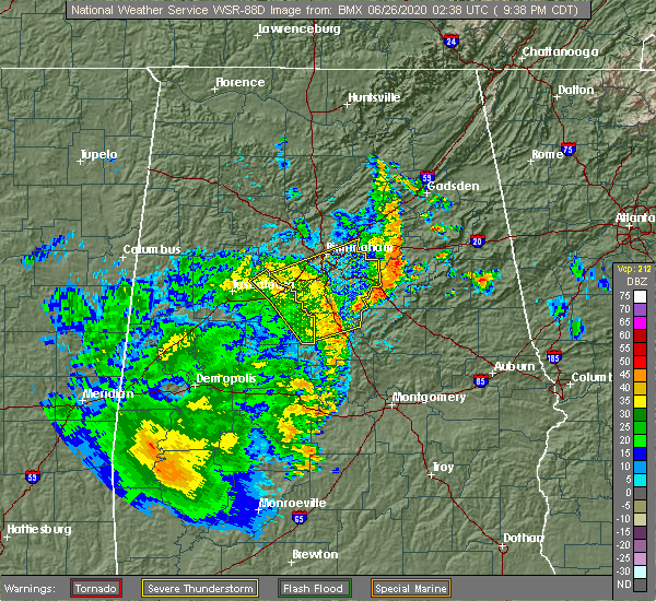 At 939 pm cdt, severe thunderstorms were located along a line extending from north johns to near helena to near calera, moving northeast at 50 mph (radar indicated). Hazards include 60 mph wind gusts. Expect damage to roofs, siding, and trees. Locations impacted include, birmingham, hoover, vestavia hills, alabaster, bessemer, homewood, pelham, mountain brook, trussville, helena, hueytown, irondale, leeds, moody, calera, fairfield, chelsea, montevallo, columbiana and jemison. At 939 pm cdt, severe thunderstorms were located along a line extending from north johns to near helena to near calera, moving northeast at 50 mph (radar indicated). Hazards include 60 mph wind gusts. Expect damage to roofs, siding, and trees. Locations impacted include, birmingham, hoover, vestavia hills, alabaster, bessemer, homewood, pelham, mountain brook, trussville, helena, hueytown, irondale, leeds, moody, calera, fairfield, chelsea, montevallo, columbiana and jemison.
|
| 6/25/2020 9:20 PM CDT |
 At 919 pm cdt, severe thunderstorms were located along a line extending from near brookwood to near woodstock to near ashby, moving northeast at 50 mph (radar indicated). Hazards include 60 mph wind gusts. expect damage to roofs, siding, and trees At 919 pm cdt, severe thunderstorms were located along a line extending from near brookwood to near woodstock to near ashby, moving northeast at 50 mph (radar indicated). Hazards include 60 mph wind gusts. expect damage to roofs, siding, and trees
|
| 5/22/2020 5:52 PM CDT |
 At 552 pm cdt, a severe thunderstorm was located over northwestern birmingham, moving northeast at 15 mph (radar indicated). Hazards include quarter size hail. damage to vehicles is expected At 552 pm cdt, a severe thunderstorm was located over northwestern birmingham, moving northeast at 15 mph (radar indicated). Hazards include quarter size hail. damage to vehicles is expected
|
| 4/19/2020 8:09 AM CDT |
 At 808 am cdt, a severe thunderstorm was located over patton creek, or over hoover, moving east at 60 mph (radar indicated). Hazards include 60 mph wind gusts and penny size hail. Expect damage to roofs, siding, and trees. Locations impacted include, southern birmingham, hoover, vestavia hills, alabaster, bessemer, homewood, pelham, mountain brook, helena, irondale, leeds, fairfield, chelsea, childersburg, wilsonville, midfield, brighton, indian springs village, lipscomb and vincent. At 808 am cdt, a severe thunderstorm was located over patton creek, or over hoover, moving east at 60 mph (radar indicated). Hazards include 60 mph wind gusts and penny size hail. Expect damage to roofs, siding, and trees. Locations impacted include, southern birmingham, hoover, vestavia hills, alabaster, bessemer, homewood, pelham, mountain brook, helena, irondale, leeds, fairfield, chelsea, childersburg, wilsonville, midfield, brighton, indian springs village, lipscomb and vincent.
|
| 4/19/2020 7:52 AM CDT |
 At 752 am cdt, a severe thunderstorm was located over north johns, or 9 miles west of bessemer, moving east at 60 mph (radar indicated). Hazards include 60 mph wind gusts and penny size hail. expect damage to roofs, siding, and trees At 752 am cdt, a severe thunderstorm was located over north johns, or 9 miles west of bessemer, moving east at 60 mph (radar indicated). Hazards include 60 mph wind gusts and penny size hail. expect damage to roofs, siding, and trees
|
| 4/12/2020 10:00 PM CDT |
 At 959 pm cdt, severe thunderstorms were located along a line extending from near geraldine to reece city to near rainbow city to near bald rock, moving east at 45 mph (radar indicated). Hazards include 60 mph wind gusts. Expect damage to roofs, siding, and trees. Locations impacted include, birmingham, hoover, gadsden, vestavia hills, bessemer, homewood, mountain brook, trussville, hueytown, gardendale, pell city, irondale, leeds, moody, fairfield, chelsea, rainbow city, fultondale, oneonta and attalla. At 959 pm cdt, severe thunderstorms were located along a line extending from near geraldine to reece city to near rainbow city to near bald rock, moving east at 45 mph (radar indicated). Hazards include 60 mph wind gusts. Expect damage to roofs, siding, and trees. Locations impacted include, birmingham, hoover, gadsden, vestavia hills, bessemer, homewood, mountain brook, trussville, hueytown, gardendale, pell city, irondale, leeds, moody, fairfield, chelsea, rainbow city, fultondale, oneonta and attalla.
|
| 4/12/2020 9:19 PM CDT |
 At 919 pm cdt, severe thunderstorms were located along a line extending from near strawberry to fairview to near dallas to birmingham, moving east at 45 mph (radar indicated). Hazards include 60 mph wind gusts. expect damage to roofs, siding, and trees At 919 pm cdt, severe thunderstorms were located along a line extending from near strawberry to fairview to near dallas to birmingham, moving east at 45 mph (radar indicated). Hazards include 60 mph wind gusts. expect damage to roofs, siding, and trees
|
| 4/12/2020 9:11 PM CDT |
 At 911 pm cdt, a severe thunderstorm was located over pleasant grove, or near hueytown, moving northeast at 55 mph (radar indicated). Hazards include 60 mph wind gusts. Expect damage to roofs, siding, and trees. locations impacted include, birmingham, bessemer, homewood, mountain brook, hueytown, irondale, leeds, fairfield, pleasant grove, midfield, adamsville, brighton, sylvan springs, mulga, maytown, birmingham fairgounds, b. j. c. c. Edgewater, shops of grand river and kingston. At 911 pm cdt, a severe thunderstorm was located over pleasant grove, or near hueytown, moving northeast at 55 mph (radar indicated). Hazards include 60 mph wind gusts. Expect damage to roofs, siding, and trees. locations impacted include, birmingham, bessemer, homewood, mountain brook, hueytown, irondale, leeds, fairfield, pleasant grove, midfield, adamsville, brighton, sylvan springs, mulga, maytown, birmingham fairgounds, b. j. c. c. Edgewater, shops of grand river and kingston.
|
| 4/12/2020 8:51 PM CDT |
 At 851 pm cdt, a severe thunderstorm was located over bull city, or 15 miles west of hueytown, moving northeast at 55 mph (radar indicated). Hazards include 60 mph wind gusts. expect damage to roofs, siding, and trees At 851 pm cdt, a severe thunderstorm was located over bull city, or 15 miles west of hueytown, moving northeast at 55 mph (radar indicated). Hazards include 60 mph wind gusts. expect damage to roofs, siding, and trees
|
| 4/12/2020 8:42 PM CDT |
 At 842 pm cdt, a confirmed tornado was located near bankhead lock and dam, or 10 miles northeast of holt, moving northeast at 55 mph (radar confirmed tornado). Hazards include damaging tornado. Flying debris will be dangerous to those caught without shelter. mobile homes will be damaged or destroyed. damage to roofs, windows, and vehicles will occur. tree damage is likely. Locations impacted include, hueytown, fairfield, pleasant grove, midfield, sylvan springs, bull city, concord, dolomite and lake nicol. At 842 pm cdt, a confirmed tornado was located near bankhead lock and dam, or 10 miles northeast of holt, moving northeast at 55 mph (radar confirmed tornado). Hazards include damaging tornado. Flying debris will be dangerous to those caught without shelter. mobile homes will be damaged or destroyed. damage to roofs, windows, and vehicles will occur. tree damage is likely. Locations impacted include, hueytown, fairfield, pleasant grove, midfield, sylvan springs, bull city, concord, dolomite and lake nicol.
|
| 4/12/2020 8:41 PM CDT |
 At 841 pm cdt, a confirmed tornado was located near deerlick creek campgrounds, or 9 miles northeast of holt, moving northeast at 55 mph (radar confirmed tornado). Hazards include damaging tornado. Flying debris will be dangerous to those caught without shelter. mobile homes will be damaged or destroyed. damage to roofs, windows, and vehicles will occur. tree damage is likely. Locations impacted include, hueytown, fairfield, pleasant grove, midfield, sylvan springs, bull city, concord, dolomite and lake nicol. At 841 pm cdt, a confirmed tornado was located near deerlick creek campgrounds, or 9 miles northeast of holt, moving northeast at 55 mph (radar confirmed tornado). Hazards include damaging tornado. Flying debris will be dangerous to those caught without shelter. mobile homes will be damaged or destroyed. damage to roofs, windows, and vehicles will occur. tree damage is likely. Locations impacted include, hueytown, fairfield, pleasant grove, midfield, sylvan springs, bull city, concord, dolomite and lake nicol.
|
| 4/12/2020 8:36 PM CDT |
 At 836 pm cdt, a tornado producing storm was located near deerlick creek campgrounds, or near holt, moving northeast at 50 mph (radar confirmed tornado). Hazards include damaging tornado. Flying debris will be dangerous to those caught without shelter. mobile homes will be damaged or destroyed. damage to roofs, windows, and vehicles will occur. Tree damage is likely. At 836 pm cdt, a tornado producing storm was located near deerlick creek campgrounds, or near holt, moving northeast at 50 mph (radar confirmed tornado). Hazards include damaging tornado. Flying debris will be dangerous to those caught without shelter. mobile homes will be damaged or destroyed. damage to roofs, windows, and vehicles will occur. Tree damage is likely.
|
| 4/12/2020 8:32 PM CDT |
 At 832 pm cdt, a severe thunderstorm capable of producing a tornado was located over holt, moving east at 50 mph (radar indicated rotation). Hazards include tornado. Flying debris will be dangerous to those caught without shelter. mobile homes will be damaged or destroyed. damage to roofs, windows, and vehicles will occur. Tree damage is likely. At 832 pm cdt, a severe thunderstorm capable of producing a tornado was located over holt, moving east at 50 mph (radar indicated rotation). Hazards include tornado. Flying debris will be dangerous to those caught without shelter. mobile homes will be damaged or destroyed. damage to roofs, windows, and vehicles will occur. Tree damage is likely.
|
| 1/11/2020 12:54 PM CST |
 At 1253 pm cst, severe thunderstorms were located along a line extending from near good hope to center point to near wilton, moving northeast at 60 mph (radar indicated). Hazards include 70 mph wind gusts. Expect considerable tree damage. damage is likely to mobile homes, roofs, and outbuildings. Locations impacted include, birmingham, hoover, vestavia hills, alabaster, bessemer, homewood, pelham, mountain brook, helena, hueytown, gardendale, fairfield, fultondale, montevallo, tarrant, midfield, brighton, kimberly, lipscomb and morris. At 1253 pm cst, severe thunderstorms were located along a line extending from near good hope to center point to near wilton, moving northeast at 60 mph (radar indicated). Hazards include 70 mph wind gusts. Expect considerable tree damage. damage is likely to mobile homes, roofs, and outbuildings. Locations impacted include, birmingham, hoover, vestavia hills, alabaster, bessemer, homewood, pelham, mountain brook, helena, hueytown, gardendale, fairfield, fultondale, montevallo, tarrant, midfield, brighton, kimberly, lipscomb and morris.
|
| 1/11/2020 12:35 PM CST |
 At 1234 pm cst, severe thunderstorms were located along a line extending from near smith dam to mulga to near west blocton, moving northeast at 65 mph (radar indicated). Hazards include 70 mph wind gusts. Expect considerable tree damage. damage is likely to mobile homes, roofs, and outbuildings. Locations impacted include, birmingham, hoover, vestavia hills, alabaster, bessemer, homewood, pelham, mountain brook, helena, hueytown, jasper, gardendale, fairfield, fultondale, montevallo, sumiton, cordova, dora, pleasant grove and tarrant. At 1234 pm cst, severe thunderstorms were located along a line extending from near smith dam to mulga to near west blocton, moving northeast at 65 mph (radar indicated). Hazards include 70 mph wind gusts. Expect considerable tree damage. damage is likely to mobile homes, roofs, and outbuildings. Locations impacted include, birmingham, hoover, vestavia hills, alabaster, bessemer, homewood, pelham, mountain brook, helena, hueytown, jasper, gardendale, fairfield, fultondale, montevallo, sumiton, cordova, dora, pleasant grove and tarrant.
|
| 1/11/2020 12:19 PM CST |
 At 1219 pm cst, severe thunderstorms were located along a line extending from 6 miles south of camp mcdowell to near bull city to near low gap, moving northeast at 60 mph (radar indicated). Hazards include 70 mph wind gusts. Expect considerable tree damage. damage is likely to mobile homes, roofs, and outbuildings. Locations impacted include, birmingham, hoover, vestavia hills, alabaster, bessemer, homewood, pelham, mountain brook, helena, hueytown, jasper, gardendale, fairfield, fultondale, montevallo, sumiton, cordova, dora, pleasant grove and tarrant. At 1219 pm cst, severe thunderstorms were located along a line extending from 6 miles south of camp mcdowell to near bull city to near low gap, moving northeast at 60 mph (radar indicated). Hazards include 70 mph wind gusts. Expect considerable tree damage. damage is likely to mobile homes, roofs, and outbuildings. Locations impacted include, birmingham, hoover, vestavia hills, alabaster, bessemer, homewood, pelham, mountain brook, helena, hueytown, jasper, gardendale, fairfield, fultondale, montevallo, sumiton, cordova, dora, pleasant grove and tarrant.
|
| 1/11/2020 12:01 PM CST |
 At 1201 pm cst, severe thunderstorms were located along a line extending from near carbon hill to 6 miles southwest of bankhead lock and dam to 8 miles southeast of moundville, moving northeast at 65 mph (radar indicated). Hazards include 70 mph wind gusts. Expect considerable tree damage. Damage is likely to mobile homes, roofs, and outbuildings. At 1201 pm cst, severe thunderstorms were located along a line extending from near carbon hill to 6 miles southwest of bankhead lock and dam to 8 miles southeast of moundville, moving northeast at 65 mph (radar indicated). Hazards include 70 mph wind gusts. Expect considerable tree damage. Damage is likely to mobile homes, roofs, and outbuildings.
|
| 8/27/2019 4:44 PM CDT |
 At 443 pm cdt, a severe thunderstorm was located over sumiton, moving southeast at 15 mph (radar indicated). Hazards include 60 mph wind gusts and quarter size hail. Hail damage to vehicles is expected. Expect wind damage to roofs, siding, and trees. At 443 pm cdt, a severe thunderstorm was located over sumiton, moving southeast at 15 mph (radar indicated). Hazards include 60 mph wind gusts and quarter size hail. Hail damage to vehicles is expected. Expect wind damage to roofs, siding, and trees.
|
| 6/20/2019 3:15 AM CDT |
 At 315 am cdt, severe thunderstorms were located along a line extending from near locust fork to oak mountain state park to near marion, moving east at 45 mph (radar indicated). Hazards include 60 mph wind gusts and penny size hail. Expect damage to roofs, siding, and trees. Locations impacted include, birmingham, hoover, vestavia hills, alabaster, bessemer, homewood, pelham, mountain brook, trussville, helena, hueytown, gardendale, irondale, leeds, moody, calera, fairfield, chelsea, fultondale and montevallo. At 315 am cdt, severe thunderstorms were located along a line extending from near locust fork to oak mountain state park to near marion, moving east at 45 mph (radar indicated). Hazards include 60 mph wind gusts and penny size hail. Expect damage to roofs, siding, and trees. Locations impacted include, birmingham, hoover, vestavia hills, alabaster, bessemer, homewood, pelham, mountain brook, trussville, helena, hueytown, gardendale, irondale, leeds, moody, calera, fairfield, chelsea, fultondale and montevallo.
|
| 6/20/2019 3:00 AM CDT |
 At 259 am cdt, severe thunderstorms were located along a line extending from near blount springs to near bessemer to near newbern, moving east at 45 mph (radar indicated). Hazards include 60 mph wind gusts and penny size hail. Expect damage to roofs, siding, and trees. Locations impacted include, birmingham, hoover, vestavia hills, alabaster, bessemer, homewood, pelham, mountain brook, trussville, helena, hueytown, gardendale, irondale, leeds, moody, calera, fairfield, chelsea, fultondale and montevallo. At 259 am cdt, severe thunderstorms were located along a line extending from near blount springs to near bessemer to near newbern, moving east at 45 mph (radar indicated). Hazards include 60 mph wind gusts and penny size hail. Expect damage to roofs, siding, and trees. Locations impacted include, birmingham, hoover, vestavia hills, alabaster, bessemer, homewood, pelham, mountain brook, trussville, helena, hueytown, gardendale, irondale, leeds, moody, calera, fairfield, chelsea, fultondale and montevallo.
|
| 6/20/2019 2:36 AM CDT |
 At 235 am cdt, severe thunderstorms were located along a line extending from near smith dam to near abernant to near arcola, moving east at 45 mph (radar indicated). Hazards include 60 mph wind gusts and penny size hail. Expect damage to roofs, siding, and trees. Locations impacted include, birmingham, hoover, vestavia hills, alabaster, bessemer, homewood, pelham, mountain brook, trussville, helena, hueytown, gardendale, irondale, leeds, moody, calera, fairfield, chelsea, fultondale and montevallo. At 235 am cdt, severe thunderstorms were located along a line extending from near smith dam to near abernant to near arcola, moving east at 45 mph (radar indicated). Hazards include 60 mph wind gusts and penny size hail. Expect damage to roofs, siding, and trees. Locations impacted include, birmingham, hoover, vestavia hills, alabaster, bessemer, homewood, pelham, mountain brook, trussville, helena, hueytown, gardendale, irondale, leeds, moody, calera, fairfield, chelsea, fultondale and montevallo.
|
| 6/20/2019 2:29 AM CDT |
 At 229 am cdt, severe thunderstorms were located along a line extending from near curry to near bull city to near forkland, moving east at 45 mph (radar indicated). Hazards include 60 mph wind gusts and penny size hail. expect damage to roofs, siding, and trees At 229 am cdt, severe thunderstorms were located along a line extending from near curry to near bull city to near forkland, moving east at 45 mph (radar indicated). Hazards include 60 mph wind gusts and penny size hail. expect damage to roofs, siding, and trees
|
| 5/9/2019 12:26 PM CDT |
 At 1139 am cdt, severe thunderstorms were located along a line extending from near jasper to tuscaloosa, moving east at 40 mph (radar indicated). Hazards include 60 mph wind gusts. expect damage to roofs, siding, and trees At 1139 am cdt, severe thunderstorms were located along a line extending from near jasper to tuscaloosa, moving east at 40 mph (radar indicated). Hazards include 60 mph wind gusts. expect damage to roofs, siding, and trees
|
| 5/9/2019 12:09 PM CDT |
 At 1139 am cdt, severe thunderstorms were located along a line extending from near jasper to tuscaloosa, moving east at 40 mph (radar indicated). Hazards include 60 mph wind gusts. expect damage to roofs, siding, and trees At 1139 am cdt, severe thunderstorms were located along a line extending from near jasper to tuscaloosa, moving east at 40 mph (radar indicated). Hazards include 60 mph wind gusts. expect damage to roofs, siding, and trees
|
| 5/9/2019 12:00 PM CDT |
 At 1139 am cdt, severe thunderstorms were located along a line extending from near jasper to tuscaloosa, moving east at 40 mph (radar indicated). Hazards include 60 mph wind gusts. expect damage to roofs, siding, and trees At 1139 am cdt, severe thunderstorms were located along a line extending from near jasper to tuscaloosa, moving east at 40 mph (radar indicated). Hazards include 60 mph wind gusts. expect damage to roofs, siding, and trees
|
| 5/9/2019 11:40 AM CDT |
 The national weather service in birmingham has issued a * severe thunderstorm warning for. jefferson county in central alabama. until 100 pm cdt. At 1139 am cdt, severe thunderstorms were located along a line extending from near jasper to tuscaloosa, moving east at 40 mph. The national weather service in birmingham has issued a * severe thunderstorm warning for. jefferson county in central alabama. until 100 pm cdt. At 1139 am cdt, severe thunderstorms were located along a line extending from near jasper to tuscaloosa, moving east at 40 mph.
|
| 4/18/2019 7:15 PM CDT |
 At 715 pm cdt, severe thunderstorms were located along a line extending from near west jefferson to birmingham to helena, moving northeast at 45 mph (radar indicated). Hazards include 60 mph wind gusts. Expect damage to roofs, siding, and trees. locations impacted include, birmingham, hoover, vestavia hills, bessemer, homewood, mountain brook, trussville, hueytown, gardendale, irondale, leeds, moody, fairfield, fultondale, center point, pleasant grove, clay, pinson, tarrant and midfield. A tornado watch remains in effect until 1100 pm cdt for central and west central alabama. At 715 pm cdt, severe thunderstorms were located along a line extending from near west jefferson to birmingham to helena, moving northeast at 45 mph (radar indicated). Hazards include 60 mph wind gusts. Expect damage to roofs, siding, and trees. locations impacted include, birmingham, hoover, vestavia hills, bessemer, homewood, mountain brook, trussville, hueytown, gardendale, irondale, leeds, moody, fairfield, fultondale, center point, pleasant grove, clay, pinson, tarrant and midfield. A tornado watch remains in effect until 1100 pm cdt for central and west central alabama.
|
| 4/18/2019 7:06 PM CDT |
 At 706 pm cdt, severe thunderstorms were located along a line extending from near west jefferson to hueytown to near tannehill ironworks state park, moving northeast at 45 mph (radar indicated). Hazards include 60 mph wind gusts. Expect damage to roofs, siding, and trees. locations impacted include, birmingham, hoover, vestavia hills, bessemer, homewood, mountain brook, trussville, hueytown, gardendale, irondale, leeds, moody, fairfield, fultondale, center point, pleasant grove, clay, pinson, tarrant and midfield. A tornado watch remains in effect until 1100 pm cdt for central and west central alabama. At 706 pm cdt, severe thunderstorms were located along a line extending from near west jefferson to hueytown to near tannehill ironworks state park, moving northeast at 45 mph (radar indicated). Hazards include 60 mph wind gusts. Expect damage to roofs, siding, and trees. locations impacted include, birmingham, hoover, vestavia hills, bessemer, homewood, mountain brook, trussville, hueytown, gardendale, irondale, leeds, moody, fairfield, fultondale, center point, pleasant grove, clay, pinson, tarrant and midfield. A tornado watch remains in effect until 1100 pm cdt for central and west central alabama.
|
| 4/18/2019 6:57 PM CDT |
 At 657 pm cdt, severe thunderstorms were located along a line extending from near gorgas steam plant to north johns to near tannehill ironworks state park, moving northeast at 45 mph (radar indicated). Hazards include 60 mph wind gusts. Expect damage to roofs, siding, and trees. locations impacted include, birmingham, hoover, vestavia hills, bessemer, homewood, mountain brook, trussville, hueytown, gardendale, irondale, leeds, moody, fairfield, fultondale, center point, pleasant grove, clay, pinson, tarrant and midfield. A tornado watch remains in effect until 1100 pm cdt for central and west central alabama. At 657 pm cdt, severe thunderstorms were located along a line extending from near gorgas steam plant to north johns to near tannehill ironworks state park, moving northeast at 45 mph (radar indicated). Hazards include 60 mph wind gusts. Expect damage to roofs, siding, and trees. locations impacted include, birmingham, hoover, vestavia hills, bessemer, homewood, mountain brook, trussville, hueytown, gardendale, irondale, leeds, moody, fairfield, fultondale, center point, pleasant grove, clay, pinson, tarrant and midfield. A tornado watch remains in effect until 1100 pm cdt for central and west central alabama.
|
| 4/18/2019 6:38 PM CDT |
 At 638 pm cdt, severe thunderstorms were located along a line extending from near bankhead lock and dam to near brookwood to near vance, moving northeast at 45 mph (radar indicated). Hazards include 70 mph wind gusts. Expect considerable tree damage. Damage is likely to mobile homes, roofs, and outbuildings. At 638 pm cdt, severe thunderstorms were located along a line extending from near bankhead lock and dam to near brookwood to near vance, moving northeast at 45 mph (radar indicated). Hazards include 70 mph wind gusts. Expect considerable tree damage. Damage is likely to mobile homes, roofs, and outbuildings.
|
| 2/23/2019 4:14 PM CST |
 At 414 pm cst, a severe thunderstorm was located over tarrant, or over fultondale, moving northeast at 35 mph (radar indicated). Hazards include 60 mph wind gusts and quarter size hail. Hail damage to vehicles is expected. expect wind damage to roofs, siding, and trees. locations impacted include, birmingham, mountain brook, trussville, gardendale, irondale, leeds, moody, fairfield, fultondale, center point, clay, pinson, tarrant, adamsville, argo, graysville, brookside, cardiff, birmingham fairgounds and ketona lakes. A tornado watch remains in effect until 1000 pm cst for central alabama. At 414 pm cst, a severe thunderstorm was located over tarrant, or over fultondale, moving northeast at 35 mph (radar indicated). Hazards include 60 mph wind gusts and quarter size hail. Hail damage to vehicles is expected. expect wind damage to roofs, siding, and trees. locations impacted include, birmingham, mountain brook, trussville, gardendale, irondale, leeds, moody, fairfield, fultondale, center point, clay, pinson, tarrant, adamsville, argo, graysville, brookside, cardiff, birmingham fairgounds and ketona lakes. A tornado watch remains in effect until 1000 pm cst for central alabama.
|
| 2/23/2019 3:53 PM CST |
 At 352 pm cst, a severe thunderstorm was located over pleasant grove, or near hueytown, moving northeast at 35 mph (radar indicated). Hazards include 60 mph wind gusts and quarter size hail. Hail damage to vehicles is expected. expect wind damage to roofs, siding, and trees. locations impacted include, birmingham, bessemer, homewood, mountain brook, trussville, hueytown, gardendale, irondale, leeds, moody, fairfield, fultondale, center point, pleasant grove, clay, pinson, tarrant, midfield, adamsville and argo. A tornado watch remains in effect until 1000 pm cst for central alabama. At 352 pm cst, a severe thunderstorm was located over pleasant grove, or near hueytown, moving northeast at 35 mph (radar indicated). Hazards include 60 mph wind gusts and quarter size hail. Hail damage to vehicles is expected. expect wind damage to roofs, siding, and trees. locations impacted include, birmingham, bessemer, homewood, mountain brook, trussville, hueytown, gardendale, irondale, leeds, moody, fairfield, fultondale, center point, pleasant grove, clay, pinson, tarrant, midfield, adamsville and argo. A tornado watch remains in effect until 1000 pm cst for central alabama.
|
| 2/23/2019 3:39 PM CST |
 At 339 pm cst, a severe thunderstorm was located near north johns, or near hueytown, moving northeast at 35 mph (radar indicated). Hazards include 60 mph wind gusts and quarter size hail. Hail damage to vehicles is expected. Expect wind damage to roofs, siding, and trees. At 339 pm cst, a severe thunderstorm was located near north johns, or near hueytown, moving northeast at 35 mph (radar indicated). Hazards include 60 mph wind gusts and quarter size hail. Hail damage to vehicles is expected. Expect wind damage to roofs, siding, and trees.
|
| 6/28/2018 3:13 PM CDT |
 At 312 pm cdt, severe thunderstorms were located along a line extending from near oak grove to patton creek to near wilsonville, moving southwest at 35 mph (emergency management). Hazards include 70 mph wind gusts and penny size hail. Expect considerable tree damage. damage is likely to mobile homes, roofs, and outbuildings. Locations impacted include, birmingham, hoover, vestavia hills, alabaster, bessemer, homewood, pelham, mountain brook, helena, hueytown, irondale, calera, fairfield, chelsea, fultondale, montevallo, columbiana, wilsonville, pleasant grove and tarrant. At 312 pm cdt, severe thunderstorms were located along a line extending from near oak grove to patton creek to near wilsonville, moving southwest at 35 mph (emergency management). Hazards include 70 mph wind gusts and penny size hail. Expect considerable tree damage. damage is likely to mobile homes, roofs, and outbuildings. Locations impacted include, birmingham, hoover, vestavia hills, alabaster, bessemer, homewood, pelham, mountain brook, helena, hueytown, irondale, calera, fairfield, chelsea, fultondale, montevallo, columbiana, wilsonville, pleasant grove and tarrant.
|
| 6/28/2018 2:53 PM CDT |
 At 252 pm cdt, severe thunderstorms were located along a line extending from west jefferson to birmingham to near harpersville, moving southwest at 35 mph (emergency management). Hazards include 60 to 70 mph wind gusts and penny size hail. Expect considerable tree damage. Damage is likely to mobile homes, roofs, and outbuildings. At 252 pm cdt, severe thunderstorms were located along a line extending from west jefferson to birmingham to near harpersville, moving southwest at 35 mph (emergency management). Hazards include 60 to 70 mph wind gusts and penny size hail. Expect considerable tree damage. Damage is likely to mobile homes, roofs, and outbuildings.
|
| 6/23/2018 8:55 AM CDT |
 The severe thunderstorm warning for central jefferson county will expire at 900 am cdt, the storms which prompted the warning have weakened below severe limits, and no longer pose an immediate threat to life or property. therefore, the warning will be allowed to expire. to report severe weather, contact your nearest law enforcement agency. they will relay your report to the national weather service birmingham. The severe thunderstorm warning for central jefferson county will expire at 900 am cdt, the storms which prompted the warning have weakened below severe limits, and no longer pose an immediate threat to life or property. therefore, the warning will be allowed to expire. to report severe weather, contact your nearest law enforcement agency. they will relay your report to the national weather service birmingham.
|
| 6/23/2018 8:35 AM CDT |
 At 835 am cdt, severe thunderstorms were located along a line extending from gardendale to hueytown, moving southeast at 30 mph (radar indicated). Hazards include 60 mph wind gusts. Expect damage to roofs, siding, and trees. Locations impacted include, birmingham, hoover, vestavia hills, bessemer, homewood, mountain brook, trussville, hueytown, gardendale, irondale, fairfield, fultondale, center point, pleasant grove, tarrant, midfield, adamsville, brighton, lipscomb and graysville. At 835 am cdt, severe thunderstorms were located along a line extending from gardendale to hueytown, moving southeast at 30 mph (radar indicated). Hazards include 60 mph wind gusts. Expect damage to roofs, siding, and trees. Locations impacted include, birmingham, hoover, vestavia hills, bessemer, homewood, mountain brook, trussville, hueytown, gardendale, irondale, fairfield, fultondale, center point, pleasant grove, tarrant, midfield, adamsville, brighton, lipscomb and graysville.
|
| 6/23/2018 8:12 AM CDT |
 At 812 am cdt, a severe thunderstorm was located over west jefferson, or 8 miles south of dora, moving southeast at 35 mph (radar indicated). Hazards include 60 mph wind gusts. expect damage to roofs, siding, and trees At 812 am cdt, a severe thunderstorm was located over west jefferson, or 8 miles south of dora, moving southeast at 35 mph (radar indicated). Hazards include 60 mph wind gusts. expect damage to roofs, siding, and trees
|
| 6/22/2018 3:35 PM CDT |
 The severe thunderstorm warning for south central jefferson county will expire at 345 pm cdt, the storm which prompted the warning has weakened below severe limits, and no longer poses an immediate threat to life or property. therefore, the warning will be allowed to expire. to report severe weather, contact your nearest law enforcement agency. they will relay your report to the national weather service birmingham. The severe thunderstorm warning for south central jefferson county will expire at 345 pm cdt, the storm which prompted the warning has weakened below severe limits, and no longer poses an immediate threat to life or property. therefore, the warning will be allowed to expire. to report severe weather, contact your nearest law enforcement agency. they will relay your report to the national weather service birmingham.
|
| 6/22/2018 3:25 PM CDT |
 At 325 pm cdt, a severe thunderstorm was located over bon air, or over fairfield, moving east at 45 mph (radar indicated). Hazards include 60 mph wind gusts. Expect damage to roofs, siding, and trees. Locations impacted include, southwestern birmingham, hoover, vestavia hills, bessemer, homewood, hueytown, fairfield, pleasant grove, midfield, brighton, lipscomb, sylvan springs, birmingham fairgounds, patton creek, ross bridge, ensley, bluff park, riverchase galleria, legion field and mcdonald chapel. At 325 pm cdt, a severe thunderstorm was located over bon air, or over fairfield, moving east at 45 mph (radar indicated). Hazards include 60 mph wind gusts. Expect damage to roofs, siding, and trees. Locations impacted include, southwestern birmingham, hoover, vestavia hills, bessemer, homewood, hueytown, fairfield, pleasant grove, midfield, brighton, lipscomb, sylvan springs, birmingham fairgounds, patton creek, ross bridge, ensley, bluff park, riverchase galleria, legion field and mcdonald chapel.
|
| 6/22/2018 3:13 PM CDT |
 At 313 pm cdt, a severe thunderstorm was located near oak grove, or near hueytown, moving east at 35 mph (radar indicated). Hazards include 60 mph wind gusts. Expect damage to roofs, siding, and trees. Locations impacted include, southwestern birmingham, hoover, vestavia hills, bessemer, homewood, hueytown, fairfield, pleasant grove, midfield, brighton, lipscomb, sylvan springs, birmingham fairgounds, ensley, bluff park, legion field, splash adventure, mcdonald chapel, concord and patton creek. At 313 pm cdt, a severe thunderstorm was located near oak grove, or near hueytown, moving east at 35 mph (radar indicated). Hazards include 60 mph wind gusts. Expect damage to roofs, siding, and trees. Locations impacted include, southwestern birmingham, hoover, vestavia hills, bessemer, homewood, hueytown, fairfield, pleasant grove, midfield, brighton, lipscomb, sylvan springs, birmingham fairgounds, ensley, bluff park, legion field, splash adventure, mcdonald chapel, concord and patton creek.
|
| 6/22/2018 3:03 PM CDT |
 At 303 pm cdt, a severe thunderstorm was located over oak grove, or 10 miles west of hueytown, moving east at 40 mph (radar indicated). Hazards include 60 mph wind gusts. expect damage to roofs, siding, and trees At 303 pm cdt, a severe thunderstorm was located over oak grove, or 10 miles west of hueytown, moving east at 40 mph (radar indicated). Hazards include 60 mph wind gusts. expect damage to roofs, siding, and trees
|
| 5/15/2018 5:52 PM CDT |
 At 551 pm cdt, a severe thunderstorm was located over splash adventure, or over bessemer, and is nearly stationary (radar indicated). Hazards include 60 mph wind gusts and quarter size hail. Hail damage to vehicles is expected. expect wind damage to roofs, siding, and trees. Locations impacted include, southwestern birmingham, bessemer, hueytown, fairfield, pleasant grove, midfield, brighton, lipscomb, splash adventure, promenade tannehill and dolomite. At 551 pm cdt, a severe thunderstorm was located over splash adventure, or over bessemer, and is nearly stationary (radar indicated). Hazards include 60 mph wind gusts and quarter size hail. Hail damage to vehicles is expected. expect wind damage to roofs, siding, and trees. Locations impacted include, southwestern birmingham, bessemer, hueytown, fairfield, pleasant grove, midfield, brighton, lipscomb, splash adventure, promenade tannehill and dolomite.
|
| 5/15/2018 5:34 PM CDT |
 At 533 pm cdt, a severe thunderstorm was located over splash adventure, or over bessemer, and is nearly stationary (radar indicated). Hazards include 60 mph wind gusts and quarter size hail. Hail damage to vehicles is expected. Expect wind damage to roofs, siding, and trees. At 533 pm cdt, a severe thunderstorm was located over splash adventure, or over bessemer, and is nearly stationary (radar indicated). Hazards include 60 mph wind gusts and quarter size hail. Hail damage to vehicles is expected. Expect wind damage to roofs, siding, and trees.
|
| 4/22/2018 8:41 PM CDT |
 At 818 pm cdt, severe thunderstorms were located along a line extending from near splash adventure to near brierfield ironworks park to near parnell, moving east at 35 mph (radar indicated). Hazards include 60 mph wind gusts. Expect damage to roofs, siding, and trees. Locations impacted include, birmingham, hoover, vestavia hills, alabaster, bessemer, homewood, pelham, mountain brook, trussville, helena, hueytown, gardendale, irondale, leeds, moody, calera, fairfield, chelsea, clanton and fultondale. At 818 pm cdt, severe thunderstorms were located along a line extending from near splash adventure to near brierfield ironworks park to near parnell, moving east at 35 mph (radar indicated). Hazards include 60 mph wind gusts. Expect damage to roofs, siding, and trees. Locations impacted include, birmingham, hoover, vestavia hills, alabaster, bessemer, homewood, pelham, mountain brook, trussville, helena, hueytown, gardendale, irondale, leeds, moody, calera, fairfield, chelsea, clanton and fultondale.
|
| 4/22/2018 8:19 PM CDT |
 At 756 pm cdt, severe thunderstorms were located along a line extending from lake view to near ashby to 6 miles southwest of paul m grist state park, moving northeast at 35 mph (emergency management). Hazards include 60 mph wind gusts. expect damage to roofs, siding, and trees At 756 pm cdt, severe thunderstorms were located along a line extending from lake view to near ashby to 6 miles southwest of paul m grist state park, moving northeast at 35 mph (emergency management). Hazards include 60 mph wind gusts. expect damage to roofs, siding, and trees
|
| 4/22/2018 7:57 PM CDT |
 At 756 pm cdt, severe thunderstorms were located along a line extending from lake view to near ashby to 6 miles southwest of paul m grist state park, moving northeast at 35 mph (emergency management). Hazards include 60 mph wind gusts. expect damage to roofs, siding, and trees At 756 pm cdt, severe thunderstorms were located along a line extending from lake view to near ashby to 6 miles southwest of paul m grist state park, moving northeast at 35 mph (emergency management). Hazards include 60 mph wind gusts. expect damage to roofs, siding, and trees
|
| 6/22/2017 1:00 PM CDT | Tree fell onto kentucky fried chicken restaurant near fairfield. time approximat in jefferson county AL, 0.2 miles NW of Fairfield, AL |
| 6/22/2017 1:00 PM CDT | *** 1 inj *** structural damage reported at a liquor store near western hills mall in fairfield. possible entrapment and 1 injury reported. possible tornado. time appro in jefferson county AL, 0.7 miles W of Fairfield, AL |
| 6/22/2017 12:50 PM CDT | Structural damage reported along dr. martin luther king blvd in fairfield. possible tornado. time and location approximat in jefferson county AL, 0.2 miles NW of Fairfield, AL |
| 6/22/2017 12:27 PM CDT | *** 3 inj *** structural damage reported at a liquor store near western hills mall in fairfield. possible entrapment and 1 injury reported. possible tornado. updated in in jefferson county AL, 0.7 miles W of Fairfield, AL |
| 6/22/2017 12:27 PM CDT |
 At 1226 pm cdt, a severe thunderstorm capable of producing a tornado was located over fairfield, moving northeast at 30 mph (radar indicated rotation). Hazards include tornado. Flying debris will be dangerous to those caught without shelter. mobile homes will be damaged or destroyed. damage to roofs, windows, and vehicles will occur. Tree damage is likely. At 1226 pm cdt, a severe thunderstorm capable of producing a tornado was located over fairfield, moving northeast at 30 mph (radar indicated rotation). Hazards include tornado. Flying debris will be dangerous to those caught without shelter. mobile homes will be damaged or destroyed. damage to roofs, windows, and vehicles will occur. Tree damage is likely.
|
| 6/15/2017 3:32 PM CDT |
 At 332 pm cdt, severe thunderstorms were located along a line extending from near alexandria to near maylene to near talladega national forest, moving south at 50 mph (radar indicated). Hazards include 60 mph wind gusts and quarter size hail. Hail damage to vehicles is expected. expect wind damage to roofs, siding, and trees. Locations impacted include, birmingham, hoover, gadsden, vestavia hills, alabaster, bessemer, homewood, anniston, pelham, oxford, mountain brook, trussville, helena, hueytown, talladega, gardendale, sylacauga, pell city, jacksonville and irondale. At 332 pm cdt, severe thunderstorms were located along a line extending from near alexandria to near maylene to near talladega national forest, moving south at 50 mph (radar indicated). Hazards include 60 mph wind gusts and quarter size hail. Hail damage to vehicles is expected. expect wind damage to roofs, siding, and trees. Locations impacted include, birmingham, hoover, gadsden, vestavia hills, alabaster, bessemer, homewood, anniston, pelham, oxford, mountain brook, trussville, helena, hueytown, talladega, gardendale, sylacauga, pell city, jacksonville and irondale.
|
| 6/15/2017 3:23 PM CDT |
 At 323 pm cdt, severe thunderstorms were located along a line extending from glencoe to near bessemer to near centreville, moving south at 50 mph (radar indicated). Hazards include 60 mph wind gusts. there have been several reports of trees downed by these storms. Expect damage to roofs, siding, and trees. Locations impacted include, birmingham, hoover, gadsden, vestavia hills, alabaster, bessemer, homewood, anniston, pelham, oxford, mountain brook, trussville, helena, hueytown, talladega, gardendale, sylacauga, pell city, jacksonville and irondale. At 323 pm cdt, severe thunderstorms were located along a line extending from glencoe to near bessemer to near centreville, moving south at 50 mph (radar indicated). Hazards include 60 mph wind gusts. there have been several reports of trees downed by these storms. Expect damage to roofs, siding, and trees. Locations impacted include, birmingham, hoover, gadsden, vestavia hills, alabaster, bessemer, homewood, anniston, pelham, oxford, mountain brook, trussville, helena, hueytown, talladega, gardendale, sylacauga, pell city, jacksonville and irondale.
|
| 6/15/2017 3:15 PM CDT |
 At 315 pm cdt, severe thunderstorms were located along a line extending from near reece city to hueytown to near west blocton, moving south at 50 mph (radar indicated). Hazards include 60 mph wind gusts. expect damage to roofs, siding, and trees At 315 pm cdt, severe thunderstorms were located along a line extending from near reece city to hueytown to near west blocton, moving south at 50 mph (radar indicated). Hazards include 60 mph wind gusts. expect damage to roofs, siding, and trees
|
| 6/15/2017 2:47 PM CDT |
 At 246 pm cdt, severe thunderstorms were located along a line extending from albertville to 7 miles southwest of bankhead lock and dam, moving southeast at 35 mph. there have been a few reports of downed trees with these storms (radar indicated). Hazards include 60 mph wind gusts. expect damage to roofs, siding, and trees At 246 pm cdt, severe thunderstorms were located along a line extending from albertville to 7 miles southwest of bankhead lock and dam, moving southeast at 35 mph. there have been a few reports of downed trees with these storms (radar indicated). Hazards include 60 mph wind gusts. expect damage to roofs, siding, and trees
|
| 5/30/2017 4:00 PM CDT |
 At 400 pm cdt, a severe thunderstorm was located over ross bridge, or near bessemer, moving east at 10 mph (radar indicated). Hazards include 60 mph wind gusts and quarter size hail. Hail damage to vehicles is expected. expect wind damage to roofs, siding, and trees. Locations impacted include, birmingham, hoover, bessemer, homewood, midfield, lipscomb, ross bridge, bluff park and shannon. At 400 pm cdt, a severe thunderstorm was located over ross bridge, or near bessemer, moving east at 10 mph (radar indicated). Hazards include 60 mph wind gusts and quarter size hail. Hail damage to vehicles is expected. expect wind damage to roofs, siding, and trees. Locations impacted include, birmingham, hoover, bessemer, homewood, midfield, lipscomb, ross bridge, bluff park and shannon.
|
| 5/30/2017 3:51 PM CDT |
 At 351 pm cdt, a severe thunderstorm was located over lipscomb, or near bessemer, moving east at 10 mph (radar indicated). Hazards include 60 mph wind gusts and quarter size hail. Hail damage to vehicles is expected. Expect wind damage to roofs, siding, and trees. At 351 pm cdt, a severe thunderstorm was located over lipscomb, or near bessemer, moving east at 10 mph (radar indicated). Hazards include 60 mph wind gusts and quarter size hail. Hail damage to vehicles is expected. Expect wind damage to roofs, siding, and trees.
|
| 5/28/2017 3:11 AM CDT |
 At 311 am cdt, severe thunderstorms were located along a line extending from bull city to near clay, moving southeast at 35 mph (radar indicated). Hazards include 60 mph wind gusts. Expect damage to roofs, siding, and trees. Locations impacted include, birmingham, hoover, vestavia hills, bessemer, homewood, mountain brook, trussville, hueytown, gardendale, irondale, leeds, moody, fairfield, fultondale, sumiton, pinson-clay-chalkv, center point, pleasant grove, clay and pinson. At 311 am cdt, severe thunderstorms were located along a line extending from bull city to near clay, moving southeast at 35 mph (radar indicated). Hazards include 60 mph wind gusts. Expect damage to roofs, siding, and trees. Locations impacted include, birmingham, hoover, vestavia hills, bessemer, homewood, mountain brook, trussville, hueytown, gardendale, irondale, leeds, moody, fairfield, fultondale, sumiton, pinson-clay-chalkv, center point, pleasant grove, clay and pinson.
|
| 5/28/2017 2:53 AM CDT |
 At 253 am cdt, severe thunderstorms were located along a line extending from 6 miles northwest of oak grove to near morris, moving southeast at 40 mph (radar indicated). Hazards include 60 mph wind gusts. Expect damage to roofs, siding, and trees. Locations impacted include, birmingham, hoover, vestavia hills, bessemer, homewood, mountain brook, trussville, hueytown, gardendale, irondale, leeds, moody, fairfield, fultondale, sumiton, cordova, dora, pinson-clay-chalkv, center point and pleasant grove. At 253 am cdt, severe thunderstorms were located along a line extending from 6 miles northwest of oak grove to near morris, moving southeast at 40 mph (radar indicated). Hazards include 60 mph wind gusts. Expect damage to roofs, siding, and trees. Locations impacted include, birmingham, hoover, vestavia hills, bessemer, homewood, mountain brook, trussville, hueytown, gardendale, irondale, leeds, moody, fairfield, fultondale, sumiton, cordova, dora, pinson-clay-chalkv, center point and pleasant grove.
|
| 5/28/2017 2:28 AM CDT |
 At 228 am cdt, severe thunderstorms were located along a line extending from near oakman to near smith dam, moving southeast at 40 mph (radar indicated). Hazards include 60 mph wind gusts. expect damage to roofs, siding, and trees At 228 am cdt, severe thunderstorms were located along a line extending from near oakman to near smith dam, moving southeast at 40 mph (radar indicated). Hazards include 60 mph wind gusts. expect damage to roofs, siding, and trees
|
| 4/30/2017 2:15 PM CDT |
 At 214 pm cdt, severe thunderstorms were located along a line extending from 9 miles northwest of holly pond to near bessemer, moving northeast at 35 mph (radar indicated). Hazards include 60 mph wind gusts. Expect damage to roofs, siding, and trees. locations impacted include, birmingham, hoover, vestavia hills, bessemer, homewood, mountain brook, trussville, hueytown, gardendale, irondale, leeds, moody, fairfield, fultondale, oneonta, blountsville, cleveland, pinson-clay-chalkv, dallas and center point. a tornado watch remains in effect until 700 pm cdt for alabama. A tornado watch also remains in effect until 700 pm cdt for northeastern alabama. At 214 pm cdt, severe thunderstorms were located along a line extending from 9 miles northwest of holly pond to near bessemer, moving northeast at 35 mph (radar indicated). Hazards include 60 mph wind gusts. Expect damage to roofs, siding, and trees. locations impacted include, birmingham, hoover, vestavia hills, bessemer, homewood, mountain brook, trussville, hueytown, gardendale, irondale, leeds, moody, fairfield, fultondale, oneonta, blountsville, cleveland, pinson-clay-chalkv, dallas and center point. a tornado watch remains in effect until 700 pm cdt for alabama. A tornado watch also remains in effect until 700 pm cdt for northeastern alabama.
|
| 4/30/2017 1:45 PM CDT |
 At 145 pm cdt, severe thunderstorms were located along a line extending from 7 miles southeast of helicon to tannehill ironworks state park, moving northeast at 50 mph (radar indicated). Hazards include 70 mph wind gusts. Expect considerable tree damage. Damage is likely to mobile homes, roofs, and outbuildings. At 145 pm cdt, severe thunderstorms were located along a line extending from 7 miles southeast of helicon to tannehill ironworks state park, moving northeast at 50 mph (radar indicated). Hazards include 70 mph wind gusts. Expect considerable tree damage. Damage is likely to mobile homes, roofs, and outbuildings.
|
| 3/27/2017 7:22 PM CDT |
 At 722 pm cdt, a severe thunderstorm was located over brighton, or near hueytown, moving northeast at 45 mph (radar indicated). Hazards include 60 mph wind gusts and quarter size hail. Hail damage to vehicles is expected. Expect wind damage to roofs, siding, and trees. At 722 pm cdt, a severe thunderstorm was located over brighton, or near hueytown, moving northeast at 45 mph (radar indicated). Hazards include 60 mph wind gusts and quarter size hail. Hail damage to vehicles is expected. Expect wind damage to roofs, siding, and trees.
|
| 3/10/2017 2:51 AM CST |
 At 251 am cst, severe thunderstorms were located along a line extending from logan martin lake to bull city, moving south at 40 mph (radar indicated). Hazards include 60 mph wind gusts. Expect damage to roofs, siding, and trees. Locations impacted include, birmingham, hoover, vestavia hills, alabaster, bessemer, homewood, pelham, mountain brook, trussville, helena, hueytown, pell city, irondale, leeds, moody, calera, fairfield, chelsea, fultondale and montevallo. At 251 am cst, severe thunderstorms were located along a line extending from logan martin lake to bull city, moving south at 40 mph (radar indicated). Hazards include 60 mph wind gusts. Expect damage to roofs, siding, and trees. Locations impacted include, birmingham, hoover, vestavia hills, alabaster, bessemer, homewood, pelham, mountain brook, trussville, helena, hueytown, pell city, irondale, leeds, moody, calera, fairfield, chelsea, fultondale and montevallo.
|
| 3/10/2017 2:36 AM CST |
 At 236 am cst, severe thunderstorms were located along a line extending from near riverside to 6 miles northwest of oak grove, moving south at 40 mph (radar indicated). Hazards include 60 mph wind gusts. expect damage to roofs, siding, and trees At 236 am cst, severe thunderstorms were located along a line extending from near riverside to 6 miles northwest of oak grove, moving south at 40 mph (radar indicated). Hazards include 60 mph wind gusts. expect damage to roofs, siding, and trees
|
| 3/7/2017 2:58 PM CST |
 At 258 pm cst, severe thunderstorms were located along a line extending from pleasant grove to birmingham to near bessemer, moving east at 45 mph (radar indicated). Hazards include 60 mph wind gusts. Expect damage to roofs, siding, and trees. Locations impacted include, birmingham, hoover, vestavia hills, bessemer, homewood, pelham, mountain brook, helena, hueytown, irondale, leeds, fairfield, chelsea, pleasant grove, midfield, brighton, indian springs village, lipscomb, vincent and harpersville. At 258 pm cst, severe thunderstorms were located along a line extending from pleasant grove to birmingham to near bessemer, moving east at 45 mph (radar indicated). Hazards include 60 mph wind gusts. Expect damage to roofs, siding, and trees. Locations impacted include, birmingham, hoover, vestavia hills, bessemer, homewood, pelham, mountain brook, helena, hueytown, irondale, leeds, fairfield, chelsea, pleasant grove, midfield, brighton, indian springs village, lipscomb, vincent and harpersville.
|
| 3/7/2017 2:46 PM CST |
 At 246 pm cst, severe thunderstorms were located along a line extending from near concord to near splash adventure to lake view, moving east at 45 mph (radar indicated). Hazards include 60 mph wind gusts. expect damage to roofs, siding, and trees At 246 pm cst, severe thunderstorms were located along a line extending from near concord to near splash adventure to lake view, moving east at 45 mph (radar indicated). Hazards include 60 mph wind gusts. expect damage to roofs, siding, and trees
|
| 1/22/2017 1:04 AM CST |
 At 103 am cst, a severe thunderstorm was located over southwestern birmingham, moving east at 55 mph (radar indicated). Hazards include 60 mph wind gusts. expect damage to roofs, siding, and trees At 103 am cst, a severe thunderstorm was located over southwestern birmingham, moving east at 55 mph (radar indicated). Hazards include 60 mph wind gusts. expect damage to roofs, siding, and trees
|
| 1/2/2017 9:29 AM CST |
 At 929 am cst, a severe thunderstorm was located over northwestern birmingham, moving northeast at 35 mph (radar indicated). Hazards include quarter size hail. Damage to vehicles is expected. locations impacted include, birmingham, trussville, gardendale, fairfield, fultondale, center point, pleasant grove, clay, pinson, tarrant, midfield, adamsville, argo, kimberly, morris, brookside, mulga, county line, b. j. c. c. And birmingham airport. At 929 am cst, a severe thunderstorm was located over northwestern birmingham, moving northeast at 35 mph (radar indicated). Hazards include quarter size hail. Damage to vehicles is expected. locations impacted include, birmingham, trussville, gardendale, fairfield, fultondale, center point, pleasant grove, clay, pinson, tarrant, midfield, adamsville, argo, kimberly, morris, brookside, mulga, county line, b. j. c. c. And birmingham airport.
|
| 1/2/2017 9:13 AM CST |
 At 913 am cst, a severe thunderstorm was located over pleasant grove, or near fairfield, moving northeast at 40 mph (radar indicated). Hazards include quarter size hail. damage to vehicles is expected At 913 am cst, a severe thunderstorm was located over pleasant grove, or near fairfield, moving northeast at 40 mph (radar indicated). Hazards include quarter size hail. damage to vehicles is expected
|
| 7/14/2016 4:33 PM CDT |
 At 433 pm cdt, severe thunderstorms were located along a line extending from birmingham to near north johns, moving east at 10 mph (radar indicated). Hazards include 60 mph wind gusts. Expect damage to roofs. siding. And trees. At 433 pm cdt, severe thunderstorms were located along a line extending from birmingham to near north johns, moving east at 10 mph (radar indicated). Hazards include 60 mph wind gusts. Expect damage to roofs. siding. And trees.
|
| 6/17/2016 3:06 PM CDT |
 At 306 pm cdt, severe thunderstorms were located along a line extending from birmingham to near tannehill ironworks state park, moving southeast at 40 mph (radar indicated). Hazards include 60 mph wind gusts and quarter size hail. Hail damage to vehicles is expected. expect wind damage to roofs, siding, and trees. Locations impacted include, southwestern birmingham, hoover, vestavia hills, bessemer, homewood, hueytown, fairfield, pleasant grove, midfield, brighton, lipscomb, north johns, splash adventure, ross bridge, bluff park, concord, patton creek, riverchase galleria, mcdonald chapel and edgewater. At 306 pm cdt, severe thunderstorms were located along a line extending from birmingham to near tannehill ironworks state park, moving southeast at 40 mph (radar indicated). Hazards include 60 mph wind gusts and quarter size hail. Hail damage to vehicles is expected. expect wind damage to roofs, siding, and trees. Locations impacted include, southwestern birmingham, hoover, vestavia hills, bessemer, homewood, hueytown, fairfield, pleasant grove, midfield, brighton, lipscomb, north johns, splash adventure, ross bridge, bluff park, concord, patton creek, riverchase galleria, mcdonald chapel and edgewater.
|
| 6/17/2016 3:00 PM CDT | Tree down along 56th street in fairfield. time estimated by rada in jefferson county AL, 0.2 miles NW of Fairfield, AL |
| 6/17/2016 2:43 PM CDT |
 At 243 pm cdt, severe thunderstorms were located along a line extending from 6 miles south of gorgas steam plant to north johns, moving southeast at 45 mph (radar indicated). Hazards include 60 mph wind gusts and quarter size hail. Hail damage to vehicles is expected. expect wind damage to roofs, siding, and trees. Locations impacted include, southwestern birmingham, hoover, vestavia hills, bessemer, homewood, hueytown, fairfield, pleasant grove, midfield, brighton, lipscomb, sylvan springs, mulga, maytown, north johns, splash adventure, ross bridge, bluff park, concord and patton creek. At 243 pm cdt, severe thunderstorms were located along a line extending from 6 miles south of gorgas steam plant to north johns, moving southeast at 45 mph (radar indicated). Hazards include 60 mph wind gusts and quarter size hail. Hail damage to vehicles is expected. expect wind damage to roofs, siding, and trees. Locations impacted include, southwestern birmingham, hoover, vestavia hills, bessemer, homewood, hueytown, fairfield, pleasant grove, midfield, brighton, lipscomb, sylvan springs, mulga, maytown, north johns, splash adventure, ross bridge, bluff park, concord and patton creek.
|
| 6/17/2016 2:29 PM CDT |
 At 229 pm cdt, a severe thunderstorm was located 7 miles northeast of bankhead lock and dam, or 15 miles south of cordova, moving southeast at 30 mph (radar indicated). Hazards include 60 mph wind gusts and quarter size hail. Hail damage to vehicles is expected. Expect wind damage to roofs, siding, and trees. At 229 pm cdt, a severe thunderstorm was located 7 miles northeast of bankhead lock and dam, or 15 miles south of cordova, moving southeast at 30 mph (radar indicated). Hazards include 60 mph wind gusts and quarter size hail. Hail damage to vehicles is expected. Expect wind damage to roofs, siding, and trees.
|
| 4/29/2016 6:23 PM CDT |
 At 623 pm cdt, severe thunderstorms were located along a line extending from near pinson to near tannehill ironworks state park, moving east at 40 mph (trained weather spotters). Hazards include 60 mph wind gusts and quarter size hail. Hail damage to vehicles is expected. expect wind damage to roofs, siding, and trees. Locations impacted include, birmingham, hoover, vestavia hills, bessemer, homewood, mountain brook, trussville, hueytown, gardendale, irondale, leeds, fairfield, fultondale, center point, pleasant grove, clay, pinson, tarrant, midfield and adamsville. At 623 pm cdt, severe thunderstorms were located along a line extending from near pinson to near tannehill ironworks state park, moving east at 40 mph (trained weather spotters). Hazards include 60 mph wind gusts and quarter size hail. Hail damage to vehicles is expected. expect wind damage to roofs, siding, and trees. Locations impacted include, birmingham, hoover, vestavia hills, bessemer, homewood, mountain brook, trussville, hueytown, gardendale, irondale, leeds, fairfield, fultondale, center point, pleasant grove, clay, pinson, tarrant, midfield and adamsville.
|
| 4/29/2016 6:02 PM CDT |
 At 602 pm cdt, severe thunderstorms were located along a line extending from arkadelphia to abernant, moving east at 35 mph (trained weather spotters). Hazards include 60 mph wind gusts and quarter size hail. Hail damage to vehicles is expected. expect wind damage to roofs, siding, and trees. Locations impacted include, birmingham, hoover, vestavia hills, bessemer, homewood, mountain brook, trussville, hueytown, gardendale, irondale, leeds, fairfield, fultondale, sumiton, center point, pleasant grove, clay, pinson, tarrant and midfield. At 602 pm cdt, severe thunderstorms were located along a line extending from arkadelphia to abernant, moving east at 35 mph (trained weather spotters). Hazards include 60 mph wind gusts and quarter size hail. Hail damage to vehicles is expected. expect wind damage to roofs, siding, and trees. Locations impacted include, birmingham, hoover, vestavia hills, bessemer, homewood, mountain brook, trussville, hueytown, gardendale, irondale, leeds, fairfield, fultondale, sumiton, center point, pleasant grove, clay, pinson, tarrant and midfield.
|
| 4/29/2016 5:42 PM CDT |
 At 542 pm cdt, severe thunderstorms were located along a line extending from near smith dam to near deerlick creek campgrounds, moving east at 35 mph (radar indicated). Hazards include 60 mph wind gusts and quarter size hail. Hail damage to vehicles is expected. Expect wind damage to roofs, siding, and trees. At 542 pm cdt, severe thunderstorms were located along a line extending from near smith dam to near deerlick creek campgrounds, moving east at 35 mph (radar indicated). Hazards include 60 mph wind gusts and quarter size hail. Hail damage to vehicles is expected. Expect wind damage to roofs, siding, and trees.
|
| 3/1/2016 5:42 PM CST |
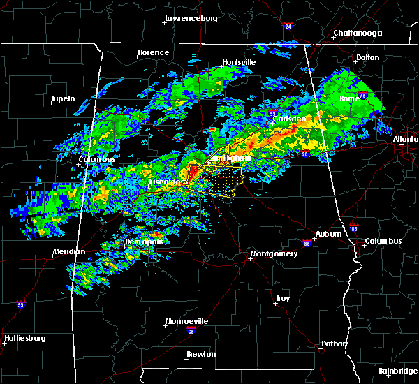 At 541 pm cst, severe thunderstorms were located along a line extending from brighton to near bessemer to near woodstock, moving east at 65 mph (radar indicated). Hazards include 70 mph wind gusts and quarter size hail. Hail damage to vehicles is expected. expect considerable tree damage. wind damage is also likely to mobile homes, roofs and outbuildings. locations impacted include, southwestern birmingham, hoover, vestavia hills, alabaster, bessemer, homewood, pelham, mountain brook, helena, hueytown, calera, fairfield, chelsea, childersburg, columbiana, wilsonville, pleasant grove, midfield, brighton and indian springs village. this includes the following highways, interstate 65 between mile markers 234 and 258. interstate 459 between mile markers 6 and 23. Interstate 20 between mile markers 106 and 118. At 541 pm cst, severe thunderstorms were located along a line extending from brighton to near bessemer to near woodstock, moving east at 65 mph (radar indicated). Hazards include 70 mph wind gusts and quarter size hail. Hail damage to vehicles is expected. expect considerable tree damage. wind damage is also likely to mobile homes, roofs and outbuildings. locations impacted include, southwestern birmingham, hoover, vestavia hills, alabaster, bessemer, homewood, pelham, mountain brook, helena, hueytown, calera, fairfield, chelsea, childersburg, columbiana, wilsonville, pleasant grove, midfield, brighton and indian springs village. this includes the following highways, interstate 65 between mile markers 234 and 258. interstate 459 between mile markers 6 and 23. Interstate 20 between mile markers 106 and 118.
|
| 3/1/2016 5:27 PM CST |
 At 527 pm cst, severe thunderstorms were located along a line extending from oak grove to near abernant to brookwood, moving east at 50 mph (radar indicated). Hazards include 60 mph wind gusts and quarter size hail. Hail damage to vehicles is expected. Expect wind damage to roofs, siding and trees. At 527 pm cst, severe thunderstorms were located along a line extending from oak grove to near abernant to brookwood, moving east at 50 mph (radar indicated). Hazards include 60 mph wind gusts and quarter size hail. Hail damage to vehicles is expected. Expect wind damage to roofs, siding and trees.
|
| 3/1/2016 5:15 PM CST |
 At 515 pm cst, severe thunderstorms were located along a line extending from gardendale to birmingham to pleasant grove, moving east at 55 mph (radar indicated). Hazards include 60 mph wind gusts and quarter size hail. Hail damage to vehicles is expected. expect wind damage to roofs, siding and trees. locations impacted include, birmingham, vestavia hills, homewood, mountain brook, trussville, gardendale, irondale, leeds, moody, fairfield, fultondale, center point, pleasant grove, clay, pinson, tarrant, midfield, adamsville, argo and sylvan springs. this includes the following highways, interstate 65 between mile markers 255 and 272. interstate 459 between mile markers 19 and 33. interstate 59 between mile markers 130 and 143. Interstate 20 between mile markers 118 and 140. At 515 pm cst, severe thunderstorms were located along a line extending from gardendale to birmingham to pleasant grove, moving east at 55 mph (radar indicated). Hazards include 60 mph wind gusts and quarter size hail. Hail damage to vehicles is expected. expect wind damage to roofs, siding and trees. locations impacted include, birmingham, vestavia hills, homewood, mountain brook, trussville, gardendale, irondale, leeds, moody, fairfield, fultondale, center point, pleasant grove, clay, pinson, tarrant, midfield, adamsville, argo and sylvan springs. this includes the following highways, interstate 65 between mile markers 255 and 272. interstate 459 between mile markers 19 and 33. interstate 59 between mile markers 130 and 143. Interstate 20 between mile markers 118 and 140.
|
| 3/1/2016 5:04 PM CST |
 At 504 pm cst, severe thunderstorms were located along a line extending from near cardiff to near sylvan springs, moving east at 40 mph (radar indicated). Hazards include 60 mph wind gusts and quarter size hail. Hail damage to vehicles is expected. Expect wind damage to roofs, siding and trees. At 504 pm cst, severe thunderstorms were located along a line extending from near cardiff to near sylvan springs, moving east at 40 mph (radar indicated). Hazards include 60 mph wind gusts and quarter size hail. Hail damage to vehicles is expected. Expect wind damage to roofs, siding and trees.
|
| 12/25/2015 5:03 PM CST |
 At 503 pm cst, a confirmed tornado was located over southwestern birmingham, moving northeast at 20 mph (radar confirmed tornado). Hazards include damaging tornado. Flying debris will be dangerous to those caught without shelter. mobile homes will be damaged or destroyed. damage to roofs, windows and vehicles will occur. tree damage is likely. this tornado will be near, birmingham and legion field around 510 pm cst. vestavia hills, homewood, u. a. b. campus, five points south, regions field, b. j. c. c. and samford university around 515 pm cst. mountain brook and cahaba heights around 520 pm cst. kingston around 525 pm cst. fultondale, tarrant, birmingham airport and ketona lakes around 530 pm cst. irondale around 535 pm cst. other locations impacted by this tornadic thunderstorm include highland park golf course, ruffner mountain, birmingham zoo, vulcan park, liberty park, cloverdale, rickwood field and danville. this includes the following highways, interstate 65 between mile markers 254 and 262. interstate 459 between mile markers 23 and 27. interstate 59 between mile markers 130 and 134. Interstate 20 between mile markers 113 and 136. At 503 pm cst, a confirmed tornado was located over southwestern birmingham, moving northeast at 20 mph (radar confirmed tornado). Hazards include damaging tornado. Flying debris will be dangerous to those caught without shelter. mobile homes will be damaged or destroyed. damage to roofs, windows and vehicles will occur. tree damage is likely. this tornado will be near, birmingham and legion field around 510 pm cst. vestavia hills, homewood, u. a. b. campus, five points south, regions field, b. j. c. c. and samford university around 515 pm cst. mountain brook and cahaba heights around 520 pm cst. kingston around 525 pm cst. fultondale, tarrant, birmingham airport and ketona lakes around 530 pm cst. irondale around 535 pm cst. other locations impacted by this tornadic thunderstorm include highland park golf course, ruffner mountain, birmingham zoo, vulcan park, liberty park, cloverdale, rickwood field and danville. this includes the following highways, interstate 65 between mile markers 254 and 262. interstate 459 between mile markers 23 and 27. interstate 59 between mile markers 130 and 134. Interstate 20 between mile markers 113 and 136.
|
| 12/25/2015 4:58 PM CST |
 At 458 pm cst, a confirmed tornado was located over southwestern birmingham, moving northeast at 15 mph (radar confirmed tornado). Hazards include damaging tornado. Flying debris will be dangerous to those caught without shelter. mobile homes will be damaged or destroyed. damage to roofs, windows and vehicles will occur. tree damage is likely. this tornado will be near, birmingham, hoover and ensley around 505 pm cst. birmingham fairgounds around 510 pm cst. legion field and birmingham southern college around 515 pm cst. u. a. b. campus, samford university and regions field around 520 pm cst. vestavia hills, homewood, mountain brook, five points south and b. j. c. c. around 525 pm cst. kingston and cahaba heights around 535 pm cst. birmingham airport and ketona lakes around 540 pm cst. irondale around 545 pm cst. other locations impacted by this tornadic thunderstorm include highland park golf course, ruffner mountain, birmingham zoo, vulcan park, liberty park, cloverdale, rickwood field and danville. this includes the following highways, interstate 65 between mile markers 254 and 262. interstate 459 between mile markers 23 and 27. interstate 59 between mile markers 130 and 134. Interstate 20 between mile markers 113 and 136. At 458 pm cst, a confirmed tornado was located over southwestern birmingham, moving northeast at 15 mph (radar confirmed tornado). Hazards include damaging tornado. Flying debris will be dangerous to those caught without shelter. mobile homes will be damaged or destroyed. damage to roofs, windows and vehicles will occur. tree damage is likely. this tornado will be near, birmingham, hoover and ensley around 505 pm cst. birmingham fairgounds around 510 pm cst. legion field and birmingham southern college around 515 pm cst. u. a. b. campus, samford university and regions field around 520 pm cst. vestavia hills, homewood, mountain brook, five points south and b. j. c. c. around 525 pm cst. kingston and cahaba heights around 535 pm cst. birmingham airport and ketona lakes around 540 pm cst. irondale around 545 pm cst. other locations impacted by this tornadic thunderstorm include highland park golf course, ruffner mountain, birmingham zoo, vulcan park, liberty park, cloverdale, rickwood field and danville. this includes the following highways, interstate 65 between mile markers 254 and 262. interstate 459 between mile markers 23 and 27. interstate 59 between mile markers 130 and 134. Interstate 20 between mile markers 113 and 136.
|
| 12/25/2015 4:55 PM CST |
 At 455 pm cst, a severe thunderstorm capable of producing a tornado was located over southwestern birmingham, moving northeast at 20 mph (radar indicated rotation). Hazards include tornado. Flying debris will be dangerous to those caught without shelter. mobile homes will be damaged or destroyed. damage to roofs, windows and vehicles will occur. tree damage is likely. this dangerous storm will be near, hoover around 500 pm cst. birmingham, birmingham fairgounds and ensley around 505 pm cst. legion field and birmingham southern college around 510 pm cst. vestavia hills, homewood, u. a. b. campus, regions field, five points south, b. j. c. c. and samford university around 515 pm cst. mountain brook around 520 pm cst. kingston and cahaba heights around 525 pm cst. birmingham airport and ketona lakes around 530 pm cst. irondale, fultondale and tarrant around 535 pm cst. other locations impacted by this tornadic thunderstorm include highland park golf course, ruffner mountain, birmingham zoo, vulcan park, liberty park, cloverdale, rickwood field and danville. this includes the following highways, interstate 65 between mile markers 254 and 262. interstate 459 between mile markers 23 and 27. interstate 59 between mile markers 130 and 134. Interstate 20 between mile markers 113 and 136. At 455 pm cst, a severe thunderstorm capable of producing a tornado was located over southwestern birmingham, moving northeast at 20 mph (radar indicated rotation). Hazards include tornado. Flying debris will be dangerous to those caught without shelter. mobile homes will be damaged or destroyed. damage to roofs, windows and vehicles will occur. tree damage is likely. this dangerous storm will be near, hoover around 500 pm cst. birmingham, birmingham fairgounds and ensley around 505 pm cst. legion field and birmingham southern college around 510 pm cst. vestavia hills, homewood, u. a. b. campus, regions field, five points south, b. j. c. c. and samford university around 515 pm cst. mountain brook around 520 pm cst. kingston and cahaba heights around 525 pm cst. birmingham airport and ketona lakes around 530 pm cst. irondale, fultondale and tarrant around 535 pm cst. other locations impacted by this tornadic thunderstorm include highland park golf course, ruffner mountain, birmingham zoo, vulcan park, liberty park, cloverdale, rickwood field and danville. this includes the following highways, interstate 65 between mile markers 254 and 262. interstate 459 between mile markers 23 and 27. interstate 59 between mile markers 130 and 134. Interstate 20 between mile markers 113 and 136.
|
| 8/10/2015 8:57 PM CDT |
 At 856 pm cdt, severe thunderstorms were located along a line extending from chelsea to near tannehill ironworks state park, moving southeast at 30 mph (trained weather spotters). Hazards include 60 mph wind gusts. Expect damage to roofs. siding and trees. locations impacted include, birmingham, hoover, vestavia hills, bessemer, homewood, mountain brook, hueytown, irondale, fairfield, midfield, brighton, lipscomb, north johns, splash adventure, b. j. c. c,. Ross bridge, regions field, bluff park, the summit and legion field. At 856 pm cdt, severe thunderstorms were located along a line extending from chelsea to near tannehill ironworks state park, moving southeast at 30 mph (trained weather spotters). Hazards include 60 mph wind gusts. Expect damage to roofs. siding and trees. locations impacted include, birmingham, hoover, vestavia hills, bessemer, homewood, mountain brook, hueytown, irondale, fairfield, midfield, brighton, lipscomb, north johns, splash adventure, b. j. c. c,. Ross bridge, regions field, bluff park, the summit and legion field.
|
| 8/10/2015 8:31 PM CDT |
 At 830 pm cdt, severe thunderstorms were located along a line extending from mountain brook to near oak grove, moving southeast at 40 mph (trained weather spotters). Hazards include 70 mph wind gusts. Expect considerable tree damage. damage is likely to mobile homes, roofs and outbuildings. Locations impacted include, birmingham, hoover, vestavia hills, bessemer, homewood, mountain brook, hueytown, gardendale, irondale, fairfield, fultondale, pleasant grove, tarrant, midfield, adamsville, brighton, lipscomb, graysville, sylvan springs and brookside. At 830 pm cdt, severe thunderstorms were located along a line extending from mountain brook to near oak grove, moving southeast at 40 mph (trained weather spotters). Hazards include 70 mph wind gusts. Expect considerable tree damage. damage is likely to mobile homes, roofs and outbuildings. Locations impacted include, birmingham, hoover, vestavia hills, bessemer, homewood, mountain brook, hueytown, gardendale, irondale, fairfield, fultondale, pleasant grove, tarrant, midfield, adamsville, brighton, lipscomb, graysville, sylvan springs and brookside.
|
| 8/10/2015 8:15 PM CDT |
 At 815 pm cdt, severe thunderstorms were located along a line extending from near forestdale to 8 miles southwest of gorgas steam plant, moving southeast at 40 mph (radar indicated). Hazards include 60 mph wind gusts. Expect damage to roofs. Siding and trees. At 815 pm cdt, severe thunderstorms were located along a line extending from near forestdale to 8 miles southwest of gorgas steam plant, moving southeast at 40 mph (radar indicated). Hazards include 60 mph wind gusts. Expect damage to roofs. Siding and trees.
|
| 7/29/2015 2:37 PM CDT |
 At 237 pm cdt, severe thunderstorms were located along a line extending from birmingham to near westover, moving south at 30 mph (radar indicated). Hazards include 60 mph wind gusts. Expect damage to roofs. Siding and trees. At 237 pm cdt, severe thunderstorms were located along a line extending from birmingham to near westover, moving south at 30 mph (radar indicated). Hazards include 60 mph wind gusts. Expect damage to roofs. Siding and trees.
|
| 7/14/2015 8:20 PM CDT |
 At 820 pm cdt, severe thunderstorms were located along a line extending from 6 miles west of ashville to argo to birmingham to ensley to oak grove to bankhead lock and dam, moving southeast at 55 mph (radar indicated). Hazards include 70 mph wind gusts and penny size hail. Expect considerable tree damage. Damage is likely to mobile homes, roofs and outbuildings. At 820 pm cdt, severe thunderstorms were located along a line extending from 6 miles west of ashville to argo to birmingham to ensley to oak grove to bankhead lock and dam, moving southeast at 55 mph (radar indicated). Hazards include 70 mph wind gusts and penny size hail. Expect considerable tree damage. Damage is likely to mobile homes, roofs and outbuildings.
|
| 7/14/2015 8:02 PM CDT |
 At 802 pm cdt, severe thunderstorms were located along a line extending from 6 miles northwest of ashville to near springville to center point to birmingham to near oak grove to near bankhead lock and dam, moving southeast at 50 mph (radar indicated). Hazards include 70 mph wind gusts and penny size hail. Expect considerable tree damage. damage is likely to mobile homes, roofs and outbuildings. Locations impacted include, birmingham, hoover, vestavia hills, bessemer, homewood, mountain brook, trussville, hueytown, gardendale, irondale, leeds, moody, fairfield, fultondale, oneonta, blountsville, cleveland, dallas, center point and pleasant grove. At 802 pm cdt, severe thunderstorms were located along a line extending from 6 miles northwest of ashville to near springville to center point to birmingham to near oak grove to near bankhead lock and dam, moving southeast at 50 mph (radar indicated). Hazards include 70 mph wind gusts and penny size hail. Expect considerable tree damage. damage is likely to mobile homes, roofs and outbuildings. Locations impacted include, birmingham, hoover, vestavia hills, bessemer, homewood, mountain brook, trussville, hueytown, gardendale, irondale, leeds, moody, fairfield, fultondale, oneonta, blountsville, cleveland, dallas, center point and pleasant grove.
|
| 7/14/2015 7:31 PM CDT |
 At 731 pm cdt, severe thunderstorms were located along a line extending from brooksville to near nectar to near blount springs to near arkadelphia to near parrish to 6 miles south of carbon hill, moving south at 50 mph (radar indicated). Hazards include 70 mph wind gusts and penny size hail. Expect considerable tree damage. Damage is likely to mobile homes, roofs and outbuildings. At 731 pm cdt, severe thunderstorms were located along a line extending from brooksville to near nectar to near blount springs to near arkadelphia to near parrish to 6 miles south of carbon hill, moving south at 50 mph (radar indicated). Hazards include 70 mph wind gusts and penny size hail. Expect considerable tree damage. Damage is likely to mobile homes, roofs and outbuildings.
|
| 6/30/2015 7:16 AM CDT |
 At 715 am cdt, a severe thunderstorm was located over helena, moving east at 45 mph (radar indicated). Hazards include 60 mph wind gusts and quarter size hail. Hail damage to vehicles is expected. Expect wind damage to roofs, siding and trees. At 715 am cdt, a severe thunderstorm was located over helena, moving east at 45 mph (radar indicated). Hazards include 60 mph wind gusts and quarter size hail. Hail damage to vehicles is expected. Expect wind damage to roofs, siding and trees.
|
| 3/31/2015 8:16 PM CDT | A severe thunderstorm warning remains in effect until 900 pm cdt for east central jefferson county. at 815 pm cdt. a severe thunderstorm was located over fultondale. moving east at 30 mph. hazard. quarter size hail. source. Public. |
| 3/31/2015 7:56 PM CDT | The national weather service in birmingham has issued a * severe thunderstorm warning for. jefferson county in central alabama. until 900 pm cdt * at 755 pm cdt. a severe thunderstorm was located over graysville. or 8 miles southeast of sumiton. Moving east at 30. |
Hail Maps for Fairfield, AL
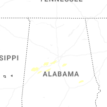
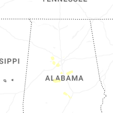

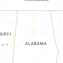


Connect with Interactive Hail Maps