

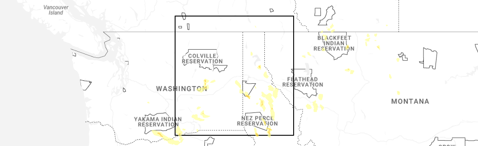
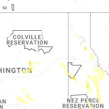
Hail Map for Fairfield, WA
The Fairfield, WA area has had 1 report of on-the-ground hail by trained spotters, and has been under severe weather warnings 3 times during the past 12 months. Doppler radar has detected hail at or near Fairfield, WA on 4 occasions, including 1 occasion during the past year.
| Name: | Fairfield, WA |
| Where Located: | 21.8 miles SSE of Spokane, WA |
| Map: | Google Map for Fairfield, WA |
| Population: | 612 |
| Housing Units: | 240 |
| More Info: | Search Google for Fairfield, WA |
5
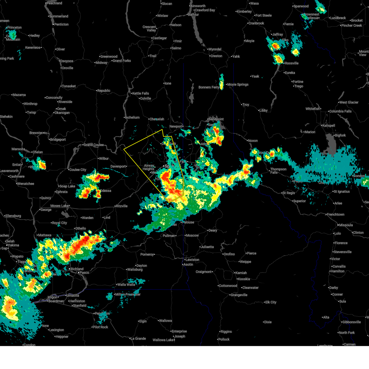
The Top Recent Hail Date for Fairfield, WA is Thursday, May 28, 2026 (2nd out of 4)
Hail and Wind Damage Spotted near Fairfield, WA
| Date / Time | Report Details |
|---|---|
| 5/28/2026 8:00 PM PDT |
 Svrotx the national weather service in spokane has issued a * severe thunderstorm warning for, northeastern lincoln county in eastern washington, northern whitman county in eastern washington, southeastern stevens county in northeastern washington, spokane county in northeastern washington, * until 900 pm pdt. * at 800 pm pdt, a severe thunderstorm was located 10 miles south of dishman, or 11 miles south of spokane valley, moving northwest at 55 mph (radar indicated). Hazards include 60 mph wind gusts and penny size hail. expect damage to roofs, siding, and trees Svrotx the national weather service in spokane has issued a * severe thunderstorm warning for, northeastern lincoln county in eastern washington, northern whitman county in eastern washington, southeastern stevens county in northeastern washington, spokane county in northeastern washington, * until 900 pm pdt. * at 800 pm pdt, a severe thunderstorm was located 10 miles south of dishman, or 11 miles south of spokane valley, moving northwest at 55 mph (radar indicated). Hazards include 60 mph wind gusts and penny size hail. expect damage to roofs, siding, and trees
|
| 5/28/2026 7:46 PM PDT |
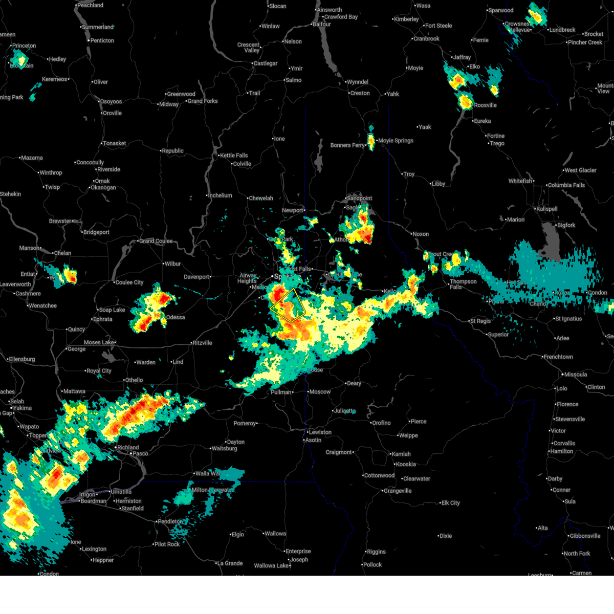 At 746 pm pdt, a severe thunderstorm was located 11 miles south of dishman, or 12 miles south of spokane valley, moving northwest at 15 mph (radar indicated). Hazards include 70 mph wind gusts and penny size hail. Expect considerable tree damage. damage is likely to mobile homes, roofs, and outbuildings. locations impacted include, fairfield, rockford, spangle, and waverly. this includes u. s. Highway 195 in washington between mile markers 76 and 79. At 746 pm pdt, a severe thunderstorm was located 11 miles south of dishman, or 12 miles south of spokane valley, moving northwest at 15 mph (radar indicated). Hazards include 70 mph wind gusts and penny size hail. Expect considerable tree damage. damage is likely to mobile homes, roofs, and outbuildings. locations impacted include, fairfield, rockford, spangle, and waverly. this includes u. s. Highway 195 in washington between mile markers 76 and 79.
|
| 5/28/2026 7:11 PM PDT |
 Svrotx the national weather service in spokane has issued a * severe thunderstorm warning for, southeastern spokane county in northeastern washington, * until 800 pm pdt. * at 711 pm pdt, a severe thunderstorm was located 13 miles west of plummer, or 19 miles south of spokane valley, moving northwest at 15 mph (radar indicated). Hazards include 60 mph wind gusts and quarter size hail. Hail damage to vehicles is expected. Expect wind damage to roofs, siding, and trees. Svrotx the national weather service in spokane has issued a * severe thunderstorm warning for, southeastern spokane county in northeastern washington, * until 800 pm pdt. * at 711 pm pdt, a severe thunderstorm was located 13 miles west of plummer, or 19 miles south of spokane valley, moving northwest at 15 mph (radar indicated). Hazards include 60 mph wind gusts and quarter size hail. Hail damage to vehicles is expected. Expect wind damage to roofs, siding, and trees.
|
| 6/8/2023 4:57 PM PDT |
 The severe thunderstorm warning for northwestern benewah, southwestern kootenai and eastern spokane counties will expire at 500 pm pdt, the storms which prompted the warning have moved out of the area. therefore, the warning will be allowed to expire. however, gusty winds are still possible with these thunderstorms. The severe thunderstorm warning for northwestern benewah, southwestern kootenai and eastern spokane counties will expire at 500 pm pdt, the storms which prompted the warning have moved out of the area. therefore, the warning will be allowed to expire. however, gusty winds are still possible with these thunderstorms.
|
| 6/8/2023 4:34 PM PDT |
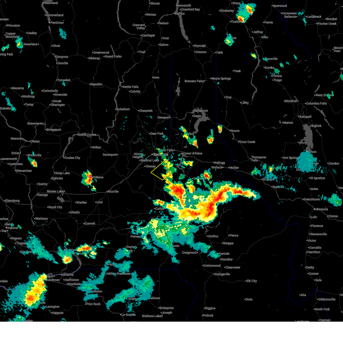
 At 433 pm pdt, severe thunderstorms were located along a line extending from near chattaroy to 9 miles west of plummer, moving west at 15 mph (trained weather spotters reported damage in greenacres at 426 pm). Hazards include 60 mph wind gusts and nickel size hail. Expect damage to roofs, siding, and trees. locations impacted include, spokane, spokane valley, post falls, liberty lake, nine mile falls, millwood, plummer, hauser, otis orchards-east farms, fairwood, otis orchards, green acres, trentwood, country homes, town and country, chattaroy, dishman, mead, fairfield, and rockford. this includes the following highways, interstate 90 in washington between mile markers 277 and 299. interstate 90 in idaho between mile markers 0 and 5. u. s. highway 95 in idaho between mile markers 391 and 420. u. s. highway 2 in washington between mile markers 282 and 305. u. s. highway 195 in washington between mile markers 75 and 95. u. s. highway 395 in washington between mile markers 165 and 177. hail threat, radar indicated max hail size, 0. 88 in wind threat, radar indicated max wind gust, 60 mph. At 433 pm pdt, severe thunderstorms were located along a line extending from near chattaroy to 9 miles west of plummer, moving west at 15 mph (trained weather spotters reported damage in greenacres at 426 pm). Hazards include 60 mph wind gusts and nickel size hail. Expect damage to roofs, siding, and trees. locations impacted include, spokane, spokane valley, post falls, liberty lake, nine mile falls, millwood, plummer, hauser, otis orchards-east farms, fairwood, otis orchards, green acres, trentwood, country homes, town and country, chattaroy, dishman, mead, fairfield, and rockford. this includes the following highways, interstate 90 in washington between mile markers 277 and 299. interstate 90 in idaho between mile markers 0 and 5. u. s. highway 95 in idaho between mile markers 391 and 420. u. s. highway 2 in washington between mile markers 282 and 305. u. s. highway 195 in washington between mile markers 75 and 95. u. s. highway 395 in washington between mile markers 165 and 177. hail threat, radar indicated max hail size, 0. 88 in wind threat, radar indicated max wind gust, 60 mph.
|
| 6/8/2023 4:34 PM PDT |
 At 433 pm pdt, severe thunderstorms were located along a line extending from near chattaroy to 9 miles west of plummer, moving west at 15 mph (trained weather spotters reported damage in greenacres at 426 pm). Hazards include 60 mph wind gusts and nickel size hail. Expect damage to roofs, siding, and trees. locations impacted include, spokane, spokane valley, post falls, liberty lake, nine mile falls, millwood, plummer, hauser, otis orchards-east farms, fairwood, otis orchards, green acres, trentwood, country homes, town and country, chattaroy, dishman, mead, fairfield, and rockford. this includes the following highways, interstate 90 in washington between mile markers 277 and 299. interstate 90 in idaho between mile markers 0 and 5. u. s. highway 95 in idaho between mile markers 391 and 420. u. s. highway 2 in washington between mile markers 282 and 305. u. s. highway 195 in washington between mile markers 75 and 95. u. s. highway 395 in washington between mile markers 165 and 177. hail threat, radar indicated max hail size, 0. 88 in wind threat, radar indicated max wind gust, 60 mph. At 433 pm pdt, severe thunderstorms were located along a line extending from near chattaroy to 9 miles west of plummer, moving west at 15 mph (trained weather spotters reported damage in greenacres at 426 pm). Hazards include 60 mph wind gusts and nickel size hail. Expect damage to roofs, siding, and trees. locations impacted include, spokane, spokane valley, post falls, liberty lake, nine mile falls, millwood, plummer, hauser, otis orchards-east farms, fairwood, otis orchards, green acres, trentwood, country homes, town and country, chattaroy, dishman, mead, fairfield, and rockford. this includes the following highways, interstate 90 in washington between mile markers 277 and 299. interstate 90 in idaho between mile markers 0 and 5. u. s. highway 95 in idaho between mile markers 391 and 420. u. s. highway 2 in washington between mile markers 282 and 305. u. s. highway 195 in washington between mile markers 75 and 95. u. s. highway 395 in washington between mile markers 165 and 177. hail threat, radar indicated max hail size, 0. 88 in wind threat, radar indicated max wind gust, 60 mph.
|
| 6/8/2023 4:25 PM PDT |
 At 423 pm pdt, severe thunderstorms were located along a line extending from 6 miles east of chattaroy to 7 miles west of plummer, moving west at 20 mph (trained weather spotters reported downed tree limbs and highway signs near lake coeur d`alene earlier with these storms). Hazards include 60 mph wind gusts and nickel size hail. Expect damage to roofs, siding, and trees. locations impacted include, spokane, spokane valley, post falls, rathdrum, liberty lake, nine mile falls, millwood, plummer, hauser, harrison, otis orchards-east farms, fairwood, otis orchards, green acres, trentwood, country homes, town and country, chattaroy, dishman, and mead. this includes the following highways, interstate 90 in washington between mile markers 277 and 299. interstate 90 in idaho between mile markers 0 and 8. u. s. highway 95 in idaho between mile markers 390 and 425. u. s. highway 2 in washington between mile markers 282 and 305. u. s. highway 195 in washington between mile markers 75 and 95. u. s. highway 395 in washington between mile markers 165 and 177. hail threat, radar indicated max hail size, 0. 88 in wind threat, radar indicated max wind gust, 60 mph. At 423 pm pdt, severe thunderstorms were located along a line extending from 6 miles east of chattaroy to 7 miles west of plummer, moving west at 20 mph (trained weather spotters reported downed tree limbs and highway signs near lake coeur d`alene earlier with these storms). Hazards include 60 mph wind gusts and nickel size hail. Expect damage to roofs, siding, and trees. locations impacted include, spokane, spokane valley, post falls, rathdrum, liberty lake, nine mile falls, millwood, plummer, hauser, harrison, otis orchards-east farms, fairwood, otis orchards, green acres, trentwood, country homes, town and country, chattaroy, dishman, and mead. this includes the following highways, interstate 90 in washington between mile markers 277 and 299. interstate 90 in idaho between mile markers 0 and 8. u. s. highway 95 in idaho between mile markers 390 and 425. u. s. highway 2 in washington between mile markers 282 and 305. u. s. highway 195 in washington between mile markers 75 and 95. u. s. highway 395 in washington between mile markers 165 and 177. hail threat, radar indicated max hail size, 0. 88 in wind threat, radar indicated max wind gust, 60 mph.
|
| 6/8/2023 4:10 PM PDT |
 At 409 pm pdt, severe thunderstorms were located along a line extending from near hauser to 6 miles west of harrison, moving west at 15 mph (radar indicated). Hazards include 60 mph wind gusts and nickel size hail. expect damage to roofs, siding, and trees At 409 pm pdt, severe thunderstorms were located along a line extending from near hauser to 6 miles west of harrison, moving west at 15 mph (radar indicated). Hazards include 60 mph wind gusts and nickel size hail. expect damage to roofs, siding, and trees
|
| 8/11/2022 5:21 PM PDT |
 At 519 pm pdt, a severe thunderstorm was located 11 miles south of liberty lake, or 14 miles southeast of spokane valley, moving north at 30 mph (radar indicated). Hazards include tennis ball size hail and 60 mph wind gusts. People and animals outdoors will be injured. expect hail damage to roofs, siding, windows, and vehicles. expect wind damage to roofs, siding, and trees. locations impacted include, spokane valley, coeur d`alene, post falls, liberty lake, green acres, otis orchards-east farms, otis orchards, trentwood, fairfield, rockford, worley, fernan lake village, huetter, state line and mica. this includes the following highways, interstate 90 in washington between mile markers 293 and 299. interstate 90 in idaho between mile markers 0 and 17. u. s. highway 95 in idaho between mile markers 402 and 431. thunderstorm damage threat, considerable hail threat, radar indicated max hail size, 2. 50 in wind threat, radar indicated max wind gust, 60 mph. At 519 pm pdt, a severe thunderstorm was located 11 miles south of liberty lake, or 14 miles southeast of spokane valley, moving north at 30 mph (radar indicated). Hazards include tennis ball size hail and 60 mph wind gusts. People and animals outdoors will be injured. expect hail damage to roofs, siding, windows, and vehicles. expect wind damage to roofs, siding, and trees. locations impacted include, spokane valley, coeur d`alene, post falls, liberty lake, green acres, otis orchards-east farms, otis orchards, trentwood, fairfield, rockford, worley, fernan lake village, huetter, state line and mica. this includes the following highways, interstate 90 in washington between mile markers 293 and 299. interstate 90 in idaho between mile markers 0 and 17. u. s. highway 95 in idaho between mile markers 402 and 431. thunderstorm damage threat, considerable hail threat, radar indicated max hail size, 2. 50 in wind threat, radar indicated max wind gust, 60 mph.
|
| 8/11/2022 5:10 PM PDT | Quarter sized hail reported 3.1 miles W of Fairfield, WA |
| 8/11/2022 5:07 PM PDT |
 At 507 pm pdt, a severe thunderstorm was located 11 miles northwest of plummer, or 18 miles south of spokane valley, moving northeast at 40 mph (radar indicated). Hazards include golf ball size hail and 60 mph wind gusts. People and animals outdoors will be injured. expect hail damage to roofs, siding, windows, and vehicles. Expect wind damage to roofs, siding, and trees. At 507 pm pdt, a severe thunderstorm was located 11 miles northwest of plummer, or 18 miles south of spokane valley, moving northeast at 40 mph (radar indicated). Hazards include golf ball size hail and 60 mph wind gusts. People and animals outdoors will be injured. expect hail damage to roofs, siding, windows, and vehicles. Expect wind damage to roofs, siding, and trees.
|
| 8/11/2022 5:05 PM PDT | Downed power lines and power outages east of fairfield. time estimated from rada in spokane county WA, 3.5 miles WNW of Fairfield, WA |
| 8/11/2022 4:59 PM PDT |
 At 459 pm pdt, a severe thunderstorm was located 8 miles west of plummer, or 23 miles west of st. maries, moving northeast at 40 mph (radar indicated). Hazards include ping pong ball size hail and 60 mph wind gusts. People and animals outdoors will be injured. expect hail damage to roofs, siding, windows, and vehicles. expect wind damage to roofs, siding, and trees. locations impacted include, harrison, tekoa, fairfield, rockford, worley and latah. this includes u. s. highway 95 in idaho between mile markers 398 and 413. hail threat, radar indicated max hail size, 1. 50 in wind threat, radar indicated max wind gust, 60 mph. At 459 pm pdt, a severe thunderstorm was located 8 miles west of plummer, or 23 miles west of st. maries, moving northeast at 40 mph (radar indicated). Hazards include ping pong ball size hail and 60 mph wind gusts. People and animals outdoors will be injured. expect hail damage to roofs, siding, windows, and vehicles. expect wind damage to roofs, siding, and trees. locations impacted include, harrison, tekoa, fairfield, rockford, worley and latah. this includes u. s. highway 95 in idaho between mile markers 398 and 413. hail threat, radar indicated max hail size, 1. 50 in wind threat, radar indicated max wind gust, 60 mph.
|
| 8/11/2022 4:48 PM PDT |
 At 448 pm pdt, a severe thunderstorm was located 12 miles southwest of plummer, or 26 miles west of st. maries, moving northeast at 35 mph (radar indicated). Hazards include 60 mph wind gusts and quarter size hail. Hail damage to vehicles is expected. expect wind damage to roofs, siding, and trees. locations impacted include, harrison, tekoa, fairfield, rockford, worley and latah. this includes u. s. highway 95 in idaho between mile markers 397 and 413. hail threat, radar indicated max hail size, 1. 00 in wind threat, radar indicated max wind gust, 60 mph. At 448 pm pdt, a severe thunderstorm was located 12 miles southwest of plummer, or 26 miles west of st. maries, moving northeast at 35 mph (radar indicated). Hazards include 60 mph wind gusts and quarter size hail. Hail damage to vehicles is expected. expect wind damage to roofs, siding, and trees. locations impacted include, harrison, tekoa, fairfield, rockford, worley and latah. this includes u. s. highway 95 in idaho between mile markers 397 and 413. hail threat, radar indicated max hail size, 1. 00 in wind threat, radar indicated max wind gust, 60 mph.
|
| 8/11/2022 4:34 PM PDT |
 At 433 pm pdt, a severe thunderstorm was located 17 miles north of colfax, or 27 miles north of pullman, moving northeast at 45 mph (radar indicated). Hazards include quarter size hail. damage to vehicles is expected At 433 pm pdt, a severe thunderstorm was located 17 miles north of colfax, or 27 miles north of pullman, moving northeast at 45 mph (radar indicated). Hazards include quarter size hail. damage to vehicles is expected
|
| 5/4/2016 11:13 PM PDT | The severe thunderstorm warning for eastern lincoln and southern spokane counties will expire at 1115 pm pdt, the gust front which prompted the warning has moved out of the area. therefore the warning will be allowed to expire. however heavy rain is still possible with thunderstorms behind this gust front. a severe thunderstorm warning remains in effect for northern spokane county, extreme northern lincoln county and southern stevens and pend orielle counties until 1145 pm. |
| 5/4/2016 10:26 PM PDT |
 At 1024 pm pdt, doppler radar indicated a strong gust front with a line of severe thunderstorms capable of producing damaging winds in excess of 60 mph. these storms were located along a line extending from 16 miles south of davenport to 13 miles southeast of cheney, and moving north at 35 mph. At 1024 pm pdt, doppler radar indicated a strong gust front with a line of severe thunderstorms capable of producing damaging winds in excess of 60 mph. these storms were located along a line extending from 16 miles south of davenport to 13 miles southeast of cheney, and moving north at 35 mph.
|
Hail Maps for Fairfield, WA


Connect with Interactive Hail Maps