

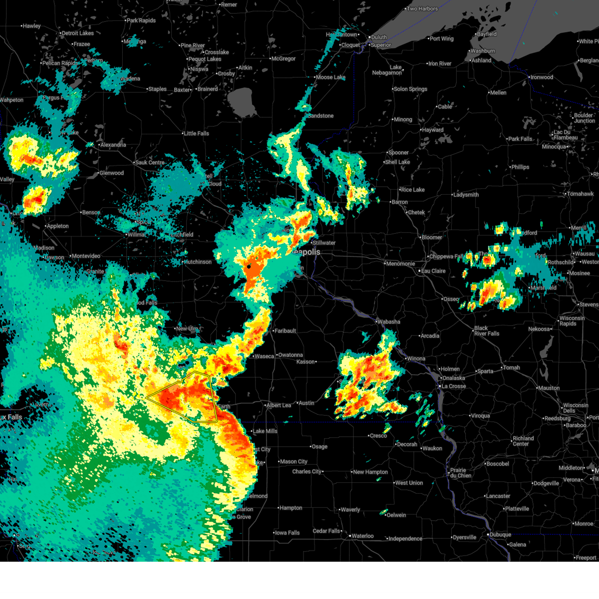
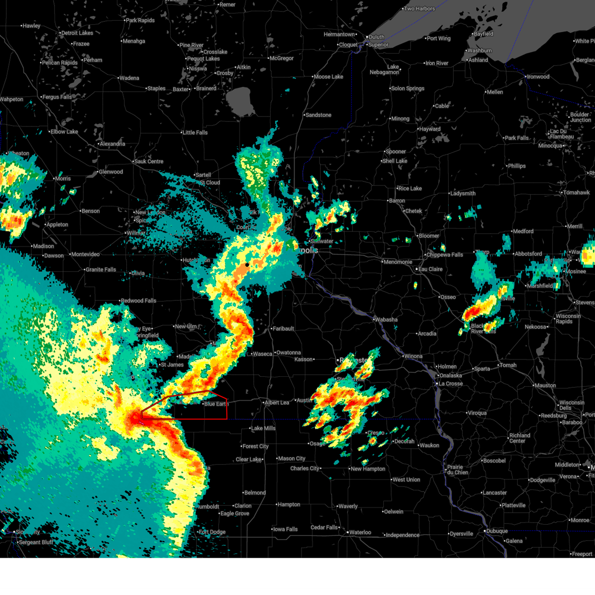
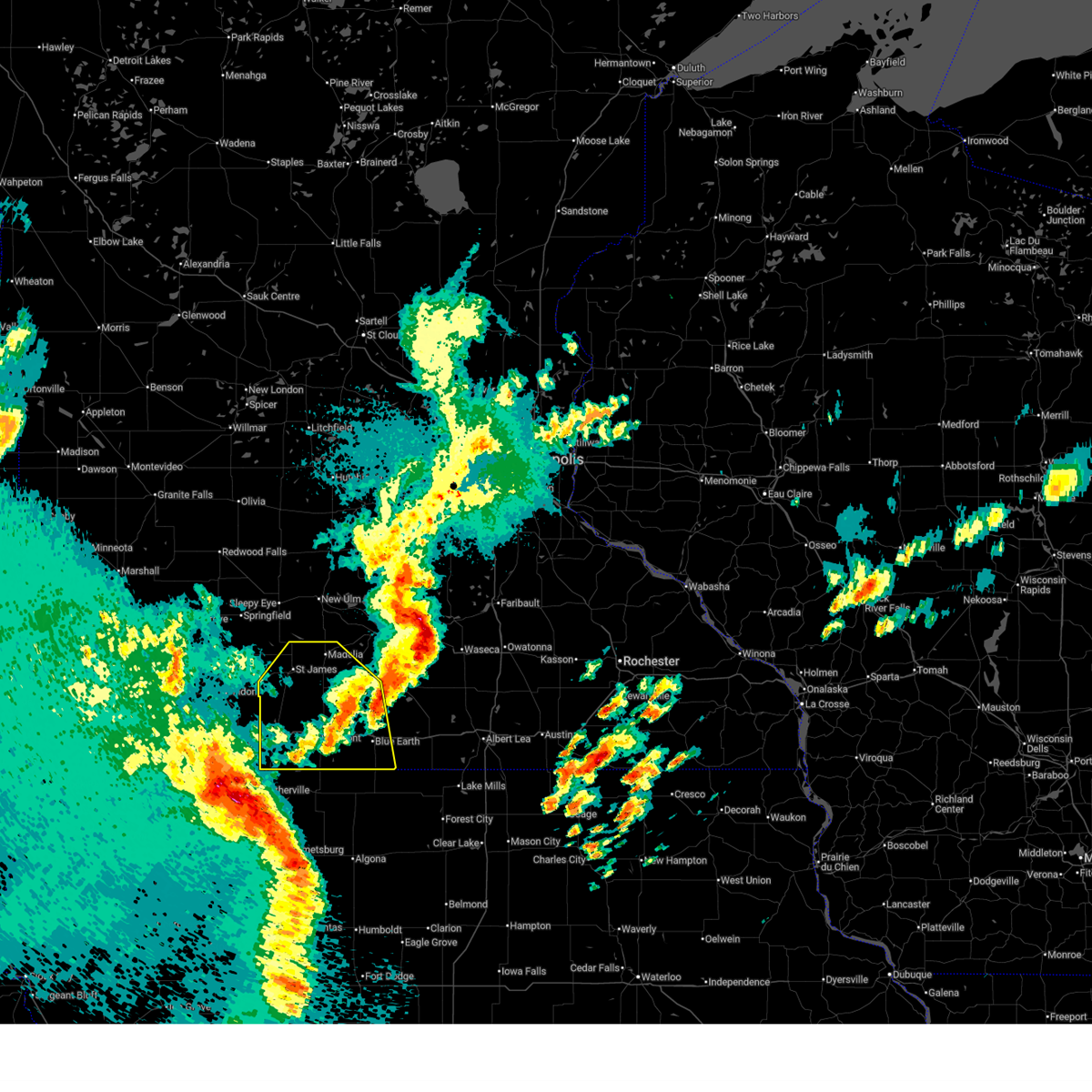
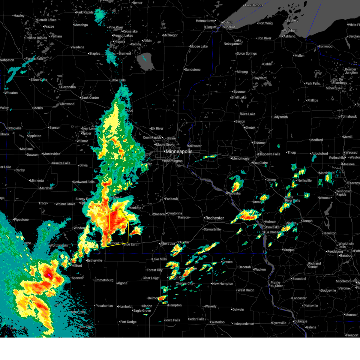
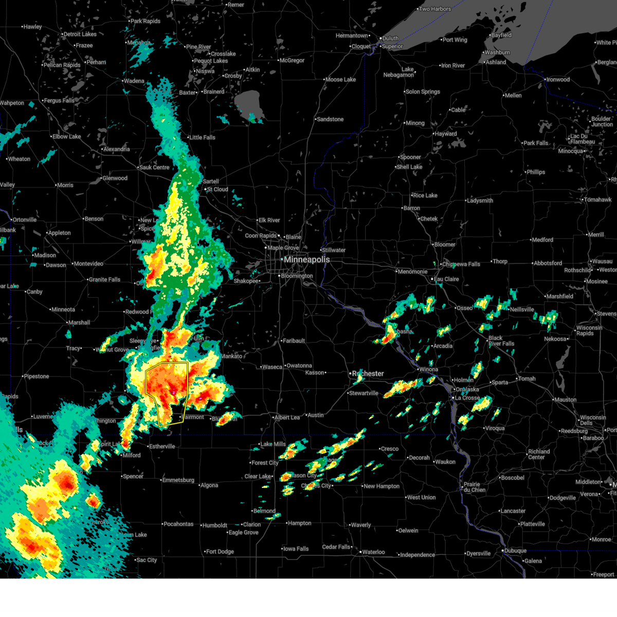
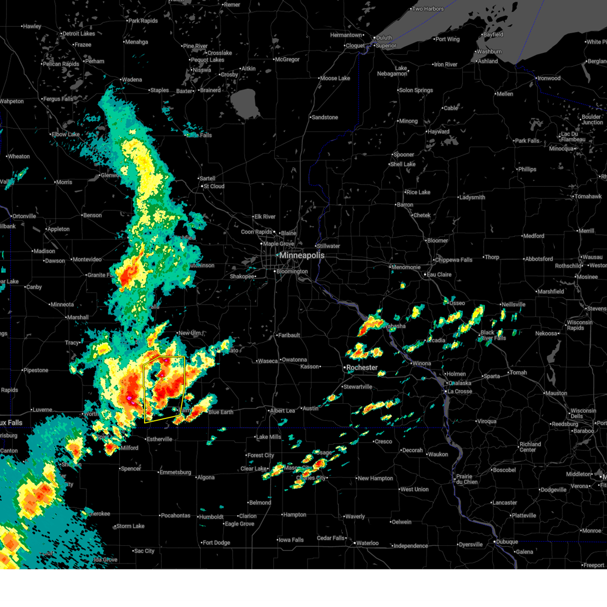
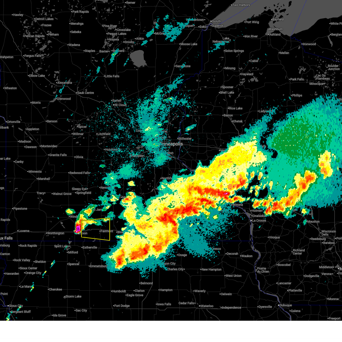
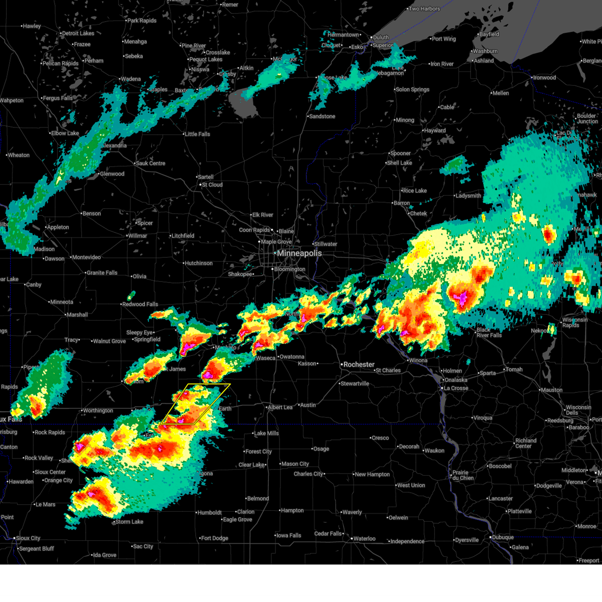
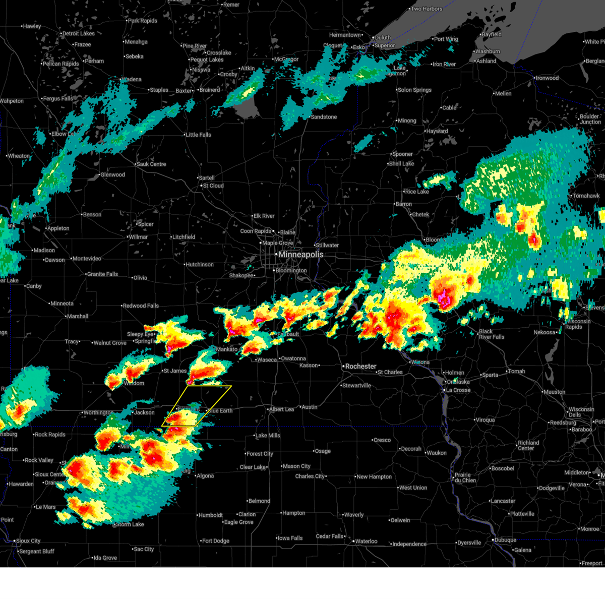
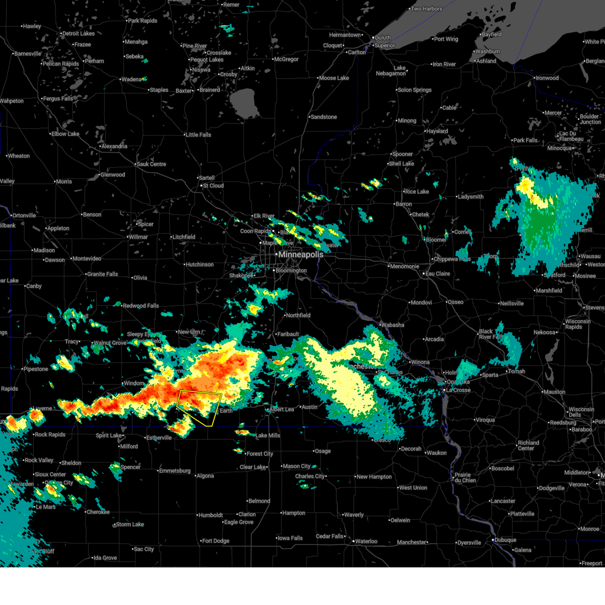
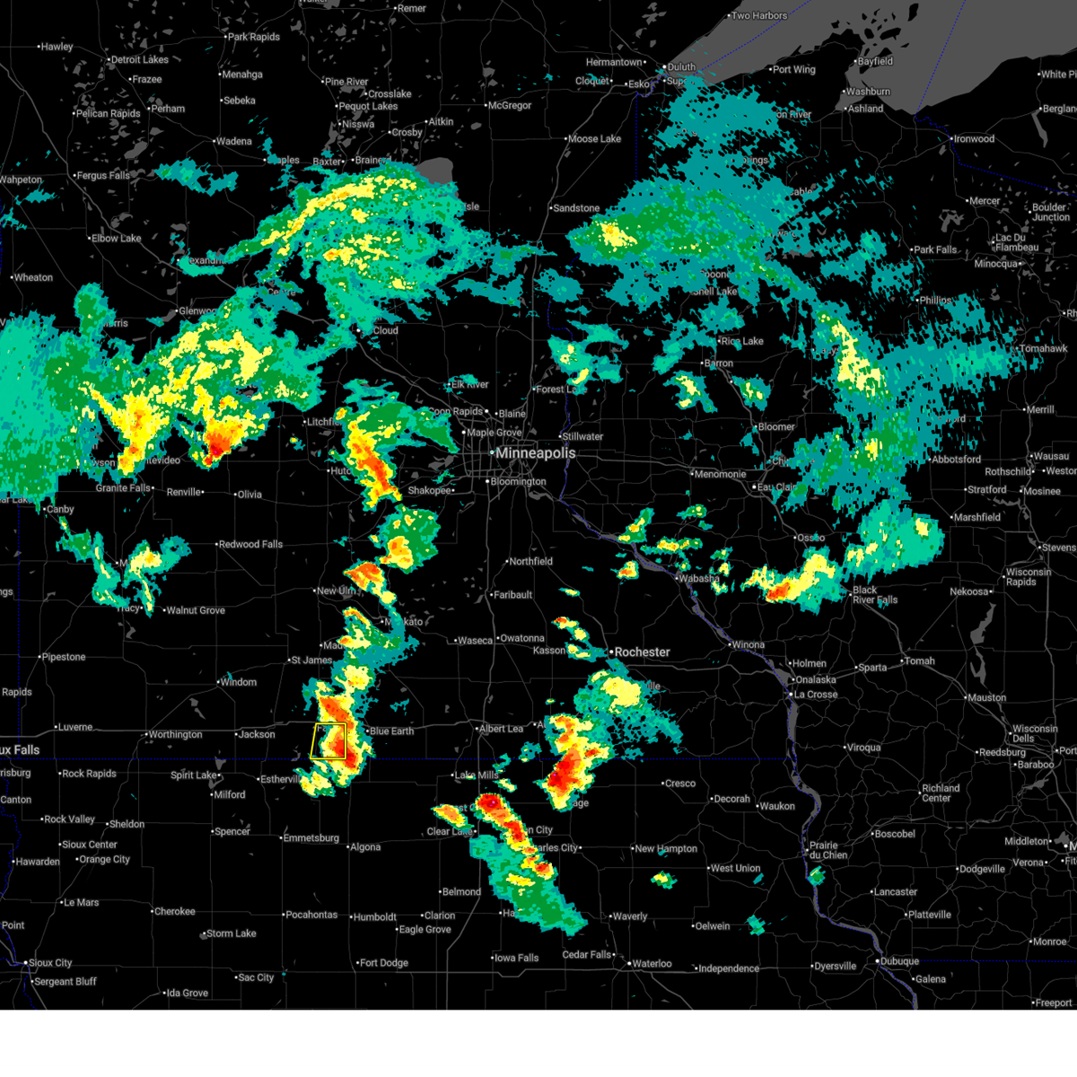
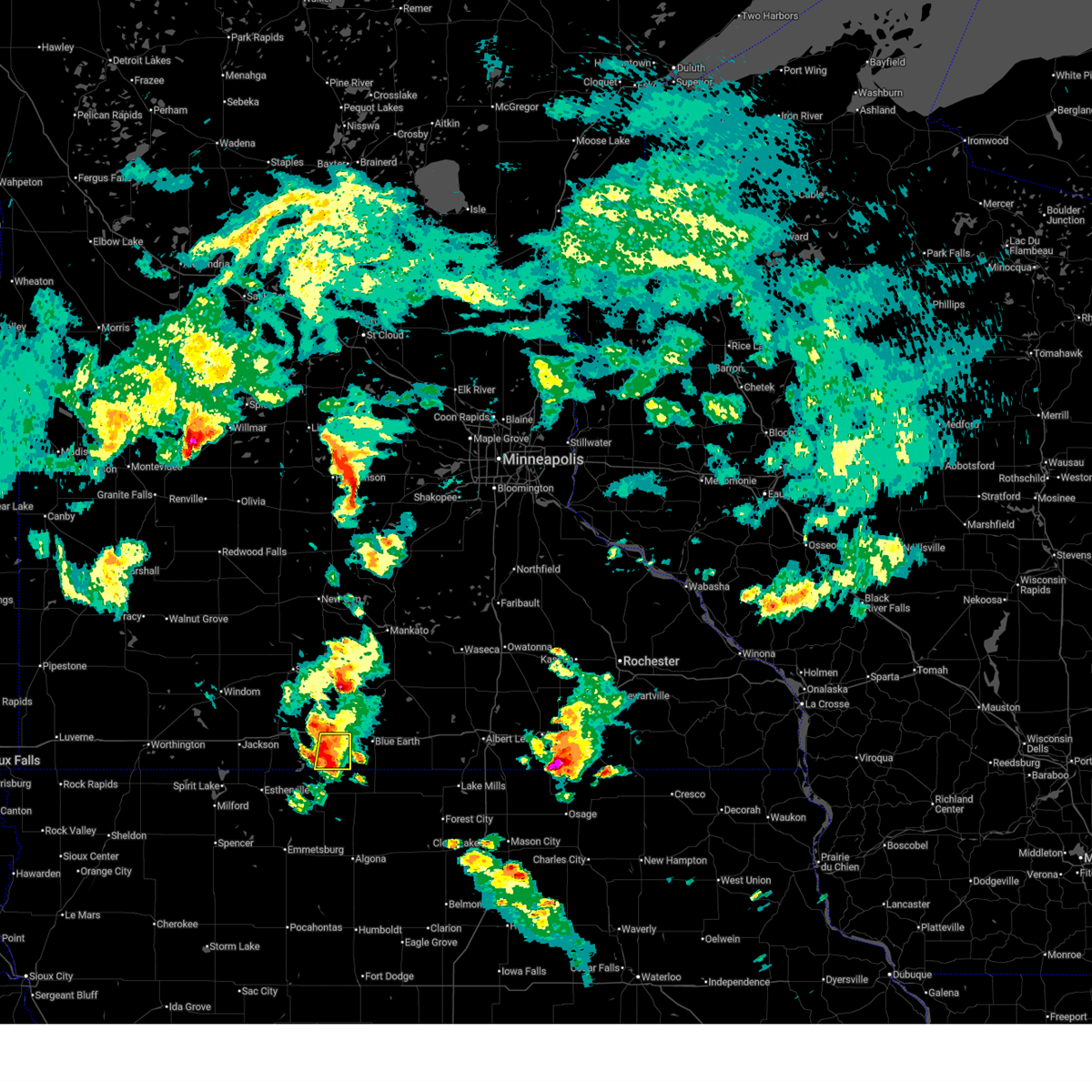
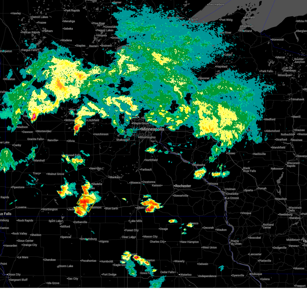
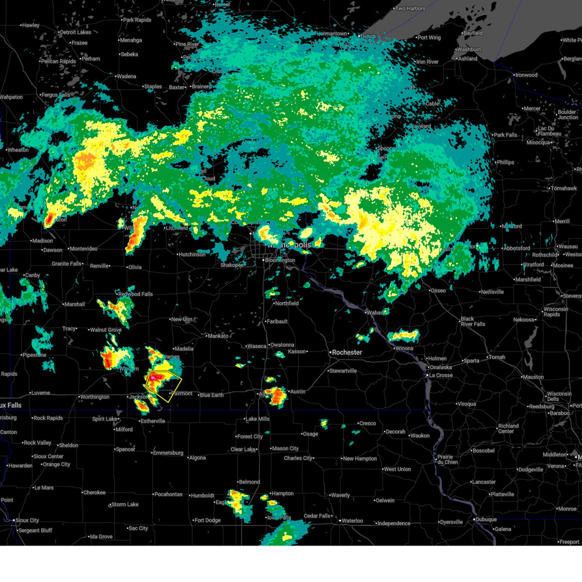
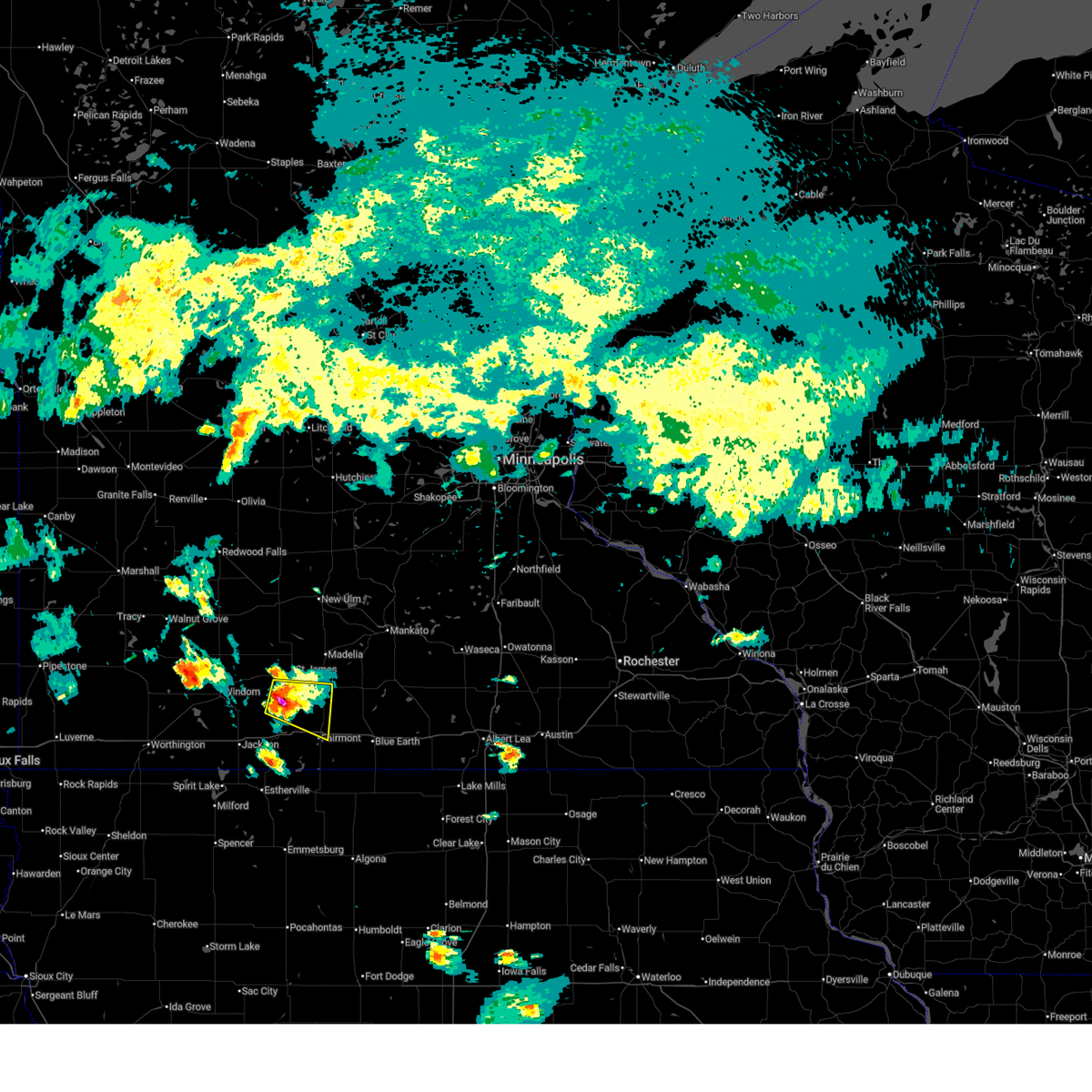
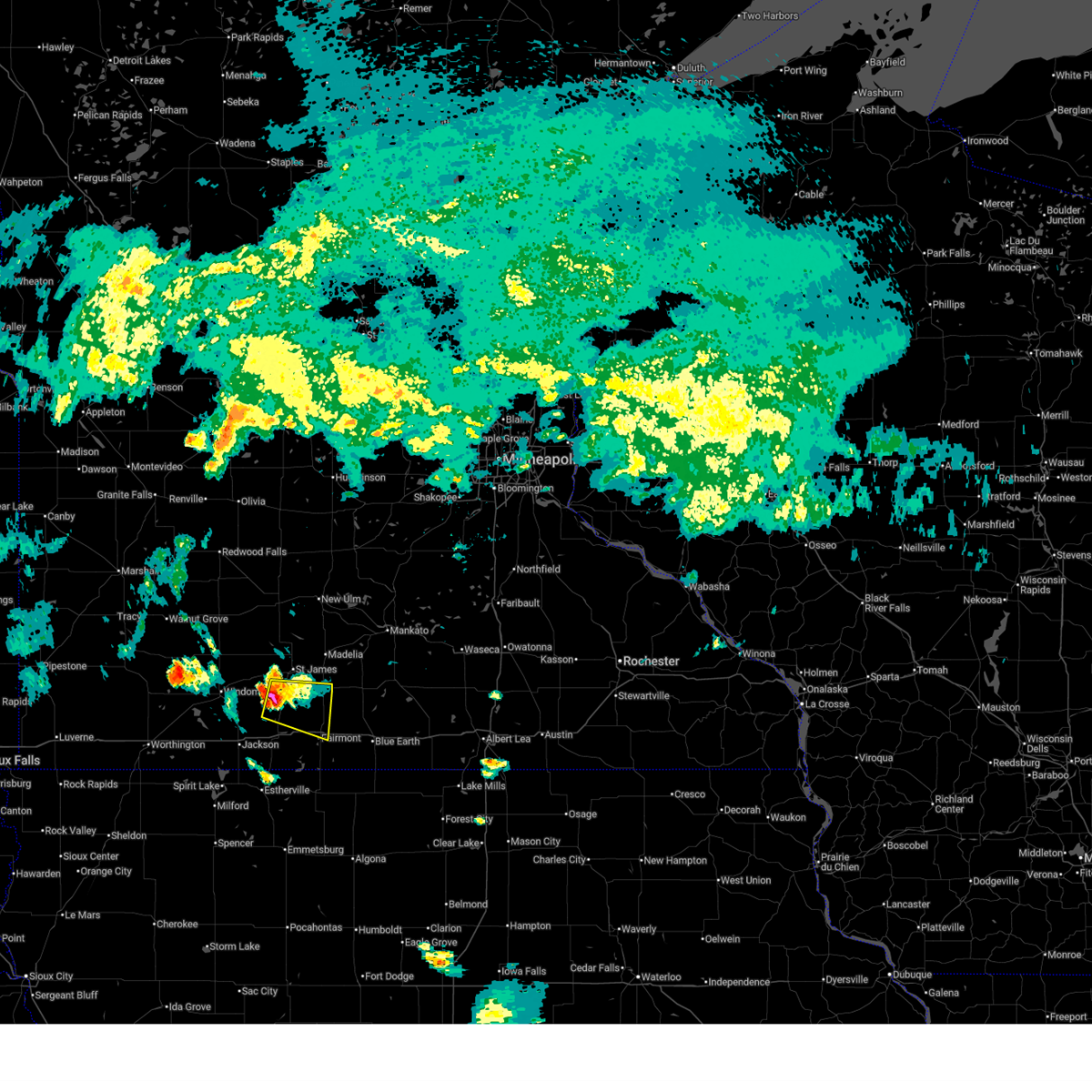
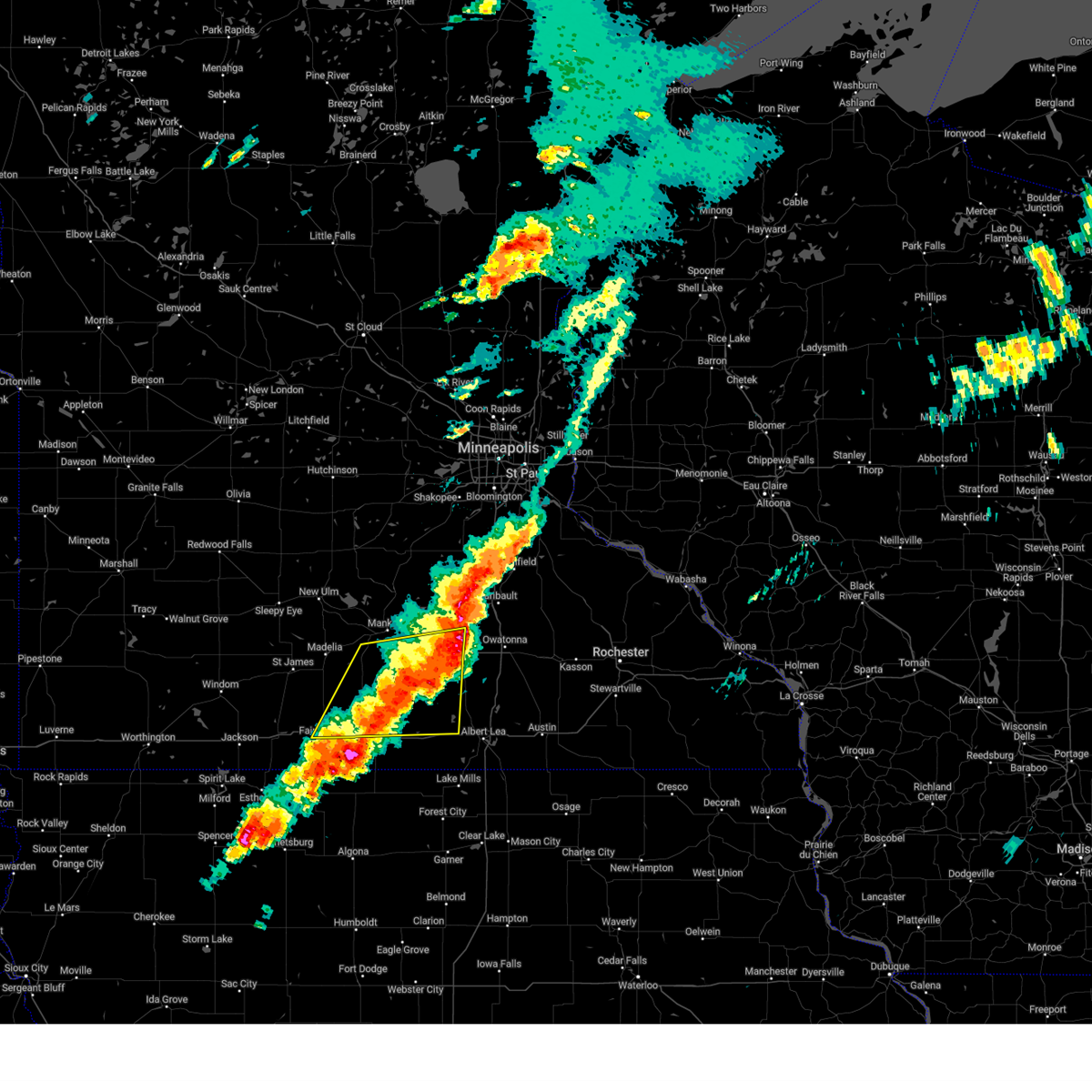
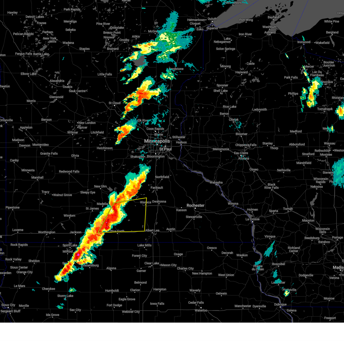
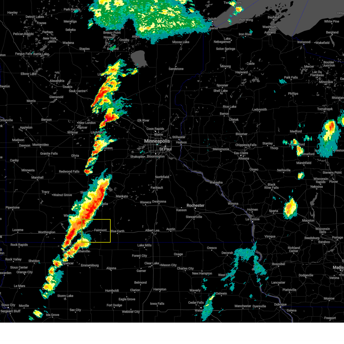
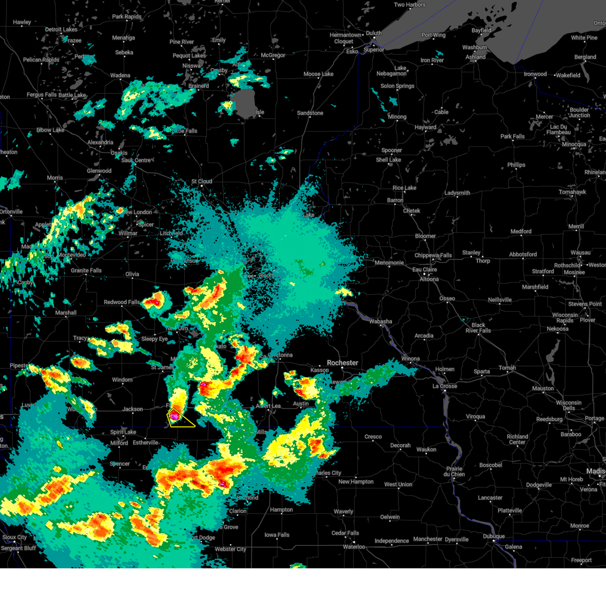
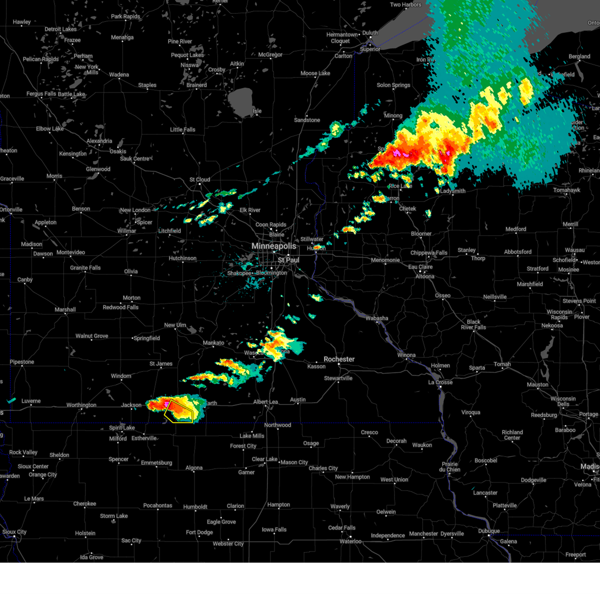
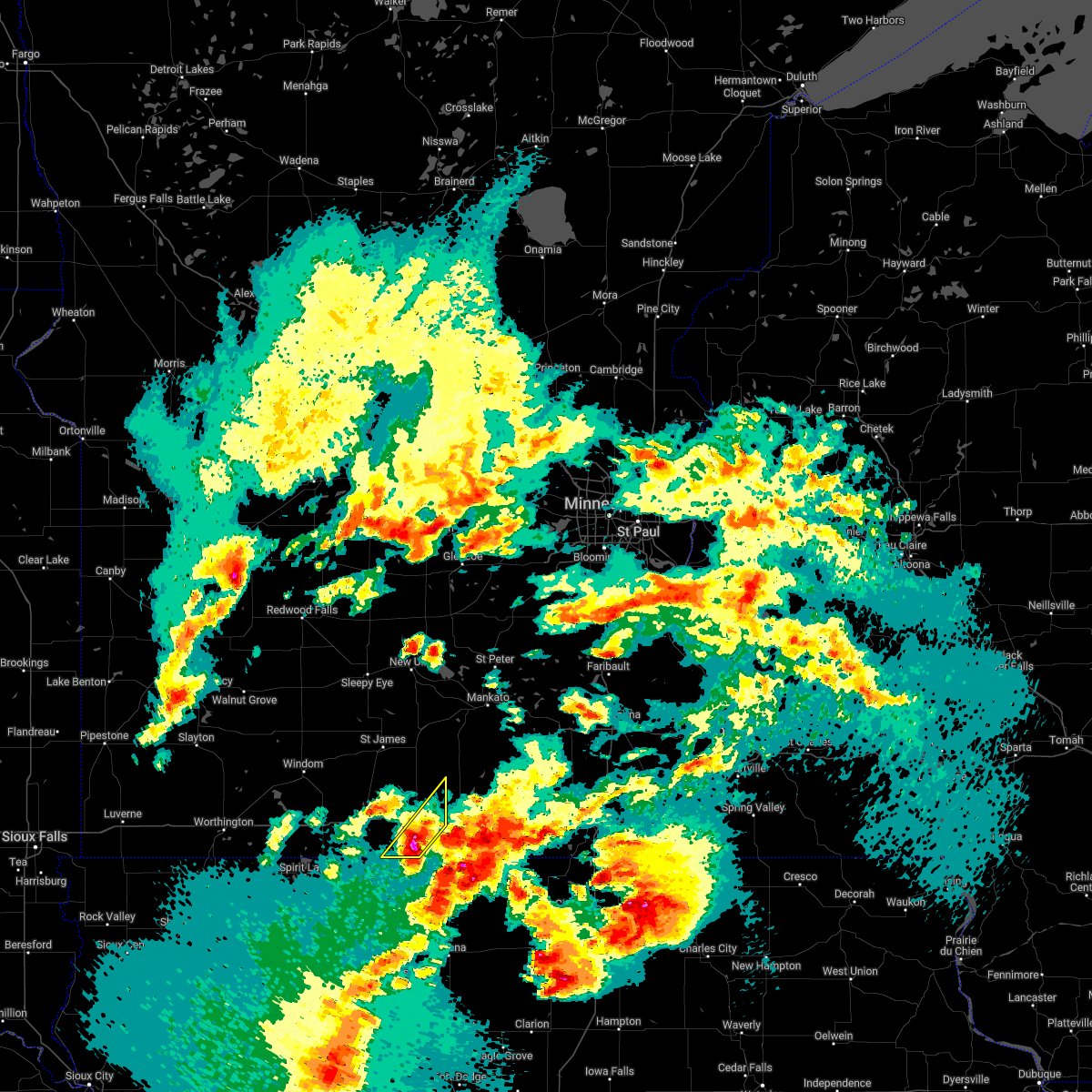
Hail Map for Fairmont, MN
The Fairmont, MN area has had 11 reports of on-the-ground hail by trained spotters, and has been under severe weather warnings 19 times during the past 12 months. Doppler radar has detected hail at or near Fairmont, MN on 73 occasions, including 9 occasions during the past year.
| Name: | Fairmont, MN |
| Where Located: | 72.4 miles WNW of Mason City, IA |
| Map: | Google Map for Fairmont, MN |
| Population: | 10666 |
| Housing Units: | 5251 |
| More Info: | Search Google for Fairmont, MN |
2
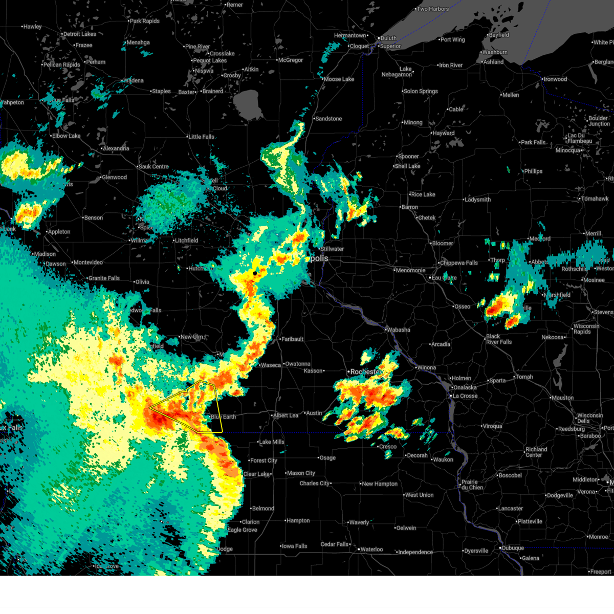
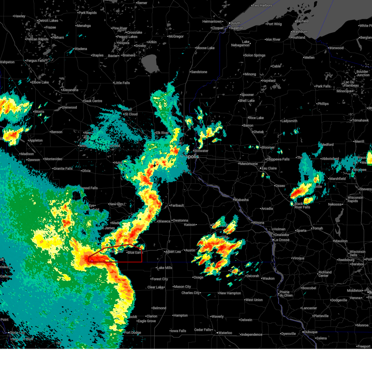
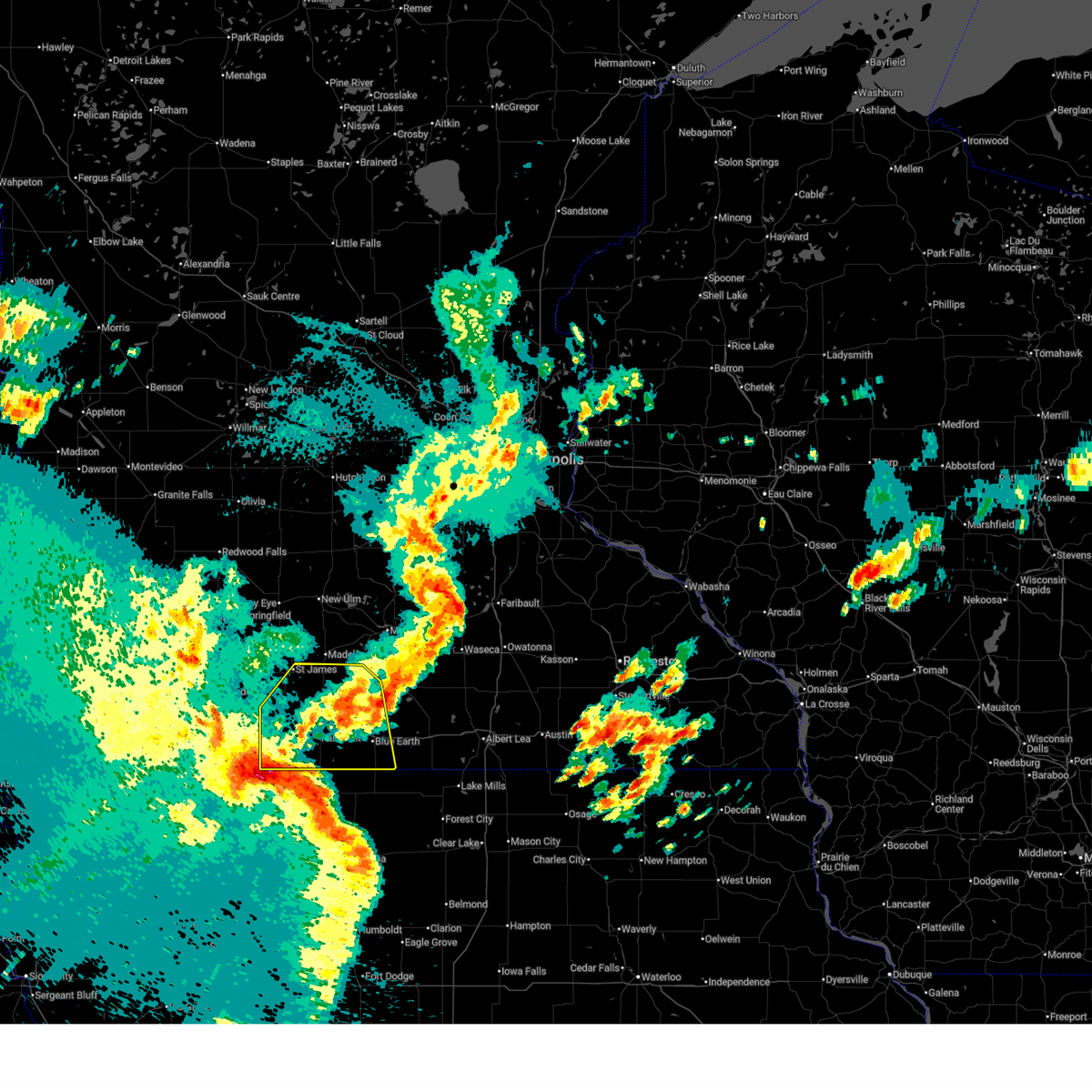
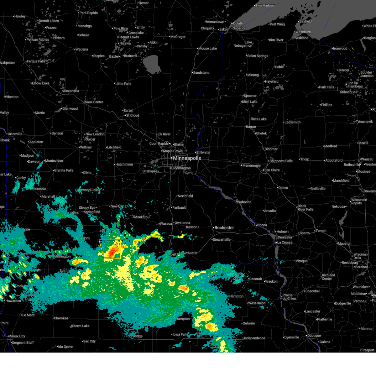
The Top Recent Hail Date for Fairmont, MN is Tuesday, June 30, 2026 (13th out of 73)
Hail and Wind Damage Spotted near Fairmont, MN
| Date / Time | Report Details |
|---|---|
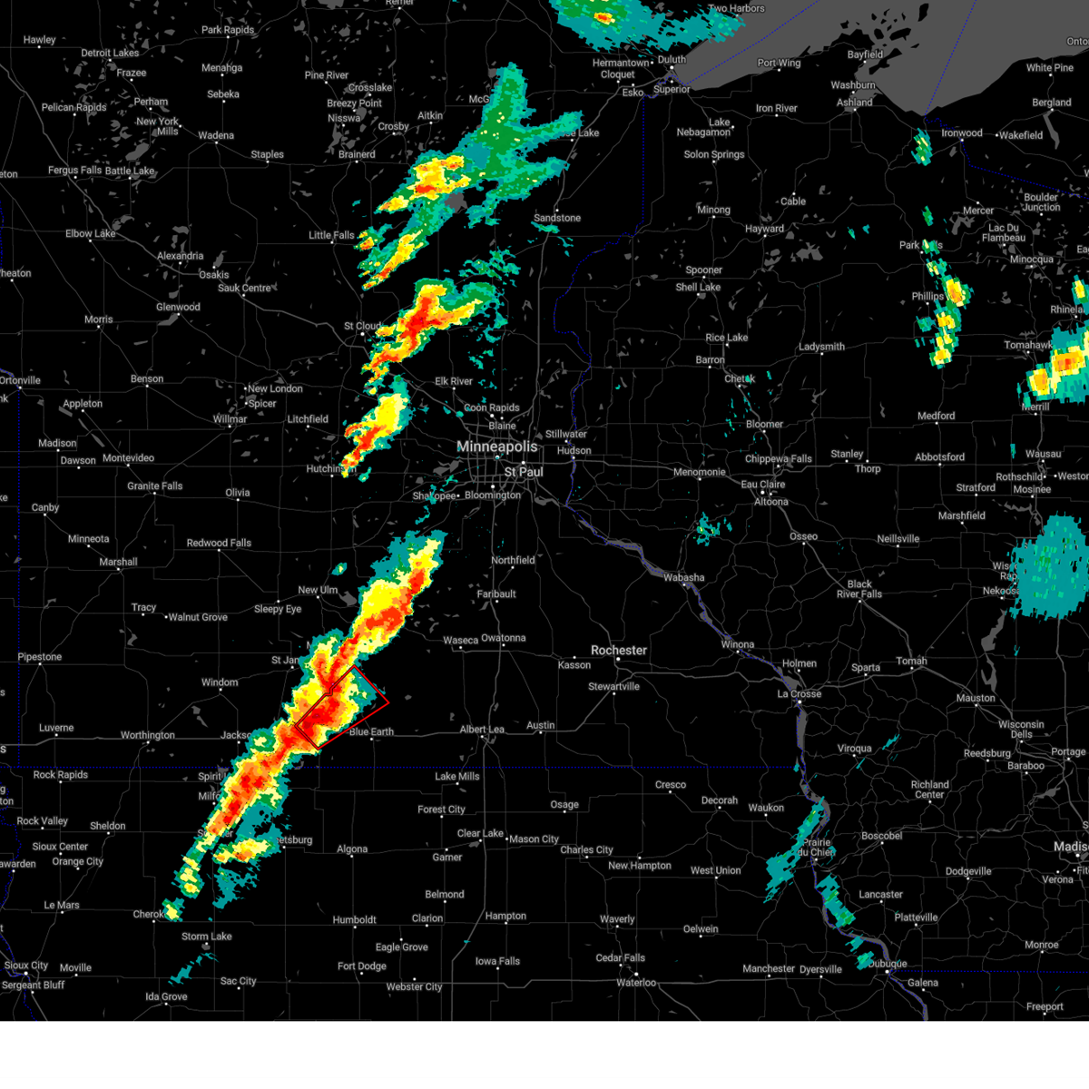
| 6/30/2026 2:46 AM CDT |
 Svrmpx the national weather service in the twin cities has issued a * severe thunderstorm warning for, blue earth county in south central minnesota, brown county in south central minnesota, western faribault county in south central minnesota, martin county in south central minnesota, watonwan county in south central minnesota, * until 345 am cdt. * at 246 am cdt, severe thunderstorms were located along a line from 19 miles south of lamberton to 19 miles southwest of ceylon, or along a line from 41 miles south of redwood falls to 30 miles southwest of fairmont, moving northeast at 50 to 60 mph (radar indicated). Hazards include 60 mph wind gusts and quarter size hail. Hail damage to vehicles is expected. Expect wind damage to roofs, siding, and trees. Svrmpx the national weather service in the twin cities has issued a * severe thunderstorm warning for, blue earth county in south central minnesota, brown county in south central minnesota, western faribault county in south central minnesota, martin county in south central minnesota, watonwan county in south central minnesota, * until 345 am cdt. * at 246 am cdt, severe thunderstorms were located along a line from 19 miles south of lamberton to 19 miles southwest of ceylon, or along a line from 41 miles south of redwood falls to 30 miles southwest of fairmont, moving northeast at 50 to 60 mph (radar indicated). Hazards include 60 mph wind gusts and quarter size hail. Hail damage to vehicles is expected. Expect wind damage to roofs, siding, and trees.
|
| 6/28/2026 6:59 AM CDT |
 The storms which prompted the warning have weakened below severe limits, and no longer pose an immediate threat to life or property. therefore, the warning will be allowed to expire. however, gusty winds are still possible with these thunderstorms. a severe thunderstorm watch remains in effect until 900 am cdt for a portion of south central minnesota. The storms which prompted the warning have weakened below severe limits, and no longer pose an immediate threat to life or property. therefore, the warning will be allowed to expire. however, gusty winds are still possible with these thunderstorms. a severe thunderstorm watch remains in effect until 900 am cdt for a portion of south central minnesota.
|
| 6/28/2026 5:59 AM CDT |
 Svrmpx the national weather service in the twin cities has issued a * severe thunderstorm warning for, southern blue earth county in south central minnesota, faribault county in south central minnesota, martin county in south central minnesota, watonwan county in south central minnesota, * until 700 am cdt. * at 559 am cdt, severe thunderstorms were located along a line from 7 miles southwest of comfrey to 10 miles southwest of ceylon, or along a line from 32 miles southwest of new ulm to 20 miles southwest of fairmont, moving east at 55 mph (radar indicated). Hazards include 60 mph wind gusts and nickel size hail. expect damage to roofs, siding, and trees Svrmpx the national weather service in the twin cities has issued a * severe thunderstorm warning for, southern blue earth county in south central minnesota, faribault county in south central minnesota, martin county in south central minnesota, watonwan county in south central minnesota, * until 700 am cdt. * at 559 am cdt, severe thunderstorms were located along a line from 7 miles southwest of comfrey to 10 miles southwest of ceylon, or along a line from 32 miles southwest of new ulm to 20 miles southwest of fairmont, moving east at 55 mph (radar indicated). Hazards include 60 mph wind gusts and nickel size hail. expect damage to roofs, siding, and trees
|
| 5/17/2026 10:11 PM CDT |
 The storms which prompted the warning have moved out of the area. therefore, the warning will be allowed to expire. however, gusty winds and heavy rain are still possible with these thunderstorms. a tornado warning still remains in effect for eastern faribault county until 1045 pm. a tornado watch remains in effect until 100 am cdt monday for a portion of south central minnesota. The storms which prompted the warning have moved out of the area. therefore, the warning will be allowed to expire. however, gusty winds and heavy rain are still possible with these thunderstorms. a tornado warning still remains in effect for eastern faribault county until 1045 pm. a tornado watch remains in effect until 100 am cdt monday for a portion of south central minnesota.
|
| 5/17/2026 10:07 PM CDT |
 The storms which prompted the warning have weakened below severe limits, and no longer pose an immediate threat to life or property. therefore, the warning will be allowed to expire. however, heavy rain is still possible with these thunderstorms. a tornado warning still remains in effect for southeast faribault county until 1045 pm. a tornado watch remains in effect until 100 am cdt monday for a portion of south central minnesota. The storms which prompted the warning have weakened below severe limits, and no longer pose an immediate threat to life or property. therefore, the warning will be allowed to expire. however, heavy rain is still possible with these thunderstorms. a tornado warning still remains in effect for southeast faribault county until 1045 pm. a tornado watch remains in effect until 100 am cdt monday for a portion of south central minnesota.
|
| 5/17/2026 10:00 PM CDT |
 At 1000 pm cdt, a line of severe thunderstorms capable of producing tornadoes and 70 mph wind gusts were located along a line from near winnebago to 16 miles south of bricelyn, moving northeast at 60 mph (radar indicated rotation). Hazards include tornado. Flying debris will be dangerous to those caught without shelter. mobile homes will be damaged or destroyed. damage to roofs, windows and vehicles will occur. tree damage is likely. This tornado will be near, bricelyn, frost and blue earth around 1005 pm cdt. At 1000 pm cdt, a line of severe thunderstorms capable of producing tornadoes and 70 mph wind gusts were located along a line from near winnebago to 16 miles south of bricelyn, moving northeast at 60 mph (radar indicated rotation). Hazards include tornado. Flying debris will be dangerous to those caught without shelter. mobile homes will be damaged or destroyed. damage to roofs, windows and vehicles will occur. tree damage is likely. This tornado will be near, bricelyn, frost and blue earth around 1005 pm cdt.
|
| 5/17/2026 9:55 PM CDT |
 the severe thunderstorm warning has been cancelled and is no longer in effect the severe thunderstorm warning has been cancelled and is no longer in effect
|
| 5/17/2026 9:55 PM CDT |
 At 955 pm cdt, severe thunderstorms were located along a line from 7 miles northeast of welcome to near elmore, moving northeast at 55 mph (radar indicated). Hazards include 60 mph wind gusts and quarter size hail. Hail damage to vehicles is expected. expect wind damage to roofs, siding, and trees. Locations impacted include, fairmont, welcome, east chain, foxlake, fairmont airport, imogene, granada, guckeen, elmore, northrop, huntley, blue earth, truman, winnebago, delavan and amboy. At 955 pm cdt, severe thunderstorms were located along a line from 7 miles northeast of welcome to near elmore, moving northeast at 55 mph (radar indicated). Hazards include 60 mph wind gusts and quarter size hail. Hail damage to vehicles is expected. expect wind damage to roofs, siding, and trees. Locations impacted include, fairmont, welcome, east chain, foxlake, fairmont airport, imogene, granada, guckeen, elmore, northrop, huntley, blue earth, truman, winnebago, delavan and amboy.
|
| 5/17/2026 9:47 PM CDT |
 At 947 pm cdt, a line of severe thunderstorms capable of producing tornadoes and 70 mph wind gusts was located along a line from over welcome to 12 miles south of elmore, moving northeast at 55 mph (radar indicated rotation). Hazards include tornado. Flying debris will be dangerous to those caught without shelter. mobile homes will be damaged or destroyed. damage to roofs, windows and vehicles will occur. tree damage is likely. this tornado will be near, fairmont and welcome around 950 pm cdt. elmore around 955 pm cdt. blue earth around 1000 pm cdt. frost around 1005 pm cdt. bricelyn around 1010 pm cdt. Other locations impacted by the tornado include east chain, fairmont airport, imogene, guckeen and granada. At 947 pm cdt, a line of severe thunderstorms capable of producing tornadoes and 70 mph wind gusts was located along a line from over welcome to 12 miles south of elmore, moving northeast at 55 mph (radar indicated rotation). Hazards include tornado. Flying debris will be dangerous to those caught without shelter. mobile homes will be damaged or destroyed. damage to roofs, windows and vehicles will occur. tree damage is likely. this tornado will be near, fairmont and welcome around 950 pm cdt. elmore around 955 pm cdt. blue earth around 1000 pm cdt. frost around 1005 pm cdt. bricelyn around 1010 pm cdt. Other locations impacted by the tornado include east chain, fairmont airport, imogene, guckeen and granada.
|
| 5/17/2026 9:38 PM CDT |
 At 938 pm cdt, severe thunderstorms were located along a line from near sherburn to 15 miles southwest of elmore, moving northeast at 60 mph (radar indicated). Hazards include 60 mph wind gusts and quarter size hail. Hail damage to vehicles is expected. expect wind damage to roofs, siding, and trees. locations impacted include, dunnell, ceylon, sherburn, fairmont, welcome, east chain, trimont, granada, northrop, elmore, ormsby, blue earth, winnebago, truman, south branch, st. James, delavan, lewisville, amboy and vernon center. At 938 pm cdt, severe thunderstorms were located along a line from near sherburn to 15 miles southwest of elmore, moving northeast at 60 mph (radar indicated). Hazards include 60 mph wind gusts and quarter size hail. Hail damage to vehicles is expected. expect wind damage to roofs, siding, and trees. locations impacted include, dunnell, ceylon, sherburn, fairmont, welcome, east chain, trimont, granada, northrop, elmore, ormsby, blue earth, winnebago, truman, south branch, st. James, delavan, lewisville, amboy and vernon center.
|
| 5/17/2026 9:36 PM CDT |
 Tormpx the national weather service in the twin cities has issued a * tornado warning for, southwestern faribault county in south central minnesota, southern martin county in south central minnesota, * until 1015 pm cdt. * at 936 pm cdt, a line of severe thunderstorms capable of producing tornadoes was located along a line from 7 miles southwest of sherburn to 19 miles southwest of elmore in northern iowa, moving northeast at 55 mph (radar indicated rotation). Hazards include tornado. Flying debris will be dangerous to those caught without shelter. mobile homes will be damaged or destroyed. damage to roofs, windows and vehicles will occur. tree damage is likely. this tornado will be near, ceylon around 940 pm cdt. fairmont and welcome around 945 pm cdt. elmore around 955 pm cdt. blue earth around 1000 pm cdt. frost around 1005 pm cdt. Other locations impacted by the tornado include wilbert, dunnell, east chain, fairmont airport and imogene. Tormpx the national weather service in the twin cities has issued a * tornado warning for, southwestern faribault county in south central minnesota, southern martin county in south central minnesota, * until 1015 pm cdt. * at 936 pm cdt, a line of severe thunderstorms capable of producing tornadoes was located along a line from 7 miles southwest of sherburn to 19 miles southwest of elmore in northern iowa, moving northeast at 55 mph (radar indicated rotation). Hazards include tornado. Flying debris will be dangerous to those caught without shelter. mobile homes will be damaged or destroyed. damage to roofs, windows and vehicles will occur. tree damage is likely. this tornado will be near, ceylon around 940 pm cdt. fairmont and welcome around 945 pm cdt. elmore around 955 pm cdt. blue earth around 1000 pm cdt. frost around 1005 pm cdt. Other locations impacted by the tornado include wilbert, dunnell, east chain, fairmont airport and imogene.
|
| 5/17/2026 9:19 PM CDT |
 Svrmpx the national weather service in the twin cities has issued a * severe thunderstorm warning for, southwestern blue earth county in south central minnesota, western faribault county in south central minnesota, martin county in south central minnesota, watonwan county in south central minnesota, * until 1015 pm cdt. * at 919 pm cdt, severe thunderstorms were located in northern iowa along a line from 15 miles west of sherburn to 26 miles south of ceylon, moving northeast at 60 mph (radar indicated). Hazards include 60 mph wind gusts and quarter size hail. Hail damage to vehicles is expected. Expect wind damage to roofs, siding, and trees. Svrmpx the national weather service in the twin cities has issued a * severe thunderstorm warning for, southwestern blue earth county in south central minnesota, western faribault county in south central minnesota, martin county in south central minnesota, watonwan county in south central minnesota, * until 1015 pm cdt. * at 919 pm cdt, severe thunderstorms were located in northern iowa along a line from 15 miles west of sherburn to 26 miles south of ceylon, moving northeast at 60 mph (radar indicated). Hazards include 60 mph wind gusts and quarter size hail. Hail damage to vehicles is expected. Expect wind damage to roofs, siding, and trees.
|
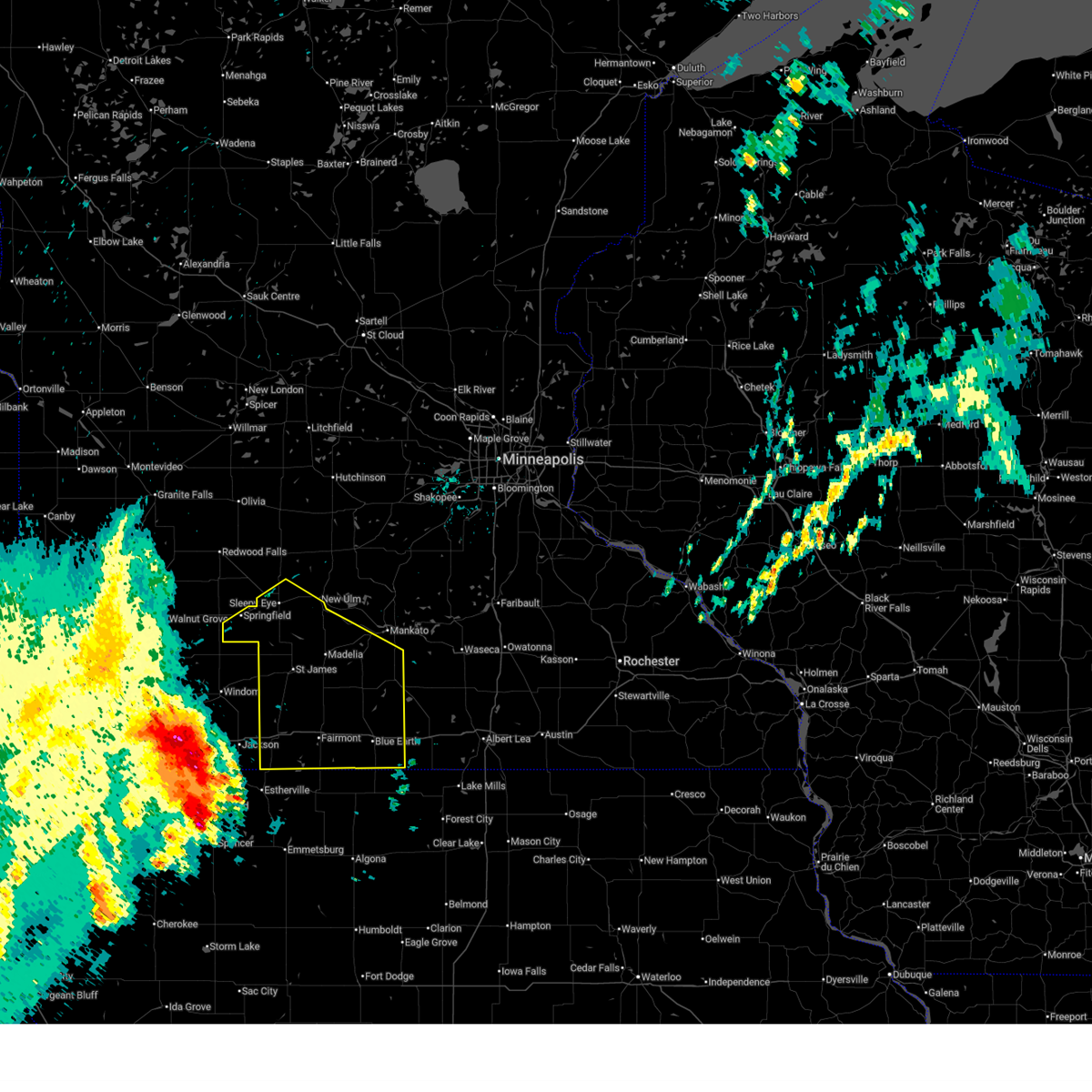
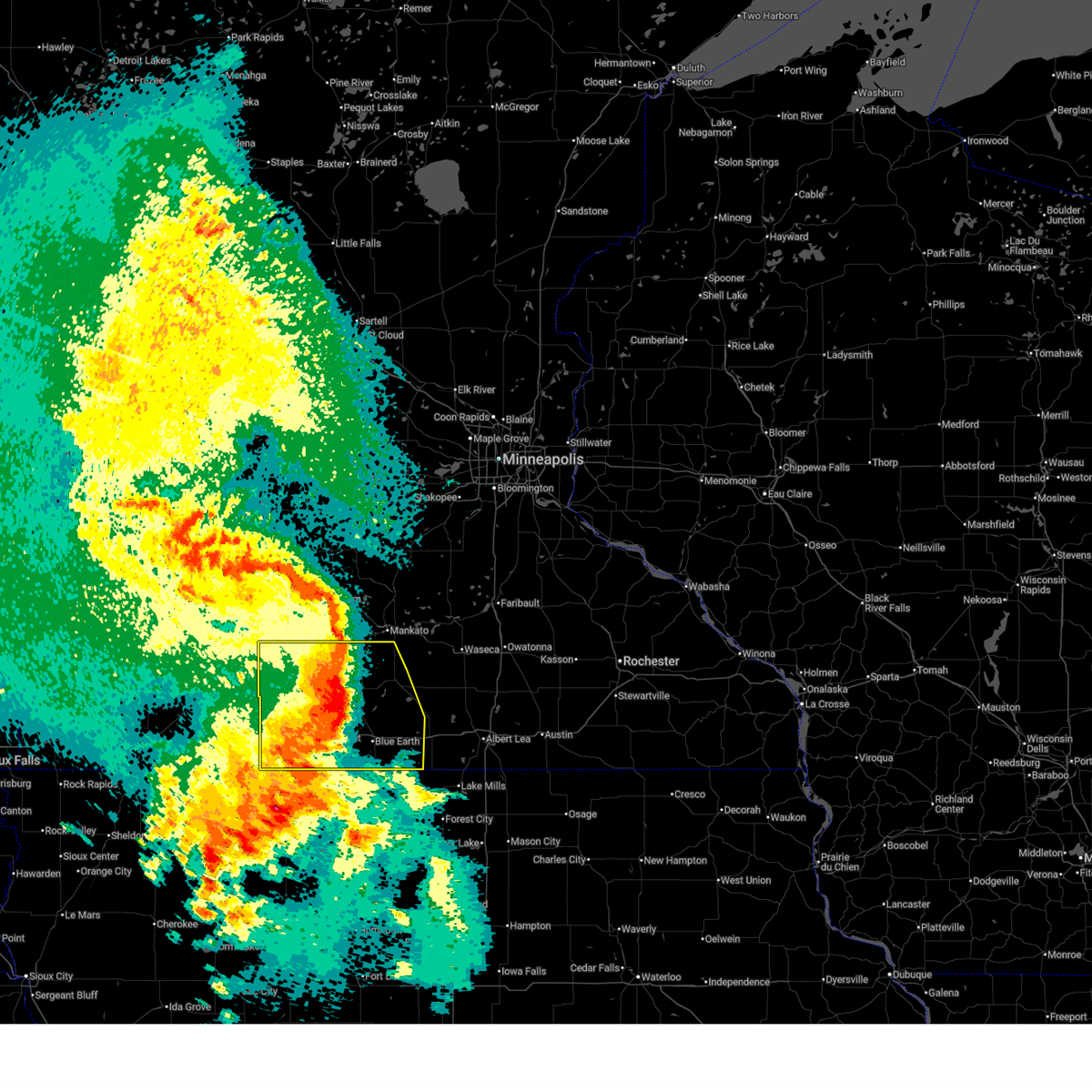
| 5/17/2026 8:15 PM CDT |
 At 815 pm cdt, severe thunderstorms were located along a line from near st. james to near fairmont, moving east at 25 mph (radar indicated). Hazards include 60 mph wind gusts and half dollar size hail. Hail damage to vehicles is expected. expect wind damage to roofs, siding, and trees. Locations impacted include, granada, imogene, guckeen, huntley, winnebago, amboy, vernon center, blue earth, lake crystal, garden city, good thunder and delavan. At 815 pm cdt, severe thunderstorms were located along a line from near st. james to near fairmont, moving east at 25 mph (radar indicated). Hazards include 60 mph wind gusts and half dollar size hail. Hail damage to vehicles is expected. expect wind damage to roofs, siding, and trees. Locations impacted include, granada, imogene, guckeen, huntley, winnebago, amboy, vernon center, blue earth, lake crystal, garden city, good thunder and delavan.
|
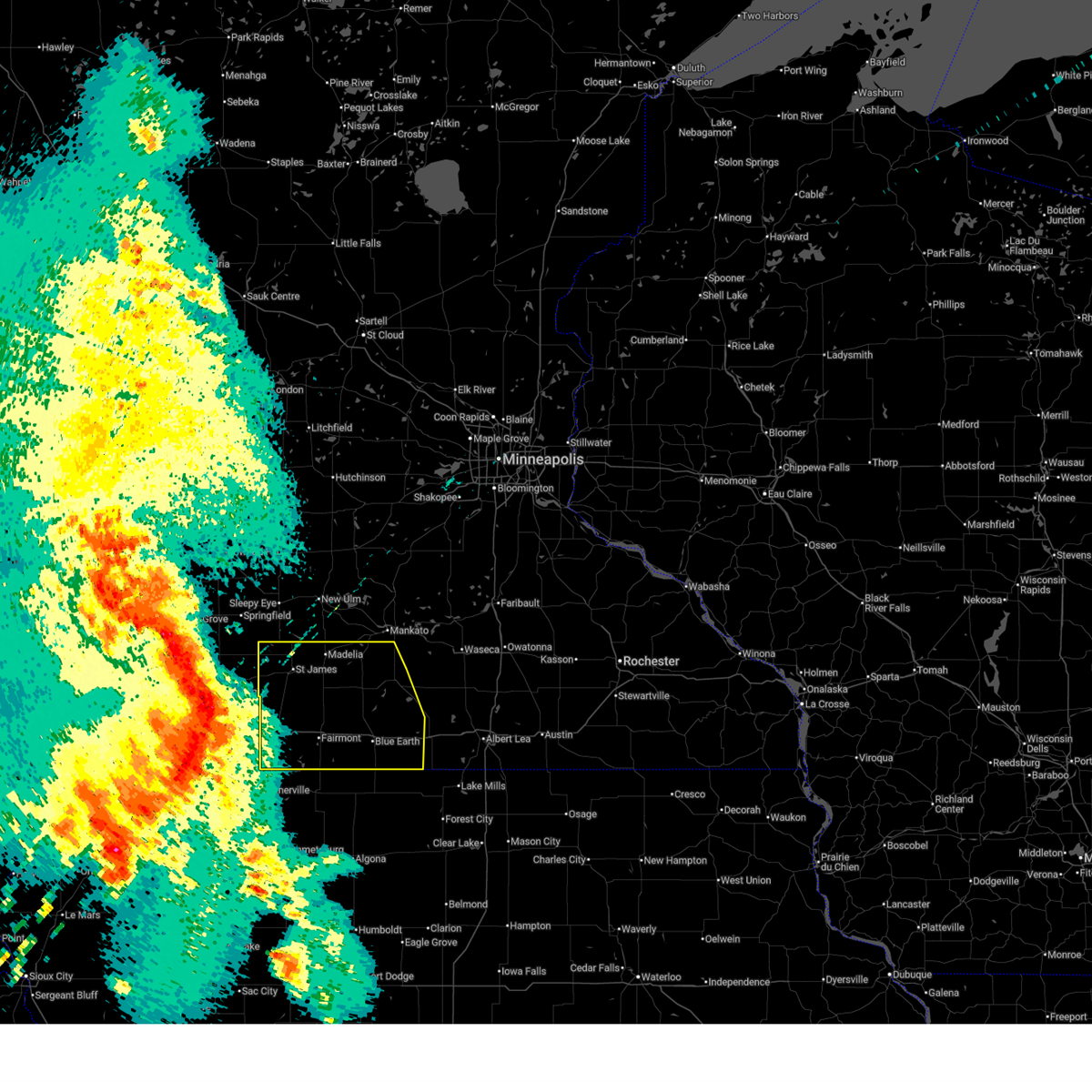
| 5/17/2026 7:59 PM CDT |
 At 759 pm cdt, severe thunderstorms were located along a line from over st. james to near fairmont (radar indicated). Hazards include ping pong ball size hail and 60 mph wind gusts. People and animals outdoors will be injured. expect hail damage to roofs, siding, windows, and vehicles. expect wind damage to roofs, siding, and trees. locations impacted include, trimont, butterfield, odin, foxlake, ormsby, welcome, echols, sveadahl, st. James, south branch, fairmont, st james airport, la salle, northrop, grogan, truman, lewisville and madelia. At 759 pm cdt, severe thunderstorms were located along a line from over st. james to near fairmont (radar indicated). Hazards include ping pong ball size hail and 60 mph wind gusts. People and animals outdoors will be injured. expect hail damage to roofs, siding, windows, and vehicles. expect wind damage to roofs, siding, and trees. locations impacted include, trimont, butterfield, odin, foxlake, ormsby, welcome, echols, sveadahl, st. James, south branch, fairmont, st james airport, la salle, northrop, grogan, truman, lewisville and madelia.
|
| 5/17/2026 7:32 PM CDT |
 Svrmpx the national weather service in the twin cities has issued a * severe thunderstorm warning for, northwestern martin county in south central minnesota, watonwan county in south central minnesota, * until 830 pm cdt. * at 732 pm cdt, severe thunderstorms were located along a line from 6 miles west of butterfield to 8 miles southwest of sherburn (radar indicated). Hazards include 60 mph wind gusts and quarter size hail. Hail damage to vehicles is expected. Expect wind damage to roofs, siding, and trees. Svrmpx the national weather service in the twin cities has issued a * severe thunderstorm warning for, northwestern martin county in south central minnesota, watonwan county in south central minnesota, * until 830 pm cdt. * at 732 pm cdt, severe thunderstorms were located along a line from 6 miles west of butterfield to 8 miles southwest of sherburn (radar indicated). Hazards include 60 mph wind gusts and quarter size hail. Hail damage to vehicles is expected. Expect wind damage to roofs, siding, and trees.
|
| 4/13/2026 8:57 PM CDT |
 Svrmpx the national weather service in the twin cities has issued a * severe thunderstorm warning for, martin county in south central minnesota, * until 1000 pm cdt. * at 857 pm cdt, a severe thunderstorm was located 8 miles west of sherburn, or 21 miles west of fairmont, moving east at 35 mph (radar indicated). Hazards include golf ball size hail and 60 mph wind gusts. People and animals outdoors will be injured. expect hail damage to roofs, siding, windows, and vehicles. Expect wind damage to roofs, siding, and trees. Svrmpx the national weather service in the twin cities has issued a * severe thunderstorm warning for, martin county in south central minnesota, * until 1000 pm cdt. * at 857 pm cdt, a severe thunderstorm was located 8 miles west of sherburn, or 21 miles west of fairmont, moving east at 35 mph (radar indicated). Hazards include golf ball size hail and 60 mph wind gusts. People and animals outdoors will be injured. expect hail damage to roofs, siding, windows, and vehicles. Expect wind damage to roofs, siding, and trees.
|
| 4/13/2026 6:54 PM CDT |
 At 654 pm cdt, a severe thunderstorm was located 7 miles east of fairmont, moving northeast at 30 mph (radar indicated). Hazards include 60 mph wind gusts and quarter size hail. Hail damage to vehicles is expected. expect wind damage to roofs, siding, and trees. Locations impacted include, wilbert, fairmont, east chain, fairmont airport, imogene, granada, guckeen, huntley, blue earth, winnebago, delavan, easton and minnesota lake. At 654 pm cdt, a severe thunderstorm was located 7 miles east of fairmont, moving northeast at 30 mph (radar indicated). Hazards include 60 mph wind gusts and quarter size hail. Hail damage to vehicles is expected. expect wind damage to roofs, siding, and trees. Locations impacted include, wilbert, fairmont, east chain, fairmont airport, imogene, granada, guckeen, huntley, blue earth, winnebago, delavan, easton and minnesota lake.
|
| 4/13/2026 6:43 PM CDT | Quarter sized hail reported 5.6 miles N of Fairmont, MN |
| 4/13/2026 6:40 PM CDT |
 Svrmpx the national weather service in the twin cities has issued a * severe thunderstorm warning for, western faribault county in south central minnesota, eastern martin county in south central minnesota, * until 745 pm cdt. * at 640 pm cdt, a severe thunderstorm was located over fairmont, moving northeast at 30 mph (radar indicated). Hazards include 60 mph wind gusts and quarter size hail. Hail damage to vehicles is expected. Expect wind damage to roofs, siding, and trees. Svrmpx the national weather service in the twin cities has issued a * severe thunderstorm warning for, western faribault county in south central minnesota, eastern martin county in south central minnesota, * until 745 pm cdt. * at 640 pm cdt, a severe thunderstorm was located over fairmont, moving northeast at 30 mph (radar indicated). Hazards include 60 mph wind gusts and quarter size hail. Hail damage to vehicles is expected. Expect wind damage to roofs, siding, and trees.
|
| 7/19/2025 1:25 AM CDT |
 Svrmpx the national weather service in the twin cities has issued a * severe thunderstorm warning for, western faribault county in south central minnesota, northeastern martin county in south central minnesota, * until 200 am cdt. * at 125 am cdt, a severe thunderstorm was located 8 miles southeast of truman, or 9 miles northeast of fairmont, moving southeast at 35 mph (radar indicated). Hazards include 60 mph wind gusts and quarter size hail. Hail damage to vehicles is expected. Expect wind damage to roofs, siding, and trees. Svrmpx the national weather service in the twin cities has issued a * severe thunderstorm warning for, western faribault county in south central minnesota, northeastern martin county in south central minnesota, * until 200 am cdt. * at 125 am cdt, a severe thunderstorm was located 8 miles southeast of truman, or 9 miles northeast of fairmont, moving southeast at 35 mph (radar indicated). Hazards include 60 mph wind gusts and quarter size hail. Hail damage to vehicles is expected. Expect wind damage to roofs, siding, and trees.
|
| 6/12/2025 7:54 PM CDT |
 The storm which prompted the warning has weakened below severe limits, and no longer poses an immediate threat to life or property. therefore, the warning will be allowed to expire. however, small hail and gusty winds are still possible with this thunderstorm. The storm which prompted the warning has weakened below severe limits, and no longer poses an immediate threat to life or property. therefore, the warning will be allowed to expire. however, small hail and gusty winds are still possible with this thunderstorm.
|
| 6/12/2025 7:29 PM CDT |
 Svrmpx the national weather service in the twin cities has issued a * severe thunderstorm warning for, southeastern martin county in south central minnesota, * until 800 pm cdt. * at 729 pm cdt, a severe thunderstorm was located 6 miles southeast of fairmont, moving east at 15 mph (radar indicated). Hazards include 60 mph wind gusts and quarter size hail. Hail damage to vehicles is expected. Expect wind damage to roofs, siding, and trees. Svrmpx the national weather service in the twin cities has issued a * severe thunderstorm warning for, southeastern martin county in south central minnesota, * until 800 pm cdt. * at 729 pm cdt, a severe thunderstorm was located 6 miles southeast of fairmont, moving east at 15 mph (radar indicated). Hazards include 60 mph wind gusts and quarter size hail. Hail damage to vehicles is expected. Expect wind damage to roofs, siding, and trees.
|
| 6/12/2025 6:24 PM CDT |
 The storm which prompted the warning has weakened below severe limits, and no longer poses an immediate threat to life or property. therefore, the warning will be allowed to expire. however, small hail and heavy rain are still possible with this thunderstorm. The storm which prompted the warning has weakened below severe limits, and no longer poses an immediate threat to life or property. therefore, the warning will be allowed to expire. however, small hail and heavy rain are still possible with this thunderstorm.
|
| 6/12/2025 6:17 PM CDT |
 At 617 pm cdt, a severe thunderstorm was located 6 miles northeast of welcome, or 7 miles northwest of fairmont, moving southeast at 25 mph (radar indicated). Hazards include 60 mph wind gusts and quarter size hail. Hail damage to vehicles is expected. expect wind damage to roofs, siding, and trees. Locations impacted include, fairmont, truman, trimont, welcome, northrop, foxlake and fairmont airport. At 617 pm cdt, a severe thunderstorm was located 6 miles northeast of welcome, or 7 miles northwest of fairmont, moving southeast at 25 mph (radar indicated). Hazards include 60 mph wind gusts and quarter size hail. Hail damage to vehicles is expected. expect wind damage to roofs, siding, and trees. Locations impacted include, fairmont, truman, trimont, welcome, northrop, foxlake and fairmont airport.
|
| 6/12/2025 5:58 PM CDT |
 The severe thunderstorm warning that was previously in effect has been reissued for martin county and is in effect until 630 pm. please refer to that bulletin for the latest severe weather information. The severe thunderstorm warning that was previously in effect has been reissued for martin county and is in effect until 630 pm. please refer to that bulletin for the latest severe weather information.
|
| 6/12/2025 5:57 PM CDT |
 Svrmpx the national weather service in the twin cities has issued a * severe thunderstorm warning for, northeastern martin county in south central minnesota, * until 630 pm cdt. * at 557 pm cdt, a severe thunderstorm was located 5 miles east of trimont, or 12 miles northwest of fairmont, moving southeast at 20 mph (radar indicated). Hazards include 60 mph wind gusts and quarter size hail. Hail damage to vehicles is expected. Expect wind damage to roofs, siding, and trees. Svrmpx the national weather service in the twin cities has issued a * severe thunderstorm warning for, northeastern martin county in south central minnesota, * until 630 pm cdt. * at 557 pm cdt, a severe thunderstorm was located 5 miles east of trimont, or 12 miles northwest of fairmont, moving southeast at 20 mph (radar indicated). Hazards include 60 mph wind gusts and quarter size hail. Hail damage to vehicles is expected. Expect wind damage to roofs, siding, and trees.
|
| 6/12/2025 5:37 PM CDT |
 At 537 pm cdt, a severe thunderstorm was located near trimont, or 17 miles northwest of fairmont, moving east at 20 mph (radar indicated). Hazards include 60 mph wind gusts and half dollar size hail. Hail damage to vehicles is expected. expect wind damage to roofs, siding, and trees. Locations impacted include, fairmont, truman, trimont, south branch, northrop, ormsby, odin, echols and fairmont airport. At 537 pm cdt, a severe thunderstorm was located near trimont, or 17 miles northwest of fairmont, moving east at 20 mph (radar indicated). Hazards include 60 mph wind gusts and half dollar size hail. Hail damage to vehicles is expected. expect wind damage to roofs, siding, and trees. Locations impacted include, fairmont, truman, trimont, south branch, northrop, ormsby, odin, echols and fairmont airport.
|
| 6/12/2025 5:22 PM CDT |
 Svrmpx the national weather service in the twin cities has issued a * severe thunderstorm warning for, northern martin county in south central minnesota, southern watonwan county in south central minnesota, * until 600 pm cdt. * at 522 pm cdt, a severe thunderstorm was located 5 miles north of trimont, or 19 miles northwest of fairmont, moving east at 20 mph (trained spotters reported quarter size hail south of butterfield). Hazards include 60 mph wind gusts and quarter size hail. Hail damage to vehicles is expected. Expect wind damage to roofs, siding, and trees. Svrmpx the national weather service in the twin cities has issued a * severe thunderstorm warning for, northern martin county in south central minnesota, southern watonwan county in south central minnesota, * until 600 pm cdt. * at 522 pm cdt, a severe thunderstorm was located 5 miles north of trimont, or 19 miles northwest of fairmont, moving east at 20 mph (trained spotters reported quarter size hail south of butterfield). Hazards include 60 mph wind gusts and quarter size hail. Hail damage to vehicles is expected. Expect wind damage to roofs, siding, and trees.
|
| 4/28/2025 5:33 PM CDT |
 The storms which prompted the warning have moved out of the area. therefore, the warning has been allowed to expire. a severe thunderstorm warning still remains in effect for southeastern blue earth, waseca, faribault, southeastern martin, and freeborn counties. The storms which prompted the warning have moved out of the area. therefore, the warning has been allowed to expire. a severe thunderstorm warning still remains in effect for southeastern blue earth, waseca, faribault, southeastern martin, and freeborn counties.
|
| 4/28/2025 4:52 PM CDT |
 Svrmpx the national weather service in the twin cities has issued a * severe thunderstorm warning for, blue earth county in south central minnesota, northern faribault county in south central minnesota, northwestern freeborn county in south central minnesota, northeastern martin county in south central minnesota, waseca county in south central minnesota, * until 530 pm cdt. * at 452 pm cdt, severe thunderstorms were located along a line from 6 miles north of good thunder to over winnebago, or along a line from 7 miles southwest of mankato to 14 miles northeast of fairmont, moving northeast at 60 mph (radar indicated). Hazards include 60 mph wind gusts and half dollar size hail. Hail damage to vehicles is expected. Expect wind damage to roofs, siding, and trees. Svrmpx the national weather service in the twin cities has issued a * severe thunderstorm warning for, blue earth county in south central minnesota, northern faribault county in south central minnesota, northwestern freeborn county in south central minnesota, northeastern martin county in south central minnesota, waseca county in south central minnesota, * until 530 pm cdt. * at 452 pm cdt, severe thunderstorms were located along a line from 6 miles north of good thunder to over winnebago, or along a line from 7 miles southwest of mankato to 14 miles northeast of fairmont, moving northeast at 60 mph (radar indicated). Hazards include 60 mph wind gusts and half dollar size hail. Hail damage to vehicles is expected. Expect wind damage to roofs, siding, and trees.
|
| 4/28/2025 4:40 PM CDT |
 At 440 pm cdt, a severe thunderstorm capable of producing a tornado was located 6 miles southeast of truman, or 9 miles northeast of fairmont, moving northeast at 60 mph (radar indicated rotation). Hazards include tornado and quarter size hail. Flying debris will be dangerous to those caught without shelter. mobile homes will be damaged or destroyed. damage to roofs, windows and vehicles will occur. tree damage is likely. Locations impacted include, fairmont, winnebago, truman, amboy, granada, northrop, imogene and fairmont airport. At 440 pm cdt, a severe thunderstorm capable of producing a tornado was located 6 miles southeast of truman, or 9 miles northeast of fairmont, moving northeast at 60 mph (radar indicated rotation). Hazards include tornado and quarter size hail. Flying debris will be dangerous to those caught without shelter. mobile homes will be damaged or destroyed. damage to roofs, windows and vehicles will occur. tree damage is likely. Locations impacted include, fairmont, winnebago, truman, amboy, granada, northrop, imogene and fairmont airport.
|
| 4/28/2025 4:32 PM CDT |
 At 432 pm cdt, severe thunderstorms were located along a line from 6 miles east of lewisville to 9 miles south of sherburn, or along a line from 23 miles north of fairmont to 17 miles southwest of fairmont, moving east at 30 mph (radar indicated). Hazards include ping pong ball size hail and 60 mph wind gusts. People and animals outdoors will be injured. expect hail damage to roofs, siding, windows, and vehicles. expect wind damage to roofs, siding, and trees. Locations impacted include, fairmont, sherburn, truman, welcome, ceylon, granada, east chain, northrop, dunnell, fairmont airport, wilbert, imogene and foxlake. At 432 pm cdt, severe thunderstorms were located along a line from 6 miles east of lewisville to 9 miles south of sherburn, or along a line from 23 miles north of fairmont to 17 miles southwest of fairmont, moving east at 30 mph (radar indicated). Hazards include ping pong ball size hail and 60 mph wind gusts. People and animals outdoors will be injured. expect hail damage to roofs, siding, windows, and vehicles. expect wind damage to roofs, siding, and trees. Locations impacted include, fairmont, sherburn, truman, welcome, ceylon, granada, east chain, northrop, dunnell, fairmont airport, wilbert, imogene and foxlake.
|
| 4/28/2025 4:24 PM CDT |
 Tormpx the national weather service in the twin cities has issued a * tornado warning for, southwestern blue earth county in south central minnesota, northwestern faribault county in south central minnesota, central martin county in south central minnesota, * until 500 pm cdt. * at 424 pm cdt, a confirmed tornado was located near ceylon, or 8 miles southwest of fairmont, moving northeast at 60 mph (weather spotters confirmed tornado). Hazards include damaging tornado and quarter size hail. Flying debris will be dangerous to those caught without shelter. mobile homes will be damaged or destroyed. damage to roofs, windows and vehicles will occur. Tree damage is likely. Tormpx the national weather service in the twin cities has issued a * tornado warning for, southwestern blue earth county in south central minnesota, northwestern faribault county in south central minnesota, central martin county in south central minnesota, * until 500 pm cdt. * at 424 pm cdt, a confirmed tornado was located near ceylon, or 8 miles southwest of fairmont, moving northeast at 60 mph (weather spotters confirmed tornado). Hazards include damaging tornado and quarter size hail. Flying debris will be dangerous to those caught without shelter. mobile homes will be damaged or destroyed. damage to roofs, windows and vehicles will occur. Tree damage is likely.
|
| 4/28/2025 3:53 PM CDT |
 Svrmpx the national weather service in the twin cities has issued a * severe thunderstorm warning for, martin county in south central minnesota, * until 500 pm cdt. * at 353 pm cdt, severe thunderstorms were located along a line from 7 miles southwest of st. james to 24 miles southwest of sherburn, or along a line from 21 miles northwest of fairmont to 35 miles west of fairmont, moving east at 30 mph (radar indicated). Hazards include 60 mph wind gusts and quarter size hail. Hail damage to vehicles is expected. Expect wind damage to roofs, siding, and trees. Svrmpx the national weather service in the twin cities has issued a * severe thunderstorm warning for, martin county in south central minnesota, * until 500 pm cdt. * at 353 pm cdt, severe thunderstorms were located along a line from 7 miles southwest of st. james to 24 miles southwest of sherburn, or along a line from 21 miles northwest of fairmont to 35 miles west of fairmont, moving east at 30 mph (radar indicated). Hazards include 60 mph wind gusts and quarter size hail. Hail damage to vehicles is expected. Expect wind damage to roofs, siding, and trees.
|
| 3/14/2025 7:37 PM CDT |
 At 737 pm cdt, a severe thunderstorm was located 6 miles north of fairmont, moving north at 50 mph (trained spotters reported. at 734 pm, a 58 mph gust was measured at fairmont airport). Hazards include 60 mph wind gusts and small hail. Expect damage to roofs, siding, and trees. Locations impacted include, fairmont airport, fairmont, imogene, granada, northrop and truman. At 737 pm cdt, a severe thunderstorm was located 6 miles north of fairmont, moving north at 50 mph (trained spotters reported. at 734 pm, a 58 mph gust was measured at fairmont airport). Hazards include 60 mph wind gusts and small hail. Expect damage to roofs, siding, and trees. Locations impacted include, fairmont airport, fairmont, imogene, granada, northrop and truman.
|
| 3/14/2025 7:32 PM CDT | Awos station kfrm fairmont a in martin county MN, 2.6 miles WNW of Fairmont, MN |
| 3/14/2025 7:25 PM CDT |
 At 725 pm cdt, a severe thunderstorm was located 5 miles south of fairmont, moving north at 45 mph (radar indicated). Hazards include 60 mph wind gusts and small hail. Expect damage to roofs, siding, and trees. Locations impacted include, east chain, wilbert, imogene, fairmont, fairmont airport, welcome, granada, northrop and truman. At 725 pm cdt, a severe thunderstorm was located 5 miles south of fairmont, moving north at 45 mph (radar indicated). Hazards include 60 mph wind gusts and small hail. Expect damage to roofs, siding, and trees. Locations impacted include, east chain, wilbert, imogene, fairmont, fairmont airport, welcome, granada, northrop and truman.
|
| 3/14/2025 7:13 PM CDT |
 Svrmpx the national weather service in the twin cities has issued a * severe thunderstorm warning for, martin county in south central minnesota, * until 815 pm cdt. * at 713 pm cdt, a severe thunderstorm was located 15 miles south of fairmont, moving north at 45 mph (radar indicated). Hazards include 60 mph wind gusts and small hail. expect damage to roofs, siding, and trees Svrmpx the national weather service in the twin cities has issued a * severe thunderstorm warning for, martin county in south central minnesota, * until 815 pm cdt. * at 713 pm cdt, a severe thunderstorm was located 15 miles south of fairmont, moving north at 45 mph (radar indicated). Hazards include 60 mph wind gusts and small hail. expect damage to roofs, siding, and trees
|
| 6/17/2024 4:39 AM CDT |
 The storms which prompted the warning have moved out of the area. therefore, the warning will be allowed to expire. however, gusty winds are still possible with these thunderstorms. a severe thunderstorm watch remains in effect until 1000 am cdt for south central minnesota. The storms which prompted the warning have moved out of the area. therefore, the warning will be allowed to expire. however, gusty winds are still possible with these thunderstorms. a severe thunderstorm watch remains in effect until 1000 am cdt for south central minnesota.
|
| 6/17/2024 4:22 AM CDT |
 Svrmpx the national weather service in the twin cities has issued a * severe thunderstorm warning for, eastern martin county in south central minnesota, southeastern watonwan county in south central minnesota, * until 445 am cdt. * at 422 am cdt, severe thunderstorms were located along a line extending from near lewisville to 5 miles southeast of truman to 6 miles northeast of iowa lake, moving northeast at 25 mph (radar indicated). Hazards include 60 mph wind gusts. Expect damage to roofs, siding, and trees. severe thunderstorms will be near, truman and lewisville around 430 am cdt. other locations impacted by these severe thunderstorms include fairmont airport, east chain, imogene, granada, northrop, and south branch. This includes interstate 90 between mile markers 99 and 112. Svrmpx the national weather service in the twin cities has issued a * severe thunderstorm warning for, eastern martin county in south central minnesota, southeastern watonwan county in south central minnesota, * until 445 am cdt. * at 422 am cdt, severe thunderstorms were located along a line extending from near lewisville to 5 miles southeast of truman to 6 miles northeast of iowa lake, moving northeast at 25 mph (radar indicated). Hazards include 60 mph wind gusts. Expect damage to roofs, siding, and trees. severe thunderstorms will be near, truman and lewisville around 430 am cdt. other locations impacted by these severe thunderstorms include fairmont airport, east chain, imogene, granada, northrop, and south branch. This includes interstate 90 between mile markers 99 and 112.
|
| 6/17/2024 4:15 AM CDT |
 The damaging winds which prompted the warning have moved out of the area. therefore, the warning will be allowed to expire. however, gusty winds are still possible with these thunderstorms. a severe thunderstorm watch remains in effect until 1000 am cdt for south central minnesota. to report severe weather, contact your nearest law enforcement agency. they will relay your report to the national weather service the twin cities. The damaging winds which prompted the warning have moved out of the area. therefore, the warning will be allowed to expire. however, gusty winds are still possible with these thunderstorms. a severe thunderstorm watch remains in effect until 1000 am cdt for south central minnesota. to report severe weather, contact your nearest law enforcement agency. they will relay your report to the national weather service the twin cities.
|
| 6/17/2024 4:07 AM CDT |
 At 406 am cdt, severe thunderstorms were located along a line extending from near madelia to 8 miles northeast of fairmont to 5 miles northeast of iowa lake, moving east at 35 mph (radar indicated). Hazards include 70 mph wind gusts. a 67 mph wind gust was measured at fairmont airport. Expect considerable tree damage. damage is likely to mobile homes, roofs, and outbuildings. these severe storms will be near, madelia around 410 am cdt. Other locations impacted by these severe thunderstorms include fairmont airport, east chain, grogan, imogene, wilbert, northrop, st james airport, granada, and south branch. At 406 am cdt, severe thunderstorms were located along a line extending from near madelia to 8 miles northeast of fairmont to 5 miles northeast of iowa lake, moving east at 35 mph (radar indicated). Hazards include 70 mph wind gusts. a 67 mph wind gust was measured at fairmont airport. Expect considerable tree damage. damage is likely to mobile homes, roofs, and outbuildings. these severe storms will be near, madelia around 410 am cdt. Other locations impacted by these severe thunderstorms include fairmont airport, east chain, grogan, imogene, wilbert, northrop, st james airport, granada, and south branch.
|
| 6/17/2024 4:03 AM CDT | Awos station kfrm fairmont a in martin county MN, 2.6 miles WNW of Fairmont, MN |
| 6/17/2024 4:01 AM CDT |
 At 401 am cdt, severe thunderstorms were located along a line extending from near madelia to 7 miles northeast of fairmont to near iowa lake, moving east at 35 mph (radar indicated). Hazards include 60 mph wind gusts. a 63 mph wind gust was measured near trimont at 336 am. Expect damage to roofs, siding, and trees. These severe thunderstorms will remain over mainly rural areas of eastern martin and eastern watonwan counties, including the following locations, fairmont airport, east chain, grogan, imogene, wilbert, northrop, st james airport, granada, and south branch. At 401 am cdt, severe thunderstorms were located along a line extending from near madelia to 7 miles northeast of fairmont to near iowa lake, moving east at 35 mph (radar indicated). Hazards include 60 mph wind gusts. a 63 mph wind gust was measured near trimont at 336 am. Expect damage to roofs, siding, and trees. These severe thunderstorms will remain over mainly rural areas of eastern martin and eastern watonwan counties, including the following locations, fairmont airport, east chain, grogan, imogene, wilbert, northrop, st james airport, granada, and south branch.
|
| 6/17/2024 3:39 AM CDT |
 At 339 am cdt, severe thunderstorms were located along a line extending from 5 miles southeast of butterfield to near welcome to near okamanpedan lake, moving east at 40 mph (radar indicated). Hazards include 60 mph wind gusts. Expect damage to roofs, siding, and trees. these severe storms will be near, fairmont, st. james, iowa lake, and okamanpedan lake around 345 am cdt. truman around 350 am cdt. lewisville around 355 am cdt. Other locations impacted by these severe thunderstorms include fairmont airport, dunnell, northrop, ormsby, st james airport, granada, echols, east chain, grogan, and imogene. At 339 am cdt, severe thunderstorms were located along a line extending from 5 miles southeast of butterfield to near welcome to near okamanpedan lake, moving east at 40 mph (radar indicated). Hazards include 60 mph wind gusts. Expect damage to roofs, siding, and trees. these severe storms will be near, fairmont, st. james, iowa lake, and okamanpedan lake around 345 am cdt. truman around 350 am cdt. lewisville around 355 am cdt. Other locations impacted by these severe thunderstorms include fairmont airport, dunnell, northrop, ormsby, st james airport, granada, echols, east chain, grogan, and imogene.
|
| 6/17/2024 3:18 AM CDT |
 Svrmpx the national weather service in the twin cities has issued a * severe thunderstorm warning for, martin county in south central minnesota, watonwan county in south central minnesota, * until 415 am cdt. * at 318 am cdt, severe thunderstorms were located along a line extending from near mountain lake to 5 miles east of jackson in jackson county to superior, moving east at 40 mph (radar indicated). Hazards include 60 mph wind gusts. Expect damage to roofs, siding, and trees. severe thunderstorms will be near, sherburn and trimont around 325 am cdt. welcome and butterfield around 330 am cdt. ceylon and okamanpedan lake around 335 am cdt. fairmont and st. james around 340 am cdt. iowa lake around 345 am cdt. truman and lewisville around 350 am cdt. other locations impacted by these severe thunderstorms include fairmont airport, dunnell, northrop, ormsby, st james airport, granada, echols, east chain, grogan, and imogene. This includes interstate 90 between mile markers 82 and 112. Svrmpx the national weather service in the twin cities has issued a * severe thunderstorm warning for, martin county in south central minnesota, watonwan county in south central minnesota, * until 415 am cdt. * at 318 am cdt, severe thunderstorms were located along a line extending from near mountain lake to 5 miles east of jackson in jackson county to superior, moving east at 40 mph (radar indicated). Hazards include 60 mph wind gusts. Expect damage to roofs, siding, and trees. severe thunderstorms will be near, sherburn and trimont around 325 am cdt. welcome and butterfield around 330 am cdt. ceylon and okamanpedan lake around 335 am cdt. fairmont and st. james around 340 am cdt. iowa lake around 345 am cdt. truman and lewisville around 350 am cdt. other locations impacted by these severe thunderstorms include fairmont airport, dunnell, northrop, ormsby, st james airport, granada, echols, east chain, grogan, and imogene. This includes interstate 90 between mile markers 82 and 112.
|
| 5/21/2024 3:56 PM CDT | Awos station kfrm fairmont a in martin county MN, 2.6 miles WNW of Fairmont, MN |
| 5/20/2024 11:51 PM CDT |
 The storm which prompted the warning has weakened below severe limits, and no longer poses an immediate threat to life or property. therefore, the warning will be allowed to expire. a severe thunderstorm watch remains in effect until midnight cdt for south central minnesota. The storm which prompted the warning has weakened below severe limits, and no longer poses an immediate threat to life or property. therefore, the warning will be allowed to expire. a severe thunderstorm watch remains in effect until midnight cdt for south central minnesota.
|
| 5/20/2024 11:38 PM CDT |
 At 1138 pm cdt, a severe thunderstorm was located near fairmont, moving southeast at 25 mph (radar indicated). Hazards include golf ball size hail and 60 mph wind gusts. People and animals outdoors will be injured. expect hail damage to roofs, siding, windows, and vehicles. expect wind damage to roofs, siding, and trees. Locations impacted include, fairmont and iowa lake. At 1138 pm cdt, a severe thunderstorm was located near fairmont, moving southeast at 25 mph (radar indicated). Hazards include golf ball size hail and 60 mph wind gusts. People and animals outdoors will be injured. expect hail damage to roofs, siding, windows, and vehicles. expect wind damage to roofs, siding, and trees. Locations impacted include, fairmont and iowa lake.
|
| 5/20/2024 11:27 PM CDT |
 Svrmpx the national weather service in the twin cities has issued a * severe thunderstorm warning for, southeastern martin county in south central minnesota, * until midnight cdt. * at 1127 pm cdt, a severe thunderstorm was located near welcome, or near fairmont, moving southeast at 25 mph (radar indicated). Hazards include golf ball size hail and 60 mph wind gusts. People and animals outdoors will be injured. expect hail damage to roofs, siding, windows, and vehicles. Expect wind damage to roofs, siding, and trees. Svrmpx the national weather service in the twin cities has issued a * severe thunderstorm warning for, southeastern martin county in south central minnesota, * until midnight cdt. * at 1127 pm cdt, a severe thunderstorm was located near welcome, or near fairmont, moving southeast at 25 mph (radar indicated). Hazards include golf ball size hail and 60 mph wind gusts. People and animals outdoors will be injured. expect hail damage to roofs, siding, windows, and vehicles. Expect wind damage to roofs, siding, and trees.
|
| 8/16/2023 9:07 PM CDT |
 At 907 pm cdt, a severe thunderstorm was located near fairmont, moving southeast at 40 mph (radar indicated). Hazards include 60 mph wind gusts and quarter size hail. Hail damage to vehicles is expected. expect wind damage to roofs, siding, and trees. this severe thunderstorm will be near, fairmont around 910 pm cdt. iowa lake around 920 pm cdt. hail threat, observed max hail size, 1. 00 in wind threat, radar indicated max wind gust, 60 mph. At 907 pm cdt, a severe thunderstorm was located near fairmont, moving southeast at 40 mph (radar indicated). Hazards include 60 mph wind gusts and quarter size hail. Hail damage to vehicles is expected. expect wind damage to roofs, siding, and trees. this severe thunderstorm will be near, fairmont around 910 pm cdt. iowa lake around 920 pm cdt. hail threat, observed max hail size, 1. 00 in wind threat, radar indicated max wind gust, 60 mph.
|
| 8/16/2023 9:01 PM CDT |
 At 901 pm cdt, a severe thunderstorm was located over welcome, or 6 miles west of fairmont, moving southeast at 45 mph (public reported hail slightly larger than a quarter). Hazards include 60 mph wind gusts and half dollar size hail. Hail damage to vehicles is expected. expect wind damage to roofs, siding, and trees. This severe thunderstorm will remain over mainly rural areas of central martin county, including the following locations, foxlake. At 901 pm cdt, a severe thunderstorm was located over welcome, or 6 miles west of fairmont, moving southeast at 45 mph (public reported hail slightly larger than a quarter). Hazards include 60 mph wind gusts and half dollar size hail. Hail damage to vehicles is expected. expect wind damage to roofs, siding, and trees. This severe thunderstorm will remain over mainly rural areas of central martin county, including the following locations, foxlake.
|
| 8/16/2023 8:41 PM CDT |
 At 841 pm cdt, a severe thunderstorm was located near trimont, or 12 miles northeast of jackson in jackson county, moving southeast at 50 mph (radar indicated). Hazards include 60 mph wind gusts and quarter size hail. Hail damage to vehicles is expected. expect wind damage to roofs, siding, and trees. this severe thunderstorm will be near, sherburn around 845 pm cdt. Welcome around 855 pm cdt. At 841 pm cdt, a severe thunderstorm was located near trimont, or 12 miles northeast of jackson in jackson county, moving southeast at 50 mph (radar indicated). Hazards include 60 mph wind gusts and quarter size hail. Hail damage to vehicles is expected. expect wind damage to roofs, siding, and trees. this severe thunderstorm will be near, sherburn around 845 pm cdt. Welcome around 855 pm cdt.
|
| 8/11/2023 6:55 PM CDT |
 At 654 pm cdt, a severe thunderstorm was located 8 miles west of blue earth, or 10 miles east of fairmont, moving east at 55 mph (radar indicated). Hazards include 60 mph wind gusts and half dollar size hail. Hail damage to vehicles is expected. expect wind damage to roofs, siding, and trees. this severe thunderstorm will be near, blue earth around 705 pm cdt. frost around 710 pm cdt. other locations in the path of this severe thunderstorm include bricelyn and wells. hail threat, radar indicated max hail size, 1. 25 in wind threat, radar indicated max wind gust, 60 mph. At 654 pm cdt, a severe thunderstorm was located 8 miles west of blue earth, or 10 miles east of fairmont, moving east at 55 mph (radar indicated). Hazards include 60 mph wind gusts and half dollar size hail. Hail damage to vehicles is expected. expect wind damage to roofs, siding, and trees. this severe thunderstorm will be near, blue earth around 705 pm cdt. frost around 710 pm cdt. other locations in the path of this severe thunderstorm include bricelyn and wells. hail threat, radar indicated max hail size, 1. 25 in wind threat, radar indicated max wind gust, 60 mph.
|
| 7/5/2022 6:21 PM CDT |
 The severe thunderstorm warning for martin county will expire at 630 pm cdt, the storm which prompted the warning has weakened below severe limits, and no longer poses an immediate threat to life or property. therefore, the warning will be allowed to expire. however gusty winds and heavy rain are still possible with this thunderstorm. a severe thunderstorm watch remains in effect until 1000 pm cdt for south central minnesota. The severe thunderstorm warning for martin county will expire at 630 pm cdt, the storm which prompted the warning has weakened below severe limits, and no longer poses an immediate threat to life or property. therefore, the warning will be allowed to expire. however gusty winds and heavy rain are still possible with this thunderstorm. a severe thunderstorm watch remains in effect until 1000 pm cdt for south central minnesota.
|
| 7/5/2022 5:36 PM CDT |
 At 535 pm cdt, a line of severe thunderstorms were located 6 miles southwest of sherburn, or 8 miles east of jackson in jackson county, moving east at 40 mph (law enforcement). Hazards include 60 mph wind gusts. expect damage to roofs, siding, and trees At 535 pm cdt, a line of severe thunderstorms were located 6 miles southwest of sherburn, or 8 miles east of jackson in jackson county, moving east at 40 mph (law enforcement). Hazards include 60 mph wind gusts. expect damage to roofs, siding, and trees
|
| 6/13/2022 6:39 AM CDT |
 The severe thunderstorm warning for central martin county will expire at 645 am cdt, the storm which prompted the warning has weakened below severe limits, and has exited the warned area. therefore, the warning will be allowed to expire. The severe thunderstorm warning for central martin county will expire at 645 am cdt, the storm which prompted the warning has weakened below severe limits, and has exited the warned area. therefore, the warning will be allowed to expire.
|
| 6/13/2022 6:34 AM CDT |
 At 634 am cdt, a severe thunderstorm was located near truman, or 10 miles north of fairmont, moving northeast at 35 mph (radar indicated). Hazards include quarter size hail. Damage to vehicles is expected. locations impacted include, fairmont, truman, welcome, northrop and fairmont airport. hail threat, radar indicated max hail size, 1. 00 in wind threat, radar indicated max wind gust, <50 mph. At 634 am cdt, a severe thunderstorm was located near truman, or 10 miles north of fairmont, moving northeast at 35 mph (radar indicated). Hazards include quarter size hail. Damage to vehicles is expected. locations impacted include, fairmont, truman, welcome, northrop and fairmont airport. hail threat, radar indicated max hail size, 1. 00 in wind threat, radar indicated max wind gust, <50 mph.
|
| 6/13/2022 6:19 AM CDT |
 At 619 am cdt, a severe thunderstorm was located near welcome, or 10 miles northwest of fairmont, moving northeast at 35 mph (radar indicated). Hazards include 60 mph wind gusts and half dollar size hail. Hail damage to vehicles is expected. expect wind damage to roofs, siding, and trees. locations impacted include, truman. hail threat, radar indicated max hail size, 1. 25 in wind threat, radar indicated max wind gust, 60 mph. At 619 am cdt, a severe thunderstorm was located near welcome, or 10 miles northwest of fairmont, moving northeast at 35 mph (radar indicated). Hazards include 60 mph wind gusts and half dollar size hail. Hail damage to vehicles is expected. expect wind damage to roofs, siding, and trees. locations impacted include, truman. hail threat, radar indicated max hail size, 1. 25 in wind threat, radar indicated max wind gust, 60 mph.
|
| 6/13/2022 6:05 AM CDT |
 At 605 am cdt, a severe thunderstorm was located near sherburn, or 10 miles east of jackson in jackson county, moving northeast at 35 mph (radar indicated). Hazards include 60 mph wind gusts and half dollar size hail. Hail damage to vehicles is expected. expect wind damage to roofs, siding, and trees. this severe thunderstorm will be near, sherburn around 610 am cdt. trimont around 615 am cdt. welcome around 620 am cdt. other locations in the path of this severe thunderstorm include truman. hail threat, radar indicated max hail size, 1. 25 in wind threat, radar indicated max wind gust, 60 mph. At 605 am cdt, a severe thunderstorm was located near sherburn, or 10 miles east of jackson in jackson county, moving northeast at 35 mph (radar indicated). Hazards include 60 mph wind gusts and half dollar size hail. Hail damage to vehicles is expected. expect wind damage to roofs, siding, and trees. this severe thunderstorm will be near, sherburn around 610 am cdt. trimont around 615 am cdt. welcome around 620 am cdt. other locations in the path of this severe thunderstorm include truman. hail threat, radar indicated max hail size, 1. 25 in wind threat, radar indicated max wind gust, 60 mph.
|
| 5/30/2022 3:29 AM CDT |
 At 329 am cdt, severe thunderstorms were located along a line extending from 7 miles southwest of echo to near jackson in jackson county, moving northeast at 60 mph (radar indicated). Hazards include 60 mph wind gusts. Expect damage to roofs, siding, and trees. locations impacted include, redwood falls, st. James, sleepy eye, springfield, sherburn, truman, morgan, lamberton, trimont, wabasso, welcome and butterfield. At 329 am cdt, severe thunderstorms were located along a line extending from 7 miles southwest of echo to near jackson in jackson county, moving northeast at 60 mph (radar indicated). Hazards include 60 mph wind gusts. Expect damage to roofs, siding, and trees. locations impacted include, redwood falls, st. James, sleepy eye, springfield, sherburn, truman, morgan, lamberton, trimont, wabasso, welcome and butterfield.
|
| 5/30/2022 3:02 AM CDT |
 At 301 am cdt, severe thunderstorms were located along a line extending from near camden state park to round lake, moving northeast at 60 mph (radar indicated). Hazards include 70 mph wind gusts. Expect considerable tree damage. Damage is likely to mobile homes, roofs, and outbuildings. At 301 am cdt, severe thunderstorms were located along a line extending from near camden state park to round lake, moving northeast at 60 mph (radar indicated). Hazards include 70 mph wind gusts. Expect considerable tree damage. Damage is likely to mobile homes, roofs, and outbuildings.
|
| 5/12/2022 7:02 PM CDT |
 At 702 pm cdt, severe thunderstorms were located along a line extending from 5 miles west of hanska to ceylon, moving east at 40 mph (radar indicated). Hazards include 60 mph wind gusts. Expect damage to roofs, siding, and trees. severe thunderstorms will be near, fairmont around 710 pm cdt. courtland around 720 pm cdt. lake crystal around 730 pm cdt. elmore around 740 pm cdt. mankato around 745 pm cdt. frost around 750 pm cdt. hail threat, radar indicated max hail size, <. 75 in wind threat, radar indicated max wind gust, 60 mph. At 702 pm cdt, severe thunderstorms were located along a line extending from 5 miles west of hanska to ceylon, moving east at 40 mph (radar indicated). Hazards include 60 mph wind gusts. Expect damage to roofs, siding, and trees. severe thunderstorms will be near, fairmont around 710 pm cdt. courtland around 720 pm cdt. lake crystal around 730 pm cdt. elmore around 740 pm cdt. mankato around 745 pm cdt. frost around 750 pm cdt. hail threat, radar indicated max hail size, <. 75 in wind threat, radar indicated max wind gust, 60 mph.
|
| 5/12/2022 6:20 PM CDT |
 At 620 pm cdt, severe thunderstorms were located along a line extending from near echo to near storden to near spirit lake, moving northeast at 70 mph (radar indicated). Hazards include 70 mph wind gusts. Expect considerable tree damage. damage is likely to mobile homes, roofs, and outbuildings. these severe storms will be near, echo around 625 pm cdt. sacred heart around 630 pm cdt. renville and comfrey around 635 pm cdt. springfield around 640 pm cdt. sherburn around 645 pm cdt. sleepy eye and trimont around 650 pm cdt. truman around 700 pm cdt. lewisville around 705 pm cdt. thunderstorm damage threat, considerable hail threat, radar indicated max hail size, <. 75 in wind threat, radar indicated max wind gust, 70 mph. At 620 pm cdt, severe thunderstorms were located along a line extending from near echo to near storden to near spirit lake, moving northeast at 70 mph (radar indicated). Hazards include 70 mph wind gusts. Expect considerable tree damage. damage is likely to mobile homes, roofs, and outbuildings. these severe storms will be near, echo around 625 pm cdt. sacred heart around 630 pm cdt. renville and comfrey around 635 pm cdt. springfield around 640 pm cdt. sherburn around 645 pm cdt. sleepy eye and trimont around 650 pm cdt. truman around 700 pm cdt. lewisville around 705 pm cdt. thunderstorm damage threat, considerable hail threat, radar indicated max hail size, <. 75 in wind threat, radar indicated max wind gust, 70 mph.
|
| 5/12/2022 6:02 PM CDT |
 At 602 pm cdt, severe thunderstorms were located along a line extending from near camden state park to 5 miles south of fulda to 6 miles southeast of ocheyedan, moving northeast at 75 mph (radar indicated). Hazards include 70 mph wind gusts and quarter size hail. Hail damage to vehicles is expected. expect considerable tree damage. wind damage is also likely to mobile homes, roofs, and outbuildings. severe thunderstorms will be near, wood lake and echo around 625 pm cdt. springfield, sherburn, sacred heart and comfrey around 635 pm cdt. renville and trimont around 640 pm cdt. sleepy eye and olivia around 645 pm cdt. new ulm, truman and lewisville around 655 pm cdt. madelia around 700 pm cdt. thunderstorm damage threat, considerable hail threat, radar indicated max hail size, 1. 00 in wind threat, radar indicated max wind gust, 70 mph. At 602 pm cdt, severe thunderstorms were located along a line extending from near camden state park to 5 miles south of fulda to 6 miles southeast of ocheyedan, moving northeast at 75 mph (radar indicated). Hazards include 70 mph wind gusts and quarter size hail. Hail damage to vehicles is expected. expect considerable tree damage. wind damage is also likely to mobile homes, roofs, and outbuildings. severe thunderstorms will be near, wood lake and echo around 625 pm cdt. springfield, sherburn, sacred heart and comfrey around 635 pm cdt. renville and trimont around 640 pm cdt. sleepy eye and olivia around 645 pm cdt. new ulm, truman and lewisville around 655 pm cdt. madelia around 700 pm cdt. thunderstorm damage threat, considerable hail threat, radar indicated max hail size, 1. 00 in wind threat, radar indicated max wind gust, 70 mph.
|
| 5/11/2022 7:33 PM CDT |
 At 733 pm cdt, a severe thunderstorm was located near winnebago, or 13 miles northeast of fairmont, moving east at 55 mph (radar indicated). Hazards include 70 mph wind gusts and quarter size hail. Hail damage to vehicles is expected. expect considerable tree damage. wind damage is also likely to mobile homes, roofs, and outbuildings. this severe thunderstorm will be near, delavan around 745 pm cdt. Other locations in the path of this severe thunderstorm include minnesota lake, easton and wells. At 733 pm cdt, a severe thunderstorm was located near winnebago, or 13 miles northeast of fairmont, moving east at 55 mph (radar indicated). Hazards include 70 mph wind gusts and quarter size hail. Hail damage to vehicles is expected. expect considerable tree damage. wind damage is also likely to mobile homes, roofs, and outbuildings. this severe thunderstorm will be near, delavan around 745 pm cdt. Other locations in the path of this severe thunderstorm include minnesota lake, easton and wells.
|
| 5/11/2022 7:30 PM CDT | Few trees dow in martin county MN, 6.3 miles S of Fairmont, MN |
| 5/11/2022 7:20 PM CDT |
 At 718 pm cdt, a severe thunderstorm capable of producing a tornado was located near vernon center, or 19 miles southwest of mankato, moving northeast at 50 mph (radar indicated rotation). Hazards include tornado. Flying debris will be dangerous to those caught without shelter. mobile homes will be damaged or destroyed. damage to roofs, windows, and vehicles will occur. tree damage is likely. Locations impacted include, fairmont, truman, welcome, lewisville, granada, south branch and northrop. At 718 pm cdt, a severe thunderstorm capable of producing a tornado was located near vernon center, or 19 miles southwest of mankato, moving northeast at 50 mph (radar indicated rotation). Hazards include tornado. Flying debris will be dangerous to those caught without shelter. mobile homes will be damaged or destroyed. damage to roofs, windows, and vehicles will occur. tree damage is likely. Locations impacted include, fairmont, truman, welcome, lewisville, granada, south branch and northrop.
|
| 5/11/2022 7:05 PM CDT |
 At 705 pm cdt, a severe thunderstorm capable of producing a tornado was located near truman, or 16 miles north of fairmont, moving northeast at 55 mph (radar indicated rotation). Hazards include tornado. Flying debris will be dangerous to those caught without shelter. mobile homes will be damaged or destroyed. damage to roofs, windows, and vehicles will occur. tree damage is likely. This tornadic thunderstorm will remain over mainly rural areas of northern martin and southeastern watonwan counties, including the following locations, foxlake, northrop, south branch and granada. At 705 pm cdt, a severe thunderstorm capable of producing a tornado was located near truman, or 16 miles north of fairmont, moving northeast at 55 mph (radar indicated rotation). Hazards include tornado. Flying debris will be dangerous to those caught without shelter. mobile homes will be damaged or destroyed. damage to roofs, windows, and vehicles will occur. tree damage is likely. This tornadic thunderstorm will remain over mainly rural areas of northern martin and southeastern watonwan counties, including the following locations, foxlake, northrop, south branch and granada.
|
| 5/11/2022 6:53 PM CDT |
 At 653 pm cdt, a severe thunderstorm capable of producing a tornado was located over trimont, or 14 miles northwest of fairmont, moving northeast at 50 mph (radar indicated rotation). Hazards include tornado. Flying debris will be dangerous to those caught without shelter. mobile homes will be damaged or destroyed. damage to roofs, windows, and vehicles will occur. tree damage is likely. This dangerous storm will be near, truman and lewisville around 710 pm cdt. At 653 pm cdt, a severe thunderstorm capable of producing a tornado was located over trimont, or 14 miles northwest of fairmont, moving northeast at 50 mph (radar indicated rotation). Hazards include tornado. Flying debris will be dangerous to those caught without shelter. mobile homes will be damaged or destroyed. damage to roofs, windows, and vehicles will occur. tree damage is likely. This dangerous storm will be near, truman and lewisville around 710 pm cdt.
|
| 5/11/2022 6:28 PM CDT |
 At 627 pm cdt, a severe thunderstorm was located over jackson in jackson county, moving northeast at 35 mph (radar indicated). Hazards include 70 mph wind gusts and quarter size hail. Hail damage to vehicles is expected. expect considerable tree damage. wind damage is also likely to mobile homes, roofs, and outbuildings. this severe thunderstorm will be near, sherburn around 645 pm cdt. Other locations in the path of this severe thunderstorm include trimont, welcome and truman. At 627 pm cdt, a severe thunderstorm was located over jackson in jackson county, moving northeast at 35 mph (radar indicated). Hazards include 70 mph wind gusts and quarter size hail. Hail damage to vehicles is expected. expect considerable tree damage. wind damage is also likely to mobile homes, roofs, and outbuildings. this severe thunderstorm will be near, sherburn around 645 pm cdt. Other locations in the path of this severe thunderstorm include trimont, welcome and truman.
|
| 4/12/2022 9:06 PM CDT |
 At 905 pm cdt, a severe thunderstorm was located 7 miles southeast of fairmont, moving northeast at 45 mph (radar indicated). Hazards include 60 mph wind gusts and quarter size hail. Hail damage to vehicles is expected. expect wind damage to roofs, siding, and trees. this severe thunderstorm will be near, blue earth and winnebago around 925 pm cdt. other locations in the path of this severe thunderstorm include delavan, easton, wells and minnesota lake. hail threat, radar indicated max hail size, 1. 00 in wind threat, radar indicated max wind gust, 60 mph. At 905 pm cdt, a severe thunderstorm was located 7 miles southeast of fairmont, moving northeast at 45 mph (radar indicated). Hazards include 60 mph wind gusts and quarter size hail. Hail damage to vehicles is expected. expect wind damage to roofs, siding, and trees. this severe thunderstorm will be near, blue earth and winnebago around 925 pm cdt. other locations in the path of this severe thunderstorm include delavan, easton, wells and minnesota lake. hail threat, radar indicated max hail size, 1. 00 in wind threat, radar indicated max wind gust, 60 mph.
|
| 4/12/2022 8:58 PM CDT |
 At 858 pm cdt, a severe thunderstorm was located near iowa lake, or 6 miles south of fairmont, moving northeast at 50 mph (radar indicated). Hazards include ping pong ball size hail and 60 mph wind gusts. People and animals outdoors will be injured. expect hail damage to roofs, siding, windows, and vehicles. expect wind damage to roofs, siding, and trees. this severe thunderstorm will remain over mainly rural areas of southeastern martin county, including the following locations, fairmont airport, imogene, granada and wilbert. hail threat, radar indicated max hail size, 1. 50 in wind threat, radar indicated max wind gust, 60 mph. At 858 pm cdt, a severe thunderstorm was located near iowa lake, or 6 miles south of fairmont, moving northeast at 50 mph (radar indicated). Hazards include ping pong ball size hail and 60 mph wind gusts. People and animals outdoors will be injured. expect hail damage to roofs, siding, windows, and vehicles. expect wind damage to roofs, siding, and trees. this severe thunderstorm will remain over mainly rural areas of southeastern martin county, including the following locations, fairmont airport, imogene, granada and wilbert. hail threat, radar indicated max hail size, 1. 50 in wind threat, radar indicated max wind gust, 60 mph.
|
| 4/12/2022 8:39 PM CDT |
 At 839 pm cdt, a severe thunderstorm was located 6 miles northeast of estherville, moving northeast at 45 mph (radar indicated). Hazards include 60 mph wind gusts and half dollar size hail. Hail damage to vehicles is expected. expect wind damage to roofs, siding, and trees. this severe thunderstorm will be near, ceylon and okamanpedan lake around 850 pm cdt. other locations in the path of this severe thunderstorm include fairmont, welcome and truman. hail threat, radar indicated max hail size, 1. 25 in wind threat, radar indicated max wind gust, 60 mph. At 839 pm cdt, a severe thunderstorm was located 6 miles northeast of estherville, moving northeast at 45 mph (radar indicated). Hazards include 60 mph wind gusts and half dollar size hail. Hail damage to vehicles is expected. expect wind damage to roofs, siding, and trees. this severe thunderstorm will be near, ceylon and okamanpedan lake around 850 pm cdt. other locations in the path of this severe thunderstorm include fairmont, welcome and truman. hail threat, radar indicated max hail size, 1. 25 in wind threat, radar indicated max wind gust, 60 mph.
|
| 4/12/2022 7:19 PM CDT |
 At 719 pm cdt, a severe thunderstorm was located 6 miles southeast of fairmont, moving northeast at 50 mph (radar indicated). Hazards include 60 mph wind gusts and quarter size hail. Hail damage to vehicles is expected. expect wind damage to roofs, siding, and trees. this severe storm will be near, winnebago around 740 pm cdt. delavan around 745 pm cdt. minnesota lake around 755 pm cdt. Other locations impacted by this severe thunderstorm include huntley, east chain, imogene, granada and guckeen. At 719 pm cdt, a severe thunderstorm was located 6 miles southeast of fairmont, moving northeast at 50 mph (radar indicated). Hazards include 60 mph wind gusts and quarter size hail. Hail damage to vehicles is expected. expect wind damage to roofs, siding, and trees. this severe storm will be near, winnebago around 740 pm cdt. delavan around 745 pm cdt. minnesota lake around 755 pm cdt. Other locations impacted by this severe thunderstorm include huntley, east chain, imogene, granada and guckeen.
|
| 4/12/2022 7:16 PM CDT | Quarter sized hail reported 3.5 miles N of Fairmont, MN, pictures via twitter. |
| 4/12/2022 7:14 PM CDT |
 At 713 pm cdt, a severe thunderstorm was located near iowa lake, or near fairmont, moving northeast at 50 mph (radar indicated). Hazards include 60 mph wind gusts and quarter size hail. Hail damage to vehicles is expected. expect wind damage to roofs, siding, and trees. this severe thunderstorm will be near, winnebago around 735 pm cdt. delavan around 745 pm cdt. minnesota lake around 755 pm cdt. other locations impacted by this severe thunderstorm include fairmont airport, huntley, east chain, imogene, granada and guckeen. hail threat, radar indicated max hail size, 1. 00 in wind threat, radar indicated max wind gust, 60 mph. At 713 pm cdt, a severe thunderstorm was located near iowa lake, or near fairmont, moving northeast at 50 mph (radar indicated). Hazards include 60 mph wind gusts and quarter size hail. Hail damage to vehicles is expected. expect wind damage to roofs, siding, and trees. this severe thunderstorm will be near, winnebago around 735 pm cdt. delavan around 745 pm cdt. minnesota lake around 755 pm cdt. other locations impacted by this severe thunderstorm include fairmont airport, huntley, east chain, imogene, granada and guckeen. hail threat, radar indicated max hail size, 1. 00 in wind threat, radar indicated max wind gust, 60 mph.
|
| 4/12/2022 7:10 PM CDT |
 The severe thunderstorm warning for northern martin county will expire at 715 pm cdt, the storm which prompted the warning has moved out of the area. therefore, the warning will be allowed to expire. however, another storm to the south may necessitate another warning soon. a tornado watch remains in effect until 1000 pm cdt for south central minnesota. The severe thunderstorm warning for northern martin county will expire at 715 pm cdt, the storm which prompted the warning has moved out of the area. therefore, the warning will be allowed to expire. however, another storm to the south may necessitate another warning soon. a tornado watch remains in effect until 1000 pm cdt for south central minnesota.
|
| 4/12/2022 7:09 PM CDT |
 The severe thunderstorm warning for northwestern faribault and east central martin counties will expire at 715 pm cdt, the storm which prompted the warning has moved out of the area. therefore, the warning will be allowed to expire. however, another storm to the south may necessitate another warning soon. a tornado watch remains in effect until 1000 pm cdt for south central minnesota. The severe thunderstorm warning for northwestern faribault and east central martin counties will expire at 715 pm cdt, the storm which prompted the warning has moved out of the area. therefore, the warning will be allowed to expire. however, another storm to the south may necessitate another warning soon. a tornado watch remains in effect until 1000 pm cdt for south central minnesota.
|
| 4/12/2022 7:02 PM CDT |
 At 701 pm cdt, a severe thunderstorm was located near winnebago, or 17 miles northeast of fairmont, moving northeast at 60 mph (radar indicated). Hazards include 60 mph wind gusts and half dollar size hail. Hail damage to vehicles is expected. expect wind damage to roofs, siding, and trees. this severe thunderstorm will remain over mainly rural areas of northwestern faribault and east central martin counties, including the following locations, huntley and granada. hail threat, radar indicated max hail size, 1. 25 in wind threat, radar indicated max wind gust, 60 mph. At 701 pm cdt, a severe thunderstorm was located near winnebago, or 17 miles northeast of fairmont, moving northeast at 60 mph (radar indicated). Hazards include 60 mph wind gusts and half dollar size hail. Hail damage to vehicles is expected. expect wind damage to roofs, siding, and trees. this severe thunderstorm will remain over mainly rural areas of northwestern faribault and east central martin counties, including the following locations, huntley and granada. hail threat, radar indicated max hail size, 1. 25 in wind threat, radar indicated max wind gust, 60 mph.
|
| 4/12/2022 7:00 PM CDT |
 At 700 pm cdt, a severe thunderstorm was located over trimont, or 15 miles northwest of fairmont, moving northeast at 55 mph (radar indicated). Hazards include golf ball size hail and 60 mph wind gusts. People and animals outdoors will be injured. expect hail damage to roofs, siding, windows, and vehicles. expect wind damage to roofs, siding, and trees. locations impacted include, fairmont, truman, trimont, welcome, northrop and foxlake. thunderstorm damage threat, considerable hail threat, radar indicated max hail size, 1. 75 in wind threat, radar indicated max wind gust, 60 mph. At 700 pm cdt, a severe thunderstorm was located over trimont, or 15 miles northwest of fairmont, moving northeast at 55 mph (radar indicated). Hazards include golf ball size hail and 60 mph wind gusts. People and animals outdoors will be injured. expect hail damage to roofs, siding, windows, and vehicles. expect wind damage to roofs, siding, and trees. locations impacted include, fairmont, truman, trimont, welcome, northrop and foxlake. thunderstorm damage threat, considerable hail threat, radar indicated max hail size, 1. 75 in wind threat, radar indicated max wind gust, 60 mph.
|
| 4/12/2022 6:48 PM CDT |
 At 648 pm cdt, a severe thunderstorm was located over sherburn, or 11 miles west of fairmont, moving northeast at 60 mph (radar indicated). Hazards include 60 mph wind gusts and quarter size hail. Hail damage to vehicles is expected. expect wind damage to roofs, siding, and trees. locations impacted include, truman. hail threat, radar indicated max hail size, 1. 00 in wind threat, radar indicated max wind gust, 60 mph. At 648 pm cdt, a severe thunderstorm was located over sherburn, or 11 miles west of fairmont, moving northeast at 60 mph (radar indicated). Hazards include 60 mph wind gusts and quarter size hail. Hail damage to vehicles is expected. expect wind damage to roofs, siding, and trees. locations impacted include, truman. hail threat, radar indicated max hail size, 1. 00 in wind threat, radar indicated max wind gust, 60 mph.
|
| 4/12/2022 6:47 PM CDT |
 At 647 pm cdt, a severe thunderstorm was located 8 miles southwest of winnebago, or 9 miles east of fairmont, moving northeast at 60 mph (radar indicated). Hazards include 60 mph wind gusts and quarter size hail. Hail damage to vehicles is expected. expect wind damage to roofs, siding, and trees. this severe thunderstorm will be near, winnebago around 655 pm cdt. delavan around 700 pm cdt. hail threat, radar indicated max hail size, 1. 00 in wind threat, radar indicated max wind gust, 60 mph. At 647 pm cdt, a severe thunderstorm was located 8 miles southwest of winnebago, or 9 miles east of fairmont, moving northeast at 60 mph (radar indicated). Hazards include 60 mph wind gusts and quarter size hail. Hail damage to vehicles is expected. expect wind damage to roofs, siding, and trees. this severe thunderstorm will be near, winnebago around 655 pm cdt. delavan around 700 pm cdt. hail threat, radar indicated max hail size, 1. 00 in wind threat, radar indicated max wind gust, 60 mph.
|
| 4/12/2022 6:38 PM CDT |
 At 638 pm cdt, a severe thunderstorm was located near sherburn, or 12 miles east of jackson in jackson county, moving northeast at 60 mph (radar indicated). Hazards include 60 mph wind gusts and quarter size hail. Hail damage to vehicles is expected. expect wind damage to roofs, siding, and trees. this severe thunderstorm will be near, welcome around 645 pm cdt. trimont around 650 pm cdt. other locations in the path of this severe thunderstorm include truman. hail threat, radar indicated max hail size, 1. 00 in wind threat, radar indicated max wind gust, 60 mph. At 638 pm cdt, a severe thunderstorm was located near sherburn, or 12 miles east of jackson in jackson county, moving northeast at 60 mph (radar indicated). Hazards include 60 mph wind gusts and quarter size hail. Hail damage to vehicles is expected. expect wind damage to roofs, siding, and trees. this severe thunderstorm will be near, welcome around 645 pm cdt. trimont around 650 pm cdt. other locations in the path of this severe thunderstorm include truman. hail threat, radar indicated max hail size, 1. 00 in wind threat, radar indicated max wind gust, 60 mph.
|
| 8/28/2021 6:26 PM CDT |
 At 624 pm cdt, severe thunderstorms were located along a line extending from near comfrey to near kilen woods state park, moving east at 50 mph. at 615 pm cdt a 66 mph wind gust was observed near windom, mn (automated observation). Hazards include 70 mph wind gusts. Expect considerable tree damage. damage is likely to mobile homes, roofs, and outbuildings. severe thunderstorms will be near, butterfield around 630 pm cdt. st. james around 640 pm cdt. other locations in the path of these severe thunderstorms include trimont, madelia, lake crystal, truman, good thunder, winnebago, amboy, st. clair, easton and delavan. thunderstorm damage threat, considerable hail threat, radar indicated max hail size, <. 75 in wind threat, observed max wind gust, 70 mph. At 624 pm cdt, severe thunderstorms were located along a line extending from near comfrey to near kilen woods state park, moving east at 50 mph. at 615 pm cdt a 66 mph wind gust was observed near windom, mn (automated observation). Hazards include 70 mph wind gusts. Expect considerable tree damage. damage is likely to mobile homes, roofs, and outbuildings. severe thunderstorms will be near, butterfield around 630 pm cdt. st. james around 640 pm cdt. other locations in the path of these severe thunderstorms include trimont, madelia, lake crystal, truman, good thunder, winnebago, amboy, st. clair, easton and delavan. thunderstorm damage threat, considerable hail threat, radar indicated max hail size, <. 75 in wind threat, observed max wind gust, 70 mph.
|
| 9/6/2020 2:24 AM CDT |
 At 224 am cdt, severe thunderstorms were located along a line extending from 7 miles northeast of trimont to 7 miles east of fairmont, moving southeast at 35 mph (radar indicated). Hazards include 60 mph wind gusts and half dollar size hail. Hail damage to vehicles is expected. expect wind damage to roofs, siding, and trees. these severe storms will be near, truman around 240 am cdt. blue earth around 245 am cdt. Other locations impacted by these severe thunderstorms include fairmont airport, huntley, east chain, imogene, foxlake, northrop, granada, guckeen and south branch. At 224 am cdt, severe thunderstorms were located along a line extending from 7 miles northeast of trimont to 7 miles east of fairmont, moving southeast at 35 mph (radar indicated). Hazards include 60 mph wind gusts and half dollar size hail. Hail damage to vehicles is expected. expect wind damage to roofs, siding, and trees. these severe storms will be near, truman around 240 am cdt. blue earth around 245 am cdt. Other locations impacted by these severe thunderstorms include fairmont airport, huntley, east chain, imogene, foxlake, northrop, granada, guckeen and south branch.
|
| 9/6/2020 2:01 AM CDT |
 At 201 am cdt, severe thunderstorms were located along a line extending from lewisville to near trimont, moving southeast at 35 mph (radar indicated). Hazards include 60 mph wind gusts and half dollar size hail. Hail damage to vehicles is expected. expect wind damage to roofs, siding, and trees. severe thunderstorms will be near, truman around 210 am cdt. fairmont and amboy around 220 am cdt. winnebago around 230 am cdt. delavan around 240 am cdt. blue earth around 245 am cdt. Other locations impacted by these severe thunderstorms include fairmont airport, huntley, east chain, imogene, foxlake, northrop, granada, guckeen and south branch. At 201 am cdt, severe thunderstorms were located along a line extending from lewisville to near trimont, moving southeast at 35 mph (radar indicated). Hazards include 60 mph wind gusts and half dollar size hail. Hail damage to vehicles is expected. expect wind damage to roofs, siding, and trees. severe thunderstorms will be near, truman around 210 am cdt. fairmont and amboy around 220 am cdt. winnebago around 230 am cdt. delavan around 240 am cdt. blue earth around 245 am cdt. Other locations impacted by these severe thunderstorms include fairmont airport, huntley, east chain, imogene, foxlake, northrop, granada, guckeen and south branch.
|
| 9/6/2020 1:45 AM CDT |
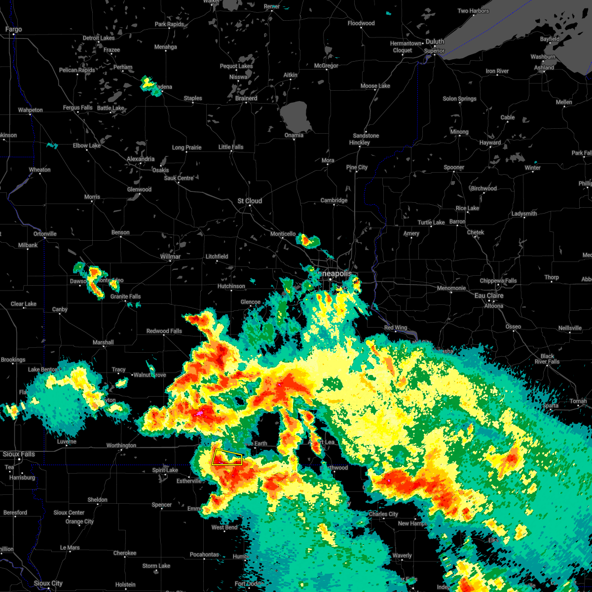 At 145 am cdt, a severe thunderstorm was located over iowa lake, or 7 miles south of fairmont, moving east at 60 mph (radar indicated). Hazards include 60 mph wind gusts and quarter size hail. Hail damage to vehicles is expected. expect wind damage to roofs, siding, and trees. This severe thunderstorm will remain over mainly rural areas of southeastern martin county, including the following locations, east chain. At 145 am cdt, a severe thunderstorm was located over iowa lake, or 7 miles south of fairmont, moving east at 60 mph (radar indicated). Hazards include 60 mph wind gusts and quarter size hail. Hail damage to vehicles is expected. expect wind damage to roofs, siding, and trees. This severe thunderstorm will remain over mainly rural areas of southeastern martin county, including the following locations, east chain.
|
| 9/6/2020 1:34 AM CDT |
 At 134 am cdt, a severe thunderstorm was located near sherburn, or 12 miles west of fairmont, moving east at 45 mph (radar indicated). Hazards include 60 mph wind gusts and half dollar size hail. Hail damage to vehicles is expected. expect wind damage to roofs, siding, and trees. this severe storm will be near, ceylon around 140 am cdt. okamanpedan lake around 145 am cdt. fairmont around 150 am cdt. iowa lake around 155 am cdt. Other locations impacted by this severe thunderstorm include fairmont airport, east chain, imogene, dunnell, wilbert and granada. At 134 am cdt, a severe thunderstorm was located near sherburn, or 12 miles west of fairmont, moving east at 45 mph (radar indicated). Hazards include 60 mph wind gusts and half dollar size hail. Hail damage to vehicles is expected. expect wind damage to roofs, siding, and trees. this severe storm will be near, ceylon around 140 am cdt. okamanpedan lake around 145 am cdt. fairmont around 150 am cdt. iowa lake around 155 am cdt. Other locations impacted by this severe thunderstorm include fairmont airport, east chain, imogene, dunnell, wilbert and granada.
|
| 9/6/2020 1:17 AM CDT |
 At 117 am cdt, severe thunderstorms were located along a line extending from near jackson in jackson county to okamanpedan lake, moving southeast at 40 mph (radar indicated). Hazards include two inch hail and 60 mph wind gusts. People and animals outdoors will be injured. expect hail damage to roofs, siding, windows, and vehicles. Expect wind damage to roofs, siding, and trees. At 117 am cdt, severe thunderstorms were located along a line extending from near jackson in jackson county to okamanpedan lake, moving southeast at 40 mph (radar indicated). Hazards include two inch hail and 60 mph wind gusts. People and animals outdoors will be injured. expect hail damage to roofs, siding, windows, and vehicles. Expect wind damage to roofs, siding, and trees.
|
| 8/16/2020 9:12 PM CDT |
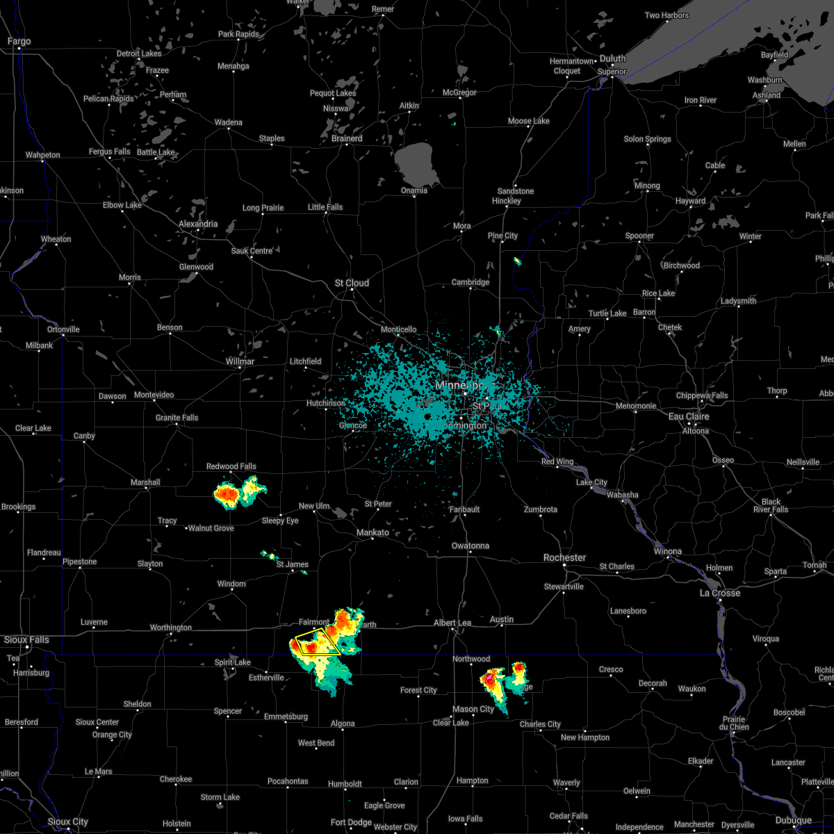 At 912 pm cdt, a severe thunderstorm was located over iowa lake, or 7 miles south of fairmont, moving southeast at 20 mph (radar indicated). Hazards include 60 mph wind gusts and quarter size hail. Hail damage to vehicles is expected. expect wind damage to roofs, siding, and trees. this severe storm will be near, iowa lake around 915 pm cdt. Other locations impacted by this severe thunderstorm include wilbert and east chain. At 912 pm cdt, a severe thunderstorm was located over iowa lake, or 7 miles south of fairmont, moving southeast at 20 mph (radar indicated). Hazards include 60 mph wind gusts and quarter size hail. Hail damage to vehicles is expected. expect wind damage to roofs, siding, and trees. this severe storm will be near, iowa lake around 915 pm cdt. Other locations impacted by this severe thunderstorm include wilbert and east chain.
|
| 8/16/2020 9:02 PM CDT |
 At 902 pm cdt, a severe thunderstorm was located near fairmont, moving southeast at 20 mph (radar indicated). Hazards include 60 mph wind gusts and quarter size hail. Hail damage to vehicles is expected. expect wind damage to roofs, siding, and trees. this severe storm will be near, iowa lake around 915 pm cdt. Other locations impacted by this severe thunderstorm include fairmont airport, wilbert and east chain. At 902 pm cdt, a severe thunderstorm was located near fairmont, moving southeast at 20 mph (radar indicated). Hazards include 60 mph wind gusts and quarter size hail. Hail damage to vehicles is expected. expect wind damage to roofs, siding, and trees. this severe storm will be near, iowa lake around 915 pm cdt. Other locations impacted by this severe thunderstorm include fairmont airport, wilbert and east chain.
|
| 8/16/2020 8:51 PM CDT |
 At 850 pm cdt, a severe thunderstorm was located over fairmont, moving southeast at 20 mph (radar indicated). Hazards include 60 mph wind gusts and quarter size hail. Hail damage to vehicles is expected. expect wind damage to roofs, siding, and trees. this severe thunderstorm will be near, iowa lake around 915 pm cdt. Other locations impacted by this severe thunderstorm include fairmont airport, wilbert and east chain. At 850 pm cdt, a severe thunderstorm was located over fairmont, moving southeast at 20 mph (radar indicated). Hazards include 60 mph wind gusts and quarter size hail. Hail damage to vehicles is expected. expect wind damage to roofs, siding, and trees. this severe thunderstorm will be near, iowa lake around 915 pm cdt. Other locations impacted by this severe thunderstorm include fairmont airport, wilbert and east chain.
|
| 7/11/2020 4:08 PM CDT |
 The severe thunderstorm warning for southwestern faribault and southeastern martin counties will expire at 415 pm cdt, the storm which prompted the warning has weakened below severe limits, and no longer poses an immediate threat to life or property. therefore, the warning will be allowed to expire. a severe thunderstorm watch remains in effect until 800 pm cdt for south central minnesota. The severe thunderstorm warning for southwestern faribault and southeastern martin counties will expire at 415 pm cdt, the storm which prompted the warning has weakened below severe limits, and no longer poses an immediate threat to life or property. therefore, the warning will be allowed to expire. a severe thunderstorm watch remains in effect until 800 pm cdt for south central minnesota.
|
| 7/11/2020 3:47 PM CDT |
 At 347 pm cdt, a severe thunderstorm was located near blue earth, or 11 miles east of fairmont, moving southeast at 50 mph (trained weather spotters). Hazards include 60 mph wind gusts and quarter size hail. Hail damage to vehicles is expected. expect wind damage to roofs, siding, and trees. Locations impacted include, fairmont, blue earth, elmore, granada, east chain, fairmont airport, imogene and guckeen. At 347 pm cdt, a severe thunderstorm was located near blue earth, or 11 miles east of fairmont, moving southeast at 50 mph (trained weather spotters). Hazards include 60 mph wind gusts and quarter size hail. Hail damage to vehicles is expected. expect wind damage to roofs, siding, and trees. Locations impacted include, fairmont, blue earth, elmore, granada, east chain, fairmont airport, imogene and guckeen.
|
| 7/11/2020 3:43 PM CDT | Quarter sized hail reported 0.7 miles SSW of Fairmont, MN, reported via twitter on north side of fairmont along i-90. includes photo. |
| 7/11/2020 3:26 PM CDT |
 At 326 pm cdt, a severe thunderstorm was located near truman, or 10 miles north of fairmont, moving southeast at 50 mph (radar indicated). Hazards include 60 mph wind gusts and quarter size hail. Hail damage to vehicles is expected. Expect wind damage to roofs, siding, and trees. At 326 pm cdt, a severe thunderstorm was located near truman, or 10 miles north of fairmont, moving southeast at 50 mph (radar indicated). Hazards include 60 mph wind gusts and quarter size hail. Hail damage to vehicles is expected. Expect wind damage to roofs, siding, and trees.
|
| 7/11/2020 2:51 PM CDT |
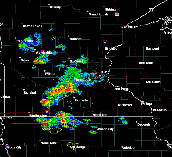 The severe thunderstorm warning for southeastern martin county will expire at 300 pm cdt, the storm which prompted the warning has moved out of the area. therefore, the warning will be allowed to expire. a severe thunderstorm watch remains in effect until 800 pm cdt for south central minnesota. The severe thunderstorm warning for southeastern martin county will expire at 300 pm cdt, the storm which prompted the warning has moved out of the area. therefore, the warning will be allowed to expire. a severe thunderstorm watch remains in effect until 800 pm cdt for south central minnesota.
|
| 7/11/2020 2:44 PM CDT |
 At 244 pm cdt, a severe thunderstorm was located near iowa lake, or 10 miles southeast of fairmont, moving southeast at 35 mph (radar indicated). Hazards include 60 mph wind gusts and quarter size hail. Hail damage to vehicles is expected. expect wind damage to roofs, siding, and trees. Locations impacted include, fairmont, iowa lake, east chain, fairmont airport and wilbert. At 244 pm cdt, a severe thunderstorm was located near iowa lake, or 10 miles southeast of fairmont, moving southeast at 35 mph (radar indicated). Hazards include 60 mph wind gusts and quarter size hail. Hail damage to vehicles is expected. expect wind damage to roofs, siding, and trees. Locations impacted include, fairmont, iowa lake, east chain, fairmont airport and wilbert.
|
| 7/11/2020 2:20 PM CDT |
 At 219 pm cdt, a severe thunderstorm was located near welcome, or near fairmont, moving southeast at 35 mph (radar indicated). Hazards include 60 mph wind gusts and quarter size hail. Hail damage to vehicles is expected. Expect wind damage to roofs, siding, and trees. At 219 pm cdt, a severe thunderstorm was located near welcome, or near fairmont, moving southeast at 35 mph (radar indicated). Hazards include 60 mph wind gusts and quarter size hail. Hail damage to vehicles is expected. Expect wind damage to roofs, siding, and trees.
|
| 6/5/2020 12:00 AM CDT |
 At 1200 am cdt, a severe thunderstorm was located near jackson in jackson county, moving southeast at 55 mph (radar indicated). Hazards include 60 mph wind gusts and quarter size hail. Hail damage to vehicles is expected. Expect wind damage to roofs, siding, and trees. At 1200 am cdt, a severe thunderstorm was located near jackson in jackson county, moving southeast at 55 mph (radar indicated). Hazards include 60 mph wind gusts and quarter size hail. Hail damage to vehicles is expected. Expect wind damage to roofs, siding, and trees.
|
| 6/2/2020 6:19 PM CDT |
 At 619 pm cdt, severe thunderstorms were located along a line extending from near amboy to iowa lake, moving east at 55 mph (radar indicated). Hazards include 60 mph wind gusts and quarter size hail. Hail damage to vehicles is expected. Expect wind damage to roofs, siding, and trees. At 619 pm cdt, severe thunderstorms were located along a line extending from near amboy to iowa lake, moving east at 55 mph (radar indicated). Hazards include 60 mph wind gusts and quarter size hail. Hail damage to vehicles is expected. Expect wind damage to roofs, siding, and trees.
|
| 6/2/2020 6:05 PM CDT |
 At 605 pm cdt, severe thunderstorms were located along a line extending from near good thunder to 6 miles southwest of winnebago, moving east at 45 mph (radar indicated). Hazards include 60 mph wind gusts and half dollar size hail. Hail damage to vehicles is expected. expect wind damage to roofs, siding, and trees. Locations impacted include, fairmont, blue earth, mapleton, winnebago, truman, minnesota lake, amboy, vernon center, lewisville, easton, delavan and granada. At 605 pm cdt, severe thunderstorms were located along a line extending from near good thunder to 6 miles southwest of winnebago, moving east at 45 mph (radar indicated). Hazards include 60 mph wind gusts and half dollar size hail. Hail damage to vehicles is expected. expect wind damage to roofs, siding, and trees. Locations impacted include, fairmont, blue earth, mapleton, winnebago, truman, minnesota lake, amboy, vernon center, lewisville, easton, delavan and granada.
|
| 6/2/2020 5:42 PM CDT |
 At 542 pm cdt, severe thunderstorms were located along a line extending from near lake crystal to near trimont, moving east at 45 mph (radar indicated). Hazards include golf ball size hail and 60 mph wind gusts. People and animals outdoors will be injured. expect hail damage to roofs, siding, windows, and vehicles. Expect wind damage to roofs, siding, and trees. At 542 pm cdt, severe thunderstorms were located along a line extending from near lake crystal to near trimont, moving east at 45 mph (radar indicated). Hazards include golf ball size hail and 60 mph wind gusts. People and animals outdoors will be injured. expect hail damage to roofs, siding, windows, and vehicles. Expect wind damage to roofs, siding, and trees.
|
| 8/18/2019 12:19 AM CDT |
 At 1219 am cdt, severe thunderstorms were located along a line extending from amboy to near elmore, moving east at 60 mph (radar indicated). Hazards include 60 mph wind gusts and quarter size hail. Hail damage to vehicles is expected. expect wind damage to roofs, siding, and trees. Locations impacted include, fairmont, truman, ceylon, iowa lake, okamanpedan lake, granada, east chain, northrop, fairmont airport, imogene and wilbert. At 1219 am cdt, severe thunderstorms were located along a line extending from amboy to near elmore, moving east at 60 mph (radar indicated). Hazards include 60 mph wind gusts and quarter size hail. Hail damage to vehicles is expected. expect wind damage to roofs, siding, and trees. Locations impacted include, fairmont, truman, ceylon, iowa lake, okamanpedan lake, granada, east chain, northrop, fairmont airport, imogene and wilbert.
|
| 8/18/2019 12:05 AM CDT |
 At 1147 pm cdt, severe thunderstorms were located along a line extending from 6 miles north of trimont to 7 miles southwest of ceylon, moving east at 65 mph (radar indicated). Hazards include 60 mph wind gusts and quarter size hail. Hail damage to vehicles is expected. expect wind damage to roofs, siding, and trees. Locations impacted include, fairmont, sherburn, truman, trimont, welcome, ceylon, iowa lake, okamanpedan lake, granada, east chain, northrop and dunnell. At 1147 pm cdt, severe thunderstorms were located along a line extending from 6 miles north of trimont to 7 miles southwest of ceylon, moving east at 65 mph (radar indicated). Hazards include 60 mph wind gusts and quarter size hail. Hail damage to vehicles is expected. expect wind damage to roofs, siding, and trees. Locations impacted include, fairmont, sherburn, truman, trimont, welcome, ceylon, iowa lake, okamanpedan lake, granada, east chain, northrop and dunnell.
|
| 8/17/2019 11:47 PM CDT |
 A severe thunderstorm warning remains in effect until 1230 am cdt for martin county. at 1147 pm cdt, severe thunderstorms were located along a line extending from 6 miles north of trimont to 7 miles southwest of ceylon, moving east at 65 mph. hazard. 60 mph wind gusts and quarter size hail. A severe thunderstorm warning remains in effect until 1230 am cdt for martin county. at 1147 pm cdt, severe thunderstorms were located along a line extending from 6 miles north of trimont to 7 miles southwest of ceylon, moving east at 65 mph. hazard. 60 mph wind gusts and quarter size hail.
|
| 8/17/2019 11:28 PM CDT |
 At 1128 pm cdt, severe thunderstorms were located along a line extending from windom to near orleans, moving east at 60 mph (radar indicated). Hazards include 60 mph wind gusts and quarter size hail. Hail damage to vehicles is expected. Expect wind damage to roofs, siding, and trees. At 1128 pm cdt, severe thunderstorms were located along a line extending from windom to near orleans, moving east at 60 mph (radar indicated). Hazards include 60 mph wind gusts and quarter size hail. Hail damage to vehicles is expected. Expect wind damage to roofs, siding, and trees.
|
| 8/10/2019 6:47 PM CDT |
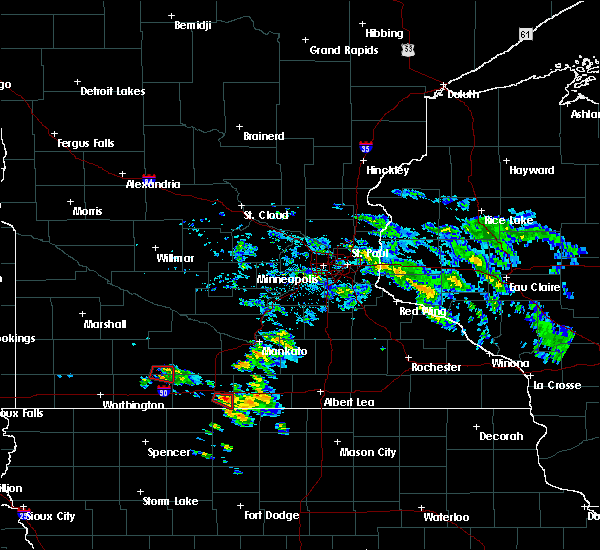 At 646 pm cdt, a severe thunderstorm capable of producing a tornado was located southest of fairmont, moving east at 15 mph (weather spotters reported a funnel cloud). Hazards include tornado. Flying debris will be dangerous to those caught without shelter. mobile homes will be damaged or destroyed. damage to roofs, windows, and vehicles will occur. tree damage is likely. Locations impacted include, east chain and rural southeast martin county. At 646 pm cdt, a severe thunderstorm capable of producing a tornado was located southest of fairmont, moving east at 15 mph (weather spotters reported a funnel cloud). Hazards include tornado. Flying debris will be dangerous to those caught without shelter. mobile homes will be damaged or destroyed. damage to roofs, windows, and vehicles will occur. tree damage is likely. Locations impacted include, east chain and rural southeast martin county.
|
| 8/10/2019 6:30 PM CDT |
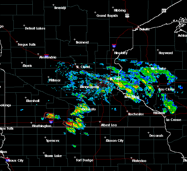 At 629 pm cdt, a severe thunderstorm capable of producing a tornado was located just east fairmont, moving east at 15 mph (radar indicated rotation). Hazards include tornado. Flying debris will be dangerous to those caught without shelter. mobile homes will be damaged or destroyed. damage to roofs, windows, and vehicles will occur. tree damage is likely. This tornadic thunderstorm will remain over mainly rural areas of southeastern martin county, including the following locations, east chain. At 629 pm cdt, a severe thunderstorm capable of producing a tornado was located just east fairmont, moving east at 15 mph (radar indicated rotation). Hazards include tornado. Flying debris will be dangerous to those caught without shelter. mobile homes will be damaged or destroyed. damage to roofs, windows, and vehicles will occur. tree damage is likely. This tornadic thunderstorm will remain over mainly rural areas of southeastern martin county, including the following locations, east chain.
|
| 8/10/2019 6:21 PM CDT |
 At 621 pm cdt, a severe thunderstorm capable of producing a tornado was located near fairmont, moving southeast at 10 mph (radar indicated rotation). Hazards include tornado and quarter size hail. Flying debris will be dangerous to those caught without shelter. mobile homes will be damaged or destroyed. damage to roofs, windows, and vehicles will occur. tree damage is likely. this dangerous storm will be near, fairmont around 630 pm cdt. Other locations impacted by this tornadic thunderstorm include east chain. At 621 pm cdt, a severe thunderstorm capable of producing a tornado was located near fairmont, moving southeast at 10 mph (radar indicated rotation). Hazards include tornado and quarter size hail. Flying debris will be dangerous to those caught without shelter. mobile homes will be damaged or destroyed. damage to roofs, windows, and vehicles will occur. tree damage is likely. this dangerous storm will be near, fairmont around 630 pm cdt. Other locations impacted by this tornadic thunderstorm include east chain.
|
| 8/10/2019 6:14 PM CDT |
 At 613 pm cdt, a severe thunderstorm capable of producing a tornado was located near fairmont, moving southeast at 10 mph (radar indicated rotation). Hazards include tornado and quarter size hail. Flying debris will be dangerous to those caught without shelter. mobile homes will be damaged or destroyed. damage to roofs, windows, and vehicles will occur. tree damage is likely. this dangerous storm will be near, fairmont and iowa lake around 630 pm cdt. Other locations impacted by this tornadic thunderstorm include fairmont airport, wilbert and east chain. At 613 pm cdt, a severe thunderstorm capable of producing a tornado was located near fairmont, moving southeast at 10 mph (radar indicated rotation). Hazards include tornado and quarter size hail. Flying debris will be dangerous to those caught without shelter. mobile homes will be damaged or destroyed. damage to roofs, windows, and vehicles will occur. tree damage is likely. this dangerous storm will be near, fairmont and iowa lake around 630 pm cdt. Other locations impacted by this tornadic thunderstorm include fairmont airport, wilbert and east chain.
|
| 8/10/2019 6:02 PM CDT |
 At 602 pm cdt, a severe thunderstorm capable of producing a tornado was located near fairmont, moving east at 15 mph (weather spotters reported a funnel cloud). Hazards include tornado. Flying debris will be dangerous to those caught without shelter. mobile homes will be damaged or destroyed. damage to roofs, windows, and vehicles will occur. tree damage is likely. this dangerous storm will be near, fairmont around 610 pm cdt. iowa lake around 630 pm cdt. Other locations impacted by this tornadic thunderstorm include wilbert and east chain. At 602 pm cdt, a severe thunderstorm capable of producing a tornado was located near fairmont, moving east at 15 mph (weather spotters reported a funnel cloud). Hazards include tornado. Flying debris will be dangerous to those caught without shelter. mobile homes will be damaged or destroyed. damage to roofs, windows, and vehicles will occur. tree damage is likely. this dangerous storm will be near, fairmont around 610 pm cdt. iowa lake around 630 pm cdt. Other locations impacted by this tornadic thunderstorm include wilbert and east chain.
|
| 8/10/2019 5:51 PM CDT |
 At 551 pm cdt, a severe thunderstorm capable of producing a tornado was located near welcome, or near fairmont, moving east at 15 mph (weather spotters reported funnel cloud). Hazards include tornado. Flying debris will be dangerous to those caught without shelter. mobile homes will be damaged or destroyed. damage to roofs, windows, and vehicles will occur. tree damage is likely. this dangerous storm will be near, fairmont around 610 pm cdt. iowa lake around 630 pm cdt. Other locations impacted by this tornadic thunderstorm include wilbert and east chain. At 551 pm cdt, a severe thunderstorm capable of producing a tornado was located near welcome, or near fairmont, moving east at 15 mph (weather spotters reported funnel cloud). Hazards include tornado. Flying debris will be dangerous to those caught without shelter. mobile homes will be damaged or destroyed. damage to roofs, windows, and vehicles will occur. tree damage is likely. this dangerous storm will be near, fairmont around 610 pm cdt. iowa lake around 630 pm cdt. Other locations impacted by this tornadic thunderstorm include wilbert and east chain.
|
| 8/5/2019 4:08 PM CDT |
 At 408 pm cdt, a severe thunderstorm was located near truman, or 11 miles northeast of fairmont, moving east at 20 mph (radar indicated). Hazards include 60 mph wind gusts and quarter size hail. Hail damage to vehicles is expected. Expect wind damage to roofs, siding, and trees. At 408 pm cdt, a severe thunderstorm was located near truman, or 11 miles northeast of fairmont, moving east at 20 mph (radar indicated). Hazards include 60 mph wind gusts and quarter size hail. Hail damage to vehicles is expected. Expect wind damage to roofs, siding, and trees.
|
| 7/20/2019 10:28 AM CDT |
 At 1027 am cdt, a severe thunderstorm was located near minnesota lake, or 20 miles southeast of mankato, moving east at 65 mph. at 1007 am a wind gust of 64 mph was measured at the fairmont airport. additionally, a trained spotter in winnebago reported wind gusts around 60 mph (radar indicated). Hazards include 60 mph wind gusts and penny size hail. Expect damage to roofs, siding, and trees. locations impacted include, mankato, fairmont, north mankato, blue earth, lake crystal, eagle lake, wells, janesville, mapleton, winnebago, madison lake and st. Clair. At 1027 am cdt, a severe thunderstorm was located near minnesota lake, or 20 miles southeast of mankato, moving east at 65 mph. at 1007 am a wind gust of 64 mph was measured at the fairmont airport. additionally, a trained spotter in winnebago reported wind gusts around 60 mph (radar indicated). Hazards include 60 mph wind gusts and penny size hail. Expect damage to roofs, siding, and trees. locations impacted include, mankato, fairmont, north mankato, blue earth, lake crystal, eagle lake, wells, janesville, mapleton, winnebago, madison lake and st. Clair.
|
| 7/20/2019 10:06 AM CDT |
 The severe thunderstorm warning for western martin, brown and watonwan counties will expire at 1015 am cdt, the storm which prompted the warning has moved out of the area. therefore, the warning will be allowed to expire. a severe thunderstorm watch remains in effect until 400 pm cdt for south central and southwestern minnesota. The severe thunderstorm warning for western martin, brown and watonwan counties will expire at 1015 am cdt, the storm which prompted the warning has moved out of the area. therefore, the warning will be allowed to expire. a severe thunderstorm watch remains in effect until 400 pm cdt for south central and southwestern minnesota.
|
| 7/20/2019 10:04 AM CDT | Awos station kfrm fairmont a in martin county MN, 2.6 miles WNW of Fairmont, MN |
| 7/20/2019 10:01 AM CDT |
 At 1000 am cdt, a severe thunderstorm was located near lewisville, or 21 miles north of fairmont, moving east at 65 mph (radar indicated). Hazards include 60 mph wind gusts and penny size hail. expect damage to roofs, siding, and trees At 1000 am cdt, a severe thunderstorm was located near lewisville, or 21 miles north of fairmont, moving east at 65 mph (radar indicated). Hazards include 60 mph wind gusts and penny size hail. expect damage to roofs, siding, and trees
|
| 7/20/2019 9:19 AM CDT |
 At 919 am cdt, severe thunderstorms was located near heron lake, or 8 miles west of windom, moving east at 45 mph. these storms have a history of producing wing gusts of 60 to 70 mph (radar indicated). Hazards include 60 mph wind gusts and penny size hail. expect damage to roofs, siding, and trees At 919 am cdt, severe thunderstorms was located near heron lake, or 8 miles west of windom, moving east at 45 mph. these storms have a history of producing wing gusts of 60 to 70 mph (radar indicated). Hazards include 60 mph wind gusts and penny size hail. expect damage to roofs, siding, and trees
|
| 6/27/2019 7:49 AM CDT |
 At 748 am cdt, a severe thunderstorm was located near jeffers, or 14 miles north of windom, moving northeast at 55 mph (radar indicated). Hazards include 60 mph wind gusts and quarter size hail. Hail damage to vehicles is expected. Expect wind damage to roofs, siding, and trees. At 748 am cdt, a severe thunderstorm was located near jeffers, or 14 miles north of windom, moving northeast at 55 mph (radar indicated). Hazards include 60 mph wind gusts and quarter size hail. Hail damage to vehicles is expected. Expect wind damage to roofs, siding, and trees.
|
| 6/20/2019 8:38 PM CDT |
 The severe thunderstorm warning for west central faribault and eastern martin counties will expire at 845 pm cdt, the storm which prompted the warning has moved out of the area. therefore, the warning will be allowed to expire. remember, a severe thunderstorm warning still remains in effect for southwest faribault county. The severe thunderstorm warning for west central faribault and eastern martin counties will expire at 845 pm cdt, the storm which prompted the warning has moved out of the area. therefore, the warning will be allowed to expire. remember, a severe thunderstorm warning still remains in effect for southwest faribault county.
|
| 6/20/2019 8:17 PM CDT |
 At 817 pm cdt, a severe thunderstorm was located 7 miles west of blue earth, or 11 miles east of fairmont, moving southeast at 25 mph (radar indicated). Hazards include 60 mph wind gusts and quarter size hail. Hail damage to vehicles is expected. expect wind damage to roofs, siding, and trees. this severe storm will be near, blue earth around 830 pm cdt. Other locations impacted by this severe thunderstorm include huntley, east chain, imogene, granada, northrop and guckeen. At 817 pm cdt, a severe thunderstorm was located 7 miles west of blue earth, or 11 miles east of fairmont, moving southeast at 25 mph (radar indicated). Hazards include 60 mph wind gusts and quarter size hail. Hail damage to vehicles is expected. expect wind damage to roofs, siding, and trees. this severe storm will be near, blue earth around 830 pm cdt. Other locations impacted by this severe thunderstorm include huntley, east chain, imogene, granada, northrop and guckeen.
|
| 6/20/2019 7:57 PM CDT |
 The severe thunderstorm warning for northeastern martin and southeastern watonwan counties will expire at 800 pm cdt, the storm which prompted the warning has moved out of the area. therefore, the warning will be allowed to expire. remember, a severe thunderstorm warning still remains in effect for eastern martin county. The severe thunderstorm warning for northeastern martin and southeastern watonwan counties will expire at 800 pm cdt, the storm which prompted the warning has moved out of the area. therefore, the warning will be allowed to expire. remember, a severe thunderstorm warning still remains in effect for eastern martin county.
|
| 6/20/2019 7:55 PM CDT |
 At 755 pm cdt, a severe thunderstorm was located near truman, or 10 miles northeast of fairmont, moving southeast at 25 mph (trained weather spotters). Hazards include golf ball size hail and 70 mph wind gusts. People and animals outdoors will be injured. expect hail damage to roofs, siding, windows, and vehicles. expect considerable tree damage. wind damage is also likely to mobile homes, roofs, and outbuildings. this severe thunderstorm will be near, winnebago around 810 pm cdt. blue earth around 835 pm cdt. other locations impacted by this severe thunderstorm include fairmont airport, huntley, east chain, imogene, northrop, granada and guckeen. this includes the following highways, interstate 90 between mile markers 103 and 124. u. s. Highway 169 between mile markers 8 and 19. At 755 pm cdt, a severe thunderstorm was located near truman, or 10 miles northeast of fairmont, moving southeast at 25 mph (trained weather spotters). Hazards include golf ball size hail and 70 mph wind gusts. People and animals outdoors will be injured. expect hail damage to roofs, siding, windows, and vehicles. expect considerable tree damage. wind damage is also likely to mobile homes, roofs, and outbuildings. this severe thunderstorm will be near, winnebago around 810 pm cdt. blue earth around 835 pm cdt. other locations impacted by this severe thunderstorm include fairmont airport, huntley, east chain, imogene, northrop, granada and guckeen. this includes the following highways, interstate 90 between mile markers 103 and 124. u. s. Highway 169 between mile markers 8 and 19.
|
| 6/20/2019 7:42 PM CDT |
 At 742 pm cdt, a severe thunderstorm was located over truman, or 12 miles north of fairmont, moving southeast at 25 mph (trained weather spotters). Hazards include golf ball size hail and 70 mph wind gusts. People and animals outdoors will be injured. expect hail damage to roofs, siding, windows, and vehicles. expect considerable tree damage. wind damage is also likely to mobile homes, roofs, and outbuildings. This severe thunderstorm will remain over mainly rural areas of northeastern martin and southeastern watonwan counties, including the following locations, northrop. At 742 pm cdt, a severe thunderstorm was located over truman, or 12 miles north of fairmont, moving southeast at 25 mph (trained weather spotters). Hazards include golf ball size hail and 70 mph wind gusts. People and animals outdoors will be injured. expect hail damage to roofs, siding, windows, and vehicles. expect considerable tree damage. wind damage is also likely to mobile homes, roofs, and outbuildings. This severe thunderstorm will remain over mainly rural areas of northeastern martin and southeastern watonwan counties, including the following locations, northrop.
|
| 6/20/2019 7:14 PM CDT |
 At 713 pm cdt, a severe thunderstorm was located near st. james, or 20 miles north of fairmont, moving southeast at 30 mph (trained weather spotters). Hazards include golf ball size hail and 60 mph wind gusts. People and animals outdoors will be injured. expect hail damage to roofs, siding, windows, and vehicles. expect wind damage to roofs, siding, and trees. this severe thunderstorm will be near, lewisville around 720 pm cdt. truman around 735 pm cdt. other locations impacted by this severe thunderstorm include northrop, echols and south branch. This includes interstate 90 between mile markers 98 and 100. At 713 pm cdt, a severe thunderstorm was located near st. james, or 20 miles north of fairmont, moving southeast at 30 mph (trained weather spotters). Hazards include golf ball size hail and 60 mph wind gusts. People and animals outdoors will be injured. expect hail damage to roofs, siding, windows, and vehicles. expect wind damage to roofs, siding, and trees. this severe thunderstorm will be near, lewisville around 720 pm cdt. truman around 735 pm cdt. other locations impacted by this severe thunderstorm include northrop, echols and south branch. This includes interstate 90 between mile markers 98 and 100.
|
| 9/20/2018 6:05 PM CDT | Tree dow in martin county MN, 0.2 miles W of Fairmont, MN |
| 9/20/2018 5:52 PM CDT |
 At 552 pm cdt, severe thunderstorms were located along a line extending from near truman to fairmont airport to east chain, moving northeast at 75 mph. these are very dangerous storms (radar indicated). Hazards include 80 mph wind gusts. Flying debris will be dangerous to those caught without shelter. mobile homes will be heavily damaged. expect considerable damage to roofs, windows, and vehicles. extensive tree damage and power outages are likely. these severe storms will be near, blue earth and lewisville around 600 pm cdt. winnebago and amboy around 605 pm cdt. delavan around 610 pm cdt. other locations impacted by these severe thunderstorms include fairmont airport, huntley, east chain, imogene, wilbert, northrop, granada, guckeen and south branch. A tornado watch remains in effect until 1100 pm cdt for south central minnesota. At 552 pm cdt, severe thunderstorms were located along a line extending from near truman to fairmont airport to east chain, moving northeast at 75 mph. these are very dangerous storms (radar indicated). Hazards include 80 mph wind gusts. Flying debris will be dangerous to those caught without shelter. mobile homes will be heavily damaged. expect considerable damage to roofs, windows, and vehicles. extensive tree damage and power outages are likely. these severe storms will be near, blue earth and lewisville around 600 pm cdt. winnebago and amboy around 605 pm cdt. delavan around 610 pm cdt. other locations impacted by these severe thunderstorms include fairmont airport, huntley, east chain, imogene, wilbert, northrop, granada, guckeen and south branch. A tornado watch remains in effect until 1100 pm cdt for south central minnesota.
|
| 9/20/2018 5:42 PM CDT |
 At 541 pm cdt, severe thunderstorms were located along a line extending from near sherburn to okamanpedan state park, moving northeast at 75 mph. these are very dangerous storms (radar indicated). Hazards include 80 mph wind gusts. estherville, iowa gusted to 75 mph. Flying debris will be dangerous to those caught without shelter. mobile homes will be heavily damaged. expect considerable damage to roofs, windows, and vehicles. extensive tree damage and power outages are likely. these severe storms will be near, fairmont and iowa lake around 545 pm cdt. truman around 555 pm cdt. blue earth, winnebago and lewisville around 600 pm cdt. amboy around 605 pm cdt. delavan around 610 pm cdt. other locations impacted by these severe thunderstorms include fairmont airport, huntley, east chain, imogene, dunnell, wilbert, foxlake, northrop, granada and guckeen. A tornado watch remains in effect until 1100 pm cdt for south central minnesota. At 541 pm cdt, severe thunderstorms were located along a line extending from near sherburn to okamanpedan state park, moving northeast at 75 mph. these are very dangerous storms (radar indicated). Hazards include 80 mph wind gusts. estherville, iowa gusted to 75 mph. Flying debris will be dangerous to those caught without shelter. mobile homes will be heavily damaged. expect considerable damage to roofs, windows, and vehicles. extensive tree damage and power outages are likely. these severe storms will be near, fairmont and iowa lake around 545 pm cdt. truman around 555 pm cdt. blue earth, winnebago and lewisville around 600 pm cdt. amboy around 605 pm cdt. delavan around 610 pm cdt. other locations impacted by these severe thunderstorms include fairmont airport, huntley, east chain, imogene, dunnell, wilbert, foxlake, northrop, granada and guckeen. A tornado watch remains in effect until 1100 pm cdt for south central minnesota.
|
| 9/20/2018 5:30 PM CDT |
 At 530 pm cdt, severe thunderstorms were located along a line extending from jackson in jackson county to near estherville, moving northeast at 75 mph (radar indicated). Hazards include 60 mph wind gusts. Expect damage to roofs, siding, and trees. severe thunderstorms will be near, sherburn, ceylon and okamanpedan lake around 540 pm cdt. trimont and welcome around 545 pm cdt. fairmont around 550 pm cdt. truman around 555 pm cdt. lewisville around 600 pm cdt. winnebago and amboy around 605 pm cdt. delavan around 610 pm cdt. other locations impacted by these severe thunderstorms include fairmont airport, huntley, east chain, imogene, dunnell, wilbert, foxlake, northrop, granada and guckeen. A tornado watch remains in effect until 1100 pm cdt for south central minnesota. At 530 pm cdt, severe thunderstorms were located along a line extending from jackson in jackson county to near estherville, moving northeast at 75 mph (radar indicated). Hazards include 60 mph wind gusts. Expect damage to roofs, siding, and trees. severe thunderstorms will be near, sherburn, ceylon and okamanpedan lake around 540 pm cdt. trimont and welcome around 545 pm cdt. fairmont around 550 pm cdt. truman around 555 pm cdt. lewisville around 600 pm cdt. winnebago and amboy around 605 pm cdt. delavan around 610 pm cdt. other locations impacted by these severe thunderstorms include fairmont airport, huntley, east chain, imogene, dunnell, wilbert, foxlake, northrop, granada and guckeen. A tornado watch remains in effect until 1100 pm cdt for south central minnesota.
|
| 8/27/2018 4:08 PM CDT |
 The severe thunderstorm warning for southwestern faribault, martin and watonwan counties will expire at 415 pm cdt, the storms which prompted the warning have moved out of the area. therefore, the warning will be allowed to expire. a severe thunderstorm watch remains in effect until 1000 pm cdt for south central minnesota. to report severe weather, contact your nearest law enforcement agency. they will relay your report to the national weather service the twin cities. The severe thunderstorm warning for southwestern faribault, martin and watonwan counties will expire at 415 pm cdt, the storms which prompted the warning have moved out of the area. therefore, the warning will be allowed to expire. a severe thunderstorm watch remains in effect until 1000 pm cdt for south central minnesota. to report severe weather, contact your nearest law enforcement agency. they will relay your report to the national weather service the twin cities.
|
| 8/27/2018 3:57 PM CDT |
 At 356 pm cdt, severe thunderstorms were located along a line extending from madelia to near winnebago, moving northeast at 55 mph (public). Hazards include 60 mph wind gusts and quarter size hail. Hail damage to vehicles is expected. expect wind damage to roofs, siding, and trees. These severe thunderstorms will remain over mainly rural areas of southwestern faribault, martin and watonwan counties, including the following locations, fairmont airport, huntley, northrop, ormsby, st james airport, granada, echols, east chain, grogan and imogene. At 356 pm cdt, severe thunderstorms were located along a line extending from madelia to near winnebago, moving northeast at 55 mph (public). Hazards include 60 mph wind gusts and quarter size hail. Hail damage to vehicles is expected. expect wind damage to roofs, siding, and trees. These severe thunderstorms will remain over mainly rural areas of southwestern faribault, martin and watonwan counties, including the following locations, fairmont airport, huntley, northrop, ormsby, st james airport, granada, echols, east chain, grogan and imogene.
|
| 8/27/2018 3:48 PM CDT |
 At 335 pm cdt, severe thunderstorms were located along a line extending from echols to near fairmont, moving northeast at 45 mph (radar indicated). Hazards include 60 mph wind gusts and quarter size hail. Hail damage to vehicles is expected. expect wind damage to roofs, siding, and trees. these severe storms will be near, lewisville around 345 pm cdt. madelia and winnebago around 355 pm cdt. Other locations impacted by these severe thunderstorms include fairmont airport, huntley, dunnell, northrop, ormsby, st james airport, granada, echols, east chain and grogan. At 335 pm cdt, severe thunderstorms were located along a line extending from echols to near fairmont, moving northeast at 45 mph (radar indicated). Hazards include 60 mph wind gusts and quarter size hail. Hail damage to vehicles is expected. expect wind damage to roofs, siding, and trees. these severe storms will be near, lewisville around 345 pm cdt. madelia and winnebago around 355 pm cdt. Other locations impacted by these severe thunderstorms include fairmont airport, huntley, dunnell, northrop, ormsby, st james airport, granada, echols, east chain and grogan.
|
| 8/27/2018 3:40 PM CDT | Social media photo of tree and power lines down in northrop. time estimated from rada in martin county MN, 5.8 miles SSW of Fairmont, MN |
| 8/27/2018 3:35 PM CDT |
 At 335 pm cdt, severe thunderstorms were located along a line extending from echols to near fairmont, moving northeast at 45 mph (radar indicated). Hazards include 60 mph wind gusts and quarter size hail. Hail damage to vehicles is expected. expect wind damage to roofs, siding, and trees. these severe storms will be near, lewisville around 345 pm cdt. madelia and winnebago around 355 pm cdt. Other locations impacted by these severe thunderstorms include fairmont airport, huntley, dunnell, northrop, ormsby, st james airport, granada, echols, east chain and grogan. At 335 pm cdt, severe thunderstorms were located along a line extending from echols to near fairmont, moving northeast at 45 mph (radar indicated). Hazards include 60 mph wind gusts and quarter size hail. Hail damage to vehicles is expected. expect wind damage to roofs, siding, and trees. these severe storms will be near, lewisville around 345 pm cdt. madelia and winnebago around 355 pm cdt. Other locations impacted by these severe thunderstorms include fairmont airport, huntley, dunnell, northrop, ormsby, st james airport, granada, echols, east chain and grogan.
|
| 8/27/2018 3:17 PM CDT |
 At 316 pm cdt, severe thunderstorms were located along a line extending from near bergen to near estherville municipal airport, moving northeast at 40 mph (radar indicated). Hazards include 60 mph wind gusts and quarter size hail. Hail damage to vehicles is expected. expect wind damage to roofs, siding, and trees. severe thunderstorms will be near, trimont and ceylon around 330 pm cdt. fairmont around 340 pm cdt. st. james around 350 pm cdt. lewisville around 400 pm cdt. blue earth, madelia and winnebago around 410 pm cdt. other locations impacted by these severe thunderstorms include fairmont airport, huntley, dunnell, northrop, ormsby, st james airport, granada, echols, east chain and grogan. this includes the following highways, interstate 90 between mile markers 82 and 119. u. s. Highway 169 between mile markers 1 and 9. At 316 pm cdt, severe thunderstorms were located along a line extending from near bergen to near estherville municipal airport, moving northeast at 40 mph (radar indicated). Hazards include 60 mph wind gusts and quarter size hail. Hail damage to vehicles is expected. expect wind damage to roofs, siding, and trees. severe thunderstorms will be near, trimont and ceylon around 330 pm cdt. fairmont around 340 pm cdt. st. james around 350 pm cdt. lewisville around 400 pm cdt. blue earth, madelia and winnebago around 410 pm cdt. other locations impacted by these severe thunderstorms include fairmont airport, huntley, dunnell, northrop, ormsby, st james airport, granada, echols, east chain and grogan. this includes the following highways, interstate 90 between mile markers 82 and 119. u. s. Highway 169 between mile markers 1 and 9.
|
| 6/6/2018 4:50 AM CDT |
 At 449 am cdt, severe thunderstorms were located along a line extending from madelia to near ormsby to near orleans, moving southeast at 45 mph (radar indicated). Hazards include 60 mph wind gusts and nickel size hail. Expect damage to roofs, siding, and trees. severe thunderstorms will be near, truman around 500 am cdt. amboy around 510 am cdt. Other locations impacted by these severe thunderstorms include imogene, dunnell, wilbert, foxlake, northrop, granada and south branch. At 449 am cdt, severe thunderstorms were located along a line extending from madelia to near ormsby to near orleans, moving southeast at 45 mph (radar indicated). Hazards include 60 mph wind gusts and nickel size hail. Expect damage to roofs, siding, and trees. severe thunderstorms will be near, truman around 500 am cdt. amboy around 510 am cdt. Other locations impacted by these severe thunderstorms include imogene, dunnell, wilbert, foxlake, northrop, granada and south branch.
|
| 7/20/2017 1:39 AM CDT |
 At 139 am cdt, a severe thunderstorm was located over east chain, or 12 miles southeast of fairmont, moving southeast at 40 mph (radar indicated). Hazards include 60 mph wind gusts and quarter size hail. Hail damage to vehicles is expected. expect wind damage to roofs, siding, and trees. Locations impacted include, fairmont, granada, east chain, fairmont airport and imogene. At 139 am cdt, a severe thunderstorm was located over east chain, or 12 miles southeast of fairmont, moving southeast at 40 mph (radar indicated). Hazards include 60 mph wind gusts and quarter size hail. Hail damage to vehicles is expected. expect wind damage to roofs, siding, and trees. Locations impacted include, fairmont, granada, east chain, fairmont airport and imogene.
|
| 7/20/2017 1:29 AM CDT |
 At 129 am cdt, a severe thunderstorm was located near east chain, or near fairmont, moving southeast at 40 mph (radar indicated). Hazards include 60 mph wind gusts and quarter size hail. Hail damage to vehicles is expected. expect wind damage to roofs, siding, and trees. Locations impacted include, fairmont, welcome, granada, east chain, northrop, fairmont airport, imogene and wilbert. At 129 am cdt, a severe thunderstorm was located near east chain, or near fairmont, moving southeast at 40 mph (radar indicated). Hazards include 60 mph wind gusts and quarter size hail. Hail damage to vehicles is expected. expect wind damage to roofs, siding, and trees. Locations impacted include, fairmont, welcome, granada, east chain, northrop, fairmont airport, imogene and wilbert.
|
| 7/20/2017 1:20 AM CDT |
 At 120 am cdt, a severe thunderstorm was located over fairmont, moving southeast at 45 mph (radar indicated). Hazards include 60 mph wind gusts and half dollar size hail. Hail damage to vehicles is expected. expect wind damage to roofs, siding, and trees. Locations impacted include, fairmont, sherburn, truman, trimont, welcome, granada, east chain, northrop, fairmont airport, imogene, wilbert and foxlake. At 120 am cdt, a severe thunderstorm was located over fairmont, moving southeast at 45 mph (radar indicated). Hazards include 60 mph wind gusts and half dollar size hail. Hail damage to vehicles is expected. expect wind damage to roofs, siding, and trees. Locations impacted include, fairmont, sherburn, truman, trimont, welcome, granada, east chain, northrop, fairmont airport, imogene, wilbert and foxlake.
|
| 7/20/2017 1:10 AM CDT |
 At 109 am cdt, a severe thunderstorm was located over welcome, or near fairmont, moving southeast at 50 mph (radar indicated). Hazards include 60 mph wind gusts and half dollar size hail. Hail damage to vehicles is expected. expect wind damage to roofs, siding, and trees. Locations impacted include, fairmont, sherburn, truman, trimont, welcome, granada, east chain, northrop, ormsby, fairmont airport, imogene and wilbert. At 109 am cdt, a severe thunderstorm was located over welcome, or near fairmont, moving southeast at 50 mph (radar indicated). Hazards include 60 mph wind gusts and half dollar size hail. Hail damage to vehicles is expected. expect wind damage to roofs, siding, and trees. Locations impacted include, fairmont, sherburn, truman, trimont, welcome, granada, east chain, northrop, ormsby, fairmont airport, imogene and wilbert.
|
| 7/20/2017 12:49 AM CDT |
 At 1248 am cdt, a severe thunderstorm was located over bergen, or 9 miles southeast of windom, moving southeast at 40 mph (radar indicated). Hazards include golf ball size hail and 60 mph wind gusts. People and animals outdoors will be injured. expect hail damage to roofs, siding, windows, and vehicles. expect wind damage to roofs, siding, and trees. locations impacted include, fairmont, sherburn, truman, trimont, welcome, butterfield, granada, east chain, south branch, northrop, ormsby and odin. an additional thunderstorm is located ahead of this severe storm, and will affect much of the same area. That storm could produce hail to nickel size and wind gusts to 40 mph. At 1248 am cdt, a severe thunderstorm was located over bergen, or 9 miles southeast of windom, moving southeast at 40 mph (radar indicated). Hazards include golf ball size hail and 60 mph wind gusts. People and animals outdoors will be injured. expect hail damage to roofs, siding, windows, and vehicles. expect wind damage to roofs, siding, and trees. locations impacted include, fairmont, sherburn, truman, trimont, welcome, butterfield, granada, east chain, south branch, northrop, ormsby and odin. an additional thunderstorm is located ahead of this severe storm, and will affect much of the same area. That storm could produce hail to nickel size and wind gusts to 40 mph.
|
| 7/20/2017 12:41 AM CDT |
 At 1240 am cdt, a severe thunderstorm was located near bergen, or near windom, moving southeast at 40 mph (radar indicated). Hazards include ping pong ball size hail and 60 mph wind gusts. People and animals outdoors will be injured. expect hail damage to roofs, siding, windows, and vehicles. expect wind damage to roofs, siding, and trees. this severe thunderstorm will be near, trimont around 105 am cdt. sherburn around 110 am cdt. welcome around 115 am cdt. fairmont around 125 am cdt. other locations impacted by this severe thunderstorm include fairmont airport, east chain, imogene, wilbert, foxlake, northrop, ormsby, granada, echols and south branch. This includes interstate 90 between mile markers 82 and 111. At 1240 am cdt, a severe thunderstorm was located near bergen, or near windom, moving southeast at 40 mph (radar indicated). Hazards include ping pong ball size hail and 60 mph wind gusts. People and animals outdoors will be injured. expect hail damage to roofs, siding, windows, and vehicles. expect wind damage to roofs, siding, and trees. this severe thunderstorm will be near, trimont around 105 am cdt. sherburn around 110 am cdt. welcome around 115 am cdt. fairmont around 125 am cdt. other locations impacted by this severe thunderstorm include fairmont airport, east chain, imogene, wilbert, foxlake, northrop, ormsby, granada, echols and south branch. This includes interstate 90 between mile markers 82 and 111.
|
| 7/19/2017 3:50 PM CDT |
 At 350 pm cdt, a severe thunderstorm was located near east chain, or 11 miles southeast of fairmont, moving east at 50 mph (radar indicated). Hazards include 60 mph wind gusts and quarter size hail. Hail damage to vehicles is expected. expect wind damage to roofs, siding, and trees. this severe thunderstorm will be near, elmore around 405 pm cdt. Other locations impacted by this severe thunderstorm include wilbert and east chain. At 350 pm cdt, a severe thunderstorm was located near east chain, or 11 miles southeast of fairmont, moving east at 50 mph (radar indicated). Hazards include 60 mph wind gusts and quarter size hail. Hail damage to vehicles is expected. expect wind damage to roofs, siding, and trees. this severe thunderstorm will be near, elmore around 405 pm cdt. Other locations impacted by this severe thunderstorm include wilbert and east chain.
|
| 6/22/2017 12:25 AM CDT |
 At 1224 am cdt, severe thunderstorms were located along a line extending from near northrop to east chain, moving east at 30 mph (radar indicated). Hazards include half dollar size hail. Damage to vehicles is expected. These severe thunderstorms will remain over mainly rural areas of southeastern martin county, including the following locations: fairmont airport, granada, northrop and imogene. At 1224 am cdt, severe thunderstorms were located along a line extending from near northrop to east chain, moving east at 30 mph (radar indicated). Hazards include half dollar size hail. Damage to vehicles is expected. These severe thunderstorms will remain over mainly rural areas of southeastern martin county, including the following locations: fairmont airport, granada, northrop and imogene.
|
| 6/22/2017 12:12 AM CDT |
 At 1212 am cdt, severe thunderstorms were located along a line extending from foxlake to near iowa lake, moving east at 35 mph (radar indicated). Hazards include half dollar size hail. Damage to vehicles is expected. these severe storms will be near, iowa lake around 1215 am cdt. fairmont around 1230 am cdt. Other locations impacted by these severe thunderstorms include fairmont airport, granada, foxlake and northrop. At 1212 am cdt, severe thunderstorms were located along a line extending from foxlake to near iowa lake, moving east at 35 mph (radar indicated). Hazards include half dollar size hail. Damage to vehicles is expected. these severe storms will be near, iowa lake around 1215 am cdt. fairmont around 1230 am cdt. Other locations impacted by these severe thunderstorms include fairmont airport, granada, foxlake and northrop.
|
| 6/21/2017 11:58 PM CDT |
 At 1158 pm cdt, a severe thunderstorm was located near sherburn, or 11 miles east of jackson in jackson county, moving east at 25 mph (radar indicated). Hazards include half dollar size hail. Damage to vehicles is expected. this severe thunderstorm will be near, welcome around 1215 am cdt. ceylon around 1220 am cdt. fairmont around 1230 am cdt. iowa lake around 1240 am cdt. other locations impacted by this severe thunderstorm include fairmont airport, granada, dunnell, wilbert, foxlake and northrop. This includes interstate 90 between mile markers 81 and 107. At 1158 pm cdt, a severe thunderstorm was located near sherburn, or 11 miles east of jackson in jackson county, moving east at 25 mph (radar indicated). Hazards include half dollar size hail. Damage to vehicles is expected. this severe thunderstorm will be near, welcome around 1215 am cdt. ceylon around 1220 am cdt. fairmont around 1230 am cdt. iowa lake around 1240 am cdt. other locations impacted by this severe thunderstorm include fairmont airport, granada, dunnell, wilbert, foxlake and northrop. This includes interstate 90 between mile markers 81 and 107.
|
| 6/16/2017 3:54 PM CDT |
 The severe thunderstorm warning for southwestern faribault, eastern martin and southeastern watonwan counties will expire at 400 pm cdt, the storm which prompted the warning has moved out of the area. therefore the warning will be allowed to expire. a severe thunderstorm watch remains in effect until 1000 pm cdt for south central minnesota. The severe thunderstorm warning for southwestern faribault, eastern martin and southeastern watonwan counties will expire at 400 pm cdt, the storm which prompted the warning has moved out of the area. therefore the warning will be allowed to expire. a severe thunderstorm watch remains in effect until 1000 pm cdt for south central minnesota.
|
| 6/16/2017 3:30 PM CDT |
 At 330 pm cdt, a severe thunderstorm was located near south branch, or 12 miles northwest of fairmont, moving east at 30 mph (radar indicated). Hazards include golf ball size hail and 60 mph wind gusts. People and animals outdoors will be injured. expect hail damage to roofs, siding, windows, and vehicles. expect wind damage to roofs, siding, and trees. this severe storm will be near, truman around 345 pm cdt. lewisville around 350 pm cdt. Other locations impacted by this severe thunderstorm include fairmont airport, huntley, east chain, imogene, northrop, granada and guckeen. At 330 pm cdt, a severe thunderstorm was located near south branch, or 12 miles northwest of fairmont, moving east at 30 mph (radar indicated). Hazards include golf ball size hail and 60 mph wind gusts. People and animals outdoors will be injured. expect hail damage to roofs, siding, windows, and vehicles. expect wind damage to roofs, siding, and trees. this severe storm will be near, truman around 345 pm cdt. lewisville around 350 pm cdt. Other locations impacted by this severe thunderstorm include fairmont airport, huntley, east chain, imogene, northrop, granada and guckeen.
|
| 6/16/2017 3:21 PM CDT |
 At 321 pm cdt, severe thunderstorms were located along a line extending from trimont to near fairmont, moving northeast at 30 mph (radar indicated). Hazards include 60 mph wind gusts and half dollar size hail. Hail damage to vehicles is expected. expect wind damage to roofs, siding, and trees. severe thunderstorms will be near, fairmont around 325 pm cdt. truman around 350 pm cdt. lewisville around 355 pm cdt. blue earth around 400 pm cdt. other locations impacted by these severe thunderstorms include fairmont airport, huntley, east chain, imogene, foxlake, northrop, granada and guckeen. this includes the following highways, interstate 90 between mile markers 92 and 120. u. s. Highway 169 between mile markers 1 and 14. At 321 pm cdt, severe thunderstorms were located along a line extending from trimont to near fairmont, moving northeast at 30 mph (radar indicated). Hazards include 60 mph wind gusts and half dollar size hail. Hail damage to vehicles is expected. expect wind damage to roofs, siding, and trees. severe thunderstorms will be near, fairmont around 325 pm cdt. truman around 350 pm cdt. lewisville around 355 pm cdt. blue earth around 400 pm cdt. other locations impacted by these severe thunderstorms include fairmont airport, huntley, east chain, imogene, foxlake, northrop, granada and guckeen. this includes the following highways, interstate 90 between mile markers 92 and 120. u. s. Highway 169 between mile markers 1 and 14.
|
| 6/12/2017 12:15 PM CDT |
 At 1215 pm cdt, severe thunderstorms were located along a line extending from near odin to near trimont to fairmont to near iowa lake, moving northeast at 40 mph (radar indicated). Hazards include 60 mph wind gusts and half dollar size hail. Hail damage to vehicles is expected. expect wind damage to roofs, siding, and trees. locations impacted include, fairmont, st. James, sherburn, truman, trimont, welcome, butterfield, ceylon, lewisville, iowa lake, okamanpedan lake and granada. At 1215 pm cdt, severe thunderstorms were located along a line extending from near odin to near trimont to fairmont to near iowa lake, moving northeast at 40 mph (radar indicated). Hazards include 60 mph wind gusts and half dollar size hail. Hail damage to vehicles is expected. expect wind damage to roofs, siding, and trees. locations impacted include, fairmont, st. James, sherburn, truman, trimont, welcome, butterfield, ceylon, lewisville, iowa lake, okamanpedan lake and granada.
|
| 6/12/2017 11:57 AM CDT |
 At 1156 am cdt, severe thunderstorms were located along a line extending from near alpha to ceylon to armstrong, moving north at 45 mph (radar indicated). Hazards include 60 mph wind gusts and quarter size hail. Hail damage to vehicles is expected. Expect wind damage to roofs, siding, and trees. At 1156 am cdt, severe thunderstorms were located along a line extending from near alpha to ceylon to armstrong, moving north at 45 mph (radar indicated). Hazards include 60 mph wind gusts and quarter size hail. Hail damage to vehicles is expected. Expect wind damage to roofs, siding, and trees.
|
| 6/3/2017 3:14 PM CDT | Awos station frm... fairmont a in martin county MN, 2.3 miles WNW of Fairmont, MN |
| 5/17/2017 3:30 PM CDT | Quarter sized hail reported 0.2 miles W of Fairmont, MN, photo submitted via facebook. |
| 5/17/2017 3:30 PM CDT | Quarter sized hail reported 2.9 miles NNE of Fairmont, MN |
| 9/5/2016 2:43 AM CDT |
 At 243 am cdt, severe thunderstorms were located along a line extending from near sveadahl to near gruver, moving east at 50 mph (radar indicated). Hazards include 60 mph wind gusts. Expect damage to roofs. siding. and trees. these severe storms will be near, madelia around 300 am cdt. Other locations impacted by these severe thunderstorms include grogan, ormsby, foxlake, darfur, fairmont airport, st james airport, la salle, odin, imogene and wilbert. At 243 am cdt, severe thunderstorms were located along a line extending from near sveadahl to near gruver, moving east at 50 mph (radar indicated). Hazards include 60 mph wind gusts. Expect damage to roofs. siding. and trees. these severe storms will be near, madelia around 300 am cdt. Other locations impacted by these severe thunderstorms include grogan, ormsby, foxlake, darfur, fairmont airport, st james airport, la salle, odin, imogene and wilbert.
|
| 9/5/2016 2:22 AM CDT |
 The national weather service in the twin cities has issued a * severe thunderstorm warning for. watonwan county in south central minnesota. martin county in south central minnesota. until 315 am cdt * at 221 am cdt. Severe thunderstorms were located along a line. The national weather service in the twin cities has issued a * severe thunderstorm warning for. watonwan county in south central minnesota. martin county in south central minnesota. until 315 am cdt * at 221 am cdt. Severe thunderstorms were located along a line.
|
| 6/17/2016 7:29 PM CDT | Measured at ksum radio station. relayed via social medi in martin county MN, 2.9 miles ENE of Fairmont, MN |
| 6/17/2016 7:15 PM CDT | Several trees down in town. time estimated from rada in martin county MN, 0.7 miles NNW of Fairmont, MN |
| 6/17/2016 7:12 PM CDT | Eighteen wheeled truck turned over on i-90 just north of town. time estimated from rada in martin county MN, 0.2 miles W of Fairmont, MN |
| 5/26/2016 1:05 AM CDT |
 At 104 am cdt, severe thunderstorms were located along a line extending from near echols to 6 miles west of trimont to estherville, moving northeast at 50 mph (radar indicated. at 100 am...estherville iowa gusted to 77 mph and at 1252 am jackson minnesota gusted to 60 mph). Hazards include 60 mph wind gusts and penny size hail. Expect damage to roofs. siding. and trees. severe thunderstorms will be near, st. james and trimont around 110 am cdt. ceylon and okamanpedan lake around 120 am cdt. madelia around 125 am cdt. fairmont, truman and iowa lake around 130 am cdt. lewisville around 135 am cdt. other locations impacted by these severe thunderstorms include grogan, ormsby, foxlake, fairmont airport, st james airport, la salle, odin, imogene, wilbert and south branch. This includes interstate 90 between mile markers 82 and 112. At 104 am cdt, severe thunderstorms were located along a line extending from near echols to 6 miles west of trimont to estherville, moving northeast at 50 mph (radar indicated. at 100 am...estherville iowa gusted to 77 mph and at 1252 am jackson minnesota gusted to 60 mph). Hazards include 60 mph wind gusts and penny size hail. Expect damage to roofs. siding. and trees. severe thunderstorms will be near, st. james and trimont around 110 am cdt. ceylon and okamanpedan lake around 120 am cdt. madelia around 125 am cdt. fairmont, truman and iowa lake around 130 am cdt. lewisville around 135 am cdt. other locations impacted by these severe thunderstorms include grogan, ormsby, foxlake, fairmont airport, st james airport, la salle, odin, imogene, wilbert and south branch. This includes interstate 90 between mile markers 82 and 112.
|
| 5/25/2016 11:22 PM CDT | Quarter sized hail reported 1 miles NW of Fairmont, MN, via social media. |
| 5/25/2016 11:09 PM CDT |
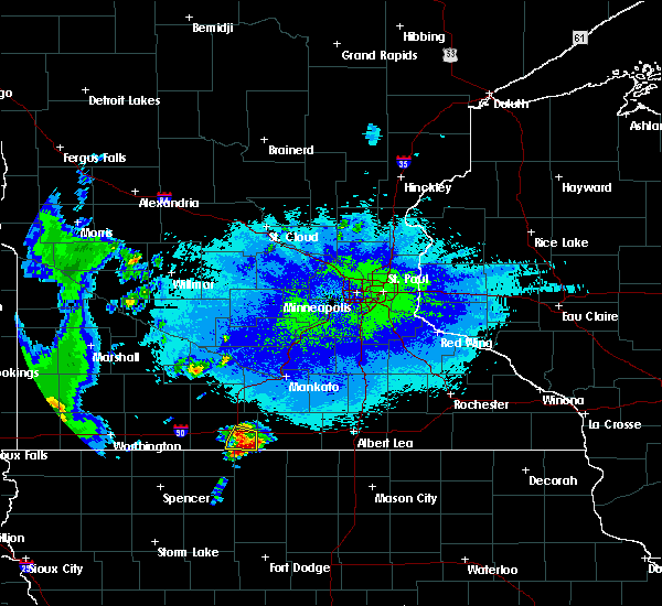 At 1109 pm cdt, severe thunderstorms were located along a line extending from fairmont to iowa lake, moving northeast at 25 mph (law enforcement reported quarter size hail just southwest of fairmont at 1105 pm). Hazards include half dollar size hail. Damage to vehicles is expected. These severe thunderstorms will remain over mainly rural areas of southeastern martin county, including the following locations: imogene, east chain, granada and fairmont airport. At 1109 pm cdt, severe thunderstorms were located along a line extending from fairmont to iowa lake, moving northeast at 25 mph (law enforcement reported quarter size hail just southwest of fairmont at 1105 pm). Hazards include half dollar size hail. Damage to vehicles is expected. These severe thunderstorms will remain over mainly rural areas of southeastern martin county, including the following locations: imogene, east chain, granada and fairmont airport.
|
| 5/25/2016 11:05 PM CDT | Quarter sized hail reported 3.6 miles NNE of Fairmont, MN, deputies reported dime to quarter size hail southwest of fairmont |
| 5/25/2016 10:50 PM CDT |
 At 1049 pm cdt, a severe thunderstorm was located over okamanpedan state park, or 9 miles southwest of fairmont, moving northeast at 25 mph (radar indicated). Hazards include quarter size hail. Damage to vehicles is expected. this severe thunderstorm will be near, fairmont around 1105 pm cdt. other locations impacted by this severe thunderstorm include wilbert, imogene, east chain, granada and fairmont airport. This includes interstate 90 between mile markers 100 and 112. At 1049 pm cdt, a severe thunderstorm was located over okamanpedan state park, or 9 miles southwest of fairmont, moving northeast at 25 mph (radar indicated). Hazards include quarter size hail. Damage to vehicles is expected. this severe thunderstorm will be near, fairmont around 1105 pm cdt. other locations impacted by this severe thunderstorm include wilbert, imogene, east chain, granada and fairmont airport. This includes interstate 90 between mile markers 100 and 112.
|
| 6/22/2015 5:39 AM CDT |
 At 538 am cdt, severe thunderstorms were located along a line extending from near comfrey to near bergen to 6 miles north of superior, moving east at 80 mph (trained weather spotters). Hazards include 70 mph wind gusts and quarter size hail. Hail damage to vehicles is expected. expect considerable tree damage. wind damage is also likely to mobile homes, roofs and outbuildings. these severe storms will be near, trimont around 545 am cdt. ceylon around 550 am cdt. fairmont and truman around 555 am cdt. other locations impacted by these severe thunderstorms include grogan, ormsby, foxlake, darfur, fairmont airport, st james airport, la salle, odin, wilbert and south branch. This includes interstate 90 between mile markers 82 and 106. At 538 am cdt, severe thunderstorms were located along a line extending from near comfrey to near bergen to 6 miles north of superior, moving east at 80 mph (trained weather spotters). Hazards include 70 mph wind gusts and quarter size hail. Hail damage to vehicles is expected. expect considerable tree damage. wind damage is also likely to mobile homes, roofs and outbuildings. these severe storms will be near, trimont around 545 am cdt. ceylon around 550 am cdt. fairmont and truman around 555 am cdt. other locations impacted by these severe thunderstorms include grogan, ormsby, foxlake, darfur, fairmont airport, st james airport, la salle, odin, wilbert and south branch. This includes interstate 90 between mile markers 82 and 106.
|
| 6/22/2015 5:23 AM CDT |
 At 522 am cdt, severe thunderstorms were located along a line extending from near revere to heron lake to near round lake, moving east at 75 mph (trained weather spotters). Hazards include 70 mph wind gusts and quarter size hail. Hail damage to vehicles is expected. expect considerable tree damage. wind damage is also likely to mobile homes, roofs and outbuildings. severe thunderstorms will be near, trimont and butterfield around 545 am cdt. sherburn around 550 am cdt. welcome and ceylon around 555 am cdt. fairmont, truman and lewisville around 600 am cdt. other locations impacted by these severe thunderstorms include grogan, ormsby, foxlake, darfur, fairmont airport, st james airport, la salle, odin, wilbert and south branch. This includes interstate 90 between mile markers 82 and 106. At 522 am cdt, severe thunderstorms were located along a line extending from near revere to heron lake to near round lake, moving east at 75 mph (trained weather spotters). Hazards include 70 mph wind gusts and quarter size hail. Hail damage to vehicles is expected. expect considerable tree damage. wind damage is also likely to mobile homes, roofs and outbuildings. severe thunderstorms will be near, trimont and butterfield around 545 am cdt. sherburn around 550 am cdt. welcome and ceylon around 555 am cdt. fairmont, truman and lewisville around 600 am cdt. other locations impacted by these severe thunderstorms include grogan, ormsby, foxlake, darfur, fairmont airport, st james airport, la salle, odin, wilbert and south branch. This includes interstate 90 between mile markers 82 and 106.
|
| 4/7/2015 12:50 PM CST | Quarter sized hail reported 1.4 miles WNW of Fairmont, MN, measured by law enforcement. |
| 4/7/2015 12:45 PM CST | Quarter sized hail reported 0.7 miles SSW of Fairmont, MN, started as pea-size... but increased to quarter-size. |
| 4/7/2015 1:39 PM CDT | A severe thunderstorm warning remains in effect until 200 pm cdt for northeastern martin county. at 139 pm cdt. doppler radar indicated a severe thunderstorm capable of producing quarter size hail. this storm was located over granada. or 8 miles northeast of fairmont. Moving northeast at 40 mph. |
| 4/7/2015 1:26 PM CDT | The national weather service in the twin cities has issued a * severe thunderstorm warning for. eastern martin county in south central minnesota. until 200 pm cdt * at 126 pm cdt. doppler radar indicated a severe thunderstorm capable of producing quarter size hail. This storm was located over. |
| 8/18/2014 6:23 PM CDT | Quarter sized hail reported 4.1 miles S of Fairmont, MN, quarter sized hail reported north of fairmont via twitter. |
| 7/7/2014 7:20 PM CDT | 3 to 4 foot diameter oak tree blown over. also reported 100 acres of corn and beans destroye in martin county MN, 4.4 miles NNE of Fairmont, MN |
| 6/16/2014 5:35 PM CDT | Awos station fairmont ap /frm/ in martin county MN, 2.3 miles WNW of Fairmont, MN |
| 6/16/2014 5:31 PM CDT | Power out in town in martin county MN, 3.5 miles N of Fairmont, MN |
| 6/16/2014 5:27 PM CDT | Quarter sized hail reported 3.5 miles N of Fairmont, MN |
| 6/16/2014 5:20 PM CDT | Numerous trees downed. roof blown of in martin county MN, 9.6 miles NW of Fairmont, MN |
| 6/23/2013 4:30 AM CDT | 1 ft branch split from the tre in martin county MN, 0.7 miles NNW of Fairmont, MN |
| 6/22/2013 12:35 AM CDT | Corrected date - trees down on the western side of tow in martin county MN, 0.7 miles NNW of Fairmont, MN |
| 6/21/2013 12:35 AM CDT | Trees down on the western side of tow in martin county MN, 0.7 miles NNW of Fairmont, MN |
| 6/14/2012 8:15 PM CDT | Law enforcement reported large tree down blocking the road...time estimated from radar in martin county MN, 0.7 miles NNW of Fairmont, MN |
| 6/14/2012 6:18 PM CDT | Delayed report machine shop roof damage..several large trees down in martin county MN, 8.3 miles N of Fairmont, MN |
Hail Maps for Fairmont, MN
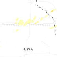
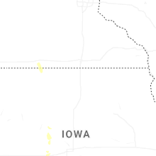
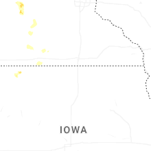
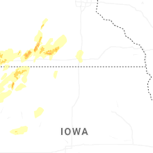
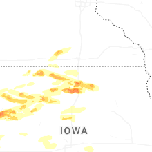

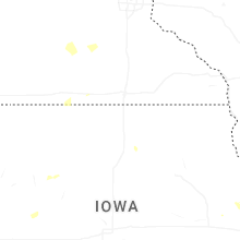
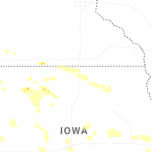
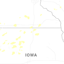
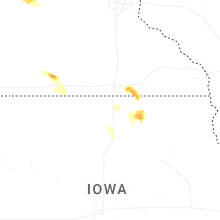

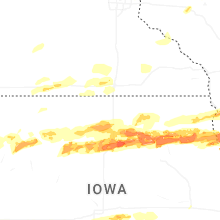


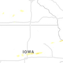


Connect with Interactive Hail Maps