

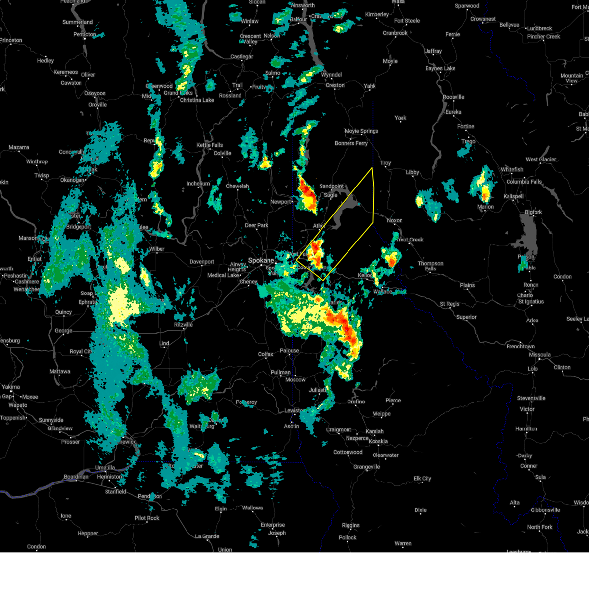
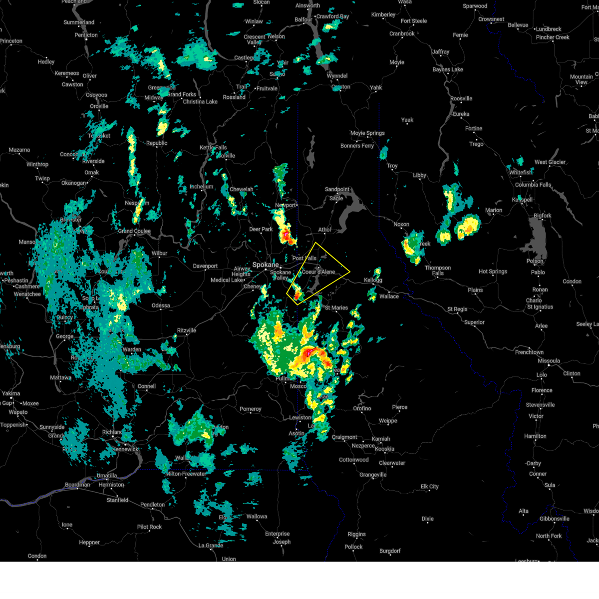
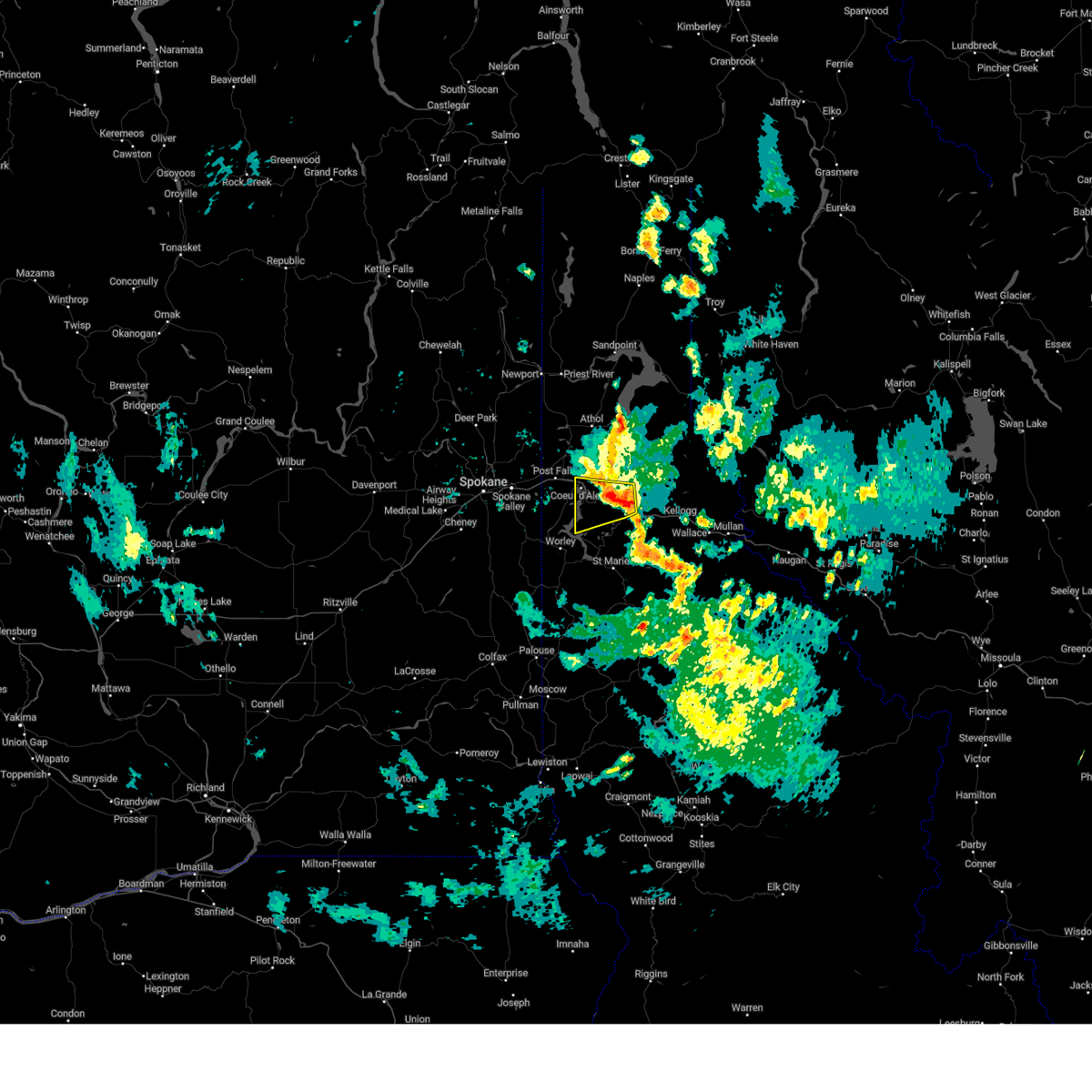
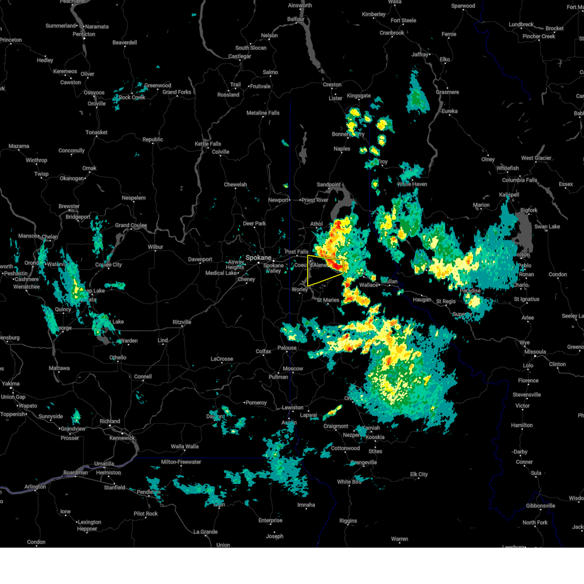
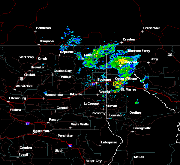
Hail Map for Fernan Lake Village, ID
The Fernan Lake Village, ID area has had 0 reports of on-the-ground hail by trained spotters, and has been under severe weather warnings 0 times during the past 12 months. Doppler radar has detected hail at or near Fernan Lake Village, ID on 3 occasions.
| Name: | Fernan Lake Village, ID |
| Where Located: | 31.1 miles E of Spokane, WA |
| Map: | Google Map for Fernan Lake Village, ID |
| Population: | 169 |
| Housing Units: | 77 |
| More Info: | Search Google for Fernan Lake Village, ID |
5
The Top Recent Hail Date for Fernan Lake Village, ID is Thursday, June 8, 2023 (1st out of 3)

Hail and Wind Damage Spotted near Fernan Lake Village, ID
| Date / Time | Report Details |
|---|---|
| 9/25/2024 5:17 PM PDT |
 Svrotx the national weather service in spokane has issued a * severe thunderstorm warning for, southeastern bonner county in the panhandle of idaho, northwestern shoshone county in the panhandle of idaho, central kootenai county in the panhandle of idaho, * until 615 pm pdt. * at 516 pm pdt, a severe thunderstorm was located near hayden lake, or near dalton gardens, moving northeast at 60 mph (radar indicated). Hazards include 60 mph wind gusts and penny size hail. expect damage to roofs, siding, and trees Svrotx the national weather service in spokane has issued a * severe thunderstorm warning for, southeastern bonner county in the panhandle of idaho, northwestern shoshone county in the panhandle of idaho, central kootenai county in the panhandle of idaho, * until 615 pm pdt. * at 516 pm pdt, a severe thunderstorm was located near hayden lake, or near dalton gardens, moving northeast at 60 mph (radar indicated). Hazards include 60 mph wind gusts and penny size hail. expect damage to roofs, siding, and trees
|
| 9/25/2024 4:51 PM PDT |
 Svrotx the national weather service in spokane has issued a * severe thunderstorm warning for, kootenai county in the panhandle of idaho, east central spokane county in northeastern washington, * until 530 pm pdt. * at 450 pm pdt, a severe thunderstorm was located 11 miles west of harrison, or 16 miles southeast of spokane valley, moving northeast at 40 mph (radar indicated). Hazards include 60 mph wind gusts and penny size hail. areas of blowing dust producing brief visibility reductions near one quarter mile. expect damage to roofs, siding, and trees Svrotx the national weather service in spokane has issued a * severe thunderstorm warning for, kootenai county in the panhandle of idaho, east central spokane county in northeastern washington, * until 530 pm pdt. * at 450 pm pdt, a severe thunderstorm was located 11 miles west of harrison, or 16 miles southeast of spokane valley, moving northeast at 40 mph (radar indicated). Hazards include 60 mph wind gusts and penny size hail. areas of blowing dust producing brief visibility reductions near one quarter mile. expect damage to roofs, siding, and trees
|
| 6/8/2023 3:42 PM PDT |
 At 342 pm pdt, a severe thunderstorm was located 7 miles south of coeur d`alene, moving west at 25 mph (law enforcement reported quarter size hail at mile marker 32 on interstate 90 at 322 pm). Hazards include 60 mph wind gusts and quarter size hail. Hail damage to vehicles is expected. expect wind damage to roofs, siding, and trees. locations impacted include, coeur d`alene, post falls, harrison, fernan lake village, huetter, beauty creek campground, and wolf creek campground. this includes the following highways, interstate 90 in idaho between mile markers 10 and 23. u. s. highway 95 in idaho between mile markers 414 and 431. hail threat, observed max hail size, 1. 00 in wind threat, radar indicated max wind gust, 60 mph. At 342 pm pdt, a severe thunderstorm was located 7 miles south of coeur d`alene, moving west at 25 mph (law enforcement reported quarter size hail at mile marker 32 on interstate 90 at 322 pm). Hazards include 60 mph wind gusts and quarter size hail. Hail damage to vehicles is expected. expect wind damage to roofs, siding, and trees. locations impacted include, coeur d`alene, post falls, harrison, fernan lake village, huetter, beauty creek campground, and wolf creek campground. this includes the following highways, interstate 90 in idaho between mile markers 10 and 23. u. s. highway 95 in idaho between mile markers 414 and 431. hail threat, observed max hail size, 1. 00 in wind threat, radar indicated max wind gust, 60 mph.
|
| 6/8/2023 3:28 PM PDT |
 At 328 pm pdt, a severe thunderstorm was located near fourth of july pass, or 9 miles southeast of coeur d`alene, moving west at 25 mph (radar indicated). Hazards include 60 mph wind gusts and quarter size hail. Hail damage to vehicles is expected. Expect wind damage to roofs, siding, and trees. At 328 pm pdt, a severe thunderstorm was located near fourth of july pass, or 9 miles southeast of coeur d`alene, moving west at 25 mph (radar indicated). Hazards include 60 mph wind gusts and quarter size hail. Hail damage to vehicles is expected. Expect wind damage to roofs, siding, and trees.
|
| 6/8/2023 3:21 PM PDT |
 At 321 pm pdt, a severe thunderstorm was located near fourth of july pass, or 10 miles southeast of coeur d`alene, moving west at 30 mph (radar indicated). Hazards include 60 mph wind gusts and quarter size hail. Hail damage to vehicles is expected. expect wind damage to roofs, siding, and trees. locations impacted include, coeur d`alene, fourth of july pass, fernan lake village, beauty creek campground, and wolf creek campground. this includes the following highways, interstate 90 in idaho between mile markers 11 and 35. u. s. highway 95 in idaho between mile markers 429 and 431. hail threat, radar indicated max hail size, 1. 00 in wind threat, radar indicated max wind gust, 60 mph. At 321 pm pdt, a severe thunderstorm was located near fourth of july pass, or 10 miles southeast of coeur d`alene, moving west at 30 mph (radar indicated). Hazards include 60 mph wind gusts and quarter size hail. Hail damage to vehicles is expected. expect wind damage to roofs, siding, and trees. locations impacted include, coeur d`alene, fourth of july pass, fernan lake village, beauty creek campground, and wolf creek campground. this includes the following highways, interstate 90 in idaho between mile markers 11 and 35. u. s. highway 95 in idaho between mile markers 429 and 431. hail threat, radar indicated max hail size, 1. 00 in wind threat, radar indicated max wind gust, 60 mph.
|
| 6/8/2023 3:08 PM PDT |
 At 307 pm pdt, a severe thunderstorm was located over fourth of july pass, or 13 miles northwest of pinehurst, moving west at 30 mph (radar indicated). Hazards include 60 mph wind gusts and quarter size hail. Hail damage to vehicles is expected. Expect wind damage to roofs, siding, and trees. At 307 pm pdt, a severe thunderstorm was located over fourth of july pass, or 13 miles northwest of pinehurst, moving west at 30 mph (radar indicated). Hazards include 60 mph wind gusts and quarter size hail. Hail damage to vehicles is expected. Expect wind damage to roofs, siding, and trees.
|
| 8/11/2022 5:52 PM PDT |
 At 551 pm pdt, a severe thunderstorm was located over hauser, or near post falls, moving north at 35 mph (trained weather spotter reported golf ball sized hail near otis orchards). Hazards include golf ball size hail and 70 mph wind gusts. People and animals outdoors will be injured. expect hail damage to roofs, siding, windows, and vehicles. expect considerable tree damage. wind damage is also likely to mobile homes, roofs, and outbuildings. locations impacted include, spokane valley, coeur d`alene, post falls, hayden, rathdrum, dalton gardens, liberty lake, hauser, hayden lake, green acres, otis orchards-east farms, otis orchards, trentwood, fernan lake village, huetter, state line, newman lake, mount spokane and chilco. this includes the following highways, interstate 90 in washington between mile markers 293 and 299. interstate 90 in idaho between mile markers 0 and 16. u. s. highway 95 in idaho between mile markers 419 and 447. thunderstorm damage threat, considerable hail threat, radar indicated max hail size, 1. 75 in wind threat, radar indicated max wind gust, 70 mph. At 551 pm pdt, a severe thunderstorm was located over hauser, or near post falls, moving north at 35 mph (trained weather spotter reported golf ball sized hail near otis orchards). Hazards include golf ball size hail and 70 mph wind gusts. People and animals outdoors will be injured. expect hail damage to roofs, siding, windows, and vehicles. expect considerable tree damage. wind damage is also likely to mobile homes, roofs, and outbuildings. locations impacted include, spokane valley, coeur d`alene, post falls, hayden, rathdrum, dalton gardens, liberty lake, hauser, hayden lake, green acres, otis orchards-east farms, otis orchards, trentwood, fernan lake village, huetter, state line, newman lake, mount spokane and chilco. this includes the following highways, interstate 90 in washington between mile markers 293 and 299. interstate 90 in idaho between mile markers 0 and 16. u. s. highway 95 in idaho between mile markers 419 and 447. thunderstorm damage threat, considerable hail threat, radar indicated max hail size, 1. 75 in wind threat, radar indicated max wind gust, 70 mph.
|
| 8/11/2022 5:40 PM PDT |
 At 539 pm pdt, a severe thunderstorm was located over liberty lake, or 7 miles southwest of post falls, moving north at 35 mph (broadcast media reported on social media of numerous trees down and multiple power outages in the rockford area). Hazards include golf ball size hail and 70 mph wind gusts. People and animals outdoors will be injured. expect hail damage to roofs, siding, windows, and vehicles. expect considerable tree damage. Wind damage is also likely to mobile homes, roofs, and outbuildings. At 539 pm pdt, a severe thunderstorm was located over liberty lake, or 7 miles southwest of post falls, moving north at 35 mph (broadcast media reported on social media of numerous trees down and multiple power outages in the rockford area). Hazards include golf ball size hail and 70 mph wind gusts. People and animals outdoors will be injured. expect hail damage to roofs, siding, windows, and vehicles. expect considerable tree damage. Wind damage is also likely to mobile homes, roofs, and outbuildings.
|
| 8/11/2022 5:31 PM PDT |
 At 529 pm pdt, a severe thunderstorm was located near liberty lake, or 10 miles south of post falls, moving northeast at 40 mph (public. at 5 pm, numerous power outages were reported near rockford). Hazards include tennis ball size hail and 70 mph wind gusts. People and animals outdoors will be injured. expect hail damage to roofs, siding, windows, and vehicles. expect considerable tree damage. wind damage is also likely to mobile homes, roofs, and outbuildings. locations impacted include, coeur d`alene, post falls, liberty lake, otis orchards-east farms, otis orchards, green acres, rockford, worley, fernan lake village, huetter and state line. this includes the following highways, interstate 90 in washington between mile markers 295 and 299. interstate 90 in idaho between mile markers 0 and 17. u. s. highway 95 in idaho between mile markers 402 and 431. thunderstorm damage threat, considerable hail threat, radar indicated max hail size, 2. 50 in wind threat, radar indicated max wind gust, 70 mph. At 529 pm pdt, a severe thunderstorm was located near liberty lake, or 10 miles south of post falls, moving northeast at 40 mph (public. at 5 pm, numerous power outages were reported near rockford). Hazards include tennis ball size hail and 70 mph wind gusts. People and animals outdoors will be injured. expect hail damage to roofs, siding, windows, and vehicles. expect considerable tree damage. wind damage is also likely to mobile homes, roofs, and outbuildings. locations impacted include, coeur d`alene, post falls, liberty lake, otis orchards-east farms, otis orchards, green acres, rockford, worley, fernan lake village, huetter and state line. this includes the following highways, interstate 90 in washington between mile markers 295 and 299. interstate 90 in idaho between mile markers 0 and 17. u. s. highway 95 in idaho between mile markers 402 and 431. thunderstorm damage threat, considerable hail threat, radar indicated max hail size, 2. 50 in wind threat, radar indicated max wind gust, 70 mph.
|
| 8/11/2022 5:21 PM PDT |
 At 519 pm pdt, a severe thunderstorm was located 11 miles south of liberty lake, or 14 miles southeast of spokane valley, moving north at 30 mph (radar indicated). Hazards include tennis ball size hail and 60 mph wind gusts. People and animals outdoors will be injured. expect hail damage to roofs, siding, windows, and vehicles. expect wind damage to roofs, siding, and trees. locations impacted include, spokane valley, coeur d`alene, post falls, liberty lake, green acres, otis orchards-east farms, otis orchards, trentwood, fairfield, rockford, worley, fernan lake village, huetter, state line and mica. this includes the following highways, interstate 90 in washington between mile markers 293 and 299. interstate 90 in idaho between mile markers 0 and 17. u. s. highway 95 in idaho between mile markers 402 and 431. thunderstorm damage threat, considerable hail threat, radar indicated max hail size, 2. 50 in wind threat, radar indicated max wind gust, 60 mph. At 519 pm pdt, a severe thunderstorm was located 11 miles south of liberty lake, or 14 miles southeast of spokane valley, moving north at 30 mph (radar indicated). Hazards include tennis ball size hail and 60 mph wind gusts. People and animals outdoors will be injured. expect hail damage to roofs, siding, windows, and vehicles. expect wind damage to roofs, siding, and trees. locations impacted include, spokane valley, coeur d`alene, post falls, liberty lake, green acres, otis orchards-east farms, otis orchards, trentwood, fairfield, rockford, worley, fernan lake village, huetter, state line and mica. this includes the following highways, interstate 90 in washington between mile markers 293 and 299. interstate 90 in idaho between mile markers 0 and 17. u. s. highway 95 in idaho between mile markers 402 and 431. thunderstorm damage threat, considerable hail threat, radar indicated max hail size, 2. 50 in wind threat, radar indicated max wind gust, 60 mph.
|
| 8/11/2022 5:07 PM PDT |
 At 507 pm pdt, a severe thunderstorm was located 11 miles northwest of plummer, or 18 miles south of spokane valley, moving northeast at 40 mph (radar indicated). Hazards include golf ball size hail and 60 mph wind gusts. People and animals outdoors will be injured. expect hail damage to roofs, siding, windows, and vehicles. Expect wind damage to roofs, siding, and trees. At 507 pm pdt, a severe thunderstorm was located 11 miles northwest of plummer, or 18 miles south of spokane valley, moving northeast at 40 mph (radar indicated). Hazards include golf ball size hail and 60 mph wind gusts. People and animals outdoors will be injured. expect hail damage to roofs, siding, windows, and vehicles. Expect wind damage to roofs, siding, and trees.
|
| 7/22/2016 5:15 PM PDT |
 At 512 pm pdt, doppler radar indicated a severe thunderstorm capable of producing dime size hail. this storm was located just south and east of of coeur d`alene, moving east at 15 mph. locations impacted include, coeur d`alene, fernan lake village, beauty creek campground and wolf creek campground. At 512 pm pdt, doppler radar indicated a severe thunderstorm capable of producing dime size hail. this storm was located just south and east of of coeur d`alene, moving east at 15 mph. locations impacted include, coeur d`alene, fernan lake village, beauty creek campground and wolf creek campground.
|
| 7/22/2016 4:52 PM PDT |
 At 452 pm pdt, doppler radar indicated a severe thunderstorm capable of producing quarter size hail. this storm was located 9 miles southeast of liberty lake, or 10 miles south of post falls, and moving east at 15 mph. At 452 pm pdt, doppler radar indicated a severe thunderstorm capable of producing quarter size hail. this storm was located 9 miles southeast of liberty lake, or 10 miles south of post falls, and moving east at 15 mph.
|
| 5/29/2015 8:46 PM PDT | At 841 pm pdt, weather service personnel measured a 53 mph wind gust at the weather office in airway heights. a trained weather spotter reported a dissipating funnel cloud near peone prairie. this storm was moving east at 30 mph. this severe storm will be near, post falls around 850 pm pdt. rathdrum around 855 pm pdt. hayden and dalton gardens around 905 pm pdt. coeur d`alene and hayden lake around 910 pm pdt. other locations impacted by this severe thunderstorm include mica, elk, newman lake, fernan lake village, laclede, mount spokane, opportunity, huetter, veradale and chilco. |
| 5/29/2015 8:46 PM PDT | At 841 pm pdt, weather service personnel measured a 53 mph wind gust at the weather office in airway heights. a trained weather spotter reported a dissipating funnel cloud near peone prairie. this storm was moving east at 30 mph. this severe storm will be near, post falls around 850 pm pdt. rathdrum around 855 pm pdt. hayden and dalton gardens around 905 pm pdt. coeur d`alene and hayden lake around 910 pm pdt. other locations impacted by this severe thunderstorm include mica, elk, newman lake, fernan lake village, laclede, mount spokane, opportunity, huetter, veradale and chilco. |
| 5/29/2015 8:31 PM PDT | At 827 pm pdt, doppler radar indicated a severe thunderstorm capable of producing damaging winds around 55 mph. this storm was located near trentwood, or 15 miles west of post falls, and moving east at 35 mph. small hail is also possible with this line of storms. * this severe thunderstorm will be near, liberty lake and otis orchards around 835 pm pdt. otis orchards-east farms around 840 pm pdt. hauser around 845 pm pdt. post falls around 850 pm pdt. rathdrum around 855 pm pdt. hayden, dalton gardens and hayden lake around 905 pm pdt. coeur d`alene around 910 pm pdt. other locations impacted by this severe thunderstorm include mica, elk, newman lake, fernan lake village, laclede, mount spokane, opportunity, huetter, veradale and chilco. |
| 5/29/2015 8:31 PM PDT | At 827 pm pdt, doppler radar indicated a severe thunderstorm capable of producing damaging winds around 55 mph. this storm was located near trentwood, or 15 miles west of post falls, and moving east at 35 mph. small hail is also possible with this line of storms. * this severe thunderstorm will be near, liberty lake and otis orchards around 835 pm pdt. otis orchards-east farms around 840 pm pdt. hauser around 845 pm pdt. post falls around 850 pm pdt. rathdrum around 855 pm pdt. hayden, dalton gardens and hayden lake around 905 pm pdt. coeur d`alene around 910 pm pdt. other locations impacted by this severe thunderstorm include mica, elk, newman lake, fernan lake village, laclede, mount spokane, opportunity, huetter, veradale and chilco. |
Hail Maps for Fernan Lake Village, ID


Connect with Interactive Hail Maps