

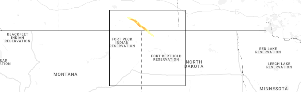
Hail Map for Fortuna, ND
The Fortuna, ND area has had 2 reports of on-the-ground hail by trained spotters, and has been under severe weather warnings 6 times during the past 12 months. Doppler radar has detected hail at or near Fortuna, ND on 22 occasions.
| Name: | Fortuna, ND |
| Where Located: | 53.3 miles N of Williston, ND |
| Map: | Google Map for Fortuna, ND |
| Population: | 22 |
| Housing Units: | 26 |
| More Info: | Search Google for Fortuna, ND |
0
The Top Recent Hail Date for Fortuna, ND is Sunday, July 17, 2022 (14th out of 22)
Hail and Wind Damage Spotted near Fortuna, ND
| Date / Time | Report Details |
|---|---|
| 8/30/2023 11:48 PM CDT |
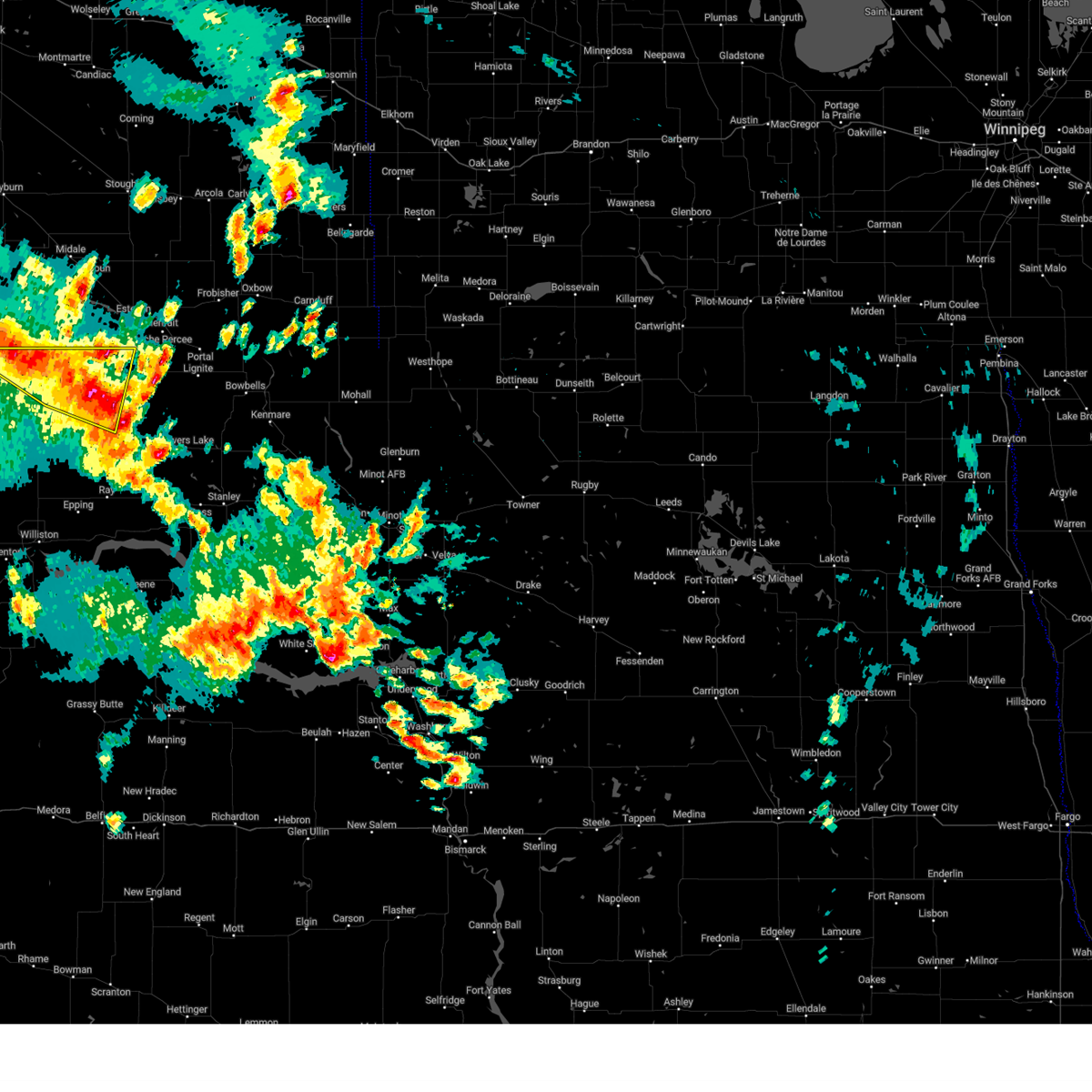 At 1148 pm cdt, severe thunderstorms were located along a line extending from 8 miles northwest of fortuna to 9 miles north of alamo to 5 miles south of wildrose, moving north at 40 mph (radar indicated). Hazards include 60 mph wind gusts. Expect damage to roofs, siding, and trees. locations impacted include, crosby, fortuna and ambrose. hail threat, radar indicated max hail size, <. 75 in wind threat, observed max wind gust, 60 mph. At 1148 pm cdt, severe thunderstorms were located along a line extending from 8 miles northwest of fortuna to 9 miles north of alamo to 5 miles south of wildrose, moving north at 40 mph (radar indicated). Hazards include 60 mph wind gusts. Expect damage to roofs, siding, and trees. locations impacted include, crosby, fortuna and ambrose. hail threat, radar indicated max hail size, <. 75 in wind threat, observed max wind gust, 60 mph.
|
| 8/30/2023 11:41 PM CDT |
 At 1140 pm cdt, severe thunderstorms were located along a line extending from 6 miles northwest of fortuna to 6 miles north of alamo to 9 miles south of wildrose, moving north at 40 mph (radar indicated). Hazards include 60 mph wind gusts and quarter size hail. Hail damage to vehicles is expected. expect wind damage to roofs, siding, and trees. locations impacted include, wildrose, fortuna, crosby and noonan. hail threat, radar indicated max hail size, 1. 00 in wind threat, observed max wind gust, 60 mph. At 1140 pm cdt, severe thunderstorms were located along a line extending from 6 miles northwest of fortuna to 6 miles north of alamo to 9 miles south of wildrose, moving north at 40 mph (radar indicated). Hazards include 60 mph wind gusts and quarter size hail. Hail damage to vehicles is expected. expect wind damage to roofs, siding, and trees. locations impacted include, wildrose, fortuna, crosby and noonan. hail threat, radar indicated max hail size, 1. 00 in wind threat, observed max wind gust, 60 mph.
|
| 8/30/2023 11:11 PM CDT |
 At 1111 pm cdt, severe thunderstorms were located along a line extending from 7 miles northwest of grenora to 8 miles east of bonetrail to near epping, moving north at 40 mph (radar indicated). Hazards include 60 mph wind gusts and quarter size hail. Hail damage to vehicles is expected. expect wind damage to roofs, siding, and trees. these severe storms will be near, epping and hanks city around 1115 pm cdt. other locations in the path of these severe thunderstorms include writing rock state historical site, westby, alamo, alkabo, fortuna, wildrose and crosby. hail threat, radar indicated max hail size, 1. 00 in wind threat, observed max wind gust, 60 mph. At 1111 pm cdt, severe thunderstorms were located along a line extending from 7 miles northwest of grenora to 8 miles east of bonetrail to near epping, moving north at 40 mph (radar indicated). Hazards include 60 mph wind gusts and quarter size hail. Hail damage to vehicles is expected. expect wind damage to roofs, siding, and trees. these severe storms will be near, epping and hanks city around 1115 pm cdt. other locations in the path of these severe thunderstorms include writing rock state historical site, westby, alamo, alkabo, fortuna, wildrose and crosby. hail threat, radar indicated max hail size, 1. 00 in wind threat, observed max wind gust, 60 mph.
|
| 8/30/2023 10:58 PM CDT |
 At 1058 pm cdt, severe thunderstorms were located along a line extending from 5 miles west of grenora to 9 miles southeast of bonetrail to 9 miles east of williston, moving north at 40 mph (radar indicated). Hazards include 60 mph wind gusts. Expect damage to roofs, siding, and trees. severe thunderstorms will be near, grenora, epping and hanks city around 1105 pm cdt. writing rock state historical site around 1115 pm cdt. alamo and alkabo around 1120 pm cdt. westby around 1020 pm mdt. fortuna around 1130 pm cdt. wildrose around 1140 pm cdt. other locations impacted by these severe thunderstorms include zahl, appam, wheelock, hanks, ambrose, spring brook, corinth and blacktail lake. hail threat, radar indicated max hail size, <. 75 in wind threat, observed max wind gust, 60 mph. At 1058 pm cdt, severe thunderstorms were located along a line extending from 5 miles west of grenora to 9 miles southeast of bonetrail to 9 miles east of williston, moving north at 40 mph (radar indicated). Hazards include 60 mph wind gusts. Expect damage to roofs, siding, and trees. severe thunderstorms will be near, grenora, epping and hanks city around 1105 pm cdt. writing rock state historical site around 1115 pm cdt. alamo and alkabo around 1120 pm cdt. westby around 1020 pm mdt. fortuna around 1130 pm cdt. wildrose around 1140 pm cdt. other locations impacted by these severe thunderstorms include zahl, appam, wheelock, hanks, ambrose, spring brook, corinth and blacktail lake. hail threat, radar indicated max hail size, <. 75 in wind threat, observed max wind gust, 60 mph.
|
| 8/30/2023 10:23 PM CDT |
 At 1023 pm cdt, severe thunderstorms were located along a line extending from 14 miles west of bonetrail to 6 miles southeast of fort union trading post to 16 miles south of alexander, moving northeast at 45 mph (radar indicated). Hazards include 60 mph wind gusts and quarter size hail. Hail damage to vehicles is expected. expect wind damage to roofs, siding, and trees. these severe storms will be near, alexander around 1030 pm cdt. grenora and bonetrail around 1040 pm cdt. williston around 1045 pm cdt. hanks city around 1050 pm cdt. writing rock state historical site around 1055 pm cdt. other locations impacted by these severe thunderstorms include zahl, cartwright, sather dam, fort buford state historical site, charbonneau, appam, rawson, hanks, trenton and spring brook. hail threat, radar indicated max hail size, 1. 00 in wind threat, observed max wind gust, 60 mph. At 1023 pm cdt, severe thunderstorms were located along a line extending from 14 miles west of bonetrail to 6 miles southeast of fort union trading post to 16 miles south of alexander, moving northeast at 45 mph (radar indicated). Hazards include 60 mph wind gusts and quarter size hail. Hail damage to vehicles is expected. expect wind damage to roofs, siding, and trees. these severe storms will be near, alexander around 1030 pm cdt. grenora and bonetrail around 1040 pm cdt. williston around 1045 pm cdt. hanks city around 1050 pm cdt. writing rock state historical site around 1055 pm cdt. other locations impacted by these severe thunderstorms include zahl, cartwright, sather dam, fort buford state historical site, charbonneau, appam, rawson, hanks, trenton and spring brook. hail threat, radar indicated max hail size, 1. 00 in wind threat, observed max wind gust, 60 mph.
|
| 8/30/2023 10:07 PM CDT |
 At 1007 pm cdt, severe thunderstorms were located along a line extending from 9 miles north of bainville to east fairview to 12 miles northeast of skaar, moving northeast at 45 mph (radar indicated). Hazards include 60 mph wind gusts and quarter size hail. Hail damage to vehicles is expected. expect wind damage to roofs, siding, and trees. severe thunderstorms will be near, alexander around 1030 pm cdt. williston, grenora and bonetrail around 1040 pm cdt. hanks city around 1050 pm cdt. other locations impacted by these severe thunderstorms include zahl, cartwright, sather dam, fort buford state historical site, charbonneau, appam, rawson, hanks, trenton and spring brook. hail threat, radar indicated max hail size, 1. 00 in wind threat, radar indicated max wind gust, 60 mph. At 1007 pm cdt, severe thunderstorms were located along a line extending from 9 miles north of bainville to east fairview to 12 miles northeast of skaar, moving northeast at 45 mph (radar indicated). Hazards include 60 mph wind gusts and quarter size hail. Hail damage to vehicles is expected. expect wind damage to roofs, siding, and trees. severe thunderstorms will be near, alexander around 1030 pm cdt. williston, grenora and bonetrail around 1040 pm cdt. hanks city around 1050 pm cdt. other locations impacted by these severe thunderstorms include zahl, cartwright, sather dam, fort buford state historical site, charbonneau, appam, rawson, hanks, trenton and spring brook. hail threat, radar indicated max hail size, 1. 00 in wind threat, radar indicated max wind gust, 60 mph.
|
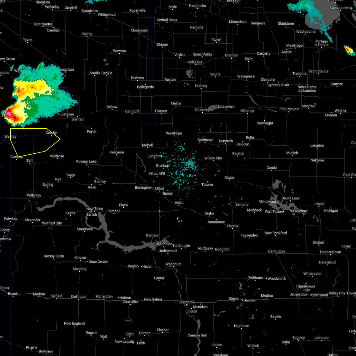
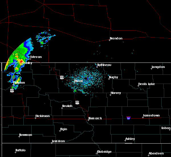
| 7/18/2022 11:38 PM CDT |
 At 1138 pm cdt, severe thunderstorms were located along a line extending from 4 miles northeast of fortuna to 6 miles northwest of alamo to williston, moving northeast at 55 mph (public. at 1135 pm cdt, ping pong ball size was reported in williston). Hazards include 70 mph wind gusts and ping pong ball size hail. People and animals outdoors will be injured. expect hail damage to roofs, siding, windows, and vehicles. expect considerable tree damage. wind damage is also likely to mobile homes, roofs, and outbuildings. these severe storms will be near, alamo around 1145 pm cdt. epping around 1155 pm cdt. ray around 1205 am cdt. other locations impacted by these severe thunderstorms include zahl, appam, wheelock, hanks, ambrose, trenton, spring brook, corinth and blacktail lake. thunderstorm damage threat, considerable hail threat, radar indicated max hail size, 1. 50 in wind threat, radar indicated max wind gust, 70 mph. At 1138 pm cdt, severe thunderstorms were located along a line extending from 4 miles northeast of fortuna to 6 miles northwest of alamo to williston, moving northeast at 55 mph (public. at 1135 pm cdt, ping pong ball size was reported in williston). Hazards include 70 mph wind gusts and ping pong ball size hail. People and animals outdoors will be injured. expect hail damage to roofs, siding, windows, and vehicles. expect considerable tree damage. wind damage is also likely to mobile homes, roofs, and outbuildings. these severe storms will be near, alamo around 1145 pm cdt. epping around 1155 pm cdt. ray around 1205 am cdt. other locations impacted by these severe thunderstorms include zahl, appam, wheelock, hanks, ambrose, trenton, spring brook, corinth and blacktail lake. thunderstorm damage threat, considerable hail threat, radar indicated max hail size, 1. 50 in wind threat, radar indicated max wind gust, 70 mph.
|
| 7/18/2022 11:18 PM CDT |
 At 1118 pm cdt, severe thunderstorms were located along a line extending from near alkabo to 6 miles north of bonetrail to 10 miles northeast of fort union trading post, moving northeast at 55 mph (radar indicated). Hazards include 70 mph wind gusts and half dollar size hail. Hail damage to vehicles is expected. expect considerable tree damage. wind damage is also likely to mobile homes, roofs, and outbuildings. these severe storms will be near, alkabo and writing rock state historical site around 1125 pm cdt. fortuna around 1130 pm cdt. alamo around 1140 pm cdt. epping around 1145 pm cdt. ray around 1200 am cdt. other locations impacted by these severe thunderstorms include zahl, appam, wheelock, hanks, ambrose, trenton, spring brook, corinth and blacktail lake. thunderstorm damage threat, considerable hail threat, radar indicated max hail size, 1. 25 in wind threat, radar indicated max wind gust, 70 mph. At 1118 pm cdt, severe thunderstorms were located along a line extending from near alkabo to 6 miles north of bonetrail to 10 miles northeast of fort union trading post, moving northeast at 55 mph (radar indicated). Hazards include 70 mph wind gusts and half dollar size hail. Hail damage to vehicles is expected. expect considerable tree damage. wind damage is also likely to mobile homes, roofs, and outbuildings. these severe storms will be near, alkabo and writing rock state historical site around 1125 pm cdt. fortuna around 1130 pm cdt. alamo around 1140 pm cdt. epping around 1145 pm cdt. ray around 1200 am cdt. other locations impacted by these severe thunderstorms include zahl, appam, wheelock, hanks, ambrose, trenton, spring brook, corinth and blacktail lake. thunderstorm damage threat, considerable hail threat, radar indicated max hail size, 1. 25 in wind threat, radar indicated max wind gust, 70 mph.
|
| 7/18/2022 11:02 PM CDT |
 At 1101 pm cdt, severe thunderstorms were located along a line extending from 9 miles southwest of westby to 9 miles west of bonetrail to near fort union trading post, moving northeast at 55 mph (radar indicated). Hazards include 60 mph wind gusts and quarter size hail. Hail damage to vehicles is expected. expect wind damage to roofs, siding, and trees. severe thunderstorms will be near, bonetrail around 1110 pm cdt. westby around 1010 pm mdt. alkabo and writing rock state historical site around 1115 pm cdt. williston and fortuna around 1125 pm cdt. alamo around 1135 pm cdt. epping around 1140 pm cdt. ray around 1150 pm cdt. other locations impacted by these severe thunderstorms include zahl, appam, wheelock, hanks, ambrose, trenton, spring brook, corinth and blacktail lake. hail threat, radar indicated max hail size, 1. 00 in wind threat, radar indicated max wind gust, 60 mph. At 1101 pm cdt, severe thunderstorms were located along a line extending from 9 miles southwest of westby to 9 miles west of bonetrail to near fort union trading post, moving northeast at 55 mph (radar indicated). Hazards include 60 mph wind gusts and quarter size hail. Hail damage to vehicles is expected. expect wind damage to roofs, siding, and trees. severe thunderstorms will be near, bonetrail around 1110 pm cdt. westby around 1010 pm mdt. alkabo and writing rock state historical site around 1115 pm cdt. williston and fortuna around 1125 pm cdt. alamo around 1135 pm cdt. epping around 1140 pm cdt. ray around 1150 pm cdt. other locations impacted by these severe thunderstorms include zahl, appam, wheelock, hanks, ambrose, trenton, spring brook, corinth and blacktail lake. hail threat, radar indicated max hail size, 1. 00 in wind threat, radar indicated max wind gust, 60 mph.
|
| 7/18/2022 10:03 PM CDT |
 At 1001 pm cdt, a severe thunderstorm was located 5 miles north of alamo, or 20 miles southwest of crosby, moving northeast at 45 mph (radar indicated. at 944 pm the public reported 60 mph wind gust 6 miles north of bonetrail). Hazards include 70 mph wind gusts and quarter size hail. Hail damage to vehicles is expected. expect considerable tree damage. wind damage is also likely to mobile homes, roofs, and outbuildings. Locations impacted include, crosby, grenora, wildrose, alamo, fortuna, alkabo, writing rock state historical site, bonetrail, hamlet, ambrose, zahl, appam, hanks, corinth and blacktail lake. At 1001 pm cdt, a severe thunderstorm was located 5 miles north of alamo, or 20 miles southwest of crosby, moving northeast at 45 mph (radar indicated. at 944 pm the public reported 60 mph wind gust 6 miles north of bonetrail). Hazards include 70 mph wind gusts and quarter size hail. Hail damage to vehicles is expected. expect considerable tree damage. wind damage is also likely to mobile homes, roofs, and outbuildings. Locations impacted include, crosby, grenora, wildrose, alamo, fortuna, alkabo, writing rock state historical site, bonetrail, hamlet, ambrose, zahl, appam, hanks, corinth and blacktail lake.
|
| 7/18/2022 9:51 PM CDT |
 At 951 pm cdt, a severe thunderstorm was located 8 miles west of alamo, or 28 miles southwest of crosby, moving northeast at 45 mph (radar indicated). Hazards include 70 mph wind gusts and quarter size hail. Hail damage to vehicles is expected. expect considerable tree damage. wind damage is also likely to mobile homes, roofs, and outbuildings. locations impacted include, crosby, grenora, westby, wildrose, alamo, fortuna, alkabo, writing rock state historical site, bonetrail, hamlet, ambrose, zahl, appam, hanks, corinth and blacktail lake. thunderstorm damage threat, considerable hail threat, radar indicated max hail size, 1. 00 in wind threat, radar indicated max wind gust, 70 mph. At 951 pm cdt, a severe thunderstorm was located 8 miles west of alamo, or 28 miles southwest of crosby, moving northeast at 45 mph (radar indicated). Hazards include 70 mph wind gusts and quarter size hail. Hail damage to vehicles is expected. expect considerable tree damage. wind damage is also likely to mobile homes, roofs, and outbuildings. locations impacted include, crosby, grenora, westby, wildrose, alamo, fortuna, alkabo, writing rock state historical site, bonetrail, hamlet, ambrose, zahl, appam, hanks, corinth and blacktail lake. thunderstorm damage threat, considerable hail threat, radar indicated max hail size, 1. 00 in wind threat, radar indicated max wind gust, 70 mph.
|
| 7/18/2022 9:35 PM CDT |
 At 935 pm cdt, a severe thunderstorm was located 6 miles northwest of bonetrail, or 27 miles northwest of williston, moving northeast at 45 mph (radar indicated). Hazards include 70 mph wind gusts and half dollar size hail. Hail damage to vehicles is expected. expect considerable tree damage. wind damage is also likely to mobile homes, roofs, and outbuildings. locations impacted include, alamo. thunderstorm damage threat, considerable hail threat, radar indicated max hail size, 1. 25 in wind threat, radar indicated max wind gust, 70 mph. At 935 pm cdt, a severe thunderstorm was located 6 miles northwest of bonetrail, or 27 miles northwest of williston, moving northeast at 45 mph (radar indicated). Hazards include 70 mph wind gusts and half dollar size hail. Hail damage to vehicles is expected. expect considerable tree damage. wind damage is also likely to mobile homes, roofs, and outbuildings. locations impacted include, alamo. thunderstorm damage threat, considerable hail threat, radar indicated max hail size, 1. 25 in wind threat, radar indicated max wind gust, 70 mph.
|
| 7/18/2022 9:19 PM CDT |
 At 918 pm cdt, a severe thunderstorm was located 13 miles west of bonetrail, or 25 miles northeast of culbertson, moving northeast at 45 mph (radar indicated). Hazards include 70 mph wind gusts and half dollar size hail. Hail damage to vehicles is expected. expect considerable tree damage. wind damage is also likely to mobile homes, roofs, and outbuildings. this severe thunderstorm will be near, bonetrail around 935 pm cdt. other locations in the path of this severe thunderstorm include alamo. thunderstorm damage threat, considerable hail threat, radar indicated max hail size, 1. 25 in wind threat, radar indicated max wind gust, 70 mph. At 918 pm cdt, a severe thunderstorm was located 13 miles west of bonetrail, or 25 miles northeast of culbertson, moving northeast at 45 mph (radar indicated). Hazards include 70 mph wind gusts and half dollar size hail. Hail damage to vehicles is expected. expect considerable tree damage. wind damage is also likely to mobile homes, roofs, and outbuildings. this severe thunderstorm will be near, bonetrail around 935 pm cdt. other locations in the path of this severe thunderstorm include alamo. thunderstorm damage threat, considerable hail threat, radar indicated max hail size, 1. 25 in wind threat, radar indicated max wind gust, 70 mph.
|
| 7/17/2022 7:22 PM CDT | 60 mph winds estimated with the initial thunderstorm push. some pea size hail also. time estimated from rada in divide county ND, 7 miles SSW of Fortuna, ND |
| 7/17/2022 7:11 PM CDT |
 At 710 pm cdt, a severe thunderstorm was located 8 miles northeast of fortuna, or 14 miles west of crosby, moving southeast at 30 mph (radar indicated). Hazards include golf ball size hail and 60 mph wind gusts. People and animals outdoors will be injured. expect hail damage to roofs, siding, windows, and vehicles. expect wind damage to roofs, siding, and trees. this severe storm will be near, crosby around 735 pm cdt. other locations impacted by this severe thunderstorm include ambrose. thunderstorm damage threat, considerable hail threat, radar indicated max hail size, 1. 75 in wind threat, radar indicated max wind gust, 60 mph. At 710 pm cdt, a severe thunderstorm was located 8 miles northeast of fortuna, or 14 miles west of crosby, moving southeast at 30 mph (radar indicated). Hazards include golf ball size hail and 60 mph wind gusts. People and animals outdoors will be injured. expect hail damage to roofs, siding, windows, and vehicles. expect wind damage to roofs, siding, and trees. this severe storm will be near, crosby around 735 pm cdt. other locations impacted by this severe thunderstorm include ambrose. thunderstorm damage threat, considerable hail threat, radar indicated max hail size, 1. 75 in wind threat, radar indicated max wind gust, 60 mph.
|
| 7/17/2022 6:56 PM CDT |
 At 656 pm cdt, a severe thunderstorm was located 7 miles north of fortuna, or 24 miles west of crosby, moving southeast at 30 mph (radar indicated). Hazards include golf ball size hail and 60 mph wind gusts. People and animals outdoors will be injured. expect hail damage to roofs, siding, windows, and vehicles. expect wind damage to roofs, siding, and trees. this severe storm will be near, fortuna around 705 pm cdt. other locations impacted by this severe thunderstorm include ambrose and crosby. thunderstorm damage threat, considerable hail threat, radar indicated max hail size, 1. 75 in wind threat, radar indicated max wind gust, 60 mph. At 656 pm cdt, a severe thunderstorm was located 7 miles north of fortuna, or 24 miles west of crosby, moving southeast at 30 mph (radar indicated). Hazards include golf ball size hail and 60 mph wind gusts. People and animals outdoors will be injured. expect hail damage to roofs, siding, windows, and vehicles. expect wind damage to roofs, siding, and trees. this severe storm will be near, fortuna around 705 pm cdt. other locations impacted by this severe thunderstorm include ambrose and crosby. thunderstorm damage threat, considerable hail threat, radar indicated max hail size, 1. 75 in wind threat, radar indicated max wind gust, 60 mph.
|
| 7/17/2022 6:40 PM CDT |
 At 640 pm cdt, a severe thunderstorm was located 12 miles northwest of fortuna, or 30 miles west of crosby, moving southeast at 30 mph (radar indicated). Hazards include golf ball size hail and 60 mph wind gusts. People and animals outdoors will be injured. expect hail damage to roofs, siding, windows, and vehicles. expect wind damage to roofs, siding, and trees. this severe thunderstorm will be near, alkabo around 700 pm cdt. fortuna around 705 pm cdt. other locations impacted by this severe thunderstorm include ambrose. thunderstorm damage threat, considerable hail threat, radar indicated max hail size, 1. 75 in wind threat, radar indicated max wind gust, 60 mph. At 640 pm cdt, a severe thunderstorm was located 12 miles northwest of fortuna, or 30 miles west of crosby, moving southeast at 30 mph (radar indicated). Hazards include golf ball size hail and 60 mph wind gusts. People and animals outdoors will be injured. expect hail damage to roofs, siding, windows, and vehicles. expect wind damage to roofs, siding, and trees. this severe thunderstorm will be near, alkabo around 700 pm cdt. fortuna around 705 pm cdt. other locations impacted by this severe thunderstorm include ambrose. thunderstorm damage threat, considerable hail threat, radar indicated max hail size, 1. 75 in wind threat, radar indicated max wind gust, 60 mph.
|
| 7/10/2022 1:41 AM CDT |
 The severe thunderstorm warning for western williams and divide counties will expire at 145 am cdt, the storms which prompted the warning have weakened below severe limits. therefore, the warning will be allowed to expire. however, gusty winds and heavy rain are still possible with these thunderstorms. a severe thunderstorm watch remains in effect until 500 am cdt for northwestern north dakota. The severe thunderstorm warning for western williams and divide counties will expire at 145 am cdt, the storms which prompted the warning have weakened below severe limits. therefore, the warning will be allowed to expire. however, gusty winds and heavy rain are still possible with these thunderstorms. a severe thunderstorm watch remains in effect until 500 am cdt for northwestern north dakota.
|
| 7/10/2022 1:28 AM CDT | At 127 am cdt, severe thunderstorms were located along a line extending from 9 miles east of fortuna to 10 miles east of grenora to 13 miles east of bainville, moving east at 45 mph (radar indicated). Hazards include 60 mph wind gusts and penny size hail. Expect damage to roofs, siding, and trees. these severe storms will be near, williston and alamo around 145 am cdt. other locations impacted by these severe thunderstorms include zahl, fort buford state historical site, appam, hanks, ambrose, trenton, and blacktail lake. hail threat, radar indicated max hail size, 0. 75 in wind threat, radar indicated max wind gust, 60 mph. |
| 7/10/2022 1:11 AM CDT |
 At 110 am cdt, severe thunderstorms were located along a line extending from 4 miles northwest of fortuna to near grenora to near bainville, moving east at 45 mph (radar indicated). Hazards include 70 mph wind gusts and nickel size hail. Expect considerable tree damage. damage is likely to mobile homes, roofs, and outbuildings. these severe storms will be near, grenora, fortuna and alkabo around 115 am cdt. williston and alamo around 145 am cdt. other locations impacted by these severe thunderstorms include zahl, fort buford state historical site, appam, hanks, ambrose, trenton, and blacktail lake. thunderstorm damage threat, considerable hail threat, radar indicated max hail size, 0. 88 in wind threat, radar indicated max wind gust, 70 mph. At 110 am cdt, severe thunderstorms were located along a line extending from 4 miles northwest of fortuna to near grenora to near bainville, moving east at 45 mph (radar indicated). Hazards include 70 mph wind gusts and nickel size hail. Expect considerable tree damage. damage is likely to mobile homes, roofs, and outbuildings. these severe storms will be near, grenora, fortuna and alkabo around 115 am cdt. williston and alamo around 145 am cdt. other locations impacted by these severe thunderstorms include zahl, fort buford state historical site, appam, hanks, ambrose, trenton, and blacktail lake. thunderstorm damage threat, considerable hail threat, radar indicated max hail size, 0. 88 in wind threat, radar indicated max wind gust, 70 mph.
|
| 7/10/2022 12:51 AM CDT |
 At 1250 am cdt, severe thunderstorms were located along a line extending from 5 miles northwest of westby to 13 miles northeast of medicine lake to culbertson, moving east at 45 mph (radar indicated). Hazards include 70 mph wind gusts and nickel size hail. Expect considerable tree damage. damage is likely to mobile homes, roofs, and outbuildings. severe thunderstorms will be near, westby around 1155 pm mdt. alkabo around 105 am cdt. grenora around 110 am cdt. fortuna around 115 am cdt. alamo around 140 am cdt. williston around 145 am cdt. other locations impacted by these severe thunderstorms include zahl, fort buford state historical site, appam, hanks, ambrose, trenton, and blacktail lake. thunderstorm damage threat, considerable hail threat, radar indicated max hail size, 0. 88 in wind threat, radar indicated max wind gust, 70 mph. At 1250 am cdt, severe thunderstorms were located along a line extending from 5 miles northwest of westby to 13 miles northeast of medicine lake to culbertson, moving east at 45 mph (radar indicated). Hazards include 70 mph wind gusts and nickel size hail. Expect considerable tree damage. damage is likely to mobile homes, roofs, and outbuildings. severe thunderstorms will be near, westby around 1155 pm mdt. alkabo around 105 am cdt. grenora around 110 am cdt. fortuna around 115 am cdt. alamo around 140 am cdt. williston around 145 am cdt. other locations impacted by these severe thunderstorms include zahl, fort buford state historical site, appam, hanks, ambrose, trenton, and blacktail lake. thunderstorm damage threat, considerable hail threat, radar indicated max hail size, 0. 88 in wind threat, radar indicated max wind gust, 70 mph.
|
| 7/9/2022 3:07 AM CDT |
 At 306 am cdt/206 am mdt/, severe thunderstorms were located along a line extending from columbus to 5 miles east of tioga to 11 miles northeast of watford city, moving east at 45 mph (radar indicated). Hazards include 60 mph wind gusts. Expect damage to roofs, siding, and trees. these severe storms will be near, portal around 315 am cdt. lignite around 320 am cdt. ross around 325 am cdt. flaxton and lostwood around 330 am cdt. stanley around 335 am cdt. bowbells and palermo around 340 am cdt. blaisdell around 350 am cdt. other locations impacted by these severe thunderstorms include hamlet, white earth, cartwright, charbonneau, white earth bay recreation area, larson, niobe, white tail bay recreation area, wheelock and coteau. hail threat, radar indicated max hail size, <. 75 in wind threat, radar indicated max wind gust, 60 mph. At 306 am cdt/206 am mdt/, severe thunderstorms were located along a line extending from columbus to 5 miles east of tioga to 11 miles northeast of watford city, moving east at 45 mph (radar indicated). Hazards include 60 mph wind gusts. Expect damage to roofs, siding, and trees. these severe storms will be near, portal around 315 am cdt. lignite around 320 am cdt. ross around 325 am cdt. flaxton and lostwood around 330 am cdt. stanley around 335 am cdt. bowbells and palermo around 340 am cdt. blaisdell around 350 am cdt. other locations impacted by these severe thunderstorms include hamlet, white earth, cartwright, charbonneau, white earth bay recreation area, larson, niobe, white tail bay recreation area, wheelock and coteau. hail threat, radar indicated max hail size, <. 75 in wind threat, radar indicated max wind gust, 60 mph.
|
| 7/9/2022 2:44 AM CDT |
 At 243 am cdt/143 am mdt/, severe thunderstorms were located along a line extending from 6 miles east of crosby to 7 miles north of ray to near arnegard, moving east at 55 mph (radar indicated. at 220 am cdt a 61 mph wind gust was reported at charbonneau). Hazards include 60 mph wind gusts. Expect damage to roofs, siding, and trees. severe thunderstorms will be near, noonan around 250 am cdt. tioga around 255 am cdt. columbus around 300 am cdt. other locations in the path of these severe thunderstorms include lignite, portal, ross, stanley, flaxton, lostwood, bowbells, palermo and blaisdell. hail threat, radar indicated max hail size, <. 75 in wind threat, observed max wind gust, 60 mph. At 243 am cdt/143 am mdt/, severe thunderstorms were located along a line extending from 6 miles east of crosby to 7 miles north of ray to near arnegard, moving east at 55 mph (radar indicated. at 220 am cdt a 61 mph wind gust was reported at charbonneau). Hazards include 60 mph wind gusts. Expect damage to roofs, siding, and trees. severe thunderstorms will be near, noonan around 250 am cdt. tioga around 255 am cdt. columbus around 300 am cdt. other locations in the path of these severe thunderstorms include lignite, portal, ross, stanley, flaxton, lostwood, bowbells, palermo and blaisdell. hail threat, radar indicated max hail size, <. 75 in wind threat, observed max wind gust, 60 mph.
|
| 7/9/2022 2:21 AM CDT |
 At 221 am cdt/121 am mdt/, severe thunderstorms were located along a line extending from 10 miles east of fortuna to 4 miles south of alamo to 10 miles south of sidney, moving east at 50 mph (radar indicated). Hazards include 60 mph wind gusts and penny size hail. Expect damage to roofs, siding, and trees. these severe storms will be near, alamo around 225 am cdt. crosby around 235 am cdt. tioga and noonan around 250 am cdt. other locations impacted by these severe thunderstorms include hamlet, zahl, cartwright, sather dam, lewis and clark state park, charbonneau, appam, ambrose, spring brook and white tail bay recreation area. hail threat, radar indicated max hail size, 0. 75 in wind threat, radar indicated max wind gust, 60 mph. At 221 am cdt/121 am mdt/, severe thunderstorms were located along a line extending from 10 miles east of fortuna to 4 miles south of alamo to 10 miles south of sidney, moving east at 50 mph (radar indicated). Hazards include 60 mph wind gusts and penny size hail. Expect damage to roofs, siding, and trees. these severe storms will be near, alamo around 225 am cdt. crosby around 235 am cdt. tioga and noonan around 250 am cdt. other locations impacted by these severe thunderstorms include hamlet, zahl, cartwright, sather dam, lewis and clark state park, charbonneau, appam, ambrose, spring brook and white tail bay recreation area. hail threat, radar indicated max hail size, 0. 75 in wind threat, radar indicated max wind gust, 60 mph.
|
| 7/9/2022 2:07 AM CDT |
 At 206 am cdt/106 am mdt/, severe thunderstorms were located along a line extending from near alkabo to 8 miles southeast of grenora to 10 miles north of savage, moving east at 50 mph (radar indicated). Hazards include 60 mph wind gusts and penny size hail. Expect damage to roofs, siding, and trees. these severe storms will be near, alkabo around 210 am cdt. fortuna around 215 am cdt. alamo around 225 am cdt. crosby and wildrose around 240 am cdt. noonan around 255 am cdt. arnegard around 300 am cdt. watford city around 310 am cdt. other locations impacted by these severe thunderstorms include hamlet, zahl, cartwright, sather dam, lewis and clark state park, charbonneau, appam, ambrose, spring brook and white tail bay recreation area. hail threat, radar indicated max hail size, 0. 75 in wind threat, radar indicated max wind gust, 60 mph. At 206 am cdt/106 am mdt/, severe thunderstorms were located along a line extending from near alkabo to 8 miles southeast of grenora to 10 miles north of savage, moving east at 50 mph (radar indicated). Hazards include 60 mph wind gusts and penny size hail. Expect damage to roofs, siding, and trees. these severe storms will be near, alkabo around 210 am cdt. fortuna around 215 am cdt. alamo around 225 am cdt. crosby and wildrose around 240 am cdt. noonan around 255 am cdt. arnegard around 300 am cdt. watford city around 310 am cdt. other locations impacted by these severe thunderstorms include hamlet, zahl, cartwright, sather dam, lewis and clark state park, charbonneau, appam, ambrose, spring brook and white tail bay recreation area. hail threat, radar indicated max hail size, 0. 75 in wind threat, radar indicated max wind gust, 60 mph.
|
| 7/9/2022 1:35 AM CDT |
 At 134 am cdt/1234 am mdt/, severe thunderstorms were located along a line extending from 9 miles southeast of port of raymond to 5 miles southeast of froid to 9 miles southwest of lambert, moving east at 55 mph (radar indicated). Hazards include 60 mph wind gusts and penny size hail. Expect damage to roofs, siding, and trees. severe thunderstorms will be near, westby around 1250 am mdt. alkabo around 200 am cdt. fortuna and bonetrail around 205 am cdt. epping around 225 am cdt. crosby around 230 am cdt. ray around 235 am cdt. noonan around 240 am cdt. tioga around 245 am cdt. other locations impacted by these severe thunderstorms include hamlet, zahl, cartwright, sather dam, lewis and clark state park, charbonneau, appam, ambrose, spring brook and white tail bay recreation area. hail threat, radar indicated max hail size, 0. 75 in wind threat, radar indicated max wind gust, 60 mph. At 134 am cdt/1234 am mdt/, severe thunderstorms were located along a line extending from 9 miles southeast of port of raymond to 5 miles southeast of froid to 9 miles southwest of lambert, moving east at 55 mph (radar indicated). Hazards include 60 mph wind gusts and penny size hail. Expect damage to roofs, siding, and trees. severe thunderstorms will be near, westby around 1250 am mdt. alkabo around 200 am cdt. fortuna and bonetrail around 205 am cdt. epping around 225 am cdt. crosby around 230 am cdt. ray around 235 am cdt. noonan around 240 am cdt. tioga around 245 am cdt. other locations impacted by these severe thunderstorms include hamlet, zahl, cartwright, sather dam, lewis and clark state park, charbonneau, appam, ambrose, spring brook and white tail bay recreation area. hail threat, radar indicated max hail size, 0. 75 in wind threat, radar indicated max wind gust, 60 mph.
|
| 6/10/2021 11:27 PM CDT |
 At 1126 pm cdt, severe thunderstorms were located along a line extending from 11 miles southeast of fortuna to 7 miles southeast of alamo to 7 miles east of watford city, moving northeast at 45 mph. these are very dangerous storms (radar indicated). Hazards include 80 mph wind gusts and ping pong ball size hail. Flying debris will be dangerous to those caught without shelter. mobile homes will be heavily damaged. expect considerable damage to roofs, windows, and vehicles. extensive tree damage and power outages are likely. Locations impacted include, williston, watford city, tioga, ray, grenora, wildrose, epping, alamo, fortuna, writing rock state historical site, bonetrail, wheelock, hamlet, keene, ambrose, white tail bay recreation area, corinth, blacktail lake, zahl and lewis and clark state park. At 1126 pm cdt, severe thunderstorms were located along a line extending from 11 miles southeast of fortuna to 7 miles southeast of alamo to 7 miles east of watford city, moving northeast at 45 mph. these are very dangerous storms (radar indicated). Hazards include 80 mph wind gusts and ping pong ball size hail. Flying debris will be dangerous to those caught without shelter. mobile homes will be heavily damaged. expect considerable damage to roofs, windows, and vehicles. extensive tree damage and power outages are likely. Locations impacted include, williston, watford city, tioga, ray, grenora, wildrose, epping, alamo, fortuna, writing rock state historical site, bonetrail, wheelock, hamlet, keene, ambrose, white tail bay recreation area, corinth, blacktail lake, zahl and lewis and clark state park.
|
| 6/10/2021 11:14 PM CDT |
 At 1113 pm cdt, severe thunderstorms were located along a line extending from 6 miles northeast of grenora to 9 miles northwest of epping to 6 miles northwest of theodore roosevelt national park north unit, moving northeast at 45 mph (radar indicated). Hazards include 70 mph wind gusts and ping pong ball size hail. People and animals outdoors will be injured. expect hail damage to roofs, siding, windows, and vehicles. expect considerable tree damage. Wind damage is also likely to mobile homes, roofs, and outbuildings. At 1113 pm cdt, severe thunderstorms were located along a line extending from 6 miles northeast of grenora to 9 miles northwest of epping to 6 miles northwest of theodore roosevelt national park north unit, moving northeast at 45 mph (radar indicated). Hazards include 70 mph wind gusts and ping pong ball size hail. People and animals outdoors will be injured. expect hail damage to roofs, siding, windows, and vehicles. expect considerable tree damage. Wind damage is also likely to mobile homes, roofs, and outbuildings.
|
| 7/7/2020 10:02 PM CDT |
 At 943 pm cdt, severe thunderstorms were located along a line extending from near crosby south to near arnegard, moving east at 55 mph (radar indicated). Hazards include 70 mph wind gusts and penny size hail. Expect considerable tree damage. Damage is likely to mobile homes, roofs, and outbuildings. At 943 pm cdt, severe thunderstorms were located along a line extending from near crosby south to near arnegard, moving east at 55 mph (radar indicated). Hazards include 70 mph wind gusts and penny size hail. Expect considerable tree damage. Damage is likely to mobile homes, roofs, and outbuildings.
|
| 7/7/2020 9:44 PM CDT |
 At 943 pm cdt, severe thunderstorms were located along a line extending from near crosby south to near arnegard, moving east at 55 mph (radar indicated). Hazards include 70 mph wind gusts and penny size hail. Expect considerable tree damage. Damage is likely to mobile homes, roofs, and outbuildings. At 943 pm cdt, severe thunderstorms were located along a line extending from near crosby south to near arnegard, moving east at 55 mph (radar indicated). Hazards include 70 mph wind gusts and penny size hail. Expect considerable tree damage. Damage is likely to mobile homes, roofs, and outbuildings.
|
| 7/7/2020 9:17 PM CDT |
 At 915 pm cdt/815 pm mdt/, severe thunderstorms were located along a line extending from 10 miles northwest of fortuna, to 3 miles west of williston, 14 miles southwest of alexander, moving east at 60 mph (radar indicated). Hazards include 70 mph wind gusts and penny size hail. Expect considerable tree damage. damage is likely to mobile homes, roofs, and outbuildings. Locations impacted include, williston, watford city, crosby, tioga, ray, grenora, alexander, westby, noonan, arnegard, wildrose, epping, alamo, fortuna, writing rock state historical site, bonetrail, alkabo, fort union trading post, east fairview and trenton. At 915 pm cdt/815 pm mdt/, severe thunderstorms were located along a line extending from 10 miles northwest of fortuna, to 3 miles west of williston, 14 miles southwest of alexander, moving east at 60 mph (radar indicated). Hazards include 70 mph wind gusts and penny size hail. Expect considerable tree damage. damage is likely to mobile homes, roofs, and outbuildings. Locations impacted include, williston, watford city, crosby, tioga, ray, grenora, alexander, westby, noonan, arnegard, wildrose, epping, alamo, fortuna, writing rock state historical site, bonetrail, alkabo, fort union trading post, east fairview and trenton.
|
| 7/7/2020 8:43 PM CDT |
 At 842 pm cdt/742 pm mdt/, severe thunderstorms were located across northeastern montana, 15 miles west of the north dakota border. movement of these storms was to the east at 60 mph (radar indicated). Hazards include 70 mph wind gusts and nickel size hail. Expect considerable tree damage. Damage is likely to mobile homes, roofs, and outbuildings. At 842 pm cdt/742 pm mdt/, severe thunderstorms were located across northeastern montana, 15 miles west of the north dakota border. movement of these storms was to the east at 60 mph (radar indicated). Hazards include 70 mph wind gusts and nickel size hail. Expect considerable tree damage. Damage is likely to mobile homes, roofs, and outbuildings.
|
| 7/5/2020 12:24 AM CDT |
 At 1223 am cdt, severe thunderstorms were located along a line extending from 8 miles north of westby to 5 miles southwest of bonetrail, moving east at 30 mph (radar indicated). Hazards include 70 mph wind gusts and nickel size hail. Expect considerable tree damage. damage is likely to mobile homes, roofs, and outbuildings. these severe storms will be near, fortuna around 1240 am cdt. Other locations impacted by these severe thunderstorms include hanks, zahl, ambrose, corinth, blacktail lake and appam. At 1223 am cdt, severe thunderstorms were located along a line extending from 8 miles north of westby to 5 miles southwest of bonetrail, moving east at 30 mph (radar indicated). Hazards include 70 mph wind gusts and nickel size hail. Expect considerable tree damage. damage is likely to mobile homes, roofs, and outbuildings. these severe storms will be near, fortuna around 1240 am cdt. Other locations impacted by these severe thunderstorms include hanks, zahl, ambrose, corinth, blacktail lake and appam.
|
| 7/5/2020 12:05 AM CDT |
 At 1204 am cdt, severe thunderstorms were located along a line extending from 8 miles north of westby to 12 miles west of bonetrail, moving east at 30 mph (radar indicated). Hazards include 70 mph wind gusts and nickel size hail. Expect considerable tree damage. damage is likely to mobile homes, roofs, and outbuildings. severe thunderstorms will be near, bonetrail around 1230 am cdt. fortuna around 1235 am cdt. Other locations impacted by these severe thunderstorms include hanks, zahl, ambrose, corinth, blacktail lake and appam. At 1204 am cdt, severe thunderstorms were located along a line extending from 8 miles north of westby to 12 miles west of bonetrail, moving east at 30 mph (radar indicated). Hazards include 70 mph wind gusts and nickel size hail. Expect considerable tree damage. damage is likely to mobile homes, roofs, and outbuildings. severe thunderstorms will be near, bonetrail around 1230 am cdt. fortuna around 1235 am cdt. Other locations impacted by these severe thunderstorms include hanks, zahl, ambrose, corinth, blacktail lake and appam.
|
| 9/20/2019 12:46 AM CDT |
 At 1244 am cdt, a severe thunderstorm was located near fortuna, or 23 miles west of crosby, moving northeast at 30 mph (radar indicated). Hazards include 60 mph wind gusts and quarter size hail. Hail damage to vehicles is expected. expect wind damage to roofs, siding, and trees. This severe thunderstorm will remain over mainly rural areas of northwestern divide county, including the following locations, ambrose and highway 5. At 1244 am cdt, a severe thunderstorm was located near fortuna, or 23 miles west of crosby, moving northeast at 30 mph (radar indicated). Hazards include 60 mph wind gusts and quarter size hail. Hail damage to vehicles is expected. expect wind damage to roofs, siding, and trees. This severe thunderstorm will remain over mainly rural areas of northwestern divide county, including the following locations, ambrose and highway 5.
|
| 9/20/2019 12:26 AM CDT |
 At 1226 am cdt, a severe thunderstorm was located near westby, or 27 miles east of plentywood, moving northeast at 35 mph (radar indicated). Hazards include 60 mph wind gusts and quarter size hail. Hail damage to vehicles is expected. expect wind damage to roofs, siding, and trees. this severe thunderstorm will be near, alkabo around 1230 am cdt. fortuna around 1240 am cdt. Other locations impacted by this severe thunderstorm include ambrose. At 1226 am cdt, a severe thunderstorm was located near westby, or 27 miles east of plentywood, moving northeast at 35 mph (radar indicated). Hazards include 60 mph wind gusts and quarter size hail. Hail damage to vehicles is expected. expect wind damage to roofs, siding, and trees. this severe thunderstorm will be near, alkabo around 1230 am cdt. fortuna around 1240 am cdt. Other locations impacted by this severe thunderstorm include ambrose.
|
| 7/24/2019 11:53 PM CDT |
 The severe thunderstorm warning for north central divide county will expire at midnight cdt, the severe thunderstorm which prompted the warning has weakened. therefore, the warning will be allowed to expire. however small hail, gusty winds and heavy rain are still possible with this thunderstorm. The severe thunderstorm warning for north central divide county will expire at midnight cdt, the severe thunderstorm which prompted the warning has weakened. therefore, the warning will be allowed to expire. however small hail, gusty winds and heavy rain are still possible with this thunderstorm.
|
| 7/24/2019 11:31 PM CDT |
 At 1130 pm cdt, a severe thunderstorm was located 6 miles east of fortuna, or 16 miles west of crosby, moving east at 35 mph (radar indicated). Hazards include 60 mph wind gusts and quarter size hail. Hail damage to vehicles is expected. expect wind damage to roofs, siding, and trees. this severe storm will be near, crosby around 1155 pm cdt. Other locations impacted by this severe thunderstorm include ambrose. At 1130 pm cdt, a severe thunderstorm was located 6 miles east of fortuna, or 16 miles west of crosby, moving east at 35 mph (radar indicated). Hazards include 60 mph wind gusts and quarter size hail. Hail damage to vehicles is expected. expect wind damage to roofs, siding, and trees. this severe storm will be near, crosby around 1155 pm cdt. Other locations impacted by this severe thunderstorm include ambrose.
|
| 7/24/2019 11:16 PM CDT |
 At 1116 pm cdt, a severe thunderstorm was located near fortuna, or 24 miles west of crosby, moving east at 35 mph (radar indicated). Hazards include 60 mph wind gusts and quarter size hail. Hail damage to vehicles is expected. expect wind damage to roofs, siding, and trees. this severe storm will be near, fortuna around 1125 pm cdt. crosby around 1200 am cdt. Other locations impacted by this severe thunderstorm include ambrose. At 1116 pm cdt, a severe thunderstorm was located near fortuna, or 24 miles west of crosby, moving east at 35 mph (radar indicated). Hazards include 60 mph wind gusts and quarter size hail. Hail damage to vehicles is expected. expect wind damage to roofs, siding, and trees. this severe storm will be near, fortuna around 1125 pm cdt. crosby around 1200 am cdt. Other locations impacted by this severe thunderstorm include ambrose.
|
| 7/24/2019 10:57 PM CDT |
 At 1056 pm cdt, a severe thunderstorm was located over westby, or 24 miles east of plentywood, moving east at 35 mph (radar indicated). Hazards include 60 mph wind gusts and half dollar size hail. Hail damage to vehicles is expected. expect wind damage to roofs, siding, and trees. this severe thunderstorm will be near, alkabo around 1110 pm cdt. fortuna around 1120 pm cdt. crosby around 1155 pm cdt. Other locations impacted by this severe thunderstorm include ambrose. At 1056 pm cdt, a severe thunderstorm was located over westby, or 24 miles east of plentywood, moving east at 35 mph (radar indicated). Hazards include 60 mph wind gusts and half dollar size hail. Hail damage to vehicles is expected. expect wind damage to roofs, siding, and trees. this severe thunderstorm will be near, alkabo around 1110 pm cdt. fortuna around 1120 pm cdt. crosby around 1155 pm cdt. Other locations impacted by this severe thunderstorm include ambrose.
|
| 7/8/2019 5:02 PM CDT |
 At 449 pm cdt, severe thunderstorms were located along a line extending from 5 miles northwest of fortuna to 7 miles southeast of writing rock state historical site, moving east at 25 mph (radar indicated). Hazards include ping pong ball size hail and 60 mph wind gusts. People and animals outdoors will be injured. expect hail damage to roofs, siding, windows, and vehicles. expect wind damage to roofs, siding, and trees. These severe thunderstorms will remain over mainly rural areas of western divide county, including the following locations, ambrose. At 449 pm cdt, severe thunderstorms were located along a line extending from 5 miles northwest of fortuna to 7 miles southeast of writing rock state historical site, moving east at 25 mph (radar indicated). Hazards include ping pong ball size hail and 60 mph wind gusts. People and animals outdoors will be injured. expect hail damage to roofs, siding, windows, and vehicles. expect wind damage to roofs, siding, and trees. These severe thunderstorms will remain over mainly rural areas of western divide county, including the following locations, ambrose.
|
| 7/8/2019 5:00 PM CDT | 1.75 inches of rain in 15 minute in divide county ND, 5.8 miles SSE of Fortuna, ND |
| 7/8/2019 4:49 PM CDT |
 At 449 pm cdt, severe thunderstorms were located along a line extending from 5 miles northwest of fortuna to 7 miles southeast of writing rock state historical site, moving east at 25 mph (radar indicated). Hazards include ping pong ball size hail and 60 mph wind gusts. People and animals outdoors will be injured. expect hail damage to roofs, siding, windows, and vehicles. expect wind damage to roofs, siding, and trees. These severe thunderstorms will remain over mainly rural areas of western divide county, including the following locations, ambrose. At 449 pm cdt, severe thunderstorms were located along a line extending from 5 miles northwest of fortuna to 7 miles southeast of writing rock state historical site, moving east at 25 mph (radar indicated). Hazards include ping pong ball size hail and 60 mph wind gusts. People and animals outdoors will be injured. expect hail damage to roofs, siding, windows, and vehicles. expect wind damage to roofs, siding, and trees. These severe thunderstorms will remain over mainly rural areas of western divide county, including the following locations, ambrose.
|
| 7/1/2019 10:21 PM CDT |
 At 1020 pm cdt, severe thunderstorms were located along a line extending from 6 miles northwest of crosby to 4 miles southwest of alamo, moving east at 40 mph (radar indicated). Hazards include 60 mph wind gusts and penny size hail. Expect damage to roofs, siding, and trees. Locations impacted include, crosby, grenora, westby, noonan, wildrose, alamo, fortuna, alkabo, writing rock state historical site, hamlet, ambrose, zahl, appam, hanks, mcgregor and corinth. At 1020 pm cdt, severe thunderstorms were located along a line extending from 6 miles northwest of crosby to 4 miles southwest of alamo, moving east at 40 mph (radar indicated). Hazards include 60 mph wind gusts and penny size hail. Expect damage to roofs, siding, and trees. Locations impacted include, crosby, grenora, westby, noonan, wildrose, alamo, fortuna, alkabo, writing rock state historical site, hamlet, ambrose, zahl, appam, hanks, mcgregor and corinth.
|
| 7/1/2019 9:59 PM CDT |
 The national weather service in bismarck has issued a * severe thunderstorm warning for. northern williams county in northwestern north dakota. divide county in northwestern north dakota. until 1100 pm cdt. At 958 pm cdt, severe thunderstorms were located along a line. The national weather service in bismarck has issued a * severe thunderstorm warning for. northern williams county in northwestern north dakota. divide county in northwestern north dakota. until 1100 pm cdt. At 958 pm cdt, severe thunderstorms were located along a line.
|
| 7/10/2018 10:09 PM CDT |
 At 1008 pm cdt, severe thunderstorms were located along a line extending from 18 miles northeast of crosby to near noonan to epping, moving east at 65 mph. these are very dangerous storms (radar indicated). Hazards include 80 mph wind gusts and nickel size hail. Flying debris will be dangerous to those caught without shelter. mobile homes will be heavily damaged. expect considerable damage to roofs, windows, and vehicles. Extensive tree damage and power outages are likely. At 1008 pm cdt, severe thunderstorms were located along a line extending from 18 miles northeast of crosby to near noonan to epping, moving east at 65 mph. these are very dangerous storms (radar indicated). Hazards include 80 mph wind gusts and nickel size hail. Flying debris will be dangerous to those caught without shelter. mobile homes will be heavily damaged. expect considerable damage to roofs, windows, and vehicles. Extensive tree damage and power outages are likely.
|
| 7/10/2018 9:45 PM CDT | Fortuna grain elevator had its roof torn off. also some of the tin structure is damaged. time estimated from radar. report relayed by emergency manage in divide county ND, 0.2 miles NE of Fortuna, ND |
| 7/10/2018 9:42 PM CDT |
 At 940 pm cdt, severe thunderstorms were located along a line extending from 8 miles north of fortuna to 7 miles southeast of writing rock state historical site to 5 miles west of bonetrail, moving east at 55 mph. some rotation has been observed on radar near alkabo and fortuna. another area of rotation has been observed just west of grenora. severe thunderstorms can and do produce tornadoes. these are very dangerous storms (public). Hazards include 80 mph wind gusts and nickel size hail. Flying debris will be dangerous to those caught without shelter. mobile homes will be heavily damaged. expect considerable damage to roofs, windows, and vehicles. extensive tree damage and power outages are likely. these severe storms will be near, alamo around 955 pm cdt. crosby around 1005 pm cdt. wildrose and epping around 1010 pm cdt. ray and noonan around 1015 pm cdt. Other locations impacted by these severe thunderstorms include hamlet, zahl, appam, wheelock, hanks, mcgregor, ambrose, corinth and blacktail lake. At 940 pm cdt, severe thunderstorms were located along a line extending from 8 miles north of fortuna to 7 miles southeast of writing rock state historical site to 5 miles west of bonetrail, moving east at 55 mph. some rotation has been observed on radar near alkabo and fortuna. another area of rotation has been observed just west of grenora. severe thunderstorms can and do produce tornadoes. these are very dangerous storms (public). Hazards include 80 mph wind gusts and nickel size hail. Flying debris will be dangerous to those caught without shelter. mobile homes will be heavily damaged. expect considerable damage to roofs, windows, and vehicles. extensive tree damage and power outages are likely. these severe storms will be near, alamo around 955 pm cdt. crosby around 1005 pm cdt. wildrose and epping around 1010 pm cdt. ray and noonan around 1015 pm cdt. Other locations impacted by these severe thunderstorms include hamlet, zahl, appam, wheelock, hanks, mcgregor, ambrose, corinth and blacktail lake.
|
| 7/10/2018 9:36 PM CDT |
 At 934 pm cdt, severe thunderstorms were located along a line extending from 8 miles northwest of fortuna to 5 miles northeast of grenora to 10 miles west of bonetrail, moving east at 65 mph. these are very dangerous storms (an automated weather observing site measured a 75 mph wind gust at 917 pm cdt east of plentywood, mt). Hazards include 80 mph wind gusts and nickel size hail. Flying debris will be dangerous to those caught without shelter. mobile homes will be heavily damaged. expect considerable damage to roofs, windows, and vehicles. extensive tree damage and power outages are likely. these severe storms will be near, fortuna around 940 pm cdt. alamo around 950 pm cdt. crosby around 1000 pm cdt. wildrose and epping around 1005 pm cdt. ray around 1015 pm cdt. Other locations impacted by these severe thunderstorms include hamlet, zahl, appam, wheelock, hanks, mcgregor, ambrose, corinth and blacktail lake. At 934 pm cdt, severe thunderstorms were located along a line extending from 8 miles northwest of fortuna to 5 miles northeast of grenora to 10 miles west of bonetrail, moving east at 65 mph. these are very dangerous storms (an automated weather observing site measured a 75 mph wind gust at 917 pm cdt east of plentywood, mt). Hazards include 80 mph wind gusts and nickel size hail. Flying debris will be dangerous to those caught without shelter. mobile homes will be heavily damaged. expect considerable damage to roofs, windows, and vehicles. extensive tree damage and power outages are likely. these severe storms will be near, fortuna around 940 pm cdt. alamo around 950 pm cdt. crosby around 1000 pm cdt. wildrose and epping around 1005 pm cdt. ray around 1015 pm cdt. Other locations impacted by these severe thunderstorms include hamlet, zahl, appam, wheelock, hanks, mcgregor, ambrose, corinth and blacktail lake.
|
| 7/10/2018 9:19 PM CDT |
 At 919 pm cdt, severe thunderstorms were located along a line extending from 12 miles northwest of westby to 11 miles west of grenora to 5 miles northeast of froid, moving east at 65 mph (radar indicated). Hazards include 70 mph wind gusts and nickel size hail. Expect considerable tree damage. damage is likely to mobile homes, roofs, and outbuildings. severe thunderstorms will be near, grenora around 930 pm cdt. writing rock state historical site around 935 pm cdt. fortuna around 940 pm cdt. bonetrail around 945 pm cdt. alamo around 950 pm cdt. crosby and wildrose around 1000 pm cdt. epping around 1005 pm cdt. ray and noonan around 1010 pm cdt. Other locations impacted by these severe thunderstorms include hamlet, zahl, appam, wheelock, hanks, mcgregor, ambrose, corinth and blacktail lake. At 919 pm cdt, severe thunderstorms were located along a line extending from 12 miles northwest of westby to 11 miles west of grenora to 5 miles northeast of froid, moving east at 65 mph (radar indicated). Hazards include 70 mph wind gusts and nickel size hail. Expect considerable tree damage. damage is likely to mobile homes, roofs, and outbuildings. severe thunderstorms will be near, grenora around 930 pm cdt. writing rock state historical site around 935 pm cdt. fortuna around 940 pm cdt. bonetrail around 945 pm cdt. alamo around 950 pm cdt. crosby and wildrose around 1000 pm cdt. epping around 1005 pm cdt. ray and noonan around 1010 pm cdt. Other locations impacted by these severe thunderstorms include hamlet, zahl, appam, wheelock, hanks, mcgregor, ambrose, corinth and blacktail lake.
|
| 6/24/2016 10:54 PM CDT |
 At 1052 pm cdt/952 pm mdt/, severe thunderstorms were located along a line extending from 13 miles northwest of crosby to 5 miles west of mckenzie bay recreation area, moving east at 55 mph (radar indicated). Hazards include 70 mph wind gusts and half dollar size hail. Hail damage to vehicles is expected. expect considerable tree damage. wind damage is also likely to mobile homes, roofs, and outbuildings. these severe storms will be near, ross around 1055 pm cdt. stanley and mckenzie bay recreation area around 1100 pm cdt. lignite and palermo around 1110 pm cdt. indian hills recreation area around 1115 pm cdt. flaxton and blaisdell around 1120 pm cdt. bowbells around 1125 pm cdt. roseglen around 1130 pm cdt. other locations impacted by these severe thunderstorms include raub, larson, keene, northgate, white tail bay recreation area, charlson, white earth, white shield, coteau and lewis and clark state park. Strong winds will continue for up to an hour after the line of storms reaches your area. At 1052 pm cdt/952 pm mdt/, severe thunderstorms were located along a line extending from 13 miles northwest of crosby to 5 miles west of mckenzie bay recreation area, moving east at 55 mph (radar indicated). Hazards include 70 mph wind gusts and half dollar size hail. Hail damage to vehicles is expected. expect considerable tree damage. wind damage is also likely to mobile homes, roofs, and outbuildings. these severe storms will be near, ross around 1055 pm cdt. stanley and mckenzie bay recreation area around 1100 pm cdt. lignite and palermo around 1110 pm cdt. indian hills recreation area around 1115 pm cdt. flaxton and blaisdell around 1120 pm cdt. bowbells around 1125 pm cdt. roseglen around 1130 pm cdt. other locations impacted by these severe thunderstorms include raub, larson, keene, northgate, white tail bay recreation area, charlson, white earth, white shield, coteau and lewis and clark state park. Strong winds will continue for up to an hour after the line of storms reaches your area.
|
| 6/24/2016 10:30 PM CDT |
 At 1028 pm cdt/928 pm mdt/, severe thunderstorms were located along a line extending from 10 miles northwest of fortuna to 10 miles west of little missouri state park, moving northeast at 55 mph (radar indicated). Hazards include 70 mph wind gusts and half dollar size hail. Hail damage to vehicles is expected. expect considerable tree damage. wind damage is also likely to mobile homes, roofs, and outbuildings. severe thunderstorms will be near, tioga and wildrose around 1035 pm cdt. little missouri state park around 1040 pm cdt. mandaree around 1045 pm cdt. powers lake and noonan around 1050 pm cdt. columbus and lostwood around 1100 pm cdt. lignite and portal around 1110 pm cdt. flaxton around 1115 pm cdt. roseglen around 1125 pm cdt. other locations impacted by these severe thunderstorms include raub, keene, northgate, white shield, coteau, wheelock, appam, tagus, white earth bay recreation area and coulee. the largest hail with this line of storms will impact the mandaree, white earth, and new town areas. Damaging winds are expected all along the line. At 1028 pm cdt/928 pm mdt/, severe thunderstorms were located along a line extending from 10 miles northwest of fortuna to 10 miles west of little missouri state park, moving northeast at 55 mph (radar indicated). Hazards include 70 mph wind gusts and half dollar size hail. Hail damage to vehicles is expected. expect considerable tree damage. wind damage is also likely to mobile homes, roofs, and outbuildings. severe thunderstorms will be near, tioga and wildrose around 1035 pm cdt. little missouri state park around 1040 pm cdt. mandaree around 1045 pm cdt. powers lake and noonan around 1050 pm cdt. columbus and lostwood around 1100 pm cdt. lignite and portal around 1110 pm cdt. flaxton around 1115 pm cdt. roseglen around 1125 pm cdt. other locations impacted by these severe thunderstorms include raub, keene, northgate, white shield, coteau, wheelock, appam, tagus, white earth bay recreation area and coulee. the largest hail with this line of storms will impact the mandaree, white earth, and new town areas. Damaging winds are expected all along the line.
|
| 6/24/2016 10:16 PM CDT |
 At 1015 pm cdt/915 pm mdt/, severe thunderstorms were located along a line extending from 10 miles southwest of westby to near theodore roosevelt national park north unit, moving east at 60 mph. these are very dangerous storms (public. at 1005 pm cdt...wind gusts of 60 mph were estimated in williston, breaking tree branches). Hazards include 80 mph wind gusts and quarter size hail. Flying debris will be dangerous to those caught without shelter. mobile homes will be heavily damaged. expect considerable damage to roofs, windows, and vehicles. extensive tree damage and power outages are likely. these severe storms will be near, watford city, epping and theodore roosevelt national park north unit around 1020 pm cdt. ray around 1025 pm cdt. tioga, writing rock state historical site and alkabo around 1030 pm cdt. Other locations impacted by these severe thunderstorms include keene, rawson, twin buttes, fort buford state historical site, wheelock, trenton, oakdale, appam, white earth bay recreation area and hamlet. At 1015 pm cdt/915 pm mdt/, severe thunderstorms were located along a line extending from 10 miles southwest of westby to near theodore roosevelt national park north unit, moving east at 60 mph. these are very dangerous storms (public. at 1005 pm cdt...wind gusts of 60 mph were estimated in williston, breaking tree branches). Hazards include 80 mph wind gusts and quarter size hail. Flying debris will be dangerous to those caught without shelter. mobile homes will be heavily damaged. expect considerable damage to roofs, windows, and vehicles. extensive tree damage and power outages are likely. these severe storms will be near, watford city, epping and theodore roosevelt national park north unit around 1020 pm cdt. ray around 1025 pm cdt. tioga, writing rock state historical site and alkabo around 1030 pm cdt. Other locations impacted by these severe thunderstorms include keene, rawson, twin buttes, fort buford state historical site, wheelock, trenton, oakdale, appam, white earth bay recreation area and hamlet.
|
| 6/24/2016 10:03 PM CDT |
 At 1001 pm cdt/901 pm mdt/, severe thunderstorms were located along a line extending from 43 miles north of fortuna to near theodore roosevelt national park north unit, moving northeast at 60 mph. these are very dangerous storms (radar indicated). Hazards include 80 mph wind gusts and quarter size hail. Flying debris will be dangerous to those caught without shelter. mobile homes will be heavily damaged. expect considerable damage to roofs, windows, and vehicles. extensive tree damage and power outages are likely. these severe storms will be near, tioga around 1015 pm cdt mandaree around 1030 pm cdt. Other locations impacted by these severe thunderstorms include keene, rawson, sather dam, twin buttes, fort buford state historical site, wheelock, trenton, oakdale, appam and white earth bay recreation area. At 1001 pm cdt/901 pm mdt/, severe thunderstorms were located along a line extending from 43 miles north of fortuna to near theodore roosevelt national park north unit, moving northeast at 60 mph. these are very dangerous storms (radar indicated). Hazards include 80 mph wind gusts and quarter size hail. Flying debris will be dangerous to those caught without shelter. mobile homes will be heavily damaged. expect considerable damage to roofs, windows, and vehicles. extensive tree damage and power outages are likely. these severe storms will be near, tioga around 1015 pm cdt mandaree around 1030 pm cdt. Other locations impacted by these severe thunderstorms include keene, rawson, sather dam, twin buttes, fort buford state historical site, wheelock, trenton, oakdale, appam and white earth bay recreation area.
|
| 6/24/2016 9:34 PM CDT |
 At 932 pm cdt/832 pm mdt/, severe thunderstorms were located along a line extending from 25 miles north of port of raymond to 7 miles northeast of trotters, moving northeast at 60 mph. these are very dangerous storms (radar indicated). Hazards include 80 mph wind gusts and quarter size hail. Flying debris will be dangerous to those caught without shelter. mobile homes will be heavily damaged. expect considerable damage to roofs, windows, and vehicles. extensive tree damage and power outages are likely. severe thunderstorms will be near, theodore roosevelt national park north unit around 1005 pm cdt. williston and watford city around 1000 pm cdt mandaree around 1030 pm cdt. Other locations impacted by these severe thunderstorms include keene, rawson, sather dam, twin buttes, fort buford state historical site, wheelock, trenton, oakdale, appam and white earth bay recreation area. At 932 pm cdt/832 pm mdt/, severe thunderstorms were located along a line extending from 25 miles north of port of raymond to 7 miles northeast of trotters, moving northeast at 60 mph. these are very dangerous storms (radar indicated). Hazards include 80 mph wind gusts and quarter size hail. Flying debris will be dangerous to those caught without shelter. mobile homes will be heavily damaged. expect considerable damage to roofs, windows, and vehicles. extensive tree damage and power outages are likely. severe thunderstorms will be near, theodore roosevelt national park north unit around 1005 pm cdt. williston and watford city around 1000 pm cdt mandaree around 1030 pm cdt. Other locations impacted by these severe thunderstorms include keene, rawson, sather dam, twin buttes, fort buford state historical site, wheelock, trenton, oakdale, appam and white earth bay recreation area.
|
| 6/18/2016 11:56 PM CDT |
 At 1156 pm cdt/1056 pm mdt/, severe thunderstorms were located along a line extending from 4 miles southwest of writing rock state historical site to 10 miles east of sidney, moving east at 55 mph (radar indicated). Hazards include golf ball size hail and 70 mph wind gusts. People and animals outdoors will be injured. expect hail damage to roofs, siding, windows, and vehicles. expect considerable tree damage. wind damage is also likely to mobile homes, roofs, and outbuildings. these severe storms will be near, writing rock state historical site around 1200 am cdt. williston and alexander around 1215 am cdt. arnegard around 1220 am cdt. watford city and crosby around 1230 am cdt. Other locations impacted by these severe thunderstorms include spring brook, blacktail lake, keene, rawson, white tail bay recreation area, charlson, sather dam, hanks, lewis and clark state park and ambrose. At 1156 pm cdt/1056 pm mdt/, severe thunderstorms were located along a line extending from 4 miles southwest of writing rock state historical site to 10 miles east of sidney, moving east at 55 mph (radar indicated). Hazards include golf ball size hail and 70 mph wind gusts. People and animals outdoors will be injured. expect hail damage to roofs, siding, windows, and vehicles. expect considerable tree damage. wind damage is also likely to mobile homes, roofs, and outbuildings. these severe storms will be near, writing rock state historical site around 1200 am cdt. williston and alexander around 1215 am cdt. arnegard around 1220 am cdt. watford city and crosby around 1230 am cdt. Other locations impacted by these severe thunderstorms include spring brook, blacktail lake, keene, rawson, white tail bay recreation area, charlson, sather dam, hanks, lewis and clark state park and ambrose.
|
| 6/18/2016 11:28 PM CDT |
 At 1128 pm cdt/1028 pm mdt/, severe thunderstorms were located along a line extending from 12 miles west of westby to 6 miles northwest of sidney, moving east at 55 mph (radar indicated). Hazards include golf ball size hail and 70 mph wind gusts. People and animals outdoors will be injured. expect hail damage to roofs, siding, windows, and vehicles. expect considerable tree damage. wind damage is also likely to mobile homes, roofs, and outbuildings. severe thunderstorms will be near, westby and east fairview around 1140 pm cdt. alkabo and writing rock state historical site around 1150 pm cdt. fortuna around 1155 pm cdt. williston and alexander around 1200 am cdt. arnegard around 1210 am cdt. watford city and crosby around 1220 am cdt. noonan around 1230 am cdt. Other locations impacted by these severe thunderstorms include spring brook, blacktail lake, keene, rawson, white tail bay recreation area, charlson, sather dam, hanks, lewis and clark state park and ambrose. At 1128 pm cdt/1028 pm mdt/, severe thunderstorms were located along a line extending from 12 miles west of westby to 6 miles northwest of sidney, moving east at 55 mph (radar indicated). Hazards include golf ball size hail and 70 mph wind gusts. People and animals outdoors will be injured. expect hail damage to roofs, siding, windows, and vehicles. expect considerable tree damage. wind damage is also likely to mobile homes, roofs, and outbuildings. severe thunderstorms will be near, westby and east fairview around 1140 pm cdt. alkabo and writing rock state historical site around 1150 pm cdt. fortuna around 1155 pm cdt. williston and alexander around 1200 am cdt. arnegard around 1210 am cdt. watford city and crosby around 1220 am cdt. noonan around 1230 am cdt. Other locations impacted by these severe thunderstorms include spring brook, blacktail lake, keene, rawson, white tail bay recreation area, charlson, sather dam, hanks, lewis and clark state park and ambrose.
|
| 6/9/2016 4:05 PM CDT | Half Dollar sized hail reported 2.1 miles W of Fortuna, ND |
| 6/9/2016 4:02 PM CDT |
 At 402 pm cdt, a severe thunderstorm was located 11 miles northwest of crosby, moving northeast at 50 mph (radar indicated). Hazards include 60 mph wind gusts and quarter size hail. Hail damage to vehicles is expected. expect wind damage to roofs, siding, and trees. Locations impacted include, crosby, fortuna and ambrose. At 402 pm cdt, a severe thunderstorm was located 11 miles northwest of crosby, moving northeast at 50 mph (radar indicated). Hazards include 60 mph wind gusts and quarter size hail. Hail damage to vehicles is expected. expect wind damage to roofs, siding, and trees. Locations impacted include, crosby, fortuna and ambrose.
|
| 6/9/2016 3:50 PM CDT |
 At 349 pm cdt, a severe thunderstorm was located near fortuna, or 19 miles west of crosby, moving northeast at 40 mph (radar indicated). Hazards include 60 mph wind gusts and quarter size hail. Hail damage to vehicles is expected. expect wind damage to roofs, siding, and trees. Locations impacted include, crosby, fortuna, alkabo, writing rock state historical site and ambrose. At 349 pm cdt, a severe thunderstorm was located near fortuna, or 19 miles west of crosby, moving northeast at 40 mph (radar indicated). Hazards include 60 mph wind gusts and quarter size hail. Hail damage to vehicles is expected. expect wind damage to roofs, siding, and trees. Locations impacted include, crosby, fortuna, alkabo, writing rock state historical site and ambrose.
|
| 6/9/2016 3:35 PM CDT |
 At 334 pm cdt, a severe thunderstorm was located over fortuna, or 24 miles west of crosby, moving northeast at 55 mph (radar indicated). Hazards include 60 mph wind gusts and quarter size hail. Hail damage to vehicles is expected. expect wind damage to roofs, siding, and trees. This severe thunderstorm will remain over mainly rural areas of northwestern divide county, including the following locations: ambrose. At 334 pm cdt, a severe thunderstorm was located over fortuna, or 24 miles west of crosby, moving northeast at 55 mph (radar indicated). Hazards include 60 mph wind gusts and quarter size hail. Hail damage to vehicles is expected. expect wind damage to roofs, siding, and trees. This severe thunderstorm will remain over mainly rural areas of northwestern divide county, including the following locations: ambrose.
|
| 6/9/2016 3:21 PM CDT |
 At 321 pm cdt, a severe thunderstorm was located over westby, or 22 miles east of plentywood, moving northeast at 55 mph (radar indicated). Hazards include 60 mph wind gusts and quarter size hail. Hail damage to vehicles is expected. expect wind damage to roofs, siding, and trees. this severe thunderstorm will be near, alkabo around 330 pm cdt. fortuna around 340 pm cdt. Other locations impacted by this severe thunderstorm include ambrose. At 321 pm cdt, a severe thunderstorm was located over westby, or 22 miles east of plentywood, moving northeast at 55 mph (radar indicated). Hazards include 60 mph wind gusts and quarter size hail. Hail damage to vehicles is expected. expect wind damage to roofs, siding, and trees. this severe thunderstorm will be near, alkabo around 330 pm cdt. fortuna around 340 pm cdt. Other locations impacted by this severe thunderstorm include ambrose.
|
| 7/27/2015 10:02 PM CDT |
 At 1002 pm cdt, a severe thunderstorm was located near grenora, or 31 miles east of plentywood, moving north at 60 mph (trained weather spotters). Hazards include 60 mph wind gusts. Expect damage to roofs. siding and trees. this severe storm will be near, writing rock state historical site around 1010 pm cdt. alkabo around 1015 pm cdt. fortuna around 1020 pm cdt. Other locations impacted by this severe thunderstorm include zahl, blacktail lake and hanks. At 1002 pm cdt, a severe thunderstorm was located near grenora, or 31 miles east of plentywood, moving north at 60 mph (trained weather spotters). Hazards include 60 mph wind gusts. Expect damage to roofs. siding and trees. this severe storm will be near, writing rock state historical site around 1010 pm cdt. alkabo around 1015 pm cdt. fortuna around 1020 pm cdt. Other locations impacted by this severe thunderstorm include zahl, blacktail lake and hanks.
|
| 7/27/2015 9:51 PM CDT |
 At 950 pm cdt, a severe thunderstorm was located 6 miles northwest of bonetrail, or 26 miles northwest of williston, moving north at 40 mph (trained weather spotters reported 70 mph winds and damage to property south of bonetraill). Hazards include 70 mph wind gusts. Expect considerable tree damage. damage is likely to mobile homes, roofs and outbuildings. this severe storm will be near, grenora around 1005 pm cdt. writing rock state historical site around 1025 pm cdt. alkabo around 1030 pm cdt. Other locations impacted by this severe thunderstorm include zahl, blacktail lake and hanks. At 950 pm cdt, a severe thunderstorm was located 6 miles northwest of bonetrail, or 26 miles northwest of williston, moving north at 40 mph (trained weather spotters reported 70 mph winds and damage to property south of bonetraill). Hazards include 70 mph wind gusts. Expect considerable tree damage. damage is likely to mobile homes, roofs and outbuildings. this severe storm will be near, grenora around 1005 pm cdt. writing rock state historical site around 1025 pm cdt. alkabo around 1030 pm cdt. Other locations impacted by this severe thunderstorm include zahl, blacktail lake and hanks.
|
| 7/27/2015 9:24 PM CDT |
 At 924 pm cdt, a severe thunderstorm was located 12 miles east of bainville, or 15 miles west of williston, moving north at 40 mph (radar indicated). Hazards include 70 mph wind gusts. Expect considerable tree damage. damage is likely to mobile homes, roofs and outbuildings. this severe thunderstorm will be near, bonetrail around 945 pm cdt. grenora around 1005 pm cdt. writing rock state historical site around 1025 pm cdt. alkabo around 1030 pm cdt. Other locations impacted by this severe thunderstorm include zahl, blacktail lake and hanks. At 924 pm cdt, a severe thunderstorm was located 12 miles east of bainville, or 15 miles west of williston, moving north at 40 mph (radar indicated). Hazards include 70 mph wind gusts. Expect considerable tree damage. damage is likely to mobile homes, roofs and outbuildings. this severe thunderstorm will be near, bonetrail around 945 pm cdt. grenora around 1005 pm cdt. writing rock state historical site around 1025 pm cdt. alkabo around 1030 pm cdt. Other locations impacted by this severe thunderstorm include zahl, blacktail lake and hanks.
|
| 7/4/2015 3:33 PM CDT |
 At 331 pm cdt, a severe thunderstorm was located over crosby, moving southeast at 35 mph (trained weather spotters reported golfball sized hail 7 miles northwest of crosby). Hazards include golf ball size hail and 60 mph wind gusts. People and animals outdoors will be injured. expect hail damage to roofs, siding, windows and vehicles. expect wind damage to roofs, siding and trees. this severe storm will be near, noonan around 355 pm cdt. other locations impacted by this severe thunderstorm include blacktail lake, corinth, larson, appam, mcgregor, hanks, ambrose, zahl and hamlet. additional strong to severe storms were located over western divide county. These storms were moving southeast around 25 mph. At 331 pm cdt, a severe thunderstorm was located over crosby, moving southeast at 35 mph (trained weather spotters reported golfball sized hail 7 miles northwest of crosby). Hazards include golf ball size hail and 60 mph wind gusts. People and animals outdoors will be injured. expect hail damage to roofs, siding, windows and vehicles. expect wind damage to roofs, siding and trees. this severe storm will be near, noonan around 355 pm cdt. other locations impacted by this severe thunderstorm include blacktail lake, corinth, larson, appam, mcgregor, hanks, ambrose, zahl and hamlet. additional strong to severe storms were located over western divide county. These storms were moving southeast around 25 mph.
|
| 7/4/2015 3:09 PM CDT |
 At 309 pm cdt, a severe thunderstorm was located 9 miles east of antelope, or 14 miles east of plentywood, moving east at 25 mph (radar indicated). Hazards include 60 mph wind gusts and half dollar size hail. Hail damage to vehicles is expected. expect wind damage to roofs, siding and trees. this severe thunderstorm will be near, grenora around 345 pm cdt. Other locations impacted by this severe thunderstorm include blacktail lake, corinth, larson, appam, mcgregor, hanks, ambrose, zahl and hamlet. At 309 pm cdt, a severe thunderstorm was located 9 miles east of antelope, or 14 miles east of plentywood, moving east at 25 mph (radar indicated). Hazards include 60 mph wind gusts and half dollar size hail. Hail damage to vehicles is expected. expect wind damage to roofs, siding and trees. this severe thunderstorm will be near, grenora around 345 pm cdt. Other locations impacted by this severe thunderstorm include blacktail lake, corinth, larson, appam, mcgregor, hanks, ambrose, zahl and hamlet.
|
| 5/22/2012 4:55 PM CDT | 4 to 6 inch diameter branches broken off in divide county ND, 0.2 miles NE of Fortuna, ND |
| 8/27/2011 10:09 PM CDT | Quarter sized hail reported 7.8 miles SE of Fortuna, ND, also had 55-60 mph winds. |
Hail Maps for Fortuna, ND


Connect with Interactive Hail Maps