

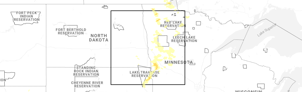
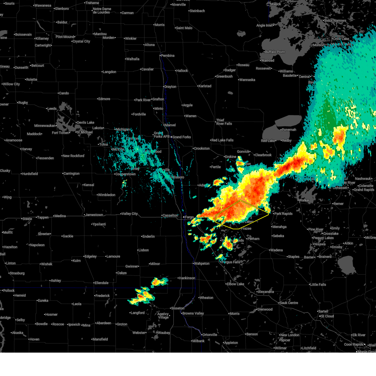
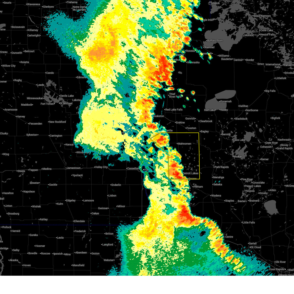
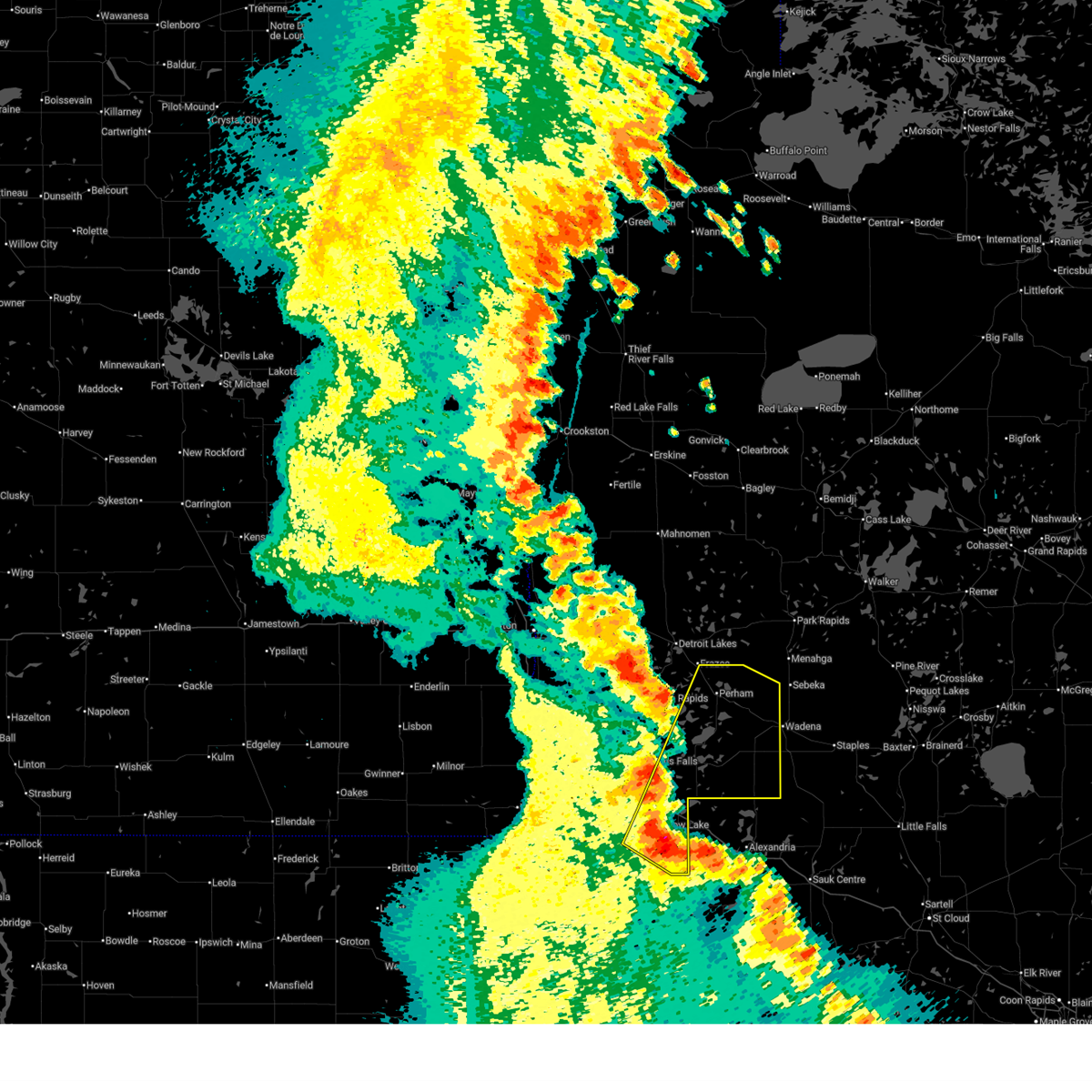
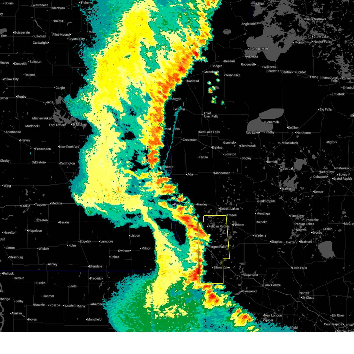
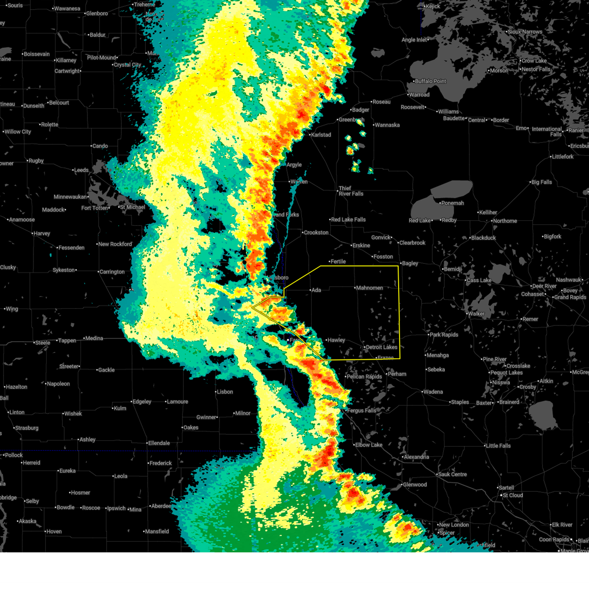
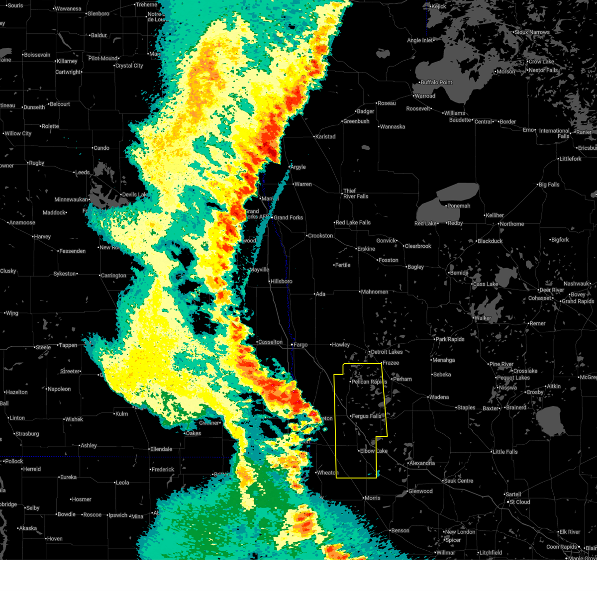
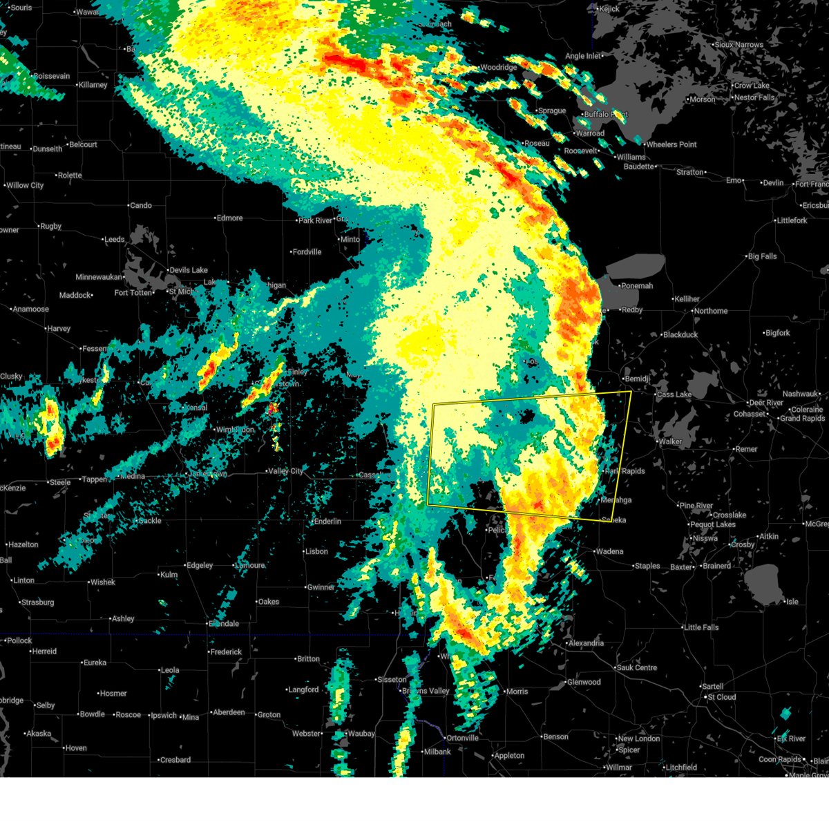
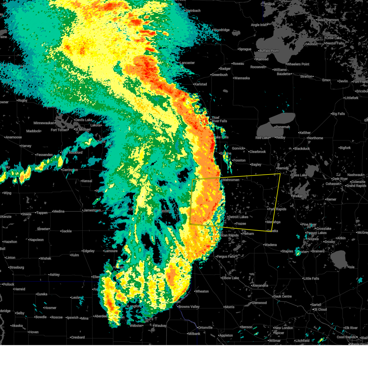
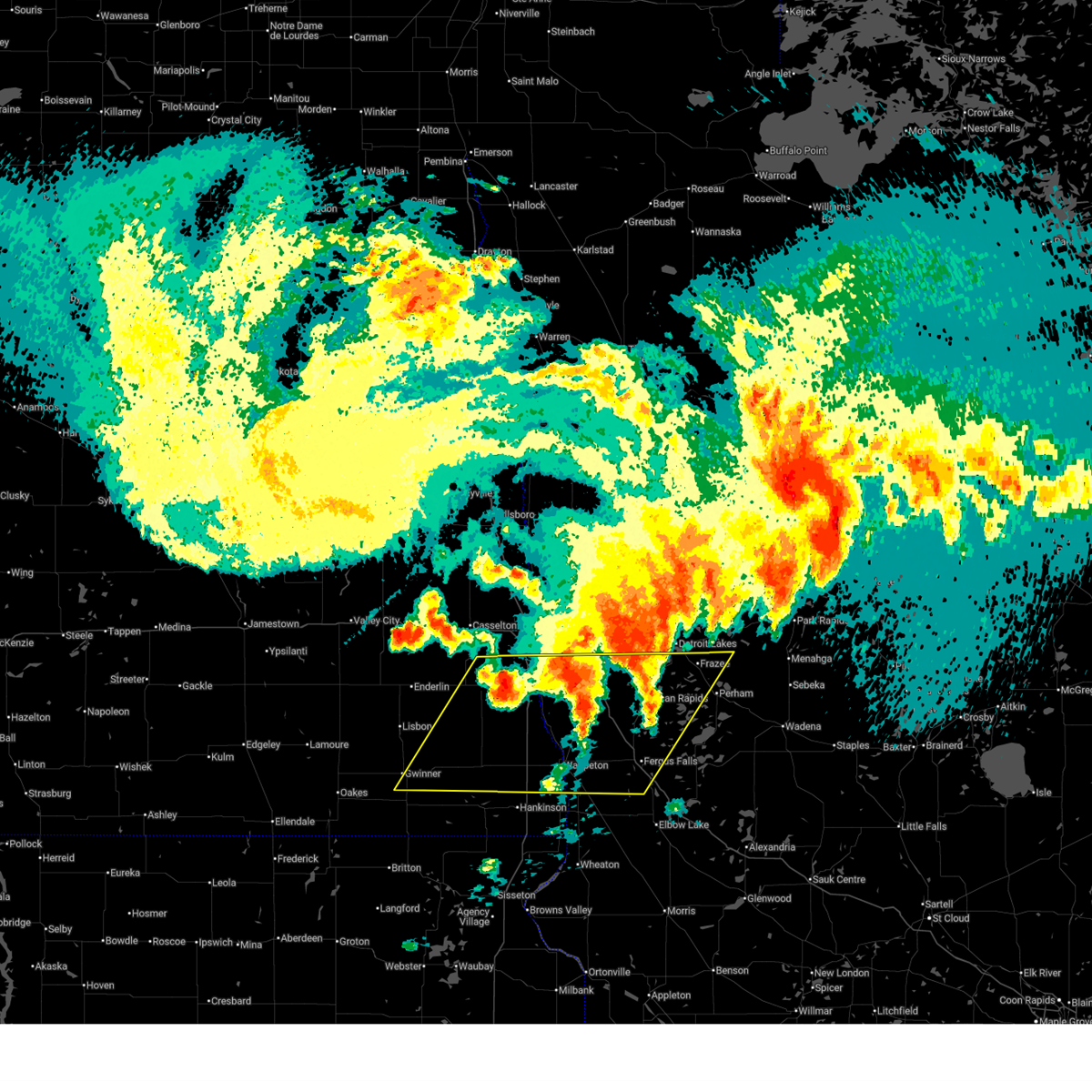
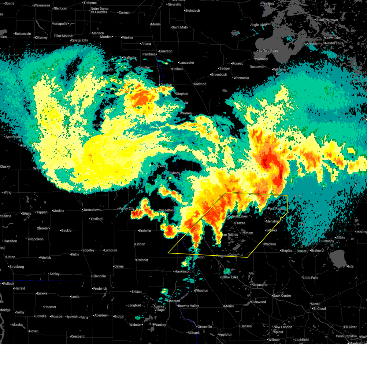
Hail Map for Frazee, MN
The Frazee, MN area has had 11 reports of on-the-ground hail by trained spotters, and has been under severe weather warnings 14 times during the past 12 months. Doppler radar has detected hail at or near Frazee, MN on 36 occasions, including 2 occasions during the past year.
| Name: | Frazee, MN |
| Where Located: | 52.1 miles ESE of Fargo, ND |
| Map: | Google Map for Frazee, MN |
| Population: | 1350 |
| Housing Units: | 595 |
| More Info: | Search Google for Frazee, MN |
2
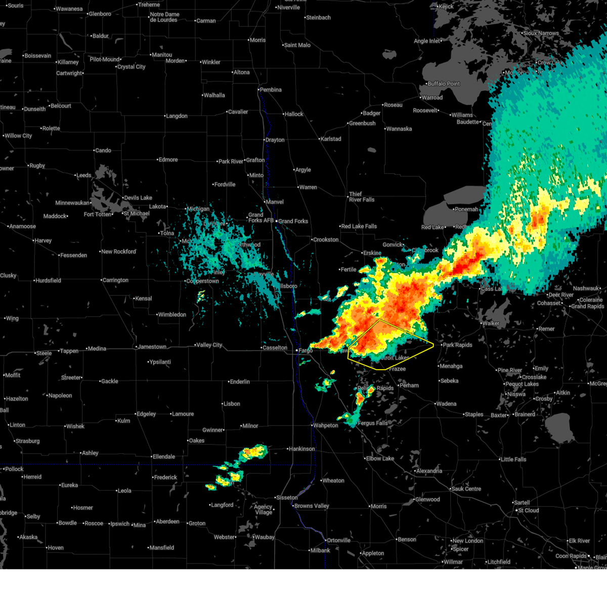
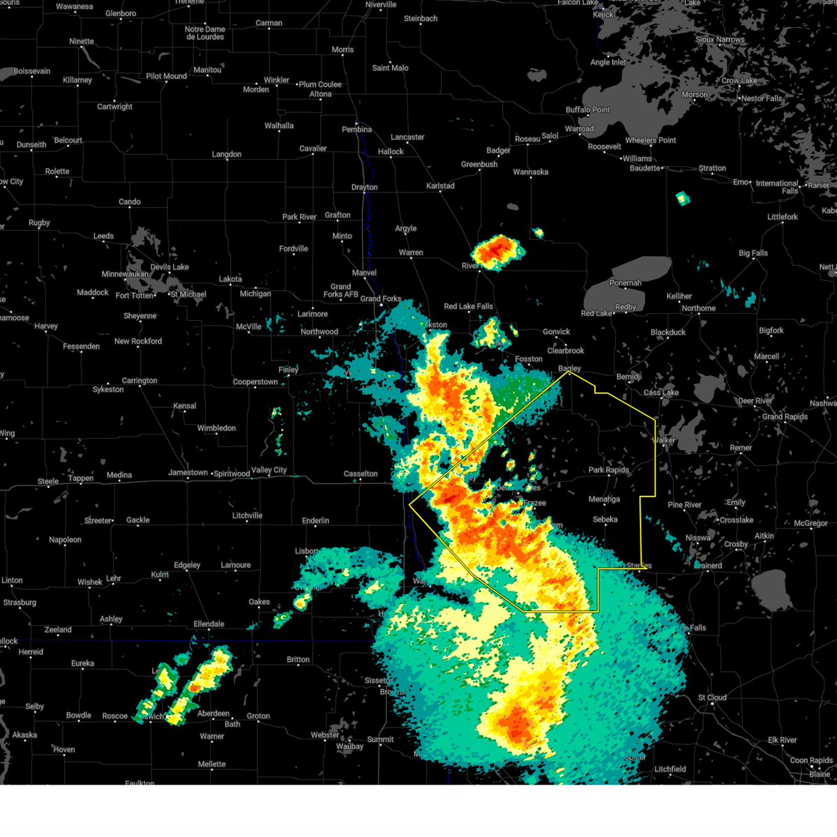
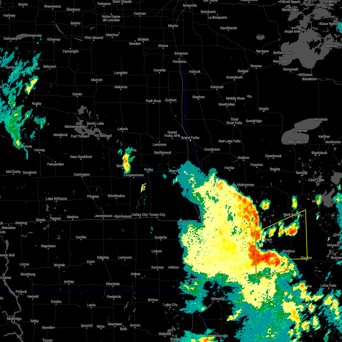
The Top Recent Hail Date for Frazee, MN is Monday, July 6, 2026 (12th out of 36)
Hail and Wind Damage Spotted near Frazee, MN
| Date / Time | Report Details |
|---|---|
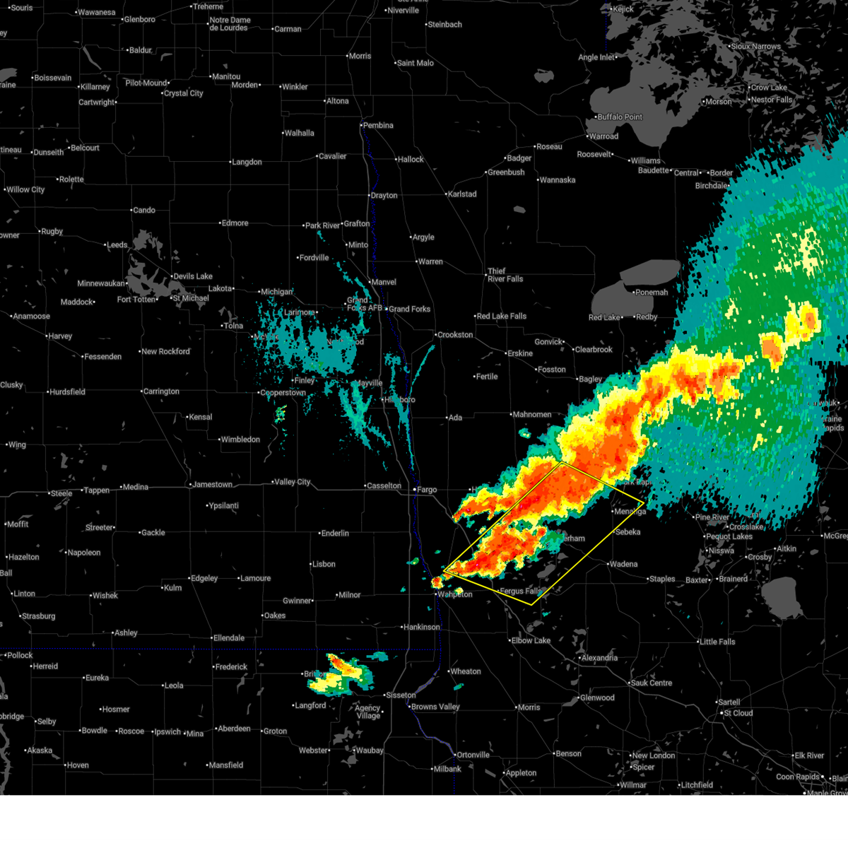
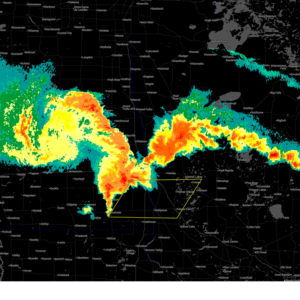
| 7/6/2026 8:20 PM CDT |
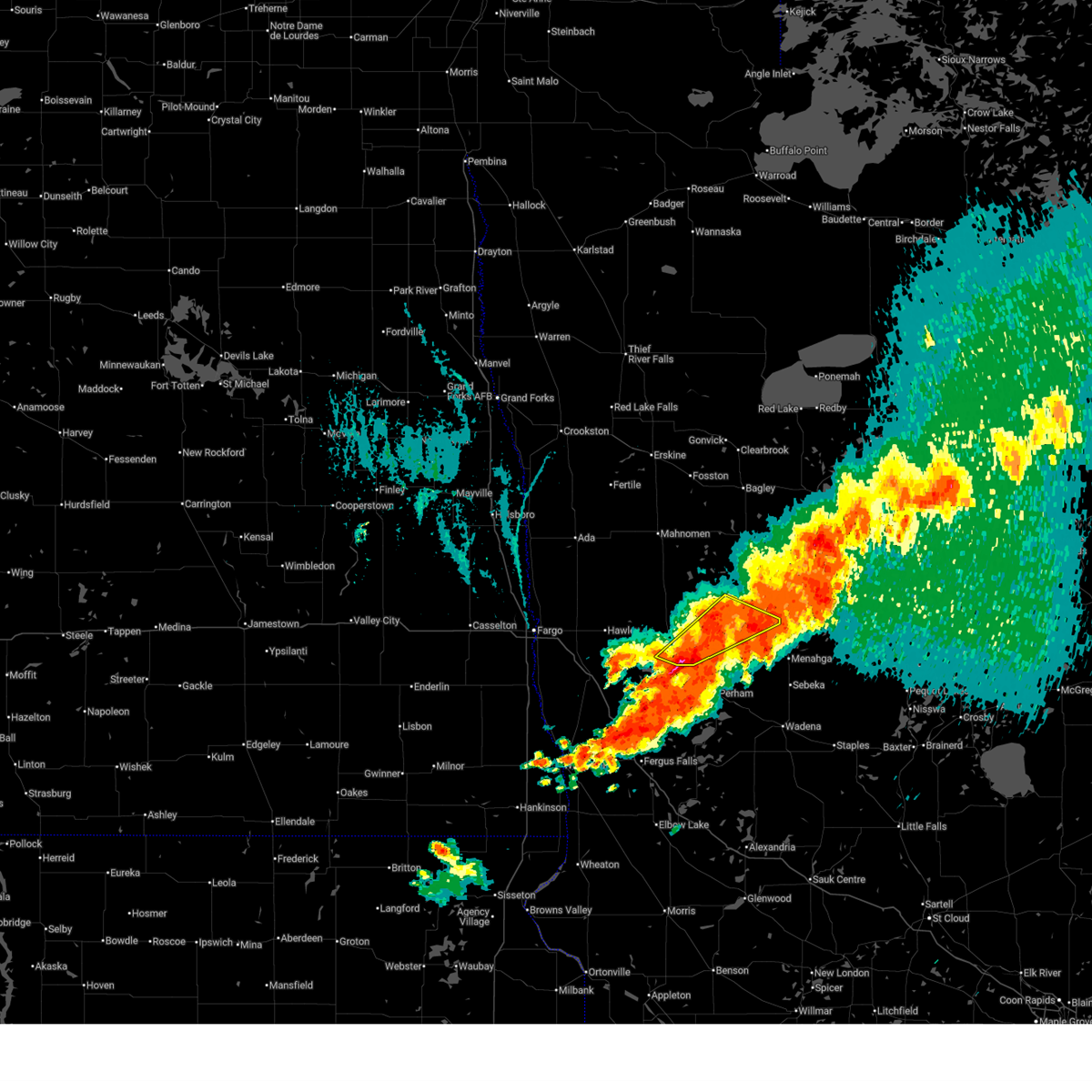 The storms which prompted the warning have moved out of the area. therefore, the warning will be allowed to expire. however, gusty winds are still possible with these thunderstorms. a severe thunderstorm watch remains in effect until 200 am cdt for north central and northwestern minnesota. The storms which prompted the warning have moved out of the area. therefore, the warning will be allowed to expire. however, gusty winds are still possible with these thunderstorms. a severe thunderstorm watch remains in effect until 200 am cdt for north central and northwestern minnesota.
|
| 7/6/2026 8:15 PM CDT |
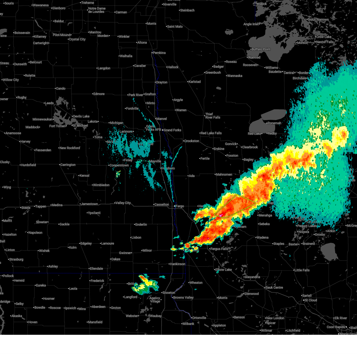 At 814 pm cdt, severe thunderstorms were located along a line extending from white earth nation to near shoreham, moving southeast at 20 mph (radar indicated). Hazards include golf ball size hail and 60 mph wind gusts. People and animals outdoors will be injured. expect hail damage to roofs, siding, windows, and vehicles. expect wind damage to roofs, siding, and trees. Locations impacted include, detroit lakes, frazee, toad lake, height of land lake, osage, shoreham, and pine point. At 814 pm cdt, severe thunderstorms were located along a line extending from white earth nation to near shoreham, moving southeast at 20 mph (radar indicated). Hazards include golf ball size hail and 60 mph wind gusts. People and animals outdoors will be injured. expect hail damage to roofs, siding, windows, and vehicles. expect wind damage to roofs, siding, and trees. Locations impacted include, detroit lakes, frazee, toad lake, height of land lake, osage, shoreham, and pine point.
|
| 7/6/2026 8:10 PM CDT |
 Svrfgf the national weather service in grand forks has issued a * severe thunderstorm warning for, southwestern hubbard county in north central minnesota, northwestern wadena county in central minnesota, central otter tail county in west central minnesota, east central wilkin county in west central minnesota, southeastern becker county in northwestern minnesota, * until 915 pm cdt. * at 810 pm cdt, severe thunderstorms were located along a line extending from ponsford to near carlisle, moving east at 25 mph (radar indicated). Hazards include golf ball size hail and 60 mph wind gusts. People and animals outdoors will be injured. expect hail damage to roofs, siding, windows, and vehicles. Expect wind damage to roofs, siding, and trees. Svrfgf the national weather service in grand forks has issued a * severe thunderstorm warning for, southwestern hubbard county in north central minnesota, northwestern wadena county in central minnesota, central otter tail county in west central minnesota, east central wilkin county in west central minnesota, southeastern becker county in northwestern minnesota, * until 915 pm cdt. * at 810 pm cdt, severe thunderstorms were located along a line extending from ponsford to near carlisle, moving east at 25 mph (radar indicated). Hazards include golf ball size hail and 60 mph wind gusts. People and animals outdoors will be injured. expect hail damage to roofs, siding, windows, and vehicles. Expect wind damage to roofs, siding, and trees.
|
| 7/6/2026 7:39 PM CDT |
 At 739 pm cdt, severe thunderstorms were located along a line extending from white earth nation to near cormorant, moving southeast at 20 mph (radar indicated). Hazards include golf ball size hail and 60 mph wind gusts. People and animals outdoors will be injured. expect hail damage to roofs, siding, windows, and vehicles. expect wind damage to roofs, siding, and trees. Locations impacted include, detroit lakes, frazee, lake park, toad lake, height of land lake, callaway, and shoreham. At 739 pm cdt, severe thunderstorms were located along a line extending from white earth nation to near cormorant, moving southeast at 20 mph (radar indicated). Hazards include golf ball size hail and 60 mph wind gusts. People and animals outdoors will be injured. expect hail damage to roofs, siding, windows, and vehicles. expect wind damage to roofs, siding, and trees. Locations impacted include, detroit lakes, frazee, lake park, toad lake, height of land lake, callaway, and shoreham.
|
| 7/6/2026 7:26 PM CDT |
 Svrfgf the national weather service in grand forks has issued a * severe thunderstorm warning for, central becker county in northwestern minnesota, * until 830 pm cdt. * at 725 pm cdt, severe thunderstorms were located along a line extending from white earth nation to near rollag, moving southeast at 20 mph (radar indicated). Hazards include 60 mph wind gusts and quarter size hail. Hail damage to vehicles is expected. Expect wind damage to roofs, siding, and trees. Svrfgf the national weather service in grand forks has issued a * severe thunderstorm warning for, central becker county in northwestern minnesota, * until 830 pm cdt. * at 725 pm cdt, severe thunderstorms were located along a line extending from white earth nation to near rollag, moving southeast at 20 mph (radar indicated). Hazards include 60 mph wind gusts and quarter size hail. Hail damage to vehicles is expected. Expect wind damage to roofs, siding, and trees.
|
| 6/29/2026 10:37 AM CDT |
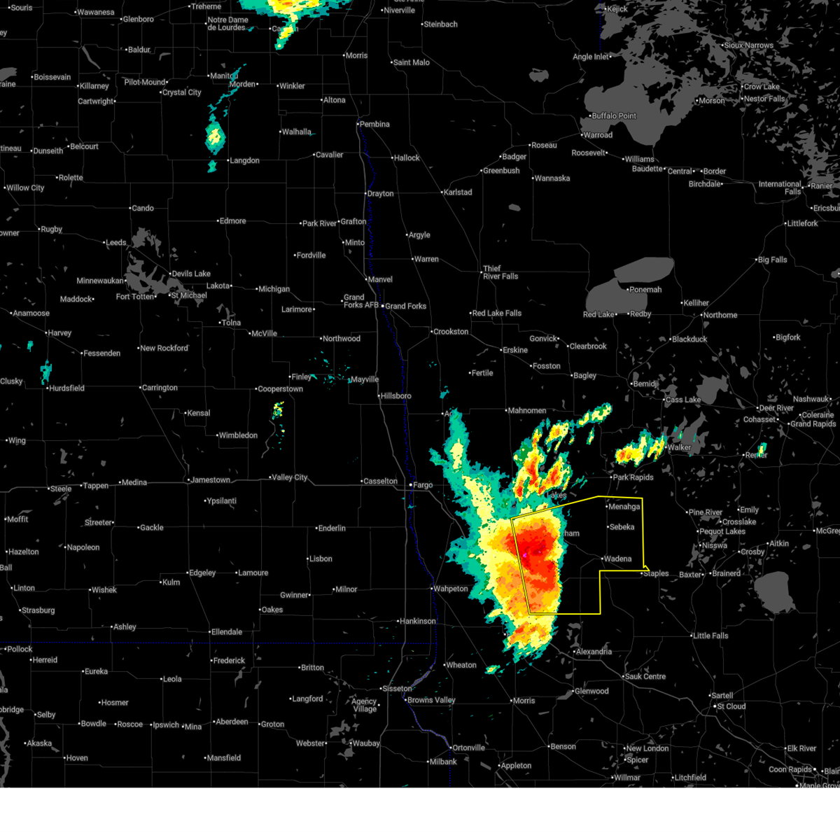 Svrfgf the national weather service in grand forks has issued a * severe thunderstorm warning for, wadena county in central minnesota, otter tail county in west central minnesota, southeastern becker county in northwestern minnesota, * until 1130 am cdt. * at 1036 am cdt, severe thunderstorms were located along a line extending from near vergas to ottertail to near millerville, moving east at 65 mph (radar indicated). Hazards include ping pong ball size hail and 60 mph wind gusts. People and animals outdoors will be injured. expect hail damage to roofs, siding, windows, and vehicles. Expect wind damage to roofs, siding, and trees. Svrfgf the national weather service in grand forks has issued a * severe thunderstorm warning for, wadena county in central minnesota, otter tail county in west central minnesota, southeastern becker county in northwestern minnesota, * until 1130 am cdt. * at 1036 am cdt, severe thunderstorms were located along a line extending from near vergas to ottertail to near millerville, moving east at 65 mph (radar indicated). Hazards include ping pong ball size hail and 60 mph wind gusts. People and animals outdoors will be injured. expect hail damage to roofs, siding, windows, and vehicles. Expect wind damage to roofs, siding, and trees.
|
| 6/10/2026 2:50 AM CDT |
 At 249 am cdt, severe thunderstorms were located along a line extending from dent to near deer creek to parkers prairie, moving east at 50 mph (radar indicated). Hazards include 60 mph wind gusts. Expect damage to roofs, siding, and trees. Locations impacted include, wadena, perham, ottertail lake, new york mills, parkers prairie, battle lake, and henning. At 249 am cdt, severe thunderstorms were located along a line extending from dent to near deer creek to parkers prairie, moving east at 50 mph (radar indicated). Hazards include 60 mph wind gusts. Expect damage to roofs, siding, and trees. Locations impacted include, wadena, perham, ottertail lake, new york mills, parkers prairie, battle lake, and henning.
|
| 6/10/2026 2:33 AM CDT |
 At 232 am cdt, severe thunderstorms were located along a line extending from near maple bay to white earth nation to 6 miles northeast of height of land lake, moving northeast at 75 mph (radar indicated). Hazards include 60 mph wind gusts and penny size hail. Expect damage to roofs, siding, and trees. Locations impacted include, detroit lakes, frazee, mahnomen, twin valley, lake park, toad lake, and bad medicine lake. At 232 am cdt, severe thunderstorms were located along a line extending from near maple bay to white earth nation to 6 miles northeast of height of land lake, moving northeast at 75 mph (radar indicated). Hazards include 60 mph wind gusts and penny size hail. Expect damage to roofs, siding, and trees. Locations impacted include, detroit lakes, frazee, mahnomen, twin valley, lake park, toad lake, and bad medicine lake.
|
| 6/10/2026 2:17 AM CDT |
 Svrfgf the national weather service in grand forks has issued a * severe thunderstorm warning for, otter tail county in west central minnesota, grant county in west central minnesota, * until 315 am cdt. * at 216 am cdt, severe thunderstorms were located along a line extending from near fergus falls to near melby to near kensington, moving northeast at 50 mph. wind gusts to 82 mph have been reported with this storm. these are destructive storms for northeast grant county and southern otter tail county (radar indicated). Hazards include 80 mph wind gusts. Flying debris will be dangerous to those caught without shelter. mobile homes will be heavily damaged. expect considerable damage to roofs, windows, and vehicles. Extensive tree damage and power outages are likely. Svrfgf the national weather service in grand forks has issued a * severe thunderstorm warning for, otter tail county in west central minnesota, grant county in west central minnesota, * until 315 am cdt. * at 216 am cdt, severe thunderstorms were located along a line extending from near fergus falls to near melby to near kensington, moving northeast at 50 mph. wind gusts to 82 mph have been reported with this storm. these are destructive storms for northeast grant county and southern otter tail county (radar indicated). Hazards include 80 mph wind gusts. Flying debris will be dangerous to those caught without shelter. mobile homes will be heavily damaged. expect considerable damage to roofs, windows, and vehicles. Extensive tree damage and power outages are likely.
|
| 6/10/2026 2:01 AM CDT |
 At 200 am cdt, severe thunderstorms were located along a line extending from near dunvilla to near underwood to 6 miles northeast of donnelly, moving east at 50 mph (emergency management). Hazards include 70 mph wind gusts and penny size hail. Expect considerable tree damage. damage is likely to mobile homes, roofs, and outbuildings. Locations impacted include, fergus falls, pelican rapids, southwestern ottertail lake, lake lida, elbow lake, battle lake, and hoffman. At 200 am cdt, severe thunderstorms were located along a line extending from near dunvilla to near underwood to 6 miles northeast of donnelly, moving east at 50 mph (emergency management). Hazards include 70 mph wind gusts and penny size hail. Expect considerable tree damage. damage is likely to mobile homes, roofs, and outbuildings. Locations impacted include, fergus falls, pelican rapids, southwestern ottertail lake, lake lida, elbow lake, battle lake, and hoffman.
|
| 6/10/2026 1:53 AM CDT |
 Svrfgf the national weather service in grand forks has issued a * severe thunderstorm warning for, clay county in northwestern minnesota, norman county in northwestern minnesota, mahnomen county in northwestern minnesota, becker county in northwestern minnesota, southwestern clearwater county in northwestern minnesota, northeastern cass county in southeastern north dakota, * until 300 am cdt. * at 153 am cdt, severe thunderstorms were located along a line extending from near grandin to near muskoda to near lawndale, moving northeast at 60 mph (radar indicated). Hazards include 60 mph wind gusts and penny size hail. expect damage to roofs, siding, and trees Svrfgf the national weather service in grand forks has issued a * severe thunderstorm warning for, clay county in northwestern minnesota, norman county in northwestern minnesota, mahnomen county in northwestern minnesota, becker county in northwestern minnesota, southwestern clearwater county in northwestern minnesota, northeastern cass county in southeastern north dakota, * until 300 am cdt. * at 153 am cdt, severe thunderstorms were located along a line extending from near grandin to near muskoda to near lawndale, moving northeast at 60 mph (radar indicated). Hazards include 60 mph wind gusts and penny size hail. expect damage to roofs, siding, and trees
|
| 6/10/2026 1:26 AM CDT |
 Svrfgf the national weather service in grand forks has issued a * severe thunderstorm warning for, western otter tail county in west central minnesota, grant county in west central minnesota, * until 230 am cdt. * at 126 am cdt, severe thunderstorms were located along a line extending from near kent to near campbell to near collis, moving east at 50 mph (radar indicated). Hazards include 60 mph wind gusts and penny size hail. expect damage to roofs, siding, and trees Svrfgf the national weather service in grand forks has issued a * severe thunderstorm warning for, western otter tail county in west central minnesota, grant county in west central minnesota, * until 230 am cdt. * at 126 am cdt, severe thunderstorms were located along a line extending from near kent to near campbell to near collis, moving east at 50 mph (radar indicated). Hazards include 60 mph wind gusts and penny size hail. expect damage to roofs, siding, and trees
|
| 8/8/2025 5:59 AM CDT |
 The storms which prompted the warning have weakened below severe limits, and have exited the warned area. therefore, the warning will be allowed to expire. however, gusty winds are still possible with these thunderstorms. a severe thunderstorm watch remains in effect until 700 am cdt for central, north central, northwestern and west central minnesota. The storms which prompted the warning have weakened below severe limits, and have exited the warned area. therefore, the warning will be allowed to expire. however, gusty winds are still possible with these thunderstorms. a severe thunderstorm watch remains in effect until 700 am cdt for central, north central, northwestern and west central minnesota.
|
| 8/8/2025 5:00 AM CDT |
 Svrfgf the national weather service in grand forks has issued a * severe thunderstorm warning for, eastern clay county in northwestern minnesota, western hubbard county in north central minnesota, southeastern norman county in northwestern minnesota, northwestern wadena county in central minnesota, northeastern otter tail county in west central minnesota, southern mahnomen county in northwestern minnesota, becker county in northwestern minnesota, southern clearwater county in northwestern minnesota, * until 600 am cdt. * at 459 am cdt, severe thunderstorms were located along a line extending from white earth nation to near cormorant, moving east at 50 mph (radar indicated). Hazards include 60 mph wind gusts. expect damage to roofs, siding, and trees Svrfgf the national weather service in grand forks has issued a * severe thunderstorm warning for, eastern clay county in northwestern minnesota, western hubbard county in north central minnesota, southeastern norman county in northwestern minnesota, northwestern wadena county in central minnesota, northeastern otter tail county in west central minnesota, southern mahnomen county in northwestern minnesota, becker county in northwestern minnesota, southern clearwater county in northwestern minnesota, * until 600 am cdt. * at 459 am cdt, severe thunderstorms were located along a line extending from white earth nation to near cormorant, moving east at 50 mph (radar indicated). Hazards include 60 mph wind gusts. expect damage to roofs, siding, and trees
|
| 6/21/2025 12:46 AM CDT |
 The storms which prompted the warning have weakened below severe limits, and have exited the warned area. therefore, the warning has been allowed to expire. however, heavy rain is still possible with these thunderstorms. a tornado watch remains in effect until 300 am cdt for northwestern and west central minnesota, and southeastern north dakota. The storms which prompted the warning have weakened below severe limits, and have exited the warned area. therefore, the warning has been allowed to expire. however, heavy rain is still possible with these thunderstorms. a tornado watch remains in effect until 300 am cdt for northwestern and west central minnesota, and southeastern north dakota.
|
| 6/21/2025 12:45 AM CDT |
 Svrfgf the national weather service in grand forks has issued a * severe thunderstorm warning for, southeastern clay county in northwestern minnesota, southern hubbard county in north central minnesota, northwestern wadena county in central minnesota, otter tail county in west central minnesota, northern wilkin county in west central minnesota, becker county in northwestern minnesota, northeastern richland county in southeastern north dakota, * until 145 am cdt. * at 1245 am cdt, severe thunderstorms were located along a line extending from white earth nation to near brushvale, moving east at 55 mph (radar indicated). Hazards include 60 mph wind gusts. expect damage to roofs, siding, and trees Svrfgf the national weather service in grand forks has issued a * severe thunderstorm warning for, southeastern clay county in northwestern minnesota, southern hubbard county in north central minnesota, northwestern wadena county in central minnesota, otter tail county in west central minnesota, northern wilkin county in west central minnesota, becker county in northwestern minnesota, northeastern richland county in southeastern north dakota, * until 145 am cdt. * at 1245 am cdt, severe thunderstorms were located along a line extending from white earth nation to near brushvale, moving east at 55 mph (radar indicated). Hazards include 60 mph wind gusts. expect damage to roofs, siding, and trees
|
| 6/20/2025 11:52 PM CDT |
 Svrfgf the national weather service in grand forks has issued a * severe thunderstorm warning for, southern clay county in northwestern minnesota, western otter tail county in west central minnesota, wilkin county in west central minnesota, southwestern becker county in northwestern minnesota, southeastern ransom county in southeastern north dakota, southeastern cass county in southeastern north dakota, richland county in southeastern north dakota, northeastern sargent county in southeastern north dakota, * until 1245 am cdt. * at 1151 pm cdt, severe thunderstorms were located along a line extending from near mapleton to near gwinner, moving east at 70 mph (radar indicated). Hazards include 70 mph wind gusts. Expect considerable tree damage. damage is likely to mobile homes, roofs, and outbuildings. severe thunderstorms will be near, horace, kindred, and milnor around 1155 pm cdt. wild rice around 1200 am cdt. wyndmere, oxbow, and walcott around 1205 am cdt. wolverton, colfax, and barney around 1210 am cdt. abercrombie, mooreton, and galchutt around 1215 am cdt. other locations impacted by these severe thunderstorms include fergus falls airport. this includes the following highways, interstate 29 between mile markers 15 and 57. interstate 94 in north dakota between mile markers 15 and 62. Interstate 94 in minnesota between mile markers 15 and 62. Svrfgf the national weather service in grand forks has issued a * severe thunderstorm warning for, southern clay county in northwestern minnesota, western otter tail county in west central minnesota, wilkin county in west central minnesota, southwestern becker county in northwestern minnesota, southeastern ransom county in southeastern north dakota, southeastern cass county in southeastern north dakota, richland county in southeastern north dakota, northeastern sargent county in southeastern north dakota, * until 1245 am cdt. * at 1151 pm cdt, severe thunderstorms were located along a line extending from near mapleton to near gwinner, moving east at 70 mph (radar indicated). Hazards include 70 mph wind gusts. Expect considerable tree damage. damage is likely to mobile homes, roofs, and outbuildings. severe thunderstorms will be near, horace, kindred, and milnor around 1155 pm cdt. wild rice around 1200 am cdt. wyndmere, oxbow, and walcott around 1205 am cdt. wolverton, colfax, and barney around 1210 am cdt. abercrombie, mooreton, and galchutt around 1215 am cdt. other locations impacted by these severe thunderstorms include fergus falls airport. this includes the following highways, interstate 29 between mile markers 15 and 57. interstate 94 in north dakota between mile markers 15 and 62. Interstate 94 in minnesota between mile markers 15 and 62.
|
| 5/15/2025 4:02 PM CDT | Trees across highway 34... time estimated from rada in becker county MN, 10.1 miles SSW of Frazee, MN |
| 7/31/2024 2:54 PM CDT |
 Svrfgf the national weather service in grand forks has issued a * severe thunderstorm warning for, northern wadena county in central minnesota, hubbard county in north central minnesota, northeastern otter tail county in west central minnesota, southeastern beltrami county in north central minnesota, southern mahnomen county in northwestern minnesota, becker county in northwestern minnesota, southern clearwater county in northwestern minnesota, * until 400 pm cdt. * at 253 pm cdt, severe thunderstorms were located along a line extending from white earth nation to near lake itasca to near menahga, moving east at 45 mph (radar indicated). Hazards include 60 mph wind gusts and nickel size hail. expect damage to roofs, siding, and trees Svrfgf the national weather service in grand forks has issued a * severe thunderstorm warning for, northern wadena county in central minnesota, hubbard county in north central minnesota, northeastern otter tail county in west central minnesota, southeastern beltrami county in north central minnesota, southern mahnomen county in northwestern minnesota, becker county in northwestern minnesota, southern clearwater county in northwestern minnesota, * until 400 pm cdt. * at 253 pm cdt, severe thunderstorms were located along a line extending from white earth nation to near lake itasca to near menahga, moving east at 45 mph (radar indicated). Hazards include 60 mph wind gusts and nickel size hail. expect damage to roofs, siding, and trees
|
| 7/31/2024 2:35 PM CDT | Rwis station mn132 frazee mn do in otter tail county MN, 1.5 miles NNW of Frazee, MN |
| 7/31/2024 2:32 PM CDT |
 At 232 pm cdt, severe thunderstorms were located along a line extending from near hitterdal to near vergas to near rose city, moving northeast at 50 mph (radar indicated). Hazards include 60 mph wind gusts and nickel size hail. Expect damage to roofs, siding, and trees. Locations impacted include, detroit lakes, wadena, park rapids, perham, ottertail lake, hawley, and bagley. At 232 pm cdt, severe thunderstorms were located along a line extending from near hitterdal to near vergas to near rose city, moving northeast at 50 mph (radar indicated). Hazards include 60 mph wind gusts and nickel size hail. Expect damage to roofs, siding, and trees. Locations impacted include, detroit lakes, wadena, park rapids, perham, ottertail lake, hawley, and bagley.
|
| 7/31/2024 2:32 PM CDT |
 the severe thunderstorm warning has been cancelled and is no longer in effect the severe thunderstorm warning has been cancelled and is no longer in effect
|
| 7/31/2024 2:28 PM CDT | Personal weather station kmnfraze2 measured 73 mph wind gust at 228p in otter tail county MN, 4.9 miles NNE of Frazee, MN |
| 7/31/2024 2:20 PM CDT | Machine shed lost roof and trees snapped near eagle lake at blues campgroun in becker county MN, 2.3 miles ESE of Frazee, MN |
| 7/31/2024 2:09 PM CDT |
 Svrfgf the national weather service in grand forks has issued a * severe thunderstorm warning for, southern clay county in northwestern minnesota, wadena county in central minnesota, hubbard county in north central minnesota, otter tail county in west central minnesota, northeastern wilkin county in west central minnesota, southern mahnomen county in northwestern minnesota, becker county in northwestern minnesota, southern clearwater county in northwestern minnesota, * until 300 pm cdt. * at 209 pm cdt, severe thunderstorms were located along a line extending from sabin to near maplewood state park to garfield, moving northeast at 50 mph (radar indicated). Hazards include 70 mph wind gusts and nickel size hail. Expect considerable tree damage. Damage is likely to mobile homes, roofs, and outbuildings. Svrfgf the national weather service in grand forks has issued a * severe thunderstorm warning for, southern clay county in northwestern minnesota, wadena county in central minnesota, hubbard county in north central minnesota, otter tail county in west central minnesota, northeastern wilkin county in west central minnesota, southern mahnomen county in northwestern minnesota, becker county in northwestern minnesota, southern clearwater county in northwestern minnesota, * until 300 pm cdt. * at 209 pm cdt, severe thunderstorms were located along a line extending from sabin to near maplewood state park to garfield, moving northeast at 50 mph (radar indicated). Hazards include 70 mph wind gusts and nickel size hail. Expect considerable tree damage. Damage is likely to mobile homes, roofs, and outbuildings.
|
| 7/13/2024 9:48 PM CDT |
 Svrfgf the national weather service in grand forks has issued a * severe thunderstorm warning for, eastern otter tail county in west central minnesota, * until 1015 pm cdt. * at 948 pm cdt, a severe thunderstorm was located over ottertail, or 27 miles east of fergus falls, moving southeast at 45 mph. this is a destructive storm for eastern otter tail county (radar indicated). Hazards include 80 mph wind gusts and half dollar size hail. Flying debris will be dangerous to those caught without shelter. mobile homes will be heavily damaged. expect considerable damage to roofs, windows, and vehicles. Extensive tree damage and power outages are likely. Svrfgf the national weather service in grand forks has issued a * severe thunderstorm warning for, eastern otter tail county in west central minnesota, * until 1015 pm cdt. * at 948 pm cdt, a severe thunderstorm was located over ottertail, or 27 miles east of fergus falls, moving southeast at 45 mph. this is a destructive storm for eastern otter tail county (radar indicated). Hazards include 80 mph wind gusts and half dollar size hail. Flying debris will be dangerous to those caught without shelter. mobile homes will be heavily damaged. expect considerable damage to roofs, windows, and vehicles. Extensive tree damage and power outages are likely.
|
| 7/13/2024 9:38 PM CDT |
 the severe thunderstorm warning has been cancelled and is no longer in effect the severe thunderstorm warning has been cancelled and is no longer in effect
|
| 7/13/2024 9:38 PM CDT |
 At 937 pm cdt, severe thunderstorms were located along a line extending from vergas to near richville to near phelps, moving southeast at 50 mph (radar indicated). Hazards include 70 mph wind gusts and quarter size hail. Hail damage to vehicles is expected. expect considerable tree damage. wind damage is also likely to mobile homes, roofs, and outbuildings. Locations impacted include, perham, ottertail lake, lake lida, new york mills, battle lake, henning, and ottertail. At 937 pm cdt, severe thunderstorms were located along a line extending from vergas to near richville to near phelps, moving southeast at 50 mph (radar indicated). Hazards include 70 mph wind gusts and quarter size hail. Hail damage to vehicles is expected. expect considerable tree damage. wind damage is also likely to mobile homes, roofs, and outbuildings. Locations impacted include, perham, ottertail lake, lake lida, new york mills, battle lake, henning, and ottertail.
|
| 7/13/2024 9:27 PM CDT |
 At 926 pm cdt, severe thunderstorms were located along a line extending from shoreham to near big mcdonald lake to edwards, moving east at 40 mph (radar indicated). Hazards include 60 mph wind gusts and quarter size hail. Hail damage to vehicles is expected. expect wind damage to roofs, siding, and trees. Locations impacted include, detroit lakes, perham, pelican rapids, ottertail lake, frazee, lake lida, and new york mills. At 926 pm cdt, severe thunderstorms were located along a line extending from shoreham to near big mcdonald lake to edwards, moving east at 40 mph (radar indicated). Hazards include 60 mph wind gusts and quarter size hail. Hail damage to vehicles is expected. expect wind damage to roofs, siding, and trees. Locations impacted include, detroit lakes, perham, pelican rapids, ottertail lake, frazee, lake lida, and new york mills.
|
| 7/13/2024 9:20 PM CDT |
 Svrfgf the national weather service in grand forks has issued a * severe thunderstorm warning for, central otter tail county in west central minnesota, southern becker county in northwestern minnesota, * until 1000 pm cdt. * at 920 pm cdt, severe thunderstorms were located along a line extending from near shoreham to near lake lida to near edwards, moving east at 40 mph (radar indicated). Hazards include 60 mph wind gusts and quarter size hail. Hail damage to vehicles is expected. Expect wind damage to roofs, siding, and trees. Svrfgf the national weather service in grand forks has issued a * severe thunderstorm warning for, central otter tail county in west central minnesota, southern becker county in northwestern minnesota, * until 1000 pm cdt. * at 920 pm cdt, severe thunderstorms were located along a line extending from near shoreham to near lake lida to near edwards, moving east at 40 mph (radar indicated). Hazards include 60 mph wind gusts and quarter size hail. Hail damage to vehicles is expected. Expect wind damage to roofs, siding, and trees.
|
| 6/18/2024 4:52 AM CDT |
 At 451 am cdt, severe thunderstorms were located along a line extending from near kelliher to kabekona to near sebeka, moving east at 25 mph (radar indicated). Hazards include 70 mph wind gusts. Expect considerable tree damage. damage is likely to mobile homes, roofs, and outbuildings. Locations impacted include, bemidji, detroit lakes, park rapids, perham, frazee, menahga, and redby. At 451 am cdt, severe thunderstorms were located along a line extending from near kelliher to kabekona to near sebeka, moving east at 25 mph (radar indicated). Hazards include 70 mph wind gusts. Expect considerable tree damage. damage is likely to mobile homes, roofs, and outbuildings. Locations impacted include, bemidji, detroit lakes, park rapids, perham, frazee, menahga, and redby.
|
| 6/18/2024 4:52 AM CDT |
 the severe thunderstorm warning has been cancelled and is no longer in effect the severe thunderstorm warning has been cancelled and is no longer in effect
|
| 6/18/2024 4:20 AM CDT |
 Svrfgf the national weather service in grand forks has issued a * severe thunderstorm warning for, east central clay county in northwestern minnesota, wadena county in central minnesota, hubbard county in north central minnesota, southeastern polk county in northwestern minnesota, northeastern otter tail county in west central minnesota, southern beltrami county in north central minnesota, mahnomen county in northwestern minnesota, becker county in northwestern minnesota, clearwater county in northwestern minnesota, * until 515 am cdt. * at 419 am cdt, severe thunderstorms were located along a line extending from red lake nation to white earth nation to near pelican rapids, moving east at 55 mph (radar indicated). Hazards include 70 mph wind gusts. Expect considerable tree damage. Damage is likely to mobile homes, roofs, and outbuildings. Svrfgf the national weather service in grand forks has issued a * severe thunderstorm warning for, east central clay county in northwestern minnesota, wadena county in central minnesota, hubbard county in north central minnesota, southeastern polk county in northwestern minnesota, northeastern otter tail county in west central minnesota, southern beltrami county in north central minnesota, mahnomen county in northwestern minnesota, becker county in northwestern minnesota, clearwater county in northwestern minnesota, * until 515 am cdt. * at 419 am cdt, severe thunderstorms were located along a line extending from red lake nation to white earth nation to near pelican rapids, moving east at 55 mph (radar indicated). Hazards include 70 mph wind gusts. Expect considerable tree damage. Damage is likely to mobile homes, roofs, and outbuildings.
|
| 8/11/2023 6:08 PM CDT | Half Dollar sized hail reported 1.2 miles W of Frazee, MN, relayed via broadcast media. report from public. |
| 8/11/2023 5:38 PM CDT |
 At 538 pm cdt, a severe thunderstorm was located near rochert, or near detroit lakes, moving southeast at 35 mph (radar indicated). Hazards include 60 mph wind gusts and quarter size hail. Hail damage to vehicles is expected. Expect wind damage to roofs, siding, and trees. At 538 pm cdt, a severe thunderstorm was located near rochert, or near detroit lakes, moving southeast at 35 mph (radar indicated). Hazards include 60 mph wind gusts and quarter size hail. Hail damage to vehicles is expected. Expect wind damage to roofs, siding, and trees.
|
| 7/9/2023 9:00 PM CDT | Half Dollar sized hail reported 7.8 miles SW of Frazee, MN, half dollar sized hail from our co-op observer 12 e detroit lakes. |
| 8/5/2022 8:41 PM CDT |
 At 841 pm cdt, a severe thunderstorm was located near rollag, or 16 miles west of detroit lakes, moving east at 40 mph (radar indicated). Hazards include 60 mph wind gusts and quarter size hail. Hail damage to vehicles is expected. expect wind damage to roofs, siding, and trees. this severe thunderstorm will be near, lake park around 845 pm cdt. cormorant around 850 pm cdt. shoreham around 900 pm cdt. other locations in the path of this severe thunderstorm include detroit lakes, frazee and rochert. hail threat, radar indicated max hail size, 1. 00 in wind threat, radar indicated max wind gust, 60 mph. At 841 pm cdt, a severe thunderstorm was located near rollag, or 16 miles west of detroit lakes, moving east at 40 mph (radar indicated). Hazards include 60 mph wind gusts and quarter size hail. Hail damage to vehicles is expected. expect wind damage to roofs, siding, and trees. this severe thunderstorm will be near, lake park around 845 pm cdt. cormorant around 850 pm cdt. shoreham around 900 pm cdt. other locations in the path of this severe thunderstorm include detroit lakes, frazee and rochert. hail threat, radar indicated max hail size, 1. 00 in wind threat, radar indicated max wind gust, 60 mph.
|
| 7/10/2022 2:50 PM CDT |
 The severe thunderstorm warning for southern wadena and northeastern otter tail counties will expire at 300 pm cdt, the storms which prompted the warning have weakened below severe limits, and no longer pose an immediate threat to life or property. therefore, the warning will be allowed to expire. however small hail is still possible with these thunderstorms. a severe thunderstorm watch remains in effect until 600 pm cdt for central and west central minnesota. The severe thunderstorm warning for southern wadena and northeastern otter tail counties will expire at 300 pm cdt, the storms which prompted the warning have weakened below severe limits, and no longer pose an immediate threat to life or property. therefore, the warning will be allowed to expire. however small hail is still possible with these thunderstorms. a severe thunderstorm watch remains in effect until 600 pm cdt for central and west central minnesota.
|
| 7/10/2022 2:29 PM CDT |
 At 229 pm cdt, severe thunderstorms were located along a line extending from nimrod to near richville, moving east at 30 mph (radar indicated). Hazards include 60 mph wind gusts and quarter size hail. Hail damage to vehicles is expected. expect wind damage to roofs, siding, and trees. locations impacted include, new york mills, deer creek, bluffton and wadena. hail threat, radar indicated max hail size, 1. 00 in wind threat, radar indicated max wind gust, 60 mph. At 229 pm cdt, severe thunderstorms were located along a line extending from nimrod to near richville, moving east at 30 mph (radar indicated). Hazards include 60 mph wind gusts and quarter size hail. Hail damage to vehicles is expected. expect wind damage to roofs, siding, and trees. locations impacted include, new york mills, deer creek, bluffton and wadena. hail threat, radar indicated max hail size, 1. 00 in wind threat, radar indicated max wind gust, 60 mph.
|
| 7/10/2022 1:56 PM CDT |
 At 155 pm cdt, severe thunderstorms were located along a line extending from near hillview to near lake lida, moving east at 30 mph (radar indicated). Hazards include ping pong ball size hail and 60 mph wind gusts. People and animals outdoors will be injured. expect hail damage to roofs, siding, windows, and vehicles. expect wind damage to roofs, siding, and trees. severe thunderstorms will be near, hillview and midway around 200 pm cdt. sebeka around 210 pm cdt. other locations in the path of these severe thunderstorms include blue grass, richville, perham and ottertail. hail threat, radar indicated max hail size, 1. 50 in wind threat, radar indicated max wind gust, 60 mph. At 155 pm cdt, severe thunderstorms were located along a line extending from near hillview to near lake lida, moving east at 30 mph (radar indicated). Hazards include ping pong ball size hail and 60 mph wind gusts. People and animals outdoors will be injured. expect hail damage to roofs, siding, windows, and vehicles. expect wind damage to roofs, siding, and trees. severe thunderstorms will be near, hillview and midway around 200 pm cdt. sebeka around 210 pm cdt. other locations in the path of these severe thunderstorms include blue grass, richville, perham and ottertail. hail threat, radar indicated max hail size, 1. 50 in wind threat, radar indicated max wind gust, 60 mph.
|
| 7/10/2022 1:40 PM CDT | Half Dollar sized hail reported 0.2 miles WSW of Frazee, MN, relayed via broadcast media partner. time estimated via radar. |
| 7/10/2022 1:34 PM CDT |
 At 133 pm cdt, a severe thunderstorm was located near frazee, or near detroit lakes, moving southeast at 30 mph. at 130 pm cdt, broadcast media reported ping pong ball size hail near little cormorant lake (broadcast media). Hazards include ping pong ball size hail and 60 mph wind gusts. People and animals outdoors will be injured. expect hail damage to roofs, siding, windows, and vehicles. expect wind damage to roofs, siding, and trees. locations impacted include, detroit lakes, lake park, height of land lake, shoreham, rochert, westbury and frazee. hail threat, observed max hail size, 1. 50 in wind threat, radar indicated max wind gust, 60 mph. At 133 pm cdt, a severe thunderstorm was located near frazee, or near detroit lakes, moving southeast at 30 mph. at 130 pm cdt, broadcast media reported ping pong ball size hail near little cormorant lake (broadcast media). Hazards include ping pong ball size hail and 60 mph wind gusts. People and animals outdoors will be injured. expect hail damage to roofs, siding, windows, and vehicles. expect wind damage to roofs, siding, and trees. locations impacted include, detroit lakes, lake park, height of land lake, shoreham, rochert, westbury and frazee. hail threat, observed max hail size, 1. 50 in wind threat, radar indicated max wind gust, 60 mph.
|
| 7/10/2022 1:33 PM CDT |
 At 132 pm cdt, a severe thunderstorm was located near shoreham, or near detroit lakes, moving southeast at 25 mph. at 130 pm cdt, broadcast media reported ping-pong ball size hail near little cormorant lake (radar indicated). Hazards include ping pong ball size hail and 60 mph wind gusts. People and animals outdoors will be injured. expect hail damage to roofs, siding, windows, and vehicles. expect wind damage to roofs, siding, and trees. this severe storm will be near, vergas and frazee around 145 pm cdt. other locations in the path of this severe thunderstorm include big mcdonald lake, dent and perham. hail threat, observed max hail size, 1. 50 in wind threat, radar indicated max wind gust, 60 mph. At 132 pm cdt, a severe thunderstorm was located near shoreham, or near detroit lakes, moving southeast at 25 mph. at 130 pm cdt, broadcast media reported ping-pong ball size hail near little cormorant lake (radar indicated). Hazards include ping pong ball size hail and 60 mph wind gusts. People and animals outdoors will be injured. expect hail damage to roofs, siding, windows, and vehicles. expect wind damage to roofs, siding, and trees. this severe storm will be near, vergas and frazee around 145 pm cdt. other locations in the path of this severe thunderstorm include big mcdonald lake, dent and perham. hail threat, observed max hail size, 1. 50 in wind threat, radar indicated max wind gust, 60 mph.
|
| 7/10/2022 1:28 PM CDT |
 At 127 pm cdt, a severe thunderstorm was located over shoreham, or near detroit lakes, moving southeast at 25 mph (radar indicated). Hazards include 60 mph wind gusts and quarter size hail. Hail damage to vehicles is expected. expect wind damage to roofs, siding, and trees. this severe thunderstorm will be near, vergas and frazee around 145 pm cdt. other locations in the path of this severe thunderstorm include big mcdonald lake, dent, northeastern star lake and perham. hail threat, radar indicated max hail size, 1. 00 in wind threat, radar indicated max wind gust, 60 mph. At 127 pm cdt, a severe thunderstorm was located over shoreham, or near detroit lakes, moving southeast at 25 mph (radar indicated). Hazards include 60 mph wind gusts and quarter size hail. Hail damage to vehicles is expected. expect wind damage to roofs, siding, and trees. this severe thunderstorm will be near, vergas and frazee around 145 pm cdt. other locations in the path of this severe thunderstorm include big mcdonald lake, dent, northeastern star lake and perham. hail threat, radar indicated max hail size, 1. 00 in wind threat, radar indicated max wind gust, 60 mph.
|
| 7/10/2022 1:26 PM CDT |
 At 126 pm cdt, a severe thunderstorm was located over shoreham, or near detroit lakes, moving southeast at 30 mph (radar indicated). Hazards include 60 mph wind gusts and quarter size hail. Hail damage to vehicles is expected. expect wind damage to roofs, siding, and trees. locations impacted include, detroit lakes, lake park, height of land lake, shoreham, rochert, westbury and frazee. hail threat, observed max hail size, 1. 00 in wind threat, radar indicated max wind gust, 60 mph. At 126 pm cdt, a severe thunderstorm was located over shoreham, or near detroit lakes, moving southeast at 30 mph (radar indicated). Hazards include 60 mph wind gusts and quarter size hail. Hail damage to vehicles is expected. expect wind damage to roofs, siding, and trees. locations impacted include, detroit lakes, lake park, height of land lake, shoreham, rochert, westbury and frazee. hail threat, observed max hail size, 1. 00 in wind threat, radar indicated max wind gust, 60 mph.
|
| 7/10/2022 1:12 PM CDT |
 At 112 pm cdt, a severe thunderstorm was located near toad lake, or 16 miles east of detroit lakes, moving east at 30 mph (radar indicated). Hazards include ping pong ball size hail and 60 mph wind gusts. People and animals outdoors will be injured. expect hail damage to roofs, siding, windows, and vehicles. expect wind damage to roofs, siding, and trees. locations impacted include, detroit lakes, lake park, toad lake, bad medicine lake, height of land lake, callaway and many point lake. hail threat, observed max hail size, 1. 50 in wind threat, radar indicated max wind gust, 60 mph. At 112 pm cdt, a severe thunderstorm was located near toad lake, or 16 miles east of detroit lakes, moving east at 30 mph (radar indicated). Hazards include ping pong ball size hail and 60 mph wind gusts. People and animals outdoors will be injured. expect hail damage to roofs, siding, windows, and vehicles. expect wind damage to roofs, siding, and trees. locations impacted include, detroit lakes, lake park, toad lake, bad medicine lake, height of land lake, callaway and many point lake. hail threat, observed max hail size, 1. 50 in wind threat, radar indicated max wind gust, 60 mph.
|
| 7/10/2022 1:02 PM CDT |
 At 101 pm cdt, a severe thunderstorm was located over height of land lake, or 12 miles northeast of detroit lakes, moving east at 30 mph. at 1258 pm cdt, the public reported quarter sized hail near rock lake (radar indicated). Hazards include 60 mph wind gusts and quarter size hail. Hail damage to vehicles is expected. expect wind damage to roofs, siding, and trees. locations impacted include, toad lake, snellman, ponsford, pine point and wolf lake. hail threat, observed max hail size, 1. 00 in wind threat, radar indicated max wind gust, 60 mph. At 101 pm cdt, a severe thunderstorm was located over height of land lake, or 12 miles northeast of detroit lakes, moving east at 30 mph. at 1258 pm cdt, the public reported quarter sized hail near rock lake (radar indicated). Hazards include 60 mph wind gusts and quarter size hail. Hail damage to vehicles is expected. expect wind damage to roofs, siding, and trees. locations impacted include, toad lake, snellman, ponsford, pine point and wolf lake. hail threat, observed max hail size, 1. 00 in wind threat, radar indicated max wind gust, 60 mph.
|
| 7/10/2022 12:38 PM CDT |
 At 1237 pm cdt, a severe thunderstorm was located over richwood, or 8 miles north of detroit lakes, moving east at 30 mph (radar indicated). Hazards include 60 mph wind gusts and quarter size hail. Hail damage to vehicles is expected. expect wind damage to roofs, siding, and trees. this severe thunderstorm will be near, richwood around 1240 pm cdt. detroit lakes around 1245 pm cdt. other locations in the path of this severe thunderstorm include rochert, height of land lake and toad lake. hail threat, radar indicated max hail size, 1. 00 in wind threat, radar indicated max wind gust, 60 mph. At 1237 pm cdt, a severe thunderstorm was located over richwood, or 8 miles north of detroit lakes, moving east at 30 mph (radar indicated). Hazards include 60 mph wind gusts and quarter size hail. Hail damage to vehicles is expected. expect wind damage to roofs, siding, and trees. this severe thunderstorm will be near, richwood around 1240 pm cdt. detroit lakes around 1245 pm cdt. other locations in the path of this severe thunderstorm include rochert, height of land lake and toad lake. hail threat, radar indicated max hail size, 1. 00 in wind threat, radar indicated max wind gust, 60 mph.
|
| 7/10/2022 9:32 AM CDT |
 At 932 am cdt, severe thunderstorms were located along a line extending from lengby to white earth nation to near big mcdonald lake, moving east at 55 mph (radar indicated). Hazards include 70 mph wind gusts and quarter size hail. Hail damage to vehicles is expected. expect considerable tree damage. wind damage is also likely to mobile homes, roofs, and outbuildings. severe thunderstorms will be near, many point lake and pine bend around 935 am cdt. ebro, pine point and ponsford around 940 am cdt. other locations in the path of these severe thunderstorms include bagley, perham, richville, two inlets and shevlin. thunderstorm damage threat, considerable hail threat, radar indicated max hail size, 1. 00 in wind threat, radar indicated max wind gust, 70 mph. At 932 am cdt, severe thunderstorms were located along a line extending from lengby to white earth nation to near big mcdonald lake, moving east at 55 mph (radar indicated). Hazards include 70 mph wind gusts and quarter size hail. Hail damage to vehicles is expected. expect considerable tree damage. wind damage is also likely to mobile homes, roofs, and outbuildings. severe thunderstorms will be near, many point lake and pine bend around 935 am cdt. ebro, pine point and ponsford around 940 am cdt. other locations in the path of these severe thunderstorms include bagley, perham, richville, two inlets and shevlin. thunderstorm damage threat, considerable hail threat, radar indicated max hail size, 1. 00 in wind threat, radar indicated max wind gust, 70 mph.
|
| 7/10/2022 9:24 AM CDT |
 At 924 am cdt, severe thunderstorms were located along a line extending from near fosston to white earth nation to lake lida, moving east at 55 mph (radar indicated). Hazards include 60 mph wind gusts and quarter size hail. Hail damage to vehicles is expected. expect wind damage to roofs, siding, and trees. severe thunderstorms will be near, lengby, many point lake and island lake in mahnomen county around 930 am cdt. ebro, dent and vergas around 935 am cdt. pine point, ponsford and richville around 940 am cdt. other locations in the path of these severe thunderstorms include bagley, perham, shevlin and two inlets. hail threat, radar indicated max hail size, 1. 00 in wind threat, radar indicated max wind gust, 60 mph. At 924 am cdt, severe thunderstorms were located along a line extending from near fosston to white earth nation to lake lida, moving east at 55 mph (radar indicated). Hazards include 60 mph wind gusts and quarter size hail. Hail damage to vehicles is expected. expect wind damage to roofs, siding, and trees. severe thunderstorms will be near, lengby, many point lake and island lake in mahnomen county around 930 am cdt. ebro, dent and vergas around 935 am cdt. pine point, ponsford and richville around 940 am cdt. other locations in the path of these severe thunderstorms include bagley, perham, shevlin and two inlets. hail threat, radar indicated max hail size, 1. 00 in wind threat, radar indicated max wind gust, 60 mph.
|
| 7/10/2022 9:17 AM CDT |
 At 916 am cdt, severe thunderstorms were located along a line extending from 6 miles east of winger to white earth nation to near pelican rapids, moving east at 55 mph (radar indicated). Hazards include 60 mph wind gusts and quarter size hail. Hail damage to vehicles is expected. expect wind damage to roofs, siding, and trees. locations impacted include, detroit lakes, pelican rapids, hawley, bagley, frazee, lake lida and mahnomen. this includes interstate 94 in minnesota between mile markers 27 and 35. hail threat, radar indicated max hail size, 1. 00 in wind threat, radar indicated max wind gust, 60 mph. At 916 am cdt, severe thunderstorms were located along a line extending from 6 miles east of winger to white earth nation to near pelican rapids, moving east at 55 mph (radar indicated). Hazards include 60 mph wind gusts and quarter size hail. Hail damage to vehicles is expected. expect wind damage to roofs, siding, and trees. locations impacted include, detroit lakes, pelican rapids, hawley, bagley, frazee, lake lida and mahnomen. this includes interstate 94 in minnesota between mile markers 27 and 35. hail threat, radar indicated max hail size, 1. 00 in wind threat, radar indicated max wind gust, 60 mph.
|
| 7/10/2022 9:06 AM CDT |
 At 905 am cdt, severe thunderstorms were located along a line extending from near rindal to 8 miles east of ulen to near barnesville, moving east at 55 mph (radar indicated). Hazards include 60 mph wind gusts and quarter size hail. Hail damage to vehicles is expected. expect wind damage to roofs, siding, and trees. locations impacted include, winger, white earth nation, bejou, callaway, ogema, dunvilla, pelican rapids, richwood, island lake in mahnomen county, lake lida, lengby, pine bend and tulaby lake. this includes interstate 94 in minnesota between mile markers 5 and 35. hail threat, radar indicated max hail size, 1. 00 in wind threat, radar indicated max wind gust, 60 mph. At 905 am cdt, severe thunderstorms were located along a line extending from near rindal to 8 miles east of ulen to near barnesville, moving east at 55 mph (radar indicated). Hazards include 60 mph wind gusts and quarter size hail. Hail damage to vehicles is expected. expect wind damage to roofs, siding, and trees. locations impacted include, winger, white earth nation, bejou, callaway, ogema, dunvilla, pelican rapids, richwood, island lake in mahnomen county, lake lida, lengby, pine bend and tulaby lake. this includes interstate 94 in minnesota between mile markers 5 and 35. hail threat, radar indicated max hail size, 1. 00 in wind threat, radar indicated max wind gust, 60 mph.
|
| 7/10/2022 8:33 AM CDT |
 At 833 am cdt, severe thunderstorms were located along a line extending from near shelly to near kragnes to near kindred, moving east at 55 mph (radar indicated). Hazards include 60 mph wind gusts and quarter size hail. Hail damage to vehicles is expected. expect wind damage to roofs, siding, and trees. severe thunderstorms will be near, lockhart and averill around 840 am cdt. comstock, wolverton and felton around 845 am cdt. other locations in the path of these severe thunderstorms include flaming, fertile, hitterdal, rindal, barnesville, ranum, white earth nation and lawndale. this includes the following highways, interstate 29 between mile markers 42 and 68. interstate 94 in north dakota between mile markers 348 and 352. interstate 94 in minnesota between mile markers 1 and 35. hail threat, radar indicated max hail size, 1. 00 in wind threat, radar indicated max wind gust, 60 mph. At 833 am cdt, severe thunderstorms were located along a line extending from near shelly to near kragnes to near kindred, moving east at 55 mph (radar indicated). Hazards include 60 mph wind gusts and quarter size hail. Hail damage to vehicles is expected. expect wind damage to roofs, siding, and trees. severe thunderstorms will be near, lockhart and averill around 840 am cdt. comstock, wolverton and felton around 845 am cdt. other locations in the path of these severe thunderstorms include flaming, fertile, hitterdal, rindal, barnesville, ranum, white earth nation and lawndale. this includes the following highways, interstate 29 between mile markers 42 and 68. interstate 94 in north dakota between mile markers 348 and 352. interstate 94 in minnesota between mile markers 1 and 35. hail threat, radar indicated max hail size, 1. 00 in wind threat, radar indicated max wind gust, 60 mph.
|
| 6/24/2022 11:55 PM CDT |
 At 1154 pm cdt, severe thunderstorms were located along a line extending from near butler to near urbank to near herman, moving east at 45 mph (radar indicated). Hazards include 60 mph wind gusts and nickel size hail. Expect damage to roofs, siding, and trees. locations impacted include, hillview, butler, urbank, parkers prairie, almora, menahga, sebeka, wrightstown and hoffman. this includes interstate 94 in minnesota between mile markers 64 and 80. hail threat, radar indicated max hail size, 0. 88 in wind threat, radar indicated max wind gust, 60 mph. At 1154 pm cdt, severe thunderstorms were located along a line extending from near butler to near urbank to near herman, moving east at 45 mph (radar indicated). Hazards include 60 mph wind gusts and nickel size hail. Expect damage to roofs, siding, and trees. locations impacted include, hillview, butler, urbank, parkers prairie, almora, menahga, sebeka, wrightstown and hoffman. this includes interstate 94 in minnesota between mile markers 64 and 80. hail threat, radar indicated max hail size, 0. 88 in wind threat, radar indicated max wind gust, 60 mph.
|
| 6/24/2022 11:30 PM CDT |
 At 1129 pm cdt, severe thunderstorms were located along a line extending from near vergas to near battle lake to immanuel church, moving east at 65 mph (radar indicated). Hazards include 60 mph wind gusts and nickel size hail. Expect damage to roofs, siding, and trees. severe thunderstorms will be near, vergas, frazee and clitherall around 1135 pm cdt. vining, perham and urbank around 1140 pm cdt. wendell and henning around 1145 pm cdt. other locations in the path of these severe thunderstorms include almora, elbow lake, butler, erdahl, wrightstown and hillview. this includes interstate 94 in minnesota between mile markers 62 and 80. hail threat, radar indicated max hail size, 0. 88 in wind threat, radar indicated max wind gust, 60 mph. At 1129 pm cdt, severe thunderstorms were located along a line extending from near vergas to near battle lake to immanuel church, moving east at 65 mph (radar indicated). Hazards include 60 mph wind gusts and nickel size hail. Expect damage to roofs, siding, and trees. severe thunderstorms will be near, vergas, frazee and clitherall around 1135 pm cdt. vining, perham and urbank around 1140 pm cdt. wendell and henning around 1145 pm cdt. other locations in the path of these severe thunderstorms include almora, elbow lake, butler, erdahl, wrightstown and hillview. this includes interstate 94 in minnesota between mile markers 62 and 80. hail threat, radar indicated max hail size, 0. 88 in wind threat, radar indicated max wind gust, 60 mph.
|
| 6/24/2022 10:16 PM CDT |
 At 1016 pm cdt, severe thunderstorms were located along a line extending from near two inlets to dent to near rothsay, moving southeast at 40 mph (radar indicated). Hazards include 70 mph wind gusts and half dollar size hail. Hail damage to vehicles is expected. expect considerable tree damage. wind damage is also likely to mobile homes, roofs, and outbuildings. locations impacted include, detroit lakes, pelican rapids, frazee, lake lida, toad lake, bad medicine lake and big mcdonald lake. This includes interstate 94 in minnesota between mile markers 39 and 43. At 1016 pm cdt, severe thunderstorms were located along a line extending from near two inlets to dent to near rothsay, moving southeast at 40 mph (radar indicated). Hazards include 70 mph wind gusts and half dollar size hail. Hail damage to vehicles is expected. expect considerable tree damage. wind damage is also likely to mobile homes, roofs, and outbuildings. locations impacted include, detroit lakes, pelican rapids, frazee, lake lida, toad lake, bad medicine lake and big mcdonald lake. This includes interstate 94 in minnesota between mile markers 39 and 43.
|
| 6/24/2022 9:52 PM CDT |
 At 952 pm cdt, severe thunderstorms were located along a line extending from white earth nation to near dunvilla to 6 miles west of colfax, moving southeast at 25 mph (radar indicated). Hazards include 70 mph wind gusts and half dollar size hail. Hail damage to vehicles is expected. expect considerable tree damage. wind damage is also likely to mobile homes, roofs, and outbuildings. locations impacted include, detroit lakes, barnesville, pelican rapids, frazee, lake lida, lake park and toad lake. this includes the following highways, interstate 29 between mile markers 23 and 48. Interstate 94 in minnesota between mile markers 16 and 43. At 952 pm cdt, severe thunderstorms were located along a line extending from white earth nation to near dunvilla to 6 miles west of colfax, moving southeast at 25 mph (radar indicated). Hazards include 70 mph wind gusts and half dollar size hail. Hail damage to vehicles is expected. expect considerable tree damage. wind damage is also likely to mobile homes, roofs, and outbuildings. locations impacted include, detroit lakes, barnesville, pelican rapids, frazee, lake lida, lake park and toad lake. this includes the following highways, interstate 29 between mile markers 23 and 48. Interstate 94 in minnesota between mile markers 16 and 43.
|
| 6/24/2022 9:42 PM CDT |
 At 942 pm cdt, severe thunderstorms were located along a line extending from white earth nation to near cormorant to near barrie, moving southeast at 30 mph (radar indicated). Hazards include 70 mph wind gusts and penny size hail. Expect considerable tree damage. damage is likely to mobile homes, roofs, and outbuildings. locations impacted include, tulaby lake, cormorant, rollag, dunvilla, many point lake, pelican rapids, colfax, bad medicine lake, lake lida, galchutt, pine point and ponsford. this includes the following highways, interstate 29 between mile markers 23 and 48. interstate 94 in minnesota between mile markers 13 and 43. thunderstorm damage threat, considerable hail threat, radar indicated max hail size, 0. 75 in wind threat, radar indicated max wind gust, 70 mph. At 942 pm cdt, severe thunderstorms were located along a line extending from white earth nation to near cormorant to near barrie, moving southeast at 30 mph (radar indicated). Hazards include 70 mph wind gusts and penny size hail. Expect considerable tree damage. damage is likely to mobile homes, roofs, and outbuildings. locations impacted include, tulaby lake, cormorant, rollag, dunvilla, many point lake, pelican rapids, colfax, bad medicine lake, lake lida, galchutt, pine point and ponsford. this includes the following highways, interstate 29 between mile markers 23 and 48. interstate 94 in minnesota between mile markers 13 and 43. thunderstorm damage threat, considerable hail threat, radar indicated max hail size, 0. 75 in wind threat, radar indicated max wind gust, 70 mph.
|
| 6/24/2022 9:24 PM CDT |
 At 924 pm cdt, severe thunderstorms were located along a line extending from white earth nation to near hawley to near barrie, moving southeast at 25 mph (radar indicated). Hazards include 70 mph wind gusts and penny size hail. Expect considerable tree damage. damage is likely to mobile homes, roofs, and outbuildings. severe thunderstorms will be near, hawley, muskoda and dale around 925 pm cdt. rollag around 935 pm cdt. tulaby lake around 940 pm cdt. other locations in the path of these severe thunderstorms include walcott, cormorant and many point lake. this includes the following highways, interstate 29 between mile markers 23 and 66. interstate 94 in north dakota between mile markers 346 and 352. interstate 94 in minnesota between mile markers 1 and 43. thunderstorm damage threat, considerable hail threat, radar indicated max hail size, 0. 75 in wind threat, radar indicated max wind gust, 70 mph. At 924 pm cdt, severe thunderstorms were located along a line extending from white earth nation to near hawley to near barrie, moving southeast at 25 mph (radar indicated). Hazards include 70 mph wind gusts and penny size hail. Expect considerable tree damage. damage is likely to mobile homes, roofs, and outbuildings. severe thunderstorms will be near, hawley, muskoda and dale around 925 pm cdt. rollag around 935 pm cdt. tulaby lake around 940 pm cdt. other locations in the path of these severe thunderstorms include walcott, cormorant and many point lake. this includes the following highways, interstate 29 between mile markers 23 and 66. interstate 94 in north dakota between mile markers 346 and 352. interstate 94 in minnesota between mile markers 1 and 43. thunderstorm damage threat, considerable hail threat, radar indicated max hail size, 0. 75 in wind threat, radar indicated max wind gust, 70 mph.
|
| 6/21/2022 12:02 AM CDT |
 At 1201 am cdt, severe thunderstorms were located along a line extending from near height of land lake to near perham to near wrightstown, moving northeast at 55 mph. these are destructive storms for eastern otter tail and wadena counties (radar indicated). Hazards include 80 mph wind gusts and quarter size hail. Flying debris will be dangerous to those caught without shelter. mobile homes will be heavily damaged. expect considerable damage to roofs, windows, and vehicles. extensive tree damage and power outages are likely. locations impacted include, wrightstown, new york mills, butler, hillview, aldrich, verndale, staples airport and midway. thunderstorm damage threat, destructive hail threat, radar indicated max hail size, 1. 00 in wind threat, radar indicated max wind gust, 80 mph. At 1201 am cdt, severe thunderstorms were located along a line extending from near height of land lake to near perham to near wrightstown, moving northeast at 55 mph. these are destructive storms for eastern otter tail and wadena counties (radar indicated). Hazards include 80 mph wind gusts and quarter size hail. Flying debris will be dangerous to those caught without shelter. mobile homes will be heavily damaged. expect considerable damage to roofs, windows, and vehicles. extensive tree damage and power outages are likely. locations impacted include, wrightstown, new york mills, butler, hillview, aldrich, verndale, staples airport and midway. thunderstorm damage threat, destructive hail threat, radar indicated max hail size, 1. 00 in wind threat, radar indicated max wind gust, 80 mph.
|
| 6/20/2022 11:34 PM CDT |
 At 1133 pm cdt, severe thunderstorms were located along a line extending from dunvilla to near edwards to near millerville, moving east at 45 mph. these are destructive storms for eastern ottertail and wadena counties (radar indicated). Hazards include 80 mph wind gusts and quarter size hail. Flying debris will be dangerous to those caught without shelter. mobile homes will be heavily damaged. expect considerable damage to roofs, windows, and vehicles. extensive tree damage and power outages are likely. severe thunderstorms will be near, phelps around 1145 pm cdt. amor, star lake and vergas around 1150 pm cdt. other locations in the path of these severe thunderstorms include frazee, dent, big mcdonald lake, richville, ottertail, wrightstown and perham. thunderstorm damage threat, destructive hail threat, radar indicated max hail size, 1. 00 in wind threat, radar indicated max wind gust, 80 mph. At 1133 pm cdt, severe thunderstorms were located along a line extending from dunvilla to near edwards to near millerville, moving east at 45 mph. these are destructive storms for eastern ottertail and wadena counties (radar indicated). Hazards include 80 mph wind gusts and quarter size hail. Flying debris will be dangerous to those caught without shelter. mobile homes will be heavily damaged. expect considerable damage to roofs, windows, and vehicles. extensive tree damage and power outages are likely. severe thunderstorms will be near, phelps around 1145 pm cdt. amor, star lake and vergas around 1150 pm cdt. other locations in the path of these severe thunderstorms include frazee, dent, big mcdonald lake, richville, ottertail, wrightstown and perham. thunderstorm damage threat, destructive hail threat, radar indicated max hail size, 1. 00 in wind threat, radar indicated max wind gust, 80 mph.
|
| 6/20/2022 7:52 PM CDT |
 At 751 pm cdt, severe thunderstorms were located along a line extending from weme to near long lost lake to perham, moving northeast at 70 mph (radar indicated). Hazards include 70 mph wind gusts and nickel size hail. Expect considerable tree damage. damage is likely to mobile homes, roofs, and outbuildings. severe thunderstorms will be near, weme and long lost lake around 755 pm cdt. lake itasca, clearbrook and new york mills around 800 pm cdt. hillview, butler and becida around 805 pm cdt. debs, midway and kabekona around 810 pm cdt. other locations in the path of these severe thunderstorms include menahga, nary and island lake in beltrami county. thunderstorm damage threat, considerable hail threat, radar indicated max hail size, 0. 88 in wind threat, radar indicated max wind gust, 70 mph. At 751 pm cdt, severe thunderstorms were located along a line extending from weme to near long lost lake to perham, moving northeast at 70 mph (radar indicated). Hazards include 70 mph wind gusts and nickel size hail. Expect considerable tree damage. damage is likely to mobile homes, roofs, and outbuildings. severe thunderstorms will be near, weme and long lost lake around 755 pm cdt. lake itasca, clearbrook and new york mills around 800 pm cdt. hillview, butler and becida around 805 pm cdt. debs, midway and kabekona around 810 pm cdt. other locations in the path of these severe thunderstorms include menahga, nary and island lake in beltrami county. thunderstorm damage threat, considerable hail threat, radar indicated max hail size, 0. 88 in wind threat, radar indicated max wind gust, 70 mph.
|
| 6/20/2022 7:41 PM CDT |
 At 740 pm cdt, severe thunderstorms were located along a line extending from 6 miles east of winger to white earth nation to near sebeka, moving east at 55 mph (law enforcement has reported a roof blown off near lake park minnesota). Hazards include 70 mph wind gusts and quarter size hail. Hail damage to vehicles is expected. expect considerable tree damage. wind damage is also likely to mobile homes, roofs, and outbuildings. these severe storms will be near, nimrod around 745 pm cdt. Other locations in the path of these severe thunderstorms include huntersville, long lost lake, bad medicine lake, ebro, weme, zerkel, lake itasca, bagley and clearbrook. At 740 pm cdt, severe thunderstorms were located along a line extending from 6 miles east of winger to white earth nation to near sebeka, moving east at 55 mph (law enforcement has reported a roof blown off near lake park minnesota). Hazards include 70 mph wind gusts and quarter size hail. Hail damage to vehicles is expected. expect considerable tree damage. wind damage is also likely to mobile homes, roofs, and outbuildings. these severe storms will be near, nimrod around 745 pm cdt. Other locations in the path of these severe thunderstorms include huntersville, long lost lake, bad medicine lake, ebro, weme, zerkel, lake itasca, bagley and clearbrook.
|
| 6/20/2022 7:29 PM CDT |
 At 729 pm cdt, severe thunderstorms were located along a line extending from white earth nation to white earth to near sebeka, moving east at 55 mph (radar indicated). Hazards include 70 mph wind gusts and quarter size hail. Hail damage to vehicles is expected. expect considerable tree damage. wind damage is also likely to mobile homes, roofs, and outbuildings. these severe storms will be near, white earth nation and hillview around 730 pm cdt. Other locations in the path of these severe thunderstorms include sebeka, menahga, tulaby lake, fosston, nimrod, lengby, long lost lake, bad medicine lake and weme. At 729 pm cdt, severe thunderstorms were located along a line extending from white earth nation to white earth to near sebeka, moving east at 55 mph (radar indicated). Hazards include 70 mph wind gusts and quarter size hail. Hail damage to vehicles is expected. expect considerable tree damage. wind damage is also likely to mobile homes, roofs, and outbuildings. these severe storms will be near, white earth nation and hillview around 730 pm cdt. Other locations in the path of these severe thunderstorms include sebeka, menahga, tulaby lake, fosston, nimrod, lengby, long lost lake, bad medicine lake and weme.
|
| 6/20/2022 7:10 PM CDT |
 At 709 pm cdt, severe thunderstorms were located along a line extending from near gary to hitterdal to near perham, moving east at 55 mph (radar indicated). Hazards include 70 mph wind gusts and quarter size hail. Hail damage to vehicles is expected. expect considerable tree damage. wind damage is also likely to mobile homes, roofs, and outbuildings. public these severe storms will be near, ranum around 720 pm cdt. Other locations in the path of these severe thunderstorms include callaway, westbury, faith, richwood, mahnomen, bejou, sebeka and beaulieu. At 709 pm cdt, severe thunderstorms were located along a line extending from near gary to hitterdal to near perham, moving east at 55 mph (radar indicated). Hazards include 70 mph wind gusts and quarter size hail. Hail damage to vehicles is expected. expect considerable tree damage. wind damage is also likely to mobile homes, roofs, and outbuildings. public these severe storms will be near, ranum around 720 pm cdt. Other locations in the path of these severe thunderstorms include callaway, westbury, faith, richwood, mahnomen, bejou, sebeka and beaulieu.
|
| 6/20/2022 7:04 PM CDT |
 At 703 pm cdt, severe thunderstorms were located along a line extending from near gary to near hitterdal to near perham, moving east at 55 mph (radar indicated). Hazards include 70 mph wind gusts and quarter size hail. Hail damage to vehicles is expected. expect considerable tree damage. wind damage is also likely to mobile homes, roofs, and outbuildings. severe thunderstorms will be near, perham and richville around 705 pm cdt. ranum, waukon and rindal around 715 pm cdt. white earth nation, ogema and hillview around 720 pm cdt. other locations in the path of these severe thunderstorms include sebeka, white earth, bejou and menahga. thunderstorm damage threat, considerable hail threat, radar indicated max hail size, 1. 00 in wind threat, radar indicated max wind gust, 70 mph. At 703 pm cdt, severe thunderstorms were located along a line extending from near gary to near hitterdal to near perham, moving east at 55 mph (radar indicated). Hazards include 70 mph wind gusts and quarter size hail. Hail damage to vehicles is expected. expect considerable tree damage. wind damage is also likely to mobile homes, roofs, and outbuildings. severe thunderstorms will be near, perham and richville around 705 pm cdt. ranum, waukon and rindal around 715 pm cdt. white earth nation, ogema and hillview around 720 pm cdt. other locations in the path of these severe thunderstorms include sebeka, white earth, bejou and menahga. thunderstorm damage threat, considerable hail threat, radar indicated max hail size, 1. 00 in wind threat, radar indicated max wind gust, 70 mph.
|
| 5/30/2022 5:35 PM CDT | Shingles lifted off roo in becker county MN, 7.8 miles SW of Frazee, MN |
| 5/30/2022 5:07 PM CDT |
 At 507 pm cdt, severe thunderstorms were located along a line extending from frazee to near clarissa, moving northeast at 75 mph (radar indicated). Hazards include 60 mph wind gusts. expect damage to roofs, siding, and trees At 507 pm cdt, severe thunderstorms were located along a line extending from frazee to near clarissa, moving northeast at 75 mph (radar indicated). Hazards include 60 mph wind gusts. expect damage to roofs, siding, and trees
|
| 5/30/2022 5:05 PM CDT | Multiple trees blown down. some have fallen on power lines. shingles lifted off roof of hous in becker county MN, 7.8 miles SW of Frazee, MN |
| 5/30/2022 5:02 PM CDT | Metal roofing peeled off of a garage. time estimated based on rada in becker county MN, 0.2 miles WSW of Frazee, MN |
| 5/30/2022 4:45 PM CDT |
 At 444 pm cdt, severe thunderstorms were located along a line extending from near downer to near amor, moving north at 85 mph (radar indicated). Hazards include 70 mph wind gusts. Expect considerable tree damage. damage is likely to mobile homes, roofs, and outbuildings. locations impacted include, fergus falls, detroit lakes, wadena, perham, pelican rapids, ottertail lake and frazee. This includes interstate 94 in minnesota between mile markers 29 and 69. At 444 pm cdt, severe thunderstorms were located along a line extending from near downer to near amor, moving north at 85 mph (radar indicated). Hazards include 70 mph wind gusts. Expect considerable tree damage. damage is likely to mobile homes, roofs, and outbuildings. locations impacted include, fergus falls, detroit lakes, wadena, perham, pelican rapids, ottertail lake and frazee. This includes interstate 94 in minnesota between mile markers 29 and 69.
|
| 5/30/2022 4:26 PM CDT |
 At 426 pm cdt, severe thunderstorms were located along a line extending from 9 miles east of brushvale to near melby, moving north at 85 mph (radar indicated). Hazards include 70 mph wind gusts. Expect considerable tree damage. damage is likely to mobile homes, roofs, and outbuildings. severe thunderstorms will be near, rothsay around 430 pm cdt. battle lake, lawndale and clitherall around 435 pm cdt. ottertail lake, amor and phelps around 440 pm cdt. richville, star lake and ottertail around 445 pm cdt. other locations in the path of these severe thunderstorms include dent and big mcdonald lake. This includes interstate 94 in minnesota between mile markers 29 and 80. At 426 pm cdt, severe thunderstorms were located along a line extending from 9 miles east of brushvale to near melby, moving north at 85 mph (radar indicated). Hazards include 70 mph wind gusts. Expect considerable tree damage. damage is likely to mobile homes, roofs, and outbuildings. severe thunderstorms will be near, rothsay around 430 pm cdt. battle lake, lawndale and clitherall around 435 pm cdt. ottertail lake, amor and phelps around 440 pm cdt. richville, star lake and ottertail around 445 pm cdt. other locations in the path of these severe thunderstorms include dent and big mcdonald lake. This includes interstate 94 in minnesota between mile markers 29 and 80.
|
| 5/12/2022 8:06 PM CDT |
 At 805 pm cdt, severe thunderstorms were located along a line extending from near horace to near blue grass, moving north at 45 mph (radar indicated). Hazards include 70 mph wind gusts. Expect considerable tree damage. damage is likely to mobile homes, roofs, and outbuildings. locations impacted include, nimrod, frontier, west fargo, prairie rose, huntersville, reile`s acres, mapleton, harwood, hubbard, prosper and brooktree park. this includes the following highways, interstate 29 between mile markers 48 and 100. interstate 94 in north dakota between mile markers 333 and 352. Interstate 94 in minnesota between mile markers 1 and 32. At 805 pm cdt, severe thunderstorms were located along a line extending from near horace to near blue grass, moving north at 45 mph (radar indicated). Hazards include 70 mph wind gusts. Expect considerable tree damage. damage is likely to mobile homes, roofs, and outbuildings. locations impacted include, nimrod, frontier, west fargo, prairie rose, huntersville, reile`s acres, mapleton, harwood, hubbard, prosper and brooktree park. this includes the following highways, interstate 29 between mile markers 48 and 100. interstate 94 in north dakota between mile markers 333 and 352. Interstate 94 in minnesota between mile markers 1 and 32.
|
| 5/12/2022 7:47 PM CDT |
 At 747 pm cdt, severe thunderstorms were located along a line extending from near walcott to verndale, moving north at 55 mph (radar indicated). Hazards include 70 mph wind gusts. Expect considerable tree damage. damage is likely to mobile homes, roofs, and outbuildings. severe thunderstorms will be near, wadena around 750 pm cdt. kindred around 755 pm cdt. blue grass, davenport and hickson around 800 pm cdt. horace and wild rice around 805 pm cdt. other locations in the path of these severe thunderstorms include nimrod, sebeka and prairie rose. this includes the following highways, interstate 29 between mile markers 31 and 100. interstate 94 in north dakota between mile markers 333 and 352. Interstate 94 in minnesota between mile markers 1 and 55. At 747 pm cdt, severe thunderstorms were located along a line extending from near walcott to verndale, moving north at 55 mph (radar indicated). Hazards include 70 mph wind gusts. Expect considerable tree damage. damage is likely to mobile homes, roofs, and outbuildings. severe thunderstorms will be near, wadena around 750 pm cdt. kindred around 755 pm cdt. blue grass, davenport and hickson around 800 pm cdt. horace and wild rice around 805 pm cdt. other locations in the path of these severe thunderstorms include nimrod, sebeka and prairie rose. this includes the following highways, interstate 29 between mile markers 31 and 100. interstate 94 in north dakota between mile markers 333 and 352. Interstate 94 in minnesota between mile markers 1 and 55.
|
| 5/9/2022 8:45 AM CDT |
 At 844 am cdt, a severe thunderstorm was located near vergas, or 12 miles south of detroit lakes, moving northeast at 65 mph (radar indicated). Hazards include 60 mph wind gusts and quarter size hail. Hail damage to vehicles is expected. expect wind damage to roofs, siding, and trees. locations impacted include, frazee, detroit lakes, rochert, height of land lake and northern toad lake. hail threat, radar indicated max hail size, 1. 00 in wind threat, radar indicated max wind gust, 60 mph. At 844 am cdt, a severe thunderstorm was located near vergas, or 12 miles south of detroit lakes, moving northeast at 65 mph (radar indicated). Hazards include 60 mph wind gusts and quarter size hail. Hail damage to vehicles is expected. expect wind damage to roofs, siding, and trees. locations impacted include, frazee, detroit lakes, rochert, height of land lake and northern toad lake. hail threat, radar indicated max hail size, 1. 00 in wind threat, radar indicated max wind gust, 60 mph.
|
| 5/9/2022 8:29 AM CDT |
 At 829 am cdt, a severe thunderstorm was located over edwards, or 9 miles north of fergus falls, moving northeast at 65 mph (radar indicated). Hazards include 60 mph wind gusts and quarter size hail. Hail damage to vehicles is expected. expect wind damage to roofs, siding, and trees. this severe thunderstorm will be near, edwards and erhard around 830 am cdt. maplewood state park and lake lida around 835 am cdt. star lake around 840 am cdt. big mcdonald lake and dunvilla around 845 am cdt. other locations in the path of this severe thunderstorm include vergas and shoreham. this includes interstate 94 in minnesota near mile marker 46. hail threat, radar indicated max hail size, 1. 00 in wind threat, radar indicated max wind gust, 60 mph. At 829 am cdt, a severe thunderstorm was located over edwards, or 9 miles north of fergus falls, moving northeast at 65 mph (radar indicated). Hazards include 60 mph wind gusts and quarter size hail. Hail damage to vehicles is expected. expect wind damage to roofs, siding, and trees. this severe thunderstorm will be near, edwards and erhard around 830 am cdt. maplewood state park and lake lida around 835 am cdt. star lake around 840 am cdt. big mcdonald lake and dunvilla around 845 am cdt. other locations in the path of this severe thunderstorm include vergas and shoreham. this includes interstate 94 in minnesota near mile marker 46. hail threat, radar indicated max hail size, 1. 00 in wind threat, radar indicated max wind gust, 60 mph.
|
| 10/13/2021 6:10 PM CDT | Law enforcement relays reports of multiple trees down near pleasant view road and eagle lake road. time approximate in becker county MN, 1.7 miles E of Frazee, MN |
| 7/24/2021 1:37 AM CDT |
 The severe thunderstorm warning for northeastern otter tail and southeastern becker counties will expire at 145 am cdt, the storm which prompted the warning has weakened below severe limits, and no longer poses an immediate threat to life or property. therefore, the warning will be allowed to expire. a severe thunderstorm watch remains in effect until 500 am cdt for west central minnesota. The severe thunderstorm warning for northeastern otter tail and southeastern becker counties will expire at 145 am cdt, the storm which prompted the warning has weakened below severe limits, and no longer poses an immediate threat to life or property. therefore, the warning will be allowed to expire. a severe thunderstorm watch remains in effect until 500 am cdt for west central minnesota.
|
| 7/24/2021 1:08 AM CDT | Half Dollar sized hail reported 0.2 miles WSW of Frazee, MN |
| 7/24/2021 1:05 AM CDT |
 At 105 am cdt, a severe thunderstorm was located over frazee, or 9 miles southeast of detroit lakes, moving southeast at 20 mph (radar indicated). Hazards include ping pong ball size hail and 60 mph wind gusts. People and animals outdoors will be injured. expect hail damage to roofs, siding, windows, and vehicles. Expect wind damage to roofs, siding, and trees. At 105 am cdt, a severe thunderstorm was located over frazee, or 9 miles southeast of detroit lakes, moving southeast at 20 mph (radar indicated). Hazards include ping pong ball size hail and 60 mph wind gusts. People and animals outdoors will be injured. expect hail damage to roofs, siding, windows, and vehicles. Expect wind damage to roofs, siding, and trees.
|
| 6/11/2021 6:36 AM CDT |
 The severe thunderstorm warning for clay, otter tail, grant, wilkin, southeastern mahnomen, becker and south central clearwater counties will expire at 645 am cdt, the storms which prompted the warning have weakened below severe limits, and no longer pose an immediate threat to life or property. therefore, the warning will be allowed to expire. however small hail and gusty winds are still possible with these thunderstorms. a severe thunderstorm watch remains in effect until 700 am cdt for northwestern and west central minnesota, and southeastern north dakota. The severe thunderstorm warning for clay, otter tail, grant, wilkin, southeastern mahnomen, becker and south central clearwater counties will expire at 645 am cdt, the storms which prompted the warning have weakened below severe limits, and no longer pose an immediate threat to life or property. therefore, the warning will be allowed to expire. however small hail and gusty winds are still possible with these thunderstorms. a severe thunderstorm watch remains in effect until 700 am cdt for northwestern and west central minnesota, and southeastern north dakota.
|
| 6/11/2021 6:15 AM CDT |
 At 613 am cdt, severe thunderstorms were located along a line extending from white earth nation to near ashby, moving east at 60 mph (radar indicated). Hazards include 60 mph wind gusts and quarter size hail. Hail damage to vehicles is expected. expect wind damage to roofs, siding, and trees. Locations impacted include, fergus falls, detroit lakes, moorhead, dilworth, breckenridge, perham and barnesville. At 613 am cdt, severe thunderstorms were located along a line extending from white earth nation to near ashby, moving east at 60 mph (radar indicated). Hazards include 60 mph wind gusts and quarter size hail. Hail damage to vehicles is expected. expect wind damage to roofs, siding, and trees. Locations impacted include, fergus falls, detroit lakes, moorhead, dilworth, breckenridge, perham and barnesville.
|
| 6/11/2021 5:47 AM CDT |
 At 546 am cdt, severe thunderstorms were located along a line extending from hitterdal to near nashua, moving east at 55 mph (radar indicated). Hazards include 60 mph wind gusts and quarter size hail. Hail damage to vehicles is expected. Expect wind damage to roofs, siding, and trees. At 546 am cdt, severe thunderstorms were located along a line extending from hitterdal to near nashua, moving east at 55 mph (radar indicated). Hazards include 60 mph wind gusts and quarter size hail. Hail damage to vehicles is expected. Expect wind damage to roofs, siding, and trees.
|
| 6/11/2021 5:39 AM CDT |
 At 538 am cdt, severe thunderstorms were located along a line extending from 6 miles west of hitterdal to campbell, moving east at 60 mph (radar indicated). Hazards include 60 mph wind gusts and quarter size hail. Hail damage to vehicles is expected. Expect wind damage to roofs, siding, and trees. At 538 am cdt, severe thunderstorms were located along a line extending from 6 miles west of hitterdal to campbell, moving east at 60 mph (radar indicated). Hazards include 60 mph wind gusts and quarter size hail. Hail damage to vehicles is expected. Expect wind damage to roofs, siding, and trees.
|
| 6/7/2021 11:59 PM CDT | Mndot rwis measured 69 mph wind gust at 1159 cd in otter tail county MN, 2 miles N of Frazee, MN |
| 6/7/2021 11:55 PM CDT |
 At 1155 pm cdt, a severe thunderstorm was located near frazee, or near detroit lakes, moving east at 35 mph (radar indicated). Hazards include 60 mph wind gusts. expect damage to roofs, siding, and trees At 1155 pm cdt, a severe thunderstorm was located near frazee, or near detroit lakes, moving east at 35 mph (radar indicated). Hazards include 60 mph wind gusts. expect damage to roofs, siding, and trees
|
| 6/7/2021 11:50 PM CDT | Report via spotter network. large birch tree 2 feet in diameter uprooted. time estimated by rada in becker county MN, 1.2 miles W of Frazee, MN |
| 6/7/2021 11:39 PM CDT |
 At 1138 pm cdt, a severe thunderstorm was located near detroit lakes, moving east at 30 mph (radar indicated). Hazards include 70 mph wind gusts. Expect considerable tree damage. damage is likely to mobile homes, roofs, and outbuildings. Locations impacted include, detroit lakes, frazee, lake park, callaway, shoreham, richwood and rochert. At 1138 pm cdt, a severe thunderstorm was located near detroit lakes, moving east at 30 mph (radar indicated). Hazards include 70 mph wind gusts. Expect considerable tree damage. damage is likely to mobile homes, roofs, and outbuildings. Locations impacted include, detroit lakes, frazee, lake park, callaway, shoreham, richwood and rochert.
|
| 6/7/2021 11:12 PM CDT |
 At 1112 pm cdt, a severe thunderstorm was located near lake park, or 15 miles west of detroit lakes, moving east at 30 mph (radar indicated). Hazards include 60 mph wind gusts and penny size hail. expect damage to roofs, siding, and trees At 1112 pm cdt, a severe thunderstorm was located near lake park, or 15 miles west of detroit lakes, moving east at 30 mph (radar indicated). Hazards include 60 mph wind gusts and penny size hail. expect damage to roofs, siding, and trees
|
| 8/14/2020 10:45 AM CDT |
 At 1044 am cdt, severe thunderstorms were located along a line extending from island lake in mahnomen county to near tulaby lake to richwood to near cormorant, moving east at 55 mph (radar indicated). Hazards include 60 mph wind gusts and penny size hail. Expect damage to roofs, siding, and trees. these severe storms will be near, pine bend, island lake in mahnomen county and tulaby lake around 1050 am cdt. long lost lake and rice lake around 1055 am cdt. many point lake, bad medicine lake and detroit lakes around 1100 am cdt. frazee, pine point and ponsford around 1105 am cdt. itasca state park around 1110 am cdt. Other locations impacted by these severe thunderstorms include many point scout camp. At 1044 am cdt, severe thunderstorms were located along a line extending from island lake in mahnomen county to near tulaby lake to richwood to near cormorant, moving east at 55 mph (radar indicated). Hazards include 60 mph wind gusts and penny size hail. Expect damage to roofs, siding, and trees. these severe storms will be near, pine bend, island lake in mahnomen county and tulaby lake around 1050 am cdt. long lost lake and rice lake around 1055 am cdt. many point lake, bad medicine lake and detroit lakes around 1100 am cdt. frazee, pine point and ponsford around 1105 am cdt. itasca state park around 1110 am cdt. Other locations impacted by these severe thunderstorms include many point scout camp.
|
| 8/14/2020 10:30 AM CDT |
 At 1029 am cdt, severe thunderstorms were located along a line extending from near ranum to waubun to 7 miles north of lake park to near barnesville, moving east at 50 mph (radar indicated). Hazards include 60 mph wind gusts and penny size hail. Expect damage to roofs, siding, and trees. these severe storms will be near, bejou, waubun and white earth around 1035 am cdt. callaway and westbury around 1040 am cdt. richwood, cormorant and beaulieu around 1045 am cdt. island lake in mahnomen county, tulaby lake and dunvilla around 1050 am cdt. pine bend, shoreham and mahkonce around 1055 am cdt. other locations impacted by these severe thunderstorms include many point scout camp. This includes interstate 94 in minnesota between mile markers 8 and 27. At 1029 am cdt, severe thunderstorms were located along a line extending from near ranum to waubun to 7 miles north of lake park to near barnesville, moving east at 50 mph (radar indicated). Hazards include 60 mph wind gusts and penny size hail. Expect damage to roofs, siding, and trees. these severe storms will be near, bejou, waubun and white earth around 1035 am cdt. callaway and westbury around 1040 am cdt. richwood, cormorant and beaulieu around 1045 am cdt. island lake in mahnomen county, tulaby lake and dunvilla around 1050 am cdt. pine bend, shoreham and mahkonce around 1055 am cdt. other locations impacted by these severe thunderstorms include many point scout camp. This includes interstate 94 in minnesota between mile markers 8 and 27.
|
| 8/14/2020 10:14 AM CDT |
 At 1014 am cdt, severe thunderstorms were located along a line extending from 6 miles west of flaming to syre to near hitterdal to near baker, moving east at 55 mph (radar indicated). Hazards include 60 mph wind gusts and penny size hail. Expect damage to roofs, siding, and trees. severe thunderstorms will be near, syre, hawley and twin valley around 1015 am cdt. flaming, hitterdal and flom around 1020 am cdt. barnesville, lake park and faith around 1025 am cdt. waubun, ranum and waukon around 1030 am cdt. bejou, callaway and westbury around 1035 am cdt. other locations impacted by these severe thunderstorms include many point scout camp and moorhead airport. This includes interstate 94 in minnesota between mile markers 7 and 27. At 1014 am cdt, severe thunderstorms were located along a line extending from 6 miles west of flaming to syre to near hitterdal to near baker, moving east at 55 mph (radar indicated). Hazards include 60 mph wind gusts and penny size hail. Expect damage to roofs, siding, and trees. severe thunderstorms will be near, syre, hawley and twin valley around 1015 am cdt. flaming, hitterdal and flom around 1020 am cdt. barnesville, lake park and faith around 1025 am cdt. waubun, ranum and waukon around 1030 am cdt. bejou, callaway and westbury around 1035 am cdt. other locations impacted by these severe thunderstorms include many point scout camp and moorhead airport. This includes interstate 94 in minnesota between mile markers 7 and 27.
|
| 8/14/2020 2:50 AM CDT |
 At 249 am cdt, a severe thunderstorm was located near frazee, or near detroit lakes, moving northeast at 35 mph (radar indicated). Hazards include quarter size hail. Damage to vehicles is expected. Locations impacted include, lake lida, star lake, big mcdonald lake, vergas, dent, maplewood state park and amor. At 249 am cdt, a severe thunderstorm was located near frazee, or near detroit lakes, moving northeast at 35 mph (radar indicated). Hazards include quarter size hail. Damage to vehicles is expected. Locations impacted include, lake lida, star lake, big mcdonald lake, vergas, dent, maplewood state park and amor.
|
| 8/14/2020 2:37 AM CDT |
 At 237 am cdt, a severe thunderstorm was located near shoreham, or 8 miles southwest of detroit lakes, moving northeast at 35 mph (radar indicated). Hazards include 60 mph wind gusts and half dollar size hail. Hail damage to vehicles is expected. expect wind damage to roofs, siding, and trees. locations impacted include, detroit lakes, pelican rapids, frazee, lake lida, star lake, big mcdonald lake and vergas. This includes interstate 94 in minnesota between mile markers 44 and 50. At 237 am cdt, a severe thunderstorm was located near shoreham, or 8 miles southwest of detroit lakes, moving northeast at 35 mph (radar indicated). Hazards include 60 mph wind gusts and half dollar size hail. Hail damage to vehicles is expected. expect wind damage to roofs, siding, and trees. locations impacted include, detroit lakes, pelican rapids, frazee, lake lida, star lake, big mcdonald lake and vergas. This includes interstate 94 in minnesota between mile markers 44 and 50.
|
| 8/14/2020 2:03 AM CDT |
 At 203 am cdt, a severe thunderstorm was located near rothsay, or 19 miles northwest of fergus falls, moving northeast at 35 mph (radar indicated). Hazards include 60 mph wind gusts and quarter size hail. Hail damage to vehicles is expected. Expect wind damage to roofs, siding, and trees. At 203 am cdt, a severe thunderstorm was located near rothsay, or 19 miles northwest of fergus falls, moving northeast at 35 mph (radar indicated). Hazards include 60 mph wind gusts and quarter size hail. Hail damage to vehicles is expected. Expect wind damage to roofs, siding, and trees.
|
| 8/14/2020 12:29 AM CDT |
 The national weather service in grand forks has issued a * severe thunderstorm warning for. hubbard county in north central minnesota. wadena county in central minnesota. otter tail county in west central minnesota. Northeastern grant county in west central minnesota. The national weather service in grand forks has issued a * severe thunderstorm warning for. hubbard county in north central minnesota. wadena county in central minnesota. otter tail county in west central minnesota. Northeastern grant county in west central minnesota.
|
| 8/14/2020 12:12 AM CDT |
 At 1212 am cdt, severe thunderstorms were located along a line extending from near frazee to near carlisle, moving east at 25 mph (radar indicated). Hazards include 60 mph wind gusts and nickel size hail. Expect damage to roofs, siding, and trees. locations impacted include, fergus falls, perham, ottertail lake, frazee, lake lida, new york mills and battle lake. This includes interstate 94 in minnesota between mile markers 42 and 65. At 1212 am cdt, severe thunderstorms were located along a line extending from near frazee to near carlisle, moving east at 25 mph (radar indicated). Hazards include 60 mph wind gusts and nickel size hail. Expect damage to roofs, siding, and trees. locations impacted include, fergus falls, perham, ottertail lake, frazee, lake lida, new york mills and battle lake. This includes interstate 94 in minnesota between mile markers 42 and 65.
|
| 8/13/2020 11:41 PM CDT |
 At 1141 pm cdt, severe thunderstorms were located along a line extending from near cormorant to 8 miles north of everdell, moving east at 25 mph (radar indicated). Hazards include 60 mph wind gusts and quarter size hail. Hail damage to vehicles is expected. Expect wind damage to roofs, siding, and trees. At 1141 pm cdt, severe thunderstorms were located along a line extending from near cormorant to 8 miles north of everdell, moving east at 25 mph (radar indicated). Hazards include 60 mph wind gusts and quarter size hail. Hail damage to vehicles is expected. Expect wind damage to roofs, siding, and trees.
|
| 7/25/2020 2:52 AM CDT |
 At 251 am cdt, severe thunderstorms were located along a line extending from near richwood to rochert to near vergas, moving east at 45 mph (radar indicated). Hazards include 70 mph wind gusts. Expect considerable tree damage. damage is likely to mobile homes, roofs, and outbuildings. Locations impacted include, detroit lakes, frazee, toad lake, vergas, height of land lake, shoreham and wolf lake. At 251 am cdt, severe thunderstorms were located along a line extending from near richwood to rochert to near vergas, moving east at 45 mph (radar indicated). Hazards include 70 mph wind gusts. Expect considerable tree damage. damage is likely to mobile homes, roofs, and outbuildings. Locations impacted include, detroit lakes, frazee, toad lake, vergas, height of land lake, shoreham and wolf lake.
|
| 7/25/2020 2:23 AM CDT |
 At 223 am cdt, a severe thunderstorm was located near rollag, or 15 miles west of detroit lakes, moving east at 40 mph (radar indicated). Hazards include 70 mph wind gusts. Expect considerable tree damage. damage is likely to mobile homes, roofs, and outbuildings. this severe thunderstorm will be near, cormorant and dunvilla around 230 am cdt. shoreham around 240 am cdt. westbury around 245 am cdt. detroit lakes around 250 am cdt. Rochert around 300 am cdt. At 223 am cdt, a severe thunderstorm was located near rollag, or 15 miles west of detroit lakes, moving east at 40 mph (radar indicated). Hazards include 70 mph wind gusts. Expect considerable tree damage. damage is likely to mobile homes, roofs, and outbuildings. this severe thunderstorm will be near, cormorant and dunvilla around 230 am cdt. shoreham around 240 am cdt. westbury around 245 am cdt. detroit lakes around 250 am cdt. Rochert around 300 am cdt.
|
| 7/17/2020 8:48 PM CDT |
 At 847 pm cdt, a severe thunderstorm was located over evergreen, or 21 miles east of detroit lakes, moving east at 40 mph (radar indicated). Hazards include 70 mph wind gusts. Expect considerable tree damage. damage is likely to mobile homes, roofs, and outbuildings. Locations impacted include, perham, frazee, menahga, lake lida, new york mills, sebeka and star lake. At 847 pm cdt, a severe thunderstorm was located over evergreen, or 21 miles east of detroit lakes, moving east at 40 mph (radar indicated). Hazards include 70 mph wind gusts. Expect considerable tree damage. damage is likely to mobile homes, roofs, and outbuildings. Locations impacted include, perham, frazee, menahga, lake lida, new york mills, sebeka and star lake.
|
| 7/17/2020 8:19 PM CDT |
 The national weather service in grand forks has issued a * severe thunderstorm warning for. southeastern clay county in northwestern minnesota. northwestern wadena county in central minnesota. northern otter tail county in west central minnesota. Southern becker county in northwestern minnesota. The national weather service in grand forks has issued a * severe thunderstorm warning for. southeastern clay county in northwestern minnesota. northwestern wadena county in central minnesota. northern otter tail county in west central minnesota. Southern becker county in northwestern minnesota.
|
| 7/9/2020 12:16 AM CDT |
 At 1216 am cdt, a severe thunderstorm was located over evergreen, or 20 miles east of detroit lakes, moving east at 30 mph (radar indicated). Hazards include 60 mph wind gusts and quarter size hail. Hail damage to vehicles is expected. expect wind damage to roofs, siding, and trees. Locations impacted include, frazee, evergreen, snellman and southern toad lake. At 1216 am cdt, a severe thunderstorm was located over evergreen, or 20 miles east of detroit lakes, moving east at 30 mph (radar indicated). Hazards include 60 mph wind gusts and quarter size hail. Hail damage to vehicles is expected. expect wind damage to roofs, siding, and trees. Locations impacted include, frazee, evergreen, snellman and southern toad lake.
|
| 7/8/2020 11:38 PM CDT |
 At 1138 pm cdt, a severe thunderstorm was located over vergas, or 9 miles south of detroit lakes, moving east at 30 mph (radar indicated). Hazards include 60 mph wind gusts and quarter size hail. Hail damage to vehicles is expected. expect wind damage to roofs, siding, and trees. this severe thunderstorm will be near, frazee around 1150 pm cdt. Evergreen around 1215 am cdt. At 1138 pm cdt, a severe thunderstorm was located over vergas, or 9 miles south of detroit lakes, moving east at 30 mph (radar indicated). Hazards include 60 mph wind gusts and quarter size hail. Hail damage to vehicles is expected. expect wind damage to roofs, siding, and trees. this severe thunderstorm will be near, frazee around 1150 pm cdt. Evergreen around 1215 am cdt.
|
| 6/9/2020 3:22 AM CDT |
 At 322 am cdt, severe thunderstorms were located along a line extending from near shoreham to near parkers prairie, moving east at 40 mph (radar indicated). Hazards include 60 mph wind gusts. Expect damage to roofs, siding, and trees. Locations impacted include, wadena, perham, frazee, lake lida, new york mills, henning and verndale. At 322 am cdt, severe thunderstorms were located along a line extending from near shoreham to near parkers prairie, moving east at 40 mph (radar indicated). Hazards include 60 mph wind gusts. Expect damage to roofs, siding, and trees. Locations impacted include, wadena, perham, frazee, lake lida, new york mills, henning and verndale.
|
| 6/9/2020 3:03 AM CDT |
 At 303 am cdt, severe thunderstorms were located along a line extending from near dunvilla to urbank, moving northeast at 40 mph (radar indicated). Hazards include 70 mph wind gusts. Expect considerable tree damage. Damage is likely to mobile homes, roofs, and outbuildings. At 303 am cdt, severe thunderstorms were located along a line extending from near dunvilla to urbank, moving northeast at 40 mph (radar indicated). Hazards include 70 mph wind gusts. Expect considerable tree damage. Damage is likely to mobile homes, roofs, and outbuildings.
|
| 6/7/2020 10:23 PM CDT |
 At 1021 pm cdt, severe thunderstorms were located along a line extending from 6 miles southwest of buffalo river state park to lamars, moving east at 55 mph (radar indicated). Hazards include 60 mph wind gusts. expect damage to roofs, siding, and trees At 1021 pm cdt, severe thunderstorms were located along a line extending from 6 miles southwest of buffalo river state park to lamars, moving east at 55 mph (radar indicated). Hazards include 60 mph wind gusts. expect damage to roofs, siding, and trees
|
| 9/2/2019 7:41 PM CDT |
 The severe thunderstorm warning for northwestern wadena, otter tail, northeastern wilkin and southern becker counties will expire at 745 pm cdt, the storms which prompted the warning have weakened below severe limits, and no longer poses an immediate threat to life or property. therefore, the warning will be allowed to expire. however gusty winds are still possible with these thunderstorms. a severe thunderstorm watch remains in effect until 1100 pm cdt for central, northwestern and west central minnesota. to report severe weather, contact your nearest law enforcement agency. they will relay your report to the national weather service grand forks. The severe thunderstorm warning for northwestern wadena, otter tail, northeastern wilkin and southern becker counties will expire at 745 pm cdt, the storms which prompted the warning have weakened below severe limits, and no longer poses an immediate threat to life or property. therefore, the warning will be allowed to expire. however gusty winds are still possible with these thunderstorms. a severe thunderstorm watch remains in effect until 1100 pm cdt for central, northwestern and west central minnesota. to report severe weather, contact your nearest law enforcement agency. they will relay your report to the national weather service grand forks.
|
| 9/2/2019 7:15 PM CDT |
 At 714 pm cdt, severe thunderstorms were located along a line extending from near rochert to near rothsay, moving east at 45 mph (radar indicated). Hazards include 60 mph wind gusts. Expect damage to roofs, siding, and trees. locations impacted include, detroit lakes, perham, pelican rapids, ottertail lake, frazee, menahga and lake lida. This includes interstate 94 in minnesota between mile markers 28 and 40. At 714 pm cdt, severe thunderstorms were located along a line extending from near rochert to near rothsay, moving east at 45 mph (radar indicated). Hazards include 60 mph wind gusts. Expect damage to roofs, siding, and trees. locations impacted include, detroit lakes, perham, pelican rapids, ottertail lake, frazee, menahga and lake lida. This includes interstate 94 in minnesota between mile markers 28 and 40.
|
| 9/2/2019 6:45 PM CDT |
 At 644 pm cdt, severe thunderstorms were located along a line extending from near lake park to near abercrombie, moving east at 45 mph (radar indicated). Hazards include 60 mph wind gusts. expect damage to roofs, siding, and trees At 644 pm cdt, severe thunderstorms were located along a line extending from near lake park to near abercrombie, moving east at 45 mph (radar indicated). Hazards include 60 mph wind gusts. expect damage to roofs, siding, and trees
|
| 8/20/2019 5:46 AM CDT |
 At 545 am cdt, severe thunderstorms were located along a line extending from near bluffton to near badoura to near benedict, moving east at 70 mph (radar indicated). Hazards include 70 mph wind gusts and quarter size hail. Hail damage to vehicles is expected. expect considerable tree damage. wind damage is also likely to mobile homes, roofs, and outbuildings. Locations impacted include, wadena, park rapids, perham, frazee, menahga, new york mills and sebeka. At 545 am cdt, severe thunderstorms were located along a line extending from near bluffton to near badoura to near benedict, moving east at 70 mph (radar indicated). Hazards include 70 mph wind gusts and quarter size hail. Hail damage to vehicles is expected. expect considerable tree damage. wind damage is also likely to mobile homes, roofs, and outbuildings. Locations impacted include, wadena, park rapids, perham, frazee, menahga, new york mills and sebeka.
|
| 8/20/2019 5:32 AM CDT |
 At 531 am cdt, severe thunderstorms were located along a line extending from near perham to near park rapids to near lake george, moving east at 70 mph. these are very dangerous storms (radar indicated). Hazards include 80 mph wind gusts and quarter size hail. Flying debris will be dangerous to those caught without shelter. mobile homes will be heavily damaged. expect considerable damage to roofs, windows, and vehicles. extensive tree damage and power outages are likely. Locations impacted include, detroit lakes, wadena, park rapids, perham, frazee, menahga and new york mills. At 531 am cdt, severe thunderstorms were located along a line extending from near perham to near park rapids to near lake george, moving east at 70 mph. these are very dangerous storms (radar indicated). Hazards include 80 mph wind gusts and quarter size hail. Flying debris will be dangerous to those caught without shelter. mobile homes will be heavily damaged. expect considerable damage to roofs, windows, and vehicles. extensive tree damage and power outages are likely. Locations impacted include, detroit lakes, wadena, park rapids, perham, frazee, menahga and new york mills.
|
| 8/20/2019 5:13 AM CDT |
 The national weather service in grand forks has issued a * severe thunderstorm warning for. hubbard county in north central minnesota. wadena county in central minnesota. northeastern otter tail county in west central minnesota. Southeastern mahnomen county in northwestern minnesota. The national weather service in grand forks has issued a * severe thunderstorm warning for. hubbard county in north central minnesota. wadena county in central minnesota. northeastern otter tail county in west central minnesota. Southeastern mahnomen county in northwestern minnesota.
|
| 7/14/2019 5:51 PM CDT |
 At 550 pm cdt, a severe thunderstorm was located over westbury, or 7 miles northwest of detroit lakes, moving east at 25 mph (radar indicated). Hazards include ping pong ball size hail and 60 mph wind gusts. People and animals outdoors will be injured. expect hail damage to roofs, siding, windows, and vehicles. expect wind damage to roofs, siding, and trees. this severe thunderstorm will be near, richwood and detroit lakes around 600 pm cdt. rochert around 615 pm cdt. height of land lake around 620 pm cdt. southern many point lake and toad lake around 635 pm cdt. Other locations impacted by this severe thunderstorm include many point scout camp. At 550 pm cdt, a severe thunderstorm was located over westbury, or 7 miles northwest of detroit lakes, moving east at 25 mph (radar indicated). Hazards include ping pong ball size hail and 60 mph wind gusts. People and animals outdoors will be injured. expect hail damage to roofs, siding, windows, and vehicles. expect wind damage to roofs, siding, and trees. this severe thunderstorm will be near, richwood and detroit lakes around 600 pm cdt. rochert around 615 pm cdt. height of land lake around 620 pm cdt. southern many point lake and toad lake around 635 pm cdt. Other locations impacted by this severe thunderstorm include many point scout camp.
|
| 7/9/2019 12:23 AM CDT |
 At 1223 am cdt, severe thunderstorms were located along a line extending from midway to near vining to erdahl, moving east at 30 mph (radar indicated). Hazards include 60 mph wind gusts. Expect damage to roofs, siding, and trees. locations impacted include, wadena, perham, ottertail lake, frazee, menahga, new york mills and elbow lake. This includes interstate 94 in minnesota between mile markers 63 and 80. At 1223 am cdt, severe thunderstorms were located along a line extending from midway to near vining to erdahl, moving east at 30 mph (radar indicated). Hazards include 60 mph wind gusts. Expect damage to roofs, siding, and trees. locations impacted include, wadena, perham, ottertail lake, frazee, menahga, new york mills and elbow lake. This includes interstate 94 in minnesota between mile markers 63 and 80.
|
| 7/8/2019 11:43 PM CDT |
 At 1143 pm cdt, severe thunderstorms were located along a line extending from height of land lake to near phelps to western, moving east at 40 mph (radar indicated). Hazards include 60 mph wind gusts. expect damage to roofs, siding, and trees At 1143 pm cdt, severe thunderstorms were located along a line extending from height of land lake to near phelps to western, moving east at 40 mph (radar indicated). Hazards include 60 mph wind gusts. expect damage to roofs, siding, and trees
|
| 7/8/2019 11:33 PM CDT |
 At 1132 pm cdt, severe thunderstorms were located along a line extending from near toad lake to shoreham to elizabeth, moving east at 40 mph (radar indicated). Hazards include 60 mph wind gusts. Expect damage to roofs, siding, and trees. locations impacted include, fergus falls, detroit lakes, wahpeton, breckenridge, perham, barnesville and pelican rapids. this includes the following highways, interstate 29 between mile markers 25 and 30. Interstate 94 in minnesota between mile markers 18 and 70. At 1132 pm cdt, severe thunderstorms were located along a line extending from near toad lake to shoreham to elizabeth, moving east at 40 mph (radar indicated). Hazards include 60 mph wind gusts. Expect damage to roofs, siding, and trees. locations impacted include, fergus falls, detroit lakes, wahpeton, breckenridge, perham, barnesville and pelican rapids. this includes the following highways, interstate 29 between mile markers 25 and 30. Interstate 94 in minnesota between mile markers 18 and 70.
|
| 7/8/2019 10:42 PM CDT |
 At 1042 pm cdt, severe thunderstorms were located along a line extending from near height of land lake to near rollag to near lawndale, moving east at 40 mph (radar indicated). Hazards include 60 mph wind gusts and quarter size hail. Hail damage to vehicles is expected. Expect wind damage to roofs, siding, and trees. At 1042 pm cdt, severe thunderstorms were located along a line extending from near height of land lake to near rollag to near lawndale, moving east at 40 mph (radar indicated). Hazards include 60 mph wind gusts and quarter size hail. Hail damage to vehicles is expected. Expect wind damage to roofs, siding, and trees.
|
| 7/8/2019 9:43 PM CDT |
 At 942 pm cdt, severe thunderstorms were located along a line extending from near ulen to near downer to near davenport, moving southeast at 35 mph (radar indicated). Hazards include 60 mph wind gusts. expect damage to roofs, siding, and trees At 942 pm cdt, severe thunderstorms were located along a line extending from near ulen to near downer to near davenport, moving southeast at 35 mph (radar indicated). Hazards include 60 mph wind gusts. expect damage to roofs, siding, and trees
|
| 6/29/2019 1:49 PM CDT |
 At 149 pm cdt, severe thunderstorms were located along a line extending from lake park to near cormorant to near pelican rapids, moving east at 40 mph (trained weather spotters). Hazards include 70 mph wind gusts. Expect considerable tree damage. damage is likely to mobile homes, roofs, and outbuildings. these severe storms will be near, lake lida and dunvilla around 150 pm cdt. shoreham around 155 pm cdt. detroit lakes and northern maplewood state park around 200 pm cdt. star lake and vergas around 205 pm cdt. Dent and big mcdonald lake around 210 pm cdt. At 149 pm cdt, severe thunderstorms were located along a line extending from lake park to near cormorant to near pelican rapids, moving east at 40 mph (trained weather spotters). Hazards include 70 mph wind gusts. Expect considerable tree damage. damage is likely to mobile homes, roofs, and outbuildings. these severe storms will be near, lake lida and dunvilla around 150 pm cdt. shoreham around 155 pm cdt. detroit lakes and northern maplewood state park around 200 pm cdt. star lake and vergas around 205 pm cdt. Dent and big mcdonald lake around 210 pm cdt.
|
| 6/29/2019 1:40 PM CDT |
 At 140 pm cdt, severe thunderstorms were located along a line extending from near ulen to near lake park to pelican rapids, moving east at 40 mph (trained weather spotters). Hazards include 70 mph wind gusts. Expect considerable tree damage. damage is likely to mobile homes, roofs, and outbuildings. these severe storms will be near, lake lida and dunvilla around 145 pm cdt. westbury and shoreham around 150 pm cdt. northern maplewood state park around 155 pm cdt. detroit lakes, star lake and richwood around 200 pm cdt. Big mcdonald lake and vergas around 205 pm cdt. At 140 pm cdt, severe thunderstorms were located along a line extending from near ulen to near lake park to pelican rapids, moving east at 40 mph (trained weather spotters). Hazards include 70 mph wind gusts. Expect considerable tree damage. damage is likely to mobile homes, roofs, and outbuildings. these severe storms will be near, lake lida and dunvilla around 145 pm cdt. westbury and shoreham around 150 pm cdt. northern maplewood state park around 155 pm cdt. detroit lakes, star lake and richwood around 200 pm cdt. Big mcdonald lake and vergas around 205 pm cdt.
|
| 1/1/0001 12:00 AM | At 124 pm cdt, severe thunderstorms were located along a line extending from near felton to near dale to near lawndale, moving east at 40 mph (trained weather spotters). Hazards include 70 mph wind gusts. Expect considerable tree damage. damage is likely to mobile homes, roofs, and outbuildings. severe thunderstorms will be near, dale around 130 pm cdt. pelican rapids and lake park around 135 pm cdt. dunvilla around 140 pm cdt. lake lida around 145 pm cdt. Westbury, maplewood state park and shoreham around 150 pm cdt. |
| 8/26/2018 11:55 AM CDT |
 The severe thunderstorm warning for southern hubbard, wadena, eastern otter tail and southeastern becker counties will expire at noon cdt, the storms which prompted the warning have weakened. therefore, the warning will be allowed to expire. however gusty winds, small hail, and heavy rain are still possible with these thunderstorms. The severe thunderstorm warning for southern hubbard, wadena, eastern otter tail and southeastern becker counties will expire at noon cdt, the storms which prompted the warning have weakened. therefore, the warning will be allowed to expire. however gusty winds, small hail, and heavy rain are still possible with these thunderstorms.
|
| 8/26/2018 11:40 AM CDT |
 At 1140 am cdt, severe thunderstorms were located along a line extending from near evergreen to near hillview to deer creek to miltona, moving east at 60 mph (radar indicated). Hazards include 60 mph wind gusts and penny size hail. Expect damage to roofs, siding, and trees. Locations impacted include, detroit lakes, wadena, park rapids, perham, frazee, menahga and new york mills. At 1140 am cdt, severe thunderstorms were located along a line extending from near evergreen to near hillview to deer creek to miltona, moving east at 60 mph (radar indicated). Hazards include 60 mph wind gusts and penny size hail. Expect damage to roofs, siding, and trees. Locations impacted include, detroit lakes, wadena, park rapids, perham, frazee, menahga and new york mills.
|
| 8/26/2018 11:30 AM CDT |
 At 1129 am cdt, severe thunderstorms were located along a line extending from near rochert to near butler to near henning to leaf valley, moving northeast at 65 mph (radar indicated). Hazards include 60 mph wind gusts and penny size hail. Expect damage to roofs, siding, and trees. Locations impacted include, detroit lakes, wadena, park rapids, perham, ottertail lake, frazee and menahga. At 1129 am cdt, severe thunderstorms were located along a line extending from near rochert to near butler to near henning to leaf valley, moving northeast at 65 mph (radar indicated). Hazards include 60 mph wind gusts and penny size hail. Expect damage to roofs, siding, and trees. Locations impacted include, detroit lakes, wadena, park rapids, perham, ottertail lake, frazee and menahga.
|
| 8/26/2018 11:01 AM CDT |
 At 1101 am cdt, severe thunderstorms were located along a line extending from near dunvilla to maplewood state park to near fergus falls to near barrett, moving east at 70 mph (radar indicated). Hazards include 70 mph wind gusts and quarter size hail. Hail damage to vehicles is expected. expect considerable tree damage. Wind damage is also likely to mobile homes, roofs, and outbuildings. At 1101 am cdt, severe thunderstorms were located along a line extending from near dunvilla to maplewood state park to near fergus falls to near barrett, moving east at 70 mph (radar indicated). Hazards include 70 mph wind gusts and quarter size hail. Hail damage to vehicles is expected. expect considerable tree damage. Wind damage is also likely to mobile homes, roofs, and outbuildings.
|
| 7/31/2018 11:00 PM CDT |
 At 1059 pm cdt, severe thunderstorms were located along a line extending from near detroit lakes to cormorant, moving southeast at 25 mph (law enforcement). Hazards include golf ball size hail and 60 mph wind gusts. People and animals outdoors will be injured. expect hail damage to roofs, siding, windows, and vehicles. expect wind damage to roofs, siding, and trees. these severe storms will be near, detroit lakes around 1105 pm cdt. rochert, shoreham and southern height of land lake around 1115 pm cdt. frazee around 1125 pm cdt. Vergas, big mcdonald lake and evergreen around 1130 pm cdt. At 1059 pm cdt, severe thunderstorms were located along a line extending from near detroit lakes to cormorant, moving southeast at 25 mph (law enforcement). Hazards include golf ball size hail and 60 mph wind gusts. People and animals outdoors will be injured. expect hail damage to roofs, siding, windows, and vehicles. expect wind damage to roofs, siding, and trees. these severe storms will be near, detroit lakes around 1105 pm cdt. rochert, shoreham and southern height of land lake around 1115 pm cdt. frazee around 1125 pm cdt. Vergas, big mcdonald lake and evergreen around 1130 pm cdt.
|
| 7/31/2018 10:53 PM CDT |
 At 1052 pm cdt, severe thunderstorms were located along a line extending from near westbury to near cormorant, moving southeast at 25 mph (radar indicated). Hazards include 60 mph wind gusts and quarter size hail. Hail damage to vehicles is expected. expect wind damage to roofs, siding, and trees. severe thunderstorms will be near, detroit lakes around 1105 pm cdt. dunvilla and shoreham around 1110 pm cdt. rochert and southern height of land lake around 1115 pm cdt. frazee around 1125 pm cdt. Vergas, big mcdonald lake and evergreen around 1130 pm cdt. At 1052 pm cdt, severe thunderstorms were located along a line extending from near westbury to near cormorant, moving southeast at 25 mph (radar indicated). Hazards include 60 mph wind gusts and quarter size hail. Hail damage to vehicles is expected. expect wind damage to roofs, siding, and trees. severe thunderstorms will be near, detroit lakes around 1105 pm cdt. dunvilla and shoreham around 1110 pm cdt. rochert and southern height of land lake around 1115 pm cdt. frazee around 1125 pm cdt. Vergas, big mcdonald lake and evergreen around 1130 pm cdt.
|
| 7/8/2018 7:27 PM CDT |
 At 727 pm cdt, severe thunderstorms were located along a line extending from near oshawa to dunvilla, moving east at 30 mph (radar indicated). Hazards include 60 mph wind gusts and quarter size hail. Hail damage to vehicles is expected. expect wind damage to roofs, siding, and trees. severe thunderstorms will be near, chamberlain around 730 pm cdt. vergas and big mcdonald lake around 745 pm cdt. dent and frazee around 750 pm cdt. richville around 800 pm cdt. Perham around 805 pm cdt. At 727 pm cdt, severe thunderstorms were located along a line extending from near oshawa to dunvilla, moving east at 30 mph (radar indicated). Hazards include 60 mph wind gusts and quarter size hail. Hail damage to vehicles is expected. expect wind damage to roofs, siding, and trees. severe thunderstorms will be near, chamberlain around 730 pm cdt. vergas and big mcdonald lake around 745 pm cdt. dent and frazee around 750 pm cdt. richville around 800 pm cdt. Perham around 805 pm cdt.
|
| 7/8/2018 7:14 PM CDT |
 At 714 pm cdt, a severe thunderstorm was located near evergreen, or 15 miles southeast of detroit lakes, moving southeast at 25 mph (radar indicated). Hazards include 60 mph wind gusts and half dollar size hail. Hail damage to vehicles is expected. expect wind damage to roofs, siding, and trees. This severe thunderstorm will remain over mainly rural areas of north central otter tail and south central becker counties. At 714 pm cdt, a severe thunderstorm was located near evergreen, or 15 miles southeast of detroit lakes, moving southeast at 25 mph (radar indicated). Hazards include 60 mph wind gusts and half dollar size hail. Hail damage to vehicles is expected. expect wind damage to roofs, siding, and trees. This severe thunderstorm will remain over mainly rural areas of north central otter tail and south central becker counties.
|
| 7/8/2018 7:11 PM CDT |
 At 711 pm cdt, a severe thunderstorm was located near frazee, or 12 miles southeast of detroit lakes, moving east at 20 mph (radar indicated). Hazards include 60 mph wind gusts and half dollar size hail. Hail damage to vehicles is expected. expect wind damage to roofs, siding, and trees. This severe thunderstorm will remain over mainly rural areas of north central otter tail and south central becker counties. At 711 pm cdt, a severe thunderstorm was located near frazee, or 12 miles southeast of detroit lakes, moving east at 20 mph (radar indicated). Hazards include 60 mph wind gusts and half dollar size hail. Hail damage to vehicles is expected. expect wind damage to roofs, siding, and trees. This severe thunderstorm will remain over mainly rural areas of north central otter tail and south central becker counties.
|
| 7/8/2018 7:02 PM CDT |
 At 701 pm cdt, a severe thunderstorm capable of producing a tornado was located over frazee, or 10 miles southeast of detroit lakes, moving east at 25 mph (radar indicated rotation). Hazards include tornado and half dollar size hail. Expect damage to mobile homes, roofs, and vehicles. this dangerous storm will be near, perham around 720 pm cdt. evergreen around 725 pm cdt. Butler around 740 pm cdt. At 701 pm cdt, a severe thunderstorm capable of producing a tornado was located over frazee, or 10 miles southeast of detroit lakes, moving east at 25 mph (radar indicated rotation). Hazards include tornado and half dollar size hail. Expect damage to mobile homes, roofs, and vehicles. this dangerous storm will be near, perham around 720 pm cdt. evergreen around 725 pm cdt. Butler around 740 pm cdt.
|
| 7/8/2018 7:00 PM CDT | Quarter sized hail reported 0.2 miles WSW of Frazee, MN |
| 7/8/2018 6:48 PM CDT |
 At 648 pm cdt, a severe thunderstorm was located near detroit lakes, moving east at 25 mph (radar indicated). Hazards include golf ball size hail and 60 mph wind gusts. People and animals outdoors will be injured. expect hail damage to roofs, siding, windows, and vehicles. expect wind damage to roofs, siding, and trees. this severe thunderstorm will be near, frazee around 655 pm cdt. rochert around 700 pm cdt. height of land lake around 710 pm cdt. Southwestern toad lake around 725 pm cdt. At 648 pm cdt, a severe thunderstorm was located near detroit lakes, moving east at 25 mph (radar indicated). Hazards include golf ball size hail and 60 mph wind gusts. People and animals outdoors will be injured. expect hail damage to roofs, siding, windows, and vehicles. expect wind damage to roofs, siding, and trees. this severe thunderstorm will be near, frazee around 655 pm cdt. rochert around 700 pm cdt. height of land lake around 710 pm cdt. Southwestern toad lake around 725 pm cdt.
|
| 6/29/2018 5:51 AM CDT |
 The severe thunderstorm warning for southern hubbard, wadena, northeastern otter tail and southeastern becker counties will expire at 600 am cdt, the storms which prompted the warning have weakened below severe limits, and no longer poses an immediate threat to life or property. therefore, the warning will be allowed to expire. a severe thunderstorm watch remains in effect until 800 am cdt for central, north central, northwestern and west central minnesota. The severe thunderstorm warning for southern hubbard, wadena, northeastern otter tail and southeastern becker counties will expire at 600 am cdt, the storms which prompted the warning have weakened below severe limits, and no longer poses an immediate threat to life or property. therefore, the warning will be allowed to expire. a severe thunderstorm watch remains in effect until 800 am cdt for central, north central, northwestern and west central minnesota.
|
| 6/29/2018 5:44 AM CDT |
 At 544 am cdt, severe thunderstorms were located along a line extending from near snellman to near frazee to big mcdonald lake, moving east at 60 mph (public). Hazards include 60 mph wind gusts and penny size hail. Expect damage to roofs, siding, and trees. these severe storms will be near, snellman and toad lake around 545 am cdt. evergreen around 550 am cdt. butler and wolf lake around 555 am cdt. Hillview, park rapids and new york mills around 600 am cdt. At 544 am cdt, severe thunderstorms were located along a line extending from near snellman to near frazee to big mcdonald lake, moving east at 60 mph (public). Hazards include 60 mph wind gusts and penny size hail. Expect damage to roofs, siding, and trees. these severe storms will be near, snellman and toad lake around 545 am cdt. evergreen around 550 am cdt. butler and wolf lake around 555 am cdt. Hillview, park rapids and new york mills around 600 am cdt.
|
| 6/29/2018 5:25 AM CDT |
 At 525 am cdt, severe thunderstorms were located along a line extending from near westbury to near dunvilla to near pelican rapids, moving east at 55 mph (public. this storm has a history of producing measured wind gusts up to 60 mph). Hazards include 60 mph wind gusts and penny size hail. Expect damage to roofs, siding, and trees. these severe storms will be near, detroit lakes around 530 am cdt. height of land lake, vergas and rochert around 535 am cdt. frazee around 540 am cdt. big mcdonald lake, toad lake and snellman around 545 am cdt. Richville, wolf lake and evergreen around 550 am cdt. At 525 am cdt, severe thunderstorms were located along a line extending from near westbury to near dunvilla to near pelican rapids, moving east at 55 mph (public. this storm has a history of producing measured wind gusts up to 60 mph). Hazards include 60 mph wind gusts and penny size hail. Expect damage to roofs, siding, and trees. these severe storms will be near, detroit lakes around 530 am cdt. height of land lake, vergas and rochert around 535 am cdt. frazee around 540 am cdt. big mcdonald lake, toad lake and snellman around 545 am cdt. Richville, wolf lake and evergreen around 550 am cdt.
|
| 6/29/2018 4:57 AM CDT |
 At 456 am cdt, severe thunderstorms were located along a line extending from near hitterdal to near barnesville to near great bend, moving east at 60 mph (radar indicated). Hazards include 60 mph wind gusts and penny size hail. Expect damage to roofs, siding, and trees. severe thunderstorms will be near, lawndale, barnesville and hawley around 500 am cdt. dale around 505 am cdt. everdell and lake park around 510 am cdt. pelican rapids, dunvilla and lake lida around 515 am cdt. western around 520 am cdt. other locations impacted by these severe thunderstorms include fergus falls airport. this includes interstate 94 in minnesota between mile markers 9 and 69. This storm has a history of producing measured wind gusts around 60 mph. At 456 am cdt, severe thunderstorms were located along a line extending from near hitterdal to near barnesville to near great bend, moving east at 60 mph (radar indicated). Hazards include 60 mph wind gusts and penny size hail. Expect damage to roofs, siding, and trees. severe thunderstorms will be near, lawndale, barnesville and hawley around 500 am cdt. dale around 505 am cdt. everdell and lake park around 510 am cdt. pelican rapids, dunvilla and lake lida around 515 am cdt. western around 520 am cdt. other locations impacted by these severe thunderstorms include fergus falls airport. this includes interstate 94 in minnesota between mile markers 9 and 69. This storm has a history of producing measured wind gusts around 60 mph.
|
| 6/16/2018 8:56 AM CDT |
 At 854 am cdt, severe thunderstorms were located along a line extending from amenia to near harwood to dunvilla, moving north at 45 mph (radar indicated). Hazards include 60 mph wind gusts and quarter size hail. Hail damage to vehicles is expected. expect wind damage to roofs, siding, and trees. these severe storms will be near, averill around 900 am cdt. shoreham around 905 am cdt. hunter and felton around 910 am cdt. detroit lakes and westbury around 915 am cdt. other locations impacted by these severe thunderstorms include moorhead, casselton, and argusville. this includes the following highways, interstate 29 between mile markers 52 and 89. interstate 94 in north dakota between mile markers 324 and 352. Interstate 94 in minnesota between mile markers 1 and 48. At 854 am cdt, severe thunderstorms were located along a line extending from amenia to near harwood to dunvilla, moving north at 45 mph (radar indicated). Hazards include 60 mph wind gusts and quarter size hail. Hail damage to vehicles is expected. expect wind damage to roofs, siding, and trees. these severe storms will be near, averill around 900 am cdt. shoreham around 905 am cdt. hunter and felton around 910 am cdt. detroit lakes and westbury around 915 am cdt. other locations impacted by these severe thunderstorms include moorhead, casselton, and argusville. this includes the following highways, interstate 29 between mile markers 52 and 89. interstate 94 in north dakota between mile markers 324 and 352. Interstate 94 in minnesota between mile markers 1 and 48.
|
| 6/16/2018 8:37 AM CDT |
 At 836 am cdt, severe thunderstorms were located along a line extending from near chaffee to sabin to near erhard, moving northeast at 45 mph (radar indicated). Hazards include 60 mph wind gusts and quarter size hail. Hail damage to vehicles is expected. expect wind damage to roofs, siding, and trees. these severe storms will be near, sabin, erhard and baker around 840 am cdt. moorhead, dilworth and pelican rapids around 845 am cdt. glyndon, absaraka and buffalo river state park around 850 am cdt. amenia, dunvilla and averill around 855 am cdt. cormorant around 900 am cdt. other locations impacted by these severe thunderstorms include fargo, moorhead, casselton, and argusville. this includes the following highways, interstate 29 between mile markers 41 and 89. interstate 94 in north dakota between mile markers 316 and 352. Interstate 94 in minnesota between mile markers 1 and 50. At 836 am cdt, severe thunderstorms were located along a line extending from near chaffee to sabin to near erhard, moving northeast at 45 mph (radar indicated). Hazards include 60 mph wind gusts and quarter size hail. Hail damage to vehicles is expected. expect wind damage to roofs, siding, and trees. these severe storms will be near, sabin, erhard and baker around 840 am cdt. moorhead, dilworth and pelican rapids around 845 am cdt. glyndon, absaraka and buffalo river state park around 850 am cdt. amenia, dunvilla and averill around 855 am cdt. cormorant around 900 am cdt. other locations impacted by these severe thunderstorms include fargo, moorhead, casselton, and argusville. this includes the following highways, interstate 29 between mile markers 41 and 89. interstate 94 in north dakota between mile markers 316 and 352. Interstate 94 in minnesota between mile markers 1 and 50.
|
| 6/16/2018 8:23 AM CDT |
 At 822 am cdt, severe thunderstorms were located along a line extending from 6 miles north of sheldon to near comstock to near carlisle, moving northeast at 40 mph (radar indicated). Hazards include 60 mph wind gusts and quarter size hail. Hail damage to vehicles is expected. expect wind damage to roofs, siding, and trees. severe thunderstorms will be near, oxbow, wolverton and comstock around 825 am cdt. elizabeth around 830 am cdt. rothsay, baker and rustad around 835 am cdt. sabin, erhard and briarwood around 840 am cdt. wheatland around 845 am cdt. other locations impacted by these severe thunderstorms include fargo, moorhead, casselton, and argusville. this includes the following highways, interstate 29 between mile markers 34 and 89. interstate 94 in north dakota between mile markers 316 and 352. Interstate 94 in minnesota between mile markers 1 and 50. At 822 am cdt, severe thunderstorms were located along a line extending from 6 miles north of sheldon to near comstock to near carlisle, moving northeast at 40 mph (radar indicated). Hazards include 60 mph wind gusts and quarter size hail. Hail damage to vehicles is expected. expect wind damage to roofs, siding, and trees. severe thunderstorms will be near, oxbow, wolverton and comstock around 825 am cdt. elizabeth around 830 am cdt. rothsay, baker and rustad around 835 am cdt. sabin, erhard and briarwood around 840 am cdt. wheatland around 845 am cdt. other locations impacted by these severe thunderstorms include fargo, moorhead, casselton, and argusville. this includes the following highways, interstate 29 between mile markers 34 and 89. interstate 94 in north dakota between mile markers 316 and 352. Interstate 94 in minnesota between mile markers 1 and 50.
|
| 6/6/2018 1:40 AM CDT |
 The severe thunderstorm warning for southeastern clay, northwestern otter tail and southwestern becker counties will expire at 145 am cdt, the storms which prompted the warning have moved out of the area. therefore, the warning will be allowed to expire. however heavy rain is still possible with these thunderstorms. a severe thunderstorm watch remains in effect until 600 am cdt for northwestern and west central minnesota. remember, a severe thunderstorm warning still remains in effect for southeastern becker county and northeastern otter tail county. The severe thunderstorm warning for southeastern clay, northwestern otter tail and southwestern becker counties will expire at 145 am cdt, the storms which prompted the warning have moved out of the area. therefore, the warning will be allowed to expire. however heavy rain is still possible with these thunderstorms. a severe thunderstorm watch remains in effect until 600 am cdt for northwestern and west central minnesota. remember, a severe thunderstorm warning still remains in effect for southeastern becker county and northeastern otter tail county.
|
| 6/6/2018 1:38 AM CDT |
 At 138 am cdt, a severe thunderstorm was located near shoreham, or 8 miles southwest of detroit lakes, moving east at 40 mph (radar indicated). Hazards include 60 mph wind gusts and quarter size hail. Hail damage to vehicles is expected. expect wind damage to roofs, siding, and trees. this severe thunderstorm will be near, vergas around 145 am cdt. frazee and big mcdonald lake around 150 am cdt. dent around 155 am cdt. perham around 200 am cdt. Butler around 215 am cdt. At 138 am cdt, a severe thunderstorm was located near shoreham, or 8 miles southwest of detroit lakes, moving east at 40 mph (radar indicated). Hazards include 60 mph wind gusts and quarter size hail. Hail damage to vehicles is expected. expect wind damage to roofs, siding, and trees. this severe thunderstorm will be near, vergas around 145 am cdt. frazee and big mcdonald lake around 150 am cdt. dent around 155 am cdt. perham around 200 am cdt. Butler around 215 am cdt.
|
| 6/6/2018 1:29 AM CDT |
 At 127 am cdt, severe thunderstorms were located along a line extending from near westbury to near rothsay, moving east at 50 mph (radar indicated). Hazards include 60 mph wind gusts and quarter size hail. Hail damage to vehicles is expected. expect wind damage to roofs, siding, and trees. locations impacted include, detroit lakes, pelican rapids, frazee, lake lida, lake park, star lake and big mcdonald lake. This includes interstate 94 in minnesota between mile markers 25 and 26. At 127 am cdt, severe thunderstorms were located along a line extending from near westbury to near rothsay, moving east at 50 mph (radar indicated). Hazards include 60 mph wind gusts and quarter size hail. Hail damage to vehicles is expected. expect wind damage to roofs, siding, and trees. locations impacted include, detroit lakes, pelican rapids, frazee, lake lida, lake park, star lake and big mcdonald lake. This includes interstate 94 in minnesota between mile markers 25 and 26.
|
| 6/6/2018 12:57 AM CDT |
 At 1256 am cdt, severe thunderstorms were located along a line extending from near averill to near wolverton, moving east at 50 mph (radar indicated). Hazards include 60 mph wind gusts and quarter size hail. Hail damage to vehicles is expected. Expect wind damage to roofs, siding, and trees. At 1256 am cdt, severe thunderstorms were located along a line extending from near averill to near wolverton, moving east at 50 mph (radar indicated). Hazards include 60 mph wind gusts and quarter size hail. Hail damage to vehicles is expected. Expect wind damage to roofs, siding, and trees.
|
| 7/22/2017 4:32 AM CDT |
 At 432 am cdt, a severe thunderstorm was located over southern maplewood state park, or 16 miles north of fergus falls, moving east at 35 mph (radar indicated). Hazards include ping pong ball size hail and 60 mph wind gusts. People and animals outdoors will be injured. expect hail damage to roofs, siding, windows, and vehicles. expect wind damage to roofs, siding, and trees. this severe storm will be near, star lake around 440 am cdt. big mcdonald lake, dent and phelps around 445 am cdt. amor around 450 am cdt. ottertail lake and richville around 455 am cdt. ottertail and northern glendalough state park around 500 am cdt. This includes interstate 94 in minnesota between mile markers 47 and 50. At 432 am cdt, a severe thunderstorm was located over southern maplewood state park, or 16 miles north of fergus falls, moving east at 35 mph (radar indicated). Hazards include ping pong ball size hail and 60 mph wind gusts. People and animals outdoors will be injured. expect hail damage to roofs, siding, windows, and vehicles. expect wind damage to roofs, siding, and trees. this severe storm will be near, star lake around 440 am cdt. big mcdonald lake, dent and phelps around 445 am cdt. amor around 450 am cdt. ottertail lake and richville around 455 am cdt. ottertail and northern glendalough state park around 500 am cdt. This includes interstate 94 in minnesota between mile markers 47 and 50.
|
| 7/22/2017 4:25 AM CDT |
 At 425 am cdt, a severe thunderstorm was located near pelican rapids, or 17 miles north of fergus falls, moving southeast at 40 mph (radar indicated). Hazards include 60 mph wind gusts and quarter size hail. Hail damage to vehicles is expected. expect wind damage to roofs, siding, and trees. this severe storm will be near, edwards around 430 am cdt. maplewood state park around 435 am cdt. star lake and big mcdonald lake around 440 am cdt. dent and phelps around 445 am cdt. amor around 450 am cdt. This includes interstate 94 in minnesota between mile markers 35 and 50. At 425 am cdt, a severe thunderstorm was located near pelican rapids, or 17 miles north of fergus falls, moving southeast at 40 mph (radar indicated). Hazards include 60 mph wind gusts and quarter size hail. Hail damage to vehicles is expected. expect wind damage to roofs, siding, and trees. this severe storm will be near, edwards around 430 am cdt. maplewood state park around 435 am cdt. star lake and big mcdonald lake around 440 am cdt. dent and phelps around 445 am cdt. amor around 450 am cdt. This includes interstate 94 in minnesota between mile markers 35 and 50.
|
| 7/22/2017 4:00 AM CDT |
 The national weather service in grand forks has issued a * severe thunderstorm warning for. southeastern clay county in northwestern minnesota. otter tail county in west central minnesota. northeastern wilkin county in west central minnesota. Southwestern becker county in northwestern minnesota. The national weather service in grand forks has issued a * severe thunderstorm warning for. southeastern clay county in northwestern minnesota. otter tail county in west central minnesota. northeastern wilkin county in west central minnesota. Southwestern becker county in northwestern minnesota.
|
| 7/21/2017 6:43 PM CDT |
 The severe thunderstorm warning for southern clay, northern otter tail, northern wilkin and southern becker counties will expire at 645 pm cdt, the storm which prompted the warning has weakened below severe limits, and no longer pose an immediate threat to life or property. therefore the warning will be allowed to expire. a severe thunderstorm watch remains in effect until 1100 pm cdt for central, northwestern and west central minnesota, and southeastern north dakota. The severe thunderstorm warning for southern clay, northern otter tail, northern wilkin and southern becker counties will expire at 645 pm cdt, the storm which prompted the warning has weakened below severe limits, and no longer pose an immediate threat to life or property. therefore the warning will be allowed to expire. a severe thunderstorm watch remains in effect until 1100 pm cdt for central, northwestern and west central minnesota, and southeastern north dakota.
|
| 7/21/2017 6:28 PM CDT |
 At 628 pm cdt, a severe thunderstorm was located near rochert, or 10 miles east of detroit lakes, moving east at 35 mph (radar indicated). Hazards include 60 mph wind gusts and quarter size hail. Hail damage to vehicles is expected. expect wind damage to roofs, siding, and trees. this severe thunderstorm will be near, toad lake around 635 pm cdt. evergreen around 645 pm cdt. wolf lake around 650 pm cdt. Midway around 655 pm cdt. At 628 pm cdt, a severe thunderstorm was located near rochert, or 10 miles east of detroit lakes, moving east at 35 mph (radar indicated). Hazards include 60 mph wind gusts and quarter size hail. Hail damage to vehicles is expected. expect wind damage to roofs, siding, and trees. this severe thunderstorm will be near, toad lake around 635 pm cdt. evergreen around 645 pm cdt. wolf lake around 650 pm cdt. Midway around 655 pm cdt.
|
| 7/21/2017 5:57 PM CDT |
 A severe thunderstorm warning remains in effect until 630 pm cdt for becker and south central clearwater counties. at 555 pm cdt, a severe thunderstorm was located 7 miles east of richwood, or 15 miles northeast of detroit lakes, moving east at 35 mph. hazard. 60 mph wind gusts and quarter size hail. A severe thunderstorm warning remains in effect until 630 pm cdt for becker and south central clearwater counties. at 555 pm cdt, a severe thunderstorm was located 7 miles east of richwood, or 15 miles northeast of detroit lakes, moving east at 35 mph. hazard. 60 mph wind gusts and quarter size hail.
|
| 7/21/2017 5:49 PM CDT |
 At 549 pm cdt, a severe thunderstorm was located near muskoda, or 22 miles east of fargo, moving east at 55 mph (radar indicated). Hazards include 60 mph wind gusts and quarter size hail. Hail damage to vehicles is expected. expect wind damage to roofs, siding, and trees. this severe thunderstorm will be near, hawley around 550 pm cdt. rollag and dale around 555 pm cdt. vergas around 620 pm cdt. butler and hillview around 645 pm cdt. This includes interstate 94 in minnesota between mile markers 8 and 44. At 549 pm cdt, a severe thunderstorm was located near muskoda, or 22 miles east of fargo, moving east at 55 mph (radar indicated). Hazards include 60 mph wind gusts and quarter size hail. Hail damage to vehicles is expected. expect wind damage to roofs, siding, and trees. this severe thunderstorm will be near, hawley around 550 pm cdt. rollag and dale around 555 pm cdt. vergas around 620 pm cdt. butler and hillview around 645 pm cdt. This includes interstate 94 in minnesota between mile markers 8 and 44.
|
| 7/21/2017 5:29 PM CDT |
 At 529 pm cdt, a severe thunderstorm was located near lake park, or 13 miles northwest of detroit lakes, moving east at 55 mph (radar indicated). Hazards include 60 mph wind gusts and quarter size hail. Hail damage to vehicles is expected. expect wind damage to roofs, siding, and trees. this severe thunderstorm will be near, callaway, westbury and richwood around 540 pm cdt. detroit lakes around 545 pm cdt. rochert around 550 pm cdt. height of land lake around 555 pm cdt. toad lake around 600 pm cdt. Other locations impacted by this severe thunderstorm include many point scout camp. At 529 pm cdt, a severe thunderstorm was located near lake park, or 13 miles northwest of detroit lakes, moving east at 55 mph (radar indicated). Hazards include 60 mph wind gusts and quarter size hail. Hail damage to vehicles is expected. expect wind damage to roofs, siding, and trees. this severe thunderstorm will be near, callaway, westbury and richwood around 540 pm cdt. detroit lakes around 545 pm cdt. rochert around 550 pm cdt. height of land lake around 555 pm cdt. toad lake around 600 pm cdt. Other locations impacted by this severe thunderstorm include many point scout camp.
|
| 7/11/2017 11:01 PM CDT |
 At 1100 pm cdt, a severe thunderstorm was located over lake lida, or 15 miles south of detroit lakes, moving southeast at 25 mph (radar indicated). Hazards include golf ball size hail and 60 mph wind gusts. People and animals outdoors will be injured. expect hail damage to roofs, siding, windows, and vehicles. expect wind damage to roofs, siding, and trees. this severe storm will be near, vergas around 1110 pm cdt. big mcdonald lake and star lake around 1120 pm cdt. dent around 1125 pm cdt. perham and richville around 1135 pm cdt. Ottertail around 1145 pm cdt. At 1100 pm cdt, a severe thunderstorm was located over lake lida, or 15 miles south of detroit lakes, moving southeast at 25 mph (radar indicated). Hazards include golf ball size hail and 60 mph wind gusts. People and animals outdoors will be injured. expect hail damage to roofs, siding, windows, and vehicles. expect wind damage to roofs, siding, and trees. this severe storm will be near, vergas around 1110 pm cdt. big mcdonald lake and star lake around 1120 pm cdt. dent around 1125 pm cdt. perham and richville around 1135 pm cdt. Ottertail around 1145 pm cdt.
|
| 7/11/2017 10:38 PM CDT |
 At 1037 pm cdt, a severe thunderstorm was located near cormorant, or 16 miles southwest of detroit lakes, moving southeast at 30 mph (radar indicated). Hazards include golf ball size hail and 60 mph wind gusts. People and animals outdoors will be injured. expect hail damage to roofs, siding, windows, and vehicles. expect wind damage to roofs, siding, and trees. this severe thunderstorm will be near, cormorant around 1040 pm cdt. pelican rapids around 1045 pm cdt. dunvilla around 1050 pm cdt. lake lida around 1055 pm cdt. maplewood state park around 1105 pm cdt. A tornado watch remains in effect until 1100 pm cdt for northwestern and west central minnesota. At 1037 pm cdt, a severe thunderstorm was located near cormorant, or 16 miles southwest of detroit lakes, moving southeast at 30 mph (radar indicated). Hazards include golf ball size hail and 60 mph wind gusts. People and animals outdoors will be injured. expect hail damage to roofs, siding, windows, and vehicles. expect wind damage to roofs, siding, and trees. this severe thunderstorm will be near, cormorant around 1040 pm cdt. pelican rapids around 1045 pm cdt. dunvilla around 1050 pm cdt. lake lida around 1055 pm cdt. maplewood state park around 1105 pm cdt. A tornado watch remains in effect until 1100 pm cdt for northwestern and west central minnesota.
|
| 7/11/2017 10:15 PM CDT | Half Dollar sized hail reported 12.3 miles W of Frazee, MN, could have been some a little bigger... but did not go out to look around. |
| 7/11/2017 10:08 PM CDT |
 At 1008 pm cdt, a severe thunderstorm was located over evergreen, or 16 miles east of detroit lakes, moving southeast at 45 mph. this is a very dangerous storm (radar indicated). Hazards include 80 mph wind gusts and ping pong ball size hail. Flying debris will be dangerous to those caught without shelter. mobile homes will be heavily damaged. expect considerable damage to roofs, windows, and vehicles. extensive tree damage and power outages are likely. this severe thunderstorm will be near, evergreen around 1010 pm cdt. wolf lake around 1015 pm cdt. butler around 1020 pm cdt. hillview around 1025 pm cdt. new york mills around 1030 pm cdt. A tornado watch remains in effect until 1100 pm cdt for central, north central, northwestern and west central minnesota. At 1008 pm cdt, a severe thunderstorm was located over evergreen, or 16 miles east of detroit lakes, moving southeast at 45 mph. this is a very dangerous storm (radar indicated). Hazards include 80 mph wind gusts and ping pong ball size hail. Flying debris will be dangerous to those caught without shelter. mobile homes will be heavily damaged. expect considerable damage to roofs, windows, and vehicles. extensive tree damage and power outages are likely. this severe thunderstorm will be near, evergreen around 1010 pm cdt. wolf lake around 1015 pm cdt. butler around 1020 pm cdt. hillview around 1025 pm cdt. new york mills around 1030 pm cdt. A tornado watch remains in effect until 1100 pm cdt for central, north central, northwestern and west central minnesota.
|
| 7/11/2017 9:49 PM CDT |
 At 948 pm cdt, a severe thunderstorm was located near detroit lakes, moving southeast at 35 mph. this is a very dangerous storm (radar indicated). Hazards include 80 mph wind gusts and ping pong ball size hail. Flying debris will be dangerous to those caught without shelter. mobile homes will be heavily damaged. expect considerable damage to roofs, windows, and vehicles. extensive tree damage and power outages are likely. this severe storm will be near, rochert around 955 pm cdt. height of land lake around 1000 pm cdt. frazee around 1005 pm cdt. perham and evergreen around 1015 pm cdt. other locations impacted by this severe thunderstorm include many point scout camp. A tornado watch remains in effect until 1100 pm cdt for northwestern and west central minnesota. At 948 pm cdt, a severe thunderstorm was located near detroit lakes, moving southeast at 35 mph. this is a very dangerous storm (radar indicated). Hazards include 80 mph wind gusts and ping pong ball size hail. Flying debris will be dangerous to those caught without shelter. mobile homes will be heavily damaged. expect considerable damage to roofs, windows, and vehicles. extensive tree damage and power outages are likely. this severe storm will be near, rochert around 955 pm cdt. height of land lake around 1000 pm cdt. frazee around 1005 pm cdt. perham and evergreen around 1015 pm cdt. other locations impacted by this severe thunderstorm include many point scout camp. A tornado watch remains in effect until 1100 pm cdt for northwestern and west central minnesota.
|
| 7/11/2017 9:38 PM CDT |
 At 937 pm cdt, severe thunderstorms were located along a line extending from many point lake to near rochert to near lake park, moving southeast at 40 mph. these are very dangerous storms (radar indicated). Hazards include 80 mph wind gusts and ping pong ball size hail. Flying debris will be dangerous to those caught without shelter. mobile homes will be heavily damaged. expect considerable damage to roofs, windows, and vehicles. extensive tree damage and power outages are likely. these severe storms will be near, many point lake and rochert around 940 pm cdt. height of land lake around 945 pm cdt. shoreham, pine point and toad lake around 950 pm cdt. snellman around 955 pm cdt. osage and evergreen around 1000 pm cdt. other locations impacted by these severe thunderstorms include many point scout camp. A tornado watch remains in effect until 1100 pm cdt for northwestern and west central minnesota. At 937 pm cdt, severe thunderstorms were located along a line extending from many point lake to near rochert to near lake park, moving southeast at 40 mph. these are very dangerous storms (radar indicated). Hazards include 80 mph wind gusts and ping pong ball size hail. Flying debris will be dangerous to those caught without shelter. mobile homes will be heavily damaged. expect considerable damage to roofs, windows, and vehicles. extensive tree damage and power outages are likely. these severe storms will be near, many point lake and rochert around 940 pm cdt. height of land lake around 945 pm cdt. shoreham, pine point and toad lake around 950 pm cdt. snellman around 955 pm cdt. osage and evergreen around 1000 pm cdt. other locations impacted by these severe thunderstorms include many point scout camp. A tornado watch remains in effect until 1100 pm cdt for northwestern and west central minnesota.
|
| 7/11/2017 9:14 PM CDT |
 At 913 pm cdt, a severe thunderstorm was located near ogema, or 20 miles northwest of detroit lakes, moving southeast at 40 mph. this is a very dangerous storm (radar indicated). Hazards include 80 mph wind gusts and half dollar size hail. Flying debris will be dangerous to those caught without shelter. mobile homes will be heavily damaged. expect considerable damage to roofs, windows, and vehicles. extensive tree damage and power outages are likely. this severe thunderstorm will be near, ogema around 920 pm cdt. callaway and white earth around 925 pm cdt. westbury around 930 pm cdt. richwood around 935 pm cdt. rochert around 945 pm cdt. other locations impacted by this severe thunderstorm include many point scout camp. A tornado watch remains in effect until 1100 pm cdt for northwestern and west central minnesota. At 913 pm cdt, a severe thunderstorm was located near ogema, or 20 miles northwest of detroit lakes, moving southeast at 40 mph. this is a very dangerous storm (radar indicated). Hazards include 80 mph wind gusts and half dollar size hail. Flying debris will be dangerous to those caught without shelter. mobile homes will be heavily damaged. expect considerable damage to roofs, windows, and vehicles. extensive tree damage and power outages are likely. this severe thunderstorm will be near, ogema around 920 pm cdt. callaway and white earth around 925 pm cdt. westbury around 930 pm cdt. richwood around 935 pm cdt. rochert around 945 pm cdt. other locations impacted by this severe thunderstorm include many point scout camp. A tornado watch remains in effect until 1100 pm cdt for northwestern and west central minnesota.
|
| 7/5/2017 1:15 AM CDT |
 At 115 am cdt, severe thunderstorms were located along a line extending from 6 miles north of height of land lake to near rothsay, moving east at 25 mph (radar indicated). Hazards include 60 mph wind gusts and quarter size hail. Hail damage to vehicles is expected. expect wind damage to roofs, siding, and trees. these severe storms will be near, height of land lake around 120 am cdt. toad lake around 130 am cdt. snellman and carlisle around 140 am cdt. elizabeth and erhard around 145 am cdt. osage around 155 am cdt. This includes interstate 94 in minnesota between mile markers 31 and 50. At 115 am cdt, severe thunderstorms were located along a line extending from 6 miles north of height of land lake to near rothsay, moving east at 25 mph (radar indicated). Hazards include 60 mph wind gusts and quarter size hail. Hail damage to vehicles is expected. expect wind damage to roofs, siding, and trees. these severe storms will be near, height of land lake around 120 am cdt. toad lake around 130 am cdt. snellman and carlisle around 140 am cdt. elizabeth and erhard around 145 am cdt. osage around 155 am cdt. This includes interstate 94 in minnesota between mile markers 31 and 50.
|
| 7/5/2017 12:54 AM CDT |
 At 1254 am cdt, severe thunderstorms were located along a line extending from near richwood to 6 miles northeast of kent, moving east at 25 mph (radar indicated). Hazards include 60 mph wind gusts and quarter size hail. Hail damage to vehicles is expected. expect wind damage to roofs, siding, and trees. severe thunderstorms will be near, richwood around 1255 am cdt. height of land lake and lawndale around 115 am cdt. rothsay around 125 am cdt. toad lake around 130 am cdt. ponsford and snellman around 135 am cdt. This includes interstate 94 in minnesota between mile markers 26 and 50. At 1254 am cdt, severe thunderstorms were located along a line extending from near richwood to 6 miles northeast of kent, moving east at 25 mph (radar indicated). Hazards include 60 mph wind gusts and quarter size hail. Hail damage to vehicles is expected. expect wind damage to roofs, siding, and trees. severe thunderstorms will be near, richwood around 1255 am cdt. height of land lake and lawndale around 115 am cdt. rothsay around 125 am cdt. toad lake around 130 am cdt. ponsford and snellman around 135 am cdt. This includes interstate 94 in minnesota between mile markers 26 and 50.
|
| 6/13/2017 10:01 PM CDT |
 A severe thunderstorm warning remains in effect until 1030 pm cdt for eastern norman. southwestern wadena. eastern otter tail. mahnomen. becker and southern clearwater counties. At 1000 pm cdt, severe thunderstorms were located along a line extending from hitterdal to near perham to near urbank, and are nearly stationary. A severe thunderstorm warning remains in effect until 1030 pm cdt for eastern norman. southwestern wadena. eastern otter tail. mahnomen. becker and southern clearwater counties. At 1000 pm cdt, severe thunderstorms were located along a line extending from hitterdal to near perham to near urbank, and are nearly stationary.
|
| 6/13/2017 9:55 PM CDT | A large tree was down along the highwa in becker county MN, 4.9 miles SSE of Frazee, MN |
| 6/13/2017 9:37 PM CDT |
 At 936 pm cdt, severe thunderstorms were located along a line extending from hitterdal to near perham to near urbank, and are nearly stationary (public. this storm has a history of producing damaging winds). Hazards include 60 mph wind gusts and penny size hail. Expect damage to roofs, siding, and trees. severe thunderstorms will be near, vergas and dale around 940 pm cdt. hitterdal around 955 pm cdt. perham around 1000 pm cdt. Frazee, ulen and almora around 1030 pm cdt. At 936 pm cdt, severe thunderstorms were located along a line extending from hitterdal to near perham to near urbank, and are nearly stationary (public. this storm has a history of producing damaging winds). Hazards include 60 mph wind gusts and penny size hail. Expect damage to roofs, siding, and trees. severe thunderstorms will be near, vergas and dale around 940 pm cdt. hitterdal around 955 pm cdt. perham around 1000 pm cdt. Frazee, ulen and almora around 1030 pm cdt.
|
| 8/10/2016 3:20 PM CDT | Large 3 to 5 inch diameter tree branches broken down. assorted debris blown around farm yar in becker county MN, 5.5 miles W of Frazee, MN |
| 8/10/2016 3:09 PM CDT |
 At 308 pm cdt, a severe thunderstorm was located near frazee, or 12 miles southeast of detroit lakes, moving northeast at 25 mph (radar indicated). Hazards include 60 mph wind gusts and half dollar size hail. Hail damage to vehicles is expected. expect wind damage to roofs, siding, and trees. this severe thunderstorm will be near, toad lake and evergreen around 330 pm cdt. butler around 335 pm cdt. snellman around 340 pm cdt. wolf lake around 345 pm cdt. Midway around 350 pm cdt. At 308 pm cdt, a severe thunderstorm was located near frazee, or 12 miles southeast of detroit lakes, moving northeast at 25 mph (radar indicated). Hazards include 60 mph wind gusts and half dollar size hail. Hail damage to vehicles is expected. expect wind damage to roofs, siding, and trees. this severe thunderstorm will be near, toad lake and evergreen around 330 pm cdt. butler around 335 pm cdt. snellman around 340 pm cdt. wolf lake around 345 pm cdt. Midway around 350 pm cdt.
|
| 7/21/2016 1:49 AM CDT |
 At 148 am cdt, severe thunderstorms were located along a line extending from near motley to 6 miles south of wrightstown to near campbell, moving southeast at 45 mph (radar indicated). Hazards include 60 mph wind gusts and penny size hail. Expect damage to roofs. siding. and trees. these severe storms will be near, wrightstown around 150 am cdt. western around 155 am cdt. wendell and charlesville around 205 am cdt. elbow lake and barrett around 215 am cdt. Also includes interstate 94 in minnesota between mile markers 24 and 80. At 148 am cdt, severe thunderstorms were located along a line extending from near motley to 6 miles south of wrightstown to near campbell, moving southeast at 45 mph (radar indicated). Hazards include 60 mph wind gusts and penny size hail. Expect damage to roofs. siding. and trees. these severe storms will be near, wrightstown around 150 am cdt. western around 155 am cdt. wendell and charlesville around 205 am cdt. elbow lake and barrett around 215 am cdt. Also includes interstate 94 in minnesota between mile markers 24 and 80.
|
| 7/21/2016 1:20 AM CDT |
 At 120 am cdt, severe thunderstorms were located along a line extending from near nimrod to near ottertail to near brushvale, moving southeast at 45 mph (radar indicated). Hazards include 60 mph wind gusts and penny size hail. Expect damage to roofs. siding. and trees. severe thunderstorms will be near, henning, ottertail and blue grass around 125 am cdt. deer creek around 130 am cdt. almora around 135 am cdt. parkers prairie, staples airport and wrightstown around 140 am cdt. western around 145 am cdt. Also includes interstate 94 in minnesota between mile markers 24 and 80. At 120 am cdt, severe thunderstorms were located along a line extending from near nimrod to near ottertail to near brushvale, moving southeast at 45 mph (radar indicated). Hazards include 60 mph wind gusts and penny size hail. Expect damage to roofs. siding. and trees. severe thunderstorms will be near, henning, ottertail and blue grass around 125 am cdt. deer creek around 130 am cdt. almora around 135 am cdt. parkers prairie, staples airport and wrightstown around 140 am cdt. western around 145 am cdt. Also includes interstate 94 in minnesota between mile markers 24 and 80.
|
| 7/21/2016 1:04 AM CDT |
 At 103 am cdt, severe thunderstorms were located along a line extending from butler to near rothsay to barrie, moving southeast at 55 mph (radar indicated). Hazards include 60 mph wind gusts and penny size hail. Expect damage to roofs. siding. and trees. these severe storms will be near, pelican rapids and butler around 105 am cdt. erhard, lake lida and elizabeth around 110 am cdt. edwards and maplewood state park around 115 am cdt. colfax around 120 am cdt. abercrombie, underwood and phelps around 125 am cdt. also includes the following highways, interstate 29 between mile markers 29 and 67. interstate 94 in north dakota between mile markers 333 and 352. Interstate 94 in minnesota between mile markers 1 and 65. At 103 am cdt, severe thunderstorms were located along a line extending from butler to near rothsay to barrie, moving southeast at 55 mph (radar indicated). Hazards include 60 mph wind gusts and penny size hail. Expect damage to roofs. siding. and trees. these severe storms will be near, pelican rapids and butler around 105 am cdt. erhard, lake lida and elizabeth around 110 am cdt. edwards and maplewood state park around 115 am cdt. colfax around 120 am cdt. abercrombie, underwood and phelps around 125 am cdt. also includes the following highways, interstate 29 between mile markers 29 and 67. interstate 94 in north dakota between mile markers 333 and 352. Interstate 94 in minnesota between mile markers 1 and 65.
|
| 7/21/2016 12:37 AM CDT |
 At 1237 am cdt, a severe thunderstorm was located over sabin, or 12 miles southeast of fargo, moving east at 80 mph (radar indicated). Hazards include 60 mph wind gusts and quarter size hail. Hail damage to vehicles is expected. expect wind damage to roofs, siding, and trees. this severe thunderstorm will be near, downer around 1240 am cdt. barnesville around 1245 am cdt. rollag around 1250 am cdt. cormorant around 1255 am cdt. shoreham and dunvilla around 100 am cdt. also includes the following highways, interstate 29 between mile markers 29 and 67. interstate 94 in north dakota between mile markers 320 and 352. Interstate 94 in minnesota between mile markers 1 and 65. At 1237 am cdt, a severe thunderstorm was located over sabin, or 12 miles southeast of fargo, moving east at 80 mph (radar indicated). Hazards include 60 mph wind gusts and quarter size hail. Hail damage to vehicles is expected. expect wind damage to roofs, siding, and trees. this severe thunderstorm will be near, downer around 1240 am cdt. barnesville around 1245 am cdt. rollag around 1250 am cdt. cormorant around 1255 am cdt. shoreham and dunvilla around 100 am cdt. also includes the following highways, interstate 29 between mile markers 29 and 67. interstate 94 in north dakota between mile markers 320 and 352. Interstate 94 in minnesota between mile markers 1 and 65.
|
| 7/11/2016 2:34 AM CDT |
 At 233 am cdt, severe thunderstorms were located along a line extending from near becida to hubbard to near almora, moving east at 55 mph (radar indicated). Hazards include 70 mph wind gusts and penny size hail. Expect considerable tree damage. damage is likely to mobile homes, roofs, and outbuildings. these severe storms will be near, lake george, park rapids and menahga around 235 am cdt. huntersville, kabekona and dorset around 240 am cdt. laporte, wrightstown and badoura around 245 am cdt. Also includes interstate 94 in minnesota between mile markers 42 and 58. At 233 am cdt, severe thunderstorms were located along a line extending from near becida to hubbard to near almora, moving east at 55 mph (radar indicated). Hazards include 70 mph wind gusts and penny size hail. Expect considerable tree damage. damage is likely to mobile homes, roofs, and outbuildings. these severe storms will be near, lake george, park rapids and menahga around 235 am cdt. huntersville, kabekona and dorset around 240 am cdt. laporte, wrightstown and badoura around 245 am cdt. Also includes interstate 94 in minnesota between mile markers 42 and 58.
|
| 7/11/2016 1:45 AM CDT |
 At 143 am cdt, severe thunderstorms were located along a line extending from near faith to just east of lake park to near elizabeth, moving east at 60 mph. these are very dangerous storms (radar indicated). Hazards include 80 mph wind gusts. Flying debris will be dangerous to those caught without shelter. mobile homes will be heavily damaged. expect considerable damage to roofs, windows, and vehicles. extensive tree damage and power outages are likely. a trained spotter measured 91 mph wind gust near 2 miles west of lake park. severe thunderstorms will be near, shoreham and westbury around 145 am cdt. detroit lakes and waubun around 150 am cdt. rochert around 155 am cdt. underwood, height of land lake and phelps around 200 am cdt. toad lake, battle lake and naytahwaush around 205 am cdt. Also includes interstate 94 in minnesota between mile markers 42 and 58. At 143 am cdt, severe thunderstorms were located along a line extending from near faith to just east of lake park to near elizabeth, moving east at 60 mph. these are very dangerous storms (radar indicated). Hazards include 80 mph wind gusts. Flying debris will be dangerous to those caught without shelter. mobile homes will be heavily damaged. expect considerable damage to roofs, windows, and vehicles. extensive tree damage and power outages are likely. a trained spotter measured 91 mph wind gust near 2 miles west of lake park. severe thunderstorms will be near, shoreham and westbury around 145 am cdt. detroit lakes and waubun around 150 am cdt. rochert around 155 am cdt. underwood, height of land lake and phelps around 200 am cdt. toad lake, battle lake and naytahwaush around 205 am cdt. Also includes interstate 94 in minnesota between mile markers 42 and 58.
|
| 7/11/2016 1:22 AM CDT |
 At 121 am cdt, severe thunderstorms were located along a line extending from near borup to near hawley to near wahpeton, moving east at 65 mph (radar indicated). Hazards include 70 mph wind gusts and quarter size hail. Hail damage to vehicles is expected. expect considerable tree damage. wind damage is also likely to mobile homes, roofs, and outbuildings. storm spotters reported widespread 55 to 65 mph winds across the fargo-moorhead metro area in the past half hour. these severe storms will be near, hawley, dale and rollag around 125 am cdt. lake park and syre around 130 am cdt. foxhome and flom around 135 am cdt. shoreham and westbury around 140 am cdt. detroit lakes, fergus falls and waubun around 145 am cdt. also includes the following highways, interstate 29 between mile markers 20 and 76. interstate 94 in north dakota between mile markers 348 and 352. Interstate 94 in minnesota between mile markers 1 and 59. At 121 am cdt, severe thunderstorms were located along a line extending from near borup to near hawley to near wahpeton, moving east at 65 mph (radar indicated). Hazards include 70 mph wind gusts and quarter size hail. Hail damage to vehicles is expected. expect considerable tree damage. wind damage is also likely to mobile homes, roofs, and outbuildings. storm spotters reported widespread 55 to 65 mph winds across the fargo-moorhead metro area in the past half hour. these severe storms will be near, hawley, dale and rollag around 125 am cdt. lake park and syre around 130 am cdt. foxhome and flom around 135 am cdt. shoreham and westbury around 140 am cdt. detroit lakes, fergus falls and waubun around 145 am cdt. also includes the following highways, interstate 29 between mile markers 20 and 76. interstate 94 in north dakota between mile markers 348 and 352. Interstate 94 in minnesota between mile markers 1 and 59.
|
| 7/11/2016 12:58 AM CDT |
 At 1258 am cdt, severe thunderstorms were located along a line extending from near grandin to fargo to wyndmere, moving east at 65 mph (radar indicated). Hazards include 70 mph wind gusts and quarter size hail. Hail damage to vehicles is expected. expect considerable tree damage. wind damage is also likely to mobile homes, roofs, and outbuildings. severe thunderstorms will be near, fargo, moorhead and frontier around 100 am cdt. dilworth, sabin and perley around 105 am cdt. mooreton, glyndon and downer around 110 am cdt. borup, muskoda and dwight around 115 am cdt. wahpeton and hawley around 120 am cdt. also includes the following highways, interstate 29 between mile markers 20 and 76. interstate 94 in north dakota between mile markers 348 and 352. Interstate 94 in minnesota between mile markers 1 and 59. At 1258 am cdt, severe thunderstorms were located along a line extending from near grandin to fargo to wyndmere, moving east at 65 mph (radar indicated). Hazards include 70 mph wind gusts and quarter size hail. Hail damage to vehicles is expected. expect considerable tree damage. wind damage is also likely to mobile homes, roofs, and outbuildings. severe thunderstorms will be near, fargo, moorhead and frontier around 100 am cdt. dilworth, sabin and perley around 105 am cdt. mooreton, glyndon and downer around 110 am cdt. borup, muskoda and dwight around 115 am cdt. wahpeton and hawley around 120 am cdt. also includes the following highways, interstate 29 between mile markers 20 and 76. interstate 94 in north dakota between mile markers 348 and 352. Interstate 94 in minnesota between mile markers 1 and 59.
|
| 7/9/2016 11:27 PM CDT |
 At 1127 pm cdt, severe thunderstorms were located along a line extending from height of land lake to near pelican rapids to near rothsay, moving south at 25 mph (radar indicated). Hazards include 60 mph wind gusts and quarter size hail. Hail damage to vehicles is expected. expect wind damage to roofs, siding, and trees. these severe storms will be near, lake lida and pelican rapids around 1130 pm cdt. rothsay around 1135 pm cdt. erhard around 1140 pm cdt. maplewood state park around 1145 pm cdt. frazee, star lake and edwards around 1150 pm cdt. Also includes interstate 94 in minnesota between mile markers 26 and 56. At 1127 pm cdt, severe thunderstorms were located along a line extending from height of land lake to near pelican rapids to near rothsay, moving south at 25 mph (radar indicated). Hazards include 60 mph wind gusts and quarter size hail. Hail damage to vehicles is expected. expect wind damage to roofs, siding, and trees. these severe storms will be near, lake lida and pelican rapids around 1130 pm cdt. rothsay around 1135 pm cdt. erhard around 1140 pm cdt. maplewood state park around 1145 pm cdt. frazee, star lake and edwards around 1150 pm cdt. Also includes interstate 94 in minnesota between mile markers 26 and 56.
|
| 7/9/2016 10:57 PM CDT |
 At 1057 pm cdt, severe thunderstorms were located along a line extending from near white earth to near cormorant to near barnesville, moving south at 35 mph (radar indicated). Hazards include 60 mph wind gusts and half dollar size hail. Hail damage to vehicles is expected. expect wind damage to roofs, siding, and trees. severe thunderstorms will be near, barnesville, cormorant and rollag around 1100 pm cdt. dunvilla and richwood around 1110 pm cdt. lawndale around 1115 pm cdt. pelican rapids around 1120 pm cdt. rothsay and lake lida around 1125 pm cdt. Also includes interstate 94 in minnesota between mile markers 18 and 56. At 1057 pm cdt, severe thunderstorms were located along a line extending from near white earth to near cormorant to near barnesville, moving south at 35 mph (radar indicated). Hazards include 60 mph wind gusts and half dollar size hail. Hail damage to vehicles is expected. expect wind damage to roofs, siding, and trees. severe thunderstorms will be near, barnesville, cormorant and rollag around 1100 pm cdt. dunvilla and richwood around 1110 pm cdt. lawndale around 1115 pm cdt. pelican rapids around 1120 pm cdt. rothsay and lake lida around 1125 pm cdt. Also includes interstate 94 in minnesota between mile markers 18 and 56.
|
| 6/17/2016 11:56 AM CDT |
 At 1155 am cdt, a severe thunderstorm was located near star lake, or 18 miles south of detroit lakes, moving east at 25 mph (radar indicated). Hazards include quarter size hail. Damage to vehicles is expected. this severe thunderstorm will be near, big mcdonald lake, star lake and vergas around 1205 pm cdt. dent around 1210 pm cdt. richville around 1225 pm cdt. perham around 1230 pm cdt. New york mills around 1250 pm cdt. At 1155 am cdt, a severe thunderstorm was located near star lake, or 18 miles south of detroit lakes, moving east at 25 mph (radar indicated). Hazards include quarter size hail. Damage to vehicles is expected. this severe thunderstorm will be near, big mcdonald lake, star lake and vergas around 1205 pm cdt. dent around 1210 pm cdt. richville around 1225 pm cdt. perham around 1230 pm cdt. New york mills around 1250 pm cdt.
|
| 6/17/2016 10:05 AM CDT |
 At 1003 am cdt, severe thunderstorms were located along a line extending from near wilton to ottertail, moving east at 50 mph (radar indicated. the highest threat for large hail is currently near new york mills in northeastern ottertail county). Hazards include ping pong ball size hail and 60 mph wind gusts. People and animals outdoors will be injured. expect hail damage to roofs, siding, windows, and vehicles. expect wind damage to roofs, siding, and trees. these severe storms will be near, new york mills, deer creek and rosby around 1015 am cdt. bluffton around 1020 am cdt. wadena around 1025 am cdt. sebeka and blue grass around 1035 am cdt. Oylen and nimrod around 1045 am cdt. At 1003 am cdt, severe thunderstorms were located along a line extending from near wilton to ottertail, moving east at 50 mph (radar indicated. the highest threat for large hail is currently near new york mills in northeastern ottertail county). Hazards include ping pong ball size hail and 60 mph wind gusts. People and animals outdoors will be injured. expect hail damage to roofs, siding, windows, and vehicles. expect wind damage to roofs, siding, and trees. these severe storms will be near, new york mills, deer creek and rosby around 1015 am cdt. bluffton around 1020 am cdt. wadena around 1025 am cdt. sebeka and blue grass around 1035 am cdt. Oylen and nimrod around 1045 am cdt.
|
| 6/17/2016 9:51 AM CDT |
 At 951 am cdt, severe thunderstorms were located along a line extending from alida to amor, moving east at 50 mph (radar indicated). Hazards include 60 mph wind gusts and quarter size hail. Hail damage to vehicles is expected. expect wind damage to roofs, siding, and trees. severe thunderstorms will be near, alida and upper rice lake around 955 am cdt. becida around 1000 am cdt. new york mills, deer creek and rosby around 1015 am cdt. bluffton around 1020 am cdt. Wadena around 1025 am cdt. At 951 am cdt, severe thunderstorms were located along a line extending from alida to amor, moving east at 50 mph (radar indicated). Hazards include 60 mph wind gusts and quarter size hail. Hail damage to vehicles is expected. expect wind damage to roofs, siding, and trees. severe thunderstorms will be near, alida and upper rice lake around 955 am cdt. becida around 1000 am cdt. new york mills, deer creek and rosby around 1015 am cdt. bluffton around 1020 am cdt. Wadena around 1025 am cdt.
|
| 6/17/2016 9:25 AM CDT |
 At 923 am cdt, severe thunderstorms were located along a line extending from near naytahwaush to vergas, moving east at 40 mph (radar indicated). Hazards include 60 mph wind gusts and quarter size hail. Hail damage to vehicles is expected. expect wind damage to roofs, siding, and trees. these severe storms will be near, naytahwaush and tulaby lake around 930 am cdt. frazee around 935 am cdt. southwestern long lost lake around 940 am cdt. evergreen around 950 am cdt. Butler around 955 am cdt. At 923 am cdt, severe thunderstorms were located along a line extending from near naytahwaush to vergas, moving east at 40 mph (radar indicated). Hazards include 60 mph wind gusts and quarter size hail. Hail damage to vehicles is expected. expect wind damage to roofs, siding, and trees. these severe storms will be near, naytahwaush and tulaby lake around 930 am cdt. frazee around 935 am cdt. southwestern long lost lake around 940 am cdt. evergreen around 950 am cdt. Butler around 955 am cdt.
|
| 6/17/2016 8:55 AM CDT |
 At 855 am cdt, severe thunderstorms were located along a line extending from near syre to near dunvilla, moving east at 30 mph (radar indicated). Hazards include 60 mph wind gusts and quarter size hail. Hail damage to vehicles is expected. expect wind damage to roofs, siding, and trees. severe thunderstorms will be near, dunvilla and cormorant around 900 am cdt. northern lake lida around 905 am cdt. shoreham around 915 am cdt. ogema, vergas and waubun around 925 am cdt. White earth and frazee around 935 am cdt. At 855 am cdt, severe thunderstorms were located along a line extending from near syre to near dunvilla, moving east at 30 mph (radar indicated). Hazards include 60 mph wind gusts and quarter size hail. Hail damage to vehicles is expected. expect wind damage to roofs, siding, and trees. severe thunderstorms will be near, dunvilla and cormorant around 900 am cdt. northern lake lida around 905 am cdt. shoreham around 915 am cdt. ogema, vergas and waubun around 925 am cdt. White earth and frazee around 935 am cdt.
|
| 6/12/2016 3:37 PM CDT |
 At 336 pm cdt, a severe thunderstorm was located over rothsay, or 16 miles northwest of fergus falls, moving northeast at 40 mph (radar indicated). Hazards include 70 mph wind gusts and half dollar size hail. Hail damage to vehicles is expected. expect considerable tree damage. wind damage is also likely to mobile homes, roofs, and outbuildings. this severe storm will be near, erhard around 340 pm cdt. pelican rapids around 345 pm cdt. lake lida and maplewood state park around 350 pm cdt. dunvilla around 355 pm cdt. big mcdonald lake around 400 pm cdt. Also includes interstate 94 in minnesota between mile markers 26 and 60. At 336 pm cdt, a severe thunderstorm was located over rothsay, or 16 miles northwest of fergus falls, moving northeast at 40 mph (radar indicated). Hazards include 70 mph wind gusts and half dollar size hail. Hail damage to vehicles is expected. expect considerable tree damage. wind damage is also likely to mobile homes, roofs, and outbuildings. this severe storm will be near, erhard around 340 pm cdt. pelican rapids around 345 pm cdt. lake lida and maplewood state park around 350 pm cdt. dunvilla around 355 pm cdt. big mcdonald lake around 400 pm cdt. Also includes interstate 94 in minnesota between mile markers 26 and 60.
|
| 6/12/2016 3:19 PM CDT |
 At 318 pm cdt, a severe thunderstorm was located 8 miles east of brushvale, or 9 miles northeast of wahpeton, moving northeast at 40 mph (radar indicated). Hazards include 70 mph wind gusts and half dollar size hail. Hail damage to vehicles is expected. expect considerable tree damage. wind damage is also likely to mobile homes, roofs, and outbuildings. this severe thunderstorm will be near, rothsay and lawndale around 335 pm cdt. pelican rapids around 345 pm cdt. cormorant and dunvilla around 355 pm cdt. shoreham around 405 pm cdt. detroit lakes around 410 pm cdt. Also includes interstate 94 in minnesota between mile markers 20 and 59. At 318 pm cdt, a severe thunderstorm was located 8 miles east of brushvale, or 9 miles northeast of wahpeton, moving northeast at 40 mph (radar indicated). Hazards include 70 mph wind gusts and half dollar size hail. Hail damage to vehicles is expected. expect considerable tree damage. wind damage is also likely to mobile homes, roofs, and outbuildings. this severe thunderstorm will be near, rothsay and lawndale around 335 pm cdt. pelican rapids around 345 pm cdt. cormorant and dunvilla around 355 pm cdt. shoreham around 405 pm cdt. detroit lakes around 410 pm cdt. Also includes interstate 94 in minnesota between mile markers 20 and 59.
|
| 6/12/2016 2:35 PM CDT |
 At 234 pm cdt, a severe thunderstorm was located near lawndale, or 26 miles northwest of fergus falls, moving northeast at 45 mph (radar indicated). Hazards include half dollar size hail. Damage to vehicles is expected. this severe thunderstorm will be near, rollag around 245 pm cdt. cormorant around 255 pm cdt. lake park around 305 pm cdt. detroit lakes around 310 pm cdt. westbury around 315 pm cdt. Also includes interstate 94 in minnesota between mile markers 22 and 43. At 234 pm cdt, a severe thunderstorm was located near lawndale, or 26 miles northwest of fergus falls, moving northeast at 45 mph (radar indicated). Hazards include half dollar size hail. Damage to vehicles is expected. this severe thunderstorm will be near, rollag around 245 pm cdt. cormorant around 255 pm cdt. lake park around 305 pm cdt. detroit lakes around 310 pm cdt. westbury around 315 pm cdt. Also includes interstate 94 in minnesota between mile markers 22 and 43.
|
| 8/12/2015 11:43 PM CDT |
 At 1141 pm cdt, a severe thunderstorm was located near tulaby lake, or 22 miles northeast of detroit lakes, moving south at 45 mph (radar indicated. at 1133 pm...golfball sized hail was reported 10 east southeast of beaulieu mn by a trained spotter). Hazards include 70 mph wind gusts and half dollar size hail. Hail damage to vehicles is expected. expect considerable tree damage. wind damage is also likely to mobile homes, roofs and outbuildings. this severe thunderstorm will be near, pine point around 1155 pm cdt. height of land lake and rochert around 1200 am cdt. toad lake and snellman around 1205 am cdt. wolf lake around 1210 am cdt. Evergreen around 1215 am cdt. At 1141 pm cdt, a severe thunderstorm was located near tulaby lake, or 22 miles northeast of detroit lakes, moving south at 45 mph (radar indicated. at 1133 pm...golfball sized hail was reported 10 east southeast of beaulieu mn by a trained spotter). Hazards include 70 mph wind gusts and half dollar size hail. Hail damage to vehicles is expected. expect considerable tree damage. wind damage is also likely to mobile homes, roofs and outbuildings. this severe thunderstorm will be near, pine point around 1155 pm cdt. height of land lake and rochert around 1200 am cdt. toad lake and snellman around 1205 am cdt. wolf lake around 1210 am cdt. Evergreen around 1215 am cdt.
|
| 8/2/2015 7:26 AM CDT |
 At 725 am cdt, a severe thunderstorm was located near evergreen, or 15 miles east of detroit lakes, moving southeast at 40 mph. many reports of large hail to golf ball size have been received from callaway to richwood to rochert in the past half hour (radar indicated). Hazards include 60 mph wind gusts and half dollar size hail. Hail damage to vehicles is expected. expect wind damage to roofs, siding and trees. this severe storm will be near, wolf lake around 730 am cdt. butler around 740 am cdt. hillview around 745 am cdt. People attending the becker county fairgrounds in detroit lakes should seek safe shelter immediately!. At 725 am cdt, a severe thunderstorm was located near evergreen, or 15 miles east of detroit lakes, moving southeast at 40 mph. many reports of large hail to golf ball size have been received from callaway to richwood to rochert in the past half hour (radar indicated). Hazards include 60 mph wind gusts and half dollar size hail. Hail damage to vehicles is expected. expect wind damage to roofs, siding and trees. this severe storm will be near, wolf lake around 730 am cdt. butler around 740 am cdt. hillview around 745 am cdt. People attending the becker county fairgrounds in detroit lakes should seek safe shelter immediately!.
|
| 8/2/2015 7:25 AM CDT | Ping Pong Ball sized hail reported 0.2 miles WSW of Frazee, MN, picture on social media |
| 8/2/2015 7:25 AM CDT | Ping Pong Ball sized hail reported 2.3 miles WSW of Frazee, MN, picture on social media |
| 8/2/2015 7:20 AM CDT | Tennis Ball sized hail reported 5.6 miles S of Frazee, MN, picture from social media. also reported minor damage to their house...and major damage to a car. |
| 7/24/2015 2:17 AM CDT |
 At 215 am cdt, severe thunderstorms were located along a line extending from 7 miles southeast of hines to walker to near hillview, moving east at 50 mph (public). Hazards include 70 mph wind gusts and penny size hail. Expect considerable tree damage. damage is likely to mobile homes, roofs and outbuildings. damage has been reported in mahnomen and lake park. These severe storms will be near, huntersville and nimrod around 225 am cdt. At 215 am cdt, severe thunderstorms were located along a line extending from 7 miles southeast of hines to walker to near hillview, moving east at 50 mph (public). Hazards include 70 mph wind gusts and penny size hail. Expect considerable tree damage. damage is likely to mobile homes, roofs and outbuildings. damage has been reported in mahnomen and lake park. These severe storms will be near, huntersville and nimrod around 225 am cdt.
|
| 7/24/2015 1:55 AM CDT |
 At 153 am cdt, severe thunderstorms were located along a line extending from near puposky to near emmaville to near frazee, moving east at 45 mph (public). Hazards include 70 mph wind gusts and penny size hail. Expect considerable tree damage. damage is likely to mobile homes, roofs and outbuildings. power outages have been reported in lake park in becker county. these severe storms will be near, lake george, emmaville and puposky around 155 am cdt. turtle river, lavinia and nevis around 205 am cdt. tenstrike and butler around 210 am cdt. akeley, hillview, benedict, hines and midway around 215 am cdt. Sebeka, menahga and pennington around 225 am cdt. At 153 am cdt, severe thunderstorms were located along a line extending from near puposky to near emmaville to near frazee, moving east at 45 mph (public). Hazards include 70 mph wind gusts and penny size hail. Expect considerable tree damage. damage is likely to mobile homes, roofs and outbuildings. power outages have been reported in lake park in becker county. these severe storms will be near, lake george, emmaville and puposky around 155 am cdt. turtle river, lavinia and nevis around 205 am cdt. tenstrike and butler around 210 am cdt. akeley, hillview, benedict, hines and midway around 215 am cdt. Sebeka, menahga and pennington around 225 am cdt.
|
| 7/24/2015 1:24 AM CDT |
 At 123 am cdt, severe thunderstorms were located along a line extending from near leonard to near bad medicine lake to near cormorant, moving east at 55 mph (radar indicated). Hazards include 70 mph wind gusts and penny size hail. Expect considerable tree damage. damage is likely to mobile homes, roofs and outbuildings. severe thunderstorms will be near, bad medicine lake, clearbrook, many point lake, leonard and long lost lake around 125 am cdt. debs around 130 am cdt. detroit lakes, pinewood and two inlets around 135 am cdt. frazee, vergas and rochert around 140 am cdt. Lake george, height of land lake, puposky and nebish around 145 am cdt. At 123 am cdt, severe thunderstorms were located along a line extending from near leonard to near bad medicine lake to near cormorant, moving east at 55 mph (radar indicated). Hazards include 70 mph wind gusts and penny size hail. Expect considerable tree damage. damage is likely to mobile homes, roofs and outbuildings. severe thunderstorms will be near, bad medicine lake, clearbrook, many point lake, leonard and long lost lake around 125 am cdt. debs around 130 am cdt. detroit lakes, pinewood and two inlets around 135 am cdt. frazee, vergas and rochert around 140 am cdt. Lake george, height of land lake, puposky and nebish around 145 am cdt.
|
| 7/24/2015 1:17 AM CDT |
 At 116 am cdt, severe thunderstorms were located along a line extending from near gonvick to near naytahwaush to near rollag, moving east at 50 mph. these are very dangerous storms (radar indicated). Hazards include 80 mph wind gusts and penny size hail. Flying debris will be dangerous to those caught without shelter. mobile homes will be heavily damaged. expect considerable damage to roofs, windows and vehicles. extensive tree damage and power outages are likely. these severe storms will be near, clearbrook, naytahwaush, tulaby lake, gonvick, berner and roy lake around 120 am cdt. Detroit lakes, shoreham, bad medicine lake, long lost lake, leonard and zerkel around 130 am cdt. At 116 am cdt, severe thunderstorms were located along a line extending from near gonvick to near naytahwaush to near rollag, moving east at 50 mph. these are very dangerous storms (radar indicated). Hazards include 80 mph wind gusts and penny size hail. Flying debris will be dangerous to those caught without shelter. mobile homes will be heavily damaged. expect considerable damage to roofs, windows and vehicles. extensive tree damage and power outages are likely. these severe storms will be near, clearbrook, naytahwaush, tulaby lake, gonvick, berner and roy lake around 120 am cdt. Detroit lakes, shoreham, bad medicine lake, long lost lake, leonard and zerkel around 130 am cdt.
|
| 7/24/2015 1:05 AM CDT |
 At 104 am cdt, severe thunderstorms were located along a line extending from trail to near waubun to near muskoda, moving east at 55 mph. these are very dangerous storms (radar indicated). Hazards include 80 mph wind gusts and penny size hail. Flying debris will be dangerous to those caught without shelter. mobile homes will be heavily damaged. expect considerable damage to roofs, windows and vehicles. extensive tree damage and power outages are likely. these severe storms will be near, gully, trail, olga and beaulieu around 110 am cdt. gonvick and berner around 115 am cdt. naytahwaush, clearbrook, tulaby lake, lake park, mahkonce and roy lake around 120 am cdt. lower rice lake around 125 am cdt. Detroit lakes, shoreham, bad medicine lake, long lost lake, leonard and zerkel around 130 am cdt. At 104 am cdt, severe thunderstorms were located along a line extending from trail to near waubun to near muskoda, moving east at 55 mph. these are very dangerous storms (radar indicated). Hazards include 80 mph wind gusts and penny size hail. Flying debris will be dangerous to those caught without shelter. mobile homes will be heavily damaged. expect considerable damage to roofs, windows and vehicles. extensive tree damage and power outages are likely. these severe storms will be near, gully, trail, olga and beaulieu around 110 am cdt. gonvick and berner around 115 am cdt. naytahwaush, clearbrook, tulaby lake, lake park, mahkonce and roy lake around 120 am cdt. lower rice lake around 125 am cdt. Detroit lakes, shoreham, bad medicine lake, long lost lake, leonard and zerkel around 130 am cdt.
|
| 7/24/2015 12:34 AM CDT |
 At 1233 am cdt, severe thunderstorms were located along a line extending from gentilly to near ada to durbin, moving east at 50 mph. these are very dangerous storms (radar indicated). Hazards include 80 mph wind gusts and penny size hail. Flying debris will be dangerous to those caught without shelter. mobile homes will be heavily damaged. expect considerable damage to roofs, windows and vehicles. extensive tree damage and power outages are likely. severe thunderstorms will be near, ada, gentilly, huot and harold around 1235 am cdt. borup, marcoux and perault around 1240 am cdt. horace and dugdale around 1245 am cdt. frontier, twin valley, mentor, prairie rose, briarwood, syre, wild rice and terrebonne around 1250 am cdt. brooks, dilworth, erskine, moorhead and rustad around 1255 am cdt. Also includes interstate 29 between mile markers 56 and 76. At 1233 am cdt, severe thunderstorms were located along a line extending from gentilly to near ada to durbin, moving east at 50 mph. these are very dangerous storms (radar indicated). Hazards include 80 mph wind gusts and penny size hail. Flying debris will be dangerous to those caught without shelter. mobile homes will be heavily damaged. expect considerable damage to roofs, windows and vehicles. extensive tree damage and power outages are likely. severe thunderstorms will be near, ada, gentilly, huot and harold around 1235 am cdt. borup, marcoux and perault around 1240 am cdt. horace and dugdale around 1245 am cdt. frontier, twin valley, mentor, prairie rose, briarwood, syre, wild rice and terrebonne around 1250 am cdt. brooks, dilworth, erskine, moorhead and rustad around 1255 am cdt. Also includes interstate 29 between mile markers 56 and 76.
|
| 7/12/2015 5:18 PM CDT |
 At 517 pm cdt, a severe thunderstorm capable of producing a tornado was located near edwards, or 7 miles northeast of fergus falls, moving east at 20 mph (weather spotters reported funnel cloud). Hazards include tornado and golf ball size hail. Expect damage to mobile homes. roofs and vehicles. this dangerous storm will be near, southern maplewood state park around 520 pm cdt. phelps around 525 pm cdt. star lake, ottertail lake and amor around 530 pm cdt. dent and richville around 535 pm cdt. Ottertail around 540 pm cdt. At 517 pm cdt, a severe thunderstorm capable of producing a tornado was located near edwards, or 7 miles northeast of fergus falls, moving east at 20 mph (weather spotters reported funnel cloud). Hazards include tornado and golf ball size hail. Expect damage to mobile homes. roofs and vehicles. this dangerous storm will be near, southern maplewood state park around 520 pm cdt. phelps around 525 pm cdt. star lake, ottertail lake and amor around 530 pm cdt. dent and richville around 535 pm cdt. Ottertail around 540 pm cdt.
|
| 6/20/2013 10:10 PM CDT | Half Dollar sized hail reported 5.6 miles S of Frazee, MN |
| 7/2/2012 7:08 PM CDT | Quarter sized hail reported 12 miles SW of Frazee, MN |
| 1/1/0001 12:00 AM | 8-12 inch diameter apple tree broke into two in becker county MN, 0.2 miles WSW of Frazee, MN |
Hail Maps for Frazee, MN
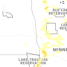
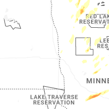


Connect with Interactive Hail Maps