

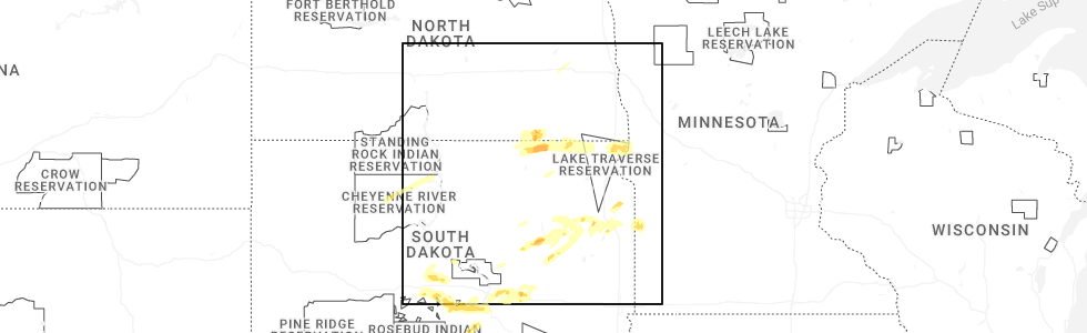
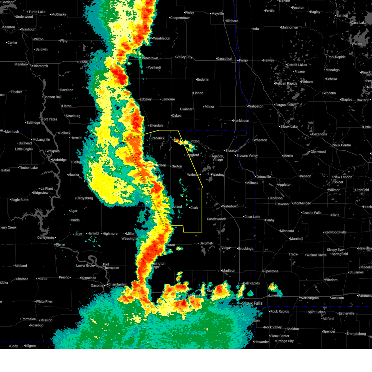
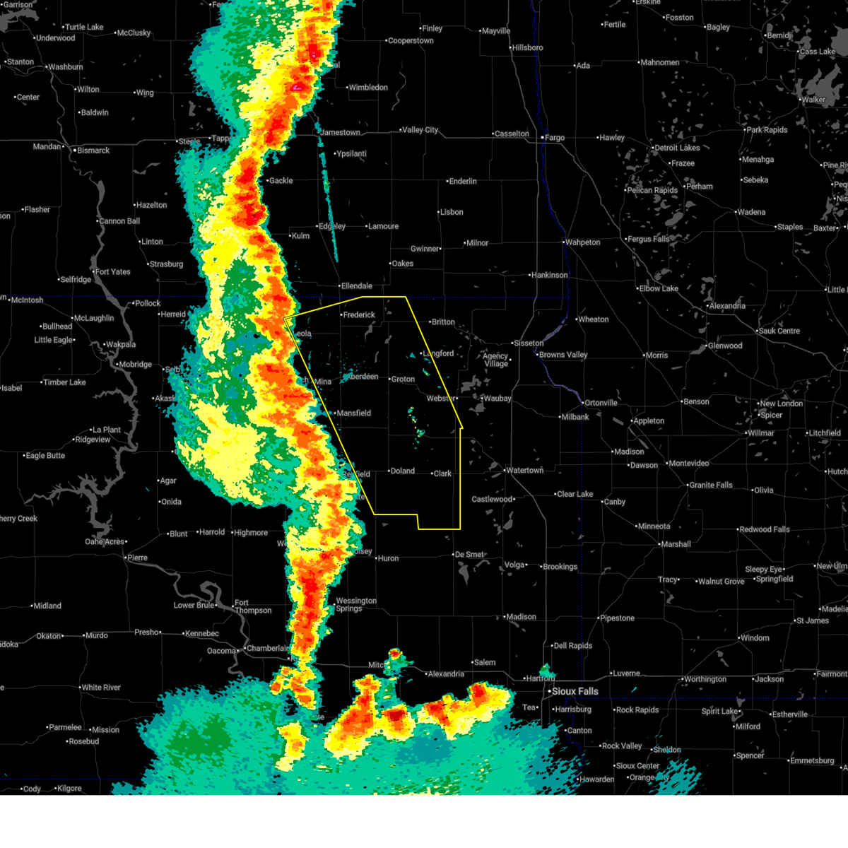
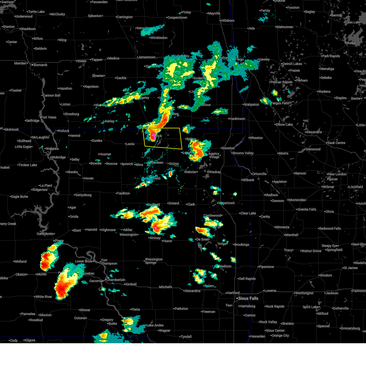
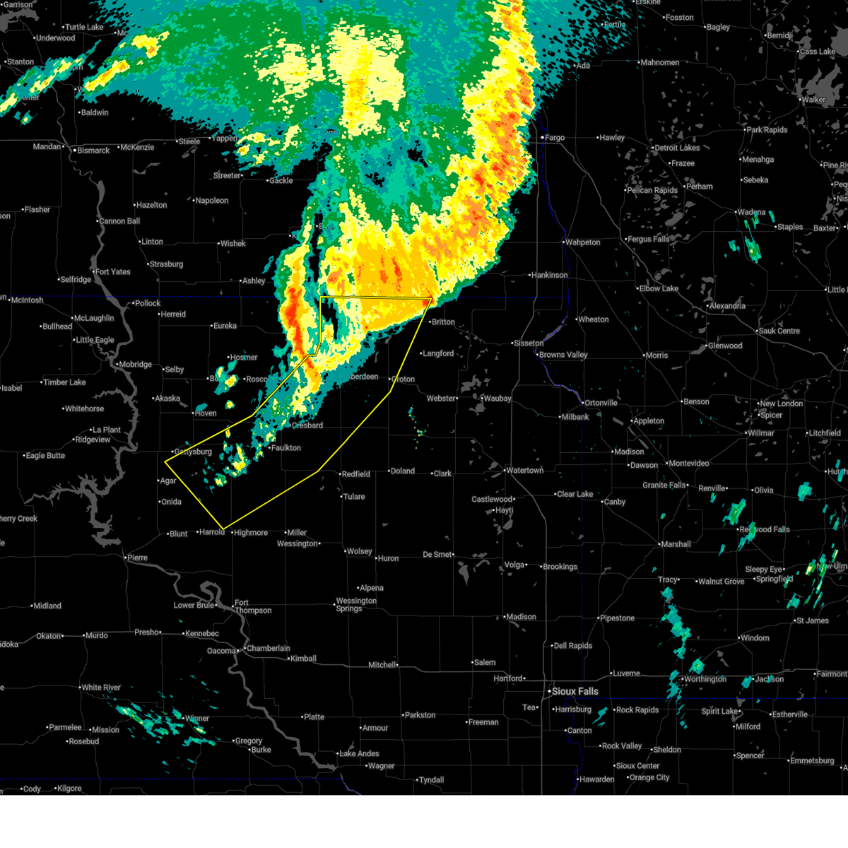
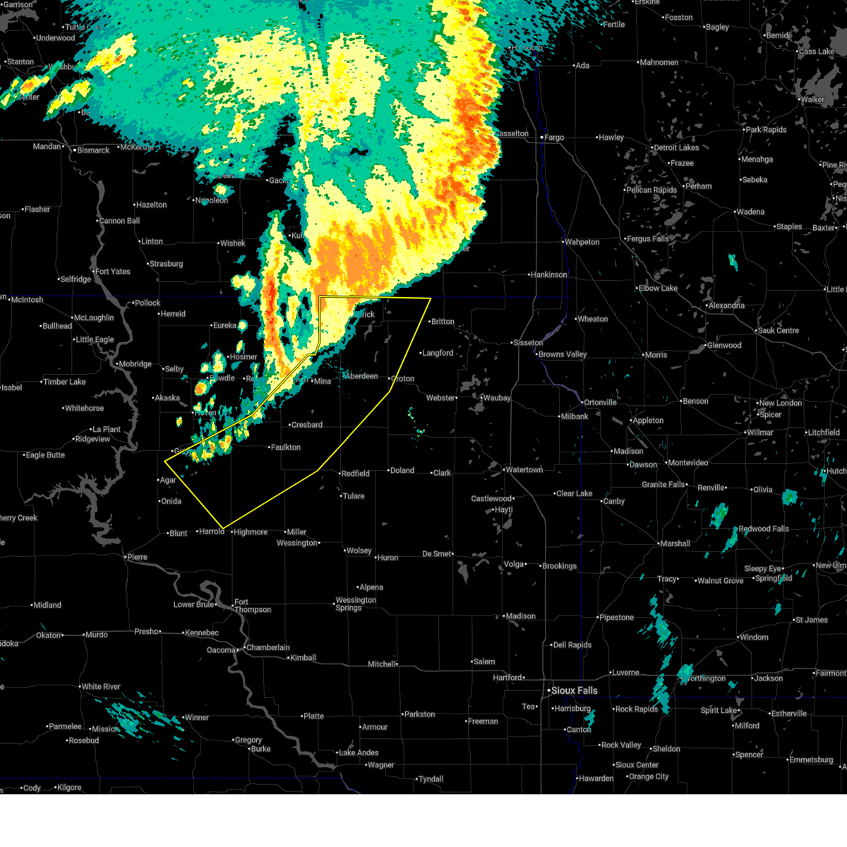
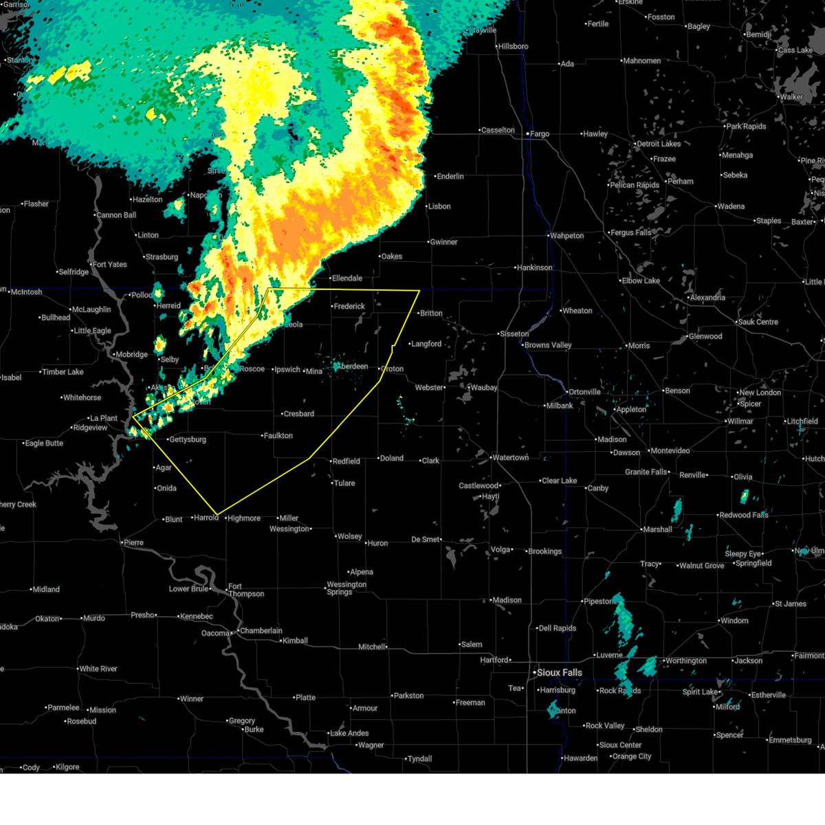
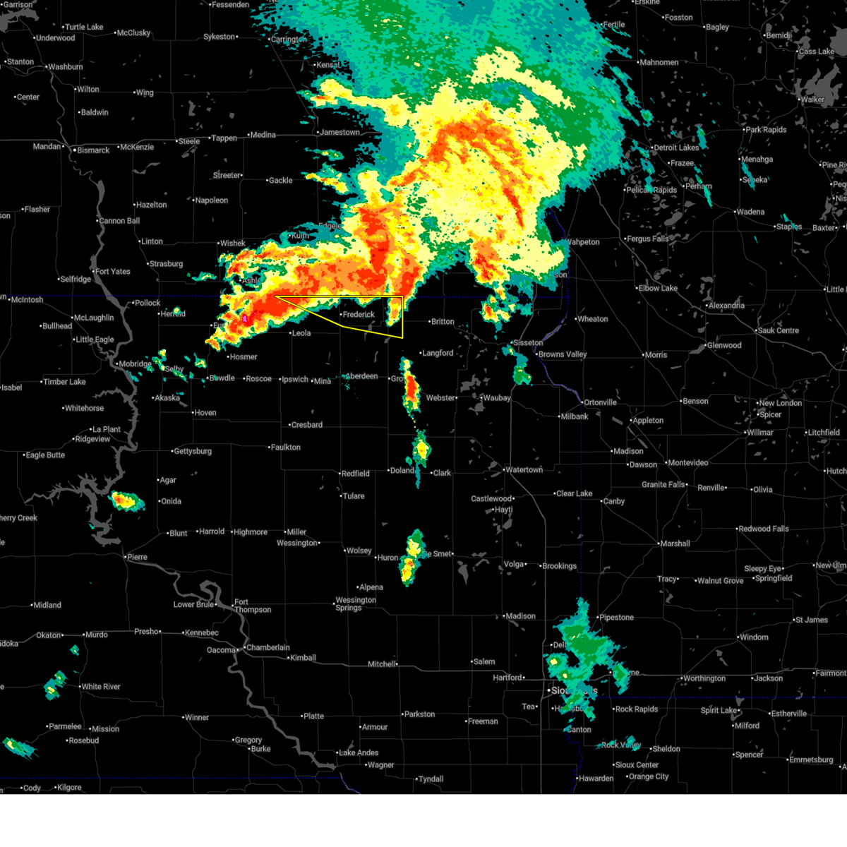
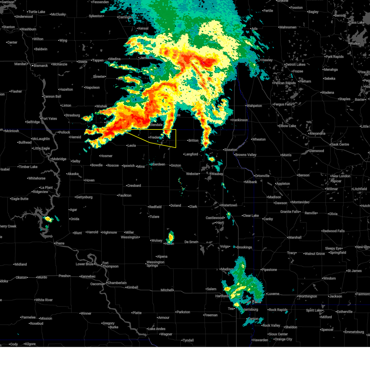
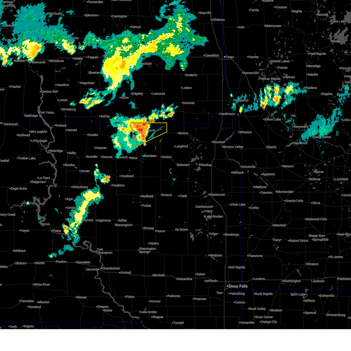
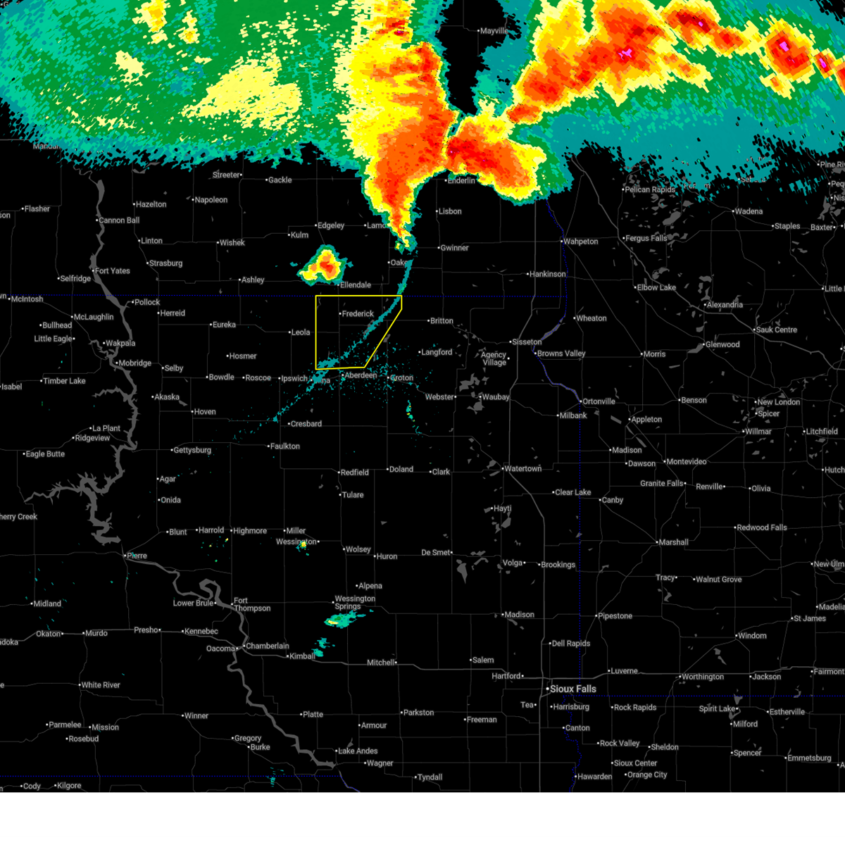
Hail Map for Frederick, SD
The Frederick, SD area has had 20 reports of on-the-ground hail by trained spotters, and has been under severe weather warnings 20 times during the past 12 months. Doppler radar has detected hail at or near Frederick, SD on 58 occasions, including 7 occasions during the past year.
| Name: | Frederick, SD |
| Where Located: | 25.8 miles N of Aberdeen, SD |
| Map: | Google Map for Frederick, SD |
| Population: | 199 |
| Housing Units: | 119 |
| More Info: | Search Google for Frederick, SD |
2
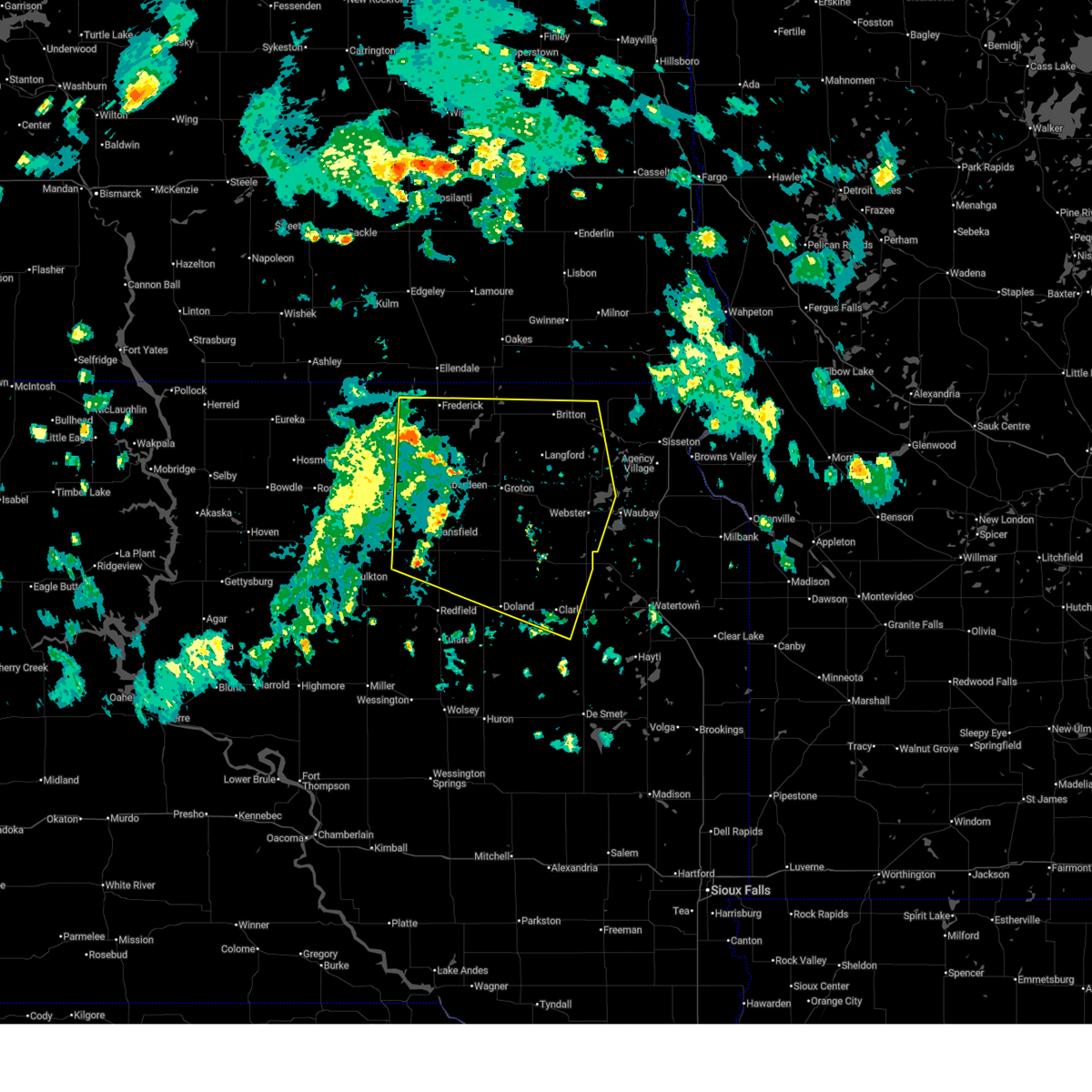
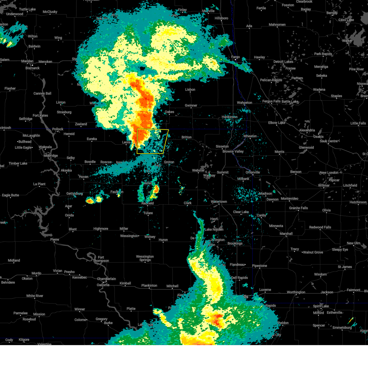
The Top Recent Hail Date for Frederick, SD is Wednesday, June 3, 2026 (2nd out of 58)
Hail and Wind Damage Spotted near Frederick, SD
| Date / Time | Report Details |
|---|---|
| 6/29/2026 7:42 AM CDT |
 Svrabr the national weather service in aberdeen has issued a * severe thunderstorm warning for, eastern edmunds county in north central south dakota, central brown county in northeastern south dakota, northeastern faulk county in north central south dakota, northwestern spink county in northeastern south dakota, * until 845 am cdt. * at 741 am cdt, a severe thunderstorm was located near mansfield, or near warner, moving northeast at 45 mph (trained weather spotters). Hazards include 60 mph wind gusts. Expect damage to roofs, siding, and trees. this severe thunderstorm will be near, aberdeen around 750 am cdt. Other locations in the path of this severe thunderstorm include columbia, sand lake wildlife refuge and houghton. Svrabr the national weather service in aberdeen has issued a * severe thunderstorm warning for, eastern edmunds county in north central south dakota, central brown county in northeastern south dakota, northeastern faulk county in north central south dakota, northwestern spink county in northeastern south dakota, * until 845 am cdt. * at 741 am cdt, a severe thunderstorm was located near mansfield, or near warner, moving northeast at 45 mph (trained weather spotters). Hazards include 60 mph wind gusts. Expect damage to roofs, siding, and trees. this severe thunderstorm will be near, aberdeen around 750 am cdt. Other locations in the path of this severe thunderstorm include columbia, sand lake wildlife refuge and houghton.
|
| 6/15/2026 4:11 PM CDT |
 The storms which prompted the warning have weakened below severe limits, and no longer pose an immediate threat to life or property. therefore, the warning will be allowed to expire. however, gusty winds are still possible with these thunderstorms. The storms which prompted the warning have weakened below severe limits, and no longer pose an immediate threat to life or property. therefore, the warning will be allowed to expire. however, gusty winds are still possible with these thunderstorms.
|
| 6/15/2026 4:01 PM CDT |
 At 400 pm cdt, severe thunderstorms were located along a line extending from near sunset colony to 6 miles north of holmquist to 7 miles southwest of crocker, moving east at 50 mph (trained weather spotters). Hazards include 60 mph wind gusts. Expect damage to roofs, siding, and trees. Locations impacted include, webster, britton, roslyn, sunset colony, hillcrest colony, bradley, grenville, crocker, lily, minnewasta lake, eden, garden city, rush lake, fort sisseton state park and roy lake rec area. At 400 pm cdt, severe thunderstorms were located along a line extending from near sunset colony to 6 miles north of holmquist to 7 miles southwest of crocker, moving east at 50 mph (trained weather spotters). Hazards include 60 mph wind gusts. Expect damage to roofs, siding, and trees. Locations impacted include, webster, britton, roslyn, sunset colony, hillcrest colony, bradley, grenville, crocker, lily, minnewasta lake, eden, garden city, rush lake, fort sisseton state park and roy lake rec area.
|
| 6/15/2026 3:19 PM CDT |
 Svrabr the national weather service in aberdeen has issued a * severe thunderstorm warning for, eastern edmunds county in north central south dakota, day county in northeastern south dakota, southwestern marshall county in northeastern south dakota, brown county in northeastern south dakota, northeastern faulk county in north central south dakota, northern clark county in northeastern south dakota, southeastern mcpherson county in north central south dakota, northern spink county in northeastern south dakota, * until 415 pm cdt. * at 318 pm cdt, severe thunderstorms were located along a line extending from near elm lake to bath to near athol, moving east at 50 mph (trained weather spotters). Hazards include 60 mph wind gusts and blowing dust. Expect damage to roofs, siding, and trees. severe thunderstorms will be near, groton, frederick, columbia, putney, hutterville colony, brentford, stratford, ferney, barnard, and sand lake wildlife refuge around 325 pm cdt. verdon and houghton around 330 pm cdt. conde, andover, camrose colony, and turton around 335 pm cdt. Other locations in the path of these severe thunderstorms include pierpont, claremont, crandall, bristol, langford, newport colony, amherst, sunset colony, butler, crocker, lily, holmquist, webster, britton, roslyn, bradley and waubay lake. Svrabr the national weather service in aberdeen has issued a * severe thunderstorm warning for, eastern edmunds county in north central south dakota, day county in northeastern south dakota, southwestern marshall county in northeastern south dakota, brown county in northeastern south dakota, northeastern faulk county in north central south dakota, northern clark county in northeastern south dakota, southeastern mcpherson county in north central south dakota, northern spink county in northeastern south dakota, * until 415 pm cdt. * at 318 pm cdt, severe thunderstorms were located along a line extending from near elm lake to bath to near athol, moving east at 50 mph (trained weather spotters). Hazards include 60 mph wind gusts and blowing dust. Expect damage to roofs, siding, and trees. severe thunderstorms will be near, groton, frederick, columbia, putney, hutterville colony, brentford, stratford, ferney, barnard, and sand lake wildlife refuge around 325 pm cdt. verdon and houghton around 330 pm cdt. conde, andover, camrose colony, and turton around 335 pm cdt. Other locations in the path of these severe thunderstorms include pierpont, claremont, crandall, bristol, langford, newport colony, amherst, sunset colony, butler, crocker, lily, holmquist, webster, britton, roslyn, bradley and waubay lake.
|
| 6/15/2026 3:14 PM CDT |
 At 314 pm cdt, severe thunderstorms were located along a line extending from near elm lake to near richmond lake rec area to near warner to near northville, moving east at 35 mph (trained weather spotters). Hazards include 60 mph wind gusts and blowing dust. Expect damage to roofs, siding, and trees. Locations impacted include, aberdeen, warner, mellette, northville, westport, mansfield, richmond lake rec area, bath, ashton, stratford, barnard, frederick and brentford. At 314 pm cdt, severe thunderstorms were located along a line extending from near elm lake to near richmond lake rec area to near warner to near northville, moving east at 35 mph (trained weather spotters). Hazards include 60 mph wind gusts and blowing dust. Expect damage to roofs, siding, and trees. Locations impacted include, aberdeen, warner, mellette, northville, westport, mansfield, richmond lake rec area, bath, ashton, stratford, barnard, frederick and brentford.
|
| 6/15/2026 2:46 PM CDT |
 Svrabr the national weather service in aberdeen has issued a * severe thunderstorm warning for, eastern edmunds county in north central south dakota, western brown county in northeastern south dakota, northeastern faulk county in north central south dakota, eastern mcpherson county in north central south dakota, northwestern spink county in northeastern south dakota, * until 330 pm cdt. * at 246 pm cdt, severe thunderstorms were located along a line extending from near long lake to deerfield colony to near cravens corner to near cresbard, moving east at 35 mph (radar indicated). Hazards include 60 mph wind gusts. Expect damage to roofs, siding, and trees. severe thunderstorms will be near, leola, mina lake rec area, deerfield colony, grassland colony, cresbard, devoe, long lake colony, wetonka, mina, and north scatterwood lake around 250 pm cdt. chelsea and richmond lake rec area around 255 pm cdt. aberdeen and mansfield around 305 pm cdt. Other locations in the path of these severe thunderstorms include warner, northville, mellette, westport and athol. Svrabr the national weather service in aberdeen has issued a * severe thunderstorm warning for, eastern edmunds county in north central south dakota, western brown county in northeastern south dakota, northeastern faulk county in north central south dakota, eastern mcpherson county in north central south dakota, northwestern spink county in northeastern south dakota, * until 330 pm cdt. * at 246 pm cdt, severe thunderstorms were located along a line extending from near long lake to deerfield colony to near cravens corner to near cresbard, moving east at 35 mph (radar indicated). Hazards include 60 mph wind gusts. Expect damage to roofs, siding, and trees. severe thunderstorms will be near, leola, mina lake rec area, deerfield colony, grassland colony, cresbard, devoe, long lake colony, wetonka, mina, and north scatterwood lake around 250 pm cdt. chelsea and richmond lake rec area around 255 pm cdt. aberdeen and mansfield around 305 pm cdt. Other locations in the path of these severe thunderstorms include warner, northville, mellette, westport and athol.
|
| 6/9/2026 11:57 PM CDT |
 Svrabr the national weather service in aberdeen has issued a * severe thunderstorm warning for, southwestern traverse county in west central minnesota, northwestern big stone county in west central minnesota, deuel county in northeastern south dakota, roberts county in northeastern south dakota, day county in northeastern south dakota, marshall county in northeastern south dakota, northeastern brown county in northeastern south dakota, hamlin county in northeastern south dakota, grant county in northeastern south dakota, clark county in northeastern south dakota, codington county in northeastern south dakota, * until 100 am cdt. * at 1156 pm cdt, severe thunderstorms were located along a line extending from near hecla to near pierpont to near wallace to near willow lake, moving east at 55 mph (radar indicated). Hazards include 70 mph wind gusts and nickel size hail. Expect considerable tree damage. damage is likely to mobile homes, roofs, and outbuildings. severe thunderstorms will be near, webster, bryant, florence, langford, henry, hecla, mayfield colony, sunset colony, newport colony, and hazel around 1200 am cdt. watertown, britton, goose lake, roslyn, rush lake, minnewasta lake, opitz lake, cattail lake, bitter lake, and lake kampeska around 1205 am cdt. waubay, hayti, enemy swim housing, eden, kidder, grenville, westwood colony, enemy swim lake, campbell slough, and piyas lake around 1210 am cdt. rauville, ortley, lake city, clear lake rec area, buffalo lakes, roy lake rec area, and pickerel lake rec area around 1215 am cdt. Other locations in the path of these severe thunderstorms include castlewood, summit, rudebusch corner, red iron housing, agency village, south shore, waverly, kranzburg, claremont colony, marvin, hillhead, finley heights housing, long hollow housing, sica hollow state park, sisseton, veblen, peever, goodwin, stockholm, twin brooks, troy, bemis, school lake, veblen flats housing, wilmot, corona, strandburg, bullhead lake, dakota connection & casino and peever flats housing. Svrabr the national weather service in aberdeen has issued a * severe thunderstorm warning for, southwestern traverse county in west central minnesota, northwestern big stone county in west central minnesota, deuel county in northeastern south dakota, roberts county in northeastern south dakota, day county in northeastern south dakota, marshall county in northeastern south dakota, northeastern brown county in northeastern south dakota, hamlin county in northeastern south dakota, grant county in northeastern south dakota, clark county in northeastern south dakota, codington county in northeastern south dakota, * until 100 am cdt. * at 1156 pm cdt, severe thunderstorms were located along a line extending from near hecla to near pierpont to near wallace to near willow lake, moving east at 55 mph (radar indicated). Hazards include 70 mph wind gusts and nickel size hail. Expect considerable tree damage. damage is likely to mobile homes, roofs, and outbuildings. severe thunderstorms will be near, webster, bryant, florence, langford, henry, hecla, mayfield colony, sunset colony, newport colony, and hazel around 1200 am cdt. watertown, britton, goose lake, roslyn, rush lake, minnewasta lake, opitz lake, cattail lake, bitter lake, and lake kampeska around 1205 am cdt. waubay, hayti, enemy swim housing, eden, kidder, grenville, westwood colony, enemy swim lake, campbell slough, and piyas lake around 1210 am cdt. rauville, ortley, lake city, clear lake rec area, buffalo lakes, roy lake rec area, and pickerel lake rec area around 1215 am cdt. Other locations in the path of these severe thunderstorms include castlewood, summit, rudebusch corner, red iron housing, agency village, south shore, waverly, kranzburg, claremont colony, marvin, hillhead, finley heights housing, long hollow housing, sica hollow state park, sisseton, veblen, peever, goodwin, stockholm, twin brooks, troy, bemis, school lake, veblen flats housing, wilmot, corona, strandburg, bullhead lake, dakota connection & casino and peever flats housing.
|
| 6/9/2026 11:49 PM CDT |
 At 1148 pm cdt, severe thunderstorms were located along a line extending from 6 miles northwest of sand lake wildlife refuge to clark, moving east at 55 mph (radar indicated). Hazards include 70 mph wind gusts. Expect considerable tree damage. damage is likely to mobile homes, roofs, and outbuildings. Locations impacted include, bristol, hecla, pierpont, claremont, newport colony, hillcrest colony, andover, bradley, garden city, crocker, langford, amherst, holmquist and sunset colony. At 1148 pm cdt, severe thunderstorms were located along a line extending from 6 miles northwest of sand lake wildlife refuge to clark, moving east at 55 mph (radar indicated). Hazards include 70 mph wind gusts. Expect considerable tree damage. damage is likely to mobile homes, roofs, and outbuildings. Locations impacted include, bristol, hecla, pierpont, claremont, newport colony, hillcrest colony, andover, bradley, garden city, crocker, langford, amherst, holmquist and sunset colony.
|
| 6/9/2026 11:26 PM CDT |
 At 1126 pm cdt, severe thunderstorms were located along a line extending from 6 miles south of elm lake to near doland, moving east at 55 mph (radar indicated). Hazards include 70 mph wind gusts. Expect considerable tree damage. damage is likely to mobile homes, roofs, and outbuildings. these severe storms will be near, aberdeen, frederick, doland, bath, conde, westport, hutterville colony, clark colony, stratford, and raymond around 1130 pm cdt. Other locations in the path of these severe thunderstorms include columbia, ferney, verdon, sand lake wildlife refuge, tacoma park, groton, clark, putney, crandall, hillcrest colony, crocker, houghton, hecla, claremont, andover, bradley, garden city, silver lake, bristol, pierpont, newport colony, butler, lily, swan lake, langford, amherst, holmquist and sunset colony. At 1126 pm cdt, severe thunderstorms were located along a line extending from 6 miles south of elm lake to near doland, moving east at 55 mph (radar indicated). Hazards include 70 mph wind gusts. Expect considerable tree damage. damage is likely to mobile homes, roofs, and outbuildings. these severe storms will be near, aberdeen, frederick, doland, bath, conde, westport, hutterville colony, clark colony, stratford, and raymond around 1130 pm cdt. Other locations in the path of these severe thunderstorms include columbia, ferney, verdon, sand lake wildlife refuge, tacoma park, groton, clark, putney, crandall, hillcrest colony, crocker, houghton, hecla, claremont, andover, bradley, garden city, silver lake, bristol, pierpont, newport colony, butler, lily, swan lake, langford, amherst, holmquist and sunset colony.
|
| 6/9/2026 11:12 PM CDT |
 Svrabr the national weather service in aberdeen has issued a * severe thunderstorm warning for, northeastern edmunds county in north central south dakota, western day county in northeastern south dakota, southwestern marshall county in northeastern south dakota, brown county in northeastern south dakota, clark county in northeastern south dakota, southeastern mcpherson county in north central south dakota, spink county in northeastern south dakota, * until 1215 am cdt. * at 1111 pm cdt, severe thunderstorms were located along a line extending from near leola to near frankfort, moving east at 55 mph (radar indicated). Hazards include 60 mph wind gusts. Expect damage to roofs, siding, and trees. severe thunderstorms will be near, leola, warner, mina lake rec area, mellette, glendale colony, frankfort, grassland colony, mansfield, camrose colony, and long lake colony around 1115 pm cdt. aberdeen, doland, brentford, and elm lake around 1120 pm cdt. westport, hutterville colony, stratford, and turton around 1125 pm cdt. frederick, bath, conde, clark colony, raymond, and barnard around 1130 pm cdt. Other locations in the path of these severe thunderstorms include columbia, ferney, verdon, sand lake wildlife refuge, crandall, tacoma park, groton, clark, putney, hillcrest colony, crocker, houghton, hecla, claremont, andover, bradley, garden city, lily and silver lake. Svrabr the national weather service in aberdeen has issued a * severe thunderstorm warning for, northeastern edmunds county in north central south dakota, western day county in northeastern south dakota, southwestern marshall county in northeastern south dakota, brown county in northeastern south dakota, clark county in northeastern south dakota, southeastern mcpherson county in north central south dakota, spink county in northeastern south dakota, * until 1215 am cdt. * at 1111 pm cdt, severe thunderstorms were located along a line extending from near leola to near frankfort, moving east at 55 mph (radar indicated). Hazards include 60 mph wind gusts. Expect damage to roofs, siding, and trees. severe thunderstorms will be near, leola, warner, mina lake rec area, mellette, glendale colony, frankfort, grassland colony, mansfield, camrose colony, and long lake colony around 1115 pm cdt. aberdeen, doland, brentford, and elm lake around 1120 pm cdt. westport, hutterville colony, stratford, and turton around 1125 pm cdt. frederick, bath, conde, clark colony, raymond, and barnard around 1130 pm cdt. Other locations in the path of these severe thunderstorms include columbia, ferney, verdon, sand lake wildlife refuge, crandall, tacoma park, groton, clark, putney, hillcrest colony, crocker, houghton, hecla, claremont, andover, bradley, garden city, lily and silver lake.
|
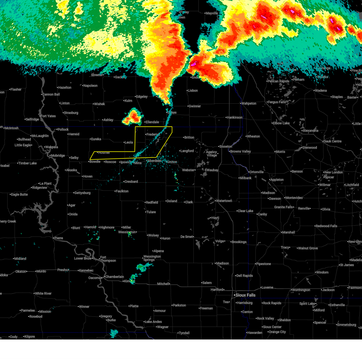
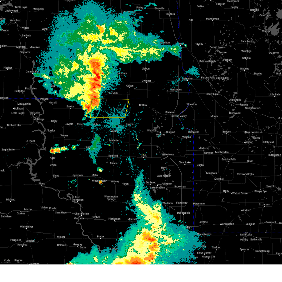
| 6/3/2026 6:26 PM CDT |
 Svrabr the national weather service in aberdeen has issued a * severe thunderstorm warning for, northwestern marshall county in northeastern south dakota, northern brown county in northeastern south dakota, * until 715 pm cdt. * at 625 pm cdt, a severe thunderstorm was located near sand lake wildlife refuge, or 15 miles southeast of ellendale, moving east at 30 mph (trained weather spotters). Hazards include 70 mph wind gusts. Expect considerable tree damage. damage is likely to mobile homes, roofs, and outbuildings. this severe thunderstorm will be near, sand lake wildlife refuge and houghton around 630 pm cdt. hecla around 640 pm cdt. Other locations in the path of this severe thunderstorm include sunset colony and amherst. Svrabr the national weather service in aberdeen has issued a * severe thunderstorm warning for, northwestern marshall county in northeastern south dakota, northern brown county in northeastern south dakota, * until 715 pm cdt. * at 625 pm cdt, a severe thunderstorm was located near sand lake wildlife refuge, or 15 miles southeast of ellendale, moving east at 30 mph (trained weather spotters). Hazards include 70 mph wind gusts. Expect considerable tree damage. damage is likely to mobile homes, roofs, and outbuildings. this severe thunderstorm will be near, sand lake wildlife refuge and houghton around 630 pm cdt. hecla around 640 pm cdt. Other locations in the path of this severe thunderstorm include sunset colony and amherst.
|
| 6/3/2026 6:25 PM CDT | Delayed report. 2 outbuildings lots... football field score board lost... a pergola structure blew into a home and punched a hole in the wall. a few trees down as wel in brown county SD, 0.2 miles NE of Frederick, SD |
| 6/3/2026 6:20 PM CDT | Personal weather station. a small building at a football field also destroye in brown county SD, 0.2 miles NE of Frederick, SD |
| 8/8/2025 4:10 AM CDT |
 The storms which prompted the warning have weakened below severe limits, and no longer pose an immediate threat to life or property. therefore, the warning will be allowed to expire. however, gusty winds are still possible with these thunderstorms. The storms which prompted the warning have weakened below severe limits, and no longer pose an immediate threat to life or property. therefore, the warning will be allowed to expire. however, gusty winds are still possible with these thunderstorms.
|
| 8/8/2025 3:54 AM CDT |
 At 353 am cdt, severe thunderstorms were located along a line extending from near barnard to mina lake rec area to near evergreen colony to 8 miles south of seneca, moving southeast at 50 mph (trained weather spotters). Hazards include 60 mph wind gusts. Expect damage to roofs, siding, and trees. Locations impacted include, aberdeen, faulkton, columbia, evergreen colony, cresbard, chelsea, devoe, sand lake wildlife refuge, south scatterwood lake, north scatterwood lake, warner, bath, putney, mansfield, orient, tacoma park, miranda, mellette, northville, rockham, polo, groton, stratford, athol and zell. At 353 am cdt, severe thunderstorms were located along a line extending from near barnard to mina lake rec area to near evergreen colony to 8 miles south of seneca, moving southeast at 50 mph (trained weather spotters). Hazards include 60 mph wind gusts. Expect damage to roofs, siding, and trees. Locations impacted include, aberdeen, faulkton, columbia, evergreen colony, cresbard, chelsea, devoe, sand lake wildlife refuge, south scatterwood lake, north scatterwood lake, warner, bath, putney, mansfield, orient, tacoma park, miranda, mellette, northville, rockham, polo, groton, stratford, athol and zell.
|
| 8/8/2025 3:54 AM CDT |
 the severe thunderstorm warning has been cancelled and is no longer in effect the severe thunderstorm warning has been cancelled and is no longer in effect
|
| 8/8/2025 3:29 AM CDT |
 Svrabr the national weather service in aberdeen has issued a * severe thunderstorm warning for, edmunds county in north central south dakota, northern hand county in central south dakota, northeastern sully county in central south dakota, northwestern marshall county in northeastern south dakota, northern hyde county in central south dakota, brown county in northeastern south dakota, faulk county in north central south dakota, potter county in north central south dakota, eastern mcpherson county in north central south dakota, northwestern spink county in northeastern south dakota, southeastern walworth county in north central south dakota, * until 415 am cdt. * at 329 am cdt, severe thunderstorms were located along a line extending from near elm lake to near leola to near roscoe to near lebanon, moving southeast at 50 mph (radar indicated). Hazards include 60 mph wind gusts. Expect damage to roofs, siding, and trees. severe thunderstorms will be near, ipswich, frederick, pembrook colony, deerfield colony, grassland colony, brentwood colony, lebanon, seneca, onaka, and long lake colony around 335 am cdt. mina lake rec area, norbeck, richmond lake rec area, and barnard around 340 am cdt. westport, evergreen colony, mina, and burkmere around 345 am cdt. Other locations in the path of these severe thunderstorms include aberdeen, faulkton, cresbard, sand lake wildlife refuge, north scatterwood lake, columbia, devoe, south scatterwood lake, warner, bath, mansfield, orient, chelsea, tacoma park, miranda and putney. Svrabr the national weather service in aberdeen has issued a * severe thunderstorm warning for, edmunds county in north central south dakota, northern hand county in central south dakota, northeastern sully county in central south dakota, northwestern marshall county in northeastern south dakota, northern hyde county in central south dakota, brown county in northeastern south dakota, faulk county in north central south dakota, potter county in north central south dakota, eastern mcpherson county in north central south dakota, northwestern spink county in northeastern south dakota, southeastern walworth county in north central south dakota, * until 415 am cdt. * at 329 am cdt, severe thunderstorms were located along a line extending from near elm lake to near leola to near roscoe to near lebanon, moving southeast at 50 mph (radar indicated). Hazards include 60 mph wind gusts. Expect damage to roofs, siding, and trees. severe thunderstorms will be near, ipswich, frederick, pembrook colony, deerfield colony, grassland colony, brentwood colony, lebanon, seneca, onaka, and long lake colony around 335 am cdt. mina lake rec area, norbeck, richmond lake rec area, and barnard around 340 am cdt. westport, evergreen colony, mina, and burkmere around 345 am cdt. Other locations in the path of these severe thunderstorms include aberdeen, faulkton, cresbard, sand lake wildlife refuge, north scatterwood lake, columbia, devoe, south scatterwood lake, warner, bath, mansfield, orient, chelsea, tacoma park, miranda and putney.
|
| 8/5/2025 7:14 PM CDT |
 the severe thunderstorm warning has been cancelled and is no longer in effect the severe thunderstorm warning has been cancelled and is no longer in effect
|
| 8/5/2025 6:48 PM CDT |
 Svrabr the national weather service in aberdeen has issued a * severe thunderstorm warning for, northern brown county in northeastern south dakota, northeastern mcpherson county in north central south dakota, * until 730 pm cdt. * at 647 pm cdt, a severe thunderstorm was located near elm lake, or 7 miles southwest of ellendale, moving east at 35 mph (radar indicated). Hazards include 60 mph wind gusts. expect damage to roofs, siding, and trees Svrabr the national weather service in aberdeen has issued a * severe thunderstorm warning for, northern brown county in northeastern south dakota, northeastern mcpherson county in north central south dakota, * until 730 pm cdt. * at 647 pm cdt, a severe thunderstorm was located near elm lake, or 7 miles southwest of ellendale, moving east at 35 mph (radar indicated). Hazards include 60 mph wind gusts. expect damage to roofs, siding, and trees
|
| 8/5/2025 4:39 PM CDT | Ping Pong Ball sized hail reported 9.9 miles ESE of Frederick, SD, report from mping: ping pong ball (1.50 in.). |
| 8/5/2025 4:34 PM CDT | Quarter sized hail reported 10.1 miles ESE of Frederick, SD, quarter size hail reported in elm lake. time estimated by radar. |
| 7/22/2025 10:30 AM CDT | Call from public with estimated winds and 0.77 in rai in brown county SD, 0.2 miles NE of Frederick, SD |
| 7/22/2025 10:26 AM CDT |
 Svrabr the national weather service in aberdeen has issued a * severe thunderstorm warning for, northern brown county in northeastern south dakota, * until 1115 am cdt. * at 1026 am cdt, a severe thunderstorm was located over frederick, or 14 miles south of ellendale, moving northeast at 35 mph (radar indicated). Hazards include 60 mph wind gusts and quarter size hail. Hail damage to vehicles is expected. expect wind damage to roofs, siding, and trees. this severe thunderstorm will be near, frederick around 1030 am cdt. sand lake wildlife refuge around 1045 am cdt. Other locations in the path of this severe thunderstorm include hecla. Svrabr the national weather service in aberdeen has issued a * severe thunderstorm warning for, northern brown county in northeastern south dakota, * until 1115 am cdt. * at 1026 am cdt, a severe thunderstorm was located over frederick, or 14 miles south of ellendale, moving northeast at 35 mph (radar indicated). Hazards include 60 mph wind gusts and quarter size hail. Hail damage to vehicles is expected. expect wind damage to roofs, siding, and trees. this severe thunderstorm will be near, frederick around 1030 am cdt. sand lake wildlife refuge around 1045 am cdt. Other locations in the path of this severe thunderstorm include hecla.
|
| 7/14/2025 10:43 PM CDT |
 At 1043 pm cdt, a severe thunderstorm was located 9 miles northwest of hecla, or 10 miles southeast of ellendale, moving east at 30 mph (radar indicated). Hazards include ping pong ball size hail and 60 mph wind gusts. People and animals outdoors will be injured. expect hail damage to roofs, siding, windows, and vehicles. expect wind damage to roofs, siding, and trees. Locations impacted include, hecla, frederick, and sand lake wildlife refuge. At 1043 pm cdt, a severe thunderstorm was located 9 miles northwest of hecla, or 10 miles southeast of ellendale, moving east at 30 mph (radar indicated). Hazards include ping pong ball size hail and 60 mph wind gusts. People and animals outdoors will be injured. expect hail damage to roofs, siding, windows, and vehicles. expect wind damage to roofs, siding, and trees. Locations impacted include, hecla, frederick, and sand lake wildlife refuge.
|
| 7/14/2025 10:24 PM CDT |
 Svrabr the national weather service in aberdeen has issued a * severe thunderstorm warning for, northern brown county in northeastern south dakota, * until 1115 pm cdt. * at 1023 pm cdt, a severe thunderstorm was located near frederick, or 7 miles south of ellendale, moving east at 30 mph (radar indicated). Hazards include ping pong ball size hail and 60 mph wind gusts. People and animals outdoors will be injured. expect hail damage to roofs, siding, windows, and vehicles. Expect wind damage to roofs, siding, and trees. Svrabr the national weather service in aberdeen has issued a * severe thunderstorm warning for, northern brown county in northeastern south dakota, * until 1115 pm cdt. * at 1023 pm cdt, a severe thunderstorm was located near frederick, or 7 miles south of ellendale, moving east at 30 mph (radar indicated). Hazards include ping pong ball size hail and 60 mph wind gusts. People and animals outdoors will be injured. expect hail damage to roofs, siding, windows, and vehicles. Expect wind damage to roofs, siding, and trees.
|
| 6/20/2025 11:38 PM CDT |
 The outflow boundary which prompted the warning have weakened below severe limits, and no longer pose an immediate threat to life or property. therefore, the warning will be allowed to expire. however, gusty winds are still possible with this outflow. a tornado watch remains in effect until 300 am cdt for northeastern south dakota. The outflow boundary which prompted the warning have weakened below severe limits, and no longer pose an immediate threat to life or property. therefore, the warning will be allowed to expire. however, gusty winds are still possible with this outflow. a tornado watch remains in effect until 300 am cdt for northeastern south dakota.
|
| 6/20/2025 11:28 PM CDT |
 At 1128 pm cdt, outflow winds from severe thunderstorms were located along a line extending from near oakes to 6 miles southeast of pembrook colony, moving east at 45 mph (radar indicated). Hazards include 60 mph wind gusts. Expect damage to roofs, siding, and trees. Locations impacted include, hecla, frederick, columbia, westport, elm lake, barnard, sand lake wildlife refuge, richmond lake rec area, and houghton. At 1128 pm cdt, outflow winds from severe thunderstorms were located along a line extending from near oakes to 6 miles southeast of pembrook colony, moving east at 45 mph (radar indicated). Hazards include 60 mph wind gusts. Expect damage to roofs, siding, and trees. Locations impacted include, hecla, frederick, columbia, westport, elm lake, barnard, sand lake wildlife refuge, richmond lake rec area, and houghton.
|
| 6/20/2025 11:28 PM CDT |
 the severe thunderstorm warning has been cancelled and is no longer in effect the severe thunderstorm warning has been cancelled and is no longer in effect
|
| 6/20/2025 11:26 PM CDT |
 the severe thunderstorm warning has been cancelled and is no longer in effect the severe thunderstorm warning has been cancelled and is no longer in effect
|
| 6/20/2025 11:26 PM CDT |
 At 1125 pm cdt, severe thunderstorms were located along a line extending from oakes to 6 miles southeast of pembrook colony, moving east at 45 mph (radar indicated). Hazards include 60 mph wind gusts. Expect damage to roofs, siding, and trees. Locations impacted include, hecla, westport, sand lake wildlife refuge, richmond lake rec area, barnard, columbia and houghton. At 1125 pm cdt, severe thunderstorms were located along a line extending from oakes to 6 miles southeast of pembrook colony, moving east at 45 mph (radar indicated). Hazards include 60 mph wind gusts. Expect damage to roofs, siding, and trees. Locations impacted include, hecla, westport, sand lake wildlife refuge, richmond lake rec area, barnard, columbia and houghton.
|
| 6/20/2025 11:03 PM CDT |
 Svrabr the national weather service in aberdeen has issued a * severe thunderstorm warning for, northern edmunds county in north central south dakota, northern brown county in northeastern south dakota, mcpherson county in north central south dakota, * until 1145 pm cdt. * at 1103 pm cdt, outflow from severe thunderstorms were located along a line extending from fullerton to near loyalton, moving east at 50 mph (radar indicated). Hazards include 60 mph wind gusts. Expect damage to roofs, siding, and trees. severe thunderstorms will be near, frederick, deerfield colony, grassland colony, long lake colony, and wetonka around 1110 pm cdt. richmond lake rec area and barnard around 1115 pm cdt. westport around 1120 pm cdt. Other locations in the path of these severe thunderstorms include hecla, sand lake wildlife refuge, columbia and houghton. Svrabr the national weather service in aberdeen has issued a * severe thunderstorm warning for, northern edmunds county in north central south dakota, northern brown county in northeastern south dakota, mcpherson county in north central south dakota, * until 1145 pm cdt. * at 1103 pm cdt, outflow from severe thunderstorms were located along a line extending from fullerton to near loyalton, moving east at 50 mph (radar indicated). Hazards include 60 mph wind gusts. Expect damage to roofs, siding, and trees. severe thunderstorms will be near, frederick, deerfield colony, grassland colony, long lake colony, and wetonka around 1110 pm cdt. richmond lake rec area and barnard around 1115 pm cdt. westport around 1120 pm cdt. Other locations in the path of these severe thunderstorms include hecla, sand lake wildlife refuge, columbia and houghton.
|
| 7/29/2024 10:53 PM CDT |
 The storm which prompted the warning has weakened below severe limits, and no longer poses an immediate threat to life or property. therefore, the warning will be allowed to expire. however, gusty winds are still possible with this thunderstorm. a severe thunderstorm watch remains in effect until midnight cdt for north central and northeastern south dakota. The storm which prompted the warning has weakened below severe limits, and no longer poses an immediate threat to life or property. therefore, the warning will be allowed to expire. however, gusty winds are still possible with this thunderstorm. a severe thunderstorm watch remains in effect until midnight cdt for north central and northeastern south dakota.
|
| 7/29/2024 10:38 PM CDT |
 At 1038 pm cdt, a severe thunderstorm was located near barnard, or 16 miles south of ellendale, moving east at 30 mph (radar indicated). Hazards include 60 mph wind gusts. Expect damage to roofs, siding, and trees. Locations impacted include, frederick, barnard, sand lake wildlife refuge and houghton. At 1038 pm cdt, a severe thunderstorm was located near barnard, or 16 miles south of ellendale, moving east at 30 mph (radar indicated). Hazards include 60 mph wind gusts. Expect damage to roofs, siding, and trees. Locations impacted include, frederick, barnard, sand lake wildlife refuge and houghton.
|
| 7/29/2024 10:38 PM CDT |
 the severe thunderstorm warning has been cancelled and is no longer in effect the severe thunderstorm warning has been cancelled and is no longer in effect
|
| 7/29/2024 10:08 PM CDT |
 Svrabr the national weather service in aberdeen has issued a * severe thunderstorm warning for, northwestern brown county in northeastern south dakota, eastern mcpherson county in north central south dakota, * until 1100 pm cdt. * at 1008 pm cdt, a severe thunderstorm was located near leola, moving east at 35 mph (trained weather spotters). Hazards include 60 mph wind gusts and penny size hail. Expect damage to roofs, siding, and trees. this severe thunderstorm will be near, elm lake around 1015 pm cdt. Other locations in the path of this severe thunderstorm include frederick, barnard and sand lake wildlife refuge. Svrabr the national weather service in aberdeen has issued a * severe thunderstorm warning for, northwestern brown county in northeastern south dakota, eastern mcpherson county in north central south dakota, * until 1100 pm cdt. * at 1008 pm cdt, a severe thunderstorm was located near leola, moving east at 35 mph (trained weather spotters). Hazards include 60 mph wind gusts and penny size hail. Expect damage to roofs, siding, and trees. this severe thunderstorm will be near, elm lake around 1015 pm cdt. Other locations in the path of this severe thunderstorm include frederick, barnard and sand lake wildlife refuge.
|
| 7/9/2024 8:10 PM CDT | Half Dollar sized hail reported 1.9 miles WSW of Frederick, SD |
| 7/9/2024 8:10 PM CDT | Several 10-12 inch diameter tree branches down as well as several 3 to 4 inch branche in brown county SD, 1.9 miles WSW of Frederick, SD |
| 7/9/2024 8:03 PM CDT |
 At 803 pm cdt, a severe thunderstorm was located 7 miles northwest of sand lake wildlife refuge, or 14 miles southeast of ellendale, moving southeast at 20 mph (radar indicated). Hazards include 60 mph wind gusts and half dollar size hail. Hail damage to vehicles is expected. expect wind damage to roofs, siding, and trees. Locations impacted include, sand lake wildlife refuge and houghton. At 803 pm cdt, a severe thunderstorm was located 7 miles northwest of sand lake wildlife refuge, or 14 miles southeast of ellendale, moving southeast at 20 mph (radar indicated). Hazards include 60 mph wind gusts and half dollar size hail. Hail damage to vehicles is expected. expect wind damage to roofs, siding, and trees. Locations impacted include, sand lake wildlife refuge and houghton.
|
| 7/9/2024 7:49 PM CDT |
 Svrabr the national weather service in aberdeen has issued a * severe thunderstorm warning for, northeastern brown county in northeastern south dakota, * until 830 pm cdt. * at 749 pm cdt, a severe thunderstorm was located 7 miles northeast of frederick, or 8 miles southeast of ellendale, moving southeast at 20 mph (radar indicated). Hazards include 60 mph wind gusts and quarter size hail. Hail damage to vehicles is expected. expect wind damage to roofs, siding, and trees. this severe thunderstorm will be near, sand lake wildlife refuge around 800 pm cdt. Other locations in the path of this severe thunderstorm include houghton. Svrabr the national weather service in aberdeen has issued a * severe thunderstorm warning for, northeastern brown county in northeastern south dakota, * until 830 pm cdt. * at 749 pm cdt, a severe thunderstorm was located 7 miles northeast of frederick, or 8 miles southeast of ellendale, moving southeast at 20 mph (radar indicated). Hazards include 60 mph wind gusts and quarter size hail. Hail damage to vehicles is expected. expect wind damage to roofs, siding, and trees. this severe thunderstorm will be near, sand lake wildlife refuge around 800 pm cdt. Other locations in the path of this severe thunderstorm include houghton.
|
| 6/2/2024 6:30 PM CDT | Half Dollar sized hail reported 5.7 miles N of Frederick, SD |
| 6/2/2024 6:25 PM CDT |
 At 624 pm cdt, a severe thunderstorm was located near barnard, or 15 miles south of ellendale, moving northeast at 10 mph. this is a destructive storm for areas north of barnard (trained weather spotters. at 622 pm, hail up to baseball size was reported near barnard). Hazards include baseball size hail and 60 mph wind gusts. People and animals outdoors will be severely injured. expect shattered windows, extensive damage to roofs, siding, and vehicles. This severe storm will be near, frederick around 630 pm cdt. At 624 pm cdt, a severe thunderstorm was located near barnard, or 15 miles south of ellendale, moving northeast at 10 mph. this is a destructive storm for areas north of barnard (trained weather spotters. at 622 pm, hail up to baseball size was reported near barnard). Hazards include baseball size hail and 60 mph wind gusts. People and animals outdoors will be severely injured. expect shattered windows, extensive damage to roofs, siding, and vehicles. This severe storm will be near, frederick around 630 pm cdt.
|
| 6/2/2024 6:21 PM CDT | Baseball sized hail reported 4.3 miles N of Frederick, SD, em reports golfball to baseball hail. |
| 6/2/2024 6:20 PM CDT |
 At 619 pm cdt, a severe thunderstorm was located near barnard, or 16 miles south of ellendale, moving northeast at 10 mph (trained weather spotters). Hazards include ping pong ball size hail and 60 mph wind gusts. People and animals outdoors will be injured. expect hail damage to roofs, siding, windows, and vehicles. expect wind damage to roofs, siding, and trees. This severe storm will be near, frederick around 625 pm cdt. At 619 pm cdt, a severe thunderstorm was located near barnard, or 16 miles south of ellendale, moving northeast at 10 mph (trained weather spotters). Hazards include ping pong ball size hail and 60 mph wind gusts. People and animals outdoors will be injured. expect hail damage to roofs, siding, windows, and vehicles. expect wind damage to roofs, siding, and trees. This severe storm will be near, frederick around 625 pm cdt.
|
| 6/2/2024 6:08 PM CDT |
 At 607 pm cdt, a severe thunderstorm was located near barnard, or 17 miles south of ellendale, moving northeast at 10 mph (trained weather spotters. at 557 pm, half dollar sized hail was reported 5 miles west of barnard). Hazards include ping pong ball size hail and 60 mph wind gusts. People and animals outdoors will be injured. expect hail damage to roofs, siding, windows, and vehicles. expect wind damage to roofs, siding, and trees. This severe storm will be near, frederick and barnard around 615 pm cdt. At 607 pm cdt, a severe thunderstorm was located near barnard, or 17 miles south of ellendale, moving northeast at 10 mph (trained weather spotters. at 557 pm, half dollar sized hail was reported 5 miles west of barnard). Hazards include ping pong ball size hail and 60 mph wind gusts. People and animals outdoors will be injured. expect hail damage to roofs, siding, windows, and vehicles. expect wind damage to roofs, siding, and trees. This severe storm will be near, frederick and barnard around 615 pm cdt.
|
| 6/2/2024 5:57 PM CDT | Half Dollar sized hail reported 9.2 miles NNE of Frederick, SD |
| 6/2/2024 5:57 PM CDT |
 Svrabr the national weather service in aberdeen has issued a * severe thunderstorm warning for, northwestern brown county in northeastern south dakota, * until 645 pm cdt. * at 556 pm cdt, a severe thunderstorm was located near barnard, or 16 miles east of leola, moving northeast at 10 mph (radar indicated). Hazards include 60 mph wind gusts and half dollar size hail. Hail damage to vehicles is expected. expect wind damage to roofs, siding, and trees. this severe thunderstorm will be near, barnard around 600 pm cdt. Frederick around 605 pm cdt. Svrabr the national weather service in aberdeen has issued a * severe thunderstorm warning for, northwestern brown county in northeastern south dakota, * until 645 pm cdt. * at 556 pm cdt, a severe thunderstorm was located near barnard, or 16 miles east of leola, moving northeast at 10 mph (radar indicated). Hazards include 60 mph wind gusts and half dollar size hail. Hail damage to vehicles is expected. expect wind damage to roofs, siding, and trees. this severe thunderstorm will be near, barnard around 600 pm cdt. Frederick around 605 pm cdt.
|
| 5/23/2024 4:30 PM CDT | Half Dollar sized hail reported 9.8 miles ESE of Frederick, SD, time estimated. |
| 5/17/2024 9:58 PM CDT |
 The storms which prompted the warning have moved out of the area. therefore, the warning will be allowed to expire. however, gusty winds are still possible with these thunderstorms. a severe thunderstorm watch remains in effect until midnight cdt for north central and northeastern south dakota. The storms which prompted the warning have moved out of the area. therefore, the warning will be allowed to expire. however, gusty winds are still possible with these thunderstorms. a severe thunderstorm watch remains in effect until midnight cdt for north central and northeastern south dakota.
|
| 5/17/2024 9:35 PM CDT | Storm damage reported in brown county SD, 0.2 miles NE of Frederick, SD |
| 5/17/2024 9:08 PM CDT |
 Svrabr the national weather service in aberdeen has issued a * severe thunderstorm warning for, edmunds county in north central south dakota, northwestern brown county in northeastern south dakota, eastern mcpherson county in north central south dakota, * until 1000 pm cdt. * at 908 pm cdt, severe thunderstorms were located along a line extending from 6 miles west of spring creek colony to 8 miles north of onaka, moving east at 45 mph (radar indicated). Hazards include 60 mph wind gusts. Expect damage to roofs, siding, and trees. severe thunderstorms will be near, leola, roscoe, spring creek colony, plainview colony, and forbes around 915 pm cdt. ipswich and elm lake around 920 pm cdt. deerfield colony, grassland colony, and long lake colony around 925 pm cdt. Other locations in the path of these severe thunderstorms include pembrook colony, wetonka, cravens corner, frederick, mina lake rec area, mina, richmond lake rec area and barnard. Svrabr the national weather service in aberdeen has issued a * severe thunderstorm warning for, edmunds county in north central south dakota, northwestern brown county in northeastern south dakota, eastern mcpherson county in north central south dakota, * until 1000 pm cdt. * at 908 pm cdt, severe thunderstorms were located along a line extending from 6 miles west of spring creek colony to 8 miles north of onaka, moving east at 45 mph (radar indicated). Hazards include 60 mph wind gusts. Expect damage to roofs, siding, and trees. severe thunderstorms will be near, leola, roscoe, spring creek colony, plainview colony, and forbes around 915 pm cdt. ipswich and elm lake around 920 pm cdt. deerfield colony, grassland colony, and long lake colony around 925 pm cdt. Other locations in the path of these severe thunderstorms include pembrook colony, wetonka, cravens corner, frederick, mina lake rec area, mina, richmond lake rec area and barnard.
|
| 8/10/2023 5:19 PM CDT |
 At 519 pm cdt, a severe thunderstorm was located near frederick, or 14 miles south of ellendale, moving northeast at 20 mph (radar indicated). Hazards include 60 mph wind gusts and quarter size hail. Hail damage to vehicles is expected. expect wind damage to roofs, siding, and trees. locations impacted include, frederick, elm lake and barnard. hail threat, radar indicated max hail size, 1. 00 in wind threat, radar indicated max wind gust, 60 mph. At 519 pm cdt, a severe thunderstorm was located near frederick, or 14 miles south of ellendale, moving northeast at 20 mph (radar indicated). Hazards include 60 mph wind gusts and quarter size hail. Hail damage to vehicles is expected. expect wind damage to roofs, siding, and trees. locations impacted include, frederick, elm lake and barnard. hail threat, radar indicated max hail size, 1. 00 in wind threat, radar indicated max wind gust, 60 mph.
|
| 8/10/2023 5:11 PM CDT |
 At 510 pm cdt, a severe thunderstorm was located 7 miles southwest of frederick, or 15 miles east of leola, moving northeast at 20 mph (radar indicated). Hazards include 60 mph wind gusts and quarter size hail. Hail damage to vehicles is expected. expect wind damage to roofs, siding, and trees. locations impacted include, frederick, elm lake and barnard. hail threat, radar indicated max hail size, 1. 00 in wind threat, radar indicated max wind gust, 60 mph. At 510 pm cdt, a severe thunderstorm was located 7 miles southwest of frederick, or 15 miles east of leola, moving northeast at 20 mph (radar indicated). Hazards include 60 mph wind gusts and quarter size hail. Hail damage to vehicles is expected. expect wind damage to roofs, siding, and trees. locations impacted include, frederick, elm lake and barnard. hail threat, radar indicated max hail size, 1. 00 in wind threat, radar indicated max wind gust, 60 mph.
|
| 8/10/2023 4:54 PM CDT |
 At 453 pm cdt, a severe thunderstorm was located near grassland colony, or 9 miles east of leola, moving northeast at 20 mph (radar indicated). Hazards include 60 mph wind gusts and quarter size hail. Hail damage to vehicles is expected. expect wind damage to roofs, siding, and trees. locations impacted include, frederick, grassland colony, wetonka, elm lake and barnard. hail threat, radar indicated max hail size, 1. 00 in wind threat, radar indicated max wind gust, 60 mph. At 453 pm cdt, a severe thunderstorm was located near grassland colony, or 9 miles east of leola, moving northeast at 20 mph (radar indicated). Hazards include 60 mph wind gusts and quarter size hail. Hail damage to vehicles is expected. expect wind damage to roofs, siding, and trees. locations impacted include, frederick, grassland colony, wetonka, elm lake and barnard. hail threat, radar indicated max hail size, 1. 00 in wind threat, radar indicated max wind gust, 60 mph.
|
| 8/10/2023 4:38 PM CDT |
 At 438 pm cdt, a severe thunderstorm was located over grassland colony, or near leola, moving northeast at 20 mph (radar indicated). Hazards include 60 mph wind gusts and quarter size hail. Hail damage to vehicles is expected. Expect wind damage to roofs, siding, and trees. At 438 pm cdt, a severe thunderstorm was located over grassland colony, or near leola, moving northeast at 20 mph (radar indicated). Hazards include 60 mph wind gusts and quarter size hail. Hail damage to vehicles is expected. Expect wind damage to roofs, siding, and trees.
|
| 7/26/2023 8:43 PM CDT | Mesonet station 49 frederick (sddot in brown county SD, 6.9 miles S of Frederick, SD |
| 7/23/2022 6:42 AM CDT |
 At 642 am cdt, a severe thunderstorm was located 7 miles south of elm lake, or 18 miles southwest of ellendale, moving east at 45 mph (radar indicated). Hazards include 60 mph wind gusts and quarter size hail. Hail damage to vehicles is expected. expect wind damage to roofs, siding, and trees. locations impacted include, frederick and barnard. hail threat, radar indicated max hail size, 1. 00 in wind threat, radar indicated max wind gust, 60 mph. At 642 am cdt, a severe thunderstorm was located 7 miles south of elm lake, or 18 miles southwest of ellendale, moving east at 45 mph (radar indicated). Hazards include 60 mph wind gusts and quarter size hail. Hail damage to vehicles is expected. expect wind damage to roofs, siding, and trees. locations impacted include, frederick and barnard. hail threat, radar indicated max hail size, 1. 00 in wind threat, radar indicated max wind gust, 60 mph.
|
| 7/23/2022 6:14 AM CDT |
 At 614 am cdt, a severe thunderstorm was located near long lake, or 20 miles southeast of ashley, moving east at 45 mph (radar indicated). Hazards include 60 mph wind gusts and quarter size hail. Hail damage to vehicles is expected. expect wind damage to roofs, siding, and trees. this severe thunderstorm will be near, leola around 630 am cdt. other locations in the path of this severe thunderstorm include grassland colony, elm lake, frederick and barnard. hail threat, radar indicated max hail size, 1. 00 in wind threat, radar indicated max wind gust, 60 mph. At 614 am cdt, a severe thunderstorm was located near long lake, or 20 miles southeast of ashley, moving east at 45 mph (radar indicated). Hazards include 60 mph wind gusts and quarter size hail. Hail damage to vehicles is expected. expect wind damage to roofs, siding, and trees. this severe thunderstorm will be near, leola around 630 am cdt. other locations in the path of this severe thunderstorm include grassland colony, elm lake, frederick and barnard. hail threat, radar indicated max hail size, 1. 00 in wind threat, radar indicated max wind gust, 60 mph.
|
| 7/21/2022 7:19 PM CDT |
 At 718 pm cdt, a severe thunderstorm was located near elm lake, or 11 miles southwest of ellendale, moving southeast at 35 mph (radar indicated). Hazards include 60 mph wind gusts and penny size hail. Expect damage to roofs, siding, and trees. locations impacted include, frederick and barnard. hail threat, radar indicated max hail size, 0. 75 in wind threat, radar indicated max wind gust, 60 mph. At 718 pm cdt, a severe thunderstorm was located near elm lake, or 11 miles southwest of ellendale, moving southeast at 35 mph (radar indicated). Hazards include 60 mph wind gusts and penny size hail. Expect damage to roofs, siding, and trees. locations impacted include, frederick and barnard. hail threat, radar indicated max hail size, 0. 75 in wind threat, radar indicated max wind gust, 60 mph.
|
| 7/21/2022 6:54 PM CDT |
 At 654 pm cdt, a severe thunderstorm was located near forbes, or 16 miles west of ellendale, moving southeast at 35 mph (radar indicated). Hazards include 60 mph wind gusts and quarter size hail. Hail damage to vehicles is expected. expect wind damage to roofs, siding, and trees. this severe thunderstorm will be near, forbes around 705 pm cdt. other locations in the path of this severe thunderstorm include elm lake, frederick and barnard. hail threat, radar indicated max hail size, 1. 00 in wind threat, radar indicated max wind gust, 60 mph. At 654 pm cdt, a severe thunderstorm was located near forbes, or 16 miles west of ellendale, moving southeast at 35 mph (radar indicated). Hazards include 60 mph wind gusts and quarter size hail. Hail damage to vehicles is expected. expect wind damage to roofs, siding, and trees. this severe thunderstorm will be near, forbes around 705 pm cdt. other locations in the path of this severe thunderstorm include elm lake, frederick and barnard. hail threat, radar indicated max hail size, 1. 00 in wind threat, radar indicated max wind gust, 60 mph.
|
| 6/14/2022 5:23 AM CDT |
 The severe thunderstorm warning for northwestern marshall and northern brown counties will expire at 530 am cdt, the storm which prompted the warning has weakened below severe limits, and has exited the warned area. therefore, the warning will be allowed to expire. however gusty winds are still possible with this thunderstorm. a severe thunderstorm watch remains in effect until 600 am cdt for northeastern south dakota. The severe thunderstorm warning for northwestern marshall and northern brown counties will expire at 530 am cdt, the storm which prompted the warning has weakened below severe limits, and has exited the warned area. therefore, the warning will be allowed to expire. however gusty winds are still possible with this thunderstorm. a severe thunderstorm watch remains in effect until 600 am cdt for northeastern south dakota.
|
| 6/14/2022 5:12 AM CDT |
 At 512 am cdt, a severe thunderstorm was located 9 miles west of hecla, or 10 miles southeast of ellendale, moving northeast at 50 mph (radar indicated). Hazards include 70 mph wind gusts and quarter size hail. Hail damage to vehicles is expected. expect considerable tree damage. wind damage is also likely to mobile homes, roofs, and outbuildings. locations impacted include, hecla. thunderstorm damage threat, considerable hail threat, radar indicated max hail size, 1. 00 in wind threat, radar indicated max wind gust, 70 mph. At 512 am cdt, a severe thunderstorm was located 9 miles west of hecla, or 10 miles southeast of ellendale, moving northeast at 50 mph (radar indicated). Hazards include 70 mph wind gusts and quarter size hail. Hail damage to vehicles is expected. expect considerable tree damage. wind damage is also likely to mobile homes, roofs, and outbuildings. locations impacted include, hecla. thunderstorm damage threat, considerable hail threat, radar indicated max hail size, 1. 00 in wind threat, radar indicated max wind gust, 70 mph.
|
| 6/14/2022 4:55 AM CDT | Golf Ball sized hail reported 9.3 miles SE of Frederick, SD, facebook report with picture. |
| 6/14/2022 4:50 AM CDT | Large trees downed... grain bin downed... power lines and power polls blown over. timing based on radar dat in brown county SD, 0.8 miles SE of Frederick, SD |
| 6/14/2022 4:41 AM CDT |
 At 439 am cdt, a severe thunderstorm was located over grassland colony, or 20 miles northeast of ipswich, moving northeast at 55 mph. this is a potentially destructive storm for eastern mcpherson and northern brown counties (radar indicated). Hazards include 80 mph wind gusts and quarter size hail. Flying debris will be dangerous to those caught without shelter. mobile homes will be heavily damaged. expect considerable damage to roofs, windows, and vehicles. extensive tree damage and power outages are likely. this severe thunderstorm will be near, elm lake around 450 am cdt. barnard around 455 am cdt. other locations in the path of this severe thunderstorm include frederick, sand lake wildlife refuge and hecla. thunderstorm damage threat, destructive hail threat, radar indicated max hail size, 1. 00 in wind threat, radar indicated max wind gust, 80 mph. At 439 am cdt, a severe thunderstorm was located over grassland colony, or 20 miles northeast of ipswich, moving northeast at 55 mph. this is a potentially destructive storm for eastern mcpherson and northern brown counties (radar indicated). Hazards include 80 mph wind gusts and quarter size hail. Flying debris will be dangerous to those caught without shelter. mobile homes will be heavily damaged. expect considerable damage to roofs, windows, and vehicles. extensive tree damage and power outages are likely. this severe thunderstorm will be near, elm lake around 450 am cdt. barnard around 455 am cdt. other locations in the path of this severe thunderstorm include frederick, sand lake wildlife refuge and hecla. thunderstorm damage threat, destructive hail threat, radar indicated max hail size, 1. 00 in wind threat, radar indicated max wind gust, 80 mph.
|
| 8/24/2021 12:33 AM CDT | Mesonet station 49 frederick (sddot in brown county SD, 6.9 miles S of Frederick, SD |
| 8/24/2021 12:27 AM CDT | Storm damage reported in brown county SD, 9.9 miles ESE of Frederick, SD |
| 8/24/2021 12:27 AM CDT |
 At 1226 am cdt, a severe thunderstorm was located near barnard, or 19 miles south of ellendale, moving east at 50 mph (radar indicated). Hazards include 60 mph wind gusts. Expect damage to roofs, siding, and trees. locations impacted include, sand lake wildlife refuge, houghton and claremont. hail threat, radar indicated max hail size, <. 75 in wind threat, radar indicated max wind gust, 60 mph. At 1226 am cdt, a severe thunderstorm was located near barnard, or 19 miles south of ellendale, moving east at 50 mph (radar indicated). Hazards include 60 mph wind gusts. Expect damage to roofs, siding, and trees. locations impacted include, sand lake wildlife refuge, houghton and claremont. hail threat, radar indicated max hail size, <. 75 in wind threat, radar indicated max wind gust, 60 mph.
|
| 8/24/2021 12:01 AM CDT |
 At 1201 am cdt, a severe thunderstorm was located near leola, or 21 miles northeast of ipswich, moving east at 50 mph (radar indicated). Hazards include 60 mph wind gusts. Expect damage to roofs, siding, and trees. this severe thunderstorm will be near, wetonka and grassland colony around 1205 am cdt. frederick, westport and barnard around 1220 am cdt. other locations in the path of this severe thunderstorm include sand lake wildlife refuge, houghton and claremont. hail threat, radar indicated max hail size, <. 75 in wind threat, radar indicated max wind gust, 60 mph. At 1201 am cdt, a severe thunderstorm was located near leola, or 21 miles northeast of ipswich, moving east at 50 mph (radar indicated). Hazards include 60 mph wind gusts. Expect damage to roofs, siding, and trees. this severe thunderstorm will be near, wetonka and grassland colony around 1205 am cdt. frederick, westport and barnard around 1220 am cdt. other locations in the path of this severe thunderstorm include sand lake wildlife refuge, houghton and claremont. hail threat, radar indicated max hail size, <. 75 in wind threat, radar indicated max wind gust, 60 mph.
|
| 8/7/2021 7:40 PM CDT |
 At 740 pm cdt, a severe thunderstorm was located over frederick, or 13 miles south of ellendale, moving east at 15 mph (radar indicated). Hazards include quarter size hail. Damage to vehicles is expected. this severe thunderstorm will remain over mainly rural areas of northwestern brown county. hail threat, radar indicated max hail size, 1. 00 in wind threat, radar indicated max wind gust, <50 mph. At 740 pm cdt, a severe thunderstorm was located over frederick, or 13 miles south of ellendale, moving east at 15 mph (radar indicated). Hazards include quarter size hail. Damage to vehicles is expected. this severe thunderstorm will remain over mainly rural areas of northwestern brown county. hail threat, radar indicated max hail size, 1. 00 in wind threat, radar indicated max wind gust, <50 mph.
|
| 8/7/2021 7:26 PM CDT |
 At 726 pm cdt, a severe thunderstorm was located near frederick, or 14 miles south of ellendale, moving east at 15 mph (radar indicated). Hazards include half dollar size hail. Damage to vehicles is expected. this severe thunderstorm will be near, barnard around 730 pm cdt. frederick around 740 pm cdt. hail threat, radar indicated max hail size, 1. 25 in wind threat, radar indicated max wind gust, <50 mph. At 726 pm cdt, a severe thunderstorm was located near frederick, or 14 miles south of ellendale, moving east at 15 mph (radar indicated). Hazards include half dollar size hail. Damage to vehicles is expected. this severe thunderstorm will be near, barnard around 730 pm cdt. frederick around 740 pm cdt. hail threat, radar indicated max hail size, 1. 25 in wind threat, radar indicated max wind gust, <50 mph.
|
| 8/7/2021 7:16 PM CDT | Quarter sized hail reported 4 miles SE of Frederick, SD |
| 8/7/2021 7:03 PM CDT | Ping Pong Ball sized hail reported 8.5 miles SE of Frederick, SD |
| 8/7/2021 7:01 PM CDT | Quarter sized hail reported 8.5 miles SE of Frederick, SD |
| 7/23/2021 10:59 PM CDT |
 At 1059 pm cdt, a severe thunderstorm was located near barnard, or 18 miles south of ellendale, moving east at 45 mph (radar indicated). Hazards include 70 mph wind gusts and penny size hail. Expect considerable tree damage. damage is likely to mobile homes, roofs, and outbuildings. Locations impacted include, houghton and sand lake wildlife refuge. At 1059 pm cdt, a severe thunderstorm was located near barnard, or 18 miles south of ellendale, moving east at 45 mph (radar indicated). Hazards include 70 mph wind gusts and penny size hail. Expect considerable tree damage. damage is likely to mobile homes, roofs, and outbuildings. Locations impacted include, houghton and sand lake wildlife refuge.
|
| 7/23/2021 10:31 PM CDT |
 At 1031 pm cdt, a severe thunderstorm was located near spring creek colony, or 19 miles southwest of ellendale, moving east at 45 mph (trained weather spotters. at 1000 pm cdt, a 75 mph wind gust was reported 10 miles wnw of long lake). Hazards include 70 mph wind gusts and penny size hail. Expect considerable tree damage. damage is likely to mobile homes, roofs, and outbuildings. this severe thunderstorm will be near, elm lake around 1040 pm cdt. Other locations in the path of this severe thunderstorm include frederick, barnard, houghton and sand lake wildlife refuge. At 1031 pm cdt, a severe thunderstorm was located near spring creek colony, or 19 miles southwest of ellendale, moving east at 45 mph (trained weather spotters. at 1000 pm cdt, a 75 mph wind gust was reported 10 miles wnw of long lake). Hazards include 70 mph wind gusts and penny size hail. Expect considerable tree damage. damage is likely to mobile homes, roofs, and outbuildings. this severe thunderstorm will be near, elm lake around 1040 pm cdt. Other locations in the path of this severe thunderstorm include frederick, barnard, houghton and sand lake wildlife refuge.
|
| 6/11/2021 3:38 AM CDT |
 At 338 am cdt, severe thunderstorms were located along a line extending from 7 miles west of hecla to near rockham, moving east at 45 mph (radar indicated). Hazards include 60 mph wind gusts and quarter size hail. Hail damage to vehicles is expected. expect wind damage to roofs, siding, and trees. severe thunderstorms will be near, sand lake wildlife refuge around 345 am cdt. hecla around 350 am cdt. Other locations in the path of these severe thunderstorms include redfield, ashton, britton, frankfort and kidder. At 338 am cdt, severe thunderstorms were located along a line extending from 7 miles west of hecla to near rockham, moving east at 45 mph (radar indicated). Hazards include 60 mph wind gusts and quarter size hail. Hail damage to vehicles is expected. expect wind damage to roofs, siding, and trees. severe thunderstorms will be near, sand lake wildlife refuge around 345 am cdt. hecla around 350 am cdt. Other locations in the path of these severe thunderstorms include redfield, ashton, britton, frankfort and kidder.
|
| 6/11/2021 3:24 AM CDT | Storm damage reported in brown county SD, 10.3 miles ESE of Frederick, SD |
| 5/24/2021 12:30 AM CDT |
 At 1228 am cdt, severe thunderstorms were located along a line extending from near frederick to near putney to near andover, moving northeast at 45 mph (trained weather spotters. at 1219 pm cdt, a 58 mph wind gust was reported 4 miles southwest of columbia). Hazards include 60 mph wind gusts. Expect damage to roofs, siding, and trees. in addition, the wind gusts will lead to blowing dust and reduced visibilities. Locations impacted include, andover, claremont, langford, pierpont and amherst. At 1228 am cdt, severe thunderstorms were located along a line extending from near frederick to near putney to near andover, moving northeast at 45 mph (trained weather spotters. at 1219 pm cdt, a 58 mph wind gust was reported 4 miles southwest of columbia). Hazards include 60 mph wind gusts. Expect damage to roofs, siding, and trees. in addition, the wind gusts will lead to blowing dust and reduced visibilities. Locations impacted include, andover, claremont, langford, pierpont and amherst.
|
| 5/24/2021 12:11 AM CDT |
 At 1210 am cdt, severe thunderstorms were located along a line extending from near leola to near aberdeen to near stratford, moving northeast at 40 mph (trained weather spotters. at 1210 am cdt, a 58 mph wind gust was reported the aberdeen airport). Hazards include 60 mph wind gusts. Expect damage to roofs, siding, and trees. severe thunderstorms will be near, bath and verdon around 1215 am cdt. ferney and tacoma park around 1220 am cdt. columbia, putney, forbes and elm lake around 1225 am cdt. groton around 1230 am cdt. Other locations in the path of these severe thunderstorms include andover, houghton, sand lake wildlife refuge, pierpont, claremont, amherst and langford. At 1210 am cdt, severe thunderstorms were located along a line extending from near leola to near aberdeen to near stratford, moving northeast at 40 mph (trained weather spotters. at 1210 am cdt, a 58 mph wind gust was reported the aberdeen airport). Hazards include 60 mph wind gusts. Expect damage to roofs, siding, and trees. severe thunderstorms will be near, bath and verdon around 1215 am cdt. ferney and tacoma park around 1220 am cdt. columbia, putney, forbes and elm lake around 1225 am cdt. groton around 1230 am cdt. Other locations in the path of these severe thunderstorms include andover, houghton, sand lake wildlife refuge, pierpont, claremont, amherst and langford.
|
| 8/23/2020 5:57 PM CDT |
 At 557 pm cdt, a severe thunderstorm was located 7 miles north of sand lake wildlife refuge, or 14 miles southeast of ellendale, moving east at 35 mph (trained weather spotters. this storm has a history of producing large hail). Hazards include golf ball size hail. People and animals outdoors will be injured. expect damage to roofs, siding, windows, and vehicles. this severe thunderstorm will be near, sand lake wildlife refuge around 605 pm cdt. hecla and houghton around 610 pm cdt. claremont around 625 pm cdt. Amherst around 630 pm cdt. At 557 pm cdt, a severe thunderstorm was located 7 miles north of sand lake wildlife refuge, or 14 miles southeast of ellendale, moving east at 35 mph (trained weather spotters. this storm has a history of producing large hail). Hazards include golf ball size hail. People and animals outdoors will be injured. expect damage to roofs, siding, windows, and vehicles. this severe thunderstorm will be near, sand lake wildlife refuge around 605 pm cdt. hecla and houghton around 610 pm cdt. claremont around 625 pm cdt. Amherst around 630 pm cdt.
|
| 8/23/2020 5:30 PM CDT | Grapefruit sized hail reported 9.9 miles ESE of Frederick, SD |
| 8/8/2020 8:58 AM CDT |
 At 857 am cdt, a severe thunderstorm was located near grassland colony, or 20 miles south of ellendale, moving east at 50 mph (radar indicated). Hazards include 60 mph wind gusts. expect damage to roofs, siding, and trees At 857 am cdt, a severe thunderstorm was located near grassland colony, or 20 miles south of ellendale, moving east at 50 mph (radar indicated). Hazards include 60 mph wind gusts. expect damage to roofs, siding, and trees
|
| 7/24/2020 11:54 PM CDT | Personal weather statio in brown county SD, 10.3 miles ESE of Frederick, SD |
| 7/24/2020 10:40 PM CDT |
 The severe thunderstorm warning for northwestern brown county will expire at 1045 pm cdt, the storm which prompted the warning has weakened below severe limits, and no longer poses an immediate threat to life or property. therefore, the warning will be allowed to expire. The severe thunderstorm warning for northwestern brown county will expire at 1045 pm cdt, the storm which prompted the warning has weakened below severe limits, and no longer poses an immediate threat to life or property. therefore, the warning will be allowed to expire.
|
| 7/24/2020 10:28 PM CDT |
 At 1028 pm cdt, a severe thunderstorm was located near frederick, or 14 miles south of ellendale, moving east at 20 mph (trained weather spotters). Hazards include 60 mph wind gusts. Expect damage to roofs, siding, and trees. Locations impacted include, frederick, elm lake and barnard. At 1028 pm cdt, a severe thunderstorm was located near frederick, or 14 miles south of ellendale, moving east at 20 mph (trained weather spotters). Hazards include 60 mph wind gusts. Expect damage to roofs, siding, and trees. Locations impacted include, frederick, elm lake and barnard.
|
| 7/24/2020 10:04 PM CDT |
 At 1004 pm cdt, a severe thunderstorm was located near elm lake, or 16 miles southwest of ellendale, moving east at 20 mph (radar indicated). Hazards include 60 mph wind gusts and penny size hail. expect damage to roofs, siding, and trees At 1004 pm cdt, a severe thunderstorm was located near elm lake, or 16 miles southwest of ellendale, moving east at 20 mph (radar indicated). Hazards include 60 mph wind gusts and penny size hail. expect damage to roofs, siding, and trees
|
| 6/7/2020 9:34 PM CDT |
 At 933 pm cdt, severe thunderstorms were located along a line extending from near barnard to columbia to near bath, moving northeast at 60 mph (trained weather spotters. 60 to 70 mph wind was reported in warner with this storm, along with tree damage in aberdeen). Hazards include 70 mph wind gusts and penny size hail. Expect considerable tree damage. Damage is likely to mobile homes, roofs, and outbuildings. At 933 pm cdt, severe thunderstorms were located along a line extending from near barnard to columbia to near bath, moving northeast at 60 mph (trained weather spotters. 60 to 70 mph wind was reported in warner with this storm, along with tree damage in aberdeen). Hazards include 70 mph wind gusts and penny size hail. Expect considerable tree damage. Damage is likely to mobile homes, roofs, and outbuildings.
|
| 6/7/2020 8:46 PM CDT |
 At 846 pm cdt, a severe thunderstorm was located over sand lake wildlife refuge, or 19 miles southeast of ellendale, moving northeast at 60 mph. this is a very dangerous storm (trained weather spotters). Hazards include 80 mph wind gusts. Flying debris will be dangerous to those caught without shelter. mobile homes will be heavily damaged. expect considerable damage to roofs, windows, and vehicles. extensive tree damage and power outages are likely. Locations impacted include, aberdeen, hecla, frederick, columbia, westport, claremont, putney, barnard, sand lake wildlife refuge and houghton. At 846 pm cdt, a severe thunderstorm was located over sand lake wildlife refuge, or 19 miles southeast of ellendale, moving northeast at 60 mph. this is a very dangerous storm (trained weather spotters). Hazards include 80 mph wind gusts. Flying debris will be dangerous to those caught without shelter. mobile homes will be heavily damaged. expect considerable damage to roofs, windows, and vehicles. extensive tree damage and power outages are likely. Locations impacted include, aberdeen, hecla, frederick, columbia, westport, claremont, putney, barnard, sand lake wildlife refuge and houghton.
|
| 6/7/2020 8:40 PM CDT | Irrigation pivot flipped ove in brown county SD, 1.2 miles NW of Frederick, SD |
| 6/7/2020 8:36 PM CDT | Storm damage reported in brown county SD, 5.7 miles N of Frederick, SD |
| 6/7/2020 8:34 PM CDT | 60 mph sustained winds from the west for a few minute in brown county SD, 3.6 miles N of Frederick, SD |
| 6/7/2020 8:34 PM CDT |
 At 834 pm cdt, a severe thunderstorm capable of producing a tornado was located over frederick, or 12 miles south of ellendale, moving northeast at 55 mph (radar indicated rotation). Hazards include tornado. Flying debris will be dangerous to those caught without shelter. mobile homes will be damaged or destroyed. damage to roofs, windows, and vehicles will occur. tree damage is likely. This tornadic thunderstorm will remain over mainly rural areas of northwestern brown county. At 834 pm cdt, a severe thunderstorm capable of producing a tornado was located over frederick, or 12 miles south of ellendale, moving northeast at 55 mph (radar indicated rotation). Hazards include tornado. Flying debris will be dangerous to those caught without shelter. mobile homes will be damaged or destroyed. damage to roofs, windows, and vehicles will occur. tree damage is likely. This tornadic thunderstorm will remain over mainly rural areas of northwestern brown county.
|
| 6/7/2020 8:28 PM CDT |
 At 827 pm cdt, a severe thunderstorm was located near richmond lake rec area, or 10 miles northwest of aberdeen, moving northeast at 60 mph. this is a very dangerous storm (trained weather spotters). Hazards include 80 mph wind gusts. Flying debris will be dangerous to those caught without shelter. mobile homes will be heavily damaged. expect considerable damage to roofs, windows, and vehicles. extensive tree damage and power outages are likely. Locations impacted include, aberdeen, hecla, frederick, columbia, westport, claremont, putney, wetonka, barnard, grassland colony, houghton, sand lake wildlife refuge and richmond lake rec area. At 827 pm cdt, a severe thunderstorm was located near richmond lake rec area, or 10 miles northwest of aberdeen, moving northeast at 60 mph. this is a very dangerous storm (trained weather spotters). Hazards include 80 mph wind gusts. Flying debris will be dangerous to those caught without shelter. mobile homes will be heavily damaged. expect considerable damage to roofs, windows, and vehicles. extensive tree damage and power outages are likely. Locations impacted include, aberdeen, hecla, frederick, columbia, westport, claremont, putney, wetonka, barnard, grassland colony, houghton, sand lake wildlife refuge and richmond lake rec area.
|
| 6/7/2020 8:21 PM CDT |
 At 821 pm cdt, a severe thunderstorm was located near richmond lake rec area, or 11 miles northwest of aberdeen, moving northeast at 60 mph (radar indicated). Hazards include 70 mph wind gusts. Expect considerable tree damage. Damage is likely to mobile homes, roofs, and outbuildings. At 821 pm cdt, a severe thunderstorm was located near richmond lake rec area, or 11 miles northwest of aberdeen, moving northeast at 60 mph (radar indicated). Hazards include 70 mph wind gusts. Expect considerable tree damage. Damage is likely to mobile homes, roofs, and outbuildings.
|
| 6/4/2019 3:45 PM CDT | Quarter sized hail reported 10.9 miles NE of Frederick, SD, radar estimated time. |
| 8/26/2018 8:41 PM CDT |
 At 840 pm cdt, a severe thunderstorm was located 7 miles south of elm lake, or 16 miles south of ellendale, moving east at 30 mph (radar indicated). Hazards include 60 mph wind gusts and half dollar size hail. Hail damage to vehicles is expected. expect wind damage to roofs, siding, and trees. locations impacted include, frederick and barnard. A tornado watch remains in effect until 200 am cdt for north central and northeastern south dakota. At 840 pm cdt, a severe thunderstorm was located 7 miles south of elm lake, or 16 miles south of ellendale, moving east at 30 mph (radar indicated). Hazards include 60 mph wind gusts and half dollar size hail. Hail damage to vehicles is expected. expect wind damage to roofs, siding, and trees. locations impacted include, frederick and barnard. A tornado watch remains in effect until 200 am cdt for north central and northeastern south dakota.
|
| 8/26/2018 8:25 PM CDT |
 At 824 pm cdt, a severe thunderstorm was located near leola, or 22 miles northeast of ipswich, moving east at 25 mph (radar indicated). Hazards include golf ball size hail and 60 mph wind gusts. People and animals outdoors will be injured. expect hail damage to roofs, siding, windows, and vehicles. expect wind damage to roofs, siding, and trees. locations impacted include, leola, frederick, westport, barnard and grassland colony. A tornado watch remains in effect until 200 am cdt for north central and northeastern south dakota. At 824 pm cdt, a severe thunderstorm was located near leola, or 22 miles northeast of ipswich, moving east at 25 mph (radar indicated). Hazards include golf ball size hail and 60 mph wind gusts. People and animals outdoors will be injured. expect hail damage to roofs, siding, windows, and vehicles. expect wind damage to roofs, siding, and trees. locations impacted include, leola, frederick, westport, barnard and grassland colony. A tornado watch remains in effect until 200 am cdt for north central and northeastern south dakota.
|
| 8/26/2018 8:20 PM CDT |
 At 819 pm cdt, a severe thunderstorm was located near leola, or 21 miles north of ipswich, moving east at 30 mph (radar indicated). Hazards include 60 mph wind gusts and quarter size hail. Hail damage to vehicles is expected. Expect wind damage to roofs, siding, and trees. At 819 pm cdt, a severe thunderstorm was located near leola, or 21 miles north of ipswich, moving east at 30 mph (radar indicated). Hazards include 60 mph wind gusts and quarter size hail. Hail damage to vehicles is expected. Expect wind damage to roofs, siding, and trees.
|
| 8/26/2018 8:25 AM CDT |
 At 825 am cdt, a severe thunderstorm was located over grassland colony, or 21 miles northeast of ipswich, moving east at 50 mph (radar indicated). Hazards include 60 mph wind gusts and quarter size hail. Hail damage to vehicles is expected. expect wind damage to roofs, siding, and trees. Locations impacted include, frederick, westport, wetonka, barnard, long lake colony, grassland colony, elm lake and sand lake wildlife refuge. At 825 am cdt, a severe thunderstorm was located over grassland colony, or 21 miles northeast of ipswich, moving east at 50 mph (radar indicated). Hazards include 60 mph wind gusts and quarter size hail. Hail damage to vehicles is expected. expect wind damage to roofs, siding, and trees. Locations impacted include, frederick, westport, wetonka, barnard, long lake colony, grassland colony, elm lake and sand lake wildlife refuge.
|
| 8/26/2018 8:07 AM CDT |
 At 806 am cdt, a severe thunderstorm was located near plainview colony, or 13 miles north of ipswich, moving east at 50 mph (radar indicated). Hazards include 60 mph wind gusts and quarter size hail. Hail damage to vehicles is expected. Expect wind damage to roofs, siding, and trees. At 806 am cdt, a severe thunderstorm was located near plainview colony, or 13 miles north of ipswich, moving east at 50 mph (radar indicated). Hazards include 60 mph wind gusts and quarter size hail. Hail damage to vehicles is expected. Expect wind damage to roofs, siding, and trees.
|
| 5/23/2018 7:09 PM CDT |
 The severe thunderstorm warning for north central brown county will expire at 715 pm cdt, the storm which prompted the warning has weakened below severe limits, and no longer poses an immediate threat to life or property. therefore the warning will be allowed to expire. The severe thunderstorm warning for north central brown county will expire at 715 pm cdt, the storm which prompted the warning has weakened below severe limits, and no longer poses an immediate threat to life or property. therefore the warning will be allowed to expire.
|
| 5/23/2018 7:01 PM CDT |
 At 701 pm cdt, a severe thunderstorm was located over frederick, or 12 miles south of ellendale, moving north at 15 mph (radar indicated). Hazards include 60 mph wind gusts and nickel size hail. Expect damage to roofs, siding, and trees. Locations impacted include, frederick. At 701 pm cdt, a severe thunderstorm was located over frederick, or 12 miles south of ellendale, moving north at 15 mph (radar indicated). Hazards include 60 mph wind gusts and nickel size hail. Expect damage to roofs, siding, and trees. Locations impacted include, frederick.
|
| 5/23/2018 6:43 PM CDT |
 At 642 pm cdt, a severe thunderstorm was located over barnard, or 17 miles south of ellendale, moving north at 15 mph (radar indicated). Hazards include 60 mph wind gusts and quarter size hail. Hail damage to vehicles is expected. Expect wind damage to roofs, siding, and trees. At 642 pm cdt, a severe thunderstorm was located over barnard, or 17 miles south of ellendale, moving north at 15 mph (radar indicated). Hazards include 60 mph wind gusts and quarter size hail. Hail damage to vehicles is expected. Expect wind damage to roofs, siding, and trees.
|
| 9/19/2017 8:08 PM CDT | Ping Pong Ball sized hail reported 10.8 miles WNW of Frederick, SD |
| 7/5/2017 9:01 PM CDT |
 At 901 pm cdt, severe thunderstorms were located along a line extending from near frederick to near putney, moving east at 35 mph (radar indicated). Hazards include 60 mph wind gusts and quarter size hail. Hail damage to vehicles is expected. Expect wind damage to roofs, siding, and trees. At 901 pm cdt, severe thunderstorms were located along a line extending from near frederick to near putney, moving east at 35 mph (radar indicated). Hazards include 60 mph wind gusts and quarter size hail. Hail damage to vehicles is expected. Expect wind damage to roofs, siding, and trees.
|
| 7/5/2017 8:48 PM CDT | Ping Pong Ball sized hail reported 1.8 miles ENE of Frederick, SD, time estimated by radar - report received via facebook - size estimated. |
| 8/10/2016 2:08 AM CDT |
 At 208 am cdt, a severe thunderstorm was located over columbia, or 15 miles northeast of aberdeen, moving east at 35 mph (radar indicated). Hazards include 70 mph wind gusts and quarter size hail. Hail damage to vehicles is expected. expect considerable tree damage. wind damage is also likely to mobile homes, roofs, and outbuildings. this severe storm will be near, putney around 215 am cdt. Claremont around 230 am cdt. At 208 am cdt, a severe thunderstorm was located over columbia, or 15 miles northeast of aberdeen, moving east at 35 mph (radar indicated). Hazards include 70 mph wind gusts and quarter size hail. Hail damage to vehicles is expected. expect considerable tree damage. wind damage is also likely to mobile homes, roofs, and outbuildings. this severe storm will be near, putney around 215 am cdt. Claremont around 230 am cdt.
|
| 8/10/2016 2:00 AM CDT | Fredrick rwi in brown county SD, 6.9 miles S of Frederick, SD |
| 8/10/2016 1:34 AM CDT |
 At 134 am cdt, a severe thunderstorm was located over grassland colony, or 20 miles northeast of ipswich, moving east at 55 mph (radar indicated). Hazards include 60 mph wind gusts and quarter size hail. Hail damage to vehicles is expected. expect wind damage to roofs, siding, and trees. this severe thunderstorm will be near, westport and barnard around 150 am cdt. columbia around 200 am cdt. putney around 205 am cdt. Claremont around 210 am cdt. At 134 am cdt, a severe thunderstorm was located over grassland colony, or 20 miles northeast of ipswich, moving east at 55 mph (radar indicated). Hazards include 60 mph wind gusts and quarter size hail. Hail damage to vehicles is expected. expect wind damage to roofs, siding, and trees. this severe thunderstorm will be near, westport and barnard around 150 am cdt. columbia around 200 am cdt. putney around 205 am cdt. Claremont around 210 am cdt.
|
| 8/3/2016 11:48 PM CDT |
 At 1147 pm cdt, a severe thunderstorm was located over barnard, or 17 miles south of ellendale, moving east at 40 mph (radar indicated). Hazards include 70 mph wind gusts and quarter size hail. Hail damage to vehicles is expected. expect considerable tree damage. wind damage is also likely to mobile homes, roofs, and outbuildings. Locations impacted include, frederick, forbes, barnard and elm lake. At 1147 pm cdt, a severe thunderstorm was located over barnard, or 17 miles south of ellendale, moving east at 40 mph (radar indicated). Hazards include 70 mph wind gusts and quarter size hail. Hail damage to vehicles is expected. expect considerable tree damage. wind damage is also likely to mobile homes, roofs, and outbuildings. Locations impacted include, frederick, forbes, barnard and elm lake.
|
| 8/3/2016 11:44 PM CDT |
 At 1143 pm cdt, a severe thunderstorm was located near barnard, or 16 miles south of ellendale, moving east at 40 mph (radar indicated). Hazards include 60 mph wind gusts and quarter size hail. Hail damage to vehicles is expected. expect wind damage to roofs, siding, and trees. This severe thunderstorm will remain over mainly rural areas of northeastern mcpherson and northwestern brown counties. At 1143 pm cdt, a severe thunderstorm was located near barnard, or 16 miles south of ellendale, moving east at 40 mph (radar indicated). Hazards include 60 mph wind gusts and quarter size hail. Hail damage to vehicles is expected. expect wind damage to roofs, siding, and trees. This severe thunderstorm will remain over mainly rural areas of northeastern mcpherson and northwestern brown counties.
|
| 8/3/2016 11:16 PM CDT |
 At 1116 pm cdt, a severe thunderstorm was located near spring creek colony, or 21 miles southwest of ellendale, moving east at 40 mph (radar indicated). Hazards include 60 mph wind gusts. Expect damage to roofs. siding. and trees. this severe thunderstorm will be near, elm lake around 1130 pm cdt. frederick around 1145 pm cdt. Barnard around 1150 pm cdt. At 1116 pm cdt, a severe thunderstorm was located near spring creek colony, or 21 miles southwest of ellendale, moving east at 40 mph (radar indicated). Hazards include 60 mph wind gusts. Expect damage to roofs. siding. and trees. this severe thunderstorm will be near, elm lake around 1130 pm cdt. frederick around 1145 pm cdt. Barnard around 1150 pm cdt.
|
| 8/3/2016 11:08 PM CDT |
 At 1108 pm cdt, a severe thunderstorm was located 7 miles west of barnard, or 19 miles south of ellendale, moving east at 45 mph (radar indicated). Hazards include 60 mph wind gusts and quarter size hail. Hail damage to vehicles is expected. expect wind damage to roofs, siding, and trees. This severe thunderstorm will remain over mainly rural areas of eastern mcpherson and northwestern brown counties. At 1108 pm cdt, a severe thunderstorm was located 7 miles west of barnard, or 19 miles south of ellendale, moving east at 45 mph (radar indicated). Hazards include 60 mph wind gusts and quarter size hail. Hail damage to vehicles is expected. expect wind damage to roofs, siding, and trees. This severe thunderstorm will remain over mainly rural areas of eastern mcpherson and northwestern brown counties.
|
| 8/3/2016 10:40 PM CDT |
 At 1040 pm cdt, a severe thunderstorm was located 8 miles east of long lake, or 21 miles southeast of ashley, moving east at 45 mph (radar indicated). Hazards include 70 mph wind gusts and quarter size hail. Hail damage to vehicles is expected. expect considerable tree damage. wind damage is also likely to mobile homes, roofs, and outbuildings. this severe storm will be near, leola and spring creek colony around 1050 pm cdt. Grassland colony around 1100 pm cdt. At 1040 pm cdt, a severe thunderstorm was located 8 miles east of long lake, or 21 miles southeast of ashley, moving east at 45 mph (radar indicated). Hazards include 70 mph wind gusts and quarter size hail. Hail damage to vehicles is expected. expect considerable tree damage. wind damage is also likely to mobile homes, roofs, and outbuildings. this severe storm will be near, leola and spring creek colony around 1050 pm cdt. Grassland colony around 1100 pm cdt.
|
| 8/3/2016 10:35 PM CDT |
 At 1035 pm cdt, a severe thunderstorm was located near long lake, or 18 miles southeast of ashley, moving east at 45 mph (radar indicated). Hazards include 60 mph wind gusts and quarter size hail. Hail damage to vehicles is expected. expect wind damage to roofs, siding, and trees. this severe thunderstorm will be near, leola and spring creek colony around 1050 pm cdt. Grassland colony around 1100 pm cdt. At 1035 pm cdt, a severe thunderstorm was located near long lake, or 18 miles southeast of ashley, moving east at 45 mph (radar indicated). Hazards include 60 mph wind gusts and quarter size hail. Hail damage to vehicles is expected. expect wind damage to roofs, siding, and trees. this severe thunderstorm will be near, leola and spring creek colony around 1050 pm cdt. Grassland colony around 1100 pm cdt.
|
| 8/1/2016 9:57 PM CDT |
 At 957 pm cdt, a severe thunderstorm was located near barnard, or 15 miles south of ellendale, moving east at 15 mph (radar indicated). Hazards include quarter size hail. Damage to vehicles is expected. This severe storm will be near, sand lake wildlife refuge around 1030 pm cdt. At 957 pm cdt, a severe thunderstorm was located near barnard, or 15 miles south of ellendale, moving east at 15 mph (radar indicated). Hazards include quarter size hail. Damage to vehicles is expected. This severe storm will be near, sand lake wildlife refuge around 1030 pm cdt.
|
| 8/1/2016 9:43 PM CDT |
 At 943 pm cdt, a severe thunderstorm was located over frederick, or 14 miles south of ellendale, moving east at 20 mph (radar indicated). Hazards include half dollar size hail. Damage to vehicles is expected. this severe thunderstorm will be near, barnard around 950 pm cdt. Sand lake wildlife refuge around 1025 pm cdt. At 943 pm cdt, a severe thunderstorm was located over frederick, or 14 miles south of ellendale, moving east at 20 mph (radar indicated). Hazards include half dollar size hail. Damage to vehicles is expected. this severe thunderstorm will be near, barnard around 950 pm cdt. Sand lake wildlife refuge around 1025 pm cdt.
|
| 8/1/2016 9:25 PM CDT |
 At 925 pm cdt, a severe thunderstorm was located near frederick, or 11 miles south of ellendale, moving east at 15 mph (radar indicated). Hazards include quarter size hail. Damage to vehicles is expected. This severe storm will be near, frederick around 940 pm cdt. At 925 pm cdt, a severe thunderstorm was located near frederick, or 11 miles south of ellendale, moving east at 15 mph (radar indicated). Hazards include quarter size hail. Damage to vehicles is expected. This severe storm will be near, frederick around 940 pm cdt.
|
| 8/1/2016 9:15 PM CDT |
 At 915 pm cdt, a severe thunderstorm was located near elm lake, or 12 miles southwest of ellendale, moving east at 15 mph (radar indicated). Hazards include quarter size hail. Damage to vehicles is expected. This severe storm will be near, frederick around 945 pm cdt. At 915 pm cdt, a severe thunderstorm was located near elm lake, or 12 miles southwest of ellendale, moving east at 15 mph (radar indicated). Hazards include quarter size hail. Damage to vehicles is expected. This severe storm will be near, frederick around 945 pm cdt.
|
| 8/1/2016 9:02 PM CDT |
 At 901 pm cdt, a severe thunderstorm was located near elm lake, or 10 miles southwest of ellendale, moving east at 15 mph (radar indicated). Hazards include quarter size hail. Damage to vehicles is expected. This severe thunderstorm will be near, frederick around 925 pm cdt. At 901 pm cdt, a severe thunderstorm was located near elm lake, or 10 miles southwest of ellendale, moving east at 15 mph (radar indicated). Hazards include quarter size hail. Damage to vehicles is expected. This severe thunderstorm will be near, frederick around 925 pm cdt.
|
| 7/26/2016 1:40 PM CDT | . in brown county SD, 6.9 miles S of Frederick, SD |
| 7/17/2016 12:05 AM CDT |
 At 1204 am cdt, a severe thunderstorm was located over putney, or 9 miles northwest of groton, moving east at 30 mph (radar indicated). Hazards include 60 mph wind gusts and quarter size hail. Hail damage to vehicles is expected. expect wind damage to roofs, siding, and trees. This severe thunderstorm will remain over mainly rural areas of brown county. At 1204 am cdt, a severe thunderstorm was located over putney, or 9 miles northwest of groton, moving east at 30 mph (radar indicated). Hazards include 60 mph wind gusts and quarter size hail. Hail damage to vehicles is expected. expect wind damage to roofs, siding, and trees. This severe thunderstorm will remain over mainly rural areas of brown county.
|
| 7/16/2016 11:31 PM CDT |
 At 1130 pm cdt, a severe thunderstorm was located near richmond lake rec area, or 8 miles west of aberdeen, moving east at 50 mph (trained weather spotters). Hazards include 70 mph wind gusts. Expect considerable tree damage. damage is likely to mobile homes, roofs, and outbuildings. this severe storm will be near, aberdeen around 1140 pm cdt. bath and columbia around 1150 pm cdt. putney around 1200 am cdt. Groton around 1205 am cdt. At 1130 pm cdt, a severe thunderstorm was located near richmond lake rec area, or 8 miles west of aberdeen, moving east at 50 mph (trained weather spotters). Hazards include 70 mph wind gusts. Expect considerable tree damage. damage is likely to mobile homes, roofs, and outbuildings. this severe storm will be near, aberdeen around 1140 pm cdt. bath and columbia around 1150 pm cdt. putney around 1200 am cdt. Groton around 1205 am cdt.
|
| 7/16/2016 11:09 PM CDT |
 At 1109 pm cdt, a severe thunderstorm was located over ipswich, moving east at 50 mph (emergency management). Hazards include 70 mph wind gusts. Expect considerable tree damage. damage is likely to mobile homes, roofs, and outbuildings. this severe thunderstorm will be near, deerfield colony around 1115 pm cdt. mina lake rec area and mina around 1125 pm cdt. richmond lake rec area around 1130 pm cdt. aberdeen around 1140 pm cdt. bath and columbia around 1150 pm cdt. putney around 1200 am cdt. Groton around 1205 am cdt. At 1109 pm cdt, a severe thunderstorm was located over ipswich, moving east at 50 mph (emergency management). Hazards include 70 mph wind gusts. Expect considerable tree damage. damage is likely to mobile homes, roofs, and outbuildings. this severe thunderstorm will be near, deerfield colony around 1115 pm cdt. mina lake rec area and mina around 1125 pm cdt. richmond lake rec area around 1130 pm cdt. aberdeen around 1140 pm cdt. bath and columbia around 1150 pm cdt. putney around 1200 am cdt. Groton around 1205 am cdt.
|
| 7/4/2016 6:35 PM CDT |
 The severe thunderstorm warning for northern brown county will expire at 645 pm cdt, the storm which prompted the warning has weakened below severe limits, and no longer pose an immediate threat to life or property. therefore the warning will be allowed to expire. a severe thunderstorm watch remains in effect until 1000 pm cdt for northeastern south dakota. The severe thunderstorm warning for northern brown county will expire at 645 pm cdt, the storm which prompted the warning has weakened below severe limits, and no longer pose an immediate threat to life or property. therefore the warning will be allowed to expire. a severe thunderstorm watch remains in effect until 1000 pm cdt for northeastern south dakota.
|
| 7/4/2016 6:17 PM CDT |
 At 616 pm cdt, a severe thunderstorm was located near frederick, or 10 miles south of ellendale, moving east at 45 mph (radar indicated). Hazards include 60 mph wind gusts and quarter size hail. Hail damage to vehicles is expected. expect wind damage to roofs, siding, and trees. this severe thunderstorm will be near, sand lake wildlife refuge around 630 pm cdt. Hecla and houghton around 635 pm cdt. At 616 pm cdt, a severe thunderstorm was located near frederick, or 10 miles south of ellendale, moving east at 45 mph (radar indicated). Hazards include 60 mph wind gusts and quarter size hail. Hail damage to vehicles is expected. expect wind damage to roofs, siding, and trees. this severe thunderstorm will be near, sand lake wildlife refuge around 630 pm cdt. Hecla and houghton around 635 pm cdt.
|
| 7/4/2016 6:03 PM CDT |
 At 603 pm cdt, a severe thunderstorm was located near frederick, or 14 miles south of ellendale, moving southeast at 45 mph (radar indicated). Hazards include 60 mph wind gusts and quarter size hail. Hail damage to vehicles is expected. expect wind damage to roofs, siding, and trees. This severe thunderstorm will remain over mainly rural areas of northeastern mcpherson and northwestern brown counties. At 603 pm cdt, a severe thunderstorm was located near frederick, or 14 miles south of ellendale, moving southeast at 45 mph (radar indicated). Hazards include 60 mph wind gusts and quarter size hail. Hail damage to vehicles is expected. expect wind damage to roofs, siding, and trees. This severe thunderstorm will remain over mainly rural areas of northeastern mcpherson and northwestern brown counties.
|
| 7/4/2016 5:52 PM CDT | 3 rv campers along with a few pontoon boats were flipped at elm lake. winds estimated at 70mph. time estimated. no injurie in brown county SD, 10.3 miles ESE of Frederick, SD |
| 7/4/2016 5:38 PM CDT |
 At 538 pm cdt, a severe thunderstorm was located over spring creek colony, or 16 miles west of ellendale, moving southeast at 45 mph (radar indicated). Hazards include 60 mph wind gusts. Expect damage to roofs. siding. and trees. this severe thunderstorm will be near, elm lake around 550 pm cdt. Frederick around 600 pm cdt. At 538 pm cdt, a severe thunderstorm was located over spring creek colony, or 16 miles west of ellendale, moving southeast at 45 mph (radar indicated). Hazards include 60 mph wind gusts. Expect damage to roofs. siding. and trees. this severe thunderstorm will be near, elm lake around 550 pm cdt. Frederick around 600 pm cdt.
|
| 6/22/2016 3:05 AM CDT |
 At 304 am cdt, a severe thunderstorm was located near sand lake wildlife refuge, or 18 miles southeast of ellendale, moving southeast at 60 mph (radar indicated. at 257 am cdt...a 62 mph wind gust was reported 7 miles north of frederick). Hazards include 70 mph wind gusts and penny size hail. Expect considerable tree damage. damage is likely to mobile homes, roofs, and outbuildings. This severe storm will be near, houghton around 310 am cdt. At 304 am cdt, a severe thunderstorm was located near sand lake wildlife refuge, or 18 miles southeast of ellendale, moving southeast at 60 mph (radar indicated. at 257 am cdt...a 62 mph wind gust was reported 7 miles north of frederick). Hazards include 70 mph wind gusts and penny size hail. Expect considerable tree damage. damage is likely to mobile homes, roofs, and outbuildings. This severe storm will be near, houghton around 310 am cdt.
|
| 6/22/2016 2:53 AM CDT |
 At 252 am cdt, a severe thunderstorm was located near frederick, or 10 miles south of ellendale, moving southeast at 60 mph (radar indicated). Hazards include 70 mph wind gusts and penny size hail. Expect considerable tree damage. damage is likely to mobile homes, roofs, and outbuildings. This severe storm will be near, columbia, houghton and sand lake wildlife refuge around 310 am cdt. At 252 am cdt, a severe thunderstorm was located near frederick, or 10 miles south of ellendale, moving southeast at 60 mph (radar indicated). Hazards include 70 mph wind gusts and penny size hail. Expect considerable tree damage. damage is likely to mobile homes, roofs, and outbuildings. This severe storm will be near, columbia, houghton and sand lake wildlife refuge around 310 am cdt.
|
| 6/22/2016 2:36 AM CDT |
 At 236 am cdt, a severe thunderstorm was located near spring creek colony, or 16 miles west of ellendale, moving southeast at 60 mph (radar indicated). Hazards include 60 mph wind gusts and penny size hail. Expect damage to roofs. siding. and trees. this severe thunderstorm will be near, forbes around 240 am cdt. elm lake around 250 am cdt. frederick around 255 am cdt. barnard around 300 am cdt. Columbia, houghton and sand lake wildlife refuge around 310 am cdt. At 236 am cdt, a severe thunderstorm was located near spring creek colony, or 16 miles west of ellendale, moving southeast at 60 mph (radar indicated). Hazards include 60 mph wind gusts and penny size hail. Expect damage to roofs. siding. and trees. this severe thunderstorm will be near, forbes around 240 am cdt. elm lake around 250 am cdt. frederick around 255 am cdt. barnard around 300 am cdt. Columbia, houghton and sand lake wildlife refuge around 310 am cdt.
|
| 5/30/2016 8:17 PM CDT |
 At 817 pm cdt, a severe thunderstorm was located near grassland colony, or 18 miles northeast of ipswich, moving northeast at 45 mph (radar indicated). Hazards include 70 mph wind gusts and penny size hail. Expect considerable tree damage. damage is likely to mobile homes, roofs, and outbuildings. this severe storm will be near, wetonka and grassland colony around 820 pm cdt. elm lake around 835 pm cdt. barnard around 840 pm cdt. Frederick around 845 pm cdt. At 817 pm cdt, a severe thunderstorm was located near grassland colony, or 18 miles northeast of ipswich, moving northeast at 45 mph (radar indicated). Hazards include 70 mph wind gusts and penny size hail. Expect considerable tree damage. damage is likely to mobile homes, roofs, and outbuildings. this severe storm will be near, wetonka and grassland colony around 820 pm cdt. elm lake around 835 pm cdt. barnard around 840 pm cdt. Frederick around 845 pm cdt.
|
| 5/30/2016 7:53 PM CDT |
 At 753 pm cdt, a severe thunderstorm was located near plainview colony, or 7 miles northwest of ipswich, moving east at 40 mph (radar indicated). Hazards include 70 mph wind gusts and quarter size hail. Hail damage to vehicles is expected. expect considerable tree damage. wind damage is also likely to mobile homes, roofs, and outbuildings. this severe thunderstorm will be near, plainview colony around 805 pm cdt. deerfield colony around 810 pm cdt. long lake colony around 815 pm cdt. wetonka and grassland colony around 820 pm cdt. richmond lake rec area around 825 pm cdt. westport around 840 pm cdt. Barnard around 845 pm cdt. At 753 pm cdt, a severe thunderstorm was located near plainview colony, or 7 miles northwest of ipswich, moving east at 40 mph (radar indicated). Hazards include 70 mph wind gusts and quarter size hail. Hail damage to vehicles is expected. expect considerable tree damage. wind damage is also likely to mobile homes, roofs, and outbuildings. this severe thunderstorm will be near, plainview colony around 805 pm cdt. deerfield colony around 810 pm cdt. long lake colony around 815 pm cdt. wetonka and grassland colony around 820 pm cdt. richmond lake rec area around 825 pm cdt. westport around 840 pm cdt. Barnard around 845 pm cdt.
|
| 7/23/2015 10:47 PM CDT |
 At 1047 pm cdt, severe thunderstorms were located along a line extending from near hecla to near mina lake rec area, moving east at 30 mph (radar indicated). Hazards include 60 mph wind gusts and quarter size hail. Hail damage to vehicles is expected. expect wind damage to roofs, siding and trees. These severe storms will be near, hecla and sand lake wildlife refuge around 1050 pm cdt. At 1047 pm cdt, severe thunderstorms were located along a line extending from near hecla to near mina lake rec area, moving east at 30 mph (radar indicated). Hazards include 60 mph wind gusts and quarter size hail. Hail damage to vehicles is expected. expect wind damage to roofs, siding and trees. These severe storms will be near, hecla and sand lake wildlife refuge around 1050 pm cdt.
|
| 7/23/2015 10:29 PM CDT |
 At 1027 pm cdt, severe thunderstorms were located along a line extending from near frederick to near cravens corner, moving east at 40 mph (trained weather spotters. at 1023 pm cdt...weather spotters reported 60 mph winds 7 miles west of frederick). Hazards include 60 mph wind gusts and quarter size hail. Hail damage to vehicles is expected. expect wind damage to roofs, siding and trees. these severe storms will be near, hecla and sand lake wildlife refuge around 1045 pm cdt. Aberdeen around 1055 pm cdt. At 1027 pm cdt, severe thunderstorms were located along a line extending from near frederick to near cravens corner, moving east at 40 mph (trained weather spotters. at 1023 pm cdt...weather spotters reported 60 mph winds 7 miles west of frederick). Hazards include 60 mph wind gusts and quarter size hail. Hail damage to vehicles is expected. expect wind damage to roofs, siding and trees. these severe storms will be near, hecla and sand lake wildlife refuge around 1045 pm cdt. Aberdeen around 1055 pm cdt.
|
| 7/23/2015 10:23 PM CDT | Storm damage reported in brown county SD, 6.9 miles E of Frederick, SD |
| 7/23/2015 10:19 PM CDT |
 At 1018 pm cdt, severe thunderstorms were located along a line extending from near frederick to cravens corner, moving southeast at 25 mph (radar indicated). Hazards include 60 mph wind gusts and quarter size hail. Hail damage to vehicles is expected. expect wind damage to roofs, siding and trees. severe thunderstorms will be near, frederick around 1025 pm cdt. barnard around 1035 pm cdt. mina around 1040 pm cdt. Sand lake wildlife refuge around 1055 pm cdt. At 1018 pm cdt, severe thunderstorms were located along a line extending from near frederick to cravens corner, moving southeast at 25 mph (radar indicated). Hazards include 60 mph wind gusts and quarter size hail. Hail damage to vehicles is expected. expect wind damage to roofs, siding and trees. severe thunderstorms will be near, frederick around 1025 pm cdt. barnard around 1035 pm cdt. mina around 1040 pm cdt. Sand lake wildlife refuge around 1055 pm cdt.
|
| 7/23/2015 10:10 PM CDT |
 At 1010 pm cdt, severe thunderstorms were located along a line extending from near elm lake to near plainview colony, moving southeast at 25 mph (radar indicated). Hazards include 60 mph wind gusts and half dollar size hail. Hail damage to vehicles is expected. expect wind damage to roofs, siding and trees. These severe storms will be near, wetonka and long lake colony around 1025 pm cdt. At 1010 pm cdt, severe thunderstorms were located along a line extending from near elm lake to near plainview colony, moving southeast at 25 mph (radar indicated). Hazards include 60 mph wind gusts and half dollar size hail. Hail damage to vehicles is expected. expect wind damage to roofs, siding and trees. These severe storms will be near, wetonka and long lake colony around 1025 pm cdt.
|
| 7/23/2015 9:48 PM CDT |
 At 947 pm cdt, severe thunderstorms were located along a line extending from near spring creek colony to 6 miles north of plainview colony, moving east at 30 mph (radar indicated). Hazards include 60 mph wind gusts and quarter size hail. Hail damage to vehicles is expected. expect wind damage to roofs, siding and trees. severe thunderstorms will be near, leola and spring creek colony around 955 pm cdt. forbes around 1005 pm cdt. long lake colony around 1010 pm cdt. wetonka, elm lake and grassland colony around 1015 pm cdt. Frederick and richmond lake rec area around 1030 pm cdt. At 947 pm cdt, severe thunderstorms were located along a line extending from near spring creek colony to 6 miles north of plainview colony, moving east at 30 mph (radar indicated). Hazards include 60 mph wind gusts and quarter size hail. Hail damage to vehicles is expected. expect wind damage to roofs, siding and trees. severe thunderstorms will be near, leola and spring creek colony around 955 pm cdt. forbes around 1005 pm cdt. long lake colony around 1010 pm cdt. wetonka, elm lake and grassland colony around 1015 pm cdt. Frederick and richmond lake rec area around 1030 pm cdt.
|
| 7/17/2015 6:24 PM CDT |
 At 624 pm cdt, a severe thunderstorm was located near columbia, or 15 miles north of groton, moving east at 35 mph (emergency management). Hazards include 70 mph wind gusts and half dollar size hail. Hail damage to vehicles is expected. expect considerable tree damage. wind damage is also likely to mobile homes, roofs and outbuildings. this severe thunderstorm will be near, claremont around 640 pm cdt. amherst around 650 pm cdt. Langford around 655 pm cdt. At 624 pm cdt, a severe thunderstorm was located near columbia, or 15 miles north of groton, moving east at 35 mph (emergency management). Hazards include 70 mph wind gusts and half dollar size hail. Hail damage to vehicles is expected. expect considerable tree damage. wind damage is also likely to mobile homes, roofs and outbuildings. this severe thunderstorm will be near, claremont around 640 pm cdt. amherst around 650 pm cdt. Langford around 655 pm cdt.
|
| 7/17/2015 6:13 PM CDT |
 At 611 pm cdt, a severe thunderstorm was located near barnard, or 17 miles north of aberdeen, moving east at 35 mph (emergency management reported. at 608 pm cdt golf ball size hail was reported 7 miles west of barnard). Hazards include golf ball size hail and 60 mph wind gusts. People and animals outdoors will be injured. expect hail damage to roofs, siding, windows and vehicles. expect wind damage to roofs, siding and trees. this severe storm will be near, columbia around 620 pm cdt. Houghton and sand lake wildlife refuge around 630 pm cdt. At 611 pm cdt, a severe thunderstorm was located near barnard, or 17 miles north of aberdeen, moving east at 35 mph (emergency management reported. at 608 pm cdt golf ball size hail was reported 7 miles west of barnard). Hazards include golf ball size hail and 60 mph wind gusts. People and animals outdoors will be injured. expect hail damage to roofs, siding, windows and vehicles. expect wind damage to roofs, siding and trees. this severe storm will be near, columbia around 620 pm cdt. Houghton and sand lake wildlife refuge around 630 pm cdt.
|
| 7/17/2015 6:06 PM CDT | Golf Ball sized hail reported 9.5 miles NE of Frederick, SD |
| 7/17/2015 5:49 PM CDT | Quarter sized hail reported 9.5 miles NE of Frederick, SD |
| 7/17/2015 5:49 PM CDT |
 At 548 pm cdt, a severe thunderstorm was located near grassland colony, or 20 miles northwest of aberdeen, moving east at 35 mph (radar indicated. at 543 pm cdt...golf ball size hail was reported 9 miles east of leola). Hazards include golf ball size hail and 60 mph wind gusts. People and animals outdoors will be injured. expect hail damage to roofs, siding, windows and vehicles. expect wind damage to roofs, siding and trees. this severe storm will be near, westport and barnard around 605 pm cdt. columbia around 620 pm cdt. sand lake wildlife refuge around 625 pm cdt. Houghton around 630 pm cdt. At 548 pm cdt, a severe thunderstorm was located near grassland colony, or 20 miles northwest of aberdeen, moving east at 35 mph (radar indicated. at 543 pm cdt...golf ball size hail was reported 9 miles east of leola). Hazards include golf ball size hail and 60 mph wind gusts. People and animals outdoors will be injured. expect hail damage to roofs, siding, windows and vehicles. expect wind damage to roofs, siding and trees. this severe storm will be near, westport and barnard around 605 pm cdt. columbia around 620 pm cdt. sand lake wildlife refuge around 625 pm cdt. Houghton around 630 pm cdt.
|
| 7/17/2015 5:31 PM CDT |
 At 531 pm cdt, a severe thunderstorm was located near deerfield colony, or 15 miles north of ipswich, moving east at 35 mph (radar indicated). Hazards include ping pong ball size hail and 60 mph wind gusts. People and animals outdoors will be injured. expect hail damage to roofs, siding, windows and vehicles. expect wind damage to roofs, siding and trees. this severe thunderstorm will be near, grassland colony and long lake colony around 540 pm cdt. wetonka around 545 pm cdt. richmond lake rec area around 555 pm cdt. westport and barnard around 605 pm cdt. columbia around 620 pm cdt. Houghton around 630 pm cdt. At 531 pm cdt, a severe thunderstorm was located near deerfield colony, or 15 miles north of ipswich, moving east at 35 mph (radar indicated). Hazards include ping pong ball size hail and 60 mph wind gusts. People and animals outdoors will be injured. expect hail damage to roofs, siding, windows and vehicles. expect wind damage to roofs, siding and trees. this severe thunderstorm will be near, grassland colony and long lake colony around 540 pm cdt. wetonka around 545 pm cdt. richmond lake rec area around 555 pm cdt. westport and barnard around 605 pm cdt. columbia around 620 pm cdt. Houghton around 630 pm cdt.
|
| 7/16/2015 3:33 PM CDT |
 At 331 pm cdt, a severe thunderstorm was located near sand lake wildlife refuge, or 19 miles north of groton, moving southeast at 35 mph (radar indicated. also...at 320 pm cdt...60 mph thunderstorm wind gusts were reported five miles east of frederick). Hazards include 60 mph wind gusts and quarter size hail. Hail damage to vehicles is expected. expect wind damage to roofs, siding and trees. this severe storm will be near, claremont around 350 pm cdt. amherst around 355 pm cdt. Langford around 410 pm cdt. At 331 pm cdt, a severe thunderstorm was located near sand lake wildlife refuge, or 19 miles north of groton, moving southeast at 35 mph (radar indicated. also...at 320 pm cdt...60 mph thunderstorm wind gusts were reported five miles east of frederick). Hazards include 60 mph wind gusts and quarter size hail. Hail damage to vehicles is expected. expect wind damage to roofs, siding and trees. this severe storm will be near, claremont around 350 pm cdt. amherst around 355 pm cdt. Langford around 410 pm cdt.
|
| 7/16/2015 3:20 PM CDT | 60 mph wind gust with dime size hai in brown county SD, 5.2 miles W of Frederick, SD |
| 7/16/2015 3:14 PM CDT |
 At 314 pm cdt, a severe thunderstorm was located near barnard, or 16 miles south of ellendale, moving southeast at 35 mph (radar indicated). Hazards include 60 mph wind gusts and quarter size hail. Hail damage to vehicles is expected. expect wind damage to roofs, siding and trees. this severe thunderstorm will be near, sand lake wildlife refuge around 325 pm cdt. columbia and houghton around 330 pm cdt. claremont around 350 pm cdt. Langford around 410 pm cdt. At 314 pm cdt, a severe thunderstorm was located near barnard, or 16 miles south of ellendale, moving southeast at 35 mph (radar indicated). Hazards include 60 mph wind gusts and quarter size hail. Hail damage to vehicles is expected. expect wind damage to roofs, siding and trees. this severe thunderstorm will be near, sand lake wildlife refuge around 325 pm cdt. columbia and houghton around 330 pm cdt. claremont around 350 pm cdt. Langford around 410 pm cdt.
|
| 6/27/2015 5:07 PM CDT |
 At 507 pm cdt, a severe thunderstorm was located near spring creek colony, or 20 miles west of ellendale, moving southeast at 35 mph (radar indicated). Hazards include 60 mph wind gusts and quarter size hail. Hail damage to vehicles is expected. expect wind damage to roofs, siding and trees. this severe thunderstorm will be near, spring creek colony around 515 pm cdt. forbes around 520 pm cdt. elm lake around 530 pm cdt. Frederick around 545 pm cdt. At 507 pm cdt, a severe thunderstorm was located near spring creek colony, or 20 miles west of ellendale, moving southeast at 35 mph (radar indicated). Hazards include 60 mph wind gusts and quarter size hail. Hail damage to vehicles is expected. expect wind damage to roofs, siding and trees. this severe thunderstorm will be near, spring creek colony around 515 pm cdt. forbes around 520 pm cdt. elm lake around 530 pm cdt. Frederick around 545 pm cdt.
|
| 6/21/2015 11:47 PM CDT |
 At 1147 pm cdt, a severe thunderstorm was located over grassland colony, or 19 miles northeast of ipswich, moving southeast at 35 mph (radar indicated). Hazards include 70 mph wind gusts and ping pong ball size hail. People and animals outdoors will be injured. expect hail damage to roofs, siding, windows and vehicles. expect considerable tree damage. wind damage is also likely to mobile homes, roofs and outbuildings. this severe storm will be near, richmond lake rec area around 1205 am cdt. westport around 1210 am cdt. Aberdeen around 1215 am cdt. At 1147 pm cdt, a severe thunderstorm was located over grassland colony, or 19 miles northeast of ipswich, moving southeast at 35 mph (radar indicated). Hazards include 70 mph wind gusts and ping pong ball size hail. People and animals outdoors will be injured. expect hail damage to roofs, siding, windows and vehicles. expect considerable tree damage. wind damage is also likely to mobile homes, roofs and outbuildings. this severe storm will be near, richmond lake rec area around 1205 am cdt. westport around 1210 am cdt. Aberdeen around 1215 am cdt.
|
| 6/21/2015 11:29 PM CDT |
 At 1129 pm cdt, a severe thunderstorm was located over leola, or 20 miles north of ipswich, moving southeast at 50 mph (radar indicated). Hazards include 70 mph wind gusts and ping pong ball size hail. People and animals outdoors will be injured. expect hail damage to roofs, siding, windows and vehicles. expect considerable tree damage. wind damage is also likely to mobile homes, roofs and outbuildings. this severe thunderstorm will be near, grassland colony and long lake colony around 1140 pm cdt. wetonka around 1145 pm cdt. westport and richmond lake rec area around 1155 pm cdt. Aberdeen around 1205 am cdt. At 1129 pm cdt, a severe thunderstorm was located over leola, or 20 miles north of ipswich, moving southeast at 50 mph (radar indicated). Hazards include 70 mph wind gusts and ping pong ball size hail. People and animals outdoors will be injured. expect hail damage to roofs, siding, windows and vehicles. expect considerable tree damage. wind damage is also likely to mobile homes, roofs and outbuildings. this severe thunderstorm will be near, grassland colony and long lake colony around 1140 pm cdt. wetonka around 1145 pm cdt. westport and richmond lake rec area around 1155 pm cdt. Aberdeen around 1205 am cdt.
|
| 9/9/2013 3:20 AM CDT | Several trees down...tin damage to a barn...and a powerpole snappe in brown county SD, 5.7 miles SW of Frederick, SD |
| 7/9/2013 6:55 PM CDT | Quarter sized hail reported 1.1 miles E of Frederick, SD, quarter size hail. bean field destroyed. |
| 7/9/2013 6:50 PM CDT | Ping Pong Ball sized hail reported 3.3 miles S of Frederick, SD, intersection of hiways 281 and 10 ping pong hail with 45 mph winds. |
| 6/19/2012 3:50 AM CDT | Quarter sized hail reported 8.8 miles WSW of Frederick, SD |
Hail Maps for Frederick, SD
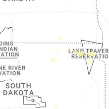

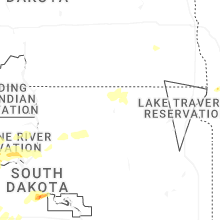
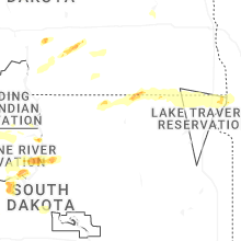
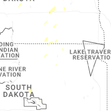


Connect with Interactive Hail Maps