

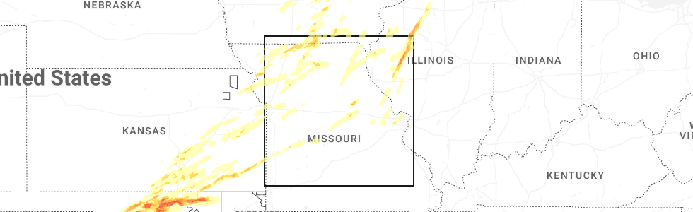
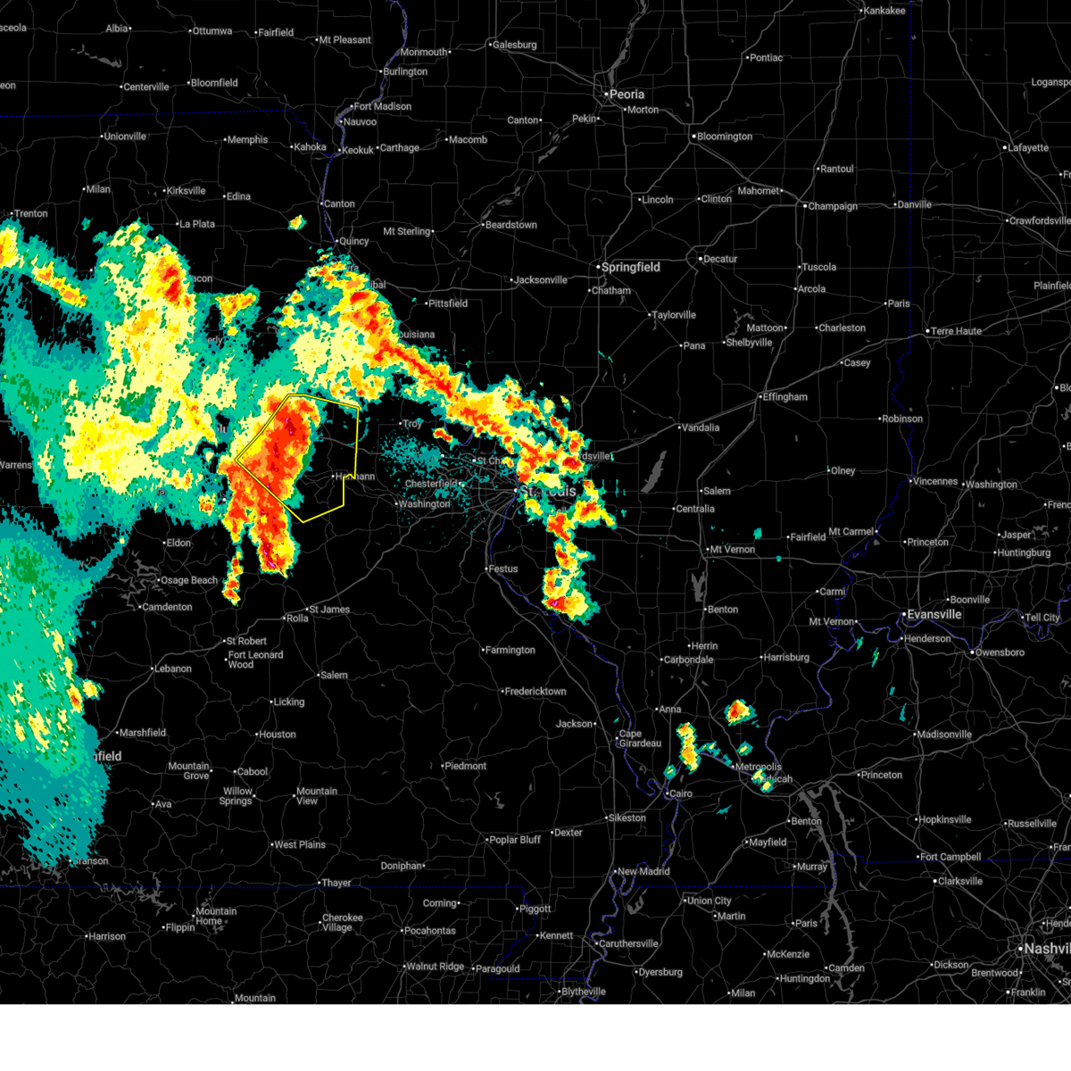
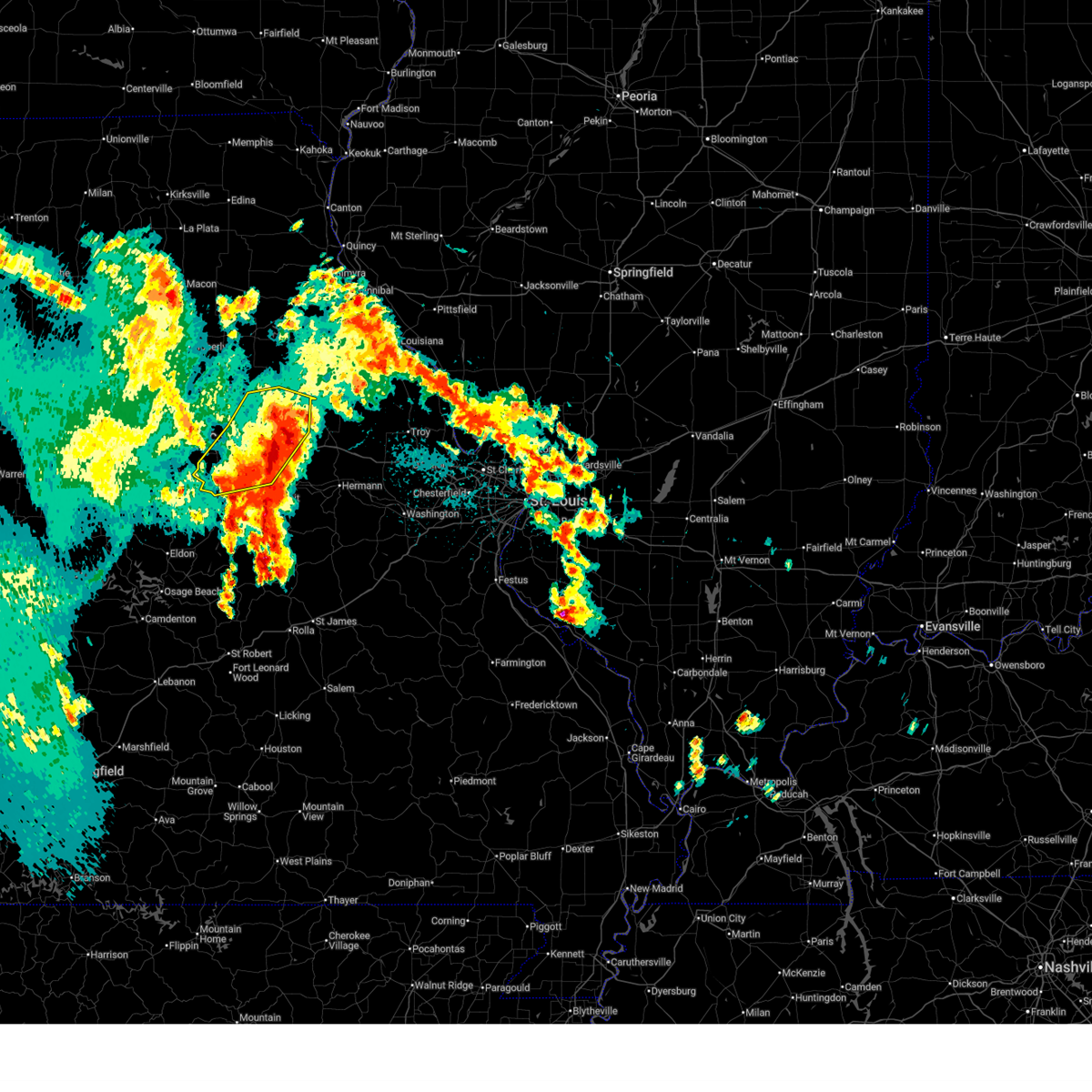
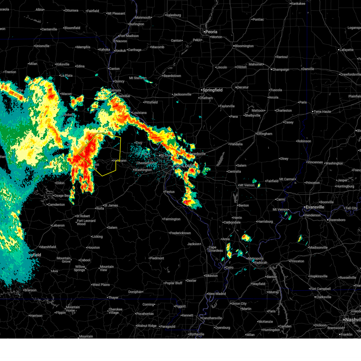
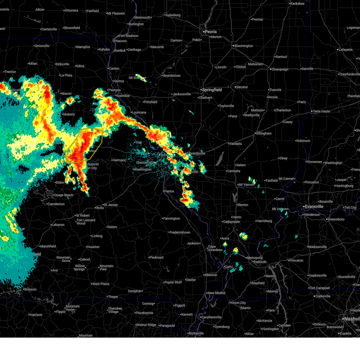
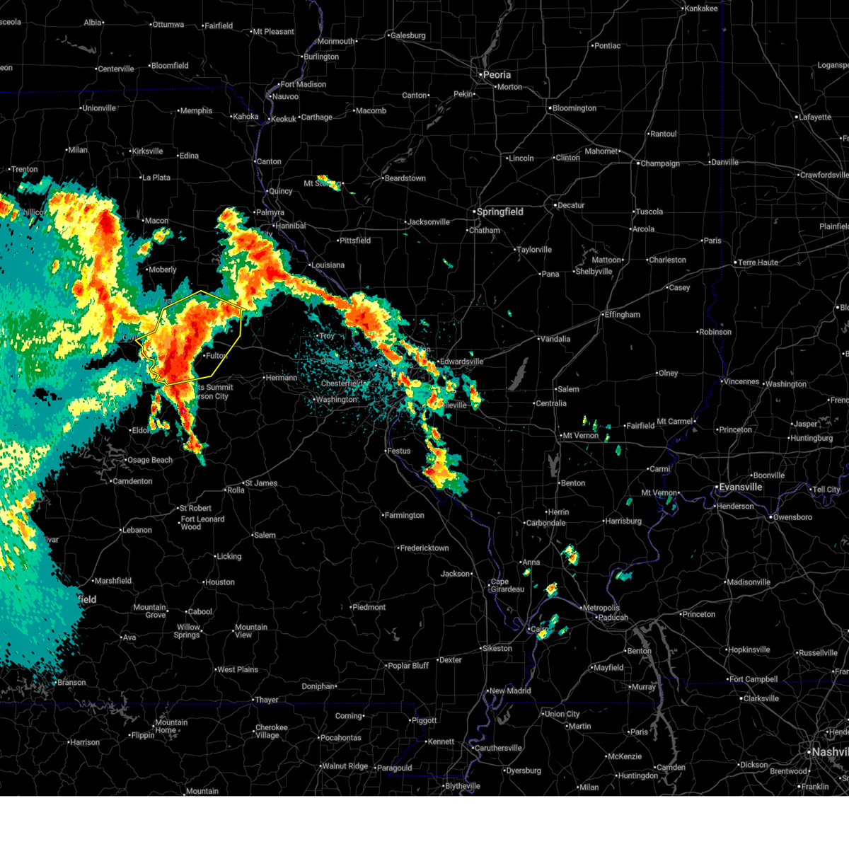
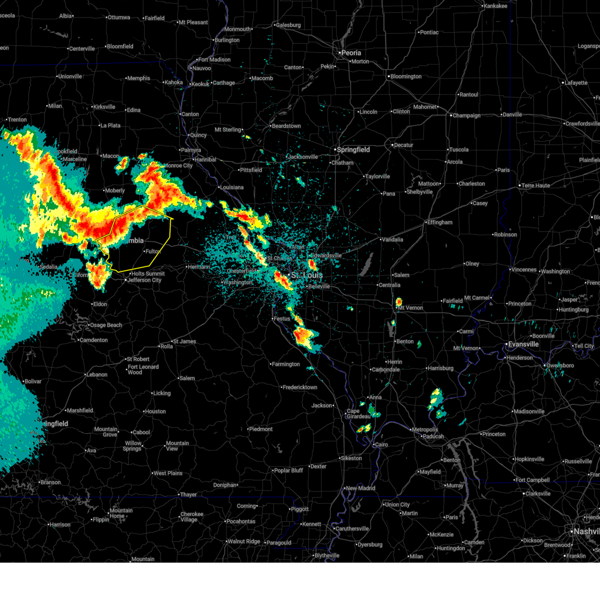
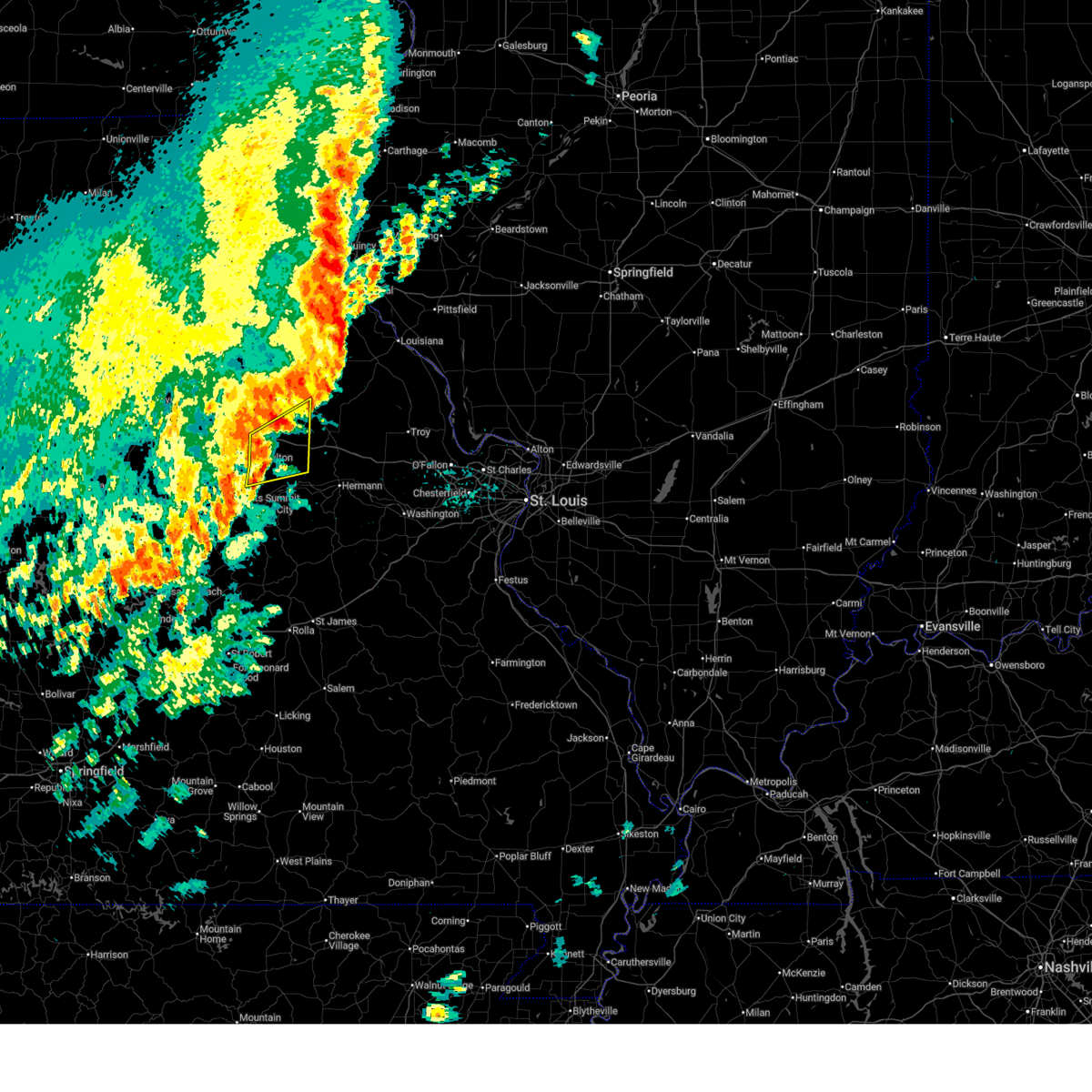
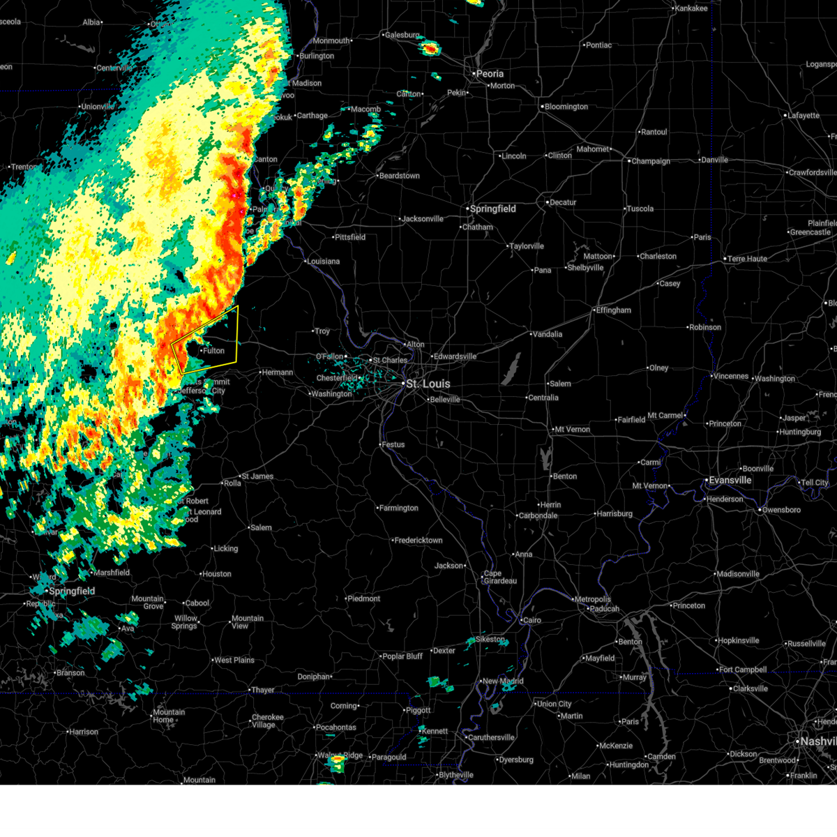
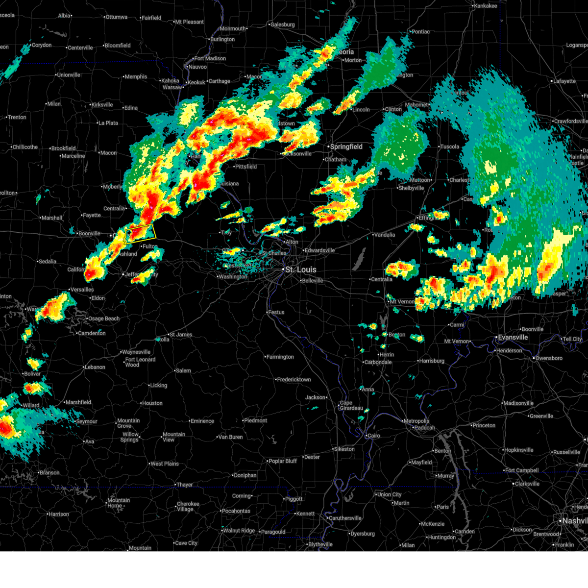
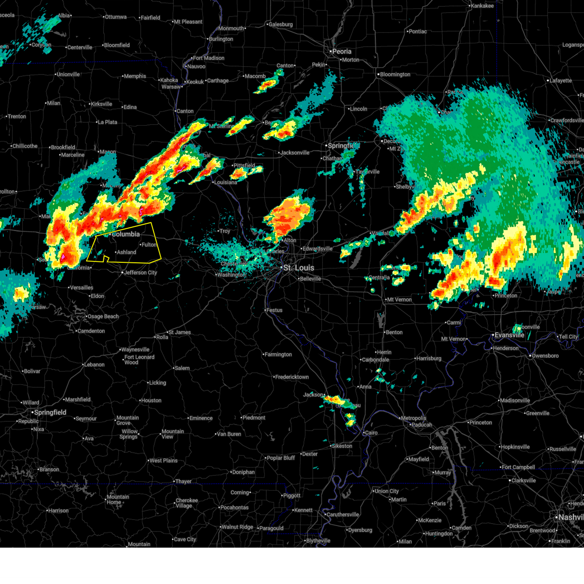
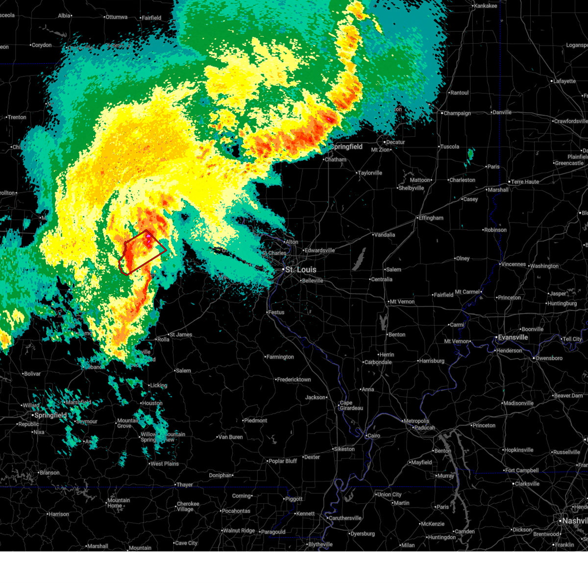
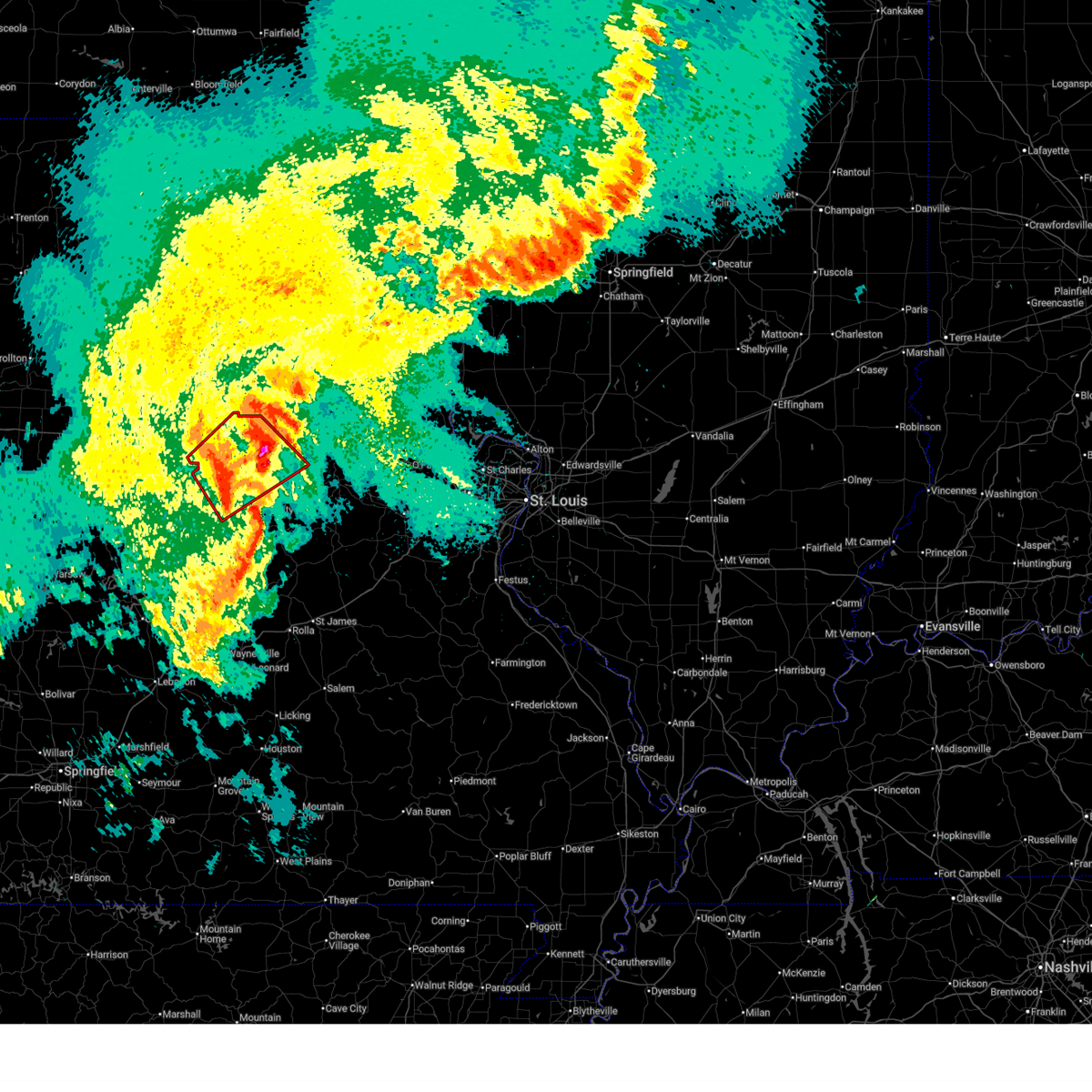
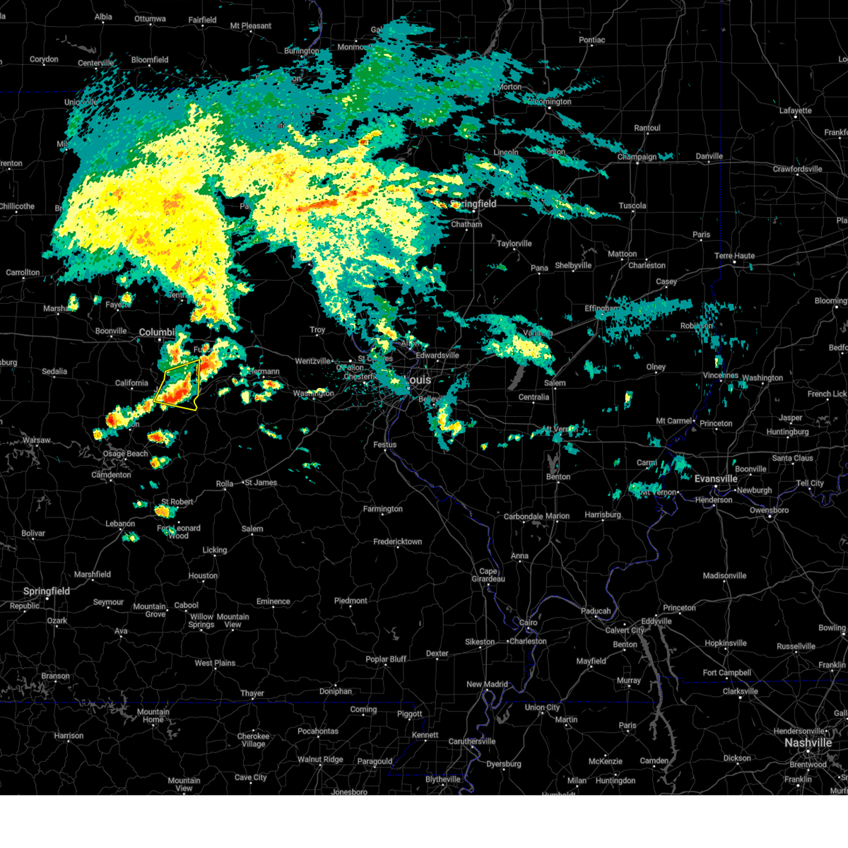
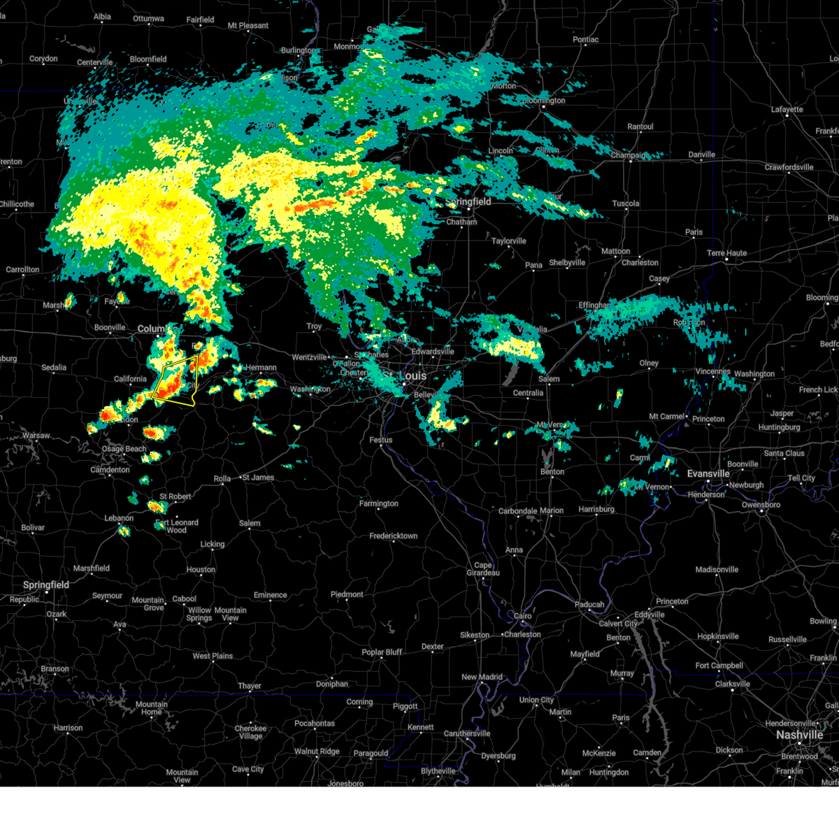
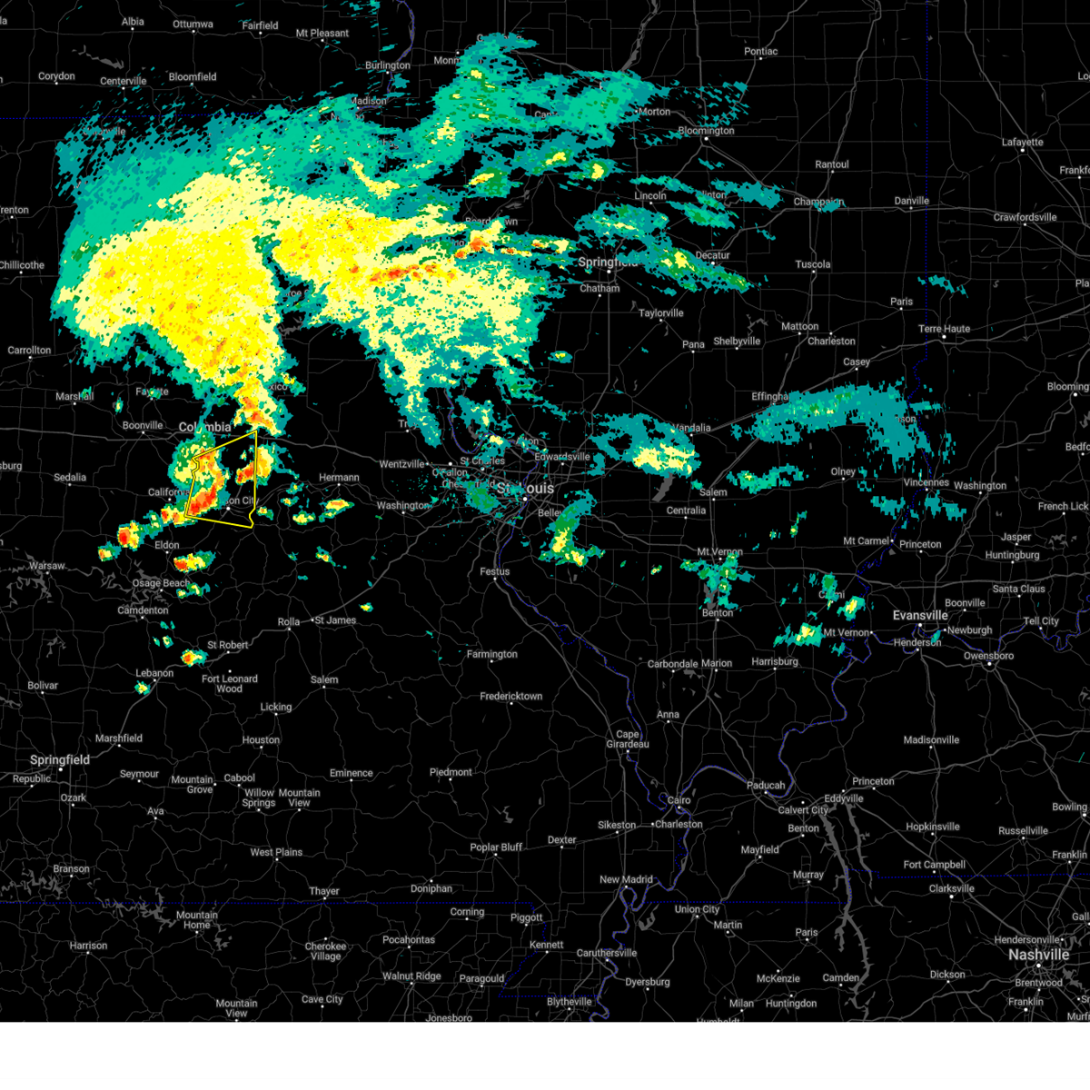
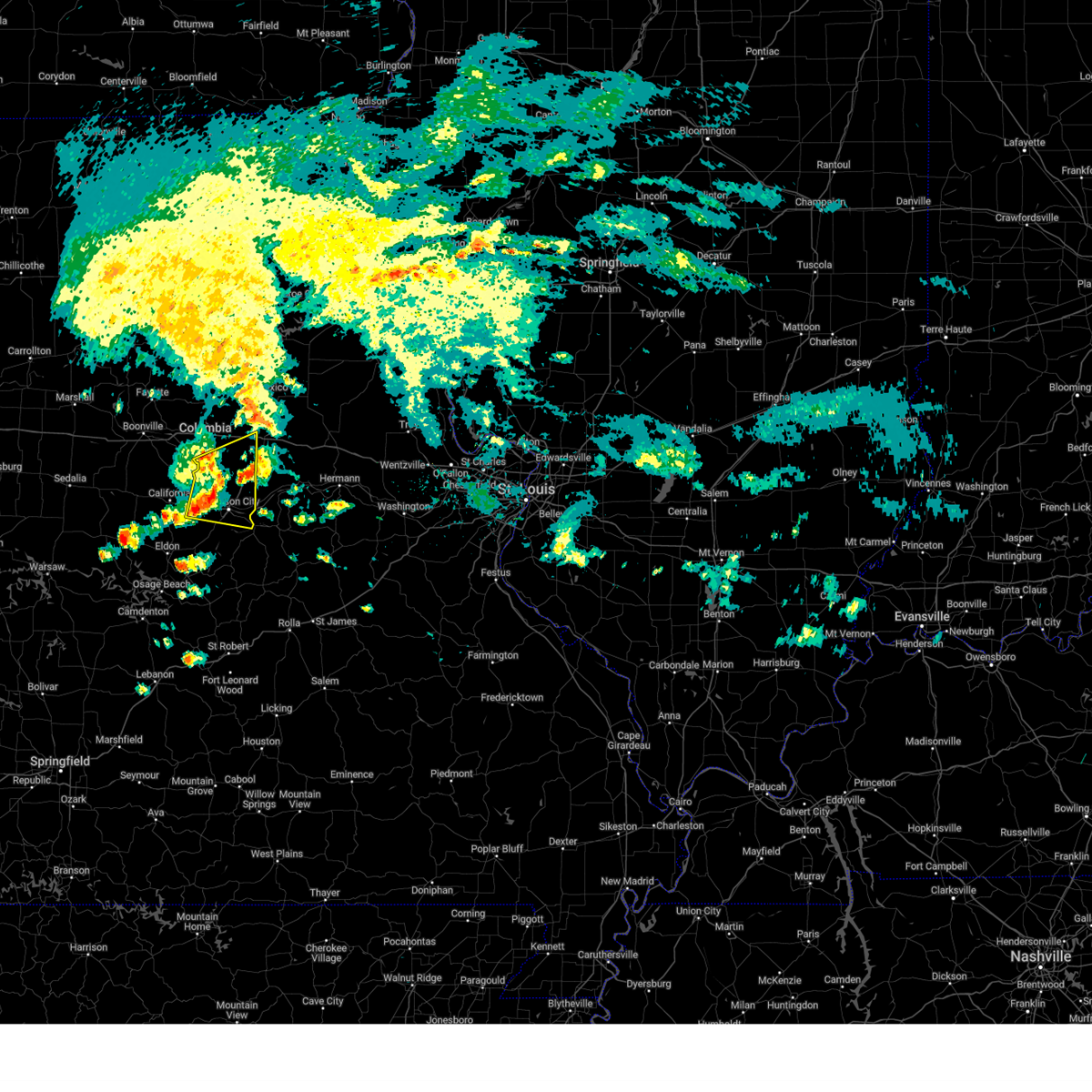
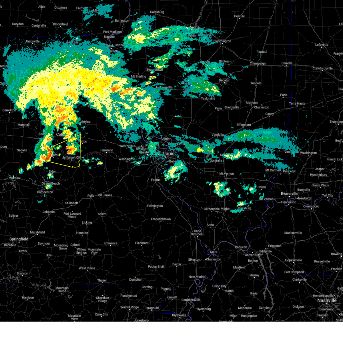
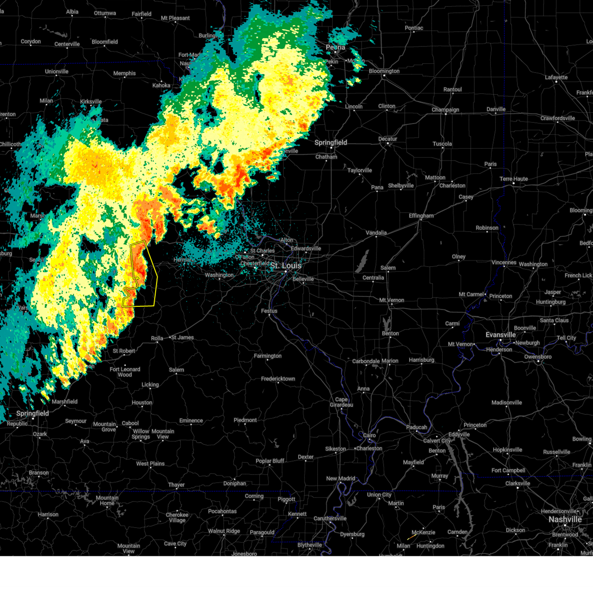
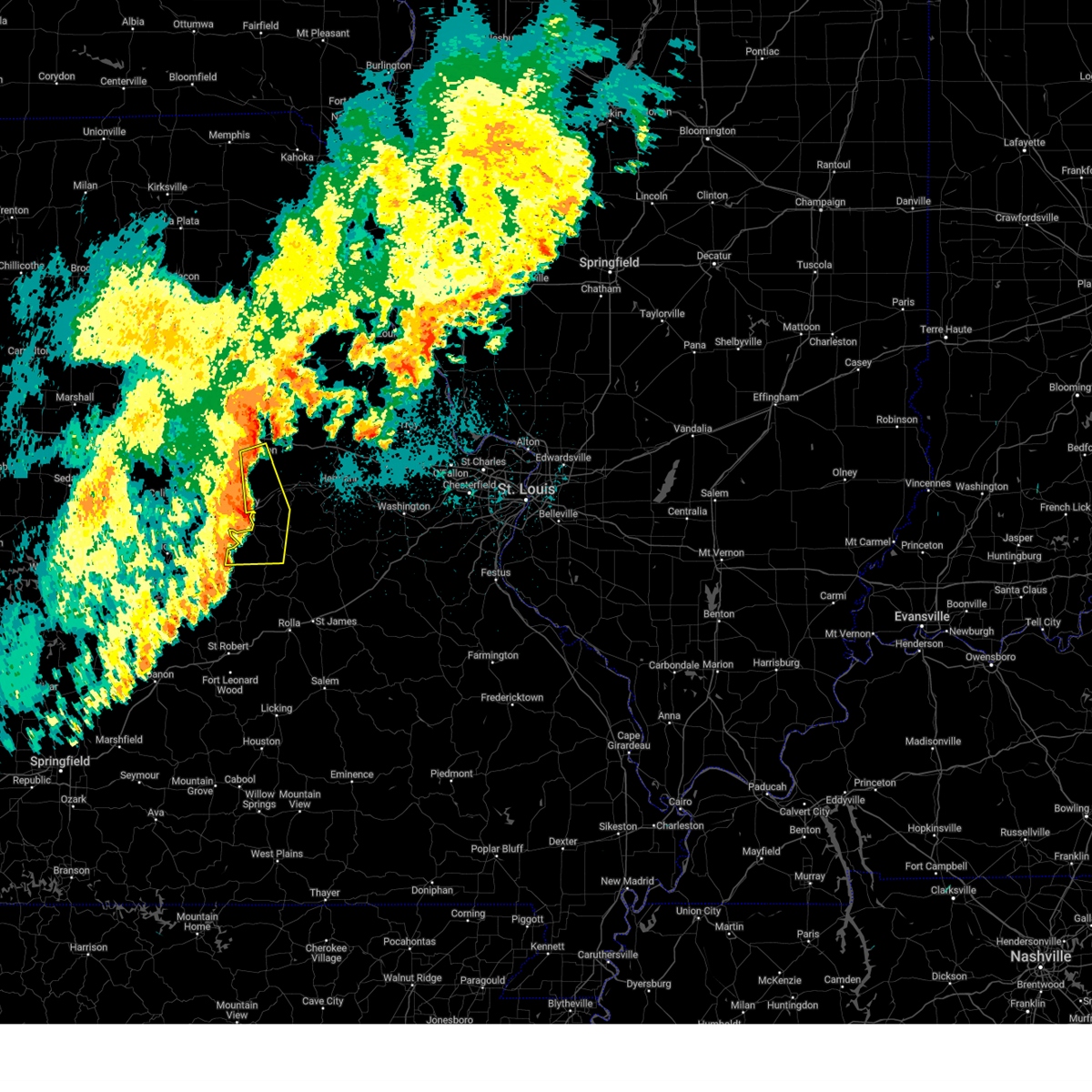
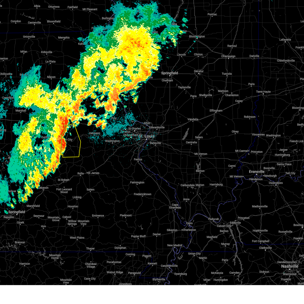
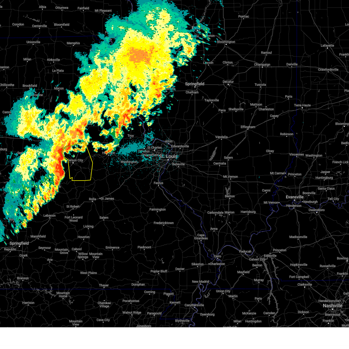
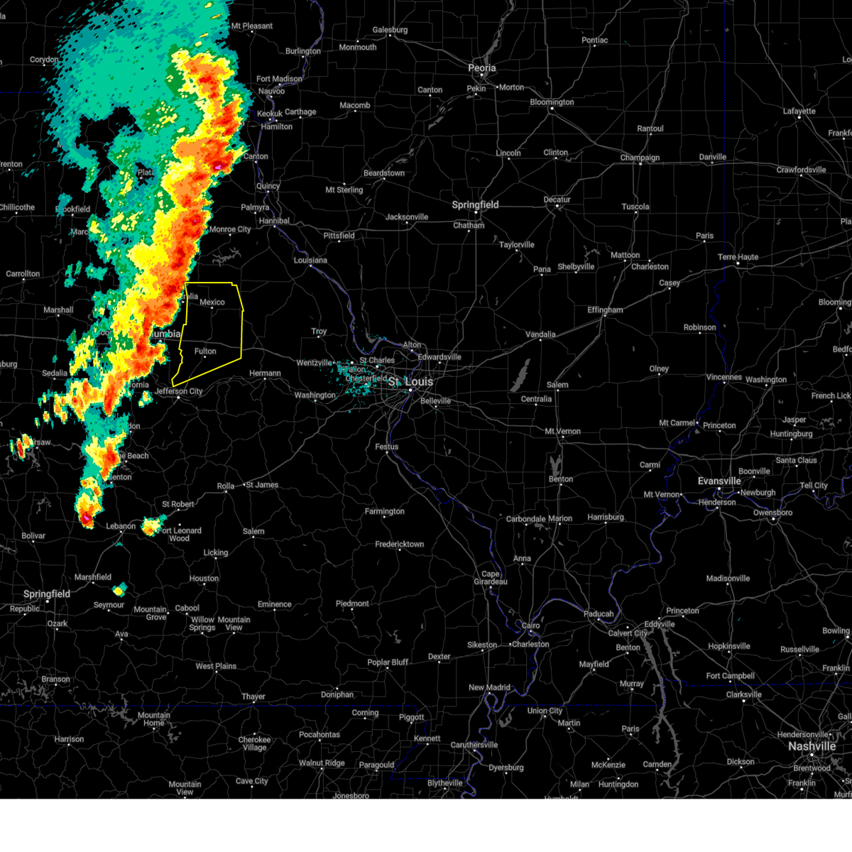
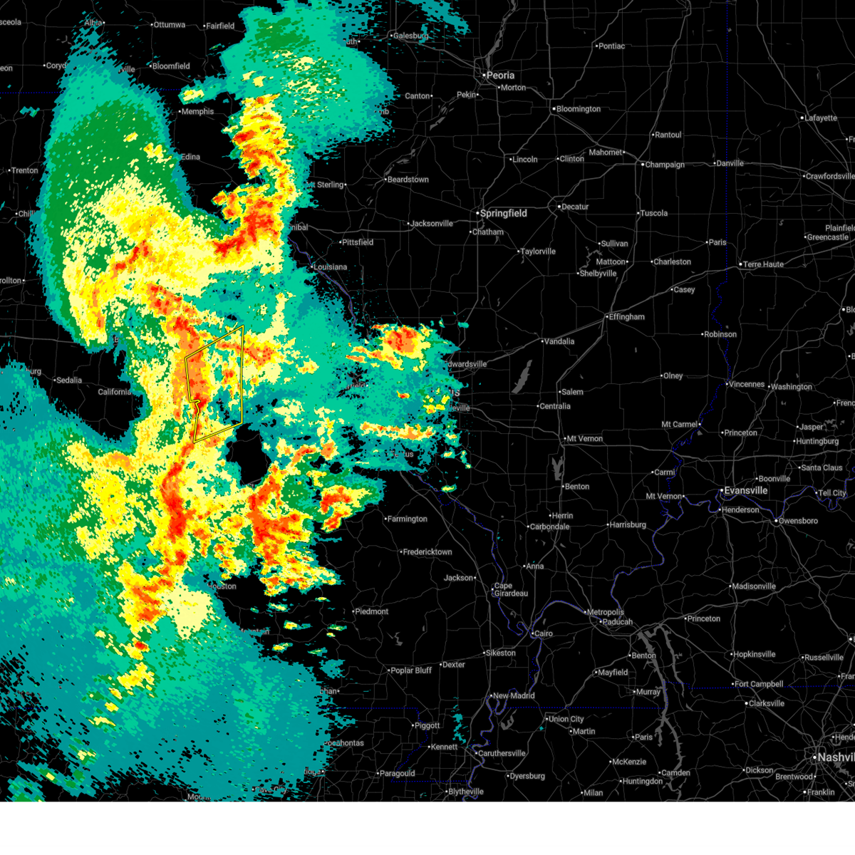
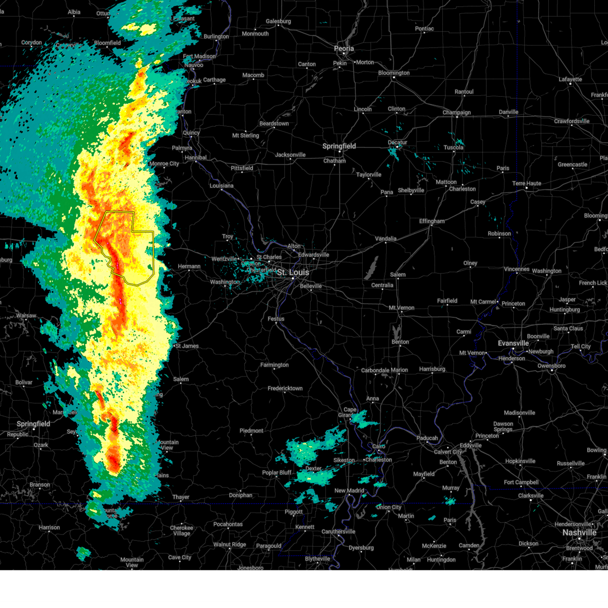
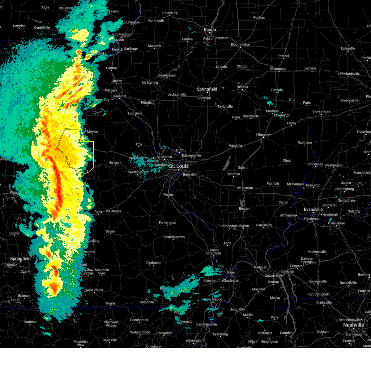
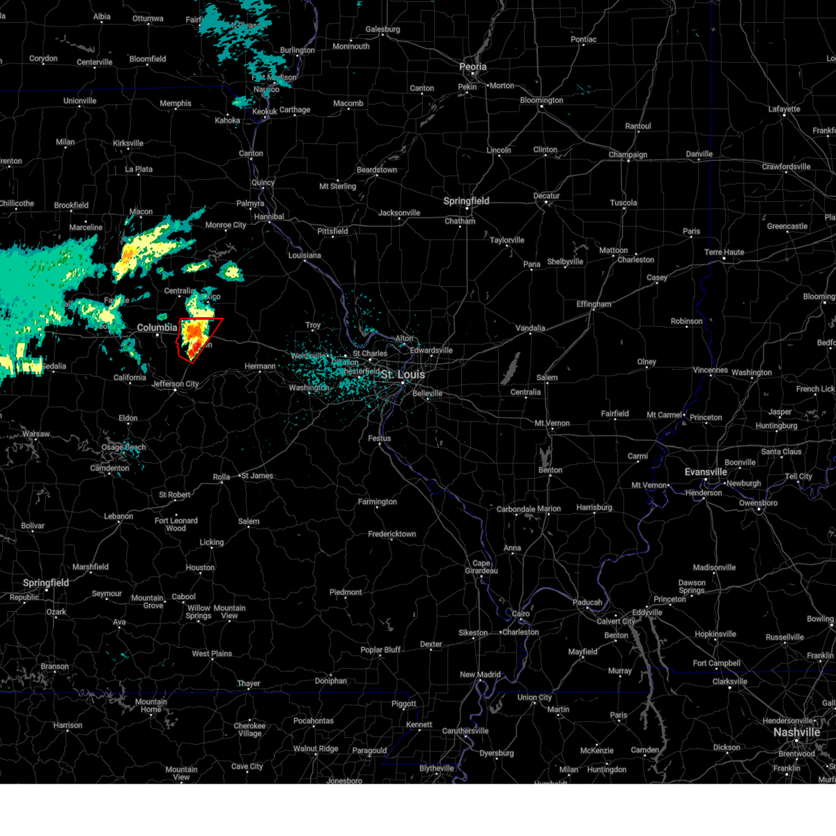
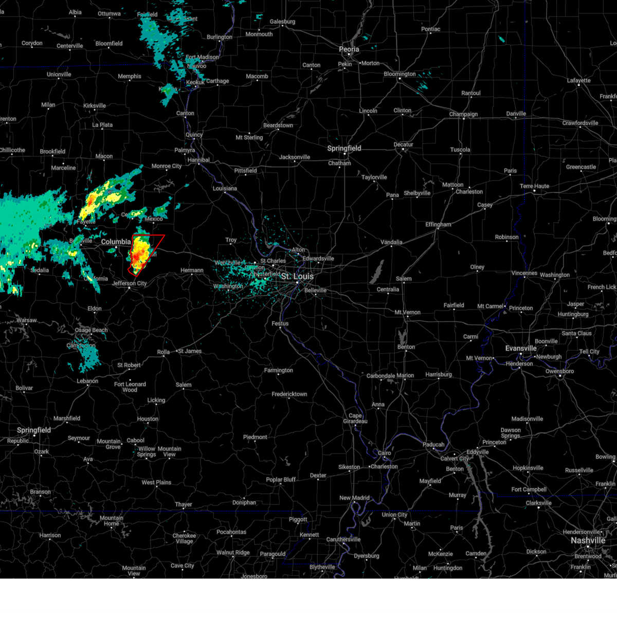
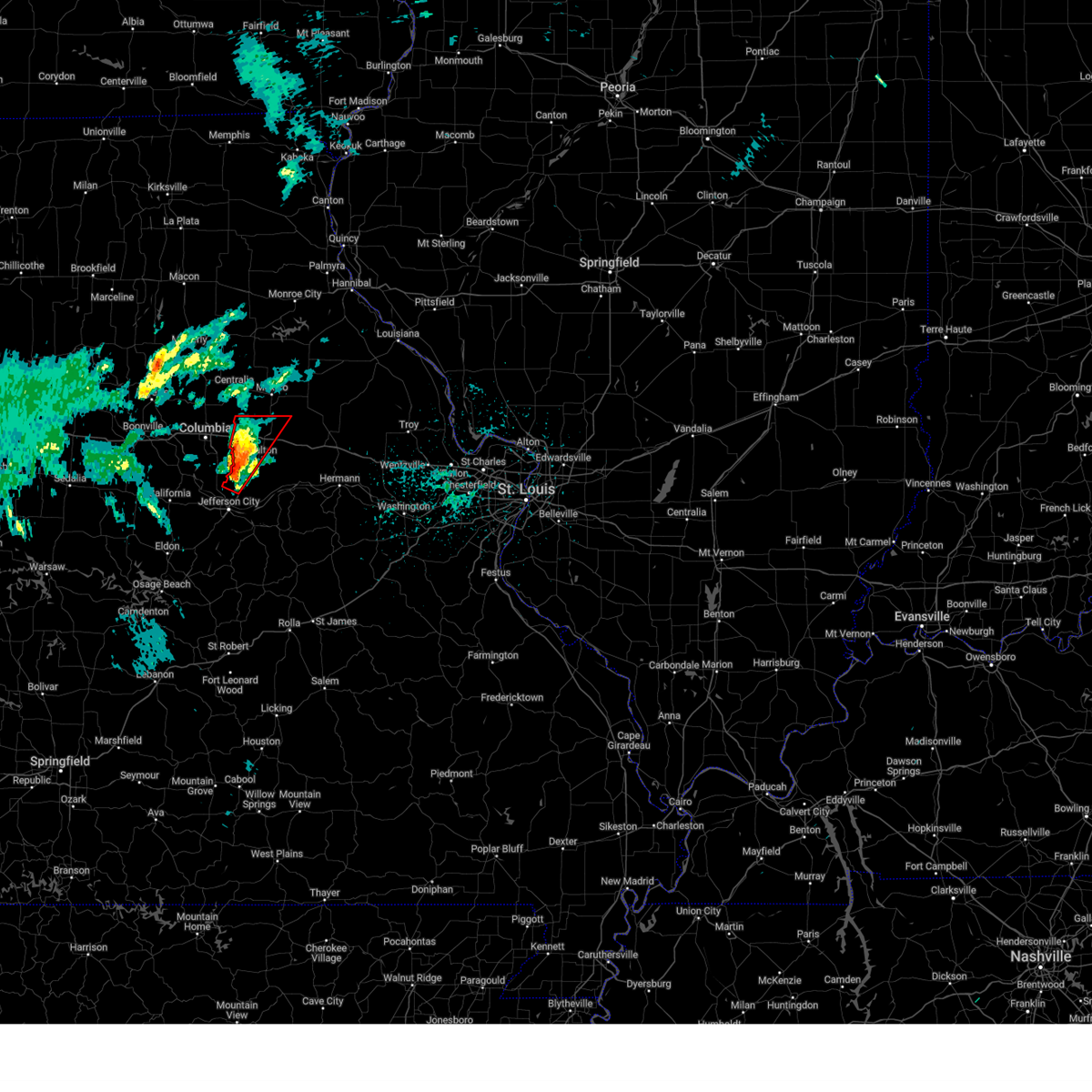
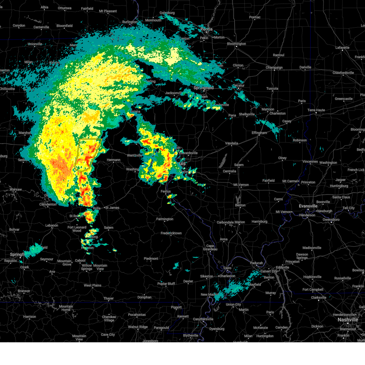
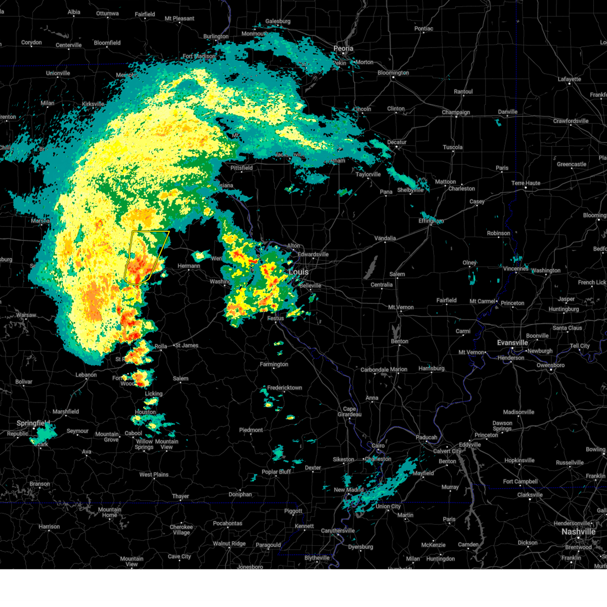
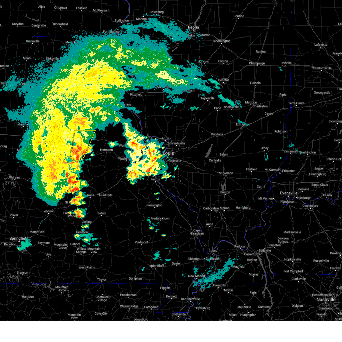
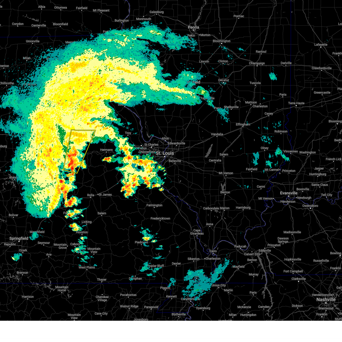
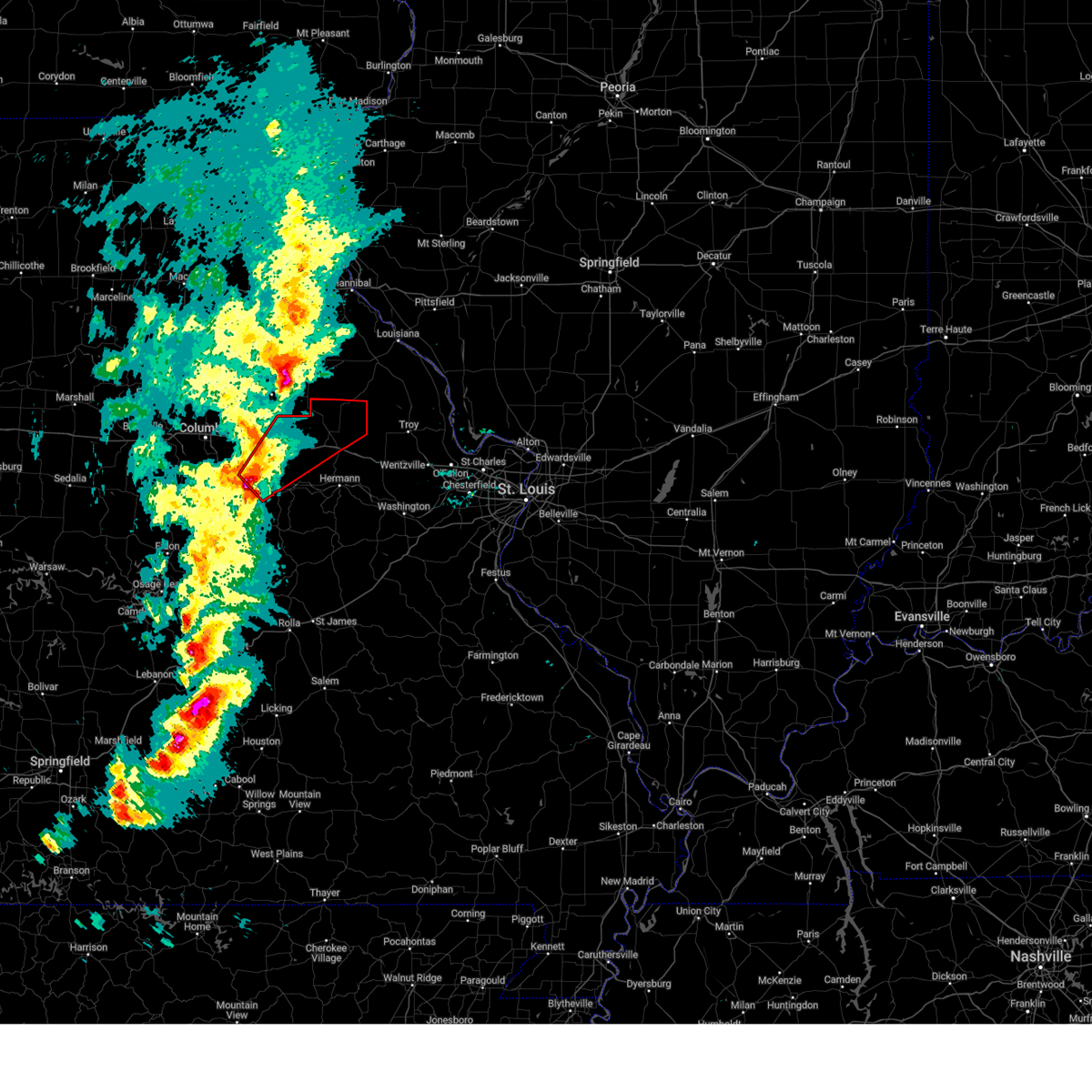
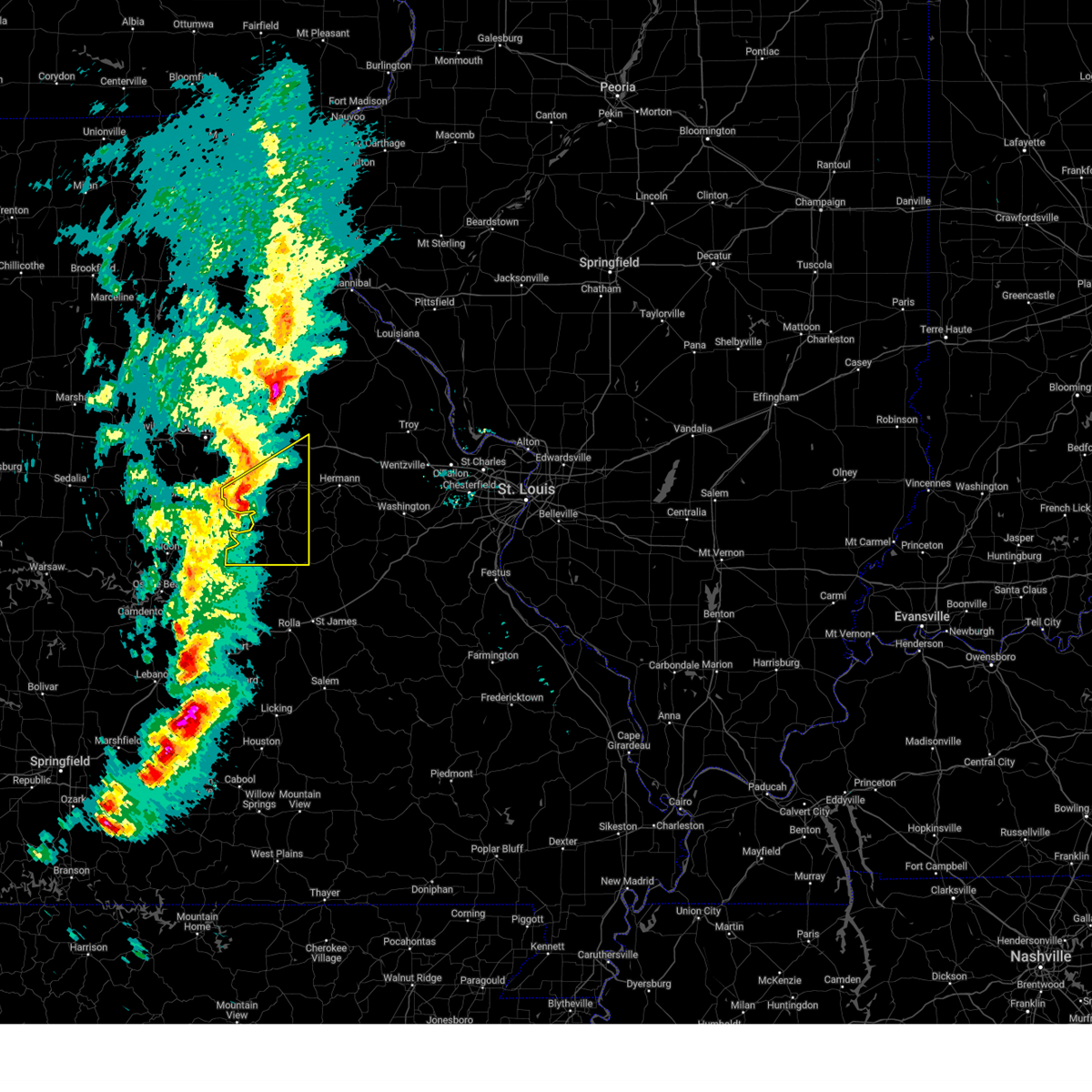
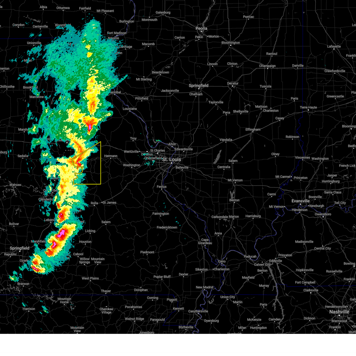
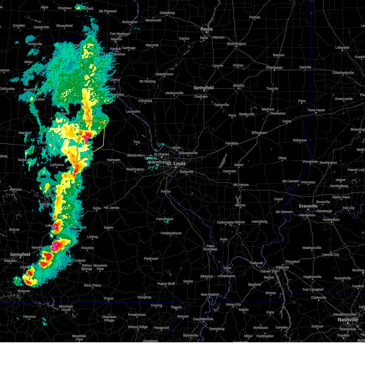
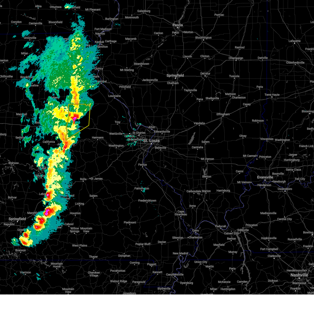
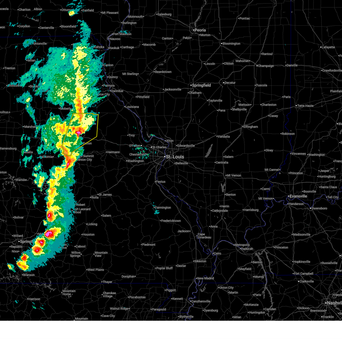
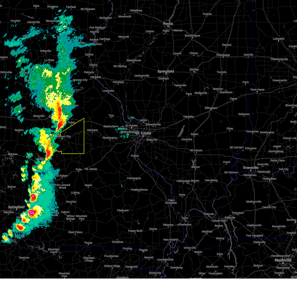
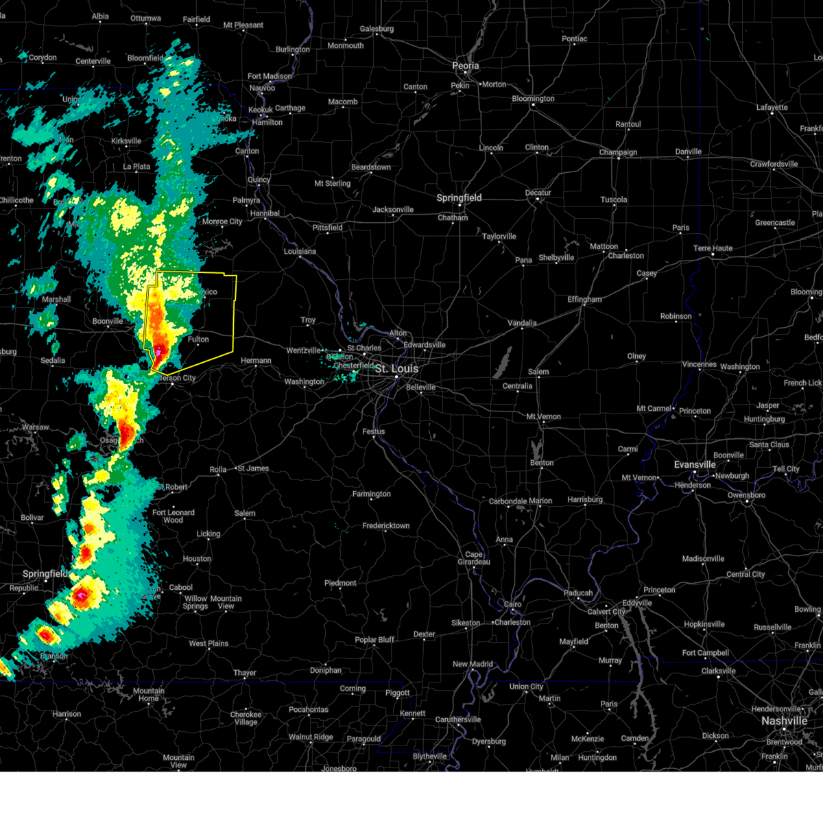
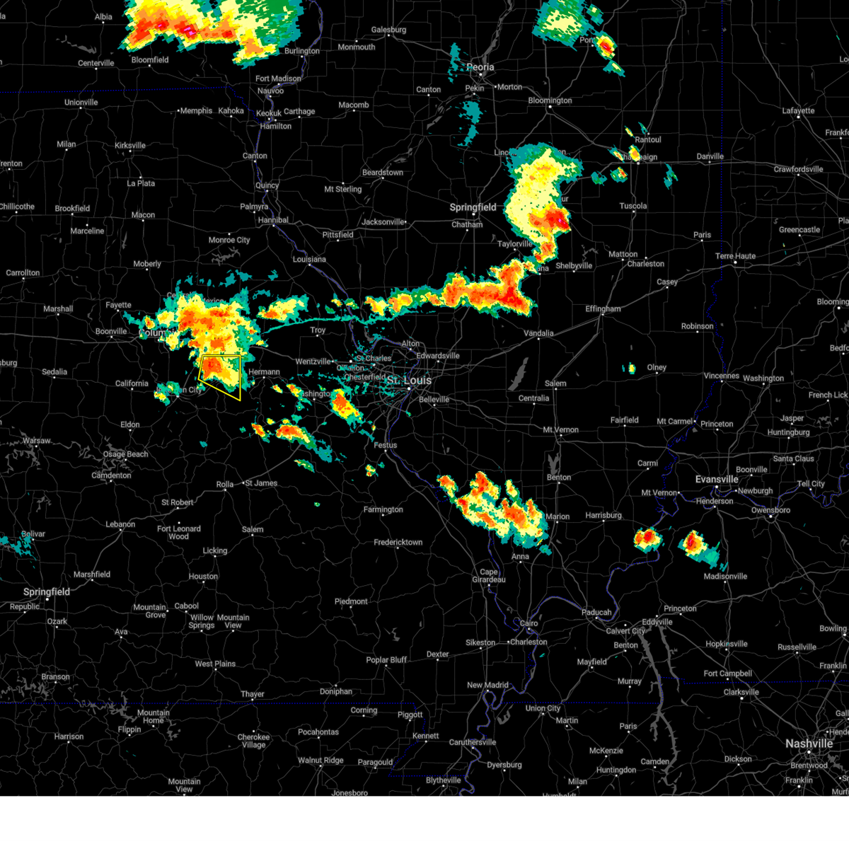
Hail Map for Fulton, MO
The Fulton, MO area has had 36 reports of on-the-ground hail by trained spotters, and has been under severe weather warnings 25 times during the past 12 months. Doppler radar has detected hail at or near Fulton, MO on 84 occasions, including 5 occasions during the past year.
| Name: | Fulton, MO |
| Where Located: | 21.2 miles ESE of Columbia, MO |
| Map: | Google Map for Fulton, MO |
| Population: | 12790 |
| Housing Units: | 4602 |
| More Info: | Search Google for Fulton, MO |
2
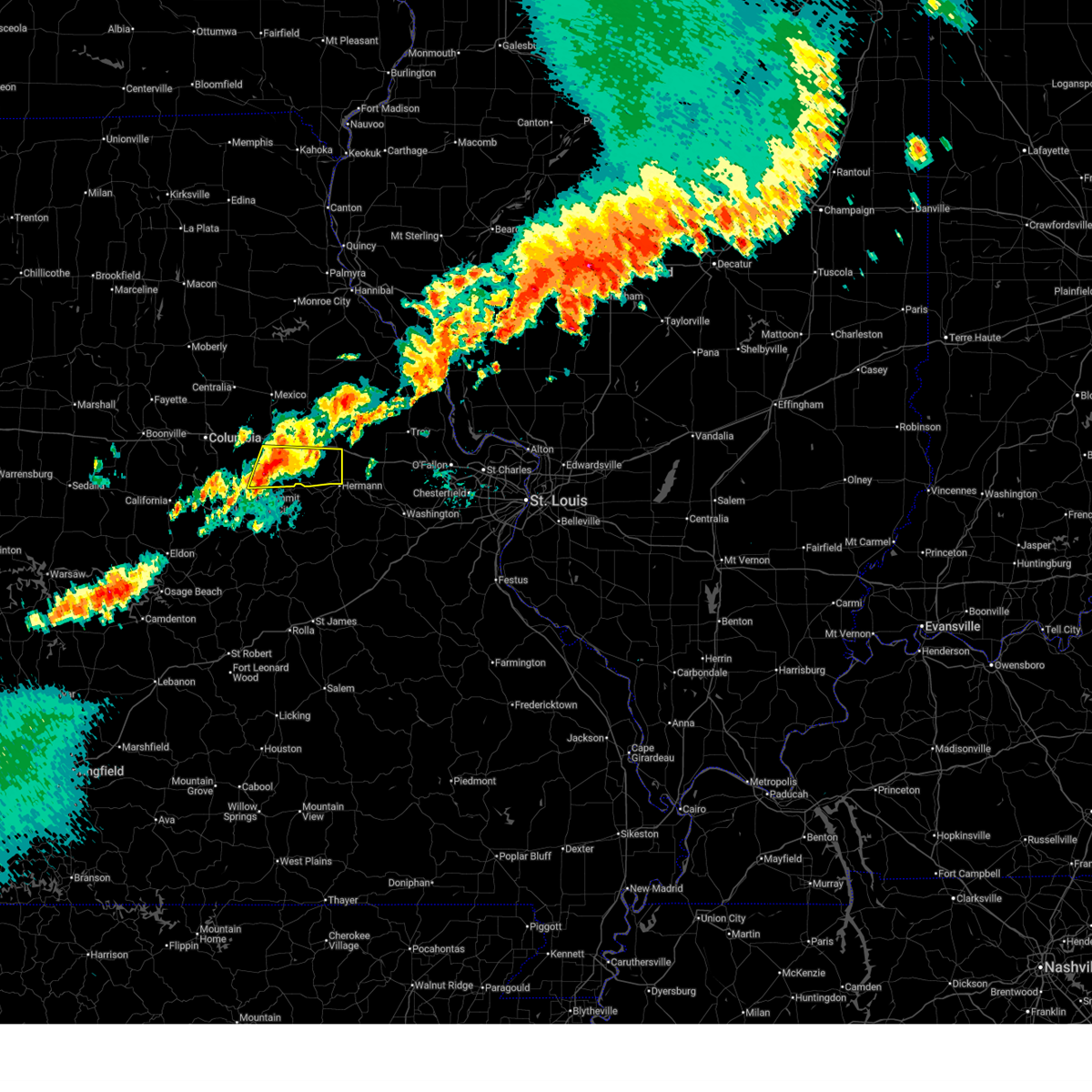
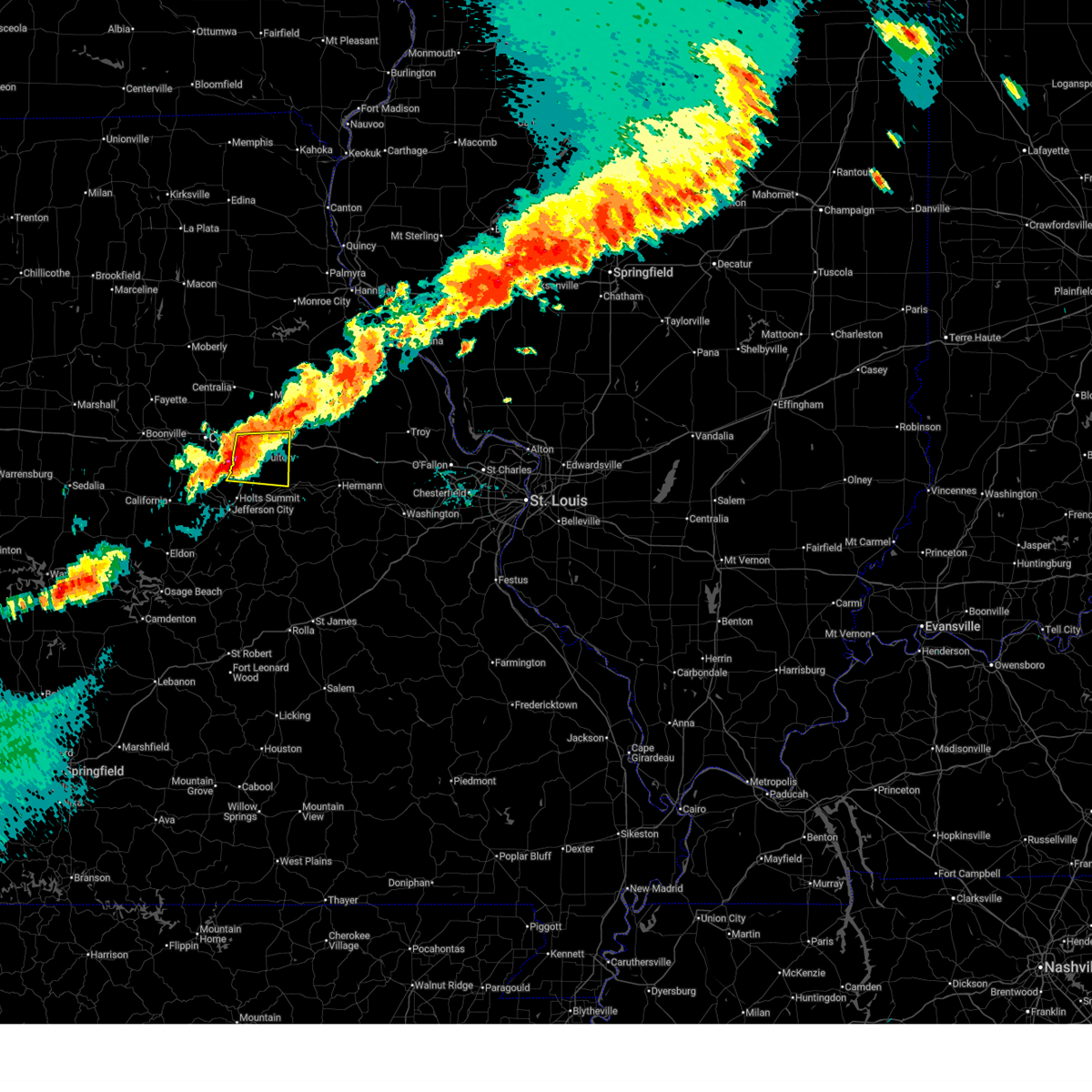
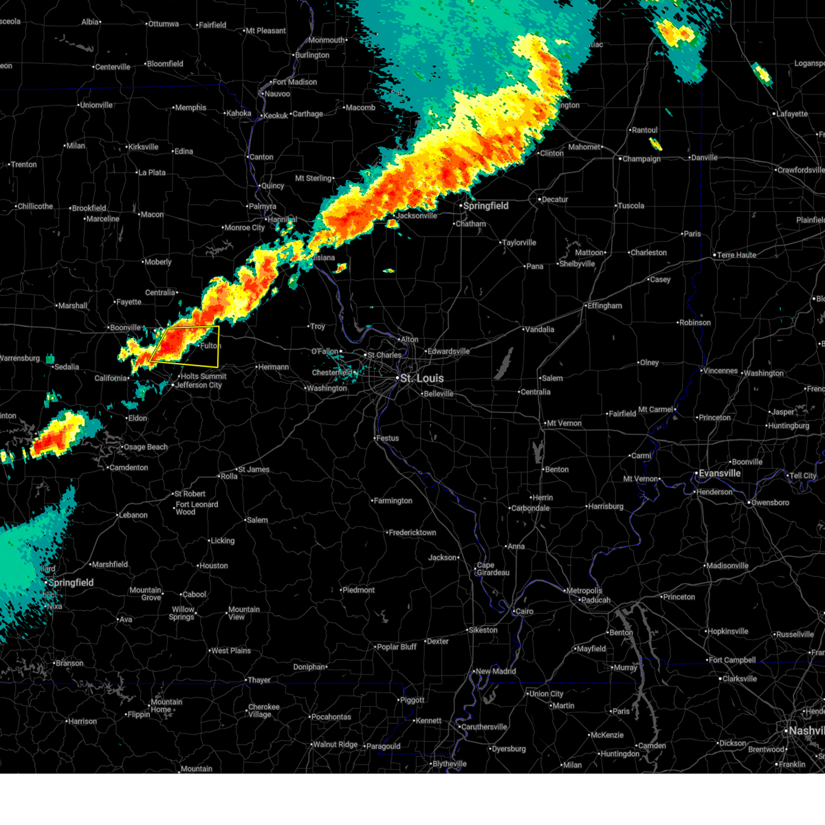
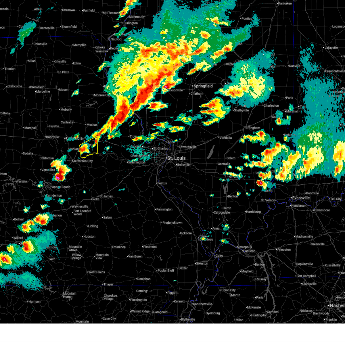
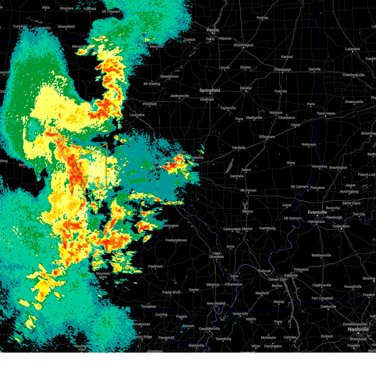
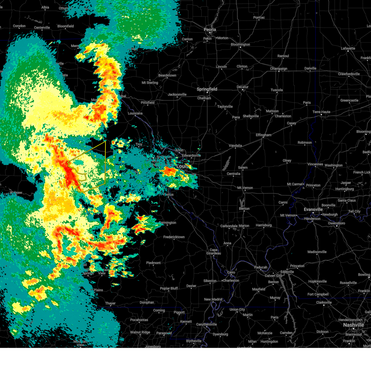
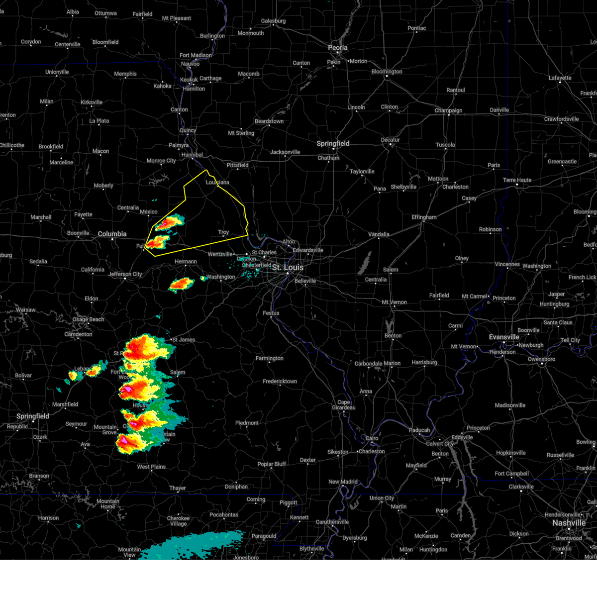
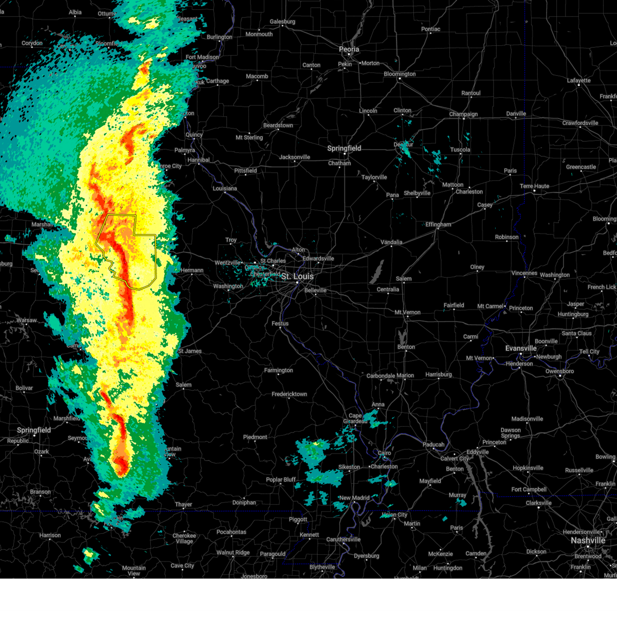
The Top Recent Hail Date for Fulton, MO is Friday, April 17, 2026 (8th out of 84)
Hail and Wind Damage Spotted near Fulton, MO
| Date / Time | Report Details |
|---|---|
| 6/11/2026 7:25 PM CDT |
 Svrlsx the national weather service in st louis has issued a * severe thunderstorm warning for, east central callaway county in central missouri, southwestern montgomery county in east central missouri, * until 815 pm cdt. * at 725 pm cdt, a severe thunderstorm was located near fulton, moving east at 35 mph (radar indicated). Hazards include 60 mph wind gusts and quarter size hail. Hail damage to vehicles is expected. Expect wind damage to roofs, siding, and trees. Svrlsx the national weather service in st louis has issued a * severe thunderstorm warning for, east central callaway county in central missouri, southwestern montgomery county in east central missouri, * until 815 pm cdt. * at 725 pm cdt, a severe thunderstorm was located near fulton, moving east at 35 mph (radar indicated). Hazards include 60 mph wind gusts and quarter size hail. Hail damage to vehicles is expected. Expect wind damage to roofs, siding, and trees.
|
| 6/11/2026 7:08 PM CDT |
 At 708 pm cdt, a severe thunderstorm was located 6 miles east of columbia regional airport, moving east at 30 mph (radar indicated). Hazards include 60 mph wind gusts and quarter size hail. Hail damage to vehicles is expected. expect wind damage to roofs, siding, and trees. locations impacted include, guthrie, new bloomfield, carrington, fulton, kingdom city, reform and steedman. This includes interstate 70 in missouri between exits 144 and 155. At 708 pm cdt, a severe thunderstorm was located 6 miles east of columbia regional airport, moving east at 30 mph (radar indicated). Hazards include 60 mph wind gusts and quarter size hail. Hail damage to vehicles is expected. expect wind damage to roofs, siding, and trees. locations impacted include, guthrie, new bloomfield, carrington, fulton, kingdom city, reform and steedman. This includes interstate 70 in missouri between exits 144 and 155.
|
| 6/11/2026 7:08 PM CDT |
 the severe thunderstorm warning has been cancelled and is no longer in effect the severe thunderstorm warning has been cancelled and is no longer in effect
|
| 6/11/2026 6:49 PM CDT |
 Svrlsx the national weather service in st louis has issued a * severe thunderstorm warning for, southeastern boone county in central missouri, central callaway county in central missouri, * until 730 pm cdt. * at 649 pm cdt, a severe thunderstorm was located over columbia regional airport, moving east at 35 mph (radar indicated). Hazards include 60 mph wind gusts and quarter size hail. Hail damage to vehicles is expected. Expect wind damage to roofs, siding, and trees. Svrlsx the national weather service in st louis has issued a * severe thunderstorm warning for, southeastern boone county in central missouri, central callaway county in central missouri, * until 730 pm cdt. * at 649 pm cdt, a severe thunderstorm was located over columbia regional airport, moving east at 35 mph (radar indicated). Hazards include 60 mph wind gusts and quarter size hail. Hail damage to vehicles is expected. Expect wind damage to roofs, siding, and trees.
|
| 6/1/2026 4:38 AM CDT |
 At 438 am cdt, severe thunderstorms were located along a line from near wellsville to 7 miles southeast of new bloomfield, or along a line from near wellsville to 8 miles east of holts summit, moving southeast at 30 mph (radar indicated). Hazards include 60 mph wind gusts and quarter size hail. Hail damage to vehicles is expected. expect wind damage to roofs, siding, and trees. locations impacted include, fulton, martinsburg, shamrock, wellsville, williamsburg, montgomery city, mokane, mineola, buell, chamois, new florence, bellflower, big spring, high hill, rhineland, gasconade, jonesburg, hermann, swiss and mount sterling. this includes the following state parks, deutschheim historic site and graham cave state park. This includes interstate 70 in missouri between exits 155 and 183. At 438 am cdt, severe thunderstorms were located along a line from near wellsville to 7 miles southeast of new bloomfield, or along a line from near wellsville to 8 miles east of holts summit, moving southeast at 30 mph (radar indicated). Hazards include 60 mph wind gusts and quarter size hail. Hail damage to vehicles is expected. expect wind damage to roofs, siding, and trees. locations impacted include, fulton, martinsburg, shamrock, wellsville, williamsburg, montgomery city, mokane, mineola, buell, chamois, new florence, bellflower, big spring, high hill, rhineland, gasconade, jonesburg, hermann, swiss and mount sterling. this includes the following state parks, deutschheim historic site and graham cave state park. This includes interstate 70 in missouri between exits 155 and 183.
|
| 6/1/2026 4:25 AM CDT |
 The severe thunderstorm warning that was previously in effect has been reissued for audrain and callaway counties and is in effect until 500 am cdt. please refer to that bulletin for the latest severe weather information. a severe thunderstorm watch remains in effect until 900 am cdt for a portion of central missouri. The severe thunderstorm warning that was previously in effect has been reissued for audrain and callaway counties and is in effect until 500 am cdt. please refer to that bulletin for the latest severe weather information. a severe thunderstorm watch remains in effect until 900 am cdt for a portion of central missouri.
|
| 6/1/2026 4:22 AM CDT |
 Svrlsx the national weather service in st louis has issued a * severe thunderstorm warning for, south central audrain county in central missouri, callaway county in central missouri, northeastern osage county in central missouri, northern gasconade county in east central missouri, montgomery county in east central missouri, west central warren county in east central missouri, * until 500 am cdt. * at 422 am cdt, severe thunderstorms were located along a line from over martinsburg to over new bloomfield, or along a line from near wellsville to 7 miles north of holts summit, moving southeast at 30 mph (radar indicated). Hazards include ping pong ball size hail and 60 mph wind gusts. People and animals outdoors will be injured. expect hail damage to roofs, siding, windows, and vehicles. Expect wind damage to roofs, siding, and trees. Svrlsx the national weather service in st louis has issued a * severe thunderstorm warning for, south central audrain county in central missouri, callaway county in central missouri, northeastern osage county in central missouri, northern gasconade county in east central missouri, montgomery county in east central missouri, west central warren county in east central missouri, * until 500 am cdt. * at 422 am cdt, severe thunderstorms were located along a line from over martinsburg to over new bloomfield, or along a line from near wellsville to 7 miles north of holts summit, moving southeast at 30 mph (radar indicated). Hazards include ping pong ball size hail and 60 mph wind gusts. People and animals outdoors will be injured. expect hail damage to roofs, siding, windows, and vehicles. Expect wind damage to roofs, siding, and trees.
|
| 6/1/2026 4:15 AM CDT |
 At 415 am cdt, severe thunderstorms were located along a line from 7 miles south of auxvasse to over ashland, or along a line from 7 miles northeast of fulton to over ashland, moving southeast at 20 mph (radar indicated). Hazards include 60 mph wind gusts and quarter size hail. Hail damage to vehicles is expected. expect wind damage to roofs, siding, and trees. locations impacted include, vandiver, hatton, mexico, easley, benton city, auxvasse, columbia regional airport, kingdom city, ashland, fulton, martinsburg, carrington, hartsburg, shamrock, guthrie, new bloomfield, lake mykee town, lake mykee and williamsburg. this includes the following state parks, rock bridge state park. This includes interstate 70 in missouri between exits 133 and 155. At 415 am cdt, severe thunderstorms were located along a line from 7 miles south of auxvasse to over ashland, or along a line from 7 miles northeast of fulton to over ashland, moving southeast at 20 mph (radar indicated). Hazards include 60 mph wind gusts and quarter size hail. Hail damage to vehicles is expected. expect wind damage to roofs, siding, and trees. locations impacted include, vandiver, hatton, mexico, easley, benton city, auxvasse, columbia regional airport, kingdom city, ashland, fulton, martinsburg, carrington, hartsburg, shamrock, guthrie, new bloomfield, lake mykee town, lake mykee and williamsburg. this includes the following state parks, rock bridge state park. This includes interstate 70 in missouri between exits 133 and 155.
|
| 6/1/2026 4:04 AM CDT |
 At 404 am cdt, severe thunderstorms were located along a line from near auxvasse to over ashland, or along a line from 8 miles north of fulton to over ashland, moving southeast at 20 mph (radar indicated). Hazards include 60 mph wind gusts and quarter size hail. Hail damage to vehicles is expected. expect wind damage to roofs, siding, and trees. locations impacted include, hallsville, centralia, columbia, murry, mexico, easley, benton city, auxvasse, columbia regional airport, kingdom city, ashland, fulton, martinsburg, hartsburg, shamrock, new bloomfield, lake mykee town, lake mykee and williamsburg. this includes the following state parks, rock bridge state park, finger lakes state park and jewell cemetery historic site. This includes interstate 70 in missouri between exits 121 and 155. At 404 am cdt, severe thunderstorms were located along a line from near auxvasse to over ashland, or along a line from 8 miles north of fulton to over ashland, moving southeast at 20 mph (radar indicated). Hazards include 60 mph wind gusts and quarter size hail. Hail damage to vehicles is expected. expect wind damage to roofs, siding, and trees. locations impacted include, hallsville, centralia, columbia, murry, mexico, easley, benton city, auxvasse, columbia regional airport, kingdom city, ashland, fulton, martinsburg, hartsburg, shamrock, new bloomfield, lake mykee town, lake mykee and williamsburg. this includes the following state parks, rock bridge state park, finger lakes state park and jewell cemetery historic site. This includes interstate 70 in missouri between exits 121 and 155.
|
| 6/1/2026 3:33 AM CDT |
 Svrlsx the national weather service in st louis has issued a * severe thunderstorm warning for, southern audrain county in central missouri, boone county in central missouri, callaway county in central missouri, * until 430 am cdt. * at 333 am cdt, severe thunderstorms were located along a line from 8 miles northeast of murry to 6 miles south of midway, or along a line from 10 miles southeast of centralia to 7 miles southwest of columbia, moving southeast at 20 mph (radar indicated). Hazards include 60 mph wind gusts and quarter size hail. Hail damage to vehicles is expected. Expect wind damage to roofs, siding, and trees. Svrlsx the national weather service in st louis has issued a * severe thunderstorm warning for, southern audrain county in central missouri, boone county in central missouri, callaway county in central missouri, * until 430 am cdt. * at 333 am cdt, severe thunderstorms were located along a line from 8 miles northeast of murry to 6 miles south of midway, or along a line from 10 miles southeast of centralia to 7 miles southwest of columbia, moving southeast at 20 mph (radar indicated). Hazards include 60 mph wind gusts and quarter size hail. Hail damage to vehicles is expected. Expect wind damage to roofs, siding, and trees.
|
| 5/18/2026 6:32 AM CDT |
 the severe thunderstorm warning has been cancelled and is no longer in effect the severe thunderstorm warning has been cancelled and is no longer in effect
|
| 5/18/2026 6:32 AM CDT |
 At 632 am cdt, a severe thunderstorm was located near fulton, moving east at 45 mph (radar indicated). Hazards include 60 mph wind gusts and small hail. Expect damage to roofs, siding, and trees. locations impacted include, fulton, kingdom city, auxvasse, reform, williamsburg, shamrock and martinsburg. This includes interstate 70 in missouri between exits 144 and 161. At 632 am cdt, a severe thunderstorm was located near fulton, moving east at 45 mph (radar indicated). Hazards include 60 mph wind gusts and small hail. Expect damage to roofs, siding, and trees. locations impacted include, fulton, kingdom city, auxvasse, reform, williamsburg, shamrock and martinsburg. This includes interstate 70 in missouri between exits 144 and 161.
|
| 5/18/2026 6:18 AM CDT |
 Svrlsx the national weather service in st louis has issued a * severe thunderstorm warning for, south central audrain county in central missouri, east central boone county in central missouri, callaway county in central missouri, * until 700 am cdt. * at 618 am cdt, a severe thunderstorm was located 8 miles north of new bloomfield, or 7 miles west of fulton, moving east at 45 mph. at 605 am, 71 mph winds were reported at the columbia airport (radar indicated). Hazards include 70 mph wind gusts and quarter size hail. Hail damage to vehicles is expected. expect considerable tree damage. Wind damage is also likely to mobile homes, roofs, and outbuildings. Svrlsx the national weather service in st louis has issued a * severe thunderstorm warning for, south central audrain county in central missouri, east central boone county in central missouri, callaway county in central missouri, * until 700 am cdt. * at 618 am cdt, a severe thunderstorm was located 8 miles north of new bloomfield, or 7 miles west of fulton, moving east at 45 mph. at 605 am, 71 mph winds were reported at the columbia airport (radar indicated). Hazards include 70 mph wind gusts and quarter size hail. Hail damage to vehicles is expected. expect considerable tree damage. Wind damage is also likely to mobile homes, roofs, and outbuildings.
|
| 4/27/2026 5:23 PM CDT |
 At 523 pm cdt, a severe thunderstorm was located 7 miles southeast of fulton, moving east at 65 mph (radar indicated). Hazards include 60 mph wind gusts and quarter size hail. Hail damage to vehicles is expected. expect wind damage to roofs, siding, and trees. this severe thunderstorm will be near, fulton and chamois around 525 pm cdt. williamsburg around 535 pm cdt. other locations impacted by the severe thunderstorm include steedman, mokane, reform and portland. This includes interstate 70 in missouri near exit 161. At 523 pm cdt, a severe thunderstorm was located 7 miles southeast of fulton, moving east at 65 mph (radar indicated). Hazards include 60 mph wind gusts and quarter size hail. Hail damage to vehicles is expected. expect wind damage to roofs, siding, and trees. this severe thunderstorm will be near, fulton and chamois around 525 pm cdt. williamsburg around 535 pm cdt. other locations impacted by the severe thunderstorm include steedman, mokane, reform and portland. This includes interstate 70 in missouri near exit 161.
|
| 4/27/2026 5:09 PM CDT |
 Svrlsx the national weather service in st louis has issued a * severe thunderstorm warning for, central callaway county in central missouri, * until 600 pm cdt. * at 509 pm cdt, a severe thunderstorm was located over lake mykee town, or near holts summit, moving east at 65 mph (radar indicated). Hazards include ping pong ball size hail and 60 mph wind gusts. People and animals outdoors will be injured. expect hail damage to roofs, siding, windows, and vehicles. expect wind damage to roofs, siding, and trees. this severe thunderstorm will be near, new bloomfield, lake mykee town, lake mykee and holts summit around 510 pm cdt. fulton around 520 pm cdt. chamois around 525 pm cdt. other locations impacted by the severe thunderstorm include guthrie, carrington, mokane, steedman, reform and portland. This includes interstate 70 in missouri near exit 161. Svrlsx the national weather service in st louis has issued a * severe thunderstorm warning for, central callaway county in central missouri, * until 600 pm cdt. * at 509 pm cdt, a severe thunderstorm was located over lake mykee town, or near holts summit, moving east at 65 mph (radar indicated). Hazards include ping pong ball size hail and 60 mph wind gusts. People and animals outdoors will be injured. expect hail damage to roofs, siding, windows, and vehicles. expect wind damage to roofs, siding, and trees. this severe thunderstorm will be near, new bloomfield, lake mykee town, lake mykee and holts summit around 510 pm cdt. fulton around 520 pm cdt. chamois around 525 pm cdt. other locations impacted by the severe thunderstorm include guthrie, carrington, mokane, steedman, reform and portland. This includes interstate 70 in missouri near exit 161.
|
| 4/27/2026 5:04 PM CDT |
 The storm which prompted the warning has moved out of the area. therefore, the warning has been allowed to expire. a tornado watch remains in effect until 900 pm cdt for a portion of central missouri. The storm which prompted the warning has moved out of the area. therefore, the warning has been allowed to expire. a tornado watch remains in effect until 900 pm cdt for a portion of central missouri.
|
| 4/27/2026 4:44 PM CDT |
 At 444 pm cdt, a severe thunderstorm was located 6 miles southwest of auxvasse, or 9 miles north of fulton, moving east at 60 mph (radar indicated). Hazards include 60 mph wind gusts and quarter size hail. Hail damage to vehicles is expected. expect wind damage to roofs, siding, and trees. this severe thunderstorm will be near, auxvasse around 450 pm cdt. other locations impacted by the severe thunderstorm include kingdom city. This includes interstate 70 in missouri between exits 137 and 155. At 444 pm cdt, a severe thunderstorm was located 6 miles southwest of auxvasse, or 9 miles north of fulton, moving east at 60 mph (radar indicated). Hazards include 60 mph wind gusts and quarter size hail. Hail damage to vehicles is expected. expect wind damage to roofs, siding, and trees. this severe thunderstorm will be near, auxvasse around 450 pm cdt. other locations impacted by the severe thunderstorm include kingdom city. This includes interstate 70 in missouri between exits 137 and 155.
|
| 4/27/2026 4:00 PM CDT |
 Svrlsx the national weather service in st louis has issued a * severe thunderstorm warning for, southern boone county in central missouri, callaway county in central missouri, northeastern moniteau county in central missouri, * until 500 pm cdt. * at 400 pm cdt, a severe thunderstorm was located 6 miles north of tipton, moving east at 60 mph (radar indicated). Hazards include 60 mph wind gusts and half dollar size hail. Hail damage to vehicles is expected. expect wind damage to roofs, siding, and trees. this severe thunderstorm will be near, jamestown around 415 pm cdt. easley around 420 pm cdt. other locations impacted by the severe thunderstorm include kliever, sandy hook, lupus, wilton, mcbaine, hartsburg, guthrie, carrington and kingdom city. this includes the following state parks, rock bridge state park and jewell cemetery historic site. This includes interstate 70 in missouri between exits 128 and 155. Svrlsx the national weather service in st louis has issued a * severe thunderstorm warning for, southern boone county in central missouri, callaway county in central missouri, northeastern moniteau county in central missouri, * until 500 pm cdt. * at 400 pm cdt, a severe thunderstorm was located 6 miles north of tipton, moving east at 60 mph (radar indicated). Hazards include 60 mph wind gusts and half dollar size hail. Hail damage to vehicles is expected. expect wind damage to roofs, siding, and trees. this severe thunderstorm will be near, jamestown around 415 pm cdt. easley around 420 pm cdt. other locations impacted by the severe thunderstorm include kliever, sandy hook, lupus, wilton, mcbaine, hartsburg, guthrie, carrington and kingdom city. this includes the following state parks, rock bridge state park and jewell cemetery historic site. This includes interstate 70 in missouri between exits 128 and 155.
|
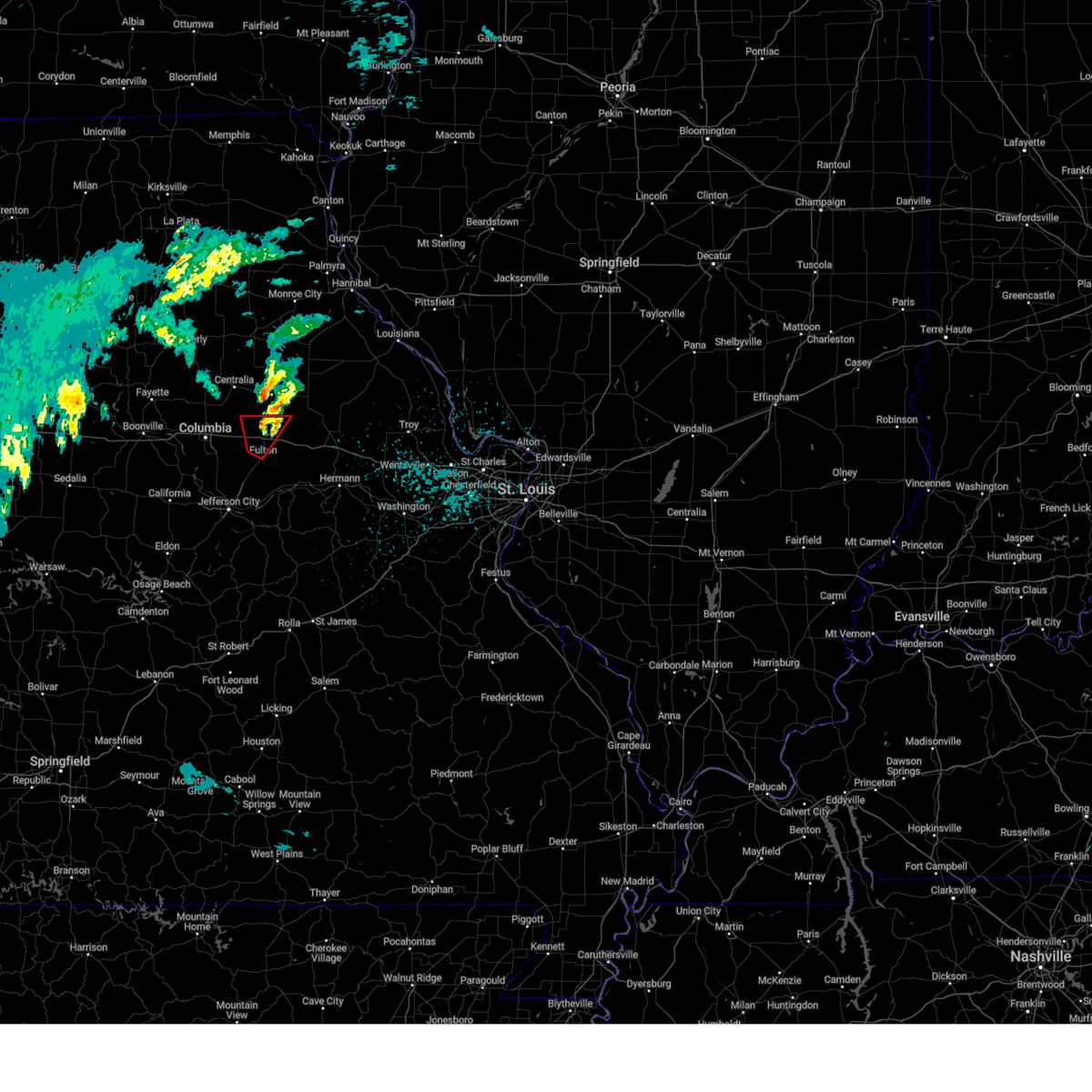
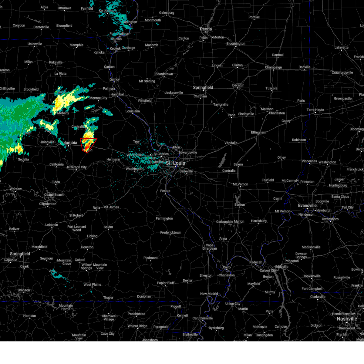
| 4/17/2026 8:48 PM CDT |
 the tornado warning has been cancelled and is no longer in effect the tornado warning has been cancelled and is no longer in effect
|
| 4/17/2026 8:48 PM CDT |
 At 848 pm cdt, a severe thunderstorm capable of producing a tornado was located 7 miles northeast of fulton, moving northeast at 50 mph (radar indicated rotation). Hazards include tornado. Flying debris will be dangerous to those caught without shelter. mobile homes will be damaged or destroyed. damage to roofs, windows and vehicles will occur. tree damage is likely. this tornado will be near, fulton around 850 pm cdt. other locations impacted by the tornado include kingdom city. This includes interstate 70 in missouri between exits 148 and 155. At 848 pm cdt, a severe thunderstorm capable of producing a tornado was located 7 miles northeast of fulton, moving northeast at 50 mph (radar indicated rotation). Hazards include tornado. Flying debris will be dangerous to those caught without shelter. mobile homes will be damaged or destroyed. damage to roofs, windows and vehicles will occur. tree damage is likely. this tornado will be near, fulton around 850 pm cdt. other locations impacted by the tornado include kingdom city. This includes interstate 70 in missouri between exits 148 and 155.
|
| 4/17/2026 8:38 PM CDT |
 At 838 pm cdt, a severe thunderstorm capable of producing a tornado was located over fulton, moving northeast at 50 mph (radar indicated rotation). Hazards include tornado. Flying debris will be dangerous to those caught without shelter. mobile homes will be damaged or destroyed. damage to roofs, windows and vehicles will occur. tree damage is likely. this tornado will be near, fulton around 840 pm cdt. other locations impacted by the tornado include carrington and kingdom city. this includes the following state parks, rock bridge state park, jewell cemetery historic site and jefferson landing historic site. This includes interstate 70 in missouri between exits 128 and 155. At 838 pm cdt, a severe thunderstorm capable of producing a tornado was located over fulton, moving northeast at 50 mph (radar indicated rotation). Hazards include tornado. Flying debris will be dangerous to those caught without shelter. mobile homes will be damaged or destroyed. damage to roofs, windows and vehicles will occur. tree damage is likely. this tornado will be near, fulton around 840 pm cdt. other locations impacted by the tornado include carrington and kingdom city. this includes the following state parks, rock bridge state park, jewell cemetery historic site and jefferson landing historic site. This includes interstate 70 in missouri between exits 128 and 155.
|
| 4/17/2026 8:17 PM CDT |
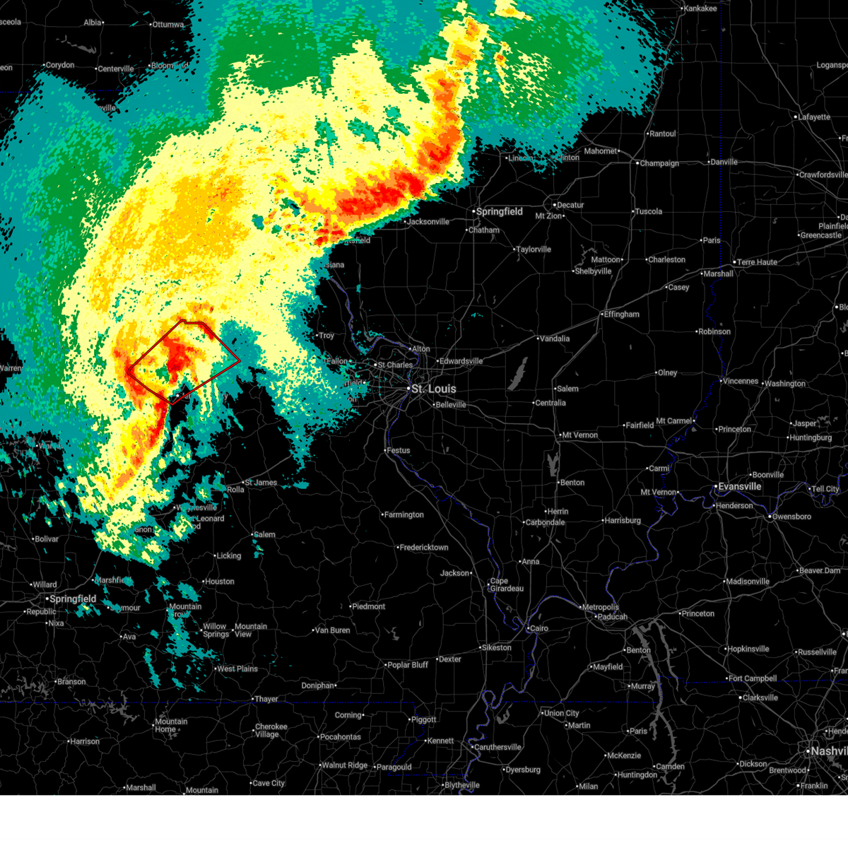 Torlsx the national weather service in st louis has issued a * tornado warning for, southeastern boone county in central missouri, callaway county in central missouri, northwestern cole county in central missouri, northeastern moniteau county in central missouri, * until 900 pm cdt. * at 817 pm cdt, a severe thunderstorm capable of producing a tornado was located 6 miles south of ashland, moving northeast at 40 mph (radar indicated rotation). Hazards include tornado. Flying debris will be dangerous to those caught without shelter. mobile homes will be damaged or destroyed. damage to roofs, windows and vehicles will occur. tree damage is likely. this tornado will be near, ashland and jefferson city around 820 pm cdt. lake mykee town, lake mykee, holts summit and columbia regional airport around 825 pm cdt. new bloomfield around 830 pm cdt. other locations impacted by the tornado include hartsburg, guthrie, carrington, kingdom city and reform. this includes the following state parks, rock bridge state park, jewell cemetery historic site and jefferson landing historic site. This includes interstate 70 in missouri between exits 128 and 155. Torlsx the national weather service in st louis has issued a * tornado warning for, southeastern boone county in central missouri, callaway county in central missouri, northwestern cole county in central missouri, northeastern moniteau county in central missouri, * until 900 pm cdt. * at 817 pm cdt, a severe thunderstorm capable of producing a tornado was located 6 miles south of ashland, moving northeast at 40 mph (radar indicated rotation). Hazards include tornado. Flying debris will be dangerous to those caught without shelter. mobile homes will be damaged or destroyed. damage to roofs, windows and vehicles will occur. tree damage is likely. this tornado will be near, ashland and jefferson city around 820 pm cdt. lake mykee town, lake mykee, holts summit and columbia regional airport around 825 pm cdt. new bloomfield around 830 pm cdt. other locations impacted by the tornado include hartsburg, guthrie, carrington, kingdom city and reform. this includes the following state parks, rock bridge state park, jewell cemetery historic site and jefferson landing historic site. This includes interstate 70 in missouri between exits 128 and 155.
|
| 3/7/2026 2:50 AM CST |
 the severe thunderstorm warning has been cancelled and is no longer in effect the severe thunderstorm warning has been cancelled and is no longer in effect
|
| 3/7/2026 2:31 AM CST |
 Svrlsx the national weather service in st louis has issued a * severe thunderstorm warning for, southeastern boone county in central missouri, northern callaway county in central missouri, * until 315 am cst. * at 231 am cst, a severe thunderstorm was located over easley, or near ashland, moving northeast at 55 mph (radar indicated). Hazards include 60 mph wind gusts and quarter size hail. Hail damage to vehicles is expected. Expect wind damage to roofs, siding, and trees. Svrlsx the national weather service in st louis has issued a * severe thunderstorm warning for, southeastern boone county in central missouri, northern callaway county in central missouri, * until 315 am cst. * at 231 am cst, a severe thunderstorm was located over easley, or near ashland, moving northeast at 55 mph (radar indicated). Hazards include 60 mph wind gusts and quarter size hail. Hail damage to vehicles is expected. Expect wind damage to roofs, siding, and trees.
|
| 9/15/2025 4:40 PM CDT | Trees down just east of millersburg. time estimated by rada in callaway county MO, 9.6 miles ESE of Fulton, MO |
| 7/7/2025 4:10 PM CDT |
 Svrlsx the national weather service in st louis has issued a * severe thunderstorm warning for, southeastern callaway county in central missouri, northeastern osage county in central missouri, * until 500 pm cdt. * at 410 pm cdt, a severe thunderstorm was located 10 miles south of fulton, moving south at 10 mph (radar indicated). Hazards include 60 mph wind gusts. expect damage to roofs, siding, and trees Svrlsx the national weather service in st louis has issued a * severe thunderstorm warning for, southeastern callaway county in central missouri, northeastern osage county in central missouri, * until 500 pm cdt. * at 410 pm cdt, a severe thunderstorm was located 10 miles south of fulton, moving south at 10 mph (radar indicated). Hazards include 60 mph wind gusts. expect damage to roofs, siding, and trees
|
| 6/7/2025 3:36 PM CDT |
 The storm which prompted the warning has weakened below severe limits, and no longer poses an immediate threat to life or property. therefore, the warning will be allowed to expire. The storm which prompted the warning has weakened below severe limits, and no longer poses an immediate threat to life or property. therefore, the warning will be allowed to expire.
|
| 6/7/2025 3:30 PM CDT |
 At 330 pm cdt, a severe thunderstorm was located over new bloomfield, or near holts summit, moving east at 45 mph (radar indicated). Hazards include 60 mph wind gusts. Expect damage to roofs, siding, and trees. locations impacted include, jefferson city, holts summit, wardsville, st. martins, taos, new bloomfield, lake mykee town, lake mykee, lohman, wainwright, guthrie, osage city, schubert and elston. This includes the following state parks, clarks hill/norton historic site and jefferson landing historic site. At 330 pm cdt, a severe thunderstorm was located over new bloomfield, or near holts summit, moving east at 45 mph (radar indicated). Hazards include 60 mph wind gusts. Expect damage to roofs, siding, and trees. locations impacted include, jefferson city, holts summit, wardsville, st. martins, taos, new bloomfield, lake mykee town, lake mykee, lohman, wainwright, guthrie, osage city, schubert and elston. This includes the following state parks, clarks hill/norton historic site and jefferson landing historic site.
|
| 6/7/2025 3:21 PM CDT |
 the severe thunderstorm warning has been cancelled and is no longer in effect the severe thunderstorm warning has been cancelled and is no longer in effect
|
| 6/7/2025 3:21 PM CDT |
 At 321 pm cdt, a severe thunderstorm was located 5 miles southeast of ashland, moving east at 45 mph (radar indicated). Hazards include 60 mph wind gusts. Expect damage to roofs, siding, and trees. locations impacted include, columbia, jefferson city, ashland, holts summit, columbia regional airport, wardsville, st. martins, taos, new bloomfield, lake mykee town, centertown, lake mykee, easley, marion, lohman, hartsburg, guthrie, elston, carrington and wilton. this includes the following state parks, clarks hill/norton historic site and jefferson landing historic site. This includes interstate 70 in missouri near exit 144. At 321 pm cdt, a severe thunderstorm was located 5 miles southeast of ashland, moving east at 45 mph (radar indicated). Hazards include 60 mph wind gusts. Expect damage to roofs, siding, and trees. locations impacted include, columbia, jefferson city, ashland, holts summit, columbia regional airport, wardsville, st. martins, taos, new bloomfield, lake mykee town, centertown, lake mykee, easley, marion, lohman, hartsburg, guthrie, elston, carrington and wilton. this includes the following state parks, clarks hill/norton historic site and jefferson landing historic site. This includes interstate 70 in missouri near exit 144.
|
| 6/7/2025 3:01 PM CDT |
 Svrlsx the national weather service in st louis has issued a * severe thunderstorm warning for, southeastern boone county in central missouri, western callaway county in central missouri, central cole county in central missouri, eastern moniteau county in central missouri, * until 345 pm cdt. * at 301 pm cdt, a severe thunderstorm was located near mcgirk, or near california, moving east at 45 mph (radar indicated). Hazards include 60 mph wind gusts. expect damage to roofs, siding, and trees Svrlsx the national weather service in st louis has issued a * severe thunderstorm warning for, southeastern boone county in central missouri, western callaway county in central missouri, central cole county in central missouri, eastern moniteau county in central missouri, * until 345 pm cdt. * at 301 pm cdt, a severe thunderstorm was located near mcgirk, or near california, moving east at 45 mph (radar indicated). Hazards include 60 mph wind gusts. expect damage to roofs, siding, and trees
|
| 6/3/2025 10:10 PM CDT |
 The storms which prompted the warning have weakened below severe limits, and no longer pose an immediate threat to life or property. therefore, the warning will be allowed to expire. however, gusty winds and heavy rain are still possible with these thunderstorms. The storms which prompted the warning have weakened below severe limits, and no longer pose an immediate threat to life or property. therefore, the warning will be allowed to expire. however, gusty winds and heavy rain are still possible with these thunderstorms.
|
| 6/3/2025 10:02 PM CDT |
 the severe thunderstorm warning has been cancelled and is no longer in effect the severe thunderstorm warning has been cancelled and is no longer in effect
|
| 6/3/2025 10:02 PM CDT |
 At 1002 pm cdt, severe thunderstorms were located along a line from 5 miles southwest of auxvasse to near westphalia, or along a line from 7 miles north of fulton to 13 miles southwest of linn, moving northeast at 35 mph (radar indicated). Hazards include 60 mph wind gusts and small hail. Expect damage to roofs, siding, and trees. Other locations impacted by the severe thunderstorm include carrington, meta, tebbetts, bonnots mill, koeltztown, argyle, loose creek, frankenstein and mokane. At 1002 pm cdt, severe thunderstorms were located along a line from 5 miles southwest of auxvasse to near westphalia, or along a line from 7 miles north of fulton to 13 miles southwest of linn, moving northeast at 35 mph (radar indicated). Hazards include 60 mph wind gusts and small hail. Expect damage to roofs, siding, and trees. Other locations impacted by the severe thunderstorm include carrington, meta, tebbetts, bonnots mill, koeltztown, argyle, loose creek, frankenstein and mokane.
|
| 6/3/2025 9:49 PM CDT |
 the severe thunderstorm warning has been cancelled and is no longer in effect the severe thunderstorm warning has been cancelled and is no longer in effect
|
| 6/3/2025 9:49 PM CDT |
 At 949 pm cdt, severe thunderstorms were located along a line from 9 miles northeast of columbia regional airport to over st. thomas, or along a line from 9 miles west of fulton to 16 miles south of jefferson city, moving northeast at 35 mph (radar indicated). Hazards include 60 mph wind gusts and small hail. Expect damage to roofs, siding, and trees. this severe thunderstorm will be near, jefferson city around 930 pm cdt. other locations impacted by the severe thunderstorm include guthrie, schubert, carrington, osage bend, wainwright, osage city, meta, tebbetts, bonnots mill and koeltztown. This includes the following state parks, clarks hill/norton historic site and jefferson landing historic site. At 949 pm cdt, severe thunderstorms were located along a line from 9 miles northeast of columbia regional airport to over st. thomas, or along a line from 9 miles west of fulton to 16 miles south of jefferson city, moving northeast at 35 mph (radar indicated). Hazards include 60 mph wind gusts and small hail. Expect damage to roofs, siding, and trees. this severe thunderstorm will be near, jefferson city around 930 pm cdt. other locations impacted by the severe thunderstorm include guthrie, schubert, carrington, osage bend, wainwright, osage city, meta, tebbetts, bonnots mill and koeltztown. This includes the following state parks, clarks hill/norton historic site and jefferson landing historic site.
|
| 6/3/2025 9:24 PM CDT |
 Svrlsx the national weather service in st louis has issued a * severe thunderstorm warning for, southeastern boone county in central missouri, southwestern callaway county in central missouri, central cole county in central missouri, osage county in central missouri, * until 1015 pm cdt. * at 924 pm cdt, severe thunderstorms were located along a line from over easley to 11 miles south of hickory hill, or along a line from 5 miles northwest of ashland to 26 miles southwest of jefferson city, moving northeast at 35 mph (radar indicated). Hazards include 60 mph wind gusts and small hail. expect damage to roofs, siding, and trees Svrlsx the national weather service in st louis has issued a * severe thunderstorm warning for, southeastern boone county in central missouri, southwestern callaway county in central missouri, central cole county in central missouri, osage county in central missouri, * until 1015 pm cdt. * at 924 pm cdt, severe thunderstorms were located along a line from over easley to 11 miles south of hickory hill, or along a line from 5 miles northwest of ashland to 26 miles southwest of jefferson city, moving northeast at 35 mph (radar indicated). Hazards include 60 mph wind gusts and small hail. expect damage to roofs, siding, and trees
|
| 6/3/2025 5:29 PM CDT |
 Svrlsx the national weather service in st louis has issued a * severe thunderstorm warning for, audrain county in central missouri, callaway county in central missouri, * until 615 pm cdt. * at 529 pm cdt, severe thunderstorms were located along a line from 9 miles north of centralia to near centertown, or along a line from 9 miles north of centralia to 9 miles northeast of california, moving northeast at 50 mph (radar indicated). Hazards include 60 mph wind gusts and quarter size hail. Hail damage to vehicles is expected. expect wind damage to roofs, siding, and trees. other locations impacted by the severe thunderstorm include thompson, hatton, guthrie, vandiver, carrington, kingdom city, benton city and rush hill. This includes interstate 70 in missouri between exits 137 and 161. Svrlsx the national weather service in st louis has issued a * severe thunderstorm warning for, audrain county in central missouri, callaway county in central missouri, * until 615 pm cdt. * at 529 pm cdt, severe thunderstorms were located along a line from 9 miles north of centralia to near centertown, or along a line from 9 miles north of centralia to 9 miles northeast of california, moving northeast at 50 mph (radar indicated). Hazards include 60 mph wind gusts and quarter size hail. Hail damage to vehicles is expected. expect wind damage to roofs, siding, and trees. other locations impacted by the severe thunderstorm include thompson, hatton, guthrie, vandiver, carrington, kingdom city, benton city and rush hill. This includes interstate 70 in missouri between exits 137 and 161.
|
| 5/19/2025 9:21 PM CDT |
 At 921 pm cdt, a severe thunderstorm was located 8 miles southeast of fulton, moving northeast at 40 mph (radar indicated). Hazards include 60 mph wind gusts. Expect damage to roofs, siding, and trees. locations impacted include, fulton, linn, new bloomfield, freeburg, chamois, westphalia, lake mykee town, rich fountain, williamsburg, shamrock, mokane, kingdom city, steedman, frankenstein, reform, tebbetts, portland, bonnots mill, loose creek and wainwright. This includes interstate 70 in missouri between exits 155 and 161. At 921 pm cdt, a severe thunderstorm was located 8 miles southeast of fulton, moving northeast at 40 mph (radar indicated). Hazards include 60 mph wind gusts. Expect damage to roofs, siding, and trees. locations impacted include, fulton, linn, new bloomfield, freeburg, chamois, westphalia, lake mykee town, rich fountain, williamsburg, shamrock, mokane, kingdom city, steedman, frankenstein, reform, tebbetts, portland, bonnots mill, loose creek and wainwright. This includes interstate 70 in missouri between exits 155 and 161.
|
| 5/19/2025 9:21 PM CDT |
 the severe thunderstorm warning has been cancelled and is no longer in effect the severe thunderstorm warning has been cancelled and is no longer in effect
|
| 5/19/2025 9:00 PM CDT |
 At 900 pm cdt, a severe thunderstorm was located over lake mykee, or near holts summit, moving northeast at 40 mph (radar indicated). Hazards include 60 mph wind gusts. Expect damage to roofs, siding, and trees. locations impacted include, jefferson city, fulton, ashland, holts summit, linn, columbia regional airport, new bloomfield, freeburg, chamois, westphalia, lake mykee town, lake mykee, rich fountain, williamsburg, shamrock, mokane, kingdom city, tebbetts, steedman and frankenstein. This includes interstate 70 in missouri between exits 155 and 161. At 900 pm cdt, a severe thunderstorm was located over lake mykee, or near holts summit, moving northeast at 40 mph (radar indicated). Hazards include 60 mph wind gusts. Expect damage to roofs, siding, and trees. locations impacted include, jefferson city, fulton, ashland, holts summit, linn, columbia regional airport, new bloomfield, freeburg, chamois, westphalia, lake mykee town, lake mykee, rich fountain, williamsburg, shamrock, mokane, kingdom city, tebbetts, steedman and frankenstein. This includes interstate 70 in missouri between exits 155 and 161.
|
| 5/19/2025 8:42 PM CDT |
 Svrlsx the national weather service in st louis has issued a * severe thunderstorm warning for, southeastern boone county in central missouri, callaway county in central missouri, osage county in central missouri, * until 945 pm cdt. * at 842 pm cdt, a severe thunderstorm was located near jefferson city, moving northeast at 50 mph (radar indicated). Hazards include 60 mph wind gusts. expect damage to roofs, siding, and trees Svrlsx the national weather service in st louis has issued a * severe thunderstorm warning for, southeastern boone county in central missouri, callaway county in central missouri, osage county in central missouri, * until 945 pm cdt. * at 842 pm cdt, a severe thunderstorm was located near jefferson city, moving northeast at 50 mph (radar indicated). Hazards include 60 mph wind gusts. expect damage to roofs, siding, and trees
|
| 5/16/2025 1:17 PM CDT |
 Svrlsx the national weather service in st louis has issued a * severe thunderstorm warning for, southeastern audrain county in central missouri, northeastern callaway county in central missouri, lincoln county in east central missouri, montgomery county in east central missouri, north central warren county in east central missouri, pike county in northeastern missouri, * until 230 pm cdt. * at 117 pm cdt, a severe thunderstorm was located over martinsburg, or 6 miles west of wellsville, moving northeast at 50 mph (radar indicated). Hazards include 60 mph wind gusts and half dollar size hail. Hail damage to vehicles is expected. Expect wind damage to roofs, siding, and trees. Svrlsx the national weather service in st louis has issued a * severe thunderstorm warning for, southeastern audrain county in central missouri, northeastern callaway county in central missouri, lincoln county in east central missouri, montgomery county in east central missouri, north central warren county in east central missouri, pike county in northeastern missouri, * until 230 pm cdt. * at 117 pm cdt, a severe thunderstorm was located over martinsburg, or 6 miles west of wellsville, moving northeast at 50 mph (radar indicated). Hazards include 60 mph wind gusts and half dollar size hail. Hail damage to vehicles is expected. Expect wind damage to roofs, siding, and trees.
|
| 4/20/2025 5:15 PM CDT |
 At 515 pm cdt, severe thunderstorms were located along a line from near midway to 5 miles northwest of holts summit, or along a line from 9 miles northwest of columbia to 5 miles northwest of holts summit, moving northeast at 50 mph (trained spotters reported. at 4:50 pm a 61 mph wind gust was reported near california, mo). Hazards include 70 mph wind gusts. Expect considerable tree damage. damage is likely to mobile homes, roofs, and outbuildings. this severe thunderstorm will be near, easley and rocheport around 505 pm cdt. other locations impacted by the severe thunderstorm include wilton, mcbaine, lupus, hartsburg, harrisburg, guthrie, carrington, hatton and kingdom city. this includes the following state parks, rock bridge state park, finger lakes state park and jewell cemetery historic site. This includes interstate 70 in missouri between exits 115 and 148. At 515 pm cdt, severe thunderstorms were located along a line from near midway to 5 miles northwest of holts summit, or along a line from 9 miles northwest of columbia to 5 miles northwest of holts summit, moving northeast at 50 mph (trained spotters reported. at 4:50 pm a 61 mph wind gust was reported near california, mo). Hazards include 70 mph wind gusts. Expect considerable tree damage. damage is likely to mobile homes, roofs, and outbuildings. this severe thunderstorm will be near, easley and rocheport around 505 pm cdt. other locations impacted by the severe thunderstorm include wilton, mcbaine, lupus, hartsburg, harrisburg, guthrie, carrington, hatton and kingdom city. this includes the following state parks, rock bridge state park, finger lakes state park and jewell cemetery historic site. This includes interstate 70 in missouri between exits 115 and 148.
|
| 4/20/2025 5:11 PM CDT |
 At 511 pm cdt, severe thunderstorms were located along a line from near midway to 7 miles northwest of jefferson city, or along a line from 10 miles northwest of columbia to 7 miles northwest of jefferson city, moving northeast at 50 mph (trained spotters reported. at 4:50 pm a 61 mph wind gust was reported near california, mo). Hazards include 60 mph wind gusts. Expect damage to roofs, siding, and trees. this severe thunderstorm will be near, easley and rocheport around 505 pm cdt. other locations impacted by the severe thunderstorm include wilton, mcbaine, lupus, hartsburg, harrisburg, guthrie, carrington, hatton and kingdom city. this includes the following state parks, rock bridge state park, finger lakes state park and jewell cemetery historic site. This includes interstate 70 in missouri between exits 115 and 148. At 511 pm cdt, severe thunderstorms were located along a line from near midway to 7 miles northwest of jefferson city, or along a line from 10 miles northwest of columbia to 7 miles northwest of jefferson city, moving northeast at 50 mph (trained spotters reported. at 4:50 pm a 61 mph wind gust was reported near california, mo). Hazards include 60 mph wind gusts. Expect damage to roofs, siding, and trees. this severe thunderstorm will be near, easley and rocheport around 505 pm cdt. other locations impacted by the severe thunderstorm include wilton, mcbaine, lupus, hartsburg, harrisburg, guthrie, carrington, hatton and kingdom city. this includes the following state parks, rock bridge state park, finger lakes state park and jewell cemetery historic site. This includes interstate 70 in missouri between exits 115 and 148.
|
| 4/20/2025 4:51 PM CDT |
 Svrlsx the national weather service in st louis has issued a * severe thunderstorm warning for, boone county in central missouri, callaway county in central missouri, * until 545 pm cdt. * at 451 pm cdt, severe thunderstorms were located along a line from 14 miles north of tipton to 22 miles south of hickory hill, or along a line from 14 miles north of tipton to 37 miles southwest of jefferson city, moving northeast at 50 mph (radar indicated). Hazards include 60 mph wind gusts. Expect damage to roofs, siding, and trees. this severe thunderstorm will be near, rocheport around 505 pm cdt. other locations impacted by the severe thunderstorm include lupus, wilton, mcbaine, hartsburg, harrisburg, guthrie, wainwright, carrington, tebbetts and hatton. this includes the following state parks, rock bridge state park, finger lakes state park and jewell cemetery historic site. This includes interstate 70 in missouri between exits 115 and 148. Svrlsx the national weather service in st louis has issued a * severe thunderstorm warning for, boone county in central missouri, callaway county in central missouri, * until 545 pm cdt. * at 451 pm cdt, severe thunderstorms were located along a line from 14 miles north of tipton to 22 miles south of hickory hill, or along a line from 14 miles north of tipton to 37 miles southwest of jefferson city, moving northeast at 50 mph (radar indicated). Hazards include 60 mph wind gusts. Expect damage to roofs, siding, and trees. this severe thunderstorm will be near, rocheport around 505 pm cdt. other locations impacted by the severe thunderstorm include lupus, wilton, mcbaine, hartsburg, harrisburg, guthrie, wainwright, carrington, tebbetts and hatton. this includes the following state parks, rock bridge state park, finger lakes state park and jewell cemetery historic site. This includes interstate 70 in missouri between exits 115 and 148.
|
| 4/20/2025 2:11 PM CDT |
 The storm which prompted the warning has weakened below severe limits, and no longer appears capable of producing a tornado. therefore, the warning will be allowed to expire. a tornado watch remains in effect until 700 pm cdt for a portion of central missouri. The storm which prompted the warning has weakened below severe limits, and no longer appears capable of producing a tornado. therefore, the warning will be allowed to expire. a tornado watch remains in effect until 700 pm cdt for a portion of central missouri.
|
| 4/20/2025 2:01 PM CDT |
 At 201 pm cdt, a severe thunderstorm capable of producing a tornado was located near auxvasse, or 9 miles north of fulton, moving northeast at 40 mph (radar indicated rotation). Hazards include tornado. Flying debris will be dangerous to those caught without shelter. mobile homes will be damaged or destroyed. damage to roofs, windows and vehicles will occur. tree damage is likely. locations impacted include, fulton, auxvasse, kingdom city and hatton. This includes interstate 70 in missouri between exits 144 and 148. At 201 pm cdt, a severe thunderstorm capable of producing a tornado was located near auxvasse, or 9 miles north of fulton, moving northeast at 40 mph (radar indicated rotation). Hazards include tornado. Flying debris will be dangerous to those caught without shelter. mobile homes will be damaged or destroyed. damage to roofs, windows and vehicles will occur. tree damage is likely. locations impacted include, fulton, auxvasse, kingdom city and hatton. This includes interstate 70 in missouri between exits 144 and 148.
|
| 4/20/2025 1:49 PM CDT |
 At 149 pm cdt, a severe thunderstorm capable of producing a tornado was located near fulton, moving northeast at 40 mph (radar indicated rotation). Hazards include tornado. Flying debris will be dangerous to those caught without shelter. mobile homes will be damaged or destroyed. damage to roofs, windows and vehicles will occur. tree damage is likely. locations impacted include, fulton, auxvasse, kingdom city, hatton and carrington. This includes interstate 70 in missouri between exits 137 and 148. At 149 pm cdt, a severe thunderstorm capable of producing a tornado was located near fulton, moving northeast at 40 mph (radar indicated rotation). Hazards include tornado. Flying debris will be dangerous to those caught without shelter. mobile homes will be damaged or destroyed. damage to roofs, windows and vehicles will occur. tree damage is likely. locations impacted include, fulton, auxvasse, kingdom city, hatton and carrington. This includes interstate 70 in missouri between exits 137 and 148.
|
| 4/20/2025 1:39 PM CDT |
 At 139 pm cdt, a confirmed tornado was located 5 miles north of new bloomfield, or 7 miles east of columbia regional airport, moving northeast at 40 mph (law enforcement confirmed tornado). Hazards include damaging tornado. Flying debris will be dangerous to those caught without shelter. mobile homes will be damaged or destroyed. damage to roofs, windows and vehicles will occur. tree damage is likely. locations impacted include, fulton, auxvasse, new bloomfield, kingdom city, hatton, carrington and guthrie. This includes interstate 70 in missouri between exits 137 and 148. At 139 pm cdt, a confirmed tornado was located 5 miles north of new bloomfield, or 7 miles east of columbia regional airport, moving northeast at 40 mph (law enforcement confirmed tornado). Hazards include damaging tornado. Flying debris will be dangerous to those caught without shelter. mobile homes will be damaged or destroyed. damage to roofs, windows and vehicles will occur. tree damage is likely. locations impacted include, fulton, auxvasse, new bloomfield, kingdom city, hatton, carrington and guthrie. This includes interstate 70 in missouri between exits 137 and 148.
|
| 4/20/2025 1:31 PM CDT |
 Torlsx the national weather service in st louis has issued a * tornado warning for, northwestern callaway county in central missouri, * until 215 pm cdt. * at 131 pm cdt, a severe thunderstorm capable of producing a tornado was located over new bloomfield, or 6 miles north of holts summit, moving northeast at 40 mph (radar indicated rotation). Hazards include tornado. Flying debris will be dangerous to those caught without shelter. mobile homes will be damaged or destroyed. damage to roofs, windows and vehicles will occur. Tree damage is likely. Torlsx the national weather service in st louis has issued a * tornado warning for, northwestern callaway county in central missouri, * until 215 pm cdt. * at 131 pm cdt, a severe thunderstorm capable of producing a tornado was located over new bloomfield, or 6 miles north of holts summit, moving northeast at 40 mph (radar indicated rotation). Hazards include tornado. Flying debris will be dangerous to those caught without shelter. mobile homes will be damaged or destroyed. damage to roofs, windows and vehicles will occur. Tree damage is likely.
|
| 4/20/2025 6:44 AM CDT |
 the severe thunderstorm warning has been cancelled and is no longer in effect the severe thunderstorm warning has been cancelled and is no longer in effect
|
| 4/20/2025 6:30 AM CDT |
 the severe thunderstorm warning has been cancelled and is no longer in effect the severe thunderstorm warning has been cancelled and is no longer in effect
|
| 4/20/2025 6:30 AM CDT |
 At 630 am cdt, a severe thunderstorm was located near holts summit, moving northeast at 40 mph (radar indicated). Hazards include quarter size hail. Damage to vehicles is expected. locations impacted include, jefferson city, fulton, holts summit, auxvasse, new bloomfield, lake mykee town, lake mykee, kingdom city, carrington, guthrie, hatton, tebbetts and wainwright. This includes interstate 70 in missouri between exits 137 and 155. At 630 am cdt, a severe thunderstorm was located near holts summit, moving northeast at 40 mph (radar indicated). Hazards include quarter size hail. Damage to vehicles is expected. locations impacted include, jefferson city, fulton, holts summit, auxvasse, new bloomfield, lake mykee town, lake mykee, kingdom city, carrington, guthrie, hatton, tebbetts and wainwright. This includes interstate 70 in missouri between exits 137 and 155.
|
| 4/20/2025 6:13 AM CDT |
 Svrlsx the national weather service in st louis has issued a * severe thunderstorm warning for, southeastern boone county in central missouri, callaway county in central missouri, central cole county in central missouri, central osage county in central missouri, * until 715 am cdt. * at 613 am cdt, a severe thunderstorm was located over wardsville, or 6 miles southeast of jefferson city, moving north at 45 mph (radar indicated). Hazards include quarter size hail. damage to vehicles is expected Svrlsx the national weather service in st louis has issued a * severe thunderstorm warning for, southeastern boone county in central missouri, callaway county in central missouri, central cole county in central missouri, central osage county in central missouri, * until 715 am cdt. * at 613 am cdt, a severe thunderstorm was located over wardsville, or 6 miles southeast of jefferson city, moving north at 45 mph (radar indicated). Hazards include quarter size hail. damage to vehicles is expected
|
| 3/14/2025 7:15 PM CDT |
 Torlsx the national weather service in st louis has issued a * tornado warning for, southeastern callaway county in central missouri, montgomery county in east central missouri, * until 800 pm cdt. * at 715 pm cdt, a severe thunderstorm capable of producing a tornado was located 8 miles south of fulton, moving northeast at 60 mph (radar indicated rotation). Hazards include tornado. Flying debris will be dangerous to those caught without shelter. mobile homes will be damaged or destroyed. damage to roofs, windows and vehicles will occur. tree damage is likely. this tornado will be near, new bloomfield around 715 pm cdt. fulton around 720 pm cdt. other locations impacted by the tornado include mokane, steedman, reform, danville and middletown. this includes the following state parks, graham cave state park. This includes interstate 70 in missouri between exits 148 and 175. Torlsx the national weather service in st louis has issued a * tornado warning for, southeastern callaway county in central missouri, montgomery county in east central missouri, * until 800 pm cdt. * at 715 pm cdt, a severe thunderstorm capable of producing a tornado was located 8 miles south of fulton, moving northeast at 60 mph (radar indicated rotation). Hazards include tornado. Flying debris will be dangerous to those caught without shelter. mobile homes will be damaged or destroyed. damage to roofs, windows and vehicles will occur. tree damage is likely. this tornado will be near, new bloomfield around 715 pm cdt. fulton around 720 pm cdt. other locations impacted by the tornado include mokane, steedman, reform, danville and middletown. this includes the following state parks, graham cave state park. This includes interstate 70 in missouri between exits 148 and 175.
|
| 3/14/2025 7:11 PM CDT |
 the severe thunderstorm warning has been cancelled and is no longer in effect the severe thunderstorm warning has been cancelled and is no longer in effect
|
| 3/14/2025 7:11 PM CDT |
 At 711 pm cdt, a severe thunderstorm was located 6 miles southeast of new bloomfield, or 7 miles east of holts summit, moving northeast at 60 mph (trained spotters reported. at 7:01 pm a 74 mph wind gust was reported in jefferson city). Hazards include 70 mph wind gusts and quarter size hail. Hail damage to vehicles is expected. expect considerable tree damage. wind damage is also likely to mobile homes, roofs, and outbuildings. other locations impacted by the severe thunderstorm include wainwright, tebbetts, mokane, steedman and reform. This includes interstate 70 in missouri near exit 161. At 711 pm cdt, a severe thunderstorm was located 6 miles southeast of new bloomfield, or 7 miles east of holts summit, moving northeast at 60 mph (trained spotters reported. at 7:01 pm a 74 mph wind gust was reported in jefferson city). Hazards include 70 mph wind gusts and quarter size hail. Hail damage to vehicles is expected. expect considerable tree damage. wind damage is also likely to mobile homes, roofs, and outbuildings. other locations impacted by the severe thunderstorm include wainwright, tebbetts, mokane, steedman and reform. This includes interstate 70 in missouri near exit 161.
|
| 3/14/2025 7:06 PM CDT |
 At 706 pm cdt, a severe thunderstorm was located near holts summit, moving northeast at 60 mph (trained spotters reported. at 7:01 pm a 74 mph wind gust was reported in jefferson city). Hazards include 70 mph wind gusts and quarter size hail. Hail damage to vehicles is expected. expect considerable tree damage. wind damage is also likely to mobile homes, roofs, and outbuildings. other locations impacted by the severe thunderstorm include wainwright, bonnots mill, tebbetts, mokane, steedman and reform. This includes interstate 70 in missouri near exit 161. At 706 pm cdt, a severe thunderstorm was located near holts summit, moving northeast at 60 mph (trained spotters reported. at 7:01 pm a 74 mph wind gust was reported in jefferson city). Hazards include 70 mph wind gusts and quarter size hail. Hail damage to vehicles is expected. expect considerable tree damage. wind damage is also likely to mobile homes, roofs, and outbuildings. other locations impacted by the severe thunderstorm include wainwright, bonnots mill, tebbetts, mokane, steedman and reform. This includes interstate 70 in missouri near exit 161.
|
| 3/14/2025 7:06 PM CDT |
 the severe thunderstorm warning has been cancelled and is no longer in effect the severe thunderstorm warning has been cancelled and is no longer in effect
|
| 3/14/2025 7:03 PM CDT |
 At 703 pm cdt, a severe thunderstorm was located over mexico, moving northeast at 65 mph (radar indicated). Hazards include 70 mph wind gusts and ping pong ball size hail. People and animals outdoors will be injured. expect hail damage to roofs, siding, windows, and vehicles. expect considerable tree damage. wind damage is also likely to mobile homes, roofs, and outbuildings. other locations impacted by the severe thunderstorm include hatton, kingdom city, vandiver, thompson, benton city and rush hill. This includes interstate 70 in missouri between exits 137 and 155. At 703 pm cdt, a severe thunderstorm was located over mexico, moving northeast at 65 mph (radar indicated). Hazards include 70 mph wind gusts and ping pong ball size hail. People and animals outdoors will be injured. expect hail damage to roofs, siding, windows, and vehicles. expect considerable tree damage. wind damage is also likely to mobile homes, roofs, and outbuildings. other locations impacted by the severe thunderstorm include hatton, kingdom city, vandiver, thompson, benton city and rush hill. This includes interstate 70 in missouri between exits 137 and 155.
|
| 3/14/2025 7:03 PM CDT |
 the severe thunderstorm warning has been cancelled and is no longer in effect the severe thunderstorm warning has been cancelled and is no longer in effect
|
| 3/14/2025 6:50 PM CDT |
 At 650 pm cdt, a severe thunderstorm was located 6 miles west of auxvasse, or 12 miles southwest of mexico, moving northeast at 65 mph (radar indicated). Hazards include 60 mph wind gusts and quarter size hail. Hail damage to vehicles is expected. expect wind damage to roofs, siding, and trees. this severe thunderstorm will be near, easley around 625 pm cdt. ashland and columbia regional airport around 630 pm cdt. other locations impacted by the severe thunderstorm include hartsburg, hatton, kingdom city, vandiver, thompson, benton city and rush hill. this includes the following state parks, rock bridge state park. This includes interstate 70 in missouri between exits 128 and 155. At 650 pm cdt, a severe thunderstorm was located 6 miles west of auxvasse, or 12 miles southwest of mexico, moving northeast at 65 mph (radar indicated). Hazards include 60 mph wind gusts and quarter size hail. Hail damage to vehicles is expected. expect wind damage to roofs, siding, and trees. this severe thunderstorm will be near, easley around 625 pm cdt. ashland and columbia regional airport around 630 pm cdt. other locations impacted by the severe thunderstorm include hartsburg, hatton, kingdom city, vandiver, thompson, benton city and rush hill. this includes the following state parks, rock bridge state park. This includes interstate 70 in missouri between exits 128 and 155.
|
| 3/14/2025 6:30 PM CDT |
 Svrlsx the national weather service in st louis has issued a * severe thunderstorm warning for, southern callaway county in central missouri, cole county in central missouri, osage county in central missouri, * until 730 pm cdt. * at 630 pm cdt, a severe thunderstorm was located 10 miles southwest of hickory hill, or 22 miles south of california, moving northeast at 75 mph (radar indicated). Hazards include 70 mph wind gusts and quarter size hail. Hail damage to vehicles is expected. expect considerable tree damage. wind damage is also likely to mobile homes, roofs, and outbuildings. this severe thunderstorm will be near, hickory hill, st. thomas and russellville around 640 pm cdt. other locations impacted by the severe thunderstorm include eugene, enon, lohman, wainwright, osage city, schubert, tebbetts, bonnots mill, mokane and reform. this includes the following state parks, clarks hill/norton historic site and jefferson landing historic site. This includes interstate 70 in missouri near exit 161. Svrlsx the national weather service in st louis has issued a * severe thunderstorm warning for, southern callaway county in central missouri, cole county in central missouri, osage county in central missouri, * until 730 pm cdt. * at 630 pm cdt, a severe thunderstorm was located 10 miles southwest of hickory hill, or 22 miles south of california, moving northeast at 75 mph (radar indicated). Hazards include 70 mph wind gusts and quarter size hail. Hail damage to vehicles is expected. expect considerable tree damage. wind damage is also likely to mobile homes, roofs, and outbuildings. this severe thunderstorm will be near, hickory hill, st. thomas and russellville around 640 pm cdt. other locations impacted by the severe thunderstorm include eugene, enon, lohman, wainwright, osage city, schubert, tebbetts, bonnots mill, mokane and reform. this includes the following state parks, clarks hill/norton historic site and jefferson landing historic site. This includes interstate 70 in missouri near exit 161.
|
| 3/14/2025 6:24 PM CDT |
 Svrlsx the national weather service in st louis has issued a * severe thunderstorm warning for, audrain county in central missouri, boone county in central missouri, callaway county in central missouri, * until 730 pm cdt. * at 624 pm cdt, a severe thunderstorm was located near ashland, moving northeast at 65 mph (radar indicated). Hazards include 70 mph wind gusts and quarter size hail. Hail damage to vehicles is expected. expect considerable tree damage. wind damage is also likely to mobile homes, roofs, and outbuildings. this severe thunderstorm will be near, ashland and easley around 625 pm cdt. columbia regional airport and columbia around 630 pm cdt. other locations impacted by the severe thunderstorm include hatton, kingdom city, thompson, vandiver, benton city and rush hill. this includes the following state parks, rock bridge state park, finger lakes state park and jewell cemetery historic site. This includes interstate 70 in missouri between exits 124 and 161. Svrlsx the national weather service in st louis has issued a * severe thunderstorm warning for, audrain county in central missouri, boone county in central missouri, callaway county in central missouri, * until 730 pm cdt. * at 624 pm cdt, a severe thunderstorm was located near ashland, moving northeast at 65 mph (radar indicated). Hazards include 70 mph wind gusts and quarter size hail. Hail damage to vehicles is expected. expect considerable tree damage. wind damage is also likely to mobile homes, roofs, and outbuildings. this severe thunderstorm will be near, ashland and easley around 625 pm cdt. columbia regional airport and columbia around 630 pm cdt. other locations impacted by the severe thunderstorm include hatton, kingdom city, thompson, vandiver, benton city and rush hill. this includes the following state parks, rock bridge state park, finger lakes state park and jewell cemetery historic site. This includes interstate 70 in missouri between exits 124 and 161.
|
| 7/30/2024 3:55 PM CDT |
 Svrlsx the national weather service in st louis has issued a * severe thunderstorm warning for, southeastern callaway county in central missouri, northeastern osage county in central missouri, * until 445 pm cdt. * at 355 pm cdt, a severe thunderstorm was located 7 miles northwest of chamois, moving east at 30 mph (radar indicated). Hazards include 60 mph wind gusts and quarter size hail. Hail damage to vehicles is expected. Expect wind damage to roofs, siding, and trees. Svrlsx the national weather service in st louis has issued a * severe thunderstorm warning for, southeastern callaway county in central missouri, northeastern osage county in central missouri, * until 445 pm cdt. * at 355 pm cdt, a severe thunderstorm was located 7 miles northwest of chamois, moving east at 30 mph (radar indicated). Hazards include 60 mph wind gusts and quarter size hail. Hail damage to vehicles is expected. Expect wind damage to roofs, siding, and trees.
|
| 6/25/2024 6:52 PM CDT |
 the severe thunderstorm warning has been cancelled and is no longer in effect the severe thunderstorm warning has been cancelled and is no longer in effect
|
| 6/25/2024 6:37 PM CDT |
 At 636 pm cdt, severe thunderstorms were located along a line extending from near auxvasse to near easley, moving east at 30 mph (radar indicated). Hazards include 60 mph wind gusts. Expect damage to roofs, siding, and trees. locations impacted include, jefferson city, fulton, holts summit, new bloomfield, chamois, lake mykee town, lake mykee, williamsburg, mokane, wainwright, portland, carrington, tebbetts, guthrie, reform, and steedman. This includes interstate 70 in missouri near exit 161. At 636 pm cdt, severe thunderstorms were located along a line extending from near auxvasse to near easley, moving east at 30 mph (radar indicated). Hazards include 60 mph wind gusts. Expect damage to roofs, siding, and trees. locations impacted include, jefferson city, fulton, holts summit, new bloomfield, chamois, lake mykee town, lake mykee, williamsburg, mokane, wainwright, portland, carrington, tebbetts, guthrie, reform, and steedman. This includes interstate 70 in missouri near exit 161.
|
| 6/25/2024 6:37 PM CDT |
 the severe thunderstorm warning has been cancelled and is no longer in effect the severe thunderstorm warning has been cancelled and is no longer in effect
|
| 6/25/2024 6:17 PM CDT |
 Svrlsx the national weather service in st louis has issued a * severe thunderstorm warning for, southeastern boone county in central missouri, callaway county in central missouri, * until 715 pm cdt. * at 617 pm cdt, severe thunderstorms were located along a line extending from murry to jamestown, moving east at 30 mph (radar indicated). Hazards include 60 mph wind gusts. expect damage to roofs, siding, and trees Svrlsx the national weather service in st louis has issued a * severe thunderstorm warning for, southeastern boone county in central missouri, callaway county in central missouri, * until 715 pm cdt. * at 617 pm cdt, severe thunderstorms were located along a line extending from murry to jamestown, moving east at 30 mph (radar indicated). Hazards include 60 mph wind gusts. expect damage to roofs, siding, and trees
|
| 6/13/2024 10:23 PM CDT |
 the severe thunderstorm warning has been cancelled and is no longer in effect the severe thunderstorm warning has been cancelled and is no longer in effect
|
| 6/13/2024 10:17 PM CDT |
 At 1017 pm cdt, a severe thunderstorm was located 8 miles northwest of chamois, moving southeast at 30 mph (radar indicated). Hazards include 60 mph wind gusts. Expect damage to roofs, siding, and trees. Locations impacted include, linn, chamois, mokane, morrison, portland, frankenstein, tebbetts, reform, steedman, and bonnots mill. At 1017 pm cdt, a severe thunderstorm was located 8 miles northwest of chamois, moving southeast at 30 mph (radar indicated). Hazards include 60 mph wind gusts. Expect damage to roofs, siding, and trees. Locations impacted include, linn, chamois, mokane, morrison, portland, frankenstein, tebbetts, reform, steedman, and bonnots mill.
|
| 6/13/2024 10:08 PM CDT |
 The storm which prompted the warning has weakened below severe limits, and no longer appears capable of producing a tornado. therefore, the warning will be allowed to expire. however, gusty winds are still possible with this thunderstorm. a severe thunderstorm watch remains in effect until 100 am cdt for central missouri. The storm which prompted the warning has weakened below severe limits, and no longer appears capable of producing a tornado. therefore, the warning will be allowed to expire. however, gusty winds are still possible with this thunderstorm. a severe thunderstorm watch remains in effect until 100 am cdt for central missouri.
|
| 6/13/2024 10:06 PM CDT |
 Svrlsx the national weather service in st louis has issued a * severe thunderstorm warning for, southeastern callaway county in central missouri, eastern osage county in central missouri, * until 1100 pm cdt. * at 1006 pm cdt, a severe thunderstorm was located over fulton, moving southeast at 30 mph (radar indicated). Hazards include 60 mph wind gusts and penny size hail. expect damage to roofs, siding, and trees Svrlsx the national weather service in st louis has issued a * severe thunderstorm warning for, southeastern callaway county in central missouri, eastern osage county in central missouri, * until 1100 pm cdt. * at 1006 pm cdt, a severe thunderstorm was located over fulton, moving southeast at 30 mph (radar indicated). Hazards include 60 mph wind gusts and penny size hail. expect damage to roofs, siding, and trees
|
| 6/13/2024 9:57 PM CDT |
 At 957 pm cdt, a severe thunderstorm capable of producing a tornado was located near fulton, moving southeast at 30 mph (radar indicated rotation). Hazards include tornado and quarter size hail. Flying debris will be dangerous to those caught without shelter. mobile homes will be damaged or destroyed. damage to roofs, windows, and vehicles will occur. tree damage is likely. locations impacted include, fulton and kingdom city. This includes interstate 70 in missouri between exits 144 and 148. At 957 pm cdt, a severe thunderstorm capable of producing a tornado was located near fulton, moving southeast at 30 mph (radar indicated rotation). Hazards include tornado and quarter size hail. Flying debris will be dangerous to those caught without shelter. mobile homes will be damaged or destroyed. damage to roofs, windows, and vehicles will occur. tree damage is likely. locations impacted include, fulton and kingdom city. This includes interstate 70 in missouri between exits 144 and 148.
|
| 6/13/2024 9:52 PM CDT |
 At 952 pm cdt, a severe thunderstorm was located near fulton, moving southeast at 35 mph (radar indicated). Hazards include 70 mph wind gusts and quarter size hail. Hail damage to vehicles is expected. expect considerable tree damage. wind damage is also likely to mobile homes, roofs, and outbuildings. locations impacted include, columbia, fulton, holts summit, columbia regional airport, auxvasse, new bloomfield, lake mykee town, shamrock, lake mykee, williamsburg, kingdom city, carrington, hatton, and guthrie. This includes interstate 70 in missouri between exits 133 and 161. At 952 pm cdt, a severe thunderstorm was located near fulton, moving southeast at 35 mph (radar indicated). Hazards include 70 mph wind gusts and quarter size hail. Hail damage to vehicles is expected. expect considerable tree damage. wind damage is also likely to mobile homes, roofs, and outbuildings. locations impacted include, columbia, fulton, holts summit, columbia regional airport, auxvasse, new bloomfield, lake mykee town, shamrock, lake mykee, williamsburg, kingdom city, carrington, hatton, and guthrie. This includes interstate 70 in missouri between exits 133 and 161.
|
| 6/13/2024 9:52 PM CDT |
 the severe thunderstorm warning has been cancelled and is no longer in effect the severe thunderstorm warning has been cancelled and is no longer in effect
|
| 6/13/2024 9:49 PM CDT |
 At 949 pm cdt, a severe thunderstorm capable of producing a tornado was located 8 miles northwest of fulton, moving southeast at 35 mph (radar indicated rotation). Hazards include tornado and quarter size hail. Flying debris will be dangerous to those caught without shelter. mobile homes will be damaged or destroyed. damage to roofs, windows, and vehicles will occur. tree damage is likely. locations impacted include, fulton, auxvasse, williamsburg, kingdom city, and hatton. This includes interstate 70 in missouri between exits 144 and 161. At 949 pm cdt, a severe thunderstorm capable of producing a tornado was located 8 miles northwest of fulton, moving southeast at 35 mph (radar indicated rotation). Hazards include tornado and quarter size hail. Flying debris will be dangerous to those caught without shelter. mobile homes will be damaged or destroyed. damage to roofs, windows, and vehicles will occur. tree damage is likely. locations impacted include, fulton, auxvasse, williamsburg, kingdom city, and hatton. This includes interstate 70 in missouri between exits 144 and 161.
|
| 6/13/2024 9:49 PM CDT |
 the tornado warning has been cancelled and is no longer in effect the tornado warning has been cancelled and is no longer in effect
|
| 6/13/2024 9:46 PM CDT |
 At 946 pm cdt, a severe thunderstorm was located 8 miles northwest of fulton, moving southeast at 40 mph (radar indicated). Hazards include 70 mph wind gusts and quarter size hail. Hail damage to vehicles is expected. expect considerable tree damage. wind damage is also likely to mobile homes, roofs, and outbuildings. locations impacted include, columbia, fulton, holts summit, columbia regional airport, auxvasse, new bloomfield, lake mykee town, murry, shamrock, lake mykee, williamsburg, kingdom city, carrington, hatton, and guthrie. This includes interstate 70 in missouri between exits 131 and 161. At 946 pm cdt, a severe thunderstorm was located 8 miles northwest of fulton, moving southeast at 40 mph (radar indicated). Hazards include 70 mph wind gusts and quarter size hail. Hail damage to vehicles is expected. expect considerable tree damage. wind damage is also likely to mobile homes, roofs, and outbuildings. locations impacted include, columbia, fulton, holts summit, columbia regional airport, auxvasse, new bloomfield, lake mykee town, murry, shamrock, lake mykee, williamsburg, kingdom city, carrington, hatton, and guthrie. This includes interstate 70 in missouri between exits 131 and 161.
|
| 6/13/2024 9:33 PM CDT |
 Torlsx the national weather service in st louis has issued a * tornado warning for, southwestern audrain county in central missouri, northern callaway county in central missouri, * until 1015 pm cdt. * at 933 pm cdt, a severe thunderstorm capable of producing a tornado was located near murry, moving southeast at 35 mph (radar indicated rotation). Hazards include tornado. Flying debris will be dangerous to those caught without shelter. mobile homes will be damaged or destroyed. damage to roofs, windows, and vehicles will occur. Tree damage is likely. Torlsx the national weather service in st louis has issued a * tornado warning for, southwestern audrain county in central missouri, northern callaway county in central missouri, * until 1015 pm cdt. * at 933 pm cdt, a severe thunderstorm capable of producing a tornado was located near murry, moving southeast at 35 mph (radar indicated rotation). Hazards include tornado. Flying debris will be dangerous to those caught without shelter. mobile homes will be damaged or destroyed. damage to roofs, windows, and vehicles will occur. Tree damage is likely.
|
| 6/13/2024 9:26 PM CDT |
 Svrlsx the national weather service in st louis has issued a * severe thunderstorm warning for, eastern boone county in central missouri, southwestern audrain county in central missouri, callaway county in central missouri, * until 1015 pm cdt. * at 926 pm cdt, a severe thunderstorm was located over murry, moving southeast at 35 mph (radar indicated). Hazards include 70 mph wind gusts and quarter size hail. Hail damage to vehicles is expected. expect considerable tree damage. Wind damage is also likely to mobile homes, roofs, and outbuildings. Svrlsx the national weather service in st louis has issued a * severe thunderstorm warning for, eastern boone county in central missouri, southwestern audrain county in central missouri, callaway county in central missouri, * until 1015 pm cdt. * at 926 pm cdt, a severe thunderstorm was located over murry, moving southeast at 35 mph (radar indicated). Hazards include 70 mph wind gusts and quarter size hail. Hail damage to vehicles is expected. expect considerable tree damage. Wind damage is also likely to mobile homes, roofs, and outbuildings.
|
| 5/27/2024 4:14 PM CDT |
 The storm which prompted the warning has moved out of the area. therefore, the warning will be allowed to expire. The storm which prompted the warning has moved out of the area. therefore, the warning will be allowed to expire.
|
| 5/27/2024 3:59 PM CDT |
 At 359 pm cdt, a severe thunderstorm was located 8 miles east of new bloomfield, moving southeast at 40 mph (emergency management). Hazards include 60 mph wind gusts. Expect damage to roofs, siding, and trees. Locations impacted include, fulton, new bloomfield, chamois, mokane, portland, tebbetts, and steedman. At 359 pm cdt, a severe thunderstorm was located 8 miles east of new bloomfield, moving southeast at 40 mph (emergency management). Hazards include 60 mph wind gusts. Expect damage to roofs, siding, and trees. Locations impacted include, fulton, new bloomfield, chamois, mokane, portland, tebbetts, and steedman.
|
| 5/27/2024 3:47 PM CDT |
 At 347 pm cdt, a severe thunderstorm was located near new bloomfield, moving southeast at 40 mph (emergency management). Hazards include 60 mph wind gusts. Expect damage to roofs, siding, and trees. Locations impacted include, fulton, new bloomfield, chamois, mokane, carrington, portland, tebbetts, guthrie, and steedman. At 347 pm cdt, a severe thunderstorm was located near new bloomfield, moving southeast at 40 mph (emergency management). Hazards include 60 mph wind gusts. Expect damage to roofs, siding, and trees. Locations impacted include, fulton, new bloomfield, chamois, mokane, carrington, portland, tebbetts, guthrie, and steedman.
|
| 5/27/2024 3:47 PM CDT |
 the severe thunderstorm warning has been cancelled and is no longer in effect the severe thunderstorm warning has been cancelled and is no longer in effect
|
| 5/27/2024 3:33 PM CDT |
 Svrlsx the national weather service in st louis has issued a * severe thunderstorm warning for, southeastern boone county in central missouri, central callaway county in central missouri, * until 415 pm cdt. * at 332 pm cdt, a severe thunderstorm was located near columbia regional airport, moving southeast at 40 mph (radar indicated). Hazards include 60 mph wind gusts. expect damage to roofs, siding, and trees Svrlsx the national weather service in st louis has issued a * severe thunderstorm warning for, southeastern boone county in central missouri, central callaway county in central missouri, * until 415 pm cdt. * at 332 pm cdt, a severe thunderstorm was located near columbia regional airport, moving southeast at 40 mph (radar indicated). Hazards include 60 mph wind gusts. expect damage to roofs, siding, and trees
|
| 5/7/2024 2:29 AM CDT |
 At 229 am cdt, severe thunderstorms were located along a line extending from near granville to 9 miles southwest of santa fe to near auxvasse to near taos, moving east at 35 mph (radar indicated). Hazards include 60 mph wind gusts. Expect damage to roofs, siding, and trees. locations impacted include, columbia, jefferson city, fulton, centralia, ashland, holts summit, columbia regional airport, hallsville, sturgeon, new bloomfield, madison, lake mykee town, murry, woodlawn, lake mykee, granville, holliday, kingdom city, hartsburg, and hatton. this also includes rock bridge state park and union covered bridge historic site. This includes interstate 70 in missouri between exits 128 and 148. At 229 am cdt, severe thunderstorms were located along a line extending from near granville to 9 miles southwest of santa fe to near auxvasse to near taos, moving east at 35 mph (radar indicated). Hazards include 60 mph wind gusts. Expect damage to roofs, siding, and trees. locations impacted include, columbia, jefferson city, fulton, centralia, ashland, holts summit, columbia regional airport, hallsville, sturgeon, new bloomfield, madison, lake mykee town, murry, woodlawn, lake mykee, granville, holliday, kingdom city, hartsburg, and hatton. this also includes rock bridge state park and union covered bridge historic site. This includes interstate 70 in missouri between exits 128 and 148.
|
| 5/7/2024 1:57 AM CDT |
 At 156 am cdt, severe thunderstorms were located along a line extending from near cairo to clark to columbia to near russellville, moving east at 45 mph (radar indicated). Hazards include 60 mph wind gusts. Expect damage to roofs, siding, and trees. locations impacted include, columbia, jefferson city, fulton, centralia, ashland, holts summit, columbia regional airport, hallsville, sturgeon, new bloomfield, madison, lake mykee town, rocheport, easley, murry, midway, woodlawn, lake mykee, granville, and harrisburg. this also includes rock bridge state park, finger lakes state park, union covered bridge historic site, and jewell cemetery historic site. This includes interstate 70 in missouri between exits 115 and 148. At 156 am cdt, severe thunderstorms were located along a line extending from near cairo to clark to columbia to near russellville, moving east at 45 mph (radar indicated). Hazards include 60 mph wind gusts. Expect damage to roofs, siding, and trees. locations impacted include, columbia, jefferson city, fulton, centralia, ashland, holts summit, columbia regional airport, hallsville, sturgeon, new bloomfield, madison, lake mykee town, rocheport, easley, murry, midway, woodlawn, lake mykee, granville, and harrisburg. this also includes rock bridge state park, finger lakes state park, union covered bridge historic site, and jewell cemetery historic site. This includes interstate 70 in missouri between exits 115 and 148.
|
| 5/7/2024 1:25 AM CDT |
 Svrlsx the national weather service in st louis has issued a * severe thunderstorm warning for, boone county in central missouri, western audrain county in central missouri, western callaway county in central missouri, western monroe county in northeastern missouri, * until 245 am cdt. * at 124 am cdt, severe thunderstorms were located along a line extending from near brookfield to 6 miles north of glasgow to new franklin to near tipton, moving east at 45 mph (radar indicated). Hazards include 60 mph wind gusts. expect damage to roofs, siding, and trees Svrlsx the national weather service in st louis has issued a * severe thunderstorm warning for, boone county in central missouri, western audrain county in central missouri, western callaway county in central missouri, western monroe county in northeastern missouri, * until 245 am cdt. * at 124 am cdt, severe thunderstorms were located along a line extending from near brookfield to 6 miles north of glasgow to new franklin to near tipton, moving east at 45 mph (radar indicated). Hazards include 60 mph wind gusts. expect damage to roofs, siding, and trees
|
| 4/1/2024 6:46 PM CDT | Missouri state highway patrol reports an unknown object blocking all westbound lanes and a portion of the eastbound lanes on rte z. its not confirmed if its a tree... t in callaway county MO, 6.6 miles WSW of Fulton, MO |
| 3/14/2024 4:46 PM CDT | Half Dollar sized hail reported 0.9 miles NNW of Fulton, MO, report from mping: half dollar (1.25 in.). |
| 3/14/2024 4:39 PM CDT |
 At 438 pm cdt, a severe thunderstorm was located near fulton, moving east at 35 mph (at 437 pm, trained weather spotters reported golf ball sized hail in fulton, mo). Hazards include golf ball size hail and 60 mph wind gusts. People and animals outdoors will be injured. expect hail damage to roofs, siding, windows, and vehicles. expect wind damage to roofs, siding, and trees. locations impacted include, fulton, williamsburg, kingdom city, and reform. This includes interstate 70 in missouri between exits 155 and 161. At 438 pm cdt, a severe thunderstorm was located near fulton, moving east at 35 mph (at 437 pm, trained weather spotters reported golf ball sized hail in fulton, mo). Hazards include golf ball size hail and 60 mph wind gusts. People and animals outdoors will be injured. expect hail damage to roofs, siding, windows, and vehicles. expect wind damage to roofs, siding, and trees. locations impacted include, fulton, williamsburg, kingdom city, and reform. This includes interstate 70 in missouri between exits 155 and 161.
|
| 3/14/2024 4:38 PM CDT | Golf Ball sized hail reported 0.3 miles WNW of Fulton, MO |
| 3/14/2024 4:37 PM CDT | Half Dollar sized hail reported 0.9 miles NNW of Fulton, MO, report from mping: half dollar (1.25 in.). |
| 3/14/2024 4:36 PM CDT | Quarter sized hail reported 1.7 miles NNW of Fulton, MO, report from mping: quarter (1.00 in.). |
| 3/14/2024 4:35 PM CDT | Half Dollar sized hail reported 3 miles NNE of Fulton, MO, delayed report. |
| 3/14/2024 4:33 PM CDT | Half Dollar sized hail reported 1.5 miles N of Fulton, MO, delayed report. |
| 3/14/2024 4:27 PM CDT |
 the severe thunderstorm warning has been cancelled and is no longer in effect the severe thunderstorm warning has been cancelled and is no longer in effect
|
| 3/14/2024 4:27 PM CDT |
 At 426 pm cdt, a severe thunderstorm was located over fulton, moving east at 45 mph (at 425 pm, trained weather spotters reported quarter-sized hail 1 mile north of fulton, mo). Hazards include ping pong ball size hail and 60 mph wind gusts. People and animals outdoors will be injured. expect hail damage to roofs, siding, windows, and vehicles. expect wind damage to roofs, siding, and trees. locations impacted include, fulton, new bloomfield, shamrock, williamsburg, kingdom city, carrington, portland, guthrie, and reform. This includes interstate 70 in missouri between exits 137 and 161. At 426 pm cdt, a severe thunderstorm was located over fulton, moving east at 45 mph (at 425 pm, trained weather spotters reported quarter-sized hail 1 mile north of fulton, mo). Hazards include ping pong ball size hail and 60 mph wind gusts. People and animals outdoors will be injured. expect hail damage to roofs, siding, windows, and vehicles. expect wind damage to roofs, siding, and trees. locations impacted include, fulton, new bloomfield, shamrock, williamsburg, kingdom city, carrington, portland, guthrie, and reform. This includes interstate 70 in missouri between exits 137 and 161.
|
| 3/14/2024 4:26 PM CDT | Quarter sized hail reported 0.3 miles WNW of Fulton, MO |
| 3/14/2024 4:16 PM CDT |
 At 415 pm cdt, a severe thunderstorm was located 7 miles northeast of columbia regional airport, moving east at 45 mph (at 412 pm, trained weather spotters reported ping pong sized hail north of columbia regional airport in ashland, mo). Hazards include ping pong ball size hail and 60 mph wind gusts. People and animals outdoors will be injured. expect hail damage to roofs, siding, windows, and vehicles. expect wind damage to roofs, siding, and trees. locations impacted include, columbia, fulton, ashland, columbia regional airport, new bloomfield, shamrock, williamsburg, kingdom city, carrington, portland, guthrie, and reform. This includes interstate 70 in missouri between exits 137 and 161. At 415 pm cdt, a severe thunderstorm was located 7 miles northeast of columbia regional airport, moving east at 45 mph (at 412 pm, trained weather spotters reported ping pong sized hail north of columbia regional airport in ashland, mo). Hazards include ping pong ball size hail and 60 mph wind gusts. People and animals outdoors will be injured. expect hail damage to roofs, siding, windows, and vehicles. expect wind damage to roofs, siding, and trees. locations impacted include, columbia, fulton, ashland, columbia regional airport, new bloomfield, shamrock, williamsburg, kingdom city, carrington, portland, guthrie, and reform. This includes interstate 70 in missouri between exits 137 and 161.
|
| 3/14/2024 4:07 PM CDT |
 Svrlsx the national weather service in st louis has issued a * severe thunderstorm warning for, southeastern boone county in central missouri, callaway county in central missouri, * until 500 pm cdt. * at 407 pm cdt, a severe thunderstorm was located over columbia regional airport, moving east at 45 mph (radar indicated). Hazards include 60 mph wind gusts and quarter size hail. Hail damage to vehicles is expected. Expect wind damage to roofs, siding, and trees. Svrlsx the national weather service in st louis has issued a * severe thunderstorm warning for, southeastern boone county in central missouri, callaway county in central missouri, * until 500 pm cdt. * at 407 pm cdt, a severe thunderstorm was located over columbia regional airport, moving east at 45 mph (radar indicated). Hazards include 60 mph wind gusts and quarter size hail. Hail damage to vehicles is expected. Expect wind damage to roofs, siding, and trees.
|
| 3/14/2024 2:43 PM CDT |
 At 243 pm cdt, a severe thunderstorm was located near chamois, moving northeast at 35 mph (radar indicated). Hazards include 60 mph wind gusts and quarter size hail. Hail damage to vehicles is expected. expect wind damage to roofs, siding, and trees. Locations impacted include, fulton, chamois, mokane, reform, steedman, and portland. At 243 pm cdt, a severe thunderstorm was located near chamois, moving northeast at 35 mph (radar indicated). Hazards include 60 mph wind gusts and quarter size hail. Hail damage to vehicles is expected. expect wind damage to roofs, siding, and trees. Locations impacted include, fulton, chamois, mokane, reform, steedman, and portland.
|
| 3/14/2024 2:35 PM CDT |
 At 234 pm cdt, a severe thunderstorm was located near new bloomfield, moving northeast at 40 mph (radar indicated). Hazards include 60 mph wind gusts and quarter size hail. Hail damage to vehicles is expected. expect wind damage to roofs, siding, and trees. Locations impacted include, fulton, holts summit, new bloomfield, chamois, lake mykee town, lake mykee, mokane, kingdom city, portland, carrington, guthrie, reform, and steedman. At 234 pm cdt, a severe thunderstorm was located near new bloomfield, moving northeast at 40 mph (radar indicated). Hazards include 60 mph wind gusts and quarter size hail. Hail damage to vehicles is expected. expect wind damage to roofs, siding, and trees. Locations impacted include, fulton, holts summit, new bloomfield, chamois, lake mykee town, lake mykee, mokane, kingdom city, portland, carrington, guthrie, reform, and steedman.
|
| 3/14/2024 2:22 PM CDT |
 Svrlsx the national weather service in st louis has issued a * severe thunderstorm warning for, callaway county in central missouri, * until 300 pm cdt. * at 222 pm cdt, a severe thunderstorm was located over holts summit, moving northeast at 35 mph (radar indicated). Hazards include 60 mph wind gusts and quarter size hail. Hail damage to vehicles is expected. Expect wind damage to roofs, siding, and trees. Svrlsx the national weather service in st louis has issued a * severe thunderstorm warning for, callaway county in central missouri, * until 300 pm cdt. * at 222 pm cdt, a severe thunderstorm was located over holts summit, moving northeast at 35 mph (radar indicated). Hazards include 60 mph wind gusts and quarter size hail. Hail damage to vehicles is expected. Expect wind damage to roofs, siding, and trees.
|
| 8/12/2023 3:04 AM CDT |
 At 304 am cdt, severe thunderstorms were located along a line extending from 6 miles southeast of paris to near mexico to near murry to near columbia, moving southeast at 40 mph (radar indicated). Hazards include 60 mph wind gusts and quarter size hail. Hail damage to vehicles is expected. Expect wind damage to roofs, siding, and trees. At 304 am cdt, severe thunderstorms were located along a line extending from 6 miles southeast of paris to near mexico to near murry to near columbia, moving southeast at 40 mph (radar indicated). Hazards include 60 mph wind gusts and quarter size hail. Hail damage to vehicles is expected. Expect wind damage to roofs, siding, and trees.
|
| 8/4/2023 10:09 PM CDT |
 At 1009 pm cdt, severe thunderstorms were located along a line extending from near fulton to near chamois to 6 miles north of westphalia to near taos, moving east at 30 mph (radar indicated). Hazards include 60 mph wind gusts and nickel size hail. Expect damage to roofs, siding, and trees. locations impacted include, jefferson city, fulton, holts summit, wardsville, taos, westphalia, mokane, wainwright, schubert, osage city, osage bend, frankenstein, tebbetts, steedman, loose creek, and bonnots mill. This also includes clarks hill/norton historic site. At 1009 pm cdt, severe thunderstorms were located along a line extending from near fulton to near chamois to 6 miles north of westphalia to near taos, moving east at 30 mph (radar indicated). Hazards include 60 mph wind gusts and nickel size hail. Expect damage to roofs, siding, and trees. locations impacted include, jefferson city, fulton, holts summit, wardsville, taos, westphalia, mokane, wainwright, schubert, osage city, osage bend, frankenstein, tebbetts, steedman, loose creek, and bonnots mill. This also includes clarks hill/norton historic site.
|
| 8/4/2023 10:03 PM CDT |
 At 1003 pm cdt, a severe thunderstorm capable of producing a tornado was located near fulton, moving east at 35 mph (radar indicated rotation). Hazards include tornado. Flying debris will be dangerous to those caught without shelter. mobile homes will be damaged or destroyed. damage to roofs, windows, and vehicles will occur. tree damage is likely. this tornadic thunderstorm will remain over mainly rural areas of east central callaway county, including the following locations, reform. This includes interstate 70 in missouri near exit 161. At 1003 pm cdt, a severe thunderstorm capable of producing a tornado was located near fulton, moving east at 35 mph (radar indicated rotation). Hazards include tornado. Flying debris will be dangerous to those caught without shelter. mobile homes will be damaged or destroyed. damage to roofs, windows, and vehicles will occur. tree damage is likely. this tornadic thunderstorm will remain over mainly rural areas of east central callaway county, including the following locations, reform. This includes interstate 70 in missouri near exit 161.
|
| 8/4/2023 9:53 PM CDT |
 At 952 pm cdt, a severe thunderstorm capable of producing a tornado was located near fulton, moving east at 35 mph (radar indicated rotation). Hazards include tornado. Flying debris will be dangerous to those caught without shelter. mobile homes will be damaged or destroyed. damage to roofs, windows, and vehicles will occur. tree damage is likely. this dangerous storm will be near, fulton around 1000 pm cdt. This includes interstate 70 in missouri near exit 161. At 952 pm cdt, a severe thunderstorm capable of producing a tornado was located near fulton, moving east at 35 mph (radar indicated rotation). Hazards include tornado. Flying debris will be dangerous to those caught without shelter. mobile homes will be damaged or destroyed. damage to roofs, windows, and vehicles will occur. tree damage is likely. this dangerous storm will be near, fulton around 1000 pm cdt. This includes interstate 70 in missouri near exit 161.
|
| 8/4/2023 9:44 PM CDT |
 At 944 pm cdt, severe thunderstorms were located along a line extending from 6 miles east of columbia regional airport to jefferson city to brazito, moving east at 30 mph (radar indicated). Hazards include 60 mph wind gusts and quarter size hail. Hail damage to vehicles is expected. Expect wind damage to roofs, siding, and trees. At 944 pm cdt, severe thunderstorms were located along a line extending from 6 miles east of columbia regional airport to jefferson city to brazito, moving east at 30 mph (radar indicated). Hazards include 60 mph wind gusts and quarter size hail. Hail damage to vehicles is expected. Expect wind damage to roofs, siding, and trees.
|
| 7/29/2023 2:05 PM CDT |
 At 205 pm cdt, severe thunderstorms were located along a line extending from near wellsville to 7 miles southwest of chamois, moving east at 40 mph (radar indicated). Hazards include 70 mph wind gusts and quarter size hail. Hail damage to vehicles is expected. expect considerable tree damage. wind damage is also likely to mobile homes, roofs, and outbuildings. these severe storms will be near, montgomery city, new florence, buell, and mineola around 210 pm cdt. other locations in the path of these severe thunderstorms include bellflower, big spring, hermann, jonesburg, mount sterling, swiss and drake. this also includes deutschheim historic site and graham cave state park. this includes interstate 70 in missouri between exits 148 and 183. thunderstorm damage threat, considerable hail threat, radar indicated max hail size, 1. 00 in wind threat, radar indicated max wind gust, 70 mph. At 205 pm cdt, severe thunderstorms were located along a line extending from near wellsville to 7 miles southwest of chamois, moving east at 40 mph (radar indicated). Hazards include 70 mph wind gusts and quarter size hail. Hail damage to vehicles is expected. expect considerable tree damage. wind damage is also likely to mobile homes, roofs, and outbuildings. these severe storms will be near, montgomery city, new florence, buell, and mineola around 210 pm cdt. other locations in the path of these severe thunderstorms include bellflower, big spring, hermann, jonesburg, mount sterling, swiss and drake. this also includes deutschheim historic site and graham cave state park. this includes interstate 70 in missouri between exits 148 and 183. thunderstorm damage threat, considerable hail threat, radar indicated max hail size, 1. 00 in wind threat, radar indicated max wind gust, 70 mph.
|
| 7/29/2023 1:53 PM CDT |
 At 152 pm cdt, severe thunderstorms were located along a line extending from near martinsburg to 8 miles northwest of linn, moving east at 50 mph (trained weather spotters. at 150 pm estimated wind gusts of 60 mph were reported in mexico). Hazards include 70 mph wind gusts. Expect considerable tree damage. damage is likely to mobile homes, roofs, and outbuildings. locations impacted include, montgomery city, wellsville, chamois, mineola, new florence, buell, bellflower, big spring, hermann, jonesburg and swiss. this also includes deutschheim historic site and graham cave state park. this includes interstate 70 in missouri between exits 148 and 183. thunderstorm damage threat, considerable hail threat, radar indicated max hail size, <. 75 in wind threat, observed max wind gust, 70 mph. At 152 pm cdt, severe thunderstorms were located along a line extending from near martinsburg to 8 miles northwest of linn, moving east at 50 mph (trained weather spotters. at 150 pm estimated wind gusts of 60 mph were reported in mexico). Hazards include 70 mph wind gusts. Expect considerable tree damage. damage is likely to mobile homes, roofs, and outbuildings. locations impacted include, montgomery city, wellsville, chamois, mineola, new florence, buell, bellflower, big spring, hermann, jonesburg and swiss. this also includes deutschheim historic site and graham cave state park. this includes interstate 70 in missouri between exits 148 and 183. thunderstorm damage threat, considerable hail threat, radar indicated max hail size, <. 75 in wind threat, observed max wind gust, 70 mph.
|
| 7/29/2023 1:51 PM CDT | Multiple power outages from trees on power lines in fulton city limits. multiple trees down in fulton city limits. time estimate from rada in callaway county MO, 1.5 miles N of Fulton, MO |
| 7/29/2023 1:36 PM CDT |
 At 136 pm cdt, severe thunderstorms were located along a line extending from near mexico to holts summit, moving southeast at 50 mph (radar indicated). Hazards include 70 mph wind gusts. Expect considerable tree damage. damage is likely to mobile homes, roofs, and outbuildings. severe thunderstorms will be near, fulton, mexico, and auxvasse around 140 pm cdt. martinsburg, williamsburg, and shamrock around 150 pm cdt. wellsville and chamois around 155 pm cdt. other locations in the path of these severe thunderstorms include montgomery city, mineola, new florence, buell and big spring. this includes interstate 70 in missouri between exits 148 and 183. this also includes deutschheim historic site and graham cave state park. thunderstorm damage threat, considerable hail threat, radar indicated max hail size, <. 75 in wind threat, radar indicated max wind gust, 70 mph. At 136 pm cdt, severe thunderstorms were located along a line extending from near mexico to holts summit, moving southeast at 50 mph (radar indicated). Hazards include 70 mph wind gusts. Expect considerable tree damage. damage is likely to mobile homes, roofs, and outbuildings. severe thunderstorms will be near, fulton, mexico, and auxvasse around 140 pm cdt. martinsburg, williamsburg, and shamrock around 150 pm cdt. wellsville and chamois around 155 pm cdt. other locations in the path of these severe thunderstorms include montgomery city, mineola, new florence, buell and big spring. this includes interstate 70 in missouri between exits 148 and 183. this also includes deutschheim historic site and graham cave state park. thunderstorm damage threat, considerable hail threat, radar indicated max hail size, <. 75 in wind threat, radar indicated max wind gust, 70 mph.
|
| 7/29/2023 1:15 PM CDT |
 At 113 pm cdt, severe thunderstorms were located along a line extending from cairo to near rocheport, moving east at 45 mph (radar indicated. this complex has a history of producing 60 to 70 mph winds along with downed trees). Hazards include 70 mph wind gusts. Expect considerable tree damage. damage is likely to mobile homes, roofs, and outbuildings. locations impacted include, columbia, sturgeon, midway, hallsville, madison, centralia, murry, paris, mexico and auxvasse. this also includes rock bridge state park, finger lakes state park, union covered bridge historic site, and jewell cemetery historic site. this includes interstate 70 in missouri between exits 115 and 148. thunderstorm damage threat, considerable hail threat, radar indicated max hail size, <. 75 in wind threat, radar indicated max wind gust, 70 mph. At 113 pm cdt, severe thunderstorms were located along a line extending from cairo to near rocheport, moving east at 45 mph (radar indicated. this complex has a history of producing 60 to 70 mph winds along with downed trees). Hazards include 70 mph wind gusts. Expect considerable tree damage. damage is likely to mobile homes, roofs, and outbuildings. locations impacted include, columbia, sturgeon, midway, hallsville, madison, centralia, murry, paris, mexico and auxvasse. this also includes rock bridge state park, finger lakes state park, union covered bridge historic site, and jewell cemetery historic site. this includes interstate 70 in missouri between exits 115 and 148. thunderstorm damage threat, considerable hail threat, radar indicated max hail size, <. 75 in wind threat, radar indicated max wind gust, 70 mph.
|
| 7/29/2023 12:46 PM CDT |
 At 1246 pm cdt, severe thunderstorms were located along a line extending from 9 miles north of salisbury to 7 miles west of new franklin, moving east at 45 mph (radar indicated). Hazards include 60 mph wind gusts. Expect damage to roofs, siding, and trees. severe thunderstorms will be near, rocheport around 105 pm cdt. other locations in the path of these severe thunderstorms include midway, columbia, sturgeon, madison, hallsville, centralia and murry. this includes interstate 70 in missouri between exits 115 and 148. this also includes rock bridge state park, finger lakes state park, union covered bridge historic site, and jewell cemetery historic site. hail threat, radar indicated max hail size, <. 75 in wind threat, radar indicated max wind gust, 60 mph. At 1246 pm cdt, severe thunderstorms were located along a line extending from 9 miles north of salisbury to 7 miles west of new franklin, moving east at 45 mph (radar indicated). Hazards include 60 mph wind gusts. Expect damage to roofs, siding, and trees. severe thunderstorms will be near, rocheport around 105 pm cdt. other locations in the path of these severe thunderstorms include midway, columbia, sturgeon, madison, hallsville, centralia and murry. this includes interstate 70 in missouri between exits 115 and 148. this also includes rock bridge state park, finger lakes state park, union covered bridge historic site, and jewell cemetery historic site. hail threat, radar indicated max hail size, <. 75 in wind threat, radar indicated max wind gust, 60 mph.
|
| 7/18/2023 8:42 AM CDT |
 At 842 am cdt, severe thunderstorms were located along a line extending from near rocheport to near tipton, moving southeast at 55 mph (radar indicated). Hazards include 60 mph wind gusts and nickel size hail. expect damage to roofs, siding, and trees At 842 am cdt, severe thunderstorms were located along a line extending from near rocheport to near tipton, moving southeast at 55 mph (radar indicated). Hazards include 60 mph wind gusts and nickel size hail. expect damage to roofs, siding, and trees
|
| 7/14/2023 7:54 PM CDT |
 The severe thunderstorm warning for northeastern callaway county will expire at 800 pm cdt, the storm which prompted the warning has weakened below severe limits, and no longer poses an immediate threat to life or property. therefore, the warning will be allowed to expire. however, gusty winds and heavy rain are still possible with this thunderstorm. a severe thunderstorm watch remains in effect until midnight cdt for central missouri. The severe thunderstorm warning for northeastern callaway county will expire at 800 pm cdt, the storm which prompted the warning has weakened below severe limits, and no longer poses an immediate threat to life or property. therefore, the warning will be allowed to expire. however, gusty winds and heavy rain are still possible with this thunderstorm. a severe thunderstorm watch remains in effect until midnight cdt for central missouri.
|
| 7/14/2023 7:30 PM CDT | Report from mping: 3-inch tree limbs broken; power poles broke in callaway county MO, 7.3 miles NNW of Fulton, MO |
| 7/14/2023 7:17 PM CDT |
 At 717 pm cdt, a severe thunderstorm was located near fulton, moving north at 20 mph (radar indicated). Hazards include ping pong ball size hail and 60 mph wind gusts. People and animals outdoors will be injured. expect hail damage to roofs, siding, windows, and vehicles. expect wind damage to roofs, siding, and trees. this severe thunderstorm will be near, fulton around 720 pm cdt. other locations in the path of this severe thunderstorm include auxvasse. this includes interstate 70 in missouri between exits 148 and 161. hail threat, radar indicated max hail size, 1. 50 in wind threat, radar indicated max wind gust, 60 mph. At 717 pm cdt, a severe thunderstorm was located near fulton, moving north at 20 mph (radar indicated). Hazards include ping pong ball size hail and 60 mph wind gusts. People and animals outdoors will be injured. expect hail damage to roofs, siding, windows, and vehicles. expect wind damage to roofs, siding, and trees. this severe thunderstorm will be near, fulton around 720 pm cdt. other locations in the path of this severe thunderstorm include auxvasse. this includes interstate 70 in missouri between exits 148 and 161. hail threat, radar indicated max hail size, 1. 50 in wind threat, radar indicated max wind gust, 60 mph.
|
| 7/14/2023 7:12 PM CDT |
 The severe thunderstorm warning for southern callaway county will expire at 715 pm cdt, the storm which prompted the warning has moved out of the area. therefore, the warning will be allowed to expire. a severe thunderstorm watch remains in effect until midnight cdt for central missouri. remember, a severe thunderstorm warning still remains in effect for northeast callaway county until 800 pm cdt. The severe thunderstorm warning for southern callaway county will expire at 715 pm cdt, the storm which prompted the warning has moved out of the area. therefore, the warning will be allowed to expire. a severe thunderstorm watch remains in effect until midnight cdt for central missouri. remember, a severe thunderstorm warning still remains in effect for northeast callaway county until 800 pm cdt.
|
| 7/14/2023 7:11 PM CDT |
 At 711 pm cdt, a severe thunderstorm was located near fulton, moving north at 20 mph (radar indicated). Hazards include 60 mph wind gusts and nickel size hail. Expect damage to roofs, siding, and trees. this severe thunderstorm will be near, fulton around 715 pm cdt. this includes interstate 70 in missouri between exits 148 and 161. hail threat, radar indicated max hail size, 0. 88 in wind threat, radar indicated max wind gust, 60 mph. At 711 pm cdt, a severe thunderstorm was located near fulton, moving north at 20 mph (radar indicated). Hazards include 60 mph wind gusts and nickel size hail. Expect damage to roofs, siding, and trees. this severe thunderstorm will be near, fulton around 715 pm cdt. this includes interstate 70 in missouri between exits 148 and 161. hail threat, radar indicated max hail size, 0. 88 in wind threat, radar indicated max wind gust, 60 mph.
|
| 7/14/2023 7:02 PM CDT | Corrects previous tstm wnd dmg report from 6 sse fulton. report from mping: 3-inch tree limbs broken; power poles broke in callaway county MO, 7.3 miles NNW of Fulton, MO |
| 7/14/2023 7:00 PM CDT |
 At 700 pm cdt, a severe thunderstorm was located 7 miles south of fulton, moving north at 20 mph (radar indicated). Hazards include 60 mph wind gusts and nickel size hail. Expect damage to roofs, siding, and trees. locations impacted include, fulton, new bloomfield, mokane, carrington, tebbetts, reform, and steedman. hail threat, radar indicated max hail size, 0. 88 in wind threat, radar indicated max wind gust, 60 mph. At 700 pm cdt, a severe thunderstorm was located 7 miles south of fulton, moving north at 20 mph (radar indicated). Hazards include 60 mph wind gusts and nickel size hail. Expect damage to roofs, siding, and trees. locations impacted include, fulton, new bloomfield, mokane, carrington, tebbetts, reform, and steedman. hail threat, radar indicated max hail size, 0. 88 in wind threat, radar indicated max wind gust, 60 mph.
|
| 7/14/2023 6:43 PM CDT |
 At 643 pm cdt, a severe thunderstorm was located 8 miles east of new bloomfield, moving north at 20 mph (radar indicated). Hazards include 60 mph wind gusts and nickel size hail. expect damage to roofs, siding, and trees At 643 pm cdt, a severe thunderstorm was located 8 miles east of new bloomfield, moving north at 20 mph (radar indicated). Hazards include 60 mph wind gusts and nickel size hail. expect damage to roofs, siding, and trees
|
| 7/12/2023 7:20 PM CDT |
 At 719 pm cdt, a severe thunderstorm was located 8 miles west of chamois, moving southeast at 40 mph (trained weather spotters reported quarter size hail between new bloomsfield and fulton). Hazards include 60 mph wind gusts and quarter size hail. Hail damage to vehicles is expected. expect wind damage to roofs, siding, and trees. locations impacted include, fulton, chamois, mokane, portland, tebbetts, reform, and steedman. hail threat, observed max hail size, 1. 00 in wind threat, radar indicated max wind gust, 60 mph. At 719 pm cdt, a severe thunderstorm was located 8 miles west of chamois, moving southeast at 40 mph (trained weather spotters reported quarter size hail between new bloomsfield and fulton). Hazards include 60 mph wind gusts and quarter size hail. Hail damage to vehicles is expected. expect wind damage to roofs, siding, and trees. locations impacted include, fulton, chamois, mokane, portland, tebbetts, reform, and steedman. hail threat, observed max hail size, 1. 00 in wind threat, radar indicated max wind gust, 60 mph.
|
| 7/12/2023 7:14 PM CDT | Quarter sized hail reported 8.5 miles N of Fulton, MO, small branches also reported down. |
| 7/12/2023 7:08 PM CDT |
 At 708 pm cdt, a severe thunderstorm was located near fulton, moving southeast at 40 mph (radar indicated). Hazards include 60 mph wind gusts and quarter size hail. Hail damage to vehicles is expected. expect wind damage to roofs, siding, and trees. locations impacted include, jefferson city, fulton, holts summit, new bloomfield, chamois, lake mykee town, lake mykee, mokane, kingdom city, wainwright, portland, carrington, tebbetts, guthrie, reform, and steedman. hail threat, radar indicated max hail size, 1. 00 in wind threat, radar indicated max wind gust, 60 mph. At 708 pm cdt, a severe thunderstorm was located near fulton, moving southeast at 40 mph (radar indicated). Hazards include 60 mph wind gusts and quarter size hail. Hail damage to vehicles is expected. expect wind damage to roofs, siding, and trees. locations impacted include, jefferson city, fulton, holts summit, new bloomfield, chamois, lake mykee town, lake mykee, mokane, kingdom city, wainwright, portland, carrington, tebbetts, guthrie, reform, and steedman. hail threat, radar indicated max hail size, 1. 00 in wind threat, radar indicated max wind gust, 60 mph.
|
| 7/12/2023 7:02 PM CDT | Callaway county em relayed a report of roof damage to a residence near county road 334 and shelly driv in callaway county MO, 7.4 miles ENE of Fulton, MO |
| 7/12/2023 6:59 PM CDT |
 At 659 pm cdt, a severe thunderstorm was located near fulton, moving southeast at 40 mph (radar indicated). Hazards include 60 mph wind gusts and quarter size hail. Hail damage to vehicles is expected. expect wind damage to roofs, siding, and trees. locations impacted include, jefferson city, fulton, ashland, holts summit, columbia regional airport, new bloomfield, chamois, lake mykee town, lake mykee, mokane, kingdom city, wainwright, portland, carrington, tebbetts, guthrie, reform, and steedman. this includes interstate 70 in missouri between exits 144 and 148. hail threat, radar indicated max hail size, 1. 00 in wind threat, radar indicated max wind gust, 60 mph. At 659 pm cdt, a severe thunderstorm was located near fulton, moving southeast at 40 mph (radar indicated). Hazards include 60 mph wind gusts and quarter size hail. Hail damage to vehicles is expected. expect wind damage to roofs, siding, and trees. locations impacted include, jefferson city, fulton, ashland, holts summit, columbia regional airport, new bloomfield, chamois, lake mykee town, lake mykee, mokane, kingdom city, wainwright, portland, carrington, tebbetts, guthrie, reform, and steedman. this includes interstate 70 in missouri between exits 144 and 148. hail threat, radar indicated max hail size, 1. 00 in wind threat, radar indicated max wind gust, 60 mph.
|
| 7/12/2023 6:49 PM CDT |
 At 649 pm cdt, severe thunderstorms were located along a line extending from 7 miles southeast of murry to 6 miles northeast of columbia regional airport to near columbia, moving southeast at 40 mph (broadcast media reported trees and power lines down in columbia). Hazards include 60 mph wind gusts and quarter size hail. Hail damage to vehicles is expected. Expect wind damage to roofs, siding, and trees. At 649 pm cdt, severe thunderstorms were located along a line extending from 7 miles southeast of murry to 6 miles northeast of columbia regional airport to near columbia, moving southeast at 40 mph (broadcast media reported trees and power lines down in columbia). Hazards include 60 mph wind gusts and quarter size hail. Hail damage to vehicles is expected. Expect wind damage to roofs, siding, and trees.
|
| 7/1/2023 3:21 AM CDT |
 At 321 am cdt, a severe thunderstorm was located near new bloomfield, moving east at 35 mph (radar indicated). Hazards include 60 mph wind gusts and quarter size hail. Hail damage to vehicles is expected. expect wind damage to roofs, siding, and trees. locations impacted include, fulton, chamois, williamsburg, mokane, carrington, portland, reform, and steedman. this includes interstate 70 in missouri near exit 161. hail threat, radar indicated max hail size, 1. 00 in wind threat, radar indicated max wind gust, 60 mph. At 321 am cdt, a severe thunderstorm was located near new bloomfield, moving east at 35 mph (radar indicated). Hazards include 60 mph wind gusts and quarter size hail. Hail damage to vehicles is expected. expect wind damage to roofs, siding, and trees. locations impacted include, fulton, chamois, williamsburg, mokane, carrington, portland, reform, and steedman. this includes interstate 70 in missouri near exit 161. hail threat, radar indicated max hail size, 1. 00 in wind threat, radar indicated max wind gust, 60 mph.
|
| 7/1/2023 3:06 AM CDT |
 At 306 am cdt, a severe thunderstorm was located over lake mykee, moving east at 45 mph (radar indicated). Hazards include 60 mph wind gusts and half dollar size hail. Hail damage to vehicles is expected. Expect wind damage to roofs, siding, and trees. At 306 am cdt, a severe thunderstorm was located over lake mykee, moving east at 45 mph (radar indicated). Hazards include 60 mph wind gusts and half dollar size hail. Hail damage to vehicles is expected. Expect wind damage to roofs, siding, and trees.
|
| 4/20/2023 2:42 PM CDT |
 The severe thunderstorm warning for eastern callaway county will expire at 245 pm cdt, the storm which prompted the warning has weakened below severe limits, and no longer poses an immediate threat to life or property. therefore, the warning will be allowed to expire. a severe thunderstorm watch remains in effect until 800 pm cdt for central missouri. remember, a severe thunderstorm warning still remains in effect for far northeastern callaway county. The severe thunderstorm warning for eastern callaway county will expire at 245 pm cdt, the storm which prompted the warning has weakened below severe limits, and no longer poses an immediate threat to life or property. therefore, the warning will be allowed to expire. a severe thunderstorm watch remains in effect until 800 pm cdt for central missouri. remember, a severe thunderstorm warning still remains in effect for far northeastern callaway county.
|
| 4/20/2023 2:17 PM CDT | Quarter sized hail reported 7.3 miles NNE of Fulton, MO |
| 4/20/2023 2:17 PM CDT |
 At 217 pm cdt, a severe thunderstorm was located over fulton, moving northeast at 50 mph (radar indicated). Hazards include 60 mph wind gusts and quarter size hail. Hail damage to vehicles is expected. expect wind damage to roofs, siding, and trees. locations impacted include, fulton, williamsburg, shamrock, carrington, and reform. this includes interstate 70 in missouri between exits 155 and 161. hail threat, radar indicated max hail size, 1. 00 in wind threat, radar indicated max wind gust, 60 mph. At 217 pm cdt, a severe thunderstorm was located over fulton, moving northeast at 50 mph (radar indicated). Hazards include 60 mph wind gusts and quarter size hail. Hail damage to vehicles is expected. expect wind damage to roofs, siding, and trees. locations impacted include, fulton, williamsburg, shamrock, carrington, and reform. this includes interstate 70 in missouri between exits 155 and 161. hail threat, radar indicated max hail size, 1. 00 in wind threat, radar indicated max wind gust, 60 mph.
|
| 4/20/2023 2:04 PM CDT |
 At 204 pm cdt, a severe thunderstorm was located over new bloomfield, moving northeast at 50 mph (radar indicated). Hazards include 60 mph wind gusts and half dollar size hail. Hail damage to vehicles is expected. Expect wind damage to roofs, siding, and trees. At 204 pm cdt, a severe thunderstorm was located over new bloomfield, moving northeast at 50 mph (radar indicated). Hazards include 60 mph wind gusts and half dollar size hail. Hail damage to vehicles is expected. Expect wind damage to roofs, siding, and trees.
|
| 4/5/2023 4:51 AM CDT |
 The severe thunderstorm warning for cole, south central boone, southern callaway and central osage counties will expire at 500 am cdt, the storms which prompted the warning have weakened below severe limits, and no longer poses an immediate threat to life or property. therefore, the warning will be allowed to expire. however small hail is still possible with these thunderstorms. a severe thunderstorm watch remains in effect until 1000 am cdt for central missouri. The severe thunderstorm warning for cole, south central boone, southern callaway and central osage counties will expire at 500 am cdt, the storms which prompted the warning have weakened below severe limits, and no longer poses an immediate threat to life or property. therefore, the warning will be allowed to expire. however small hail is still possible with these thunderstorms. a severe thunderstorm watch remains in effect until 1000 am cdt for central missouri.
|
| 4/5/2023 4:40 AM CDT |
 At 440 am cdt, a severe thunderstorm was located over lake mykee, moving northeast at 65 mph (radar indicated). Hazards include 60 mph wind gusts and quarter size hail. Hail damage to vehicles is expected. expect wind damage to roofs, siding, and trees. locations impacted include, fulton. this also includes clarks hill/norton historic site and jefferson landing historic site. hail threat, radar indicated max hail size, 1. 00 in wind threat, radar indicated max wind gust, 60 mph. At 440 am cdt, a severe thunderstorm was located over lake mykee, moving northeast at 65 mph (radar indicated). Hazards include 60 mph wind gusts and quarter size hail. Hail damage to vehicles is expected. expect wind damage to roofs, siding, and trees. locations impacted include, fulton. this also includes clarks hill/norton historic site and jefferson landing historic site. hail threat, radar indicated max hail size, 1. 00 in wind threat, radar indicated max wind gust, 60 mph.
|
| 4/5/2023 4:19 AM CDT |
 At 419 am cdt, a severe thunderstorm was located over russellville, moving northeast at 60 mph (radar indicated). Hazards include 60 mph wind gusts and quarter size hail. Hail damage to vehicles is expected. expect wind damage to roofs, siding, and trees. this severe thunderstorm will be near, st. martins around 425 am cdt. jefferson city around 430 am cdt. other locations in the path of this severe thunderstorm include holts summit, lake mykee town, lake mykee, new bloomfield and fulton. this also includes clarks hill/norton historic site and jefferson landing historic site. hail threat, radar indicated max hail size, 1. 00 in wind threat, radar indicated max wind gust, 60 mph. At 419 am cdt, a severe thunderstorm was located over russellville, moving northeast at 60 mph (radar indicated). Hazards include 60 mph wind gusts and quarter size hail. Hail damage to vehicles is expected. expect wind damage to roofs, siding, and trees. this severe thunderstorm will be near, st. martins around 425 am cdt. jefferson city around 430 am cdt. other locations in the path of this severe thunderstorm include holts summit, lake mykee town, lake mykee, new bloomfield and fulton. this also includes clarks hill/norton historic site and jefferson landing historic site. hail threat, radar indicated max hail size, 1. 00 in wind threat, radar indicated max wind gust, 60 mph.
|
| 4/5/2023 4:16 AM CDT |
 At 415 am cdt, a severe thunderstorm was located 7 miles southeast of murry, moving northeast at 60 mph (emergency management). Hazards include 60 mph wind gusts and quarter size hail. Hail damage to vehicles is expected. expect wind damage to roofs, siding, and trees. locations impacted include, fulton, mexico, auxvasse, shamrock, williamsburg, kingdom city, benton city, vandiver, carrington and hatton. this includes interstate 70 in missouri between exits 137 and 161. hail threat, radar indicated max hail size, 1. 00 in wind threat, radar indicated max wind gust, 60 mph. At 415 am cdt, a severe thunderstorm was located 7 miles southeast of murry, moving northeast at 60 mph (emergency management). Hazards include 60 mph wind gusts and quarter size hail. Hail damage to vehicles is expected. expect wind damage to roofs, siding, and trees. locations impacted include, fulton, mexico, auxvasse, shamrock, williamsburg, kingdom city, benton city, vandiver, carrington and hatton. this includes interstate 70 in missouri between exits 137 and 161. hail threat, radar indicated max hail size, 1. 00 in wind threat, radar indicated max wind gust, 60 mph.
|
| 4/5/2023 4:11 AM CDT |
 At 409 am cdt, a severe thunderstorm was located near columbia regional airport, moving northeast at 60 mph (at 405 am, emergency management reported a large tree down in ashland, missouri). Hazards include 60 mph wind gusts and quarter size hail. Hail damage to vehicles is expected. expect wind damage to roofs, siding, and trees. locations impacted include, auxvasse and mexico. this includes interstate 70 in missouri between exits 133 and 161. hail threat, radar indicated max hail size, 1. 00 in wind threat, radar indicated max wind gust, 60 mph. At 409 am cdt, a severe thunderstorm was located near columbia regional airport, moving northeast at 60 mph (at 405 am, emergency management reported a large tree down in ashland, missouri). Hazards include 60 mph wind gusts and quarter size hail. Hail damage to vehicles is expected. expect wind damage to roofs, siding, and trees. locations impacted include, auxvasse and mexico. this includes interstate 70 in missouri between exits 133 and 161. hail threat, radar indicated max hail size, 1. 00 in wind threat, radar indicated max wind gust, 60 mph.
|
| 4/5/2023 3:59 AM CDT |
 At 359 am cdt, a severe thunderstorm was located over easley, moving northeast at 60 mph (radar indicated). Hazards include 60 mph wind gusts and quarter size hail. Hail damage to vehicles is expected. expect wind damage to roofs, siding, and trees. this severe thunderstorm will be near, columbia regional airport around 405 am cdt. other locations in the path of this severe thunderstorm include auxvasse and mexico. this includes interstate 70 in missouri between exits 128 and 161. this also includes rock bridge state park and jewell cemetery historic site. hail threat, radar indicated max hail size, 1. 00 in wind threat, radar indicated max wind gust, 60 mph. At 359 am cdt, a severe thunderstorm was located over easley, moving northeast at 60 mph (radar indicated). Hazards include 60 mph wind gusts and quarter size hail. Hail damage to vehicles is expected. expect wind damage to roofs, siding, and trees. this severe thunderstorm will be near, columbia regional airport around 405 am cdt. other locations in the path of this severe thunderstorm include auxvasse and mexico. this includes interstate 70 in missouri between exits 128 and 161. this also includes rock bridge state park and jewell cemetery historic site. hail threat, radar indicated max hail size, 1. 00 in wind threat, radar indicated max wind gust, 60 mph.
|
| 2/27/2023 3:57 AM CST |
 At 357 am cst, a severe thunderstorm was located near chamois, moving northeast at 60 mph (radar indicated). Hazards include 60 mph wind gusts. Expect damage to roofs, siding, and trees. this severe thunderstorm will be near, williamsburg around 410 am cst. mineola and shamrock around 415 am cst. other locations in the path of this severe thunderstorm include montgomery city, new florence, wellsville, buell and bellflower. this includes interstate 70 in missouri between exits 155 and 175. This also includes graham cave state park. At 357 am cst, a severe thunderstorm was located near chamois, moving northeast at 60 mph (radar indicated). Hazards include 60 mph wind gusts. Expect damage to roofs, siding, and trees. this severe thunderstorm will be near, williamsburg around 410 am cst. mineola and shamrock around 415 am cst. other locations in the path of this severe thunderstorm include montgomery city, new florence, wellsville, buell and bellflower. this includes interstate 70 in missouri between exits 155 and 175. This also includes graham cave state park.
|
| 6/17/2022 3:59 AM CDT |
 At 358 am cdt, severe thunderstorms were located along a line extending from near eolia to 6 miles northeast of bellflower to near williamsburg, moving east at 80 mph (radar indicated). Hazards include 60 mph wind gusts and penny size hail. Expect damage to roofs, siding, and trees. severe thunderstorms will be near, hawk point and eolia around 405 am cdt. elsberry, davis and new florence around 410 am cdt. troy, hermann, moscow mills, jonesburg and fountain n` lakes around 415 am cdt. other locations in the path of these severe thunderstorms include st. paul, winfield, hardin, chain of rocks, warrenton, new haven, truesdale, treloar, st. charles, washington, jerseyville, marthasville, innsbrook, dutzow, maryland heights, bridgeton, elsah, new melle, portage des sioux, augusta, orchard farms, hazelwood, brighton, west alton and defiance. this includes interstate 70 in missouri between exits 155 and 229. this also includes deutschheim historic site, cuivre river state park, clarks hill/norton historic site, graham cave state park, first missouri state capitol historic site, and pere marquette state park. hail threat, radar indicated max hail size, 0. 75 in wind threat, radar indicated max wind gust, 60 mph. At 358 am cdt, severe thunderstorms were located along a line extending from near eolia to 6 miles northeast of bellflower to near williamsburg, moving east at 80 mph (radar indicated). Hazards include 60 mph wind gusts and penny size hail. Expect damage to roofs, siding, and trees. severe thunderstorms will be near, hawk point and eolia around 405 am cdt. elsberry, davis and new florence around 410 am cdt. troy, hermann, moscow mills, jonesburg and fountain n` lakes around 415 am cdt. other locations in the path of these severe thunderstorms include st. paul, winfield, hardin, chain of rocks, warrenton, new haven, truesdale, treloar, st. charles, washington, jerseyville, marthasville, innsbrook, dutzow, maryland heights, bridgeton, elsah, new melle, portage des sioux, augusta, orchard farms, hazelwood, brighton, west alton and defiance. this includes interstate 70 in missouri between exits 155 and 229. this also includes deutschheim historic site, cuivre river state park, clarks hill/norton historic site, graham cave state park, first missouri state capitol historic site, and pere marquette state park. hail threat, radar indicated max hail size, 0. 75 in wind threat, radar indicated max wind gust, 60 mph.
|
| 6/8/2022 3:58 AM CDT |
 At 358 am cdt, severe thunderstorms were located along a line extending from 6 miles southwest of auxvasse to near holts summit, moving east at 65 mph (radar indicated). Hazards include 60 mph wind gusts. Expect damage to roofs, siding, and trees. severe thunderstorms will be near, auxvasse around 405 am cdt. chamois around 410 am cdt. shamrock around 415 am cdt. other locations in the path of these severe thunderstorms include wellsville, martinsburg, montgomery city, buell, hermann, bellflower, big spring and jonesburg. this includes interstate 70 in missouri between exits 144 and 183. this also includes deutschheim historic site and graham cave state park. hail threat, radar indicated max hail size, <. 75 in wind threat, radar indicated max wind gust, 60 mph. At 358 am cdt, severe thunderstorms were located along a line extending from 6 miles southwest of auxvasse to near holts summit, moving east at 65 mph (radar indicated). Hazards include 60 mph wind gusts. Expect damage to roofs, siding, and trees. severe thunderstorms will be near, auxvasse around 405 am cdt. chamois around 410 am cdt. shamrock around 415 am cdt. other locations in the path of these severe thunderstorms include wellsville, martinsburg, montgomery city, buell, hermann, bellflower, big spring and jonesburg. this includes interstate 70 in missouri between exits 144 and 183. this also includes deutschheim historic site and graham cave state park. hail threat, radar indicated max hail size, <. 75 in wind threat, radar indicated max wind gust, 60 mph.
|
| 6/8/2022 3:38 AM CDT |
 At 338 am cdt, severe thunderstorms were located along a line extending from near midway to near easley, moving east at 60 mph (radar indicated). Hazards include 60 mph wind gusts. Expect damage to roofs, siding, and trees. locations impacted include, columbia regional airport, lake mykee town, murry, lake mykee, new bloomfield and fulton. this also includes rock bridge state park, finger lakes state park, jewell cemetery historic site, and jefferson landing historic site. this includes interstate 70 in missouri between exits 121 and 144. hail threat, radar indicated max hail size, <. 75 in wind threat, radar indicated max wind gust, 60 mph. At 338 am cdt, severe thunderstorms were located along a line extending from near midway to near easley, moving east at 60 mph (radar indicated). Hazards include 60 mph wind gusts. Expect damage to roofs, siding, and trees. locations impacted include, columbia regional airport, lake mykee town, murry, lake mykee, new bloomfield and fulton. this also includes rock bridge state park, finger lakes state park, jewell cemetery historic site, and jefferson landing historic site. this includes interstate 70 in missouri between exits 121 and 144. hail threat, radar indicated max hail size, <. 75 in wind threat, radar indicated max wind gust, 60 mph.
|
| 6/8/2022 3:22 AM CDT |
 At 322 am cdt, a severe thunderstorm was located 8 miles southeast of boonville, moving east at 55 mph (radar indicated). Hazards include 60 mph wind gusts. Expect damage to roofs, siding, and trees. this severe thunderstorm will be near, rocheport around 330 am cdt. midway around 335 am cdt. easley around 340 am cdt. other locations in the path of this severe thunderstorm include columbia regional airport and fulton. this includes interstate 70 in missouri between exits 115 and 144. This also includes rock bridge state park, finger lakes state park, jewell cemetery historic site, and jefferson landing historic site. At 322 am cdt, a severe thunderstorm was located 8 miles southeast of boonville, moving east at 55 mph (radar indicated). Hazards include 60 mph wind gusts. Expect damage to roofs, siding, and trees. this severe thunderstorm will be near, rocheport around 330 am cdt. midway around 335 am cdt. easley around 340 am cdt. other locations in the path of this severe thunderstorm include columbia regional airport and fulton. this includes interstate 70 in missouri between exits 115 and 144. This also includes rock bridge state park, finger lakes state park, jewell cemetery historic site, and jefferson landing historic site.
|
| 5/31/2022 3:53 PM CDT |
 At 353 pm cdt, a severe thunderstorm was located near murry, moving east at 30 mph (radar indicated). Hazards include 60 mph wind gusts and quarter size hail. Hail damage to vehicles is expected. Expect wind damage to roofs, siding, and trees. At 353 pm cdt, a severe thunderstorm was located near murry, moving east at 30 mph (radar indicated). Hazards include 60 mph wind gusts and quarter size hail. Hail damage to vehicles is expected. Expect wind damage to roofs, siding, and trees.
|
| 12/10/2021 6:37 PM CST | Callaway county sheriffs office reported a tree down on a house in fulton. time estimated from rada in callaway county MO, 1.2 miles NW of Fulton, MO |
| 10/24/2021 6:48 PM CDT |
 At 648 pm cdt, a severe thunderstorm was located near fulton, moving northeast at 55 mph (radar indicated). Hazards include 60 mph wind gusts and nickel size hail. Expect damage to roofs, siding, and trees. locations impacted include, williamsburg. This includes interstate 70 in missouri near exit 161. At 648 pm cdt, a severe thunderstorm was located near fulton, moving northeast at 55 mph (radar indicated). Hazards include 60 mph wind gusts and nickel size hail. Expect damage to roofs, siding, and trees. locations impacted include, williamsburg. This includes interstate 70 in missouri near exit 161.
|
| 10/24/2021 6:37 PM CDT |
 At 637 pm cdt, a severe thunderstorm was located near new bloomfield, moving northeast at 40 mph (radar indicated). Hazards include 60 mph wind gusts and nickel size hail. Expect damage to roofs, siding, and trees. this severe thunderstorm will be near, fulton around 645 pm cdt. other locations in the path of this severe thunderstorm include williamsburg and shamrock. This includes interstate 70 in missouri between exits 155 and 161. At 637 pm cdt, a severe thunderstorm was located near new bloomfield, moving northeast at 40 mph (radar indicated). Hazards include 60 mph wind gusts and nickel size hail. Expect damage to roofs, siding, and trees. this severe thunderstorm will be near, fulton around 645 pm cdt. other locations in the path of this severe thunderstorm include williamsburg and shamrock. This includes interstate 70 in missouri between exits 155 and 161.
|
| 7/9/2021 11:17 PM CDT | Tree limbs blocking hwy o near rt 111. time estimated by rada in callaway county MO, 8 miles NW of Fulton, MO |
| 7/9/2021 11:09 PM CDT |
 At 1109 pm cdt, a severe thunderstorm was located over new florence, moving southeast at 40 mph (trained weather spotters). Hazards include 60 mph wind gusts and nickel size hail. Expect damage to roofs, siding, and trees. locations impacted include, jonesburg. this also includes graham cave state park. This includes interstate 70 in missouri between exits 148 and 183. At 1109 pm cdt, a severe thunderstorm was located over new florence, moving southeast at 40 mph (trained weather spotters). Hazards include 60 mph wind gusts and nickel size hail. Expect damage to roofs, siding, and trees. locations impacted include, jonesburg. this also includes graham cave state park. This includes interstate 70 in missouri between exits 148 and 183.
|
| 7/9/2021 11:08 PM CDT |
 At 1108 pm cdt, severe thunderstorms were located along a line extending from 7 miles north of buell to montgomery city to near mineola to 6 miles northeast of fulton, moving south at 40 mph (radar indicated). Hazards include 60 mph wind gusts and nickel size hail. Expect damage to roofs, siding, and trees. severe thunderstorms will be near, big spring around 1125 pm cdt. other locations in the path of these severe thunderstorms include chamois, hermann, swiss, linn, drake, mount sterling, owensville, treloar, new haven, gerald and rosebud. this includes the following highways, interstate 44 in missouri between exits 225 and 242. interstate 70 in missouri between exits 188 and 200. This also includes deutschheim historic site. At 1108 pm cdt, severe thunderstorms were located along a line extending from 7 miles north of buell to montgomery city to near mineola to 6 miles northeast of fulton, moving south at 40 mph (radar indicated). Hazards include 60 mph wind gusts and nickel size hail. Expect damage to roofs, siding, and trees. severe thunderstorms will be near, big spring around 1125 pm cdt. other locations in the path of these severe thunderstorms include chamois, hermann, swiss, linn, drake, mount sterling, owensville, treloar, new haven, gerald and rosebud. this includes the following highways, interstate 44 in missouri between exits 225 and 242. interstate 70 in missouri between exits 188 and 200. This also includes deutschheim historic site.
|
| 7/9/2021 10:45 PM CDT |
 At 1044 pm cdt, a severe thunderstorm was located near martinsburg, moving southeast at 40 mph (trained weather spotters have reported wind damage with this storm). Hazards include 70 mph wind gusts and quarter size hail. Expect considerable tree damage. wind damage is also likely to mobile homes, roofs, and outbuildings. this severe thunderstorm will be near, wellsville around 1055 pm cdt. buell around 1100 pm cdt. other locations in the path of this severe thunderstorm include montgomery city, bellflower, mineola, new florence and jonesburg. this includes interstate 70 in missouri between exits 148 and 183. This also includes graham cave state park. At 1044 pm cdt, a severe thunderstorm was located near martinsburg, moving southeast at 40 mph (trained weather spotters have reported wind damage with this storm). Hazards include 70 mph wind gusts and quarter size hail. Expect considerable tree damage. wind damage is also likely to mobile homes, roofs, and outbuildings. this severe thunderstorm will be near, wellsville around 1055 pm cdt. buell around 1100 pm cdt. other locations in the path of this severe thunderstorm include montgomery city, bellflower, mineola, new florence and jonesburg. this includes interstate 70 in missouri between exits 148 and 183. This also includes graham cave state park.
|
| 6/25/2021 6:55 PM CDT |
 At 655 pm cdt, a severe thunderstorm was located 7 miles northeast of columbia regional airport, moving northeast at 20 mph (radar indicated). Hazards include 60 mph wind gusts and quarter size hail. Hail damage to vehicles is expected. expect wind damage to roofs, siding, and trees. this severe thunderstorm will be near, murry around 710 pm cdt. other locations in the path of this severe thunderstorm include auxvasse. this includes interstate 70 in missouri between exits 131 and 148. This also includes rock bridge state park. At 655 pm cdt, a severe thunderstorm was located 7 miles northeast of columbia regional airport, moving northeast at 20 mph (radar indicated). Hazards include 60 mph wind gusts and quarter size hail. Hail damage to vehicles is expected. expect wind damage to roofs, siding, and trees. this severe thunderstorm will be near, murry around 710 pm cdt. other locations in the path of this severe thunderstorm include auxvasse. this includes interstate 70 in missouri between exits 131 and 148. This also includes rock bridge state park.
|
| 6/25/2021 4:59 PM CDT |
 At 459 pm cdt, a severe thunderstorm was located 7 miles northwest of linn, moving north at 25 mph (radar indicated). Hazards include 60 mph wind gusts and quarter size hail. Hail damage to vehicles is expected. Expect wind damage to roofs, siding, and trees. At 459 pm cdt, a severe thunderstorm was located 7 miles northwest of linn, moving north at 25 mph (radar indicated). Hazards include 60 mph wind gusts and quarter size hail. Hail damage to vehicles is expected. Expect wind damage to roofs, siding, and trees.
|
| 6/21/2021 12:57 AM CDT |
 The severe thunderstorm warning for central cole and southern callaway counties will expire at 100 am cdt, the storms which prompted the warning have weakened below severe limits. therefore, the warning will be allowed to expire. however gusty winds are still possible with these thunderstorms. a severe thunderstorm watch remains in effect until 100 am cdt for central missouri. The severe thunderstorm warning for central cole and southern callaway counties will expire at 100 am cdt, the storms which prompted the warning have weakened below severe limits. therefore, the warning will be allowed to expire. however gusty winds are still possible with these thunderstorms. a severe thunderstorm watch remains in effect until 100 am cdt for central missouri.
|
| 6/21/2021 12:47 AM CDT |
 At 1247 am cdt, severe thunderstorms were located along a line extending from near fulton to near holts summit to near st. martins, moving east at 40 mph (radar indicated). Hazards include 60 mph wind gusts. Expect damage to roofs, siding, and trees. these severe storms will be near, fulton around 1250 am cdt. This also includes clarks hill/norton historic site and jefferson landing historic site. At 1247 am cdt, severe thunderstorms were located along a line extending from near fulton to near holts summit to near st. martins, moving east at 40 mph (radar indicated). Hazards include 60 mph wind gusts. Expect damage to roofs, siding, and trees. these severe storms will be near, fulton around 1250 am cdt. This also includes clarks hill/norton historic site and jefferson landing historic site.
|
| 6/21/2021 12:34 AM CDT |
 At 1234 am cdt, severe thunderstorms were located along a line extending from 7 miles northeast of columbia regional airport to near st. martins to near centertown, moving east at 40 mph (radar indicated). Hazards include 60 mph wind gusts. Expect damage to roofs, siding, and trees. severe thunderstorms will be near, jefferson city around 1240 am cdt. fulton, holts summit, lake mykee town and lake mykee around 1250 am cdt. other locations in the path of these severe thunderstorms include wardsville. This also includes clarks hill/norton historic site and jefferson landing historic site. At 1234 am cdt, severe thunderstorms were located along a line extending from 7 miles northeast of columbia regional airport to near st. martins to near centertown, moving east at 40 mph (radar indicated). Hazards include 60 mph wind gusts. Expect damage to roofs, siding, and trees. severe thunderstorms will be near, jefferson city around 1240 am cdt. fulton, holts summit, lake mykee town and lake mykee around 1250 am cdt. other locations in the path of these severe thunderstorms include wardsville. This also includes clarks hill/norton historic site and jefferson landing historic site.
|
| 6/20/2021 11:44 PM CDT |
 At 1144 pm cdt, severe thunderstorms were located along a line extending from near new melle to near marthasville to rich fountain, moving east at 65 mph (radar indicated). Hazards include 60 mph wind gusts. Expect damage to roofs, siding, and trees. locations impacted include, marthasville, mount sterling and drake. this also includes deutschheim historic site, clarks hill/norton historic site, and graham cave state park. This includes interstate 70 in missouri between exits 170 and 200. At 1144 pm cdt, severe thunderstorms were located along a line extending from near new melle to near marthasville to rich fountain, moving east at 65 mph (radar indicated). Hazards include 60 mph wind gusts. Expect damage to roofs, siding, and trees. locations impacted include, marthasville, mount sterling and drake. this also includes deutschheim historic site, clarks hill/norton historic site, and graham cave state park. This includes interstate 70 in missouri between exits 170 and 200.
|
| 6/20/2021 11:29 PM CDT |
 At 1129 pm cdt, severe thunderstorms were located along a line extending from near hawk point to 6 miles east of hermann to near linn, moving east at 50 mph (radar indicated). Hazards include 60 mph wind gusts. Expect damage to roofs, siding, and trees. severe thunderstorms will be near, hawk point around 1135 pm cdt. troy, new haven and treloar around 1140 pm cdt. washington, marthasville and innsbrook around 1145 pm cdt. other locations in the path of these severe thunderstorms include mount sterling and drake. this includes interstate 70 in missouri between exits 155 and 200. This also includes deutschheim historic site, clarks hill/norton historic site, jefferson landing historic site, and graham cave state park. At 1129 pm cdt, severe thunderstorms were located along a line extending from near hawk point to 6 miles east of hermann to near linn, moving east at 50 mph (radar indicated). Hazards include 60 mph wind gusts. Expect damage to roofs, siding, and trees. severe thunderstorms will be near, hawk point around 1135 pm cdt. troy, new haven and treloar around 1140 pm cdt. washington, marthasville and innsbrook around 1145 pm cdt. other locations in the path of these severe thunderstorms include mount sterling and drake. this includes interstate 70 in missouri between exits 155 and 200. This also includes deutschheim historic site, clarks hill/norton historic site, jefferson landing historic site, and graham cave state park.
|
| 6/20/2021 11:09 PM CDT |
 At 1108 pm cdt, severe thunderstorms were located along a line extending from buell to near chamois, moving east at 55 mph (trained weather spotters). Hazards include 70 mph wind gusts and quarter size hail. Hail damage to vehicles is expected. expect considerable tree damage. wind damage is also likely to mobile homes, roofs, and outbuildings. these severe storms will be near, bellflower and buell around 1115 pm cdt. this also includes graham cave state park. This includes interstate 70 in missouri between exits 144 and 183. At 1108 pm cdt, severe thunderstorms were located along a line extending from buell to near chamois, moving east at 55 mph (trained weather spotters). Hazards include 70 mph wind gusts and quarter size hail. Hail damage to vehicles is expected. expect considerable tree damage. wind damage is also likely to mobile homes, roofs, and outbuildings. these severe storms will be near, bellflower and buell around 1115 pm cdt. this also includes graham cave state park. This includes interstate 70 in missouri between exits 144 and 183.
|
| 6/20/2021 10:55 PM CDT |
 At 1054 pm cdt, severe thunderstorms were located along a line extending from martinsburg to 6 miles south of fulton, moving east at 55 mph (trained weather spotters. at 10:25 pm multiple trees and power lines were reported to be blown down in columbia, mo). Hazards include 70 mph wind gusts and quarter size hail. Hail damage to vehicles is expected. expect considerable tree damage. wind damage is also likely to mobile homes, roofs, and outbuildings. severe thunderstorms will be near, wellsville and martinsburg around 1100 pm cdt. montgomery city around 1105 pm cdt. buell around 1110 pm cdt. other locations in the path of these severe thunderstorms include bellflower. this includes interstate 70 in missouri between exits 121 and 183. This also includes rock bridge state park, jewell cemetery historic site, and graham cave state park. At 1054 pm cdt, severe thunderstorms were located along a line extending from martinsburg to 6 miles south of fulton, moving east at 55 mph (trained weather spotters. at 10:25 pm multiple trees and power lines were reported to be blown down in columbia, mo). Hazards include 70 mph wind gusts and quarter size hail. Hail damage to vehicles is expected. expect considerable tree damage. wind damage is also likely to mobile homes, roofs, and outbuildings. severe thunderstorms will be near, wellsville and martinsburg around 1100 pm cdt. montgomery city around 1105 pm cdt. buell around 1110 pm cdt. other locations in the path of these severe thunderstorms include bellflower. this includes interstate 70 in missouri between exits 121 and 183. This also includes rock bridge state park, jewell cemetery historic site, and graham cave state park.
|
| 6/20/2021 10:54 PM CDT | Tree over z highwa in callaway county MO, 6.6 miles WSW of Fulton, MO |
| 6/20/2021 10:22 PM CDT |
 At 1021 pm cdt, severe thunderstorms were located along a line extending from near centralia to near midway, moving east at 45 mph (radar indicated). Hazards include 70 mph wind gusts and quarter size hail. Hail damage to vehicles is expected. expect considerable tree damage. wind damage is also likely to mobile homes, roofs, and outbuildings. severe thunderstorms will be near, hallsville around 1025 pm cdt. columbia regional airport around 1040 pm cdt. other locations in the path of these severe thunderstorms include mexico, fulton and shamrock. this includes interstate 70 in missouri between exits 115 and 161. This also includes rock bridge state park, finger lakes state park, and jewell cemetery historic site. At 1021 pm cdt, severe thunderstorms were located along a line extending from near centralia to near midway, moving east at 45 mph (radar indicated). Hazards include 70 mph wind gusts and quarter size hail. Hail damage to vehicles is expected. expect considerable tree damage. wind damage is also likely to mobile homes, roofs, and outbuildings. severe thunderstorms will be near, hallsville around 1025 pm cdt. columbia regional airport around 1040 pm cdt. other locations in the path of these severe thunderstorms include mexico, fulton and shamrock. this includes interstate 70 in missouri between exits 115 and 161. This also includes rock bridge state park, finger lakes state park, and jewell cemetery historic site.
|
| 6/19/2021 10:12 PM CDT |
 The severe thunderstorm warning for northeastern callaway county will expire at 1015 pm cdt, the storm which prompted the warning has weakened below severe limits, and no longer poses an immediate threat to life or property. therefore, the warning will be allowed to expire. however small hail, gusty winds and heavy rain are still possible with this thunderstorm. The severe thunderstorm warning for northeastern callaway county will expire at 1015 pm cdt, the storm which prompted the warning has weakened below severe limits, and no longer poses an immediate threat to life or property. therefore, the warning will be allowed to expire. however small hail, gusty winds and heavy rain are still possible with this thunderstorm.
|
| 6/19/2021 9:49 PM CDT |
 At 948 pm cdt, a severe thunderstorm was located near williamsburg, moving southeast at 25 mph (radar indicated). Hazards include 60 mph wind gusts and nickel size hail. Expect damage to roofs, siding, and trees. locations impacted include, williamsburg. This includes interstate 70 in missouri between exits 155 and 161. At 948 pm cdt, a severe thunderstorm was located near williamsburg, moving southeast at 25 mph (radar indicated). Hazards include 60 mph wind gusts and nickel size hail. Expect damage to roofs, siding, and trees. locations impacted include, williamsburg. This includes interstate 70 in missouri between exits 155 and 161.
|
| 6/19/2021 9:33 PM CDT |
 At 932 pm cdt, a severe thunderstorm was located near auxvasse, moving southeast at 25 mph (radar indicated). Hazards include 60 mph wind gusts and nickel size hail. Expect damage to roofs, siding, and trees. this severe thunderstorm will be near, williamsburg around 950 pm cdt. This includes interstate 70 in missouri between exits 144 and 161. At 932 pm cdt, a severe thunderstorm was located near auxvasse, moving southeast at 25 mph (radar indicated). Hazards include 60 mph wind gusts and nickel size hail. Expect damage to roofs, siding, and trees. this severe thunderstorm will be near, williamsburg around 950 pm cdt. This includes interstate 70 in missouri between exits 144 and 161.
|
| 5/16/2021 5:20 PM CDT |
 The severe thunderstorm warning for southeastern boone and central callaway counties will expire at 530 pm cdt, the storm which prompted the warning has weakened below severe limits, and no longer poses an immediate threat to life or property. therefore, the warning will be allowed to expire. however small hail, gusty winds and heavy rain are still possible with this thunderstorm. The severe thunderstorm warning for southeastern boone and central callaway counties will expire at 530 pm cdt, the storm which prompted the warning has weakened below severe limits, and no longer poses an immediate threat to life or property. therefore, the warning will be allowed to expire. however small hail, gusty winds and heavy rain are still possible with this thunderstorm.
|
| 5/16/2021 5:04 PM CDT |
 At 503 pm cdt, a severe thunderstorm was located near columbia regional airport, moving east at 20 mph (radar indicated). Hazards include 60 mph wind gusts and quarter size hail. Hail damage to vehicles is expected. expect wind damage to roofs, siding, and trees. locations impacted include, new bloomfield and fulton. This includes interstate 70 in missouri near exit 148. At 503 pm cdt, a severe thunderstorm was located near columbia regional airport, moving east at 20 mph (radar indicated). Hazards include 60 mph wind gusts and quarter size hail. Hail damage to vehicles is expected. expect wind damage to roofs, siding, and trees. locations impacted include, new bloomfield and fulton. This includes interstate 70 in missouri near exit 148.
|
| 5/16/2021 4:49 PM CDT |
 At 448 pm cdt, a severe thunderstorm was located over ashland, moving east at 25 mph (radar indicated). Hazards include 60 mph wind gusts and quarter size hail. Hail damage to vehicles is expected. expect wind damage to roofs, siding, and trees. this severe thunderstorm will be near, columbia regional airport around 455 pm cdt. other locations in the path of this severe thunderstorm include new bloomfield and fulton. This includes interstate 70 in missouri between exits 144 and 148. At 448 pm cdt, a severe thunderstorm was located over ashland, moving east at 25 mph (radar indicated). Hazards include 60 mph wind gusts and quarter size hail. Hail damage to vehicles is expected. expect wind damage to roofs, siding, and trees. this severe thunderstorm will be near, columbia regional airport around 455 pm cdt. other locations in the path of this severe thunderstorm include new bloomfield and fulton. This includes interstate 70 in missouri between exits 144 and 148.
|
| 11/10/2020 12:29 PM CST |
 At 1229 pm cst, severe thunderstorms were located along a line extending from near midway to high point, moving northeast at 50 mph (radar indicated). Hazards include 60 mph wind gusts. Expect damage to roofs, siding, and trees. locations impacted include, columbia, jefferson city, fulton, california, ashland, holts summit, columbia regional airport, st. martins, russellville, new bloomfield, jamestown, lake mykee town, centertown, easley, high point, mcgirk, lake mykee, marion, lohman and hartsburg. This also includes rock bridge state park, jewell cemetery historic site, and jefferson landing historic site. At 1229 pm cst, severe thunderstorms were located along a line extending from near midway to high point, moving northeast at 50 mph (radar indicated). Hazards include 60 mph wind gusts. Expect damage to roofs, siding, and trees. locations impacted include, columbia, jefferson city, fulton, california, ashland, holts summit, columbia regional airport, st. martins, russellville, new bloomfield, jamestown, lake mykee town, centertown, easley, high point, mcgirk, lake mykee, marion, lohman and hartsburg. This also includes rock bridge state park, jewell cemetery historic site, and jefferson landing historic site.
|
| 11/10/2020 11:59 AM CST |
 At 1159 am cst, severe thunderstorms were located along a line extending from near otterville to near versailles, moving northeast at 70 mph (radar indicated). Hazards include 60 mph wind gusts. expect damage to roofs, siding, and trees At 1159 am cst, severe thunderstorms were located along a line extending from near otterville to near versailles, moving northeast at 70 mph (radar indicated). Hazards include 60 mph wind gusts. expect damage to roofs, siding, and trees
|
| 8/31/2020 10:48 AM CDT |
 At 1048 am cdt, severe thunderstorms were located along a line extending from 7 miles northwest of fulton to near new bloomfield to near jefferson city to hickory hill, moving east at 50 mph (radar indicated). Hazards include 60 mph wind gusts. Expect damage to roofs, siding, and trees. locations impacted include, jefferson city, fulton, ashland, holts summit, linn, columbia regional airport, wardsville, st. martins, taos, new bloomfield, freeburg, chamois, westphalia, lake mykee town, st. thomas, rich fountain, hickory hill, williamsburg, brazito and lake mykee. this also includes clarks hill/norton historic site and jefferson landing historic site. This includes interstate 70 in missouri between exits 137 and 161. At 1048 am cdt, severe thunderstorms were located along a line extending from 7 miles northwest of fulton to near new bloomfield to near jefferson city to hickory hill, moving east at 50 mph (radar indicated). Hazards include 60 mph wind gusts. Expect damage to roofs, siding, and trees. locations impacted include, jefferson city, fulton, ashland, holts summit, linn, columbia regional airport, wardsville, st. martins, taos, new bloomfield, freeburg, chamois, westphalia, lake mykee town, st. thomas, rich fountain, hickory hill, williamsburg, brazito and lake mykee. this also includes clarks hill/norton historic site and jefferson landing historic site. This includes interstate 70 in missouri between exits 137 and 161.
|
| 8/31/2020 10:35 AM CDT |
 At 1035 am cdt, severe thunderstorms were located along a line extending from 7 miles north of columbia regional airport to 6 miles southeast of high point, moving east at 35 mph (radar indicated). Hazards include 60 mph wind gusts. expect damage to roofs, siding, and trees At 1035 am cdt, severe thunderstorms were located along a line extending from 7 miles north of columbia regional airport to 6 miles southeast of high point, moving east at 35 mph (radar indicated). Hazards include 60 mph wind gusts. expect damage to roofs, siding, and trees
|
| 6/3/2020 8:56 PM CDT |
 At 856 pm cdt, a severe thunderstorm was located near murry, moving east at 10 mph (radar indicated). Hazards include 60 mph wind gusts and quarter size hail. Hail damage to vehicles is expected. Expect wind damage to roofs, siding, and trees. At 856 pm cdt, a severe thunderstorm was located near murry, moving east at 10 mph (radar indicated). Hazards include 60 mph wind gusts and quarter size hail. Hail damage to vehicles is expected. Expect wind damage to roofs, siding, and trees.
|
| 4/28/2020 6:24 PM CDT |
 At 623 pm cdt, severe thunderstorms were located along a line extending from 7 miles north of chamois to near linn to freeburg, moving east at 50 mph (radar indicated). Hazards include 60 mph wind gusts and penny size hail. expect damage to roofs, siding, and trees At 623 pm cdt, severe thunderstorms were located along a line extending from 7 miles north of chamois to near linn to freeburg, moving east at 50 mph (radar indicated). Hazards include 60 mph wind gusts and penny size hail. expect damage to roofs, siding, and trees
|
| 3/27/2020 10:35 PM CDT |
 At 1034 pm cdt, a severe thunderstorm was located near lake mykee, moving northeast at 60 mph. this is a very dangerous storm (trained weather spotters. numerous reports of very large hail up to 3 inches in diameter). Hazards include three inch hail and 60 mph wind gusts. People and animals outdoors will be severely injured. expect shattered windows, extensive damage to roofs, siding, and vehicles. locations impacted include, jefferson city, fulton, holts summit, new bloomfield, chamois, lake mykee town, lake mykee, williamsburg, mokane, morrison, wainwright, portland, tebbetts, guthrie, reform and steedman. This includes interstate 70 in missouri near exit 161. At 1034 pm cdt, a severe thunderstorm was located near lake mykee, moving northeast at 60 mph. this is a very dangerous storm (trained weather spotters. numerous reports of very large hail up to 3 inches in diameter). Hazards include three inch hail and 60 mph wind gusts. People and animals outdoors will be severely injured. expect shattered windows, extensive damage to roofs, siding, and vehicles. locations impacted include, jefferson city, fulton, holts summit, new bloomfield, chamois, lake mykee town, lake mykee, williamsburg, mokane, morrison, wainwright, portland, tebbetts, guthrie, reform and steedman. This includes interstate 70 in missouri near exit 161.
|
| 3/27/2020 10:30 PM CDT |
 At 1029 pm cdt, a severe thunderstorm was located over holts summit, moving northeast at 65 mph. this is a very dangerous storm (trained weather spotters. very large hail to 3 inches has been reported with this storm in jefferson city). Hazards include three inch hail and 60 mph wind gusts. People and animals outdoors will be severely injured. expect shattered windows, extensive damage to roofs, siding, and vehicles. locations impacted include, jefferson city, fulton, holts summit, wardsville, new bloomfield, chamois, lake mykee town, lake mykee, williamsburg, mokane, morrison, wainwright, portland, osage city, frankenstein, tebbetts, guthrie, reform, steedman and bonnots mill. this also includes clarks hill/norton historic site and jefferson landing historic site. This includes interstate 70 in missouri near exit 161. At 1029 pm cdt, a severe thunderstorm was located over holts summit, moving northeast at 65 mph. this is a very dangerous storm (trained weather spotters. very large hail to 3 inches has been reported with this storm in jefferson city). Hazards include three inch hail and 60 mph wind gusts. People and animals outdoors will be severely injured. expect shattered windows, extensive damage to roofs, siding, and vehicles. locations impacted include, jefferson city, fulton, holts summit, wardsville, new bloomfield, chamois, lake mykee town, lake mykee, williamsburg, mokane, morrison, wainwright, portland, osage city, frankenstein, tebbetts, guthrie, reform, steedman and bonnots mill. this also includes clarks hill/norton historic site and jefferson landing historic site. This includes interstate 70 in missouri near exit 161.
|
| 3/27/2020 10:21 PM CDT |
 At 1021 pm cdt, a severe thunderstorm was located near jefferson city, moving northeast at 65 mph (radar indicated). Hazards include two inch hail and 60 mph wind gusts. People and animals outdoors will be injured. expect hail damage to roofs, siding, windows, and vehicles. Expect wind damage to roofs, siding, and trees. At 1021 pm cdt, a severe thunderstorm was located near jefferson city, moving northeast at 65 mph (radar indicated). Hazards include two inch hail and 60 mph wind gusts. People and animals outdoors will be injured. expect hail damage to roofs, siding, windows, and vehicles. Expect wind damage to roofs, siding, and trees.
|
| 3/27/2020 1:34 AM CDT |
 At 133 am cdt, a severe thunderstorm was located 7 miles east of fulton, moving east at 60 mph (public reported quarter sized hail). Hazards include ping pong ball size hail. People and animals outdoors will be injured. expect damage to roofs, siding, windows, and vehicles. locations impacted include, fulton, williamsburg, reform and portland. This includes interstate 70 in missouri between exits 155 and 161. At 133 am cdt, a severe thunderstorm was located 7 miles east of fulton, moving east at 60 mph (public reported quarter sized hail). Hazards include ping pong ball size hail. People and animals outdoors will be injured. expect damage to roofs, siding, windows, and vehicles. locations impacted include, fulton, williamsburg, reform and portland. This includes interstate 70 in missouri between exits 155 and 161.
|
| 3/27/2020 1:21 AM CDT |
 At 120 am cdt, a severe thunderstorm was located near fulton, moving east at 60 mph (public reported quarter sized hail). Hazards include golf ball size hail. People and animals outdoors will be injured. expect damage to roofs, siding, windows, and vehicles. locations impacted include, fulton, holts summit, auxvasse, new bloomfield, chamois, lake mykee town, shamrock, lake mykee, williamsburg, mokane, kingdom city, portland, carrington, hatton, guthrie, reform and steedman. This includes interstate 70 in missouri between exits 137 and 161. At 120 am cdt, a severe thunderstorm was located near fulton, moving east at 60 mph (public reported quarter sized hail). Hazards include golf ball size hail. People and animals outdoors will be injured. expect damage to roofs, siding, windows, and vehicles. locations impacted include, fulton, holts summit, auxvasse, new bloomfield, chamois, lake mykee town, shamrock, lake mykee, williamsburg, mokane, kingdom city, portland, carrington, hatton, guthrie, reform and steedman. This includes interstate 70 in missouri between exits 137 and 161.
|
| 3/27/2020 1:09 AM CDT |
 At 108 am cdt, a severe thunderstorm was located over columbia regional airport, moving east at 60 mph (radar indicated). Hazards include golf ball size hail. People and animals outdoors will be injured. expect damage to roofs, siding, windows, and vehicles. locations impacted include, columbia, fulton, ashland, holts summit, columbia regional airport, auxvasse, new bloomfield, chamois, lake mykee town, easley, murry, shamrock, lake mykee, williamsburg, mokane, kingdom city, hartsburg, portland, wilton and carrington. this also includes rock bridge state park and jewell cemetery historic site. This includes interstate 70 in missouri between exits 124 and 161. At 108 am cdt, a severe thunderstorm was located over columbia regional airport, moving east at 60 mph (radar indicated). Hazards include golf ball size hail. People and animals outdoors will be injured. expect damage to roofs, siding, windows, and vehicles. locations impacted include, columbia, fulton, ashland, holts summit, columbia regional airport, auxvasse, new bloomfield, chamois, lake mykee town, easley, murry, shamrock, lake mykee, williamsburg, mokane, kingdom city, hartsburg, portland, wilton and carrington. this also includes rock bridge state park and jewell cemetery historic site. This includes interstate 70 in missouri between exits 124 and 161.
|
| 3/27/2020 12:46 AM CDT |
 At 1245 am cdt, a severe thunderstorm was located 8 miles east of bunceton, moving east at 60 mph (radar indicated). Hazards include half dollar size hail. damage to vehicles is expected At 1245 am cdt, a severe thunderstorm was located 8 miles east of bunceton, moving east at 60 mph (radar indicated). Hazards include half dollar size hail. damage to vehicles is expected
|
| 8/29/2019 5:57 PM CDT |
 At 539 pm cdt, a severe thunderstorm was located near fulton, moving southeast at 20 mph (radar indicated). Hazards include ping pong ball size hail and 60 mph wind gusts. People and animals outdoors will be injured. expect hail damage to roofs, siding, windows, and vehicles. expect wind damage to roofs, siding, and trees. locations impacted include, fulton and kingdom city. This includes interstate 70 in missouri near exit 148. At 539 pm cdt, a severe thunderstorm was located near fulton, moving southeast at 20 mph (radar indicated). Hazards include ping pong ball size hail and 60 mph wind gusts. People and animals outdoors will be injured. expect hail damage to roofs, siding, windows, and vehicles. expect wind damage to roofs, siding, and trees. locations impacted include, fulton and kingdom city. This includes interstate 70 in missouri near exit 148.
|
| 8/29/2019 5:39 PM CDT |
 At 539 pm cdt, a severe thunderstorm was located near fulton, moving southeast at 20 mph (radar indicated). Hazards include ping pong ball size hail and 60 mph wind gusts. People and animals outdoors will be injured. expect hail damage to roofs, siding, windows, and vehicles. expect wind damage to roofs, siding, and trees. locations impacted include, fulton and kingdom city. This includes interstate 70 in missouri near exit 148. At 539 pm cdt, a severe thunderstorm was located near fulton, moving southeast at 20 mph (radar indicated). Hazards include ping pong ball size hail and 60 mph wind gusts. People and animals outdoors will be injured. expect hail damage to roofs, siding, windows, and vehicles. expect wind damage to roofs, siding, and trees. locations impacted include, fulton and kingdom city. This includes interstate 70 in missouri near exit 148.
|
| 8/29/2019 5:27 PM CDT |
 At 527 pm cdt, a severe thunderstorm was located 7 miles northwest of fulton, moving southeast at 15 mph (radar indicated). Hazards include ping pong ball size hail and 60 mph wind gusts. People and animals outdoors will be injured. expect hail damage to roofs, siding, windows, and vehicles. expect wind damage to roofs, siding, and trees. locations impacted include, fulton and kingdom city. This includes interstate 70 in missouri between exits 144 and 155. At 527 pm cdt, a severe thunderstorm was located 7 miles northwest of fulton, moving southeast at 15 mph (radar indicated). Hazards include ping pong ball size hail and 60 mph wind gusts. People and animals outdoors will be injured. expect hail damage to roofs, siding, windows, and vehicles. expect wind damage to roofs, siding, and trees. locations impacted include, fulton and kingdom city. This includes interstate 70 in missouri between exits 144 and 155.
|
| 8/29/2019 5:08 PM CDT |
 At 507 pm cdt, a severe thunderstorm was located near murry, moving southeast at 15 mph (radar indicated). Hazards include 60 mph wind gusts and quarter size hail. Hail damage to vehicles is expected. Expect wind damage to roofs, siding, and trees. At 507 pm cdt, a severe thunderstorm was located near murry, moving southeast at 15 mph (radar indicated). Hazards include 60 mph wind gusts and quarter size hail. Hail damage to vehicles is expected. Expect wind damage to roofs, siding, and trees.
|
| 6/21/2019 10:22 AM CDT |
 A severe thunderstorm warning remains in effect until 1045 am cdt for southeastern boone and southeastern audrain counties in central missouri. montgomery county in east central missouri. callaway county in central missouri and southwestern pike counties in northeastern missouri. At 1022 am cdt, severe thunderstorms were located along a line. A severe thunderstorm warning remains in effect until 1045 am cdt for southeastern boone and southeastern audrain counties in central missouri. montgomery county in east central missouri. callaway county in central missouri and southwestern pike counties in northeastern missouri. At 1022 am cdt, severe thunderstorms were located along a line.
|
| 6/21/2019 10:06 AM CDT |
 At 1005 am cdt, severe thunderstorms were located along a line extending from near laddonia to near easley, moving east at 40 mph (trained weather spotters reported trees down in columbia and quarter size hail in rocheport). Hazards include 60 mph wind gusts and quarter size hail. Hail damage to vehicles is expected. expect wind damage to roofs, siding, and trees. locations impacted include, columbia, jefferson city, fulton, mexico, vandalia, ashland, holts summit, montgomery city, wellsville, columbia regional airport, wardsville, hallsville, st. martins, auxvasse, taos, new florence, new bloomfield, laddonia, bellflower and jamestown. this also includes rock bridge state park, clarks hill/norton historic site, jewell cemetery historic site, jefferson landing historic site, and graham cave state park. This includes interstate 70 in missouri between exits 124 and 175. At 1005 am cdt, severe thunderstorms were located along a line extending from near laddonia to near easley, moving east at 40 mph (trained weather spotters reported trees down in columbia and quarter size hail in rocheport). Hazards include 60 mph wind gusts and quarter size hail. Hail damage to vehicles is expected. expect wind damage to roofs, siding, and trees. locations impacted include, columbia, jefferson city, fulton, mexico, vandalia, ashland, holts summit, montgomery city, wellsville, columbia regional airport, wardsville, hallsville, st. martins, auxvasse, taos, new florence, new bloomfield, laddonia, bellflower and jamestown. this also includes rock bridge state park, clarks hill/norton historic site, jewell cemetery historic site, jefferson landing historic site, and graham cave state park. This includes interstate 70 in missouri between exits 124 and 175.
|
| 6/21/2019 9:43 AM CDT |
 At 943 am cdt, severe thunderstorms were located along a line extending from 9 miles west of santa fe to 8 miles east of bunceton, moving east at 55 mph (radar indicated). Hazards include 60 mph wind gusts and quarter size hail. Hail damage to vehicles is expected. Expect wind damage to roofs, siding, and trees. At 943 am cdt, severe thunderstorms were located along a line extending from 9 miles west of santa fe to 8 miles east of bunceton, moving east at 55 mph (radar indicated). Hazards include 60 mph wind gusts and quarter size hail. Hail damage to vehicles is expected. Expect wind damage to roofs, siding, and trees.
|
| 6/21/2019 9:25 AM CDT |
 At 924 am cdt, severe thunderstorms were located along a line extending from 7 miles east of la plata to near midway, moving east at 45 mph (radar indicated hail up to the size of half dollars in western monroe and audrain counties and spotters continue to report wind gusts of 60 mph with the severe line of the thunderstorms). Hazards include 60 mph wind gusts and half dollar size hail. Hail damage to vehicles is expected. expect wind damage to roofs, siding, and trees. locations impacted include, columbia, fulton, mexico, centralia, monroe city, shelbina, paris, edina, santa fe, warren, hallsville, auxvasse, sturgeon, clarence, la belle, madison, shelbyville, lewistown, knox city and murry. this also includes finger lakes state park, union covered bridge historic site, jewell cemetery historic site, and mark twain lake recreational area. This includes interstate 70 in missouri between exits 117 and 148. At 924 am cdt, severe thunderstorms were located along a line extending from 7 miles east of la plata to near midway, moving east at 45 mph (radar indicated hail up to the size of half dollars in western monroe and audrain counties and spotters continue to report wind gusts of 60 mph with the severe line of the thunderstorms). Hazards include 60 mph wind gusts and half dollar size hail. Hail damage to vehicles is expected. expect wind damage to roofs, siding, and trees. locations impacted include, columbia, fulton, mexico, centralia, monroe city, shelbina, paris, edina, santa fe, warren, hallsville, auxvasse, sturgeon, clarence, la belle, madison, shelbyville, lewistown, knox city and murry. this also includes finger lakes state park, union covered bridge historic site, jewell cemetery historic site, and mark twain lake recreational area. This includes interstate 70 in missouri between exits 117 and 148.
|
| 6/21/2019 9:20 AM CDT |
 At 919 am cdt, severe thunderstorms were located along a line extending from near la plata to near rocheport, moving east at 55 mph (spotters in randolph county have estimated wind gusts of 60 mph with this line of thunderstorms). Hazards include 60 mph wind gusts. Expect damage to roofs, siding, and trees. locations impacted include, columbia, fulton, mexico, centralia, monroe city, shelbina, paris, edina, santa fe, warren, hallsville, auxvasse, sturgeon, clarence, la belle, madison, shelbyville, lewistown, knox city and murry. this also includes finger lakes state park, union covered bridge historic site, jewell cemetery historic site, and mark twain lake recreational area. This includes interstate 70 in missouri between exits 117 and 148. At 919 am cdt, severe thunderstorms were located along a line extending from near la plata to near rocheport, moving east at 55 mph (spotters in randolph county have estimated wind gusts of 60 mph with this line of thunderstorms). Hazards include 60 mph wind gusts. Expect damage to roofs, siding, and trees. locations impacted include, columbia, fulton, mexico, centralia, monroe city, shelbina, paris, edina, santa fe, warren, hallsville, auxvasse, sturgeon, clarence, la belle, madison, shelbyville, lewistown, knox city and murry. this also includes finger lakes state park, union covered bridge historic site, jewell cemetery historic site, and mark twain lake recreational area. This includes interstate 70 in missouri between exits 117 and 148.
|
| 6/21/2019 8:51 AM CDT |
 At 850 am cdt, severe thunderstorms were located along a line extending from near kirksville to moberly to marshall, moving east at 55 mph (radar indicated). Hazards include 60 mph wind gusts. expect damage to roofs, siding, and trees At 850 am cdt, severe thunderstorms were located along a line extending from near kirksville to moberly to marshall, moving east at 55 mph (radar indicated). Hazards include 60 mph wind gusts. expect damage to roofs, siding, and trees
|
| 5/23/2019 12:22 AM CDT |
 The tornado warning for southern callaway county will expire at 1230 am cdt, the storm which prompted the warning has moved out of the area. therefore, the warning will be allowed to expire. a tornado watch remains in effect until 500 am cdt for central missouri. remember, a tornado warning still remains in effect for southeast portions of callaway county until 100 am cdt. The tornado warning for southern callaway county will expire at 1230 am cdt, the storm which prompted the warning has moved out of the area. therefore, the warning will be allowed to expire. a tornado watch remains in effect until 500 am cdt for central missouri. remember, a tornado warning still remains in effect for southeast portions of callaway county until 100 am cdt.
|
| 5/23/2019 12:03 AM CDT |
 At 1203 am cdt, a severe thunderstorm capable of producing a tornado was located near lake mykee, moving northeast at 40 mph (radar indicated rotation). Hazards include tornado. Flying debris will be dangerous to those caught without shelter. mobile homes will be damaged or destroyed. damage to roofs, windows, and vehicles will occur. tree damage is likely. this dangerous storm will be near, fulton around 1215 am cdt. Other locations impacted by this tornadic thunderstorm include wainwright, carrington, tebbetts, guthrie, reform, steedman and mokane. At 1203 am cdt, a severe thunderstorm capable of producing a tornado was located near lake mykee, moving northeast at 40 mph (radar indicated rotation). Hazards include tornado. Flying debris will be dangerous to those caught without shelter. mobile homes will be damaged or destroyed. damage to roofs, windows, and vehicles will occur. tree damage is likely. this dangerous storm will be near, fulton around 1215 am cdt. Other locations impacted by this tornadic thunderstorm include wainwright, carrington, tebbetts, guthrie, reform, steedman and mokane.
|
| 5/22/2019 11:54 PM CDT |
 At 1154 pm cdt, a confirmed large and extremely dangerous tornado was located over holts summit, moving northeast at 35 mph. this is a particularly dangerous situation. take cover now! (radar confirmed tornado). Hazards include damaging tornado. You are in a life-threatening situation. flying debris may be deadly to those caught without shelter. mobile homes will be destroyed. considerable damage to homes, businesses, and vehicles is likely and complete destruction is possible. the tornado will be near, new bloomfield around 1205 am cdt. fulton around 1220 am cdt. Other locations impacted by this tornadic thunderstorm include wainwright, carrington, tebbetts, guthrie, reform, steedman and mokane. At 1154 pm cdt, a confirmed large and extremely dangerous tornado was located over holts summit, moving northeast at 35 mph. this is a particularly dangerous situation. take cover now! (radar confirmed tornado). Hazards include damaging tornado. You are in a life-threatening situation. flying debris may be deadly to those caught without shelter. mobile homes will be destroyed. considerable damage to homes, businesses, and vehicles is likely and complete destruction is possible. the tornado will be near, new bloomfield around 1205 am cdt. fulton around 1220 am cdt. Other locations impacted by this tornadic thunderstorm include wainwright, carrington, tebbetts, guthrie, reform, steedman and mokane.
|
| 5/22/2019 11:43 PM CDT |
 Tornado emergency for jefferson city, the national weather service in st louis has issued a * tornado warning for, central cole county in central missouri, southern callaway county in central missouri, central osage county in central missouri, * until 1230 am cdt. * at 1143 pm cdt, a confirmed large and destructive tornado was observed over jefferson city, moving northeast at 40 mph. tornado emergency for jefferson city. this is a particularly dangerous situation. take cover now! (weather spotters confirmed tornado). Hazards include deadly tornado. You are in a life-threatening situation. flying debris may be deadly to those caught without shelter. mobile homes will be destroyed. considerable damage to homes, businesses, and vehicles is likely and complete destruction is possible. the tornado will be near, holts summit and lake mykee town around 1155 pm cdt. lake mykee around 1200 am cdt. new bloomfield around 1205 am cdt. fulton around 1215 am cdt. other locations impacted by this tornadic thunderstorm include wainwright, carrington, tebbetts, osage city, guthrie, reform, steedman and mokane. This also includes clarks hill/norton historic site and jefferson landing historic site. Tornado emergency for jefferson city, the national weather service in st louis has issued a * tornado warning for, central cole county in central missouri, southern callaway county in central missouri, central osage county in central missouri, * until 1230 am cdt. * at 1143 pm cdt, a confirmed large and destructive tornado was observed over jefferson city, moving northeast at 40 mph. tornado emergency for jefferson city. this is a particularly dangerous situation. take cover now! (weather spotters confirmed tornado). Hazards include deadly tornado. You are in a life-threatening situation. flying debris may be deadly to those caught without shelter. mobile homes will be destroyed. considerable damage to homes, businesses, and vehicles is likely and complete destruction is possible. the tornado will be near, holts summit and lake mykee town around 1155 pm cdt. lake mykee around 1200 am cdt. new bloomfield around 1205 am cdt. fulton around 1215 am cdt. other locations impacted by this tornadic thunderstorm include wainwright, carrington, tebbetts, osage city, guthrie, reform, steedman and mokane. This also includes clarks hill/norton historic site and jefferson landing historic site.
|
| 5/22/2019 10:40 PM CDT |
 At 1040 pm cdt, a severe thunderstorm was located near wellsville, moving east at 60 mph (radar indicated). Hazards include 60 mph wind gusts and quarter size hail. Hail damage to vehicles is expected. expect wind damage to roofs, siding, and trees. locations impacted include, fulton, mexico, montgomery city, wellsville, auxvasse, new florence, jonesburg, bellflower, martinsburg, shamrock, buell, new hartford, williamsburg, mineola, high hill, middletown, kingdom city, benton city, vandiver and danville. this also includes graham cave state park. This includes interstate 70 in missouri between exits 148 and 183. At 1040 pm cdt, a severe thunderstorm was located near wellsville, moving east at 60 mph (radar indicated). Hazards include 60 mph wind gusts and quarter size hail. Hail damage to vehicles is expected. expect wind damage to roofs, siding, and trees. locations impacted include, fulton, mexico, montgomery city, wellsville, auxvasse, new florence, jonesburg, bellflower, martinsburg, shamrock, buell, new hartford, williamsburg, mineola, high hill, middletown, kingdom city, benton city, vandiver and danville. this also includes graham cave state park. This includes interstate 70 in missouri between exits 148 and 183.
|
| 5/22/2019 10:17 PM CDT |
 At 1017 pm cdt, a severe thunderstorm was located over auxvasse, moving east at 45 mph (radar indicated). Hazards include 60 mph wind gusts and quarter size hail. Hail damage to vehicles is expected. Expect wind damage to roofs, siding, and trees. At 1017 pm cdt, a severe thunderstorm was located over auxvasse, moving east at 45 mph (radar indicated). Hazards include 60 mph wind gusts and quarter size hail. Hail damage to vehicles is expected. Expect wind damage to roofs, siding, and trees.
|
| 5/21/2019 5:08 PM CDT |
 A severe thunderstorm warning remains in effect until 530 pm cdt for south central audrain. western montgomery. northeastern callaway. eastern osage and gasconade counties. At 507 pm cdt, severe thunderstorms were located along a line extending from 6 miles southwest of mexico to near mineola to owensville, moving northeast at 55 mph. A severe thunderstorm warning remains in effect until 530 pm cdt for south central audrain. western montgomery. northeastern callaway. eastern osage and gasconade counties. At 507 pm cdt, severe thunderstorms were located along a line extending from 6 miles southwest of mexico to near mineola to owensville, moving northeast at 55 mph.
|
| 5/21/2019 5:06 PM CDT |
 At 447 pm cdt, severe thunderstorms capable of producing a tornado were located along a line extending from near columbia regional airport to near chamois to near linn, moving northeast at 55 mph (radar indicated rotation). Hazards include tornado. Flying debris will be dangerous to those caught without shelter. mobile homes will be damaged or destroyed. damage to roofs, windows, and vehicles will occur. tree damage is likely. these dangerous storms will be near, auxvasse around 505 pm cdt. mineola and williamsburg around 510 pm cdt. other locations impacted by these tornadic storms include gasconade, portland, morrison, carrington, hatton, americus, frankenstein, guthrie, reform and steedman. this also includes graham cave state park. This includes interstate 70 in missouri between exits 144 and 161. At 447 pm cdt, severe thunderstorms capable of producing a tornado were located along a line extending from near columbia regional airport to near chamois to near linn, moving northeast at 55 mph (radar indicated rotation). Hazards include tornado. Flying debris will be dangerous to those caught without shelter. mobile homes will be damaged or destroyed. damage to roofs, windows, and vehicles will occur. tree damage is likely. these dangerous storms will be near, auxvasse around 505 pm cdt. mineola and williamsburg around 510 pm cdt. other locations impacted by these tornadic storms include gasconade, portland, morrison, carrington, hatton, americus, frankenstein, guthrie, reform and steedman. this also includes graham cave state park. This includes interstate 70 in missouri between exits 144 and 161.
|
| 5/21/2019 5:04 PM CDT | Tree down into hous in callaway county MO, 1.5 miles N of Fulton, MO |
| 5/21/2019 4:58 PM CDT |
 A tornado warning remains in effect until 515 pm cdt for southwestern montgomery. callaway. northeastern osage and northwestern gasconade counties. At 458 pm cdt, severe thunderstorms capable of producing tornadoes were located along a line extending from 6 miles south of murry to near chamois to 8 miles northwest of mount sterling, moving northeast. A tornado warning remains in effect until 515 pm cdt for southwestern montgomery. callaway. northeastern osage and northwestern gasconade counties. At 458 pm cdt, severe thunderstorms capable of producing tornadoes were located along a line extending from 6 miles south of murry to near chamois to 8 miles northwest of mount sterling, moving northeast.
|
| 5/21/2019 4:51 PM CDT |
 A severe thunderstorm warning remains in effect until 530 pm cdt for south central audrain. western montgomery. callaway. eastern osage and gasconade counties. At 451 pm cdt, severe thunderstorms were located along a line extending from 6 miles south of murry to chamois to 6 miles southeast of belle, moving northeast at 55 mph. A severe thunderstorm warning remains in effect until 530 pm cdt for south central audrain. western montgomery. callaway. eastern osage and gasconade counties. At 451 pm cdt, severe thunderstorms were located along a line extending from 6 miles south of murry to chamois to 6 miles southeast of belle, moving northeast at 55 mph.
|
| 5/21/2019 4:48 PM CDT |
 At 447 pm cdt, severe thunderstorms capable of producing a tornado were located along a line extending from near columbia regional airport to near chamois to near linn, moving northeast at 55 mph (radar indicated rotation). Hazards include tornado. Flying debris will be dangerous to those caught without shelter. mobile homes will be damaged or destroyed. damage to roofs, windows, and vehicles will occur. tree damage is likely. these dangerous storms will be near, auxvasse around 505 pm cdt. mineola and williamsburg around 510 pm cdt. other locations impacted by these tornadic storms include gasconade, portland, morrison, carrington, hatton, americus, frankenstein, guthrie, reform and steedman. this also includes graham cave state park. This includes interstate 70 in missouri between exits 144 and 161. At 447 pm cdt, severe thunderstorms capable of producing a tornado were located along a line extending from near columbia regional airport to near chamois to near linn, moving northeast at 55 mph (radar indicated rotation). Hazards include tornado. Flying debris will be dangerous to those caught without shelter. mobile homes will be damaged or destroyed. damage to roofs, windows, and vehicles will occur. tree damage is likely. these dangerous storms will be near, auxvasse around 505 pm cdt. mineola and williamsburg around 510 pm cdt. other locations impacted by these tornadic storms include gasconade, portland, morrison, carrington, hatton, americus, frankenstein, guthrie, reform and steedman. this also includes graham cave state park. This includes interstate 70 in missouri between exits 144 and 161.
|
| 5/21/2019 4:40 PM CDT |
 The national weather service in st louis has issued a * severe thunderstorm warning for. southeastern boone county in central missouri. south central audrain county in central missouri. western montgomery county in east central missouri. Callaway county in central missouri. The national weather service in st louis has issued a * severe thunderstorm warning for. southeastern boone county in central missouri. south central audrain county in central missouri. western montgomery county in east central missouri. Callaway county in central missouri.
|
| 5/18/2019 6:19 PM CDT | Tree down in roa in callaway county MO, 1.5 miles N of Fulton, MO |
| 5/18/2019 6:05 PM CDT |
 The national weather service in st louis has issued a * severe thunderstorm warning for. northeastern boone county in central missouri. audrain county in central missouri. montgomery county in east central missouri. Callaway county in central missouri. The national weather service in st louis has issued a * severe thunderstorm warning for. northeastern boone county in central missouri. audrain county in central missouri. montgomery county in east central missouri. Callaway county in central missouri.
|
| 5/18/2019 5:35 PM CDT |
 At 534 pm cdt, severe thunderstorms were located along a line extending from near mcgirk to 6 miles northwest of vienna, moving northeast at 50 mph (radar indicated). Hazards include 60 mph wind gusts and quarter size hail. Hail damage to vehicles is expected. expect wind damage to roofs, siding, and trees. locations impacted include, columbia, jefferson city, california, ashland, holts summit, linn, columbia regional airport, belle, wardsville, st. martins, taos, russellville, new bloomfield, freeburg, chamois, westphalia, jamestown, lake mykee town, clarksburg and centertown. This also includes rock bridge state park, clarks hill/norton historic site, and jefferson landing historic site. At 534 pm cdt, severe thunderstorms were located along a line extending from near mcgirk to 6 miles northwest of vienna, moving northeast at 50 mph (radar indicated). Hazards include 60 mph wind gusts and quarter size hail. Hail damage to vehicles is expected. expect wind damage to roofs, siding, and trees. locations impacted include, columbia, jefferson city, california, ashland, holts summit, linn, columbia regional airport, belle, wardsville, st. martins, taos, russellville, new bloomfield, freeburg, chamois, westphalia, jamestown, lake mykee town, clarksburg and centertown. This also includes rock bridge state park, clarks hill/norton historic site, and jefferson landing historic site.
|
| 5/18/2019 5:18 PM CDT |
 At 517 pm cdt, severe thunderstorms were located along a line extending from near high point to near iberia, moving northeast at 50 mph. this storm has a history of producing half-dollar size hail in near camdenton, mo (radar indicated). Hazards include 60 mph wind gusts and quarter size hail. Hail damage to vehicles is expected. Expect wind damage to roofs, siding, and trees. At 517 pm cdt, severe thunderstorms were located along a line extending from near high point to near iberia, moving northeast at 50 mph. this storm has a history of producing half-dollar size hail in near camdenton, mo (radar indicated). Hazards include 60 mph wind gusts and quarter size hail. Hail damage to vehicles is expected. Expect wind damage to roofs, siding, and trees.
|
| 6/28/2018 6:35 AM CDT |
 The severe thunderstorm warning for southeastern boone and northwestern callaway counties will expire at 645 am cdt, the storm which prompted the warning has weakened below severe limits, and no longer poses an immediate threat to life or property. therefore, the warning will be allowed to expire. however small hail and heavy rain are still possible with this thunderstorm. The severe thunderstorm warning for southeastern boone and northwestern callaway counties will expire at 645 am cdt, the storm which prompted the warning has weakened below severe limits, and no longer poses an immediate threat to life or property. therefore, the warning will be allowed to expire. however small hail and heavy rain are still possible with this thunderstorm.
|
| 6/28/2018 6:21 AM CDT |
 At 621 am cdt, a severe thunderstorm was located 8 miles west of fulton, moving south at 25 mph (radar indicated). Hazards include 60 mph wind gusts and quarter size hail. Hail damage to vehicles is expected. expect wind damage to roofs, siding, and trees. locations impacted include, fulton, columbia regional airport and carrington. This includes interstate 70 in missouri between exits 133 and 144. At 621 am cdt, a severe thunderstorm was located 8 miles west of fulton, moving south at 25 mph (radar indicated). Hazards include 60 mph wind gusts and quarter size hail. Hail damage to vehicles is expected. expect wind damage to roofs, siding, and trees. locations impacted include, fulton, columbia regional airport and carrington. This includes interstate 70 in missouri between exits 133 and 144.
|
| 6/28/2018 5:58 AM CDT |
 The national weather service in st louis has issued a * severe thunderstorm warning for. eastern boone county in central missouri. northwestern callaway county in central missouri. until 645 am cdt. At 557 am cdt, a severe thunderstorm was located over murry, moving. The national weather service in st louis has issued a * severe thunderstorm warning for. eastern boone county in central missouri. northwestern callaway county in central missouri. until 645 am cdt. At 557 am cdt, a severe thunderstorm was located over murry, moving.
|
| 6/26/2018 3:31 PM CDT |
 At 330 pm cdt, severe thunderstorms were located along a line extending from 6 miles southeast of auxvasse to 6 miles northeast of taos to brazito, moving east at 50 mph (radar indicated). Hazards include 60 mph wind gusts and penny size hail. Expect damage to roofs, siding, and trees. locations impacted include, jefferson city, fulton, holts summit, linn, wardsville, st. martins, auxvasse, taos, russellville, new bloomfield, freeburg, chamois, westphalia, lake mykee town, st. thomas, high point, rich fountain, shamrock, hickory hill and williamsburg. this also includes clarks hill/norton historic site and jefferson landing historic site. This includes interstate 70 in missouri between exits 144 and 161. At 330 pm cdt, severe thunderstorms were located along a line extending from 6 miles southeast of auxvasse to 6 miles northeast of taos to brazito, moving east at 50 mph (radar indicated). Hazards include 60 mph wind gusts and penny size hail. Expect damage to roofs, siding, and trees. locations impacted include, jefferson city, fulton, holts summit, linn, wardsville, st. martins, auxvasse, taos, russellville, new bloomfield, freeburg, chamois, westphalia, lake mykee town, st. thomas, high point, rich fountain, shamrock, hickory hill and williamsburg. this also includes clarks hill/norton historic site and jefferson landing historic site. This includes interstate 70 in missouri between exits 144 and 161.
|
| 6/26/2018 3:18 PM CDT |
 At 317 pm cdt, severe thunderstorms were located along a line extending from 6 miles west of auxvasse to jefferson city to near russellville, moving east at 40 mph (radar indicated). Hazards include 60 mph wind gusts and penny size hail. Expect damage to roofs, siding, and trees. locations impacted include, jefferson city, fulton, california, ashland, holts summit, linn, columbia regional airport, wardsville, st. martins, auxvasse, taos, russellville, new bloomfield, freeburg, chamois, westphalia, lake mykee town, centertown, st. thomas and high point. this also includes clarks hill/norton historic site and jefferson landing historic site. This includes interstate 70 in missouri between exits 133 and 161. At 317 pm cdt, severe thunderstorms were located along a line extending from 6 miles west of auxvasse to jefferson city to near russellville, moving east at 40 mph (radar indicated). Hazards include 60 mph wind gusts and penny size hail. Expect damage to roofs, siding, and trees. locations impacted include, jefferson city, fulton, california, ashland, holts summit, linn, columbia regional airport, wardsville, st. martins, auxvasse, taos, russellville, new bloomfield, freeburg, chamois, westphalia, lake mykee town, centertown, st. thomas and high point. this also includes clarks hill/norton historic site and jefferson landing historic site. This includes interstate 70 in missouri between exits 133 and 161.
|
| 6/26/2018 3:01 PM CDT |
 At 301 pm cdt, severe thunderstorms were located along a line extending from near murry to near centertown to 6 miles northwest of high point, moving east at 50 mph (radar indicated). Hazards include 60 mph wind gusts and penny size hail. expect damage to roofs, siding, and trees At 301 pm cdt, severe thunderstorms were located along a line extending from near murry to near centertown to 6 miles northwest of high point, moving east at 50 mph (radar indicated). Hazards include 60 mph wind gusts and penny size hail. expect damage to roofs, siding, and trees
|
| 5/14/2018 4:55 PM CDT | Tree down blocking northbound traffic along missouri state hwy d near yucata in callaway county MO, 11.2 miles W of Fulton, MO |
| 5/14/2018 4:50 PM CDT | Tree down along state route c in fulton... m in callaway county MO, 2.2 miles N of Fulton, MO |
| 5/14/2018 4:43 PM CDT | Tree down along state route z near calwoo in callaway county MO, 6.6 miles WSW of Fulton, MO |
| 5/14/2018 4:40 PM CDT |
 At 440 pm cdt, a severe thunderstorm was located near new bloomfield, moving east at 30 mph (radar indicated). Hazards include 60 mph wind gusts and quarter size hail. Hail damage to vehicles is expected. Expect wind damage to roofs, siding, and trees. At 440 pm cdt, a severe thunderstorm was located near new bloomfield, moving east at 30 mph (radar indicated). Hazards include 60 mph wind gusts and quarter size hail. Hail damage to vehicles is expected. Expect wind damage to roofs, siding, and trees.
|
| 5/14/2018 4:17 PM CDT |
 At 417 pm cdt, severe thunderstorms were located along a line extending from 6 miles northeast of mexico to near auxvasse, moving east at 45 mph (trained weather spotters). Hazards include 70 mph wind gusts and quarter size hail. Hail damage to vehicles is expected. expect considerable tree damage. wind damage is also likely to mobile homes, roofs, and outbuildings. locations impacted include, columbia, fulton, mexico, centralia, auxvasse, laddonia, martinsburg, shamrock, williamsburg, rush hill, kingdom city, benton city, vandiver, mcbaine, hatton and thompson. this also includes jewell cemetery historic site. This includes interstate 70 in missouri between exits 128 and 161. At 417 pm cdt, severe thunderstorms were located along a line extending from 6 miles northeast of mexico to near auxvasse, moving east at 45 mph (trained weather spotters). Hazards include 70 mph wind gusts and quarter size hail. Hail damage to vehicles is expected. expect considerable tree damage. wind damage is also likely to mobile homes, roofs, and outbuildings. locations impacted include, columbia, fulton, mexico, centralia, auxvasse, laddonia, martinsburg, shamrock, williamsburg, rush hill, kingdom city, benton city, vandiver, mcbaine, hatton and thompson. this also includes jewell cemetery historic site. This includes interstate 70 in missouri between exits 128 and 161.
|
| 5/14/2018 3:59 PM CDT |
 At 347 pm cdt, a severe thunderstorm was located over murry, moving east at 40 mph (radar indicated). Hazards include 60 mph wind gusts and quarter size hail. Hail damage to vehicles is expected. Expect wind damage to roofs, siding, and trees. At 347 pm cdt, a severe thunderstorm was located over murry, moving east at 40 mph (radar indicated). Hazards include 60 mph wind gusts and quarter size hail. Hail damage to vehicles is expected. Expect wind damage to roofs, siding, and trees.
|
| 5/14/2018 3:47 PM CDT |
 At 347 pm cdt, a severe thunderstorm was located over murry, moving east at 40 mph (radar indicated). Hazards include 60 mph wind gusts and quarter size hail. Hail damage to vehicles is expected. Expect wind damage to roofs, siding, and trees. At 347 pm cdt, a severe thunderstorm was located over murry, moving east at 40 mph (radar indicated). Hazards include 60 mph wind gusts and quarter size hail. Hail damage to vehicles is expected. Expect wind damage to roofs, siding, and trees.
|
| 3/26/2018 8:29 AM CDT |
 At 829 am cdt, a severe thunderstorm was located near holts summit, moving northeast at 35 mph (radar indicated). Hazards include quarter size hail. damage to vehicles is expected At 829 am cdt, a severe thunderstorm was located near holts summit, moving northeast at 35 mph (radar indicated). Hazards include quarter size hail. damage to vehicles is expected
|
| 10/14/2017 10:36 PM CDT |
 The severe thunderstorm warning for central cole, southeastern boone, south central audrain, montgomery, callaway, northeastern osage, southeastern moniteau and northwestern gasconade counties will expire at 1045 pm cdt, the storms which prompted the warning have weakened below severe limits, and no longer pose an immediate threat to life or property. therefore the warning will be allowed to expire. however gusty winds are still possible with these thunderstorms. a tornado watch remains in effect until 100 am cdt for central missouri. The severe thunderstorm warning for central cole, southeastern boone, south central audrain, montgomery, callaway, northeastern osage, southeastern moniteau and northwestern gasconade counties will expire at 1045 pm cdt, the storms which prompted the warning have weakened below severe limits, and no longer pose an immediate threat to life or property. therefore the warning will be allowed to expire. however gusty winds are still possible with these thunderstorms. a tornado watch remains in effect until 100 am cdt for central missouri.
|
| 10/14/2017 9:59 PM CDT |
 At 959 pm cdt, severe thunderstorms were located along a line extending from 7 miles west of auxvasse to near new bloomfield to near russellville, moving east at 50 mph (radar indicated). Hazards include 60 mph wind gusts. expect damage to roofs, siding, and trees At 959 pm cdt, severe thunderstorms were located along a line extending from 7 miles west of auxvasse to near new bloomfield to near russellville, moving east at 50 mph (radar indicated). Hazards include 60 mph wind gusts. expect damage to roofs, siding, and trees
|
| 8/16/2017 2:54 PM CDT |
 The severe thunderstorm warning for southeastern cole, callaway and osage counties will expire at 300 pm cdt, the storms which prompted the warning have weakened below severe limits, and no longer pose an immediate threat to life or property. therefore the warning will be allowed to expire. however gusty winds and heavy rain are still possible with these thunderstorms. to report severe weather, contact your nearest law enforcement agency. they will relay your report to the national weather service st louis. The severe thunderstorm warning for southeastern cole, callaway and osage counties will expire at 300 pm cdt, the storms which prompted the warning have weakened below severe limits, and no longer pose an immediate threat to life or property. therefore the warning will be allowed to expire. however gusty winds and heavy rain are still possible with these thunderstorms. to report severe weather, contact your nearest law enforcement agency. they will relay your report to the national weather service st louis.
|
| 8/16/2017 2:48 PM CDT |
 At 248 pm cdt, severe thunderstorms were located along a line extending from near fulton to 7 miles east of new bloomfield to st. thomas, moving northeast at 25 mph (radar indicated). Hazards include 60 mph wind gusts. Expect damage to roofs, siding, and trees. locations impacted include, jefferson city, fulton, holts summit, linn, wardsville, taos, new bloomfield, chamois, westphalia, lake mykee town, st. thomas, shamrock, williamsburg, lake mykee, mokane, kingdom city, portland, osage city, osage bend and frankenstein. this also includes clarks hill/norton historic site and jefferson landing historic site. This includes interstate 70 in missouri between exits 144 and 161. At 248 pm cdt, severe thunderstorms were located along a line extending from near fulton to 7 miles east of new bloomfield to st. thomas, moving northeast at 25 mph (radar indicated). Hazards include 60 mph wind gusts. Expect damage to roofs, siding, and trees. locations impacted include, jefferson city, fulton, holts summit, linn, wardsville, taos, new bloomfield, chamois, westphalia, lake mykee town, st. thomas, shamrock, williamsburg, lake mykee, mokane, kingdom city, portland, osage city, osage bend and frankenstein. this also includes clarks hill/norton historic site and jefferson landing historic site. This includes interstate 70 in missouri between exits 144 and 161.
|
| 8/16/2017 2:17 PM CDT |
 At 217 pm cdt, severe thunderstorms were located along a line extending from near columbia to 6 miles north of jefferson city to near eldon, moving east at 45 mph (radar indicated). Hazards include 60 mph wind gusts and penny size hail. expect damage to roofs, siding, and trees At 217 pm cdt, severe thunderstorms were located along a line extending from near columbia to 6 miles north of jefferson city to near eldon, moving east at 45 mph (radar indicated). Hazards include 60 mph wind gusts and penny size hail. expect damage to roofs, siding, and trees
|
| 7/23/2017 1:16 AM CDT |
 At 116 am cdt, a severe thunderstorm was located near fulton, moving east at 25 mph (radar indicated). Hazards include 60 mph wind gusts and half dollar size hail. Hail damage to vehicles is expected. expect wind damage to roofs, siding, and trees. locations impacted include, fulton, kingdom city, carrington and reform. This includes interstate 70 in missouri between exits 137 and 155. At 116 am cdt, a severe thunderstorm was located near fulton, moving east at 25 mph (radar indicated). Hazards include 60 mph wind gusts and half dollar size hail. Hail damage to vehicles is expected. expect wind damage to roofs, siding, and trees. locations impacted include, fulton, kingdom city, carrington and reform. This includes interstate 70 in missouri between exits 137 and 155.
|
| 7/23/2017 12:54 AM CDT |
 At 1253 am cdt, a severe thunderstorm was located near columbia regional airport, moving east at 25 mph (radar indicated). Hazards include 60 mph wind gusts and half dollar size hail. Hail damage to vehicles is expected. Expect wind damage to roofs, siding, and trees. At 1253 am cdt, a severe thunderstorm was located near columbia regional airport, moving east at 25 mph (radar indicated). Hazards include 60 mph wind gusts and half dollar size hail. Hail damage to vehicles is expected. Expect wind damage to roofs, siding, and trees.
|
| 6/17/2017 11:50 PM CDT | 911 office reported trees... powerlines... and some street light poles dow in callaway county MO, 1.5 miles N of Fulton, MO |
| 6/17/2017 11:32 PM CDT |
 At 1131 pm cdt, severe thunderstorms were located along a line extending from murry to 6 miles northeast of columbia regional airport to mcgirk, moving east at 60 mph (radar indicated). Hazards include 70 mph wind gusts. Expect considerable tree damage. damage is likely to mobile homes, roofs, and outbuildings. locations impacted include, columbia, jefferson city, fulton, california, ashland, holts summit, columbia regional airport, wardsville, st. martins, auxvasse, russellville, new bloomfield, jamestown, lake mykee town, clarksburg, centertown, rocheport, easley, murry and shamrock. this also includes rock bridge state park, finger lakes state park, clarks hill/norton historic site, jewell cemetery historic site, and jefferson landing historic site. This includes interstate 70 in missouri between exits 115 and 161. At 1131 pm cdt, severe thunderstorms were located along a line extending from murry to 6 miles northeast of columbia regional airport to mcgirk, moving east at 60 mph (radar indicated). Hazards include 70 mph wind gusts. Expect considerable tree damage. damage is likely to mobile homes, roofs, and outbuildings. locations impacted include, columbia, jefferson city, fulton, california, ashland, holts summit, columbia regional airport, wardsville, st. martins, auxvasse, russellville, new bloomfield, jamestown, lake mykee town, clarksburg, centertown, rocheport, easley, murry and shamrock. this also includes rock bridge state park, finger lakes state park, clarks hill/norton historic site, jewell cemetery historic site, and jefferson landing historic site. This includes interstate 70 in missouri between exits 115 and 161.
|
| 6/17/2017 11:04 PM CDT |
 At 1101 pm cdt, severe thunderstorms were located along a line extending from near armstrong to near boonville to otterville, moving east at 55 mph (radar indicated). Hazards include 70 mph wind gusts and penny size hail. Expect considerable tree damage. Damage is likely to mobile homes, roofs, and outbuildings. At 1101 pm cdt, severe thunderstorms were located along a line extending from near armstrong to near boonville to otterville, moving east at 55 mph (radar indicated). Hazards include 70 mph wind gusts and penny size hail. Expect considerable tree damage. Damage is likely to mobile homes, roofs, and outbuildings.
|
| 5/27/2017 2:58 PM CDT |
 At 258 pm cdt, severe thunderstorms were located along a line extending from near easley to near centertown to 6 miles southwest of hickory hill, moving east at 60 mph (radar indicated). Hazards include 60 mph wind gusts and nickel size hail. expect damage to roofs, siding, and trees At 258 pm cdt, severe thunderstorms were located along a line extending from near easley to near centertown to 6 miles southwest of hickory hill, moving east at 60 mph (radar indicated). Hazards include 60 mph wind gusts and nickel size hail. expect damage to roofs, siding, and trees
|
| 5/19/2017 7:10 PM CDT |
 At 710 pm cdt, severe thunderstorms were located along a line extending from near fulton to near chamois to near mount sterling to near bland, moving east at 50 mph (radar indicated). Hazards include 60 mph wind gusts. Expect damage to roofs, siding, and trees. locations impacted include, fulton, owensville, linn, belle, bland, chamois, williamsburg, mount sterling, drake, gasconade, mokane, morrison, canaan, portland, bay, reform and steedman. this includes interstate 70 in missouri near exit 161. A tornado watch remains in effect until 1000 pm cdt for central and east central missouri. At 710 pm cdt, severe thunderstorms were located along a line extending from near fulton to near chamois to near mount sterling to near bland, moving east at 50 mph (radar indicated). Hazards include 60 mph wind gusts. Expect damage to roofs, siding, and trees. locations impacted include, fulton, owensville, linn, belle, bland, chamois, williamsburg, mount sterling, drake, gasconade, mokane, morrison, canaan, portland, bay, reform and steedman. this includes interstate 70 in missouri near exit 161. A tornado watch remains in effect until 1000 pm cdt for central and east central missouri.
|
| 5/19/2017 6:56 PM CDT |
 At 656 pm cdt, severe thunderstorms were located along a line extending from near new bloomfield to near linn to 8 miles northwest of st. james, moving east at 45 mph (radar indicated). Hazards include 60 mph wind gusts and penny size hail. Expect damage to roofs, siding, and trees. locations impacted include, fulton, holts summit, owensville, linn, belle, new bloomfield, bland, freeburg, chamois, lake mykee town, rich fountain, williamsburg, mount sterling, lake mykee, drake, gasconade, mokane, morrison, canaan and portland. this includes interstate 70 in missouri near exit 161. A tornado watch remains in effect until 1000 pm cdt for central and east central missouri. At 656 pm cdt, severe thunderstorms were located along a line extending from near new bloomfield to near linn to 8 miles northwest of st. james, moving east at 45 mph (radar indicated). Hazards include 60 mph wind gusts and penny size hail. Expect damage to roofs, siding, and trees. locations impacted include, fulton, holts summit, owensville, linn, belle, new bloomfield, bland, freeburg, chamois, lake mykee town, rich fountain, williamsburg, mount sterling, lake mykee, drake, gasconade, mokane, morrison, canaan and portland. this includes interstate 70 in missouri near exit 161. A tornado watch remains in effect until 1000 pm cdt for central and east central missouri.
|
| 5/19/2017 6:38 PM CDT |
 At 637 pm cdt, severe thunderstorms were located along a line extending from near ashland to westphalia to 8 miles north of doolittle, moving east at 45 mph (radar indicated). Hazards include 60 mph wind gusts and penny size hail. expect damage to roofs, siding, and trees At 637 pm cdt, severe thunderstorms were located along a line extending from near ashland to westphalia to 8 miles north of doolittle, moving east at 45 mph (radar indicated). Hazards include 60 mph wind gusts and penny size hail. expect damage to roofs, siding, and trees
|
| 3/29/2017 10:17 PM CDT |
 At 1016 pm cdt, a severe thunderstorm was located near new bloomfield, moving northeast at 40 mph (radar indicated). Hazards include 60 mph wind gusts. Expect damage to roofs, siding, and trees. locations impacted include, fulton, holts summit, new bloomfield, lake mykee town, lake mykee, mokane, carrington, tebbetts, guthrie and steedman. A tornado watch remains in effect until 300 am cdt for central missouri. At 1016 pm cdt, a severe thunderstorm was located near new bloomfield, moving northeast at 40 mph (radar indicated). Hazards include 60 mph wind gusts. Expect damage to roofs, siding, and trees. locations impacted include, fulton, holts summit, new bloomfield, lake mykee town, lake mykee, mokane, carrington, tebbetts, guthrie and steedman. A tornado watch remains in effect until 300 am cdt for central missouri.
|
| 3/29/2017 9:57 PM CDT |
 At 957 pm cdt, a severe thunderstorm was located over jefferson city, moving northeast at 40 mph (trained weather spotters). Hazards include 60 mph wind gusts and quarter size hail. Hail damage to vehicles is expected. Expect wind damage to roofs, siding, and trees. At 957 pm cdt, a severe thunderstorm was located over jefferson city, moving northeast at 40 mph (trained weather spotters). Hazards include 60 mph wind gusts and quarter size hail. Hail damage to vehicles is expected. Expect wind damage to roofs, siding, and trees.
|
| 3/29/2017 7:40 PM CDT |
 At 739 pm cdt, a severe thunderstorm was located over fulton, moving north at 50 mph. the storm is weakening rapidly, but may strengthen again (trained weather spotters). Hazards include golf ball size hail. People and animals outdoors will be injured. expect damage to roofs, siding, windows, and vehicles. locations impacted include, fulton, new bloomfield, kingdom city, guthrie and carrington. This includes interstate 70 in missouri between exits 137 and 155. At 739 pm cdt, a severe thunderstorm was located over fulton, moving north at 50 mph. the storm is weakening rapidly, but may strengthen again (trained weather spotters). Hazards include golf ball size hail. People and animals outdoors will be injured. expect damage to roofs, siding, windows, and vehicles. locations impacted include, fulton, new bloomfield, kingdom city, guthrie and carrington. This includes interstate 70 in missouri between exits 137 and 155.
|
| 3/29/2017 7:38 PM CDT | Golf Ball sized hail reported 2.6 miles WNW of Fulton, MO |
| 3/29/2017 7:37 PM CDT | Golf Ball sized hail reported 2.9 miles WNW of Fulton, MO |
| 3/29/2017 7:22 PM CDT |
 At 722 pm cdt, a severe thunderstorm was located near lake mykee, moving north at 50 mph (radar indicated). Hazards include quarter size hail. damage to vehicles is expected At 722 pm cdt, a severe thunderstorm was located near lake mykee, moving north at 50 mph (radar indicated). Hazards include quarter size hail. damage to vehicles is expected
|
| 3/6/2017 11:11 PM CST |
 At 1111 pm cst, severe thunderstorms were located along a line extending from 6 miles north of tarrants to near wellsville to near rich fountain, moving east at 60 mph (radar indicated). Hazards include 60 mph wind gusts and quarter size hail. Hail damage to vehicles is expected. expect wind damage to roofs, siding, and trees. locations impacted include, jefferson city, washington, fulton, troy, warrenton, bowling green, vandalia, louisiana, holts summit, wright city, montgomery city, owensville, hermann, new haven, linn, wellsville, belle, gerald, davis and marthasville. this also includes deutschheim historic site, clarks hill/norton historic site, and graham cave state park. this includes interstate 70 in missouri between exits 155 and 200. A tornado watch remains in effect until 400 am cst for southwestern and west central illinois, and central, northeastern and east central missouri. At 1111 pm cst, severe thunderstorms were located along a line extending from 6 miles north of tarrants to near wellsville to near rich fountain, moving east at 60 mph (radar indicated). Hazards include 60 mph wind gusts and quarter size hail. Hail damage to vehicles is expected. expect wind damage to roofs, siding, and trees. locations impacted include, jefferson city, washington, fulton, troy, warrenton, bowling green, vandalia, louisiana, holts summit, wright city, montgomery city, owensville, hermann, new haven, linn, wellsville, belle, gerald, davis and marthasville. this also includes deutschheim historic site, clarks hill/norton historic site, and graham cave state park. this includes interstate 70 in missouri between exits 155 and 200. A tornado watch remains in effect until 400 am cst for southwestern and west central illinois, and central, northeastern and east central missouri.
|
| 3/6/2017 10:55 PM CST |
 At 1054 pm cst, severe thunderstorms were located along a line extending from vandalia to 7 miles northwest of chamois to near st. thomas, moving east at 80 mph (radar indicated). Hazards include 60 mph wind gusts and quarter size hail. Hail damage to vehicles is expected. Expect wind damage to roofs, siding, and trees. At 1054 pm cst, severe thunderstorms were located along a line extending from vandalia to 7 miles northwest of chamois to near st. thomas, moving east at 80 mph (radar indicated). Hazards include 60 mph wind gusts and quarter size hail. Hail damage to vehicles is expected. Expect wind damage to roofs, siding, and trees.
|
| 3/6/2017 10:51 PM CST | Quarter sized hail reported 1.5 miles N of Fulton, MO |
| 3/6/2017 10:37 PM CST |
 At 1036 pm cst, severe thunderstorms were located along a line extending from near santa fe to 7 miles northeast of columbia regional airport to near high point, moving east at 55 mph (radar indicated). Hazards include 70 mph wind gusts and ping pong ball size hail. People and animals outdoors will be injured. expect hail damage to roofs, siding, windows, and vehicles. expect considerable tree damage. wind damage is also likely to mobile homes, roofs, and outbuildings. locations impacted include, columbia, jefferson city, fulton, mexico, california, centralia, vandalia, ashland, holts summit, columbia regional airport, wardsville, hallsville, st. martins, auxvasse, taos, russellville, new bloomfield, laddonia, jamestown and lake mykee town. this also includes rock bridge state park, finger lakes state park, clarks hill/norton historic site, jewell cemetery historic site, and jefferson landing historic site. this includes interstate 70 in missouri between exits 124 and 161. A tornado watch remains in effect until 400 am cst for central, northeastern and east central missouri. At 1036 pm cst, severe thunderstorms were located along a line extending from near santa fe to 7 miles northeast of columbia regional airport to near high point, moving east at 55 mph (radar indicated). Hazards include 70 mph wind gusts and ping pong ball size hail. People and animals outdoors will be injured. expect hail damage to roofs, siding, windows, and vehicles. expect considerable tree damage. wind damage is also likely to mobile homes, roofs, and outbuildings. locations impacted include, columbia, jefferson city, fulton, mexico, california, centralia, vandalia, ashland, holts summit, columbia regional airport, wardsville, hallsville, st. martins, auxvasse, taos, russellville, new bloomfield, laddonia, jamestown and lake mykee town. this also includes rock bridge state park, finger lakes state park, clarks hill/norton historic site, jewell cemetery historic site, and jefferson landing historic site. this includes interstate 70 in missouri between exits 124 and 161. A tornado watch remains in effect until 400 am cst for central, northeastern and east central missouri.
|
| 3/6/2017 10:20 PM CST |
 At 1020 pm cst, severe thunderstorms were located along a line extending from 7 miles north of centralia to near columbia to 7 miles south of clarksburg, moving east at 45 mph (radar indicated). Hazards include 60 mph wind gusts and quarter size hail. Hail damage to vehicles is expected. expect wind damage to roofs, siding, and trees. locations impacted include, columbia, jefferson city, fulton, mexico, california, centralia, vandalia, ashland, tipton, holts summit, columbia regional airport, wardsville, hallsville, st. martins, auxvasse, taos, sturgeon, russellville, new bloomfield and laddonia. this also includes rock bridge state park, finger lakes state park, clarks hill/norton historic site, jewell cemetery historic site, and jefferson landing historic site. this includes interstate 70 in missouri between exits 117 and 161. A tornado watch remains in effect until 400 am cst for central, northeastern and east central missouri. At 1020 pm cst, severe thunderstorms were located along a line extending from 7 miles north of centralia to near columbia to 7 miles south of clarksburg, moving east at 45 mph (radar indicated). Hazards include 60 mph wind gusts and quarter size hail. Hail damage to vehicles is expected. expect wind damage to roofs, siding, and trees. locations impacted include, columbia, jefferson city, fulton, mexico, california, centralia, vandalia, ashland, tipton, holts summit, columbia regional airport, wardsville, hallsville, st. martins, auxvasse, taos, sturgeon, russellville, new bloomfield and laddonia. this also includes rock bridge state park, finger lakes state park, clarks hill/norton historic site, jewell cemetery historic site, and jefferson landing historic site. this includes interstate 70 in missouri between exits 117 and 161. A tornado watch remains in effect until 400 am cst for central, northeastern and east central missouri.
|
| 3/6/2017 9:54 PM CST |
 At 953 pm cst, severe thunderstorms were located along a line extending from near huntsville to near otterville, moving east at 55 mph (radar indicated). Hazards include 60 mph wind gusts and nickel size hail. expect damage to roofs, siding, and trees At 953 pm cst, severe thunderstorms were located along a line extending from near huntsville to near otterville, moving east at 55 mph (radar indicated). Hazards include 60 mph wind gusts and nickel size hail. expect damage to roofs, siding, and trees
|
| 7/13/2016 1:48 PM CDT |
 At 148 pm cdt, severe thunderstorms were located along a line extending from near rensselaer to near williamsburg to st. thomas, moving east at 50 mph (trained weather spotters). Hazards include 60 mph wind gusts. Expect damage to roofs. siding. and trees. locations impacted include, jefferson city, hannibal, fulton, mexico, bowling green, vandalia, ashland, holts summit, montgomery city, owensville, monroe city, hermann, linn, wellsville, santa fe, belle, wardsville, gerald, st. martins and auxvasse. this also includes deutschheim historic site, clarks hill/norton historic site, jefferson landing historic site, graham cave state park, and mark twain lake recreational area. this includes the following highways, interstate 72 near exit 10. Interstate 70 in missouri between exits 133 and 183. At 148 pm cdt, severe thunderstorms were located along a line extending from near rensselaer to near williamsburg to st. thomas, moving east at 50 mph (trained weather spotters). Hazards include 60 mph wind gusts. Expect damage to roofs. siding. and trees. locations impacted include, jefferson city, hannibal, fulton, mexico, bowling green, vandalia, ashland, holts summit, montgomery city, owensville, monroe city, hermann, linn, wellsville, santa fe, belle, wardsville, gerald, st. martins and auxvasse. this also includes deutschheim historic site, clarks hill/norton historic site, jefferson landing historic site, graham cave state park, and mark twain lake recreational area. this includes the following highways, interstate 72 near exit 10. Interstate 70 in missouri between exits 133 and 183.
|
| 7/13/2016 1:45 PM CDT | Estimated 50-60 mp in callaway county MO, 1.5 miles N of Fulton, MO |
| 7/13/2016 1:40 PM CDT | Tree down into power line in callaway county MO, 1.5 miles N of Fulton, MO |
| 7/13/2016 1:40 PM CDT |
 At 139 pm cdt, severe thunderstorms were located along a line extending from near monroe city to near fulton to hickory hill, moving east at 45 mph (trained weather spotters. numerous reports of trees and tree limbs down and power lines down). Hazards include 60 mph wind gusts. Expect damage to roofs. siding. And trees. At 139 pm cdt, severe thunderstorms were located along a line extending from near monroe city to near fulton to hickory hill, moving east at 45 mph (trained weather spotters. numerous reports of trees and tree limbs down and power lines down). Hazards include 60 mph wind gusts. Expect damage to roofs. siding. And trees.
|
| 7/13/2016 1:18 PM CDT |
 At 118 pm cdt, severe thunderstorms were located along a line extending from paris to russellville, moving east at 45 mph (radar indicated). Hazards include 60 mph wind gusts and penny size hail. Expect damage to roofs. siding. and trees. locations impacted include, columbia, jefferson city, fulton, mexico, california, centralia, ashland, tipton, holts summit, linn, paris, santa fe, belle, wardsville, hallsville, st. martins, auxvasse, taos, sturgeon and russellville. this also includes rock bridge state park, finger lakes state park, clarks hill/norton historic site, union covered bridge historic site, jewell cemetery historic site, jefferson landing historic site, and mark twain lake recreational area. This includes interstate 70 in missouri between exits 115 and 161. At 118 pm cdt, severe thunderstorms were located along a line extending from paris to russellville, moving east at 45 mph (radar indicated). Hazards include 60 mph wind gusts and penny size hail. Expect damage to roofs. siding. and trees. locations impacted include, columbia, jefferson city, fulton, mexico, california, centralia, ashland, tipton, holts summit, linn, paris, santa fe, belle, wardsville, hallsville, st. martins, auxvasse, taos, sturgeon and russellville. this also includes rock bridge state park, finger lakes state park, clarks hill/norton historic site, union covered bridge historic site, jewell cemetery historic site, jefferson landing historic site, and mark twain lake recreational area. This includes interstate 70 in missouri between exits 115 and 161.
|
| 7/7/2016 7:18 AM CDT |
 At 717 am cdt, severe thunderstorms were located along a line extending from 6 miles southeast of shelbina to near auxvasse to near russellville, moving east at 50 mph (radar indicated). Hazards include 60 mph wind gusts. Expect damage to roofs. siding. And trees. At 717 am cdt, severe thunderstorms were located along a line extending from 6 miles southeast of shelbina to near auxvasse to near russellville, moving east at 50 mph (radar indicated). Hazards include 60 mph wind gusts. Expect damage to roofs. siding. And trees.
|
| 7/7/2016 7:08 AM CDT |
 The severe thunderstorm warning for cole, monroe, western callaway, southern shelby, audrain, moniteau and boone counties will expire at 715 am cdt, the storms which prompted the warning have moved out of the area. therefore the warning will be allowed to expire. a severe thunderstorm watch remains in effect until 100 pm cdt for northeastern missouri. The severe thunderstorm warning for cole, monroe, western callaway, southern shelby, audrain, moniteau and boone counties will expire at 715 am cdt, the storms which prompted the warning have moved out of the area. therefore the warning will be allowed to expire. a severe thunderstorm watch remains in effect until 100 pm cdt for northeastern missouri.
|
| 7/7/2016 6:09 AM CDT |
 At 609 am cdt, severe thunderstorms were located along a line extending from near keytesville to green ridge, moving southeast at 60 mph (radar indicated). Hazards include 60 mph wind gusts. Expect damage to roofs. siding. And trees. At 609 am cdt, severe thunderstorms were located along a line extending from near keytesville to green ridge, moving southeast at 60 mph (radar indicated). Hazards include 60 mph wind gusts. Expect damage to roofs. siding. And trees.
|
| 5/11/2016 9:49 PM CDT |
 At 947 pm cdt, a severe thunderstorm was located near fulton, moving east at 30 mph (radar indicated). Hazards include quarter size hail. Damage to vehicles is expected. locations impacted include, fulton, auxvasse, shamrock, williamsburg, kingdom city, hatton, carrington and reform. This includes interstate 70 in missouri between exits 137 and 161. At 947 pm cdt, a severe thunderstorm was located near fulton, moving east at 30 mph (radar indicated). Hazards include quarter size hail. Damage to vehicles is expected. locations impacted include, fulton, auxvasse, shamrock, williamsburg, kingdom city, hatton, carrington and reform. This includes interstate 70 in missouri between exits 137 and 161.
|
| 5/11/2016 9:29 PM CDT | Quarter sized hail reported 5.3 miles ESE of Fulton, MO, near the county line. near intersection of ww and j. |
| 5/11/2016 9:28 PM CDT |
 At 927 pm cdt, a severe thunderstorm was located 8 miles south of murry, moving east at 30 mph (radar indicated). Hazards include quarter size hail. damage to vehicles is expected At 927 pm cdt, a severe thunderstorm was located 8 miles south of murry, moving east at 30 mph (radar indicated). Hazards include quarter size hail. damage to vehicles is expected
|
| 5/11/2016 5:52 PM CDT |
 At 551 pm cdt, a severe thunderstorm was located near auxvasse, moving east at 30 mph (radar indicated). Hazards include 60 mph wind gusts and quarter size hail. Hail damage to vehicles is expected. expect wind damage to roofs, siding, and trees. locations impacted include, fulton, montgomery city, auxvasse, mineola, shamrock, williamsburg, kingdom city and danville. this also includes graham cave state park. This includes interstate 70 in missouri between exits 144 and 170. At 551 pm cdt, a severe thunderstorm was located near auxvasse, moving east at 30 mph (radar indicated). Hazards include 60 mph wind gusts and quarter size hail. Hail damage to vehicles is expected. expect wind damage to roofs, siding, and trees. locations impacted include, fulton, montgomery city, auxvasse, mineola, shamrock, williamsburg, kingdom city and danville. this also includes graham cave state park. This includes interstate 70 in missouri between exits 144 and 170.
|
| 5/11/2016 5:45 PM CDT | Quarter sized hail reported 2 miles ESE of Fulton, MO |
| 5/11/2016 5:35 PM CDT |
 At 535 pm cdt, a severe thunderstorm was located near fulton, moving east at 30 mph (radar indicated). Hazards include 60 mph wind gusts and quarter size hail. Hail damage to vehicles is expected. Expect wind damage to roofs, siding, and trees. At 535 pm cdt, a severe thunderstorm was located near fulton, moving east at 30 mph (radar indicated). Hazards include 60 mph wind gusts and quarter size hail. Hail damage to vehicles is expected. Expect wind damage to roofs, siding, and trees.
|
| 4/26/2016 12:27 PM CDT | The severe thunderstorm warning for southeastern cole, callaway, northwestern montgomery, eastern audrain and osage counties will expire at 1230 pm cdt, the storms which prompted the warning have moved out of the area. therefore the warning will be allowed to expire. a severe thunderstorm watch remains in effect until 200 pm cdt for central missouri. a severe thunderstorm watch also remains in effect until 700 pm cdt for northeastern missouri. remember, a severe thunderstorm warning still remains in effect for portions of osage, callaway, and audrain counties. |
| 4/26/2016 12:21 PM CDT |
 At 1220 pm cdt, severe thunderstorms were located along a line extending from near farber to near westphalia, moving east at 45 mph (trained weather spotters). Hazards include 60 mph wind gusts and half dollar size hail. Hail damage to vehicles is expected. expect wind damage to roofs, siding, and trees. locations impacted include, jefferson city, fulton, mexico, linn, wellsville, auxvasse, taos, laddonia, freeburg, chamois, westphalia, farber, martinsburg, rich fountain, shamrock, williamsburg, meta, mokane, argyle and rush hill. this also includes clarks hill/norton historic site and graham cave state park. This includes interstate 70 in missouri between exits 148 and 161. At 1220 pm cdt, severe thunderstorms were located along a line extending from near farber to near westphalia, moving east at 45 mph (trained weather spotters). Hazards include 60 mph wind gusts and half dollar size hail. Hail damage to vehicles is expected. expect wind damage to roofs, siding, and trees. locations impacted include, jefferson city, fulton, mexico, linn, wellsville, auxvasse, taos, laddonia, freeburg, chamois, westphalia, farber, martinsburg, rich fountain, shamrock, williamsburg, meta, mokane, argyle and rush hill. this also includes clarks hill/norton historic site and graham cave state park. This includes interstate 70 in missouri between exits 148 and 161.
|
| 4/26/2016 12:02 PM CDT |
 At 1202 pm cdt, severe thunderstorms were located along a line extending from santa fe to near st. thomas, moving east at 45 mph (trained weather spotters reported 2 inch hail west of guthrie). Hazards include two inch hail and 60 mph wind gusts. People and animals outdoors will be injured. expect hail damage to roofs, siding, windows, and vehicles. expect wind damage to roofs, siding, and trees. locations impacted include, jefferson city, fulton, mexico, holts summit, linn, paris, wellsville, santa fe, wardsville, auxvasse, taos, new bloomfield, laddonia, freeburg, chamois, westphalia, lake mykee town, farber, martinsburg and st. thomas. this also includes clarks hill/norton historic site, union covered bridge historic site, jefferson landing historic site, and graham cave state park. This includes interstate 70 in missouri between exits 137 and 161. At 1202 pm cdt, severe thunderstorms were located along a line extending from santa fe to near st. thomas, moving east at 45 mph (trained weather spotters reported 2 inch hail west of guthrie). Hazards include two inch hail and 60 mph wind gusts. People and animals outdoors will be injured. expect hail damage to roofs, siding, windows, and vehicles. expect wind damage to roofs, siding, and trees. locations impacted include, jefferson city, fulton, mexico, holts summit, linn, paris, wellsville, santa fe, wardsville, auxvasse, taos, new bloomfield, laddonia, freeburg, chamois, westphalia, lake mykee town, farber, martinsburg and st. thomas. this also includes clarks hill/norton historic site, union covered bridge historic site, jefferson landing historic site, and graham cave state park. This includes interstate 70 in missouri between exits 137 and 161.
|
| 4/26/2016 11:47 AM CDT | Quarter sized hail reported 1.5 miles N of Fulton, MO |
| 4/26/2016 11:45 AM CDT |
 At 1144 am cdt, severe thunderstorms were located along a line extending from 6 miles south of paris to near hickory hill, moving east at 45 mph (trained weather spotters. quarter size hail was reported southwest of fulton, and a 58 mph wind gust was measured at columbia regional airport). Hazards include 60 mph wind gusts and half dollar size hail. Hail damage to vehicles is expected. expect wind damage to roofs, siding, and trees. locations impacted include, columbia, jefferson city, fulton, mexico, centralia, ashland, holts summit, linn, paris, wellsville, santa fe, wardsville, hallsville, st. martins, auxvasse, taos, russellville, new bloomfield, laddonia and freeburg. this also includes rock bridge state park, clarks hill/norton historic site, union covered bridge historic site, jewell cemetery historic site, jefferson landing historic site, and graham cave state park. This includes interstate 70 in missouri between exits 125 and 161. At 1144 am cdt, severe thunderstorms were located along a line extending from 6 miles south of paris to near hickory hill, moving east at 45 mph (trained weather spotters. quarter size hail was reported southwest of fulton, and a 58 mph wind gust was measured at columbia regional airport). Hazards include 60 mph wind gusts and half dollar size hail. Hail damage to vehicles is expected. expect wind damage to roofs, siding, and trees. locations impacted include, columbia, jefferson city, fulton, mexico, centralia, ashland, holts summit, linn, paris, wellsville, santa fe, wardsville, hallsville, st. martins, auxvasse, taos, russellville, new bloomfield, laddonia and freeburg. this also includes rock bridge state park, clarks hill/norton historic site, union covered bridge historic site, jewell cemetery historic site, jefferson landing historic site, and graham cave state park. This includes interstate 70 in missouri between exits 125 and 161.
|
| 4/26/2016 11:44 AM CDT | Quarter sized hail reported 4.9 miles NNE of Fulton, MO, dime to quarter sized hail |
| 4/26/2016 11:37 AM CDT |
 At 1137 am cdt, severe thunderstorms were located along a line extending from 7 miles southeast of madison to near russellville, moving east at 45 mph (radar indicated). Hazards include 60 mph wind gusts and half dollar size hail. Hail damage to vehicles is expected. Expect wind damage to roofs, siding, and trees. At 1137 am cdt, severe thunderstorms were located along a line extending from 7 miles southeast of madison to near russellville, moving east at 45 mph (radar indicated). Hazards include 60 mph wind gusts and half dollar size hail. Hail damage to vehicles is expected. Expect wind damage to roofs, siding, and trees.
|
| 8/18/2015 11:24 PM CDT |
 At 1122 pm cdt, a severe thunderstorm was located 7 miles southeast of fulton, moving east at 45 mph (trained weather spotters). Hazards include 70 mph wind gusts. Expect considerable tree damage. damage is likely to mobile homes, roofs and outbuildings. locations impacted include, fulton, holts summit, new florence, new bloomfield, lake mykee town, big spring, lake mykee, mineola, rhineland, mckittrick, steedman, danville, guthrie, reform, portland, carrington and americus. this warning also includes graham cave state park. This includes interstate 70 in missouri between exits 161 and 175. At 1122 pm cdt, a severe thunderstorm was located 7 miles southeast of fulton, moving east at 45 mph (trained weather spotters). Hazards include 70 mph wind gusts. Expect considerable tree damage. damage is likely to mobile homes, roofs and outbuildings. locations impacted include, fulton, holts summit, new florence, new bloomfield, lake mykee town, big spring, lake mykee, mineola, rhineland, mckittrick, steedman, danville, guthrie, reform, portland, carrington and americus. this warning also includes graham cave state park. This includes interstate 70 in missouri between exits 161 and 175.
|
| 8/18/2015 11:21 PM CDT | Trained spotter measured 72 mph gust at ground level. some downed trees also reporte in callaway county MO, 1.5 miles N of Fulton, MO |
| 8/18/2015 11:06 PM CDT |
 At 1106 pm cdt, a severe thunderstorm was located over new bloomfield, moving east at 40 mph (radar indicated). Hazards include 60 mph wind gusts. Expect damage to roofs. Siding and trees. At 1106 pm cdt, a severe thunderstorm was located over new bloomfield, moving east at 40 mph (radar indicated). Hazards include 60 mph wind gusts. Expect damage to roofs. Siding and trees.
|
| 7/1/2015 7:57 PM CDT |
 At 757 pm cdt, a severe thunderstorm capable of producing a tornado was located near columbia, moving southeast at 20 mph (radar indicated rotation). Hazards include tornado. Flying debris will be dangerous to those caught without shelter. mobile homes will be damaged or destroyed. damage to roofs, windows and vehicles will occur. tree damage is likely. this tornadic thunderstorm will remain over mainly rural areas of east central boone and northwestern callaway counties, including the following locations, carrington, kingdom city and guthrie. This includes interstate 70 in missouri between exits 131 and 148. At 757 pm cdt, a severe thunderstorm capable of producing a tornado was located near columbia, moving southeast at 20 mph (radar indicated rotation). Hazards include tornado. Flying debris will be dangerous to those caught without shelter. mobile homes will be damaged or destroyed. damage to roofs, windows and vehicles will occur. tree damage is likely. this tornadic thunderstorm will remain over mainly rural areas of east central boone and northwestern callaway counties, including the following locations, carrington, kingdom city and guthrie. This includes interstate 70 in missouri between exits 131 and 148.
|
| 7/1/2015 7:43 PM CDT |
 At 742 pm cdt, a severe thunderstorm capable of producing a tornado was located near columbia, moving east at 25 mph (radar indicated rotation). Hazards include tornado. Flying debris will be dangerous to those caught without shelter. mobile homes will be damaged or destroyed. damage to roofs, windows and vehicles will occur. tree damage is likely. this dangerous storm will be near, fulton and new bloomfield around 815 pm cdt. other locations impacted by this tornadic thunderstorm include carrington, kingdom city and guthrie. this warning also includes rock bridge state park and jewell cemetery historic site. This includes interstate 70 in missouri between exits 125 and 148. At 742 pm cdt, a severe thunderstorm capable of producing a tornado was located near columbia, moving east at 25 mph (radar indicated rotation). Hazards include tornado. Flying debris will be dangerous to those caught without shelter. mobile homes will be damaged or destroyed. damage to roofs, windows and vehicles will occur. tree damage is likely. this dangerous storm will be near, fulton and new bloomfield around 815 pm cdt. other locations impacted by this tornadic thunderstorm include carrington, kingdom city and guthrie. this warning also includes rock bridge state park and jewell cemetery historic site. This includes interstate 70 in missouri between exits 125 and 148.
|
| 6/28/2015 6:01 PM CDT |
 At 559 pm cdt, a severe thunderstorm was located 8 miles west of chamois, and moving east at 30 mph (trained weather spotters reported quarter to half dollar size hail). Hazards include 60 mph wind gusts and quarter size hail. Hail damage to vehicles is expected. expect wind damage to roofs, siding and trees. Locations impacted include, linn, chamois, mokane, frankenstein and steedman. At 559 pm cdt, a severe thunderstorm was located 8 miles west of chamois, and moving east at 30 mph (trained weather spotters reported quarter to half dollar size hail). Hazards include 60 mph wind gusts and quarter size hail. Hail damage to vehicles is expected. expect wind damage to roofs, siding and trees. Locations impacted include, linn, chamois, mokane, frankenstein and steedman.
|
| 6/28/2015 5:55 PM CDT | Half Dollar sized hail reported 10.5 miles N of Fulton, MO, ongoing |
| 6/28/2015 5:45 PM CDT |
 At 542 pm cdt, a severe thunderstorm was located near lake mykee, and moving southeast at 40 mph (radar indicated). Hazards include 60 mph wind gusts and quarter size hail. Hail damage to vehicles is expected. Expect wind damage to roofs, siding and trees. At 542 pm cdt, a severe thunderstorm was located near lake mykee, and moving southeast at 40 mph (radar indicated). Hazards include 60 mph wind gusts and quarter size hail. Hail damage to vehicles is expected. Expect wind damage to roofs, siding and trees.
|
| 6/28/2015 5:39 PM CDT |
 The severe thunderstorm warning for northeastern osage and central callaway counties will expire at 545 pm cdt, the storm which prompted the warning has moved out of the warned area. additional strong thunderstorms are still possible, and a tornado watch remains in effect until 10 pm. The severe thunderstorm warning for northeastern osage and central callaway counties will expire at 545 pm cdt, the storm which prompted the warning has moved out of the warned area. additional strong thunderstorms are still possible, and a tornado watch remains in effect until 10 pm.
|
| 6/28/2015 5:12 PM CDT |
 At 510 pm cdt, a severe thunderstorm was located near fulton, and moving southeast at 35 mph (trained weather spotters reported quarter size hail in fulton). Hazards include 60 mph wind gusts and quarter size hail. Hail damage to vehicles is expected. expect wind damage to roofs, siding and trees. locations impacted include, chamois, mokane, reform, steedman and portland. This warning also includes, interstate 70 in missouri near exit 148. At 510 pm cdt, a severe thunderstorm was located near fulton, and moving southeast at 35 mph (trained weather spotters reported quarter size hail in fulton). Hazards include 60 mph wind gusts and quarter size hail. Hail damage to vehicles is expected. expect wind damage to roofs, siding and trees. locations impacted include, chamois, mokane, reform, steedman and portland. This warning also includes, interstate 70 in missouri near exit 148.
|
| 6/28/2015 5:10 PM CDT | Quarter sized hail reported 1.5 miles N of Fulton, MO |
| 6/28/2015 5:07 PM CDT |
 At 505 pm cdt, a severe thunderstorm was located near fulton, and moving southeast at 35 mph (radar indicated). Hazards include 60 mph wind gusts and quarter size hail. Hail damage to vehicles is expected. Expect wind damage to roofs, siding and trees. At 505 pm cdt, a severe thunderstorm was located near fulton, and moving southeast at 35 mph (radar indicated). Hazards include 60 mph wind gusts and quarter size hail. Hail damage to vehicles is expected. Expect wind damage to roofs, siding and trees.
|
| 6/25/2015 8:22 PM CDT | Multiple limbs down. some six inches in diamete in callaway county MO, 1.5 miles N of Fulton, MO |
| 5/24/2015 3:45 PM CDT | At 341 pm cdt, a severe thunderstorm was located 6 miles west of fulton, and moving northeast at 50 mph (radar indicated). Hazards include 60 mph wind gusts. Expect damage to roofs. siding and trees. locations impacted include, kingdom city. This warning also includes, interstate 70 in missouri from exit 133 to exit 155. |
| 5/24/2015 3:33 PM CDT | At 329 pm cdt, a severe thunderstorm was located near new bloomfield, and moving northeast at 50 mph (radar indicated). Hazards include 60 mph wind gusts. Expect damage to roofs. siding and trees. locations impacted include, fulton, carrington and kingdom city. This warning also includes, interstate 70 in missouri from exit 131 to exit 155. |
| 5/24/2015 3:19 PM CDT | At 317 pm cdt, a severe thunderstorm was located near jefferson city, and moving northeast at 50 mph (radar indicated). Hazards include 60 mph wind gusts. Expect damage to roofs. Siding and trees. |
| 4/8/2015 6:52 PM CDT | A severe thunderstorm warning remains in effect for western audrain. western monroe. northeastern moniteau. northern callaway and boone counties until 700 pm cdt. at 650 pm cdt. severe thunderstorms were located along a line extending from higbee to 6 miles north of easley. and moving east at 35 mph. The greatest threat of high winds and hail will be over. |
| 4/8/2015 6:27 PM CDT | The national weather service in st louis has issued a * severe thunderstorm warning for. western audrain county in central missouri. boone county in central missouri. northern callaway county in central missouri. Northern moniteau county in central missouri. |
| 4/8/2015 1:16 PM CDT | A severe thunderstorm warning remains in effect for callaway county until 130 pm cdt. at 114 pm cdt. a severe thunderstorm was located near fulton. and moving east at 45 mph. hazard. ping pong ball size hail and 60 mph wind gusts. source. Radar indicated. |
| 4/8/2015 12:58 PM CDT | A severe thunderstorm warning remains in effect for callaway and southeastern boone counties until 130 pm cdt. at 1257 pm cdt. a severe thunderstorm was located near fulton. and moving east at 35 mph. hazard. ping pong ball size hail and 60 mph wind gusts. source. Radar indicated. |
| 4/8/2015 12:46 PM CDT | The national weather service in st louis has issued a * severe thunderstorm warning for. southeastern boone county in central missouri. callaway county in central missouri. until 130 pm cdt * at 1244 pm cdt. A severe thunderstorm was located near new. |
| 4/7/2015 6:23 AM CDT | The national weather service in st louis has issued a * severe thunderstorm warning for. northeastern callaway county in central missouri. montgomery county in east central missouri. until 730 am cdt * at 622 am cdt. A severe thunderstorm was located 7 miles west of. |
| 4/7/2015 6:00 AM CDT | A severe thunderstorm warning remains in effect for south central audrain and northern callaway counties until 630 am cdt. at 558 am cdt. a severe thunderstorm was located near auxvasse. and moving east at 35 mph. hazard. golf ball size hail and 60 mph wind gusts. source. Law enforcement. |
| 4/7/2015 5:41 AM CDT | A severe thunderstorm warning remains in effect for southern audrain and northern callaway counties until 630 am cdt. at 539 am cdt. a severe thunderstorm was located near murry. and moving east at 35 mph. hazard. golf ball size hail and 60 mph wind gusts. source. Law enforcement. |
| 4/7/2015 5:34 AM CDT | The national weather service in st louis has issued a * severe thunderstorm warning for. southern audrain county in central missouri. northern callaway county in central missouri. until 630 am cdt * at 532 am cdt. a severe thunderstorm was located near murry. And. |
| 7/7/2014 11:50 PM CDT | Tree limbs down on numerous streets thoughout the county. numerous power outages reporte in callaway county MO, 1.5 miles N of Fulton, MO |
| 5/10/2014 9:47 PM CDT | Quarter sized hail reported 3.8 miles ENE of Fulton, MO |
| 4/28/2014 1:15 PM CDT | Quarter sized hail reported 7.4 miles WNW of Fulton, MO, marble to quarter sized hail with intense rainfall of about an inch. |
| 4/28/2014 12:56 PM CDT | Quarter sized hail reported 1.5 miles N of Fulton, MO, hail size varies from dime to quarter. |
| 4/24/2014 4:14 PM CDT | Large spruce tree blown dow in callaway county MO, 1.5 miles N of Fulton, MO |
| 4/2/2014 8:28 AM CDT | Quarter sized hail reported 4.3 miles N of Fulton, MO, hail up to the size of quarters south of fulton. |
| 4/2/2014 8:22 AM CDT | Half Dollar sized hail reported 3.5 miles NNW of Fulton, MO, half dollar size hail. |
| 4/2/2014 7:55 AM CDT | Half Dollar sized hail reported 1.5 miles N of Fulton, MO |
| 4/2/2014 7:51 AM CDT | Quarter sized hail reported 1.5 miles N of Fulton, MO |
| 4/2/2014 7:50 AM CDT | Quarter sized hail reported 1.5 miles N of Fulton, MO, e-spotter report of 1-inch hail. numerous reports of quarter-sized hail in fulton. |
| 5/31/2013 5:36 PM CDT | Half Dollar sized hail reported 9.6 miles E of Fulton, MO |
| 4/28/2012 1:18 PM CDT | Quarter sized hail reported 3.8 miles WNW of Fulton, MO |
| 3/2/2012 6:16 AM CST | Golf Ball sized hail reported 1.5 miles N of Fulton, MO |
| 3/2/2012 6:14 AM CST | Quarter sized hail reported 1.5 miles N of Fulton, MO |
| 12/6/2011 4:03 PM CST | Quarter sized hail reported 1.5 miles N of Fulton, MO, storm total. |
| 1/1/0001 12:00 AM | Trees and power lines down in fulton...tree also fell on a car at westminster college in fulton. a street sign was pulled out of the ground and blew past a policeman ju in callaway county MO, 1.5 miles N of Fulton, MO |
| 1/1/0001 12:00 AM | Golf Ball sized hail reported 5.5 miles NNE of Fulton, MO |
| 1/1/0001 12:00 AM | Quarter sized hail reported 7 miles N of Fulton, MO |
| 1/1/0001 12:00 AM | Golf Ball sized hail reported 5.8 miles NNE of Fulton, MO |
| 1/1/0001 12:00 AM | Part of barn damaged and power lines down on state road uu in callaway county MO, 3.3 miles NW of Fulton, MO |
| 1/1/0001 12:00 AM | Carport roof blown down...numerous shingles from a house missing...5 trees blown down up to 18 inches in diameter at 7209 state road c in callaway county MO, 5 miles N of Fulton, MO |
| 1/1/0001 12:00 AM | Quarter sized hail reported 3.6 miles N of Fulton, MO, hail observed on highway 54 |
| 1/1/0001 12:00 AM | Quarter sized hail reported 1.5 miles N of Fulton, MO |
Hail Maps for Fulton, MO
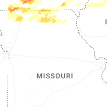

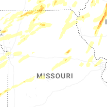


Connect with Interactive Hail Maps