

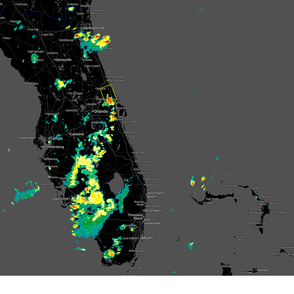
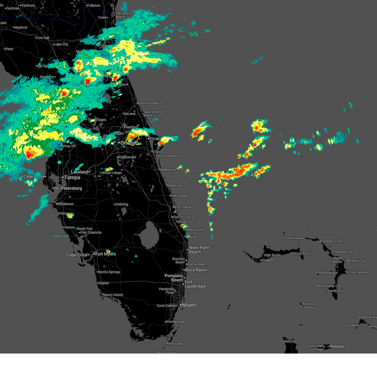
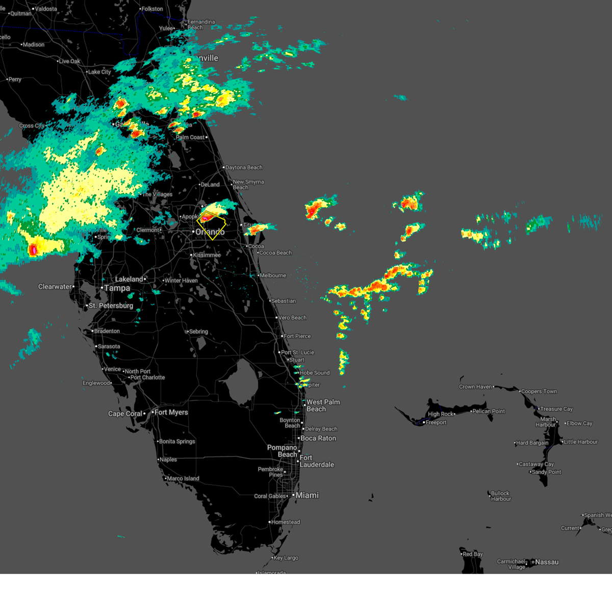
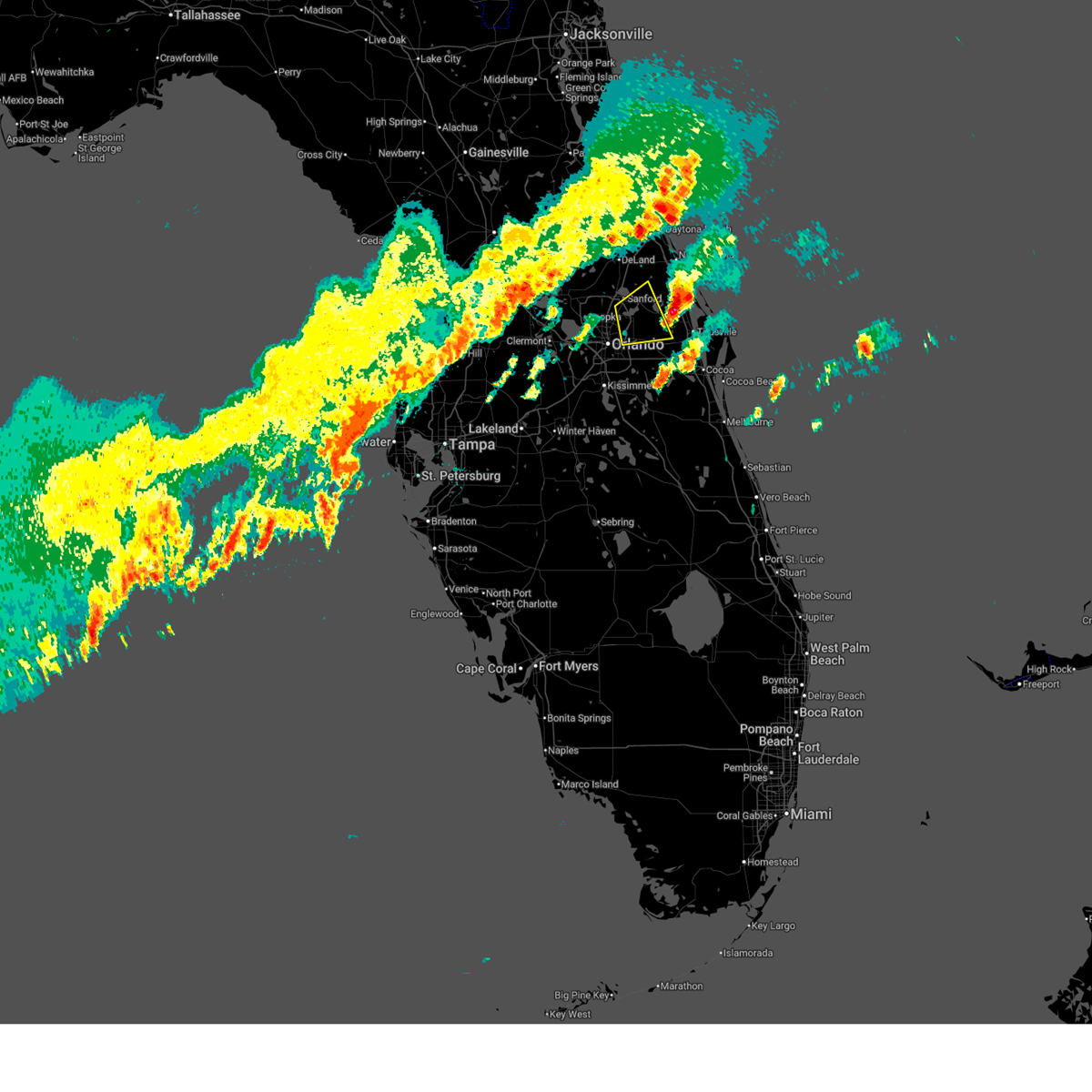
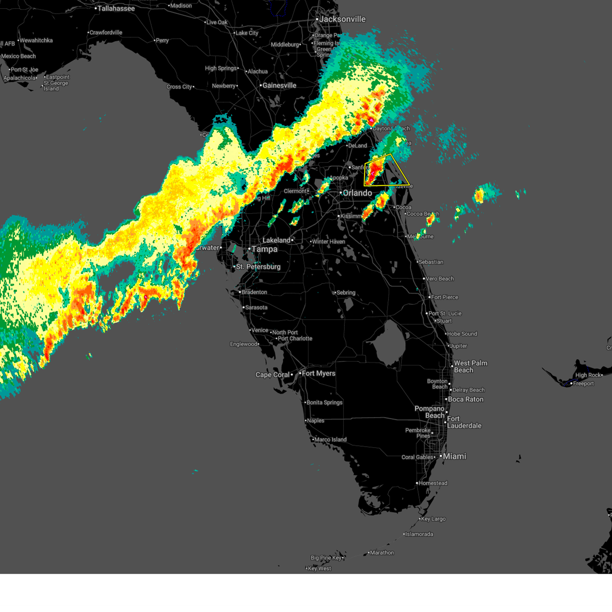
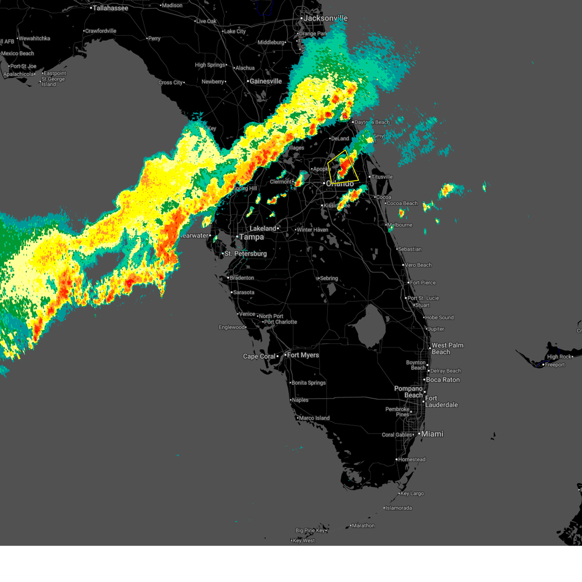
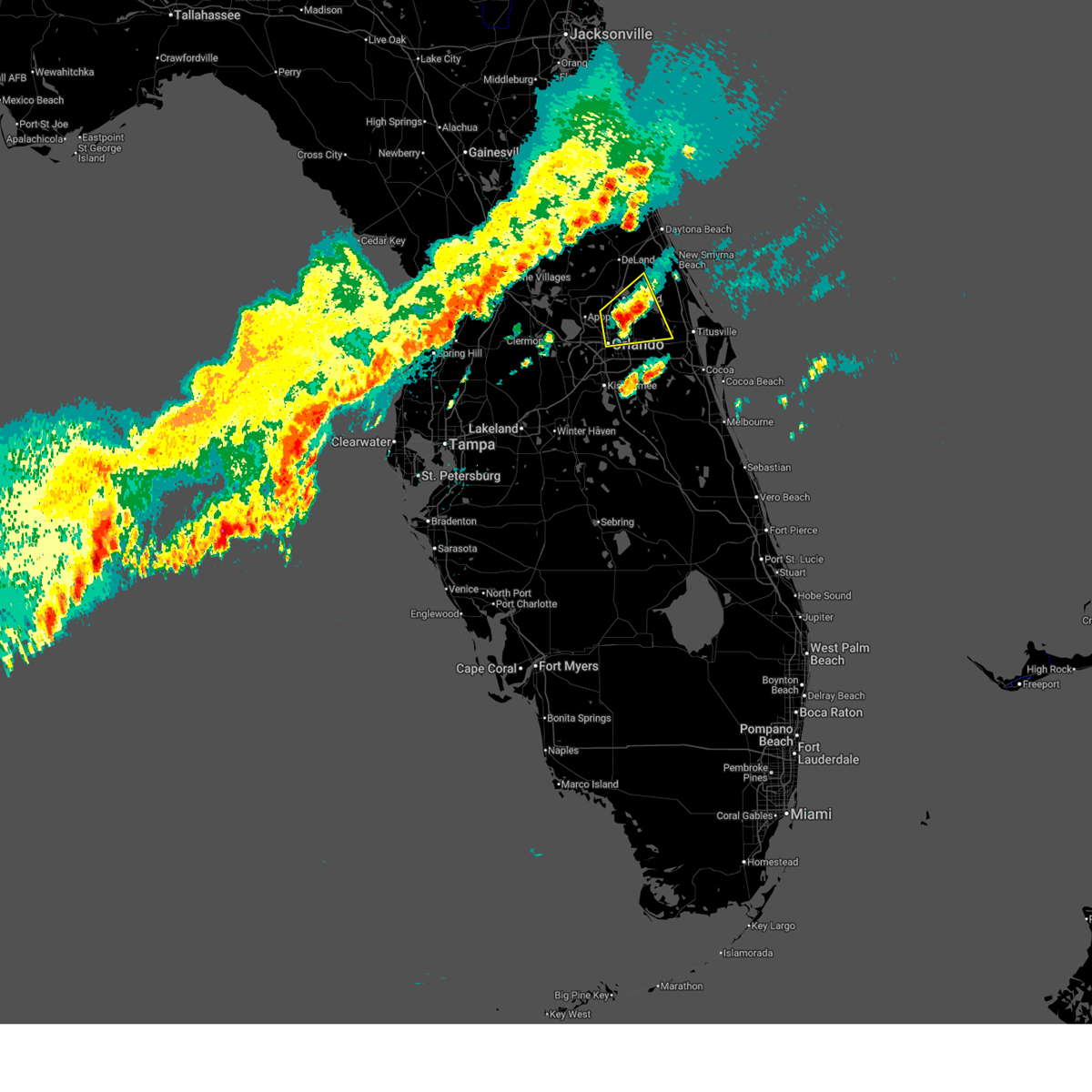
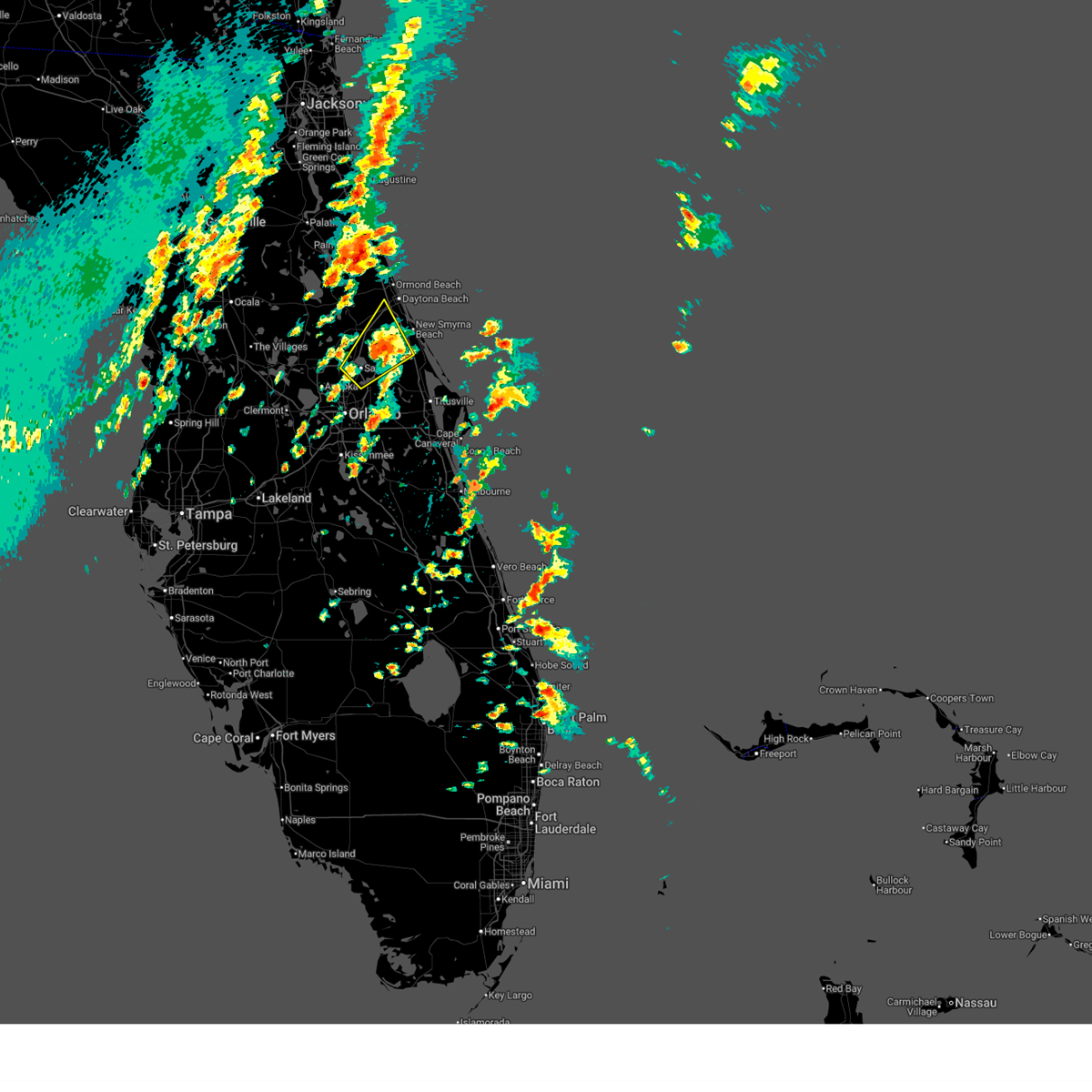
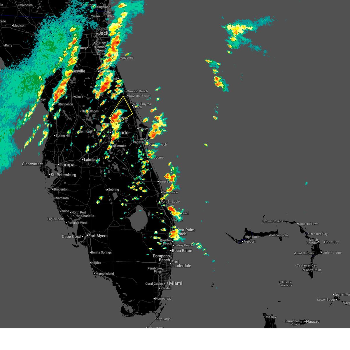
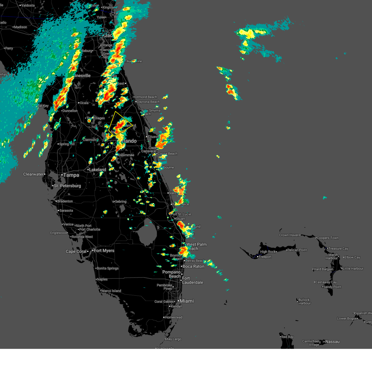
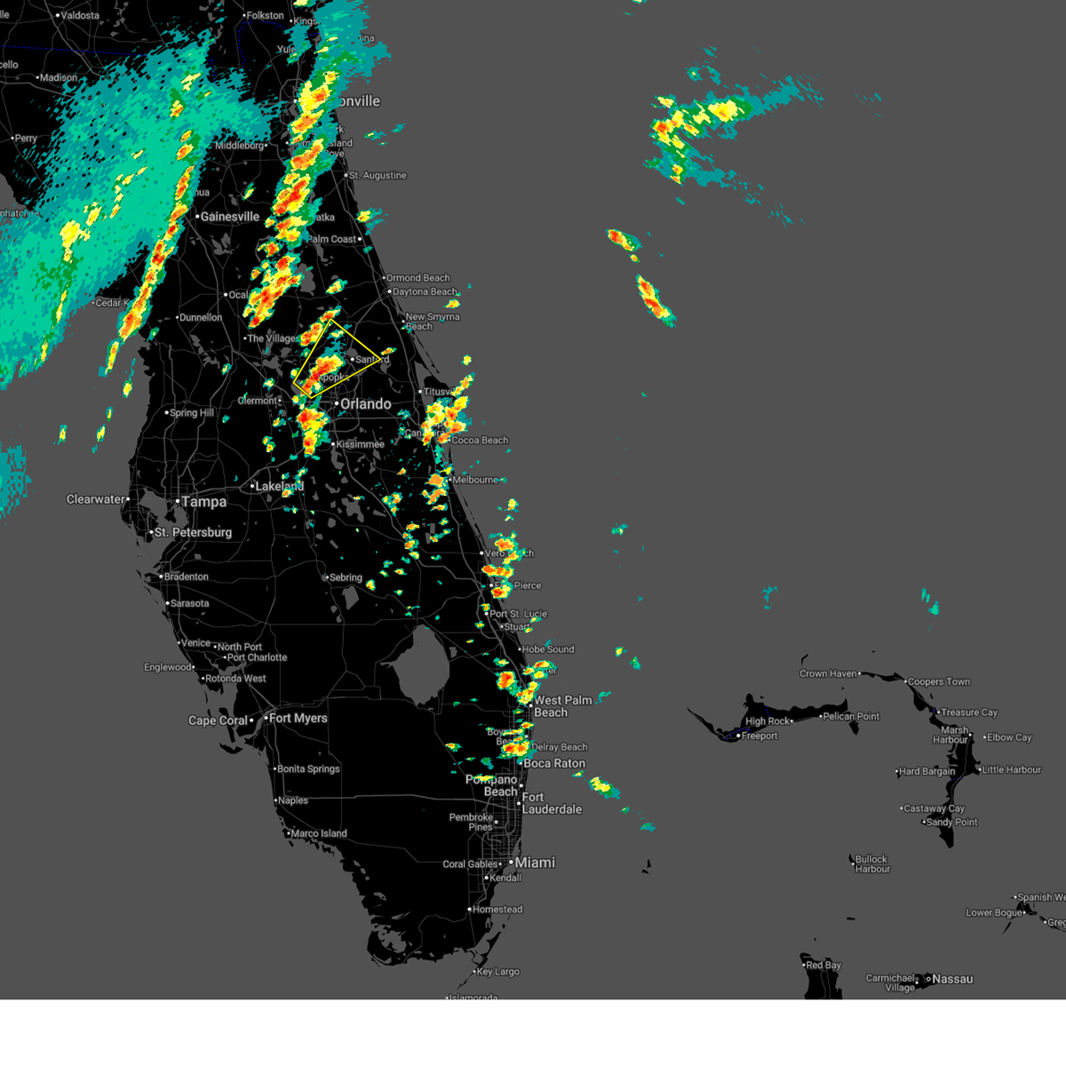
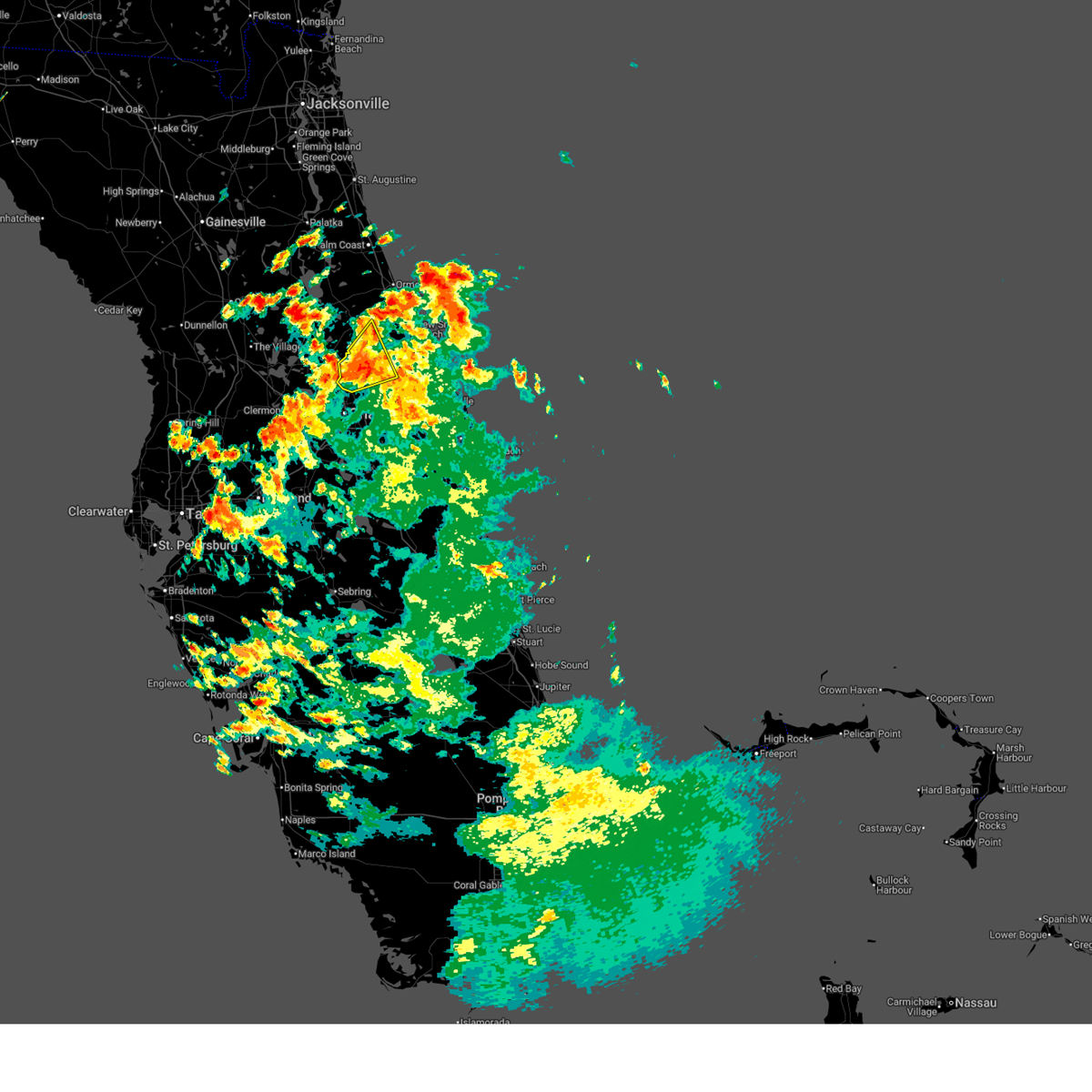
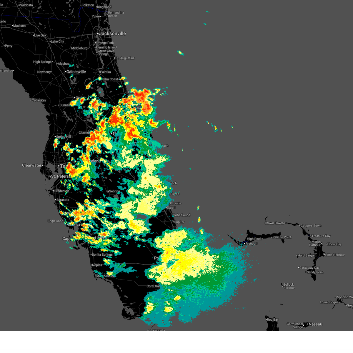
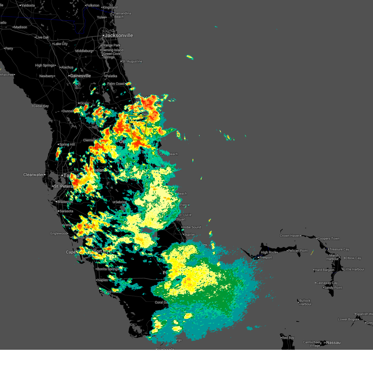
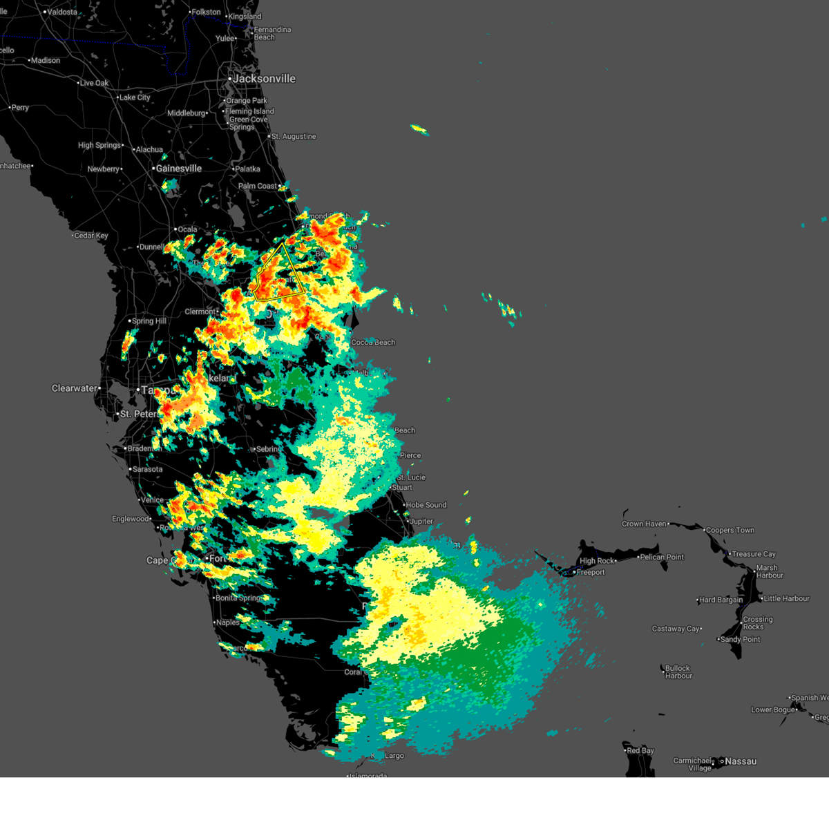
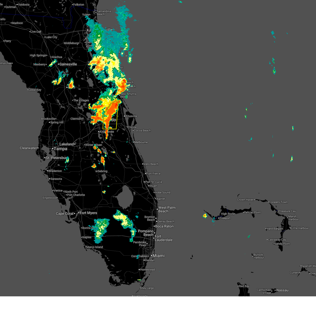
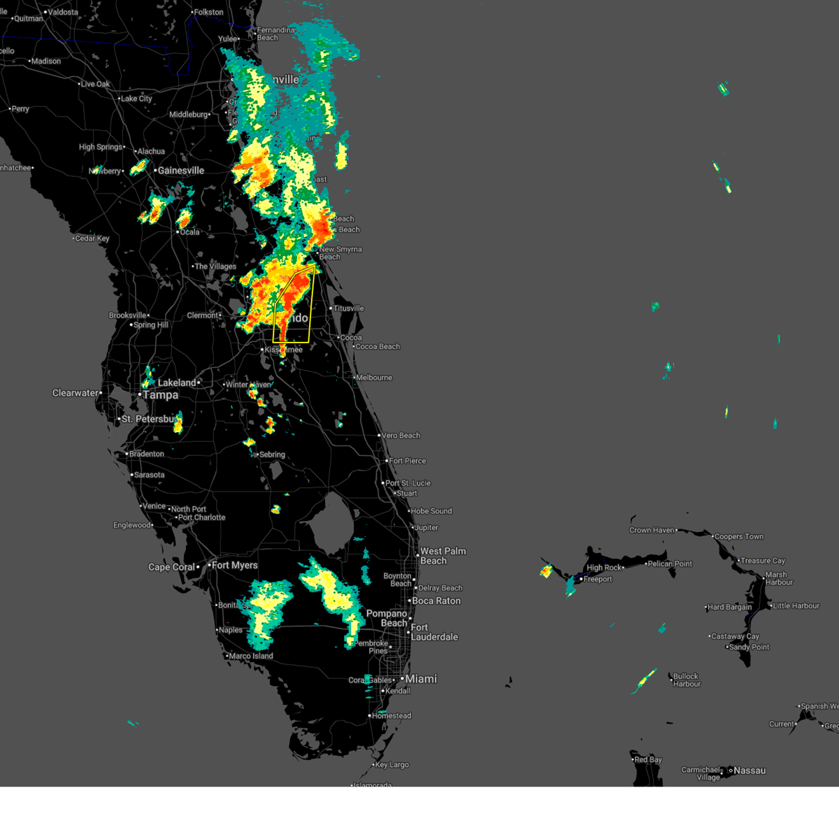
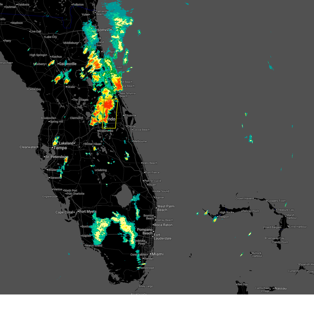
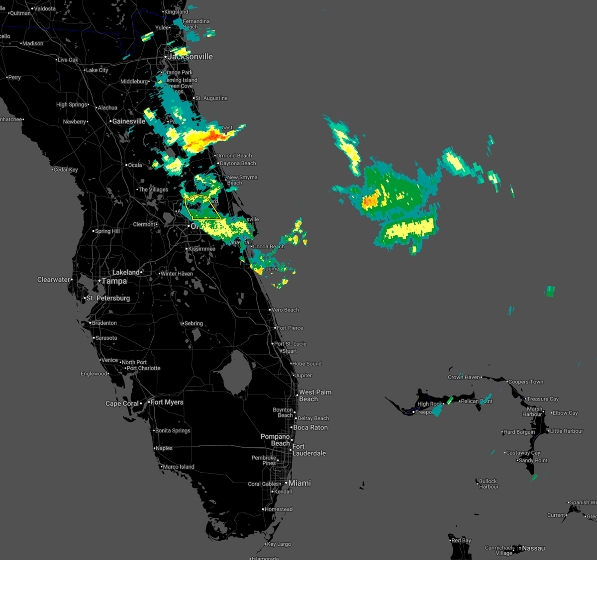
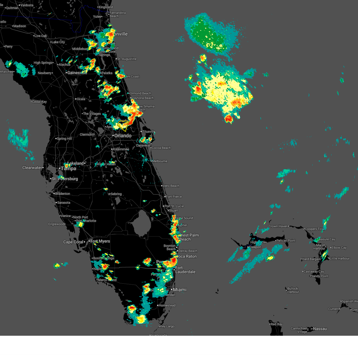
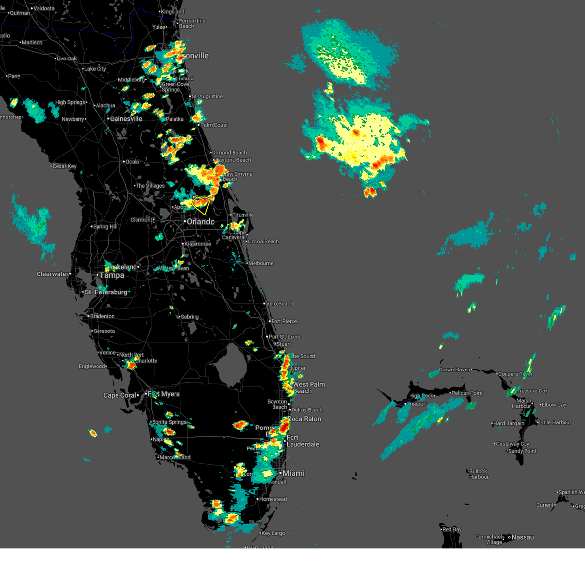
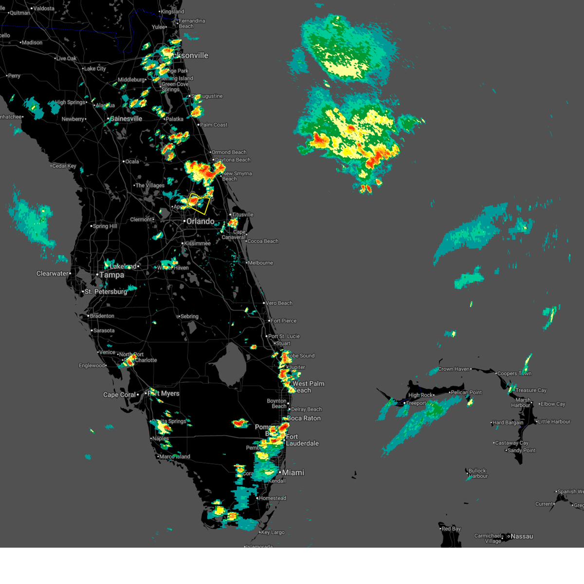
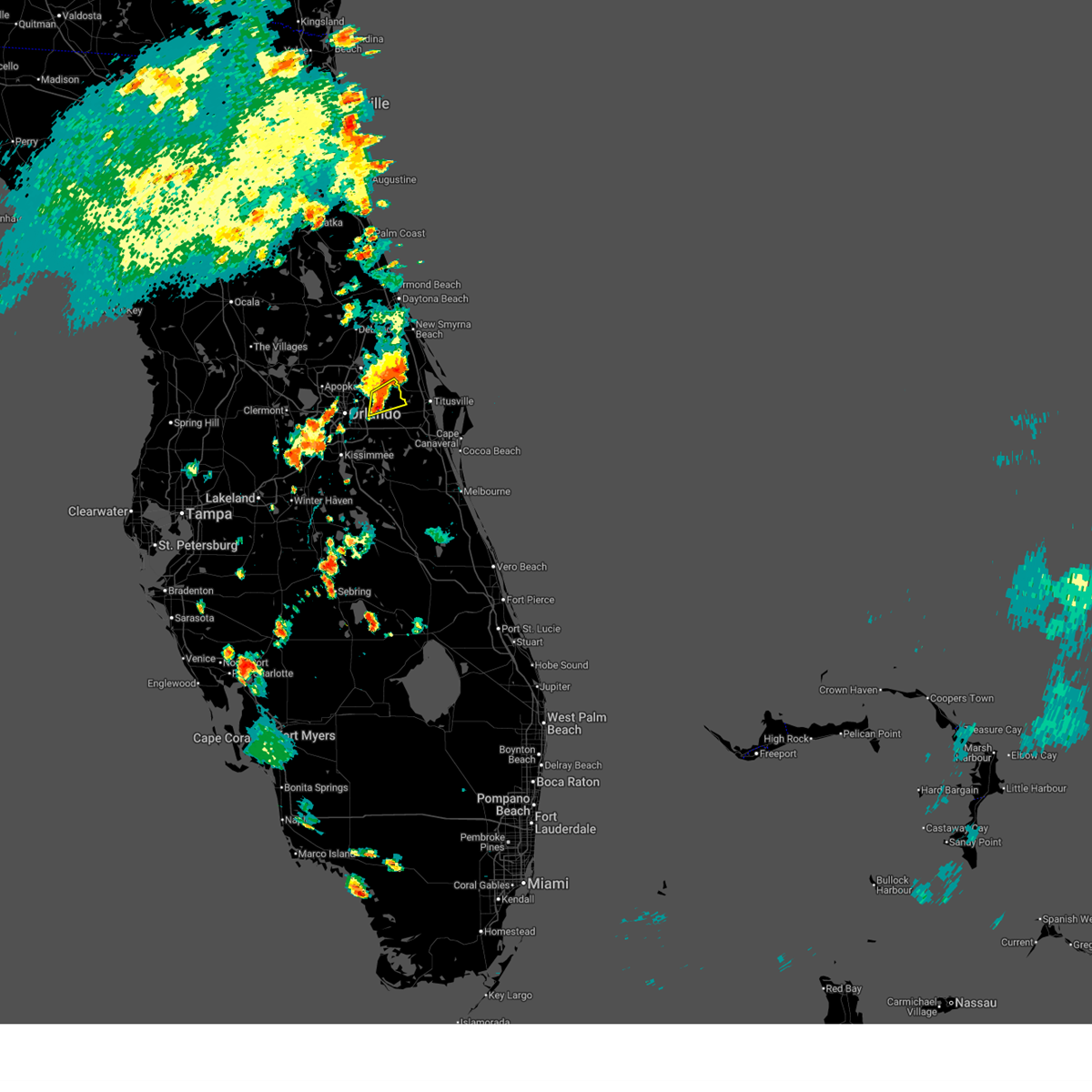
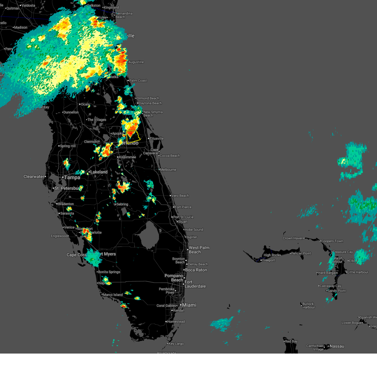
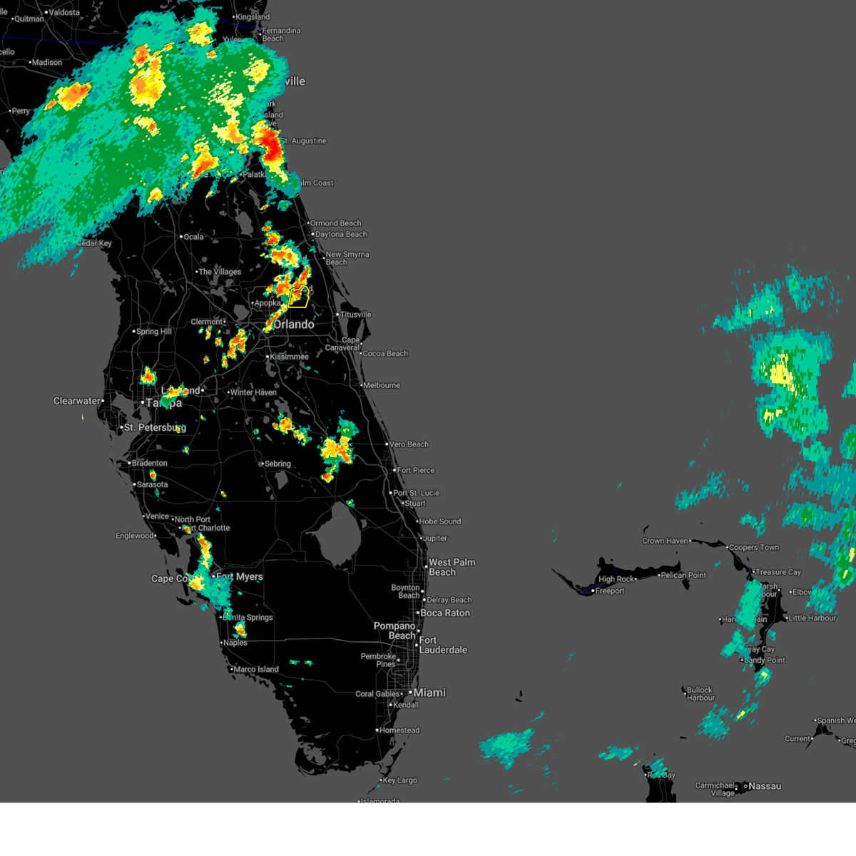
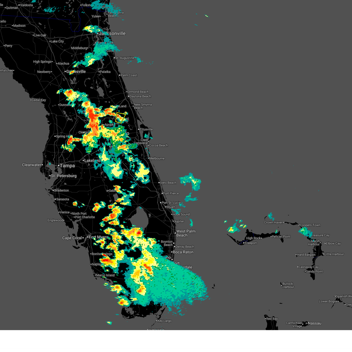
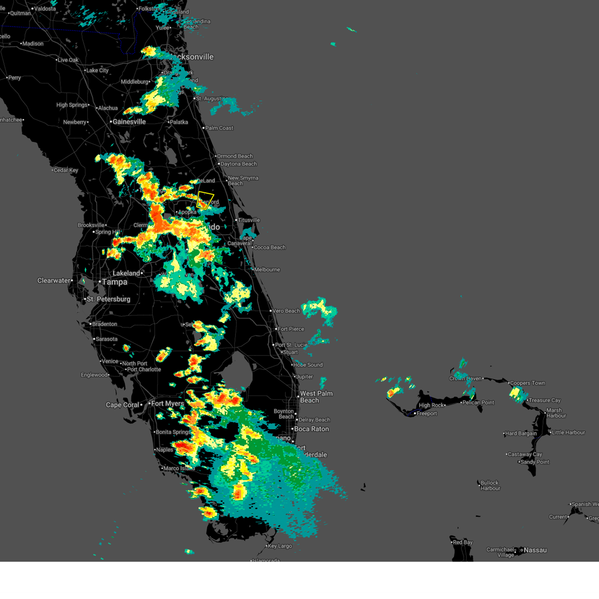
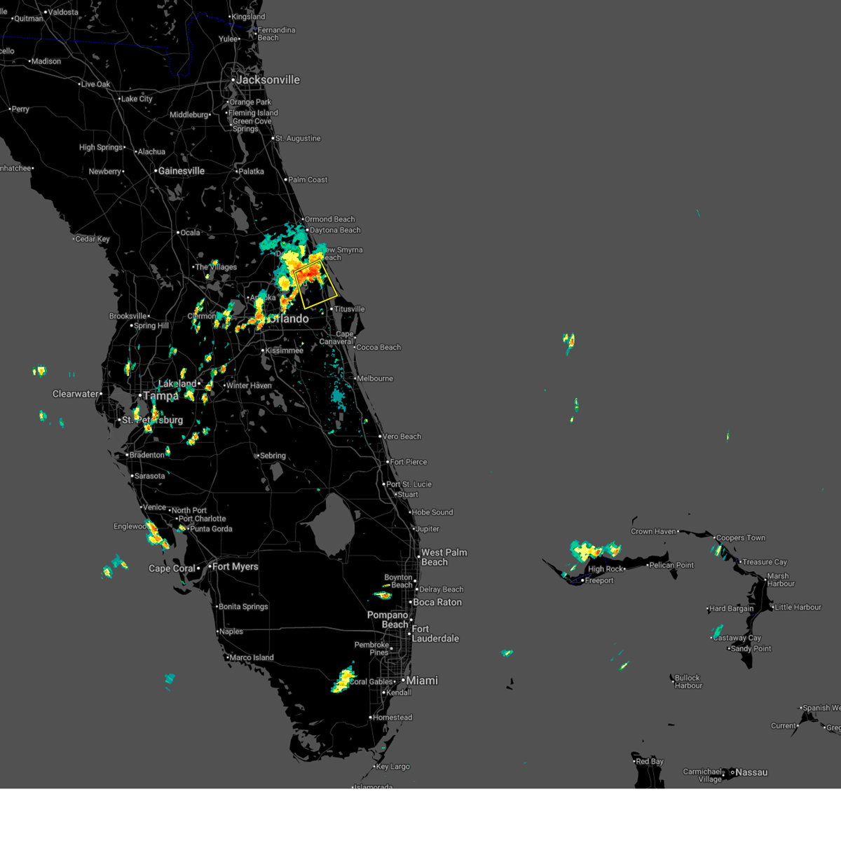
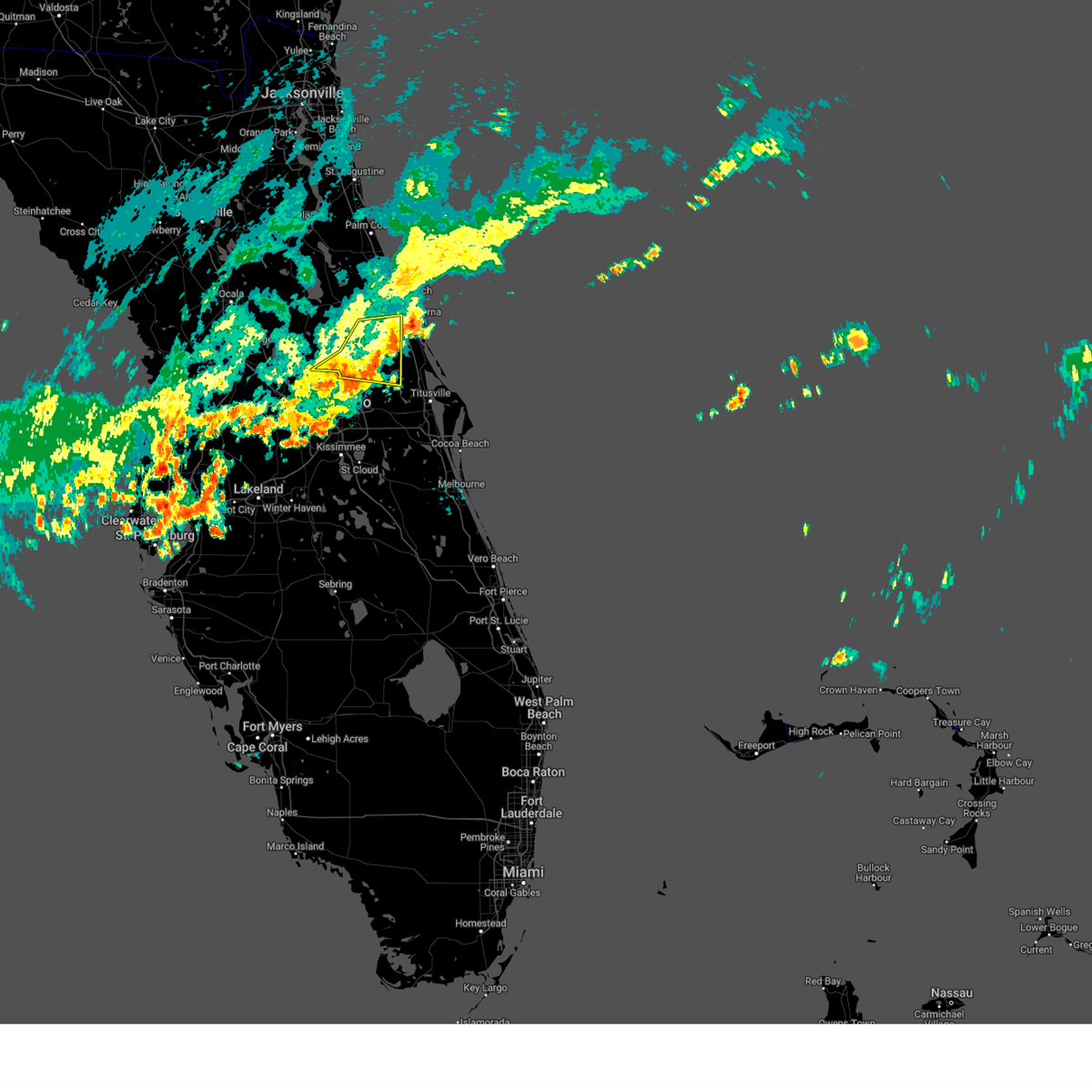
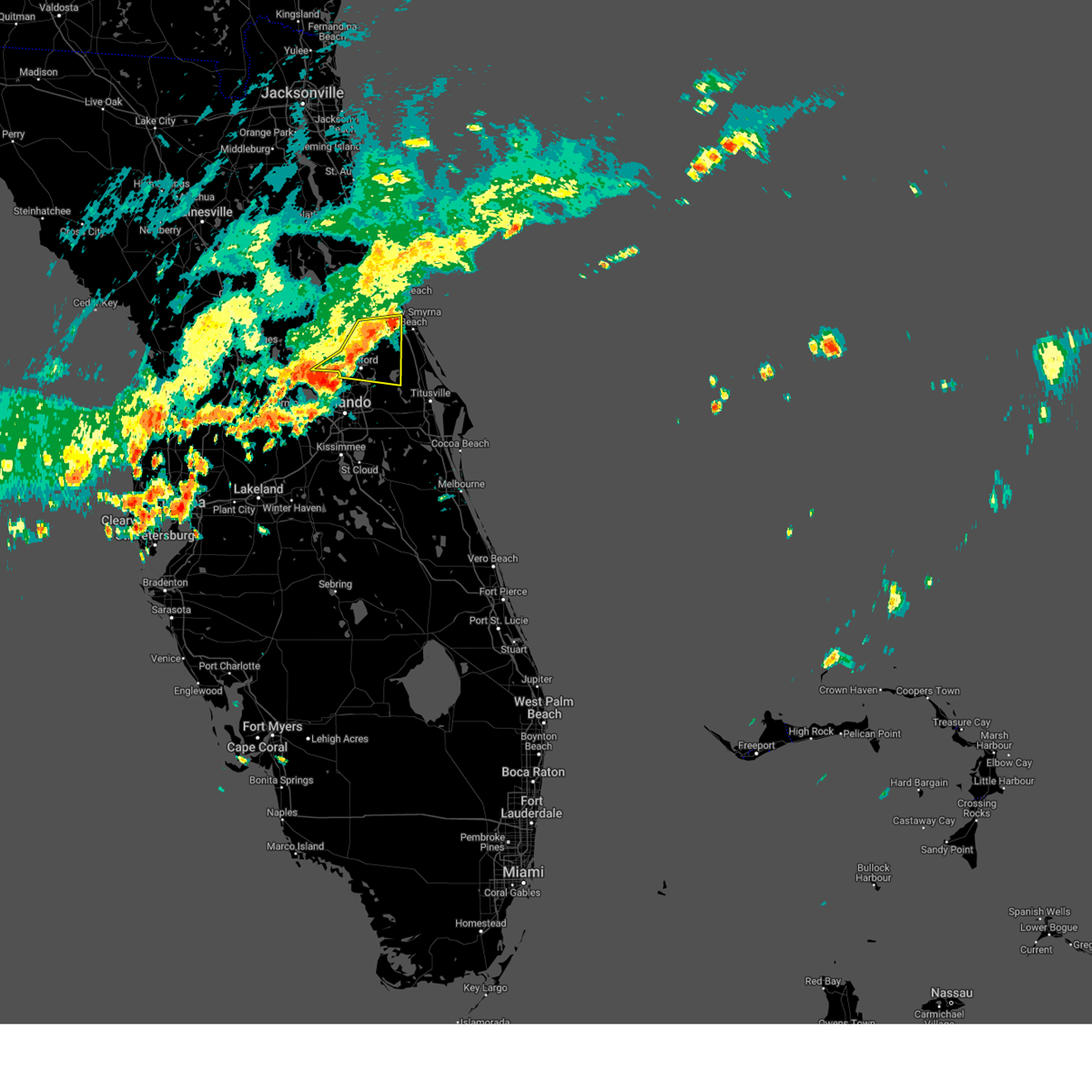
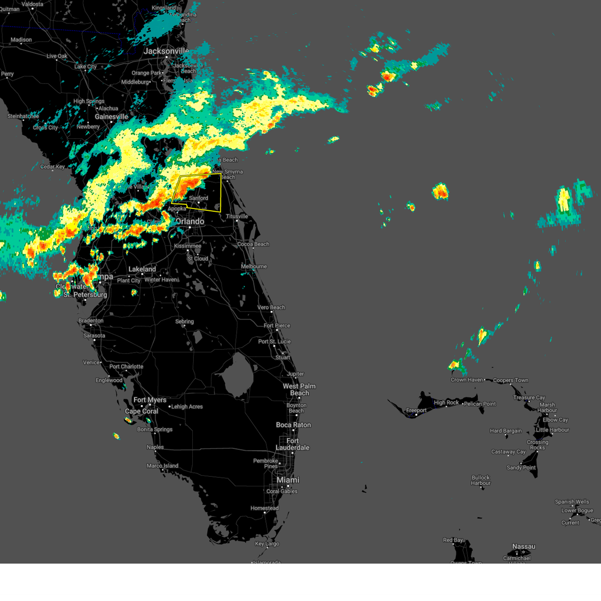
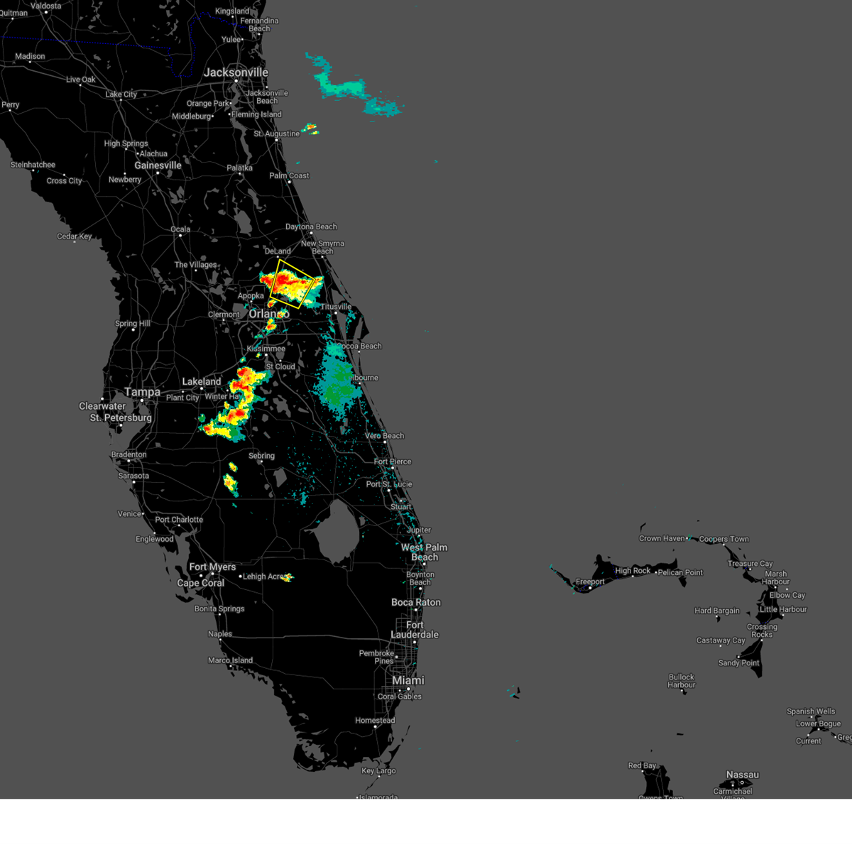
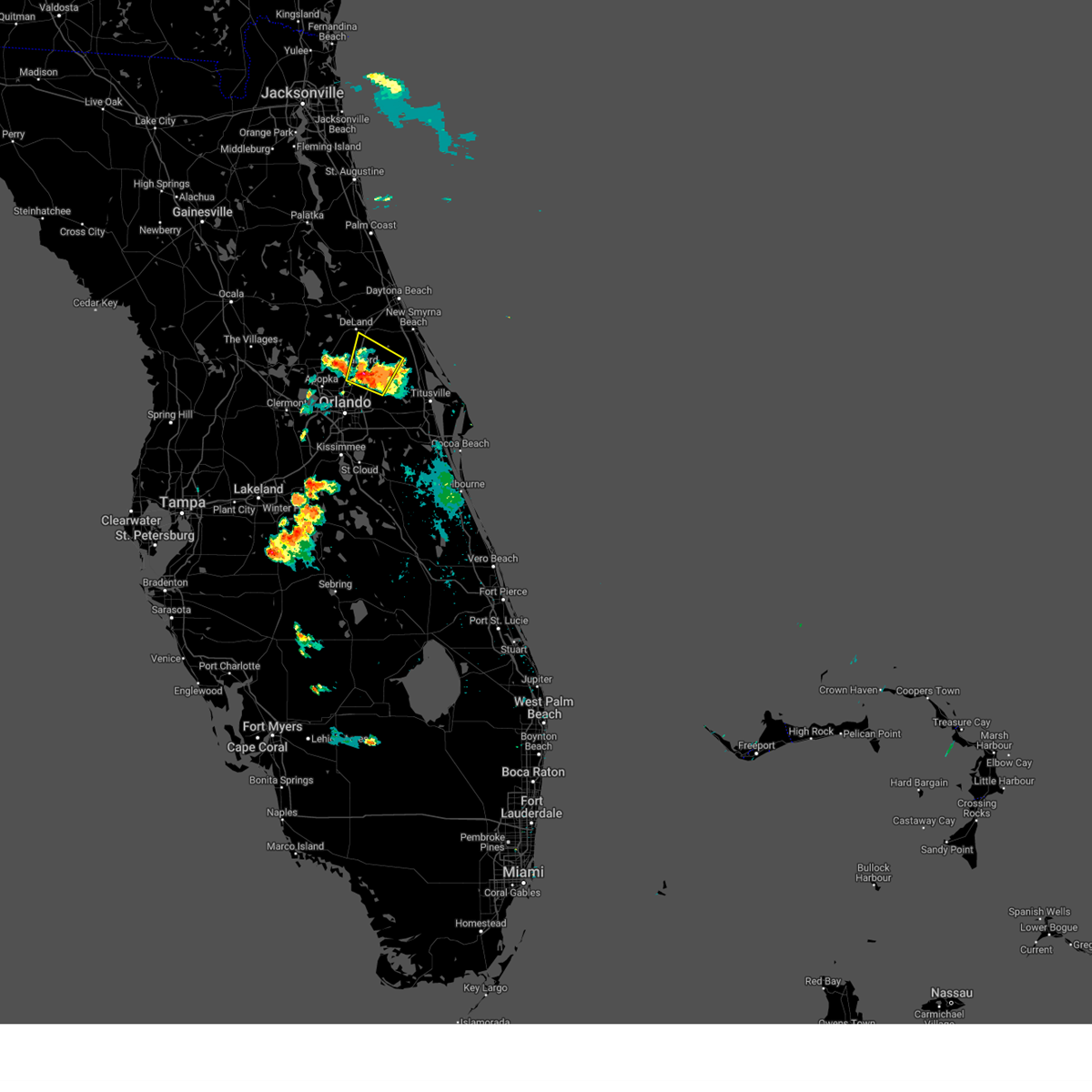
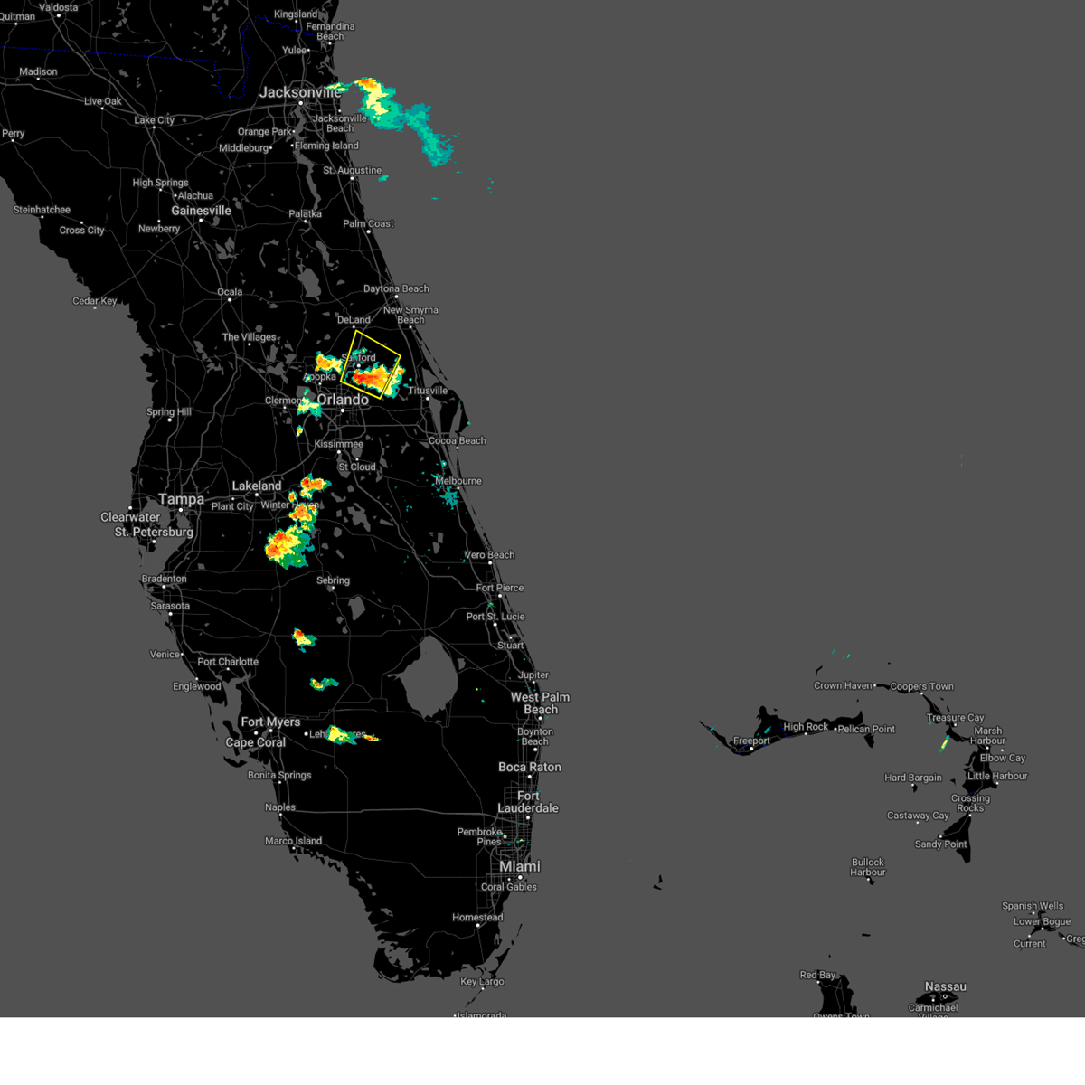
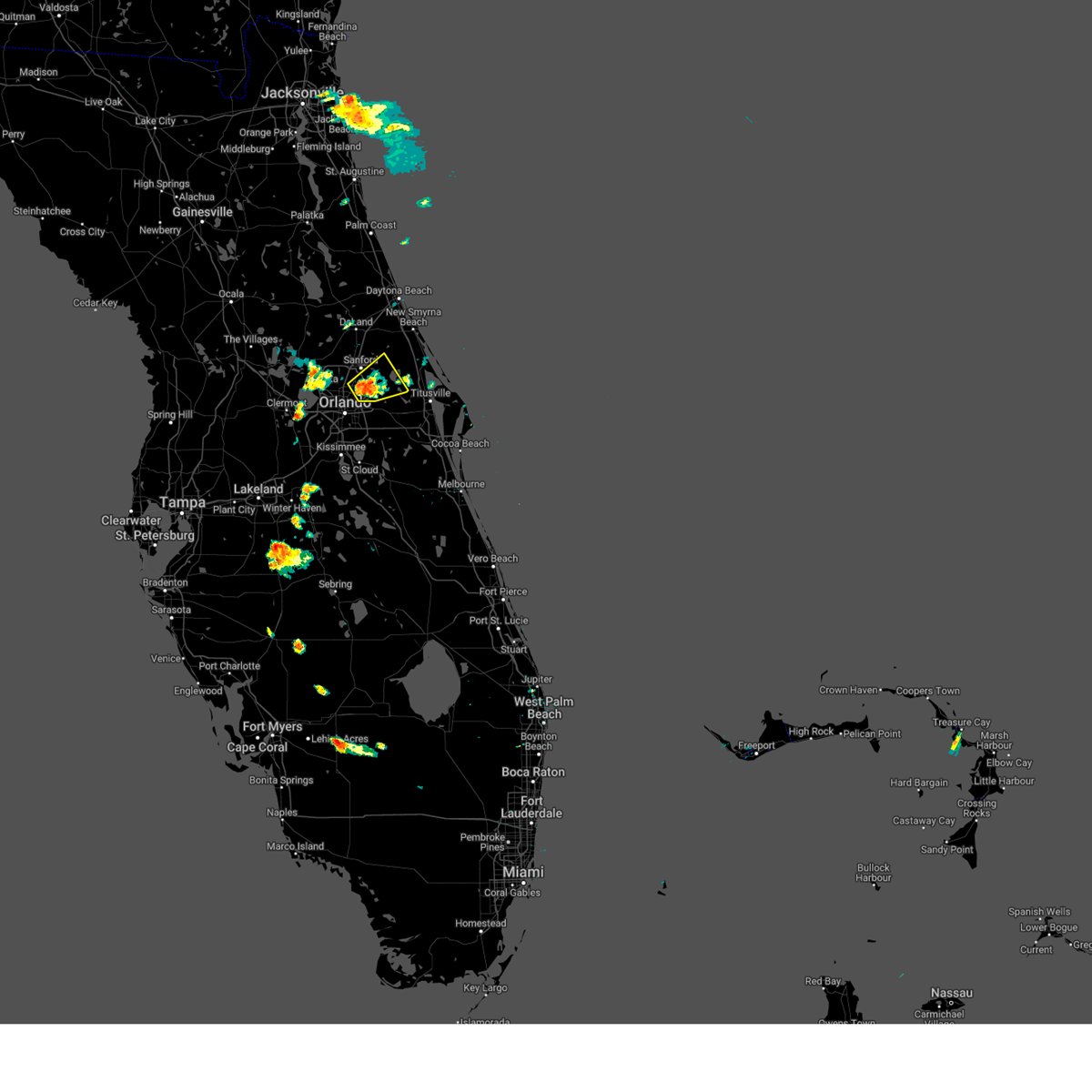
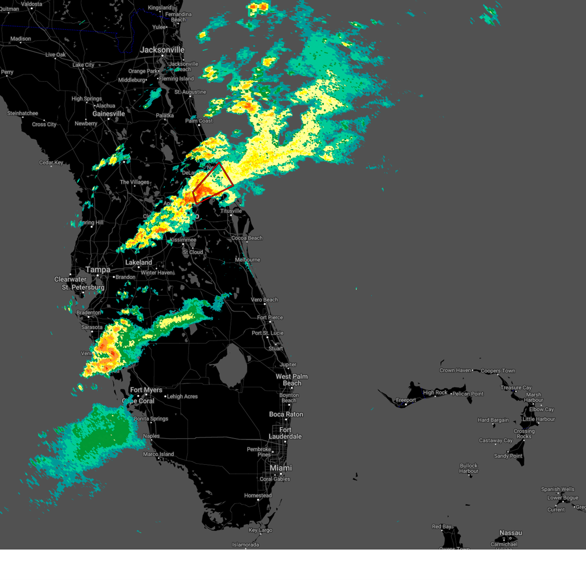
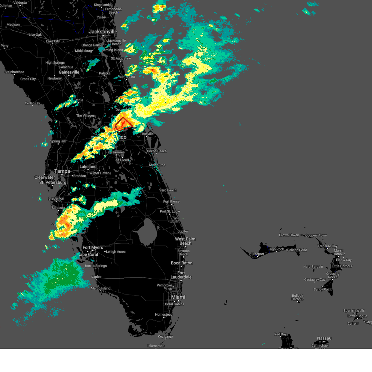
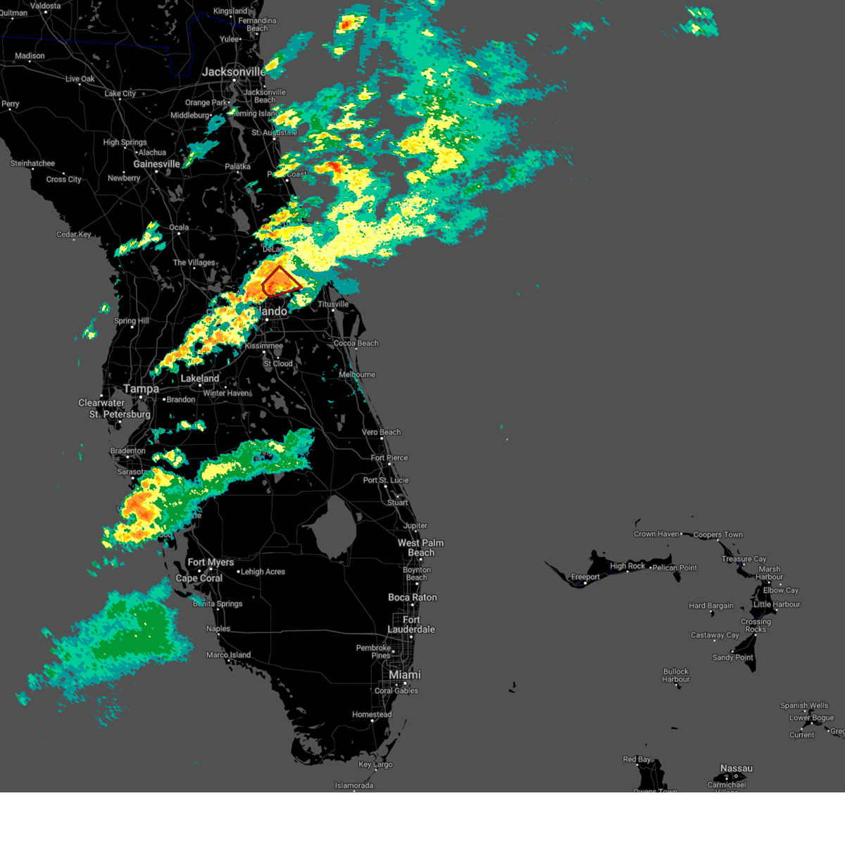
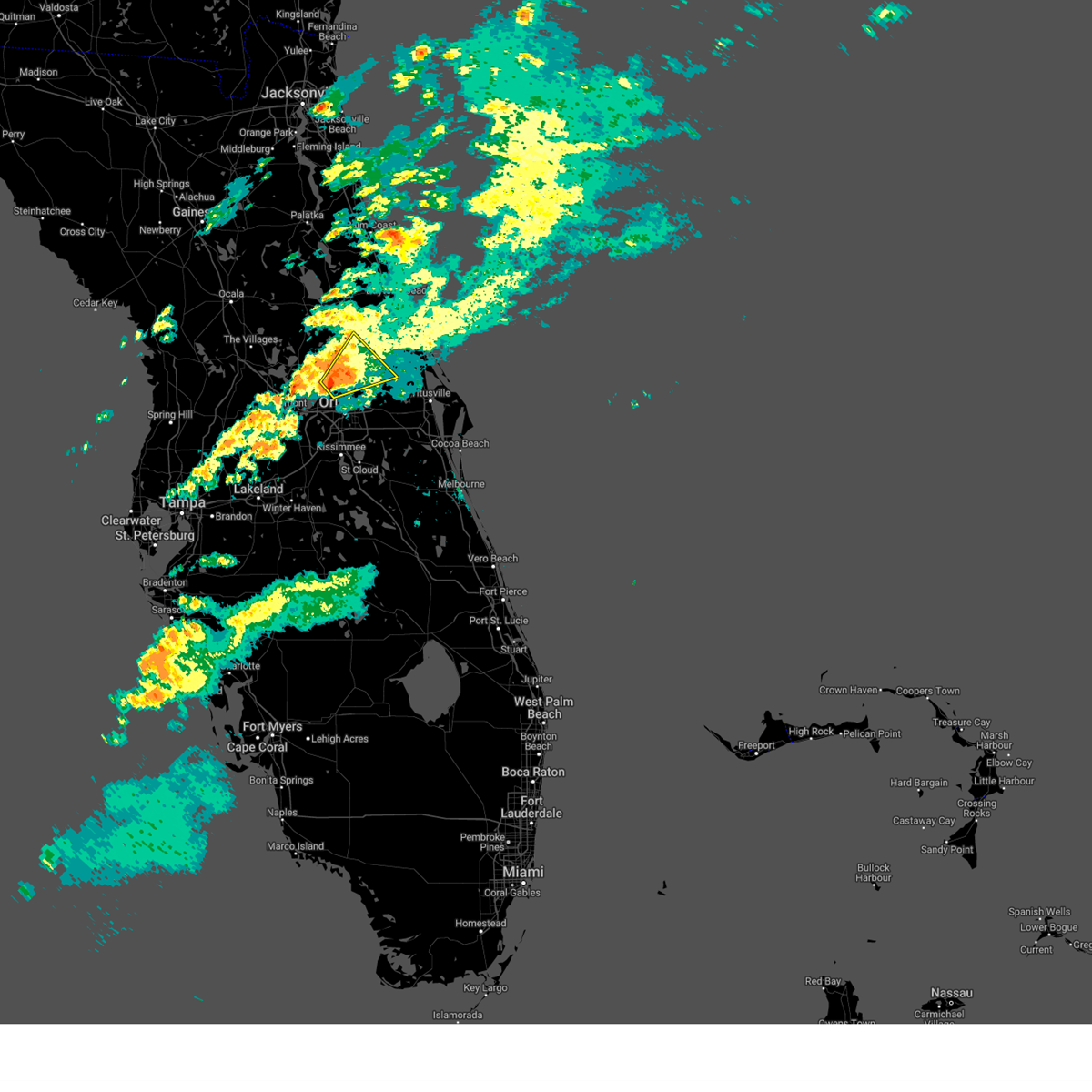
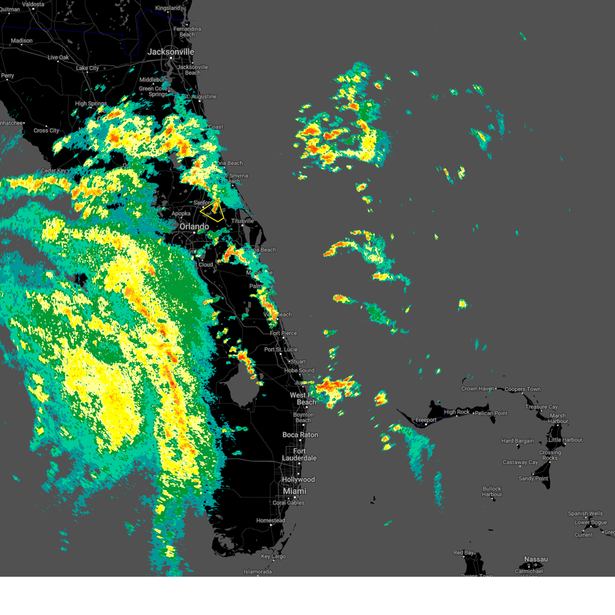
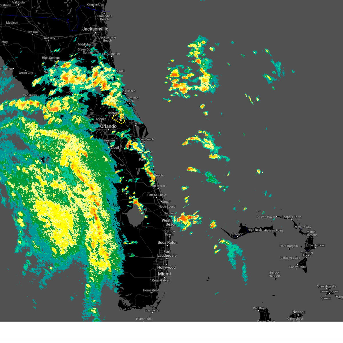
Hail Map for Geneva, FL
The Geneva, FL area has had 0 reports of on-the-ground hail by trained spotters, and has been under severe weather warnings 28 times during the past 12 months. Doppler radar has detected hail at or near Geneva, FL on 102 occasions, including 5 occasions during the past year.
| Name: | Geneva, FL |
| Where Located: | 20.9 miles NE of Orlando, FL |
| Map: | Google Map for Geneva, FL |
| Population: | 2940 |
| Housing Units: | 1110 |
| More Info: | Search Google for Geneva, FL |
2
The Top Recent Hail Date for Geneva, FL is Wednesday, July 9, 2025 (10th out of 102)

Hail and Wind Damage Spotted near Geneva, FL
| Date / Time | Report Details |
|---|---|
| 6/25/2026 6:13 PM EDT |
 Svrmlb the national weather service in melbourne has issued a * severe thunderstorm warning for, northeastern seminole county in east central florida, southeastern volusia county in east central florida, * until 645 pm edt. * at 613 pm edt, a severe thunderstorm was located near maytown, or 9 miles northeast of geneva, moving north at 20 mph (radar indicated). Hazards include 60 mph wind gusts and penny size hail. expect damage to roofs, siding, and trees Svrmlb the national weather service in melbourne has issued a * severe thunderstorm warning for, northeastern seminole county in east central florida, southeastern volusia county in east central florida, * until 645 pm edt. * at 613 pm edt, a severe thunderstorm was located near maytown, or 9 miles northeast of geneva, moving north at 20 mph (radar indicated). Hazards include 60 mph wind gusts and penny size hail. expect damage to roofs, siding, and trees
|
| 5/12/2026 12:26 PM EDT |
 At 1226 pm edt, a severe thunderstorm was located over chuluota, moving east at 20 mph (radar indicated). Hazards include 60 mph wind gusts and quarter size hail. Hail damage to vehicles is expected. expect wind damage to roofs, siding, and trees. Locations impacted include, oviedo, wedgefield, university of central florida, bithlo, and chuluota. At 1226 pm edt, a severe thunderstorm was located over chuluota, moving east at 20 mph (radar indicated). Hazards include 60 mph wind gusts and quarter size hail. Hail damage to vehicles is expected. expect wind damage to roofs, siding, and trees. Locations impacted include, oviedo, wedgefield, university of central florida, bithlo, and chuluota.
|
| 5/12/2026 11:57 AM EDT |
 Svrmlb the national weather service in melbourne has issued a * severe thunderstorm warning for, southeastern seminole county in east central florida, central orange county in east central florida, * until 1245 pm edt. * at 1157 am edt, a severe thunderstorm was located over winter springs, moving southeast at 15 mph (radar indicated). Hazards include 60 mph wind gusts and half dollar size hail. Hail damage to vehicles is expected. Expect wind damage to roofs, siding, and trees. Svrmlb the national weather service in melbourne has issued a * severe thunderstorm warning for, southeastern seminole county in east central florida, central orange county in east central florida, * until 1245 pm edt. * at 1157 am edt, a severe thunderstorm was located over winter springs, moving southeast at 15 mph (radar indicated). Hazards include 60 mph wind gusts and half dollar size hail. Hail damage to vehicles is expected. Expect wind damage to roofs, siding, and trees.
|
| 5/2/2026 2:29 PM EDT |
 The storm which prompted the warning has moved out of the area. therefore, the warning will be allowed to expire. a tornado watch remains in effect until 600 pm edt for east central florida. The storm which prompted the warning has moved out of the area. therefore, the warning will be allowed to expire. a tornado watch remains in effect until 600 pm edt for east central florida.
|
| 5/2/2026 2:20 PM EDT |
 Svrmlb the national weather service in melbourne has issued a * severe thunderstorm warning for, southeastern seminole county in east central florida, northwestern brevard county in east central florida, southeastern volusia county in east central florida, * until 300 pm edt. * at 220 pm edt, a severe thunderstorm was located near maytown, or near scottsmoor, moving east at 30 mph (radar indicated). Hazards include 60 mph wind gusts and quarter size hail. Hail damage to vehicles is expected. Expect wind damage to roofs, siding, and trees. Svrmlb the national weather service in melbourne has issued a * severe thunderstorm warning for, southeastern seminole county in east central florida, northwestern brevard county in east central florida, southeastern volusia county in east central florida, * until 300 pm edt. * at 220 pm edt, a severe thunderstorm was located near maytown, or near scottsmoor, moving east at 30 mph (radar indicated). Hazards include 60 mph wind gusts and quarter size hail. Hail damage to vehicles is expected. Expect wind damage to roofs, siding, and trees.
|
| 5/2/2026 2:06 PM EDT |
 At 206 pm edt, a severe thunderstorm was located over geneva, moving east at 30 mph (radar indicated). Hazards include 60 mph wind gusts and quarter size hail. Hail damage to vehicles is expected. expect wind damage to roofs, siding, and trees. Locations impacted include, sanford, oviedo, winter springs, casselberry, and lake mary. At 206 pm edt, a severe thunderstorm was located over geneva, moving east at 30 mph (radar indicated). Hazards include 60 mph wind gusts and quarter size hail. Hail damage to vehicles is expected. expect wind damage to roofs, siding, and trees. Locations impacted include, sanford, oviedo, winter springs, casselberry, and lake mary.
|
| 5/2/2026 1:56 PM EDT |
 Svrmlb the national weather service in melbourne has issued a * severe thunderstorm warning for, seminole county in east central florida, central orange county in east central florida, south central volusia county in east central florida, * until 230 pm edt. * at 156 pm edt, a severe thunderstorm was located over winter springs, moving east at 25 mph (radar indicated). Hazards include 60 mph wind gusts and quarter size hail. Hail damage to vehicles is expected. Expect wind damage to roofs, siding, and trees. Svrmlb the national weather service in melbourne has issued a * severe thunderstorm warning for, seminole county in east central florida, central orange county in east central florida, south central volusia county in east central florida, * until 230 pm edt. * at 156 pm edt, a severe thunderstorm was located over winter springs, moving east at 25 mph (radar indicated). Hazards include 60 mph wind gusts and quarter size hail. Hail damage to vehicles is expected. Expect wind damage to roofs, siding, and trees.
|
| 3/16/2026 2:40 PM EDT |
 the severe thunderstorm warning has been cancelled and is no longer in effect the severe thunderstorm warning has been cancelled and is no longer in effect
|
| 3/16/2026 2:24 PM EDT |
 Svrmlb the national weather service in melbourne has issued a * severe thunderstorm warning for, central seminole county in east central florida, central volusia county in east central florida, * until 300 pm edt. * at 223 pm edt, a severe thunderstorm was located over sanford, moving northeast at 45 mph (radar indicated). Hazards include 60 mph wind gusts and quarter size hail. Hail damage to vehicles is expected. Expect wind damage to roofs, siding, and trees. Svrmlb the national weather service in melbourne has issued a * severe thunderstorm warning for, central seminole county in east central florida, central volusia county in east central florida, * until 300 pm edt. * at 223 pm edt, a severe thunderstorm was located over sanford, moving northeast at 45 mph (radar indicated). Hazards include 60 mph wind gusts and quarter size hail. Hail damage to vehicles is expected. Expect wind damage to roofs, siding, and trees.
|
| 3/16/2026 2:18 PM EDT |
 At 217 pm edt, a severe thunderstorm was located near wekiva springs, or near lake mary, moving northeast at 40 mph (radar indicated). Hazards include 60 mph wind gusts and quarter size hail. Hail damage to vehicles is expected. expect wind damage to roofs, siding, and trees. Locations impacted include, deltona, sanford, apopka, altamonte springs, and winter springs. At 217 pm edt, a severe thunderstorm was located near wekiva springs, or near lake mary, moving northeast at 40 mph (radar indicated). Hazards include 60 mph wind gusts and quarter size hail. Hail damage to vehicles is expected. expect wind damage to roofs, siding, and trees. Locations impacted include, deltona, sanford, apopka, altamonte springs, and winter springs.
|
| 3/16/2026 2:01 PM EDT |
 Svrmlb the national weather service in melbourne has issued a * severe thunderstorm warning for, northwestern seminole county in east central florida, east central lake county in east central florida, northwestern orange county in east central florida, south central volusia county in east central florida, * until 230 pm edt. * at 200 pm edt, a severe thunderstorm was located over wekiwa springs state park, or near apopka, moving northeast at 30 mph (radar indicated). Hazards include 60 mph wind gusts and quarter size hail. Hail damage to vehicles is expected. Expect wind damage to roofs, siding, and trees. Svrmlb the national weather service in melbourne has issued a * severe thunderstorm warning for, northwestern seminole county in east central florida, east central lake county in east central florida, northwestern orange county in east central florida, south central volusia county in east central florida, * until 230 pm edt. * at 200 pm edt, a severe thunderstorm was located over wekiwa springs state park, or near apopka, moving northeast at 30 mph (radar indicated). Hazards include 60 mph wind gusts and quarter size hail. Hail damage to vehicles is expected. Expect wind damage to roofs, siding, and trees.
|
| 3/15/2026 6:07 PM EDT |
 The storm which prompted the warning has weakened below severe limits, and no longer poses an immediate threat to life or property. therefore, the warning will be allowed to expire. however small hail and gusty winds are still possible with this thunderstorm. The storm which prompted the warning has weakened below severe limits, and no longer poses an immediate threat to life or property. therefore, the warning will be allowed to expire. however small hail and gusty winds are still possible with this thunderstorm.
|
| 3/15/2026 6:04 PM EDT |
 the severe thunderstorm warning has been cancelled and is no longer in effect the severe thunderstorm warning has been cancelled and is no longer in effect
|
| 3/15/2026 5:51 PM EDT |
 At 550 pm edt, a severe thunderstorm was located over sanford, moving northeast at 20 mph (radar indicated). Hazards include 60 mph wind gusts and quarter size hail. Hail damage to vehicles is expected. expect wind damage to roofs, siding, and trees. Locations impacted include, deltona, sanford, altamonte springs, winter springs, and deland. At 550 pm edt, a severe thunderstorm was located over sanford, moving northeast at 20 mph (radar indicated). Hazards include 60 mph wind gusts and quarter size hail. Hail damage to vehicles is expected. expect wind damage to roofs, siding, and trees. Locations impacted include, deltona, sanford, altamonte springs, winter springs, and deland.
|
| 3/15/2026 5:41 PM EDT |
 Svrmlb the national weather service in melbourne has issued a * severe thunderstorm warning for, eastern seminole county in east central florida, northwestern brevard county in east central florida, east central orange county in east central florida, southeastern volusia county in east central florida, * until 615 pm edt. * at 541 pm edt, a severe thunderstorm was located 7 miles east of chuluota, moving north at 45 mph (radar indicated). Hazards include 60 mph wind gusts. expect damage to roofs, siding, and trees Svrmlb the national weather service in melbourne has issued a * severe thunderstorm warning for, eastern seminole county in east central florida, northwestern brevard county in east central florida, east central orange county in east central florida, southeastern volusia county in east central florida, * until 615 pm edt. * at 541 pm edt, a severe thunderstorm was located 7 miles east of chuluota, moving north at 45 mph (radar indicated). Hazards include 60 mph wind gusts. expect damage to roofs, siding, and trees
|
| 3/15/2026 5:35 PM EDT |
 Svrmlb the national weather service in melbourne has issued a * severe thunderstorm warning for, seminole county in east central florida, south central volusia county in east central florida, * until 615 pm edt. * at 535 pm edt, a severe thunderstorm was located over lake mary, moving northeast at 20 mph (radar indicated). Hazards include 60 mph wind gusts and quarter size hail. Hail damage to vehicles is expected. Expect wind damage to roofs, siding, and trees. Svrmlb the national weather service in melbourne has issued a * severe thunderstorm warning for, seminole county in east central florida, south central volusia county in east central florida, * until 615 pm edt. * at 535 pm edt, a severe thunderstorm was located over lake mary, moving northeast at 20 mph (radar indicated). Hazards include 60 mph wind gusts and quarter size hail. Hail damage to vehicles is expected. Expect wind damage to roofs, siding, and trees.
|
| 8/5/2025 8:01 PM EDT |
 The storms which prompted the warning have weakened below severe limits. therefore, the warning has been allowed to expire. however gusty winds and heavy rain are still possible with these thunderstorms. The storms which prompted the warning have weakened below severe limits. therefore, the warning has been allowed to expire. however gusty winds and heavy rain are still possible with these thunderstorms.
|
| 8/5/2025 7:46 PM EDT |
 At 746 pm edt, severe thunderstorms were located along a line extending from near maytown to lake hart, moving east at 10 mph (radar indicated). Hazards include 60 mph wind gusts and penny size hail. Expect damage to roofs, siding, and trees. Locations impacted include, orlando, oviedo, winter springs, wedgefield, and avalon park. At 746 pm edt, severe thunderstorms were located along a line extending from near maytown to lake hart, moving east at 10 mph (radar indicated). Hazards include 60 mph wind gusts and penny size hail. Expect damage to roofs, siding, and trees. Locations impacted include, orlando, oviedo, winter springs, wedgefield, and avalon park.
|
| 8/5/2025 7:34 PM EDT |
 Svrmlb the national weather service in melbourne has issued a * severe thunderstorm warning for, eastern seminole county in east central florida, southeastern orange county in east central florida, south central volusia county in east central florida, * until 800 pm edt. * at 734 pm edt, severe thunderstorms were located along a line extending from near osteen to near lake hart, moving east at 10 mph (radar indicated). Hazards include 60 mph wind gusts and penny size hail. expect damage to roofs, siding, and trees Svrmlb the national weather service in melbourne has issued a * severe thunderstorm warning for, eastern seminole county in east central florida, southeastern orange county in east central florida, south central volusia county in east central florida, * until 800 pm edt. * at 734 pm edt, severe thunderstorms were located along a line extending from near osteen to near lake hart, moving east at 10 mph (radar indicated). Hazards include 60 mph wind gusts and penny size hail. expect damage to roofs, siding, and trees
|
| 7/14/2025 12:05 AM EDT |
 The storm which prompted the warning has weakened below severe limits, and no longer poses an immediate threat to life or property. therefore, the warning will be allowed to expire. however gusty winds and heavy rain are still possible with this thunderstorm. The storm which prompted the warning has weakened below severe limits, and no longer poses an immediate threat to life or property. therefore, the warning will be allowed to expire. however gusty winds and heavy rain are still possible with this thunderstorm.
|
| 7/13/2025 11:46 PM EDT |
 At 1146 pm edt, a severe thunderstorm was located over oviedo, moving southeast at 25 mph (radar indicated). Hazards include 60 mph wind gusts. Expect damage to roofs, siding, and trees. Locations impacted include, deltona, sanford, altamonte springs, oviedo, and winter springs. At 1146 pm edt, a severe thunderstorm was located over oviedo, moving southeast at 25 mph (radar indicated). Hazards include 60 mph wind gusts. Expect damage to roofs, siding, and trees. Locations impacted include, deltona, sanford, altamonte springs, oviedo, and winter springs.
|
| 7/13/2025 11:34 PM EDT |
 Svrmlb the national weather service in melbourne has issued a * severe thunderstorm warning for, seminole county in east central florida, south central volusia county in east central florida, * until 1215 am edt. * at 1133 pm edt, a severe thunderstorm was located over sanford, moving southeast at 15 mph (radar indicated). Hazards include 60 mph wind gusts. expect damage to roofs, siding, and trees Svrmlb the national weather service in melbourne has issued a * severe thunderstorm warning for, seminole county in east central florida, south central volusia county in east central florida, * until 1215 am edt. * at 1133 pm edt, a severe thunderstorm was located over sanford, moving southeast at 15 mph (radar indicated). Hazards include 60 mph wind gusts. expect damage to roofs, siding, and trees
|
| 7/13/2025 2:35 PM EDT |
 the severe thunderstorm warning has been cancelled and is no longer in effect the severe thunderstorm warning has been cancelled and is no longer in effect
|
| 7/13/2025 2:25 PM EDT |
 At 224 pm edt, a severe thunderstorm was located over lake jesup, moving east at 20 mph (radar indicated). Hazards include 60 mph wind gusts. Expect damage to roofs, siding, and trees. Locations impacted include, sanford, oviedo, winter springs, geneva, and lake jesup. At 224 pm edt, a severe thunderstorm was located over lake jesup, moving east at 20 mph (radar indicated). Hazards include 60 mph wind gusts. Expect damage to roofs, siding, and trees. Locations impacted include, sanford, oviedo, winter springs, geneva, and lake jesup.
|
| 7/13/2025 2:15 PM EDT |
 Svrmlb the national weather service in melbourne has issued a * severe thunderstorm warning for, central seminole county in east central florida, * until 245 pm edt. * at 214 pm edt, a severe thunderstorm was located over lake jesup, moving east at 20 mph (radar indicated). Hazards include 60 mph wind gusts. expect damage to roofs, siding, and trees Svrmlb the national weather service in melbourne has issued a * severe thunderstorm warning for, central seminole county in east central florida, * until 245 pm edt. * at 214 pm edt, a severe thunderstorm was located over lake jesup, moving east at 20 mph (radar indicated). Hazards include 60 mph wind gusts. expect damage to roofs, siding, and trees
|
| 7/9/2025 5:40 PM EDT |
 At 540 pm edt, a severe thunderstorm was located over bithlo, moving south at 15 mph (radar indicated). Hazards include 60 mph wind gusts and quarter size hail. Hail damage to vehicles is expected. expect wind damage to roofs, siding, and trees. Locations impacted include, oviedo, university of central florida, bithlo, chuluota, and geneva. At 540 pm edt, a severe thunderstorm was located over bithlo, moving south at 15 mph (radar indicated). Hazards include 60 mph wind gusts and quarter size hail. Hail damage to vehicles is expected. expect wind damage to roofs, siding, and trees. Locations impacted include, oviedo, university of central florida, bithlo, chuluota, and geneva.
|
| 7/9/2025 5:23 PM EDT |
 Svrmlb the national weather service in melbourne has issued a * severe thunderstorm warning for, southeastern seminole county in east central florida, east central orange county in east central florida, * until 600 pm edt. * at 523 pm edt, a severe thunderstorm was located over oviedo, moving southeast at 5 mph (radar indicated). Hazards include 60 mph wind gusts and quarter size hail. Hail damage to vehicles is expected. Expect wind damage to roofs, siding, and trees. Svrmlb the national weather service in melbourne has issued a * severe thunderstorm warning for, southeastern seminole county in east central florida, east central orange county in east central florida, * until 600 pm edt. * at 523 pm edt, a severe thunderstorm was located over oviedo, moving southeast at 5 mph (radar indicated). Hazards include 60 mph wind gusts and quarter size hail. Hail damage to vehicles is expected. Expect wind damage to roofs, siding, and trees.
|
| 7/9/2025 5:01 PM EDT |
 Svrmlb the national weather service in melbourne has issued a * severe thunderstorm warning for, eastern seminole county in east central florida, * until 530 pm edt. * at 500 pm edt, a severe thunderstorm was located near geneva, moving south at 5 mph (radar indicated). Hazards include 60 mph wind gusts and quarter size hail. Hail damage to vehicles is expected. Expect wind damage to roofs, siding, and trees. Svrmlb the national weather service in melbourne has issued a * severe thunderstorm warning for, eastern seminole county in east central florida, * until 530 pm edt. * at 500 pm edt, a severe thunderstorm was located near geneva, moving south at 5 mph (radar indicated). Hazards include 60 mph wind gusts and quarter size hail. Hail damage to vehicles is expected. Expect wind damage to roofs, siding, and trees.
|
| 6/27/2025 5:26 PM EDT |
 the severe thunderstorm warning has been cancelled and is no longer in effect the severe thunderstorm warning has been cancelled and is no longer in effect
|
| 6/27/2025 5:13 PM EDT |
 Svrmlb the national weather service in melbourne has issued a * severe thunderstorm warning for, central seminole county in east central florida, south central volusia county in east central florida, * until 600 pm edt. * at 513 pm edt, a severe thunderstorm was located near sanford, moving northeast at 20 mph (radar indicated). Hazards include 60 mph wind gusts and penny size hail. expect damage to roofs, siding, and trees Svrmlb the national weather service in melbourne has issued a * severe thunderstorm warning for, central seminole county in east central florida, south central volusia county in east central florida, * until 600 pm edt. * at 513 pm edt, a severe thunderstorm was located near sanford, moving northeast at 20 mph (radar indicated). Hazards include 60 mph wind gusts and penny size hail. expect damage to roofs, siding, and trees
|
| 6/20/2025 1:16 PM EDT |
 Svrmlb the national weather service in melbourne has issued a * severe thunderstorm warning for, eastern seminole county in east central florida, northwestern brevard county in east central florida, southeastern volusia county in east central florida, * until 145 pm edt. * at 116 pm edt, a severe thunderstorm was located near maytown, or 9 miles northwest of scottsmoor, moving south at 20 mph (radar indicated). Hazards include 60 mph wind gusts and quarter size hail. Hail damage to vehicles is expected. Expect wind damage to roofs, siding, and trees. Svrmlb the national weather service in melbourne has issued a * severe thunderstorm warning for, eastern seminole county in east central florida, northwestern brevard county in east central florida, southeastern volusia county in east central florida, * until 145 pm edt. * at 116 pm edt, a severe thunderstorm was located near maytown, or 9 miles northwest of scottsmoor, moving south at 20 mph (radar indicated). Hazards include 60 mph wind gusts and quarter size hail. Hail damage to vehicles is expected. Expect wind damage to roofs, siding, and trees.
|
| 5/31/2025 6:13 AM EDT |
 The storm which prompted the warning has weakened below severe limits, and no longer poses an immediate threat to life or property. therefore, the warning will be allowed to expire. however gusty winds are still possible with this thunderstorm. to report severe weather, contact your nearest law enforcement agency. they will relay your report to the national weather service melbourne. The storm which prompted the warning has weakened below severe limits, and no longer poses an immediate threat to life or property. therefore, the warning will be allowed to expire. however gusty winds are still possible with this thunderstorm. to report severe weather, contact your nearest law enforcement agency. they will relay your report to the national weather service melbourne.
|
| 5/31/2025 5:52 AM EDT |
 At 552 am edt, a severe thunderstorm was located over debary, moving east at 40 mph (radar indicated). Hazards include 60 mph wind gusts. Expect damage to roofs, siding, and trees. Locations impacted include, deltona, port orange, sanford, deland, and new smyrna beach. At 552 am edt, a severe thunderstorm was located over debary, moving east at 40 mph (radar indicated). Hazards include 60 mph wind gusts. Expect damage to roofs, siding, and trees. Locations impacted include, deltona, port orange, sanford, deland, and new smyrna beach.
|
| 5/31/2025 5:39 AM EDT |
 Svrmlb the national weather service in melbourne has issued a * severe thunderstorm warning for, central seminole county in east central florida, northeastern lake county in east central florida, central volusia county in east central florida, * until 615 am edt. * at 539 am edt, a severe thunderstorm was located over cassia, moving east at 40 mph (radar indicated). Hazards include 60 mph wind gusts. expect damage to roofs, siding, and trees Svrmlb the national weather service in melbourne has issued a * severe thunderstorm warning for, central seminole county in east central florida, northeastern lake county in east central florida, central volusia county in east central florida, * until 615 am edt. * at 539 am edt, a severe thunderstorm was located over cassia, moving east at 40 mph (radar indicated). Hazards include 60 mph wind gusts. expect damage to roofs, siding, and trees
|
| 4/1/2025 8:29 PM EDT |
 The storm which prompted the warning has weakened below severe limits, and no longer poses an immediate threat to life or property. therefore, the warning will be allowed to expire. however gusty winds are still possible with this thunderstorm. to report severe weather, contact your nearest law enforcement agency. they will relay your report to the national weather service melbourne. The storm which prompted the warning has weakened below severe limits, and no longer poses an immediate threat to life or property. therefore, the warning will be allowed to expire. however gusty winds are still possible with this thunderstorm. to report severe weather, contact your nearest law enforcement agency. they will relay your report to the national weather service melbourne.
|
| 4/1/2025 8:08 PM EDT |
 At 808 pm edt, a severe thunderstorm was located over sanford, moving northeast at 15 mph (radar indicated). Hazards include 60 mph wind gusts and quarter size hail. Hail damage to vehicles is expected. expect wind damage to roofs, siding, and trees. Locations impacted include, lake harney, osteen, orange city, farmton, and geneva. At 808 pm edt, a severe thunderstorm was located over sanford, moving northeast at 15 mph (radar indicated). Hazards include 60 mph wind gusts and quarter size hail. Hail damage to vehicles is expected. expect wind damage to roofs, siding, and trees. Locations impacted include, lake harney, osteen, orange city, farmton, and geneva.
|
| 4/1/2025 7:58 PM EDT |
 Svrmlb the national weather service in melbourne has issued a * severe thunderstorm warning for, seminole county in east central florida, south central volusia county in east central florida, * until 830 pm edt. * at 758 pm edt, a severe thunderstorm was located over sanford, moving northeast at 20 mph (radar indicated). Hazards include 60 mph wind gusts and quarter size hail. Hail damage to vehicles is expected. Expect wind damage to roofs, siding, and trees. Svrmlb the national weather service in melbourne has issued a * severe thunderstorm warning for, seminole county in east central florida, south central volusia county in east central florida, * until 830 pm edt. * at 758 pm edt, a severe thunderstorm was located over sanford, moving northeast at 20 mph (radar indicated). Hazards include 60 mph wind gusts and quarter size hail. Hail damage to vehicles is expected. Expect wind damage to roofs, siding, and trees.
|
| 4/1/2025 7:50 PM EDT |
 At 749 pm edt, a severe thunderstorm was located over lake jesup, moving northeast at 15 mph (radar indicated). Hazards include 60 mph wind gusts and nickel size hail. Expect damage to roofs, siding, and trees. Locations impacted include, lake harney, chuluota, osteen, geneva, and longwood. At 749 pm edt, a severe thunderstorm was located over lake jesup, moving northeast at 15 mph (radar indicated). Hazards include 60 mph wind gusts and nickel size hail. Expect damage to roofs, siding, and trees. Locations impacted include, lake harney, chuluota, osteen, geneva, and longwood.
|
| 4/1/2025 7:35 PM EDT |
 Svrmlb the national weather service in melbourne has issued a * severe thunderstorm warning for, seminole county in east central florida, south central volusia county in east central florida, * until 800 pm edt. * at 734 pm edt, a severe thunderstorm was located over winter springs, moving northeast at 15 mph (radar indicated). Hazards include 60 mph wind gusts and nickel size hail. expect damage to roofs, siding, and trees Svrmlb the national weather service in melbourne has issued a * severe thunderstorm warning for, seminole county in east central florida, south central volusia county in east central florida, * until 800 pm edt. * at 734 pm edt, a severe thunderstorm was located over winter springs, moving northeast at 15 mph (radar indicated). Hazards include 60 mph wind gusts and nickel size hail. expect damage to roofs, siding, and trees
|
| 3/10/2025 9:57 AM EDT |
 Tormlb the national weather service in melbourne has issued a * tornado warning for, northeastern seminole county in east central florida, southeastern volusia county in east central florida, * until 1045 am edt. * at 955 am edt, a severe thunderstorm capable of producing a tornado was located over osteen, or near deltona, moving northeast at 30 mph (radar indicated rotation). Hazards include tornado. Flying debris will be dangerous to those caught without shelter. mobile homes will be damaged or destroyed. damage to roofs, windows, and vehicles will occur. tree damage is likely. this dangerous storm will be near, deltona and osteen around 1000 am edt. new smyrna beach around 1010 am edt. port orange and edgewater around 1030 am edt. Other locations impacted by this tornadic thunderstorm include new smyrna beach airport, lake ashby and farmton. Tormlb the national weather service in melbourne has issued a * tornado warning for, northeastern seminole county in east central florida, southeastern volusia county in east central florida, * until 1045 am edt. * at 955 am edt, a severe thunderstorm capable of producing a tornado was located over osteen, or near deltona, moving northeast at 30 mph (radar indicated rotation). Hazards include tornado. Flying debris will be dangerous to those caught without shelter. mobile homes will be damaged or destroyed. damage to roofs, windows, and vehicles will occur. tree damage is likely. this dangerous storm will be near, deltona and osteen around 1000 am edt. new smyrna beach around 1010 am edt. port orange and edgewater around 1030 am edt. Other locations impacted by this tornadic thunderstorm include new smyrna beach airport, lake ashby and farmton.
|
| 3/10/2025 9:50 AM EDT |
 At 950 am edt, a confirmed tornado was located over sanford, moving northeast at 45 mph (radar confirmed tornado). Hazards include damaging tornado. Flying debris will be dangerous to those caught without shelter. mobile homes will be damaged or destroyed. damage to roofs, windows, and vehicles will occur. tree damage is likely. this tornado will be near, deltona, geneva, and osteen around 1000 am edt. Other locations impacted by this tornadic thunderstorm include sanford and heathrow. At 950 am edt, a confirmed tornado was located over sanford, moving northeast at 45 mph (radar confirmed tornado). Hazards include damaging tornado. Flying debris will be dangerous to those caught without shelter. mobile homes will be damaged or destroyed. damage to roofs, windows, and vehicles will occur. tree damage is likely. this tornado will be near, deltona, geneva, and osteen around 1000 am edt. Other locations impacted by this tornadic thunderstorm include sanford and heathrow.
|
| 3/10/2025 9:42 AM EDT |
 At 942 am edt, a confirmed tornado was located over lake mary, moving northeast at 30 mph (emergency management confirmed tornado). Hazards include damaging tornado. Flying debris will be dangerous to those caught without shelter. mobile homes will be damaged or destroyed. damage to roofs, windows, and vehicles will occur. tree damage is likely. this tornado will be near, lake mary, deltona, and debary around 950 am edt. osteen around 1000 am edt. Other locations impacted by this tornadic thunderstorm include heathrow. At 942 am edt, a confirmed tornado was located over lake mary, moving northeast at 30 mph (emergency management confirmed tornado). Hazards include damaging tornado. Flying debris will be dangerous to those caught without shelter. mobile homes will be damaged or destroyed. damage to roofs, windows, and vehicles will occur. tree damage is likely. this tornado will be near, lake mary, deltona, and debary around 950 am edt. osteen around 1000 am edt. Other locations impacted by this tornadic thunderstorm include heathrow.
|
| 3/10/2025 9:41 AM EDT |
 the tornado warning has been cancelled and is no longer in effect the tornado warning has been cancelled and is no longer in effect
|
| 3/10/2025 9:41 AM EDT |
 At 940 am edt, a severe thunderstorm capable of producing a tornado was located over lake mary, moving northeast at 30 mph (radar indicated rotation). Hazards include tornado. Flying debris will be dangerous to those caught without shelter. mobile homes will be damaged or destroyed. damage to roofs, windows, and vehicles will occur. tree damage is likely. this dangerous storm will be near, lake mary, debary, and sanford around 950 am edt. Other locations impacted by this tornadic thunderstorm include heathrow. At 940 am edt, a severe thunderstorm capable of producing a tornado was located over lake mary, moving northeast at 30 mph (radar indicated rotation). Hazards include tornado. Flying debris will be dangerous to those caught without shelter. mobile homes will be damaged or destroyed. damage to roofs, windows, and vehicles will occur. tree damage is likely. this dangerous storm will be near, lake mary, debary, and sanford around 950 am edt. Other locations impacted by this tornadic thunderstorm include heathrow.
|
| 3/10/2025 9:34 AM EDT |
 Tormlb the national weather service in melbourne has issued a * tornado warning for, northern seminole county in east central florida, north central orange county in east central florida, south central volusia county in east central florida, * until 1000 am edt. * at 933 am edt, a severe thunderstorm capable of producing a tornado was located over wekiwa springs state park, or near altamonte springs, moving northeast at 35 mph (radar indicated rotation). Hazards include tornado. Flying debris will be dangerous to those caught without shelter. mobile homes will be damaged or destroyed. damage to roofs, windows, and vehicles will occur. tree damage is likely. this dangerous storm will be near, altamonte springs, lake mary, and longwood around 940 am edt. deltona and orange city around 950 am edt. Other locations impacted by this tornadic thunderstorm include heathrow. Tormlb the national weather service in melbourne has issued a * tornado warning for, northern seminole county in east central florida, north central orange county in east central florida, south central volusia county in east central florida, * until 1000 am edt. * at 933 am edt, a severe thunderstorm capable of producing a tornado was located over wekiwa springs state park, or near altamonte springs, moving northeast at 35 mph (radar indicated rotation). Hazards include tornado. Flying debris will be dangerous to those caught without shelter. mobile homes will be damaged or destroyed. damage to roofs, windows, and vehicles will occur. tree damage is likely. this dangerous storm will be near, altamonte springs, lake mary, and longwood around 940 am edt. deltona and orange city around 950 am edt. Other locations impacted by this tornadic thunderstorm include heathrow.
|
| 3/10/2025 9:32 AM EDT |
 Svrmlb the national weather service in melbourne has issued a * severe thunderstorm warning for, seminole county in east central florida, east central lake county in east central florida, northwestern orange county in east central florida, south central volusia county in east central florida, * until 1000 am edt. * at 932 am edt, a severe thunderstorm was located over wekiva springs, or near altamonte springs, moving northeast at 35 mph (radar indicated). Hazards include 60 mph wind gusts. expect damage to roofs, siding, and trees Svrmlb the national weather service in melbourne has issued a * severe thunderstorm warning for, seminole county in east central florida, east central lake county in east central florida, northwestern orange county in east central florida, south central volusia county in east central florida, * until 1000 am edt. * at 932 am edt, a severe thunderstorm was located over wekiva springs, or near altamonte springs, moving northeast at 35 mph (radar indicated). Hazards include 60 mph wind gusts. expect damage to roofs, siding, and trees
|
| 8/4/2024 2:28 PM EDT |
 The storm which prompted the warning has weakened below severe limits, and no longer poses an immediate threat to life or property. therefore, the warning will be allowed to expire. however gusty winds are still possible with this thunderstorm. a tornado watch remains in effect until 800 pm edt for east central florida. The storm which prompted the warning has weakened below severe limits, and no longer poses an immediate threat to life or property. therefore, the warning will be allowed to expire. however gusty winds are still possible with this thunderstorm. a tornado watch remains in effect until 800 pm edt for east central florida.
|
| 8/4/2024 2:19 PM EDT |
 Svrmlb the national weather service in melbourne has issued a * severe thunderstorm warning for, eastern seminole county in east central florida, southern volusia county in east central florida, * until 230 pm edt. * at 219 pm edt, a severe thunderstorm was located over geneva, moving northwest at 35 mph (radar indicated). Hazards include 60 mph wind gusts. expect damage to roofs, siding, and trees Svrmlb the national weather service in melbourne has issued a * severe thunderstorm warning for, eastern seminole county in east central florida, southern volusia county in east central florida, * until 230 pm edt. * at 219 pm edt, a severe thunderstorm was located over geneva, moving northwest at 35 mph (radar indicated). Hazards include 60 mph wind gusts. expect damage to roofs, siding, and trees
|
| 6/6/2024 7:31 PM EDT |
 At 730 pm edt, severe thunderstorms were located along a line extending from wekiva springs to near lake jessup to near christmas, moving northeast at 25 mph (radar indicated). Hazards include 60 mph wind gusts and quarter size hail. Hail damage to vehicles is expected. expect wind damage to roofs, siding, and trees. Locations impacted include, orlando, deltona, sanford, apopka, and altamonte springs. At 730 pm edt, severe thunderstorms were located along a line extending from wekiva springs to near lake jessup to near christmas, moving northeast at 25 mph (radar indicated). Hazards include 60 mph wind gusts and quarter size hail. Hail damage to vehicles is expected. expect wind damage to roofs, siding, and trees. Locations impacted include, orlando, deltona, sanford, apopka, and altamonte springs.
|
| 6/6/2024 7:26 PM EDT |
 Svrmlb the national weather service in melbourne has issued a * severe thunderstorm warning for, seminole county in east central florida, east central lake county in east central florida, central orange county in east central florida, south central volusia county in east central florida, * until 800 pm edt. * at 725 pm edt, severe thunderstorms were located along a line extending from wekiva springs to near oviedo to near christmas, moving northeast at 25 mph (radar indicated). Hazards include 60 mph wind gusts and quarter size hail. Hail damage to vehicles is expected. Expect wind damage to roofs, siding, and trees. Svrmlb the national weather service in melbourne has issued a * severe thunderstorm warning for, seminole county in east central florida, east central lake county in east central florida, central orange county in east central florida, south central volusia county in east central florida, * until 800 pm edt. * at 725 pm edt, severe thunderstorms were located along a line extending from wekiva springs to near oviedo to near christmas, moving northeast at 25 mph (radar indicated). Hazards include 60 mph wind gusts and quarter size hail. Hail damage to vehicles is expected. Expect wind damage to roofs, siding, and trees.
|
| 6/6/2024 7:04 PM EDT |
 At 704 pm edt, severe thunderstorms were located along a line extending from pine hills to union park to near wedgefield, moving north at 35 mph (radar indicated). Hazards include 60 mph wind gusts and half dollar size hail. Hail damage to vehicles is expected. expect wind damage to roofs, siding, and trees. Locations impacted include, orlando, sanford, apopka, altamonte springs, and oviedo. At 704 pm edt, severe thunderstorms were located along a line extending from pine hills to union park to near wedgefield, moving north at 35 mph (radar indicated). Hazards include 60 mph wind gusts and half dollar size hail. Hail damage to vehicles is expected. expect wind damage to roofs, siding, and trees. Locations impacted include, orlando, sanford, apopka, altamonte springs, and oviedo.
|
| 6/6/2024 7:04 PM EDT |
 the severe thunderstorm warning has been cancelled and is no longer in effect the severe thunderstorm warning has been cancelled and is no longer in effect
|
| 6/6/2024 6:59 PM EDT |
 Svrmlb the national weather service in melbourne has issued a * severe thunderstorm warning for, seminole county in east central florida, northwestern brevard county in east central florida, orange county in east central florida, north central osceola county in east central florida, * until 730 pm edt. * at 658 pm edt, severe thunderstorms were located along a line extending from oak ridge to near lake nona to 7 miles west of lone cabbage fish camp, moving north at 35 mph (radar indicated. a wind gust to 58 mph recently occurred at orlando international airport with this storm!). Hazards include 60 mph wind gusts and half dollar size hail. Hail damage to vehicles is expected. Expect wind damage to roofs, siding, and trees. Svrmlb the national weather service in melbourne has issued a * severe thunderstorm warning for, seminole county in east central florida, northwestern brevard county in east central florida, orange county in east central florida, north central osceola county in east central florida, * until 730 pm edt. * at 658 pm edt, severe thunderstorms were located along a line extending from oak ridge to near lake nona to 7 miles west of lone cabbage fish camp, moving north at 35 mph (radar indicated. a wind gust to 58 mph recently occurred at orlando international airport with this storm!). Hazards include 60 mph wind gusts and half dollar size hail. Hail damage to vehicles is expected. Expect wind damage to roofs, siding, and trees.
|
| 2/4/2024 8:04 PM EST |
 At 803 pm est, a severe thunderstorm was located over university of central florida, moving northeast at 35 mph (radar indicated). Hazards include 60 mph wind gusts and quarter size hail. Hail damage to vehicles is expected. Expect wind damage to roofs, siding, and trees. At 803 pm est, a severe thunderstorm was located over university of central florida, moving northeast at 35 mph (radar indicated). Hazards include 60 mph wind gusts and quarter size hail. Hail damage to vehicles is expected. Expect wind damage to roofs, siding, and trees.
|
| 1/9/2024 6:24 PM EST |
 The national weather service in melbourne has issued a * severe thunderstorm warning for. southeastern seminole county in east central florida. northwestern brevard county in east central florida. southeastern orange county in east central florida. Southeastern volusia county in east central florida. The national weather service in melbourne has issued a * severe thunderstorm warning for. southeastern seminole county in east central florida. northwestern brevard county in east central florida. southeastern orange county in east central florida. Southeastern volusia county in east central florida.
|
| 1/9/2024 6:18 PM EST |
 At 617 pm est, severe thunderstorms capable of producing tornadoes were located along a line extending from near osteen to bithlo to lake hart, moving northeast at 70 mph (radar indicated rotation). Hazards include tornado. Flying debris will be dangerous to those caught without shelter. mobile homes will be damaged or destroyed. damage to roofs, windows, and vehicles will occur. tree damage is likely. these dangerous storms will be near, orlando, oviedo, and new smyrna beach around 620 pm est. titusville, oak hill, and scottsmoor around 630 pm est. merritt island wildlife refuge and klondike beach around 640 pm est. playalinda beach around 650 pm est. Other locations impacted by these tornadic storms include turnbull. At 617 pm est, severe thunderstorms capable of producing tornadoes were located along a line extending from near osteen to bithlo to lake hart, moving northeast at 70 mph (radar indicated rotation). Hazards include tornado. Flying debris will be dangerous to those caught without shelter. mobile homes will be damaged or destroyed. damage to roofs, windows, and vehicles will occur. tree damage is likely. these dangerous storms will be near, orlando, oviedo, and new smyrna beach around 620 pm est. titusville, oak hill, and scottsmoor around 630 pm est. merritt island wildlife refuge and klondike beach around 640 pm est. playalinda beach around 650 pm est. Other locations impacted by these tornadic storms include turnbull.
|
| 1/9/2024 6:08 PM EST |
 At 607 pm est, severe thunderstorms were located along a line extending from near daytona beach shores to near geneva to near orlando international airport, moving northeast at 65 mph (radar indicated). Hazards include 60 mph wind gusts and nickel size hail. Expect damage to roofs, siding, and trees. Locations impacted include, orlando, deltona, kissimmee, port orange, and sanford. At 607 pm est, severe thunderstorms were located along a line extending from near daytona beach shores to near geneva to near orlando international airport, moving northeast at 65 mph (radar indicated). Hazards include 60 mph wind gusts and nickel size hail. Expect damage to roofs, siding, and trees. Locations impacted include, orlando, deltona, kissimmee, port orange, and sanford.
|
| 1/9/2024 6:08 PM EST |
 At 607 pm est, a severe thunderstorm capable of producing a tornado was located over oviedo, moving northeast at 75 mph (radar indicated rotation). Hazards include tornado. Flying debris will be dangerous to those caught without shelter. mobile homes will be damaged or destroyed. damage to roofs, windows, and vehicles will occur. tree damage is likely. this dangerous storm will be near, oviedo, winter springs, and bithlo around 610 pm est. scottsmoor and mims around 620 pm est. haulover canal around 630 pm est. Other locations impacted by this tornadic thunderstorm include turnbull. At 607 pm est, a severe thunderstorm capable of producing a tornado was located over oviedo, moving northeast at 75 mph (radar indicated rotation). Hazards include tornado. Flying debris will be dangerous to those caught without shelter. mobile homes will be damaged or destroyed. damage to roofs, windows, and vehicles will occur. tree damage is likely. this dangerous storm will be near, oviedo, winter springs, and bithlo around 610 pm est. scottsmoor and mims around 620 pm est. haulover canal around 630 pm est. Other locations impacted by this tornadic thunderstorm include turnbull.
|
| 1/9/2024 5:55 PM EST |
 The national weather service in melbourne has issued a * severe thunderstorm warning for. seminole county in east central florida. orange county in east central florida. central volusia county in east central florida. northwestern osceola county in east central florida. Until 645 pm est. The national weather service in melbourne has issued a * severe thunderstorm warning for. seminole county in east central florida. orange county in east central florida. central volusia county in east central florida. northwestern osceola county in east central florida. Until 645 pm est.
|
| 1/9/2024 5:44 PM EST |
 At 543 pm est, severe thunderstorms were located along a line extending from near flagler beach to orange city to ocoee, moving northeast at 70 mph (radar indicated). Hazards include 60 mph wind gusts. Expect damage to roofs, siding, and trees. Locations impacted include, orlando, deltona, daytona beach, kissimmee, and port orange. At 543 pm est, severe thunderstorms were located along a line extending from near flagler beach to orange city to ocoee, moving northeast at 70 mph (radar indicated). Hazards include 60 mph wind gusts. Expect damage to roofs, siding, and trees. Locations impacted include, orlando, deltona, daytona beach, kissimmee, and port orange.
|
| 1/9/2024 5:21 PM EST |
 The national weather service in melbourne has issued a * severe thunderstorm warning for. seminole county in east central florida. central lake county in east central florida. orange county in east central florida. Volusia county in east central florida. The national weather service in melbourne has issued a * severe thunderstorm warning for. seminole county in east central florida. central lake county in east central florida. orange county in east central florida. Volusia county in east central florida.
|
| 9/26/2023 8:11 PM EDT |
 The severe thunderstorm warning for central seminole and south central volusia counties will expire at 815 pm edt, the storm which prompted the warning has weakened below severe limits, and no longer poses an immediate threat to life or property. therefore, the warning will be allowed to expire. however gusty winds and heavy rain are still possible with this thunderstorm. to report severe weather, contact your nearest law enforcement agency. they will relay your report to the national weather service melbourne. The severe thunderstorm warning for central seminole and south central volusia counties will expire at 815 pm edt, the storm which prompted the warning has weakened below severe limits, and no longer poses an immediate threat to life or property. therefore, the warning will be allowed to expire. however gusty winds and heavy rain are still possible with this thunderstorm. to report severe weather, contact your nearest law enforcement agency. they will relay your report to the national weather service melbourne.
|
| 9/26/2023 7:57 PM EDT |
 At 756 pm edt, a severe thunderstorm was located over osteen, or near geneva, moving east at 20 mph (radar indicated). Hazards include 60 mph wind gusts. Expect damage to roofs, siding, and trees. Locations impacted include, deltona, sanford, oviedo, winter springs, and geneva. At 756 pm edt, a severe thunderstorm was located over osteen, or near geneva, moving east at 20 mph (radar indicated). Hazards include 60 mph wind gusts. Expect damage to roofs, siding, and trees. Locations impacted include, deltona, sanford, oviedo, winter springs, and geneva.
|
| 9/26/2023 7:43 PM EDT |
 At 742 pm edt, a severe thunderstorm capable of producing a tornado was located near osteen, or near sanford, moving northeast at 25 mph. continuous cloud to ground lightning is also occurring with this storm! (radar indicated rotation). Hazards include tornado. Flying debris will be dangerous to those caught without shelter. mobile homes will be damaged or destroyed. damage to roofs, windows, and vehicles will occur. tree damage is likely. this dangerous storm will be near, deltona, geneva, and osteen around 750 pm edt. Other locations impacted by this tornadic thunderstorm include mullet lake park. At 742 pm edt, a severe thunderstorm capable of producing a tornado was located near osteen, or near sanford, moving northeast at 25 mph. continuous cloud to ground lightning is also occurring with this storm! (radar indicated rotation). Hazards include tornado. Flying debris will be dangerous to those caught without shelter. mobile homes will be damaged or destroyed. damage to roofs, windows, and vehicles will occur. tree damage is likely. this dangerous storm will be near, deltona, geneva, and osteen around 750 pm edt. Other locations impacted by this tornadic thunderstorm include mullet lake park.
|
| 9/26/2023 7:40 PM EDT |
 At 739 pm edt, a severe thunderstorm was located over sanford, moving northeast at 15 mph (radar indicated). Hazards include 60 mph wind gusts. expect damage to roofs, siding, and trees At 739 pm edt, a severe thunderstorm was located over sanford, moving northeast at 15 mph (radar indicated). Hazards include 60 mph wind gusts. expect damage to roofs, siding, and trees
|
| 9/26/2023 7:31 PM EDT |
 At 731 pm edt, a severe thunderstorm capable of producing a tornado was located near sanford, moving east at 10 mph (radar indicated rotation). Hazards include tornado. Flying debris will be dangerous to those caught without shelter. mobile homes will be damaged or destroyed. damage to roofs, windows, and vehicles will occur. tree damage is likely. this dangerous storm will be near, deltona, sanford, and debary around 740 pm edt. Other locations impacted by this tornadic thunderstorm include enterprise. At 731 pm edt, a severe thunderstorm capable of producing a tornado was located near sanford, moving east at 10 mph (radar indicated rotation). Hazards include tornado. Flying debris will be dangerous to those caught without shelter. mobile homes will be damaged or destroyed. damage to roofs, windows, and vehicles will occur. tree damage is likely. this dangerous storm will be near, deltona, sanford, and debary around 740 pm edt. Other locations impacted by this tornadic thunderstorm include enterprise.
|
| 9/26/2023 7:23 PM EDT |
 At 722 pm edt, a severe thunderstorm capable of producing a tornado was located over sanford, moving northeast at 15 mph (radar indicated rotation). Hazards include tornado. Flying debris will be dangerous to those caught without shelter. mobile homes will be damaged or destroyed. damage to roofs, windows, and vehicles will occur. tree damage is likely. this dangerous storm will be near, deltona, sanford, and debary around 730 pm edt. osteen around 740 pm edt. Other locations impacted by this tornadic thunderstorm include valdez. At 722 pm edt, a severe thunderstorm capable of producing a tornado was located over sanford, moving northeast at 15 mph (radar indicated rotation). Hazards include tornado. Flying debris will be dangerous to those caught without shelter. mobile homes will be damaged or destroyed. damage to roofs, windows, and vehicles will occur. tree damage is likely. this dangerous storm will be near, deltona, sanford, and debary around 730 pm edt. osteen around 740 pm edt. Other locations impacted by this tornadic thunderstorm include valdez.
|
| 8/30/2023 4:52 AM EDT |
 At 451 am edt, a severe thunderstorm capable of producing a tornado was located east of chuluota, moving northeast at 35 mph (radar indicated rotation). Hazards include tornado. Flying debris will be dangerous to those caught without shelter. mobile homes will be damaged or destroyed. damage to roofs, windows, and vehicles will occur. tree damage is likely. this dangerous storm will be near, st. Johns river east of geneva around 500 am edt. At 451 am edt, a severe thunderstorm capable of producing a tornado was located east of chuluota, moving northeast at 35 mph (radar indicated rotation). Hazards include tornado. Flying debris will be dangerous to those caught without shelter. mobile homes will be damaged or destroyed. damage to roofs, windows, and vehicles will occur. tree damage is likely. this dangerous storm will be near, st. Johns river east of geneva around 500 am edt.
|
| 8/30/2023 4:34 AM EDT |
 At 434 am edt, a severe thunderstorm capable of producing a tornado was located over bithlo, moving north at 40 mph (radar indicated rotation). Hazards include tornado. Flying debris will be dangerous to those caught without shelter. mobile homes will be damaged or destroyed. damage to roofs, windows, and vehicles will occur. tree damage is likely. this dangerous storm will be near, oviedo, bithlo, and chuluota around 440 am edt. Geneva around 450 am edt. At 434 am edt, a severe thunderstorm capable of producing a tornado was located over bithlo, moving north at 40 mph (radar indicated rotation). Hazards include tornado. Flying debris will be dangerous to those caught without shelter. mobile homes will be damaged or destroyed. damage to roofs, windows, and vehicles will occur. tree damage is likely. this dangerous storm will be near, oviedo, bithlo, and chuluota around 440 am edt. Geneva around 450 am edt.
|
| 7/5/2023 4:06 PM EDT |
 At 404 pm edt, strong to severe thunderstorms were located along a line extending from near titusville to near harmony, moving southeast at 10 mph. the strongest cells are over eastern orange county (radar indicated). Hazards include 60 mph wind gusts and penny size hail. Expect damage to roofs, siding, and trees. locations impacted include, orlando, titusville, oviedo, wedgefield and avalon park. hail threat, radar indicated max hail size, 0. 75 in wind threat, radar indicated max wind gust, 60 mph. At 404 pm edt, strong to severe thunderstorms were located along a line extending from near titusville to near harmony, moving southeast at 10 mph. the strongest cells are over eastern orange county (radar indicated). Hazards include 60 mph wind gusts and penny size hail. Expect damage to roofs, siding, and trees. locations impacted include, orlando, titusville, oviedo, wedgefield and avalon park. hail threat, radar indicated max hail size, 0. 75 in wind threat, radar indicated max wind gust, 60 mph.
|
| 7/5/2023 3:56 PM EDT |
 At 355 pm edt, severe thunderstorms were located along a line extending from 7 miles west of mims to near lake hart, moving southeast at 25 mph (radar indicated). Hazards include 60 mph wind gusts. expect damage to roofs, siding, and trees At 355 pm edt, severe thunderstorms were located along a line extending from 7 miles west of mims to near lake hart, moving southeast at 25 mph (radar indicated). Hazards include 60 mph wind gusts. expect damage to roofs, siding, and trees
|
| 6/22/2023 3:52 PM EDT |
 The severe thunderstorm warning for seminole, northwestern brevard, southeastern orange and south central volusia counties will expire at 400 pm edt, the storm which prompted the warning has moved out of the area. therefore, the warning will be allowed to expire. however heavy rain is still possible with this thunderstorm. remember, a severe thunderstorm warning still remains in effect for extreme northern brevard and southern volusia counties until 415 pm. The severe thunderstorm warning for seminole, northwestern brevard, southeastern orange and south central volusia counties will expire at 400 pm edt, the storm which prompted the warning has moved out of the area. therefore, the warning will be allowed to expire. however heavy rain is still possible with this thunderstorm. remember, a severe thunderstorm warning still remains in effect for extreme northern brevard and southern volusia counties until 415 pm.
|
| 6/22/2023 3:19 PM EDT |
 At 319 pm edt, a severe thunderstorm was located over chuluota, moving northeast at 35 mph. the storm earlier produced a gust of 58 mph at orlando executive airport (radar indicated). Hazards include 60 mph wind gusts. Expect damage to roofs, siding, and trees. locations impacted include, deltona, sanford, altamonte springs, oviedo and winter springs. hail threat, radar indicated max hail size, <. 75 in wind threat, observed max wind gust, 60 mph. At 319 pm edt, a severe thunderstorm was located over chuluota, moving northeast at 35 mph. the storm earlier produced a gust of 58 mph at orlando executive airport (radar indicated). Hazards include 60 mph wind gusts. Expect damage to roofs, siding, and trees. locations impacted include, deltona, sanford, altamonte springs, oviedo and winter springs. hail threat, radar indicated max hail size, <. 75 in wind threat, observed max wind gust, 60 mph.
|
| 6/22/2023 3:09 PM EDT |
 At 309 pm edt, a severe thunderstorm was located over union park, or over university of central florida, moving northeast at 35 mph (radar indicated). Hazards include 60 mph wind gusts. expect damage to roofs, siding, and trees At 309 pm edt, a severe thunderstorm was located over union park, or over university of central florida, moving northeast at 35 mph (radar indicated). Hazards include 60 mph wind gusts. expect damage to roofs, siding, and trees
|
| 6/19/2023 8:58 PM EDT |
 At 857 pm edt, severe thunderstorms were located along a line extending from avalon park to near christmas to 8 miles southeast of geneva, moving east at 20 mph (radar indicated). Hazards include 60 mph wind gusts and quarter size hail. Hail damage to vehicles is expected. expect wind damage to roofs, siding, and trees. Locations impacted include, orlando, titusville, oviedo, wedgefield and avalon park. At 857 pm edt, severe thunderstorms were located along a line extending from avalon park to near christmas to 8 miles southeast of geneva, moving east at 20 mph (radar indicated). Hazards include 60 mph wind gusts and quarter size hail. Hail damage to vehicles is expected. expect wind damage to roofs, siding, and trees. Locations impacted include, orlando, titusville, oviedo, wedgefield and avalon park.
|
| 6/19/2023 8:44 PM EDT |
 At 844 pm edt, severe thunderstorms were located along a line extending from near avalon park to bithlo to near geneva, moving east at 20 mph (radar indicated). Hazards include 60 mph wind gusts and penny size hail. expect damage to roofs, siding, and trees At 844 pm edt, severe thunderstorms were located along a line extending from near avalon park to bithlo to near geneva, moving east at 20 mph (radar indicated). Hazards include 60 mph wind gusts and penny size hail. expect damage to roofs, siding, and trees
|
| 4/29/2023 5:54 PM EDT |
 At 554 pm edt, a severe thunderstorm was located over avalon park, moving northeast at 30 mph (radar indicated). Hazards include 60 mph wind gusts and penny size hail. expect damage to roofs, siding, and trees At 554 pm edt, a severe thunderstorm was located over avalon park, moving northeast at 30 mph (radar indicated). Hazards include 60 mph wind gusts and penny size hail. expect damage to roofs, siding, and trees
|
| 4/27/2023 6:36 PM EDT |
 At 636 pm edt, a severe thunderstorm capable of producing a tornado was located near chuluota, moving east at 20 mph (radar indicated rotation). Hazards include tornado and quarter size hail. Flying debris will be dangerous to those caught without shelter. mobile homes will be damaged or destroyed. damage to roofs, windows, and vehicles will occur. tree damage is likely. Locations impacted include, geneva, chuluota and lake harney. At 636 pm edt, a severe thunderstorm capable of producing a tornado was located near chuluota, moving east at 20 mph (radar indicated rotation). Hazards include tornado and quarter size hail. Flying debris will be dangerous to those caught without shelter. mobile homes will be damaged or destroyed. damage to roofs, windows, and vehicles will occur. tree damage is likely. Locations impacted include, geneva, chuluota and lake harney.
|
| 4/27/2023 6:26 PM EDT |
 At 626 pm edt, a severe thunderstorm capable of producing a tornado was located over chuluota, moving northeast at 25 mph (radar indicated rotation). Hazards include tornado. Flying debris will be dangerous to those caught without shelter. mobile homes will be damaged or destroyed. damage to roofs, windows, and vehicles will occur. tree damage is likely. This tornadic thunderstorm will remain over mainly rural areas of southeastern seminole and south central volusia counties, including the following locations, lake harney. At 626 pm edt, a severe thunderstorm capable of producing a tornado was located over chuluota, moving northeast at 25 mph (radar indicated rotation). Hazards include tornado. Flying debris will be dangerous to those caught without shelter. mobile homes will be damaged or destroyed. damage to roofs, windows, and vehicles will occur. tree damage is likely. This tornadic thunderstorm will remain over mainly rural areas of southeastern seminole and south central volusia counties, including the following locations, lake harney.
|
| 8/2/2022 3:32 PM EDT |
 At 331 pm edt, a severe thunderstorm was located near geneva, and is nearly stationary (radar indicated). Hazards include 60 mph wind gusts and quarter size hail. Hail damage to vehicles is expected. Expect wind damage to roofs, siding, and trees. At 331 pm edt, a severe thunderstorm was located near geneva, and is nearly stationary (radar indicated). Hazards include 60 mph wind gusts and quarter size hail. Hail damage to vehicles is expected. Expect wind damage to roofs, siding, and trees.
|
| 7/19/2022 4:01 PM EDT |
 At 401 pm edt, a severe thunderstorm was located 8 miles south of maytown, or 8 miles southeast of geneva, moving northeast at 30 mph (radar indicated). Hazards include 60 mph wind gusts and penny size hail. expect damage to roofs, siding, and trees At 401 pm edt, a severe thunderstorm was located 8 miles south of maytown, or 8 miles southeast of geneva, moving northeast at 30 mph (radar indicated). Hazards include 60 mph wind gusts and penny size hail. expect damage to roofs, siding, and trees
|
| 6/8/2022 3:48 PM EDT |
 At 347 pm edt, a severe thunderstorm capable of producing a tornado was located over winter springs, moving northeast at 15 mph (radar indicated rotation). Hazards include tornado. Flying debris will be dangerous to those caught without shelter. mobile homes will be damaged or destroyed. damage to roofs, windows, and vehicles will occur. tree damage is likely. this dangerous storm will be near, oviedo and lake jessup around 400 pm edt. geneva around 410 pm edt. Other locations impacted by this tornadic thunderstorm include mullet lake park. At 347 pm edt, a severe thunderstorm capable of producing a tornado was located over winter springs, moving northeast at 15 mph (radar indicated rotation). Hazards include tornado. Flying debris will be dangerous to those caught without shelter. mobile homes will be damaged or destroyed. damage to roofs, windows, and vehicles will occur. tree damage is likely. this dangerous storm will be near, oviedo and lake jessup around 400 pm edt. geneva around 410 pm edt. Other locations impacted by this tornadic thunderstorm include mullet lake park.
|
| 6/6/2022 4:21 PM EDT |
 The severe thunderstorm warning for southeastern seminole and central orange counties will expire at 430 pm edt, the storm which prompted the warning has weakened below severe limits, and no longer poses an immediate threat to life or property. therefore, the warning will be allowed to expire. however gusty winds and heavy rain are still possible with this thunderstorm. The severe thunderstorm warning for southeastern seminole and central orange counties will expire at 430 pm edt, the storm which prompted the warning has weakened below severe limits, and no longer poses an immediate threat to life or property. therefore, the warning will be allowed to expire. however gusty winds and heavy rain are still possible with this thunderstorm.
|
| 6/6/2022 3:58 PM EDT |
 At 358 pm edt, a severe thunderstorm was located over oviedo, moving southeast at 15 mph (radar indicated. at 350 pm nickel sized hail was reported via social media near the intersection of tuscawilla rd and trotwood blvd in winter springs). Hazards include 60 mph wind gusts and quarter size hail. Hail damage to vehicles is expected. expect wind damage to roofs, siding, and trees. locations impacted include, oviedo, winter springs, wedgefield, avalon park and bithlo. hail threat, observed max hail size, 1. 00 in wind threat, radar indicated max wind gust, 60 mph. At 358 pm edt, a severe thunderstorm was located over oviedo, moving southeast at 15 mph (radar indicated. at 350 pm nickel sized hail was reported via social media near the intersection of tuscawilla rd and trotwood blvd in winter springs). Hazards include 60 mph wind gusts and quarter size hail. Hail damage to vehicles is expected. expect wind damage to roofs, siding, and trees. locations impacted include, oviedo, winter springs, wedgefield, avalon park and bithlo. hail threat, observed max hail size, 1. 00 in wind threat, radar indicated max wind gust, 60 mph.
|
| 6/6/2022 3:40 PM EDT |
 At 340 pm edt, a severe thunderstorm was located over lake jessup, moving southeast at 15 mph (radar indicated). Hazards include 60 mph wind gusts and quarter size hail. Hail damage to vehicles is expected. Expect wind damage to roofs, siding, and trees. At 340 pm edt, a severe thunderstorm was located over lake jessup, moving southeast at 15 mph (radar indicated). Hazards include 60 mph wind gusts and quarter size hail. Hail damage to vehicles is expected. Expect wind damage to roofs, siding, and trees.
|
| 5/21/2022 6:13 PM EDT |
 At 612 pm edt, a severe thunderstorm was located over lake jessup, moving north at 30 mph (radar indicated). Hazards include 60 mph wind gusts and quarter size hail. Hail damage to vehicles is expected. Expect wind damage to roofs, siding, and trees. At 612 pm edt, a severe thunderstorm was located over lake jessup, moving north at 30 mph (radar indicated). Hazards include 60 mph wind gusts and quarter size hail. Hail damage to vehicles is expected. Expect wind damage to roofs, siding, and trees.
|
| 5/21/2022 6:06 PM EDT |
 At 605 pm edt, a severe thunderstorm was located over oviedo, moving north at 30 mph (radar indicated). Hazards include 60 mph wind gusts and quarter size hail. Hail damage to vehicles is expected. expect wind damage to roofs, siding, and trees. locations impacted include, altamonte springs, oviedo, winter springs, casselberry and longwood. hail threat, radar indicated max hail size, 1. 00 in wind threat, radar indicated max wind gust, 60 mph. At 605 pm edt, a severe thunderstorm was located over oviedo, moving north at 30 mph (radar indicated). Hazards include 60 mph wind gusts and quarter size hail. Hail damage to vehicles is expected. expect wind damage to roofs, siding, and trees. locations impacted include, altamonte springs, oviedo, winter springs, casselberry and longwood. hail threat, radar indicated max hail size, 1. 00 in wind threat, radar indicated max wind gust, 60 mph.
|
| 5/21/2022 5:53 PM EDT |
 At 553 pm edt, a severe thunderstorm was located over union park, or over university of central florida, moving north at 30 mph (radar indicated). Hazards include 60 mph wind gusts and quarter size hail. Hail damage to vehicles is expected. Expect wind damage to roofs, siding, and trees. At 553 pm edt, a severe thunderstorm was located over union park, or over university of central florida, moving north at 30 mph (radar indicated). Hazards include 60 mph wind gusts and quarter size hail. Hail damage to vehicles is expected. Expect wind damage to roofs, siding, and trees.
|
| 3/16/2022 6:41 PM EDT |
 At 640 pm edt, a severe thunderstorm was located over osteen, or near geneva, moving northeast at 40 mph (radar indicated). Hazards include 60 mph wind gusts and half dollar size hail. Hail damage to vehicles is expected. Expect wind damage to roofs, siding, and trees. At 640 pm edt, a severe thunderstorm was located over osteen, or near geneva, moving northeast at 40 mph (radar indicated). Hazards include 60 mph wind gusts and half dollar size hail. Hail damage to vehicles is expected. Expect wind damage to roofs, siding, and trees.
|
| 3/16/2022 6:36 PM EDT |
 At 636 pm edt, a severe thunderstorm was located over osteen, or near deltona, moving northeast at 40 mph (radar indicated). Hazards include 60 mph wind gusts and half dollar size hail. Hail damage to vehicles is expected. expect wind damage to roofs, siding, and trees. locations impacted include, deltona, sanford, oviedo, winter springs and casselberry. hail threat, observed max hail size, 1. 25 in wind threat, radar indicated max wind gust, 60 mph. At 636 pm edt, a severe thunderstorm was located over osteen, or near deltona, moving northeast at 40 mph (radar indicated). Hazards include 60 mph wind gusts and half dollar size hail. Hail damage to vehicles is expected. expect wind damage to roofs, siding, and trees. locations impacted include, deltona, sanford, oviedo, winter springs and casselberry. hail threat, observed max hail size, 1. 25 in wind threat, radar indicated max wind gust, 60 mph.
|
| 3/16/2022 6:17 PM EDT |
 At 616 pm edt, a severe thunderstorm was located over lake mary, moving northeast at 40 mph. this is a destructive storm for lake mary and sanford (radar indicated). Hazards include baseball size hail and 60 mph wind gusts. People and animals outdoors will be severely injured. expect shattered windows, extensive damage to roofs, siding, and vehicles. locations impacted include, deltona, sanford, altamonte springs, oviedo and winter springs. thunderstorm damage threat, destructive hail threat, radar indicated max hail size, 2. 75 in wind threat, radar indicated max wind gust, 60 mph. At 616 pm edt, a severe thunderstorm was located over lake mary, moving northeast at 40 mph. this is a destructive storm for lake mary and sanford (radar indicated). Hazards include baseball size hail and 60 mph wind gusts. People and animals outdoors will be severely injured. expect shattered windows, extensive damage to roofs, siding, and vehicles. locations impacted include, deltona, sanford, altamonte springs, oviedo and winter springs. thunderstorm damage threat, destructive hail threat, radar indicated max hail size, 2. 75 in wind threat, radar indicated max wind gust, 60 mph.
|
| 3/16/2022 6:08 PM EDT |
 At 607 pm edt, a severe thunderstorm was located over wekiwa springs state park, or over apopka, moving northeast at 35 mph (radar indicated). Hazards include golf ball size hail and 60 mph wind gusts. People and animals outdoors may be injured. expect hail damage to roofs, siding, windows, and vehicles. expect wind damage to roofs, siding, and trees. locations impacted include, orlando, deltona, sanford, apopka and altamonte springs. thunderstorm damage threat, considerable hail threat, radar indicated max hail size, 1. 75 in wind threat, radar indicated max wind gust, 60 mph. At 607 pm edt, a severe thunderstorm was located over wekiwa springs state park, or over apopka, moving northeast at 35 mph (radar indicated). Hazards include golf ball size hail and 60 mph wind gusts. People and animals outdoors may be injured. expect hail damage to roofs, siding, windows, and vehicles. expect wind damage to roofs, siding, and trees. locations impacted include, orlando, deltona, sanford, apopka and altamonte springs. thunderstorm damage threat, considerable hail threat, radar indicated max hail size, 1. 75 in wind threat, radar indicated max wind gust, 60 mph.
|
| 3/16/2022 6:00 PM EDT |
 At 559 pm edt, a severe thunderstorm was located over apopka, moving northeast at 40 mph (radar indicated). Hazards include 60 mph wind gusts and quarter size hail. Hail damage to vehicles is expected. Expect wind damage to roofs, siding, and trees. At 559 pm edt, a severe thunderstorm was located over apopka, moving northeast at 40 mph (radar indicated). Hazards include 60 mph wind gusts and quarter size hail. Hail damage to vehicles is expected. Expect wind damage to roofs, siding, and trees.
|
| 3/12/2022 10:15 AM EST |
 At 1015 am est, severe thunderstorms were located along a line extending from near bethune beach to maytown to near champions gate, moving east at 60 mph (radar indicated). Hazards include 60 mph wind gusts and penny size hail. expect damage to roofs, siding, and trees At 1015 am est, severe thunderstorms were located along a line extending from near bethune beach to maytown to near champions gate, moving east at 60 mph (radar indicated). Hazards include 60 mph wind gusts and penny size hail. expect damage to roofs, siding, and trees
|
| 3/12/2022 9:49 AM EST |
 At 948 am est, severe thunderstorms were located along a line extending from near ormond beach to altamonte springs to near lake louisa, moving east at 35 mph (radar indicated). Hazards include 60 mph wind gusts and penny size hail. Expect damage to roofs, siding, and trees. Locations impacted include, orlando, deltona, daytona beach, port orange and sanford. At 948 am est, severe thunderstorms were located along a line extending from near ormond beach to altamonte springs to near lake louisa, moving east at 35 mph (radar indicated). Hazards include 60 mph wind gusts and penny size hail. Expect damage to roofs, siding, and trees. Locations impacted include, orlando, deltona, daytona beach, port orange and sanford.
|
| 3/12/2022 9:30 AM EST |
 At 930 am est, severe thunderstorms were located along a line extending from 6 miles northeast of ormond-by-the-sea to near ocoee to 9 miles southwest of lake louisa, moving east at 60 mph (radar indicated). Hazards include 60 mph wind gusts and penny size hail. expect damage to roofs, siding, and trees At 930 am est, severe thunderstorms were located along a line extending from 6 miles northeast of ormond-by-the-sea to near ocoee to 9 miles southwest of lake louisa, moving east at 60 mph (radar indicated). Hazards include 60 mph wind gusts and penny size hail. expect damage to roofs, siding, and trees
|
| 4/25/2021 9:56 AM EDT |
 At 956 am edt, a severe thunderstorm was located near maytown, or near geneva, moving east at 30 mph (radar indicated). Hazards include 60 mph wind gusts and quarter size hail. Hail damage to vehicles is expected. expect wind damage to roofs, siding, and trees. Locations impacted include, oak hill, mims, geneva, playalinda beach and scottsmoor. At 956 am edt, a severe thunderstorm was located near maytown, or near geneva, moving east at 30 mph (radar indicated). Hazards include 60 mph wind gusts and quarter size hail. Hail damage to vehicles is expected. expect wind damage to roofs, siding, and trees. Locations impacted include, oak hill, mims, geneva, playalinda beach and scottsmoor.
|
| 4/25/2021 9:44 AM EDT |
 At 943 am edt, a severe thunderstorm was located near osteen, or near geneva, moving east at 25 mph (radar indicated). Hazards include 60 mph wind gusts and quarter size hail. Hail damage to vehicles is expected. Expect wind damage to roofs, siding, and trees. At 943 am edt, a severe thunderstorm was located near osteen, or near geneva, moving east at 25 mph (radar indicated). Hazards include 60 mph wind gusts and quarter size hail. Hail damage to vehicles is expected. Expect wind damage to roofs, siding, and trees.
|
| 4/20/2021 8:07 AM EDT |
 At 806 am edt, a severe thunderstorm was located over chuluota, moving northeast at 35 mph (radar indicated). Hazards include 60 mph wind gusts and quarter size hail. Hail damage to vehicles is expected. expect wind damage to roofs, siding, and trees. Locations impacted include, oviedo, bithlo, university of central florida, chuluota and geneva. At 806 am edt, a severe thunderstorm was located over chuluota, moving northeast at 35 mph (radar indicated). Hazards include 60 mph wind gusts and quarter size hail. Hail damage to vehicles is expected. expect wind damage to roofs, siding, and trees. Locations impacted include, oviedo, bithlo, university of central florida, chuluota and geneva.
|
| 4/20/2021 7:54 AM EDT |
 At 754 am edt, a severe thunderstorm was located over union park, or near university of central florida, moving northeast at 35 mph (radar indicated). Hazards include 60 mph wind gusts and quarter size hail. Hail damage to vehicles is expected. expect wind damage to roofs, siding, and trees. Locations impacted include, orlando, oviedo, winter springs, winter park and casselberry. At 754 am edt, a severe thunderstorm was located over union park, or near university of central florida, moving northeast at 35 mph (radar indicated). Hazards include 60 mph wind gusts and quarter size hail. Hail damage to vehicles is expected. expect wind damage to roofs, siding, and trees. Locations impacted include, orlando, oviedo, winter springs, winter park and casselberry.
|
| 4/20/2021 7:46 AM EDT |
 At 746 am edt, a severe thunderstorm was located over orlando executive airport, or over azalea park, moving northeast at 30 mph (radar indicated). Hazards include 60 mph wind gusts and quarter size hail. Hail damage to vehicles is expected. Expect wind damage to roofs, siding, and trees. At 746 am edt, a severe thunderstorm was located over orlando executive airport, or over azalea park, moving northeast at 30 mph (radar indicated). Hazards include 60 mph wind gusts and quarter size hail. Hail damage to vehicles is expected. Expect wind damage to roofs, siding, and trees.
|
| 4/11/2021 11:13 AM EDT |
 At 1112 am edt, a severe thunderstorm was located near maytown, or near geneva, moving northeast at 45 mph (emergency management). Hazards include golf ball size hail and 60 mph wind gusts. People and animals outdoors will be injured. expect hail damage to roofs, siding, windows, and vehicles. expect wind damage to roofs, siding, and trees. Locations impacted include, oviedo, winter springs, chuluota, lake jessup and geneva. At 1112 am edt, a severe thunderstorm was located near maytown, or near geneva, moving northeast at 45 mph (emergency management). Hazards include golf ball size hail and 60 mph wind gusts. People and animals outdoors will be injured. expect hail damage to roofs, siding, windows, and vehicles. expect wind damage to roofs, siding, and trees. Locations impacted include, oviedo, winter springs, chuluota, lake jessup and geneva.
|
| 4/11/2021 10:56 AM EDT |
 At 1056 am edt, a severe thunderstorm was located over oviedo, moving northeast at 45 mph (emergency management). Hazards include golf ball size hail and 60 mph wind gusts. People and animals outdoors will be injured. expect hail damage to roofs, siding, windows, and vehicles. Expect wind damage to roofs, siding, and trees. At 1056 am edt, a severe thunderstorm was located over oviedo, moving northeast at 45 mph (emergency management). Hazards include golf ball size hail and 60 mph wind gusts. People and animals outdoors will be injured. expect hail damage to roofs, siding, windows, and vehicles. Expect wind damage to roofs, siding, and trees.
|
| 2/15/2021 6:46 PM EST |
 At 645 pm est, a severe thunderstorm was located over chuluota, moving northeast at 40 mph (radar indicated). Hazards include 60 mph wind gusts. Expect damage to roofs, siding, and trees. Locations impacted include, titusville, oviedo, new smyrna beach, oak hill and chuluota. At 645 pm est, a severe thunderstorm was located over chuluota, moving northeast at 40 mph (radar indicated). Hazards include 60 mph wind gusts. Expect damage to roofs, siding, and trees. Locations impacted include, titusville, oviedo, new smyrna beach, oak hill and chuluota.
|
| 2/15/2021 6:31 PM EST |
 At 630 pm est, a severe thunderstorm was located over avalon park, moving northeast at 40 mph (radar indicated). Hazards include 60 mph wind gusts. expect damage to roofs, siding, and trees At 630 pm est, a severe thunderstorm was located over avalon park, moving northeast at 40 mph (radar indicated). Hazards include 60 mph wind gusts. expect damage to roofs, siding, and trees
|
| 8/21/2020 4:16 PM EDT |
 At 415 pm edt, a severe thunderstorm was located over sanford, moving northeast at 20 mph. a 58 mph wind gust was measured at the sanford airport (radar indicated). Hazards include 60 mph wind gusts and nickel size hail. Expect damage to roofs, siding, and trees. Locations impacted include, deltona, sanford, altamonte springs, oviedo and winter springs. At 415 pm edt, a severe thunderstorm was located over sanford, moving northeast at 20 mph. a 58 mph wind gust was measured at the sanford airport (radar indicated). Hazards include 60 mph wind gusts and nickel size hail. Expect damage to roofs, siding, and trees. Locations impacted include, deltona, sanford, altamonte springs, oviedo and winter springs.
|
| 8/21/2020 4:09 PM EDT |
 At 408 pm edt, a severe thunderstorm was located over lake mary, moving northeast at 25 mph. at 408 pm a wind gust of 56 mph was measured at the sanford airport (radar indicated). Hazards include 60 mph wind gusts and nickel size hail. Expect damage to roofs, siding, and trees. Locations impacted include, deltona, sanford, apopka, altamonte springs and oviedo. At 408 pm edt, a severe thunderstorm was located over lake mary, moving northeast at 25 mph. at 408 pm a wind gust of 56 mph was measured at the sanford airport (radar indicated). Hazards include 60 mph wind gusts and nickel size hail. Expect damage to roofs, siding, and trees. Locations impacted include, deltona, sanford, apopka, altamonte springs and oviedo.
|
| 8/21/2020 3:57 PM EDT |
 At 357 pm edt, a severe thunderstorm was located near lake mary, moving northeast at 20 mph (radar indicated). Hazards include 60 mph wind gusts and nickel size hail. expect damage to roofs, siding, and trees At 357 pm edt, a severe thunderstorm was located near lake mary, moving northeast at 20 mph (radar indicated). Hazards include 60 mph wind gusts and nickel size hail. expect damage to roofs, siding, and trees
|
| 8/7/2020 6:25 PM EDT |
 The severe thunderstorm warning for northeastern seminole and south central volusia counties will expire at 630 pm edt, the storm which prompted the warning has weakened below severe limits, and no longer poses an immediate threat to life or property. therefore, the warning will be allowed to expire. however gusty winds and heavy rain are still possible with these thunderstorms. The severe thunderstorm warning for northeastern seminole and south central volusia counties will expire at 630 pm edt, the storm which prompted the warning has weakened below severe limits, and no longer poses an immediate threat to life or property. therefore, the warning will be allowed to expire. however gusty winds and heavy rain are still possible with these thunderstorms.
|
| 8/7/2020 5:48 PM EDT |
 At 547 pm edt, a severe thunderstorm was located over osteen, or near deltona, moving east at 5 mph (radar indicated). Hazards include 60 mph wind gusts and penny size hail. expect damage to roofs, siding, and trees At 547 pm edt, a severe thunderstorm was located over osteen, or near deltona, moving east at 5 mph (radar indicated). Hazards include 60 mph wind gusts and penny size hail. expect damage to roofs, siding, and trees
|
| 6/24/2020 9:41 PM EDT |
 At 844 pm edt, a severe thunderstorm was located over lake jessup, moving northeast at 10 mph (radar indicated). Hazards include 60 mph wind gusts and quarter size hail. Hail damage to vehicles is expected. Expect wind damage to roofs, siding, and trees. At 844 pm edt, a severe thunderstorm was located over lake jessup, moving northeast at 10 mph (radar indicated). Hazards include 60 mph wind gusts and quarter size hail. Hail damage to vehicles is expected. Expect wind damage to roofs, siding, and trees.
|
| 6/24/2020 8:44 PM EDT |
 At 844 pm edt, a severe thunderstorm was located over lake jessup, moving northeast at 10 mph (radar indicated). Hazards include 60 mph wind gusts and quarter size hail. Hail damage to vehicles is expected. Expect wind damage to roofs, siding, and trees. At 844 pm edt, a severe thunderstorm was located over lake jessup, moving northeast at 10 mph (radar indicated). Hazards include 60 mph wind gusts and quarter size hail. Hail damage to vehicles is expected. Expect wind damage to roofs, siding, and trees.
|
| 6/24/2020 8:13 PM EDT |
 At 811 pm edt, a severe thunderstorm was located over lake jessup, moving east at 10 mph. the orlando sanford international airport recently reported a gust of 60 mph with this storm (radar indicated). Hazards include 60 mph wind gusts and quarter size hail. Hail damage to vehicles is expected. expect wind damage to roofs, siding, and trees. Locations impacted include, sanford, oviedo, winter springs, lake jessup and geneva. At 811 pm edt, a severe thunderstorm was located over lake jessup, moving east at 10 mph. the orlando sanford international airport recently reported a gust of 60 mph with this storm (radar indicated). Hazards include 60 mph wind gusts and quarter size hail. Hail damage to vehicles is expected. expect wind damage to roofs, siding, and trees. Locations impacted include, sanford, oviedo, winter springs, lake jessup and geneva.
|
| 6/24/2020 8:02 PM EDT |
 At 802 pm edt, a severe thunderstorm was located over lake jessup, moving east at 10 mph (radar indicated). Hazards include 60 mph wind gusts and quarter size hail. Hail damage to vehicles is expected. Expect wind damage to roofs, siding, and trees. At 802 pm edt, a severe thunderstorm was located over lake jessup, moving east at 10 mph (radar indicated). Hazards include 60 mph wind gusts and quarter size hail. Hail damage to vehicles is expected. Expect wind damage to roofs, siding, and trees.
|
| 5/28/2020 5:21 PM EDT |
 The severe thunderstorm warning for northeastern seminole and south central volusia counties will expire at 530 pm edt, the storm which prompted the warning has weakened below severe limits, and has exited the warned area. therefore, the warning will be allowed to expire. however gusty winds are still possible with this thunderstorm. The severe thunderstorm warning for northeastern seminole and south central volusia counties will expire at 530 pm edt, the storm which prompted the warning has weakened below severe limits, and has exited the warned area. therefore, the warning will be allowed to expire. however gusty winds are still possible with this thunderstorm.
|
| 5/28/2020 5:12 PM EDT |
 At 512 pm edt, a severe thunderstorm was located near lake helen, moving west at 5 mph (radar indicated). Hazards include 60 mph wind gusts. Expect damage to roofs, siding, and trees. Locations impacted include, deltona, sanford, deland, orange city and lake helen. At 512 pm edt, a severe thunderstorm was located near lake helen, moving west at 5 mph (radar indicated). Hazards include 60 mph wind gusts. Expect damage to roofs, siding, and trees. Locations impacted include, deltona, sanford, deland, orange city and lake helen.
|
| 5/28/2020 4:56 PM EDT |
 At 455 pm edt, a severe thunderstorm was located near deltona, moving west at 5 mph (radar indicated). Hazards include 60 mph wind gusts. expect damage to roofs, siding, and trees At 455 pm edt, a severe thunderstorm was located near deltona, moving west at 5 mph (radar indicated). Hazards include 60 mph wind gusts. expect damage to roofs, siding, and trees
|
| 4/20/2020 11:48 AM EDT |
 At 1147 am edt, a tornado producing storm was located over lake jessup, moving east at 40 mph (radar confirmed tornado). Hazards include damaging tornado. Flying debris will be dangerous to those caught without shelter. mobile homes will be damaged or destroyed. damage to roofs, windows, and vehicles will occur. tree damage is likely. this tornadic storm will be near, geneva around 1150 am edt. maytown around 1210 pm edt. scottsmoor and mims around 1220 pm edt. Other locations impacted by this tornadic thunderstorm include lake harney. At 1147 am edt, a tornado producing storm was located over lake jessup, moving east at 40 mph (radar confirmed tornado). Hazards include damaging tornado. Flying debris will be dangerous to those caught without shelter. mobile homes will be damaged or destroyed. damage to roofs, windows, and vehicles will occur. tree damage is likely. this tornadic storm will be near, geneva around 1150 am edt. maytown around 1210 pm edt. scottsmoor and mims around 1220 pm edt. Other locations impacted by this tornadic thunderstorm include lake harney.
|
| 4/20/2020 11:44 AM EDT |
 At 1144 am edt, a severe thunderstorm was located near geneva, moving east at 45 to 50 mph (radar indicated). Hazards include 60 mph wind gusts and nickel size hail. expect damage to roofs, siding, and trees At 1144 am edt, a severe thunderstorm was located near geneva, moving east at 45 to 50 mph (radar indicated). Hazards include 60 mph wind gusts and nickel size hail. expect damage to roofs, siding, and trees
|
| 4/20/2020 11:10 AM EDT |
 At 1109 am edt, a severe thunderstorm was located over lake helen, moving east-southeast at 45 mph (radar indicated). Hazards include 60 mph wind gusts and nickel size hail. expect damage to roofs, siding, and trees At 1109 am edt, a severe thunderstorm was located over lake helen, moving east-southeast at 45 mph (radar indicated). Hazards include 60 mph wind gusts and nickel size hail. expect damage to roofs, siding, and trees
|
| 4/20/2020 10:42 AM EDT |
 At 1041 am edt, a severe thunderstorm was located 8 miles northeast of bushnell, moving east at 45 to 50 mph (radar indicated). Hazards include 60 mph wind gusts and quarter size hail. Hail damage to vehicles is expected. Expect wind damage to roofs, siding, and trees. At 1041 am edt, a severe thunderstorm was located 8 miles northeast of bushnell, moving east at 45 to 50 mph (radar indicated). Hazards include 60 mph wind gusts and quarter size hail. Hail damage to vehicles is expected. Expect wind damage to roofs, siding, and trees.
|
| 2/7/2020 12:07 AM EST |
 At 1206 am est, severe thunderstorms were located along a line extending from 10 miles east of daytona beach shores to near lone cabbage fish camp, moving east at 50 mph (radar indicated). Hazards include 60 mph wind gusts. expect damage to roofs, siding, and trees At 1206 am est, severe thunderstorms were located along a line extending from 10 miles east of daytona beach shores to near lone cabbage fish camp, moving east at 50 mph (radar indicated). Hazards include 60 mph wind gusts. expect damage to roofs, siding, and trees
|
| 12/17/2019 3:47 PM EST |
 At 347 pm est, a severe thunderstorm was located over altamonte springs, moving northeast at 25 mph (radar indicated). Hazards include 60 mph wind gusts and penny size hail. expect damage to roofs, siding, and trees At 347 pm est, a severe thunderstorm was located over altamonte springs, moving northeast at 25 mph (radar indicated). Hazards include 60 mph wind gusts and penny size hail. expect damage to roofs, siding, and trees
|
| 7/12/2019 7:37 PM EDT |
 At 737 pm edt, a severe thunderstorm was located over oviedo, moving northeast at 20 mph (radar indicated). Hazards include 60 mph wind gusts. expect damage to roofs, siding, and trees At 737 pm edt, a severe thunderstorm was located over oviedo, moving northeast at 20 mph (radar indicated). Hazards include 60 mph wind gusts. expect damage to roofs, siding, and trees
|
| 6/25/2019 6:56 PM EDT |
 At 655 pm edt, a severe thunderstorm was located over lake jessup, moving southeast at 10 mph. storm activity was diminishing over the sanford area, but was building south toward goldenrod and the university of central florida (radar indicated). Hazards include 60 mph wind gusts. Expect damage to roofs, siding, and trees. Locations impacted include, orlando, sanford, altamonte springs, oviedo and winter springs. At 655 pm edt, a severe thunderstorm was located over lake jessup, moving southeast at 10 mph. storm activity was diminishing over the sanford area, but was building south toward goldenrod and the university of central florida (radar indicated). Hazards include 60 mph wind gusts. Expect damage to roofs, siding, and trees. Locations impacted include, orlando, sanford, altamonte springs, oviedo and winter springs.
|
| 6/25/2019 6:34 PM EDT |
 At 633 pm edt, a severe thunderstorm was located over sanford, moving southeast at 15 mph. a wind gust to 59 mph was recorded at the sanford airport at 631 pm (radar indicated). Hazards include 60 mph wind gusts. expect damage to roofs, siding, and trees At 633 pm edt, a severe thunderstorm was located over sanford, moving southeast at 15 mph. a wind gust to 59 mph was recorded at the sanford airport at 631 pm (radar indicated). Hazards include 60 mph wind gusts. expect damage to roofs, siding, and trees
|
| 6/9/2019 3:51 PM EDT |
 At 337 pm edt, a severe thunderstorm was located over winter springs, moving north at 30 mph (radar indicated). Hazards include 60 mph wind gusts. Expect damage to roofs, siding, and trees. Locations impacted include, orlando, altamonte springs, oviedo, winter springs and winter park. At 337 pm edt, a severe thunderstorm was located over winter springs, moving north at 30 mph (radar indicated). Hazards include 60 mph wind gusts. Expect damage to roofs, siding, and trees. Locations impacted include, orlando, altamonte springs, oviedo, winter springs and winter park.
|
| 6/9/2019 3:37 PM EDT |
 At 337 pm edt, a severe thunderstorm was located over winter springs, moving north at 30 mph (radar indicated). Hazards include 60 mph wind gusts. Expect damage to roofs, siding, and trees. Locations impacted include, orlando, altamonte springs, oviedo, winter springs and winter park. At 337 pm edt, a severe thunderstorm was located over winter springs, moving north at 30 mph (radar indicated). Hazards include 60 mph wind gusts. Expect damage to roofs, siding, and trees. Locations impacted include, orlando, altamonte springs, oviedo, winter springs and winter park.
|
| 6/9/2019 3:18 PM EDT |
 The national weather service in melbourne has issued a * severe thunderstorm warning for. southern seminole county in east central florida. central orange county in east central florida. until 400 pm edt. At 318 pm edt, a severe thunderstorm was located over azalea park,. The national weather service in melbourne has issued a * severe thunderstorm warning for. southern seminole county in east central florida. central orange county in east central florida. until 400 pm edt. At 318 pm edt, a severe thunderstorm was located over azalea park,.
|
| 5/5/2019 2:33 PM EDT |
 At 232 pm edt, a line of severe thunderstorm was located from lake george south to sanford, also near deltona, moving northeast at 50 mph (radar indicated). Hazards include 60 mph wind gusts and nickel size hail. expect damage to roofs, siding, and trees At 232 pm edt, a line of severe thunderstorm was located from lake george south to sanford, also near deltona, moving northeast at 50 mph (radar indicated). Hazards include 60 mph wind gusts and nickel size hail. expect damage to roofs, siding, and trees
|
| 5/5/2019 2:24 PM EDT |
 At 224 pm edt, a severe thunderstorm was located over oviedo, moving northeast at 40 mph (radar indicated). Hazards include 70 mph wind gusts and nickel size hail. Expect considerable tree damage. damage is likely to mobile homes, roofs, and outbuildings. Locations impacted include, sanford, altamonte springs, oviedo, winter springs and winter park. At 224 pm edt, a severe thunderstorm was located over oviedo, moving northeast at 40 mph (radar indicated). Hazards include 70 mph wind gusts and nickel size hail. Expect considerable tree damage. damage is likely to mobile homes, roofs, and outbuildings. Locations impacted include, sanford, altamonte springs, oviedo, winter springs and winter park.
|
| 5/5/2019 2:17 PM EDT |
 At 217 pm edt, a severe thunderstorm was located over azalea park, moving northeast at 30 mph (radar indicated). Hazards include 70 mph wind gusts and nickel size hail. Expect considerable tree damage. damage is likely to mobile homes, roofs, and outbuildings. Locations impacted include, orlando, sanford, apopka, altamonte springs and oviedo. At 217 pm edt, a severe thunderstorm was located over azalea park, moving northeast at 30 mph (radar indicated). Hazards include 70 mph wind gusts and nickel size hail. Expect considerable tree damage. damage is likely to mobile homes, roofs, and outbuildings. Locations impacted include, orlando, sanford, apopka, altamonte springs and oviedo.
|
| 5/5/2019 2:05 PM EDT |
 At 205 pm edt, a severe thunderstorm was located over college park, moving northeast at 30 mph (radar indicated). Hazards include 60 mph wind gusts and nickel size hail. Expect damage to roofs, siding, and trees. Locations impacted include, orlando, sanford, apopka, altamonte springs and ocoee. At 205 pm edt, a severe thunderstorm was located over college park, moving northeast at 30 mph (radar indicated). Hazards include 60 mph wind gusts and nickel size hail. Expect damage to roofs, siding, and trees. Locations impacted include, orlando, sanford, apopka, altamonte springs and ocoee.
|
| 5/5/2019 2:00 PM EDT |
 At 200 pm edt, a severe thunderstorm was located over orlovista, or near orlando, moving northeast at 30 mph (radar indicated). Hazards include 60 mph wind gusts and nickel size hail. expect damage to roofs, siding, and trees At 200 pm edt, a severe thunderstorm was located over orlovista, or near orlando, moving northeast at 30 mph (radar indicated). Hazards include 60 mph wind gusts and nickel size hail. expect damage to roofs, siding, and trees
|
| 4/19/2019 4:12 PM EDT |
 At 410 pm edt, a severe thunderstorm was located near geneva, or over lake harney, moving northeast at 50 mph (radar indicated). Hazards include 60 mph wind gusts. expect damage to roofs, siding, and trees At 410 pm edt, a severe thunderstorm was located near geneva, or over lake harney, moving northeast at 50 mph (radar indicated). Hazards include 60 mph wind gusts. expect damage to roofs, siding, and trees
|
| 4/9/2019 3:33 PM EDT |
 At 333 pm edt, a severe thunderstorm was located near geneva, moving northeast at 30 mph (radar indicated). Hazards include 60 mph wind gusts and quarter size hail. Hail damage to vehicles is expected. Expect wind damage to roofs, siding, and trees. At 333 pm edt, a severe thunderstorm was located near geneva, moving northeast at 30 mph (radar indicated). Hazards include 60 mph wind gusts and quarter size hail. Hail damage to vehicles is expected. Expect wind damage to roofs, siding, and trees.
|
| 4/6/2019 8:52 PM EDT |
 At 852 pm edt, a severe thunderstorm was located near osteen, or near deltona, moving southeast at 15 mph (radar indicated). Hazards include 60 mph wind gusts and quarter size hail. Hail damage to vehicles is expected. Expect wind damage to roofs, siding, and trees. At 852 pm edt, a severe thunderstorm was located near osteen, or near deltona, moving southeast at 15 mph (radar indicated). Hazards include 60 mph wind gusts and quarter size hail. Hail damage to vehicles is expected. Expect wind damage to roofs, siding, and trees.
|
| 12/20/2018 12:24 PM EST |
 The severe thunderstorm warning for southeastern seminole, northern brevard, southeastern orange, southeastern volusia and northern osceola counties will expire at 1230 pm est, the storms which prompted the warning will be moving offshore, and will no longer pose an immediate threat to life or property. therefore, the warning will be allowed to expireas scheduled for now. a tornado watch remains in effect until 400 pm est for east central florida. The severe thunderstorm warning for southeastern seminole, northern brevard, southeastern orange, southeastern volusia and northern osceola counties will expire at 1230 pm est, the storms which prompted the warning will be moving offshore, and will no longer pose an immediate threat to life or property. therefore, the warning will be allowed to expireas scheduled for now. a tornado watch remains in effect until 400 pm est for east central florida.
|
| 12/20/2018 11:35 AM EST |
 At 1133 am est, severe thunderstorms were located along a line extending from near geneva to 7 miles southeast of poinciana, moving northeast at 40 mph (radar indicated). Hazards include 70 mph wind gusts. Expect considerable tree damage. Damage is likely to mobile homes, roofs, and outbuildings. At 1133 am est, severe thunderstorms were located along a line extending from near geneva to 7 miles southeast of poinciana, moving northeast at 40 mph (radar indicated). Hazards include 70 mph wind gusts. Expect considerable tree damage. Damage is likely to mobile homes, roofs, and outbuildings.
|
| 12/20/2018 10:46 AM EST |
 At 1046 am est, severe thunderstorms capable of producing both tornadoes and straight line wind damage were located over geneva, moving northeast at 45 mph (radar indicated rotation). Hazards include tornado. Flying debris will be dangerous to those caught without shelter. mobile homes will be damaged or destroyed. damage to roofs, windows, and vehicles will occur. tree damage is likely. This tornadic thunderstorm will remain over mainly rural areas of northeastern seminole and southeastern volusia counties, including the following locations, lake harney. At 1046 am est, severe thunderstorms capable of producing both tornadoes and straight line wind damage were located over geneva, moving northeast at 45 mph (radar indicated rotation). Hazards include tornado. Flying debris will be dangerous to those caught without shelter. mobile homes will be damaged or destroyed. damage to roofs, windows, and vehicles will occur. tree damage is likely. This tornadic thunderstorm will remain over mainly rural areas of northeastern seminole and southeastern volusia counties, including the following locations, lake harney.
|
| 12/3/2018 2:28 PM EST |
 The severe thunderstorm warning for northeastern seminole. northwestern brevard and southeastern volusia counties will expire at 230 pm est. the storm which prompted the warning has weakened below severe limits and pushed offshore, and no longer poses an immediate threat to life or property. Therefore, the warning will be allowed to. The severe thunderstorm warning for northeastern seminole. northwestern brevard and southeastern volusia counties will expire at 230 pm est. the storm which prompted the warning has weakened below severe limits and pushed offshore, and no longer poses an immediate threat to life or property. Therefore, the warning will be allowed to.
|
| 12/3/2018 2:04 PM EST |
 At 203 pm est, a severe thunderstorm was located near osteen, or near geneva, moving east at 35 mph (radar indicated). Hazards include 60 mph wind gusts. Expect damage to roofs, siding, and trees. Locations impacted include, deltona, edgewater, oak hill, geneva and scottsmoor. At 203 pm est, a severe thunderstorm was located near osteen, or near geneva, moving east at 35 mph (radar indicated). Hazards include 60 mph wind gusts. Expect damage to roofs, siding, and trees. Locations impacted include, deltona, edgewater, oak hill, geneva and scottsmoor.
|
| 12/3/2018 1:49 PM EST |
 At 149 pm est, a severe thunderstorm was located over sanford, moving east at 35 mph (radar indicated). Hazards include 60 mph wind gusts. expect damage to roofs, siding, and trees At 149 pm est, a severe thunderstorm was located over sanford, moving east at 35 mph (radar indicated). Hazards include 60 mph wind gusts. expect damage to roofs, siding, and trees
|
| 11/2/2018 5:33 PM EDT |
 At 533 pm edt, a line of severe thunderstorms was located from deland, to deltona, to east of sanford, to christmas, to northeastern osceola county, moving northeast at 45 mph (radar indicated). Hazards include 60 mph wind gusts. expect damage to roofs, siding, and trees At 533 pm edt, a line of severe thunderstorms was located from deland, to deltona, to east of sanford, to christmas, to northeastern osceola county, moving northeast at 45 mph (radar indicated). Hazards include 60 mph wind gusts. expect damage to roofs, siding, and trees
|
| 8/13/2018 6:31 PM EDT |
 At 631 pm edt, a severe thunderstorm was located over sanford, moving northeast at 15 mph (radar indicated). Hazards include 60 mph wind gusts. Expect damage to roofs, siding, and trees. Locations impacted include, deltona, sanford, deland, orange city and lake helen. At 631 pm edt, a severe thunderstorm was located over sanford, moving northeast at 15 mph (radar indicated). Hazards include 60 mph wind gusts. Expect damage to roofs, siding, and trees. Locations impacted include, deltona, sanford, deland, orange city and lake helen.
|
| 8/13/2018 6:18 PM EDT |
 At 618 pm edt, a severe thunderstorm was located over sanford, moving north at 15 mph (radar indicated). Hazards include 60 mph wind gusts. expect damage to roofs, siding, and trees At 618 pm edt, a severe thunderstorm was located over sanford, moving north at 15 mph (radar indicated). Hazards include 60 mph wind gusts. expect damage to roofs, siding, and trees
|
| 6/16/2018 4:59 PM EDT |
 At 453 pm edt, severe thunderstorms were located from geneva to near chuluota, moving southeast at 5 to 10 mph. a brief funnel cloud was reported by a seminole county sheriff`s deputy near chuluota at 447 pm. persons driving on state road 46 westward from the volusia- seminole county line, and on seminole county road 426 near geneva should use extreme caution in these areas!! excessive lightning and torrential rainfall are occurring with these storms. in addition, significant ponding and temporary inundation on local roadways is expected (radar indicated). Hazards include 60 mph wind gusts and quarter size hail. Hail damage to vehicles is expected. expect wind damage to roofs, siding, and trees. Locations impacted include, deltona, sanford, oviedo, winter springs and wedgefield. At 453 pm edt, severe thunderstorms were located from geneva to near chuluota, moving southeast at 5 to 10 mph. a brief funnel cloud was reported by a seminole county sheriff`s deputy near chuluota at 447 pm. persons driving on state road 46 westward from the volusia- seminole county line, and on seminole county road 426 near geneva should use extreme caution in these areas!! excessive lightning and torrential rainfall are occurring with these storms. in addition, significant ponding and temporary inundation on local roadways is expected (radar indicated). Hazards include 60 mph wind gusts and quarter size hail. Hail damage to vehicles is expected. expect wind damage to roofs, siding, and trees. Locations impacted include, deltona, sanford, oviedo, winter springs and wedgefield.
|
| 6/16/2018 4:41 PM EDT |
 At 440 pm edt, a severe thunderstorm was located over geneva, moving southeast at 5 to 10 mph. another strong storm was near chuluota, and also has the potential to become severe (radar indicated). Hazards include 60 mph wind gusts and quarter size hail. Hail damage to vehicles is expected. Expect wind damage to roofs, siding, and trees. At 440 pm edt, a severe thunderstorm was located over geneva, moving southeast at 5 to 10 mph. another strong storm was near chuluota, and also has the potential to become severe (radar indicated). Hazards include 60 mph wind gusts and quarter size hail. Hail damage to vehicles is expected. Expect wind damage to roofs, siding, and trees.
|
| 6/14/2018 7:42 PM EDT |
 At 742 pm edt, a severe thunderstorm was located over osteen, or near deltona, and is nearly stationary (radar indicated). Hazards include 60 mph wind gusts and quarter size hail. Hail damage to vehicles is expected. expect wind damage to roofs, siding, and trees. Locations impacted include, deltona, geneva, osteen, lake harney and mullet lake park. At 742 pm edt, a severe thunderstorm was located over osteen, or near deltona, and is nearly stationary (radar indicated). Hazards include 60 mph wind gusts and quarter size hail. Hail damage to vehicles is expected. expect wind damage to roofs, siding, and trees. Locations impacted include, deltona, geneva, osteen, lake harney and mullet lake park.
|
| 6/14/2018 7:30 PM EDT |
 At 729 pm edt, a severe thunderstorm was located over osteen, or near deltona, and is nearly stationary (radar indicated). Hazards include 60 mph wind gusts and quarter size hail. Hail damage to vehicles is expected. Expect wind damage to roofs, siding, and trees. At 729 pm edt, a severe thunderstorm was located over osteen, or near deltona, and is nearly stationary (radar indicated). Hazards include 60 mph wind gusts and quarter size hail. Hail damage to vehicles is expected. Expect wind damage to roofs, siding, and trees.
|
| 6/14/2018 7:25 PM EDT |
 The severe thunderstorm warning for northeastern seminole, northwestern brevard and southeastern volusia counties will expire at 730 pm edt, the storm which prompted the warning has weakened below severe limits, and no longer poses an immediate threat to life or property. therefore, the warning will be allowed to expire. however small hail, gusty winds and heavy rain are still possible with this thunderstorm. The severe thunderstorm warning for northeastern seminole, northwestern brevard and southeastern volusia counties will expire at 730 pm edt, the storm which prompted the warning has weakened below severe limits, and no longer poses an immediate threat to life or property. therefore, the warning will be allowed to expire. however small hail, gusty winds and heavy rain are still possible with this thunderstorm.
|
| 6/14/2018 7:04 PM EDT |
 At 703 pm edt, a severe thunderstorm was located near geneva, moving north at 15 mph. at 700 pm a trained spotter reported penny sized hail on state road 46 east of geneva. hail up to the size of quarters is still possible with this storm (radar indicated). Hazards include 60 mph wind gusts and quarter size hail. Hail damage to vehicles is expected. expect wind damage to roofs, siding, and trees. Locations impacted include, oak hill, geneva, scottsmoor, mims and maytown. At 703 pm edt, a severe thunderstorm was located near geneva, moving north at 15 mph. at 700 pm a trained spotter reported penny sized hail on state road 46 east of geneva. hail up to the size of quarters is still possible with this storm (radar indicated). Hazards include 60 mph wind gusts and quarter size hail. Hail damage to vehicles is expected. expect wind damage to roofs, siding, and trees. Locations impacted include, oak hill, geneva, scottsmoor, mims and maytown.
|
| 6/14/2018 6:55 PM EDT |
 At 655 pm edt, a severe thunderstorm was located near geneva, moving north at 15 mph (radar indicated). Hazards include 60 mph wind gusts and quarter size hail. Hail damage to vehicles is expected. Expect wind damage to roofs, siding, and trees. At 655 pm edt, a severe thunderstorm was located near geneva, moving north at 15 mph (radar indicated). Hazards include 60 mph wind gusts and quarter size hail. Hail damage to vehicles is expected. Expect wind damage to roofs, siding, and trees.
|
| 6/7/2018 5:44 PM EDT |
 At 543 pm edt, a severe thunderstorm was located near chuluota, moving southeast at 10 mph (radar indicated). Hazards include 60 mph wind gusts and quarter size hail. Hail damage to vehicles is expected. Expect wind damage to roofs, siding, and trees. At 543 pm edt, a severe thunderstorm was located near chuluota, moving southeast at 10 mph (radar indicated). Hazards include 60 mph wind gusts and quarter size hail. Hail damage to vehicles is expected. Expect wind damage to roofs, siding, and trees.
|
| 6/4/2018 3:00 PM EDT |
 At 300 pm edt, a severe thunderstorm was located over geneva, moving southeast at 20 mph (radar indicated). Hazards include 60 mph wind gusts. expect damage to roofs, siding, and trees At 300 pm edt, a severe thunderstorm was located over geneva, moving southeast at 20 mph (radar indicated). Hazards include 60 mph wind gusts. expect damage to roofs, siding, and trees
|
| 6/4/2018 2:31 PM EDT |
 At 231 pm edt, severe thunderstorms were located along a line extending from near oak hill to near maytown, moving southeast at 25 mph (radar indicated). Hazards include 60 mph wind gusts and quarter size hail. Hail damage to vehicles is expected. expect wind damage to roofs, siding, and trees. Locations impacted include, oak hill, geneva, maytown, osteen and lake harney. At 231 pm edt, severe thunderstorms were located along a line extending from near oak hill to near maytown, moving southeast at 25 mph (radar indicated). Hazards include 60 mph wind gusts and quarter size hail. Hail damage to vehicles is expected. expect wind damage to roofs, siding, and trees. Locations impacted include, oak hill, geneva, maytown, osteen and lake harney.
|
| 6/4/2018 2:07 PM EDT |
 At 207 pm edt, severe thunderstorms were located along a line extending from 9 miles southwest of new smyrna beach to deltona, moving southeast at 25 mph (radar indicated). Hazards include 60 mph wind gusts and quarter size hail. Hail damage to vehicles is expected. Expect wind damage to roofs, siding, and trees. At 207 pm edt, severe thunderstorms were located along a line extending from 9 miles southwest of new smyrna beach to deltona, moving southeast at 25 mph (radar indicated). Hazards include 60 mph wind gusts and quarter size hail. Hail damage to vehicles is expected. Expect wind damage to roofs, siding, and trees.
|
| 5/15/2018 5:07 PM EDT |
 The severe thunderstorm warning for central seminole and central volusia counties will expire at 515 pm edt, the storm which prompted the warning has weakened below severe limits, and has exited the warned area. therefore, the warning will be allowed to expire. to report severe weather, contact your nearest law enforcement agency. they will relay your report to the national weather service melbourne. The severe thunderstorm warning for central seminole and central volusia counties will expire at 515 pm edt, the storm which prompted the warning has weakened below severe limits, and has exited the warned area. therefore, the warning will be allowed to expire. to report severe weather, contact your nearest law enforcement agency. they will relay your report to the national weather service melbourne.
|
| 5/15/2018 4:48 PM EDT |
 At 447 pm edt, a severe thunderstorm was located over osteen, just southwest of near deltona, moving north at 20 mph (radar indicated). Hazards include 60 mph wind gusts and quarter size hail. Hail damage to vehicles is expected. expect wind damage to roofs, siding, and trees. Locations impacted include, deltona, sanford, oviedo, winter springs and deland. At 447 pm edt, a severe thunderstorm was located over osteen, just southwest of near deltona, moving north at 20 mph (radar indicated). Hazards include 60 mph wind gusts and quarter size hail. Hail damage to vehicles is expected. expect wind damage to roofs, siding, and trees. Locations impacted include, deltona, sanford, oviedo, winter springs and deland.
|
| 5/15/2018 4:33 PM EDT |
 At 433 pm edt, a severe thunderstorm was located over sanford, moving north at 20 mph (radar indicated). Hazards include 60 mph wind gusts and quarter size hail. Hail damage to vehicles is expected. Expect wind damage to roofs, siding, and trees. At 433 pm edt, a severe thunderstorm was located over sanford, moving north at 20 mph (radar indicated). Hazards include 60 mph wind gusts and quarter size hail. Hail damage to vehicles is expected. Expect wind damage to roofs, siding, and trees.
|
| 4/15/2018 3:48 PM EDT |
 At 347 pm edt, severe thunderstorms were located along a line extending from lake helen to near geneva, moving north-northeast at 50 mph. these are very dangerous storms (radar indicated). Hazards include 70 to 80 mph wind gusts. Flying debris will be dangerous to those caught without shelter. mobile homes will be heavily damaged. expect considerable damage to roofs, windows, and vehicles. extensive tree damage and power outages are likely. Locations impacted include, deltona, daytona beach, port orange, sanford and oviedo. At 347 pm edt, severe thunderstorms were located along a line extending from lake helen to near geneva, moving north-northeast at 50 mph. these are very dangerous storms (radar indicated). Hazards include 70 to 80 mph wind gusts. Flying debris will be dangerous to those caught without shelter. mobile homes will be heavily damaged. expect considerable damage to roofs, windows, and vehicles. extensive tree damage and power outages are likely. Locations impacted include, deltona, daytona beach, port orange, sanford and oviedo.
|
| 4/15/2018 3:41 PM EDT |
 At 341 pm edt, severe thunderstorms were located along a line extending from near orange city to lake jessup, moving north at 65 mph (radar indicated). Hazards include 70 mph wind gusts. Expect considerable tree damage. Damage is likely to mobile homes, roofs, and outbuildings. At 341 pm edt, severe thunderstorms were located along a line extending from near orange city to lake jessup, moving north at 65 mph (radar indicated). Hazards include 70 mph wind gusts. Expect considerable tree damage. Damage is likely to mobile homes, roofs, and outbuildings.
|
| 4/15/2018 3:38 PM EDT |
 At 337 pm edt, severe thunderstorms were located along a line extending from winter springs to near oviedo, moving north-northeast 45 mph (radar indicated). Hazards include 70 mph wind gusts. Expect considerable tree damage. damage is likely to mobile homes, roofs, and outbuildings. Locations impacted include, orlando, sanford, altamonte springs, oviedo and winter springs. At 337 pm edt, severe thunderstorms were located along a line extending from winter springs to near oviedo, moving north-northeast 45 mph (radar indicated). Hazards include 70 mph wind gusts. Expect considerable tree damage. damage is likely to mobile homes, roofs, and outbuildings. Locations impacted include, orlando, sanford, altamonte springs, oviedo and winter springs.
|
| 4/15/2018 3:18 PM EDT |
 At 317 pm edt, a couple of severe thunderstorms were located near lockhart and the orlando international airport, moving north- northeast at 5 mph (radar indicated). Hazards include 60 mph wind gusts. expect damage to roofs, siding, and trees At 317 pm edt, a couple of severe thunderstorms were located near lockhart and the orlando international airport, moving north- northeast at 5 mph (radar indicated). Hazards include 60 mph wind gusts. expect damage to roofs, siding, and trees
|
| 3/20/2018 3:04 PM EDT |
 At 303 pm edt, a severe thunderstorm was located over chuluota, moving east at 35 mph. hail up to the size of ping pong balls were recently reported by trained storm spotters in oviedo! (radar indicated). Hazards include golf ball size hail and 60 mph wind gusts. People and animals outdoors will be injured. expect hail damage to roofs, siding, windows, and vehicles. expect wind damage to roofs, siding, and trees. locations impacted include, oviedo, bithlo, university of central florida, chuluota and geneva. A tornado watch remains in effect until 700 pm edt for east central florida. At 303 pm edt, a severe thunderstorm was located over chuluota, moving east at 35 mph. hail up to the size of ping pong balls were recently reported by trained storm spotters in oviedo! (radar indicated). Hazards include golf ball size hail and 60 mph wind gusts. People and animals outdoors will be injured. expect hail damage to roofs, siding, windows, and vehicles. expect wind damage to roofs, siding, and trees. locations impacted include, oviedo, bithlo, university of central florida, chuluota and geneva. A tornado watch remains in effect until 700 pm edt for east central florida.
|
| 3/20/2018 2:56 PM EDT |
 At 255 pm edt, a severe thunderstorm was located over university of central florida, moving east at 40 mph. radar indicates the potential for large hail up to golf ball size falling near the university of central florida and oviedo (radar indicated). Hazards include golf ball size hail and 70 mph wind gusts. People and animals outdoors will be injured. expect hail damage to roofs, siding, windows, and vehicles. expect considerable tree damage. wind damage is also likely to mobile homes, roofs, and outbuildings. locations impacted include, oviedo, winter springs, bithlo, university of central florida and chuluota. A tornado watch remains in effect until 700 pm edt for east central florida. At 255 pm edt, a severe thunderstorm was located over university of central florida, moving east at 40 mph. radar indicates the potential for large hail up to golf ball size falling near the university of central florida and oviedo (radar indicated). Hazards include golf ball size hail and 70 mph wind gusts. People and animals outdoors will be injured. expect hail damage to roofs, siding, windows, and vehicles. expect considerable tree damage. wind damage is also likely to mobile homes, roofs, and outbuildings. locations impacted include, oviedo, winter springs, bithlo, university of central florida and chuluota. A tornado watch remains in effect until 700 pm edt for east central florida.
|
| 3/20/2018 2:48 PM EDT |
 At 248 pm edt, a severe thunderstorm was located over goldenrod, moving east at 40 mph (radar indicated). Hazards include 70 mph wind gusts and half dollar size hail. Hail damage to vehicles is expected. expect considerable tree damage. Wind damage is also likely to mobile homes, roofs, and outbuildings. At 248 pm edt, a severe thunderstorm was located over goldenrod, moving east at 40 mph (radar indicated). Hazards include 70 mph wind gusts and half dollar size hail. Hail damage to vehicles is expected. expect considerable tree damage. Wind damage is also likely to mobile homes, roofs, and outbuildings.
|
| 9/10/2017 8:51 PM EDT |
 At 851 pm edt, a severe thunderstorm capable of producing a tornado was located over maytown, or near scottsmoor, moving west at 75 mph (radar indicated rotation). Hazards include tornado. Flying debris will be dangerous to those caught without shelter. mobile homes will be damaged or destroyed. damage to roofs, windows, and vehicles will occur. Tree damage is likely. At 851 pm edt, a severe thunderstorm capable of producing a tornado was located over maytown, or near scottsmoor, moving west at 75 mph (radar indicated rotation). Hazards include tornado. Flying debris will be dangerous to those caught without shelter. mobile homes will be damaged or destroyed. damage to roofs, windows, and vehicles will occur. Tree damage is likely.
|
| 9/10/2017 6:42 PM EDT |
 The tornado warning for central seminole, northeastern lake and central volusia counties will expire at 645 pm edt, the storm which prompted the warning has moved out of the area. therefore the warning will be allowed to expire. a tornado watch remains in effect until midnight edt for east central florida. The tornado warning for central seminole, northeastern lake and central volusia counties will expire at 645 pm edt, the storm which prompted the warning has moved out of the area. therefore the warning will be allowed to expire. a tornado watch remains in effect until midnight edt for east central florida.
|
| 9/10/2017 6:15 PM EDT |
 At 614 pm edt, a new severe thunderstorm capable of producing a tornado was located near osteen, or near geneva, moving northwest at 55 mph (radar indicated rotation). Hazards include tornado. Flying debris will be dangerous to those caught without shelter. mobile homes will be damaged or destroyed. damage to roofs, windows, and vehicles will occur. Tree damage is likely. At 614 pm edt, a new severe thunderstorm capable of producing a tornado was located near osteen, or near geneva, moving northwest at 55 mph (radar indicated rotation). Hazards include tornado. Flying debris will be dangerous to those caught without shelter. mobile homes will be damaged or destroyed. damage to roofs, windows, and vehicles will occur. Tree damage is likely.
|
| 9/10/2017 6:07 PM EDT |
 The tornado warning for northern seminole and south central volusia counties will expire at 615 pm edt, the storm which prompted the warning has weakened below severe limits, and has exited the warned area. therefore, the warning will be allowed to expire. however gusty winds and heavy rain are still possible with this thunderstorm. a tornado watch remains in effect until midnight edt for east central florida. The tornado warning for northern seminole and south central volusia counties will expire at 615 pm edt, the storm which prompted the warning has weakened below severe limits, and has exited the warned area. therefore, the warning will be allowed to expire. however gusty winds and heavy rain are still possible with this thunderstorm. a tornado watch remains in effect until midnight edt for east central florida.
|
| 9/10/2017 5:43 PM EDT |
 At 543 pm edt, a severe thunderstorm capable of producing a tornado was located over osteen, or near sanford, moving west at 30 mph (radar indicated rotation). Hazards include tornado. Flying debris will be dangerous to those caught without shelter. mobile homes will be damaged or destroyed. damage to roofs, windows, and vehicles will occur. tree damage is likely. this dangerous storm will be near, sanford and lake mary around 600 pm edt. Other locations impacted by this tornadic thunderstorm include heathrow. At 543 pm edt, a severe thunderstorm capable of producing a tornado was located over osteen, or near sanford, moving west at 30 mph (radar indicated rotation). Hazards include tornado. Flying debris will be dangerous to those caught without shelter. mobile homes will be damaged or destroyed. damage to roofs, windows, and vehicles will occur. tree damage is likely. this dangerous storm will be near, sanford and lake mary around 600 pm edt. Other locations impacted by this tornadic thunderstorm include heathrow.
|
| 9/10/2017 5:12 PM EDT |
 At 511 pm edt, a severe thunderstorm capable of producing a tornado was located 11 miles northeast of port canaveral, moving northwest at 50 mph (radar indicated rotation). Hazards include tornado. Flying debris will be dangerous to those caught without shelter. mobile homes will be damaged or destroyed. damage to roofs, windows, and vehicles will occur. Tree damage is likely. At 511 pm edt, a severe thunderstorm capable of producing a tornado was located 11 miles northeast of port canaveral, moving northwest at 50 mph (radar indicated rotation). Hazards include tornado. Flying debris will be dangerous to those caught without shelter. mobile homes will be damaged or destroyed. damage to roofs, windows, and vehicles will occur. Tree damage is likely.
|
| 9/10/2017 4:42 PM EDT |
 At 441 pm edt, a severe thunderstorm capable of producing a tornado was located near mims, moving west at 50 mph (radar indicated rotation). Hazards include tornado. Flying debris will be dangerous to those caught without shelter. mobile homes will be damaged or destroyed. damage to roofs, windows, and vehicles will occur. Tree damage is likely. At 441 pm edt, a severe thunderstorm capable of producing a tornado was located near mims, moving west at 50 mph (radar indicated rotation). Hazards include tornado. Flying debris will be dangerous to those caught without shelter. mobile homes will be damaged or destroyed. damage to roofs, windows, and vehicles will occur. Tree damage is likely.
|
| 5/24/2017 4:12 PM EDT |
 At 410 pm edt, severe thunderstorms were located along a line extending from near cassia to oviedo to near lake hart, moving northeast at 45 mph. other strong to severe storms were moving into saint cloud and southern orange county near orlando international airport (radar indicated). Hazards include 60 mph wind gusts. Expect damage to roofs, siding, and trees. Locations impacted include, orlando, deltona, saint cloud and sanford. At 410 pm edt, severe thunderstorms were located along a line extending from near cassia to oviedo to near lake hart, moving northeast at 45 mph. other strong to severe storms were moving into saint cloud and southern orange county near orlando international airport (radar indicated). Hazards include 60 mph wind gusts. Expect damage to roofs, siding, and trees. Locations impacted include, orlando, deltona, saint cloud and sanford.
|
| 5/24/2017 3:48 PM EDT |
 At 347 pm edt, severe thunderstorms were located along a line extending from near lake apopka to near oak ridge to near west lake toho, moving northeast at 45 mph (radar indicated). Hazards include 60 mph wind gusts. expect damage to roofs, siding, and trees At 347 pm edt, severe thunderstorms were located along a line extending from near lake apopka to near oak ridge to near west lake toho, moving northeast at 45 mph (radar indicated). Hazards include 60 mph wind gusts. expect damage to roofs, siding, and trees
|
| 4/4/2017 2:49 PM EDT |
 At 247 pm edt, a severe thunderstorm was located over lake jessup, moving east at 15 to 20 mph. this storm continues to exhibit mid level rotation (radar indicated). Hazards include 60 mph wind gusts and quarter size hail. Hail damage to vehicles is expected. Expect wind damage to roofs, siding, and trees. At 247 pm edt, a severe thunderstorm was located over lake jessup, moving east at 15 to 20 mph. this storm continues to exhibit mid level rotation (radar indicated). Hazards include 60 mph wind gusts and quarter size hail. Hail damage to vehicles is expected. Expect wind damage to roofs, siding, and trees.
|
| 1/22/2017 8:29 PM EST |
 At 828 pm est, severe thunderstorms were located near port orange, wedgefield, and mims, moving northeast at 55 mph (radar indicated). Hazards include 60 mph wind gusts and nickel size hail. expect damage to roofs, siding, and trees At 828 pm est, severe thunderstorms were located near port orange, wedgefield, and mims, moving northeast at 55 mph (radar indicated). Hazards include 60 mph wind gusts and nickel size hail. expect damage to roofs, siding, and trees
|
| 1/22/2017 8:10 PM EST |
 At 807 pm est, severe thunderstorms still capable of producing a tornado were located over bithlo and just north of the orlando international airport, moving northeast at 55 mph (radar indicated rotation). Hazards include tornado and quarter size hail. Flying debris will be dangerous to those caught without shelter. mobile homes will be damaged or destroyed. damage to roofs, windows, and vehicles will occur. tree damage is likely. these dangerous storms will be near, scottsmoor around 820 pm est, then haulover canal and mims around 830 pm est. Other locations impacted by these tornadic thunderstorms include edgewood. At 807 pm est, severe thunderstorms still capable of producing a tornado were located over bithlo and just north of the orlando international airport, moving northeast at 55 mph (radar indicated rotation). Hazards include tornado and quarter size hail. Flying debris will be dangerous to those caught without shelter. mobile homes will be damaged or destroyed. damage to roofs, windows, and vehicles will occur. tree damage is likely. these dangerous storms will be near, scottsmoor around 820 pm est, then haulover canal and mims around 830 pm est. Other locations impacted by these tornadic thunderstorms include edgewood.
|
| 1/22/2017 7:53 PM EST |
 At 752 pm est, a line of severe thunderstorms was located from pierson to eustis, moving northeast at 65 mph (radar indicated). Hazards include 60 mph wind gusts and quarter size hail. Hail damage to vehicles is expected. Expect wind damage to roofs, siding, and trees. At 752 pm est, a line of severe thunderstorms was located from pierson to eustis, moving northeast at 65 mph (radar indicated). Hazards include 60 mph wind gusts and quarter size hail. Hail damage to vehicles is expected. Expect wind damage to roofs, siding, and trees.
|
| 1/22/2017 7:51 PM EST |
 At 750 pm est, a severe thunderstorm capable of producing a tornado was located over conway, moving northeast at 55 mph (radar indicated rotation). Hazards include tornado and quarter size hail. Flying debris will be dangerous to those caught without shelter. mobile homes will be damaged or destroyed. damage to roofs, windows, and vehicles will occur. tree damage is likely. this dangerous storm will be near, wedgefield around 800 pm est. bithlo and chuluota around 810 pm est. haulover canal and mims around 830 pm est. Other locations impacted by this tornadic thunderstorm include edgewood. At 750 pm est, a severe thunderstorm capable of producing a tornado was located over conway, moving northeast at 55 mph (radar indicated rotation). Hazards include tornado and quarter size hail. Flying debris will be dangerous to those caught without shelter. mobile homes will be damaged or destroyed. damage to roofs, windows, and vehicles will occur. tree damage is likely. this dangerous storm will be near, wedgefield around 800 pm est. bithlo and chuluota around 810 pm est. haulover canal and mims around 830 pm est. Other locations impacted by this tornadic thunderstorm include edgewood.
|
| 1/22/2017 7:39 PM EST |
 At 738 pm est, a strong and dangerous tornado was located near geneva and lake harney, moving northeast at 60 mph. this is a particularly dangerous situation. take cover now! (radar indicated rotation). Hazards include damaging tornado. You are in a life-threatening situation. flying debris may be deadly to those caught without shelter. mobile homes will be destroyed. considerable damage to homes, businesses, and vehicles is likely and complete destruction is possible. the tornado will be near, maytown around 750 pm est. oak hill, apollo beach and bethune beach around 800 pm est. Other locations impacted by this tornadic thunderstorm include spruce creek. At 738 pm est, a strong and dangerous tornado was located near geneva and lake harney, moving northeast at 60 mph. this is a particularly dangerous situation. take cover now! (radar indicated rotation). Hazards include damaging tornado. You are in a life-threatening situation. flying debris may be deadly to those caught without shelter. mobile homes will be destroyed. considerable damage to homes, businesses, and vehicles is likely and complete destruction is possible. the tornado will be near, maytown around 750 pm est. oak hill, apollo beach and bethune beach around 800 pm est. Other locations impacted by this tornadic thunderstorm include spruce creek.
|
| 1/22/2017 7:19 PM EST |
 At 718 pm est, severe thunderstorms capable of producing a tornado was located over winter park and near sanford, moving northeast at 55 mph (radar indicated rotation). Hazards include tornado and quarter size hail. Flying debris will be dangerous to those caught without shelter. mobile homes will be damaged or destroyed. damage to roofs, windows, and vehicles will occur. tree damage is likely. these dangerous storms will be near, goldenrod, azalea park and fern park around 720 pm est. oviedo, winter springs and lake jessup around 730 pm est. maytown around 750 pm est. oak hill and apollo beach around 800 pm est. Other locations impacted by this tornadic thunderstorm include spruce creek. At 718 pm est, severe thunderstorms capable of producing a tornado was located over winter park and near sanford, moving northeast at 55 mph (radar indicated rotation). Hazards include tornado and quarter size hail. Flying debris will be dangerous to those caught without shelter. mobile homes will be damaged or destroyed. damage to roofs, windows, and vehicles will occur. tree damage is likely. these dangerous storms will be near, goldenrod, azalea park and fern park around 720 pm est. oviedo, winter springs and lake jessup around 730 pm est. maytown around 750 pm est. oak hill and apollo beach around 800 pm est. Other locations impacted by this tornadic thunderstorm include spruce creek.
|
| 1/22/2017 7:00 PM EST |
 At 658 pm est, severe thunderstorms were located over bay hill, near bay lake, and near maitland, moving east at 55 mph (radar indicated). Hazards include 70 mph wind gusts and quarter size hail. Hail damage to vehicles is expected. expect considerable tree damage. Wind damage is also likely to mobile homes, roofs, and outbuildings. At 658 pm est, severe thunderstorms were located over bay hill, near bay lake, and near maitland, moving east at 55 mph (radar indicated). Hazards include 70 mph wind gusts and quarter size hail. Hail damage to vehicles is expected. expect considerable tree damage. Wind damage is also likely to mobile homes, roofs, and outbuildings.
|
| 3/26/2016 6:59 PM EDT |
 At 658 pm edt, a severe thunderstorm was located near sorrento, or near mount plymouth, moving east-northeast at 25 mph (radar indicated). Hazards include 60 mph wind gusts and quarter size hail. Hail damage to vehicles is expected. Expect wind damage to roofs, siding, and trees. At 658 pm edt, a severe thunderstorm was located near sorrento, or near mount plymouth, moving east-northeast at 25 mph (radar indicated). Hazards include 60 mph wind gusts and quarter size hail. Hail damage to vehicles is expected. Expect wind damage to roofs, siding, and trees.
|
| 1/15/2016 11:52 AM EST |
 The severe thunderstorm warning for orange, seminole and northwestern osceola counties will expire at 1200 pm est, the storm which prompted the warning has moved out of the area. therefore the warning will be allowed to expire. however gusty winds are still possible this afternoon. to report severe weather, contact your nearest law enforcement agency. they will relay your report to the national weather service melbourne. The severe thunderstorm warning for orange, seminole and northwestern osceola counties will expire at 1200 pm est, the storm which prompted the warning has moved out of the area. therefore the warning will be allowed to expire. however gusty winds are still possible this afternoon. to report severe weather, contact your nearest law enforcement agency. they will relay your report to the national weather service melbourne.
|
| 1/15/2016 10:54 AM EST |
 At 1053 am est, a severe thunderstorm was located near horizon west, moving east at 30 mph (radar indicated). Hazards include 60 mph wind gusts. Expect damage to roofs. Siding and trees. At 1053 am est, a severe thunderstorm was located near horizon west, moving east at 30 mph (radar indicated). Hazards include 60 mph wind gusts. Expect damage to roofs. Siding and trees.
|
| 7/5/2015 5:36 PM EDT |
 At 531 pm edt, doppler radar indicated that the severe storm that was dropping down out of seminole county had weakened, but it could still re-intensify and produce quarter size hail and damaging winds in excess of 60 mph. the storm complex was was located over winter springs and drifting south, while other strong to severe storms were over western orange county and could build into the metro orlando area. locations impacted include, orlando, altamonte springs and winter springs. At 531 pm edt, doppler radar indicated that the severe storm that was dropping down out of seminole county had weakened, but it could still re-intensify and produce quarter size hail and damaging winds in excess of 60 mph. the storm complex was was located over winter springs and drifting south, while other strong to severe storms were over western orange county and could build into the metro orlando area. locations impacted include, orlando, altamonte springs and winter springs.
|
| 7/5/2015 4:57 PM EDT |
 At 456 pm edt, doppler radar indicated a severe thunderstorm capable of producing quarter size hail and damaging winds in excess of 60 mph. this storm was located over lake jessup, and moving south at 10 to 15 mph. At 456 pm edt, doppler radar indicated a severe thunderstorm capable of producing quarter size hail and damaging winds in excess of 60 mph. this storm was located over lake jessup, and moving south at 10 to 15 mph.
|
| 7/5/2015 4:48 PM EDT |
 At 446 pm edt, doppler radar continued to indicate a severe thunderstorm capable of producing quarter size hail and damaging winds in excess of 60 mph. this storm was located just east of sanford, developing southward at 10 mph. locations impacted include, deltona, sanford, winter springs, lake mary and geneva. At 446 pm edt, doppler radar continued to indicate a severe thunderstorm capable of producing quarter size hail and damaging winds in excess of 60 mph. this storm was located just east of sanford, developing southward at 10 mph. locations impacted include, deltona, sanford, winter springs, lake mary and geneva.
|
| 7/5/2015 4:12 PM EDT |
 At 411 pm edt, doppler radar indicated a severe thunderstorm capable of producing quarter size hail and damaging winds in excess of 60 mph. this storm was located near lake helen, and moving south at 10 mph. At 411 pm edt, doppler radar indicated a severe thunderstorm capable of producing quarter size hail and damaging winds in excess of 60 mph. this storm was located near lake helen, and moving south at 10 mph.
|
| 6/19/2015 6:41 PM EDT |
 The severe thunderstorm warning for south central volusia and central seminole counties will expire at 645 pm edt, the storm which prompted the warning has weakened below severe limits. therefore the warning will be allowed to expire. however gusty winds and heavy rain will continue through 715 pm with this thunderstorm. The severe thunderstorm warning for south central volusia and central seminole counties will expire at 645 pm edt, the storm which prompted the warning has weakened below severe limits. therefore the warning will be allowed to expire. however gusty winds and heavy rain will continue through 715 pm with this thunderstorm.
|
| 6/19/2015 6:01 PM EDT |
 At 600 pm edt, doppler radar indicated a severe thunderstorm capable of producing damaging winds in excess of 60 mph. this storm was located over osteen, or near deltona, and moving south at 10 mph. nickel size hail may also accompany the damaging winds. At 600 pm edt, doppler radar indicated a severe thunderstorm capable of producing damaging winds in excess of 60 mph. this storm was located over osteen, or near deltona, and moving south at 10 mph. nickel size hail may also accompany the damaging winds.
|
| 5/21/2015 4:55 PM EDT | At 454 pm edt, doppler radar indicated a severe thunderstorm capable of producing quarter size hail and damaging winds in excess of 60 mph. this storm was located over maytown, or 7 miles northwest of scottsmoor, moving southeast at 20 mph. locations impacted include, maytown, oak hill, scottsmoor and mims. |
| 5/21/2015 4:45 PM EDT | At 445 pm edt, doppler radar indicated a severe thunderstorm capable of producing quarter size hail and damaging winds in excess of 60 mph. this storm was located near maytown, or 8 miles northeast of geneva, and moving southeast at 15 mph. |
| 5/20/2015 6:21 PM EDT | At 619 pm edt, doppler radar indicated a severe thunderstorm capable of producing quarter size hail and damaging winds in excess of 60 mph. this storm was located over chuluota, moving east to southeast at 15 mph. locations impacted include, oviedo, chuluota, bithlo and christmas. |
| 5/20/2015 6:07 PM EDT | At 605 pm edt, doppler radar indicated a severe thunderstorm capable of producing quarter size hail and damaging winds in excess of 60 mph. this storm was located over chuluota, and moving east at 10 mph. |
| 1/1/0001 12:00 AM | Sanford pd reported power lines down at osceola road and osceola bluff lane in seminole county FL, 0.1 miles SE of Geneva, FL |
Hail Maps for Geneva, FL
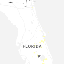
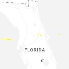
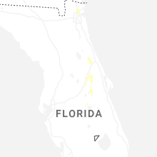
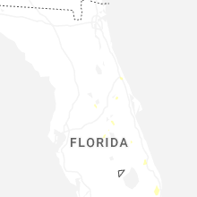
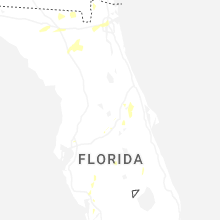
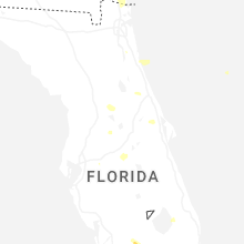
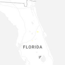


Connect with Interactive Hail Maps