

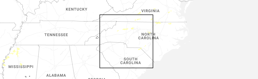
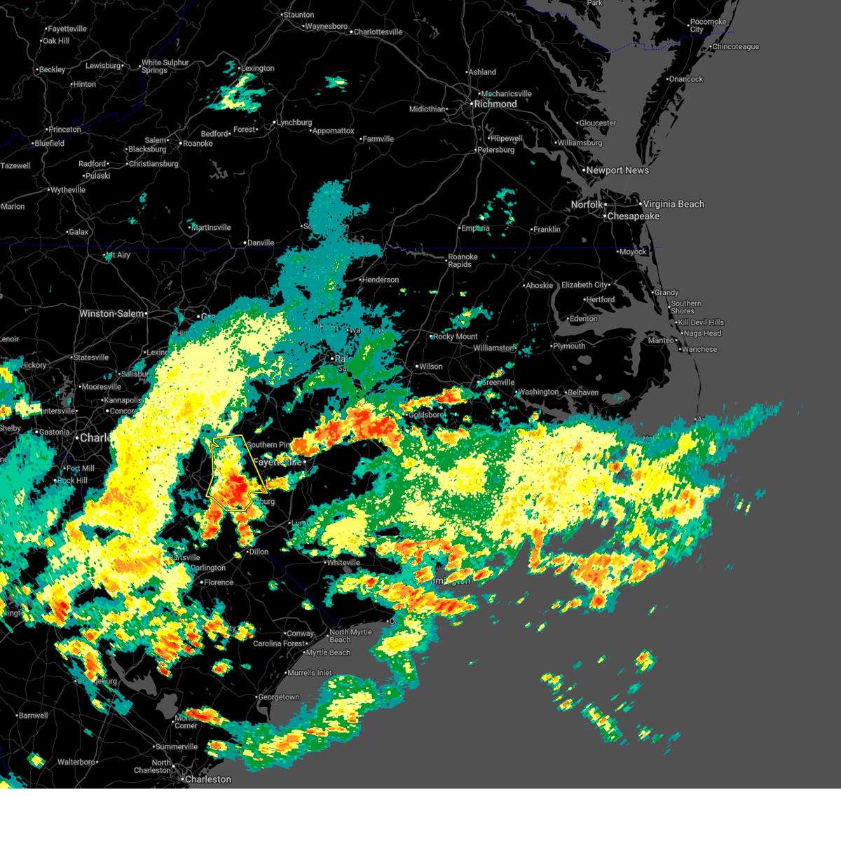
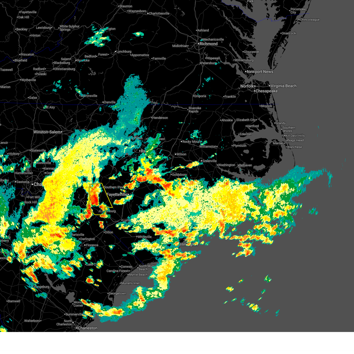
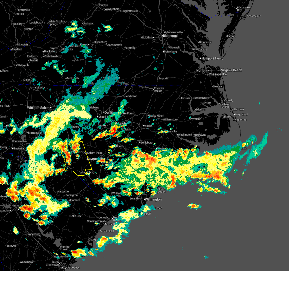
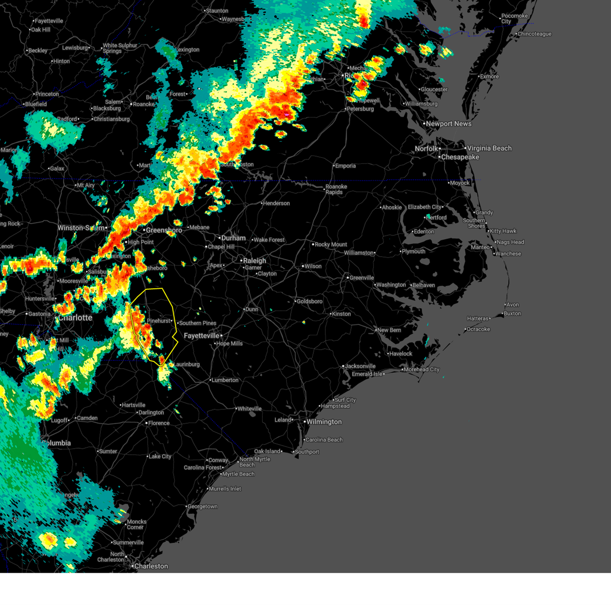
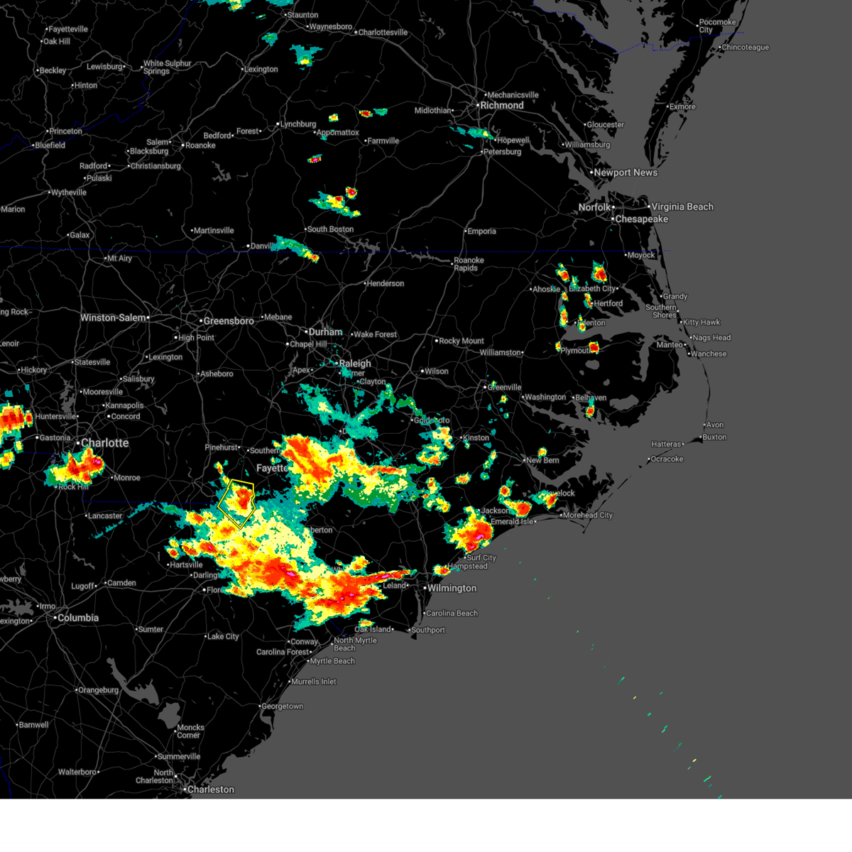
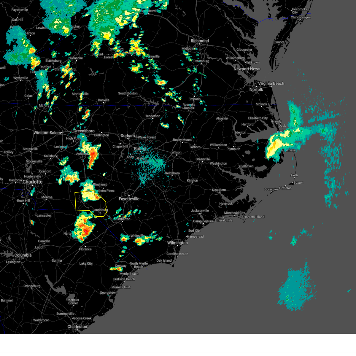
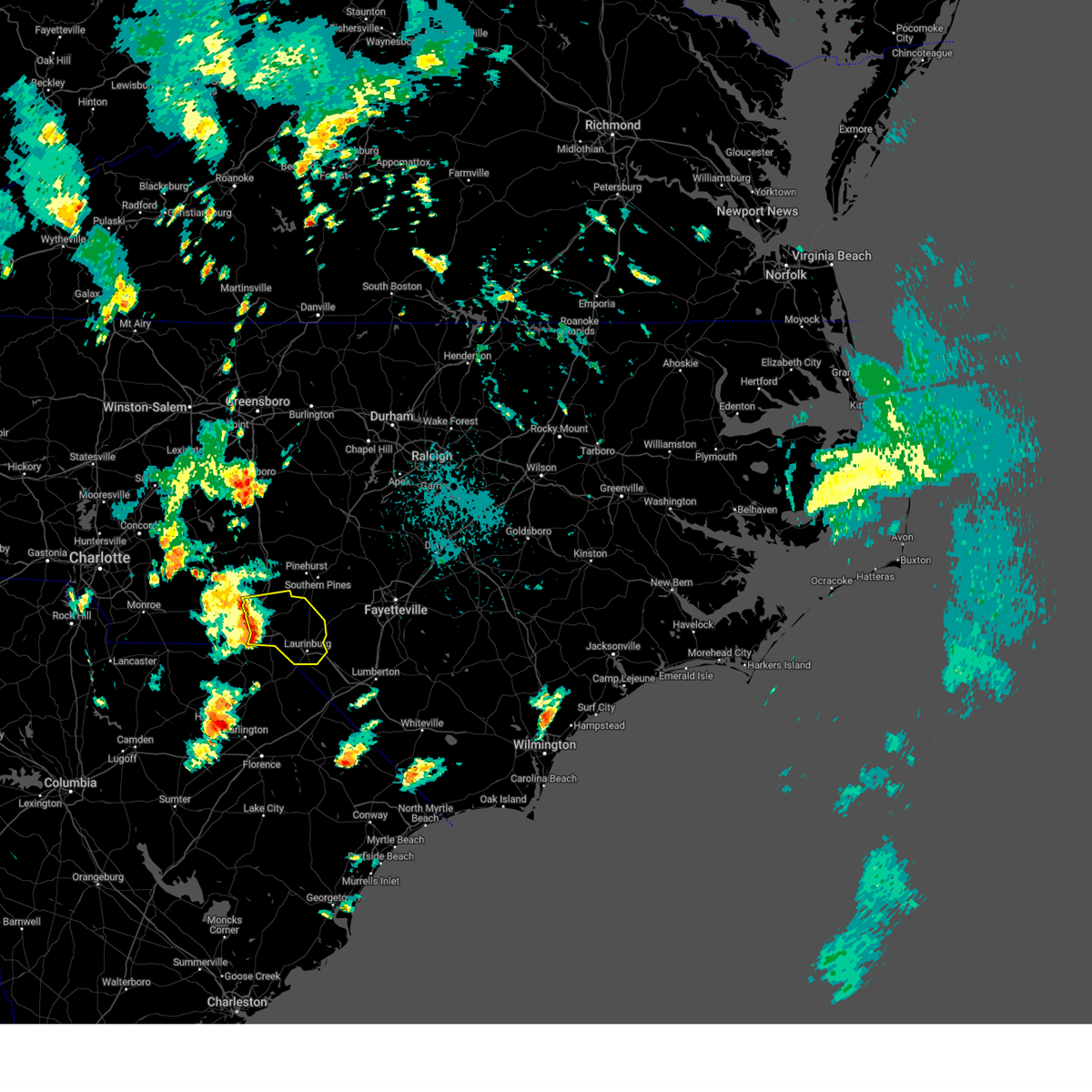
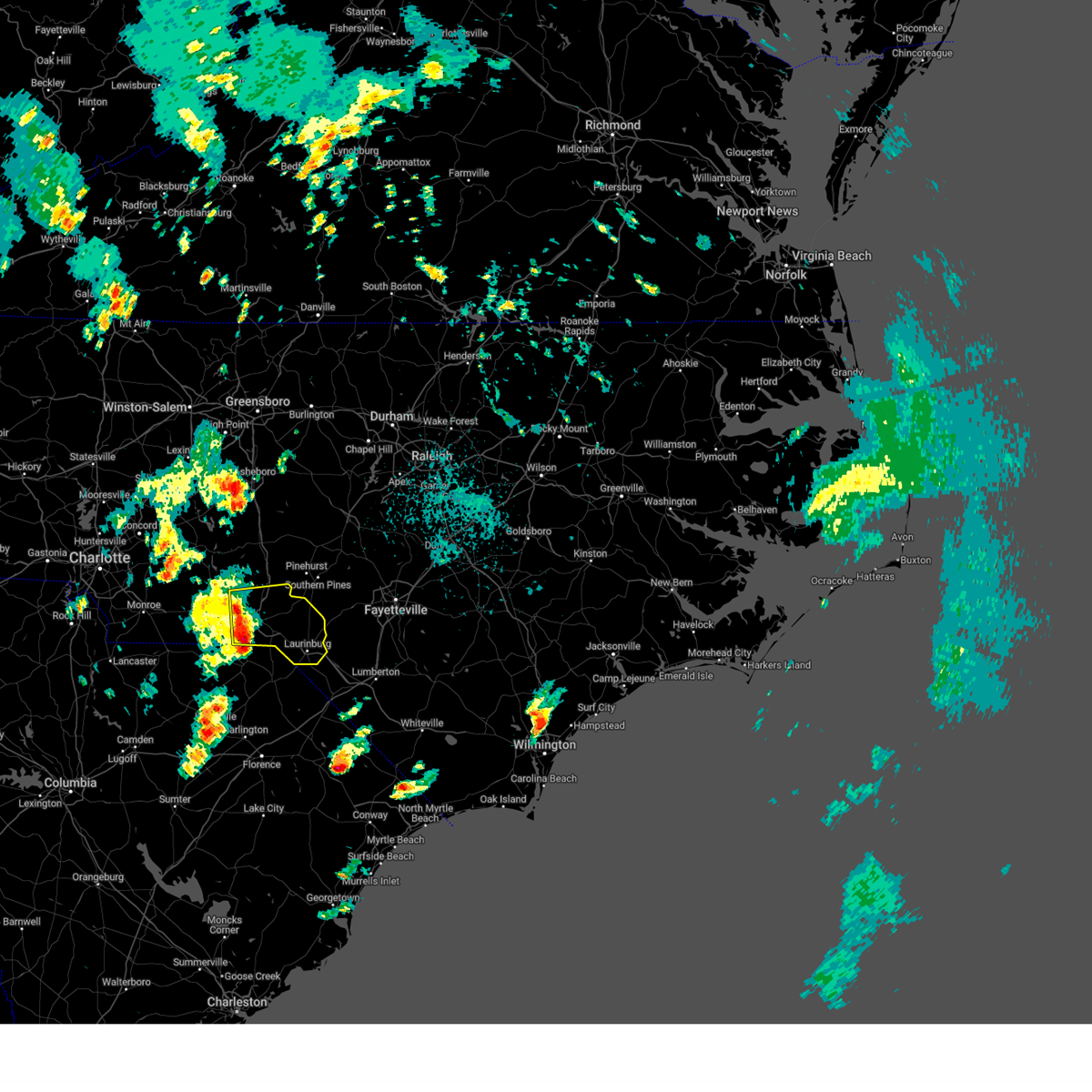
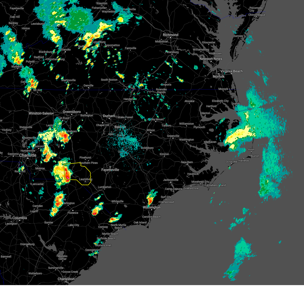
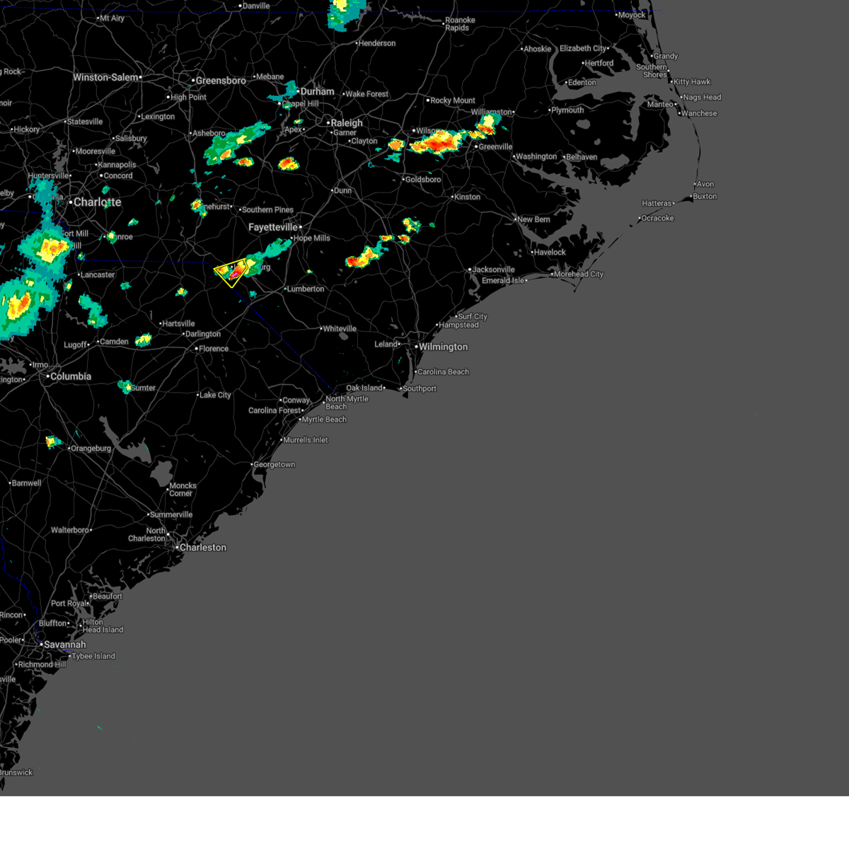
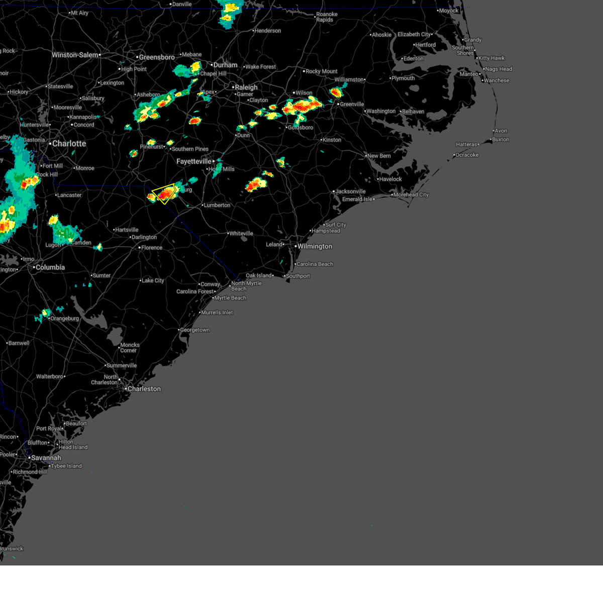
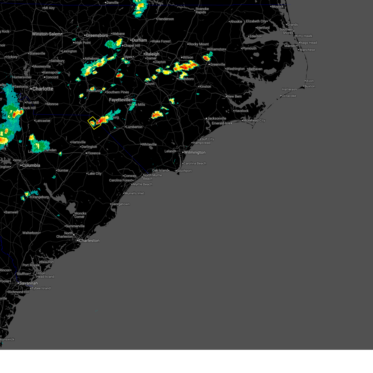
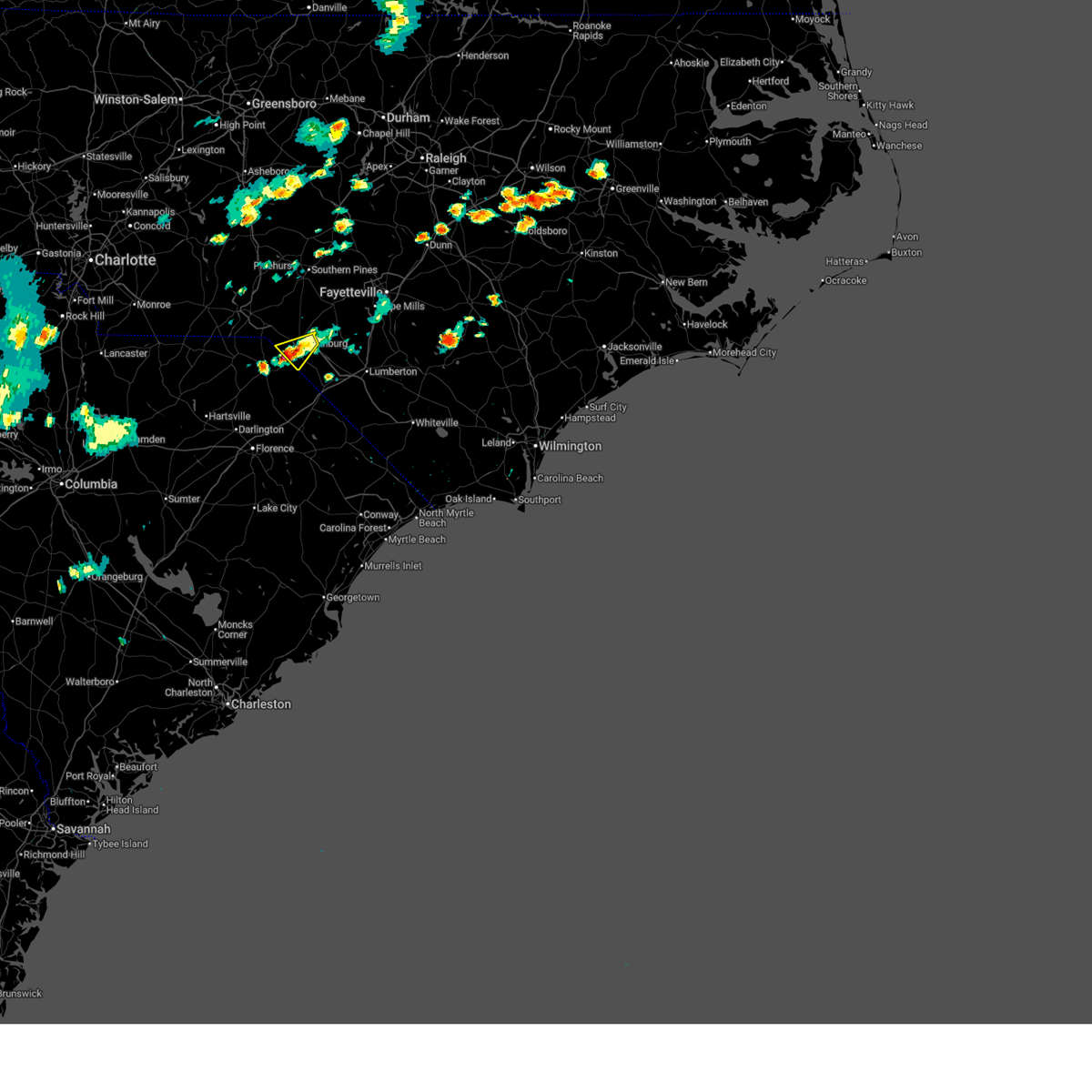
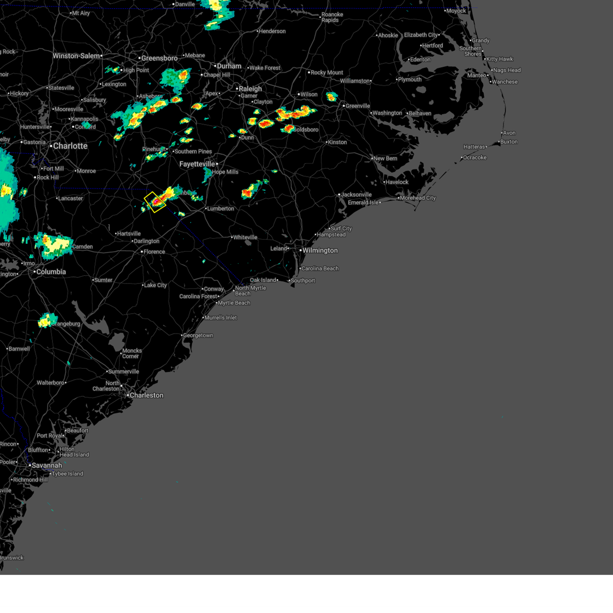
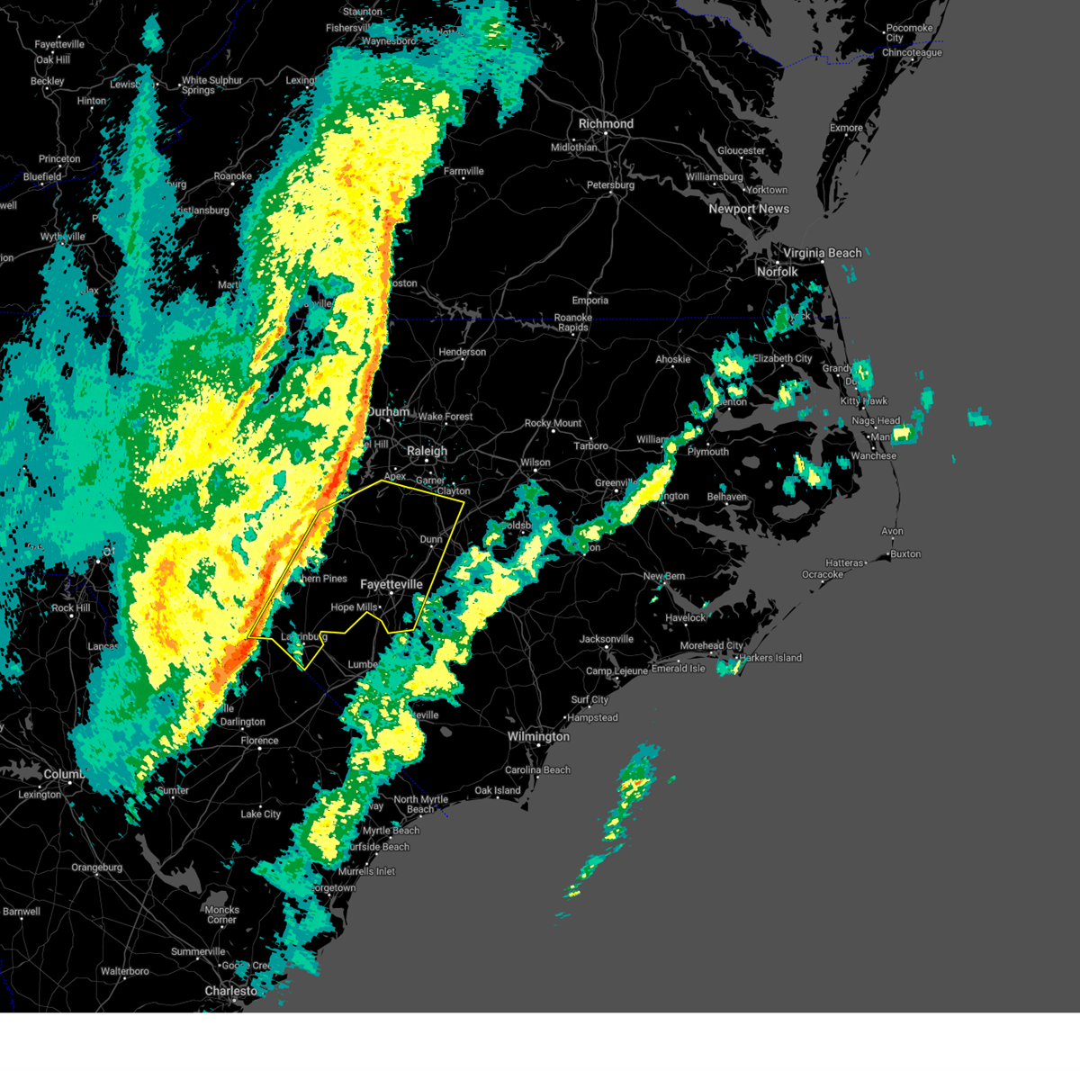
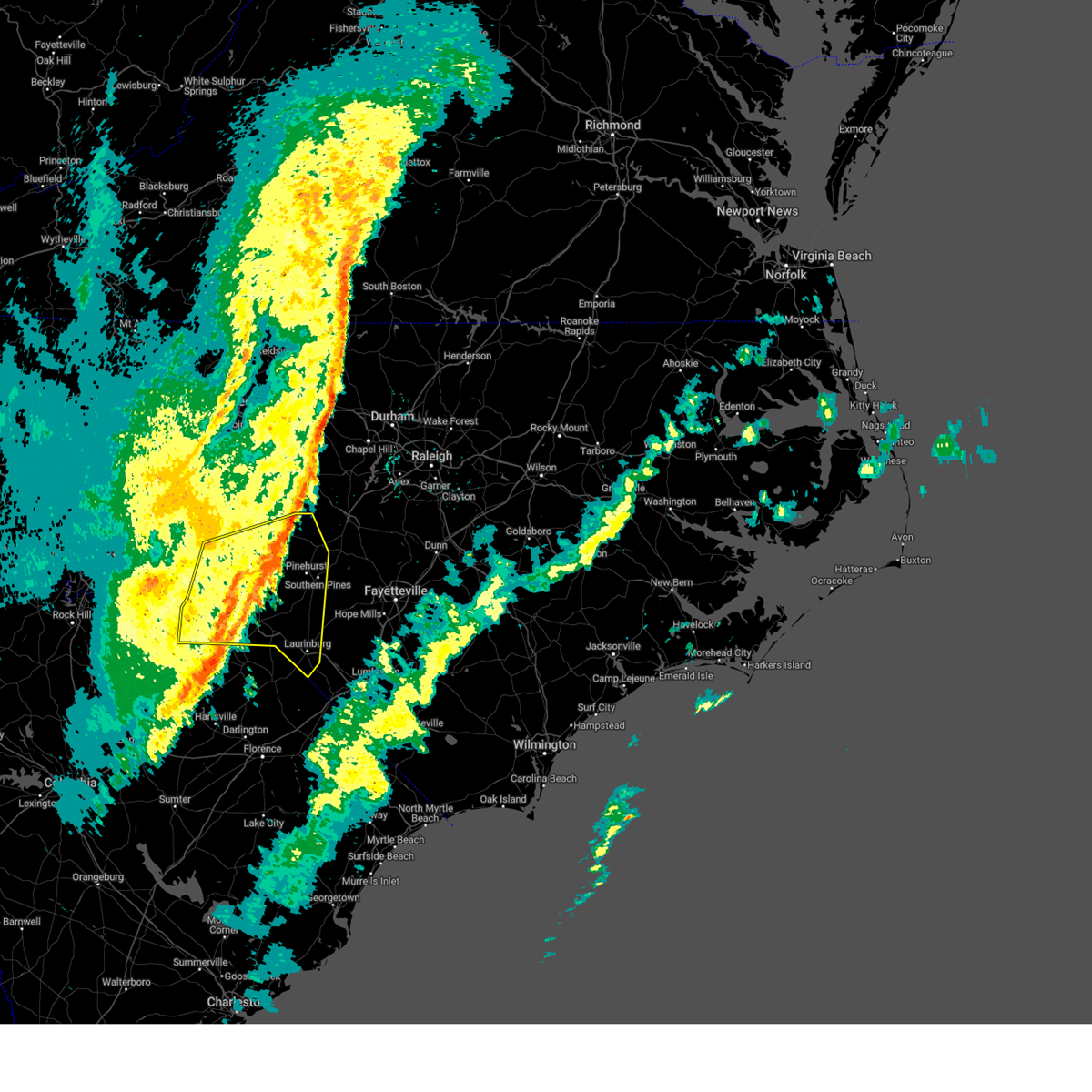
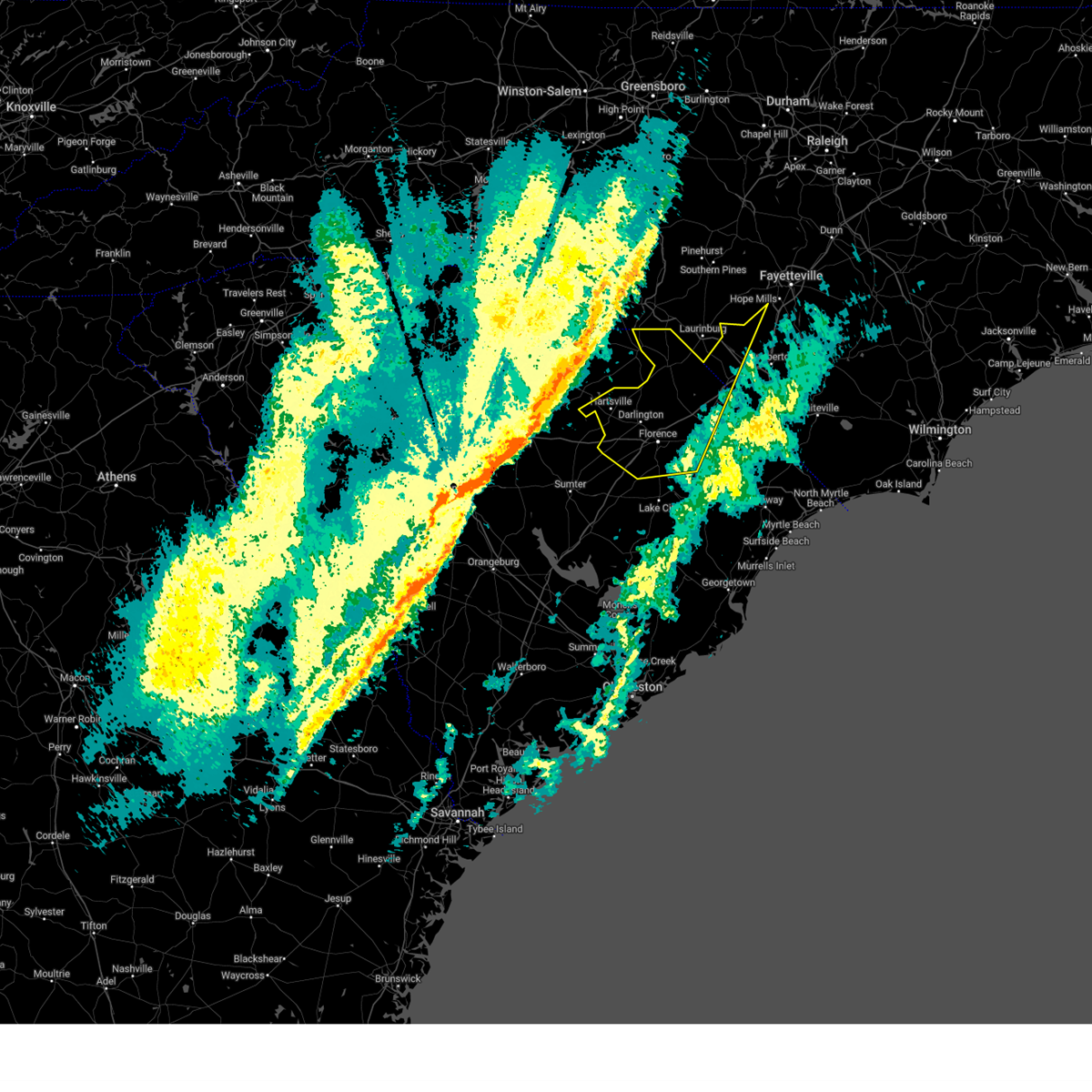
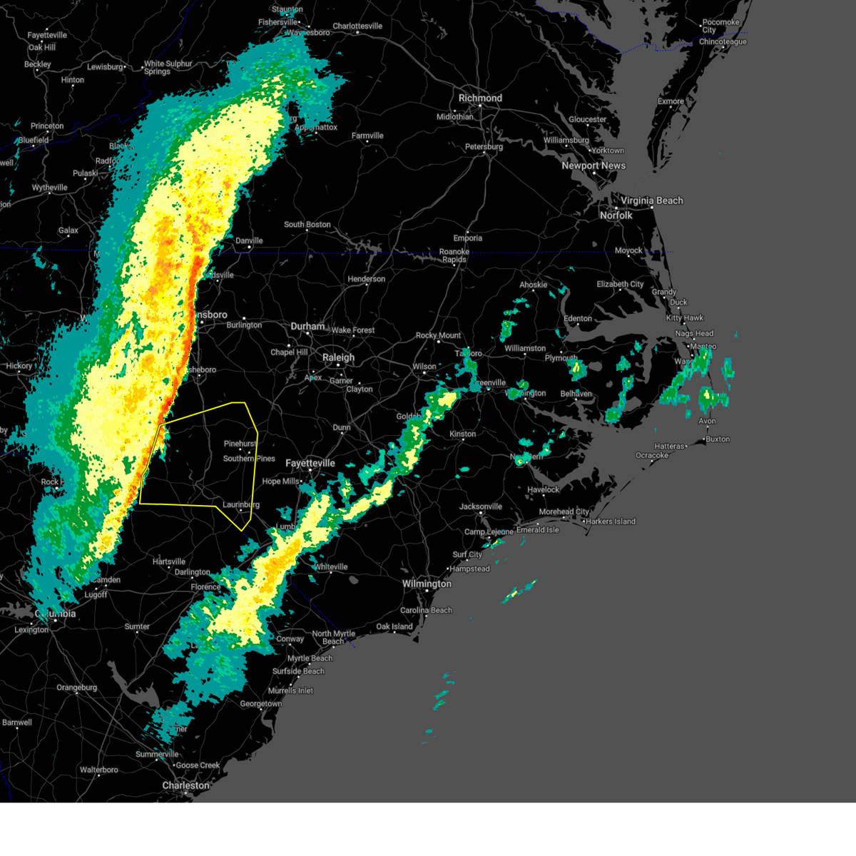
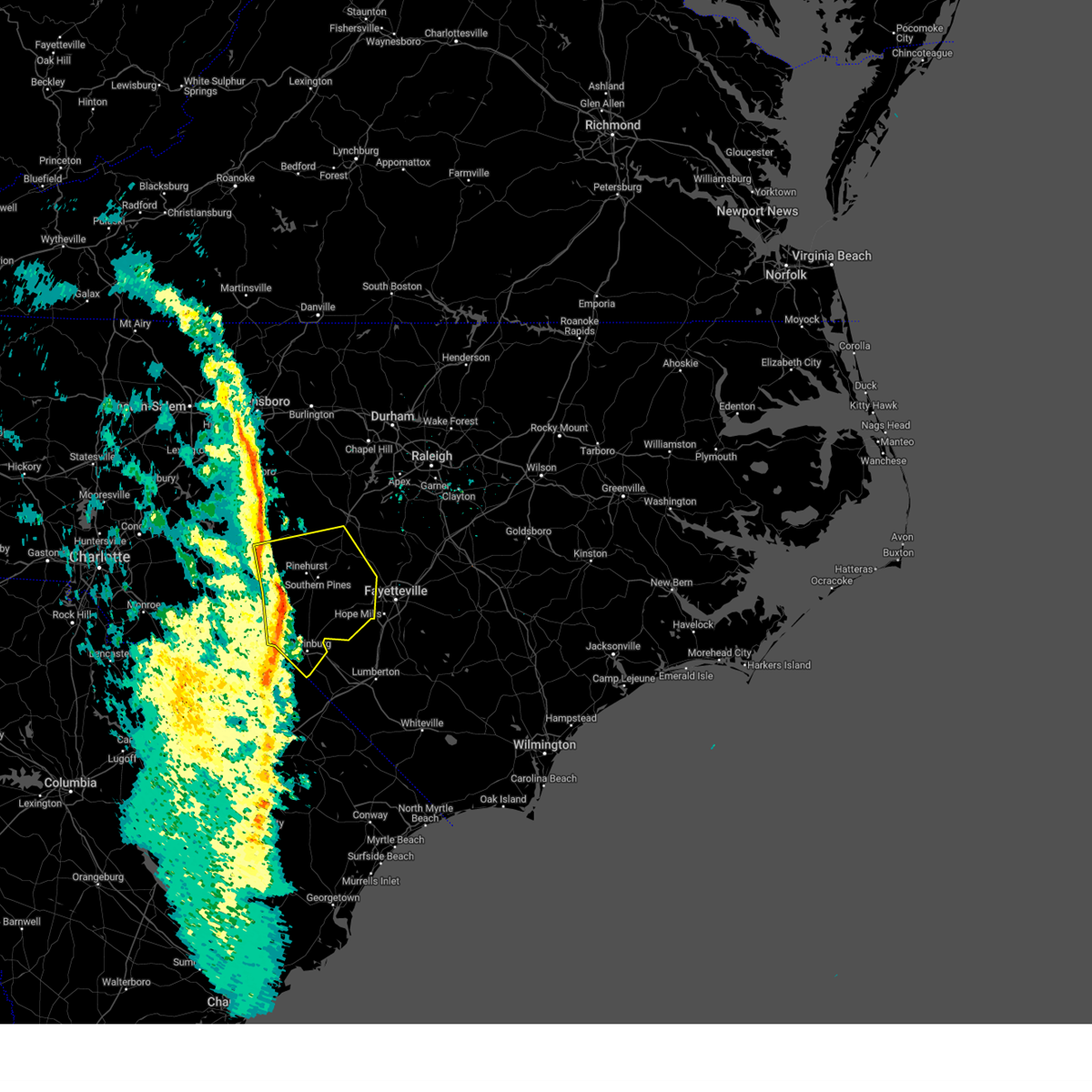
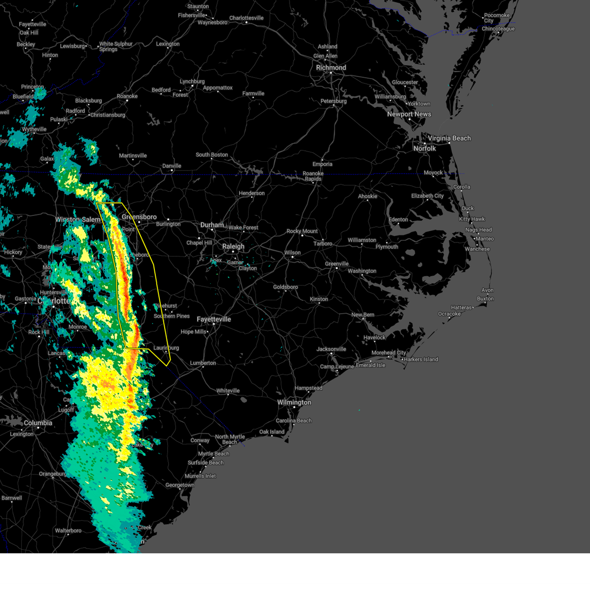
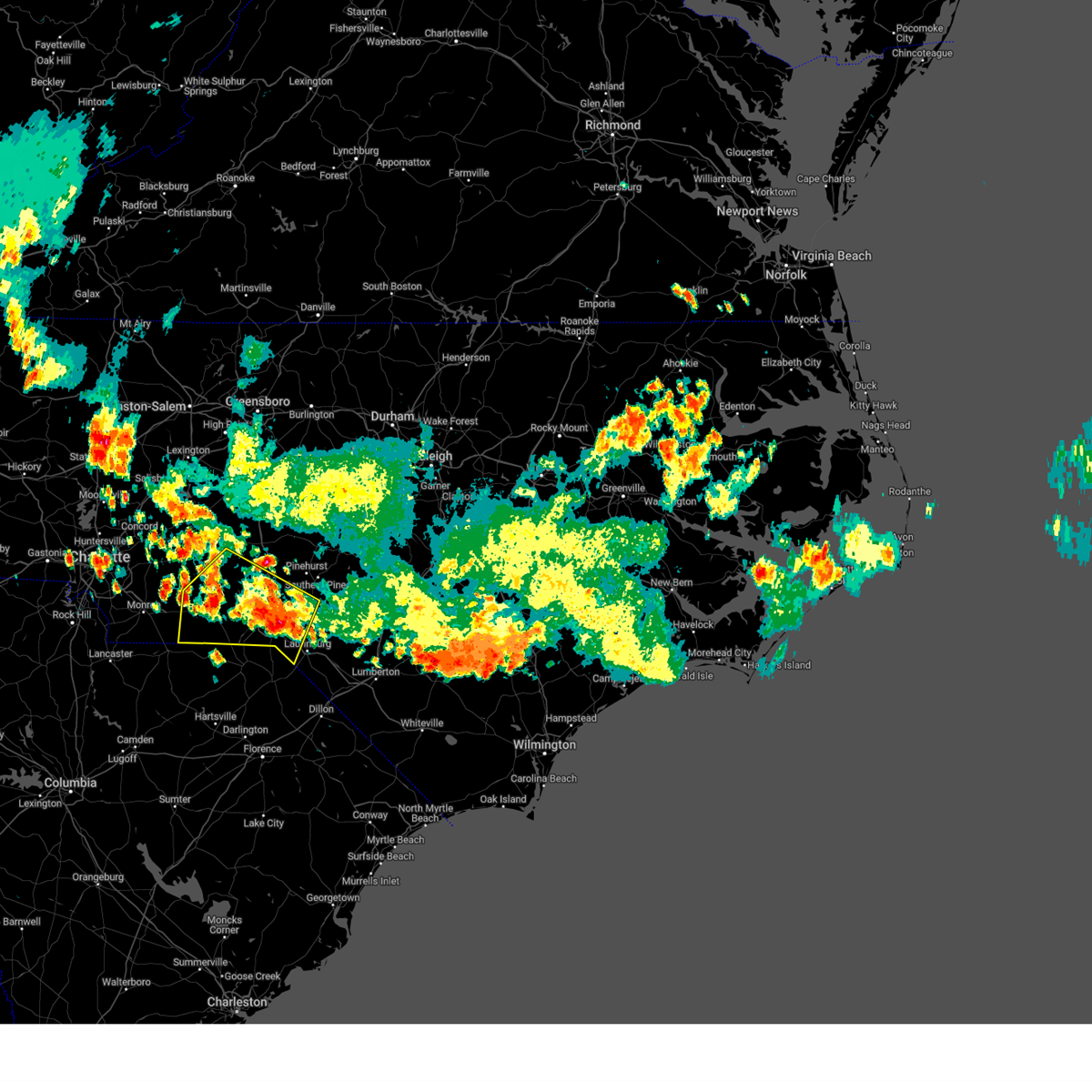
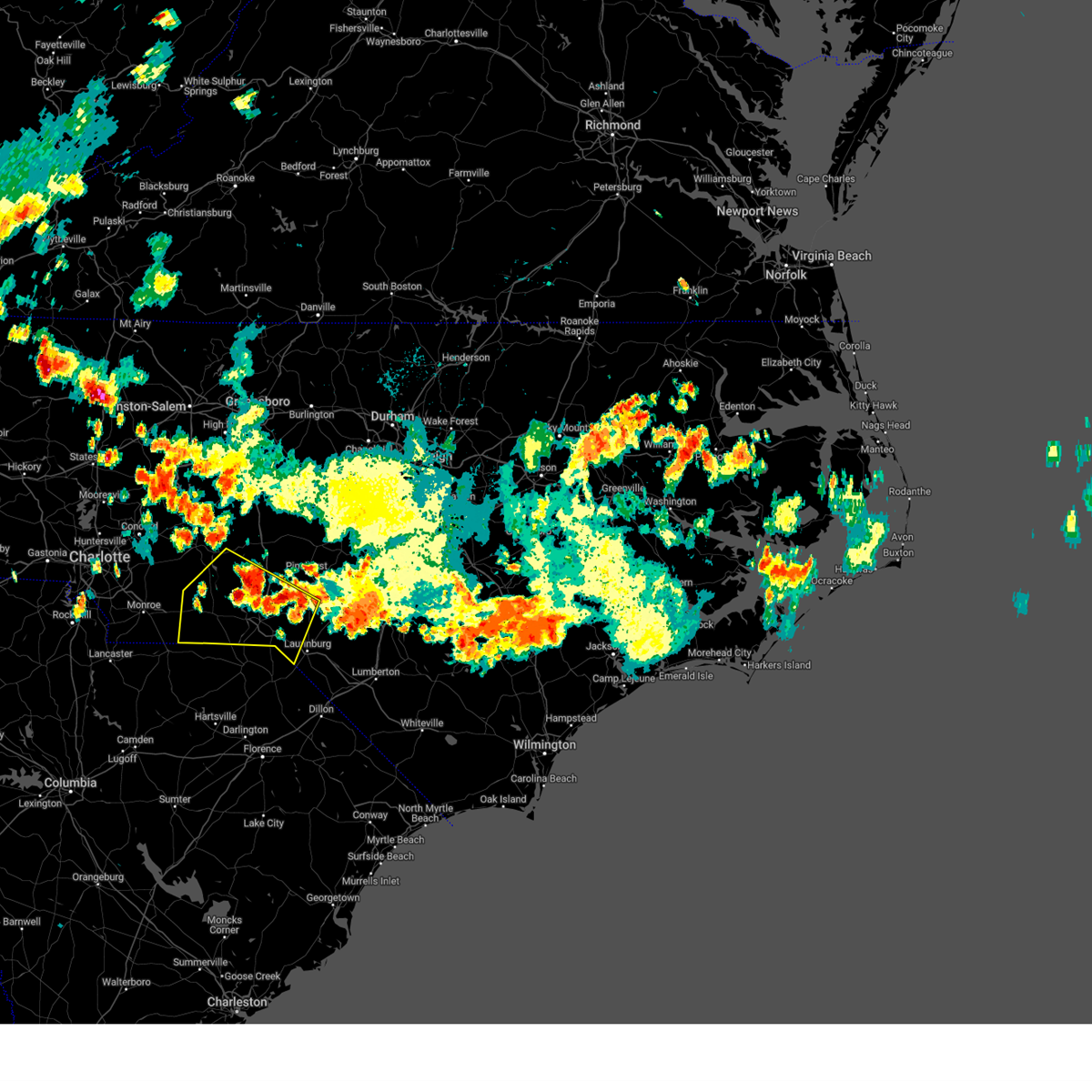
Hail Map for Gibson, NC
The Gibson, NC area has had 0 reports of on-the-ground hail by trained spotters, and has been under severe weather warnings 9 times during the past 12 months. Doppler radar has detected hail at or near Gibson, NC on 43 occasions.
| Name: | Gibson, NC |
| Where Located: | 76.7 miles ESE of Charlotte, NC |
| Map: | Google Map for Gibson, NC |
| Population: | 540 |
| Housing Units: | 256 |
| More Info: | Search Google for Gibson, NC |
3
The Top Recent Hail Date for Gibson, NC is Thursday, June 19, 2025 (6th out of 43)
Hail and Wind Damage Spotted near Gibson, NC
| Date / Time | Report Details |
|---|---|
| 6/18/2026 6:58 PM EDT |
 Svrrah the national weather service in raleigh has issued a * severe thunderstorm warning for, south central moore county in central north carolina, scotland county in central north carolina, eastern richmond county in central north carolina, southwestern hoke county in central north carolina, * until 745 pm edt. * at 658 pm edt, a severe thunderstorm was located 7 miles southwest of rockingham, moving northeast at 35 mph (radar indicated). Hazards include 60 mph wind gusts and nickel size hail. expect damage to roofs, siding, and trees Svrrah the national weather service in raleigh has issued a * severe thunderstorm warning for, south central moore county in central north carolina, scotland county in central north carolina, eastern richmond county in central north carolina, southwestern hoke county in central north carolina, * until 745 pm edt. * at 658 pm edt, a severe thunderstorm was located 7 miles southwest of rockingham, moving northeast at 35 mph (radar indicated). Hazards include 60 mph wind gusts and nickel size hail. expect damage to roofs, siding, and trees
|
| 3/16/2026 5:51 PM EDT |
 At 549 pm edt, severe thunderstorms were located along a line extending from monticello to siler city to hoffman, moving northeast at 50 mph (radar indicated). Hazards include 60 mph wind gusts. Expect damage to roofs, siding, and trees. locations impacted include, burlington, sanford, laurinburg, graham, southern pines, raeford, carthage, siler city, pinehurst, and aberdeen. this includes the following highways, interstate 85 between mile markers 129 and 131. interstate 40 between mile markers 132 and 150, and between mile markers 225 and 226. Us 1 near mile marker 69. At 549 pm edt, severe thunderstorms were located along a line extending from monticello to siler city to hoffman, moving northeast at 50 mph (radar indicated). Hazards include 60 mph wind gusts. Expect damage to roofs, siding, and trees. locations impacted include, burlington, sanford, laurinburg, graham, southern pines, raeford, carthage, siler city, pinehurst, and aberdeen. this includes the following highways, interstate 85 between mile markers 129 and 131. interstate 40 between mile markers 132 and 150, and between mile markers 225 and 226. Us 1 near mile marker 69.
|
| 3/16/2026 5:51 PM EDT |
 the severe thunderstorm warning has been cancelled and is no longer in effect the severe thunderstorm warning has been cancelled and is no longer in effect
|
| 3/16/2026 5:23 PM EDT |
 Svrrah the national weather service in raleigh has issued a * severe thunderstorm warning for, alamance county in central north carolina, moore county in central north carolina, scotland county in central north carolina, eastern montgomery county in central north carolina, richmond county in central north carolina, randolph county in central north carolina, guilford county in central north carolina, western lee county in central north carolina, western hoke county in central north carolina, western chatham county in central north carolina, * until 615 pm edt. * at 523 pm edt, severe thunderstorms were located along a line extending from near walnut cove to near biscoe to 7 miles north of wallace, moving east at 50 mph (radar indicated). Hazards include 60 mph wind gusts. expect damage to roofs, siding, and trees Svrrah the national weather service in raleigh has issued a * severe thunderstorm warning for, alamance county in central north carolina, moore county in central north carolina, scotland county in central north carolina, eastern montgomery county in central north carolina, richmond county in central north carolina, randolph county in central north carolina, guilford county in central north carolina, western lee county in central north carolina, western hoke county in central north carolina, western chatham county in central north carolina, * until 615 pm edt. * at 523 pm edt, severe thunderstorms were located along a line extending from near walnut cove to near biscoe to 7 miles north of wallace, moving east at 50 mph (radar indicated). Hazards include 60 mph wind gusts. expect damage to roofs, siding, and trees
|
| 8/1/2025 8:14 PM EDT |
 The storm which prompted the warning has weakened, the warning will be allowed to expire. however, heavy rain is still possible with this thunderstorm. to report severe weather, contact your nearest law enforcement agency. they will relay your report to the national weather service raleigh. The storm which prompted the warning has weakened, the warning will be allowed to expire. however, heavy rain is still possible with this thunderstorm. to report severe weather, contact your nearest law enforcement agency. they will relay your report to the national weather service raleigh.
|
| 8/1/2025 7:56 PM EDT |
 At 755 pm edt, a severe thunderstorm was located 7 miles northwest of laurinburg, moving southeast at 25 mph (radar indicated). Hazards include 60 mph wind gusts and quarter size hail. Hail damage to vehicles is expected. expect wind damage to roofs, siding, and trees. this severe storm will be near, laurinburg around 800 pm edt. maxton around 805 pm edt. Other locations impacted by this severe thunderstorm include east laurinburg, laurel hill, derby, pinebluff, and taylortown. At 755 pm edt, a severe thunderstorm was located 7 miles northwest of laurinburg, moving southeast at 25 mph (radar indicated). Hazards include 60 mph wind gusts and quarter size hail. Hail damage to vehicles is expected. expect wind damage to roofs, siding, and trees. this severe storm will be near, laurinburg around 800 pm edt. maxton around 805 pm edt. Other locations impacted by this severe thunderstorm include east laurinburg, laurel hill, derby, pinebluff, and taylortown.
|
| 8/1/2025 7:56 PM EDT |
 the severe thunderstorm warning has been cancelled and is no longer in effect the severe thunderstorm warning has been cancelled and is no longer in effect
|
| 8/1/2025 7:13 PM EDT |
 Svrrah the national weather service in raleigh has issued a * severe thunderstorm warning for, southwestern moore county in central north carolina, scotland county in central north carolina, southeastern montgomery county in central north carolina, richmond county in central north carolina, western hoke county in central north carolina, * until 815 pm edt. * at 712 pm edt, a severe thunderstorm was located 9 miles north of rockingham, moving southeast at 25 mph (radar indicated). Hazards include 60 mph wind gusts and quarter size hail. Hail damage to vehicles is expected. expect wind damage to roofs, siding, and trees. this severe thunderstorm will be near, rockingham, hamlet, and hoffman around 720 pm edt. laurinburg around 755 pm edt. Other locations impacted by this severe thunderstorm include diggs, dobbins heights, norman, laurel hill, and derby. Svrrah the national weather service in raleigh has issued a * severe thunderstorm warning for, southwestern moore county in central north carolina, scotland county in central north carolina, southeastern montgomery county in central north carolina, richmond county in central north carolina, western hoke county in central north carolina, * until 815 pm edt. * at 712 pm edt, a severe thunderstorm was located 9 miles north of rockingham, moving southeast at 25 mph (radar indicated). Hazards include 60 mph wind gusts and quarter size hail. Hail damage to vehicles is expected. expect wind damage to roofs, siding, and trees. this severe thunderstorm will be near, rockingham, hamlet, and hoffman around 720 pm edt. laurinburg around 755 pm edt. Other locations impacted by this severe thunderstorm include diggs, dobbins heights, norman, laurel hill, and derby.
|
| 7/9/2025 6:30 PM EDT |
 Svrrah the national weather service in raleigh has issued a * severe thunderstorm warning for, western moore county in central north carolina, northwestern scotland county in central north carolina, central montgomery county in central north carolina, richmond county in central north carolina, * until 730 pm edt. * at 630 pm edt, severe thunderstorms were located along a line extending from 6 miles south of troy to near rockingham, moving northeast at 20 mph (radar indicated). Hazards include 60 mph wind gusts. expect damage to roofs, siding, and trees Svrrah the national weather service in raleigh has issued a * severe thunderstorm warning for, western moore county in central north carolina, northwestern scotland county in central north carolina, central montgomery county in central north carolina, richmond county in central north carolina, * until 730 pm edt. * at 630 pm edt, severe thunderstorms were located along a line extending from 6 miles south of troy to near rockingham, moving northeast at 20 mph (radar indicated). Hazards include 60 mph wind gusts. expect damage to roofs, siding, and trees
|
| 6/25/2025 6:14 PM EDT |
 The storm which prompted the warning has weakened below severe limits, and no longer poses an immediate threat to life or property. therefore, the warning will be allowed to expire. however, heavy rain is still possible with this thunderstorm. a severe thunderstorm watch remains in effect until midnight edt for central north carolina. to report severe weather, contact your nearest law enforcement agency. they will relay your report to the national weather service raleigh. The storm which prompted the warning has weakened below severe limits, and no longer poses an immediate threat to life or property. therefore, the warning will be allowed to expire. however, heavy rain is still possible with this thunderstorm. a severe thunderstorm watch remains in effect until midnight edt for central north carolina. to report severe weather, contact your nearest law enforcement agency. they will relay your report to the national weather service raleigh.
|
| 6/25/2025 5:13 PM EDT |
 Svrrah the national weather service in raleigh has issued a * severe thunderstorm warning for, scotland county in central north carolina, * until 615 pm edt. * at 513 pm edt, a severe thunderstorm was located 7 miles north of laurinburg, moving south at 25 mph (radar indicated). Hazards include 60 mph wind gusts. expect damage to roofs, siding, and trees Svrrah the national weather service in raleigh has issued a * severe thunderstorm warning for, scotland county in central north carolina, * until 615 pm edt. * at 513 pm edt, a severe thunderstorm was located 7 miles north of laurinburg, moving south at 25 mph (radar indicated). Hazards include 60 mph wind gusts. expect damage to roofs, siding, and trees
|
| 6/25/2025 5:08 PM EDT |
 At 507 pm edt, a severe thunderstorm was located 9 miles north of laurinburg, moving south at 15 mph (emergency management reported multiple trees down). Hazards include 60 mph wind gusts and quarter size hail. Hail damage to vehicles is expected. expect wind damage to roofs, siding, and trees. Locations impacted include, laurinburg, maxton, hoffman, wagram, gibson, east laurinburg, laurel hill, camp mackall, and sandhills game land. At 507 pm edt, a severe thunderstorm was located 9 miles north of laurinburg, moving south at 15 mph (emergency management reported multiple trees down). Hazards include 60 mph wind gusts and quarter size hail. Hail damage to vehicles is expected. expect wind damage to roofs, siding, and trees. Locations impacted include, laurinburg, maxton, hoffman, wagram, gibson, east laurinburg, laurel hill, camp mackall, and sandhills game land.
|
| 6/25/2025 4:24 PM EDT |
 Svrrah the national weather service in raleigh has issued a * severe thunderstorm warning for, scotland county in central north carolina, southeastern richmond county in central north carolina, * until 515 pm edt. * at 423 pm edt, a severe thunderstorm was located over laurinburg, and is nearly stationary (radar indicated). Hazards include 60 mph wind gusts and penny size hail. expect damage to roofs, siding, and trees Svrrah the national weather service in raleigh has issued a * severe thunderstorm warning for, scotland county in central north carolina, southeastern richmond county in central north carolina, * until 515 pm edt. * at 423 pm edt, a severe thunderstorm was located over laurinburg, and is nearly stationary (radar indicated). Hazards include 60 mph wind gusts and penny size hail. expect damage to roofs, siding, and trees
|
| 5/13/2025 3:37 PM EDT |
 The storm which prompted the warning has weakened below severe limits, and no longer poses an immediate threat to life or property. therefore, the warning will be allowed to expire. The storm which prompted the warning has weakened below severe limits, and no longer poses an immediate threat to life or property. therefore, the warning will be allowed to expire.
|
| 5/13/2025 2:59 PM EDT |
 the severe thunderstorm warning has been cancelled and is no longer in effect the severe thunderstorm warning has been cancelled and is no longer in effect
|
| 5/13/2025 2:59 PM EDT |
 At 258 pm edt, a severe thunderstorm was located near hamlet, or near rockingham, moving east at 35 mph (radar indicated). Hazards include quarter size hail. Damage to vehicles is expected. Locations impacted include, laurinburg, rockingham, hamlet, maxton, hoffman, ellerbe, dobbins heights, wagram, gibson, and east laurinburg. At 258 pm edt, a severe thunderstorm was located near hamlet, or near rockingham, moving east at 35 mph (radar indicated). Hazards include quarter size hail. Damage to vehicles is expected. Locations impacted include, laurinburg, rockingham, hamlet, maxton, hoffman, ellerbe, dobbins heights, wagram, gibson, and east laurinburg.
|
| 5/13/2025 2:46 PM EDT |
 Svrrah the national weather service in raleigh has issued a * severe thunderstorm warning for, scotland county in central north carolina, southeastern anson county in central north carolina, richmond county in central north carolina, * until 345 pm edt. * at 246 pm edt, a severe thunderstorm was located near wallace, or 8 miles north of cheraw, moving east at 30 mph (radar indicated). Hazards include quarter size hail. damage to vehicles is expected Svrrah the national weather service in raleigh has issued a * severe thunderstorm warning for, scotland county in central north carolina, southeastern anson county in central north carolina, richmond county in central north carolina, * until 345 pm edt. * at 246 pm edt, a severe thunderstorm was located near wallace, or 8 miles north of cheraw, moving east at 30 mph (radar indicated). Hazards include quarter size hail. damage to vehicles is expected
|
| 5/13/2025 2:45 PM EDT |
 Svrrah the national weather service in raleigh has issued a * severe thunderstorm warning for, scotland county in central north carolina, southeastern anson county in central north carolina, richmond county in central north carolina, * until 345 pm edt. * at 244 pm edt, a severe thunderstorm was located near wallace, or 7 miles north of cheraw, moving east at 30 mph (radar indicated). Hazards include quarter size hail. damage to vehicles is expected Svrrah the national weather service in raleigh has issued a * severe thunderstorm warning for, scotland county in central north carolina, southeastern anson county in central north carolina, richmond county in central north carolina, * until 345 pm edt. * at 244 pm edt, a severe thunderstorm was located near wallace, or 7 miles north of cheraw, moving east at 30 mph (radar indicated). Hazards include quarter size hail. damage to vehicles is expected
|
| 5/8/2025 9:48 PM EDT |
 Svrrah the national weather service in raleigh has issued a * severe thunderstorm warning for, southeastern moore county in central north carolina, scotland county in central north carolina, harnett county in central north carolina, eastern richmond county in central north carolina, cumberland county in central north carolina, lee county in central north carolina, southwestern wake county in central north carolina, southwestern johnston county in central north carolina, hoke county in central north carolina, eastern chatham county in central north carolina, * until 1045 pm edt. * at 947 pm edt, severe thunderstorms were located along a line extending from pittsboro to near sanford to near southern pines to 7 miles northeast of rockingham, moving east at 35 mph (radar indicated). Hazards include 60 mph wind gusts. expect damage to roofs, siding, and trees Svrrah the national weather service in raleigh has issued a * severe thunderstorm warning for, southeastern moore county in central north carolina, scotland county in central north carolina, harnett county in central north carolina, eastern richmond county in central north carolina, cumberland county in central north carolina, lee county in central north carolina, southwestern wake county in central north carolina, southwestern johnston county in central north carolina, hoke county in central north carolina, eastern chatham county in central north carolina, * until 1045 pm edt. * at 947 pm edt, severe thunderstorms were located along a line extending from pittsboro to near sanford to near southern pines to 7 miles northeast of rockingham, moving east at 35 mph (radar indicated). Hazards include 60 mph wind gusts. expect damage to roofs, siding, and trees
|
| 5/2/2025 6:01 PM EDT |
 The storm which prompted the warning is moving out of the area. therefore, the warning has been allowed to expire. however, small hail and gusty winds are still possible with this thunderstorm. The storm which prompted the warning is moving out of the area. therefore, the warning has been allowed to expire. however, small hail and gusty winds are still possible with this thunderstorm.
|
| 5/2/2025 5:54 PM EDT |
 At 554 pm edt, a severe thunderstorm was located near maxton, or near laurinburg, moving east at 10 mph (radar indicated). Hazards include 60 mph wind gusts and penny size hail. Expect damage to roofs, siding, and trees. Locations impacted include, laurinburg, maxton, gibson, and east laurinburg. At 554 pm edt, a severe thunderstorm was located near maxton, or near laurinburg, moving east at 10 mph (radar indicated). Hazards include 60 mph wind gusts and penny size hail. Expect damage to roofs, siding, and trees. Locations impacted include, laurinburg, maxton, gibson, and east laurinburg.
|
| 5/2/2025 5:32 PM EDT |
 At 532 pm edt, a severe thunderstorm was located near laurinburg, moving east at 15 mph (radar indicated). Hazards include 60 mph wind gusts and penny size hail. Expect damage to roofs, siding, and trees. Locations impacted include, laurinburg, maxton, gibson, and east laurinburg. At 532 pm edt, a severe thunderstorm was located near laurinburg, moving east at 15 mph (radar indicated). Hazards include 60 mph wind gusts and penny size hail. Expect damage to roofs, siding, and trees. Locations impacted include, laurinburg, maxton, gibson, and east laurinburg.
|
| 5/2/2025 5:27 PM EDT |
 The storm which prompted the warning has moved out of the area. therefore, the warning will be allowed to expire. please send your reports of hail and/or wind damage, including trees or large limbs downed, by calling the national weather service office in wilmington at 1-800-697-3901. The storm which prompted the warning has moved out of the area. therefore, the warning will be allowed to expire. please send your reports of hail and/or wind damage, including trees or large limbs downed, by calling the national weather service office in wilmington at 1-800-697-3901.
|
| 5/2/2025 5:21 PM EDT |
 Svrrah the national weather service in raleigh has issued a * severe thunderstorm warning for, southern scotland county in central north carolina, * until 600 pm edt. * at 521 pm edt, a severe thunderstorm was located over mccoll, or near laurinburg, moving east at 15 mph (radar indicated). Hazards include 60 mph wind gusts and penny size hail. expect damage to roofs, siding, and trees Svrrah the national weather service in raleigh has issued a * severe thunderstorm warning for, southern scotland county in central north carolina, * until 600 pm edt. * at 521 pm edt, a severe thunderstorm was located over mccoll, or near laurinburg, moving east at 15 mph (radar indicated). Hazards include 60 mph wind gusts and penny size hail. expect damage to roofs, siding, and trees
|
| 5/2/2025 5:07 PM EDT |
 Svrilm the national weather service in wilmington has issued a * severe thunderstorm warning for, northeastern marlboro county in northeastern south carolina, * until 530 pm edt. * at 507 pm edt, a severe thunderstorm was located near mccoll, or near bennettsville, moving northeast at 15 mph (radar indicated). Hazards include 60 mph wind gusts and quarter size hail. Minor hail damage to vehicles is possible. Expect wind damage to trees and power lines. Svrilm the national weather service in wilmington has issued a * severe thunderstorm warning for, northeastern marlboro county in northeastern south carolina, * until 530 pm edt. * at 507 pm edt, a severe thunderstorm was located near mccoll, or near bennettsville, moving northeast at 15 mph (radar indicated). Hazards include 60 mph wind gusts and quarter size hail. Minor hail damage to vehicles is possible. Expect wind damage to trees and power lines.
|
| 3/5/2025 10:58 AM EST |
 Svrrah the national weather service in raleigh has issued a * severe thunderstorm warning for, central moore county in central north carolina, scotland county in central north carolina, harnett county in central north carolina, eastern richmond county in central north carolina, northwestern cumberland county in central north carolina, lee county in central north carolina, hoke county in central north carolina, * until noon est. * at 1058 am est, severe thunderstorms were located along a line extending from near pittsboro to near hoffman, moving northeast at 60 mph (radar indicated). Hazards include 60 mph wind gusts. expect damage to roofs, siding, and trees Svrrah the national weather service in raleigh has issued a * severe thunderstorm warning for, central moore county in central north carolina, scotland county in central north carolina, harnett county in central north carolina, eastern richmond county in central north carolina, northwestern cumberland county in central north carolina, lee county in central north carolina, hoke county in central north carolina, * until noon est. * at 1058 am est, severe thunderstorms were located along a line extending from near pittsboro to near hoffman, moving northeast at 60 mph (radar indicated). Hazards include 60 mph wind gusts. expect damage to roofs, siding, and trees
|
| 2/16/2025 9:01 AM EST |
 At 901 am est, severe thunderstorms were located along a line extending from 10 miles northeast of sanford to 8 miles northwest of pope afb to 7 miles northwest of wakulla, moving northeast at 90 mph (radar indicated). Hazards include 60 mph wind gusts. Expect damage to roofs, siding, and trees. Locations impacted include, aberdeen, cameron, falcon, carthage, southern pines, east rockingham, dunn, sanford, anderson creek, and fort liberty. At 901 am est, severe thunderstorms were located along a line extending from 10 miles northeast of sanford to 8 miles northwest of pope afb to 7 miles northwest of wakulla, moving northeast at 90 mph (radar indicated). Hazards include 60 mph wind gusts. Expect damage to roofs, siding, and trees. Locations impacted include, aberdeen, cameron, falcon, carthage, southern pines, east rockingham, dunn, sanford, anderson creek, and fort liberty.
|
| 2/16/2025 8:45 AM EST |
 At 845 am est, severe thunderstorms were located along a line extending from 7 miles northwest of laurinburg to near elliott, moving east at 45 mph (radar indicated). Hazards include 60 mph wind gusts. Expect wind damage to trees and power lines. Locations impacted include, florence, bennettsville, hartsville, dillon, darlington, red springs, pembroke, maxton, timmonsville, mccoll, latta, rowland, lamar, quinby, clio, sellers, blue brick, hamer, brownsville, and darlington raceway. At 845 am est, severe thunderstorms were located along a line extending from 7 miles northwest of laurinburg to near elliott, moving east at 45 mph (radar indicated). Hazards include 60 mph wind gusts. Expect wind damage to trees and power lines. Locations impacted include, florence, bennettsville, hartsville, dillon, darlington, red springs, pembroke, maxton, timmonsville, mccoll, latta, rowland, lamar, quinby, clio, sellers, blue brick, hamer, brownsville, and darlington raceway.
|
| 2/16/2025 8:31 AM EST |
 Svrrah the national weather service in raleigh has issued a * severe thunderstorm warning for, central moore county in central north carolina, scotland county in central north carolina, northwestern sampson county in central north carolina, harnett county in central north carolina, eastern richmond county in central north carolina, cumberland county in central north carolina, lee county in central north carolina, southwestern wake county in central north carolina, southwestern johnston county in central north carolina, hoke county in central north carolina, southeastern chatham county in central north carolina, * until 915 am est. * at 831 am est, severe thunderstorms were located along a line extending from 7 miles north of carthage to near pinehurst to near wallace, moving east at 75 mph (radar indicated). Hazards include 60 mph wind gusts. expect damage to roofs, siding, and trees Svrrah the national weather service in raleigh has issued a * severe thunderstorm warning for, central moore county in central north carolina, scotland county in central north carolina, northwestern sampson county in central north carolina, harnett county in central north carolina, eastern richmond county in central north carolina, cumberland county in central north carolina, lee county in central north carolina, southwestern wake county in central north carolina, southwestern johnston county in central north carolina, hoke county in central north carolina, southeastern chatham county in central north carolina, * until 915 am est. * at 831 am est, severe thunderstorms were located along a line extending from 7 miles north of carthage to near pinehurst to near wallace, moving east at 75 mph (radar indicated). Hazards include 60 mph wind gusts. expect damage to roofs, siding, and trees
|
| 2/16/2025 8:19 AM EST |
 At 819 am est, severe thunderstorms were located along a line extending from 8 miles east of biscoe to 13 miles northwest of hoffman to 6 miles east of carolina sandhills wildlife refuge, moving east at 75 mph (radar indicated). Hazards include 60 mph wind gusts. Expect damage to roofs, siding, and trees. Locations impacted include, blewett falls lake, aberdeen, white store, covington, pekin, biscoe, carthage, southern pines, east rockingham, and morven. At 819 am est, severe thunderstorms were located along a line extending from 8 miles east of biscoe to 13 miles northwest of hoffman to 6 miles east of carolina sandhills wildlife refuge, moving east at 75 mph (radar indicated). Hazards include 60 mph wind gusts. Expect damage to roofs, siding, and trees. Locations impacted include, blewett falls lake, aberdeen, white store, covington, pekin, biscoe, carthage, southern pines, east rockingham, and morven.
|
| 2/16/2025 8:06 AM EST |
 Svrilm the national weather service in wilmington has issued a * severe thunderstorm warning for, northwestern robeson county in southeastern north carolina, northwestern florence county in northeastern south carolina, dillon county in northeastern south carolina, darlington county in northeastern south carolina, northwestern marion county in northeastern south carolina, marlboro county in northeastern south carolina, * until 900 am est. * at 805 am est, severe thunderstorms were located along a line extending from 6 miles north of chesterfield to 7 miles southeast of elgin, moving east at 65 mph (radar indicated). Hazards include 60 mph wind gusts. expect wind damage to trees and power lines Svrilm the national weather service in wilmington has issued a * severe thunderstorm warning for, northwestern robeson county in southeastern north carolina, northwestern florence county in northeastern south carolina, dillon county in northeastern south carolina, darlington county in northeastern south carolina, northwestern marion county in northeastern south carolina, marlboro county in northeastern south carolina, * until 900 am est. * at 805 am est, severe thunderstorms were located along a line extending from 6 miles north of chesterfield to 7 miles southeast of elgin, moving east at 65 mph (radar indicated). Hazards include 60 mph wind gusts. expect wind damage to trees and power lines
|
| 2/16/2025 7:51 AM EST |
 Svrrah the national weather service in raleigh has issued a * severe thunderstorm warning for, moore county in central north carolina, scotland county in central north carolina, anson county in central north carolina, montgomery county in central north carolina, richmond county in central north carolina, southeastern stanly county in central north carolina, northwestern hoke county in central north carolina, * until 830 am est. * at 751 am est, severe thunderstorms were located along a line extending from near albemarle to 6 miles northeast of marshville to near westville, moving east at 70 mph (radar indicated). Hazards include 60 mph wind gusts. expect damage to roofs, siding, and trees Svrrah the national weather service in raleigh has issued a * severe thunderstorm warning for, moore county in central north carolina, scotland county in central north carolina, anson county in central north carolina, montgomery county in central north carolina, richmond county in central north carolina, southeastern stanly county in central north carolina, northwestern hoke county in central north carolina, * until 830 am est. * at 751 am est, severe thunderstorms were located along a line extending from near albemarle to 6 miles northeast of marshville to near westville, moving east at 70 mph (radar indicated). Hazards include 60 mph wind gusts. expect damage to roofs, siding, and trees
|
| 12/29/2024 10:57 AM EST |
 Svrrah the national weather service in raleigh has issued a * severe thunderstorm warning for, moore county in central north carolina, scotland county in central north carolina, southwestern harnett county in central north carolina, southeastern montgomery county in central north carolina, eastern richmond county in central north carolina, northwestern cumberland county in central north carolina, southwestern lee county in central north carolina, hoke county in central north carolina, * until 1145 am est. * at 1057 am est, severe thunderstorms were located along a line extending from near biscoe to near hoffman to 7 miles southeast of hamlet, moving east at 40 mph (radar indicated). Hazards include 60 mph wind gusts. expect damage to roofs, siding, and trees Svrrah the national weather service in raleigh has issued a * severe thunderstorm warning for, moore county in central north carolina, scotland county in central north carolina, southwestern harnett county in central north carolina, southeastern montgomery county in central north carolina, eastern richmond county in central north carolina, northwestern cumberland county in central north carolina, southwestern lee county in central north carolina, hoke county in central north carolina, * until 1145 am est. * at 1057 am est, severe thunderstorms were located along a line extending from near biscoe to near hoffman to 7 miles southeast of hamlet, moving east at 40 mph (radar indicated). Hazards include 60 mph wind gusts. expect damage to roofs, siding, and trees
|
| 12/29/2024 10:43 AM EST |
 the severe thunderstorm warning has been cancelled and is no longer in effect the severe thunderstorm warning has been cancelled and is no longer in effect
|
| 12/29/2024 10:43 AM EST |
 At 1043 am est, severe thunderstorms were located along a line extending from near kernersville to 6 miles west of randleman to near biscoe to near hamlet, moving east at 45 mph (radar indicated). Hazards include 60 mph wind gusts. Expect damage to roofs, siding, and trees. Locations impacted include, greensboro, winston-salem, high point, asheboro, laurinburg, rockingham, randleman, troy, north carolina zoo, and badin lake. At 1043 am est, severe thunderstorms were located along a line extending from near kernersville to 6 miles west of randleman to near biscoe to near hamlet, moving east at 45 mph (radar indicated). Hazards include 60 mph wind gusts. Expect damage to roofs, siding, and trees. Locations impacted include, greensboro, winston-salem, high point, asheboro, laurinburg, rockingham, randleman, troy, north carolina zoo, and badin lake.
|
| 12/29/2024 10:21 AM EST |
 Svrrah the national weather service in raleigh has issued a * severe thunderstorm warning for, forsyth county in central north carolina, western moore county in central north carolina, scotland county in central north carolina, davidson county in central north carolina, eastern anson county in central north carolina, montgomery county in central north carolina, richmond county in central north carolina, randolph county in central north carolina, eastern stanly county in central north carolina, western guilford county in central north carolina, * until 1100 am est. * at 1021 am est, severe thunderstorms were located along a line extending from bermuda run to near high rock lake to 6 miles north of ansonville to 8 miles north of chesterfield, moving northeast at 40 mph (radar indicated). Hazards include 60 mph wind gusts. expect damage to roofs, siding, and trees Svrrah the national weather service in raleigh has issued a * severe thunderstorm warning for, forsyth county in central north carolina, western moore county in central north carolina, scotland county in central north carolina, davidson county in central north carolina, eastern anson county in central north carolina, montgomery county in central north carolina, richmond county in central north carolina, randolph county in central north carolina, eastern stanly county in central north carolina, western guilford county in central north carolina, * until 1100 am est. * at 1021 am est, severe thunderstorms were located along a line extending from bermuda run to near high rock lake to 6 miles north of ansonville to 8 miles north of chesterfield, moving northeast at 40 mph (radar indicated). Hazards include 60 mph wind gusts. expect damage to roofs, siding, and trees
|
| 8/30/2024 7:25 PM EDT |
 The storms which prompted the warning have weakened. therefore, the warning will be allowed to expire. however, gusty winds and heavy rain are still possible with these thunderstorms. to report severe weather, contact your nearest law enforcement agency. they will relay your report to the national weather service raleigh. The storms which prompted the warning have weakened. therefore, the warning will be allowed to expire. however, gusty winds and heavy rain are still possible with these thunderstorms. to report severe weather, contact your nearest law enforcement agency. they will relay your report to the national weather service raleigh.
|
| 8/30/2024 6:46 PM EDT |
 Svrrah the national weather service in raleigh has issued a * severe thunderstorm warning for, south central moore county in central north carolina, central scotland county in central north carolina, anson county in central north carolina, southern montgomery county in central north carolina, richmond county in central north carolina, southeastern stanly county in central north carolina, west central hoke county in central north carolina, * until 730 pm edt. * at 645 pm edt, severe thunderstorms were located along a line extending from near ansonville to near hoffman, moving southwest at 35 mph (radar indicated). Hazards include 60 mph wind gusts. expect damage to roofs, siding, and trees Svrrah the national weather service in raleigh has issued a * severe thunderstorm warning for, south central moore county in central north carolina, central scotland county in central north carolina, anson county in central north carolina, southern montgomery county in central north carolina, richmond county in central north carolina, southeastern stanly county in central north carolina, west central hoke county in central north carolina, * until 730 pm edt. * at 645 pm edt, severe thunderstorms were located along a line extending from near ansonville to near hoffman, moving southwest at 35 mph (radar indicated). Hazards include 60 mph wind gusts. expect damage to roofs, siding, and trees
|
| 7/23/2024 6:07 PM EDT |
 The storm which prompted the warning is weakening, and will soon no longer pose an immediate threat to life or property. therefore, the warning will be allowed to expire. however, gusty winds and heavy rain are still possible with this thunderstorm. please send your reports of hail and/or wind damage, including trees or large limbs downed, by calling the national weather service office in wilmington at 1-800-697-3901. The storm which prompted the warning is weakening, and will soon no longer pose an immediate threat to life or property. therefore, the warning will be allowed to expire. however, gusty winds and heavy rain are still possible with this thunderstorm. please send your reports of hail and/or wind damage, including trees or large limbs downed, by calling the national weather service office in wilmington at 1-800-697-3901.
|
| 7/23/2024 5:52 PM EDT |
 Svrilm the national weather service in wilmington has issued a * severe thunderstorm warning for, northern marlboro county in northeastern south carolina, * until 615 pm edt. * at 552 pm edt, a severe thunderstorm was located over bennettsville, moving northeast at 45 mph (radar indicated). Hazards include 60 mph wind gusts. expect wind damage to trees and power lines Svrilm the national weather service in wilmington has issued a * severe thunderstorm warning for, northern marlboro county in northeastern south carolina, * until 615 pm edt. * at 552 pm edt, a severe thunderstorm was located over bennettsville, moving northeast at 45 mph (radar indicated). Hazards include 60 mph wind gusts. expect wind damage to trees and power lines
|
| 5/10/2024 7:31 PM EDT |
 The storms which prompted the warning have moved out of the area. therefore, the warning has been allowed to expire. however, gusty winds and heavy rain are still possible with these thunderstorms. a severe thunderstorm watch remains in effect until 900 pm edt for central north carolina. The storms which prompted the warning have moved out of the area. therefore, the warning has been allowed to expire. however, gusty winds and heavy rain are still possible with these thunderstorms. a severe thunderstorm watch remains in effect until 900 pm edt for central north carolina.
|
| 5/10/2024 7:07 PM EDT |
 At 707 pm edt, severe thunderstorms were located along a line extending from 8 miles southeast of hoffman to wallace, moving east at 50 mph (radar indicated). Hazards include 60 mph wind gusts and quarter size hail. Hail damage to vehicles is expected. expect wind damage to roofs, siding, and trees. Locations impacted include, laurinburg, rockingham, hamlet, maxton, hoffman, antioch, dobbins heights, wagram, gibson, and east laurinburg. At 707 pm edt, severe thunderstorms were located along a line extending from 8 miles southeast of hoffman to wallace, moving east at 50 mph (radar indicated). Hazards include 60 mph wind gusts and quarter size hail. Hail damage to vehicles is expected. expect wind damage to roofs, siding, and trees. Locations impacted include, laurinburg, rockingham, hamlet, maxton, hoffman, antioch, dobbins heights, wagram, gibson, and east laurinburg.
|
| 5/10/2024 7:07 PM EDT |
 the severe thunderstorm warning has been cancelled and is no longer in effect the severe thunderstorm warning has been cancelled and is no longer in effect
|
| 5/10/2024 6:52 PM EDT |
 Svrrah the national weather service in raleigh has issued a * severe thunderstorm warning for, scotland county in central north carolina, southeastern anson county in central north carolina, richmond county in central north carolina, southern hoke county in central north carolina, * until 730 pm edt. * at 652 pm edt, severe thunderstorms were located along a line extending from near hoffman to near chesterfield, moving east at 50 mph (radar indicated). Hazards include 60 mph wind gusts and quarter size hail. Hail damage to vehicles is expected. Expect wind damage to roofs, siding, and trees. Svrrah the national weather service in raleigh has issued a * severe thunderstorm warning for, scotland county in central north carolina, southeastern anson county in central north carolina, richmond county in central north carolina, southern hoke county in central north carolina, * until 730 pm edt. * at 652 pm edt, severe thunderstorms were located along a line extending from near hoffman to near chesterfield, moving east at 50 mph (radar indicated). Hazards include 60 mph wind gusts and quarter size hail. Hail damage to vehicles is expected. Expect wind damage to roofs, siding, and trees.
|
| 5/8/2024 6:13 PM EDT |
 At 613 pm edt, severe thunderstorms were located along a line extending from 6 miles east of hamlet to 8 miles north of dovesville to near cassatt, moving southeast at 35 mph (radar indicated). Hazards include 60 mph wind gusts and quarter size hail. Minor hail damage to vehicles is possible. expect wind damage to trees and power lines. Locations impacted include, bennettsville, hartsville, darlington, mccoll, lamar, clio, mont clare, brownsville, lydia, darlington raceway, swift creek, oats, chavistown, floyd, north hartsville, dovesville, auburn, wallace, clyde, and mechanicsville. At 613 pm edt, severe thunderstorms were located along a line extending from 6 miles east of hamlet to 8 miles north of dovesville to near cassatt, moving southeast at 35 mph (radar indicated). Hazards include 60 mph wind gusts and quarter size hail. Minor hail damage to vehicles is possible. expect wind damage to trees and power lines. Locations impacted include, bennettsville, hartsville, darlington, mccoll, lamar, clio, mont clare, brownsville, lydia, darlington raceway, swift creek, oats, chavistown, floyd, north hartsville, dovesville, auburn, wallace, clyde, and mechanicsville.
|
| 5/8/2024 6:00 PM EDT |
 the severe thunderstorm warning has been cancelled and is no longer in effect the severe thunderstorm warning has been cancelled and is no longer in effect
|
| 5/8/2024 6:00 PM EDT |
 At 600 pm edt, severe thunderstorms were located from near hoffman to near hamlet to near wallace, moving east at 45 mph (radar indicated). Hazards include 60 mph wind gusts and quarter size hail. Hail damage to vehicles is expected. expect wind damage to roofs, siding, and trees. Locations impacted include, laurinburg, rockingham, hamlet, maxton, hoffman, ellerbe, dobbins heights, wagram, gibson, and east laurinburg. At 600 pm edt, severe thunderstorms were located from near hoffman to near hamlet to near wallace, moving east at 45 mph (radar indicated). Hazards include 60 mph wind gusts and quarter size hail. Hail damage to vehicles is expected. expect wind damage to roofs, siding, and trees. Locations impacted include, laurinburg, rockingham, hamlet, maxton, hoffman, ellerbe, dobbins heights, wagram, gibson, and east laurinburg.
|
| 5/8/2024 5:49 PM EDT |
 Svrrah the national weather service in raleigh has issued a * severe thunderstorm warning for, south central moore county in central north carolina, scotland county in central north carolina, southeastern anson county in central north carolina, richmond county in central north carolina, western hoke county in central north carolina, * until 630 pm edt. * at 548 pm edt, a severe thunderstorm was located 13 miles south of biscoe to rockingham to near cheraw municipal airport, moving southeast at 45 mph (law enforcement). Hazards include 70 mph wind gusts and quarter size hail. Hail damage to vehicles is expected. expect considerable tree damage. Wind damage is also likely to mobile homes, roofs, and outbuildings. Svrrah the national weather service in raleigh has issued a * severe thunderstorm warning for, south central moore county in central north carolina, scotland county in central north carolina, southeastern anson county in central north carolina, richmond county in central north carolina, western hoke county in central north carolina, * until 630 pm edt. * at 548 pm edt, a severe thunderstorm was located 13 miles south of biscoe to rockingham to near cheraw municipal airport, moving southeast at 45 mph (law enforcement). Hazards include 70 mph wind gusts and quarter size hail. Hail damage to vehicles is expected. expect considerable tree damage. Wind damage is also likely to mobile homes, roofs, and outbuildings.
|
| 5/8/2024 5:31 PM EDT |
 Svrilm the national weather service in wilmington has issued a * severe thunderstorm warning for, darlington county in northeastern south carolina, marlboro county in northeastern south carolina, * until 645 pm edt. * at 530 pm edt, severe thunderstorms were located along a line extending from 11 miles east of ansonville to near chesterfield to near liberty hill, moving southeast at 35 mph (radar indicated). Hazards include 60 mph wind gusts and quarter size hail. Minor hail damage to vehicles is possible. Expect wind damage to trees and power lines. Svrilm the national weather service in wilmington has issued a * severe thunderstorm warning for, darlington county in northeastern south carolina, marlboro county in northeastern south carolina, * until 645 pm edt. * at 530 pm edt, severe thunderstorms were located along a line extending from 11 miles east of ansonville to near chesterfield to near liberty hill, moving southeast at 35 mph (radar indicated). Hazards include 60 mph wind gusts and quarter size hail. Minor hail damage to vehicles is possible. Expect wind damage to trees and power lines.
|
| 4/20/2024 4:04 PM EDT |
 At 404 pm edt, a severe thunderstorm was located near hamlet, or 9 miles east of rockingham, moving southeast at 25 mph (radar indicated). Hazards include 60 mph wind gusts and quarter size hail. Hail damage to vehicles is expected. expect wind damage to roofs, siding, and trees. Locations impacted include, laurinburg, maxton, wagram, gibson, east laurinburg, laurel hill, and sandhills game land. At 404 pm edt, a severe thunderstorm was located near hamlet, or 9 miles east of rockingham, moving southeast at 25 mph (radar indicated). Hazards include 60 mph wind gusts and quarter size hail. Hail damage to vehicles is expected. expect wind damage to roofs, siding, and trees. Locations impacted include, laurinburg, maxton, wagram, gibson, east laurinburg, laurel hill, and sandhills game land.
|
| 4/20/2024 3:50 PM EDT |
 Svrrah the national weather service in raleigh has issued a * severe thunderstorm warning for, scotland county in central north carolina, southeastern richmond county in central north carolina, south central hoke county in central north carolina, * until 445 pm edt. * at 350 pm edt, a severe thunderstorm was located near hamlet, or near rockingham, moving southeast at 25 mph (radar indicated). Hazards include 60 mph wind gusts and quarter size hail. Hail damage to vehicles is expected. Expect wind damage to roofs, siding, and trees. Svrrah the national weather service in raleigh has issued a * severe thunderstorm warning for, scotland county in central north carolina, southeastern richmond county in central north carolina, south central hoke county in central north carolina, * until 445 pm edt. * at 350 pm edt, a severe thunderstorm was located near hamlet, or near rockingham, moving southeast at 25 mph (radar indicated). Hazards include 60 mph wind gusts and quarter size hail. Hail damage to vehicles is expected. Expect wind damage to roofs, siding, and trees.
|
| 4/19/2024 1:49 PM EDT |
 Svrrah the national weather service in raleigh has issued a * severe thunderstorm warning for, south central moore county in central north carolina, scotland county in central north carolina, eastern richmond county in central north carolina, southwestern hoke county in central north carolina, * until 245 pm edt. * at 148 pm edt, severe thunderstorms were located along a line extending from near rockingham to near hamlet, moving northeast at 20 mph (radar indicated). Hazards include 60 mph wind gusts and penny size hail. expect damage to roofs, siding, and trees Svrrah the national weather service in raleigh has issued a * severe thunderstorm warning for, south central moore county in central north carolina, scotland county in central north carolina, eastern richmond county in central north carolina, southwestern hoke county in central north carolina, * until 245 pm edt. * at 148 pm edt, severe thunderstorms were located along a line extending from near rockingham to near hamlet, moving northeast at 20 mph (radar indicated). Hazards include 60 mph wind gusts and penny size hail. expect damage to roofs, siding, and trees
|
| 4/12/2024 6:09 PM EDT |
 At 608 pm edt, severe thunderstorms were located along a line extending from 7 miles north of pope afb to 7 miles west of raeford to 7 miles north of laurinburg, moving east at 35 mph (radar indicated). Hazards include 60 mph wind gusts. pea-sized hail. Expect damage to roofs, siding, and trees. Locations impacted include, fayetteville, laurinburg, raeford, fort liberty, dunn, maxton, godwin, pope afb, antioch, and jerome. At 608 pm edt, severe thunderstorms were located along a line extending from 7 miles north of pope afb to 7 miles west of raeford to 7 miles north of laurinburg, moving east at 35 mph (radar indicated). Hazards include 60 mph wind gusts. pea-sized hail. Expect damage to roofs, siding, and trees. Locations impacted include, fayetteville, laurinburg, raeford, fort liberty, dunn, maxton, godwin, pope afb, antioch, and jerome.
|
| 4/12/2024 6:09 PM EDT |
 the severe thunderstorm warning has been cancelled and is no longer in effect the severe thunderstorm warning has been cancelled and is no longer in effect
|
| 4/12/2024 5:45 PM EDT |
 Svrrah the national weather service in raleigh has issued a * severe thunderstorm warning for, southeastern moore county in central north carolina, scotland county in central north carolina, southern harnett county in central north carolina, eastern richmond county in central north carolina, cumberland county in central north carolina, hoke county in central north carolina, * until 645 pm edt. * at 545 pm edt, severe thunderstorms were located along a line extending from near carthage to near hoffman to near rockingham, moving east at 50 mph (radar indicated). Hazards include 60 mph wind gusts. expect damage to roofs, siding, and trees Svrrah the national weather service in raleigh has issued a * severe thunderstorm warning for, southeastern moore county in central north carolina, scotland county in central north carolina, southern harnett county in central north carolina, eastern richmond county in central north carolina, cumberland county in central north carolina, hoke county in central north carolina, * until 645 pm edt. * at 545 pm edt, severe thunderstorms were located along a line extending from near carthage to near hoffman to near rockingham, moving east at 50 mph (radar indicated). Hazards include 60 mph wind gusts. expect damage to roofs, siding, and trees
|
| 1/9/2024 4:59 PM EST |
 At 457 pm est, severe thunderstorms were located along a line extending from 8 miles southeast of hamlet to near gourdin, moving east at 55 mph (emergency management reported many trees down around darlington). Hazards include 60 mph wind gusts. expect wind damage to trees and power lines At 457 pm est, severe thunderstorms were located along a line extending from 8 miles southeast of hamlet to near gourdin, moving east at 55 mph (emergency management reported many trees down around darlington). Hazards include 60 mph wind gusts. expect wind damage to trees and power lines
|
| 1/9/2024 4:40 PM EST |
 At 439 pm est, severe thunderstorms were located along a line extending from rockingham to 6 miles southwest of cross, moving northeast at 50 mph (emergency management. many trees down around darlington). Hazards include 60 mph wind gusts. Expect wind damage to trees and power lines. Locations impacted include, florence, bennettsville, hartsville, lake city, darlington, kingstree, timmonsville, mccoll, lamar, quinby, clio, brownsville, cades, darlington raceway, swift creek, chavistown, floyd, new hope, north hartsville, and effingham. At 439 pm est, severe thunderstorms were located along a line extending from rockingham to 6 miles southwest of cross, moving northeast at 50 mph (emergency management. many trees down around darlington). Hazards include 60 mph wind gusts. Expect wind damage to trees and power lines. Locations impacted include, florence, bennettsville, hartsville, lake city, darlington, kingstree, timmonsville, mccoll, lamar, quinby, clio, brownsville, cades, darlington raceway, swift creek, chavistown, floyd, new hope, north hartsville, and effingham.
|
| 1/9/2024 4:38 PM EST |
 At 438 pm est, severe thunderstorms were located along a line extending from 12 miles north of rockingham to floyd, moving northeast at 45 mph (radar indicated). Hazards include 60 mph wind gusts. expect damage to roofs, siding, and trees At 438 pm est, severe thunderstorms were located along a line extending from 12 miles north of rockingham to floyd, moving northeast at 45 mph (radar indicated). Hazards include 60 mph wind gusts. expect damage to roofs, siding, and trees
|
| 1/9/2024 4:27 PM EST |
 At 427 pm est, severe thunderstorms were located along a line extending from 12 miles south of biscoe to 6 miles south of cheraw state park, moving northeast at 50 mph (radar indicated). Hazards include 60 mph wind gusts. Expect damage to roofs, siding, and trees. Locations impacted include, rockingham, pinehurst, hamlet, hoffman, pinebluff, ellerbe, foxfire, dobbins heights, taylortown, and gibson. At 427 pm est, severe thunderstorms were located along a line extending from 12 miles south of biscoe to 6 miles south of cheraw state park, moving northeast at 50 mph (radar indicated). Hazards include 60 mph wind gusts. Expect damage to roofs, siding, and trees. Locations impacted include, rockingham, pinehurst, hamlet, hoffman, pinebluff, ellerbe, foxfire, dobbins heights, taylortown, and gibson.
|
| 1/9/2024 3:58 PM EST |
 At 356 pm est, severe thunderstorms were located along a line extending from near ansonville to 7 miles northwest of holly hill, moving northeast at 80 mph (radar indicated). Hazards include 60 mph wind gusts. expect wind damage to trees and power lines At 356 pm est, severe thunderstorms were located along a line extending from near ansonville to 7 miles northwest of holly hill, moving northeast at 80 mph (radar indicated). Hazards include 60 mph wind gusts. expect wind damage to trees and power lines
|
| 1/9/2024 3:57 PM EST |
 At 357 pm est, severe thunderstorms were located along a line extending from near wadesboro to 6 miles west of clyde, moving northeast at 55 mph (radar indicated). Hazards include 60 mph wind gusts. expect damage to roofs, siding, and trees At 357 pm est, severe thunderstorms were located along a line extending from near wadesboro to 6 miles west of clyde, moving northeast at 55 mph (radar indicated). Hazards include 60 mph wind gusts. expect damage to roofs, siding, and trees
|
| 8/7/2023 7:37 PM EDT |
 The severe thunderstorm warning for northern robeson, northwestern florence, northwestern dillon, darlington and marlboro counties will expire at 745 pm edt, the storm which prompted the warning has begun to move out of the area. therefore, the warning will be allowed to expire. however, gusty winds are still possible with this thunderstorm and a new severe thunderstorm warning will be issued for portions of the area. a severe thunderstorm watch remains in effect until midnight edt for southeastern north carolina, and northeastern south carolina. to report severe weather, contact your nearest law enforcement agency. they will relay your report to the national weather service wilmington. The severe thunderstorm warning for northern robeson, northwestern florence, northwestern dillon, darlington and marlboro counties will expire at 745 pm edt, the storm which prompted the warning has begun to move out of the area. therefore, the warning will be allowed to expire. however, gusty winds are still possible with this thunderstorm and a new severe thunderstorm warning will be issued for portions of the area. a severe thunderstorm watch remains in effect until midnight edt for southeastern north carolina, and northeastern south carolina. to report severe weather, contact your nearest law enforcement agency. they will relay your report to the national weather service wilmington.
|
| 8/7/2023 7:27 PM EDT |
 At 726 pm edt, a severe thunderstorm was located near mccoll, or 9 miles south of laurinburg, moving southeast at 45 mph (trained weather spotters). Hazards include 60 mph wind gusts and penny size hail. Expect wind damage to trees and power lines. locations impacted include, bennettsville, hartsville, darlington, red springs, pembroke, maxton, mccoll, st. pauls, rowland, lamar, quinby, clio, rex, hamer, brownsville, darlington raceway, swift creek, shannon, chavistown, and floyd. hail threat, radar indicated max hail size, 0. 75 in wind threat, observed max wind gust, 60 mph. At 726 pm edt, a severe thunderstorm was located near mccoll, or 9 miles south of laurinburg, moving southeast at 45 mph (trained weather spotters). Hazards include 60 mph wind gusts and penny size hail. Expect wind damage to trees and power lines. locations impacted include, bennettsville, hartsville, darlington, red springs, pembroke, maxton, mccoll, st. pauls, rowland, lamar, quinby, clio, rex, hamer, brownsville, darlington raceway, swift creek, shannon, chavistown, and floyd. hail threat, radar indicated max hail size, 0. 75 in wind threat, observed max wind gust, 60 mph.
|
| 8/7/2023 7:12 PM EDT |
 The severe thunderstorm warning for southeastern moore, scotland, southern anson, western harnett, richmond, lee and central hoke counties will expire at 715 pm edt, the storms which prompted the warning have moved out of the area. therefore, this particular warning will be allowed to expire. however gusty winds are still possible with these thunderstorms and additional severe thunderstorm warnings remain in effect to the east. The severe thunderstorm warning for southeastern moore, scotland, southern anson, western harnett, richmond, lee and central hoke counties will expire at 715 pm edt, the storms which prompted the warning have moved out of the area. therefore, this particular warning will be allowed to expire. however gusty winds are still possible with these thunderstorms and additional severe thunderstorm warnings remain in effect to the east.
|
| 8/7/2023 7:10 PM EDT |
 At 710 pm edt, a severe thunderstorm was located near chavistown, or 7 miles north of bennettsville, moving southeast at 45 mph (radar indicated). Hazards include 60 mph wind gusts and penny size hail. Expect wind damage to trees and power lines. locations impacted include, bennettsville, hartsville, darlington, red springs, pembroke, maxton, mccoll, st. pauls, rowland, lamar, quinby, clio, rex, hamer, brownsville, darlington raceway, swift creek, shannon, chavistown, and floyd. hail threat, radar indicated max hail size, 0. 75 in wind threat, radar indicated max wind gust, 60 mph. At 710 pm edt, a severe thunderstorm was located near chavistown, or 7 miles north of bennettsville, moving southeast at 45 mph (radar indicated). Hazards include 60 mph wind gusts and penny size hail. Expect wind damage to trees and power lines. locations impacted include, bennettsville, hartsville, darlington, red springs, pembroke, maxton, mccoll, st. pauls, rowland, lamar, quinby, clio, rex, hamer, brownsville, darlington raceway, swift creek, shannon, chavistown, and floyd. hail threat, radar indicated max hail size, 0. 75 in wind threat, radar indicated max wind gust, 60 mph.
|
| 8/7/2023 7:00 PM EDT |
 At 700 pm edt, severe thunderstorms were located along a line extending from near sanford to near raeford to near hamlet, moving east at 45 mph (radar indicated). Hazards include 70 mph wind gusts. Expect considerable tree damage. damage is likely to mobile homes, roofs, and outbuildings. Locations impacted include, sanford, laurinburg, southern pines, rockingham, wadesboro, pinehurst, hamlet, aberdeen, maxton and hoffman. At 700 pm edt, severe thunderstorms were located along a line extending from near sanford to near raeford to near hamlet, moving east at 45 mph (radar indicated). Hazards include 70 mph wind gusts. Expect considerable tree damage. damage is likely to mobile homes, roofs, and outbuildings. Locations impacted include, sanford, laurinburg, southern pines, rockingham, wadesboro, pinehurst, hamlet, aberdeen, maxton and hoffman.
|
| 8/7/2023 6:59 PM EDT |
 At 658 pm edt, severe thunderstorms were located along a line extending from near sanford to 6 miles north of raeford to near hamlet, moving east at 55 mph (radar indicated). Hazards include 70 mph wind gusts. Expect considerable tree damage. Damage is likely to mobile homes, roofs, and outbuildings. At 658 pm edt, severe thunderstorms were located along a line extending from near sanford to 6 miles north of raeford to near hamlet, moving east at 55 mph (radar indicated). Hazards include 70 mph wind gusts. Expect considerable tree damage. Damage is likely to mobile homes, roofs, and outbuildings.
|
| 8/7/2023 6:47 PM EDT |
 At 645 pm edt, severe thunderstorms were located along a line extending from near goldston to near aberdeen to 8 miles north of wallace, moving east at 55 mph (radar indicated). Hazards include 70 mph wind gusts. Expect considerable tree damage. damage is likely to mobile homes, roofs, and outbuildings. Locations impacted include, sanford, laurinburg, southern pines, rockingham, wadesboro, carthage, pinehurst, hamlet, aberdeen and maxton. At 645 pm edt, severe thunderstorms were located along a line extending from near goldston to near aberdeen to 8 miles north of wallace, moving east at 55 mph (radar indicated). Hazards include 70 mph wind gusts. Expect considerable tree damage. damage is likely to mobile homes, roofs, and outbuildings. Locations impacted include, sanford, laurinburg, southern pines, rockingham, wadesboro, carthage, pinehurst, hamlet, aberdeen and maxton.
|
| 8/7/2023 6:43 PM EDT |
 At 643 pm edt, a severe thunderstorm was located near wadesboro, moving southeast at 45 mph (radar indicated). Hazards include 60 mph wind gusts and penny size hail. expect wind damage to trees and power lines At 643 pm edt, a severe thunderstorm was located near wadesboro, moving southeast at 45 mph (radar indicated). Hazards include 60 mph wind gusts and penny size hail. expect wind damage to trees and power lines
|
| 8/7/2023 6:21 PM EDT |
 At 620 pm edt, severe thunderstorms were located along a line extending from near seagrove to 7 miles northwest of rockingham to near pageland, moving east at 55 mph (radar indicated). Hazards include 70 mph wind gusts. Expect considerable tree damage. Damage is likely to mobile homes, roofs, and outbuildings. At 620 pm edt, severe thunderstorms were located along a line extending from near seagrove to 7 miles northwest of rockingham to near pageland, moving east at 55 mph (radar indicated). Hazards include 70 mph wind gusts. Expect considerable tree damage. Damage is likely to mobile homes, roofs, and outbuildings.
|
| 7/31/2023 3:34 PM EDT |
 At 333 pm edt, a severe thunderstorm was located near laurinburg, moving southeast at 30 mph (radar indicated). Hazards include 60 mph wind gusts. Expect damage to roofs, siding, and trees. locations impacted include, laurinburg, maxton, wagram, gibson, east laurinburg, laurel hill, camp mackall and sandhills game land. hail threat, radar indicated max hail size, <. 75 in wind threat, radar indicated max wind gust, 60 mph. At 333 pm edt, a severe thunderstorm was located near laurinburg, moving southeast at 30 mph (radar indicated). Hazards include 60 mph wind gusts. Expect damage to roofs, siding, and trees. locations impacted include, laurinburg, maxton, wagram, gibson, east laurinburg, laurel hill, camp mackall and sandhills game land. hail threat, radar indicated max hail size, <. 75 in wind threat, radar indicated max wind gust, 60 mph.
|
| 7/31/2023 3:18 PM EDT |
 At 317 pm edt, a severe thunderstorm was located near hoffman, or 9 miles east of rockingham, moving southeast at 20 mph (radar indicated). Hazards include 60 mph wind gusts. Expect damage to roofs, siding, and trees. locations impacted include, laurinburg, rockingham, hamlet, maxton, hoffman, dobbins heights, wagram, gibson, east laurinburg and laurel hill. hail threat, radar indicated max hail size, <. 75 in wind threat, radar indicated max wind gust, 60 mph. At 317 pm edt, a severe thunderstorm was located near hoffman, or 9 miles east of rockingham, moving southeast at 20 mph (radar indicated). Hazards include 60 mph wind gusts. Expect damage to roofs, siding, and trees. locations impacted include, laurinburg, rockingham, hamlet, maxton, hoffman, dobbins heights, wagram, gibson, east laurinburg and laurel hill. hail threat, radar indicated max hail size, <. 75 in wind threat, radar indicated max wind gust, 60 mph.
|
| 7/31/2023 2:57 PM EDT |
 At 256 pm edt, a severe thunderstorm was located near hoffman, or 9 miles northeast of rockingham, moving southeast at 20 mph (radar indicated). Hazards include 60 mph wind gusts. expect damage to roofs, siding, and trees At 256 pm edt, a severe thunderstorm was located near hoffman, or 9 miles northeast of rockingham, moving southeast at 20 mph (radar indicated). Hazards include 60 mph wind gusts. expect damage to roofs, siding, and trees
|
| 7/14/2023 6:13 PM EDT |
 At 613 pm edt, a severe thunderstorm was located near bennettsville, moving south at 30 mph (radar indicated). Hazards include 60 mph wind gusts. expect wind damage to trees and power lines At 613 pm edt, a severe thunderstorm was located near bennettsville, moving south at 30 mph (radar indicated). Hazards include 60 mph wind gusts. expect wind damage to trees and power lines
|
| 7/14/2023 6:12 PM EDT |
 The severe thunderstorm warning for southwestern scotland county will expire at 615 pm edt, the storm which prompted the warning has weakened below severe limits and has exited the warned area. therefore, the warning will be allowed to expire. to report severe weather, contact your nearest law enforcement agency. they will relay your report to the national weather service raleigh. The severe thunderstorm warning for southwestern scotland county will expire at 615 pm edt, the storm which prompted the warning has weakened below severe limits and has exited the warned area. therefore, the warning will be allowed to expire. to report severe weather, contact your nearest law enforcement agency. they will relay your report to the national weather service raleigh.
|
| 7/14/2023 6:03 PM EDT |
 At 603 pm edt, a severe thunderstorm was located near mccoll, or near laurinburg, moving southeast at 15 mph (radar indicated). Hazards include 60 mph wind gusts. Expect damage to roofs, siding, and trees. locations impacted include, laurinburg, gibson and laurel hill. hail threat, radar indicated max hail size, <. 75 in wind threat, radar indicated max wind gust, 60 mph. At 603 pm edt, a severe thunderstorm was located near mccoll, or near laurinburg, moving southeast at 15 mph (radar indicated). Hazards include 60 mph wind gusts. Expect damage to roofs, siding, and trees. locations impacted include, laurinburg, gibson and laurel hill. hail threat, radar indicated max hail size, <. 75 in wind threat, radar indicated max wind gust, 60 mph.
|
| 7/14/2023 5:51 PM EDT |
 At 551 pm edt, a severe thunderstorm was located near laurinburg, moving southeast at 20 mph (radar indicated). Hazards include 60 mph wind gusts. Expect damage to roofs, siding, and trees. locations impacted include, laurinburg, gibson, east laurinburg and laurel hill. hail threat, radar indicated max hail size, <. 75 in wind threat, radar indicated max wind gust, 60 mph. At 551 pm edt, a severe thunderstorm was located near laurinburg, moving southeast at 20 mph (radar indicated). Hazards include 60 mph wind gusts. Expect damage to roofs, siding, and trees. locations impacted include, laurinburg, gibson, east laurinburg and laurel hill. hail threat, radar indicated max hail size, <. 75 in wind threat, radar indicated max wind gust, 60 mph.
|
| 7/14/2023 5:44 PM EDT | Dot dispatched to clear a downed tree... blocking the northbound lane at 15641 hamlet r in scotland county NC, 1.5 miles SSE of Gibson, NC |
| 7/14/2023 5:41 PM EDT |
 At 541 pm edt, a severe thunderstorm was located near hamlet, or 8 miles southeast of rockingham, moving southeast at 15 mph (radar indicated). Hazards include 60 mph wind gusts. Expect damage to roofs, siding, and trees. locations impacted include, laurinburg, hamlet, wagram, gibson, east laurinburg, laurel hill, camp mackall and sandhills game land. hail threat, radar indicated max hail size, <. 75 in wind threat, radar indicated max wind gust, 60 mph. At 541 pm edt, a severe thunderstorm was located near hamlet, or 8 miles southeast of rockingham, moving southeast at 15 mph (radar indicated). Hazards include 60 mph wind gusts. Expect damage to roofs, siding, and trees. locations impacted include, laurinburg, hamlet, wagram, gibson, east laurinburg, laurel hill, camp mackall and sandhills game land. hail threat, radar indicated max hail size, <. 75 in wind threat, radar indicated max wind gust, 60 mph.
|
| 7/14/2023 5:11 PM EDT |
 At 510 pm edt, severe thunderstorms were located along a line extending from near hoffman to hamlet, moving southeast at 15 mph (radar indicated). Hazards include 60 mph wind gusts and penny size hail. expect damage to roofs, siding, and trees At 510 pm edt, severe thunderstorms were located along a line extending from near hoffman to hamlet, moving southeast at 15 mph (radar indicated). Hazards include 60 mph wind gusts and penny size hail. expect damage to roofs, siding, and trees
|
| 7/14/2023 2:07 PM EDT |
 The severe thunderstorm warning for southeastern moore, scotland, southeastern richmond and hoke counties will expire at 215 pm edt, the storm which prompted the warning has weakened below severe limits, and no longer poses an immediate threat to life or property. therefore, the warning will be allowed to expire. however gusty winds and heavy rain are still possible with this thunderstorm. to report severe weather, contact your nearest law enforcement agency. they will relay your report to the national weather service raleigh. The severe thunderstorm warning for southeastern moore, scotland, southeastern richmond and hoke counties will expire at 215 pm edt, the storm which prompted the warning has weakened below severe limits, and no longer poses an immediate threat to life or property. therefore, the warning will be allowed to expire. however gusty winds and heavy rain are still possible with this thunderstorm. to report severe weather, contact your nearest law enforcement agency. they will relay your report to the national weather service raleigh.
|
| 7/14/2023 1:36 PM EDT |
 At 136 pm edt, a severe thunderstorm was located 8 miles south of hoffman, or 10 miles northwest of laurinburg, moving northeast at 25 mph (radar indicated). Hazards include 60 mph wind gusts and quarter size hail. Hail damage to vehicles is expected. Expect wind damage to roofs, siding, and trees. At 136 pm edt, a severe thunderstorm was located 8 miles south of hoffman, or 10 miles northwest of laurinburg, moving northeast at 25 mph (radar indicated). Hazards include 60 mph wind gusts and quarter size hail. Hail damage to vehicles is expected. Expect wind damage to roofs, siding, and trees.
|
| 4/22/2023 4:46 PM EDT |
 At 446 pm edt, severe thunderstorms were located along a line extending from near lillington to near pope afb to 8 miles east of raeford to near antioch to mccoll, moving east at 35 mph (radar indicated). Hazards include 60 mph wind gusts and nickel size hail. Expect damage to roofs, siding, and trees. locations impacted include, fayetteville, laurinburg, raeford, lillington, fort bragg, dunn, maxton, godwin, pope afb and antioch. hail threat, radar indicated max hail size, 0. 88 in wind threat, radar indicated max wind gust, 60 mph. At 446 pm edt, severe thunderstorms were located along a line extending from near lillington to near pope afb to 8 miles east of raeford to near antioch to mccoll, moving east at 35 mph (radar indicated). Hazards include 60 mph wind gusts and nickel size hail. Expect damage to roofs, siding, and trees. locations impacted include, fayetteville, laurinburg, raeford, lillington, fort bragg, dunn, maxton, godwin, pope afb and antioch. hail threat, radar indicated max hail size, 0. 88 in wind threat, radar indicated max wind gust, 60 mph.
|
| 4/22/2023 4:37 PM EDT |
 At 437 pm edt, severe thunderstorms were located along a line extending from 7 miles west of lillington to near pope afb to near raeford to near wakulla to near mccoll, moving east at 35 mph (radar indicated). Hazards include 60 mph wind gusts and nickel size hail. Expect damage to roofs, siding, and trees. locations impacted include, fayetteville, laurinburg, raeford, lillington, fort bragg, dunn, maxton, godwin, pope afb and antioch. hail threat, radar indicated max hail size, 0. 88 in wind threat, radar indicated max wind gust, 60 mph. At 437 pm edt, severe thunderstorms were located along a line extending from 7 miles west of lillington to near pope afb to near raeford to near wakulla to near mccoll, moving east at 35 mph (radar indicated). Hazards include 60 mph wind gusts and nickel size hail. Expect damage to roofs, siding, and trees. locations impacted include, fayetteville, laurinburg, raeford, lillington, fort bragg, dunn, maxton, godwin, pope afb and antioch. hail threat, radar indicated max hail size, 0. 88 in wind threat, radar indicated max wind gust, 60 mph.
|
| 4/22/2023 4:29 PM EDT |
 At 428 pm edt, severe thunderstorms were located along a line extending from 6 miles northeast of laurinburg to near mccoll, moving east at 30 mph (radar indicated). Hazards include 60 mph wind gusts and penny size hail. Expect damage to roofs, siding, and trees. locations impacted include, laurinburg, raeford, maxton, wagram, gibson, east laurinburg, laurel hill and bowmore. hail threat, radar indicated max hail size, 0. 75 in wind threat, radar indicated max wind gust, 60 mph. At 428 pm edt, severe thunderstorms were located along a line extending from 6 miles northeast of laurinburg to near mccoll, moving east at 30 mph (radar indicated). Hazards include 60 mph wind gusts and penny size hail. Expect damage to roofs, siding, and trees. locations impacted include, laurinburg, raeford, maxton, wagram, gibson, east laurinburg, laurel hill and bowmore. hail threat, radar indicated max hail size, 0. 75 in wind threat, radar indicated max wind gust, 60 mph.
|
| 4/22/2023 4:26 PM EDT |
 At 425 pm edt, severe thunderstorms were located along a line extending from 9 miles southeast of sanford to 7 miles west of pope afb to raeford to near laurinburg to near bennettsville, moving east at 35 mph (radar indicated). Hazards include 60 mph wind gusts and nickel size hail. expect damage to roofs, siding, and trees At 425 pm edt, severe thunderstorms were located along a line extending from 9 miles southeast of sanford to 7 miles west of pope afb to raeford to near laurinburg to near bennettsville, moving east at 35 mph (radar indicated). Hazards include 60 mph wind gusts and nickel size hail. expect damage to roofs, siding, and trees
|
| 4/22/2023 4:12 PM EDT |
 At 412 pm edt, severe thunderstorms were located along a line extending from 7 miles northwest of laurinburg to chavistown, moving east at 20 mph (radar indicated). Hazards include 60 mph wind gusts and quarter size hail. Hail damage to vehicles is expected. expect wind damage to roofs, siding, and trees. locations impacted include, laurinburg, raeford, maxton, wagram, gibson, east laurinburg, laurel hill and bowmore. hail threat, radar indicated max hail size, 1. 00 in wind threat, radar indicated max wind gust, 60 mph. At 412 pm edt, severe thunderstorms were located along a line extending from 7 miles northwest of laurinburg to chavistown, moving east at 20 mph (radar indicated). Hazards include 60 mph wind gusts and quarter size hail. Hail damage to vehicles is expected. expect wind damage to roofs, siding, and trees. locations impacted include, laurinburg, raeford, maxton, wagram, gibson, east laurinburg, laurel hill and bowmore. hail threat, radar indicated max hail size, 1. 00 in wind threat, radar indicated max wind gust, 60 mph.
|
| 4/22/2023 4:07 PM EDT |
 At 406 pm edt, severe thunderstorms were located along a line extending from 7 miles south of hamlet to near chavistown, moving east at 20 mph (radar indicated). Hazards include 60 mph wind gusts and quarter size hail. Minor hail damage to vehicles is possible. expect wind damage to trees and power lines. locations impacted include, bennettsville, mccoll, chavistown, wallace and gibson. hail threat, radar indicated max hail size, 1. 00 in wind threat, radar indicated max wind gust, 60 mph. At 406 pm edt, severe thunderstorms were located along a line extending from 7 miles south of hamlet to near chavistown, moving east at 20 mph (radar indicated). Hazards include 60 mph wind gusts and quarter size hail. Minor hail damage to vehicles is possible. expect wind damage to trees and power lines. locations impacted include, bennettsville, mccoll, chavistown, wallace and gibson. hail threat, radar indicated max hail size, 1. 00 in wind threat, radar indicated max wind gust, 60 mph.
|
| 4/22/2023 3:55 PM EDT |
 At 355 pm edt, severe thunderstorms were located along a line extending from 6 miles south of hamlet to near cheraw, moving east at 20 mph (radar indicated). Hazards include 60 mph wind gusts and quarter size hail. Hail damage to vehicles is expected. Expect wind damage to roofs, siding, and trees. At 355 pm edt, severe thunderstorms were located along a line extending from 6 miles south of hamlet to near cheraw, moving east at 20 mph (radar indicated). Hazards include 60 mph wind gusts and quarter size hail. Hail damage to vehicles is expected. Expect wind damage to roofs, siding, and trees.
|
| 4/22/2023 3:53 PM EDT |
 At 353 pm edt, a severe thunderstorm was located near wallace, or near cheraw, moving east at 30 mph (radar indicated). Hazards include 60 mph wind gusts and quarter size hail. Minor hail damage to vehicles is possible. Expect wind damage to trees and power lines. At 353 pm edt, a severe thunderstorm was located near wallace, or near cheraw, moving east at 30 mph (radar indicated). Hazards include 60 mph wind gusts and quarter size hail. Minor hail damage to vehicles is possible. Expect wind damage to trees and power lines.
|
| 4/14/2023 3:23 PM EDT |
 The severe thunderstorm warning for northern scotland and southeastern richmond counties will expire at 330 pm edt, the storm which prompted the warning has weakened below severe limits, and no longer poses an immediate threat to life or property. therefore, the warning will be allowed to expire. The severe thunderstorm warning for northern scotland and southeastern richmond counties will expire at 330 pm edt, the storm which prompted the warning has weakened below severe limits, and no longer poses an immediate threat to life or property. therefore, the warning will be allowed to expire.
|
| 4/14/2023 3:08 PM EDT |
 At 307 pm edt, a severe thunderstorm was located 7 miles east of hamlet, or 9 miles northwest of laurinburg, moving northeast at 20 mph (radar indicated). Hazards include 60 mph wind gusts and nickel size hail and heavy rainfall. expect damage to roofs, siding, and trees At 307 pm edt, a severe thunderstorm was located 7 miles east of hamlet, or 9 miles northwest of laurinburg, moving northeast at 20 mph (radar indicated). Hazards include 60 mph wind gusts and nickel size hail and heavy rainfall. expect damage to roofs, siding, and trees
|
| 8/15/2022 5:00 PM EDT |
 At 459 pm edt, a severe thunderstorm was located over mccoll, or near bennettsville, moving southeast at 20 mph (radar indicated). Hazards include 70 mph wind gusts and half dollar size hail. Minor hail damage to vehicles is possible. expect considerable tree damage. wind damage is also likely to mobile homes, roofs, and outbuildings. locations impacted include, bennettsville, mccoll, clio, raemon, dunbar, minturn, gibson and tatum. thunderstorm damage threat, considerable hail threat, radar indicated max hail size, 1. 25 in wind threat, radar indicated max wind gust, 70 mph. At 459 pm edt, a severe thunderstorm was located over mccoll, or near bennettsville, moving southeast at 20 mph (radar indicated). Hazards include 70 mph wind gusts and half dollar size hail. Minor hail damage to vehicles is possible. expect considerable tree damage. wind damage is also likely to mobile homes, roofs, and outbuildings. locations impacted include, bennettsville, mccoll, clio, raemon, dunbar, minturn, gibson and tatum. thunderstorm damage threat, considerable hail threat, radar indicated max hail size, 1. 25 in wind threat, radar indicated max wind gust, 70 mph.
|
| 8/15/2022 4:43 PM EDT |
 At 443 pm edt, a severe thunderstorm was located near mccoll, or near bennettsville, moving southeast at 20 mph (radar indicated). Hazards include 70 mph wind gusts and ping pong ball size hail. People and animals outdoors will be injured. expect hail damage to roofs, siding, windows, and vehicles. expect considerable tree damage. Wind damage is also likely to mobile homes, roofs, and outbuildings. At 443 pm edt, a severe thunderstorm was located near mccoll, or near bennettsville, moving southeast at 20 mph (radar indicated). Hazards include 70 mph wind gusts and ping pong ball size hail. People and animals outdoors will be injured. expect hail damage to roofs, siding, windows, and vehicles. expect considerable tree damage. Wind damage is also likely to mobile homes, roofs, and outbuildings.
|
| 8/15/2022 4:34 PM EDT |
 At 434 pm edt, a severe thunderstorm was located near laurinburg, moving southeast at 25 mph (radar indicated). Hazards include 70 mph wind gusts and ping pong ball size hail. People and animals outdoors will be injured. expect hail damage to roofs, siding, windows, and vehicles. expect considerable tree damage. wind damage is also likely to mobile homes, roofs, and outbuildings. Locations impacted include, bennettsville, mccoll, clio, chavistown, gibson and tatum. At 434 pm edt, a severe thunderstorm was located near laurinburg, moving southeast at 25 mph (radar indicated). Hazards include 70 mph wind gusts and ping pong ball size hail. People and animals outdoors will be injured. expect hail damage to roofs, siding, windows, and vehicles. expect considerable tree damage. wind damage is also likely to mobile homes, roofs, and outbuildings. Locations impacted include, bennettsville, mccoll, clio, chavistown, gibson and tatum.
|
| 8/15/2022 4:24 PM EDT |
 At 423 pm edt, a severe thunderstorm was located near mccoll, or 7 miles west of laurinburg, moving southeast at 25 mph (radar indicated). Hazards include 60 mph wind gusts and quarter size hail. Hail damage to vehicles is expected. expect wind damage to roofs, siding, and trees. locations impacted include, laurinburg, hamlet, gibson, east laurinburg and laurel hill. hail threat, radar indicated max hail size, 1. 00 in wind threat, radar indicated max wind gust, 60 mph. At 423 pm edt, a severe thunderstorm was located near mccoll, or 7 miles west of laurinburg, moving southeast at 25 mph (radar indicated). Hazards include 60 mph wind gusts and quarter size hail. Hail damage to vehicles is expected. expect wind damage to roofs, siding, and trees. locations impacted include, laurinburg, hamlet, gibson, east laurinburg and laurel hill. hail threat, radar indicated max hail size, 1. 00 in wind threat, radar indicated max wind gust, 60 mph.
|
| 8/15/2022 4:16 PM EDT |
 At 416 pm edt, a severe thunderstorm was located near hamlet, or 8 miles southeast of rockingham, moving southeast at 25 mph (radar indicated). Hazards include 70 mph wind gusts and quarter size hail. Minor hail damage to vehicles is possible. expect considerable tree damage. wind damage is also likely to mobile homes, roofs, and outbuildings. Locations impacted include, bennettsville, mccoll, clio, chavistown, gibson and tatum. At 416 pm edt, a severe thunderstorm was located near hamlet, or 8 miles southeast of rockingham, moving southeast at 25 mph (radar indicated). Hazards include 70 mph wind gusts and quarter size hail. Minor hail damage to vehicles is possible. expect considerable tree damage. wind damage is also likely to mobile homes, roofs, and outbuildings. Locations impacted include, bennettsville, mccoll, clio, chavistown, gibson and tatum.
|
| 8/15/2022 4:02 PM EDT |
 At 402 pm edt, a severe thunderstorm was located near hamlet, or 7 miles south of rockingham, moving southeast at 25 mph (radar indicated). Hazards include 60 mph wind gusts and quarter size hail. Hail damage to vehicles is expected. Expect wind damage to roofs, siding, and trees. At 402 pm edt, a severe thunderstorm was located near hamlet, or 7 miles south of rockingham, moving southeast at 25 mph (radar indicated). Hazards include 60 mph wind gusts and quarter size hail. Hail damage to vehicles is expected. Expect wind damage to roofs, siding, and trees.
|
| 8/15/2022 4:00 PM EDT |
 At 359 pm edt, a severe thunderstorm was located near rockingham, moving southeast at 25 mph (radar indicated). Hazards include 60 mph wind gusts and quarter size hail. Minor hail damage to vehicles is possible. Expect wind damage to trees and power lines. At 359 pm edt, a severe thunderstorm was located near rockingham, moving southeast at 25 mph (radar indicated). Hazards include 60 mph wind gusts and quarter size hail. Minor hail damage to vehicles is possible. Expect wind damage to trees and power lines.
|
| 7/7/2022 10:42 PM EDT |
 The severe thunderstorm warning for northern marlboro county will expire at 1045 pm edt, the storm which prompted the warning has weakened below severe limits, and no longer poses an immediate threat to life or property. therefore, the warning will be allowed to expire. however, gusty winds are still possible with this thunderstorm. The severe thunderstorm warning for northern marlboro county will expire at 1045 pm edt, the storm which prompted the warning has weakened below severe limits, and no longer poses an immediate threat to life or property. therefore, the warning will be allowed to expire. however, gusty winds are still possible with this thunderstorm.
|
| 7/7/2022 10:24 PM EDT |
 At 1024 pm edt, a severe thunderstorm was located near chavistown, or just north of bennettsville, moving east at 10 mph (radar indicated). Hazards include 60 mph wind gusts and penny size hail. Expect wind damage to trees and power lines. locations impacted include, bennettsville, chavistown, wallace and gibson. hail threat, radar indicated max hail size, 0. 75 in wind threat, radar indicated max wind gust, 60 mph. At 1024 pm edt, a severe thunderstorm was located near chavistown, or just north of bennettsville, moving east at 10 mph (radar indicated). Hazards include 60 mph wind gusts and penny size hail. Expect wind damage to trees and power lines. locations impacted include, bennettsville, chavistown, wallace and gibson. hail threat, radar indicated max hail size, 0. 75 in wind threat, radar indicated max wind gust, 60 mph.
|
| 7/7/2022 10:12 PM EDT |
 At 1012 pm edt, a severe thunderstorm was located near bennettsville, moving east at 30 mph (radar indicated). Hazards include 60 mph wind gusts and penny size hail. expect wind damage to trees and power lines At 1012 pm edt, a severe thunderstorm was located near bennettsville, moving east at 30 mph (radar indicated). Hazards include 60 mph wind gusts and penny size hail. expect wind damage to trees and power lines
|
| 6/17/2022 7:29 PM EDT |
 At 729 pm edt, severe thunderstorms were located along a line extending from red springs to near laurinburg to near cheraw state park, moving east at 45 mph (emergency management). Hazards include 70 mph wind gusts and nickel size hail. Expect considerable tree damage. damage is likely to mobile homes, roofs, and outbuildings. locations impacted include, laurinburg, rockingham, hamlet, maxton, hoffman, dobbins heights, wagram, gibson, east laurinburg and mcfarlan. thunderstorm damage threat, considerable hail threat, radar indicated max hail size, 0. 88 in wind threat, radar indicated max wind gust, 70 mph. At 729 pm edt, severe thunderstorms were located along a line extending from red springs to near laurinburg to near cheraw state park, moving east at 45 mph (emergency management). Hazards include 70 mph wind gusts and nickel size hail. Expect considerable tree damage. damage is likely to mobile homes, roofs, and outbuildings. locations impacted include, laurinburg, rockingham, hamlet, maxton, hoffman, dobbins heights, wagram, gibson, east laurinburg and mcfarlan. thunderstorm damage threat, considerable hail threat, radar indicated max hail size, 0. 88 in wind threat, radar indicated max wind gust, 70 mph.
|
| 6/17/2022 7:24 PM EDT |
 At 724 pm edt, severe thunderstorms were located along a line extending from near fayetteville to 8 miles northeast of chavistown, moving southeast at 40 mph (radar indicated). Hazards include 60 mph wind gusts. expect wind damage to trees and power lines At 724 pm edt, severe thunderstorms were located along a line extending from near fayetteville to 8 miles northeast of chavistown, moving southeast at 40 mph (radar indicated). Hazards include 60 mph wind gusts. expect wind damage to trees and power lines
|
| 6/17/2022 7:19 PM EDT |
 At 718 pm edt, severe thunderstorms were located along a line extending from 7 miles west of antioch to near laurinburg to cheraw municipal airport, moving southeast at 35 mph (emergency management). Hazards include 60 mph wind gusts and nickel size hail. Expect damage to roofs, siding, and trees. locations impacted include, laurinburg, rockingham, hamlet, maxton, hoffman, dobbins heights, wagram, gibson, morven and east laurinburg. hail threat, radar indicated max hail size, 0. 88 in wind threat, radar indicated max wind gust, 60 mph. At 718 pm edt, severe thunderstorms were located along a line extending from 7 miles west of antioch to near laurinburg to cheraw municipal airport, moving southeast at 35 mph (emergency management). Hazards include 60 mph wind gusts and nickel size hail. Expect damage to roofs, siding, and trees. locations impacted include, laurinburg, rockingham, hamlet, maxton, hoffman, dobbins heights, wagram, gibson, morven and east laurinburg. hail threat, radar indicated max hail size, 0. 88 in wind threat, radar indicated max wind gust, 60 mph.
|
| 6/17/2022 7:11 PM EDT |
 At 710 pm edt, severe thunderstorms were located along a line extending from 9 miles west of raeford to near hamlet to near chesterfield, moving southeast at 50 mph (emergency management. at 709 pm, emergency management reported power lines down in rockingham). Hazards include 60 mph wind gusts and nickel size hail. Expect damage to roofs, siding, and trees. locations impacted include, laurinburg, rockingham, wadesboro, hamlet, maxton, hoffman, pinebluff, ellerbe, foxfire and dobbins heights. hail threat, radar indicated max hail size, 0. 88 in wind threat, radar indicated max wind gust, 60 mph. At 710 pm edt, severe thunderstorms were located along a line extending from 9 miles west of raeford to near hamlet to near chesterfield, moving southeast at 50 mph (emergency management. at 709 pm, emergency management reported power lines down in rockingham). Hazards include 60 mph wind gusts and nickel size hail. Expect damage to roofs, siding, and trees. locations impacted include, laurinburg, rockingham, wadesboro, hamlet, maxton, hoffman, pinebluff, ellerbe, foxfire and dobbins heights. hail threat, radar indicated max hail size, 0. 88 in wind threat, radar indicated max wind gust, 60 mph.
|
| 6/17/2022 7:07 PM EDT |
 At 707 pm edt, severe thunderstorms were located along a line extending from 9 miles southeast of hoffman to near hamlet to near chesterfield, moving southeast at 40 mph (radar indicated). Hazards include 60 mph wind gusts and nickel size hail. Expect damage to roofs, siding, and trees. locations impacted include, laurinburg, rockingham, wadesboro, hamlet, maxton, hoffman, pinebluff, ellerbe, foxfire and dobbins heights. hail threat, radar indicated max hail size, 0. 88 in wind threat, radar indicated max wind gust, 60 mph. At 707 pm edt, severe thunderstorms were located along a line extending from 9 miles southeast of hoffman to near hamlet to near chesterfield, moving southeast at 40 mph (radar indicated). Hazards include 60 mph wind gusts and nickel size hail. Expect damage to roofs, siding, and trees. locations impacted include, laurinburg, rockingham, wadesboro, hamlet, maxton, hoffman, pinebluff, ellerbe, foxfire and dobbins heights. hail threat, radar indicated max hail size, 0. 88 in wind threat, radar indicated max wind gust, 60 mph.
|
| 6/17/2022 6:54 PM EDT |
 At 654 pm edt, severe thunderstorms were located along a line extending from near hoffman to near rockingham to near chesterfield, moving east at 45 mph (radar indicated). Hazards include 60 mph wind gusts and nickel size hail. expect damage to roofs, siding, and trees At 654 pm edt, severe thunderstorms were located along a line extending from near hoffman to near rockingham to near chesterfield, moving east at 45 mph (radar indicated). Hazards include 60 mph wind gusts and nickel size hail. expect damage to roofs, siding, and trees
|
| 6/16/2022 7:07 PM EDT |
 At 707 pm edt, a severe thunderstorm was located near laurinburg, moving southeast at 35 mph (radar indicated). Hazards include 60 mph wind gusts and quarter size hail. Hail damage to vehicles is expected. expect wind damage to roofs, siding, and trees. locations impacted include, rockingham, hamlet, dobbins heights, gibson, diggs, east rockingham, laurel hill and sandhills game land. hail threat, radar indicated max hail size, 1. 00 in wind threat, radar indicated max wind gust, 60 mph. At 707 pm edt, a severe thunderstorm was located near laurinburg, moving southeast at 35 mph (radar indicated). Hazards include 60 mph wind gusts and quarter size hail. Hail damage to vehicles is expected. expect wind damage to roofs, siding, and trees. locations impacted include, rockingham, hamlet, dobbins heights, gibson, diggs, east rockingham, laurel hill and sandhills game land. hail threat, radar indicated max hail size, 1. 00 in wind threat, radar indicated max wind gust, 60 mph.
|
| 6/16/2022 7:02 PM EDT |
 At 702 pm edt, severe thunderstorms were located along a line extending from 6 miles north of bennettsville to near mont clare to near timmonsville, moving southeast at 10 mph (radar indicated). Hazards include 60 mph wind gusts and quarter size hail. Minor hail damage to vehicles is possible. expect wind damage to trees and power lines. locations impacted include, bennettsville, hartsville, darlington, mccoll, lamar, clio, mont clare, brownsville, lydia, darlington raceway, swift creek, oats, chavistown, floyd, minturn, dovesville, auburn, wallace, bingham and mechanicsville. hail threat, radar indicated max hail size, 1. 00 in wind threat, radar indicated max wind gust, 60 mph. At 702 pm edt, severe thunderstorms were located along a line extending from 6 miles north of bennettsville to near mont clare to near timmonsville, moving southeast at 10 mph (radar indicated). Hazards include 60 mph wind gusts and quarter size hail. Minor hail damage to vehicles is possible. expect wind damage to trees and power lines. locations impacted include, bennettsville, hartsville, darlington, mccoll, lamar, clio, mont clare, brownsville, lydia, darlington raceway, swift creek, oats, chavistown, floyd, minturn, dovesville, auburn, wallace, bingham and mechanicsville. hail threat, radar indicated max hail size, 1. 00 in wind threat, radar indicated max wind gust, 60 mph.
|
| 6/16/2022 6:55 PM EDT |
 At 654 pm edt, a severe thunderstorm was located 9 miles northwest of hoffman, or 14 miles north of rockingham, moving southeast at 15 mph (radar indicated). Hazards include 60 mph wind gusts and quarter size hail. Hail damage to vehicles is expected. expect wind damage to roofs, siding, and trees. locations impacted include, rockingham, hamlet, hoffman, ellerbe, dobbins heights, gibson, norman, diggs, laurel hill and derby. hail threat, radar indicated max hail size, 1. 00 in wind threat, radar indicated max wind gust, 60 mph. At 654 pm edt, a severe thunderstorm was located 9 miles northwest of hoffman, or 14 miles north of rockingham, moving southeast at 15 mph (radar indicated). Hazards include 60 mph wind gusts and quarter size hail. Hail damage to vehicles is expected. expect wind damage to roofs, siding, and trees. locations impacted include, rockingham, hamlet, hoffman, ellerbe, dobbins heights, gibson, norman, diggs, laurel hill and derby. hail threat, radar indicated max hail size, 1. 00 in wind threat, radar indicated max wind gust, 60 mph.
|
| 6/16/2022 6:45 PM EDT |
 At 645 pm edt, severe thunderstorms were located along a line extending from near chavistown to near mont clare to near lamar, moving southeast at 15 mph (radar indicated). Hazards include 60 mph wind gusts and quarter size hail. Minor hail damage to vehicles is possible. expect wind damage to trees and power lines. locations impacted include, bennettsville, hartsville, darlington, mccoll, lamar, clio, mont clare, brownsville, lydia, darlington raceway, swift creek, oats, chavistown, floyd, minturn, north hartsville, dovesville, auburn, wallace and bingham. hail threat, radar indicated max hail size, 1. 00 in wind threat, radar indicated max wind gust, 60 mph. At 645 pm edt, severe thunderstorms were located along a line extending from near chavistown to near mont clare to near lamar, moving southeast at 15 mph (radar indicated). Hazards include 60 mph wind gusts and quarter size hail. Minor hail damage to vehicles is possible. expect wind damage to trees and power lines. locations impacted include, bennettsville, hartsville, darlington, mccoll, lamar, clio, mont clare, brownsville, lydia, darlington raceway, swift creek, oats, chavistown, floyd, minturn, north hartsville, dovesville, auburn, wallace and bingham. hail threat, radar indicated max hail size, 1. 00 in wind threat, radar indicated max wind gust, 60 mph.
|
| 6/16/2022 6:26 PM EDT |
 At 625 pm edt, a severe thunderstorm was located 9 miles south of biscoe, or 13 miles southeast of troy, moving south at 15 mph. there is also a north-south oriented line of strong storms from candor to diggs also capable of producing severe winds and quarter sized hail (radar indicated). Hazards include 60 mph wind gusts and quarter size hail. Hail damage to vehicles is expected. Expect wind damage to roofs, siding, and trees. At 625 pm edt, a severe thunderstorm was located 9 miles south of biscoe, or 13 miles southeast of troy, moving south at 15 mph. there is also a north-south oriented line of strong storms from candor to diggs also capable of producing severe winds and quarter sized hail (radar indicated). Hazards include 60 mph wind gusts and quarter size hail. Hail damage to vehicles is expected. Expect wind damage to roofs, siding, and trees.
|
| 6/16/2022 6:08 PM EDT |
 At 608 pm edt, severe thunderstorms were located along a line extending from near cheraw municipal airport to near cassatt, moving southeast at 20 mph (radar indicated). Hazards include 60 mph wind gusts and quarter size hail. Minor hail damage to vehicles is possible. Expect wind damage to trees and power lines. At 608 pm edt, severe thunderstorms were located along a line extending from near cheraw municipal airport to near cassatt, moving southeast at 20 mph (radar indicated). Hazards include 60 mph wind gusts and quarter size hail. Minor hail damage to vehicles is possible. Expect wind damage to trees and power lines.
|
| 6/8/2022 2:42 PM EDT |
 The severe thunderstorm warning for central marlboro county will expire at 245 pm edt, the storm which prompted the warning has weakened below severe limits, and no longer poses an immediate threat to life or property. therefore, the warning will be allowed to expire. however heavy rain is still possible with this thunderstorm. The severe thunderstorm warning for central marlboro county will expire at 245 pm edt, the storm which prompted the warning has weakened below severe limits, and no longer poses an immediate threat to life or property. therefore, the warning will be allowed to expire. however heavy rain is still possible with this thunderstorm.
|
| 6/8/2022 2:25 PM EDT |
 At 225 pm edt, a severe thunderstorm was located over bennettsville, moving northeast at 20 mph (radar indicated). Hazards include 60 mph wind gusts and penny size hail. expect wind damage to trees and power lines At 225 pm edt, a severe thunderstorm was located over bennettsville, moving northeast at 20 mph (radar indicated). Hazards include 60 mph wind gusts and penny size hail. expect wind damage to trees and power lines
|
| 6/3/2022 5:51 PM EDT |
 At 551 pm edt, a severe thunderstorm was located over cheraw state park, or near cheraw, moving east at 30 mph (radar indicated). Hazards include 60 mph wind gusts and penny size hail. expect wind damage to trees and power lines At 551 pm edt, a severe thunderstorm was located over cheraw state park, or near cheraw, moving east at 30 mph (radar indicated). Hazards include 60 mph wind gusts and penny size hail. expect wind damage to trees and power lines
|
| 5/23/2022 2:32 PM EDT |
 At 231 pm edt, severe thunderstorms were located along a line extending from 13 miles south of biscoe to near hamlet to near cheraw state park, moving northeast at 35 mph (radar indicated). Hazards include 60 mph wind gusts. expect damage to roofs, siding, and trees At 231 pm edt, severe thunderstorms were located along a line extending from 13 miles south of biscoe to near hamlet to near cheraw state park, moving northeast at 35 mph (radar indicated). Hazards include 60 mph wind gusts. expect damage to roofs, siding, and trees
|
| 5/21/2022 3:52 PM EDT |
 At 351 pm edt, severe thunderstorms were located along a line extending from 6 miles north of wallace to 9 miles southwest of raeford, moving north at 25 mph (law enforcement. multiple trees down near laurinburg and laurel hill). Hazards include 60 mph wind gusts and quarter size hail. Hail damage to vehicles is expected. expect wind damage to roofs, siding, and trees. locations impacted include, laurinburg, rockingham, hamlet, dobbins heights, wagram, gibson, diggs, east rockingham, laurel hill and camp mackall. hail threat, radar indicated max hail size, 1. 00 in wind threat, observed max wind gust, 60 mph. At 351 pm edt, severe thunderstorms were located along a line extending from 6 miles north of wallace to 9 miles southwest of raeford, moving north at 25 mph (law enforcement. multiple trees down near laurinburg and laurel hill). Hazards include 60 mph wind gusts and quarter size hail. Hail damage to vehicles is expected. expect wind damage to roofs, siding, and trees. locations impacted include, laurinburg, rockingham, hamlet, dobbins heights, wagram, gibson, diggs, east rockingham, laurel hill and camp mackall. hail threat, radar indicated max hail size, 1. 00 in wind threat, observed max wind gust, 60 mph.
|
| 5/21/2022 3:31 PM EDT |
 At 330 pm edt, severe thunderstorms were located along a line extending from near chavistown to near maxton, moving north at 25 mph (radar indicated). Hazards include 60 mph wind gusts and quarter size hail. Hail damage to vehicles is expected. expect wind damage to roofs, siding, and trees. locations impacted include, laurinburg, rockingham, hamlet, maxton, dobbins heights, wagram, gibson, east laurinburg, diggs and laurel hill. hail threat, radar indicated max hail size, 1. 00 in wind threat, radar indicated max wind gust, 60 mph. At 330 pm edt, severe thunderstorms were located along a line extending from near chavistown to near maxton, moving north at 25 mph (radar indicated). Hazards include 60 mph wind gusts and quarter size hail. Hail damage to vehicles is expected. expect wind damage to roofs, siding, and trees. locations impacted include, laurinburg, rockingham, hamlet, maxton, dobbins heights, wagram, gibson, east laurinburg, diggs and laurel hill. hail threat, radar indicated max hail size, 1. 00 in wind threat, radar indicated max wind gust, 60 mph.
|
| 5/21/2022 3:22 PM EDT |
 At 322 pm edt, severe thunderstorms were located along a line extending from near chavistown to maxton, moving north at 25 mph (radar indicated). Hazards include 60 mph wind gusts and nickel size hail. expect damage to roofs, siding, and trees At 322 pm edt, severe thunderstorms were located along a line extending from near chavistown to maxton, moving north at 25 mph (radar indicated). Hazards include 60 mph wind gusts and nickel size hail. expect damage to roofs, siding, and trees
|
| 4/26/2022 4:37 PM EDT |
 The severe thunderstorm warning for scotland, cumberland and hoke counties will expire at 445 pm edt, the storms which prompted the warning have moved out of the area. therefore, the warning will be allowed to expire. The severe thunderstorm warning for scotland, cumberland and hoke counties will expire at 445 pm edt, the storms which prompted the warning have moved out of the area. therefore, the warning will be allowed to expire.
|
| 4/26/2022 3:46 PM EDT |
 At 346 pm edt, severe thunderstorms were located along a line extending from near aberdeen to 6 miles east of chavistown, moving east at 35 mph (radar indicated). Hazards include 60 mph wind gusts and quarter size hail. Hail damage to vehicles is expected. expect wind damage to roofs, siding, and trees. severe thunderstorms will be near, raeford around 405 pm edt. maxton around 420 pm edt. other locations impacted by these severe thunderstorms include wade, laurel hill, hope mills, vander and cedar creek. hail threat, radar indicated max hail size, 1. 00 in wind threat, radar indicated max wind gust, 60 mph. At 346 pm edt, severe thunderstorms were located along a line extending from near aberdeen to 6 miles east of chavistown, moving east at 35 mph (radar indicated). Hazards include 60 mph wind gusts and quarter size hail. Hail damage to vehicles is expected. expect wind damage to roofs, siding, and trees. severe thunderstorms will be near, raeford around 405 pm edt. maxton around 420 pm edt. other locations impacted by these severe thunderstorms include wade, laurel hill, hope mills, vander and cedar creek. hail threat, radar indicated max hail size, 1. 00 in wind threat, radar indicated max wind gust, 60 mph.
|
| 1/3/2022 6:11 AM EST |
 The severe thunderstorm warning for florence, west central georgetown, southwestern dillon, northeastern darlington, marlboro and central williamsburg counties will expire at 615 am est, the storms which prompted the warning have moved out of the area. therefore, the warning will be allowed to expire. however gusty winds are still possible with these thunderstorms. a tornado watch remains in effect until 1100 am est for northeastern south carolina. The severe thunderstorm warning for florence, west central georgetown, southwestern dillon, northeastern darlington, marlboro and central williamsburg counties will expire at 615 am est, the storms which prompted the warning have moved out of the area. therefore, the warning will be allowed to expire. however gusty winds are still possible with these thunderstorms. a tornado watch remains in effect until 1100 am est for northeastern south carolina.
|
| 1/3/2022 6:00 AM EST |
 At 559 am est, severe thunderstorms were located along a line extending from 10 miles northwest of hoffman to near dunbar, moving northeast at 45 mph (radar indicated). Hazards include 60 mph wind gusts. expect damage to roofs, siding, and trees At 559 am est, severe thunderstorms were located along a line extending from 10 miles northwest of hoffman to near dunbar, moving northeast at 45 mph (radar indicated). Hazards include 60 mph wind gusts. expect damage to roofs, siding, and trees
|
| 1/3/2022 5:51 AM EST |
 At 550 am est, severe thunderstorms were located along a line extending from 8 miles southwest of bennettsville to near salters, moving east at 40 mph (radar indicated). Hazards include 60 mph wind gusts. Expect wind damage to trees and power lines. locations impacted include, florence, bennettsville, lake city, darlington, kingstree, andrews, pamplico, quinby, mont clare, mars bluff, brownsville, cades, florence darlington technical college main campus, indiantown, earle, chavistown, new hope, trio, warsaw and hyman. hail threat, radar indicated max hail size, <. 75 in wind threat, observed max wind gust, 60 mph. At 550 am est, severe thunderstorms were located along a line extending from 8 miles southwest of bennettsville to near salters, moving east at 40 mph (radar indicated). Hazards include 60 mph wind gusts. Expect wind damage to trees and power lines. locations impacted include, florence, bennettsville, lake city, darlington, kingstree, andrews, pamplico, quinby, mont clare, mars bluff, brownsville, cades, florence darlington technical college main campus, indiantown, earle, chavistown, new hope, trio, warsaw and hyman. hail threat, radar indicated max hail size, <. 75 in wind threat, observed max wind gust, 60 mph.
|
| 1/3/2022 5:29 AM EST |
 At 528 am est, severe thunderstorms were located along a line extending from near auburn to near saint stephen, moving east at 40 mph (radar indicated). Hazards include 60 mph wind gusts. Expect wind damage to trees and power lines. locations impacted include, florence, bennettsville, hartsville, lake city, darlington, kingstree, andrews, timmonsville, pamplico, lamar, quinby, brownsville, cades, darlington raceway, swift creek, chavistown, floyd, new hope, north hartsville and warsaw. hail threat, radar indicated max hail size, <. 75 in wind threat, radar indicated max wind gust, 60 mph. At 528 am est, severe thunderstorms were located along a line extending from near auburn to near saint stephen, moving east at 40 mph (radar indicated). Hazards include 60 mph wind gusts. Expect wind damage to trees and power lines. locations impacted include, florence, bennettsville, hartsville, lake city, darlington, kingstree, andrews, timmonsville, pamplico, lamar, quinby, brownsville, cades, darlington raceway, swift creek, chavistown, floyd, new hope, north hartsville and warsaw. hail threat, radar indicated max hail size, <. 75 in wind threat, radar indicated max wind gust, 60 mph.
|
| 1/3/2022 5:10 AM EST |
 At 509 am est, severe thunderstorms were located along a line extending from near kellytown to cross, moving northeast at 40 mph (radar indicated). Hazards include 60 mph wind gusts. expect wind damage to trees and power lines At 509 am est, severe thunderstorms were located along a line extending from near kellytown to cross, moving northeast at 40 mph (radar indicated). Hazards include 60 mph wind gusts. expect wind damage to trees and power lines
|
| 8/19/2021 9:49 PM EDT |
 At 948 pm edt, severe thunderstorms were located along a line extending from 7 miles southeast of carthage to 7 miles north of laurinburg, moving east at 30 mph (radar indicated). Hazards include 60 mph wind gusts. Expect damage to roofs, siding, and trees. locations impacted include, laurinburg, southern pines, raeford, fort bragg, pinehurst, aberdeen, maxton, pope afb, antioch and spring lake. hail threat, radar indicated max hail size, <. 75 in wind threat, radar indicated max wind gust, 60 mph. At 948 pm edt, severe thunderstorms were located along a line extending from 7 miles southeast of carthage to 7 miles north of laurinburg, moving east at 30 mph (radar indicated). Hazards include 60 mph wind gusts. Expect damage to roofs, siding, and trees. locations impacted include, laurinburg, southern pines, raeford, fort bragg, pinehurst, aberdeen, maxton, pope afb, antioch and spring lake. hail threat, radar indicated max hail size, <. 75 in wind threat, radar indicated max wind gust, 60 mph.
|
| 8/19/2021 9:27 PM EDT |
 At 927 pm edt, severe thunderstorms were located along a line extending from near pinehurst to 6 miles southeast of hamlet, moving east at 30 mph (radar indicated). Hazards include 60 mph wind gusts. expect damage to roofs, siding, and trees At 927 pm edt, severe thunderstorms were located along a line extending from near pinehurst to 6 miles southeast of hamlet, moving east at 30 mph (radar indicated). Hazards include 60 mph wind gusts. expect damage to roofs, siding, and trees
|
| 8/1/2021 3:57 PM EDT |
 The severe thunderstorm warning for scotland, southeastern richmond and southwestern hoke counties will expire at 400 pm edt, the storm which prompted the warning has weakened below severe limits, and no longer poses an immediate threat to life or property. therefore, the warning will be allowed to expire. however gusty winds are still possible with this thunderstorm. a severe thunderstorm watch remains in effect until 800 pm edt for central north carolina. The severe thunderstorm warning for scotland, southeastern richmond and southwestern hoke counties will expire at 400 pm edt, the storm which prompted the warning has weakened below severe limits, and no longer poses an immediate threat to life or property. therefore, the warning will be allowed to expire. however gusty winds are still possible with this thunderstorm. a severe thunderstorm watch remains in effect until 800 pm edt for central north carolina.
|
| 8/1/2021 3:46 PM EDT |
 At 346 pm edt, a severe thunderstorm was located near laurinburg, moving east at 35 mph (radar indicated). Hazards include 60 mph wind gusts and quarter size hail. Hail damage to vehicles is expected. expect wind damage to roofs, siding, and trees. Locations impacted include, laurinburg, hamlet, maxton, dobbins heights, wagram, gibson, east laurinburg, laurel hill, bowmore and sandhills game land. At 346 pm edt, a severe thunderstorm was located near laurinburg, moving east at 35 mph (radar indicated). Hazards include 60 mph wind gusts and quarter size hail. Hail damage to vehicles is expected. expect wind damage to roofs, siding, and trees. Locations impacted include, laurinburg, hamlet, maxton, dobbins heights, wagram, gibson, east laurinburg, laurel hill, bowmore and sandhills game land.
|
| 8/1/2021 3:28 PM EDT |
 At 328 pm edt, a severe thunderstorm was located near hamlet, or 8 miles southeast of rockingham, moving southeast at 40 mph (radar indicated). Hazards include 60 mph wind gusts and quarter size hail. Hail damage to vehicles is expected. expect wind damage to roofs, siding, and trees. Locations impacted include, laurinburg, rockingham, raeford, hamlet, maxton, hoffman, dobbins heights, wagram, gibson and east laurinburg. At 328 pm edt, a severe thunderstorm was located near hamlet, or 8 miles southeast of rockingham, moving southeast at 40 mph (radar indicated). Hazards include 60 mph wind gusts and quarter size hail. Hail damage to vehicles is expected. expect wind damage to roofs, siding, and trees. Locations impacted include, laurinburg, rockingham, raeford, hamlet, maxton, hoffman, dobbins heights, wagram, gibson and east laurinburg.
|
| 8/1/2021 3:18 PM EDT |
 At 318 pm edt, a severe thunderstorm was located near rockingham, moving southeast at 40 mph (radar indicated). Hazards include 60 mph wind gusts and quarter size hail. Hail damage to vehicles is expected. Expect wind damage to roofs, siding, and trees. At 318 pm edt, a severe thunderstorm was located near rockingham, moving southeast at 40 mph (radar indicated). Hazards include 60 mph wind gusts and quarter size hail. Hail damage to vehicles is expected. Expect wind damage to roofs, siding, and trees.
|
| 7/1/2021 8:58 PM EDT |
 At 857 pm edt, severe thunderstorms were located along a line extending from 7 miles south of sanford to near raeford, moving northeast at 55 mph (radar indicated). Hazards include 60 mph wind gusts and quarter size hail. Hail damage to vehicles is expected. expect wind damage to roofs, siding, and trees. Locations impacted include, sanford, laurinburg, southern pines, raeford, carthage, pinehurst, aberdeen, maxton, antioch and whispering pines. At 857 pm edt, severe thunderstorms were located along a line extending from 7 miles south of sanford to near raeford, moving northeast at 55 mph (radar indicated). Hazards include 60 mph wind gusts and quarter size hail. Hail damage to vehicles is expected. expect wind damage to roofs, siding, and trees. Locations impacted include, sanford, laurinburg, southern pines, raeford, carthage, pinehurst, aberdeen, maxton, antioch and whispering pines.
|
| 7/1/2021 8:40 PM EDT |
 At 839 pm edt, severe thunderstorms were located along a line extending from near southern pines to laurinburg, moving northeast at 55 mph (radar indicated). Hazards include 60 mph wind gusts and quarter size hail. Hail damage to vehicles is expected. Expect wind damage to roofs, siding, and trees. At 839 pm edt, severe thunderstorms were located along a line extending from near southern pines to laurinburg, moving northeast at 55 mph (radar indicated). Hazards include 60 mph wind gusts and quarter size hail. Hail damage to vehicles is expected. Expect wind damage to roofs, siding, and trees.
|
| 5/4/2021 6:27 PM EDT |
 The severe thunderstorm warning for scotland, southeastern anson and southeastern richmond counties will expire at 630 pm edt, the storm which prompted the warning has moved out of the area. therefore, the warning will be allowed to expire. however gusty winds are still possible with this thunderstorm. a severe thunderstorm watch remains in effect until 900 pm edt for central north carolina. to report severe weather, contact your nearest law enforcement agency. they will relay your report to the national weather service raleigh. The severe thunderstorm warning for scotland, southeastern anson and southeastern richmond counties will expire at 630 pm edt, the storm which prompted the warning has moved out of the area. therefore, the warning will be allowed to expire. however gusty winds are still possible with this thunderstorm. a severe thunderstorm watch remains in effect until 900 pm edt for central north carolina. to report severe weather, contact your nearest law enforcement agency. they will relay your report to the national weather service raleigh.
|
| 5/4/2021 6:13 PM EDT |
 At 612 pm edt, a severe thunderstorm was located near mccoll, or near laurinburg, moving east at 55 mph (radar indicated). Hazards include 70 mph wind gusts and penny size hail. Expect considerable tree damage. damage is likely to mobile homes, roofs, and outbuildings. Locations impacted include, bennettsville, pembroke, maxton, mccoll, rowland, clio, raemon, wallace, wakulla, chavistown, purvis, prospect, dunbar, minturn, elrod, gibson, blenheim, mcdonald, tatum and raynham. At 612 pm edt, a severe thunderstorm was located near mccoll, or near laurinburg, moving east at 55 mph (radar indicated). Hazards include 70 mph wind gusts and penny size hail. Expect considerable tree damage. damage is likely to mobile homes, roofs, and outbuildings. Locations impacted include, bennettsville, pembroke, maxton, mccoll, rowland, clio, raemon, wallace, wakulla, chavistown, purvis, prospect, dunbar, minturn, elrod, gibson, blenheim, mcdonald, tatum and raynham.
|
| 5/4/2021 6:08 PM EDT |
 At 608 pm edt, a severe thunderstorm was located 8 miles south of hoffman, or 11 miles east of rockingham, moving northeast at 55 mph (radar indicated). Hazards include 60 mph wind gusts. Expect damage to roofs, siding, and trees. Locations impacted include, laurinburg, rockingham, hamlet, maxton, hoffman, dobbins heights, wagram, gibson, morven and east laurinburg. At 608 pm edt, a severe thunderstorm was located 8 miles south of hoffman, or 11 miles east of rockingham, moving northeast at 55 mph (radar indicated). Hazards include 60 mph wind gusts. Expect damage to roofs, siding, and trees. Locations impacted include, laurinburg, rockingham, hamlet, maxton, hoffman, dobbins heights, wagram, gibson, morven and east laurinburg.
|
| 5/4/2021 5:57 PM EDT |
 At 557 pm edt, a severe thunderstorm was located near bennettsville, moving east at 55 mph (radar indicated). Hazards include 70 mph wind gusts and penny size hail. Expect considerable tree damage. Damage is likely to mobile homes, roofs, and outbuildings. At 557 pm edt, a severe thunderstorm was located near bennettsville, moving east at 55 mph (radar indicated). Hazards include 70 mph wind gusts and penny size hail. Expect considerable tree damage. Damage is likely to mobile homes, roofs, and outbuildings.
|
| 5/4/2021 5:57 PM EDT |
 The national weather service in wilmington has issued a * severe thunderstorm warning for. northwestern robeson county in southeastern north carolina. northwestern dillon county in northeastern south carolina. northeastern darlington county in northeastern south carolina. Marlboro county in northeastern south carolina. The national weather service in wilmington has issued a * severe thunderstorm warning for. northwestern robeson county in southeastern north carolina. northwestern dillon county in northeastern south carolina. northeastern darlington county in northeastern south carolina. Marlboro county in northeastern south carolina.
|
| 5/4/2021 5:37 PM EDT |
 At 537 pm edt, a severe thunderstorm was located near cheraw municipal airport, or 7 miles west of cheraw, moving northeast at 40 mph (radar indicated). Hazards include 60 mph wind gusts and penny size hail. expect damage to roofs, siding, and trees At 537 pm edt, a severe thunderstorm was located near cheraw municipal airport, or 7 miles west of cheraw, moving northeast at 40 mph (radar indicated). Hazards include 60 mph wind gusts and penny size hail. expect damage to roofs, siding, and trees
|
| 7/24/2020 5:47 PM EDT |
 At 546 pm edt, a severe thunderstorm was located 5 miles north of laurinburg, movement nearly stationary (radar indicated). Hazards include 60 mph wind gusts. expect damage to roofs, siding, and trees At 546 pm edt, a severe thunderstorm was located 5 miles north of laurinburg, movement nearly stationary (radar indicated). Hazards include 60 mph wind gusts. expect damage to roofs, siding, and trees
|
| 5/22/2020 6:13 PM EDT |
 The severe thunderstorm warning for marlboro county will expire at 615 pm edt, the storms which prompted the warning have moved out of the area. therefore, the warning will be allowed to expire. however heavy rain and gusty winds are still possible with these thunderstorms. a severe thunderstorm watch remains in effect until 1000 pm edt for northeastern south carolina. The severe thunderstorm warning for marlboro county will expire at 615 pm edt, the storms which prompted the warning have moved out of the area. therefore, the warning will be allowed to expire. however heavy rain and gusty winds are still possible with these thunderstorms. a severe thunderstorm watch remains in effect until 1000 pm edt for northeastern south carolina.
|
| 5/22/2020 6:00 PM EDT |
 At 559 pm edt, severe thunderstorms were located along a line extending from near carthage to 8 miles west of dunbar, moving east at 50 mph (radar indicated). Hazards include 60 mph wind gusts and penny size hail. Expect wind damage to trees and power lines. Locations impacted include, bennettsville, mccoll, clio, brownsville, chavistown, dunbar, blenheim and tatum. At 559 pm edt, severe thunderstorms were located along a line extending from near carthage to 8 miles west of dunbar, moving east at 50 mph (radar indicated). Hazards include 60 mph wind gusts and penny size hail. Expect wind damage to trees and power lines. Locations impacted include, bennettsville, mccoll, clio, brownsville, chavistown, dunbar, blenheim and tatum.
|
| 5/22/2020 5:53 PM EDT |
 At 552 pm edt, severe thunderstorms were located along a line extending from 9 miles northwest of pinehurst to 8 miles west of raeford to near mccoll, moving east at 55 mph (radar indicated). Hazards include 60 mph wind gusts and penny size hail. Expect damage to roofs, siding, and trees. Locations impacted include, fayetteville, sanford, laurinburg, southern pines, raeford, carthage, fort bragg, pinehurst, aberdeen and maxton. At 552 pm edt, severe thunderstorms were located along a line extending from 9 miles northwest of pinehurst to 8 miles west of raeford to near mccoll, moving east at 55 mph (radar indicated). Hazards include 60 mph wind gusts and penny size hail. Expect damage to roofs, siding, and trees. Locations impacted include, fayetteville, sanford, laurinburg, southern pines, raeford, carthage, fort bragg, pinehurst, aberdeen and maxton.
|
| 5/22/2020 5:45 PM EDT | Large tree down in the area of mary's lane in the mccoll community in marlboro county SC, 2.2 miles NNE of Gibson, NC |
| 5/22/2020 5:41 PM EDT | Tree on roadway. highway patrol report in marlboro county SC, 2.4 miles NE of Gibson, NC |
| 5/22/2020 5:38 PM EDT |
 At 538 pm edt, severe thunderstorms were located along a line extending from 7 miles southeast of biscoe to near hoffman to near bennettsville, moving east at 55 mph (radar indicated). Hazards include 60 mph wind gusts and penny size hail. Expect damage to roofs, siding, and trees. Locations impacted include, fayetteville, sanford, laurinburg, southern pines, rockingham, raeford, carthage, fort bragg, pinehurst and hamlet. At 538 pm edt, severe thunderstorms were located along a line extending from 7 miles southeast of biscoe to near hoffman to near bennettsville, moving east at 55 mph (radar indicated). Hazards include 60 mph wind gusts and penny size hail. Expect damage to roofs, siding, and trees. Locations impacted include, fayetteville, sanford, laurinburg, southern pines, rockingham, raeford, carthage, fort bragg, pinehurst and hamlet.
|
| 5/22/2020 5:38 PM EDT |
 At 538 pm edt, severe thunderstorms were located along a line extending from near biscoe to 6 miles northwest of dovesville, moving east at 30 mph. the strongest part of this line is traveling across northern marlboro county (radar indicated). Hazards include 60 mph wind gusts and penny size hail. Expect wind damage to trees and power lines. Locations impacted include, bennettsville, hartsville, mccoll, clio, north hartsville, dovesville, mont clare, brownsville, auburn, wallace, clyde, chavistown, floyd, dunbar, society hill, blenheim and tatum. At 538 pm edt, severe thunderstorms were located along a line extending from near biscoe to 6 miles northwest of dovesville, moving east at 30 mph. the strongest part of this line is traveling across northern marlboro county (radar indicated). Hazards include 60 mph wind gusts and penny size hail. Expect wind damage to trees and power lines. Locations impacted include, bennettsville, hartsville, mccoll, clio, north hartsville, dovesville, mont clare, brownsville, auburn, wallace, clyde, chavistown, floyd, dunbar, society hill, blenheim and tatum.
|
| 5/22/2020 5:27 PM EDT |
 At 527 pm edt, severe thunderstorms were located along a line extending from troy to 11 miles north of rockingham to near wallace, moving east at 45 mph (radar indicated). Hazards include 60 mph wind gusts and penny size hail. expect damage to roofs, siding, and trees At 527 pm edt, severe thunderstorms were located along a line extending from troy to 11 miles north of rockingham to near wallace, moving east at 45 mph (radar indicated). Hazards include 60 mph wind gusts and penny size hail. expect damage to roofs, siding, and trees
|
| 5/22/2020 5:13 PM EDT |
 At 513 pm edt, severe thunderstorms were located along a line extending from 9 miles southwest of troy to 6 miles northwest of clyde, moving east at 50 mph (radar indicated). Hazards include 60 mph wind gusts and penny size hail. expect wind damage to trees and power lines At 513 pm edt, severe thunderstorms were located along a line extending from 9 miles southwest of troy to 6 miles northwest of clyde, moving east at 50 mph (radar indicated). Hazards include 60 mph wind gusts and penny size hail. expect wind damage to trees and power lines
|
| 4/13/2020 7:38 AM EDT |
 The severe thunderstorm warning for northwestern florence, northwestern dillon, darlington and marlboro counties will expire at 745 am edt, the storm which prompted the warning has moved out of the area. therefore, the warning will be allowed to expire. however gusty winds are still possible with this thunderstorm. a tornado watch remains in effect until noon edt for southeastern north carolina, and northeastern south carolina. The severe thunderstorm warning for northwestern florence, northwestern dillon, darlington and marlboro counties will expire at 745 am edt, the storm which prompted the warning has moved out of the area. therefore, the warning will be allowed to expire. however gusty winds are still possible with this thunderstorm. a tornado watch remains in effect until noon edt for southeastern north carolina, and northeastern south carolina.
|
| 4/13/2020 7:10 AM EDT |
 At 710 am edt, severe thunderstorms were located along a line extending from near pinehurst to 9 miles south of hoffman to 8 miles southwest of bennettsville, moving northeast at 55 mph (radar indicated). Hazards include 60 mph wind gusts. Expect damage to roofs, siding, and trees. Locations impacted include, fayetteville, sanford, laurinburg, southern pines, rockingham, raeford, lillington, carthage, fort bragg and pinehurst. At 710 am edt, severe thunderstorms were located along a line extending from near pinehurst to 9 miles south of hoffman to 8 miles southwest of bennettsville, moving northeast at 55 mph (radar indicated). Hazards include 60 mph wind gusts. Expect damage to roofs, siding, and trees. Locations impacted include, fayetteville, sanford, laurinburg, southern pines, rockingham, raeford, lillington, carthage, fort bragg and pinehurst.
|
| 4/13/2020 6:58 AM EDT |
 At 657 am edt, severe thunderstorms were located along a line extending from 12 miles east of seagrove to near pinehurst to near rockingham, moving northeast at 60 mph (radar indicated). Hazards include 60 mph wind gusts. expect damage to roofs, siding, and trees At 657 am edt, severe thunderstorms were located along a line extending from 12 miles east of seagrove to near pinehurst to near rockingham, moving northeast at 60 mph (radar indicated). Hazards include 60 mph wind gusts. expect damage to roofs, siding, and trees
|
| 4/13/2020 6:58 AM EDT |
 At 658 am edt, a severe thunderstorm was located over auburn, or 7 miles east of hartsville, moving northeast at 75 mph (radar indicated). Hazards include 60 mph wind gusts and penny size hail. expect wind damage to trees and power lines At 658 am edt, a severe thunderstorm was located over auburn, or 7 miles east of hartsville, moving northeast at 75 mph (radar indicated). Hazards include 60 mph wind gusts and penny size hail. expect wind damage to trees and power lines
|
| 4/13/2020 6:49 AM EDT |
 At 649 am edt, a severe thunderstorm was located 7 miles northwest of clyde, or 13 miles northwest of hartsville, moving northeast at 65 mph (radar indicated). Hazards include 60 mph wind gusts and penny size hail. Expect wind damage to trees and power lines. Locations impacted include, bennettsville, hartsville, darlington, timmonsville, mccoll, lamar, mont clare, lydia, darlington raceway, swift creek, cartersville, florence darlington technical college main campus, oats, chavistown, floyd, north hartsville, dovesville, auburn, wallace and clyde. At 649 am edt, a severe thunderstorm was located 7 miles northwest of clyde, or 13 miles northwest of hartsville, moving northeast at 65 mph (radar indicated). Hazards include 60 mph wind gusts and penny size hail. Expect wind damage to trees and power lines. Locations impacted include, bennettsville, hartsville, darlington, timmonsville, mccoll, lamar, mont clare, lydia, darlington raceway, swift creek, cartersville, florence darlington technical college main campus, oats, chavistown, floyd, north hartsville, dovesville, auburn, wallace and clyde.
|
| 4/13/2020 6:32 AM EDT |
 At 631 am edt, a severe thunderstorm was located 8 miles southeast of camden, moving northeast at 65 mph (radar indicated). Hazards include 60 mph wind gusts and penny size hail. expect wind damage to trees and power lines At 631 am edt, a severe thunderstorm was located 8 miles southeast of camden, moving northeast at 65 mph (radar indicated). Hazards include 60 mph wind gusts and penny size hail. expect wind damage to trees and power lines
|
| 1/12/2020 12:18 AM EST |
 At 1218 am est, severe thunderstorms were located along a line extending from near hoffman to near clio, moving northeast at 65 mph (radar indicated). Hazards include 60 mph wind gusts. expect damage to roofs, siding, and trees At 1218 am est, severe thunderstorms were located along a line extending from near hoffman to near clio, moving northeast at 65 mph (radar indicated). Hazards include 60 mph wind gusts. expect damage to roofs, siding, and trees
|
| 1/11/2020 11:38 PM EST |
 At 1138 pm est, severe thunderstorms were located along a line extending from near sanford to laurinburg to near bennettsville, moving east at 55 mph (radar indicated). Hazards include 60 mph wind gusts. Expect damage to roofs, siding, and trees. Locations impacted include, sanford, laurinburg, southern pines, raeford, carthage, pinehurst, aberdeen, maxton, antioch and whispering pines. At 1138 pm est, severe thunderstorms were located along a line extending from near sanford to laurinburg to near bennettsville, moving east at 55 mph (radar indicated). Hazards include 60 mph wind gusts. Expect damage to roofs, siding, and trees. Locations impacted include, sanford, laurinburg, southern pines, raeford, carthage, pinehurst, aberdeen, maxton, antioch and whispering pines.
|
| 1/11/2020 11:09 PM EST |
 At 1107 pm est, a line of showers and isolated thunderstorms with damaging winds to 60 mph. the line was moving east at 55 mph into the robbins, carthage, laurinburg and raeford areas (radar indicated). Hazards include 60 mph wind gusts. expect damage to roofs, siding, and trees At 1107 pm est, a line of showers and isolated thunderstorms with damaging winds to 60 mph. the line was moving east at 55 mph into the robbins, carthage, laurinburg and raeford areas (radar indicated). Hazards include 60 mph wind gusts. expect damage to roofs, siding, and trees
|
| 1/11/2020 11:03 PM EST |
 At 1102 pm est, a severe thunderstorm was located 10 miles south of chesterfield, or 11 miles southwest of cheraw, moving northeast at 55 mph (radar indicated). Hazards include 60 mph wind gusts and penny size hail. expect wind damage to trees and power lines At 1102 pm est, a severe thunderstorm was located 10 miles south of chesterfield, or 11 miles southwest of cheraw, moving northeast at 55 mph (radar indicated). Hazards include 60 mph wind gusts and penny size hail. expect wind damage to trees and power lines
|
| 10/31/2019 8:46 PM EDT |
 At 846 pm edt, severe thunderstorms were located along a line extending from near raleigh to near fuquay-varina to 10 miles west of pope afb, moving east at 45 mph (radar indicated). Hazards include 60 mph wind gusts. Expect damage to roofs, siding, and trees. locations impacted include, fayetteville, sanford, laurinburg, southern pines, raeford, lillington, fort bragg, pinehurst, dunn and aberdeen. A tornado watch remains in effect until 1100 pm edt for central north carolina. At 846 pm edt, severe thunderstorms were located along a line extending from near raleigh to near fuquay-varina to 10 miles west of pope afb, moving east at 45 mph (radar indicated). Hazards include 60 mph wind gusts. Expect damage to roofs, siding, and trees. locations impacted include, fayetteville, sanford, laurinburg, southern pines, raeford, lillington, fort bragg, pinehurst, dunn and aberdeen. A tornado watch remains in effect until 1100 pm edt for central north carolina.
|
| 10/31/2019 7:39 PM EDT |
 The national weather service in raleigh has issued a * severe thunderstorm warning for. central moore county in central north carolina. scotland county in central north carolina. harnett county in central north carolina. Eastern richmond county in central north carolina. The national weather service in raleigh has issued a * severe thunderstorm warning for. central moore county in central north carolina. scotland county in central north carolina. harnett county in central north carolina. Eastern richmond county in central north carolina.
|
| 7/22/2019 6:10 PM EDT |
 At 610 pm edt, a severe thunderstorm was located near hamlet, or 7 miles southeast of rockingham, moving northeast at 20 mph (radar indicated). Hazards include 60 mph wind gusts. expect damage to roofs, siding, and trees At 610 pm edt, a severe thunderstorm was located near hamlet, or 7 miles southeast of rockingham, moving northeast at 20 mph (radar indicated). Hazards include 60 mph wind gusts. expect damage to roofs, siding, and trees
|
| 7/19/2019 10:07 PM EDT |
 At 1007 pm edt, a severe thunderstorm was located near laurinburg, moving northeast at 10 mph (radar indicated). Hazards include 60 mph wind gusts. Expect damage to roofs, siding, and trees. Locations impacted include, laurinburg, gibson, east laurinburg, laurel hill and sandhills game land. At 1007 pm edt, a severe thunderstorm was located near laurinburg, moving northeast at 10 mph (radar indicated). Hazards include 60 mph wind gusts. Expect damage to roofs, siding, and trees. Locations impacted include, laurinburg, gibson, east laurinburg, laurel hill and sandhills game land.
|
| 7/19/2019 10:05 PM EDT | Thunderstorm winds downed several trees along walters road near the intersection with frances road. time estimated via rada in scotland county NC, 2.3 miles SSW of Gibson, NC |
| 7/19/2019 10:05 PM EDT | Thunderstorm winds downed several trees along henry gibson road... including trees near the intersection of smith road and tobacco roads. time estimated via rada in scotland county NC, 3 miles WSW of Gibson, NC |
| 7/19/2019 9:48 PM EDT |
 At 948 pm edt, a severe thunderstorm was located near mccoll, or near laurinburg, moving northeast at 10 mph (radar indicated). Hazards include 60 mph wind gusts. expect damage to roofs, siding, and trees At 948 pm edt, a severe thunderstorm was located near mccoll, or near laurinburg, moving northeast at 10 mph (radar indicated). Hazards include 60 mph wind gusts. expect damage to roofs, siding, and trees
|
| 6/22/2019 6:23 PM EDT |
 The severe thunderstorm warning for marlboro county will expire at 630 pm edt, the storm which prompted the warning has moved out of the area. therefore, the warning will be allowed to expire. a severe thunderstorm watch remains in effect until 900 pm edt for northeastern south carolina. The severe thunderstorm warning for marlboro county will expire at 630 pm edt, the storm which prompted the warning has moved out of the area. therefore, the warning will be allowed to expire. a severe thunderstorm watch remains in effect until 900 pm edt for northeastern south carolina.
|
| 6/22/2019 6:07 PM EDT |
 At 606 pm edt, a severe thunderstorm was located over maxton, or near laurinburg, moving east at 45 mph (radar indicated). Hazards include 70 mph wind gusts. Expect considerable tree damage. damage is likely to mobile homes, roofs, and outbuildings. Locations impacted include, laurinburg, maxton, gibson, east laurinburg and laurel hill. At 606 pm edt, a severe thunderstorm was located over maxton, or near laurinburg, moving east at 45 mph (radar indicated). Hazards include 70 mph wind gusts. Expect considerable tree damage. damage is likely to mobile homes, roofs, and outbuildings. Locations impacted include, laurinburg, maxton, gibson, east laurinburg and laurel hill.
|
| 6/22/2019 5:38 PM EDT |
 At 537 pm edt, a severe thunderstorm was located near hamlet, or near rockingham, moving east at 45 mph (radar indicated). Hazards include 70 mph wind gusts. Expect considerable tree damage. Damage is likely to mobile homes, roofs, and outbuildings. At 537 pm edt, a severe thunderstorm was located near hamlet, or near rockingham, moving east at 45 mph (radar indicated). Hazards include 70 mph wind gusts. Expect considerable tree damage. Damage is likely to mobile homes, roofs, and outbuildings.
|
| 6/22/2019 5:23 PM EDT |
 At 523 pm edt, a severe thunderstorm was located 8 miles southeast of wadesboro, moving southeast at 45 mph (public). Hazards include 60 mph wind gusts and quarter size hail. Minor hail damage to vehicles is possible. Expect wind damage to trees and power lines. At 523 pm edt, a severe thunderstorm was located 8 miles southeast of wadesboro, moving southeast at 45 mph (public). Hazards include 60 mph wind gusts and quarter size hail. Minor hail damage to vehicles is possible. Expect wind damage to trees and power lines.
|
| 6/5/2019 2:58 PM EDT |
 At 257 pm edt, a severe thunderstorm was located over aberdeen, or near southern pines, moving northeast at 25 mph (radar indicated). Hazards include 60 mph wind gusts and quarter size hail. Hail damage to vehicles is expected. Expect wind damage to roofs, siding, and trees. At 257 pm edt, a severe thunderstorm was located over aberdeen, or near southern pines, moving northeast at 25 mph (radar indicated). Hazards include 60 mph wind gusts and quarter size hail. Hail damage to vehicles is expected. Expect wind damage to roofs, siding, and trees.
|
| 5/31/2019 7:28 PM EDT |
 At 728 pm edt, a severe thunderstorm was located 7 miles east of bennettsville, moving east at 35 mph (radar indicated). Hazards include 60 mph wind gusts and quarter size hail. Minor hail damage to vehicles is possible. Expect wind damage to trees and powerlines. At 728 pm edt, a severe thunderstorm was located 7 miles east of bennettsville, moving east at 35 mph (radar indicated). Hazards include 60 mph wind gusts and quarter size hail. Minor hail damage to vehicles is possible. Expect wind damage to trees and powerlines.
|
| 4/19/2019 3:44 PM EDT |
 At 344 pm edt, a severe thunderstorm capable of producing a tornado was located near bennettsville, moving north at 45 mph (radar indicated rotation). Hazards include tornado. Expect damage to mobile homes, roofs, and vehicles. This tornadic thunderstorm will remain over mainly rural areas of northeastern marlboro county, including the following locations, tatum. At 344 pm edt, a severe thunderstorm capable of producing a tornado was located near bennettsville, moving north at 45 mph (radar indicated rotation). Hazards include tornado. Expect damage to mobile homes, roofs, and vehicles. This tornadic thunderstorm will remain over mainly rural areas of northeastern marlboro county, including the following locations, tatum.
|
| 4/19/2019 3:40 PM EDT |
 At 340 pm edt, a severe thunderstorm was located over mccoll, or 7 miles northeast of bennettsville, moving north at 35 mph (radar indicated). Hazards include 60 mph wind gusts. expect damage to roofs, siding, and trees At 340 pm edt, a severe thunderstorm was located over mccoll, or 7 miles northeast of bennettsville, moving north at 35 mph (radar indicated). Hazards include 60 mph wind gusts. expect damage to roofs, siding, and trees
|
| 4/19/2019 3:33 PM EDT |
 At 333 pm edt, a severe thunderstorm capable of producing a tornado was located near dunbar, or near bennettsville, moving north at 45 mph (radar indicated rotation). Hazards include tornado. Expect damage to mobile homes, roofs, and vehicles. this dangerous storm will be near, bennettsville and mccoll around 345 pm edt. Other locations impacted by this tornadic thunderstorm include tatum and blenheim. At 333 pm edt, a severe thunderstorm capable of producing a tornado was located near dunbar, or near bennettsville, moving north at 45 mph (radar indicated rotation). Hazards include tornado. Expect damage to mobile homes, roofs, and vehicles. this dangerous storm will be near, bennettsville and mccoll around 345 pm edt. Other locations impacted by this tornadic thunderstorm include tatum and blenheim.
|
| 4/19/2019 3:04 PM EDT |
 At 304 pm edt, severe thunderstorms were located along a line extending from 8 miles southeast of seagrove to near hamlet, moving north at 10 mph (radar indicated). Hazards include 60 mph wind gusts. Expect damage to roofs, siding, and trees. locations impacted include, rockingham, troy, pinehurst, hamlet, biscoe, hoffman, robbins, ellerbe, foxfire and star. A tornado watch remains in effect until 500 pm edt for central north carolina. At 304 pm edt, severe thunderstorms were located along a line extending from 8 miles southeast of seagrove to near hamlet, moving north at 10 mph (radar indicated). Hazards include 60 mph wind gusts. Expect damage to roofs, siding, and trees. locations impacted include, rockingham, troy, pinehurst, hamlet, biscoe, hoffman, robbins, ellerbe, foxfire and star. A tornado watch remains in effect until 500 pm edt for central north carolina.
|
| 4/19/2019 2:29 PM EDT |
 At 228 pm edt, severe thunderstorms were located along a line extending from 10 miles south of troy to near hamlet, moving northeast at 50 mph (radar indicated). Hazards include 60 mph wind gusts. expect damage to roofs, siding, and trees At 228 pm edt, severe thunderstorms were located along a line extending from 10 miles south of troy to near hamlet, moving northeast at 50 mph (radar indicated). Hazards include 60 mph wind gusts. expect damage to roofs, siding, and trees
|
| 2/12/2019 6:58 PM EST |
 At 657 pm est, severe thunderstorms were located along a line extending from near hoffman to near laurinburg to near bennettsville, moving northeast at 60 mph (radar indicated). Hazards include 60 mph wind gusts. Expect damage to roofs, siding, and trees. Locations impacted include, laurinburg, raeford, maxton, antioch, wagram, gibson, east laurinburg, laurel hill, rockfish and ashley heights. At 657 pm est, severe thunderstorms were located along a line extending from near hoffman to near laurinburg to near bennettsville, moving northeast at 60 mph (radar indicated). Hazards include 60 mph wind gusts. Expect damage to roofs, siding, and trees. Locations impacted include, laurinburg, raeford, maxton, antioch, wagram, gibson, east laurinburg, laurel hill, rockfish and ashley heights.
|
| 2/12/2019 6:47 PM EST |
 At 647 pm est, a severe thunderstorm was located near bennettsville, moving northeast at 65 mph (radar indicated). Hazards include 60 mph wind gusts. Expect wind damage to trees and power lines. Locations impacted include, bennettsville, mccoll, clio, wallace, chavistown, dunbar, blenheim and tatum. At 647 pm est, a severe thunderstorm was located near bennettsville, moving northeast at 65 mph (radar indicated). Hazards include 60 mph wind gusts. Expect wind damage to trees and power lines. Locations impacted include, bennettsville, mccoll, clio, wallace, chavistown, dunbar, blenheim and tatum.
|
| 2/12/2019 6:42 PM EST |
 At 642 pm est, severe thunderstorms were located along a line extending from near hamlet to chavistown to 6 miles north of dovesville, moving northeast at 50 mph (radar indicated). Hazards include 60 mph wind gusts. expect damage to roofs, siding, and trees At 642 pm est, severe thunderstorms were located along a line extending from near hamlet to chavistown to 6 miles north of dovesville, moving northeast at 50 mph (radar indicated). Hazards include 60 mph wind gusts. expect damage to roofs, siding, and trees
|
| 2/12/2019 6:38 PM EST |
 At 637 pm est, a severe thunderstorm was located near chavistown, or near cheraw, moving northeast at 55 mph (radar indicated). Hazards include 60 mph wind gusts. Expect wind damage to trees and power lines. Locations impacted include, bennettsville, hartsville, mccoll, clio, north hartsville, dovesville, mont clare, lydia, auburn, wallace, clyde, chavistown, floyd, dunbar, kellytown, society hill, blenheim, tatum and carolina pines regional medical center. At 637 pm est, a severe thunderstorm was located near chavistown, or near cheraw, moving northeast at 55 mph (radar indicated). Hazards include 60 mph wind gusts. Expect wind damage to trees and power lines. Locations impacted include, bennettsville, hartsville, mccoll, clio, north hartsville, dovesville, mont clare, lydia, auburn, wallace, clyde, chavistown, floyd, dunbar, kellytown, society hill, blenheim, tatum and carolina pines regional medical center.
|
| 2/12/2019 6:22 PM EST |
 At 621 pm est, a severe thunderstorm was located 10 miles north of north hartsville, or 12 miles north of hartsville, moving northeast at 70 mph (radar indicated). Hazards include 60 mph wind gusts. expect wind damage to trees and power lines At 621 pm est, a severe thunderstorm was located 10 miles north of north hartsville, or 12 miles north of hartsville, moving northeast at 70 mph (radar indicated). Hazards include 60 mph wind gusts. expect wind damage to trees and power lines
|
| 12/2/2018 3:19 PM EST |
 At 318 pm est, a severe thunderstorm was located near laurinburg, moving northeast at 60 mph (radar indicated). Hazards include 60 mph wind gusts and nickel size hail. expect damage to roofs, siding, and trees At 318 pm est, a severe thunderstorm was located near laurinburg, moving northeast at 60 mph (radar indicated). Hazards include 60 mph wind gusts and nickel size hail. expect damage to roofs, siding, and trees
|
| 10/11/2018 4:57 PM EDT |
 At 455 pm edt, a line of damaging winds mixing south along the western side of michael were moving along a line extending from 8 miles west of cary through 11 miles southeast of pittsboro to 6 miles northeast of hamlet, moving east at 45 mph. this line of winds have a history of producing extensive wind damage to structures (emergency management). Hazards include 60 mph wind gusts. expect damage to roofs, siding, and trees At 455 pm edt, a line of damaging winds mixing south along the western side of michael were moving along a line extending from 8 miles west of cary through 11 miles southeast of pittsboro to 6 miles northeast of hamlet, moving east at 45 mph. this line of winds have a history of producing extensive wind damage to structures (emergency management). Hazards include 60 mph wind gusts. expect damage to roofs, siding, and trees
|
| 9/27/2018 11:07 PM EDT |
 At 1107 pm edt, a line of showers and thunderstorms, embedded with isolated strong to severe wind gusts, was moving across weatern darlington county, approaching central darlington county, moving northeast at 40 mph (radar indicated). Hazards include 60 mph wind gusts. Expect possible damage from weakened trees, or trees blown over due to wet ground. locations impacted include, bennettsville, hartsville, dillon, darlington, timmonsville, mccoll, lamar, quinby, clio, hamer, mont clare, brownsville, lydia, south of the border, darlington raceway, florence darlington technical college main campus, chavistown, floyd, minturn and north hartsville. this includes the following highways, interstate 20 between mile markers 126 and 141. Interstate 95 in south carolina near mile marker 146, and between mile markers 159 and 198. At 1107 pm edt, a line of showers and thunderstorms, embedded with isolated strong to severe wind gusts, was moving across weatern darlington county, approaching central darlington county, moving northeast at 40 mph (radar indicated). Hazards include 60 mph wind gusts. Expect possible damage from weakened trees, or trees blown over due to wet ground. locations impacted include, bennettsville, hartsville, dillon, darlington, timmonsville, mccoll, lamar, quinby, clio, hamer, mont clare, brownsville, lydia, south of the border, darlington raceway, florence darlington technical college main campus, chavistown, floyd, minturn and north hartsville. this includes the following highways, interstate 20 between mile markers 126 and 141. Interstate 95 in south carolina near mile marker 146, and between mile markers 159 and 198.
|
| 9/27/2018 10:36 PM EDT |
 At 1036 pm edt, a severe thunderstorm was located 7 miles southwest of clyde, or 8 miles north of bishopville, moving northeast at 40 mph (radar indicated). Hazards include 60 mph wind gusts. expect wind damage to trees and power lines At 1036 pm edt, a severe thunderstorm was located 7 miles southwest of clyde, or 8 miles north of bishopville, moving northeast at 40 mph (radar indicated). Hazards include 60 mph wind gusts. expect wind damage to trees and power lines
|
| 9/16/2018 3:22 PM EDT |
 At 320 pm edt, a severe thunderstorm capable of producing a tornado was located near south of the border, or 7 miles north of dillon, moving north at 40 mph (radar indicated rotation). Hazards include tornado. Flying debris will be dangerous to those caught without shelter. mobile homes will be damaged or destroyed. damage to roofs, windows, and vehicles will occur. Tree damage is likely. At 320 pm edt, a severe thunderstorm capable of producing a tornado was located near south of the border, or 7 miles north of dillon, moving north at 40 mph (radar indicated rotation). Hazards include tornado. Flying debris will be dangerous to those caught without shelter. mobile homes will be damaged or destroyed. damage to roofs, windows, and vehicles will occur. Tree damage is likely.
|
| 8/8/2018 8:27 PM EDT |
 At 827 pm edt, severe thunderstorms were located along a line extending from hoffman to near hamlet, moving east at 25 mph (radar indicated). Hazards include 60 mph wind gusts. Expect damage to roofs, siding, and trees. Locations impacted include, laurinburg, rockingham, raeford, hamlet, maxton, hoffman, ellerbe, dobbins heights, wagram and gibson. At 827 pm edt, severe thunderstorms were located along a line extending from hoffman to near hamlet, moving east at 25 mph (radar indicated). Hazards include 60 mph wind gusts. Expect damage to roofs, siding, and trees. Locations impacted include, laurinburg, rockingham, raeford, hamlet, maxton, hoffman, ellerbe, dobbins heights, wagram and gibson.
|
| 8/8/2018 7:51 PM EDT |
 At 750 pm edt, severe thunderstorms were located along a line extending from 13 miles south of biscoe to 7 miles northwest of chesterfield, moving east at 25 mph (radar indicated). Hazards include 60 mph wind gusts. expect damage to roofs, siding, and trees At 750 pm edt, severe thunderstorms were located along a line extending from 13 miles south of biscoe to 7 miles northwest of chesterfield, moving east at 25 mph (radar indicated). Hazards include 60 mph wind gusts. expect damage to roofs, siding, and trees
|
| 6/25/2018 9:39 PM EDT |
 At 938 pm edt, severe thunderstorms were located along a line extending from near raeford to 7 miles northeast of laurinburg to 7 miles south of cheraw, moving southeast at 30 mph. this storm has a history of producing wind damage in the form of downed trees and powerlines (radar indicated). Hazards include 60 mph wind gusts and penny size hail. Expect damage to roofs, siding, and trees. Locations impacted include, laurinburg, raeford, maxton, antioch, wagram, gibson, east laurinburg, laurel hill, rockfish and ashley heights. At 938 pm edt, severe thunderstorms were located along a line extending from near raeford to 7 miles northeast of laurinburg to 7 miles south of cheraw, moving southeast at 30 mph. this storm has a history of producing wind damage in the form of downed trees and powerlines (radar indicated). Hazards include 60 mph wind gusts and penny size hail. Expect damage to roofs, siding, and trees. Locations impacted include, laurinburg, raeford, maxton, antioch, wagram, gibson, east laurinburg, laurel hill, rockfish and ashley heights.
|
| 6/25/2018 9:27 PM EDT |
 At 926 pm edt, severe thunderstorms were located along a line extending from 7 miles southeast of aberdeen to 8 miles southeast of hoffman to near cheraw, moving southeast at 30 mph (radar indicated). Hazards include 60 mph wind gusts and penny size hail. Expect damage to roofs, siding, and trees. Locations impacted include, laurinburg, rockingham, raeford, hamlet, maxton, hoffman, antioch, dobbins heights, wagram and gibson. At 926 pm edt, severe thunderstorms were located along a line extending from 7 miles southeast of aberdeen to 8 miles southeast of hoffman to near cheraw, moving southeast at 30 mph (radar indicated). Hazards include 60 mph wind gusts and penny size hail. Expect damage to roofs, siding, and trees. Locations impacted include, laurinburg, rockingham, raeford, hamlet, maxton, hoffman, antioch, dobbins heights, wagram and gibson.
|
| 6/25/2018 8:57 PM EDT |
 At 856 pm edt, severe thunderstorms were located along a line extending from near pinehurst to 7 miles northwest of hoffman to 8 miles southwest of wadesboro, moving southeast at 35 mph. this storm has a history of producing wind damage (radar indicated). Hazards include 60 mph wind gusts and penny size hail. expect damage to roofs, siding, and trees At 856 pm edt, severe thunderstorms were located along a line extending from near pinehurst to 7 miles northwest of hoffman to 8 miles southwest of wadesboro, moving southeast at 35 mph. this storm has a history of producing wind damage (radar indicated). Hazards include 60 mph wind gusts and penny size hail. expect damage to roofs, siding, and trees
|
| 6/24/2018 4:21 PM EDT |
 At 420 pm edt, severe thunderstorms were located along a line extending from near laurinburg to 6 miles northwest of mccoll, moving east at 30 mph (radar indicated). Hazards include 60 mph wind gusts. expect damage to roofs, siding, and trees At 420 pm edt, severe thunderstorms were located along a line extending from near laurinburg to 6 miles northwest of mccoll, moving east at 30 mph (radar indicated). Hazards include 60 mph wind gusts. expect damage to roofs, siding, and trees
|
| 6/1/2018 9:59 PM EDT |
 At 958 pm edt, severe thunderstorms were located along a line extending from 6 miles west of hoffman to 7 miles southeast of hamlet, moving east at 25 mph (radar indicated). Hazards include 60 mph wind gusts and quarter size hail. Hail damage to vehicles is expected. expect wind damage to roofs, siding, and trees. Locations impacted include, laurinburg, rockingham, hamlet, dobbins heights, gibson, east laurinburg, east rockingham, laurel hill and sandhills game land. At 958 pm edt, severe thunderstorms were located along a line extending from 6 miles west of hoffman to 7 miles southeast of hamlet, moving east at 25 mph (radar indicated). Hazards include 60 mph wind gusts and quarter size hail. Hail damage to vehicles is expected. expect wind damage to roofs, siding, and trees. Locations impacted include, laurinburg, rockingham, hamlet, dobbins heights, gibson, east laurinburg, east rockingham, laurel hill and sandhills game land.
|
| 6/1/2018 9:44 PM EDT |
 At 943 pm edt, a severe thunderstorm was located near rockingham, moving east at 15 mph (radar indicated). Hazards include 60 mph wind gusts and quarter size hail. Hail damage to vehicles is expected. Expect wind damage to roofs, siding, and trees. At 943 pm edt, a severe thunderstorm was located near rockingham, moving east at 15 mph (radar indicated). Hazards include 60 mph wind gusts and quarter size hail. Hail damage to vehicles is expected. Expect wind damage to roofs, siding, and trees.
|
| 4/15/2018 4:55 PM EDT |
 At 453 pm edt, a line of severe thunderstorms were approaching from the south. these storms were located near mccoll, or near bennettsville, moving north at 45 mph (radar indicated). Hazards include 60 mph wind gusts and quarter size hail. Hail damage to vehicles is expected. Expect wind damage to roofs, siding, and trees. At 453 pm edt, a line of severe thunderstorms were approaching from the south. these storms were located near mccoll, or near bennettsville, moving north at 45 mph (radar indicated). Hazards include 60 mph wind gusts and quarter size hail. Hail damage to vehicles is expected. Expect wind damage to roofs, siding, and trees.
|
| 9/1/2017 5:16 PM EDT |
 At 516 pm edt, a severe thunderstorm was located near laurinburg, moving east at 30 mph (radar indicated). Hazards include 60 mph wind gusts. expect damage to roofs, siding, and trees At 516 pm edt, a severe thunderstorm was located near laurinburg, moving east at 30 mph (radar indicated). Hazards include 60 mph wind gusts. expect damage to roofs, siding, and trees
|
| 9/1/2017 4:23 PM EDT |
 The national weather service in wilmington has issued a * severe thunderstorm warning for. northwestern marlboro county in northeastern south carolina. Until 500 pm edt * at 423 pm edt, a severe thunderstorm was located near cheraw, moving northeast at 40 mph. The national weather service in wilmington has issued a * severe thunderstorm warning for. northwestern marlboro county in northeastern south carolina. Until 500 pm edt * at 423 pm edt, a severe thunderstorm was located near cheraw, moving northeast at 40 mph.
|
| 7/23/2017 5:41 PM EDT |
 At 541 pm edt, severe thunderstorms were located along a line extending from 6 miles east of raeford to near mccoll to 6 miles southwest of rockingham, moving southeast at 5 mph (radar indicated). Hazards include 60 mph wind gusts and quarter size hail. Hail damage to vehicles is expected. expect wind damage to roofs, siding, and trees. Locations impacted include, laurinburg, rockingham, raeford, hamlet, antioch, dobbins heights, wagram, gibson, east laurinburg and diggs. At 541 pm edt, severe thunderstorms were located along a line extending from 6 miles east of raeford to near mccoll to 6 miles southwest of rockingham, moving southeast at 5 mph (radar indicated). Hazards include 60 mph wind gusts and quarter size hail. Hail damage to vehicles is expected. expect wind damage to roofs, siding, and trees. Locations impacted include, laurinburg, rockingham, raeford, hamlet, antioch, dobbins heights, wagram, gibson, east laurinburg and diggs.
|
| 7/23/2017 5:15 PM EDT |
 At 514 pm edt, severe thunderstorms were located along a line extending from near raeford to 7 miles west of laurinburg to near rockingham, moving south at 5 mph (radar indicated). Hazards include 60 mph wind gusts and quarter size hail. Hail damage to vehicles is expected. expect wind damage to roofs, siding, and trees. Locations impacted include, laurinburg, rockingham, raeford, hamlet, hoffman, antioch, dobbins heights, wagram, gibson and east laurinburg. At 514 pm edt, severe thunderstorms were located along a line extending from near raeford to 7 miles west of laurinburg to near rockingham, moving south at 5 mph (radar indicated). Hazards include 60 mph wind gusts and quarter size hail. Hail damage to vehicles is expected. expect wind damage to roofs, siding, and trees. Locations impacted include, laurinburg, rockingham, raeford, hamlet, hoffman, antioch, dobbins heights, wagram, gibson and east laurinburg.
|
| 7/23/2017 4:57 PM EDT |
 At 457 pm edt, severe thunderstorms were located along a line extending from near raeford to 6 miles north of laurinburg to near rockingham, and are nearly stationary (radar indicated). Hazards include 60 mph wind gusts and quarter size hail. Hail damage to vehicles is expected. Expect wind damage to roofs, siding, and trees. At 457 pm edt, severe thunderstorms were located along a line extending from near raeford to 6 miles north of laurinburg to near rockingham, and are nearly stationary (radar indicated). Hazards include 60 mph wind gusts and quarter size hail. Hail damage to vehicles is expected. Expect wind damage to roofs, siding, and trees.
|
| 7/23/2017 4:21 PM EDT |
 At 420 pm edt, severe thunderstorms were located along a line extending from 6 miles southeast of aberdeen to 6 miles east of hamlet, and are nearly stationary (radar indicated). Hazards include 60 mph wind gusts and quarter size hail. Hail damage to vehicles is expected. expect wind damage to roofs, siding, and trees. Locations impacted include, laurinburg, rockingham, raeford, hamlet, dobbins heights, wagram, gibson and diggs. At 420 pm edt, severe thunderstorms were located along a line extending from 6 miles southeast of aberdeen to 6 miles east of hamlet, and are nearly stationary (radar indicated). Hazards include 60 mph wind gusts and quarter size hail. Hail damage to vehicles is expected. expect wind damage to roofs, siding, and trees. Locations impacted include, laurinburg, rockingham, raeford, hamlet, dobbins heights, wagram, gibson and diggs.
|
| 7/23/2017 3:55 PM EDT |
 At 355 pm edt, severe thunderstorms were located along a line extending from 6 miles east of aberdeen to 6 miles south of hoffman, and are nearly stationary (radar indicated). Hazards include 60 mph wind gusts and penny size hail. expect damage to roofs, siding, and trees At 355 pm edt, severe thunderstorms were located along a line extending from 6 miles east of aberdeen to 6 miles south of hoffman, and are nearly stationary (radar indicated). Hazards include 60 mph wind gusts and penny size hail. expect damage to roofs, siding, and trees
|
| 7/15/2017 6:04 PM EDT |
 At 604 pm edt, a severe thunderstorm was located near mccoll, or near bennettsville, moving east at 30 mph (radar indicated). Hazards include 60 mph wind gusts and nickel size hail. Expect damage trees and power lines. Locations impacted include, bennettsville, mccoll, chavistown and tatum. At 604 pm edt, a severe thunderstorm was located near mccoll, or near bennettsville, moving east at 30 mph (radar indicated). Hazards include 60 mph wind gusts and nickel size hail. Expect damage trees and power lines. Locations impacted include, bennettsville, mccoll, chavistown and tatum.
|
| 7/15/2017 5:46 PM EDT |
 At 546 pm edt, a severe thunderstorm was located over chavistown, or near bennettsville, moving east at 25 mph (radar indicated). Hazards include 60 mph wind gusts and nickel size hail. expect damage trees and power lines At 546 pm edt, a severe thunderstorm was located over chavistown, or near bennettsville, moving east at 25 mph (radar indicated). Hazards include 60 mph wind gusts and nickel size hail. expect damage trees and power lines
|
| 5/24/2017 4:25 PM EDT |
 At 425 pm edt, a severe thunderstorm was located near hamlet, or 10 miles west of laurinburg, moving north at 50 mph (radar indicated). Hazards include 60 mph wind gusts and penny size hail. Expect damage to roofs, siding, and trees. locations impacted include, laurinburg, rockingham, wadesboro, raeford, hamlet, maxton, ansonville, hoffman, antioch and polkton. A tornado watch remains in effect until midnight edt for central north carolina. At 425 pm edt, a severe thunderstorm was located near hamlet, or 10 miles west of laurinburg, moving north at 50 mph (radar indicated). Hazards include 60 mph wind gusts and penny size hail. Expect damage to roofs, siding, and trees. locations impacted include, laurinburg, rockingham, wadesboro, raeford, hamlet, maxton, ansonville, hoffman, antioch and polkton. A tornado watch remains in effect until midnight edt for central north carolina.
|
| 5/24/2017 4:10 PM EDT |
 At 409 pm edt, a severe thunderstorm was located near cheraw, moving north at 45 mph (radar indicated). Hazards include 60 mph wind gusts. expect damage to siding and trees At 409 pm edt, a severe thunderstorm was located near cheraw, moving north at 45 mph (radar indicated). Hazards include 60 mph wind gusts. expect damage to siding and trees
|
| 4/3/2017 5:59 PM EDT |
 At 559 pm edt, severe thunderstorms were located along a line extending from 6 miles west of pinehurst to 7 miles west of laurinburg, moving east at 45 mph (radar indicated). Hazards include 60 mph wind gusts. Expect minor damage to roofs, siding, and trees. Locations impacted include, laurinburg, southern pines, pinehurst, aberdeen, maxton, hoffman, pinebluff, foxfire, wagram and gibson. At 559 pm edt, severe thunderstorms were located along a line extending from 6 miles west of pinehurst to 7 miles west of laurinburg, moving east at 45 mph (radar indicated). Hazards include 60 mph wind gusts. Expect minor damage to roofs, siding, and trees. Locations impacted include, laurinburg, southern pines, pinehurst, aberdeen, maxton, hoffman, pinebluff, foxfire, wagram and gibson.
|
| 4/3/2017 5:55 PM EDT |
 At 554 pm edt, a severe thunderstorm was located over mechanicsville, or 7 miles northeast of darlington, moving northeast at 55 mph (radar indicated). Hazards include 60 mph wind gusts and quarter size hail. Hail damage to vehicles is expected. expect wind damage to roofs, siding, and trees. locations impacted include, florence, bennettsville, hartsville, lake city, darlington, timmonsville, mccoll, johnsonville, pamplico, lamar, quinby, clio, brownsville, darlington raceway, chavistown, floyd, new hope, north hartsville, hyman and effingham. this includes the following highways, interstate 20 between mile markers 125 and 141. Interstate 95 in south carolina near mile marker 146, and between mile markers 148 and 175. At 554 pm edt, a severe thunderstorm was located over mechanicsville, or 7 miles northeast of darlington, moving northeast at 55 mph (radar indicated). Hazards include 60 mph wind gusts and quarter size hail. Hail damage to vehicles is expected. expect wind damage to roofs, siding, and trees. locations impacted include, florence, bennettsville, hartsville, lake city, darlington, timmonsville, mccoll, johnsonville, pamplico, lamar, quinby, clio, brownsville, darlington raceway, chavistown, floyd, new hope, north hartsville, hyman and effingham. this includes the following highways, interstate 20 between mile markers 125 and 141. Interstate 95 in south carolina near mile marker 146, and between mile markers 148 and 175.
|
| 4/3/2017 5:44 PM EDT |
 At 544 pm edt, severe thunderstorms were located along a line extending from 13 miles south of biscoe to 6 miles north of wallace, moving east at 40 mph (radar indicated). Hazards include 60 mph wind gusts. expect damage to roofs, siding, and trees At 544 pm edt, severe thunderstorms were located along a line extending from 13 miles south of biscoe to 6 miles north of wallace, moving east at 40 mph (radar indicated). Hazards include 60 mph wind gusts. expect damage to roofs, siding, and trees
|
| 4/3/2017 5:36 PM EDT |
 At 535 pm edt, a severe thunderstorm was located near darlington, moving northeast at 50 mph (radar indicated). Hazards include 60 mph wind gusts and quarter size hail. Hail damage to vehicles is expected. expect wind damage to roofs, siding, and trees. locations impacted include, florence, bennettsville, hartsville, lake city, darlington, timmonsville, mccoll, johnsonville, pamplico, lamar, quinby, clio, brownsville, darlington raceway, chavistown, floyd, new hope, north hartsville, hyman and effingham. this includes the following highways, interstate 20 between mile markers 125 and 141. Interstate 95 in south carolina near mile marker 146, and between mile markers 148 and 175. At 535 pm edt, a severe thunderstorm was located near darlington, moving northeast at 50 mph (radar indicated). Hazards include 60 mph wind gusts and quarter size hail. Hail damage to vehicles is expected. expect wind damage to roofs, siding, and trees. locations impacted include, florence, bennettsville, hartsville, lake city, darlington, timmonsville, mccoll, johnsonville, pamplico, lamar, quinby, clio, brownsville, darlington raceway, chavistown, floyd, new hope, north hartsville, hyman and effingham. this includes the following highways, interstate 20 between mile markers 125 and 141. Interstate 95 in south carolina near mile marker 146, and between mile markers 148 and 175.
|
| 4/3/2017 5:15 PM EDT |
 At 514 pm edt, a severe thunderstorm was located near bishopville, moving northeast at 55 mph (radar indicated). Hazards include 60 mph wind gusts and quarter size hail. Hail damage to vehicles is expected. Expect wind damage to roofs, siding, and trees. At 514 pm edt, a severe thunderstorm was located near bishopville, moving northeast at 55 mph (radar indicated). Hazards include 60 mph wind gusts and quarter size hail. Hail damage to vehicles is expected. Expect wind damage to roofs, siding, and trees.
|
| 7/19/2016 9:44 PM EDT |
 At 944 pm edt, severe thunderstorms were located along a line extending from 7 miles west of raeford to near rex, moving south at 10 mph (radar indicated). Hazards include 60 mph wind gusts. Expect damage to roofs. siding. And trees. At 944 pm edt, severe thunderstorms were located along a line extending from 7 miles west of raeford to near rex, moving south at 10 mph (radar indicated). Hazards include 60 mph wind gusts. Expect damage to roofs. siding. And trees.
|
| 7/16/2016 8:46 PM EDT |
 At 845 pm edt, a severe thunderstorm was located near bennettsville, moving east at 30 mph (radar indicated). Hazards include 60 mph wind gusts. Expect damage to roofs. siding. and trees. Locations impacted include, bennettsville, mccoll, clio, dunbar, blenheim and tatum. At 845 pm edt, a severe thunderstorm was located near bennettsville, moving east at 30 mph (radar indicated). Hazards include 60 mph wind gusts. Expect damage to roofs. siding. and trees. Locations impacted include, bennettsville, mccoll, clio, dunbar, blenheim and tatum.
|
| 7/16/2016 8:42 PM EDT |
 At 842 pm edt, severe thunderstorms were located along a line extending from near southern pines to 7 miles west of raeford to clio, moving east at 25 mph (radar indicated). Hazards include 60 mph wind gusts. Expect damage to roofs. siding. And trees. At 842 pm edt, severe thunderstorms were located along a line extending from near southern pines to 7 miles west of raeford to clio, moving east at 25 mph (radar indicated). Hazards include 60 mph wind gusts. Expect damage to roofs. siding. And trees.
|
| 7/16/2016 8:28 PM EDT |
 At 828 pm edt, a severe thunderstorm was located near chavistown, or near cheraw, moving east at 30 mph (radar indicated). Hazards include 60 mph wind gusts. Expect damage to roofs. siding. And trees. At 828 pm edt, a severe thunderstorm was located near chavistown, or near cheraw, moving east at 30 mph (radar indicated). Hazards include 60 mph wind gusts. Expect damage to roofs. siding. And trees.
|
| 7/16/2016 8:25 PM EDT |
 At 825 pm edt, severe thunderstorms were located along a line extending from near pinehurst to near hoffman to 7 miles southeast of hamlet, moving east at 20 mph (radar indicated). Hazards include 60 mph wind gusts. Expect damage to roofs. siding. and trees. Locations impacted include, laurinburg, southern pines, rockingham, raeford, carthage, pinehurst, hamlet, aberdeen, maxton and hoffman. At 825 pm edt, severe thunderstorms were located along a line extending from near pinehurst to near hoffman to 7 miles southeast of hamlet, moving east at 20 mph (radar indicated). Hazards include 60 mph wind gusts. Expect damage to roofs. siding. and trees. Locations impacted include, laurinburg, southern pines, rockingham, raeford, carthage, pinehurst, hamlet, aberdeen, maxton and hoffman.
|
| 7/16/2016 8:17 PM EDT |
 At 816 pm edt, severe thunderstorms were located along a line extending from 10 miles northwest of carthage to 7 miles northwest of pinehurst to near hamlet, moving east at 25 mph (radar indicated). Hazards include 60 mph wind gusts. Expect damage to roofs. siding. and trees. Locations impacted include, laurinburg, southern pines, rockingham, raeford, carthage, pinehurst, hamlet, aberdeen, maxton and hoffman. At 816 pm edt, severe thunderstorms were located along a line extending from 10 miles northwest of carthage to 7 miles northwest of pinehurst to near hamlet, moving east at 25 mph (radar indicated). Hazards include 60 mph wind gusts. Expect damage to roofs. siding. and trees. Locations impacted include, laurinburg, southern pines, rockingham, raeford, carthage, pinehurst, hamlet, aberdeen, maxton and hoffman.
|
| 7/16/2016 7:45 PM EDT |
 At 743 pm edt, severe thunderstorms were located along a line extending from near seagrove to 6 miles southeast of biscoe to 10 miles northwest of wallace, moving east at 25 mph (radar indicated). Hazards include 60 mph wind gusts. Expect damage to roofs. siding. And trees. At 743 pm edt, severe thunderstorms were located along a line extending from near seagrove to 6 miles southeast of biscoe to 10 miles northwest of wallace, moving east at 25 mph (radar indicated). Hazards include 60 mph wind gusts. Expect damage to roofs. siding. And trees.
|
| 7/11/2016 2:22 PM EDT |
 At 222 pm edt, a severe thunderstorm was located 7 miles southeast of hamlet, or 8 miles west of laurinburg, moving northeast at 30 mph (radar indicated). Hazards include 60 mph wind gusts and nickel size hail. Expect wind damage to roofs. siding. And trees. At 222 pm edt, a severe thunderstorm was located 7 miles southeast of hamlet, or 8 miles west of laurinburg, moving northeast at 30 mph (radar indicated). Hazards include 60 mph wind gusts and nickel size hail. Expect wind damage to roofs. siding. And trees.
|
| 7/8/2016 10:40 PM EDT |
 The severe thunderstorm warning for central harnett, hoke, cumberland and scotland counties will expire at 1045 pm edt, the storms which prompted the warning have moved out of the area. therefore the warning will be allowed to expire. however gusty winds and heavy rain are still possible with these thunderstorms. a severe thunderstorm watch remains in effect until midnight edt for central north carolina. remember, a severe thunderstorm warning still remains in effect for cumberland county until 1115 pm. The severe thunderstorm warning for central harnett, hoke, cumberland and scotland counties will expire at 1045 pm edt, the storms which prompted the warning have moved out of the area. therefore the warning will be allowed to expire. however gusty winds and heavy rain are still possible with these thunderstorms. a severe thunderstorm watch remains in effect until midnight edt for central north carolina. remember, a severe thunderstorm warning still remains in effect for cumberland county until 1115 pm.
|
| 7/8/2016 10:23 PM EDT |
 At 1022 pm edt, severe thunderstorms were located along a line extending from angier to near hoffman, moving east at 35 mph (radar indicated). Hazards include 60 mph wind gusts. Expect damage to roofs. siding. and trees. locations impacted include, fayetteville, laurinburg, raeford, lillington, fort bragg, dunn, benson, maxton, godwin and pope afb. A severe thunderstorm watch remains in effect until midnight edt for central north carolina. At 1022 pm edt, severe thunderstorms were located along a line extending from angier to near hoffman, moving east at 35 mph (radar indicated). Hazards include 60 mph wind gusts. Expect damage to roofs. siding. and trees. locations impacted include, fayetteville, laurinburg, raeford, lillington, fort bragg, dunn, benson, maxton, godwin and pope afb. A severe thunderstorm watch remains in effect until midnight edt for central north carolina.
|
| 7/8/2016 10:08 PM EDT |
 At 1008 pm edt, a severe thunderstorm was located near bennettsville, moving southeast at 40 mph (radar indicated). Hazards include 60 mph wind gusts and quarter size hail. Hail damage to vehicles is expected. expect wind damage to roofs, siding, and trees. Locations impacted include, bennettsville, mccoll, clio, chavistown, dunbar, brownsville, wallace, blenheim and tatum. At 1008 pm edt, a severe thunderstorm was located near bennettsville, moving southeast at 40 mph (radar indicated). Hazards include 60 mph wind gusts and quarter size hail. Hail damage to vehicles is expected. expect wind damage to roofs, siding, and trees. Locations impacted include, bennettsville, mccoll, clio, chavistown, dunbar, brownsville, wallace, blenheim and tatum.
|
| 7/8/2016 9:36 PM EDT |
 At 935 pm edt, a severe thunderstorm was located 7 miles northwest of cheraw, moving southeast at 35 mph (radar indicated). Hazards include 60 mph wind gusts and quarter size hail. Hail damage to vehicles is expected. Expect wind damage to roofs, siding, and trees. At 935 pm edt, a severe thunderstorm was located 7 miles northwest of cheraw, moving southeast at 35 mph (radar indicated). Hazards include 60 mph wind gusts and quarter size hail. Hail damage to vehicles is expected. Expect wind damage to roofs, siding, and trees.
|
| 7/8/2016 9:26 PM EDT |
 At 925 pm edt, severe thunderstorms were located along a line extending from near goldston to near ansonville, moving southeast at 35 mph (radar indicated). Hazards include 60 mph wind gusts and quarter size hail. Hail damage to vehicles is expected. Expect wind damage to roofs, siding, and trees. At 925 pm edt, severe thunderstorms were located along a line extending from near goldston to near ansonville, moving southeast at 35 mph (radar indicated). Hazards include 60 mph wind gusts and quarter size hail. Hail damage to vehicles is expected. Expect wind damage to roofs, siding, and trees.
|
| 7/6/2016 6:10 PM EDT |
 At 609 pm edt, severe thunderstorms were located along a line extending from near chavistown to sellers, moving east and northeast at 25 mph (radar indicated). Hazards include 60 mph wind gusts and frequent cloud to ground lightning. Some areas within the warned area could receive damage to roofs, siding, and trees. Locations impacted include, bennettsville, dillon, mccoll, latta, clio, sellers, bingham, brownsville, minturn, chavistown, dunbar, floydale, oak grove, little rock, blenheim and tatum. At 609 pm edt, severe thunderstorms were located along a line extending from near chavistown to sellers, moving east and northeast at 25 mph (radar indicated). Hazards include 60 mph wind gusts and frequent cloud to ground lightning. Some areas within the warned area could receive damage to roofs, siding, and trees. Locations impacted include, bennettsville, dillon, mccoll, latta, clio, sellers, bingham, brownsville, minturn, chavistown, dunbar, floydale, oak grove, little rock, blenheim and tatum.
|
| 7/6/2016 5:50 PM EDT |
 At 549 pm edt, severe thunderstorms were located along a line extending from near cheraw to just east of quinby, moving east and northeast at 25 mph (radar indicated). Hazards include 60 mph wind gusts and frequent cloud to ground lightning. Expect damage to roofs. siding. And trees. At 549 pm edt, severe thunderstorms were located along a line extending from near cheraw to just east of quinby, moving east and northeast at 25 mph (radar indicated). Hazards include 60 mph wind gusts and frequent cloud to ground lightning. Expect damage to roofs. siding. And trees.
|
| 7/5/2016 7:26 PM EDT | The severe thunderstorm warning for northwestern florence, marlboro, eastern darlington and western dillon counties will expire at 730 pm edt, the storms which prompted the warning have weakened and therefore the warning will be allowed to expire. |
| 7/5/2016 7:08 PM EDT |
 At 708 pm edt, severe thunderstorms were located along a line extending from near laurinburg to near hebron, moving east at 35 mph (radar indicated). Hazards include 60 mph wind gusts and penny size hail. Expect damage to roofs. siding. and trees. Locations impacted include, florence, bennettsville, darlington, timmonsville, mccoll, quinby, clio, sellers, sardis, bingham, new hope, little rock, minturn, chavistown, effingham, oak grove, florence darlington technical college main campus, brownsville, dovesville and wallace. At 708 pm edt, severe thunderstorms were located along a line extending from near laurinburg to near hebron, moving east at 35 mph (radar indicated). Hazards include 60 mph wind gusts and penny size hail. Expect damage to roofs. siding. and trees. Locations impacted include, florence, bennettsville, darlington, timmonsville, mccoll, quinby, clio, sellers, sardis, bingham, new hope, little rock, minturn, chavistown, effingham, oak grove, florence darlington technical college main campus, brownsville, dovesville and wallace.
|
| 7/5/2016 6:45 PM EDT |
 At 644 pm edt, severe thunderstorms were located along a line extending from near chavistown to 7 miles northeast of manning, moving east at 35 mph (radar indicated). Hazards include 60 mph wind gusts and penny size hail. Expect damage to roofs. siding. And trees. At 644 pm edt, severe thunderstorms were located along a line extending from near chavistown to 7 miles northeast of manning, moving east at 35 mph (radar indicated). Hazards include 60 mph wind gusts and penny size hail. Expect damage to roofs. siding. And trees.
|
| 7/5/2016 6:23 PM EDT |
 At 622 pm edt, severe thunderstorms were located along a line extending from 9 miles southwest of rockingham to 8 miles northwest of manning, moving east at 50 mph (radar indicated). Hazards include 60 mph wind gusts and penny size hail. Expect damage to roofs. siding. and trees. Locations impacted include, florence, bennettsville, hartsville, darlington, timmonsville, mccoll, lamar, quinby, sardis, chavistown, kellytown, cartersville, florence darlington technical college main campus, dovesville, wallace, north hartsville, mont clare, darlington raceway, floyd and lydia. At 622 pm edt, severe thunderstorms were located along a line extending from 9 miles southwest of rockingham to 8 miles northwest of manning, moving east at 50 mph (radar indicated). Hazards include 60 mph wind gusts and penny size hail. Expect damage to roofs. siding. and trees. Locations impacted include, florence, bennettsville, hartsville, darlington, timmonsville, mccoll, lamar, quinby, sardis, chavistown, kellytown, cartersville, florence darlington technical college main campus, dovesville, wallace, north hartsville, mont clare, darlington raceway, floyd and lydia.
|
| 7/5/2016 6:08 PM EDT |
 At 608 pm edt, severe thunderstorms were located along a line extending from 6 miles north of chesterfield to 11 miles north of elloree, moving east at 50 mph (radar indicated). Hazards include 60 mph wind gusts and penny size hail. Expect damage to roofs. siding. And trees. At 608 pm edt, severe thunderstorms were located along a line extending from 6 miles north of chesterfield to 11 miles north of elloree, moving east at 50 mph (radar indicated). Hazards include 60 mph wind gusts and penny size hail. Expect damage to roofs. siding. And trees.
|
| 7/3/2016 1:52 PM EDT |
 At 152 pm edt, a severe thunderstorm was located over hamlet, or near rockingham, moving east at 20 mph (radar indicated). Hazards include 60 mph wind gusts and quarter size hail. Hail damage to vehicles is expected. expect wind damage to roofs, siding, and trees. Locations impacted include, laurinburg, rockingham, hamlet, maxton, hoffman, ellerbe, dobbins heights, wagram, gibson and lilesville. At 152 pm edt, a severe thunderstorm was located over hamlet, or near rockingham, moving east at 20 mph (radar indicated). Hazards include 60 mph wind gusts and quarter size hail. Hail damage to vehicles is expected. expect wind damage to roofs, siding, and trees. Locations impacted include, laurinburg, rockingham, hamlet, maxton, hoffman, ellerbe, dobbins heights, wagram, gibson and lilesville.
|
| 7/3/2016 1:29 PM EDT |
 At 129 pm edt, a severe thunderstorm was located near rockingham, moving east at 20 mph (radar indicated). Hazards include 60 mph wind gusts and quarter size hail. Hail damage to vehicles is expected. Expect wind damage to roofs, siding, and trees. At 129 pm edt, a severe thunderstorm was located near rockingham, moving east at 20 mph (radar indicated). Hazards include 60 mph wind gusts and quarter size hail. Hail damage to vehicles is expected. Expect wind damage to roofs, siding, and trees.
|
| 6/30/2016 8:10 PM EDT |
 At 810 pm edt, a severe thunderstorm was located over hamlet, or 7 miles southeast of rockingham, moving north at 10 mph (radar indicated). Hazards include 60 mph wind gusts. Expect damage to roofs. siding. And trees. At 810 pm edt, a severe thunderstorm was located over hamlet, or 7 miles southeast of rockingham, moving north at 10 mph (radar indicated). Hazards include 60 mph wind gusts. Expect damage to roofs. siding. And trees.
|
| 6/24/2016 3:54 PM EDT |
 At 354 pm edt, a severe thunderstorm was located near laurinburg, moving east at 25 mph (radar indicated). Hazards include 60 mph wind gusts and nickel size hail. Expect damage to roofs. siding. and trees. Locations impacted include, laurinburg, maxton, gibson, east laurinburg and laurel hill. At 354 pm edt, a severe thunderstorm was located near laurinburg, moving east at 25 mph (radar indicated). Hazards include 60 mph wind gusts and nickel size hail. Expect damage to roofs. siding. and trees. Locations impacted include, laurinburg, maxton, gibson, east laurinburg and laurel hill.
|
| 6/24/2016 3:45 PM EDT |
 At 344 pm edt, a severe thunderstorm was located near mccoll, or near laurinburg, moving east at 20 mph (radar indicated). Hazards include 60 mph wind gusts and nickel size hail. Expect damage to roofs. siding. and trees. Locations impacted include, laurinburg, maxton, gibson, east laurinburg and laurel hill. At 344 pm edt, a severe thunderstorm was located near mccoll, or near laurinburg, moving east at 20 mph (radar indicated). Hazards include 60 mph wind gusts and nickel size hail. Expect damage to roofs. siding. and trees. Locations impacted include, laurinburg, maxton, gibson, east laurinburg and laurel hill.
|
| 6/24/2016 3:32 PM EDT |
 At 332 pm edt, a severe thunderstorm was located 8 miles northwest of mccoll, or 9 miles west of laurinburg, moving east at 20 mph (radar indicated). Hazards include 60 mph wind gusts and quarter size hail. Expect wind damage to roofs. siding. And trees. At 332 pm edt, a severe thunderstorm was located 8 miles northwest of mccoll, or 9 miles west of laurinburg, moving east at 20 mph (radar indicated). Hazards include 60 mph wind gusts and quarter size hail. Expect wind damage to roofs. siding. And trees.
|
| 5/2/2016 7:12 PM EDT |
 At 712 pm edt, a severe thunderstorm was located 7 miles southwest of chavistown, or 7 miles southeast of cheraw, moving east at 15 mph (radar indicated). Hazards include 60 mph wind gusts and quarter size hail. Hail damage to vehicles is expected. Expect wind damage to roofs, siding, and trees. At 712 pm edt, a severe thunderstorm was located 7 miles southwest of chavistown, or 7 miles southeast of cheraw, moving east at 15 mph (radar indicated). Hazards include 60 mph wind gusts and quarter size hail. Hail damage to vehicles is expected. Expect wind damage to roofs, siding, and trees.
|
| 2/24/2016 3:47 PM EST |
 At 346 pm est, doppler radar indicated a severe thunderstorm capable of producing a tornado. this dangerous storm was located over hamlet, or near rockingham, and moving northeast at 60 mph. * this dangerous storm will be near, hoffman around 355 pm est. aberdeen around 410 pm est. southern pines around 415 pm est. other locations impacted by this tornadic thunderstorm include sandhills game land, wagram, bowmore, camp mackall and east rockingham. At 346 pm est, doppler radar indicated a severe thunderstorm capable of producing a tornado. this dangerous storm was located over hamlet, or near rockingham, and moving northeast at 60 mph. * this dangerous storm will be near, hoffman around 355 pm est. aberdeen around 410 pm est. southern pines around 415 pm est. other locations impacted by this tornadic thunderstorm include sandhills game land, wagram, bowmore, camp mackall and east rockingham.
|
| 7/23/2015 6:42 PM EDT | The severe thunderstorm warning for marlboro and northeastern darlington counties will expire at 645 pm edt, the storm which prompted the warning has moved out of the area. therefore the warning will be allowed to expire. to report severe weather, contact your nearest law enforcement agency. they will relay your report to the national weather service wilmington. a severe thunderstorm watch remains in effect til 800 pm. |
| 7/23/2015 6:23 PM EDT |
 At 623 pm edt, doppler radar indicated a severe thunderstorm capable of producing quarter size hail and damaging winds in excess of 60 mph. this storm was located 12 miles west of dillon, moving southeast at 25 mph. locations impacted include, bennettsville, mccoll, clio, dunbar, brownsville, blenheim, tatum and marlboro park hospital. At 623 pm edt, doppler radar indicated a severe thunderstorm capable of producing quarter size hail and damaging winds in excess of 60 mph. this storm was located 12 miles west of dillon, moving southeast at 25 mph. locations impacted include, bennettsville, mccoll, clio, dunbar, brownsville, blenheim, tatum and marlboro park hospital.
|
| 7/23/2015 5:14 PM EDT |
 At 514 pm edt, doppler radar indicated a severe thunderstorm capable of producing quarter size hail and damaging winds in excess of 60 mph. this storm was located 7 miles southwest of cheraw, and moving southeast at 25 mph. At 514 pm edt, doppler radar indicated a severe thunderstorm capable of producing quarter size hail and damaging winds in excess of 60 mph. this storm was located 7 miles southwest of cheraw, and moving southeast at 25 mph.
|
| 6/30/2015 6:55 PM EDT |
 At 655 pm edt, doppler radar indicated a severe thunderstorm capable of producing quarter size hail and damaging winds in excess of 60 mph. this storm was located near raemon, or 7 miles south of laurinburg, and moving east at 35 mph. At 655 pm edt, doppler radar indicated a severe thunderstorm capable of producing quarter size hail and damaging winds in excess of 60 mph. this storm was located near raemon, or 7 miles south of laurinburg, and moving east at 35 mph.
|
| 6/30/2015 6:52 PM EDT |
 At 650 pm edt, .doppler radar continued to indicate a line of severe thunderstorms capable of producing damaging winds in in excess of 58 mph. these storms were located along a line extending from 6 miles southwest of sanford to 10 miles northwest of pope army airfield to near laurinburg, moving east at 30 mph. locations impacted include, fayetteville, sanford, laurinburg, southern pines, raeford, fort bragg, pinehurst, aberdeen, maxton and pope army airfield. At 650 pm edt, .doppler radar continued to indicate a line of severe thunderstorms capable of producing damaging winds in in excess of 58 mph. these storms were located along a line extending from 6 miles southwest of sanford to 10 miles northwest of pope army airfield to near laurinburg, moving east at 30 mph. locations impacted include, fayetteville, sanford, laurinburg, southern pines, raeford, fort bragg, pinehurst, aberdeen, maxton and pope army airfield.
|
| 6/30/2015 6:39 PM EDT |
 At 638 pm edt, doppler radar continued to indicate a line of severe thunderstorms capable of producing damaging winds in excess of 58 mph. these storms were located along a line extending from near carthage to 6 miles east of southern pines to 7 miles southeast of hamlet, moving east at 25 mph. locations impacted include, fayetteville, sanford, laurinburg, southern pines, raeford, carthage, fort bragg, pinehurst, hamlet and aberdeen. At 638 pm edt, doppler radar continued to indicate a line of severe thunderstorms capable of producing damaging winds in excess of 58 mph. these storms were located along a line extending from near carthage to 6 miles east of southern pines to 7 miles southeast of hamlet, moving east at 25 mph. locations impacted include, fayetteville, sanford, laurinburg, southern pines, raeford, carthage, fort bragg, pinehurst, hamlet and aberdeen.
|
| 6/30/2015 6:07 PM EDT |
 At 607 pm edt, doppler radar indicated a line of severe thunderstorms capable of producing damaging winds in excess of 58 mph. these storms were located along a line extending from 12 miles east of seagrove to pinehurst to 7 miles north of wallace, and moving east at 30 mph. At 607 pm edt, doppler radar indicated a line of severe thunderstorms capable of producing damaging winds in excess of 58 mph. these storms were located along a line extending from 12 miles east of seagrove to pinehurst to 7 miles north of wallace, and moving east at 30 mph.
|
| 6/26/2015 9:50 PM EDT | At 949 pm edt, doppler radar continued to indicate a cluster of severe thunderstorms capable of producing damaging winds in excess of 58 mph. these storms were located along a line extending from 13 miles south of biscoe to 6 miles east of hoffman to near antioch, moving northeast at 20 mph. locations impacted include, laurinburg, rockingham, raeford, hamlet, maxton, hoffman, antioch, ellerbe, dobbins heights and wagram. |
| 6/26/2015 9:09 PM EDT | At 908 pm edt, doppler radar continued to indicate a cluster of severe thunderstorms capable of producing damaging winds in excess of 58 mph. these storms were located along a line extending from 7 miles east of ansonville to 6 miles northeast of hamlet to near laurinburg, moving northeast at 20 mph. locations impacted include, laurinburg, rockingham, wadesboro, raeford, hamlet, maxton, ansonville, hoffman, antioch and polkton. |
| 6/26/2015 8:53 PM EDT | At 852 pm edt, doppler radar indicated a line of severe thunderstorms capable of producing quarter size hail and damaging winds in excess of 58 mph. these storms were located along a line extending from 7 miles northwest of rockingham to 6 miles northeast of hamlet, and moving northeast at 20 mph. |
| 6/19/2015 7:00 PM EDT |
 At 700 pm edt, doppler radar indicated a severe thunderstorm capable of producing quarter size hail and damaging winds in excess of 58 mph. this storm was located near laurinburg, and moving east at 20 mph. At 700 pm edt, doppler radar indicated a severe thunderstorm capable of producing quarter size hail and damaging winds in excess of 58 mph. this storm was located near laurinburg, and moving east at 20 mph.
|
Hail Maps for Gibson, NC

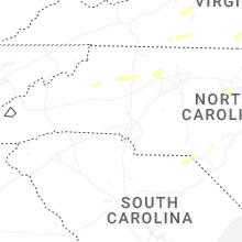


Connect with Interactive Hail Maps