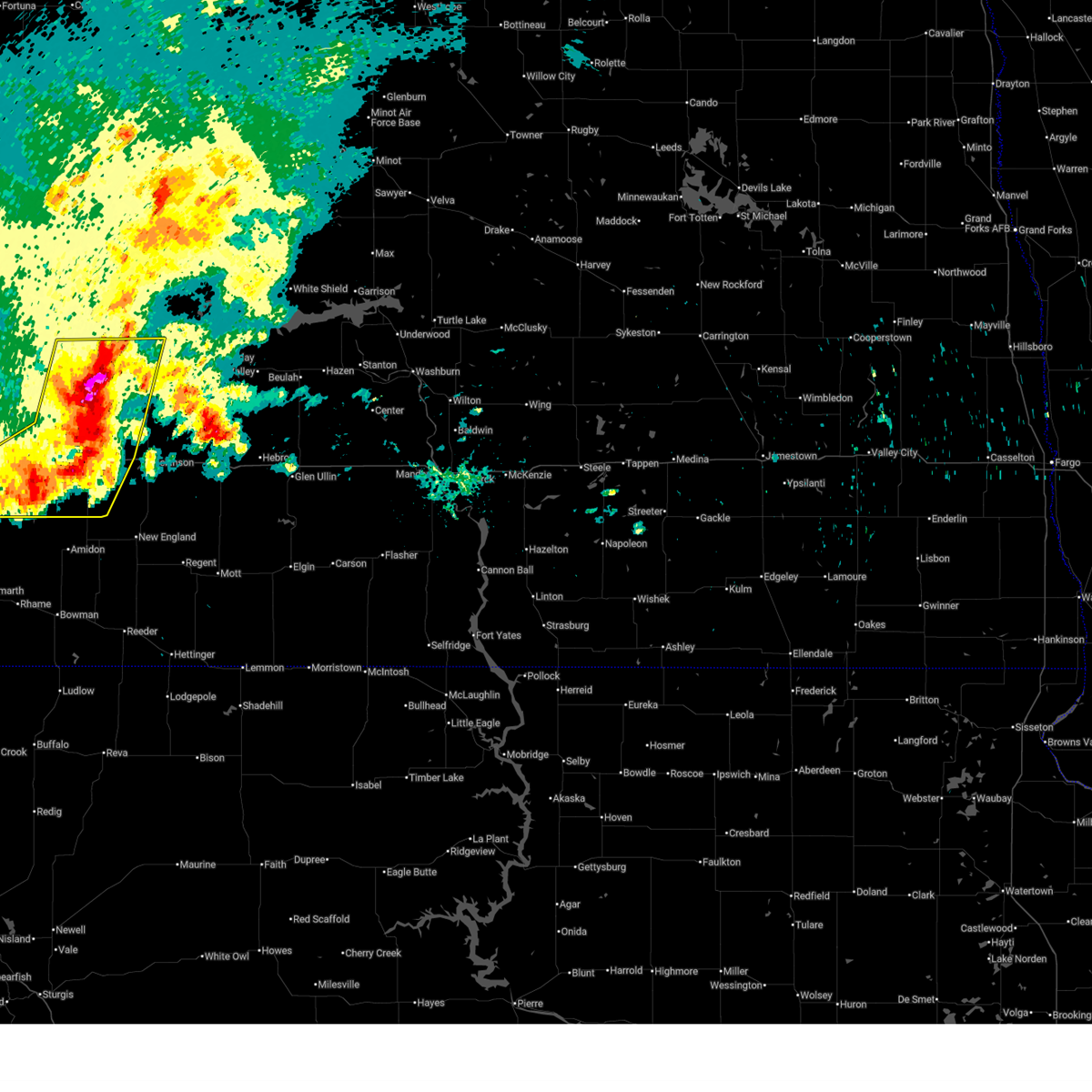
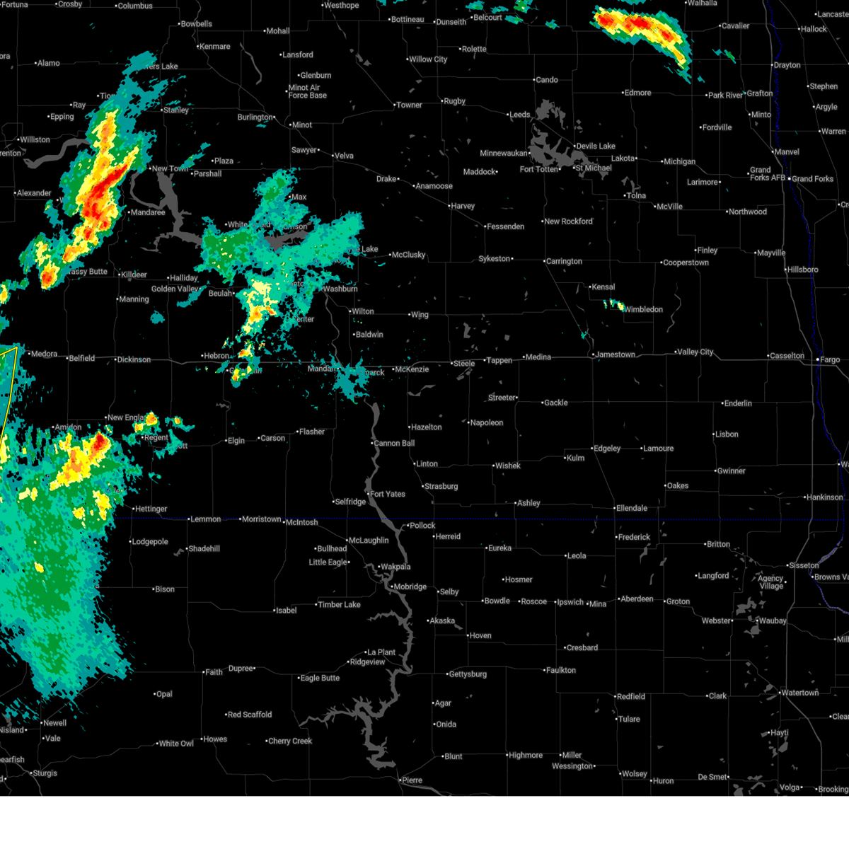
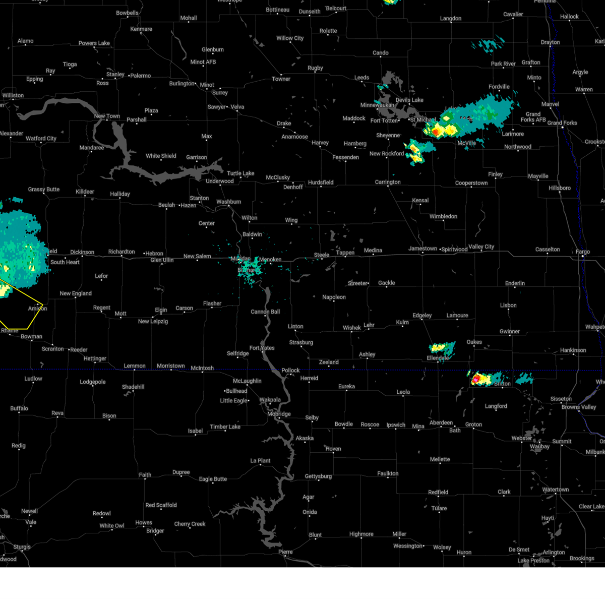
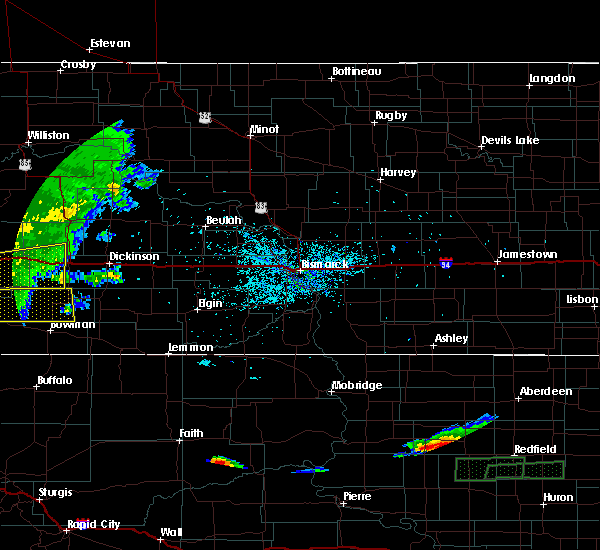
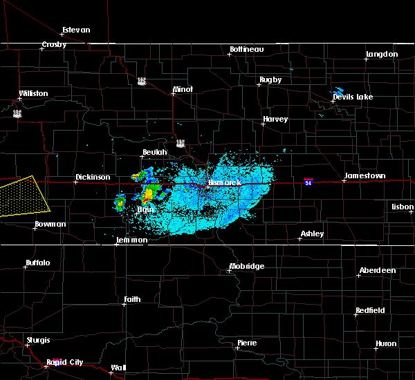
| 6/27/2026 6:40 PM MDT |
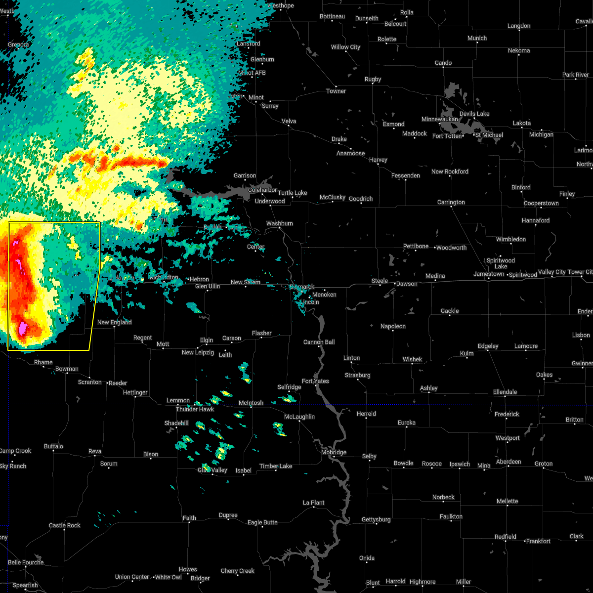
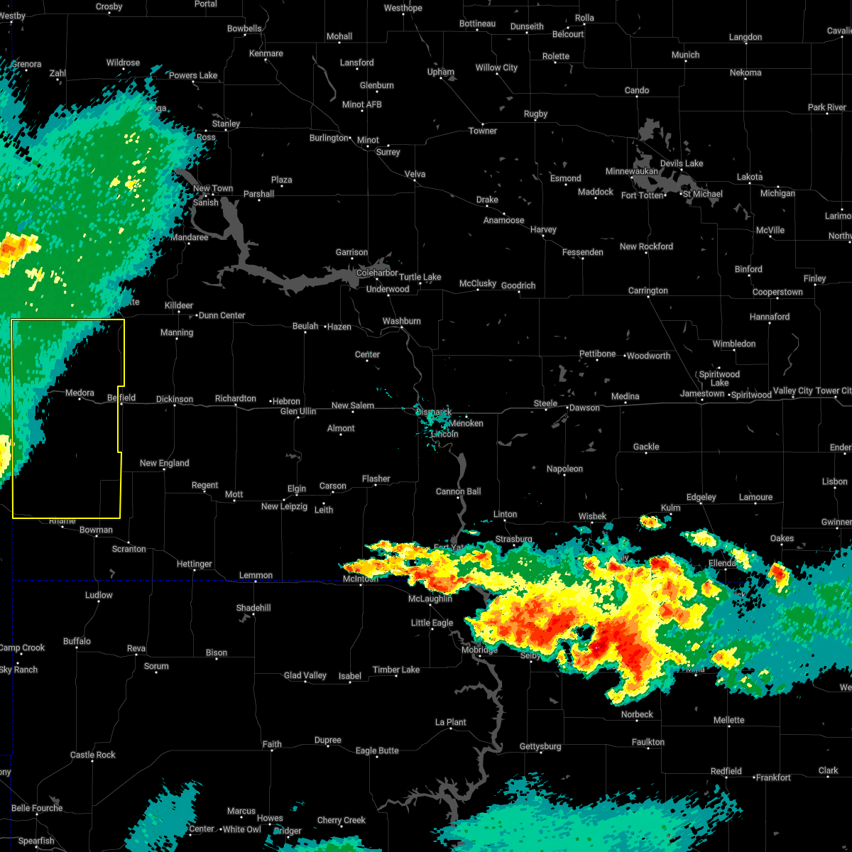
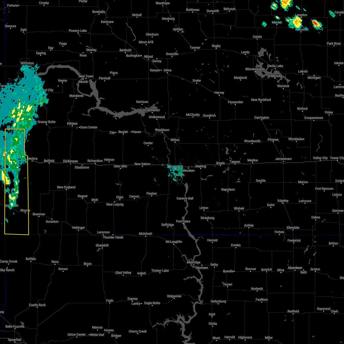
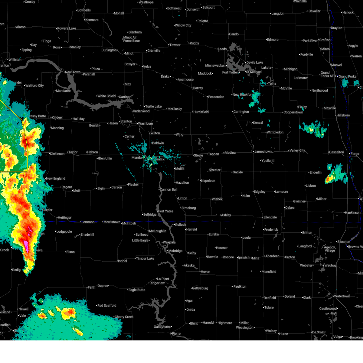 Svrbis the national weather service in bismarck has issued a * severe thunderstorm warning for, southwestern mckenzie county in northwestern north dakota, billings county in southwestern north dakota, golden valley county in southwestern north dakota, * until 745 pm mdt. * at 640 pm mdt, severe thunderstorms were located along a line from 15 miles west of skaar to 16 miles south of medora, or along a line from 39 miles northwest of beach to 25 miles southeast of beach, moving northeast at 15 mph (radar indicated). Hazards include 70 mph wind gusts and quarter size hail. Hail damage to vehicles is expected. expect considerable tree damage. Wind damage is also likely to mobile homes, roofs, and outbuildings. Svrbis the national weather service in bismarck has issued a * severe thunderstorm warning for, southwestern mckenzie county in northwestern north dakota, billings county in southwestern north dakota, golden valley county in southwestern north dakota, * until 745 pm mdt. * at 640 pm mdt, severe thunderstorms were located along a line from 15 miles west of skaar to 16 miles south of medora, or along a line from 39 miles northwest of beach to 25 miles southeast of beach, moving northeast at 15 mph (radar indicated). Hazards include 70 mph wind gusts and quarter size hail. Hail damage to vehicles is expected. expect considerable tree damage. Wind damage is also likely to mobile homes, roofs, and outbuildings.
|
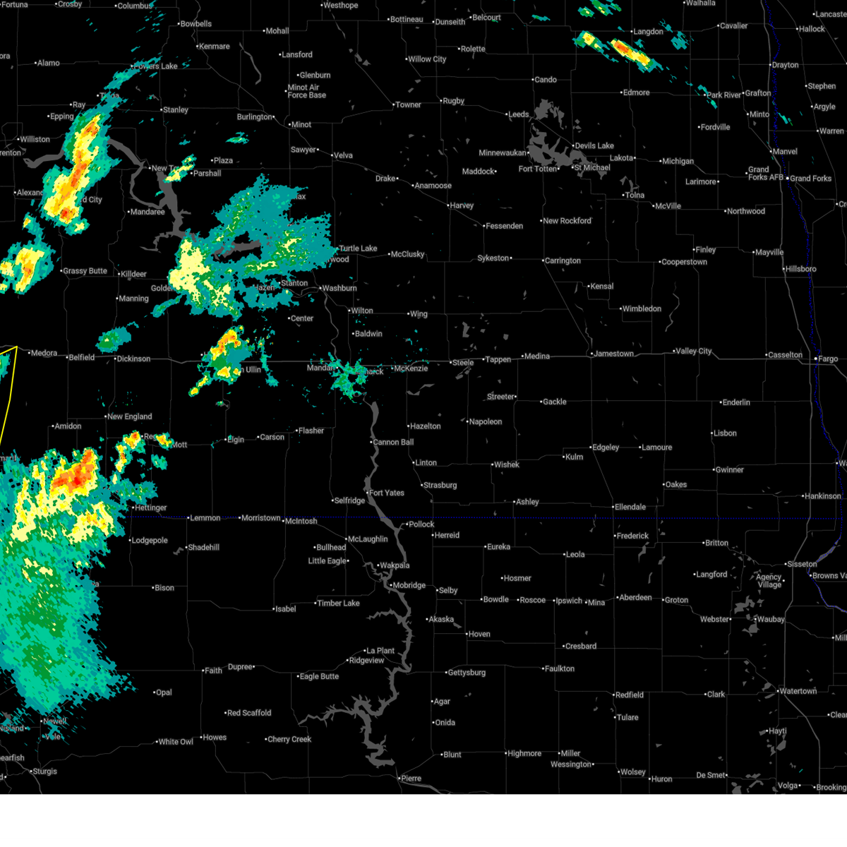
| 6/7/2026 6:47 PM MDT |
 the severe thunderstorm warning has been cancelled and is no longer in effect the severe thunderstorm warning has been cancelled and is no longer in effect
|
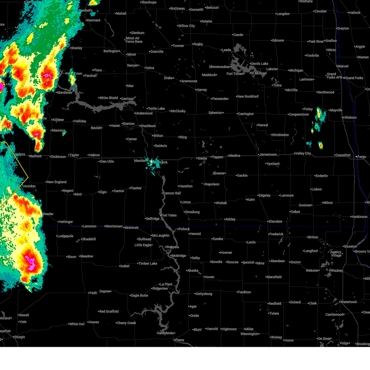
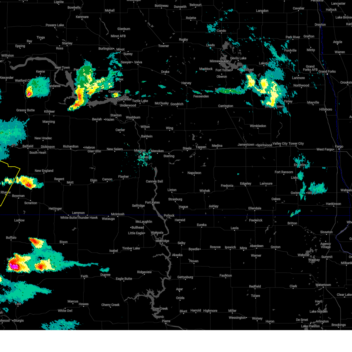
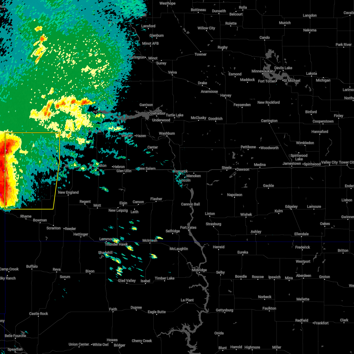
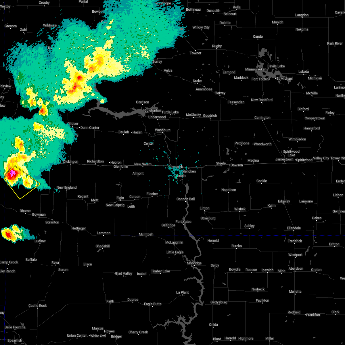
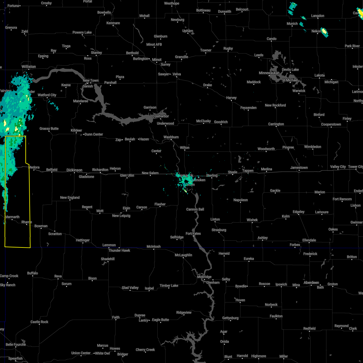
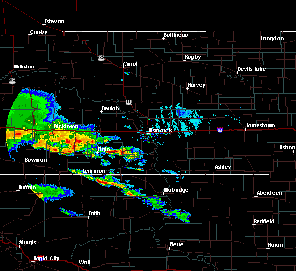
| 6/7/2026 6:47 PM MDT |
 At 647 pm mdt, severe thunderstorms were located along a line from 6 miles south of beach to 18 miles north of rhame, or along a line from 6 miles south of beach to 24 miles northwest of bowman, moving northeast at 55 mph (radar indicated). Hazards include 70 mph wind gusts and small hail. Expect considerable tree damage. damage is likely to mobile homes, roofs, and outbuildings. Locations impacted include, beach, medora, golva, sentinel butte, alpha, three v crossing, sentinel butte state nature preserve and rough rider state park. At 647 pm mdt, severe thunderstorms were located along a line from 6 miles south of beach to 18 miles north of rhame, or along a line from 6 miles south of beach to 24 miles northwest of bowman, moving northeast at 55 mph (radar indicated). Hazards include 70 mph wind gusts and small hail. Expect considerable tree damage. damage is likely to mobile homes, roofs, and outbuildings. Locations impacted include, beach, medora, golva, sentinel butte, alpha, three v crossing, sentinel butte state nature preserve and rough rider state park.
|
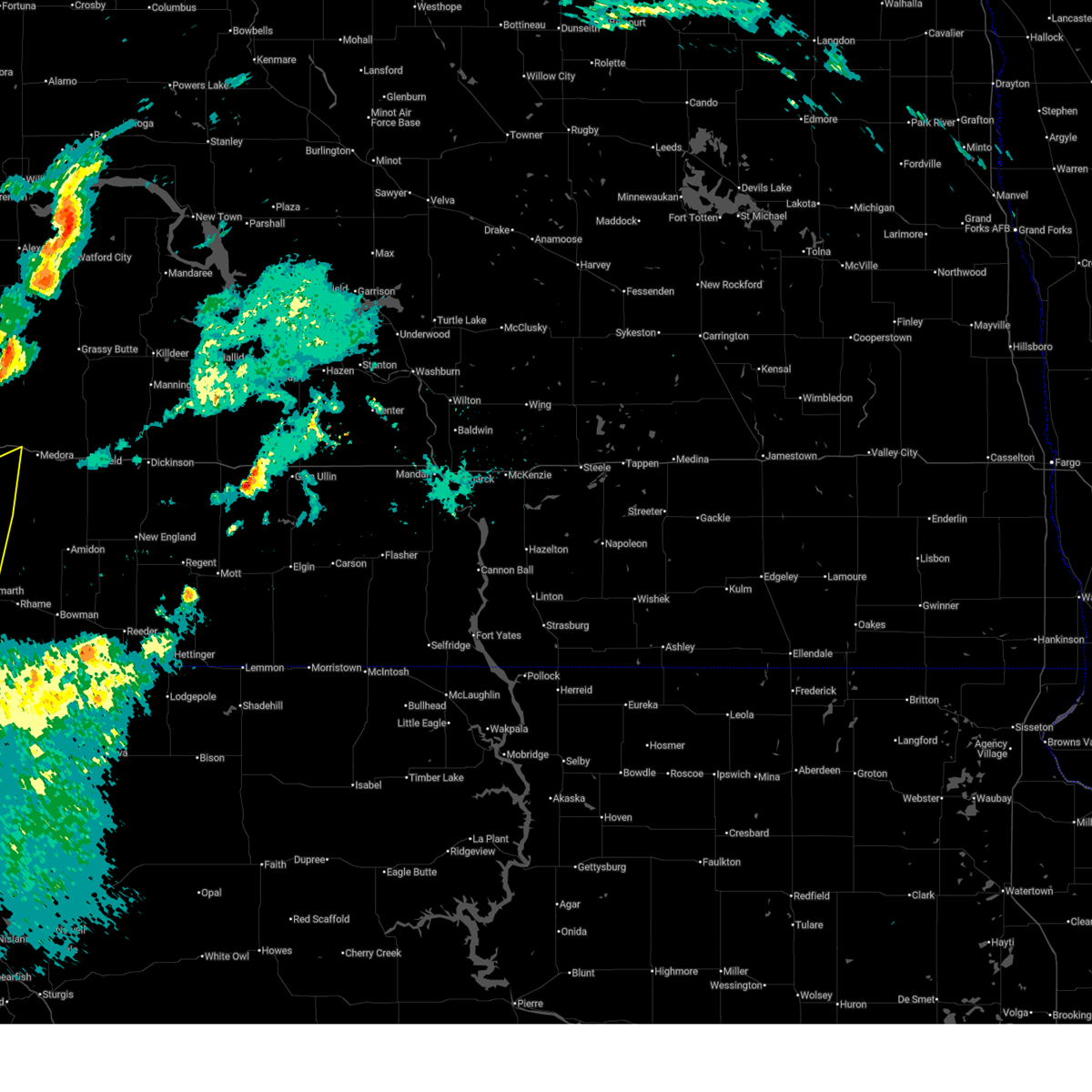
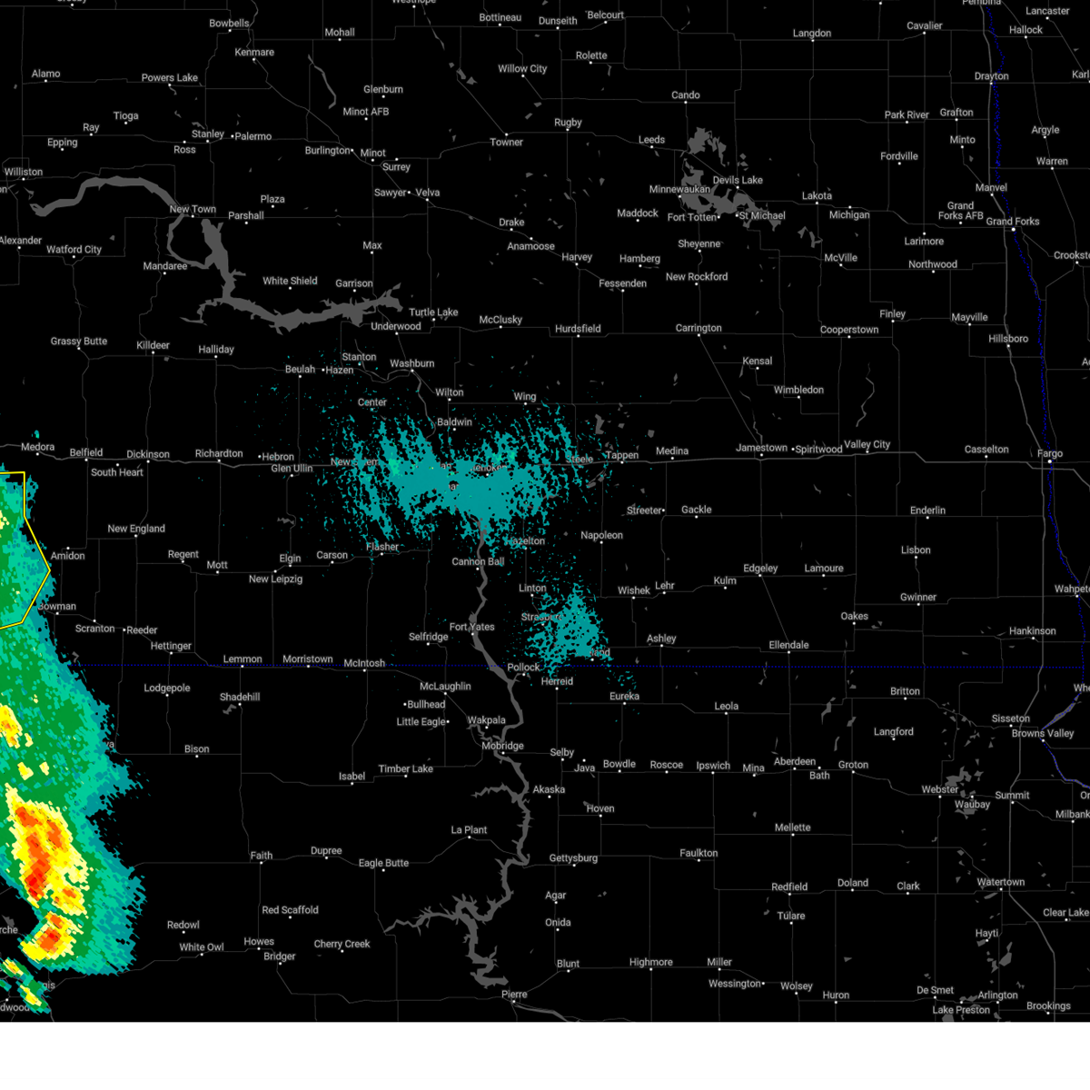
| 6/7/2026 6:25 PM MDT |
 Svrbis the national weather service in bismarck has issued a * severe thunderstorm warning for, southwestern billings county in southwestern north dakota, northwestern bowman county in southwestern north dakota, golden valley county in southwestern north dakota, western slope county in southwestern north dakota, * until 730 pm mdt. * at 625 pm mdt, severe thunderstorms were located along a line from 26 miles west of golva to 9 miles west of marmarth, or along a line from 30 miles southwest of beach to 35 miles west of bowman, moving northeast at 45 mph (radar indicated). Hazards include 70 mph wind gusts and small hail. Expect considerable tree damage. Damage is likely to mobile homes, roofs, and outbuildings. Svrbis the national weather service in bismarck has issued a * severe thunderstorm warning for, southwestern billings county in southwestern north dakota, northwestern bowman county in southwestern north dakota, golden valley county in southwestern north dakota, western slope county in southwestern north dakota, * until 730 pm mdt. * at 625 pm mdt, severe thunderstorms were located along a line from 26 miles west of golva to 9 miles west of marmarth, or along a line from 30 miles southwest of beach to 35 miles west of bowman, moving northeast at 45 mph (radar indicated). Hazards include 70 mph wind gusts and small hail. Expect considerable tree damage. Damage is likely to mobile homes, roofs, and outbuildings.
|
| 6/7/2026 4:46 PM MDT |
 Svrbis the national weather service in bismarck has issued a * severe thunderstorm warning for, central golden valley county in southwestern north dakota, * until 600 pm mdt. * at 446 pm mdt, a severe thunderstorm was located 5 miles north of golva, or 8 miles south of beach, moving northeast at 20 mph (radar indicated). Hazards include golf ball size hail and 60 mph wind gusts. People and animals outdoors will be injured. expect hail damage to roofs, siding, windows, and vehicles. Expect wind damage to roofs, siding, and trees. Svrbis the national weather service in bismarck has issued a * severe thunderstorm warning for, central golden valley county in southwestern north dakota, * until 600 pm mdt. * at 446 pm mdt, a severe thunderstorm was located 5 miles north of golva, or 8 miles south of beach, moving northeast at 20 mph (radar indicated). Hazards include golf ball size hail and 60 mph wind gusts. People and animals outdoors will be injured. expect hail damage to roofs, siding, windows, and vehicles. Expect wind damage to roofs, siding, and trees.
|
| 8/7/2025 9:53 PM MDT |
 Svrbis the national weather service in bismarck has issued a * severe thunderstorm warning for, golden valley county in southwestern north dakota, billings county in southwestern north dakota, southwestern mckenzie county in northwestern north dakota, northwestern slope county in southwestern north dakota, northwestern stark county in southwestern north dakota, * until midnight cdt/1100 pm mdt/. * at 1053 pm cdt/953 pm mdt/, severe thunderstorms were located along a line extending from 8 miles west of skaar to 9 miles north of sentinel butte to 10 miles northeast of baker, moving northeast at 50 mph (radar indicated). Hazards include 60 mph wind gusts. expect damage to roofs, siding, and trees Svrbis the national weather service in bismarck has issued a * severe thunderstorm warning for, golden valley county in southwestern north dakota, billings county in southwestern north dakota, southwestern mckenzie county in northwestern north dakota, northwestern slope county in southwestern north dakota, northwestern stark county in southwestern north dakota, * until midnight cdt/1100 pm mdt/. * at 1053 pm cdt/953 pm mdt/, severe thunderstorms were located along a line extending from 8 miles west of skaar to 9 miles north of sentinel butte to 10 miles northeast of baker, moving northeast at 50 mph (radar indicated). Hazards include 60 mph wind gusts. expect damage to roofs, siding, and trees
|
| 7/28/2025 6:54 AM MDT |
 At 654 am mdt, severe thunderstorms were located along a line extending from 11 miles east of grassy butte to 4 miles east of belfield to 13 miles south of medora, moving east at 30 mph (trained weather spotters). Hazards include 70 mph wind gusts and ping pong ball size hail. People and animals outdoors will be injured. expect hail damage to roofs, siding, windows, and vehicles. expect considerable tree damage. wind damage is also likely to mobile homes, roofs, and outbuildings. Locations impacted include, belfield, killdeer, south heart, medora, manning, golva, sentinel butte, grassy butte, south fairfield, fairfield, fryburg, new hradec, alpha, sentinel butte state nature preserve, and sully creek state park. At 654 am mdt, severe thunderstorms were located along a line extending from 11 miles east of grassy butte to 4 miles east of belfield to 13 miles south of medora, moving east at 30 mph (trained weather spotters). Hazards include 70 mph wind gusts and ping pong ball size hail. People and animals outdoors will be injured. expect hail damage to roofs, siding, windows, and vehicles. expect considerable tree damage. wind damage is also likely to mobile homes, roofs, and outbuildings. Locations impacted include, belfield, killdeer, south heart, medora, manning, golva, sentinel butte, grassy butte, south fairfield, fairfield, fryburg, new hradec, alpha, sentinel butte state nature preserve, and sully creek state park.
|
| 7/28/2025 6:40 AM MDT |
 At 638 am mdt, severe thunderstorms were located along a line extending from 9 miles southeast of grassy butte to 8 miles northwest of belfield to 8 miles east of golva, moving east at 35 mph (trained weather spotters. at 634 am mdt, a 75 mph wind gust was reported 2 miles west of fairfield). Hazards include 70 mph wind gusts and ping pong ball size hail. People and animals outdoors will be injured. expect hail damage to roofs, siding, windows, and vehicles. expect considerable tree damage. wind damage is also likely to mobile homes, roofs, and outbuildings. Locations impacted include, beach, belfield, killdeer, south heart, medora, manning, golva, sentinel butte, grassy butte, south fairfield, fairfield, fryburg, elkhorn state natural area, new hradec, alpha, sentinel butte state nature preserve, and sully creek state park. At 638 am mdt, severe thunderstorms were located along a line extending from 9 miles southeast of grassy butte to 8 miles northwest of belfield to 8 miles east of golva, moving east at 35 mph (trained weather spotters. at 634 am mdt, a 75 mph wind gust was reported 2 miles west of fairfield). Hazards include 70 mph wind gusts and ping pong ball size hail. People and animals outdoors will be injured. expect hail damage to roofs, siding, windows, and vehicles. expect considerable tree damage. wind damage is also likely to mobile homes, roofs, and outbuildings. Locations impacted include, beach, belfield, killdeer, south heart, medora, manning, golva, sentinel butte, grassy butte, south fairfield, fairfield, fryburg, elkhorn state natural area, new hradec, alpha, sentinel butte state nature preserve, and sully creek state park.
|
| 7/28/2025 6:23 AM MDT |
 Svrbis the national weather service in bismarck has issued a * severe thunderstorm warning for, golden valley county in southwestern north dakota, southwestern dunn county in southwestern north dakota, billings county in southwestern north dakota, south central mckenzie county in northwestern north dakota, western stark county in southwestern north dakota, * until 730 am mdt. * at 622 am mdt, severe thunderstorms were located along a line extending from 5 miles southwest of grassy butte to 7 miles north of medora to 5 miles northwest of golva, moving east at 30 mph (radar indicated). Hazards include golf ball size hail and 60 mph wind gusts. People and animals outdoors will be injured. expect hail damage to roofs, siding, windows, and vehicles. Expect wind damage to roofs, siding, and trees. Svrbis the national weather service in bismarck has issued a * severe thunderstorm warning for, golden valley county in southwestern north dakota, southwestern dunn county in southwestern north dakota, billings county in southwestern north dakota, south central mckenzie county in northwestern north dakota, western stark county in southwestern north dakota, * until 730 am mdt. * at 622 am mdt, severe thunderstorms were located along a line extending from 5 miles southwest of grassy butte to 7 miles north of medora to 5 miles northwest of golva, moving east at 30 mph (radar indicated). Hazards include golf ball size hail and 60 mph wind gusts. People and animals outdoors will be injured. expect hail damage to roofs, siding, windows, and vehicles. Expect wind damage to roofs, siding, and trees.
|
| 7/20/2025 6:25 PM MDT |
 Svrbis the national weather service in bismarck has issued a * severe thunderstorm warning for, southern golden valley county in southwestern north dakota, southwestern billings county in southwestern north dakota, northwestern slope county in southwestern north dakota, * until 730 pm mdt. * at 625 pm mdt, a severe thunderstorm was located near golva, or 10 miles southeast of beach, moving east at 20 mph (radar indicated). Hazards include golf ball size hail and 60 mph wind gusts. People and animals outdoors will be injured. expect hail damage to roofs, siding, windows, and vehicles. Expect wind damage to roofs, siding, and trees. Svrbis the national weather service in bismarck has issued a * severe thunderstorm warning for, southern golden valley county in southwestern north dakota, southwestern billings county in southwestern north dakota, northwestern slope county in southwestern north dakota, * until 730 pm mdt. * at 625 pm mdt, a severe thunderstorm was located near golva, or 10 miles southeast of beach, moving east at 20 mph (radar indicated). Hazards include golf ball size hail and 60 mph wind gusts. People and animals outdoors will be injured. expect hail damage to roofs, siding, windows, and vehicles. Expect wind damage to roofs, siding, and trees.
|
| 7/3/2025 10:40 PM MDT |
 The storms which prompted the warning have weakened below severe limits, and no longer pose an immediate threat to life or property. therefore, the warning will be allowed to expire. a severe thunderstorm watch remains in effect until 100 am mdt for southwestern north dakota. The storms which prompted the warning have weakened below severe limits, and no longer pose an immediate threat to life or property. therefore, the warning will be allowed to expire. a severe thunderstorm watch remains in effect until 100 am mdt for southwestern north dakota.
|
| 7/3/2025 10:19 PM MDT |
 the severe thunderstorm warning has been cancelled and is no longer in effect the severe thunderstorm warning has been cancelled and is no longer in effect
|
| 7/3/2025 10:19 PM MDT |
 At 1019 pm mdt, severe thunderstorms were located along a line extending from near sentinel butte to 8 miles southeast of golva to 5 miles northwest of marmarth, moving east at 20 mph (radar indicated). Hazards include 60 mph wind gusts and penny size hail. Expect damage to roofs, siding, and trees. Locations impacted include, marmarth, golva, alpha, sentinel butte state nature preserve, three v crossing, and pretty butte. At 1019 pm mdt, severe thunderstorms were located along a line extending from near sentinel butte to 8 miles southeast of golva to 5 miles northwest of marmarth, moving east at 20 mph (radar indicated). Hazards include 60 mph wind gusts and penny size hail. Expect damage to roofs, siding, and trees. Locations impacted include, marmarth, golva, alpha, sentinel butte state nature preserve, three v crossing, and pretty butte.
|
| 7/3/2025 9:56 PM MDT |
 Svrbis the national weather service in bismarck has issued a * severe thunderstorm warning for, southern golden valley county in southwestern north dakota, northwestern bowman county in southwestern north dakota, western slope county in southwestern north dakota, * until 1045 pm mdt. * at 955 pm mdt, severe thunderstorms were located along a line extending from 4 miles north of golva to 6 miles south of carlyle to 7 miles south of baker, moving northeast at 15 mph (radar indicated). Hazards include 70 mph wind gusts and penny size hail. Expect considerable tree damage. Damage is likely to mobile homes, roofs, and outbuildings. Svrbis the national weather service in bismarck has issued a * severe thunderstorm warning for, southern golden valley county in southwestern north dakota, northwestern bowman county in southwestern north dakota, western slope county in southwestern north dakota, * until 1045 pm mdt. * at 955 pm mdt, severe thunderstorms were located along a line extending from 4 miles north of golva to 6 miles south of carlyle to 7 miles south of baker, moving northeast at 15 mph (radar indicated). Hazards include 70 mph wind gusts and penny size hail. Expect considerable tree damage. Damage is likely to mobile homes, roofs, and outbuildings.
|
| 6/27/2024 5:44 PM MDT |
 Svrbis the national weather service in bismarck has issued a * severe thunderstorm warning for, golden valley county in southwestern north dakota, western billings county in southwestern north dakota, * until 630 pm mdt. * at 543 pm mdt, severe thunderstorms were located along a line extending from 7 miles west of skaar to near sentinel butte to 4 miles southeast of golva, moving east at 40 mph (radar indicated). Hazards include 70 mph wind gusts. Expect considerable tree damage. Damage is likely to mobile homes, roofs, and outbuildings. Svrbis the national weather service in bismarck has issued a * severe thunderstorm warning for, golden valley county in southwestern north dakota, western billings county in southwestern north dakota, * until 630 pm mdt. * at 543 pm mdt, severe thunderstorms were located along a line extending from 7 miles west of skaar to near sentinel butte to 4 miles southeast of golva, moving east at 40 mph (radar indicated). Hazards include 70 mph wind gusts. Expect considerable tree damage. Damage is likely to mobile homes, roofs, and outbuildings.
|
| 6/22/2024 4:55 PM MDT |
 At 453 pm mdt, a severe thunderstorm was located 11 miles east of carlyle, or 23 miles south of beach, moving southeast at 35 mph (public reported hail the size of quarters south southeast of golva). Hazards include 60 mph wind gusts and half dollar size hail. Hail damage to vehicles is expected. expect wind damage to roofs, siding, and trees. Locations impacted include, golva, amidon, alpha, and three v crossing. At 453 pm mdt, a severe thunderstorm was located 11 miles east of carlyle, or 23 miles south of beach, moving southeast at 35 mph (public reported hail the size of quarters south southeast of golva). Hazards include 60 mph wind gusts and half dollar size hail. Hail damage to vehicles is expected. expect wind damage to roofs, siding, and trees. Locations impacted include, golva, amidon, alpha, and three v crossing.
|
| 6/22/2024 4:45 PM MDT |
Quarter sized hail reported 3.1 miles NNW of Golva, ND, hail from 5:45 to 5:50. swing set blown over.
|
| 6/22/2024 4:42 PM MDT |
 Svrbis the national weather service in bismarck has issued a * severe thunderstorm warning for, southern golden valley county in southwestern north dakota, central slope county in southwestern north dakota, * until 545 pm mdt. * at 441 pm mdt, a severe thunderstorm was located near carlyle, or 17 miles south of beach, moving southeast at 35 mph (radar indicated). Hazards include 60 mph wind gusts and half dollar size hail. Hail damage to vehicles is expected. Expect wind damage to roofs, siding, and trees. Svrbis the national weather service in bismarck has issued a * severe thunderstorm warning for, southern golden valley county in southwestern north dakota, central slope county in southwestern north dakota, * until 545 pm mdt. * at 441 pm mdt, a severe thunderstorm was located near carlyle, or 17 miles south of beach, moving southeast at 35 mph (radar indicated). Hazards include 60 mph wind gusts and half dollar size hail. Hail damage to vehicles is expected. Expect wind damage to roofs, siding, and trees.
|
| 5/29/2024 5:16 PM MDT |
 The storms which prompted the warning have weakened below severe limits, and have exited the warned area. therefore, the warning has been allowed to expire. however, gusty winds are still possible with these thunderstorms. a severe thunderstorm watch remains in effect until 900 pm mdt for southwestern north dakota. remember, a severe thunderstorm warning still remains in effect for northern golden valley county until 545 pm mdt. The storms which prompted the warning have weakened below severe limits, and have exited the warned area. therefore, the warning has been allowed to expire. however, gusty winds are still possible with these thunderstorms. a severe thunderstorm watch remains in effect until 900 pm mdt for southwestern north dakota. remember, a severe thunderstorm warning still remains in effect for northern golden valley county until 545 pm mdt.
|
| 5/29/2024 5:03 PM MDT |
 At 502 pm mdt, severe thunderstorms were located along a line extending from 11 miles southeast of golva to 14 miles east of marmarth to 5 miles southwest of rhame, moving east at 20 mph (radar indicated). Hazards include 60 mph wind gusts. Expect damage to roofs, siding, and trees. Locations impacted include, rhame, marmarth, golva, sunset butte, alpha, three v crossing, and pretty butte. At 502 pm mdt, severe thunderstorms were located along a line extending from 11 miles southeast of golva to 14 miles east of marmarth to 5 miles southwest of rhame, moving east at 20 mph (radar indicated). Hazards include 60 mph wind gusts. Expect damage to roofs, siding, and trees. Locations impacted include, rhame, marmarth, golva, sunset butte, alpha, three v crossing, and pretty butte.
|
| 5/29/2024 4:44 PM MDT |
 At 444 pm mdt, severe thunderstorms were located along a line extending from 8 miles southeast of golva to 7 miles northwest of rhame to 8 miles south of marmarth, moving east at 20 mph (radar indicated). Hazards include 60 mph wind gusts and quarter size hail. Hail damage to vehicles is expected. expect wind damage to roofs, siding, and trees. Locations impacted include, rhame, marmarth, golva, sunset butte, alpha, three v crossing, and pretty butte. At 444 pm mdt, severe thunderstorms were located along a line extending from 8 miles southeast of golva to 7 miles northwest of rhame to 8 miles south of marmarth, moving east at 20 mph (radar indicated). Hazards include 60 mph wind gusts and quarter size hail. Hail damage to vehicles is expected. expect wind damage to roofs, siding, and trees. Locations impacted include, rhame, marmarth, golva, sunset butte, alpha, three v crossing, and pretty butte.
|
| 5/29/2024 4:21 PM MDT |
 Svrbis the national weather service in bismarck has issued a * severe thunderstorm warning for, southern golden valley county in southwestern north dakota, northwestern bowman county in southwestern north dakota, western slope county in southwestern north dakota, * until 515 pm mdt. * at 420 pm mdt, severe thunderstorms were located along a line extending from 5 miles southeast of carlyle to near marmarth to 12 miles northwest of mud buttes, moving east at 20 mph (radar indicated). Hazards include 60 mph wind gusts and quarter size hail. Hail damage to vehicles is expected. Expect wind damage to roofs, siding, and trees. Svrbis the national weather service in bismarck has issued a * severe thunderstorm warning for, southern golden valley county in southwestern north dakota, northwestern bowman county in southwestern north dakota, western slope county in southwestern north dakota, * until 515 pm mdt. * at 420 pm mdt, severe thunderstorms were located along a line extending from 5 miles southeast of carlyle to near marmarth to 12 miles northwest of mud buttes, moving east at 20 mph (radar indicated). Hazards include 60 mph wind gusts and quarter size hail. Hail damage to vehicles is expected. Expect wind damage to roofs, siding, and trees.
|
| 7/11/2023 5:42 PM MDT |
 At 541 pm mdt, a severe thunderstorm was located 6 miles west of carlyle, or 19 miles north of baker, moving southeast at 40 mph (radar indicated). Hazards include golf ball size hail and 70 mph wind gusts. People and animals outdoors will be injured. expect hail damage to roofs, siding, windows, and vehicles. expect considerable tree damage. wind damage is also likely to mobile homes, roofs, and outbuildings. this severe thunderstorm will remain over mainly rural areas of southern golden valley, northwestern bowman and western slope counties, including the following locations, alpha, sunset butte, three v crossing and pretty butte. thunderstorm damage threat, considerable hail threat, radar indicated max hail size, 1. 75 in wind threat, radar indicated max wind gust, 70 mph. At 541 pm mdt, a severe thunderstorm was located 6 miles west of carlyle, or 19 miles north of baker, moving southeast at 40 mph (radar indicated). Hazards include golf ball size hail and 70 mph wind gusts. People and animals outdoors will be injured. expect hail damage to roofs, siding, windows, and vehicles. expect considerable tree damage. wind damage is also likely to mobile homes, roofs, and outbuildings. this severe thunderstorm will remain over mainly rural areas of southern golden valley, northwestern bowman and western slope counties, including the following locations, alpha, sunset butte, three v crossing and pretty butte. thunderstorm damage threat, considerable hail threat, radar indicated max hail size, 1. 75 in wind threat, radar indicated max wind gust, 70 mph.
|
| 6/19/2023 9:06 PM MDT |
Quarter sized hail reported 3.8 miles NW of Golva, ND, mainly pea size. not much wind.
|
| 6/19/2023 9:06 PM MDT |
 At 906 pm mdt, a severe thunderstorm was located 6 miles northeast of golva, or 11 miles southeast of beach, moving northeast at 45 mph (radar indicated). Hazards include 70 mph wind gusts and ping pong ball size hail. People and animals outdoors will be injured. expect hail damage to roofs, siding, windows, and vehicles. expect considerable tree damage. wind damage is also likely to mobile homes, roofs, and outbuildings. this severe storm will be near, medora around 930 pm mdt. other locations impacted by this severe thunderstorm include alpha, sentinel butte state nature preserve, sully creek state park and elkhorn state natural area. thunderstorm damage threat, considerable hail threat, radar indicated max hail size, 1. 50 in wind threat, radar indicated max wind gust, 70 mph. At 906 pm mdt, a severe thunderstorm was located 6 miles northeast of golva, or 11 miles southeast of beach, moving northeast at 45 mph (radar indicated). Hazards include 70 mph wind gusts and ping pong ball size hail. People and animals outdoors will be injured. expect hail damage to roofs, siding, windows, and vehicles. expect considerable tree damage. wind damage is also likely to mobile homes, roofs, and outbuildings. this severe storm will be near, medora around 930 pm mdt. other locations impacted by this severe thunderstorm include alpha, sentinel butte state nature preserve, sully creek state park and elkhorn state natural area. thunderstorm damage threat, considerable hail threat, radar indicated max hail size, 1. 50 in wind threat, radar indicated max wind gust, 70 mph.
|
|
|
| 6/19/2023 8:47 PM MDT |
 At 846 pm mdt, a severe thunderstorm was located 5 miles north of carlyle, or 13 miles south of beach, moving northeast at 50 mph (radar indicated). Hazards include 70 mph wind gusts and ping pong ball size hail. People and animals outdoors will be injured. expect hail damage to roofs, siding, windows, and vehicles. expect considerable tree damage. wind damage is also likely to mobile homes, roofs, and outbuildings. this severe thunderstorm will be near, golva around 850 pm mdt. sentinel butte around 910 pm mdt. medora around 925 pm mdt. other locations impacted by this severe thunderstorm include alpha, sentinel butte state nature preserve, sully creek state park and elkhorn state natural area. thunderstorm damage threat, considerable hail threat, radar indicated max hail size, 1. 50 in wind threat, radar indicated max wind gust, 70 mph. At 846 pm mdt, a severe thunderstorm was located 5 miles north of carlyle, or 13 miles south of beach, moving northeast at 50 mph (radar indicated). Hazards include 70 mph wind gusts and ping pong ball size hail. People and animals outdoors will be injured. expect hail damage to roofs, siding, windows, and vehicles. expect considerable tree damage. wind damage is also likely to mobile homes, roofs, and outbuildings. this severe thunderstorm will be near, golva around 850 pm mdt. sentinel butte around 910 pm mdt. medora around 925 pm mdt. other locations impacted by this severe thunderstorm include alpha, sentinel butte state nature preserve, sully creek state park and elkhorn state natural area. thunderstorm damage threat, considerable hail threat, radar indicated max hail size, 1. 50 in wind threat, radar indicated max wind gust, 70 mph.
|
| 7/10/2022 1:14 AM MDT |
 At 113 am mdt, severe thunderstorms were located along a line extending from 11 miles southeast of trotters to 6 miles east of sentinel butte to 16 miles northeast of marmarth, moving east at 60 mph. these are destructive storms for golden valley, billings, and slope counties (radar indicated). Hazards include 80 mph wind gusts and ping pong ball size hail. Flying debris will be dangerous to those caught without shelter. mobile homes will be heavily damaged. expect considerable damage to roofs, windows, and vehicles. extensive tree damage and power outages are likely. these severe storms will be near, medora around 120 am mdt. amidon around 135 am mdt. south fairfield around 140 am mdt. other locations impacted by these severe thunderstorms include alpha, fryburg, fairfield, three v crossing, and pretty butte. thunderstorm damage threat, destructive hail threat, radar indicated max hail size, 1. 50 in wind threat, observed max wind gust, 80 mph. At 113 am mdt, severe thunderstorms were located along a line extending from 11 miles southeast of trotters to 6 miles east of sentinel butte to 16 miles northeast of marmarth, moving east at 60 mph. these are destructive storms for golden valley, billings, and slope counties (radar indicated). Hazards include 80 mph wind gusts and ping pong ball size hail. Flying debris will be dangerous to those caught without shelter. mobile homes will be heavily damaged. expect considerable damage to roofs, windows, and vehicles. extensive tree damage and power outages are likely. these severe storms will be near, medora around 120 am mdt. amidon around 135 am mdt. south fairfield around 140 am mdt. other locations impacted by these severe thunderstorms include alpha, fryburg, fairfield, three v crossing, and pretty butte. thunderstorm damage threat, destructive hail threat, radar indicated max hail size, 1. 50 in wind threat, observed max wind gust, 80 mph.
|
| 7/10/2022 1:03 AM MDT |
 At 102 am mdt, severe thunderstorms were located along a line extending from 11 miles south of trotters to near beach to 12 miles north of marmarth, moving northeast at 50 mph (radar indicated). Hazards include 70 mph wind gusts and ping pong ball size hail. People and animals outdoors will be injured. expect hail damage to roofs, siding, windows, and vehicles. expect considerable tree damage. wind damage is also likely to mobile homes, roofs, and outbuildings. these severe storms will be near, sentinel butte around 110 am mdt. medora around 125 am mdt. south fairfield around 145 am mdt. other locations impacted by these severe thunderstorms include alpha, fryburg, fairfield, three v crossing, and pretty butte. thunderstorm damage threat, considerable hail threat, radar indicated max hail size, 1. 50 in wind threat, radar indicated max wind gust, 70 mph. At 102 am mdt, severe thunderstorms were located along a line extending from 11 miles south of trotters to near beach to 12 miles north of marmarth, moving northeast at 50 mph (radar indicated). Hazards include 70 mph wind gusts and ping pong ball size hail. People and animals outdoors will be injured. expect hail damage to roofs, siding, windows, and vehicles. expect considerable tree damage. wind damage is also likely to mobile homes, roofs, and outbuildings. these severe storms will be near, sentinel butte around 110 am mdt. medora around 125 am mdt. south fairfield around 145 am mdt. other locations impacted by these severe thunderstorms include alpha, fryburg, fairfield, three v crossing, and pretty butte. thunderstorm damage threat, considerable hail threat, radar indicated max hail size, 1. 50 in wind threat, radar indicated max wind gust, 70 mph.
|
| 7/10/2022 12:45 AM MDT |
 At 1245 am mdt, severe thunderstorms were located along a line extending from 10 miles northwest of wibaux to 9 miles northwest of golva to 7 miles north of baker, moving east at 60 mph (radar indicated). Hazards include 70 mph wind gusts and ping pong ball size hail. People and animals outdoors will be injured. expect hail damage to roofs, siding, windows, and vehicles. expect considerable tree damage. wind damage is also likely to mobile homes, roofs, and outbuildings. severe thunderstorms will be near, golva around 1250 am mdt. beach around 1255 am mdt. sentinel butte around 100 am mdt. medora around 115 am mdt. belfield around 130 am mdt. other locations impacted by these severe thunderstorms include alpha, fryburg, fairfield, three v crossing, and pretty butte. thunderstorm damage threat, considerable hail threat, radar indicated max hail size, 1. 50 in wind threat, radar indicated max wind gust, 70 mph. At 1245 am mdt, severe thunderstorms were located along a line extending from 10 miles northwest of wibaux to 9 miles northwest of golva to 7 miles north of baker, moving east at 60 mph (radar indicated). Hazards include 70 mph wind gusts and ping pong ball size hail. People and animals outdoors will be injured. expect hail damage to roofs, siding, windows, and vehicles. expect considerable tree damage. wind damage is also likely to mobile homes, roofs, and outbuildings. severe thunderstorms will be near, golva around 1250 am mdt. beach around 1255 am mdt. sentinel butte around 100 am mdt. medora around 115 am mdt. belfield around 130 am mdt. other locations impacted by these severe thunderstorms include alpha, fryburg, fairfield, three v crossing, and pretty butte. thunderstorm damage threat, considerable hail threat, radar indicated max hail size, 1. 50 in wind threat, radar indicated max wind gust, 70 mph.
|
| 7/3/2022 9:09 PM MDT |
 At 909 pm mdt, severe thunderstorms were located along a line extending from near trotters to 9 miles northeast of marmarth, moving east at 35 mph (radar indicated). Hazards include 70 mph wind gusts and half dollar size hail. Hail damage to vehicles is expected. expect considerable tree damage. wind damage is also likely to mobile homes, roofs, and outbuildings. locations impacted include, amidon. thunderstorm damage threat, considerable hail threat, radar indicated max hail size, 1. 25 in wind threat, radar indicated max wind gust, 70 mph. At 909 pm mdt, severe thunderstorms were located along a line extending from near trotters to 9 miles northeast of marmarth, moving east at 35 mph (radar indicated). Hazards include 70 mph wind gusts and half dollar size hail. Hail damage to vehicles is expected. expect considerable tree damage. wind damage is also likely to mobile homes, roofs, and outbuildings. locations impacted include, amidon. thunderstorm damage threat, considerable hail threat, radar indicated max hail size, 1. 25 in wind threat, radar indicated max wind gust, 70 mph.
|
| 7/3/2022 8:40 PM MDT |
 At 838 pm mdt, severe thunderstorms were located along a line extending from 5 miles west of skaar to 10 miles northeast of baker, moving east at 45 mph (radar indicated). Hazards include 70 mph wind gusts and half dollar size hail. Hail damage to vehicles is expected. expect considerable tree damage. wind damage is also likely to mobile homes, roofs, and outbuildings. severe thunderstorms will be near, trotters around 855 pm mdt. other locations in the path of these severe thunderstorms include amidon. thunderstorm damage threat, considerable hail threat, radar indicated max hail size, 1. 25 in wind threat, radar indicated max wind gust, 70 mph. At 838 pm mdt, severe thunderstorms were located along a line extending from 5 miles west of skaar to 10 miles northeast of baker, moving east at 45 mph (radar indicated). Hazards include 70 mph wind gusts and half dollar size hail. Hail damage to vehicles is expected. expect considerable tree damage. wind damage is also likely to mobile homes, roofs, and outbuildings. severe thunderstorms will be near, trotters around 855 pm mdt. other locations in the path of these severe thunderstorms include amidon. thunderstorm damage threat, considerable hail threat, radar indicated max hail size, 1. 25 in wind threat, radar indicated max wind gust, 70 mph.
|
| 7/2/2022 6:49 PM MDT |
 At 649 pm mdt, a severe thunderstorm was located near golva, or 14 miles south of beach, moving southeast at 25 mph (radar indicated). Hazards include 60 mph wind gusts and quarter size hail. Hail damage to vehicles is expected. expect wind damage to roofs, siding, and trees. this severe thunderstorm will remain over mainly rural areas of southern golden valley, southwestern billings and northwestern slope counties, including the following locations, alpha and three v crossing. hail threat, radar indicated max hail size, 1. 00 in wind threat, radar indicated max wind gust, 60 mph. At 649 pm mdt, a severe thunderstorm was located near golva, or 14 miles south of beach, moving southeast at 25 mph (radar indicated). Hazards include 60 mph wind gusts and quarter size hail. Hail damage to vehicles is expected. expect wind damage to roofs, siding, and trees. this severe thunderstorm will remain over mainly rural areas of southern golden valley, southwestern billings and northwestern slope counties, including the following locations, alpha and three v crossing. hail threat, radar indicated max hail size, 1. 00 in wind threat, radar indicated max wind gust, 60 mph.
|
| 7/20/2021 4:58 PM MDT |
 At 458 pm mdt, a severe thunderstorm was located over golva, or 11 miles south of beach, moving northeast at 20 mph (radar indicated). Hazards include ping pong ball size hail and 60 mph wind gusts. People and animals outdoors will be injured. expect hail damage to roofs, siding, windows, and vehicles. Expect wind damage to roofs, siding, and trees. At 458 pm mdt, a severe thunderstorm was located over golva, or 11 miles south of beach, moving northeast at 20 mph (radar indicated). Hazards include ping pong ball size hail and 60 mph wind gusts. People and animals outdoors will be injured. expect hail damage to roofs, siding, windows, and vehicles. Expect wind damage to roofs, siding, and trees.
|
| 6/5/2021 9:03 PM MDT |
 At 902 pm mdt, severe thunderstorms were located along a line extending from 12 miles east of trotters to 17 miles east of golva to 5 miles northeast of mud buttes, moving east at 45 mph (surface observations). Hazards include 60 mph wind gusts. Expect damage to roofs, siding, and trees. Locations impacted include, beach, rhame, marmarth, golva, sentinel butte, mud buttes, trotters, sunset butte, alpha, three v crossing, and pretty butte. At 902 pm mdt, severe thunderstorms were located along a line extending from 12 miles east of trotters to 17 miles east of golva to 5 miles northeast of mud buttes, moving east at 45 mph (surface observations). Hazards include 60 mph wind gusts. Expect damage to roofs, siding, and trees. Locations impacted include, beach, rhame, marmarth, golva, sentinel butte, mud buttes, trotters, sunset butte, alpha, three v crossing, and pretty butte.
|
| 6/5/2021 8:51 PM MDT |
 At 835 pm mdt, severe thunderstorms were located along a line extending from 11 miles south of skaar to 5 miles southeast of carlyle to 13 miles west of mud buttes, moving east at 40 mph (surface observations). Hazards include 70 mph wind gusts. Expect considerable tree damage. damage is likely to mobile homes, roofs, and outbuildings. severe thunderstorms will be near, trotters around 850 pm mdt. Mud buttes around 855 pm mdt. At 835 pm mdt, severe thunderstorms were located along a line extending from 11 miles south of skaar to 5 miles southeast of carlyle to 13 miles west of mud buttes, moving east at 40 mph (surface observations). Hazards include 70 mph wind gusts. Expect considerable tree damage. damage is likely to mobile homes, roofs, and outbuildings. severe thunderstorms will be near, trotters around 850 pm mdt. Mud buttes around 855 pm mdt.
|
| 6/5/2021 8:36 PM MDT |
 At 835 pm mdt, severe thunderstorms were located along a line extending from 11 miles south of skaar to 5 miles southeast of carlyle to 13 miles west of mud buttes, moving east at 40 mph (surface observations). Hazards include 70 mph wind gusts. Expect considerable tree damage. damage is likely to mobile homes, roofs, and outbuildings. severe thunderstorms will be near, trotters around 850 pm mdt. Mud buttes around 855 pm mdt. At 835 pm mdt, severe thunderstorms were located along a line extending from 11 miles south of skaar to 5 miles southeast of carlyle to 13 miles west of mud buttes, moving east at 40 mph (surface observations). Hazards include 70 mph wind gusts. Expect considerable tree damage. damage is likely to mobile homes, roofs, and outbuildings. severe thunderstorms will be near, trotters around 850 pm mdt. Mud buttes around 855 pm mdt.
|
| 7/23/2020 5:18 PM MDT |
 At 518 pm mdt, a severe thunderstorm was located 13 miles southeast of carlyle, or 22 miles northeast of baker, moving north at 20 mph (radar indicated). Hazards include 60 mph wind gusts and quarter size hail. Hail damage to vehicles is expected. expect wind damage to roofs, siding, and trees. This severe thunderstorm will remain over mainly rural areas of southern golden valley and northwestern slope counties, including the following locations, alpha and three v crossing. At 518 pm mdt, a severe thunderstorm was located 13 miles southeast of carlyle, or 22 miles northeast of baker, moving north at 20 mph (radar indicated). Hazards include 60 mph wind gusts and quarter size hail. Hail damage to vehicles is expected. expect wind damage to roofs, siding, and trees. This severe thunderstorm will remain over mainly rural areas of southern golden valley and northwestern slope counties, including the following locations, alpha and three v crossing.
|
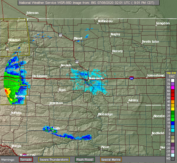
| 7/23/2020 5:02 PM MDT |
 At 502 pm mdt, a severe thunderstorm was located 8 miles southeast of carlyle, or 20 miles northeast of baker, moving north at 15 mph (radar indicated). Hazards include 60 mph wind gusts and quarter size hail. Hail damage to vehicles is expected. expect wind damage to roofs, siding, and trees. this severe storm will be near, golva around 545 pm mdt. Other locations impacted by this severe thunderstorm include alpha and three v crossing. At 502 pm mdt, a severe thunderstorm was located 8 miles southeast of carlyle, or 20 miles northeast of baker, moving north at 15 mph (radar indicated). Hazards include 60 mph wind gusts and quarter size hail. Hail damage to vehicles is expected. expect wind damage to roofs, siding, and trees. this severe storm will be near, golva around 545 pm mdt. Other locations impacted by this severe thunderstorm include alpha and three v crossing.
|
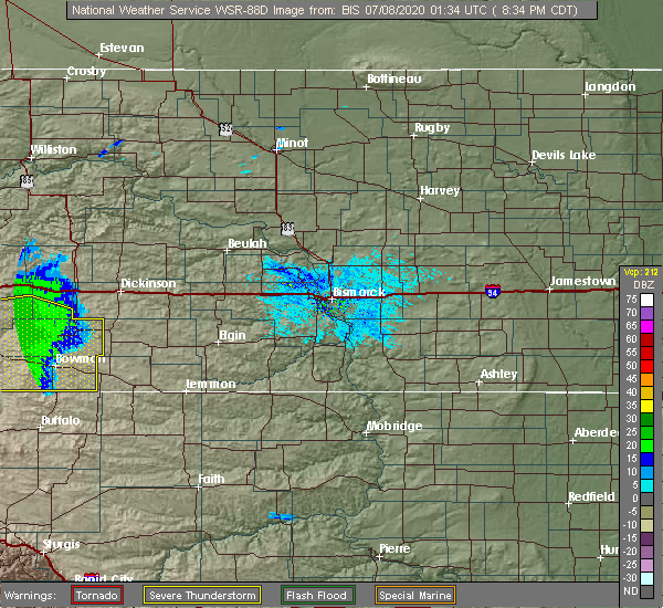
| 7/23/2020 4:53 PM MDT |
 At 453 pm mdt, a severe thunderstorm was located 9 miles southeast of carlyle, or 18 miles northeast of baker, moving north at 15 mph (radar indicated). Hazards include ping pong ball size hail and 60 mph wind gusts. People and animals outdoors will be injured. expect hail damage to roofs, siding, windows, and vehicles. expect wind damage to roofs, siding, and trees. this severe thunderstorm will be near, golva around 540 pm mdt. Other locations impacted by this severe thunderstorm include alpha and three v crossing. At 453 pm mdt, a severe thunderstorm was located 9 miles southeast of carlyle, or 18 miles northeast of baker, moving north at 15 mph (radar indicated). Hazards include ping pong ball size hail and 60 mph wind gusts. People and animals outdoors will be injured. expect hail damage to roofs, siding, windows, and vehicles. expect wind damage to roofs, siding, and trees. this severe thunderstorm will be near, golva around 540 pm mdt. Other locations impacted by this severe thunderstorm include alpha and three v crossing.
|
| 7/10/2020 2:55 PM MDT |
 The severe thunderstorm warning for southern golden valley and northwestern slope counties will expire at 300 pm mdt, the storms which prompted the warning have moved out of the area. therefore, the warning will be allowed to expire. a severe thunderstorm watch remains in effect until 900 pm mdt for southwestern north dakota. The severe thunderstorm warning for southern golden valley and northwestern slope counties will expire at 300 pm mdt, the storms which prompted the warning have moved out of the area. therefore, the warning will be allowed to expire. a severe thunderstorm watch remains in effect until 900 pm mdt for southwestern north dakota.
|
| 7/10/2020 2:36 PM MDT |
 At 236 pm mdt, severe thunderstorms were located along a line extending from 6 miles northeast of golva to 16 miles northeast of marmarth, moving northeast at 40 mph (radar indicated). Hazards include ping pong ball size hail and 60 mph wind gusts. People and animals outdoors will be injured. expect hail damage to roofs, siding, windows, and vehicles. expect wind damage to roofs, siding, and trees. these severe storms will be near, sentinel butte around 245 pm mdt. Other locations impacted by these severe thunderstorms include alpha and three v crossing. At 236 pm mdt, severe thunderstorms were located along a line extending from 6 miles northeast of golva to 16 miles northeast of marmarth, moving northeast at 40 mph (radar indicated). Hazards include ping pong ball size hail and 60 mph wind gusts. People and animals outdoors will be injured. expect hail damage to roofs, siding, windows, and vehicles. expect wind damage to roofs, siding, and trees. these severe storms will be near, sentinel butte around 245 pm mdt. Other locations impacted by these severe thunderstorms include alpha and three v crossing.
|
| 7/10/2020 2:21 PM MDT |
 At 221 pm mdt, severe thunderstorms were located along a line extending from near carlyle to 6 miles northeast of marmarth, moving northeast at 40 mph (radar indicated). Hazards include ping pong ball size hail and 60 mph wind gusts. People and animals outdoors will be injured. expect hail damage to roofs, siding, windows, and vehicles. expect wind damage to roofs, siding, and trees. these severe storms will be near, golva around 230 pm mdt. sentinel butte around 250 pm mdt. Other locations impacted by these severe thunderstorms include alpha, pretty butte and three v crossing. At 221 pm mdt, severe thunderstorms were located along a line extending from near carlyle to 6 miles northeast of marmarth, moving northeast at 40 mph (radar indicated). Hazards include ping pong ball size hail and 60 mph wind gusts. People and animals outdoors will be injured. expect hail damage to roofs, siding, windows, and vehicles. expect wind damage to roofs, siding, and trees. these severe storms will be near, golva around 230 pm mdt. sentinel butte around 250 pm mdt. Other locations impacted by these severe thunderstorms include alpha, pretty butte and three v crossing.
|
| 7/10/2020 2:04 PM MDT |
 At 204 pm mdt, a severe thunderstorm was located 7 miles south of carlyle, or 14 miles northeast of baker, moving northeast at 40 mph (radar indicated). Hazards include ping pong ball size hail and 60 mph wind gusts. People and animals outdoors will be injured. expect hail damage to roofs, siding, windows, and vehicles. expect wind damage to roofs, siding, and trees. this severe thunderstorm will be near, golva around 225 pm mdt. Other locations impacted by this severe thunderstorm include alpha, pretty butte and three v crossing. At 204 pm mdt, a severe thunderstorm was located 7 miles south of carlyle, or 14 miles northeast of baker, moving northeast at 40 mph (radar indicated). Hazards include ping pong ball size hail and 60 mph wind gusts. People and animals outdoors will be injured. expect hail damage to roofs, siding, windows, and vehicles. expect wind damage to roofs, siding, and trees. this severe thunderstorm will be near, golva around 225 pm mdt. Other locations impacted by this severe thunderstorm include alpha, pretty butte and three v crossing.
|
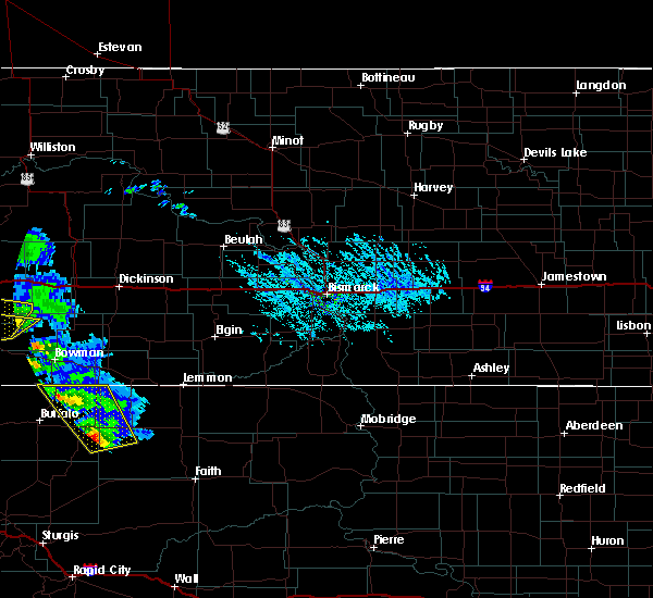
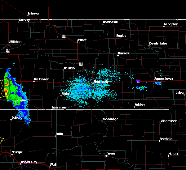
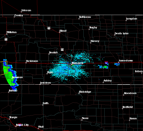
| 7/7/2020 8:12 PM MDT |
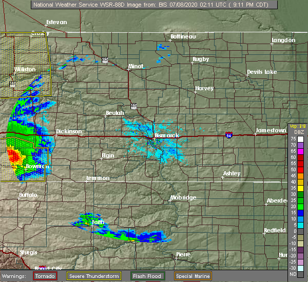 At 811 pm mdt, severe thunderstorms were located along a line extending from golva to 7 miles southwest of amidon to 9 miles north of camp crook, moving northeast at 50 mph (emergency management. at 810 pm mdt, the bowman county emergency manager reported 73 mph winds 4 miles southwest of rhame). Hazards include 70 mph wind gusts and ping pong ball size hail. People and animals outdoors will be injured. expect hail damage to roofs, siding, windows, and vehicles. expect considerable tree damage. wind damage is also likely to mobile homes, roofs, and outbuildings. these severe storms will be near, amidon around 820 pm mdt. Other locations impacted by these severe thunderstorms include sunset butte, bowman haley dam, alpha, griffin, buffalo springs, three v crossing, pretty butte and gascoyne. At 811 pm mdt, severe thunderstorms were located along a line extending from golva to 7 miles southwest of amidon to 9 miles north of camp crook, moving northeast at 50 mph (emergency management. at 810 pm mdt, the bowman county emergency manager reported 73 mph winds 4 miles southwest of rhame). Hazards include 70 mph wind gusts and ping pong ball size hail. People and animals outdoors will be injured. expect hail damage to roofs, siding, windows, and vehicles. expect considerable tree damage. wind damage is also likely to mobile homes, roofs, and outbuildings. these severe storms will be near, amidon around 820 pm mdt. Other locations impacted by these severe thunderstorms include sunset butte, bowman haley dam, alpha, griffin, buffalo springs, three v crossing, pretty butte and gascoyne.
|
| 7/7/2020 8:00 PM MDT |
 At 759 pm mdt, severe thunderstorms were located along a line extending from near carlyle to 10 miles northeast of rhame to 10 miles northwest of camp crook, moving northeast at 50 mph (radar indicated). Hazards include 70 mph wind gusts and ping pong ball size hail. People and animals outdoors will be injured. expect hail damage to roofs, siding, windows, and vehicles. expect considerable tree damage. wind damage is also likely to mobile homes, roofs, and outbuildings. these severe storms will be near, golva around 810 pm mdt. amidon around 815 pm mdt. Other locations impacted by these severe thunderstorms include sunset butte, bowman haley dam, alpha, griffin, buffalo springs, three v crossing, pretty butte and gascoyne. At 759 pm mdt, severe thunderstorms were located along a line extending from near carlyle to 10 miles northeast of rhame to 10 miles northwest of camp crook, moving northeast at 50 mph (radar indicated). Hazards include 70 mph wind gusts and ping pong ball size hail. People and animals outdoors will be injured. expect hail damage to roofs, siding, windows, and vehicles. expect considerable tree damage. wind damage is also likely to mobile homes, roofs, and outbuildings. these severe storms will be near, golva around 810 pm mdt. amidon around 815 pm mdt. Other locations impacted by these severe thunderstorms include sunset butte, bowman haley dam, alpha, griffin, buffalo springs, three v crossing, pretty butte and gascoyne.
|
| 7/7/2020 7:33 PM MDT |
 At 733 pm mdt, severe thunderstorms were located along a line extending from 16 miles northwest of baker to 6 miles southwest of marmarth to near ridgeway, moving northeast at 50 mph (radar indicated). Hazards include 70 mph wind gusts and ping pong ball size hail. People and animals outdoors will be injured. expect hail damage to roofs, siding, windows, and vehicles. expect considerable tree damage. wind damage is also likely to mobile homes, roofs, and outbuildings. severe thunderstorms will be near, marmarth around 740 pm mdt. rhame around 755 pm mdt. golva around 810 pm mdt. amidon around 820 pm mdt. Other locations impacted by these severe thunderstorms include sunset butte, bowman haley dam, alpha, griffin, buffalo springs, three v crossing, pretty butte and gascoyne. At 733 pm mdt, severe thunderstorms were located along a line extending from 16 miles northwest of baker to 6 miles southwest of marmarth to near ridgeway, moving northeast at 50 mph (radar indicated). Hazards include 70 mph wind gusts and ping pong ball size hail. People and animals outdoors will be injured. expect hail damage to roofs, siding, windows, and vehicles. expect considerable tree damage. wind damage is also likely to mobile homes, roofs, and outbuildings. severe thunderstorms will be near, marmarth around 740 pm mdt. rhame around 755 pm mdt. golva around 810 pm mdt. amidon around 820 pm mdt. Other locations impacted by these severe thunderstorms include sunset butte, bowman haley dam, alpha, griffin, buffalo springs, three v crossing, pretty butte and gascoyne.
|
| 7/14/2019 11:41 PM MDT |
 At 1141 pm mdt, severe thunderstorms were located along a line extending from 7 miles southwest of grassy butte to 12 miles north of amidon, moving east at 50 mph (radar indicated). Hazards include 70 mph wind gusts. Expect considerable tree damage. damage is likely to mobile homes, roofs, and outbuildings. Locations impacted include, beach, belfield, south heart, medora, golva, sentinel butte, south fairfield, trotters, fairfield, fryburg and alpha. At 1141 pm mdt, severe thunderstorms were located along a line extending from 7 miles southwest of grassy butte to 12 miles north of amidon, moving east at 50 mph (radar indicated). Hazards include 70 mph wind gusts. Expect considerable tree damage. damage is likely to mobile homes, roofs, and outbuildings. Locations impacted include, beach, belfield, south heart, medora, golva, sentinel butte, south fairfield, trotters, fairfield, fryburg and alpha.
|
| 7/14/2019 11:21 PM MDT |
 At 1120 pm mdt, severe thunderstorms were located along a line extending from 7 miles east of trotters to 11 miles east of golva, moving east at 45 mph (radar indicated). Hazards include 70 mph wind gusts. Expect considerable tree damage. damage is likely to mobile homes, roofs, and outbuildings. These severe thunderstorms will remain over mainly rural areas of golden valley, billings and western stark counties, including the following locations, alpha, fryburg and fairfield. At 1120 pm mdt, severe thunderstorms were located along a line extending from 7 miles east of trotters to 11 miles east of golva, moving east at 45 mph (radar indicated). Hazards include 70 mph wind gusts. Expect considerable tree damage. damage is likely to mobile homes, roofs, and outbuildings. These severe thunderstorms will remain over mainly rural areas of golden valley, billings and western stark counties, including the following locations, alpha, fryburg and fairfield.
|
| 7/21/2018 6:12 PM MDT |
 At 611 pm mdt, a severe thunderstorm was located 10 miles southeast of carlyle, or 19 miles northeast of baker, moving northeast at 35 mph (radar indicated). Hazards include quarter size hail. Damage to vehicles is expected. This severe thunderstorm will remain over mainly rural areas of southern golden valley and northwestern slope counties, including the following locations, alpha, pretty butte and three v crossing. At 611 pm mdt, a severe thunderstorm was located 10 miles southeast of carlyle, or 19 miles northeast of baker, moving northeast at 35 mph (radar indicated). Hazards include quarter size hail. Damage to vehicles is expected. This severe thunderstorm will remain over mainly rural areas of southern golden valley and northwestern slope counties, including the following locations, alpha, pretty butte and three v crossing.
|
| 7/3/2018 1:07 AM MDT |
 At 107 am mdt, a severe thunderstorm was located 10 miles northwest of amidon, moving east at 40 mph (radar indicated). Hazards include 70 mph wind gusts and quarter size hail. Hail damage to vehicles is expected. expect considerable tree damage. wind damage is also likely to mobile homes, roofs, and outbuildings. This severe thunderstorm will remain over mainly rural areas of southern golden valley and southwestern billings counties, including the following locations, alpha and fryburg. At 107 am mdt, a severe thunderstorm was located 10 miles northwest of amidon, moving east at 40 mph (radar indicated). Hazards include 70 mph wind gusts and quarter size hail. Hail damage to vehicles is expected. expect considerable tree damage. wind damage is also likely to mobile homes, roofs, and outbuildings. This severe thunderstorm will remain over mainly rural areas of southern golden valley and southwestern billings counties, including the following locations, alpha and fryburg.
|
|
|
| 7/3/2018 12:29 AM MDT |
 At 1227 am mdt, a severe thunderstorm was located 7 miles northeast of golva, or 11 miles southeast of beach, moving east at 45 mph (automated system. at 1215 am mdt, a 60 mph wind gust was reported at the beach airport). Hazards include 60 mph wind gusts and quarter size hail. Hail damage to vehicles is expected. expect wind damage to roofs, siding, and trees. this severe storm will be near, medora around 1250 am mdt. Other locations impacted by this severe thunderstorm include alpha and fryburg. At 1227 am mdt, a severe thunderstorm was located 7 miles northeast of golva, or 11 miles southeast of beach, moving east at 45 mph (automated system. at 1215 am mdt, a 60 mph wind gust was reported at the beach airport). Hazards include 60 mph wind gusts and quarter size hail. Hail damage to vehicles is expected. expect wind damage to roofs, siding, and trees. this severe storm will be near, medora around 1250 am mdt. Other locations impacted by this severe thunderstorm include alpha and fryburg.
|
| 7/3/2018 12:10 AM MDT |
 At 1209 am mdt, a severe thunderstorm was located 8 miles west of golva, or 12 miles southwest of beach, moving east at 45 mph (radar indicated). Hazards include 60 mph wind gusts and quarter size hail. Hail damage to vehicles is expected. expect wind damage to roofs, siding, and trees. this severe thunderstorm will be near, golva around 1220 am mdt. medora around 1250 am mdt. Other locations impacted by this severe thunderstorm include alpha and fryburg. At 1209 am mdt, a severe thunderstorm was located 8 miles west of golva, or 12 miles southwest of beach, moving east at 45 mph (radar indicated). Hazards include 60 mph wind gusts and quarter size hail. Hail damage to vehicles is expected. expect wind damage to roofs, siding, and trees. this severe thunderstorm will be near, golva around 1220 am mdt. medora around 1250 am mdt. Other locations impacted by this severe thunderstorm include alpha and fryburg.
|
| 7/19/2017 4:42 AM MDT |
 At 442 am mdt, a severe thunderstorm was located 7 miles southeast of carlyle, or 21 miles northeast of baker, moving east at 45 mph (radar indicated). Hazards include golf ball size hail and 60 mph wind gusts. People and animals outdoors will be injured. expect hail damage to roofs, siding, windows, and vehicles. expect wind damage to roofs, siding, and trees. this severe storm will be near, amidon around 525 am mdt. Other locations impacted by this severe thunderstorm include alpha, fryburg and three v crossing. At 442 am mdt, a severe thunderstorm was located 7 miles southeast of carlyle, or 21 miles northeast of baker, moving east at 45 mph (radar indicated). Hazards include golf ball size hail and 60 mph wind gusts. People and animals outdoors will be injured. expect hail damage to roofs, siding, windows, and vehicles. expect wind damage to roofs, siding, and trees. this severe storm will be near, amidon around 525 am mdt. Other locations impacted by this severe thunderstorm include alpha, fryburg and three v crossing.
|
| 7/19/2017 4:28 AM MDT |
 At 428 am mdt, a severe thunderstorm was located 6 miles northwest of carlyle, or 18 miles southwest of beach, moving east at 45 mph (radar indicated). Hazards include 60 mph wind gusts and quarter size hail. Hail damage to vehicles is expected. expect wind damage to roofs, siding, and trees. this severe thunderstorm will be near, golva around 440 am mdt. Other locations impacted by this severe thunderstorm include alpha, fryburg and three v crossing. At 428 am mdt, a severe thunderstorm was located 6 miles northwest of carlyle, or 18 miles southwest of beach, moving east at 45 mph (radar indicated). Hazards include 60 mph wind gusts and quarter size hail. Hail damage to vehicles is expected. expect wind damage to roofs, siding, and trees. this severe thunderstorm will be near, golva around 440 am mdt. Other locations impacted by this severe thunderstorm include alpha, fryburg and three v crossing.
|
| 7/2/2017 5:52 PM MDT |
 At 551 pm mdt, severe thunderstorms were located along a line extending from 11 miles northeast of skaar to 10 miles east of carlyle, moving east at 15 mph (radar indicated). Hazards include 60 mph wind gusts. Expect damage to roofs, siding, and trees. Locations impacted include, beach, medora, golva, sentinel butte, trotters and alpha. At 551 pm mdt, severe thunderstorms were located along a line extending from 11 miles northeast of skaar to 10 miles east of carlyle, moving east at 15 mph (radar indicated). Hazards include 60 mph wind gusts. Expect damage to roofs, siding, and trees. Locations impacted include, beach, medora, golva, sentinel butte, trotters and alpha.
|
| 7/2/2017 5:37 PM MDT |
 At 536 pm mdt, severe thunderstorms were located along a line extending from 10 miles northeast of skaar to 7 miles southeast of carlyle, moving east at 15 mph (radar indicated). Hazards include 60 mph wind gusts. Expect damage to roofs, siding, and trees. These severe thunderstorms will remain over mainly rural areas of golden valley and western billings counties, including the following locations: alpha. At 536 pm mdt, severe thunderstorms were located along a line extending from 10 miles northeast of skaar to 7 miles southeast of carlyle, moving east at 15 mph (radar indicated). Hazards include 60 mph wind gusts. Expect damage to roofs, siding, and trees. These severe thunderstorms will remain over mainly rural areas of golden valley and western billings counties, including the following locations: alpha.
|
| 6/17/2016 12:25 AM MDT |
 At 1224 am mdt, a severe thunderstorm was located 16 miles southeast of golva, or 19 miles northwest of amidon, moving east at 50 mph (radar indicated). Hazards include ping pong ball size hail and 60 mph wind gusts. People and animals outdoors will be injured. expect hail damage to roofs, siding, windows, and vehicles. expect wind damage to roofs, siding, and trees. This severe thunderstorm will remain over mainly rural areas of northern slope, southern golden valley and southwestern billings counties, including the following locations: alpha and three v crossing. At 1224 am mdt, a severe thunderstorm was located 16 miles southeast of golva, or 19 miles northwest of amidon, moving east at 50 mph (radar indicated). Hazards include ping pong ball size hail and 60 mph wind gusts. People and animals outdoors will be injured. expect hail damage to roofs, siding, windows, and vehicles. expect wind damage to roofs, siding, and trees. This severe thunderstorm will remain over mainly rural areas of northern slope, southern golden valley and southwestern billings counties, including the following locations: alpha and three v crossing.
|
| 6/17/2016 12:10 AM MDT |
 At 1210 am mdt, a severe thunderstorm was located 9 miles southeast of carlyle, or 22 miles northeast of baker, moving east at 45 mph (radar indicated). Hazards include ping pong ball size hail and 60 mph wind gusts. People and animals outdoors will be injured. expect hail damage to roofs, siding, windows, and vehicles. expect wind damage to roofs, siding, and trees. This severe thunderstorm will remain over mainly rural areas of northern slope, southern golden valley and southwestern billings counties, including the following locations: pretty butte, alpha and three v crossing. At 1210 am mdt, a severe thunderstorm was located 9 miles southeast of carlyle, or 22 miles northeast of baker, moving east at 45 mph (radar indicated). Hazards include ping pong ball size hail and 60 mph wind gusts. People and animals outdoors will be injured. expect hail damage to roofs, siding, windows, and vehicles. expect wind damage to roofs, siding, and trees. This severe thunderstorm will remain over mainly rural areas of northern slope, southern golden valley and southwestern billings counties, including the following locations: pretty butte, alpha and three v crossing.
|
| 6/16/2016 11:55 PM MDT |
 At 1155 pm mdt, a severe thunderstorm was located 10 miles south of carlyle, or 11 miles northeast of baker, moving east at 50 mph (radar indicated). Hazards include ping pong ball size hail and 60 mph wind gusts. People and animals outdoors will be injured. expect hail damage to roofs, siding, windows, and vehicles. expect wind damage to roofs, siding, and trees. This severe thunderstorm will remain over mainly rural areas of northern slope, southern golden valley and southwestern billings counties, including the following locations: pretty butte, alpha and three v crossing. At 1155 pm mdt, a severe thunderstorm was located 10 miles south of carlyle, or 11 miles northeast of baker, moving east at 50 mph (radar indicated). Hazards include ping pong ball size hail and 60 mph wind gusts. People and animals outdoors will be injured. expect hail damage to roofs, siding, windows, and vehicles. expect wind damage to roofs, siding, and trees. This severe thunderstorm will remain over mainly rural areas of northern slope, southern golden valley and southwestern billings counties, including the following locations: pretty butte, alpha and three v crossing.
|
| 6/11/2016 7:25 PM MDT |
 At 724 pm mdt, a severe thunderstorm was located 6 miles southeast of carlyle, or 21 miles south of beach, moving north at 40 mph (radar indicated). Hazards include 60 mph wind gusts and nickel size hail. Expect damage to roofs. siding. and trees. this severe storm will be near, golva around 735 pm mdt. Other locations impacted by this severe thunderstorm include alpha and three v crossing. At 724 pm mdt, a severe thunderstorm was located 6 miles southeast of carlyle, or 21 miles south of beach, moving north at 40 mph (radar indicated). Hazards include 60 mph wind gusts and nickel size hail. Expect damage to roofs. siding. and trees. this severe storm will be near, golva around 735 pm mdt. Other locations impacted by this severe thunderstorm include alpha and three v crossing.
|
| 6/11/2016 7:09 PM MDT |
 At 708 pm mdt, a severe thunderstorm was located 12 miles northwest of marmarth, or 12 miles northeast of baker, moving northeast at 40 mph (radar indicated). Hazards include 60 mph wind gusts and quarter size hail. Hail damage to vehicles is expected. expect wind damage to roofs, siding, and trees. this severe thunderstorm will be near, golva around 740 pm mdt. Other locations impacted by this severe thunderstorm include pretty butte, alpha and three v crossing. At 708 pm mdt, a severe thunderstorm was located 12 miles northwest of marmarth, or 12 miles northeast of baker, moving northeast at 40 mph (radar indicated). Hazards include 60 mph wind gusts and quarter size hail. Hail damage to vehicles is expected. expect wind damage to roofs, siding, and trees. this severe thunderstorm will be near, golva around 740 pm mdt. Other locations impacted by this severe thunderstorm include pretty butte, alpha and three v crossing.
|
| 9/5/2015 10:53 PM MDT |
 The severe thunderstorm warning for western slope, southern golden valley and southwestern billings counties will expire at 1100 pm mdt, the storm which prompted the warning has weakened below severe limits, and no longer poses an immediate threat to life or property. therefore the warning will be allowed to expire. however gusty winds are still possible with this thunderstorm. a severe thunderstorm watch remains in effect until 100 am mdt for southwestern north dakota. The severe thunderstorm warning for western slope, southern golden valley and southwestern billings counties will expire at 1100 pm mdt, the storm which prompted the warning has weakened below severe limits, and no longer poses an immediate threat to life or property. therefore the warning will be allowed to expire. however gusty winds are still possible with this thunderstorm. a severe thunderstorm watch remains in effect until 100 am mdt for southwestern north dakota.
|
| 9/5/2015 10:22 PM MDT |
 At 1021 pm mdt, a severe thunderstorm was located 11 miles southeast of golva, or 22 miles southeast of beach, moving east at 30 mph (radar indicated). Hazards include 60 mph wind gusts and quarter size hail. Hail damage to vehicles is expected. expect wind damage to roofs, siding and trees. Locations impacted include, beach, marmarth, golva, sentinel butte, pretty butte, alpha and three v crossing. At 1021 pm mdt, a severe thunderstorm was located 11 miles southeast of golva, or 22 miles southeast of beach, moving east at 30 mph (radar indicated). Hazards include 60 mph wind gusts and quarter size hail. Hail damage to vehicles is expected. expect wind damage to roofs, siding and trees. Locations impacted include, beach, marmarth, golva, sentinel butte, pretty butte, alpha and three v crossing.
|
| 9/5/2015 10:02 PM MDT |
 At 1001 pm mdt, a severe thunderstorm was located near carlyle, or 21 miles south of beach, moving east at 30 mph (radar indicated). Hazards include 60 mph wind gusts and quarter size hail. Hail damage to vehicles is expected. Expect wind damage to roofs, siding and trees. At 1001 pm mdt, a severe thunderstorm was located near carlyle, or 21 miles south of beach, moving east at 30 mph (radar indicated). Hazards include 60 mph wind gusts and quarter size hail. Hail damage to vehicles is expected. Expect wind damage to roofs, siding and trees.
|
| 7/27/2015 9:26 PM MDT |
 The severe thunderstorm warning for southwestern stark, slope, southwestern billings and southern golden valley counties will expire at 930 pm mdt, the storms which prompted the warning have weakened below severe limits, therefore the warning will be allowed to expire. however gusty winds are still possible with these thunderstorms. a severe thunderstorm watch remains in effect until 200 am mdt for southwestern north dakota. The severe thunderstorm warning for southwestern stark, slope, southwestern billings and southern golden valley counties will expire at 930 pm mdt, the storms which prompted the warning have weakened below severe limits, therefore the warning will be allowed to expire. however gusty winds are still possible with these thunderstorms. a severe thunderstorm watch remains in effect until 200 am mdt for southwestern north dakota.
|
| 7/27/2015 9:08 PM MDT |
 At 908 pm mdt, severe thunderstorms were located along a line extending from 11 miles east of golva to 6 miles northwest of rhame, moving northeast at 55 mph (radar indicated). Hazards include 60 mph wind gusts. Expect damage to roofs. siding and trees. Locations impacted include, amidon, belfield, marmarth, golva, pretty butte, fryburg, alpha and three v crossing. At 908 pm mdt, severe thunderstorms were located along a line extending from 11 miles east of golva to 6 miles northwest of rhame, moving northeast at 55 mph (radar indicated). Hazards include 60 mph wind gusts. Expect damage to roofs. siding and trees. Locations impacted include, amidon, belfield, marmarth, golva, pretty butte, fryburg, alpha and three v crossing.
|
| 7/27/2015 8:52 PM MDT |
 At 852 pm mdt, severe thunderstorms were located along a line extending from 4 miles northwest of beach to near carlyle, moving northeast at 45 mph (radar indicated). Hazards include 70 mph wind gusts. Expect considerable tree damage. damage is likely to mobile homes, roofs and outbuildings. severe thunderstorms will be near, beach around 955 pm cdt. golva around 1005 pm cdt. sentinel butte around 1025 pm cdt. medora around 1030 pm cdt. Other locations impacted by these severe thunderstorms include fairfield. At 852 pm mdt, severe thunderstorms were located along a line extending from 4 miles northwest of beach to near carlyle, moving northeast at 45 mph (radar indicated). Hazards include 70 mph wind gusts. Expect considerable tree damage. damage is likely to mobile homes, roofs and outbuildings. severe thunderstorms will be near, beach around 955 pm cdt. golva around 1005 pm cdt. sentinel butte around 1025 pm cdt. medora around 1030 pm cdt. Other locations impacted by these severe thunderstorms include fairfield.
|
| 7/27/2015 8:26 PM MDT |
 At 825 pm mdt, severe thunderstorms were located along a line extending from 4 miles east of baker to 9 miles west of camp crook, moving northeast at 40 mph (radar indicated). Hazards include 70 mph wind gusts. Expect considerable tree damage. damage is likely to mobile homes, roofs and outbuildings. These severe thunderstorms will remain over mainly rural areas of southwestern stark, slope, southwestern billings, bowman and southern golden valley counties, including the following locations, pretty butte, fryburg, buffalo springs, alpha, griffin, three v crossing, sunset butte and bowman haley dam. At 825 pm mdt, severe thunderstorms were located along a line extending from 4 miles east of baker to 9 miles west of camp crook, moving northeast at 40 mph (radar indicated). Hazards include 70 mph wind gusts. Expect considerable tree damage. damage is likely to mobile homes, roofs and outbuildings. These severe thunderstorms will remain over mainly rural areas of southwestern stark, slope, southwestern billings, bowman and southern golden valley counties, including the following locations, pretty butte, fryburg, buffalo springs, alpha, griffin, three v crossing, sunset butte and bowman haley dam.
|
| 7/27/2015 5:55 PM MDT |
 At 555 pm mdt, a severe thunderstorm was located 14 miles southeast of carlyle, or 23 miles west of amidon, moving north at 40 mph (radar indicated). Hazards include 60 mph wind gusts. Expect damage to roofs. siding and trees. This severe thunderstorm will remain over mainly rural areas of northwestern slope and southern golden valley counties, including the following locations, alpha and three v crossing. At 555 pm mdt, a severe thunderstorm was located 14 miles southeast of carlyle, or 23 miles west of amidon, moving north at 40 mph (radar indicated). Hazards include 60 mph wind gusts. Expect damage to roofs. siding and trees. This severe thunderstorm will remain over mainly rural areas of northwestern slope and southern golden valley counties, including the following locations, alpha and three v crossing.
|
| 7/27/2015 5:38 PM MDT |
 At 538 pm mdt, a severe thunderstorm was located 6 miles north of marmarth, or 17 miles east of baker, moving north at 40 mph (radar indicated). Hazards include 60 mph wind gusts and penny size hail. Expect damage to roofs. siding and trees. this severe thunderstorm will be near, golva around 615 pm mdt. sentinel butte around 635 pm mdt. Other locations impacted by this severe thunderstorm include pretty butte, alpha and three v crossing. At 538 pm mdt, a severe thunderstorm was located 6 miles north of marmarth, or 17 miles east of baker, moving north at 40 mph (radar indicated). Hazards include 60 mph wind gusts and penny size hail. Expect damage to roofs. siding and trees. this severe thunderstorm will be near, golva around 615 pm mdt. sentinel butte around 635 pm mdt. Other locations impacted by this severe thunderstorm include pretty butte, alpha and three v crossing.
|
| 7/1/2015 9:05 PM MDT |
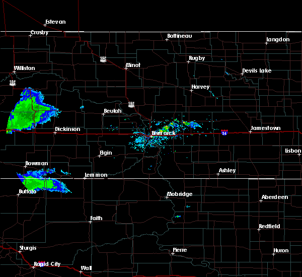 At 904 pm mdt, a severe thunderstorm was located near beach, moving southeast at 35 mph (trained weather spotters). Hazards include 70 mph wind gusts and nickel size hail. Expect considerable tree damage. damage is likely to mobile homes, roofs and outbuildings. this severe thunderstorm will be near, golva around 920 pm mdt. Other locations impacted by this severe thunderstorm include alpha and three v crossing. At 904 pm mdt, a severe thunderstorm was located near beach, moving southeast at 35 mph (trained weather spotters). Hazards include 70 mph wind gusts and nickel size hail. Expect considerable tree damage. damage is likely to mobile homes, roofs and outbuildings. this severe thunderstorm will be near, golva around 920 pm mdt. Other locations impacted by this severe thunderstorm include alpha and three v crossing.
|
|
|
| 6/30/2015 6:50 PM MDT |
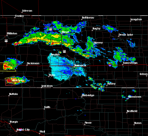 At 649 pm mdt, a severe thunderstorm was located 9 miles southeast of sentinel butte, or 16 miles east of beach, moving south at 25 mph (radar indicated). Hazards include 60 mph wind gusts and half dollar size hail. Hail damage to vehicles is expected. expect wind damage to roofs, siding and trees. this severe thunderstorm will remain over mainly rural areas of southwestern billings and southern golden valley counties, including the following locations, alpha. A tornado watch remains in effect until 100 am mdt for southwestern north dakota. At 649 pm mdt, a severe thunderstorm was located 9 miles southeast of sentinel butte, or 16 miles east of beach, moving south at 25 mph (radar indicated). Hazards include 60 mph wind gusts and half dollar size hail. Hail damage to vehicles is expected. expect wind damage to roofs, siding and trees. this severe thunderstorm will remain over mainly rural areas of southwestern billings and southern golden valley counties, including the following locations, alpha. A tornado watch remains in effect until 100 am mdt for southwestern north dakota.
|
| 6/30/2015 6:30 PM MDT |
 At 630 pm mdt, a severe thunderstorm was located 5 miles northeast of sentinel butte, or 12 miles east of beach, moving southeast at 25 mph (trained weather spotters 60 mph wind 12 miles north of beach). Hazards include 60 mph wind gusts and quarter size hail. Hail damage to vehicles is expected. expect wind damage to roofs, siding and trees. this severe thunderstorm will be near, medora around 650 pm mdt. other locations impacted by this severe thunderstorm include alpha. A tornado watch remains in effect until 100 am mdt for southwestern north dakota. At 630 pm mdt, a severe thunderstorm was located 5 miles northeast of sentinel butte, or 12 miles east of beach, moving southeast at 25 mph (trained weather spotters 60 mph wind 12 miles north of beach). Hazards include 60 mph wind gusts and quarter size hail. Hail damage to vehicles is expected. expect wind damage to roofs, siding and trees. this severe thunderstorm will be near, medora around 650 pm mdt. other locations impacted by this severe thunderstorm include alpha. A tornado watch remains in effect until 100 am mdt for southwestern north dakota.
|
| 6/30/2015 5:18 PM MDT |
 At 517 pm mdt, a severe thunderstorm was located over golva, or 15 miles south of beach, moving southeast at 30 mph (radar indicated). Hazards include 60 mph wind gusts and quarter size hail. Hail damage to vehicles is expected. expect wind damage to roofs, siding and trees. this severe thunderstorm will remain over mainly rural areas of western slope and southern golden valley counties, including the following locations, pretty butte, alpha and three v crossing. A tornado watch remains in effect until 100 am mdt for southwestern north dakota. At 517 pm mdt, a severe thunderstorm was located over golva, or 15 miles south of beach, moving southeast at 30 mph (radar indicated). Hazards include 60 mph wind gusts and quarter size hail. Hail damage to vehicles is expected. expect wind damage to roofs, siding and trees. this severe thunderstorm will remain over mainly rural areas of western slope and southern golden valley counties, including the following locations, pretty butte, alpha and three v crossing. A tornado watch remains in effect until 100 am mdt for southwestern north dakota.
|
| 6/23/2015 4:10 PM MDT |
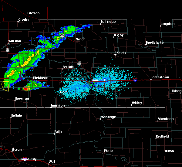 At 409 pm mdt, a severe thunderstorm was located 8 miles east of golva, or 17 miles southeast of beach, moving southeast at 30 mph (radar indicated). Hazards include 60 mph wind gusts and quarter size hail. Hail damage to vehicles is expected. expect wind damage to roofs, siding and trees. Locations impacted include, golva and alpha. At 409 pm mdt, a severe thunderstorm was located 8 miles east of golva, or 17 miles southeast of beach, moving southeast at 30 mph (radar indicated). Hazards include 60 mph wind gusts and quarter size hail. Hail damage to vehicles is expected. expect wind damage to roofs, siding and trees. Locations impacted include, golva and alpha.
|
| 6/23/2015 3:58 PM MDT |
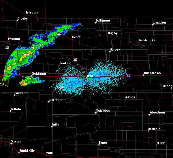 At 358 pm mdt, a severe thunderstorm was located over golva, or 13 miles south of beach, moving southeast at 30 mph (radar indicated). Hazards include 60 mph wind gusts and quarter size hail. Hail damage to vehicles is expected. expect wind damage to roofs, siding and trees. This severe thunderstorm will remain over mainly rural areas of north central slope and southern golden valley counties, including the following locations, alpha. At 358 pm mdt, a severe thunderstorm was located over golva, or 13 miles south of beach, moving southeast at 30 mph (radar indicated). Hazards include 60 mph wind gusts and quarter size hail. Hail damage to vehicles is expected. expect wind damage to roofs, siding and trees. This severe thunderstorm will remain over mainly rural areas of north central slope and southern golden valley counties, including the following locations, alpha.
|
| 6/19/2015 5:45 PM MDT |
 At 544 pm mdt, severe thunderstorms were located along a line extending from 8 miles northeast of sentinel butte to 6 miles southeast of beach, moving east at 45 mph (beach airport reported gusts to 61 mph with this storm). Hazards include 60 mph wind gusts and quarter size hail. Hail damage to vehicles is expected. expect wind damage to roofs, siding and trees. these severe storms will be near, medora around 555 pm mdt. Other locations impacted by these severe thunderstorms include fryburg. At 544 pm mdt, severe thunderstorms were located along a line extending from 8 miles northeast of sentinel butte to 6 miles southeast of beach, moving east at 45 mph (beach airport reported gusts to 61 mph with this storm). Hazards include 60 mph wind gusts and quarter size hail. Hail damage to vehicles is expected. expect wind damage to roofs, siding and trees. these severe storms will be near, medora around 555 pm mdt. Other locations impacted by these severe thunderstorms include fryburg.
|
| 6/19/2015 5:31 PM MDT |
 At 531 pm mdt, a severe thunderstorm was located near beach, moving east at 40 mph (radar indicated). Hazards include 60 mph wind gusts and quarter size hail. Hail damage to vehicles is expected. expect wind damage to roofs, siding and trees. this severe thunderstorm will be near, beach around 535 pm mdt. sentinel butte around 545 pm mdt. medora around 610 pm mdt. Other locations impacted by this severe thunderstorm include fryburg. At 531 pm mdt, a severe thunderstorm was located near beach, moving east at 40 mph (radar indicated). Hazards include 60 mph wind gusts and quarter size hail. Hail damage to vehicles is expected. expect wind damage to roofs, siding and trees. this severe thunderstorm will be near, beach around 535 pm mdt. sentinel butte around 545 pm mdt. medora around 610 pm mdt. Other locations impacted by this severe thunderstorm include fryburg.
|
| 9/7/2013 5:32 PM MDT |
Winds pushed 1200 pound round hay bales through 2 fence in fallon county MT, 12.8 miles NNE of Golva, ND
|
| 9/7/2013 4:15 PM MDT |
Winds pushed 1200 pound round hay bales through 2 fence in fallon county MT, 12.8 miles NNE of Golva, ND
|
| 7/8/2013 7:30 PM MDT |
Heavy rain was also reporte in golden valley county ND, 10.1 miles NW of Golva, ND
|


Connect with Interactive Hail Maps