

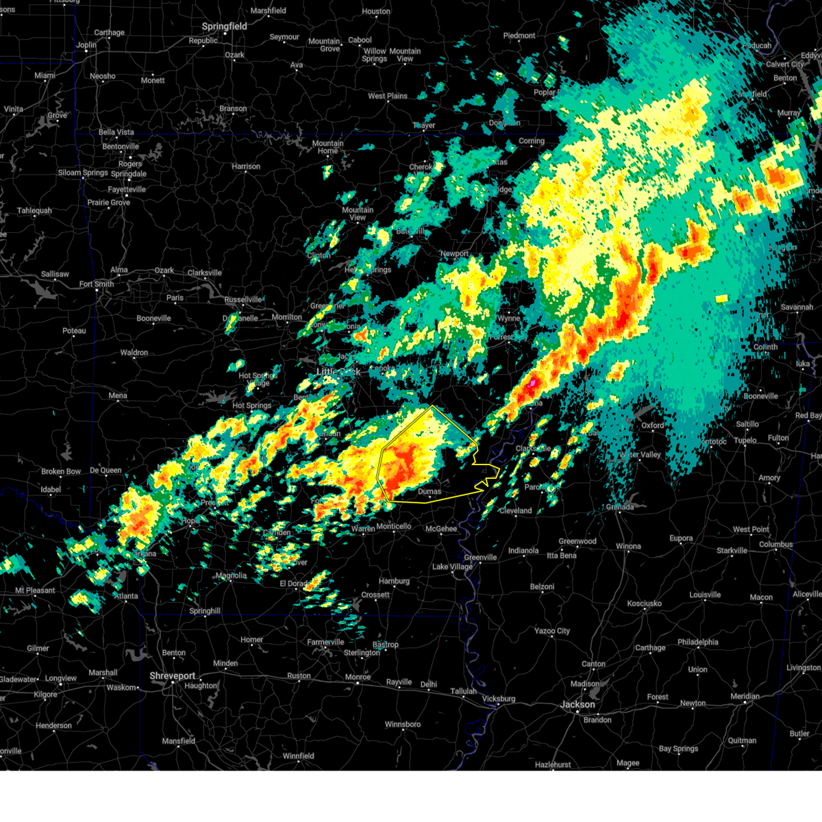
Hail Map for Grady, AR
The Grady, AR area has had 6 reports of on-the-ground hail by trained spotters, and has been under severe weather warnings 11 times during the past 12 months. Doppler radar has detected hail at or near Grady, AR on 56 occasions, including 3 occasions during the past year.
| Name: | Grady, AR |
| Where Located: | 56.3 miles SE of Little Rock, AR |
| Map: | Google Map for Grady, AR |
| Population: | 449 |
| Housing Units: | 208 |
| More Info: | Search Google for Grady, AR |
2
The Top Recent Hail Date for Grady, AR is Sunday, March 15, 2026 (11th out of 56)

Hail and Wind Damage Spotted near Grady, AR
| Date / Time | Report Details |
|---|---|
| 3/15/2026 6:55 PM CDT |
 At 655 pm cdt, a severe thunderstorm was located over whitefield, or 11 miles northeast of star city, moving east at 55 mph (radar indicated). Hazards include 60 mph wind gusts and quarter size hail. Hail damage to vehicles is expected. expect wind damage to roofs, siding, and trees. Locations impacted include, star city, gould, gillett, grady, nebo, whitefield, linwood, little bayou meto park, merrisach lake, woodville, langford, douglas, cane creek state park, arkansas post, tarry, tamo, moscow, crigler, sarassa, pendleton,. At 655 pm cdt, a severe thunderstorm was located over whitefield, or 11 miles northeast of star city, moving east at 55 mph (radar indicated). Hazards include 60 mph wind gusts and quarter size hail. Hail damage to vehicles is expected. expect wind damage to roofs, siding, and trees. Locations impacted include, star city, gould, gillett, grady, nebo, whitefield, linwood, little bayou meto park, merrisach lake, woodville, langford, douglas, cane creek state park, arkansas post, tarry, tamo, moscow, crigler, sarassa, pendleton,.
|
| 3/15/2026 6:55 PM CDT |
 the severe thunderstorm warning has been cancelled and is no longer in effect the severe thunderstorm warning has been cancelled and is no longer in effect
|
| 3/15/2026 6:43 PM CDT |
 Svrlzk the national weather service in little rock has issued a * severe thunderstorm warning for, northeastern cleveland county in southeastern arkansas, northwestern desha county in southeastern arkansas, southeastern jefferson county in southeastern arkansas, central lincoln county in southeastern arkansas, south central arkansas county in southeastern arkansas, * until 730 pm cdt. * at 643 pm cdt, a severe thunderstorm was located near feenyville, or 9 miles northwest of star city, moving east at 55 mph (radar indicated). Hazards include 60 mph wind gusts and quarter size hail. Hail damage to vehicles is expected. Expect wind damage to roofs, siding, and trees. Svrlzk the national weather service in little rock has issued a * severe thunderstorm warning for, northeastern cleveland county in southeastern arkansas, northwestern desha county in southeastern arkansas, southeastern jefferson county in southeastern arkansas, central lincoln county in southeastern arkansas, south central arkansas county in southeastern arkansas, * until 730 pm cdt. * at 643 pm cdt, a severe thunderstorm was located near feenyville, or 9 miles northwest of star city, moving east at 55 mph (radar indicated). Hazards include 60 mph wind gusts and quarter size hail. Hail damage to vehicles is expected. Expect wind damage to roofs, siding, and trees.
|
| 3/15/2026 6:23 PM CDT |
 At 622 pm cdt, a severe thunderstorm was located over linwood, or 12 miles east of pine bluff, moving east at 35 mph (radar indicated). Hazards include 60 mph wind gusts and quarter size hail. Hail damage to vehicles is expected. expect wind damage to roofs, siding, and trees. Locations impacted include, pine bluff, gillett, grady, cottondale, whitefield, woodville, langford, linwood, richardson, little bayou meto park, madding, tarry, cornerstone, tamo, moscow, ladd, bayou meteo state game area, glenlake, lodge corner, reydell,. At 622 pm cdt, a severe thunderstorm was located over linwood, or 12 miles east of pine bluff, moving east at 35 mph (radar indicated). Hazards include 60 mph wind gusts and quarter size hail. Hail damage to vehicles is expected. expect wind damage to roofs, siding, and trees. Locations impacted include, pine bluff, gillett, grady, cottondale, whitefield, woodville, langford, linwood, richardson, little bayou meto park, madding, tarry, cornerstone, tamo, moscow, ladd, bayou meteo state game area, glenlake, lodge corner, reydell,.
|
| 3/15/2026 6:23 PM CDT |
 the severe thunderstorm warning has been cancelled and is no longer in effect the severe thunderstorm warning has been cancelled and is no longer in effect
|
| 3/15/2026 6:07 PM CDT |
 Svrlzk the national weather service in little rock has issued a * severe thunderstorm warning for, northeastern cleveland county in southeastern arkansas, southern jefferson county in southeastern arkansas, northern lincoln county in southeastern arkansas, west central arkansas county in southeastern arkansas, * until 645 pm cdt. * at 607 pm cdt, a severe thunderstorm was located near pine bluff, moving east at 35 mph (radar indicated). Hazards include 60 mph wind gusts and quarter size hail. Hail damage to vehicles is expected. Expect wind damage to roofs, siding, and trees. Svrlzk the national weather service in little rock has issued a * severe thunderstorm warning for, northeastern cleveland county in southeastern arkansas, southern jefferson county in southeastern arkansas, northern lincoln county in southeastern arkansas, west central arkansas county in southeastern arkansas, * until 645 pm cdt. * at 607 pm cdt, a severe thunderstorm was located near pine bluff, moving east at 35 mph (radar indicated). Hazards include 60 mph wind gusts and quarter size hail. Hail damage to vehicles is expected. Expect wind damage to roofs, siding, and trees.
|
| 3/11/2026 8:03 AM CDT |
 At 802 am cdt, a severe thunderstorm was centered near woodville, or 14 miles northeast of star city, moving northeast at 45 mph (radar indicated). Hazards include 60 mph wind gusts. Expect damage to roofs, siding, and trees. Locations impacted include, grady, nebo, whitefield, woodville, langford, linwood, richardson, little bayou meto park, cornerstone, tamo, moscow, bayou meteo state game area, reydell, varner, sarassa, yorktown,. At 802 am cdt, a severe thunderstorm was centered near woodville, or 14 miles northeast of star city, moving northeast at 45 mph (radar indicated). Hazards include 60 mph wind gusts. Expect damage to roofs, siding, and trees. Locations impacted include, grady, nebo, whitefield, woodville, langford, linwood, richardson, little bayou meto park, cornerstone, tamo, moscow, bayou meteo state game area, reydell, varner, sarassa, yorktown,.
|
| 3/11/2026 7:50 AM CDT |
 At 749 am cdt, a severe thunderstorm was located near nebo, or 8 miles north of star city, moving northeast at 45 mph (radar indicated). Hazards include 60 mph wind gusts. Expect damage to roofs, siding, and trees. Locations impacted include, star city, grady, nebo, feenyville, cottondale, whitefield, woodville, langford, linwood, richardson, little bayou meto park, tarry, cornerstone, tamo, moscow, ladd, bayou meteo state game area, reydell, varner, sarassa,. At 749 am cdt, a severe thunderstorm was located near nebo, or 8 miles north of star city, moving northeast at 45 mph (radar indicated). Hazards include 60 mph wind gusts. Expect damage to roofs, siding, and trees. Locations impacted include, star city, grady, nebo, feenyville, cottondale, whitefield, woodville, langford, linwood, richardson, little bayou meto park, tarry, cornerstone, tamo, moscow, ladd, bayou meteo state game area, reydell, varner, sarassa,.
|
| 3/11/2026 7:50 AM CDT |
 the severe thunderstorm warning has been cancelled and is no longer in effect the severe thunderstorm warning has been cancelled and is no longer in effect
|
| 3/11/2026 7:24 AM CDT |
 Svrlzk the national weather service in little rock has issued a * severe thunderstorm warning for, northeastern cleveland county in southeastern arkansas, southeastern jefferson county in southeastern arkansas, northern lincoln county in southeastern arkansas, west central arkansas county in southeastern arkansas, * until 815 am cdt. * at 723 am cdt, a severe thunderstorm was located over toledo, or over rison, moving northeast at 45 mph (radar indicated). Hazards include 60 mph wind gusts. expect damage to roofs, siding, and trees Svrlzk the national weather service in little rock has issued a * severe thunderstorm warning for, northeastern cleveland county in southeastern arkansas, southeastern jefferson county in southeastern arkansas, northern lincoln county in southeastern arkansas, west central arkansas county in southeastern arkansas, * until 815 am cdt. * at 723 am cdt, a severe thunderstorm was located over toledo, or over rison, moving northeast at 45 mph (radar indicated). Hazards include 60 mph wind gusts. expect damage to roofs, siding, and trees
|
| 3/9/2026 1:08 PM CDT |
 Svrlzk the national weather service in little rock has issued a * severe thunderstorm warning for, northern desha county in southeastern arkansas, southeastern monroe county in eastern arkansas, southeastern jefferson county in southeastern arkansas, northeastern lincoln county in southeastern arkansas, arkansas county in southeastern arkansas, * until 200 pm cdt. * at 108 pm cdt, severe thunderstorms were located along a line extending from near almyra to near grady, moving east at 45 mph (radar indicated). Hazards include 60 mph wind gusts and quarter size hail. Hail damage to vehicles is expected. Expect wind damage to roofs, siding, and trees. Svrlzk the national weather service in little rock has issued a * severe thunderstorm warning for, northern desha county in southeastern arkansas, southeastern monroe county in eastern arkansas, southeastern jefferson county in southeastern arkansas, northeastern lincoln county in southeastern arkansas, arkansas county in southeastern arkansas, * until 200 pm cdt. * at 108 pm cdt, severe thunderstorms were located along a line extending from near almyra to near grady, moving east at 45 mph (radar indicated). Hazards include 60 mph wind gusts and quarter size hail. Hail damage to vehicles is expected. Expect wind damage to roofs, siding, and trees.
|
| 6/7/2025 9:50 AM CDT |
 At 949 am cdt, severe thunderstorms were located along a line extending from near garret grove to 8 miles northeast of almyra to altheimer, moving southeast at 55 mph (radar indicated). Hazards include 60 mph wind gusts and nickel size hail. Expect damage to roofs, siding, and trees. Locations impacted include, dobbs landing, de luce, slovak, aberdeen, almyra airport, sherrill, england, louisiana purchase state park, whitefield, casscoe, tichnor, lodge corner, little bayou meto park, fargo, ulm, weber, seaton, humnoke, humphrey, woodville,. At 949 am cdt, severe thunderstorms were located along a line extending from near garret grove to 8 miles northeast of almyra to altheimer, moving southeast at 55 mph (radar indicated). Hazards include 60 mph wind gusts and nickel size hail. Expect damage to roofs, siding, and trees. Locations impacted include, dobbs landing, de luce, slovak, aberdeen, almyra airport, sherrill, england, louisiana purchase state park, whitefield, casscoe, tichnor, lodge corner, little bayou meto park, fargo, ulm, weber, seaton, humnoke, humphrey, woodville,.
|
| 6/7/2025 9:25 AM CDT |
 Svrlzk the national weather service in little rock has issued a * severe thunderstorm warning for, southern woodruff county in eastern arkansas, eastern prairie county in central arkansas, southern lonoke county in central arkansas, monroe county in eastern arkansas, jefferson county in southeastern arkansas, northeastern lincoln county in southeastern arkansas, southeastern pulaski county in central arkansas, arkansas county in southeastern arkansas, * until 1015 am cdt. * at 925 am cdt, severe thunderstorms were located along a line extending from 10 miles southeast of hurricane lake wma to near hazen to near estes, moving southeast at 55 mph (radar indicated). Hazards include 60 mph wind gusts and quarter size hail. Hail damage to vehicles is expected. Expect wind damage to roofs, siding, and trees. Svrlzk the national weather service in little rock has issued a * severe thunderstorm warning for, southern woodruff county in eastern arkansas, eastern prairie county in central arkansas, southern lonoke county in central arkansas, monroe county in eastern arkansas, jefferson county in southeastern arkansas, northeastern lincoln county in southeastern arkansas, southeastern pulaski county in central arkansas, arkansas county in southeastern arkansas, * until 1015 am cdt. * at 925 am cdt, severe thunderstorms were located along a line extending from 10 miles southeast of hurricane lake wma to near hazen to near estes, moving southeast at 55 mph (radar indicated). Hazards include 60 mph wind gusts and quarter size hail. Hail damage to vehicles is expected. Expect wind damage to roofs, siding, and trees.
|
| 5/25/2025 5:57 PM CDT |
 Svrlzk the national weather service in little rock has issued a * severe thunderstorm warning for, desha county in southeastern arkansas, northeastern drew county in southeastern arkansas, southeastern jefferson county in southeastern arkansas, eastern lincoln county in southeastern arkansas, southeastern arkansas county in southeastern arkansas, * until 645 pm cdt. * at 556 pm cdt, severe thunderstorms were located along a line extending from 6 miles southwest of white river national wildlife refuge to near gillett to near woodville, moving southeast at 30 mph. this line of storms has a history of producing 50 to 60 mph wind gusts most recently near de witt and gillett (radar indicated). Hazards include 60 mph wind gusts. expect damage to roofs, siding, and trees Svrlzk the national weather service in little rock has issued a * severe thunderstorm warning for, desha county in southeastern arkansas, northeastern drew county in southeastern arkansas, southeastern jefferson county in southeastern arkansas, eastern lincoln county in southeastern arkansas, southeastern arkansas county in southeastern arkansas, * until 645 pm cdt. * at 556 pm cdt, severe thunderstorms were located along a line extending from 6 miles southwest of white river national wildlife refuge to near gillett to near woodville, moving southeast at 30 mph. this line of storms has a history of producing 50 to 60 mph wind gusts most recently near de witt and gillett (radar indicated). Hazards include 60 mph wind gusts. expect damage to roofs, siding, and trees
|
| 5/25/2025 4:08 PM CDT |
 Svrlzk the national weather service in little rock has issued a * severe thunderstorm warning for, northeastern cleveland county in southeastern arkansas, southeastern jefferson county in southeastern arkansas, western lincoln county in southeastern arkansas, * until 500 pm cdt. * at 408 pm cdt, a severe thunderstorm was located near toledo, or 7 miles east of rison, moving east at 20 mph (radar indicated). Hazards include 60 mph wind gusts and quarter size hail. Hail damage to vehicles is expected. Expect wind damage to roofs, siding, and trees. Svrlzk the national weather service in little rock has issued a * severe thunderstorm warning for, northeastern cleveland county in southeastern arkansas, southeastern jefferson county in southeastern arkansas, western lincoln county in southeastern arkansas, * until 500 pm cdt. * at 408 pm cdt, a severe thunderstorm was located near toledo, or 7 miles east of rison, moving east at 20 mph (radar indicated). Hazards include 60 mph wind gusts and quarter size hail. Hail damage to vehicles is expected. Expect wind damage to roofs, siding, and trees.
|
| 5/20/2025 3:06 PM CDT |
 The storm which prompted the warning has weakened below severe limits, and no longer poses an immediate threat to life or property. therefore, the warning will be allowed to expire. a tornado watch remains in effect until 800 pm cdt for southeastern arkansas. remember, a severe thunderstorm warning still remains in effect for central lincoln county. The storm which prompted the warning has weakened below severe limits, and no longer poses an immediate threat to life or property. therefore, the warning will be allowed to expire. a tornado watch remains in effect until 800 pm cdt for southeastern arkansas. remember, a severe thunderstorm warning still remains in effect for central lincoln county.
|
| 5/20/2025 2:32 PM CDT |
 Svrlzk the national weather service in little rock has issued a * severe thunderstorm warning for, northeastern cleveland county in southeastern arkansas, southwestern jefferson county in southeastern arkansas, northwestern lincoln county in southeastern arkansas, * until 315 pm cdt. * at 232 pm cdt, a severe thunderstorm was located over kedron, or near rison, moving east at 45 mph (radar indicated). Hazards include 60 mph wind gusts and quarter size hail. Hail damage to vehicles is expected. Expect wind damage to roofs, siding, and trees. Svrlzk the national weather service in little rock has issued a * severe thunderstorm warning for, northeastern cleveland county in southeastern arkansas, southwestern jefferson county in southeastern arkansas, northwestern lincoln county in southeastern arkansas, * until 315 pm cdt. * at 232 pm cdt, a severe thunderstorm was located over kedron, or near rison, moving east at 45 mph (radar indicated). Hazards include 60 mph wind gusts and quarter size hail. Hail damage to vehicles is expected. Expect wind damage to roofs, siding, and trees.
|
| 5/20/2025 4:42 AM CDT |
 The storm which prompted the warning has weakened below severe limits, and no longer poses an immediate threat to life or property. therefore, the warning will be allowed to expire. however gusty winds and heavy rain are still possible with this thunderstorm. a severe thunderstorm watch remains in effect until 800 am cdt for central, southeastern and southwestern arkansas. The storm which prompted the warning has weakened below severe limits, and no longer poses an immediate threat to life or property. therefore, the warning will be allowed to expire. however gusty winds and heavy rain are still possible with this thunderstorm. a severe thunderstorm watch remains in effect until 800 am cdt for central, southeastern and southwestern arkansas.
|
| 5/20/2025 4:27 AM CDT |
 At 427 am cdt, a severe thunderstorm was located over white hall, or near pine bluff, moving east at 40 mph (radar indicated). Hazards include 60 mph wind gusts. Expect damage to roofs, siding, and trees. Locations impacted include, nebo, tarry, cornerstone, lamont, cottondale, tamo, whitefield, moscow, linwood, glenlake, watson chapel, staves, grady, sulphur springs, pine bluff arsenal, madding, clear lake, hardin, dexter, rob roy,. At 427 am cdt, a severe thunderstorm was located over white hall, or near pine bluff, moving east at 40 mph (radar indicated). Hazards include 60 mph wind gusts. Expect damage to roofs, siding, and trees. Locations impacted include, nebo, tarry, cornerstone, lamont, cottondale, tamo, whitefield, moscow, linwood, glenlake, watson chapel, staves, grady, sulphur springs, pine bluff arsenal, madding, clear lake, hardin, dexter, rob roy,.
|
| 5/20/2025 4:16 AM CDT |
 At 415 am cdt, a severe thunderstorm was located 8 miles southwest of white hall, or 11 miles southeast of sheridan, moving east at 50 mph (radar indicated). Hazards include 60 mph wind gusts. Expect damage to roofs, siding, and trees. Locations impacted include, nebo, tarry, cornerstone, lamont, cottondale, tamo, whitefield, moscow, linwood, glenlake, watson chapel, staves, grady, sulphur springs, pine bluff arsenal, madding, clear lake, hardin, dexter, rob roy,. At 415 am cdt, a severe thunderstorm was located 8 miles southwest of white hall, or 11 miles southeast of sheridan, moving east at 50 mph (radar indicated). Hazards include 60 mph wind gusts. Expect damage to roofs, siding, and trees. Locations impacted include, nebo, tarry, cornerstone, lamont, cottondale, tamo, whitefield, moscow, linwood, glenlake, watson chapel, staves, grady, sulphur springs, pine bluff arsenal, madding, clear lake, hardin, dexter, rob roy,.
|
| 5/20/2025 4:04 AM CDT |
 Svrlzk the national weather service in little rock has issued a * severe thunderstorm warning for, northern cleveland county in southeastern arkansas, southern grant county in central arkansas, northeastern dallas county in southwestern arkansas, southwestern jefferson county in southeastern arkansas, northwestern lincoln county in southeastern arkansas, * until 445 am cdt. * at 404 am cdt, a severe thunderstorm was located 8 miles east of carthage, or 13 miles south of sheridan, moving east at 45 mph (radar indicated). Hazards include 60 mph wind gusts. expect damage to roofs, siding, and trees Svrlzk the national weather service in little rock has issued a * severe thunderstorm warning for, northern cleveland county in southeastern arkansas, southern grant county in central arkansas, northeastern dallas county in southwestern arkansas, southwestern jefferson county in southeastern arkansas, northwestern lincoln county in southeastern arkansas, * until 445 am cdt. * at 404 am cdt, a severe thunderstorm was located 8 miles east of carthage, or 13 miles south of sheridan, moving east at 45 mph (radar indicated). Hazards include 60 mph wind gusts. expect damage to roofs, siding, and trees
|
| 5/18/2025 7:42 AM CDT |
 Svrlzk the national weather service in little rock has issued a * severe thunderstorm warning for, central prairie county in central arkansas, southeastern lonoke county in central arkansas, northwestern desha county in southeastern arkansas, monroe county in eastern arkansas, central jefferson county in southeastern arkansas, central lincoln county in southeastern arkansas, arkansas county in southeastern arkansas, * until 830 am cdt. * at 741 am cdt, severe thunderstorms were located along a line extending from near fredonia to near ulm to near humphrey to near pine bluff, moving southeast at 45 mph (radar indicated). Hazards include 60 mph wind gusts and quarter size hail. Hail damage to vehicles is expected. Expect wind damage to roofs, siding, and trees. Svrlzk the national weather service in little rock has issued a * severe thunderstorm warning for, central prairie county in central arkansas, southeastern lonoke county in central arkansas, northwestern desha county in southeastern arkansas, monroe county in eastern arkansas, central jefferson county in southeastern arkansas, central lincoln county in southeastern arkansas, arkansas county in southeastern arkansas, * until 830 am cdt. * at 741 am cdt, severe thunderstorms were located along a line extending from near fredonia to near ulm to near humphrey to near pine bluff, moving southeast at 45 mph (radar indicated). Hazards include 60 mph wind gusts and quarter size hail. Hail damage to vehicles is expected. Expect wind damage to roofs, siding, and trees.
|
| 5/18/2025 7:13 AM CDT |
 Svrlzk the national weather service in little rock has issued a * severe thunderstorm warning for, south central lonoke county in central arkansas, northeastern grant county in central arkansas, jefferson county in southeastern arkansas, northwestern lincoln county in southeastern arkansas, southeastern pulaski county in central arkansas, west central arkansas county in southeastern arkansas, * until 745 am cdt. * at 712 am cdt, severe thunderstorms were located along a line extending from near keo to near redfield, moving southeast at 40 mph (radar indicated). Hazards include 60 mph wind gusts and quarter size hail. Hail damage to vehicles is expected. Expect wind damage to roofs, siding, and trees. Svrlzk the national weather service in little rock has issued a * severe thunderstorm warning for, south central lonoke county in central arkansas, northeastern grant county in central arkansas, jefferson county in southeastern arkansas, northwestern lincoln county in southeastern arkansas, southeastern pulaski county in central arkansas, west central arkansas county in southeastern arkansas, * until 745 am cdt. * at 712 am cdt, severe thunderstorms were located along a line extending from near keo to near redfield, moving southeast at 40 mph (radar indicated). Hazards include 60 mph wind gusts and quarter size hail. Hail damage to vehicles is expected. Expect wind damage to roofs, siding, and trees.
|
| 5/18/2025 12:46 AM CDT |
 At 1245 am cdt, severe thunderstorms were located along a line extending from near little bayou meto park to near mills, moving east at 60 mph (radar indicated). Hazards include 60 mph wind gusts and quarter size hail. Hail damage to vehicles is expected. expect wind damage to roofs, siding, and trees. locations impacted include, de luce, cornerville, florence, whitefield, tyro, watson, tichnor, reedville, morgan point recreation area, pea ridge, lodge corner, little bayou meto park, weber, star city, relfs bluff, woodville, fresno, douglas, st. Charles, reydell,. At 1245 am cdt, severe thunderstorms were located along a line extending from near little bayou meto park to near mills, moving east at 60 mph (radar indicated). Hazards include 60 mph wind gusts and quarter size hail. Hail damage to vehicles is expected. expect wind damage to roofs, siding, and trees. locations impacted include, de luce, cornerville, florence, whitefield, tyro, watson, tichnor, reedville, morgan point recreation area, pea ridge, lodge corner, little bayou meto park, weber, star city, relfs bluff, woodville, fresno, douglas, st. Charles, reydell,.
|
| 5/18/2025 12:46 AM CDT |
 the severe thunderstorm warning has been cancelled and is no longer in effect the severe thunderstorm warning has been cancelled and is no longer in effect
|
| 5/18/2025 12:31 AM CDT |
 At 1231 am cdt, severe thunderstorms were located along a line extending from linwood to 7 miles northwest of nebo to feenyville to 7 miles northeast of herbine, moving east at 45 mph (radar indicated). Hazards include 60 mph wind gusts and quarter size hail. Hail damage to vehicles is expected. expect wind damage to roofs, siding, and trees. Locations impacted include, de luce, pastoria, almyra airport, cornerville, florence, sherrill, whitefield, tyro, watson, tichnor, reedville, morgan point recreation area, pea ridge, lodge corner, little bayou meto park, weber, star city, glendale in lincoln county, humphrey, woodville,. At 1231 am cdt, severe thunderstorms were located along a line extending from linwood to 7 miles northwest of nebo to feenyville to 7 miles northeast of herbine, moving east at 45 mph (radar indicated). Hazards include 60 mph wind gusts and quarter size hail. Hail damage to vehicles is expected. expect wind damage to roofs, siding, and trees. Locations impacted include, de luce, pastoria, almyra airport, cornerville, florence, sherrill, whitefield, tyro, watson, tichnor, reedville, morgan point recreation area, pea ridge, lodge corner, little bayou meto park, weber, star city, glendale in lincoln county, humphrey, woodville,.
|
| 5/18/2025 12:21 AM CDT |
 Svrlzk the national weather service in little rock has issued a * severe thunderstorm warning for, northeastern cleveland county in southeastern arkansas, northwestern desha county in southeastern arkansas, southeastern monroe county in eastern arkansas, northeastern drew county in southeastern arkansas, jefferson county in southeastern arkansas, lincoln county in southeastern arkansas, arkansas county in southeastern arkansas, * until 115 am cdt. * at 1221 am cdt, severe thunderstorms were located along a line extending from cottondale to 7 miles south of pine bluff to 6 miles east of kedron to near toledo, moving east at 40 mph (radar indicated). Hazards include 60 mph wind gusts and nickel size hail. expect damage to roofs, siding, and trees Svrlzk the national weather service in little rock has issued a * severe thunderstorm warning for, northeastern cleveland county in southeastern arkansas, northwestern desha county in southeastern arkansas, southeastern monroe county in eastern arkansas, northeastern drew county in southeastern arkansas, jefferson county in southeastern arkansas, lincoln county in southeastern arkansas, arkansas county in southeastern arkansas, * until 115 am cdt. * at 1221 am cdt, severe thunderstorms were located along a line extending from cottondale to 7 miles south of pine bluff to 6 miles east of kedron to near toledo, moving east at 40 mph (radar indicated). Hazards include 60 mph wind gusts and nickel size hail. expect damage to roofs, siding, and trees
|
| 4/30/2025 6:43 PM CDT |
 Svrlzk the national weather service in little rock has issued a * severe thunderstorm warning for, eastern cleveland county in southeastern arkansas, southeastern prairie county in central arkansas, southeastern lonoke county in central arkansas, northwestern desha county in southeastern arkansas, west central monroe county in eastern arkansas, northern drew county in southeastern arkansas, jefferson county in southeastern arkansas, lincoln county in southeastern arkansas, western arkansas county in southeastern arkansas, * until 730 pm cdt. * at 642 pm cdt, severe thunderstorms were located along a line extending from near sisemore to herbine, moving east at 30 mph (radar indicated). Hazards include 60 mph wind gusts. expect damage to roofs, siding, and trees Svrlzk the national weather service in little rock has issued a * severe thunderstorm warning for, eastern cleveland county in southeastern arkansas, southeastern prairie county in central arkansas, southeastern lonoke county in central arkansas, northwestern desha county in southeastern arkansas, west central monroe county in eastern arkansas, northern drew county in southeastern arkansas, jefferson county in southeastern arkansas, lincoln county in southeastern arkansas, western arkansas county in southeastern arkansas, * until 730 pm cdt. * at 642 pm cdt, severe thunderstorms were located along a line extending from near sisemore to herbine, moving east at 30 mph (radar indicated). Hazards include 60 mph wind gusts. expect damage to roofs, siding, and trees
|
| 4/30/2025 5:55 PM CDT |
 Svrlzk the national weather service in little rock has issued a * severe thunderstorm warning for, northern cleveland county in southeastern arkansas, south central prairie county in central arkansas, southern lonoke county in central arkansas, eastern grant county in central arkansas, northeastern dallas county in southwestern arkansas, jefferson county in southeastern arkansas, northwestern lincoln county in southeastern arkansas, southeastern pulaski county in central arkansas, northwestern arkansas county in southeastern arkansas, * until 645 pm cdt. * at 554 pm cdt, severe thunderstorms were located along a line extending from near scott to 6 miles west of white hall to 7 miles northwest of kingsland, moving east at 40 mph (radar indicated). Hazards include 60 mph wind gusts. expect damage to roofs, siding, and trees Svrlzk the national weather service in little rock has issued a * severe thunderstorm warning for, northern cleveland county in southeastern arkansas, south central prairie county in central arkansas, southern lonoke county in central arkansas, eastern grant county in central arkansas, northeastern dallas county in southwestern arkansas, jefferson county in southeastern arkansas, northwestern lincoln county in southeastern arkansas, southeastern pulaski county in central arkansas, northwestern arkansas county in southeastern arkansas, * until 645 pm cdt. * at 554 pm cdt, severe thunderstorms were located along a line extending from near scott to 6 miles west of white hall to 7 miles northwest of kingsland, moving east at 40 mph (radar indicated). Hazards include 60 mph wind gusts. expect damage to roofs, siding, and trees
|
| 4/5/2025 2:05 PM CDT |
 At 205 pm cdt, severe thunderstorms were located along a line extending from near watkins corner to 6 miles northwest of pea ridge to 8 miles southwest of dermott, moving northeast at 50 mph (radar indicated). Hazards include 60 mph wind gusts and quarter size hail. Hail damage to vehicles is expected. expect wind damage to roofs, siding, and trees. Locations impacted include, de luce, florence, tyro, watson, tichnor, reedville, selma, lucca landing, morgan point recreation area, pea ridge, mcgehee, reed, tillar, little bayou meto park, weber, baxter, halley, fresno, collins, douglas,. At 205 pm cdt, severe thunderstorms were located along a line extending from near watkins corner to 6 miles northwest of pea ridge to 8 miles southwest of dermott, moving northeast at 50 mph (radar indicated). Hazards include 60 mph wind gusts and quarter size hail. Hail damage to vehicles is expected. expect wind damage to roofs, siding, and trees. Locations impacted include, de luce, florence, tyro, watson, tichnor, reedville, selma, lucca landing, morgan point recreation area, pea ridge, mcgehee, reed, tillar, little bayou meto park, weber, baxter, halley, fresno, collins, douglas,.
|
| 4/5/2025 1:47 PM CDT |
 At 147 pm cdt, severe thunderstorms were located along a line extending from near st. charles to near mills to near ladelle, moving east at 45 mph (radar indicated). Hazards include 60 mph wind gusts and quarter size hail. Hail damage to vehicles is expected. expect wind damage to roofs, siding, and trees. Locations impacted include, de luce, florence, tyro, watson, wilmar, tichnor, reedville, selma, plantersville, lucca landing, morgan point recreation area, pea ridge, mcgehee, reed, tillar, little bayou meto park, weber, star city, relfs bluff, baxter,. At 147 pm cdt, severe thunderstorms were located along a line extending from near st. charles to near mills to near ladelle, moving east at 45 mph (radar indicated). Hazards include 60 mph wind gusts and quarter size hail. Hail damage to vehicles is expected. expect wind damage to roofs, siding, and trees. Locations impacted include, de luce, florence, tyro, watson, wilmar, tichnor, reedville, selma, plantersville, lucca landing, morgan point recreation area, pea ridge, mcgehee, reed, tillar, little bayou meto park, weber, star city, relfs bluff, baxter,.
|
| 4/5/2025 1:47 PM CDT |
 the severe thunderstorm warning has been cancelled and is no longer in effect the severe thunderstorm warning has been cancelled and is no longer in effect
|
| 4/5/2025 1:28 PM CDT |
 Svrlzk the national weather service in little rock has issued a * severe thunderstorm warning for, bradley county in southeastern arkansas, southeastern cleveland county in southeastern arkansas, desha county in southeastern arkansas, southeastern monroe county in eastern arkansas, drew county in southeastern arkansas, southeastern jefferson county in southeastern arkansas, lincoln county in southeastern arkansas, arkansas county in southeastern arkansas, * until 215 pm cdt. * at 128 pm cdt, severe thunderstorms were located along a line extending from near st. charles to near mills to 6 miles west of old milo, moving northeast at 50 mph (radar indicated). Hazards include 60 mph wind gusts and nickel size hail. expect damage to roofs, siding, and trees Svrlzk the national weather service in little rock has issued a * severe thunderstorm warning for, bradley county in southeastern arkansas, southeastern cleveland county in southeastern arkansas, desha county in southeastern arkansas, southeastern monroe county in eastern arkansas, drew county in southeastern arkansas, southeastern jefferson county in southeastern arkansas, lincoln county in southeastern arkansas, arkansas county in southeastern arkansas, * until 215 pm cdt. * at 128 pm cdt, severe thunderstorms were located along a line extending from near st. charles to near mills to 6 miles west of old milo, moving northeast at 50 mph (radar indicated). Hazards include 60 mph wind gusts and nickel size hail. expect damage to roofs, siding, and trees
|
| 4/5/2025 12:06 PM CDT |
 the severe thunderstorm warning has been cancelled and is no longer in effect the severe thunderstorm warning has been cancelled and is no longer in effect
|
| 4/5/2025 12:06 PM CDT |
 At 1206 pm cdt, severe thunderstorms were located along a line extending from near de valls bluff to near altheimer to 6 miles northeast of kedron, moving east at 60 mph (radar indicated). Hazards include 60 mph wind gusts. Expect damage to roofs, siding, and trees. Locations impacted include, nebo, tarry, slovak, peppers landing, almyra airport, cornerstone, stuttgart, de valls bluff, cottondale, tamo, whitefield, brummitt, moscow, linwood, glenlake, lodge corner, watson chapel, sulphur springs, ulm, madding,. At 1206 pm cdt, severe thunderstorms were located along a line extending from near de valls bluff to near altheimer to 6 miles northeast of kedron, moving east at 60 mph (radar indicated). Hazards include 60 mph wind gusts. Expect damage to roofs, siding, and trees. Locations impacted include, nebo, tarry, slovak, peppers landing, almyra airport, cornerstone, stuttgart, de valls bluff, cottondale, tamo, whitefield, brummitt, moscow, linwood, glenlake, lodge corner, watson chapel, sulphur springs, ulm, madding,.
|
| 4/5/2025 11:59 AM CDT |
 At 1159 am cdt, severe thunderstorms were located along a line extending from near stuttgart municipal airport to near warbritton to kedron, moving east at 45 mph (radar indicated). Hazards include 60 mph wind gusts and nickel size hail. Expect damage to roofs, siding, and trees. Locations impacted include, slovak, pastoria, almyra airport, sherrill, whitefield, lock and dam 5 park, lodge corner, staves, ulm, hardin, dexter, seaton, humnoke, humphrey, woodville, pine bluff, samples, grapevine, stuttgart municipal airport, mt zion,. At 1159 am cdt, severe thunderstorms were located along a line extending from near stuttgart municipal airport to near warbritton to kedron, moving east at 45 mph (radar indicated). Hazards include 60 mph wind gusts and nickel size hail. Expect damage to roofs, siding, and trees. Locations impacted include, slovak, pastoria, almyra airport, sherrill, whitefield, lock and dam 5 park, lodge corner, staves, ulm, hardin, dexter, seaton, humnoke, humphrey, woodville, pine bluff, samples, grapevine, stuttgart municipal airport, mt zion,.
|
| 4/5/2025 11:37 AM CDT |
 At 1137 am cdt, severe thunderstorms were located along a line extending from near england to 8 miles west of white hall to 9 miles southwest of lamont, moving northeast at 60 mph (radar indicated). Hazards include 60 mph wind gusts and nickel size hail. Expect damage to roofs, siding, and trees. Locations impacted include, slovak, pastoria, almyra airport, sherrill, whitefield, lock and dam 5 park, lodge corner, staves, ulm, hardin, dexter, seaton, humnoke, humphrey, woodville, pine bluff, samples, grapevine, stuttgart municipal airport, mt zion,. At 1137 am cdt, severe thunderstorms were located along a line extending from near england to 8 miles west of white hall to 9 miles southwest of lamont, moving northeast at 60 mph (radar indicated). Hazards include 60 mph wind gusts and nickel size hail. Expect damage to roofs, siding, and trees. Locations impacted include, slovak, pastoria, almyra airport, sherrill, whitefield, lock and dam 5 park, lodge corner, staves, ulm, hardin, dexter, seaton, humnoke, humphrey, woodville, pine bluff, samples, grapevine, stuttgart municipal airport, mt zion,.
|
| 4/5/2025 11:34 AM CDT |
 Svrlzk the national weather service in little rock has issued a * severe thunderstorm warning for, northern cleveland county in southeastern arkansas, central prairie county in central arkansas, southeastern lonoke county in central arkansas, southeastern grant county in central arkansas, northeastern dallas county in southwestern arkansas, west central monroe county in eastern arkansas, jefferson county in southeastern arkansas, northwestern lincoln county in southeastern arkansas, northwestern arkansas county in southeastern arkansas, * until 1215 pm cdt. * at 1134 am cdt, severe thunderstorms were located along a line extending from near england to 8 miles west of white hall to 10 miles southeast of carthage, moving northeast at 100 mph (radar indicated). Hazards include 60 mph wind gusts and nickel size hail. expect damage to roofs, siding, and trees Svrlzk the national weather service in little rock has issued a * severe thunderstorm warning for, northern cleveland county in southeastern arkansas, central prairie county in central arkansas, southeastern lonoke county in central arkansas, southeastern grant county in central arkansas, northeastern dallas county in southwestern arkansas, west central monroe county in eastern arkansas, jefferson county in southeastern arkansas, northwestern lincoln county in southeastern arkansas, northwestern arkansas county in southeastern arkansas, * until 1215 pm cdt. * at 1134 am cdt, severe thunderstorms were located along a line extending from near england to 8 miles west of white hall to 10 miles southeast of carthage, moving northeast at 100 mph (radar indicated). Hazards include 60 mph wind gusts and nickel size hail. expect damage to roofs, siding, and trees
|
| 4/3/2025 7:15 PM CDT |
 At 715 pm cdt, a severe thunderstorm was located over grady, or 14 miles northeast of star city, moving east at 60 mph (radar indicated). Hazards include 60 mph wind gusts and quarter size hail. Hail damage to vehicles is expected. expect wind damage to roofs, siding, and trees. Locations impacted include, nebo, tarry, feenyville, cornerstone, cottondale, tamo, gillett, whitefield, moscow, crigler, linwood, glenlake, lodge corner, watson chapel, cane creek state park, grady, little bayou meto park, madding, sarassa, rob roy,. At 715 pm cdt, a severe thunderstorm was located over grady, or 14 miles northeast of star city, moving east at 60 mph (radar indicated). Hazards include 60 mph wind gusts and quarter size hail. Hail damage to vehicles is expected. expect wind damage to roofs, siding, and trees. Locations impacted include, nebo, tarry, feenyville, cornerstone, cottondale, tamo, gillett, whitefield, moscow, crigler, linwood, glenlake, lodge corner, watson chapel, cane creek state park, grady, little bayou meto park, madding, sarassa, rob roy,.
|
| 4/3/2025 7:13 PM CDT | Golf Ball sized hail reported 0.4 miles WNW of Grady, AR, storm verified from pictures on social media and radar estimates. |
| 4/3/2025 7:05 PM CDT |
 At 704 pm cdt, a severe thunderstorm was located near feenyville, or 9 miles northwest of star city, moving northeast at 55 mph (radar indicated). Hazards include 60 mph wind gusts and quarter size hail. Hail damage to vehicles is expected. expect wind damage to roofs, siding, and trees. Locations impacted include, nebo, tarry, feenyville, cornerville, cornerstone, cottondale, tamo, gillett, whitefield, palmyra, moscow, crigler, linwood, glenlake, lodge corner, watson chapel, cane creek state park, grady, sulphur springs, little bayou meto park,. At 704 pm cdt, a severe thunderstorm was located near feenyville, or 9 miles northwest of star city, moving northeast at 55 mph (radar indicated). Hazards include 60 mph wind gusts and quarter size hail. Hail damage to vehicles is expected. expect wind damage to roofs, siding, and trees. Locations impacted include, nebo, tarry, feenyville, cornerville, cornerstone, cottondale, tamo, gillett, whitefield, palmyra, moscow, crigler, linwood, glenlake, lodge corner, watson chapel, cane creek state park, grady, sulphur springs, little bayou meto park,.
|
| 4/3/2025 6:49 PM CDT |
 Svrlzk the national weather service in little rock has issued a * severe thunderstorm warning for, eastern cleveland county in southeastern arkansas, jefferson county in southeastern arkansas, lincoln county in southeastern arkansas, western arkansas county in southeastern arkansas, * until 730 pm cdt. * at 649 pm cdt, a severe thunderstorm was located over toledo, or over rison, moving northeast at 55 mph (radar indicated). Hazards include 60 mph wind gusts and quarter size hail. Hail damage to vehicles is expected. Expect wind damage to roofs, siding, and trees. Svrlzk the national weather service in little rock has issued a * severe thunderstorm warning for, eastern cleveland county in southeastern arkansas, jefferson county in southeastern arkansas, lincoln county in southeastern arkansas, western arkansas county in southeastern arkansas, * until 730 pm cdt. * at 649 pm cdt, a severe thunderstorm was located over toledo, or over rison, moving northeast at 55 mph (radar indicated). Hazards include 60 mph wind gusts and quarter size hail. Hail damage to vehicles is expected. Expect wind damage to roofs, siding, and trees.
|
| 4/2/2025 10:07 PM CDT |
 the severe thunderstorm warning has been cancelled and is no longer in effect the severe thunderstorm warning has been cancelled and is no longer in effect
|
| 4/2/2025 10:07 PM CDT |
 At 1006 pm cdt, a severe thunderstorm was located over whitefield, or 8 miles northeast of star city, moving northeast at 55 mph (radar indicated). Hazards include 60 mph wind gusts and quarter size hail. Hail damage to vehicles is expected. expect wind damage to roofs, siding, and trees. Locations impacted include, nebo, tarry, feenyville, cornerstone, cottondale, tamo, whitefield, moscow, crigler, linwood, glenlake, cane creek state park, grady, little bayou meto park, madding, star city, sarassa, calhoun, woodville, langford,. At 1006 pm cdt, a severe thunderstorm was located over whitefield, or 8 miles northeast of star city, moving northeast at 55 mph (radar indicated). Hazards include 60 mph wind gusts and quarter size hail. Hail damage to vehicles is expected. expect wind damage to roofs, siding, and trees. Locations impacted include, nebo, tarry, feenyville, cornerstone, cottondale, tamo, whitefield, moscow, crigler, linwood, glenlake, cane creek state park, grady, little bayou meto park, madding, star city, sarassa, calhoun, woodville, langford,.
|
| 4/2/2025 10:05 PM CDT |
 Svrlzk the national weather service in little rock has issued a * severe thunderstorm warning for, northern desha county in southeastern arkansas, southeastern jefferson county in southeastern arkansas, lincoln county in southeastern arkansas, arkansas county in southeastern arkansas, * until 1045 pm cdt. * at 1004 pm cdt, a severe thunderstorm was located over woodville, or 15 miles northeast of star city, moving northeast at 45 mph (radar indicated). Hazards include 60 mph wind gusts and quarter size hail. Hail damage to vehicles is expected. Expect wind damage to roofs, siding, and trees. Svrlzk the national weather service in little rock has issued a * severe thunderstorm warning for, northern desha county in southeastern arkansas, southeastern jefferson county in southeastern arkansas, lincoln county in southeastern arkansas, arkansas county in southeastern arkansas, * until 1045 pm cdt. * at 1004 pm cdt, a severe thunderstorm was located over woodville, or 15 miles northeast of star city, moving northeast at 45 mph (radar indicated). Hazards include 60 mph wind gusts and quarter size hail. Hail damage to vehicles is expected. Expect wind damage to roofs, siding, and trees.
|
| 4/2/2025 9:36 PM CDT |
 Svrlzk the national weather service in little rock has issued a * severe thunderstorm warning for, cleveland county in southeastern arkansas, southeastern dallas county in southwestern arkansas, southern jefferson county in southeastern arkansas, lincoln county in southeastern arkansas, * until 1015 pm cdt. * at 936 pm cdt, a severe thunderstorm was located over hebron, or 7 miles south of rison, moving northeast at 55 mph (radar indicated). Hazards include 60 mph wind gusts and quarter size hail. Hail damage to vehicles is expected. Expect wind damage to roofs, siding, and trees. Svrlzk the national weather service in little rock has issued a * severe thunderstorm warning for, cleveland county in southeastern arkansas, southeastern dallas county in southwestern arkansas, southern jefferson county in southeastern arkansas, lincoln county in southeastern arkansas, * until 1015 pm cdt. * at 936 pm cdt, a severe thunderstorm was located over hebron, or 7 miles south of rison, moving northeast at 55 mph (radar indicated). Hazards include 60 mph wind gusts and quarter size hail. Hail damage to vehicles is expected. Expect wind damage to roofs, siding, and trees.
|
| 4/2/2025 6:05 PM CDT |
 the severe thunderstorm warning has been cancelled and is no longer in effect the severe thunderstorm warning has been cancelled and is no longer in effect
|
| 4/2/2025 5:54 PM CDT |
 Torlzk the national weather service in little rock has issued a * tornado warning for, southeastern jefferson county in southeastern arkansas, northeastern lincoln county in southeastern arkansas, central arkansas county in southeastern arkansas, * until 630 pm cdt. * at 554 pm cdt, a severe thunderstorm capable of producing a tornado was located over little bayou meto park, or 17 miles northwest of dumas, moving northeast at 60 mph (radar indicated rotation). Hazards include tornado. Flying debris will be dangerous to those caught without shelter. mobile homes will be damaged or destroyed. damage to roofs, windows, and vehicles will occur. Tree damage is likely. Torlzk the national weather service in little rock has issued a * tornado warning for, southeastern jefferson county in southeastern arkansas, northeastern lincoln county in southeastern arkansas, central arkansas county in southeastern arkansas, * until 630 pm cdt. * at 554 pm cdt, a severe thunderstorm capable of producing a tornado was located over little bayou meto park, or 17 miles northwest of dumas, moving northeast at 60 mph (radar indicated rotation). Hazards include tornado. Flying debris will be dangerous to those caught without shelter. mobile homes will be damaged or destroyed. damage to roofs, windows, and vehicles will occur. Tree damage is likely.
|
| 4/2/2025 5:42 PM CDT |
 Svrlzk the national weather service in little rock has issued a * severe thunderstorm warning for, south central monroe county in eastern arkansas, southeastern jefferson county in southeastern arkansas, central lincoln county in southeastern arkansas, central arkansas county in southeastern arkansas, * until 630 pm cdt. * at 542 pm cdt, a severe thunderstorm was located near cane creek state park, or near star city, moving northeast at 60 mph (radar indicated). Hazards include golf ball size hail and 60 mph wind gusts. People and animals outdoors will be injured. expect hail damage to roofs, siding, windows, and vehicles. Expect wind damage to roofs, siding, and trees. Svrlzk the national weather service in little rock has issued a * severe thunderstorm warning for, south central monroe county in eastern arkansas, southeastern jefferson county in southeastern arkansas, central lincoln county in southeastern arkansas, central arkansas county in southeastern arkansas, * until 630 pm cdt. * at 542 pm cdt, a severe thunderstorm was located near cane creek state park, or near star city, moving northeast at 60 mph (radar indicated). Hazards include golf ball size hail and 60 mph wind gusts. People and animals outdoors will be injured. expect hail damage to roofs, siding, windows, and vehicles. Expect wind damage to roofs, siding, and trees.
|
| 4/2/2025 5:28 PM CDT |
 Svrlzk the national weather service in little rock has issued a * severe thunderstorm warning for, south central monroe county in eastern arkansas, southeastern jefferson county in southeastern arkansas, northeastern lincoln county in southeastern arkansas, central arkansas county in southeastern arkansas, * until 615 pm cdt. * at 528 pm cdt, a severe thunderstorm was located over grady, or 13 miles northeast of star city, moving northeast at 55 mph (radar indicated). Hazards include tennis ball size hail and 60 mph wind gusts. People and animals outdoors will be injured. expect hail damage to roofs, siding, windows, and vehicles. Expect wind damage to roofs, siding, and trees. Svrlzk the national weather service in little rock has issued a * severe thunderstorm warning for, south central monroe county in eastern arkansas, southeastern jefferson county in southeastern arkansas, northeastern lincoln county in southeastern arkansas, central arkansas county in southeastern arkansas, * until 615 pm cdt. * at 528 pm cdt, a severe thunderstorm was located over grady, or 13 miles northeast of star city, moving northeast at 55 mph (radar indicated). Hazards include tennis ball size hail and 60 mph wind gusts. People and animals outdoors will be injured. expect hail damage to roofs, siding, windows, and vehicles. Expect wind damage to roofs, siding, and trees.
|
| 4/2/2025 5:19 PM CDT |
 At 518 pm cdt, a severe thunderstorm was located near nebo, or near star city, moving northeast at 50 mph (radar indicated). Hazards include tennis ball size hail and 60 mph wind gusts. People and animals outdoors will be injured. expect hail damage to roofs, siding, windows, and vehicles. expect wind damage to roofs, siding, and trees. Locations impacted include, nebo, tamo, woodville, whitefield, crigler, langford, fresno, douglas, cane creek state park, grady, little bayou meto park, reydell, varner, star city, gould, sarassa, avery, yorktown, feenyville, bayou meteo state game area,. At 518 pm cdt, a severe thunderstorm was located near nebo, or near star city, moving northeast at 50 mph (radar indicated). Hazards include tennis ball size hail and 60 mph wind gusts. People and animals outdoors will be injured. expect hail damage to roofs, siding, windows, and vehicles. expect wind damage to roofs, siding, and trees. Locations impacted include, nebo, tamo, woodville, whitefield, crigler, langford, fresno, douglas, cane creek state park, grady, little bayou meto park, reydell, varner, star city, gould, sarassa, avery, yorktown, feenyville, bayou meteo state game area,.
|
| 4/2/2025 5:05 PM CDT |
 the severe thunderstorm warning has been cancelled and is no longer in effect the severe thunderstorm warning has been cancelled and is no longer in effect
|
| 4/2/2025 5:05 PM CDT |
 At 504 pm cdt, a severe thunderstorm was located near star city, moving northeast at 60 mph. this is a destructive storm for lincoln county and star city (radar indicated). Hazards include baseball size hail and 60 mph wind gusts. People and animals outdoors will be severely injured. expect shattered windows, extensive damage to roofs, siding, and vehicles. Locations impacted include, garrett bridge, nebo, tarry, feenyville, gourd, cornerville, tamo, whitefield, tyro, palmyra, rose hill, crigler, cane creek state park, grady, little bayou meto park, mills, star city, sarassa, relfs bluff, glendale in lincoln county,. At 504 pm cdt, a severe thunderstorm was located near star city, moving northeast at 60 mph. this is a destructive storm for lincoln county and star city (radar indicated). Hazards include baseball size hail and 60 mph wind gusts. People and animals outdoors will be severely injured. expect shattered windows, extensive damage to roofs, siding, and vehicles. Locations impacted include, garrett bridge, nebo, tarry, feenyville, gourd, cornerville, tamo, whitefield, tyro, palmyra, rose hill, crigler, cane creek state park, grady, little bayou meto park, mills, star city, sarassa, relfs bluff, glendale in lincoln county,.
|
| 4/2/2025 4:55 PM CDT |
 At 455 pm cdt, a severe thunderstorm was located near herbine, or 12 miles north of warren, moving northeast at 55 mph (radar indicated). Hazards include golf ball size hail and 60 mph wind gusts. People and animals outdoors will be injured. expect hail damage to roofs, siding, windows, and vehicles. expect wind damage to roofs, siding, and trees. Locations impacted include, garrett bridge, nebo, tarry, feenyville, gourd, cornerville, tamo, whitefield, tyro, palmyra, rose hill, crigler, plantersville, cane creek state park, grady, little bayou meto park, mills, star city, sarassa, relfs bluff,. At 455 pm cdt, a severe thunderstorm was located near herbine, or 12 miles north of warren, moving northeast at 55 mph (radar indicated). Hazards include golf ball size hail and 60 mph wind gusts. People and animals outdoors will be injured. expect hail damage to roofs, siding, windows, and vehicles. expect wind damage to roofs, siding, and trees. Locations impacted include, garrett bridge, nebo, tarry, feenyville, gourd, cornerville, tamo, whitefield, tyro, palmyra, rose hill, crigler, plantersville, cane creek state park, grady, little bayou meto park, mills, star city, sarassa, relfs bluff,.
|
| 4/2/2025 4:51 PM CDT |
 Svrlzk the national weather service in little rock has issued a * severe thunderstorm warning for, southeastern cleveland county in southeastern arkansas, northwestern drew county in southeastern arkansas, southeastern jefferson county in southeastern arkansas, lincoln county in southeastern arkansas, west central arkansas county in southeastern arkansas, * until 530 pm cdt. * at 451 pm cdt, a severe thunderstorm was located near herbine, or 10 miles north of warren, moving northeast at 60 mph (radar indicated). Hazards include 60 mph wind gusts and half dollar size hail. Hail damage to vehicles is expected. Expect wind damage to roofs, siding, and trees. Svrlzk the national weather service in little rock has issued a * severe thunderstorm warning for, southeastern cleveland county in southeastern arkansas, northwestern drew county in southeastern arkansas, southeastern jefferson county in southeastern arkansas, lincoln county in southeastern arkansas, west central arkansas county in southeastern arkansas, * until 530 pm cdt. * at 451 pm cdt, a severe thunderstorm was located near herbine, or 10 miles north of warren, moving northeast at 60 mph (radar indicated). Hazards include 60 mph wind gusts and half dollar size hail. Hail damage to vehicles is expected. Expect wind damage to roofs, siding, and trees.
|
| 3/15/2025 1:14 AM CDT |
 the severe thunderstorm warning has been cancelled and is no longer in effect the severe thunderstorm warning has been cancelled and is no longer in effect
|
| 3/15/2025 1:14 AM CDT |
 At 114 am cdt, a severe thunderstorm was located near whitefield, or 9 miles north of star city, moving east at 45 mph (radar indicated). Hazards include 60 mph wind gusts and quarter size hail. Hail damage to vehicles is expected. expect wind damage to roofs, siding, and trees. Locations impacted include, tarry, cornerstone, cottondale, tamo, woodville, whitefield, moscow, langford, ladd, bayou meteo state game area, linwood, douglas, richardson, grady, little bayou meto park, reydell, varner, sarassa, yorktown, nebo,. At 114 am cdt, a severe thunderstorm was located near whitefield, or 9 miles north of star city, moving east at 45 mph (radar indicated). Hazards include 60 mph wind gusts and quarter size hail. Hail damage to vehicles is expected. expect wind damage to roofs, siding, and trees. Locations impacted include, tarry, cornerstone, cottondale, tamo, woodville, whitefield, moscow, langford, ladd, bayou meteo state game area, linwood, douglas, richardson, grady, little bayou meto park, reydell, varner, sarassa, yorktown, nebo,.
|
| 3/15/2025 12:57 AM CDT |
 At 1257 am cdt, a severe thunderstorm was located near feenyville, or 10 miles northwest of star city, moving east at 45 mph (radar indicated). Hazards include 60 mph wind gusts and quarter size hail. Hail damage to vehicles is expected. expect wind damage to roofs, siding, and trees. Locations impacted include, nebo, tarry, feenyville, cornerstone, cottondale, tamo, whitefield, moscow, linwood, glenlake, grady, little bayou meto park, madding, sarassa, kedron, glendale in lincoln county, woodville, pinebergen, langford, ladd,. At 1257 am cdt, a severe thunderstorm was located near feenyville, or 10 miles northwest of star city, moving east at 45 mph (radar indicated). Hazards include 60 mph wind gusts and quarter size hail. Hail damage to vehicles is expected. expect wind damage to roofs, siding, and trees. Locations impacted include, nebo, tarry, feenyville, cornerstone, cottondale, tamo, whitefield, moscow, linwood, glenlake, grady, little bayou meto park, madding, sarassa, kedron, glendale in lincoln county, woodville, pinebergen, langford, ladd,.
|
| 3/15/2025 12:44 AM CDT |
 Svrlzk the national weather service in little rock has issued a * severe thunderstorm warning for, northeastern cleveland county in southeastern arkansas, southeastern jefferson county in southeastern arkansas, northern lincoln county in southeastern arkansas, southwestern arkansas county in southeastern arkansas, * until 130 am cdt. * at 1243 am cdt, a severe thunderstorm was located over toledo, or over rison, moving northeast at 45 mph (radar indicated). Hazards include 60 mph wind gusts and quarter size hail. Hail damage to vehicles is expected. Expect wind damage to roofs, siding, and trees. Svrlzk the national weather service in little rock has issued a * severe thunderstorm warning for, northeastern cleveland county in southeastern arkansas, southeastern jefferson county in southeastern arkansas, northern lincoln county in southeastern arkansas, southwestern arkansas county in southeastern arkansas, * until 130 am cdt. * at 1243 am cdt, a severe thunderstorm was located over toledo, or over rison, moving northeast at 45 mph (radar indicated). Hazards include 60 mph wind gusts and quarter size hail. Hail damage to vehicles is expected. Expect wind damage to roofs, siding, and trees.
|
| 1/5/2025 1:04 PM CST |
 the severe thunderstorm warning has been cancelled and is no longer in effect the severe thunderstorm warning has been cancelled and is no longer in effect
|
| 1/5/2025 12:40 PM CST |
 At 1239 pm cst, severe thunderstorms were located along a line extending from near kedron to near smackover, moving east at 60 mph (radar indicated). Hazards include 60 mph wind gusts and penny size hail. Expect damage to roofs, siding, and trees. Locations impacted include, warren, fordyce, star city, rison, hampton, bearden, calion, grady, kingsland, thornton, harrell, louann, whitefield, hampton municipal airport, moro bay, weeks, woodville, tipton, herbine, nebo,. At 1239 pm cst, severe thunderstorms were located along a line extending from near kedron to near smackover, moving east at 60 mph (radar indicated). Hazards include 60 mph wind gusts and penny size hail. Expect damage to roofs, siding, and trees. Locations impacted include, warren, fordyce, star city, rison, hampton, bearden, calion, grady, kingsland, thornton, harrell, louann, whitefield, hampton municipal airport, moro bay, weeks, woodville, tipton, herbine, nebo,.
|
| 1/5/2025 12:24 PM CST |
 Svrlzk the national weather service in little rock has issued a * severe thunderstorm warning for, northwestern bradley county in southeastern arkansas, cleveland county in southeastern arkansas, calhoun county in southwestern arkansas, eastern dallas county in southwestern arkansas, central ouachita county in southwestern arkansas, western lincoln county in southeastern arkansas, * until 115 pm cst. * at 1224 pm cst, severe thunderstorms were located along a line extending from 8 miles east of carthage to near louann, moving east at 50 mph (radar indicated). Hazards include 60 mph wind gusts. expect damage to roofs, siding, and trees Svrlzk the national weather service in little rock has issued a * severe thunderstorm warning for, northwestern bradley county in southeastern arkansas, cleveland county in southeastern arkansas, calhoun county in southwestern arkansas, eastern dallas county in southwestern arkansas, central ouachita county in southwestern arkansas, western lincoln county in southeastern arkansas, * until 115 pm cst. * at 1224 pm cst, severe thunderstorms were located along a line extending from 8 miles east of carthage to near louann, moving east at 50 mph (radar indicated). Hazards include 60 mph wind gusts. expect damage to roofs, siding, and trees
|
| 8/18/2024 10:20 PM CDT |
 At 1020 pm cdt, severe thunderstorms were located along a line extending from 8 miles northeast of monticello to hermitage to near louann, moving south at 60 mph (radar indicated). Hazards include 60 mph wind gusts. Expect damage to roofs, siding, and trees. Locations impacted include, camden, monticello, warren, fordyce, star city, rison, hampton, bearden, stephens, hermitage, wilmar, grady, kingsland, sparkman, thornton, chidester, harrell, louann, whitefield, weeks,. At 1020 pm cdt, severe thunderstorms were located along a line extending from 8 miles northeast of monticello to hermitage to near louann, moving south at 60 mph (radar indicated). Hazards include 60 mph wind gusts. Expect damage to roofs, siding, and trees. Locations impacted include, camden, monticello, warren, fordyce, star city, rison, hampton, bearden, stephens, hermitage, wilmar, grady, kingsland, sparkman, thornton, chidester, harrell, louann, whitefield, weeks,.
|
| 8/18/2024 10:20 PM CDT |
 the severe thunderstorm warning has been cancelled and is no longer in effect the severe thunderstorm warning has been cancelled and is no longer in effect
|
| 8/18/2024 10:12 PM CDT |
 The storms which prompted the warning have moved out of portions of the warned area. therefore, the warning will be allowed to expire. however strong winds are still possible with these thunderstorms. a severe thunderstorm watch remains in effect until midnight cdt for central, southeastern and southwestern arkansas. remember, a severe thunderstorm warning still remains in effect for portions of ouachita, calhoun, cleveland, dallas, and lincoln counties until 1045 pm cdt. The storms which prompted the warning have moved out of portions of the warned area. therefore, the warning will be allowed to expire. however strong winds are still possible with these thunderstorms. a severe thunderstorm watch remains in effect until midnight cdt for central, southeastern and southwestern arkansas. remember, a severe thunderstorm warning still remains in effect for portions of ouachita, calhoun, cleveland, dallas, and lincoln counties until 1045 pm cdt.
|
| 8/18/2024 10:10 PM CDT |
 At 1010 pm cdt, severe thunderstorms were located along a line extending from near cane creek state park to near lanark to 7 miles east of stephens, moving south at 50 mph (radar indicated). Hazards include 70 mph wind gusts and nickel size hail. Expect considerable tree damage. damage is likely to mobile homes, roofs, and outbuildings. Locations impacted include, camden, monticello, warren, fordyce, star city, rison, hampton, bearden, stephens, hermitage, wilmar, grady, kingsland, sparkman, thornton, chidester, harrell, louann, whelen springs, whitefield,. At 1010 pm cdt, severe thunderstorms were located along a line extending from near cane creek state park to near lanark to 7 miles east of stephens, moving south at 50 mph (radar indicated). Hazards include 70 mph wind gusts and nickel size hail. Expect considerable tree damage. damage is likely to mobile homes, roofs, and outbuildings. Locations impacted include, camden, monticello, warren, fordyce, star city, rison, hampton, bearden, stephens, hermitage, wilmar, grady, kingsland, sparkman, thornton, chidester, harrell, louann, whelen springs, whitefield,.
|
| 8/18/2024 10:01 PM CDT |
 At 1000 pm cdt, severe thunderstorms were located along a line extending from 6 miles north of feenyville to near herbine to near ellisville to near camden, moving south at 55 mph (radar indicated). Hazards include 70 mph wind gusts and nickel size hail. Expect considerable tree damage. damage is likely to mobile homes, roofs, and outbuildings. Locations impacted include, pine bluff, camden, arkadelphia, fordyce, star city, rison, white hall, gurdon, altheimer, bearden, grady, kingsland, sparkman, thornton, carthage, chidester, whelen springs, beirne, whitefield, little bayou meto park,. At 1000 pm cdt, severe thunderstorms were located along a line extending from 6 miles north of feenyville to near herbine to near ellisville to near camden, moving south at 55 mph (radar indicated). Hazards include 70 mph wind gusts and nickel size hail. Expect considerable tree damage. damage is likely to mobile homes, roofs, and outbuildings. Locations impacted include, pine bluff, camden, arkadelphia, fordyce, star city, rison, white hall, gurdon, altheimer, bearden, grady, kingsland, sparkman, thornton, carthage, chidester, whelen springs, beirne, whitefield, little bayou meto park,.
|
| 8/18/2024 10:01 PM CDT |
 the severe thunderstorm warning has been cancelled and is no longer in effect the severe thunderstorm warning has been cancelled and is no longer in effect
|
| 8/18/2024 9:54 PM CDT |
 Svrlzk the national weather service in little rock has issued a * severe thunderstorm warning for, bradley county in southeastern arkansas, cleveland county in southeastern arkansas, southeastern clark county in southwestern arkansas, west central desha county in southeastern arkansas, calhoun county in southwestern arkansas, southern dallas county in southwestern arkansas, ouachita county in southwestern arkansas, drew county in southeastern arkansas, southwestern jefferson county in southeastern arkansas, lincoln county in southeastern arkansas, * until 1045 pm cdt. * at 953 pm cdt, severe thunderstorms were located along a line extending from 6 miles northwest of feenyville to near fordyce to near bluff city, moving southeast at 60 mph (radar indicated). Hazards include 70 mph wind gusts and nickel size hail. Expect considerable tree damage. Damage is likely to mobile homes, roofs, and outbuildings. Svrlzk the national weather service in little rock has issued a * severe thunderstorm warning for, bradley county in southeastern arkansas, cleveland county in southeastern arkansas, southeastern clark county in southwestern arkansas, west central desha county in southeastern arkansas, calhoun county in southwestern arkansas, southern dallas county in southwestern arkansas, ouachita county in southwestern arkansas, drew county in southeastern arkansas, southwestern jefferson county in southeastern arkansas, lincoln county in southeastern arkansas, * until 1045 pm cdt. * at 953 pm cdt, severe thunderstorms were located along a line extending from 6 miles northwest of feenyville to near fordyce to near bluff city, moving southeast at 60 mph (radar indicated). Hazards include 70 mph wind gusts and nickel size hail. Expect considerable tree damage. Damage is likely to mobile homes, roofs, and outbuildings.
|
| 8/18/2024 9:50 PM CDT |
 At 950 pm cdt, severe thunderstorms were located along a line extending from hensley island to 7 miles west of white hall to near carthage to near gurdon, moving southeast at 55 mph (radar indicated). Hazards include 70 mph wind gusts and nickel size hail. Expect considerable tree damage. damage is likely to mobile homes, roofs, and outbuildings. Locations impacted include, pine bluff, camden, arkadelphia, fordyce, star city, rison, white hall, gurdon, altheimer, bearden, caddo valley, leola, grady, kingsland, sparkman, thornton, carthage, chidester, whelen springs, beirne,. At 950 pm cdt, severe thunderstorms were located along a line extending from hensley island to 7 miles west of white hall to near carthage to near gurdon, moving southeast at 55 mph (radar indicated). Hazards include 70 mph wind gusts and nickel size hail. Expect considerable tree damage. damage is likely to mobile homes, roofs, and outbuildings. Locations impacted include, pine bluff, camden, arkadelphia, fordyce, star city, rison, white hall, gurdon, altheimer, bearden, caddo valley, leola, grady, kingsland, sparkman, thornton, carthage, chidester, whelen springs, beirne,.
|
| 8/18/2024 9:42 PM CDT |
 the severe thunderstorm warning has been cancelled and is no longer in effect the severe thunderstorm warning has been cancelled and is no longer in effect
|
| 8/18/2024 9:42 PM CDT |
 At 941 pm cdt, severe thunderstorms were located along a line extending from warbritton to near kedron to 9 miles northwest of fordyce to 6 miles east of whelen springs, moving southeast at 55 mph (radar indicated). Hazards include 70 mph wind gusts and nickel size hail. Expect considerable tree damage. damage is likely to mobile homes, roofs, and outbuildings. Locations impacted include, pine bluff, camden, arkadelphia, sheridan, fordyce, star city, rison, white hall, gurdon, redfield, altheimer, bearden, caddo valley, leola, grady, tull, kingsland, sparkman, thornton, carthage,. At 941 pm cdt, severe thunderstorms were located along a line extending from warbritton to near kedron to 9 miles northwest of fordyce to 6 miles east of whelen springs, moving southeast at 55 mph (radar indicated). Hazards include 70 mph wind gusts and nickel size hail. Expect considerable tree damage. damage is likely to mobile homes, roofs, and outbuildings. Locations impacted include, pine bluff, camden, arkadelphia, sheridan, fordyce, star city, rison, white hall, gurdon, redfield, altheimer, bearden, caddo valley, leola, grady, tull, kingsland, sparkman, thornton, carthage,.
|
| 8/18/2024 9:29 PM CDT |
 Svrlzk the national weather service in little rock has issued a * severe thunderstorm warning for, cleveland county in southeastern arkansas, clark county in southwestern arkansas, southwestern lonoke county in central arkansas, grant county in central arkansas, northern calhoun county in southwestern arkansas, dallas county in southwestern arkansas, northern ouachita county in southwestern arkansas, jefferson county in southeastern arkansas, southeastern saline county in central arkansas, northern lincoln county in southeastern arkansas, southern hot spring county in southwestern arkansas, southeastern pulaski county in central arkansas, * until 1015 pm cdt. * at 928 pm cdt, severe thunderstorms were located along a line extending from near hensley island to near redfield to near sheridan to near leola to near gum springs in clark county, moving southeast at 45 mph (radar indicated). Hazards include 60 mph wind gusts and nickel size hail. expect damage to roofs, siding, and trees Svrlzk the national weather service in little rock has issued a * severe thunderstorm warning for, cleveland county in southeastern arkansas, clark county in southwestern arkansas, southwestern lonoke county in central arkansas, grant county in central arkansas, northern calhoun county in southwestern arkansas, dallas county in southwestern arkansas, northern ouachita county in southwestern arkansas, jefferson county in southeastern arkansas, southeastern saline county in central arkansas, northern lincoln county in southeastern arkansas, southern hot spring county in southwestern arkansas, southeastern pulaski county in central arkansas, * until 1015 pm cdt. * at 928 pm cdt, severe thunderstorms were located along a line extending from near hensley island to near redfield to near sheridan to near leola to near gum springs in clark county, moving southeast at 45 mph (radar indicated). Hazards include 60 mph wind gusts and nickel size hail. expect damage to roofs, siding, and trees
|
| 8/18/2024 6:13 PM CDT |
 At 613 pm cdt, a severe thunderstorm was located near linwood, or 10 miles north of star city, moving southeast at 30 mph (radar indicated). Hazards include 60 mph wind gusts and quarter size hail. Hail damage to vehicles is expected. expect wind damage to roofs, siding, and trees. Locations impacted include, pine bluff, star city, gould, grady, nebo, feenyville, cottondale, whitefield, linwood, cane creek state park, little bayou meto park, madding, woodville, douglas, kedron, tarry, cornerville, tamo, palmyra, moscow,. At 613 pm cdt, a severe thunderstorm was located near linwood, or 10 miles north of star city, moving southeast at 30 mph (radar indicated). Hazards include 60 mph wind gusts and quarter size hail. Hail damage to vehicles is expected. expect wind damage to roofs, siding, and trees. Locations impacted include, pine bluff, star city, gould, grady, nebo, feenyville, cottondale, whitefield, linwood, cane creek state park, little bayou meto park, madding, woodville, douglas, kedron, tarry, cornerville, tamo, palmyra, moscow,.
|
| 8/18/2024 5:53 PM CDT |
 Svrlzk the national weather service in little rock has issued a * severe thunderstorm warning for, northeastern cleveland county in southeastern arkansas, southern jefferson county in southeastern arkansas, lincoln county in southeastern arkansas, * until 645 pm cdt. * at 553 pm cdt, a severe thunderstorm was located over pine bluff, moving southeast at 20 mph (radar indicated). Hazards include 60 mph wind gusts and quarter size hail. Hail damage to vehicles is expected. Expect wind damage to roofs, siding, and trees. Svrlzk the national weather service in little rock has issued a * severe thunderstorm warning for, northeastern cleveland county in southeastern arkansas, southern jefferson county in southeastern arkansas, lincoln county in southeastern arkansas, * until 645 pm cdt. * at 553 pm cdt, a severe thunderstorm was located over pine bluff, moving southeast at 20 mph (radar indicated). Hazards include 60 mph wind gusts and quarter size hail. Hail damage to vehicles is expected. Expect wind damage to roofs, siding, and trees.
|
| 6/3/2024 7:28 PM CDT |
 the severe thunderstorm warning has been cancelled and is no longer in effect the severe thunderstorm warning has been cancelled and is no longer in effect
|
| 6/3/2024 7:24 PM CDT |
 The storms which prompted the warning have weakened below severe limits, and no longer pose an immediate threat to life or property. therefore, the warning will be allowed to expire. however gusty winds are still possible with these thunderstorms. a severe thunderstorm watch remains in effect until 900 pm cdt for southeastern arkansas. The storms which prompted the warning have weakened below severe limits, and no longer pose an immediate threat to life or property. therefore, the warning will be allowed to expire. however gusty winds are still possible with these thunderstorms. a severe thunderstorm watch remains in effect until 900 pm cdt for southeastern arkansas.
|
| 6/3/2024 7:20 PM CDT |
 At 719 pm cdt, severe thunderstorms were located along a line extending from near stuttgart to near douglas to near monticello to 8 miles southeast of ingalls, moving east at 35 mph (radar indicated). Hazards include 60 mph wind gusts. Expect damage to roofs, siding, and trees. Locations impacted include, monticello, pea ridge, dumas, dermott, rosedale, rohwer, gould, gillett, wilmar, grady, arkansas city, mitchellville, tillar, watson, winchester, ingalls, plantersville, lucca landing, mcgehee, little bayou meto park,. At 719 pm cdt, severe thunderstorms were located along a line extending from near stuttgart to near douglas to near monticello to 8 miles southeast of ingalls, moving east at 35 mph (radar indicated). Hazards include 60 mph wind gusts. Expect damage to roofs, siding, and trees. Locations impacted include, monticello, pea ridge, dumas, dermott, rosedale, rohwer, gould, gillett, wilmar, grady, arkansas city, mitchellville, tillar, watson, winchester, ingalls, plantersville, lucca landing, mcgehee, little bayou meto park,.
|
| 6/3/2024 7:20 PM CDT |
 the severe thunderstorm warning has been cancelled and is no longer in effect the severe thunderstorm warning has been cancelled and is no longer in effect
|
| 6/3/2024 7:16 PM CDT |
 At 716 pm cdt, severe thunderstorms were located along a line extending from 7 miles south of stuttgart to douglas to 7 miles east of plantersville, moving east at 30 mph (radar indicated). Hazards include 60 mph wind gusts. Expect damage to roofs, siding, and trees. Locations impacted include, gould, gillett, grady, almyra, woodville, langford, douglas, cane creek state park, little bayou meto park, mills, garrett bridge, calhoun, almyra airport, tyro, rose hill, crigler, bayou meteo state game area, fresno, lodge corner, garnett,. At 716 pm cdt, severe thunderstorms were located along a line extending from 7 miles south of stuttgart to douglas to 7 miles east of plantersville, moving east at 30 mph (radar indicated). Hazards include 60 mph wind gusts. Expect damage to roofs, siding, and trees. Locations impacted include, gould, gillett, grady, almyra, woodville, langford, douglas, cane creek state park, little bayou meto park, mills, garrett bridge, calhoun, almyra airport, tyro, rose hill, crigler, bayou meteo state game area, fresno, lodge corner, garnett,.
|
| 6/3/2024 7:16 PM CDT |
 the severe thunderstorm warning has been cancelled and is no longer in effect the severe thunderstorm warning has been cancelled and is no longer in effect
|
| 6/3/2024 7:11 PM CDT |
 Svrlzk the national weather service in little rock has issued a * severe thunderstorm warning for, southeastern bradley county in southeastern arkansas, desha county in southeastern arkansas, southeastern monroe county in eastern arkansas, drew county in southeastern arkansas, southeastern jefferson county in southeastern arkansas, central lincoln county in southeastern arkansas, arkansas county in southeastern arkansas, * until 800 pm cdt. * at 711 pm cdt, severe thunderstorms were located along a line extending from near stuttgart to douglas to near monticello to 6 miles south of ingalls, moving east at 35 mph (radar indicated). Hazards include 60 mph wind gusts. expect damage to roofs, siding, and trees Svrlzk the national weather service in little rock has issued a * severe thunderstorm warning for, southeastern bradley county in southeastern arkansas, desha county in southeastern arkansas, southeastern monroe county in eastern arkansas, drew county in southeastern arkansas, southeastern jefferson county in southeastern arkansas, central lincoln county in southeastern arkansas, arkansas county in southeastern arkansas, * until 800 pm cdt. * at 711 pm cdt, severe thunderstorms were located along a line extending from near stuttgart to douglas to near monticello to 6 miles south of ingalls, moving east at 35 mph (radar indicated). Hazards include 60 mph wind gusts. expect damage to roofs, siding, and trees
|
| 6/3/2024 7:03 PM CDT |
 At 703 pm cdt, severe thunderstorms were located along a line extending from 6 miles south of stuttgart to near douglas to near plantersville, moving east at 35 mph (radar indicated). Hazards include 60 mph wind gusts. Expect damage to roofs, siding, and trees. Locations impacted include, stuttgart, star city, gould, gillett, humphrey, grady, almyra, nebo, feenyville, whitefield, linwood, cane creek state park, little bayou meto park, madding, mills, woodville, langford, douglas, richardson, cottondale,. At 703 pm cdt, severe thunderstorms were located along a line extending from 6 miles south of stuttgart to near douglas to near plantersville, moving east at 35 mph (radar indicated). Hazards include 60 mph wind gusts. Expect damage to roofs, siding, and trees. Locations impacted include, stuttgart, star city, gould, gillett, humphrey, grady, almyra, nebo, feenyville, whitefield, linwood, cane creek state park, little bayou meto park, madding, mills, woodville, langford, douglas, richardson, cottondale,.
|
| 6/3/2024 6:52 PM CDT |
 At 652 pm cdt, severe thunderstorms were located along a line extending from near humphrey to woodville to near herbine, moving east at 35 mph (radar indicated). Hazards include 60 mph wind gusts. Expect damage to roofs, siding, and trees. Locations impacted include, pine bluff, stuttgart, star city, altheimer, gould, gillett, humphrey, grady, almyra, whitefield, little bayou meto park, woodville, douglas, herbine, nebo, feenyville, cottondale, linwood, cane creek state park, madding,. At 652 pm cdt, severe thunderstorms were located along a line extending from near humphrey to woodville to near herbine, moving east at 35 mph (radar indicated). Hazards include 60 mph wind gusts. Expect damage to roofs, siding, and trees. Locations impacted include, pine bluff, stuttgart, star city, altheimer, gould, gillett, humphrey, grady, almyra, whitefield, little bayou meto park, woodville, douglas, herbine, nebo, feenyville, cottondale, linwood, cane creek state park, madding,.
|
| 6/3/2024 6:39 PM CDT |
 Svrlzk the national weather service in little rock has issued a * severe thunderstorm warning for, northeastern cleveland county in southeastern arkansas, central jefferson county in southeastern arkansas, lincoln county in southeastern arkansas, western arkansas county in southeastern arkansas, * until 730 pm cdt. * at 638 pm cdt, severe thunderstorms were located along a line extending from near humnoke to near linwood to near herbine, moving east at 30 mph (radar indicated). Hazards include 60 mph wind gusts and quarter size hail. Hail damage to vehicles is expected. Expect wind damage to roofs, siding, and trees. Svrlzk the national weather service in little rock has issued a * severe thunderstorm warning for, northeastern cleveland county in southeastern arkansas, central jefferson county in southeastern arkansas, lincoln county in southeastern arkansas, western arkansas county in southeastern arkansas, * until 730 pm cdt. * at 638 pm cdt, severe thunderstorms were located along a line extending from near humnoke to near linwood to near herbine, moving east at 30 mph (radar indicated). Hazards include 60 mph wind gusts and quarter size hail. Hail damage to vehicles is expected. Expect wind damage to roofs, siding, and trees.
|
| 5/27/2024 1:03 AM CDT |
 At 103 am cdt, severe thunderstorms were located along a line extending from langford to near gould to near star city, moving east at 50 mph (radar indicated). Hazards include 60 mph wind gusts and quarter size hail. Hail damage to vehicles is expected. expect wind damage to roofs, siding, and trees. Locations impacted include, pea ridge, dumas, star city, gould, gillett, grady, mitchellville, nebo, feenyville, whitefield, omega, cane creek state park, little bayou meto park, mills, merrisach lake, woodville, langford, douglas, arkansas post, garrett bridge,. At 103 am cdt, severe thunderstorms were located along a line extending from langford to near gould to near star city, moving east at 50 mph (radar indicated). Hazards include 60 mph wind gusts and quarter size hail. Hail damage to vehicles is expected. expect wind damage to roofs, siding, and trees. Locations impacted include, pea ridge, dumas, star city, gould, gillett, grady, mitchellville, nebo, feenyville, whitefield, omega, cane creek state park, little bayou meto park, mills, merrisach lake, woodville, langford, douglas, arkansas post, garrett bridge,.
|
| 5/27/2024 12:39 AM CDT |
 Svrlzk the national weather service in little rock has issued a * severe thunderstorm warning for, northeastern cleveland county in southeastern arkansas, northwestern desha county in southeastern arkansas, southeastern jefferson county in southeastern arkansas, lincoln county in southeastern arkansas, southwestern arkansas county in southeastern arkansas, * until 130 am cdt. * at 1239 am cdt, severe thunderstorms were located along a line extending from madding to near nebo to near toledo, moving east at 45 mph (radar indicated). Hazards include 60 mph wind gusts and quarter size hail. Hail damage to vehicles is expected. Expect wind damage to roofs, siding, and trees. Svrlzk the national weather service in little rock has issued a * severe thunderstorm warning for, northeastern cleveland county in southeastern arkansas, northwestern desha county in southeastern arkansas, southeastern jefferson county in southeastern arkansas, lincoln county in southeastern arkansas, southwestern arkansas county in southeastern arkansas, * until 130 am cdt. * at 1239 am cdt, severe thunderstorms were located along a line extending from madding to near nebo to near toledo, moving east at 45 mph (radar indicated). Hazards include 60 mph wind gusts and quarter size hail. Hail damage to vehicles is expected. Expect wind damage to roofs, siding, and trees.
|
| 1/12/2024 5:43 AM CST |
 A severe thunderstorm warning remains in effect until 615 am cst for southeastern prairie. northwestern desha. southwestern monroe. southeastern jefferson. lincoln and arkansas counties. At 543 am cst, severe thunderstorms were located along a line extending from near ulm to 6 miles northeast of langford to near cane creek state park, moving east at 50 mph. A severe thunderstorm warning remains in effect until 615 am cst for southeastern prairie. northwestern desha. southwestern monroe. southeastern jefferson. lincoln and arkansas counties. At 543 am cst, severe thunderstorms were located along a line extending from near ulm to 6 miles northeast of langford to near cane creek state park, moving east at 50 mph.
|
| 1/12/2024 5:32 AM CST |
 The national weather service in little rock has issued a * severe thunderstorm warning for. northeastern cleveland county in southeastern arkansas. southeastern prairie county in central arkansas. southeastern lonoke county in central arkansas. Northwestern desha county in southeastern arkansas. The national weather service in little rock has issued a * severe thunderstorm warning for. northeastern cleveland county in southeastern arkansas. southeastern prairie county in central arkansas. southeastern lonoke county in central arkansas. Northwestern desha county in southeastern arkansas.
|
| 1/12/2024 5:32 AM CST |
 At 532 am cst, severe thunderstorms were located along a line extending from near brummitt to woodville to plantersville, moving east at 65 mph (radar indicated). Hazards include 70 mph wind gusts and penny size hail. Expect considerable tree damage. Damage is likely to mobile homes, roofs, and outbuildings. At 532 am cst, severe thunderstorms were located along a line extending from near brummitt to woodville to plantersville, moving east at 65 mph (radar indicated). Hazards include 70 mph wind gusts and penny size hail. Expect considerable tree damage. Damage is likely to mobile homes, roofs, and outbuildings.
|
| 9/6/2023 5:13 PM CDT |
 At 512 pm cdt, a severe thunderstorm was located over gould, or 9 miles northwest of dumas, moving southeast at 30 mph (radar indicated). Hazards include 60 mph wind gusts. Expect damage to roofs, siding, and trees. locations impacted include, dumas, gould, grady, mitchellville, omega, douglas, little bayou meto park, mills, pendleton, gourd, reedville, morgan point recreation area, yukon, varner, pickens in desha county, avery, fresno, hail threat, radar indicated max hail size, <. 75 in wind threat, radar indicated max wind gust, 60 mph. At 512 pm cdt, a severe thunderstorm was located over gould, or 9 miles northwest of dumas, moving southeast at 30 mph (radar indicated). Hazards include 60 mph wind gusts. Expect damage to roofs, siding, and trees. locations impacted include, dumas, gould, grady, mitchellville, omega, douglas, little bayou meto park, mills, pendleton, gourd, reedville, morgan point recreation area, yukon, varner, pickens in desha county, avery, fresno, hail threat, radar indicated max hail size, <. 75 in wind threat, radar indicated max wind gust, 60 mph.
|
| 9/6/2023 5:00 PM CDT |
 At 500 pm cdt, a severe thunderstorm was located near grady, or 14 miles northeast of star city, moving southeast at 30 mph (radar indicated). Hazards include 60 mph wind gusts. expect damage to roofs, siding, and trees At 500 pm cdt, a severe thunderstorm was located near grady, or 14 miles northeast of star city, moving southeast at 30 mph (radar indicated). Hazards include 60 mph wind gusts. expect damage to roofs, siding, and trees
|
| 6/25/2023 7:59 PM CDT |
 At 759 pm cdt, severe thunderstorms were located along a line extending from langford to near feenyville to near rison, moving southeast at 50 mph (radar indicated). Hazards include 60 mph wind gusts and quarter size hail. Hail damage to vehicles is expected. Expect wind damage to roofs, siding, and trees. At 759 pm cdt, severe thunderstorms were located along a line extending from langford to near feenyville to near rison, moving southeast at 50 mph (radar indicated). Hazards include 60 mph wind gusts and quarter size hail. Hail damage to vehicles is expected. Expect wind damage to roofs, siding, and trees.
|
| 6/25/2023 7:43 PM CDT |
 At 742 pm cdt, severe thunderstorms were located along a line extending from near altheimer to near kedron to 7 miles west of lamont, moving southeast at 50 mph (radar indicated). Hazards include 60 mph wind gusts and half dollar size hail. Hail damage to vehicles is expected. expect wind damage to roofs, siding, and trees. locations impacted include, pine bluff, star city, rison, white hall, altheimer, grady, kingsland, whitefield, little bayou meto park, woodville, nebo, feenyville, lamont, cottondale, linwood, cane creek state park, madding, kedron, warbritton, langford, hail threat, radar indicated max hail size, 1. 25 in wind threat, radar indicated max wind gust, 60 mph. At 742 pm cdt, severe thunderstorms were located along a line extending from near altheimer to near kedron to 7 miles west of lamont, moving southeast at 50 mph (radar indicated). Hazards include 60 mph wind gusts and half dollar size hail. Hail damage to vehicles is expected. expect wind damage to roofs, siding, and trees. locations impacted include, pine bluff, star city, rison, white hall, altheimer, grady, kingsland, whitefield, little bayou meto park, woodville, nebo, feenyville, lamont, cottondale, linwood, cane creek state park, madding, kedron, warbritton, langford, hail threat, radar indicated max hail size, 1. 25 in wind threat, radar indicated max wind gust, 60 mph.
|
| 6/25/2023 7:21 PM CDT |
 At 720 pm cdt, severe thunderstorms were located along a line extending from near 5 miles northwest of sherrill to 6 miles east of sheridan to near prattsville, moving southeast at 45 mph (radar indicated). Hazards include golf ball size hail and 60 mph wind gusts. People and animals outdoors will be injured. expect hail damage to roofs, siding, windows, and vehicles. Expect wind damage to roofs, siding, and trees. At 720 pm cdt, severe thunderstorms were located along a line extending from near 5 miles northwest of sherrill to 6 miles east of sheridan to near prattsville, moving southeast at 45 mph (radar indicated). Hazards include golf ball size hail and 60 mph wind gusts. People and animals outdoors will be injured. expect hail damage to roofs, siding, windows, and vehicles. Expect wind damage to roofs, siding, and trees.
|
| 6/25/2023 6:49 PM CDT |
 At 648 pm cdt, severe thunderstorms were located along a line extending from near roe to 7 miles southwest of almyra to richardson, moving east at 55 mph (radar indicated). Hazards include 70 mph wind gusts and penny size hail. Expect considerable tree damage. damage is likely to mobile homes, roofs, and outbuildings. locations impacted include, stuttgart, dumas, rosedale, clarendon, rohwer, altheimer, gould, gillett, holly grove, humphrey, grady, arkansas city, mitchellville, almyra, st. Charles, tillar, watson, ulm, winchester, roe,. At 648 pm cdt, severe thunderstorms were located along a line extending from near roe to 7 miles southwest of almyra to richardson, moving east at 55 mph (radar indicated). Hazards include 70 mph wind gusts and penny size hail. Expect considerable tree damage. damage is likely to mobile homes, roofs, and outbuildings. locations impacted include, stuttgart, dumas, rosedale, clarendon, rohwer, altheimer, gould, gillett, holly grove, humphrey, grady, arkansas city, mitchellville, almyra, st. Charles, tillar, watson, ulm, winchester, roe,.
|
| 6/25/2023 6:42 PM CDT |
 At 642 pm cdt, severe thunderstorms were located along a line extending from near roe to 7 miles southwest of almyra to richardson, moving southeast at 55 mph (radar indicated). Hazards include 70 mph wind gusts and penny size hail. Expect considerable tree damage. Damage is likely to mobile homes, roofs, and outbuildings. At 642 pm cdt, severe thunderstorms were located along a line extending from near roe to 7 miles southwest of almyra to richardson, moving southeast at 55 mph (radar indicated). Hazards include 70 mph wind gusts and penny size hail. Expect considerable tree damage. Damage is likely to mobile homes, roofs, and outbuildings.
|
| 6/25/2023 6:29 PM CDT |
 At 628 pm cdt, severe thunderstorms were located along a line extending from near stuttgart municipal airport to near brummitt to near humphrey, moving southeast at 50 mph (radar indicated). Hazards include 70 mph wind gusts and nickel size hail. Expect considerable tree damage. damage is likely to mobile homes, roofs, and outbuildings. locations impacted include, pine bluff, stuttgart, lonoke, star city, clarendon, hazen, de valls bluff, white hall, england, carlisle, wrightsville, redfield, altheimer, holly grove, humphrey, grady, fredonia, humnoke, almyra, keo, thunderstorm damage threat, considerable hail threat, radar indicated max hail size, 0. 88 in wind threat, radar indicated max wind gust, 70 mph. At 628 pm cdt, severe thunderstorms were located along a line extending from near stuttgart municipal airport to near brummitt to near humphrey, moving southeast at 50 mph (radar indicated). Hazards include 70 mph wind gusts and nickel size hail. Expect considerable tree damage. damage is likely to mobile homes, roofs, and outbuildings. locations impacted include, pine bluff, stuttgart, lonoke, star city, clarendon, hazen, de valls bluff, white hall, england, carlisle, wrightsville, redfield, altheimer, holly grove, humphrey, grady, fredonia, humnoke, almyra, keo, thunderstorm damage threat, considerable hail threat, radar indicated max hail size, 0. 88 in wind threat, radar indicated max wind gust, 70 mph.
|
| 6/25/2023 6:07 PM CDT |
 At 605 pm cdt, severe thunderstorms were located along a line extending from near barrettsville to near lonoke to near keo, moving southeast at 50 mph. these are destructive storms for england and humnoke (radar indicated). Hazards include 80 mph wind gusts and nickel size hail. Flying debris will be dangerous to those caught without shelter. mobile homes will be heavily damaged. expect considerable damage to roofs, windows, and vehicles. Extensive tree damage and power outages are likely. At 605 pm cdt, severe thunderstorms were located along a line extending from near barrettsville to near lonoke to near keo, moving southeast at 50 mph. these are destructive storms for england and humnoke (radar indicated). Hazards include 80 mph wind gusts and nickel size hail. Flying debris will be dangerous to those caught without shelter. mobile homes will be heavily damaged. expect considerable damage to roofs, windows, and vehicles. Extensive tree damage and power outages are likely.
|
| 6/18/2023 3:56 AM CDT |
 The severe thunderstorm warning for east central bradley, western desha, drew, southeastern jefferson, lincoln and central arkansas counties will expire at 400 am cdt, the storms which prompted the warning have mostly weakened. therefore, the warning will be allowed to expire. a severe thunderstorm watch remains in effect until 600 am cdt for southeastern arkansas. &&. The severe thunderstorm warning for east central bradley, western desha, drew, southeastern jefferson, lincoln and central arkansas counties will expire at 400 am cdt, the storms which prompted the warning have mostly weakened. therefore, the warning will be allowed to expire. a severe thunderstorm watch remains in effect until 600 am cdt for southeastern arkansas. &&.
|
| 6/18/2023 3:34 AM CDT |
 At 333 am cdt, severe thunderstorms were located along a line extending from 6 miles north of richardson to 6 miles southwest of mills to near fountain hill, moving east at 50 mph (radar indicated). Hazards include 70 mph wind gusts and penny size hail. Expect considerable tree damage. damage is likely to mobile homes, roofs, and outbuildings. locations impacted include, monticello, dumas, dermott, star city, rohwer, gould, gillett, wilmar, grady, mitchellville, almyra, tillar, watson, winchester, whitefield, mcgehee, little bayou meto park, woodville, douglas, nebo, thunderstorm damage threat, considerable hail threat, radar indicated max hail size, 0. 75 in wind threat, radar indicated max wind gust, 70 mph. At 333 am cdt, severe thunderstorms were located along a line extending from 6 miles north of richardson to 6 miles southwest of mills to near fountain hill, moving east at 50 mph (radar indicated). Hazards include 70 mph wind gusts and penny size hail. Expect considerable tree damage. damage is likely to mobile homes, roofs, and outbuildings. locations impacted include, monticello, dumas, dermott, star city, rohwer, gould, gillett, wilmar, grady, mitchellville, almyra, tillar, watson, winchester, whitefield, mcgehee, little bayou meto park, woodville, douglas, nebo, thunderstorm damage threat, considerable hail threat, radar indicated max hail size, 0. 75 in wind threat, radar indicated max wind gust, 70 mph.
|
| 6/18/2023 3:02 AM CDT |
 At 302 am cdt, severe thunderstorms were located along a line extending from 6 miles west of white hall to herbine to near ingalls, moving east at 55 mph (radar indicated). Hazards include 70 mph wind gusts and penny size hail. Expect considerable tree damage. Damage is likely to mobile homes, roofs, and outbuildings. At 302 am cdt, severe thunderstorms were located along a line extending from 6 miles west of white hall to herbine to near ingalls, moving east at 55 mph (radar indicated). Hazards include 70 mph wind gusts and penny size hail. Expect considerable tree damage. Damage is likely to mobile homes, roofs, and outbuildings.
|
| 6/14/2023 7:54 PM CDT |
 The severe thunderstorm warning for east central cleveland, west central desha, southeastern jefferson and lincoln counties will expire at 800 pm cdt, the severe thunderstorm which prompted the warning has moved out of the warned area. therefore, the warning will be allowed to expire. a severe thunderstorm watch remains in effect until midnight cdt for southeastern arkansas. The severe thunderstorm warning for east central cleveland, west central desha, southeastern jefferson and lincoln counties will expire at 800 pm cdt, the severe thunderstorm which prompted the warning has moved out of the warned area. therefore, the warning will be allowed to expire. a severe thunderstorm watch remains in effect until midnight cdt for southeastern arkansas.
|
| 6/14/2023 7:42 PM CDT |
 At 742 pm cdt, a severe thunderstorm was located over star city, moving east at 50 mph (radar indicated). Hazards include two inch hail and 60 mph wind gusts. People and animals outdoors will be injured. expect hail damage to roofs, siding, windows, and vehicles. expect wind damage to roofs, siding, and trees. locations impacted include, star city, gould, grady, nebo, feenyville, cottondale, whitefield, linwood, cane creek state park, mills, woodville, douglas, little bayou meto park, garrett bridge, tarry, gourd, tamo, tyro, palmyra, rose hill, thunderstorm damage threat, considerable hail threat, radar indicated max hail size, 2. 00 in wind threat, radar indicated max wind gust, 60 mph. At 742 pm cdt, a severe thunderstorm was located over star city, moving east at 50 mph (radar indicated). Hazards include two inch hail and 60 mph wind gusts. People and animals outdoors will be injured. expect hail damage to roofs, siding, windows, and vehicles. expect wind damage to roofs, siding, and trees. locations impacted include, star city, gould, grady, nebo, feenyville, cottondale, whitefield, linwood, cane creek state park, mills, woodville, douglas, little bayou meto park, garrett bridge, tarry, gourd, tamo, tyro, palmyra, rose hill, thunderstorm damage threat, considerable hail threat, radar indicated max hail size, 2. 00 in wind threat, radar indicated max wind gust, 60 mph.
|
| 6/14/2023 7:30 PM CDT |
 At 729 pm cdt, a severe thunderstorm was located 7 miles east of kedron, or 11 miles south of pine bluff, moving east at 50 mph (radar indicated). Hazards include two inch hail and 60 mph wind gusts. People and animals outdoors will be injured. expect hail damage to roofs, siding, windows, and vehicles. expect wind damage to roofs, siding, and trees. locations impacted include, pine bluff, star city, rison, gould, grady, nebo, feenyville, cottondale, whitefield, linwood, cane creek state park, mills, kedron, woodville, douglas, toledo, little bayou meto park, garrett bridge, tarry, gourd, thunderstorm damage threat, considerable hail threat, radar indicated max hail size, 2. 00 in wind threat, radar indicated max wind gust, 60 mph. At 729 pm cdt, a severe thunderstorm was located 7 miles east of kedron, or 11 miles south of pine bluff, moving east at 50 mph (radar indicated). Hazards include two inch hail and 60 mph wind gusts. People and animals outdoors will be injured. expect hail damage to roofs, siding, windows, and vehicles. expect wind damage to roofs, siding, and trees. locations impacted include, pine bluff, star city, rison, gould, grady, nebo, feenyville, cottondale, whitefield, linwood, cane creek state park, mills, kedron, woodville, douglas, toledo, little bayou meto park, garrett bridge, tarry, gourd, thunderstorm damage threat, considerable hail threat, radar indicated max hail size, 2. 00 in wind threat, radar indicated max wind gust, 60 mph.
|
| 6/14/2023 7:22 PM CDT |
 At 719 pm cdt, a severe thunderstorm was located near kedron, or 9 miles southwest of pine bluff, moving east at 60 mph (radar indicated). Hazards include two inch hail and 60 mph wind gusts. People and animals outdoors will be injured. expect hail damage to roofs, siding, windows, and vehicles. Expect wind damage to roofs, siding, and trees. At 719 pm cdt, a severe thunderstorm was located near kedron, or 9 miles southwest of pine bluff, moving east at 60 mph (radar indicated). Hazards include two inch hail and 60 mph wind gusts. People and animals outdoors will be injured. expect hail damage to roofs, siding, windows, and vehicles. Expect wind damage to roofs, siding, and trees.
|
| 6/14/2023 6:41 PM CDT |
 At 641 pm cdt, a severe thunderstorm was located over richardson, or 14 miles east of pine bluff, moving east at 30 mph (radar indicated). Hazards include 60 mph wind gusts and quarter size hail. Hail damage to vehicles is expected. expect wind damage to roofs, siding, and trees. locations impacted include, gould, gillett, grady, almyra, cottondale, whitefield, linwood, little bayou meto park, madding, woodville, langford, douglas, richardson, de witt, cornerstone, tamo, moscow, lodge corner, sarassa, pendleton, hail threat, radar indicated max hail size, 1. 00 in wind threat, radar indicated max wind gust, 60 mph. At 641 pm cdt, a severe thunderstorm was located over richardson, or 14 miles east of pine bluff, moving east at 30 mph (radar indicated). Hazards include 60 mph wind gusts and quarter size hail. Hail damage to vehicles is expected. expect wind damage to roofs, siding, and trees. locations impacted include, gould, gillett, grady, almyra, cottondale, whitefield, linwood, little bayou meto park, madding, woodville, langford, douglas, richardson, de witt, cornerstone, tamo, moscow, lodge corner, sarassa, pendleton, hail threat, radar indicated max hail size, 1. 00 in wind threat, radar indicated max wind gust, 60 mph.
|
| 6/14/2023 6:23 PM CDT |
 At 622 pm cdt, a severe thunderstorm was located near altheimer, or 9 miles northeast of pine bluff, moving east at 35 mph (radar indicated). Hazards include 60 mph wind gusts and quarter size hail. Hail damage to vehicles is expected. Expect wind damage to roofs, siding, and trees. At 622 pm cdt, a severe thunderstorm was located near altheimer, or 9 miles northeast of pine bluff, moving east at 35 mph (radar indicated). Hazards include 60 mph wind gusts and quarter size hail. Hail damage to vehicles is expected. Expect wind damage to roofs, siding, and trees.
|
| 6/14/2023 12:33 PM CDT |
 At 1232 pm cdt, a severe thunderstorm was located over feenyville, or near star city, moving east at 45 mph (radar indicated). Hazards include 60 mph wind gusts and quarter size hail. Hail damage to vehicles is expected. expect wind damage to roofs, siding, and trees. locations impacted include, star city, gould, grady, nebo, feenyville, whitefield, woodville, cane creek state park, glendale in lincoln county, tarry, tamo, palmyra, moscow, crigler, fresno, varner, yorktown, ladd, hail threat, radar indicated max hail size, 1. 00 in wind threat, radar indicated max wind gust, 60 mph. At 1232 pm cdt, a severe thunderstorm was located over feenyville, or near star city, moving east at 45 mph (radar indicated). Hazards include 60 mph wind gusts and quarter size hail. Hail damage to vehicles is expected. expect wind damage to roofs, siding, and trees. locations impacted include, star city, gould, grady, nebo, feenyville, whitefield, woodville, cane creek state park, glendale in lincoln county, tarry, tamo, palmyra, moscow, crigler, fresno, varner, yorktown, ladd, hail threat, radar indicated max hail size, 1. 00 in wind threat, radar indicated max wind gust, 60 mph.
|
| 6/14/2023 12:19 PM CDT |
 At 1219 pm cdt, a severe thunderstorm was located near toledo, or near rison, moving east at 40 mph (radar indicated). Hazards include 60 mph wind gusts and quarter size hail. Hail damage to vehicles is expected. Expect wind damage to roofs, siding, and trees. At 1219 pm cdt, a severe thunderstorm was located near toledo, or near rison, moving east at 40 mph (radar indicated). Hazards include 60 mph wind gusts and quarter size hail. Hail damage to vehicles is expected. Expect wind damage to roofs, siding, and trees.
|
| 4/15/2023 9:36 PM CDT |
 The severe thunderstorm warning for east central cleveland, southeastern jefferson, lincoln and central arkansas counties will expire at 945 pm cdt, the storms which prompted the warning have moved out of the area. therefore, the warning will be allowed to expire. however strong thunderstorm winds are still possible with these thunderstorms. a severe thunderstorm watch remains in effect until 1000 pm cdt for southeastern arkansas. remember, another severe thunderstorm warning still remains in effect for jefferson, lincoln, and arkansas counties. The severe thunderstorm warning for east central cleveland, southeastern jefferson, lincoln and central arkansas counties will expire at 945 pm cdt, the storms which prompted the warning have moved out of the area. therefore, the warning will be allowed to expire. however strong thunderstorm winds are still possible with these thunderstorms. a severe thunderstorm watch remains in effect until 1000 pm cdt for southeastern arkansas. remember, another severe thunderstorm warning still remains in effect for jefferson, lincoln, and arkansas counties.
|
| 4/15/2023 9:25 PM CDT |
 At 925 pm cdt, severe thunderstorms were located along a line extending from 6 miles northwest of gillett to near douglas to near cane creek state park, moving east at 50 mph (radar indicated). Hazards include 60 mph wind gusts and quarter size hail. Hail damage to vehicles is expected. Expect wind damage to roofs, siding, and trees. At 925 pm cdt, severe thunderstorms were located along a line extending from 6 miles northwest of gillett to near douglas to near cane creek state park, moving east at 50 mph (radar indicated). Hazards include 60 mph wind gusts and quarter size hail. Hail damage to vehicles is expected. Expect wind damage to roofs, siding, and trees.
|
| 4/15/2023 9:18 PM CDT |
 At 918 pm cdt, severe thunderstorms were located along a line extending from near langford to near gould to cane creek state park, moving east at 50 mph (radar indicated). Hazards include 60 mph wind gusts and quarter size hail. Hail damage to vehicles is expected. expect wind damage to roofs, siding, and trees. locations impacted include, star city, gould, gillett, grady, nebo, feenyville, whitefield, linwood, cane creek state park, little bayou meto park, mills, woodville, langford, douglas, richardson, garrett bridge, tarry, de luce, cornerville, tamo, hail threat, radar indicated max hail size, 1. 00 in wind threat, radar indicated max wind gust, 60 mph. At 918 pm cdt, severe thunderstorms were located along a line extending from near langford to near gould to cane creek state park, moving east at 50 mph (radar indicated). Hazards include 60 mph wind gusts and quarter size hail. Hail damage to vehicles is expected. expect wind damage to roofs, siding, and trees. locations impacted include, star city, gould, gillett, grady, nebo, feenyville, whitefield, linwood, cane creek state park, little bayou meto park, mills, woodville, langford, douglas, richardson, garrett bridge, tarry, de luce, cornerville, tamo, hail threat, radar indicated max hail size, 1. 00 in wind threat, radar indicated max wind gust, 60 mph.
|
| 4/15/2023 8:59 PM CDT |
 At 859 pm cdt, severe thunderstorms were located along a line extending from near richardson to near nebo to near herbine, moving east at 30 mph (radar indicated). Hazards include 60 mph wind gusts and quarter size hail. Hail damage to vehicles is expected. Expect wind damage to roofs, siding, and trees. At 859 pm cdt, severe thunderstorms were located along a line extending from near richardson to near nebo to near herbine, moving east at 30 mph (radar indicated). Hazards include 60 mph wind gusts and quarter size hail. Hail damage to vehicles is expected. Expect wind damage to roofs, siding, and trees.
|
| 4/15/2023 8:34 PM CDT |
 At 833 pm cdt, a severe thunderstorm was located over brandon, or 11 miles northeast of warren, moving northeast at 40 mph (radar indicated). Hazards include 60 mph wind gusts and quarter size hail. Hail damage to vehicles is expected. expect wind damage to roofs, siding, and trees. locations impacted include, monticello, warren, dumas, star city, wilmar, grady, winchester, nebo, omega, plantersville, cane creek state park, mills, brandon, herbine, garrett bridge, gourd, cornerville, florence, tyro, palmyra, hail threat, radar indicated max hail size, 1. 00 in wind threat, radar indicated max wind gust, 60 mph. At 833 pm cdt, a severe thunderstorm was located over brandon, or 11 miles northeast of warren, moving northeast at 40 mph (radar indicated). Hazards include 60 mph wind gusts and quarter size hail. Hail damage to vehicles is expected. expect wind damage to roofs, siding, and trees. locations impacted include, monticello, warren, dumas, star city, wilmar, grady, winchester, nebo, omega, plantersville, cane creek state park, mills, brandon, herbine, garrett bridge, gourd, cornerville, florence, tyro, palmyra, hail threat, radar indicated max hail size, 1. 00 in wind threat, radar indicated max wind gust, 60 mph.
|
| 4/15/2023 8:18 PM CDT |
 At 818 pm cdt, a severe thunderstorm was located over warren, moving northeast at 50 mph (radar indicated). Hazards include 60 mph wind gusts and quarter size hail. Hail damage to vehicles is expected. Expect wind damage to roofs, siding, and trees. At 818 pm cdt, a severe thunderstorm was located over warren, moving northeast at 50 mph (radar indicated). Hazards include 60 mph wind gusts and quarter size hail. Hail damage to vehicles is expected. Expect wind damage to roofs, siding, and trees.
|
| 3/12/2023 12:49 AM CDT |
 At 1148 pm cst, severe thunderstorms were located along a line extending from douglas to near winchester to near monticello to 7 miles east of hermitage, moving east at 55 mph (radar indicated). Hazards include 60 mph wind gusts and quarter size hail. Hail damage to vehicles is expected. expect wind damage to roofs, siding, and trees. locations impacted include, camden, monticello, warren, dumas, dermott, rosedale, hampton, rohwer, gould, hermitage, gillett, wilmar, grady, arkansas city, mitchellville, harrell, tillar, watson, winchester, ingalls, hail threat, radar indicated max hail size, 1. 00 in wind threat, radar indicated max wind gust, 60 mph. At 1148 pm cst, severe thunderstorms were located along a line extending from douglas to near winchester to near monticello to 7 miles east of hermitage, moving east at 55 mph (radar indicated). Hazards include 60 mph wind gusts and quarter size hail. Hail damage to vehicles is expected. expect wind damage to roofs, siding, and trees. locations impacted include, camden, monticello, warren, dumas, dermott, rosedale, hampton, rohwer, gould, hermitage, gillett, wilmar, grady, arkansas city, mitchellville, harrell, tillar, watson, winchester, ingalls, hail threat, radar indicated max hail size, 1. 00 in wind threat, radar indicated max wind gust, 60 mph.
|
| 3/12/2023 12:25 AM CDT |
 At 1125 pm cst, severe thunderstorms were located along a line extending from cottondale to near star city to near warren to 6 miles north of harrell, moving east at 55 mph (radar indicated). Hazards include 60 mph wind gusts and quarter size hail. Hail damage to vehicles is expected. Expect wind damage to roofs, siding, and trees. At 1125 pm cst, severe thunderstorms were located along a line extending from cottondale to near star city to near warren to 6 miles north of harrell, moving east at 55 mph (radar indicated). Hazards include 60 mph wind gusts and quarter size hail. Hail damage to vehicles is expected. Expect wind damage to roofs, siding, and trees.
|
| 3/11/2023 11:44 PM CDT |
 At 1044 pm cst, severe thunderstorms were located along a line extending from sheridan to near carthage to 9 miles east of sparkman, moving east at 60 mph (radar indicated). Hazards include 60 mph wind gusts and quarter size hail. Hail damage to vehicles is expected. Expect wind damage to roofs, siding, and trees. At 1044 pm cst, severe thunderstorms were located along a line extending from sheridan to near carthage to 9 miles east of sparkman, moving east at 60 mph (radar indicated). Hazards include 60 mph wind gusts and quarter size hail. Hail damage to vehicles is expected. Expect wind damage to roofs, siding, and trees.
|
| 3/1/2023 8:40 PM CST |
 At 839 pm cst, a severe thunderstorm capable of producing a tornado was located near grady, or 10 miles northeast of star city, moving east at 50 mph (radar indicated rotation). Hazards include tornado and golf ball size hail. Flying debris will be dangerous to those caught without shelter. mobile homes will be damaged or destroyed. damage to roofs, windows, and vehicles will occur. tree damage is likely. Locations impacted include, dumas, star city, gould, gillett, grady, mitchellville, nebo, whitefield, cane creek state park, little bayou meto park, mills, woodville, douglas, arkansas post, tamo, rose hill, reedville, crigler, sarassa, pendleton,. At 839 pm cst, a severe thunderstorm capable of producing a tornado was located near grady, or 10 miles northeast of star city, moving east at 50 mph (radar indicated rotation). Hazards include tornado and golf ball size hail. Flying debris will be dangerous to those caught without shelter. mobile homes will be damaged or destroyed. damage to roofs, windows, and vehicles will occur. tree damage is likely. Locations impacted include, dumas, star city, gould, gillett, grady, mitchellville, nebo, whitefield, cane creek state park, little bayou meto park, mills, woodville, douglas, arkansas post, tamo, rose hill, reedville, crigler, sarassa, pendleton,.
|
| 3/1/2023 8:26 PM CST |
 At 826 pm cst, a severe thunderstorm capable of producing a tornado was located over feenyville, or near star city, moving east at 50 mph (radar indicated rotation). Hazards include tornado and golf ball size hail. Flying debris will be dangerous to those caught without shelter. mobile homes will be damaged or destroyed. damage to roofs, windows, and vehicles will occur. Tree damage is likely. At 826 pm cst, a severe thunderstorm capable of producing a tornado was located over feenyville, or near star city, moving east at 50 mph (radar indicated rotation). Hazards include tornado and golf ball size hail. Flying debris will be dangerous to those caught without shelter. mobile homes will be damaged or destroyed. damage to roofs, windows, and vehicles will occur. Tree damage is likely.
|
| 3/1/2023 8:15 PM CST |
 At 814 pm cst, a severe thunderstorm was located over pine bluff, moving east at 60 mph (radar indicated). Hazards include golf ball size hail and 60 mph wind gusts. People and animals outdoors will be injured. expect hail damage to roofs, siding, windows, and vehicles. expect wind damage to roofs, siding, and trees. locations impacted include, pine bluff, rison, grady, nebo, cottondale, whitefield, linwood, madding, kedron, woodville, richardson, sulphur springs, tarry, cornerstone, tamo, moscow, glenlake, watson chapel, sarassa, faith, thunderstorm damage threat, considerable hail threat, radar indicated max hail size, 1. 75 in wind threat, radar indicated max wind gust, 60 mph. At 814 pm cst, a severe thunderstorm was located over pine bluff, moving east at 60 mph (radar indicated). Hazards include golf ball size hail and 60 mph wind gusts. People and animals outdoors will be injured. expect hail damage to roofs, siding, windows, and vehicles. expect wind damage to roofs, siding, and trees. locations impacted include, pine bluff, rison, grady, nebo, cottondale, whitefield, linwood, madding, kedron, woodville, richardson, sulphur springs, tarry, cornerstone, tamo, moscow, glenlake, watson chapel, sarassa, faith, thunderstorm damage threat, considerable hail threat, radar indicated max hail size, 1. 75 in wind threat, radar indicated max wind gust, 60 mph.
|
| 3/1/2023 8:10 PM CST |
 At 810 pm cst, a severe thunderstorm was located near kedron, or near rison, moving east at 50 mph (radar indicated). Hazards include golf ball size hail and 60 mph wind gusts. People and animals outdoors will be injured. expect hail damage to roofs, siding, windows, and vehicles. Expect wind damage to roofs, siding, and trees. At 810 pm cst, a severe thunderstorm was located near kedron, or near rison, moving east at 50 mph (radar indicated). Hazards include golf ball size hail and 60 mph wind gusts. People and animals outdoors will be injured. expect hail damage to roofs, siding, windows, and vehicles. Expect wind damage to roofs, siding, and trees.
|
| 3/1/2023 7:56 PM CST |
 At 755 pm cst, a severe thunderstorm was located near lamont, or 13 miles south of sheridan, moving east at 60 mph (radar indicated). Hazards include 60 mph wind gusts and half dollar size hail. Hail damage to vehicles is expected. Expect wind damage to roofs, siding, and trees. At 755 pm cst, a severe thunderstorm was located near lamont, or 13 miles south of sheridan, moving east at 60 mph (radar indicated). Hazards include 60 mph wind gusts and half dollar size hail. Hail damage to vehicles is expected. Expect wind damage to roofs, siding, and trees.
|
| 1/3/2023 3:07 AM CST |
 At 307 am cst, a severe thunderstorm was located near linwood, or 15 miles northeast of star city, moving northeast at 55 mph (radar indicated). Hazards include 60 mph wind gusts and quarter size hail. Hail damage to vehicles is expected. Expect wind damage to roofs, siding, and trees. At 307 am cst, a severe thunderstorm was located near linwood, or 15 miles northeast of star city, moving northeast at 55 mph (radar indicated). Hazards include 60 mph wind gusts and quarter size hail. Hail damage to vehicles is expected. Expect wind damage to roofs, siding, and trees.
|
| 1/2/2023 11:30 PM CST |
 At 1130 pm cst, severe thunderstorms were located along a line extending from 7 miles southwest of almyra to near langford to near douglas to near cane creek state park, moving northeast at 70 mph (radar indicated). Hazards include 60 mph wind gusts. Expect damage to roofs, siding, and trees. locations impacted include, stuttgart, dumas, star city, gould, gillett, grady, mitchellville, almyra, ulm, whitefield, little bayou meto park, woodville, douglas, herbine, nebo, feenyville, linwood, cane creek state park, mills, langford, hail threat, radar indicated max hail size, <. 75 in wind threat, radar indicated max wind gust, 60 mph. At 1130 pm cst, severe thunderstorms were located along a line extending from 7 miles southwest of almyra to near langford to near douglas to near cane creek state park, moving northeast at 70 mph (radar indicated). Hazards include 60 mph wind gusts. Expect damage to roofs, siding, and trees. locations impacted include, stuttgart, dumas, star city, gould, gillett, grady, mitchellville, almyra, ulm, whitefield, little bayou meto park, woodville, douglas, herbine, nebo, feenyville, linwood, cane creek state park, mills, langford, hail threat, radar indicated max hail size, <. 75 in wind threat, radar indicated max wind gust, 60 mph.
|
| 1/2/2023 11:14 PM CST |
 At 1113 pm cst, severe thunderstorms were located along a line extending from linwood to near whitefield to cane creek state park to near plantersville, moving northeast at 70 mph (radar indicated). Hazards include 60 mph wind gusts. Expect damage to roofs, siding, and trees. locations impacted include, pine bluff, stuttgart, dumas, star city, altheimer, gould, gillett, humphrey, grady, mitchellville, almyra, ulm, whitefield, little bayou meto park, woodville, douglas, stuttgart municipal airport, herbine, nebo, feenyville, hail threat, radar indicated max hail size, <. 75 in wind threat, radar indicated max wind gust, 60 mph. At 1113 pm cst, severe thunderstorms were located along a line extending from linwood to near whitefield to cane creek state park to near plantersville, moving northeast at 70 mph (radar indicated). Hazards include 60 mph wind gusts. Expect damage to roofs, siding, and trees. locations impacted include, pine bluff, stuttgart, dumas, star city, altheimer, gould, gillett, humphrey, grady, mitchellville, almyra, ulm, whitefield, little bayou meto park, woodville, douglas, stuttgart municipal airport, herbine, nebo, feenyville, hail threat, radar indicated max hail size, <. 75 in wind threat, radar indicated max wind gust, 60 mph.
|
| 1/2/2023 10:57 PM CST |
 At 1056 pm cst, severe thunderstorms were located along a line extending from kedron to near toledo to herbine to 8 miles north of warren, moving northeast at 60 mph (radar indicated). Hazards include 60 mph wind gusts. expect damage to roofs, siding, and trees At 1056 pm cst, severe thunderstorms were located along a line extending from kedron to near toledo to herbine to 8 miles north of warren, moving northeast at 60 mph (radar indicated). Hazards include 60 mph wind gusts. expect damage to roofs, siding, and trees
|
| 12/13/2022 6:18 PM CST |
 At 618 pm cst, a severe thunderstorm was located near mills, or 9 miles west of dumas, moving northeast at 70 mph (radar indicated). Hazards include 60 mph wind gusts and penny size hail. Expect damage to roofs, siding, and trees. locations impacted include, dumas, gould, gillett, grady, mitchellville, watson, winchester, yancopin, omega, cane creek state park, little bayou meto park, mills, merrisach lake, woodville, langford, douglas, trusten holder wma, arkansas post, garrett bridge, gourd, hail threat, radar indicated max hail size, 0. 75 in wind threat, radar indicated max wind gust, 60 mph. At 618 pm cst, a severe thunderstorm was located near mills, or 9 miles west of dumas, moving northeast at 70 mph (radar indicated). Hazards include 60 mph wind gusts and penny size hail. Expect damage to roofs, siding, and trees. locations impacted include, dumas, gould, gillett, grady, mitchellville, watson, winchester, yancopin, omega, cane creek state park, little bayou meto park, mills, merrisach lake, woodville, langford, douglas, trusten holder wma, arkansas post, garrett bridge, gourd, hail threat, radar indicated max hail size, 0. 75 in wind threat, radar indicated max wind gust, 60 mph.
|
| 12/13/2022 6:02 PM CST |
 At 602 pm cst, a severe thunderstorm was located over green hill, or near monticello, moving northeast at 60 mph (radar indicated). Hazards include 60 mph wind gusts and penny size hail. expect damage to roofs, siding, and trees At 602 pm cst, a severe thunderstorm was located over green hill, or near monticello, moving northeast at 60 mph (radar indicated). Hazards include 60 mph wind gusts and penny size hail. expect damage to roofs, siding, and trees
|
| 11/29/2022 6:43 PM CST |
 At 642 pm cst, a severe thunderstorm was located over star city, moving northeast at 55 mph (radar indicated). Hazards include 60 mph wind gusts and quarter size hail. Hail damage to vehicles is expected. expect wind damage to roofs, siding, and trees. locations impacted include, star city, grady, nebo, feenyville, cottondale, whitefield, linwood, cane creek state park, little bayou meto park, madding, woodville, langford, douglas, richardson, tarry, cornerstone, tamo, palmyra, moscow, crigler, hail threat, radar indicated max hail size, 1. 00 in wind threat, radar indicated max wind gust, 60 mph. At 642 pm cst, a severe thunderstorm was located over star city, moving northeast at 55 mph (radar indicated). Hazards include 60 mph wind gusts and quarter size hail. Hail damage to vehicles is expected. expect wind damage to roofs, siding, and trees. locations impacted include, star city, grady, nebo, feenyville, cottondale, whitefield, linwood, cane creek state park, little bayou meto park, madding, woodville, langford, douglas, richardson, tarry, cornerstone, tamo, palmyra, moscow, crigler, hail threat, radar indicated max hail size, 1. 00 in wind threat, radar indicated max wind gust, 60 mph.
|
| 11/29/2022 6:27 PM CST |
 At 627 pm cst, a severe thunderstorm was located over herbine, or 11 miles southeast of rison, moving northeast at 50 mph (radar indicated). Hazards include 60 mph wind gusts and quarter size hail. Hail damage to vehicles is expected. Expect wind damage to roofs, siding, and trees. At 627 pm cst, a severe thunderstorm was located over herbine, or 11 miles southeast of rison, moving northeast at 50 mph (radar indicated). Hazards include 60 mph wind gusts and quarter size hail. Hail damage to vehicles is expected. Expect wind damage to roofs, siding, and trees.
|
| 11/5/2022 12:26 AM CDT |
 At 1225 am cdt, severe thunderstorms were located along a line extending from near richardson to 9 miles southeast of moro bay state park, moving east at 55 mph (radar indicated). Hazards include 60 mph wind gusts and penny size hail. expect damage to roofs, siding, and trees At 1225 am cdt, severe thunderstorms were located along a line extending from near richardson to 9 miles southeast of moro bay state park, moving east at 55 mph (radar indicated). Hazards include 60 mph wind gusts and penny size hail. expect damage to roofs, siding, and trees
|
| 7/18/2022 2:31 AM CDT |
 At 231 am cdt, a severe thunderstorm was located near altheimer, or 15 miles northeast of pine bluff, moving southeast at 40 mph (radar indicated). Hazards include 60 mph wind gusts. Expect damage to roofs, siding, and trees. locations impacted include, pine bluff, stuttgart, white hall, england, altheimer, humphrey, grady, humnoke, ulm, cottondale, brummitt, linwood, pine bluff arsenal, madding, warbritton, langford, richardson, hensley island, wabbaseka, allport, this includes interstate 530 between mile markers 22 and 25, and between mile markers 42 and 46. hail threat, radar indicated max hail size, <. 75 in wind threat, radar indicated max wind gust, 60 mph. At 231 am cdt, a severe thunderstorm was located near altheimer, or 15 miles northeast of pine bluff, moving southeast at 40 mph (radar indicated). Hazards include 60 mph wind gusts. Expect damage to roofs, siding, and trees. locations impacted include, pine bluff, stuttgart, white hall, england, altheimer, humphrey, grady, humnoke, ulm, cottondale, brummitt, linwood, pine bluff arsenal, madding, warbritton, langford, richardson, hensley island, wabbaseka, allport, this includes interstate 530 between mile markers 22 and 25, and between mile markers 42 and 46. hail threat, radar indicated max hail size, <. 75 in wind threat, radar indicated max wind gust, 60 mph.
|
| 7/18/2022 2:13 AM CDT |
 At 212 am cdt, a severe thunderstorm was located near hensley island, or 17 miles north of pine bluff, moving southeast at 40 mph (radar indicated). Hazards include 60 mph wind gusts. expect damage to roofs, siding, and trees At 212 am cdt, a severe thunderstorm was located near hensley island, or 17 miles north of pine bluff, moving southeast at 40 mph (radar indicated). Hazards include 60 mph wind gusts. expect damage to roofs, siding, and trees
|
| 5/21/2022 11:37 PM CDT |
 At 1137 pm cdt, severe thunderstorms were located along a line extending from near gillett to 10 miles southwest of mills to near warren to near harrell to cullendale, moving southeast at 30 mph (radar indicated). Hazards include 60 mph wind gusts and penny size hail. Expect damage to roofs, siding, and trees. locations impacted include, camden, monticello, warren, dumas, star city, hampton, rohwer, bearden, stephens, gould, hermitage, gillett, wilmar, calion, grady, thornton, mitchellville, chidester, harrell, tillar, hail threat, radar indicated max hail size, 0. 75 in wind threat, radar indicated max wind gust, 60 mph. At 1137 pm cdt, severe thunderstorms were located along a line extending from near gillett to 10 miles southwest of mills to near warren to near harrell to cullendale, moving southeast at 30 mph (radar indicated). Hazards include 60 mph wind gusts and penny size hail. Expect damage to roofs, siding, and trees. locations impacted include, camden, monticello, warren, dumas, star city, hampton, rohwer, bearden, stephens, gould, hermitage, gillett, wilmar, calion, grady, thornton, mitchellville, chidester, harrell, tillar, hail threat, radar indicated max hail size, 0. 75 in wind threat, radar indicated max wind gust, 60 mph.
|
| 5/21/2022 11:05 PM CDT |
 At 1104 pm cdt, severe thunderstorms were located along a line extending from 9 miles southwest of almyra to near nebo to near hebron to near harlow to near chidester, moving southeast at 30 mph (radar indicated). Hazards include 60 mph wind gusts and quarter size hail. Hail damage to vehicles is expected. Expect wind damage to roofs, siding, and trees. At 1104 pm cdt, severe thunderstorms were located along a line extending from 9 miles southwest of almyra to near nebo to near hebron to near harlow to near chidester, moving southeast at 30 mph (radar indicated). Hazards include 60 mph wind gusts and quarter size hail. Hail damage to vehicles is expected. Expect wind damage to roofs, siding, and trees.
|
| 5/21/2022 10:29 PM CDT |
 At 1029 pm cdt, severe thunderstorms were located along a line extending from near humnoke to near white hall, moving southeast at 40 mph (radar indicated). Hazards include 60 mph wind gusts and quarter size hail. Hail damage to vehicles is expected. Expect wind damage to roofs, siding, and trees. At 1029 pm cdt, severe thunderstorms were located along a line extending from near humnoke to near white hall, moving southeast at 40 mph (radar indicated). Hazards include 60 mph wind gusts and quarter size hail. Hail damage to vehicles is expected. Expect wind damage to roofs, siding, and trees.
|
| 5/15/2022 5:51 PM CDT |
 The severe thunderstorm warning for northeastern cleveland, southeastern grant, southeastern monroe, southern jefferson, northwestern lincoln and arkansas counties will expire at 600 pm cdt, the storms which prompted the warning are exiting into areas to the south. therefore, the warning will be allowed to expire. a severe thunderstorm watch remains in effect until 600 pm cdt for central, eastern and southeastern arkansas. a severe thunderstorm watch also remains in effect until 900 pm cdt for southeastern arkansas. &&. The severe thunderstorm warning for northeastern cleveland, southeastern grant, southeastern monroe, southern jefferson, northwestern lincoln and arkansas counties will expire at 600 pm cdt, the storms which prompted the warning are exiting into areas to the south. therefore, the warning will be allowed to expire. a severe thunderstorm watch remains in effect until 600 pm cdt for central, eastern and southeastern arkansas. a severe thunderstorm watch also remains in effect until 900 pm cdt for southeastern arkansas. &&.
|
| 5/15/2022 5:39 PM CDT |
 At 538 pm cdt, severe thunderstorms were located along a line extending from near st. charles to grady to rison, moving southeast at 45 mph (radar indicated). Hazards include 60 mph wind gusts and penny size hail. expect damage to roofs, siding, and trees At 538 pm cdt, severe thunderstorms were located along a line extending from near st. charles to grady to rison, moving southeast at 45 mph (radar indicated). Hazards include 60 mph wind gusts and penny size hail. expect damage to roofs, siding, and trees
|
| 5/15/2022 5:25 PM CDT |
 At 524 pm cdt, severe thunderstorms were located along a line extending from near palmer to 9 miles west of de witt to near lamont, moving southeast at 40 mph (radar indicated). Hazards include 60 mph wind gusts and nickel size hail. Expect damage to roofs, siding, and trees. locations impacted include, pine bluff, rison, white hall, altheimer, grady, almyra, st. charles, whitefield, little bayou meto park, woodville, cottondale, lamont, linwood, madding, kedron, langford, palmer, richardson, de witt, warbritton, this includes interstate 530 between mile markers 35 and 46. hail threat, radar indicated max hail size, 0. 88 in wind threat, radar indicated max wind gust, 60 mph. At 524 pm cdt, severe thunderstorms were located along a line extending from near palmer to 9 miles west of de witt to near lamont, moving southeast at 40 mph (radar indicated). Hazards include 60 mph wind gusts and nickel size hail. Expect damage to roofs, siding, and trees. locations impacted include, pine bluff, rison, white hall, altheimer, grady, almyra, st. charles, whitefield, little bayou meto park, woodville, cottondale, lamont, linwood, madding, kedron, langford, palmer, richardson, de witt, warbritton, this includes interstate 530 between mile markers 35 and 46. hail threat, radar indicated max hail size, 0. 88 in wind threat, radar indicated max wind gust, 60 mph.
|
| 5/15/2022 4:59 PM CDT |
 At 459 pm cdt, severe thunderstorms were located along a line extending from garret grove to humphrey to near sheridan, moving southeast at 40 mph (radar indicated). Hazards include 60 mph wind gusts and quarter size hail. Hail damage to vehicles is expected. Expect wind damage to roofs, siding, and trees. At 459 pm cdt, severe thunderstorms were located along a line extending from garret grove to humphrey to near sheridan, moving southeast at 40 mph (radar indicated). Hazards include 60 mph wind gusts and quarter size hail. Hail damage to vehicles is expected. Expect wind damage to roofs, siding, and trees.
|
| 5/5/2022 2:11 PM CDT | Quarter sized hail reported 0.4 miles WNW of Grady, AR |
| 5/5/2022 2:03 PM CDT |
 At 203 pm cdt, severe thunderstorms were located along a line extending from linwood to nebo, moving east at 40 mph (radar indicated). Hazards include 60 mph wind gusts and quarter size hail. Hail damage to vehicles is expected. Expect wind damage to roofs, siding, and trees. At 203 pm cdt, severe thunderstorms were located along a line extending from linwood to nebo, moving east at 40 mph (radar indicated). Hazards include 60 mph wind gusts and quarter size hail. Hail damage to vehicles is expected. Expect wind damage to roofs, siding, and trees.
|
| 5/5/2022 1:02 PM CDT |
 At 102 pm cdt, a severe thunderstorm was located near richardson, or 16 miles south of stuttgart, moving east at 25 mph (radar indicated). Hazards include 60 mph wind gusts and quarter size hail. Hail damage to vehicles is expected. expect wind damage to roofs, siding, and trees. locations impacted include, white river national wildlife r, gillett, grady, yancopin, woodville, langford, douglas, little bayou meto park, merrisach lake, trusten holder wma, de witt, arkansas post, ethel, de luce, tichnor, morgan point recreation area, bayou meteo state game area, lodge corner, reydell, weber, hail threat, radar indicated max hail size, 1. 00 in wind threat, radar indicated max wind gust, 60 mph. At 102 pm cdt, a severe thunderstorm was located near richardson, or 16 miles south of stuttgart, moving east at 25 mph (radar indicated). Hazards include 60 mph wind gusts and quarter size hail. Hail damage to vehicles is expected. expect wind damage to roofs, siding, and trees. locations impacted include, white river national wildlife r, gillett, grady, yancopin, woodville, langford, douglas, little bayou meto park, merrisach lake, trusten holder wma, de witt, arkansas post, ethel, de luce, tichnor, morgan point recreation area, bayou meteo state game area, lodge corner, reydell, weber, hail threat, radar indicated max hail size, 1. 00 in wind threat, radar indicated max wind gust, 60 mph.
|
| 5/5/2022 12:43 PM CDT |
 At 1243 pm cdt, severe thunderstorms were located along a line extending from 7 miles southeast of humphrey to 7 miles northwest of feenyville, moving east at 50 mph (radar indicated). Hazards include 60 mph wind gusts and penny size hail. Expect damage to roofs, siding, and trees. locations impacted include, white river national wildlife r, gould, gillett, grady, watson, yancopin, cottondale, whitefield, linwood, little bayou meto park, madding, merrisach lake, woodville, langford, douglas, richardson, trusten holder wma, de witt, arkansas post, tarry, hail threat, radar indicated max hail size, 0. 75 in wind threat, radar indicated max wind gust, 60 mph. At 1243 pm cdt, severe thunderstorms were located along a line extending from 7 miles southeast of humphrey to 7 miles northwest of feenyville, moving east at 50 mph (radar indicated). Hazards include 60 mph wind gusts and penny size hail. Expect damage to roofs, siding, and trees. locations impacted include, white river national wildlife r, gould, gillett, grady, watson, yancopin, cottondale, whitefield, linwood, little bayou meto park, madding, merrisach lake, woodville, langford, douglas, richardson, trusten holder wma, de witt, arkansas post, tarry, hail threat, radar indicated max hail size, 0. 75 in wind threat, radar indicated max wind gust, 60 mph.
|
| 5/5/2022 12:07 PM CDT |
 At 1207 pm cdt, severe thunderstorms were located along a line extending from near warbritton to near lamont, moving east at 55 mph (radar indicated). Hazards include 60 mph wind gusts and penny size hail. expect damage to roofs, siding, and trees At 1207 pm cdt, severe thunderstorms were located along a line extending from near warbritton to near lamont, moving east at 55 mph (radar indicated). Hazards include 60 mph wind gusts and penny size hail. expect damage to roofs, siding, and trees
|
| 4/17/2022 2:01 PM CDT |
 At 201 pm cdt, a severe thunderstorm was located near cane creek state park, or near star city, moving east at 35 mph (radar indicated). Hazards include quarter size hail. Damage to vehicles is expected. locations impacted include, star city, gould, grady, nebo, cane creek state park, mills, rose hill, crigler, fresno, varner, avery, yorktown, calhoun, hail threat, radar indicated max hail size, 1. 00 in wind threat, radar indicated max wind gust, <50 mph. At 201 pm cdt, a severe thunderstorm was located near cane creek state park, or near star city, moving east at 35 mph (radar indicated). Hazards include quarter size hail. Damage to vehicles is expected. locations impacted include, star city, gould, grady, nebo, cane creek state park, mills, rose hill, crigler, fresno, varner, avery, yorktown, calhoun, hail threat, radar indicated max hail size, 1. 00 in wind threat, radar indicated max wind gust, <50 mph.
|
| 4/17/2022 1:45 PM CDT |
 At 145 pm cdt, a severe thunderstorm was located near feenyville, or 8 miles west of star city, moving east at 30 mph (radar indicated). Hazards include quarter size hail. damage to vehicles is expected At 145 pm cdt, a severe thunderstorm was located near feenyville, or 8 miles west of star city, moving east at 30 mph (radar indicated). Hazards include quarter size hail. damage to vehicles is expected
|
| 4/13/2022 4:32 PM CDT |
 At 431 pm cdt, severe thunderstorms were located along a line extending from near holly grove to near de witt to near gould, moving east at 65 mph (radar indicated). Hazards include 70 mph wind gusts and penny size hail. Expect considerable tree damage. damage is likely to mobile homes, roofs, and outbuildings. locations impacted include, gould, gillett, holly grove, grady, almyra, st. Charles, cane creek state park, little bayou meto park, merrisach lake, woodville, langford, palmer, douglas, de witt, arkansas post, de luce, almyra airport, casscoe, tichnor, crigler,. At 431 pm cdt, severe thunderstorms were located along a line extending from near holly grove to near de witt to near gould, moving east at 65 mph (radar indicated). Hazards include 70 mph wind gusts and penny size hail. Expect considerable tree damage. damage is likely to mobile homes, roofs, and outbuildings. locations impacted include, gould, gillett, holly grove, grady, almyra, st. Charles, cane creek state park, little bayou meto park, merrisach lake, woodville, langford, palmer, douglas, de witt, arkansas post, de luce, almyra airport, casscoe, tichnor, crigler,.
|
| 4/13/2022 3:57 PM CDT |
 At 356 pm cdt, severe thunderstorms were located along a line extending from near hensley island to near pine bluff to near toledo, moving east at 65 mph (radar indicated). Hazards include 70 mph wind gusts and penny size hail. Expect considerable tree damage. Damage is likely to mobile homes, roofs, and outbuildings. At 356 pm cdt, severe thunderstorms were located along a line extending from near hensley island to near pine bluff to near toledo, moving east at 65 mph (radar indicated). Hazards include 70 mph wind gusts and penny size hail. Expect considerable tree damage. Damage is likely to mobile homes, roofs, and outbuildings.
|
| 3/7/2022 1:47 AM CST |
 At 146 am cst, a severe thunderstorm capable of producing a tornado was located over woodville, or 16 miles northeast of star city, moving northeast at 50 mph (radar indicated rotation). Hazards include tornado. Flying debris will be dangerous to those caught without shelter. mobile homes will be damaged or destroyed. damage to roofs, windows, and vehicles will occur. tree damage is likely. Locations impacted include, grady, richardson, little bayou meto park, woodville, whitefield, langford, bayou meteo state game area, reydell, tamo, sarassa, cornerstone, moscow,. At 146 am cst, a severe thunderstorm capable of producing a tornado was located over woodville, or 16 miles northeast of star city, moving northeast at 50 mph (radar indicated rotation). Hazards include tornado. Flying debris will be dangerous to those caught without shelter. mobile homes will be damaged or destroyed. damage to roofs, windows, and vehicles will occur. tree damage is likely. Locations impacted include, grady, richardson, little bayou meto park, woodville, whitefield, langford, bayou meteo state game area, reydell, tamo, sarassa, cornerstone, moscow,.
|
| 3/7/2022 1:33 AM CST |
 At 133 am cst, a severe thunderstorm capable of producing a tornado was located over nebo, or near star city, moving northeast at 50 mph (radar indicated rotation). Hazards include tornado. Flying debris will be dangerous to those caught without shelter. mobile homes will be damaged or destroyed. damage to roofs, windows, and vehicles will occur. tree damage is likely. Locations impacted include, grady, nebo, woodville, whitefield, langford, linwood, douglas, richardson, little bayou meto park, tarry, cornerstone, tamo, moscow, bayou meteo state game area, reydell, varner, sarassa, yorktown,. At 133 am cst, a severe thunderstorm capable of producing a tornado was located over nebo, or near star city, moving northeast at 50 mph (radar indicated rotation). Hazards include tornado. Flying debris will be dangerous to those caught without shelter. mobile homes will be damaged or destroyed. damage to roofs, windows, and vehicles will occur. tree damage is likely. Locations impacted include, grady, nebo, woodville, whitefield, langford, linwood, douglas, richardson, little bayou meto park, tarry, cornerstone, tamo, moscow, bayou meteo state game area, reydell, varner, sarassa, yorktown,.
|
| 3/7/2022 1:23 AM CST |
 At 123 am cst, a severe thunderstorm capable of producing a tornado was located over feenyville, or near star city, moving northeast at 50 mph (radar indicated rotation). Hazards include tornado. Flying debris will be dangerous to those caught without shelter. mobile homes will be damaged or destroyed. damage to roofs, windows, and vehicles will occur. Tree damage is likely. At 123 am cst, a severe thunderstorm capable of producing a tornado was located over feenyville, or near star city, moving northeast at 50 mph (radar indicated rotation). Hazards include tornado. Flying debris will be dangerous to those caught without shelter. mobile homes will be damaged or destroyed. damage to roofs, windows, and vehicles will occur. Tree damage is likely.
|
| 2/17/2022 11:24 AM CST |
 At 1123 am cst, a severe thunderstorm was located 8 miles northwest of feenyville, or 8 miles south of pine bluff, moving northeast at 55 mph (radar indicated). Hazards include 60 mph wind gusts and penny size hail. expect damage to roofs, siding, and trees At 1123 am cst, a severe thunderstorm was located 8 miles northwest of feenyville, or 8 miles south of pine bluff, moving northeast at 55 mph (radar indicated). Hazards include 60 mph wind gusts and penny size hail. expect damage to roofs, siding, and trees
|
| 9/21/2021 1:05 PM CDT |
 At 105 pm cdt, a severe thunderstorm was located over nebo, or near star city, moving southeast at 35 mph (radar indicated). Hazards include 60 mph wind gusts and quarter size hail. Hail damage to vehicles is expected. Expect wind damage to roofs, siding, and trees. At 105 pm cdt, a severe thunderstorm was located over nebo, or near star city, moving southeast at 35 mph (radar indicated). Hazards include 60 mph wind gusts and quarter size hail. Hail damage to vehicles is expected. Expect wind damage to roofs, siding, and trees.
|
| 9/21/2021 12:49 PM CDT |
 At 1249 pm cdt, a severe thunderstorm was located near feenyville, or 10 miles northwest of star city, moving southeast at 30 mph (radar indicated). Hazards include 60 mph wind gusts and half dollar size hail. Hail damage to vehicles is expected. expect wind damage to roofs, siding, and trees. locations impacted include, pine bluff, star city, grady, nebo, cottondale, woodville, whitefield, linwood, richardson, madding, cane creek state park, sulphur springs, tarry, tamo, pinebergen, faith, moscow, crigler, ladd, glenlake, this includes interstate 530 between mile markers 36 and 46. hail threat, radar indicated max hail size, 1. 25 in wind threat, radar indicated max wind gust, 60 mph. At 1249 pm cdt, a severe thunderstorm was located near feenyville, or 10 miles northwest of star city, moving southeast at 30 mph (radar indicated). Hazards include 60 mph wind gusts and half dollar size hail. Hail damage to vehicles is expected. expect wind damage to roofs, siding, and trees. locations impacted include, pine bluff, star city, grady, nebo, cottondale, woodville, whitefield, linwood, richardson, madding, cane creek state park, sulphur springs, tarry, tamo, pinebergen, faith, moscow, crigler, ladd, glenlake, this includes interstate 530 between mile markers 36 and 46. hail threat, radar indicated max hail size, 1. 25 in wind threat, radar indicated max wind gust, 60 mph.
|
| 9/21/2021 12:33 PM CDT |
 At 1233 pm cdt, a severe thunderstorm was located near pine bluff, moving east at 25 mph (radar indicated). Hazards include 60 mph wind gusts and quarter size hail. Hail damage to vehicles is expected. Expect wind damage to roofs, siding, and trees. At 1233 pm cdt, a severe thunderstorm was located near pine bluff, moving east at 25 mph (radar indicated). Hazards include 60 mph wind gusts and quarter size hail. Hail damage to vehicles is expected. Expect wind damage to roofs, siding, and trees.
|
| 6/9/2021 8:14 PM CDT |
 At 814 pm cdt, severe thunderstorms were located along a line extending from near redfield to 7 miles east of hensley island to near altheimer, moving south at 15 mph (radar indicated). Hazards include 60 mph wind gusts and quarter size hail. Hail damage to vehicles is expected. Expect wind damage to roofs, siding, and trees. At 814 pm cdt, severe thunderstorms were located along a line extending from near redfield to 7 miles east of hensley island to near altheimer, moving south at 15 mph (radar indicated). Hazards include 60 mph wind gusts and quarter size hail. Hail damage to vehicles is expected. Expect wind damage to roofs, siding, and trees.
|
| 6/8/2021 2:00 PM CDT |
 At 159 pm cdt, severe thunderstorms were located along a line extending from 6 miles north of richardson to whitefield to plantersville, moving east at 30 mph (radar indicated). Hazards include 60 mph wind gusts. expect damage to roofs, siding, and trees At 159 pm cdt, severe thunderstorms were located along a line extending from 6 miles north of richardson to whitefield to plantersville, moving east at 30 mph (radar indicated). Hazards include 60 mph wind gusts. expect damage to roofs, siding, and trees
|
| 6/8/2021 1:40 PM CDT |
 At 140 pm cdt, severe thunderstorms were located along a line extending from cottondale to near feenyville, moving east at 40 mph (radar indicated). Hazards include 60 mph wind gusts. Expect damage to roofs, siding, and trees. Locations impacted include, pine bluff, star city, grady, nebo, feenyville, cottondale, whitefield, linwood, cane creek state park, madding, woodville, richardson, herbine, tarry, cornerville, cornerstone, tamo, palmyra, moscow, crigler,. At 140 pm cdt, severe thunderstorms were located along a line extending from cottondale to near feenyville, moving east at 40 mph (radar indicated). Hazards include 60 mph wind gusts. Expect damage to roofs, siding, and trees. Locations impacted include, pine bluff, star city, grady, nebo, feenyville, cottondale, whitefield, linwood, cane creek state park, madding, woodville, richardson, herbine, tarry, cornerville, cornerstone, tamo, palmyra, moscow, crigler,.
|
| 6/8/2021 1:19 PM CDT |
 At 119 pm cdt, severe thunderstorms were located along a line extending from near kedron to mt elba, moving northeast at 40 mph (radar indicated). Hazards include 60 mph wind gusts. expect damage to roofs, siding, and trees At 119 pm cdt, severe thunderstorms were located along a line extending from near kedron to mt elba, moving northeast at 40 mph (radar indicated). Hazards include 60 mph wind gusts. expect damage to roofs, siding, and trees
|
| 6/7/2021 6:28 PM CDT |
 At 628 pm cdt, severe thunderstorms were located along a line extending from near england to near humphrey to near douglas to near gillett to 6 miles northwest of gunnison, moving northeast at 45 mph (radar indicated). Hazards include 60 mph wind gusts. Expect damage to roofs, siding, and trees. locations impacted include, stuttgart, clarendon, hazen, de valls bluff, england, altheimer, gould, gillett, holly grove, humphrey, grady, fredonia, humnoke, almyra, st. Charles, watson, ulm, roe, little bayou meto park, woodville, this includes interstate 40 between mile markers 192 and 200. At 628 pm cdt, severe thunderstorms were located along a line extending from near england to near humphrey to near douglas to near gillett to 6 miles northwest of gunnison, moving northeast at 45 mph (radar indicated). Hazards include 60 mph wind gusts. Expect damage to roofs, siding, and trees. locations impacted include, stuttgart, clarendon, hazen, de valls bluff, england, altheimer, gould, gillett, holly grove, humphrey, grady, fredonia, humnoke, almyra, st. Charles, watson, ulm, roe, little bayou meto park, woodville, this includes interstate 40 between mile markers 192 and 200.
|
| 6/7/2021 6:07 PM CDT |
 At 607 pm cdt, severe thunderstorms were located along a line extending from hensley island to near madding to near cane creek state park to near gould to 6 miles north of jersey point, moving northeast at 50 mph (radar indicated). Hazards include 60 mph wind gusts. expect damage to roofs, siding, and trees At 607 pm cdt, severe thunderstorms were located along a line extending from hensley island to near madding to near cane creek state park to near gould to 6 miles north of jersey point, moving northeast at 50 mph (radar indicated). Hazards include 60 mph wind gusts. expect damage to roofs, siding, and trees
|
| 6/7/2021 5:55 PM CDT |
 At 555 pm cdt, severe thunderstorms were located along a line extending from near orion to near white hall to 6 miles southeast of pine bluff to near brandon, moving northeast at 45 mph (radar indicated). Hazards include 60 mph wind gusts. Expect damage to roofs, siding, and trees. Locations impacted include, pine bluff, star city, white hall, wrightsville, redfield, altheimer, grady, whitefield, cane creek, plantersville, ironton, east end, woodville, orion, hensley island, herbine, nebo, feenyville, cottondale, linwood, this includes interstate 530 between mile markers 6 and 46. At 555 pm cdt, severe thunderstorms were located along a line extending from near orion to near white hall to 6 miles southeast of pine bluff to near brandon, moving northeast at 45 mph (radar indicated). Hazards include 60 mph wind gusts. Expect damage to roofs, siding, and trees. Locations impacted include, pine bluff, star city, white hall, wrightsville, redfield, altheimer, grady, whitefield, cane creek, plantersville, ironton, east end, woodville, orion, hensley island, herbine, nebo, feenyville, cottondale, linwood, this includes interstate 530 between mile markers 6 and 46.
|
| 6/7/2021 5:39 PM CDT |
 At 539 pm cdt, severe thunderstorms were located along a line extending from near sheridan to near lamont to 6 miles southeast of kedron to warren, moving northeast at 45 mph (radar indicated). Hazards include 60 mph wind gusts. expect damage to roofs, siding, and trees At 539 pm cdt, severe thunderstorms were located along a line extending from near sheridan to near lamont to 6 miles southeast of kedron to warren, moving northeast at 45 mph (radar indicated). Hazards include 60 mph wind gusts. expect damage to roofs, siding, and trees
|
| 5/9/2021 7:12 PM CDT |
 The severe thunderstorm warning for northwestern desha, southeastern jefferson, central lincoln and southwestern arkansas counties will expire at 715 pm cdt, the storm which prompted the warning has weakened below severe limits, and no longer poses an immediate threat to life or property. therefore, the warning will be allowed to expire. however small hail, gusty winds and heavy rain are still possible with this thunderstorm. a severe thunderstorm watch remains in effect until 900 pm cdt for southeastern arkansas. The severe thunderstorm warning for northwestern desha, southeastern jefferson, central lincoln and southwestern arkansas counties will expire at 715 pm cdt, the storm which prompted the warning has weakened below severe limits, and no longer poses an immediate threat to life or property. therefore, the warning will be allowed to expire. however small hail, gusty winds and heavy rain are still possible with this thunderstorm. a severe thunderstorm watch remains in effect until 900 pm cdt for southeastern arkansas.
|
| 5/9/2021 6:54 PM CDT |
 At 653 pm cdt, a severe thunderstorm was located over woodville, or 16 miles northeast of star city, moving southeast at 20 mph (radar indicated). Hazards include 60 mph wind gusts and quarter size hail. Hail damage to vehicles is expected. expect wind damage to roofs, siding, and trees. Locations impacted include, star city, gould, grady, nebo, whitefield, linwood, cane creek state park, little bayou meto park, mills, woodville, langford, douglas, arkansas post, tarry, tamo, rose hill, reedville, moscow, crigler, sarassa,. At 653 pm cdt, a severe thunderstorm was located over woodville, or 16 miles northeast of star city, moving southeast at 20 mph (radar indicated). Hazards include 60 mph wind gusts and quarter size hail. Hail damage to vehicles is expected. expect wind damage to roofs, siding, and trees. Locations impacted include, star city, gould, grady, nebo, whitefield, linwood, cane creek state park, little bayou meto park, mills, woodville, langford, douglas, arkansas post, tarry, tamo, rose hill, reedville, moscow, crigler, sarassa,.
|
| 5/9/2021 6:36 PM CDT |
 At 636 pm cdt, a severe thunderstorm was located over linwood, or 14 miles north of star city, moving southeast at 20 mph (radar indicated). Hazards include 60 mph wind gusts and quarter size hail. Hail damage to vehicles is expected. expect wind damage to roofs, siding, and trees. Locations impacted include, star city, gould, grady, nebo, cottondale, whitefield, linwood, cane creek state park, little bayou meto park, mills, woodville, langford, douglas, richardson, arkansas post, tarry, tamo, rose hill, reedville, moscow,. At 636 pm cdt, a severe thunderstorm was located over linwood, or 14 miles north of star city, moving southeast at 20 mph (radar indicated). Hazards include 60 mph wind gusts and quarter size hail. Hail damage to vehicles is expected. expect wind damage to roofs, siding, and trees. Locations impacted include, star city, gould, grady, nebo, cottondale, whitefield, linwood, cane creek state park, little bayou meto park, mills, woodville, langford, douglas, richardson, arkansas post, tarry, tamo, rose hill, reedville, moscow,.
|
| 5/9/2021 6:26 PM CDT |
 At 626 pm cdt, a severe thunderstorm was located over linwood, or 11 miles east of pine bluff, moving southeast at 20 mph (radar indicated). Hazards include 60 mph wind gusts and quarter size hail. Hail damage to vehicles is expected. Expect wind damage to roofs, siding, and trees. At 626 pm cdt, a severe thunderstorm was located over linwood, or 11 miles east of pine bluff, moving southeast at 20 mph (radar indicated). Hazards include 60 mph wind gusts and quarter size hail. Hail damage to vehicles is expected. Expect wind damage to roofs, siding, and trees.
|
| 5/9/2021 6:13 PM CDT |
 At 613 pm cdt, a severe thunderstorm was located over madding, or 10 miles east of pine bluff, moving southeast at 25 mph (radar indicated). Hazards include 60 mph wind gusts and half dollar size hail. Hail damage to vehicles is expected. expect wind damage to roofs, siding, and trees. Locations impacted include, pine bluff, altheimer, grady, cottondale, woodville, whitefield, langford, linwood, richardson, madding, tarry, cornerstone, tamo, moscow, ladd, bayou meteo state game area, glenlake, reydell, sarassa, yorktown,. At 613 pm cdt, a severe thunderstorm was located over madding, or 10 miles east of pine bluff, moving southeast at 25 mph (radar indicated). Hazards include 60 mph wind gusts and half dollar size hail. Hail damage to vehicles is expected. expect wind damage to roofs, siding, and trees. Locations impacted include, pine bluff, altheimer, grady, cottondale, woodville, whitefield, langford, linwood, richardson, madding, tarry, cornerstone, tamo, moscow, ladd, bayou meteo state game area, glenlake, reydell, sarassa, yorktown,.
|
| 5/9/2021 6:02 PM CDT |
 At 602 pm cdt, a severe thunderstorm was located near altheimer, or 7 miles northeast of pine bluff, moving southeast at 25 mph (radar indicated). Hazards include 60 mph wind gusts and half dollar size hail. Hail damage to vehicles is expected. expect wind damage to roofs, siding, and trees. Locations impacted include, pine bluff, white hall, altheimer, grady, feenyville, cottondale, whitefield, linwood, madding, warbritton, woodville, langford, richardson, pine bluff arsenal, tarry, cornerstone, tamo, moscow, glenlake, sarassa, this includes interstate 530 between mile markers 40 and 46. At 602 pm cdt, a severe thunderstorm was located near altheimer, or 7 miles northeast of pine bluff, moving southeast at 25 mph (radar indicated). Hazards include 60 mph wind gusts and half dollar size hail. Hail damage to vehicles is expected. expect wind damage to roofs, siding, and trees. Locations impacted include, pine bluff, white hall, altheimer, grady, feenyville, cottondale, whitefield, linwood, madding, warbritton, woodville, langford, richardson, pine bluff arsenal, tarry, cornerstone, tamo, moscow, glenlake, sarassa, this includes interstate 530 between mile markers 40 and 46.
|
| 5/9/2021 5:50 PM CDT |
 At 550 pm cdt, a severe thunderstorm was located near warbritton, or near pine bluff, moving southeast at 25 mph (radar indicated). Hazards include 60 mph wind gusts and quarter size hail. Hail damage to vehicles is expected. expect wind damage to roofs, siding, and trees. Locations impacted include, pine bluff, white hall, altheimer, grady, feenyville, cottondale, whitefield, linwood, madding, warbritton, woodville, langford, richardson, pine bluff arsenal, tarry, cornerstone, tamo, moscow, glenlake, watson chapel, this includes interstate 530 between mile markers 31 and 46. At 550 pm cdt, a severe thunderstorm was located near warbritton, or near pine bluff, moving southeast at 25 mph (radar indicated). Hazards include 60 mph wind gusts and quarter size hail. Hail damage to vehicles is expected. expect wind damage to roofs, siding, and trees. Locations impacted include, pine bluff, white hall, altheimer, grady, feenyville, cottondale, whitefield, linwood, madding, warbritton, woodville, langford, richardson, pine bluff arsenal, tarry, cornerstone, tamo, moscow, glenlake, watson chapel, this includes interstate 530 between mile markers 31 and 46.
|
| 5/9/2021 5:39 PM CDT |
 The national weather service in little rock has issued a * severe thunderstorm warning for. northeastern cleveland county in southeastern arkansas. southern jefferson county in southeastern arkansas. northwestern lincoln county in southeastern arkansas. West central arkansas county in southeastern arkansas. The national weather service in little rock has issued a * severe thunderstorm warning for. northeastern cleveland county in southeastern arkansas. southern jefferson county in southeastern arkansas. northwestern lincoln county in southeastern arkansas. West central arkansas county in southeastern arkansas.
|
| 4/9/2021 4:40 PM CDT |
 At 440 pm cdt, severe thunderstorms were located along a line extending from whitefield to near omega to 10 miles northeast of ladelle, moving east at 60 mph (radar indicated). Hazards include 60 mph wind gusts and quarter size hail. Hail damage to vehicles is expected. expect wind damage to roofs, siding, and trees. Locations impacted include, monticello, dumas, dermott, star city, rohwer, gould, wilmar, grady, arkansas city, mitchellville, tillar, winchester, ingalls, whitefield, plantersville, mcgehee, little bayou meto park, douglas, nebo, feenyville,. At 440 pm cdt, severe thunderstorms were located along a line extending from whitefield to near omega to 10 miles northeast of ladelle, moving east at 60 mph (radar indicated). Hazards include 60 mph wind gusts and quarter size hail. Hail damage to vehicles is expected. expect wind damage to roofs, siding, and trees. Locations impacted include, monticello, dumas, dermott, star city, rohwer, gould, wilmar, grady, arkansas city, mitchellville, tillar, winchester, ingalls, whitefield, plantersville, mcgehee, little bayou meto park, douglas, nebo, feenyville,.
|
| 4/9/2021 4:25 PM CDT |
 At 423 pm cdt, severe thunderstorms were located along a line extending from near feenyville to near plantersville to near ladelle, moving east at 50 mph (trained weather spotters). Hazards include 70 mph wind gusts and quarter size hail. Hail damage to vehicles is expected. expect considerable tree damage. wind damage is also likely to mobile homes, roofs, and outbuildings. Locations impacted include, monticello, warren, dumas, dermott, star city, rison, rohwer, gould, hermitage, wilmar, grady, arkansas city, mitchellville, tillar, winchester, ingalls, whitefield, plantersville, mcgehee, little bayou meto park,. At 423 pm cdt, severe thunderstorms were located along a line extending from near feenyville to near plantersville to near ladelle, moving east at 50 mph (trained weather spotters). Hazards include 70 mph wind gusts and quarter size hail. Hail damage to vehicles is expected. expect considerable tree damage. wind damage is also likely to mobile homes, roofs, and outbuildings. Locations impacted include, monticello, warren, dumas, dermott, star city, rison, rohwer, gould, hermitage, wilmar, grady, arkansas city, mitchellville, tillar, winchester, ingalls, whitefield, plantersville, mcgehee, little bayou meto park,.
|
| 4/9/2021 3:55 PM CDT |
 At 354 pm cdt, severe thunderstorms were located along a line extending from near kingsland to weeks to near moro bay state park, moving east at 60 mph (trained weather spotters). Hazards include 70 mph wind gusts and half dollar size hail. Hail damage to vehicles is expected. expect considerable tree damage. Wind damage is also likely to mobile homes, roofs, and outbuildings. At 354 pm cdt, severe thunderstorms were located along a line extending from near kingsland to weeks to near moro bay state park, moving east at 60 mph (trained weather spotters). Hazards include 70 mph wind gusts and half dollar size hail. Hail damage to vehicles is expected. expect considerable tree damage. Wind damage is also likely to mobile homes, roofs, and outbuildings.
|
| 3/27/2021 8:18 PM CDT |
 At 818 pm cdt, a severe thunderstorm capable of producing a tornado was located near woodville, or 18 miles northeast of star city, moving northeast at 35 mph (radar indicated rotation). Hazards include tornado and half dollar size hail. Flying debris will be dangerous to those caught without shelter. mobile homes will be damaged or destroyed. damage to roofs, windows, and vehicles will occur. tree damage is likely. locations impacted include, gillett, grady, st. Charles, woodville, langford, little bayou meto park, de witt, ethel, de luce, tichnor, bayou meteo state game area, indian bay, lodge corner, reydell, weber, sarassa, cross roads in monroe county, tamo,. At 818 pm cdt, a severe thunderstorm capable of producing a tornado was located near woodville, or 18 miles northeast of star city, moving northeast at 35 mph (radar indicated rotation). Hazards include tornado and half dollar size hail. Flying debris will be dangerous to those caught without shelter. mobile homes will be damaged or destroyed. damage to roofs, windows, and vehicles will occur. tree damage is likely. locations impacted include, gillett, grady, st. Charles, woodville, langford, little bayou meto park, de witt, ethel, de luce, tichnor, bayou meteo state game area, indian bay, lodge corner, reydell, weber, sarassa, cross roads in monroe county, tamo,.
|
| 3/27/2021 8:07 PM CDT |
 At 807 pm cdt, a severe thunderstorm capable of producing a tornado was located over linwood, or 13 miles north of star city, moving east at 45 mph (radar indicated rotation). Hazards include tornado and half dollar size hail. Flying debris will be dangerous to those caught without shelter. mobile homes will be damaged or destroyed. damage to roofs, windows, and vehicles will occur. Tree damage is likely. At 807 pm cdt, a severe thunderstorm capable of producing a tornado was located over linwood, or 13 miles north of star city, moving east at 45 mph (radar indicated rotation). Hazards include tornado and half dollar size hail. Flying debris will be dangerous to those caught without shelter. mobile homes will be damaged or destroyed. damage to roofs, windows, and vehicles will occur. Tree damage is likely.
|
| 3/27/2021 7:59 PM CDT |
 A tornado warning remains in effect until 815 pm cdt for central jefferson. northern lincoln and west central arkansas counties. at 759 pm cdt, a severe thunderstorm capable of producing a tornado was located near cottondale, or 9 miles southeast of pine bluff, moving east at 50 mph. hazard. Tornado and half dollar size hail. A tornado warning remains in effect until 815 pm cdt for central jefferson. northern lincoln and west central arkansas counties. at 759 pm cdt, a severe thunderstorm capable of producing a tornado was located near cottondale, or 9 miles southeast of pine bluff, moving east at 50 mph. hazard. Tornado and half dollar size hail.
|
| 3/27/2021 7:48 PM CDT |
 At 748 pm cdt, a severe thunderstorm capable of producing a tornado was located 7 miles northeast of kedron, or 8 miles south of pine bluff, moving northeast at 50 mph (radar indicated rotation). Hazards include tornado and half dollar size hail. Flying debris will be dangerous to those caught without shelter. mobile homes will be damaged or destroyed. damage to roofs, windows, and vehicles will occur. tree damage is likely. Locations impacted include, pine bluff, altheimer, humphrey, grady, cottondale, whitefield, linwood, little bayou meto park, madding, woodville, langford, richardson, sulphur springs, wabbaseka, tarry, cornerstone, tamo, moscow, glenlake, watson chapel, this includes interstate 530 between mile markers 37 and 46. At 748 pm cdt, a severe thunderstorm capable of producing a tornado was located 7 miles northeast of kedron, or 8 miles south of pine bluff, moving northeast at 50 mph (radar indicated rotation). Hazards include tornado and half dollar size hail. Flying debris will be dangerous to those caught without shelter. mobile homes will be damaged or destroyed. damage to roofs, windows, and vehicles will occur. tree damage is likely. Locations impacted include, pine bluff, altheimer, humphrey, grady, cottondale, whitefield, linwood, little bayou meto park, madding, woodville, langford, richardson, sulphur springs, wabbaseka, tarry, cornerstone, tamo, moscow, glenlake, watson chapel, this includes interstate 530 between mile markers 37 and 46.
|
| 3/27/2021 7:34 PM CDT |
 At 734 pm cdt, a severe thunderstorm capable of producing a tornado was located near kedron, or near rison, moving northeast at 45 mph (radar indicated rotation). Hazards include tornado and ping pong ball size hail. Flying debris will be dangerous to those caught without shelter. mobile homes will be damaged or destroyed. damage to roofs, windows, and vehicles will occur. Tree damage is likely. At 734 pm cdt, a severe thunderstorm capable of producing a tornado was located near kedron, or near rison, moving northeast at 45 mph (radar indicated rotation). Hazards include tornado and ping pong ball size hail. Flying debris will be dangerous to those caught without shelter. mobile homes will be damaged or destroyed. damage to roofs, windows, and vehicles will occur. Tree damage is likely.
|
| 3/17/2021 5:14 AM CDT |
 At 514 am cdt, a severe thunderstorm was located 9 miles northeast of monticello, moving northeast at 45 mph (radar indicated). Hazards include 60 mph wind gusts and quarter size hail. Hail damage to vehicles is expected. expect wind damage to roofs, siding, and trees. Locations impacted include, monticello, dumas, rohwer, gould, mitchellville, tillar, winchester, omega, plantersville, cane creek state park, mills, kelso, brandon, douglas, little bayou meto park, reed, garrett bridge, gourd, florence, tyro,. At 514 am cdt, a severe thunderstorm was located 9 miles northeast of monticello, moving northeast at 45 mph (radar indicated). Hazards include 60 mph wind gusts and quarter size hail. Hail damage to vehicles is expected. expect wind damage to roofs, siding, and trees. Locations impacted include, monticello, dumas, rohwer, gould, mitchellville, tillar, winchester, omega, plantersville, cane creek state park, mills, kelso, brandon, douglas, little bayou meto park, reed, garrett bridge, gourd, florence, tyro,.
|
| 3/17/2021 5:01 AM CDT |
 At 500 am cdt, a severe thunderstorm was located near brandon, or near monticello, moving northeast at 45 mph (radar indicated). Hazards include 60 mph wind gusts and quarter size hail. Hail damage to vehicles is expected. Expect wind damage to roofs, siding, and trees. At 500 am cdt, a severe thunderstorm was located near brandon, or near monticello, moving northeast at 45 mph (radar indicated). Hazards include 60 mph wind gusts and quarter size hail. Hail damage to vehicles is expected. Expect wind damage to roofs, siding, and trees.
|
| 11/25/2020 3:26 AM CST |
 At 325 am cst, severe thunderstorms were located along a line extending from near woodville to near mills to 7 miles northeast of monticello, moving east at 50 mph (radar indicated). Hazards include 60 mph wind gusts. Expect damage to roofs, siding, and trees. Locations impacted include, monticello, dumas, gould, gillett, grady, mitchellville, tillar, winchester, omega, little bayou meto park, mills, merrisach lake, woodville, langford, douglas, green hill, reed, arkansas post, garrett bridge, de luce,. At 325 am cst, severe thunderstorms were located along a line extending from near woodville to near mills to 7 miles northeast of monticello, moving east at 50 mph (radar indicated). Hazards include 60 mph wind gusts. Expect damage to roofs, siding, and trees. Locations impacted include, monticello, dumas, gould, gillett, grady, mitchellville, tillar, winchester, omega, little bayou meto park, mills, merrisach lake, woodville, langford, douglas, green hill, reed, arkansas post, garrett bridge, de luce,.
|
| 11/25/2020 2:56 AM CST |
 The national weather service in little rock has issued a * severe thunderstorm warning for. northeastern bradley county in southeastern arkansas. eastern cleveland county in southeastern arkansas. northwestern desha county in southeastern arkansas. Northern drew county in southeastern arkansas. The national weather service in little rock has issued a * severe thunderstorm warning for. northeastern bradley county in southeastern arkansas. eastern cleveland county in southeastern arkansas. northwestern desha county in southeastern arkansas. Northern drew county in southeastern arkansas.
|
| 6/21/2020 3:45 PM CDT |
 At 344 pm cdt, a severe thunderstorm was located near mills, or 9 miles northwest of dumas, moving northeast at 20 mph (radar indicated). Hazards include 60 mph wind gusts and quarter size hail. Hail damage to vehicles is expected. expect wind damage to roofs, siding, and trees. Locations impacted include, gould, gillett, grady, woodville, langford, douglas, little bayou meto park, mills, garrett bridge, rose hill, reedville, fresno, reydell, varner, sarassa, avery, bayou meteo state game area,. At 344 pm cdt, a severe thunderstorm was located near mills, or 9 miles northwest of dumas, moving northeast at 20 mph (radar indicated). Hazards include 60 mph wind gusts and quarter size hail. Hail damage to vehicles is expected. expect wind damage to roofs, siding, and trees. Locations impacted include, gould, gillett, grady, woodville, langford, douglas, little bayou meto park, mills, garrett bridge, rose hill, reedville, fresno, reydell, varner, sarassa, avery, bayou meteo state game area,.
|
| 6/21/2020 3:31 PM CDT |
 At 331 pm cdt, a severe thunderstorm was located near cane creek state park, or 9 miles east of star city, moving northeast at 30 mph (radar indicated). Hazards include 60 mph wind gusts and quarter size hail. Hail damage to vehicles is expected. Expect wind damage to roofs, siding, and trees. At 331 pm cdt, a severe thunderstorm was located near cane creek state park, or 9 miles east of star city, moving northeast at 30 mph (radar indicated). Hazards include 60 mph wind gusts and quarter size hail. Hail damage to vehicles is expected. Expect wind damage to roofs, siding, and trees.
|
| 6/5/2020 7:13 PM CDT |
 At 712 pm cdt, a severe thunderstorm was located 8 miles south of humphrey, or 15 miles southwest of stuttgart, moving south at 20 mph (radar indicated). Hazards include ping pong ball size hail and 60 mph wind gusts. People and animals outdoors will be injured. expect hail damage to roofs, siding, windows, and vehicles. expect wind damage to roofs, siding, and trees. Locations impacted include, grady, richardson, little bayou meto park, woodville, whitefield, langford, bayou meteo state game area, cornerstone, reydell, tamo, sarassa,. At 712 pm cdt, a severe thunderstorm was located 8 miles south of humphrey, or 15 miles southwest of stuttgart, moving south at 20 mph (radar indicated). Hazards include ping pong ball size hail and 60 mph wind gusts. People and animals outdoors will be injured. expect hail damage to roofs, siding, windows, and vehicles. expect wind damage to roofs, siding, and trees. Locations impacted include, grady, richardson, little bayou meto park, woodville, whitefield, langford, bayou meteo state game area, cornerstone, reydell, tamo, sarassa,.
|
| 6/5/2020 7:01 PM CDT |
 At 701 pm cdt, a severe thunderstorm was located near humphrey, or 10 miles southwest of stuttgart, moving south at 20 mph (radar indicated). Hazards include ping pong ball size hail and 60 mph wind gusts. People and animals outdoors will be injured. expect hail damage to roofs, siding, windows, and vehicles. Expect wind damage to roofs, siding, and trees. At 701 pm cdt, a severe thunderstorm was located near humphrey, or 10 miles southwest of stuttgart, moving south at 20 mph (radar indicated). Hazards include ping pong ball size hail and 60 mph wind gusts. People and animals outdoors will be injured. expect hail damage to roofs, siding, windows, and vehicles. Expect wind damage to roofs, siding, and trees.
|
| 4/29/2020 12:30 AM CDT |
 At 1230 am cdt, severe thunderstorms were located along a line extending from near watkins corner to near merrisach lake to near cane creek state park, moving southeast at 60 mph (radar indicated). Hazards include 60 mph wind gusts and penny size hail. Expect damage to roofs, siding, and trees. locations impacted include, dumas, rosedale, rohwer, gould, gillett, grady, arkansas city, mitchellville, st. Charles, tillar, watson, winchester, whitefield, lucca landing, little bayou meto park, woodville, douglas, trusten holder wma, nebo, yancopin,. At 1230 am cdt, severe thunderstorms were located along a line extending from near watkins corner to near merrisach lake to near cane creek state park, moving southeast at 60 mph (radar indicated). Hazards include 60 mph wind gusts and penny size hail. Expect damage to roofs, siding, and trees. locations impacted include, dumas, rosedale, rohwer, gould, gillett, grady, arkansas city, mitchellville, st. Charles, tillar, watson, winchester, whitefield, lucca landing, little bayou meto park, woodville, douglas, trusten holder wma, nebo, yancopin,.
|
| 4/29/2020 12:12 AM CDT |
 At 1212 am cdt, severe thunderstorms were located along a line extending from near holly grove to near de witt to near cottondale, moving east at 55 mph (radar indicated). Hazards include 60 mph wind gusts and penny size hail. expect damage to roofs, siding, and trees At 1212 am cdt, severe thunderstorms were located along a line extending from near holly grove to near de witt to near cottondale, moving east at 55 mph (radar indicated). Hazards include 60 mph wind gusts and penny size hail. expect damage to roofs, siding, and trees
|
| 4/28/2020 11:48 PM CDT |
 At 1148 pm cdt, severe thunderstorms were located along a line extending from near roe to near stuttgart to near humphrey to near pine bluff, moving southeast at 45 mph (radar indicated). Hazards include 60 mph wind gusts and quarter size hail. Hail damage to vehicles is expected. expect wind damage to roofs, siding, and trees. locations impacted include, pine bluff, stuttgart, star city, clarendon, hazen, de valls bluff, white hall, england, altheimer, gould, gillett, holly grove, humphrey, grady, fredonia, humnoke, almyra, st. charles, ulm, roe, this includes the following highways, interstate 40 between mile markers 191 and 198. Interstate 530 between mile markers 24 and 46. At 1148 pm cdt, severe thunderstorms were located along a line extending from near roe to near stuttgart to near humphrey to near pine bluff, moving southeast at 45 mph (radar indicated). Hazards include 60 mph wind gusts and quarter size hail. Hail damage to vehicles is expected. expect wind damage to roofs, siding, and trees. locations impacted include, pine bluff, stuttgart, star city, clarendon, hazen, de valls bluff, white hall, england, altheimer, gould, gillett, holly grove, humphrey, grady, fredonia, humnoke, almyra, st. charles, ulm, roe, this includes the following highways, interstate 40 between mile markers 191 and 198. Interstate 530 between mile markers 24 and 46.
|
| 4/28/2020 11:24 PM CDT |
 At 1124 pm cdt, severe thunderstorms were located along a line extending from near carlisle to near parkers corner to england to near pine bluff arsenal, moving southeast at 55 mph (radar indicated). Hazards include 60 mph wind gusts and quarter size hail. Hail damage to vehicles is expected. Expect wind damage to roofs, siding, and trees. At 1124 pm cdt, severe thunderstorms were located along a line extending from near carlisle to near parkers corner to england to near pine bluff arsenal, moving southeast at 55 mph (radar indicated). Hazards include 60 mph wind gusts and quarter size hail. Hail damage to vehicles is expected. Expect wind damage to roofs, siding, and trees.
|
| 4/12/2020 8:51 PM CDT |
 At 850 pm cdt, severe thunderstorms were located along a line extending from near parkers corner to 7 miles south of stuttgart to 8 miles northeast of langford to near gillett to near dumas to near tillar, moving east at 75 mph (radar indicated). Hazards include 70 mph wind gusts and quarter size hail. Hail damage to vehicles is expected. expect considerable tree damage. wind damage is also likely to mobile homes, roofs, and outbuildings. locations impacted include, stuttgart, dumas, rohwer, gould, gillett, holly grove, humphrey, grady, mitchellville, humnoke, almyra, st. Charles, tillar, watson, ulm, winchester, roe, little bayou meto park, woodville, douglas,. At 850 pm cdt, severe thunderstorms were located along a line extending from near parkers corner to 7 miles south of stuttgart to 8 miles northeast of langford to near gillett to near dumas to near tillar, moving east at 75 mph (radar indicated). Hazards include 70 mph wind gusts and quarter size hail. Hail damage to vehicles is expected. expect considerable tree damage. wind damage is also likely to mobile homes, roofs, and outbuildings. locations impacted include, stuttgart, dumas, rohwer, gould, gillett, holly grove, humphrey, grady, mitchellville, humnoke, almyra, st. Charles, tillar, watson, ulm, winchester, roe, little bayou meto park, woodville, douglas,.
|
| 4/12/2020 8:28 PM CDT |
 At 827 pm cdt, severe thunderstorms were located along a line extending from estes to 7 miles northwest of altheimer to near cottondale to near feenyville to 6 miles east of herbine to near warren, moving east at 65 mph (radar indicated). Hazards include 70 mph wind gusts and quarter size hail. Hail damage to vehicles is expected. expect considerable tree damage. Wind damage is also likely to mobile homes, roofs, and outbuildings. At 827 pm cdt, severe thunderstorms were located along a line extending from estes to 7 miles northwest of altheimer to near cottondale to near feenyville to 6 miles east of herbine to near warren, moving east at 65 mph (radar indicated). Hazards include 70 mph wind gusts and quarter size hail. Hail damage to vehicles is expected. expect considerable tree damage. Wind damage is also likely to mobile homes, roofs, and outbuildings.
|
| 1/11/2020 2:28 AM CST |
 At 228 am cst, severe thunderstorms were located along a line extending from near stuttgart to 8 miles southwest of almyra to little bayou meto park to near whitefield, moving east at 35 mph (radar indicated). Hazards include 60 mph wind gusts. expect damage to roofs, siding, and trees At 228 am cst, severe thunderstorms were located along a line extending from near stuttgart to 8 miles southwest of almyra to little bayou meto park to near whitefield, moving east at 35 mph (radar indicated). Hazards include 60 mph wind gusts. expect damage to roofs, siding, and trees
|
| 1/11/2020 2:18 AM CST |
 At 218 am cst, severe thunderstorms were located along a line extending from near humphrey to 7 miles north of langford to near woodville to nebo, moving east at 30 mph (radar indicated). Hazards include 60 mph wind gusts. Expect damage to roofs, siding, and trees. locations impacted include, pine bluff, stuttgart, altheimer, gould, gillett, humphrey, grady, almyra, st. Charles, nebo, cottondale, whitefield, brummitt, linwood, little bayou meto park, madding, woodville, langford, douglas, richardson,. At 218 am cst, severe thunderstorms were located along a line extending from near humphrey to 7 miles north of langford to near woodville to nebo, moving east at 30 mph (radar indicated). Hazards include 60 mph wind gusts. Expect damage to roofs, siding, and trees. locations impacted include, pine bluff, stuttgart, altheimer, gould, gillett, humphrey, grady, almyra, st. Charles, nebo, cottondale, whitefield, brummitt, linwood, little bayou meto park, madding, woodville, langford, douglas, richardson,.
|
| 1/11/2020 1:29 AM CST |
 At 129 am cst, severe thunderstorms were located along a line extending from near hazen to brummitt to near madding to 8 miles northwest of feenyville, moving east at 30 mph (radar indicated). Hazards include 60 mph wind gusts. expect damage to roofs, siding, and trees At 129 am cst, severe thunderstorms were located along a line extending from near hazen to brummitt to near madding to 8 miles northwest of feenyville, moving east at 30 mph (radar indicated). Hazards include 60 mph wind gusts. expect damage to roofs, siding, and trees
|
| 11/26/2019 7:21 PM CST |
 At 721 pm cst, a severe thunderstorm capable of producing a tornado was located over whitefield, or 10 miles northeast of star city, moving northeast at 50 mph (radar indicated rotation). Hazards include tornado. Flying debris will be dangerous to those caught without shelter. mobile homes will be damaged or destroyed. damage to roofs, windows, and vehicles will occur. tree damage is likely. Locations impacted include, grady, little bayou meto park, woodville, whitefield, langford, tarry, lodge corner, reydell, tamo, sarassa, bayou meteo state game area,. At 721 pm cst, a severe thunderstorm capable of producing a tornado was located over whitefield, or 10 miles northeast of star city, moving northeast at 50 mph (radar indicated rotation). Hazards include tornado. Flying debris will be dangerous to those caught without shelter. mobile homes will be damaged or destroyed. damage to roofs, windows, and vehicles will occur. tree damage is likely. Locations impacted include, grady, little bayou meto park, woodville, whitefield, langford, tarry, lodge corner, reydell, tamo, sarassa, bayou meteo state game area,.
|
| 11/26/2019 7:14 PM CST |
 At 714 pm cst, a severe thunderstorm capable of producing a tornado was located over nebo, or near star city, moving northeast at 50 mph (radar indicated rotation). Hazards include tornado. Flying debris will be dangerous to those caught without shelter. mobile homes will be damaged or destroyed. damage to roofs, windows, and vehicles will occur. Tree damage is likely. At 714 pm cst, a severe thunderstorm capable of producing a tornado was located over nebo, or near star city, moving northeast at 50 mph (radar indicated rotation). Hazards include tornado. Flying debris will be dangerous to those caught without shelter. mobile homes will be damaged or destroyed. damage to roofs, windows, and vehicles will occur. Tree damage is likely.
|
| 10/21/2019 5:43 AM CDT |
 The national weather service in little rock has issued a * severe thunderstorm warning for. northern desha county in southeastern arkansas. southeastern monroe county in eastern arkansas. southeastern jefferson county in southeastern arkansas. Northern lincoln county in southeastern arkansas. The national weather service in little rock has issued a * severe thunderstorm warning for. northern desha county in southeastern arkansas. southeastern monroe county in eastern arkansas. southeastern jefferson county in southeastern arkansas. Northern lincoln county in southeastern arkansas.
|
| 10/21/2019 5:33 AM CDT |
 At 533 am cdt, severe thunderstorms were located along a line extending from near holly grove to star city, moving east at 60 mph (radar indicated). Hazards include 60 mph wind gusts. Expect damage to roofs, siding, and trees. locations impacted include, pine bluff, stuttgart, rison, altheimer, gould, gillett, holly grove, humphrey, grady, almyra, st. Charles, ulm, whitefield, little bayou meto park, woodville, douglas, stuttgart municipal airport, nebo, feenyville, cottondale,. At 533 am cdt, severe thunderstorms were located along a line extending from near holly grove to star city, moving east at 60 mph (radar indicated). Hazards include 60 mph wind gusts. Expect damage to roofs, siding, and trees. locations impacted include, pine bluff, stuttgart, rison, altheimer, gould, gillett, holly grove, humphrey, grady, almyra, st. Charles, ulm, whitefield, little bayou meto park, woodville, douglas, stuttgart municipal airport, nebo, feenyville, cottondale,.
|
| 10/21/2019 5:06 AM CDT |
 At 506 am cdt, severe thunderstorms were located along a line extending from stuttgart municipal airport to near kingsland, moving east at 55 mph (radar indicated). Hazards include 60 mph wind gusts. expect damage to roofs, siding, and trees At 506 am cdt, severe thunderstorms were located along a line extending from stuttgart municipal airport to near kingsland, moving east at 55 mph (radar indicated). Hazards include 60 mph wind gusts. expect damage to roofs, siding, and trees
|
| 6/19/2019 9:57 PM CDT |
 At 957 pm cdt, severe thunderstorms were located along a line extending from near whitefield to near mills to near dumas, moving east at 55 mph (radar indicated). Hazards include 70 mph wind gusts and quarter size hail. Hail damage to vehicles is expected. expect considerable tree damage. Wind damage is also likely to mobile homes, roofs, and outbuildings. At 957 pm cdt, severe thunderstorms were located along a line extending from near whitefield to near mills to near dumas, moving east at 55 mph (radar indicated). Hazards include 70 mph wind gusts and quarter size hail. Hail damage to vehicles is expected. expect considerable tree damage. Wind damage is also likely to mobile homes, roofs, and outbuildings.
|
| 6/19/2019 9:54 PM CDT |
 At 953 pm cdt, a severe thunderstorm was located near grady, or 11 miles northeast of star city, moving east at 60 mph (radar indicated). Hazards include 60 mph wind gusts and quarter size hail. Hail damage to vehicles is expected. expect wind damage to roofs, siding, and trees. Locations impacted include, dumas, star city, gould, grady, mitchellville, nebo, feenyville, whitefield, cane creek state park, little bayou meto park, mills, woodville, langford, douglas, garrett bridge, tarry, cornerville, tamo, palmyra, rose hill,. At 953 pm cdt, a severe thunderstorm was located near grady, or 11 miles northeast of star city, moving east at 60 mph (radar indicated). Hazards include 60 mph wind gusts and quarter size hail. Hail damage to vehicles is expected. expect wind damage to roofs, siding, and trees. Locations impacted include, dumas, star city, gould, grady, mitchellville, nebo, feenyville, whitefield, cane creek state park, little bayou meto park, mills, woodville, langford, douglas, garrett bridge, tarry, cornerville, tamo, palmyra, rose hill,.
|
| 6/19/2019 9:17 PM CDT |
 At 917 pm cdt, a severe thunderstorm was located near feenyville, or 8 miles west of star city, moving east at 40 mph (radar indicated). Hazards include 60 mph wind gusts and quarter size hail. Hail damage to vehicles is expected. Expect wind damage to roofs, siding, and trees. At 917 pm cdt, a severe thunderstorm was located near feenyville, or 8 miles west of star city, moving east at 40 mph (radar indicated). Hazards include 60 mph wind gusts and quarter size hail. Hail damage to vehicles is expected. Expect wind damage to roofs, siding, and trees.
|
| 5/18/2019 5:47 PM CDT |
 At 547 pm cdt, severe thunderstorms were located along a line extending from near pine bluff arsenal to near pine bluff to mt elba, moving east at 40 mph (radar indicated). Hazards include 60 mph wind gusts and penny size hail. expect damage to roofs, siding, and trees At 547 pm cdt, severe thunderstorms were located along a line extending from near pine bluff arsenal to near pine bluff to mt elba, moving east at 40 mph (radar indicated). Hazards include 60 mph wind gusts and penny size hail. expect damage to roofs, siding, and trees
|
| 5/8/2019 6:11 PM CDT |
 At 610 pm cdt, severe thunderstorms were located along a line extending from near pine bluff to nebo to near plantersville, moving northeast at 45 mph (law enforcement). Hazards include 60 mph wind gusts. expect damage to roofs, siding, and trees At 610 pm cdt, severe thunderstorms were located along a line extending from near pine bluff to nebo to near plantersville, moving northeast at 45 mph (law enforcement). Hazards include 60 mph wind gusts. expect damage to roofs, siding, and trees
|
| 5/8/2019 6:03 PM CDT |
 At 602 pm cdt, a severe thunderstorm was located over star city, moving east at 50 mph (radar indicated). Hazards include 60 mph wind gusts. Expect damage to roofs, siding, and trees. Locations impacted include, monticello, star city, grady, nebo, feenyville, whitefield, plantersville, linwood, cane creek state park, brandon, garrett bridge, tarry, cornerville, florence, tamo, tyro, palmyra, rose hill, moscow, crigler,. At 602 pm cdt, a severe thunderstorm was located over star city, moving east at 50 mph (radar indicated). Hazards include 60 mph wind gusts. Expect damage to roofs, siding, and trees. Locations impacted include, monticello, star city, grady, nebo, feenyville, whitefield, plantersville, linwood, cane creek state park, brandon, garrett bridge, tarry, cornerville, florence, tamo, tyro, palmyra, rose hill, moscow, crigler,.
|
| 5/8/2019 5:42 PM CDT |
 At 540 pm cdt, a severe thunderstorm was located over mt elba, or 7 miles southeast of rison, moving east at 50 mph (trained weather spotters). Hazards include 60 mph wind gusts. expect damage to roofs, siding, and trees At 540 pm cdt, a severe thunderstorm was located over mt elba, or 7 miles southeast of rison, moving east at 50 mph (trained weather spotters). Hazards include 60 mph wind gusts. expect damage to roofs, siding, and trees
|
| 12/1/2018 3:53 AM CST |
 At 353 am cst, a severe thunderstorm was located near cane creek state park, or 9 miles east of star city, moving northeast at 20 mph (radar indicated). Hazards include 60 mph wind gusts. expect damage to roofs, siding, and trees At 353 am cst, a severe thunderstorm was located near cane creek state park, or 9 miles east of star city, moving northeast at 20 mph (radar indicated). Hazards include 60 mph wind gusts. expect damage to roofs, siding, and trees
|
| 12/1/2018 3:19 AM CST |
 At 318 am cst, severe thunderstorms were located along a line extending from warbritton to near cottondale to 6 miles north of herbine, moving northeast at 55 mph (radar indicated). Hazards include 60 mph wind gusts. Expect damage to roofs, siding, and trees. locations impacted include, pine bluff, star city, rison, white hall, altheimer, grady, whitefield, woodville, hensley island, herbine, nebo, feenyville, cottondale, linwood, cane creek state park, pine bluff arsenal, madding, kedron, warbritton, mt elba, this includes interstate 530 between mile markers 25 and 46. A tornado watch remains in effect until 800 am cst for central and southeastern arkansas. At 318 am cst, severe thunderstorms were located along a line extending from warbritton to near cottondale to 6 miles north of herbine, moving northeast at 55 mph (radar indicated). Hazards include 60 mph wind gusts. Expect damage to roofs, siding, and trees. locations impacted include, pine bluff, star city, rison, white hall, altheimer, grady, whitefield, woodville, hensley island, herbine, nebo, feenyville, cottondale, linwood, cane creek state park, pine bluff arsenal, madding, kedron, warbritton, mt elba, this includes interstate 530 between mile markers 25 and 46. A tornado watch remains in effect until 800 am cst for central and southeastern arkansas.
|
| 12/1/2018 2:44 AM CST |
 At 243 am cst, severe thunderstorms were located along a line extending from carthage to 7 miles north of fordyce to near harlow, moving northeast at 55 mph (radar indicated). Hazards include 60 mph wind gusts. expect damage to roofs, siding, and trees At 243 am cst, severe thunderstorms were located along a line extending from carthage to 7 miles north of fordyce to near harlow, moving northeast at 55 mph (radar indicated). Hazards include 60 mph wind gusts. expect damage to roofs, siding, and trees
|
| 8/17/2018 1:36 PM CDT |
 At 135 pm cdt, a severe thunderstorm was located over white hall, or near pine bluff, moving southeast at 30 mph (radar indicated). Hazards include 60 mph wind gusts. expect damage to roofs, siding, and trees At 135 pm cdt, a severe thunderstorm was located over white hall, or near pine bluff, moving southeast at 30 mph (radar indicated). Hazards include 60 mph wind gusts. expect damage to roofs, siding, and trees
|
| 8/8/2018 6:22 PM CDT |
 At 622 pm cdt, severe thunderstorms were located along a line extending from near humphrey to langford to 9 miles southeast of cane creek state park, moving east at 40 mph (radar indicated). Hazards include 60 mph wind gusts and penny size hail. Expect damage to roofs, siding, and trees. Locations impacted include, stuttgart, dumas, gould, gillett, humphrey, grady, mitchellville, almyra, winchester, whitefield, plantersville, little bayou meto park, woodville, douglas, omega, cane creek state park, mills, langford, richardson, de witt,. At 622 pm cdt, severe thunderstorms were located along a line extending from near humphrey to langford to 9 miles southeast of cane creek state park, moving east at 40 mph (radar indicated). Hazards include 60 mph wind gusts and penny size hail. Expect damage to roofs, siding, and trees. Locations impacted include, stuttgart, dumas, gould, gillett, humphrey, grady, mitchellville, almyra, winchester, whitefield, plantersville, little bayou meto park, woodville, douglas, omega, cane creek state park, mills, langford, richardson, de witt,.
|
| 8/8/2018 5:56 PM CDT |
 At 555 pm cdt, severe thunderstorms were located along a line extending from near pine bluff arsenal to near linwood to near brandon, moving east at 40 mph (radar indicated). Hazards include 60 mph wind gusts and penny size hail. expect damage to roofs, siding, and trees At 555 pm cdt, severe thunderstorms were located along a line extending from near pine bluff arsenal to near linwood to near brandon, moving east at 40 mph (radar indicated). Hazards include 60 mph wind gusts and penny size hail. expect damage to roofs, siding, and trees
|
| 7/16/2018 3:29 PM CDT |
 At 328 pm cdt, a severe thunderstorm was located near pine bluff, moving southeast at 15 mph (radar indicated). Hazards include 60 mph wind gusts and quarter size hail. Hail damage to vehicles is expected. Expect wind damage to roofs, siding, and trees. At 328 pm cdt, a severe thunderstorm was located near pine bluff, moving southeast at 15 mph (radar indicated). Hazards include 60 mph wind gusts and quarter size hail. Hail damage to vehicles is expected. Expect wind damage to roofs, siding, and trees.
|
| 6/13/2018 5:24 PM CDT |
 The severe thunderstorm warning for northeastern cleveland, southwestern jefferson and northwestern lincoln counties will expire at 530 pm cdt, the storm which prompted the warning has moved out of the area. therefore, the warning will be allowed to expire. The severe thunderstorm warning for northeastern cleveland, southwestern jefferson and northwestern lincoln counties will expire at 530 pm cdt, the storm which prompted the warning has moved out of the area. therefore, the warning will be allowed to expire.
|
| 6/13/2018 4:45 PM CDT |
 At 445 pm cdt, a severe thunderstorm was located near pine bluff, moving southeast at 10 mph (radar indicated). Hazards include 60 mph wind gusts and quarter size hail. Hail damage to vehicles is expected. Expect wind damage to roofs, siding, and trees. At 445 pm cdt, a severe thunderstorm was located near pine bluff, moving southeast at 10 mph (radar indicated). Hazards include 60 mph wind gusts and quarter size hail. Hail damage to vehicles is expected. Expect wind damage to roofs, siding, and trees.
|
| 6/9/2018 5:50 PM CDT |
 At 549 pm cdt, a severe thunderstorm was located near nebo, or 8 miles north of star city, moving west at 5 mph (radar indicated). Hazards include 60 mph wind gusts and quarter size hail. Hail damage to vehicles is expected. expect wind damage to roofs, siding, and trees. Locations impacted include, grady, nebo, linwood, cottondale, whitefield, tarry, glenlake, tamo, moscow, yorktown, ladd, crigler,. At 549 pm cdt, a severe thunderstorm was located near nebo, or 8 miles north of star city, moving west at 5 mph (radar indicated). Hazards include 60 mph wind gusts and quarter size hail. Hail damage to vehicles is expected. expect wind damage to roofs, siding, and trees. Locations impacted include, grady, nebo, linwood, cottondale, whitefield, tarry, glenlake, tamo, moscow, yorktown, ladd, crigler,.
|
| 6/9/2018 5:33 PM CDT |
 At 533 pm cdt, a severe thunderstorm was located near whitefield, or 9 miles north of star city, moving northwest at 5 mph (radar indicated). Hazards include 60 mph wind gusts and quarter size hail. Hail damage to vehicles is expected. Expect wind damage to roofs, siding, and trees. At 533 pm cdt, a severe thunderstorm was located near whitefield, or 9 miles north of star city, moving northwest at 5 mph (radar indicated). Hazards include 60 mph wind gusts and quarter size hail. Hail damage to vehicles is expected. Expect wind damage to roofs, siding, and trees.
|
| 5/21/2018 3:54 PM CDT |
 The severe thunderstorm warning for northwestern desha and central lincoln counties will expire at 400 pm cdt, the storm which prompted the warning has weakened below severe limits, and no longer poses an immediate threat to life or property. therefore, the warning will be allowed to expire. however small hail, gusty winds and heavy rain are still possible with this thunderstorm. The severe thunderstorm warning for northwestern desha and central lincoln counties will expire at 400 pm cdt, the storm which prompted the warning has weakened below severe limits, and no longer poses an immediate threat to life or property. therefore, the warning will be allowed to expire. however small hail, gusty winds and heavy rain are still possible with this thunderstorm.
|
| 5/21/2018 3:44 PM CDT |
 At 344 pm cdt, a severe thunderstorm was located near cane creek state park, or 8 miles east of star city, moving northeast at 15 mph (radar indicated). Hazards include 60 mph wind gusts and quarter size hail. Hail damage to vehicles is expected. expect wind damage to roofs, siding, and trees. Locations impacted include, star city, gould, grady, cane creek state park, nebo, fresno, calhoun, varner, rose hill, avery, crigler,. At 344 pm cdt, a severe thunderstorm was located near cane creek state park, or 8 miles east of star city, moving northeast at 15 mph (radar indicated). Hazards include 60 mph wind gusts and quarter size hail. Hail damage to vehicles is expected. expect wind damage to roofs, siding, and trees. Locations impacted include, star city, gould, grady, cane creek state park, nebo, fresno, calhoun, varner, rose hill, avery, crigler,.
|
| 5/21/2018 3:35 PM CDT |
 At 334 pm cdt, a severe thunderstorm was located near cane creek state park, or near star city, moving northeast at 15 mph (radar indicated). Hazards include 60 mph wind gusts and quarter size hail. Hail damage to vehicles is expected. expect wind damage to roofs, siding, and trees. Locations impacted include, star city, gould, grady, nebo, cane creek state park, mills, garrett bridge, calhoun, tyro, rose hill, crigler, fresno, garnett, varner, avery,. At 334 pm cdt, a severe thunderstorm was located near cane creek state park, or near star city, moving northeast at 15 mph (radar indicated). Hazards include 60 mph wind gusts and quarter size hail. Hail damage to vehicles is expected. expect wind damage to roofs, siding, and trees. Locations impacted include, star city, gould, grady, nebo, cane creek state park, mills, garrett bridge, calhoun, tyro, rose hill, crigler, fresno, garnett, varner, avery,.
|
| 5/21/2018 3:23 PM CDT |
 At 323 pm cdt, a severe thunderstorm was located over cane creek state park, or near star city, moving northeast at 15 mph (radar indicated). Hazards include 60 mph wind gusts and quarter size hail. Hail damage to vehicles is expected. Expect wind damage to roofs, siding, and trees. At 323 pm cdt, a severe thunderstorm was located over cane creek state park, or near star city, moving northeast at 15 mph (radar indicated). Hazards include 60 mph wind gusts and quarter size hail. Hail damage to vehicles is expected. Expect wind damage to roofs, siding, and trees.
|
| 4/14/2018 1:39 AM CDT |
 The tornado warning for southeastern jefferson and central lincoln counties will expire at 145 am cdt, the storm which prompted the warning has weakened, and no longer appears capable of producing a tornado. therefore, the warning will be allowed to expire. however heavy rain is still possible with this thunderstorm. a tornado watch remains in effect until 600 am cdt for southeastern arkansas. The tornado warning for southeastern jefferson and central lincoln counties will expire at 145 am cdt, the storm which prompted the warning has weakened, and no longer appears capable of producing a tornado. therefore, the warning will be allowed to expire. however heavy rain is still possible with this thunderstorm. a tornado watch remains in effect until 600 am cdt for southeastern arkansas.
|
| 4/14/2018 1:29 AM CDT |
 At 129 am cdt, a severe thunderstorm capable of producing a tornado was located over cane creek state park, or near star city, moving northeast at 55 mph (radar indicated rotation). Hazards include tornado. Flying debris will be dangerous to those caught without shelter. mobile homes will be damaged or destroyed. damage to roofs, windows, and vehicles will occur. tree damage is likely. Locations impacted include, star city, gould, grady, nebo, whitefield, cane creek state park, mills, garrett bridge, calhoun, rose hill, crigler, fresno, garnett, varner, avery, yorktown, tyro,. At 129 am cdt, a severe thunderstorm capable of producing a tornado was located over cane creek state park, or near star city, moving northeast at 55 mph (radar indicated rotation). Hazards include tornado. Flying debris will be dangerous to those caught without shelter. mobile homes will be damaged or destroyed. damage to roofs, windows, and vehicles will occur. tree damage is likely. Locations impacted include, star city, gould, grady, nebo, whitefield, cane creek state park, mills, garrett bridge, calhoun, rose hill, crigler, fresno, garnett, varner, avery, yorktown, tyro,.
|
| 4/14/2018 1:21 AM CDT |
 At 121 am cdt, a severe thunderstorm capable of producing a tornado was located near plantersville, or near star city, moving northeast at 45 mph (radar indicated rotation). Hazards include tornado. Flying debris will be dangerous to those caught without shelter. mobile homes will be damaged or destroyed. damage to roofs, windows, and vehicles will occur. tree damage is likely. Locations impacted include, star city, gould, grady, nebo, whitefield, cane creek state park, mills, garrett bridge, calhoun, cornerville, tyro, rose hill, crigler, fresno, garnett, varner, avery, relfs bluff, yorktown,. At 121 am cdt, a severe thunderstorm capable of producing a tornado was located near plantersville, or near star city, moving northeast at 45 mph (radar indicated rotation). Hazards include tornado. Flying debris will be dangerous to those caught without shelter. mobile homes will be damaged or destroyed. damage to roofs, windows, and vehicles will occur. tree damage is likely. Locations impacted include, star city, gould, grady, nebo, whitefield, cane creek state park, mills, garrett bridge, calhoun, cornerville, tyro, rose hill, crigler, fresno, garnett, varner, avery, relfs bluff, yorktown,.
|
| 4/14/2018 1:16 AM CDT |
 At 116 am cdt, a severe thunderstorm capable of producing a tornado was located over plantersville, or 12 miles northwest of monticello, moving northeast at 55 mph (radar indicated rotation). Hazards include tornado. Flying debris will be dangerous to those caught without shelter. mobile homes will be damaged or destroyed. damage to roofs, windows, and vehicles will occur. Tree damage is likely. At 116 am cdt, a severe thunderstorm capable of producing a tornado was located over plantersville, or 12 miles northwest of monticello, moving northeast at 55 mph (radar indicated rotation). Hazards include tornado. Flying debris will be dangerous to those caught without shelter. mobile homes will be damaged or destroyed. damage to roofs, windows, and vehicles will occur. Tree damage is likely.
|
| 3/10/2018 10:17 PM CDT |
 At 917 pm cst, severe thunderstorms were located along a line extending from 6 miles southeast of kedron to near linwood to near gould, moving east at 35 mph (radar indicated). Hazards include ping pong ball size hail. People and animals outdoors will be injured. expect damage to roofs, siding, windows, and vehicles. Locations impacted include, dumas, star city, gould, grady, mitchellville, watson, winchester, nebo, feenyville, whitefield, omega, linwood, cane creek state park, mills, woodville, douglas, garrett bridge, tarry, gourd, florence,. At 917 pm cst, severe thunderstorms were located along a line extending from 6 miles southeast of kedron to near linwood to near gould, moving east at 35 mph (radar indicated). Hazards include ping pong ball size hail. People and animals outdoors will be injured. expect damage to roofs, siding, windows, and vehicles. Locations impacted include, dumas, star city, gould, grady, mitchellville, watson, winchester, nebo, feenyville, whitefield, omega, linwood, cane creek state park, mills, woodville, douglas, garrett bridge, tarry, gourd, florence,.
|
| 3/10/2018 10:02 PM CDT |
 At 901 pm cst, severe thunderstorms were located along a line extending from kedron to near pine bluff to near grady, moving southeast at 35 mph (radar indicated). Hazards include half dollar size hail. Damage to vehicles is expected. Locations impacted include, pine bluff, dumas, star city, gould, grady, mitchellville, watson, winchester, whitefield, woodville, douglas, nebo, feenyville, cottondale, omega, linwood, cane creek state park, madding, mills, kedron,. At 901 pm cst, severe thunderstorms were located along a line extending from kedron to near pine bluff to near grady, moving southeast at 35 mph (radar indicated). Hazards include half dollar size hail. Damage to vehicles is expected. Locations impacted include, pine bluff, dumas, star city, gould, grady, mitchellville, watson, winchester, whitefield, woodville, douglas, nebo, feenyville, cottondale, omega, linwood, cane creek state park, madding, mills, kedron,.
|
| 3/10/2018 9:42 PM CDT |
 At 841 pm cst, severe thunderstorms were located along a line extending from near lamont to near white hall to near linwood, moving southeast at 30 mph (radar indicated). Hazards include golf ball size hail. People and animals outdoors will be injured. Expect damage to roofs, siding, windows, and vehicles. At 841 pm cst, severe thunderstorms were located along a line extending from near lamont to near white hall to near linwood, moving southeast at 30 mph (radar indicated). Hazards include golf ball size hail. People and animals outdoors will be injured. Expect damage to roofs, siding, windows, and vehicles.
|
| 3/10/2018 9:25 PM CDT |
 At 825 pm cst, a severe thunderstorm was located over cottondale, or near pine bluff, moving southeast at 35 mph (radar indicated). Hazards include golf ball size hail and 60 mph wind gusts. People and animals outdoors will be injured. expect hail damage to roofs, siding, windows, and vehicles. expect wind damage to roofs, siding, and trees. Locations impacted include, pine bluff, white hall, grady, nebo, cottondale, whitefield, linwood, pine bluff arsenal, madding, warbritton, woodville, richardson, sulphur springs, tarry, pastoria, cornerstone, tamo, moscow, lock and dam 5 park, crigler,. At 825 pm cst, a severe thunderstorm was located over cottondale, or near pine bluff, moving southeast at 35 mph (radar indicated). Hazards include golf ball size hail and 60 mph wind gusts. People and animals outdoors will be injured. expect hail damage to roofs, siding, windows, and vehicles. expect wind damage to roofs, siding, and trees. Locations impacted include, pine bluff, white hall, grady, nebo, cottondale, whitefield, linwood, pine bluff arsenal, madding, warbritton, woodville, richardson, sulphur springs, tarry, pastoria, cornerstone, tamo, moscow, lock and dam 5 park, crigler,.
|
| 3/10/2018 9:13 PM CDT |
 At 812 pm cst, a severe thunderstorm was located over warbritton, or near pine bluff, moving southeast at 35 mph (radar indicated). Hazards include tennis ball size hail and 60 mph wind gusts. People and animals outdoors will be injured. expect hail damage to roofs, siding, windows, and vehicles. expect wind damage to roofs, siding, and trees. Locations impacted include, pine bluff, white hall, grady, nebo, cottondale, whitefield, linwood, pine bluff arsenal, madding, warbritton, woodville, richardson, sulphur springs, tarry, pastoria, cornerstone, tamo, moscow, lock and dam 5 park, crigler,. At 812 pm cst, a severe thunderstorm was located over warbritton, or near pine bluff, moving southeast at 35 mph (radar indicated). Hazards include tennis ball size hail and 60 mph wind gusts. People and animals outdoors will be injured. expect hail damage to roofs, siding, windows, and vehicles. expect wind damage to roofs, siding, and trees. Locations impacted include, pine bluff, white hall, grady, nebo, cottondale, whitefield, linwood, pine bluff arsenal, madding, warbritton, woodville, richardson, sulphur springs, tarry, pastoria, cornerstone, tamo, moscow, lock and dam 5 park, crigler,.
|
| 3/10/2018 9:12 PM CDT |
 At 812 pm cst, a severe thunderstorm was located near feenyville, or near star city, moving east at 15 mph (radar indicated). Hazards include quarter size hail. Damage to vehicles is expected. Locations impacted include, star city, grady, nebo, feenyville, whitefield, cane creek state park, garrett bridge, glendale in lincoln county, calhoun, cornerville, rowell, palmyra, rose hill, crigler, fresno, calmer, garnett, avery, yorktown, tyro,. At 812 pm cst, a severe thunderstorm was located near feenyville, or near star city, moving east at 15 mph (radar indicated). Hazards include quarter size hail. Damage to vehicles is expected. Locations impacted include, star city, grady, nebo, feenyville, whitefield, cane creek state park, garrett bridge, glendale in lincoln county, calhoun, cornerville, rowell, palmyra, rose hill, crigler, fresno, calmer, garnett, avery, yorktown, tyro,.
|
| 3/10/2018 9:01 PM CDT |
 At 801 pm cst, a severe thunderstorm was located over pine bluff arsenal, or 9 miles northwest of pine bluff, moving southeast at 30 mph (radar indicated). Hazards include ping pong ball size hail and 60 mph wind gusts. People and animals outdoors will be injured. expect hail damage to roofs, siding, windows, and vehicles. Expect wind damage to roofs, siding, and trees. At 801 pm cst, a severe thunderstorm was located over pine bluff arsenal, or 9 miles northwest of pine bluff, moving southeast at 30 mph (radar indicated). Hazards include ping pong ball size hail and 60 mph wind gusts. People and animals outdoors will be injured. expect hail damage to roofs, siding, windows, and vehicles. Expect wind damage to roofs, siding, and trees.
|
| 3/10/2018 9:00 PM CDT |
 At 800 pm cst, a severe thunderstorm was located near herbine, or 8 miles west of star city, moving east at 15 mph (radar indicated). Hazards include quarter size hail. damage to vehicles is expected At 800 pm cst, a severe thunderstorm was located near herbine, or 8 miles west of star city, moving east at 15 mph (radar indicated). Hazards include quarter size hail. damage to vehicles is expected
|
| 4/29/2017 5:30 PM CDT |
 At 530 pm cdt, severe thunderstorms were located along a line extending from near nebo to mills to omega, moving north at 65 mph (radar indicated). Hazards include 60 mph wind gusts and penny size hail. Expect damage to roofs, siding, and trees. Locations impacted include, stuttgart, dumas, gould, gillett, humphrey, grady, mitchellville, almyra, tillar, watson, winchester, whitefield, mcgehee, little bayou meto park, woodville, douglas, nebo, omega, linwood, mills,. At 530 pm cdt, severe thunderstorms were located along a line extending from near nebo to mills to omega, moving north at 65 mph (radar indicated). Hazards include 60 mph wind gusts and penny size hail. Expect damage to roofs, siding, and trees. Locations impacted include, stuttgart, dumas, gould, gillett, humphrey, grady, mitchellville, almyra, tillar, watson, winchester, whitefield, mcgehee, little bayou meto park, woodville, douglas, nebo, omega, linwood, mills,.
|
| 4/29/2017 5:08 PM CDT |
 At 508 pm cdt, severe thunderstorms were located along a line extending from plantersville to 9 miles southwest of tillar to near dermott, moving north at 65 mph (radar indicated). Hazards include 60 mph wind gusts and penny size hail. expect damage to roofs, siding, and trees At 508 pm cdt, severe thunderstorms were located along a line extending from plantersville to 9 miles southwest of tillar to near dermott, moving north at 65 mph (radar indicated). Hazards include 60 mph wind gusts and penny size hail. expect damage to roofs, siding, and trees
|
| 4/22/2017 3:02 AM CDT |
 At 302 am cdt, severe thunderstorms were located along a line extending from grady to nebo to near feenyville, moving east at 40 mph (radar indicated). Hazards include 60 mph wind gusts. Expect damage to roofs, siding, and trees. Locations impacted include, dumas, star city, gould, gillett, grady, mitchellville, nebo, feenyville, whitefield, omega, cane creek state park, little bayou meto park, mills, merrisach lake, woodville, langford, douglas, linwood, arkansas post, garrett bridge,. At 302 am cdt, severe thunderstorms were located along a line extending from grady to nebo to near feenyville, moving east at 40 mph (radar indicated). Hazards include 60 mph wind gusts. Expect damage to roofs, siding, and trees. Locations impacted include, dumas, star city, gould, gillett, grady, mitchellville, nebo, feenyville, whitefield, omega, cane creek state park, little bayou meto park, mills, merrisach lake, woodville, langford, douglas, linwood, arkansas post, garrett bridge,.
|
| 4/22/2017 2:48 AM CDT |
 At 247 am cdt, severe thunderstorms were located along a line extending from near linwood to near feenyville to 6 miles east of toledo, moving east at 45 mph (radar indicated). Hazards include 60 mph wind gusts and penny size hail. expect damage to roofs, siding, and trees At 247 am cdt, severe thunderstorms were located along a line extending from near linwood to near feenyville to 6 miles east of toledo, moving east at 45 mph (radar indicated). Hazards include 60 mph wind gusts and penny size hail. expect damage to roofs, siding, and trees
|
| 4/10/2017 9:51 PM CDT |
 At 950 pm cdt, severe thunderstorms were located along a line extending from 9 miles north of langford to near gillett to near mitchellville, moving east at 65 mph (radar indicated). Hazards include 60 mph wind gusts. Expect damage to roofs, siding, and trees. locations impacted include, pine bluff, dumas, star city, white river national wildlife r, altheimer, gould, gillett, grady, mitchellville, almyra, st. Charles, watson, whitefield, little bayou meto park, woodville, douglas, trusten holder wma, nebo, feenyville, yancopin, this includes interstate 530 between mile markers 43 and 46. At 950 pm cdt, severe thunderstorms were located along a line extending from 9 miles north of langford to near gillett to near mitchellville, moving east at 65 mph (radar indicated). Hazards include 60 mph wind gusts. Expect damage to roofs, siding, and trees. locations impacted include, pine bluff, dumas, star city, white river national wildlife r, altheimer, gould, gillett, grady, mitchellville, almyra, st. Charles, watson, whitefield, little bayou meto park, woodville, douglas, trusten holder wma, nebo, feenyville, yancopin, this includes interstate 530 between mile markers 43 and 46.
|
| 4/10/2017 9:15 PM CDT |
 At 914 pm cdt, severe thunderstorms were located along a line extending from 6 miles northeast of lamont to near kedron to near herbine, moving east at 65 mph (radar indicated). Hazards include 60 mph wind gusts. expect damage to roofs, siding, and trees At 914 pm cdt, severe thunderstorms were located along a line extending from 6 miles northeast of lamont to near kedron to near herbine, moving east at 65 mph (radar indicated). Hazards include 60 mph wind gusts. expect damage to roofs, siding, and trees
|
| 7/14/2016 7:13 PM CDT |
 At 713 pm cdt, severe thunderstorms were located along a line extending from 7 miles southeast of humphrey to near green hill, moving east at 50 mph (radar indicated). Hazards include 60 mph wind gusts. Expect damage to roofs. siding. And trees. At 713 pm cdt, severe thunderstorms were located along a line extending from 7 miles southeast of humphrey to near green hill, moving east at 50 mph (radar indicated). Hazards include 60 mph wind gusts. Expect damage to roofs. siding. And trees.
|
| 7/14/2016 7:08 PM CDT |
 At 705 pm cdt, severe thunderstorms were located along a line extending from woodville to near warren, moving southeast at 45 mph (radar indicated). Hazards include 60 mph wind gusts. Expect damage to roofs. siding. and trees. Locations impacted include, pine bluff, monticello, warren, star city, rison, white hall, altheimer, gould, hermitage, humphrey, wilmar, grady, kingsland, little bayou meto park, hebron, pine bluff arsenal, tipton, madding, woodville, douglas,. At 705 pm cdt, severe thunderstorms were located along a line extending from woodville to near warren, moving southeast at 45 mph (radar indicated). Hazards include 60 mph wind gusts. Expect damage to roofs. siding. and trees. Locations impacted include, pine bluff, monticello, warren, star city, rison, white hall, altheimer, gould, hermitage, humphrey, wilmar, grady, kingsland, little bayou meto park, hebron, pine bluff arsenal, tipton, madding, woodville, douglas,.
|
| 7/14/2016 6:30 PM CDT |
 At 630 pm cdt, severe thunderstorms were located along a line extending from near pine bluff arsenal to near thornton, moving southeast at 45 mph (radar indicated). Hazards include 60 mph wind gusts. Expect damage to roofs. siding. And trees. At 630 pm cdt, severe thunderstorms were located along a line extending from near pine bluff arsenal to near thornton, moving southeast at 45 mph (radar indicated). Hazards include 60 mph wind gusts. Expect damage to roofs. siding. And trees.
|
| 5/10/2016 1:02 AM CDT |
 At 102 am cdt, severe thunderstorms were located along a line extending from 6 miles southwest of holly grove to 7 miles northeast of langford to near nebo, moving east at 50 mph (radar indicated). Hazards include 60 mph wind gusts and penny size hail. Expect damage to roofs. siding. and trees. Locations impacted include, stuttgart, holly grove, grady, almyra, ulm, little bayou meto pa, whitefield, madding, woodville, cottondale, richardson, langford, linwood, aberdeen, casscoe, cornerstone, bayou meteo state ga, sarassa, moscow, tarry, a tornado watch remains in effect until 200 am cdt for southeastern arkansas. At 102 am cdt, severe thunderstorms were located along a line extending from 6 miles southwest of holly grove to 7 miles northeast of langford to near nebo, moving east at 50 mph (radar indicated). Hazards include 60 mph wind gusts and penny size hail. Expect damage to roofs. siding. and trees. Locations impacted include, stuttgart, holly grove, grady, almyra, ulm, little bayou meto pa, whitefield, madding, woodville, cottondale, richardson, langford, linwood, aberdeen, casscoe, cornerstone, bayou meteo state ga, sarassa, moscow, tarry, a tornado watch remains in effect until 200 am cdt for southeastern arkansas.
|
| 5/10/2016 12:35 AM CDT |
 At 1235 am cdt, severe thunderstorms were located along a line extending from near stuttgart municipal airport to near altheimer to near rison, moving east at 45 mph (radar indicated). Hazards include 60 mph wind gusts and penny size hail. Expect damage to roofs. siding. And trees. At 1235 am cdt, severe thunderstorms were located along a line extending from near stuttgart municipal airport to near altheimer to near rison, moving east at 45 mph (radar indicated). Hazards include 60 mph wind gusts and penny size hail. Expect damage to roofs. siding. And trees.
|
| 4/11/2016 12:40 PM CDT |
 At 1240 pm cdt, severe thunderstorms were located along a line extending from 6 miles north of richardson to near nebo to near mt elba, moving east at 45 mph (radar indicated). Hazards include 70 mph wind gusts and nickel size hail. Expect considerable tree damage. Damage is likely to mobile homes, roofs, and outbuildings. At 1240 pm cdt, severe thunderstorms were located along a line extending from 6 miles north of richardson to near nebo to near mt elba, moving east at 45 mph (radar indicated). Hazards include 70 mph wind gusts and nickel size hail. Expect considerable tree damage. Damage is likely to mobile homes, roofs, and outbuildings.
|
| 4/11/2016 12:18 PM CDT |
 At 1217 pm cdt, severe thunderstorms were located along a line extending from 7 miles east of hensley island to near kedron, moving east at 50 mph (radar indicated). Hazards include 60 mph wind gusts and nickel size hail. Expect damage to roofs. siding. and trees. Locations impacted include, pine bluff, stuttgart, white hall, altheimer, humphrey, grady, pine bluff arsenal, madding, cottondale, hensley island, richardson, linwood, warbritton, sulphur springs, wabbaseka, sherrill, cornerstone, bayou meteo state ga, moscow, pastoria,. At 1217 pm cdt, severe thunderstorms were located along a line extending from 7 miles east of hensley island to near kedron, moving east at 50 mph (radar indicated). Hazards include 60 mph wind gusts and nickel size hail. Expect damage to roofs. siding. and trees. Locations impacted include, pine bluff, stuttgart, white hall, altheimer, humphrey, grady, pine bluff arsenal, madding, cottondale, hensley island, richardson, linwood, warbritton, sulphur springs, wabbaseka, sherrill, cornerstone, bayou meteo state ga, moscow, pastoria,.
|
| 4/11/2016 11:57 AM CDT |
 At 1157 am cdt, severe thunderstorms were located along a line extending from near redfield to 6 miles northwest of lamont, moving east at 50 mph (radar indicated). Hazards include 60 mph wind gusts and nickel size hail. Expect damage to roofs. siding. And trees. At 1157 am cdt, severe thunderstorms were located along a line extending from near redfield to 6 miles northwest of lamont, moving east at 50 mph (radar indicated). Hazards include 60 mph wind gusts and nickel size hail. Expect damage to roofs. siding. And trees.
|
| 3/30/2016 7:49 PM CDT |
 At 749 pm cdt, a severe thunderstorm was located near cane creek state park, or near star city, moving northeast at 45 mph (radar indicated). Hazards include 60 mph wind gusts and quarter size hail. Hail damage to vehicles is expected. Expect wind damage to roofs, siding, and trees. At 749 pm cdt, a severe thunderstorm was located near cane creek state park, or near star city, moving northeast at 45 mph (radar indicated). Hazards include 60 mph wind gusts and quarter size hail. Hail damage to vehicles is expected. Expect wind damage to roofs, siding, and trees.
|
| 3/13/2016 7:55 PM CDT |
 At 755 pm cdt, a severe thunderstorm was located near plantersville, or 7 miles southwest of star city, moving east at 30 mph (radar indicated). Hazards include 60 mph wind gusts and quarter size hail. Hail damage to vehicles is expected. Expect wind damage to roofs, siding, and trees. At 755 pm cdt, a severe thunderstorm was located near plantersville, or 7 miles southwest of star city, moving east at 30 mph (radar indicated). Hazards include 60 mph wind gusts and quarter size hail. Hail damage to vehicles is expected. Expect wind damage to roofs, siding, and trees.
|
| 3/13/2016 6:39 PM CDT |
 At 639 pm cdt, a severe thunderstorm capable of producing a tornado was located near langford, or 20 miles northeast of star city, moving northeast at 50 mph (radar indicated rotation). Hazards include tornado and half dollar size hail. Flying debris will be dangerous to those caught without shelter. mobile homes will be damaged or destroyed. damage to roofs, windows, and vehicles will occur. tree damage is likely. this dangerous storm will be near, almyra and de witt around 700 pm cdt. Other locations impacted by this tornadic thunderstorm include cornerstone, bayou meteo state game area, sarassa, lodge corner, almyra airport, reydell and tamo. At 639 pm cdt, a severe thunderstorm capable of producing a tornado was located near langford, or 20 miles northeast of star city, moving northeast at 50 mph (radar indicated rotation). Hazards include tornado and half dollar size hail. Flying debris will be dangerous to those caught without shelter. mobile homes will be damaged or destroyed. damage to roofs, windows, and vehicles will occur. tree damage is likely. this dangerous storm will be near, almyra and de witt around 700 pm cdt. Other locations impacted by this tornadic thunderstorm include cornerstone, bayou meteo state game area, sarassa, lodge corner, almyra airport, reydell and tamo.
|
| 3/13/2016 6:27 PM CDT | One house had roof damage and one end of the home was ripped of in jefferson county AR, 5 miles ESE of Grady, AR |
| 3/13/2016 6:22 PM CDT |
 At 622 pm cdt, a severe thunderstorm was located near linwood, or 11 miles north of star city, moving northeast at 50 mph (radar indicated). Hazards include 70 mph wind gusts and quarter size hail. Hail damage to vehicles is expected. expect considerable tree damage. Wind damage is also likely to mobile homes, roofs, and outbuildings. At 622 pm cdt, a severe thunderstorm was located near linwood, or 11 miles north of star city, moving northeast at 50 mph (radar indicated). Hazards include 70 mph wind gusts and quarter size hail. Hail damage to vehicles is expected. expect considerable tree damage. Wind damage is also likely to mobile homes, roofs, and outbuildings.
|
| 11/17/2015 3:20 PM CST |
 A severe thunderstorm warning remains in effect until 345 pm cst for south central arkansas. western desha. southeastern jefferson. eastern drew and lincoln counties. at 319 pm cst. severe thunderstorms were located along a line extending from woodville to 10 miles southwest of mills to 7 miles southeast of ladelle. Moving northeast at 45 mph. A severe thunderstorm warning remains in effect until 345 pm cst for south central arkansas. western desha. southeastern jefferson. eastern drew and lincoln counties. at 319 pm cst. severe thunderstorms were located along a line extending from woodville to 10 miles southwest of mills to 7 miles southeast of ladelle. Moving northeast at 45 mph.
|
| 11/17/2015 2:59 PM CST |
 At 258 pm cst, severe thunderstorms were located along a line extending from 6 miles north of feenyville to near plantersville to near fountain hill, moving east at 45 mph (radar indicated). Hazards include 60 mph wind gusts. Expect damage to roofs. Siding and trees. At 258 pm cst, severe thunderstorms were located along a line extending from 6 miles north of feenyville to near plantersville to near fountain hill, moving east at 45 mph (radar indicated). Hazards include 60 mph wind gusts. Expect damage to roofs. Siding and trees.
|
| 5/24/2015 4:58 PM CDT | At 456 pm cdt, severe thunderstorms were located along a line extending from lonoke to whitefield, and moving northeast at 45 mph (radar indicated). Hazards include 60 mph wind gusts. Expect damage to roofs. Siding and trees. |
| 5/24/2015 4:30 PM CDT | At 428 pm cdt, severe thunderstorms were located along a line extending from estes to 7 miles southwest of star city, and moving northeast at 45 mph (radar indicated). Hazards include 60 mph wind gusts. Expect damage to roofs. Siding and trees. |
| 5/24/2015 3:45 PM CDT | At 342 pm cdt, severe thunderstorms were located along a line extending from grays lake to weeks to 8 miles southeast of warren, and moving northeast at 45 mph (radar indicated). Hazards include 60 mph wind gusts. Expect damage to roofs. Siding and trees. |
| 4/24/2015 10:55 PM CDT | The severe thunderstorm warning for lincoln, southeastern jefferson, drew, desha, southeastern cleveland, northern bradley and southeastern arkansas counties will expire at 1100 pm cdt, the line of storms which prompted the warning has weakened below severe limits, and no longer poses an immediate threat to life or property. additional strong thunderstorms are still possible, and a tornado watch remains in effect until 2 am cdt. |
| 4/24/2015 10:05 PM CDT | At 1003 pm cdt, severe thunderstorms were located along a line extending from grady to star city to lanark, and moving east at 50 mph (radar indicated). Hazards include 60 mph wind gusts. Expect damage to roofs. Siding and trees. |
| 4/24/2015 9:49 PM CDT | At 945 pm cdt, severe thunderstorms were located along a line extending from 7 miles northwest of feenyville to mt elba to hampton, and moving east at 40 mph (radar indicated). Hazards include 60 mph wind gusts and nickel size hail. Expect damage to roofs. Siding and trees. |
| 4/24/2015 9:26 PM CDT | At 922 pm cdt, severe thunderstorms were located along a line extending from grays lake to 5 miles southwest of highland indstrl pk, and moving east at 55 mph (radar indicated). Hazards include 60 mph wind gusts and nickel size hail. Expect damage to roofs. Siding and trees. |
| 4/19/2015 7:59 PM CDT | The national weather service in little rock has issued a * severe thunderstorm warning for. southeastern arkansas county in southeast arkansas. north central desha county in southeast arkansas. southeastern jefferson county in southeast arkansas. Northeastern lincoln county in southeast arkansas. |
| 4/19/2015 7:53 PM CDT | At 749 pm cdt, a severe thunderstorm was located near nebo, and moving east at 40 mph (radar indicated). Hazards include quarter to golf ball size hail and 60 mph wind gusts. People and animals outdoors will be injured. expect hail damage to roofs, siding, windows and vehicles. Expect wind damage to roofs, siding and trees. |
| 4/19/2015 7:27 PM CDT | At 723 pm cdt, a severe thunderstorm was located 5 miles west of feenyville, and moving northeast at 40 mph (radar indicated). Hazards include 60 mph wind gusts and quarter size hail. Hail damage to vehicles is expected. Expect wind damage to roofs, siding and trees. |
| 4/19/2015 7:14 PM CDT | At 712 pm cdt, a severe thunderstorm was located near cottondale, and moving northeast at 40 mph (radar indicated). Hazards include 60 mph wind gusts and quarter size hail. Hail damage to vehicles is expected. Expect wind damage to roofs, siding and trees. |
| 4/19/2015 7:09 PM CDT | At 707 pm cdt, a severe thunderstorm was located near toledo, and moving northeast at 45 mph (radar indicated). Hazards include 60 mph wind gusts and quarter size hail. Hail damage to vehicles is expected. Expect wind damage to roofs, siding and trees. |
| 4/19/2015 6:53 PM CDT | At 651 pm cdt, a severe thunderstorm was located near kedron, and moving northeast at 40 mph (radar indicated). Hazards include 60 mph wind gusts and quarter size hail. Hail damage to vehicles is expected. Expect wind damage to roofs, siding and trees. |
| 3/31/2015 1:20 PM CST | Tennis Ball sized hail reported 9.8 miles SW of Grady, AR |
| 4/24/2014 7:50 PM CDT | A tree was blown down onto u.s. 42 in lincoln county AR, 7.2 miles E of Grady, AR |
| 1/1/0001 12:00 AM | Half Dollar sized hail reported 7.9 miles WNW of Grady, AR |
| 1/1/0001 12:00 AM | Golf Ball sized hail reported 7.2 miles E of Grady, AR |
| 1/1/0001 12:00 AM | Hen Egg sized hail reported 1.2 miles NW of Grady, AR |
Hail Maps for Grady, AR
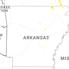
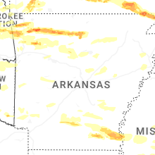

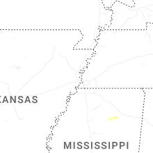


Connect with Interactive Hail Maps