

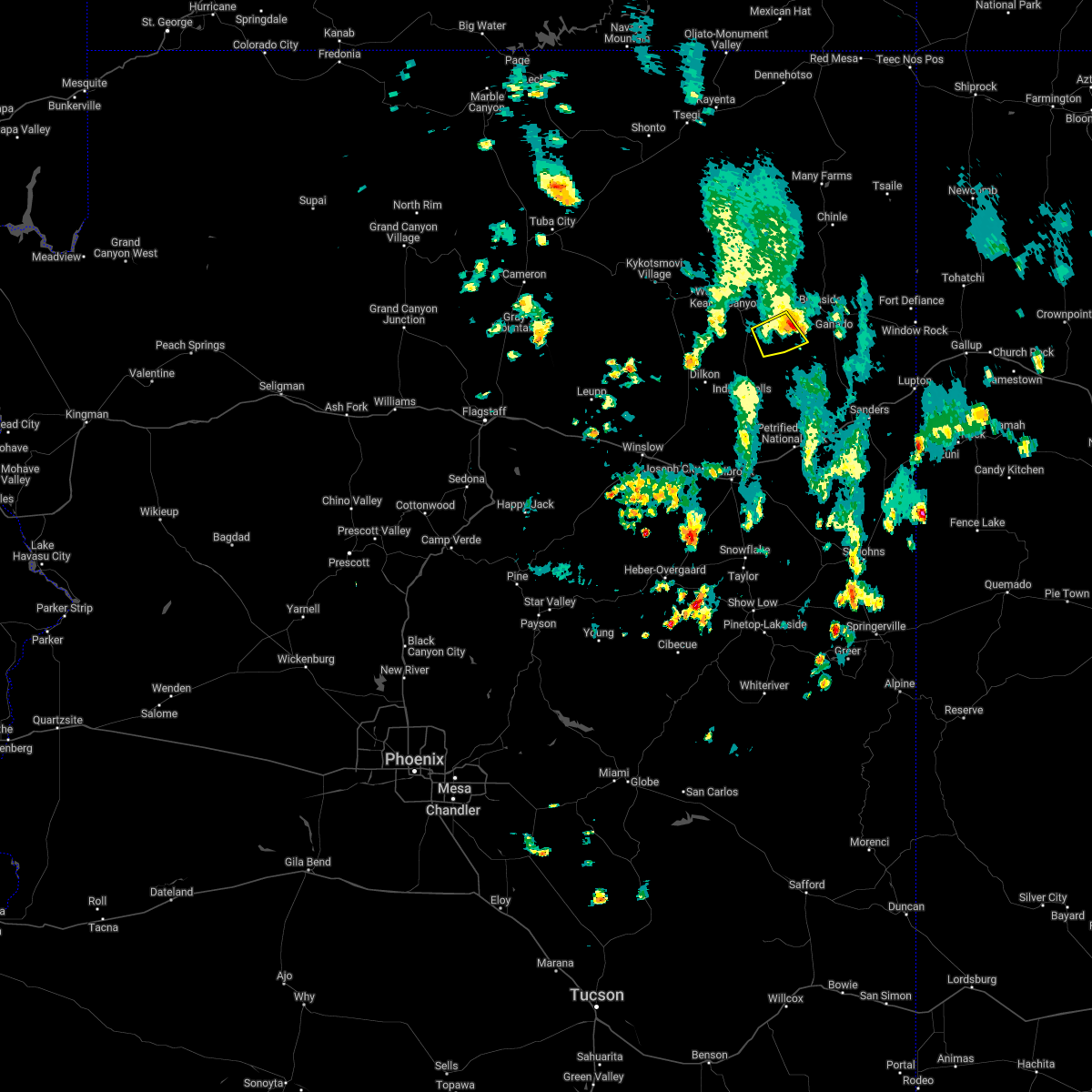
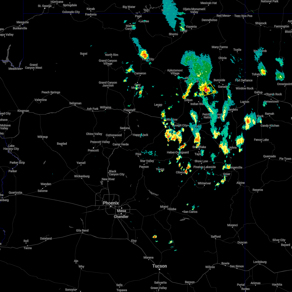
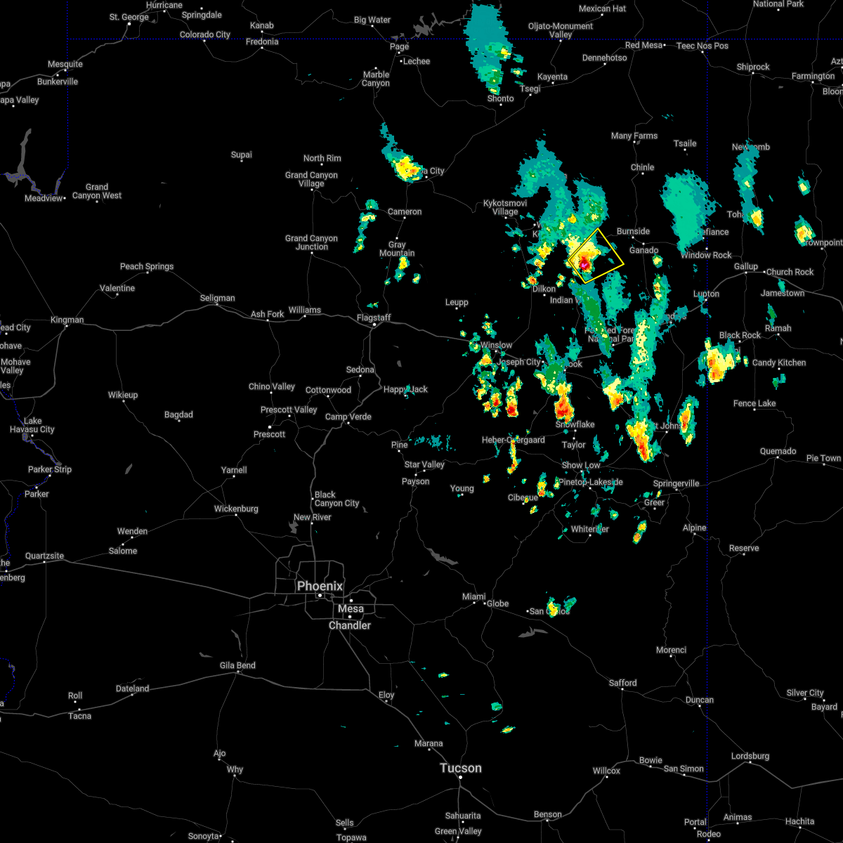
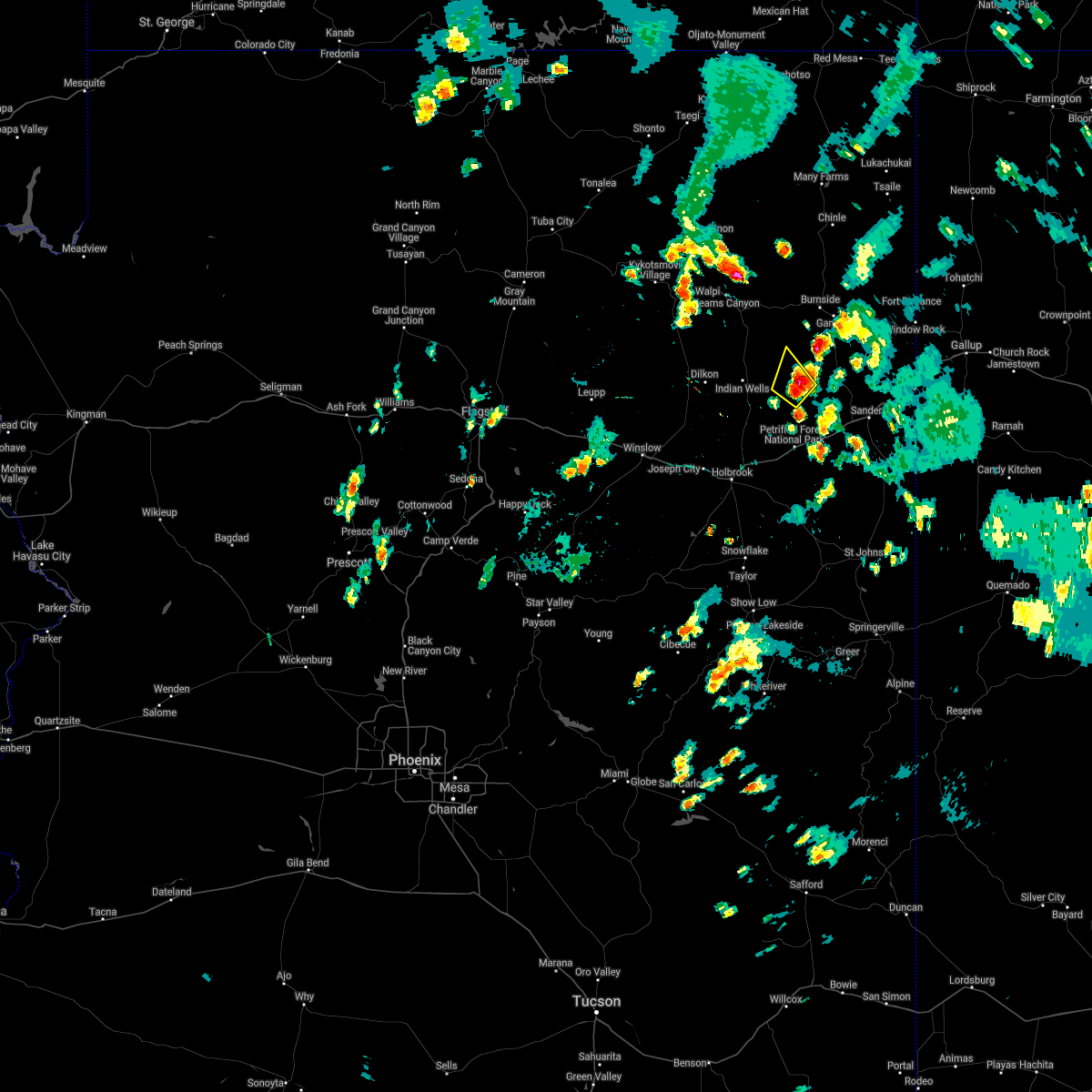
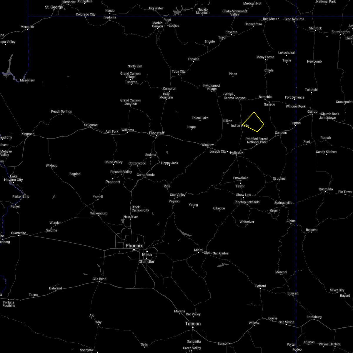
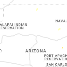
Hail Map for Greasewood, AZ
The Greasewood, AZ area has had 0 reports of on-the-ground hail by trained spotters, and has been under severe weather warnings 0 times during the past 12 months. Doppler radar has detected hail at or near Greasewood, AZ on 6 occasions, including 2 occasions during the past year.
| Name: | Greasewood, AZ |
| Where Located: | 88.6 miles N of Show Low, AZ |
| Map: | Google Map for Greasewood, AZ |
| Population: | 547 |
| Housing Units: | 181 |
| More Info: | Search Google for Greasewood, AZ |
0
The Top Recent Hail Date for Greasewood, AZ is Monday, August 7, 2023 (6th out of 6)

Hail and Wind Damage Spotted near Greasewood, AZ
| Date / Time | Report Details |
|---|---|
| 7/5/2022 3:27 PM MDT |
 The severe thunderstorm warning for apache and navajo counties will expire at 330 pm mdt, the storm which prompted the warning has weakened below severe limits, and no longer poses an immediate threat to life or property. therefore, the warning will be allowed to expire. however gusty winds are still possible with this thunderstorm. The severe thunderstorm warning for apache and navajo counties will expire at 330 pm mdt, the storm which prompted the warning has weakened below severe limits, and no longer poses an immediate threat to life or property. therefore, the warning will be allowed to expire. however gusty winds are still possible with this thunderstorm.
|
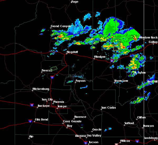
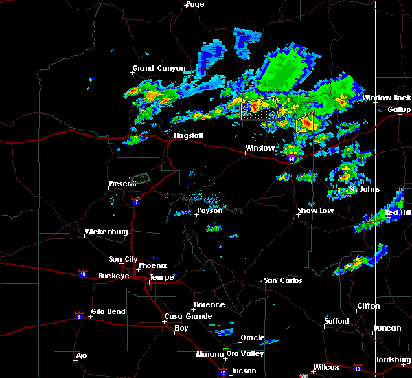
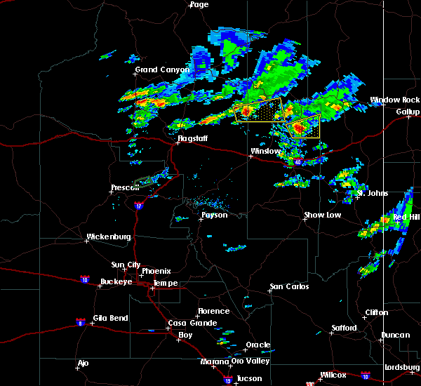
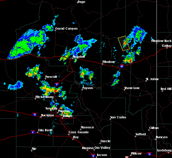
| 7/5/2022 2:59 PM MDT |
 At 258 pm mdt, a severe thunderstorm was located near greasewood springs, or 21 miles southeast of keams canyon, moving east at 10 mph (radar indicated). Hazards include 60 mph wind gusts and quarter size hail. Hail damage to vehicles is expected. expect wind damage to roofs, siding, and trees. locations impacted include, sunrise springs and greasewood. hail threat, radar indicated max hail size, 1. 00 in wind threat, radar indicated max wind gust, 60 mph. At 258 pm mdt, a severe thunderstorm was located near greasewood springs, or 21 miles southeast of keams canyon, moving east at 10 mph (radar indicated). Hazards include 60 mph wind gusts and quarter size hail. Hail damage to vehicles is expected. expect wind damage to roofs, siding, and trees. locations impacted include, sunrise springs and greasewood. hail threat, radar indicated max hail size, 1. 00 in wind threat, radar indicated max wind gust, 60 mph.
|
| 7/5/2022 2:38 PM MDT |
 At 137 pm mst/237 pm mdt/, a severe thunderstorm was located near white cone, or 19 miles southeast of keams canyon, moving northeast at 10 mph (radar indicated). Hazards include 60 mph wind gusts and half dollar size hail. Hail damage to vehicles is expected. Expect wind damage to roofs, siding, and trees. At 137 pm mst/237 pm mdt/, a severe thunderstorm was located near white cone, or 19 miles southeast of keams canyon, moving northeast at 10 mph (radar indicated). Hazards include 60 mph wind gusts and half dollar size hail. Hail damage to vehicles is expected. Expect wind damage to roofs, siding, and trees.
|
| 8/1/2021 5:56 PM MDT |
 At 556 pm mdt, a severe thunderstorm was located 13 miles southeast of greasewood springs, or 40 miles southeast of keams canyon, and is nearly stationary (radar indicated). Hazards include 60 mph wind gusts and quarter size hail. Hail damage to vehicles is expected. expect wind damage to roofs, siding, and trees. This severe thunderstorm will remain over mainly rural areas of apache and navajo counties. At 556 pm mdt, a severe thunderstorm was located 13 miles southeast of greasewood springs, or 40 miles southeast of keams canyon, and is nearly stationary (radar indicated). Hazards include 60 mph wind gusts and quarter size hail. Hail damage to vehicles is expected. expect wind damage to roofs, siding, and trees. This severe thunderstorm will remain over mainly rural areas of apache and navajo counties.
|
| 8/1/2021 5:38 PM MDT |
 At 537 pm navajo nation time, a severe thunderstorm was located 12 miles south of greasewood springs, or 38 miles southeast of keams canyon, moving northwest at 10 mph (radar indicated). Hazards include 60 mph wind gusts and quarter size hail. Hail damage to vehicles is expected. Expect wind damage to roofs, siding, and trees. At 537 pm navajo nation time, a severe thunderstorm was located 12 miles south of greasewood springs, or 38 miles southeast of keams canyon, moving northwest at 10 mph (radar indicated). Hazards include 60 mph wind gusts and quarter size hail. Hail damage to vehicles is expected. Expect wind damage to roofs, siding, and trees.
|
| 8/26/2018 6:06 PM MDT |
 The severe thunderstorm warning for areas east of indian wells in navajo county will expire at 515 pm mst, the storm which prompted the warning has weakened below severe limits, and has exited the warned area. therefore, the warning will be allowed to expire. to report severe weather, contact your nearest law enforcement agency. they will relay your report to the national weather service flagstaff. The severe thunderstorm warning for areas east of indian wells in navajo county will expire at 515 pm mst, the storm which prompted the warning has weakened below severe limits, and has exited the warned area. therefore, the warning will be allowed to expire. to report severe weather, contact your nearest law enforcement agency. they will relay your report to the national weather service flagstaff.
|
| 8/26/2018 5:51 PM MDT |
 At 450 pm mst, a severe thunderstorm was located 8 miles east of indian wells, moving east at 30 mph (radar indicated). Hazards include 60 mph wind gusts and half dollar size hail. Hail damage to vehicles is expected. expect wind damage to roofs, siding, and trees. Locations impacted include, greasewood springs and greasewood. At 450 pm mst, a severe thunderstorm was located 8 miles east of indian wells, moving east at 30 mph (radar indicated). Hazards include 60 mph wind gusts and half dollar size hail. Hail damage to vehicles is expected. expect wind damage to roofs, siding, and trees. Locations impacted include, greasewood springs and greasewood.
|
| 8/26/2018 5:30 PM MDT |
 At 430 pm mst, a severe thunderstorm was located near indian wells, moving east at 30 mph (radar indicated). Hazards include 60 mph wind gusts and half dollar size hail. Hail damage to vehicles is expected. Expect wind damage to roofs, siding, and trees. At 430 pm mst, a severe thunderstorm was located near indian wells, moving east at 30 mph (radar indicated). Hazards include 60 mph wind gusts and half dollar size hail. Hail damage to vehicles is expected. Expect wind damage to roofs, siding, and trees.
|
| 10/20/2015 3:42 AM MST | The severe thunderstorm warning for northwestern apache and east central navajo counties will expire at 345 am mst, the storm which prompted the warning has weakened below severe limits, and no longer poses an immediate threat to life or property. therefore, the warning will be allowed to expire. however, small hail and gusty winds are still possible with this thunderstorm. |
| 10/20/2015 3:30 AM MST |
 At 329 am mst, doppler radar indicated a severe thunderstorm capable of producing damaging winds in excess of 60 mph. this storm was located near jadito, or 10 miles southeast of keams canyon, moving north at 30 mph. nickel size hail may also accompany the damaging winds. locations impacted include, keams canyon, white cone, jadito, and navajo. At 329 am mst, doppler radar indicated a severe thunderstorm capable of producing damaging winds in excess of 60 mph. this storm was located near jadito, or 10 miles southeast of keams canyon, moving north at 30 mph. nickel size hail may also accompany the damaging winds. locations impacted include, keams canyon, white cone, jadito, and navajo.
|
| 10/20/2015 3:08 AM MST |
 At 306 am mst, doppler radar indicated a severe thunderstorm capable of producing quarter size hail and destructive winds in excess of 70 mph. this storm was located near white cone, or 21 miles southeast of keams canyon, and moving north at 35 mph. At 306 am mst, doppler radar indicated a severe thunderstorm capable of producing quarter size hail and destructive winds in excess of 70 mph. this storm was located near white cone, or 21 miles southeast of keams canyon, and moving north at 35 mph.
|
| 7/12/2015 3:20 PM MDT |
 At 219 pm mst, doppler radar indicated a severe thunderstorm capable of producing quarter size hail and damaging winds in excess of 60 mph. this storm was located 9 miles southeast of indian wells, or 36 miles south of keams canyon, and moving north at 25 mph. At 219 pm mst, doppler radar indicated a severe thunderstorm capable of producing quarter size hail and damaging winds in excess of 60 mph. this storm was located 9 miles southeast of indian wells, or 36 miles south of keams canyon, and moving north at 25 mph.
|
Hail Maps for Greasewood, AZ


Connect with Interactive Hail Maps