

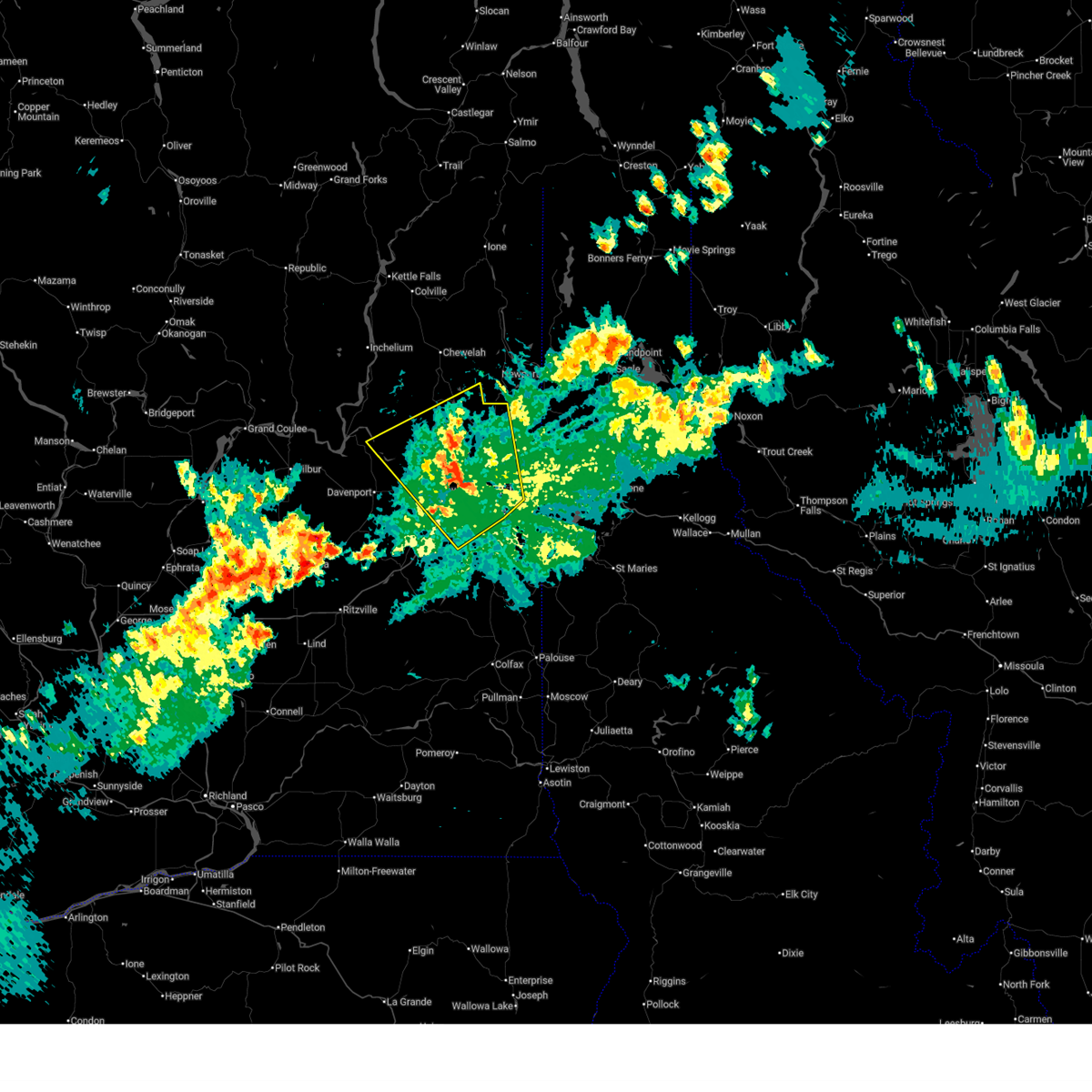
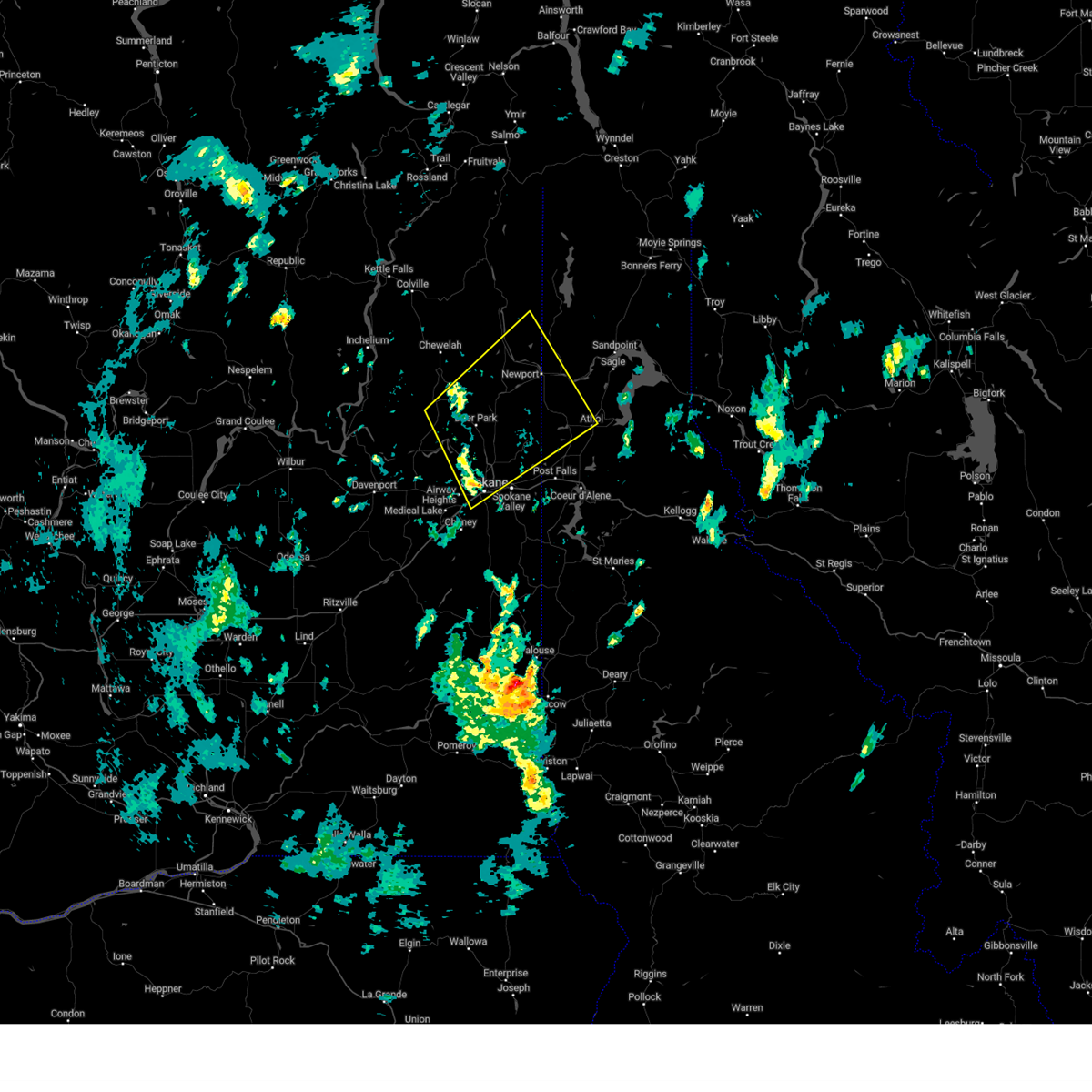
Hail Map for Green Bluff, WA
The Green Bluff, WA area has had 0 reports of on-the-ground hail by trained spotters, and has been under severe weather warnings 5 times during the past 12 months. Doppler radar has detected hail at or near Green Bluff, WA on 7 occasions.
| Name: | Green Bluff, WA |
| Where Located: | 12.6 miles NNE of Spokane, WA |
| Map: | Google Map for Green Bluff, WA |
| Population: | 761 |
| Housing Units: | 281 |
| More Info: | Search Google for Green Bluff, WA |
5
The Top Recent Hail Date for Green Bluff, WA is Friday, July 22, 2016 (1st out of 7)

Hail and Wind Damage Spotted near Green Bluff, WA
| Date / Time | Report Details |
|---|---|
| 5/28/2026 9:02 PM PDT |
 The storm which prompted the warning has weakened below severe limits, and no longer poses an immediate threat to life or property. therefore, the warning has been allowed to expire. however, small hail, gusty winds and heavy rain are still possible with this thunderstorm. a severe thunderstorm watch remains in effect until midnight pdt for eastern and northeastern washington. The storm which prompted the warning has weakened below severe limits, and no longer poses an immediate threat to life or property. therefore, the warning has been allowed to expire. however, small hail, gusty winds and heavy rain are still possible with this thunderstorm. a severe thunderstorm watch remains in effect until midnight pdt for eastern and northeastern washington.
|
| 5/28/2026 8:33 PM PDT |
 At 832 pm pdt, a severe thunderstorm was located near nine mile falls, or 10 miles west of spokane, moving northwest at 40 mph. tree damage has been reported with this storm and 60 mph winds have been observed (trained weather spotters and weather stations). Hazards include 60 mph wind gusts and penny size hail. Expect damage to roofs, siding, and trees. locations impacted include, spokane, spokane valley, cheney, airway heights, medical lake, nine mile falls, deer park, millwood, fairwood, suncrest, fairchild afb, trentwood, country homes, chattaroy, town and country, dishman, mead, green acres, reardan, and elk. this includes the following highways, interstate 90 in washington between mile markers 263 and 292. u. s. highway 195 in washington between mile markers 85 and 95. u. s. Highway 395 in washington between mile markers 165 and 191. At 832 pm pdt, a severe thunderstorm was located near nine mile falls, or 10 miles west of spokane, moving northwest at 40 mph. tree damage has been reported with this storm and 60 mph winds have been observed (trained weather spotters and weather stations). Hazards include 60 mph wind gusts and penny size hail. Expect damage to roofs, siding, and trees. locations impacted include, spokane, spokane valley, cheney, airway heights, medical lake, nine mile falls, deer park, millwood, fairwood, suncrest, fairchild afb, trentwood, country homes, chattaroy, town and country, dishman, mead, green acres, reardan, and elk. this includes the following highways, interstate 90 in washington between mile markers 263 and 292. u. s. highway 195 in washington between mile markers 85 and 95. u. s. Highway 395 in washington between mile markers 165 and 191.
|
| 5/28/2026 8:23 PM PDT |
 the severe thunderstorm warning has been cancelled and is no longer in effect the severe thunderstorm warning has been cancelled and is no longer in effect
|
| 5/28/2026 8:23 PM PDT |
 At 822 pm pdt, a severe thunderstorm was located over airway heights, or near spokane, moving northwest at 20 mph (radar indicated). Hazards include 60 mph wind gusts and penny size hail. Expect damage to roofs, siding, and trees. locations impacted include, spokane, spokane valley, cheney, airway heights, medical lake, nine mile falls, deer park, millwood, fairwood, suncrest, fairchild afb, green acres, trentwood, country homes, chattaroy, town and country, dishman, mead, otis orchards-east farms, and reardan. this includes the following highways, interstate 90 in washington between mile markers 263 and 296. u. s. highway 195 in washington between mile markers 75 and 95. u. s. Highway 395 in washington between mile markers 165 and 191. At 822 pm pdt, a severe thunderstorm was located over airway heights, or near spokane, moving northwest at 20 mph (radar indicated). Hazards include 60 mph wind gusts and penny size hail. Expect damage to roofs, siding, and trees. locations impacted include, spokane, spokane valley, cheney, airway heights, medical lake, nine mile falls, deer park, millwood, fairwood, suncrest, fairchild afb, green acres, trentwood, country homes, chattaroy, town and country, dishman, mead, otis orchards-east farms, and reardan. this includes the following highways, interstate 90 in washington between mile markers 263 and 296. u. s. highway 195 in washington between mile markers 75 and 95. u. s. Highway 395 in washington between mile markers 165 and 191.
|
| 5/28/2026 8:00 PM PDT |
 Svrotx the national weather service in spokane has issued a * severe thunderstorm warning for, northeastern lincoln county in eastern washington, northern whitman county in eastern washington, southeastern stevens county in northeastern washington, spokane county in northeastern washington, * until 900 pm pdt. * at 800 pm pdt, a severe thunderstorm was located 10 miles south of dishman, or 11 miles south of spokane valley, moving northwest at 55 mph (radar indicated). Hazards include 60 mph wind gusts and penny size hail. expect damage to roofs, siding, and trees Svrotx the national weather service in spokane has issued a * severe thunderstorm warning for, northeastern lincoln county in eastern washington, northern whitman county in eastern washington, southeastern stevens county in northeastern washington, spokane county in northeastern washington, * until 900 pm pdt. * at 800 pm pdt, a severe thunderstorm was located 10 miles south of dishman, or 11 miles south of spokane valley, moving northwest at 55 mph (radar indicated). Hazards include 60 mph wind gusts and penny size hail. expect damage to roofs, siding, and trees
|
| 9/25/2024 4:23 PM PDT |
 Svrotx the national weather service in spokane has issued a * severe thunderstorm warning for, southwestern bonner county in the panhandle of idaho, northwestern kootenai county in the panhandle of idaho, southeastern stevens county in northeastern washington, northern spokane county in northeastern washington, southeastern pend oreille county in northeastern washington, * until 530 pm pdt. * at 423 pm pdt, a severe thunderstorm was located over nine mile falls, or 8 miles northwest of spokane, moving northeast at 40 mph (radar indicated). Hazards include 60 mph wind gusts. expect damage to roofs, siding, and trees Svrotx the national weather service in spokane has issued a * severe thunderstorm warning for, southwestern bonner county in the panhandle of idaho, northwestern kootenai county in the panhandle of idaho, southeastern stevens county in northeastern washington, northern spokane county in northeastern washington, southeastern pend oreille county in northeastern washington, * until 530 pm pdt. * at 423 pm pdt, a severe thunderstorm was located over nine mile falls, or 8 miles northwest of spokane, moving northeast at 40 mph (radar indicated). Hazards include 60 mph wind gusts. expect damage to roofs, siding, and trees
|
| 6/8/2023 4:57 PM PDT |
 The severe thunderstorm warning for northwestern benewah, southwestern kootenai and eastern spokane counties will expire at 500 pm pdt, the storms which prompted the warning have moved out of the area. therefore, the warning will be allowed to expire. however, gusty winds are still possible with these thunderstorms. The severe thunderstorm warning for northwestern benewah, southwestern kootenai and eastern spokane counties will expire at 500 pm pdt, the storms which prompted the warning have moved out of the area. therefore, the warning will be allowed to expire. however, gusty winds are still possible with these thunderstorms.
|
| 6/8/2023 4:34 PM PDT |
 At 433 pm pdt, severe thunderstorms were located along a line extending from near chattaroy to 9 miles west of plummer, moving west at 15 mph (trained weather spotters reported damage in greenacres at 426 pm). Hazards include 60 mph wind gusts and nickel size hail. Expect damage to roofs, siding, and trees. locations impacted include, spokane, spokane valley, post falls, liberty lake, nine mile falls, millwood, plummer, hauser, otis orchards-east farms, fairwood, otis orchards, green acres, trentwood, country homes, town and country, chattaroy, dishman, mead, fairfield, and rockford. this includes the following highways, interstate 90 in washington between mile markers 277 and 299. interstate 90 in idaho between mile markers 0 and 5. u. s. highway 95 in idaho between mile markers 391 and 420. u. s. highway 2 in washington between mile markers 282 and 305. u. s. highway 195 in washington between mile markers 75 and 95. u. s. highway 395 in washington between mile markers 165 and 177. hail threat, radar indicated max hail size, 0. 88 in wind threat, radar indicated max wind gust, 60 mph. At 433 pm pdt, severe thunderstorms were located along a line extending from near chattaroy to 9 miles west of plummer, moving west at 15 mph (trained weather spotters reported damage in greenacres at 426 pm). Hazards include 60 mph wind gusts and nickel size hail. Expect damage to roofs, siding, and trees. locations impacted include, spokane, spokane valley, post falls, liberty lake, nine mile falls, millwood, plummer, hauser, otis orchards-east farms, fairwood, otis orchards, green acres, trentwood, country homes, town and country, chattaroy, dishman, mead, fairfield, and rockford. this includes the following highways, interstate 90 in washington between mile markers 277 and 299. interstate 90 in idaho between mile markers 0 and 5. u. s. highway 95 in idaho between mile markers 391 and 420. u. s. highway 2 in washington between mile markers 282 and 305. u. s. highway 195 in washington between mile markers 75 and 95. u. s. highway 395 in washington between mile markers 165 and 177. hail threat, radar indicated max hail size, 0. 88 in wind threat, radar indicated max wind gust, 60 mph.
|
| 6/8/2023 4:30 PM PDT | Downed tree limbs and power lines east of chattaroy. time estimated from rada in spokane county WA, 6.2 miles SSE of Green Bluff, WA |
| 6/8/2023 4:25 PM PDT |
 At 423 pm pdt, severe thunderstorms were located along a line extending from 6 miles east of chattaroy to 7 miles west of plummer, moving west at 20 mph (trained weather spotters reported downed tree limbs and highway signs near lake coeur d`alene earlier with these storms). Hazards include 60 mph wind gusts and nickel size hail. Expect damage to roofs, siding, and trees. locations impacted include, spokane, spokane valley, post falls, rathdrum, liberty lake, nine mile falls, millwood, plummer, hauser, harrison, otis orchards-east farms, fairwood, otis orchards, green acres, trentwood, country homes, town and country, chattaroy, dishman, and mead. this includes the following highways, interstate 90 in washington between mile markers 277 and 299. interstate 90 in idaho between mile markers 0 and 8. u. s. highway 95 in idaho between mile markers 390 and 425. u. s. highway 2 in washington between mile markers 282 and 305. u. s. highway 195 in washington between mile markers 75 and 95. u. s. highway 395 in washington between mile markers 165 and 177. hail threat, radar indicated max hail size, 0. 88 in wind threat, radar indicated max wind gust, 60 mph. At 423 pm pdt, severe thunderstorms were located along a line extending from 6 miles east of chattaroy to 7 miles west of plummer, moving west at 20 mph (trained weather spotters reported downed tree limbs and highway signs near lake coeur d`alene earlier with these storms). Hazards include 60 mph wind gusts and nickel size hail. Expect damage to roofs, siding, and trees. locations impacted include, spokane, spokane valley, post falls, rathdrum, liberty lake, nine mile falls, millwood, plummer, hauser, harrison, otis orchards-east farms, fairwood, otis orchards, green acres, trentwood, country homes, town and country, chattaroy, dishman, and mead. this includes the following highways, interstate 90 in washington between mile markers 277 and 299. interstate 90 in idaho between mile markers 0 and 8. u. s. highway 95 in idaho between mile markers 390 and 425. u. s. highway 2 in washington between mile markers 282 and 305. u. s. highway 195 in washington between mile markers 75 and 95. u. s. highway 395 in washington between mile markers 165 and 177. hail threat, radar indicated max hail size, 0. 88 in wind threat, radar indicated max wind gust, 60 mph.
|
| 6/8/2023 4:10 PM PDT |
 At 409 pm pdt, severe thunderstorms were located along a line extending from near hauser to 6 miles west of harrison, moving west at 15 mph (radar indicated). Hazards include 60 mph wind gusts and nickel size hail. expect damage to roofs, siding, and trees At 409 pm pdt, severe thunderstorms were located along a line extending from near hauser to 6 miles west of harrison, moving west at 15 mph (radar indicated). Hazards include 60 mph wind gusts and nickel size hail. expect damage to roofs, siding, and trees
|
| 11/5/2022 12:58 AM PDT | Report from mping: 1-inch tree limbs broken; shingles blown of in spokane county WA, 1.1 miles SSW of Green Bluff, WA |
| 7/23/2019 9:23 PM PDT |
 At 857 pm pdt, severe thunderstorms were located along a line extending from 10 miles northwest of fairchild afb to 7 miles south of dishman, moving northeast at 50 mph (radar indicated). Hazards include 60 mph wind gusts and penny size hail. expect damage to roofs, siding, and trees At 857 pm pdt, severe thunderstorms were located along a line extending from 10 miles northwest of fairchild afb to 7 miles south of dishman, moving northeast at 50 mph (radar indicated). Hazards include 60 mph wind gusts and penny size hail. expect damage to roofs, siding, and trees
|
| 7/23/2019 8:57 PM PDT |
 At 857 pm pdt, severe thunderstorms were located along a line extending from 10 miles northwest of fairchild afb to 7 miles south of dishman, moving northeast at 50 mph (radar indicated). Hazards include 60 mph wind gusts and penny size hail. expect damage to roofs, siding, and trees At 857 pm pdt, severe thunderstorms were located along a line extending from 10 miles northwest of fairchild afb to 7 miles south of dishman, moving northeast at 50 mph (radar indicated). Hazards include 60 mph wind gusts and penny size hail. expect damage to roofs, siding, and trees
|
| 5/4/2016 11:04 PM PDT |
 At 1104 pm pdt, the public reported a line of severe thunderstorms producing damaging winds in excess of 60 mph. these storms were located along a line extending from 11 miles east of davenport to green acres, and moving north at 40 mph. At 1104 pm pdt, the public reported a line of severe thunderstorms producing damaging winds in excess of 60 mph. these storms were located along a line extending from 11 miles east of davenport to green acres, and moving north at 40 mph.
|
| 5/29/2015 8:46 PM PDT | At 841 pm pdt, weather service personnel measured a 53 mph wind gust at the weather office in airway heights. a trained weather spotter reported a dissipating funnel cloud near peone prairie. this storm was moving east at 30 mph. this severe storm will be near, post falls around 850 pm pdt. rathdrum around 855 pm pdt. hayden and dalton gardens around 905 pm pdt. coeur d`alene and hayden lake around 910 pm pdt. other locations impacted by this severe thunderstorm include mica, elk, newman lake, fernan lake village, laclede, mount spokane, opportunity, huetter, veradale and chilco. |
| 5/29/2015 8:46 PM PDT | At 841 pm pdt, weather service personnel measured a 53 mph wind gust at the weather office in airway heights. a trained weather spotter reported a dissipating funnel cloud near peone prairie. this storm was moving east at 30 mph. this severe storm will be near, post falls around 850 pm pdt. rathdrum around 855 pm pdt. hayden and dalton gardens around 905 pm pdt. coeur d`alene and hayden lake around 910 pm pdt. other locations impacted by this severe thunderstorm include mica, elk, newman lake, fernan lake village, laclede, mount spokane, opportunity, huetter, veradale and chilco. |
| 5/29/2015 8:31 PM PDT | At 827 pm pdt, doppler radar indicated a severe thunderstorm capable of producing damaging winds around 55 mph. this storm was located near trentwood, or 15 miles west of post falls, and moving east at 35 mph. small hail is also possible with this line of storms. * this severe thunderstorm will be near, liberty lake and otis orchards around 835 pm pdt. otis orchards-east farms around 840 pm pdt. hauser around 845 pm pdt. post falls around 850 pm pdt. rathdrum around 855 pm pdt. hayden, dalton gardens and hayden lake around 905 pm pdt. coeur d`alene around 910 pm pdt. other locations impacted by this severe thunderstorm include mica, elk, newman lake, fernan lake village, laclede, mount spokane, opportunity, huetter, veradale and chilco. |
| 5/29/2015 8:31 PM PDT | At 827 pm pdt, doppler radar indicated a severe thunderstorm capable of producing damaging winds around 55 mph. this storm was located near trentwood, or 15 miles west of post falls, and moving east at 35 mph. small hail is also possible with this line of storms. * this severe thunderstorm will be near, liberty lake and otis orchards around 835 pm pdt. otis orchards-east farms around 840 pm pdt. hauser around 845 pm pdt. post falls around 850 pm pdt. rathdrum around 855 pm pdt. hayden, dalton gardens and hayden lake around 905 pm pdt. coeur d`alene around 910 pm pdt. other locations impacted by this severe thunderstorm include mica, elk, newman lake, fernan lake village, laclede, mount spokane, opportunity, huetter, veradale and chilco. |
| 5/29/2015 8:04 PM PDT | At 755 pm pdt, winds gusted to 53 mph at the national weather service office, just to the west of downtown spokane. winds of this strength can produce damage, and with the recent heavy rains in the area, soft ground could allow for trees to topple. these winds will move east across the interstate 90 corridor as well. locations impacted include, spokane, airway heights, nine mile falls, deer park, millwood, town and country, fairwood, suncrest, chattaroy, mead, dishman, country homes, fairchild afb, trentwood, reardan, opportunity, ford, deep creek, colbert and tum tum. |
| 5/29/2015 7:41 PM PDT | At 737 pm pdt, doppler radar indicated a severe thunderstorm capable of producing damaging winds of around 55 mph. hail to the size of dimes are likely. this storm was located 8 miles west of suncrest, or 18 miles northwest of spokane, and moving east at 25 mph. |
| 8/12/2014 7:30 PM PDT | 29100 n. elk chattaroy rd. reported power line down. reported by spokane_news in spokane county WA, 6 miles SSE of Green Bluff, WA |
| 7/23/2014 4:36 PM PDT | *** 1 inj *** downed tree landed on car and injured perso in spokane county WA, 4.9 miles SE of Green Bluff, WA |
| 8/25/2013 9:07 PM PDT | Tree on power line. 178 customers affecte in spokane county WA, 6.1 miles SSE of Green Bluff, WA |
Hail Maps for Green Bluff, WA


Connect with Interactive Hail Maps