

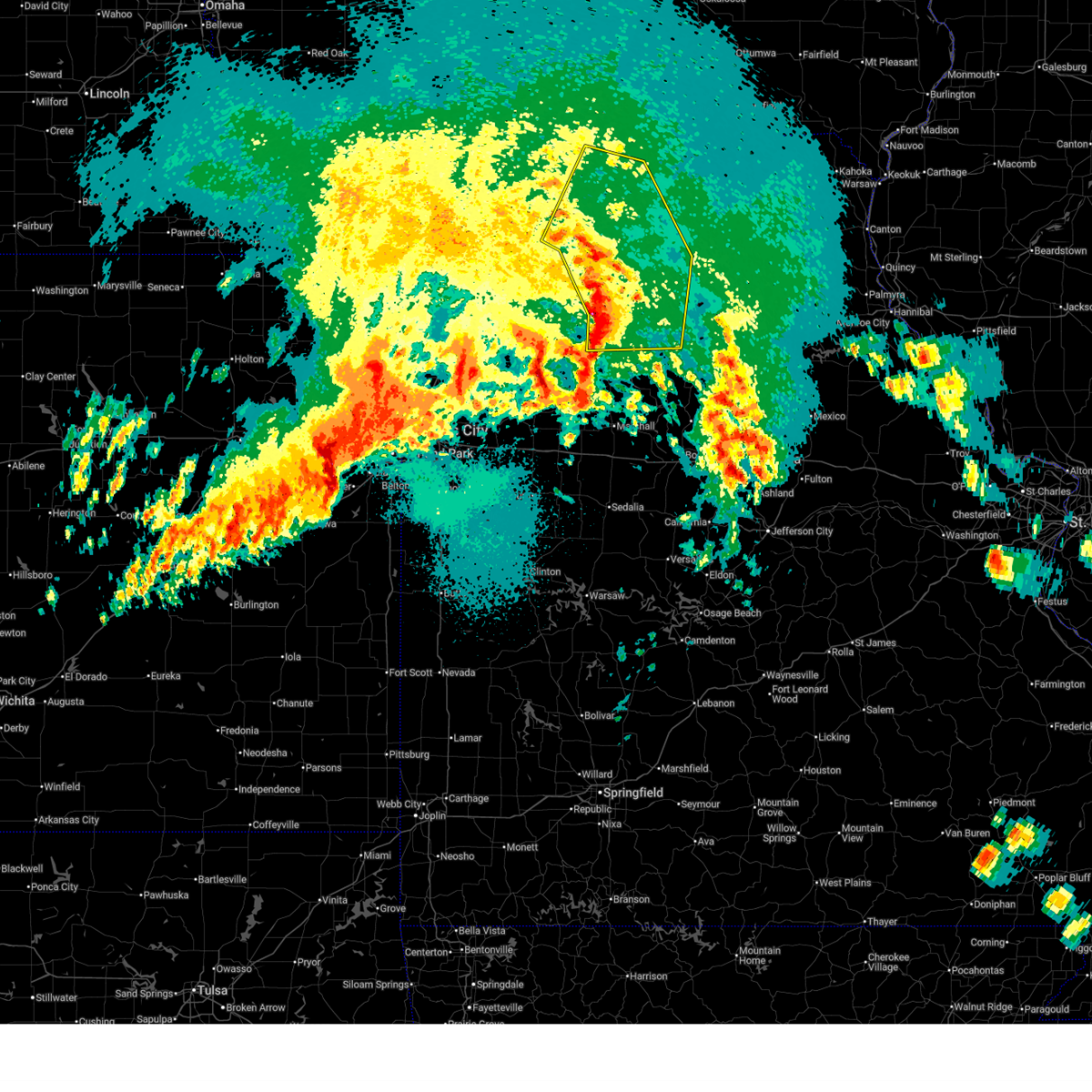
Hail Map for Greencastle, MO
The Greencastle, MO area has had 5 reports of on-the-ground hail by trained spotters, and has been under severe weather warnings 36 times during the past 12 months. Doppler radar has detected hail at or near Greencastle, MO on 64 occasions, including 4 occasions during the past year.
| Name: | Greencastle, MO |
| Where Located: | 62.2 miles W of Kahoka, MO |
| Map: | Google Map for Greencastle, MO |
| Population: | 275 |
| Housing Units: | 147 |
| More Info: | Search Google for Greencastle, MO |
2
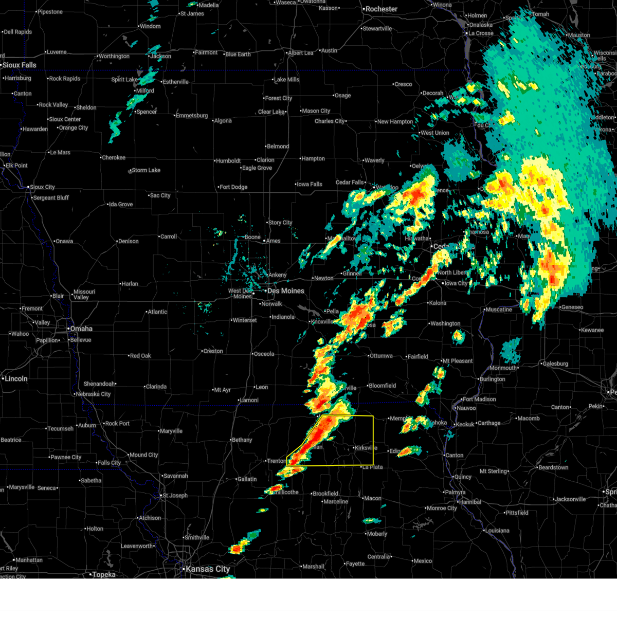
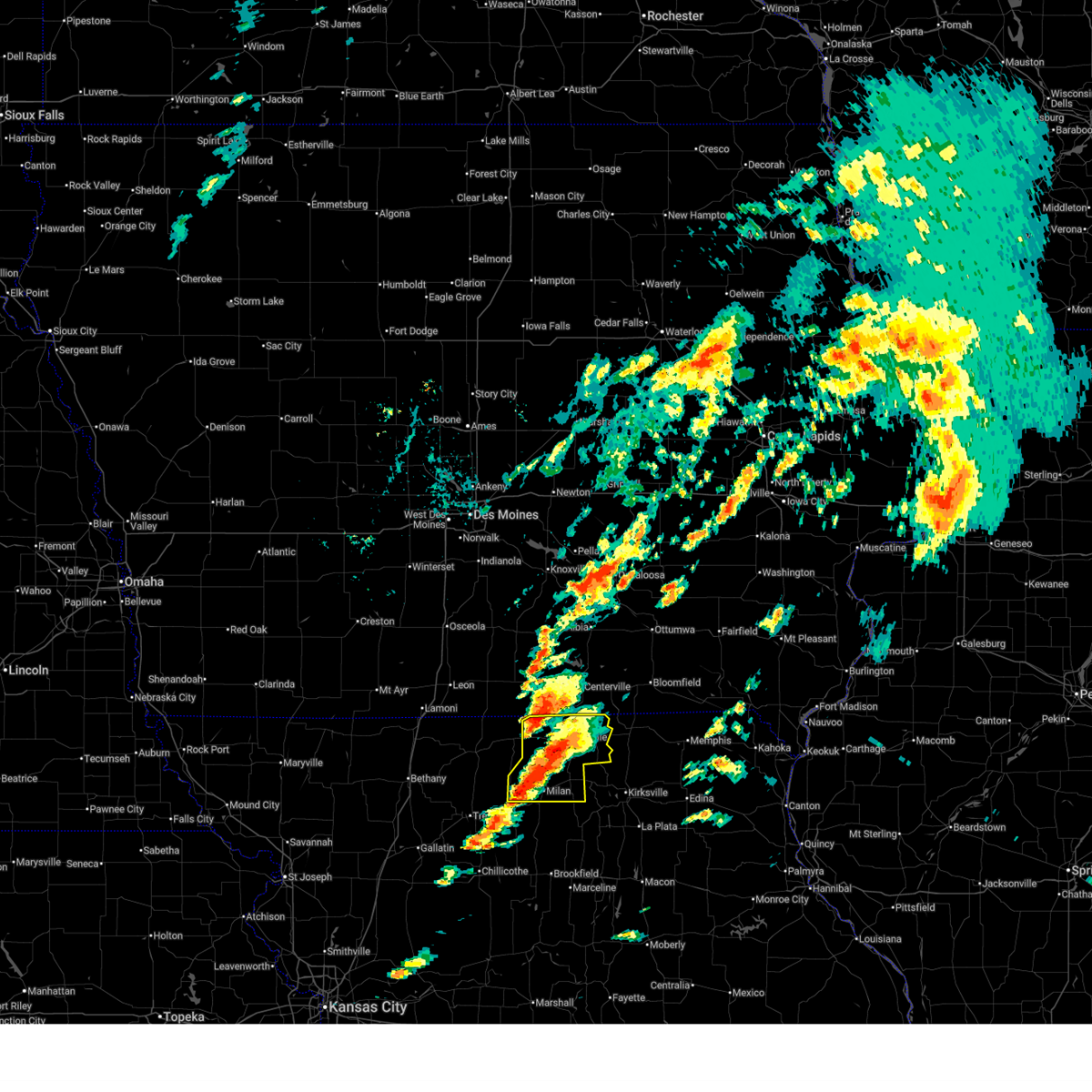
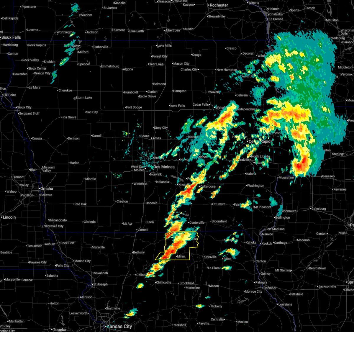
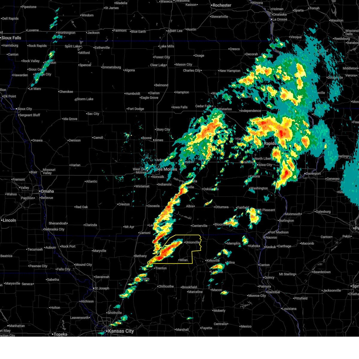
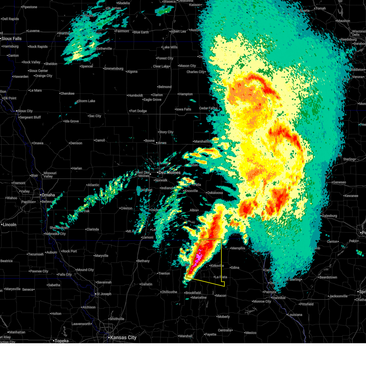
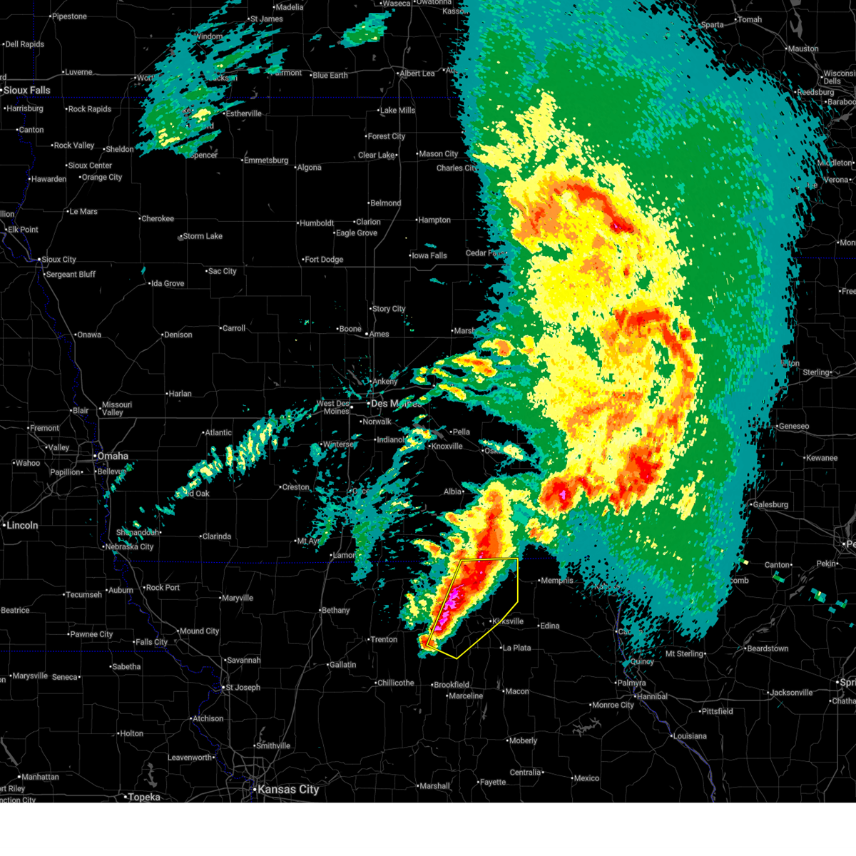
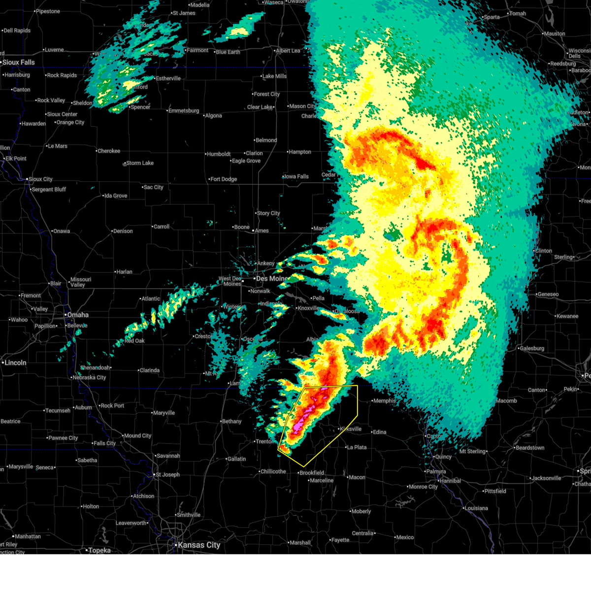
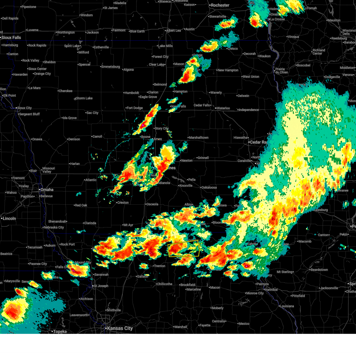
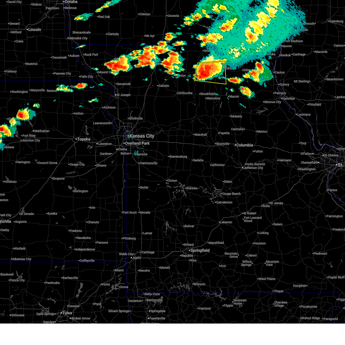
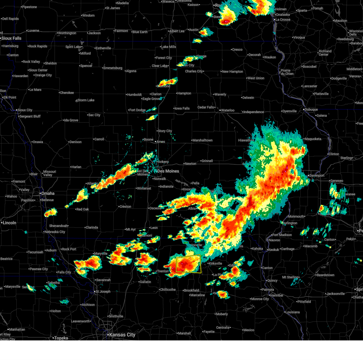
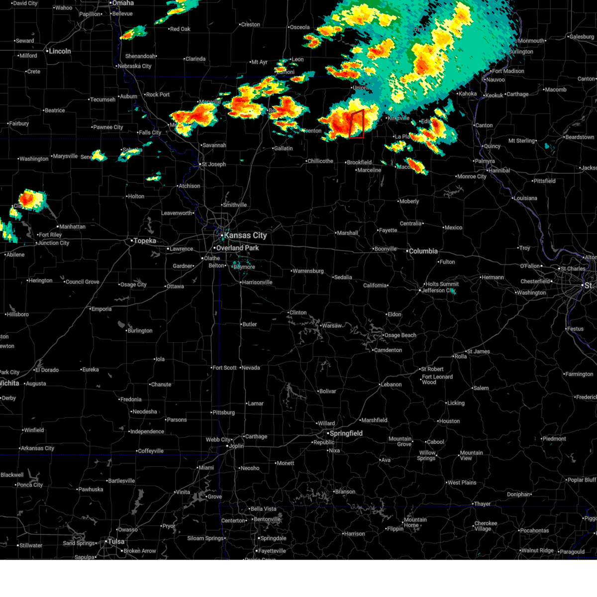
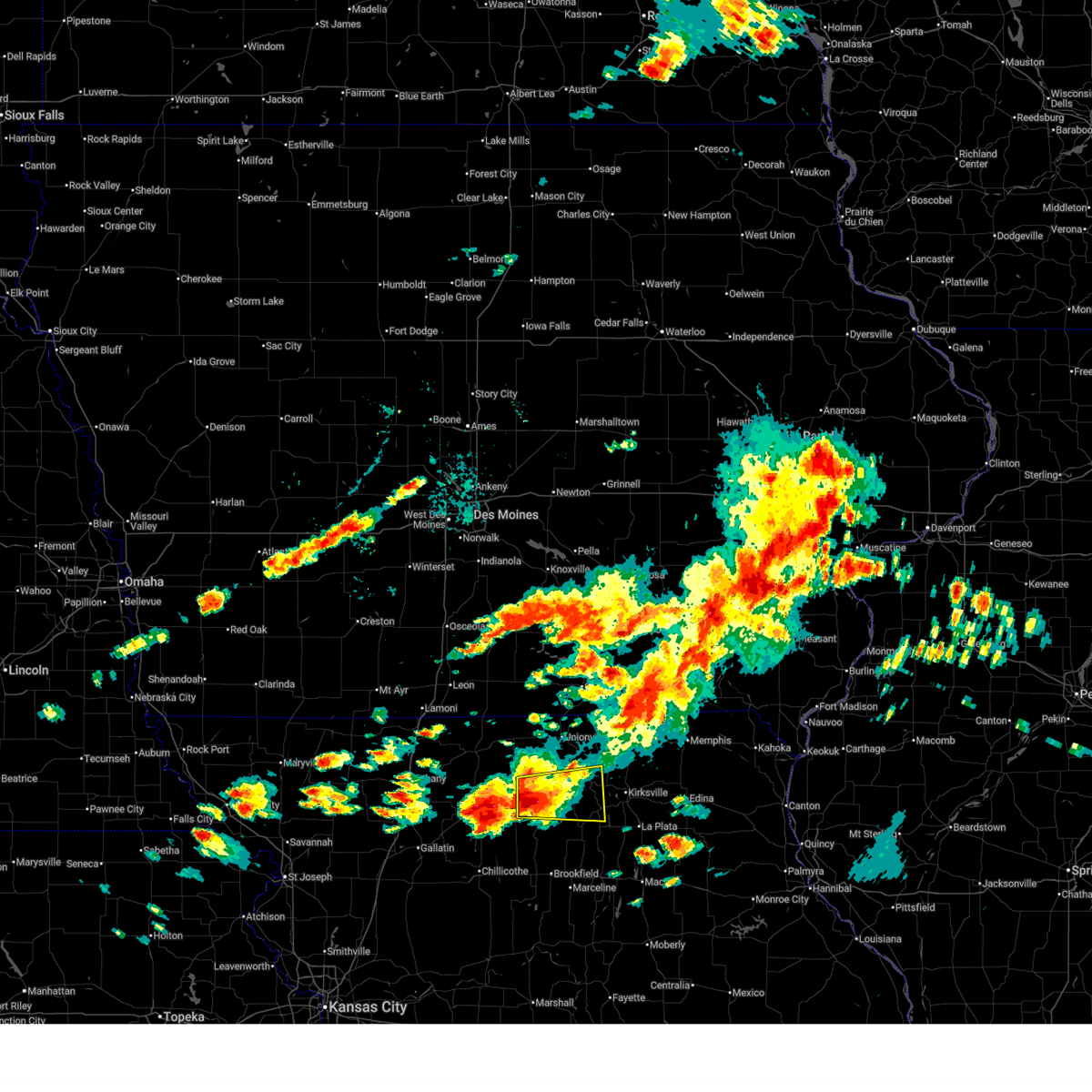
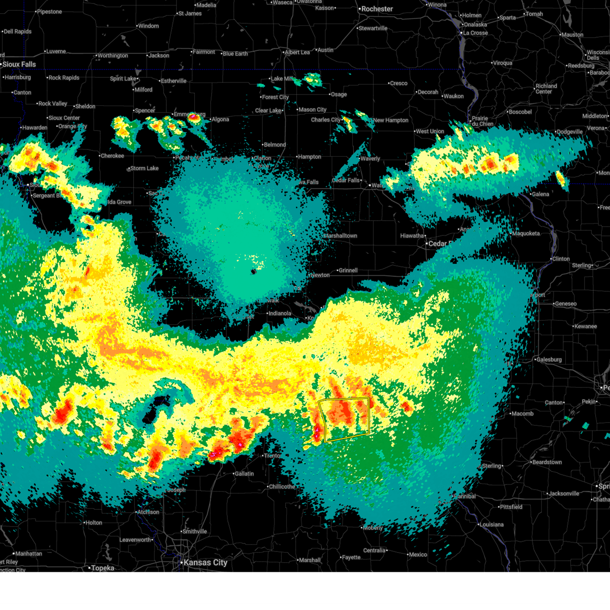
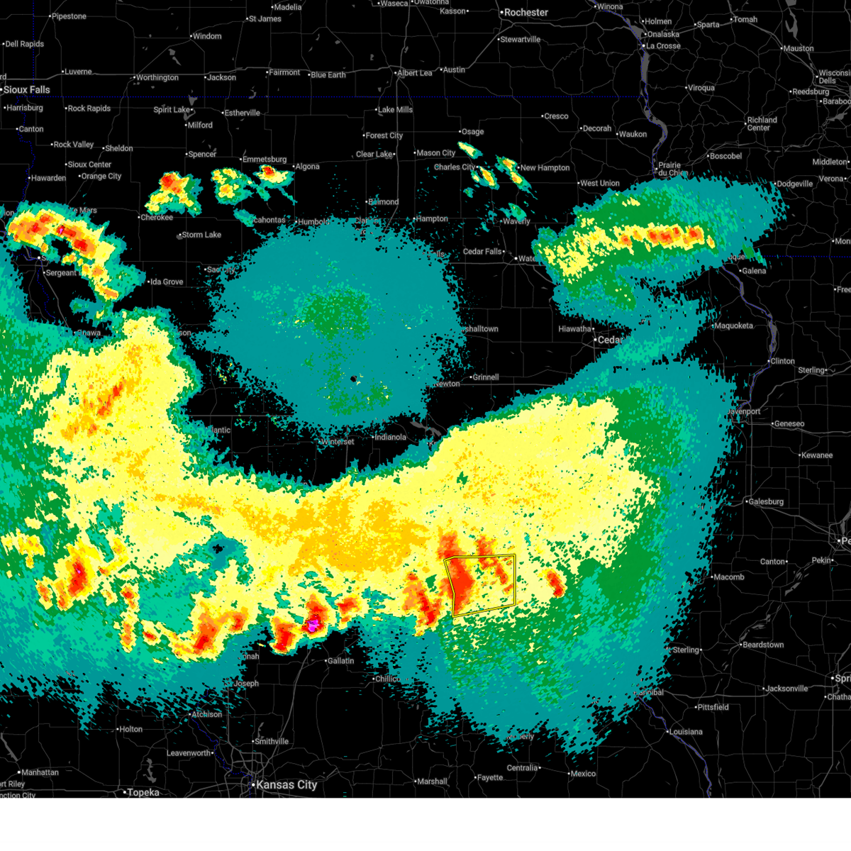
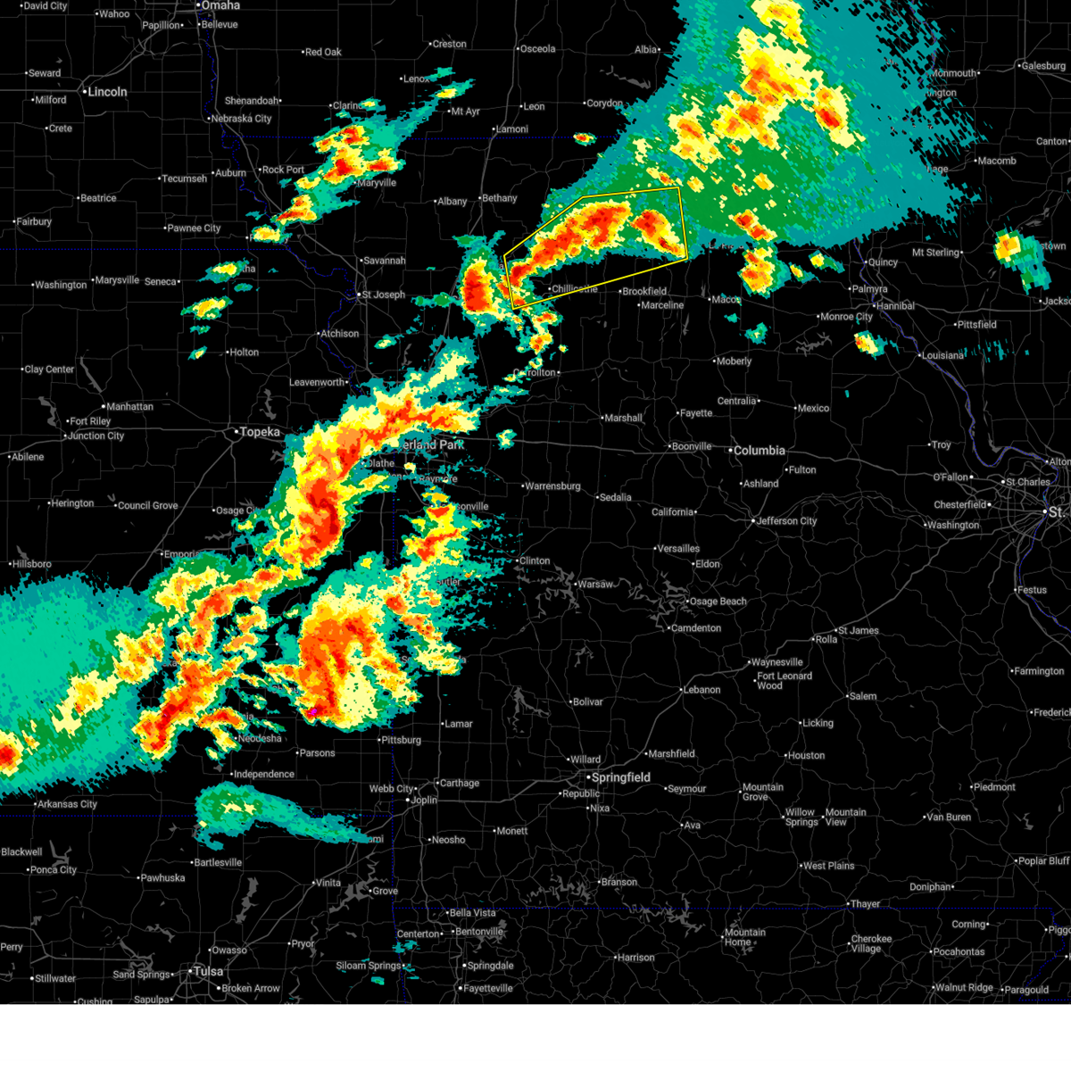
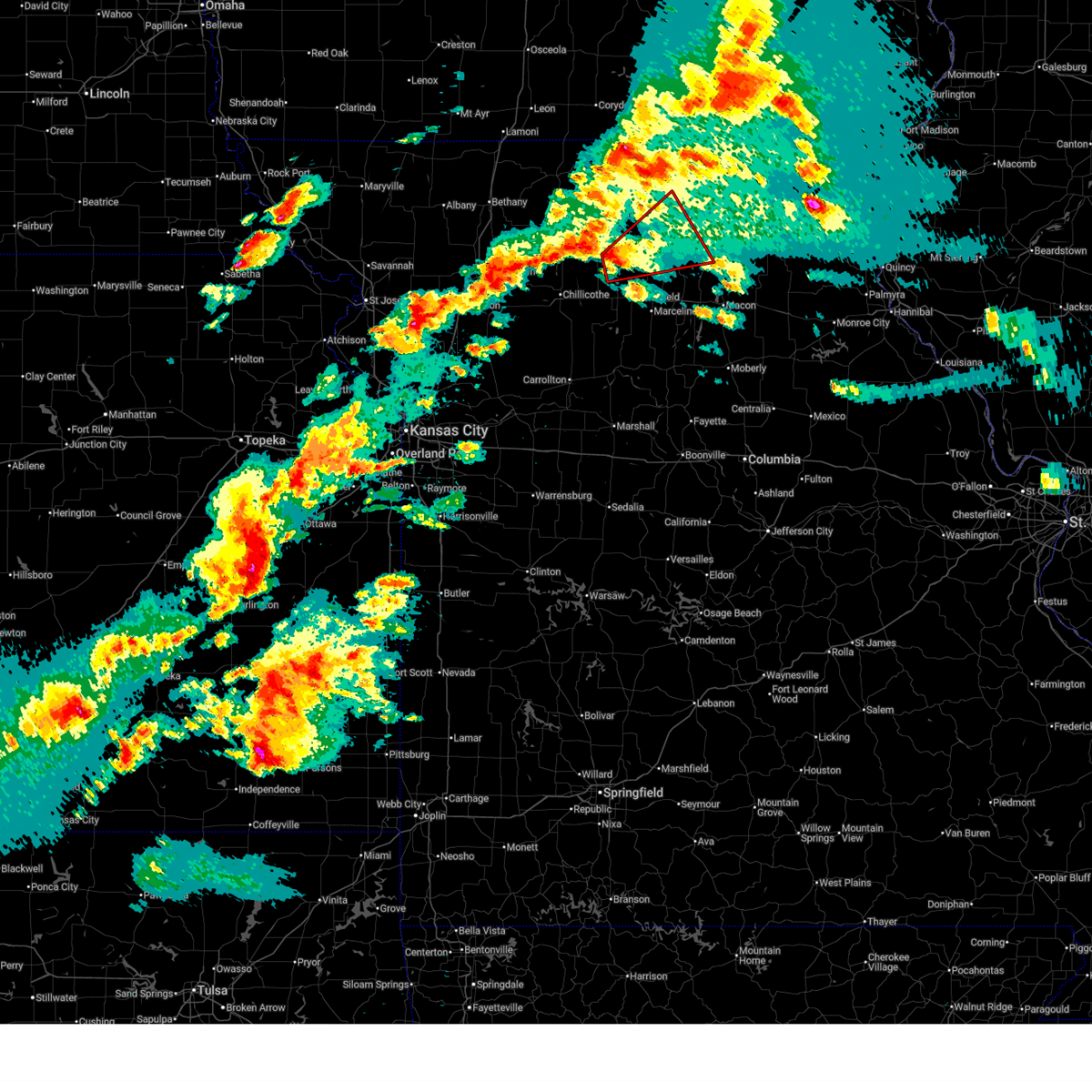
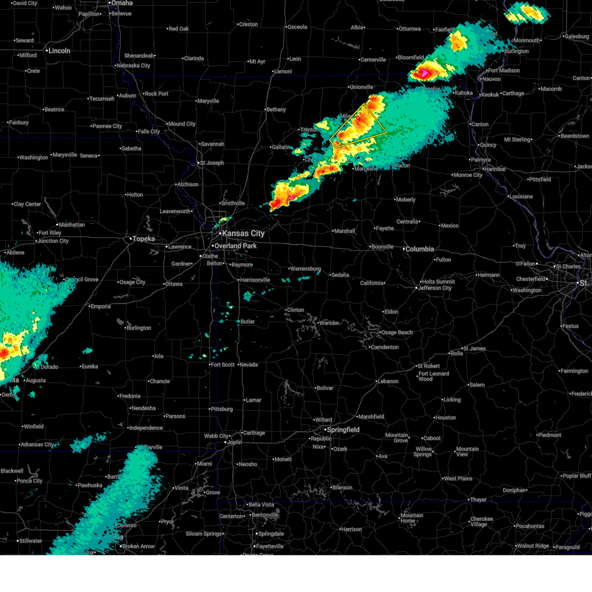
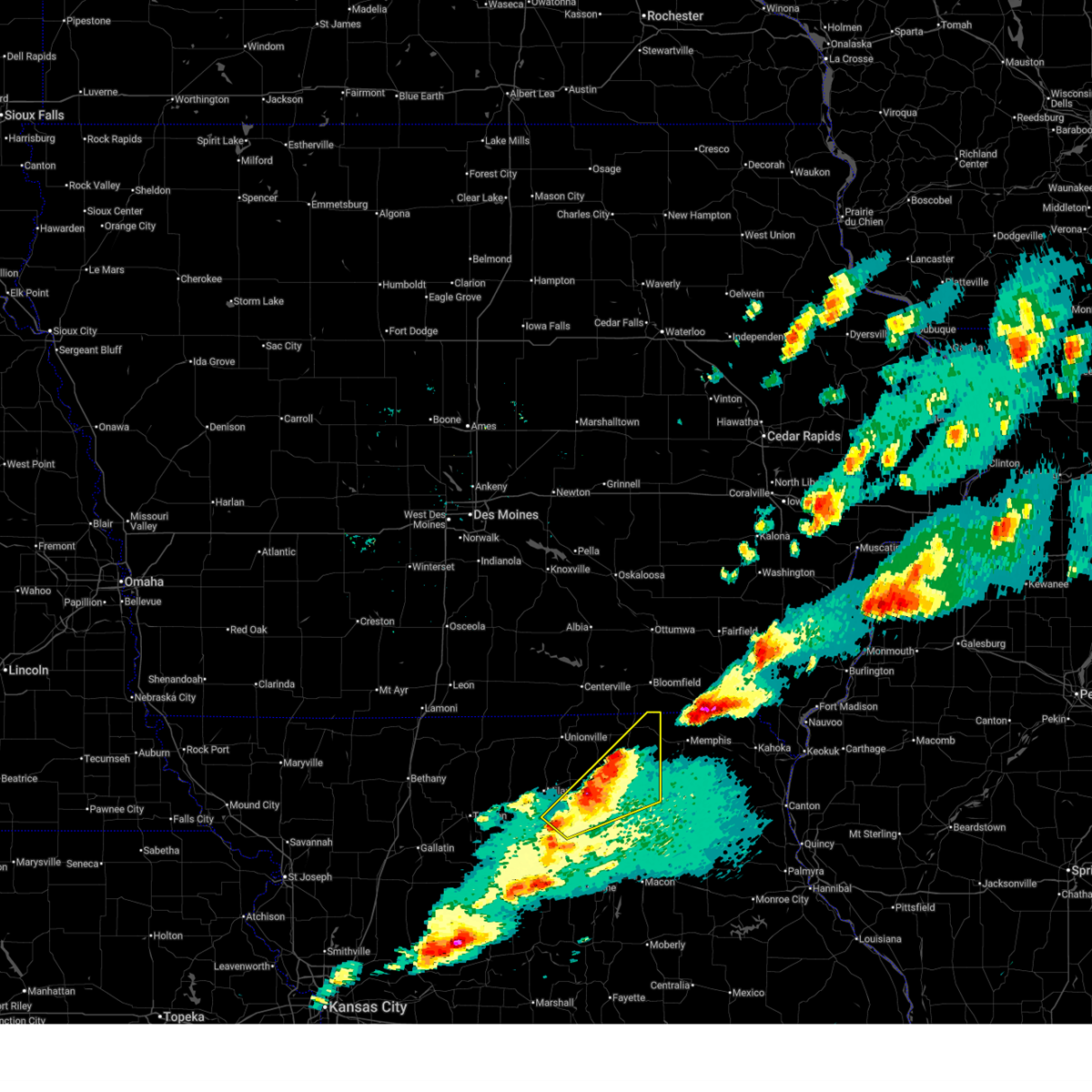
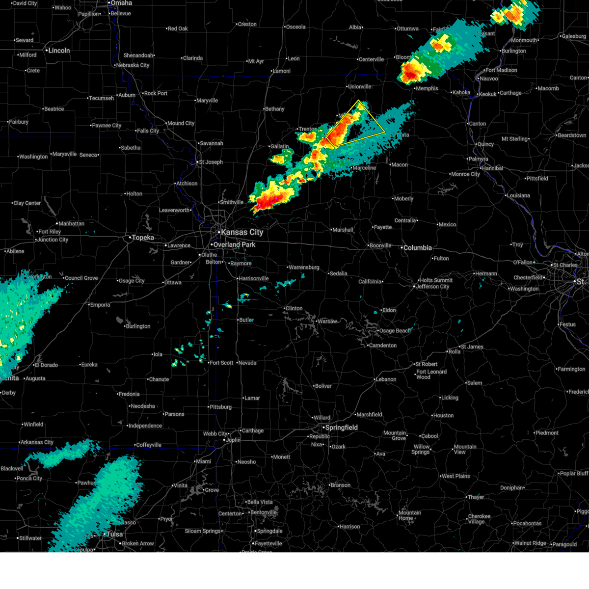
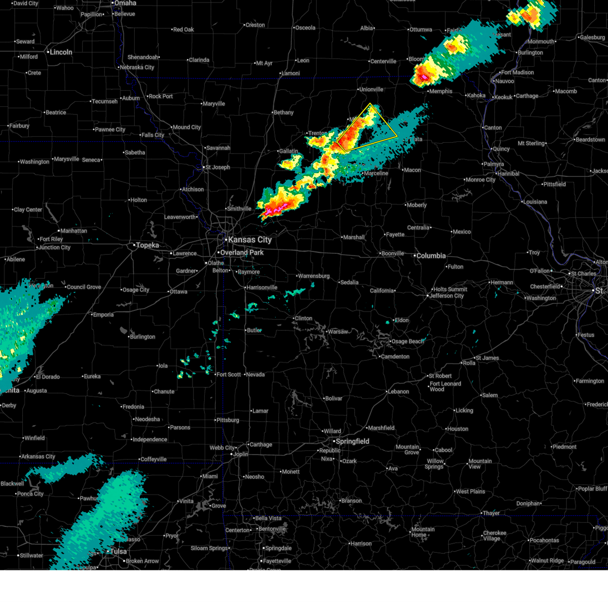
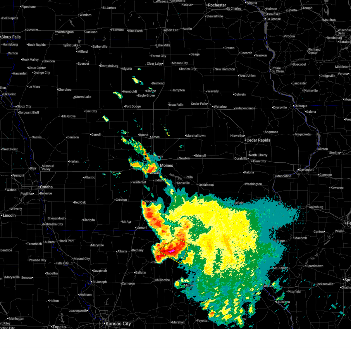
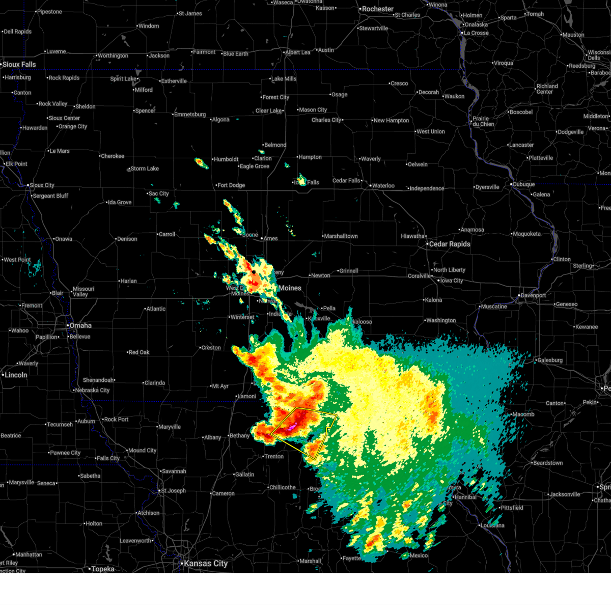
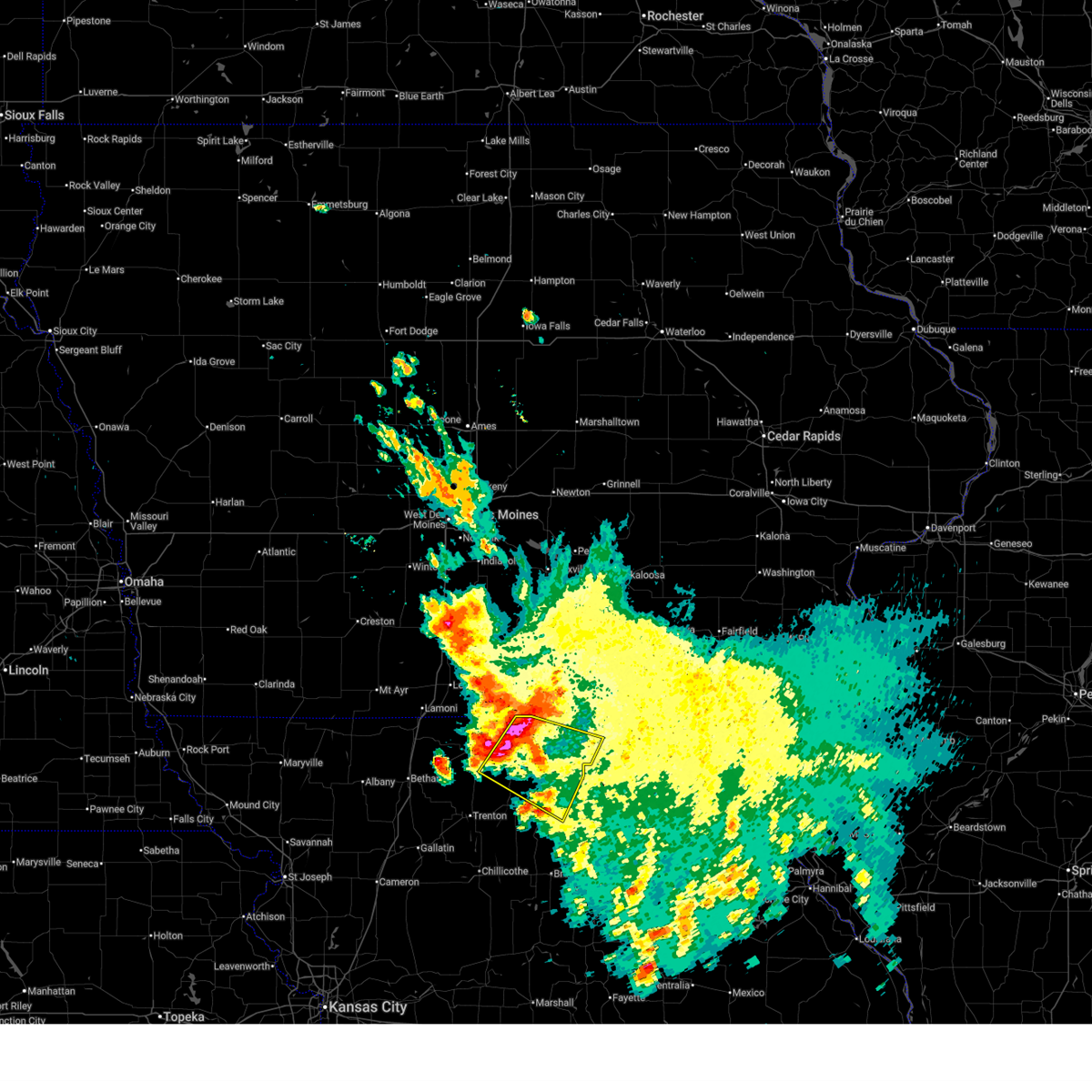
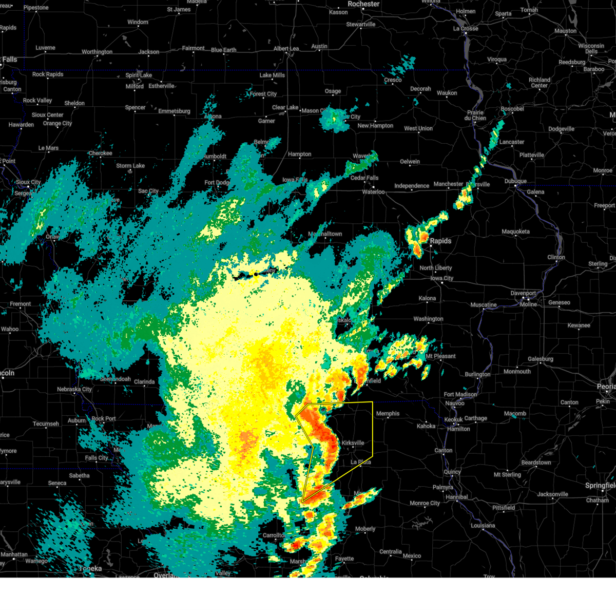
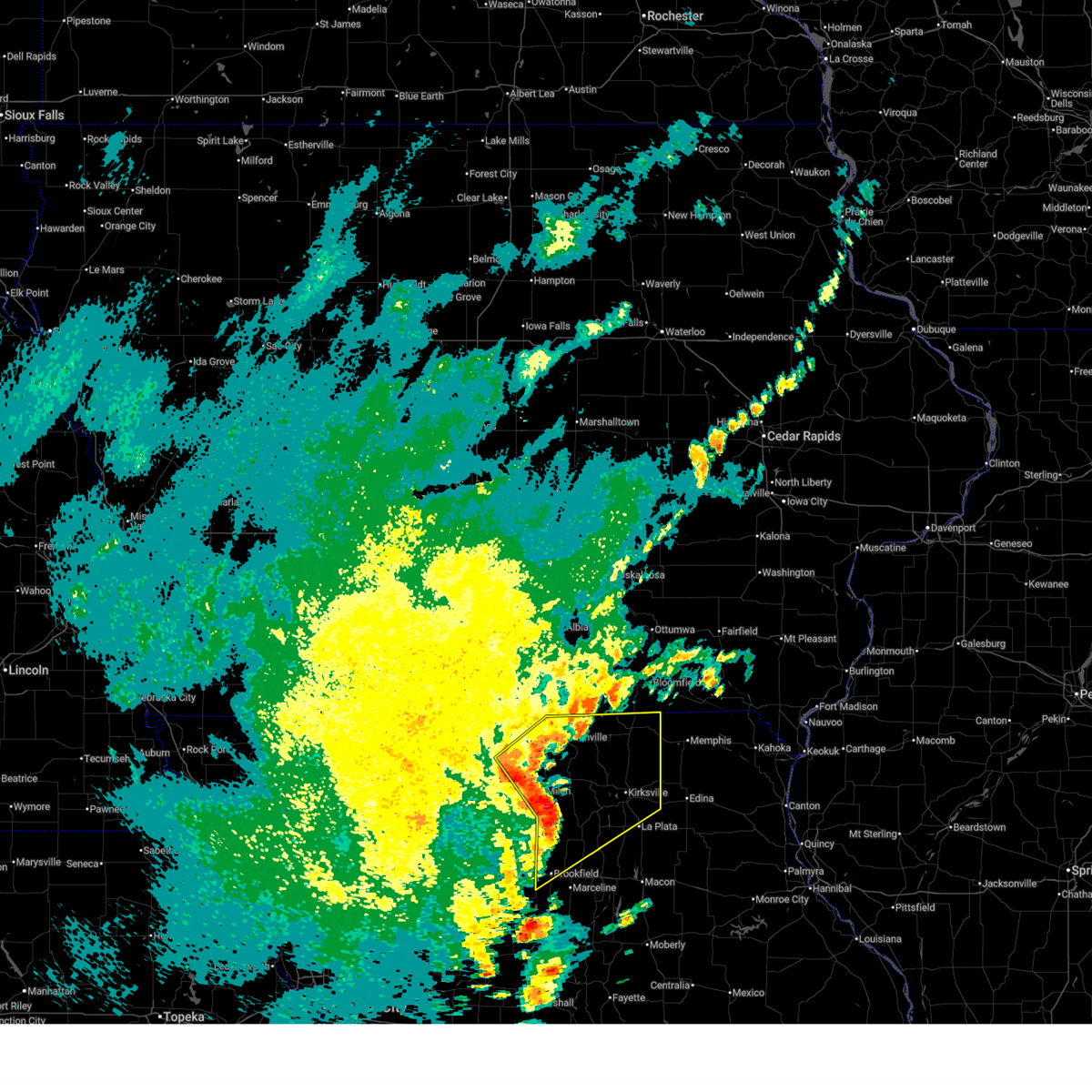
The Top Recent Hail Date for Greencastle, MO is Thursday, June 11, 2026 (4th out of 64)

Hail and Wind Damage Spotted near Greencastle, MO
| Date / Time | Report Details |
|---|---|
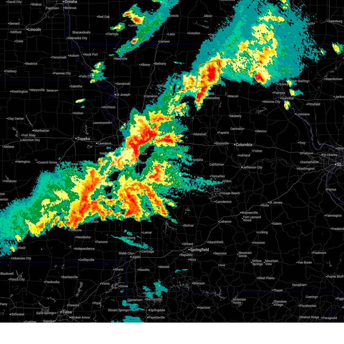
| 6/11/2026 3:06 PM CDT |
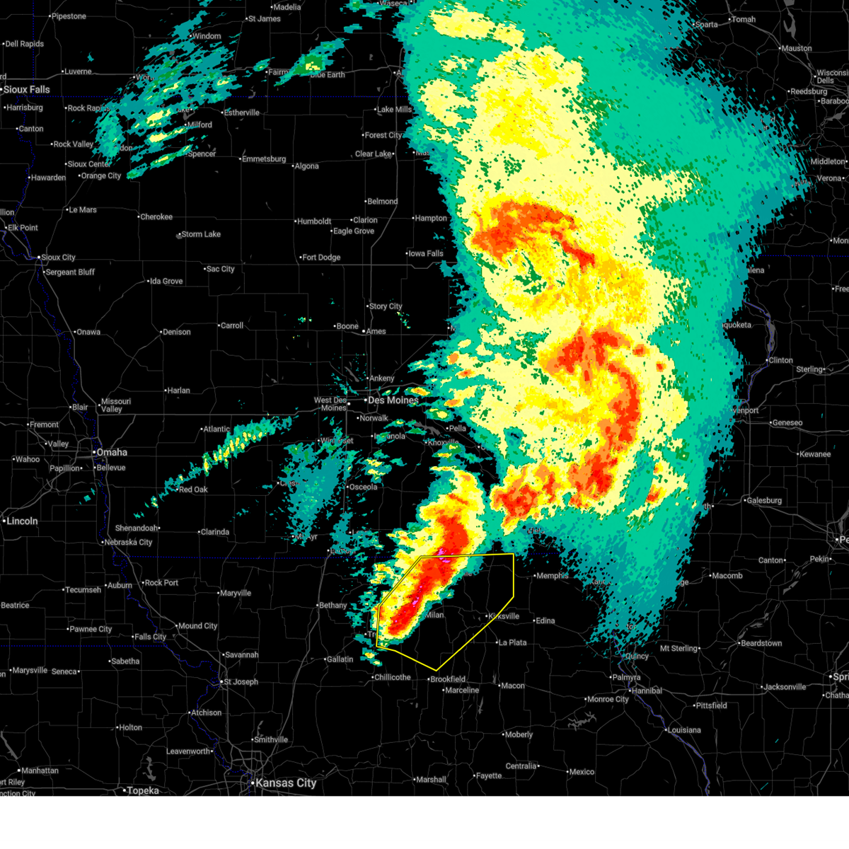
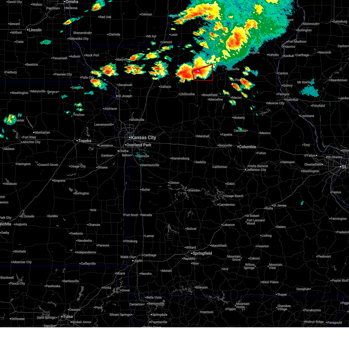
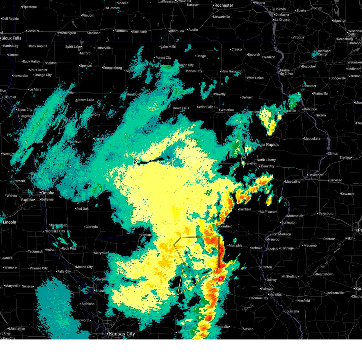
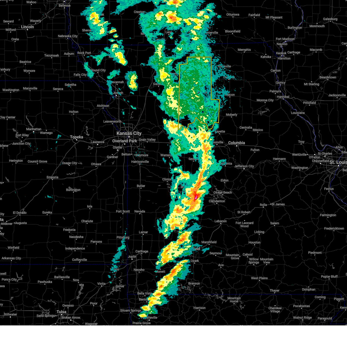
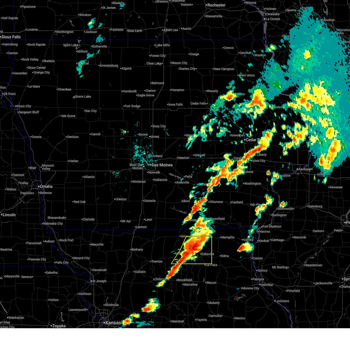 At 306 pm cdt, severe thunderstorms were located along a line extending from near queen city to near greencastle to 8 miles east of browning, moving east at 40 mph (radar indicated). Hazards include 60 mph wind gusts and quarter size hail. Hail damage to vehicles is expected. expect wind damage to roofs, siding, and trees. Locations impacted include, kirksville, green city, queen city, novinger, greentop, greencastle, brashear, gibbs, millard, worthington, kirksville regional, winigan, and green castle. At 306 pm cdt, severe thunderstorms were located along a line extending from near queen city to near greencastle to 8 miles east of browning, moving east at 40 mph (radar indicated). Hazards include 60 mph wind gusts and quarter size hail. Hail damage to vehicles is expected. expect wind damage to roofs, siding, and trees. Locations impacted include, kirksville, green city, queen city, novinger, greentop, greencastle, brashear, gibbs, millard, worthington, kirksville regional, winigan, and green castle.
|
| 6/11/2026 2:42 PM CDT |
 Svreax the national weather service in pleasant hill has issued a * severe thunderstorm warning for, adair county in northeastern missouri, sullivan county in north central missouri, southeastern putnam county in north central missouri, southern schuyler county in northeastern missouri, * until 345 pm cdt. * at 241 pm cdt, severe thunderstorms were located along a line extending from 6 miles southeast of unionville to near milan to near browning, moving east at 50 mph (radar indicated). Hazards include 60 mph wind gusts and quarter size hail. Hail damage to vehicles is expected. Expect wind damage to roofs, siding, and trees. Svreax the national weather service in pleasant hill has issued a * severe thunderstorm warning for, adair county in northeastern missouri, sullivan county in north central missouri, southeastern putnam county in north central missouri, southern schuyler county in northeastern missouri, * until 345 pm cdt. * at 241 pm cdt, severe thunderstorms were located along a line extending from 6 miles southeast of unionville to near milan to near browning, moving east at 50 mph (radar indicated). Hazards include 60 mph wind gusts and quarter size hail. Hail damage to vehicles is expected. Expect wind damage to roofs, siding, and trees.
|
| 6/11/2026 2:30 PM CDT |
 At 230 pm cdt, severe thunderstorms were located along a line extending from 6 miles southeast of centerville to near unionville to 16 miles northwest of green city, moving northeast at 55 mph (radar indicated). Hazards include 60 mph wind gusts and quarter size hail. Hail damage to vehicles is expected. expect wind damage to roofs, siding, and trees. Locations impacted include, milan, unionville, green city, greencastle, pollock, worthington, livonia, osgood, lemons, and green castle. At 230 pm cdt, severe thunderstorms were located along a line extending from 6 miles southeast of centerville to near unionville to 16 miles northwest of green city, moving northeast at 55 mph (radar indicated). Hazards include 60 mph wind gusts and quarter size hail. Hail damage to vehicles is expected. expect wind damage to roofs, siding, and trees. Locations impacted include, milan, unionville, green city, greencastle, pollock, worthington, livonia, osgood, lemons, and green castle.
|
| 6/11/2026 2:19 PM CDT |
 At 219 pm cdt, severe thunderstorms were located along a line extending from 7 miles south of centerville to near unionville to 15 miles northwest of milan, moving northeast at 55 mph (radar indicated). Hazards include 60 mph wind gusts and quarter size hail. Hail damage to vehicles is expected. expect wind damage to roofs, siding, and trees. Locations impacted include, milan, unionville, green city, greencastle, newtown, pollock, lucerne, worthington, livonia, harris, powersville, osgood, lemons, and green castle. At 219 pm cdt, severe thunderstorms were located along a line extending from 7 miles south of centerville to near unionville to 15 miles northwest of milan, moving northeast at 55 mph (radar indicated). Hazards include 60 mph wind gusts and quarter size hail. Hail damage to vehicles is expected. expect wind damage to roofs, siding, and trees. Locations impacted include, milan, unionville, green city, greencastle, newtown, pollock, lucerne, worthington, livonia, harris, powersville, osgood, lemons, and green castle.
|
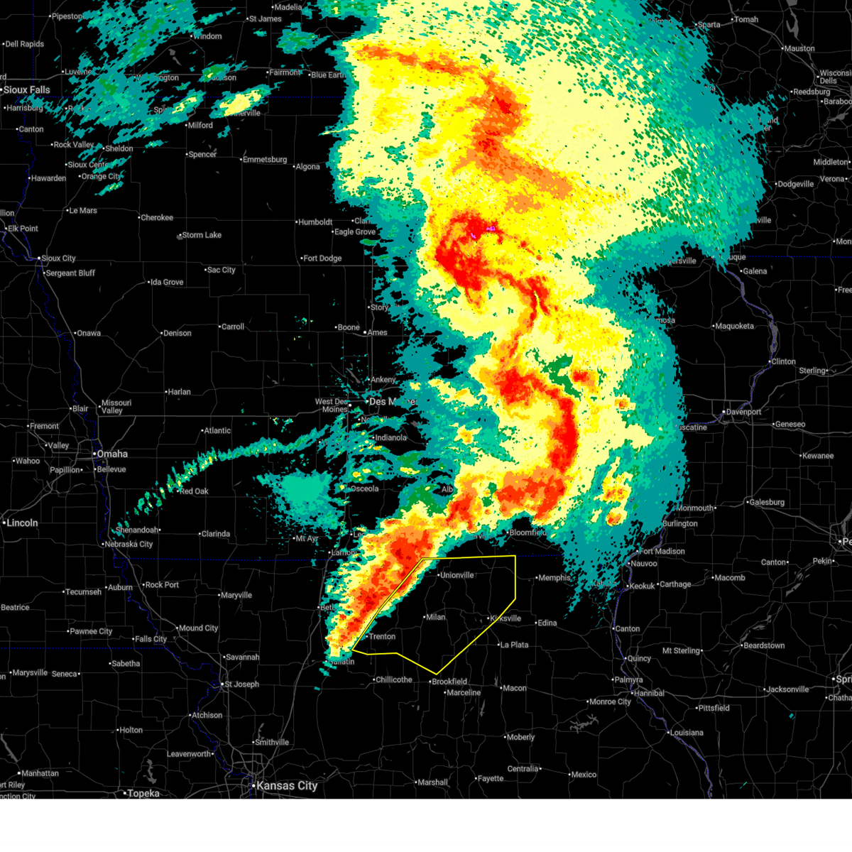
| 6/11/2026 1:52 PM CDT |
 Svreax the national weather service in pleasant hill has issued a * severe thunderstorm warning for, northern grundy county in north central missouri, sullivan county in north central missouri, southeastern mercer county in north central missouri, putnam county in north central missouri, southwestern schuyler county in northeastern missouri, * until 245 pm cdt. * at 151 pm cdt, severe thunderstorms were located along a line extending from 13 miles east of mercer to 7 miles southeast of princeton to near spickard, moving northeast at 50 mph (radar indicated). Hazards include 60 mph wind gusts and quarter size hail. Hail damage to vehicles is expected. Expect wind damage to roofs, siding, and trees. Svreax the national weather service in pleasant hill has issued a * severe thunderstorm warning for, northern grundy county in north central missouri, sullivan county in north central missouri, southeastern mercer county in north central missouri, putnam county in north central missouri, southwestern schuyler county in northeastern missouri, * until 245 pm cdt. * at 151 pm cdt, severe thunderstorms were located along a line extending from 13 miles east of mercer to 7 miles southeast of princeton to near spickard, moving northeast at 50 mph (radar indicated). Hazards include 60 mph wind gusts and quarter size hail. Hail damage to vehicles is expected. Expect wind damage to roofs, siding, and trees.
|
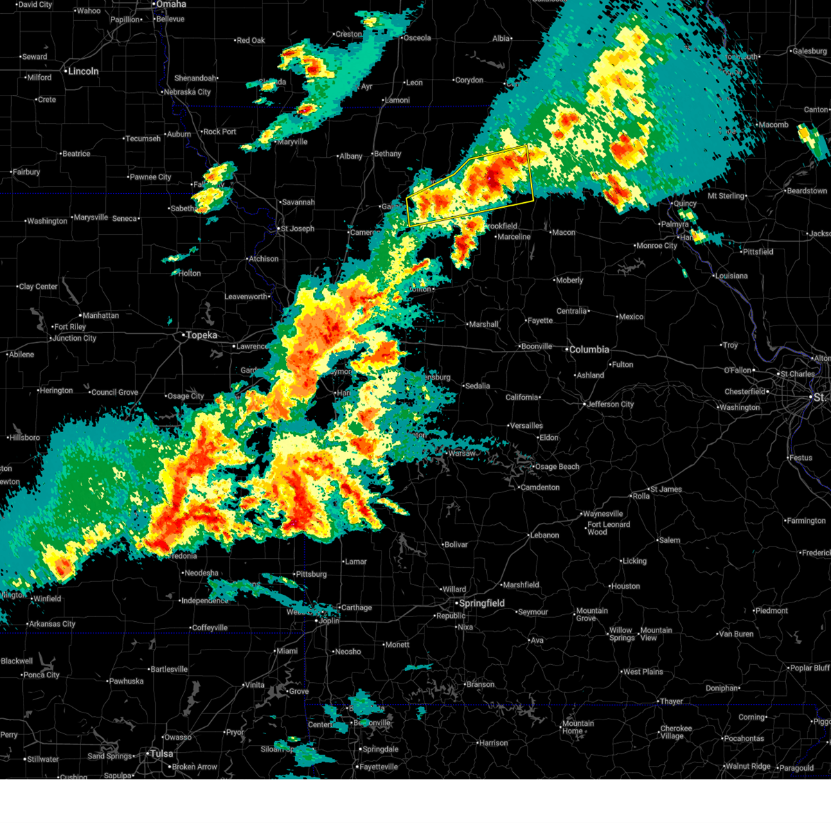
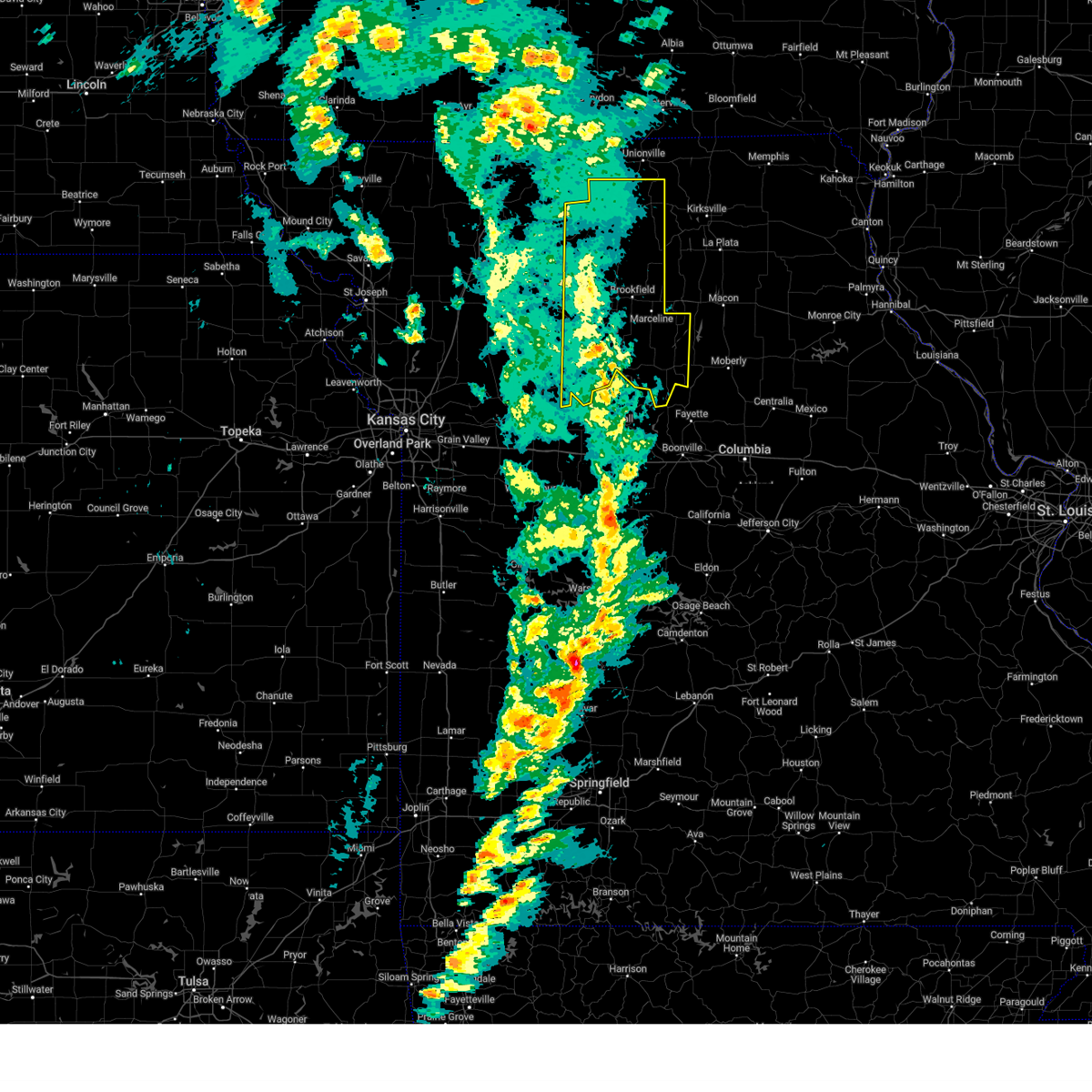
| 6/11/2026 9:56 AM CDT |
 Svreax the national weather service in pleasant hill has issued a * severe thunderstorm warning for, adair county in northeastern missouri, northeastern linn county in north central missouri, southeastern sullivan county in north central missouri, eastern putnam county in north central missouri, schuyler county in northeastern missouri, northern macon county in north central missouri, * until 1100 am cdt. * at 955 am cdt, severe thunderstorms were located along a line extending from near downing to near greentop to 12 miles east of browning, moving east at 50 mph (radar indicated). Hazards include 70 mph wind gusts and ping pong ball size hail. People and animals outdoors will be injured. expect hail damage to roofs, siding, windows, and vehicles. expect considerable tree damage. Wind damage is also likely to mobile homes, roofs, and outbuildings. Svreax the national weather service in pleasant hill has issued a * severe thunderstorm warning for, adair county in northeastern missouri, northeastern linn county in north central missouri, southeastern sullivan county in north central missouri, eastern putnam county in north central missouri, schuyler county in northeastern missouri, northern macon county in north central missouri, * until 1100 am cdt. * at 955 am cdt, severe thunderstorms were located along a line extending from near downing to near greentop to 12 miles east of browning, moving east at 50 mph (radar indicated). Hazards include 70 mph wind gusts and ping pong ball size hail. People and animals outdoors will be injured. expect hail damage to roofs, siding, windows, and vehicles. expect considerable tree damage. Wind damage is also likely to mobile homes, roofs, and outbuildings.
|
| 6/11/2026 9:50 AM CDT |
 At 950 am cdt, severe thunderstorms were located along a line extending from near downing to novinger to 11 miles east of browning, moving east at 45 mph (radar indicated). Hazards include 70 mph wind gusts and ping pong ball size hail. People and animals outdoors will be injured. expect hail damage to roofs, siding, windows, and vehicles. expect considerable tree damage. wind damage is also likely to mobile homes, roofs, and outbuildings. Locations impacted include, kirksville, lancaster, green city, queen city, novinger, greentop, downing, greencastle, glenwood, worthington, livonia, winigan, and green castle. At 950 am cdt, severe thunderstorms were located along a line extending from near downing to novinger to 11 miles east of browning, moving east at 45 mph (radar indicated). Hazards include 70 mph wind gusts and ping pong ball size hail. People and animals outdoors will be injured. expect hail damage to roofs, siding, windows, and vehicles. expect considerable tree damage. wind damage is also likely to mobile homes, roofs, and outbuildings. Locations impacted include, kirksville, lancaster, green city, queen city, novinger, greentop, downing, greencastle, glenwood, worthington, livonia, winigan, and green castle.
|
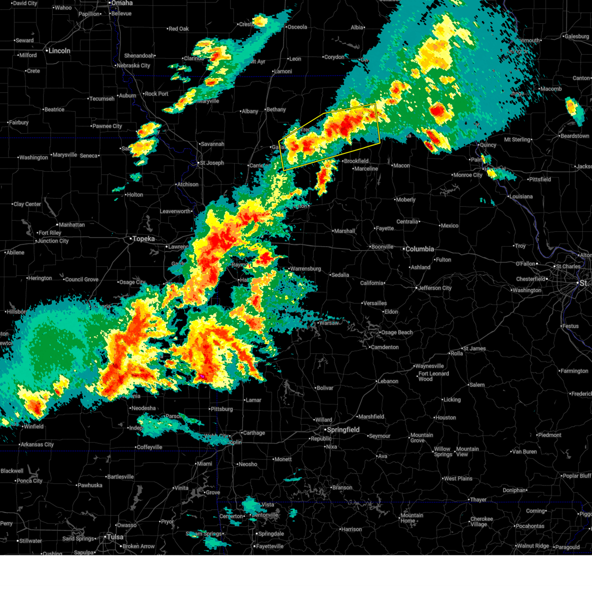
| 6/11/2026 9:39 AM CDT |
 At 939 am cdt, severe thunderstorms were located along a line extending from near lancaster to near greencastle to near browning, moving east at 45 mph (radar indicated). Hazards include 70 mph wind gusts and ping pong ball size hail. People and animals outdoors will be injured. expect hail damage to roofs, siding, windows, and vehicles. expect considerable tree damage. wind damage is also likely to mobile homes, roofs, and outbuildings. Locations impacted include, kirksville, milan, unionville, lancaster, green city, queen city, novinger, greentop, downing, greencastle, browning, glenwood, purdin, pollock, worthington, livonia, new boston, winigan, lemons, and reger. At 939 am cdt, severe thunderstorms were located along a line extending from near lancaster to near greencastle to near browning, moving east at 45 mph (radar indicated). Hazards include 70 mph wind gusts and ping pong ball size hail. People and animals outdoors will be injured. expect hail damage to roofs, siding, windows, and vehicles. expect considerable tree damage. wind damage is also likely to mobile homes, roofs, and outbuildings. Locations impacted include, kirksville, milan, unionville, lancaster, green city, queen city, novinger, greentop, downing, greencastle, browning, glenwood, purdin, pollock, worthington, livonia, new boston, winigan, lemons, and reger.
|
| 6/11/2026 9:25 AM CDT |
 At 925 am cdt, severe thunderstorms were located along a line extending from 11 miles west of lancaster to near milan to near galt, moving east at 45 mph (radar indicated). Hazards include 70 mph wind gusts and ping pong ball size hail. People and animals outdoors will be injured. expect hail damage to roofs, siding, windows, and vehicles. expect considerable tree damage. wind damage is also likely to mobile homes, roofs, and outbuildings. Locations impacted include, kirksville, milan, unionville, lancaster, green city, queen city, novinger, greentop, downing, greencastle, browning, galt, laredo, glenwood, purdin, newtown, humphreys, pollock, worthington, and livonia. At 925 am cdt, severe thunderstorms were located along a line extending from 11 miles west of lancaster to near milan to near galt, moving east at 45 mph (radar indicated). Hazards include 70 mph wind gusts and ping pong ball size hail. People and animals outdoors will be injured. expect hail damage to roofs, siding, windows, and vehicles. expect considerable tree damage. wind damage is also likely to mobile homes, roofs, and outbuildings. Locations impacted include, kirksville, milan, unionville, lancaster, green city, queen city, novinger, greentop, downing, greencastle, browning, galt, laredo, glenwood, purdin, newtown, humphreys, pollock, worthington, and livonia.
|
| 6/11/2026 9:06 AM CDT |
 Svreax the national weather service in pleasant hill has issued a * severe thunderstorm warning for, adair county in northeastern missouri, northern linn county in north central missouri, grundy county in north central missouri, sullivan county in north central missouri, southeastern mercer county in north central missouri, putnam county in north central missouri, schuyler county in northeastern missouri, northwestern macon county in north central missouri, * until 1000 am cdt. * at 905 am cdt, severe thunderstorms were located along a line extending from 6 miles northeast of unionville to 9 miles northeast of galt to near trenton, moving east at 40 mph (radar indicated). Hazards include 70 mph wind gusts and ping pong ball size hail. People and animals outdoors will be injured. expect hail damage to roofs, siding, windows, and vehicles. expect considerable tree damage. Wind damage is also likely to mobile homes, roofs, and outbuildings. Svreax the national weather service in pleasant hill has issued a * severe thunderstorm warning for, adair county in northeastern missouri, northern linn county in north central missouri, grundy county in north central missouri, sullivan county in north central missouri, southeastern mercer county in north central missouri, putnam county in north central missouri, schuyler county in northeastern missouri, northwestern macon county in north central missouri, * until 1000 am cdt. * at 905 am cdt, severe thunderstorms were located along a line extending from 6 miles northeast of unionville to 9 miles northeast of galt to near trenton, moving east at 40 mph (radar indicated). Hazards include 70 mph wind gusts and ping pong ball size hail. People and animals outdoors will be injured. expect hail damage to roofs, siding, windows, and vehicles. expect considerable tree damage. Wind damage is also likely to mobile homes, roofs, and outbuildings.
|
| 6/10/2026 7:29 PM CDT |
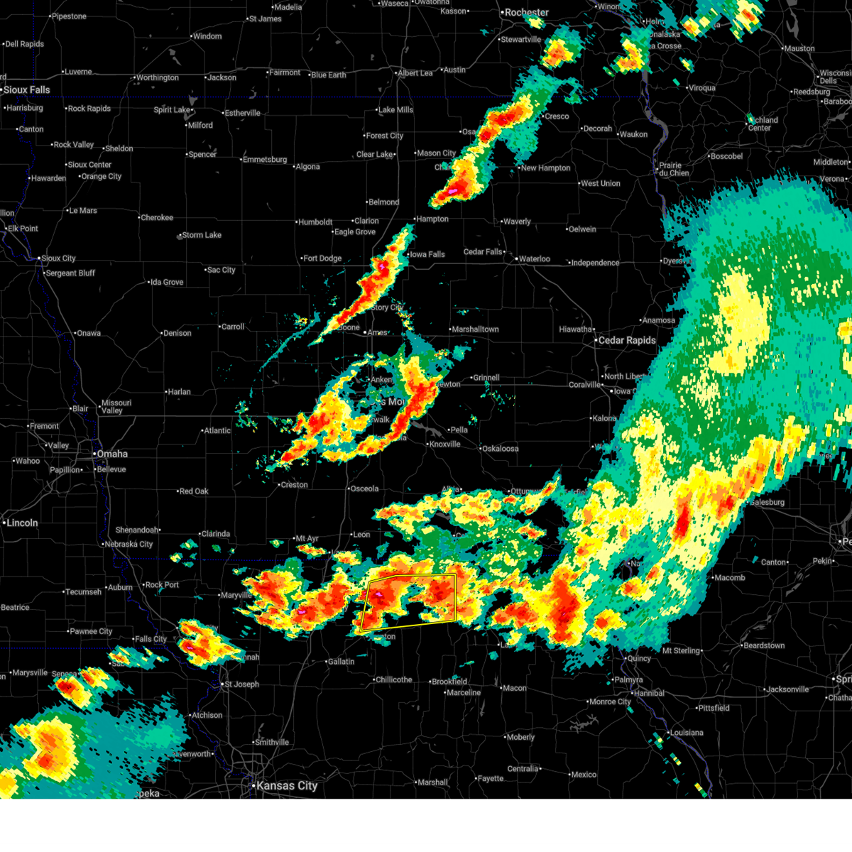 Svreax the national weather service in pleasant hill has issued a * severe thunderstorm warning for, northeastern grundy county in north central missouri, sullivan county in north central missouri, southeastern mercer county in north central missouri, southwestern putnam county in north central missouri, * until 815 pm cdt. * at 729 pm cdt, a severe thunderstorm was located 8 miles east of spickard, or 15 miles northeast of trenton, moving east at 40 mph (radar indicated). Hazards include 70 mph wind gusts and half dollar size hail. Hail damage to vehicles is expected. expect considerable tree damage. Wind damage is also likely to mobile homes, roofs, and outbuildings. Svreax the national weather service in pleasant hill has issued a * severe thunderstorm warning for, northeastern grundy county in north central missouri, sullivan county in north central missouri, southeastern mercer county in north central missouri, southwestern putnam county in north central missouri, * until 815 pm cdt. * at 729 pm cdt, a severe thunderstorm was located 8 miles east of spickard, or 15 miles northeast of trenton, moving east at 40 mph (radar indicated). Hazards include 70 mph wind gusts and half dollar size hail. Hail damage to vehicles is expected. expect considerable tree damage. Wind damage is also likely to mobile homes, roofs, and outbuildings.
|
| 6/10/2026 7:20 PM CDT |
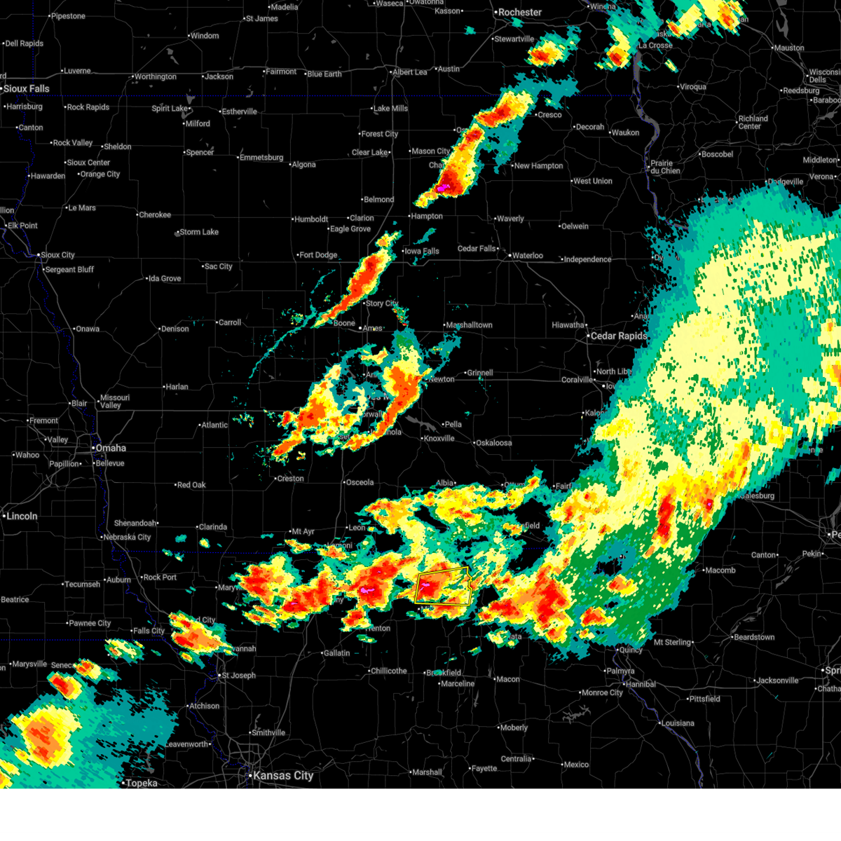 At 720 pm cdt, a severe thunderstorm was located near green city, or 10 miles south of unionville, moving east at 40 mph (radar indicated). Hazards include ping pong ball size hail and 60 mph wind gusts. People and animals outdoors will be injured. expect hail damage to roofs, siding, windows, and vehicles. expect wind damage to roofs, siding, and trees. Locations impacted include, green city, novinger, greencastle, pollock, worthington, lemons, and green castle. At 720 pm cdt, a severe thunderstorm was located near green city, or 10 miles south of unionville, moving east at 40 mph (radar indicated). Hazards include ping pong ball size hail and 60 mph wind gusts. People and animals outdoors will be injured. expect hail damage to roofs, siding, windows, and vehicles. expect wind damage to roofs, siding, and trees. Locations impacted include, green city, novinger, greencastle, pollock, worthington, lemons, and green castle.
|
| 6/10/2026 7:07 PM CDT |
 Svreax the national weather service in pleasant hill has issued a * severe thunderstorm warning for, northwestern adair county in northeastern missouri, northern sullivan county in north central missouri, southern putnam county in north central missouri, * until 800 pm cdt. * at 707 pm cdt, a severe thunderstorm was located 7 miles north of milan, moving east at 40 mph (radar indicated). Hazards include ping pong ball size hail and 60 mph wind gusts. People and animals outdoors will be injured. expect hail damage to roofs, siding, windows, and vehicles. Expect wind damage to roofs, siding, and trees. Svreax the national weather service in pleasant hill has issued a * severe thunderstorm warning for, northwestern adair county in northeastern missouri, northern sullivan county in north central missouri, southern putnam county in north central missouri, * until 800 pm cdt. * at 707 pm cdt, a severe thunderstorm was located 7 miles north of milan, moving east at 40 mph (radar indicated). Hazards include ping pong ball size hail and 60 mph wind gusts. People and animals outdoors will be injured. expect hail damage to roofs, siding, windows, and vehicles. Expect wind damage to roofs, siding, and trees.
|
| 6/10/2026 6:10 PM CDT |
 Svreax the national weather service in pleasant hill has issued a * severe thunderstorm warning for, western adair county in northeastern missouri, northeastern linn county in north central missouri, southeastern sullivan county in north central missouri, northwestern macon county in north central missouri, * until 700 pm cdt. * at 610 pm cdt, a severe thunderstorm was located 8 miles east of browning, or 11 miles southeast of milan, moving east at 40 mph (radar indicated). Hazards include 70 mph wind gusts and ping pong ball size hail. People and animals outdoors will be injured. expect hail damage to roofs, siding, windows, and vehicles. expect considerable tree damage. Wind damage is also likely to mobile homes, roofs, and outbuildings. Svreax the national weather service in pleasant hill has issued a * severe thunderstorm warning for, western adair county in northeastern missouri, northeastern linn county in north central missouri, southeastern sullivan county in north central missouri, northwestern macon county in north central missouri, * until 700 pm cdt. * at 610 pm cdt, a severe thunderstorm was located 8 miles east of browning, or 11 miles southeast of milan, moving east at 40 mph (radar indicated). Hazards include 70 mph wind gusts and ping pong ball size hail. People and animals outdoors will be injured. expect hail damage to roofs, siding, windows, and vehicles. expect considerable tree damage. Wind damage is also likely to mobile homes, roofs, and outbuildings.
|
| 6/10/2026 6:01 PM CDT |
 At 601 pm cdt, a severe thunderstorm was located near browning, or near milan, moving east at 40 mph (radar indicated). Hazards include 70 mph wind gusts and ping pong ball size hail. People and animals outdoors will be injured. expect hail damage to roofs, siding, windows, and vehicles. expect considerable tree damage. wind damage is also likely to mobile homes, roofs, and outbuildings. Locations impacted include, milan, green city, greencastle, reger, and green castle. At 601 pm cdt, a severe thunderstorm was located near browning, or near milan, moving east at 40 mph (radar indicated). Hazards include 70 mph wind gusts and ping pong ball size hail. People and animals outdoors will be injured. expect hail damage to roofs, siding, windows, and vehicles. expect considerable tree damage. wind damage is also likely to mobile homes, roofs, and outbuildings. Locations impacted include, milan, green city, greencastle, reger, and green castle.
|
| 6/10/2026 5:58 PM CDT |
 At 558 pm cdt, a severe thunderstorm capable of producing a tornado was located 9 miles southeast of milan, moving east at 30 mph (radar indicated rotation). Hazards include tornado and golf ball size hail. Flying debris will be dangerous to those caught without shelter. mobile homes will be damaged or destroyed. damage to roofs, windows, and vehicles will occur. tree damage is likely. Locations impacted include, greencastle, green castle, and winigan. At 558 pm cdt, a severe thunderstorm capable of producing a tornado was located 9 miles southeast of milan, moving east at 30 mph (radar indicated rotation). Hazards include tornado and golf ball size hail. Flying debris will be dangerous to those caught without shelter. mobile homes will be damaged or destroyed. damage to roofs, windows, and vehicles will occur. tree damage is likely. Locations impacted include, greencastle, green castle, and winigan.
|
| 6/10/2026 5:40 PM CDT |
 Toreax the national weather service in pleasant hill has issued a * tornado warning for, northeastern linn county in north central missouri, southern sullivan county in north central missouri, * until 630 pm cdt. * at 539 pm cdt, a severe thunderstorm capable of producing a tornado was located near browning, or 9 miles southwest of milan, moving east at 30 mph (radar indicated rotation). Hazards include tornado and golf ball size hail. Flying debris will be dangerous to those caught without shelter. mobile homes will be damaged or destroyed. damage to roofs, windows, and vehicles will occur. Tree damage is likely. Toreax the national weather service in pleasant hill has issued a * tornado warning for, northeastern linn county in north central missouri, southern sullivan county in north central missouri, * until 630 pm cdt. * at 539 pm cdt, a severe thunderstorm capable of producing a tornado was located near browning, or 9 miles southwest of milan, moving east at 30 mph (radar indicated rotation). Hazards include tornado and golf ball size hail. Flying debris will be dangerous to those caught without shelter. mobile homes will be damaged or destroyed. damage to roofs, windows, and vehicles will occur. Tree damage is likely.
|
| 6/10/2026 5:32 PM CDT |
 Svreax the national weather service in pleasant hill has issued a * severe thunderstorm warning for, western adair county in northeastern missouri, central sullivan county in north central missouri, * until 615 pm cdt. * at 532 pm cdt, a severe thunderstorm was located near milan, moving east at 40 mph (radar indicated). Hazards include golf ball size hail and 60 mph wind gusts. People and animals outdoors will be injured. expect hail damage to roofs, siding, windows, and vehicles. Expect wind damage to roofs, siding, and trees. Svreax the national weather service in pleasant hill has issued a * severe thunderstorm warning for, western adair county in northeastern missouri, central sullivan county in north central missouri, * until 615 pm cdt. * at 532 pm cdt, a severe thunderstorm was located near milan, moving east at 40 mph (radar indicated). Hazards include golf ball size hail and 60 mph wind gusts. People and animals outdoors will be injured. expect hail damage to roofs, siding, windows, and vehicles. Expect wind damage to roofs, siding, and trees.
|
| 5/16/2026 11:44 PM CDT |
 the severe thunderstorm warning has been cancelled and is no longer in effect the severe thunderstorm warning has been cancelled and is no longer in effect
|
| 5/16/2026 11:25 PM CDT |
 Svreax the national weather service in pleasant hill has issued a * severe thunderstorm warning for, northern adair county in northeastern missouri, northeastern sullivan county in north central missouri, eastern putnam county in north central missouri, schuyler county in northeastern missouri, * until 1230 am cdt. * at 1125 pm cdt, severe thunderstorms were located along a line extending from 9 miles northeast of unionville to 8 miles west of queen city to near novinger, moving east at 30 mph (radar indicated). Hazards include 60 mph wind gusts and quarter size hail. Hail damage to vehicles is expected. Expect wind damage to roofs, siding, and trees. Svreax the national weather service in pleasant hill has issued a * severe thunderstorm warning for, northern adair county in northeastern missouri, northeastern sullivan county in north central missouri, eastern putnam county in north central missouri, schuyler county in northeastern missouri, * until 1230 am cdt. * at 1125 pm cdt, severe thunderstorms were located along a line extending from 9 miles northeast of unionville to 8 miles west of queen city to near novinger, moving east at 30 mph (radar indicated). Hazards include 60 mph wind gusts and quarter size hail. Hail damage to vehicles is expected. Expect wind damage to roofs, siding, and trees.
|
| 4/27/2026 5:25 AM CDT |
 Svreax the national weather service in pleasant hill has issued a * severe thunderstorm warning for, southwestern adair county in northeastern missouri, northern chariton county in north central missouri, linn county in north central missouri, grundy county in north central missouri, sullivan county in north central missouri, southeastern mercer county in north central missouri, southwestern putnam county in north central missouri, north central carroll county in north central missouri, western macon county in north central missouri, eastern livingston county in north central missouri, * until 615 am cdt. * at 525 am cdt, severe thunderstorms were located along a line extending from near galt to near laclede to bosworth, moving northeast at 45 mph (radar indicated). Hazards include 60 mph wind gusts and quarter size hail. Hail damage to vehicles is expected. Expect wind damage to roofs, siding, and trees. Svreax the national weather service in pleasant hill has issued a * severe thunderstorm warning for, southwestern adair county in northeastern missouri, northern chariton county in north central missouri, linn county in north central missouri, grundy county in north central missouri, sullivan county in north central missouri, southeastern mercer county in north central missouri, southwestern putnam county in north central missouri, north central carroll county in north central missouri, western macon county in north central missouri, eastern livingston county in north central missouri, * until 615 am cdt. * at 525 am cdt, severe thunderstorms were located along a line extending from near galt to near laclede to bosworth, moving northeast at 45 mph (radar indicated). Hazards include 60 mph wind gusts and quarter size hail. Hail damage to vehicles is expected. Expect wind damage to roofs, siding, and trees.
|
| 4/17/2026 5:33 PM CDT |
 At 532 pm cdt, a severe thunderstorm was located 9 miles southwest of novinger, or 12 miles southwest of kirksville, moving northeast at 45 mph (radar indicated). Hazards include 60 mph wind gusts and quarter size hail. Hail damage to vehicles is expected. expect wind damage to roofs, siding, and trees. Locations impacted include, green city, novinger, greencastle, elmer, south gifford, green castle, new boston, and winigan. At 532 pm cdt, a severe thunderstorm was located 9 miles southwest of novinger, or 12 miles southwest of kirksville, moving northeast at 45 mph (radar indicated). Hazards include 60 mph wind gusts and quarter size hail. Hail damage to vehicles is expected. expect wind damage to roofs, siding, and trees. Locations impacted include, green city, novinger, greencastle, elmer, south gifford, green castle, new boston, and winigan.
|
| 4/17/2026 5:22 PM CDT |
 At 521 pm cdt, a severe thunderstorm was located 10 miles south of green city, or 10 miles southeast of milan, moving east at 30 mph (radar indicated). Hazards include 60 mph wind gusts and quarter size hail. Hail damage to vehicles is expected. expect wind damage to roofs, siding, and trees. Locations impacted include, chillicothe, milan, green city, novinger, linneus, greencastle, browning, chula, laredo, purdin, humphreys, elmer, south gifford, spring hill, new boston, winigan, reger, and green castle. At 521 pm cdt, a severe thunderstorm was located 10 miles south of green city, or 10 miles southeast of milan, moving east at 30 mph (radar indicated). Hazards include 60 mph wind gusts and quarter size hail. Hail damage to vehicles is expected. expect wind damage to roofs, siding, and trees. Locations impacted include, chillicothe, milan, green city, novinger, linneus, greencastle, browning, chula, laredo, purdin, humphreys, elmer, south gifford, spring hill, new boston, winigan, reger, and green castle.
|
| 4/17/2026 5:12 PM CDT |
 At 512 pm cdt, severe thunderstorms were located along a line extending from 7 miles southeast of milan to 7 miles north of chillicothe, moving east at 40 mph (radar indicated). Hazards include 60 mph wind gusts and quarter size hail. Hail damage to vehicles is expected. expect wind damage to roofs, siding, and trees. Locations impacted include, chillicothe, trenton, milan, green city, jamesport, novinger, breckenridge, linneus, greencastle, wheeling, utica, browning, galt, chula, laredo, purdin, humphreys, mooresville, elmer, and lock springs. At 512 pm cdt, severe thunderstorms were located along a line extending from 7 miles southeast of milan to 7 miles north of chillicothe, moving east at 40 mph (radar indicated). Hazards include 60 mph wind gusts and quarter size hail. Hail damage to vehicles is expected. expect wind damage to roofs, siding, and trees. Locations impacted include, chillicothe, trenton, milan, green city, jamesport, novinger, breckenridge, linneus, greencastle, wheeling, utica, browning, galt, chula, laredo, purdin, humphreys, mooresville, elmer, and lock springs.
|
| 4/17/2026 4:53 PM CDT |
 Svreax the national weather service in pleasant hill has issued a * severe thunderstorm warning for, western adair county in northeastern missouri, southeastern daviess county in north central missouri, northern linn county in north central missouri, southern grundy county in north central missouri, sullivan county in north central missouri, northeastern caldwell county in north central missouri, northwestern macon county in north central missouri, northern livingston county in north central missouri, * until 545 pm cdt. * at 452 pm cdt, severe thunderstorms were located along a line extending from 8 miles south of greencastle to 6 miles north of breckenridge, moving northeast at 50 mph (radar indicated). Hazards include 60 mph wind gusts and quarter size hail. Hail damage to vehicles is expected. Expect wind damage to roofs, siding, and trees. Svreax the national weather service in pleasant hill has issued a * severe thunderstorm warning for, western adair county in northeastern missouri, southeastern daviess county in north central missouri, northern linn county in north central missouri, southern grundy county in north central missouri, sullivan county in north central missouri, northeastern caldwell county in north central missouri, northwestern macon county in north central missouri, northern livingston county in north central missouri, * until 545 pm cdt. * at 452 pm cdt, severe thunderstorms were located along a line extending from 8 miles south of greencastle to 6 miles north of breckenridge, moving northeast at 50 mph (radar indicated). Hazards include 60 mph wind gusts and quarter size hail. Hail damage to vehicles is expected. Expect wind damage to roofs, siding, and trees.
|
| 4/17/2026 4:41 PM CDT |
 At 440 pm cdt, a severe thunderstorm was located 11 miles northwest of queen city, or 11 miles west of lancaster, moving northeast at 40 mph (radar indicated). Hazards include 60 mph wind gusts and quarter size hail. Hail damage to vehicles is expected. expect wind damage to roofs, siding, and trees. Locations impacted include, milan, unionville, lancaster, green city, greencastle, glenwood, pollock, worthington, livonia, lemons, and green castle. At 440 pm cdt, a severe thunderstorm was located 11 miles northwest of queen city, or 11 miles west of lancaster, moving northeast at 40 mph (radar indicated). Hazards include 60 mph wind gusts and quarter size hail. Hail damage to vehicles is expected. expect wind damage to roofs, siding, and trees. Locations impacted include, milan, unionville, lancaster, green city, greencastle, glenwood, pollock, worthington, livonia, lemons, and green castle.
|
| 4/17/2026 4:24 PM CDT |
 Toreax the national weather service in pleasant hill has issued a * tornado warning for, southwestern adair county in northeastern missouri, northern linn county in north central missouri, southeastern sullivan county in north central missouri, northwestern macon county in north central missouri, * until 515 pm cdt. * at 423 pm cdt, a severe thunderstorm capable of producing a tornado was located near linneus, or 12 miles northwest of brookfield, moving northeast at 40 mph (weather spotters reported funnel cloud). Hazards include tornado. Flying debris will be dangerous to those caught without shelter. mobile homes will be damaged or destroyed. damage to roofs, windows, and vehicles will occur. Tree damage is likely. Toreax the national weather service in pleasant hill has issued a * tornado warning for, southwestern adair county in northeastern missouri, northern linn county in north central missouri, southeastern sullivan county in north central missouri, northwestern macon county in north central missouri, * until 515 pm cdt. * at 423 pm cdt, a severe thunderstorm capable of producing a tornado was located near linneus, or 12 miles northwest of brookfield, moving northeast at 40 mph (weather spotters reported funnel cloud). Hazards include tornado. Flying debris will be dangerous to those caught without shelter. mobile homes will be damaged or destroyed. damage to roofs, windows, and vehicles will occur. Tree damage is likely.
|
| 4/17/2026 4:08 PM CDT |
 Svreax the national weather service in pleasant hill has issued a * severe thunderstorm warning for, northwestern adair county in northeastern missouri, sullivan county in north central missouri, southeastern mercer county in north central missouri, putnam county in north central missouri, northwestern schuyler county in northeastern missouri, * until 500 pm cdt. * at 408 pm cdt, severe thunderstorms were located along a line extending from 14 miles northwest of milan to green city, moving northeast at 40 mph (radar indicated). Hazards include ping pong ball size hail and 60 mph wind gusts. People and animals outdoors will be injured. expect hail damage to roofs, siding, windows, and vehicles. Expect wind damage to roofs, siding, and trees. Svreax the national weather service in pleasant hill has issued a * severe thunderstorm warning for, northwestern adair county in northeastern missouri, sullivan county in north central missouri, southeastern mercer county in north central missouri, putnam county in north central missouri, northwestern schuyler county in northeastern missouri, * until 500 pm cdt. * at 408 pm cdt, severe thunderstorms were located along a line extending from 14 miles northwest of milan to green city, moving northeast at 40 mph (radar indicated). Hazards include ping pong ball size hail and 60 mph wind gusts. People and animals outdoors will be injured. expect hail damage to roofs, siding, windows, and vehicles. Expect wind damage to roofs, siding, and trees.
|
| 3/10/2026 8:12 PM CDT |
 At 811 pm cdt, a severe thunderstorm was located 11 miles east of browning, or 11 miles southeast of milan, moving northeast at 45 mph (trained weather spotters). Hazards include ping pong ball size hail and 60 mph wind gusts. People and animals outdoors will be injured. expect hail damage to roofs, siding, windows, and vehicles. expect wind damage to roofs, siding, and trees. Locations impacted include, greencastle, browning, purdin, south gifford, green castle, and winigan. At 811 pm cdt, a severe thunderstorm was located 11 miles east of browning, or 11 miles southeast of milan, moving northeast at 45 mph (trained weather spotters). Hazards include ping pong ball size hail and 60 mph wind gusts. People and animals outdoors will be injured. expect hail damage to roofs, siding, windows, and vehicles. expect wind damage to roofs, siding, and trees. Locations impacted include, greencastle, browning, purdin, south gifford, green castle, and winigan.
|
| 3/10/2026 8:11 PM CDT |
 Svreax the national weather service in pleasant hill has issued a * severe thunderstorm warning for, adair county in northeastern missouri, northeastern linn county in north central missouri, southeastern sullivan county in north central missouri, southeastern putnam county in north central missouri, schuyler county in northeastern missouri, northwestern macon county in north central missouri, * until 915 pm cdt. * at 811 pm cdt, a severe thunderstorm was located near greencastle, or 14 miles west of kirksville, moving northeast at 45 mph (trained weather spotters). Hazards include ping pong ball size hail and 60 mph wind gusts. People and animals outdoors will be injured. expect hail damage to roofs, siding, windows, and vehicles. Expect wind damage to roofs, siding, and trees. Svreax the national weather service in pleasant hill has issued a * severe thunderstorm warning for, adair county in northeastern missouri, northeastern linn county in north central missouri, southeastern sullivan county in north central missouri, southeastern putnam county in north central missouri, schuyler county in northeastern missouri, northwestern macon county in north central missouri, * until 915 pm cdt. * at 811 pm cdt, a severe thunderstorm was located near greencastle, or 14 miles west of kirksville, moving northeast at 45 mph (trained weather spotters). Hazards include ping pong ball size hail and 60 mph wind gusts. People and animals outdoors will be injured. expect hail damage to roofs, siding, windows, and vehicles. Expect wind damage to roofs, siding, and trees.
|
| 3/10/2026 8:08 PM CDT | Ping Pong Ball sized hail reported 4.6 miles SSW of Greencastle, MO |
| 3/10/2026 8:03 PM CDT |
 the severe thunderstorm warning has been cancelled and is no longer in effect the severe thunderstorm warning has been cancelled and is no longer in effect
|
| 3/10/2026 8:03 PM CDT |
 At 802 pm cdt, a severe thunderstorm was located near browning, or 11 miles south of milan, moving northeast at 45 mph (radar indicated). Hazards include 60 mph wind gusts and quarter size hail. Hail damage to vehicles is expected. expect wind damage to roofs, siding, and trees. Locations impacted include, green city, greencastle, browning, purdin, south gifford, green castle, and winigan. At 802 pm cdt, a severe thunderstorm was located near browning, or 11 miles south of milan, moving northeast at 45 mph (radar indicated). Hazards include 60 mph wind gusts and quarter size hail. Hail damage to vehicles is expected. expect wind damage to roofs, siding, and trees. Locations impacted include, green city, greencastle, browning, purdin, south gifford, green castle, and winigan.
|
| 3/10/2026 7:49 PM CDT |
 Svreax the national weather service in pleasant hill has issued a * severe thunderstorm warning for, southwestern adair county in northeastern missouri, northern linn county in north central missouri, southeastern grundy county in north central missouri, southeastern sullivan county in north central missouri, northwestern macon county in north central missouri, northeastern livingston county in north central missouri, * until 830 pm cdt. * at 749 pm cdt, a severe thunderstorm was located 7 miles southwest of browning, or 15 miles northwest of brookfield, moving northeast at 45 mph (radar indicated). Hazards include ping pong ball size hail and 60 mph wind gusts. People and animals outdoors will be injured. expect hail damage to roofs, siding, windows, and vehicles. Expect wind damage to roofs, siding, and trees. Svreax the national weather service in pleasant hill has issued a * severe thunderstorm warning for, southwestern adair county in northeastern missouri, northern linn county in north central missouri, southeastern grundy county in north central missouri, southeastern sullivan county in north central missouri, northwestern macon county in north central missouri, northeastern livingston county in north central missouri, * until 830 pm cdt. * at 749 pm cdt, a severe thunderstorm was located 7 miles southwest of browning, or 15 miles northwest of brookfield, moving northeast at 45 mph (radar indicated). Hazards include ping pong ball size hail and 60 mph wind gusts. People and animals outdoors will be injured. expect hail damage to roofs, siding, windows, and vehicles. Expect wind damage to roofs, siding, and trees.
|
| 8/7/2025 9:56 AM CDT |
 At 956 am cdt, a severe thunderstorm was located over milan, moving southeast at 35 mph (radar indicated). Hazards include 60 mph wind gusts and quarter size hail. Hail damage to vehicles is expected. expect wind damage to roofs, siding, and trees. Locations impacted include, milan, green city, greencastle, pollock, harris, lemons, reger, and green castle. At 956 am cdt, a severe thunderstorm was located over milan, moving southeast at 35 mph (radar indicated). Hazards include 60 mph wind gusts and quarter size hail. Hail damage to vehicles is expected. expect wind damage to roofs, siding, and trees. Locations impacted include, milan, green city, greencastle, pollock, harris, lemons, reger, and green castle.
|
| 8/7/2025 9:44 AM CDT |
 At 944 am cdt, a severe thunderstorm was located 7 miles northwest of milan, moving southeast at 30 mph (radar indicated). Hazards include 60 mph wind gusts and quarter size hail. Hail damage to vehicles is expected. expect wind damage to roofs, siding, and trees. Locations impacted include, milan, unionville, green city, greencastle, newtown, pollock, lucerne, harris, lemons, reger, and green castle. At 944 am cdt, a severe thunderstorm was located 7 miles northwest of milan, moving southeast at 30 mph (radar indicated). Hazards include 60 mph wind gusts and quarter size hail. Hail damage to vehicles is expected. expect wind damage to roofs, siding, and trees. Locations impacted include, milan, unionville, green city, greencastle, newtown, pollock, lucerne, harris, lemons, reger, and green castle.
|
| 8/7/2025 9:23 AM CDT |
 Svreax the national weather service in pleasant hill has issued a * severe thunderstorm warning for, northeastern grundy county in north central missouri, sullivan county in north central missouri, southeastern mercer county in north central missouri, putnam county in north central missouri, * until 1015 am cdt. * at 923 am cdt, a severe thunderstorm was located 13 miles southeast of mercer, or 16 miles west of unionville, moving southeast at 30 mph (radar indicated). Hazards include 60 mph wind gusts and quarter size hail. Hail damage to vehicles is expected. Expect wind damage to roofs, siding, and trees. Svreax the national weather service in pleasant hill has issued a * severe thunderstorm warning for, northeastern grundy county in north central missouri, sullivan county in north central missouri, southeastern mercer county in north central missouri, putnam county in north central missouri, * until 1015 am cdt. * at 923 am cdt, a severe thunderstorm was located 13 miles southeast of mercer, or 16 miles west of unionville, moving southeast at 30 mph (radar indicated). Hazards include 60 mph wind gusts and quarter size hail. Hail damage to vehicles is expected. Expect wind damage to roofs, siding, and trees.
|
| 6/3/2025 4:52 PM CDT |
 The storms which prompted the warning have moved out of the area. therefore, the warning will be allowed to expire. a tornado watch remains in effect until 800 pm cdt for north central and northeastern missouri. The storms which prompted the warning have moved out of the area. therefore, the warning will be allowed to expire. a tornado watch remains in effect until 800 pm cdt for north central and northeastern missouri.
|
| 6/3/2025 4:18 PM CDT |
 the severe thunderstorm warning has been cancelled and is no longer in effect the severe thunderstorm warning has been cancelled and is no longer in effect
|
| 6/3/2025 4:18 PM CDT |
 At 417 pm cdt, severe thunderstorms were located along a line extending from near unionville to near novinger to 9 miles north of bucklin, moving northeast at 60 mph (radar indicated). Hazards include 70 mph wind gusts and penny size hail. Expect considerable tree damage. damage is likely to mobile homes, roofs, and outbuildings. Locations impacted include, kirksville, brookfield, unionville, lancaster, green city, queen city, novinger, greentop, downing, greencastle, brashear, glenwood, gibbs, millard, pollock, worthington, elmer, livonia, south gifford, and new boston. At 417 pm cdt, severe thunderstorms were located along a line extending from near unionville to near novinger to 9 miles north of bucklin, moving northeast at 60 mph (radar indicated). Hazards include 70 mph wind gusts and penny size hail. Expect considerable tree damage. damage is likely to mobile homes, roofs, and outbuildings. Locations impacted include, kirksville, brookfield, unionville, lancaster, green city, queen city, novinger, greentop, downing, greencastle, brashear, glenwood, gibbs, millard, pollock, worthington, elmer, livonia, south gifford, and new boston.
|
| 6/3/2025 4:02 PM CDT |
 Svreax the national weather service in pleasant hill has issued a * severe thunderstorm warning for, adair county in northeastern missouri, northwestern chariton county in north central missouri, eastern linn county in north central missouri, sullivan county in north central missouri, east central mercer county in north central missouri, putnam county in north central missouri, schuyler county in northeastern missouri, northwestern macon county in north central missouri, * until 500 pm cdt. * at 401 pm cdt, severe thunderstorms were located along a line extending from 13 miles northwest of milan to 7 miles south of green city to brookfield, moving northeast at 60 mph (radar indicated). Hazards include 60 mph wind gusts and penny size hail. expect damage to roofs, siding, and trees Svreax the national weather service in pleasant hill has issued a * severe thunderstorm warning for, adair county in northeastern missouri, northwestern chariton county in north central missouri, eastern linn county in north central missouri, sullivan county in north central missouri, east central mercer county in north central missouri, putnam county in north central missouri, schuyler county in northeastern missouri, northwestern macon county in north central missouri, * until 500 pm cdt. * at 401 pm cdt, severe thunderstorms were located along a line extending from 13 miles northwest of milan to 7 miles south of green city to brookfield, moving northeast at 60 mph (radar indicated). Hazards include 60 mph wind gusts and penny size hail. expect damage to roofs, siding, and trees
|
| 3/14/2025 5:43 PM CDT |
 The storm which prompted the warning has weakened below severe limits, and has exited the warned area. therefore, the warning will be allowed to expire. however, non-thunderstorm wind gusts up to 60 mph are still expected. a tornado watch remains in effect until 1100 pm cdt for central and north central missouri. a severe thunderstorm watch remains in effect until 700 pm cdt for west central missouri. The storm which prompted the warning has weakened below severe limits, and has exited the warned area. therefore, the warning will be allowed to expire. however, non-thunderstorm wind gusts up to 60 mph are still expected. a tornado watch remains in effect until 1100 pm cdt for central and north central missouri. a severe thunderstorm watch remains in effect until 700 pm cdt for west central missouri.
|
| 3/14/2025 5:19 PM CDT |
 At 518 pm cdt, showers with embedded thunderstorms were located 7 miles west of browning, or 15 miles southwest of milan, moving north at 60 mph (radar indicated). Hazards include 60 mph wind gusts. Expect damage to roofs, siding, and trees. Locations impacted include, carrollton, avalon, marceline, triplett, prairie hill, linneus, newtown, salisbury, reger, osgood, purdin, bogard, sumner, dalton, humphreys, pollock, saint catherine, brunswick, galt, and chula. At 518 pm cdt, showers with embedded thunderstorms were located 7 miles west of browning, or 15 miles southwest of milan, moving north at 60 mph (radar indicated). Hazards include 60 mph wind gusts. Expect damage to roofs, siding, and trees. Locations impacted include, carrollton, avalon, marceline, triplett, prairie hill, linneus, newtown, salisbury, reger, osgood, purdin, bogard, sumner, dalton, humphreys, pollock, saint catherine, brunswick, galt, and chula.
|
| 3/14/2025 4:57 PM CDT |
 Svreax the national weather service in pleasant hill has issued a * severe thunderstorm warning for, chariton county in north central missouri, linn county in north central missouri, eastern grundy county in north central missouri, sullivan county in north central missouri, central carroll county in north central missouri, eastern livingston county in north central missouri, * until 545 pm cdt. * at 456 pm cdt, a cluster of severe thunderstorms were located near wheeling, or 10 miles southeast of chillicothe, moving north at 60 mph (radar indicated). Hazards include 70 mph wind gusts and penny size hail. Expect considerable tree damage. Damage is likely to mobile homes, roofs, and outbuildings. Svreax the national weather service in pleasant hill has issued a * severe thunderstorm warning for, chariton county in north central missouri, linn county in north central missouri, eastern grundy county in north central missouri, sullivan county in north central missouri, central carroll county in north central missouri, eastern livingston county in north central missouri, * until 545 pm cdt. * at 456 pm cdt, a cluster of severe thunderstorms were located near wheeling, or 10 miles southeast of chillicothe, moving north at 60 mph (radar indicated). Hazards include 70 mph wind gusts and penny size hail. Expect considerable tree damage. Damage is likely to mobile homes, roofs, and outbuildings.
|
| 7/10/2024 3:55 PM CDT |
 The storm which prompted the warning has weakened below severe limits, and no longer poses an immediate threat to life or property. therefore, the warning will be allowed to expire. however, gusty winds and heavy rain are still possible with this thunderstorm. a severe thunderstorm watch remains in effect until 1000 pm cdt for north central and northeastern missouri. remember, a severe thunderstorm warning still remains in effect for northeastern adair county until 4:15pm. The storm which prompted the warning has weakened below severe limits, and no longer poses an immediate threat to life or property. therefore, the warning will be allowed to expire. however, gusty winds and heavy rain are still possible with this thunderstorm. a severe thunderstorm watch remains in effect until 1000 pm cdt for north central and northeastern missouri. remember, a severe thunderstorm warning still remains in effect for northeastern adair county until 4:15pm.
|
| 7/10/2024 3:29 PM CDT |
 Svreax the national weather service in pleasant hill has issued a * severe thunderstorm warning for, northwestern adair county in northeastern missouri, northeastern sullivan county in north central missouri, * until 400 pm cdt. * at 329 pm cdt, a severe thunderstorm was located near green city, or 9 miles northeast of milan, moving southeast at 25 mph (radar indicated). Hazards include 60 mph wind gusts and quarter size hail. Hail damage to vehicles is expected. Expect wind damage to roofs, siding, and trees. Svreax the national weather service in pleasant hill has issued a * severe thunderstorm warning for, northwestern adair county in northeastern missouri, northeastern sullivan county in north central missouri, * until 400 pm cdt. * at 329 pm cdt, a severe thunderstorm was located near green city, or 9 miles northeast of milan, moving southeast at 25 mph (radar indicated). Hazards include 60 mph wind gusts and quarter size hail. Hail damage to vehicles is expected. Expect wind damage to roofs, siding, and trees.
|
| 7/10/2024 3:05 PM CDT |
 Svreax the national weather service in pleasant hill has issued a * severe thunderstorm warning for, northeastern sullivan county in north central missouri, southeastern putnam county in north central missouri, * until 330 pm cdt. * at 304 pm cdt, a severe thunderstorm was located 8 miles southwest of unionville, moving southeast at 25 mph (radar indicated). Hazards include 60 mph wind gusts and quarter size hail. Hail damage to vehicles is expected. Expect wind damage to roofs, siding, and trees. Svreax the national weather service in pleasant hill has issued a * severe thunderstorm warning for, northeastern sullivan county in north central missouri, southeastern putnam county in north central missouri, * until 330 pm cdt. * at 304 pm cdt, a severe thunderstorm was located 8 miles southwest of unionville, moving southeast at 25 mph (radar indicated). Hazards include 60 mph wind gusts and quarter size hail. Hail damage to vehicles is expected. Expect wind damage to roofs, siding, and trees.
|
| 7/2/2024 7:42 PM CDT |
 Svreax the national weather service in pleasant hill has issued a * severe thunderstorm warning for, adair county in northeastern missouri, linn county in north central missouri, eastern sullivan county in north central missouri, southeastern putnam county in north central missouri, southern schuyler county in northeastern missouri, northwestern macon county in north central missouri, northeastern livingston county in north central missouri, * until 845 pm cdt. * at 742 pm cdt, severe thunderstorms were located along a line extending from 6 miles north of novinger to near chillicothe, moving east at 25 mph (radar indicated). Hazards include 60 mph wind gusts and penny size hail. expect damage to roofs, siding, and trees Svreax the national weather service in pleasant hill has issued a * severe thunderstorm warning for, adair county in northeastern missouri, linn county in north central missouri, eastern sullivan county in north central missouri, southeastern putnam county in north central missouri, southern schuyler county in northeastern missouri, northwestern macon county in north central missouri, northeastern livingston county in north central missouri, * until 845 pm cdt. * at 742 pm cdt, severe thunderstorms were located along a line extending from 6 miles north of novinger to near chillicothe, moving east at 25 mph (radar indicated). Hazards include 60 mph wind gusts and penny size hail. expect damage to roofs, siding, and trees
|
| 7/2/2024 6:45 PM CDT |
 Svreax the national weather service in pleasant hill has issued a * severe thunderstorm warning for, adair county in northeastern missouri, northeastern grundy county in north central missouri, sullivan county in north central missouri, eastern putnam county in north central missouri, schuyler county in northeastern missouri, * until 745 pm cdt. * at 645 pm cdt, severe thunderstorms were located along a line extending from near lancaster to near greencastle to near galt, moving east at 35 mph (radar indicated). Hazards include 60 mph wind gusts and quarter size hail. Hail damage to vehicles is expected. Expect wind damage to roofs, siding, and trees. Svreax the national weather service in pleasant hill has issued a * severe thunderstorm warning for, adair county in northeastern missouri, northeastern grundy county in north central missouri, sullivan county in north central missouri, eastern putnam county in north central missouri, schuyler county in northeastern missouri, * until 745 pm cdt. * at 645 pm cdt, severe thunderstorms were located along a line extending from near lancaster to near greencastle to near galt, moving east at 35 mph (radar indicated). Hazards include 60 mph wind gusts and quarter size hail. Hail damage to vehicles is expected. Expect wind damage to roofs, siding, and trees.
|
| 7/2/2024 6:24 PM CDT |
 Svreax the national weather service in pleasant hill has issued a * severe thunderstorm warning for, eastern grundy county in north central missouri, sullivan county in north central missouri, * until 645 pm cdt. * at 622 pm cdt, a severe thunderstorm was located 8 miles north of galt, or 12 miles west of milan, moving east northeast at 40 mph (radar indicated). Hazards include 60 mph wind gusts and quarter size hail. Hail damage to vehicles is expected. Expect wind damage to roofs, siding, and trees. Svreax the national weather service in pleasant hill has issued a * severe thunderstorm warning for, eastern grundy county in north central missouri, sullivan county in north central missouri, * until 645 pm cdt. * at 622 pm cdt, a severe thunderstorm was located 8 miles north of galt, or 12 miles west of milan, moving east northeast at 40 mph (radar indicated). Hazards include 60 mph wind gusts and quarter size hail. Hail damage to vehicles is expected. Expect wind damage to roofs, siding, and trees.
|
| 7/2/2024 5:52 PM CDT |
 Svreax the national weather service in pleasant hill has issued a * severe thunderstorm warning for, northern adair county in northeastern missouri, northern sullivan county in north central missouri, putnam county in north central missouri, schuyler county in northeastern missouri, * until 645 pm cdt. * at 551 pm cdt, severe thunderstorms were located along a line extending from 8 miles west of bloomfield to 7 miles northeast of unionville to 10 miles north of galt, moving east at 50 mph (radar indicated). Hazards include 60 mph wind gusts and quarter size hail. Hail damage to vehicles is expected. Expect wind damage to roofs, siding, and trees. Svreax the national weather service in pleasant hill has issued a * severe thunderstorm warning for, northern adair county in northeastern missouri, northern sullivan county in north central missouri, putnam county in north central missouri, schuyler county in northeastern missouri, * until 645 pm cdt. * at 551 pm cdt, severe thunderstorms were located along a line extending from 8 miles west of bloomfield to 7 miles northeast of unionville to 10 miles north of galt, moving east at 50 mph (radar indicated). Hazards include 60 mph wind gusts and quarter size hail. Hail damage to vehicles is expected. Expect wind damage to roofs, siding, and trees.
|
| 6/25/2024 9:34 PM CDT |
 At 934 pm cdt, a severe thunderstorm was located near green city, or near milan, moving southeast at 15 mph (radar indicated). Hazards include 60 mph wind gusts and quarter size hail. Hail damage to vehicles is expected. expect wind damage to roofs, siding, and trees. Locations impacted include, milan, green city, novinger, greencastle, and green castle. At 934 pm cdt, a severe thunderstorm was located near green city, or near milan, moving southeast at 15 mph (radar indicated). Hazards include 60 mph wind gusts and quarter size hail. Hail damage to vehicles is expected. expect wind damage to roofs, siding, and trees. Locations impacted include, milan, green city, novinger, greencastle, and green castle.
|
| 6/25/2024 9:28 PM CDT |
 At 928 pm cdt, a severe thunderstorm was located near green city, or near milan, moving southeast at 25 mph (radar indicated). Hazards include 60 mph wind gusts and quarter size hail. Hail damage to vehicles is expected. expect wind damage to roofs, siding, and trees. Locations impacted include, milan, green city, novinger, greencastle, and green castle. At 928 pm cdt, a severe thunderstorm was located near green city, or near milan, moving southeast at 25 mph (radar indicated). Hazards include 60 mph wind gusts and quarter size hail. Hail damage to vehicles is expected. expect wind damage to roofs, siding, and trees. Locations impacted include, milan, green city, novinger, greencastle, and green castle.
|
| 6/25/2024 9:16 PM CDT |
 At 916 pm cdt, a severe thunderstorm was located near green city, or 7 miles northeast of milan, moving southeast at 15 mph (radar indicated). Hazards include 60 mph wind gusts and quarter size hail. Hail damage to vehicles is expected. expect wind damage to roofs, siding, and trees. Locations impacted include, milan, green city, novinger, greencastle, pollock, and green castle. At 916 pm cdt, a severe thunderstorm was located near green city, or 7 miles northeast of milan, moving southeast at 15 mph (radar indicated). Hazards include 60 mph wind gusts and quarter size hail. Hail damage to vehicles is expected. expect wind damage to roofs, siding, and trees. Locations impacted include, milan, green city, novinger, greencastle, pollock, and green castle.
|
| 6/25/2024 9:07 PM CDT |
 Svreax the national weather service in pleasant hill has issued a * severe thunderstorm warning for, northwestern adair county in northeastern missouri, sullivan county in north central missouri, * until 945 pm cdt. * at 907 pm cdt, a severe thunderstorm was located 8 miles north of milan, moving southeast at 15 mph (radar indicated). Hazards include 60 mph wind gusts and quarter size hail. Hail damage to vehicles is expected. Expect wind damage to roofs, siding, and trees. Svreax the national weather service in pleasant hill has issued a * severe thunderstorm warning for, northwestern adair county in northeastern missouri, sullivan county in north central missouri, * until 945 pm cdt. * at 907 pm cdt, a severe thunderstorm was located 8 miles north of milan, moving southeast at 15 mph (radar indicated). Hazards include 60 mph wind gusts and quarter size hail. Hail damage to vehicles is expected. Expect wind damage to roofs, siding, and trees.
|
| 6/13/2024 6:21 PM CDT |
 Svreax the national weather service in pleasant hill has issued a * severe thunderstorm warning for, adair county in northeastern missouri, northeastern linn county in north central missouri, southeastern sullivan county in north central missouri, northern macon county in north central missouri, * until 700 pm cdt. * at 620 pm cdt, severe thunderstorms were located along a line extending from near brashear to 7 miles southeast of milan, moving southeast at 40 mph (radar indicated). Hazards include 60 mph wind gusts and half dollar size hail. Hail damage to vehicles is expected. Expect wind damage to roofs, siding, and trees. Svreax the national weather service in pleasant hill has issued a * severe thunderstorm warning for, adair county in northeastern missouri, northeastern linn county in north central missouri, southeastern sullivan county in north central missouri, northern macon county in north central missouri, * until 700 pm cdt. * at 620 pm cdt, severe thunderstorms were located along a line extending from near brashear to 7 miles southeast of milan, moving southeast at 40 mph (radar indicated). Hazards include 60 mph wind gusts and half dollar size hail. Hail damage to vehicles is expected. Expect wind damage to roofs, siding, and trees.
|
| 6/13/2024 5:58 PM CDT |
 At 557 pm cdt, severe thunderstorms were located along a line extending from 8 miles southeast of greentop to 6 miles south of novinger, moving east at 40 mph (radar indicated). Hazards include ping pong ball size hail and 60 mph wind gusts. People and animals outdoors will be injured. expect hail damage to roofs, siding, windows, and vehicles. expect wind damage to roofs, siding, and trees. Locations impacted include, kirksville, green city, novinger, greentop, greencastle, brashear, millard, south gifford, green castle, and kirksville regional. At 557 pm cdt, severe thunderstorms were located along a line extending from 8 miles southeast of greentop to 6 miles south of novinger, moving east at 40 mph (radar indicated). Hazards include ping pong ball size hail and 60 mph wind gusts. People and animals outdoors will be injured. expect hail damage to roofs, siding, windows, and vehicles. expect wind damage to roofs, siding, and trees. Locations impacted include, kirksville, green city, novinger, greentop, greencastle, brashear, millard, south gifford, green castle, and kirksville regional.
|
| 6/13/2024 5:43 PM CDT |
 At 543 pm cdt, severe thunderstorms were located along a line extending from near greentop to near greencastle, moving east at 40 mph (radar indicated). Hazards include golf ball size hail and 60 mph wind gusts. People and animals outdoors will be injured. expect hail damage to roofs, siding, windows, and vehicles. expect wind damage to roofs, siding, and trees. Locations impacted include, kirksville, green city, novinger, greentop, greencastle, brashear, millard, south gifford, green castle, and kirksville regional. At 543 pm cdt, severe thunderstorms were located along a line extending from near greentop to near greencastle, moving east at 40 mph (radar indicated). Hazards include golf ball size hail and 60 mph wind gusts. People and animals outdoors will be injured. expect hail damage to roofs, siding, windows, and vehicles. expect wind damage to roofs, siding, and trees. Locations impacted include, kirksville, green city, novinger, greentop, greencastle, brashear, millard, south gifford, green castle, and kirksville regional.
|
| 6/13/2024 5:28 PM CDT |
 Svreax the national weather service in pleasant hill has issued a * severe thunderstorm warning for, adair county in northeastern missouri, eastern sullivan county in north central missouri, southeastern putnam county in north central missouri, southwestern schuyler county in northeastern missouri, northwestern macon county in north central missouri, * until 615 pm cdt. * at 527 pm cdt, severe thunderstorms were located along a line extending from 6 miles northeast of greencastle to near green city, moving east at 50 mph (radar indicated). Hazards include golf ball size hail and 60 mph wind gusts. People and animals outdoors will be injured. expect hail damage to roofs, siding, windows, and vehicles. Expect wind damage to roofs, siding, and trees. Svreax the national weather service in pleasant hill has issued a * severe thunderstorm warning for, adair county in northeastern missouri, eastern sullivan county in north central missouri, southeastern putnam county in north central missouri, southwestern schuyler county in northeastern missouri, northwestern macon county in north central missouri, * until 615 pm cdt. * at 527 pm cdt, severe thunderstorms were located along a line extending from 6 miles northeast of greencastle to near green city, moving east at 50 mph (radar indicated). Hazards include golf ball size hail and 60 mph wind gusts. People and animals outdoors will be injured. expect hail damage to roofs, siding, windows, and vehicles. Expect wind damage to roofs, siding, and trees.
|
| 5/26/2024 10:09 PM CDT |
 At 1009 pm cdt, a severe thunderstorm was located 9 miles southeast of milan, moving southeast at 35 mph (radar indicated). Hazards include ping pong ball size hail and 60 mph wind gusts. People and animals outdoors will be injured. expect hail damage to roofs, siding, windows, and vehicles. expect wind damage to roofs, siding, and trees. Locations impacted include, kirksville, milan, green city, greencastle, millard, elmer, ethel, south gifford, green castle, kirksville regional, new boston, and winigan. At 1009 pm cdt, a severe thunderstorm was located 9 miles southeast of milan, moving southeast at 35 mph (radar indicated). Hazards include ping pong ball size hail and 60 mph wind gusts. People and animals outdoors will be injured. expect hail damage to roofs, siding, windows, and vehicles. expect wind damage to roofs, siding, and trees. Locations impacted include, kirksville, milan, green city, greencastle, millard, elmer, ethel, south gifford, green castle, kirksville regional, new boston, and winigan.
|
| 5/26/2024 9:39 PM CDT |
 Svreax the national weather service in pleasant hill has issued a * severe thunderstorm warning for, southwestern adair county in northeastern missouri, northeastern linn county in north central missouri, sullivan county in north central missouri, northwestern macon county in north central missouri, * until 1030 pm cdt. * at 938 pm cdt, a severe thunderstorm was located 8 miles northwest of milan, moving southeast at 35 mph (radar indicated). Hazards include ping pong ball size hail and 60 mph wind gusts. People and animals outdoors will be injured. expect hail damage to roofs, siding, windows, and vehicles. Expect wind damage to roofs, siding, and trees. Svreax the national weather service in pleasant hill has issued a * severe thunderstorm warning for, southwestern adair county in northeastern missouri, northeastern linn county in north central missouri, sullivan county in north central missouri, northwestern macon county in north central missouri, * until 1030 pm cdt. * at 938 pm cdt, a severe thunderstorm was located 8 miles northwest of milan, moving southeast at 35 mph (radar indicated). Hazards include ping pong ball size hail and 60 mph wind gusts. People and animals outdoors will be injured. expect hail damage to roofs, siding, windows, and vehicles. Expect wind damage to roofs, siding, and trees.
|
| 5/21/2024 5:56 PM CDT |
 The storm which prompted the warning has weakened below severe limits, and no longer appears capable of producing a tornado. therefore, the warning will be allowed to expire. a tornado watch remains in effect until 1000 pm cdt for north central and northeastern missouri. The storm which prompted the warning has weakened below severe limits, and no longer appears capable of producing a tornado. therefore, the warning will be allowed to expire. a tornado watch remains in effect until 1000 pm cdt for north central and northeastern missouri.
|
| 5/21/2024 5:38 PM CDT |
 At 538 pm cdt, a severe thunderstorm capable of producing a tornado was located over greencastle, or 14 miles southeast of unionville, moving northeast at 70 mph (radar indicated rotation). Hazards include tornado and quarter size hail. Flying debris will be dangerous to those caught without shelter. mobile homes will be damaged or destroyed. damage to roofs, windows, and vehicles will occur. tree damage is likely. Locations impacted include, green city, queen city, novinger, greentop, greencastle, worthington, livonia, and green castle. At 538 pm cdt, a severe thunderstorm capable of producing a tornado was located over greencastle, or 14 miles southeast of unionville, moving northeast at 70 mph (radar indicated rotation). Hazards include tornado and quarter size hail. Flying debris will be dangerous to those caught without shelter. mobile homes will be damaged or destroyed. damage to roofs, windows, and vehicles will occur. tree damage is likely. Locations impacted include, green city, queen city, novinger, greentop, greencastle, worthington, livonia, and green castle.
|
| 5/21/2024 5:25 PM CDT |
 Toreax the national weather service in pleasant hill has issued a * tornado warning for, northwestern adair county in northeastern missouri, eastern sullivan county in north central missouri, southeastern putnam county in north central missouri, southwestern schuyler county in northeastern missouri, * until 600 pm cdt. * at 525 pm cdt, a severe thunderstorm capable of producing a tornado was located over milan, moving northeast at 70 mph (radar indicated rotation). Hazards include tornado. Flying debris will be dangerous to those caught without shelter. mobile homes will be damaged or destroyed. damage to roofs, windows, and vehicles will occur. Tree damage is likely. Toreax the national weather service in pleasant hill has issued a * tornado warning for, northwestern adair county in northeastern missouri, eastern sullivan county in north central missouri, southeastern putnam county in north central missouri, southwestern schuyler county in northeastern missouri, * until 600 pm cdt. * at 525 pm cdt, a severe thunderstorm capable of producing a tornado was located over milan, moving northeast at 70 mph (radar indicated rotation). Hazards include tornado. Flying debris will be dangerous to those caught without shelter. mobile homes will be damaged or destroyed. damage to roofs, windows, and vehicles will occur. Tree damage is likely.
|
| 5/7/2024 1:34 AM CDT |
 At 133 am cdt, severe thunderstorms were located along a line extending from 9 miles north of unionville to near marceline, moving east at 40 mph (radar indicated). Hazards include 60 mph wind gusts. Expect damage to roofs, siding, and trees. Locations impacted include, kirksville, macon, brookfield, marceline, milan, unionville, la plata, lancaster, bevier, green city, queen city, bucklin, novinger, greentop, atlanta, downing, callao, greencastle, brashear, and glenwood. At 133 am cdt, severe thunderstorms were located along a line extending from 9 miles north of unionville to near marceline, moving east at 40 mph (radar indicated). Hazards include 60 mph wind gusts. Expect damage to roofs, siding, and trees. Locations impacted include, kirksville, macon, brookfield, marceline, milan, unionville, la plata, lancaster, bevier, green city, queen city, bucklin, novinger, greentop, atlanta, downing, callao, greencastle, brashear, and glenwood.
|
| 5/7/2024 1:34 AM CDT |
 the severe thunderstorm warning has been cancelled and is no longer in effect the severe thunderstorm warning has been cancelled and is no longer in effect
|
| 5/7/2024 1:07 AM CDT |
 Svreax the national weather service in pleasant hill has issued a * severe thunderstorm warning for, adair county in northeastern missouri, northern chariton county in north central missouri, linn county in north central missouri, sullivan county in north central missouri, northeastern mercer county in north central missouri, putnam county in north central missouri, schuyler county in northeastern missouri, macon county in north central missouri, * until 215 am cdt. * at 106 am cdt, severe thunderstorms were located along a line extending from 11 miles northeast of mercer to 8 miles northeast of hale, moving east at 40 mph (emergency management. trees and power lines were reported downed in trenton as these storms passed). Hazards include 60 mph wind gusts. expect damage to roofs, siding, and trees Svreax the national weather service in pleasant hill has issued a * severe thunderstorm warning for, adair county in northeastern missouri, northern chariton county in north central missouri, linn county in north central missouri, sullivan county in north central missouri, northeastern mercer county in north central missouri, putnam county in north central missouri, schuyler county in northeastern missouri, macon county in north central missouri, * until 215 am cdt. * at 106 am cdt, severe thunderstorms were located along a line extending from 11 miles northeast of mercer to 8 miles northeast of hale, moving east at 40 mph (emergency management. trees and power lines were reported downed in trenton as these storms passed). Hazards include 60 mph wind gusts. expect damage to roofs, siding, and trees
|
| 4/27/2024 6:34 PM CDT |
 At 634 pm cdt, a severe thunderstorm was located near green city, or 9 miles northeast of milan, moving east at 45 mph (radar indicated). Hazards include ping pong ball size hail and 60 mph wind gusts. People and animals outdoors will be injured. expect hail damage to roofs, siding, windows, and vehicles. expect wind damage to roofs, siding, and trees. Locations impacted include, milan, unionville, green city, novinger, greencastle, newtown, humphreys, pollock, lucerne, harris, osgood, reger, lemons, and green castle. At 634 pm cdt, a severe thunderstorm was located near green city, or 9 miles northeast of milan, moving east at 45 mph (radar indicated). Hazards include ping pong ball size hail and 60 mph wind gusts. People and animals outdoors will be injured. expect hail damage to roofs, siding, windows, and vehicles. expect wind damage to roofs, siding, and trees. Locations impacted include, milan, unionville, green city, novinger, greencastle, newtown, humphreys, pollock, lucerne, harris, osgood, reger, lemons, and green castle.
|
| 4/27/2024 6:09 PM CDT |
 Svreax the national weather service in pleasant hill has issued a * severe thunderstorm warning for, northwestern adair county in northeastern missouri, sullivan county in north central missouri, putnam county in north central missouri, * until 700 pm cdt. * at 608 pm cdt, a severe thunderstorm was located 7 miles southwest of unionville, moving northeast at 40 mph (radar indicated). Hazards include 60 mph wind gusts and quarter size hail. Hail damage to vehicles is expected. Expect wind damage to roofs, siding, and trees. Svreax the national weather service in pleasant hill has issued a * severe thunderstorm warning for, northwestern adair county in northeastern missouri, sullivan county in north central missouri, putnam county in north central missouri, * until 700 pm cdt. * at 608 pm cdt, a severe thunderstorm was located 7 miles southwest of unionville, moving northeast at 40 mph (radar indicated). Hazards include 60 mph wind gusts and quarter size hail. Hail damage to vehicles is expected. Expect wind damage to roofs, siding, and trees.
|
| 4/27/2024 5:45 PM CDT |
 At 545 pm cdt, severe thunderstorms were located along a line extending from near mercer to near spickard to 7 miles west of browning, moving east at 45 mph (public. quarter size hail was reported in spickard at 541 pm). Hazards include 60 mph wind gusts and half dollar size hail. Hail damage to vehicles is expected. expect wind damage to roofs, siding, and trees. Locations impacted include, trenton, milan, unionville, princeton, green city, mercer, greencastle, browning, spickard, galt, laredo, newtown, humphreys, pollock, lucerne, tindall, harris, powersville, osgood, and winigan. At 545 pm cdt, severe thunderstorms were located along a line extending from near mercer to near spickard to 7 miles west of browning, moving east at 45 mph (public. quarter size hail was reported in spickard at 541 pm). Hazards include 60 mph wind gusts and half dollar size hail. Hail damage to vehicles is expected. expect wind damage to roofs, siding, and trees. Locations impacted include, trenton, milan, unionville, princeton, green city, mercer, greencastle, browning, spickard, galt, laredo, newtown, humphreys, pollock, lucerne, tindall, harris, powersville, osgood, and winigan.
|
| 4/27/2024 5:36 PM CDT |
 Svreax the national weather service in pleasant hill has issued a * severe thunderstorm warning for, northern linn county in north central missouri, northeastern grundy county in north central missouri, sullivan county in north central missouri, eastern mercer county in north central missouri, putnam county in north central missouri, * until 615 pm cdt. * at 535 pm cdt, severe thunderstorms were located along a line extending from near princeton to spickard to 8 miles south of galt, moving east at 45 mph (public). Hazards include 60 mph wind gusts and half dollar size hail. Hail damage to vehicles is expected. Expect wind damage to roofs, siding, and trees. Svreax the national weather service in pleasant hill has issued a * severe thunderstorm warning for, northern linn county in north central missouri, northeastern grundy county in north central missouri, sullivan county in north central missouri, eastern mercer county in north central missouri, putnam county in north central missouri, * until 615 pm cdt. * at 535 pm cdt, severe thunderstorms were located along a line extending from near princeton to spickard to 8 miles south of galt, moving east at 45 mph (public). Hazards include 60 mph wind gusts and half dollar size hail. Hail damage to vehicles is expected. Expect wind damage to roofs, siding, and trees.
|
| 4/16/2024 2:09 PM CDT |
 Svreax the national weather service in pleasant hill has issued a * severe thunderstorm warning for, northwestern adair county in northeastern missouri, northwestern chariton county in north central missouri, linn county in north central missouri, sullivan county in north central missouri, putnam county in north central missouri, northeastern carroll county in north central missouri, eastern livingston county in north central missouri, * until 245 pm cdt. * at 209 pm cdt, a severe thunderstorm was located near milan, moving northeast at 65 mph (radar indicated). Hazards include 60 mph wind gusts and quarter size hail. Hail damage to vehicles is expected. Expect wind damage to roofs, siding, and trees. Svreax the national weather service in pleasant hill has issued a * severe thunderstorm warning for, northwestern adair county in northeastern missouri, northwestern chariton county in north central missouri, linn county in north central missouri, sullivan county in north central missouri, putnam county in north central missouri, northeastern carroll county in north central missouri, eastern livingston county in north central missouri, * until 245 pm cdt. * at 209 pm cdt, a severe thunderstorm was located near milan, moving northeast at 65 mph (radar indicated). Hazards include 60 mph wind gusts and quarter size hail. Hail damage to vehicles is expected. Expect wind damage to roofs, siding, and trees.
|
| 4/16/2024 11:33 AM CDT |
 Svreax the national weather service in pleasant hill has issued a * severe thunderstorm warning for, western adair county in northeastern missouri, northeastern sullivan county in north central missouri, eastern putnam county in north central missouri, schuyler county in northeastern missouri, * until noon cdt. * at 1133 am cdt, a severe thunderstorm was located near novinger, or 10 miles northwest of kirksville, moving northeast at 65 mph (radar indicated). Hazards include golf ball size hail and 60 mph wind gusts. People and animals outdoors will be injured. expect hail damage to roofs, siding, windows, and vehicles. Expect wind damage to roofs, siding, and trees. Svreax the national weather service in pleasant hill has issued a * severe thunderstorm warning for, western adair county in northeastern missouri, northeastern sullivan county in north central missouri, eastern putnam county in north central missouri, schuyler county in northeastern missouri, * until noon cdt. * at 1133 am cdt, a severe thunderstorm was located near novinger, or 10 miles northwest of kirksville, moving northeast at 65 mph (radar indicated). Hazards include golf ball size hail and 60 mph wind gusts. People and animals outdoors will be injured. expect hail damage to roofs, siding, windows, and vehicles. Expect wind damage to roofs, siding, and trees.
|
| 3/14/2024 1:27 AM CDT |
 Svreax the national weather service in pleasant hill has issued a * severe thunderstorm warning for, adair county in northeastern missouri, chariton county in north central missouri, randolph county in north central missouri, eastern linn county in north central missouri, eastern sullivan county in north central missouri, southeastern schuyler county in northeastern missouri, macon county in north central missouri, * until 215 am cdt. * at 127 am cdt, severe thunderstorms were located along a line extending from near milan to 13 miles east of browning to 6 miles north of bucklin to near marceline to near keytesville, moving east at 40 mph (radar indicated). Hazards include 60 mph wind gusts and quarter size hail. Hail damage to vehicles is expected. Expect wind damage to roofs, siding, and trees. Svreax the national weather service in pleasant hill has issued a * severe thunderstorm warning for, adair county in northeastern missouri, chariton county in north central missouri, randolph county in north central missouri, eastern linn county in north central missouri, eastern sullivan county in north central missouri, southeastern schuyler county in northeastern missouri, macon county in north central missouri, * until 215 am cdt. * at 127 am cdt, severe thunderstorms were located along a line extending from near milan to 13 miles east of browning to 6 miles north of bucklin to near marceline to near keytesville, moving east at 40 mph (radar indicated). Hazards include 60 mph wind gusts and quarter size hail. Hail damage to vehicles is expected. Expect wind damage to roofs, siding, and trees.
|
| 8/11/2023 10:34 PM CDT |
 At 1033 pm cdt, a severe thunderstorm was located 9 miles northeast of greencastle, or 13 miles southeast of unionville, moving east at 45 mph (radar indicated). Hazards include 60 mph wind gusts and half dollar size hail. Hail damage to vehicles is expected. Expect wind damage to roofs, siding, and trees. At 1033 pm cdt, a severe thunderstorm was located 9 miles northeast of greencastle, or 13 miles southeast of unionville, moving east at 45 mph (radar indicated). Hazards include 60 mph wind gusts and half dollar size hail. Hail damage to vehicles is expected. Expect wind damage to roofs, siding, and trees.
|
| 7/29/2023 1:31 PM CDT |
 At 130 pm cdt, severe thunderstorms were located along a line extending from 10 miles east of unionville to near atlanta, moving east at 40 mph (public). Hazards include 60 mph wind gusts. Expect damage to roofs, siding, and trees. locations impacted include, kirksville, la plata, green city, queen city, novinger, greentop, greencastle, brashear, gibbs, millard, pollock, worthington, elmer, south gifford, kirksville regional, winigan, lemons, green castle and new boston. hail threat, radar indicated max hail size, <. 75 in wind threat, observed max wind gust, 60 mph. At 130 pm cdt, severe thunderstorms were located along a line extending from 10 miles east of unionville to near atlanta, moving east at 40 mph (public). Hazards include 60 mph wind gusts. Expect damage to roofs, siding, and trees. locations impacted include, kirksville, la plata, green city, queen city, novinger, greentop, greencastle, brashear, gibbs, millard, pollock, worthington, elmer, south gifford, kirksville regional, winigan, lemons, green castle and new boston. hail threat, radar indicated max hail size, <. 75 in wind threat, observed max wind gust, 60 mph.
|
| 7/29/2023 1:25 PM CDT |
 At 125 pm cdt, severe thunderstorms were located along a line extending from near greencastle to near bevier, moving east at 35 mph (radar indicated). Hazards include 60 mph wind gusts. Expect damage to roofs, siding, and trees. locations impacted include, kirksville, la plata, green city, queen city, novinger, greentop, greencastle, brashear, gibbs, millard, pollock, worthington, elmer, south gifford, kirksville regional, winigan, lemons, green castle and new boston. hail threat, radar indicated max hail size, <. 75 in wind threat, radar indicated max wind gust, 60 mph. At 125 pm cdt, severe thunderstorms were located along a line extending from near greencastle to near bevier, moving east at 35 mph (radar indicated). Hazards include 60 mph wind gusts. Expect damage to roofs, siding, and trees. locations impacted include, kirksville, la plata, green city, queen city, novinger, greentop, greencastle, brashear, gibbs, millard, pollock, worthington, elmer, south gifford, kirksville regional, winigan, lemons, green castle and new boston. hail threat, radar indicated max hail size, <. 75 in wind threat, radar indicated max wind gust, 60 mph.
|
| 7/29/2023 12:59 PM CDT |
 At 1259 pm cdt, severe thunderstorms were located along a line extending from 9 miles north of milan to near bucklin, moving east at 35 mph (radar indicated). Hazards include 60 mph wind gusts. expect damage to roofs, siding, and trees At 1259 pm cdt, severe thunderstorms were located along a line extending from 9 miles north of milan to near bucklin, moving east at 35 mph (radar indicated). Hazards include 60 mph wind gusts. expect damage to roofs, siding, and trees
|
| 6/29/2023 9:54 AM CDT |
 The severe thunderstorm warning for adair, northeastern sullivan, eastern putnam, schuyler and northern macon counties will expire at 1000 am cdt, the storms which prompted the warning have moved out of the area. therefore, the warning will be allowed to expire. however gusty winds are still possible with these thunderstorms. a severe thunderstorm watch remains in effect until 100 pm cdt for north central and northeastern missouri. The severe thunderstorm warning for adair, northeastern sullivan, eastern putnam, schuyler and northern macon counties will expire at 1000 am cdt, the storms which prompted the warning have moved out of the area. therefore, the warning will be allowed to expire. however gusty winds are still possible with these thunderstorms. a severe thunderstorm watch remains in effect until 100 pm cdt for north central and northeastern missouri.
|
| 6/29/2023 9:39 AM CDT |
 At 938 am cdt, severe thunderstorms were located along a line extending from 6 miles west of queen city to near kirksville to la plata, moving east at 50 mph (trained weather spotters). Hazards include 70 mph wind gusts. Expect considerable tree damage. damage is likely to mobile homes, roofs, and outbuildings. locations impacted include, kirksville, unionville, la plata, lancaster, queen city, novinger, greentop, downing, greencastle, brashear, glenwood, gibbs, millard, worthington, elmer, livonia, south gifford, kirksville regional and green castle. thunderstorm damage threat, considerable hail threat, radar indicated max hail size, <. 75 in wind threat, observed max wind gust, 70 mph. At 938 am cdt, severe thunderstorms were located along a line extending from 6 miles west of queen city to near kirksville to la plata, moving east at 50 mph (trained weather spotters). Hazards include 70 mph wind gusts. Expect considerable tree damage. damage is likely to mobile homes, roofs, and outbuildings. locations impacted include, kirksville, unionville, la plata, lancaster, queen city, novinger, greentop, downing, greencastle, brashear, glenwood, gibbs, millard, worthington, elmer, livonia, south gifford, kirksville regional and green castle. thunderstorm damage threat, considerable hail threat, radar indicated max hail size, <. 75 in wind threat, observed max wind gust, 70 mph.
|
| 6/29/2023 9:34 AM CDT |
 At 933 am cdt, severe thunderstorms were located along a line extending from 11 miles south of centerville to greentop to near la plata, moving east at 50 mph (trained weather spotters). Hazards include 60 mph wind gusts. Expect damage to roofs, siding, and trees. locations impacted include, kirksville, unionville, la plata, lancaster, queen city, novinger, greentop, downing, greencastle, brashear, glenwood, gibbs, millard, worthington, elmer, livonia, south gifford, kirksville regional and green castle. hail threat, radar indicated max hail size, <. 75 in wind threat, observed max wind gust, 60 mph. At 933 am cdt, severe thunderstorms were located along a line extending from 11 miles south of centerville to greentop to near la plata, moving east at 50 mph (trained weather spotters). Hazards include 60 mph wind gusts. Expect damage to roofs, siding, and trees. locations impacted include, kirksville, unionville, la plata, lancaster, queen city, novinger, greentop, downing, greencastle, brashear, glenwood, gibbs, millard, worthington, elmer, livonia, south gifford, kirksville regional and green castle. hail threat, radar indicated max hail size, <. 75 in wind threat, observed max wind gust, 60 mph.
|
| 6/29/2023 9:22 AM CDT |
 At 921 am cdt, severe thunderstorms were located along a line extending from 7 miles northwest of unionville to 7 miles north of novinger to 11 miles southwest of kirksville, moving east at 55 mph (trained weather spotters). Hazards include 70 mph wind gusts. Expect considerable tree damage. damage is likely to mobile homes, roofs, and outbuildings. locations impacted include, kirksville, milan, unionville, la plata, lancaster, green city, queen city, novinger, greentop, downing, greencastle, brashear, glenwood, gibbs, millard, pollock, lucerne, worthington, elmer and livonia. thunderstorm damage threat, considerable hail threat, radar indicated max hail size, <. 75 in wind threat, observed max wind gust, 70 mph. At 921 am cdt, severe thunderstorms were located along a line extending from 7 miles northwest of unionville to 7 miles north of novinger to 11 miles southwest of kirksville, moving east at 55 mph (trained weather spotters). Hazards include 70 mph wind gusts. Expect considerable tree damage. damage is likely to mobile homes, roofs, and outbuildings. locations impacted include, kirksville, milan, unionville, la plata, lancaster, green city, queen city, novinger, greentop, downing, greencastle, brashear, glenwood, gibbs, millard, pollock, lucerne, worthington, elmer and livonia. thunderstorm damage threat, considerable hail threat, radar indicated max hail size, <. 75 in wind threat, observed max wind gust, 70 mph.
|
| 6/29/2023 9:08 AM CDT |
 At 906 am cdt, severe thunderstorms were located along a line extending from 8 miles northeast of mercer to near green city to browning, moving east at 50 mph (radar indicated). Hazards include 70 mph wind gusts. Expect considerable tree damage. Damage is likely to mobile homes, roofs, and outbuildings. At 906 am cdt, severe thunderstorms were located along a line extending from 8 miles northeast of mercer to near green city to browning, moving east at 50 mph (radar indicated). Hazards include 70 mph wind gusts. Expect considerable tree damage. Damage is likely to mobile homes, roofs, and outbuildings.
|
| 6/29/2023 8:52 AM CDT |
 At 851 am cdt, severe thunderstorms were located along a line extending from 7 miles southeast of mercer to 11 miles east of spickard to near galt, moving east at 55 mph (trained weather spotters). Hazards include 60 mph wind gusts. Expect damage to roofs, siding, and trees. locations impacted include, trenton, milan, unionville, princeton, green city, mercer, greencastle, browning, spickard, galt, newtown, humphreys, pollock, lucerne, tindall, harris, powersville, osgood, mill grove and reger. hail threat, radar indicated max hail size, <. 75 in wind threat, observed max wind gust, 60 mph. At 851 am cdt, severe thunderstorms were located along a line extending from 7 miles southeast of mercer to 11 miles east of spickard to near galt, moving east at 55 mph (trained weather spotters). Hazards include 60 mph wind gusts. Expect damage to roofs, siding, and trees. locations impacted include, trenton, milan, unionville, princeton, green city, mercer, greencastle, browning, spickard, galt, newtown, humphreys, pollock, lucerne, tindall, harris, powersville, osgood, mill grove and reger. hail threat, radar indicated max hail size, <. 75 in wind threat, observed max wind gust, 60 mph.
|
| 6/29/2023 8:39 AM CDT |
 At 839 am cdt, severe thunderstorms were located along a line extending from near cainsville to near spickard to 6 miles west of trenton, moving east at 55 mph (trained weather spotters). Hazards include 70 mph wind gusts. Expect considerable tree damage. damage is likely to mobile homes, roofs, and outbuildings. locations impacted include, trenton, milan, unionville, princeton, green city, jamesport, ridgeway, mercer, cainsville, greencastle, browning, spickard, galt, laredo, blythedale, purdin, newtown, humphreys, pollock and mount moriah. this includes interstate 35 in missouri between mile markers 108 and 111. thunderstorm damage threat, considerable hail threat, radar indicated max hail size, <. 75 in wind threat, observed max wind gust, 70 mph. At 839 am cdt, severe thunderstorms were located along a line extending from near cainsville to near spickard to 6 miles west of trenton, moving east at 55 mph (trained weather spotters). Hazards include 70 mph wind gusts. Expect considerable tree damage. damage is likely to mobile homes, roofs, and outbuildings. locations impacted include, trenton, milan, unionville, princeton, green city, jamesport, ridgeway, mercer, cainsville, greencastle, browning, spickard, galt, laredo, blythedale, purdin, newtown, humphreys, pollock and mount moriah. this includes interstate 35 in missouri between mile markers 108 and 111. thunderstorm damage threat, considerable hail threat, radar indicated max hail size, <. 75 in wind threat, observed max wind gust, 70 mph.
|
| 6/29/2023 8:23 AM CDT |
 At 822 am cdt, severe thunderstorms were located along a line extending from ridgeway to 7 miles east of bethany to near gilman city, moving east at 55 mph (trained weather spotters). Hazards include 70 mph wind gusts. Expect considerable tree damage. Damage is likely to mobile homes, roofs, and outbuildings. At 822 am cdt, severe thunderstorms were located along a line extending from ridgeway to 7 miles east of bethany to near gilman city, moving east at 55 mph (trained weather spotters). Hazards include 70 mph wind gusts. Expect considerable tree damage. Damage is likely to mobile homes, roofs, and outbuildings.
|
| 5/17/2022 6:47 PM CDT |
 At 647 pm cdt, a severe thunderstorm was located near queen city, or near lancaster, moving east at 45 mph (radar indicated). Hazards include 60 mph wind gusts and penny size hail. Expect damage to roofs, siding, and trees. locations impacted include, lancaster, green city, queen city, greentop, downing, greencastle, glenwood, worthington and livonia. hail threat, radar indicated max hail size, 0. 75 in wind threat, radar indicated max wind gust, 60 mph. At 647 pm cdt, a severe thunderstorm was located near queen city, or near lancaster, moving east at 45 mph (radar indicated). Hazards include 60 mph wind gusts and penny size hail. Expect damage to roofs, siding, and trees. locations impacted include, lancaster, green city, queen city, greentop, downing, greencastle, glenwood, worthington and livonia. hail threat, radar indicated max hail size, 0. 75 in wind threat, radar indicated max wind gust, 60 mph.
|
| 5/17/2022 6:29 PM CDT |
 At 629 pm cdt, a severe thunderstorm was located near unionville, moving east at 45 mph (radar indicated). Hazards include 60 mph wind gusts and quarter size hail. Hail damage to vehicles is expected. Expect wind damage to roofs, siding, and trees. At 629 pm cdt, a severe thunderstorm was located near unionville, moving east at 45 mph (radar indicated). Hazards include 60 mph wind gusts and quarter size hail. Hail damage to vehicles is expected. Expect wind damage to roofs, siding, and trees.
|
| 5/17/2022 6:11 PM CDT |
 The severe thunderstorm warning for west central adair and northeastern sullivan counties will expire at 615 pm cdt, the storm which prompted the warning has weakened below severe limits, and no longer poses an immediate threat to life or property. therefore, the warning will be allowed to expire. a severe thunderstorm watch remains in effect until 1000 pm cdt for north central and northeastern missouri. The severe thunderstorm warning for west central adair and northeastern sullivan counties will expire at 615 pm cdt, the storm which prompted the warning has weakened below severe limits, and no longer poses an immediate threat to life or property. therefore, the warning will be allowed to expire. a severe thunderstorm watch remains in effect until 1000 pm cdt for north central and northeastern missouri.
|
| 5/17/2022 5:53 PM CDT |
 At 553 pm cdt, a severe thunderstorm was located near green city, or near milan, moving northeast at 20 mph (radar indicated). Hazards include 60 mph wind gusts and half dollar size hail. Hail damage to vehicles is expected. expect wind damage to roofs, siding, and trees. locations impacted include, green city, greencastle and green castle. hail threat, radar indicated max hail size, 1. 25 in wind threat, radar indicated max wind gust, 60 mph. At 553 pm cdt, a severe thunderstorm was located near green city, or near milan, moving northeast at 20 mph (radar indicated). Hazards include 60 mph wind gusts and half dollar size hail. Hail damage to vehicles is expected. expect wind damage to roofs, siding, and trees. locations impacted include, green city, greencastle and green castle. hail threat, radar indicated max hail size, 1. 25 in wind threat, radar indicated max wind gust, 60 mph.
|
| 5/17/2022 5:37 PM CDT |
 At 537 pm cdt, a severe thunderstorm was located over milan, moving northeast at 25 mph (radar indicated). Hazards include 60 mph wind gusts and half dollar size hail. Hail damage to vehicles is expected. Expect wind damage to roofs, siding, and trees. At 537 pm cdt, a severe thunderstorm was located over milan, moving northeast at 25 mph (radar indicated). Hazards include 60 mph wind gusts and half dollar size hail. Hail damage to vehicles is expected. Expect wind damage to roofs, siding, and trees.
|
| 3/5/2022 6:55 PM CST |
 At 655 pm cst, a severe thunderstorm was located over milan, moving east at 35 mph (emergency management). Hazards include golf ball size hail and 60 mph wind gusts. People and animals outdoors will be injured. expect hail damage to roofs, siding, windows, and vehicles. Expect wind damage to roofs, siding, and trees. At 655 pm cst, a severe thunderstorm was located over milan, moving east at 35 mph (emergency management). Hazards include golf ball size hail and 60 mph wind gusts. People and animals outdoors will be injured. expect hail damage to roofs, siding, windows, and vehicles. Expect wind damage to roofs, siding, and trees.
|
| 6/24/2021 10:03 PM CDT |
 At 1003 pm cdt, severe thunderstorms were located along a line extending from near unionville to near greencastle to 14 miles east of browning to near brookfield to near meadville to 7 miles east of braymer, moving east at 45 mph (radar indicated). Hazards include 60 mph wind gusts. Expect damage to roofs, siding, and trees. Locations impacted include, kirksville, chillicothe, brookfield, marceline, unionville, la plata, lancaster, braymer, green city, queen city, bucklin, meadville, novinger, greentop, hale, atlanta, breckenridge, laclede, callao and linneus. At 1003 pm cdt, severe thunderstorms were located along a line extending from near unionville to near greencastle to 14 miles east of browning to near brookfield to near meadville to 7 miles east of braymer, moving east at 45 mph (radar indicated). Hazards include 60 mph wind gusts. Expect damage to roofs, siding, and trees. Locations impacted include, kirksville, chillicothe, brookfield, marceline, unionville, la plata, lancaster, braymer, green city, queen city, bucklin, meadville, novinger, greentop, hale, atlanta, breckenridge, laclede, callao and linneus.
|
| 6/24/2021 9:58 PM CDT |
 At 958 pm cdt, a severe thunderstorm capable of producing a tornado was located near green city, or 8 miles east of milan, moving northeast at 35 mph (radar indicated rotation). Hazards include tornado. Flying debris will be dangerous to those caught without shelter. mobile homes will be damaged or destroyed. damage to roofs, windows, and vehicles will occur. Tree damage is likely. At 958 pm cdt, a severe thunderstorm capable of producing a tornado was located near green city, or 8 miles east of milan, moving northeast at 35 mph (radar indicated rotation). Hazards include tornado. Flying debris will be dangerous to those caught without shelter. mobile homes will be damaged or destroyed. damage to roofs, windows, and vehicles will occur. Tree damage is likely.
|
| 6/24/2021 9:45 PM CDT |
 At 945 pm cdt, severe thunderstorms were located along a line extending from 8 miles west of unionville to milan to near browning to near linneus to near chillicothe to near breckenridge, moving east at 45 mph (radar indicated). Hazards include 70 mph wind gusts and penny size hail. Expect considerable tree damage. damage is likely to mobile homes, roofs, and outbuildings. Locations impacted include, kirksville, chillicothe, brookfield, marceline, milan, unionville, hamilton, la plata, lancaster, braymer, green city, queen city, bucklin, meadville, novinger, greentop, hale, atlanta, breckenridge and laclede. At 945 pm cdt, severe thunderstorms were located along a line extending from 8 miles west of unionville to milan to near browning to near linneus to near chillicothe to near breckenridge, moving east at 45 mph (radar indicated). Hazards include 70 mph wind gusts and penny size hail. Expect considerable tree damage. damage is likely to mobile homes, roofs, and outbuildings. Locations impacted include, kirksville, chillicothe, brookfield, marceline, milan, unionville, hamilton, la plata, lancaster, braymer, green city, queen city, bucklin, meadville, novinger, greentop, hale, atlanta, breckenridge and laclede.
|
| 6/24/2021 9:29 PM CDT |
 At 929 pm cdt, severe thunderstorms were located along a line extending from 10 miles southeast of mercer to 6 miles northeast of galt to 7 miles west of browning to 6 miles north of wheeling to near utica to near hamilton, moving east at 45 mph (radar indicated). Hazards include 70 mph wind gusts and penny size hail. Expect considerable tree damage. Damage is likely to mobile homes, roofs, and outbuildings. At 929 pm cdt, severe thunderstorms were located along a line extending from 10 miles southeast of mercer to 6 miles northeast of galt to 7 miles west of browning to 6 miles north of wheeling to near utica to near hamilton, moving east at 45 mph (radar indicated). Hazards include 70 mph wind gusts and penny size hail. Expect considerable tree damage. Damage is likely to mobile homes, roofs, and outbuildings.
|
| 6/20/2021 8:01 PM CDT |
 At 800 pm cdt, a severe thunderstorm was located near green city, or 9 miles east of milan, moving southeast at 35 mph (radar indicated). Hazards include 60 mph wind gusts and quarter size hail. Hail damage to vehicles is expected. expect wind damage to roofs, siding, and trees. this severe thunderstorm will be near, novinger around 815 pm cdt. Other locations in the path of this severe thunderstorm include la plata. At 800 pm cdt, a severe thunderstorm was located near green city, or 9 miles east of milan, moving southeast at 35 mph (radar indicated). Hazards include 60 mph wind gusts and quarter size hail. Hail damage to vehicles is expected. expect wind damage to roofs, siding, and trees. this severe thunderstorm will be near, novinger around 815 pm cdt. Other locations in the path of this severe thunderstorm include la plata.
|
| 6/20/2021 7:38 PM CDT |
 At 738 pm cdt, a severe thunderstorm was located 9 miles southeast of princeton, or 18 miles northwest of milan, moving east at 40 mph (radar indicated). Hazards include 60 mph wind gusts and quarter size hail. Hail damage to vehicles is expected. expect wind damage to roofs, siding, and trees. Locations impacted include, milan, green city and greencastle. At 738 pm cdt, a severe thunderstorm was located 9 miles southeast of princeton, or 18 miles northwest of milan, moving east at 40 mph (radar indicated). Hazards include 60 mph wind gusts and quarter size hail. Hail damage to vehicles is expected. expect wind damage to roofs, siding, and trees. Locations impacted include, milan, green city and greencastle.
|
| 6/20/2021 7:15 PM CDT |
 At 715 pm cdt, a severe thunderstorm was located near cainsville, or 18 miles northeast of bethany, moving east at 40 mph (radar indicated). Hazards include 60 mph wind gusts and half dollar size hail. Hail damage to vehicles is expected. expect wind damage to roofs, siding, and trees. this severe thunderstorm will be near, princeton around 725 pm cdt. spickard around 730 pm cdt. other locations in the path of this severe thunderstorm include milan. This includes interstate 35 in missouri between mile markers 91 and 98. At 715 pm cdt, a severe thunderstorm was located near cainsville, or 18 miles northeast of bethany, moving east at 40 mph (radar indicated). Hazards include 60 mph wind gusts and half dollar size hail. Hail damage to vehicles is expected. expect wind damage to roofs, siding, and trees. this severe thunderstorm will be near, princeton around 725 pm cdt. spickard around 730 pm cdt. other locations in the path of this severe thunderstorm include milan. This includes interstate 35 in missouri between mile markers 91 and 98.
|
| 8/10/2020 2:30 PM CDT |
 At 229 pm cdt, severe thunderstorms were located along a line extending from near unionville to 10 miles north of greencastle to near novinger to 6 miles southeast of kirksville to 7 miles east of atlanta, moving northeast at 35 mph (radar indicated). Hazards include 60 mph wind gusts and nickel size hail. Expect damage to roofs, siding, and trees. Locations impacted include, kirksville, macon, unionville, la plata, lancaster, green city, queen city, novinger, greentop, atlanta, downing, greencastle, brashear, glenwood, newtown, gibbs, millard, pollock, lucerne and worthington. At 229 pm cdt, severe thunderstorms were located along a line extending from near unionville to 10 miles north of greencastle to near novinger to 6 miles southeast of kirksville to 7 miles east of atlanta, moving northeast at 35 mph (radar indicated). Hazards include 60 mph wind gusts and nickel size hail. Expect damage to roofs, siding, and trees. Locations impacted include, kirksville, macon, unionville, la plata, lancaster, green city, queen city, novinger, greentop, atlanta, downing, greencastle, brashear, glenwood, newtown, gibbs, millard, pollock, lucerne and worthington.
|
| 8/10/2020 2:15 PM CDT |
 At 214 pm cdt, severe thunderstorms were located along a line extending from 11 miles north of galt to near milan to near greencastle to 8 miles west of la plata to near atlanta, moving northeast at 40 mph (radar indicated). Hazards include 60 mph wind gusts and quarter size hail. Hail damage to vehicles is expected. expect wind damage to roofs, siding, and trees. Locations impacted include, kirksville, macon, milan, unionville, la plata, lancaster, princeton, bevier, green city, queen city, novinger, greentop, atlanta, downing, mercer, callao, greencastle, brashear, spickard and glenwood. At 214 pm cdt, severe thunderstorms were located along a line extending from 11 miles north of galt to near milan to near greencastle to 8 miles west of la plata to near atlanta, moving northeast at 40 mph (radar indicated). Hazards include 60 mph wind gusts and quarter size hail. Hail damage to vehicles is expected. expect wind damage to roofs, siding, and trees. Locations impacted include, kirksville, macon, milan, unionville, la plata, lancaster, princeton, bevier, green city, queen city, novinger, greentop, atlanta, downing, mercer, callao, greencastle, brashear, spickard and glenwood.
|
| 8/10/2020 1:58 PM CDT |
 At 157 pm cdt, severe thunderstorms were located along a line extending from near spickard to 6 miles west of milan to 9 miles south of green city to 14 miles north of bucklin to near callao, moving northeast at 40 mph (radar indicated). Hazards include 60 mph wind gusts and penny size hail. expect damage to roofs, siding, and trees At 157 pm cdt, severe thunderstorms were located along a line extending from near spickard to 6 miles west of milan to 9 miles south of green city to 14 miles north of bucklin to near callao, moving northeast at 40 mph (radar indicated). Hazards include 60 mph wind gusts and penny size hail. expect damage to roofs, siding, and trees
|
| 5/25/2020 5:11 PM CDT |
 At 511 pm cdt, a severe thunderstorm was located near greencastle, or 13 miles southeast of unionville, moving north at 35 mph (radar indicated). Hazards include 60 mph wind gusts and nickel size hail. Expect damage to roofs, siding, and trees. Locations impacted include, green city, novinger, greencastle, worthington and green castle. At 511 pm cdt, a severe thunderstorm was located near greencastle, or 13 miles southeast of unionville, moving north at 35 mph (radar indicated). Hazards include 60 mph wind gusts and nickel size hail. Expect damage to roofs, siding, and trees. Locations impacted include, green city, novinger, greencastle, worthington and green castle.
|
| 5/25/2020 4:54 PM CDT |
 At 454 pm cdt, a severe thunderstorm was located 7 miles south of greencastle, or 14 miles east of milan, moving north at 35 mph (radar indicated). Hazards include 60 mph wind gusts and nickel size hail. expect damage to roofs, siding, and trees At 454 pm cdt, a severe thunderstorm was located 7 miles south of greencastle, or 14 miles east of milan, moving north at 35 mph (radar indicated). Hazards include 60 mph wind gusts and nickel size hail. expect damage to roofs, siding, and trees
|
| 5/24/2020 3:10 PM CDT |
 At 309 pm cdt, a severe thunderstorm was located near greencastle, or 12 miles northwest of kirksville, moving northeast at 25 mph (radar indicated). Hazards include 60 mph wind gusts and half dollar size hail. Hail damage to vehicles is expected. Expect wind damage to roofs, siding, and trees. At 309 pm cdt, a severe thunderstorm was located near greencastle, or 12 miles northwest of kirksville, moving northeast at 25 mph (radar indicated). Hazards include 60 mph wind gusts and half dollar size hail. Hail damage to vehicles is expected. Expect wind damage to roofs, siding, and trees.
|
| 5/24/2020 2:52 PM CDT |
 At 251 pm cdt, a severe thunderstorm was located over greencastle, or 13 miles east of milan, moving northeast at 35 mph (radar indicated). Hazards include ping pong ball size hail and 60 mph wind gusts. People and animals outdoors will be injured. expect hail damage to roofs, siding, windows, and vehicles. Expect wind damage to roofs, siding, and trees. At 251 pm cdt, a severe thunderstorm was located over greencastle, or 13 miles east of milan, moving northeast at 35 mph (radar indicated). Hazards include ping pong ball size hail and 60 mph wind gusts. People and animals outdoors will be injured. expect hail damage to roofs, siding, windows, and vehicles. Expect wind damage to roofs, siding, and trees.
|
| 5/14/2020 10:29 PM CDT |
 At 1029 pm cdt, severe thunderstorms were located along a line extending from near novinger to near meadville, moving east at 45 mph (radar indicated). Hazards include 60 mph wind gusts. expect damage to roofs, siding, and trees At 1029 pm cdt, severe thunderstorms were located along a line extending from near novinger to near meadville, moving east at 45 mph (radar indicated). Hazards include 60 mph wind gusts. expect damage to roofs, siding, and trees
|
| 9/27/2019 8:13 PM CDT |
 At 813 pm cdt, a severe thunderstorm was located near greentop, or 11 miles southwest of lancaster, moving east at 45 mph (radar indicated). Hazards include ping pong ball size hail and 60 mph wind gusts. People and animals outdoors will be injured. expect hail damage to roofs, siding, windows, and vehicles. Expect wind damage to roofs, siding, and trees. At 813 pm cdt, a severe thunderstorm was located near greentop, or 11 miles southwest of lancaster, moving east at 45 mph (radar indicated). Hazards include ping pong ball size hail and 60 mph wind gusts. People and animals outdoors will be injured. expect hail damage to roofs, siding, windows, and vehicles. Expect wind damage to roofs, siding, and trees.
|
| 9/8/2019 1:29 AM CDT |
 At 128 am cdt, severe thunderstorms were located along a line extending from 7 miles northeast of mercer to near spickard to near trenton, moving east at 55 mph (emergency management). Hazards include 60 mph wind gusts. Expect damage to roofs, siding, and trees. Locations impacted include, chillicothe, trenton, brookfield, milan, unionville, green city, meadville, laclede, linneus, greencastle, wheeling, browning, galt, chula, laredo, purdin, newtown, humphreys, pollock and lucerne. At 128 am cdt, severe thunderstorms were located along a line extending from 7 miles northeast of mercer to near spickard to near trenton, moving east at 55 mph (emergency management). Hazards include 60 mph wind gusts. Expect damage to roofs, siding, and trees. Locations impacted include, chillicothe, trenton, brookfield, milan, unionville, green city, meadville, laclede, linneus, greencastle, wheeling, browning, galt, chula, laredo, purdin, newtown, humphreys, pollock and lucerne.
|
| 9/8/2019 1:15 AM CDT |
 At 115 am cdt, severe thunderstorms were located along a line extending from near mercer to spickard to near jamesport, moving east at 55 mph (emergency management). Hazards include 60 mph wind gusts. Expect damage to roofs, siding, and trees. Locations impacted include, chillicothe, trenton, brookfield, milan, unionville, gallatin, princeton, green city, jamesport, meadville, gilman city, laclede, mercer, cainsville, linneus, greencastle, wheeling, browning, spickard and galt. At 115 am cdt, severe thunderstorms were located along a line extending from near mercer to spickard to near jamesport, moving east at 55 mph (emergency management). Hazards include 60 mph wind gusts. Expect damage to roofs, siding, and trees. Locations impacted include, chillicothe, trenton, brookfield, milan, unionville, gallatin, princeton, green city, jamesport, meadville, gilman city, laclede, mercer, cainsville, linneus, greencastle, wheeling, browning, spickard and galt.
|
| 9/8/2019 12:59 AM CDT |
 The national weather service in pleasant hill has issued a * severe thunderstorm warning for. eastern daviess county in north central missouri. linn county in north central missouri. grundy county in north central missouri. Southwestern putnam county in north central missouri. The national weather service in pleasant hill has issued a * severe thunderstorm warning for. eastern daviess county in north central missouri. linn county in north central missouri. grundy county in north central missouri. Southwestern putnam county in north central missouri.
|
| 8/20/2019 7:57 AM CDT |
 At 757 am cdt, severe thunderstorms were located along a line extending from near greensburg to greentop to 9 miles southwest of unionville, moving southeast at 35 mph (radar indicated). Hazards include 60 mph wind gusts and nickel size hail. Expect damage to roofs, siding, and trees. Locations impacted include, kirksville, unionville, lancaster, green city, queen city, novinger, greentop, downing, greencastle, brashear, glenwood, gibbs, millard, worthington, livonia, kirksville regional, lemons and green castle. At 757 am cdt, severe thunderstorms were located along a line extending from near greensburg to greentop to 9 miles southwest of unionville, moving southeast at 35 mph (radar indicated). Hazards include 60 mph wind gusts and nickel size hail. Expect damage to roofs, siding, and trees. Locations impacted include, kirksville, unionville, lancaster, green city, queen city, novinger, greentop, downing, greencastle, brashear, glenwood, gibbs, millard, worthington, livonia, kirksville regional, lemons and green castle.
|
| 8/20/2019 7:46 AM CDT |
 At 746 am cdt, severe thunderstorms were located along a line extending from new boston to near memphis to 6 miles west of queen city, moving southeast at 60 mph (radar indicated). Hazards include 60 mph wind gusts and nickel size hail. expect damage to roofs, siding, and trees At 746 am cdt, severe thunderstorms were located along a line extending from new boston to near memphis to 6 miles west of queen city, moving southeast at 60 mph (radar indicated). Hazards include 60 mph wind gusts and nickel size hail. expect damage to roofs, siding, and trees
|
| 7/20/2019 6:49 PM CDT |
 The national weather service in pleasant hill has issued a * severe thunderstorm warning for. northern adair county in northeastern missouri. putnam county in north central missouri. northern sullivan county in north central missouri. Schuyler county in northeastern missouri. The national weather service in pleasant hill has issued a * severe thunderstorm warning for. northern adair county in northeastern missouri. putnam county in north central missouri. northern sullivan county in north central missouri. Schuyler county in northeastern missouri.
|
| 6/28/2019 12:28 PM CDT |
 At 1228 pm cdt, severe thunderstorms were located along a line extending from near greensburg to near novinger to 10 miles southwest of unionville, moving south at 30 mph (radar indicated). Hazards include 60 mph wind gusts and nickel size hail. expect damage to roofs, siding, and trees At 1228 pm cdt, severe thunderstorms were located along a line extending from near greensburg to near novinger to 10 miles southwest of unionville, moving south at 30 mph (radar indicated). Hazards include 60 mph wind gusts and nickel size hail. expect damage to roofs, siding, and trees
|
| 6/28/2019 11:24 AM CDT |
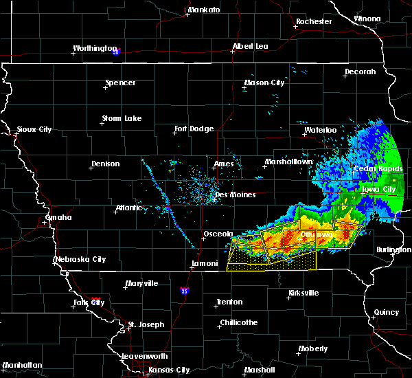 At 1123 am cdt, severe thunderstorms were located along a line extending from near leon to 10 miles southwest of centerville to 7 miles southwest of milton, moving south at 30 mph (radar indicated). Hazards include 60 mph wind gusts. expect damage to roofs, siding, and trees At 1123 am cdt, severe thunderstorms were located along a line extending from near leon to 10 miles southwest of centerville to 7 miles southwest of milton, moving south at 30 mph (radar indicated). Hazards include 60 mph wind gusts. expect damage to roofs, siding, and trees
|
| 6/22/2019 8:47 PM CDT |
 At 847 pm cdt, severe thunderstorms were located along a line extending from 8 miles southeast of centerville to 7 miles north of keytesville, moving east at 45 mph (radar indicated). Hazards include 70 mph wind gusts and quarter size hail. Hail damage to vehicles is expected. expect considerable tree damage. wind damage is also likely to mobile homes, roofs, and outbuildings. Locations impacted include, kirksville, moberly, macon, brookfield, marceline, milan, unionville, salisbury, huntsville, la plata, lancaster, brunswick, bevier, green city, queen city, keytesville, bucklin, meadville, novinger and greentop. At 847 pm cdt, severe thunderstorms were located along a line extending from 8 miles southeast of centerville to 7 miles north of keytesville, moving east at 45 mph (radar indicated). Hazards include 70 mph wind gusts and quarter size hail. Hail damage to vehicles is expected. expect considerable tree damage. wind damage is also likely to mobile homes, roofs, and outbuildings. Locations impacted include, kirksville, moberly, macon, brookfield, marceline, milan, unionville, salisbury, huntsville, la plata, lancaster, brunswick, bevier, green city, queen city, keytesville, bucklin, meadville, novinger and greentop.
|
| 6/22/2019 8:13 PM CDT |
 At 812 pm cdt, severe thunderstorms were located along a line extending from 11 miles east of mercer to 7 miles north of carrollton, moving east at 45 mph (radar indicated). Hazards include 70 mph wind gusts and quarter size hail. Hail damage to vehicles is expected. expect considerable tree damage. Wind damage is also likely to mobile homes, roofs, and outbuildings. At 812 pm cdt, severe thunderstorms were located along a line extending from 11 miles east of mercer to 7 miles north of carrollton, moving east at 45 mph (radar indicated). Hazards include 70 mph wind gusts and quarter size hail. Hail damage to vehicles is expected. expect considerable tree damage. Wind damage is also likely to mobile homes, roofs, and outbuildings.
|
| 6/21/2019 8:45 AM CDT |
 At 845 am cdt, severe thunderstorms were located along a line extending from milan to 10 miles north of bucklin to near marceline, moving northeast at 30 mph (radar indicated). Hazards include 60 mph wind gusts and quarter size hail. Hail damage to vehicles is expected. expect wind damage to roofs, siding, and trees. Locations impacted include, marceline, milan, green city, bucklin, callao, greencastle, browning, new cambria, ethel, new boston, winigan, wien, reger, green castle and saint catherine. At 845 am cdt, severe thunderstorms were located along a line extending from milan to 10 miles north of bucklin to near marceline, moving northeast at 30 mph (radar indicated). Hazards include 60 mph wind gusts and quarter size hail. Hail damage to vehicles is expected. expect wind damage to roofs, siding, and trees. Locations impacted include, marceline, milan, green city, bucklin, callao, greencastle, browning, new cambria, ethel, new boston, winigan, wien, reger, green castle and saint catherine.
|
| 6/21/2019 8:22 AM CDT |
 At 822 am cdt, severe thunderstorms were located along a line extending from 6 miles east of galt to near laclede to 9 miles southwest of marceline, moving northeast at 30 mph (radar indicated). Hazards include 60 mph wind gusts and quarter size hail. Hail damage to vehicles is expected. Expect wind damage to roofs, siding, and trees. At 822 am cdt, severe thunderstorms were located along a line extending from 6 miles east of galt to near laclede to 9 miles southwest of marceline, moving northeast at 30 mph (radar indicated). Hazards include 60 mph wind gusts and quarter size hail. Hail damage to vehicles is expected. Expect wind damage to roofs, siding, and trees.
|
| 6/15/2019 8:08 PM CDT | Quarter sized hail reported 3.1 miles WNW of Greencastle, MO, pea to quarter sized hail. |
| 6/15/2019 7:52 PM CDT |
 At 752 pm cdt, a severe thunderstorm was located near milan, moving east at 25 mph (radar indicated). Hazards include 60 mph wind gusts and quarter size hail. Hail damage to vehicles is expected. Expect wind damage to roofs, siding, and trees. At 752 pm cdt, a severe thunderstorm was located near milan, moving east at 25 mph (radar indicated). Hazards include 60 mph wind gusts and quarter size hail. Hail damage to vehicles is expected. Expect wind damage to roofs, siding, and trees.
|
| 6/5/2019 3:44 PM CDT |
 At 344 pm cdt, a severe thunderstorm was located 10 miles south of greencastle, or 12 miles southeast of milan, moving southeast at 25 mph (radar indicated). Hazards include ping pong ball size hail and 60 mph wind gusts. People and animals outdoors will be injured. expect hail damage to roofs, siding, windows, and vehicles. Expect wind damage to roofs, siding, and trees. At 344 pm cdt, a severe thunderstorm was located 10 miles south of greencastle, or 12 miles southeast of milan, moving southeast at 25 mph (radar indicated). Hazards include ping pong ball size hail and 60 mph wind gusts. People and animals outdoors will be injured. expect hail damage to roofs, siding, windows, and vehicles. Expect wind damage to roofs, siding, and trees.
|
| 6/5/2019 2:53 PM CDT |
 At 252 pm cdt, a severe thunderstorm was located 9 miles southwest of unionville, moving east at 15 mph (radar indicated). Hazards include ping pong ball size hail and 60 mph wind gusts. People and animals outdoors will be injured. expect hail damage to roofs, siding, windows, and vehicles. expect wind damage to roofs, siding, and trees. Locations impacted include, green city, greencastle, pollock, lemons and green castle. At 252 pm cdt, a severe thunderstorm was located 9 miles southwest of unionville, moving east at 15 mph (radar indicated). Hazards include ping pong ball size hail and 60 mph wind gusts. People and animals outdoors will be injured. expect hail damage to roofs, siding, windows, and vehicles. expect wind damage to roofs, siding, and trees. Locations impacted include, green city, greencastle, pollock, lemons and green castle.
|
| 6/5/2019 2:38 PM CDT |
 At 238 pm cdt, a severe thunderstorm was located 11 miles southwest of unionville, moving east at 15 mph (radar indicated). Hazards include 60 mph wind gusts and quarter size hail. Hail damage to vehicles is expected. Expect wind damage to roofs, siding, and trees. At 238 pm cdt, a severe thunderstorm was located 11 miles southwest of unionville, moving east at 15 mph (radar indicated). Hazards include 60 mph wind gusts and quarter size hail. Hail damage to vehicles is expected. Expect wind damage to roofs, siding, and trees.
|
| 5/28/2019 6:10 PM CDT |
 The severe thunderstorm warning for central putnam and eastern sullivan counties will expire at 615 pm cdt, the storms which prompted the warning have moved out of the area. therefore, the warning will be allowed to expire. to report severe weather, contact your nearest law enforcement agency. they will relay your report to the national weather service pleasant hill. remember, a severe thunderstorm warning still remains in effect for far eastern portions of putnam and sullivan counties until 715 pm. The severe thunderstorm warning for central putnam and eastern sullivan counties will expire at 615 pm cdt, the storms which prompted the warning have moved out of the area. therefore, the warning will be allowed to expire. to report severe weather, contact your nearest law enforcement agency. they will relay your report to the national weather service pleasant hill. remember, a severe thunderstorm warning still remains in effect for far eastern portions of putnam and sullivan counties until 715 pm.
|
| 5/28/2019 6:01 PM CDT |
 At 601 pm cdt, severe thunderstorms were located along a line extending from 7 miles northwest of unionville to 6 miles north of green city to near milan, moving east at 45 mph (radar indicated). Hazards include 70 mph wind gusts and quarter size hail. Hail damage to vehicles is expected. expect considerable tree damage. wind damage is also likely to mobile homes, roofs, and outbuildings. Locations impacted include, milan, unionville, green city, greencastle, pollock, reger, lemons and green castle. At 601 pm cdt, severe thunderstorms were located along a line extending from 7 miles northwest of unionville to 6 miles north of green city to near milan, moving east at 45 mph (radar indicated). Hazards include 70 mph wind gusts and quarter size hail. Hail damage to vehicles is expected. expect considerable tree damage. wind damage is also likely to mobile homes, roofs, and outbuildings. Locations impacted include, milan, unionville, green city, greencastle, pollock, reger, lemons and green castle.
|
| 5/28/2019 5:58 PM CDT |
 At 558 pm cdt, severe thunderstorms were located along a line extending from 11 miles northwest of unionville to near green city to near milan, moving east at 40 mph (radar indicated). Hazards include 70 mph wind gusts and quarter size hail. Hail damage to vehicles is expected. expect considerable tree damage. Wind damage is also likely to mobile homes, roofs, and outbuildings. At 558 pm cdt, severe thunderstorms were located along a line extending from 11 miles northwest of unionville to near green city to near milan, moving east at 40 mph (radar indicated). Hazards include 70 mph wind gusts and quarter size hail. Hail damage to vehicles is expected. expect considerable tree damage. Wind damage is also likely to mobile homes, roofs, and outbuildings.
|
| 5/28/2019 5:52 PM CDT |
 At 552 pm cdt, severe thunderstorms were located along a line extending from 10 miles northwest of unionville to 8 miles northwest of green city to near milan, moving east at 50 mph (radar indicated). Hazards include 70 mph wind gusts and quarter size hail. Hail damage to vehicles is expected. expect considerable tree damage. wind damage is also likely to mobile homes, roofs, and outbuildings. Locations impacted include, milan, unionville, green city, greencastle, humphreys, pollock, lucerne, powersville, reger, lemons and green castle. At 552 pm cdt, severe thunderstorms were located along a line extending from 10 miles northwest of unionville to 8 miles northwest of green city to near milan, moving east at 50 mph (radar indicated). Hazards include 70 mph wind gusts and quarter size hail. Hail damage to vehicles is expected. expect considerable tree damage. wind damage is also likely to mobile homes, roofs, and outbuildings. Locations impacted include, milan, unionville, green city, greencastle, humphreys, pollock, lucerne, powersville, reger, lemons and green castle.
|
| 5/28/2019 5:25 PM CDT |
 At 524 pm cdt, severe thunderstorms were located along a line extending from mercer to near galt, moving east at 45 mph (radar indicated). Hazards include 60 mph wind gusts and half dollar size hail. Hail damage to vehicles is expected. Expect wind damage to roofs, siding, and trees. At 524 pm cdt, severe thunderstorms were located along a line extending from mercer to near galt, moving east at 45 mph (radar indicated). Hazards include 60 mph wind gusts and half dollar size hail. Hail damage to vehicles is expected. Expect wind damage to roofs, siding, and trees.
|
| 5/25/2019 8:04 PM CDT |
 At 804 pm cdt, severe thunderstorms were located along a line extending from 7 miles southeast of unionville to near greencastle to 8 miles east of browning, moving east at 45 mph (law enforcement). Hazards include 60 mph wind gusts. Expect damage to roofs, siding, and trees. Locations impacted include, milan, green city, novinger, greencastle, pollock, worthington, reger, lemons, green castle and winigan. At 804 pm cdt, severe thunderstorms were located along a line extending from 7 miles southeast of unionville to near greencastle to 8 miles east of browning, moving east at 45 mph (law enforcement). Hazards include 60 mph wind gusts. Expect damage to roofs, siding, and trees. Locations impacted include, milan, green city, novinger, greencastle, pollock, worthington, reger, lemons, green castle and winigan.
|
| 5/25/2019 7:42 PM CDT |
 At 741 pm cdt, severe thunderstorms were located along a line extending from 13 miles west of unionville to 7 miles northwest of milan to galt, moving east at 45 mph (radar indicated). Hazards include 60 mph wind gusts. expect damage to roofs, siding, and trees At 741 pm cdt, severe thunderstorms were located along a line extending from 13 miles west of unionville to 7 miles northwest of milan to galt, moving east at 45 mph (radar indicated). Hazards include 60 mph wind gusts. expect damage to roofs, siding, and trees
|
| 5/25/2019 6:44 PM CDT |
 At 643 pm cdt, a severe thunderstorm was located near greencastle, or 12 miles southeast of unionville, moving east at 35 mph (radar indicated). Hazards include 60 mph wind gusts and quarter size hail. Hail damage to vehicles is expected. Expect wind damage to roofs, siding, and trees. At 643 pm cdt, a severe thunderstorm was located near greencastle, or 12 miles southeast of unionville, moving east at 35 mph (radar indicated). Hazards include 60 mph wind gusts and quarter size hail. Hail damage to vehicles is expected. Expect wind damage to roofs, siding, and trees.
|
| 8/28/2018 7:22 PM CDT |
 At 722 pm cdt, a severe thunderstorm was located near milan, moving east at 30 mph (radar indicated). Hazards include 60 mph wind gusts and quarter size hail. Hail damage to vehicles is expected. expect wind damage to roofs, siding, and trees. Locations impacted include, milan, green city, greencastle, green castle and winigan. At 722 pm cdt, a severe thunderstorm was located near milan, moving east at 30 mph (radar indicated). Hazards include 60 mph wind gusts and quarter size hail. Hail damage to vehicles is expected. expect wind damage to roofs, siding, and trees. Locations impacted include, milan, green city, greencastle, green castle and winigan.
|
| 8/28/2018 7:08 PM CDT |
 At 707 pm cdt, a severe thunderstorm was located near browning, or near milan, moving east at 30 mph (radar indicated). Hazards include 60 mph wind gusts and quarter size hail. Hail damage to vehicles is expected. Expect wind damage to roofs, siding, and trees. At 707 pm cdt, a severe thunderstorm was located near browning, or near milan, moving east at 30 mph (radar indicated). Hazards include 60 mph wind gusts and quarter size hail. Hail damage to vehicles is expected. Expect wind damage to roofs, siding, and trees.
|
| 6/2/2018 5:43 AM CDT |
 At 543 am cdt, a severe thunderstorm was located over greencastle, or 13 miles southeast of unionville, moving northeast at 40 mph (law enforcement). Hazards include 60 mph wind gusts and quarter size hail. Hail damage to vehicles is expected. Expect wind damage to roofs, siding, and trees. At 543 am cdt, a severe thunderstorm was located over greencastle, or 13 miles southeast of unionville, moving northeast at 40 mph (law enforcement). Hazards include 60 mph wind gusts and quarter size hail. Hail damage to vehicles is expected. Expect wind damage to roofs, siding, and trees.
|
| 6/2/2018 4:57 AM CDT |
 At 457 am cdt, a severe thunderstorm was located 14 miles northwest of milan, moving northeast at 35 mph (radar indicated). Hazards include 60 mph wind gusts. expect damage to roofs, siding, and trees At 457 am cdt, a severe thunderstorm was located 14 miles northwest of milan, moving northeast at 35 mph (radar indicated). Hazards include 60 mph wind gusts. expect damage to roofs, siding, and trees
|
| 5/20/2018 1:00 AM CDT |
 At 1246 am cdt, a severe thunderstorm was located 10 miles north of milan, moving east at 40 mph (radar indicated). Hazards include ping pong ball size hail and 60 mph wind gusts. People and animals outdoors will be injured. expect hail damage to roofs, siding, windows, and vehicles. Expect wind damage to roofs, siding, and trees. At 1246 am cdt, a severe thunderstorm was located 10 miles north of milan, moving east at 40 mph (radar indicated). Hazards include ping pong ball size hail and 60 mph wind gusts. People and animals outdoors will be injured. expect hail damage to roofs, siding, windows, and vehicles. Expect wind damage to roofs, siding, and trees.
|
| 5/20/2018 12:47 AM CDT |
 At 1246 am cdt, a severe thunderstorm was located 10 miles north of milan, moving east at 40 mph (radar indicated). Hazards include ping pong ball size hail and 60 mph wind gusts. People and animals outdoors will be injured. expect hail damage to roofs, siding, windows, and vehicles. Expect wind damage to roofs, siding, and trees. At 1246 am cdt, a severe thunderstorm was located 10 miles north of milan, moving east at 40 mph (radar indicated). Hazards include ping pong ball size hail and 60 mph wind gusts. People and animals outdoors will be injured. expect hail damage to roofs, siding, windows, and vehicles. Expect wind damage to roofs, siding, and trees.
|
| 5/2/2018 11:07 PM CDT |
 At 1106 pm cdt, a severe thunderstorm was located near green city, or 7 miles east of milan, moving northeast at 50 mph (radar indicated). Hazards include 60 mph wind gusts and quarter size hail. Hail damage to vehicles is expected. Expect wind damage to roofs, siding, and trees. At 1106 pm cdt, a severe thunderstorm was located near green city, or 7 miles east of milan, moving northeast at 50 mph (radar indicated). Hazards include 60 mph wind gusts and quarter size hail. Hail damage to vehicles is expected. Expect wind damage to roofs, siding, and trees.
|
| 9/16/2017 6:24 PM CDT |
 The severe thunderstorm warning for western adair and sullivan counties will expire at 630 pm cdt, the storm which prompted the warning has weakened below severe limits, and no longer poses an immediate threat to life or property. therefore the warning will be allowed to expire. however gusty winds up to 50 mph are still possible with this thunderstorm. The severe thunderstorm warning for western adair and sullivan counties will expire at 630 pm cdt, the storm which prompted the warning has weakened below severe limits, and no longer poses an immediate threat to life or property. therefore the warning will be allowed to expire. however gusty winds up to 50 mph are still possible with this thunderstorm.
|
| 9/16/2017 6:11 PM CDT |
 At 610 pm cdt, a severe thunderstorm was located 8 miles southeast of milan, moving east at 50 mph (public. damage to a pole barn has been reported with this storm). Hazards include 60 mph wind gusts and penny size hail. Expect damage to roofs, siding, and trees. Locations impacted include, milan, green city, novinger, greencastle, reger, green castle and winigan. At 610 pm cdt, a severe thunderstorm was located 8 miles southeast of milan, moving east at 50 mph (public. damage to a pole barn has been reported with this storm). Hazards include 60 mph wind gusts and penny size hail. Expect damage to roofs, siding, and trees. Locations impacted include, milan, green city, novinger, greencastle, reger, green castle and winigan.
|
| 9/16/2017 5:58 PM CDT |
 At 558 pm cdt, a severe thunderstorm was located near browning, or 8 miles south of milan, moving east at 50 mph (radar indicated). Hazards include 60 mph wind gusts and penny size hail. expect damage to roofs, siding, and trees At 558 pm cdt, a severe thunderstorm was located near browning, or 8 miles south of milan, moving east at 50 mph (radar indicated). Hazards include 60 mph wind gusts and penny size hail. expect damage to roofs, siding, and trees
|
| 6/28/2017 3:53 PM CDT |
 At 853 pm cdt, a severe thunderstorm was located over galt, or 11 miles east of trenton, moving east at 35 mph (radar indicated). Hazards include ping pong ball size hail and 60 mph wind gusts. People and animals outdoors will be injured. expect hail damage to roofs, siding, windows, and vehicles. Expect wind damage to roofs, siding, and trees. At 853 pm cdt, a severe thunderstorm was located over galt, or 11 miles east of trenton, moving east at 35 mph (radar indicated). Hazards include ping pong ball size hail and 60 mph wind gusts. People and animals outdoors will be injured. expect hail damage to roofs, siding, windows, and vehicles. Expect wind damage to roofs, siding, and trees.
|
| 6/28/2017 3:39 PM CDT |
 At 838 pm cdt, severe thunderstorms were located along a line extending from near lancaster to near novinger to near milan, moving east at 35 mph (radar indicated). Hazards include 60 mph wind gusts and quarter size hail. Hail damage to vehicles is expected. expect wind damage to roofs, siding, and trees. locations impacted include, kirksville, milan, lancaster, green city, queen city, novinger, greentop, greencastle, glenwood, newtown, humphreys, millard, pollock, harris, osgood, kirksville regional, reger and green castle. A tornado watch remains in effect until 1000 pm cdt for north central and northeastern missouri. At 838 pm cdt, severe thunderstorms were located along a line extending from near lancaster to near novinger to near milan, moving east at 35 mph (radar indicated). Hazards include 60 mph wind gusts and quarter size hail. Hail damage to vehicles is expected. expect wind damage to roofs, siding, and trees. locations impacted include, kirksville, milan, lancaster, green city, queen city, novinger, greentop, greencastle, glenwood, newtown, humphreys, millard, pollock, harris, osgood, kirksville regional, reger and green castle. A tornado watch remains in effect until 1000 pm cdt for north central and northeastern missouri.
|
| 6/28/2017 3:00 PM CDT |
 At 759 pm cdt, severe thunderstorms were located along a line extending from 9 miles south of centerville to near milan to 6 miles southeast of spickard, moving east at 35 mph (radar indicated). Hazards include 60 mph wind gusts and quarter size hail. Hail damage to vehicles is expected. Expect wind damage to roofs, siding, and trees. At 759 pm cdt, severe thunderstorms were located along a line extending from 9 miles south of centerville to near milan to 6 miles southeast of spickard, moving east at 35 mph (radar indicated). Hazards include 60 mph wind gusts and quarter size hail. Hail damage to vehicles is expected. Expect wind damage to roofs, siding, and trees.
|
| 3/6/2017 9:15 PM CST | Power outag in sullivan county MO, 0.1 miles ENE of Greencastle, MO |
| 3/6/2017 8:32 PM CST |
 At 832 pm cst, severe thunderstorms were located along a line extending from near unionville to near lexington, moving east at 50 mph (radar indicated). Hazards include 60 mph wind gusts and quarter size hail. Hail damage to vehicles is expected. Expect wind damage to roofs, siding, and trees. At 832 pm cst, severe thunderstorms were located along a line extending from near unionville to near lexington, moving east at 50 mph (radar indicated). Hazards include 60 mph wind gusts and quarter size hail. Hail damage to vehicles is expected. Expect wind damage to roofs, siding, and trees.
|
| 9/19/2016 7:36 PM CDT |
 At 735 pm cdt, a severe thunderstorm was located 14 miles southeast of mercer, or 15 miles northwest of milan, moving southeast at 30 mph (radar indicated). Hazards include ping pong ball size hail and 60 mph wind gusts. People and animals outdoors will be injured. expect hail damage to roofs, siding, windows, and vehicles. Expect wind damage to roofs, siding, and trees. At 735 pm cdt, a severe thunderstorm was located 14 miles southeast of mercer, or 15 miles northwest of milan, moving southeast at 30 mph (radar indicated). Hazards include ping pong ball size hail and 60 mph wind gusts. People and animals outdoors will be injured. expect hail damage to roofs, siding, windows, and vehicles. Expect wind damage to roofs, siding, and trees.
|
| 4/27/2016 6:53 PM CDT |
 At 653 pm cdt, severe thunderstorms were located along a line extending from 10 miles east of mercer to 13 miles northwest of green city to 10 miles southwest of unionville to near milan, moving northeast at 30 mph (radar indicated). Hazards include 60 mph wind gusts and quarter size hail. Hail damage to vehicles is expected. Expect wind damage to roofs, siding, and trees. At 653 pm cdt, severe thunderstorms were located along a line extending from 10 miles east of mercer to 13 miles northwest of green city to 10 miles southwest of unionville to near milan, moving northeast at 30 mph (radar indicated). Hazards include 60 mph wind gusts and quarter size hail. Hail damage to vehicles is expected. Expect wind damage to roofs, siding, and trees.
|
| 3/23/2016 9:24 PM CDT |
 The severe thunderstorm warning for sullivan. western schuyler. northeastern livingston. putnam. western adair and northern linn counties will expire at 930 pm cdt. the storms which prompted the warning have weakened below severe limits. and exited the warned area. therefore the warning will be allowed to expire. However gusty winds are still possible with these. The severe thunderstorm warning for sullivan. western schuyler. northeastern livingston. putnam. western adair and northern linn counties will expire at 930 pm cdt. the storms which prompted the warning have weakened below severe limits. and exited the warned area. therefore the warning will be allowed to expire. However gusty winds are still possible with these.
|
| 3/23/2016 9:04 PM CDT |
 At 904 pm cdt, severe thunderstorms were located along a line extending from 8 miles north of unionville to near milan to 6 miles northwest of linneus, moving east at 35 mph (radar indicated). Hazards include 60 mph wind gusts. Expect damage to roofs. siding. and trees. locations impacted include, milan, unionville, green city, novinger, greencastle, browning, purdin, humphreys, pollock, worthington, livonia, winigan, lemons, reger, green castle and new boston. A tornado watch remains in effect until 1000 pm cdt for north central missouri. At 904 pm cdt, severe thunderstorms were located along a line extending from 8 miles north of unionville to near milan to 6 miles northwest of linneus, moving east at 35 mph (radar indicated). Hazards include 60 mph wind gusts. Expect damage to roofs. siding. and trees. locations impacted include, milan, unionville, green city, novinger, greencastle, browning, purdin, humphreys, pollock, worthington, livonia, winigan, lemons, reger, green castle and new boston. A tornado watch remains in effect until 1000 pm cdt for north central missouri.
|
| 3/23/2016 8:52 PM CDT |
 At 852 pm cdt, severe thunderstorms were located along a line extending from 11 miles northwest of unionville to near milan to 10 miles northwest of linneus, moving east at 35 mph (radar indicated). Hazards include 60 mph wind gusts. Expect damage to roofs. siding. And trees. At 852 pm cdt, severe thunderstorms were located along a line extending from 11 miles northwest of unionville to near milan to 10 miles northwest of linneus, moving east at 35 mph (radar indicated). Hazards include 60 mph wind gusts. Expect damage to roofs. siding. And trees.
|
| 11/11/2015 3:23 PM CST |
 At 323 pm cst, severe thunderstorms were located along a line extending from near unionville to 11 miles south of greencastle to near keytesville, moving east at 45 mph (radar indicated). Hazards include 60 mph wind gusts. Expect damage to roofs. Siding and trees. At 323 pm cst, severe thunderstorms were located along a line extending from near unionville to 11 miles south of greencastle to near keytesville, moving east at 45 mph (radar indicated). Hazards include 60 mph wind gusts. Expect damage to roofs. Siding and trees.
|
| 9/17/2015 7:38 PM CDT |
 At 737 pm cdt, a severe thunderstorm was located over greencastle, or 11 miles east of milan, moving east at 35 mph (radar indicated). Hazards include golf ball size hail and 60 mph wind gusts. People and animals outdoors will be injured. expect hail damage to roofs, siding, windows and vehicles. expect wind damage to roofs, siding and trees. Locations impacted include, kirksville, green city, novinger, greencastle and green castle. At 737 pm cdt, a severe thunderstorm was located over greencastle, or 11 miles east of milan, moving east at 35 mph (radar indicated). Hazards include golf ball size hail and 60 mph wind gusts. People and animals outdoors will be injured. expect hail damage to roofs, siding, windows and vehicles. expect wind damage to roofs, siding and trees. Locations impacted include, kirksville, green city, novinger, greencastle and green castle.
|
| 9/17/2015 7:23 PM CDT |
 At 723 pm cdt, a severe thunderstorm was located over milan, moving east at 30 mph (radar indicated). Hazards include golf ball size hail and 60 mph wind gusts. People and animals outdoors will be injured. expect hail damage to roofs, siding, windows and vehicles. expect wind damage to roofs, siding and trees. Locations impacted include, kirksville, milan, green city, novinger, greencastle, worthington and green castle. At 723 pm cdt, a severe thunderstorm was located over milan, moving east at 30 mph (radar indicated). Hazards include golf ball size hail and 60 mph wind gusts. People and animals outdoors will be injured. expect hail damage to roofs, siding, windows and vehicles. expect wind damage to roofs, siding and trees. Locations impacted include, kirksville, milan, green city, novinger, greencastle, worthington and green castle.
|
| 9/17/2015 7:10 PM CDT |
 At 709 pm cdt, a severe thunderstorm was located over milan, moving east at 40 mph (radar indicated). Hazards include ping pong ball size hail and 60 mph wind gusts. People and animals outdoors will be injured. expect hail damage to roofs, siding, windows and vehicles. Expect wind damage to roofs, siding and trees. At 709 pm cdt, a severe thunderstorm was located over milan, moving east at 40 mph (radar indicated). Hazards include ping pong ball size hail and 60 mph wind gusts. People and animals outdoors will be injured. expect hail damage to roofs, siding, windows and vehicles. Expect wind damage to roofs, siding and trees.
|
| 8/2/2015 8:37 PM CDT |
 At 835 pm cdt, a severe thunderstorm was located 7 miles south of greencastle, or 13 miles west of kirksville, moving southeast at 35 mph (trained weather spotters. at 825 pm...estimated 60 mph winds were reported near green castle). Hazards include 60 mph wind gusts and nickel size hail. Expect damage to roofs. siding and trees. Locations impacted include, kirksville, milan, green city, novinger, reger and green castle. At 835 pm cdt, a severe thunderstorm was located 7 miles south of greencastle, or 13 miles west of kirksville, moving southeast at 35 mph (trained weather spotters. at 825 pm...estimated 60 mph winds were reported near green castle). Hazards include 60 mph wind gusts and nickel size hail. Expect damage to roofs. siding and trees. Locations impacted include, kirksville, milan, green city, novinger, reger and green castle.
|
| 8/2/2015 8:25 PM CDT | Estimated leading wind gust up to 60 mph in sullivan county MO, 2 miles S of Greencastle, MO |
| 8/2/2015 8:16 PM CDT |
 At 815 pm cdt, a severe thunderstorm was located over green city, or 10 miles northeast of milan, moving southeast at 35 mph (radar indicated). Hazards include 60 mph wind gusts and nickel size hail. Expect damage to roofs. Siding and trees. At 815 pm cdt, a severe thunderstorm was located over green city, or 10 miles northeast of milan, moving southeast at 35 mph (radar indicated). Hazards include 60 mph wind gusts and nickel size hail. Expect damage to roofs. Siding and trees.
|
| 7/29/2015 12:38 AM CDT |
 The severe thunderstorm warning for northeastern sullivan and central putnam counties will expire at 1245 am cdt, the storm which prompted the warning has weakened below severe limits, and no longer pose an immediate threat to life or property. therefore the warning will be allowed to expire. however gusty winds to 50 mph and heavy rain are still possible with this thunderstorm. The severe thunderstorm warning for northeastern sullivan and central putnam counties will expire at 1245 am cdt, the storm which prompted the warning has weakened below severe limits, and no longer pose an immediate threat to life or property. therefore the warning will be allowed to expire. however gusty winds to 50 mph and heavy rain are still possible with this thunderstorm.
|
| 7/29/2015 12:25 AM CDT |
 At 1225 am cdt, a severe thunderstorm was located over unionville, moving east at 35 mph (radar indicated). Hazards include 60 mph wind gusts. Expect damage to roofs. siding and trees. Locations impacted include, unionville, green city, greencastle, pollock, lemons and green castle. At 1225 am cdt, a severe thunderstorm was located over unionville, moving east at 35 mph (radar indicated). Hazards include 60 mph wind gusts. Expect damage to roofs. siding and trees. Locations impacted include, unionville, green city, greencastle, pollock, lemons and green castle.
|
| 7/29/2015 12:14 AM CDT |
 At 1213 am cdt, a severe thunderstorm was located 8 miles southwest of unionville, and is nearly stationary (radar indicated). Hazards include 60 mph wind gusts. Expect damage to roofs. siding and trees. Locations impacted include, unionville, green city, greencastle, newtown, pollock, lucerne, harris, powersville, lemons and green castle. At 1213 am cdt, a severe thunderstorm was located 8 miles southwest of unionville, and is nearly stationary (radar indicated). Hazards include 60 mph wind gusts. Expect damage to roofs. siding and trees. Locations impacted include, unionville, green city, greencastle, newtown, pollock, lucerne, harris, powersville, lemons and green castle.
|
| 7/29/2015 12:03 AM CDT |
 At 1202 am cdt, a severe thunderstorm was located 14 miles west of unionville, moving east at 30 mph (radar indicated). Hazards include 60 mph wind gusts. Expect damage to roofs. siding and trees. Locations impacted include, unionville, green city, greencastle, newtown, pollock, lucerne, harris, powersville, lemons and green castle. At 1202 am cdt, a severe thunderstorm was located 14 miles west of unionville, moving east at 30 mph (radar indicated). Hazards include 60 mph wind gusts. Expect damage to roofs. siding and trees. Locations impacted include, unionville, green city, greencastle, newtown, pollock, lucerne, harris, powersville, lemons and green castle.
|
| 7/28/2015 11:52 PM CDT |
 At 1151 pm cdt, a severe thunderstorm was located 11 miles southeast of mercer, or 18 miles northwest of milan, moving east at 30 mph (radar indicated). Hazards include 60 mph wind gusts. Expect damage to roofs. Siding and trees. At 1151 pm cdt, a severe thunderstorm was located 11 miles southeast of mercer, or 18 miles northwest of milan, moving east at 30 mph (radar indicated). Hazards include 60 mph wind gusts. Expect damage to roofs. Siding and trees.
|
| 7/24/2015 2:35 PM CDT | 4 inch tree limbs torn out of tre in sullivan county MO, 0.1 miles ENE of Greencastle, MO |
| 7/16/2015 4:53 PM CDT |
 At 453 pm cdt, a severe thunderstorm was located near novinger, or 7 miles northwest of kirksville, moving northeast at 30 mph (radar indicated). Hazards include 60 mph wind gusts and quarter size hail. Hail damage to vehicles is expected. expect wind damage to roofs, siding and trees. Locations impacted include, kirksville, queen city, novinger, greentop, greencastle, worthington and green castle. At 453 pm cdt, a severe thunderstorm was located near novinger, or 7 miles northwest of kirksville, moving northeast at 30 mph (radar indicated). Hazards include 60 mph wind gusts and quarter size hail. Hail damage to vehicles is expected. expect wind damage to roofs, siding and trees. Locations impacted include, kirksville, queen city, novinger, greentop, greencastle, worthington and green castle.
|
| 7/16/2015 4:34 PM CDT |
 At 433 pm cdt, a severe thunderstorm was located near greencastle, or 12 miles west of kirksville, moving northeast at 30 mph (radar indicated). Hazards include 60 mph wind gusts and quarter size hail. Hail damage to vehicles is expected. Expect wind damage to roofs, siding and trees. At 433 pm cdt, a severe thunderstorm was located near greencastle, or 12 miles west of kirksville, moving northeast at 30 mph (radar indicated). Hazards include 60 mph wind gusts and quarter size hail. Hail damage to vehicles is expected. Expect wind damage to roofs, siding and trees.
|
| 7/13/2015 4:52 PM CDT |
 At 451 pm cdt, a severe thunderstorm was located over green city, or 9 miles northeast of milan, moving east at 40 mph (radar indicated). Hazards include 60 mph wind gusts and quarter size hail. Hail damage to vehicles is expected. Expect wind damage to roofs, siding and trees. At 451 pm cdt, a severe thunderstorm was located over green city, or 9 miles northeast of milan, moving east at 40 mph (radar indicated). Hazards include 60 mph wind gusts and quarter size hail. Hail damage to vehicles is expected. Expect wind damage to roofs, siding and trees.
|
| 7/13/2015 4:44 PM CDT |
 At 443 pm cdt, a severe thunderstorm was located 7 miles northwest of milan, moving east at 40 mph (radar indicated). Hazards include 60 mph wind gusts and quarter size hail. Hail damage to vehicles is expected. expect wind damage to roofs, siding and trees. Locations impacted include, milan, unionville, green city, greencastle, pollock, lucerne, lemons, winigan, reger and green castle. At 443 pm cdt, a severe thunderstorm was located 7 miles northwest of milan, moving east at 40 mph (radar indicated). Hazards include 60 mph wind gusts and quarter size hail. Hail damage to vehicles is expected. expect wind damage to roofs, siding and trees. Locations impacted include, milan, unionville, green city, greencastle, pollock, lucerne, lemons, winigan, reger and green castle.
|
| 7/13/2015 4:36 PM CDT |
 At 436 pm cdt, a severe thunderstorm was located 12 miles northwest of milan, moving east at 40 mph (radar indicated). Hazards include 60 mph wind gusts and quarter size hail. Hail damage to vehicles is expected. expect wind damage to roofs, siding and trees. Locations impacted include, milan, unionville, green city, mercer, greencastle, newtown, humphreys, pollock, lucerne, harris, osgood, winigan, lemons, reger and green castle. At 436 pm cdt, a severe thunderstorm was located 12 miles northwest of milan, moving east at 40 mph (radar indicated). Hazards include 60 mph wind gusts and quarter size hail. Hail damage to vehicles is expected. expect wind damage to roofs, siding and trees. Locations impacted include, milan, unionville, green city, mercer, greencastle, newtown, humphreys, pollock, lucerne, harris, osgood, winigan, lemons, reger and green castle.
|
| 7/13/2015 4:13 PM CDT |
 At 413 pm cdt, a severe thunderstorm was located near princeton, or 17 miles north of trenton, moving east at 40 mph (radar indicated). Hazards include 60 mph wind gusts and quarter size hail. Hail damage to vehicles is expected. Expect wind damage to roofs, siding and trees. At 413 pm cdt, a severe thunderstorm was located near princeton, or 17 miles north of trenton, moving east at 40 mph (radar indicated). Hazards include 60 mph wind gusts and quarter size hail. Hail damage to vehicles is expected. Expect wind damage to roofs, siding and trees.
|
| 6/22/2015 8:24 PM CDT |
 At 822 pm cdt, severe thunderstorms were located along a line extending from green city to 5 miles northwest of greensburg, and moving southeast at 35 mph (radar indicated). Hazards include 60 mph wind gusts and penny size hail. Expect damage to roofs. Siding and trees. At 822 pm cdt, severe thunderstorms were located along a line extending from green city to 5 miles northwest of greensburg, and moving southeast at 35 mph (radar indicated). Hazards include 60 mph wind gusts and penny size hail. Expect damage to roofs. Siding and trees.
|
| 6/20/2015 9:28 PM CDT |
 At 926 pm cdt, a severe thunderstorm was located 6 miles south of novinger, and moving southeast at 20 mph. at 912 pm, trained weather spotters reported a 70 mph wind gust 8 miles east of green city. at 912 pm, trained weather spotters reported quarter size hail 8 miles east of green city (radar indicated). Hazards include 60 mph wind gusts and quarter size hail. Hail damage to vehicles is expected. Expect wind damage to roofs, siding and trees. At 926 pm cdt, a severe thunderstorm was located 6 miles south of novinger, and moving southeast at 20 mph. at 912 pm, trained weather spotters reported a 70 mph wind gust 8 miles east of green city. at 912 pm, trained weather spotters reported quarter size hail 8 miles east of green city (radar indicated). Hazards include 60 mph wind gusts and quarter size hail. Hail damage to vehicles is expected. Expect wind damage to roofs, siding and trees.
|
| 6/20/2015 9:17 PM CDT |
 At 912 pm, trained weather spotters reported a 70 mph wind gust 8 miles east of green city. at 912 pm, trained weather spotters reported quarter size hail 8 miles east of green city. at 915 pm cdt, a severe thunderstorm was located near novinger, and moving southeast at 20 mph (trained weather spotters). Hazards include 70 mph wind gusts and quarter size hail. Hail damage to vehicles is expected. expect considerable tree damage. wind damage is also likely to mobile homes, roofs and outbuildings. Locations impacted include, kirksville. At 912 pm, trained weather spotters reported a 70 mph wind gust 8 miles east of green city. at 912 pm, trained weather spotters reported quarter size hail 8 miles east of green city. at 915 pm cdt, a severe thunderstorm was located near novinger, and moving southeast at 20 mph (trained weather spotters). Hazards include 70 mph wind gusts and quarter size hail. Hail damage to vehicles is expected. expect considerable tree damage. wind damage is also likely to mobile homes, roofs and outbuildings. Locations impacted include, kirksville.
|
| 6/20/2015 9:12 PM CDT | Quarter sized hail reported 4.2 miles W of Greencastle, MO |
| 6/20/2015 9:12 PM CDT | Branches down in adair county MO, 4.2 miles W of Greencastle, MO |
| 6/20/2015 8:52 PM CDT |
 At 850 pm cdt, a severe thunderstorm was located 6 miles east of green city, and moving southeast at 20 mph. at 828 pm, trained weather spotters reported straight line wind damage 4 miles west of worthington. at 820 pm, trained weather spotters reported penny size hail 8 miles north of green city (radar indicated). Hazards include 60 mph wind gusts and nickel size hail. Expect damage to roofs. Siding and trees. At 850 pm cdt, a severe thunderstorm was located 6 miles east of green city, and moving southeast at 20 mph. at 828 pm, trained weather spotters reported straight line wind damage 4 miles west of worthington. at 820 pm, trained weather spotters reported penny size hail 8 miles north of green city (radar indicated). Hazards include 60 mph wind gusts and nickel size hail. Expect damage to roofs. Siding and trees.
|
| 6/11/2015 7:54 PM CDT |
 At 752 pm cdt, severe thunderstorms were located along a line extending from 6 miles north of unionville to 5 miles north of browning, and moving east at 35 mph (radar indicated). Hazards include 60 mph wind gusts and penny size hail. Expect damage to roofs. Siding and trees. At 752 pm cdt, severe thunderstorms were located along a line extending from 6 miles north of unionville to 5 miles north of browning, and moving east at 35 mph (radar indicated). Hazards include 60 mph wind gusts and penny size hail. Expect damage to roofs. Siding and trees.
|
| 6/11/2015 7:32 PM CDT |
 At 731 pm cdt, severe thunderstorms were located along a line extending from 14 miles west of unionville to 9 miles west of milan, and moving east at 30 mph. at 705 pm, local emergency management reported straight line wind damage 3 miles south of princeton (radar indicated). Hazards include 60 mph wind gusts and quarter size hail. Hail damage to vehicles is expected. Expect wind damage to roofs, siding and trees. At 731 pm cdt, severe thunderstorms were located along a line extending from 14 miles west of unionville to 9 miles west of milan, and moving east at 30 mph. at 705 pm, local emergency management reported straight line wind damage 3 miles south of princeton (radar indicated). Hazards include 60 mph wind gusts and quarter size hail. Hail damage to vehicles is expected. Expect wind damage to roofs, siding and trees.
|
| 6/7/2015 6:35 PM CDT | At 633 pm cdt, a severe thunderstorm was located near greentop, and moving east at 40 mph (radar indicated). Hazards include 60 mph wind gusts and quarter size hail. Hail damage to vehicles is expected. expect wind damage to roofs, siding and trees. Locations impacted include, brashear. |
| 6/7/2015 6:05 PM CDT | At 600 pm cdt, a severe thunderstorm was located near green city, and moving east at 40 mph. at 540 pm, the public reported penny size hail 4 miles southwest of livonia. at 550 pm, the public reported penny size hail in milan (radar indicated). Hazards include 60 mph wind gusts and quarter size hail. Hail damage to vehicles is expected. Expect wind damage to roofs, siding and trees. |
| 4/9/2015 2:54 PM CDT | Quarter sized hail reported 4.1 miles W of Greencastle, MO |
| 6/24/2013 1:54 PM CDT | 60 mph wnd...tree limbs down and power outage in sullivan county MO, 0.1 miles ENE of Greencastle, MO |
| 1/1/0001 12:00 AM | Winds estimated between 60 and 70 mph. 3/4 inch diameter hail observed as wel in sullivan county MO, 0.1 miles ENE of Greencastle, MO |
| 1/1/0001 12:00 AM | Quarter sized hail reported 0.1 miles ENE of Greencastle, MO, quarter sized hail covering the ground |
Hail Maps for Greencastle, MO

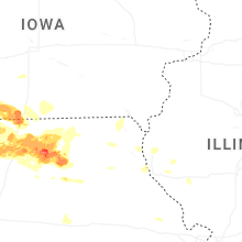
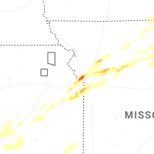


Connect with Interactive Hail Maps