

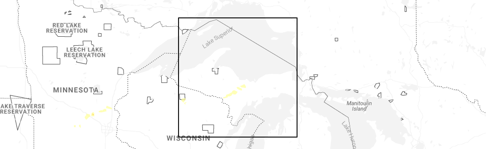
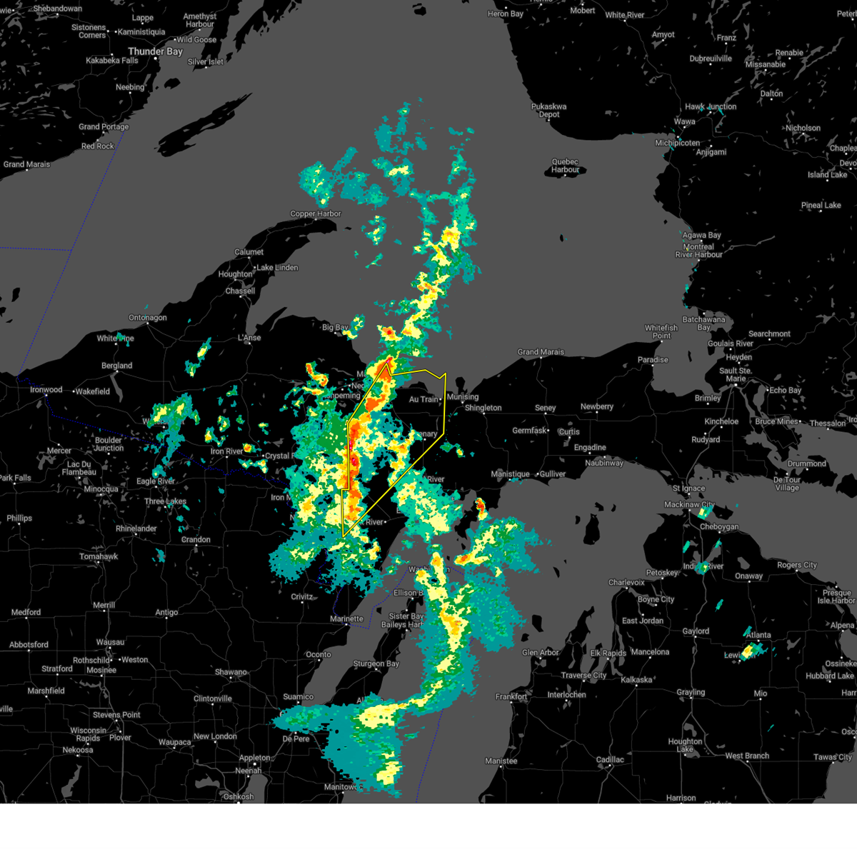
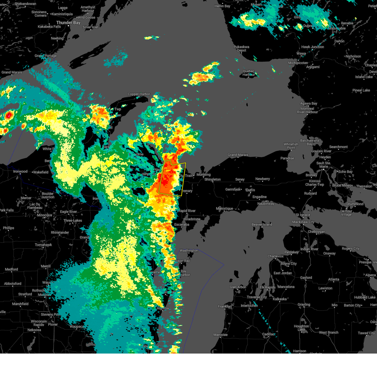
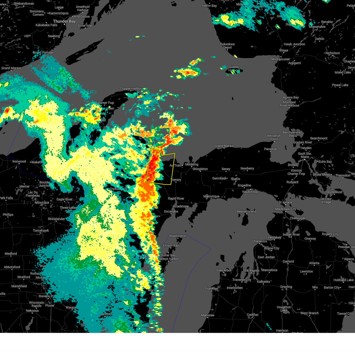
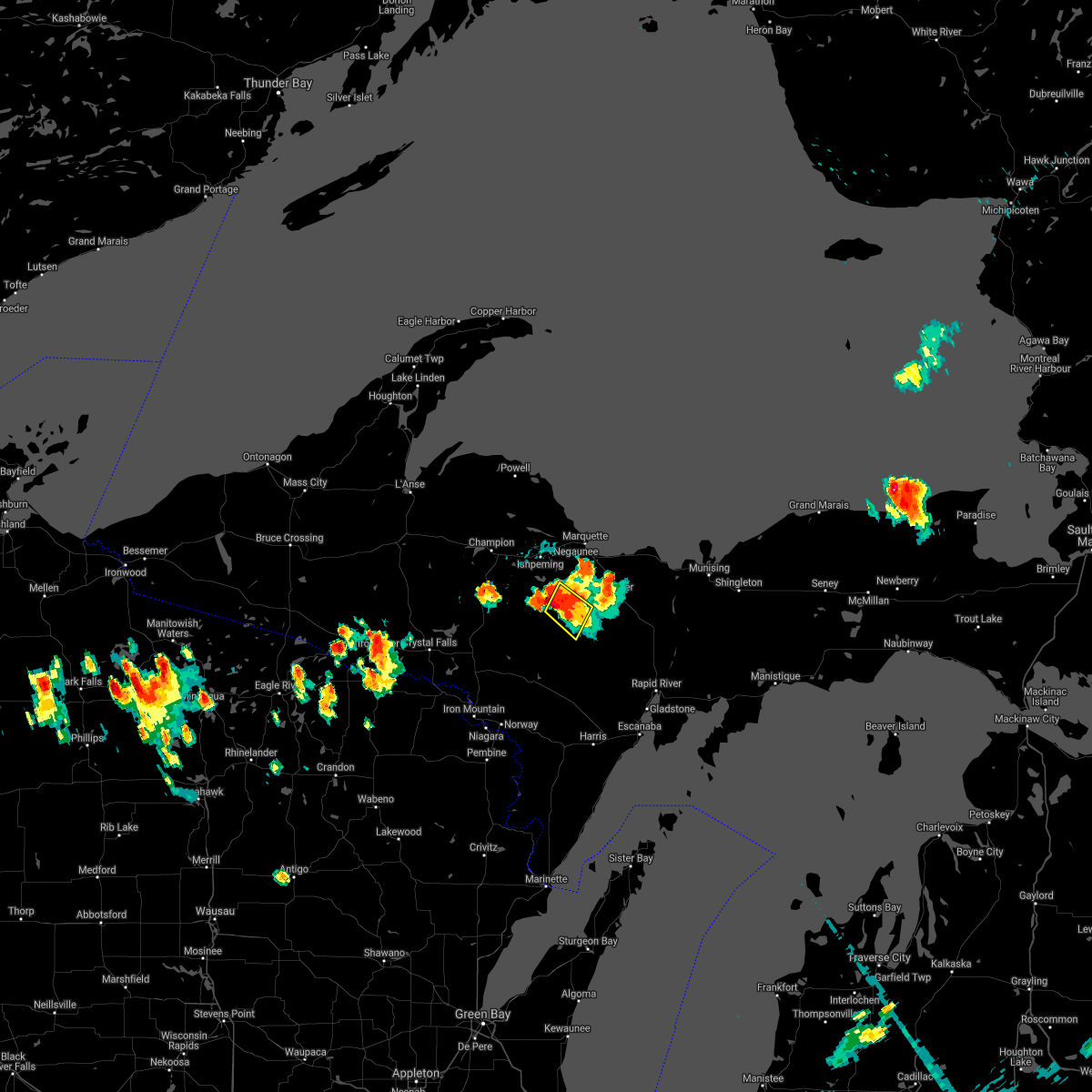
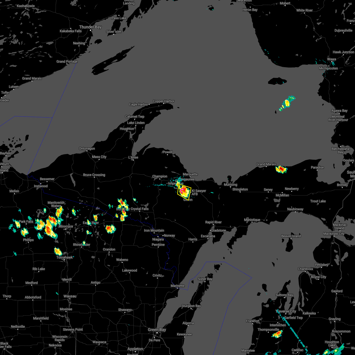
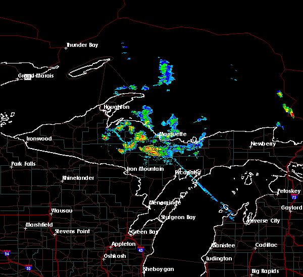
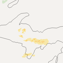
Hail Map for Gwinn, MI
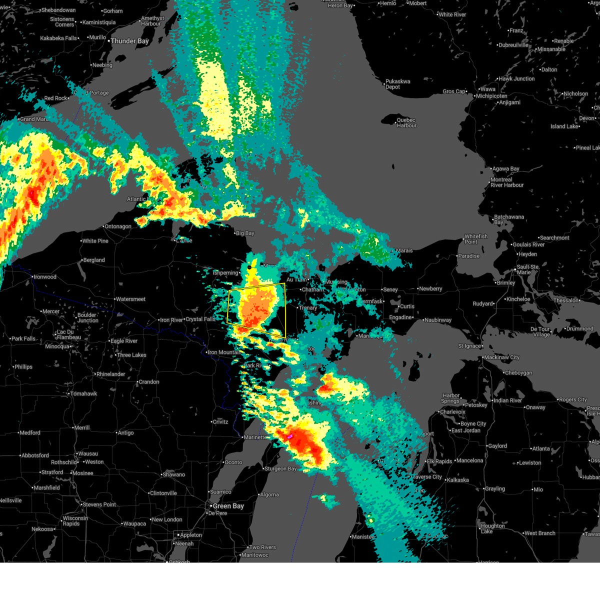
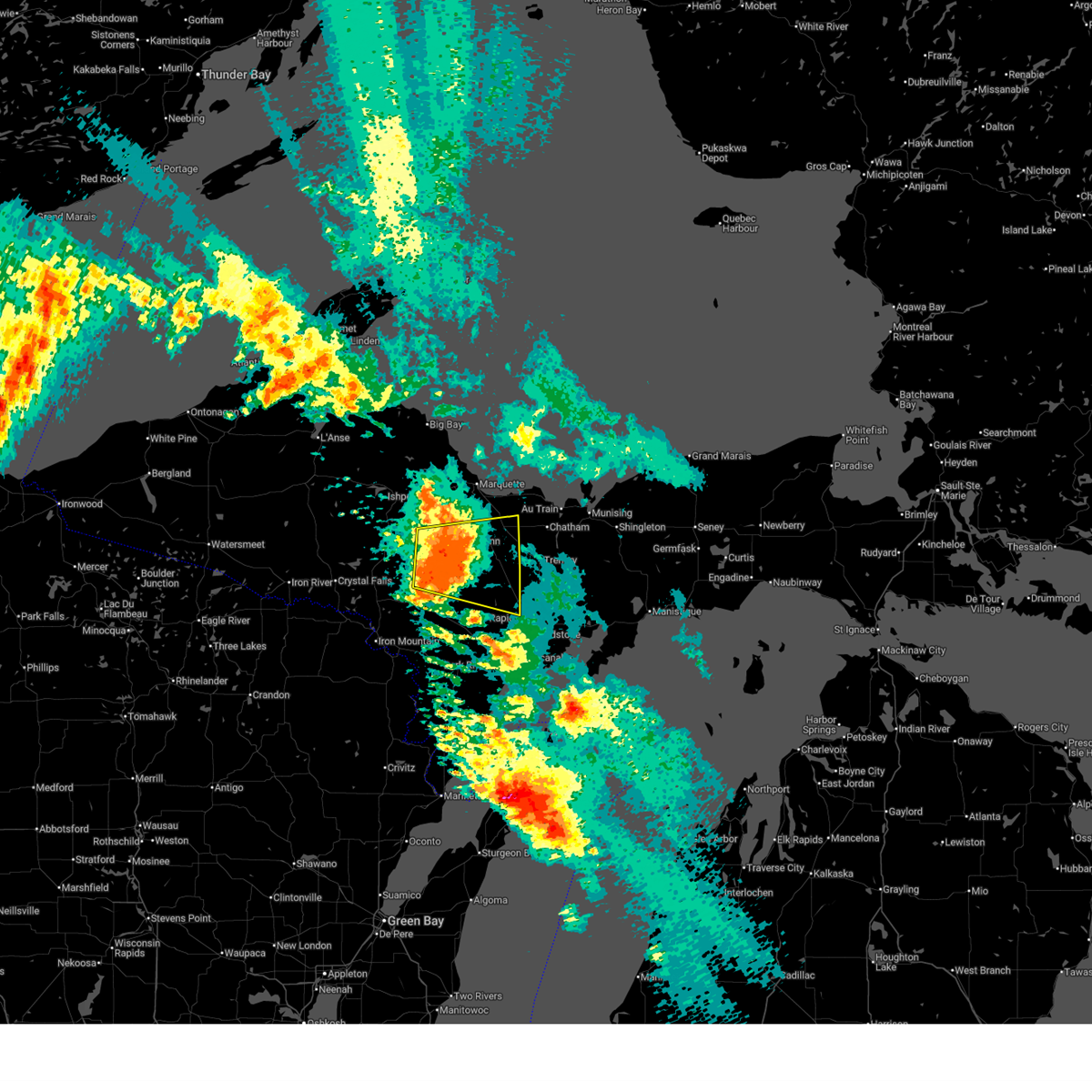
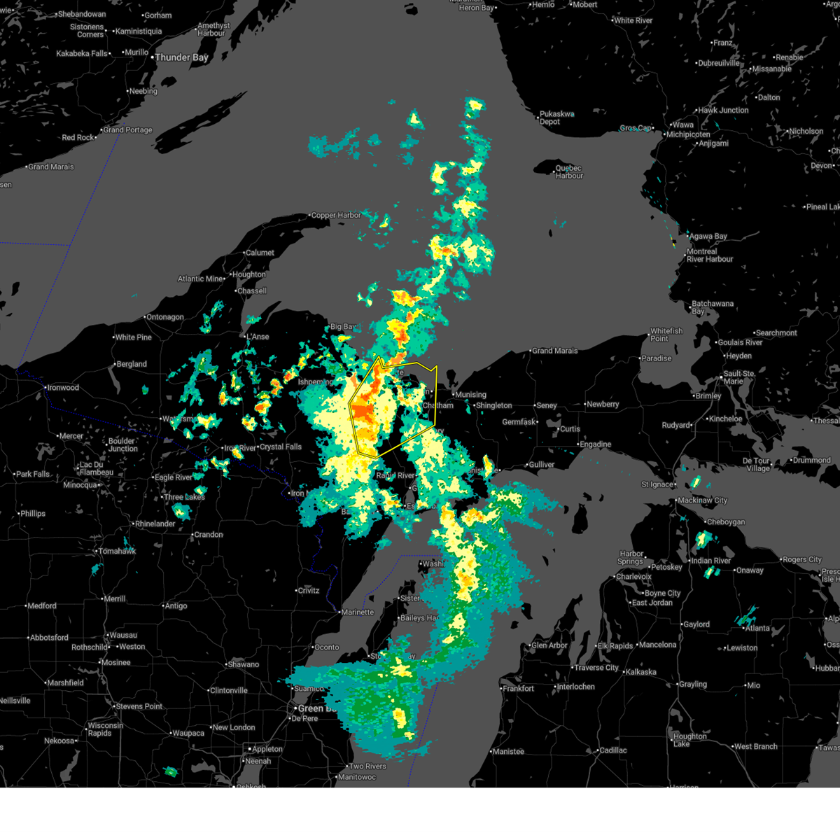
The Gwinn, MI area has had 2 reports of on-the-ground hail by trained spotters, and has been under severe weather warnings 0 times during the past 12 months. Doppler radar has detected hail at or near Gwinn, MI on 27 occasions, including 1 occasion during the past year.
| Name: | Gwinn, MI |
| Where Located: | 17.5 miles S of Marquette, MI |
| Map: | Google Map for Gwinn, MI |
| Population: | 1917 |
| Housing Units: | 976 |
| More Info: | Search Google for Gwinn, MI |
1
The Top Recent Hail Date for Gwinn, MI is Wednesday, September 17, 2025 (9th out of 27)
Hail and Wind Damage Spotted near Gwinn, MI
| Date / Time | Report Details |
|---|---|
| 6/21/2025 5:23 AM EDT |
 the severe thunderstorm warning has been cancelled and is no longer in effect the severe thunderstorm warning has been cancelled and is no longer in effect
|
| 6/21/2025 5:09 AM EDT |
 Svrmqt the national weather service in marquette has issued a * severe thunderstorm warning for, northeastern dickinson county in south central upper michigan, northwestern delta county in south central upper michigan, southeastern marquette county in north central upper michigan, * until 600 am edt/500 am cdt/. * at 509 am edt/409 am cdt/, a severe thunderstorm was located 8 miles southwest of gwinn, or 18 miles south of ishpeming, moving east at 30 mph (radar indicated). Hazards include 60 mph wind gusts and penny size hail. expect damage to roofs, siding, and trees Svrmqt the national weather service in marquette has issued a * severe thunderstorm warning for, northeastern dickinson county in south central upper michigan, northwestern delta county in south central upper michigan, southeastern marquette county in north central upper michigan, * until 600 am edt/500 am cdt/. * at 509 am edt/409 am cdt/, a severe thunderstorm was located 8 miles southwest of gwinn, or 18 miles south of ishpeming, moving east at 30 mph (radar indicated). Hazards include 60 mph wind gusts and penny size hail. expect damage to roofs, siding, and trees
|
| 5/16/2025 5:35 PM EDT |
 At 534 pm edt, severe thunderstorms were located along a line extending from harvey to 6 miles east of gwinn to near watson, moving northeast at 50 mph (radar indicated). Hazards include 60 mph wind gusts. Expect damage to roofs, siding, and trees. locations impacted include, marquette, au train, chatham, deerton, trenary, k. i. Sawyer airport, harvey, gwinn, sands, skandia, forest lake, and the 553 and 480 crossroads. At 534 pm edt, severe thunderstorms were located along a line extending from harvey to 6 miles east of gwinn to near watson, moving northeast at 50 mph (radar indicated). Hazards include 60 mph wind gusts. Expect damage to roofs, siding, and trees. locations impacted include, marquette, au train, chatham, deerton, trenary, k. i. Sawyer airport, harvey, gwinn, sands, skandia, forest lake, and the 553 and 480 crossroads.
|
| 5/16/2025 5:35 PM EDT |
 the severe thunderstorm warning has been cancelled and is no longer in effect the severe thunderstorm warning has been cancelled and is no longer in effect
|
| 5/16/2025 5:13 PM EDT |
 Svrmqt the national weather service in marquette has issued a * severe thunderstorm warning for, northwestern delta county in south central upper michigan, northeastern menominee county in south central upper michigan, southeastern marquette county in north central upper michigan, southwestern alger county in north central upper michigan, * until 615 pm edt/515 pm cdt/. * at 513 pm edt/413 pm cdt/, severe thunderstorms were located along a line extending from near gwinn to near watson to hermansville, moving northeast at 50 mph (radar indicated). Hazards include 60 mph wind gusts. expect damage to roofs, siding, and trees Svrmqt the national weather service in marquette has issued a * severe thunderstorm warning for, northwestern delta county in south central upper michigan, northeastern menominee county in south central upper michigan, southeastern marquette county in north central upper michigan, southwestern alger county in north central upper michigan, * until 615 pm edt/515 pm cdt/. * at 513 pm edt/413 pm cdt/, severe thunderstorms were located along a line extending from near gwinn to near watson to hermansville, moving northeast at 50 mph (radar indicated). Hazards include 60 mph wind gusts. expect damage to roofs, siding, and trees
|
| 5/16/2025 4:00 PM EDT | Large branch about 10 inches in diameter broke from a tree in the yar in marquette county MI, 1 miles NNW of Gwinn, MI |
| 8/27/2024 3:00 AM EDT |
 At 259 am edt, severe thunderstorms were located along a line extending from near presque isle to 8 miles southeast of gwinn, moving east at 20 mph (radar indicated). Hazards include 60 mph wind gusts and quarter size hail. Hail damage to vehicles is expected. expect wind damage to roofs, siding, and trees. locations impacted include, marquette, presque isle, k. i. Sawyer airport, deerton, harvey, gwinn, sands, skandia, shot point, laughing whitefish falls, beaver grove, and sundell. At 259 am edt, severe thunderstorms were located along a line extending from near presque isle to 8 miles southeast of gwinn, moving east at 20 mph (radar indicated). Hazards include 60 mph wind gusts and quarter size hail. Hail damage to vehicles is expected. expect wind damage to roofs, siding, and trees. locations impacted include, marquette, presque isle, k. i. Sawyer airport, deerton, harvey, gwinn, sands, skandia, shot point, laughing whitefish falls, beaver grove, and sundell.
|
| 8/27/2024 2:46 AM EDT |
 Svrmqt the national weather service in marquette has issued a * severe thunderstorm warning for, southeastern marquette county in north central upper michigan, southwestern alger county in north central upper michigan, * until 315 am edt. * at 245 am edt, severe thunderstorms were located along a line extending from presque isle to 6 miles south of gwinn, moving east at 20 mph (radar indicated). Hazards include 60 mph wind gusts and quarter size hail. Hail damage to vehicles is expected. Expect wind damage to roofs, siding, and trees. Svrmqt the national weather service in marquette has issued a * severe thunderstorm warning for, southeastern marquette county in north central upper michigan, southwestern alger county in north central upper michigan, * until 315 am edt. * at 245 am edt, severe thunderstorms were located along a line extending from presque isle to 6 miles south of gwinn, moving east at 20 mph (radar indicated). Hazards include 60 mph wind gusts and quarter size hail. Hail damage to vehicles is expected. Expect wind damage to roofs, siding, and trees.
|
| 8/27/2024 2:40 AM EDT | Trees down on roadway. time estimated from rada in marquette county MI, 2.8 miles ENE of Gwinn, MI |
| 8/27/2024 2:30 AM EDT | Multiple power outages reported in and around gwinn... sawyer... republic... dead river basin... and near greenwood res. report from utility outage map. time estimated in marquette county MI, 1.7 miles E of Gwinn, MI |
| 6/13/2024 1:19 PM EDT |
 Svrmqt the national weather service in marquette has issued a * severe thunderstorm warning for, east central marquette county in north central upper michigan, western alger county in north central upper michigan, * until 145 pm edt. * at 118 pm edt, a severe thunderstorm was located near gwinn, or 18 miles south of marquette, moving east at 35 mph (radar indicated). Hazards include 60 mph wind gusts and quarter size hail. Hail damage to vehicles is expected. Expect wind damage to roofs, siding, and trees. Svrmqt the national weather service in marquette has issued a * severe thunderstorm warning for, east central marquette county in north central upper michigan, western alger county in north central upper michigan, * until 145 pm edt. * at 118 pm edt, a severe thunderstorm was located near gwinn, or 18 miles south of marquette, moving east at 35 mph (radar indicated). Hazards include 60 mph wind gusts and quarter size hail. Hail damage to vehicles is expected. Expect wind damage to roofs, siding, and trees.
|
| 7/10/2023 7:16 PM EDT |
 At 716 pm edt, a severe thunderstorm was located near k. i. sawyer airport, or 16 miles south of marquette, moving east at 40 mph (radar indicated). Hazards include quarter size hail. Damage to vehicles is expected. locations impacted include, chatham, k. i. sawyer airport, trenary, gwinn, u. s. 41 between trenary and rapid river, sands, skandia, laughing whitefish falls, forest lake, sundell, little lake and kiva. hail threat, radar indicated max hail size, 1. 00 in wind threat, radar indicated max wind gust, <50 mph. At 716 pm edt, a severe thunderstorm was located near k. i. sawyer airport, or 16 miles south of marquette, moving east at 40 mph (radar indicated). Hazards include quarter size hail. Damage to vehicles is expected. locations impacted include, chatham, k. i. sawyer airport, trenary, gwinn, u. s. 41 between trenary and rapid river, sands, skandia, laughing whitefish falls, forest lake, sundell, little lake and kiva. hail threat, radar indicated max hail size, 1. 00 in wind threat, radar indicated max wind gust, <50 mph.
|
| 7/10/2023 7:13 PM EDT | Quarter sized hail reported 1 miles NNW of Gwinn, MI, report with picture. |
| 7/10/2023 7:04 PM EDT |
 At 704 pm edt/604 pm cdt/, a severe thunderstorm was located near gwinn, or 13 miles southeast of ishpeming, moving east at 40 mph (radar indicated). Hazards include 60 mph wind gusts and quarter size hail. Hail damage to vehicles is expected. expect wind damage to roofs, siding, and trees. locations impacted include, ishpeming, chatham, k. i. sawyer airport, trenary, gwinn, u. s. 41 between trenary and rapid river, sands, skandia, laughing whitefish falls, forest lake, sundell and little lake. hail threat, radar indicated max hail size, 1. 00 in wind threat, radar indicated max wind gust, 60 mph. At 704 pm edt/604 pm cdt/, a severe thunderstorm was located near gwinn, or 13 miles southeast of ishpeming, moving east at 40 mph (radar indicated). Hazards include 60 mph wind gusts and quarter size hail. Hail damage to vehicles is expected. expect wind damage to roofs, siding, and trees. locations impacted include, ishpeming, chatham, k. i. sawyer airport, trenary, gwinn, u. s. 41 between trenary and rapid river, sands, skandia, laughing whitefish falls, forest lake, sundell and little lake. hail threat, radar indicated max hail size, 1. 00 in wind threat, radar indicated max wind gust, 60 mph.
|
| 7/10/2023 6:49 PM EDT |
 At 649 pm edt/549 pm cdt/, a severe thunderstorm was located 7 miles southeast of gwinn, or 22 miles south of marquette, moving east at 35 mph (radar indicated). Hazards include quarter size hail. Damage to vehicles is expected. locations impacted include, k. i. sawyer airport, rock, gwinn, skandia, mcfarland, anderson lake, lathrop, little lake, carlshend and big bass lake. hail threat, radar indicated max hail size, 1. 00 in wind threat, radar indicated max wind gust, <50 mph. At 649 pm edt/549 pm cdt/, a severe thunderstorm was located 7 miles southeast of gwinn, or 22 miles south of marquette, moving east at 35 mph (radar indicated). Hazards include quarter size hail. Damage to vehicles is expected. locations impacted include, k. i. sawyer airport, rock, gwinn, skandia, mcfarland, anderson lake, lathrop, little lake, carlshend and big bass lake. hail threat, radar indicated max hail size, 1. 00 in wind threat, radar indicated max wind gust, <50 mph.
|
| 7/10/2023 6:43 PM EDT |
 At 643 pm edt/543 pm cdt/, a severe thunderstorm was located 8 miles east of witch lake, or 14 miles southwest of ishpeming, moving east at 40 mph (radar indicated). Hazards include 60 mph wind gusts and quarter size hail. Hail damage to vehicles is expected. Expect wind damage to roofs, siding, and trees. At 643 pm edt/543 pm cdt/, a severe thunderstorm was located 8 miles east of witch lake, or 14 miles southwest of ishpeming, moving east at 40 mph (radar indicated). Hazards include 60 mph wind gusts and quarter size hail. Hail damage to vehicles is expected. Expect wind damage to roofs, siding, and trees.
|
| 7/10/2023 6:40 PM EDT |
 At 640 pm edt/540 pm cdt/, a severe thunderstorm was located near gwinn, or 21 miles southeast of ishpeming, moving east at 45 mph (radar indicated). Hazards include quarter size hail. Damage to vehicles is expected. locations impacted include, k. i. sawyer airport, rock, gwinn, skandia, mcfarland, anderson lake, lathrop, little lake, carlshend and big bass lake. hail threat, radar indicated max hail size, 1. 00 in wind threat, radar indicated max wind gust, <50 mph. At 640 pm edt/540 pm cdt/, a severe thunderstorm was located near gwinn, or 21 miles southeast of ishpeming, moving east at 45 mph (radar indicated). Hazards include quarter size hail. Damage to vehicles is expected. locations impacted include, k. i. sawyer airport, rock, gwinn, skandia, mcfarland, anderson lake, lathrop, little lake, carlshend and big bass lake. hail threat, radar indicated max hail size, 1. 00 in wind threat, radar indicated max wind gust, <50 mph.
|
| 7/10/2023 6:34 PM EDT |
 At 634 pm edt/534 pm cdt/, a severe thunderstorm was located near gwinn, or 18 miles southeast of ishpeming, moving east at 45 mph (radar indicated). Hazards include quarter size hail. Damage to vehicles is expected. locations impacted include, k. i. sawyer airport, rock, gwinn, skandia, mcfarland, anderson lake, lathrop, little lake, carlshend and big bass lake. hail threat, radar indicated max hail size, 1. 00 in wind threat, radar indicated max wind gust, <50 mph. At 634 pm edt/534 pm cdt/, a severe thunderstorm was located near gwinn, or 18 miles southeast of ishpeming, moving east at 45 mph (radar indicated). Hazards include quarter size hail. Damage to vehicles is expected. locations impacted include, k. i. sawyer airport, rock, gwinn, skandia, mcfarland, anderson lake, lathrop, little lake, carlshend and big bass lake. hail threat, radar indicated max hail size, 1. 00 in wind threat, radar indicated max wind gust, <50 mph.
|
| 7/10/2023 6:22 PM EDT |
 At 622 pm edt/522 pm cdt/, a severe thunderstorm was located 13 miles east of witch lake, or 17 miles south of ishpeming, moving east at 35 mph (radar indicated). Hazards include quarter size hail. damage to vehicles is expected At 622 pm edt/522 pm cdt/, a severe thunderstorm was located 13 miles east of witch lake, or 17 miles south of ishpeming, moving east at 35 mph (radar indicated). Hazards include quarter size hail. damage to vehicles is expected
|
| 8/2/2022 10:10 PM EDT | Multiple power outages are reported in forsyth and richmond townships in marquette county. event time based on rada in marquette county MI, 1.2 miles ENE of Gwinn, MI |
| 8/2/2022 10:06 PM EDT | Marquette county law enforcement dispatch reports large trees and downed wires suspended on other wires around the princeton area west of gwinn along m-35 in forsyth to in marquette county MI, 4.1 miles E of Gwinn, MI |
| 8/2/2022 10:06 PM EDT | Law enforcement dispatch reports a power line down across m-35 between chipmunk field and the cataract basin drive west of princeton. time based on rada in marquette county MI, 3.1 miles E of Gwinn, MI |
| 8/2/2022 10:05 PM EDT | Law enforcement reports downed power lines on shag lake drive in forsyth township. time is estimated from mqt rada in marquette county MI, 3.1 miles ENE of Gwinn, MI |
| 8/2/2022 10:02 PM EDT |
 At 1002 pm edt, a severe thunderstorm was located near west ishpeming, moving east at 35 mph (radar indicated). Hazards include 60 mph wind gusts and quarter size hail. Hail damage to vehicles is expected. expect wind damage to roofs, siding, and trees. this severe storm will be near, negaunee around 1005 pm edt. gwinn around 1025 pm edt. other locations impacted by this severe thunderstorm include national mine and palmer. hail threat, radar indicated max hail size, 1. 00 in wind threat, radar indicated max wind gust, 60 mph. At 1002 pm edt, a severe thunderstorm was located near west ishpeming, moving east at 35 mph (radar indicated). Hazards include 60 mph wind gusts and quarter size hail. Hail damage to vehicles is expected. expect wind damage to roofs, siding, and trees. this severe storm will be near, negaunee around 1005 pm edt. gwinn around 1025 pm edt. other locations impacted by this severe thunderstorm include national mine and palmer. hail threat, radar indicated max hail size, 1. 00 in wind threat, radar indicated max wind gust, 60 mph.
|
| 8/2/2022 10:00 PM EDT | Report from mping: trees uprooted or snapped. event time based off mqt rada in marquette county MI, 7.8 miles ENE of Gwinn, MI |
| 8/2/2022 9:55 PM EDT | Tree down and damaged the power mast of the roof on the northside of west bass lake. report relayed from wjmntv3 meteorologis in marquette county MI, 7.1 miles ENE of Gwinn, MI |
| 8/2/2022 9:43 PM EDT |
 At 943 pm edt, a severe thunderstorm was located near champion, or 13 miles west of ishpeming, moving east at 30 mph (radar indicated). Hazards include 60 mph wind gusts and quarter size hail. Hail damage to vehicles is expected. expect wind damage to roofs, siding, and trees. this severe storm will be near, west ishpeming around 1000 pm edt. ishpeming around 1005 pm edt. negaunee around 1010 pm edt. other locations impacted by this severe thunderstorm include humboldt, national mine, palmer, diorite, van riper state park and republic. hail threat, radar indicated max hail size, 1. 00 in wind threat, radar indicated max wind gust, 60 mph. At 943 pm edt, a severe thunderstorm was located near champion, or 13 miles west of ishpeming, moving east at 30 mph (radar indicated). Hazards include 60 mph wind gusts and quarter size hail. Hail damage to vehicles is expected. expect wind damage to roofs, siding, and trees. this severe storm will be near, west ishpeming around 1000 pm edt. ishpeming around 1005 pm edt. negaunee around 1010 pm edt. other locations impacted by this severe thunderstorm include humboldt, national mine, palmer, diorite, van riper state park and republic. hail threat, radar indicated max hail size, 1. 00 in wind threat, radar indicated max wind gust, 60 mph.
|
| 8/2/2022 9:26 PM EDT |
 At 925 pm edt, a severe thunderstorm was located over lake michigamme, or 16 miles west of ishpeming, moving east at 35 mph (radar indicated). Hazards include 60 mph wind gusts and quarter size hail. Hail damage to vehicles is expected. expect wind damage to roofs, siding, and trees. this severe thunderstorm will be near, west ishpeming around 945 pm edt. ishpeming around 950 pm edt. negaunee around 955 pm edt. marquette and trowbridge park around 1010 pm edt. other locations impacted by this severe thunderstorm include palmer, diorite, van riper state park, humboldt, national mine, big bass lake and republic. hail threat, radar indicated max hail size, 1. 00 in wind threat, radar indicated max wind gust, 60 mph. At 925 pm edt, a severe thunderstorm was located over lake michigamme, or 16 miles west of ishpeming, moving east at 35 mph (radar indicated). Hazards include 60 mph wind gusts and quarter size hail. Hail damage to vehicles is expected. expect wind damage to roofs, siding, and trees. this severe thunderstorm will be near, west ishpeming around 945 pm edt. ishpeming around 950 pm edt. negaunee around 955 pm edt. marquette and trowbridge park around 1010 pm edt. other locations impacted by this severe thunderstorm include palmer, diorite, van riper state park, humboldt, national mine, big bass lake and republic. hail threat, radar indicated max hail size, 1. 00 in wind threat, radar indicated max wind gust, 60 mph.
|
| 6/28/2022 4:08 PM EDT | Shared a picture showing two downed trees blocking county rd sd. time estimated by rada in marquette county MI, 20.3 miles N of Gwinn, MI |
| 8/10/2021 4:55 PM EDT |
 The severe thunderstorm warning for northeastern dickinson, northwestern delta, northeastern menominee, southeastern marquette and southwestern alger counties will expire at 500 pm edt/400 pm cdt/, the storm which prompted the warning has weakened below severe limits, and no longer poses an immediate threat to life or property. therefore, the warning will be allowed to expire. however gusty winds and heavy rain are still possible with this thunderstorm. The severe thunderstorm warning for northeastern dickinson, northwestern delta, northeastern menominee, southeastern marquette and southwestern alger counties will expire at 500 pm edt/400 pm cdt/, the storm which prompted the warning has weakened below severe limits, and no longer poses an immediate threat to life or property. therefore, the warning will be allowed to expire. however gusty winds and heavy rain are still possible with this thunderstorm.
|
| 8/10/2021 4:54 PM EDT |
 The severe thunderstorm warning for northeastern dickinson and southeastern marquette counties will expire at 500 pm edt/400 pm cdt/, the storm which prompted the warning has moved out of the area. therefore, the warning will be allowed to expire. The severe thunderstorm warning for northeastern dickinson and southeastern marquette counties will expire at 500 pm edt/400 pm cdt/, the storm which prompted the warning has moved out of the area. therefore, the warning will be allowed to expire.
|
| 8/10/2021 4:43 PM EDT |
 At 443 pm edt/343 pm cdt/, a severe thunderstorm was located over k i sawyer, or 15 miles south of marquette, moving east at 30 mph (radar indicated). Hazards include 60 mph wind gusts and penny size hail. Expect damage to roofs, siding, and trees. locations impacted include, k. i. sawyer airport, harvey, k i sawyer, gwinn, sands, palmer, beaver grove, anderson lake, the 553 and 480 crossroads, little lake and big bass lake. hail threat, radar indicated max hail size, 0. 75 in wind threat, radar indicated max wind gust, 60 mph. At 443 pm edt/343 pm cdt/, a severe thunderstorm was located over k i sawyer, or 15 miles south of marquette, moving east at 30 mph (radar indicated). Hazards include 60 mph wind gusts and penny size hail. Expect damage to roofs, siding, and trees. locations impacted include, k. i. sawyer airport, harvey, k i sawyer, gwinn, sands, palmer, beaver grove, anderson lake, the 553 and 480 crossroads, little lake and big bass lake. hail threat, radar indicated max hail size, 0. 75 in wind threat, radar indicated max wind gust, 60 mph.
|
| 8/10/2021 4:35 PM EDT |
 At 434 pm edt/334 pm cdt/, a severe thunderstorm was located near k i sawyer, or 18 miles south of marquette, moving east at 30 mph (radar indicated). Hazards include 60 mph wind gusts and penny size hail. expect damage to roofs, siding, and trees At 434 pm edt/334 pm cdt/, a severe thunderstorm was located near k i sawyer, or 18 miles south of marquette, moving east at 30 mph (radar indicated). Hazards include 60 mph wind gusts and penny size hail. expect damage to roofs, siding, and trees
|
| 8/10/2021 4:30 PM EDT | Facebook report with photo of several trees and a broken power pole in the gwinn area. time estimated by rada in marquette county MI, 1 miles NNW of Gwinn, MI |
| 8/10/2021 4:22 PM EDT | Uppco outage map showed more than a thousand customers without power in the area west of gwinn... with most outages concentrated around shag lake. delayed report. time in marquette county MI, 3.5 miles ENE of Gwinn, MI |
| 8/10/2021 4:13 PM EDT |
 At 412 pm edt/312 pm cdt/, a severe thunderstorm was located 12 miles west of gwinn, or 13 miles south of ishpeming, moving east at 35 mph (radar indicated). Hazards include 60 mph wind gusts and penny size hail. expect damage to roofs, siding, and trees At 412 pm edt/312 pm cdt/, a severe thunderstorm was located 12 miles west of gwinn, or 13 miles south of ishpeming, moving east at 35 mph (radar indicated). Hazards include 60 mph wind gusts and penny size hail. expect damage to roofs, siding, and trees
|
| 6/8/2021 5:52 PM EDT |
 The severe thunderstorm warning for south central marquette county will expire at 600 pm edt, the storm which prompted the warning has weakened below severe limits, and no longer poses an immediate threat to life or property. therefore, the warning will be allowed to expire. however gusty winds and heavy rain are still possible with this thunderstorm. The severe thunderstorm warning for south central marquette county will expire at 600 pm edt, the storm which prompted the warning has weakened below severe limits, and no longer poses an immediate threat to life or property. therefore, the warning will be allowed to expire. however gusty winds and heavy rain are still possible with this thunderstorm.
|
| 6/8/2021 5:36 PM EDT | Numerous power outages reported in the little shag lake area as well as additional multiple outages in the princeton and areas west in forsyth townshi in marquette county MI, 3.5 miles NE of Gwinn, MI |
| 6/8/2021 5:36 PM EDT |
 At 536 pm edt, a severe thunderstorm was located near gwinn, or 15 miles south of ishpeming, moving southeast at 5 mph (radar indicated). Hazards include 60 mph wind gusts and quarter size hail. Hail damage to vehicles is expected. expect wind damage to roofs, siding, and trees. Locations impacted include, gwinn and anderson lake. At 536 pm edt, a severe thunderstorm was located near gwinn, or 15 miles south of ishpeming, moving southeast at 5 mph (radar indicated). Hazards include 60 mph wind gusts and quarter size hail. Hail damage to vehicles is expected. expect wind damage to roofs, siding, and trees. Locations impacted include, gwinn and anderson lake.
|
| 6/8/2021 5:16 PM EDT |
 At 515 pm edt, a severe thunderstorm was located near gwinn, or 14 miles southeast of ishpeming, moving southeast at 10 mph (radar indicated). Hazards include 60 mph wind gusts and quarter size hail. Hail damage to vehicles is expected. Expect wind damage to roofs, siding, and trees. At 515 pm edt, a severe thunderstorm was located near gwinn, or 14 miles southeast of ishpeming, moving southeast at 10 mph (radar indicated). Hazards include 60 mph wind gusts and quarter size hail. Hail damage to vehicles is expected. Expect wind damage to roofs, siding, and trees.
|
| 6/8/2021 5:00 PM EDT |
 At 500 pm edt, a severe thunderstorm was located near k i sawyer, or 10 miles southeast of ishpeming, moving east at 5 mph (radar indicated). Hazards include 60 mph wind gusts and quarter size hail. Hail damage to vehicles is expected. expect wind damage to roofs, siding, and trees. locations impacted include, gwinn, k. i. Sawyer airport and palmer. At 500 pm edt, a severe thunderstorm was located near k i sawyer, or 10 miles southeast of ishpeming, moving east at 5 mph (radar indicated). Hazards include 60 mph wind gusts and quarter size hail. Hail damage to vehicles is expected. expect wind damage to roofs, siding, and trees. locations impacted include, gwinn, k. i. Sawyer airport and palmer.
|
| 6/8/2021 4:44 PM EDT |
 At 443 pm edt, a severe thunderstorm was located 7 miles northwest of gwinn, or 10 miles southeast of ishpeming, moving east at 5 mph (radar indicated). Hazards include 60 mph wind gusts and quarter size hail. Hail damage to vehicles is expected. expect wind damage to roofs, siding, and trees. this severe thunderstorm will be near, k. i. sawyer airport and gwinn around 515 pm edt. Other locations impacted by this severe thunderstorm include palmer. At 443 pm edt, a severe thunderstorm was located 7 miles northwest of gwinn, or 10 miles southeast of ishpeming, moving east at 5 mph (radar indicated). Hazards include 60 mph wind gusts and quarter size hail. Hail damage to vehicles is expected. expect wind damage to roofs, siding, and trees. this severe thunderstorm will be near, k. i. sawyer airport and gwinn around 515 pm edt. Other locations impacted by this severe thunderstorm include palmer.
|
| 8/10/2020 10:23 AM EDT |
 At 1022 am edt, severe thunderstorms were located along a line extending from near harvey to 8 miles east of k i sawyer to 6 miles northeast of watson, moving east at 45 mph (radar indicated). Hazards include 60 mph wind gusts and half dollar size hail. Hail damage to vehicles is expected. expect wind damage to roofs, siding, and trees. locations impacted include, watson, au train, chatham, deerton, trenary, k. i. sawyer airport, rock, k i sawyer, harvey, gwinn, u. s. 41 between trenary and rapid river and sands. At 1022 am edt, severe thunderstorms were located along a line extending from near harvey to 8 miles east of k i sawyer to 6 miles northeast of watson, moving east at 45 mph (radar indicated). Hazards include 60 mph wind gusts and half dollar size hail. Hail damage to vehicles is expected. expect wind damage to roofs, siding, and trees. locations impacted include, watson, au train, chatham, deerton, trenary, k. i. sawyer airport, rock, k i sawyer, harvey, gwinn, u. s. 41 between trenary and rapid river and sands.
|
| 8/10/2020 10:11 AM EDT |
 At 1010 am edt/910 am cdt/, severe thunderstorms were located along a line extending from 7 miles south of negaunee to 7 miles southwest of gwinn to 7 miles northeast of foster city, moving east at 40 mph (radar indicated). Hazards include 60 mph wind gusts and quarter size hail. Hail damage to vehicles is expected. Expect wind damage to roofs, siding, and trees. At 1010 am edt/910 am cdt/, severe thunderstorms were located along a line extending from 7 miles south of negaunee to 7 miles southwest of gwinn to 7 miles northeast of foster city, moving east at 40 mph (radar indicated). Hazards include 60 mph wind gusts and quarter size hail. Hail damage to vehicles is expected. Expect wind damage to roofs, siding, and trees.
|
| 8/9/2020 11:26 PM EDT |
 At 1126 pm edt/1026 pm cdt/, severe thunderstorms were located along a line extending from near trowbridge park to near k i sawyer to 7 miles south of gwinn to 7 miles northeast of foster city, moving east at 50 mph (radar indicated). Hazards include 60 mph wind gusts. Expect damage to roofs, siding, and trees. locations impacted include, marquette, ishpeming, presque isle, negaunee, felch, little presque isle, k. i. Sawyer airport, k i sawyer, trowbridge park, harvey, gwinn and sands. At 1126 pm edt/1026 pm cdt/, severe thunderstorms were located along a line extending from near trowbridge park to near k i sawyer to 7 miles south of gwinn to 7 miles northeast of foster city, moving east at 50 mph (radar indicated). Hazards include 60 mph wind gusts. Expect damage to roofs, siding, and trees. locations impacted include, marquette, ishpeming, presque isle, negaunee, felch, little presque isle, k. i. Sawyer airport, k i sawyer, trowbridge park, harvey, gwinn and sands.
|
| 8/9/2020 11:15 PM EDT |
 At 1115 pm edt/1015 pm cdt/, severe thunderstorms were located along a line extending from near negaunee to near gwinn to 13 miles northwest of watson to near felch, moving east at 50 mph (radar indicated). Hazards include 60 mph wind gusts and penny size hail. Expect damage to roofs, siding, and trees. locations impacted include, marquette, ishpeming, presque isle, negaunee, felch, little presque isle, west ishpeming, k. i. Sawyer airport, k i sawyer, trowbridge park, harvey and gwinn. At 1115 pm edt/1015 pm cdt/, severe thunderstorms were located along a line extending from near negaunee to near gwinn to 13 miles northwest of watson to near felch, moving east at 50 mph (radar indicated). Hazards include 60 mph wind gusts and penny size hail. Expect damage to roofs, siding, and trees. locations impacted include, marquette, ishpeming, presque isle, negaunee, felch, little presque isle, west ishpeming, k. i. Sawyer airport, k i sawyer, trowbridge park, harvey and gwinn.
|
| 8/9/2020 10:53 PM EDT |
 At 1053 pm edt/953 pm cdt/, severe thunderstorms were located along a line extending from near champion to 12 miles south of west ishpeming to 11 miles southeast of witch lake to 6 miles south of channing, moving east at 50 mph (radar indicated). Hazards include 60 mph wind gusts and penny size hail. expect damage to roofs, siding, and trees At 1053 pm edt/953 pm cdt/, severe thunderstorms were located along a line extending from near champion to 12 miles south of west ishpeming to 11 miles southeast of witch lake to 6 miles south of channing, moving east at 50 mph (radar indicated). Hazards include 60 mph wind gusts and penny size hail. expect damage to roofs, siding, and trees
|
| 7/19/2020 2:37 AM EDT |
 At 237 am edt, severe thunderstorms were located along a line extending from 10 miles southeast of k i sawyer to 8 miles southeast of gwinn to 12 miles northwest of watson, moving east at 25 mph (radar indicated). Hazards include 60 mph wind gusts and penny size hail. expect damage to roofs, siding, and trees At 237 am edt, severe thunderstorms were located along a line extending from 10 miles southeast of k i sawyer to 8 miles southeast of gwinn to 12 miles northwest of watson, moving east at 25 mph (radar indicated). Hazards include 60 mph wind gusts and penny size hail. expect damage to roofs, siding, and trees
|
| 8/27/2019 3:45 PM EDT | Delayed report. received pictures of an approximately 12 inch diameter tree down in gwin in marquette county MI, 1 miles NNW of Gwinn, MI |
| 8/27/2019 3:42 PM EDT |
 At 340 pm edt, severe thunderstorms were located along a line extending from 8 miles northeast of little presque isle to near k i sawyer, moving east at 45 mph (radar indicated). Hazards include 60 mph wind gusts and penny size hail. expect damage to roofs, siding, and trees At 340 pm edt, severe thunderstorms were located along a line extending from 8 miles northeast of little presque isle to near k i sawyer, moving east at 45 mph (radar indicated). Hazards include 60 mph wind gusts and penny size hail. expect damage to roofs, siding, and trees
|
| 8/27/2019 3:23 PM EDT |
 At 322 pm edt, severe thunderstorms were located along a line extending from 6 miles west of big bay to 11 miles northwest of little presque isle to near negaunee to 13 miles east of witch lake, moving east at 45 mph. a 54 mph wind gust was measured at the nws office in negaunee township at about 3:20 pm edt (radar indicated). Hazards include 60 mph wind gusts and penny size hail. expect damage to roofs, siding, and trees At 322 pm edt, severe thunderstorms were located along a line extending from 6 miles west of big bay to 11 miles northwest of little presque isle to near negaunee to 13 miles east of witch lake, moving east at 45 mph. a 54 mph wind gust was measured at the nws office in negaunee township at about 3:20 pm edt (radar indicated). Hazards include 60 mph wind gusts and penny size hail. expect damage to roofs, siding, and trees
|
| 8/5/2019 4:11 PM EDT | Multiple trees down along pine street. report via social media. time estimated by rada in marquette county MI, 1 miles NNW of Gwinn, MI |
| 8/5/2018 8:16 PM EDT |
 At 816 pm edt, a severe thunderstorm was located near k i sawyer, or 18 miles south of marquette, moving southeast at 30 mph (radar indicated). Hazards include 60 mph wind gusts and penny size hail. Expect damage to roofs, siding, and trees. locations impacted include, chatham, k. i. Sawyer airport, k i sawyer, trenary, gwinn, skandia, sundell, little lake, kiva, diffin, eben junction and carlshend. At 816 pm edt, a severe thunderstorm was located near k i sawyer, or 18 miles south of marquette, moving southeast at 30 mph (radar indicated). Hazards include 60 mph wind gusts and penny size hail. Expect damage to roofs, siding, and trees. locations impacted include, chatham, k. i. Sawyer airport, k i sawyer, trenary, gwinn, skandia, sundell, little lake, kiva, diffin, eben junction and carlshend.
|
| 8/5/2018 8:07 PM EDT | Corrects previous tstm wnd dmg report from 3 nnw little lake. photo received via social media of large pine tree felled onto a house. no injury to occupant. numerous ot in marquette county MI, 4.8 miles WSW of Gwinn, MI |
| 8/5/2018 8:03 PM EDT |
 At 802 pm edt, a severe thunderstorm was located over k i sawyer, or 15 miles south of marquette, moving east at 35 mph (radar indicated). Hazards include 60 mph wind gusts and nickel size hail. expect damage to roofs, siding, and trees At 802 pm edt, a severe thunderstorm was located over k i sawyer, or 15 miles south of marquette, moving east at 35 mph (radar indicated). Hazards include 60 mph wind gusts and nickel size hail. expect damage to roofs, siding, and trees
|
| 8/5/2018 8:00 PM EDT | Photo received via social media of large pine tree felled onto a house. no injury to occupant. numerous other trees reported down in the are in marquette county MI, 4.8 miles WSW of Gwinn, MI |
| 6/29/2018 1:17 PM EDT |
 At 116 pm edt, severe thunderstorms were located along a line extending from 10 miles northeast of presque isle to 9 miles east of witch lake, moving east at 40 mph (radar indicated). Hazards include 60 mph wind gusts and quarter size hail. Hail damage to vehicles is expected. expect wind damage to roofs, siding, and trees. locations impacted include, marquette, ishpeming, presque isle, negaunee, michigamme, champion, little presque isle, west ishpeming, k. i. Sawyer airport, the huron islands, k i sawyer and trowbridge park. At 116 pm edt, severe thunderstorms were located along a line extending from 10 miles northeast of presque isle to 9 miles east of witch lake, moving east at 40 mph (radar indicated). Hazards include 60 mph wind gusts and quarter size hail. Hail damage to vehicles is expected. expect wind damage to roofs, siding, and trees. locations impacted include, marquette, ishpeming, presque isle, negaunee, michigamme, champion, little presque isle, west ishpeming, k. i. Sawyer airport, the huron islands, k i sawyer and trowbridge park.
|
| 6/29/2018 12:48 PM EDT |
 At 1247 pm edt, severe thunderstorms were located along a line extending from 9 miles northeast of big bay to 7 miles north of squaw lake, moving east at 45 mph (radar indicated). Hazards include 60 mph wind gusts and quarter size hail. Hail damage to vehicles is expected. expect considerable tree damage. wind damage is also likely to mobile homes, roofs, and outbuildings. locations impacted include, marquette, ishpeming, presque isle, negaunee, michigamme, champion, little presque isle, west ishpeming, k. i. Sawyer airport, the huron islands, k i sawyer and trowbridge park. At 1247 pm edt, severe thunderstorms were located along a line extending from 9 miles northeast of big bay to 7 miles north of squaw lake, moving east at 45 mph (radar indicated). Hazards include 60 mph wind gusts and quarter size hail. Hail damage to vehicles is expected. expect considerable tree damage. wind damage is also likely to mobile homes, roofs, and outbuildings. locations impacted include, marquette, ishpeming, presque isle, negaunee, michigamme, champion, little presque isle, west ishpeming, k. i. Sawyer airport, the huron islands, k i sawyer and trowbridge park.
|
| 6/29/2018 12:24 PM EDT |
 At 1223 pm edt, severe thunderstorms were located along a line extending from 10 miles north of the huron islands to near three lakes, moving east at 50 mph (radar indicated). Hazards include 70 mph wind gusts and quarter size hail. Hail damage to vehicles is expected. expect considerable tree damage. Wind damage is also likely to mobile homes, roofs, and outbuildings. At 1223 pm edt, severe thunderstorms were located along a line extending from 10 miles north of the huron islands to near three lakes, moving east at 50 mph (radar indicated). Hazards include 70 mph wind gusts and quarter size hail. Hail damage to vehicles is expected. expect considerable tree damage. Wind damage is also likely to mobile homes, roofs, and outbuildings.
|
| 5/26/2018 2:25 PM EDT |
 The severe thunderstorm warning for south central marquette county will expire at 230 pm edt, the storm which prompted the warning has weakened below severe limits, and no longer pose an immediate threat to life or property. therefore the warning will be allowed to expire. The severe thunderstorm warning for south central marquette county will expire at 230 pm edt, the storm which prompted the warning has weakened below severe limits, and no longer pose an immediate threat to life or property. therefore the warning will be allowed to expire.
|
| 5/26/2018 2:14 PM EDT |
 At 213 pm edt, a severe thunderstorm was located near gwinn, or 16 miles south of ishpeming, moving southeast at 5 mph (radar indicated). Hazards include 60 mph wind gusts and quarter size hail. Hail damage to vehicles is expected. expect wind damage to roofs, siding, and trees. Locations impacted include, gwinn, anderson lake and big bass lake. At 213 pm edt, a severe thunderstorm was located near gwinn, or 16 miles south of ishpeming, moving southeast at 5 mph (radar indicated). Hazards include 60 mph wind gusts and quarter size hail. Hail damage to vehicles is expected. expect wind damage to roofs, siding, and trees. Locations impacted include, gwinn, anderson lake and big bass lake.
|
| 5/26/2018 1:28 PM EDT |
 At 128 pm edt/1228 pm cdt/, a severe thunderstorm was located 8 miles west of gwinn, or 12 miles south of ishpeming, moving south at 15 mph (radar indicated). Hazards include 60 mph wind gusts and quarter size hail. Hail damage to vehicles is expected. Expect wind damage to roofs, siding, and trees. At 128 pm edt/1228 pm cdt/, a severe thunderstorm was located 8 miles west of gwinn, or 12 miles south of ishpeming, moving south at 15 mph (radar indicated). Hazards include 60 mph wind gusts and quarter size hail. Hail damage to vehicles is expected. Expect wind damage to roofs, siding, and trees.
|
| 5/26/2018 12:47 PM EDT |
 At 1247 pm edt, a severe thunderstorm was located near negaunee, or 7 miles southwest of marquette, moving southeast at 15 mph (radar indicated). Hazards include 60 mph wind gusts and quarter size hail. Hail damage to vehicles is expected. expect wind damage to roofs, siding, and trees. locations impacted include, marquette, ishpeming, negaunee, k. i. Sawyer airport, k i sawyer, trowbridge park, harvey, gwinn, sands, skandia, beaver grove and the 553 and 480 crossroads. At 1247 pm edt, a severe thunderstorm was located near negaunee, or 7 miles southwest of marquette, moving southeast at 15 mph (radar indicated). Hazards include 60 mph wind gusts and quarter size hail. Hail damage to vehicles is expected. expect wind damage to roofs, siding, and trees. locations impacted include, marquette, ishpeming, negaunee, k. i. Sawyer airport, k i sawyer, trowbridge park, harvey, gwinn, sands, skandia, beaver grove and the 553 and 480 crossroads.
|
| 5/26/2018 12:26 PM EDT |
 The national weather service in marquette has issued a * severe thunderstorm warning for. southeastern marquette county in north central upper michigan. Until 115 pm edt * at 1226 pm edt, a severe thunderstorm was located near negaunee, or near marquette, moving southeast at 20 mph. The national weather service in marquette has issued a * severe thunderstorm warning for. southeastern marquette county in north central upper michigan. Until 115 pm edt * at 1226 pm edt, a severe thunderstorm was located near negaunee, or near marquette, moving southeast at 20 mph.
|
| 9/25/2017 6:22 PM EDT |
 The severe thunderstorm warning for southeastern marquette county will expire at 630 pm edt, the storm which prompted the warning has weakened below severe limits, and no longer pose an immediate threat to life or property. therefore the warning will be allowed to expire. however gusty winds are still possible with this thunderstorm. The severe thunderstorm warning for southeastern marquette county will expire at 630 pm edt, the storm which prompted the warning has weakened below severe limits, and no longer pose an immediate threat to life or property. therefore the warning will be allowed to expire. however gusty winds are still possible with this thunderstorm.
|
| 9/25/2017 6:03 PM EDT |
 At 603 pm edt, a severe thunderstorm was located near gwinn, or 21 miles south of marquette, moving northeast at 25 mph (radar indicated). Hazards include 60 mph wind gusts and quarter size hail. Hail damage to vehicles is expected. expect wind damage to roofs, siding, and trees. locations impacted include, k. i. Sawyer airport, k i sawyer, gwinn, sands, skandia, little lake, carlshend and anderson lake. At 603 pm edt, a severe thunderstorm was located near gwinn, or 21 miles south of marquette, moving northeast at 25 mph (radar indicated). Hazards include 60 mph wind gusts and quarter size hail. Hail damage to vehicles is expected. expect wind damage to roofs, siding, and trees. locations impacted include, k. i. Sawyer airport, k i sawyer, gwinn, sands, skandia, little lake, carlshend and anderson lake.
|
| 9/25/2017 5:54 PM EDT |
 At 553 pm edt, a severe thunderstorm was located near gwinn, or 22 miles southeast of ishpeming, moving northeast at 15 mph (radar indicated). Hazards include 60 mph wind gusts and quarter size hail. Hail damage to vehicles is expected. Expect wind damage to roofs, siding, and trees. At 553 pm edt, a severe thunderstorm was located near gwinn, or 22 miles southeast of ishpeming, moving northeast at 15 mph (radar indicated). Hazards include 60 mph wind gusts and quarter size hail. Hail damage to vehicles is expected. Expect wind damage to roofs, siding, and trees.
|
| 9/22/2017 2:16 PM EDT | Power lines down--time estimated by rada in marquette county MI, 2.6 miles E of Gwinn, MI |
| 7/31/2017 3:50 PM EDT | Small tree limbs were damaged near at the k.i. sawyer housing area 4ne of gwinn. report via mpin in marquette county MI, 3.6 miles WSW of Gwinn, MI |
| 7/6/2017 9:03 PM EDT |
 At 902 pm edt, a severe thunderstorm was located over k. i. sawyer airport, or 11 miles south of marquette, moving east at 55 mph (radar indicated). Hazards include 70 mph wind gusts and quarter size hail. Hail damage to vehicles is expected. expect considerable tree damage. Wind damage is also likely to mobile homes, roofs, and outbuildings. At 902 pm edt, a severe thunderstorm was located over k. i. sawyer airport, or 11 miles south of marquette, moving east at 55 mph (radar indicated). Hazards include 70 mph wind gusts and quarter size hail. Hail damage to vehicles is expected. expect considerable tree damage. Wind damage is also likely to mobile homes, roofs, and outbuildings.
|
| 4/10/2017 3:30 AM EDT | Quarter sized hail reported 1 miles NNW of Gwinn, MI, observed quarter size hail in gwinn. report via social media. |
| 4/10/2017 3:29 AM EDT |
 At 329 am edt, severe thunderstorms were located along a line extending from k. i. sawyer airport to 8 miles north of rock, moving northeast at 55 mph (radar indicated). Hazards include 60 mph wind gusts and quarter size hail. Hail damage to vehicles is expected. expect wind damage to roofs, siding, and trees. locations impacted include, munising, grand island, watson, au train, chatham, deerton, trenary, k. i. sawyer airport, rock, k i sawyer, harvey, gwinn, u. s. 41 between trenary and rapid river, sands, skandia, christmas, forest lake, chicago lake, the 553 and 480 crossroads and little lake. At 329 am edt, severe thunderstorms were located along a line extending from k. i. sawyer airport to 8 miles north of rock, moving northeast at 55 mph (radar indicated). Hazards include 60 mph wind gusts and quarter size hail. Hail damage to vehicles is expected. expect wind damage to roofs, siding, and trees. locations impacted include, munising, grand island, watson, au train, chatham, deerton, trenary, k. i. sawyer airport, rock, k i sawyer, harvey, gwinn, u. s. 41 between trenary and rapid river, sands, skandia, christmas, forest lake, chicago lake, the 553 and 480 crossroads and little lake.
|
| 4/10/2017 3:14 AM EDT |
 At 313 am edt, severe thunderstorms were located along a line extending from 11 miles west of gwinn to 8 miles northeast of foster city, moving northeast at 60 mph (radar indicated). Hazards include 60 mph wind gusts and quarter size hail. Hail damage to vehicles is expected. Expect wind damage to roofs, siding, and trees. At 313 am edt, severe thunderstorms were located along a line extending from 11 miles west of gwinn to 8 miles northeast of foster city, moving northeast at 60 mph (radar indicated). Hazards include 60 mph wind gusts and quarter size hail. Hail damage to vehicles is expected. Expect wind damage to roofs, siding, and trees.
|
| 10/17/2016 8:32 PM EDT |
 At 832 pm edt, severe thunderstorms were located along a line extending from 7 miles south of gwinn to 6 miles northwest of rock, moving northeast at 40 mph (radar indicated). Hazards include 60 mph wind gusts and penny size hail. Expect damage to roofs. siding. and trees. locations impacted include, k i sawyer, k. i. Sawyer airport, gwinn, mcfarland, little lake and lathrop. At 832 pm edt, severe thunderstorms were located along a line extending from 7 miles south of gwinn to 6 miles northwest of rock, moving northeast at 40 mph (radar indicated). Hazards include 60 mph wind gusts and penny size hail. Expect damage to roofs. siding. and trees. locations impacted include, k i sawyer, k. i. Sawyer airport, gwinn, mcfarland, little lake and lathrop.
|
| 10/17/2016 8:16 PM EDT |
 At 816 pm edt, a severe thunderstorm was located over watson, or 25 miles northwest of escanaba, moving northeast at 35 mph (radar indicated). Hazards include 60 mph wind gusts and quarter size hail. Hail damage to vehicles is expected. Expect wind damage to roofs, siding, and trees. At 816 pm edt, a severe thunderstorm was located over watson, or 25 miles northwest of escanaba, moving northeast at 35 mph (radar indicated). Hazards include 60 mph wind gusts and quarter size hail. Hail damage to vehicles is expected. Expect wind damage to roofs, siding, and trees.
|
| 7/21/2016 8:19 AM EDT |
 At 818 am edt, severe thunderstorms were located along a line extending from 12 miles northeast of presque isle to marquette to 9 miles southwest of gwinn, moving east at 60 mph (radar indicated. downed trees have been reported across western marquette county). Hazards include 60 mph wind gusts and penny size hail. Expect damage to roofs. siding and trees. Locations impacted include, marquette, presque isle, negaunee, gwinn, shot point, harvey, little presque isle, k i sawyer, trowbridge park, sands, skandia, the 553 and 480 crossroads, palmer, carlshend, big bass lake, little lake, silver lake, sugarloaf mountain and beaver grove. At 818 am edt, severe thunderstorms were located along a line extending from 12 miles northeast of presque isle to marquette to 9 miles southwest of gwinn, moving east at 60 mph (radar indicated. downed trees have been reported across western marquette county). Hazards include 60 mph wind gusts and penny size hail. Expect damage to roofs. siding and trees. Locations impacted include, marquette, presque isle, negaunee, gwinn, shot point, harvey, little presque isle, k i sawyer, trowbridge park, sands, skandia, the 553 and 480 crossroads, palmer, carlshend, big bass lake, little lake, silver lake, sugarloaf mountain and beaver grove.
|
| 7/21/2016 8:02 AM EDT |
 At 802 am edt, severe thunderstorms were located along a line extending from 19 miles northeast of big bay to saux head point to near west ishpeming to near witch lake, moving east at 55 mph (law enforcement. numerous trees and powerlines were reported down across baraga county). Hazards include 60 mph wind gusts and penny size hail. Expect damage to roofs. siding and trees. Locations impacted include, marquette, ishpeming, presque isle, negaunee, gwinn, shot point, harvey, k i sawyer, trowbridge park, witch lake, halfway village, little presque isle, saux head point, west ishpeming, sands, republic, skandia, humboldt, national mine and the 553 and 480 crossroads. At 802 am edt, severe thunderstorms were located along a line extending from 19 miles northeast of big bay to saux head point to near west ishpeming to near witch lake, moving east at 55 mph (law enforcement. numerous trees and powerlines were reported down across baraga county). Hazards include 60 mph wind gusts and penny size hail. Expect damage to roofs. siding and trees. Locations impacted include, marquette, ishpeming, presque isle, negaunee, gwinn, shot point, harvey, k i sawyer, trowbridge park, witch lake, halfway village, little presque isle, saux head point, west ishpeming, sands, republic, skandia, humboldt, national mine and the 553 and 480 crossroads.
|
| 7/21/2016 7:49 AM EDT |
 At 748 am edt, severe thunderstorms were located along a line extending from 8 miles north of big bay to 13 miles south of huron river point to near lake michigamme to 7 miles northwest of channing, moving east at 55 mph (law enforcement. numerous trees and powerlines were reported down across baraga county). Hazards include 60 mph wind gusts and penny size hail. Expect damage to roofs. siding and trees. Locations impacted include, marquette, ishpeming, presque isle, negaunee, michigamme, champion, the huron islands, gwinn, shot point, squaw lake, harvey, lake michigamme, big bay, k i sawyer, trowbridge park, witch lake, halfway village, little presque isle, saux head point and huron river point. At 748 am edt, severe thunderstorms were located along a line extending from 8 miles north of big bay to 13 miles south of huron river point to near lake michigamme to 7 miles northwest of channing, moving east at 55 mph (law enforcement. numerous trees and powerlines were reported down across baraga county). Hazards include 60 mph wind gusts and penny size hail. Expect damage to roofs. siding and trees. Locations impacted include, marquette, ishpeming, presque isle, negaunee, michigamme, champion, the huron islands, gwinn, shot point, squaw lake, harvey, lake michigamme, big bay, k i sawyer, trowbridge park, witch lake, halfway village, little presque isle, saux head point and huron river point.
|
| 7/21/2016 7:33 AM EDT |
 At 731 am edt, severe thunderstorms were located along a line extending from near point abbaye to 7 miles east of skanee to 7 miles north of three lakes to near amasa, moving east at 55 mph (law enforcement. at 725 am edt numerous trees and powerlines were reported down across baraga county). Hazards include 70 mph wind gusts and nickel size hail. Expect considerable tree damage. damage is likely to mobile homes, roofs and outbuildings. Locations impacted include, marquette, ishpeming, presque isle, negaunee, michigamme, champion, the huron islands, gwinn, shot point, squaw lake, harvey, lake michigamme, big bay, k i sawyer, trowbridge park, witch lake, halfway village, little presque isle, saux head point and huron river point. At 731 am edt, severe thunderstorms were located along a line extending from near point abbaye to 7 miles east of skanee to 7 miles north of three lakes to near amasa, moving east at 55 mph (law enforcement. at 725 am edt numerous trees and powerlines were reported down across baraga county). Hazards include 70 mph wind gusts and nickel size hail. Expect considerable tree damage. damage is likely to mobile homes, roofs and outbuildings. Locations impacted include, marquette, ishpeming, presque isle, negaunee, michigamme, champion, the huron islands, gwinn, shot point, squaw lake, harvey, lake michigamme, big bay, k i sawyer, trowbridge park, witch lake, halfway village, little presque isle, saux head point and huron river point.
|
| 7/21/2016 7:14 AM EDT |
 At 712 am edt, severe thunderstorms were located along a line extending from near the lower entrance of portage canal to near assinins to near alberta to 14 miles northwest of iron river, moving east at 65 mph (law enforcement. these storms have downed numerous trees and powerlines with measured wind gusts over 60 mph over western upper michigan). Hazards include 70 mph wind gusts and nickel size hail. Expect considerable tree damage. Damage is likely to mobile homes, roofs and outbuildings. At 712 am edt, severe thunderstorms were located along a line extending from near the lower entrance of portage canal to near assinins to near alberta to 14 miles northwest of iron river, moving east at 65 mph (law enforcement. these storms have downed numerous trees and powerlines with measured wind gusts over 60 mph over western upper michigan). Hazards include 70 mph wind gusts and nickel size hail. Expect considerable tree damage. Damage is likely to mobile homes, roofs and outbuildings.
|
| 7/6/2016 12:07 AM EDT |
 At 1206 am edt, severe thunderstorms were located along a line extending from the huron islands to near michigamme to 8 miles southwest of u.s. 141 between covington and amasa, moving east at 70 mph (radar indicated). Hazards include 60 mph wind gusts. Expect damage to roofs. Siding and trees. At 1206 am edt, severe thunderstorms were located along a line extending from the huron islands to near michigamme to 8 miles southwest of u.s. 141 between covington and amasa, moving east at 70 mph (radar indicated). Hazards include 60 mph wind gusts. Expect damage to roofs. Siding and trees.
|
| 6/1/2016 6:06 PM EDT |
 At 605 pm edt/505 pm cdt/, a severe thunderstorm was located near la branche, or 23 miles east of iron mountain, moving northeast at 15 mph (radar indicated). Hazards include half dollar size hail. Damage to vehicles is expected. this severe storm will be near, watson around 530 pm cdt. Other locations impacted by this severe thunderstorm include little lake, arnold, mcfarland and lathrop. At 605 pm edt/505 pm cdt/, a severe thunderstorm was located near la branche, or 23 miles east of iron mountain, moving northeast at 15 mph (radar indicated). Hazards include half dollar size hail. Damage to vehicles is expected. this severe storm will be near, watson around 530 pm cdt. Other locations impacted by this severe thunderstorm include little lake, arnold, mcfarland and lathrop.
|
| 6/1/2016 5:55 PM EDT |
 At 555 pm edt/455 pm cdt/, a severe thunderstorm was located near la branche, or 22 miles east of iron mountain, moving northeast at 20 mph (radar indicated). Hazards include half dollar size hail. Damage to vehicles is expected. this severe storm will be near, watson around 530 pm cdt. Other locations impacted by this severe thunderstorm include little lake, arnold, hardwood, mcfarland, anderson lake, northland and lathrop. At 555 pm edt/455 pm cdt/, a severe thunderstorm was located near la branche, or 22 miles east of iron mountain, moving northeast at 20 mph (radar indicated). Hazards include half dollar size hail. Damage to vehicles is expected. this severe storm will be near, watson around 530 pm cdt. Other locations impacted by this severe thunderstorm include little lake, arnold, hardwood, mcfarland, anderson lake, northland and lathrop.
|
| 6/1/2016 5:45 PM EDT |
 At 545 pm edt/445 pm cdt/, a severe thunderstorm was located near foster city, or 21 miles east of iron mountain, moving northeast at 35 mph (radar indicated). Hazards include half dollar size hail. Damage to vehicles is expected. this severe thunderstorm will be near, watson around 605 pm edt. Other locations impacted by this severe thunderstorm include little lake, arnold, hardwood, mcfarland, anderson lake, northland and lathrop. At 545 pm edt/445 pm cdt/, a severe thunderstorm was located near foster city, or 21 miles east of iron mountain, moving northeast at 35 mph (radar indicated). Hazards include half dollar size hail. Damage to vehicles is expected. this severe thunderstorm will be near, watson around 605 pm edt. Other locations impacted by this severe thunderstorm include little lake, arnold, hardwood, mcfarland, anderson lake, northland and lathrop.
|
| 8/2/2015 7:41 AM EDT |
 At 741 am edt /641 am cdt/, severe thunderstorms were located along a line extending from near gwinn to 7 miles north of felch, moving east at 20 mph (radar indicated). Hazards include quarter size hail and 60 mph wind gusts. Hail damage to vehicles is expected. Expect wind damage to roofs, siding and trees. At 741 am edt /641 am cdt/, severe thunderstorms were located along a line extending from near gwinn to 7 miles north of felch, moving east at 20 mph (radar indicated). Hazards include quarter size hail and 60 mph wind gusts. Hail damage to vehicles is expected. Expect wind damage to roofs, siding and trees.
|
| 7/4/2012 7:35 PM EDT | A few maple trees uprooted on little west road. size unknown. time estimated from rada in marquette county MI, 15.6 miles N of Gwinn, MI |
| 1/1/0001 12:00 AM | Numerous 3 to 4 inch branches down. time estimated by rada in marquette county MI, 1 miles NNE of Gwinn, MI |
| 1/1/0001 12:00 AM | Storm damage reported in marquette county MI, 0.4 miles NW of Gwinn, MI |
Hail Maps for Gwinn, MI


Connect with Interactive Hail Maps